Final PIR 01-0K940 South Broadway Complete Streets project
274
01 - HUM - 101 – 73.3/76.1 EA 01-0K940K - EFIS 0121000033 – PPNO 2544 - SHOPP ID 22715 20.XX.201.999 Sustainability and Complete Streets July 2021 February 11, 2020 – VERSION 2.1 Project Initiation Report To Request Programming in the 2020 SHOPP On Route 101 Between 73.300 And 76.100 APPROVAL RECOMMENDED: Jaime Matteoli, PROJECT MANAGER APPROVAL RECOMMENDED: Brad Mettam, DEPUTY DISTRICT DIRECTOR, PLANNING AND LOCAL ASSISTANCE APPROVED: Matthew K. Brady, DISTRICT 1 DIRECTOR DATE 7/23/2021 for
-
Upload
khangminh22 -
Category
Documents
-
view
3 -
download
0
Transcript of Final PIR 01-0K940 South Broadway Complete Streets project

01 - HUM - 101 – 73.3/76.1
EA 01-0K940K - EFIS 0121000033 – PPNO 2544 - SHOPP ID 22715
20.XX.201.999 Sustainability and Complete Streets
July 2021
February 11, 2020 – VERSION 2.1
Project Initiation
Report To
Request Programming in the 2020 SHOPP
On Route 101
Between 73.300
And 76.100
APPROVAL RECOMMENDED:
Jaime Matteoli, PROJECT MANAGER
APPROVAL RECOMMENDED:
Brad Mettam, DEPUTY DISTRICT DIRECTOR, PLANNING AND LOCAL ASSISTANCE
APPROVED:
Matthew K. Brady, DISTRICT 1 DIRECTOR DATE
7/23/2021for

01-HUM-101-73.3/76.1
February 11, 2020 – VERSION 2.1

01-HUM-101-73.3/76.1
February 11, 2020 – VERSION 2.1
This report has been prepared under the direction of the following registered civil
engineer. The registered civil engineer attests to the technical information contained
herein and the engineering data upon which recommendations, conclusions, and
decisions are based.
7/23/2021
REGISTERED CIVIL ENGINEER DATE
C12345
Dawn Yang
C85809 09/30/22

01-HUM-101-73.3/76.1
February 11, 2020 – VERSION 2.1
PDT MEMBERS
Name Title Division/Office Phone Number Dawn Yang Project Engineer Advance Planning (707) 296-6752
Joseph Caminiti Designer Advance Planning (707) 684-6921
Kirsten Thuresson Acting Advance Planning Chief Advance Planning (707) 572-0865
Jaime Matteoli PM Project Management (707) 498-0961
Rebecca Law PM Assistant PMSU (707) 684-1004
Alexis Kelso Project Planning Liaison Planning (707) 498-0536
Rex Jackman Senior Transportation Planner Planning (707) 834-2413
Valency Fitzgerald District 1 Asset Manager Maintenance (707) 834-1484
Kellie Eldridge Associate Environmental Planner NR Environmental (707) 815-6995
Steve Croteau Senior Environmental Planner NR Environmental (707) 572-7149
Timothy Keefe Senior Environmental Planner NR Environmental (707) 382-1508
Robert Wall Senior Environmental Planner Environmental (707) 834-2471
Kevin Church Senior Transportation Engineer NR Environmental (707) 496-0433
Laura Lazzarotto Landscape Associate Landscape Architecture (707) 492-9983
Phlora Barbash Landscape Associate Landscape Architecture (707) 492 9984
Timothy Boese Senior Transportation Engineer Landscape Architecture (707) 502-5710
Lena Ashley Senior Transportation Engineer Design (707) 497-4524
Sara Atchley-Thomas D1 Native American Liaison Planning (707) 834-1486
Abnish Rajbanshi Materials Engineer D1 Materials Engineering (707) 496-7070
Sheri Rodriguez D1 Traffic Manager Traffic Operations (707) 498-5252
David Morgan D1 Chief of Traffic Safety Traffic Safety (707) 498-0122
Ryan Stiltz Technical Liaison Engineer Structure Design (562) 665-2414
Kadambari Toke Senior Transportation Engineer DES- Project Management (916) 639-5866
Charlie Narwold Senior Engineering Geologist Geotechnical Services (707) 498-1631
Sheila Sadkowski Engineering Serv. E2 Branch Chief Engineering Services (707) 666-5969
Brittany Wattle CIP/Drainage Coordinator Maintenance Hydraulics (707) 498-1397
Mark Gorona Maint./Const. Liaison Engineer Maintenance Engineering (707) 496-4359
Jeremiah Joyner Senior Right-of-Way Agent Right of Way (707) 666-5870
Chris Johnston Senior Transportation Surveyor Right of Way Engineering (707) 497-7802
Bryan Reynolds Associate Right-of-Way Agent Right of Way (530) 225-2472
Daniel Kaiser Associate Right-of-Way Agent Right of Way (707) 441-4644
Sebastian Cohen Supvg Transportation Engineer Construction (707) 496-4096
Jeffrey Zimmerer Area Construction Engineer Construction (707) 498-3207
Parvin Sebti Senior Bridge Engineer Structures Construction (707) 834-1149
Brian Georgeson Maintenance Supervisor Maintenance (707) 498-3130
Jason Hayes Maintenance Area Superintendent Maintenance (707) 498-0680
Eric Shada District Design Liaison Design (707) 492-4610
Steve Hughes Design Office Chief Design (707) 496-7168

01-HUM-101-73.3/76.1
February 11, 2020 – VERSION 2.1
Contents INTRODUCTION, WORK DESCRIPTION AND SUMMARY TABLE .................................... 1
PURPOSE AND NEED ...................................................................................................... 2
RECOMMENDATION ...................................................................................................... 3
RISK SUMMARY ............................................................................................................... 3
BACKGROUND ............................................................................................................... 3
ASSET MANAGEMENT .................................................................................................... 3
CORRIDOR AND SYSTEM COORDINATION .................................................................. 5
EXISTING FACILITY CONDITION...................................................................................... 7
ALTERNATIVES ............................................................................................................... 16
COMPLETE STREETS ....................................................................................................... 43
CLIMATE CHANGE CONSIDERATION ......................................................................... 44
ENVIRONMENTAL COMPLIANCE ................................................................................ 44
RIGHT-OF-WAY ............................................................................................................. 45
STORMWATER ............................................................................................................... 46
TRANSPORTATION MANAGEMENT PLAN.................................................................... 46
ADVANCE TECHNOLOGIES & COMMUNICATION SYSTEMS ..................................... 47
ADDITIONAL CONSIDERATIONS .................................................................................. 47
ESTIMATE, FUNDING AND PROGRAMMING ............................................................... 51
DELIVERY SCHEDULE .................................................................................................... 52
EXTERNAL AGENCY COORDINATION......................................................................... 52
PROJECT REVIEWS ........................................................................................................ 53
PROJECT PERSONNEL .................................................................................................. 54
ATTACHMENTS (Number of Pages) ............................................................................ 56

01-HUM-101-73.3/76.1
February 11, 2020 – VERSION 2.1 1
INTRODUCTION, WORK DESCRIPTION AND SUMMARY TABLE Project Description:
This project is nicknamed South Broadway Complete Streets. It is in Humboldt County
on part of US 101 known as Broadway, which is a main street through the City of
Eureka. This project was initiated as a stand-alone Complete Streets project to
improve the safety, connectivity, and livability for non-motorized and transit users. The
project limits are from postmile (PM) 73.3 to PM 76.1. The beginning of the project from
PM 73.3 to PM 74.8 is included for potential onsite environmental restoration. The
project proposes three build alternatives to consider a Class I path from PM 74.8 to PM
75.2. These alternatives have been deemed infeasible for completion in the 2020
State Highway Operation and Protection Program (SHOPP) due to programming
constraints for Complete Streets reservation funds but have been left in this Project
Initiation Document as reference. The fourth build alternative is the programmable
project alternative and includes a Class II or Class III bicycle facility, rather than a
Class I path. A Class IV separated bikeway is proposed for the remainder of the
project limits from PM 75.2 to PM 76.1 for all four alternatives.
Project Limits 01-HUM-101-PM 73.3/76.1
Number of Alternatives 5 (Including No Build Alternative)
Programmable Project Alternative Alternative 4
Funding Source 20.XX.201.999
Funding Year 2024
Type of Facility 4-Lane Conventional Highway
4-Lane Freeway
Number of Structures
Alternative 1: 2
Alternative 2: 2
Alternative 3: 3
Alternative 4: 2
Anchor Asset SHOPP Project Output See Attachment R
Anticipated Environmental Determination or Document
California Environmental Quality Act
(CEQA): Initial Study (Negative
Declaration/Mitigated Negative
Declaration)
National Environmental Policy Act
(NEPA): Categorical Exclusion (23 USC
327)

01-HUM-101-73.3/76.1
February 11, 2020 – VERSION 2.1 2
Legal Description In Humboldt County in and near Eureka
from 0.3 mi south of Spruce PT NB Off
Ramp to 0.1 MI north of Truesdale Street
Project Development Category 4A
PIR Level 2
Capital Outlay Project Cost
Current Cost Estimate including
Risk: ($1000)
Escalated Cost Estimate: ($1000)
Support PA&ED 1,334 1,380
PS&E 1,229 1,340
R/W (Right-of-Way) 552 601
CONS (Construction) 1,290 1,461
Capital R/W 555 634
CONS 6,245 7,084
PURPOSE AND NEED
Purpose:
The purpose of this project is to increase pedestrian and bicyclist safety, connectivity,
and level of comfort and to improve accessibility and on-time performance of the
transit facility.
Need:
Broadway serves as a main street through the City of Eureka and is one of the busiest
corridors in District 1. Volumes (33,000 AADT), speed limits (40-55 MPH), and the
number of lanes (two in each direction plus a two-way left turn lane), make
Broadway a barrier for pedestrians and cyclists. There are no bicycle facilities on the
corridor. Marked pedestrian crossings are widely spaced and only at signalized
intersections, and there are no sidewalks south of PM 75.138. Three transit routes
operate in the project area. Transit generally runs behind schedule due to the inability
to merge back into traffic after stops. Because of these conditions, surrounding
residential communities are discouraged from using active transportation to access
destinations on Broadway, local and regional transit on Broadway, and the regional
trail network.

01-HUM-101-73.3/76.1
February 11, 2020 – VERSION 2.1 3
RECOMMENDATION
It is recommended that this report be approved, and the project programmed using
the estimate and schedule for Alternative 4, the Programmable Project Alternative.
This report was prepared to documentation Level 2.
RISK SUMMARY
Five risks were identified for the Programmable Project Alternative. Risks are related to
environmental, construction, right of way, and design. One of the most significant risks
is that the environmental and right of way timelines will not fit into the 2020 SHOPP.
The team will work to meet the deadlines in the 2020 SHOPP. Another risk is unearthing
cultural resources during construction because there are some culturally sensitive
areas within the project limits. Construction would be halted until cultural resources
were assessed if any were discovered. A complete list of risks can be found in the risk
register (Attachment E).
BACKGROUND
The Broadway corridor is marked by a significant number of vehicle/pedestrian
collisions. Congestion contributes to higher collision rates, and vehicle volumes are
projected to increase into the future. This project is identified in the Broadway Corridor
Plan for the City of Eureka. Plans for future improvements along the rest of Broadway
are still under development and will require more complex environmental and right-
of-way processes. More background information can be obtained from the Project
Initiation Proposal (Attachment I).
The project limits for the originally proposed project included PM 74.8 to 76.1 but have
been extended to include potential on-site environmental restoration areas for
Alternatives 1 through 3 that were identified from PM 73.3 to 74.8. No other work is
proposed from PM 73.3 to 74.8. The complete streets elements are within the original
project limits.
ASSET MANAGEMENT
This project’s performance objectives are consistent with the Transportation Asset
Management Plan, 10-year SHOPP Plan, 10-year Project Book, and Five-Year
Maintenance Plan. The tables below outline the key performance metrics. Note that
the “Good” column for post condition includes “New” assets. The performance
measures (Attachment R) have a complete list of these metrics.

01-HUM-101-73.3/76.1
February 11, 2020 – VERSION 2.1 4
Primary Asset Classes
Unit Good Fair Poor Quantity
Pavement (121)
Existing
Condition
Lane
Miles 1.294 2.426 3.72
Post
Condition
Lane
Miles 3.72 3.72
Culverts (151)
Existing
Condition LF
Post
Condition LF 1,566.99 1,566.99
Supplementary Asset Classes
Unit Good Fair Poor Quantity ADA – Repair
Existing Sidewalk (361)
Existing
Condition LF 1,156 1,156
Post Condition LF 1,156 1,156
ADA – New Curb Ramp
Installed (361)
Existing
Condition EA
Post Condition EA 4 4
ADA – Repair/Upgrade
Curb Ramp (361)
Existing
Condition EA 7 7
Post Condition EA 7 7
ADA – Modify Driveway (361)
Existing
Condition LF 435 435
Post Condition LF 435 435
ADA – New Crosswalk (361)
Existing
Condition LF
Post Condition LF 532 532
ADA – Modify Crosswalk (361)
Existing
Condition LF 635 635
Post Condition LF 635 635
ADA – Deficient Elements
Existing
Condition
Deficient
Elements 22 39 61
Post Condition Deficient
Elements 65 65

01-HUM-101-73.3/76.1
February 11, 2020 – VERSION 2.1 5
Other Assets
Unit Good Fair Poor Quantity Complete
Streets Build New
(999)
Existing
Condition
Linear
Feet 7,520 7,520
Post
Condition
Linear
Feet 7,520 7,520
CORRIDOR AND SYSTEM COORDINATION
Transportation Concept Report (TCR)
The project limits fall within two TCR segments for US 101: Segment 13 (PM R5.63/74.78)
and Segment 14 (PM 74.78/79.574). Segment 13 is four-lane freeway/expressway, and
the Ultimate Facility Concept is to maintain only. Segment 14 is four- to six-lane
conventional highway, and the Ultimate Facility Concept is to construct multi-modal
operational improvements. Both Segments 13 and 14 have the federal functional
classification of Principal Arterial.
This project is consistent with the US 101 TCR.
Transportation Planning Scoping Information Sheet (TPSIS)
A TPSIS was received from System Planning on June 04, 2021 and can be found in
Attachment J. The applicable local plans and studies that have already been
conducted are:
• Eureka Broadway Multimodal Corridor Plan (2021)
• Koster Couplet Feasibility Study (2017) and Koster Couplet Project Study Report
(2020)
• Eureka Transit Service Line Feasibility Study (2018)
• Project Study Report-Project Development Support for the US 101 Eureka South
Entry Project (2015)
• Broadway Engineered Feasibility Study (2014)
• US 101 (Broadway) K-Mart to 4th St Pedestrian and Bicycle Road Safety Audit
(2008)
The project design is aligned with the goals in these documents.
Similar and Adjacent Projects
The following table outlines neighboring projects.

01-HUM-101-73.3/76.1
February 11, 2020 – VERSION 2.1 6
EA County Route PM Limits Project Type Construction Year
01-0C570 HUM 101 69.9/75.2 Roadway
Rehab 2021
01-0B620 HUM 101 75.1/77.4
Americans
with
Disabilities
Act (ADA)
Upgrades
2021
01-0K240 HUM 101 79.024/79.773 PG&E Utilities 2021
01-0E680 HUM 101 78.1/79.6 ADA
Upgrades 2021
01-0E040 HUM 101 78.0/79.8 Pavement
Overlay 2021
01-0K920 HUM 101 76.6/77.7
Midblock
Pedestrian
Crossing
2021
Local
Project HUM 101 73.65/74.87
Waterfront
Trail
Extension to
Humboldt
Hill
2022
01-0L240 HUM 101 75.0/78.0
Replace
Pavement
Markers
2022
01-0G420 HUM 101 75.9/78.1 ADA
Upgrades 2022
01-0H740 HUM 101 76.077/76.65
Shoulder
Widening for
Bicyclist
Concerns
2022
01-0H200 HUM 101 77.9/79.5 ADA
Upgrades 2022
01-0H650 HUM 101 56.6/137.1
Drainage
and
Electrical
2025
01-0H830 HUM 101 77.2/78.113
Create
Couplet and
Complete
Streets
Upgrades
TBD

01-HUM-101-73.3/76.1
February 11, 2020 – VERSION 2.1 7
EA County Route PM Limits Project Type Construction Year
01-0L090 HUM 101 76.03/77.14
Create
Couplet and
Complete
Streets
Upgrades
TBD
Coordination will be required with some of the projects listed above. Special
consideration will be required for coordination with project 01-0H650 since this project
proposes to replace the traffic signal at the Papa & Barkley Co. intersection, which is
included in this project scope as well.
Native American Liaison
Tribes in Humboldt County were invited to provide input and to participate in project
development by a letter from District Director Matthew K. Brady dated May 3, 2021.
Outreach should continue during project development and delivery. Tribal
Employment Rights Ordinance (TERO) does not apply to the proposed work location.
Representatives from Blue Lake Rancheria and the Wiyot Tribe recommended
continued tribal consultation throughout the project development process due to the
potential for buried cultural resources and a Post-Review Discovery Plan be created.
EXISTING FACILITY CONDITION
Corridor Geometric Information and Condition Traffic Collisions
A collision analysis was completed by District 1, Office of Traffic Safety on March 15,
2021 and is included in the project files. The analysis was conducted for the limits of
the main Complete Streets project from PM 74.8 to PM 76.0 for the three-year period
between January 1, 2017 and December 31, 2019. There were 38 reported collisions
within this mainline segment, 3 fatal, 20 injury, and 15 property damage only. These
collisions include 27 multi-vehicle, 5 wet road surface, and 13 dark. This highway
segment has an actual Total collision rate less than the statewide average for similar
facilities. The actual Fatal + Injury collision rate is 1.3 times greater than the statewide
average for similar facilities. The actual Fatal collision rate is 4.8 times greater than the
statewide average for similar facilities. There were two auto-pedestrian collisions and
two bicycle collisions with automobiles. Of these, one pedestrian and one bicycle
collision occurred just south of the Pierson Building Center intersection.

01-HUM-101-73.3/76.1
February 11, 2020 – VERSION 2.1 8
County-Route (post mile range)
Number of Accidents Actual Rate (Acc/Million Vehicle Miles)
Average Rate (Acc/Million Vehicle Miles)
F1 F+I2 Total3 F1 F+I2 Total3 F1 F+I2 Total3
HUM-101-
74.8/76.0 3 23 38 0.076 0.59 0.97 0.016 0.44 1.11
Notes:
1. Fatal accidents
2. Fatal accidents plus injury accidents
3. All reported accidents
Right-of-Way
The existing right-of-way varies in width from roughly 40 to 480-feet left and right of the
roadway centerline. There is access control south of PM 75.1.
Fences
There are several privately owned fences of varying heights and types within the
project limits.
Noise Barriers
There are no existing noise barriers within the project limits.
Earth Retaining Systems
There is a soil nail retaining wall on the east side of the highway from PM 75.7 to PM
75.9 built under contract 01-294704. There is another soil nail retaining wall on the east
side of the highway from PM 76.0 to 76.1 built under contract 01-332304.
Utilities
The project area has many overhead and underground utilities. Special care should
be given to avoiding utility conflicts when feasible. Certain work, such as drainage
placement, can greatly affect the impact to utilities. Utility coordination will be
especially significant at the two transit stop locations at the 76 Gas Station and Pacific
Motorsports. Utility involvement will be detailed early in the next phase to ensure
proposed work is feasible.
Utility coordination will be required from the following entities:
• AT&T (telecommunications)
• Suddenlink (telecommunications)
• City of Eureka (water, sewer, stormwater)
• PG&E (electricity and gas)
Landscape and Landscape Irrigation Facilities
There are landscaping features including plantings and irrigation facilities at the
following locations:

01-HUM-101-73.3/76.1
February 11, 2020 – VERSION 2.1 9
PM Location Description 73.6/74.0 Spruce Point Overcrossing
74.6/75.0 Herrick Avenue Overcrossing
75.7/75.9 Soil Nail Retaining Wall
76.0/76.1 Soil Nail Retaining Wall
There are also several privately owned landscape and landscape irrigation facilities
within Broadway right of way.
Hydraulic facilities
There are numerous drainage inlets and culverts throughout the project limits. A list of
the existing hydraulic facilities and their conditions within the project limits can be
found in Attachment L.
Traffic Management Systems
Below are the existing traffic management systems:
• PM 73.47: census station
• PM 74.70: two extinguishable message signs
• PM 75.02: census station
Traffic Signals
There are four traffic signals within the project limits:
• PM 75.24: Papa & Barkley Co. driveway
• PM 75.54: Pierson Building Center and Tetrault Tire Center driveways
• PM 75.91: McCullens Avenue
• PM 76.08: South Bayshore Mall entrance
Lights
There are several lights within the project limits of varying heights, type, and condition.
A list of existing lights can be found in Attachment Q.
Signs
A list of existing signs within the project work limits can be found in Attachment Q.
Guardrail
A list of existing guardrail can be found in Attachment Q.
Traffic Volumes
The information in the table below was provided in a memo from District 1 System
Planning dated February 24, 2021, which is included in the project files. The Traffic

01-HUM-101-73.3/76.1
February 11, 2020 – VERSION 2.1 10
Index (TI) design periods are 10- and 20-year projections from the date of completion.
See Section 10 Complete Streets for transit and park-and-ride information.
County Highway Post Mile
HUM-101-PM 74.8/76.0
Annual
Average
Daily Traffic
(AADT)
2018 33,000
2025 36,000
2035 40,300
2045 44,600
Peak Hour
Volume
(PHV)
2018 3,800
2025 4,140
2035 4,630
2045 5,130
Directional % 57
DH Truck % 4.0
10-year TI 10.0
20-year TI 11.0
There was a traffic count study done along the Waterfront Trail in 2019. One of these
locations was the south entrance to the Hikshari’ Trail. Below is a summary of the
pedestrian and bicyclist data collected:
Day Date Peds Bi-directional
Peds NB
Peds SB
Bikes Bi-directional
Bikes NB
Bikes SB
Thursday 06-06-2019 117 60 57 45 23 22
Friday 06-07-2019 141 76 65 49 23 26
Saturday 06-08-2019 212 116 96 76 35 41
Sunday 06-09-2019 270 152 118 152 76 76 Total 740 404 336 322 157 165 Average 185 101 84 81 40 42
Additionally, there were traffic count studies done as part of this Project Initiation
Document at several intersections throughout the project limits. Below is a summary
table of the average daily pedestrian and bicyclist intersection volumes:

01-HUM-101-73.3/76.1
February 11, 2020 – VERSION 2.1 11
Intersection
Daily Average Pedestrian
Intersection Volume
Daily Average Bicycles on Road
Intersection Volume
Daily Average Bicycles on Crosswalk
Intersection Volume
Herrick Avenue 34 41 2
Papa & Barkley Co. 9 9 4
Pierson’s 135 6 20
Hilfiker Lane 41 20 11
McCullens Avenue 206 19 45
Truesdale/Highland1 121 28 20 Notes:
1. Due to the offset intersection, volumes were difficult to calculate. For this reason, the reported values are only from
Truesdale Street, to avoid double-counting.
Based on the project scope and location, installation of a permanent non-motorized
counter is recommended. See Section 9 Alternatives for details on the counter.
Land Uses, Destinations, and Services Surrounding the Project Vicinity
Land use surrounding the project vicinity are Rural Lands/Settlements, Suburban
Community, and Compact Community. Destinations and services surrounding the
project vicinity include the Bayshore Mall, Fort Humboldt State Historic Park, hotels,
motels, various types of stores, restaurants, fuel stations, and other commercial
businesses.
Median Barrier
There is no existing median barrier within the project limits.
Railroads
There are no existing railroads within the project limits. There is an out of service
railroad that parallels Broadway closer to Humboldt Bay.
Other – Sight Distances
There are locations in the project limits with non-standard sight distances. See Section
9 for Deviations from Boldface and Underlined Design Standards.
Other – Cross Slopes
Cross slopes vary within the project limits. The roadway is typically crowned with
greater slopes present along some of the shoulder and around drainage inlets.

01-HUM-101-73.3/76.1
February 11, 2020 – VERSION 2.1 12
Other – Vertical Clearances
There are two overhead structures within the project limits:
• Spruce Point Overcrossing (PM 73.72): Vertical clearance of 15’1”
• Herrick Avenue Overcrossing (PM 74.77): Vertical clearance of 17’8”

01-HUM-101-73.3/76.1
February 11, 2020 – VERSION 2.1 13
Roadway Geometric Information and Condition
Traveled Way, Shoulders, and Median Geometric Information
Existing Alternatives 1-43 Minimum RRR Standards
Facility Location
Post mile range 73.3/76.1 73.3/76.1 ---
Minimum Curve Radius
Radius (ft) Mainline: 2000
Mainline: 2000
Path (Alt 1): 110
Path (Alt 2): 55
Path (Alt 3): 75
Mainline: ~2500
Path: 260
Through Traffic Lanes
Number of Lanes Mainline: 4
Mainline: 4
Path (Alts 1-3): 2 ---
Lane Width (ft)
Mainline (#1): 12
Mainline (#2): 12
Mainline (#1): 11
Mainline (#2): 12
Path (Alts 1-3): 5
Mainline: 12
Path: 4
Type (Flexible, Rigid, or
Composite)
Mainline: Flex. Mainline: Flex.
Path (Alts 1-3): Flex. ---
Paved Shoulder
Width
Left (ft) Freeway: 2-5
Conv. Hwy.: 0
Freeway: 2-5
Conv. Hwy.: 0
Path (Alts 1-3): 0
Freeway: 5
Conv. Hwy.: 0
Path: 0
Right (ft) Freeway: 8-10
Conv. Hwy.: 4-8
Freeway: 8-10
Conv. Hwy.: 2-8
Path (Alts 1-3): 0
Freeway: 10
Conv. Hwy.: 8
Path: 0
Median Width (ft) Freeway: 22-46
Conv. Hwy.: 12-14
Freeway: 22-46
Conv. Hwy.: 12
Path (Alts 1-3): 0
Freeway: 62
Conv. Hwy.: 12
Path: 0
Shoulder is a Bicycle
Lane
(Y/N)-Width (ft) Y Y ---
Other Bicycle
Lane Width1
Width (ft) --- --- ---
Bicycle Route (Y/N) Y Y ---
Facilities Adjacent
to the Roadbed2
Code-Width (ft) P: 5-8
B: 5
P: 5-8
B/P (Alts 1-3): 10
---
Notes:
1. “Other Bicycle Lane Width” is the width of a bicycle lane that is not within the shoulder and is part of the traveled way.
2. Codes for row “Facilities Adjacent to the Roadbed”:
B – Bicycle path
P – Pedestrian walkway
B/P – shared bicycle and pedestrian path
L – Landscaped area between the curb and sidewalk
3. If an alternative is different from the others it is specified in the appropriate box.

01-HUM-101-73.3/76.1
February 11, 2020 – VERSION 2.1 14
Mainline Pavement Condition
General Information
Existing pavement condition and information can be viewed in the Pavement
Condition Reports (Attachment H) and the Preliminary Materials Recommendation
(Attachment K).
The existing pavement condition information is only shown for PM 75.11 to PM 76.04,
where paving is proposed as part of this project.
Topic Value Mainline existing asphalt pavement to
be resurfaced (lane-mile): 3.72
Project limits Pedestrian/Bike
accessible (Y/N): Y
Roadway Classification I
Current Automated Pavement
Condition Survey (APCS) 2019
Ten-Year Plan (TYP) 2019
PIR Completed and signed (Current) 2021
Planned Delivery (RTL) 2024
Distress Types and Extents
Flexible Pavement Distress:
01-HUM-101-PM 75.11/76.04, L-Lane Miles: 1.860, R-Lane Miles: 1.860
Type Extent
Current APCS Year: 2019
RTL Delivery Year: 2024
Alligator B Cracking (%) 0.00 3.90
Rutting (inches) 0.11 0.11
International Roughness Index
(IRI, inches/mile) 72 95

01-HUM-101-73.3/76.1
February 11, 2020 – VERSION 2.1 15
Pavement Performance Measures
Pavement
Type
Caltrans Performance Measures (lane-miles)
MAP-21 Condition (lane-miles)
Total Lane Miles
Effectiveness (%)
Year Green Yellow Blue Orange Red Good Fair Poor
SHOPP
Effectiveness
((Red +
Orange) /Total
Lane Miles) %
Rehab
Effectiveness
(Red/
Total Lane
Miles) %
Current
APCS
Year:
2019
Flexible 3.720 0.000 0.000 0.000 0.000 3.720 0.000 0.000 3.720 0.00 0.00
RTL
Delivery
Year:
2024
Flexible 0.000 3.720 0.000 0.000 0.000 1.593 2.127 0.000 3.720 0.00 0.00
Median, Shoulder, and Ramp Pavement Condition
The median and shoulder condition matches the mainline condition. There are no
ramps within the paving limits.
Other – Existing Pavement Structural Section
A review of the as-built files indicates lanes with an existing structural section
consisting of 0.65-foot asphalt concrete (AC) over 0.67-foot cement treated base
(CTB) over 0.25-foot of gravel, and shoulders with an existing structural section
consisting of 0.45-foot AC over 0.67-foot aggregate base (AB). The upper layer of the
existing wearing course in this project consists of 0.08-foot of open grade friction
course (OGFC) placed in 2003 under project 01-402334. The 0.08-foot of OGFC within
the project limits was cold planed and replaced with 0.10-foot of rubberized hot mix
asphalt gap-graded (RHMA-G) from post mile 73.3 to PM 75.13 in the year 2015 under
project 01-0C4804. Also, the OGFC within the project limits was removed by 0.25-foot
cold planing and replaced with 0.25-foot hot mix asphalt type-a (HMA-A) in 2011 on
Contract 01-478804 between PM 75.20 & 76.1.

01-HUM-101-73.3/76.1
February 11, 2020 – VERSION 2.1 16
Structure Geometric Information and Condition
Structures Width Between Curbs Vertical Clearance
Work Identified in Project EA
Report
Replace Bridge
Approach Rail
Replace Bridge Approach Slab
Name
Number
Exist
(ft)
RRR
Std
(ft)
Prop
(ft)
Exist
(ft)
RRR
Std
(ft)
Prop
(ft) (Y/N) (Y/N) (Y/N) Number
Spruce
Point OC
#04-0071
32 40 32 15’1” 16’6” 15’1” N N N ---
Elk River
#04-0021R 48-70 48-70 48-70 --- --- --- N N N ---
Elk River
#04-0021L 54-66 54-66 54-66 --- --- --- N N N ---
Herrick
Avenue
OC
#04-0280
40 40 40 17’8” 16’6” 17’8” Y N N ---
ALTERNATIVES
There are five project alternatives, including a No-Build Alternative. Alternatives 1-3
feature different alignments for a Class I path that connects Pound Road to the Papa
& Barkley Co. intersection. Alternative 4 does not include a Class I path. All four
alternatives share the same design for the rest of the project limits, which consists of
the Class IV bikeway from PM 75.2 to 76.1.
Although Alternative 3 is the preferred Class I path alignment due to fewer
environmental and right-of-way impacts, Alternative 4 is the Programmable Project
Alternative due to programming constraints. Alternatives 1-3 were deemed infeasible
for completion in the 2020 SHOPP due to programming constraints associated with
Complete Streets reservation funds, but were kept in this Project Initiation Document
to record that these Alternatives were considered, and to provide a starting point for
any future project that may look to construct the Class I path. Caltrans District 1 is
investigating what options are available to add the Class I path as a stand-alone
project in the State Highway Operation and Protection Program. Caltrans District 1 is
also investigating other options to construct the Class I path because it is part of the
vision for this segment of Broadway (from Herrick Avenue to Truesdale Street), as
shown in the Eureka Broadway Multimodal Corridor Plan for the preferred concept.

01-HUM-101-73.3/76.1
February 11, 2020 – VERSION 2.1 17
Alternative 4 – Programmable Project Alternative
Proposed Engineering Features
This alternative has several key components. They have been broken out for
discussion below. See Attachment A for Layouts and Typical Sections.
Striping/Marking Improvements (Station “A” 77+50 to “A” ~101+00)
Investigation will be conducted in the next project phase to determine if there are
any possibilities for including striping and/or marking improvements to the shoulders
on and near the Herrick Avenue Overcrossing for non-motorized users.
Since Alternative 4 doesn’t include a Class I path, striping and marking options for
non-motorized users will also be investigated between the Herrick Avenue
Overcrossing and the Papa & Barkley Co. intersection.
Class IV Separated Bikeways (Station “A” ~101+00 to “A” ~141+00)
The existing shoulders will be converted to Class IV separated bikeways from the Papa
& Barkley Co. intersection to Truesdale Street. The bikeways will be five-feet wide at
minimum and will be wider when there is extra width available. These bikeways are
separated from the traveled way with a physical separation. The details of the
physical separation remain to be decided and will require future investigation in the
next project phase. There are several options for the physical separation, each with
their own pros and cons. These options are detailed in the table below. For
preliminary project cost estimating, it is assumed that the physical separation will be a
continuous raised curb with some locations of raised bikeway.
Separation Type Pro Con
Continuous Raised Concrete Curb
(widened to island where applicable)
• More
comfortable
• Durable
• Expensive
• Limited bikeway
delineation
• Fewer opportunities to exit
the bikeway
Planting Strip (where roadway
width allows)
• More
comfortable
• Durable
• Potential to
be a bioswale
• Expensive
• Limited bikeway
delineation
• Fewer opportunities to exit
the bikeway
• Increased maintenance of
plants and plant debris

01-HUM-101-73.3/76.1
February 11, 2020 – VERSION 2.1 18
Separation Type Pro Con
Raised Bikeway (roadway,
bikeway, and sidewalk at
different elevations)
• Durable • Expensive
• Requires drainage
modifications
• Limited bikeway
delineation
• Entering and exiting the
bikeway can be
dangerous due to curb
Flexible (Durable) Posts (Like K-71, Rubber Posts, or
Posts used at Sunset Blvd Overpass in
Arcata)
• Increased
bikeway
delineation
• Inexpensive
• Removable
for operations
and
maintenance
if needed
• Less durable
• Worker safety issue to
maintain or replace posts
• Lack of public/stakeholder
support
• May be a sight obstruction
for children
Armadillos (lower version of posts)
• Inexpensive
• Removable
for operations
and
maintenance
if needed
• Less durable
• Limited bikeway
delineation
• Worker safety issue to
maintain or replace
armadillos
Parking Stops (Concrete or
Rubber)
• Inexpensive
• Removable
for operations
if needed
• Less durable
• Limited bikeway
delineation
• Worker safety issue to
maintain or replace
parking stops
Planting Boxes
• Increased
bikeway
delineation
• Inexpensive
• Removable
for operations
if needed
• Less durable
• Worker safety issue to
maintain or replace
planting boxes
• Increased maintenance of
plants and plant debris
• May be a sight obstruction
for children
For this phase of project development, the bikeway is presented as one-way on each
side of Broadway. An alternative to this design is a two-way bikeway on one side of
Broadway. Further studies and public surveys will be required to determine the
optimal design. Below is a table of pros and cons for the two designs:

01-HUM-101-73.3/76.1
February 11, 2020 – VERSION 2.1 19
Pro Con
Two-Way (SB side of Broadway)
• Some NB cyclists currently
use SB side. This design
accommodates existing
use with greater safety.
• A two-way facility is
essentially one bicycle
facility, rather than being
two facilities (one on each
side). This may potentially
require less space since
there would only be one
buffer versus two.
• Minimal separation of NB
cyclists from SB cyclists and
vehicles
• Bikeway termination
requires NB cyclists to cross
Broadway.
• Cyclist merging into
motorized traffic for turning
movements is more difficult
• Would require bicycle
signalization
• Bicyclist access to
destinations would be
limited to one side of
Broadway
Two-Way (NB side of Broadway)
• A two-way facility is
essentially one bicycle
facility, rather than being
two facilities (one on each
side). This may potentially
require less space since
there would only be one
buffer versus two.
• Minimal separation of SB
cyclists from NB cyclists and
vehicles
• Bikeway termination
requires SB cyclists to cross
Broadway.
• Cyclist merging into
motorized traffic for turning
movements is more difficult
• Wrong-way riding could
perpetuate (some NB
cyclists on SB side)
• Would require bicycle
signalization
• Bicyclist access to
destinations would be
limited to one side of
Broadway
One-Way
• Cyclists riding with traffic
• Cyclist merging into
motorized traffic for turning
movements is simple
• Bicyclists have access to
destinations on both sides
of Broadway
• Wrong-way riding could
perpetuate (some NB
cyclists on SB side)

01-HUM-101-73.3/76.1
February 11, 2020 – VERSION 2.1 20
Protected Intersection at Papa & Barkley Co. and Broadway (Station “A” ~101+00 to
“A” ~104+50)
The Papa & Barkley Co. and Broadway intersection requires a redesign because:
• It is the junction of the future Class I path and the Class IV separated bikeways.
• Widening is required along the eastern side of Broadway near the intersection
to accommodate the Class IV separated bikeways (see next Section)
• The intersection is the first signal on the south end of Eureka, so there are high
speeds in the transition to/from freeway and urban main street. These high
speeds mean that special consideration needs to be made for intersection
design, including non-motorized movements.
Protected intersections provide the greatest amount of comfort for non-motorized
users. In general, key design elements include:
• Setback pedestrian and bicyclist crossings: these allow turning drivers to better
see crossing pedestrians and bicyclists
• Corner islands: raised islands on the corners of the intersection slow turning
vehicle speeds. For this project, the corner islands are placed where there is
already sidewalk, so there is no increased benefit over existing conditions.
• Pedestrian refuge islands and bicycle queuing areas: these spaces allow
pedestrians and bicyclists to wait comfortably and reduce the crossing
distances
Constructing the protected intersection will require replacing the existing traffic signal
and streetlights.
One discussion topic to be carried into the next project phase is what the scope of
the southern crossing is. There is no existing pedestrian crosswalk here. When bicycle
crossings were scoped with the protected intersection, one was added to the
southern crossing without adding a pedestrian crosswalk. There are concerns that
pedestrians will use this southern bicycle crossing, so it may be desirable to either add
a pedestrian crosswalk or remove the bicycle crossing. If the bicycle crossing is
removed, then the northern and potentially eastern bicycle crossings should be two-
way to accommodate both directions of bicycle flow.
Associated with the above discussion is if there is only one Broadway pedestrian
crosswalk, is it safer to place it on the northern (existing) or southern side of the
intersection. For the purposes of this Project Initiation Document, it is assumed there is
a bicycle crossing on the northern and southern sides of the intersection, and a
pedestrian crosswalk only on the northern side to match existing conditions. The
reason for an existing pedestrian crosswalk only on the northern side of the

01-HUM-101-73.3/76.1
February 11, 2020 – VERSION 2.1 21
intersection is likely because there is sidewalk only on the northern side of the Papa &
Barkley Co. driveway.
Consideration should be given to modifying or removing the right turn lanes coming
into (not an official lane, but is wider here) and out of Papa & Barkley Co. The
intersection could be tightened and/or these could be converted to maintenance
pullouts.
Broadway Widening from Papa & Barkley Co. Intersection to Lithia (Station “A”
~104+50 to “A” ~109+00)
Project 01-0B6204 Broadway ADA will construct sidewalk along SB Broadway from the
Lithia car dealership to the Papa & Barkley Co. intersection. Shoulder width will be
reduced to avoid impacts to wetlands on 01-0B6204. Widening will be required on this
project on the NB side of Broadway to accommodate the Class IV separated
bikeways.
Upgrades to the Intersection of Pierson Building Center and Broadway (Station “A”
~117+00 to “A” ~118+50)
The existing intersection of Pierson Building Center and Broadway is difficult to
navigate for pedestrians along SB Broadway. Pedestrians must cross the free right-turn
lane into Pierson’s (with no crosswalk marking) to a small island refuge and then cross
Pierson’s SB and NB exit lanes on a bent crosswalk. The entire movement requires
changing direction twice and is difficult for visually impaired pedestrians.
Another issue for pedestrians is there is no marked crosswalk across Broadway on the
southern side of the intersection, so a pedestrian on the SW corner of the intersection
could have to wait through three stoplight cycles to get to the SE corner, and vice
versa. This may lead to some people crossing Broadway south of the intersection
where there is no marked crosswalk.
Another issue was raised in the US 101 (Broadway) K-Mart to 4th Street Pedestrian and
Bicycle Road Safety Audit. There are four vehicle access points on the NB side of
Broadway near the intersection at Pierson’s that all connect to one large paved
area. If project funding allows and businesses consent, these access points should be
reduced to leave only the one at the traffic signal. This would allow the Class IV
bikeway separation to be continuous though most of this area and would limit
conflict points between vehicles and non-motorized users.
Due to limited funding, the intersection cannot be altered like the Papa & Barkley Co.
intersection. Also, due to limited time and resources in this phase of project
development, options have not been fully investigated for the intersection. Concepts
to be investigated in the next project phase include:

01-HUM-101-73.3/76.1
February 11, 2020 – VERSION 2.1 22
• Adding a crosswalk to the southern side of the intersection
• Adding a raised passageway in the SW corner of the intersection. This will have
to be weighed against the proper design vehicle turning radii for this
intersection
• Modifying the existing raised passageway in the NW corner of the intersection
to be more robust.
• Consideration of modifying or removing the free right turn lanes coming into
and out of Pierson Building Center. Morgan Randall (store Manager at Pierson
Building Center) has indicated that removing the acceleration lane out of
Pierson Building Center would cause queuing issues into their parking lot. There
are also often queuing issues on Broadway even with the existing free right turn
lane into Pierson Building Center, so removing either lane could cause
operational issues. Some modifications to these two lanes might be preferred if
budget allows. The US 101 (Broadway) K-Mart to 4th Street Pedestrian and
Bicycle Road Safety Audit stated: “Consider eliminating acceleration lanes
and creating bicycle lanes where possible.”
• If the right turn lane into Pierson Building Center is maintained, then an R4-4
sign will be needed where the right turn lane begins
• Modifying the NB sidewalk to accommodate any of the above changes.
Funding has been programed with this project for intersection study and design work
in the next phase.
New Transit stops at the 76 Gas Station and Pacific Motorsports (Station “A” ~121+00 to
“A” ~123+50)
Two new transit stops are proposed: SB at the 76 Gas Station and NB at Pacific
Motorsports. These locations were decided based upon discussions with Greg Pratt,
General Manager at Humboldt Transit Authority. Widening will be required to
accommodate the bus width. The transit stops will be designed as follows:
• Bus pad that is somewhere between 50-feet to 70-feet long and ten-feet wide
• Sidewalk that is between six-feet and eight-feet wide
• A Class III mixing zone between buses and bicyclists to minimize widening at
these locations. This is especially important for avoiding operational impacts at
the 76 Gas Station because the roadway is already close to some fuel pumps,
which are used by large trucks.
Further investigation in the next phase is necessary to determine if widening these
transit stops to eliminate Class III mixing zones is feasible. It is likely feasible at Pacific
Motorsports but may not be at the 76 Gas Station due to the conflicts with large trucks
and fuel pumps. Funding may also be limited.

01-HUM-101-73.3/76.1
February 11, 2020 – VERSION 2.1 23
Broadway Pedestrian Crossing Near Hilfiker Lane (Station “A” ~126+50 to “A” ~127+00)
One goal of this project was to provide better non-motorized connections across
Broadway. One of these key connections is at Hilfiker Lane because this provides a
connection to the Hikshari’ Trail. There is no signalized intersection at this location.
Implementing a standard crosswalk with no other modifications would provide little
benefit over existing conditions. Therefore, a crosswalk with a pedestrian refuge island
in the median and a two-stage beacon will be implemented. Two-stage beacons
alert opposing vehicular traffic of a crossing pedestrian in two parts separated by a
pedestrian island. There is an existing streetlight at the crossing that will be used to
illuminate the crossing at night.
The median is often used by emergency responders to bypass heavy traffic in
emergency situations. The median can also be used for construction staging and
evacuation routes. Thus, median island design will be low and mountable. Pedestrian
detector loops will be implemented to eliminate fixed pedestrian push button poles.
An alternative to raised median islands is removable flexible posts that delineate
pavement in the shape of the islands, but the islands would be flush with the
roadway. These posts would be removed during construction staging or an
evacuation. They would also be flexible so they could be run over by first responders.
However, maintenance of these posts would create a maintenance worker safety
issue.
Another consideration is the type of pedestrian activated beacon to use. There are
two types commonly used:
• Rectangular Rapid Flashing Beacon (RRFB): this beacon does not require
vehicles to stop and will require that the pedestrians wait for vehicles to yield.
• Pedestrian Hybrid Beacon (PHB): this beacon requires drivers to stop, like a
traffic signal. Unlike a traffic signal however, this beacon is only activated by
pedestrians. The PHB would require coordination with the two nearest traffic
signals.
The selection of beacon type is deferred to the next project phase for detailed
modeling of the traffic impacts. Funding for the PHB was conservatively programmed
since this is the more expensive option of the two. This funding includes cost for
advance warning beacons. However, implementation of advance warning beacons
also needs to be investigated in the next project phase.
The crossing location was chosen to minimize the conflicts with left turn movements.
Hilfiker Lane serves large trucks which need the two way left turn lane, and there are
several driveways to the north of the intersection. Thus, a location to the south was
chosen; it should not interfere with operations at adjacent businesses since there are

01-HUM-101-73.3/76.1
February 11, 2020 – VERSION 2.1 24
two large driveways serving these businesses. This location was also chosen since it
places the crossing equidistant between the nearby traffic signals, balancing the
effects on traffic operations.
Upgraded Transit stops at McCullens Avenue and Broadway Intersection (Station “A”
~136+50 to “A” ~139+50)
There is a NB and SB transit stop located at the McCullens Avenue and Broadway
intersection. The NB transit stop currently functions well; however, the SB stop requires
buses to take up a small portion of the traveled way due to narrow shoulders. Both
transit stops will be upgraded. The transit stops will be designed as follows:
• Bus pad approximately 50-feet long and 12-feet wide.
• Unlike the transit stops at the 76 Gas Station and Pacific Motorsports, these
transit stops will incorporate raised Class IV separated bikeways that become
part of the ADA landing area for the buses. This removes conflicts between
buses and bicyclists. The raised bikeways will be five-feet wide.
• Sidewalk that is between six-feet and 12-feet wide.
• The SB transit stop will require removal of one driveway and the NB transit stop
will require removal of two driveways. Both affected properties have another
access point along McCullens Avenue.
Another topic for the McCullens Avenue intersection is the curve radius for the SE
corner of the intersection. It is larger than the other three corners and reducing this
radius would help slow vehicles and increase safety. For now, reducing this curve
radius is not included in the scope, but it is added as a future investigation item. It
would require balancing the needs of all users, including the design vehicle.
Pedestrian and Bicycle Crossing Between Highland Avenue and Truesdale Street
(Station “A” ~141+50 to “A” ~143+50)
The City of Eureka plans on making Highland Avenue a Class III bike route. Truesdale
Street provides a connection to the Hikshari’ Trail. This indicates that there will be
pedestrian and bicyclist traffic between the two streets. The two streets intersect with
Broadway offset from each other which creates challenges in moving non-motorized
users between the two streets. A two-part treatment was designed for the
intersection: treatment for pedestrians and treatment for bicyclists. The treatment for
pedestrians is like the one at Hilfiker Lane, using a RRFB or a PHB (see discussion
above). There is an existing streetlight at the crossing that will be used to illuminate the
crossing at night.
A possible solution for bicyclists is to implement a median protected bicycle center
turn lane. This uses a raised barrier in the center of the median to both prevent
vehicles from using the median and to separate the two directions of bicycle travel. It

01-HUM-101-73.3/76.1
February 11, 2020 – VERSION 2.1 25
offers a protected area free from vehicles for bicyclists to cross one direction of traffic
at a time. However, it blocks vehicle travel between the two streets, and prevents left
turns to and from the two streets. This means that there will be impacts to traffic
operations on the local network. Vehicles would be redirected to the two nearest
traffic signals at McCullens Avenue and the southern Bayshore Mall entrance, and
then would have to use local streets to get to their destination.
Another solution is to have bicyclists cross Broadway directly from the separated
bikeway. The design could include small median islands for bicyclist refuge.
The following table lists the pros and cons of the two options:
Pro Con
Median Protected
Bicycle Center
Turn Lane
• Best solution for bicyclists
• Would eliminate an existing
collision concentration by
preventing the vehicle
movement
• This area was identified as a
place for median islands in
the US 101 (Broadway) K-
Mart to 4th Street Pedestrian
and Bicycle Road Safety
Audit: “Consider installing
median islands along
Broadway, especially
between Truesdale St. and
McCullens Ave.”
• Out of direction travel for
vehicles
• More volume at two nearest
traffic signals may
necessitate intersection
modifications
• Impacts the businesses in the
vicinity
• Drivers may use driveways
instead of using the nearby
traffic signals
• Creates impacts to first
responders and a pinch
point in available pavement
width for evacuations (could
be mitigated by using
removable flexible posts, as
mentioned in the Hilfiker
Lane crossing discussion
above)
Crossing Straight Across
Broadway
• Little impact to vehicle
traffic.
• Provides little benefit to
bicyclists if no median island
built
• This is an “unnatural”
crossing movement.
Bicyclists are supposed to
cross like vehicles.
The current layouts (Attachment A) show the crossing straight across Broadway with
no median islands. Median islands can be added for little cost. The switch can also be
made to the median protected bicycle center turn lane at little cost. The final design

01-HUM-101-73.3/76.1
February 11, 2020 – VERSION 2.1 26
for this intersection will be deferred to the next phase where operational impact
studies can be performed.
Roadway Narrowing and Pavement Overlay (Station “A” ~99+50 to “A” ~144+50)
The roadway will be narrowed to make room for non-motorized improvements. The
following are the typical widths:
• Median reduced from 13-feet/14-feet to 12-feet
• Inside lane reduced from 12-feet to 11-feet
• Outside lane will remain at 12-feet
• Shoulder reduced from four-feet/eight-feet to two-feet
When the existing striping is removed, there will be slight grooves in the pavement. A
pavement overlay (micro-surfacing) has been included in the scope to remove this
effect and to provide a smooth finish over the roadway since there will be several
locations where the pavement is excavated and replaced. The southern end of the
pavement overlay should logically tie into the limits of paving from project 01-0C5704
King Salmon Rehab 2R which is currently in construction.
Previous pavement overlays have reduced the curb heights along Broadway and
have made some areas of nonstandard cross slopes. Cold planing prior to this
pavement overlay has been included in spot locations to mitigate these issues.
Structural Sections
There are many different project components all requiring different materials and
material thicknesses. Below is a table summarizing that information. The acronyms are
as follows:
• SEG: subgrade enhancement geotextile
• AB: Class II aggregate base
• HMA-A: hot mix asphalt type-A
• JPCP: jointed plain concrete pavement
• LCB: lean concrete base
Project Component Material and Thickness
Class I Shared Use Path • 0.25’ HMA-A
• 0.60’ AB
• SEG
Class IV Separated Bikeways (Where Reconstructing Shoulder)
• 0.35’ HMA-A
• 0.50’ AB
Class IV Separated Bikeways (Where Overlaid) • 0.25’ HMA-A

01-HUM-101-73.3/76.1
February 11, 2020 – VERSION 2.1 27
Project Component Material and Thickness Broadway Mainline Pavement
Overlay • Micro-surfacing (type II or III
TBD)
Broadway Mainline Pavement Reconstruction
• 0.55’ HMA-A
• 0.85’ AB
Bus Pads • 0.85’ JPCP
• 0.50’ LCB
Sidewalks and Curb Ramps • 0.33’ minor concrete
• 0.35’ AB
Sidewalks and Curb Ramps (at Commercial Driveways)
• 0.50’ reinforced minor concrete
• 0.50’ AB
Raised Median • 0.50’ reinforced minor concrete
• 0.50’ AB
Hardscaping • 0.50’ reinforced minor concrete
• 0.50’ AB
See Section 17 Additional Considerations – Recycled Materials for discussion on
alternative types of material that could be used pending further investigation.
Necessary Drainage Upgrades (Station “A” ~101+50 to “A” ~141+50)
Water currently drains off Broadway into either drainage inlets along the sidewalk or
onto local roads and driveways. The required drainage scope will depend heavily on
the type of Class IV separation selected. If the separation is continuous and raised,
then the water will be captured and a new drainage pattern will be created. Several
drainage features would be required due to the shoulder reduction.
If the type of Class IV separation is non-continuous such as flexible posts, then the
existing drainage patterns can be largely perpetuated, and drainage improvements
will be minimal.
The separation conservatively selected for the purpose of project cost estimating is
the continuous raised curb with some locations of raised bikeway. Drainage is scoped
appropriately to capture adequate funding for this type of separation. Cuts in the
raised separation were scoped to minimize the number of additional drainage
features required. The drainage worksheet can be found as Attachment M.
Street Trees and Landscaping Opportunities (Station “A” ~107+50 to “A” ~143+00)
Broadway has an industrial aesthetic which creates an uncomfortable environment
for non-motorized users. Street trees and landscaping opportunities have been
identified to mitigate this aesthetic and create a more welcoming appearance for all
roadway users, similar to the street trees along US 101 on 4th and 5th Streets in Eureka.

01-HUM-101-73.3/76.1
February 11, 2020 – VERSION 2.1 28
These features will also help with traffic calming. The scope for these areas is still
preliminary, but funding has been set aside for this work. Coordination with the City of
Eureka and groups such as Keep Eureka Beautiful is vital to ensure that the
appropriate features are selected and that they can be maintained in the future.
Curb Ramps and Driveways (Station “A” ~102+00 to “A” ~141+50)
There is little sidewalk, curb ramp, or driveway work included in this project since
much of it is being completed with project 01-0B6204 Broadway ADA. Where curb
ramp work is required, they will be designed as directional curb ramps to the extent
feasible to help guide people with visual impairments. Where driveway work is
required, the driveways should be narrowed to the extent feasible based on the
design vehicle to help slow turns into and out of the driveways and to shorten
driveway conflict areas for non-motorized users.
Potential Developments
There are several areas along Broadway that may be repurposed and could change
the scope of this project, either directly or indirectly through required driveways and
increased traffic. Coordination with developers is necessary moving forward.
Traffic Signal Upgrades for Non-Motorized Users
There are several small upgrades that can be made to the signalized intersections
that can have large safety benefits. A small lump sum of money has been allocated
to funding these upgrades, but the exact selection and design of upgrades has been
left for the next phase to determine. Here are some possibilities:
• Right-turn yield to pedestrian signage
• Bicycle signals (Papa & Barkley Co. intersection)
• Blank-out signs that indicate when pedestrians are crossing to alert right turning
vehicles to the conflict
• Leading pedestrian intervals which will give pedestrians a head-start to cross
the roadway
Maintenance of New Facilities
The proposed facilities will require special maintenance efforts. The Class I path will
require shoulder mowing and occasional sweeping. Depending on the alternative
chosen for this path, maintenance will fall either with Caltrans, the City of Eureka, or a
combination of Caltrans and the City of Eureka (Alternatives 1-3 only).

01-HUM-101-73.3/76.1
February 11, 2020 – VERSION 2.1 29
The Class IV separated bikeways will require sweeping as well. Normal street sweepers
will not fit on these facilities. The equipment needs for maintenance of these facilities
will need to be communicated to Maintenance.
Electrical Systems
This project requires replacing several existing electrical systems as well as
constructing several new ones. Below is a summary of the electrical system work,
some of which has been mentioned previously:
• Relocate and replace three lights
• Two PHBs
• Coordinate nearby signals with the Hilfiker Lane and the Highland Avenue PHBs
• Replace Papa & Barkley Co. traffic signal at PM 75.24
• Pedestrian/bicycle count station on the Class I path (Alternatives 1-3 only)
• Modify census station at PM 75.02 to also count pedestrians and bicyclists
(Alternative 1 will potentially require moving this entire census station location
due to the Class I path alignment)
• Class I path lighting (Alternatives 1-3 only)
• Traffic signal upgrades for non-motorized users
Design Vehicles
Detailed investigation of design vehicles is deferred until the next project phase when
there is more time to investigate the turning movements at the driveways and roads
throughout the project limits. The design vehicle for the mainline is a Terminal Access
(Surface Transportation Assistance Act (STAA)) semi-truck. This truck passed through
the mainline with the proposed lane width reductions.
Future Investigation for This Project
As noted throughout this discussion, there are several design features that will need to
be investigated in more detail in the next project phase. Those items are summarized
below:
• Marking and striping options on and near the Herrick Avenue Overcrossing for
non-motorized users
• Marking and striping options from the Herrick Avenue Overcrossing to the Papa
& Barkley Co. intersection for non-motorized users (Alternative 4 only)
• Class IV separated bikeway separation type
• One-way vs two-way Class IV separated bikeway design
• Pedestrian crosswalk and bicycle crossing locations, as well as the need for
right turn lanes at the Papa & Barkley Co. intersection
• Pierson Building Center intersection design

01-HUM-101-73.3/76.1
February 11, 2020 – VERSION 2.1 30
• Removing the mixing zones for bicyclists and buses at the two new transit stops
at the 76 Gas Station and Pacific Motorsports
• Use of RRFB or PHB at the Hilfiker Lane and Truesdale Street/Highland Avenue
pedestrian crossings, along with the use of advance warning beacons
• Reducing the curve radius of the SE corner of the McCullens Avenue
intersection
• Bicyclist crossing improvements at the Truesdale Street/Highland Avenue
intersection
• Coordination with developers along Broadway
• Traffic signal upgrades for non-motorized users
• Design vehicle movements
• Recycled material usage
Ideas for Future Projects
There were some concepts that could not be incorporated into this project. These
concepts would enhance mobility and livability for non-motorized users. Therefore, it is
recommended that these concepts be pursued as future projects or as add-ons to
this project. The concepts have been divided into the following three projects:
The first project is to upgrade pedestrian and bicycle facilities along Herrick Avenue
and Pound Road. There are many residences on Herrick Avenue, but there are no
non-motorized facilities on or near the Herrick Avenue Overcrossing. This lack of
facilities presents a barrier for non-motorized users who want to access the trails west
of Broadway. Project features could include any combination of the following:
• Sidewalk
• Class II bike lanes or Class IV separated bikeways
• Class I path
• Pedestrian/bicycle overcrossing over the freeway
• Pedestrian and bicyclist crossings
• Transit stops. Possible ideas for transit stops include at the freeway off ramps, in
the park-and-ride, and/or in the gravel pullout to the east of the overcrossing
on Herrick Avenue.
The second project is to implement features to the south of the Papa & Barkley Co.
intersection that create a sense of arrival to Eureka. This has been preliminarily studied
for the Eureka South Entry Project in 2015. A project study report-project development
support was written and can be found at this link. Project features could include:
• A gateway monument
• Median islands
• Streetlights
• Street trees

01-HUM-101-73.3/76.1
February 11, 2020 – VERSION 2.1 31
• Textured pavement
The third project is to implement a Class I path from Pound Road to the Papa &
Barkley Co. intersection. Alternatives 1-3 include this but were deemed infeasible for
completion in the 2020 State Highway Operation and Protection Program (SHOPP)
due to programming constraints for Complete Streets reservation funds .
California Highway Patrol (CHP) Enforcement Activities
This project will use the Construction Zone Enhanced Enforcement Program (COZEEP)
to provide additional officers on the job site during the work. COZEEP monies were
included in the cost estimate. Any median islands implemented will affect CHP
activities and other emergency responders since the median is currently used to
bypass heavy traffic. Therefore, median islands will be mountable. CHP activities and
other emergency responders will also be temporarily impacted during construction.
Context Sensitive Solutions
This project requires close coordination with local entities such as the City of Eureka.
The project has been designed with consideration of local needs. For example, the
plan to make Highland Avenue a Class III bike route with Truesdale Street being a
connection to the Hikshari’ Trail and the existing offset intersection at
Highland/Truesdale necessitates special design of the improvements proposed at this
location. Another example is the scoping of landscape features/street trees to give a
less industrial aesthetic to Broadway.
Another context sensitive solution is that this project is the southern portion of the
Broadway Corridor Plan. The rest of Broadway still requires upgrades to increase
safety and livability for non-motorized users.
Current Construction and Right-Of-Way Cost Estimates
The current non-escalated construction and right-of-way capital costs are $6,245,000
and $555,000 respectively for Alternative 4.
Earth Retaining Systems
There are two small retaining walls required for this project: one at the 76 Gas Station
transit stop and one at the SB McCullens Avenue transit stop. Both will be standard
plan retaining walls and will be approximately two-feet tall (above ground).
Erosion Control
This project will use soil stabilization and sediment control in locations within project
limits where the soil is disturbed due to earthwork.
High-Occupancy Vehicle Lanes
There are no proposed high-occupancy vehicle lanes for this project.

01-HUM-101-73.3/76.1
February 11, 2020 – VERSION 2.1 32
Highway Planting and Irrigation
This project does involve highway planting and irrigation; see the Landscape
Architecture Assessment Study (Attachment N).
Interim Features
There may be an opportunity to do a pilot for this project at the Truesdale
Street/Highland Avenue intersection with some temporary features to study how the
intersection operates before final design. This pilot may also include demonstration of
the Class IV separated bikeway with temporary features.
Noise Barriers
There are no proposed noise barriers for this project.
Operational Improvement Features
This project will improve operations for non-motorized users by providing dedicated
facilities and crossing opportunities for pedestrians and bicyclists. Transit operations
will be improved by constructing transit stops with enough space for the bus to pull off
Broadway.
Ramp Metering
There is no proposed ramp metering for this project.
Reversible Lanes:
This project does not qualify as a capacity increasing or a major street or highway
realignment project and reversible lanes have not been considered for this project.
Roadside Design and Management
All traffic islands are hardscaped in this project to minimize maintenance needs and
maintenance worker safety concerns while still providing an aesthetic treatment.
Landscape features off the roadway can be vegetated, but the design of these
features needs to consider sight distance and maintenance efforts. Maintenance
agreements will be required with the City of Eureka for any landscaping and lighting
features incorporated in the project.
Traffic Analysis
Detailed traffic analyses will need to occur in the next phase to determine the effects
of this project on traffic operations.
Deviations from Boldface and Underlined Design Standards
The July 1, 2020 version of the Highway Design Manual was used to evaluate highway
features within this project.
Non-standard geometric features that are either outside of the construction areas or
beyond the purpose and scope of this proposed project will be perpetuated. There

01-HUM-101-73.3/76.1
February 11, 2020 – VERSION 2.1 33
are non-standard geometric features that were determined to be applicable to the
purpose and scope of the project, are being modified by the project, and are being
evaluated for the following exceptions to design standard:
• Pavement reductions
• Shoulder width
• Lane width
• Horizontal minimum clearance
• Clear recovery zone
• Corner sight distance
• Curb types
• Turning traffic
• Design speed (Class I shared use path)
• Shoulder width (Class I shared use path)
• Stopping sight distance (Class I shared use path)
Evaluation of all exceptions to design standards and the preparation and approval of
the Design Standard Decision Document will be deferred until the PA & ED phase
when more accurate topographic, environmental, and right of way information is
known. The decision to defer was concurred by the approval authority, Steven
Hughes, Chief, Office of Design and Engineering Services, on April 23, 2021.
Design Standards Risk Assessment Matrix
Alt Standard (HDM
index, DIB, TOPD, etc.)
Nonstandard feature and its risk of not
being approved (low, medium, high)
Justification for the approval risk rating and additional data/studies needed for approval
1-4
Pavement Reductions: HDM 206.3(1)
Through Lane
Drops:
When a lane is to
be dropped, it
should be done by
tapering over a
distance equal to
WV, where W =
Width of lane to be
dropped and V =
Design Speed.
Nonstandard Feature: The Pierson’s
acceleration lane is
not being modified,
but the one at the
Papa & Barkley Co.
intersection is. There
will be a nonstandard
lane drop length
here.
Risk Rating of Not Being Approved:
LOW
Justification for the Approval Risk Rating: • There is local support for these types of
improvements on Broadway/101.
• Less R/W impact
• Not changing from existing much
Additional Data/Studies needed for Approval: Surveys and field measurements quantifying
existing width and length.
Proposed width and length
Collision evaluation at location of proposed
nonstandard pavement reduction
Quantification of impacts to make standard
01-HUM-101-73.3/76.1
February 11, 2020 – VERSION 2.1 34
Design Standards Risk Assessment Matrix
Alt Standard (HDM
index, DIB, TOPD, etc.)
Nonstandard feature and its risk of not
being approved (low, medium, high)
Justification for the approval risk rating and additional data/studies needed for approval
1-4
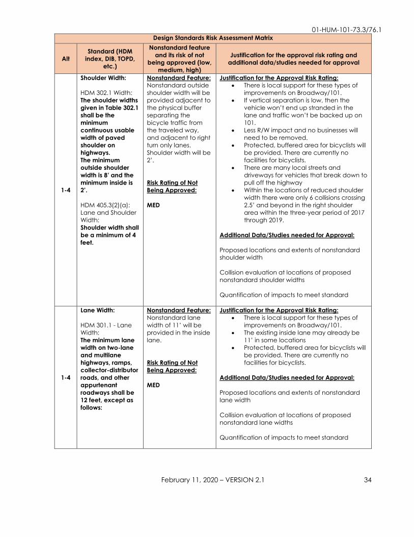
Shoulder Width: HDM 302.1 Width:
The shoulder widths given in Table 302.1 shall be the minimum continuous usable width of paved shoulder on highways. The minimum outside shoulder width is 8’ and the minimum inside is 2’. HDM 405.3(2)(a):
Lane and Shoulder
Width:
Shoulder width shall be a minimum of 4 feet.
Nonstandard Feature: Nonstandard outside
shoulder width will be
provided adjacent to
the physical buffer
separating the
bicycle traffic from
the traveled way,
and adjacent to right
turn only lanes.
Shoulder width will be
2’.
Risk Rating of Not Being Approved:
MED
Justification for the Approval Risk Rating: • There is local support for these types of
improvements on Broadway/101.
• If vertical separation is low, then the
vehicle won’t end up stranded in the
lane and traffic won’t be backed up on
101.
• Less R/W impact and no businesses will
need to be removed.
• Protected, buffered area for bicyclists will
be provided. There are currently no
facilities for bicyclists.
• There are many local streets and
driveways for vehicles that break down to
pull off the highway
• Within the locations of reduced shoulder
width there were only 6 collisions crossing
2.5’ and beyond in the right shoulder
area within the three-year period of 2017
through 2019.
Additional Data/Studies needed for Approval:
Proposed locations and extents of nonstandard
shoulder width
Collision evaluation at locations of proposed
nonstandard shoulder widths
Quantification of impacts to meet standard
1-4
Lane Width: HDM 301.1 - Lane
Width:
The minimum lane width on two-lane and multilane highways, ramps, collector-distributor roads, and other appurtenant roadways shall be 12 feet, except as follows:
Nonstandard Feature: Nonstandard lane
width of 11’ will be
provided in the inside
lane.
Risk Rating of Not Being Approved:
MED
Justification for the Approval Risk Rating: • There is local support for these types of
improvements on Broadway/101.
• The existing inside lane may already be
11’ in some locations
• Protected, buffered area for bicyclists will
be provided. There are currently no
facilities for bicyclists.
Additional Data/Studies needed for Approval:
Proposed locations and extents of nonstandard
lane width
Collision evaluation at locations of proposed
nonstandard lane widths
Quantification of impacts to meet standard

01-HUM-101-73.3/76.1
February 11, 2020 – VERSION 2.1 35
Design Standards Risk Assessment Matrix
Alt Standard (HDM
index, DIB, TOPD, etc.)
Nonstandard feature and its risk of not
being approved (low, medium, high)
Justification for the approval risk rating and additional data/studies needed for approval
1-4
Horizontal Minimum Clearance: HDM 309.1(3)(c) Minimum Clearances: On conventional highways, frontage roads, city streets and county roads within the State right of way (all without curbs), the minimum horizontal clearance shall be the standard shoulder width as listed in Tables 302.1 and 307.2, except that a minimum clearance of 4 feet shall be provided where the standard shoulder width is less than 4 feet.
Nonstandard Feature: There will be
nonstandard
clearances to the
vertical separation for
the Class IV bikeways
Risk Rating of Not Being Approved:
LOW
Justification for the Approval Risk Rating: • There is local support for these types of
improvements on Broadway/101.
• Protected, buffered area for bicyclists will
be provided. There are currently no
facilities for bicyclists.
• Vertical separation provides better
delineation of the bicycle facility than a
Class II bike lane
• This is a lower speed facility
Additional Data/Studies needed for Approval:
Proposed locations of nonstandard horizontal
minimum clearance
Collision evaluation at locations of proposed
nonstandard minimum clearance
Quantification of impacts to meet standard
1-4
Clear Recovery Zone (CRZ): HDM 309.1(2)(a)
Necessary Features: Fixed objects, when
they are necessary
highway features,
including, but not
limited to, bridge
piers, abutments,
retaining walls, and
noise barriers closer
to the edge of
traveled way than
the distances listed
above should be
eliminated, moved,
redesigned to be
made yielding, or
shielded in
accordance with
the following
guidelines:
Nonstandard Feature: Nonstandard CRZ will
be created when the
fixed base RRFBs or
PHBs are placed.
Also, if the vertical
separation is tall and
fixed, then there will
be nonstandard CRZ.
Risk Rating of Not Being Approved: LOW
Justification for the Approval Risk Rating: • There is local support for these types of
improvements on Broadway/101.
• The RRFBs are required at these crossings
to make the pedestrian crossing safer.
They are required close to the roadway
to draw drivers’ attention to the crossing.
• Traffic Safety doesn’t support breakaway
objects when pedestrians are expected
in the vicinity.
• The fixed base RRFBs or PHBs will be
placed as far back from the roadway as
possible.
• For the vertical separation portion of this,
protected, buffered area for bicyclists will
be provided. There are currently no
facilities for bicyclists.
Additional Data needed for Approval:
Proposed locations of nonstandard clear
recovery zone
Collision evaluation at locations of proposed
nonstandard clear recovery zone
Quantification of impacts to meet standard

01-HUM-101-73.3/76.1
February 11, 2020 – VERSION 2.1 36
Design Standards Risk Assessment Matrix
Alt Standard (HDM
index, DIB, TOPD, etc.)
Nonstandard feature and its risk of not
being approved (low, medium, high)
Justification for the approval risk rating and additional data/studies needed for approval
1-4
Corner Sight Distance: HDM 405.1(2)(a)
General:
There should be no
sight obstruction
within the clear
sight triangle.
Nonstandard Feature: Nonstandard corner
sight distances will be
provided if a raised
separation, such as
flexible posts or
planters, is chosen.
Also, there will be
areas of nonstandard
corner sight distances
if plantings or
streetlights are
implemented
(median or otherwise)
A guaranteed
instance of
nonstandard corner
sight distance is that
the stop bars for the
local
streets/intersections
will be pulled back
from their current
location due to
crosswalks, creating
worse sight distance
than existing.
Risk Rating of Not Being Approved:
LOW
Justification for the Approval Risk Rating: • There is local support for these types of
improvements on Broadway/101.
• Raised separation increases awareness of
the bicycle facility.
• Plantings and lighting help the aesthetic
of the facility and are desired by
members of the public. They also help
give a sense of arrival and can help calm
traffic.
• Locations of point restrictions to corner
sight distance, such as poles, are less of a
concern than continuous impediments.
• Drivers at the new crosswalks can pull
forward into the crosswalks for better sight
distance.
Additional Data/Studies needed for Approval:
Proposed nonstandard corner sight distances and
extents
Collision evaluation at locations of nonstandard
corner sight distance
Quantification of impacts to meet standard
1-4
Curb Types: HDM 303.1 General
Policy:
The use of curb
should be avoided
on facilities with
posted speeds
greater than or
equal to 40 miles
per hour, except as
noted in Table
303.1. For projects
where the use of
curb is appropriate,
it should be the
type shown in Table
303.1.
Nonstandard Feature: Nonstandard curb
type may end up
being chosen. It
appears that
nonstandard curb
type was used in
0B620.
Risk Rating of Not Being Approved:
LOW (will need to be reviewed in future, usually build to standard)
Justification for the Approval Risk Rating: • There is local support for these types of
improvements on Broadway/101.
• Using more aggressive curbing than
standard will help delineate non-vehicle
areas.
Additional Data/Studies needed for Approval:
Proposed nonstandard curb types and extents
Quantification of impacts to meet standard

01-HUM-101-73.3/76.1
February 11, 2020 – VERSION 2.1 37
Design Standards Risk Assessment Matrix
Alt Standard (HDM
index, DIB, TOPD, etc.)
Nonstandard feature and its risk of not
being approved (low, medium, high)
Justification for the approval risk rating and additional data/studies needed for approval
1-4
Turning Traffic: HDM 403.6(1)
Treatment of
Intersections with
Right-Turn-Only
Lanes:
Locations with right-
turn-only lanes
should provide a
minimum 4-foot
width for bicycle
use between the
right-turn and
through lane when
bikes are permitted,
except where
posted speed is
greater than 40
miles per hour, the
minimum width
should be 6 feet.
Nonstandard Feature: There are two right-
turn-only lanes within
the project limits and
neither one will have
this treatment: Papa
& Barkley Co.
intersection and
Pierson’s intersection.
Risk Rating of Not Being Approved:
LOW
Justification for the Approval Risk Rating: • The Papa & Barkley Co. intersection is
becoming a protected intersection, so
the bicycle facility is more protected than
the standard.
• Pierson’s intersection does not have
enough width to do this, so a mixing zone
is provided. There is currently no bicycle
facility at all, so this is an improvement
over existing conditions.
• The right-turn-only lanes at Pierson’s are
required for vehicle queuing.
Additional Data/Studies needed for Approval:
Quantification of impacts to meet standard
1-3
Design Speed (Class I Shared Use Path): 1003.1(9) Bicycle
Path Design Speed:
The design speed given in Table 1003.1 shall be the minimum. (The
minimum design
speed is 30 MPH.)
Nonstandard Feature: There will be
nonstandard
curvature on all three
alternative
alignments.
Risk Rating of Not Being Approved:
LOW (in the future, need to weigh the safety and environmental impacts to determine the final design and what design exceptions are required)
Justification for the Approval Risk Rating: • For the Alternative 1 alignment, the
nonstandard curves will be required only
at the ends of the path at intersections.
Bicyclists will be expected to slow down in
these areas.
• Pedestrians and bicyclists will be given a
new path that they did not already have
(improved conditions over existing).
Additional Data/Studies needed for Approval:
Proposed nonstandard design speeds and
extents
Analysis weighing safety versus environmental
impacts to achieve standard design speed.
Quantification of other impacts to meet standard

01-HUM-101-73.3/76.1
February 11, 2020 – VERSION 2.1 38
Design Standards Risk Assessment Matrix
Alt Standard (HDM
index, DIB, TOPD, etc.)
Nonstandard feature and its risk of not
being approved (low, medium, high)
Justification for the approval risk rating and additional data/studies needed for approval
2,3
Shoulder Width (Class I Shared Use Path)
HDM 1003.1(1)(b)
Shoulder:
A minimum 2-foot wide shoulder, composed of the same pavement material as the bike path or all-weather surface material that is free of vegetation, shall be provided adjacent to the traveled way of the bike path when not on a structure;
Nonstandard Feature: Nonstandard
shoulder width may
be provided on
Alternative 2 and
Alternative 3
alignments for the
Class I path because
these are converting
maintenance roads
with unknown widths,
and not widening
them.
Risk Rating of Not Being Approved:
LOW (in the future, need to weigh the safety and environmental impacts to determine the final design and what design exceptions are required)
Justification for the Approval Risk Rating: • A reduction or elimination of shoulder
width may be necessary along
Alternative 2 and Alternative 3 alignments
for the Class I paths to avoid
environmental issues.
• Pedestrians and bicyclists will be given a
new path that they did not already have,
so having some width is preferred over no
width.
Additional Data/Studies needed for Approval:
Existing maintenance path widths. The standards
may be able to be met, but it is unknown at this
time.
Proposed locations of nonstandard shoulder
width
Proposed nonstandard shoulder widths and
extent
Quantification of impacts to meet standard
2,3
Stopping Sight Distance (Class I Shared Use Path): 1003.1(11) Stopping
Sight Distance:
The minimum stopping sight distance based on design speed shall be 125 feet for 20 miles per hour, 175 feet for 25 miles per hour and 230 feet for 30 miles per hour.
Nonstandard Feature: Nonstandard
stopping sight
distance will be
provided for the
Alternative 2 and
Alternative 3 Class I
path alignments. The
sight distance is
blocked by trees.
Risk Rating of Not Being Approved:
LOW (in the future, need to weigh the safety and environmental impacts to determine the final design and what design exceptions are required)
Justification for the Approval Risk Rating: • There is local support for these types of
improvements on Broadway/101.
• Removal of trees to provide standard
stopping sight distance is beyond the
purpose of this project.
• Pedestrians and bicyclists will be given a
new path that they did not already have
(improved conditions over existing).
Additional Data/Studies needed for Approval:
Proposed nonstandard stopping sight distances
and extents
Quantification of impacts to meet standard

01-HUM-101-73.3/76.1
February 11, 2020 – VERSION 2.1 39
Other – Life Cycle Cost Analysis
A life cycle cost analysis is not required for this project.
Other - Culvert Material Considerations (hazardous material and compatibility
concerns)
The final culvert material for this project will be decided at a later phase, but
reinforced concrete pipe is recommended as the preferred material due to tidal
influence. If concrete is not selected, it is recommended that non-plastic culvert
materials are used for fire resiliency. The following are the culvert material
recommendations for a 50-year service life:
• 0.168" (8 gage) galvanized, corrugated steel pipe conforming to Section 66 of
the 2018 Standard Specifications
• 0.079" (14 gage) galvanized, polymeric sheet coated, corrugated steel pipe
conforming to Section 66 of the 2018 Standard Specifications
• 0.060" (16 equivalent standard gage) corrugated aluminum pipe conforming to
Section 66 of the Standard Specifications. Please review Highway Design
Manual, Section 852.4(2)(e) if planned use is pipe extension
• Reinforced concrete pipe conforming to Section 65 of the 2018 Standard
Specifications. Concrete for RCP at this location shall comply with Section 90-
1.02H Concrete in Corrosive Environments.
• Corrugated PVC conforming to Section 64 of the 2018 Standard specifications.
• Corrugated HDPE plastic pipe type-s conforming to Section 64 of the 2018
Standard specifications.
Infeasible Alternatives for Completion in the 2020 State Highway Operation and Protection Program (SHOPP) Due to programming constraints associated with Complete Streets reservation funds,
Alternatives 1-3 were deemed infeasible for this 2020 SHOPP project. Since
Alternatives 1-3 propose different alignments for the Class I path, below is a pro-con
table for comparison of Alternatives 1-3.

01-HUM-101-73.3/76.1
February 11, 2020 – VERSION 2.1 40
Alternative Pro Con
1
• Greater sense of security
based on proximity to
vehicle traffic
• Stormwater runoff
captured in bioswale
• More direct path of travel
for those coming from
Herrick Avenue or
Broadway
• More traffic noise
• More out of direction
travel for those coming
from Humboldt Hill on the
future Waterfront Trail
extension
• Comfort may be
reduced due to proximity
to vehicles
2
• Less traffic noise when
away from highway
• Provides comfort when
away from traffic
• Greater sense of security
when next to the vehicle
traffic
• Balance of out of
direction travel for users
coming from Humboldt
Hill on the future
Waterfront Trail extension
and those from Herrick
Avenue or Broadway
• More traffic noise when
along the highway
• Provides less comfort
when next to traffic
• Sense of security is
reduced when away
from the vehicle traffic
3
• Least amount of traffic
noise
• Provides most comfort
due to distance from
vehicles
• Less out of direction travel
for those coming from
Humboldt Hill on the
future Waterfront Trail
extension
• Sense of security is
reduced due to the trail
being away from the
vehicle traffic
• Greatest amount of out
of direction travel for
those coming from
Herrick Avenue or
Broadway
A couple of items that apply to all the Class I path alternatives are:
• R5-3 or R44A(CA) signs are required at the beginning and end of the Class I
path to exclude motor vehicles
• Wayfinding (Guide) signs will be needed along the Class I path to help guide
bicyclists to/from the City of Eureka’s Waterfront Trail extension to Humboldt Hill,
the Hikshari’ Trail, and US 101
Below are descriptions for each of the three infeasible alternatives.

01-HUM-101-73.3/76.1
February 11, 2020 – VERSION 2.1 41
Alternative 1
Proposed Engineering Features
See Attachment A for Layouts and Typical Sections.
Class I Shared Use Path (Station “B” 200+00 to “B” 220+50)
This Class I path alignment follows the Broadway alignment. This path will be new
construction and will require placing fill in wetland area. The path will be constructed
with five-foot paved lanes and two-foot shoulders made from an all-weather surface.
See Alternative 4 for the rest of the proposed engineering features. The striping and/or
marking improvements between Herrick Avenue and Papa & Barkley Co. would not
be included for this alternative because the Class I path would be a dedicated
separate facility from Broadway. However, striping and marking improvements could
still be considered along Herrick Avenue within Caltrans right of way to connect
residents on Herrick Avenue to the Class I path.
Current Construction and Right-Of-Way Cost Estimates
The current non-escalated construction and right-of-way capital costs are $8,157,000
and $3,996,000 respectively for Alternative 1.
See Alternative 4 for the remainder of the topics.
Alternative 2
Proposed Engineering Features
See Attachment A for Layouts and Typical Sections.
Class I Shared Use Path (Station “C” 300+00 to “C” 320+98)
Alternative 2 follows a City of Eureka maintenance road for part of the path and then
follows Broadway for the rest of the path. The portion of the path that follows the
maintenance road will convert the gravel/dirt road into a paved path. Five-foot
paved lanes and two-foot shoulders made from an all-weather surface will be
constructed where maintenance road width allows. The City will continue to use the
path for maintenance activities. The portion of the path that follows Broadway will be
the same as Alternative 1.
See Alternative 4 for the rest of the proposed engineering features. The striping and/or
marking improvements between Herrick Avenue and Papa & Barkley Co. would not
be included for this alternative because the Class I path would be a dedicated
separate facility from Broadway. However, striping and marking improvements could

01-HUM-101-73.3/76.1
February 11, 2020 – VERSION 2.1 42
still be considered along Herrick Avenue within Caltrans right of way to connect
residents on Herrick Avenue to the Class I path.
Current Construction and Right-Of-Way Cost Estimates
The current non-escalated construction and right-of-way capital costs are $7,694,000
and $2,167,000 respectively for Alternative 2.
See Alternative 4 for the remainder of the topics.
Alternative 3
Proposed Engineering Features
See Attachment A for Layouts and Typical Sections.
Class I Shared Use Path (Station “D” 400+00 to “D” 421+10)
Alternative 3 Class I path follows a City of Eureka maintenance road that diverges
from Broadway. The gravel/dirt road will be converted into a paved path. Five-foot
paved lanes and two-foot shoulders made from an all-weather surface will be
constructed where maintenance road width allows. The City will continue to use the
path for maintenance activities. This alternative will use a 145-foot pedestrian bridge
to connect the path to the Papa & Barkley Co. intersection to minimize
environmental impact to wetlands. See Attachment O for the preliminary
geotechnical assessment and Attachment B for the structures PIR estimate.
See Alternative 4 for the rest of the proposed engineering features. The striping and/or
marking improvements between Herrick Avenue and Papa & Barkley Co. would not
be included for this alternative because the Class I path would be a dedicated
separate facility from Broadway. However, striping and marking improvements could
still be considered along Herrick Avenue within Caltrans right of way to connect
residents on Herrick Avenue to the Class I path.
Current Construction and Right-Of-Way Cost Estimates
The current non-escalated construction and right-of-way capital costs are $8,364,000
and $609,000 respectively for Alternative 3.
See Alternative 4 for the remainder of the topics.
No Build Alternative
The No Build Alternative is not recommended because it does not satisfy the purpose
and need of the project. This stretch of Broadway lacks safe and efficient facilities for
all modes of transportation and is a barrier for non-motorized users. Not constructing

01-HUM-101-73.3/76.1
February 11, 2020 – VERSION 2.1 43
this project would perpetuate the high collision rates, poor perception of the facility,
and poor performance of the facility.
COMPLETE STREETS
Caltrans’ Complete Streets Directive promotes a transportation system that
accommodates bicyclists, pedestrians, and transit users. The complete streets
decision document for this project can be found in Attachment P.
Pedestrian Facilities
Project 01-0B6204 Broadway ADA will be filling sidewalk gaps and bringing most
driveways and curb ramps to ADA standards. Project 01-0G4201 Eureka Sidewalks
and Curbs will upgrade two additional driveways within the project limits to ADA
standards. These two projects will be completed before this project; therefore,
minimal sidewalk work is included.
Two pedestrian crossings will be added to the project to provide connections
between Eureka’s waterfront and the rest of the city. Crosswalks will also be added
across the local road intersections.
Other Pedestrian Concerns
There are no other existing or proposed pedestrian concerns.
Bicycle Facilities
There are no existing bicycle facilities. Bicycles currently ride in the shoulder where
vehicles park. The Class IV separated bikeways will provide a more comfortable
experience for bicyclists and will help delineate the bikeway so that all roadway users
know where the bicyclists are expected. Bicycle crossings will be added across the
local road intersections, at the Papa & Barkley Co. intersection and at the intersection
of Truesdale Street/Highland Avenue. This will connect bicyclists from the Class III bike
route on Highland Avenue that is proposed by the City of Eureka to the Hikshari’ trail
at the end of Truesdale Street.
Transit Facilities
Both Southern Humboldt Intercity and Redwood Transit System have buses that pass
through the project limits, see table below for the number of buses.

01-HUM-101-73.3/76.1
February 11, 2020 – VERSION 2.1 44
Day of Week Northbound Southbound Southern Humboldt Intercity
Monday-Friday 3 2
Saturday (no Sunday service) 3 2
Redwood Transit System Monday-Friday 26 25
Saturday (no Sunday service) 7 7
There are two existing transit stops within the proposed work location of PM 74.8 to PM
76.1 at the McCullens Avenue intersection, one NB and one SB. These two transit stops
will be upgraded. Two new transit stops will be added: NB at Pacific Motorsports and
SB at the 76 Gas Station. For more details, see Section 9 Alternatives.
Park-and-Ride Facilities
There is one park-and-ride facility within the proposed work location of PM 74.8 to PM
76.1: the Herrick Avenue park-and-ride. There are no proposed changes to the park-
and-ride.
CLIMATE CHANGE CONSIDERATION
Greenhouse Gas Reduction Measures
GHG Emissions Analysis is deferred to the future Environmental Phase (PA&ED) since
an in-depth GHG Analysis will be performed with the Environmental Document.
Adaptation Measures
This segment of Broadway is susceptible to changes in precipitation, flooding, sea
level rise, and increased risks of wildfires due to climate change. Non-plastic culvert
materials are recommended for use to provide resiliency from wildfires. It is
recommended to use reinforced concrete pipe if feasible due to impacts from tidal
influence and sea level rise.
ENVIRONMENTAL COMPLIANCE
A revised mini-Preliminary Environmental Assessment Report (mini-PEAR) was received
from North Region Environmental on June 16, 2021, included as Attachment C.
Based on the scope of this project, studies may be needed for noise, air, energy,
hazardous waste, water quality, floodplains, biological, Section 4(f), visual, and
cultural resources. Task Orders will be required to complete cultural resource and
hazardous waste studies.

01-HUM-101-73.3/76.1
February 11, 2020 – VERSION 2.1 45
Alternative 4 is within the coastal zone (within both the State’s and City of Eureka’s
jurisdiction) and is anticipated to require either two Coastal Development Permits or
one consolidated State Coastal Permit. Other permits are not anticipated. In
addition, impacts to wetlands and other Environmentally Sensitive Habitat Areas
(ESHAs) are not anticipated, and therefore permit-driven mitigation is not anticipated.
This project would visually result in more development; it is recommended that
softscape and decorative hardscape features be included in the project.
Coordination with local community stakeholders and the City of Eureka would be
required for these features.
Because the project is located within culturally sensitive areas, the project
archaeologist should be consulted prior to any ground-disturbing activities (e.g.,
culvert construction).
This project is anticipated to impact sites on the Cortese List. Hazardous waste
investigations will be conducted to determine any issues and provide information on
handling and disposal requirements of materials, if needed.
The environmental document is scoped as a California Environmental Quality Act
(CEQA) Initial Study (IS) and National Environmental Policy Act (NEPA) Categorical
Exclusion (CE) due to hazardous waste issues.
The following table outlines the requested time and the time allotted due to schedule
constraints. This schedule discrepancy is recognized and has been documented as a
risk.
Requested Time (Months)
Allotted Time (Months)
Begin Environmental to Draft Environmental Document (DED) 16 15
DED to Project Approval & Environmental Document (PA&ED) 6 5
PA&ED to Ready to List 12 9
RIGHT-OF-WAY
A Right of Way Data Sheet was received on June 21, 2021 and is included as
Attachment D. The right-of-way required for Alternative 4 (programmable alternative)
is:
• 6 fee parcels

01-HUM-101-73.3/76.1
February 11, 2020 – VERSION 2.1 46
• 21 temporary construction easements
• 2 permanent easements
• 12 encroachment permits
Parcels required are zoned mostly commercial or public lands along with some
industrial parcels. Anticipated right-of-way cost for Alternative 4 is $634,000
(escalated). Right of Way Lead time will require a minimum of 17 months after receipt
of appraisal maps, utility conflict maps, environmental clearances (HMDD) and
Certificate of Sufficiency (COS). A minimum of 12 months prior to certification will be
required from receipt of the last map revision. Shorter lead times may require
additional support resources and may adversely affect delivery of Right of Way
Certification.
Due to schedule constraints, only 10 months were allotted for right-of-way instead of
the requested 17. This schedule discrepancy is recognized and has been
documented as a risk.
STORMWATER
Stormwater Data Reports (SWDR) were prepared on May 14, 2021 (for Alts 1 through
3) and on June 18, 2021 (for Alt 4). SWDRs can be found in Attachment F.
New impervious surfaces associated with the construction of bikeways and
pedestrian facilities are exempt from post construction stormwater treatment
requirements. Temporary construction best management practices (BMPs) will be
required and are included in the cost estimate.
TRANSPORTATION MANAGEMENT PLAN
A Transportation Management Plan Datasheet (TMPDS) dated May 10, 2021 was
received from District 1 Traffic Management & Systems Operations and can be found
in Attachment G. Anticipated traffic control on Broadway consists of:
• Lane reduction
• Sidewalk closure
• Partial shoulder closure
A work zone speed reduction is required.
Minimal delays are expected.
Pedestrian and bicyclist accommodation is required. Pedestrian detours of no more
than two city blocks will be required. Five feet will be provided adjacent to the open

01-HUM-101-73.3/76.1
February 11, 2020 – VERSION 2.1 47
traffic lane for bicyclists, which will involve using the two-way left turn lane for one
direction of traffic and then providing five feet for bicyclists in the number one lane.
Another option to provide the five feet for bicyclists is to stage construction so that
the existing shoulder is modified before the class IV bikeway separation is constructed.
Then, bicyclists can be directed onto the new shoulder while the class IV separation is
constructed.
See Section 10 Complete Streets for transit routes that will be affected. Emergency
services that may be impacted include fire, law enforcement and medical. Impacts
to emergency services are possible given the urban setting, so care should be taken
to accommodate these services.
Special traffic handling plans and a 60% constructability review will be required for this
project due to its complexity.
ADVANCE TECHNOLOGIES & COMMUNICATION SYSTEMS
There are no projects that propose to install fiber optic conduit within the existing
right-of-way. The Transportation Planning Scoping Information Sheet identified that
the project should install broadband conduit throughout the project limits. This is
outside of the purpose and scope of this project but can be included if an outside
funding source is secured.
Fueling opportunities for zero-emission vehicles are outside of the purpose and scope
of this project as well. When new striping is placed, it will be the six-inch standard,
which will help the transition for infrastructure-to-vehicle communications for
autonomous vehicles.
ADDITIONAL CONSIDERATIONS Accommodation of Oversize Loads
This segment of US 101 has a truck network designation of Terminal Access (Surface
Transportation Assistance Act (STAA). The design vehicle will be accommodated
through the project limits.
Airports or Emergency Related Helipads
There are no airports or emergency related helipads within the project limits. The
nearest airport is Murray Field, approximately 5.2 miles north of the project.

01-HUM-101-73.3/76.1
February 11, 2020 – VERSION 2.1 48
Air Quality Conformity
This project is in an area that is designated as attainment or is unclassified for all
current National Ambient Air Quality Standards. Therefore, conformity requirements
do not apply.
Contaminated Material Including Regulated, Designated and Hazardous Waste
An Initial Site Assessment (ISA) was received from North Region Environmental on April
14, 2021 and can be found in the project files. The ISA found that the project may
have minor hazardous waste issues. In addition, the ISA found project work will impact
sites listed on the Hazardous Waste and Substances Site List (Cortese List).
Where soil disturbance is proposed, a 0-phase Preliminary Site Investigation (PSI) will
be necessary to determine if this project will be impacting areas previously
contaminated with Aerial Deposited Lead (ADL). In the proposed areas for transit stop
development and new drainage systems, an investigation will be required to
determine if this project will be impacting areas that may contain residual petroleum
hydrocarbons associated with historical leaking underground storage tanks (LUSTs)
within the project limits. If contamination is present, these investigations will inform the
PDT and provide the Department information regarding handling and disposal of
these materials such as: determining potential handling, disposal, and workers’
protection requirements. Information gathered from these studies will inform the
SSP/NSSP development.
Constructability Issues
Drainage diversion may be necessary for the proposed culvert work if flow is
expected during construction. Also, construction of drainage features may need to
be timed with tidal influence.
Construction Staging
Potential staging areas have been identified at the Herrick Avenue park-and-ride and
at parking lots adjacent to the facility, as shown on the Layouts (Attachment A).
Environmental-Justice (Title VI Considerations)
This project is not anticipated to adversely affect any low-income or minority
populations.
Floodplain Issues
A floodplain evaluation report summary was received on May 6, 2021. Much of US
101/Broadway is designated as a special flood hazard area from PM 73.3 to PM 75.0.
The Floodplain Analysis and Preliminary Hydraulics Recommendation can be found in
Attachment L.

01-HUM-101-73.3/76.1
February 11, 2020 – VERSION 2.1 49
Graffiti Control
Project 01-0B6204 Broadway ADA will paint geese and water on the soil nail retaining
wall from PM 75.7 to PM 75.9. The traffic signal utility boxes have also been painted at
PM 75.24, PM 75.54, and PM 75.91 by local artists.
Maintenance and Cooperative Agreements
Maintenance agreements will be required with the City of Eureka for any landscaping
and lighting features incorporated in the project.
Maintenance and Worker Safety
Maintenance requirements will increase after construction of this project. The Class IV
separated bikeway will require regular sweeping. Normal street sweepers will not fit on
these facilities. The equipment needs for maintenance of these facilities will need to
be communicated to Maintenance. Increased maintenance can lead to increased
worker safety issues, but these will be mitigated with standard procedures.
Material Borrow and/or Disposal Site
No material borrow or disposal site is necessary.
Recycled Materials
Several opportunities for utilizing recycled materials were investigated. The first was
the use of plastic bottles as part of the asphalt mix for the roadway. Caltrans has a
pilot project (Butte 162 Pilot Project) for this in which a 1000-foot highway segment
was repaved with 100% recycled materials. This type of technology is still being
investigated but will not be available for widespread use until Caltrans has developed
specifications for the material; it remains an option for investigation in the future.
Rubberized hot-mix asphalt gap-graded (RHMA-G) is not recommended for use in this
project based on the quantity of pavement required (only doing a micro-surface).
RHMA-G is asphalt mixed with recycled tires to create a pavement material that is
typically used on larger pavement jobs.
Also, Caltrans Standard Specification Section 39 allows contractors to substitute
Reclaimed Asphalt Pavement (RAP) for a part of the virgin aggregate in a quantity
up to 25% of the aggregate blend. Almost all asphalt plants in Caltrans District 1
(Mercer Fraser, Kernen at Blue lake, Granite Construction) all use recycled asphalt
from other projects. Commonly used RAP percentage in hot-mix asphalt (HMA) is 15%-
25%. There is an effort from Pavement & Materials Partnering Committee to increase
the use of RAP up to 40% in HMA.
Processed RAP, portland cement concrete, lean concrete base, cement treated
base, etc. in combination with other materials such as; broken stone, crushed gravel,
sand, etc. can be used as subbase or base complying with Section 25 and Section 26
respectively of the Standard Specifications.

01-HUM-101-73.3/76.1
February 11, 2020 – VERSION 2.1 50
Cold-in-place recycling can be another method for recycling materials. This method
could be used for the mainline overlay process in which a portion of the roadway is
removed, mixed with additives, and then placed back as part of the overlay process.
However, this was deemed out of the project scope because this method is more for
treating pavement distresses and it requires an overlay over the recycled materials.
The existing pavement will be in good to fair condition (see Section 8) and the micro-
surfacing is only needed to provide a smooth, clean finish over the roadway after
construction.
Noise Abatement Decision Report
A noise abatement decision report is not required for this project.
Reversible Lanes
This project does not qualify as a capacity increasing or a major street or highway
realignment project and reversible lanes have not been considered.
Resource Conservation
Resources will be conserved to the maximum extent feasible.
Report on Feasibility of Providing Access to Navigable Rivers
This project is not in a location that will have impacts on access to navigable rivers.
Route Adoptions, Freeway Agreements, Relinquishments and Modification of Access
Control
There are no route adoptions, freeway agreements, or modification of access control
required.
Salvaging and Recycling of Hardware and Other Non-Renewable Resources
Grindings from cold planning can be captured and reused in the future as reclaimed
asphalt pavement. Concrete removed from sidewalk and other features can be
reused as subbase or base. See Section Recycled Materials above for more
information.
Sea Level Rise
The project area may be susceptible to increased flooding due to sea level rise and
precipitation. However, it is beyond the scope of this project to address sea level rise
specifically.
Value Analysis
A value analysis is not required for this project.

01-HUM-101-73.3/76.1
February 11, 2020 – VERSION 2.1 51
Other – Road Safety Audit
The US 101 (Broadway) K-Mart to 4th Street Pedestrian and Bicycle Road Safety Audit
was completed in 2008. This project and project 01-0B6204 Broadway ADA make
significant improvements to the top safety issues identified in the audit.
ESTIMATE, FUNDING AND PROGRAMMING
Estimate
The cost estimate can be found in Attachment B.
Estimated Capital & Support Cost ($1,000s)- Programmable Alternative
Phase (A) Total Optimistic
(B) Total Pessimistic
(C) Total Most Likely
(D) Risk Amount
(E) Total including Risk (C+D)
(F) # Years to Mid Yr of Phase
(G) Escalation Rate
(H) Escalation Amount
(I) Total Escalated Cost (E + H)
Support PA&ED N/A N/A 1,334 - 1,334 1.0 3.0% 46 1,380
PS&E N/A N/A 1,229 - 1,229 2.6 3.0% 111 1,340
Right of Way N/A N/A 552 - 552 3.9 3.0% 49 601
Const. N/A N/A 1,290 - 1,290 4.7 3.0% 171 1,461
Capital Right of Way N/A N/A 555 - 555 2.3 5.0% 79 634
Const. N/A N/A 6,245 - 6,245 3.8 3.2% 839 7,084
Totals N/A N/A 11,205 - 11,205 - - 1,295 12,500
Funding
It has been determined that this project is eligible for Federal-aid funding. Funding for
this project was acquired by competing statewide for State Highway Operation and
Protection Program (SHOPP) complete streets reservation funds.
Programming
The programming sheet can be found in Attachment S.

01-HUM-101-73.3/76.1
February 11, 2020 – VERSION 2.1 52
Fund Source Fiscal Year Estimate for the Programmable Alternative 20.XX.201.999 21/22 22/23 23/24 Total Sup/Cap % Component In thousands of dollars ($1,000) PA&ED Support 1,380 1,380 17.88
PS&E Support 1,340 1,340 17.36
Right-of-Way Support 601 601 7.79
Construction Support 1,461 1,461 18.93
Right-of-Way 634 634
Construction 7,084 7,084
Total 1,380 1,941 9,179 12,500 61.96
The support to capital cost ratio is 61.96%. The following table displays the escalation
rates used.
DELIVERY SCHEDULE
Project Milestones Milestone Date
(Month/Day/Year)
Milestone Designation
(Target/Actual) PROGRAM PROJECT M015 08/18/2021 Target
BEGIN ENVIRONMENTAL M020 10/21/2021 Target
CIRCULATE DED EXTERNALLY M120 01/23/2023 Target
PA & ED M200 06/21/2023 Target
PS&E TO DOE M377 04/08/2024 Target
RIGHT OF WAY CERTIFICATION M410 04/22/2024 Target
READY TO LIST M460 06/03/2024 Target
FUND ALLOCATION M470 08/21/2024 Target
HEADQUARTERS ADVERTISE M480 09/04/2024 Target
AWARD M495 11/15/2024 Target
APPROVE CONTRACT M500 12/03/2024 Target
CONTRACT ACCEPTANCE M600 12/01/2025 Target
END PROJECT M800 12/01/2027 Target
EXTERNAL AGENCY COORDINATION Federal Highway Administration (FHWA)
This project is a delegated project in accordance with the most current version of the
Stewardship and Oversight Agreement between the Federal Highway Administration
(FHWA) and the California Department of Transportation (Caltrans).

01-HUM-101-73.3/76.1
February 11, 2020 – VERSION 2.1 53
The project requires the following coordination:
California Coastal Commission
• State Coastal Development Permit
City of Eureka
• Local Coastal Development Permit
PROJECT REVIEWS
Name Date
Scoping Team Field Review
Joseph Caminiti
Harrison Rankin
Nicole Farrell
Alexis Kelso
Jaime Matteoli
Brett Gronemeyer
Fariar Kohzad
02/24/2021
03/03/2021
03/25/2021
05/04/2021
Safety Field Review N/A N/A
District Program Advisor
Alexis Kelso
Rex Jackman
Suzi Theiss (Local
Assistance)
6/23/2021
Headquarters SHOPP Program Advisor
Abdel Beshair
Ray Estakhri
Ross Foon (Local
Assistance)
6/23/2021
District Maintenance Chris Ghidinelli 6/23/2021
Headquarters Project Delivery Coordinator Zebunnesa Tareque 6/23/2021
Project Manager Jaime Matteoli 6/23/2021
FHWA N/A N/A
District Safety Review Brian Simon 6/23/2021
Constructability Review Juan Reyes 6/23/2021
District Maintenance Electrical Andrew Gray 6/23/2021

01-HUM-101-73.3/76.1
February 11, 2020 – VERSION 2.1 54
PROJECT PERSONNEL
Internal Stakeholders:
Name Title Division/Office Phone Number Dawn Yang Project Engineer Advance Planning (707) 296-6752
Joseph Caminiti Designer Advance Planning (707) 684-6921
Kirsten Thuresson Acting Advance Planning Chief Advance Planning (707) 572-0865
Jaime Matteoli PM Project Management (707) 498-0961
Rebecca Law PM Assistant PMSU (707) 684-1004
Alexis Kelso Project Planning Liaison Planning (707) 498-0536
Rex Jackman Senior Transportation Planner Planning (707) 834-2413
Valency Fitzgerald District 1 Asset Manager Maintenance (707) 834-1484
Kellie Eldridge Associate Environmental Planner NR Environmental (707) 815-6995
Steve Croteau Senior Environmental Planner NR Environmental (707) 572-7149
Timothy Keefe Senior Environmental Planner NR Environmental (707) 382-1508
Robert Wall Senior Environmental Planner Environmental (707) 834-2471
Kevin Church Senior Transportation Engineer NR Environmental (707) 496-0433
Laura Lazzarotto Landscape Associate Landscape Architecture (707) 492-9983
Phlora Barbash Landscape Associate Landscape Architecture (707) 492 9984
Timothy Boese Senior Transportation Engineer Landscape Architecture (707) 502-5710
Lena Ashley Senior Transportation Engineer Design (707) 497-4524
Sara Atchley-Thomas D1 Native American Liaison Planning (707) 834 1486
Kathleen Sartorius D1 Native American Liaison Planning (707) 441-5815
Abnish Rajbanshi Materials Engineer D1 Materials Engineering (707)-496-7070
Sheri Rodriguez D1 Traffic Manager Traffic Operations (707) 498-5252
David Morgan D1 Chief of Traffic Safety Traffic Safety (707) 498-0122
Ryan Stiltz Technical Liaison Engineer Structure Design (562) 665-2414
Eskinder Taddesse Senior Transportation Engineer Structure Design (916) 639-5620
Charlie Narwold Senior Engineering Geologist Geotechnical Services (707) 498-1631
Sheila Sadkowski Engineering Serv. E2 Branch Chief Engineering Services (707) 666-5969
Brittany Wattle CIP/Drainage Coordinator Maintenance Hydraulics (707) 498-1397
Mark Gorona Maint./Const. Liaison Engineer Maintenance Engineering (707) 496-4359
Jeremiah Joyner Senior Right-of-Way Agent Right of Way (707) 666-5870
Chris Johnston Senior Transportation Surveyor Right of Way Engineering (707) 497-7802
Sebastian Cohen Supvg Transportation Engineer Construction (707) 496-4096
Jeffrey Zimmerer Area Construction Engineer Construction (707) 498-3207
Parvin Sebti Senior Bridge Engineer Structures Construction (707) 834-1149
Brian Georgeson Maintenance Supervisor Maintenance (707) 498-3130
Jason Hayes Maintenance Area Superintendent Maintenance (707) 498-0680

01-HUM-101-73.3/76.1
February 11, 2020 – VERSION 2.1 55
External Stakeholders:
Name Organization Amy Conlin Humboldt Bay Fire
Beth Burks Humboldt County Association of
Governments
Brian Gerving City of Eureka
Jesse Willor City of Eureka
Colin Fiske Coalition for Responsible
Transportation Priorities
Morguine Sefcik Natural Resources Services Division
of Redwood Community Action
Agency
Greg Pratt Humboldt Transit Authority
Jennifer Kalt Humboldt Baykeeper
Karen Underwood Humboldt Trails Council
Peggy Martinez Creative Inclusion
Rick Knapp Humboldt Bay Bicycle Commuters
Association
Paul Gullick California Highway Patrol
Stacy Barr California Highway Patrol
Shawn Morris California Highway Patrol
Gary Whitmer Eureka Police Department
Brittany Powell Eureka Police Department
Ryan Derby Humboldt County Sheriff’s Office
Samantha Karges Humboldt County Sheriff’s Office
Justin Braud Humboldt County Sheriff’s Office
Tom Wheeler Environmental Protection
Information Center
Julian Berg Keep Eureka Beautiful
Julie Fulkerson Keep Eureka Beautiful
Michele McKeegan Keep Eureka Beautiful
Larry Glass Northcoast Environmental Center
Bob Merrill California Coastal Commission

01-HUM-101-73.3/76.1
February 11, 2020 – VERSION 2.1 56
ATTACHMENTS (Number of Pages)
A. Layouts and Typical Sections (23)
B. Cost Estimates and PIR Structures Estimate (43)
C. Mini-Preliminary Environmental Assessment Report (17)
D. Right-of-Way Datasheet (24)
E. PIR Risk Register (5)
F. PIR Stormwater Data Reports (12)
G. Transportation Management Plan Data Sheet (2)
H. Pavement Condition Reports (3)
I. Project Initiation Proposal (11)
J. Transportation Planning Scoping Information Sheet (9)
K. Preliminary Materials Recommendation (9)
L. Floodplain Analysis and Preliminary Hydraulics Recommendation (8)
M. Drainage Worksheet (1)
N. Landscape Architecture Assessment Study (8)
O. Preliminary Geotechnical Assessment (5)
P. Complete Streets Decision Document (6)
Q. Signs, Lights, and Guardrail Logs (4)
R. Performance Output (2)
S. Programming Sheet (2)

ATTACHMENT A
Layouts & Typical Sections


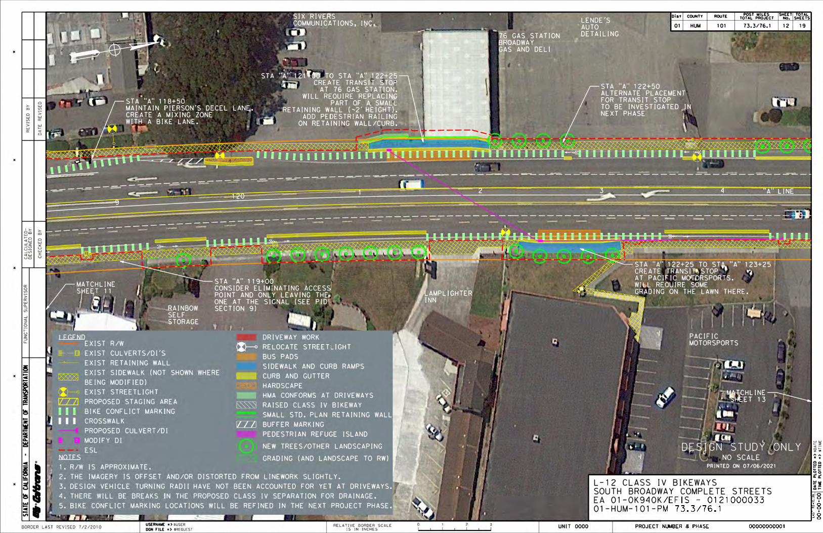


x
x
x
x
x
Dist COUNTY ROUTEPOST MILES
TOTAL PROJECT
SHEET
No.
TOTAL
SHEETS
LA
ST
RE
VIS
ION
ST
AT
E O
F C
AL
IFO
RN
IA -
DE
PA
RT
ME
NT
OF
TR
AN
SP
OR
TA
TIO
N
No.
Exp.
CIVIL
RE
GI
ST
ER
E
DP
ROFESSIONAL
EN
GI
NE
ER
S
TATE
OF CALIFORN
IA
REGISTERED CIVIL ENGINEER
TIM
E P
LO
TT
ED
=>
DA
TE
PL
OT
TE
D =
>
$T
IM
E
$D
AT
E
CH
EC
KE
D B
Y
DE
SIG
NE
D B
Y
CA
LC
UL
AT
ED
-R
EV
ISE
D B
Y
DA
TE
RE
VIS
ED
PLANS APPROVAL DATE
DATE
FU
NC
TIO
NA
L S
UP
ER
VIS
OR
R
COPIES OF THIS PLAN SHEET.
THE ACCURACY OR COMPLETENESS OF SCANNED
OR AGENTS SHALL NOT BE RESPONSIBLE FOR
THE STATE OF CALIFORNIA OR ITS OFFICERS
R
00-00-00
USERNAME => $USER
DGN FILE => $REQUEST
RELATIVE BORDER SCALE
IS IN INCHES
0 1 2 3UNIT 0000 PROJECT NUMBER & PHASE 00000000001BORDER LAST REVISED 7/2/2010
40'-175'
2%
ETWEP ETW
86'-92'
6'-7'23'-24'8'
MEDIAN
ETW EP
23'-24' 8'
2%
ETW
FENCE (R/W)
EXISTING
R/W R/W
ETWEP ETW
97'-110'
23'-24'8'
MEDIAN
ETW EP
23'-24' 8'
ETWEPEP
CABLE BARRIER
HIGH TENSION
HP
2'2' 5'
PATH
STATION "C" 314+96 TO 320+98STATION "B" 200+00 TO 220+50
CLASS 1 SHARED USE PATHALTERNATIVE 1 AND PART OF ALTERNATIVE 2
EUREKA, CACORRIDOR CONCEPT
US 101 / BROADWAY
HUM 101PROPOSED
HUM 101EXISTING
0'-20'
"B-LINE" & "C-LINE"CLASS 1 SHARED USE PATH
PROPOSED
FENCE (R/W)
EXISTING
REMOVE
FENCE (R/W)
NEW
Geotextile (SEG)
Subgrade Enhancement
0.60' CL2 AB
0.25' HMA-A
BIOSWALLE
WEED MAT
HP
0'-16'
WETLAND AREA
EXISTING
R/W APPROXIMATE1. EXISTING DIMENSIONS AND NOTES:
01 HUM 101 74.8/76.0 01 04
6'-7'
6'-7' 6'-7'5'
CL
45'-130'
EMBANKMENT
REINFORCED
AND/OR GEOSYNTHETIC
IMPORTED BORROW
3:1
TYPICAL
2:1 TYPICAL
PRELIMINARY
DESIGN
FOR REVIE
W ONLY

x
x
x
x
x
Dist COUNTY ROUTEPOST MILES
TOTAL PROJECT
SHEET
No.
TOTAL
SHEETS
LA
ST
RE
VIS
ION
ST
AT
E O
F C
AL
IFO
RN
IA -
DE
PA
RT
ME
NT
OF
TR
AN
SP
OR
TA
TIO
N
No.
Exp.
CIVIL
RE
GI
ST
ER
E
DP
ROFESSIONAL
EN
GI
NE
ER
S
TATE
OF CALIFORN
IA
REGISTERED CIVIL ENGINEER
TIM
E P
LO
TT
ED
=>
DA
TE
PL
OT
TE
D =
>
$T
IM
E
$D
AT
E
CH
EC
KE
D B
Y
DE
SIG
NE
D B
Y
CA
LC
UL
AT
ED
-R
EV
ISE
D B
Y
DA
TE
RE
VIS
ED
PLANS APPROVAL DATE
DATE
FU
NC
TIO
NA
L S
UP
ER
VIS
OR
R
COPIES OF THIS PLAN SHEET.
THE ACCURACY OR COMPLETENESS OF SCANNED
OR AGENTS SHALL NOT BE RESPONSIBLE FOR
THE STATE OF CALIFORNIA OR ITS OFFICERS
R
00-00-00
USERNAME => $USER
DGN FILE => $REQUEST
RELATIVE BORDER SCALE
IS IN INCHES
0 1 2 3UNIT 0000 PROJECT NUMBER & PHASE 00000000001BORDER LAST REVISED 7/2/2010
STATION "D" 400+00 TO 418+18STATION "C" 300+00 TO 314+96
CLASS 1 SHARED USE PATHPART OF ALTERNATIVE 2 AND ALTERNATIVE 3
EUREKA, CACORRIDOR CONCEPT
US 101 / BROADWAY
EPHP
TYP)(2' VAR
PATH
SINGLE SPAN STEEL TRUSS ARCHED PEDESTRIAN BRIDGESTATION "D" 418+18 TO 419+63
PART OF ALTERNATIVE 3
ETWETW
PATH
6' HIGH
RAIL
WETLAND AREA
EXISTING WETLAND AREA
EXISTING
WETLAND AREA
EXISTING
WETLAND AREA
EXISTING
MAINTENANCE ROAD
CITY OF EUREKA, CA
CONVERT EXISTING
CONCRETE BRIDGE DECK
DRIVEN H-PILE FOUNDATIONS2. FOUNDATIONS ASSUMED TO BE 1. EXISTING DIMENSIONS APPROXIMATENOTES:
TYP)(1' VAR
EP HP
TYP)(2' VAR
TYP)(1' VAR
01 HUM 101 74.8/76.0 0402
Geotextile (SEG)
Subgrade Enhancement
0.60' CL2 AB
0.25' HMA-A
4'-5' 4'-5'
5' 5'
CL
CL
SEE NOTE 2
PRELIMINARY
DESIGN
FOR REVIE
W ONLY

x
x
x
x
x
Dist COUNTY ROUTEPOST MILES
TOTAL PROJECT
SHEET
No.
TOTAL
SHEETS
LA
ST
RE
VIS
ION
ST
AT
E O
F C
AL
IFO
RN
IA -
DE
PA
RT
ME
NT
OF
TR
AN
SP
OR
TA
TIO
N
No.
Exp.
CIVIL
RE
GI
ST
ER
E
DP
ROFESSIONAL
EN
GI
NE
ER
S
TATE
OF CALIFORN
IA
REGISTERED CIVIL ENGINEER
TIM
E P
LO
TT
ED
=>
DA
TE
PL
OT
TE
D =
>
$T
IM
E
$D
AT
E
CH
EC
KE
D B
Y
DE
SIG
NE
D B
Y
CA
LC
UL
AT
ED
-R
EV
ISE
D B
Y
DA
TE
RE
VIS
ED
PLANS APPROVAL DATE
DATE
FU
NC
TIO
NA
L S
UP
ER
VIS
OR
R
COPIES OF THIS PLAN SHEET.
THE ACCURACY OR COMPLETENESS OF SCANNED
OR AGENTS SHALL NOT BE RESPONSIBLE FOR
THE STATE OF CALIFORNIA OR ITS OFFICERS
R
00-00-00
USERNAME => $USER
DGN FILE => $REQUEST
RELATIVE BORDER SCALE
IS IN INCHES
0 1 2 3UNIT 0000 PROJECT NUMBER & PHASE 00000000001BORDER LAST REVISED 7/2/2010
OG OG
R/WR/W
VARVAR
ETWEP
SIDEWALK
VAR
2'-12'
ETW
TWLTL
23'-24'
ETW EP
SIDEWALK
VAR
ETW
23'-24'
ETW
SIDEWALK
ETWBKSW
WAYBIKE
W/ 2' WIDE GUTTER
RAISED SEPERATION
0.25' HMA-A
TBD COLD PLANE (SEE NOTE 2)
TYPE II OR III TBD
MICRO-SURFACING
STATION "A" 140+92 TO 143+69STATION "A" 100+00 TO 136+20
CLASS 4 SEPERATED BIKEWAY ON STREETALTERNATIVES 1-4
EUREKA, CACORRIDOR CONCEPT
US 101 / BROADWAY
"A-Line"HUM 101EXISTING
"A-Line"HUM 101
PROPOSED
5' 2.5' 23'
ZONE
BUFFER
ETW
SIDEWALK
ETW BKSW
WAYBIKE
2.5'23'
ZONE
BUFFER
VAR VAR
VARVAR
IV SEPARATION WILL BE USED.AND WHAT TYPE OF CLASSEXISTING GUTTERS CAN BE FILLEDWILL DEPEND ON WHETHER THEDECIDED IN THE NEXT PHASE. IT2. COLD PLANE DEPTH WILL BER/W APPROXIMATE1. EXISTING DIMENSIONS AND NOTES:
5'
0.50' CL2 AB
0.50' MINOR CONCRETE
01 HUM 101 74.8/76.0 0403
ROLLED CURB
PAVEMENT & CONSTRUCT
SAWCUT EXISTING ROLLED CURB
PAVEMENT & CONSTRUCT
SAWCUT EXISTING
6'-7' 6'-7'
6' (Typ.) 6' (Typ.)
CL
45'-50' 50'-55'
TWLTLOR
(SPOT LOCATIONS)RAISED MEDIAN
0.50' CL2 AB
0.50' MINOR CONCRETE
SIDEWALK
OR IN TREE WELLS IN
EITHER BEHIND SIDEWALK
PLACE STREET TREES
PRELIMINARY
DESIGN
FOR REVIE
W ONLY

x
x
x
x
x
Dist COUNTY ROUTEPOST MILES
TOTAL PROJECT
SHEET
No.
TOTAL
SHEETS
LA
ST
RE
VIS
ION
ST
AT
E O
F C
AL
IFO
RN
IA -
DE
PA
RT
ME
NT
OF
TR
AN
SP
OR
TA
TIO
N
No.
Exp.
CIVIL
RE
GI
ST
ER
E
DP
ROFESSIONAL
EN
GI
NE
ER
S
TATE
OF CALIFORN
IA
REGISTERED CIVIL ENGINEER
TIM
E P
LO
TT
ED
=>
DA
TE
PL
OT
TE
D =
>
$T
IM
E
$D
AT
E
CH
EC
KE
D B
Y
DE
SIG
NE
D B
Y
CA
LC
UL
AT
ED
-R
EV
ISE
D B
Y
DA
TE
RE
VIS
ED
PLANS APPROVAL DATE
DATE
FU
NC
TIO
NA
L S
UP
ER
VIS
OR
R
COPIES OF THIS PLAN SHEET.
THE ACCURACY OR COMPLETENESS OF SCANNED
OR AGENTS SHALL NOT BE RESPONSIBLE FOR
THE STATE OF CALIFORNIA OR ITS OFFICERS
R
00-00-00
USERNAME => $USER
DGN FILE => $REQUEST
RELATIVE BORDER SCALE
IS IN INCHES
0 1 2 3UNIT 0000 PROJECT NUMBER & PHASE 00000000001BORDER LAST REVISED 7/2/2010
STATION "A" 136+20 TO 140+92RAISED CLASS 4 SEPERATED BIKEWAY ON STREET
ALTERNATIVES 1-4
EUREKA, CACORRIDOR CONCEPT
US 101 / BROADWAY
IV SEPARATION WILL BE USED.AND WHAT TYPE OF CLASSEXISTING GUTTERS CAN BE FILLEDWILL DEPEND ON WHETHER THEDECIDED IN THE NEXT PHASE. IT2. COLD PLANE DEPTH WILL BER/W APPROXIMATE1. EXISTING DIMENSIONS AND NOTES:
OG OG
50'-55'
R/WR/W
VARVAR
ETWEP
SIDEWALK
VAR
2'-12'
ETW
TWLTL
23'-24'
ETW EP
SIDEWALK
VAR
ETW
23'-24'
"A-Line"HUM 101EXISTING
0.50' CL2 AB
0.50' MINOR CONCRETE
VAR VAR
ETW
SIDEWALK
ETW
23'
BKSW
VAR
ETW
SIDEWALK
ETW
23'
BKSW
VAR
"A-Line"HUM 101
PROPOSED
ROLLED CURB
PAVEMENT & CONSTRUCT
SAWCUT EXISTING
TYPE II OR III TBD
MICRO-SURFACING
01 HUM 101 74.8/76.0 0404
0.25' HMA-A
TBD COLD PLANE (SEE NOTE 2)
6'-7' 6'-7'
6' (Typ.) 6' (Typ.)
TWLTLOR
(SPOT LOCATIONS)RAISED MEDIAN
CL
45'-50'
0.50' CL2 AB
0.50' MINOR CONCRETE
SIDEWALK
OR IN TREE WELLS IN
EITHER BEHIND SIDEWALK
PLACE STREET TREES
3'5'
WAYBIKE
ZONE
BUFFER
ZONE
BUFFER
ROLLED CURB
PAVEMENT & CONSTRUCT
SAWCUT EXISTING
WAYBIKE
5'3'
PRELIMINARY
DESIGN
FOR REVIE
W ONLY

ATTACHMENT B
Cost Estimates and PIR Structures Estimate

PROJECT
©
EA: 01-0K940K
PID: 0121000033 District-County-Route: 01-HUM-101
PM: 73.3/76.1
SUMMARY OF PROJECT COST ESTIMATE
Current Year Cost Escalated Cost
8,157,000$ 9,694,000$
-$ -$
8,157,000$ 9,694,000$
3,996,000$ 5,184,000$
12,153,000$ 14,878,000$
2,803,000$ 2,902,000$
2,401,000$ 2,617,000$
591,000$ 643,000$
2,781,000$ 3,147,000$
8,576,000$ 9,309,000$
20,729,000$ 24,187,000$ *
Programmed Amount
Month / Year
Date of Estimate (Month/Year) 7 / 2021
Estimated Construction Start (Month/Year) 3 / 2026
Number of Working Days = 250
Estimated Mid-Point of Construction (Month/Year) 1 / 2027
Estimated Construction End (Month/Year) 12 / 2027
Number of Plant Establishment Days 250
7/23/2021
2/21/2024
9/18/2025
10/7/2025
3/17/2026
Ali Salehi 6/21/2021 530-821-3956
Office Engineer / Cost Estimate Certifier Date Phone
Project Manager Date Phone
PLANNING COST ESTIMATE
EA: 01-0K940K PID: 0121000033
RIGHT OF WAY SUPPORT
TOTAL STRUCTURES COST
SUBTOTAL CONSTRUCTION COST
PID
201.999
IN HUMBOLDT COUNTY IN AND NEAR EUREKA FROM 0.3 MI SOUTH OF SPRUCE PT NB OFF RAMP TO 0.1 MI NORTH OF
TRUESDALE STREET
Mobility Improvements
Class I shared use path from Herrick Ave to Papa & Barkley Co., widening from Papa & Barkley Co. to Lithia, Class IV
separated bikeways from Papa & Barkley Co. to Truesdale St, bus pads/stops at 76 gast station/Pacific Motorsports
and at McCullens Ave, pedestrian crossings near Hilfiker Lane and Highland Avenue, and a bicycle crossing treatment
between Highland Ave and Truesdale St
1Alternative :
TOTAL RIGHT OF WAY COST
TOTAL ROADWAY COST
Type of Estimate :
PA/ED SUPPORT
Program Code :
Project Limits :
Project Description:
Scope :
Reviewed by District O.E. or
Cost Estimate Certifier
Begin Construction
TOTAL SUPPORT COST
Estimated Project Schedule
TOTAL PROJECT COST
PS&E SUPPORT
TOTAL CAPITAL OUTLAY COSTS
CONSTRUCTION SUPPORT
Approved by Project Manager
RTL
PID Approval
PA/ED Approval
PS&E
Page 1 7/20/2021
7/22/21 707-498-0961

PROJECT COST ESTIMATE
EA: 01-0K940K PID: 0121000033
I. ROADWAY ITEMS SUMMARY
Cost
1 667,500$
2 1,621,500$
3 756,700$
4 475,000$
5 400,500$
6 2,042,000$
7 -$
8 59,700$
9 301,200$
10 105,200$
11 332,300$
12 180,700$
13 1,214,600$
8,156,900$
Joseph Caminiti, Designer, (707) 684-6921 and Harrison Rankin, Designer, (707) 684-6985 7/2/2021
Name and Title Date
Dawn Yang, Project Engineer, (707) 296-6752 7/2/2021
Name and Title Date
TOTAL ROADWAY ITEMS
Estimate Prepared By :
By signing this estimate you are attesting that you have discussed your project with all functional units and have incorporated all
their comments or have discussed with them why they will not be incorporated.
State Furnished
Section
Earthwork
Pavement Structural Section
Drainage
Specialty Items
Supplemental Work
Estimate Reviewed By :
Time-Related Overhead
Total Roadway Contingency
Environmental
Traffic Items
Detours
Minor Items
Roadway Mobilization
Page 2 7/20/2021

PROJECT COST ESTIMATE
EA: 01-0K940K PID: 0121000033
SECTION 1: EARTHWORK
Item code Unit Quantity Unit Price ($) Cost
190101 Roadway Excavation CY 2,970 x 85.00 = 252,450$
160102 Clearing & Grubbing LS 1 x 15,000.00 = 15,000$
198010 Imported Borrow (CY) (May Include GRE) CY 4,000 x 100.00 = 400,000$
667,500$
SECTION 2: PAVEMENT STRUCTURAL SECTION
Item code Unit Quantity Unit Price ($) Cost
153123 Remove Concrete SQYD 1,390 x 50.00 = 69,500$
731700 Remove Curb LF 1,980 x 20.00 = 39,600$
393004 Geosynthetic Pavement Interlayer (Paving Fabric) SQYD 230 x 25.00 = 5,750$
391006 Asphalt Binder (Geosynthetic Pavement Interlayer) TON 1 x 1,500.00 = 1,500$
198209 Subgrade Enahncement Geotextile, Class B2 SQYD 3,200 x 3.50 = 11,200$
260203 Class 2 Aggregate Base (Cy) CY 1,540 x 105.00 = 161,700$
280000 Lean Concrete Base CY 40 x 500.00 = 20,000$
390100 Prime Coat TON 6 x 1,500.00 = 9,000$
390132 Hot Mix Asphalt (Type A) TON 1,230 x 200.00 = 246,000$
397005 Tack Coat TON 18 x 1,500.00 = 27,000$
378000 Micro-surfacing (type II) TON 400 x 350.00 = 140,000$
401050 Jointed Plain Concrete Pavement (Bus Pads) CY 70 x 1,000.00 = 70,000$
731504 Minor Concrete (Curb and Gutter) CY 370 x 1,000.00 = 370,000$
731521 Minor Concrete (Sidewalk) CY 90 x 1,000.00 = 90,000$
731511 Minor Concrete (Island Paving) CY 10 x 1,400.00 = 14,000$
731516 Minor Concrete (Driveway) CY 70 x 1,800.00 = 126,000$
731530 Minor Concrete (Textured Paving) CY 34 x 1,400.00 = 47,600$
731623 Minor Concrete (Curb Ramp) CY 10 x 2,500.00 = 25,000$
398200 Cold Plane Asphalt Concrete Pavement SQYD 5,800 x 12.00 = 69,600$
394090 Place Hot Mix Asphalt (Miscellaneous Area) SQYD 260 x 50.00 = 13,000$
XXXXXX Wire Mesh Reinforcement LS 1 x 15,000.00 = 15,000$
XXXXXX Digouts LS 1 x 50,000.00 = 50,000$
1,621,500$ TOTAL PAVEMENT STRUCTURAL SECTION ITEMS
TOTAL EARTHWORK SECTION ITEMS
Page 3 7/20/2021

PROJECT COST ESTIMATE
EA: 01-0K940K PID: 0121000033
SECTION 3: DRAINAGE
Item code Unit Quantity Unit Price ($) Cost
XXXXXX Remove Drainage Inlet EA 13 x 1,350.00 = 17,550$
510094 Structural Concrete, Drainage Inlet CY 51 x 3,200.00 = 163,200$
750001 Miscellaneous Iron and Steel LB 17,460 x 4.00 = 69,840$
XXXXXX 24" Alternative Pipe Culvert LF 1,687 x 300.00 = 506,100$
756,700$
SECTION 4: SPECIALTY ITEMS
Item code Unit Quantity Unit Price ($) Cost
832070 Vegetation Control (Minor Concrete) SQYD 330 x 70.00 = 23,100$
839522A High Tension Cable Barrier Terminal EA 2 x 10,000.00 = 20,000$
839528A High Tension Cable Barrier LF 1,470 x 100.00 = 147,000$
839521 Cable Railing LF 300 x 75.00 = 22,500$
803020 Remove Fence LF 1,470 x 6.00 = 8,820$
XXXXXX New 6' Fence LF 2,060 x 50.00 = 103,000$
XXXXXX Two Small Standard Plan Retaining Walls LS 1 x 90,000.00 = 90,000$
XXXXXX Construction Contract Work from RWDS LS 1 x 60,500.00 = 60,500$
475,000$ TOTAL SPECIALTY ITEMS
TOTAL DRAINAGE ITEMS
Page 4 7/20/2021

PROJECT COST ESTIMATE
EA: 01-0K940K PID: 0121000033
SECTION 5: ENVIRONMENTAL
5A - ENVIRONMENTAL MITIGATIONItem code Unit Quantity Unit Price ($) Cost
XXXXXX Some Item LS x = -$
Subtotal Environmental Mitigation -$
5B - LANDSCAPE AND IRRIGATION
Item code Unit Quantity Unit Price ($) Cost
XXXXXX Highway Planting - Maintenance Agreement Required (see LAAS) LS 1 x 115,200.00 = 115,200$
XXXXXX Bioswale Between Class I Path and Highway LS 1 x 48,800.00 = 48,800$
Subtotal Landscape and Irrigation 164,000$
5C - EROSION CONTROL
Item code Unit Quantity Unit Price ($) Cost
XXXXXX Erosion Control Items (see LAAS) LS 1 x 116,420.00 = 116,420$
Subtotal Erosion Control 116,420$
5D - NPDES
Item code Unit Quantity Unit Price ($) Cost
XXXXXX Construction BMPs LS 1 x 120,000.00 = 120,000$
Subtotal NPDES 120,000$
TOTAL ENVIRONMENTAL 400,500$
Supplemental Work for NPDES
XXXXXX Some Item LS x = -$
Subtotal Supplemental Work for NDPS -$
Page 5 7/20/2021

PROJECT COST ESTIMATE
EA: 01-0K940K PID: 0121000033
SECTION 6: TRAFFIC ITEMS
6A - Traffic Electrical
Item code Unit Quantity Unit Price ($) Cost
XXXXXX Relocate and Replace 3 Lights LS 1 x 105,000.00 = 105,000$
XXXXXX Pierson/McCullens Coordination with Hilfiker PHB LS 1 x 100,000.00 = 100,000$
XXXXXX McCullens/South Bayshore Mall entrance coordination with Highland PHB LS 1 x 30,000.00 = 30,000$
XXXXXX Replace Papa & Barkley Co. signal LS 1 x 350,000.00 = 350,000$
XXXXXX Two PHBs (includes cost of advance warning beacons) LS 1 x 540,000.00 = 540,000$
XXXXXX Pedestrian/Bicycle Count Station on Class I Path LS 1 x 80,000.00 = 80,000$
XXXXXX Modify Census Station at PM 75.02 to Include Non-Motorized Counts LS 1 x 50,000.00 = 50,000$
XXXXXX Class I Path Lighting LS 1 x 100,000.00 = 100,000$
XXXXXX Miscellaneous Traffic Signal Upgrades LS 1 x 50,000.00 = 50,000$
860090 Maintain Existing Traffic Management System Elements During Construction LS 1 x 10,000.00 = 10,000$
Subtotal Traffic Electrical 1,415,000$
6B - Traffic Signing and StripingItem code Unit Quantity Unit Price ($) Cost
XXXXXX Signing and Striping Items (detail will come in 0-phase) LS 1 x 250,000.00 = 250,000$
Subtotal Traffic Signing and Striping 250,000$
6C - Traffic Management PlanItem code Unit Quantity Unit Price ($) Cost
128652 Portable Changeable Message Sign LS 1 x 20,000$ = 20,000$
120210A Portable Radar Feedback Sign Systems LS 1 x 20,000$ = 20,000$
Subtotal Traffic Management Plan 40,000$
6C - Stage Construction and Traffic Handling
Item code Unit Quantity Unit Price ($) Cost
124000 Temporary Pedestrian Access Route LS 1 x 20,000.00 = 20,000$
120100 Traffic Control System LS 1 x 250,000.00 = 250,000$
120090 Construction Area Signs LS 1 x 20,000.00 = 20,000$
129000 Temporary Railing Type K LF 700 x 60.00 = 42,000$
010404 Alternative Temporary Crash Cushion EA 1 x 5,000.00 = 5,000$
Subtotal Stage Construction and Traffic Handling 337,000$
2,042,000$ TOTAL TRAFFIC ITEMS
Page 6 7/20/2021

PROJECT COST ESTIMATE
EA: 01-0K940K PID: 0121000033
SECTION 7: DETOURS
Item code Unit Quantity Unit Price ($) Cost
XXXXXX Some Item Unit x = -$
-$
SUBTOTAL SECTIONS 1 through 7 5,963,200$
SECTION 8: MINOR ITEMS
8A - Americans with Disabilities Act Items
ADA Items 1.0% 59,632$
8B - Bike Path Items
Bike Path Items 0.0% -$
8C - Other Minor Items
Other Minor Items 0.0% -$
Total of Section 1-7 5,963,200$ x 1.0% = 59,632$
59,700$
SECTIONS 9: ROADWAY MOBILIZATION *
Item code
999990 Total Section 1-8 6,022,900$ x 5% = 301,145$
301,200$
SECTION 10: SUPPLEMENTAL WORK
Item code Unit Quantity Unit Price ($) Cost
066070 Maintain Traffic LS 1 x 4,000.00 = 4,000$
066670 Payment Adjustments For Price Index Fluctuations LS 1 x 11,100.00 = 11,100$
066921 Dispute Resolution Advisor LS 1 x 5,000.00 = 5,000$
066015 Federal Trainee Program LS 1 x 4,800.00 = 4,800$
066610 Partnering LS 1 x 20,000.00 = 20,000$
Cost of NPDES Supplemental Work specified in Section 5D = -$
Total Section 1-8 6,022,900$ 1% = 60,300$
TOTAL SUPPLEMENTAL WORK 105,200$
Includes constructing, maintaining, and removal
TOTAL DETOURS
TOTAL MINOR ITEMS
TOTAL ROADWAY MOBILIZATION
Page 7 7/20/2021

PROJECT COST ESTIMATE
EA: 01-0K940K PID: 0121000033
SECTION 11: STATE FURNISHED MATERIALS AND EXPENSES
Item code Unit Quantity Unit Price ($) Cost
066105 Resident Engineers Office LS 1 x 202,050.00 = $202,050
066063 Traffic Management Plan - Public Information LS 1 x 2,000.00 = $2,000
066062 COZEEP Contract LS 1 x 50,000.00 = $50,000
XXXXXX 401 Annual Fees LS 1 x 18,000.00 = $18,000
XXXXXX General Construction Permit LS 1 x 30,000.00 = $30,000
Total Section 1-8 6,022,900$ 0.5% = 30,200$
$332,300
SECTION 12: TIME-RELATED OVERHEAD
Estimated Time-Related Overhead (TRO) Percentage (0% to 10%) = 3%
Item code Unit Quantity Unit Price ($) Cost
090100 Time-Related Overhead WD 250 X $723 = $180,700
TOTAL TIME-RELATED OVERHEAD $180,700
SECTION 13: ROADWAY CONTINGENCY
Total Section 1-12 $ 6,942,300 x 17% = $1,214,556
TOTAL CONTINGENCY* $1,214,600
TOTAL STATE FURNISHED
Page 8 7/20/2021

PROJECT COST ESTIMATE
EA: 01-0K940K PID: 0121000033
II. STRUCTURE ITEMS
0 LF 0 LF 0 LF0 LF 0 LF 0 LF0 SQFT 0 SQFT 0 SQFT
0 LF 0 LF 0 LF0 LF 0 LF 0 LF0 SQFT 0 SQFT 0 SQFT0 LF 0 LF 0 LF
Time-Related Overhead 10%
STRUCTURES MOBILIZATION 10%
STRUCTURES CONTINGENCY* 25%
TOTAL COST OF STRUCTURES
Estimate Prepared By:
XXXXXXXXXXXXXXXXX ------ Division of Structures Date
$0
Cost Per Square Foot $0 $0 $0
COST OF EACH $0 $0 $0
TOTAL COST OF BRIDGES $0
TOTAL COST OF BUILDINGS $0
$0
$0
$0
Bridge Number 57-XXX 57-XXX 57-XXX
xxxxxxxxxxxxxxxxxxx
Structure Type xxxxxxxxxxxxxxxxxxx xxxxxxxxxxxxxxxxxxx xxxxxxxxxxxxxxxxxxxWidth (Feet) [out to out]Total Building Length (Feet)Total Area (Square Feet)Structure Depth (Feet)Footing Type (pile or spread) xxxxxxxxxxxxxxxxxxx xxxxxxxxxxxxxxxxxxx
DATE OF ESTIMATE 00/00/00 00/00/00 00/00/00Building Name xxxxxxxxxxxxxxxxxxx xxxxxxxxxxxxxxxxxxx xxxxxxxxxxxxxxxxxxx
COST OF EACH $0 $0 $0
Building 1
Cost Per Linear Foot $0 $0 $0
Length Per TransitionTotal Length of Transitions
Structure Type xxxxxxxxxxxxxxxxxxx xxxxxxxxxxxxxxxxxxx xxxxxxxxxxxxxxxxxxxNumber of Transitions
xxxxxxxxxxxxxxxxxxxBridge Number 57-XXX 57-XXX 57-XXXBridge Name xxxxxxxxxxxxxxxxxxx xxxxxxxxxxxxxxxxxxx
Bridge 1
DATE OF ESTIMATE 00/00/00 00/00/00 00/00/00
Page 9 7/20/2021

PROJECT COST ESTIMATE
EA: 01-0K940K PID: 0121000033
III. RIGHT OF WAYFill in all of the available information from the Right of Way Data Sheet.
Current Value
Future Use
Escalated
Value
A) A1) Acquisition, including Excess Land, Fees, $ 1,522,375 $ 1,969,374
Damages, Goodwill
A2) Acquisition of Offsite Mitigation $ 2,362,500 $ 3,070,121
A3) Railroad Acquisition $ 0 $ 0
B) B1) Utility Relocation (State Share) $ 90,000 $ 116,957
B2) Potholing (Design Phase) $ 0 $ 0
C) Utility - Advance Engineering Estimate $ 0 $ 0
(Encumber with State Only Funds)
D) RAP and/or Last Resort Housing $ 0 $ 0
E) Clearance & Demolition $ 0 $ 0
F) Relocation Assistance (RAP and/or Last Resort Housing Costs) $ 0 $ 0
G) $ 21,500 $ 27,940
H) Environmental Review $ 0 $ 0
I) 0% $ 0 $ 0
J) Design Appreciation Factor 0% $ 0 $ 0
K) Utility Relocation (Construction Cost) $ 0 $ 0
L)
M)
N)
Utility Estimate Prepared
By Utility Coordinator2
Phone
R/W Acquisition
Estimate Prepared By Right of Way Estimator3
Phone
$3,996,000
Title and Escrow
Condemnation Settlements
TOTAL RIGHT OF WAY ESTIMATE
Support Cost Estimate
Prepared By Project Coordinator1
Phone
TOTAL R/W ESTIMATE: Escalated $5,184,000
$643,000RIGHT OF WAY SUPPORT
Page 10 7/20/2021

PROJECT
©
EA: 01-0K940K
PID: 0121000033 District-County-Route: 01-HUM-101
PM: 73.3/76.1
SUMMARY OF PROJECT COST ESTIMATE
Current Year Cost Escalated Cost
7,694,000$ 9,144,000$
-$ -$
7,694,000$ 9,144,000$
2,167,000$ 2,808,000$
9,861,000$ 11,952,000$
2,803,000$ 2,902,000$
2,401,000$ 2,617,000$
591,000$ 643,000$
2,781,000$ 3,147,000$
8,576,000$ 9,309,000$
18,437,000$ 21,261,000$ *
Programmed Amount
Month / Year
Date of Estimate (Month/Year) 7 / 2021
Estimated Construction Start (Month/Year) 3 / 2026
Number of Working Days = 250
Estimated Mid-Point of Construction (Month/Year) 1 / 2027
Estimated Construction End (Month/Year) 12 / 2027
Number of Plant Establishment Days 250
7/23/2021
2/21/2024
9/18/2025
10/7/2025
3/17/2026
Ali Salehi 6/21/2021 530-821-3956
Office Engineer / Cost Estimate Certifier Date Phone
Project Manager Date Phone
Approved by Project Manager
RTL
PID Approval
PA/ED Approval
PS&E
Program Code :
Project Limits :
Project Description:
Scope :
Reviewed by District O.E. or
Cost Estimate Certifier
Begin Construction
TOTAL SUPPORT COST
Estimated Project Schedule
TOTAL PROJECT COST
PS&E SUPPORT
TOTAL CAPITAL OUTLAY COSTS
CONSTRUCTION SUPPORT
PLANNING COST ESTIMATE
EA: 01-0K940K PID: 0121000033
RIGHT OF WAY SUPPORT
TOTAL STRUCTURES COST
SUBTOTAL CONSTRUCTION COST
PID
201.999
IN HUMBOLDT COUNTY IN AND NEAR EUREKA FROM 0.3 MI SOUTH OF SPRUCE PT NB OFF RAMP TO 0.1 MI NORTH OF
TRUESDALE STREET
Mobility Improvements
Class I shared use path from Herrick Ave to Papa & Barkley Co., widening from Papa & Barkley Co. to Lithia, Class IV
separated bikeways from Papa & Barkley Co. to Truesdale St, bus pads/stops at 76 gast station/Pacific Motorsports
and at McCullens Ave, pedestrian crossings near Hilfiker Lane and Highland Avenue, and a bicycle crossing treatment
between Highland Ave and Truesdale St
2Alternative :
TOTAL RIGHT OF WAY COST
TOTAL ROADWAY COST
Type of Estimate :
PA/ED SUPPORT
Page 1 7/20/2021
7/22/21 707-498-0961

PROJECT COST ESTIMATE
EA: 01-0K940K PID: 0121000033
I. ROADWAY ITEMS SUMMARY
Cost
1 596,000$
2 1,685,800$
3 738,700$
4 254,400$
5 338,400$
6 2,042,000$
7 -$
8 56,600$
9 285,600$
10 102,100$
11 269,000$
12 171,400$
13 1,153,700$
7,693,700$
Joseph Caminiti, Designer, (707) 684-6921 and Harrison Rankin, Designer, (707) 684-6985 7/2/2021
Name and Title Date
Dawn Yang, Project Engineer, (707) 296-6752 7/2/2021
Name and Title Date
By signing this estimate you are attesting that you have discussed your project with all functional units and have incorporated all
their comments or have discussed with them why they will not be incorporated.
State Furnished
Section
Earthwork
Pavement Structural Section
Drainage
Specialty Items
Supplemental Work
Estimate Reviewed By :
Time-Related Overhead
Total Roadway Contingency
Environmental
Traffic Items
Detours
Minor Items
Roadway Mobilization
TOTAL ROADWAY ITEMS
Estimate Prepared By :
Page 2 7/20/2021

PROJECT COST ESTIMATE
EA: 01-0K940K PID: 0121000033
SECTION 1: EARTHWORK
Item code Unit Quantity Unit Price ($) Cost
190101 Roadway Excavation CY 3,070 x 85.00 = 260,950$
160102 Clearing & Grubbing LS 1 x 15,000.00 = 15,000$
198010 Imported Borrow (CY) (May Include GRE) CY 3,200 x 100.00 = 320,000$
596,000$
SECTION 2: PAVEMENT STRUCTURAL SECTION
Item code Unit Quantity Unit Price ($) Cost
153123 Remove Concrete SQYD 1,390 x 50.00 = 69,500$
731700 Remove Curb LF 1,980 x 20.00 = 39,600$
393004 Geosynthetic Pavement Interlayer (Paving Fabric) SQYD 230 x 25.00 = 5,750$
391006 Asphalt Binder (Geosynthetic Pavement Interlayer) TON 1 x 1,500.00 = 1,500$
198209 Subgrade Enahncement Geotextile, Class B2 SQYD 3,270 x 3.50 = 11,445$
260203 Class 2 Aggregate Base (Cy) CY 1,560 x 105.00 = 163,800$
280000 Lean Concrete Base CY 40 x 500.00 = 20,000$
390100 Prime Coat TON 6 x 1,500.00 = 9,000$
390132 Hot Mix Asphalt (Type A) TON 1,240 x 200.00 = 248,000$
397005 Tack Coat TON 18 x 1,500.00 = 27,000$
378000 Micro-surfacing (type II) TON 400 x 350.00 = 140,000$
401050 Jointed Plain Concrete Pavement (Bus Pads) CY 70 x 1,000.00 = 70,000$
731504 Minor Concrete (Curb and Gutter) CY 370 x 1,000.00 = 370,000$
731521 Minor Concrete (Sidewalk) CY 90 x 1,000.00 = 90,000$
731511 Minor Concrete (Island Paving) CY 10 x 1,400.00 = 14,000$
731516 Minor Concrete (Driveway) CY 70 x 1,800.00 = 126,000$
731530 Minor Concrete (Textured Paving) CY 34 x 1,400.00 = 47,600$
731623 Minor Concrete (Curb Ramp) CY 10 x 2,500.00 = 25,000$
398200 Cold Plane Asphalt Concrete Pavement SQYD 5,800 x 12.00 = 69,600$
394090 Place Hot Mix Asphalt (Miscellaneous Area) SQYD 260 x 50.00 = 13,000$
XXXXXX Wire Mesh Reinforcement LS 1 x 15,000.00 = 15,000$
XXXXXX Digouts LS 1 x 50,000.00 = 50,000$
XXXXXX Widening Along Pound Road LS 1 x 60,000.00 = 60,000$
1,685,800$
TOTAL EARTHWORK SECTION ITEMS
TOTAL PAVEMENT STRUCTURAL SECTION ITEMS
Page 3 7/20/2021

PROJECT COST ESTIMATE
EA: 01-0K940K PID: 0121000033
SECTION 3: DRAINAGE
Item code Unit Quantity Unit Price ($) Cost
XXXXXX Remove Drainage Inlet EA 13 x 1,350.00 = 17,550$
510094 Structural Concrete, Drainage Inlet CY 51 x 3,200.00 = 163,200$
750001 Miscellaneous Iron and Steel LB 17,460 x 4.00 = 69,840$
XXXXXX 24" Alternative Pipe Culvert LF 1,627 x 300.00 = 488,100$
738,700$
SECTION 4: SPECIALTY ITEMS
Item code Unit Quantity Unit Price ($) Cost
832070 Vegetation Control (Minor Concrete) SQYD 120 x 95.00 = 11,400$
839522A High Tension Cable Barrier Terminal EA 2 x 10,000.00 = 20,000$
839528A High Tension Cable Barrier LF 500 x 100.00 = 50,000$
839521 Cable Railing LF 300 x 75.00 = 22,500$
XXXXXX Two Small Standard Plan Retaining Walls LS 1 x 90,000.00 = 90,000$
XXXXXX Construction Contract Work from RWDS LS 1 x 60,500.00 = 60,500$
254,400$ TOTAL SPECIALTY ITEMS
TOTAL DRAINAGE ITEMS
Page 4 7/20/2021

PROJECT COST ESTIMATE
EA: 01-0K940K PID: 0121000033
SECTION 5: ENVIRONMENTAL
5A - ENVIRONMENTAL MITIGATIONItem code Unit Quantity Unit Price ($) Cost
XXXXXX Some Item LS x = -$
Subtotal Environmental Mitigation -$
5B - LANDSCAPE AND IRRIGATION
Item code Unit Quantity Unit Price ($) Cost
XXXXXX Highway Planting - Maintenance Agreement Required (see LAAS) LS 1 x 115,200.00 = 115,200$
XXXXXX Bioswale Between Class I Path and Highway LS 1 x 22,300.00 = 22,300$
Subtotal Landscape and Irrigation 137,500$
5C - EROSION CONTROL
Item code Unit Quantity Unit Price ($) Cost
XXXXXX Erosion Control Items (see LAAS) LS 1 x 88,370.00 = 88,370$
Subtotal Erosion Control 88,370$
5D - NPDES
Item code Unit Quantity Unit Price ($) Cost
XXXXXX Construction BMPs LS 1 x 112,500.00 = 112,500$
Subtotal NPDES 112,500$
TOTAL ENVIRONMENTAL 338,400$
Supplemental Work for NPDES
XXXXXX Some Item LS x = -$
Subtotal Supplemental Work for NDPS -$
Page 5 7/20/2021

PROJECT COST ESTIMATE
EA: 01-0K940K PID: 0121000033
SECTION 6: TRAFFIC ITEMS
6A - Traffic Electrical
Item code Unit Quantity Unit Price ($) Cost
XXXXXX Relocate and Replace 3 Lights LS 1 x 105,000.00 = 105,000$
XXXXXX Pierson/McCullens Coordination with Hilfiker PHB LS 1 x 100,000.00 = 100,000$
XXXXXX McCullens/South Bayshore Mall entrance coordination with Highland PHB LS 1 x 30,000.00 = 30,000$
XXXXXX Replace Papa & Barkley Co. signal LS 1 x 350,000.00 = 350,000$
XXXXXX Two PHBs (includes cost of advance warning beacons) LS 1 x 540,000.00 = 540,000$
XXXXXX Pedestrian/Bicycle Count Station on Class I Path LS 1 x 80,000.00 = 80,000$
XXXXXX Modify Census Station at PM 75.02 to Include Non-Motorized Counts LS 1 x 50,000.00 = 50,000$
XXXXXX Class I Path Lighting LS 1 x 100,000.00 = 100,000$
XXXXXX Miscellaneous Traffic Signal Upgrades LS 1 x 50,000.00 = 50,000$
860090 Maintain Existing Traffic Management System Elements During Construction LS 1 x 10,000.00 = 10,000$
Subtotal Traffic Electrical 1,415,000$
6B - Traffic Signing and StripingItem code Unit Quantity Unit Price ($) Cost
XXXXXX Signing and Striping Items (detail will come in 0-phase) LS 1 x 250,000.00 = 250,000$
Subtotal Traffic Signing and Striping 250,000$
6C - Traffic Management PlanItem code Unit Quantity Unit Price ($) Cost
128652 Portable Changeable Message Sign LS 1 x 20,000$ = 20,000$
120210A Portable Radar Feedback Sign Systems LS 1 x 20,000$ = 20,000$
Subtotal Traffic Management Plan 40,000$
6C - Stage Construction and Traffic Handling
Item code Unit Quantity Unit Price ($) Cost
124000 Temporary Pedestrian Access Route LS 1 x 20,000.00 = 20,000$
120100 Traffic Control System LS 1 x 250,000.00 = 250,000$
120090 Construction Area Signs LS 1 x 20,000.00 = 20,000$
129000 Temporary Railing Type K LF 700 x 60.00 = 42,000$
010404 Alternative Temporary Crash Cushion EA 1 x 5,000.00 = 5,000$
Subtotal Stage Construction and Traffic Handling 337,000$
2,042,000$ TOTAL TRAFFIC ITEMS
Page 6 7/20/2021

PROJECT COST ESTIMATE
EA: 01-0K940K PID: 0121000033
SECTION 7: DETOURS
Item code Unit Quantity Unit Price ($) Cost
XXXXXX Some Item Unit x = -$
-$
SUBTOTAL SECTIONS 1 through 7 5,655,300$
SECTION 8: MINOR ITEMS
8A - Americans with Disabilities Act Items
ADA Items 1.0% 56,553$
8B - Bike Path Items
Bike Path Items 0.0% -$
8C - Other Minor Items
Other Minor Items 0.0% -$
Total of Section 1-7 5,655,300$ x 1.0% = 56,553$
56,600$
SECTIONS 9: ROADWAY MOBILIZATION *
Item code
999990 Total Section 1-8 5,711,900$ x 5% = 285,595$
285,600$
SECTION 10: SUPPLEMENTAL WORK
Item code Unit Quantity Unit Price ($) Cost
066070 Maintain Traffic LS 1 x 4,000.00 = 4,000$
066670 Payment Adjustments For Price Index Fluctuations LS 1 x 11,100.00 = 11,100$
066921 Dispute Resolution Advisor LS 1 x 5,000.00 = 5,000$
066015 Federal Trainee Program LS 1 x 4,800.00 = 4,800$
066610 Partnering LS 1 x 20,000.00 = 20,000$
Cost of NPDES Supplemental Work specified in Section 5D = -$
Total Section 1-8 5,711,900$ 1% = 57,200$
TOTAL SUPPLEMENTAL WORK 102,100$
Includes constructing, maintaining, and removal
TOTAL DETOURS
TOTAL MINOR ITEMS
TOTAL ROADWAY MOBILIZATION
Page 7 7/20/2021

PROJECT COST ESTIMATE
EA: 01-0K940K PID: 0121000033
SECTION 11: STATE FURNISHED MATERIALS AND EXPENSES
Item code Unit Quantity Unit Price ($) Cost
066105 Resident Engineers Office LS 1 x 140,350.00 = $140,350
066063 Traffic Management Plan - Public Information LS 1 x 2,000.00 = $2,000
066062 COZEEP Contract LS 1 x 50,000.00 = $50,000
XXXXXX 401 Annual Fees LS 1 x 18,000.00 = $18,000
XXXXXX General Construction Permit LS 1 x 30,000.00 = $30,000
Total Section 1-8 5,711,900$ 0.5% = 28,600$
$269,000
SECTION 12: TIME-RELATED OVERHEAD
Estimated Time-Related Overhead (TRO) Percentage (0% to 10%) = 3%
Item code Unit Quantity Unit Price ($) Cost
090100 Time-Related Overhead WD 250 X $686 = $171,400
TOTAL TIME-RELATED OVERHEAD $171,400
SECTION 13: ROADWAY CONTINGENCY
Total Section 1-12 $ 6,540,000 x 18% = $1,153,656
TOTAL CONTINGENCY* $1,153,700
TOTAL STATE FURNISHED
Page 8 7/20/2021

PROJECT COST ESTIMATE
EA: 01-0K940K PID: 0121000033
II. STRUCTURE ITEMS
0 LF 0 LF 0 LF0 LF 0 LF 0 LF0 SQFT 0 SQFT 0 SQFT
0 LF 0 LF 0 LF0 LF 0 LF 0 LF0 SQFT 0 SQFT 0 SQFT0 LF 0 LF 0 LF
Time-Related Overhead 10%
STRUCTURES MOBILIZATION 10%
STRUCTURES CONTINGENCY* 25%
Bridge 1
DATE OF ESTIMATE 00/00/00 00/00/00 00/00/00xxxxxxxxxxxxxxxxxxx
Bridge Number 57-XXX 57-XXX 57-XXXBridge Name xxxxxxxxxxxxxxxxxxx xxxxxxxxxxxxxxxxxxx
Structure Type xxxxxxxxxxxxxxxxxxx xxxxxxxxxxxxxxxxxxx xxxxxxxxxxxxxxxxxxxNumber of Transitions
Cost Per Linear Foot $0 $0 $0
Length Per TransitionTotal Length of Transitions
COST OF EACH $0 $0 $0
Building 1
DATE OF ESTIMATE 00/00/00 00/00/00 00/00/00Building Name xxxxxxxxxxxxxxxxxxx xxxxxxxxxxxxxxxxxxx xxxxxxxxxxxxxxxxxxxBridge Number 57-XXX 57-XXX 57-XXX
xxxxxxxxxxxxxxxxxxx
Structure Type xxxxxxxxxxxxxxxxxxx xxxxxxxxxxxxxxxxxxx xxxxxxxxxxxxxxxxxxxWidth (Feet) [out to out]Total Building Length (Feet)Total Area (Square Feet)Structure Depth (Feet)Footing Type (pile or spread) xxxxxxxxxxxxxxxxxxx xxxxxxxxxxxxxxxxxxx
TOTAL COST OF BRIDGES $0
TOTAL COST OF BUILDINGS $0
$0
$0
$0
Cost Per Square Foot $0 $0 $0
COST OF EACH $0 $0 $0
TOTAL COST OF STRUCTURES
Estimate Prepared By:
XXXXXXXXXXXXXXXXX ------ Division of Structures Date
$0
Page 9 7/20/2021

PROJECT COST ESTIMATE
EA: 01-0K940K PID: 0121000033
III. RIGHT OF WAYFill in all of the available information from the Right of Way Data Sheet.
Current Value
Future Use
Escalated
Value
A) A1) Acquisition, including Excess Land, Fees, $ 487,500 $ 626,109
Damages, Goodwill
A2) Acquisition of Offsite Mitigation $ 1,575,000 $ 2,047,021
A3) Railroad Acquisition $ 0 $ 0
B) B1) Utility Relocation (State Share) $ 90,000 $ 116,973
B2) Potholing (Design Phase) $ 0 $ 0
C) Utility - Advance Engineering Estimate $ 0 $ 0
(Encumber with State Only Funds)
D) RAP and/or Last Resort Housing $ 0 $ 0
E) Clearance & Demolition $ 0 $ 0
F) Relocation Assistance (RAP and/or Last Resort Housing Costs) $ 0 $ 0
G) $ 14,000 $ 18,196
H) Environmental Review $ 0 $ 0
I) 0% $ 0 $ 0
J) Design Appreciation Factor 0% $ 0 $ 0
K) Utility Relocation (Construction Cost) $ 0 $ 0
L)
M)
N)
$2,167,000
Title and Escrow
Condemnation Settlements
TOTAL RIGHT OF WAY ESTIMATE
Support Cost Estimate
Prepared By Project Coordinator1
Phone
TOTAL R/W ESTIMATE: Escalated $2,808,000
$643,000RIGHT OF WAY SUPPORT
Utility Estimate Prepared
By Utility Coordinator2
Phone
R/W Acquisition
Estimate Prepared By Right of Way Estimator3
Phone
Page 10 7/20/2021

PROJECT
©
EA: 01-0K940K
PID: 0121000033 District-County-Route: 01-HUM-101
PM: 73.3/76.1
SUMMARY OF PROJECT COST ESTIMATE
Current Year Cost Escalated Cost
7,564,000$ 8,989,000$
800,000$ 951,000$
8,364,000$ 9,940,000$
609,000$ 784,000$
8,973,000$ 10,724,000$
2,803,000$ 2,902,000$
2,401,000$ 2,617,000$
591,000$ 643,000$
2,781,000$ 3,147,000$
8,576,000$ 9,309,000$
17,549,000$ 20,033,000$ *
Programmed Amount
Month / Year
Date of Estimate (Month/Year) 7 / 2021
Estimated Construction Start (Month/Year) 3 / 2026
Number of Working Days = 250
Estimated Mid-Point of Construction (Month/Year) 1 / 2027
Estimated Construction End (Month/Year) 12 / 2027
Number of Plant Establishment Days 250
7/23/2021
2/21/2024
9/18/2025
10/7/2025
3/17/2026
Ali Salehi 6/21/2021 530-821-3956
Office Engineer / Cost Estimate Certifier Date Phone
Project Manager Date Phone
Approved by Project Manager
RTL
PID Approval
PA/ED Approval
PS&E
Program Code :
Project Limits :
Project Description:
Scope :
Reviewed by District O.E. or
Cost Estimate Certifier
Begin Construction
TOTAL SUPPORT COST
Estimated Project Schedule
TOTAL PROJECT COST
PS&E SUPPORT
TOTAL CAPITAL OUTLAY COSTS
CONSTRUCTION SUPPORT
PLANNING COST ESTIMATE
EA: 01-0K940K PID: 0121000033
RIGHT OF WAY SUPPORT
TOTAL STRUCTURES COST
SUBTOTAL CONSTRUCTION COST
PID
201.999
IN HUMBOLDT COUNTY IN AND NEAR EUREKA FROM 0.3 MI SOUTH OF SPRUCE PT NB OFF RAMP TO 0.1 MI NORTH OF
TRUESDALE STREET
Mobility Improvements
Class I shared use path from Herrick Ave to Papa & Barkley Co., widening from Papa & Barkley Co. to Lithia, Class IV
separated bikeways from Papa & Barkley Co. to Truesdale St, bus pads/stops at 76 gast station/Pacific Motorsports
and at McCullens Ave, pedestrian crossings near Hilfiker Lane and Highland Avenue, and a bicycle crossing treatment
between Highland Ave and Truesdale St
3Alternative :
TOTAL RIGHT OF WAY COST
TOTAL ROADWAY COST
Type of Estimate :
PA/ED SUPPORT
Page 1 7/20/2021
7/22/21 707-498-0961

PROJECT COST ESTIMATE
EA: 01-0K940K PID: 0121000033
I. ROADWAY ITEMS SUMMARY
Cost
1 384,900$
2 1,714,500$
3 720,700$
4 173,000$
5 465,000$
6 2,042,000$
7 -$
8 55,100$
9 277,800$
10 100,400$
11 327,200$
12 166,700$
13 1,135,800$
7,563,100$
Joseph Caminiti, Designer, (707) 684-6921 and Harrison Rankin, Designer, (707) 684-6985 7/2/2021
Name and Title Date
Dawn Yang, Project Engineer, (707) 296-6752 7/2/2021
Name and Title Date
Supplemental Work
Estimate Reviewed By :
Time-Related Overhead
Total Roadway Contingency
Environmental
Traffic Items
Detours
Minor Items
Roadway Mobilization
Section
Earthwork
Pavement Structural Section
Drainage
Specialty Items
TOTAL ROADWAY ITEMS
Estimate Prepared By :
By signing this estimate you are attesting that you have discussed your project with all functional units and have incorporated all their
comments or have discussed with them why they will not be incorporated.
State Furnished
Page 2 7/20/2021

PROJECT COST ESTIMATE
EA: 01-0K940K PID: 0121000033
SECTION 1: EARTHWORK
Item code Unit Quantity Unit Price ($) Cost
190101 Roadway Excavation CY 3,210 x 85.00 = 272,850$
160102 Clearing & Grubbing LS 1 x 15,000.00 = 15,000$
198010 Imported Borrow (CY) (May Include GRE) CY 970 x 100.00 = 97,000$
384,900$
SECTION 2: PAVEMENT STRUCTURAL SECTION
Item code Unit Quantity Unit Price ($) Cost
153123 Remove Concrete SQYD 1,390 x 50.00 = 69,500$
731700 Remove Curb LF 1,980 x 20.00 = 39,600$
393004 Geosynthetic Pavement Interlayer (Paving Fabric) SQYD 230 x 25.00 = 5,750$
391006 Asphalt Binder (Geosynthetic Pavement Interlayer) TON 1 x 1,500.00 = 1,500$
198209 Subgrade Enahncement Geotextile, Class B2 SQYD 3,110 x 3.50 = 10,885$
260203 Class 2 Aggregate Base (Cy) CY 1,510 x 105.00 = 158,550$
280000 Lean Concrete Base CY 40 x 500.00 = 20,000$
390100 Prime Coat TON 5 x 1,500.00 = 7,500$
390132 Hot Mix Asphalt (Type A) TON 1,220 x 200.00 = 244,000$
397005 Tack Coat TON 18 x 1,500.00 = 27,000$
378000 Micro-surfacing (type II) TON 400 x 350.00 = 140,000$
401050 Jointed Plain Concrete Pavement (Bus Pads) CY 70 x 1,000.00 = 70,000$
731504 Minor Concrete (Curb and Gutter) CY 370 x 1,000.00 = 370,000$
731521 Minor Concrete (Sidewalk) CY 90 x 1,000.00 = 90,000$
731511 Minor Concrete (Island Paving) CY 10 x 1,400.00 = 14,000$
731516 Minor Concrete (Driveway) CY 70 x 1,800.00 = 126,000$
731530 Minor Concrete (Textured Paving) CY 34 x 1,400.00 = 47,600$
731623 Minor Concrete (Curb Ramp) CY 10 x 2,500.00 = 25,000$
398200 Cold Plane Asphalt Concrete Pavement SQYD 5,800 x 12.00 = 69,600$
394090 Place Hot Mix Asphalt (Miscellaneous Area) SQYD 260 x 50.00 = 13,000$
XXXXXX Wire Mesh Reinforcement LS 1 x 15,000.00 = 15,000$
XXXXXX Digouts LS 1 x 50,000.00 = 50,000$
XXXXXX Widening Along Pound Road LS 1 x 100,000.00 = 100,000$
1,714,500$
TOTAL EARTHWORK SECTION ITEMS
TOTAL PAVEMENT STRUCTURAL SECTION ITEMS
Page 3 7/20/2021

PROJECT COST ESTIMATE
EA: 01-0K940K PID: 0121000033
SECTION 3: DRAINAGE
Item code Unit Quantity Unit Price ($) Cost
XXXXXX Remove Drainage Inlet EA 13 x 1,350.00 = 17,550$
510094 Structural Concrete, Drainage Inlet CY 51 x 3,200.00 = 163,200$
750001 Miscellaneous Iron and Steel LB 17,460 x 4.00 = 69,840$
XXXXXX 24" Alternative Pipe Culvert LF 1,567 x 300.00 = 470,100$
720,700$
SECTION 4: SPECIALTY ITEMS
Item code Unit Quantity Unit Price ($) Cost
839521 Cable Railing LF 300 x 75.00 = 22,500$
XXXXXX Two Small Standard Plan Retaining Walls LS 1 x 90,000.00 = 90,000$
XXXXXX Construction Contract Work from RWDS LS 1 x 60,500.00 = 60,500$
173,000$ TOTAL SPECIALTY ITEMS
TOTAL DRAINAGE ITEMS
Page 4 7/20/2021

PROJECT COST ESTIMATE
EA: 01-0K940K PID: 0121000033
SECTION 5: ENVIRONMENTAL
5A - ENVIRONMENTAL MITIGATIONItem code Unit Quantity Unit Price ($) Cost
XXXXXX Some Item LS x = -$
Subtotal Environmental Mitigation -$
5B - LANDSCAPE AND IRRIGATION
Item code Unit Quantity Unit Price ($) Cost
XXXXXX Highway Planting - Maintenance Agreement Required (see LAAS) LS 1 x 115,200.00 = 115,200$
XXXXXX Onsite Biological Planting Child EA LS 1 x 193,300.00 = 193,300$
Subtotal Landscape and Irrigation 308,500$
5C - EROSION CONTROL
Item code Unit Quantity Unit Price ($) Cost
XXXXXX Erosion Control Items (see LAAS) LS 1 x 33,410.00 = 33,410$
Subtotal Erosion Control 33,410$
5D - NPDES
Item code Unit Quantity Unit Price ($) Cost
XXXXXX Construction BMPs LS 1 x 123,000.00 = 123,000$
Subtotal NPDES 123,000$
TOTAL ENVIRONMENTAL 465,000$
Supplemental Work for NPDES
XXXXXX Some Item LS x = -$
Subtotal Supplemental Work for NDPS -$
Page 5 7/20/2021

PROJECT COST ESTIMATE
EA: 01-0K940K PID: 0121000033
SECTION 6: TRAFFIC ITEMS
6A - Traffic Electrical
Item code Unit Quantity Unit Price ($) Cost
XXXXXX Relocate and Replace 3 Lights LS 1 x 105,000.00 = 105,000$
XXXXXX Pierson/McCullens Coordination with Hilfiker PHB LS 1 x 100,000.00 = 100,000$
XXXXXX McCullens/South Bayshore Mall entrance coordination with Highland PHB LS 1 x 30,000.00 = 30,000$
XXXXXX Replace Papa & Barkley Co. signal LS 1 x 350,000.00 = 350,000$
XXXXXX Two PHBs (includes cost of advance warning beacons) LS 1 x 540,000.00 = 540,000$
XXXXXX Pedestrian/Bicycle Count Station on Class I Path LS 1 x 80,000.00 = 80,000$
XXXXXX Modify Census Station at PM 75.02 to Include Non-Motorized Counts LS 1 x 50,000.00 = 50,000$
XXXXXX Class I Path Lighting LS 1 x 100,000.00 = 100,000$
XXXXXX Miscellaneous Traffic Signal Upgrades LS 1 x 50,000.00 = 50,000$
860090 Maintain Existing Traffic Management System Elements During Construction LS 1 x 10,000.00 = 10,000$
Subtotal Traffic Electrical 1,415,000$
6B - Traffic Signing and StripingItem code Unit Quantity Unit Price ($) Cost
XXXXXX Signing and Striping Items (detail will come in 0-phase) LS 1 x 250,000.00 = 250,000$
Subtotal Traffic Signing and Striping 250,000$
6C - Traffic Management PlanItem code Unit Quantity Unit Price ($) Cost
128652 Portable Changeable Message Sign LS 1 x 20,000$ = 20,000$
120210A Portable Radar Feedback Sign Systems LS 1 x 20,000$ = 20,000$
Subtotal Traffic Management Plan 40,000$
6C - Stage Construction and Traffic Handling
Item code Unit Quantity Unit Price ($) Cost
124000 Temporary Pedestrian Access Route LS 1 x 20,000.00 = 20,000$
120100 Traffic Control System LS 1 x 250,000.00 = 250,000$
120090 Construction Area Signs LS 1 x 20,000.00 = 20,000$
129000 Temporary Railing Type K LF 700 x 60.00 = 42,000$
010404 Alternative Temporary Crash Cushion EA 1 x 5,000.00 = 5,000$
Subtotal Stage Construction and Traffic Handling 337,000$
2,042,000$ TOTAL TRAFFIC ITEMS
Page 6 7/20/2021

PROJECT COST ESTIMATE
EA: 01-0K940K PID: 0121000033
SECTION 7: DETOURS
Item code Unit Quantity Unit Price ($) Cost
XXXXXX Some Item Unit x = -$
-$
SUBTOTAL SECTIONS 1 through 7 5,500,100$
SECTION 8: MINOR ITEMS
8A - Americans with Disabilities Act Items
ADA Items 1.0% 55,001$
8B - Bike Path Items
Bike Path Items 0.0% -$
8C - Other Minor Items
Other Minor Items 0.0% -$
Total of Section 1-7 5,500,100$ x 1.0% = 55,001$
55,100$
SECTIONS 9: ROADWAY MOBILIZATION *
Item code
999990 Total Section 1-8 5,555,200$ x 5% = 277,760$
277,800$
SECTION 10: SUPPLEMENTAL WORK
Item code Unit Quantity Unit Price ($) Cost
066070 Maintain Traffic LS 1 x 4,000.00 = 4,000$
066670 Payment Adjustments For Price Index Fluctuations LS 1 x 11,000.00 = 11,000$
066921 Dispute Resolution Advisor LS 1 x 5,000.00 = 5,000$
066015 Federal Trainee Program LS 1 x 4,800.00 = 4,800$
066610 Partnering LS 1 x 20,000.00 = 20,000$
Cost of NPDES Supplemental Work specified in Section 5D = -$
Total Section 1-8 5,555,200$ 1% = 55,600$
TOTAL SUPPLEMENTAL WORK 100,400$
Includes constructing, maintaining, and removal
TOTAL DETOURS
TOTAL MINOR ITEMS
TOTAL ROADWAY MOBILIZATION
Page 7 7/20/2021

PROJECT COST ESTIMATE
EA: 01-0K940K PID: 0121000033
SECTION 11: STATE FURNISHED MATERIALS AND EXPENSES
Item code Unit Quantity Unit Price ($) Cost
066105 Resident Engineers Office LS 1 x 140,350.00 = $140,350
066063 Traffic Management Plan - Public Information LS 1 x 2,000.00 = $2,000
066062 COZEEP Contract LS 1 x 50,000.00 = $50,000
XXXXXX 401 Annual Fees and Revegetation LS 1 x 77,000.00 = $77,000
XXXXXX General Construction Permit LS 1 x 30,000.00 = $30,000
Total Section 1-8 5,555,200$ 0.5% = 27,800$
$327,200
SECTION 12: TIME-RELATED OVERHEAD
Estimated Time-Related Overhead (TRO) Percentage (0% to 10%) = 3%
Item code Unit Quantity Unit Price ($) Cost
090100 Time-Related Overhead WD 250 X $667 = $166,700
TOTAL TIME-RELATED OVERHEAD $166,700
SECTION 13: ROADWAY CONTINGENCY
Total Section 1-12 $ 6,427,300 x 18% = $1,135,704
TOTAL CONTINGENCY* $1,135,800
TOTAL STATE FURNISHED
Page 8 7/20/2021

PROJECT COST ESTIMATE
EA: 01-0K940K PID: 0121000033
II. STRUCTURE ITEMS
1450 SQFT 0 LF 0 LF
0 LF 0 LF 0 LF0 LF 0 LF 0 LF0 SQFT 0 SQFT 0 SQFT0 LF 0 LF 0 LF
TIME-RELATED OVERHEAD (INCLUDED IN TOTALS)
STRUCTURES MOBILIZATION (INCLUDED IN TOTALS)
STRUCTURES CONTINGENCY (INCLUDED IN TOTALS)
4/30/2021
DATE OF ESTIMATE 04/30/21 00/00/00 00/00/00xxxxxxxxxxxxxxxxxxx
Bridge Number - 57-XXX 57-XXXBridge Name Alternative 3 Class I Path Ped Bridge xxxxxxxxxxxxxxxxxxx
Structure Type Single Span Pedestrian Bridge xxxxxxxxxxxxxxxxxxx xxxxxxxxxxxxxxxxxxxTotal AreaCost Per Square Foot $552 $0 $0
COST OF EACH $800,000 $0 $0
DATE OF ESTIMATE 00/00/00 00/00/00 00/00/00Building Name xxxxxxxxxxxxxxxxxxx xxxxxxxxxxxxxxxxxxx xxxxxxxxxxxxxxxxxxxBridge Number 57-XXX 57-XXX 57-XXX
xxxxxxxxxxxxxxxxxxx
Structure Type xxxxxxxxxxxxxxxxxxx xxxxxxxxxxxxxxxxxxx xxxxxxxxxxxxxxxxxxxWidth (Feet) [out to out]Total Building Length (Feet)Total Area (Square Feet)Structure Depth (Feet)Footing Type (pile or spread) xxxxxxxxxxxxxxxxxxx xxxxxxxxxxxxxxxxxxx
TOTAL COST OF BRIDGES $800,000
TOTAL COST OF BUILDINGS $0
$0
$0
$0
Cost Per Square Foot $0 $0 $0
COST OF EACH $0 $0 $0
TOTAL COST OF STRUCTURES
Estimate Prepared By: Ryan Stiltz
Technical Liaison Engineer, North Region Date
$800,000
Page 9 7/20/2021

PROJECT COST ESTIMATE
EA: 01-0K940K PID: 0121000033
III. RIGHT OF WAYFill in all of the available information from the Right of Way Data Sheet.
Current Value
Future Use
Escalated
Value
A) A1) Acquisition, including Excess Land, Fees, $ 504,625 $ 648,366
Damages, Goodwill
A2) Acquisition of Offsite Mitigation $ 0 $ 0
A3) Railroad Acquisition $ 0 $ 0
B) B1) Utility Relocation (State Share) $ 90,000 $ 116,973
B2) Potholing (Design Phase) $ 0 $ 0
C) Utility - Advance Engineering Estimate $ 0 $ 0
(Encumber with State Only Funds)
D) RAP and/or Last Resort Housing $ 0 $ 0
E) Clearance & Demolition $ 0 $ 0
F) Relocation Assistance (RAP and/or Last Resort Housing Costs) $ 0 $ 0
G) $ 14,000 $ 18,196
H) Environmental Review $ 0 $ 0
I) 0% $ 0 $ 0
J) Design Appreciation Factor 0% $ 0 $ 0
K) Utility Relocation (Construction Cost) $ 0 $ 0
L)
M)
N)
$609,000
Title and Escrow
Condemnation Settlements
TOTAL RIGHT OF WAY ESTIMATE
Support Cost Estimate
Prepared By Project Coordinator1
Phone
TOTAL R/W ESTIMATE: Escalated $784,000
$643,000RIGHT OF WAY SUPPORT
Utility Estimate Prepared
By Utility Coordinator2
Phone
R/W Acquisition
Estimate Prepared By Right of Way Estimator3
Phone
Page 10 7/20/2021

State of California California State Transportation Agency DEPARTMENT OF TRANSPORTATION
“Provide a safe, sustainable, integrated and efficient transportation
system to enhance California’s economy and livability”
M e m o r a n d u m Making Conservation a California Way of Life.
To: JOSEPH CAMINITI Date: April 30, 2021 PROJECT ENGINEER DISTRICT 1 File: EA: 01-0K940 0121000033 01-Hum-101 From: RYAN STILTZ Technical Liaison Engineer, North Region Subject: PIR ESTIMATE The Division of Engineering Services – Structure Design has prepared a Structure PIR Cost Estimate for the above referenced project for a 145’ Pedestrian Bridge adjacent to Hwy 101 over a wetland area, in response to the PIR request dated March 30, 2021, from Joseph Caminiti, District 01-Advance Planning.
The estimated construction cost, including 10% time-related overhead, 10% mobilization and 25% contingencies, are as follows:
Single Span Pedestrian Bridge accommodating a 10’ bike path, spanning 145’ environmentally sensitive area
Structure Br. No.
Estimated Structure Cost Range
Recommended Structure Cost
for Programming Low High 145’ Single Span Pedestrian Bridge
TBD $700,000 $900,000 $800,000
The following design parameters apply to the Pedestrian Bridge:
1. Pedestrian Bridge will be a single span steel truss arched pedestrian bridge with bridge length of 145’.
2. Bridge design shall accommodate pedestrian loads or utility vehicle load. 3. Pedestrian bridge assumed as a premanufactured structural steel bridge 4. Steel pedestrian bridge shall be painted after erection. 5. 6” thick structure concrete (polymer fiber) deck on corrugated aluminum
prefabricated deck panels assumed. 6. Foundations assumed to be driven H-pile foundations. 7. Lighting for bridge to be supplied by District.

JOSEPH CAMINITI April 30, 2021 Page 2
“Provide a safe, sustainable, integrated and efficient transportation system to enhance California’s economy and livability”
The following assumptions and corresponding RISKS and OPPORTUNITIES are associated with the PIR estimate; these risks and opportunities are also identified on the attached Structure Risk Identification Spreadsheet:
1. A detailed Advance Planning Study was not developed as part of this
estimate. As a result of an Advance Planning Study being developed during the PA&ED phase, a change in the PIR structure scope may be found necessary, which could result in an increase in the construction and support costs.
2. Driven H-pile foundations are assumed for abutments. If drilling in the zero phase indicates shallow spread footings are suitable at abutments, there is an opportunity to decrease the structures cost.
3. Steel Bridge design assumes that the steel pedestrian bridge is classified as a “minor bridge” structure per Structure Technical Policy 6.2. Approval of “minor bridge” designation will be required at structures Type Selection. If bridge is not classified as a “minor bridge” and requires “major bridge” designation, additional cost for bridge may be anticipated.
The above estimate should be considered preliminary pending a more comprehensive PA&ED phase Advance Planning Study effort with DES functional unit recommendations. No working day estimate is provided with a Structure PIR Cost Estimate. If you have any questions or if you need additional information regarding this cost estimate, please contact Ryan Stiltz at (916) 743-0211.
Attachments
(1) District Vicinity Map, Layout, and Typical Section (2) Risk Identification Spreadsheet
c: JAIME MATTEOLI, Project Manager, District 1 DAN ADAMS, Office Chief, Bridge Design North RICH MELKO, Structure Design, Task Management Support Unit KADAMBARI TOKE, Project Liaison Engineer THOMAS SONG, Office Chief, Geotechnical Design North STEVE HARVEY, Office Chief, Structure Construction EROL KASLAN, Deputy Chief, Structure Maintenance and Investigation RONNIE LE, Program Advisor, Structure Maintenance & Investigatio

JOSEPH CAMINITI April 30, 2021 Page 3
“Provide a safe, sustainable, integrated and efficient transportation system to enhance California’s economy and livability”
Concept Pedestrian Bridge Elevation View
Typical Section

PROJECT
©
EA: 01-0K940K
PID: 0121000033 District-County-Route: 01-HUM-101
PM: 73.3/76.1
SUMMARY OF PROJECT COST ESTIMATE
Current Year Cost Escalated Cost
6,245,000$ 7,084,000$
-$ -$
6,245,000$ 7,084,000$
555,000$ 634,000$
6,800,000$ 7,718,000$
1,334,000$ 1,380,000$
1,229,000$ 1,340,000$
552,000$ 601,000$
1,290,000$ 1,461,000$
4,405,000$ 4,782,000$
11,205,000$ 12,500,000$ *
Programmed Amount
Month / Year
Date of Estimate (Month/Year) 7 / 2021
Estimated Construction Start (Month/Year) 12 / 2024
Number of Working Days = 200
Estimated Mid-Point of Construction (Month/Year) 6 / 2025
Estimated Construction End (Month/Year) 12 / 2025
Number of Plant Establishment Days 250
7/23/2021
6/21/2023
4/8/2024
6/3/2024
12/3/2024
Ali Salehi 6/21/2021 530-821-3956
Office Engineer / Cost Estimate Certifier Date Phone
Project Manager Date Phone
Approved by Project Manager
RTL
PID Approval
PA/ED Approval
PS&E
Program Code :
Project Limits :
Project Description:
Scope :
Reviewed by District O.E. or
Cost Estimate Certifier
Begin Construction
TOTAL SUPPORT COST
Estimated Project Schedule
TOTAL PROJECT COST
PS&E SUPPORT
TOTAL CAPITAL OUTLAY COSTS
CONSTRUCTION SUPPORT
PLANNING COST ESTIMATE
EA: 01-0K940K PID: 0121000033
RIGHT OF WAY SUPPORT
TOTAL STRUCTURES COST
SUBTOTAL CONSTRUCTION COST
PID
201.999
IN HUMBOLDT COUNTY IN AND NEAR EUREKA FROM 0.3 MI SOUTH OF SPRUCE PT NB OFF RAMP TO 0.1 MI NORTH OF
TRUESDALE STREET
Mobility Improvements
Widening from Papa & Barkley Co. to Lithia, Class IV separated bikeways from Papa & Barkley Co. to Truesdale St, bus
pads/stops at 76 gast station/Pacific Motorsports and at McCullens Ave, pedestrian crossings near Hilfiker Lane and
Highland Avenue, and a bicycle crossing treatment between Highland Ave and Truesdale St
4 (Programmable Alternative)Alternative :
TOTAL RIGHT OF WAY COST
TOTAL ROADWAY COST
Type of Estimate :
PA/ED SUPPORT
Page 1 7/20/2021
7/22/21 707-498-0961

PROJECT COST ESTIMATE
EA: 01-0K940K PID: 0121000033
I. ROADWAY ITEMS SUMMARY
Cost
1 207,400$
2 1,432,800$
3 720,700$
4 173,000$
5 217,700$
6 1,787,000$
7 -$
8 45,400$
9 229,200$
10 85,100$
11 243,900$
12 137,600$
13 964,700$
6,244,500$
Joseph Caminiti, Designer, (707) 684-6921 and Harrison Rankin, Designer, (707) 684-6985 7/2/2021
Name and Title Date
Dawn Yang, Project Engineer, (707) 296-6752 7/2/2021
Name and Title Date
Supplemental Work
Estimate Reviewed By :
Time-Related Overhead
Total Roadway Contingency
Environmental
Traffic Items
Detours
Minor Items
Roadway Mobilization
Section
Earthwork
Pavement Structural Section
Drainage
Specialty Items
TOTAL ROADWAY ITEMS
Estimate Prepared By :
By signing this estimate you are attesting that you have discussed your project with all functional units and have incorporated all
their comments or have discussed with them why they will not be incorporated.
State Furnished
Page 2 7/20/2021

PROJECT COST ESTIMATE
EA: 01-0K940K PID: 0121000033
SECTION 1: EARTHWORK
Item code Unit Quantity Unit Price ($) Cost
190101 Roadway Excavation CY 2,410 x 85.00 = 204,850$
160102 Clearing & Grubbing LS 1 x 2,500.00 = 2,500$
207,400$
SECTION 2: PAVEMENT STRUCTURAL SECTION
Item code Unit Quantity Unit Price ($) Cost
153123 Remove Concrete SQYD 1,390 x 50.00 = 69,500$
731700 Remove Curb LF 1,980 x 20.00 = 39,600$
393004 Geosynthetic Pavement Interlayer (Paving Fabric) SQYD 230 x 25.00 = 5,750$
391006 Asphalt Binder (Geosynthetic Pavement Interlayer) TON 1 x 1,500.00 = 1,500$
260203 Class 2 Aggregate Base (Cy) CY 820 x 105.00 = 86,100$
280000 Lean Concrete Base CY 40 x 500.00 = 20,000$
390100 Prime Coat TON 3 x 1,500.00 = 4,500$
390132 Hot Mix Asphalt (Type A) TON 820 x 200.00 = 164,000$
397005 Tack Coat TON 18 x 1,500.00 = 27,000$
378000 Micro-surfacing (type II) TON 400 x 350.00 = 140,000$
401050 Jointed Plain Concrete Pavement (Bus Pads) CY 70 x 1,000.00 = 70,000$
731504 Minor Concrete (Curb and Gutter) CY 370 x 1,000.00 = 370,000$
731521 Minor Concrete (Sidewalk) CY 90 x 1,000.00 = 90,000$
731511 Minor Concrete (Island Paving) CY 10 x 1,400.00 = 14,000$
731516 Minor Concrete (Driveway) CY 70 x 1,800.00 = 126,000$
731530 Minor Concrete (Textured Paving) CY 23 x 1,400.00 = 32,200$
731623 Minor Concrete (Curb Ramp) CY 10 x 2,500.00 = 25,000$
398200 Cold Plane Asphalt Concrete Pavement SQYD 5,800 x 12.00 = 69,600$
394090 Place Hot Mix Asphalt (Miscellaneous Area) SQYD 260 x 50.00 = 13,000$
XXXXXX Wire Mesh Reinforcement LS 1 x 15,000.00 = 15,000$
XXXXXX Digouts LS 1 x 50,000.00 = 50,000$
1,432,800$
TOTAL EARTHWORK SECTION ITEMS
TOTAL PAVEMENT STRUCTURAL SECTION ITEMS
Page 3 7/20/2021

PROJECT COST ESTIMATE
EA: 01-0K940K PID: 0121000033
SECTION 3: DRAINAGE
Item code Unit Quantity Unit Price ($) Cost
XXXXXX Remove Drainage Inlet EA 13 x 1,350.00 = 17,550$
510094 Structural Concrete, Drainage Inlet CY 51 x 3,200.00 = 163,200$
750001 Miscellaneous Iron and Steel LB 17,460 x 4.00 = 69,840$
XXXXXX 24" Alternative Pipe Culvert LF 1,567 x 300.00 = 470,100$
720,700$
SECTION 4: SPECIALTY ITEMS
Item code Unit Quantity Unit Price ($) Cost
839521 Cable Railing LF 300 x 75.00 = 22,500$
XXXXXX Two Small Standard Plan Retaining Walls LS 1 x 90,000.00 = 90,000$
XXXXXX Construction Contract Work from RWDS LS 1 x 60,500.00 = 60,500$
173,000$ TOTAL SPECIALTY ITEMS
TOTAL DRAINAGE ITEMS
Page 4 7/20/2021

PROJECT COST ESTIMATE
EA: 01-0K940K PID: 0121000033
SECTION 5: ENVIRONMENTAL
5A - ENVIRONMENTAL MITIGATION
Item code Unit Quantity Unit Price ($) Cost
XXXXXX Some Item LS x = -$
Subtotal Environmental Mitigation -$
5B - LANDSCAPE AND IRRIGATION
Item code Unit Quantity Unit Price ($) Cost
XXXXXX Highway Planting - Maintenance Agreement Required (see LAAS) LS 1 x 123,200.00 = 123,200$
Subtotal Landscape and Irrigation 123,200$
5C - EROSION CONTROL
Item code Unit Quantity Unit Price ($) Cost
XXXXXX Some Item LS x = -$
Subtotal Erosion Control -$
5D - NPDES
Item code Unit Quantity Unit Price ($) Cost
XXXXXX Construction BMPs LS 1 x 94,500.00 = 94,500$
Subtotal NPDES 94,500$
TOTAL ENVIRONMENTAL 217,700$
Supplemental Work for NPDES
XXXXXX Some Item LS x = -$
Subtotal Supplemental Work for NDPS -$
Page 5 7/20/2021

PROJECT COST ESTIMATE
EA: 01-0K940K PID: 0121000033
SECTION 6: TRAFFIC ITEMS
6A - Traffic Electrical
Item code Unit Quantity Unit Price ($) Cost
XXXXXX Relocate and Replace 3 Lights LS 1 x 105,000.00 = 105,000$
XXXXXX Pierson/McCullens Coordination with Hilfiker PHB LS 1 x 100,000.00 = 100,000$
XXXXXX McCullens/South Bayshore Mall entrance coordination with Highland PHB LS 1 x 30,000.00 = 30,000$
XXXXXX Replace Papa & Barkley Co. signal LS 1 x 350,000.00 = 350,000$
XXXXXX Two PHBs (includes cost of advance warning beacons) LS 1 x 540,000.00 = 540,000$
XXXXXX Modify Census Station at PM 75.02 to Include Non-Motorized Counts LS 1 x 50,000.00 = 50,000$
XXXXXX Miscellaneous Traffic Signal Upgrades LS 1 x 50,000.00 = 50,000$
860090 Maintain Existing Traffic Management System Elements During Construction LS 1 x 10,000.00 = 10,000$
Subtotal Traffic Electrical 1,235,000$
6B - Traffic Signing and Striping
Item code Unit Quantity Unit Price ($) Cost
XXXXXX Signing and Striping Items (detail will come in 0-phase) LS 1 x 225,000.00 = 225,000$
Subtotal Traffic Signing and Striping 225,000$
6C - Traffic Management Plan
Item code Unit Quantity Unit Price ($) Cost
128652 Portable Changeable Message Sign LS 1 x 20,000$ = 20,000$
120210A Portable Radar Feedback Sign Systems LS 1 x 20,000$ = 20,000$
Subtotal Traffic Management Plan 40,000$
6C - Stage Construction and Traffic Handling
Item code Unit Quantity Unit Price ($) Cost
124000 Temporary Pedestrian Access Route LS 1 x 20,000.00 = 20,000$
120100 Traffic Control System LS 1 x 200,000.00 = 200,000$
120090 Construction Area Signs LS 1 x 20,000.00 = 20,000$
129000 Temporary Railing Type K LF 700 x 60.00 = 42,000$
010404 Alternative Temporary Crash Cushion EA 1 x 5,000.00 = 5,000$
Subtotal Stage Construction and Traffic Handling 287,000$
1,787,000$ TOTAL TRAFFIC ITEMS
Page 6 7/20/2021

PROJECT COST ESTIMATE
EA: 01-0K940K PID: 0121000033
SECTION 7: DETOURS
Item code Unit Quantity Unit Price ($) Cost
XXXXXX Some Item Unit x = -$
-$
SUBTOTAL SECTIONS 1 through 7 4,538,600$
SECTION 8: MINOR ITEMS
8A - Americans with Disabilities Act Items
ADA Items 1.0% 45,386$
8B - Bike Path Items
Bike Path Items 0.0% -$
8C - Other Minor Items
Other Minor Items 0.0% -$
Total of Section 1-7 4,538,600$ x 1.0% = 45,386$
45,400$
SECTIONS 9: ROADWAY MOBILIZATION *
Item code
999990 Total Section 1-8 4,584,000$ x 5% = 229,200$
229,200$
SECTION 10: SUPPLEMENTAL WORK
Item code Unit Quantity Unit Price ($) Cost
066070 Maintain Traffic LS 1 x 4,000.00 = 4,000$
066670 Payment Adjustments For Price Index Fluctuations LS 1 x 5,400.00 = 5,400$
066921 Dispute Resolution Advisor LS 1 x 5,000.00 = 5,000$
066015 Federal Trainee Program LS 1 x 4,800.00 = 4,800$
066610 Partnering LS 1 x 20,000.00 = 20,000$
Cost of NPDES Supplemental Work specified in Section 5D = -$
Total Section 1-8 4,584,000$ 1% = 45,900$
TOTAL SUPPLEMENTAL WORK 85,100$
Includes constructing, maintaining, and removal
TOTAL DETOURS
TOTAL MINOR ITEMS
TOTAL ROADWAY MOBILIZATION
Page 7 7/20/2021

PROJECT COST ESTIMATE
EA: 01-0K940K PID: 0121000033
SECTION 11: STATE FURNISHED MATERIALS AND EXPENSES
Item code Unit Quantity Unit Price ($) Cost
066105 Resident Engineers Office LS 1 x 123,850.00 = $123,850
066063 Traffic Management Plan - Public Information LS 1 x 2,000.00 = $2,000
066062 COZEEP Contract LS 1 x 50,000.00 = $50,000
XXXXXX Tribal Monitoring During Construction LS 1 x 15,000.00 = $15,000
XXXXXX General Construction Permit LS 1 x 30,000.00 = $30,000
Total Section 1-8 4,584,000$ 0.5% = 23,000$
$243,900
SECTION 12: TIME-RELATED OVERHEAD
Estimated Time-Related Overhead (TRO) Percentage (0% to 10%) = 3%
Item code Unit Quantity Unit Price ($) Cost
090100 Time-Related Overhead WD 200 X $688 = $137,600
TOTAL TIME-RELATED OVERHEAD $137,600
SECTION 13: ROADWAY CONTINGENCY
Total Section 1-12 $ 5,279,800 x 18% = $964,620
TOTAL CONTINGENCY* $964,700
TOTAL STATE FURNISHED
Page 8 7/20/2021

PROJECT COST ESTIMATE
EA: 01-0K940K PID: 0121000033
II. STRUCTURE ITEMS
1450 SQFT 0 LF 0 LF
0 LF 0 LF 0 LF0 LF 0 LF 0 LF0 SQFT 0 SQFT 0 SQFT0 LF 0 LF 0 LF
TIME-RELATED OVERHEAD (INCLUDED IN TOTALS)
STRUCTURES MOBILIZATION (INCLUDED IN TOTALS)
STRUCTURES CONTINGENCY (INCLUDED IN TOTALS)
DATE OF ESTIMATE 04/30/21 00/00/00 00/00/00xxxxxxxxxxxxxxxxxxx
Bridge Number - 57-XXX 57-XXXBridge Name Alternative 3 Class I Path Ped Bridge xxxxxxxxxxxxxxxxxxx
Structure Type Single Span Pedestrian Bridge xxxxxxxxxxxxxxxxxxx xxxxxxxxxxxxxxxxxxxTotal AreaCost Per Square Foot $552 $0 $0
COST OF EACH $0 $0 $0
DATE OF ESTIMATE 00/00/00 00/00/00 00/00/00Building Name xxxxxxxxxxxxxxxxxxx xxxxxxxxxxxxxxxxxxx xxxxxxxxxxxxxxxxxxxBridge Number 57-XXX 57-XXX 57-XXX
xxxxxxxxxxxxxxxxxxx
Structure Type xxxxxxxxxxxxxxxxxxx xxxxxxxxxxxxxxxxxxx xxxxxxxxxxxxxxxxxxxWidth (Feet) [out to out]Total Building Length (Feet)Total Area (Square Feet)Structure Depth (Feet)Footing Type (pile or spread) xxxxxxxxxxxxxxxxxxx xxxxxxxxxxxxxxxxxxx
TOTAL COST OF BRIDGES $0
TOTAL COST OF BUILDINGS $0
$0
$0
$0
Cost Per Square Foot $0 $0 $0
COST OF EACH $0 $0 $0
TOTAL COST OF STRUCTURES
Estimate Prepared By:
Technical Liaison Engineer, North Region Date
$0
Page 9 7/20/2021

PROJECT COST ESTIMATE
EA: 01-0K940K PID: 0121000033
III. RIGHT OF WAYFill in all of the available information from the Right of Way Data Sheet.
Current Value
Future Use
Escalated
Value
A) A1) Acquisition, including Excess Land, Fees, $ 453,375 $ 517,002
Damages, Goodwill
A2) Acquisition of Offsite Mitigation $ 0 $ 0
A3) Railroad Acquisition $ 0 $ 0
B) B1) Utility Relocation (State Share) $ 90,000 $ 103,368
B2) Potholing (Design Phase) $ 0 $ 0
C) Utility - Advance Engineering Estimate $ 0 $ 0
(Encumber with State Only Funds)
D) RAP and/or Last Resort Housing $ 0 $ 0
E) Clearance & Demolition $ 0 $ 0
F) Relocation Assistance (RAP and/or Last Resort Housing Costs) $ 0 $ 0
G) $ 11,500 $ 13,208
H) Environmental Review $ 0 $ 0
I) 0% $ 0 $ 0
J) Design Appreciation Factor 0% $ 0 $ 0
K) Utility Relocation (Construction Cost) $ 0 $ 0
L)
M)
N)
$555,000
Title and Escrow
Condemnation Settlements
TOTAL RIGHT OF WAY ESTIMATE
Support Cost Estimate
Prepared By Project Coordinator1
Phone
TOTAL R/W ESTIMATE: Escalated $634,000
$601,000RIGHT OF WAY SUPPORT
Utility Estimate Prepared
By Utility Coordinator2
Phone
R/W Acquisition Estimate
Prepared By Right of Way Estimator3
Phone
Page 10 7/20/2021

ATTACHMENT C
Mini-Preliminary Environmental Assessment Report

(Rev. 10/20/20) Preliminary Environmental Assessment Report Broadway Complete Streets(Hum-101-PM 74.8/76.0)
01-0K940/0121000033Page 1 of 9
NORTH REGION ENVIRONMENTAL PRELIMINARY ENVIRONMENTAL ASSESSMENT REPORT (PEAR)
DATE: 6/16/2021
TO: Dawn Yang Project Engineer
707-296-6752Phone Number
FROM: Kellie Eldridge Environmental Planner
707-815-6995Phone Number
CO-RTE-PM: HUM-101-PM 74.8/76.0 EFIS Number: 0121000033 EA: 01-0K940 Project Nickname: Broadway Complete Streets
FUNDING SOURCE(S): (check all that apply)
☒ State ☒ Federal☐ Local ☐ Measure Funded☐ Safety Project (010 Programming Code)☐ Other:
ANTICIPATED ENVIRONMENTAL APPROVAL SCHEDULE
CEQA: Initial Study (ND/MND) NEPA: Categorical Exclusion (23 USC 327)
HQ DEA Environmental Concurrence with NEPA Class of Action date: ☒ N/A
Task Time Needed
This is the time needed from the date the ESR has been received and has
been determined complete.**
Begin Env to DED: 16 Months
DED to PA&ED: 6 Months Begin Env to PA&ED
(CE/CE only): —
PA&ED to RTL:* 12 Months *Time for permits (This project is located in both Local and State Coastaljurisdictions) + 3 months between Draft PS&E (M300) and RTL (M460). **Suggest adding 3 months to schedule prior to DED (or PA&ED if no DED) to
provide Design enough time to prepare an ESR that is considered “complete” per the ESR Submittal Guidance Checklist.
PRELIMINARY DESIGN INFORMATION
Does the project involve any of the following?
☒ New alignment (Alt1, 2, & 3)☐ Road realignment☒ Road widening☒ Bridge work (Alt 3)☒ Road cut/fill☐ Detours☒ Grinding
☐ Construct access roads☒ Disposal/borrow site(s)(Alt 1, 2, & 3)☒ Equipment staging area☒ Drainage/culverts☒ 100-year floodplain☐ Establish CRZ☐ Railroad☐ NPS, USFS, BLM, DPR,or other State/Federal lands
☐ Ramp closure☒ R/W acquisition☒ Temporary easements☒ Utility relocation☒ Ground disturbance:
Est. max. depth: TBD☒ Vegetation removal☒ Tree removal
☒ Retaining/Sound walls☒ Pile driving☐ Seasonal constr. window☒ Night work☐ Blasting☐ Stream bed, bank, and
channel work☐ Other:

(Rev. 10/20/20) Preliminary Environmental Assessment Report Broadway Complete Streets(Hum-101-PM 74.8/76.0) 01-0K940/0121000033 Page 2 of 9
SUMMARY STATEMENT
The Environmental Division has prepared this Mini-PEAR to identify environmental issues, constraints, costs, and resource needs associated with the project. Staff did not conduct field reviews or complete technical studies; therefore, these efforts will be required in the PA&ED Phase.
This project was originally scoped with three alternatives, with Alternative 3 proposed as the Programmed Alternative. On June 14, 2021, a revised ESR was provided with an additional alternative, with Alternative 4 being the proposed Programmed Alternative. This PEAR has been updated to include information on Alternative 4.
Based on the scope of this project, studies may be needed for noise, air, energy, hazardous waste, water quality, floodplains, and biological, Section 4(f), visual, and cultural resources. Task Orders will be required to complete cultural resource and hazardous waste studies.
Alternative 4 is within the coastal zone (within both the State’s and Eureka City’s jurisdiction), and is anticipated to require either two Coastal Development Permits or one consolidated State Coastal Permit. Other permits are not anticipated. In addition, impacts to wetlands and other Environmentally Sensitive Habitat Areas (ESHAs) are not anticipated, and therefore permit-driven mitigationis not anticipated.
This project would visually result in more development; it is recommended that softscape and decorative hardscape features be included in the project. Coordination with local community stakeholders and the City of Eureka would be required for these features.
Because the project is located within culturally sensitive areas, the project archaeologist should be consulted prior to any ground-disturbing activities (e.g., wetland delineations).
This project is anticipated to impact sites on the Cortese List. Hazardous waste investigations will be conducted to determine any issues and provide information on handling and disposal requirements of materials, if needed.
The environmental document is scoped as a California Environmental Quality Act (CEQA) Initial Study (IS) and National Environmental Policy Act (NEPA) Categorical Exclusion (CE) due to hazardous waste issues.
Note: This project is a segment of the Broadway Corridor Plan for the City of Eureka. Additional information about this plan can be found online at https://www.eurekabroadwaycorridorplan.com/.
Note 2: In addition to a CDP, Alternatives 1, 2, and 3 are anticipated to impact wetlands and other ESHAs, and would likely require a Lake and Streambed Alteration Agreement (LSAA), Section 401 Certification, and Section 404 Permit. In addition, a separate environmental document/clearence, CDP, and other permits may be required for geotechnical activities.
For Alternative 1, 2, and 3, permit-driven mitigation is anticipated at a 4:1 ratio. Alternatives 1 and 2 would have the greatest amount of impacts and mitigation costs, and Alternative 3 would have the least. It is anticipated that Alternatives 1 and 2 would require offsite mitigation, while Alternative 3 could potentially be offset onsite.
Additional time and resources would be needed if Alternatives 1, 2, or 3 were programmed.
Environmental Assumptions and Risks are presented at the end of this document.
ANTICIPATED ENVIRONMENTAL EFFICIENCIES IN THE ENVIRONMENTAL STUDY PHASE
☐ None ☐ Field review not required ☐ Use Water Quality Assessment Checklist ☒ PEAR Mitigation Checklist
PURPOSE AND NEED STATEMENT (Purpose: project goal; Need: identified transportation deficiency)
Purpose: The purpose of this project is to increase pedestrian and bicyclist safety, connectivity, and level of comfort, and to improve accessibility and on-time performance of the transit facility.
Need: Broadway serves as a main street through the City of Eureka and is one of the busiest corridors in District 1. Volumes (33,000 AADT), speed limits (40-55 MPH), and the number of lanes (two in each direction plus a two-way left turn lane), make Broadway a barrier for pedestrians and cyclists. There are no bicycle facilities on the corridor. Marked pedestrian crossings are widely spaced and there are no sidewalks south of 75.138. Three transit routes operate in the project area. Transit generally runs behind schedule due to the inability to merge back into traffic after stops. Because of these conditions, surrounding residential communities are discouraged from using active transportation to access destinations on Broadway, local and regional transit on Broadway, and the regional trail network.
PROJECT DESCRIPTION

(Rev. 10/20/20) Preliminary Environmental Assessment Report Broadway Complete Streets(Hum-101-PM 74.8/76.0) 01-0K940/0121000033 Page 3 of 9
This project, located between post miles (PM) 74.8 and 76.0 along U.S. Highway 101 (U.S. 101) in Eureka, California, is intended to enhance connectivity and safety for bicyclists and pedestrians. The project proposes to add Class 1 and Class 4 bike facilities. Class 1 bike facilities would connect the existing park and ride facility near the Herrick and U.S. interchange with a Class 4 bike facility along U.S. 101/Broadway.
The Class 1 facility, from the Herrick and U.S. 101 interchange to the signalized intersection just to the north (PM 74.8 to PM 75.2) has been proposed for three of the four different alternatives:
• Alternative 1: This alternative follows the existing U.S. 101 highway alignment. High tension cable barrier and a narrow bioswale have been proposed between U.S. 101 and the Class 1 facility.
• Alternative 2: This alternative proposes the Class 1 facility to be constructed along an existing City of Eureka maintenance road. This road would be repaved with a new structural section. This alternative includes a portion of the first alternative’s alignment.
• Alternative 3: This alternative proposes the Class 1 facility to be constructed along an existing City of Eureka maintenance road. This road would be repaved with a new structural section. An approximately 14-foot wide, 145-foot long bridge is proposed to span an existing wetland area to connect U.S. 101 and the maintenance road.
Alternative 4 (Programmed Alternative) will not include the Class 1 facility, but instead replaces the Class 1 with Class 2 bike lanes within Caltrans right of way within this segment of highway.
The Class 4 facility is proposed from the signalized intersection, where the Class 1 facility ends, to the intersection of Truesdale Street and Broadway (PM 75.2 to PM 76.0). Within the Class 4 segment, two new bus stops are proposed; these bus stops would require sidewalk modification and widening. Where there is limited width available, Class 2 bike facilities will be implemented. Vertical separation for the Class 4 bike facility is still being investigated and remains to be determined.
Other relevant work for the project include highway cold planning and overlay from the signalized intersection at PM 75.2 to just north of Truesdale Street at PM 76.0, drainage work at various locations, two midblock pedestrian crossings with either a rectangular rapid flashing beacon or pedestrian hybrid beacon (TBD), one median bikeway crossing, sidewalk/curb ramp work as needed, bus pads and bus stop upgrades, two new bus stops, construction of a protected intersection at the signalized intersection at PM 75.2 (which includes replacing the signal), and upgrading signals to have bicycle signals and non-motorized phases.
ENVIRONMENTAL CONSIDERATIONS
General 1. Does the project have independent utility and logical termini? Yes 2. Is the project anticipated to generate public controversy? No 3. Is Public Outreach during the K-Phase recommended? Yes - Public Meeting Noise 4. Is the project a Type 1 project as defined in 23 CFR 772.5(h) (construction on new location or the
physical alteration of an existing highway which significantly changes either the horizontal or vertical alignment or increases the number of through-traffic lanes)?
No
5. Does the project have the potential for adverse construction-related noise impacts (such as related to pile driving)?
TBD
Explain “Yes” and “TBD” responses:
A traffic noise analysis is not required for this project; a memo will be prepared. Potential noise impacts during construction is to be determined; pile driving may be required for the Alternative 3 bridge location.
Required Technical Studies and Analyses: Technical Memorandum Air Quality 6. Is the project in a NAAQS non-attainment or maintenance area for ozone, nitrogen dioxide, carbon
monoxide, PM2.5, or PM10 per U.S. EPA’s Green Book listing of nonattainment areas? [If “No,” stop here. Transportation conformity does not apply to the project.]
No
7. Is the project exempt from project-level conformity? [If “Yes,” stop here. The project is exempt from project-level conformity requirements.]
☐ 40 CFR 93.126 Table 2 category: ☐ 40 CFR 93.128 Traffic signal synchronization
--
8. Is the project exempt from regional conformity? If “Yes,” state which conformity exemption in 40 CFR 93.127 Table 3 applies:
--
9. Is the project:

(Rev. 10/20/20) Preliminary Environmental Assessment Report Broadway Complete Streets(Hum-101-PM 74.8/76.0) 01-0K940/0121000033 Page 4 of 9
• In a metropolitan non-attainment/maintenance area? -- • In an isolated rural non-attainment area? -- • In a CO, PM10, and/or PM2.5 non-attainment/maintenance area? --
Explain “Yes” and “TBD” responses:
The project is located in an area designated as in attainment or unclassified for all National Ambient Air Quality Standards (NAAQS). Therefore, transportation conformity requirements do not apply. However, the proposed project location is designated as a nonattainment area for State PM10 Standards. An air quality study with short and long-term impacts analysis would be needed due to construction of two new bus stops and intersection signalization. An energy analysis with diesel and gasoline consumption for both construction and operation is needed.
Required Technical Studies and Analyses: Technical Memorandum Hazardous Materials/Hazardous Waste 10. Is there potential for hazardous materials (including underground or above-ground tanks, etc.) or
hazardous waste (including oil/water separators, waste oil, asbestos-containing materials, lead-based paint, ADL, etc.) within or immediately adjacent to the construction area?
Yes
Explain “Yes” and “TBD” responses:
This project may have minor hazardous waste issues. A Preliminary Site Investigation will be required to determine if the project will be impacting areas previously contaminated with Aerial Deposited Lead (ADL) where soil disturbance is proposed. In addition, an investigation will be required to determine if this project will be impacting areas that may contain residual petroleum hydrocarbons associated with historical leaking underground storage tanks (LUSTs) within the project limits where soil disturbance is proposed for bus stop development and new drainage systems.
This project will impact sites on the Cortese List.
A Task Order would be required to complete the hazardous waste studies.
Required Technical Studies and Analyses: ISA and PSI Water Quality/Resources and Stormwater 11. Does the project have the potential to impact water resources (rivers, streams, bays, inlets, lakes,
drainage sloughs) within or immediately adjacent to the project area? Yes
12. Does the project trigger the need for stormwater compliance (>1 acre additional impervious surface)?
TBD
13. If yes to #12, can Caltrans achieve compliance on-site, or would off-site alternative compliance credits be required?
TBD
Explain “Yes” and “TBD” responses:
There is marshland/wetland and slough within and adjacent to the project area that connects Elk River with Humboldt Bay. The bay is approximately a quarter mile from the project limits. There is a potential for the disturbance of more than one acre of soil; a water quality assessment will be required.
Required Technical Studies and Analyses: Water Quality Assessment Report Coastal Zone
14. Is the project within the Coastal Zone? Yes 15. Is this project anticipated to need coastal mitigation? (if yes, please complete and submit the PEAR
Mitigation Checklist) Yes
Explain “Yes” and “TBD” responses:
The project is located within the coastal zone (within both the City of Eureka’s and the State’s jurisdiction). A coastal development permit (CDP) would be required; a consolidated CDP could potentially be pursued. In addition, geotechnical work is anticipated at the pedestrian bridge support location for Alternative 3; a CDP may be required for drilling activities.
Required Technical Studies and Analyses/Permit: Coastal Development Permit Floodplain 16. Is the construction area within a regulatory floodway or within the base floodplain (100-year)
elevation of a watercourse or lake? Yes
Explain response:
Portions of this project are located in areas subject to inundation by a 1-percent-annual-chance flood event.
Required Technical Studies and Analyses: Floodplain Evaluation Report Summary Wild and Scenic Rivers 17. Is the project within or immediately adjacent to a Wild and Scenic River System? No Explain “Yes” and “TBD” responses:

(Rev. 10/20/20) Preliminary Environmental Assessment Report Broadway Complete Streets(Hum-101-PM 74.8/76.0) 01-0K940/0121000033 Page 5 of 9
Required Technical Studies and Analyses: TBD Biological Resources (If “Yes” to any question (18-23) complete and submit the PEAR Mitigation Checklist to Stewardship (Unit 0288). 18. Is there a potential for state or federally listed threatened or endangered species, or their critical
habitat or essential fish habitat, to occur within or adjacent to the construction area? Yes
19. Does the project have the potential to directly or indirectly affect migratory birds, or their nests or eggs (such as vegetation removal, box culvert replacement/repair, bridge work, etc.)? Yes
20. Is there a potential for aquatic resources (wetlands and/or waters) to occur within or adjacent to the construction area? Yes
21. Does the project have the potential to interfere with the movement of fish or wildlife, or with established migratory corridors? No
22. Is there opportunity or known “Areas of Interest” for improving wildlife connectivity or fish passage? No 23. Is there a potential for the introduction or spread of invasive plant species? TBD Explain “Yes” and “TBD” responses:
The Environmental Study Limits (ESL) contain habitat that may support sensitive plant and animal species. If any special status species are identified, they would either be avoided or consultation with the appropriate agency initiated. Potential environmental resources include:
• Plants and Natural Communities: Special status plant species and sensitive natural communities have the potential to be in the project area; seasonally appropriate botanical surveys and sensitive natural community mapping would be conducted.
• Wetlands: Wetlands are present within the project area. Alternatives 1, 2, and 3 are anticipated to have temporary and permanent impacts to waters; Alternative 4 is not anticipated to have impacts to waters. A wetland delineation would be required to verify impacts.
• ESHA: This project is located within the coastal zone; an Environmentally Sensitive Habitat Area (ESHA) Assessment may be needed as part of the Coastal Development Permit, to determine which areas of the project may be considered jurisdictional, such as sensitive natural communities and wetlands. Alternatives 1, 2, and 3 are anticipated to impact natural communities and wetlands. ESHA impacts are anticipated to be as follows:
o Alternative 1: Approximately 0.75 acre o Alternative 2: Approximately 0.25 acre o Alternative 3: Approximately 0.15 acre o Alternative 4: No impacts anticipated
A 4:1 mitigation ratio is anticipated for impacts to ESHA. • Animals: Special status animal species have the potential to occur in the project area. The project area may have potential
suitable habitat for the following: o Amphibians: Northern red-legged frog is a California species of special concern (SSC) and may occur within project
limits, along with other amphibians. Standard protective measures would be implemented to avoid adverse effects. o Fish: Various special status fish that are federally and/or state-listed or SSC are known to occur in the project vicinity.
The City of Eureka has proposed the Elk River Estuary/Inter-Tidal Wetlands Enhancement and Coastal Access Project which would restore and enhance the estuary and intertidal habitats on Elk River. As part of this project, a fish-friendly tide gate may be installed which would allow fish access to improved habitat adjacent to the southern project boundaries. Threatened and endangered fish may therefore be adjacent to the project at the time of construction, including the following federally listed species: SONCC coho, CC Chinook, and NC steelhead. Alternatives 1, 2, and 3 may affect these species, their critical habitat, and essential fish habitat (EFH), and technical assistance would be required with NFMS, resulting in a letter of concurrence. However, Alternative 4 is not anticipated to affect listed fish species or their habitats and would not require technical assistance. No state take of any state-listed fish is anticipated as a result of this project.
Overall, it is anticipated that Alternative 1, 2, and 3 would impact wetlands and other ESHA, while Alternative 4 would have no impacts. Alternative 1, 2, and 3 would require a Lake and Streambed Alteration Agreement (LSAA), Section 401 Certification, and Section 404 Permit, with additional permits for geotechnical work on Alternative 3 if work is required within wetlands or other ESHA. Alternative 4 is not anticipated to require permits for biological or water quality reasons.
For Alternatives 1, 2, and 3, it is anticipated that mitigation will be required as part of permit conditions. Because the project is within the coastal zone, permit-driven mitigation ratios are anticipated to be 4:1. Impacts and restoration amounts are as follows:
• Alternative 1: Anticipated to have 0.75 acre of permanent impacts to ESHA and require 3.0 acres of restoration. • Alternative 2: Anticipated to have 0.50 acre of permanent impacts to ESHA and require 2.0 acres of restoration. • Alternative 3: Anticipated to have 0.15 acre of permanent impacts to ESHA and require 0.5 acres of restoration.
It is anticipated that Alternatives 1 and 2 would require offsite mitigation, while Alternative 3 could potentially be restored onsite. Alternative 4 is not anticipated to have permit-driven mitigation.
Required Technical Studies and Analyses: Biology: ☒ Memo ☐ NES(MI) ☐ NES ☐ BA (☐ NMFS ☐ USFWS) CESA (CDFW): ☐ Consistency Determination ☐ Incidental Take Permit

(Rev. 10/20/20) Preliminary Environmental Assessment Report Broadway Complete Streets(Hum-101-PM 74.8/76.0) 01-0K940/0121000033 Page 6 of 9
FESA: ☐ Informal Consultation: ☐ USFWS ☐ NMFS ☐ PLOC ☐ PBO ☐ LOC
☐ Formal Consultation: ☐ USFWS ☐ NMFS
EFH: ☐ Informal Consultation: NMFS ☐ PBO ☐ LOC
☐ Formal Consultation: NMFS
Wetlands: ☒ Delineation and Assessment Agencies Involved: ☒ USACE ☒ CDFW ☒ Tribal ☒ Coastal ☒ NCRWQCB Wildlife Connectivity / Fish Passage: ☐ Discuss in NES and ED Invasive Species: ☒ Discuss in NES and ED
Sections 4(f) and 6(f) 24. Section 4(f): Are there any historic sites or public owned parks, recreation areas, wildlife or
waterfowl refuges within or immediately adjacent to the construction area? Yes
25. Section 6(f): Does the project have the potential to affect properties acquired or improved with Land and Water Conservation Fund Act funds?
No
Explain “Yes” and “TBD” responses:
A portion of the Eureka Waterfront Trail, known as the Hikshari Trail, is adjacent to the project area and may be considered a Section 4(f) resource. While no work is proposed on the trail, an existing service road that acts as a portion of the trail may be used to access Alternative 2 and 3, and a portion of an existing park and ride, which doubles as a trailhead, may be used for staging for all alternatives. Depending on the proposed project activities, a technical memo to document consideration of the property may be needed, or concurrence from the appropriate official that the use of the project is considered a Temporary Occupancy, and therefore Section 4(f) does not apply.
Required Technical Studies and Analyses: Agencies Involved: Section 4(f): TBD ☐ SHPO ☐ DOI ☐ HUD ☐ USDA ☐ State Parks ☒ Other: City of
Eureka Section 6(f): N/A ☐ NPS ☐ Other:
Visual Resources 26. Does the project have the potential to affect any visual or scenic resources? Yes Explain “Yes” responses:
U.S. 101 in the project area is eligible for designation as a State Scenic Highway, and the Humboldt County General Plan states that agricultural features and open spaces, which are present in the southern end of the project, are considered scenic resources within the county. The proposed project would enhance facilities that would visually result in more development. Complete Street elements are proposed in this project, and it is recommended that the project include Context-Sensitive design features, such as Low Impact Development/Green Streets elements, enhancing visual quality and livability of the streetscape and reduce visual impacts. Coordination with local community stakeholders and the City of Eureka will be required for the visual assessment.
It is anticipated that a Minor level Visual Impact Assessment (VIA) will be required for this project. No substantial visual impacts are anticipated.
Required Technical Studies and Analyses: Minor VIA Right of Way and Relocation Impacts 27. Will the project require any right of way, including partial or full acquisitions, construction easements, or
utility relocations? Yes
Number of parcels affected: Acquisitions: TBD TCEs: TBD 28. Will the project require residential or business relocations? No Explain “Yes” responses:
Partial acquisitions, temporary construction easments, and encroachment permits will be required on various properties for this project. Utilities will be protected in place where possible, but relocation may be needed
Required Technical Studies and Analyses: N/A Land Use, Community, and Farmland Impacts 29. Is the project inconsistent with plans and goals adopted by the community? No 30. Does the project have the potential to divide or disrupt neighborhoods/communities? No 31. Does the project have the potential to disproportionately affect low-income and minority populations? No 32. Will the project require the relocation of public utilities? TBD 33. Will the project affect access to properties or roadways? No 34. Will the project involve changes in access control to the State Highway System (SHS)? No 35. Will the project involve the use of a temporary road, detour, or ramp closure? No 36. Will the project reduce available parking? TBD 37. Will project construction encroach on state or federal lands? No 38. Will the project require conversion of any farmland to a different use or impact any farmlands? No

(Rev. 10/20/20) Preliminary Environmental Assessment Report Broadway Complete Streets(Hum-101-PM 74.8/76.0) 01-0K940/0121000033 Page 7 of 9
Explain “Yes” responses:
Because the project is located within the City of Eureka, and the potential community interest in the project, a technical memorandum in recommended to document review of community impacts.
Public utilities will be protected in place where possible, but relocation may be needed. Parking may temporarily be reduced during project construction due to staging; and parking locations may be impacted by driveway work.
Required Technical Studies and Analyses: Agencies Involved: Technical Memorandum ☐ NRCS ☐ Coastal ☐ Other: ☐ Form AD 1006 (USDA) or NRCS CPA-106 ☐ NRCS
Cultural Resources 39. Are there National Register listed or potentially eligible historic properties (buildings, sites, objects,
landscapes, etc.) within or immediately adjacent to the construction area? TBD
40. Is the project adjacent to or would it encroach on Tribal Land? No 41. Is the project located within Tribal Ancestral Territory? Yes Explain “Yes” and “TBD” responses:
This project is located within the traditional ancestral territory of the Wiyot. Cultural resources are currently known to exist within or adjacent to the project area. Coordination and consultation with local tribes will be required; due to the sensitivity of the area, archaeological and tribal monitors may be requested for ground disturbing activities. A task order will be required to complete cultural tasks. In all, the cultural review of the project would include the following:
• Delineation of the Environmental Study Limit (ESL)/Area of Potential Effects (APE) • Determination of the extent of ground disturbance and delineation of the Area of Direct Impacts (ADI) • Updated records search • Consultation with local historical societies, the Native American Heritage Commission, and local Native American
representatives • An archaeological survey, documented in an Archaeological Survey Report (ASR) • Built Environment Study by an Architectural Historian research into potentially impacted built environment resources and
evaluation for National Register Status, documented in a Historic Resources Evaluation Report (HRER) • An extended Phase I (XPI) investigation for remains of historic and prehistoric sites, documented in an XPI report • Preparation of the following additional documents: Historical Properties Survey Report (HPSR) and Finding of Effect
Depending on the resources found, additional studies, reports, and coordination may be required, including geoarchaeological coring/remote sensing, a Phase II investigation (PII), Environmentally Sensitive Area (ESA) plan, Late Discovery Treatment and Monitoring Plan, coordination with the State Office of Historic Preservation, and preparation of Memorandum of Agreement (MOA) documents.
It is currently assumed that the Effects Finding of this undertaking will be No adverse Effect, and that protection measures for portions of sites not within the project footprint will be required.
Required Technical Studies and Analyses: ☐ Screened Undertaking Memorandum ☒ Historic Property Survey Report ☒ Archaeological Survey Report ☒ Historical Resources Evaluation Report ☒ Extended Phase I Report ☐ Environmentally Sensitive Area Action Plan
☐ Geoarchaeological Study ☐ Phase II Evaluation Report ☐ Ethnographic Study ☐ Phase III Data Recovery ☐ ARPA, Special Use, and/or Scientific Research Permit ☐ Other:
☒ Finding of Effects Report
Agencies involved: ☒ Cultural Studies Office ☒ SHPO
☐ Memorandum of Agreement/Programmatic Agreement
Agencies Involved: ☐ SHPO ☐ Advisory Council on Historic Preservation ☐ Cultural Studies Office
ANTICIPATED PERMITS ☐ Section 401 or Tribal Water Quality Certification ☐ Section 9 Structures in Navigable Waters (no fee) ☐ Section 404 Nationwide Permit ☐ Section 10 Work in Navigable Waters (no fee) ☐ NEPA/404 Integration MOU ☒ State Coastal Development Permit (no fee) ☐ Section 1602 Streambed Alteration Agreement ☒ Local Coastal Development Permit ☐ Incidental Take Permit (CDFW) ☐ State Lands Agreement (no fee) ☐ Section 408 Levee Alteration (no fee) ☐ Bridge Permit (no fee) ☐ Report of Waste Discharge Anticipated time to acquire permits: 9 months for Coastal Development Permit(s)

(Rev. 10/20/20) Preliminary Environmental Assessment Report Broadway Complete Streets(Hum-101-PM 74.8/76.0) 01-0K940/0121000033 Page 8 of 9
ENVIRONMENTAL RISKS
Title Risk Statement Current Status / Assumptions Probability
Strategy Response Options
Offsite Mitigation Reduction
(Opportunity: Alt 1 & 2 )
If the ESL is expanded to include the U.S. 101/Herrick
interchange, or if other locations onsite are found to be usable for
onsite restoration, offsite mitigation could be reduced or eliminated, depending on the alternative chosen and the
results of coordination efforts with permitting and resourcing
agencies, reducing costs associated with mitigation.
For Alternatives 1 and 2, offsite mitigation is assumed to be required
for impacts to ESHA, including wetlands. This is partly due to limited
space within the ESL to implement onsite restoration and revegetation. For Alternative 3, an ESL expansion
would better ensure that offsite mitigation would not be required.
Moderate (31-50%) Exploit
Expand the ESL to include the U.S. 101/Herrick
interchange for environmental studies and
review project area for other potential areas of onsite
restoration. If onsite restoration/ creation is feasible, resources and capital dollars would be
needed for implementation, in addition to close
coordination between the Revegetation Specialist,
Landscape Architect, and other PDT
members. Environmental to coordinate with agencies on
potential revegetation/mitigation
efforts.
Geotech: Impacts (Alt 3)
If access and drilling requirements for geotech
substantially impact jurisdictional areas, additional coordination with the CCC and
mitigation may be needed, impacting the costs and schedule of the project.
Drilling at the Alternative 3 bridge is anticipated to occur within wetlands or other ESHA. It is assumed that
drilling impacts would be minor and temporary.
Very Low (1-10%) Mitigate
Minimize impacts to wetlands and other ESHA
for geotech drilling.
Geotech: Schedule
If geotech drilling plans are not sent to environmental early in the PA&ED phase, there may not be sufficient time to obtain permits, resulting in schedule
delays.
It is assumed that permits will be required for geotech drilling at the
Alternative 3 bridge location, including a CDP, which may take up
to 9 months to obtain.
Moderate (31-50%) Avoid
Provide geotech plans to environmental early in the PA&ED phase to ensure
there is time to obtain permits.
Geotech: Permits
(Opportunity: Alt 3)
If geotech does not impact any ESHA, permits, including a CDP, may not be required,
reducing the amount of time for environmental review and approval of drilling plans.
It is assumed that wetlands or other ESHA would be affected by geotech
drilling at the Alternative 3 bridge location, and that permits would be
required.
Low (11-30%) Exploit Avoid drilling within wetland
or other ESHA.
LSAA (Opportunity:
Alt 1, 2, and 3)
If wetlands are determined not to be under the jurisdiction of CDFW, then no CDFW Lake
and Streambed Alteration Agreement (LSAA) would be necessary, saving permitting costs and coordination effort.
CDFW typically asserts jurisdiction over wetland areas that are part of a
river, stream, or lake. Wetlands within the project area are assumed
to be under CDFW jurisdiction.
Moderate (31-50%) Accept
Environmental to consult with CDFW on jurisdiction
within the project area.
Work Windows
If the CA Coastal Commission imposes work windows as part of permit conditions for natural
resources (such as for pile driving during nesting bird
season), construction timing may be affected, impacting the
project schedule.
A CDP would be required. However, due to the limited scope of work and
high ambient noise at the project location, no work windows would be
imposed.
Moderate (31-50%) Mitigate
Coordinate with the CA Coastal Commission to
determine if work windows will be included as a permit
condition.
NMFS Effects Determination
(Alt 1, 2, and 3)
If surveys, design changes, or coordination with agencies
result in the determination that the project should have a
different effects determination, additional consultataion efforts and reports may be needed,
affecting the cost and schedule of the project.
Work adjacent to the nearby fish bearing waters would lead to a NLAA determination with NMFS, requiring
informal consultation
Low (11-30%) Accept
Coordinate with NMFS and CDFW to determine the extent of fish habitat to
verify effects to fish.

(Rev. 10/20/20) Preliminary Environmental Assessment Report Broadway Complete Streets(Hum-101-PM 74.8/76.0) 01-0K940/0121000033 Page 9 of 9
Inadvertent Discovery
If human remains or cultural deposits are unearthed during construction, construction may need to halt temporarily until resources can be assessed, affecting the project cost and
schedule
It is assumed that no human remains, or cultural deposits are unearthed during construction.
Low (11-30%) Accept
Halt construction until cultural resources are
assessed.
Tribal Consultation
If tribal coordination and consultation needs are greater
than anticipated, additional resources may be required,
potentially affecting the project’s cost and schedule.
It is assumed that local tribes may have concerns about the project, and that coordination and consultation will
be required, and the resources scoped would be enough for this
work.
Low (11-30%) Mitigate Cultural to consult with
tribes.
Offsite Mitigation (Alt
3)
If onsite locations are found to be unsuitable for restoration, partial or full offsite mitigation may be required, which would
impact the cost and schedule of the project.
The project will have impacts to wetlands and other ESHA. It is
assumed that there is enough space in the project vicinity to off-set
impacts. However, there may not be sufficient onsite, as the available
area may be unsuitable for a variety of reasons, including planting
suitability, agency requirements, and maintenance restrictions; in this situation, at least partial offsite
mitigation may be required. The risk is highest for Alternative 1 due to the
amount of acreage anticipated for permit-driven mitigation.
Moderate (31-50%)
Mitigate
Discuss potential onsite planting locations with maintenance early to
determine restrictions. Consult with agencies to
determine potential issues with planting in scoped
areas. Discuss suitability of potential restoration areas with Reveg and Landscape to further refine study limits.
Wetland Impacts and Permitting
Requirements (Alt 4)
If cut/fill is required adjacent to US 101 due to limited space on existing disturbed areas, then wetlands may be impacted,
which would require additional studies and permits, impacting the cost and schedule of the
project.
The project will not require cut/fill within wetlands to install a Class 2
bikelane.
Low (11-30%) Mitigate Avoid cut/fill within wetlands.
DISCLAIMER This report is not an environmental document or determination. The above information and recommendations are based on the project description provided in this report. The discussion and conclusions provided by this Mini-PEAR are approximate and based on a cursory review of existing records, databases, and mapping tools to estimate the potential for probable project effects on the environment. The purpose of this report is to provide a preliminary level of environmental analysis to support the Project Initiation Document. Changes in project scope, alternatives, existing environmental conditions, and/or environmental laws or regulations will require a reevaluation of this report. Signatures: ENVIRONMENTAL BRANCH CHIEF DATE PROJECT MANAGER DATE
June 16, 2021 6/23/2021

PEAR MCCE Attachment D. Page 1 of 2 Form version 10-20-2020
ATTACHMENT D Environmental Commitments Cost Estimate*
Alternative 1
DATE: 5/13/2021 TO: Dawn Yang Project Engineer 707-296-6752 Phone Number FROM: Kellie Eldridge Environmental Planner 707-815-6995 Phone Number
CO-RTE-PM: HUM-101-PM 74.8/76.0 EFIS Number: 0121000033 EA: 01-0K940 Project Nickname: Broadway Complete Streets
FUNDING SOURCE(S): (check all that apply) ☒ State ☒ Federal ☐ Local ☐ Measure Funded ☐ Safety Project (010 Programming Code) ☐ Other:
ANTICIPATED PERMITS ☒ Section 1602 Streambed Alteration ☐ Section 9 Structures in Navigable Waters ☒ Section 401 Water Quality Certification ☐ Section 10 Work in Navigable Waters ☒ Section 404 Nationwide Permit ☒ Coastal Development Permit (No Fee) ☐ NEPA/404 Integration MOU ☒ Local Coastal Development Permit ☐ Incidental Take Permit ☐ State Lands Agreement ☐ Section 408 Levee Alteration ☐ Report of Waste Discharge
ENVIRONMENTAL COMMITMENT COSTS FOR PROJECT IMPACTS (Phase 4/Construction)
Brief description of costs Subtotal ☐ Noise abatement or mitigation ☐ Cultural resources (NA monitors, data recovery/mitigation)
☐ Scenic resources ☒ Section 401 Annual Fee (During Construction): $2000 per construction year.
Assumes two construction seasons, plus one year. $6,000
☒ Section 401 Annual Fee for Reveg Monitoring Post Construction. If Reveg needed, assume 7 years at $2000 per year ($14,000 total).
Up to 6 years. Item Code 066916, “Annual Construction General Permit”. $12,000
☐ Waste Discharge Permit Annual Fee (During Construction): $2000 per construction year.
☐ Haz. Waste:
☐ Bird and bat exclusion (Contractor)
☐ On-site planting (Environmental) Item Code 066234 “Revegetation”. Designated as State-Furnished Materials, Federally Non-Participating.
☐ On-site planting (Landscape)
☐ Other:
Total Cost of Environmental Commitments in Phase 4/Construction $18,000
Notes:
* Prepare a separate MCCE form for each viable alternative described in the Project Study Report.

PEAR MCCE Attachment D. Page 2 of 2 Form version 10-20-2020
RIGHT OF WAY (PHASE 9) RESOURCE NEEDS
Action Agency or Responsible Party Cost Notes
☒ CEQA Filing Fee CA Fish and Wildlife (CDFW) $5,000
☒ Section 401 Water Quality Certification Regional Water Quality Control Board (RWQCB) $5,000
☐ NPDES RWQCB
☒ 1602 Streambed Alteration CDFW $10,000
☐ Incidental Take Permit CDFW
☒ Local Coastal Development Permit City or County $5,000
☐ Waste Discharge Requirement Permit RWQCB
☐ Pre-construction Tree Removal TBD
☐ Mitigation Bank TBD
☐ In-Lieu Fee NFWF
☐ Off-site Mitigation Options (e.g., RCD) TBD
☒ Property Acquisition: Including endowment and any potential off-site planting and maintenance until success criteria are met.
Right of Way $2,250,000
☐ Other:
Total: $2,275,000
Property Management until property relinquished (mowing, invasive control, clean up fencing, irrigation, repairs, etc.)
Cost Per Year Number of Years until Transferred Total Cost
Total Phase 9 Costs for Environmental Commitments
$2,275,000
Number of permits to enter needed for environmental studies: 7
Environmental Branch Chief signature: Right of Way Branch Chief signature:
A copy of this form, including updates, to be completed by Environmental Coordinator/Planner and attached to the PEAR.
May 24, 2021 05/25/2021

PEAR MCCE Attachment D. Page 1 of 2 Form version 10-20-2020
ATTACHMENT D Environmental Commitments Cost Estimate*
Alternative 2
DATE: 5/13/2021 TO: Dawn Yang Project Engineer 707-296-6752 Phone Number FROM: Kellie Eldridge Environmental Planner 707-815-6995 Phone Number
CO-RTE-PM: HUM-101-PM 74.8/76.0 EFIS Number: 0121000033 EA: 01-0K940 Project Nickname: Broadway Complete Streets
FUNDING SOURCE(S): (check all that apply) ☒ State ☒ Federal ☐ Local ☐ Measure Funded ☐ Safety Project (010 Programming Code) ☐ Other:
ANTICIPATED PERMITS ☒ Section 1602 Streambed Alteration ☐ Section 9 Structures in Navigable Waters ☒ Section 401 Water Quality Certification ☐ Section 10 Work in Navigable Waters ☒ Section 404 Nationwide Permit ☒ Coastal Development Permit (No Fee) ☐ NEPA/404 Integration MOU ☒ Local Coastal Development Permit ☐ Incidental Take Permit ☐ State Lands Agreement ☐ Section 408 Levee Alteration ☐ Report of Waste Discharge
ENVIRONMENTAL COMMITMENT COSTS FOR PROJECT IMPACTS (Phase 4/Construction)
Brief description of costs Subtotal ☐ Noise abatement or mitigation ☐ Cultural resources (NA monitors, data recovery/mitigation)
☐ Scenic resources ☒ Section 401 Annual Fee (During Construction): $2000 per construction year.
Assumes two construction seasons, plus one year. $6,000
☒ Section 401 Annual Fee for Reveg Monitoring Post Construction. If Reveg needed, assume 7 years at $2000 per year ($14,000 total).
Up to 6 years. Item Code 066916, “Annual Construction General Permit”. $12,000
☐ Waste Discharge Permit Annual Fee (During Construction): $2000 per construction year.
☐ Haz. Waste:
☐ Bird and bat exclusion (Contractor)
☐ On-site planting (Environmental) Item Code 066234 “Revegetation”. Designated as State-Furnished Materials, Federally Non-Participating.
☐ On-site planting (Landscape)
☐ Other:
Total Cost of Environmental Commitments in Phase 4/Construction $18,000
Notes:
* Prepare a separate MCCE form for each viable alternative described in the Project Study Report.

PEAR MCCE Attachment D. Page 2 of 2 Form version 10-20-2020
RIGHT OF WAY (PHASE 9) RESOURCE NEEDS
Action Agency or Responsible Party Cost Notes
☒ CEQA Filing Fee CA Fish and Wildlife (CDFW) $5,000
☒ Section 401 Water Quality Certification Regional Water Quality Control Board (RWQCB) $5,000
☐ NPDES RWQCB
☒ 1602 Streambed Alteration CDFW $10,000
☐ Incidental Take Permit CDFW
☒ Local Coastal Development Permit City or County $5,000
☐ Waste Discharge Requirement Permit RWQCB
☐ Pre-construction Tree Removal TBD
☐ Mitigation Bank TBD
☐ In-Lieu Fee NFWF
☐ Off-site Mitigation Options (e.g., RCD) TBD
☒ Property Acquisition: Including endowment and any potential off-site planting and maintenance until success criteria are met.
Right of Way $1,500,000
☐ Other:
Total: $1,525,000
Property Management until property relinquished (mowing, invasive control, clean up fencing, irrigation, repairs, etc.)
Cost Per Year Number of Years until Transferred Total Cost
Total Phase 9 Costs for Environmental Commitments
$1,525,000
Number of permits to enter needed for environmental studies: 6
Environmental Branch Chief signature: Right of Way Branch Chief signature:
A copy of this form, including updates, to be completed by Environmental Coordinator/Planner and attached to the PEAR.
May 24, 2021 05/25/2021

PEAR MCCE Attachment D. Page 1 of 2 Form version 10-20-2020
ATTACHMENT D Environmental Commitments Cost Estimate*
Alternative 3
DATE: 5/13/2021 TO: Dawn Yang Project Engineer 707-296-6874 Phone Number FROM: Kellie Eldridge Environmental Planner 707-815-6995 Phone Number
CO-RTE-PM: HUM-101-PM 74.8/76.0 EFIS Number: 0121000033 EA: 01-0K940 Project Nickname: Broadway Complete Streets
FUNDING SOURCE(S): (check all that apply) ☒ State ☒ Federal ☐ Local ☐ Measure Funded ☐ Safety Project (010 Programming Code) ☐ Other:
ANTICIPATED PERMITS ☒ Section 1602 Streambed Alteration ☐ Section 9 Structures in Navigable Waters ☒ Section 401 Water Quality Certification ☐ Section 10 Work in Navigable Waters ☒ Section 404 Nationwide Permit ☒ Coastal Development Permit (No Fee) ☐ NEPA/404 Integration MOU ☒ Local Coastal Development Permit ☐ Incidental Take Permit ☐ State Lands Agreement ☐ Section 408 Levee Alteration ☐ Report of Waste Discharge
ENVIRONMENTAL COMMITMENT COSTS FOR PROJECT IMPACTS (Phase 4/Construction)
Brief description of costs Subtotal ☐ Noise abatement or mitigation ☐ Cultural resources (NA monitors, data recovery/mitigation)
☐ Scenic resources ☒ Section 401 Annual Fee (During Construction): $2000 per construction year.
Assumes two construction seasons, plus one year. $6,000
☒ Section 401 Annual Fee for Reveg Monitoring Post Construction. If Reveg needed, assume 7 years at $2000 per year ($14,000 total).
Up to 6 years. Item Code 066916, “Annual Construction General Permit”. $12,000
☐ Waste Discharge Permit Annual Fee (During Construction): $2000 per construction year.
☐ Haz. Waste:
☐ Bird and bat exclusion (Contractor)
☒ On-site planting (Environmental) Item Code 066234 “Revegetation”. Designated as State-Furnished Materials, Federally Non-Participating.
$59,000
☒ On-site planting (Landscape) See note.
☐ Other:
Total Cost of Environmental Commitments in Phase 4/Construction $77,000
Notes: This project requires onsite restoration to offset impacts to wetlands and other ESHA. It is assumed that planting and 3 years of maintenance would be conducted by contractors, and two years of maintenance by the California Conservation Corps. A revegetation specialist would conduct all five years of monitoring. Costs relating to work conducted by the contractor will be provided in the landscaping estimates. * Prepare a separate MCCE form for each viable alternative described in the Project Study Report.

PEAR MCCE Attachment D. Page 2 of 2 Form version 10-20-2020
RIGHT OF WAY (PHASE 9) RESOURCE NEEDS
Action Agency or Responsible Party Cost Notes
☒ CEQA Filing Fee CA Fish and Wildlife (CDFW) $5,000
☒ Section 401 Water Quality Certification Regional Water Quality Control Board (RWQCB) $10,000
Assumes a permit is needed for geotech drilling
☐ NPDES RWQCB
☒ 1602 Streambed Alteration CDFW $20,000 Assumes a permit is needed for geotech drilling
☐ Incidental Take Permit CDFW
☒ Local Coastal Development Permit City or County $10,000 Assumes a permit is needed for geotech drilling
☐ Waste Discharge Requirement Permit RWQCB
☐ Pre-construction Tree Removal TBD
☐ Mitigation Bank TBD
☐ In-Lieu Fee NFWF
☐ Off-site Mitigation Options (e.g., RCD) TBD
☐ Property Acquisition: Including endowment and any potential off-site planting and maintenance until success criteria are met.
Right of Way
☐ Other:
Total: $45,000
Property Management until property relinquished (mowing, invasive control, clean up fencing, irrigation, repairs, etc.)
Cost Per Year Number of Years until Transferred Total Cost
Total Phase 9 Costs for Environmental Commitments
$45,000
Number of permits to enter needed for environmental studies: 5
Environmental Branch Chief signature: Right of Way Branch Chief signature:
A copy of this form, including updates, to be completed by Environmental Coordinator/Planner and attached to the PEAR.
May 18, 2021 05/18/2021

PEAR MCCE Attachment D. Page 1 of 2 Form version 10-20-2020
ATTACHMENT D Environmental Commitments Cost Estimate*
Alternative 4
DATE: 6/16/2021
TO: Dawn Yang Project Engineer 707-296-6874Phone Number
FROM: Kellie Eldridge Environmental Planner 707-815-6995Phone Number
CO-RTE-PM: HUM-101-PM 74.8/76.0 EFIS Number: 0121000033 EA: 01-0K940 Project Nickname: Broadway Complete Streets
FUNDING SOURCE(S): (check all that apply)
☒ State ☒ Federal☐ Local ☐ Measure Funded☐ Safety Project (010 Programming Code)☐ Other:
ANTICIPATED PERMITS ☐ Section 1602 Streambed Alteration ☐ Section 9 Structures in Navigable Waters☐ Section 401 Water Quality Certification ☐ Section 10 Work in Navigable Waters☐ Section 404 Nationwide Permit ☒ Coastal Development Permit (No Fee)☐ NEPA/404 Integration MOU ☒ Local Coastal Development Permit☐ Incidental Take Permit ☐ State Lands Agreement☐ Section 408 Levee Alteration ☐ Report of Waste Discharge
ENVIRONMENTAL COMMITMENT COSTS FOR PROJECT IMPACTS (Phase 4/Construction)
Brief description of costs Subtotal ☐ Noise abatement or mitigation☒ Cultural resources (NA monitors, datarecovery/mitigation) Tribal monitoring during construction. $15,000
☐ Scenic resources☐ Section 401 Annual Fee (DuringConstruction): $2000 per construction year. .
☐ Section 401 Annual Fee for Reveg MonitoringPost Construction. If Reveg needed, assume 7years at $2000 per year ($14,000 total).☐ Waste Discharge Permit Annual Fee (DuringConstruction): $2000 per construction year.☐ Haz. Waste:
☐ Bird and bat exclusion (Contractor)
☐ On-site planting (Environmental)
☐ On-site planting (Landscape)
☐ Other:
Total Cost of Environmental Commitments in Phase 4/Construction $15,000
Notes:
* Prepare a separate MCCE form for each viable alternative described in the Project Study Report.

PEAR MCCE Attachment D. Page 2 of 2 Form version 10-20-2020
RIGHT OF WAY (PHASE 9) RESOURCE NEEDS
Action Agency or Responsible Party Cost Notes
☒ CEQA Filing Fee CA Fish and Wildlife (CDFW) $5,000
☐ Section 401 Water Quality Certification Regional Water Quality Control Board (RWQCB)
☐ NPDES RWQCB
☐ 1602 Streambed Alteration CDFW
☐ Incidental Take Permit CDFW
☒ Local Coastal Development Permit City or County $5,000
☐ Waste Discharge Requirement Permit RWQCB
☐ Pre-construction Tree Removal TBD
☐ Mitigation Bank TBD
☐ In-Lieu Fee NFWF
☐ Off-site Mitigation Options (e.g., RCD) TBD
☐ Property Acquisition: Including endowment and any potential off-site planting and maintenance until success criteria are met.
Right of Way
☒ Other: Cultural monitoring during Phases 0 and 1. Caltrans $25,000
Total: $35,000
Property Management until property relinquished (mowing, invasive control, clean up fencing, irrigation, repairs, etc.)
Cost Per Year Number of Years until Transferred Total Cost
Total Phase 9 Costs for Environmental Commitments
$35,000
Number of permits to enter needed for environmental studies: 3
Environmental Branch Chief signature: Right of Way Branch Chief signature:
A copy of this form, including updates, to be completed by Environmental Coordinator/Planner and attached to the PEAR.
June 16, 2021 06/23/2021

ATTACHMENT D
Right-of-Way Datasheet

EA:
DATASHEET DISTRIBUTION LIST PROJECT NO.:
LOCATION:ALTERNATE:
DATE:
Environmental Coordinator
Order of Documents
8. Mitigation Worksheet9. Parcel Worksheets10. Real Property Services Information Sheet (If Applicable)
7. Mitigation & Permit Estimate
11. USA Lands Infromation Sheet (If Applica
X
X
X X
X
6. Railroad Information Sheet
Right of Way Engineering
1. Datasheet Distribution List2. Resource Hour Request3. Cover Letter4. Right of Way Datasheet5. Utility Information Sheet
CHRIS MARSHALLUSA Lands
APRIL REYNOLDS
GRETE VALADAO
ANGELA JORGENSENPlanning & Management
Project Manager
Steven CroteauEnvironmental SeniorKellie Eldridge
BRYAN REYNOLDS
GRETE VALADAO
Assistant Chief, Eureka/Redding RW OfficeTADEUSZ RATAJCZAK
X
Utilities
State of California - Department of Transportation 0K940K
01 2100 0033
01-HUM-101 PM 74.8/76.0
1 of 3May 21, 2021
JOSEPH CAMINITI
Attention:
X X
Project Engineer
Send Copies to:
JAMIE MATTEOLI
X
DAWN YANG X
Real Property Services
X
XRW Project Delivery, Eureka RW Office
X
XMitigation
SAM GENTLERW Project Coordination
X
XEstimator
X
Railroads
BRYAN REYNOLDS X
X
Documents Included
Parcel Worksheet
Mitigation Worksheet
Mitigation & Permit Estimate
Utility Information Sheet
Railroad Information Sheet
USA Lands Information Sheet
X
Real Property Services Information Sheet
Resource Hour Request Cover Letter
Right of Way Datasheet
Send Original to:
Design Engineer
JEREMIAH JOYNER X
X
CHRIS JOHNSTON
X
REBECCA LAWAssistant Project Manager
JOHN BALLANTYNENorth Region Right of Way Division Chief
X X
X
X
X
X X
XX
X

State of California CALIFORNIA STATE TRANSPORTATION AGENCYDepartment of Transportation
MEMORANDUM Making ConservationA California Way of Life.
To: JOSEPH CAMINITI Date:
Department of Transportation File:EFIS No.:
Attention: DAWN YANG EA: 0K940KProject Engineer Alternate: 1 of 3
From: TADEUSZ RATAJCZAKNorth Region Right of Way Assistant Manager,Project DeliveryEureka/Redding
Subject: CURRENT ESTIMATED RIGHT OF WAY COSTS
.
Right of Way Lead Time will require a minimum of 19 months after receipt of appraisal maps, utility conflict maps, environmental clearances (HMDD) and Certificate of Sufficiency (COS). A minimum of 12 months prior tocertification will be required from receipt of the last map revision. Shorter lead timesmay require additional support resources and may adversely affect delivery of Right of Way Certification.
TADEUSZ RATAJCZAKAssistant ChiefNorth Region Right of WayEUREKA/REDDING
cc. Jamie Matteoli
Right of Way Data Sheet
Alternative 1 class I path (layout sheet L-1). All three class I path alternatives have the same class IV facility (layout sheets L-4 to L-14).
Attachments:
We have completed an estimate of the right of way costs for the above referenced
Alternate Description:
April 29, 2021project based on information received from you on
Design Engineer
Project Description:
01-HUM-101 PM 74.8/76.0
May 21, 2021
In Humboldt County in Eureka from NB on FR Herrick Ave to Truesdale Street
This is not the preferred or likely alternative. Do not use for programming.
01 2100 0033
"Caltrans improves mobility across California"
Type text here

EA:PROJECT NO.:
LOCATION:Description:
ALTERNATE:DATE:
Datasheet Type:
1. Right of Way Cost Estimate:
Current Value Escalation Escalated Future Use Rate Value
A. Total Acquisition Cost $1,467,375 5% $1,906,886B. Appraisal Fees Estimate $30,000 N/A $30,000C. Mitigation Acquisition & Credits $2,362,500 5% $3,070,121D. Project Development Permit Fees $25,000 5% $32,488
$3,884,875 $5,039,495E. Utility Relocation (State's Share) $90,000 5% $116,957
(Owner's Share: )F. Relocation Assistance (RAP) $0 $0G. Clearance/Demolition $0 $0H. Title & Escrow $21,500 5% $27,940I. Total Estimated Right of Way Cost $3,996,375 $5,184,000 *
J. Construction Contract Work $30,500
2. Current Date of Right of Way Certification
3. Parcel Data:Dual/Appr
X 0 U4 - 1 4 C&M Agreement 0A 14 - 2 2 Service Contract 0B 9 - 3 0 Easements 0C 0 0 - 4 0 Rights of Entry 0D 0 0 U5 - 7 1 Clauses 0RR 0 - 8 0
Total 23 - 9 6
Excess 0
R/W Impacts 1 RAP Displacees N/ATCE Parcels 1 N/AExcess Credits 0 N/AMitigation 2
No
0K940K01 2100 003301-HUM-101 PM 74.8/76.0
Type Utilities
Mitigation
Railroad
Misc. R/W Work
State of California - Department of TransportationRIGHT OF WAY DATASHEET
October 2, 2026
$500,000
Rounded
Subtotal
Areas:
This is not the preferred or likely alternative. Do not use for programming.
Initial5/21/20211 of 3
Pedestrian Infrastructure In Humboldt County in Eureka from NB on FR Herrick Ave to Truesdale Street
USA Involvement
1.36 AC1.16 AC
N/A3 Ac.
Clear/DemoPermit to EntersCondemnation
Page 5 of 16

4.
5.Yes No X
6.Yes No X
N/A N/AN/A N/A
N/A Sufficient replacement housing will be available without last resort housing.N/A Sufficient replacement housing will not be available without last resort housing.
7.Yes No X Not Significant
8.Yes X No
9.Yes X No $30,000
Additional information concerning Utility Involvement on this project.
Are any properties acquired for this project expected to be rented, leased, or sold?
Are RAP displacements required?
No. of business/nonprofit
Is there an effect on assessed valuation?
Are there any items of Construction Contract Work?
Are utility facilities or rights of way affected? Phase 4 Capital
No. of single family
Humboldt Community Services District (Water/Sewer)
Underground PG&E 10" Gas Transmission line, PG&E underground 12kv electric, AT&T underground fiber-optic, underground Suddenlink, City of Eureka Water and Sewer may be in conflict with the proposed cross culverts. Numerous utility lids/covers will need to be adjusted to grade for sidewalk work. Potholing required. As additional information becomes availalbe, this estimate may need to be revised.
City of Eureka (Water), City of Eureka (Sewer), PG&E (Gas), PG&E (Electric), AT&T (Communication), Suddenlink (Communication)
Relocate Papa & Barkley sign at the intersection at PM 75.2. At same intersection (Kmart), move a sign on wheels.
Based on Draft/Final Relocation Impact Statement/Study dated N/A
Names of Utility Companies requiring verification only.
Names of Utility Companies requiring involvements.
No. of multi-family No. of farms
Provide a general description of the right of way and excess lands required (zoning, use, major improvements, critical or sensitive parcels, etc.). 6 Fee, 21 Temporary Construction Easements, 2 Permement Easements and 12 Encroachment Permits will be required for this project (EP's are not listed on the worksheet as RW does not acquire Encroachment permits). Parcels required are zoned mostly commercial or public lands along with some industrial parcels. In addition, Alternative 1 also includes the acquisition of 5 fee parcels zoned public, commercial and industrial.
Page 6 of 16

10.Yes No X $0
11.
Yes No X $0
Agencies Involved:
Rights or Permissions to acquire:Courtesy Letter
Cost RecoveryTimber Sale
12.Yes No X
Type of RE OfficeModular Move In
13.Yes X
14.No X Optional Mandatory
15.Yes No X
16.Yes No X
17.
Are USA Lands or Rights Affected?
Army Corps of Engineers
EasementRight of Way GrantMineral Agreement
Special Use PermitCooperative Work Agreement
Letter of Concurrence
Is an RE Office required for the project?
Phase 4 Capital
BLMBIA
Are railroad facilities or rights of way affected?
US Forest ServiceNational Parks
Phase 4 Capital
US Fish & Wildlife GSAVetrans Administration
What type of mitigation is required for the project?
Are there any existing and/or potential airspace sites?
Were any previously unidentified sites with hazardous waste and/or material found?None Evident
Are there material borrow and/or disposal sites required?
Are there potential relinquishments and/or abandonments?
Alternative 1 requires $2.5 million in offsite mitigation.
Page 7 of 16

18.Yes X No
19.
Right of Way Lead Time will require a minimum of 19 months after we receive first appraisal maps,utility conflict maps, necessary environmental clearances and freeway agreements have been approved and obtained. Additionally a minimum of 12 months will be required after receiving the last appraisal map to Right of Way for certification.
20. Assumptions and limiting Conditions: (Check boxes that apply.)
*
***
Evaluation Prepared By:
Right of Way Date
Reviewed By
RW Project Coordinator Date
__________________________________JEREMIAH JOYNER TADEUSZ RATAJCZAKSenior Right of Way Agent Assistant ChiefProject Delivery Branch North Region Right of WayEureka Eureka/Redding
_______________________Date Date
proper, subject to the limiting conditions set forth, and I find this Data Sheet to be complete and current.
SAM GENTLE
probable Highest and Best Use, estimated values, escalation rates and assumptions are reasonable and
Indicate the anticipated Right of Way schedule and lead time requirements.
I have personally reviewed this Right of Way Data Sheet and all supporting information. I certify that the
Is it anticipated that Caltrans will perform all Right of Way work?
GRETE VALADAO
Design will secure necessary encroachment permits from local agencies.
Utility lead time begins after PA&ED is met and Utility Conflict Maps have been received. Requested lead time provides sufficient time to acquire Resolutions of Necessity if condemnations are required.Requested lead time provides insufficient time to acquire Orders of Possession if condemnations are required.
Page 8 of 16
April Reynolds for 5/24/2021
05/24/2021
for 5/24/2021
5/24/21

EA:
DATASHEET DISTRIBUTION LIST PROJECT NO.:
LOCATION:ALTERNATE:
DATE:
Environmental Coordinator
Order of Documents
8. Mitigation Worksheet9. Parcel Worksheets10. Real Property Services Information Sheet (If Applicable)
7. Mitigation & Permit Estimate
11. USA Lands Infromation Sheet (If Applicab
X
X
X X
X
6. Railroad Information Sheet
Right of Way Engineering
1. Datasheet Distribution List2. Resource Hour Request3. Cover Letter4. Right of Way Datasheet5. Utility Information Sheet
CHRIS MARSHALLUSA Lands
APRIL REYNOLDS
GRETE VALADAO
ANGELA JORGENSENPlanning & Management
Project Manager
Steven CroteauEnvironmental SeniorKellie Eldridge
BRYAN REYNOLDS
GRETE VALADAO
Assistant Chief, Eureka/Redding RW OfficeTADEUSZ RATAJCZAK
X
Utilities
State of California - Department of Transportation 0K940K
01 2100 0033
01-HUM-101 PM 74.8/76.0
2 of 3May 20, 2021
JOSEPH CAMINITI
Attention:
X X
Project Engineer
Send Copies to:
JAMIE MATTEOLI
X
DAWN YANG X
Real Property Services
X
XRW Project Delivery, Eureka RW Office
X
XMitigation
SAM GENTLERW Project Coordination
X
XEstimator
X
Railroads
BRYAN REYNOLDS X
X
Documents Included
Parcel Worksheet
Mitigation Worksheet
Mitigation & Permit Estimate
Utility Information Sheet
Railroad Information Sheet
USA Lands Information Sheet
X
Real Property Services Information Sheet
Resource Hour Request Cover Letter
Right of Way Datasheet
Send Original to:
Design Engineer
JEREMIAH JOYNER X
X
CHRIS JOHNSTON
X
REBECCA LAWAssistant Project Manager
JOHN BALLANTYNENorth Region Right of Way Division Chief
X X
X
X
X
X X
XX
X

State of California CALIFORNIA STATE TRANSPORTATION AGENCYDepartment of Transportation
MEMORANDUM Making ConservationA California Way of Life.
To: JOSEPH CAMINITI Date:
Department of Transportation File:EFIS No.:
Attention: DAWN YANG EA: 0K940KProject Engineer Alternate: 2 of 3
From: TADEUSZ RATAJCZAKNorth Region Right of Way Assistant Manager,Project DeliveryEureka/Redding
Subject: CURRENT ESTIMATED RIGHT OF WAY COSTS
.
Right of Way Lead Time will require a minimum of 19 months after receipt of appraisal maps, utility conflict maps, environmental clearances (HMDD) and Certificate of Sufficiency (COS). A minimum of 12 months prior tocertification will be required from receipt of the last map revision. Shorter lead timesmay require additional support resources and may adversely affect delivery of Right of Way Certification.
TADEUSZ RATAJCZAKAssistant ChiefNorth Region Right of WayEUREKA/REDDING
cc. Jamie Matteoli
Right of Way Data Sheet
Alternative 2 class I path (layout sheet L-2). All three class I path alternatives have the same class IV facility (layout sheets L-4 to L-14).
Attachments:
We have completed an estimate of the right of way costs for the above referenced
Alternate Description:
April 29, 2021project based on information received from you on
Design Engineer
Project Description:
01-HUM-101 PM 74.8/76.0
May 20, 2021
In Humboldt County in Eureka from NB on FR Herrick Ave to Truesdale Street
This is not the preferred or likely alternative. Do not use for programming.
01 2100 0033
"Caltrans improves mobility across California"

EA:PROJECT NO.:
LOCATION:Description:
ALTERNATE:DATE:
Datasheet Type:
1. Right of Way Cost Estimate:
Current Value Escalation Escalated Future Use Rate Value
A. Total Acquisition Cost $437,500 5% $568,617B. Appraisal Fees Estimate $25,000 N/A $25,000C. Mitigation Acquisition & Credits $1,575,000 5% $2,047,021D. Project Development Permit Fees $25,000 5% $32,492
$2,062,500 $2,673,130E. Utility Relocation (State's Share) $90,000 5% $116,973
(Owner's Share: )F. Relocation Assistance (RAP) $0 $0G. Clearance/Demolition $0 $0H. Title & Escrow $14,000 5% $18,196I. Total Estimated Right of Way Cost $2,166,500 $2,808,000 *
J. Construction Contract Work $30,500
2. Current Date of Right of Way Certification
3. Parcel Data:Dual/Appr
X 0 U4 - 1 4 C&M Agreement 0A 15 - 2 2 Service Contract 0B 6 - 3 0 Easements 0C 0 0 - 4 0 Rights of Entry 0D 0 0 U5 - 7 1 Clauses 0RR 0 - 8 0
Total 21 - 9 6
Excess 0
R/W Impacts 1 RAP Displacees N/ATCE Parcels 1 N/AExcess Credits 0 N/AMitigation 2
No
0K940K01 2100 003301-HUM-101 PM 74.8/76.0
Type Utilities
Mitigation
Railroad
Misc. R/W Work
State of California - Department of TransportationRIGHT OF WAY DATASHEET
October 2, 2026
$500,000
Rounded
Subtotal
Areas:
This is not the preferred or likely alternative. Do not use for programming.
Initial5/20/20212 of 3
Pedestrian Infrastructure In Humboldt County in Eureka from NB on FR Herrick Ave to Truesdale Street
USA Involvement
0.27 AC1.71 AC
N/A2 Ac.
Clear/DemoPermit to EntersCondemnation
Page 5 of 16

4.
5.Yes No X
6.Yes No X
N/A N/AN/A N/A
N/A Sufficient replacement housing will be available without last resort housing.N/A Sufficient replacement housing will not be available without last resort housing.
7.Yes No X Not Significant
8.Yes X No
9.Yes X No $30,000
Additional information concerning Utility Involvement on this project.
Are any properties acquired for this project expected to be rented, leased, or sold?
Are RAP displacements required?
No. of business/nonprofit
Is there an effect on assessed valuation?
Are there any items of Construction Contract Work?
Are utility facilities or rights of way affected? Phase 4 Capital
No. of single family
Humboldt Community Services District (Water/Sewer)
Underground PG&E 10" Gas Transmission line, PG&E underground 12kv electric, AT&T underground fiber-optic, underground Suddenlink, City of Eureka Water and Sewer may be in conflict with the proposed cross culverts. Numerous utility lids/covers will need to be adjusted to grade for sidewalk work. Potholing required. As additional information becomes availalbe, this estimate may need to be revised.
City of Eureka (Water), City of Eureka (Sewer), PG&E (Gas), PG&E (Electric), AT&T (Communication), Suddenlink (Communication)
Relocate Papa & Barkley sign at the intersection at PM 75.2. At same intersection (kmart), move a sign on wheels.
Based on Draft/Final Relocation Impact Statement/Study dated N/A
Names of Utility Companies requiring verification only.
Names of Utility Companies requiring involvements.
No. of multi-family No. of farms
Provide a general description of the right of way and excess lands required (zoning, use, major improvements, critical or sensitive parcels, etc.). 6 Fee, 21 Temporary Construction Easements, 2 Permement Easements and 12 Encroachment Permits will be required for this project (EP's are not listed on the worksheet as RW does not acquire Encroachment permits). Parcels required are zoned mostly commercial or public lands along with some industrial parcels. In addition, Alternative 2 also includes the acquisition of 2 fee parcels zoned public.
Page 6 of 16

10.Yes No X $0
11.
Yes No X $0
Agencies Involved:
Rights or Permissions to acquire:Courtesy Letter
Cost RecoveryTimber Sale
12.Yes No X
Type of RE OfficeModular Move In
13.Yes X
14.No X Optional Mandatory
15.Yes No X
16.Yes No X
17.
Are USA Lands or Rights Affected?
Army Corps of Engineers
EasementRight of Way GrantMineral Agreement
Special Use PermitCooperative Work Agreement
Letter of Concurrence
Is an RE Office required for the project?
Phase 4 Capital
BLMBIA
Are railroad facilities or rights of way affected?
US Forest ServiceNational Parks
Phase 4 Capital
US Fish & Wildlife GSAVetrans Administration
What type of mitigation is required for the project?
Are there any existing and/or potential airspace sites?
Were any previously unidentified sites with hazardous waste and/or material found?None Evident
Are there material borrow and/or disposal sites required?
Are there potential relinquishments and/or abandonments?
Mitigation will be off-site. Alternative 2 will impact .5 acres of wetlands.
Page 7 of 16

18.Yes X No
19.
Right of Way Lead Time will require a minimum of 19 months after we receive first appraisal maps,utility conflict maps, necessary environmental clearances and freeway agreements have been approved and obtained. Additionally a minimum of 12 months will be required after receiving the last appraisal map to Right of Way for certification.
20. Assumptions and limiting Conditions: (Check boxes that apply.)*
***
Evaluation Prepared By:
Right of Way Date
Reviewed By
RW Project Coordinator Date
__________________________________JEREMIAH JOYNER TADEUSZ RATAJCZAKSenior Right of Way Agent Assistant ChiefProject Delivery Branch North Region Right of WayEureka Eureka/Redding
_______________________Date Date
proper, subject to the limiting conditions set forth, and I find this Data Sheet to be complete and current.
SAM GENTLE
probable Highest and Best Use, estimated values, escalation rates and assumptions are reasonable and
Indicate the anticipated Right of Way schedule and lead time requirements.
I have personally reviewed this Right of Way Data Sheet and all supporting information. I certify that the
Is it anticipated that Caltrans will perform all Right of Way work?
GRETE VALADAO
Design will secure necessary encroachment permits from local agencies.
Utility lead time begins after PA&ED is met and Utility Conflict Maps have been received. Requested lead time provides sufficient time to acquire Resolutions of Necessity if condemnations are required.Requested lead time provides insufficient time to acquire Orders of Possession if condemnations are required.
Page 8 of 16
April Reynolds for 5/24/2021
05/24/2021
for 5/24/2021
5/24/21


EA:
DATASHEET DISTRIBUTION LIST PROJECT NO.:LOCATION:
ALTERNATE:DATE:
Environmental Coordinator
Order of Documents
8. Mitigation Worksheet9. Parcel Worksheets10. Real Property Services Information Sheet (If Applicable)
7. Mitigation & Permit Estimate
11. USA Lands Infromation Sheet (If Applica
X
X
X
6. Railroad Information Sheet
Right of Way Engineering
1. Datasheet Distribution List2. Resource Hour Request3. Cover Letter4. Right of Way Datasheet5. Utility Information Sheet
CHRIS MARSHALLUSA Lands
APRIL REYNOLDS
GRETE VALADAO
ANGELA JORGENSENPlanning & Management
Project Manager
Steven CroteauEnvironmental SeniorKellie Eldridge
BRYAN REYNOLDS
GRETE VALADAO
Assistant Chief, Eureka/Redding RW OfficeTADJ RATAJCZAK
X
Utilities
State of California - Department of Transportation 0K940K
01 2100 0033
01-HUM-101 PM 73.3/76.14 of 4June 21, 2021
JOSEPH CAMINITI
Attention:
X X
Project Engineer
Send Copies to:
JAMIE MATTEOLI
X
DAWN YANG X
Real Property Services
X
XRW Project Delivery, Eureka RW Office
X
Mitigation
YVONNE BECKERRW Project Coordination
X
XEstimator
X
Railroads
BRYAN REYNOLDS X
X
Documents Included
Parcel Worksheet
Mitigation Worksheet
Mitigation & Permit Estimate
Utility Information Sheet
Railroad Information Sheet
USA Lands Information Sheet
X
Real Property Services Information Sheet
Resource Hour Request Cover Letter
Right of Way Datasheet
Send Original to:
Design Engineer
JEREMIAH JOYNER X
X
CHRIS JOHNSTON
X
REBECCA LAWAssistant Project Manager
JOHN BALLANTYNENorth Region Right of Way Division Chief
X X
X
X
X
X X
XX
X

State of California CALIFORNIA STATE TRANSPORTATION AGENCYDepartment of Transportation
MEMORANDUM Making ConservationA California Way of Life.
To: JOSEPH CAMINITI Date:
Department of Transportation File:EFIS No.:
Attention: DAWN YANG EA: 0K940KProject Engineer Alternate: 4 of 4
From: TADJ RATAJCZAKNorth Region Right of Way Assistant Manager,Project DeliveryEureka/Redding
Subject: CURRENT ESTIMATED RIGHT OF WAY COSTS
.
Right of Way Lead Time will require a minimum of 17 months after receipt of appraisal maps, utility conflict maps, environmental clearances (HMDD) and Certificate of Sufficiency (COS). A minimum of 12 months prior tocertification will be required from receipt of the last map revision. Shorter lead timesmay require additional support resources and may adversely affect delivery of Right of Way Certification.
TADJ RATAJCZAKAssistant ChiefNorth Region Right of WayEUREKA/REDDING
cc. Jamie Matteoli
Right of Way Data Sheet
Alternative 4 class II bike path (layout sheet L-1). All three class I path alternatives have the same class IV facility (layout sheets L-4 to L-14).
Attachments:
We have completed an estimate of the right of way costs for the above referenced
Alternate Description:
April 29, 2021project based on information received from you on
Design Engineer
Project Description:
01-HUM-101 PM 73.3/76.1
June 21, 2021
In Humboldt County in and near Eureka from 0.3 mile south of Spruce PT NB off ramp to 0.1 mile north of Truesdale Street
01 2100 0033
"Caltrans improves mobility across California"

EA:PROJECT NO.:
LOCATION:Description:
ALTERNATE:DATE:
Datasheet Type:
1. Right of Way Cost Estimate:
Current Value Escalation Escalated Future Use Rate Value
A. Total Acquisition Cost $393,375 5% $451,803B. Appraisal Fees Estimate $25,000 N/A $25,000C. Mitigation Acquisition & Credits $0 $0D. Project Development Permit Fees $35,000 5% $40,199
$453,375 $517,002E. Utility Relocation (State's Share) $90,000 5% $103,368
(Owner's Share: )F. Relocation Assistance (RAP) $0 $0G. Clearance/Demolition $0 $0H. Title & Escrow $11,500 5% $13,208I. Total Estimated Right of Way Cost $554,875 $634,000 *J. Construction Contract Work $30,500
2. Current Date of Right of Way Certification
3. Parcel Data:Dual/Appr
X 0 U4 - 1 4 C&M Agreement 0A 14 - 2 2 Service Contract 0B 5 - 3 0 Easements 0C 0 0 - 4 0 Rights of Entry 0D 0 0 U5 - 7 1 Clauses 0RR 0 - 8 0
Total 19 - 9 6
Excess 0
R/W Impacts 0 RAP Displacees N/ATCE Parcels 0 N/AExcess Credits 0 N/AMitigation 2
No
0K940K01 2100 003301-HUM-101 PM 73.3/76.1
Type Utilities
Mitigation
Railroad
Misc. R/W Work
State of California - Department of TransportationRIGHT OF WAY DATASHEET
April 22, 2024
$500,000
Rounded
Subtotal
Areas:
Initial6/21/20214 of 4
Pedestrian Infrastructure In Humboldt County in and near Eureka from 0.3 mile south of Spruce PT NB off ramp to 0.1 mile north of Truesdale Street
USA Involvement
0.26 AC0.7 ACN/AN/A
Clear/DemoPermit to EntersCondemnation
Page 5 of 16

4.
5.Yes No X
6.Yes No X
N/A N/AN/A N/A
N/A Sufficient replacement housing will be available without last resort housing.N/A Sufficient replacement housing will not be available without last resort housing.
7.Yes No X Not Significant
8.Yes X No
9.Yes X No $30,000
Additional information concerning Utility Involvement on this project.
Are any properties acquired for this project expected to be rented, leased, or sold?
Are RAP displacements required?
No. of business/nonprofit
Is there an effect on assessed valuation?
Are there any items of Construction Contract Work?
Are utility facilities or rights of way affected? Phase 4 Capital
No. of single family
Humboldt Community Services District (Water/Sewer)
Underground PG&E 10" Gas Transmission line, PG&E underground 12kv electric, AT&T underground fiber-optic, underground Suddenlink, City of Eureka Water and Sewer may be in conflict with the proposed cross culverts. Numerous utility lids/covers will need to be adjusted to grade for sidewalk work. Potholing required. As additional information becomes availalbe, this estimate may need to be revised.
City of Eureka (Water), City of Eureka (Sewer), PG&E (Gas), PG&E (Electric), AT&T (Communication), Suddenlink (Communication)
Relocate Papa & Barkley sign at the intersection at PM 75.2. At same intersection (Kmart), move a sign on wheels.
Based on Draft/Final Relocation Impact Statement/Study dated N/A
Names of Utility Companies requiring verification only.
Names of Utility Companies requiring involvements.
No. of multi-family No. of farms
Provide a general description of the right of way and excess lands required (zoning, use, major improvements, critical or sensitive parcels, etc.). 6 Fee, 21 Temporary Construction Easements, 2 Permament Easements and 12 Encroachment Permits will be required for this project (EP's are not listed on the worksheet as RW does not acquire Encroachment permits). Parcels required are zoned mostly commercial or public lands along with some industrial parcels.
Page 6 of 16

10.Yes No X $0
11.
Yes No X $0
Agencies Involved:
Rights or Permissions to acquire:Courtesy Letter
Cost RecoveryTimber Sale
12.Yes No X
Type of RE OfficeModular Move In
13.Yes X
14.No X Optional Mandatory
15.Yes No X
16.Yes No X
17.
Are USA Lands or Rights Affected?
Army Corps of Engineers
EasementRight of Way GrantMineral Agreement
Special Use PermitCooperative Work Agreement
Letter of Concurrence
Is an RE Office required for the project?
Phase 4 Capital
BLMBIA
Are railroad facilities or rights of way affected?
US Forest ServiceNational Parks
Phase 4 Capital
US Fish & Wildlife GSAVetrans Administration
What type of mitigation is required for the project?
Are there any existing and/or potential airspace sites?
Were any previously unidentified sites with hazardous waste and/or material found?None Evident
Are there material borrow and/or disposal sites required?
Are there potential relinquishments and/or abandonments?
Mitigation is not anticipated.
Page 7 of 16

18.Yes X No
19.
Right of Way Lead Time will require a minimum of 17 months after we receive first appraisal maps,utility conflict maps, necessary environmental clearances and freeway agreements have been approved and obtained. Additionally a minimum of 12 months will be required after receiving the last appraisal map to Right of Way for certification.
20. Assumptions and limiting Conditions: (Check boxes that apply.) ****
Evaluation Prepared By:
Right of Way Date
Reviewed By
RW Project Coordinator Date
__________________________________JEREMIAH JOYNER TADJ RATAJCZAKSenior Right of Way Agent Assistant ChiefProject Delivery Branch North Region Right of WayEureka Eureka/Redding
_______________________Date Date
proper, subject to the limiting conditions set forth, and I find this Data Sheet to be complete and current.
YVONNE BECKER
probable Highest and Best Use, estimated values, escalation rates and assumptions are reasonable and
Indicate the anticipated Right of Way schedule and lead time requirements.
I have personally reviewed this Right of Way Data Sheet and all supporting information. I certify that the
Is it anticipated that Caltrans will perform all Right of Way work?
GRETE VALADAO
Design will secure necessary encroachment permits from local agencies.Utility lead time begins after PA&ED is met and Utility Conflict Maps have been received. Requested lead time provides sufficient time to acquire Resolutions of Necessity if condemnations are required.Requested lead time provides insufficient time to acquire Orders of Possession if condemnations are required.
Page 8 of 16
6/22/2021
6/22/2021
06/22/2021 6/22/21

ATTACHMENT E
PIR Risk Register

Form v3.4 last modified 1/31/2019 CB
Risk Checkpoint:Date: Optimistic PERT Pessimistic Optimistic PERT Pessimistic
Project Nickname: South Broadway Complete Streets $0 $0 $0 0 0 0
EA: 01-0K940K $0 $0 $0 0 0 0
Co-Rt, Post Miles: HUM-101-PM 73.3./76.1 $0 $0 $0 0 0 0
Project Manager: $0 $0 $0 0 0 0
FY & Program (SHOPP or STIP): $0 $0 $0 0 0 0
Capital Costs: $0 $0 $0 0 0 0
Support Costs: $0 $0 $0 0 0 0
Total Costs: $0 $0 $0 0 0 0
RTL Target: $0 $0 $0 0 0 0
Status ID # Type Category Title Risk StatementCurrent status /
assumptionsRisk Trigger Probability (P)
Cost Impact
Schedule Impact (I)
Cost Score Schedule
Score (PxI)Strategy Response Actions Risk Contact Updated Impacted Phase
Support (Hrs)
Capital Cost ($k)Schedule (Days)
Calculated
Contingency
40%
40%
20%
20%
40%
40%
20%
20%
4 - Moderate (1-3
months) 8
4
MitigateAttempt to mitigate the impacts to floodplains, which
compliments minimizing environmental impacts. Design 7/6/2021
If impacts to floodplains are deemed significant,
floodplain mitigation (excavation) will be required,
which will increase costs and delay project
schedule. This excavation would also be subject to
environmental mitigation.
It is assumed that floodplain
mitigation is not required.
2-Low (11-
30%)
2 - Low (<$1,209k)
Active 15 Threat DesignFloodplain
Mitigation
2 - Low (<1 month) 4
8
Mitigate
Microsurfacing is being placed on the 5th Street Safety
project (0H200). The team will follow up with Traffic
Safety on the application and performance of
microsurfacing on that project.
Design 7/6/2021
If lanes/delineation are shifted significantly,
microsurfacing may not be sufficient for restriping
purposes and cold plane and overlay may be
needed instead, adding costs to the project.
It is assumed that
microsurfacing will be
sufficient
2-Low (11-
30%)
4 - Moderate
($1,210k - $2,419k
Active 14 Threat Design Microsurfacing
2 - Low (<1 month) 6
6
Mitigate
The team will mitigate this risk by studying the
accomidation needs with the construction team early in
environmental phase.
Construction 7/6/2021
Because the project area experiences high
volumes for District 1 and all modes must be
accomidated, the team could discover that
additional temporary right of way easements would
be needed, adding costs and delays.
It is assumed there is
sufficient room to
accommodate all modes.
3-Moderate (31-
50%)
2 - Low (<$1,209k)
Active 11 Threat Construction
Construction
accomodations
and right of way
needs
2 - Low (<1 month) 6
12
Enhance
Discuss potential onsite planting locations with
maintenance early to determine restrictions. Consult
with agencies to determine potential issues with planting
in scoped areas. Discuss suitability of potential
restoration areas with Reveg and Landscape to further
refine study limits.
Environmental 7/6/2021
If locations onsite are found to be usable for onsite
restoration, offsite mitigation could be reduced or
eliminated, depending on results of coordination
efforts with agencies, reducing costs.
It is assumed that there is not
enough space in the project
vicinity to off-set impacts, and
therefore off-site mitigation
would be required.
3-Moderate (31-
50%)
4 - Moderate
($1,210k - $2,419k
Active 8Opportunit
yEnvironmental Onsite Mitigation
4 - Moderate (1-3
months) 8
4
Accept Halt construction until cultural resources are assessed. Environmental 7/6/2021
Because the scope involves new construction in
undisturbed areas, If human remains or cultural
deposits are unearthed during construction,
construction may need to halt temporarily until
resources can be assessed, affecting the project
cost and schedule
It is assumed that no human
remains, or cultural deposits
are unearthed during
construction.
2-Low (11-
30%)
2 - Low (<$1,209k)
Active 7 Threat EnvironmentalInadvertent
Discovery
4 - Moderate (1-3
months) 12
AcceptEnvironmental to consult with CDFW on jurisdiction
within the project area.Environmental 7/6/2021
Schedule Contingency Range ( Wkg Days)
Risk Register for 01-0K940K, South Broadway Complete Streets
2020 SHOPP9-RW Cap
Support Contingency
3-Con Sup2-RW Sup1-PS&E
Jaime Matteoli
$14,878k
PhasePID7/6/2021
0-PA&ED
Cost Contingency Range $k
4-Con Cap
Risk Response
Total Contingency
Risk Identification
$9,309k
10/7/2025
Risk Assessment
Capital Contingency
Quantifying "Red" (High P & I) Level Risks
$24,187k
If the CA Coastal Commission requires work
windows as part of permit conditions for natural
resources (such as for pile driving during nesting
bird season), construction timing may be affected,
impacting the project schedule.
A CDP would be required.
However, due to the limited
scope of work and high
ambient noise at the project
location, no work windows
would be imposed.
If wetlands are determined not to be under the
jurisdiction of CDFW, then no CDFW Lake and
Streambed Alteration Agreement (LSAA) would be
necessary, saving permitting costs and
coordination effort.
CDFW typically asserts
jurisdiction over wetland
areas that are part of a river,
stream, or lake. Wetlands
within the project area are
assumed to be under CDFW
jurisdiction.
3-Moderate (31-
50%)
2 - Low (<$1,209k)
1 - Very Low
(Insignificant) 3-Moderate (31-
50%)
Active 5 Threat Environmental Work Windows
Active
2 - Low (<1 month) 6
6
Mitigate
Coordinate with the CA Coastal Commission to
determine if work windows will be included as a permit
condition.
Environmental 7/6/2021
4Opportunit
yEnvironmental
LSAA
(Opportunity)
3
If surveys, design changes, or coordination with
agencies result in the determination that the project
should have a different effects determination,
additional consultataion efforts and reports may be
needed, affecting the cost and schedule of the
project.
Work adjacent to the nearby
fish bearing waters would
lead to a NLAA determination
with NMFS, requiring informal
consultation
2-Low (11-
30%)
1 - Very Low
(Insignificant)
Active 6 Threat EnvironmentalNMFS Effects
Determination
4 - Moderate (1-3
months) 8
2
AcceptCoordinate with NMFS and CDFW to determine the
extent of fish habitat to verify effects to fish.Environmental 7/6/2021
Printed 7/6/2021 Risk Register Page 1 of 1
Alternative 1

Form v3.4 last modified 1/31/2019 CB
Risk Checkpoint:Date: Optimistic PERT Pessimistic Optimistic PERT Pessimistic
Project Nickname: South Broadway Complete Streets $0 $0 $0 0 0 0
EA: 01-0K940K $0 $0 $0 0 0 0
Co-Rt, Post Miles: HUM-101-PM 73.3./76.1 $0 $0 $0 0 0 0
Project Manager: $0 $0 $0 0 0 0
FY & Program (SHOPP or STIP): $0 $0 $0 0 0 0
Capital Costs: $0 $0 $0 0 0 0
Support Costs: $0 $0 $0 0 0 0
Total Costs: $0 $0 $0 0 0 0
RTL Target: $0 $0 $0 0 0 0
Status ID # Type Category Title Risk StatementCurrent status /
assumptionsRisk Trigger Probability (P)
Cost Impact Schedule Impact (I)
Cost Score Schedule Score (PxI)
Strategy Response Actions Risk Contact Updated Impacted PhaseSupport (Hrs)
Capital Cost ($k)Schedule (Days)
Calculated
Contingency
40%
40%
20%
20%
40%
40%
5%
20%
20%
4 - Moderate (1-3 months)
8
4
MitigateAttempt to mitigate the impacts to floodplains, which compliments minimizing environmental impacts.
Design 7/6/2021
If impacts to floodplains are deemed significant, floodplain mitigation (excavation) will be required, which will increase costs and delay project schedule. This excavation would also be subject to environmental mitigation.
It is assumed that floodplain mitigation is not required.
2-Low (11-30%)
2 - Low (<$1,063k)
Active 15 Threat DesignFloodplain Mitigation
2 - Low (<1 month) 4
8
Mitigate
Microsurfacing is being placed on the 5th Street Safety project (0H200). The team will follow up with Traffic Safety on the application and performance of microsurfacing on that project.
Design 7/6/2021
If lanes/delineation are shifted significantly, microsurfacing may not be sufficient for restriping purposes and cold plane and overlay may be needed instead, adding costs to the project.
It is assumed that microsurfacing will be sufficient
2-Low (11-30%)
4 - Moderate ($1,064k - $2,126k
Active 14 Threat Design Microsurfacing
4 - Moderate (1-3 months)
4
2
MitigateCaltrans will continue to coordinate closely with the City of Eureka on the Class I path.
7/6/2021
Because all of the proposed class 1 paths would be built on city property, there is a potential that Caltrans would need to permently or temporarily purchase this property. Additional purchase needs would add right of way capital costs.
Based on conversations with city engineering team members, the Caltrans team assumes that the class 1 path can be constructed without a need for permanent or temporary right of way purchases.
1-Very Low (1-10%)
2 - Low (<$1,063k)
Active 12 Threat Right of WayClass I path on City of Eureka
property
2 - Low (<1 month) 6
6
MitigateThe team will mitigate this risk by studying the accomidation needs with the construction team early in environmental phase.
Construction 7/6/2021
Because the project area experiences high volumes for District 1 and all modes must be accomidated, the team could discover that additional temporary right of way easements would be needed, adding costs and delays.
Constructability studies
3-Moderate (31-50%)
2 - Low (<$1,063k)
Active 11 Threat Construction
Construction accomodations and right of way
needs
2 - Low (<1 month) 6
12
Enhance
Discuss potential onsite planting locations with maintenance early to determine restrictions. Consult with agencies to determine potential issues with planting in scoped areas. Discuss suitability of potential restoration areas with Reveg and Landscape to further refine study limits.
Environmental 7/6/2021
If locations onsite are found to be usable for onsite restoration, offsite mitigation could be reduced or eliminated, depending on results of coordination efforts with agencies, reducing costs.
It is assumed that there is not enough space in the project vicinity to off-set impacts, and therefore off-site mitigation would be required.
3-Moderate (31-50%)
4 - Moderate ($1,064k - $2,126k
Active 8Opportunit
yEnvironmental Onsite Mitigation
4 - Moderate (1-3 months)
8
4
Accept Halt construction until cultural resources are assessed. Environmental 7/6/2021
Because the scope involves new construction in undisturbed areas, If human remains or cultural deposits are unearthed during construction, construction may need to halt temporarily until resources can be assessed, affecting the project cost and schedule
It is assumed that no human remains, or cultural deposits are unearthed during construction.
2-Low (11-30%)
2 - Low (<$1,063k)
Active 7 Threat EnvironmentalInadvertent Discovery
4 - Moderate (1-3 months)
12
AcceptEnvironmental to consult with CDFW on jurisdiction within the project area.
Environmental 7/6/2021
Schedule Contingency Range ( Wkg Days)
Risk Register for 01-0K940K, South Broadway Complete Streets
2020 SHOPP9-RW Cap
Support Contingency3-Con Sup2-RW Sup
1-PS&E
Jaime Matteoli
$11,952k
PhasePID7/6/2021
0-PA&ED
Cost Contingency Range $k
4-Con Cap
Risk Response
Total Contingency
Risk Identification
$9,309k
10/7/2025
Risk Assessment
Capital Contingency
Quantifying "Red" (High P & I) Level Risks
$21,261k
If the CA Coastal Commission requires work windows as part of permit conditions for natural resources (such as for pile driving during nesting bird season), construction timing may be affected, impacting the project schedule.
A CDP would be required. However, due to the limited scope of work and high ambient noise at the project location, no work windows would be imposed.
If wetlands are determined not to be under the jurisdiction of CDFW, then no CDFW Lake and Streambed Alteration Agreement (LSAA) would be necessary, saving permitting costs and coordination effort.
CDFW typically asserts jurisdiction over wetland areas that are part of a river, stream, or lake. Wetlands within the project area are assumed to be under CDFW jurisdiction.
3-Moderate (31-50%)
2 - Low (<$1,063k)
1 - Very Low (Insignificant)
3-Moderate (31-50%)
Active 5 Threat Environmental Work Windows
Active
2 - Low (<1 month) 6
6
MitigateCoordinate with the CA Coastal Commission to determine if work windows will be included as a permit condition.
Environmental 7/6/2021
4Opportunit
yEnvironmental
LSAA (Opportunity)
3
If surveys, design changes, or coordination with agencies result in the determination that the project should have a different effects determination, additional consultataion efforts and reports may be needed, affecting the cost and schedule of the project.
Work adjacent to the nearby fish bearing waters would lead to a NLAA determination with NMFS, requiring informal consultation
2-Low (11-30%)
1 - Very Low (Insignificant)
Active 6 Threat EnvironmentalNMFS Effects Determination
4 - Moderate (1-3 months)
8
2
AcceptCoordinate with NMFS and CDFW to determine the extent of fish habitat to verify effects to fish.
Environmental 7/6/2021
Printed 7/6/2021 Risk Register Page 1 of 1
Alternative 2

Form v3.4 last modified 1/31/2019 CB
Risk Checkpoint:Date: Optimistic PERT Pessimistic Optimistic PERT Pessimistic
Project Nickname: South Broadway Complete Streets $0 $0 $0 0 0 0
EA: 01-0K940K $0 $0 $0 0 0 0
Co-Rt, Post Miles: HUM-101-PM 73.3./76.1 $0 $0 $0 0 0 0
Project Manager: $0 $0 $0 0 0 0
FY & Program (SHOPP or STIP): $0 $0 $0 0 0 0
Capital Costs: $0 $0 $0 0 0 0
Support Costs: $0 $0 $0 0 0 0
Total Costs: $0 $0 $0 0 0 0
RTL Target: $0 $0 $0 0 0 0
Status ID # Type Category Title Risk StatementCurrent status /
assumptionsRisk Trigger Probability (P)
Cost Impact Schedule Impact (I)
Cost Score Schedule Score (PxI)
Strategy Response Actions Risk Contact Updated Impacted PhaseSupport (Hrs)
Capital Cost ($k)Schedule (Days)
Calculated
Contingency
5%
20%
40%
40%
20%
20%
40%
20%
20%
2 - Low (<1 month) 4
4
Accept The team will perform the required studies. Structure Design 7/6/2021
Bridge assumed to be designed as a "minor bridge". If bridge is classified as a "major bridge" status, additional cost for both steel bridge cost and design resources may be aniticipated
Bridge is not over freeway, but over
wetland area and assumed to be
given a "minor bridge" status per
MTD 12-8. Premanufactured "minor"
bridges save on steel quantity and
steel cost as well as design resources
for the steel truss design. If "major
bridge" classification is required the
bridge cost is anticipated to increase.
2-Low (11-30%)
2 - Low (<$1,002k)
Active 10 ThreatStructure Design
Premanufactred design
2 - Low (<1 month) 4
4
Accept The team will perform the required studies.Geotechnical
Services/Structure Design
7/6/2021If geotechnical drilling indicates spread footings are suitable, there is an opportunity for realizing cost savings for foundation work.
Due to presence of clay in nearby
borings, settlement assumed to be to
high for spreadfootings. If after
drilling borings and lab testing
indicates settlement is within tolerable
limits, spread footings may be an
option
2-Low (11-30%)
2 - Low (<$1,002k)
Active 9Opportunit
yGeotechnical
Geotechnical Drilling
2 - Low (<1 month) 6
12
Mitigate
Discuss potential onsite planting locations with maintenance early to determine restrictions. Consult with agencies to determine potential issues with planting in scoped areas. Discuss suitability of potential restoration areas with Reveg and Landscape to further refine study limits.
Environmental 7/6/2021If onsite locations are found to be unsuitable for restoration, partial or full offsite mitigation may be required, which would increase costs.
It is assumed that there is enough space in the project vicinity to off-set impacts.
3-Moderate (31-50%)
4 - Moderate ($1,003k - $2,003k
Active 8 Threat Environmental Offsite Mitigation
4 - Moderate (1-3 months)
8
4
Accept Halt construction until cultural resources are assessed. Environmental 7/6/2021
Because the scope involves new construction in undisturbed areas, If human remains or cultural deposits are unearthed during construction, construction may need to halt temporarily until resources can be assessed, affecting the project cost and schedule
It is assumed that no human remains, or cultural deposits are unearthed during construction.
2-Low (11-30%)
2 - Low (<$1,002k)
Active 7 Threat EnvironmentalInadvertent Discovery
4 - Moderate (1-3 months)
8
2
AcceptCoordinate with NMFS and CDFW to determine the extent of fish habitat to verify effects to fish.
Environmental 7/6/2021
If surveys, design changes, or coordination with agencies result in the determination that the project should have a different effects determination, additional consultataion efforts and reports may be needed, affecting the cost and schedule of the project.
Work adjacent to the nearby fish bearing waters would lead to a NLAA determination with NMFS, requiring informal consultation
2-Low (11-30%)
1 - Very Low (Insignificant)
Active 6 Threat EnvironmentalNMFS Effects Determination
2 - Low (<1 month) 6
6
MitigateCoordinate with the CA Coastal Commission to determine if work windows will be included as a permit condition.
Environmental 7/6/2021
If the CA Coastal Commission requires work windows as part of permit conditions for natural resources (such as for pile driving during nesting bird season), construction timing may be affected, impacting the project schedule.
A CDP would be required. However, due to the limited scope of work and high ambient noise at the project location, no work windows would be imposed.
3-Moderate (31-50%)
2 - Low (<$1,002k)
Active 5 Threat Environmental Work Windows
4 - Moderate (1-3 months)
4
MitigateMinimize impacts to wetlands and other ESHA for geotech drilling.
Environmental & Geotech
7/6/2021
Schedule Contingency Range ( Wkg Days)
Risk Register for 01-0K940K, South Broadway Complete Streets
2020 SHOPP9-RW Cap
Support Contingency3-Con Sup2-RW Sup
1-PS&E
Jaime Matteoli
$10,724k
PhasePID7/6/2021
0-PA&ED
Cost Contingency Range $k
4-Con Cap
Risk Response
Total Contingency
Risk Identification
$9,309k
10/7/2025
Risk Assessment
Capital Contingency
Quantifying "Red" (High P & I) Level Risks
$20,033k
If geotech does not impact any ESHA, permits, including a CDP, may not be required, reducing the amount of time for environmental review and approval of drilling plans.
It is assumed that wetlands or other ESHA would be affected by geotech drilling at the Alternative 3 bridge location, and that permits would be required.
If access and drilling requirements for geotech substantially impact jurisdictional areas, additional coordination with the CCC and mitigation may be needed, impacting the costs and schedule of the project.
Drilling at the Alternative 3 bridge is anticipated to occur within wetlands or other ESHA. It is assumed that drilling impacts would be minor and temporary.
2-Low (11-30%)
1 - Very Low (Insignificant)
1 - Very Low (Insignificant)
Structures hydraulic analysis
1-Very Low (1-10%)
Active 3Opportunit
yEnvironmental
Geotech: Permits (Opportunity)
Active
2 - Low (<1 month) 4
2
Enhance Avoid drilling within wetland or other ESHA.Environmental &
Geotech7/6/2021
1 Threat Environmental Geotech: Impacts
1
If wetlands are determined not to be under the jurisdiction of CDFW, then no CDFW Lake and Streambed Alteration Agreement (LSAA) would be necessary, saving permitting costs and coordination effort.
CDFW typically asserts jurisdiction over wetland areas that are part of a river, stream, or lake. Wetlands within the project area are assumed to be under CDFW jurisdiction.
3-Moderate (31-50%)
1 - Very Low (Insignificant)
Active 4Opportunit
yEnvironmental
LSAA (Opportunity)
4 - Moderate (1-3 months)
12
3
AcceptEnvironmental to consult with CDFW on jurisdiction within the project area.
Environmental 7/6/2021
Printed 7/6/2021 Risk Register Page 1 of 2
Alternative 3

Status ID # Type Category Title Risk StatementCurrent status /
assumptionsRisk Trigger Probability (P)
Cost Impact Schedule Impact (I)
Cost Score Schedule Score (PxI)
Strategy Response Actions Risk Contact Updated Impacted PhaseSupport (Hrs)
Capital Cost ($k)Schedule (Days)
Calculated
Contingency
Risk ResponseRisk Identification Risk Assessment Quantifying "Red" (High P & I) Level Risks
40%
5%
20%
20%
4 - Moderate (1-3 months)
8
4
MitigateAttempt to mitigate the impacts to floodplains, which compliments minimizing environmental impacts.
Design 7/6/2021
If impacts to floodplains are deemed significant, floodplain mitigation (excavation) will be required, which will increase costs and delay project schedule. This excavation would also be subject to environmental mitigation.
It is assumed that floodplain mitigation is not required.
2-Low (11-30%)
2 - Low (<$1,002k)
Active 15 Threat DesignFloodplain Mitigation
2 - Low (<1 month) 4
8
Mitigate
Microsurfacing is being placed on the 5th Street Safety project (0H200). The team will follow up with Traffic Safety on the application and performance of microsurfacing on that project.
Design 7/6/2021
If lanes/delineation are shifted significantly, microsurfacing may not be sufficient for restriping purposes and cold plane and overlay may be needed instead, adding costs to the project.
It is assumed that microsurfacing will be sufficient
2-Low (11-30%)
4 - Moderate ($1,003k - $2,003k
Active 14 Threat Design Microsurfacing
4 - Moderate (1-3 months)
4
2
MitigateCaltrans will continue to coordinate closely with the City of Eureka on the Class I path.
7/6/2021
Because all of the proposed class 1 paths would be built on city property, there is a potential that Caltrans would need to permently or temporarily purchase this property. Additional purchase needs would add right of way capital costs.
Based on conversations with city engineering team members, the Caltrans team assumes that the class 1 path can be constructed without a need for permanent or temporary right of way purchases.
1-Very Low (1-10%)
2 - Low (<$1,002k)
Active 12 Threat Right of WayClass I path on City of Eureka
property
2 - Low (<1 month) 6
6
MitigateThe team will mitigate this risk by studying the accomidation needs with the construction team early in environmental phase.
Construction 7/6/2021
Because the project area experiences high volumes for District 1 and all modes must be accomidated, the team could discover that additional temporary right of way easements would be needed, adding costs and delays.
Constructability studies
3-Moderate (31-50%)
2 - Low (<$1,002k)
Active 11 Threat Construction
Construction accomodations and right of way
needs
Printed 7/6/2021 Risk Register Page 2 of 2

Form v3.4 last modified April 2019
Risk Checkpoint:
Date: Optimistic PERT Pessimistic Optimistic PERT Pessimistic
Project Nickname: South Broadway Complete Streets $0 $0 $0 0 0 0
EA: 01-0K940 $0 $0 $0 0 0 0
Co-Rt, Post Miles: HUM-101-PM 73.3/76.1 $0 $0 $0 0 0 0
Project Manager: $0 $0 $0 0 0 0
FY & Program (SHOPP or STIP): $0 $0 $0 0 0 0
Capital Costs: $0 $0 $0 0 0 0
Support Costs: $0 $0 $0 0 0 0
Total Costs: $0 $0 $0 0 0 0
RTL Target: $0 $0 $0 0 0 0
Status ID # Type Category Title Risk StatementCurrent status /
assumptionsRisk Trigger Probability (P)
Cost Impact
Schedule Impact (I)
Cost Score Schedule
Score (PxI)Strategy Response Actions Risk Owner Updated Impacted Phase
Support (Hrs)
Capital Cost ($k)Schedule (Days)
Calculated
Contingency
20%
20%
40%
40%
20%
Active 14 Threat Design Microsurfacing
If lanes/delineation are shifted significantly,
microsurfacing may not be sufficient for restriping
purposes and cold plane and overlay may be
needed instead, adding costs to the project.
It is assumed that
microsurfacing will be
sufficient
2-Low (11-
30%)
4 - Moderate ($614k
- $1,226k 8
Mitigate
Microsurfacing is being placed on the 5th Street Safety
project (0H200). The team will follow up with Traffic
Safety on the application and performance of
microsurfacing on that project.
Design 7/6/2021
2 - Low (<1 month) 4
Active 13 Threat
Environmental/
Right of
Way/Design
Schedule
Because the enviro, right of way, and design
timelines estimated longer than allowed for in the
current project schedule, in the event that the full
amount of estimated time is needed by those
functions, there would be schedule delays and
increased support costs.
Functions will attempt to
expedite for right of way
3-Moderate (31-
50%)
4 - Moderate ($614k
- $1,226k 12
Mitigate
Since the project is going to be programed in the 2020
SHOPP and there is no flexibility for this project to
become long lead, the project needs to RTL in FY 24.
The estimated enviro, right of way, and design timeline
shows that the schedule will likely take longer than this.
The team will work to try to meet these timelines as best
as possible.
Environmental/Ri
ght of
Way/Design
7/6/2021
4 - Moderate (1-3
months) 12
Risk Register for 01-0K940, South Broadway Complete Streets
2020 SHOPP
9-RW Cap
Support Contingency
3-Con Sup
2-RW Sup
1-PS&E
Jaime Matteoli
$7,718k
PhasePID
7/6/2021
0-PA&ED
4-Con Cap
Risk Response
Total Contingency
Risk Identification
$4,782k
6/3/2024
Risk Assessment
Capital Contingency
Cost Contingency Range $k
Quantifying "Red" (High P & I) Level Risks
$12,500k
Schedule Contingency Range ( Wkg Days)
If there are unanticipated impacts to wetlands or
other waters (such as cut/fill required adjacent U.S.
101 due to limited space on existing disturbed
areas), additional studies, permits, and permit-
driven mitigation may be required, impacting the
cost and schedule of the project.
It is assumed that this
alternative would not impact
wetlands or other waters, and
that permits would not be
required.
2-Low (11-
30%)
1 - Very Low
(Insignificant)
Active 6 Threat EnvironmentalWetlands and
Other Waters
4 - Moderate (1-3
months) 8
2
Avoid Avoid impacts to wetlands and other waters. Environmental 7/6/2021
Because the scope involves construction in areas
that are sensitve for cultural resources, if human
remains or cultural deposits are unearthed during
construction, construction may need to halt
temporarily until resources can be assessed,
affecting the project cost and schedule
It is assumed that no human
remains, or cultural deposits
are unearthed during
construction.
2-Low (11-
30%)
2 - Low (<$750k)
Active 7 Threat EnvironmentalInadvertent
Discovery
4 - Moderate (1-3
months) 8
4
Accept Halt construction until cultural resources are assessed. Environmental 7/6/2021
Because the project area experiences high
volumes for District 1 and all modes must be
accomodated, the team could discover that
additional temporary right of way easements would
be needed, adding costs and delays
Constructability studies
3-Moderate (31-
50%)
2 - Low (<$750k)
Active 11 Threat Construction
Construction
accomodations
and right of way
needs 2 - Low (<1 month) 6
6
Mitigate
The team will mitigate this risk by studying the
accomodation needs with the construction team early in
environmental phase.
Construction 7/6/2021
Printed 7/21/2021 Risk Register Page 1 of 3
Alternative 4

ATTACHMENT F
PIR Stormwater Data Reports

State of California Business, Transportation and Housing Agency
DEPARTMENT OF TRANSPORTATION
MemorandumFlex your power!
Be energy efficient!
TO: NR Design Stormwater Date: May 14, 2021
EA: 01-0K940K
Dist/Co/Rte/PM: 01-HUM-101-PM 74.8/76.0
FROM: Nickname: Broadway Complete Streets
EFIS: 121000033
Regional Board 1/North Coast Regional Water Quality Control Board
Advance Planning Watershed Humboldt Bay-Frontal Pacific Ocean
401 Cert (Y/N) N
SUBJECT: PIR Stormwater Data Report:
WORK DESCRIPTION: (please provide full scope of project in detail)
Describe changes in impervious area or drainage.
California Department of Transportation - District 1
Joseph Caminiti, Designer
This project can be thought of in two major parts. There will be a class I shared use path built from the Herrick Ave park and ride to the old Kmart
intersection. There are three alternative alignments for this path. Alt 1 will be built along the highway and will require filling in wetland that is impacted by
trash/runoff from the highway. Alt 3 will be built almost solely on an unpaved City of Eureka maintenance road. Alt 2 will be a combination of a different
unpaved City of Eureka maintennace road and following the highway. These paths will be where the majority of changes to impervious area come from.
The other half of the project involves upgrading bicycle, pedestrian, and transit facilities along broadway from the old Kmart intersectio to Truesdale Street.
There will be some widening along this segment, but relatively minimal impacts to impervious area.
Project Description:
This project is proposed along US-101 and Broadway in Eureka, CA to enhance connectivity and safety for bicyclist and pedestrians. Class 1 and class 4
bike facilities are proposed with this project. The project begins near PM 74.8 with a new class 1 bike facility that will connect the existing park and ride
facility located near the Herrick & US-101 interchange to the proposed class 4 bike facility that is proposed along US-101/Broadway.
The class 1 facility is proposed from the Herrick and US-101 interchange to the signalized intersection located just north, where the old K-mart was once
located (PM74.8/75.2). This class 1 facility has been proposed with three different alternatives. The first alternative follows the existing US-101 highway
alignment. With this alternative, high tension cable barrier and a narrow bioswale have been proposed between US-101 and the proposed class 1 facility.
The second and third alternatives for the class 1 facility proposes a new class 1 facility to be constructed along one of two existing city of Eureka
maintenance roads. These existing maintenance roads will be repaved with a new structural section in order to repurpose the maintenance road into a
new class 1 bike facility. The second alternative alignment includes a portion of the first alternative's alignment, and will take on the typical section for that
alternative at this point. See layouts and typical sections for details.
Proposed with the third alternative is a 14-foot wide bridge with an approximate length of roughly 145-feet. This bridge will span east to west and allow
users to pass over the existing wetland area, adjacent to US-101. The bridge will effectively connect the class 1 bike facility with Broadway and US-101
where the new class 4 facility is proposed.
The class 4 facility is proposed from the signalized intersection, where the old K-mart was once located to the intersection of Truesdale Street and Broadway
(PM75.2/76.0). Within the class 4 segment two new bus stops are proposed that will require sidewalk modification and widening. Where there is limited width
available class 2 bike facilities will be implemented. The vertical separation for the class 4 bike facility is still being investigated and remains to be
determined.
Other pertinent work includes an cold planing and overlay from just south of the Kmart intersection to just north of Truesdale Street, drainage work in some
locations, two midblock pedestrian crossings with either a rectangular rapid flashing beacon or pedestrian hybrid beacon (TBD), one median bikeway
crossing, sidewalk/curb ramp work where needed, bus pads and bus stop upgrades, two new bus stops, construction a protected intersection at the Kmart
intersection (which includes replacing the signal), and upgrading signals to have bicycle signals and non-motorized phases.

Describe Location Specifc Requirements or other environmental issues that would impact water quality design.
Identify potential water qulity issues & cost.
1
Yes/No No
Highway: X
If No: RIS (acres) NNI (acres) EIA (acres) ATA #1 & 2 (acres) PCTA (acres) Comments, potential BMPs, etc
0.00 0.93 0.93 0.00
New impervious surfaces associated with the
construction of ikeways and pedestrian facilties
are exempt from post construction stormwater
treatment requirements.
Treatment
PotentialNA (% )
Treatment
Estimated Cost NA (Dollars )
2
Yes/No No
If Yes: Estimated acres
3
Yes/No No
4
DSA (acres) RL (1,2,3)CBMP
Estimate ($$)
>1 acre 2 $ 77,500
Comments:
Estimate Construction BMPs
Is the scope of the project to obtain Compliance Unit Credits or Alternative Compliance Area?
Samantha Hadden - NR Design Stormwater Coordinator Date
Dawn Yang - Project Engineer Date
Temporary construction site BMP estimate is based on 1.50% of capital construction cost per NR
Construction Site BMP Estimating Guidance (PPDG 2017).
Will the project potentially require a RSA?
Identify any special construcion circumstances impacting estimate
Click on boxes for definitions.
The project is exempt from treatment BMP consideration in accordance with the attached
Evaluation Documentation Form.
One advantage of the Alt 1 class I path alignment is that we could construct a bioswale between the highway and the path. This could capture runoff
from the road and prevent it from entering the wetland directly.
The major environmental factor is that the class I path will be traveling through a wetland area.
Place an X in box if highway project. For non-highway project leave blank (this is used to
determine how much treatment is required when calculating PCTA (1 acre or more of
impervious area added for highway projects; 5,000 sf for non-highway projects)
5/19/21
5/19/21

5/14/2021
01-0K940K
Yes No
1Begin Project evaluation regarding requirement for
implementation of Treatment BMPsX
See Figure 4-1, Project Evaluation Process for
Consideration of Treatment BMPs. Continue to 2.
If YesYesYesYes, go to 8.
If NoNoNoNo, continue to 3.
If YesYesYesYes, continue to 4.
If NoNoNoNo, go to 9.
As defined in the WQAR or ED, does the project:
a. discharge to areas of Special Biological
Significance (ASBS), or
b. discharge to a TMDL watershed where
Caltrans is named stakeholder, orX ______(Dist./Reg. Coordinator initials )
c. have other pollution control requirements for
surface waters within the project limits?X If No No No No to all, continue to 5.
If YesYesYesYes, go to 8 ANDANDANDAND continue to 6.
If NoNoNoNo, continue to 6.
If YesYesYesYes, go to 9.
If NoNoNoNo, continue to 7.
If YesYesYesYes, go to 8.
If NoNoNoNo, go to 9.
8 Project is required to implement Treatment BMPs.
Project is not required to implement Treatment BMPs.
______(Dist./Reg. Design SW Coord. Initials)
______(Project Engineer Initials)
______________ (Date)
9Document for Project Files by completing this form and attaching it to the
SWDR.
5 X
7Does the project result in an increase of one acre or more of
new impervious surface (NIS)?X
Complete Checklist T-1, Part 1.
X6 Is this a Routine Maintenance Project?
Are any existing Treatment BMPs partially or completely
removed?
(ATA condition #1, Section 4.4.1)
4
X
3 Is there a direct or indirect discharge to surface waters?
If Yes to anyYes to anyYes to anyYes to any , contact the District/Regional Design
Stormwater Coordinator or District/Regional NPDES
Coordinator to discuss the Department’s obligations,
go to 8 or 5.
Supplemental Information for Evaluation
X
01-HUM-101-PM 74.8/76.001-HUM-101-PM 74.8/76.001-HUM-101-PM 74.8/76.001-HUM-101-PM 74.8/76.0
01-0K940K01-0K940K01-0K940K01-0K940K
Date:
Project ID(EA)
Evaluation Docmentation FormMay 2021
No. Criteria
2Is the scope of the Project to install Treatment BMPs (e.g.,
Alternative Compliance or TMDL Compliance Units)?
X

State of California Business, Transportation and Housing Agency
DEPARTMENT OF TRANSPORTATION
MemorandumFlex your power!
Be energy efficient!
TO: NR Design Stormwater Date: May 14, 2021
EA: 01-0K940K
Dist/Co/Rte/PM: 01-HUM-101-PM 74.8/76.0
FROM: Nickname: Broadway Complete Streets
EFIS: 121000033
Regional Board 1/North Coast Regional Water Quality Control Board
Advance Planning Watershed Humboldt Bay-Frontal Pacific Ocean
401 Cert (Y/N) N
SUBJECT: PIR Stormwater Data Report:
WORK DESCRIPTION: (please provide full scope of project in detail)
Describe changes in impervious area or drainage.
California Department of Transportation - District 1
Joseph Caminiti, Designer
This project can be thought of in two major parts. There will be a class I shared use path built from the Herrick Ave park and ride to the old Kmart
intersection. There are three alternative alignments for this path. Alt 1 will be built along the highway and will require filling in wetland that is impacted by
trash/runoff from the highway. Alt 3 will be built almost solely on an unpaved City of Eureka maintenance road. Alt 2 will be a combination of a different
unpaved City of Eureka maintennace road and following the highway. These paths will be where the majority of changes to impervious area come from.
The other half of the project involves upgrading bicycle, pedestrian, and transit facilities along broadway from the old Kmart intersectio to Truesdale Street.
There will be some widening along this segment, but relatively minimal impacts to impervious area.
Project Description:
This project is proposed along US-101 and Broadway in Eureka, CA to enhance connectivity and safety for bicyclist and pedestrians. Class 1 and class 4
bike facilities are proposed with this project. The project begins near PM 74.8 with a new class 1 bike facility that will connect the existing park and ride
facility located near the Herrick & US-101 interchange to the proposed class 4 bike facility that is proposed along US-101/Broadway.
The class 1 facility is proposed from the Herrick and US-101 interchange to the signalized intersection located just north, where the old K-mart was once
located (PM74.8/75.2). This class 1 facility has been proposed with three different alternatives. The first alternative follows the existing US-101 highway
alignment. With this alternative, high tension cable barrier and a narrow bioswale have been proposed between US-101 and the proposed class 1 facility.
The second and third alternatives for the class 1 facility proposes a new class 1 facility to be constructed along one of two existing city of Eureka
maintenance roads. These existing maintenance roads will be repaved with a new structural section in order to repurpose the maintenance road into a
new class 1 bike facility. The second alternative alignment includes a portion of the first alternative's alignment, and will take on the typical section for that
alternative at this point. See layouts and typical sections for details.
Proposed with the third alternative is a 14-foot wide bridge with an approximate length of roughly 145-feet. This bridge will span east to west and allow
users to pass over the existing wetland area, adjacent to US-101. The bridge will effectively connect the class 1 bike facility with Broadway and US-101
where the new class 4 facility is proposed.
The class 4 facility is proposed from the signalized intersection, where the old K-mart was once located to the intersection of Truesdale Street and Broadway
(PM75.2/76.0). Within the class 4 segment two new bus stops are proposed that will require sidewalk modification and widening. Where there is limited width
available class 2 bike facilities will be implemented. The vertical separation for the class 4 bike facility is still being investigated and remains to be
determined.
Other pertinent work includes an cold planing and overlay from just south of the Kmart intersection to just north of Truesdale Street, drainage work in some
locations, two midblock pedestrian crossings with either a rectangular rapid flashing beacon or pedestrian hybrid beacon (TBD), one median bikeway
crossing, sidewalk/curb ramp work where needed, bus pads and bus stop upgrades, two new bus stops, construction a protected intersection at the Kmart
intersection (which includes replacing the signal), and upgrading signals to have bicycle signals and non-motorized phases.

Describe Location Specifc Requirements or other environmental issues that would impact water quality design.
Identify potential water qulity issues & cost.
1
Yes/No No
Highway: X
If No: RIS (acres) NNI (acres) EIA (acres) ATA #1 & 2 (acres) PCTA (acres) Comments, potential BMPs, etc
0.00 0.86 0.86 0.00
New impervious surfaces associated with the
construction of ikeways and pedestrian facilties
are exempt from post construction stormwater
treatment requirements.
Treatment
PotentialNA (% )
Treatment
Estimated Cost NA (Dollars )
2
Yes/No No
If Yes: Estimated acres
3
Yes/No No
4
DSA (acres) RL (1,2,3)CBMP
Estimate ($$)
>1 acre 2 $ 77,500
Comments:
Temporary construction site BMP estimate is based on 1.50% of capital construction cost per NR
Construction Site BMP Estimating Guidance (PPDG 2017).
Will the project potentially require a RSA?
Click on boxes for definitions.
The project is exempt from treatment BMP consideration in accordance with the attached
Evaluation Documentation Form.
One advantage of the Alt 1 class I path alignment is that we could construct a bioswale between the highway and the path. This could capture runoff
from the road and prevent it from entering the wetland directly.
The major environmental factor is that the class I path will be traveling through a wetland area.
Place an X in box if highway project. For non-highway project leave blank (this is used to
determine how much treatment is required when calculating PCTA (1 acre or more of
impervious area added for highway projects; 5,000 sf for non-highway projects)
Estimate Construction BMPs
Is the scope of the project to obtain Compliance Unit Credits or Alternative Compliance Area?
Samantha Hadden - NR Design Stormwater Coordinator Date
Dawn Yang - Project Engineer Date
5/19/2021
5/19/21

5/14/2021
01-0K940K
Yes No
1Begin Project evaluation regarding requirement for
implementation of Treatment BMPsX
See Figure 4-1, Project Evaluation Process for
Consideration of Treatment BMPs. Continue to 2.
If YesYesYesYes, go to 8.
If NoNoNoNo, continue to 3.
If YesYesYesYes, continue to 4.
If NoNoNoNo, go to 9.
As defined in the WQAR or ED, does the project:
a. discharge to areas of Special Biological
Significance (ASBS), or
b. discharge to a TMDL watershed where
Caltrans is named stakeholder, orX ______(Dist./Reg. Coordinator initials )
c. have other pollution control requirements for
surface waters within the project limits?X If No No No No to all, continue to 5.
If YesYesYesYes, go to 8 ANDANDANDAND continue to 6.
If NoNoNoNo, continue to 6.
If YesYesYesYes, go to 9.
If NoNoNoNo, continue to 7.
If YesYesYesYes, go to 8.
If NoNoNoNo, go to 9.
8 Project is required to implement Treatment BMPs.
Project is not required to implement Treatment BMPs.
______(Dist./Reg. Design SW Coord. Initials)
______(Project Engineer Initials)
______________ (Date)
9Document for Project Files by completing this form and attaching it to the
SWDR.
5 X
7Does the project result in an increase of one acre or more of
new impervious surface (NIS)?X
Complete Checklist T-1, Part 1.
X6 Is this a Routine Maintenance Project?
Are any existing Treatment BMPs partially or completely
removed?
(ATA condition #1, Section 4.4.1)
4
X
3 Is there a direct or indirect discharge to surface waters?
If Yes to anyYes to anyYes to anyYes to any , contact the District/Regional Design
Stormwater Coordinator or District/Regional NPDES
Coordinator to discuss the Department’s obligations,
go to 8 or 5.
Supplemental Information for Evaluation
X
01-HUM-101-PM 74.8/76.001-HUM-101-PM 74.8/76.001-HUM-101-PM 74.8/76.001-HUM-101-PM 74.8/76.0
01-0K940K01-0K940K01-0K940K01-0K940K
Date:
Project ID(EA)
Evaluation Docmentation FormMay 2021
No. Criteria
2Is the scope of the Project to install Treatment BMPs (e.g.,
Alternative Compliance or TMDL Compliance Units)?
X

State of California Business, Transportation and Housing Agency
DEPARTMENT OF TRANSPORTATION
MemorandumFlex your power!
Be energy efficient!
TO: NR Design Stormwater Date: May 14, 2021
EA: 01-0K940K
Dist/Co/Rte/PM: 01-HUM-101-PM 74.8/76.0
FROM: Nickname: Broadway Complete Streets
EFIS: 121000033
Regional Board 1/North Coast Regional Water Quality Control Board
Advance Planning Watershed Humboldt Bay-Frontal Pacific Ocean
401 Cert (Y/N) N
SUBJECT: PIR Stormwater Data Report:
WORK DESCRIPTION: (please provide full scope of project in detail)
Describe changes in impervious area or drainage.
California Department of Transportation - District 1
Joseph Caminiti, Designer
This project can be thought of in two major parts. There will be a class I shared use path built from the Herrick Ave park and ride to the old Kmart
intersection. There are three alternative alignments for this path. Alt 1 will be built along the highway and will require filling in wetland that is impacted by
trash/runoff from the highway. Alt 3 will be built almost solely on an unpaved City of Eureka maintenance road. Alt 2 will be a combination of a different
unpaved City of Eureka maintennace road and following the highway. These paths will be where the majority of changes to impervious area come from.
The other half of the project involves upgrading bicycle, pedestrian, and transit facilities along broadway from the old Kmart intersectio to Truesdale Street.
There will be some widening along this segment, but relatively minimal impacts to impervious area.
Project Description:
This project is proposed along US-101 and Broadway in Eureka, CA to enhance connectivity and safety for bicyclist and pedestrians. Class 1 and class 4
bike facilities are proposed with this project. The project begins near PM 74.8 with a new class 1 bike facility that will connect the existing park and ride
facility located near the Herrick & US-101 interchange to the proposed class 4 bike facility that is proposed along US-101/Broadway.
The class 1 facility is proposed from the Herrick and US-101 interchange to the signalized intersection located just north, where the old K-mart was once
located (PM74.8/75.2). This class 1 facility has been proposed with three different alternatives. The first alternative follows the existing US-101 highway
alignment. With this alternative, high tension cable barrier and a narrow bioswale have been proposed between US-101 and the proposed class 1 facility.
The second and third alternatives for the class 1 facility proposes a new class 1 facility to be constructed along one of two existing city of Eureka
maintenance roads. These existing maintenance roads will be repaved with a new structural section in order to repurpose the maintenance road into a
new class 1 bike facility. The second alternative alignment includes a portion of the first alternative's alignment, and will take on the typical section for that
alternative at this point. See layouts and typical sections for details.
Proposed with the third alternative is a 14-foot wide bridge with an approximate length of roughly 145-feet. This bridge will span east to west and allow
users to pass over the existing wetland area, adjacent to US-101. The bridge will effectively connect the class 1 bike facility with Broadway and US-101
where the new class 4 facility is proposed.
The class 4 facility is proposed from the signalized intersection, where the old K-mart was once located to the intersection of Truesdale Street and Broadway
(PM75.2/76.0). Within the class 4 segment two new bus stops are proposed that will require sidewalk modification and widening. Where there is limited width
available class 2 bike facilities will be implemented. The vertical separation for the class 4 bike facility is still being investigated and remains to be
determined.
Other pertinent work includes an cold planing and overlay from just south of the Kmart intersection to just north of Truesdale Street, drainage work in some
locations, two midblock pedestrian crossings with either a rectangular rapid flashing beacon or pedestrian hybrid beacon (TBD), one median bikeway
crossing, sidewalk/curb ramp work where needed, bus pads and bus stop upgrades, two new bus stops, construction a protected intersection at the Kmart
intersection (which includes replacing the signal), and upgrading signals to have bicycle signals and non-motorized phases.

Describe Location Specifc Requirements or other environmental issues that would impact water quality design.
Identify potential water qulity issues & cost.
1
Yes/No No
Highway: X
If No: RIS (acres) NNI (acres) EIA (acres) ATA #1 & 2 (acres) PCTA (acres) Comments, potential BMPs, etc
0.00 0.78 0.78 0.00
New impervious surfaces associated with the
construction of ikeways and pedestrian facilties
are exempt from post construction stormwater
treatment requirements.
Treatment
PotentialNA (% )
Treatment
Estimated Cost NA (Dollars )
2
Yes/No No
If Yes: Estimated acres
3
Yes/No No
4
DSA (acres) RL (1,2,3)CBMP
Estimate ($$)
>1 acre 2 $ 77,500
Comments:
Temporary construction site BMP estimate is based on 1.50% of capital construction cost per NR
Construction Site BMP Estimating Guidance (PPDG 2017).
Will the project potentially require a RSA?
Identify any special construcion circumstances impacting estimate
Click on boxes for definitions.
The project is exempt from treatment BMP consideration in accordance with the attached
Evaluation Documentation Form.
One advantage of the Alt 1 class I path alignment is that we could construct a bioswale between the highway and the path. This could capture runoff
from the road and prevent it from entering the wetland directly.
The major environmental factor is that the class I path will be traveling through a wetland area.
Place an X in box if highway project. For non-highway project leave blank (this is used to
determine how much treatment is required when calculating PCTA (1 acre or more of
impervious area added for highway projects; 5,000 sf for non-highway projects)
Estimate Construction BMPs
Is the scope of the project to obtain Compliance Unit Credits or Alternative Compliance Area?
Samantha Hadden - NR Design Stormwater Coordinator Date
Dawn Yang - Project Engineer Date
5/19/21
5/19/21

5/14/2021
01-0K940K
Yes No
1Begin Project evaluation regarding requirement for
implementation of Treatment BMPsX
See Figure 4-1, Project Evaluation Process for
Consideration of Treatment BMPs. Continue to 2.
If YesYesYesYes, go to 8.
If NoNoNoNo, continue to 3.
If YesYesYesYes, continue to 4.
If NoNoNoNo, go to 9.
As defined in the WQAR or ED, does the project:
a. discharge to areas of Special Biological
Significance (ASBS), or
b. discharge to a TMDL watershed where
Caltrans is named stakeholder, orX ______(Dist./Reg. Coordinator initials )
c. have other pollution control requirements for
surface waters within the project limits?X If No No No No to all, continue to 5.
If YesYesYesYes, go to 8 ANDANDANDAND continue to 6.
If NoNoNoNo, continue to 6.
If YesYesYesYes, go to 9.
If NoNoNoNo, continue to 7.
If YesYesYesYes, go to 8.
If NoNoNoNo, go to 9.
8 Project is required to implement Treatment BMPs.
Project is not required to implement Treatment BMPs.
______(Dist./Reg. Design SW Coord. Initials)
______(Project Engineer Initials)
______________ (Date)
9Document for Project Files by completing this form and attaching it to the
SWDR.
5 X
7Does the project result in an increase of one acre or more of
new impervious surface (NIS)?X
Complete Checklist T-1, Part 1.
X6 Is this a Routine Maintenance Project?
Are any existing Treatment BMPs partially or completely
removed?
(ATA condition #1, Section 4.4.1)
4
X
3 Is there a direct or indirect discharge to surface waters?
If Yes to anyYes to anyYes to anyYes to any , contact the District/Regional Design
Stormwater Coordinator or District/Regional NPDES
Coordinator to discuss the Department’s obligations,
go to 8 or 5.
Supplemental Information for Evaluation
X
01-HUM-101-PM 74.8/76.001-HUM-101-PM 74.8/76.001-HUM-101-PM 74.8/76.001-HUM-101-PM 74.8/76.0
01-0K940K01-0K940K01-0K940K01-0K940K
Date:
Project ID(EA)
Evaluation Docmentation FormMay 2021
No. Criteria
2Is the scope of the Project to install Treatment BMPs (e.g.,
Alternative Compliance or TMDL Compliance Units)?
X

State of California Business, Transportation and Housing Agency
DEPARTMENT OF TRANSPORTATION
Memorandum Flex your power! Be energy efficient!
TO: NR Design Stormwater Date: June 18, 2021EA: 01-0K940K
Dist/Co/Rte/PM: 01-HUM-101-PM 74.8/76.0FROM: Nickname: Broadway Complete Streets
EFIS: 0121000033
Regional Board1/North Coast Regional Water Quality Control Board
Advance Planning Watershed Humboldt Bay-Frontal Pacific Ocean401 Cert (Y/N) N
SUBJECT: PIR Stormwater Data Report: Alternative 4
WORK DESCRIPTION: (please provide full scope of project in detail)
Describe changes in impervious area or drainage.
California Department of Transportation - District 1
Joseph Caminiti, Designer
This project can be thought of in two major parts. There will be a class I shared use path or class 2 bike lane from the Herrick Ave park and ride to the old Kmart intersection. There are three alternative alignments for the Class 1 path. Alt 1 will be built along the highway and will require filling in wetland that is impacted by trash/runoff from the highway. Alt 3 will be built almost solely on an unpaved City of Eureka maintenance road. Alt 2 will be a combination of a different unpaved City of Eureka maintennace road and following the highway. These paths will be where the majority of changes to impervious area come from. Alt 4 proposes to place class 2 bike lanes on existing roadway facility instead of constructing a new class 1 path. Therefore, for Alt 4, there will be minimal changes to impervious areas. Changes to impervious areas will come from the other half of the project as described below.
The other half of the project involves upgrading bicycle, pedestrian, and transit facilities along broadway from the old Kmart intersection to Truesdale Street. There will be some widening along this segment, but relatively minimal impacts to impervious area.
Project Description:
This project is proposed along US-101 and Broadway in Eureka, CA to enhance connectivity and safety for bicyclists and pedestrians. The project proposes a total of four build alternatives to consider a class I facility or class II bike lane from PM 74.8 to PM 75.2. A class 4 facility is then proposed for the remainder of the project limits, from PM 75.2 to PM 76.1.
Four alternatives are proposed for the Class I facility from the Herrick and US-101 interchange to the signalized intersection located just north, where the old K-mart was once located (PM74.8/75.2). The first alternative follows the existing US-101 highway alignment. With this alternative, high tension cable barrier and a narrow bioswale have been proposed between US-101 and the proposed class 1 facility. The second and third alternatives for the class 1 facility proposes a new class 1 facility to be constructed along one of two existing city of Eureka maintenance roads. These existing maintenance roads will be repaved with a new structural section in order to repurpose the maintenance road into a new class 1 bike facility. The second alternative alignment includes a portion of the first alternative's alignment, and will take on the typical section for that alternative at this point. Proposed with the third alternative is a 14-foot wide bridge with an approximate length of roughly 145-feet. This bridge will span east to west and allow users to pass over the existing wetland area, adjacent to US-101. The bridge will effectively connect the class 1 bike facility with Broadway and US-101 where the new class 4 facility is proposed.
The fourth alternative will not include the class 1 facility from the Herrick and US-101 interchange to the old Kmart intersection; but instead, replaces the class I path with class II bike lanes within Caltrans right of way in this segment (PM 74.8/75.2).
A class 4 facility is proposed from the signalized intersection, where the old K-mart was once located to the intersection of Truesdale Street and Broadway (PM75.2/76.0). Within the class 4 segment two new bus stops are proposed that will require sidewalk modification and widening. Where there is limited width available class 2 bike facilities will be implemented. The vertical separation for the class 4 bike facility is still being investigated and remains to be determined.
Other pertinent work includes an cold planning, microsurfacing from just south of the Kmart intersection to just north of Truesdale Street, drainage work in some locations, two midblock pedestrian crossings with either a rectangular rapid flashing beacon or pedestrian hybrid beacon (TBD), one median bikeway crossing, sidewalk/curb ramp work where needed, bus pads and bus stop upgrades, two new bus stops, construction a protected intersection at the Kmart intersection (which includes replacing the signal), and upgrading signals to have bicycle signals and non-motorized phases.

Describe Location Specifc Requirements or other environmental issues that would impact water quality design.
Identify potential water qulity issues & cost.
1
Yes/No No
Highway: X
If No: RIS (acres) NNI (acres) EIA (acres) ATA #1 & 2 (acres) PCTA (acres) Comments, potential BMPs, etc
0.00 0.14 0.14 0.00
New impervious surfaces associated with the construction of bikeways and pedestrian facilties
are exempt from post construction stormwater treatment requirements.
Treatment Potential
NA (% )
Treatment Estimated Cost
NA (Dollars )
2
Yes/No No
If Yes: Estimated acres
3Yes/No No
4
DSA (acres) RL (1,2,3) CBMP Estimate ($$)
>1 acre 2 $ 77,500
Comments:
Temporary construction site BMP estimate is based on 1.50% of capital construction cost per NR Construction Site BMP Estimating Guidance (PPDG 2017).
Will the project potentially require a RSA?
Identify any special construcion circumstances impacting estimate
Click on boxes for definitions.
The project is exempt from treatment BMP consideration in accordance with the attached Evaluation Documentation Form.
For Alternative 4, the Class 2 bike lane will be placed on existing roadway facility and there will be minimal impacts to water quality.
Place an X in box if highway project. For non-highway project leave blank (this is used to determine how much treatment is required when calculating PCTA (1 acre or more of impervious area added for highway projects; 5,000 sf for non-highway projects)
Estimate Construction BMPs
Is the scope of the project to obtain Compliance Unit Credits or Alternative Compliance Area?
Samantha Hadden - NR Design Stormwater Coordinator Date
Dawn Yang - Project Engineer Date
6/18/21
6/18/21

6/18/2021
01-0K940K
Yes No
1Begin Project evaluation regarding requirement for implementation of Treatment BMPs X See Figure 4-1, Project Evaluation Process for
Consideration of Treatment BMPs. Continue to 2.
If Yes, go to 8.
If No, continue to 3.
If Yes, continue to 4.
If No, go to 9.
As defined in the WQAR or ED, does the project:
a. discharge to areas of Special Biological Significance (ASBS), orb. discharge to a TMDL watershed where Caltrans is named stakeholder, or X ______(Dist./Reg. Coordinator initials )
c. have other pollution control requirements for surface waters within the project limits? X If No to all, continue to 5.
If Yes, go to 8 AND continue to 6.
If No, continue to 6.If Yes, go to 9.If No, continue to 7.
If Yes, go to 8.
If No, go to 9.
8 Project is required to implement Treatment BMPs.Project is not required to implement Treatment BMPs.______(Dist./Reg. Design SW Coord. Initials)______(Project Engineer Initials)______________ (Date)
9Document for Project Files by completing this form and attaching it to the SWDR.
5 X
7Does the project result in an increase of one acre or more of new impervious surface (NIS)? X
Complete Checklist T-1, Part 1.
X6 Is this a Routine Maintenance Project?
Are any existing Treatment BMPs partially or completely removed?(ATA condition #1, Section 4.4.1)
4
X
3 Is there a direct or indirect discharge to surface waters?
If Yes to any, contact the District/Regional Design Stormwater Coordinator or District/Regional NPDES Coordinator to discuss the Department’s obligations, go to 8 or 5.
Supplemental Information for Evaluation
X
01-HUM-101-PM 74.8/76.001-0K940K
Date:
Project ID(EA)
Evaluation Docmentation FormJune 2021
No. Criteria
2Is the scope of the Project to install Treatment BMPs (e.g., Alternative Compliance or TMDL Compliance Units)?
X
6/18/21

ATTACHMENT G
Transportation Management Plan Data Sheet

State of California California State Transportation Agency DEPARTMENT OF TRANSPORTATION
TRANSPORTATION MANAGEMENT
PLAN DATA SHEET To: NICOLE FARRELL Date: May 10, 2021
Project Engineer File: HUM-101 PM 74.8/76.0
District 1 Advance Planning EA: 01-0K940K EFIS: 01 2100 0033 K
Broadway Complete Streets
From: SHERI RODRIGUEZ, Chief
District 1 Traffic Management & Systems Operations
Project Information
Location: In Humboldt County in Eureka, from NB On from
Herrick Ave to Truesdale St
Type of Work: Construct new bicycle facility and bus stops.
Additional work includes cold
planning/overlaying, construct midblock
pedestrian and bicycle crossings, sidewalk/curb ramp upgrades, and signalized intersection
upgrades.
Anticipated Traffic Control: Lane reduction
Sidewalk closure
Partial shoulder closure
Significant Traffic Impacts: Not anticipated
Work Zone Speed Reduction: Required
Estimated Maximum Delay: Minimal
Bicyclist Accommodation: Multilane facility: Provide 5 ft of space adjacent
to the open traffic lane
Pedestrian Accommodation: Yes (max detour length of 2 city blocks)
PID Date: August 3, 2021
Anticipated Construction Date Late 2024
District Traffic Mgr/ TMP Mgr: Sheri Rodriguez (707) 498-5252
TMP Contact: Paul Hailey (707) 496-1562

01-Humboldt-101-74.8/76.0 May 10, 2021 01-0K940K/01 2100 0033 K Page 2
Broadway Complete Streets
Lane Requirements
Conventional Highway Lane Requirements
County: Humboldt Route/Direction: 101 NB/SB PM: 74.8/76.0
Closure limits:
From hour to hour 24 1 2 3 4 5 6 7 8 9 10 11 12 13 14 15 16 17 18 19 20 21 22 23 24
Mondays through Thursdays 1 1 1 1 1 1 1 1 1 1
Fridays 1 1 1 1 1 1
Saturdays
Sundays 1 1 1 1
Legend:
1 Provide at least one 17 ft through traffic lane open in each direction of travel.
No lane closures allowed. A minimum of 5 feet of paved shoulder must remain open for bicyclist
accomodation.
REMARKS: One lane closure is allowed within the project limits. Pedestrian detours are allowed any time.
Adjacent Projects
Contract No Co-Rte-PM Construction Yr Project Est Delay
01-0H8304 HUM-101-77.24/78.02 2025-2028 Koster Couplet Minimal
TMP Elements Needed for Cost Estimate
Item Code Item Unit Minimum Unit Price
066062 COZEEP Contract LS $140/officer-hr1
066063 Traffic Management Plan – Public Information LS $2,000
066070 Maintain Traffic LS 1.0% of Traffic Items2
120100 Traffic Control System LS $1,000/working day
124000 Temporary Pedestrian Access Route LS $20,000
128652 Portable Changeable Message Sign LS $20,000
120210A Portable Radar Speed Feedback Sign Systems3 LS $1,000/month 1Consult Construction for number of hours; 2 officers required during hours of darkness 2Traffic Items include 12XXXX items; round unit price to the nearest thousand. 3Need 2 total for each direction of travel (see Caltrans Revised Standard Plan T19).

ATTACHMENT H
Pavement Condition Reports

2015 1.197 2.256 0.267 0.000 0.000 2.193 1.527 0.000 3.720 0.00 0.00
2016 3.720 0.000 0.000 0.000 0.000 3.720 0.000 0.000 3.720 0.00 0.00
2017
2018 3.720 0.000 0.000 0.000 0.000 3.720 0.000 0.000 3.720 0.00 0.00
2019 3.720 0.000 0.000 0.000 0.000 3.720 0.000 0.000 3.720 0.00 0.00
2020 2.789 0.931 0.000 0.000 0.000 3.720 0.000 0.000 3.720 0.00 0.00
2021 1.891 1.829 0.000 0.000 0.000 3.720 0.000 0.000 3.720 0.00 0.00
2022 1.624 2.096 0.000 0.000 0.000 3.123 0.597 0.000 3.720 0.00 0.00
2023 0.000 3.720 0.000 0.000 0.000 1.860 1.860 0.000 3.720 0.00 0.00
2024 0.000 3.720 0.000 0.000 0.000 1.593 2.127 0.000 3.720 0.00 0.00
2025 0.000 3.720 0.000 0.000 0.000 1.561 2.159 0.000 3.720 0.00 0.00
2026 0.000 3.720 0.000 0.000 0.000 1.561 2.159 0.000 3.720 0.00 0.00
2027 0.000 3.688 0.000 0.032 0.000 0.000 3.720 0.000 3.720 0.86 0.00
2028 0.000 1.860 0.000 1.860 0.000 0.000 3.720 0.000 3.720 50.00 0.00
2029 0.000 1.860 0.000 1.860 0.000 0.000 3.720 0.000 3.720 50.00 0.00
2030 0.000 0.000 0.000 3.720 0.000 0.000 3.720 0.000 3.720 100.00 0.00
2031 0.000 0.000 0.000 3.720 0.000 0.000 3.720 0.000 3.720 100.00 0.00
2032 0.000 0.000 0.000 3.720 0.000 0.000 3.720 0.000 3.720 100.00 0.00
2033 0.000 0.000 0.000 3.720 0.000 0.000 3.720 0.000 3.720 100.00 0.00
F1 F2 F3/F4 F5 F6/F7 F8 F9 F10 F11 F12
2015 0.000 0.267 0.000 1.260 0.000 0.000 0.000 0.000 0.000 0.000 1.527
2016 0.000 0.000 0.000 0.000 0.000 0.000 0.000 0.000 0.000 0.000 0.000
2017
2018 0.000 0.000 0.000 0.000 0.000 0.000 0.000 0.000 0.000 0.000 0.000
2019 0.000 0.000 0.000 0.000 0.000 0.000 0.000 0.000 0.000 0.000 0.000
2020 0.000 0.000 0.000 0.000 0.000 0.000 0.000 0.000 0.000 0.000 0.000
2021 0.000 0.000 0.000 0.000 0.000 0.000 0.000 0.000 0.000 0.000 0.000
2022 0.000 0.000 0.000 0.597 0.000 0.000 0.000 0.000 0.000 0.000 0.597
2023 0.000 0.000 0.000 1.860 0.000 0.000 0.000 0.000 0.000 0.000 1.860
2024 0.000 0.000 0.000 2.127 0.000 0.000 0.000 0.000 0.000 0.000 2.127
2025 0.000 0.000 0.000 2.159 0.000 0.000 0.000 0.000 0.000 0.000 2.159
2026 0.000 0.000 0.000 2.159 0.000 0.000 0.000 0.000 0.000 0.000 2.159
2027 0.000 0.000 0.000 1.860 0.000 0.000 1.860 0.000 0.000 0.000 3.720
2028 0.000 0.000 0.000 1.860 0.000 0.000 1.860 0.000 0.000 0.000 3.720
2029 0.000 0.000 0.000 0.000 0.000 0.000 3.720 0.000 0.000 0.000 3.720
2030 0.000 0.000 0.000 0.000 0.000 0.000 3.720 0.000 0.000 0.000 3.720
2031 0.000 0.000 0.000 0.000 0.000 0.000 3.720 0.000 0.000 0.000 3.720
2032 0.000 0.000 0.000 0.000 0.000 0.000 3.720 0.000 0.000 0.000 3.720
2033 0.000 0.000 0.000 0.000 0.000 0.000 3.720 0.000 0.000 0.000 3.720
F1
F2
F3/F4
F5
F6/F7
F8
F9
F10
F11
F12
Fair (IRI & Rut/Fault) Good Fair Fair
Fair (All Fair) Fair Fair Fair
Fair (Cracking & IRI) Fair Fair Good
Fair (Cracking and Rutting/Faulting Only) Fair Good Fair
Fair (Rut/Fault Only) Good or Fair Good Fair
Fair (Cracking Only) Fair Good Good
Fair (Poor Rut/Fault) Good or Fair Good or Fair Poor
Fair (Fair Ride Only) Good or Fair Fair Good
Fair (Poor Crack) Poor Good or Fair Good or Fair
Fair (Poor Ride) Good or Fair Poor Good or Fair
No Data Available
End Previous Years Actuals - Begin APCS Data Collection Year and Predicted Years
ID Pavement Condition RatingDescription
Crack Ride Rutting or Faulting
No Data Available
End Previous Years Actuals - Begin APCS Data Collection Year and Predicted Years
Detailed Breakdown of MAP-21 Fair Condition (lane miles)
Year/
Condition
Lane
Miles
Fair
(Poor
Crack)
Fair
(Poor
Ride)
Fair
(Poor
Rut/Fault)
Fair
(Fair Ride
Only)
Fair
(Rut/Fault
Only)
Fair
(Cracking
Only)
Fair
(Cracking
& IRI)
Fair
(Cracking
&
Rutting/
Faulting
Only)
Fair
(IRI &
Rut/Fault)
Fair
(All Fair)
Fair
Total Lane Miles
Total Lane
Miles
Effectiveness (%)
Year/
Condition
Lane
Miles
Green Yellow Blue Orange Red Good Fair Poor
SHOPP
Effectiveness
((Red + Orange)
/Total Lane Miles) %
Rehab Effectiveness
(Red/Total Lane
Miles) %
District: 1; County: Humboldt (HUM); Route: 101
From PM: 75.110 To PM: 76.040
L-Length: 0.930. R-Length: 0.930
L-Lane Miles: 1.860. R-Lane Miles: 1.860 (Unknown lane miles: 0.000)
Traditional Condition (lane miles) MAP-21 Condition (lane miles)
PaveM Scenario Used: #3299
APCS Data Year: 2019
Caltrans Pavement Program
Pavement Condition Summary Report (PaveM)
BOTH DIRECTIONS; ALL LANES

A% B%
L1 Flexible 0.00 0.00 0.12 66 Good Green 1 0.632
L2 Flexible 4.60 0.00 0.09 76 Good Green 1 0.632
R1 Flexible 0.30 0.00 0.12 66 Good Green 1 0.631
R2 Flexible 1.00 0.00 0.10 75 Good Green 1 0.631
L1 Flexible 0.70 0.00 0.11 66 Good Green 1 0.267
L2 Flexible 1.10 0.00 0.09 79 Good Green 1 0.267
R1 Flexible 0.00 0.00 0.14 78 Good Green 1 0.267
R2 Flexible 3.80 0.00 0.12 82 Good Green 1 0.267
L1 Flexible 0.00 0.00 0.10 68 Good Green 1 0.031
L2 Flexible 0.00 0.00 0.07 82 Good Green 1 0.031
R1 Flexible 0.00 0.00 0.12 73 Good Green 1 0.032
R2 Flexible 3.10 0.00 0.09 80 Good Green 1 0.032
1.43 0.11 72 3.720
Total
Post Mile: 76.008 to 76.040
Length: 0.032
Estimated Lane Mileage: 0.126
Lane Weighted Average
Traditional
Condition
Road
Class
Estimated
Lane
Miles
Post Mile: 75.110 to 75.741
Length: 0.631
Estimated Lane Mileage: 2.526
Post Mile: 75.741 to 76.008
Length: 0.267
Estimated Lane Mileage: 1.068
Asphalt
AlligatorRut (in)
IRI in/miMAP-21
ConditionPavement Segment Lane Type
Concrete
1st% 3rd% Fault%
District: 1; County: Humboldt (HUM); Route: 101
From PM: 75.110 To PM: 76.040
Year: 2019 (Current)
R-Length: 0.930. L-Length: 0.930
R-Lane Miles: 1.860. L-Lane Miles: 1.860 (Unknown lane miles: 0.000)
PaveM Scenario Used: #3299
APCS Data Year: 2019
Using: Prior-Treatment Distresses
Caltrans Pavement Program
Pavement Condition Detailed Report (PaveM)

A% B%
L1 Flexible 4.00 3.20 0.12 84 Good Yellow 1 0.632
L2 Flexible 17.70 4.60 0.09 104 Fair Yellow 1 0.632
R1 Flexible 5.60 3.20 0.12 85 Good Yellow 1 0.631
R2 Flexible 10.40 4.60 0.10 102 Fair Yellow 1 0.631
L1 Flexible 6.80 3.20 0.11 84 Good Yellow 1 0.267
L2 Flexible 10.80 4.60 0.09 106 Fair Yellow 1 0.267
R1 Flexible 4.00 3.20 0.14 97 Fair Yellow 1 0.267
R2 Flexible 16.40 4.60 0.12 109 Fair Yellow 1 0.267
L1 Flexible 4.00 3.20 0.10 87 Good Yellow 1 0.031
L2 Flexible 6.10 4.60 0.07 109 Fair Yellow 1 0.031
R1 Flexible 4.00 3.20 0.12 92 Good Yellow 1 0.032
R2 Flexible 14.60 5.10 0.09 107 Fair Yellow 1 0.032
9.37 3.90 0.11 95 3.720
Total
Post Mile: 76.008 to 76.040
Length: 0.032
Estimated Lane Mileage: 0.126
Lane Weighted Average
Traditional
Condition
Road
Class
Estimated
Lane
Miles
Post Mile: 75.110 to 75.741
Length: 0.631
Estimated Lane Mileage: 2.526
Post Mile: 75.741 to 76.008
Length: 0.267
Estimated Lane Mileage: 1.068
Asphalt
AlligatorRut (in)
IRI in/miMAP-21
ConditionPavement Segment Lane Type
Concrete
1st% 3rd% Fault%
District: 1; County: Humboldt (HUM); Route: 101
From PM: 75.110 To PM: 76.040
Year: 2024 (Predicted)
R-Length: 0.930. L-Length: 0.930
R-Lane Miles: 1.860. L-Lane Miles: 1.860 (Unknown lane miles: 0.000)
PaveM Scenario Used: #3299
APCS Data Year: 2019
Using: Prior-Treatment Distresses
Caltrans Pavement Program
Pavement Condition Detailed Report (PaveM)

ATTACHMENT I
Project Initiation Proposal

RECEIVED
PIP #
EFIS ID PPNo 2544
GB
AI
DY ROADWAY
VF STRUCTURES
AK ROW
SG
SR / AC
RW
BM CEQA
TF NEPA
DM OTHER
JM
JB
RM
12/30/2020
HUM-101-74.8/76.0
IN HUMBOLDT COUNTY IN EUREKA FROM NB ON FR HERRICK TO TRUESDALE STREET
LOCATION DESCRIPTION:
Mark Sobota
PROJECT MANAGER Jaime Matteoli
DISTRICT 1 DIRECTOR APPROVALSIGNATURE: DATE: 01/29/2021
David Morgan
Richard Mullen
Please RETURN approved PIP to Betsy Bareilles
Jen Buck
D1 PRINCIPAL ENGINEER
CHIEF - PROJECT COORDINATION
CO-RTE-PM LIMITS:
PIP FORM - Project Initiation Proposal
SHOPP TMS Coordinator Anthony Carnemolla
Electronic Version Saved
Built in PMCS
MAJOR PROJECT 01-0K940_
District 1 - Office of Project CoordinationDistrict 1 - Office of Project CoordinationDistrict 1 - Office of Project CoordinationDistrict 1 - Office of Project Coordination
01-2100-0033
SHOPP TOOL #
PROJECT COORDINATION
PROJECT COORDINATION
APPROVED
1625
Herrick to Truesdale Complete Streets
COMPLETE STREETS
ASSET MANAGEMENT
CHIEF - PROJECT MANAGEMENT
PROGRAM COORDINATOR
Gary Banducci
PROJECT TYPE
To approve, please initial next to your name on original PIP
PROGRAM CODE
CAPITAL COST ESTIMATE
Tom Fitzgerald
Abid Ikram
ENVIRONMENTAL CLEARANCE
$7.7 million
DDD MAINTENANCE
Dawn Yang
Valency Fitzgerald
ADVANCE PLANNING
$0.5 millionAlexis Kelso
Jeremiah Joyner/Yvonne BeckerRIGHT OF WAY
ENVIRONMENTAL
DDD PLANNING
Robert Wall
Brad Mettam

RECEIVED
PIP #
EFIS ID PPNo 2544
* Additional Information - It is estimated that 1.14 PY's will be needed to prepare the final PIR and the
target for completion is August 13, 2021. The estimated breakdown of resource needs are D1 Admin 40
hours, D1 PPM 160 hours, D1 Planning / Adv Planning 1300 hours, D1Env 20 hours, D1Traffic Ops & Safety
60 hours,D1 Maint Eng & Hydralics 60 hours, NR Env 80 hours, NR RW608 hours, NR RWE 8 hours, NR Des 16
hours, NR Hydraulics / Stormwater 80 hours, NR Landscape 40 hours, NR Con- Materials 60 hours, NR Con
Betsy Bareilles
IF URGENCY EXISTS, PLEASE EXPLAIN
ORIGINATOR'S NAME, SIGNATURE AND DATE, PLEASE
Please note that the HQ Program Advisor has agreed that the 2020 SHOPP COMPLETE STREETS RESERVATION PROPOSAL will serve as the HQ PIP for
this project moving forward.
PURPOSE & NEED:
Please refer to the attached 2020 SHOPP Complete Streets Reservation Proposal for project details and planned
work.
PERFORMANCE INDICATOR:
PROPOSED IMPROVEMENTS:
12/30/2020Betsy Bareilles based on Alexis Kelso's 2020
Complete Streets Reservation Proposal /
approved 9/25/2020 (attached)
01-2100-0033 APPROVED
PROGRAM CODE
PIP FORM - Project Initiation Proposal page 2
District 1 - Office of Project CoordinationDistrict 1 - Office of Project CoordinationDistrict 1 - Office of Project CoordinationDistrict 1 - Office of Project Coordination
MAJOR PROJECT 01-0K940_ SHOPP TOOL # 1625

RECEIVED
PIP #
EFIS ID PPNo 2544
hours, NR Hydraulics / Stormwater 80 hours, NR Landscape 40 hours, NR Con- Materials 60 hours, NR Con
8 hours and NR PPM (D3) 4 hours. Funding has been reserved for this project. After PIR completion /
approval this project will be immediately amended into the 2020 SHOPP with an estimated RTL target of
June 1, 2024.
COMMENTS (PLEASE PRINT YOUR NAME AND DATE YOUR COMMENTS)Please refer to attached, compiled meeting notes for Caltrans and external stakeholder comments / input from the January
22, 2021 PIP meeting.
01-2100-0033 APPROVED
PROGRAM CODE TBD
PIP FORM - Project Initiation Proposal page 2District 1 - Office of Project CoordinationDistrict 1 - Office of Project CoordinationDistrict 1 - Office of Project CoordinationDistrict 1 - Office of Project Coordination
MAJOR PROJECT / EA 01-0K940_ SHOPP TOOL # 1625

1
2020 SHOPP COMPLETE STREETS RESERVATION PROPOSALI. PROJECT DESCRIPTION
1.1 PROJECT INFORMATION DISTRICT PROJECT TITLE CONTACT NAME COUNTY ROUTE PM
01 Broadway Complete Streets Improvements – Herrick to Truesdale
Alexis Kelso HUM 101 74.8/76.0
1.2 PROJECT ELEMENTS Are these project elements part of a programmed
2020 SHOPP project or a proposed new
standalone Complete Streets Project?
2020 SHOPP
EA # _________
New Standalone Project
What CS elements will be included in project? Fill out Attachment A: CS Elements Spreadsheet - Attached
1.3 Provide a brief summary of the proposed project: US 101 serves as a main street through the City of Eureka, a disadvantaged community. The section of highway
between Herrick Avenue and 4th Street, US 101 is called Broadway. Broadway is the busiest main street segment
of State Highway System within District 1, serving local, regional, and interregional traffic. The proposed project is
the southern 1.2 miles of the Broadway corridor. Within the proposed project area, the roadway comprises two
travel lanes in each direction, a two-way left turn lane, parking, and shoulders varying between 2 to15 feet.
There are no bicycle facilities on the corridor, although several local roads perpendicular to the corridor have
bicycle facilities. Broadway is a barrier to bicycle and pedestrian connections to the City of Eureka’s Waterfont
Trail. Sidewalks are present for about two-thirds of the project area. There are only three marked pedestrian
crossings in the 1.2 miles of project area.
The Broadway corridor is marked by a significant number of vehicle/pedestrian collisions (1,068 total
collisions in the most recent 10-year period), and is one of the busiest corridors in District 1 (33,000
AADT). Congestion contributes to higher collision rates and vehicle volumes are projected to continue
to increase into the future. The proposed project is the first phase of a larger improvement strategy for the entire
Broadway corridor. Plans for future phases are still under development. They will require more complex
environmental and right-of-way processes.
The proposed project will add two new pedestrian crossings and improve existing crossings, construct a Class I
(multi-use) path for 0.48 miles and a Class IV separated bikeway for 0.76 miles. These improvements will increase
safety, connect with improved transit operations, decrease level of traffic stress, and result in active transportation
mode shift. These improvements have been identified through an extensive public engagement process and are
consistent with the established Contextual Guidance for the Selection of Bicycle Facilities Memo issued in March
of 2020. Speed limits range from 55 to 40 miles per hour in the 1.2 mile section of the project area.
Dedicated bus lanes, to the greatest extent, and Transit Signal Priority (TSP) will be included in the project in order
to fully benefit from the multi-modal improvements. The transit improvements are the first step in providing the
necessary link to active transportation but will also assist local agencies in efforts to increase transit ridership. These
improvements will also save lives under emergency response situations and evacuations in the most populated
area in the County. Broadway is a component of the main thoroughfare in the region.
While many recent studies or plans have evaluated portions of the corridor, few improvements have been
implemented. The most recent planning effort, the Eureka Broadway Corridor Plan, studies the entire extent of
Broadway. That process is a collaboration of District 1, the City of Eureka, the Humboldt County Association of
Governments, local bicycle and pedestrian proponents and the general public. This partnership allowed for a
robust collaboration and process and resulted in widespread support for the Broadway Complete Streets
Improvements-Herrick to Truesdale project. The many letters of support included in this application is testament to
the success of the public engagement and agreement on the best way to provide safety for all users. When

2
implemented, this project will significantly increase safety for all users, be them connecting from transit, walking,
biking and crossing four lanes of fast moving traffic.
1.4 MAP See attached map
1.5 COST AND SCHEDULE*
Project Phase Programmed/Additional Cost (1,000) Start Date/Revised Start Date
PA&ED 2,170 01/2021
PS&E 1,519 02/2023
R/W (SUPPORT) 652 10/2022
R/W (CAPITAL) 500 02/2023
CON (SUPPORT) 547 05/2024
CON (CAPITAL) 7,647 06/2024
TOTAL 13,050
* For new standalone Complete Streets projects – only include proposed cost and schedule
1.6 CURRENT STATUS
CURRENT PHASE CURRENT PHASE
TARGET COMPLETION DATE
% COMPLETE RTL DATE SHOPP PROGRAM
NA NA NA NA NA
II. POTENTIAL FOR INCREASED CONNECTIVITY (HIGH, MED, LOW)
2.1 GAP CLOSURE US 101 serves as a main street through the City of Eureka. Between Herrick Avenue and 4th Street, US 101 is called
Broadway. Broadway is the busiest main street segment of State Highway System within District 1. Within the
proposed project area, the roadway comprises two travel lanes in each direction, a two-way left turn lane,
parking, and shoulders varying between 2 to15 feet. The speed limit at the south end of the project area is 55 MPH
as US 101 transitions from a freeway to a conventional highway/main street. The speed limit drops to 45 MPH at
PM 75.03. The speed limit drops again to 40 MPH at PM 75.41.
The Broadway corridor is currently a barrier to multimodal transportation in numerous ways and has been identified
as such in a number of studies and public meetings over the years. The surrounding residential communities are
essentially cut off from accessing the waterfront trail or business and services by the nature and operation of the
corridor and the lack of multimodal options along or across Broadway. Very few—except the more confident or
those with few transportation options—are willing to use or cross the corridor on foot or by bike.
Pedestrian conditions • Sidewalks are mostly present from PM 75.138 north. The “Broadway ADA” project (01-0B620) will fill gaps in
sidewalks and fix ADA issues in 2021. There are no pedestrian facilities south of PM 75.138. Despite the
presence of sidewalks, walking is uncomfortable due to the proximity and volume of high-speed vehicles.
There is little to no separation between the sidewalks and the vehicle lanes.

3
• There are currently only three intersections with marked pedestrian crossings in the project area (a total
distance of 1.2 miles). The proposed project will add two new pedestrian crossings and make
improvements to existing crossings to make them more pedestrian-friendly.
o One crossing will be added at Hilfiker Lane. There is currently a distance of 2000 feet between
marked crossings at Pierson Building Center and McCullen Avenue. Adding a crossing at Hilfiker
Lane will reduce the distance between crossings to 1000 feet. The crossing at Hilfiker Lane will have
a pedestrian refuge median and pedestrian-activated rectangular rapid flashing beacons (RRFB).
o One crossing will be added at Truesdale Street/Highland Avenue. These intersections are offset,
and the pedestrian crossing will be an innovative solution using a median to provide a safe
crossing. This crossing will also be used by bicyclists.
o Existing pedestrian crossings will be evaluated for the potential to make them more pedestrian-
friendly. Things that will be considered include bulbouts, removal of right turn lanes, and removal
of acceleration lanes. These improvements need to be coordinated with the City of Eureka during
the design phase to ensure truck and bus turning movements are addressed.
Transit and ride share conditions • Transit does operate along the corridor. However, it is underutilized and inefficient due to the current traffic
stress, time delays, and lack of multimodal connectivity.
• There is a park and ride facility at the south end of the project, accessed off Herrick Avenue/Pound Road,
but it is currently not accessed by transit mainily due to lack of bus maneuverability. The project proposed
a Class I bikeway (multi-use) between the prior K-Mart facility and the park and ride, which also is an
access point for the Hikshari’ Trail, a Class I bikeway along Eureka’s waterfront.
• There is a bus stop on Herrick Avenue just east of Broadway that serves the city’s bus system. The
proposed Class I path will increase access to this transit stop as well as to the regional bus service on
Broadway.
• A sheltered bus stop is located on the east side of Broadway south of Highland Avenue, and an uncovered
bus stop is located on the west side of Broadway south of McCullen Avenue. The new pedestrian crossing
at Truesdale Street/Highland Avenue will increase pedestrian and bicycle access to transit.
• Dedicated bus lanes, to the greatest extent, and Transit Signal Priority (TSP) will be included in the project
in order to fully benefit from the multi-modal improvements. The transit improvements are the first step in
providing the necessary link to active transportation but will also assist local agencies in efforts to
increase transit ridership.
Bicycle conditions • The corridor does not have any bike facilities along its length. The Hikshari’ and Waterfront Trails parallel
Broadway to the west, but they do not provide connections to businesses and services located along
Broadway. There are several local roads that provide bicycle facilities perpendicular to Broadway, but
crossing Broadway remains a safety issue. Currently, Broadway is not only a barrier to bicycle facilities
along its route, but it is also a barrier to people needing to cross the roadway.
• Throughout the project area, Broadway is the Pacific Coast Bike Route, serving long-distance touring
cyclists as well as local riders. Shoulders exist, but vary drastically in width, from approximately 2 feet to 15
feet in some areas. There are no indications to drivers to expect bicyclists on the road within the project
area. Many bicyclists ride on the sidewalks because the roadway feels unsafe.
• The project proposes to construct a Class I bikeway (multi-use) on the west side of Broadway between the
Pound Road park and ride and the former K-Mart (PM 75.237), and a Class IV separated bikeway between
K-Mart and Truesdale Street (PM 76.0). As previously mentioned, there is a connection to the Hikshari’ Trail
at Pound Road. At the north end of the project, the Class IV facility connects to proposed Class III bikeways
on Highland Avenue and Truesdale Street. The Hikshari’ Trail can also be accessed via Truesdale Street a
short distance (850 feet) from Broadway. The new median crossing at this location will facilitate bicycle
access between the Hikshari’ Trail and Eureka’s residential neighborhoods.

4
2.2 CONNECTION TO DESTINATIONS Broadway is the busiest main street segment of state highway system in District 1. Land use in the project area is
currently a mix commercial, industrial, and residential. At the south end of the project, the land use is more auto-
oriented uses (car sales and repair, construction materials and hardware). At the north end of the project, land
use transitions to retail stores and restaurants, with more pedestrian-scale buildings with small setbacks. Hotels
and motels are present along the extent of the corridor. Residential neighborhoods are present on both sides of
the highway, though they front on side streets. The Bayshore Mall—a major regional destination—is just north of
Truesdale Street. This project will enhance modal choice and help decrease vehicular emissions through healthy
active transportation options for not only residents, but visitors as well.
The City’s 2040 General Plan describes Broadway thusly: “The Broadway Corridor consists of those properties
adjacent to Broadway (US 101) from 5th Street to Herrick Avenue. The Broadway Corridor is broken into four sub-
corridors: North Broadway, Central Broadway, Bayshore Mall, and South Broadway. The primary entry to the City
from the south, the Broadway Corridor includes a mix of strip and larger-scale retail, lodging and other services.
This area is envisioned to increase in density with taller buildings, and to become a beautiful and well-
coordinated entry.” Most of the project area is designated “General Commercial” with a maximum floor area
ratio of 2.5. The area is “intended to be an intensive auto- and pedestrian-oriented commercial district primarily
located in or adjacent to highly visible areas, and provide for local, regional and visitor needs.” The proposed
project will create a more bicycle-, pedestrian-, and transit-friendly environment, which in turn will help realize
the City’s vision for the area.
The Eureka Transit System as well as the Regional Transit System run along Broadway with approximately 30-
minute headways. During peak hours, transit generally runs behind schedule due to the inability to merge back
into traffic after stops. An important component of this project will be to provide dedicated transit lanes, where
possible, and move transit stops to locations after signals to improve on time performance for both systems.
Utilization of TSP and dedicated bus lanes will not only provide the necessary link to active transportation but will
also assist with transit riders comfort and confidence in getting them to work safely and on-time. These
improvements will also save lives under emergency response situations and evacuations in the most populated
area in the County.
III. LOCAL ALIGNMENT (HIGH, MED, LOW)
3.1 LOCAL ALIGNMENT Making improvements to Broadway has been a high priority of the region for many years, and is supported by
Caltrans’ partners including the County of Humboldt, the City of Eureka and Humboldt County Association of
Governments (HCAOG). Other stakeholders—such as civic organizations, businesses, the transit agency, the
public health department, active transportation advocates, environmental organizations, and disability rights
groups—and the public have been involved for years in the development of planning documents. Caltrans,
HCAOG, and the City of Eureka are currently partnering to on the Eureka Broadway Multimodal Corridor Plan,
funded by a Caltrans planning grant. Previous planning efforts include the Broadway Engineered Feasibility
Study (Caltrans), the Koster Couplet Feasibility Study (Caltrans), Eureka South Entry Project (City of Eureka), and
the Eureka Transit Line Feasibility Study (Humboldt Transit Authority). These studies are available online at:
https://www.eurekabroadwaycorridorplan.com/document-library.html
Improving the Broadway corridor is a regional priority for HCAOG. Both the City of Eureka and HCAOG are
dedicated to continue planning, funding and implementing projects, in partnership with Caltrans, along this
corridor.

5
IV. COMMUNITY ENGAGEMENT (HIGH, MED, LOW)
4.1 CALTRANS ENGAGEMENT As noted in the previous section, this project has been a high priority of the region for many years and is
supported by Caltrans’ partners, including the County of Humboldt, the City of Eureka, and HCAOG. The public
and other stakeholder have been involved for years in the development of the multiple planning documents.
Eureka Broadway Multimodal Corridor Plan The Eureka Broadway Multimodal Corridor Plan is currently being developed. It is a partnership effort HCAOG,
the City of Eureka, and Caltrans. The purpose of this plan is to improve multimodal options and reduce
congestion. It is to be completed by the end year 2020. The project proposal for the Broadway Complete Streets
Improvements – Herrick to Truesdale is a result of this current planning effort, and represents
• Information is available to the public on the project website (www.eurekabroadwaycorridorplan.com).
• The first public workshop was held November 13, 2019 at the Wharfinger Building in the Eureka. It was
promoted via posters throughout the project area, news releases, social media and website postings.
More than 100 people attended. Attendees participated an electronic polling session to respond to
questions about their transportation needs and concerns within the corridor and to provide feedback on
corridor alignment concepts.
• An online mapping tool was used to allow the public to make comments related to bicycle, vehicle,
truck and "other" issues along the corridor. Members of the public made 230 comments using the
mapping tool.
• The first round of stakeholder focus groups was held on March 9th, 2020. Participating stakeholders
included representatives of businesses and business organizations, bicycle and pedestrian advocates,
elected officials, environmental groups, and social service organizations. Focus groups provided
feedback specific to issues affecting their interests and members.
• Community feedback sought and received at critical steps in the planning process. The initial
community wide meeting presented general themes, concepts and posed many questions via
interactive poster boards and instant poll that started during the meeting and continued for a weeks
after, allowing both physical participants and those who were not able to join to provide feedback. This
feedback helped shape the initial broad set of alternatives which included adding robust bicycle and
pedestrian safety improvements to all options. Between this initial meeting and the second community
wide meeting two rounds of stakeholder meetings were held to seek more specific feedback from
interested parties. The first round of stakeholder meetings attempted to discern preference for larger
concepts such as a Waterfront Drive Extension, which would act as a Broadway bypass, or for using a
couplet model such as the Koster Couplet, or staying within the existing right-of-way to address safety
and non-motorized concerns. These concepts were discussed in detail weighing pros and cons of each
including environmental factors such as wetland impacts, sea level rise and contamination as well as
robust bicycle, pedestrian and safety facilities. This feedback was used to narrow down the alternative
options, which were than brought back to the stakeholder groups for consideration. The alternatives
were than further refined with this input and brought back to the final community meeting to introduce
them to the larger public and receive comment once again. This meeting was a more detailed
discussion of the preferred set of alternatives, where the community provided input and discussion about
the options. This helped inform that they were on the right track to allow for development of the final
sweet of alternatives. The project will be brought before the Eureka City Council on October 20th for
presentation of the final project alternatives. HCAOG will consider approval on the Corridor Plan on
November 15th.
• An online questionnaire went out to all businesses along the Broadway Corridor in June, 2020. There were
139 respondents to 12 questions. A 13th question allowed participants to comments regarding the
“biggest challenges/problems”. We received 79 comments. The 14th question asked for a list of
improvements to improve safety and access along the highway. We received 31 suggestions.
• A second public meeting was held via Zoom August 25, 2020 in compliance with COVID-19 social
distancing measures. The project team shared progress on the plan and presented the draft preferred
concept. At least 66 people attended this event.

6
Eureka Transit Line Feasibility Study The Eureka Transit Line Feasibility Study was completed by the City of Eureka and Humboldt Transit Authority in
October 2018. The goal of this study was to evaluate the suitability of a line-based transit system, increase Eureka
Transit System ridership, and position the Eureka Transit System for long-term financial sustainability. In December
2017, an extensive community engagement process was initiated and requested input from both current and
potential riders. This engagement effort sought to understand community concerns, experiences, and ideas to
inform potential route and service alternatives. A variety of methods were used to inform the community of the
project and receive input. Key components and methods of community outreach included online and print
surveys, social media and local radio programs, in-person outreach to collect surveys at key locations, and
direct outreach to transit users on buses. Two surveys were conducted – one for current ETS riders and one for
non-riders. Surveys and project information sheets were developed in both English and Spanish. In-person
outreach included tabling and conducting conversations at key locations including the Bayshore Mall,
Silvercrest Senior Residences, Humboldt County Public Library, Humboldt Senior Resource Center, Humboldt
County Access & Resource Center, Tri-County Independent Living, North Coast Co-op, and bus transfer stops at
3rd and H Streets, and F and Harris Streets. In-person outreach also included interviews with key groups such as
the HCAOG Social Services Technical Advisory Committee, Paso a Paso, LatinoNet, and English Express classes.
Koster Couplet Feasibility Study The Koster Couplet Feasibility Study was completed by Caltrans in October 2017. A meeting was held with the
City on November 17, 2016 to present the preliminary alternatives for the northern and southern connections.
The City responded with formal comments and requests for a few changes to the study alternatives. The study
alternatives, as developed and analyzed, were preliminary since the area-wide microsimulation was not yet
available for use for analysis and alternative evaluation. As such, during this study phase, it was agreed with the
City of Eureka that in lieu of holding a public meeting, Caltrans provided two presentations—one to the Eureka
Traffic Safety Commission (4/17/17) and one to the Eureka City Council (6/6/17).
Eureka South Entry Project The Eureka South Entry Project was completed by the City of Eureka in December 2015. Property owners,
business owners, agencies, organizations and members of the general public were involved in the development
of the proposed design alternative throughout the PSR/PDS process. This includes the following meetings:
• Stakeholder meeting, February 11, 2015
• Community meeting, March 11, 2015
• City of Eureka and Caltrans, April 14, 2015
• City Council workshop, April 15, 2015
• City Council meeting, April 21, 2015
• Community meeting, April 23, 2015
Additionally, the City of Eureka and the PSR/PDS project team met with Caltrans, property owners and business
owners on a regular basis during development of the project. Prior to the stakeholder involvement for the
PSR/PDS development, the community was engaged by a Caltrans effort in 2014 for the Broadway Engineered
Feasibility study which included extensive outreach and included portions of the Eureka South Entry Project. In
addition, the development of the 2014 Humboldt County Regional Transportation Plan included community
outreach for projects in the City of Eureka.
Broadway Engineered Feasibility Study The Broadway Engineered Feasibility Study (EFS) was completed in June 2014.
• As part of this effort, a Technical Advisory Group (TAG) was formed to gather more detailed input from
stakeholders to develop concepts for traffic modeling of transportation scenarios. The TAG was
composed of local government agencies and local community organizations. The group provided
comments regarding the type of parameters that would be included in the microsimulation modeling.
There were questions about the collision analysis performed for the EFS and how it would be
incorporated into the analysis. The TAG asked how pedestrians and bicyclists would be included in the
model. Caltrans Staff used comments to supplement the existing modeling process with additional
technical analysis.
• There were a series of public meetings for the Broadway EFS, starting in 2012. The first round of public
meetings included two formal presentations and an open house. The Project Engineer provided an
overview and presented the improvement scenarios, followed by a public question and answer session.
After and between the two presentations, the community was invited to review displays, discuss issues,

7
and ask questions of the project team. A series of large storyboard displays provided a history of the EFS,
including a graphic representation of the transportation improvements. Caltrans staff provided computer
displays of the microsimulation modeling used to generate the scenarios. Comments received during the
meeting were used to develop a final set of six scenarios for the final public meeting in February 2014.
• On February 8, 2012, Caltrans District 1 held a business stakeholder meeting. Initial door-to-door business
stakeholder contact was conducted in mid-January 2012 to remind stakeholders of the purpose of the
study and invite them to the meeting. The meeting was focused on getting business/owner feedback
regarding the initial set of scenarios. There was discussion regarding access to properties, raised medians,
alleviation of congestion, the number of vehicles making left turns on Broadway, and speed limits.
• On February 16, 2012, Caltrans District 1 held a Public Stakeholder Meeting for the EFS. The community
expressed support for access for disabled individuals, traffic calming, bicycle and pedestrian safety
including bicycle lanes, narrow traffic lanes, continuous sidewalks, and incorporating ideas from the
Pedestrian and Bicycle Road Safety Audit.
The Final Public Meeting was held on February 27, 2014. The meeting was attended by over 100 members of the
community. The presentation covered the history of the project and outlined the final six scenarios under
consideration, followed by a question and answer session. The community was invited to review displays, discuss
issues, and ask questions of the project team. A series of large storyboard displays provided a history of the EFS,
including a graphic representation of the proposed transportation improvement scenarios. Caltrans' staff
provided computer displays of the microsimulation modeling used to generate the scenarios. The community
provided comments using comment cards and had the ability to mail or email comments by March 15, 2014.
Caltrans is pleased to have provided numerous support letters for this project. The support and enthusiasm for
this project is telling of a successful planning process for a project that will have meaningful impact to the
community.
V. DISADVANTAGED COMMUNITIES (HIGH, MED, LOW)
5.1 DAC ANALYSIS Is any part of the project located in a
Disadvantaged Community (DAC)? Yes No Partially in a DAC
What was the basis for determining if any part of project is
located in a DAC: (only check a box if in or partially in a DAC)
a. Median Household Income
b. CalEnviroScreen 3.0
c. Free or Reduced Price School Meals
d. Regional Definition
What is the DAC score using criteria above? MHI is $43,375 per
2018 ACS 5-year estimates.
5.2 BENEFITS TO DAC Most census tracts within the City of Eureka have a very low median household income (MHI), and some of the
most severely income-disadvantaged areas in District 1 are along the Broadway Corridor. The proposed project
is within census tract 4, which has a MHI of $43,375. Census tract 1 at the north end of Broadway has a MHI of only
$27,259. People in neighborhoods adjacent to the Broadway corridor are close enough to walk or bike to
everyday destinations, but many choose not to because the walking and biking environment is unpleasant and
stressful.
In terms of other census data (Poverty Status Table S1701 2108 ACS 5-year estimates) 22.3% of residents in the City
of Eureka are below the poverty level as compared to 14.3% in California; (Disability Status Table DP02 2108 ACS
5-year estimates) in the City of Eureka 18.5% of the civilian noninstitutional population is disabled as compared to
only 10.0% in California; (Carless Households Table DP04 2108 ACS 5-year estimates) 13.6% of occupied housing
units have no vehicles available as compared to those in California; and (Population over 65 Table DP05 2108 ACS
5-year estimates) 16.6% of Eureka’s population is over age 65, compared to only 13.6% in California.

8
The City of Eureka is less than 3 miles wide, and people from throughout the City use the Broadway corridor daily
to access essential businesses, services, and jobs. The City is relatively walkable and bikeable, with a gridded
network of low volume residential streets and few sidewalk gaps. Despite these good conditions for walking and
biking, the Broadway Corridor discourages walking and biking because of its high level of traffic stress (LTS 3 or 4).
The proposed project will reduce the level of traffic stress so that users of all ages and abilities, such as parents,
children families and caregivers pushing strollers, wheelchairs and shopping carts to accomplish daily and
essential functions. Expected benefits to disadvantaged communities include: (1) increased number of walking
and bicycling trips, (2) increased safety and mobility, (3) reduced greenhouse gas generation, (4) enhanced
public health by providing an active alternative, and (5) access to essential businesses, jobs and services.
.
VI. SAFETY (HIGH, MED, LOW)
6.1 SAFETY The Broadway corridor is marked by a significant number of vehicle/pedestrian collisions and is one of the busiest
corridors in District 1 (36,500 AADT). Congestion, high speeds, and number of lanes contribute to higher collision
rates. In addition, there are few crossing opportunities and no bicycle facilities within project limits. Vehicle volumes
are projected to continue to increase into the future.
To date, vehicle movement on the Broadway corridor has been prioritized over the needs of other users. The City
of Eureka consistently ranks in the top of Office of Traffic Safety Statistics for Cities of similar size for pedestrian and
bicycle collisions partially due to collisions on the Broadway corridor. For example, in 2015 there were 515
collisions and two fatal collisions in the City of Eureka, both fatalities and 149 of those collisions occurred on
Highway 101 facilities. The City has approximately 114 centerline miles with Highway 101 having approximately 7
miles or about 6%, yet the 6% of the highway had 29% of the entire city collisions and 100% of fatal collisions in
2015. These are some of the reasons that the Broadway corridor has had planning studies undertaken
approximately every 5 years. It’s a gap that is known to exist and there is a desire to fill it. Throughout public
meetings over the years regarding safety in Eureka, the Broadway corridor has risen to the top as a priority by
residents and the traveling public at large.
For the ten-year period from 1/1/10 through 12/31/19, the total collision rate within project limits is 1.41 col/MVM,
which is 1.28 times the statewide average for similar facilities. The Fatal+Injury collision rate is 0.73 col/MVM, which
is 1.66 times the statewide average for similar facilities. The Fatal collision rate is 0.041 col/MVM, which is 2.56
times the statewide average for similar facilities. There were 174 Total highway collisions: 5 Fatal, 85 injury, 131
multi-vehicle, resulting in 5 fatalities and 125 people injured. All three of these rates are statistically significant for
this type of facility; there are a high number of collisions, on the order of 99th percentile for similar facilities. For
bicylists and pedestrians during this ten-year period, there were 23 incidents -- 8 were bicyclists and 15 were
pedestrians. Of these, 3 were fatal and 20 resulted in injury, resulting in 3 total of fatalities and 21 people injured.
A large number of collisions occurred outside of a crosswalk, further illuminating the lack of facilities within project
limits.
VII. ADDITIONAL ATTACHMENTS
7.1 SUPPLEMENTAL MATERIALS Attachment B: Project Area Photos
Attachment C: Typical Cross sections
Attachment D: Support Letters
Reviewed by:
____________________________________ _______________________________________
CS Proposal Lead (Date) District Director (Date)
9/25/20 09/25/2020

ATTACHMENT J
Transportation Planning Scoping Information Sheet

Transportation Planning Scoping Information Sheet
` Page 1 | 9
Proposed Project Summary EA # 01‐0K940K AM Tool ID # EFIS Project ID # 0121000033
County‐Route‐PM 01‐HUM‐101‐PM 74.8/76.0 Anchor Asset Complete Streets Proposed Project Scope Add Class I and Class IV bike facilities to Broadway in Eureka Proposed Fund Type 2020 Complete Streets SHOPP Reservation
Section 1: TPSIS Summary Statements & Recommended Actions 1‐1 Project Needs/Opportunities: Refer to TPSIS Section: ☐ 2 ☐ 3 ☐ 5 ☐ 6 ☐ 7 ☐ 8 ☐ 9 ☐ 10
1‐1‐1 Scope: 1‐1‐2 Schedule: PID to be completed by the 2022 Solutions for Congested Corridor grant program call for proposals 1‐1‐3 Cost/Funding: $13.05 million 1‐2 Project Risks/Challenges: Refer to TPSIS Section: ☐ 2 ☐ 3 ☐ 5 ☐ 6 ☐ 7 ☐ 8 ☐ 9 ☐ 10 1‐2‐1 Scope: 1‐2‐2 Schedule: 1‐2‐3 Cost/Funding: 1‐3 Recommended Actions: Refer to TPSIS Section: ☐ 2 ☐ 3 ☐ 5 ☐ 6 ☐ 7 ☐ 8 ☐ 9 ☐ 10 1‐3‐1 Provide justification if none of identified Complete Streets needs/opportunities are included in project scope.
1‐3‐2 County‐Route‐PM Description of Identified Action/Planning Consideration Justification
Prepared for use in Project Nomination by: Received for use in Project Nomination by:
District Planning Representative (Date) District Asset Manager (Date)
06/04/202106-04-2021

Transportation Planning Scoping Information Sheet
` Page 2 | 9
Section 2: Tribal Government, Local Partners, and Public Engagement Coordination 2‐1 TRIBAL GOVERNMENT COORDINATION 2‐1‐1 Tribal Lands – Is the proposed project: ☐within or near an Indian Reservation Rancheria, or Tribal
Trust Land? No☐ involves trust lands (including tribal and individualallotted lands) outside of a reservation or Rancheria
If so, indicate if: ☐ Tribe(s) or individual allotment holders have
been notified☐ The Bureau of Indian Affairs (BIA) has been
notified (if trust lands and/or aReservation/Rancheria is involved)
☐ All applicable tribal laws and regulations beenreviewed for required coordination
Provide names of reservations, Rancherias, tribal trust lands and describe concerns/topics discussed.
2‐1‐2 Does the Tribe have a Tribal Employment Rights Office/Ordinance (TERO)? ☐ Yes ☒ No
If so, indicate if: ☐ The TERO been reviewed for required coordination☐ There is a related Memorandum of Understanding (MOU) between the District and theTribe☐ Caltrans has other MOUs with the Tribe; Provide title and description or content
2‐1‐3 Have any tribes expressed concern about areas of cultural sensitivity that may be affected by this project?
☒ Yes ☐No Provide Tribal name(s) and details Bear River Rancheria, Blue Lake Rancheria and Wiyot Tribe have expressed concerns regarding potential buried cultural resources.
The area of Truesdale is of known historic sensitivity.
2‐1‐4 Has the Tribal Government been contacted or are you aware of any Tribal concerns related to the project?
☒ Yes ☐ No Who was contacted? Describe concerns/topics discussed. The PID information was sent to all federally recognized tribes in Humboldt County. Blue Lake Rancheria, Bear River Ranchera, and Wiyot Tribe all responded regarding concern for buried cultural resources.
2‐2 DISADVANTAGED COMMUNITIES 2‐2‐1 Is the project located in or benefit a disadvantage community? You can use these links to identify if project is located in DAC area: https://map.healthyplacesindex.org/https://oehha.ca.gov/calenviroscreen /report/calenviroscreen‐30 and web service link to the statewide DAC data
☒ Yes☐ No
Median household income City‐wide poverty levels
2‐3 IDENTIFIED LOCAL PARTNERS/STAKEHOLDERS /PUBLIC SOURCE/ DATE CONTACTED COMMITMENT/OUTCOME/CONCERNS & COMMUNITIES’ PRIORITIES City of Eureka

Transportation Planning Scoping Information Sheet
` Page 3 | 9
Humboldt Transit Authority Emergency Services 2‐4 PRELIMINARY PROPOSED PUBLIC ENGAGEMENT STRATEGY OPTIONS 2‐4‐1 What is the preliminary recommended Public Engagement Strategy for this project?
☐ Inform ☒ Consult
☐ Collaborate ☐ Involve
☐ No Recommendation
Section 3: Plan and Document Review 3‐1 PLANNING DOCUMENTS AND SCOPING TOOLS SUMMARY OF RECOMMENDATIONS & CONSIDERATIONS 3‐1‐1 Active Transportation Plans: ☐ California Active Transportation Plan (CAT Plan) ☐ District Bike and Ped Plan ☒ Regional/Local Plan
Humboldt County Association of Governments and the City of Eureka received grant funding to prepare a Strategic Partnership Plan with Caltrans. The Plan evaluated the length of Broadway, from Herrick Ave to 4th Street. The proposed Complete Streets SHOPP project corresponds to the southern of three planning segments.
3‐1‐2 Broadband: ☐ Caltrans Broadband Partnership Opportunity Map
☐ Priority1 ☐ Priority2 ☐ Priority3
3‐1‐3 Climate Change Planning: ☒ Caltrans District Vulnerability Assessment ☒ Caltrans Climate Change Adaptation Priority Plans ☐ Local Climate Action Plan/ GHG reduction plan ☐ Greenhouse gas section of EIR for RTP/SCS ☐ Locally Adopted Transportation Adaptation Plan
Refer to the District Vulnerability Assessment, and Climate Change Adaptation Priority Plan for D1.
3‐1‐4 Cultural/Historic Preservation Scoping Tools: ☐ Caltrans Cultural Resources Database ☐ Caltrans Historic Bridge Inventory ☐ Archaeological Site Sensitivity Model ☐ AB52 Letter
3‐1‐5 Freight Planning: ☐ California Freight Mobility Plan ☐ California Sustainable Freight Action Plan ☐ Caltrans Safety Roadside Rest Areas (SRRA) ☐ Truck Parking Study
N/A

Transportation Planning Scoping Information Sheet
` Page 4 | 9
☐ Regional/Local Plan
3‐1‐6 Project Planning: ☐ District 10 Year Project Book ☒ MONSTER List ☐ Preliminary Investigation/Feasibility Study
The MONSTER list identifies the Broadway Corridor in general for multi‐modal congestion and safety improvements. See the Broadway Multi‐modal Corridor for the most detailed planning effort for corridor improvements.
3‐1‐7 Rail and Mass Transportation Planning: ☒ California State Rail Plan ☐ Statewide Transit Strategic Plan
Amtrak throughway bus connects the Eureka/Arcata Airport in McKinleyville to Martinez Amtrak station via US 101 through Eureka. No stops are located within the project segment.
3‐1‐8 Regional & Local Planning: ☐ Regional Transportation Plan ☐ Sustainable Community Strategy ☒ General and Local Plans ☐ Regional Concept of Transportation Operations ☐ Local Coastal Program Plan
The Broadway Multimodal Corridor Study (FHWA Strategic Partnership Program) was developed in partnership with Humboldt County Association of Governments, Caltrans, and the City of Eureka.
3‐1‐9 System Planning: ☒ Interregional Transportation Strategic Plan (ITSP) ☒ Corridor Plans (TCR, CSMP, CMCP)
US 101 is identified as a Strategic Interregional Corridor in the 2015 ITSP. The District 1 TCR for US 101 was approved in October 2017. The TCR identifies multi‐modal operational improvements within the City of Eureka (PM 74.78/79.57) to address traffic congestion.
3‐1‐10 Tribal Planning: ☐ Tribal Transportation Plan
3‐1‐ 11 Other (Identify): ☐ _________________
Section 4: Caltrans Stakeholder Information (OPTIONAL) 4‐1 Title Name Phone Number 4‐1‐1 Complete Street/Bicycle and Pedestrian Coordinator Lisa Hockaday 707‐684‐6883 4‐1‐2 Climate Change Coordinator/Liaison Clancy DeSmet 707‐572‐7933 4‐1‐3 District Native American Coordinator and/or District Cultural Resources PQS Staff (Environmental/Cultural Resources) PQS = Professionally Qualified Staff: Caltrans cultural resources staff who meet the Secretary of Interior’s Professional Qualifications Standards for Historic Preservation disciplines
Darrell Cardiff (District 1 Environmental Planning) Whitney Petrey (NR Env Planning)
707‐298‐0904 707‐815‐6724
4‐1‐4 District Native American Liaison (Transportation Planning) Sara Atchley‐Thomas 707‐834‐1486 4‐1‐5 Environmental Planner Kellie Eldridge (707) 815‐6995

Transportation Planning Scoping Information Sheet
` Page 5 | 9
4‐1‐6 Freight Planner Jacob Rightnar 707‐684‐6895 4‐1‐7 Local Development Intergovernmental Review (LD‐IGR) Planner Jesse Robertson 707‐684‐6879 4‐1‐8 Park and Ride Coordinator 4‐1‐9 Regional Planner Saskia Rymer‐Burnett 707‐684‐6889 4‐1‐10 Sustainable Planning Grant Coordinator Saskia Rymer‐Burnett 707‐684‐6889 4‐1‐11 System Planner Rex Jackman 707‐834‐2413 4‐1‐12 Rail & Transit Planner Suresh Ratnam 707‐684‐6880 4‐1‐13 Other Coordinators
Section 5: System Planning (OPTIONAL) 5‐1 ROUTE DESIGNATIONS 5‐1‐1 Freeway and Expressway Conventional highway 5‐1‐8 Scenic Highway Eligible 5‐1‐2‐ National Highway System Yes 5‐1‐9 National Highway Freight Network5‐1‐3 Federal Functional Classification Principal Arterial 5‐1‐10 Critical Urban Freight Corridor5‐1‐4 Strategic Highway Network Yes 5‐1‐11 Critical Rural Freight Corridor5‐1‐5 Strategic Interregional Corridor 5‐1‐12 NHS and STAA Route Classification Terminal Access Route STAA 5‐1‐6 Interregional Road System Yes 5‐1‐13 Truck Network Designation 5‐1‐7 Priority Interregional Facility Yes 5‐1‐14 Other5‐2 FACILITY TYPE 5‐2‐1 Current 4‐Lane Conventional Highway 5‐2‐2 Concept 4‐Lane Conventional Highway 5‐2‐3 Ultimate 4‐Lane Conventional Highway
Section 6: Smart Mobility, Active Transportation and Transit (OPTIONAL) 6‐1 APPLICABILITY OF CHECKLIST 6‐1‐1 Is the project located entirely on a facility where bicyclists and pedestrians are legally prohibited and the project does not involve a shared use path, pedestrian/bicycle structure or work impacting a local road crossing or interchange? (i.e. project including freeway mainline and ramp work where the project freeway segment legally prohibits bicyclists and pedestrians per the MUTCD.) If no, continue, if yes, you may stop here.
☐Yes ☒No
6‐1‐2 Is the primary project purpose to address assets that are outside of the roadbed where pedestrian and bicycle travel is not affected, and construction will not affect future pedestrian and bicycle facilities? (i.e. culvert outfalls, storm water treatment facilities, bridge substructure or scour mitigation, planting or vegetation removal, retaining walls, etc.) If no, continue, if yes, you may stop here.
☐Yes ☒No

Transportation Planning Scoping Information Sheet
` Page 6 | 9
6‐2 PLACE TYPES Comment/Action
6‐2‐1 Identify the Smart Mobility Framework Place Type(s) surrounding the project limits.
☐ Central Cities ☒ Urban Communities ☐ Suburban Communities
☐ Rural Areas ☐ Protected Lands and Special Use Areas
6‐2‐2 Are there any ‐existing or proposed‐ Pedestrian/ Bicyclist/ Passenger Rail/Transit Trip Generators in or adjacent to the project area?
☒ Residential Areas ☐ Parks ☒ Recreational Areas ☐ Religious Facilities
☐ Schools ☐ Town Centers ☒ Shopping Centers ☒ Bus Stops
☐ Large Employment Businesses ☒ Shared‐use trail access/parking. ☐Public Transit /Passenger Rail Facilities ☐Health/Medical Facilities ☐ Other
6‐2‐3 Check all that apply: ☒ the highway segment functions as a “Main Street” or a “Safe Route to School” ☐ the project provides unique or primary access into or out of any of the trip generators or between communities ☐ the project provides unique or primary access across a river, highway corridor or other natural and/or man‐made barrier 6‐2‐4 Summary of place type related considerations (see Smart Mobility Framework Guide) Compact Community
6‐3 BICYCLE, PEDESTRIAN, RAIL AND TRANSIT CONDITIONS Comment/Action 6‐3‐1 Identify existing bicycle and pedestrian facilities within project limits.
☐ Bicycle/Pedestrian Accessibility ☐ Bicycle Lane Choose an item. ☐ Backpacking/Hiking/Equestrian Trail ☒ Shoulder ☒ Sidewalks ☐ Other:
☒ Curb Ramps ☐ California Coastal Trail ☒ Signage ☐ Green Striping ☐ Bike Boxes ☐ Two‐Stage Turn Boxes
6‐3‐2 Identify physical and/or perceived impediments for bicyclists and pedestrians.
☐ Narrow Shoulders ☐ Narrow Sidewalks ☒ Connectivity Gaps ☐ Curbs and Gutters
☐ Utility Boxes ☒ High Vehicle Speeds ☒ AADT ☐ Other:
6‐3‐3 Identify complete Street existing Asset Inventory and Condition in the project area
Bikeway (Class I) Bikeway (Class II) Bikeway (Class III) Bikeway (Class IV) Sidewalk Crosswalk
Miles: % Poor: % Fair: % Good: Miles: % Poor: % Fair: % Good: Miles: % Poor: % Fair: % Good: Miles: % Poor: % Fair: % Good: Miles: % Poor: % Fair: % Good: Miles: % Poor: % Fair: % Good:
6‐3‐4 Design Year ADT ☐<2,500 ☐2,500‐5,000 ☐5,000‐10,000 ☒>10,000
6‐3‐5 Posted Speed ☐15‐20 ☐25‐30 ☒35‐40 ☒>45
6‐3‐6 Level of Traffic Stress (LTS)
Bicycle LTS: 4 Pedestrian LTS:

Transportation Planning Scoping Information Sheet
` Page 7 | 9
6‐3‐7 Identify existing Rail and transit facilities within the project vicinity/ corridor.
☒ Rail and Transit Stops ☒Active Rail/Transit Line ☒Park and Ride Lot ☐ Connections to other services ☐ Signal Priority ☐ Seamless Transfer Opportunities ☐ Other:
6‐4 BICYCLE, PEDESTRIAN &TRANSIT NEEDS/OPPORTUNITIES Comment/Action 6‐4‐1 Are there opportunities to improve safety for bicyclists and pedestrians with Complete Street features?
☒Yes ☐No Class 1 pathway from Herrick Ave to the K‐Mart signal, west of 101. Class IV bikeway from Kmart to Truesdale on NB & SB shoulders. Crossing enhancements.
6‐4‐2 Identify any pedestrian, bicycle or transit needs in/linking to the project area as identified in an existing Bicycle/Pedestrian Plan or comprehensive planning study for the corridor.
Enhanced non‐motorized crossings are needed at intersections and mid‐block locations to connect to the Eureka Waterfront/Hikshari Trail.
6‐4‐3 Is there a public/partner identified need for bicycle/pedestrian/ transit or “way finding” signs that could be incorporated into the project?
☒Yes ☐No City of Eureka, Humboldt Bay Bicycle Commuters Association, Humboldt County Association of Governments, Redwood Community Action Agency, Coalition for Responsible Transportation Priorities, Humboldt Trails Council
6‐4‐4 Provide recommendations to address physical and/or perceived impediments for bicyclists and pedestrians (identified in 6‐3‐2) within project limits”.
☐Yes ☐No Calss I & IV Bikeways, Mid‐block crossings, pedestrian refuge islands in the median, RRFB or HAWK beacons, Leading Pedestrian Interval at signals
6‐4‐5 Is there any opportunity to improve transit on state owned roads or improve access to transit?
☒Yes ☐No Transit priority lanes were recommended where Right of Way is available. Coordinate with Humboldt Transit Authority.
6‐4‐6 Preferred Bikeway Facilities ☒ Class I ☐ Class II ☐ Class III ☒ Class IV ☐ Standard Shoulder or Shared Lane
Section 7: Local Development – Intergovernmental Review (OPTIONAL) 7‐1 LOCAL DEVELOPMENTS IMPACTING PROJECT Project Title: Add Title Project Location: Lat/Long or Street address/ County‐Route‐PM and APN(s) GTS link: Add Link
Encroachment Permit Required ☐
7‐1‐1 Project Description: 7‐1‐2 Distance to Caltrans Project: 7‐1‐3 Summary of Mitigation Measures: 7‐1‐4 Mitigation Funding Source(s) 7‐1‐5 Amount of Available Funding 7‐1‐6 Summary of Caltrans Concerns:

Transportation Planning Scoping Information Sheet
` Page 8 | 9
Section 8: Climate Change, Planning and Environmental Linkage Considerations (OPTIONAL) 8‐1 AIR QUALITY, WILDLIFE, AND NATURAL HABITAT CONSIDERATIONS 8‐1‐1 Check all that apply: ☐ Air Quality – proposed project is located in a Federal non‐attainment or attainment maintenance area ☐ Project is within identified Wildlife Corridors in a Habitat Conservation Plan, South Coast Wildlife Linkage or California Essential Habitat Connectivity Plan. ☐ Proposed project is located within or near any lands protected under a National Scenic Rivers Act, US Fish and Wildlife Services such as Critical Habitat, National Wildlife Refuge System, etc., or within the boundaries of other resource agencies such as HCPs, USFS or BLM designated critical habitat areas or Habitat Conservation Plans 8‐1‐2 Are any of the following Officially Designated Habitat Types located within or near the proposed Project Location?
If so, describe here: A variety of wetland areas adjacent to 101 would likely be affected by this project.
☒ Wetlands ☒ Riparian or Stream Habitats ☒ Jurisdictional Waters
☒ Important Bird Areas ☐ Important Rare Plants Areas ☐ Natural Communities of Conservation Concern ☒ Environmentally Sensitive Habitat Areas
8‐1‐3 Is there an identified fish passage barrier(s)? www.cafishpac.org ☐Yes ☐No
Describe. Unknown
8‐1‐4 Is the project located in the Coastal Zone Boundary, Local Coastal Program Area (https://www.coastal.ca.gov/maps/), or within the San Francisco Bay Conservation and Development Commission (BCDC)? https://bcdc.ca.gov/bcdc‐cities‐jurisdiction.html.
☒Yes ☐No
Describe. Coastal Zone in this area is both state and local jurisdiction.
8‐2 CLIMATE CHANGE CONSIDERATIONS Comment/Action
8‐2‐1 Caltrans climate change considerations tool kit – forthcoming or remove if not relevant: Attach toolkit as an appendix and check GHG reduction measures that could apply to the proposed project for consideration.
Describe.
8‐2‐2 Using the District Vulnerability Assessment appropriate for the proposed project area, identify the potential climate stressors that could affect transportation assets within the project limits. Using the vulnerability assessment interactive Webmap; print and attach map of potential project site vulnerability
☐Temperature ☐Precipitation ☐Wildfire ☐ Other:
☒Sea‐Level Rise ☐Storm Surge ☐Cliff Retreat
8‐2‐3 Are there potential climate risks to major assets within the project area? (e.g. Bridge potentially at risk of SLR inundation, stretch of highway at risk for high temp, and wildfire‐ consider appropriate materials)
☒Yes ☐No
Sea level rise will impact Highway 101 in this area. Consider the H++ scenario.
8‐3 ADVANCE BIOLOGICAL MITIGATION OPPORTUNITIES Comment/Action 8‐3‐1 Identify Potential Environmental Mitigation Opportunities for the project: ☐ Mitigation bank within the project limits with available credits to purchase ☐ Mitigation Fees from existing Habitat Conservation Plan ☐ Projects timeline allows participation in the Advance Mitigation Program ☐ Any opportunities available within the project limits to offset project impacts
Describe.

Transportation Planning Scoping Information Sheet
` Page 9 | 9
Section 9: Broadband Coordination (OPTIONAL) 9‐1 BROADBAND OPPORTUNITIES 9‐1‐1 Does the work create an opportunity (for either Caltrans or broadband service providers) to incorporate the installation of broadband infrastructure (e.g., underground or aerial facility etc.) as part of this project for the use of either Caltrans or other public or private agencies?
Yes. Broadband conduit should be installed throughout the project limits. Confirm with Traffic Operations.
Section 10: Freight Considerations (OPTIONAL) 10‐1 FREIGHT OPPORTUNITIES AND CONSIDERATIONS
10‐1‐1 Are there any known unauthorized truck parking issues or deficiencies along the route? ☐Yes ☒No
Describe.
10‐1‐2 Are there any existing or planned restrictions/limitations pertaining to truck weight or height?
☐Yes ☒No
Describe.
10‐1‐3 Identify truck usage impacts within the project area: ☐Truck Bottleneck/Congestion ☒Shoulder Width ☐Distressed Pavement ☐Shoulder Dust Issues ☐Truck Geometric Constraints (Truck/Weight/Height restrictions) ☐Bridge Conditions
The route segment has been constructed and maintained to be used by STAA trucks.
10‐1‐4 Check if apply: ☐ The project area contains Intermodal connections to other freight facilities (sea ports, rail, airport) ☒ Freight key services along route (e.g. agriculture (crops, processing, packing))
Lumber, wood pulp, and other agricultural products are the primary exports
10‐1‐5 Are there any opportunities for Truck Parking, based on SRRA Master Plan or any relevant truck parking studies?
☒
Yes ☐No
The park and ride lot, shoulders and cross streets allow overnight parking
10‐1‐6 Identify opportunities for zero emission fueling (electric charging, hydrogen) for vehicles including trucks.
☐
Yes ☒No
An Electrify America Charging Station is located north of Truesdale
SEGMENT MAP/PICTURES (OPTIONAL)

ATTACHMENT K
Preliminary Materials Recommendation

State of California California State Transportation Agency DEPARTMENT OF TRANSPORTATION
M e m o r a n d u m Making Conservation A California Way of Life.
To: Kirsten Thuresson, Acting Chief Date: May 05, 2021
District 1 Advance Planning File: 01-HUM-101 PM: 74.8/76.0 EA: 01-0K940K EFIS: 0121000033
Broadway Complete Streets Attn: Nicole Farrell, Project Engineer District 1 Advance Planning
From: Abnish Rajbanshi Materials Engineering Eureka Materials Lab North Region Construction – West Area
Subject: Preliminary Materials Recommendation
To meet a request for a preliminary materials recommendation, the following information is provided. We reviewed the as built files from the Department’s Document Retrieval System (DRS), to determine the existing structural section, and the thicknesses of Hot Mix Asphalt (HMA) surface layers placed within this project limits. Additionally, we reviewed the current (2019) Automated Pavement Condition Survey (APCS) report, and the images of the roadway available on the Department’s PaveM Portal site, to determine the existing pavement surface condition. The next phase of project development will require a field review, collection of sample materials and testing to update the structural section calculation. For the purpose of this report the variables of the structural section calculation come from historical data. For the Class I bikeway (Alternatives 1, 2 and 3) a 20-year Traffic Index of 5 was selected, and for the Class IV Bikeway a 20-year Traffic Index of 7.5 for the adjacent shoulder was used for the structural section calculation. Please request an updated materials recommendation that will be based on soil testing when this project enters the next phase of project development.
s147242
New Stamp

Page 2
Provide a safe, sustainable, integrated and efficient transportation system to enhance California’s economy and livability
Existing Structural Section and Pavement Conditions A review of the as built files indicates lanes with an existing structural section consisting of 0.65 foot AC over 0.67 foot Cement Treated Base (CTB) over 0.25 foot of gravel, and shoulders with an existing structural section consisting of 0.45 foot AC over 0.67 Foot AB. The upper layer of the existing wearing course in this project consists of 0.08 foot of Open Grade Friction Course (OGFC) placed in 2003 under project 01-402334. The 0.08’ of OGFC was cold planed and replaced with 0.10 foot of Rubberized Hot Mix Asphalt -Gap Graded (RHMA-G) from post mile 74.8 to PM 75.13 in the year 2015 under project 01-0C4804. A portion of this project limits, from PM 74.8 to 75.20, will be overlaid with 0.15 foot of RHMA-G under a rehab project (# 01-0C570) currently in construction (Year 2021). A review of the Department’s 2019 APCS report indicates, that the existing pavement surface within this project’s limits is overall in “Good” condition and is predicted to be “ Good” to “Fair” condition (32% Good, 68% Fair) when this project reaches the milestone Ready to List (RTL) in 2026. The following table shows the pavement distresses and International Roughness Index (IRI) of the existing pavement surface within this project’s limits, taken from the Department’s 2019 APCS report. Table 1. Existing Pavement Conditions (PM 74.8/76.0) Year
Alligator “A” Cracking (%)
Alligator “B” Cracking (%)
Rut (in) IRI (inches/mile)
Current Condition (Data Year 2019)
0.00 to 4.60 (Avg. = 1.10)
0.00 (Avg.= 0.00)
0.06 to 0.14 (Avg. = 0.10)
64 to 91 (Avg. = 72)
Predicted Condition (RTL Year 2026)
6.80 to 22.90 (Avg. =14.02)
5.50 to 14.40 (Avg. = 8.43)
0.06 to 0.14 (Avg. = 0.10)
92 to 120 (Avg.= 105)
Pavement Smoothness According to the Memorandum “Providing Pavement Profile Smoothness Data”, signed by Steve Takigawa and Karla Sutliff, dated August 12, 2016, the District will provide to bidders the existing pavement profile smoothness data taken within six months of the project’s ready to list (RTL) milestone. However, with multiple signalized intersections within this project limits, collection of continuous inertial profile trace for IRI determination may not be practical due to tendency of traffic slowing down or stopping before and at the intersection. The need of Pre RTL pavement smoothness trace should be discussed with the project development team. And if pavement profile smoothness data is required, please request an inertial profiling through this office to determine the updated IRI of the existing pavement surface within six months of RTL date and allow enough lead time to schedule.

Page 3
Provide a safe, sustainable, integrated and efficient transportation system to enhance California’s economy and livability
Rubberized HMA and Reporting Requirement Documents submitted with the request for services indicate estimated Rubberized Hot Mix Asphalt (RHMA) overlay quantities to be more than 1,000 tons; therefore, this project should use RHMA products as a default pavement surface course of choice, following the guidelines in the Crumb Rubber Usage in Hot Mix Asphalt Pavements memo signed in February 2015 by K. Sutliff and S. Takigawa and Highway Design Manual (HDM), Section 631.5. If during project development the calculated quantity of RHMA is determined be less than 1000 tons, please request for recommendation on change of type of HMA overlay. New Structural Section Alternative 1, 2 & 3 – Class I Bikeway Shared Use Path (20-Year Design) Currently, the R-value of native soil at all three locations proposed for Class I Bikeway is unknown. Assuming a conservative R-value of 20 gained by use of Subgrade Enhancement Geosynthetics (SEG) for the native soil, and a 20-Year Traffic Index of 5.0, the following structural section is recommended for bicycle, pedestrian, and occasional maintenance vehicle traffic. HMA-A AB (Cl-2) SEG
Strategy 1 0.25’ 0.60’ YES
Alternative 1-Class IV Separated Bikeway on US 101/Broadway Separated bikeways are considered Class IV in accordance with Design Information Bulletin 89-01 (DIB 89-01). The Highway Design Manual (HDM), section 1003.1(15) Pavement Structure, states the design of the bike paths are to be considered the same as roadway design. Following this guideline and based on R-value of 50, and a 20-year Traffic Index (TI20) of 7.5 for shoulder condition, the following structural section strategy is recommended for Class IV Bikeways. HMA-A AB (Cl-2)
Strategy 1 0.35’ 0.50’

Page 4
Provide a safe, sustainable, integrated and efficient transportation system to enhance California’s economy and livability
Alternative 2-Class IV Separated Bikeway on US 101/Broadway Alternative 2 proposes to overlay existing pavement for Class 4 Separated Bikeway. A minimum of 0.25 foot of HMA-A overlay is recommended for this alternative. Repairs Prior to Overlay- US Route 101 Prior to overlay, a thorough inspection should be made to locate areas of severe pavement failure such as, rutting greater than 1/2 inch and/or loose spalling pavement. Identify all areas of pavement failure as a dig out locations. Based on field inspection, where dig out is required, dig out and repair the identified localized failure to a maximum depth of 0.33 foot (mill and fill with HMA-A) and rout seal cracks wider than 1/4 inch by rout and seal method. See attachment “A” for details of rout and seal crack repair. For the areas subjected to col plane, inspect and repair after cold planning, and before overlay. Overlay Existing Pavement - US Route 101 To provide a surface with a uniform appearance, and a fresh surface to receive pavement delineation, upon completion of street improvements, and repairs on existing pavement, overlay existing pavement with 0.10 foot of RHMA-G. If it is necessary to perpetuate existing profile grade, cold plane 0.10 foot of existing pavement, and overlay with 0.10 foot of RHMA-G. Bus Pads According to Section 626.4(3) of HDM, the minimum pavement structure for bus pads should be 0.85-foot Jointed Plain Concrete Pavement (JPCP) with dowel bars at transverse joints on top of 0.50-foot Lean Concrete Base (LCB). Relative slab dimension for bus pads should be approximately 1:1 to 1:1.25, transverse to longitudinal. JPCP LCB
Strategy 1 0.85’ 0.50’

Page 5
Provide a safe, sustainable, integrated and efficient transportation system to enhance California’s economy and livability
Sidewalks and Curb Ramps Concrete sidewalk should be constructed by placing a 0.33 foot (min.) concrete over 0.35 foot (min.) compacted aggregate base (Class 2). Sidewalks and ramp thickness at driveway entrances in commercial area shall be 0.50 foot (min.) and should be placed over 0.50 foot (min.) of compacted aggregate base (Class 2). Bar steel reinforcement or a welded wire reinforcement should be placed in the lower half of the 0.50 foot concrete. Construction of concrete curbs, sidewalks, and their appurtenances such as gutter depression, island paving, curb ramps and driveway shall comply with the Section 73 of the 2018 Standard Specifications and 2018 Standard Plan A87A. Raised Median The raised median for pedestrian refuge should be constructed by placing a 0.50-foot (min.) concrete over 0.50 foot (min.) of compacted aggregate base (Class 2). Bar steel reinforcement or a welded wire reinforcement should be placed in the lower half of the 0.50 foot concrete.
Hardscape The Hardscape should be constructed by placing a 0.50 foot (min.) concrete on top of 0.50 foot (min.) compacted aggregate base (Class 2). Bar steel reinforcement or a welded wire reinforcement should be placed in the lower half of the 0.50 foot concrete. If planned to place rock blanket on the concrete surface, a minimum thickness of 0.50 foot of concrete should extend below lower surface of the embedded rock. The rock blanket shall comply with Section 20-5.03B of the 2018 Standard Specification. Notes: • Routing Cracks: Rout cracks 1/4 inch wide and wider. The width of the routing should be 1/4 inch wider than the crack width. The depth should be equal to the width of the routing plus 1/4 inch. In order to alleviate the potential bump in the overlay from the crack sealant, leave the crack sealant 1/4 inch below grade to allow for expansion. Please see Attachment “A” for details. • Imported borrow used to construct the embankment for Class1 bikeway shared use Path must meet a minimum R-value of 20 when placed within 4 feet of finished grade.

Page 6
Provide a safe, sustainable, integrated and efficient transportation system to enhance California’s economy and livability
Material Specifications • Hot Mix Asphalt- Type A (HMA-A): Shall conform to Section 39 of 2018 Standard Specifications. The estimated unit weight of HMA-A is 155 lbs/ft3. • Rubberized Hot Mix Asphalt- Gap Graded (RHMA-G): Shall conform to Section 39 of the 2018 Standard Specifications. The estimated unit weight of RHMA-G is 150 lbs/ft3. • Asphalt Binder: Asphalt binder for “North Coast” climate region shall be PG 64-16 for RHMA-G, and for HMA-A. The estimated percentage of asphalt to be added per total weight of mixture (Superpave) 7.5% for RHMA-G, and 5.5% for HMA-A. • Paint Binder (Tack Coat): Shall conform to Section 39 of the 2018 Standard Specifications. • Aggregate Base (AB): Shall be Class 2, conforming to Section 26 of the 2018 Standard Specifications. • Shoulder Backing. Shoulder backing shall conform to Section 19-9 of the 2018 Standard Specifications. • Asphalt Concrete Dike: Hot Mix Asphalt used in the construction of dikes shall be 3/8-inch, Hot Mix Asphalt (HMA-A), conforming to Section 39 of the 2018 Standard Specifications. • Subgrade Enhancement Geosynthetics (SEG): Shall be Class B2 Geotextile conforming to Section 96-1.02O of the 2018 Standard Specifications. • Reinforcing Bars and Welded Wire Reinforcement: Shall comply with Section 52 of the 2018 Standard Specification. • Portland Cement Concrete (PCC): Concrete for Bus pad shall comply with Section 90 of 2018 Standard Specification. Concrete for curbs, sidewalks and their appurtenances shall comply with Section 90-2 Minor Concrete of the 2018 Standard Specification. • Lean Concrete Base (LCB): Shall comply with Section 28-2 of the 2018 Standard Specifications.

Page 7
Provide a safe, sustainable, integrated and efficient transportation system to enhance California’s economy and livability
If you have any questions, please call Abnish Rajbanshi at (707) 496-7070. Attachments: AR: ar cc: D.Yang (ec)
K. Thuresson (ec) R. Harrison (ec)
J. Caminiti (ec) A. Guimaraes (ec) Lab Files (orig.)


Page 1/1
0.168" 0.138" 0.109" 0.079" 0.064" 0.138" 0.109" 0.079" 0.064" 0.164" 0.135" 0.105" 0.075" 0.060"
pHOhms Ω Diam. 8 Gage 10 Gage 12 Gage 14 Gage 16 Gage 10 Gage 12 Gage 14 Gage 16 Gage
8 Gage Equiv.
10 Gage Equiv.
12 Gage Equiv.
14 Gage Equiv.
16 Gage Equiv.
NA PM74.8 to 76.0 NA NA 24" Yes - - - - - - - - - - - - - - - - - - - - - - - - Yes - - - - - - - - - - - - - - - - - - - - Yes Note (4) Yes Yes
(5) Please review Highway Design Manual, Section 852.4(2)(e) if corrugated aluminum pipe planned use is pipe extension.
Tested Values
Post Mile
Corrugated PVC2
Galvanized Corrugated Steel Pipe1 Polymeric Sheet Coated Galvanized Corrugated Steel Pipe1
Reinforced Concrete
Pipe3
(2) Plastic Pipe shall conform to Section 64 of the 2018 Standard specifications.
ATTACHMENT B
Alternative Pipe Culverts (Recommended Minimum Thickness - 50 Year Service Life)
(3) Reinforced Concrete Pipe shall conform to Section 65 of the 2018 Standard Specifications. (4) Concrete for RCP at this location shall comply with Section 90-1.02H Concrete in Corrosive Environments.
CommentsCorrugated Aluminum Pipe1,5
Notes: (1) Corrugated Metal Pipe shall conform to Section 66 of the 2018 Standard Specifications
DS #
01-HUM-101_PM74.8/76.001-0K940K
Corrugated HDPE Plastic Pipe Type-S2

ATTACHMENT L
Floodplain Analysis and Preliminary Hydraulics Recommendation

State of California Business, Transportation and Housing Agency
DEPARTMENT OF TRANSPORTATION
Provide a safe, sustainable, integrated and efficient transportation system
to enhance California’s economy and livability”
Serious Drought. Help save water!
M e m o r a n d u m
To: JOSEPH Caminiti, Designer Date: May 6, 2021
District 1 Advance Planning
File: 01-MEN-101-PM 74.8/76.0
01-0K940K, (0121000033)
From: FARIAR KOHZAD, PhD
North Region Hydraulics Design F. Kohzad District 1- Eureka
Subject: Floodplain Analysis and Preliminary Hydraulics Recommendation
Advance Planning requested a hydraulic analysis on March 30, 2021. The project is in Humboldt
County on US 101 from PM 74.8 to PM 76.0. Advanced Planning proposes to enhance
connectivity and safety for bicyclist and pedestrians, and level of comfort and to improve
accessibility and on-time performance of the transit facility.
Class 1 and class 4 bike facilities are proposed with this project. The project begins near PM 74.8
with a new class 1 bike facility that will connect the existing park and ride facility located near the
Herrick & US-101 interchange to the proposed class 4 bike facility that is proposed along US-
101/Broadway.
The second and third alternatives for the class 1 facility proposes a new class 1 facility to be
constructed along one of two existing city of Eureka maintenance roads. These existing
maintenance roads will be repaved with a new structural section in order to repurpose the
maintenance road into a new class 1 bike facility.
The class 4 facility is proposed from the signalized intersection, where the old K-mart was once
located to the intersection of Truesdale Street and Broadway (PM75.2/76.0). Within the class 4
segment two new bus stops are proposed that will require sidewalk modification and widening.
Hydraulics Design performed a quick floodplain analysis based on FEMA Floodplain Maps. The
outcome is provided below:
The Broadway itself is gradually going up with a small grade to the north. At PM 74.8 which is
just north of Herrick Bridge the Broadway is submerged northward and is designated as flood
"Zone AE" with a flood elevation of 10 ft. North of the bridge the HWY 101 is flooded for a
distance of 0.4 mile (2112 ft). To the south of the bridge, although not part of this project, the
flooded length of the US 101 is 0.9 mile to the south. The rest of the Broadway within the limits
of this project is not flooded and is designated as "Zone X", or the area of minimal flood hazard.
"Zone AE" is designated as Special Flood Hazard Area (SFHA) inundated by a flood event

01-HUM-101-PM 74.8/76.0 EA 01-0K940K
Tuesday 27, 2021
Page 2
Provide a safe, sustainable, integrated and efficient transportation system to enhance California’s economy and livability”
having a 1-percent chance of being equal or exceeded in a given year. It is also referred as base
flood or 100-year flood.
Flood “Zone A” and “Zone AE” are further described as the 1-percent annual chance flood, by
FEMA which has a frequency or return period of 100 year. They are shown in FIRMEtte MAPS
enclosed.
FIRMETTE Maps are shown below.
Overall Status of the Drainage System and Recommendations
On Tuesday 5/4/21 together with Joseph Caminiti, from Advanced Planning, I visited the
site and got a better feeling of what needs to be done in this project in terms of a suitable
drainage system and stormwater treatment. The existing drainage system is incomplete and
need some modification. The project is in K-Phase and the purpose is to gather information
to create a good cost estimate to secure funding. At this phase there is not enough time to
design a complete drainage system, however I recommend the following items to be
included in the project for securing sufficient fund and in next phase there should be
allocated time to carry out a detail drainage analysis and design. The recommendations are:
1- To extend the existing 36” pipe which is located on the east side of the street on
Broadway. This pipeline is flowing south to north to McCullen Avenue and
Broadway intersection. Then crosses Broadway and flows to the West in the middle
of McCullen Avenue.
The water from large 36” pipe already flows to a water body, although it was not
visible during the site visit because it was passing through houses and some
businesses but the flow definitely joins either the bay or a swampy area which
impacts the water quality.
2- To build a new line parallel to Broadway on the west side of the road flowing north
to south all the way to the wetland near Lithia Car Sale. The flow from the line
would drain to the wetland. A minimum pipe size which is 24” would be sufficient
for this application as the drainage area is only half of Broadway from road crown
to the footpath curb.
The stormwater flow from this line would also capture and carry pollutants,
sediments, metal particles and oil/grease from the road surface and drain them to
the wetland.
3- It is recommended that at the end of these two lines to install structured stormwater
technologies to treat the flow and separate the pollutants such as plastic bottles,
cans, plastic bags, cigarette bud, oil and grease that are washed from the street
surface and parking lots on the east side of Broadway. In addition to other pollutants
there will be metal particles that are dropped from old cars and ultimately washed
by stormwater.
The size of the treatment technologies will be different for the two applications.

01-HUM-101-PM 74.8/76.0 EA 01-0K940K
Tuesday 27, 2021
Page 3
Provide a safe, sustainable, integrated and efficient transportation system to enhance California’s economy and livability”
The treatment capacity, size, footprint, depth and other physical dimensions and
characteristics of the two units will be done once some site information, hydrology
and hydraulic analysist are carried out in next stage. But an approximate cost
estimate can be made.
cc: 1. Project files
FK:fk

"#N
NATIONAL FLOOD INSURANCE PROGRAMFLOOD INSURANCE RATE MAP
NOTES TO USERSFor information and questions about this Flood Insurance Rate Map (FIRM), available products associated withthis FIRM, including historic versions, the current map date for each FIRM panel, how to order products,or the National Flood Insurance Program (NFIP) in general, please call the FEMA Map Information eXchange at1-877-FEMA-MAP (1-877-336-2627) or visit the FEMA Flood Map Service Center website at https://msc.fema.gov.Available products may include previously issued Letters of Map Change, a Flood Insurance Study Report,and/or digital versions of this map. Many of these products can be ordered or obtained directly from the website.
Communities annexing land on adjacent FIRM panels must obtain a current copy of the adjacent panel as wellas the current FIRM Index. These may be ordered directly from the Flood Map Service Center at the numberlisted above.
For community and countywide map dates, refer to the Flood Insurance Study Report for this jurisdiction.
To determine if flood insurance is available in this community, contact your Insurance agent or call the NationalFlood Insurance Program at 1-800-638-6620.
Basemap information shown on this FIRM was provided in digital format by the United States Geological Survey (USGS).The basemap shown is the USGS National Map: Orthoimagery. Last refreshed October, 2020.
SCALEMap Projection:GCS, Geodetic Reference System 1980;Vertical Datum: NAVD88
Panel Contains:
MAP NUMBER
EFFECTIVE DATE
COMMUNITY NUMBER PANEL
HUMBOLDT COUNTY, CALIFORNIAAND INCORPORATED AREAS PANEL 839 OF 2050
0 500 1,000 1,500 2,000250Feet
0 100 200 300 40050Meters
This map was exported from FEMA's National Flood Hazard Layer (NFHL) on 4/14/2021 1:19 PM and doesnot reflect changes or amendments subsequent to this date and time. The NFHL and effective information maychange or become superseded by new data over time. For additional information, please see the Flood HazardMapping Updates Overview Fact Sheet at https://www.fema.gov/media-library/assets/documents/118418
This map complies with FEMA's standards for the use of digital flood maps if it is not void as described below.The basemap shown complies with FEMA's basemap accuracy standards. This map image is void if the oneor more of the following map elements do not appear: basemap imagery, flood zone labels, legend, scale bar,map creation date, community identifiers, FIRM panel number, and FIRM effective date.
CITY OF EUREKAU.S. COAST GUARDRESERVATIONHUMBOLDT COUNTYUNINCORPORATEDAREAS
06006206FED
060060
08390839
0839
06023C0839G
June 21, 2017
ATTENTION: The levee, dike, or other structure that impacts flood hazards inside this boundary has not beenshown to comply with Section 65.10 of the NFIP Regulations. As such, this FIRM panel will be revised ata later date to update the flood hazard information associated with this structure. The flood hazard datainside this boundary on the FIRM panel has been republished from the previous effective (historic) FIRMfor this area, after being converted from NGVD 29 to NAVD 88.
For information about the specific vertical datum for elevation features, datumconversions, or vertical monuments used to create this map, please see the FloodInsurance Study (FIS) Report for your community at https://msc.fema.gov
SEE FIS REPORT FOR DETAILED LEGEND AND INDEX MAPFOR DRAFT FIRM PANEL LAYOUT
OTHERFEATURES
FLOOD HAZARD INFORMATION
Without Base Flood Elevation (BFE)Zone A, V, A99
With BFE or DepthZone AE, AO, AH, VE, AR
Regulatory Floodway
0.2% Annual Chance Flood Hazard, Areasof 1% annual chance flood with averagedepth less than one foot or with drainageareas of less than one square mileZone X
Future Conditions 1% AnnualChance Flood HazardZone X
Area with Reduced Flood Risk due to LeveeSee NotesZone X
Area with Flood Risk due to LeveeZone D
NO SCREENArea of Minimal Flood HazardZone X
Area of Undetermined Flood HazardZone D
Channel, Culvert, or Storm Sewer
Levee, Dike, or Floodwall
Cross Sections with 1% Annual Chance17.5Water Surface Elevation
Coastal Transect
Coastal Transect BaselineProfile BaselineHydrographic Feature
Base Flood Elevation Line (BFE)
Limit of Study
Jurisdiction Boundary
8
Effective LOMRs
GENERALSTRUCTURES
OTHER AREAS
OTHER AREAS OFFLOOD HAZARD
SPECIAL FLOODHAZARD AREAS
B20.2
1 inch = 500 feet 1:6,000
124°13'7.98"W 40°46'59.11"N
124°11'14.62"W 40°44'53.43"N
B E G I N I N G O F P R O J E C T
O N B R O A D W A Y
E N D O F P R O J E C T O N B R O A D W A Y
s149122
Highlight

0 500 1,000 1,500 2,000250Feet
Ü
SEE FIS REPORT FOR DETAILED LEGEND AND INDEX MAP FOR FIRM PANEL LAYOUT
SPECIAL FLOODHAZARD AREAS
Without Base Flood Elevation (BFE)Zone A, V, A99
With BFE or DepthZone AE, AO, AH, VE, AR
Regulatory Floodway
0.2% Annual Chance Flood Hazard, Areasof 1% annual chance flood with averagedepth less than one foot or with drainageareas of less than one square mileZone X
Future Conditions 1% AnnualChance Flood HazardZone X
Area with Reduced Flood Risk due toLevee. See Notes.Zone X
Area with Flood Risk due to LeveeZone D
NO SCREENArea of Minimal Flood HazardZone X
Area of Undetermined Flood HazardZone D
Channel, Culvert, or Storm Sewer
Levee, Dike, or Floodwall
Cross Sections with 1% Annual Chance17.5 Water Surface Elevation
Coastal Transect
Coastal Transect BaselineProfile BaselineHydrographic Feature
Base Flood Elevation Line (BFE)
Effective LOMRs
Limit of StudyJurisdiction Boundary
Digital Data Available
No Digital Data Available
Unmapped
This map complies with FEMA's standards for the use ofdigital flood maps if it is not void as described below.The basemap shown complies with FEMA's basemapaccuracy standards
The flood hazard information is derived directly from theauthoritative NFHL web services provided by FEMA. This mapwas exported on 4/14/2021 at 1:56 PM and does notreflect changes or amendments subsequent to this date andtime. The NFHL and effective information may change orbecome superseded by new data over time.
This map image is void if the one or more of the following mapelements do not appear: basemap imagery, flood zone labels,legend, scale bar, map creation date, community identifiers,FIRM panel number, and FIRM effective date. Map images forunmapped and unmodernized areas cannot be used forregulatory purposes.
Legend
OTHER AREAS OFFLOOD HAZARD
OTHER AREAS
GENERALSTRUCTURES
OTHERFEATURES
MAP PANELS
8
B20.2
The pin displayed on the map is an approximatepoint selected by the user and does not representan authoritative property location.
1:6,000
NFHL FIRMETTE 01-0K940K HUM 101 PM
od Hazard LayerFIRMette124°11'41"W 40°45'44"N
124°11'3"W 40°45'17"N
Basemap: USGS National Map: Orthoimagery: Data refreshed October, 2020
ZONE AE FLOODED AREA ON BROADWAY
s149122
Cross-Out

Cross Street Name =
No Yes No Yes No Yes No Yes
1 - Is the proposed action a longitudinal encroachment of the base floodplain? X X X X
2 - Are the risks associated with the implementation of the proposed action significant? X X X X
3 - Will the proposed action support probable incompatible floodplain development? X X X X
4 - Are there any significant impacts on natural and beneficial floodplain values? X X X X
5 -
Routine construction procedures are required to minimize impacts on the floodplain. Are there
any special mitigation measures necessary to minimize impacts or restore and preserve natural
and beneficial floodplain values? If yes, explain.
X X X X
6 -Does the proposed action constitute a significant floodplain encroachment as defined in 23 CFR,
Section 650.105(q)?X X X X
7 - Are Floodplain Hydraulic Studies that document the above answers on file? If not explain. X X X X
5/05/2021______________
74.8 75.4
FLOODPLAIN EVALUATION REPORT SUMMARY
Dist: 1, Co: Humboldt, State Road: 101 PM 74.8/76.0 (Eureka Broadway)
Project No: EA 01-0K940K, EFIS 0121000033, HUM 101 PM 74.8/76.0
Limits: The purpose of this project is to increase pedestrian and bicyclist safety, connectivity, and
level of comfort and to improve accessibility and on-time performance of the transit facility.This project
proposes to enhance connectivity and safety for bicyclist and pedestrians along US-101 called
Broadway in Eureka, CA. Class 1 and class 4 bike facilities are proposed with this project. The project
begins near PM 74.8 with a new class 1 bike facility that will connect the existing park and ride facility
located near the Herrick & US-101 interchange to the proposed class 4 bike facility that is proposed
along US-101/Broadway. The class 1 facility is proposed from the Herrick and US-101 interchange to
the signalized intersection located just north, where the old K-Mart was once located (PM74.8/75.2).
This class 1 facility has been proposed with three different alternatives. The first alternative follows
the existing US-101 highway alignment. With this alternative, high tension cable barrier and a narrow
bioswale have been proposed between US-101 and the proposed class 1 facility. There are a second
and third alternative to this proposal. Proposed with the third alternative is a 14-foot wide bridge with
an approximate length of roughly 145-feet. This bridge will span east to west and allow users to pass
over the existing wetland area, adjacent to US-101.
PREPARED BY:
Hydraulic Engineer Fariar Kohzad F.K.
Signature - Dist. Hydraulic Engineer
Floodplain Description: The proposed project area lies in the stretch of HWY 101 from PM 74.8
to PM 76.0 which is located within the City of Eureka, called Broadway. The street itself is in a flat
area. The western area to the street is slowly sloping down to the Humboldt Bay. The eastern side
is rather hilly and sloping up. The street itself is gradually going up with a small grade to the north.
At PM 74.8 which is just north of Herrick Bridge the Broadway is submerged northward and is
designated as flood "Zone AE" with a flood elevation of 10 ft. North of the bridge the HWY 101 is
flooded for a distance of 0.4 mile which is 2112 ft. To the south of the bridge, although not part of
this project, the flooded length of the HWY 101 is 0.9 mile to the south from Herrick Bridge. The
rest of the Broadway within the limits of this project is not flooded and is designated as "Zone X",
or the area of minimal flood hazard. "Zone AE" is designated as Special Flood Hazard Area
(SFHA) inundated by a flood event having a 1-percent chance of being equal or exceeded in a
given year. It is also referred as base flood or 100-year flood.
Date__________________
PM =
Herrick Ave. Sunset Ave. Allard Ave. Highland Ave.
75.8 76.0
05/05/2021

Date__________________
Signature - Dist. Project Engineer Date__________________
Signature - Dist. Environmental Branch Chief

SYS_CO_text SYSRoute SYSPMBegin SYSNO Inlet End Treatment No.: Outlet End Treatment No.: Health_Assess Condition Date of Inspection: Diameter: Width: Height CLENGTH CBARREL Material: EA Construction EA Completion Date Video
HUM 101 73.54 41010007354 41010007354002 41010007354001 N/A N/A 7/28/2011 2 100 1 Concrete No
HUM 101 73.54 41010007354 41010007354004 41010007354003 N/A N/A 7/28/2011 2 40 1 Concrete No
HUM 101 73.54 41010007354 41010007354003 41010007354002 N/A N/A 7/28/2011 2 60 1 Concrete No
HUM 101 73.54 41010007354 41010007354005 41010007354004 N/A N/A 7/28/2011 2 50 1 Concrete No
HUM 101 73.75 41018007375 41018007375002 41018007375001 96 Good 2/5/2014 1 50 1 HDPE NO
HUM 101 73.76 41018007376 41018007376002 41018007376001 20 Poor 2/5/2014 1 50 1 ConcretePotential Fish Passage, 0H650-
removedNO
HUM 101 73.76 41018007376 41018007376003 41018007376002 93 Good 2/5/2014 1 40 1 Concrete 211
HUM 101 73.77 41018007377 41018007377002 41018007377001 94 Good 2/5/2014 1 40 1 PVC NO
HUM 101 73.8 41018007380 41018007380002 41018007380001 89 Good 2/5/2014 1.5 30 1 Concrete NO
HUM 101 73.83 41016007383 41016007383003 41016007383002 93 Good 2/5/2014 1.5 105 1 Concrete 211
HUM 101 73.83 41016007383 41016007383002 41016007383001 55 Fair 2/5/2014 1.5 70 1 Concrete 211
HUM 101 73.83 41018007383 41018007383002 41018007383001 62 Fair 7/28/2011 1.5 50 1 Concrete 176
HUM 101 73.85 41016007385 41016007385002 41016007385001 93 Good 2/5/2014 1.5 60 1 Concrete 211
HUM 101 73.98 41010007398 41010007398002 41010007398001 93 Good 2/5/2014 1.5 75 1 Concrete 211
HUM 101 73.98 41016007398 41016007398002 41016007398001 93 Good 2/5/2014 1.5 50 1 Concrete 211
HUM 101 74.24 41014007424 41014007424002 41014007424001 0 Poor 7/28/2011 2 160 1 Concrete 0E250 0E250 10/23/13
HUM 101 74.41 41014007441 41014007441003 41014007441002 82 Good 7/28/2011 2 70 1 Concrete 176
HUM 101 74.41 41014007441 41014007441002 41014007441001 82 Good 7/28/2011 2 65 1 Concrete 176
HUM 101 74.5 41010007450 41010007450002 41010007450001 76 Fair 2/5/2014 1.5 80 1 Concrete 211
HUM 101 74.72 41016007472 41016007472002 41016007472001 0 Poor 2/10/2014 1.5 90 1 Concrete 212
HUM 101 74.73 41014007473 41014007473002 41014007473001 79 Fair 2/10/2014 2.5 155 1 Concrete 212
HUM 101 74.73 41014007473 41014007473006 41014007473005 76 Fair 2/10/2014 2 85 1 Concrete 212
HUM 101 74.73 41014007473 41014007473004 41014007473003 88 Good 2/10/2014 1.5 20 1 Concrete 212
HUM 101 74.73 41014007473 41014007473007 41014007473003 94 Good 2/10/2014 1.5 180 1 Concrete 212
HUM 101 74.73 41014007473 41014007473003 41014007473002 98 Good 2/10/2014 2 75 1 Concrete 212
HUM 101 74.73 41014007473 41014007473008 41014007473007 66 Fair 2/10/2014 1.5 140 1 Concrete 212
HUM 101 74.73 41014007473 41014007473005 41014007473004 76 Fair 2/10/2014 2 55 1 Concrete 212
HUM 101 74.75 41018007475 41018007475002 41018007475001 N/A N/A 2/10/2014 6 650 2 CSP No
HUM 101 74.85 41016007485 41016007485002 41016007485001 94 Good 2/11/2014 2 100 1 HDPE 212
HUM 101 75.11 41010007511 41010007511004 41010007511003 79 Fair 6/2/2011 1.5 61 1 Concrete 173
HUM 101 75.11 41010007511 41010007511002 41010007511001 79 Fair 5/22/2011 2 83 1 Concrete 173
HUM 101 75.11 41010007511 41010007511003 41010007511002 79 Fair 5/22/2011 1.5 175 1 Concrete 173
HUM 101 75.22 41010007522 41010007522003 41010007522002 76 Fair 5/22/2011 1.5 62 1 Concrete 173
HUM 101 75.22 41010007522 41010007522002 41010007522001 52 Fair 5/22/2011 1.5 83 1 Concrete 0B620 173
HUM 101 75.26 41010007526 41010007526002 41010007526001 49 Poor 5/22/2011 1.5 81 1 Concrete 0B620 173
HUM 101 75.26 41010007526 41010007526003 41010007526002 74 Fair 5/22/2011 1.5 81 1 Concrete 173
HUM 101 75.28 41010007528 41010007528002 41010007528001 28 Poor 5/22/2011 2 81 1 Concrete 0B620? 173
HUM 101 75.3 41010007530 41010007530002 41010007530001 100 Good 5/23/2011 1.5 77 1 Concrete 0B620? 173
HUM 101 75.31 41010007531 41010007531003 41010007531002 0 Poor 5/23/2011 1.3 178 1 Concrete 0B620? 173
HUM 101 75.31 41010007531 41010007531006 41010007531005 100 Good 5/23/2011 1.5 119 1 Concrete 173
HUM 101 75.31 41010007531 41010007531004 41010007531002 69 Fair 5/23/2011 2 75 1 HDPE 173
HUM 101 75.31 41010007531 41010007531007 41010007531006 93 Good 5/23/2011 1.5 158 1 Concrete 173
HUM 101 75.31 41010007531 41010007531002 41010007531001 N/A N/A 5/23/2011 2 30 1 Concrete no
HUM 101 75.31 41010007531 41010007531005 41010007531004 76 Fair 5/23/2011 1.5 101 1 Concrete 173
HUM 101 75.9 41014007590 41014007590011 41014007590009 100 Good 6/6/2011 1.5 20 1 HDPE 0B620 no
HUM 101 75.9 41014007590 41014007590007 41014007590006 100 Good 6/2/2011 2 291 1 HDPE 173
HUM 101 75.9 41014007590 41014007590006 41014007590005 100 Good 6/2/2011 2 313 1 HDPE 173
HUM 101 75.9 41014007590 41014007590005 41014007590004 100 Good 6/2/2011 2 270 1 HDPE 173
HUM 101 75.9 41014007590 41014007590004 41014007590002 100 Good 6/2/2011 2 267 1 HDPE 173
HUM 101 75.9 41014007590 41014007590009 41014007590007 29 Poor 6/2/2011 1.5 96 1 Concrete 0H650 173
HUM 101 75.9 41014007590 41014007590003 41014007590002 100 Good 6/2/2011 1.5 15 1 HDPE 0B620 no
HUM 101 75.9 41014007590 41014007590002 41014007590001 100 Good 6/2/2011 2 60 1 HDPE 173
HUM 101 75.9 41014007590 41014007590012 41014007590011 N/A N/A 5/23/2011 1.5 20 1 HDPE no
HUM 101 75.9 41014007590 41014007590010 41014007590009 29 Poor 5/23/2011 1.5 61 1 Concrete 0H650 173
HUM 101 75.9 41014007590 41014007590010 41014007590008 100 Good 5/23/2011 1.5 12 1 HDPE no
HUM 101 75.9 41014007590 41014007590008 41014007590007 100 Good 5/23/2011 1.5 12 1 HDPE no
HUM 101 76.01 41010007601 41010007601003 41010007601002 32 Poor 6/8/2011 1.5 75 1 Concrete 0H650 174
HUM 101 76.01 41010007601 41010007601002 41010007601001 29 Poor 6/8/2011 1.5 75 1 Concrete 0H650-removed 174
Existing Drainage Facilities

ATTACHMENT M
Drainage Worksheet

SHOPP ID: 22715EA: 01‐0K940EFIS: 0121000033 Alt. 1 OnlyPrepared by: Brittany Wattle Alt. 1 & 2
No. Route PM SYSNO INETNO OUTETNO Material Inspection DateHealth
Assessment Score
Condition (Good/Fair/Poor)
Dia (ft.)
Width (ft)
Height (ft.)Length (ft.)
Number of Barrels
Proposed Work Comment
N/A 101 75.02 N41010007502 N41010007502002 N41010007502001 Concrete 2.0 30.00 New culvert on bike path (approx. PM)N/A 101 75.05 N41010007505 N41010007505002 N41010007505001 Concrete 2.0 30.00 New culvert on bike path (approx. PM)N/A 101 75.08 N41010007508 N41010007508002 N41010007508001 Concrete 2.0 30.00 New culvert on bike path (approx. PM)
N/A 101 75.11 N41011207511 N41011207511002 N41011207511001 Concrete 2.0 30.00New culvert on bike pathConnects to PM75.11 system via bioswale
1 101 75.11 N41010007511 N41010007511009 N41010007511004 Concrete 2.0 40.44 1 New culvert new DI, replace DI2 101 75.11 N41010007511 N41010007511010 N41010007511009 Concrete 2.0 52.58 1 New culvert new DI3 101 75.11 N41010007511 N41010007511006 N41010007511005 Concrete 2.0 87.62 1 New culvert new DI, replace DI4 101 75.11 N41010007511 N41010007511007 N41010007511005 Concrete 2.0 14.68 1 New culvert new DI5 101 75.11 N41010007511 N41010007511008 N41010007511007 Concrete 2.0 59.60 1 New culvert new DI6 101 75.22 Two new DIs, replace three DIs
7 101 75.26 N41010007526 N41010007526005 N41010007526004 Concrete 2.0 140.21 1 New culvert three new DIs, replace two DIs
8 101 75.31 Replace two DIs at Node #49 101 75.60 N41010007560 N41010007560002 N41010007560001 Concrete 2.0 143.57 1 New culvert two new DIs10 101 75.60 N41010007560 N41010007560003 N41010007560002 Concrete 2.0 197.57 1 New culvert, replace DI11 101 75.60 N41010007560 N41010007560033 N41010007560006 Concrete 2.0 70.58 1 New culvert two new DIs14 101 75.60 N41010007560 N41010007560030 N41010007560029 Concrete 2.0 59.36 1 New culvert two new DIs15 101 75.60 N41010007560 N41010007560029 N41010007560010 Concrete 2.0 76.15 1 New culvert, replace DI16 101 75.60 N41010007560 N41010007560015 N41010007560014 Concrete 2.0 12.30 1 New culvert new DI, replace two DIs17 101 75.60 N41010007560 N41010007560016 N41010007560015 Concrete 2.0 59.78 1 New culvert new DI18 101 75.60 N41010007560 N41010007560021 N41010007560016 Concrete 2.0 68.22 1 New culvert new DI19 101 75.60 N41010007560 N41010007560022 N41010007560021 Concrete 2.0 5.82 1 New culvert new DI20 101 75.60 N41010007560 N41010007560023 N41010007560021 Concrete 2.0 66.69 1 New culvert new DI21 101 75.60 N41010007560 N41010007560024 N41010007560023 Concrete 2.0 66.69 1 New culvert new DI22 101 75.60 N41010007560 N41010007560025 N41010007560024 Concrete 2.0 6.55 1 New culvert new DI23 101 75.60 N41010007560 N41010007560026 N41010007560024 Concrete 2.0 96.96 1 New culvert new DI24 101 75.60 N41010007560 N41010007560017 N41010007560016 Concrete 2.0 97.81 1 New culvert new DI25 101 75.60 N41010007560 N41010007560018 N41010007560017 Concrete 2.0 63.87 1 New culvert new DI26 101 75.60 N41010007560 N41010007560020 N41010007560018 Concrete 2.0 5.72 1 New culvert new DI27 101 75.60 N41010007560 N41010007560019 N41010007560018 Concrete 2.0 74.22 1 New culvert new DI
Total 23.00
Assumed end treatment numbers, a few longitudinal sections NB/SB were not in
original inspections
Drainage Worksheet ‐ (HUM‐101) ‐ Alt. 3
N/A DI modification only
N/A DI modification only

ATTACHMENT N
Landscape Architecture Assessment Study

NORTH REGION LANDSCAPE ARCHITECTURE ASSESSMENT STUDY (LAAS) NR-K-Phase LAAS-0001 (Rev. 1/19)
Page 1 of 8 S:\CADD\Landscape_Arch\PROJECT_BY_Eas\01-0K940 HUM 101 Broadway Complete Streets\K_Phase\01_LAAS\LAAS 01-0K940 HUM 101 Broadway Complete Streets_Rev3.Docx
Date: 6/21/2021 PRSM NICKNAME: Broadway Complete Streets
EFIS # EA# District County Route Post Mile Station/Fin
0121000033 01-0K940 01 Hum 101 73.3/76.1LAAS PHASE: K-PID
LAAS VERSION: Original Request Revision No: 3
FUNDING Program:
SHOPP MAJOR
SHOPP MINOR
OTHER
STIP
LOCAL
DELIVERY MILESTONES*
M010 Approve PID: M200 PA&ED: M300 Dist Circ: M377 PS&E to DOE: M380 Proj PS&E: M460 RTL: M500 Approve Cont: M600 Cont. Accept: *Subject to change
08/03/21 06/21/23 02/12/24 04/08/24 TBD 06/03/24 12/03/24 12/01/25
Cost: Roadway ($K): Structures ($K): Right of Way ($K): Total ($K):
$6278 $0 $784 $7062
Separate Contract Requirement for Highway Planting Work on Roadway Construction Projects (Per PDPM Ch. 29, “Highway Planting with an estimated cost of $300K or more, in conjunction with or resulting from a roadway construction project, must be accomplished by separate contract and must include three years of plant establishment. This policy applies to all highway planting projects within the State operational right-of-way regardless of funding source.”)
Highway Planting work included in this project EA
Highway Planting work to be delivered under separate EA (PCR to be processed by Project Manager during 0-Phase to separate funding and establish new EA)
Plant Establishment Period (PEP) is necessary and Adds 250 working days to project
Permanent EC Establishment (PECE) is necessary and Adds 250 working days to project
I have reviewed the Landscape Architecture Assessment Study and found it to be complete, current, and accurate:
Approved by Jaime Matteoli, Project Manager Date
Checked by Tim Boese, OE Branch Chief (Acting DLA) Date
Prepared by Phlora Barbash, Landscape Associate Date
06/21/2021
06/21/2021
06/30/2021

NORTH REGION LANDSCAPE ARCHITECTURE ASSESSMENT STUDY (LAAS) NR-K-Phase LAAS-0001 (Rev. 1/19)
Page 2 of 8S:\CADD\Landscape_Arch\PROJECT_BY_Eas\01-0K940 HUM 101 Broadway Complete Streets\K_Phase\01_LAAS\LAAS 01-0K940 HUM 101 Broadway Complete Streets_Rev3.Docx
Project Description
The proposed project is located along US-101 and Broadway in Eureka, CA to enhance connectivity and safety for bicyclists and pedestrians. The project begins near PM 74.8 with a new class 1 bike facility that will connect the existing park and ride facility near the Herrick & US-101 interchange to a proposed class 4 bike facility located along US-101/Broadway.
The class 1 facility is proposed from the Herrick and US-101 interchange to the signalized intersection located just north, where the old K-mart was once located (PM 74.8/75.2). This class 1 facility has been proposed with three different alternatives. The first alternative follows the existing US-101 highway alignment. With this alternative, high tension cable barrier and a narrow bioswale have been proposed between US-101 and the proposed class 1 facility. The second and third alternatives for the class 1 facility proposes a new class 1 facility to be constructed along one of two existing City of Eureka maintenance roads. These existing maintenance roads will be repaved with a new structural section to repurpose the maintenance road into a new class 1 bike facility. The second alternative alignment includes a portion of the first alternative’s alignment and will take on the typical section for that alternative. A 14-foot wide ~145-foot long bridge is proposed in the third alternative. The bridge will span east to west and allow users to pass over the existing wetland area, adjacent to US-101. The bridge will effectively connect the class 1 bike facility with Broadway and US-101 where the new class 4 facility is proposed. A fourth alternative would include replacing the existing class I path with class II bike lanes within the Caltrans right of way, connecting to the proposed class 4 facility.
The class 4 facility is proposed from the signalized intersection at the old K-mart location (PM 74.8/75.2) to the intersection of Truesdale Street and Broadway (PM 75.2/76.0). Along the class 4 segment two new bus stops are proposed that will require sidewalk modification and widening. Where there is limited width available, class 2 bike facilities will be implemented. The vertical separation for the class 4 bike facility is still being investigated and remains to be determined.
Other work includes cold planning and overlay from just south of the K-mart intersection to just north of Truesdale Street, drainage work in some locations, two midblock pedestrian crossings with either a rectangular rapid flashing beacon or pedestrian hybrid beacon, one median bikeway crossing, sidewalk/curb ramp work where needed, but pads and bus stop upgrades, two new bus stops, construction of a protected intersection at the K-mart intersection (includes signal replacing), and upgrading signals to have bicycle signal and non-motorized phases.
Recommendations/Comments
1. Per recommendations from the City of Eureka and the Keep Eureka Beautiful, landscape areas and street trees are proposed (see Layout sheets). These features are applicable under Director’s Policy (DP) 22 for Context Sensitive Solutions (CSS) and under Deputy Directive (DR) 64-R2 for Complete Streets. Landscape areas would consist of Low Impact Development (LID) features, such as street trees, which are encouraged by the City of Eureka in their City Plan and the Humboldt County General Plan for treatment of stormwater, as well as ornamental landscaped areas. Landscaped areas and street trees would be maintained by the City through the existing 2021 Landscape Maintenance Agreement (LMA). If the City determines that they would not be able to maintain the proposed landscape features in future phases, they would be removed from the project scope and other CSS considerations may be taken. See PDPM Chapter 29 for guidance on allowable new highway planting in conventional highways.
2. For street trees shown in sidewalks, include concrete removal for tree well construction (3x3) and install tree frames, grates, and PVC watering tubes for hose bibb connection, per City of Eureka Engineering Standard Details website for tree installation and tree frame and grate work.
3. Per discussions with Advance Planning, Environmental, and Project Management, it was determined to assume all biological impacts would be offset offsite for Alternatives (Alt) 1 and 2, and all biological impacts would be offset onsite for Alternative 3. In future phases there is an opportunity to look for full or partial onsite impact planting for Alt 1 and 2 to reduce offsite costs.

NORTH REGION LANDSCAPE ARCHITECTURE ASSESSMENT STUDY (LAAS) NR-K-Phase LAAS-0001 (Rev. 1/19)
Page 3 of 8S:\CADD\Landscape_Arch\PROJECT_BY_Eas\01-0K940 HUM 101 Broadway Complete Streets\K_Phase\01_LAAS\LAAS 01-0K940 HUM 101 Broadway Complete Streets_Rev3.Docx
4. For Alt 3 (and if there is enough room onsite as determined in future phases for Alt 1 and 2), per discussions with Environmental and Stewardship, it was determined to scope costs for onsite biological planting work (materials and maintenance) for 3 years (750 WD) by a Landscape Contractor (see LAAS estimate) under a separate EA (Child Project 1), and 2 years under the work of the California Conservation Corps in coordination with the Coastal Stewardship Branch (see PEAR estimate) as a separate EA (Child EA 2). See PDPM chapter 29 for guidance on separate highway planting contract policy.
5. Based on current costs as seen in the LAAS estimate, Child EA 1 for Alt 3 would likely go through the DPAC process (<$330K). If there is room for onsite planting for Alt 1 and 2, they would likely have to go through the project delivery process and DPAC process, respectively, once separated from the Parent Project by a PCR after PAED (>$330K).
6. In coordination with Advance Planning and Environmental to reduce the risk of not having enough room onsite to offset biological impacts for future phases, it was recommended to extend the project limits south to increase viable revegetation areas for Alt 1, 2, and 3.
7. All onsite planting areas, including ornamental landscape areas, street trees, and biological revegetation areas, must be reviewed, and agreed upon, by District Maintenance.
8. Additional Child EA Costs shown in the LAAS estimate for Alt 3 include Traffic Control, Job Site Management, Water Pollution Control Plan, and Mobilization for separate contract costs.
9. Include context sensitive hardscape design treatments on island/curb extension areas and pedestrian refuge islands. This work would be paid for by Minor Concrete (Textured Paving) and is included in the LAAS estimate. Pedestrian refuge islands will likely be stamped brick and stained red to be consistent with other future pedestrian refuge islands installed on Broadway (see 01-0K920).
10. If bollards are installed as part of the bike buffer delineation, consider opportunities that would enhance them as an ‘artistic’ element, as typical highway bollard installations are usually regarded by the public as an unattractive feature that contributes to highway clutter. One example would be to have varying colored bollards that create an overall pattern or visual effect. All colors and design decisions would have to be coordinated through, and approved of by, Traffic Safety.
11. If there are visual concerns brought up in the CDP process, consider staining the high-tension cable barrier (HTCB) brown as a minimization or avoidance measure. See SSP 78-4.07.
12. Stakeholders have expressed their interest in having interpretive displays and other wayfinding devices along, and for, the proposed Class 1 bikeway. Locations will need to be identified in future phases to leave open for wayfinding work by others.
13. Install context sensitive bridge railing for Alternative 3.
14. Colorize minor concrete (vegetation control) under HTBC to match color of asphalt. See SSP 83-2.01B.
15. Maintain existing natural grade wherever practical.
16. Rip and amend soil where onsite biological revegetation work is scoped to take place as feasible to promote vegetative growth.
17. Use a native and context appropriate erosion control seed mix in hydroseed applications.
18. Use linear sediment barriers as grade breaks, including some combination of fiber roll, compost socks, and/or compost berms.
19. Though Permanent Treatment BMPS are likely not required, the project currently scopes for a bioswale in Alternatives 1 and 2 between the Class 1 bikeway and US 101. Bioswale materials include compost, incorporate materials, rolled erosion control product (netting), hydroseed, and hydromulch.

NORTH REGION LANDSCAPE ARCHITECTURE ASSESSMENT STUDY (LAAS) NR-K-Phase LAAS-0001 (Rev. 1/19)
Page 4 of 8S:\CADD\Landscape_Arch\PROJECT_BY_Eas\01-0K940 HUM 101 Broadway Complete Streets\K_Phase\01_LAAS\LAAS 01-0K940 HUM 101 Broadway Complete Streets_Rev3.Docx
Cost Estimate ALTERNATIVE 1
Item Code Description Unit Quantity Unit Price ($) Total ($)
HIGHWAY PLANTING (Landscape Maintenance Agreement required; 1 yr PEP)
153123 Remove Concrete (SQYD) SQYD 33 75.00 2475.00 202006 Soil Amendment CY 12 200.00 2400.00 202038 Packet Fertilizer EA 400 1.00 200.00 204013 Plant (Group K) EA 100 450.00 45,000.00 204035 Plant (Group A) EA 200 50.00 10,000.00 204099 Plant Establishment Work LS 1 30,000.00 30,000.00 205035 Wood Mulch CY 60 130.00 7800.00 205052 Root Barrier EA 33 100.00 3300.00
206006A Tree Frame and Grate EA 33 500.00 16,500.00
EROSION CONTROL
210270 RECP (Netting) SQFT 15,000 1.00 15,000.00 210300 Hydromulch SQFT 40,000 0.20 8000.00 210350 Fiber Rolls LF 5500 7.00 38,500.00 210430 Hydroseed SQFT 40,000 0.25 10,000.00 210610 Compost (CY) CY 250 110.00 27,500.00 210630 Incorporate Materials SQFT 87,100 0.20 17,420.00
Bioswale 210270 RECP (Netting) SQFT 15,000 1.00 15,000.00 210610 Compost (CY) CY 280 110.00 30,800.00 210630 Incorporate Materials SQFT 15,000 0.20 3000.00
HARDSCAPE
731530 Minor Concrete (Textured Paving)
CY 13 1400.00 18,200.00
ALTERNATIVE 2 Item Code Description Unit Quantity Unit Price ($) Total ($)
HIGHWAY PLANTING (Landscape Maintenance Agreement required; 1 yr PEP)
153123 Remove Concrete (SQYD) SQYD 33 75.00 2475.00 202006 Soil Amendment CY 12 200.00 2400.00 202038 Packet Fertilizer EA 400 1.00 200.00 204013 Plant (Group K) EA 100 450.00 45,000.00 204035 Plant (Group A) EA 200 50.00 10,000.00 204099 Plant Establishment Work LS 1 30,000.00 30,000.00 205035 Wood Mulch CY 60 130.00 7800.00 205052 Root Barrier EA 33 100.00 3300.00
206006A Tree Frame and Grate EA 33 500.00 16,500.00
EROSION CONTROL
210270 RECP (Netting) SQFT 6000 1.50 9000.00 210300 Hydromulch SQFT 30,000 0.20 6000.00

NORTH REGION LANDSCAPE ARCHITECTURE ASSESSMENT STUDY (LAAS) NR-K-Phase LAAS-0001 (Rev. 1/19)
Page 5 of 8S:\CADD\Landscape_Arch\PROJECT_BY_Eas\01-0K940 HUM 101 Broadway Complete Streets\K_Phase\01_LAAS\LAAS 01-0K940 HUM 101 Broadway Complete Streets_Rev3.Docx
210350 Fiber Rolls LF 1500 7.50 11,250.00210430 Hydroseed SQFT 30,000 0.25 7500.00 210610 Compost (CY) CY 360 100.00 36,000.00 210630 Incorporate Materials SQFT 93,100 0.20 18,620.00
Bioswale 210270 RECP (Netting) SQFT 6000 1.50 9000.00 210610 Compost (CY) CY 110 110.00 12,100.00 210630 Incorporate Materials SQFT 6000 0.20 1200.00
HARDSCAPE
731530 Minor Concrete (Textured Paving)
CY 13 1400.00 18,200.00
ALTERNATIVE 3 Item Code Description Unit Quantity Unit Price ($) Total ($)
HIGHWAY PLANTING (Landscape Maintenance Agreement required; 1 yr PEP)
153123 Remove Concrete (SQYD) SQYD 33 75.00 2475.00 202006 Soil Amendment CY 12 200.00 2400.00 202038 Packet Fertilizer EA 400 1.00 200.00 204013 Plant (Group K) EA 100 450.00 45,000.00 204035 Plant (Group A) EA 200 50.00 10,000.00 204099 Plant Establishment Work LS 1 30,000.00 30,000.00 205035 Wood Mulch CY 60 130.00 7800.00 205052 Root Barrier EA 33 100.00 3300.00
206006A Tree Frame and Grate EA 33 500.00 16,500.00
HIGHWAY PLANTING (Onsite Biological Planting; Child EA 1; 3 yr PEP)
200001A Additional Child EA Costs LS 1 46,000.00 46,000.00 200002 Roadside Clearing LS 1 15,000.00 15,000.00 202038 Packet Fertilizer EA 1000 1.00 1000.00 204011 Plant (Group M) EA 1000 35.00 35,000.00 204099 Plant Establishment Work LS 1 54,000.00 54,000.00 205035 Wood Mulch CY 9 200.00 1800.00 205051 Foliage Protector EA 1000 25.00 25,000.00 202006 Soil Amendment CY 2 250.00 500.00
208830A Temporary Irrigation LS 1 15,000.00 15,000.00
EROSION CONTROL
210300 Hydromulch SQFT 23,000 0.20 4600.00 210350 Fiber Rolls LF 1000 8.00 8000.00 210430 Hydroseed SQFT 23,000 0.25 5750.00 210610 Compost (CY) CY 70 150.00 10,500.00 210630 Incorporate Materials SQFT 22,800 0.20 4560.00
HARDSCAPE
731530 Minor Concrete (Textured Paving)
CY 13 1400.00 18,200.00

NORTH REGION LANDSCAPE ARCHITECTURE ASSESSMENT STUDY (LAAS) NR-K-Phase LAAS-0001 (Rev. 1/19)
Page 6 of 8S:\CADD\Landscape_Arch\PROJECT_BY_Eas\01-0K940 HUM 101 Broadway Complete Streets\K_Phase\01_LAAS\LAAS 01-0K940 HUM 101 Broadway Complete Streets_Rev3.Docx
ALTERNATIVE 4 Item Code Description Unit Quantity Unit Price ($) Total ($)
HIGHWAY PLANTING (Landscape Maintenance Agreement required; 1 yr PEP)
153123 Remove Concrete (SQYD) SQYD 33 75.00 2475.00 202006 Soil Amendment CY 12 200.00 2400.00 202038 Packet Fertilizer EA 400 1.00 200.00 204013 Plant (Group K) EA 100 450.00 45,000.00 204035 Plant (Group A) EA 200 60.00 12,000.00 204099 Plant Establishment Work LS 1 36,000.00 36,000.00 205035 Wood Mulch CY 60 130.00 7800.00 205052 Root Barrier EA 33 100.00 3300.00
206006A Tree Frame and Grate EA 33 500.00 16,500.00
HARDSCAPE
731530 Minor Concrete (Textured Paving)
CY 13 1400.00 18,200.00
Environmental and Visual Setting
Scenic Highway Status: Officially Designated Eligible Not Designated
Scenic Byway: Designated Not Designated
YES NO TBD
Classified Landscaped Freeway Status: National Wild and Scenic Rivers Status: Oak Woodlands: Visual or Scenic Resources within project limits: (per County General Plan – agricultural features and open spaces)
visual PEAR prepared for this project Visual PEAR prepared by: Phlora Barbash
Visual impact mitigation required: Planting/Natural Features Architectural/Structural
Community and Local Involvement: Public Displays Required Community Identification Transportation Art Gateway Monuments Outdoor Advertising
Architectural Aesthetic Treatment: (architectural design, texture/pattern, color)
Bridge structure (slope paving, barriers, abutments, wing walls, girders) Paving (beyond the gore/narrow area/side slopes Rock slope protection (RSP) Other
Concrete barrier Retaining/soundwall Sidewalk Crosswalk
MBGR barrier Noise barrier Roundabout
Pedestrian refuge islands; curb extensions; pedestrian bridge; pedestrian bridge rail
Livability features: Multimodal travel facilities that enhance the aesthetic, environmental, scenic, and cultural values of the local community. Livability Design Elements Livability Programs
Multimodal Travel Sense of Place Daily Activities
Human Health Ecological Health Roundabouts
Community Identification & Cohesion Main Street California Transportation Art Blue Star Memorials
Vista Points Roadside Rest Gateway Monuments Mission Bells Inspiration, Reflection & Aesthetic Enjoyment

NORTH REGION LANDSCAPE ARCHITECTURE ASSESSMENT STUDY (LAAS) NR-K-Phase LAAS-0001 (Rev. 1/19)
Page 7 of 8S:\CADD\Landscape_Arch\PROJECT_BY_Eas\01-0K940 HUM 101 Broadway Complete Streets\K_Phase\01_LAAS\LAAS 01-0K940 HUM 101 Broadway Complete Streets_Rev3.Docx
Complete Streets: safe mobility for all users, Transportation agencies and local communities should go beyond minimum design standards and requirements to create safe, attractive, sustainable, accessible, and convenient bicycling and walking networks.
Urban setting Suburban setting Rural setting Rural-Urban setting Design Elements
Retain charm/history/identity Maintain human scale Safe routes to school Integrate walkability
Integrate bike ability Public transportation Disabilities, ADA ramps, crosswalks Parking Management strategies
LID (low impact development) Reduction in greenhouse gasses (GHG) All motorists & movers of commercial goods Accessibility to amenities, access points, stairs, ramps
Other sensitive uses or resources: Coastal Zone; Park and Ride Facility; Pacific Coast Bike Route; Secondary Ca Coastal Trail route
Erosion Control / Stormwater Design Construction Seasons: One Two Three Four
Notice of Termination (NOT) Risk Level WPCP RL1 RL2 LS<=1.0 RL2 LS>1.0 RL3
Strategy for NOT 70% Vegetative Cover Construction Staff Consultation (Alt. Method) RUSLE
YES NO TBD Permanent EC Establishment (PECE): PECE should be considered if the project has at least two of the following: (If you check yes to this it also needs to be marked on the first page for acknowledgement of the additional hours)
Slopes 2:1 or steeper Poor soil health which slows sustainable plant growth (ie. Serpentine or Decomposed Granite)
A significant number of erosion control design elements (blankets, netting, mesh, fiber rolls & socks) Potential direct discharge of sediment into receiving water that are 303D listed under the Clean Water Act
Adds 250 working days to project
Treatment BMPs: Proposed On Site Proposed Off Site Existing BMP's
Stormwater Alternative Compliance: Are we treating 100% of the Stormwater runoff N/A Project Water shed or sheds: Humboldt Bay-Frontal Pacific Ocean
Environmental Stormwater Coordinator: Samantha Hadden Contact Date: 5/17/2021
New impervious surface areas are exempt (bikeways and pedestrian walkways)
Concentrated Flow Systems: AC Dikes Curb & Gutter Swales Ditches Channel Berms
Hard Armor Surface Protection Systems: Rock Slope Protection (RSP) Slope Paving
Disturbed Soil Areas (DSA) YES NO TBD
DSA (Flat) 4:1 or Flatter DSA (Cut) 4:1-2:1 DSA (Cut- Steep) 2:1-1:1 DSA (Fill) 4:1-2:1 DSA (Fill-Steep) 2:1-1:1

NORTH REGION LANDSCAPE ARCHITECTURE ASSESSMENT STUDY (LAAS) NR-K-Phase LAAS-0001 (Rev. 1/19)
Page 8 of 8S:\CADD\Landscape_Arch\PROJECT_BY_Eas\01-0K940 HUM 101 Broadway Complete Streets\K_Phase\01_LAAS\LAAS 01-0K940 HUM 101 Broadway Complete Streets_Rev3.Docx
Highway Planting/ Irrigation/ Mitigation Planting YES NO TBD
New Highway Planting (Warranted):
New highway construction where adjacent properties are developed at the time of highway construction contract acceptance Major modification to existing highway where adjacent properties are developed at the time of highway construction contract acceptance Adjacent properties developed on or before June 30,1987 Satisfy conditions from a memorandum of understanding or agreement (MOU) or (MOA) between Caltrans and another governing agency Mitigate enviro. impact in compliance with enviro. commitments, agreed to, for example, part of project develp., agency permit requirement or court order Planting necessary for reveg, EC, stormwater pollution prevention, traffic safety improve. (headlight screen, delineation of roadway, fire, wind breaks)
Street Trees and ornamental landscape areas under a Maintenance Agreement with the City of Eureka; A3 – Onsite biological planting for 3 years; A1&2 – Potential onsite biological planting for 3 years in future phases
Replacement Highway Planting (Classified Landscape Freeway): N/A
Highway Planting Revegetation (Native): *planting must be programmed to be under construction within two years after acceptance of the highway contract.
Native vegetation was damaged due to roadway construction project Native vegetation was removed due to roadway construction project
Wildflower Planting: *Must be included with all projects that have federal participation. ("conventional Highways") revegetation, erosion control, and irrigation-only projects are exempt from this requirement.
N/A
Irrigation System: New irrigation system
Existing irrigation system keeping as is
Modify existing Irrigation system
Replace existing irrigation system
Potable water source
Non-Potable water source
Temporary irrigation system
Temporary irrigation for onsite biological planting needs
Required Mitigation Planting (Visual): Required Mitigation Planting (Biological Site Prep Work): Environmental Coordinator/Project Biologist: Kellie Eldgridge/Ali Thiel Contact Date: 3/30/2021
Permits required: 401, 404, 1600, CDP
Roadside Worker Safety Improvements YES NO TBD
Safe Access: Barriers: Miscellaneous Paving/ Treatment: Vegetation Control: Miscellaneous Facilities & Equipment:
Signs, Lighting, Vehicle Detection, Ramp Meters, CMS, Irrigation, etc.
Chain Control Areas
Irrigation System
Drainage/Storm Water Facilities
Graffiti

ATTACHMENT O
Preliminary Geotechnical Assessment

State of California California State Transportation Agency
DEPARTMENT OF TRANSPORTATION
“Provide a safe and reliable transportation network that serves all people and respects the environment”
Memo randum
To: JOSEPH CAMINITI Date: May 5, 2021
Project Designer
Advance Planning
File: 01-HUM-101 PM 74.8/76.0
Broadway Complete Streets
EA: 01-0K940
EFIS: 0121000033
From: Pete O’Donnell
Office of Geotechnical Design West
Geotechnical Services
Division of Engineering Services
Subject: PRELIMINARY GEOTECHNICAL ASSESSMENT
The Office of Geotechnical Design West (OGDW) has prepared this
memorandum summarizing the findings of our preliminary geotechnical site
assessment to support the design and construction of the proposed Broadway
Complete Streets Project located on U.S. Route 101 between PM 74.8 and 76.0
in Humboldt County, California. This memo is in response to your request for
Geotechnical Analysis dated March 24, 2021.
The project intends to enhance safety and connectivity for bicyclists and
pedestrians via construction of new Class 1 and 4 facilities. To construct the
facilities, earthwork will be necessary on the south end of the project. Earthwork
will include import borrow and placement of earthen fill to form a Class 1 path
that connects the Class 4 portion of the facility along Broadway to the existing
park and ride located near the Herrick Ave OC (Br. No. 04-0280).
The following documents were used to form the basis of our recommendations:
• Pertinent project documents, including:
o Geotechnical Analysis Request Memo
o Preliminary Layout Plan Sheets L-1 through L-14 (undated)
o Cross-Sections Sheets 1 through 4.
• As-Built plans and reports available on BIRIS, DRS, and GeoDog including:

Joseph Caminiti 01-HUM-101 PM 74.8/76.0
May 5, 2021 EA 01-0K940
Page 2
“Provide a safe and reliable transportation network that serves all people and respects the environment”
o 1981 As-Built Plans for Construction on State Highway in Humboldt
County, between 0.2 mile south to 0.5 mile north of Elk River Bridge.
o 1981 As-Built Plans and Log of Test Borings for Herrick Ave OC.
• Existing geologic mapping of the area, including:
o Geologic Map of California, Redding Sheet, California Division of
Mines and Geology, Olaf P. Jenkins Edition, compiled by Rudolph G.
Strand, 1962.
o Geology of the Cape Mendocino, Eureka, Garberville, and
Southwestern Part of the Hayfork 30 x 60 Minute Quadrangles and
Adjacent Offshore Area, Northern California (USGS Miscellaneous
Field Studies Map MF-2336), US Geological Survey, US Department of
the Interior, R.J McLaughlin et al., 2000.
A field review of the site was conducted on April 30, 2021.
SITE TOPOGRAPHIC AND GEOLOGIC SETTING
The project is situated on the southern end of Eureka where the Redwood
Highway segment of US-101 transitions to a reduced speed urban environment
along Broadway Street. The roadway is constructed on low fills with large radius
curves, long tangents, and a generally flat profile. Road connections and
driveways join the mainline, primarily along the northbound edge of pavement
along the east side, while vegetated wetlands persist below the embankment
on the southern end of the project along the west side.
The site is located in the Coast Ranges geomorphic province of northern
California, east of Humboldt Bay. According to the Redding Sheet of the
Geologic Map of California (O.P. Jenkins and R.G. Strand, 1962), materials in the
vicinity of the site are composed of undifferentiated Quaternary nonmarine
terrace (Qt) and Quaternary recent alluvium (Qal) deposits. The USGS
Miscellaneous Field Studies Map MF-2336 identifies the project location as
Holocene and Pleistocene alluvial deposits (Qal), described as “Clay, silt, sand,
gravel, and boulders, deposited in stream beds, alluvial fans, terraces, flood
plains and ponds; and soils formed on these deposits. Includes largely Holocene
deposits in modern stream channels and on flood plains” (R. J. McLaughlin et al.,
2000).

Joseph Caminiti 01-HUM-101 PM 74.8/76.0
May 5, 2021 EA 01-0K940
Page 3
“Provide a safe and reliable transportation network that serves all people and respects the environment”
Faulting & Seismicity
The project is in a seismically active region where large earthquakes may be
expected to occur during the lifespan of the planned improvements. The site is
located approximately 1 mile north of the nearest active fault surface trace,
identified as the Little Salmon fault zone. The Little Salmon is described as an
undifferentiated Quaternary thrust fault with a well constrained location, NE dip
direction, and slip rate of greater than 5.0-mm per year (USGS, 2021). Preliminary
screening for fault rupture indicates that the project is not located within an
Alquist-Priolo Earthquake Fault Zone (CGS, 2015). Similarly, the project does not
fall within 1,000 feet of any known unzoned fault that is Holocene-Latest
Pleistocene age or younger (CGS, 2015 & USGS, 2021). Therefore, a Surface
Fault Rupture Displacement Hazard Analysis (SFRDHA) is not warranted.
However, the site is mapped within an area where liquefaction may be a
concern (HCP&BD, 2015). The potential for liquefaction will be assessed with
respect to the preferred alternative as the project develops.
RECOMMENDATONS
Foundations
Segments of the project are likely to be underlain by soft, saturated soils.
Ponded water was noted during the field review between Station “B” 211 and
215 along the Alternative 1 alignment. Dewatering and removal of unsuitable
foundation material beneath the proposed embankment should be
anticipated. The use of lightweight fill may be considered for the construction of
embankments to reduce settlement. Specified settlement periods and
surcharges may also be considered, depending on the alternative selected,
tolerable movement, and the height of the embankments to receive surfacing.
For similar reasons as stated above, pile foundations will likely be required for the
bridge proposed in Alternative 3.
Fill Slopes
Fill slopes may be constructed 2:1 (H:V) and flatter without modification to
standard roadway embankment specifications. Fill slopes between 2:1 and
1.5:1 should be constructed using select granular fill. Slopes steeper than 1.5:1
up to 1:1 should be constructed as a GRE (fill reinforced with geosynthetic
reinforcement).

Joseph Caminiti 01-HUM-101 PM 74.8/76.0
May 5, 2021 EA 01-0K940
Page 4
“Provide a safe and reliable transportation network that serves all people and respects the environment”
FUTURE WORK
The preliminary recommendations provided above are based on literature
review and a limited site reconnaissance. As project development progresses, a
subsurface exploration program including drilling, laboratory testing, and seismic
refraction surveys may be required to support the geotechnical analysis of the
proposed improvements.
Any questions regarding the above recommendations should be directed to
Pete O’Donnell (707) 441-5678.
Report by:
PETE O’DONNELL, P.E. Transportation Engineer
Office of Geotechnical Design West
cc:
Project Folder
�/��/��

Joseph Caminiti 01-HUM-101 PM 74.8/76.0
May 5, 2021 EA 01-0K940
Page 5
“Provide a safe and reliable transportation network that serves all people and respects the environment”
REFERENCES
California Geologic Survey (CGS). (2015). CGS Information Warehouse:
Regulatory Maps; [accessed April 25, 2021]. https://maps.conservation.ca.gov/cgs/informationwarehouse/index.html?map=regulat
orymaps
Humboldt County Planning and Building Department (HCP&B). (2015).
Liquefaction Hazard Zones: Humboldt County, California, 2015. Humboldt County
Planning and Building Department; [accessed April 25, 2021]:
https://purl.stanford.edu/nk595pg0743
Jenkins, O.P., and Strand, R.G. (1962). Geologic Map of California, Redding
Sheet, California Division of Mines and Geology.
McLaughlin, R.J., et al. (2000). Geology of the Cape Mendocino, Eureka,
Garberville, and Southwestern Part of the Hayfork 30 x 60 Minute Quadrangles
and Adjacent Offshore Area, Northern California (USGS Miscellaneous Field
Studies Map MF-2336), US Geological Survey, US Department of the Interior.
U.S. Geological Survey (USGS) and California Geological Survey (CGS),
Quaternary fault and fold database for the United States; [accessed April 5, 2021]. https://www.usgs.gov/natural-hazards/earthquake-hazards/faults

ATTACHMENT P
Complete Streets Decision Document

01 - HUM - 101 – 73.3/76.1 01-0K940K - 0121000033
Complete Streets Decision Document (CSDD)
1) Is the project located entirely on a facility where bicyclists and pedestrians are legally
prohibited and the project does not involve a shared use path, pedestrian/bicycle structure or work impacting a local road crossing or interchange? (For example, a project including freeway mainline and ramp work, not including the ramp connection with the minor road, where the project freeway segment legally prohibits bicyclists and pedestrians.) __X___ NO - Proceed to Question 2 _____ YES - Stop here. The project is exempt from further complete streets evaluation. Sign and
attach to the Project Initiation Document (PID).
2) Is the primary project purpose to address assets that are outside of the roadbed where pedestrian and bicycle travel is not affected, and proposed project will not affect future pedestrian and bicycle facilities? Examples may include culvert outfalls, storm water treatment facilities, bridge substructure or scour mitigation, planting or vegetation removal, retaining walls, etc. __X___ NO - Continue to Question 3 _____ YES - Stop here. The project is exempt from further complete streets evaluation. Sign and
attach to PID.
3) Has a Transportation Planning Scoping Information Sheet (TPSIS) been completed for this project? _____ NO – Proceed to Question 4 __X___ YES – Skip to Question 5 (Note: TPSIS is attached to the PID)
4) Which of the following planning documents were consulted to determine bicycle, pedestrian or transit needs? Select all that apply and proceed to Question 5.
_____a. District Active Transportation Plan _____b. Other Caltrans or local/regional agency bike/ped/transit/safe routes to school
plans _____c. ADA Transition Plan/Grievances (consult with the District ADA Coordinator) _____d. Corridor planning documents _____e. Other (list here)
5) Based on the reviews completed in Question 4 or identified in the TPSIS, after a review of the
roadway geometrics, or identified by the PDT, are there any bicycle, pedestrian, or transit needs, deficiencies or opportunities for improvement identified for the project location? _____ NO – Provide brief description of findings:
Stop here. The project meets the requirements for consideration of Complete Streets elements. Sign and attach to the PID.
__X___ YES – Describe them here and proceed to Question 6: The scope of the project is complete streets. There is a gap in non-motorized facilities between Herrick Avenue and Papa & Barkley Co. There are no bicycle facilities from Papa & Barkley Co. to Truesdale Street. There is a need to implement transit stops near Pierson Building Center. The

01 - HUM - 101 – 73.3/76.1 01-0K940K - 0121000033
bus stops at McCullens Avenue, particularly the SB one, need upgrades. A midblock crossing is needed near Hilfiker Lane and Truesdale Street/Highland Avenue to provide connection to the Hikshari’ Trail. The intersection at Truesdale Street/Highland Avenue also needs a bicycle crossing to connect the proposed class III bike route on Highland Avenue to the Hikshari’ Trail at the end of Truesdale Street. Intersection improvements are required at the Papa & Barkley Co. and Pierson Building Center intersections. Shoulder widening is needed to accommodate class IV separated bikeway widths between Papa & Barkley Co. and Lithia.
6) Based on the needs identified in Question 5, what would be the preferred complete streets elements to address those needs (e.g. road diet, separated bikeway, reconstructed sidewalk, etc.)? Resources include the Complete Streets Elements Toolbox, the Contextual Guidance for Bikeway Facility Selection, the Bikeway Facility Selection Guidance Memorandum, etc. List them in the table below and provide a rough estimated cost to construct preferred project complete streets elements (including right-of-way and support costs) and proceed to Question 7.
FACILITY TYPE UNIT QUANTITY ESTIMATED TOTAL
COST Class I Shared Use Path LF 2,111 $3,960,000 Class IV Separated Bikeway LF 7,520 $1,390,000 Upgraded Papa & Barkley Co. Intersection EA 1 $1,050,000 Hilfiker Lane Midblock Crossing EA 1 $770,000 Highland/Truesdale Midblock Crossing EA 1 $690,000 Widening from Papa & Barkley Co. and Lithia LF 600 $540,000 Median and Lane Width Reduction LF 4500 $530,000 McCullens SB Upgraded Transit Stop EA 1 $300,000 76 Gas Station New Transit Stop EA 1 $270,000 Landscaping LS 1 $210,000 Pacific Motorsports New Transit Stop EA 1 $190,000 McCullens NB Upgraded Transit Stop EA 1 $170,000 Miscellaneous Signal Upgrades EA 1 $90,000 Upgraded Pierson’s Intersection EA 1 $50,000 Highland/Truesdale Bicycle Crossing EA 1 $40,000
7) Was there any known public and stakeholder opposition to any preferred complete streets
elements identified for the project? Provide response and proceed to Question 8. __X___ NO _____ YES – Describe the opposition position here:
8) Does the programmable project alternative/project scope include all the complete streets
elements identified in Question 6? ___X__ NO - Proceed to Question 9 _____ YES - Stop here. The project has met the requirements for consideration of complete streets elements. Sign and attach to PID.

01 - HUM - 101 – 73.3/76.1 01-0K940K - 0121000033
9) Does the project include any of the complete streets elements that are identified in Question 6? Or are there any proposed incremental improvements related to the complete streets elements in Question 6? Provide response and proceed to Question 10. _____ NO – The programmable project alternative does not include any complete streets elements, and therefore does not address identified needs for complete streets elements. __X___ YES – List them here:
FACILITY TYPE UNIT QUANTITY ESTIMATED TOTAL COST
US 101 Striping/Marking/Signage Upgrades* LS 1 $25,000 Class IV Separated Bikeway LF 7,520 $1,390,000 Upgraded Papa & Barkley Co. Intersection EA 1 $1,050,000 Hilfiker Lane Midblock Crossing EA 1 $770,000 Highland/Truesdale Midblock Crossing EA 1 $690,000 Widening from Papa & Barkley Co. and Lithia LF 600 $540,000 Median and Lane Width Reduction LF 4500 $530,000 McCullens SB Upgraded Transit Stop EA 1 $300,000 76 Gas Station New Transit Stop EA 1 $270,000 Landscaping LS 1 $210,000 Pacific Motorsports New Transit Stop EA 1 $190,000 McCullens NB Upgraded Transit Stop EA 1 $170,000 Miscellaneous Signal Upgrades EA 1 $90,000 Upgraded Pierson’s Intersection EA 1 $50,000 Highland/Truesdale Bicycle Crossing EA 1 $40,000
*Replaces Class I shared use path identified in question 8
10) Does the project funding have constraints that would preclude the ability to incorporate additional complete streets elements into the project (For example, cannot combine funding with other sources.)? Provide response and proceed to Question 11. _____ NO __X___ YES – Describe the constraints here: This is a SHOPP reservation project, so the project funding is fixed. It was determined that the class I path cannot be included due to the limited funding available. A future project, possibly in partnership with the City of Eureka, could implement the class I path.
11) Provide a rationale and justification for not including all the recommended complete streets elements into the project: (Consider the engineering justification, right-of-way constraints, environmental impacts, etc.). Funding, as described above. Environmental and right-of-way impacts are also reduced by not constructing the class I path. The PDT will pursue other future funding for the Class I path. In the meantime, implementation of class II or III facilities as an interim improvement will need to be investigated in the next phase to provide this much needed connectivity to Herrick Ave.

01 - HUM - 101 – 73.3/76.1 01-0K940K - 0121000033
Prepared by:
Dawn Yang, PID Preparer in responsible charge Advance Planning/D1 Caltrans
Concurred by:
Alexis Kelso Date District Complete Streets Coordinator
Brad Mettam Date Deputy District Director, Planning
Carlos Portillo Date Division Chief, North Region Project Development
7/8/21
07/16/2021
7/18/2021

01 - HUM - 101 – 73.3/76.1 01-0K940K - 0121000033
Revalidation of CSDD at PA&ED
Does the project scope defined in the project approval document include the complete streets elements identified in Question 6 or 9 of this CSDD and the PID? _____ NO – Prepare a Superseding CSDD (answer Questions 1 through 11) replacing the original CSDD, obtain all certified and concurrence signatures below, and attach the superseding CSDD to the project approval document. _____ YES – Certify there are no changes to the scope of complete streets elements with only the project engineer certification signature below on the original approved CSDD and attach the CSDD to the project approval document. Certified by: Name, Project Engineer Date Branch/Company Concurred by: (Only include concurrence signatures if a Superseding CSDD is prepared.) Name Date District Complete Streets Coordinator Name Date Deputy District Director, Planning Name Date Deputy District Director, Design or Division Chief, Design/Project Development

01 - HUM - 101 – 73.3/76.1 01-0K940K - 0121000033
Revalidation of CSDD at PS&E
Does the project scope designed in the plans, specifications and estimate include the complete streets elements identified in Question 6 or 9 of the CSDD (or Superseding CSDD, if applicable) certified at the PA&ED revalidation and the project approval document? _____ NO – Prepare a Superseding CSDD (answer Questions 1 through 11) replacing the CSDD that was approved at PA&ED revalidation, obtain all certified and concurrence signatures below, and attach to the Supplemental PR. If a Supplemental PR is not required, place in the project history file. _____ YES – Certify there are no changes to scope of complete streets elements in the project, and that temporary bike and pedestrian facilities during construction have been considered. Include only the project engineer certification signature below on the CSDD that was approved at PA&ED revalidation and place the CSDD in the project history file. Certified by: Name, Project Engineer Date Branch/Company Concurred by: (Only include concurrence signatures if a Superseding CSDD is prepared.) Name Date District Complete Streets Coordinator Name Date Deputy District Director, Planning Name Date Deputy District Director, Design or Division Chief, Design/Project Development

ATTACHMENT Q
Signs, Lights, and Guardrail Logs

PRINT route pm prefix post mile legend sign code sign code MUTCD mph color mat'l inst. date length height ltr. size loc. f_bt arrow offset support sign no. sequence
Y 101 74.70 TRAFFIC INFO / TUINE RADIO TO / 1610 AM G81-64 (CA) 3 1 051801 108 60 I A N 16 7 38037
Y 101 74.70 WHEN FLASHING G81-64A (CA) 8 1 051801 108 18 J A N 16 7 38038
Y 101 74.70 TRAFFIC INFO / TUINE RADIO TO / 1610 AM G81-64 (CA) 3 1 120214 108 60 I B S 12 7 38914
Y 101 74.70 WHEN FLASHING G81-64A (CA) 8 1 120214 108 18 J B S 10 7 38915
Y 101 74.70 REDUCED SPEED LIMIT AHEAD FED W3-5 55 8 6 061715 48 48 S A N C 8 E 415001
Y 101 74.72 PEDESTRIANS PROHIBITED FED R5-10c 4 1 050898 24 12 M I S 9 7 36267
Y 101 74.73 HERRICK PARK AND RIDE S22 (CA) 4 4 112103 48 30 S S 7 39017
Y 101 74.76 FREEWAY ENTRANCE G92 (CA) 7 6 102601 48 30 N I E 7 7 27877
Y 101 74.76 101 G26-2 (CA) 4 1 051006 28 24 S I E 7 7 27878
Y 101 74.76 SOUTH G48 (CA) 7 1 051006 21 9 N I E 5 7 27879
Y 101 74.76 DIR. ARROW FED M6-2 7 1 102601 21 15 I E E 7 7 27880
Y 101 74.76 FREEWAY ENTRANCE G92 (CA) 7 6 110306 48 30 N I W 7 7 27881
Y 101 74.76 101 G26-2 (CA) 4 6 110306 28 24 S I W 7 7 27882
Y 101 74.76 SOUTH G48 (CA) 7 1 110306 21 9 N I W 7 7 27883
Y 101 74.76 DIRECTIONAL ARROW FED M6-2 7 6 110306 21 15 I W F 7 7 27884
Y 101 74.76 PARK & RIDE G95 (CA) 7 7 061799 30 36 K F N A 8 7 27885
Y 101 74.76 CROSS / TRAFFIC / AHEAD W70 (CA) 8 6 031615 60 60 I E N 12 0 28262
Y 101 74.76 CROSS / TRAFFIC / AHEAD W70 (CA) 8 6 061715 60 60 I A N 16 7 28263
Y 101 74.76 PEDESTRIANS PROHIBITED FED R5-10c 4 1 050898 24 12 M I N 8 7 36274
Y 101 74.77 PARK & RIDE G95 (CA) 7 7 043001 30 36 K C W C 11 7 27887
Y 101 74.77 HERRICK AVE G07 (CA) 7 6 052704 72 18 E F N 14 7 27888
Y 101 74.77 101 / FORTUNA G78 (CA) 7 7 030696 66 42 E N W A 12 7 27889
Y 101 74.77 STOP FED R1-1 5 6 122695 30 30 H F N 7 34567
Y 101 74.77 HEADWATERS / FOREST RESERVE G07 (CA) A 6 111303 72 18 K F N B 11 7 38990
Y 101 74.78 EUREKA WATERFRONT TRAIL G08 (CA) 2014 96 30 J H S A 12 7 0
Y 101 74.78 STOP (HERRICK PARK & RIDE ) FED R1-1 5 6 112905 30 30 H C W 10 7 2779
Y 101 74.78 STOP FED R1-1 5 6 081909 30 30 H F N 8 7 27787
Y 101 74.78 DO NOT ENTER FED R5-1 5 6 072694 36 36 N F E 15 7 27890
Y 101 74.78 WRONG WAY R11A (CA) 5 6 071897 36 21 N F E 15 7 27891
Y 101 74.78 DO NOT ENTER FED R5-1 5 6 010715 36 36 N F W 8 7 27892
Y 101 74.78 WRONG WAY FED R5-1a 5 6 010715 36 24 N F W 8 7 27893
Y 101 74.78 ONE-WAY ARROW LT FED R6-1 4 1 031318 54 18 N F E 13 7 27895
Y 101 74.78 STOP FED R1-1 5 6 122104 30 30 H H S 8 7 27896
Y 101 74.78 ONE-WAY ARROW LT FED R6-1 4 6 022007 54 18 N H W 8 7 27897
Y 101 74.78 DO NOT ENTER FED R5-1 5 6 120304 36 36 N H E 6 7 27899
Y 101 74.78 WRONG WAY R11A (CA) 5 6 120304 36 21 N H E 6 7 27900
Y 101 74.78 DO NOT ENTER FED R5-1 5 6 022007 36 36 N H W 8 7 27901
Y 101 74.78 WRONG WAY FED R5-1a 5 6 022007 36 24 N H W 8 7 27902
Y 101 74.78 ONE-WAY ARROW RT FED R6-1 4 1 031318 54 18 N H E 6 7 36268
Y 101 R 74.78 DIRECTIONAL ARROW LT G33-1 (CA) A 1 080106 18 4 H S 12 7 37108
Y 101 74.78 GOLF G200-80 (CA) 7 6 080106 18 18 H S 12 7 38510
Y 101 74.78 HEADWATERS / FOREST RESERVE G08 (CA) A 6 111403 96 30 J H S A 12 7 38989 0
Y 101 74.79 HANDICAPPED / PARKING / ONLY G81 (CA) 7 1 100184 12 18 S C 7 27904
Y 101 74.79 101 / EUREKA G78 (CA) 7 7 042897 84 54 I N E A 12 7 27905
Y 101 74.79 PARK & RIDE G95 (CA) 7 7 092784 30 36 S N W C 12 7 27906
Y 101 74.79 PARK & RIDE G95-3 (CA) 7 7 012298 36 48 S C E 7 28567
Y 101 74.79 OVERNIGHT / CAMPING / PROHIBITED / EPS ORD # 5-2.01 SR (CA) 4 1 012298 24 24 S C E 7 32955
Y 101 74.79 AAH - RECOGNITION PANEL (30 X 15) S32 (CA) 0 1 080602 36 30 S B E 8 7 35218 0
Y 101 74.79 BEAR RVR BND ROHNRVILLE RNCHRIA S32B (CA) 4 4 103003 30 15 S B E 8 7 35218 0
Y 101 74.79 AAH - HEART SUB PANEL S32A (CA) 0 1 080602 10 12 S B E 8 7 37526 0
Y 101 74.79 AAH - LITTER REMOVAL SYMBOL S32-1 (CA) 0 1 080602 15 18 B E 8 7 37527 0
Y 101 74.79 HERRICK PARK AND RIDE S22 (CA) 4 4 112103 48 30 S S 7 39018 0
Y 101 74.79 AAH - VEGETATION CONTROL S32-5 (CA) 0 1 103003 15 18 B E 8 7 352185 0
Y 101 74.80 WRONG WAY FED R5-1 5 0 071018 36 36 N F W 12 7 27669
Y 101 74.80 DO NOT ENTER R11A (CA) 5 6 071897 36 21 N F W 7 27670
Y 101 74.80 PARK & RIDE G95 (CA) 7 7 012298 30 36 S H S B 12 7 27903
Y 101 74.80 FREEWAY / ENTRANCE G92 (CA) 7 6 022013 48 30 N G E 10 7 27907
Y 101 74.80 101 G26=2 (CA) 4 6 022013 28 24 S G E 10 7 27908
Y 101 74.80 NORTH G47 (CA) 4 6 022013 21 9 S G E 10 7 27909
Y 101 74.80 DIRECTIONAL ARROW AUX FED M6-2 4 6 022013 21 15 G E F 10 7 27910
Y 101 74.80 FREEWAY / ENTRANCE G92 (CA) 7 6 022613 48 30 N G W 7 7 27911
Y 101 74.80 101 G26-2 (CA) 4 6 022613 28 24 S G W 7 7 27912
Y 101 74.80 NORTH G47 (CA) 4 6 022613 21 9 S G W 7 7 27913
Y 101 74.80 DIRECTIONAL ARROW AUX FED M6-2 4 6 022613 21 15 G W E 7 7 27914
Y 101 74.80 SOUTH / (101) / NORTH G77 (CA) 7 6 012110 54 54 S N W K 16 7 27915
Y 101 74.80 TO G59 M4-5 7 1 071306 18 12 S N N 14 7 27916
Y 101 74.80 101 G26-2 (CA) 4 1 071306 28 24 S N N 11 7 27917
Y 101 74.80 DIRECTIONAL ARROW LT FED M6-1 7 1 071306 21 15 N N A 14 7 27918
Y 101 74.80 WRONG WAY FED R5-1 5 0 071018 36 36 N F E 7 7 34102 0
Y 101 74.80 DO NOT ENTER R11A (CA) 5 6 071018 36 21 N F E 7 34103 0
Y 101 74.80 PBLIC AWRNSS/HERRICK AVE. PRK&RD SG (CA) 0 4 062696 12 33 S R W 7 35513 0
Y 101 74.80 GOLF G200-80 (CA) A 6 100812 18 18 F N 10 7 38511
Y 101 74.80 LEAVING TSUNAMI HAZARD ZONE EM1CL (CA) 0 6 032408 18 24 M B S 10 7 41751 0
Y 101 74.83 SPEED LIMIT FED R2-1 65 4 6 022206 48 60 S B S 12 7 40031
Y 101 74.84 STOP AHEAD FED W3-1 0 0 012318 48 48 S H S 9 7 27922
Y 101 74.84 EUREKA CITY LIMIT POP 28606 ELEV 44 G09 (CA) 7 7 061715 60 42 S A N 21 7 32712
Y 101 74.86 SPEED LIMIT FED R2-1 55 4 6 061715 48 60 S B N 15 7 415003
Y 101 74.87 RECOGNITION PANEL (60 X 15) S32 (CA) 0 1 042595 72 54 S B S 21 7 33473 0
Y 101 74.87 MOVED PANEL 100’ SOUTH S32-1 (CA) 0 1 061715 15 18 S B S 21 7 37985 0
Y 101 74.89 NAVY LEAGUE COUNCIL S32B (CA) 4 4 042501 45 21 S B S 7 31186 0
Y 101 74.89 VOLUNTEER OF THE YEAR S32V (CA) 4 4 032205 45 21 S B S 7 31186 0
Y 101 74.89 AAH -HEART SUB PANEL S32A (CA) 0 1 040191 15 18 K B S 7 31187 0
Y 101 74.89 AAH - LITTER REMOVAL S32-1 (CA) 0 1 070301 15 18 S B S 7 37985 0
Y 101 74.89 ALL VEHICLES WHEN TOWING 55 MAX R06-4 (CA) 55 4 1 061715 48 60 S B S 18 7 415004 0
Y 101 74.90 MERGE (RT) FED W4-1 8 1 100284 48 48 A N 12 7 27923
Y 101 74.92 EXIT #702(HERRICK AVE/ELK RIVER RD) G84 (CA) 7 6 022806 48 60 H B S E 13 7 27924
Y 101 74.98 EXIT 702/HERRICK AVE/ELK RIVER RD G85 (CA) 7 6 080101 132 78 C B S E 8 7 27925
Y 101 74.98 EXIT #702 G70-3 (CA) 6 40903 132 18 D 27925 2
Y 101 74.98 GOLF G200-80 (CA) 7 6 080106 24 24 B S 10 7 38509
Y 101 75.00 AAH -HEART SUB PANEL S32A (CA) 0 1 121901 15 18 A N 7 37197
Y 101 75.00 AAH S32 (CA) 0 1 121901 54 42 S A N 14 7 38197
Y 101 75.00 LACO ASSOCIATES ENGNRS/GEOLGSTS 10-30-03 S32B (CA) 4 4 103003 45 21 S A N 7 38197
Y 101 75.00 AAH - LITTER REMOVAL S32-1 (CA) 0 1 121901 15 18 A N 7 381971
Y 101 75.03 TRUCKS/3 AXLES OR MORE/55 / MAX R06-3 (CA) 55 4 1 022206 48 60 S B S 11 7 35389
Y 101 75.06 SIGNAL AHEAD SYMBOL FED W3-3 0 6 082614 48 48 A N 12 0 28277
Y 101 75.06 TRAFFIC SIGNAL AHEAD SYMBOL FED W3-3 0 6 082714 48 48 B N 8 0 28278
Y 101 75.08 END FREEWAY R58 (CA) 4 1 012099 48 26 S A N 12 7 27928
Y 101 75.08 BEGIN FREEWAY R57 (CA) 4 6 030216 48 26 S B S 12 7 27929
Y 101 75.08 EMERGENCY PARKING ONLY FED R8-4 4 6 081515 48 36 S B S 12 7 27930
Y 101 75.10 SPEED / ENFORCED / BY / RADAR R48 (CA) 4 6 031208 48 60 I A N 9 7 28281 UPDATE
Y 101 75.13 END SPEED LIMIT R03 (CA) 45 4 6 061715 48 60 S B S 10 7 28218
Y 101 75.15 SPEED / ENFORCED / BY / AIRCRAFT SR14 (CA) 4 1 122095 36 54 J B S 7 30444
Y 101 75.16 PARK & RIDE / NEXT RIGHT G95B (CA) 7 1 081804 96 60 S B S 8 7 27931
Y 101 75.16 HEADWATERS / FOREST RESERVE G8 (CA) A 7 111303 96 30 J B S E 11 7 39372 0
Y 101 75.20 TSUNAMI HAZARD ZONE EM1E (CA) 0 6 042408 24 24 S A N 13 C 41785
Y 101 75.20 TSUNAMI HAZARD ZONE EM1E (CA) 0 6 042408 24 24 S B S 12 7 41786 0
Y 101 75.24 STOP FED R1-1 5 6 050609 30 30 H C W 2 7 32344
Y 101 75.24 NO PEDESTRIAN CROSSING FED R9-3a 0 6 021115 18 18 B W 7 7 32499
Y 101 75.31 REDWOOD / HIGHWAY SG1 (CA) 7 7 042198 54 30 E B S 12 7 2790
Y 101 75.31 NO / U / TURN FED R3-4 0 1 041506 24 24 R N 0 D 40132
Y 101 75.32 STOP FED R1-1 5 6 111608 30 30 H C W 8 7 32345
Y 101 75.32 NO / U / TURN FED R3-4 0 1 041506 24 24 R S 0 D 40129 0
Y 101 75.34 EXIT 702 / HERRICK AVE / ELK RIVER RD / EXIT 1/2 MILE G83-4 (CA) 7 6 011603 132 84 C B S 14 7 27932
Y 101 75.41 SPEED LIMIT FED R2-1 45 4 0 030113 36 48 I B S 11 7 27156
Y 101 75.42 NO PARKING ANY TIME R26A (CA) 4 4 122804 24 30 S B S 14 7 38556 0
Y 101 75.43 SPEED LIMIT FED R2-1 40 4 0 032718 36 48 S A N 12 7 2791
Y 101 75.45 NO PARKING ANY TIME R26A (CA) 4 4 122804 24 30 S B S 12 7 38557 0
Y 101 75.49 NO PARKING ANY TIME R26 (CA) 1 6 112007 12 18 S A N 8 5 27792
Y 101 75.51 NO PARKING ANY TIME W/ RT ARROW R28 (CA) 1 4 040168 12 18 S B W 15 7 2387 0
Y 101 75.52 NO LEFT TURN FED R3-2 0 1 121896 30 36 J C W 7 34104

Y 101 75.53 NO PEDESTRIAN CROSSING FED R9-3a 0 6 021115 18 18 A E 7 7 32501
Y 101 75.55 NO / PARKING / ANY / TIME R26A (CA) 1 6 010213 24 30 S B S 15 7 15348
Y 101 75.55 NO / PARKING / ANY / TIME R26A (CA) 1 6 010213 24 30 S A W 15 7 34837
Y 101 75.57 NO / PARKING / ANY / TIME R26A (CA) 4 1 020995 24 30 S B S 6 7 2795
Y 101 75.57 NO / PARKING / ANY / TIME R26A (CA) 4 1 012898 24 30 S B W 7 34838
Y 101 75.60 NO / PARKING / ANY / TIME R26A (CA) 4 4 020995 24 30 S B S 15 7 2793
Y 101 75.60 NO / PARKING / ANY / TIME R26A (CA) 4 1 020995 24 30 S A W 7 34839
Y 101 75.63 NO / PARKING / ANY / TIME R26A (CA) 1 6 120814 24 30 S A S 1 7 2794
Y 101 75.63 NO / PARKING / ANY / TIME R26A (CA) 1 6 040913 24 30 S A W 13 7 34840
Y 101 75.65 SPEED LIMIT FED R2-1 40 4 6 042417 36 48 S A N 9 E 2797
Y 101 75.65 STOP FED R1-1 5 0 050818 30 30 H C W 4 E 20338
Y 101 75.66 TSUNAMI HAZARD ZONE EM1E (CA) 0 6 043008 24 24 S B S 9 C 41806
Y 101 75.71 COASTAL ACCESS LT SG28 (CA) A 6 091614 48 48 S A N A 13 7 28720
Y 101 75.72 SPEED LIMIT FED R2-1 40 4 6 030113 36 48 S B S 10 7 2798
Y 101 75.74 NO PARKING ANY TIME W/LT ARROW R28A (CA) 1 4 040168 12 18 S A E A 5 7 2799
Y 101 75.74 NO PARKING ANY TIME R26 (CA) 1 4 121395 12 18 S A N 10 7 2800
Y 101 75.74 STOP FED R1-1 5 6 013097 30 30 H C E 20 7 2801
Y 101 75.74 NO / PARKING / ANY / TIME R26A (CA) 1 4 012898 12 18 S B S 5 7 28140
Y 101 75.76 COASTAL ACCESS RT SG28 (CA) A 6 091614 48 48 S B S 14 7 28721
Y 101 75.77 TSUNAMI HAZARD ZONE EM1E (CA) 0 6 043008 24 24 S A N 12 C 41805
Y 101 75.80 NO PARKING ANY TIME R26 (CA) 1 4 041582 12 18 S A N 6 3 2803
Y 101 75.80 NO / PARKING / ANY / TIME R26A (CA) 1 4 012898 12 18 S B S 7 7 28141
Y 101 75.83 NO / PARKING / ANY / TIME R26 (CA) 1 6 030113 12 18 S A S 9 7 28142
Y 101 75.83 NO / PARKING / ANY / TIME R26A (CA) 1 4 012898 12 18 S B W 7 34106
Y 101 75.83 NO / PARKING / ANY / TIME R26 (CA) 1 4 000000 12 18 S A N 7 34107
Y 101 75.85 STOP (ALLARD ST) FED R1-1 5 6 082715 30 30 H C E 2 7 2805
Y 101 75.85 MCCULLENS / AVENUE G07 (CA) 7 7 012898 60 30 E A N 4 7 15601
Y 101 75.85 US 101 (ALLARD ST) G26 (CA) 4 6 090115 28 24 S C E 6 7 20341
Y 101 75.85 DIRECTIONAL ARROW (ALLARD ST) FED M6-4 4 6 090115 21 15 C E 6 7 20342
Y 101 75.86 NO / PARKING / ANY / TIME R26 (CA) 1 4 131395 12 18 S B S 7 7 28143
Y 101 75.87 NO / PARKING / ANY / TIME R26 (CA) 1 4 020690 12 18 S B S 10 5 28144
Y 101 75.87 BIKE RTE / PACIF COAST S17 / G33-1 RT FED D11-1 7 1 030309 24 18 M A N 12 7 38629
Y 101 75.90 NO / PARKING / ANY / TIME R26 (CA) 6 4 100785 12 18 S B S 10 5 20344
Y 101 75.91 US 101 (MCCULLENS AVE) G26 (CA) 4 1 020206 28 24 S A E 16 7 20347
Y 101 75.91 DIR. ARROW(MCCULLENS AVE) FED M6-4 4 6 020206 21 15 A E 16 7 20348
Y 101 75.91 US 101 (MCCULLENS AVE) G26 (CA) 4 1 020590 28 24 S C W 12 7 20349
Y 101 75.91 DIRCTNAL ARROW(MCCULLENS AVE) FED M6-4 4 1 013076 21 15 C W 12 7 20350 0
Y 101 75.91 MCCULLENS / AVE G07 (CA) 7 7 012898 60 30 E B S 1 29418
Y 101 75.92 NO / PARKING / ANY / TIME R26 (CA) 1 6 120213 12 18 S B S 3 5 28146
Y 101 75.93 NO / PARKING / ANY / TIME R26 (CA) 1 4 102885 12 18 S B S 10 5 28145
Y 101 75.95 NO / PARKING / ANY / TIME R26 (CA) 1 4 121197 12 18 S B S 10 5 28147
Y 101 75.95 FRT HUM ST PK NCST RDWDS DISTR G72 (CA) A 1 102301 84 48 J/K A N B 14 7 28180
Y 101 75.96 STOP FED R1-1 5 6 111918 30 30 H C E 8 E 2809
Y 101 75.96 101 G26 (CA) 4 1 010215 28 24 S C E 10 7 20354
Y 101 75.96 DIRECTIONAL ARROW FED M6-4 4 6 010215 21 15 C E 10 7 20355
Y 101 75.98 NO PARKING ANY TIME R26 (CA) 1 1 022792 12 18 S B S 7 31901
Y 101 76.00 STOP (HIGHLAND ST) FED (CA) 5 6 102504 30 30 H C E 3 7 2812
Y 101 76.00 CITY EUREKA / HISTORICAL LANDMARK NO 477 G13 (CA) B 4 040197 36 30 S A N 8 7 2816
Y 101 76.00 NO / PARKING / ANY / TIME R23 (CA) 6 4 020116 12 18 S B S 2 7 20357
Y 101 76.00 US 101 (HIGHLAND ST) G26 (CA) 4 6 011916 28 24 S C W 12 7 20358
Y 101 76.00 DIRECTIONAL ARROW(HIGHLAND ST) FED M6-4 4 6 103113 21 15 C W G 8 7 20359
Y 101 76.00 NO PARKING ANY TIME R26 (CA) 1 1 022792 12 18 S B S 7 31902
Y 101 76.01 NO PARKING ANY TIME R26A (CA) 1 4 040168 12 18 S B W 12 7 2815
Y 101 76.01 NO PARKING ANYTIME R26A (CA) 1 4 013076 12 18 S B S 12 7 20362 0
Y 101 76.01 NO PED CROSSING (HIGHLAND ST) FED R9-3a 0 1 012898 18 18 C W 7 29136
Y 101 76.01 USE CROSSWALK W/ LT (HIGHLAND ST) FED R9-3b 4 1 012898 18 12 S C W A 7 29137
Y 101 76.02 NO PARKING W/ LT R28A (CA) 1 4 082483 12 18 S A E A 8 7 20363
Y 101 76.03 101 G26 (CA) 4 1 021898 28 24 S C E 40 7 20360
Y 101 76.03 TWO WAY DIR. ARROW FED M6-4 4 1 021898 21 15 C E 40 7 20361
Y 101 76.04 NO PARKING ANY TIME R26A (CA) 1 4 040168 12 18 S B W 12 7 2818
Y 101 76.04 NO PARKING ANYTIME R26A (CA) 1 4 101685 12 18 S B S 12 7 2819
Y 101 76.04 NO PARKING ANYTIME R26 (CA) 1 1 080504 12 18 S A N 8 2 32512
Y 101 76.05 PED SYMBOL FED W11-2 8 1 040168 36 36 B S 12 7 2820
Y 101 76.06 NO PARKING ANYTIME R26 (CA) 1 4 061593 12 18 S B S 8 7 2822
Y 101 76.06 INTERSECTION LANE CONTROL R61-13 (CA) 4 1 000000 48 30 S C E 7 36075 0
Y 101 76.07 FORT HUMBOLDT / STATE PARK // * NORTHCOAST REDWOODS / DISTRICT OFFICE G72 (CA) A 1 062100 84 48 J/K B S A 12 7 28181
Y 101 76.07 NO / U / TURN FED R3-4 0 1 012898 24 30 S R N 1 29408
Y 101 76.07 NO PARKING ANY TIME R26 (CA) 1 1 000000 12 18 S A N 7 34108
Y 101 76.07 INTERSECTION LANE CONTROL R61-13 (CA) 4 1 000000 48 30 K R E 7 36657
Y 101 76.08 SPEED LIMIT FED R2-1 40 4 6 071306 36 48 S A N 13 7 2821
Y 101 76.08 (SO. ENTRANCE TO MALL) INTERSECTION LANE CONTROL FED R9-3a 0 1 070592 18 18 B W 7 7 32504 0
Y 101 76.08 INTERSECTION LANE CONTROL FED R9-3a 0 1 070592 18 18 A E 7 32505 0
Y 101 76.10 STOP HIGHLAND AVE FED R1-1 5 0 032018 30 30 H C W 24 E 2813
Y 101 76.10 TSUNAMI HAZARD ZONE EM1E (CA) 0 6 043008 24 24 S A N 9 7 41804

Streetlights PM Quantity Notes
73.55/74.04 7 Spruce Point Overcrossing
74.52/75.01 14 Herrick Avenue Overcrossing
75.08 1 Across from Butler
Valley Carole Sund Center
75.13 1 Carpet Depot 75.19 1 Great Western Clothing 75.24 4 Papa & Barkley Co. 75.28 1 Sunset Memorial Park 75.31 1 Sunset Memorial Park 75.34 1 Lithia 75.39 1 Sunset Memorial Park
75.42 2 3300 Broadway (dual light on one post)
75.47 1 Flamingo Motel
75.54 3 Pierson Building
Center/Tetrault Tire Center
75.56 1 Pierson Building Center 75.57 1 Pocket of Posies 75.62 1 Lamplighter Inn 75.65 1 76 Gas Station
75.70 1 Across from Hilfiker Pipe Co.
75.73 1 Hilfiker Lane
75.80 1 Across from Pure Water Spas
75.85 1 Allard Avenue 75.91 4 McCullens Avenue 75.94 1 AT&T 75.96 1 Tomlinson Street 75.99 1 Highland Avenue 76.00 1 Truesdale Street
76.04 1 Across from McDonald’s

Guardrail (All MGS Steel Post) PM Notes
73.68/73.72 SPRUCE PONT OC NB APPROACH TO ABUTMENT
73.70/73.72 SPRUCE POINT OC NB MEDIAN BRIDGE COLUMNS
73.72/73.74 SPRUCE POINT OC SB MEDIAN BRIDGE COLUMNS
73.72/74.72 SPRUCE POINT OC SE SYSTEM, (BB, Rt) 73.72/73.72 SPRUCE POINT OC SW SYSTEM, (BB, Lt) 73.73/73.73 SPRUCE POINT OC NE SYSTEM (EB, Rt) 73.73/73.73 SPRUCE POINT OC NW SYSTEM (EB, Lt)
73.73/73.74 SPRUCE PONT OC SB APPROACH TO ABUTMENT
73.96/74.08 74.16/74.32 74.56/74.60 ELK RIVER BRIDGE NB MEDIAN
74.59/74.59 ELK RIVER BRIDGE NB RIGHT APROACH
74.62/74.66 ELK RIVER BRIDGE SB MEDIAN
74.62/74.64 ELK RIVER BRIDGE SB RIGHT APPROACH
74.76/74.78 HERRICK AVE OC NB MEDIAN BRIDGE COLUMNS
74.76/74.78 HERRICK AVE OC SB MEDIAN BRIDGE COLUMNS
74.77/74.77 HERRICK AVE OC SW SYSTEM (BB, Lt) 74.77/74.77 HERRICK AVE OC SE SYSTEM (BB, Rt) 74.78/74.78 HERRICK AVE OC NE SYSTEM (EB, Rt) 74.78/74.78 HERRICK AVE OC NW SYSTEM (EB, Lt)

ATTACHMENT R
Performance Output

Programming Performance Summary (All Locations)
SHOPP Project - Accomplishment - Performance Measures - BenefitsDistrict: 01 Tool ID: 22715 Project ID: 0121000033 EA: 0K940 Co-Rte-PM: HUM-101-74.8/76.0 (Primary Location) View/Print PIR (Performance) Report
Bridge Pavement Drainage Facilities Safety Mobility Roadside Complete Streets Sustainability
/Climate Change Advance
Mitigation/Mitigation Major
Damage Green-
house Gases Relinquishment
Performance & Accomplishments ( ) TYP
ActID Activity Detail Performance Objective Unit ofMeasurement Quantity
Assets in
Good Cond
Assets in
Fair Cond
Assets inPoor Cond
New AssetAdded
Comment
1 E05 Flashing Beacons (201.010, .015) No Performance Objective in the SHSMP Each 4.000 4.000 Add either rectangular rapid flashing beacons or pedestrian hybrid beacons at two midblock crossings. Advance warning beacons assumed to be added
2 F16 New Pedestrian Refuge Islands (201.310, .010, .015) No Performance Objective in the SHSMP Each 1.000 1.000 1 new at Hilfiker
3 F22 ADA - Repair Existing Sidewalk (201.361) No Performance Objective in the SHSMP Linear Feet 240.000 240.000
4 F23 ADA - New Curb Ramp Installed (201.361) No Performance Objective in the SHSMP Each 5.000 5.000
5 F24 ADA - Repair/Upgrade Curb Ramp (201.361) No Performance Objective in the SHSMP Each 2.000 2.000
6 F29 ADA - New Crosswalk (201.361) No Performance Objective in the SHSMP Linear Feet 60.000 60.000
7 F43 ADA - Deficient Elements ADA Pedestrian Infrastructure Deficient Elements 15.000 2.000 8.000 5.000
8 H05 Class I Bike Paths No Performance Objective in the SHSMP Linear Feet 2270.000 2270.000 Measured down center line
9 H06 Class II Bike Lanes No Performance Objective in the SHSMP Linear Feet 845.000 845.000 Measured each direction separately
10 H08 Class IV Separated Bikeways No Performance Objective in the SHSMP Linear Feet 8026.000 8026.000 Measured each direction separately
11 H10 Conflict Zone Green Paint No Performance Objective in the SHSMP Each 39.000 39.000
12 H12 Enhanced Crosswalk Visibility No Performance Objective in the SHSMP Each 9.000 9.000
13 H15 Lane Narrowing No Performance Objective in the SHSMP Linear Miles 0.810 0.810 Measured down center line
14 H17 Led Lighting No Performance Objective in the SHSMP Each 6.000 6.000
15 H28 New Transit Stops No Performance Objective in the SHSMP Each 2.000 2.000
16 H32 Is any Location Within the Project Limits Ped/Bike Accessible? No Performance Objective in the SHSMP Yes/No Yes
17 H34 Shared-Lane Markings No Performance Objective in the SHSMP Each 6.000 6.000
18 H56 Complete Streets Fix Existing Complete Streets Fix Existing Linear Feet
19 H57 Complete Streets Build New Complete Streets Build New Linear Feet 11141.000 11141.000
(Last Saved - 06/16/21 @ 9:58 AM by Brittany Wattle)
Program Code Activity Category Asset Class Asset Performance
ValuePerformance
Measure Unit Pre-Good
Pre-Fair
Pre-Poor
Pre-Total
Post Good New Post
Good+NewPost-Fair
Post-Poor
Post-Total
201.361 Mobility - ADA Supplementary Sidewalks and Park & Ride ADA Infrastructure 7.0 Curb ramp(s) Each 2.0 0.0 0.0 2.0 2.0 5.0 7.0 0.0 0.0 7.0
201.378 Mobility - ADA Supplementary Sidewalks and Park & Ride ADA Infrastructure 7.0 Curb ramp(s) Each 2.0 0.0 0.0 2.0 2.0 5.0 7.0 0.0 0.0 7.0
Notes:
1. The crosswalk for reporting performance in the "Programming Performance Summary" was developed to assist the districts on performance reporting requirements for CTC and PCRs. For discrepancies or errors, please notify AM Tool admins via e-mail at [email protected].
2. The data summarized in the table represents the performance reported or to be reported in CTIPS.3. Programming only requires the breakdown of Good, Fair and Poor for Primary and Supplementary Asset Classes.4. Reporting of bridge pre and post conditions may contain errors if the project RTL is before 2024/25.
Page 1 of 1
6/16/2021http://10.56.12.86/pirs/TenYrShopp/performance_measures_view.cfm?sect=TYP&id=22715
Pre-PID Performance Measures

Sustainability
/Climate Change
Unit of Assets in Assets in Assets in New Asset
Measurement Good Cond Fair CondPoor
CondAdded
1 B25 Lane Miles 3.72 1.294 2.426 Microsurfacing
2 C11 Each 41.0 13.0 28.0 New: 28 DIs; Replace: 13 DIs
3 C13 Each 23.0 23.0 New culverts added to existing systems
4 C14 Linear Feet 1566.99 1566.99
5 C17 Each 0.0
6 C18 Each 0.0
7 E05 Each 8.0 8.0
Add either rectangular rapid flashing
beacons or pedestrian hybrid beacons at
two midblock crossings. Advance warning
beacons assumed to be added
8 E11 Each 3.0 3.0 Adjust three lights away from sidewalk
9 E17 Each 20.0 20.0
Assuming 20 new signs. This will be
detailed in the next phase
10 F08 Linear Feet 765.0 765.0
11 F16 Each 7.0 1.0 6.0
3 new at Papa & Barkley Co. intersection,
1 new at Pierson's, 1 modify at Pierson's, 1
new at Hilfiker, 1 new at Highland
12 F22 Linear Feet 1156.0 1156.0
13 F23 Each 4.0 4.0
14 F24 Each 7.0 7.0
15 F28 Linear Feet 435.0 435.0
67' New widening south, 153' New
widening north, 29' New McCullens bus
stop NB south, 64' New McCullens bus
stop NB north, 107' New Tomlinson, 15'
New Highland East
16 F29 Linear Feet 532.0 532.0
New: 70' southern Pierson's, 45' eastern
Pierson's, 18' NW Pierson's, 33' east
Hilfiker midblock, 32' west Hilfiker
midblock, 70' Hilfiker, 42' Allard, 45'
Tomlinson, 40' east Highland Midblock,
34' west highland midblock, 41' hihgland,
62' Truesdale
17 F30 Linear Feet 635.0 635.0
78' Papa & Barkley co. East, 91' Papa&
Barkley Co. North, 69' Sunset, 76' Pierson's
East, 60' Pierson's West, 96' mcCullens
South, 44' McCullens East, 84' McCullens
North, 37' McCullens West,
18 F39 Each 1.0 1.0
19 F43 Deficient Elements 65.0 22.0 39.0 4.0
20 H08 Linear Feet 7520 7520 measured in both directions
21 H10 Each 40.0 40.0
22 H15 Linear Miles 0.85 0.85 Inside lane to 11', TWLTL to 12'
23 H27 Each 2.0 2.0
2 improved bus stops (McCullens NB and
SB)
24 H28 Each 2.0 2.0
2 new (Pacific Motorsports and 76 Gas
Station
25 H32 Yes/No Yes
26 H54 Square Feet 9200.0 9200.0
Planting opportunities throughout the
project
27 H56 Linear Feet 0.0
28 H57 Linear Feet 7520 7520
converted to centerline miles for summary
(bike lanes only)
29 N04 - Defer to next phase
Programming Performance Summary (All Locations)
Program Code Activity Category Asset Class Asset Performance Value Unit Pre-Good Pre-Fair Pre-Poor Pre-Total Post Good New Post Good+New Post -Fair Post-Poor Post-Total
201.999 Sustainability/Climate Change Other Performance Objectives 1.42 Centerline Mile(s) 0.0 0.0 0.0 0.0 0.0 1.42 1.42 0.0 0.0 1.42
RelinquishmentBridge Pavement Drainage Facilities Safety Mobility
New Culvert No Performance Objective in the SHSMP
SHOPP Project - Accomplishment - Performance Measures - Benefits
District: 01 Tool ID: 22715 Project ID: 0121000033 EA: 0K940 Co-Rte-PM: HUM-101-73.3/76.1 (Primary Location)
Res In PID WP: 02/03/21 Project Manager: Jaime Matteoli
Performance & Accomplishments (PRG)
ActID Activity Detail Performance Objective Quantity
Roadside Complete Streets Advance Mitigation/MitigationMajor DamageGreen-house Gases
Comment
Asphalt Pavement Minor Rehab (CAPM) Pavement Class I
Energy Dissipation & Other Element {RSP,DI, FES etc.} (201.151) No Performance Objective in the SHSMP
New Culvert Drainage Restoration
Fish Passage in the Priority List Fish Passage
Fish Passage Not in the Priority List No Performance Objective in the SHSMP
Flashing Beacons (201.010, .015) No Performance Objective in the SHSMP
Lighting (201.010, .015) No Performance Objective in the SHSMP
Signing (201.010, .015) No Performance Objective in the SHSMP
Widen Roadway (201.310) No Performance Objective in the SHSMP
New Pedestrian Refuge Islands (201.310, .010, .015) No Performance Objective in the SHSMP
ADA - Repair Existing Sidewalk (201.361) No Performance Objective in the SHSMP
ADA - New Curb Ramp Installed (201.361) No Performance Objective in the SHSMP
ADA - Repair/Upgrade Curb Ramp (201.361) No Performance Objective in the SHSMP
ADA - Modify Driveway (201.361) No Performance Objective in the SHSMP
ADA - New Crosswalk (201.361) No Performance Objective in the SHSMP
ADA - Modify Crosswalk (201.361) No Performance Objective in the SHSMP
Traffic Signals (201.315) Transportation Management Systems
ADA - Deficient Elements ADA Pedestrian Infrastructure
Class IV Separated Bikeways No Performance Objective in the SHSMP
Conflict Zone Green Paint No Performance Objective in the SHSMP
Lane Narrowing No Performance Objective in the SHSMP
Transit Stop Improvements No Performance Objective in the SHSMP
New Transit Stops No Performance Objective in the SHSMP
Complete Streets Build New Complete Streets Build New
Defer No Performance Objective in the SHSMP
Is any Location Within the Project Limits Ped/Bike Accessible? No Performance Objective in the SHSMP
Landscaped Areas No Performance Objective in the SHSMP
Complete Streets Fix Existing Complete Streets Fix Existing
Post-PID Performance Measures

ATTACHMENT S
Programming Sheet

AMS ID: 0121000033 EA: 01-0K940 COUNTY: HUM ROUTE: 101 POSTMILE: 73.3/76.1
Programming Sheet with Risk and OE
MATTEOLI, JAIME CProject Manager: PM Assistant: LAW, REBECCA L Project Nickname: Broadway Complete StreetsProject Description - Long: IN HUMBOLDT COUNTY IN AND NEAR EUREKA FROM 0.3 MI SOUTH OF SPRUCE PT NB OFF RAMP TO 0.1 MI NORTH OFWork Description - Long: PEDESTRIAN INFRASTRUCTURE
Subprogram: Pedestrian InfrastructureProgram: shopp RPT:
Yes CT Status: APLPROGRAM YR:
AADD: Yes10 Yr SHOPP: No
PPNO: 2544Open for Time:
No Funding NoRMP: RMP Date:
Dist SHOPP K- FED Aid Eligible:
Working Days: 250
MS MS Description MS DateM000 ID NEED 02/04/2021 (A)M003 BEGIN FUNCT PID 03/23/2021 (A)M006 DRAFT FOR DIST CIRC 05/25/2021 (A)M009 FINAL DRAFT FOR 07/13/2021 (T)M010 APPROVE PID 08/03/2021 (T)M015 PROG PROJ 08/18/2021 (T)M020 BEGIN ENVIRO 10/21/2021 (T)M040 BEGIN PROJ 09/20/2021 (T)M120 CIRC DPR & DED EXT 01/23/2023 (T)M200 PA&ED 06/21/2023 (T)M224 R/W REQTS 02/21/2023 (T)M225 REGULAR R/W 06/21/2023 (T)M300 CIRC PLANS IN DIST 02/12/2024 (T)M377 PS&E TO DOE 04/08/2024 (T)M410 R/W CERT 04/22/2024 (T)M430 DCR 05/20/2024 (T)M460 RTL 06/03/2024 (T)M470 FUND ALLOCATION 08/21/2024 (T)M475 CONST CONTR 08/26/2024 (T)M480 HQ ADVERT 09/04/2024 (T)M495 AWARD 11/15/2024 (T)M500 APPROVE CONTRACT 12/03/2024 (T)M600 CONTRACT ACCEPT 12/01/2025 (T)M700 FINAL REPORT 12/01/2026 (T)M800 END PROJ EXP 12/01/2027 (T)M900 FINAL PROJ 09/02/2029 (T)
Capital Cost Estimates ($k)Amount $k EST Date
Roadway 6245 06/23/21
Structures 0
Const Total 6245
ROW 555 06/21/21
Total 6800
CE (NEPA), ISEnv
Funding Info ($k)
Fund Source PA&ED PS&E ROW CON ROW CAP CON CAP
4050201.999 0 0 0 0 0 0
null null null null null null null
4050201.378 0 0 0 0 0 0
0 000 0 0Total:
OE ($k)
Phase 0 - PAED $0Phase 1 - PS&EPhase 2 - RWPhase 3 - ConPhase 4 - Con CapPhase 9 - RW Cap
$0$0$0$0$0
Total $0
$0
Risk Bud. ($k)
$0$0$0$0$0$0
Note: For Phase 0, 1, 2 and 3, only enter Risk Budgetamount if not already entered in PRSM
Risk & Operating Expense Budget
Capital Cost Est.($k)2025FY Mid M500-M600
CC Escalation %:CC Escalated $:
TOTAL:ROW CAPITAL:
3.20%7,084
6347,718
PROJECT SUPPORT COSTS ($k)
Phase Esc.Rate
PRIOR(2.00%)FY21/22 FutureFY22/23 FY23/24 FY24/25
TotalSup/Cap %FY20/21
ETC (3.00%) (3.00%) (3.00%) (3.00%)ACT $ (0.00%)
00 0 704 676 0 0 0 1,380 17.88%01 0 0 21 955 346 18 1,340 17.36%02 0 0 103 351 42 105 601 7.79%03 0 0 0 0 720 741 1,461 18.93%
TOTAL SUPPORT COSTS:
TOTAL PROJECT COSTS:
4,782 61.96%
12,500
PROJECT SUPPORT PYs
PRIORETC PYs
2022 Future2023 2024 2025 Total2021ETC PYs ETC PYs ETC PYs ETC PYs ETC PYs
Division
ACT PYS ETC PYs
01 ADMN 0.06 0.00 0.02 0.01 0.01 0.01 0.01 0.12
01 MTCE 0.01 0.00 0.03 0.03 0.01 0.01 0.01 0.09
01 PPM 0.00 0.01 0.15 0.10 0.15 0.08 0.09 0.59
01 TPLN 0.43 0.04 0.39 0.07 0.06 0.01 0.01 1.00
01 TROP 0.06 0.00 0.09 0.07 0.32 0.14 0.07 0.75
0.56 0.05 0.68 0.28 0.55 0.25 0.19 2.5501 TOTALS :
PRIORETC PYs
2022 Future2023 2024 2025 Total2021ETC PYs ETC PYs ETC PYs ETC PYs ETC PYs
Division
ACT PYS ETC PYs
03 CONS 0.03 0.00 0.07 0.07 0.19 2.51 2.33 5.21
03 ENVM 0.07 0.00 0.76 1.10 0.45 0.19 0.13 2.70
03 ESRV 0.06 0.00 0.12 0.08 0.33 0.12 0.04 0.76
03 PRJD 0.01 0.00 1.03 0.81 1.88 0.81 0.06 4.59
03 RWLS 0.06 0.01 0.22 0.27 2.12 0.20 0.38 3.26
03 SURV 0.00 0.00 0.93 1.08 0.51 0.58 0.49 3.59
0.23 0.01 3.13 3.41 5.48 4.41 3.43 20.1103 TOTALS :
PRIORETC PYs
2022 Future2023 2024 2025 Total2021ETC PYs ETC PYs ETC PYs ETC PYs ETC PYs
Division
ACT PYS ETC PYs
59 GS 0.01 0.00 0.00 0.00 0.00 0.00 0.00 0.01
Report Run Date : 06/24/2021 Page 1 of 2
Alt 4 -Escalated without Risk

AMS ID: 0121000033 EA: 01-0K940 COUNTY: HUM ROUTE: 101 POSTMILE: 73.3/76.1
Programming Sheet with Risk and OE
PRIORETC PYs
2022 Future2023 2024 2025 Total2021ETC PYs ETC PYs ETC PYs ETC PYs ETC PYs
Division
ACT PYS ETC PYs
59 METS 0.00 0.00 0.00 0.00 0.00 0.12 0.09 0.21
59 PPM 0.00 0.00 0.01 0.01 0.04 0.14 0.01 0.21
59 SDSN 0.02 0.00 0.00 0.00 0.00 0.00 0.00 0.02
0.03 0.00 0.01 0.01 0.04 0.26 0.10 0.4559 TOTALS :
0.82 0.06 3.82 3.70 6.07 4.92 3.72 23.11PROJECT TOTALS:
Comments:
Report Run Date : 06/24/2021 Page 2 of 2
Resources in the workplan are as follows:Alt 4 - DES hours added per allocation sheet in collab tab dated 6/21/2021.Alt 4 - Env Hours entered per the PEAR on the collab tab dated 6/16/2021. (does not match the RRT)Alt 4 - ROW hours entered per the document on the collab tab dated 6/21/21Alt 4 - Surveys, 03.0366, hours reduced to 3700 per Tom Gallup's email on 6/22/2021Alt 4 - Construction hours added per allocation sheet in collab tab dated 6/21/2021. On 6/23/21- 03.0460 hours were reduced by 600hrs-task 280, 600 hrs-task 285 and 1000hrs-task 270 due to programming constraints
Capital escalation calculated by PRSM
Alt 4 -Escalated without Risk