Appendix A: Complete Streets Improvements Toolkit - SCCRTC
159
Highway 9/San Lorenzo Valley Complete Streets Corridor Plan Appendix A: Complete Streets Toolkit A-1 Appendix A: Complete Streets Improvements Toolkit Contents Introduction................................................................................................................................................ A-2 1. Automobile Infrastructure ...................................................................................................................... A-2 1.1) Parking ....................................................................................................................................... A-2 1.2) Turnouts ..................................................................................................................................... A-4 1.3) Two-Way Left-Turn Lane (TWLTL) ............................................................................................ A-4 1.4) Turn and Merge Pockets............................................................................................................ A-5 1.5) Displaced Left Turn .................................................................................................................... A-5 1.6) New Stop Signs ......................................................................................................................... A-6 1.7) Roundabouts .............................................................................................................................. A-6 2. Auto Safety............................................................................................................................................ A-7 2.1) Improving Sight Lines ................................................................................................................ A-7 2.2) Radar Speed Feedback Signs ................................................................................................... A-7 2.3) Speed Limit Sign with Flashing Beacon .................................................................................... A-8 2.4) Daytime Headlight Section......................................................................................................... A-9 2.5) Narrowed lanes .......................................................................................................................... A-9 2.6) Rumble Strips ............................................................................................................................ A-9 2.7) Guardrails................................................................................................................................. A-11 2.8) Improved Drainage .................................................................................................................. A-11 2.9) Enforcement ............................................................................................................................. A-11 2.10) Reduce speed limits............................................................................................................... A-11 3. Pedestrian Facilities ............................................................................................................................ A-12 3.1) Sidewalks ................................................................................................................................. A-12 3.2) Trails, Pathways, and Pedestrian Lanes ................................................................................. A-12 3.3) Shade trees .............................................................................................................................. A-13 3.4) Safety or Pedestrian Lighting ................................................................................................... A-14 4. Crossing Facilities ............................................................................................................................... A-14 4.1) New Crosswalk ........................................................................................................................ A-14 4.2) Crosswalks without connecting sidewalks ............................................................................... A-15 4.3) Curb Extensions (“Bulb-Outs”) ................................................................................................. A-16 4.4) Pedestrian Refuge Island......................................................................................................... A-17 4.5) Speed Table Crosswalk ........................................................................................................... A-18 4.6) Pedestrian activated flashers: Rectangular Rapid Flashing Beacon (RRFB) ......................... A-18 4.7) Pedestrian Crossing Flashing Warning Beacon ...................................................................... A-19 4.8) Pedestrian Signal Heads ......................................................................................................... A-19 4.9) In-Roadway Warning Lights at Crosswalks ............................................................................. A-20 5. Bicycle Facilities .................................................................................................................................. A-20 5.1) Class II Bike Lane .................................................................................................................... A-20 5.2) Green Bike Lane ...................................................................................................................... A-21 5.3) Buffered Bike Lane – Paint ...................................................................................................... A-21 5.4) Buffered Bike Lane – Physical Buffer ...................................................................................... A-22 5.5) Bike Box ................................................................................................................................... A-22 5.6) Bicycle Safety Signage ............................................................................................................ A-23 6. Multiuse Facilities ................................................................................................................................ A-23 6.1) Wider Shoulders ...................................................................................................................... A-23 6.2) Class I Multiuse Path ............................................................................................................... A-24
-
Upload
khangminh22 -
Category
Documents
-
view
5 -
download
0
Transcript of Appendix A: Complete Streets Improvements Toolkit - SCCRTC

Highway 9/San Lorenzo Valley Complete Streets Corridor Plan
Appendix A: Complete Streets Toolkit A-1
Appendix A: Complete Streets Improvements Toolkit Contents Introduction................................................................................................................................................ A-2 1. Automobile Infrastructure ...................................................................................................................... A-2
1.1) Parking ....................................................................................................................................... A-2 1.2) Turnouts ..................................................................................................................................... A-4 1.3) Two-Way Left-Turn Lane (TWLTL) ............................................................................................ A-4 1.4) Turn and Merge Pockets ............................................................................................................ A-5 1.5) Displaced Left Turn .................................................................................................................... A-5 1.6) New Stop Signs ......................................................................................................................... A-6 1.7) Roundabouts .............................................................................................................................. A-6
2. Auto Safety ............................................................................................................................................ A-7 2.1) Improving Sight Lines ................................................................................................................ A-7 2.2) Radar Speed Feedback Signs ................................................................................................... A-7 2.3) Speed Limit Sign with Flashing Beacon .................................................................................... A-8 2.4) Daytime Headlight Section ......................................................................................................... A-9 2.5) Narrowed lanes .......................................................................................................................... A-9 2.6) Rumble Strips ............................................................................................................................ A-9 2.7) Guardrails................................................................................................................................. A-11 2.8) Improved Drainage .................................................................................................................. A-11 2.9) Enforcement ............................................................................................................................. A-11 2.10) Reduce speed limits ............................................................................................................... A-11
3. Pedestrian Facilities ............................................................................................................................ A-12 3.1) Sidewalks ................................................................................................................................. A-12 3.2) Trails, Pathways, and Pedestrian Lanes ................................................................................. A-12 3.3) Shade trees .............................................................................................................................. A-13 3.4) Safety or Pedestrian Lighting ................................................................................................... A-14
4. Crossing Facilities ............................................................................................................................... A-14 4.1) New Crosswalk ........................................................................................................................ A-14 4.2) Crosswalks without connecting sidewalks ............................................................................... A-15 4.3) Curb Extensions (“Bulb-Outs”) ................................................................................................. A-16 4.4) Pedestrian Refuge Island......................................................................................................... A-17 4.5) Speed Table Crosswalk ........................................................................................................... A-18 4.6) Pedestrian activated flashers: Rectangular Rapid Flashing Beacon (RRFB) ......................... A-18 4.7) Pedestrian Crossing Flashing Warning Beacon ...................................................................... A-19 4.8) Pedestrian Signal Heads ......................................................................................................... A-19 4.9) In-Roadway Warning Lights at Crosswalks ............................................................................. A-20
5. Bicycle Facilities .................................................................................................................................. A-20 5.1) Class II Bike Lane .................................................................................................................... A-20 5.2) Green Bike Lane ...................................................................................................................... A-21 5.3) Buffered Bike Lane – Paint ...................................................................................................... A-21 5.4) Buffered Bike Lane – Physical Buffer ...................................................................................... A-22 5.5) Bike Box ................................................................................................................................... A-22 5.6) Bicycle Safety Signage ............................................................................................................ A-23
6. Multiuse Facilities ................................................................................................................................ A-23 6.1) Wider Shoulders ...................................................................................................................... A-23 6.2) Class I Multiuse Path ............................................................................................................... A-24
Highway 9/San Lorenzo Valley Complete Streets Corridor Plan
Appendix A: Complete Streets Toolkit A-2
6.3) Sidepath ................................................................................................................................... A-25 7. Transit and Travel Demand Management .......................................................................................... A-25
7.1) ADA Waiting Pad ..................................................................................................................... A-25 7.2) Bus Shelter with Bench ............................................................................................................ A-26 7.3) Accessible Transit Stop Egress ............................................................................................... A-26 7.4) Cruz511 Traveler Information .................................................................................................. A-26 7.5) School Programs ..................................................................................................................... A-27 7.6) Park-and –Ride Lots ................................................................................................................ A-28 7.7) Microtransit............................................................................................................................... A-28 7.8) Paratransit ................................................................................................................................ A-28
Introduction
There are a variety of different transportation infrastructure options and features that might be implemented in the San Lorenzo Valley (SLV). The “toolkit” presented below describes several different categories of transportation improvements, to provide readers with a general understanding of potential infrastructure options. While most infrastructure modifications are not feasible in all locations in the SLV or would require an exception to state standards (design exceptions), this toolkit provides a sampling of some potential modifications on Highway 9 and county roads.
For each infrastructure option, current regulations, policies, and guidance at the state (Caltrans) or federal (Federal Highway Administration) level are included. References are made to Caltrans regulating documents, such as the Highway Design Manual (HDM) and the California Manual of Uniform Traffic Control Devices (CAMUTCD), as well as federal level guidance from the Federal Highway Administration (FHWA). Other Caltrans resources to be considered during project implementation include: Caltrans Project Development Procedure Manual, Caltrans Division of Design, and Caltrans Toward an Active California State Bicycle and Pedestrian Plan.
Caltrans notes that “A ‘one-size-fits-all’ design philosophy is not Departmental policy: “...[Caltrans] guidance allows for flexibility in applying design standards and approving design exceptions that take the context of the project location into consideration; which enables the designer to tailor the design, as appropriate, for the specific circumstances while maintaining safety.” (Caltrans Highway Design Manual, Chapter 80)
1. Automobile Infrastructure1.1) Parking
Within urban and suburban areas and in rural communities located the corridor, on-street parking should be considered, as appropriate to accommodate existing land uses. Where adequate off-street parking facilities are not available, the roadway design should consider on-street parking, so that the proposed highway improvement will be compatible with the land use. On-street parking as well as off-street parking needs to comply with accessibility requirements DIB82. (Caltrans Highway Design Manual, Index 402.3)
A) Parallel Parking
Marking of parking space boundaries encourages more orderly and efficient use of parking spaces where parking turnover is substantial. Parking space markings tend to prevent
Highway 9/San Lorenzo Valley Complete Streets Corridor Plan
Appendix A: Complete Streets Toolkit A-3
encroachment into fire hydrant zones, bus stops, loading zones, approaches to intersections, curb ramps, and clearance spaces for islands and other zones where parking is restricted...The desirable dimensions of parking meter stalls are 8 feet by 24 feet with a minimum length of 20 feet. See Figure 3B-21(CA) - [No Parking Zone of 20 feet minimum adjacent to intersections]. (California MUTCD Section 3B.19)
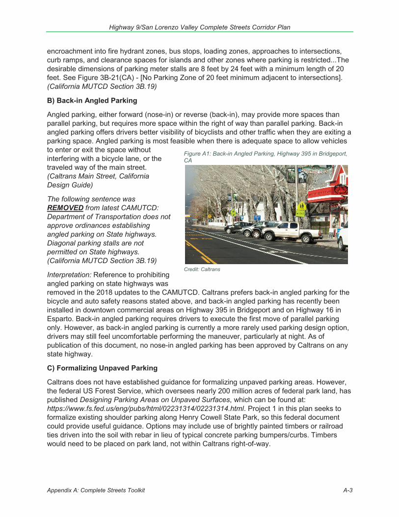
B) Back-in Angled Parking
Angled parking, either forward (nose-in) or reverse (back-in), may provide more spaces than parallel parking, but requires more space within the right of way than parallel parking. Back-in angled parking offers drivers better visibility of bicyclists and other traffic when they are exiting a parking space. Angled parking is most feasible when there is adequate space to allow vehicles to enter or exit the space without interfering with a bicycle lane, or the traveled way of the main street. (Caltrans Main Street, California Design Guide)
The following sentence was REMOVED from latest CAMUTCD: Department of Transportation does not approve ordinances establishing angled parking on State highways. Diagonal parking stalls are not permitted on State highways. (California MUTCD Section 3B.19)
Interpretation: Reference to prohibiting angled parking on state highways was removed in the 2018 updates to the CAMUTCD. Caltrans prefers back-in angled parking for the bicycle and auto safety reasons stated above, and back-in angled parking has recently been installed in downtown commercial areas on Highway 395 in Bridgeport and on Highway 16 in Esparto. Back-in angled parking requires drivers to execute the first move of parallel parking only. However, as back-in angled parking is currently a more rarely used parking design option, drivers may still feel uncomfortable performing the maneuver, particularly at night. As of publication of this document, no nose-in angled parking has been approved by Caltrans on any state highway.
C) Formalizing Unpaved Parking
Caltrans does not have established guidance for formalizing unpaved parking areas. However, the federal US Forest Service, which oversees nearly 200 million acres of federal park land, has published Designing Parking Areas on Unpaved Surfaces, which can be found at: https://www.fs.fed.us/eng/pubs/html/02231314/02231314.html. Project 1 in this plan seeks to formalize existing shoulder parking along Henry Cowell State Park, so this federal document could provide useful guidance. Options may include use of brightly painted timbers or railroad ties driven into the soil with rebar in lieu of typical concrete parking bumpers/curbs. Timbers would need to be placed on park land, not within Caltrans right-of-way.
Figure A1: Back-in Angled Parking, Highway 395 in Bridgeport, CA
Credit: Caltrans
Highway 9/San Lorenzo Valley Complete Streets Corridor Plan
Appendix A: Complete Streets Toolkit A-4
D) Establishing No Parking Areas
On-street parking generally decreases through traffic capacity, impedes traffic flow, and increases crash potential. Where the primary service of the arterial is the movement of vehicles, it may be desirable to prohibit on-street parking on State highways in urban and suburban expressways and rural arterial sections. (Caltrans Highway Design Manual, Index 402.3)
The Caltrans District Director is authorized to issue orders prohibiting or restricting the parking of vehicles on State highways. The District Director is also authorized to approve ordinances or resolutions of local authorities prohibiting or restricting parking on State highways...Major factors that may be considered for No Stopping Anytime include: Narrow roadway width, Restricted visibility at intersections for pedestrian and vehicular traffic, Narrow shoulder width, Conversion of a parking lane to a through lane or right-turn lane. (California MUTCD Section 2B.46)
At all intersections, one stall length on each side measured from the crosswalk or end of curb return should have parking prohibited…At signalized intersections parking should be prohibited for a minimum of 30 feet on the near side and one stall length (20') on the far side. (California MUTCD Section 3B.19)
Interpretation: Prohibition of stopping or parking may be required to achieve multimodal goals of many of the Highway 9/SLV Complete Streets Corridor Plan projects, particularly projects 1, 8, and any project including vehicle right turn lanes, bike lanes, multiuse paths, or sidepaths. However, maximizing parking availability in commercial areas could support economic vitality objectives in this study. This plan recommends that essential parking in the village cores be relocated, not removed.
1.2) Turnouts
On a two-lane highway where passing is limited, the California Vehicle Code requires slow-moving vehicles followed by five or more vehicles to turn off at designated turnouts or wherever sufficient area for a safe turnout exists. Designated turnouts may be constructed in hilly or mountainous terrain or on winding roads in other areas...(b) Length. Designated turnouts should be from 200 feet to 500 feet long including a short taper (usually 50 feet) at each end…(c) Width. Paved widths of at least 15 feet in fill sections and 12 feet in cut sections are recommended…On the outside of curves along steep fill slopes or drop-offs, greater width or the installation of guardrail should be considered. (d) Location. Turnouts should be located where there is stopping sight distance for approaching drivers to see vehicles leaving and re-entering the through lanes. (Caltrans Highway Design Manual Index 204.5 (4)
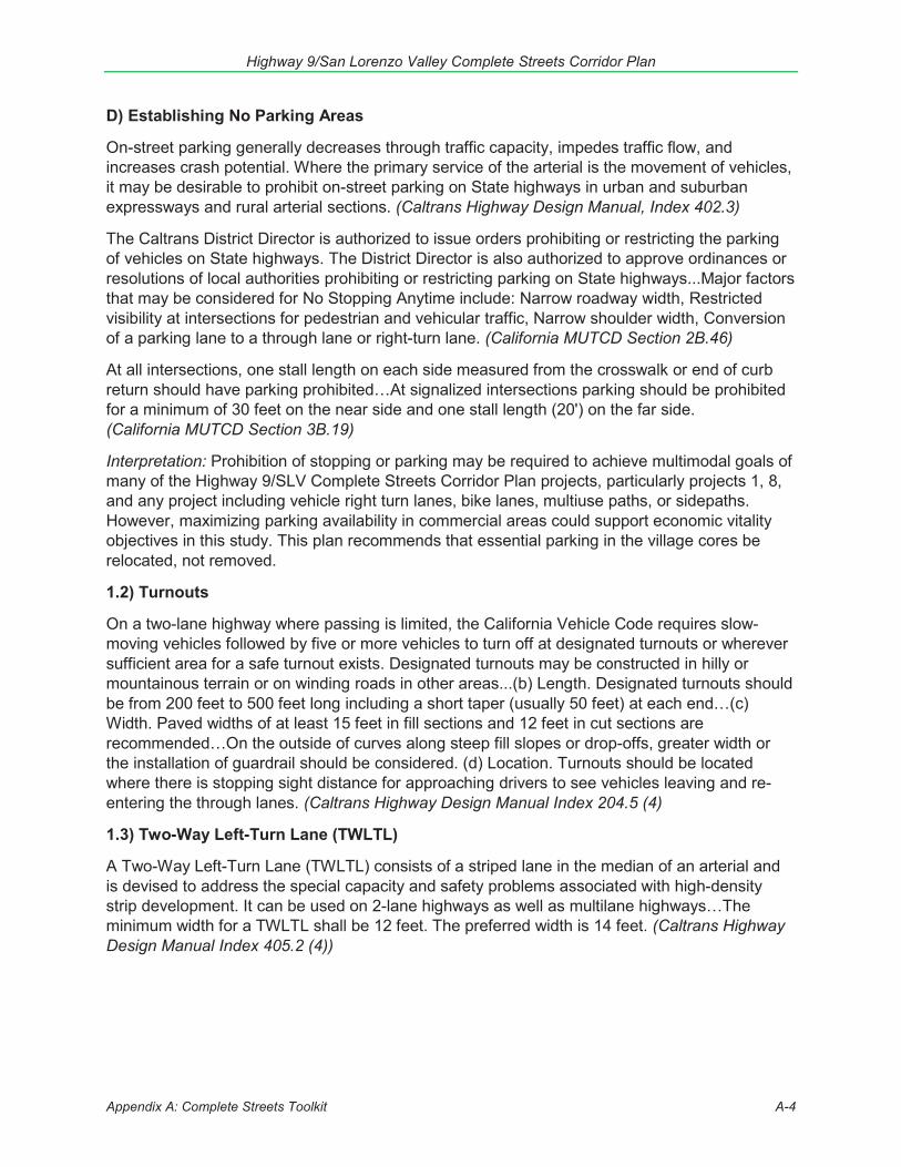
1.3) Two-Way Left-Turn Lane (TWLTL)
A Two-Way Left-Turn Lane (TWLTL) consists of a striped lane in the median of an arterial and is devised to address the special capacity and safety problems associated with high-density strip development. It can be used on 2-lane highways as well as multilane highways…The minimum width for a TWLTL shall be 12 feet. The preferred width is 14 feet. (Caltrans Highway Design Manual Index 405.2 (4))
Highway 9/San Lorenzo Valley Complete Streets Corridor Plan
Appendix A: Complete Streets Toolkit A-5
Figure A2: Two-Way Left-Turn Lane (TWLTL)
Credit: Caltrans
A two-way left-turn lane is a lane reserved in the center of a highway for exclusive use of left or U-turning vehicles. Refer to CVC21460.5. It is normally used wherethere are many points of access.(California MUTCD Section 3B.03)
Interpretation: A TWLTL could be utilized to improve traffic flow in village core areas with high levels of traffic turning into or merging from roadside parking or driveways. Synchro analysis would be needed to determine the minimum amount of TWLTL that would need to be devoted to a left turn only pocket at intersections.
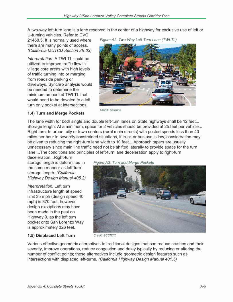
1.4) Turn and Merge Pockets
The lane width for both single and double left-turn lanes on State highways shall be 12 feet... Storage length: At a minimum, space for 2 vehicles should be provided at 25 feet per vehicle... Right turn: In urban, city or town centers (rural main streets) with posted speeds less than 40 miles per hour in severely constrained situations, if truck or bus use is low, consideration may be given to reducing the right-turn lane width to 10 feet... Approach tapers are usually unnecessary since main line traffic need not be shifted laterally to provide space for the turn lane ...The conditions and principles of left-turn lane deceleration apply to right-turn deceleration...Right-turn storage length is determined in the same manner as left-turn storage length. (California Highway Design Manual 405.2)
Interpretation: Left turn infrastructure length at speed limit 35 mph (design speed 40 mph) is 370 feet, however design exceptions may have been made in the past on Highway 9, as the left turn pocket onto San Lorenzo Way is approximately 326 feet.
1.5) Displaced Left Turn
Various effective geometric alternatives to traditional designs that can reduce crashes and their severity, improve operations, reduce congestion and delay typically by reducing or altering the number of conflict points; these alternatives include geometric design features such as intersections with displaced left-turns. (California Highway Design Manual 401.5)
Figure A3: Turn and Merge Pockets
Credit: SCCRTC
Highway 9/San Lorenzo Valley Complete Streets Corridor Plan
Appendix A: Complete Streets Toolkit A-6
Figure A4: Roundabout
Credit: NACTO
The displaced left turn (DLT) intersection is also known as a continuous flow intersection (CFI)and a crossover displaced left-turn intersection…This attribute consequently allows left-turn movements to proceed simultaneously with the through movements and eliminates the left-turn phase for this approach. The number of traffic signal phases and conflict points (locations where user paths cross) are reduced at a DLT intersection, which can result in improvements in traffic operations and safety performance. (FHWA Displaced Left Turn Intersection Informational Guide (2014))
1.6) New Stop Signs
An engineering study of traffic conditions, pedestrian characteristics, and physical characteristics of the location shall be performed to determine whether installation of a traffic control signal is justified at a particular location. Traffic signal warrants: Eight-Hour Vehicular Volume, Four-Hour Vehicular Volume, Peak Hour, Pedestrian Volume, School Crossing, Coordinated Signal System, Crash Experience, Roadway Network, Intersection Near a Grade Crossing. The satisfaction of a traffic signal warrant or warrants shall not in itself require the installation of a traffic control signal...The Peak Hour signal warrant is intended for use at a location where traffic conditions are such that for a minimum of 1 hour of an average day, the minor-street traffic suffers undue delay when entering or crossing the major street. (California MUTCD Section 4C.01-4C.09)
Interpretation: Caltrans requires an intersection control evaluation (ICE) for installation of new stop signs. This Complete Streets Corridor Plan proposes analyzing the installation of one new additional stop sign for southbound Highway 9 at Bear Creek Road (Project 27). The proposed stop sign would serve the dual purpose of slowing highway traffic as it enters Boulder Creek from the north and reducing delay for autos turning from Bear Creek Road onto Highway 9, especially during peak commute times. The new stop control at this location would likely need to pursue the “Peak Hour” traffic signal warrant option.
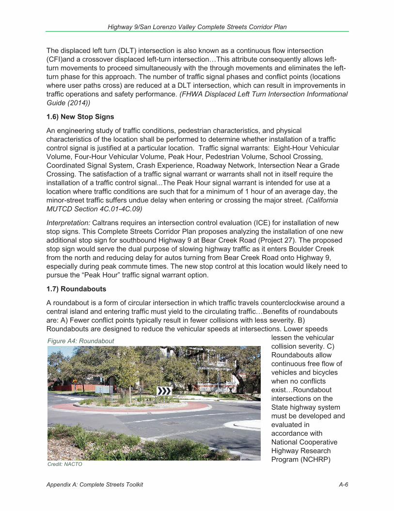
1.7) Roundabouts
A roundabout is a form of circular intersection in which traffic travels counterclockwise around a central island and entering traffic must yield to the circulating traffic…Benefits of roundabouts are: A) Fewer conflict points typically result in fewer collisions with less severity. B) Roundabouts are designed to reduce the vehicular speeds at intersections. Lower speeds
lessen the vehicularcollision severity. C) Roundabouts allow continuous free flow of vehicles and bicycles when no conflicts exist…Roundabout intersections on the State highway system must be developed and evaluated in accordance with National Cooperative Highway Research Program (NCHRP)

Highway 9/San Lorenzo Valley Complete Streets Corridor Plan
Appendix A: Complete Streets Toolkit A-7
Report 672 entitled “Roundabouts: An Informational Guide, 2nd ed.” (NCHRP Guide 2) dated October 2010 and Traffic Operations Policy Directive (TOPD) Number 13-02. (Caltrans Highway Design Manual Index 405.10)
Note: Truck and bus turning radii should be considered in the design of any roundabouts.
2. Auto Safety2.1) Improving Sight Lines
At unsignalized intersections a substantially clear line of sight should be maintained between the driver of a vehicle, bicyclist or pedestrian waiting at the crossroad and the driver of an approaching vehicle. Line of sight for all users should be included in right of way, in order to preserve sight lines…In some cases the cost to obtain 7-1/2 seconds of corner sight distances may be excessive. High costs may be attributable to right of way acquisition, building removal, extensive excavation, or immitigable environmental impacts. In such cases a lesser value of corner sight distance, as described under [table 201.1], may be used…At unsignalized public road intersections corner sight distance values given in Table 405.1A should be provided… Private Road Intersections and Rural Driveways - the minimum corner sight distance shall be equal to the stopping sight distance as given in Table 201.1, measured as previously described. (Caltrans Highway Design Manual Index 405.1)
Interpretation: At the typical Highway 9 speed limit of 35 mph (40 mph design speed) corner sight distance for unsignalized public intersections should be 440 feet, and for private roads and rural driveways should be 300 feet. Where cost to provide the full 440 feet for public intersections is infeasible, a minimum of 300 feet of sight distance must be provided.
2.2) Radar Speed Feedback Signs
A Vehicle Speed Feedback sign that displays to approaching drivers the speed at which they are traveling may be installed in conjunction with a Speed Limit (R2-1) sign. If a Vehicle Speed Feedback sign displaying approach speeds is installed, the legend shall be YOUR SPEED XX. The numerals displaying the speed shall be white, yellow, yellow-green or amber color on black background. When activated, lights shall be steady-burn conforming to the provisions of CVC Sections 21466 and 21466.5. (California MUTCD Section 2B.13)
A radar speed sign may be considered in conjunction with other guidance where a speed transition zone exists (high to low speed limits). A radar speed sign may be considered when the observed mean speeds at a site exceed the posted speed limit by 5 mph or more. A radar speed sign may be considered when ADT exceeds 500 vehicles. A radar speed sign may be considered at sites exhibiting a correctable speed-related accident history within a recent time period. A radar speed sign may
Figure A5: Radar Speed Feedback Signs
Credit: FHWA
Highway 9/San Lorenzo Valley Complete Streets Corridor Plan
Appendix A: Complete Streets Toolkit A-8
Figure A6: Speed Limit Sign with Flashing Beacon
Credit: FHWA
be used at sites with a pedestrian-related accident history. (FHWA Office of Safety Speed Management Reference Materials – Guidance for Radar Speed Sign Deployments)
Interpretation: Caltrans District 5 has provided with the following additional guidance regarding guidelines for placement of radar speed feedback signs:
Caltrans Process:
The engineering guidance for use of speed feedback signs is found in the California Manual on Uniform Traffic Control Devices. The permitting application requirements would be:
1. Engineering study and support for the speed feedback signs. The study would, at a minimum, need tojustify the use and location of the signs by way of evaluation of 3 years traffic collision data and pos-sibly speed samples from a traffic engineer. Caltrans Traffic Operations will need to concur with thestudy and recommendations prior to application for permit. This engineering study is an evaluationthat will need to provide purpose, need, and justification for installation/location; as it is an engineer-ing study, a Registered Civil Engineer will need to seal, sign, date, and provide the expiration date ofthe license in accordance with State law.
2. Resolution of support by County Board of Supervisors (BOS) for installation and maintenance in per-petuity for said signs after Caltrans Traffic Operations Branch Chief has concurred with the engineer-ing study.
3. CHP may need to be in written support of the sign as well, see what Cal MUTCD says.
4. Complete application including as appropriate: California Environmental Quality Act (CEQA) Notice ofDetermination (NOD), completed/signed encroachment permit application, complete/final Resolutionby BOS for installation and maintenance of speed feedback signs, six sets of 100% complete engi-neering plans.
5. The permit will be issued within 30 days of receipt if it is complete. The application will be rejected ifincomplete.
In some communities, radar feedback signs can become less effective over time as drivers “get used to” their presence.
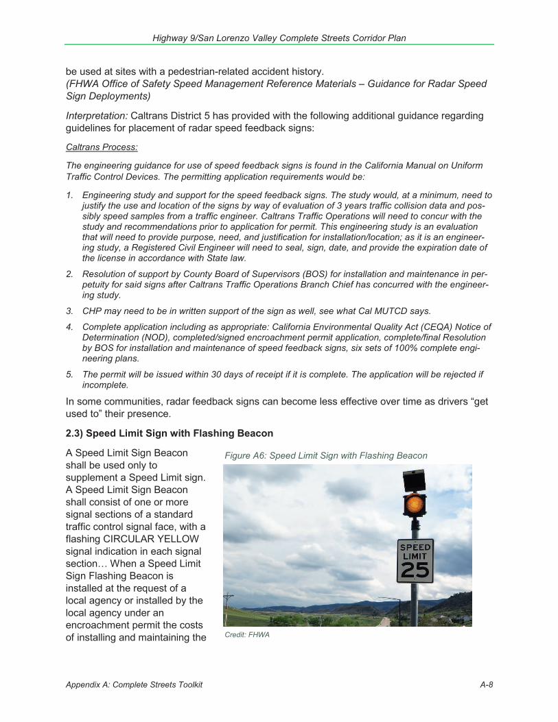
2.3) Speed Limit Sign with Flashing Beacon
A Speed Limit Sign Beacon shall be used only to supplement a Speed Limit sign. A Speed Limit Sign Beacon shall consist of one or more signal sections of a standard traffic control signal face, with a flashing CIRCULAR YELLOW signal indication in each signal section… When a Speed Limit Sign Flashing Beacon is installed at the request of a local agency or installed by the local agency under an encroachment permit the costs of installing and maintaining the
Highway 9/San Lorenzo Valley Complete Streets Corridor Plan
A-9
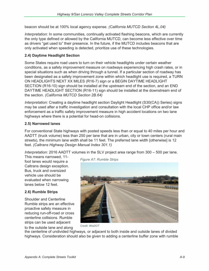
Figure A7: Rumble Strips
beacon should be at 100% local agency expense. (California MUTCD Section 4L.04)
Interpretation: In some communities, continually activated flashing beacons, which are currently the only type defined or allowed by the California MUTCD, can become less effective over time as drivers “get used to” their presence. In the future, if the MUTCD includes beacons that are only activated when speeding is detected, prioritize use of these technologies.
2.4) Daytime Headlight Section
Some States require road users to turn on their vehicle headlights under certain weather conditions, as a safety improvement measure on roadways experiencing high crash rates, or in special situations such as when driving through a tunnel. If a particular section of roadway has been designated as a safety improvement zone within which headlight use is required, a TURN ON HEADLIGHTS NEXT XX MILES (R16-7) sign or a BEGIN DAYTIME HEADLIGHT SECTION (R16-10) sign should be installed at the upstream end of the section, and an END DAYTIME HEADLIGHT SECTION (R16-11) sign should be installed at the downstream end of the section. (California MUTCD Section 2B.64)
Interpretation: Creating a daytime headlight section Daylight Headlight (S30(CA)) Series) signs may be used after a traffic investigation and consultation with the local CHP office and/or law enforcement as a traffic safety improvement measure in high accident locations on two lane highways where there is a potential for head-on collisions.
2.5) Narrowed lanes
For conventional State highways with posted speeds less than or equal to 40 miles per hour and AADTT (truck volume) less than 250 per lane that are in urban, city or town centers (rural main streets), the minimum lane width shall be 11 feet. The preferred lane width [otherwise] is 12 feet. (Caltrans Highway Design Manual Index 301.1)
Interpretation: 2016 AADTT volumes in the SLV project area range from 300 – 500 per lane. This means narrowed, 11-foot lanes would require a Caltrans design exception. Bus, truck and oversized vehicle use should be evaluated when narrowing lanes below 12 feet.
2.6) Rumble Strips
Shoulder and Centerline Rumble strips are an effective proactive safety measure in reducing run-off-road or cross centerline collisions. Rumble strips can be used adjacent to the outside lane and along Credit: WisDOT
the centerline of undivided highways, or adjacent to both inside and outside lanes of divided highways. Consideration should also be given to adding a centerline buffer zone with rumble
Appendix A: Complete Streets Toolkit
Highway 9/San Lorenzo Valley Complete Streets Corridor Plan
Appendix A: Complete Streets Toolkit A-10
strips on highway segments where collision data exhibits a high number of cross centerline collisions. (Caltrans Design Bulletin 79)
Where rumble strips are placed in the shoulder, the shoulder shall be a minimum of 4 feet width to the right of the grooved rumble strip when a vertical element, such as curb or guardrails present or a minimum of 3 feet width when a vertical element is not present. Shoulder rumble strip must not be placed in the Class II bike lane. Also see Standard Plans for rumble strip details. From 2015 Shoulder Rumble Strip Standard Plan:
Shoulder width: 4 feet Placement: 6-inch offset outside the white line Frequency: No gap pattern is specified Depth: 5/16” (0.3125 inches) Width: 5 inches Length: 12 inches (Caltrans Highway Design Manual Index 302.1)
If rumble strips are desired on bicycle network routes optimize the dimension, design, and placement of rumble strips to be more tolerable to bicyclists. 12-inch spacing center-to-center, 6–8 inches long, perpendicular to roadway, 6-inch-wide, measured parallel to roadway, 3/8 (0.375”) inch deep. Place rumble strips to overlap with the roadway edge line, also known as edge line rumble strips or rumble stripes. Provide a bicycle gap pattern to allow access into and out of the shoulder area by bicyclists. The gap pattern consists of a 12 ft (3.3 m) clear gap followed by rumbles, typical 40–60 ft (12.1–18.2 m). 8 in wide white line with rumble strip is an edge marking option. (FHWA Rural and Multimodal Networks, Paved Shoulder)
These are the rumble strip best practices recommendations that provide the minimum standards to safely accommodate bicyclists:
Shoulder width: No rumble strips or stripes installed on shoulders less than four feet wide.Placement: Adjacent to or on the white line, providing a minimum of four feet of usableshoulder to the right of the rumble strip.Frequency: 10-foot gaps allow cyclists to navigate away from the shoulder if needed.Depth: 0.375 inchesWidth: 5 inchesLength: 6 inchesCenter line rumble strips: Ensure a minimum four-foot shoulder width when installing centerline rumble strips. AASHTO recommends six-foot minimum shoulder width when both centerline and shoulder rumble strips are present.
(Adventure Cycling Association – Rumble Strips Best Practices)
Interpretation: While the FHWA Rural and Multimodal Networks guidelines closely align with the recommendations from cycling organizations, the Caltrans design standards are quite different, particularly in terms of the lack of placement of frequent gaps to allow bicyclists to exit the shoulder/bike lane to avoid hazards. If rumble strips are utilized in the SLV, either to help prevent auto run-off-road crashes or to help prevent autos from drifting into paved right-of-way space intended for cyclists or pedestrians, the FHWA Rural and Multimodal Network guidelines should be followed.
Highway 9/San Lorenzo Valley Complete Streets Corridor Plan
Appendix A: Complete Streets Toolkit A-11
2.7) Guardrails
Guardrail, installed to reduce the severity of run-off-road collisions, is the most common traffic safety system found on California State Highways. Guardrail may redirect an errant vehicle and dissipate energy from the collision in some, but not for all cases depending on the sequence of events during the collision. Although guardrail is itself a fixed object, it may reduce collision severity in situations where it is determined that striking the guardrail is less severe than striking fixed objects or slopes behind the guardrail. (Caltrans Traffic Safety Systems Guidance, 2017)
2.8) Improved Drainage
Roadway drainage involves the collection, conveyance, removal, and disposal of surface water runoff from the traveled way, shoulders, sidewalks, and adjoining areas defined in Index 62.1(7) as comprising the roadway… The design of roadway drainage systems often involves consideration of the problems associated with inadequate drainage of the adjacent or surrounding area. Cooperative drainage improvement projects with the responsible local agency may offer the best overall solution. (Caltrans Highway Design Manual Index 831.1)
2.9) Enforcement
Traffic laws in San Lorenzo Valley are enforced by the California Highway Patrol (CHP). Extra enforcement increases the number of CHP officers patrolling an area, and this high CHP visibility serves to encourage safer driving and deter traffic violations. Current CHP patrol levels are relatively low in the San Lorenzo Valley, due to lack of funding. Increases in enforcement could be funded by applying for grants through the California Office of Traffic Safety or the National Highway Traffic Safety Administration.
2.10) Reduce speed limits
Reducing speed limits can potentially reduce collisions and the severity of collisions. Driving at higher speeds can increase stopping distances, result in greater potential for loss of vehicle control, increase the degree of crash severity, reduce the effectiveness of occupant protection equipment, and increase fuel consumption and cost. Most speed regulations are based on the Basic Speed Law: “No person shall drive a vehicle at a speed greater than is reasonable or prudent and in no event at a speed which endangers the safety of persons or property” (California Vehicle Code 22350). All speed limits other than maximum speed limits are called prima facie limits, which are considered by law to be safe and prudent under normal conditions. Certain prima facie limits are established by California law and include the 25 MPH speed limit in school zones when children are present. Speed limits are normally set at the first five-mile per hour increment nearest the 85th percentile speed, defined as that speed at or below which 85 percent of the traffic is moving. Any further reduction of the speed limit must be documented by and clearly justified by an Engineering and Traffic Survey. Caltrans typically conducts surveys and adjusts the speed limits every seven to ten years based on this methodology, most recently in 2017. In 2018, the California legislature passed AB 2363 to establish a Zero Traffic Fatalities Task Force which will consider alternatives to the 85th percentile methodology to determine speed limits in California. The Task Force’s recommendations are expected to be available in 2020 and could allow Caltrans to modify the speed limits through SLV.
Highway 9/San Lorenzo Valley Complete Streets Corridor Plan
Appendix A: Complete Streets Toolkit A-12
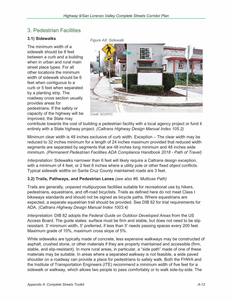
3. Pedestrian Facilities3.1) Sidewalks
The minimum width of a sidewalk should be 8 feet between a curb and a building when in urban and rural main street place types. For all other locations the minimum width of sidewalk should be 6 feet when contiguous to a curb or 5 feet when separated by a planting strip. The roadway cross section usually provides areas for pedestrians. If the safety or capacity of the highway will be improved, the State may contribute towards the cost of building a pedestrian facility with a local agency project or fund it entirely with a State highway project. (Caltrans Highway Design Manual Index 105.2)
Minimum clear width is 48 inches exclusive of curb width. Exception – The clear width may be reduced to 32 inches minimum for a length of 24 inches maximum provided that reduced width segments are separated by segments that are 48 inches long minimum and 48 inches wide minimum. (Permanent Pedestrian Facilities ADA Compliance Handbook 2018 - Path of Travel)
Interpretation: Sidewalks narrower than 6 feet will likely require a Caltrans design exception, with a minimum of 4 feet, or 2 feet 8 inches where a utility pole or other fixed object conflicts. Typical sidewalk widths on Santa Cruz County maintained roads are 3 feet.
3.2) Trails, Pathways, and Pedestrian Lanes (see also #6. Multiuse Path)
Trails are generally, unpaved multipurpose facilities suitable for recreational use by hikers, pedestrians, equestrians, and off-road bicyclists. Trails as defined here do not meet Class I bikeways standards and should not be signed as bicycle paths. Where equestrians are expected, a separate equestrian trail should be provided. See DIB 82 for trial requirements for ADA. (Caltrans Highway Design Manual Index 1003.4)
Interpretation: DIB 82 adopts the Federal Guide on Outdoor Developed Areas from the US Access Board. The guide states: surface must be firm and stable, but does not need to be slip resistant. 3' minimum width, 5' preferred, if less than 5' needs passing spaces every 200 feet. Maximum grade of 10%, maximum cross slope of 5%.
While sidewalks are typically made of concrete, less expensive walkways may be constructed of asphalt, crushed stone, or other materials if they are properly maintained and accessible (firm, stable, and slip-resistant). In more rural areas, in particular, a “side path” made of one of these materials may be suitable. In areas where a separated walkway is not feasible, a wide paved shoulder on a roadway can provide a place for pedestrians to safely walk. Both the FHWA and the Institute of Transportation Engineers (ITE) recommend a minimum width of five feet for a sidewalk or walkway, which allows two people to pass comfortably or to walk side-by-side. The
Figure A8: Sidewalk
Credit: SCCRTC
Highway 9/San Lorenzo Valley Complete Streets Corridor Plan
Appendix A: Complete Streets Toolkit A-13
preferred width for paved shoulders is at least 6 feet. Wider sidewalks should be installed near schools, at transit stops, in downtown areas, or anywhere high concentrations of pedestrians exist. Sidewalks should be continuous along both sides of a street and sidewalks should be fully accessible to all pedestrians, including those in wheelchairs. A buffer zone of four to six feet is desirable to separate pedestrians from the street. The buffer zone will vary according to the street type. In downtown or commercial districts, a street furniture zone is usually appropriate. Parked cars or bicycle lanes can provide an acceptable buffer zone. In more suburban or rural areas, a landscape strip is generally most suitable. Careful planning of sidewalks and walkways is important in a neighborhood or area in order to provide adequate safety and mobility. For example, there should be a flat sidewalk provided in areas where driveways slope to the roadway.(Pedestrian and Bicycle Information Center, Sidewalks and Walkways)
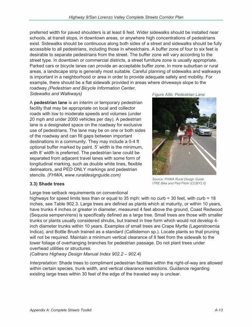
A pedestrian lane is an interim or temporary pedestrian facility that may be appropriate on local and collector roads with low to moderate speeds and volumes (under 20 mph and under 2000 vehicles per day). A pedestrian lane is a designated space on the roadway for exclusive use of pedestrians. The lane may be on one or both sides of the roadway and can fill gaps between important destinations in a community. They may include a 0-4 ft optional buffer marked by paint. 5’ width is the minimum, with 8’ width is preferred. The pedestrian lane could be separated from adjacent travel lanes with some form of longitudinal marking, such as double white lines, flexible delineators, and PED ONLY markings and pedestrian stencils. (FHWA, www.ruraldesignguide.com)
3.3) Shade trees
Large tree setback requirements on conventional highways for speed limits less than or equal to 35 mph: with no curb = 30 feet, with curb = 18 inches, see Table 902.3. Large trees are defined as plants which at maturity, or within 10 years, have trunks 4 inches or greater in diameter, measured 4 feet above the ground, Coast Redwood (Sequoia sempervirens) is specifically defined as a large tree. Small trees are those with smaller trunks or plants usually considered shrubs, but trained in tree form which would not develop 4-inch diameter trunks within 10 years. Examples of small trees are Crape Myrtle (Lagerstroemia Indica), and Bottle Brush trained as a standard (Callistemon sp.). Locate plants so that pruning will not be required. Maintain a minimum vertical clearance of 8 feet from the sidewalk to the lower foliage of overhanging branches for pedestrian passage. Do not plant trees under overhead utilities or structures. (Caltrans Highway Design Manual Index 902.2 – 902.4)
Interpretation: Shade trees to compliment pedestrian facilities within the right-of-way are allowed within certain species, trunk width, and vertical clearance restrictions. Guidance regarding existing large trees within 30 feet of the edge of the traveled way is unclear.
Figure A8b: Pedestrian Lane
Source: FHWA Rural Design Guide ITRE Bike and Ped Flickr (CCBY2.0)
Highway 9/San Lorenzo Valley Complete Streets Corridor Plan
Appendix A: Complete Streets Toolkit A-14
3.4) Safety or Pedestrian Lighting
[When] safety lighting is to be installed or modified at the intersection of a State highway and a local road, local agency participation in the installation or modification costs shall be sought...When it is necessary to widen or reconstruct a State highway, the reconstruction and relocation of traffic control devices and safety lighting systems, shall be at 100% State expense…Encroachment permits shall be required for a local agency or a private party to install or modify traffic signals and roadway lighting on a State highway. (California MUTCD Sections 4B.106, 4B.112)
On conventional highways, including expressways, State financing of highway safety lighting shall be limited to that at intersections with traffic signals or flashing beacons or at those locations which meet the conditions listed below. The existence of an intersection is not, in itself, a justification for lighting…Safety lighting may be provided at existing intersections on expressways and conventional highways…where combinations of sight distance, or horizontal or vertical curvature of the roadway, channelization or other factors constitute a confusing or unsatisfactory condition that may be improved with lighting. The project report covering such lighting should include an explanation of the factors constituting the confusing or unsatisfactory condition. (Caltrans Traffic Manual Section 9-08)
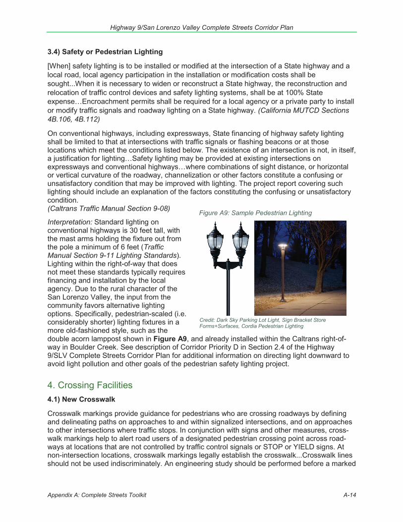
Interpretation: Standard lighting on conventional highways is 30 feet tall, with the mast arms holding the fixture out from the pole a minimum of 6 feet (Traffic Manual Section 9-11 Lighting Standards). Lighting within the right-of-way that does not meet these standards typically requires financing and installation by the local agency. Due to the rural character of the San Lorenzo Valley, the input from the community favors alternative lighting options. Specifically, pedestrian-scaled (i.e. considerably shorter) lighting fixtures in a more old-fashioned style, such as the double acorn lamppost shown in Figure A9, and already installed within the Caltrans right-of-way in Boulder Creek. See description of Corridor Priority D in Section 2.4 of the Highway 9/SLV Complete Streets Corridor Plan for additional information on directing light downward to avoid light pollution and other goals of the pedestrian safety lighting project.
4. Crossing Facilities4.1) New Crosswalk
Crosswalk markings provide guidance for pedestrians who are crossing roadways by defining and delineating paths on approaches to and within signalized intersections, and on approaches to other intersections where traffic stops. In conjunction with signs and other measures, cross-walk markings help to alert road users of a designated pedestrian crossing point across road-ways at locations that are not controlled by traffic control signals or STOP or YIELD signs. At non-intersection locations, crosswalk markings legally establish the crosswalk...Crosswalk lines should not be used indiscriminately. An engineering study should be performed before a marked
Figure A9: Sample Pedestrian Lighting
Credit: Dark Sky Parking Lot Light, Sign Bracket Store Forms+Surfaces, Cordia Pedestrian Lighting

Highway 9/San Lorenzo Valley Complete Streets Corridor Plan
Appendix A: Complete Streets Toolkit A-15
crosswalk is installed at a location away from a traffic control signal or an approach controlled by a STOP or YIELD sign. The engineering study should consider the number of lanes, the presence of a median, the distance from adjacent signalized intersections, the pedestrian vol-umes and delays, the average daily traffic (ADT), the posted or statutory speed limit or 85th-percentile speed, the geometry of the location, the possible consolidation of multiple crossing points, the availability of street lighting, and other appropriate factors. (California MUTCD Section 3B.18)
The most thorough and rigorous study of pedestrian crossing facilities, conducted by Zegeer et al., performed a comparison of pedestrian collision risk at marked and unmarked uncontrolled crossing locations. They found that marked crosswalks at unsignalized locations on multilane roads with high traffic volumes (above 12,000 vehicles per day) results in an elevated collision risk compared with unmarked crosswalks, which could be associated with a false sense of secu-rity at the locations. Crosswalk markings serve primarily to guide pedestrians in the proper paths. Pedestrian crosswalk markings should not be used indiscriminately. Unwarranted cross-walks can be detrimental to pedestrian safety by providing a false sense of security. (Caltrans State Bicycle and Pedestrian Plan Technical Report, Safety Trends 2017)
Crosswalk markings serve primarily to guide pedestrians in the proper paths. Pedestrian cross-walk markings should not be used indiscriminately. Unwarranted crosswalks can be detrimental to pedestrian safety by providing a false sense of security. (Chapter M, Caltrans Maintenance Manual 2014)
The use of "ladder", "zebra" or other enhanced markings at uncontrolled crossings can increase both pedestrian and driver awareness to the increased exposure at the crossing. Incorporating advanced "stop" or “yield" markings provides an extra safety buffer and can be effective in re-ducing the 'multiple-threat' danger to pedestrians. Nearly one-third of all pedestrian-related crashes occur at or within 50 feet of an intersection. Of these, 30 percent may involve a turning vehicle. There are several types of pedestrian crosswalks, including: continental, ladder, zebra, and standard… The enhanced safety elements, which may include curb extensions, medians and pedestrian crossing islands, beacons, and lighting, combined with pavement markings de-lineating a portion of the roadway that is designated for pedestrian crossing. Care must be tak-en to warn drivers of the potential for pedestrians crossing the roadway and enhanced im-provements added to the crossing increase the likelihood of pedestrians crossing in a safe manner. (Caltrans Local Roadway Safety Manual 2018)
Interpretation: New crosswalks are not easy to get approved. Caltrans does not typically support or approve new midblock crosswalks. Frequent crosswalks of traditional design often do not at-tract the proper amount of attention from drivers, especially at higher speeds. This plan focuses on upgrades to existing crosswalks, as well as installation of new enhanced- pedestrian activat-ed crosswalks at a few key intersections where pedestrian injury rates are high (see projects 4, 5, 12, 14, 18, 27, 28). For auto volumes and pedestrian volumes typical in the SLV, the FHWA Small Town and Rural Multimodal Networks recommends enhanced and/or pedestrian activated crossings.
4.2) Crosswalks without connecting sidewalks
For reconstruction or new construction, a curb ramp or blended transition should serve each pedestrian crossing. (Caltrans Highway Design Manual Index 105.5)
Highway 9/San Lorenzo Valley Complete Streets Corridor Plan
Appendix A: Complete Streets Toolkit A-16
In some cases, a curb ramp cannot be constructed because there is no sidewalk at the intersection. However, there may be reason to provide a blended transition, which could be at-grade… Blended Transition: A raised pedestrian street crossing, depressed corner, or similar connection between the pedestrian access route at the level of the sidewalk and the level of the pedestrian street crossing that has a grade of 5 percent or less [PROWAG R105.5]. (Caltrans Design Bulletin 82 – ADA Accessibility for Highway Projects)
Interpretation: Caltrans Design Bulletin 82 goes on to describe the slope, landing, cross slope, detectable warning device, and detectable warning surface requirements of at-grade blended transitions. There are many locations throughout the SLV where upgrades are needed to pedestrian crossing facilities that are not directly linked to pedestrian facilities with curbs, such as sidewalks (see projects 3, 5, 12, 13, 18, 27, 28). The Blended Transition option allows for maximizing the safety and accessibility of pedestrian crossings at locations where curb-and-gutter sidewalks are not planned in the foreseeable future or may never be installed. See also the federal FHWA Small Town and Rural Multimodal Networks document for depictions of accessible at-grade pedestrian crossing facilities in the “Pedestrian Lane” design example.
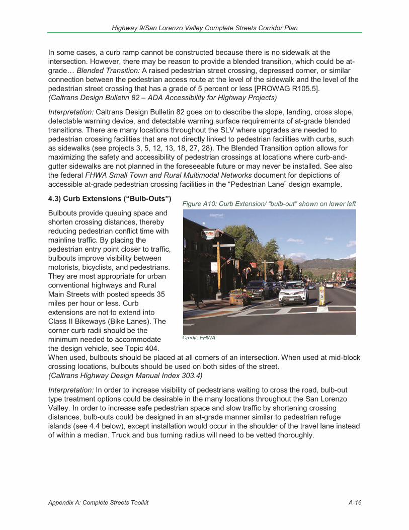
4.3) Curb Extensions (“Bulb-Outs”)
Bulbouts provide queuing space and shorten crossing distances, thereby reducing pedestrian conflict time with mainline traffic. By placing the pedestrian entry point closer to traffic, bulbouts improve visibility between motorists, bicyclists, and pedestrians. They are most appropriate for urban conventional highways and Rural Main Streets with posted speeds 35 miles per hour or less. Curb extensions are not to extend into Class II Bikeways (Bike Lanes). The corner curb radii should be the minimum needed to accommodate the design vehicle, see Topic 404. When used, bulbouts should be placed at all corners of an intersection. When used at mid-block crossing locations, bulbouts should be used on both sides of the street. (Caltrans Highway Design Manual Index 303.4)
Interpretation: In order to increase visibility of pedestrians waiting to cross the road, bulb-out type treatment options could be desirable in the many locations throughout the San Lorenzo Valley. In order to increase safe pedestrian space and slow traffic by shortening crossing distances, bulb-outs could be designed in an at-grade manner similar to pedestrian refuge islands (see 4.4 below), except installation would occur in the shoulder of the travel lane instead of within a median. Truck and bus turning radius will need to be vetted thoroughly.
Figure A10: Curb Extension/ “bulb-out” shown on lower left
Credit: FHWA
Highway 9/San Lorenzo Valley Complete Streets Corridor Plan
Appendix A: Complete Streets Toolkit A-17
Figure A11: Pedestrian Refuge Island
Credit: Santa Clara County Parks
Figure A11B: Pedestrian Corral Style Crosswalk
Credit: SANDAG
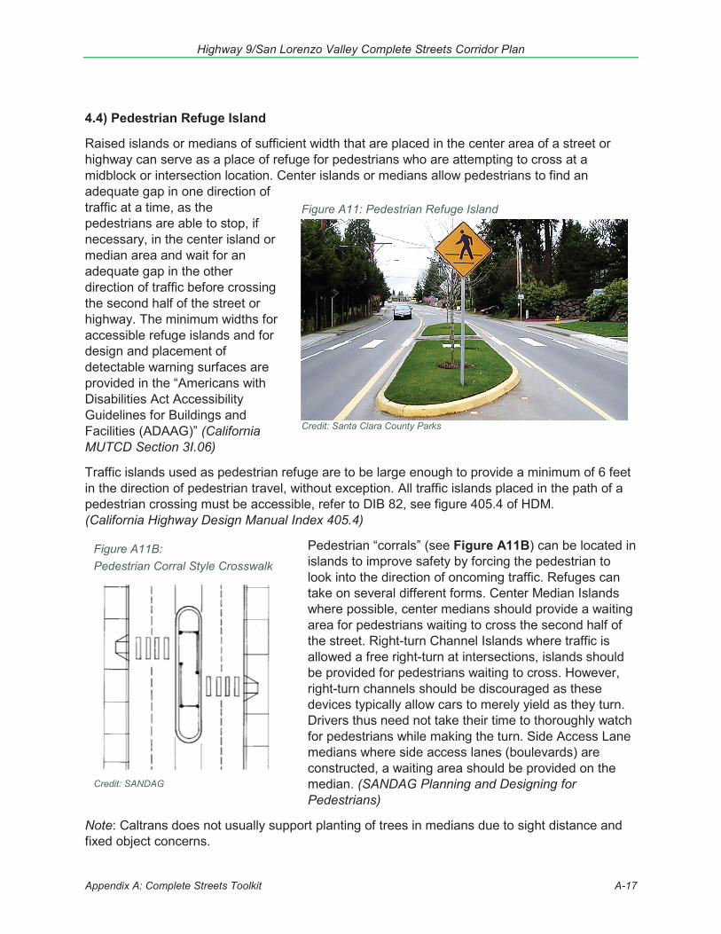
4.4) Pedestrian Refuge Island
Raised islands or medians of sufficient width that are placed in the center area of a street or highway can serve as a place of refuge for pedestrians who are attempting to cross at a midblock or intersection location. Center islands or medians allow pedestrians to find an adequate gap in one direction of traffic at a time, as the pedestrians are able to stop, if necessary, in the center island or median area and wait for an adequate gap in the other direction of traffic before crossing the second half of the street or highway. The minimum widths for accessible refuge islands and for design and placement of detectable warning surfaces are provided in the “Americans with Disabilities Act Accessibility Guidelines for Buildings and Facilities (ADAAG)” (California MUTCD Section 3I.06)
Traffic islands used as pedestrian refuge are to be large enough to provide a minimum of 6 feet in the direction of pedestrian travel, without exception. All traffic islands placed in the path of a pedestrian crossing must be accessible, refer to DIB 82, see figure 405.4 of HDM. (California Highway Design Manual Index 405.4)
Pedestrian “corrals” (see Figure A11B) can be located in islands to improve safety by forcing the pedestrian to look into the direction of oncoming traffic. Refuges can take on several different forms. Center Median Islands where possible, center medians should provide a waiting area for pedestrians waiting to cross the second half of the street. Right-turn Channel Islands where traffic is allowed a free right-turn at intersections, islands should be provided for pedestrians waiting to cross. However, right-turn channels should be discouraged as these devices typically allow cars to merely yield as they turn. Drivers thus need not take their time to thoroughly watch for pedestrians while making the turn. Side Access Lane medians where side access lanes (boulevards) are constructed, a waiting area should be provided on the median. (SANDAG Planning and Designing for Pedestrians)
Note: Caltrans does not usually support planting of trees in medians due to sight distance and fixed object concerns.
Highway 9/San Lorenzo Valley Complete Streets Corridor Plan
Appendix A: Complete Streets Toolkit A-18
4.5) Speed Table Crosswalk
Speed Table: Modified speed hump with a flat top that allows the wheelbase of a passenger car to rest on top. Provides a gentler slope than speed humps, but less reduction in speed can be expected...Speed humps are generally not recommended for use on bus routes or emergency vehicle routes; speed tables may be more appropriate. (Caltrans Preliminary Investigation: Effective Application of Traffic Calming Techniques)
The SPEED HUMP (W17-1) sign (see Figure 2C-6) should be used to give warning of a vertical deflection in the roadway that is designed to limit the speed of traffic. If used, the SPEED HUMP sign should be supplemented by an Advisory Speed plaque (see Section 2C.08) .... Speed humps generally provide more gradual vertical deflection than speed bumps. Speed bumps limit the speed of traffic more severely than speed humps. Other forms of speed humps include speed tables and raised intersections. However, these differences in engineering terminology are not well known by the public, so for signing purposes these terms are interchangeable. (California MUTCD Section 2C.29)
Interpretation: Caltrans Highway Design Manual does not provide guidance on installation of speed tables. Regulations regarding installation of speed tables on state highways is unknown. Caltrans staff have expressed concerns about the maintenance cost of speed tables.
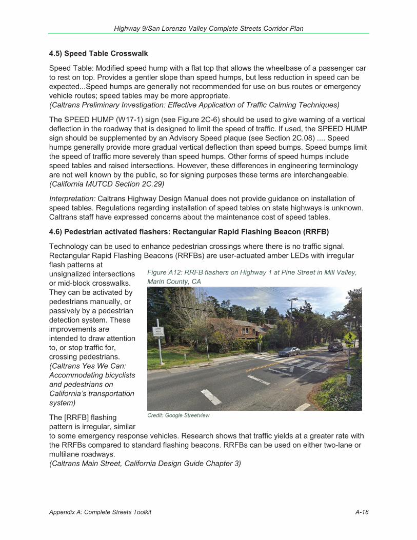
4.6) Pedestrian activated flashers: Rectangular Rapid Flashing Beacon (RRFB)
Technology can be used to enhance pedestrian crossings where there is no traffic signal. Rectangular Rapid Flashing Beacons (RRFBs) are user-actuated amber LEDs with irregular flash patterns at unsignalized intersections or mid-block crosswalks. They can be activated by pedestrians manually, or passively by a pedestrian detection system. These improvements are intended to draw attention to, or stop traffic for, crossing pedestrians. (Caltrans Yes We Can: Accommodating bicyclists and pedestrians on California’s transportation system)
The [RRFB] flashing pattern is irregular, similar to some emergency response vehicles. Research shows that traffic yields at a greater rate with the RRFBs compared to standard flashing beacons. RRFBs can be used on either two-lane or multilane roadways. (Caltrans Main Street, California Design Guide Chapter 3)
Figure A12: RRFB flashers on Highway 1 at Pine Street in Mill Valley, Marin County, CA
Credit: Google Streetview
Highway 9/San Lorenzo Valley Complete Streets Corridor Plan
Appendix A: Complete Streets Toolkit A-19
RRFB shall not be used for crosswalks across approaches controlled by stop signs or traffic control signals. If sight distance is less than deemed necessary by the engineer, additional RRFB may be installed in advance of the crosswalk with AHEAD plaque. Additional RRFB in advance of the crosswalk shall be supplemental to and not a replacement for the RRFB at the crosswalk itself. (FHWA Interim Approval IA-21)
Interpretation: RRFBs are an emerging safety technology, and as such their placement and use is controlled by FHWA Interim Approval IA-21, which requires state and local agencies to request and receive permission from the FHWA to install an RRFB. Feasibility analysis is needed for installation of an RRFB; if there are visibility constraints where drivers do not have enough time to see an activated RRFB and react to it coming around a curve, placement of an RRFB may not be appropriate. Feasibility may depend on power source availability. RRFBs have been installed within the Caltrans right-of-way along highways without adjoining sidewalks, as shown in Figure A12.
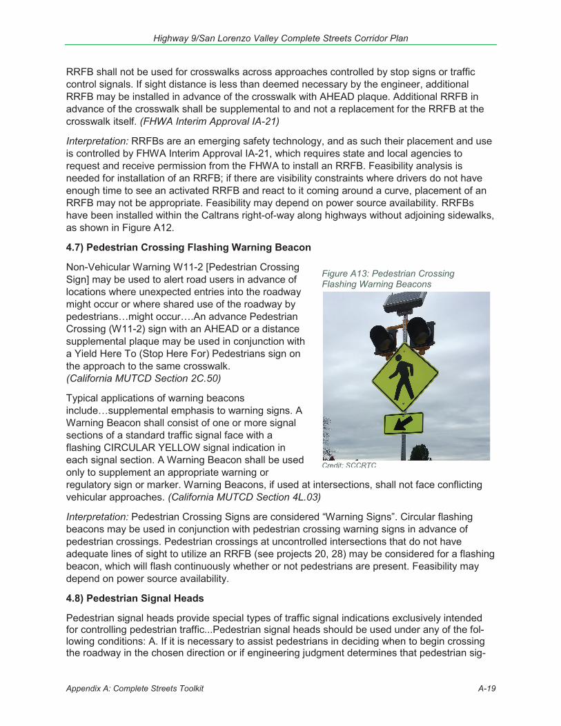
4.7) Pedestrian Crossing Flashing Warning Beacon
Non-Vehicular Warning W11-2 [Pedestrian Crossing Sign] may be used to alert road users in advance of locations where unexpected entries into the roadway might occur or where shared use of the roadway by pedestrians…might occur….An advance Pedestrian Crossing (W11-2) sign with an AHEAD or a distance supplemental plaque may be used in conjunction with a Yield Here To (Stop Here For) Pedestrians sign on the approach to the same crosswalk. (California MUTCD Section 2C.50)
Typical applications of warning beacons include…supplemental emphasis to warning signs. A Warning Beacon shall consist of one or more signal sections of a standard traffic signal face with a flashing CIRCULAR YELLOW signal indication in each signal section. A Warning Beacon shall be used only to supplement an appropriate warning or regulatory sign or marker. Warning Beacons, if used at intersections, shall not face conflicting vehicular approaches. (California MUTCD Section 4L.03)
Interpretation: Pedestrian Crossing Signs are considered “Warning Signs”. Circular flashing beacons may be used in conjunction with pedestrian crossing warning signs in advance of pedestrian crossings. Pedestrian crossings at uncontrolled intersections that do not have adequate lines of sight to utilize an RRFB (see projects 20, 28) may be considered for a flashing beacon, which will flash continuously whether or not pedestrians are present. Feasibility may depend on power source availability.
4.8) Pedestrian Signal Heads
Pedestrian signal heads provide special types of traffic signal indications exclusively intended for controlling pedestrian traffic...Pedestrian signal heads should be used under any of the fol-lowing conditions: A. If it is necessary to assist pedestrians in deciding when to begin crossing the roadway in the chosen direction or if engineering judgment determines that pedestrian sig-
Figure A13: Pedestrian Crossing Flashing Warning Beacons
Credit: SCCRTC
Highway 9/San Lorenzo Valley Complete Streets Corridor Plan
Appendix A: Complete Streets Toolkit A-20
Figure A14: Class II Bike Lane
Credit: FHWA
nal heads are justified to minimize vehicle pedestrian conflicts; B. If pedestrians are permitted to cross a portion of a street, such as to or from a median of sufficient width for pedestrians to wait, during a particular interval but are not permitted to cross the remainder of the street during any part of the same interval; and/or C. If no vehicular signal indications are visible to pedestrians, or if the vehicular signal indications that are visible to pedestrians starting a crossing provide insufficient guidance for them to decide when to begin crossing the roadway in the chosen di-rection, such as on one-way streets, at T-intersections, or at multiphase signal operations. (California MUTCD Section 4E.01)
4.9) In-Roadway Warning Lights at Crosswalks
In-roadway lights may be installed at certain marked crosswalks, based on an engineering study or engineering judgment, to provide additional warning to road users. If used, In-Roadway Warning Lights at crosswalks shall be installed only at marked crosswalks with applicable warning signs. They shall not be used at crosswalks controlled by YIELD signs, STOP signs, or traffic control signals… If used, In-Roadway Warning Lights should be installed in the center of each travel lane, at the center line of the roadway, at each edge of the roadway or parking lanes, or at other suitable locations away from the normal tire track paths. (California MUTCD Section 4N.02)
5. Bicycle Facilities[An] important reason for constructing bike lanes is to better accommodate bicyclists through corridors where insufficient room exists for side-by-side sharing of existing streets by motorists and bicyclists. This can be accomplished by reducing the number of lanes, reducing lane width, or prohibiting or reconfiguring parking on given streets in order to delineate bike lanes. (Caltrans Highway Design Manual Index 1002.1 (3))
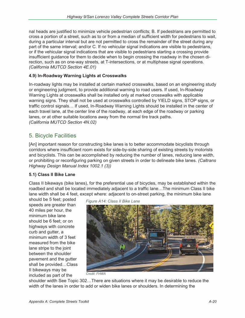
5.1) Class II Bike Lane
Class II bikeways (bike lanes), for the preferential use of bicycles, may be established within the roadbed and shall be located immediately adjacent to a traffic lane…The minimum Class II bike lane width shall be 4 feet, except where: adjacent to on-street parking, the minimum bike lane should be 5 feet; posted speeds are greater than 40 miles per hour, the minimum bike lane should be 6 feet; or on highways with concrete curb and gutter, a minimum width of 3 feet measured from the bike lane stripe to the joint between the shoulder pavement and the gutter shall be provided…Class II bikeways may be included as part of the shoulder width See Topic 302…There are situations where it may be desirable to reduce the width of the lanes in order to add or widen bike lanes or shoulders. In determining the
Highway 9/San Lorenzo Valley Complete Streets Corridor Plan
Appendix A: Complete Streets Toolkit A-21
Figure A15: Green Bike Lanes
Figure A16: Buffered Bike Lane - Paint
Credit: SCCRTC
appropriateness of narrower traffic lanes, consideration should be given to factors such as motor vehicle speeds, truck volumes, alignment, bike lane width, sight distance, and the presence of on-street parking. When on-street parking is permitted adjacent to a bike lane, or on a shoulder where bicycling is not prohibited, reducing the width of the adjacent traffic lane may allow for wider bike lanes or shoulders, to provide greater clearance between bicyclists and driver-side doors when opened. (Caltrans Highway Design Manual Index 301.2)
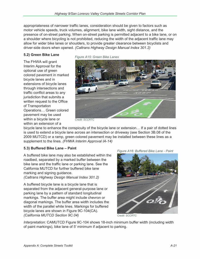
5.2) Green Bike Lane
The FHWA will grant Interim Approval for the optional use of green colored pavement in marked bicycle lanes and in extensions of bicycle lanes through intersections and traffic conflict areas to any jurisdiction that submits a written request to the Office of Transportation Operations… Green colored pavement may be used within a bicycle lane or Credit: SCCRTCwithin an extension of a bicycle lane to enhance the conspicuity of the bicycle lane or extension… If a pair of dotted lines is used to extend a bicycle lane across an intersection or driveway (see Section 3B.08 of the 2009 MUTCD) or a ramp, green colored pavement may be installed between these lines as a supplement to the lines. (FHWA Interim Approval IA-14)
5.3) Buffered Bike Lane – Paint
A buffered bike lane may also be established within the roadbed, separated by a marked buffer between the bike lane and the traffic lane or parking lane. See the California MUTCD for further buffered bike lane marking and signing guidance. (Caltrans Highway Design Manual Index 301.2)
A buffered bicycle lane is a bicycle lane that is separated from the adjacent general-purpose lane or parking lane by a pattern of standard longitudinal markings. The buffer area might include chevron or diagonal markings. The buffer area width includes the width of the parallel white lines. Markings for buffered bicycle lanes are shown in Figure 9C-104(CA). (California MUTCD Section 9C.04)
Interpretation: CAMUTCD Figure 9C-104 shows 18-inch minimum buffer width (including width of paint markings), bike lane of 5' minimum if adjacent to parking.
Highway 9/San Lorenzo Valley Complete Streets Corridor Plan
Appendix A: Complete Streets Toolkit A-22
Figure A18: Bike Box
Credit: America’s Transportation Awards
Figure A17: Buffered Bike Lanes - Physical Buffer
Credit: SCCRTC, Beach Street in Santa Cruz
Figure A17b: "Wave Delineator" bikeway barriers
Credit: Potomac Ave, Crystal City by Beyond DC – Creative Commons
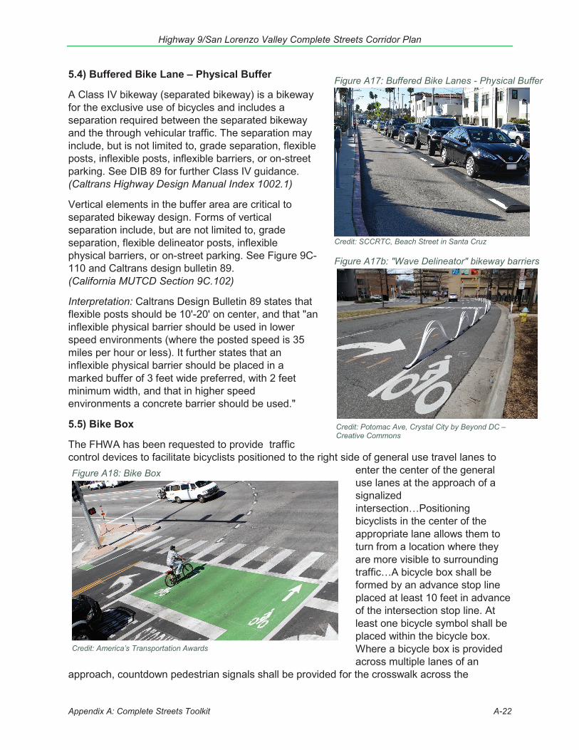
5.4) Buffered Bike Lane – Physical Buffer
A Class IV bikeway (separated bikeway) is a bikeway for the exclusive use of bicycles and includes a separation required between the separated bikeway and the through vehicular traffic. The separation may include, but is not limited to, grade separation, flexible posts, inflexible posts, inflexible barriers, or on-street parking. See DIB 89 for further Class IV guidance. (Caltrans Highway Design Manual Index 1002.1)
Vertical elements in the buffer area are critical to separated bikeway design. Forms of vertical separation include, but are not limited to, grade separation, flexible delineator posts, inflexible physical barriers, or on-street parking. See Figure 9C-110 and Caltrans design bulletin 89. (California MUTCD Section 9C.102)
Interpretation: Caltrans Design Bulletin 89 states that flexible posts should be 10'-20' on center, and that "an inflexible physical barrier should be used in lower speed environments (where the posted speed is 35 miles per hour or less). It further states that an inflexible physical barrier should be placed in a marked buffer of 3 feet wide preferred, with 2 feet minimum width, and that in higher speed environments a concrete barrier should be used."
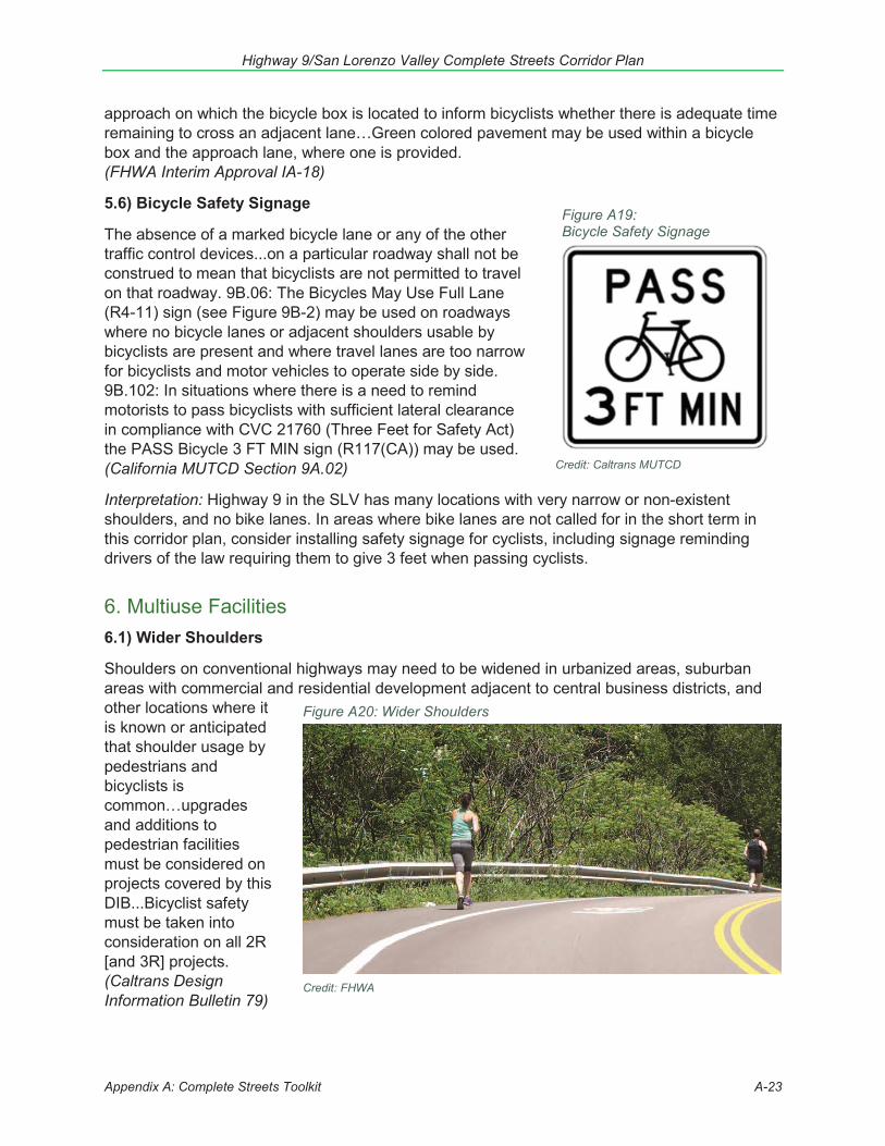
5.5) Bike Box
The FHWA has been requested to provide traffic control devices to facilitate bicyclists positioned to the right side of general use travel lanes to
enter the center of the general use lanes at the approach of a signalized intersection…Positioning bicyclists in the center of the appropriate lane allows them to turn from a location where they are more visible to surrounding traffic…A bicycle box shall be formed by an advance stop line placed at least 10 feet in advance of the intersection stop line. At least one bicycle symbol shall be placed within the bicycle box. Where a bicycle box is provided across multiple lanes of an
approach, countdown pedestrian signals shall be provided for the crosswalk across the
Highway 9/San Lorenzo Valley Complete Streets Corridor Plan
Appendix A: Complete Streets Toolkit A-23
Figure A19: Bicycle Safety Signage
Credit: Caltrans MUTCD
Figure A20: Wider Shoulders
Credit: FHWA
approach on which the bicycle box is located to inform bicyclists whether there is adequate time remaining to cross an adjacent lane…Green colored pavement may be used within a bicycle box and the approach lane, where one is provided. (FHWA Interim Approval IA-18)
5.6) Bicycle Safety Signage
The absence of a marked bicycle lane or any of the other traffic control devices...on a particular roadway shall not be construed to mean that bicyclists are not permitted to travel on that roadway. 9B.06: The Bicycles May Use Full Lane (R4-11) sign (see Figure 9B-2) may be used on roadways where no bicycle lanes or adjacent shoulders usable by bicyclists are present and where travel lanes are too narrow for bicyclists and motor vehicles to operate side by side. 9B.102: In situations where there is a need to remind motorists to pass bicyclists with sufficient lateral clearance in compliance with CVC 21760 (Three Feet for Safety Act) the PASS Bicycle 3 FT MIN sign (R117(CA)) may be used. (California MUTCD Section 9A.02)
Interpretation: Highway 9 in the SLV has many locations with very narrow or non-existent shoulders, and no bike lanes. In areas where bike lanes are not called for in the short term in this corridor plan, consider installing safety signage for cyclists, including signage reminding drivers of the law requiring them to give 3 feet when passing cyclists.
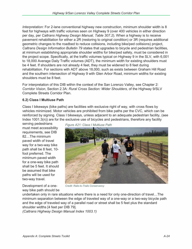
6. Multiuse Facilities6.1) Wider Shoulders
Shoulders on conventional highways may need to be widened in urbanized areas, suburban areas with commercial and residential development adjacent to central business districts, and other locations where it is known or anticipated that shoulder usage by pedestrians and bicyclists is common…upgrades and additions to pedestrian facilities must be considered on projects covered by this DIB...Bicyclist safety must be taken into consideration on all 2R [and 3R] projects. (Caltrans Design Information Bulletin 79)
Highway 9/San Lorenzo Valley Complete Streets Corridor Plan
Appendix A: Complete Streets Toolkit A-24
Interpretation: For 2-lane conventional highway new construction, minimum shoulder width is 8 feet for highways with traffic volumes seen on Highway 9 (over 400 vehicles in either direction per day, per Caltrans Highway Design Manual, Table 307.2). When a highway is to receive pavement rehabilitation for either a 2R (restoring to original condition) or 3R (requires additional geometric changes to the roadbed to reduce collisions, including bike/ped collisions) project, Caltrans Design Information Bulletin 79 states that upgrades to bicycle and pedestrian facilities, at minimum establishing appropriate shoulder widths for bike/ped safety, must be considered in the project scope. Specifically, at the traffic volumes typical on Highway 9 in the SLV, with 6,001 to 18,000 Average Daily Traffic volumes (ADT), the minimum width for existing shoulders must be 4 feet. If shoulders are not already 4 feet, they must be widened to 8 feet during rehabilitation. For sections with ADT above 18,000, such as exists between Graham Hill Road and the southern intersection of Highway 9 with Glen Arbor Road, minimum widths for existing shoulders must be 8 feet.
For interpretation of this DIB within the context of the San Lorenzo Valley, see Chapter 2: Corridor Vision, Section 2.3A: Rural Cross Section: Wider Shoulders, of the Highway 9/SLV Complete Streets Corridor Plan.
6.2) Class I Multiuse Path
Class I bikeways (bike paths) are facilities with exclusive right of way, with cross flows by vehicles minimized. Motor vehicles are prohibited from bike paths per the CVC, which can be reinforced by signing. Class I bikeways, unless adjacent to an adequate pedestrian facility, (see Index 1001.3(n)) are for the exclusive use of bicycles and pedestrians, therefore any facility serving pedestrians Figure A21: Class I Multiuse Pathmust meet accessibility requirements, see DIB 82…The minimum paved width of travel way for a two-way bike path shall be 8 feet, 10-foot preferred. The minimum paved width for a one-way bike path shall be 5 feet. It should be assumed that bike paths will be used for two-way travel.
Development of a one-
Credit: Rails-to-Trails Conservancy
way bike path should be undertaken only in rare situations where there is a need for only one-direction of travel…The minimum separation between the edge of traveled way of a one-way or a two-way bicycle path and the edge of traveled way of a parallel road or street shall be 5 feet plus the standard shoulder widths [4 feet per DIB 79]. (Caltrans Highway Design Manual Index 1003.1)
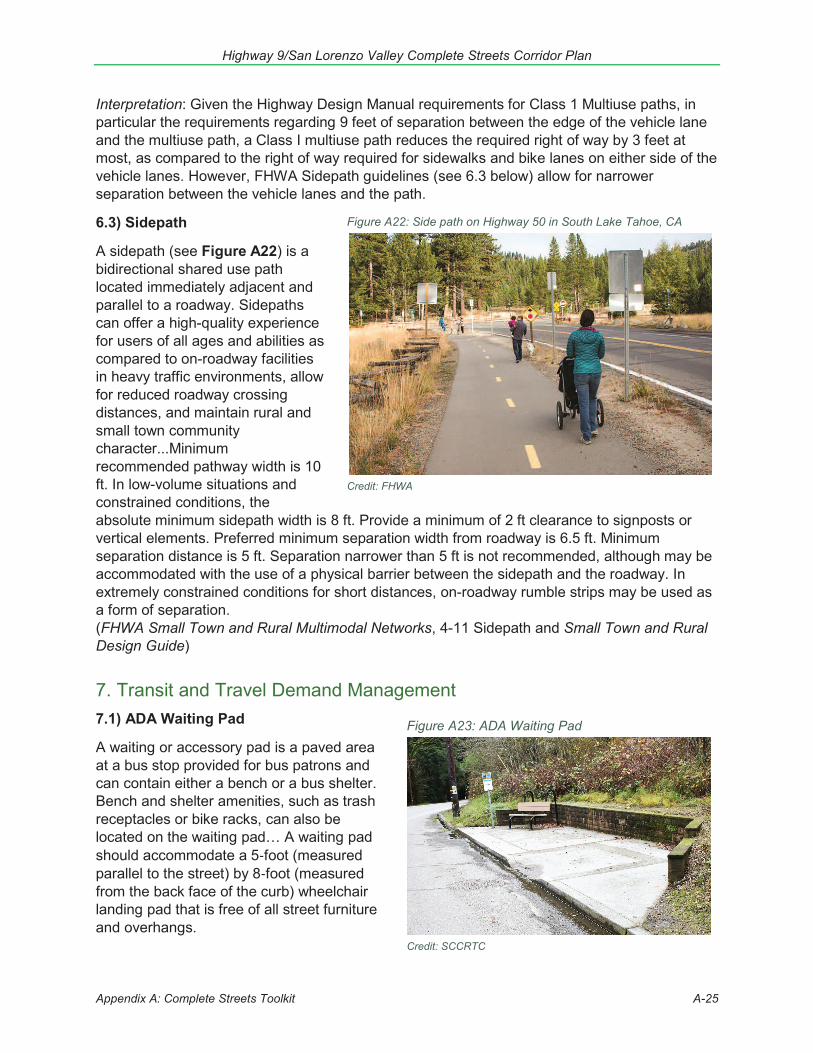
Highway 9/San Lorenzo Valley Complete Streets Corridor Plan
Appendix A: Complete Streets Toolkit A-25
Figure A22: Side path on Highway 50 in South Lake Tahoe, CA
Credit: FHWA
Figure A23: ADA Waiting Pad
Credit: SCCRTC
Interpretation: Given the Highway Design Manual requirements for Class 1 Multiuse paths, in particular the requirements regarding 9 feet of separation between the edge of the vehicle lane and the multiuse path, a Class I multiuse path reduces the required right of way by 3 feet at most, as compared to the right of way required for sidewalks and bike lanes on either side of the vehicle lanes. However, FHWA Sidepath guidelines (see 6.3 below) allow for narrower separation between the vehicle lanes and the path.
6.3) Sidepath
A sidepath (see Figure A22) is a bidirectional shared use path located immediately adjacent and parallel to a roadway. Sidepaths can offer a high-quality experience for users of all ages and abilities as compared to on-roadway facilities in heavy traffic environments, allow for reduced roadway crossing distances, and maintain rural and small town community character...Minimum recommended pathway width is 10 ft. In low-volume situations and constrained conditions, the absolute minimum sidepath width is 8 ft. Provide a minimum of 2 ft clearance to signposts or vertical elements. Preferred minimum separation width from roadway is 6.5 ft. Minimum separation distance is 5 ft. Separation narrower than 5 ft is not recommended, although may be accommodated with the use of a physical barrier between the sidepath and the roadway. In extremely constrained conditions for short distances, on-roadway rumble strips may be used as a form of separation. (FHWA Small Town and Rural Multimodal Networks, 4-11 Sidepath and Small Town and Rural Design Guide)
7. Transit and Travel Demand Management7.1) ADA Waiting Pad
A waiting or accessory pad is a paved area at a bus stop provided for bus patrons and can contain either a bench or a bus shelter. Bench and shelter amenities, such as trash receptacles or bike racks, can also be located on the waiting pad… A waiting pad should accommodate a 5-foot (measured parallel to the street) by 8-foot (measured from the back face of the curb) wheelchair landing pad that is free of all street furniture and overhangs.
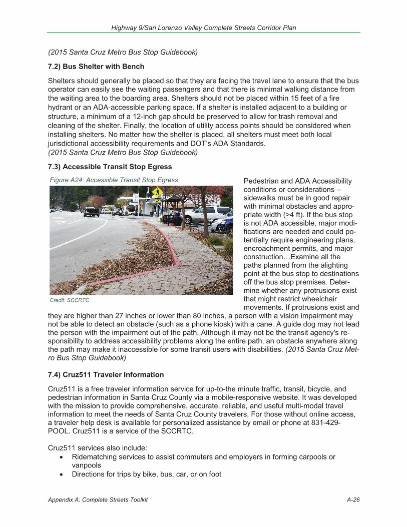
Highway 9/San Lorenzo Valley Complete Streets Corridor Plan
Appendix A: Complete Streets Toolkit A-26
Figure A24: Accessible Transit Stop Egress
Credit: SCCRTC
(2015 Santa Cruz Metro Bus Stop Guidebook)
7.2) Bus Shelter with Bench
Shelters should generally be placed so that they are facing the travel lane to ensure that the bus operator can easily see the waiting passengers and that there is minimal walking distance from the waiting area to the boarding area. Shelters should not be placed within 15 feet of a fire hydrant or an ADA-accessible parking space. If a shelter is installed adjacent to a building or structure, a minimum of a 12-inch gap should be preserved to allow for trash removal and cleaning of the shelter. Finally, the location of utility access points should be considered when installing shelters. No matter how the shelter is placed, all shelters must meet both local jurisdictional accessibility requirements and DOT’s ADA Standards. (2015 Santa Cruz Metro Bus Stop Guidebook)
7.3) Accessible Transit Stop Egress
Pedestrian and ADA Accessibility conditions or considerations – sidewalks must be in good repair with minimal obstacles and appro-priate width (>4 ft). If the bus stop is not ADA accessible, major modi-fications are needed and could po-tentially require engineering plans, encroachment permits, and major construction…Examine all the paths planned from the alighting point at the bus stop to destinations off the bus stop premises. Deter-mine whether any protrusions exist that might restrict wheelchair movements. If protrusions exist and
they are higher than 27 inches or lower than 80 inches, a person with a vision impairment may not be able to detect an obstacle (such as a phone kiosk) with a cane. A guide dog may not lead the person with the impairment out of the path. Although it may not be the transit agency's re-sponsibility to address accessibility problems along the entire path, an obstacle anywhere along the path may make it inaccessible for some transit users with disabilities. (2015 Santa Cruz Met-ro Bus Stop Guidebook)
7.4) Cruz511 Traveler Information
Cruz511 is a free traveler information service for up-to-the minute traffic, transit, bicycle, and pedestrian information in Santa Cruz County via a mobile-responsive website. It was developed with the mission to provide comprehensive, accurate, reliable, and useful multi-modal travel information to meet the needs of Santa Cruz County travelers. For those without online access, a traveler help desk is available for personalized assistance by email or phone at 831-429-POOL. Cruz511 is a service of the SCCRTC.
Cruz511 services also include: Ridematching services to assist commuters and employers in forming carpools orvanpoolsDirections for trips by bike, bus, car, or on foot

Highway 9/San Lorenzo Valley Complete Streets Corridor Plan
Appendix A: Complete Streets Toolkit A-27
Electric vehicle charging spotsShared ride optionsFree online ride matching servicePark and Ride lot locationsCountywide bike mapReport a bike or walking hazardAccessible travel optionsCost of driving calculatorTransportation resources for employers, schools, and organization(SCCRTC, Cruz511.org)
7.5) School Programs
7.5a) Safe Routes to Schools safety education programs
Safe Routes to School non-infrastructure programs aim to make it safer for students to walk and bike to school and encourage more walking and biking where safety is not a barrier. Transportation, public health and planning professionals, school communities, law enforcement officers, community groups and families all have roles to play using education, encouragement, engineering (changes to the physical environment) and enforcement to meet a local community’s needs. In Santa Cruz County the County Health Services Agency, Ecology Action, and Bike Santa Cruz County implement programs aimed at teaching students rules of the road and how to safely walk or bike.
7.5b) School Pool
A School Pool is a way of sharing in the duties of getting children to and from school. School Pool options include carpooling, walk pools (“walking school buses”), bike pools (“bike trains”) or arranging bus buddies for school buses or public transit. Two or more families agree to share responsibilities by trading days as pool leaders. Many parents have taken up School Pooling as a way to save time, save money and provide a safer way for their children to get to school… Implementation steps include forming a committee, identifying and mapping neighborhoods, identifying neighborhood residents and recruiting neighborhood captains, and promoting the program. (Safe Routes to Schools School Pool Guide)
7.5c) Walking School Bus ad Bicycle Train
A walking school bus is a group of children walking to school with one or more adults. That may sound simple, and that is part of the appeal. It can be as informal as two families taking turns walking their children to school or as structured as a planned route with meeting points, a timetable and a schedule of trained volunteers. A variation on the walking school bus is a bicycle train where a group of children and adult leaders ride together to school. For more information about these programs, see the National Center for Safe Routes to School website (www.saferoutesinfo.org) and http://guide.saferoutesinfo.org/walking_school_bus/ for more information.
7.5d) Walk & Bike to School Day
These events are used to encourage commuters, students and families to celebrate the benefits of walking and biking and to increase local leader commitment and visibility for traffic safety and community quality of life. Each year these events break records for participation. Most event
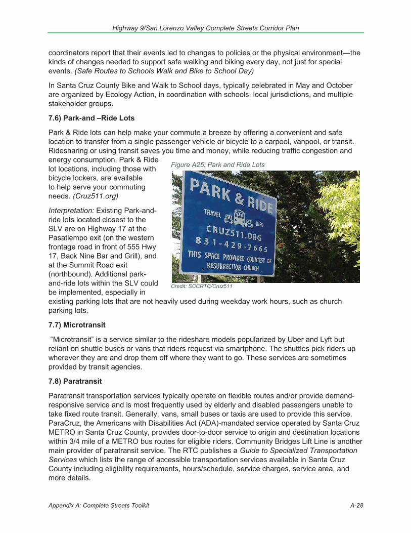
Highway 9/San Lorenzo Valley Complete Streets Corridor Plan
Appendix A: Complete Streets Toolkit A-28
Figure A25: Park and Ride Lots
Credit: SCCRTC/Cruz511
coordinators report that their events led to changes to policies or the physical environment—the kinds of changes needed to support safe walking and biking every day, not just for special events. (Safe Routes to Schools Walk and Bike to School Day)
In Santa Cruz County Bike and Walk to School days, typically celebrated in May and October are organized by Ecology Action, in coordination with schools, local jurisdictions, and multiple stakeholder groups.
7.6) Park-and –Ride Lots
Park & Ride lots can help make your commute a breeze by offering a convenient and safe location to transfer from a single passenger vehicle or bicycle to a carpool, vanpool, or transit. Ridesharing or using transit saves you time and money, while reducing traffic congestion and energy consumption. Park & Ride lot locations, including those with bicycle lockers, are available to help serve your commuting needs. (Cruz511.org)
Interpretation: Existing Park-and-ride lots located closest to the SLV are on Highway 17 at the Pasatiempo exit (on the western frontage road in front of 555 Hwy 17, Back Nine Bar and Grill), and at the Summit Road exit (northbound). Additional park-and-ride lots within the SLV could be implemented, especially in existing parking lots that are not heavily used during weekday work hours, such as church parking lots.
7.7) Microtransit
“Microtransit” is a service similar to the rideshare models popularized by Uber and Lyft but reliant on shuttle buses or vans that riders request via smartphone. The shuttles pick riders up wherever they are and drop them off where they want to go. These services are sometimes provided by transit agencies.
7.8) Paratransit
Paratransit transportation services typically operate on flexible routes and/or provide demand-responsive service and is most frequently used by elderly and disabled passengers unable to take fixed route transit. Generally, vans, small buses or taxis are used to provide this service. ParaCruz, the Americans with Disabilities Act (ADA)-mandated service operated by Santa Cruz METRO in Santa Cruz County, provides door-to-door service to origin and destination locations within 3/4 mile of a METRO bus routes for eligible riders. Community Bridges Lift Line is another main provider of paratransit service. The RTC publishes a Guide to Specialized Transportation Services which lists the range of accessible transportation services available in Santa Cruz County including eligibility requirements, hours/schedule, service charges, service area, and more details.
Highway 9/San Lorenzo Valley Complete Streets Corridor Plan
Appendix B: Identified Projects B-1
Appendix B: Identified Projects ListThe following is a list of all the transportation challenges and ideas for San Lorenzo Valley which were identified by members of the public, stakeholders, and the Highway 9/SLV plan project team. While Chapter 3 of the plan identifies priority projects and concepts, this more comprehensive list of projects and ideas is expected to also be considered, especially when projects are implemented in the SLV. Caltrans, the County of Santa Cruz Public Works and Planning Departments, Santa Cruz Metropolitan Transit District (METRO), the school district, developers and others should evaluate and consider incorporating these ideas into other projects when feasible. A map of project ideas/challenge areas identified during Ph. 1 public outreach is at: http://arcg.is/1iTSaL. Any additional ideas identified during public review of the draft plan were incorporated into this list.
Overview of key challenges in the San Lorenzo Valley (SLV) (Note: Location-specific issues listed later in document)
Safety for all modes o Vehicles speeding, a major concern especially in town centers and near schools.o Narrow and curvy road in mountainous area, shoulders very narrow or
non-existent in some sections, resulting in road sharing challenges (esp.bike/auto)
o More safe pedestrian crossings needed near destinations and transit stopso Significant injury and fatal collisionso Need improved lighting and visibility for pedestrians, especially at crossingso Sight distances are limitedo Guard and bridge rail replacements are neededo Improved drainage is needed to improve safety and minimize storm water runoff
into San Lorenzo River Watershedo Insufficient passing lanes and turnouts.
Gaps in bicycle and pedestrian facilities along the corridor o No continuous sidewalks or pathways, including through town centers; gaps in
ADA-compliant pedestrian facilities; limited pedestrian crossings; obstacles forpedestrians. Pedestrians walking in dirt or shoulders along the highway. 2018/19SHOPP includes installing accessible pedestrian signals at various locations (EAProject Identifier 1G160 0514000118)
o Existing infrastructure for bicyclists is not adequate to accommodate safe,convenient access. Bicycle lanes, bicycle parking, green paint at intersections,and other bike facilities are either incomplete or completely missing in manysections of the corridor. Lack of facilities and signage between town centers. Manydrivers concerned about sharing the road, especially coming upon bicyclistsaround blind corners.
o Lack of safe routes for walking or biking to San Lorenzo Valley High School, MiddleSchool, and Elementary School in Felton and Boulder Creek Elementary School.Students walking in the shoulder, dirt paths, or store parking lots along thehighway.
o Shoulders should be widened for non-formalized bike/ped space whereverfeasible, maintain 14' lane width where no bicycle lane can be accommodated.
Infrequent or lack of transit service o Limited bus service and service cuts.o Lack of accessible facilities providing safe paths to walk or bike to public bus stops.
Highway 9/San Lorenzo Valley Complete Streets Corridor Plan
Appendix B: Identified Projects B-2
o Upgrades are needed to bus stops, including facilities to provide shelter fromweather.
o Growing paratransit needs for seniors and people with disabilities.o Consider alternatives to fixed route public bus service – e.g. microtransit;
dial-a-ride;o last/first multi-mile challengeso Need more staple style bicycle racks, at bus stops and elsewhere
Corridor Operations: Speeding, left turn access, driveways, traffic jams through commercial and school zones, intersections, and limited passing lanes and turnouts all present operational challenges.
Challenges implementing relatively small projects in the state right-of-way, such as streetscape projects in main street sections, pedestrian-friendly street lighting, street furniture, installation of new bicycle racks, and bus stop upgrades.
System preservation and drainage, especially as this area is subject to heavy rains and storm water runoff into the San Lorenzo River Watershed. Much of the current asphalt is degrading rapidly and striping is severely faded
i. Hwy 9 from Hwy 1 to Fall Creek Drive, storm water improvements (in 2018SHOPP)
ii. Hwy 9 from Hwy 1 to Pacific St, Brookdale: Pavement, drainage improvements,sign panel replacement (2025 SHOPP)
iii. Hwy 9 from Hwy 1 to Grove St, Boulder Creek: Storm water mitigation (in 2024SHOPP)
iv. Hwy 9 from Holiday Lane (Highland Park) to County line: Storm waterimprovements (2021 SHOPP)
Preservation of historic, cultural and environmental assets, including wildlife, trees, parks. Access to businesses and jobs along the corridor, to support economic vitality and
address issues related to parking, ingress and egress. Funding needs are more than double available revenues.
Corridor-wide Project Priorities 1. Projects that reduce auto speeds, especially when entering towns or densely populated
areas, along straightaways, and near schools2. Increase transit service and add benches at transit stops3. Add bike lanes wherever feasible on Hwy 94. Add walkways wherever feasible, especially in town centers and near schools5. Add more turnouts on Hwy 96. Upgrade streetlight, add higher visibility crosswalks
Location-Specific Challenges and Project Ideas Parentheses reflect number of times participants mentioned an item during Phase 1 outreach in the MetroQuest and paper surveys and at meetings. This list also includes priorities identified in past outreach and planning efforts, including meetings held in 2013.
State Park South: Golf Club Drive to Glengarry Road Key Issues:
Parking spillover at Ox Trail parking lot: Increasing popularity of the Garden of Eden swimming hole means small designed parking lot fills quickly and undersigned parking on
Highway 9/San Lorenzo Valley Complete Streets Corridor Plan
Appendix B: Identified Projects B-3
highway shoulders creates hazards for drivers and pedestrians (approx. 37.031310, -122.064324 to 37.030837, -122.060858)
Illegal bike trail dumps onto Hwy 9 at blind curve (approx. 37.030410, -122.059364) No bicycle facilities or space for cyclists throughout section, motorists don’t give 3 feet
A. Pedestrian Facility Priorities:1. Pedestrian walkway facilities
a) Hwy 9 curve just south of Ox Trail parking lot (1)b) Hwy 9 Felton to Santa Cruz (1)c) Hwy 9 at Paradise Park entrance (1)d) Hwy 9 near Vernon/Golf Club Drive (1)
2. Pedestrian crossing facilitiesa) Hwy 9 just south of Ox Trail parking lot – install crosswalk (1)
B. Bicycle Facility Projects1. Bicycle facilities – bike path, lane, etc. to separate bicycles and autos to increase
cyclist and motorist safetya) Hwy 9 at Ox Trail parking lot – secure bicycle parking (2)b) Hwy 9 through Henry Cowell State Park – make bicycling illegal (1)c) Hwy 9 Felton to Santa Cruz – bike facilities (6)d) Hwy 9 RR crossing to Paradise Park exit road – bike facilities (4)
2. Shared bicycle and pedestrian facilitiesa) Complete shoulder or bike lane to 4 ft on both sides, complete sidewalk on
both sides (see 2006 SLV Trail Feasibility Study)b) Rail trail along Roaring Camp railroad tracks (2)c) Hwy 9 Paradise Park to Golf Club Dr (3)
C. Roadway Projects:1. Improve line of sight/blind curve
a) Hwy 9 at Glengarry (1)2. Pavement Conditions
a) Hwy 9 at railroad tracks crossing (1)3. Other roadway projects
a) Hwy 9 at Ox Trail Parking lot – make parking outside of designated parking lotillegal (1)
b) Hwy 9 at Ox Trail Parking lot – current undersigned parking lot spilloverdangerous, vehicles and those parking them in roadway (2)
c) Hwy 9 throughout Henry Cowell State Park – White lane markings currentlyuneven and lanes vary in width, restripe (1)
d) Hwy 9 north of vista point, repair storm damage (in 2020 SHOPP)e) Hwy 9 south of Paradise Park, repair storm damage (in 2020 SHOPP)
D. Auto Safety1. Speed limit enforcement
a) Hwy 9 at Powder Creek Trestle (37.007150, -122.044479) – Reduce speedlimit on narrow viaduct (2)
2. Flashing warning lightsa) Hwy 9 south of Glengarry – warn southbound drivers that they are approaching
the Ox Trail parking lot (1)b) Hwy 9 at (37.030410, -122.059364) – Illegal bike trail merges onto Hwy 9 here
Highway 9/San Lorenzo Valley Complete Streets Corridor Plan
Appendix B: Identified Projects B-4
(1) 3. Other auto safety
a) Hwy 9 south of Glengarry and north of Golf Club Drive – signs reminding drivers of 3-foot buffer law for passing cyclists (1)
b) Guardrails on northbound Hwy 9 Santa Cruz to Felton E. Transit and other ideas:
1. Provide transit service a) Transit service down Hwy 9 to Santa Cruz (1) b) Roaring Camp train tracks – work towards passenger service to Santa Cruz (2)
Felton: Glengarry Road to Graham Hill Road Key Issues:
Hwy 9 and Graham Hill intersection: multiple issues. Inadequate bike/ped facilities, more storage space need (right turn lane on northbound 9, center/left turn lanes on Graham Hill. Timing of light doesn’t allow enough time for northbound 9 or west/southbound Graham Hill, northbound Graham Hill timing still inadequate for traffic volumes. Roundabout one of many treatments suggested.
Lack of accessible sidewalks – all downtown Felton, including ped access to new library at Hihn and Gushee
Heavily used midblock crossing between Graham Hill and Kirby dangerous and ignored by motorists
Motorists turning into/out of New Leaf and other downtown parking areas blocking traffic flow or entering traffic lane unsafely – suggestions include center turn lane and realignment of parking
Unsafe/poor visibility crosswalks or lack of crosswalks throughout Felton Lack of bicycle facilities throughout Felton Crosswalk at Hwy 9 and Redwood Dr – Crosswalk heavily used by park visitors and often
ignored by motorists. The crosswalk is on the wrong side of the intersection – moving it to the south side of Redwood Dr would line up with Henry Cowell entrance and allow peds to avoid blind curve. Redesigned roadside parking needed to allow safe space for persons exiting their parked vehicles and walking into the park, better ped egress into park needed.
Speeding in residential areas outside downtown core, especially south Felton
A. Pedestrian Facility Priorities: 1. Pedestrian walkway facilities
a) Felton Empire from Hwy 9 to Fall Creek entrance (2) b) Graham Hill from Mount Hermon to Roaring Camp entrance – Pedestrian
walking facilities (RTC Observations) c) Hwy 9 Felton Empire to Russell – New sidewalks. No sidewalks in Felton,
small portions that exist not accessible (9, Felton Town Plan) d) Hwy 9 – Sidewalks throughout downtown to include shade trees/landscaping
(Felton Town Plan) e) Gushee St between Felton Empire and Hihn St – updated sidewalk for new
library (1) f) Hwy 9 between Russell and Laurel – add sidewalks to area around Farmer’s
Highway 9/San Lorenzo Valley Complete Streets Corridor Plan
Appendix B: Identified Projects B-5
Market at 120 Russell Ave (2) g) N Big Trees Road at Hwy 9 – extend paved area on north side of Henry Cowell
entrance to allow space for walkers (1)2. Pedestrian crossing facilities
a) Felton Empire at Cooper – Traffic calming, flashers at school route to library (9)b) Hwy 9 at Graham Hill – Signal timing and missing crosswalk on north side of
intersection make crossing this intersection on foot difficult/slow, pedestriansshould have precedent over cars and be allowed to cross on all 4 sides highrate of bike/ped collisions (5)
c) Graham Hill at Covered Bridge Road South – increased visibility (2)d) Hwy 9 midblock crossing between Graham Hill and Kirby – increased
visibility/flashers/traffic calming high rate of bike/ped collisions (6)e) Hwy 9 midblock crossing between Graham Hill and Kirby – move crosswalk
south ~20' to create space cushion for peds when vehicles are turning leftexiting New Leaf, add pedestrian refuge island (RTC observations, FeltonTown Plan)
f) Hwy 9 at midblock crossing between Graham Hill and Kirby – get rid ofcrosswalk (1)
g) Hwy 9 at Kirby – increased visibility/flashers/traffic calming for St LawrenceSchool (5)
h) Hwy 9 between Kirby and Hihn – add midblock crossing (2)i) Hwy 9 at Plateau – Install crosswalk (2)j) Hwy 9 at Russell – Install crosswalk, including flashers/traffic calming (4)k) Hwy 9 at Laurel – Install crosswalk, including visibility/flashers/traffic calming
(1)l) Hwy 9 downtown Felton – curb jaywalking (1)m) Hwy 9 downtown Felton – add more crosswalks (1)n) Hwy 9 downtown Felton – improve visibility of all crosswalks (2)o) Hwy 9 at Redwood Drive – Move current crossing location off of blind curve at
north side of intersection to line up with Henry Cowell entrance (south side ofHwy 9/Redwood intersection). Drivers currently do not stop for this crossing –increased signage/restriping/flashers (18)
p) Hwy 9 at San Lorenzo – Install crosswalk (1)q) Hwy 9 at Gail – Install crosswalk (1)r) Hwy 9 at Steinmaier – Install crosswalk (1)
B. Bicycle Facility Projects1. Bicycle facilities – bike path, lane, etc. to separate bicycles and autos to increase
cyclist and motorist safetya) Bicycle parking in the downtown core (Felton Town Plan)b) Hwy 9 at Graham Hill – improved bicycle facilities at intersection (5)c) Felton Empire at Love (1)d) Graham Hill at Covered Bridge Rd (2, Felton Town Plan)e) Graham Hill at Mount Hermon intersection (1, Felton Town Plan)f) Hwy 9 at Kirby (2)g) Hwy 9 throughout downtown Felton (5)h) Hwy 9 San Lorenzo to Lakeview (2)i) Hwy 9 downtown Felton to Glengarry (11)j) Hwy 9 Old Big Trees to Glengarry – possible to put bike facilities on park land
(3)2. Shared bicycle and pedestrian facilities
Highway 9/San Lorenzo Valley Complete Streets Corridor Plan
Appendix B: Identified Projects B-6
a) Hwy 9 throughout downtown Felton – shared multiuse path separated from autos (2)
b) Hwy 9 between Laurel and Redwood – shared multiuse path separated from autos for those accessing Henry Cowell State Park (7)
c) Hwy 9 between San Lorenzo and Lakeview – shared multiuse path (4) C. Roadway Projects:
1. Widen bridge to allow bike/ped space in addition to auto space a) Hwy 9 over Shingle Mill Creek (2) b) Hwy 9 over Gold Gulch Creek (1)
2. Improve line of sight/blind curve a) Hwy 9 at Lakeview Ave (3) b) Hwy 9 across from Felton Guild – telephone pole too close to travel lane (1)
3. Pavement Conditions a) None identified in plan outreach process
4. Intersection/turn improvements a) Roundabout at Graham Hill and Hwy 9, make sure large enough for semis (8) b) Hwy 9 at Graham Hill – change signal timing, not enough time for cars traveling
northbound on Hwy 9 (1) c) Graham Hill at Hwy 9 – two left turn lanes from Graham Hill onto southbound
Hwy 9, one for through traffic and one for those going to businesses (1) d) Graham Hill at Hwy 9 – provide alternative route for vehicles heading from Hwy
17 to Hwy 9 north (1) e) Graham Hill at Hwy 9 – Second lane for vehicles turning right onto northbound
9, to match 2 lanes turning left from southbound 9 to Graham Hill (RTC observations)
f) Felton Empire at Hwy 9 – Separate left turn lane onto Hwy 9 northbound from straight/right movement (1, Felton Library CEQA Mitigation)
g) Graham Hill at Mt Hermon – roundabout (1) h) Hwy 9 between Felton Empire and Kirby – northbound Hwy 9 needs longer
right turn lane onto Graham Hill Rd, vehicles currently driving in shoulder to create informal right turn lane starting at New Leaf crosswalk (2, RTC observations)
i) Hwy 9 between Felton Empire and Kirby – southbound Hwy 9 needs left turn lane into New Leaf parking lot and keep clear area in front of parking lot entrance, current arrangement dangerous and causes congestion throughout town (3, RTC observations)
j) Hwy 9 between Felton Empire and Kirby – southbound Hwy 9 left turn into New Leaf parking lot illegal during commute hours (1)
k) Hwy 9 between Felton Empire and Kirby – Close southbound Hwy 9 left turn into 6272 Hwy 9 (Taqueria Vallarta), too close to intersection (1, RTC observations)
l) Graham Hill Rd at Mount Hermon – remove free right onto Mount Hermon Road, replace with pedestrian bulb-out (Felton Town Plan)
m) Graham Hill Rd at Mount Hermon, northbound– Increase storage capacity for right hand lane, which becomes right turn lane onto Highway 9 at next light (RTC observations)
n) Graham Hill from Hwy 9 to Mount Hermon – Change timing of lights during commute hours to maximize traffic flow from southbound Mount Hermon to northbound Hwy 9 (4)
o) Graham Hill from Hwy 9 to Mount Hermon – Change timing of lights during
Highway 9/San Lorenzo Valley Complete Streets Corridor Plan
Appendix B: Identified Projects B-7
commute hours to allow more cars coming up Graham Hill from Santa Cruz to get through (1)
p) Mount Hermon at Graham Hill – Create more storage capacity for vehiclesturning right onto Graham Hill (1)
q) Hwy 9 Graham Hill to Hihn – Center left turn lane in business core of Felton(Graham Hill to Hihn) so cars don’t drive around into space currently used bybikes/peds (3, Felton Town Plan)
r) Zayante at Graham Hill – No right turn on red (for those turning right ontoGraham Hill), keep intersection clear signage/enforcement (1)
s) Graham Hill at Zayante – widen bridge, right turn lane onto Zayante (1, DPW)t) Hwy 9 at Redwood – Left turn pocket into Henry Cowell State Park (1)u) Hwy 9 at Redwood/N Big Trees – stop sign for crosswalk (2)
5. Other roadway projectsa) Felton Empire at Cooper – Add storm drain culvert, grading, ditches (2)b) Graham Hill at 6440 Graham Hill – remove sick Redwood tree, widen to allow
longer straight and left turn lanes (2)c) Hwy 9 at Graham Hill – Current parking in front of businesses in southwest
quadrant of intersection (6287 Hwy 9 and north) dangerous: cars back intovehicles turning left from Graham Hill (1)
d) Mount Hermon Rd, intersection with Graham Hill – Lengthen right turn pocketfor right turn lane which feeds into right turn onto Highway 9, where queuingalready occurs up the hill and around the curve (RTC observations)
e) Graham Hill Rd westbound, east of Mt Hermon intersection (in front of FeltonFaire) – Add second through lane on shoulder, where queuing for right lane(and right turn onto Highway 9) already occurs (RTC observations)
f) Hwy 9 between Felton Empire and Kirby – current parking design unsafe,vehicles backing into/driving alongside oncoming traffic (3)
g) Hwy 9 Graham Hill to Kirby – Downtown core needs more parking spaces or acooperative agreement with nearby lots (Felton Town Plan)
h) 2 spaces directly south of downtown public deck in blind spot for oncomingcars, consider removing (RTC observations)
i) Hwy 9 between Felton Empire and Kirby – Angled parking, perpendicularparking means vehicles frequently backing up different directions and backingup into each other, bikes/peds (3, RTC observations, Felton Town Plan)
j) Hwy 9 Redwood to Laurel – Redesign roadside parking to allow safe space forthose exiting their parked vehicles (6)
k) Hwy 9 from North Big Trees (Henry Cowell entrance) through perimeter of parknear Santa Cruz – Improve parking design and safety throughout state parkproperty along Hwy 9, especially at Ox Trail parking/Garden of Eden (2)
l) Hwy 9 anywhere speed limit under 35 mph – NACTO guidelines of 11-foottravel lanes (1)
m) Hwy 9 at Old Big Trees Rd – Straighten curve (1)
D. Auto Safety1. Speed limit enforcement
a) Felton Empire at Ashley, near library and route from schools (3)b) Hwy 9 at Plateau – reduce speed limit (1)c) Hwy 9 Laurel to Redwood – Go back to previous higher speed limit (1)d) Hwy 9 Laurel to Redwood – Enforce new speed limit (1)e) Hwy 9 at Lakeview Ave – Reduce speed limit/traffic calming (3)f) Hwy 9 between Old Big Trees Rd and Glengarry – Reduce speed limit (1)
Highway 9/San Lorenzo Valley Complete Streets Corridor Plan
Appendix B: Identified Projects B-8
2. Other auto safety a) Hwy 9 throughout downtown Felton – plant Sycamore street trees close to
travel lanes for traffic calming (2) b) Hwy 9 throughout downtown Felton – motorists driving into shoulders
(currently used by bikes/peds) to go around vehicles making left turns (1) c) Hwy 9/Graham Hill intersection – red light enforcement (1, RTC observations) d) Laurel Dr at Valley – Speed bumps to slow fast downhill traffic near preschool
(1) e) Redwood Drive at Valley - Speed bumps to slow fast downhill traffic (1) f) Hwy 9 between Laurel and Redwood – Post no U-Turn allowed signs for those
parking outside of the Henry Cowell entrance (1) g) Hwy 9 at Redwood Drive – Enforcement of pedestrian right-of-way at
crosswalk (2) h) San Lorenzo between Jefferson and Washington - Speed bumps to slow fast
downhill traffic (3) i) Hwy 9 at Old Big Trees Rd – Travel lane and shoulder too wide – cars pass
illegally here (1) E. Transit and other ideas:
1. Provide transit service a) Lompico/Zayante – Increase transit frequency beyond the two trips per day
provided for schoolchildren (1) b) South Felton bus route – Increase transit frequency beyond the two trips per
day provided for schoolchildren (1) c) Extend south Felton bus service to Old Big Trees Rd (1) d) Metro 35 route - divert into downtown Felton core (Felton Town Plan)
2. Pedestrian lighting in downtown core (Felton Town Plan)
Schools: Graham Hill Road to Brackney Road SLV High School, Middle School & Elementary access Key Issues:
Traffic congestion/backups during school pick-up and drop-off times Challenges turning across Highway 9 (to/from driveways, school entrances, and side
streets) Automobile speeds near schools Lack of pedestrian walkways Challenges walking across Highway 9 Lack of bicycle lanes and paths
A. Pedestrian Facility Priorities:
1. Pedestrian walkways (67+5 focused specifically on this section; dozens of other comments suggested walkways for the entire Hwy 9 corridor, which would include this section)
a. Schools may be willing to grant easement along west side of Hwy 9 for pathway – would need fence to prevent public access to schools (school mtg)
b. Tear down existing retaining walls along west side Hwy 9 at SLV Schools campus, rebuild farther back, shift highway to east and restripe for bike/ped space on west side (school mtg)
Highway 9/San Lorenzo Valley Complete Streets Corridor Plan
Appendix B: Identified Projects B-9
c. Westside Hwy 9: High School Entrance to Fall Creek (5)d. Westside Hwy 9: Fall Creek to Clearview Place (7)e. Alternatives to Hwy 9:
i. Fall Creek or Clearview to downtown Felton (Felton Empire) intersection(1)
1. Clearview to Cooper – make formal ped access/path (1)ii. Farmer St. to Fall Creek – make formal ped access/path (1, school mtg
consensus was Fall Creek to Farmer St too out of the way)f. Westside Hwy 9 – south of Fall Creek to Graham Hill (15)g. Westside Hwy 9 –Elementary School to High School entrances (11)h. Hacienda - formalize path from 7301 Hwy 9 to footbridge along Hacienda and
Capelli – shortcut to bus stop near El Solyo (school mtg)i. Westside Hwy 9 – Brackney to El Solyo (5)
i. Alternative: Formalize Hillview Dr. Trail, add lighting/fencing, easementmay be possible along 511 Hillview Dr property of Brian Stanford (1, schoolmtg)
j. Pedestrian walkways on eastside of Hwy 9 from Felton along businesses (1)k. Pedestrian facilities to Glen Arbor neighborhoods (school mtg)
2. Pedestrian crosswalks (improve/make more visible/add)a. High School entrance (improve crossing) – (9)b. Elementary school entrance (4)c. Hwy 9/Clearview/San Lorenzo (3)d. 6500 block of Hwy 9 (3)
B. Bicycle Facility Projects1. Add bikeway (path, bike lane, etc.), so bikes not sharing auto lanes entire area along
Highway 9 (42)a. Widen shoulders
i. Mark shoulders as bicycle lanesb. Prevent cars from parking in/blocking shoulders (1)c. Green bike lanes in front of schools/driveways (1)d. Shared bike/ped path (1)
2. Add “share the road” signs through area (1)3. Build combined bike and pedestrian paths from downtown Felton to the San Lorenzo
Valley High School and Elementary school (7)4. Use Highway 9 to Fall Creek to Cooper as bicycle route (Clearview too steep) (1)5. Bicycle facilities to Glen Arbor neighborhoods (school mtg)
C. Roadway Projects:1. Hwy 9 north of El Solyo: Improve sight lines (4)
a. Blind curve coming from the north makes exit from El Solyo risky; All of the Jr. Hightraffic dumps out here and there is a blind curve to the north, leading to some prettydaring left-hand turns.
b. Add flashing light to improve safety2. Hwy 9 @ Brackney Rd –space to turn on/off Highway (4)
a. People trying to get off of Hwy 9 have to slow to a stop to make the turn or make aU-turn; autos entering Hwy 9 from Brackney can't see NB lane and have to upturnor make dangerous entry due to lack of visibility or cars coming too fast; thebridges are too narrow and the corner entering the first bridge at Brackney is
Highway 9/San Lorenzo Valley Complete Streets Corridor Plan
Appendix B: Identified Projects B-10
dangerous. Too many cars drive up the curb. 3. Hwy 9 near Brackney Bridge: Repair road, widen road, improve sight lines/straighten
curve (6) a. Widen shoulders
4. Entrance modifications: All schools a. Redesign all entrances and driveway locations, modify circulation through
tri-school site – schools willing to look at modifying internal driveways/roadways (school mtg)
i. Enter only at one location – would require long left turn pocket ii. Move exit to another location iii. Add more exits? Including another exit from senior's parking lot iv. One-way circulation through tri-school campus?
b. Auxiliary lanes for school area – separate through traffic on Hwy 9 from school traffic, see Jamie Helmer diagram (school mtg)
c. Narrowing lanes and shoulders near schools is not recommended – new teen drivers, logging trucks, buses, etc. make recovery zones important (school mtg)
5. Middle School Entrance: Consider adding capacity to middle school drop off facilities, students currently getting dropped off at elementary or HS drop off areas (school mtg)
a. 2 lanes on El Solyo Heights at Hwy 9 – dedicated right and left (school mtg) b. Install signage on El Solyo Heights directing to middle school (school mtg) c. Create partnership/formalize use of parking lot at 7301 Hwy 9 for drop off location
(school mtg) 6. Elementary School Entrance: Improve entrance (3)
a. Add traffic/stop light – esp. for cars turning left, light green for highway traffic except during school hours (school mtg)
b. Turning left from elementary onto northbound 9 dangerous – turn pocket/longer merge lane needed (school mtg)
c. Design second drop-off location, school possibly building new staff parking lot below existing elementary lot along north side of elementary entrance. ADA accessibility on slope would be a challenge (school mtg)
d. More elementary traffic entering via Hacienda (would require new back entrance) - install signal at El Solyo? (school mtg)
7. High School Entrance: Improve entrance (3) a. Longer left turn lane at the stop light. b. Improve signal timing, including impact on side streets (school mtg) c. Create partnership/formalize use of parking lot at 6869 Hwy 9 for drop off location
(school mtg) d. Short-term/easy option: Remove dumpsters west of HS bus stop and re-stripe
parking and circulation on existing blacktop (school mtg) e. Right turn only exit from south of bus stop (senior's parking lot) - ensure no conflict
with peds walking to school or buses (school mtg) 8. Add lane/school bypass lane from Elementary to High School – to separate school traffic
and through traffic (either on Hwy 9 or through campuses) (7) a. Longer right turn lane/space b. Longer left turn lanes c. Redesign parking lots/ drop-off & pick-up zones d. Grade separate school entrances e. Resign circulation on campuses to keep cars off Highway 9 f. Elementary/Middle School circulation/parking lots:
i. Middle school kids getting dropped off at elementary school parking lot. Has school district studied how lots are used and possibly redesign?

Highway 9/San Lorenzo Valley Complete Streets Corridor Plan
Appendix B: Identified Projects B-11
9. Hwy 9: Schools to Graham Hill - Add center turn lane for businesses (3)10. Cooper St from Farmer St to Felton Empire – grading and maintenance of
culverts/ditches, add sidewalks (1)
D. Auto Safety1. More CHP enforcement through school zone (5)
a. Cars parking on shoulders (school mtg)b. Speeding between schools (school mtg)
2. Reduce speeds - Move/add School speed limit signs and flashing lights (2)a. Signs are hard to see. Need more and better placement.b. Move 30 mph speed limit sign (currently at Fall Creek) north and/or reduce speed
limit for all traffic traveling through school zone to max. 30 mph (1)3. Reduce speed limit - to 25 mph, Brackney to Clearview (school mtg)
E. Transit and other ideas:1. School TDM programs to encourage carpooling, biking, walking, bus (3)
a. School pool, vanpools, etc. - currently no school buses for high school studentsb. Currently no school buses serving neighborhoods between Glen Arbor and
Russell Ave, though there are few viable walk/bike alternatives
2. Transita. Redesign bus stop at school (1)b. More frequent transit service (3)c. Shelter for bus stop on east side of Hwy 9 @ High Schoold. Metro bus ridership incentivese. Continue K-8 school bus service
3. Othera. Modify school bell times (school mtg) Busses in and out 3 times. Current times:
i. High school 7:55 am – 2:50 pm, major traffic issue is morning (½ studentsstay late for after school activities)
ii. Middle school 8:05 am – 2:20 pmiii. Elementary school 8:20 – 2:20 or 3 pm
Input Received on Six Specific Project Ideas Near Schools (Tab 4 of Summer 2017 online survey) Community members were asked if a few specific projects previously identified in community meetings (pre-2016) should be priorities. Percentage reflect the percent of survey participants who said “yes” project should be a priority for limited funds. Comments/possible challenges identified in this section of the survey.
SLVHS Entrance to Fall Creek Dr
Transit and sidewalk access improvements at SLV school entrance and sidewalk south to Fall Creek Drive. Lower cost, could be done in near term. 90%
Comments: crosswalk north of school needs improvement also
SLV School Access Cooper Bypass
Improve bicycle and pedestrian connection to SLV schools from central Felton: Cooper/Clearview/Fall Creek Bypass 86%
Possible Challenges: public access on Clearview, which currently is a “private” road
SLV School Access Separate paths
Improve bicycle and pedestrian connection to SLV schools from central Felton: Separate Class I path on west side 82%
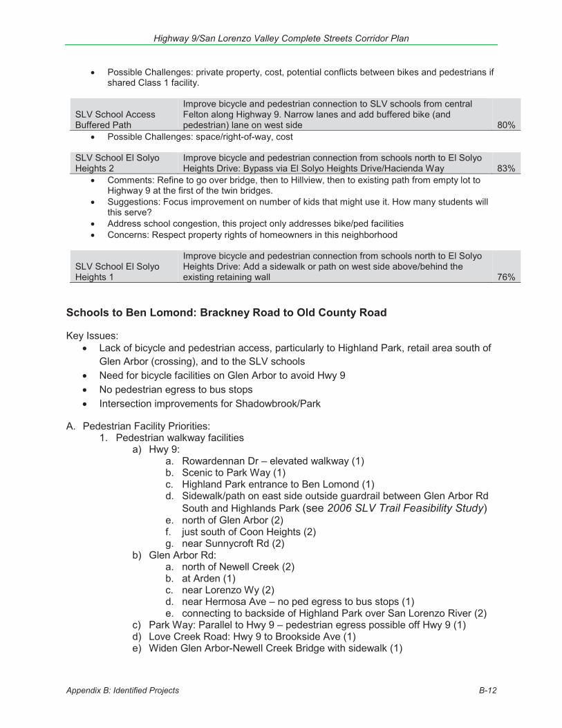
Highway 9/San Lorenzo Valley Complete Streets Corridor Plan
Appendix B: Identified Projects B-12
Possible Challenges: private property, cost, potential conflicts between bikes and pedestrians if shared Class 1 facility.
SLV School Access Buffered Path
Improve bicycle and pedestrian connection to SLV schools from central Felton along Highway 9. Narrow lanes and add buffered bike (and pedestrian) lane on west side 80%
Possible Challenges: space/right-of-way, cost
SLV School El Solyo Heights 2
Improve bicycle and pedestrian connection from schools north to El Solyo Heights Drive: Bypass via El Solyo Heights Drive/Hacienda Way 83%
Comments: Refine to go over bridge, then to Hillview, then to existing path from empty lot to Highway 9 at the first of the twin bridges.
Suggestions: Focus improvement on number of kids that might use it. How many students will this serve?
Address school congestion, this project only addresses bike/ped facilities Concerns: Respect property rights of homeowners in this neighborhood
SLV School El Solyo Heights 1
Improve bicycle and pedestrian connection from schools north to El Solyo Heights Drive: Add a sidewalk or path on west side above/behind the existing retaining wall 76%
Schools to Ben Lomond: Brackney Road to Old County Road
Key Issues: Lack of bicycle and pedestrian access, particularly to Highland Park, retail area south of
Glen Arbor (crossing), and to the SLV schools Need for bicycle facilities on Glen Arbor to avoid Hwy 9 No pedestrian egress to bus stops Intersection improvements for Shadowbrook/Park
A. Pedestrian Facility Priorities: 1. Pedestrian walkway facilities
a) Hwy 9: a. Rowardennan Dr – elevated walkway (1) b. Scenic to Park Way (1) c. Highland Park entrance to Ben Lomond (1) d. Sidewalk/path on east side outside guardrail between Glen Arbor Rd
South and Highlands Park (see 2006 SLV Trail Feasibility Study) e. north of Glen Arbor (2) f. just south of Coon Heights (2) g. near Sunnycroft Rd (2)
b) Glen Arbor Rd: a. north of Newell Creek (2) b. at Arden (1) c. near Lorenzo Wy (2) d. near Hermosa Ave – no ped egress to bus stops (1) e. connecting to backside of Highland Park over San Lorenzo River (2)
c) Park Way: Parallel to Hwy 9 – pedestrian egress possible off Hwy 9 (1) d) Love Creek Road: Hwy 9 to Brookside Ave (1) e) Widen Glen Arbor-Newell Creek Bridge with sidewalk (1)

Highway 9/San Lorenzo Valley Complete Streets Corridor Plan
Appendix B: Identified Projects B-13
2. Pedestrian crossing facilitiesa) Hwy 9 at Park Way (1)b) Hwy 9 at Willowbrook Dr – many peds cross here to access convenience store
at 7970 Hwy 9 high rate of bike/ped collisions (10)c) Hwy 9 at Sunnycroft Rd (1)d) Glen Arbor Rd at Pine St (1)e) Glen Arbor at Brookside Ave (1)
B. Bicycle Facility Projects1. Bicycle facilities – bike path, lane, etc. to separate bicycles and autos to increase
cyclist and motorist safetya) Bicycle facilities Ben Lomond to schools (3)b) Hwy 9 at Scenic Way (5)c) Hwy 9 north of Highland Park entrance (3)d) Hwy 9 at Holiday (2)e) Hwy 9 just north of Glen Arbor (4)f) Hwy 9 just south of Coon Heights (1)
C. Roadway Projects:1. Intersection/turn improvements
a) Glen Arbor and Newell Creek – all way stop sign (1)b) Hwy 9 at Scenic – Queue detection warning light, left turn pocket (1)c) Hwy 9 at Park Way/Shadowbrook Rd – center turn lane (1)d) Hwy 9 at Park Way / Shadowbrook Rd – signalized intersection (1)e) Hwy 9 at Highland Park – center turn lane (1)f) Hwy 9 at Glen Arbor – right turn lane from northbound Hwy 9 to Glen Arbor (2)
2. Other roadway projectsa) Hwy 9 bridge north of Brackney Rd – bridge too narrow for modern cars, widen
(1)b) Hwy 9 between Ben Lomond and schools – one lane for vehicle traffic, one
lane for bicycle and pedestrian traffic (1)c) Railroad Dr – fix drainage (1)d) Riverside Park Dr – fix drainage/repave (1)e) Hihn Rd – Connect through to Mt Hermon (1)
D. Auto Safety1. Speed limit enforcement
a) Newell Creek Rd just above Glen Arbor (1)b) Hwy 9 Shadowbrook Rd to Highland Park (2)c) Hwy 9 straightaway north of Glen Arbor (2)d) Glen Arbor at Azalea Ave (2)
2. Flashing warning lightsa)
3. Other auto safetya) Reduce speed limit between Locust/Willowbrook and Glen Arbor (1)b) Hwy 9 at Shadowbrook – Traffic hazard when autos pass over double yellow to
go around bicyclists in lane (1)c) No parking signs Glen Arbor to Highland Park (1)
E. Transit and other ideas:1. Provide transit service
a) SLV transit service too slow and often doesn’t arrive on time (1)
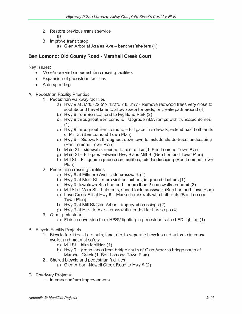
Highway 9/San Lorenzo Valley Complete Streets Corridor Plan
Appendix B: Identified Projects B-14
2. Restore previous transit service a)
3. Improve transit stop a) Glen Arbor at Azalea Ave – benches/shelters (1)
Ben Lomond: Old County Road - Marshall Creek Court Key Issues:
More/more visible pedestrian crossing facilities Expansion of pedestrian facilities Auto speeding
A. Pedestrian Facility Priorities: 1. Pedestrian walkway facilities
a) Hwy 9 at 37°05'22.5"N 122°05'35.2"W - Remove redwood trees very close to southbound travel lane to allow space for peds, or create path around (4)
b) Hwy 9 from Ben Lomond to Highland Park (2) c) Hwy 9 throughout Ben Lomond - Upgrade ADA ramps with truncated domes
(1) d) Hwy 9 throughout Ben Lomond – Fill gaps in sidewalk, extend past both ends
of Mill St (Ben Lomond Town Plan) e) Hwy 9 – Sidewalks throughout downtown to include shade trees/landscaping
(Ben Lomond Town Plan) f) Main St – sidewalks needed to post office (1, Ben Lomond Town Plan) g) Main St – Fill gaps between Hwy 9 and Mill St (Ben Lomond Town Plan) h) Mill St – Fill gaps in pedestrian facilities, add landscaping (Ben Lomond Town
Plan) 2. Pedestrian crossing facilities
a) Hwy 9 at Fillmore Ave – add crosswalk (1) b) Hwy 9 at Main St – more visible flashers, in ground flashers (1) c) Hwy 9 downtown Ben Lomond – more than 2 crosswalks needed (2) d) Mill St at Main St – bulb-outs, speed table crosswalk (Ben Lomond Town Plan) e) Love Creek Rd at Hwy 9 – Marked crosswalk with bulb-outs (Ben Lomond
Town Plan) f) Hwy 9 at Mill St/Glen Arbor – improved crossings (2) g) Hwy 9 at Hillside Ave – crosswalk needed for bus stops (4)
3. Other pedestrian a) Finish conversion from HPSV lighting to pedestrian scale LED lighting (1)
B. Bicycle Facility Projects
1. Bicycle facilities – bike path, lane, etc. to separate bicycles and autos to increase cyclist and motorist safety
a) Mill St – bike facilities (1) b) Hwy 9 – green lanes from bridge south of Glen Arbor to bridge south of
Marshall Creek (1, Ben Lomond Town Plan) 2. Shared bicycle and pedestrian facilities
a) Glen Arbor –Newell Creek Road to Hwy 9 (2) C. Roadway Projects:
1. Intersection/turn improvements

Highway 9/San Lorenzo Valley Complete Streets Corridor Plan
Appendix B: Identified Projects B-15
a) Hwy 9 throughout Ben Lomond – hard to turn left onto 9 from perpendicularstreets (1)
b) Hwy 9 at Love Creek Rd -c) Hwy 9 at Mill St/Glen Arbor – convert signal to roundabout (1)
2. Other roadway projectsa) Mill St – bike lanes, left turn pockets, merge lanes, intersection improvements
(2040 RTP)b) Hwy 9 and Fillmore Ave – Re-route Mill St to align northern intersection with
Hwy 9 with Fillmore Ave (Ben Lomond Town Plan)c) Hwy 9 through Ben Lomond – narrow travel lanes to slow drivers (1)d) Hwy 9 north of Mill St N and south of Mill St S – Entry islands (Ben Lomond
Town Plan)e) Hwy 9 across from Fire Station - Remove planted areas between parking
spaces for “safety pullouts” (2)f) Hwy 9 in front of Fire Station – add parking (1)g) Hwy 9 at Love Creek Rd – One-way entry to Love Creek Rd from Hwy 9
northbound, pedestrian island in front of 9400 Hwy 9/Valley Churches United,with speed table at crosswalk (Ben Lomond Town Plan)
h) Glen Arbor – bike lanes, transit turnouts, left turn pockets, merge lanes,intersection improvements, chip seal (2040 RTP)
D. Auto Safety1. Speed limit enforcement
a) Reduce speed limit in Ben Lomond CBD to 25 mph (2)2. Flashing warning lights
a) Hwy 9 south of Ben Lomond – Northbound warning approaching town/radarfeedback sign (2)
3. Other auto safetya) Hwy 9 at Marshall Creek – Illegal passing northbound, traffic enforcement
E. Transit and other ideas:1. Provide transit service
a) Roads other than Hwy 9 – Provide transit service up major roads perpendicularto Hwy 9 (1)
Ben Lomond to Brookdale: Marshall Creek Court - Western Avenue
Key Issues: No bicycle facilities No pedestrian facilities Intersection improvements at Alba/ Hubbard Gulch Speeding on straightaways Storm slip out not yet repaired
A. Pedestrian Facility Priorities:1. Pedestrian walkway facilities
a) Sidewalk/path on east side SR-9 Hubbard Gulch Rd to Middle Rd (see 2006SLV Trail Feasibility Study)
b) Hwy 9 Brookdale to Ben Lomond (2)c) Hwy 9 at California Dr – address [unspecified] pedestrian hazard (1)d) Hwy 9 at Hubbard Gulch, high rate of bike/ped collisions (1
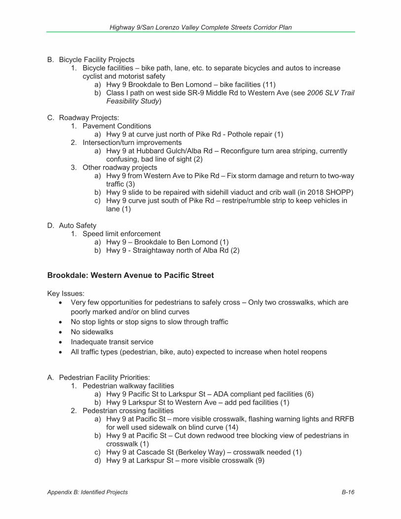
Highway 9/San Lorenzo Valley Complete Streets Corridor Plan
Appendix B: Identified Projects B-16
B. Bicycle Facility Projects
1. Bicycle facilities – bike path, lane, etc. to separate bicycles and autos to increase cyclist and motorist safety
a) Hwy 9 Brookdale to Ben Lomond – bike facilities (11) b) Class I path on west side SR-9 Middle Rd to Western Ave (see 2006 SLV Trail
Feasibility Study) C. Roadway Projects:
1. Pavement Conditions a) Hwy 9 at curve just north of Pike Rd - Pothole repair (1)
2. Intersection/turn improvements a) Hwy 9 at Hubbard Gulch/Alba Rd – Reconfigure turn area striping, currently
confusing, bad line of sight (2) 3. Other roadway projects
a) Hwy 9 from Western Ave to Pike Rd – Fix storm damage and return to two-way traffic (3)
b) Hwy 9 slide to be repaired with sidehill viaduct and crib wall (in 2018 SHOPP) c) Hwy 9 curve just south of Pike Rd – restripe/rumble strip to keep vehicles in
lane (1) D. Auto Safety
1. Speed limit enforcement a) Hwy 9 – Brookdale to Ben Lomond (1) b) Hwy 9 - Straightaway north of Alba Rd (2)
Brookdale: Western Avenue to Pacific Street Key Issues:
Very few opportunities for pedestrians to safely cross – Only two crosswalks, which are poorly marked and/or on blind curves
No stop lights or stop signs to slow through traffic No sidewalks Inadequate transit service All traffic types (pedestrian, bike, auto) expected to increase when hotel reopens
A. Pedestrian Facility Priorities: 1. Pedestrian walkway facilities
a) Hwy 9 Pacific St to Larkspur St – ADA compliant ped facilities (6) b) Hwy 9 Larkspur St to Western Ave – add ped facilities (1)
2. Pedestrian crossing facilities a) Hwy 9 at Pacific St – more visible crosswalk, flashing warning lights and RRFB
for well used sidewalk on blind curve (14) b) Hwy 9 at Pacific St – Cut down redwood tree blocking view of pedestrians in
crosswalk (1) c) Hwy 9 at Cascade St (Berkeley Way) – crosswalk needed (1) d) Hwy 9 at Larkspur St – more visible crosswalk (9)
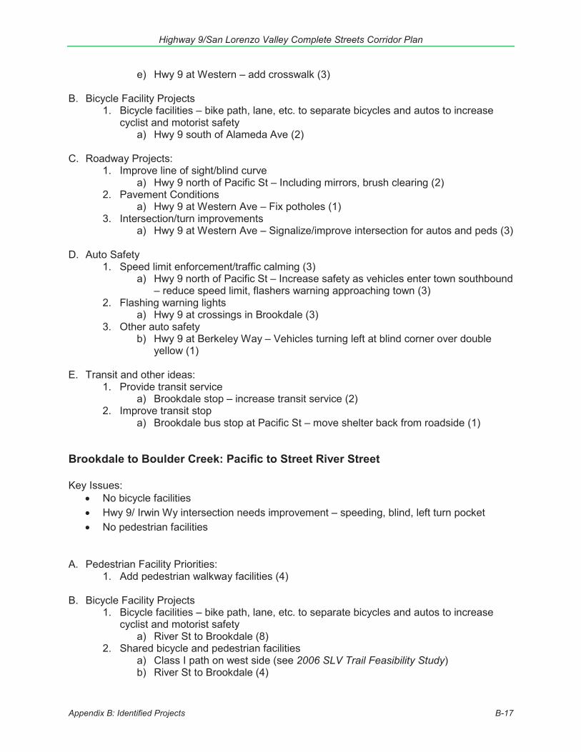
Highway 9/San Lorenzo Valley Complete Streets Corridor Plan
Appendix B: Identified Projects B-17
e) Hwy 9 at Western – add crosswalk (3)
B. Bicycle Facility Projects1. Bicycle facilities – bike path, lane, etc. to separate bicycles and autos to increase
cyclist and motorist safetya) Hwy 9 south of Alameda Ave (2)
C. Roadway Projects:1. Improve line of sight/blind curve
a) Hwy 9 north of Pacific St – Including mirrors, brush clearing (2)2. Pavement Conditions
a) Hwy 9 at Western Ave – Fix potholes (1)3. Intersection/turn improvements
a) Hwy 9 at Western Ave – Signalize/improve intersection for autos and peds (3)
D. Auto Safety1. Speed limit enforcement/traffic calming (3)
a) Hwy 9 north of Pacific St – Increase safety as vehicles enter town southbound– reduce speed limit, flashers warning approaching town (3)
2. Flashing warning lightsa) Hwy 9 at crossings in Brookdale (3)
3. Other auto safetyb) Hwy 9 at Berkeley Way – Vehicles turning left at blind corner over double
yellow (1)
E. Transit and other ideas:1. Provide transit service
a) Brookdale stop – increase transit service (2)2. Improve transit stop
a) Brookdale bus stop at Pacific St – move shelter back from roadside (1)
Brookdale to Boulder Creek: Pacific to Street River Street
Key Issues: No bicycle facilities Hwy 9/ Irwin Wy intersection needs improvement – speeding, blind, left turn pocket No pedestrian facilities
A. Pedestrian Facility Priorities:1. Add pedestrian walkway facilities (4)
B. Bicycle Facility Projects1. Bicycle facilities – bike path, lane, etc. to separate bicycles and autos to increase
cyclist and motorist safetya) River St to Brookdale (8)
2. Shared bicycle and pedestrian facilitiesa) Class I path on west side (see 2006 SLV Trail Feasibility Study)b) River St to Brookdale (4)
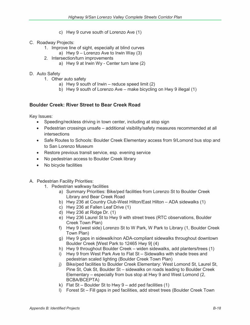
Highway 9/San Lorenzo Valley Complete Streets Corridor Plan
Appendix B: Identified Projects B-18
c) Hwy 9 curve south of Lorenzo Ave (1) C. Roadway Projects:
1. Improve line of sight, especially at blind curves a) Hwy 9 – Lorenzo Ave to Irwin Way (3)
2. Intersection/turn improvements a) Hwy 9 at Irwin Wy - Center turn lane (2)
D. Auto Safety
1. Other auto safety a) Hwy 9 south of Irwin – reduce speed limit (2) b) Hwy 9 south of Lorenzo Ave – make bicycling on Hwy 9 illegal (1)
Boulder Creek: River Street to Bear Creek Road Key Issues:
Speeding/reckless driving in town center, including at stop sign Pedestrian crossings unsafe – additional visibility/safety measures recommended at all
intersections Safe Routes to Schools: Boulder Creek Elementary access from 9/Lomond bus stop and
to San Lorenzo Museum Restore previous transit service, esp. evening service No pedestrian access to Boulder Creek library No bicycle facilities
A. Pedestrian Facility Priorities: 1. Pedestrian walkway facilities
a) Summary Priorities: Bike/ped facilities from Lorenzo St to Boulder Creek Library and Bear Creek Road
b) Hwy 236 at Country Club-West Hilton/East Hilton – ADA sidewalks (1) c) Hwy 236 at Fallen Leaf Drive (1) d) Hwy 236 at Ridge Dr. (1) e) Hwy 236 Laurel St to Hwy 9 with street trees (RTC observations, Boulder
Creek Town Plan) f) Hwy 9 (west side) Lorenzo St to W Park, W Park to Library (1, Boulder Creek
Town Plan) g) Hwy 9 gaps in sidewalk/non ADA-compliant sidewalks throughout downtown
Boulder Creek [West Park to 12465 Hwy 9] (4) h) Hwy 9 throughout Boulder Creek – widen sidewalks, add planters/trees (1) i) Hwy 9 from West Park Ave to Flat St – Sidewalks with shade trees and
pedestrian scaled lighting (Boulder Creek Town Plan) j) Bike/ped facilities to Boulder Creek Elementary: West Lomond St, Laurel St,
Pine St, Oak St, Boulder St – sidewalks on roads leading to Boulder Creek Elementary – especially from bus stop at Hwy 9 and West Lomond (2, BCBA/BCEPTA)
k) Flat St – Boulder St to Hwy 9 – add ped facilities (1) l) Forest St – Fill gaps in ped facilities, add street trees (Boulder Creek Town
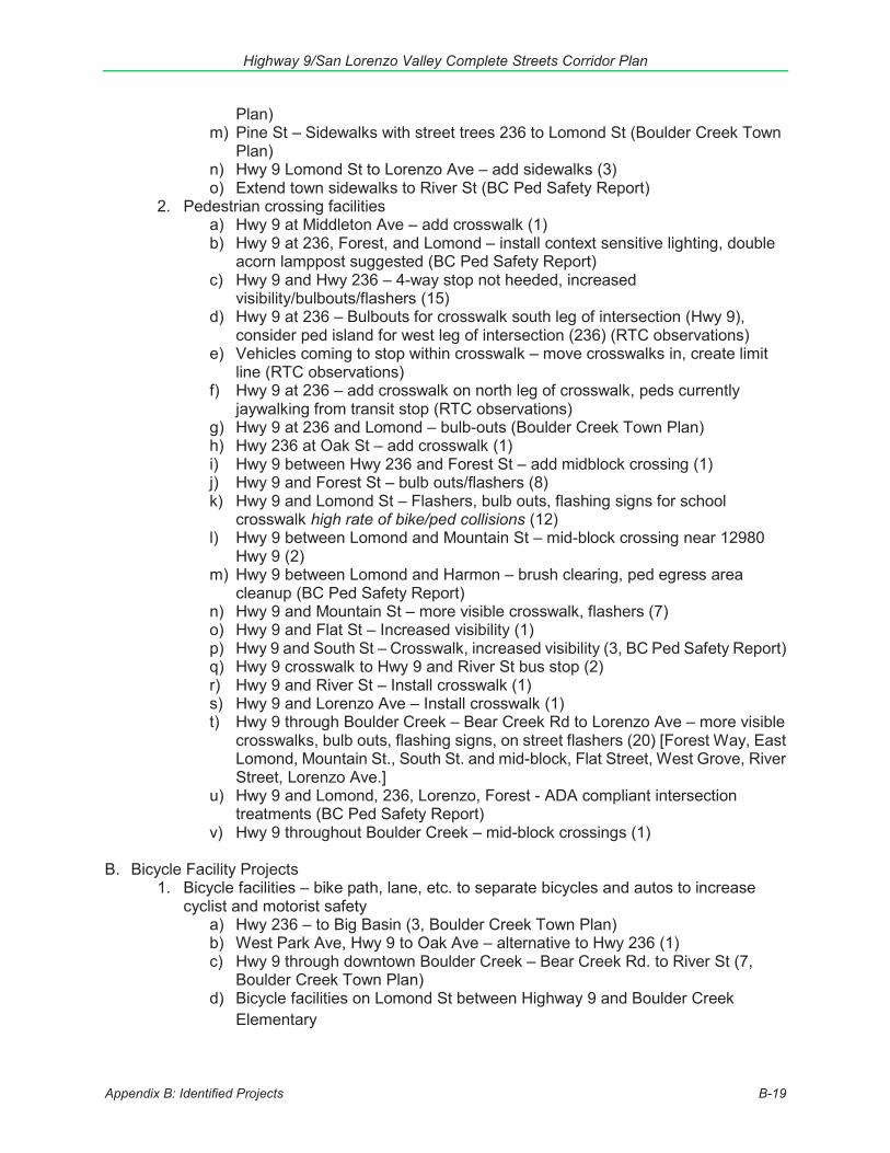
Highway 9/San Lorenzo Valley Complete Streets Corridor Plan
Appendix B: Identified Projects B-19
Plan) m) Pine St – Sidewalks with street trees 236 to Lomond St (Boulder Creek Town
Plan)n) Hwy 9 Lomond St to Lorenzo Ave – add sidewalks (3)o) Extend town sidewalks to River St (BC Ped Safety Report)
2. Pedestrian crossing facilitiesa) Hwy 9 at Middleton Ave – add crosswalk (1)b) Hwy 9 at 236, Forest, and Lomond – install context sensitive lighting, double
acorn lamppost suggested (BC Ped Safety Report)c) Hwy 9 and Hwy 236 – 4-way stop not heeded, increased
visibility/bulbouts/flashers (15)d) Hwy 9 at 236 – Bulbouts for crosswalk south leg of intersection (Hwy 9),
consider ped island for west leg of intersection (236) (RTC observations)e) Vehicles coming to stop within crosswalk – move crosswalks in, create limit
line (RTC observations)f) Hwy 9 at 236 – add crosswalk on north leg of crosswalk, peds currently
jaywalking from transit stop (RTC observations)g) Hwy 9 at 236 and Lomond – bulb-outs (Boulder Creek Town Plan)h) Hwy 236 at Oak St – add crosswalk (1)i) Hwy 9 between Hwy 236 and Forest St – add midblock crossing (1)j) Hwy 9 and Forest St – bulb outs/flashers (8)k) Hwy 9 and Lomond St – Flashers, bulb outs, flashing signs for school
crosswalk high rate of bike/ped collisions (12)l) Hwy 9 between Lomond and Mountain St – mid-block crossing near 12980
Hwy 9 (2)m) Hwy 9 between Lomond and Harmon – brush clearing, ped egress area
cleanup (BC Ped Safety Report)n) Hwy 9 and Mountain St – more visible crosswalk, flashers (7)o) Hwy 9 and Flat St – Increased visibility (1)p) Hwy 9 and South St – Crosswalk, increased visibility (3, BC Ped Safety Report)q) Hwy 9 crosswalk to Hwy 9 and River St bus stop (2)r) Hwy 9 and River St – Install crosswalk (1)s) Hwy 9 and Lorenzo Ave – Install crosswalk (1)t) Hwy 9 through Boulder Creek – Bear Creek Rd to Lorenzo Ave – more visible
crosswalks, bulb outs, flashing signs, on street flashers (20) [Forest Way, EastLomond, Mountain St., South St. and mid-block, Flat Street, West Grove, RiverStreet, Lorenzo Ave.]
u) Hwy 9 and Lomond, 236, Lorenzo, Forest - ADA compliant intersectiontreatments (BC Ped Safety Report)
v) Hwy 9 throughout Boulder Creek – mid-block crossings (1)
B. Bicycle Facility Projects1. Bicycle facilities – bike path, lane, etc. to separate bicycles and autos to increase
cyclist and motorist safetya) Hwy 236 – to Big Basin (3, Boulder Creek Town Plan)b) West Park Ave, Hwy 9 to Oak Ave – alternative to Hwy 236 (1)c) Hwy 9 through downtown Boulder Creek – Bear Creek Rd. to River St (7,
Boulder Creek Town Plan)d) Bicycle facilities on Lomond St between Highway 9 and Boulder Creek
Elementary
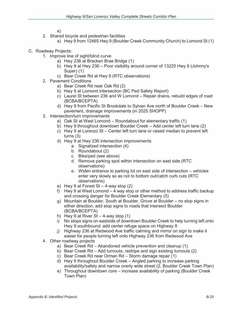
Highway 9/San Lorenzo Valley Complete Streets Corridor Plan
Appendix B: Identified Projects B-20
e) 2. Shared bicycle and pedestrian facilities
a) Hwy 9 from 12465 Hwy 9 (Boulder Creek Community Church) to Lomond St (1) C. Roadway Projects:
1. Improve line of sight/blind curve a) Hwy 236 at Bracken Brae Bridge (1) b) Hwy 9 at Hwy 236 – Poor visibility around corner of 13225 Hwy 9 (Johnny's
Super) (1) c) Bear Creek Rd at Hwy 9 (RTC observations)
2. Pavement Conditions a) Bear Creek Rd near Oak Rd (2) b) Hwy 9 at Lomond intersection (BC Ped Safety Report) c) Laurel St between 236 and W Lomond – Repair drains, rebuild edges of road
(BCBA/BCEPTA) d) Hwy 9 from Pacific St Brookdale to Sylvan Ave north of Boulder Creek – New
pavement, drainage improvements (in 2025 SHOPP) 3. Intersection/turn improvements
a) Oak St at West Lomond – Roundabout for elementary traffic (1) b) Hwy 9 throughout downtown Boulder Creek – Add center left turn lane (2) c) Hwy 9 at Lorenzo St – Center left turn lane or raised median to prevent left
turns (3) d) Hwy 9 at Hwy 236 intersection improvements
a. Signalized intersection (4) b. Roundabout (2) c. Bike/ped (see above) d. Remove parking spot within intersection on east side (RTC
observations) e. Widen entrance to parking lot on east side of intersection – vehicles
enter very slowly so as not to bottom out/catch curb cuts (RTC observations)
e) Hwy 9 at Forest St – 4-way stop (2) f) Hwy 9 at West Lomond – 4 way stop or other method to address traffic backup
and crossing danger for Boulder Creek Elementary (5) g) Mountain at Boulder, South at Boulder, Grove at Boulder – no stop signs in
either direction, add stop signs to roads that intersect Boulder (BCBA/BCEPTA)
h) Hwy 9 at River St – 4-way stop (1) i) No stops signs on eastside of downtown Boulder Creek to help turning left onto
Hwy 9 southbound; add center refuge space on Highway 9 j) Highway 236 at Redwood Ave traffic calming and mirror on sign to make it
easier for people turning left onto Highway 236 from Redwood Ave 4. Other roadway projects
a) Bear Creek Rd – Abandoned vehicle prevention and cleanup (1) b) Bear Creek Rd – Add turnouts, restripe and sign existing turnouts (2) c) Bear Creek Rd near Orman Rd – Storm damage repair (1) d) Hwy 9 throughout Boulder Creek – Angled parking to increase parking
availability/safety and narrow overly wide street (2, Boulder Creek Town Plan) e) Throughout downtown core – increase availability of parking (Boulder Creek
Town Plan)
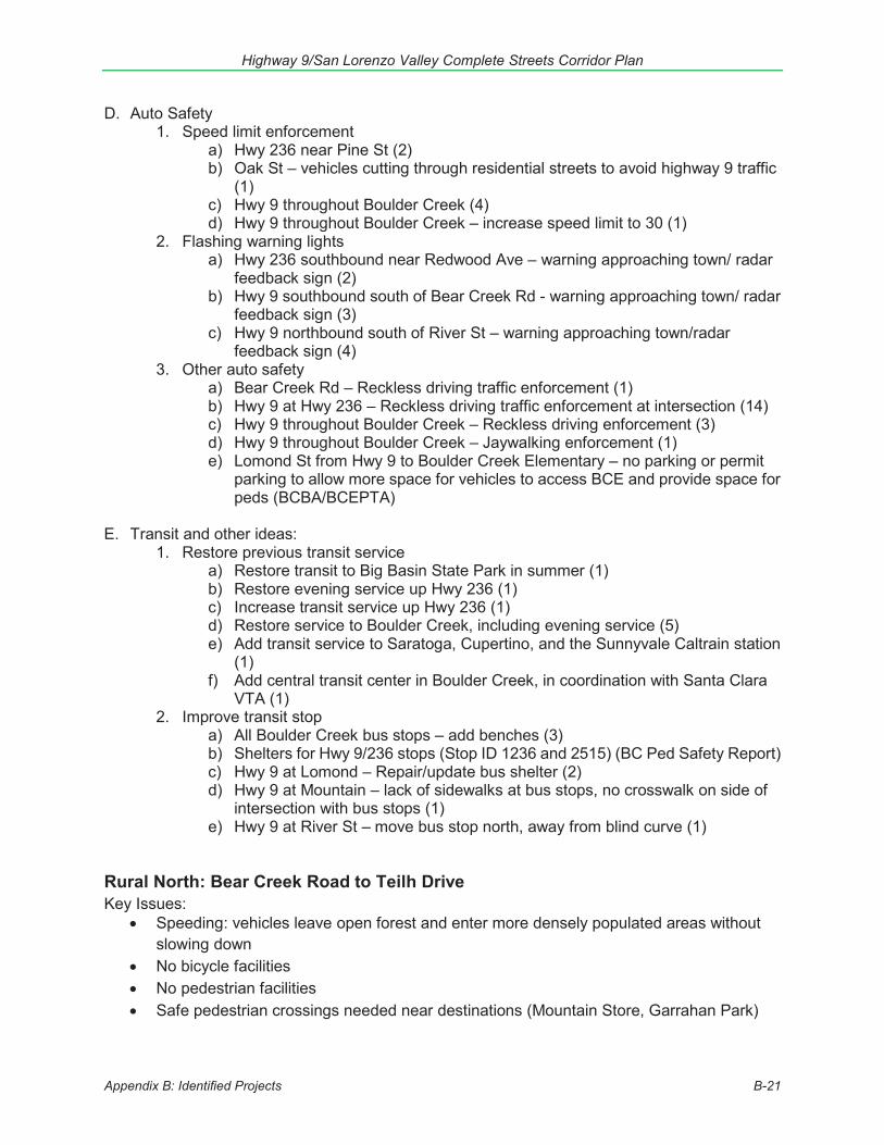
Highway 9/San Lorenzo Valley Complete Streets Corridor Plan
Appendix B: Identified Projects B-21
D. Auto Safety1. Speed limit enforcement
a) Hwy 236 near Pine St (2)b) Oak St – vehicles cutting through residential streets to avoid highway 9 traffic
(1)c) Hwy 9 throughout Boulder Creek (4)d) Hwy 9 throughout Boulder Creek – increase speed limit to 30 (1)
2. Flashing warning lightsa) Hwy 236 southbound near Redwood Ave – warning approaching town/ radar
feedback sign (2)b) Hwy 9 southbound south of Bear Creek Rd - warning approaching town/ radar
feedback sign (3)c) Hwy 9 northbound south of River St – warning approaching town/radar
feedback sign (4)3. Other auto safety
a) Bear Creek Rd – Reckless driving traffic enforcement (1)b) Hwy 9 at Hwy 236 – Reckless driving traffic enforcement at intersection (14)c) Hwy 9 throughout Boulder Creek – Reckless driving enforcement (3)d) Hwy 9 throughout Boulder Creek – Jaywalking enforcement (1)e) Lomond St from Hwy 9 to Boulder Creek Elementary – no parking or permit
parking to allow more space for vehicles to access BCE and provide space forpeds (BCBA/BCEPTA)
E. Transit and other ideas:1. Restore previous transit service
a) Restore transit to Big Basin State Park in summer (1)b) Restore evening service up Hwy 236 (1)c) Increase transit service up Hwy 236 (1)d) Restore service to Boulder Creek, including evening service (5)e) Add transit service to Saratoga, Cupertino, and the Sunnyvale Caltrain station
(1)f) Add central transit center in Boulder Creek, in coordination with Santa Clara
VTA (1)2. Improve transit stop
a) All Boulder Creek bus stops – add benches (3)b) Shelters for Hwy 9/236 stops (Stop ID 1236 and 2515) (BC Ped Safety Report)c) Hwy 9 at Lomond – Repair/update bus shelter (2)d) Hwy 9 at Mountain – lack of sidewalks at bus stops, no crosswalk on side of
intersection with bus stops (1)e) Hwy 9 at River St – move bus stop north, away from blind curve (1)
Rural North: Bear Creek Road to Teilh Drive Key Issues:
Speeding: vehicles leave open forest and enter more densely populated areas without slowing down
No bicycle facilities No pedestrian facilities Safe pedestrian crossings needed near destinations (Mountain Store, Garrahan Park)
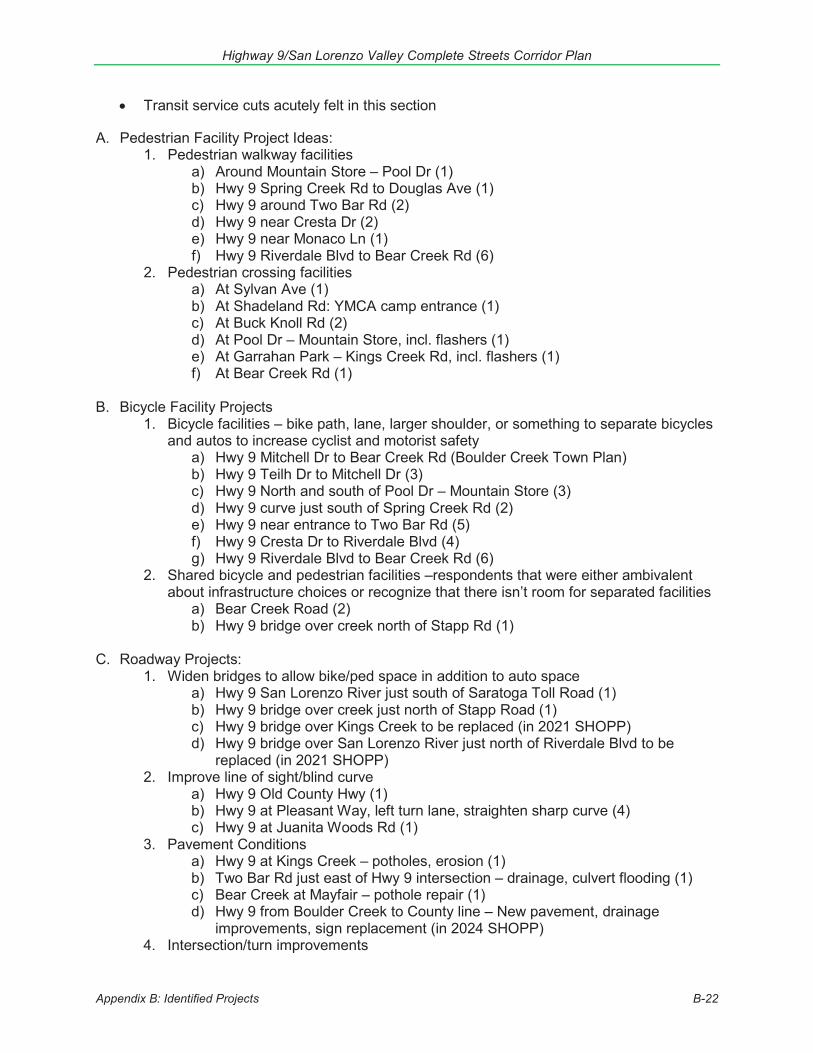
Highway 9/San Lorenzo Valley Complete Streets Corridor Plan
Appendix B: Identified Projects B-22
Transit service cuts acutely felt in this section
A. Pedestrian Facility Project Ideas: 1. Pedestrian walkway facilities
a) Around Mountain Store – Pool Dr (1) b) Hwy 9 Spring Creek Rd to Douglas Ave (1) c) Hwy 9 around Two Bar Rd (2) d) Hwy 9 near Cresta Dr (2) e) Hwy 9 near Monaco Ln (1) f) Hwy 9 Riverdale Blvd to Bear Creek Rd (6)
2. Pedestrian crossing facilities a) At Sylvan Ave (1) b) At Shadeland Rd: YMCA camp entrance (1) c) At Buck Knoll Rd (2) d) At Pool Dr – Mountain Store, incl. flashers (1) e) At Garrahan Park – Kings Creek Rd, incl. flashers (1) f) At Bear Creek Rd (1)
B. Bicycle Facility Projects
1. Bicycle facilities – bike path, lane, larger shoulder, or something to separate bicycles and autos to increase cyclist and motorist safety
a) Hwy 9 Mitchell Dr to Bear Creek Rd (Boulder Creek Town Plan) b) Hwy 9 Teilh Dr to Mitchell Dr (3) c) Hwy 9 North and south of Pool Dr – Mountain Store (3) d) Hwy 9 curve just south of Spring Creek Rd (2) e) Hwy 9 near entrance to Two Bar Rd (5) f) Hwy 9 Cresta Dr to Riverdale Blvd (4) g) Hwy 9 Riverdale Blvd to Bear Creek Rd (6)
2. Shared bicycle and pedestrian facilities –respondents that were either ambivalent about infrastructure choices or recognize that there isn’t room for separated facilities
a) Bear Creek Road (2) b) Hwy 9 bridge over creek north of Stapp Rd (1)
C. Roadway Projects:
1. Widen bridges to allow bike/ped space in addition to auto space a) Hwy 9 San Lorenzo River just south of Saratoga Toll Road (1) b) Hwy 9 bridge over creek just north of Stapp Road (1) c) Hwy 9 bridge over Kings Creek to be replaced (in 2021 SHOPP) d) Hwy 9 bridge over San Lorenzo River just north of Riverdale Blvd to be
replaced (in 2021 SHOPP) 2. Improve line of sight/blind curve
a) Hwy 9 Old County Hwy (1) b) Hwy 9 at Pleasant Way, left turn lane, straighten sharp curve (4) c) Hwy 9 at Juanita Woods Rd (1)
3. Pavement Conditions a) Hwy 9 at Kings Creek – potholes, erosion (1) b) Two Bar Rd just east of Hwy 9 intersection – drainage, culvert flooding (1) c) Bear Creek at Mayfair – pothole repair (1) d) Hwy 9 from Boulder Creek to County line – New pavement, drainage
improvements, sign replacement (in 2024 SHOPP) 4. Intersection/turn improvements

Highway 9/San Lorenzo Valley Complete Streets Corridor Plan
Appendix B: Identified Projects B-23
a) Intersection improvements at Hwy 9 and Bear Creek Rd – turn lanes/flashinglights/roundabout, especially for cars entering Hwy 9 from Bear Creek (4)
b) Hwy 9 at Bear Creek – left turn pocket, merge pocket (RTC observations)5. Other roadway projects
a) Hwy 9 between 236 and Saratoga Toll Rd – restore roadway facilities onhairpin curve (in 2016 SHOPP)
b) More clearly marked turnouts north of Boulder Creek (1)c) New main entrance to Castle Rock State Park on Hwy 9 (1)d) From Hwy 35 junction to 3.3 miles south: widen shoulders, replace guardrails,
centerline rumble strips (in 2018 SHOPP)e) Hwy 9 at Spring Creek Rd – restore roadway facilities (in 2020 SHOPP)f) Bear Creek Rd - Bike lanes, transit turnouts, left turn pockets, merge lanes,
intersection improvements, chip seal (2040 RTP)g) Bear Creek Rd – clearly marked turnouts (1)
D. Auto Safety1. Speed limit enforcement
a) Hwy 9 within Castle Rock State Park (1)b) Hwy 9 Teilh Dr to Mitchell Dr (4)c) Hwy 9 Norich Rd to Shadeland Rd – elementary and 2 summer camps (3)d) Hwy 9 at Brookside Dr (1)
2. Flashing warning lightsa) Hwy 9 Norich Rd to Shadeland Rd – speeding, elementary/summer camps (2)
3. Other auto safetya) Rumble strips around elementary school @ Norich Rd for speeding (4)b) Bear Creek Rd: Reflectors at road boundary, lighting (1)c) Add more turnouts on Bear Creek Rd
E. Transit and other ideas:1. Provide transit service
a) Hwy 9 at Saratoga Toll Rd (1)2. Restore previous transit service
a) North of Mountain Store – Teilh Dr to Buck Knoll Rd (5)b) Boulder Creek to Mountain Store (4)c) Hwy 9 at Monaco Ln (2)
3. Improve transit stopa) Stop at Pleasant Way needs shelter (1)b) Crosswalk to stop at Brookside Dr (2)
Outside Project Area A. Pedestrian Facility Project Ideas:
1. Pedestrian walkway facilitiesa) Walkways from Boulder Creek to Stapp Rd along Hwy 9
2. Shared bicycle and pedestrian facilitiesa) Path from Felton to UCSC through Pogonipb) Path from Boulder Creek to Scotts Valley
B. Bicycle Facility Projects1. Bicycle facilities
a) Dedicated path(s) that takes cyclists away from Hwy 9 from Felton to SantaCruz (see 2006 SLV Trail Feasibility Study which evaluated trail along rail
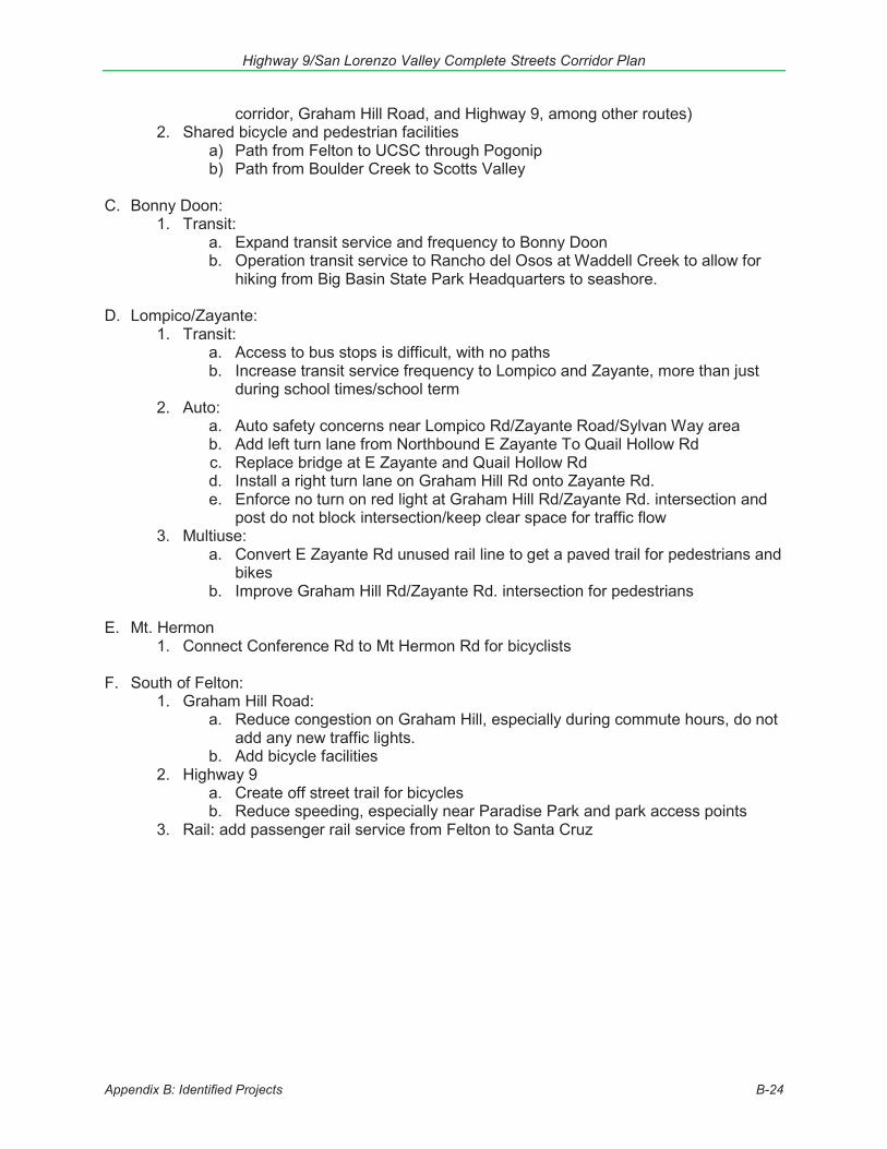
Highway 9/San Lorenzo Valley Complete Streets Corridor Plan
Appendix B: Identified Projects B-24
corridor, Graham Hill Road, and Highway 9, among other routes) 2. Shared bicycle and pedestrian facilities
a) Path from Felton to UCSC through Pogonip b) Path from Boulder Creek to Scotts Valley
C. Bonny Doon:
1. Transit: a. Expand transit service and frequency to Bonny Doon b. Operation transit service to Rancho del Osos at Waddell Creek to allow for
hiking from Big Basin State Park Headquarters to seashore.
D. Lompico/Zayante: 1. Transit:
a. Access to bus stops is difficult, with no paths b. Increase transit service frequency to Lompico and Zayante, more than just
during school times/school term 2. Auto:
a. Auto safety concerns near Lompico Rd/Zayante Road/Sylvan Way area b. Add left turn lane from Northbound E Zayante To Quail Hollow Rd c. Replace bridge at E Zayante and Quail Hollow Rd d. Install a right turn lane on Graham Hill Rd onto Zayante Rd. e. Enforce no turn on red light at Graham Hill Rd/Zayante Rd. intersection and
post do not block intersection/keep clear space for traffic flow 3. Multiuse:
a. Convert E Zayante Rd unused rail line to get a paved trail for pedestrians and bikes
b. Improve Graham Hill Rd/Zayante Rd. intersection for pedestrians
E. Mt. Hermon 1. Connect Conference Rd to Mt Hermon Rd for bicyclists
F. South of Felton:
1. Graham Hill Road: a. Reduce congestion on Graham Hill, especially during commute hours, do not
add any new traffic lights. b. Add bicycle facilities
2. Highway 9 a. Create off street trail for bicycles b. Reduce speeding, especially near Paradise Park and park access points
3. Rail: add passenger rail service from Felton to Santa Cruz
Highway 9/San Lorenzo Valley Complete Streets Corridor Plan
Appendix C: Funding Opportunities C-1
Appendix C: Funding Opportunities The cost to transform Highway 9 through the SLV into a “complete” corridor will be substantial and take many years. Some projects identified in this plan would cost well over $5 million each. Funding available to plan and construct projects that maintain roadways, build bicycle, pedestrian, and transit facilities, improve traffic flow, enhance traffic safety, reduce pollution, prioritize smart growth, and improve community health and well-being are limited. While some components of projects identified as priorities in this plan could be implemented as part of other maintenance, development or redevelopment projects, it will be necessarily to compete for grant funds for most projects. It is not uncommon for a combination of funds from several funding sources to be needed to fully fund a project. In general, Measure D sales tax revenues are expected to serve as match, in order to leverage those other funds.
The following describes some of the potential federal, state, regional, and local sources of funding, including potential community-based and private funding that may be available for transportation projects in the SLV. Transportation funding is dynamic and funding programs can change over time. New funding programs may be available as projects are implemented. Implementing agencies (Caltrans, the County of Santa Cruz, METRO, and RTC) will need to monitor funding programs and pursue funding for projects which meet criteria and priorities of each source, as opportunities arise.
Federal Sources In California, most federal transportation monies are administered through the California Department of Transportation (Caltrans). Federal funding is intended for capital improvements and safety and education programs, and projects must relate to the surface transportation system.
Fixing America’s Surface Transportation Act (FAST) Fixing America’s Surface Transportation (FAST) authorizes funding from the federal highway account for highway, rail, and transit projects. Funds are available through a combination of formula and discretionary grant programs. Some of the major programs that may be available for transportation projects in the SLV are described below.
Surface Transportation Block Grant Program (STBG) Each state’s STBG funds (previously called RSTP) are sub-allocated geographically by population. The RTC is responsible for selecting projects to receive the county’s share of regional STBG funds, approximately $3 million per year. A wide variety of transportation projects (highway, road, bike, pedestrian, and transit) are eligible.
More info: www.sccrtc.org/rtip
Transportation Alternatives and Recreational Trails Programs The Transportation Alternatives Set-Aside and the Recreational Trails Program, which in California are administered through the Active Transportation Program (ATP), described below.
Highway Safety Improvement Program (HSIP) HSIP provides funding for projects and programs that help communities achieve significant reductions in traffic fatalities and serious injuries on all public roads, bikeways, and walkways.
Highway 9/San Lorenzo Valley Complete Streets Corridor Plan
Appendix C: Funding Opportunities C-2
Infrastructure and non-infrastructure projects are eligible for HSIP funds. All HSIP projects must be consistent with the state’s Strategic Highway Safety Plan. Grant size typically ranges from $100,000 to $10 million. In California this program is administered by Caltrans. HSIP funding is available to the agency with responsibility for the expenditure of federal-aid highway funds; in this case the County of Santa Cruz. HSIP funds are eligible for work on any public road or publicly owned bicycle or pedestrian pathway or trail that improves the safety for its users. Eligibility for these funds is based on collision metrics and benefits which are demonstrated through use of tools made available for the grant application.
More info: http://www.dot.ca.gov/hq/LocalPrograms/hsip.html
Federal Transit Administration Formula Grants for Rural Areas - 5311 The Federal Transit Administration (FTA) provides capital, planning, and operating assistance to support public transportation in rural areas with less than 50,000 people. The federal funding share is 80% for capital project, which can include bus shelter improvements and improvements that connect pedestrians and bicyclists to transit. Santa Cruz METRO determines the use of the county’s share of these funds.
More info: http://www.dot.ca.gov/drmt/
Partnership for Sustainable Communities The Partnership for Sustainable Communities is a joint project of the Environmental Protection Agency, the U.S. Department of Housing and Urban Development, and the U.S. Department of Transportation. The partnership aims to “improve access to affordable housing, more transportation options, and lower transportation costs while protecting the environment in communities nationwide.” The Partnership is based on five Livability Principles, one of which explicitly addresses the need for bicycle and pedestrian infrastructure. The Partnership is not a formal agency with a regular annual grant program: rather, each participating agency separately offers funding opportunities. This is not a funding program in itself, but rather an overarching partnership that links to other specific funding programs.
More info: https://www.sustainablecommunities.gov/partnership-resources
Better Utilizing Investments to Leverage Development (BUILD) Grants The U.S. Department of Transportation’s BUILD Discretionary Grant program (formerly called TIGER) invests in road, rail, transit, bicycle, pedestrian and port projects that enhance economic development and improve access to reliable and safe transportation. This highly-competitive program (about 5% of applications are approved for funds) is typically oriented to large scale visionary projects. In 2018 awards focused on rural areas.
More info: https://www.transportation.gov/BUILDgrants
Highway 9/San Lorenzo Valley Complete Streets Corridor Plan
Appendix C: Funding Opportunities C-3
State Grant Sources Road Repair and Accountability Act of 2017 (SB1) CA State SB 1 (2017), which raises the state taxes on diesel and gasoline and introduces new vehicle fees, includes funds to maintain state highways and local roads, partnership funds for jurisdictions that have initiated their own “self-help” sales tax transportation measures – like Measure D, funds for congested corridors, trade corridors and active transportation (bike and pedestrian) projects. The California Transportation Commission (CTC) selects project to receive most of the competitive grant funds, with the Caltrans State Transportation Authority selecting projects to receive certain transit grants. Caltrans is responsible for administrative actions.
More info: http://rebuildingca.ca.gov/
State Highway Operation and Protection Program (SHOPP) The State Highway Operations and Protection Program (SHOPP) is one of the largest transportation programs in California. It funds the maintenance and repair of the State Highway system, as well as safety and some operational improvements. Caltrans is increasingly evaluating and incorporating complete streets components into the scope of SHOPP projects.
More info: http://www.dot.ca.gov/hq/transprog/shopp.htm
State Transportation Improvement Program (STIP) The STIP is a multi-year capital improvement program of transportation projects on and off the State Highway System, funded with revenues from the Transportation Investment Fund and other funding sources. STIP programming generally occurs every two years. The programming cycle begins with the release of a fund estimate of new funds available for the programming of transportation projects over a 5-year time period. Once the fund estimate is adopted, Caltrans and the regional planning agencies (following a public hearing) submit proposals for these funds to the California Transportation Commission (CTC) by December 15th (odd years). Caltrans prepares the Interregional Transportation Improvement Plan (ITIP) and regional agencies prepare Regional Transportation Improvement Programs (RTIPs). The CTC considers proposals from agencies statewide, the adopts the State Transportation Improvement Program (STIP) in spring of even years.
More info: http://catc.ca.gov/programs/stip/
Active Transportation Program (ATP) The purpose of the ATP is to encourage the increased use of active modes of transportation to reduce greenhouse gas emissions and enhance public health. For example, funding could enable activities that increase the proportion of trips that use biking and walking or increase safety and mobility for non-motorized users, including infrastructure projects such as recreational trails and walkways. Some preference is given to low income and state-defined disadvantaged communities. The ATP program consolidates several programs, including past Safe Routes to Schools and Bicycle Transportation Account programs, as well as federal Transportation Alternatives and Recreational Trails funds and $100 million per year allocated by Senate Bill 1 (2017).
More info: http://www.dot.ca.gov/hq/LocalPrograms/atp/
Highway 9/San Lorenzo Valley Complete Streets Corridor Plan
Appendix C: Funding Opportunities C-4
State Cap and Trade Programs Per AB 32, California must reduce greenhouse gas emissions to 1990 levels by 2020. A key component of this goal is the creation of a carbon cap and trade program, which places a cap on carbon emissions and enables companies to buy and/or trade emissions allowances through a state-run marketplace. Auction revenue is deposited into the Greenhouse Gas Reduction Fund (GGRF), which includes appropriations to support low carbon transportation, including transit and affordable housing/transit grants.
More info: https://www.arb.ca.gov/cc/capandtrade/auctionproceeds/ggrfprogrampage.htm
Environmental Enhancement and Mitigation (EEM) Grant Program The EEM Program offers approximately $5 to $7 million statewide for small grants to state, local, federal and nonprofit organizations for projects directly or indirectly related to the environmental impact of transportation facility modifications or construction of new transportation facilities. The EEM Program encourages projects that produce multiple benefits, such as reducing greenhouse gas emissions, increasing water use efficiency, reducing risks from climate change impacts, and demonstrating collaboration with local, state and community entities. Applicable funding categories include assessing environmental impact for proposed transportation improvements and acquisition, restoration, or enhancement of resource lands to mitigate for loss or detriment to such lands near right of way for transportation improvements. In California this funding is available through the California Natural Resources Agency.
More info: http://resources.ca.gov/grants/environmental-enhancement-and-mitigation-eem/
Urban Greening Grant Program Through the Urban Greening Grant Program, funding is available to assist entities in developing a master urban greening plan that will ultimately result in projects to help the State meet its environmental goals and the creation of healthy communities. These funds assist entities preserve, enhance, increase or establish community green areas such as urban forests, open spaces, wetlands and community spaces (e.g., community gardens). Successful projects focus on conversion of paved areas to green space, natural storm water management, and generally green infrastructure projects that reduce GHG emissions. Projects must have one other co-benefit as well, such as reducing vehicle miles traveled through the construction of pedestrian and bicycle facilities that provide safe routes between residences, commercial centers, workplaces, and schools. Approximately $26 million was available in 2018.
More info: http://sgc.ca.gov/Grant-Programs/UGG-Program.html
California Highway Patrol (CHP) and Office of Traffic Safety Programs CHP is responsible for traffic patrol on state highways and roadways in the unincorporated areas of Santa Cruz County. OTS has grant programs aimed at increasing awareness of traffic rules, rights, and responsibilities, with an emphasis on bicycle and pedestrian safety skills for students, impaired driver education. OTS Selective Traffic Enforcement Program (STEP) grants focus on traffic enforcement and education, including impaired driving enforcement, DUI checkpoints enforcement operations focusing on distracted driving, motorcycle safety, and pedestrian and bicycle safety.
More info: https://www.ots.ca.gov/grants/ and https://www.chp.ca.gov/programs-services

Highway 9/San Lorenzo Valley Complete Streets Corridor Plan
Appendix C: Funding Opportunities C-5
Regional & Local Sources Santa Cruz County Measure D In November 2016 Santa Cruz County approved Measure D, a half-cent, 30-year sales tax that provides roughly $20 million per year to improve the transportation network and fund sustainable alternative transportation efforts. The voter-approved expenditure plan for Measure D includes $10 million to the San Lorenzo Valley area for Highway 9 corridor improvements through 2035. The RTC is responsible for administering the funds. Additionally, 16% of Measure D funds are allocated to Santa Cruz METRO to provide bus and paratransit service in Santa Cruz County, 4% to Lift Line for paratransit services, and approximately 14% of Measure D funds are allocated to the County of Santa Cruz for transportation projects in unincorporated areas. Recipient agencies select projects through 5-year program of projects, updated annually, typically in the spring as agencies prepare their budgets and capital improvement programs.
More info: www.sccrtc.org/move
Monterey Bay Air Resources District (MBARD) – AB 2677 Grant Program – Clean Air Management Program In 1990 the State passed AB 2677, which enables the Monterey Bay Air Resources District to charge a $4 vehicle registration fee with proceeds going to a grant program that enables local agencies to invest in projects that reduce motor vehicle fuel emissions. Roundabouts, adaptive traffic signal control projects, and related planning and technical studies are eligible for funding. The maximum grant award is $200,000.
More info: http://mbard.org/programs-resources/planning/grants-incentives/ab2766-grant-program/
Transportation Development Act Funds are derived from a ¼ - cent sales tax collected by the State and returned to Santa Cruz County. Most TDA funds in Santa Cruz County are allocated by formula to Santa Cruz METRO for transit service operations. Some funds are also allocated for Lift Line and Volunteer Center paratransit programs, to the County Health Services agency and Ecology Action for bicycle and pedestrian education and encouragement programs, to local jurisdictions for bicycle and pedestrian projects, and to the RTC for planning. The RTC’s Bicycle Advisory Committee and Elderly and Disabled Transportation Advisory Committee (E&D TAC) review proposals (claims) for funds for bicycle, transit, paratransit, and pedestrian projects and programs.
County of Santa Cruz funding The County of Santa Cruz’s capital budget and Capital Improvement Plan (CIP) provide opportunities to address some of the priorities identified in this plan. It includes a combination of funding sources and has focused on repair and maintenance of county roads. While maintaining roads is a priority of this plan, the County does have the option to also dedicate some County funds for other complete street project both on county roads and state highways. Primary county sources of funds are described below.
Gas Tax/HUTA
The state of California imposes per-gallon excise taxes on gasoline and diesel fuel, sales taxes on gasoline and diesel fuel and registration taxes on motor vehicles with allocations dedicated
Highway 9/San Lorenzo Valley Complete Streets Corridor Plan
Appendix C: Funding Opportunities C-6
to transportation purposes. These allocations flow through the Highway Users Tax Account (HUTA). The funds are allocated to cities and counties for projects on public streets and highways (and their related public facilities for nonmotorized traffic). The County of Santa Cruz’s estimated share of these funds in FY18/19 is $10.7 million, with approximately $4.7 million of those funds the result of the 2017 SB1 Road Maintenance and Rehabilitation Account.
County Service Areas(CSA)/Benefit assessment subzones
Another option to address priority projects and roadway repairs in the SLV are CSAs. These subzones are typically small neighborhood benefit assessment areas, raising funds for pavement maintenance and other projects at the local level. These subzones are usually self-initiated and citizen-driven through a petition process through the County Board of Supervisors. The funding generated can only be utilized in the neighborhoods where the residential subzones were created.
More info: http://www.dpw.co.santa-cruz.ca.us/
Private Sources Private funding sources can be acquired by applying through advocacy groups, foundations, or corporate donations, although funding can tap into federal and state sources as well. Below are several examples of private funding opportunities available.
Foundations Foundation funding sources are typically private or community-based, and can be in the form of gifts, grants, or loans. Private foundations are generally comprised of a small core set of donors that can include an individual, a family, or a corporation, which dictate its funding interests. In turn, community foundations grants are generally donor-driven and focused on the local geographic area in which it is located. In either case, funding opportunities are often available through open Request for Proposals or can be relationship-driven. A wide range of funding interests exist through foundations, including community health and wellness, traffic and pedestrian safety, environmental conservation, and investments in smart growth. In recent years, the Land Trust of Santa Cruz County has provided funds for some transportation projects.
Corporate Donations Corporate donations are often received in the form of liquid investments (i.e., cash, stock, bonds) and in the form of land. Employers recognize that creating places to bike and walk is one way to build community and attract a quality workforce. Bicycling and outdoor recreation businesses often support local projects and programs. Municipalities typically create funds to facilitate and simplify a transaction from a corporation’s donation to the given municipality. Donations are mainly received when a widely-supported capital improvement program is implemented. Such donations can improve capital budgets and/or projects.
People for Bikes Community Grants People for Bikes community grants are supported by partners in the bicycle industry and go towards important and/or influential projects that will leverage federal funding and "build momentum for bicycling in communities across the U.S." The program funds corridor improvements, mountain bike trails, BMX parks, trails, and park access. Grants range from $1,000-$10,000.
Highway 9/San Lorenzo Valley Complete Streets Corridor Plan
Appendix C: Funding Opportunities C-7
More info: http://www.peopleforbikes.org/pages/community-grants
Development projects In addition to applying for government grants, the County of Santa Cruz could require that transportation projects and ideas identified in Chapter 3 and Appendix B be constructed as a condition of approval for development and redevelopment projects in the corridor. This could include fronting sidewalks and paths and streetscape amenities such as street lights. Even in relatively slow-growing areas, such opportunities present themselves as land uses change and as buildings are replaced or upgraded.
Transportation Project Programming Process The process for securing funds noted above varies by program. In general, for competitive grants, the County of Santa Cruz, Caltrans, Santa Cruz METRO and other public agency sponsors are eligible to submit applications for projects in the San Lorenzo Valley. The lead agency decides which projects to submit applications for after considering eligibility and competitiveness of the project for those funds. Most transportation grants are administered by Caltrans, the California Transportation Commission (CTC) or Federal Transit Administration. The Santa Cruz County Regional Transportation Commission (RTC), as the state-designated regional transportation agency for Santa Cruz County, is responsible for selecting projects to receive certain local, state and federal funds. This includes Measure D, Transportation Development Act (TDA), State Transportation Improvement Program (STIP)-with CTC concurrence, and Surface Transportation Block Grant Program (STBG) funds. The Regional Transportation Improvement Program (RTIP) identifies projects the RTC has programmed to receive certain state and federal funds. It acts as Santa Cruz County’s proposal to the California Transportation Commission (CTC) (coordinated with Caltrans District 5) for programming State Transportation Improvement Program (STIP) funds (see www.sccrtc.org/rtip).

Highway 9/San Lorenzo Valley Complete Streets Corridor Plan
Appendix D: Public Input D-1
Appendix D: Corridor Plan Public Input
Contents
1. Corridor Plan Public Input
2. Summary of Public Comment on Draft Plan
3. Summary of Updates from Draft Plan
4. Examples of Outreach on Draft Plan
a. Website
b. Flyer
c. News Article
d. Social Media Posts
e. eNews Releases
5. Comments Received on Draft Plan - online at www.sccrtc.org/slvplan
a. Minutes from February 7, 2019 public hearing
b. Letters received during public comment period
c. Emails received during public comment period
d. Comments received during Open Houses
e. Online Survey results
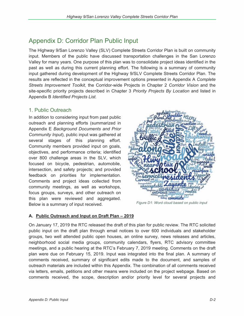
Highway 9/San Lorenzo Valley Complete Streets Corridor Plan
Appendix D: Public Input D-2
Figure D1: Word cloud based on public input
Appendix D: Corridor Plan Public Input The Highway 9/San Lorenzo Valley (SLV) Complete Streets Corridor Plan is built on community input. Members of the public have discussed transportation challenges in the San Lorenzo Valley for many years. One purpose of this plan was to consolidate project ideas identified in the past as well as during this current planning effort. The following is a summary of community input gathered during development of the Highway 9/SLV Complete Streets Corridor Plan. The results are reflected in the conceptual improvement options presented in Appendix A Complete Streets Improvement Toolkit, the Corridor-wide Projects in Chapter 2 Corridor Vision and the site-specific priority projects described in Chapter 3 Priority Projects By Location and listed in Appendix B Identified Projects List.
1. Public OutreachIn addition to considering input from past public outreach and planning efforts (summarized in Appendix E Background Documents and Prior Community Input), public input was gathered at several stages of this planning effort. Community members provided input on goals, objectives, and performance criteria; identified over 800 challenge areas in the SLV, which focused on bicycle, pedestrian, automobile, intersection, and safety projects; and provided feedback on priorities for implementation. Comments and project ideas collected from community meetings, as well as workshops, focus groups, surveys, and other outreach on this plan were reviewed and aggregated. Below is a summary of input received.
A. Public Outreach and Input on Draft Plan – 2019
On January 17, 2019 the RTC released the draft of this plan for public review. The RTC solicited public input on the draft plan through email notices to over 600 individuals and stakeholder groups, two well attended public open houses, an online survey, news releases and articles, neighborhood social media groups, community calendars, flyers, RTC advisory committee meetings, and a public hearing at the RTC’s February 7, 2019 meeting. Comments on the draft plan were due on February 15, 2019. Input was integrated into the final plan. A summary of comments received, summary of significant edits made to the document, and samples of outreach materials are included within this Appendix. The combination of all comments received via letters, emails, petitions and other means were included on the project webpage. Based on comments received, the scope, description and/or priority level for several projects and
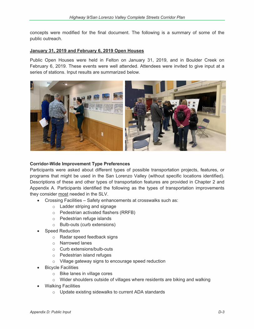
Highway 9/San Lorenzo Valley Complete Streets Corridor Plan
Appendix D: Public Input D-3
concepts were modified for the final document. The following is a summary of some of the public outreach.
January 31, 2019 and February 6, 2019 Open Houses
Public Open Houses were held in Felton on January 31, 2019, and in Boulder Creek on February 6, 2019. These events were well attended. Attendees were invited to give input at a series of stations. Input results are summarized below.
Corridor-Wide Improvement Type Preferences Participants were asked about different types of possible transportation projects, features, or programs that might be used in the San Lorenzo Valley (without specific locations identified). Descriptions of these and other types of transportation features are provided in Chapter 2 and Appendix A. Participants identified the following as the types of transportation improvements they consider most needed in the SLV.
Crossing Facilities – Safety enhancements at crosswalks such as: o Ladder striping and signageo Pedestrian activated flashers (RRFB)o Pedestrian refuge islandso Bulb-outs (curb extensions)
Speed Reduction o Radar speed feedback signso Narrowed laneso Curb extensions/bulb-outso Pedestrian island refugeso Village gateway signs to encourage speed reduction
Bicycle Facilities o Bike lanes in village coreso Wider shoulders outside of villages where residents are biking and walking
Walking Facilities o Update existing sidewalks to current ADA standards
Highway 9/San Lorenzo Valley Complete Streets Corridor Plan
Appendix D: Public Input D-4
o Add more sidewalks in villages, on Highway 9, and on side streets o Paths on one side of the road where ROW (right-of-way) is constrained
Emergency Preparation o Projects that improve drainage, removal of dangerous trees, hillside
reinforcement o Emergency warning system to alert drivers of potential hazards or detour routes
Located Priority Projects While there was generally support for all of the priority projects, implementation priorities varied among participants. For instance, improving pedestrian safety between Graham Hill Road and the Schools Complex in Felton (Project 9) was identified as the highest priority at the Felton Open House and among online survey respondents who live in or travel most in Ben Lomond and Felton, however the highest priority at the Boulder Creek Open House was Project 23: Boulder Creek Crosswalk Improvements. Unsurprisingly, residents of Boulder Creek prioritized projects in Boulder Creek and north of the Felton School complex over those in Felton. Figure D2 shows weighted scores for projects that participants at each open house identified as their top 5 priorities. Figure D2: Open House Project Rankings (of those rated as priority #1-5) PROJECT RANK
(weighted score)
Project/Concept Boulder
Creek Felton
1) Henry Cowell State Park Access and Parking 13 5 2) Southern Felton Neighborhood Bike and Walking Paths 0 14 3) Felton to Henry Cowell Bike and Walking Connection 16 7 4) Downtown Felton Crosswalks 14 3 5) Downtown Felton Bike and Walking Connections for New Library 18 8 6) Downtown Felton Pedestrian Walking Facilities 0 12 7) Downtown Felton Roadway, Parking, and Bicycling Improvements 0 6 8) Highway 9 and Graham Hill Rd Intersection Redesign 12 9 9) Pedestrian and Bicycle Connection from SLV Schools Campus to Felton 17 1 10) SLV Schools Campus Site Access 11 2 11) North SLV Schools Pedestrian and Bicycle Connections (to Brackney) 4 4 12) Willowbrook Dr Area Multimodal Improvements & Glen Arbor Bike/Ped Connection 15 21 13) Pedestrian & bicycle connections from Ben Lomond to Highland Park 19 22 14) Ben Lomond Crosswalk and Transit Improvements 21 15 15) Mill St and Glen Arbor Rd Pedestrian Improvements 23 10 16) Ben Lomond Downtown Core Multiuse Improvements 23 11 17) Pedestrian and Bicycle Connections from Mill St to Alba Rd 22 13 18) Hubbard Gulch/Alba Rd Operational Improvements 23 28 19) Brookdale Pedestrian Walking Facilities 10 25 20) Brookdale Crosswalk Improvements 9 20 21) Irwin Way/Highway 9 Intersection Improvements 2 17 22) Boulder Creek Elementary Neighborhood Multimodal Improvements 8 24 23) Boulder Creek Crosswalk Improvements 1 16 24) Parking and Bicycle Facilities in Downtown Boulder Creek 6 18 25) Sidewalk and Storefront Improvements in Downtown Boulder Creek 7 23 26) Pedestrian and Bicycle Connections to BC Library and Bear Creek Rd 3 27 27) Highway 9/Bear Creek Road Intersection Improvements 5 19 28) Pedestrian & Bike Improvements at Garrahan Park and Mountain Store 20 26
Highway 9/San Lorenzo Valley Complete Streets Corridor Plan
Appendix D: Public Input D-5
Draft Plan Online Survey
A total of 243 people participated in an online survey, which was open from January 29, 2019 to February 15, 2019. Participants were asked to provide input on the draft plan and rank priority projects in each area – Felton (Projects 1 – 8), Ben Lomond (Projects 13 – 18), Brookdale (Projects 19 – 21), Boulder Creek (Projects 22 – 28), and the SLV Schools Campus (Projects 9 – 12), based on where they travel most. All participants were also asked which of 10 projectsthey considered the top 5 projects. Significant input results are summarized below. Notsurprisingly, results varied significantly depending on where an individual traveled most. Surveydemographic and metadata information is provided at the end of this section.
In the Felton area (Projects 1 – 8), participants identified the following as the top 4 most important:
Project 7: Downtown Felton Roadway, Parking, and Bicycling Improvements (65%) Project 3: Felton to Henry Cowell Bike and Walking Connection (63%) Project 2: Southern Felton Neighborhood Bike and Walking Paths (59%) Project 8: Highway 9 and Graham Hill Rd Intersection Redesign (50%)
In the Ben Lomond area (Projects 13 – 18), participants identified the following projects as the top 3 most important:
Project 13: Pedestrian and bicycle connections from Ben Lomond to Highlands Park (66%)
Project 16: Ben Lomond Downtown Core Multiuse Improvements (66%) Project 14: Ben Lomond Crosswalk and Transit Improvements (59%)
In the Brookdale area (Projects 19 – 21), 4 participants identified the following as the top 2 most important:
Project 19: Brookdale Pedestrian Walking Facilities (75%) Project 20: Brookdale Crosswalk Improvements (75%)
In the Boulder Creek area (Projects 22 – 28), participants identified the following as the top 4 most important:
Project 23: Boulder Creek Crosswalk Improvements (92%) Project 27: Highway 9/Bear Creek Rd Intersection Improvements (79%) Project 25: Sidewalk and Storefront Improvements in Downtown Boulder Creek
(56%) Project 28: Pedestrian and Bicycle Improvements at Garrahan Park and Mountain
Store (46%)
In the SLV Schools Campus area (Projects 9 – 12), participants (all areas) ranked priority projects in the following order (from most important to least important):
Project 9: Pedestrian and Bicycle Connection from SLV Schools Campus to Felton Project 10: SLV Schools Campus Site Access Project 11: North SLV Schools Pedestrian and Bicycle Connections (to Brackney Rd) Project 12: Willowbrook Dr Area Multimodal Improvements and Glen Arbor Bike/Ped
Connection
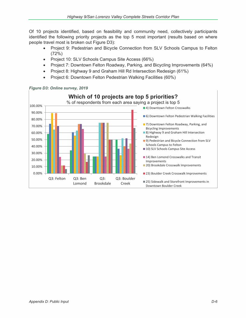
Highway 9/San Lorenzo Valley Complete Streets Corridor Plan
Appendix D: Public Input D-6
Of 10 projects identified, based on feasibility and community need, collectively participants identified the following priority projects as the top 5 most important (results based on where people travel most is broken out Figure D3):
Project 9: Pedestrian and Bicycle Connection from SLV Schools Campus to Felton (72%)
Project 10: SLV Schools Campus Site Access (66%) Project 7: Downtown Felton Roadway, Parking, and Bicycling Improvements (64%) Project 8: Highway 9 and Graham Hill Rd Intersection Redesign (61%) Project 6: Downtown Felton Pedestrian Walking Facilities (60%)
Figure D3: Online survey, 2019
Q3: Felton Q3: BenLomond
Q3:Brookdale
Q3: BoulderCreek
0.00%
10.00%
20.00%
30.00%
40.00%
50.00%
60.00%
70.00%
80.00%
90.00%
100.00%
Which of 10 projects are top 5 priorities? % of respondents from each area saying a project is top 5
4) Downtown Felton Crosswalks
6) Downtown Felton Pedestrian Walking Facilities
7) Downtown Felton Roadway, Parking, andBicycling Improvements8) Highway 9 and Graham Hill IntersectionRedesign9) Pedestrian and Bicycle Connection from SLVSchools Campus to Felton10) SLV Schools Campus Site Access
14) Ben Lomond Crosswalks and TransitImprovements20) Brookdale Crosswalk Improvements
23) Boulder Creek Crosswalk Improvements
25) Sidewalk and Storefront Improvements inDowntown Boulder Creek

Highway 9/San Lorenzo Valley Complete Streets Corridor Plan
Appendix D: Public Input D-7
Figure D4: Screen shot from Survey, Summer 2017
B. Input During Plan Development – 2016-2018
Online Survey
A total of 418 people participated in an online planning survey, which was open from June 7, 2017 to August 18, 2017. Participants identified locations along the corridor that are transportation challenges, provided input on a range of general types of transportation infrastructure and programs, and provided input on project ideas that had been identified as priorities in 10 prior years of public discussions. Significant input results are summarized below. Survey demographic and metadata information is provided at the end of this appendix.
May 31, 2017 Workshop
A workshop held in Felton on May 31, 2017 was well attended and there was lively participation and discussion. Attendees were invited to give input at a series of stations modeled after the online survey. Input results are summarized below.
Highway 9/San Lorenzo Valley Complete Streets Corridor Plan
Appendix D: Public Input D-8
What types of transportation improvements are needed in the San Lorenzo Valley? Overall Project Type Preferences Participants were asked about different types of possible transportation projects, features, or programs that might be used in the San Lorenzo Valley (without specific locations identified). The list below presents the combined project type preferences from the online and paper surveys, as well as input received at a community workshop on May 31, 2017. Descriptions of these and other types of transportation features are provided in Appendix A: Complete Streets Improvements Toolkit. Most popular types of projects/concepts: Participants identified the following as the types of transportation improvements (of list of types of projects also identified in the survey) they consider most needed in the SLV.
Trails, informal paths Pull outs/turnouts for passing or for stalled vehicles Crosswalks with controls to make them more visible Shared bicycle/pedestrian paths Passing and turning lanes Bicycle lanes Painted crosswalks
Least popular/most disliked concepts:
Narrowed automobile lanes Roundabouts Bulb-outs at intersections Raised crosswalks Increased CHP Cycle tracks
Least Opposed: Slightly different from the types of projects that participants identified as the most needed, the least opposed/least controversial concepts, those with the fewest people saying they disagree or strongly disagree that item is needed were:
Trails Pullouts Adding bus service Painted crosswalks Improving bus stops Guardrails
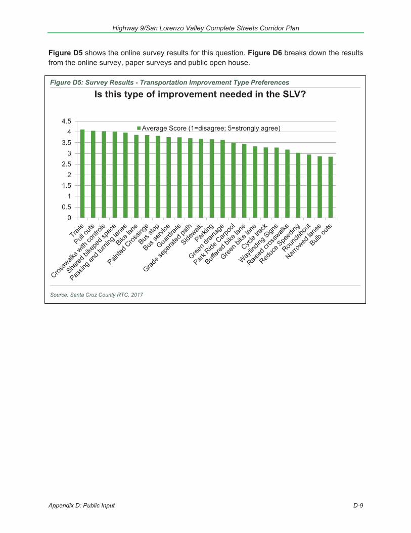
Highway 9/San Lorenzo Valley Complete Streets Corridor Plan
Appendix D: Public Input D-9
Figure D5: Survey Results - Transportation Improvement Type Preferences
Source: Santa Cruz County RTC, 2017
00.5
11.5
22.5
33.5
44.5
Is this type of improvement needed in the SLV?
Average Score (1=disagree; 5=strongly agree)
Figure D5 shows the online survey results for this question. Figure D6 breaks down the results from the online survey, paper surveys and public open house.
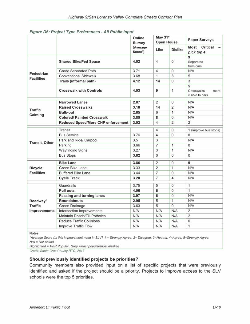
Highway 9/San Lorenzo Valley Complete Streets Corridor Plan
Appendix D: Public Input D-10
Figure D6: Project Type Preferences - All Public Input
Online Survey (Average Score*)
May 31st Open House Paper Surveys
Like Dislike Most Critical – pick top 4
Pedestrian Facilities
Shared Bike/Ped Space 4.02 4 0 9 Separated from cars
Grade Separated Path 3.71 4 0 N/A Conventional Sidewalk 3.68 1 3 5 Trails (informal path) 4.12 14 0 3
Crosswalk with Controls 4.03 9 1 5 Crosswalks more visible to cars
Traffic Calming
Narrowed Lanes 2.87 2 0 N/A Raised Crosswalks 3.18 14 2 N/A Bulb-out 2.85 6 1 N/A Colored/ Painted Crosswalk 3.85 8 0 N/A Reduced Speed/More CHP enforcement 3.03 4 2 2
Transit, Other
Transit 4 0 1 (improve bus stops) Bus Service 3.76 4 0 0 Park and Ride/ Carpool 3.5 3 N/A Parking 3.66 7 1 0 Wayfinding Signs 3.27 3 1 N/A Bus Stops 3.82 0 0 0
Bicycle Facilities
Bike Lane 3.86 2 0 9 Green Bike Lane 3.33 2 1 N/A Buffered Bike Lane 3.44 7 0 N/A Cycle Track 3.28 7 4 N/A
Roadway/ Traffic Improvements
Guardrails 3.75 5 0 1 Pull outs 4.06 6 0 1 Passing and turning lanes 3.97 6 0 N/A Roundabouts 2.95 5 1 N/A Green Drainage 3.63 5 0 N/A Intersection Improvements N/A N/A N/A 2 Maintain Roads/Fill Potholes N/A N/A N/A 2 Reduce Traffic Collisions N/A N/A N/A 0 Improve Traffic Flow N/A N/A N/A 1
Notes: *Average Score (Is this improvement need in SLV? 1 = Strongly Agree, 2= Disagree, 3=Neutral, 4=Agree, 5=Strongly Agree. N/A = Not Asked. Highlighted = Most Popular, Grey =least popular/most disliked Credit: Santa Cruz County RTC, 2017
Should previously identified projects be priorities? Community members also provided input on a list of specific projects that were previously identified and asked if the project should be a priority. Projects to improve access to the SLV schools were the top 5 priorities.
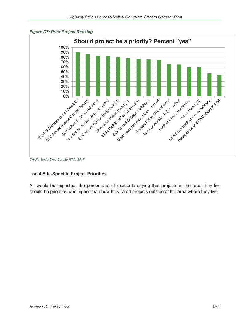
Highway 9/San Lorenzo Valley Complete Streets Corridor Plan
Appendix D: Public Input D-11
Figure D7: Prior Project Ranking
Credit: Santa Cruz County RTC, 2017
Local Site-Specific Project Priorities
As would be expected, the percentage of residents saying that projects in the area they live should be priorities was higher than how they rated projects outside of the area where they live.
0%10%20%30%40%50%60%70%80%90%
100%Should project be a priority? Percent "yes"

Highway 9/San Lorenzo Valley Complete Streets Corridor Plan
Appendix D: Public Input D-12
Figure D8: Prior Project Ranking
Credit: Santa Cruz County RTC, 2017
Site-Specific Challenge Areas and Improvement Suggestions
Site-specific needs or improvement suggestions were made on maps through the online survey, at public meetings, and in paper surveys. Participants were asked to help identify areas in the San Lorenzo Valley that are challenges and suggest possible solutions (projects). Participants could place marks on the map and add comments at locations throughout the study corridor. Participants placed nearly 900 markers on maps. In many instances, several people identified the same issue and suggested similar projects. This mapped input is difficult to present in printed maps because it is so extensive, but it can be viewed in detail in the online input map available at this link: http://arcg.is/10zf4v. The online map includes input from the online survey, as well as input provided at the May 2017 workshop, stakeholder meetings, paper surveys, and via email.
0%10%20%30%40%50%60%70%80%90%
100%
Project Rankings by Resident LocationBen Lomond Boulder Creek Brookdale Felton SLV-Other
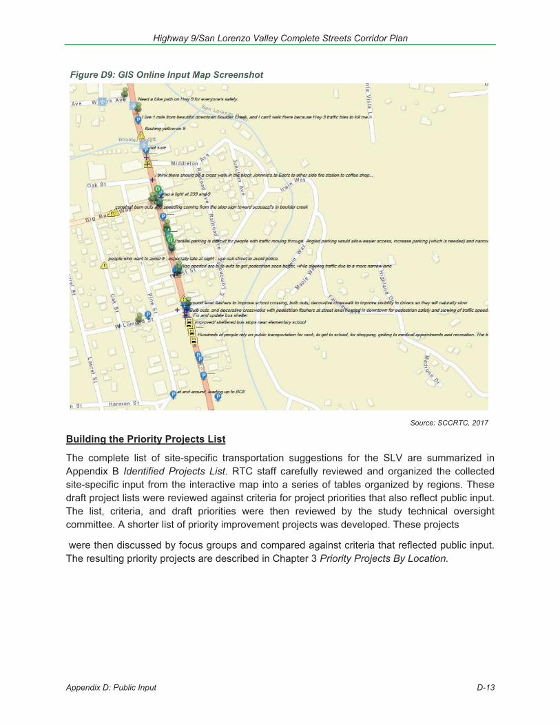
Highway 9/San Lorenzo Valley Complete Streets Corridor Plan
Appendix D: Public Input D-13
Building the Priority Projects List
The complete list of site-specific transportation suggestions for the SLV are summarized in Appendix B Identified Projects List. RTC staff carefully reviewed and organized the collected site-specific input from the interactive map into a series of tables organized by regions. These draft project lists were reviewed against criteria for project priorities that also reflect public input. The list, criteria, and draft priorities were then reviewed by the study technical oversight committee. A shorter list of priority improvement projects was developed. These projects
were then discussed by focus groups and compared against criteria that reflected public input. The resulting priority projects are described in Chapter 3 Priority Projects By Location.
Figure D9: GIS Online Input Map Screenshot
Source: SCCRTC, 2017
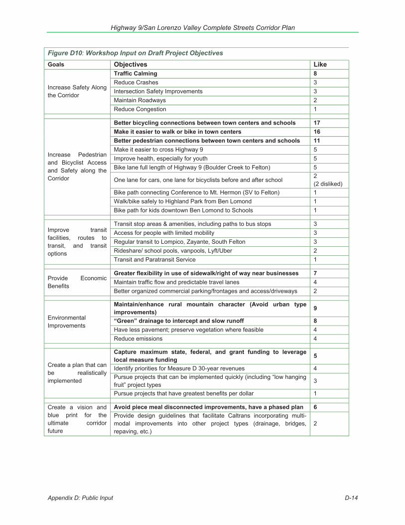
Highway 9/San Lorenzo Valley Complete Streets Corridor Plan
Appendix D: Public Input D-14
Figure D10: Workshop Input on Draft Project Objectives Like Goals Objectives Like
Increase Safety Along the Corridor
Traffic Calming 8 Reduce Crashes 3 Intersection Safety Improvements 3 Maintain Roadways 2 Reduce Congestion 1
Increase Pedestrian and Bicyclist Access and Safety along the Corridor
Better bicycling connections between town centers and schools 17 Make it easier to walk or bike in town centers 16 Better pedestrian connections between town centers and schools 11 Make it easier to cross Highway 9 5 Improve health, especially for youth 5 Bike lane full length of Highway 9 (Boulder Creek to Felton) 5
One lane for cars, one lane for bicyclists before and after school 2 (2 disliked)
Bike path connecting Conference to Mt. Hermon (SV to Felton) 1 Walk/bike safely to Highland Park from Ben Lomond 1 Bike path for kids downtown Ben Lomond to Schools 1
Improve transit facilities, routes to transit, and transit options
Transit stop areas & amenities, including paths to bus stops 3 Access for people with limited mobility 3 Regular transit to Lompico, Zayante, South Felton 3 Rideshare/ school pools, vanpools, Lyft/Uber 2 Transit and Paratransit Service 1
Provide Economic Benefits
Greater flexibility in use of sidewalk/right of way near businesses 7 Maintain traffic flow and predictable travel lanes 4 Better organized commercial parking/frontages and access/driveways 2
Environmental Improvements
Maintain/enhance rural mountain character (Avoid urban type improvements) 9
“Green” drainage to intercept and slow runoff 8 Have less pavement; preserve vegetation where feasible 4 Reduce emissions 4
Create a plan that can be realistically implemented
Capture maximum state, federal, and grant funding to leverage local measure funding 5
Identify priorities for Measure D 30-year revenues 4 Pursue projects that can be implemented quickly (including “low hanging fruit” project types
3
Pursue projects that have greatest benefits per dollar 1
Create a vision and blue print for the ultimate corridor future
Avoid piece meal disconnected improvements, have a phased plan 6 Provide design guidelines that facilitate Caltrans incorporating multi-modal improvements into other project types (drainage, bridges, repaving, etc.)
2
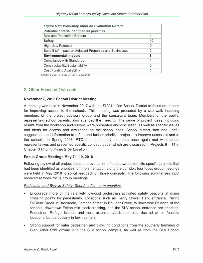
Highway 9/San Lorenzo Valley Complete Streets Corridor Plan
Appendix D: Public Input D-15
Figure D11: Workshop Input on Evaluation Criteria Potential criteria identified as priorities
Like
Bike and Pedestrian Barriers 1 Safety 10 High Use/ Potential 0 Benefit to/ Impact on Adjacent Properties and Businesses 2 Environmental Impacts 8 Compliance with Standards 1 Constructability/Sustainability 0 Cost/Funding Availability 1
Credit: SCCRTC, May 31, 2017 workshop
2. Other Focused Outreach
November 7, 2017 School District Meeting
A meeting was held in November 2017 with the SLV Unified School District to focus on options for improving access to the schools. This meeting was preceded by a site walk including members of the project advisory group and the consultant team. Members of the public, representing school parents, also attended the meeting. The range of project ideas, including results from the workshop and survey, were presented and discussed, as well as specific issues and ideas for access and circulation on the school sites. School district staff had useful suggestions and information to refine and further prioritize projects to improve access at and to the schools. In Spring 2018, RTC and community members once again met with school representatives and presented specific concept ideas, which are discussed in Projects 9 – 11 in Chapter 3 Priority Projects By Location.
Focus Group Meetings May 7 – 10, 2018
Following review of all project ideas and evaluation of about two dozen site specific projects that had been identified as priorities for implementation along the corridor, four focus group meetings were held in May 2018 to solicit feedback on those concepts. The following summarizes input received at those focus group meetings.
Pedestrian and Bicycle Safety- Short/medium term priorities:
Encourage more of the relatively low-cost pedestrian activated safety beacons at major crossing points for pedestrians. Locations such as Henry Cowell Park entrance, Pacific St/Clear Creek in Brookdale, Lomond Street in Boulder Creek, Willowbrook Dr north of the schools, downtown Felton mid-block crossing, and the SLV school entrance are priorities. Pedestrian Refuge Islands and curb extensions/bulb-outs also desired at all feasible locations, but particularly in town centers.
Strong support for safer pedestrian and bicycling conditions from the southerly terminus of Glen Arbor Rd/Highway 9 to the SLV school campus, as well as from the SLV School
Highway 9/San Lorenzo Valley Complete Streets Corridor Plan
Appendix D: Public Input D-16
Campus to downtown Felton. Determine the feasibility of widening Highway 9 to add striped bicycle lanes and pathways.
Though SLV residents strongly support maximum protection for the local coast redwoods, all stakeholder focus groups agreed that some redwood trees in the right-of-way could be removed to allow installation of pedestrian and bicycle facilities, especially to improve safety of children getting to school.
Slowing speeding was identified as a priority for all users, but especially pedestrians and bicyclists. Focus groups favored speed radar feedback signs, as well as narrowing travel lanes with the addition of bulb-outs, angled parking, and bike lanes.
Though there was support for bicycle facilities, in the face of limited right-of-way width the focus groups communicated that providing facilities for pedestrians was the priority.
Parking:
Some attendees expressed interest in adding diagonal parking on Highway 9 in downtown centers in order to maximize customer convenience and increase parking supply for the benefit of local businesses.
Strong support for relocating, not removing, any parking that needs to be moved or changed for other improvements. Sidewalks and shade trees would encourage people to walk from more remote parking locations.
Strong support for general parking plans for all the villages, including maximizing use of private parking lots through agreements with local businesses with large private lots.
Winterization, Slides and Emergency Storm Situations:
In the winter, the SLV can experience 8 feet of rainfall per year. Numerous slides and resulting road closures have occurred over the years cutting off access to schools and businesses and forcing lengthy detours and delays (up to an hour) for commuters, freight deliveries, emergency response and school access. Reinforcing hillsides, removing trees that are obvious hazards to pedestrians and motorists and improving rainfall runoff and conveyance systems were identified as priorities.
Felton
Felton has the largest traffic volumes and the second largest population but has some of the least built-out pedestrian infrastructure. Sidewalks with shade trees on Highway 9 to the end of the village and along Graham Hill Rd had strong support. Strong support also for increasing the number of marked crossings and enhancing the safety features at existing crossings, particularly the midblock crossing in front of the Wild Roots Market and the Graham Hill intersection.
Improving the Graham Hill Rd/Highway 9 intersection was universally deemed to be a high priority, second only to improving access to the SLV Schools Campus (discussed below). Improving facilities for pedestrians and bicycles through the intersection as well
Highway 9/San Lorenzo Valley Complete Streets Corridor Plan
Appendix D: Public Input D-17
as safely maximizing throughput for vehicles by extending storage lengths of turning lanes were identified as key components to intersection improvement.
SLV Schools Campus
The highest priority projects for the entire corridor that need the greatest consideration are those closest to the school campuses in Felton. This is the essentially unanimous opinion of all participants in the planning process because of the traffic impacts that affect the entire corridor and the safety issues for the children. All the projects in that area are top tier in priority.
o Addressing safety and the Highway 9 traffic jam around the schools will requireimprovements to both the Caltrans right of way and to circulation inside the schoolcampuses.
o Planning resources should be invested to work with the school district to improveinternal circulation inside the school campuses in order to identify short, medium,and long-term plans that are the most feasible ways to improve safety and reducecongestion.
Brookdale and Ben Lomond:
In Brookdale and Ben Lomond there are significant gaps in pedestrian facilities, especially between hotels and services. Residents and hotel guests want to walk along or cross Highway 9 to access services, however in each case redwood trees exist that result in very narrow walking conditions and visibility obstructions. Two redwood trees in particular have been identified in the community meetings as major obstacles to safe pedestrian travel. It is also apparent by the scars and loss of bark on these trees that they have been the subject of vehicles hitting them. Removal of these trees and/or realignment of striping away from the trees to attain safer pedestrian movements both day and night was supported by meeting attendees.
In Ben Lomond, Highway 9 was improved and widened in the 1990s between the two bridges that cross the San Lorenzo River on the south and north ends of town. Development of a striping plan that provides for formal bike lanes in this stretch should be a short/medium priority.
A left turn lane from Highway 9 to Highlands Park should also be a priority project.
Boulder Creek:
Boulder Creek has a parking shortage. Exploration of diagonal parking serves as additional spots as well as “road dieting” to narrow the corridor to slow down speed.
Boulder Creek character must be preserved. There is little desire for overhead lights - HAWK systems nor stoplights in town center.
Highway 9/San Lorenzo Valley Complete Streets Corridor Plan
Appendix D: Public Input D-18
Support for planting which would provide shade for pedestrians on the eastside of Highway 9. Narrowing lanes and adding center islands in Highway 9, which could be planted with trees.
Entrances to Boulder Creek from all areas needs to be slowed. Better signage and radar feedback signs at three town entrances, north and south on Highway 9 and from west on Highway 236.
A stop sign just north of the Bear Creek/Highway 9 intersection as you enter Boulder Creek would help commuters and slow traffic.
An additional crosswalk mid-town would prevent jay walking (between the intersections at 236 and 9, and Forest and 9).
While most attendees like the concept of bike lanes, pedestrian uses were identified as a higher priority, especially in Boulder Creek. Narrow entry points and steep hills make biking less attractive. It was suggested to narrow lanes to give greater ability for pedestrian/tree islands in center of the highway or added diagonal parking.
SLV Schools Campus Survey: Spring/Summer 2018
In spring/summer 2018, a web-based survey was utilized to gather information from people traveling to the SLV Schools Complex in Felton. A total of 127 people participated in the online survey. Participants were asked questions about transportation challenges and provided input on project ideas that had been identified as priorities for the SLV Schools Campus area. Almost 80% of the respondents were either parents or guardians of a student or were faculty or staff at one of the SLV schools. For daily travel to the SLV Schools Campus, 77% of respondents reported that they traveled to the campus by family vehicle, with only the driver and students in their family in the vehicle. The distance traveled to get to the SLV Schools Campus varied, with 29% travelling less than 2 miles, 29% travelling between 2 and 4 miles, and 39% travelling more than 4 miles.
Respondents reported that the most challenging parts of entering or exiting the SLV Schools Campus were exiting the elementary school, exiting El Solyo Heights, turning into the elementary school, and exiting the high school. The transportation goals that were ranked the highest for the area around the SLV Schools Campus were: improving ability to enter and exit the campus by car, improving traffic flow for vehicles driving past the schools, improving access to/past the schools for people walking, and improving access to/past the schools for people riding bicycles. The options for getting students to school by walking or biking that were identified as the most critical were a multiuse path for people walking or biking with a barrier providing physical separation from motor vehicles and an informal asphalt path for people walking or biking. More than 85% of respondents indicated that they would like to see pedestrian activated flashing lights (RRFBs) to alert drivers to stop at pedestrian crossing.
The schools survey sample was self-selected, meaning that individuals decided whether to access and complete the survey. It was possible for individuals to complete only a portion of the survey or to complete the survey more than once. Participants were not selected
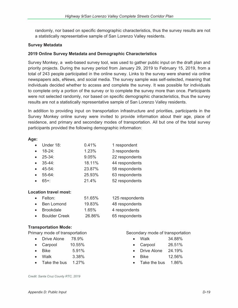
Highway 9/San Lorenzo Valley Complete Streets Corridor Plan
Appendix D: Public Input D-19
randomly, nor based on specific demographic characteristics, thus the survey results are not a statistically representative sample of San Lorenzo Valley residents.
Survey Metadata
2019 Online Survey Metadata and Demographic Characteristics
Survey Monkey, a web-based survey tool, was used to gather public input on the draft plan and priority projects. During the survey period from January 29, 2019 to February 15, 2019, from a total of 243 people participated in the online survey. Links to the survey were shared via online newspapers ads, eNews, and social media. The survey sample was self-selected, meaning that individuals decided whether to access and complete the survey. It was possible for individuals to complete only a portion of the survey or to complete the survey more than once. Participants were not selected randomly, nor based on specific demographic characteristics, thus the survey results are not a statistically representative sample of San Lorenzo Valley residents.
In addition to providing input on transportation infrastructure and priorities, participants in the Survey Monkey online survey were invited to provide information about their age, place of residence, and primary and secondary modes of transportation. All but one of the total survey participants provided the following demographic information:
Age: Under 18: 0.41% 1 respondent 18-24: 1.23% 3 respondents 25-34: 9.05% 22 respondents 35-44: 18.11% 44 respondents 45-54: 23.87% 58 respondents 55-64: 25.93% 63 respondents 65+: 21.4% 52 respondents
Location travel most: Felton: 51.65% 125 respondents Ben Lomond 19.83% 48 respondents Brookdale 1.65% 4 respondents Boulder Creek 26.86% 65 respondents
Transportation Mode: Primary mode of transportation
Drive Alone 78.9% Carpool 10.55% Bike 5.91% Walk 3.38% Take the bus 1.27%
Secondary mode of transportation Walk 34.88% Carpool 26.51% Drive Alone 24.19% Bike 12.56% Take the bus 1.86%
Credit: Santa Cruz County RTC, 2019
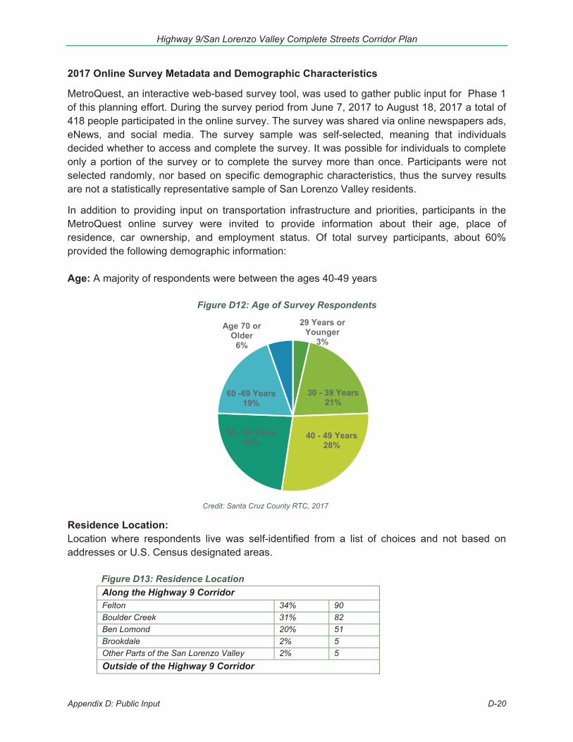
Highway 9/San Lorenzo Valley Complete Streets Corridor Plan
Appendix D: Public Input D-20
29 Years or Younger
3%
30 - 39 Years21%
40 - 49 Years28%
50 - 59 Years23%
60 -69 Years19%
Age 70 or Older
6%
2017 Online Survey Metadata and Demographic Characteristics
MetroQuest, an interactive web-based survey tool, was used to gather public input for Phase 1 of this planning effort. During the survey period from June 7, 2017 to August 18, 2017 a total of 418 people participated in the online survey. The survey was shared via online newspapers ads, eNews, and social media. The survey sample was self-selected, meaning that individuals decided whether to access and complete the survey. It was possible for individuals to complete only a portion of the survey or to complete the survey more than once. Participants were not selected randomly, nor based on specific demographic characteristics, thus the survey results are not a statistically representative sample of San Lorenzo Valley residents.
In addition to providing input on transportation infrastructure and priorities, participants in the MetroQuest online survey were invited to provide information about their age, place of residence, car ownership, and employment status. Of total survey participants, about 60% provided the following demographic information:
Age: A majority of respondents were between the ages 40-49 years
Figure D12: Age of Survey Respondents
Credit: Santa Cruz County RTC, 2017
Residence Location: Location where respondents live was self-identified from a list of choices and not based on addresses or U.S. Census designated areas. Figure D13: Residence Location
Along the Highway 9 Corridor Felton 34% 90 Boulder Creek 31% 82 Ben Lomond 20% 51 Brookdale 2% 5 Other Parts of the San Lorenzo Valley 2% 5 Outside of the Highway 9 Corridor
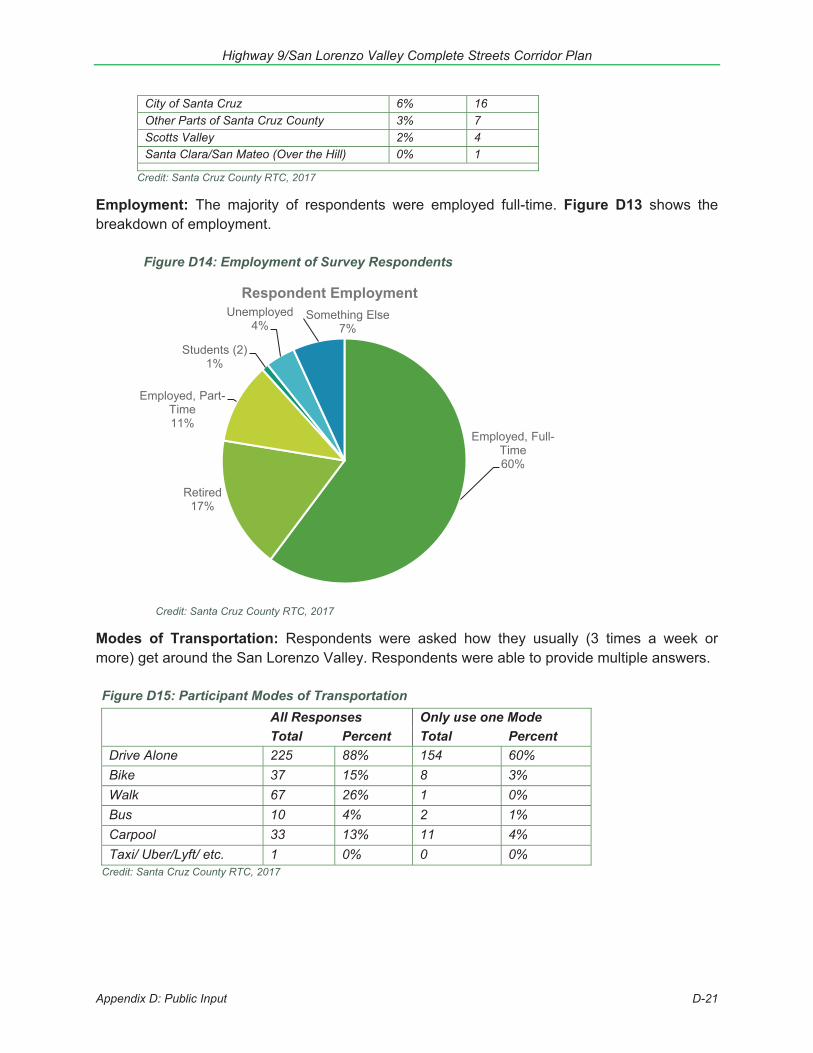
Highway 9/San Lorenzo Valley Complete Streets Corridor Plan
Appendix D: Public Input D-21
City of Santa Cruz 6% 16Other Parts of Santa Cruz County 3% 7Scotts Valley 2% 4Santa Clara/San Mateo (Over the Hill) 0% 1
Credit: Santa Cruz County RTC, 2017
Employment: The majority of respondents were employed full-time. Figure D13 shows the breakdown of employment.
Figure D14: Employment of Survey Respondents
Credit: Santa Cruz County RTC, 2017
Modes of Transportation: Respondents were asked how they usually (3 times a week or more) get around the San Lorenzo Valley. Respondents were able to provide multiple answers.
Figure D15: Participant Modes of Transportation All Responses Only use one Mode Total Percent Total Percent
Drive Alone 225 88% 154 60% Bike 37 15% 8 3% Walk 67 26% 1 0%Bus 10 4% 2 1%Carpool 33 13% 11 4%Taxi/ Uber/Lyft/ etc. 1 0% 0 0%
Credit: Santa Cruz County RTC, 2017
Employed, Full-Time60%
Retired17%
Employed, Part-Time11%
Students (2)1%
Unemployed4%
Something Else7%
Respondent Employment
Highway 9/San Lorenzo Valley Complete Streets Corridor Plan
Summary of Public Comments on the Draft Highway 9/San Lorenzo Valley (SLV) Complete Streets Corridor Plan
The following is a summary of comments the Santa Cruz County Regional Transportation Commission (RTC) received on the draft Highway 9/San Lorenzo Valley (SLV) Complete Streets Corridor Plan. Input was received by the RTC via emails, letters, comment forms, an online survey, and at several meetings held from January 17, 2019 to February 15, 2019. All of the emails, comment letters, and forms, as well as the survey results, were posted on the RTC website and available to the RTC board. Appendix D of the plan also summarizes public input over the past several years that was used to draft the plan. While the following summary does not include every unique comment, additional information is included in the final document in response to most comments and questions received during the comment period. Answers to some questions and comments are beyond the scope of this plan and would not be explored until detailed analysis occurs in later phases, including project-level environmental review and design engineering.
General Summary of Comments
Comments received ranged from strong support for the Highway 9/SLV CompleteStreets Corridor Plan (plan) in its entirety, to support of certain project types or projectsin a specific location, to voicing concerns about potential impacts or certain aspects ofprojects analyzed, to opposition to any modifications, including bicycle and/or pedestrianfacilities, and other comments in between.Most respondents expressed general support for concepts and priorities identified in theplan (such as additional bicycle and pedestrian facilities, enhanced crosswalks,improved or additional parking facilities, increased maintenance of the existing system,improved transit facilities, increased enforcement to reduce speeding, and traffic flowimprovements), though many provided specific design suggestions or modifications tosome specific locations.Concerns expressed by those opposed to specific improvements or projects identified inthe plan often focused on pedestrian and bicyclist safety, impacts on local businessesand tourism, impacts to private property and privately maintained roads, traffic flowimpacts, light pollution, and tree preservation along the Highway 9 corridor.
Points of Disagreement Conflicting comments were received regarding several proposals in the draft plan. For all of the projects and concepts in the plan, additional analysis will be needed to determine feasibility of the concepts and any alternatives. In some instances, additional community input will be needed to explore opportunities for consensus.
Corridor-wide
While adding sidewalks, bicycle facilities and various safety measures were regularlyidentified as among the highest priorities, several people expressed concerns about
Appendix D2: Public Input D-22
Highway 9/San Lorenzo Valley Complete Streets Corridor Plan
diminishing the rural feel of the SLV; associating sidewalks, ADA ramps, bulb-outs, flashing beacons, street lights, and wider shoulders/bicycle lanes as more urban. Wider shoulders: While many people advocated for wider shoulders, concerns were alsoexpressed that wider shoulders, even if for pedestrians and bicycles, could result invehicles driving faster.Lane and shoulder widths: There was also some disagreement on whether standardlane and shoulder widths or more narrow lanes would be preferable, especially if itincreases space for cyclists and pedestrians. There was also some disagreementwhether incremental/piecemeal widening and new bike or pedestrian facilities werepreferable to consistent widths for both auto and active transportation facilities.Lighting: While lighting at pedestrian crossings and other intersections in SLV, includingflashing beacons, was identified as a safety need by many community members, severalpeople have expressed concerns about light pollution and potential impacts on wildlife.Parking: While any businesses expressed interest in increasing parking supply in towncenters and bicyclist groups expressed support for back-in angled parking, somecommunity members expressed opposition to diagonal parking.Tree removal: Several community members requested removal of trees and vegetationthat they consider a hazard or that result in narrower shoulders or travel lanes, whileother community members expressed strong opposition to removing any trees.
Boulder Creek
Parking vs. bicycle lanes: There was some disagreement on whether parking or bicyclelanes should be prioritized through the town center, especially if there is insufficientspace for both. For instance, the Boulder Creek Business Association identifiedpedestrian facilities and added parking as a higher priority than bicycle lanes; the RTCBicycle Committee recommended adding parking only “where it will not conflict with bikelanes” (Project 24).Parking vs. wider sidewalks: Some businesses expressed interest in opportunities towiden sidewalks through the town center in order to allow for outdoor seating, whileothers expressed preference for angled parking.Bear Creek Rd/Highway 9 Intersection: While most community members expressedsupport for modifications to the intersection, there was some disagreement on what typeof modifications to make at Bear Creek Rd. Input included support and opposition to anystop signs, 2-way stop, 3-way stop, a roundabout, flashing lights, or a traffic light.
Implementation Priorities (Chapters 3 and 4)
While there was generally support for the list of 34 priority projects, implementation priorities varied among participants. For instance, improving pedestrian safety between Graham Hill Rd and the Schools Complex in Felton (Project 9) was identified as the highest priority at the Felton Open House and among online survey respondents who live in or travel most in Ben Lomond and Felton. However, priorities in Boulder Creek and among the other projects varied. Unsurprisingly, residents of Boulder Creek prioritized projects in Boulder Creek and north of the Felton School complex over those in Felton.
Appendix D2: Public Input D-23
Highway 9/San Lorenzo Valley Complete Streets Corridor Plan
Corridor-wide Priorities (Chapters 2 and 4)
Corridor Priority A – Safety Measures: reduce speeding, reduce collisions, and improve safety for all users in the SLV Corridor
Comments received discussed reducing the speed of vehicles traveling through corridor, prioritizing traffic calming and pedestrian safety improvements, support for complete streets elements such as curb extensions, pedestrian refuge islands, high visibility crosswalks, lighting, and lane markings that will slow traffic, requests for a gateway sign to Ben Lomond installed near Fillmore Ave and Mills St N in a landscaped island (as recommended in the town plan), requests to add medians in downtowns where possible, the addition of directional signs with “Nameoftown #miles” at key intersections (lit if feasible with solar powered lights that are photocell controlled), a suggestion for rumble strips on the center lane divider, requests to reduce speed limits in Ben Lomond and Brookdale to 25 mph, and adding RRFBs to any/all of the crosswalks on Highway 9.
Corridor Priority B – SLV Corridor Transit and Travel Demand Management
Comments received included support for micro-transit, more protected bus shelters, and increased bus service, a request for METRO to use the Clipper system (single fare payment system connected with the Bay Area), a recommendation to add bike parking to bus stops and make rental bikes/bike share available, a request for a transit center in Boulder Creek that coordinates with Santa Clara Valley Transportation Authority (VTA), and a request for a transit bus from the SLV to the Saratoga, Cupertino, and/or Sunnyvale Caltrain stations (7 am – 9 am, 5 pm – 7 pm on weekdays).
Corridor Priority C – Bicycle Facilities or Separated Paths along Highway 9 and Highway 236
Comments received included:
Concerns that 4-foot bike lanes are too narrow (preference for Caltrans standards or toreduce lane widths)Requests for buffered bike lanes where possible (even for short segments)Adding bike boxes at signalized intersections and green back bike legends in trafficlanesSupport to make Highway 9 bike-friendly, requests to provide sharrows in theroadway wherever bike lanes are not feasible and to add “Bicycles May Use Full Lane”signageSupport for bike improvements as described in the draft planOpposition to some multi-use pathsRequest to include a cross section of the proposed multi-modal pathRecommendation to add text that whenever roadwork occurs, any possible shoulderwidening should occurRequest that if there is not enough room for a bike lane in both directions on a roadwaybut room for one bike lane, the plan should specify that the lane be installed in the uphilldirection
Appendix D2: Public Input D-24
Highway 9/San Lorenzo Valley Complete Streets Corridor Plan
Request that where there are not, or until there are, adequate shoulders for cyclists, adda recommendation to stencil sharrows on the roadway and post bicycles “may use fulllane” and “pass 3 ft min” signsRequest that where there is such a sidepath and insufficient room for a bike lane on theopposite side of the road as well, that non-sidepath side of the highway should containsigning (e.g., bikes may use full lane), markings (e.g., sharrows), etc. that indicates thepresence of cyclists.Request to prepare an overall bike lane striping project that aggregates all of the bikelane proposals that can be immediately accomplished with pretty much striping alone(i.e., with only minor construction work) and installing these lanes under one contractRequest to employ temporary installations or demonstration projects in order to buildsupport for and help advance projects in the PlanRequest to prioritize routes that will get students safely to school while providing optionsfor parents who choose not to drive
Corridor Priority D – Increase the number of turnouts along Highway 9
Comments received included support for adding passing lanes and turnouts, adding dotted center lines where it is safe to pass, widening sections to two lanes for passing, widening shoulders beyond what the draft plan calls for, paving and improved maintenance of turnouts, and adding turnouts and turn-arounds sufficient for transit buses, bulldozer carriers, water-tenders, and semi-trucks.
Corridor Priority E – Pedestrian Safety Lighting and other Visibility Improvements along Highway 9
Comments received included requests for additional lighting at key intersections and at night on west Highway 9 in Boulder Creek between Redwood Keg Liquor (E Lomond St) and Travis Tree Professionals (between Middleton Ave and W Park Ave), adding lighting at intersections where the road is narrow and cannot be widened; to use motion sensitive or on-demand lights (only those approved by International Dark-Sky Association (IDA)); to add RRFBs to any/all of the crosswalks along Highway 9; and adding a daylight headlight section/safety corridor (with 4 signs – northbound in Paradise Park, northbound and southbound in Felton, and southbound in Boulder Creek); and opposition to adding any lighting in the corridor.
Corridor Priority F – Roadway Maintenance
Comments received included requests for improved maintenance of roadways and turnouts, concerns; concerns about abandoned vehicles along Highway 9 and Bear Creek Rd, requests for the Sheriff or CHP to clean up graffiti and trash on the side of Highway 9 and Bear Creek Rd, and concerns about potholes in turnouts.
Corridor Priority G – Emergency Preparedness and Resiliency
Comments received included:
Requests for development of evacuation and emergency response plans and moreinvolvement from Santa Cruz County Office of Emergency Services (OES), CHP, Santa
Appendix D2: Public Input D-25
Highway 9/San Lorenzo Valley Complete Streets Corridor Plan
Cruz County Fire Chief’s Association, Cal Fire “CZU” Felton Area, affected volunteer fire districts (especially Boulder Creek, Ben Lomond, Felton), Santa Cruz City Fire Department, and the Santa Cruz County Sheriff’s Department; Concerns with narrowing roadways at intersections (which will make it too narrow forlarge vehicles, logging trucks, evacuation routes for fire safety, and road repairs);Opposition to 11-foot lanes and concerns with how the width of traffic lanes would affectemergency evacuations;Requests for tree removal, especially on evacuation routes or if fire hazards;Request for adequate lighting and signage for corridor use as an evacuation route;Request to include pedestrian safety signs and surface mounted flexible stakes that canbe driven over if needed instead of bulb-outs, especially at Highlands Park, which is ahub for disaster response.
Priority Projects (Chapters 3 and 4)
Project 1: Henry Cowell State Park Access and Parking
Comments received included support and opposition to plans to restrict and/or organize parking near Ox Trail and along Highway 9 south and input that access and parking should be considered and addressed in coordination with State Parks.
Project 2: Southern Felton Neighborhood Bike and Walking Paths
Comments received discussed pedestrian access to the Henry Cowell entrance from the north and south, downtown Felton, and the school bus stop in front of the Big Foot Museum in Felton; requests to shore-up the hillside on the Oak Dr side above Shingle Mill Creek, and support for a southern neighborhood bike and walking connection to the Henry Cowell entrance that includes a multi-use sidepath.
Project 3: Henry Cowell State Park to Downtown Felton Bike and Pedestrian Connection Improvements
Comments received discussed concerns with pedestrian safety at the barrier at Shingle Mill Creek, requests to connect the Redwood Dr crossing with Oak Ave, requests for wider shoulders on the east side of Highway 9 at Russell and bike lanes from Laurel Dr to the Henry Cowell entrance, concerns that the plan does not help access from “Big Foot Hill,” Oak Ave and south, support for an RRFB at the Henry Cowell entrance, and support for bike/ped improvements from the Henry Cowell entrance to downtown Felton, specifically a sidepath on the east side of Highway 9 and bike lanes between Laurel Dr and the Henry Cowell entrance.
Project 4: Downtown Felton Crosswalks
Comments received discussed support for the RRFB at Wild Roots in downtown Felton, a request to install “Keep Clear” markings near the driveway for the restaurant on the southeast corner of Highway 9 and Graham Hill Rd, and suggestions for speed bumps on Felton Empire Rd before the blind curve uphill from the Cooper St/Gushee St crosswalk.
Appendix D2: Public Input D-26
Highway 9/San Lorenzo Valley Complete Streets Corridor Plan
Project 5: Downtown Felton Bicycle and Walking connections near Library
Comments received included support for bulb-outs at Gushee/Felton Empire and a request for drainage improvements at Gushee St and Plateau Ave.
Project 6: Downtown Felton Pedestrian Walking Facilities
Comments received included a suggestion to reduce the width of angled parking to 18 ft. in order to add sidewalks or bike lanes.
Project 7: Downtown Felton Roadway, Bicycle, and Parking Improvements
Comments received included a request for wider bike lanes over increased parking, increased bike access from Santa Cruz to the SLV on Highway 9 and Graham Hill Rd, support for improvements in Downtown Felton including bike lanes with green treatments at conflict zones and back-in angled parking, a suggestion to reduce the width of angled parking to 18 ft. to add sidewalks or bike lanes, concerns about back-in angled parking at grade, and the suggestion to have diagonal parking like Highway 130 at Alum Rock Village between Stewart and Manning in San Jose.
Project 8: Highway 9 and Graham Hill Rd Intersection Redesign
Comments received included requests for wider shoulders on Graham Hill Rd for bikes and pedestrians, the addition of bike boxes, green lanes, and signals that prioritize pedestrian crossing at intersections, increased bike access from Santa Cruz to the SLV on Highway 9 and Graham Hill Rd, support for widening bike lanes and green lane treatments, and a request from the County of Santa Cruz that improvements either incorporate and/or be designed so as not to interfere with restriping eastbound Felton Empire Rd as one left lane and one through/right lane (required as mitigation for new Felton library).
Project 9: Bike/Pedestrian Connections to San Lorenzo Valley Schools Campus from Felton/Graham Hill Rd and Felton-Empire
Comments received discussed:
Requests to prioritizing safe bike and pedestrian access between SLV schools,downtown Felton, and the new libraryRequests to prioritize pedestrian facilities from Graham Hill Rd to schools on Highway 9Support for improving bike/ped access from the SLV Schools Campus south to FallCreek Rd in the short-term, with a mid-term connection to Cooper StSuggestion to add flashers or speed bumps prior to the downhill curve before thecrosswalk at Felton-Empire Rd and Gushee St/Cooper StSupport for a multi-use path on the west side of Highway 9 from the SLV schools to FallCreek Dr (short-term) and Clearview Place (mid-term)Maintenance required if additional pedestrian, bicyclist, and vehicle traffic along FallCreek Dr and Farmer St
Appendix D2: Public Input D-27
Highway 9/San Lorenzo Valley Complete Streets Corridor Plan
Extra space where garbage cans are put out and block the shoulder, requests forpedestrian traffic to be separated from Highway 9Adding a two-way center turn lane for traffic turning from southbound Highway 9between San Lorenzo Way to Graham Hill RdRequests for reflective bumps or a barrier along Highway 9 shoulders between FallCreek Dr and SLV High School
Two alternatives for SLV Schools access were submitted by a member of the public: (1) Bypass through east side of SLV Schools Campus:
Repair footbridge at Hacienda WayConstruct path between SLV Elementary and Highway 9Path exit to Fall Creek Dr, onto Farmer St and Cooper St and then into townChallenge is the path through bus school entrances
(2) Bypass through west side of SLV Schools CampusHacienda Way up to existing service road on the north side of the soccer fieldPath on west side of soccer field connecting to other service roadConnects to Fall Creek Dr as in (1)
Project 10: San Lorenzo Valley Schools Campus Site Access
Comments received included support for improvements at the SLV Schools Campus, especially the access road and improved traffic flow and bus pull-off, a suggestion to put parking on only one side of the lot to increase flow, a request to add a no-right turn light and sign for the southbound Highway 9 entrance to SLV High School, and support for widening in front of the SLV Schools Campus to allow the addition of bike lanes with green lane treatments at conflict zones.
Project 11: North San Lorenzo Valley Schools Bike/Pedestrian Connections
Comments received included requests to repair and reopen the footbridge behind SLV Elementary, support for the enhanced trail bypass of Highway 9 via Hacienda Way connecting to Brackney Rd, support for bike/ped access from the SLV Schools Campus north to Hacienda Way with a formalized path to Brackney Rd, requests for a crosswalk with lights and a signal at El Solyo Heights, a request for a right turn lane on El Solyo Heights to Highway 9 with a merging lane on Highway 9, and support for crosswalk safety and bike/pedestrian access at the SLV Schools Campus; opposition to moving northbound bus stop to Lazy Woods.
Two alternatives for SLV Schools access were submitted by a member of the public (see Project 9 above for details of each alternative).
Project 12: Willowbrook Dr Commercial Area Multimodal Improvements and Glen Arbor Bike/Ped Connection
Comments received included support for a well-marked crosswalk (like Main St and Highway 9 in Ben Lomond) at Highway 9 and Willowbrook Dr and suggestion that the crosswalk at Willowbrook Dr and Highway 9 to be a top 10 priority.
Appendix D2: Public Input D-28
Highway 9/San Lorenzo Valley Complete Streets Corridor Plan
Project 13: Bike/Ped Connections from Ben Lomond to Highlands Park
Comments received included opposition to bike/ped connection to backside of Highlands Park over San Lorenzo River, requests to build a multiuse path directly on Highway 9 rather than along Glen Arbor, suggestions that facilities on Highway 9 be a high priority, questions about how this project would fit with the long-term vision from the Ben Lomond Town Plan, support for the draft plan’s recommendation for bus stops, crosswalks, and turn lanes at the entrance to Highlands Park, and support for the addition of an RRFB at the entrance to Highlands Park.
Project 14: Ben Lomond Crosswalks and Transit Improvements
Comments received included:
Request for a crosswalk at Fillmore Ave and Highway 9 with at least one bulb-out on thewest side of Highway 9Request to move the Glen Arbor bike path to the eastside of the roadRequest to add a pedestrian flasher at Main St and Highway 9 crosswalkRequest for a crosswalk across Highway 9 at Casa Nostra (Miles St/Hillside Ave) in BenLomondSupport for crosswalks at Mill St/Glen Arbor Rd, Hillside Ave/Highway 9, and FillmoreAve/Highway 9Support for a crosswalk on the south leg of the Mill St/Highway 9 traffic signalSupport for a crosswalk at the intersection with Hillside Ave transit stops includingconcrete pads, benches, and sheltersSupport for installation of a Ben Lomond village gateway crosswalk on the east side ofFillmore Ave/Highway 9 with a bulb-outSupport for past practices in Boulder Creek and Felton where multiple, successive crosswalks exist across Highway 9Request to square up the Main St crosswalk and the request to include an offsetcrosswalk as a potential alternative.
Project 15: Mill St and Glen Arbor Rd Pedestrian Improvements
Comments received included opposition to a walkway on the south side of Glen Arbor Rd and concerns regarding right-of-way, requests for a walking path along Glen Arbor Rd from Highway 9 to Pine St on the north side, a request for enhanced crossings at Brookside and Pine, a low retaining wall, and pedestrian scale lighting, and a longer-term project to extend the walkway on Glen Arbor Rd from Pine St to Newell Creek Rd with a crosswalk at Madrone Ave.
Project 16: Ben Lomond Downtown Core Multiuse Improvements
Comments received included support for sidewalks and pedestrian improvements from Scarborough Lumber to the Post Office and Sunnyside Ave along Main St, support for better lighting, bike lane striping, better intersection markings, filling gaps in sidewalks, and reducing speed to 25 mph through Ben Lomond, support for green bike markings at intersections, support for new walkways and striping improvements in front of Henflings, the Fire Department,
Appendix D2: Public Input D-29
Highway 9/San Lorenzo Valley Complete Streets Corridor Plan
and Love Creek Rd, support for a sidewalk on Highway 9 to Scarborough Lumber, support for filling sidewalk gaps on Main St and Mill St west of Highway 9 between N. Mill St and Main St as shown in the draft plan, and a proposal to extend the walkway through the Love Creek Rd/Highway 9 intersection to the existing traffic signal rather than mid-block on Love Creek Rd as in the draft plan.
Project 17: Pedestrian and Bicycle Connections from Mill St to Alba Rd
Comments received included requests to prioritize a walkway from Quality Inn in Ben Lomond into the downtown area on the west side of Highway 9 (between N. Mill St and San Lorenzo River bridge), a request to remove the tree in Caltrans right of way between San Lorenzo River bridge and N. Mill St, a request to shift the striping to the east where possible to make more space for bikes/peds on the west side of Highway 9, a request to add lighting along this section of roadway, and a suggestion to add a bike path on one side and pedestrian (multiuse) path on the other side of Highway 9 from Brookdale to Ben Lomond.
Project 18: Hubbard Gulch/Alba Rd Operational Improvements
Comments received included opposition to a crosswalk at Alba Rd in Ben Lomond due to limited sight distance and limited demand, concerns with the feasibility of the project due to limited right-of-way, sight restrictions, and utility poles, support for restriping the turn/merge pockets to comply with current Caltrans standards, support for studying a crosswalk at California Dr and Highway 9, and a request to create a safe walking path along Love Creek Rd from Highway 9 to the intersection of Love Creek Rd and Brookside Ave.
Project 19: Brookdale Sidewalks
Comments received included a suggestion to add a bike path on one side and pedestrian path on the other side from Brookdale to Ben Lomond, a request to move the bus stop at Pacific in Brookdale a few feet south by the redwood tree, concerns with safety due to redwood trees near roadway, support for sidewalks from Larkspur extension and Western Ave to school bus stop, and request for a walkway along Highway 9 in Brookdale due to increased visitors at Brookdale Lodge.
Project 20: Brookdale Crosswalk Improvements
Comments received included support for a RRFB at Pacific St, requests to remove the redwood tree that blocks view at Pacific St, support for a pedestrian crossing at Pacific St and Clear Creek Rd, and concerns with safety due to the redwood trees near roadways.
Project 21: Irwin Way and Highway 9 Intersection Improvements
Comments received included requests to make the Irwin Way intersection a top priority and concerns about light pollution.
Appendix D2: Public Input D-30
Highway 9/San Lorenzo Valley Complete Streets Corridor Plan
Project 22: Boulder Creek Elementary Neighborhood Multimodal Improvements
Comments received discussed concerns with the bike lane on Lomond St conflicting with school parking and being too steep for children to ride bikes up, requests for speed bumps in Boulder Creek Elementary neighborhood, requests for pedestrian-scale lighting at the intersections near Boulder Creek Elementary on Laurel St and Lomond St, opposition to bike lanes in Boulder Creek, requests to prioritize safe routes to school for cyclists and pedestrians, and requests to prioritize pedestrian and driver safety improvements over bicycle improvements to downtown Boulder Creek.
Project 23: Boulder Creek Crosswalk Improvements
Comments received included support for an RRFB at Forest St, opposition to any RRFBs, requests to improve signage at stop signs at Highway 9 and Highway 236 intersection, requests to prioritize pedestrian and driver safety improvements over bicycle improvements in downtown, concerns regarding bulb-outs in downtown Boulder Creek blocking the right-hand turn lane from southbound Highway 9 to Highway 236, the need for pedestrian scale lighting at the crossing at Highway 9 and Highway 236, support and opposition to a traffic signal at Highway 9 and Highway 236, and support and opposition to bike lanes, sharrows and green lanes in Boulder Creek.
Project 24: Parking Improvements and Bicycle Facilities in Downtown Boulder Creek
Comments received included support and opposition to bike lanes in Boulder Creek; opposition to a two way center turn lane; support and opposition to pedestrian islands and trees in median; requests to unbundle bike lanes in Tier II and III, make bike lanes a higher priority, eliminate the choice between bike lanes and angled parking, remove bike lanes to make room for pedestrian refuge islands and back-in angled parking, to not have bike lanes up against parking; support for sharrows and ”Share the Road” signage for bikes instead of bike lanes; a request for the County to pave shoulders on side streets to increase parking, prioritize pedestrian and driver safety improvements over bicycle improvements to downtown, and support to add diagonal parking, reduce angled parking width to 18’ to add sidewalks or bike lanes, and support for back-in angled parking with tree wells and pedestrian islands in downtown Boulder Creek.
Project 25: Sidewalk and Storefront Improvements in Downtown Boulder Creek
Comments received included support and opposition to back-in angled parking, a request to preserve the pistons and rings on the sidewalks that have historical significance, request for a pedestrian walkway and/or bike trail along Highway 236 from Big Basin to downtown Boulder Creek, and request to widen the road on west Highway 9 in Boulder Creek between Redwood Keg Liquor (E Lomond St) and Travis Tree Professionals (between Middleton Ave and W Park Ave) for a pedestrian foot path or sidewalk, separation between traffic and pedestrians and add lighting at night.
Appendix D2: Public Input D-31
Highway 9/San Lorenzo Valley Complete Streets Corridor Plan
Project 26: Pedestrian and Bicycle Connections to the Boulder Creek Library, Bear Creek Rd, and Big Basin State Park
Comments received discussed widening the road on west Highway 9 in Boulder Creek between Redwood Keg Liquor (E Lomond St) and Travis Tree Professionals (between Middleton Ave and W Park Ave) for pedestrian foot path or sidewalk, the need for curb/gutter/sidewalks, separation between traffic and pedestrians and add lighting at night, the need for a crosswalk at West Park Ave and Highway 9, requests for speed feedback signs at the intersections of Highway 9 and West Park Ave, Highway 236, and River St, and support for the project as described in the draft plan.
Project 27: Highway 9/Bear Creek Rd Intersection Improvements
Comments received discussed the need for a crosswalk at West Park Ave and Highway 9 (library access), support for the project as described in the draft plan, opposition to a stop sign on southbound Highway 9 at Bear Creek Rd, adding a bike box on northbound Highway 9 for turning on to Highway 236, support for a 3-way stop at Bear Creek Rd and Highway 9, the need for improved sight lines at Bear Creek Rd and Highway 9, concerns about pedestrian safety at Bear Creek Rd and Highway 9, support for a traffic light at Bear Creek Rd and Highway 9, support for a crosswalk on northbound Highway 9 and a crosswalk southbound at Bear Creek Rd, and requests for red or yellow flashing lights at Bear Creek Rd and Highway 9.
Project 28: Bicycle/Pedestrian Improvements at Garrahan Park and Mountain Store
Comments received discussed opposition of bulb-outs at Garrahan Park.
Comments made for areas Outside of the Project Area
Comments received discussed support for a cyclist dedicated path that takes cyclists away from Highway 9 from Felton to Santa Cruz, a request for a bike/pedestrian path from Felton to UCSC through Pogonip, the need for walkways from Boulder Creek to Stapp Rd along Highway 9, and a request for a bike/pedestrian path from Boulder Creek to Scotts Valley.
Appendix D2: Public Input D-32
Highway 9/San Lorenzo Valley Complete Streets Corridor Plan
Summary of Updates and Other Changes Final Highway 9/ San Lorenzo Valley (SLV) Complete Streets Corridor Plan
The following is a summary of changes that have been made to the Highway 9/San Lorenzo Valley (SLV) Complete Streets Corridor Plan based on comments and questions received on the draft plan during the comment period. This list reflects significant modifications to the document. Minor edits, including those of grammatical or clarifying nature, were also made, but are not listed below. No major modifications were made to Chapter 1, Appendix C, or Appendix F.
Executive Summary
List of priorities updated based on public inputTable ES 5 list of projects and concepts addedMaps updated
Updates to Chapter 2: Corridor Vision
Preferred Roadway Cross Sections
Text added to clarify that where feasible bicycle and pedestrian facilities should be widerthan minimum 4-foot standards, especially in residential and commercial areasCross Section images (figures) were updated to clarify widths and range of widths (vehiclelane, shoulder, sidewalk, etc.)
Rural Cross Section: Wider Shoulders
Text added to clarify that Caltrans’ defined ideal minimum shoulder width is 4 feet, though5- to 8-foot shoulders are preferable in the San Lorenzo Valley in segments used bypedestrians and cyclistsText added to reflect bicycle community request that if constraints prohibit shoulderwidening to the minimum, any shoulder widening that can be installed should be added
Suburban Cross Section
Text added to note that bicycle lane and sidewalk widths should be increased when feasibleor adjusted to meet requirements of the California Highway Design Manual (HDM)
Text added to note that sidepaths require separation from the adjacent roadway, whichcould include grade separation, earth, flexible posts, inflexible posts, inflexible barriers, oron-street parking
Corridor Priority A – Safety Measures:
Changed name of this section from “Reducing Speeding” to “Safety Measures”Text added regarding:o Reducing collisions and improving safety for using all modes of transportation is the
highest priority for the SLV community
o List of sample safety “countermeasures” added, including information on speedfeedback signs or trailers, speed limits, roadside barriers to reduce crash severity,widening shoulders, enhanced signing and pavement markings, enhanced delineation
Appendix D3: Public Input D-33
Highway 9/San Lorenzo Valley Complete Streets Corridor Plan
treatments (e.g. pavement markings) and pavement friction, vegetation removal/trimming, public education to reduce distracted and impaired driving
o Near-term Caltrans projects planned for the corridor
Corridor Priority B –Transit and Travel Demand Management
Text added regarding:
School bus serviceParatransit service for seniors and people with disabilitiesAlternative transportation service models such as microtransit and community transit,expanded transit services
Corridor Priority C – Bicycle Facilities or Separated Paths
Text added regarding:
Options if insufficient space for bike lanes or wider shoulders in both directions, includingwidening shoulders in uphill direction, adding signage about passing bicycles, sharrows
Rental bicycle/bikeshare and electric bicycle programs
Systemwide bicycle facilities identified as priorities: bicycle boxes and green lanes atintersections and driveways and bicycle parking
Corridor Priority D – Turnouts
Added text that where possible, turnouts should be sufficient for transit buses, bulldozercarriers, water tenders, and semi-trucks. Fire departments and/or CalFire should beconsulted regarding fire water turnouts
Corridor Priority E – Pedestrian Safety Lighting and other Visibility Improvements
Added suggestions regarding daylight headlight signs
Corridor Priority F – Roadway Maintenance
Split Priority F – Roadway Maintenance, Emergency Preparedness, and Resiliency into twonew priorities: Priority F – Roadway Maintenance and Priority G – EmergencyPreparedness and ResiliencyAdded additional information on maintenance, including vegetation removal, culverts,paving turnouts, street-sweeping; and funding shortfalls and backlog of repairsAdded examples of planned maintenance projects
Corridor Priority G – Emergency Preparedness and Resiliency
Split out from Priority FAdded text regarding:o Dynamic LED signs, low frequency advisory radio messages or other ways to alert
motorists to changing travel conditions
o Evacuation route and emergency management plans
Appendix D3: Public Input D-34
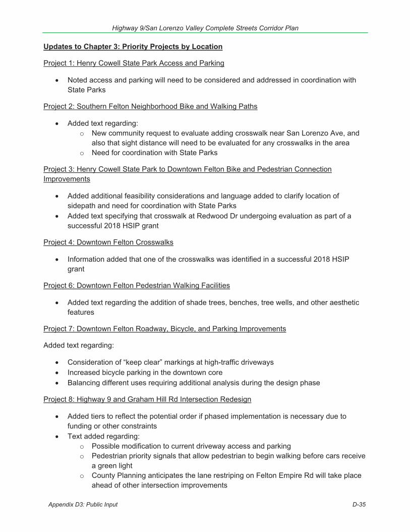
Highway 9/San Lorenzo Valley Complete Streets Corridor Plan
Updates to Chapter 3: Priority Projects by Location
Project 1: Henry Cowell State Park Access and Parking
Noted access and parking will need to be considered and addressed in coordination withState Parks
Project 2: Southern Felton Neighborhood Bike and Walking Paths
Added text regarding:o New community request to evaluate adding crosswalk near San Lorenzo Ave, and
also that sight distance will need to be evaluated for any crosswalks in the areao Need for coordination with State Parks
Project 3: Henry Cowell State Park to Downtown Felton Bike and Pedestrian Connection Improvements
Added additional feasibility considerations and language added to clarify location ofsidepath and need for coordination with State ParksAdded text specifying that crosswalk at Redwood Dr undergoing evaluation as part of asuccessful 2018 HSIP grant
Project 4: Downtown Felton Crosswalks
Information added that one of the crosswalks was identified in a successful 2018 HSIPgrant
Project 6: Downtown Felton Pedestrian Walking Facilities
Added text regarding the addition of shade trees, benches, tree wells, and other aestheticfeatures
Project 7: Downtown Felton Roadway, Bicycle, and Parking Improvements
Added text regarding:
Consideration of “keep clear” markings at high-traffic drivewaysIncreased bicycle parking in the downtown coreBalancing different uses requiring additional analysis during the design phase
Project 8: Highway 9 and Graham Hill Rd Intersection Redesign
Added tiers to reflect the potential order if phased implementation is necessary due tofunding or other constraintsText added regarding:
o Possible modification to current driveway access and parkingo Pedestrian priority signals that allow pedestrian to begin walking before cars receive
a green lighto County Planning anticipates the lane restriping on Felton Empire Rd will take place
ahead of other intersection improvements
Appendix D3: Public Input D-35
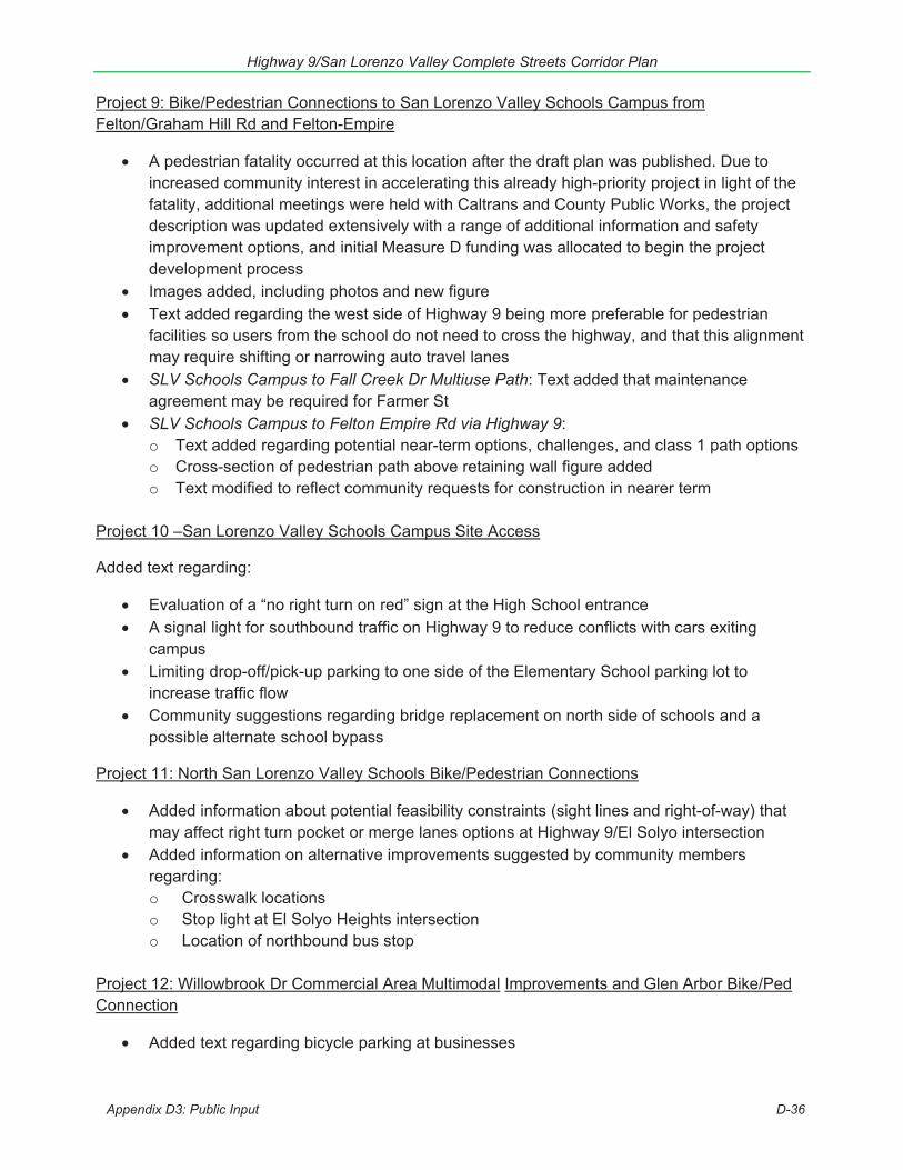
Highway 9/San Lorenzo Valley Complete Streets Corridor Plan
Project 9: Bike/Pedestrian Connections to San Lorenzo Valley Schools Campus from Felton/Graham Hill Rd and Felton-Empire
A pedestrian fatality occurred at this location after the draft plan was published. Due toincreased community interest in accelerating this already high-priority project in light of thefatality, additional meetings were held with Caltrans and County Public Works, the projectdescription was updated extensively with a range of additional information and safetyimprovement options, and initial Measure D funding was allocated to begin the projectdevelopment processImages added, including photos and new figureText added regarding the west side of Highway 9 being more preferable for pedestrianfacilities so users from the school do not need to cross the highway, and that this alignmentmay require shifting or narrowing auto travel lanesSLV Schools Campus to Fall Creek Dr Multiuse Path: Text added that maintenanceagreement may be required for Farmer StSLV Schools Campus to Felton Empire Rd via Highway 9:o Text added regarding potential near-term options, challenges, and class 1 path optionso Cross-section of pedestrian path above retaining wall figure addedo Text modified to reflect community requests for construction in nearer term
Project 10 –San Lorenzo Valley Schools Campus Site Access
Added text regarding:
Evaluation of a “no right turn on red” sign at the High School entranceA signal light for southbound traffic on Highway 9 to reduce conflicts with cars exitingcampusLimiting drop-off/pick-up parking to one side of the Elementary School parking lot toincrease traffic flowCommunity suggestions regarding bridge replacement on north side of schools and apossible alternate school bypass
Project 11: North San Lorenzo Valley Schools Bike/Pedestrian Connections
Added information about potential feasibility constraints (sight lines and right-of-way) thatmay affect right turn pocket or merge lanes options at Highway 9/El Solyo intersectionAdded information on alternative improvements suggested by community membersregarding:o Crosswalk locationso Stop light at El Solyo Heights intersectiono Location of northbound bus stop
Project 12: Willowbrook Dr Commercial Area Multimodal Improvements and Glen Arbor Bike/Ped Connection
Added text regarding bicycle parking at businesses
Appendix D3: Public Input D-36
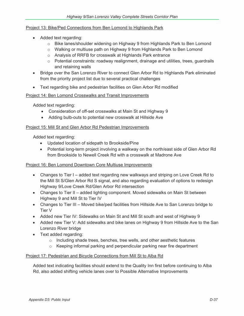
Highway 9/San Lorenzo Valley Complete Streets Corridor Plan
Project 13: Bike/Ped Connections from Ben Lomond to Highlands Park
Added text regarding:o Bike lanes/shoulder widening on Highway 9 from Highlands Park to Ben Lomondo Walking or multiuse path on Highway 9 from Highlands Park to Ben Lomondo Analysis of RRFB for crosswalk at Highlands Park entranceo Potential constraints: roadway realignment, drainage and utilities, trees, guardrails
and retaining wallsBridge over the San Lorenzo River to connect Glen Arbor Rd to Highlands Park eliminatedfrom the priority project list due to several practical challenges
Text regarding bike and pedestrian facilities on Glen Arbor Rd modified
Project 14: Ben Lomond Crosswalks and Transit Improvements
Added text regarding: Consideration of off-set crosswalks at Main St and Highway 9Adding bulb-outs to potential new crosswalk at Hillside Ave
Project 15: Mill St and Glen Arbor Rd Pedestrian Improvements
Added text regarding: Updated location of sidepath to Brookside/PinePotential long-term project involving a walkway on the north/east side of Glen Arbor Rdfrom Brookside to Newell Creek Rd with a crosswalk at Madrone Ave
Project 16: Ben Lomond Downtown Core Multiuse Improvements
Changes to Tier I – added text regarding new walkways and striping on Love Creek Rd tothe Mill St S/Glen Arbor Rd S signal, and also regarding evaluation of options to redesignHighway 9/Love Creek Rd/Glen Arbor Rd intersectionChanges to Tier II – added lighting component. Moved sidewalks on Main St betweenHighway 9 and Mill St to Tier IVChanges to Tier III – Moved bike/ped facilities from Hillside Ave to San Lorenzo bridge toTier VAdded new Tier IV: Sidewalks on Main St and Mill St south and west of Highway 9Added new Tier V: Add sidewalks and bike lanes on Highway 9 from Hillside Ave to the SanLorenzo River bridgeText added regarding:
o Including shade trees, benches, tree wells, and other aesthetic featureso Keeping informal parking and perpendicular parking near fire department
Project 17: Pedestrian and Bicycle Connections from Mill St to Alba Rd
Added text indicating facilities should extend to the Quality Inn first before continuing to Alba Rd, also added shifting vehicle lanes over to Possible Alternative Improvements
Appendix D3: Public Input D-37

Highway 9/San Lorenzo Valley Complete Streets Corridor Plan
Project 18: Hubbard Gulch/Alba Rd Operational Improvements
Added text clarifying location of potential new crosswalk nearer to transit stops and located within better line-of-sight
Project 19: Brookdale Sidewalks
Added text regarding: Sidewalks could be built on one or both sides, as feasibleIncluding shade trees, benches, tree wells, and other aesthetic features, consistent withCaltrans’ Main Street-California (2013)
Project 20: Brookdale Crosswalk Improvements
Due to community input emphasized need for tree at Clear Creek crosswalk to beremovedAdded text regarding:
o Additional crosswalk safety upgrade options, including RRFBo Crosswalk north of Pacific St/Clear Creek Rd is undergoing evaluation as part of
a successful 2018 HSIP grant
Project 21: Irwin Way and Highway 9 Intersection Improvements
Added reduce collisions to goal of project, and added text referencing community concern regarding excess light pollution
Project 22: Boulder Creek Elementary Neighborhood Multimodal Improvements
Added text regarding:o Traffic calming features outlined in Priority Ao Prevention of delivery trucks parking in center turn lanes on Highway 9o Speed humps/bumps and lighting on streets near the elementary schoolo Description of previous work done by the County near the elementary school
Deleted bicycle facilities on Lomond St between Highway 9 and Boulder CreekElementary, due to narrow right-of-way. Added text indicating Laurel may be analyzedas an option for bicycle facilities in the future.
Project 23: Boulder Creek Crosswalk Improvements
Added text regarding:
Stop sign visibility and pedestrian scale lighting at Highway 9 and Highway 236 crosswalkA new crosswalk suggestion on Highway 236 at Oak StDiscussion of midblock pedestrian crossings desired by the community and their possiblereception by CaltransDesire for landscaped medians, preserving historic rural character, and designing fortruck/bus turning radiiCrosswalk at Forest St undergoing evaluation as part of a successful 2018 HSIP grant
Appendix D3: Public Input D-38
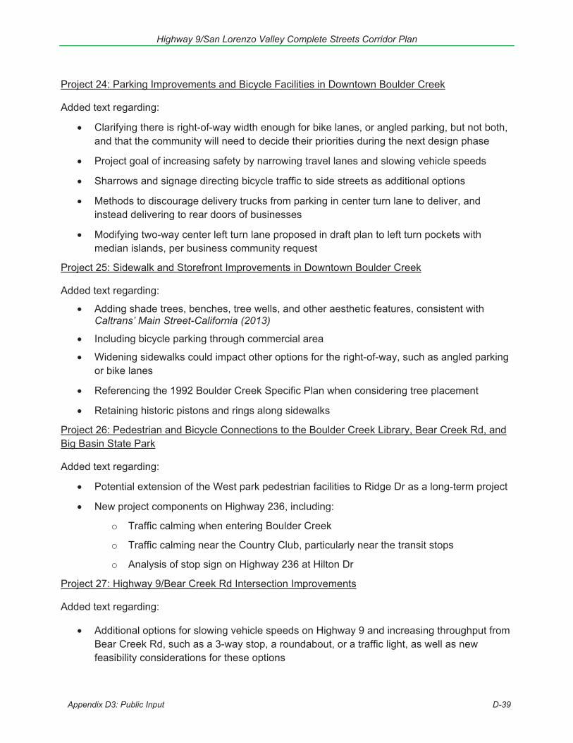
Highway 9/San Lorenzo Valley Complete Streets Corridor Plan
Project 24: Parking Improvements and Bicycle Facilities in Downtown Boulder Creek
Added text regarding:
Clarifying there is right-of-way width enough for bike lanes, or angled parking, but not both,and that the community will need to decide their priorities during the next design phase
Project goal of increasing safety by narrowing travel lanes and slowing vehicle speeds
Sharrows and signage directing bicycle traffic to side streets as additional options
Methods to discourage delivery trucks from parking in center turn lane to deliver, andinstead delivering to rear doors of businesses
Modifying two-way center left turn lane proposed in draft plan to left turn pockets withmedian islands, per business community request
Project 25: Sidewalk and Storefront Improvements in Downtown Boulder Creek
Added text regarding:
Adding shade trees, benches, tree wells, and other aesthetic features, consistent withCaltrans’ Main Street-California (2013)
Including bicycle parking through commercial area
Widening sidewalks could impact other options for the right-of-way, such as angled parkingor bike lanes
Referencing the 1992 Boulder Creek Specific Plan when considering tree placement
Retaining historic pistons and rings along sidewalks
Project 26: Pedestrian and Bicycle Connections to the Boulder Creek Library, Bear Creek Rd, and Big Basin State Park
Added text regarding:
Potential extension of the West park pedestrian facilities to Ridge Dr as a long-term project
New project components on Highway 236, including:
o Traffic calming when entering Boulder Creek
o Traffic calming near the Country Club, particularly near the transit stops
o Analysis of stop sign on Highway 236 at Hilton Dr
Project 27: Highway 9/Bear Creek Rd Intersection Improvements
Added text regarding:
Additional options for slowing vehicle speeds on Highway 9 and increasing throughput fromBear Creek Rd, such as a 3-way stop, a roundabout, or a traffic light, as well as newfeasibility considerations for these options
Appendix D3: Public Input D-39
Highway 9/San Lorenzo Valley Complete Streets Corridor Plan
Project 28: Bicycle/Pedestrian Improvements at Garrahan Park and Mountain Store
Added text regarding: Additional options to increase safety for pedestrians crossing at Pool Dr, such as an RRFBCrosswalk at Pool Dr undergoing evaluation as part of a successful 2018 HSIP grant
Updates to Chapter 4: Project Evaluation & Implementation
Added summary text that slowing traffic, improving pedestrian access and reducing crashes(auto, pedestrian, and bicycle) were the highest priorities identified by community membersSeveral projects moved between near-, short-, medium-, and longer-term priorities basedon community inputText added regarding potential interim implementation options near schoolsAdditional information and graphics added regarding the implementation process, includinginformation on Caltrans and County process, and actions that should be considered duringimplementation of projectsUnder Funding Opportunities Overview: additional text added regarding the State HighwayOperation and Protection Program (SHOPP)
Updates to Appendix A: Complete Streets Improvements Toolkit
Information added regarding:o Speed limitso Pedestrian laneso Pedestrian corrals in median islandso Sidepathso Safe routes to schools education programso Walking school bus and bicycle traino Bike and walk to school dayo Paratransit
Text added that truck and bus turning radii will need to be considered in intersections and inlane width design
Updates to Appendix B: Identified Projects
Additional project ideas and challenge areas identified by community members added to this full list of ideas
Updates to Appendix D: Public Input
Text added summarizing public outreach and input received on the Draft PlanSummary of Public Comment on Draft Plan addedSummary of Updates from Draft Plan addedExamples of Outreach on Draft Plan addedComments received posted
Updates to Appendix E: Background Documents and Prior Community Input
Examples of Caltrans projects supporting complete streets since 2014 added
Appendix D3: Public Input D-40

Search website
Click to enlarge map
Highway 9/San Lorenzo Valley Complete StreetsCorridor Plan
Draft Plan Document
On this page:
Plan OverviewPlan AreaWhy Needed?Draft PlanPublic Outreach/Get InvolvedProject Team
Current Activities:
The project team is working to incorporatecommunity input and comments that weresubmitted into the final plan.Sign Up for Hwy 9/SLV Plan updates
Plan OverviewRTC is working with the community to prepare a complete streets plan for Highway 9 andconnecting county roads through San Lorenzo Valley (SLV). The plan will identify, prioritize, andenable implementation of the most critical and cost effective transportation projects. Thismountainous roadway serves as the “Main Street” and economic center for the towns of Felton, BenLomond, Brookdale, and Boulder Creek and as an interregional arterial connecting Silicon Valley andSanta Cruz. The plan will focus on safety for pedestrians, bicyclists and motorists; access toschools, businesses, and bus stops; traffic operations, pavement conditions, drainage and otherneeds in this important travel corridor. [printable Fact Sheet]
Plan Area This transportation planning effort focuses on the section ofHighway 9 that connects the towns of Felton, Ben Lomond,Brookdale, and Boulder Creek and parallel and connectingstreets, roadways, and paths. Areas beyond the focus areaare also considered in the plan, but not the focus of the plan.
Back to Top
Why is this plan needed?A comprehensive multimodal transportation needsassessment and evaluation of a range of options to addresstransportation challenges is needed to identify and prioritizetransportation investments for this important corridor,especially since state, federal, and local revenues areseverely constrained. This comprehensive plan for Highway 9through San Lorenzo Valley will:
Build on past public input and planning activitiesDocument existing conditionsIdentify infrastructure gapsAnswer questions about what can be done within Caltrans’ right-of-wayProvide data, evaluation, analysis, and public deliberation to make informed decisionsPrioritize transportation projects that can be implemented in the short and mid-term to addresstransportation challenges on the corridor.Measure D, which was approved by voters in November2016, includes $10 million specifically earmarked for high prioritytransportation projects along the Highway 9 corridor.
This corridor-specific plan will be a stepping stone to securing funding forpriority investments and provide a framework for partnering with Caltrans to implementinvestments that promote complete streets, implement sustainable communities strategies, andimprove multi-modal access, connectivity, safety, security, system preservation, economic vitalityand environmental quality. The plan includes conceptual complete street designs and will be used tofacilitate subsequent design, environmental review and construction of improvements.
Streets & Highways
Highway 1 CorridorProgram
Highway 1EnvironmentalDocuments
Mar VistaBicycle/PedestrianOvercrossing
Bus-on-ShoulderProject
41st-Soquel AuxLanes & Bike/PedCrossing
Soquel-Morrissey AuxLanes
Highway 17
Highway 9 Plan
Highway 1-17Interchange Widening
Other Highways
Bicycle
Pedestrian
Rail
Rail Inquiries andRequests
Operating Agreement
Passenger Rail
Rail Service Studies
Rail Line Purchase
Due Diligence
Trails
Monterey Bay SanctuaryScenic Trail
MBSST Master Plan
Final EnvironmentalImpact Report
City of Santa Cruz CoastalRail Trail Project
North Coast Rail Trail
Bus Projects
Multi-Modal
Unified Corridor Study
Visualizing SustainableTransportation
Santa Cruz CountyComplete Streets
Monterey Bay AreaComplete StreetsGuidebook
MEETINGS& EVENTS
FUNDING &PLANNING PROJECTS SERVICES
ABOUTTHE RTC CRUZ511
https://sccrtc.org/projects/streets-highways/hwy-9-plan
Highway 9/San Lorenzo Valley Complete Streets Corridor Plan
Appendix D4: Public Input D-41
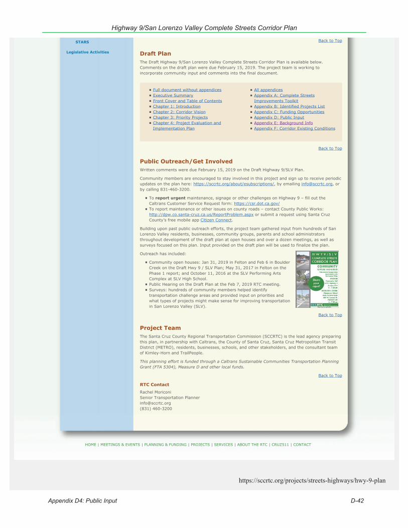
Back to Top
Draft PlanThe Draft Highway 9/San Lorenzo Valley Complete Streets Corridor Plan is available below.Comments on the draft plan were due February 15, 2019. The project team is working toincorporate community input and comments into the final document.
Back to Top
Public Outreach/Get InvolvedWritten comments were due February 15, 2019 on the Draft Highway 9/SLV Plan.
Community members are encouraged to stay involved in this project and sign up to receive periodicupdates on the plan here: https://sccrtc.org/about/esubscriptions/, by emailing [email protected], orby calling 831-460-3200.
To report urgent maintenance, signage or other challenges on Highway 9 – fill out theCaltrans Customer Service Request form: https://csr.dot.ca.gov/To report maintenance or other issues on county roads – contact County Public Works:http://dpw.co.santa-cruz.ca.us/ReportProblem.aspx or submit a request using Santa CruzCounty’s free mobile app Citizen Connect.
Building upon past public outreach efforts, the project team gathered input from hundreds of SanLorenzo Valley residents, businesses, community groups, parents and school administratorsthroughout development of the draft plan at open houses and over a dozen meetings, as well assurveys focused on this plan. Input provided on the draft plan will be used to finalize the plan.
Outreach has included:
Community open houses: Jan 31, 2019 in Felton and Feb 6 in BoulderCreek on the Draft Hwy 9 / SLV Plan; May 31, 2017 in Felton on thePhase 1 report; and October 11, 2016 at the SLV Performing ArtsComplex at SLV High School.Public Hearing on the Draft Plan at the Feb 7, 2019 RTC meeting.Surveys: hundreds of community members helped identifytransportation challenge areas and provided input on priorities andwhat types of projects might make sense for improving transportationin San Lorenzo Valley (SLV).
Back to Top
Project TeamThe Santa Cruz County Regional Transportation Commission (SCCRTC) is the lead agency preparingthis plan, in partnership with Caltrans, the County of Santa Cruz, Santa Cruz Metropolitan TransitDistrict (METRO), residents, businesses, schools, and other stakeholders, and the consultant teamof Kimley-Horn and TrailPeople.
This planning effort is funded through a Caltrans Sustainable Communities Transportation PlanningGrant (FTA 5304), Measure D and other local funds.
Back to Top
RTC Contact
Rachel MoriconiSenior Transportation [email protected](831) 460-3200
STARS
Legislative Activities
HOME | MEETINGS & EVENTS | PLANNING & FUNDING | PROJECTS | SERVICES | ABOUT THE RTC | CRUZ511 | CONTACT
Full document without appendicesExecutive SummaryFront Cover and Table of ContentsChapter 1: IntroductionChapter 2: Corridor VisionChapter 3: Priority ProjectsChapter 4: Project Evaluation andImplementation Plan
All appendicesAppendix A: Complete StreetsImprovements ToolkitAppendix B: Identified Projects ListAppendix C: Funding OpportunitiesAppendix D: Public InputAppendix E: Background InfoAppendix F: Corridor Existing Conditions
https://sccrtc.org/projects/streets-highways/hwy-9-plan
Highway 9/San Lorenzo Valley Complete Streets Corridor Plan
Appendix D4: Public Input D-42
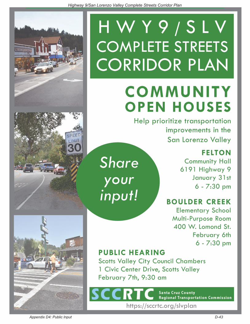
COMMUNITY OPEN HOUSES
Help prioritize transportationimprovements in the San Lorenzo Valley
FELTONCommunity Hall
6191 Highway 9January 31st6 - 7:30 pm
BOULDER CREEKElementary School
Multi-Purpose Room400 W. Lomond St.
February 6th6 - 7:30 pm
PUBLIC HEARINGScotts Valley City Council Chambers1 Civic Center Drive, Scotts ValleyFebruary 7th, 9:30 am
H W Y 9 / S L VCOMPLETE STREETSCORRIDOR PLAN
https://sccrtc.org/slvplan
Share yourinput!
Highway 9/San Lorenzo Valley Complete Streets Corridor Plan
Appendix D4: Public Input D-43
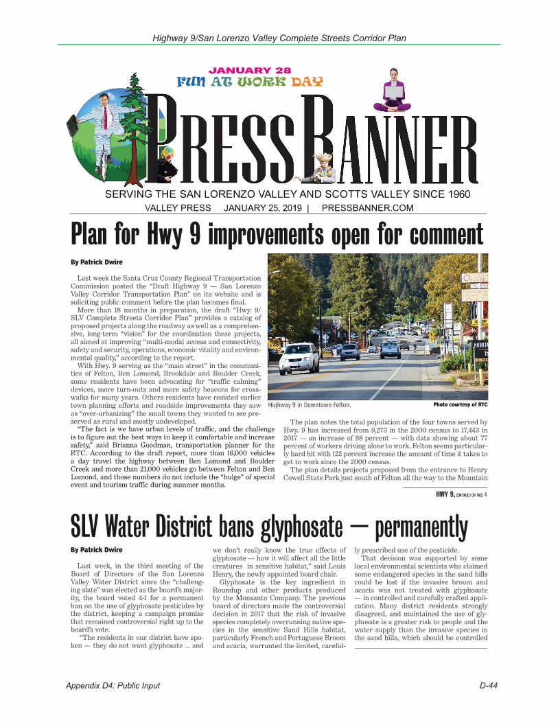
Appendix D4: Public Input D-44
Highway 9/San Lorenzo Valley Complete Streets Corridor Plan
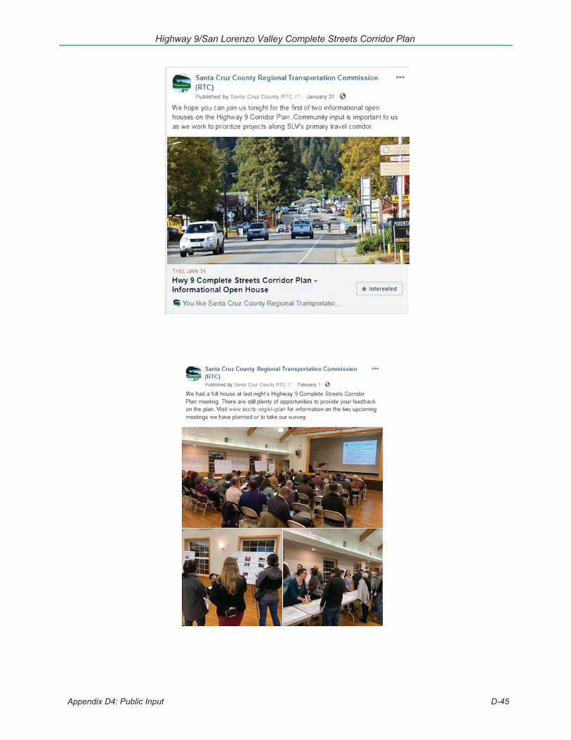
Highway 9/San Lorenzo Valley Complete Streets Corridor Plan
Appendix D4: Public Input D-45
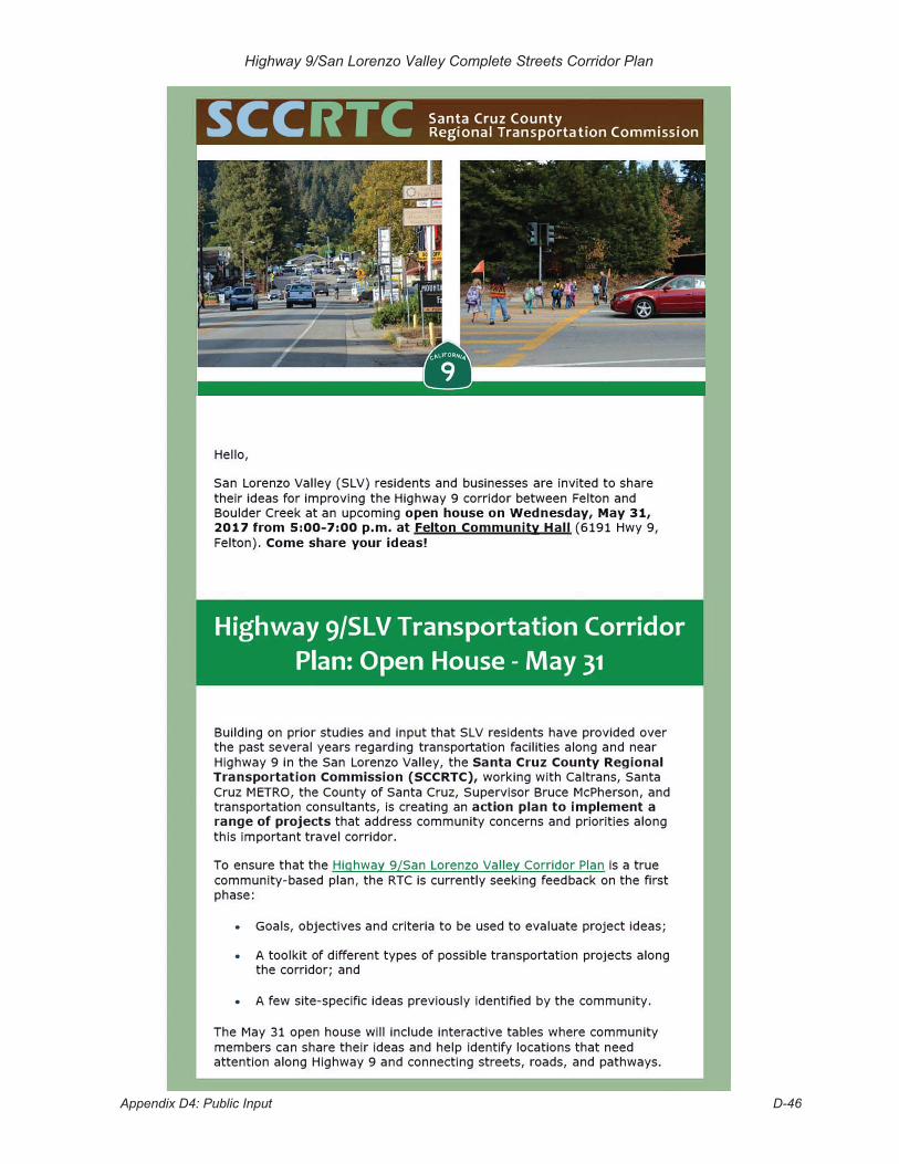
Appendix D4: Public Input D-46
Highway 9/San Lorenzo Valley Complete Streets Corridor Plan
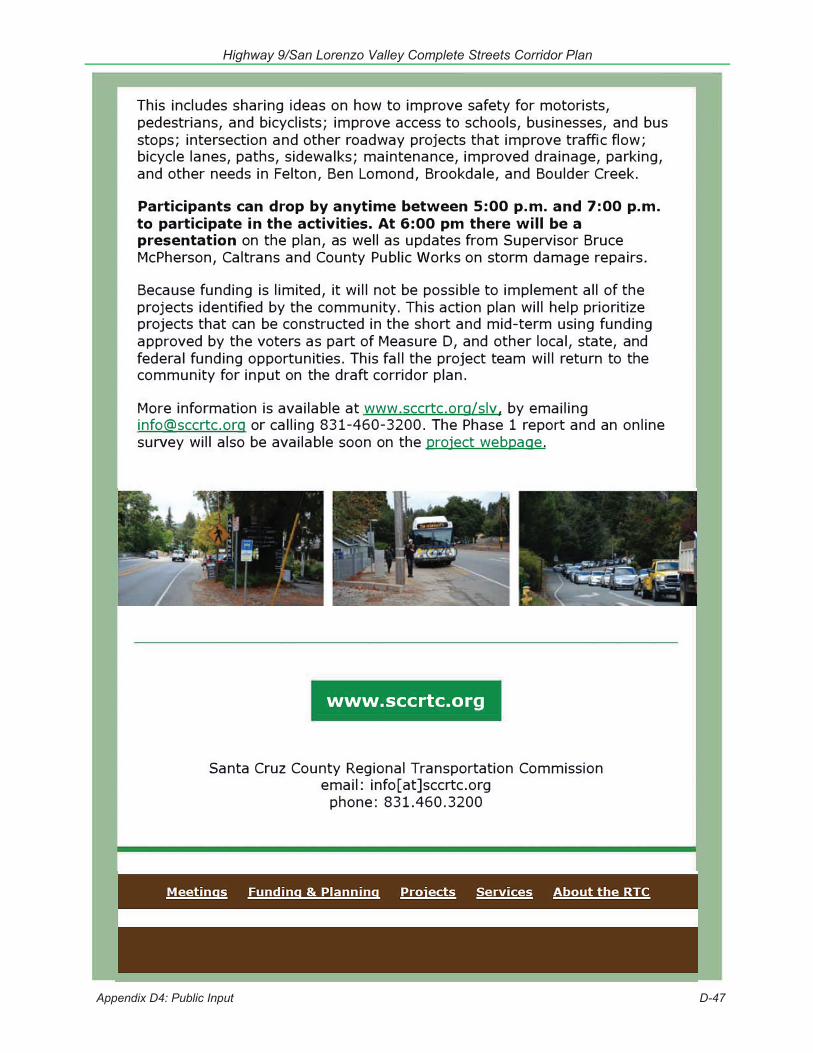
Highway 9/San Lorenzo Valley Complete Streets Corridor Plan
Appendix D4: Public Input D-47
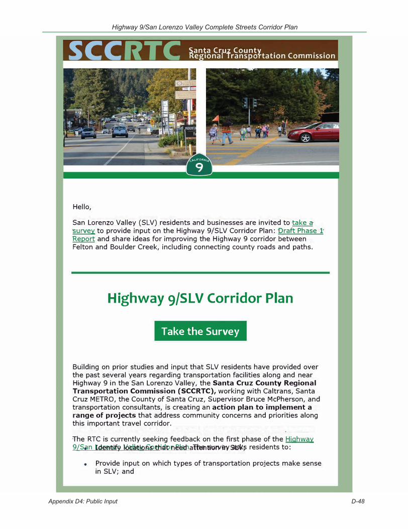
SC C RTC Santa Cruz CountyRegional Transportation Commission
Hello,
San Lorenzo Valley (SLV) residents and businesses are invited to take a survey to provide input on the Highway 9/SLV Corridor Plan: Draft Phase 1 Report and share ideas for improving the Highway 9 corridor between Felton and Boulder Creek, including connecting county roads and paths.
Highway 9/SLV Corridor Plan
Take the Survey
Building on prior studies and input that SLV residents have provided over the past several years regarding transportation facilities along and near Highway 9 in the San Lorenzo Valley, the Santa Cruz County Regional Transportation Commission (SCCRTC), working with Caltrans, Santa Cruz METRO, the County of Santa Cruz, Supervisor Bruce McPherson, and transportation consultants, is creating an action plan to implement a range of projects that address community concerns and priorities along this important travel corridor.
The RTC is currently seeking feedback on the first phase of the Highway 9/San Lorenzo Valley Corridor Plan. The survey asks residents to: • Identify locations that need attention in SLV;
• Provide input on which types of transportation projects make sense in SLV; and
Appendix D4: Public Input D-48
Highway 9/San Lorenzo Valley Complete Streets Corridor Plan
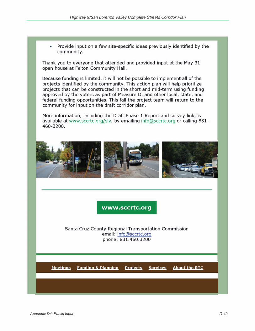
Highway 9/San Lorenzo Valley Complete Streets Corridor Plan
Appendix D4: Public Input D-49


Highway 9/San Lorenzo Valley Complete Streets Corridor Plan
Appendix E: Background Documents and Past Input E-1
Figure E1: Map from 2006 SLV Trail Study
Credit: County of Santa Cruz
Appendix E: Background Documents and Prior Community Input As a first step in development of the Highway 9/San Lorenzo Valley (SLV) Complete Streets Corridor Plan, the consultant team reviewed information from other planning documents and past community outreach. Sources of prior input that were reviewed for this planning effort include documented correspondence between area residents, RTC, and Caltrans, as well as various public outreach events. In 2013 a major public outreach effort was led by Supervisor Bruce McPherson of the Fifth District, which included a bus tour of Highway 9 with area residents and Caltrans and meetings with Town Plan committees, plus the SLV Marketing and Branding Committee.
1. Background Documents and Related PlansBelow is an overview of documents, prior studies, and state, federal, regional, and local plans related to transportation planning, land use and sustainability which were considered in development of the Highway 9/SLV Plan.
Local Plans and Studies San Lorenzo Valley Trail Feasibility Study The San Lorenzo Valley (SLV) Trail Feasibility Study, completed in 2006, evaluated bicycle and pedestrian facility options between Boulder Creek (from the southern intersection of Highway 236 with Highway 9) and the city of Santa Cruz. It included an assessment of route options along Highway 9 in SLV, as well options along Highway 9, Graham Hill Road and potential use the Big Trees/Roaring Camp Railroad line between Santa Cruz and Felton. Areas north of the southern Hwy 236/Hwy 9 intersection in “downtown” Boulder Creek were not evaluated in this study.
The objectives of this study were to: 1) provide a thorough evaluation of the conditions, opportunities and constraints of constructing a continuous bicycle and pedestrian trail, or separate facilities, along the main study routes, or any identified alternative routes; 2) prepare conceptual improvement plans and cost estimates for the most feasible routes; and, 3) with public and agency input, prepare recommendations for trail improvements.
The study ultimately evaluated over 45 miles of potential trail routes, and conceptual plans and cost estimates were prepared for 29 miles of routes. This GIS-based study was supplemented by extensive field investigations and stakeholder agency and organization contact. Extensive public comments were received through the four community meetings held during the study, and in email and written comments received primarily during review of the draft report.
The Trail Study divided the highway and parallel routes into segments that were analyzed in detail. Ten segments overlapped the current study area from the edge of the Henry Cowell Redwoods State Park property

Highway 9/San Lorenzo Valley Complete Streets Corridor Plan
Appendix E: Background Documents and Past Input E-2
at Glengarry Rd north to the southern Highway 236 intersection in Boulder Creek. Existing conditions in each segment were evaluated and classified by a set of opportunities and constraints typical to the study area, with a corresponding pair of existing conditions and improvement concept maps. Improvement cost estimates were derived from these concepts. The improvements and costs reflected an assessment of planning and environmental considerations, including natural and cultural resources, traffic and the then-current Town Plans for Felton, Ben Lomond, and Boulder Creek.
The maps used a graphic shorthand necessitated by the many miles of routes under study, but the GIS and analysis contain significant detail about site-specific conditions, including ROW and pavement width, entrances and parking, drainage facilities, crosswalks, traffic lanes and signals.
While the SLV Trail Study reflected comments received on the various routes and provides greater detail on potential constraints for bicycle and pedestrian facilities through the SLV, it did not prioritize sections for construction.
Felton Town Plan The Felton Town Plan, 1987 established design and development guidelines for the village center of Felton. The Town Plan has several pertinent policies potentially affecting any complete street improvements along Highway 9 and other roadways in the central business district.
Policies Circulation Improvement Policy 6: Change the existing 90-degree parking on Highway 9 to angled parking.
This should occur at the same time as constructing wider sidewalks, wherever feasible, and constructing a left-turn lane. (See below.).
Circulation Improvement Policy 7: Provide a middle left-turn lane in Highway 9 between Hihn Street and Graham Hill Road intersections by installing textured pavers and landscape islands at both ends of the turn lane.
Pedestrian Circulation Improvement Policy 1: Widen sidewalks. Pedestrian Circulation Improvement Policy 2: Construct sidewalks and bike lanes on both sides of Graham
Hill Road.
Highway 9 Design Plan The schematic shown in Figure 4.1 of the Felton Town Plan shows one street configuration north of Kirby and another south of Kirby Street. Between Graham Hill Road and Kirby Street: 20’ angled parking on both sides. To their interior a 12’ wide
back-out area on both sides that would have to double as the bike lane. To their interior two 12’ wide travel lanes that are separated by a 12’ wide left-turn lane.
Between Kirby Street and Hihn Street: Angled parking is limited to the west side (on private property) behind a pedestrian walk that separates the parking spaces from the right-of-way. Sidewalk would also occur on east side. To the interior of the west sidewalk a 6’ wide bike lane. To the interior of the eastside sidewalk, 12’ wide parallel parking with a 6’ wide bike lane. Therefore, a bike lane on each side. To the interior of the bike lanes, two 12’ wide travel lanes that would be separated by a 12’ wide left-turn lane.
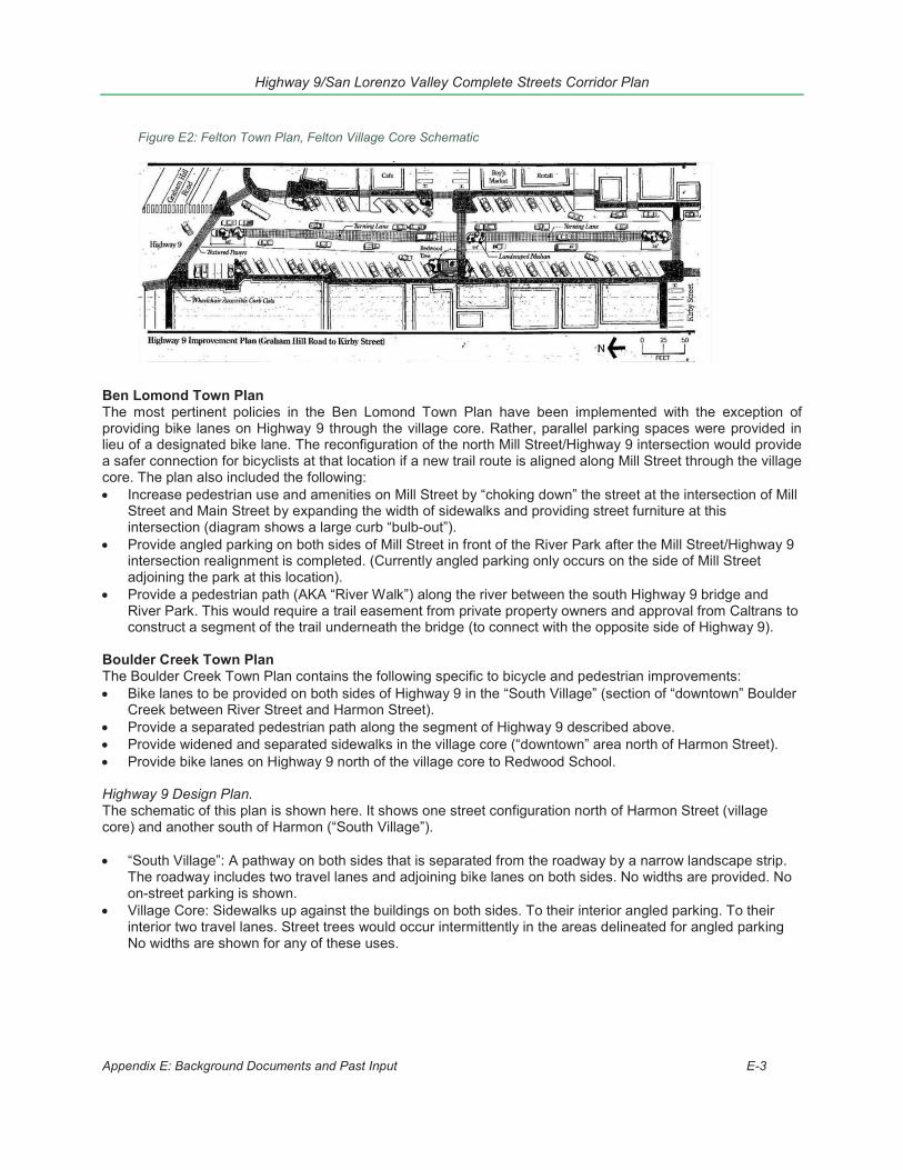
Highway 9/San Lorenzo Valley Complete Streets Corridor Plan
Appendix E: Background Documents and Past Input E-3
Ben Lomond Town Plan The most pertinent policies in the Ben Lomond Town Plan have been implemented with the exception of providing bike lanes on Highway 9 through the village core. Rather, parallel parking spaces were provided in lieu of a designated bike lane. The reconfiguration of the north Mill Street/Highway 9 intersection would provide a safer connection for bicyclists at that location if a new trail route is aligned along Mill Street through the village core. The plan also included the following:
Increase pedestrian use and amenities on Mill Street by “choking down” the street at the intersection of MillStreet and Main Street by expanding the width of sidewalks and providing street furniture at thisintersection (diagram shows a large curb “bulb-out”).Provide angled parking on both sides of Mill Street in front of the River Park after the Mill Street/Highway 9intersection realignment is completed. (Currently angled parking only occurs on the side of Mill Streetadjoining the park at this location).Provide a pedestrian path (AKA “River Walk”) along the river between the south Highway 9 bridge andRiver Park. This would require a trail easement from private property owners and approval from Caltrans toconstruct a segment of the trail underneath the bridge (to connect with the opposite side of Highway 9).
Boulder Creek Town Plan The Boulder Creek Town Plan contains the following specific to bicycle and pedestrian improvements:
Bike lanes to be provided on both sides of Highway 9 in the “South Village” (section of “downtown” BoulderCreek between River Street and Harmon Street).Provide a separated pedestrian path along the segment of Highway 9 described above.Provide widened and separated sidewalks in the village core (“downtown” area north of Harmon Street).Provide bike lanes on Highway 9 north of the village core to Redwood School.
Highway 9 Design Plan. The schematic of this plan is shown here. It shows one street configuration north of Harmon Street (village core) and another south of Harmon (“South Village”).
“South Village”: A pathway on both sides that is separated from the roadway by a narrow landscape strip.The roadway includes two travel lanes and adjoining bike lanes on both sides. No widths are provided. Noon-street parking is shown.Village Core: Sidewalks up against the buildings on both sides. To their interior angled parking. To theirinterior two travel lanes. Street trees would occur intermittently in the areas delineated for angled parkingNo widths are shown for any of these uses.
Figure E2: Felton Town Plan, Felton Village Core Schematic
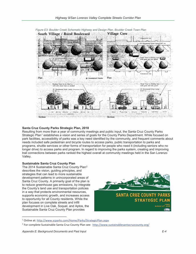
Highway 9/San Lorenzo Valley Complete Streets Corridor Plan
Appendix E: Background Documents and Past Input E-4
Santa Cruz County Parks Strategic Plan, 2018 Resulting from more than a year of community meetings and public input, the Santa Cruz County Parks Strategic Plan1 establishes a vision and series of goals for the County Parks Department. While focused on park facilities, accessibility of parks was a key need identified by the community, and frequent comments about needs included safe pedestrian and bicycle routes to access parks, public transportation to parks and programs, shuttle services or other forms of transportation for people who need it (including seniors who no longer drive) to access parks and program. In regard to improving the parks system, creating and improving trail connections between parks ranked the highest overall at community meetings held in the San Lorenzo Valley.
Sustainable Santa Cruz County Plan The 2014 Sustainable Santa Cruz County Plan2 describes the vision, guiding principles, and strategies that can lead to more sustainable development patterns in unincorporated areas of Santa Cruz County. A primarily goal of the plan is to reduce greenhouse gas emissions, by integrate the County’s land use and transportation policies in a way that protects environmental resources, supports economic growth, and increases access to opportunity for all County residents. While the plan focuses on complete streets and infill development in Live Oak, Soquel, and Aptos, the Sustainable Santa Cruz County Plan provides
1 Online at: http://www.scparks.com/Home/Parks/StrategicPlan.aspx 2 For complete Sustainable Santa Cruz County Plan see: http://www.sustainablesantacruzcounty.org/
Figure E3: Boulder Creek Schematic Highway and Design Plan, Boulder Creek Town Plan
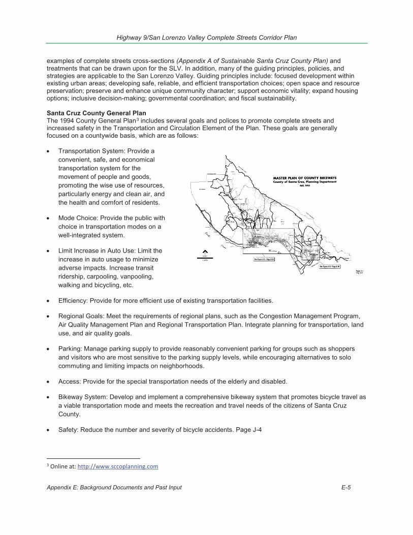
Highway 9/San Lorenzo Valley Complete Streets Corridor Plan
Appendix E: Background Documents and Past Input E-5
examples of complete streets cross-sections (Appendix A of Sustainable Santa Cruz County Plan) and treatments that can be drawn upon for the SLV. In addition, many of the guiding principles, policies, and strategies are applicable to the San Lorenzo Valley. Guiding principles include: focused development within existing urban areas; developing safe, reliable, and efficient transportation choices; open space and resource preservation; preserve and enhance unique community character; support economic vitality; expand housing options; inclusive decision-making; governmental coordination; and fiscal sustainability.
Santa Cruz County General Plan The 1994 County General Plan3 includes several goals and polices to promote complete streets and increased safety in the Transportation and Circulation Element of the Plan. These goals are generally focused on a countywide basis, which are as follows:
Transportation System: Provide a convenient, safe, and economical transportation system for the movement of people and goods, promoting the wise use of resources, particularly energy and clean air, and the health and comfort of residents.
Mode Choice: Provide the public with choice in transportation modes on a well-integrated system.
Limit Increase in Auto Use: Limit the increase in auto usage to minimize adverse impacts. Increase transit ridership, carpooling, vanpooling, walking and bicycling, etc.
Efficiency: Provide for more efficient use of existing transportation facilities.
Regional Goals: Meet the requirements of regional plans, such as the Congestion Management Program, Air Quality Management Plan and Regional Transportation Plan. Integrate planning for transportation, land use, and air quality goals.
Parking: Manage parking supply to provide reasonably convenient parking for groups such as shoppers and visitors who are most sensitive to the parking supply levels, while encouraging alternatives to solo commuting and limiting impacts on neighborhoods.
Access: Provide for the special transportation needs of the elderly and disabled.
Bikeway System: Develop and implement a comprehensive bikeway system that promotes bicycle travel as a viable transportation mode and meets the recreation and travel needs of the citizens of Santa Cruz County.
Safety: Reduce the number and severity of bicycle accidents. Page J-4
3 Online at: http://www.sccoplanning.com
Highway 9/San Lorenzo Valley Complete Streets Corridor Plan
Appendix E: Background Documents and Past Input E-6
Finance: Plan a system within the County's ability to finance and operate, distributing the costs of transportation system improvements equitably among Santa Cruz County and neighboring jurisdictions.
Aesthetics: Minimize impacts on visual, historic, and archaeological resources.
Coordination: Coordinate transportation improvements in area plans with the General Plan and LCP Land Use Plan and regional transportation plans.
The County of Santa Cruz is in the process of updating its Circulation Element, as such the goals, objectives and policies may be changed, and new objectives and policies may be applicable.
Other Regional Transportation Plans There are also other county and regionwide plans that are meant to help guide transportation and complete streets improvements, economic development, and sustainable planning within the SLV and the wider region. These plans and how they related to this SLV Complete Streets Corridor Transportation Plan are described in more detailed below.
Santa Cruz County Regional Transportation Plan. The Regional Transportation Plan (RTP) includes several polices that promote increasing alternative modes of transportation county-wide. These polices have been adopted to implement the RTC Goal #2: “To increase Mobility by Providing an Improved and Multi-Modal Transportation System”. The RTP Investment Program lists several projects planned by Caltrans and the County of Santa Cruz through 2040. It also includes a placeholder of $10 million in Measure D funds to address priorities identified through this planning effort.
Santa Cruz METRO Bus Stop Guidelines Santa Cruz METRO has established guidelines for the types of improvements allowed at their Bus Stops. METRO also has established guidelines for the levels of ridership necessary to gain additional Bus Stop Amenities. METRO’s guidelines were incorporated into the Highway 9 Complete Streets Toolkit.
Santa Cruz County Economic Vitality Study The two core values outlined in the County’s 2014 Economic Vitality Study4: sustainability and community investment, directly align with the goals of this Highway 9 project. Two additional goals, Goal 2: Support Sustainable Development with Housing and Transportation Choices and Goal 6: Revitalize and Strengthen Town Centers and Commercial Areas are served by this deeper exploration into expanding active transportation options along the Highway 9 corridor and within neighboring communities. The Vitality Study emphasizes working with transportation partners to ensure that funding is “balanced” and includes local and regional-serving improvements like bike and pedestrian facilities, and complete streets (Goal 2.15). Under the banner of revitalizing town centers, the report includes a goal to “Work with Caltrans to manage Highway 9 in a manner that contributes to the economic success of Felton, Boulder Creek, Ben Lomond, and Brookdale businesses” including “streetscape improvements” (Goal 6.9.2). The study also identified parking supply and parking strategies as vital to support area businesses (Goal 6.9.3, 6.9.4).
Santa Cruz County Economic Development Vision and Strategy This document5 projects a more developed Preliminary Economic Vitality Vision and accompanying Strategies and Actions for economic development efforts in 2015/2016 that build on the initial 2014 Economic Vitality Study. The goals of the Vision and Strategy are consistent with those from the 2014 study, while also developing a larger vision and guiding principles to support future economic sustainability and vitality and justify future investments and actions.
4 Santa Cruz County Economic Vitality Study online at: http://sccoplanning.com/PlanningHome/EconomicDevelopment/EconomicVitalityStrategy.aspx 5 Santa Cruz County Economic Development Vision and Strategy available online at: http://sccoplanning.com/PlanningHome/EconomicDevelopment/EconomicVitalityStrategy.aspx

Highway 9/San Lorenzo Valley Complete Streets Corridor Plan
Appendix E: Background Documents and Past Input E-7
Monterey Bay Area Complete Streets Guidebook The Monterey Bay Area Complete Streets Guidebook6, adopted in 2013, is a toolkit designed to assist local jurisdictions in planning, designing and implementing complete streets projects. The Guidebooks is based on best practices gathered from projects and reports released nationwide, and includes a project review checklist, and technical appendix. The Guidebook also includes “Measures of Effectiveness” (p. 25) for evaluating complete streets projects, which are helpful for developing performances measures for projects along Highway 9. Chapter 5 of the guidebook has design guidelines, including those for more rural roads.
Monterey Bay Area Metropolitan Transportation Plan and Sustainable Communities Strategy (MTP/SCS) As mentioned above, the Monterey Bay Area Metropolitan Transportation Plan/Sustainable Communities Strategies (MTP/SCS)7
combines the transportation plans and policies of the three Monterey Bay counties into a regional plan. Led by the Association of Monterey Bay Area Governments (AMBAG) in close cooperation with cities and local agencies, Moving Forward: Monterey Bay 2035, is a fiscally-constrained plan for optimizing and expanding the regional transportation system over the next 20 years. Adopted in 2014, the current MTP/SCS includes regional goals and performance measures, growth projections and a financial plan. AMBAG is in the process of developing a technical update to the current 2035 MTP/SCS. The updated 2040 MTP/SCS is planned for adoption in June 2018.
Per California SB 375, the MTP seeks to better integrate land use and transportation planning and reduce greenhouse gases by adopting a Sustainable Communities Strategy for the region. In addition to including a Sustainable Communities Strategy in the MTP, AMBAG adopted a SCS Implementation plan or toolkit, described in more detail below.
AMBAG Sustainable Communities Strategy Toolkit The Sustainable Communities Strategy Implementation Project (SCSIP)8 is a project designed to implement the Metropolitan Transportation Plan/Sustainable Communities Strategy (MTP/SCS). The project has developed a set of toolkits focusing on infill housing, transportation strategies, and economic development to achieve the goal more sustainable development in the region. AMBAG is collaborating with cities to create general plan policies and local ordinances that would help implement the vision of the regionwide MTP/SCS.
The Transportation Measures Toolkit9 includes ways to implement SCS Transportation Measures within different “place types.” For the Highway 9 corridor, which falls primarily in the Non-Urban and Town place types, the most applicable Transportation Measures are: “Enhance Pedestrian Connections” and “Enhance Bicycle Connections.” The goals of this Highway 9 corridor project are directly responding to these area needs as outlined in the MTP/SCS.
Federal and State Documents and Plans California Transportation Plan (CTP) 2040 The California Transportation Plan (CTP) 2040 provides concepts, strategies and performance measure for all modes on State Facilities. The vision from this Plan is, “California’s transportation system is safe, sustainable universally acceptable, and globally competitive. It provides reliable and efficient mobility for people, good and services, while meeting the state’s greenhouse gas emissions reduction goals and preserving the unique character of California’s communities (Caltrans, 2016). Several Goals and
6 Monterey Bay Area Complete Streets Guidebook online at: https://sccrtc.org/projects/multi-modal/santa-cruz-county-complete-streets/monterey-bay-area-complete-streets-guidebook/ 7 MTP/SCS online at: https://ambag.org/programs-services/planning/metro-transport-plan 8 More information, including toolkits here: http://www.ambag.org/programs-services/planning/metro-transport-plan/sustainable-communities-strategy-implementation 9 Toolkit online at: http://www.ambag.org/programs/SCSIP/TransportationToolkitCutsheets.pdf
Highway 9/San Lorenzo Valley Complete Streets Corridor Plan
Appendix E: Background Documents and Past Input E-8
Policies from complement the efforts of this Complete Streets Corridor Plan. Applicable Goals and Policies are listed below:
Goal 1: Improve Multimodal Mobility and Accessibility For All People Goal 3: Support A Vibrant Economy
o Policy 3.3: Seek Sustainable and Flexible Funding to Maintain and Improve the System Goal 4: Public Safety and Security
o Policy 4.1: Reduce Fatalities, Serious Injuries, and Collisions Goal 5: Foster Livable And Healthy Communities And Promote Social Equity
o Policy 5.1: Expand Engagement in Multimodal Transportation Planning and Decision Makingo Policy 5.2: Integrate Multimodal Transportation and Land Use Development
Goal 6: Practice Environmental Stewardship o Policy 6.1: Integrate Environmental Considerations in All Stages of Planning and Implementationo Policy 6.3: Reduce Greenhouse Gas Emissions and Other Air Pollutantso Policy 6.4: Transform to a Clean and Energy Efficient Transportation System
Caltrans Strategic Management Plan (CSMP) The Caltrans Strategic Management Plan, 2015 – 2020, provides guidance for Caltrans’ duties, expectations and operations as while maintaining the State’s transportation system. Several Goals and Policies from complement the efforts of this Complete Streets Corridor Plan, applicable goals and policies are listed below.
GOAL 1: SAFETY & HEALTH Objective 1.2: Reduce user fatalities and injuries by adopting a “Toward Zero Deaths” practice. Policy 1.3: Provide Viable and Equitable Multimodal Choices Including Active Transportation Objective 1.3: Promote community health through active transportation and reduced pollution in communities.
GOAL 3: SUSTAINABILITY, LIVABILITY, AND ECONOMY Objective 3.1: PEOPLE: Improve the quality of life for all Californians by providing mobility choice,
increasing accessibility to all modes of transportation and creating transportation corridors not only for conveyance of people, goods, and services, but also as livable public spaces.
Objective 3.2: PLANET: Reduce environmental impacts from the transportation system with emphasis on supporting a statewide reduction of greenhouse gas emissions to achieve 80% below 1990 levels by 2050.
District 5: 2015 District System Management Plan (DSMP) The District System Management Plan (DSMP) is one part of District 5’s long range planning process. The DSMP describes the District’s vision for the how the transportation system within the district will be maintained managed and developed over the next 20 years and beyond. State Route – 9 or Highway 9 is considered a Major Collector, Minor Arterial, with conventional access control. Highway 9 is considered part of the National Highway System and the Interregional Road System for part of its route. Additionally, Highway 9 is eligible for to be established as a State Designated Scenic Highway Route.
This Plan, a more locally relevant document, discusses the classification of the roadway network within the district and identify future projects to be undertaken that will help achieve the goals and policies set by the Plan. The goals for the DSMP are based on the Caltrans Strategic Management Plan, which provides the goals and objectives for the State. Several Goals and Policies from complement the efforts of this Complete Streets Corridor Plan, Applicable Goals and Policies are listed below:
GOAL 1: SAFETY AND HEALTH: Provide a safe transportation system for workers and users and promote health through active transportation and reduced pollution in communities. Objective 1: Promote Safe Design for All Travelers. Objective 3: Support Active Modes of Transportation and Access to Transit.
GOAL 3: SUSTAINABILITY, LIVABILITY, AND ECONOMY: Make long-lasting, smart mobility decisions that

Highway 9/San Lorenzo Valley Complete Streets Corridor Plan
Appendix E: Background Documents and Past Input E-9
Figure E4: Example of environmental sustainability through landscaping, Highway 9 through Downtown Ben Lomond
Credit: Main Street, California, Page 23
improve the environment, support a vibrant economy and build communities, not sprawl. Objective 1: Plan for Multi-modal Integration. Objective 3: Sustain Environmental Excellence
Smart Mobility 2010: A Call to Action for the New Decade The purpose of the Smart Mobility document is to provide guidelines, concepts, tools, and resources that respond to today’s transportation challenges. Smart Mobility, if incorporated in local planning process, ensures that people and freight move by emphasizing convenient and safe multi-modal travel, speed suitability, accessibility, management of the circulation network, and efficient use of land. Transportation challenges that the Smart Mobility Call to Action attempts to address is (1) the state mandate to find solutions to climate change, (2) the need to reduce per capita vehicle miles traveled, (3) demand for a safe transportation system that gets people and goods to their destinations, and (4) a transportation system that advances social equity and environmental justice.
Smart Mobility established six principles to consider when planning for the transportation improvements:
1. Location efficiency – Integrate Transportation and Land Use to achieve high levels of non-motorized traveland transit use, reduce vehicle trips and shorten average trip length while providing a high level ofaccessibility.
2. Reliable Mobility – Manage, reduce and avoid congestion by emphasizing multi-modal options and networkmanagement.
3. Health and Safety – Design, operate and manage the transportation system to reduce serious injuries andfatalities, promote active living, and lessen exposure to pollution.
4. Environmental Stewardship – Protect and enhance the State’s transportation system and its built andnatural environment
5. Social Equity – Provide mobility for people who are economically, socially, or physically disadvantaged inorder to support their full participation in society.
6. Economy – Invest in transportation improvements that support the economic health of the State and localgovernments, the competitiveness of California’s businesses, and the welfare of California residents
Many of the principles, performance measures, and ideas from the Smart Mobility Call to Action have been incorporated into the update to the 2040 CTP as well as the 2015 District 5 System Management Plan, discussed previously.
Main Street, California: A Guide for Improving Community and Transportation Vitality The Main Street, California Guide provides guidelines for transportation improvement projects along Caltrans roadways that also function as the “Main Street” or downtown of the Town or City. Many of proposed design improvements for automobiles, bicycles, pedestrians and transit, are shown in the Highway 9/SLV plan. The five guiding principles from the Main Street California Guide were incorporated into the proposed improvement projects particularly in the downtown areas of Felton, Ben Lomond and Boulder Creek. The five guiding principles are:
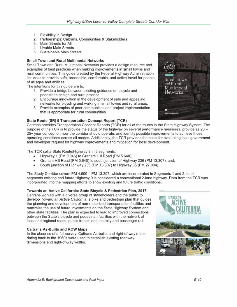
Highway 9/San Lorenzo Valley Complete Streets Corridor Plan
Appendix E: Background Documents and Past Input E-10
1. Flexibility in Design2. Partnerships: Caltrans, Communities & Stakeholders3. Main Streets for All4. Livable Main Streets5. Sustainable Main Streets
Small Town and Rural Multimodal Networks Small Town and Rural Multimodal Networks provides a design resource and examples of best practices when making improvements in small towns and rural communities. This guide created by the Federal Highway Administration list ideas to provide safe, accessible, comfortable, and active travel for people of all ages and abilities. The intentions for this guide are to:
1. Provide a bridge between existing guidance on bicycle andpedestrian design and rural practice.
2. Encourage innovation in the development of safe and appealingnetworks for bicycling and walking in small towns and rural areas.
3. Provide examples of peer communities and project implementationthat is appropriate for rural communities.
State Route (SR) 9 Transportation Concept Report (TCR) Caltrans provides Transportation Concept Reports (TCR) for all of the routes in the State Highway System. The purpose of the TCR is to provide the status of the highway on several performance measures, provide as 20 – 25+ year concept on how the corridor should operate, and identify possible improvements to achieve those operating conditions across all modes. Additionally, the TCR provides the basis for evaluating local government and developer request for highway improvements and mitigation for local development.
The TCR splits State Route/Highway 9 in 3 segments: Highway 1 (PM 0.046) to Graham Hill Road (PM 5.640), Graham Hill Road (PM 5.640) to south junction of Highway 236 (PM 13.307), and, South junction of Highway 236 (PM 13.307) to Highway 35 (PM 27.094).
The Study Corridor covers PM 4.600 – PM 13.307, which are incorporated in Segments 1 and 2. In all segments existing and future Highway 9 is considered a conventional 2-lane highway. Data from the TCR was incorporated into the mapping efforts to show existing and future traffic conditions.
Towards an Active California: State Bicycle & Pedestrian Plan, 2017 Caltrans worked with a diverse group of stakeholders and the public to develop Toward an Active California, a bike and pedestrian plan that guides the planning and development of non-motorized transportation facilities and maximize the use of future investments on the State Highway System and other state facilities. The plan is expected to lead to improved connections between the State’s bicycle and pedestrian facilities with the network of local and regional roads, public transit, and intercity and passenger rail.
Caltrans As-Builts and ROW Maps In the absence of a full survey, Caltrans As-builts and right-of-way maps dating back to the 1960s were used to establish existing roadway dimensions and right-of-way widths.
Highway 9/San Lorenzo Valley Complete Streets Corridor Plan
Appendix E: Background Documents and Past Input E-11
Programming Documents - Current and Scheduled Improvement Projects Once projects are designated funding they are typically listed in budgeted and programming documents. These documents are regularly amended as funding becomes available for specific projects. These include the following documents.
State Highway Operation and Protection Program (SHOPP) The SHOPP is focused on maintenance, system preservation (e.g. repaving, drainage, etc.), and meeting state and federal mandates within the state right-of-way. SHOPP transportation infrastructure projects on state highways include:
Central Drainage & Erosion Control: Drainage System upgrades and slope stabilization at inlets and outlets
Bridge replacements Highway Preservation: projects that address bridge preservation, roadway and roadside preservation
and operations improvements. Collision Reduction and Emergency Projects: Projects that address collision reduction, mandates
(including storm water mandates) and emergency projects. Minor Projects: Smaller SHOPP projects (less than $1.25 million) that reduce/enhance maintenance
efforts by providing minor operational, pavement rehab, drainage, intersection, electrical upgrades, landscape, and barrier improvements.
Operational and Safety: shoulder widening, bus turnouts, and turn lanes
The list of planned highway projects in Caltrans District 5 is available online at: http://www.dot.ca.gov/dist05/projects/pdf/d5sop.pdf
Santa Cruz County Capital Improvement Program The Santa Cruz County Capital Improvement Program,10 prepared by the County Department of Public Works in conjunction with the Administrative and Planning Departments, is a 5-year financing implantation plan for roads and parks11 capital improvements within the unincorporated county. The document also identifies unprogrammed projects (projects with no funding source identified in the coming five years). The CIP includes several projects along the Highway 9 corridor. Much of the funding in recent years has been focused on storm damage and other disaster recovery projects. Regional and Metropolitan Transportation Improvement Program (RTIP and MTIP) The Santa Cruz County Regional Transportation Commission (SCCRTC) and Association of Monterey Bay Area Governments (AMBAG) prepare programming documents showing which projects have been awarded regional, state and federal funds. The RTIP and links to the MTIP are online at: www.sccrtc.org/rtip.
Measure D 5-year Plans Each year, following a public hearing, the RTC updates the 5-year plan showing how it plans to use Measure D funds, including funds designated for San Lorenzo Valley (SLV) Highway 9 corridor improvements. The plans are posted online at: www.sccrtc.org/move. The County of Santa Cruz selects projects for the county’s direct allocation of Measure D funds for projects in the unincorporated areas of the county, including the SLV, as part of its annual Capital Improvement Program (see below).
2. List of Prior Public Input and Planning DocumentsA. Supervisor Bruce McPherson Summary Letter, Oct 7, 2013B. Comments by Hal Anjo on Supervisor Bruce McPherson Summary Letter, Oct 28, 2013C. San Lorenzo Valley Town Committees Current Issues/Projects, December 5, 2013D. Supervisor Bruce McPherson Nov 8 Meeting Outcomes Letter, December 10, 2013E. San Lorenzo Valley Highway 9 Committee Issues list
10 See complete document here: http://www.dpw.co.santa-cruz.ca.us/Portals/19/pdfs/2016-17Proposed-CIP.pdf 11 Including roadside betterment and drainage projects.
Highway 9/San Lorenzo Valley Complete Streets Corridor Plan
Appendix E: Background Documents and Past Input E-12
F. 2040 Regional Transportation Plan (RTP): San Lorenzo Valley Projects ListG. Memo “Opportunities to improve safety near the highway 9 schools” sent to Adam Fukushima,
Caltrans, from Bryan Largay, SLV Walking and Bike Path Team, November 13, 2012H. Email “Bike and Ped improvements for Hwy 9” from Bill Lebon to Cory Caletti, RTC, May 13, 2007I. Email “Public Works Sponsorship for Hwy 9 improvements” from Bill Lebon to John Presleigh, County
Public Works, July 2, 2007.J. Email, “Re: Caltrans”, Bill Lebon to Cory Caletti, with attachments “South Felton Neighbor Letter,”
“Questionnaire,” and “Statement ofNeed,” June 25, 2007
K. RTP Summary of public comments related to Highway 9L. SLV/Highway 9 Priority Projects documentM. South Felton Neighbor Letter (attachment from Bill Lebon on email “J”)N. Statement of Need (attachment from Bill Lebon email “J”)
3. Summary of Previously Identified IssuesNote: Letters after each project or issue reflect sources of community input listed in E2 above.
Felton 1. Bike and pedestrian paths from Felton to the San Lorenzo Valley High School and Elementary school. -
See E, G, K, L, M2. Improve pedestrian access through Felton with trails and sidewalks downtown. -See E, K, L3. Widen and extend sidewalks on Highway 9 from Graham Hill Road to Hihn Street by making parking
diagonal. – See A, E, K, L
4. Need safer crosswalk on Highway 9 at New Leaf, and possibly a “keep clear” zone so cars can exit andenter New Leaf parking lot while waiting for the light Change. -See E, L
5. As an alternative to 4, consider a stop light at New Leaf crossing pedestrian safety but also make saferexit of cars from New Leaf lot onto Highway 9. -See E
6. Diagonal parking for safer backing out in commercial areas. – See A, B, E, L7. Better bike and pedestrian paths through town to Henry Cowell Park entrance. Crosswalk at Henry
Cowell Park (M) – See A, E, K, L8. Improve Metro stop near SLV High – See A, B, C, D, E, K9. South Felton -25 mph extended from Felton to HC Park, shoulder widened along east side to
accommodate bikes and parallel parking, hiking and equestrian trails along the highway – See M10. El Solyo Heights – G, K
Ben Lomond 1. Route 9 Main Street crosswalk add warning devices such as in pavement flasher to overhead beacons
to actively alert drivers to pedestrians crossing, install additional electrolier and convert to LED lights onRoute 9. - See A, B, C, D, E, L (Crossover issue with the BC Ped/Safety/Traffic Flow Committee)
2. Install a new pathway on the south side of Route 9 from the Quality Inn /bridge southerly to the MillStreet crosswalk. This should include removal of one or more redwood trees to provide sufficient width.-See E, L (Crossover issue with the BC Ped/Safety/Traffic Flow Committee)
3. Conduct an engineering speed study on Route 9 in the current 30 MPH zone in downtown (this shouldclosely examine the number of businesses that are now active in this stretch and reported crashes). -See E, L
4. Overhead street name signs on the traffic signal, replace any existing street name signs with outdatedsmaller fonts with FHWA required large fonts. – See A, B, C, D (Boulder Creek), E, L
Boulder Creek 1. The right for businesses to do sidewalk/storefront improvements along Hwy 9. – See A, B, D, E
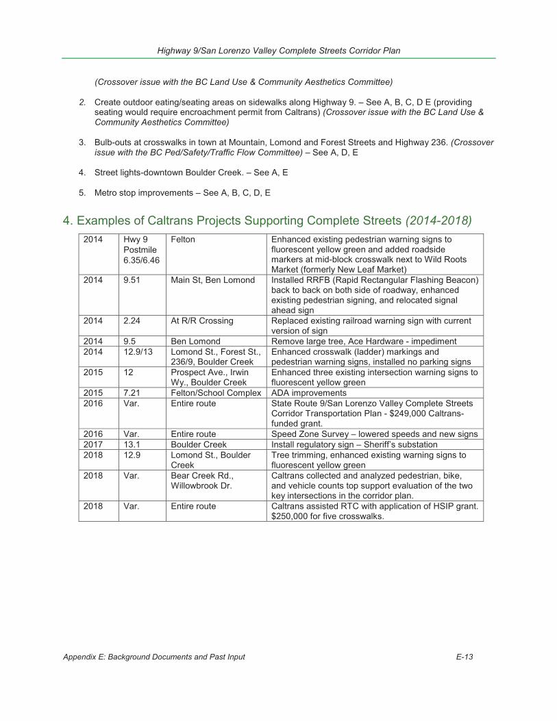
Highway 9/San Lorenzo Valley Complete Streets Corridor Plan
Appendix E: Background Documents and Past Input E-13
(Crossover issue with the BC Land Use & Community Aesthetics Committee)
2. Create outdoor eating/seating areas on sidewalks along Highway 9. – See A, B, C, D E (providingseating would require encroachment permit from Caltrans) (Crossover issue with the BC Land Use &Community Aesthetics Committee)
3. Bulb-outs at crosswalks in town at Mountain, Lomond and Forest Streets and Highway 236. (Crossoverissue with the BC Ped/Safety/Traffic Flow Committee) – See A, D, E
4. Street lights-downtown Boulder Creek. – See A, E
5. Metro stop improvements – See A, B, C, D, E
4. Examples of Caltrans Projects Supporting Complete Streets (2014-2018)2014 Hwy 9
Postmile6.35/6.46
Felton Enhanced existing pedestrian warning signs to fluorescent yellow green and added roadside markers at mid-block crosswalk next to Wild Roots Market (formerly New Leaf Market)
2014 9.51 Main St, Ben Lomond Installed RRFB (Rapid Rectangular Flashing Beacon) back to back on both side of roadway, enhanced existing pedestrian signing, and relocated signal ahead sign
2014 2.24 At R/R Crossing Replaced existing railroad warning sign with current version of sign
2014 9.5 Ben Lomond Remove large tree, Ace Hardware - impediment 2014 12.9/13 Lomond St., Forest St.,
236/9, Boulder Creek Enhanced crosswalk (ladder) markings and pedestrian warning signs, installed no parking signs
2015 12 Prospect Ave., Irwin Wy., Boulder Creek
Enhanced three existing intersection warning signs to fluorescent yellow green
2015 7.21 Felton/School Complex ADA improvements 2016 Var. Entire route State Route 9/San Lorenzo Valley Complete Streets
Corridor Transportation Plan - $249,000 Caltrans-funded grant.
2016 Var. Entire route Speed Zone Survey – lowered speeds and new signs 2017 13.1 Boulder Creek Install regulatory sign – Sheriff’s substation 2018 12.9 Lomond St., Boulder
Creek Tree trimming, enhanced existing warning signs to fluorescent yellow green
2018 Var. Bear Creek Rd., Willowbrook Dr.
Caltrans collected and analyzed pedestrian, bike, and vehicle counts top support evaluation of the two key intersections in the corridor plan.
2018 Var. Entire route Caltrans assisted RTC with application of HSIP grant. $250,000 for five crosswalks.


Appendix F: Corridor Existing Conditions Physical conditions occurring within the Highway 9 corridor are quite variable and complex. This Appendix provides descriptions and maps of some of the typical conditions along the corridor that serve to support some modifications, as well as demonstrate some of the constraints or challenges in implementing many projects and concepts that have been identified by the com-munity.
F1. Existing Roadway Conditions Existing Conditions Maps show peak hour traffic volumes, bus stop locations as of 2017, cross-walk locations, and traffic flow level of service (LOS) are included in Figure F1.
Appendix F: Corridor Existing Conditions F-1
Highway 9 – San Lorenzo Valley Complete Streets Corridor Plan

LAUR
ELAV
BROO
KSID
EWY
MCKINLEY WY
LAKEVIEWDR
GLENGARR
YRD
SCENIC
DR
VALLEY DR
REDWOODRD
GRANT WY
WILLIAM
WY
WASHINGTON WY
LINCOLN WY
GULCHRD
PLATEAU DR
FERRAR
I DR
VIEW
CT
OAKA
V
GOLD
AV
JACKSON WY
TAYLOR WY
SILVIA
NWY
ARROWLN
SPRINGLN
TOLLHOUSEGULCHRD
RIVER LN
REDWOODPL
BIGT R
E ESP
ARKR
D
MCKEERD
OAKPL
LAGUN AAV
OLDBIG
TREESRD
VIE
W
CI
MADRO
NA
RD
GRANDVIEW
AV
STEIN
MAIERRD
WILLOW
WY
HENRY COWELL SERVICERD
BETH
DR
C
AA
BGRAH
AMHIL
LRD
£ ¤9
4.5
4.8
5.6
5.1
5.9
4.6
5.4
4.9
5.2
5.7
4.4
4.7
5
HENR
YCO
WEL
LST
ATE P
ARK
Shingle
MillCree
k
San Lor
enzo R
iver
Zayante Trail
OxTrai
lEntrance Road
Entrance
Road
! I
Sheet 1 / 12
1,000
'
Lege
nd")
Bus s
top
ÆýCr
ossw
alk[
]Br
idge/C
ulvert
PM pe
ak H
ourly
Traff
ic vo
lume
48 49 - 4
4144
2 - 76
376
34 - 1
003
1003
- 117
0
A-E
indica
tes P
M pe
ak ho
ur LO
S(pe
r Calt
rans)
App
endi
x F:
Cor
ridor
Exi
stin
g C
ondi
tions
F-2
Hig
hway
9 –
San
Lor
enzo
Val
ley
Com
plet
e S
treet
s C
orrid
or P
lan
rmoriconi
Typewritten Text
rmoriconi
Typewritten Text
rmoriconi
Typewritten Text
Figure F1 Vehicular Conditions Maps
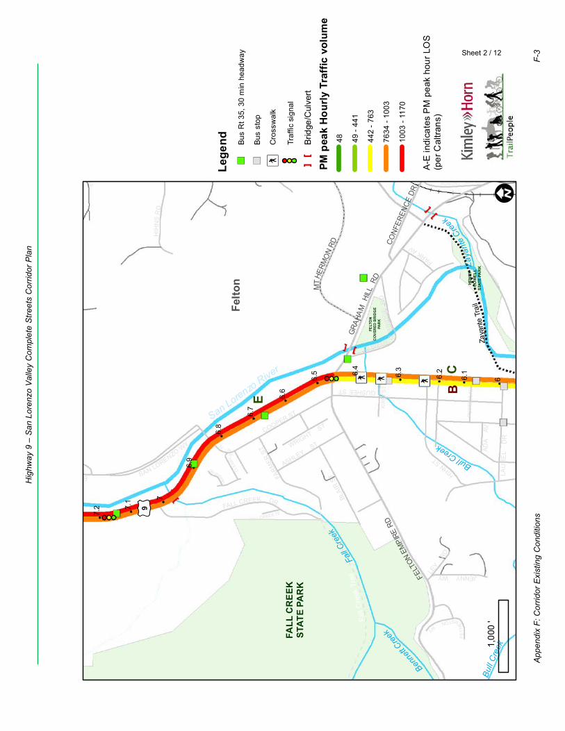
JENNYWY
COOPER ST
PARKAV
EAST
TERR
ACE
DR
GUSHEE ST
HIH
NS
RD
SAN LORENZO WY
FALL CREEK TE
HIHNST
LAU
RE
L D
R
HIGG
INSRD
WRIGHT ST
FET
HE
RSTONWY
ASHLEY ST
ADA
AV
LEY
RD
BRACKNEYRD
BLAI
R STFA
RMER
ST
FALL CREEK DR
CLEA
RVI E
WPL
ROARING CAMP RD
COVERE DB
RID
GE
RD
RUSS
ELL
AV
KIRB
Y ST
C
E
B
GRAH
AMHI
LLRD
FELT
ONEM
PIRE
RDCO
NFER
ENCE
DR
MTH
ERM
ON
RD
£ ¤9
6.3
6.6
7.1
6.1
6.9
6.4
7.2
6.7
6.2
6.5
7
6
6.8
FELT
ON
CO
VER
ED B
RID
GE
PAR
K
HEN
RYCO
WEL
LST
ATE
PAR
K
FALL
CR
EEK
STAT
E PA
RK
Bull
Cre
ek
Benne
ttCree
k
Zaya
nte
Creek
BullCreek
Fall C
reek
San LorenzoRiver
Zaya
nte
Trai
l
Fall
Cre
ek T
rail
Felto
n
! I
Sheet 2 / 12
1,00
0'
Lege
nd")
Bus
Rt 3
5, 3
0 m
in h
eadw
ay
")Bu
s st
op
ÆýC
ross
wal
k
Traf
fic s
igna
l
[]
Brid
ge/C
ulve
rt
PM p
eak
Hour
ly T
raffi
c vo
lum
e48 49
- 44
1
442
- 763
7634
- 10
03
1003
- 11
70
A-E
indi
cate
s P
M p
eak
hour
LO
S(p
er C
altra
ns)
App
endi
x F:
Cor
ridor
Exi
stin
g C
ondi
tions
F-3
Hig
hway
9 –
San
Lor
enzo
Val
ley
Com
plet
e S
treet
s C
orrid
or P
lan
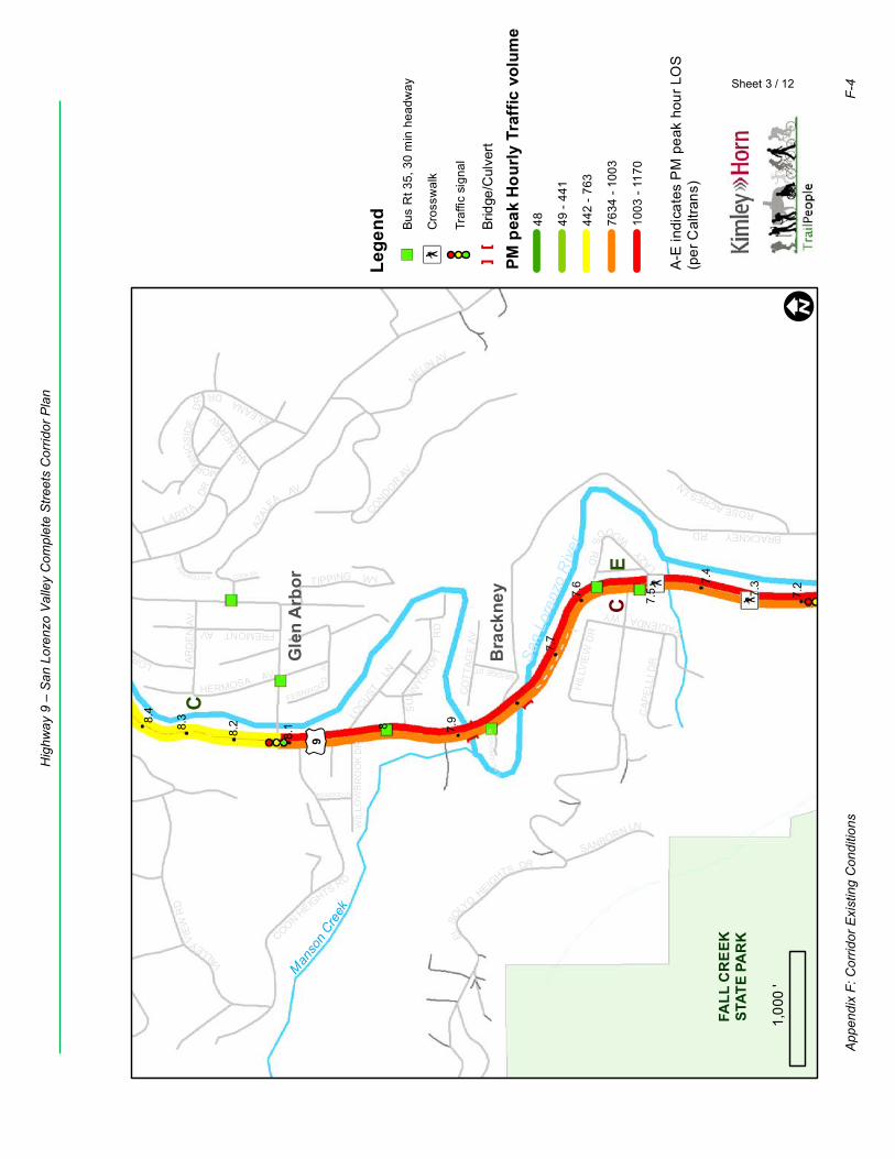
ARD
EN
AV
CONDORAV
LAZY
WOOD
SR
D
MORNING
SID
ED
R
ELSO
LYOHEIG
HTS DR
ELEANADR
LOCUST
LN
AZAL
EAAV
ROSEACRESLN
SUN
NYCRO
FT
RD
COOK WY
ARCHE
RAV
LARITA
DR
COONHEIGHTS RD
WIL
LOW
BR
OO
KD
R
GLE
NLO
MO
ND
LN
REDWOOD LN
VA
LLEYVIE
WR
D
CO
TTAG
EAV
BRIDGE ST
NOTEWARELN
HERMOSA AV
BRACKNEYRD
FERNWOO
DAV
FIDDLESTICKSDR
FREMONT AV
SANBORN LN
CAP
ELLI
DR
MELIN AV
HIL
LVIE
W D
R
LORENZOW
Y
TIPPING WY
H
ACIENDAWY
E
C
C
£ ¤98.
1
7.6
8.4
7.9
7.4
8.2
7.2
7.7
8
7.5
8.3
7.3
FALL
CR
EEK
STAT
E PA
RK
Man
son
Creek
San
Lore
nzo
Riv
er
Bra
ckne
y
Gle
n A
rbor
! I
Sheet 3 / 12
1,00
0'
Lege
nd")
Bus
Rt 3
5, 3
0 m
in h
eadw
ay
ÆýC
ross
wal
k
Traf
fic s
igna
l
[]
Brid
ge/C
ulve
rt
PM p
eak
Hour
ly T
raffi
c vo
lum
e48 49
- 44
1
442
- 763
7634
- 10
03
1003
- 11
70
A-E
indi
cate
s P
M p
eak
hour
LO
S(p
er C
altra
ns)
App
endi
x F:
Cor
ridor
Exi
stin
g C
ondi
tions
F-4
Hig
hway
9 –
San
Lor
enzo
Val
ley
Com
plet
e S
treet
s C
orrid
or P
lan
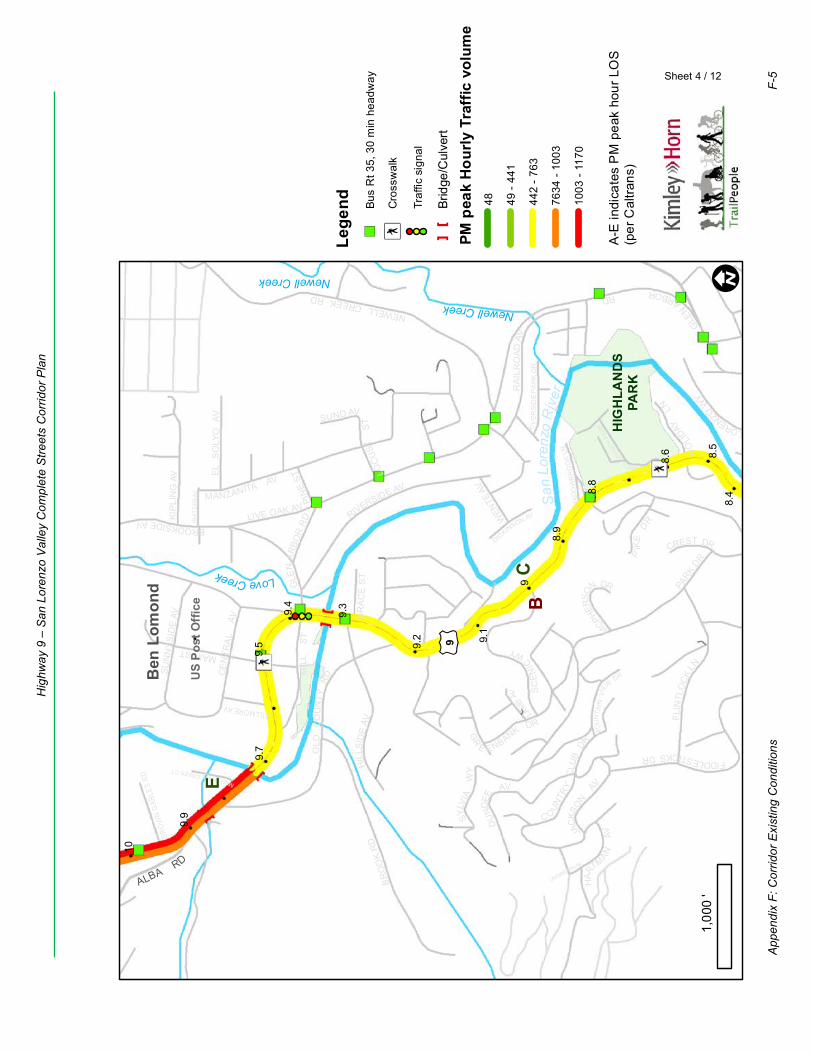
BROOKSIDEAV
PIK
EDRW
HIT
TIER
AV
NEWELLCREEKRD
RIVERSIDE AV
MOU
NTA
INVI
EWDR
GLE
N
ARBORRD
GR
E ENBANK DR
PARK
DR
LINDBERGH AV
MANZANITA AV
LAMB
AV
JACK
SON
AV
WEN
TE AV
KIP
LIN
G A
V
F LIN
TLO
CK
LN
SYLV
IAW
Y
DICKINSON AV
SC
EN
IC
WY
HAR
TMANAV
C O
UNTR
YC
LUB
DR
RIV
ERSI
DE
PAR
KD
R
LOC
UST
ST
MAIN ST
SHAD
OW
BR
OO
KLN
DU
NDEE
AV
HILL
SID
EAV
SUND AV
CE
NTR
AL
AV
CREST DR
HIGHLANDSCOUN
TYPA
RK
OLD
CO
UN
TYRD
MARSHALLCREEKCT
MIL
LST
GR
AC
E S
T
SUN
NYS
IDE
AV
MCPHER
SON DR
HO
LIDAY
LN
FIDDLESTICKSDR
EL S
OLY
O A
V
LORENZOW
Y
RA
ILR
OAD
AV
BR
OO
KR
D
LIVE OAK AV
FILLMORE AV
BRO
WN
GAB
LES
RD
PINE
ST
GLE
NA
RBO
RR
D
C
E
B
ALBARD
£ ¤9
8.6
9.9
9.4
8.4
8.9
9.7
9.2
10
9.5
8.5
9
9.3
8.8
9.1
HIG
HLA
ND
SPA
RK
Newell Creek
LoveCreek
Newell Creek
San
Lore
nzo
Riv
er
Ben
Lom
ond
US
Post
Offi
ce
! I
Sheet 4 / 12
1,00
0'
Lege
nd")
Bus
Rt 3
5, 3
0 m
in h
eadw
ay
ÆýC
ross
wal
k
Traf
fic s
igna
l
[]
Brid
ge/C
ulve
rt
PM p
eak
Hour
ly T
raffi
c vo
lum
e48 49
- 44
1
442
- 763
7634
- 10
03
1003
- 11
70
A-E
indi
cate
s P
M p
eak
hour
LO
S(p
er C
altra
ns)
App
endi
x F:
Cor
ridor
Exi
stin
g C
ondi
tions
F-5
Hig
hway
9 –
San
Lor
enzo
Val
ley
Com
plet
e S
treet
s C
orrid
or P
lan
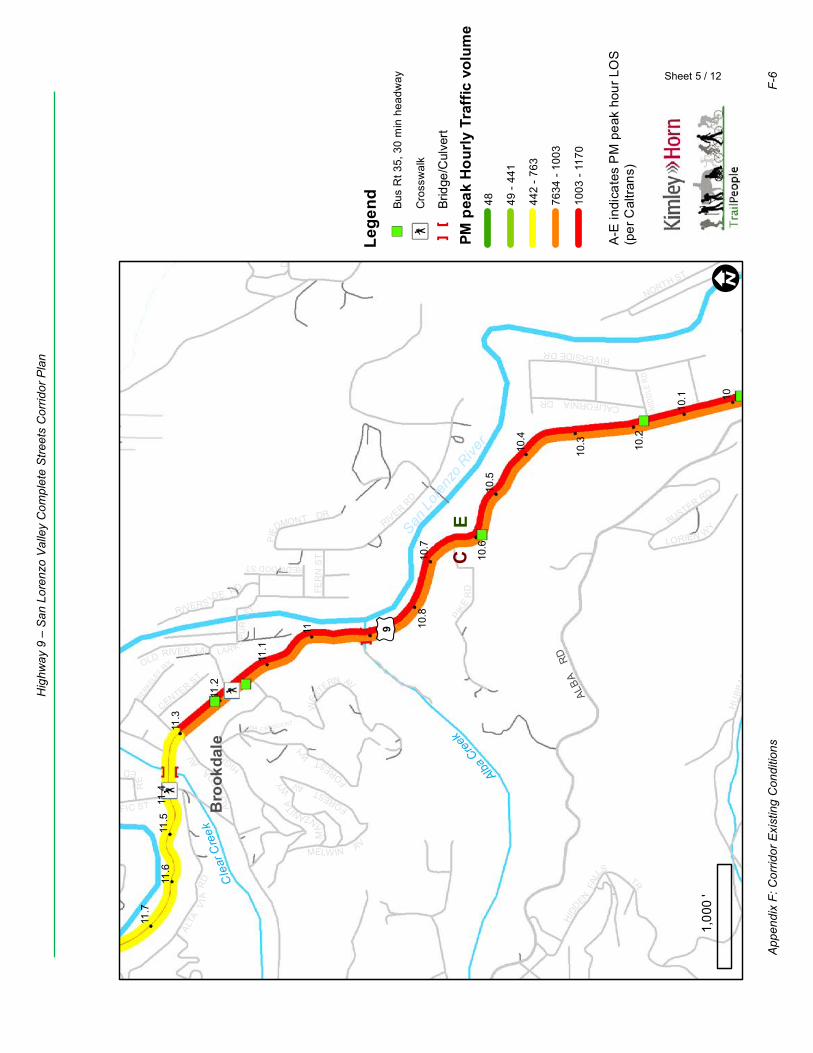
LUNA C RESCENT
RIVER
RD
HIGHST
LAR K SP
UR
ST
HU
BBAR
DG
ULC
HR
D
WES
TERN AV
DA
KE
NBR
OOK RD
HIDD
ENFA
LL
STR
MELWIN AV
RIVERSIDEDR
FER
N S
T
FORESTWY
ALTA
VIA
RD
REDWOOD ST
NORTH ST
PACIFIC ST
MA
NZANITA
WY
LORIEN W
Y
RIVERS IDE R D
CALIFORNIADR
BERKELEY
WY
BUSTER RD
RE
EDST
CENTERST
OLD RIVER LN
PIED
MONT DR
FORESTAV
ALA
ME
DA
AV
PIKE
RD
MID
DLE
RD BRO
WN
GAB
LES
RD
EC
ALBA
RD
£ ¤9
11.4
10.4
11.7
11.2
10.7
10.2
11
11.5
10.5
10
11.3
10.8
10.3
11.6
11.1
10.6
10.1
Cle
arC
reek
Alba C
reek
SanLo
renz
o River
Bro
okda
le
! I
Sheet 5 / 12
1,00
0'
Lege
nd")
Bus
Rt 3
5, 3
0 m
in h
eadw
ay
ÆýC
ross
wal
k
[]
Brid
ge/C
ulve
rt
PM p
eak
Hour
ly T
raffi
c vo
lum
e48 49
- 44
1
442
- 763
7634
- 10
03
1003
- 11
70
A-E
indi
cate
s P
M p
eak
hour
LO
S(p
er C
altra
ns)
App
endi
x F:
Cor
ridor
Exi
stin
g C
ondi
tions
F-6
Hig
hway
9 –
San
Lor
enzo
Val
ley
Com
plet
e S
treet
s C
orrid
or P
lan
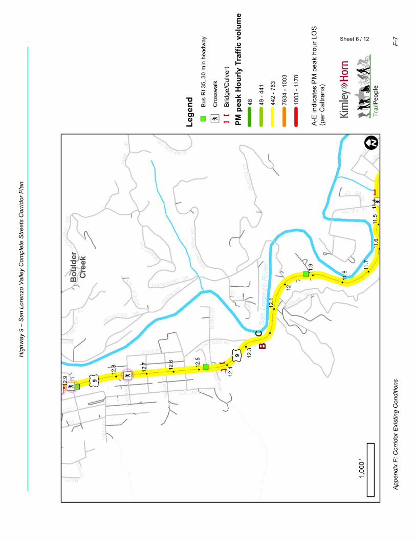
HAZEL AV
BOULDER ST
TIN
KER
STR
LAUREL ST
AQUIL
AW
Y
ELSIEMAE
DR
IR
WINWY
RIV
ER
ST
OAK ST
FER
N LN
HIG
HLAN
DD
R
SOU
TH S
T
CAM
PJOYR
D
DEBBIEDR
MO
LASK
EY S
T
MAPLEWY
PACIFIC ST
EAST ST
FAIRV
I EW
AV
BERKE
LEY
WY
MONANWY
RE
EDSTLORENZO AV
CENTERST
OLD RIVER LNN
INA
DR
REDWOOD WY
FAIRMOUNT DR
SPRING
CR
EEK
RD
HAR
MO
N S
T
FLAT
ST
MO
UN
TAIN
ST
CB
£ ¤9
£ ¤9
11.9
11.4
12.7
11.7
12.5
12
11.5
12.3
12.8
11.8
12.6
11.6
12.1
12.9 12
.4
San
Lor
enzo
Riv
er
Bou
lder
Cre
ek
! I
Sheet 6 / 12
1,00
0'
Lege
nd")
Bus
Rt 3
5, 3
0 m
in h
eadw
ay
ÆýC
ross
wal
k
[]
Brid
ge/C
ulve
rt
PM p
eak
Hour
ly T
raffi
c vo
lum
e48 49
- 44
1
442
- 763
7634
- 10
03
1003
- 11
70
A-E
indi
cate
s P
M p
eak
hour
LO
S(p
er C
altra
ns)
App
endi
x F:
Cor
ridor
Exi
stin
g C
ondi
tions
F-7
Hig
hway
9 –
San
Lor
enzo
Val
ley
Com
plet
e S
treet
s C
orrid
or P
lan
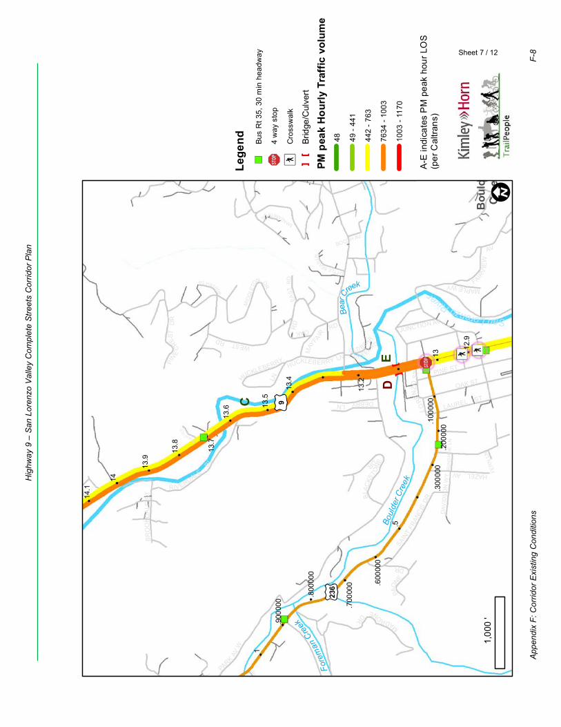
HAZEL AV
BR
OO
KDA
LES
T
LAUREL ST
MID
DLE
TO
N DR
OLD BEAR
C RE EK RD
OAKRD
FRO
STBL
PARK
AVW
OAK ST
FER
N LN
SAINT
FRAN
CIS
DR
MAY
FAIRRD
PINE ST
BOOTH AV
LO
RENZO
ST
PARK
ST
SUN
SH
INE
LN
PAON
E
DR
MANZANITALN
MAPLEWYD
AVID
SO
N W
Y
BON
VIEWDR
EAST
RD FAIR
VIE
W
AVC
HIPM
UN
KH
OLL
OW
RD
LITTLEBEARLN
M
ADRO
NEDR
RIV ERDALE
BL
JUNCTION AV
WESTRD
DEBBYLN
HUCKLEBERRY LN
PINE
CR
EST
DR
MESADR
BLA
CKS
TONE
DR
HUCKLEBERRY
LNMONACOL
N
E
C
D
£ ¤236
£ ¤9
.800
000
.600
000
.100
000
.900
000
.200
000
.700
000
1
.5
.300
000
13.7
13.2
14
13
13.5
13.8
13.6
14.1
13.9
12.9
13.4
Fore
man
Creek
Bear
Creek
Boul
der C
reek
SanLorenzoRiver
Bou
lder
Cre
ek! I
Sheet 7 / 12
1,00
0'
Lege
nd")
Bus
Rt 3
5, 3
0 m
in h
eadw
ay
!"$4
way
sto
p
ÆýC
ross
wal
k
[]
Brid
ge/C
ulve
rt
PM p
eak
Hour
ly T
raffi
c vo
lum
e48 49
- 44
1
442
- 763
7634
- 10
03
1003
- 11
70
A-E
indi
cate
s P
M p
eak
hour
LO
S(p
er C
altra
ns)
App
endi
x F:
Cor
ridor
Exi
stin
g C
ondi
tions
F-8
Hig
hway
9 –
San
Lor
enzo
Val
ley
Com
plet
e S
treet
s C
orrid
or P
lan
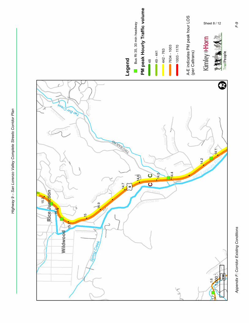
BRIMBLECOM RD
JUA
NIT
ARD
BLUERIDG
ED
R
TER
RA
CEDR
HOOTOWLW
Y
BLU
ME
RT
D
R
BAND RD
BLAC
KBER
RY
LN
VIRGINIAAV
DO
UGLASAV
FER
NAV
S UNSETR
D
UPPE
RRD
PLUMERIACT
ASBU
RY
LN
IGO WY
APPLEKNOLL
ROBINHOODS HOLLOW
SHADY
LN
MARGA
RET D
R
GR
OV
E
DR
RINCON WY
B
U E NA VISTA AVMORE DR
BRO
OK
DR
CRES
TAD
R
HIG
HRI
SE
DR
FIRESID E R D
CC
TWOBARRD
£ ¤9
£ ¤236
1.6
1.7
15.2
14.2
14.7
15
14.5
15.3
15.1
14.6
14.1
14.9
14.4
Sprin
gC
reek
TwoBarCreek
San Lorenzo
River
Ric
e Ju
nctio
n
Wild
woo
d
! I
Sheet 8 / 12
1,00
0'
Lege
nd")
Bus
Rt 3
5, 3
0 m
in h
eadw
ay
PM p
eak
Hour
ly T
raffi
c vo
lum
e48 49
- 44
1
442
- 763
7634
- 10
03
1003
- 11
70
A-E
indi
cate
s P
M p
eak
hour
LO
S(p
er C
altra
ns)
App
endi
x F:
Cor
ridor
Exi
stin
g C
ondi
tions
F-9
Hig
hway
9 –
San
Lor
enzo
Val
ley
Com
plet
e S
treet
s C
orrid
or P
lan
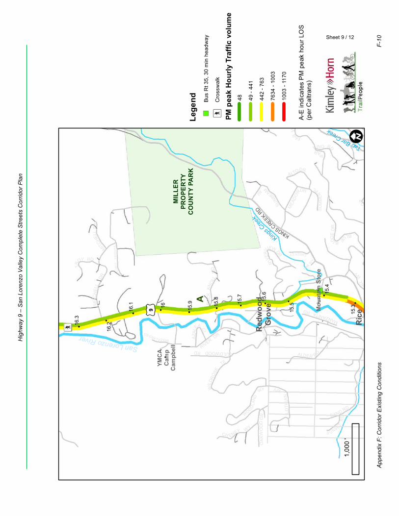
MANZANITARD
ALDER RD
R
IVER
VIEWDR
RIVER DR
OAK WY
APPL
EWO
OD
RD
BLUERIDG
ED
R
MITCHE
LLP
L
HOOTOWLW
Y
OA
KW
OO
DD
R BAND RD
MEA
DO
W
DR
SHADELANDRD
S UNSETR
D
CREEKCT
SU
MM
ER
PL
WIL
DRO
SE
TE
TR
OY RD
AZA
LEA C
I
MIT
CHE
LLH
EIG
HTS
WILDWOODRD
B
ARKING RD
B
U E NA VISTA AV
CH ENEY WY
ALTODR
SUN
BEAMAV
FARV
IEW
RD
LOTH
IAN
WY
BU
CK
KNO
LLR
D
WOODLA
ND
WY
MIT
CH
ELL
DR
A
KINGSCREEKRD
£ ¤9 15.516
16.2
15.8
15.3
15.6
16.3
15.9
15.4
16.1 15
.7
MIL
LER
PRO
PER
TYC
OU
NTY
PA
RK
TwoBarCreek
KingsCreek
SanLorenzoRiver
Red
woo
dG
rove
Ric
eJu
nctio
n
YMC
AC
amp
Cam
pbel
l
Mou
ntai
n St
ore
! I
Sheet 9 / 12
1,00
0'
Lege
nd")
Bus
Rt 3
5, 3
0 m
in h
eadw
ay
ÆýC
ross
wal
k
PM p
eak
Hour
ly T
raffi
c vo
lum
e48 49
- 44
1
442
- 763
7634
- 10
03
1003
- 11
70
A-E
indi
cate
s P
M p
eak
hour
LO
S(p
er C
altra
ns)
App
endi
x F:
Cor
ridor
Exi
stin
g C
ondi
tions
F-10
Hig
hway
9 –
San
Lor
enzo
Val
ley
Com
plet
e S
treet
s C
orrid
or P
lan

BEAN AV
TE
ILH
DR
TIELHRD
EITHERWY
MITCH
ELL
P
L
WILDBERRY
DR
ALP
INE
DR
TR
OY RD
RAMBL
ING RD
UPL
ANDDR
BER
NST
EIN
DR
WOODRD
GR
EEN
VALE
RD
TR
ES
SELPA S
SRD
NO
RIC
HR
D
DRY
WEL
LRD
CR
EEK
DR
STEWARTST
MIT
CH
ELL
DR
SHILO
H
CT
A
£ ¤9
17.2
16.7
17
16.5
17.3
16.3
16.8
17.1
16.6
16.9
16.4
San Lorenzo River
Riv
ersi
deG
rove
! I
Sheet 10 / 12
1,00
0'
Lege
nd")
Bus
Rt 3
5, 3
0 m
in h
eadw
ay
ÆýC
ross
wal
k
PM p
eak
Hour
ly T
raffi
c vo
lum
e48 49
- 44
1
442
- 763
7634
- 10
03
1003
- 11
70
A-E
indi
cate
s P
M p
eak
hour
LO
S(p
er C
altra
ns)
App
endi
x F:
Cor
ridor
Exi
stin
g C
ondi
tions
F-11
Hig
hway
9 –
San
Lor
enzo
Val
ley
Com
plet
e S
treet
s C
orrid
or P
lan
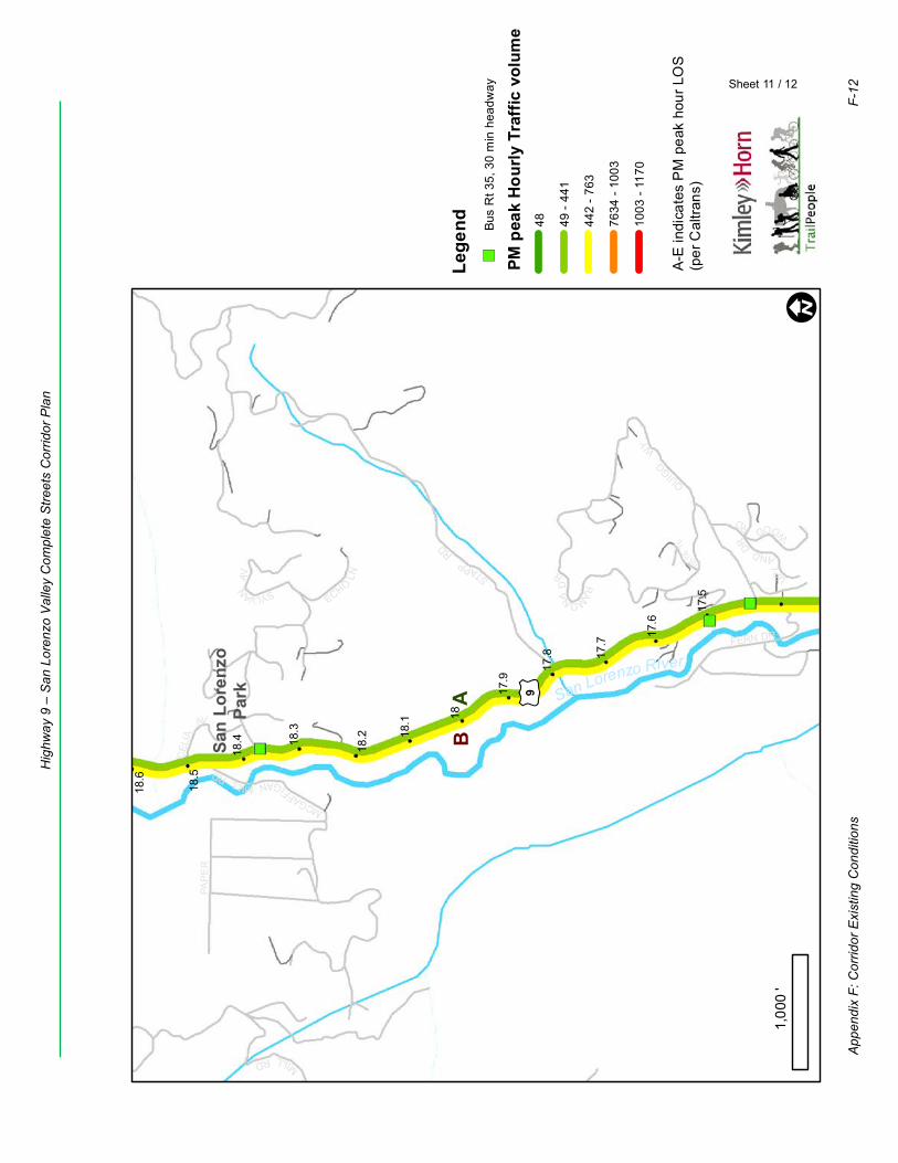
MCGAFFIGANMILLRD
PAP
ER
SYLVANA
V
VISTATE
CH
ASE
M
ILLRD
CEL
IA
AV
FERN DR
ECHO
LN UPL
ANDDR WOODRD
QUIGG
WY
RAMONAD
RSTAPPRD
AB
£ ¤9
18.2
17.7
18.5
18
17.5
18.3
17.8
18.6
17.6
18.1
18.4
17.9
San Lorenzo River
San
Lore
nzo
Park
! I
Sheet 11 / 12
1,00
0'
Lege
nd")
Bus
Rt 3
5, 3
0 m
in h
eadw
ay
PM p
eak
Hour
ly T
raffi
c vo
lum
e48 49
- 44
1
442
- 763
7634
- 10
03
1003
- 11
70
A-E
indi
cate
s P
M p
eak
hour
LO
S(p
er C
altra
ns)
App
endi
x F:
Cor
ridor
Exi
stin
g C
ondi
tions
F-12
Hig
hway
9 –
San
Lor
enzo
Val
ley
Com
plet
e S
treet
s C
orrid
or P
lan
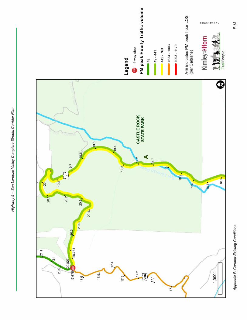
SARATOGATOLLRD
KIN
GS
CR
EEK
TT
A
£ ¤9
£ ¤236
17.6
17.1
17.4
17.6
75
17.2
17.5
17
17.3
19.2
21.1
18.7
20.5
19.5
20
19
20.9
20.3
19.8
18.8
19.3
20.1
20.6
19.6
19.1
21
18.6
20.7
51
20.4
18.9
19.4
20.8
2720
.219
.7
CA
STLE
RO
CK
STAT
E PA
RK
San Lorenzo River
! I
Sheet 12 / 12
1,00
0'
Lege
nd
!"$4
way
sto
p
PM p
eak
Hour
ly T
raffi
c vo
lum
e48 49
- 44
1
442
- 763
7634
- 10
03
1003
- 11
70
A-E
indi
cate
s P
M p
eak
hour
LO
S(p
er C
altra
ns)
App
endi
x F:
Cor
ridor
Exi
stin
g C
ondi
tions
F-13
Hig
hway
9 –
San
Lor
enzo
Val
ley
Com
plet
e S
treet
s C
orrid
or P
lan
F2. Collisions There have been a number of significant collisions in the past decade in the SLV. Leading causes of injury and fatal collisions 2013-2017 involved unsafe speed or improper turning. Residents are justly concerned about speeding on roadways throughout the SLV, especially near schools, residential and commercial areas. The narrow curving right-of-way and close proximity to buildings, fences, and trees meant nearly 40% of all collisions 2013-2017 were “hit object” collisions, rather than a collision between two vehicles. Impaired driving from alcohol or drugs is also a significant challenge. Figure F2 shows all collisions 2013-2017, separating those involving a bicycle or pedestrian (F2A) from those that do not (vehicle on vehicle, hit fixed object, etc.) (F2B). California Highway Patrol (CHP) is responsible for traffic enforcement through the SLV, though officers are responsible for covering very large areas.
Appendix F: Corridor Existing Conditions F-14
Highway 9 – San Lorenzo Valley Complete Streets Corridor Plan

¹ºl
¹ºm
¹ºm
¹ºl
¹ºl
¹ºm
¹ºm
¹ºm
¹ºl
¹ºm
¹ºl
¹ºl
¹ºl
¹ºm
¹ºm¹ºm
¹ºl
¹ºl
¹ºm
¹ºl
¹ºm
¹ºm¹ºl
¹ºl
¹ºl
¹ºl
¹ºm
¹ºm
¹ºm
¹ºm¹ºl
¹ºm
¹ºl
¹ºl
¹ºl
¹ºm
Felton
Brookdale
Ben Lomond
Boulder Creek
EMP
IRE G
RAD
E
ALBA RD
EAST
ZAY
ANTE
RD
BEAR CREEK RD
FELTON EMPIRE RD
GRAHAM HILL RD
HWY 236
HIGHWAY 9
Prod
uced
01/
2019
| S
:\GIS
\Pro
ject
s\Sa
ntaC
ruzC
ount
y\H
ighw
aysa
ndSt
reet
s\H
ighw
ay9\
GIS
MA
PS
\Hw
y9C
ollis
ions
.mxd
Collision data source: Statewide Integrated Traffic Records System
¹ºm 1 collision involving pedestrian(s)
¹ºl 1 collision involving bicycle(s)
SCHOOL
SLVSCHOOLSCAMPUS
0 0.50.25 Mile
Figure F2A Bicycle and Pedestrian Collisions MapPedestrian and bicycle involved collisions resulting in injuries or fatalities, 2013 - 2017
F-15Appendix F: Corridor Existing Conditions
Highway 9 – San Lorenzo Valley Complete Streets Corridor Plan
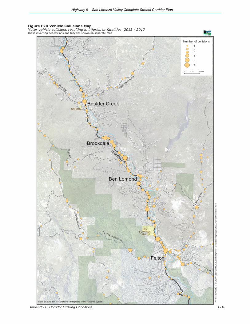
!(
!(
!(
!(
!(
!(
!(
!(
!(
!(
!(
!(
!(
!(
!(
!(
!(
!(
!(
!(
!(
!(
!(
!(
!(
!(
!(
!(
!(
!(
!(
!(
!(
!(
!(
!(
!(
!(
!(
!(
!(
!(
!(
!(
!(
!(
!(
!(
!(
!(
!(
!(
!(
!(
!(
!(
!(
!(
!(
!(
!(
!(
!(
!(
!(
!(
!(
!(
!(
!(
!(
!(
!(
!(
!(
!( !(
!(
!(
!(
!(
!(
!(
!(
!(
!(
!(
!(
!(
!(
!(
!(
!(
!(
!(
!(
!(
!(
!(
!(
!(
!(
!(
!(
!(
!(
!(
!(
!(
!(
!(
!(
!(
!(
!(
!(
!(
!( !(
!(
!(
!(
!(
!(
!(
!(
!(
!(
!(
!(
!(
!(
!(
!(
!(
!(
!(
!(
!(
!(
!(
!(
!(
!(
!(
!(
!(
!(
!(
!(
!(
!(
!(
!(
!(
!(
!(
!(
!(
!(
!(
!(
!(
!(
!(
!(
!(
!(
!(
!(
!(
!(
!(
!(
!(
!(
!(
!(
!(
!(
!(
!(
!(
!(
!(
!(
!(
!(
!(
!(
!(
!(
Felton
Brookdale
Ben Lomond
Boulder Creek
EMPIR
E GRADE
ALBA RD
EAST
ZAY
ANTE
RD
BEAR CREEK RD
FELTON EMPIRE RD
GRAHAM HILL RD
HWY 236
HIGHWAY 9
Prod
uced
01/
2019
| S
:\GIS
\Pro
ject
s\Sa
ntaC
ruzC
ount
y\H
ighw
aysa
ndSt
reet
s\H
ighw
ay9\
GIS
MAP
S\H
wy9
Col
lisio
ns.m
xd
Collision data source: Statewide Integrated Traffic Records System
!( 3!( 4
!( 5
SCHOOL
SLVSCHOOLSCAMPUS
!( 2!( 1
!( 6
Number of collisions
0 0.50.25 Mile
Appendix F: Corridor Existing Conditions F-16
Figure F2B Vehicle Collisions MapMotor vehicle collisions resulting in injuries or fatalities, 2013 - 2017Those involving pedestrians and bicycles shown on separate map
Highway 9 – San Lorenzo Valley Complete Streets Corridor Plan
Highway 9 – San Lorenzo Valley Complete Streets Corridor Plan
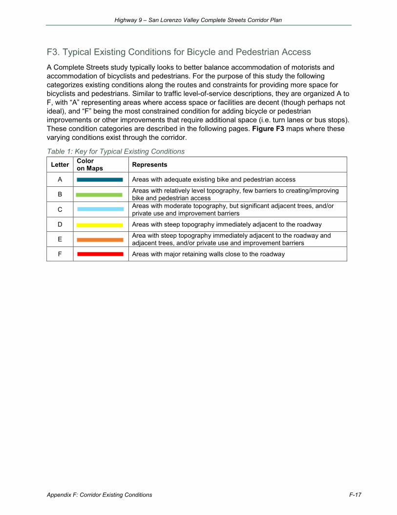
F3. Typical Existing Conditions for Bicycle and Pedestrian Access A Complete Streets study typically looks to better balance accommodation of motorists and accommodation of bicyclists and pedestrians. For the purpose of this study the following categorizes existing conditions along the routes and constraints for providing more space for bicyclists and pedestrians. Similar to traffic level-of-service descriptions, they are organized A to F, with “A” representing areas where access space or facilities are decent (though perhaps not ideal), and “F” being the most constrained condition for adding bicycle or pedestrian improvements or other improvements that require additional space (i.e. turn lanes or bus stops). These condition categories are described in the following pages. Figure F3 maps where these varying conditions exist through the corridor.
Table 1: Key for Typical Existing Conditions
Letter Color on Maps Represents
A Areas with adequate existing bike and pedestrian access
B Areas with relatively level topography, few barriers to creating/improving bike and pedestrian access
C Areas with moderate topography, but significant adjacent trees, and/or private use and improvement barriers
D Areas with steep topography immediately adjacent to the roadway
E Area with steep topography immediately adjacent to the roadway and adjacent trees, and/or private use and improvement barriers
F Areas with major retaining walls close to the roadway
Appendix F: Corridor Existing Conditions F-17
Highway 9 – San Lorenzo Valley Complete Streets Corridor Plan
rmoriconi
Typewritten Text
rmoriconi
Typewritten Text
rmoriconi
Typewritten Text
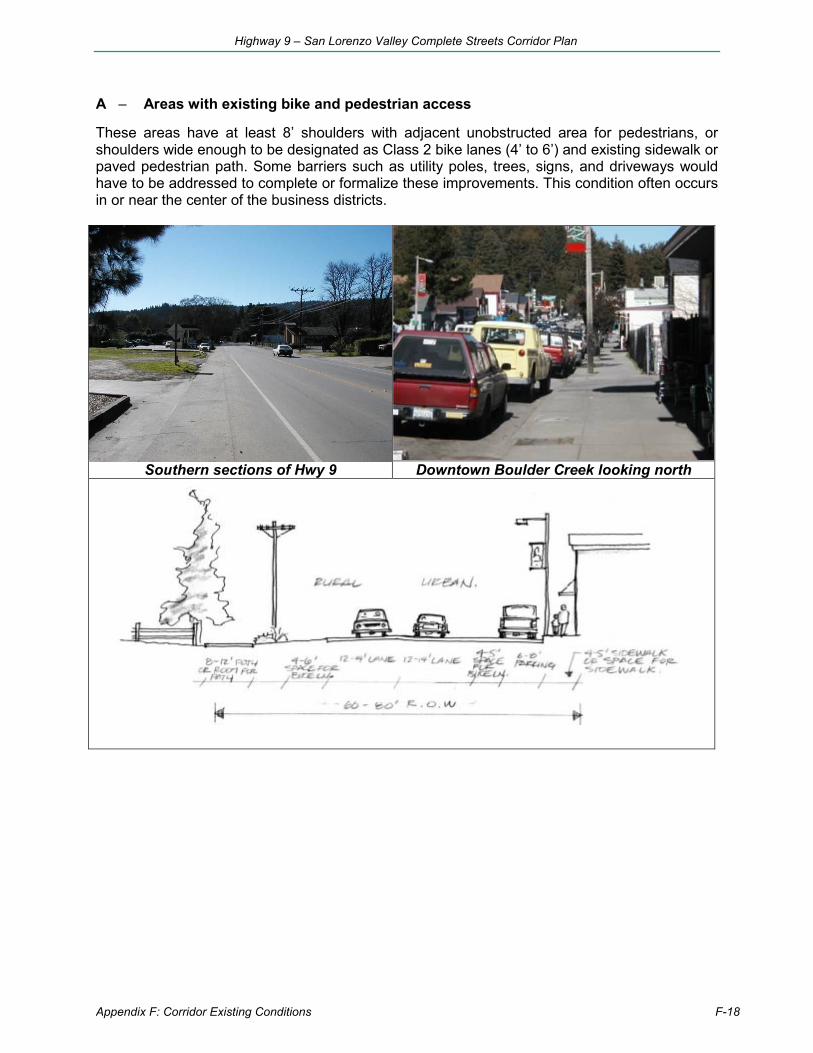
A – Areas with existing bike and pedestrian access
These areas have at least 8’ shoulders with adjacent unobstructed area for pedestrians, or shoulders wide enough to be designated as Class 2 bike lanes (4’ to 6’) and existing sidewalk or paved pedestrian path. Some barriers such as utility poles, trees, signs, and driveways would have to be addressed to complete or formalize these improvements. This condition often occurs in or near the center of the business districts.
Southern sections of Hwy 9 Downtown Boulder Creek looking north
Appendix F: Corridor Existing Conditions F-18
Highway 9 – San Lorenzo Valley Complete Streets Corridor Plan
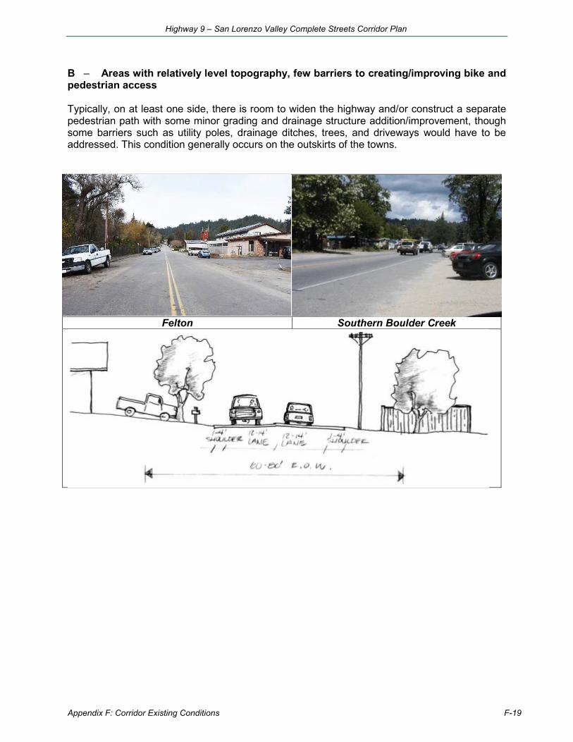
B – Areas with relatively level topography, few barriers to creating/improving bike and pedestrian access
Typically, on at least one side, there is room to widen the highway and/or construct a separate pedestrian path with some minor grading and drainage structure addition/improvement, though some barriers such as utility poles, drainage ditches, trees, and driveways would have to be addressed. This condition generally occurs on the outskirts of the towns.
Felton Southern Boulder Creek
Appendix F: Corridor Existing Conditions F-19
Highway 9 – San Lorenzo Valley Complete Streets Corridor Plan
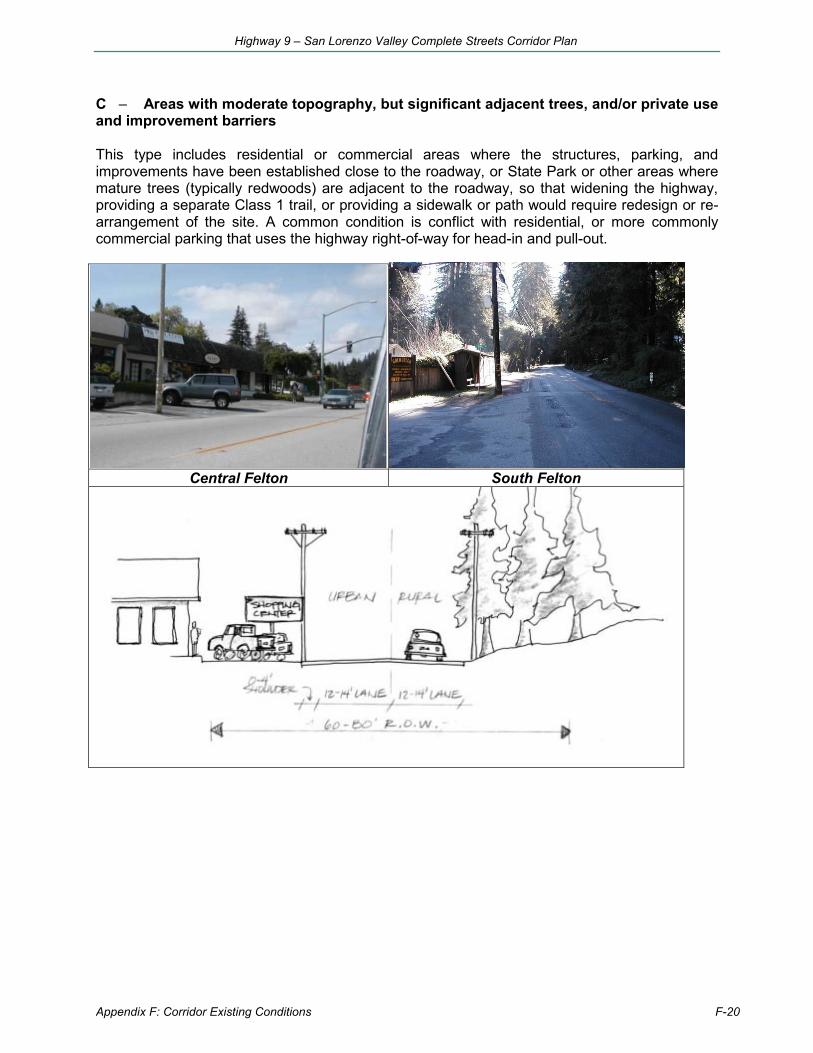
C – Areas with moderate topography, but significant adjacent trees, and/or private use and improvement barriers
This type includes residential or commercial areas where the structures, parking, and improvements have been established close to the roadway, or State Park or other areas where mature trees (typically redwoods) are adjacent to the roadway, so that widening the highway, providing a separate Class 1 trail, or providing a sidewalk or path would require redesign or re-arrangement of the site. A common condition is conflict with residential, or more commonly commercial parking that uses the highway right-of-way for head-in and pull-out.
Central Felton South Felton
Appendix F: Corridor Existing Conditions F-20
Highway 9 – San Lorenzo Valley Complete Streets Corridor Plan
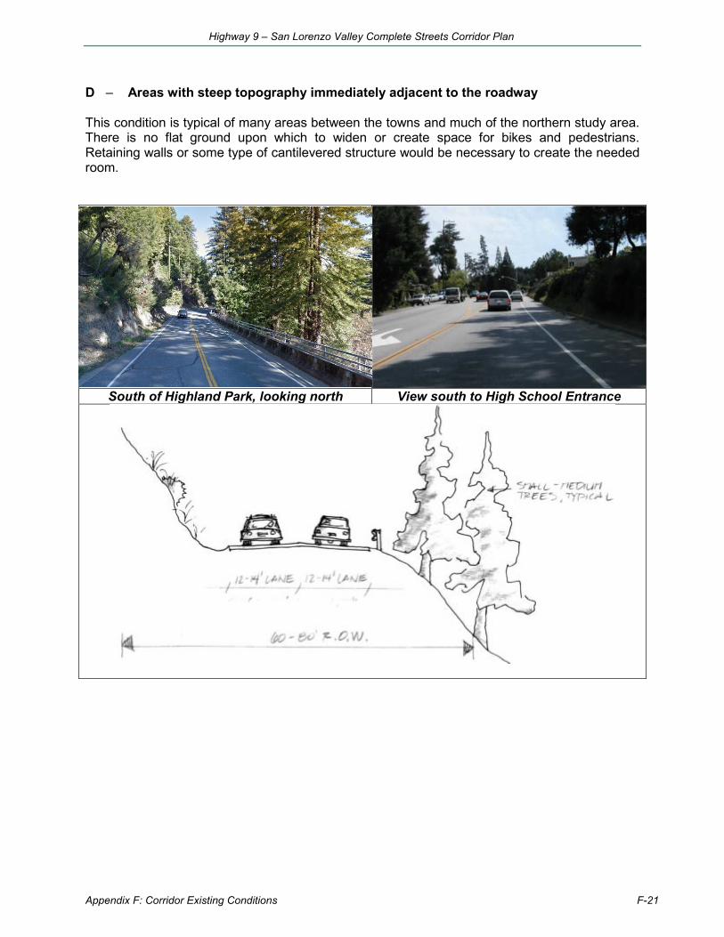
D – Areas with steep topography immediately adjacent to the roadway
This condition is typical of many areas between the towns and much of the northern study area. There is no flat ground upon which to widen or create space for bikes and pedestrians. Retaining walls or some type of cantilevered structure would be necessary to create the needed room.
South of Highland Park, looking north View south to High School Entrance
Appendix F: Corridor Existing Conditions F-21
Highway 9 – San Lorenzo Valley Complete Streets Corridor Plan
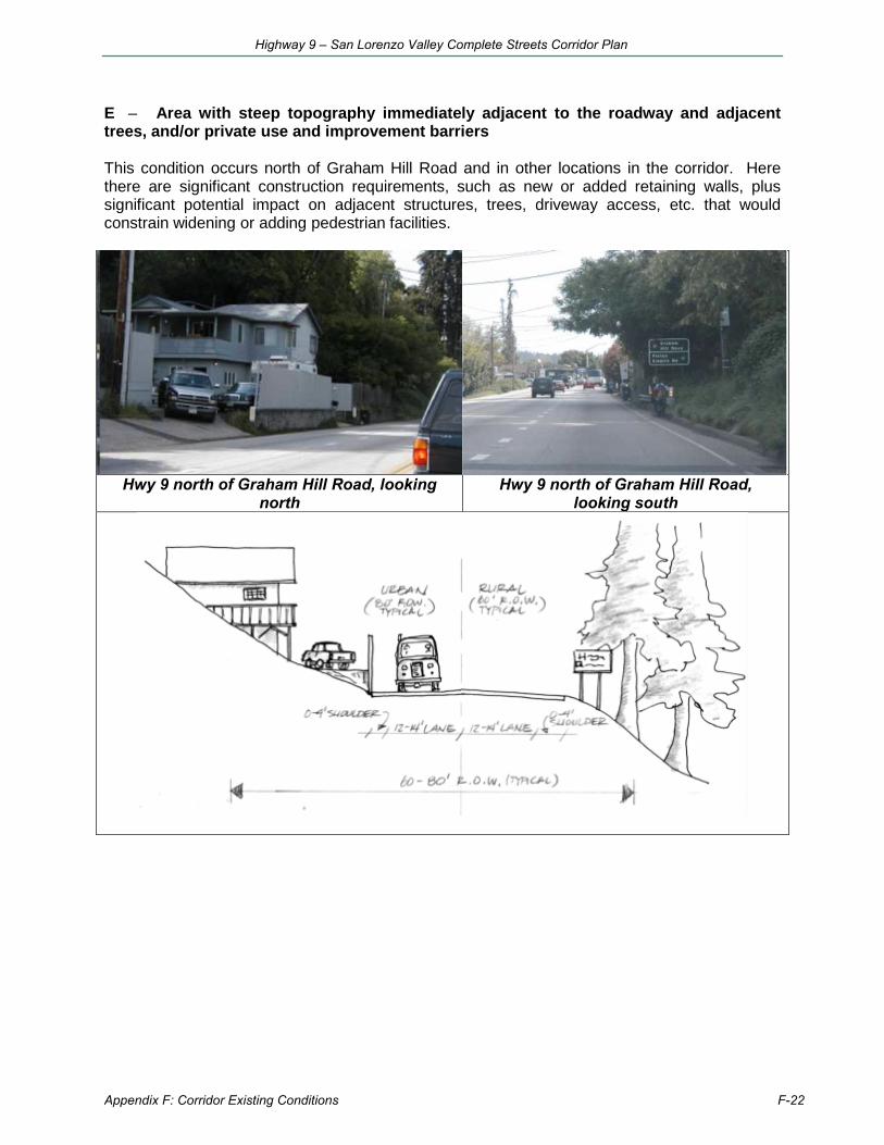
E – Area with steep topography immediately adjacent to the roadway and adjacent trees, and/or private use and improvement barriers
This condition occurs north of Graham Hill Road and in other locations in the corridor. Here there are significant construction requirements, such as new or added retaining walls, plus significant potential impact on adjacent structures, trees, driveway access, etc. that would constrain widening or adding pedestrian facilities.
Hwy 9 north of Graham Hill Road, looking north
Hwy 9 north of Graham Hill Road, looking south
Appendix F: Corridor Existing Conditions F-22
Highway 9 – San Lorenzo Valley Complete Streets Corridor Plan
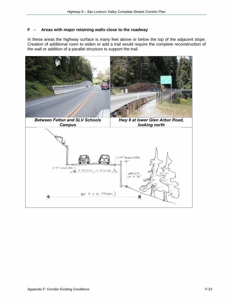
F – Areas with major retaining walls close to the roadway
In these areas the highway surface is many feet above or below the top of the adjacent slope. Creation of additional room to widen or add a trail would require the complete reconstruction of the wall or addition of a parallel structure to support the trail.
Between Felton and SLV Schools Campus
Hwy 9 at lower Glen Arbor Road, looking north
Appendix F: Corridor Existing Conditions F-23
Highway 9 – San Lorenzo Valley Complete Streets Corridor Plan
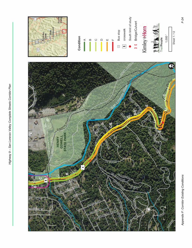
LAU
RE
LAV
BRO
OKS
IDE
WY
MCKINLEY WY
LA
KE
VIEWDR
GLENGAR
RYR
D
SCENIC
D
R
VALLEY DR
REDWOODRD
GRANT WY
MW
Y
WASHINGTON WY
LINCOLN WY
GULCH
RD
PLATEAU DR
FERR
AR
I D
VIEW
CT
OAK
AV
GO
LDAV
JACKSON WY
TAYLOR WY
SILV
IAN
WY
ARROWLN
SPRINGLN
LLHOUSEGULC
HR
D
RIVER LN
REDWOODPL
BIG
TRE
ES
PAR
KR
D
MCKEERD
OAKPL
LAGUN AAV
OLD
BIGTR
EESR
D
VIE
W
CI
MADR
ONA
RD
AV
STEI
NMAI
ERRD
WILLOW
W
Y
HENRY
COWELL
BETH
D
R
GRAHA
MH
ILL
RD
£ ¤9
5.8
4.5
4.8
5.6
5.1
5.9
4.6
5.4
4.9
5.2
5.7
4.4
4.7
5
HEN
RYC
OW
ELL
STAT
E PA
RK
Shingle
Mill
Creek
SanLo
renz
oR
iver Ox Tra
ilEntrance Road
EntranceRo
ad
E
E
D/E
C
C
C/E
B
E
C
B
! ISh
eet 1
/ 12
1,00
0'
Con
ditio
nA B C D E F
")Bu
s st
op
Æýcr
ossw
alk
!(So
uth
limit
of s
tudy
[]
Brid
ge/C
ulve
rt
App
endi
x F:
Cor
ridor
Exi
stin
g C
ondi
tions
F-24
Hig
hway
9 –
San
Lor
enzo
Val
ley
Com
plet
e S
treet
s C
orrid
or P
lan
rmoriconi
Typewritten Text
rmoriconi
Typewritten Text
rmoriconi
Typewritten Text
rmoriconi
Text Box
rmoriconi
Typewritten Text
rmoriconi
Typewritten Text
Figure F3: Bicycle and Pedestrian Conditions Maps
rmoriconi
Typewritten Text
rmoriconi
Typewritten Text
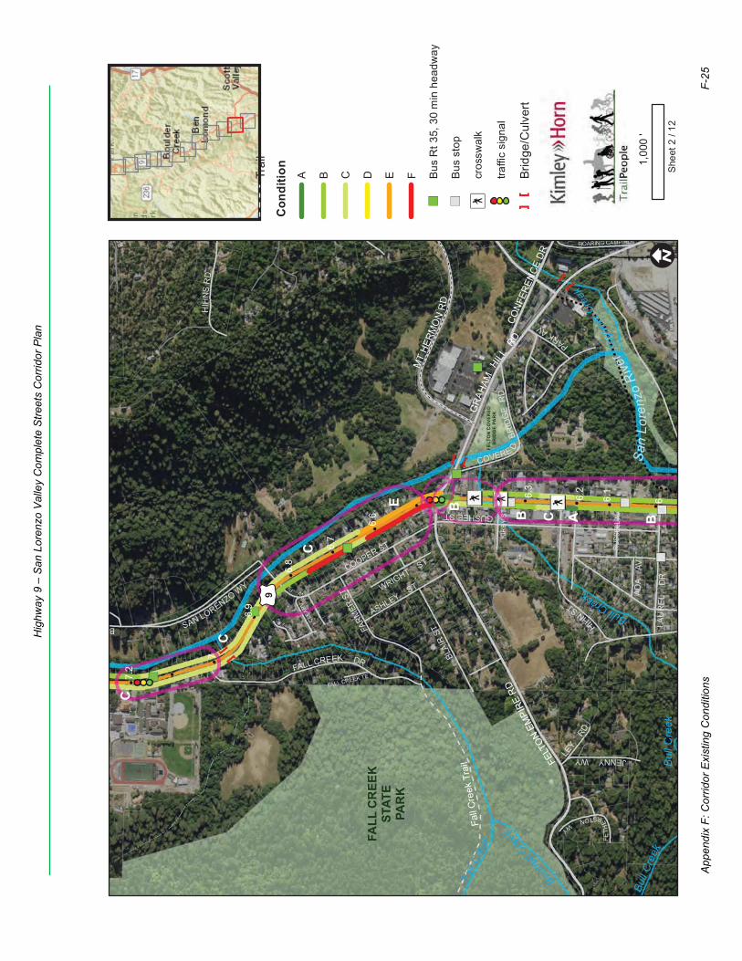
JENNYWY
COOPER ST
PARKAV
EA
GUSHEE ST
HIH
NS
RD
SAN LORENZO WY
FALL CREEK TE
HIHNST
LAU
RE
L D
R
HIGGINSRD
WRIGHT ST
FETH
E
RSTONWY
ASHLEY ST ADA
AV
LEY
RD
B
BLAI
R STFA
RMER
ST
FALL CREEK DR
CLEA
RVIE
WPL
ROARING CAMP RD
COVERE DBR
IDG
ER
D
RUSS
ELL A
V
KIRB
Y ST
GRA
HAM
HILLRD
FELT
ONEM
PIRE
RDCO
NFER
ENCE
DR
MT
HERM
ON
RD
£ ¤9
6.3
6.6
6.1
6.9
7.2
6.7
6.2
7
6
6.8
FELT
ON
CO
VER
EDB
RID
GE
PAR
K
FALL
CR
EEK
STAT
EPA
RK
Bul
l Cre
ek
Bull
Cree
k
Benne
ttCre
ek
Zaya
nte
Cree
k
BullCreek
Fall C
reek
San
Lore
nzo
Rive
rZa
yant
e Tr
ail
E
B
C
C
B
AC B
C
Fall
Cre
ek T
rail
! ISh
eet 2
/ 12
1,00
0'
Trai
l
Con
ditio
nA B C D E F
")Bu
s R
t 35,
30
min
hea
dway
")Bu
s st
op
Æýcr
ossw
alk
traffi
c si
gnal
[]
Brid
ge/C
ulve
rt
App
endi
x F:
Cor
ridor
Exi
stin
g C
ondi
tions
F-25
Hig
hway
9 –
San
Lor
enzo
Val
ley
Com
plet
e S
treet
s C
orrid
or P
lan
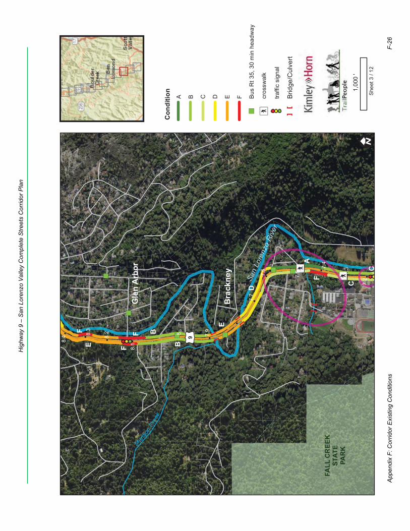
£ ¤9
8.1
7.6
8.4 7.
9
7.4
8.2
7.2
7.7
8
7.5
8.3
7.3
FALL
CR
EEK
STAT
EPA
RK
Manso
nCr
eek
San
Lore
nzo
Rive
r
C
F F
E
A
D
B
F
F
C
E B
Bra
ckne
y
Gle
n A
rbor
! ISh
eet 3
/ 12
1,00
0'
Con
ditio
nA B C D E F
")Bu
s R
t 35,
30
min
hea
dway
Æýcr
ossw
alk
traffi
c si
gnal
[]
Brid
ge/C
ulve
rt
App
endi
x F:
Cor
ridor
Exi
stin
g C
ondi
tions
F-26
Hig
hway
9 –
San
Lor
enzo
Val
ley
Com
plet
e S
treet
s C
orrid
or P
lan
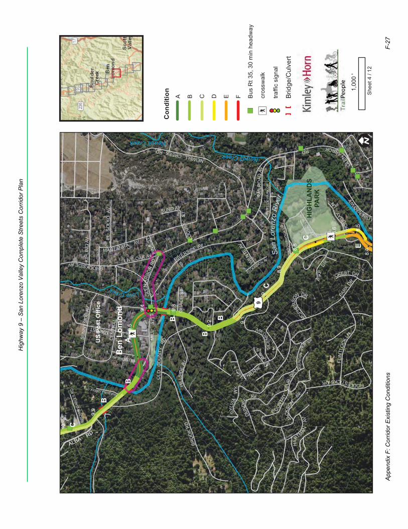
BROOKSIDEAV
PIK
EDRW
HIT
TIE
R A
V
NEWELLCREEKRD
RIVERSIDE AV
MOU
NTA
INVI
EWDR
GLEN
ARBORRD
GR
E ENBANK DR
PARK
DR
LINDBERGH AV
MANZANITA AV
LAMB
AV
JACK
SON
AV
WEN
TE AV
KIP
LIN
G A
V
FLIN
TLO
CK
LN
SYLV
IAW
Y
DICKINSON AV
SC
ENI
C
WY
HAR
TMANAV
C O
UNTR
YC
LUB
DR
RIV
ERS
IDE
PAR
KD
R
LOCU
STS
T
MAIN ST
SHAD
OW
BRO
OK
LN
DUN
DEE
AV
HILL
SID
EAV
SUND AV
CEN
TRA
LAV
CREST DR
HIGHLANDSCOUNT
YPA
RK
OL D
CO
UN
TYRD
MARSHALLCREEKCT
MIL
LST
GR
AC
E S
T
SUN
NYS
IDE
AV
MCPHER
SON DR
HO
LIDAY
LN
FIDDLESTICKSDR
EL S
OLY
O A
V
LORENZOW
Y
RA
ILR
OAD
AV
BRO
OK
RD
LIVE OAK AV
FILLMORE AV
BROW
N G
ABLE
S RD
PINE
ST
GLE
NAR
BOR
RD
ALBARD
£ ¤9
8.6
9.9
9.4
8.4
8.9
9.2
10
9.5
8.5
9
9.3
8.8
9.1
HIG
HLA
ND
SPA
RK
Newell Creek
LoveCreek
NewellCreek
San
Lore
nzo
Riv
er
C
B
A
C
B
B
B
E
B
C
Ben
Lom
ond
US
Post
Offi
ce
! ISh
eet 4
/ 12
1,00
0'
Con
ditio
nA B C D E F
")Bu
s R
t 35,
30
min
hea
dway
Æýcr
ossw
alk
traffi
c si
gnal
[]
Brid
ge/C
ulve
rt
App
endi
x F:
Cor
ridor
Exi
stin
g C
ondi
tions
F-27
Hig
hway
9 –
San
Lor
enzo
Val
ley
Com
plet
e S
treet
s C
orrid
or P
lan
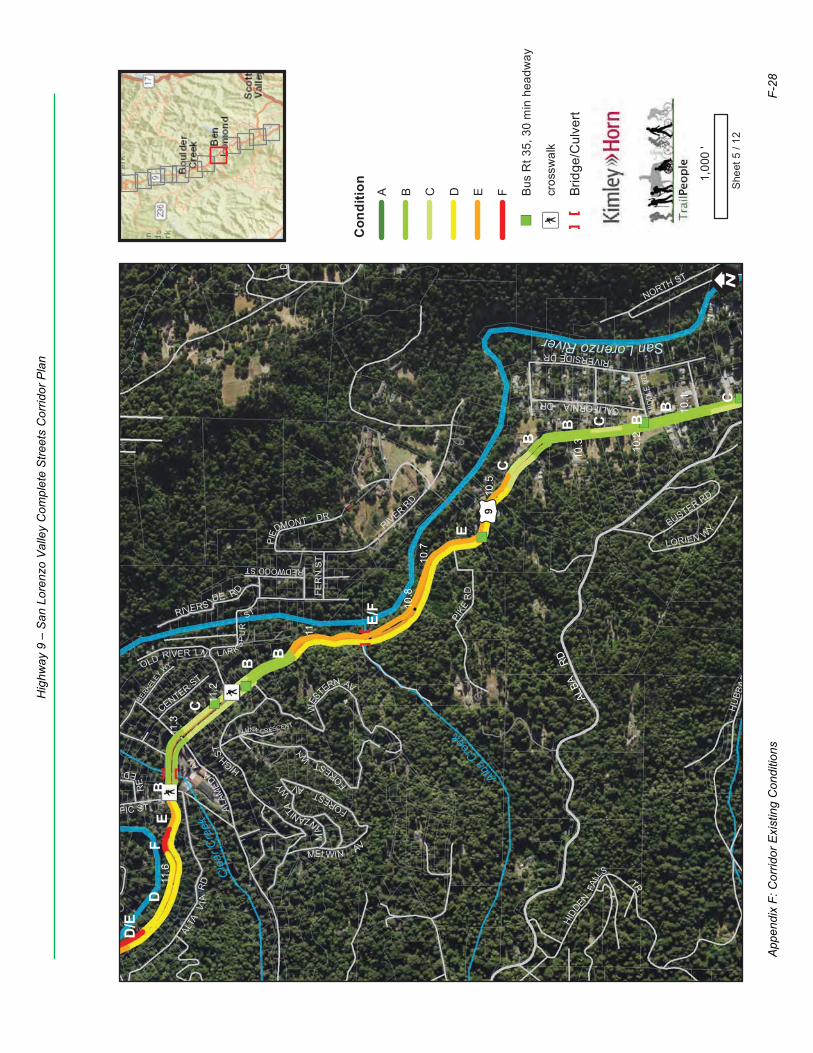
LUNA CRESCENT
RIVER
RD
HIGHST
LARK SP
UR
ST
HU
BBAR
WES
TERN AV
D
HIDD
ENFA
LL
STR
MELWIN AV
RIVERSIDEDR
FER
N S
T
FORESTW
Y
ALTA
VIA
RD
REDWOOD ST
NORTH ST
FIC ST
MAN
ZANITAWY
LORIEN WY
RIVERS IDE RD
CALIFORNIADR
BERKELEY
WY
BUSTER RD
RE
ED
CENTERST
OLD RIVER LN
PIED
MONT DR
FORESTAV
ALA
ME
DA
AV
PIKE
RD
MID
DLE
RD
D
ALBA
RD
£ ¤9
11.2
10.7
10.2
11
10.5
11.3
10.8
10.3
11.6
10.1
Cle
arC
reek
Alba C
reek
SanLorenzoRiver
B
F
C
C
E
B
B
B
C
B
D
E
E/F
C
B
D/E
B
! ISh
eet 5
/ 12
1,00
0'
Con
ditio
nA B C D E F
")Bu
s R
t 35,
30
min
hea
dway
Æýcr
ossw
alk
[]
Brid
ge/C
ulve
rt
App
endi
x F:
Cor
ridor
Exi
stin
g C
ondi
tions
F-28
Hig
hway
9 –
San
Lor
enzo
Val
ley
Com
plet
e S
treet
s C
orrid
or P
lan
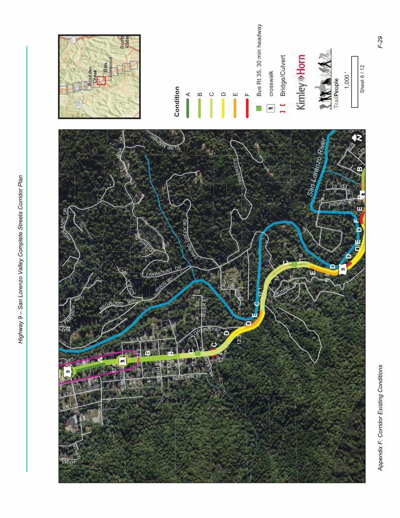
HAZEL
BOULDER ST
TINK
ERS
TR
EL ST
AQUI
LAW
Y
ELSIEMAE
DR
IR
WINWY
RIV
ER
ST
AK ST
FER
N LN
HIG
HLAN
DD
R
SOU
TH S
T
CAM
PJOYR
D
DEBBIEDR
MO
LASK
EY S
T
MAPL
PACIFIC ST
EAST ST
FAIRV
IEW
AV
BERKELE
Y
WY
MONANWY
RE
EDSTLORENZO AV
CENT
OLD
NIN
AD
R
REDWOOD WY
FAIRMOUNT DR
SPRIN
GCR
EEK
RD
HARM
ON
ST
FLAT
ST
MO
UN
TAIN
ST
£ ¤9
£ ¤9
11.9
12.7
12.5
12
12.3
12.8
11.8
12.6
12.1
12.4
San
Lore
nzo
Riv
er
ED
F
D
E
B
D
D
C
C
B
D
D
D/E
E
A
CB
C
! ISh
eet 6
/ 12
1,00
0'
Con
ditio
nA B C D E F
")Bu
s R
t 35,
30
min
hea
dway
Æýcr
ossw
alk
[]
Brid
ge/C
ulve
rt
App
endi
x F:
Cor
ridor
Exi
stin
g C
ondi
tions
F-29
Hig
hway
9 –
San
Lor
enzo
Val
ley
Com
plet
e S
treet
s C
orrid
or P
lan
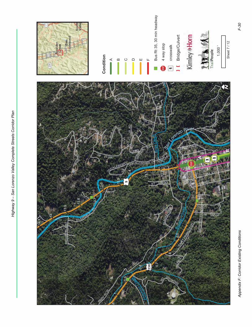
HAZEL AV
BR
OO
KDA
L ES T
LAUREL ST
MID
DLE
TO
N DR
OL D BEAR
C RE EK RD
OAKRD
FR
PARK
AVW
OAK ST
FER
N LN
SAIN
TFR
ANCI
SDR
MAY
FAIR
RD
PINE ST
BOOTH AV
LOREN
ZOST
ST
SUN
SH
INE
LN
PAON
E
DR
MANZANITALN
MAPLEWYD
AVID
SO
N W
Y
BON
VIEWDR
EAST
RD FAIR
VIE
W
AVR
D
LITTLEBEARLN
MADRONEDR
RIVERDALE
BL
JUNCTION AV
WESTRD
DEBBYLN
HUCKLEBERRY LN
PINE
CRES
TD
R
BLAC
KSTO
NE
DR
HUCKLEBERRY
LNMONACO
LN
£ ¤236
£ ¤9
0.8
0.6
0.1
0.9
0.2
0.7
1
0.5
0.3
13.7
13.2
14
13.5
13.8
13.3
13.6
14.1
13.9
13.4
Fore
man
Creek
Bea
rCre
ek
Boul
der C
reek
San
Lorenzo River
B
A
! ISh
eet 7
/ 12
1,00
0'
Con
ditio
nA B C D E F
")Bu
s R
t 35,
30
min
hea
dway
!"$4
way
sto
p
Æýcr
ossw
alk
[]
Brid
ge/C
ulve
rt
App
endi
x F:
Cor
ridor
Exi
stin
g C
ondi
tions
F-30
Hig
hway
9 –
San
Lor
enzo
Val
ley
Com
plet
e S
treet
s C
orrid
or P
lan
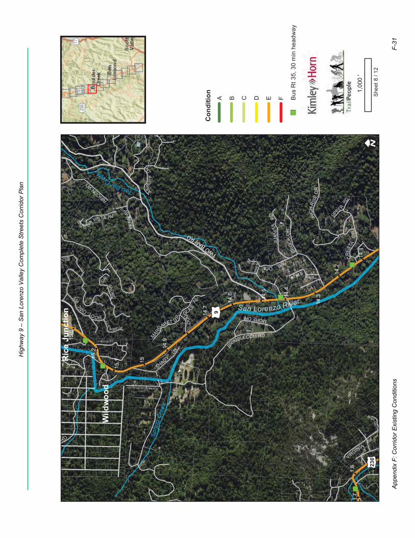
BRIMBLECOM RD
JUA
NIT
ARD
BLUE
TER
RA
CEDR
HOOTOWLW
Y
B
RD
CKBE
RRY
LN
VIRGINIA
AV
DO
UGLA S
AV
FER
NAV
RD
UPPE RRD
PLUMERIACT
ASBU
RY
LN
IGO WY
APPLE KNOLL
ROBINHOODS HOLLOW
SHADY
LN
MARG
ARET D
R
GR
OV
E
DR
RINCON WY
B
U E NA VISTA AVMORE DR
BRO
OK
DR
CRES
TAD
R
HIG
HRI
SED
R
FIRESIDE R D
TWOBARRD
£ ¤9
£ ¤236
1.6
1.7
15.2
14.2
14.7
15
14.5
15.3
14.3
15.1
14.6
14.1
14.9
14.4
Sprin
gC
reek
TwoBarCree
k
San Lorenzo River
Ric
e Ju
nctio
n
Wild
woo
d
! ISh
eet 8
/ 12
1,00
0'
Con
ditio
nA B C D E F
")Bu
s R
t 35,
30
min
hea
dway
App
endi
x F:
Cor
ridor
Exi
stin
g C
ondi
tions
F-31
Hig
hway
9 –
San
Lor
enzo
Val
ley
Com
plet
e S
treet
s C
orrid
or P
lan
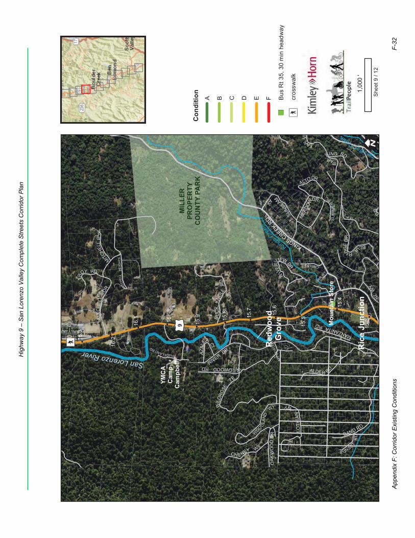
MANZANITARD
ALDER RD
R
IVER
VIEWDR
RIVER DR
OAK WY
APPL
EWO
OD
RD
BLUERIDG
ED
R
MITCHE
LLP
L
OWLW
Y
OAK
WO
OD
DR BAND RD
MEA
DOWDR
SHADELANDRD
S UNSETR
D
CREEKCT
SU
MM
ER
PL
WIL
DRO
SE
TE
TR
OY RD
AZAL
EA CI
MIT
CHE
LLH
EIG
HTS
WILDWOODRD
B
ARKING RD
B
U
CH ENEY WY
ALTODR
SUN
BEAMAV
FARVI
LOTH
IAN
WY
BU
CK
KNO
LLR
D
WOODLA
ND
WY
MIT
CH
ELL
DR
KINGSCREEKRD
£ ¤9 15.516
16.2
15.8
15.3
15.6
16.3
15.9
15.4
16.1 15
.7
MIL
LER
PRO
PER
TYC
OU
NTY
PA
RK
TwoBarCreek
KingsCree
k
SanLorenzoRiver
Red
woo
dG
rove
Ric
e Ju
nctio
n
YMC
AC
amp
Cam
pbel
l
Mou
ntai
n St
ore
! ISh
eet 9
/ 12
1,00
0'
Con
ditio
nA B C D E F
")Bu
s R
t 35,
30
min
hea
dway
Æýcr
ossw
alk
App
endi
x F:
Cor
ridor
Exi
stin
g C
ondi
tions
F-32
Hig
hway
9 –
San
Lor
enzo
Val
ley
Com
plet
e S
treet
s C
orrid
or P
lan
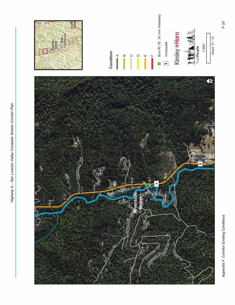
BEAN AV
TE
ILH
DR
TIELHRD
EITHERWY
L
WILDBERRY
DR
ALP
INE
DR
TR
OY RD
RAMBL
ING RD
U
BER
NST
EIN
DR
W
GR
EEN
VALE
RD
TR
ES
SELPA S
SRD
NO
RIC
HR
D
DRY
WEL
LRD
CREE
KDR
STEWARTST
SHILO
H
CT
£ ¤9
17.2
16.7
17
16.5
17.3
16.3
16.8
17.1
16.6
16.9
16.4
San Lorenzo River
Riv
ersi
deG
rove
! ISh
eet 1
0 / 1
2
1,00
0'
Con
ditio
nA B C D E F
")Bu
s R
t 35,
30
min
hea
dway
Æýcr
ossw
alk
App
endi
x F:
Cor
ridor
Exi
stin
g C
ondi
tions
F-33
Hig
hway
9 –
San
Lor
enzo
Val
ley
Com
plet
e S
treet
s C
orrid
or P
lan
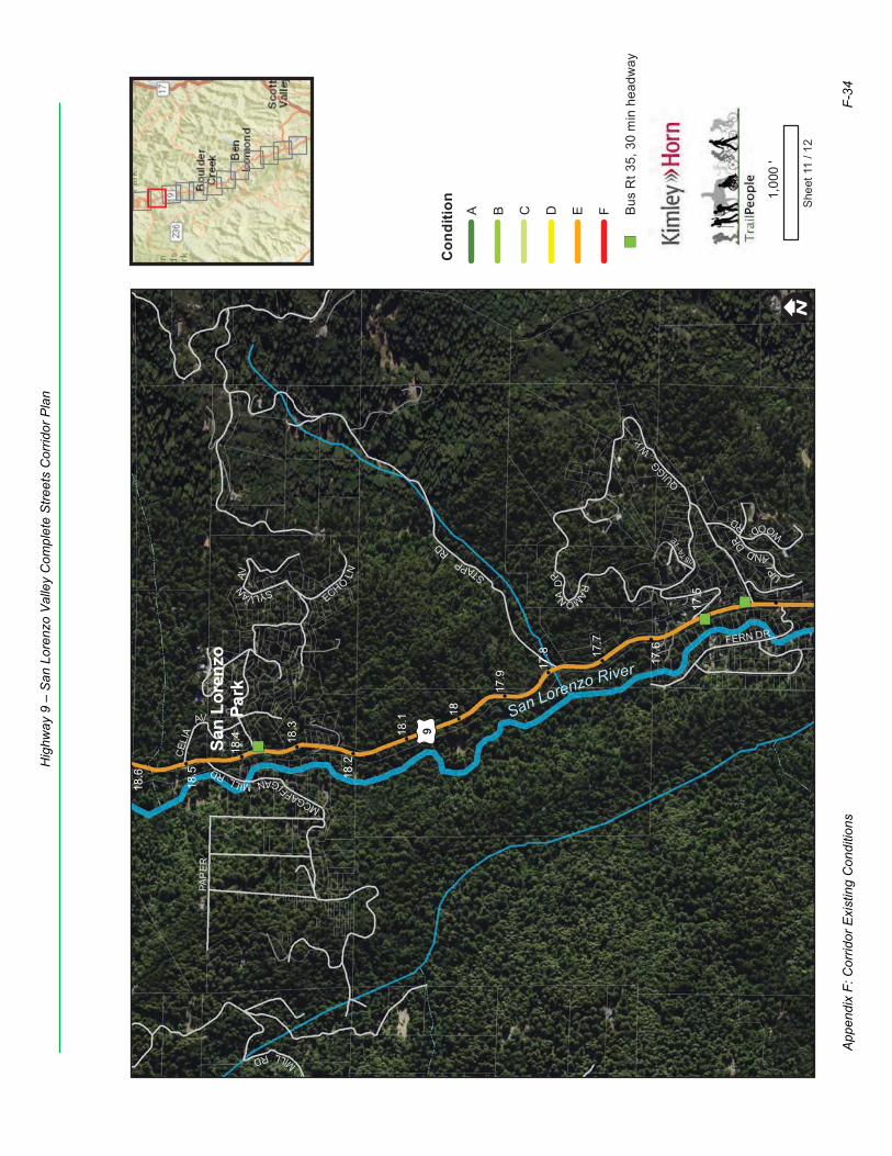
MCGAFFI
GANMILLRD
PAP
ER
SYLVANAV
VISTATE
E
MILLRD
CELI
A
AV
FERN DR
ECHO
LN UPL
ANDDR
WOODRD
QUIGG
WY
RAMONAD
RSTAPPRD
£ ¤9
18.2
17.7
18.5
18
17.5
18.3
17.8
18.6
17.6
18.1
18.4
17.9
San Lorenzo River
San
Lore
nzo
Park
! ISh
eet 1
1 / 1
2
1,00
0'
Con
ditio
nA B C D E F
")Bu
s R
t 35,
30
min
hea
dway
App
endi
x F:
Cor
ridor
Exi
stin
g C
ondi
tions
F-34
Hig
hway
9 –
San
Lor
enzo
Val
ley
Com
plet
e S
treet
s C
orrid
or P
lan
SARATOGATOLLRD
KIN
GS
CR
EEK
TT£ ¤9
£ ¤236
17.6
17.1
17.4
17.6
75
17.2
17.5
17
17.3
19.2
21.1
18.7
20.5
19.5
20
19
20.9
20.3
19.8
18.8
19.3
20.1
20.6
19.6
19.1
21
18.6
20.7
51
20.4
18.9
19.4
20.8
2720
.2
19.7
CA
STLE
RO
CK
STAT
E PA
RK
San Lorenzo River
SkylinetotheSeaTrail
Toll R
oad
conn
ecto
r
Skylin
eto
the
SeaTr
ail
Toll Road
Connector
! ISh
eet 1
2 / 1
2
1,00
0'
Trai
l
Con
ditio
nA B C D E F
!"$4
way
sto
p
!(N
orth
lim
it of
stu
dy
App
endi
x F:
Cor
ridor
Exi
stin
g C
ondi
tions
F-35
Hig
hway
9 –
San
Lor
enzo
Val
ley
Com
plet
e S
treet
s C
orrid
or P
lan