Figures - ICPDR
78
Figures
-
Upload
khangminh22 -
Category
Documents
-
view
0 -
download
0
Transcript of Figures - ICPDR

Figures


Technical Reports – Part C: Water Quality, Annexes 147
List of Figures
Fig. 2 - 1 Distribution of Municipal Hot Spots
Fig. 2 - 2 Distribution of Agricultural Hot Spots
Fig. 2 - 3 Distribution of Industrial Hot Spots
Fig. 2 - 4 Distribution of Wastewater Treatment Plants
Fig. 3 – 1 Land Use within the Danube Watershed in FRY
Fig. 4 – 1 Position of the FRY within the Danube Watershed
Fig. 4 - 2 Hydrological Stations within the Danube Watershed in FRY
Fig. 4 - 3 Watersheds within the Danube Basin in FRY
Fig. 4 - 4 Potentially Flooded Areas within the Danube Watershed in FRY
Fig. 4 - 5 Embankments within the Danube Watershed in FRY
Fig. 4 - 6 Water Transfers within the Danube Watershed in FRY
Fig. 4 - 7 Network of Relevant WQ Monitoring Stations within the Danube Watershed in FRY
Fig. 4 - 8 Water Budget within the Danube Watershed in FRY
Fig. 4 - 9 Flow Diagram of Suspended Sediments Discharges within the Danube Watershed in FRY
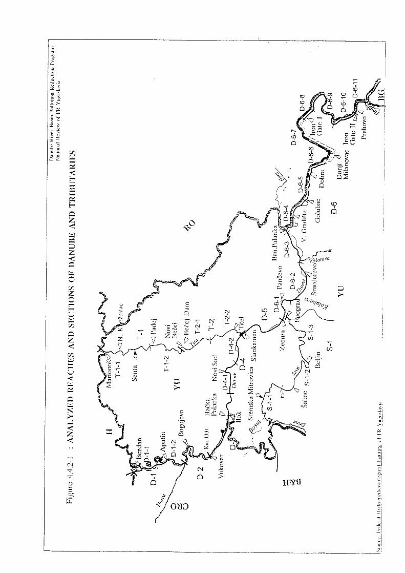
Fig. 4.4.2.-1 Analyzed Reaches and Sections of Danube and Tributaries within FRY
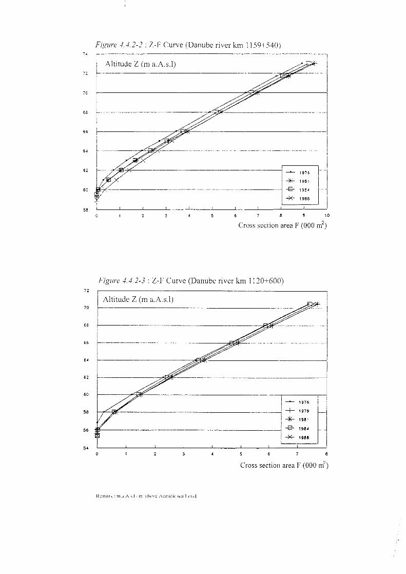
Fig. 4.4.2.-2 Z-F Curve (Danube river km 1159 + 540)
Fig. 4.4.2.-3 Z-F Curve (Danube river km 1120 + 600)
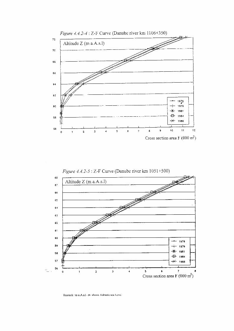
Fig. 4.4.2.-4 Z-F Curve (Danube river km 1106 + 350)
Fig. 4.4.2.-5 Z-F Curve (Danube river km 1051 + 500)
Fig. 4.4.2.-6 Z-F Curve (Danube river km 995 + 200)
Fig. 4.4.2.-7 Z-F Curve (Danube river km 952 + 400)
Fig. 4.4.3.-1 The Longitudinal Profile of Danube within FR Yugoslavia
Fig. 4.4.3.-2 The Longitudinal Profile of Sava River within FR Yugoslavia
Fig. 4.4.3.-3 The Longitudinal Profile of Tisa River within FR Yugoslavia
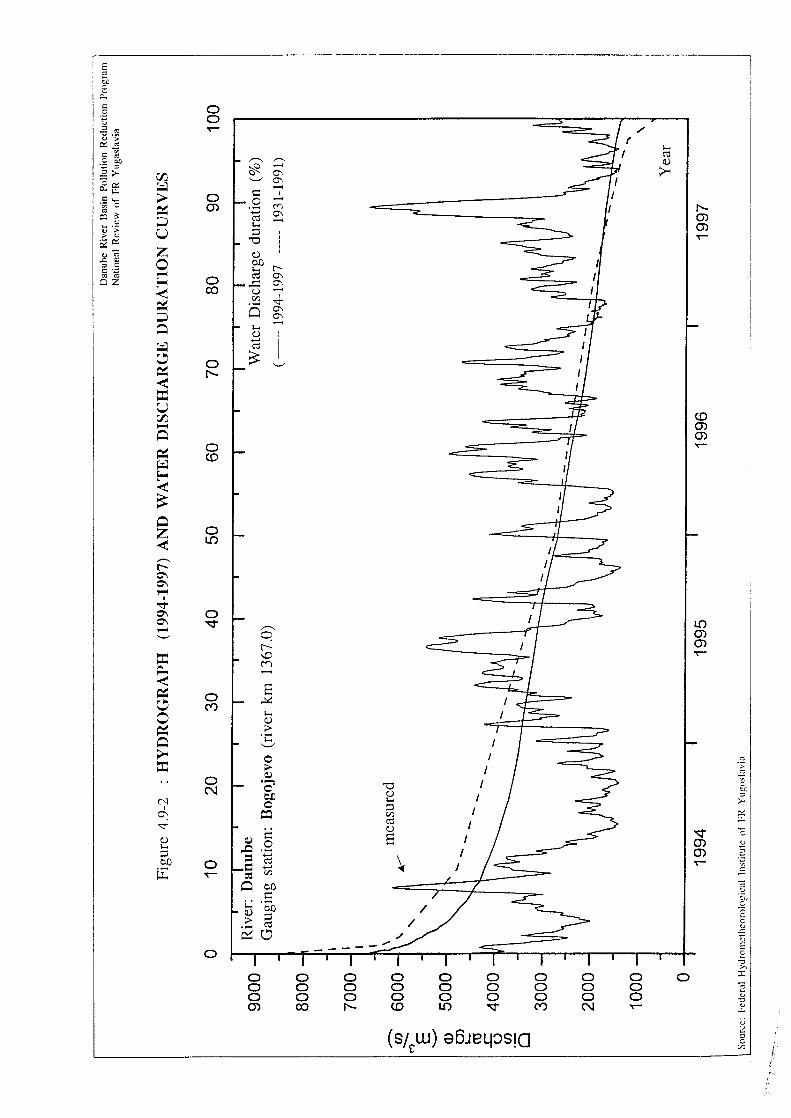
Fig. 4.9.-1 Hydrograph and Water Flow Duration Curves (Danube-GS “Bezdan”)
Fig. 4.9.-2 Hydrograph and Water Flow Duration Curves (Danube-GS “Bogojevo”)
Fig. 4.9.-3 Hydrograph and Water Flow Duration Curves (Danube-GS “Novi Sad”)
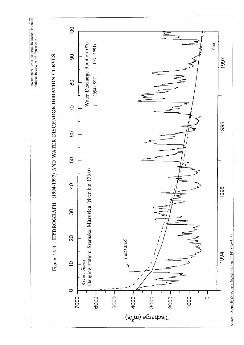
Fig. 4.9.-4 Hydrograph and Water Flow Duration Curves (Sava-GS “Sremska Mitrovica”)
Fig. 4.9.-5 Hydrograph and Water Flow Duration Curves (Tisa-GS “Senta”)
Fig. 4.9.-6 Hydrograph and Water Flow Duration Curves (Grand Morava-GS “Lj. Most”)


46o
21o
21o
20o
20o
19o
19o
45o45o
44o
43o
43o
44o
42o
Tisa
Brzava
Tam
i{
Kubr{nica
V.M
orav
a
C
mr
Tnii
ok
Bel
i T
imok
Ni{ava
Ju‘na M
orava
Lep
ne ac
Jablanica
Dragovi{tica
Klina
Beli D
rim
P~inja
Beli Drim
Kriva
Zapadna Mor va a
Ras
ina
Uvac
Lim
Resava
Ra{
ka
Drina
Tara
Zeta Mor
a~a
Boj
ana
Piv
a
Lim
Ibar
Gru‘a
Skrape‘
Vlasina
Jerm
a
Lab
Sitnica
Topli ac
Timok
Jasenica
Tamnava
Kol
uba
ra
UbK
ar
a{
DunavDri
na
Jadar
Sava
Zla
tica
Morav
ica
k. K
aravukovo-
P
B.
etrovac
k. Bogojevo-Be~ej
Tisa
k. N.S
ad - S
oa
nvi Selo
Novi Kne‘evac
Senta
B.Topola Ada
Od‘aci
Ba~
@abalj
Temerin
Be~ejNovi Be~ej
Ba~ka Palanka
Apatin
@abljak
[avnik
Mojkovac
Kola{in
Berane
Plav
Ro‘aje
Bijelo Polje
Prijepolje
Priboj
Nova Varo{
Sjenica
Ivanjica
Arilje Lu~ani^ajetina
Po‘ega
Tutin
Novi Pazar
Ra{ka
Leposavi}
Bajina Ba{ta
LjubovijaLjig
G. Milanovac
Mali Zvornik
Krupanj
Ose~ina
Koceljeva UbLajkovac
Aran|elovac
Topola
Lazarevac
Pljevlja
Legend:
Subotica
Sombor Kikinda
Novi Sad
Zrenjanin
Sremska Mitrovica
[abac BeogradPan~evo
SmederevoPo‘arevac
Valjevo
U‘ice
^a~ak
Kraljevo
KragujevacJagodina
Zaje~ar
Bor
Kru{evac
Ni{
Prokuplje
Pirot
Leskovac
Vranje
Kanji‘a
Pri{tina
K.Mitrovica
Pe}
Prizren
Gnjilane
Titel
S.Pazova
In|ija
Pe}inci
Ruma
Irig[idBeo~in
Opovo Alibunar
@iti{te
Kova~ica
@iti{te
Plandi{te
Vr{ac
Bela Crkva
Kovin
Se~anj
Nova Crnja
Vladimirci
Bogati}
Loznica
ObrenovacBarajevo
Mladenovac
S. Palanka
Velika Plana @abari
Svilajnac@agubica
Majdanpek
Ku~evo
Golubac
V.Gradi{te
M. Crni}e
Petrovac
Kladovo
Negotin
Bato~ina
Despotovac
]uprija
Para}in
Rekovac
Varvarin ]i}evac
Ra‘anj
Soko Banja Knja‘evac
Boljevac
Aleksinac
Aleksandrovac
Trstenik
Vrnja~kaBanja
Brus
Blace
Kur{umlija @itora|a Doljevac
Mero{ina Gad‘in Han
Bela Palanka
Babu{nica
Vlasotince
CrnaTrava
Svrljig
DimitrovgradBojnik
Lebane
Medve|aPodujevo
SurdulicaVladi~in Han
Bujanovac
Pre{evoVitina
N.Brdo Kos.Kamenica
[timlje
Lipljan
Glogovac Kosovo Polje
Obili}
Vu~itrn
Zve~an
Bajski kanal
Plazovic
Krivaja
^Ik
Kere{
Kik
inds
ki k
.
Danube
Dunav
Bosut
Studva
Stari B
egej
Begej
Beg
ej
Nadela
Danube
Nera
Mlava
MUNICIPAL HOT SPOTS
Kosjeri}
Moravica
\etinja
BjelicaGu~a
Ibar
Lim
]ehotina
Rzav
Djakovica
Draga{
Istok
Klina
De~ani
Suva Reka
Orahovac
Srbica
[TRPCE
Vet
erni
ca
Podgorica
Nik{i}
Cetinje
Bar
KotorH.Novi
Plu‘ine
Tivat
Budva
Ulcinj
Petrovac
M.Rzav
DANUBE RIVER BASIN POLLUTION REDUCTION PROGRAM
NATIONAL REVIEW OF FR YUGOSLAVIA
Border of Danube River Watershed
State Border
Republic Border
Border of Subwatershed
BG
BG
A
B &
H
M
CR
O
H
RO
RO
B &
H
22o
Medium Priority
Low Priority
High Priority
Andrijevica
Uprgading of WWTP is needed
B.Petrovac
Mali Idjo{Mali Idjo{
Srbobran
Bega
Timis
DTD
Canal
DTD Canal
Iron
Gat
e I
Iron
Gat
e II
DTD CanalBecej D
am
Created 1998 by : Z.V. Cukic, L.Knezic, M.Popovic, B.Dalmaciaja
Crvenka
Vrbas
Kula
Gusinje
N.Pazova
Fig. 2-1
, B.Bogdanovic
MorishSzeged
Tis
za
Timisoara
Danube


46o
21o20o
19o
19o
45o45o
44o
43o43o
44o
42o
Stari B
egej
Tisa
Brzava
Tam
i{
Begej
Krivaja
Dunav
V.Morava
Pek
C
mr
Tnii
ok
Bel
i T
imo
k
Ju‘na M
orava
Lep
ne ac
Jablanica
Dragovi{tica
Klina
Beli Drim
P~inja
Beli Drim
Ibar
Kriva
Ras
ina
Moravica
Uvac
Lim
Resava
Mlava
Ra{
ka
Drina
]ehotina
Tara
Zeta Mor
a~a
Boj
ana
Piv
a
Lim
\etinja
Ibar
Gru‘a
Skrape ‘
Vlasina
Jerm
a
Lab
Topli ac
Kol
uba
ra
Kar
a{
Dunav
Dri
na
Bosut
Sava
Bajski kanal
Morav
ica
k. K
aravukovo-
P
B.
etrovac
k. Bogojevo-Be~ej
k. N.S
ad - S
oa
nvi Selo
Plazovic
Drava
CR
O
H
RO
RO
BG
BG
A
B &
H
B &
H
M
Bega
Tim
is
Nera
AD
RIATIC SEA
Danube
Sava
Z.Morava
Borska
J. M
orav
a
Bin. Morava
M.Rzav
Ni{ava
Kik
inds
ki k
.B
egej
Danube
Timok
Studva
Rzav
Vet
erni
ca
Podgorica
Sombor
Novi Sad
Zrenjanin
Sremska Mitrovica
[abacBeograd
Smederevo
Po‘arevac
Valjevo
U‘ice^a~ak
Kraljevo
KragujevacJagodina
Bor
Kru{evac
Berane
Bijelo Polje
Pljevlja
Zaje~ar
Ni{
Prokuplje
Leskovac
Vranje
Pri{tina
KosovskaMitrovica
Gnjilane
PirotNovi Pazar
Iron
Gat
e II
Loznica
S. Palanka
Negotin
Vr{ac
Mojkovac
Priboj
Sur~in
PadinskaSkela
Obrenovac
Petrovac na Mlavi
Zitoradja
Zaje~ar
Se~anj
Srbobran
Vel. Plana
Varvarin
Leskovac
Created 1998 by : M.Bozovic, Z.V.Cukic & S.Kov~in
DANUBE RIVER BASIN POLLUTION REDUCTION PROGRAM
NATIONAL REVIEW OF FR YUGOSLAVIA
Legend:
Border of Danube River Watershed
Subwatershed border
State border
Republic border
Medium Priority
Low Priority
High Priority
AGRICULTURAL HOT SPOTSDISTRIBUTION OF
Fig. 2-2
Vrbas-Farmakop
Subotica
Kere{


46o
21o
21o
20o
20o
19o
19o
45o45o
44o
43o
43o
44o
42o
Stari B
egej
Tisa
Brzava
Tam
i{
Begej
Krivaja
DunavV.M
orava
Pek
C
mr
Tnii
ok
Bel
i T
imo
k
Ju‘na M
orava
Lep
ne ac
Jablanica
Dragovi{tica
Klina
Beli Drim
P~inja
Beli Drim
Ibar
Kriva
Ras
ina
MoravicaUvac
Lim
Resava
Mlava
Ra{
ka
Drina
]ehotina
Tara
Zeta Mor
a~a
Boj
ana
Piv
a
Lim
\etinja
Ibar
Gru‘a
Skrape ‘
Vlasina
Jerm
aLab
Topli ac
Kol
uba
ra
Kar
a{
Dunav
Dri
na
Bosut
Sava
Zla
tica
Bajski kanal
Morav
ica
k. K
aravukovo-
P
B.
etrovac
k. Bogojevo-Be~ej
Tisa
k. N.S
ad - S
oa
nvi Selo
Plazovic
Drava
CR
O
H
RO
RO
BG
BG
A
B &
H
B &
H
M
Kere{
Bega
Tim
is
Nera
DANUBE RIVER BASIN POLLUTION REDUCTION PROGRAM
NATIONAL REVIEW OF FR YUGOSLAVIA
AD
RIATIC SEA
Danube
Sava
Z.Morava
Borska
J. M
orav
a
Bin. Morava
M.Rzav
Ni{ava
Kik
inds
ki k
.B
egej
Danube
Timok
StudvaRzav
Vet
erni
ca
Podgorica
Chem. Ind.
Sugar Mill
Paper Mill
Paper Mill
Coal processing.
Food process.
Legend:
Border of Danube River WatershedSubwatershed border
State border
Republic border
Medium Priority
Low Priority
High Priority
DTD
Canal
DTD Canal
Sugar Mill
Iron
Gat
e I
Iron
Gat
e II
INDUSTRIAL HOT SPOTSDISTRIBUTION OF
Sugar Mill
Created 1998 by ; M.Popovic, B.Dalmacija & Z.V.Cukic
Sugar Mill & Destilery
Copper OreProcess.
Process.Pb & Zn Ore
Copper OreProcess.
Process.Pb & Zn Ore
42o
Fig. 2-3
Fertilizers Ind.
N.Kne‘evac
Senta
Crvenka
Vrbas
JabukaMalt Production
[ABAC
Prahovo
PKB
Trep~a
Ki{nica
FOPA
Cuprija
Bor
Majdanpek
TE Obrenovac
TE Kolubara
Thermo power
Thermo power
Majdanpek 2
1


46o
21o
21o
20o
20o
19o
19o
45o45o
44o
43o43o
44o
42o
Tisa
Brzava
Tam
i{
Kubr{nica
V.M
orav
a
C
mr
Tnii
ok
Bel
i T
imok
Ni{ava
Ju‘na M
orava
Lep
ne ac
Jablanica
Dragovi{tica
Klina
Beli D
rim
P~inja
Beli Drim
Kriva
Zapadna Mor va a
Ras
ina
Uvac
Lim
Resava
Ra{
ka
Drina
Tara
Zeta Mor
a~a
Boj
ana
Piv
a
Lim
Ibar
Gru‘a
Skrape‘
Vlasina
Jerm
a
Lab
Sitnica
Topli ac
Timok
Jasenica
Tamnava
Kol
uba
ra
UbK
ar
a{
DunavDri
na
Jadar
Sava
Zla
tica
Morav
ica
k. K
aravukovo-
P
B.
etrovac
k. Bogojevo-Be~ej
Tisa
k. N.S
ad - S
oa
nvi Selo
Novi Kne‘evac
Senta^oka
B.TopolaAda
Od‘aci
Kula
Vrbas
Ba~
@abalj
Temerin
Be~ejNovi Be~ej
Ba~ka Palanka
Apatin
@abljak
[avnik
Mojkovac
Kola{in
Berane
Plav
Ro‘aje
Bijelo Polje
Pljevlja Prijepolje
Priboj
Nova Varo{
Sjenica
Ivanjica
Arilje Lu~ani^ajetina
Po‘ega
Tutin
Novi Pazar
Ra{ka
Leposavi}
Bajina Ba{ta
LjubovijaLjig
G. Milanovac
Mali Zvornik
Krupanj
Ose~ina
Koceljeva Ub
Lajkovac
Aran|elovac
Topola
Lazarevac
Legend:
Subotica
Sombor Kikinda
Novi Sad
Zrenjanin
Sremska Mitrovica
[abac
BeogradPan~evo
Smederevo Po‘arevac
Valjevo
U‘ice^a~ak
Kraljevo
KragujevacJagodina
Zaje~ar
Bor
Kru{evac
Ni{
Prokuplje
Pirot
Leskovac
Vranje
Kanji‘a
Pri{tina
K.Mitrovica
Pe}
Prizren
Gnjilane
Titel
S.Pazova
In|ija
Pe}inci
Ruma
Irig[id
Beo~in
Opovo Alibunar
@iti{te
Kova~ica
@iti{te
Plandi{t
e
Vr{ac
Bela Crkva
Kovin
Se~anj
Nova Crnja
Vladimirci
Bogati}
Loznica
ObrenovacBarajevo
Mladenovac
S. Palanka
Velika Plana @abari
Svilajnac@agubica
Majdanpek
Ku~evo
Golubac
V.Gradi{te
M. Crni}e
Petrovac
Kladovo
Negotin
Bato~ina
Despotovac
]uprija
Para}in
Rekovac
Varvarin ]i}evac
Ra‘anj
Soko Banja Knja‘evac
Boljevac
Aleksinac
Aleksandrovac
Trstenik
Vrnja~kaBanja
Brus
Blace
Kur{umlija
@itora|a
Doljevac
Mero{ina Gad‘in Han
Bela Palanka
Babu{nica
Vlasotince
CrnaTrava
Svrljig
DimitrovgradBojnik
Lebane
Medve|aPodujevo
SurdulicaVladi~in Han
Bujanovac
Pre{evoVitina
N.Brdo Kos.Kamenica
[timlje
Lipljan
Glogovac Kosovo Polje
Obili}
Vu~itrn
Zve~an
Bajski kanal
Plazovic
Krivaja
Crvenka
^Ik
Kere{
Kik
inds
ki k
.
Danube
Dunav
Bosut
Studva
Stari B
egej
Begej
Beg
ej
Nadela
Danube
Nera
Mlava
MUNICIPAL WWTP
Kosjeri}
Moravica
\etinja
BjelicaGu~a
Ibar
Lim
]ehotina
Rzav
Djakovica
Draga{
Istok
Klina
De~ani
Suva Reka
Orahovac
Srbica
[TRPCE
Uro{evac
Vet
erni
ca
Podgorica
Nik{i}
Cetinje
Bar
KotorH.Novi
Plu‘ine
Tivat
Budva
Ulcinj
Petrovac
M.Rzav
DANUBE RIVER BASIN POLLUTION REDUCTION PROGRAM
NATIONAL REVIEW OF FR YUGOSLAVIA
Biological Wastewater Treatment (under construction)
Mechanical Wastewater Treatment (in operation)
Biological Wastewater Treatment (in operation)
Mechanical Wastewater Treatment (under construction)
Border of Danube River Watershed
State Border
Republic Border
Border of Subwatershed
BG
BG
A
B &
H
M
CR
O
H
RO
RO
B &
H
22o
Andrijevica
Kopaonik
St.Moravica
Bega
Timis
DTD
Canal
DTD Canal
Iron
Gat
e I
Iron
Gat
e II
DTD Canal
Becej Dam
Created 1998 by : B.Bogdanovic, Z.V.Cukic & A.Djukic
DISTRIBUTION OF
Fig. 2-4

46o
21o20o
19o
19o
45o45o
44o
43o43o
44o
42o
Stari B
egej
Tisa
Brzava
Begej
Krivaja
Dunav
V.Morava
Pek
C
mr
Tnii
ok
Bel
i T
imo
k
Lep
ne ac
Klina
Beli Drim
Ibar
Kriva
Ras
ina
Moravica
Uvac
Lim
Resava
Mlava
Drina
Tara
Zeta
Boj
ana
Piv
a
Lim
Ibar
Vlasina
Jerm
a
Lab
Topli ac
Kol
uba
ra
Kar
a{
Dunav
Dri
na
Bosut
Sava
Bajski kanal
Morav
ica
k. K
aravukovo-
P
B.
etrovac
k. Bogojevo-Be~ej
k. N.S
ad - S
oa
nvi Selo
Plazovic
Drava
CR
O
H
RO
RO
BG
BG
A
B &
H
B &
H
M
Bega
Tim
is
Nera
AD
RIATIC SEA
Danube
Sava
Z.Morava
Borska
J. M
orav
a
Bin. Morava
M.Rzav
Kik
inds
ki k
.B
egej
Danube
Timok
Studva
Rzav
Vet
erni
ca
Podgorica
Sombor
Novi Sad
Zrenjanin
Sremska Mitrovica
Beograd
Smederevo
Valjevo
Kraljevo
KragujevacJagodina
Bor
Berane
Bijelo Polje
Pljevlja
Prokuplje
Leskovac
Vranje
KosovskaMitrovica
Gnjilane
PirotNovi Pazar
Iron
Gat
e I
Iron
Gat
e II
Loznica
S. Palanka
Negotin
Vr{ac
Mojkovac
Priboj
Varvarin
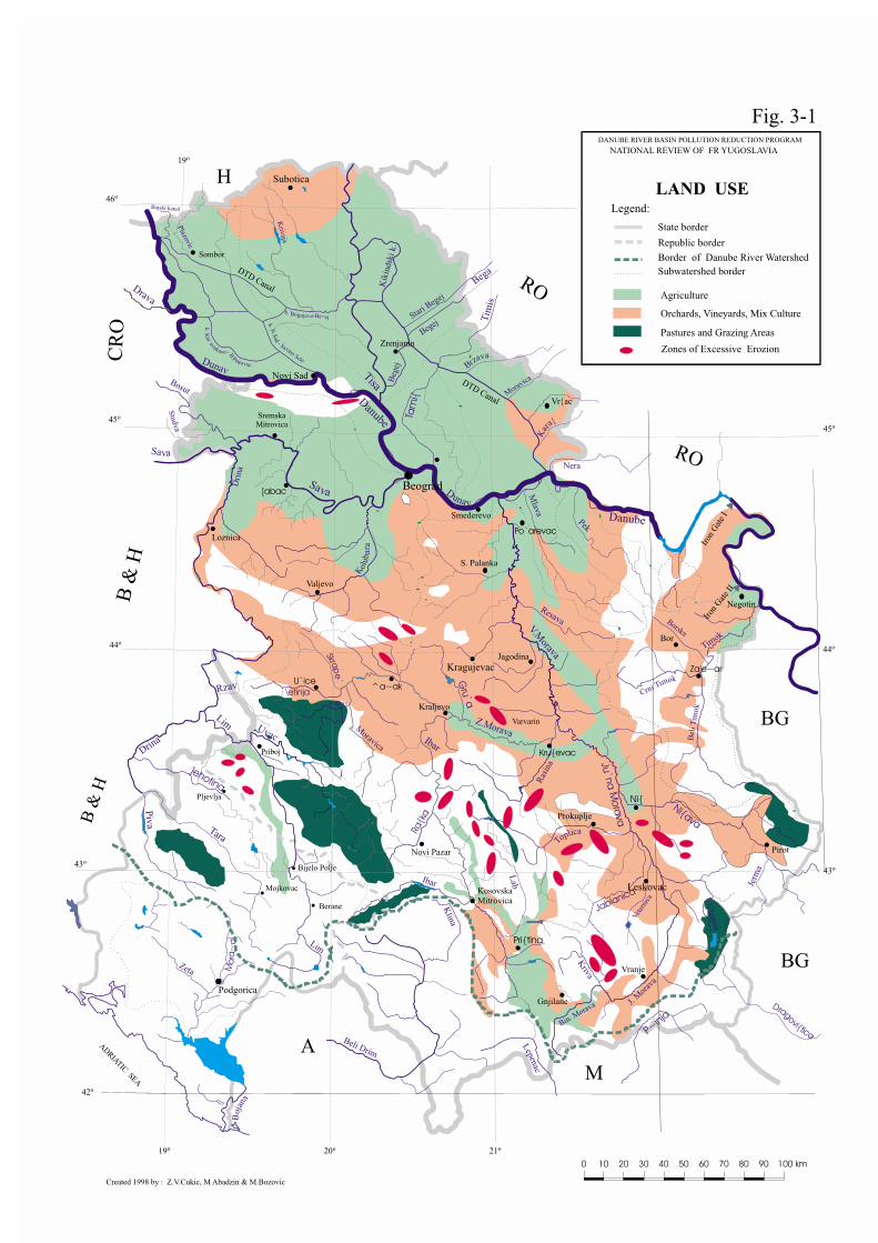
Created 1998 by : Z.V.Cukic, M Abadzin & M.Bozovic
Legend:
Border of Danube River Watershed
Subwatershed border
State border
Republic border
Subotica
Pastures and Grazing Areas
LAND USE
Orchards, Vineyards, Mix Culture
Agriculture
DANUBE RIVER BASIN POLLUTION REDUCTION PROGRAM
NATIONAL REVIEW OF FR YUGOSLAVIA
Fig. 3-1
DTD Canal
DTD Canal
Zones of Excessive Erozion


Adr
iatic
Sea
Bla
ckSea
DA
NU
BE
RIV
ER
BA
SIN
Hun
gary
Aus
tria
Slo
veni
a
Ger
man
y
Cro
atia
Rom
ania
Ukr
aine
Mol
davi
a
Bul
garia
Yugo
slav
ia
Bos
nia-
Her
zego
vinaS
lova
kia
Cze
ch R
epub
lic
Dan
ube
Danu
be
Da nu be
YU
GO
SLA
VIA
N P
AR
T O
F
DA
NU
BE
RIV
ER
BA
SIN
SE
A
DA
NU
BE
RIV
ER
BA
SIN
RIV
ER
STA
TE B
OU
ND
AR
Y


Skad
arskoJezero
WITHIN FR OF YUGOSLAVIA
NETWORK OF HYDROLOGICAL STATIONS
Source :
Fig. 4-2
Melenci
Martono{
Ba~
Morovi}
Batrovci
Jamena
Kajtasovo
Studva
Vrbas II
S. Mileti}
B. Gardi{te

46o
21o
21o
20o
20o
19o
19o
45o
45o
44o
43o43o
44o
42o
Velik
l
i Kaan
Stari B
egej
TisaBrza
va
Tam
i{
Begej
Krivaja
DunavDunav
Kubr{nica
V. Morava
V. Morava
PekPek
C
mr
Tnii
ok
Bel
i T
imo
k
J. Morava
Lep
ne ac
Jablanica
Dragovi{tica
Klina
Beli Drim P~inja
Beli Drim
Ibar
Kriva
Ras
ina
MoravicaUvac
Lim
Resava
Mlava
Mlava
Ra{
ka
Drina
Drina
]ehotina
Tara
Zeta Mor
a~a
Boj
ana
Piv
a
Lim
\etinja
Ibar
Gru‘a
Skrape ‘
Vlasina
Jerm
a
Lab
Sitnica
Topli ac
Jasenica
Tamnava
Kol
uba
ra
UbK
ar
a{
DunavDunavD
rina
Dri
na
Bosut
Jadar
SavaSava
Zla
tica
Bajski kanal
Morav
ica
k. K
aravukovo-
P
B.
etrovac
k. Bogojevo-Be~ej
Tisa
k. N.S
ad - S
oa
nvi Selo
Plazovic
Nadela
^Ik
Drava
CR
O
H
RO
RO
BG
BG
AL
B &
H
B &
H
M
Kere{
Bega
Tim
is
Nera
DANUBE RIVER BASIN POLLUTION REDUCTION PROGRAM
NATIONAL REVIEW OF FR YUGOSLAVIA
Legend
Border of Danube River Watershed
State border
Republic border
AD
RIATIC SEA
Danube
Danube
Sava
Bjelica
Z. Morava
Z. Morava
Borska
J. M
orav
a
Bin. Morava
V.Rzav
Ni{ava
Kik
inds
ki k
.B
egej
Beg
ej
DanubeDanube
Vr{k
a~ i kanal
Timok
Studva
Rzav
Vet
erni
ca
Podgorica
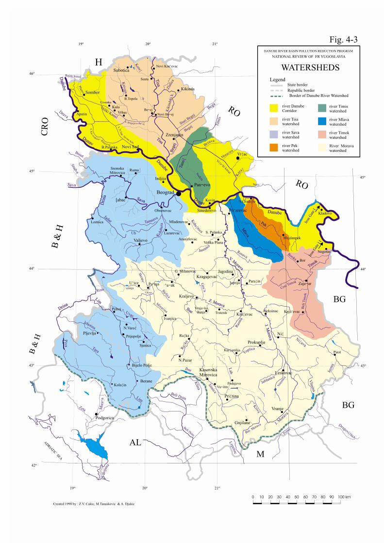
WATERSHEDS
Kola{inBerane
Bijelo Polje
Pljevlja
Subotica
Sombor
Novi Sad
Zrenjanin
Sremska Mitrovica
[abac
Beograd
Pan~evo
Smederevo Po‘arevac
Valjevo
U‘ice^a~ak
Kraljevo
KragujevacJagodina
Zaje~ar
Bor
Kru{evac
Ni{
Prokuplje
Leskovac
Vranje
Pri{tina
KosovskaMitrovica
Gnjilane
Kikinda
Pirot
river Tisa watershed
river Savawatershed
river Pekwatershed
River Morava watershed
river Timokwatershed
river Mlavawatershed
river Timiswatershed
river Danube Corridor
Iron
Gat
e I
Iron
Gat
e I I
Fig. 4-3
Created 1998 by : Z.V. Cukic, M.Tanaskovic & A. Djukic
Negotin
Kladovo
Majdanpek
V.Gradi{te
Vr{ac
Danube
Danube
Obrenovac
Vrbas
B.Palanka
Apatin
Loznica
Priboj
Prijepolje
Sjenica
N.Varo{
G. Milanovac
Trstenik
Vrnja~kaBanja
Ra{ka
N.Pazar
Po‘ega
Ivanjica
]uprija Para}in
Aleksinac
Kur{umlija
PodujevoVu~itrn
Knja‘evac
Aran|elovac
Mladenovac
S. Palanka
Velika Plana
Lazarevac
Kovin
Indjija
Novi Kne‘evac
Senta
B.Topola
Be~ej
Novi Be~ej
Ruma
Crvenka
Kula


46o
21o
21o
20o
20o
19o
19o
45o45o
44o
43o43o
44o
42o
Stari B
egej
Tisa
Brzava
Tam
i{
Begej
Krivaja
Dunav
Kubr{nica
V.Morava
Pek
C
mr
Tnii
ok
Bel
i T
imo
k
Ju‘na M
orava
Lep
ne ac
Jablanica
Dragovi{tica
Klina
Beli Drim
P~inja
Beli Drim
Ibar
Kriva
Ras
ina
MoravicaUvac
Lim
Resava
Mlava
Ra{
ka
Drina
]ehotina
Tara
Zeta Mor
a~a
Boj
ana
Piv
a
Lim
\etinja
Ibar
Gru‘a
Skrape‘
Vlasina
Jerm
a
Lab
Sitnica
Topli ac
Jasenica
Tamnava
Kol
uba
ra
Ub
Kar
a{
DunavDri
na
Bosut
Jadar
Sava
Zla
tica
Bajski kanal
Morav
ica
k. K
aravukovo-
P
B.
etrovac
k. Bogojevo-Be~ej
Tisa
k. N.S
ad - S
oa
nvi Selo
Nadela
^Ik
Drava
CR
O
H
RO
RO
BG
BG
AL
B &
H
B &
H
M
Kere{
Bega
Tim
is
Nera
DANUBE RIVER BASIN POLLUTION REDUCTION PROGRAM
NATIONAL REVIEW OF FR YUGOSLAVIA
Legend
Border of Danube River Watershed
Subwatershed border
Potentially flooded area
State border
Republic border
AD
RIATIC SEA
Danube
Sava
Bjelica
Z.Morava
Borska
J. M
orav
a
Bin. Morava
V.Rzav
Ni{ava
Kik
inds
ki k
.B
egej
Danube
Timok
StudvaRzav
Vet
erni
ca
Podgorica
POTENTIALLY FLOODED AREAS
Kola{inBerane
Bijelo Polje
Pljevlja
Subotica
Sombor
Novi Sad
Zrenjanin
S.Mitrovica
[abac
Beograd
Pan~evo
Smederevo Po‘arevac
Valjevo
U‘ice^a~ak
Kraljevo
KragujevacJagodina
Zaje~ar
Bor
Kru{evac
Ni{
Prokuplje
Leskovac
Vranje
Pri{tina
K.Mitrovica
Gnjilane
Kikinda
Pirot
DTD Canal
DTD Canal Vr{ac
Iron
Gat
e I
Iron
Gat
e II
(Without existing flood defence)
Becej D
am
Created 1998 by Z.V.Cukic & A.R. Djukic
Fig. 4-4


46o
21o
21o
20o
20o
19o
19o
45o45o
44o
43o
44o
42o
Stari B
egej
Tisa
Brzava
Begej
Krivaja
Kubr{nica
V.Morava
Pek
C
mr
Tnii
ok
Bel
i T
imo
k
Lep
ne ac
Jablanica
Klina
Beli Drim
P~inja
Beli Drim
Ibar
Kriva
Ras
ina
Moravica
Uvac
Lim
Resava
Mlava
Drina
Tara
Zeta Mor
a~a
Boj
ana
Piv
a
Lim
\etinja
Ibar
Skrape ‘
Vlasina
Jerm
a
Lab
Sitnica
Topli ac
Jasenica
Tamnava
Kol
uba
ra
Ub
DunavDri
na
Bosut
Jadar
Sava
Zla
tica
Bajski kanal
Morav
ica
k. K
aravukovo-
P
B.
etrovac
k. Bogojevo-Be~ej
Tisa
k. N.S
ad - S
oa
nvi Selo
Nadela
^Ik
Drava
CR
OH
RO
RO
BG
BG
AL
B &
H
B &
H
M
Kere{
Bega
Tim
is
Nera
DANUBE RIVER BASIN POLLUTION REDUCTION PROGRAM
NATIONAL REVIEW OF FR YUGOSLAVIA
Legend
Border of Danube River Watershed
Subwatershed border
Dike
State border
Republic border
ADRIATIC SEA
Danube
Sava
Bjelica
Borska
J. M
orav
a
Bin. Morava
V.Rzav
Kik
inds
ki k
.B
egej
Danube
Timok
Studva
Rzav
Vet
erni
ca
Podgorica
Berane
Bijelo Polje
Pljevlja
Subotica
Sombor
Novi Sad
Zrenjanin
Beograd
Po‘arevac
Valjevo
Kraljevo
Kragujevac
Bor
Prokuplje
Leskovac
Vranje
Gnjilane
Kikinda
Pirot
S.Mitrovica
K.Mitrovica
Zapadna Morava
DTD Canal
DTD Canal
Iron
Gat
e I
Iron
Gat
e II
EMBANKMENTS(100 years return period)
Created 1998 by : M.Bozinovic, A.Djukic & Z.V.Cukic
Fig. 4-5
Becej Gate
Inundation
Wetland
Mihajlovac
Grocka
Dubovac
SlankamenKr~edin
Kovilj
Beljarica
Ram
Susek Cerevi} Beo~in
Apatin


Danube
Sava
Gra
nd M
ora
va
West Morava
Ibar
Toplica
Ni{ava
South
Mora
va
Timok
Mla
va
Pek
Lim
Dri
na
Dam Zvornik
Dam B. Ba{ta
Kolu
bara
IRO
N G
ATE I
Dam
IRON GATE II
Dam
RO
RO
CR
O
H
BG
BG
A
B &
H
B &
H
M
AD
RIA
TIC
SEA
DANUBE RIVER BASIN POLLUTION REDUCTION PROGRAM
NATIONAL REVIEW OF FR YUGOSLAVIA
WATER TRANSFERS
Drava B
ega
Tim
is
DTD Canal
DT
D C
anal
Becej Gate
Tis
za
BELGRADE11.7
Dunav
Tis
a17.7
Danube
Tam
is
Ibar
Sitn
ica
Piv
a
Tara
]Ehotin
a
Cern
a
Mures
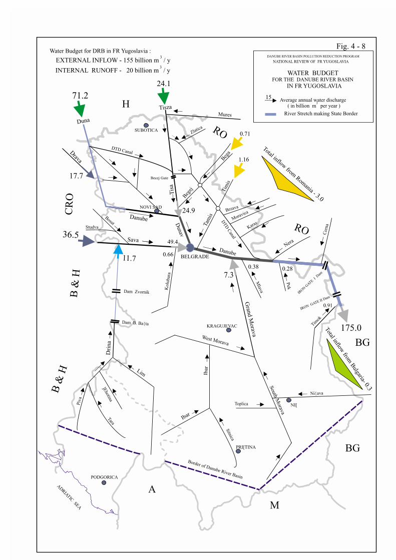
EXTERNAL INFLOW - 155 billion m / y3
INTERNAL RUNOFF - 20 billion m / y3
Water Budget for DRB in FR Yugoslavia :
Beg
ej
Zlatica
Nera
Karas
Brzava
Moravica
Duna
Border of Danube River Basin
NI[
PODGORICA
NOVI SAD
PRI[TINA
KRAGUJEVAC
SUBOTICA
Bosut
Studva
WITHIN THE DANUBE RIVER BASIN
IN FR YUGOSLAVIA
Fig. 4-6
River Stretch making State Border
Becej
PadejBezdan
Bogojevo
Water transfer
Q = 12 m /s3
Q = 30 g
m /s3
Q = 60 m /sg
3
Q = 18 m /sp
3
Q = 60 m /sg
3
Q = 12 m /sp
3
Qp
Qg - withdrawal by gravitation
- withdrawal by pumping

46o
21o
21o
20o
20o
19o
19o
45o45o
44o
43o43o
44o
42o
Stari B
egej
Tisa
Brzava
Tam
i{
Begej
Krivaja
Dunav
Kubr{nica
V.Morava
Pek
C
mr
Tnii
ok
Bel
i T
imo
k
Ju‘na M
orava
Lep
ne ac
Jablanica
Dragovi{tica
Klina
Beli Drim
P~inja
Beli Drim
Ibar
Kriva
Ras
ina
MoravicaUvac
Lim
Resava
Mlava
Ra{
ka
Drina
]ehotina
Tara
Zeta Mor
a~a
Boj
ana
Piv
a
Lim
\etinja
Ibar
Gru‘a
Skrape ‘
Vlasina
Jerm
a
Lab
Sitnica
Topli ac
Jasenica
Tamnava
Kol
uba
ra
UbK
ar
a{
DunavDri
na
Bosut
Jadar
Sava
Zla
tica
Bajski kanal
Morav
ica
k. K
aravukovo-
P
B.
etrovac
k. Bogojevo-Be~ej
Tisa
k. N.S
ad - S
oa
nvi Selo
Martono{
Ba~ki BregBezdan
Apatin
Bogojevo
Sombor
B. Petrovac
Vrbas II Srbobran
Ba~
Hetin
MelenciN. Be~ej
Staji}evo
Ja{a Tomi}
Markovi}evo
Vatin
Pan~evo
Dra‘evac
Ostru‘nica
N. Sad I
Titel
Kusi}
Ban.Palanka
Kajtasovo
Dobri~evo
Ljubi~evski most
V. Gra
di{t
e
Kusi}i
Teki
ja
Brza Palanka
Rad
ujev
ac
Brusnik
RgotinaBagrdan
Varvarin
Maskare Mojsinje
Doljevac
Bela Palanka
Ni{
Dimitrovgrad
Grdelica
Ristovac
Morovi}
Jamena
Batrovci
S. Mitrovica
Slovac
Bajina Ba{taGugaljski most
Kraljevo
Priboj
PrijepoljeGradac
\ur|evi}aTara
Ra{ka
Prelez
Smederevo
Srpski Itebej
Plazovic
Nadela
B. G
radi{te
^Ik
Drava
CR
O
H
RO
RO
BG
BG
A
B &
H
B &
H
M
Kere{
Bega
Tim
is
Nera
DANUBE RIVER BASIN POLLUTION REDUCTION PROGRAM
NATIONAL REVIEW OF FR YUGOSLAVIA
Legend :
Border of Danube River Watershed
Subwatershed border
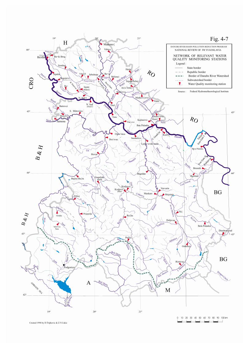
Water Quality monitoring station
State border
Republic border
AD
RIATIC SEA
Danube
Sava
Bjelica
Z.Morava
Borska
J. M
orav
a
Bin. Morava
M.Rzav
Ni{ava
Kik
inds
ki k
.B
egej
Danube
Timok
Studva
Rzav
Vet
erni
ca
Podgorica
NETWORK OF RELEVANT WATER QUALITY MONITORING STATIONS
Source : Federal Hydrometheorological Institute
Kraljevo(Ibar)
N. Sad(Dunav)
DTD
Canal
DTD Canal
DTD Canal
Iron
Gat
e I
Iron
Gat
e II
Becej Dam
Created 1998 by D.Tripkovic & Z.V.Cukic
Fig. 4-7
^Enta
SrpskiMileti}
Vrbica
Lim

Danube
Sava
Gra
nd M
ora
va
West Morava
Ibar
Toplica
Ni{ava
South
Mora
va
Timok
Mla
va
Pek
Lim
Dri
na
Dam Zvornik
Dam B. Ba{ta
Kolu
bara
IRO
N G
ATE I
Dam
IRON GATE II
Dam
RO
RO
CR
O
H
BG
BG
A
B &
H
B &
H
M
AD
RIA
TIC
SEA
24.1
71.2 Average annual water discharge
DANUBE RIVER BASIN POLLUTION REDUCTION PROGRAM
NATIONAL REVIEW OF FR YUGOSLAVIA
WATER BUDGET
Drava B
ega
Tim
is
DTD Canal
DT
D C
anal
Becej Gate
( in billion m per year )3
Tisza
36.5
BELGRADE
0.71
1.16
11.7
49.4
Dunav
Tis
a17.7
7.3
Danube
Tam
is
Ibar
Sitn
ica
Piv
a
Tara
]Ehotin
a
15
Total inflow from
Rom
ania - 3.0
0.38 0.28
0.91
Total in
flow
from
Bulg
aria- 0.3
Cern
a175.0
Mures
24.9
EXTERNAL INFLOW - 155 billion m / y3
INTERNAL RUNOFF - 20 billion m / y3
Water Budget for DRB in FR Yugoslavia :
Beg
ej
0.66
Zlatica
Nera
Karas
Brzava
Moravica
Duna
Border of Danube River Basin
NI[
PODGORICA
NOVI SAD
PRI[TINA
KRAGUJEVAC
SUBOTICA
Bosut
Studva
FOR THE DANUBE RIVER BASIN
IN FR YUGOSLAVIA
Fig. 4 - 8
River Stretch making State Border


6.7
4.4
11.1
14.53.0
0.5
17.3
2.8
0.2
0.1
3.0
2.0
0.9
0.3
1.2
0.3
0.7
1.1
2.0
0.5
0.1
2.2
2.5
0.5
Danube
Sava
Tisa
Gra
nd M
ora
vaZ. Morava
Ibar
Toplica
Ni{ava
J. Morav
a
Timok
Mlav
a
Pek
Lim
Dri
na
Dam Zvornik
Dam B. Ba{ta
Dam Potpe}
Kolu
bara
0.1 - average annual discharge of suspended
sediments (million tons per year)
SUSPENDED SEDIMENTS DISCHARGES
DANUBE RIVER BASIN POLLUTION REDUCTION PROGRAM
NATIONAL REVIEW OF FR YUGOSLAVIA
FLOW DIAGRAM OF
Source : Water Master Plan of Republic of Serbia
IRO
N G
ATE I D
am
IRON G
ATE II Dam
Fig. 4-9
RO
RO
CR
O
H
BG
BG
A
B &
H
B &
H
M
AD
RIA
TIC
SEA


Summary of Information for theMunicipal High Priority Hot Spots


Technical Reports – Part C: Water Quality, Annexes 193
Name of the Hot Spot: City of Belgrade (Central Sewage System)Name of the receiving water : Danube River
River km of the effluent discharge : 1165Critical Emissions Discharge (m3/y) 146,000,000
BOD5 (t/y) 35,040Tot N (tN/y) 5,840Tot P (tP/y) 1,314Susp. Solids (t/y) 28,850
Seasonal Variations
The CDF-critical dilution factor (Q95:Qeffl ), is ratherhigh (i.e. 450-500) accounting at whole river flow butin the mixing zone after bank outlet of sewage, CDF isaround 80-120. The emission affects water quality butdoesn’t change it dramatically even in the mixingzone.
Immediate Causes of EmissionsThere is no Municipal WWTP. Actually, there areseveral sewage outlets distributed along 5 km riverstretch. It is planned to connect all of its to maincollector (i.e. Interceptor).
Root Causes of Water QualityProblems
The emission of pollution from a large Metropolitanarea located on the riverbank. The lack of money forinvestment.
Receiving Waters Direct outflow in the Danube River (right bank)
Nearby Downstream Uses
The impoundment of surface water for the SmallWater Treatment Plant (capacity ~ 5000 m3/d)supplying the southern suburban area of the City islocated 10 km kilometers downstream of the plannedsewage outflow. Also, there is a large recreationalarea downstream of sewage outlet.
Transboundary Implications
There is no direct transboundary implications (thebeginning of the stretch making the State border withRomania is 100 km downstream of Belgrade) butrather indirect ones because of large emission ofpollution.
Rank High

194 Danube Pollution Reduction Programme – National Review, Federal Republic of Yugoslavia
Name of the Hot Spot: City of Belgrade (Sewage System “Ostru`nica”)Name of the receiving water : Sava RiverRiver km of the effluentdischarge :
15
Critical EmissionsDischarge (m3/y) 5,000,000BOD5 (t/y) 1,205Tot N (tN/y) 201Tot P (tP/y) 45Susp. Solids (t/y) 925
Seasonal Variations :
The CDF-critical dilution factor (Q95: Qeffl ), is rather high(i.e. 250-300) accounting at whole river flow but in themixing zone after bank outlet of sewage, CDF is around50-60. The emission affects water quality but doesn’tchange it dramatically.
Immediate Causes of Emissions There is no WWTP. Actually, there are several outlets,which are planned to be connected in one.
Root Causes of Water QualityProblems
The emission of pollution from a part (mixed urban/rural)of large Metropolitan area. Actually, there are severalsmaller outlets of sewage distributed along the riverbank.Just a part (55%) of users is connected on the sewagesystem in this horizon.
Receiving Waters Direct outflow in the Sava River (right bank).
Nearby Downstream Uses
Several withdrawals (wells) of bank filtrate for two WaterTreatment Plant (total capacity ~ 250000 m3/d) as well asthe withdrawal of surface water for the “Maki{” WaterTreatment Plant (actual capacity ~ 250000 m3/d)supplying the largest part of Metropolitan Area are alllocated along the riverbank downstream of plannedsewage outlet. Also, there is a large recreation areadownstream of planned sewage outlet.
Transboundary Implications There are no direct transboundary implications butindirect ones.
Rank High
Technical Reports – Part C: Water Quality, Annexes 195
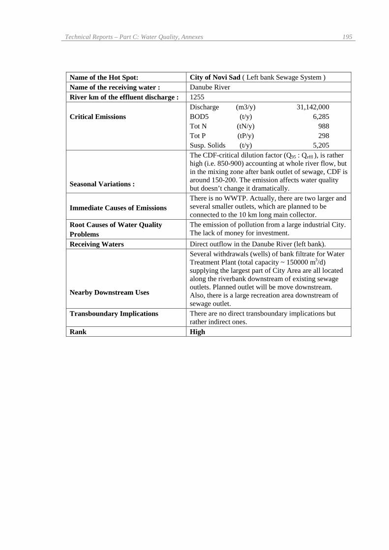
Name of the Hot Spot: City of Novi Sad ( Left bank Sewage System )Name of the receiving water : Danube RiverRiver km of the effluent discharge : 1255
Critical EmissionsDischarge (m3/y) 31,142,000BOD5 (t/y) 6,285Tot N (tN/y) 988Tot P (tP/y) 298Susp. Solids (t/y) 5,205
Seasonal Variations :
The CDF-critical dilution factor (Q95 : Qeffl ), is ratherhigh (i.e. 850-900) accounting at whole river flow, butin the mixing zone after bank outlet of sewage, CDF isaround 150-200. The emission affects water qualitybut doesn’t change it dramatically.
Immediate Causes of EmissionsThere is no WWTP. Actually, there are two larger andseveral smaller outlets, which are planned to beconnected to the 10 km long main collector.
Root Causes of Water QualityProblems
The emission of pollution from a large industrial City.The lack of money for investment.
Receiving Waters Direct outflow in the Danube River (left bank).
Nearby Downstream Uses
Several withdrawals (wells) of bank filtrate for WaterTreatment Plant (total capacity ~ 150000 m3/d)supplying the largest part of City Area are all locatedalong the riverbank downstream of existing sewageoutlets. Planned outlet will be move downstream.Also, there is a large recreation area downstream ofsewage outlet.
Transboundary Implications There are no direct transboundary implications butrather indirect ones.
Rank High
196 Danube Pollution Reduction Programme – National Review, Federal Republic of Yugoslavia
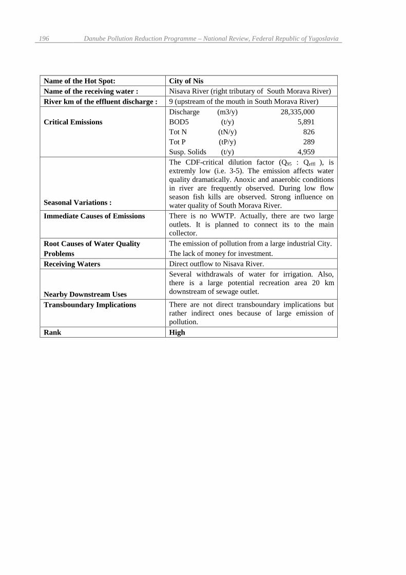
Name of the Hot Spot: City of NisName of the receiving water : Nisava River (right tributary of South Morava River)River km of the effluent discharge : 9 (upstream of the mouth in South Morava River)
Critical EmissionsDischarge (m3/y) 28,335,000BOD5 (t/y) 5,891Tot N (tN/y) 826Tot P (tP/y) 289Susp. Solids (t/y) 4,959
Seasonal Variations :
The CDF-critical dilution factor (Q95 : Qeffl ), isextremly low (i.e. 3-5). The emission affects waterquality dramatically. Anoxic and anaerobic conditionsin river are frequently observed. During low flowseason fish kills are observed. Strong influence onwater quality of South Morava River.
Immediate Causes of Emissions There is no WWTP. Actually, there are two largeoutlets. It is planned to connect its to the maincollector.
Root Causes of Water QualityProblems
The emission of pollution from a large industrial City.The lack of money for investment.
Receiving Waters Direct outflow to Nisava River.
Nearby Downstream Uses
Several withdrawals of water for irrigation. Also,there is a large potential recreation area 20 kmdownstream of sewage outlet.
Transboundary Implications There are not direct transboundary implications butrather indirect ones because of large emission ofpollution.
Rank High

Technical Reports – Part C: Water Quality, Annexes 197
Name of the Hot Spot: City of PristinaName of the receiving water : Sitnica RiverRiver km of the effluent discharge : 1165
Critical EmissionsDischarge (m3/y) 16,500,000BOD5 (t/y) 3,959Tot N (tN/y) 570Tot P (tP/y) 148Susp. Solids (t/y) 3,207
Seasonal Variations
The CDF-critical dilution factor (Q95: Qeffl ) isextremely low (i.e. 1.5-2.5). The pollution emissionhas a detrimental effect on water quality as well as onthe ecosystem. Anoxic and anaerobic conditions inriver are regularly observed during the largest part ofthe year. There is also a strong influence on waterquality of Ibar River.
Immediate Causes of Emissions There is no Municipal WWTP. Actually, there is onelarge outlet ending at location of planned WWTP.
Root Causes of Water QualityProblems
The emission of pollution from a large Metropolitanarea located on the riverbank. The lack of money forinvestment.
Receiving Waters Direct outflow in the Pristevka stream, tributary ofsmall Sitnica River (Watershed of Velika Morava).
Nearby Downstream Uses
There are not nearby downstream users as the waterquality is out of any class. The water would bepotentially use for irrigation and for industrial watersupply. There is the strong influence on water supplyof settlements in Sitnica and Ibar River valleys.
Transboundary Implications
There are not direct transboundary implications butrather indirect ones because of large emission ofpollution.
Rank High
198 Danube Pollution Reduction Programme – National Review, Federal Republic of Yugoslavia
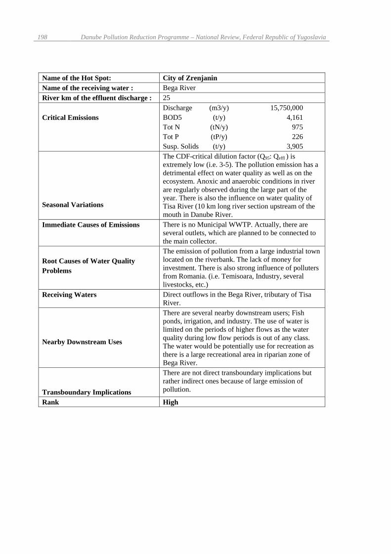
Name of the Hot Spot: City of ZrenjaninName of the receiving water : Bega RiverRiver km of the effluent discharge : 25
Critical EmissionsDischarge (m3/y) 15,750,000BOD5 (t/y) 4,161Tot N (tN/y) 975Tot P (tP/y) 226Susp. Solids (t/y) 3,905
Seasonal Variations
The CDF-critical dilution factor (Q95: Qeffl ) isextremely low (i.e. 3-5). The pollution emission has adetrimental effect on water quality as well as on theecosystem. Anoxic and anaerobic conditions in riverare regularly observed during the large part of theyear. There is also the influence on water quality ofTisa River (10 km long river section upstream of themouth in Danube River.
Immediate Causes of Emissions There is no Municipal WWTP. Actually, there areseveral outlets, which are planned to be connected tothe main collector.
Root Causes of Water QualityProblems
The emission of pollution from a large industrial townlocated on the riverbank. The lack of money forinvestment. There is also strong influence of pollutersfrom Romania. (i.e. Temisoara, Industry, severallivestocks, etc.)
Receiving Waters Direct outflows in the Bega River, tributary of TisaRiver.
Nearby Downstream Uses
There are several nearby downstream users; Fishponds, irrigation, and industry. The use of water islimited on the periods of higher flows as the waterquality during low flow periods is out of any class.The water would be potentially use for recreation asthere is a large recreational area in riparian zone ofBega River.
Transboundary Implications
There are not direct transboundary implications butrather indirect ones because of large emission ofpollution.
Rank High

Technical Reports – Part C: Water Quality, Annexes 199
Name of the Hot Spot: Vrbas – Kula Regional SystemName of the receiving water : DTD CanalRiver km of the effluent discharge : 40
Critical EmissionsDischarge (m3/y) 9,450,000BOD5 (t/y) 3,592Tot N (tN/y) 547Tot P (tP/y) 151Susp. Solids (t/y) 3,022
Seasonal Variations
The CDF-critical dilution factor (Q95: Qeffl ) isextremely low (i.e. 2-3). The pollution emission,particularly during the full production of foodprocessing industry, has a detrimental effect on waterquality as well as on the ecosystem of DTD Canal.Anoxic and anaerobic conditions along thedownstream section of Canal are regularly observed.During the full production of seasonal industry thefish kills are observed. There is also the influence onwater quality of Tisa River as DTD Canal empties inTisa River near Becej Gate.
Immediate Causes of Emissions There is no Municipal WWTP. Actually, there areseveral outlets, which will be connected to theRegional Sewage System.
Root Causes of Water QualityProblems
The emission of pollution from two industrial (largefood processing industry) towns located on the Canalbank. The lack of money for investment.
Receiving Waters Direct outflows in the DTD Canal, about 40 kmupstream from the mouth with Tisa River.
Nearby Downstream Uses
There are several nearby downstream users, i.e.fishponds, irrigation, industry. The use of water islimited on the periods of higher flows as the waterquality during low flow periods is out of any class.The water would be potentially use for recreation asthere is a large recreational area in riparian zone ofBega River.
Transboundary Implications
There are not direct transboundary implications butrather indirect ones because of large emission ofpollution.
Rank High

200 Danube Pollution Reduction Programme – National Review, Federal Republic of Yugoslavia
Name of the Hot Spot: City of LeskovacName of the receiving water : Ju`na (South) Morava RiverRiver km of the effluent discharge : 128
Critical EmissionsDischarge (m3/y) 12,600,000BOD5 (t/y) 3,193Tot N (tN/y) 295Tot P (tP/y) 132Susp. Solids (t/y) 2,903
Seasonal Variations
The CDF-critical dilution factor (Q95: Qeffl ) is low (i.e.12-15). The pollution emission has an extremelyadverse effect on water quality as well as on theecosystem. Anoxic and anaerobic conditions in riverare occasionally observed. There is also the influenceon water quality of Velika Morava River.
Immediate Causes of EmissionsThere is no Municipal WWTP. The existing outlet onthe Veternica River (tributary of South Morava River)bank will be moved (10 km long collector)downstream to the location planned for WWTP.
Root Causes of Water QualityProblems
The emission of pollution from a large industrial townlocated on the riverbank.The lack of money for investment.
Receiving Waters As it is planned, the effluent will be discharged to theJu`na (South) Morava River, tributary of VelikaMorava River.
Nearby Downstream Uses
There are several nearby downstream users; irrigation,industry. The use of water is limited on the periods ofhigher flows as the water quality during low flowperiods is bad. There is a need of several downstreamusers to use water (i.e. bank filtrate) for water supply.The water would be potentially use for recreation asthere is a large recreational area in riparian zone of J.Morava River.
Transboundary Implications
There are not direct transboundary implications butrather indirect ones because of large emission ofpollution.
Rank High
Technical Reports – Part C: Water Quality, Annexes 201
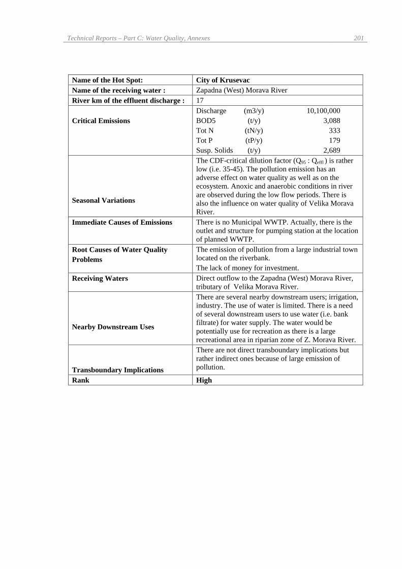
Name of the Hot Spot: City of KrusevacName of the receiving water : Zapadna (West) Morava RiverRiver km of the effluent discharge : 17
Critical EmissionsDischarge (m3/y) 10,100,000BOD5 (t/y) 3,088Tot N (tN/y) 333Tot P (tP/y) 179Susp. Solids (t/y) 2,689
Seasonal Variations
The CDF-critical dilution factor (Q95 : Qeffl ) is ratherlow (i.e. 35-45). The pollution emission has anadverse effect on water quality as well as on theecosystem. Anoxic and anaerobic conditions in riverare observed during the low flow periods. There isalso the influence on water quality of Velika MoravaRiver.
Immediate Causes of Emissions There is no Municipal WWTP. Actually, there is theoutlet and structure for pumping station at the locationof planned WWTP.
Root Causes of Water QualityProblems
The emission of pollution from a large industrial townlocated on the riverbank.The lack of money for investment.
Receiving Waters Direct outflow to the Zapadna (West) Morava River,tributary of Velika Morava River.
Nearby Downstream Uses
There are several nearby downstream users; irrigation,industry. The use of water is limited. There is a needof several downstream users to use water (i.e. bankfiltrate) for water supply. The water would bepotentially use for recreation as there is a largerecreational area in riparian zone of Z. Morava River.
Transboundary Implications
There are not direct transboundary implications butrather indirect ones because of large emission ofpollution.
Rank High

202 Danube Pollution Reduction Programme – National Review, Federal Republic of Yugoslavia
Name of the Hot Spot: City of CacakName of the receiving water : Zapadna (West) Morava RiverRiver km of the effluent discharge : 168
Critical EmissionsDischarge (m3/y) 10,930,000BOD5 (t/y) 2,740Tot N (tN/y) 410Tot P (tP/y) 139Susp. Solids (t/y) 2,350
Seasonal Variations
The CDF-critical dilution factor (Q95: Qeffl ) is ratherlow (i.e. 15-20). The pollution emission has anadverse effect on water quality as well as on theecosystem. Anoxic and anaerobic conditions in riverare observed during the low flow periods. There isalso the influence on water quality of Velika MoravaRiver.
Immediate Causes of Emissions There is no Municipal WWTP. Actually, there are twooutlets, which are planned to be connected to the maincollector.
Root Causes of Water QualityProblems
The emission of pollution from a large industrial townlocated on the riverbank.The lack of money for investment.
Receiving Waters Direct outflows in the Zapadna (West) Morava River,tributary of Velika Morava River.
Nearby Downstream Uses
There are several nearby downstream users; irrigation,industry. The use of water is limited. There is a needof several downstream users to use water (i.e. bankfiltrate) for water supply. The water would bepotentially use for recreation as there is a largerecreational area in riparian zone of Z. Morava River.
Transboundary Implications
There are not direct transboundary implications butrather indirect ones because of large emission ofpollution.
Rank High

Technical Reports – Part C: Water Quality, Annexes 203
Name of the Hot Spot: City of SabacName of the receiving water : Sava RiverRiver km of the effluent discharge: 101
Critical EmissionsDischarge (m3/y) 8,500,000BOD5 (t/y) 2,124Tot N (tN/y) 287Tot P (tP/y) 113Susp. Solids (t/y) 1,805
Seasonal Variations :
The CDF-critical dilution factor (Q95: Qeffl ), is ratherhigh (i.e. 100-120) accounting at whole river flow but inthe mixing zone after bank outlet of sewage, CDF isaround 20-30. The emission affects water quality butdoesn’t change it dramatically even in the mixing zone.
Immediate Causes of Emissions There is no WWTP. Actually, there are several outlets,which are planned to be connected in one.
Root Causes of Water QualityProblems
The emission of pollution from a large industrial townlocated on the riverbank.The lack of money for investment.
Receiving Waters Direct outflow in the Sava River (right bank).
Nearby Downstream Uses
Several withdrawals (wells) of bank filtrate for severalsmaller towns as well as dozens withdrawals (wells) fortwo Belgrade Water Treatment Plant (total capacity ~450000 m3/d are all located along the Sava riverbanksdownstream of planned sewage outlet. Also, there is alarge recreation area downstream of planned sewageoutlet.
Transboundary Implications There is no direct transboundary implications butindirect ones.
Rank High

204 Danube Pollution Reduction Programme – National Review, Federal Republic of Yugoslavia
Name of the Hot Spot: City of VranjeName of the receiving water : Ju`na (South) Morava RiverRiver km of the effluent discharge : 221
Critical EmissionsDischarge (m3/y) 9,450,000BOD5 (t/y) 2,059Tot N (tN/y) 286Tot P (tP/y) 92Susp. Solids (t/y) 1,782
Seasonal Variations
The CDF-critical dilution factor (Q95: Qeffl ) isextremely low (i.e. 2-3). The pollution emission hasan extremely adverse effect on water quality as well ason the ecosystem. Anoxic and anaerobic conditions inriver are frequently observed. There is also theinfluence on water quality of Velika Morava River.
Immediate Causes of EmissionsThere is no Municipal WWTP. Existing outlet insmall Vranjska stream (tributary of South MoravaRiver) will be moved (7 km long main collector)downstream to the location planned for WWTP.
Root Causes of Water QualityProblems
The emission of pollution from a large industrial townlocated on the riverbank.The lack of money for investment.
Receiving Waters The direct outflow in the Ju`na (South) Morava River,tributary of Velika Morava River.
Nearby Downstream Uses
There are several nearby downstream users; watersupply (bank filtrate), irrigation, industry. The use ofwater is limited, as the water quality during low flowperiods is bad. There is a need of several downstreamusers to increase use of water (i.e. bank filtrate) forwater supply. The water would be potentially use forrecreation as there is a large recreational area inriparian zone of J. Morava River.
Transboundary Implications
There are not direct transboundary implications butrather indirect ones because of large emission ofpollution.
Rank High
Technical Reports – Part C: Water Quality, Annexes 205
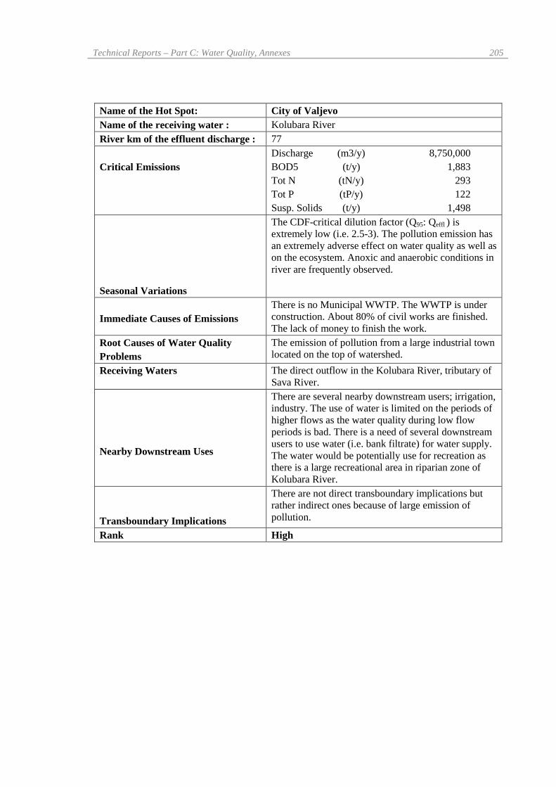
Name of the Hot Spot: City of ValjevoName of the receiving water : Kolubara RiverRiver km of the effluent discharge : 77
Critical EmissionsDischarge (m3/y) 8,750,000BOD5 (t/y) 1,883Tot N (tN/y) 293Tot P (tP/y) 122Susp. Solids (t/y) 1,498
Seasonal Variations
The CDF-critical dilution factor (Q95: Qeffl ) isextremely low (i.e. 2.5-3). The pollution emission hasan extremely adverse effect on water quality as well ason the ecosystem. Anoxic and anaerobic conditions inriver are frequently observed.
Immediate Causes of EmissionsThere is no Municipal WWTP. The WWTP is underconstruction. About 80% of civil works are finished.The lack of money to finish the work.
Root Causes of Water QualityProblems
The emission of pollution from a large industrial townlocated on the top of watershed.
Receiving Waters The direct outflow in the Kolubara River, tributary ofSava River.
Nearby Downstream Uses
There are several nearby downstream users; irrigation,industry. The use of water is limited on the periods ofhigher flows as the water quality during low flowperiods is bad. There is a need of several downstreamusers to use water (i.e. bank filtrate) for water supply.The water would be potentially use for recreation asthere is a large recreational area in riparian zone ofKolubara River.
Transboundary Implications
There are not direct transboundary implications butrather indirect ones because of large emission ofpollution.
Rank High

206 Danube Pollution Reduction Programme – National Review, Federal Republic of Yugoslavia
Name of the Hot Spot: City of SuboticaName of the receiving water : Lakes ; Palic and LudosRiver km of the effluent discharge :
Critical EmissionsDischarge (m3/y) 17,350,000BOD5 (t/y) 4,161Tot N (tN/y) 696Tot P (tP/y) 187Susp. Solids (t/y) 4,267
Seasonal VariationsThe variation of pollution emission depends onseasonal industry (food processing).
Immediate Causes of EmissionsThe overloading of existing WWTP (110,000 p.e.,activated sludge process) which was built in 1975.Lack of capacity (for additional 90,000 p.e.) ofexisting Municipal WWTP as well as the lack offacilities for nutrients removal. The need for theRenovation of existing WWTP.
Root Causes of Water QualityProblems
The emission of pollution from a large industrial townlocated on the top of watershed. The lack of moneyfor the investment.
Receiving WatersThe effluent from WWTP discharges to facultativelagoons than to Palic Lake. Overflow discharges toKeres creek (enters from Hungary), the tributary ofLudos Lake, which is the famous wild bird reserve(Ramsar Site).
Nearby Downstream Uses
Palic Lake is the large recreational area. The water isused for recreation. Ludos Lake is the famous wildbird reserve (Ramsar Site). Overflow from LudosLake is used for supply of a large fish pond.
Transboundary Implications There are not direct transboundary implications.Rank High

Technical Reports – Part C: Water Quality, Annexes 207
Name of the Hot Spot: City of UziceName of the receiving water : Djetinja RiverRiver km of the effluent discharge : 32
Critical EmissionsDischarge (m3/y) 7,300,000BOD5 (t/y) 1,643Tot N (tN/y) 222Tot P (tP/y) 62Susp. Solids (t/y) 1,164
Seasonal Variations
The CDF-critical dilution factor (Q95 : Qeffl ) is ratherlow (i.e. 5-6). The pollution emission has an adverseeffect on water quality as well as on the ecosystem.Anoxic and anaerobic conditions in river are observedduring the low flow periods.
Immediate Causes of Emissions There is no Municipal WWTP. Actually, there areseveral outlets, which are planned to be connected onthe 8 km long collector.
Root Causes of Water QualityProblems
The emission of pollution from a large industrial townlocated on the riverbank.The Lack of money for investment.
Receiving Waters Direct outflows in the Djetinja River, tributary ofZapadna (West) Morava.
Nearby Downstream Uses
There are several nearby downstream users; irrigation,industry. The use of water is limited. There is a needof several downstream users to use water (i.e. bankfiltrate) for water supply. The water would bepotentially use for recreation as there is a largerecreational area in riparian zone of Djetinja andZapadna Morava River.
Transboundary Implications
There are not direct transboundary implications butrather indirect ones because of large emission ofpollution.
Rank High

208 Danube Pollution Reduction Programme – National Review, Federal Republic of Yugoslavia
Name of the Hot Spot: City of ZajecarName of the receiving water : Timok RiverRiver km of the effluent discharge : 67
Critical EmissionsDischarge (m3/y) 5,633,000BOD5 (t/y) 1,461Tot N (tN/y) 205Tot P (tP/y) 55Susp. Solids (t/y) 1,121
Seasonal Variations
The CDF-critical dilution factor (Q95: Qeffl ) is ratherlow (i.e. 5-6). The pollution emission has an adverseeffect on water quality as well as on the ecosystem.Anoxic and anaerobic conditions in river are observedduring the low flow periods.
Immediate Causes of Emissions There is no Municipal WWTP. Actually, there isoutlet, which will be moved to the location of plannedWWTP.
Root Causes of Water QualityProblems
The emission of pollution from a medium sizeindustrial town located on the riverbank. The Lack ofmoney for investment.
Receiving Waters Direct outflows in the Timok River, direct tributary ofDanube.
Nearby Downstream Uses
There are several nearby downstream users; irrigation,industry. The use of water is limited. There is a needof several downstream smeller users to use water (i.e.bank filtrate) for water supply. The water would bepotentially use for recreation as there is a largerecreational area in riparian zone of Timok River.
Transboundary Implications
There are direct transboundary implications as theTimok River makes the State Border (19 km long)with Bulgaria.
Rank High

Technical Reports – Part C: Water Quality, Annexes 209
Name of the Hot Spot: City of BorName of the receiving water : Borska stream (tributary of Timok River)River km of the effluent discharge : 27
Critical EmissionsDischarge (m3/y) 5,494,000BOD5 (t/y) 1,398Tot N (tN/y) 145Tot P (tP/y) 43Susp. Solids (t/y) 1,095
Seasonal Variations
The CDF-critical dilution factor (Q95: Qeffl ) is extreelylow (i.e. 2-3). The pollution emission has adetrimental effect on water quality as well as on theecosystem. Anoxic and anaerobic conditions in riverare observed during the largest part of the year,particularly during low flow periods.
Immediate Causes of Emissions There is no Municipal WWTP.Root Causes of Water QualityProblems
The emission of pollution from a medium sizeindustrial town located on the riverbank. The Lack ofmoney for investment.
Receiving Waters Direct outflows in the Borska stream, the tributary ofTimok River.
Nearby Downstream Uses
There are several nearby downstream users; irrigation,industry. The use of water is limited as its waterquality is out of any class. The water would bepotentially use for recreation as there is a largerecreational area in riparian zone.
Transboundary Implications
There are direct transboundary implications as theBorska stream is the left tributary of the Timok Riverwhich makes the State Border (19 km long) withBulgaria.
Rank High
210 Danube Pollution Reduction Programme – National Review, Federal Republic of Yugoslavia
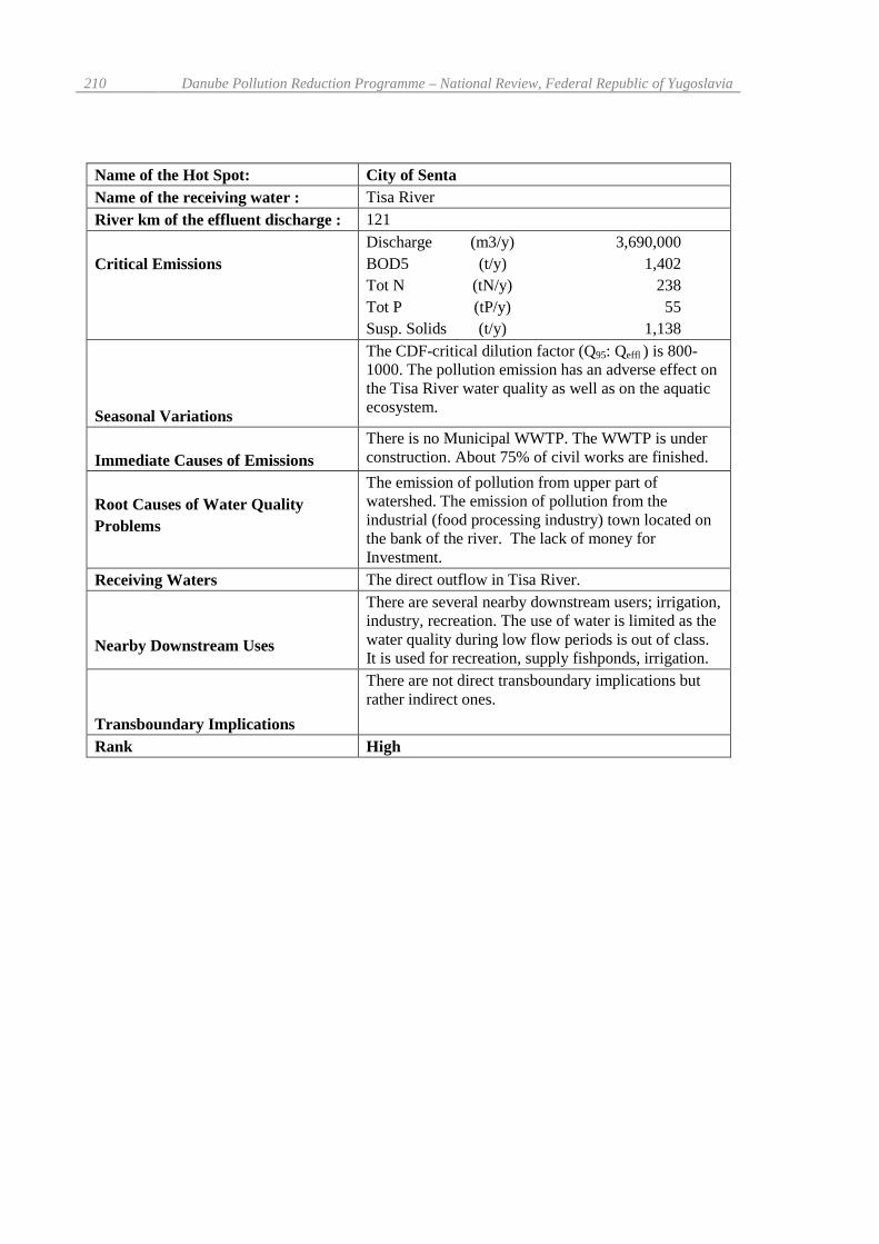
Name of the Hot Spot: City of SentaName of the receiving water : Tisa RiverRiver km of the effluent discharge : 121
Critical EmissionsDischarge (m3/y) 3,690,000BOD5 (t/y) 1,402Tot N (tN/y) 238Tot P (tP/y) 55Susp. Solids (t/y) 1,138
Seasonal Variations
The CDF-critical dilution factor (Q95: Qeffl ) is 800-1000. The pollution emission has an adverse effect onthe Tisa River water quality as well as on the aquaticecosystem.
Immediate Causes of EmissionsThere is no Municipal WWTP. The WWTP is underconstruction. About 75% of civil works are finished.
Root Causes of Water QualityProblems
The emission of pollution from upper part ofwatershed. The emission of pollution from theindustrial (food processing industry) town located onthe bank of the river. The lack of money forInvestment.
Receiving Waters The direct outflow in Tisa River.
Nearby Downstream Uses
There are several nearby downstream users; irrigation,industry, recreation. The use of water is limited as thewater quality during low flow periods is out of class.It is used for recreation, supply fishponds, irrigation.
Transboundary Implications
There are not direct transboundary implications butrather indirect ones.
Rank High

Technical Reports – Part C: Water Quality, Annexes 211
Name of the Hot Spot: Rozaje TownName of the receiving water : Ibar RiverRiver km of the effluent discharge : 251
Critical EmissionsDischarge (m3/y) 1,575,000BOD5 (t/y) 394Tot N (tN/y) 38Tot P (tP/y) 12Susp. Solids (t/y) 302
Seasonal Variations :
The CDF-critical dilution factor (Q95: Qeffl ), is ratherlow (i.e. 20-30). The pollution emission affects waterquality as well as aquatic ecosystem.
Immediate Causes of Emissions There is no WWTP.
Root Causes of Water QualityProblems
The emission of pollution from a small growing townlocated in Montenegro just on the top of Ibar Riverwatershed.The lack of money for investment.
Receiving Waters Direct outflow to Ibar River.
Nearby Downstream Uses
The use of bank filtrate for water supply of severalsmaller settlements. Several withdrawals of water forirrigation. The multipurpose reservoir “Gazivode”assigned for irrigation and industrial water supply. Itis also planned for water supply of City of Pristina.
Transboundary Implications There is no direct transboundary implications.Rank High (water resource protection)

212 Danube Pollution Reduction Programme – National Review, Federal Republic of Yugoslavia
Name of the Hot Spot: Blace TownName of the receiving water : Blatasnica Stream (tributary of Rasina River)River km of the effluent discharge : 28
Critical EmissionsDischarge (m3/y) 1,250,000BOD5 (t/y) 329Tot N (tN/y) 48Tot P (tP/y) 15Susp. Solids (t/y) 211
Seasonal Variations :
The CDF-critical dilution factor (Q95: Qeffl ), isextremely low (i.e. 1-2). The emission affects waterquality as well as aquatic ecosystem.
Immediate Causes of Emissions
The overloading of existing WWTP (5,000 p.e.,activated sludge process) which was built in 1981.Lack of capacity (for additional 15,000 p.e.) ofexisting WWTP as well as the lack of facilities fornutrients removal.The need for the Renovation of existing WWTP.
Root Causes of Water QualityProblems
The growing emission of pollution from a severalsmall towns located on the top of river watershed.The lack of money for investment.
Receiving WatersDirect outflow to the river which flows to thereservoir “Celije” assigned for water supply of City ofKrusevac.
Nearby Downstream UsesThe regional water supply. Several withdrawals ofwater for irrigation.
Transboundary Implications There are no direct transboundary implications.
Rank High (drinking water resource protection)

Technical Reports – Part C: Water Quality, Annexes 213
Name of the Hot Spot: Mojkovac TownName of the receiving water : Tara RiverRiver km of the effluent discharge : 96
Critical Emissions Discharge (m3/y) 630,000BOD5 (t/y) 131Tot N (tN/y) 19Tot P (tP/y) 5Susp. Solids (t/y) 118
Seasonal Variations :
The CDF-critical dilution factor (Q95: Qeffl ), is 300-320. The emission affects water quality as well asaquatic ecosystem, which is the reserve of nature.
Immediate Causes of Emissions The Direct discharge of wastewater as there is noWWTP.
Root Causes of Water QualityProblems
The growing emission of pollution from a smallgrowing town located in Montenegro on the top ofriver watershed.The lack of money for investment.
Receiving Waters Direct outflow to the Tara River whose Canyon isunder protection as the UNESCO Heritage.
Nearby Downstream Uses Especial protected mountainous ecosystem.Transboundary Implications There are no direct transboundary implications.
Rank High (protection of Word Heritage)

214 Danube Pollution Reduction Programme – National Review, Federal Republic of Yugoslavia
Name of the Hot Spot: Kolasin TownName of the receiving water : Tara RiverRiver km of the effluent discharge : 126
Critical EmissionsDischarge (m3/y) 956,000BOD5 (t/y) 195Tot N (tN/y) 35Tot P (tP/y) 7Susp. Solids (t/y) 145
Seasonal Variations :
The CDF-critical dilution factor (Q95 : Qeffl ), is 200-220). The emission affects water quality as well asaquatic ecosystem, which is the reserve of nature.
Immediate Causes of Emissions The Direct discharge of wastewater as there is noWWTP.
Root Causes of Water QualityProblems
The growing emission of pollution from a smallgrowing town located in Montenegro on the top ofriver watershed.The lack of money for investment.
Receiving Waters Direct outflow to the Tara River whose Canyon isunder protection as the UNESCO Heritage.
Nearby Downstream Uses Especial protected mountainous ecosystem.Transboundary Implications There are no direct transboundary implications.
Rank High (protection of Word Heritage)
Part DWater Environmental Engineering

1. Summary
1.1. National Targets and Instruments for Water Pollution ReductionFollowing the disintegration of former Socialist Federal Republic of Yugoslavia (SFRY), theGovernment of the Federal Republic of Yugoslavia (FRY), having considered the state ofenvironmental protection under newly created conditions, adopted the Resolution on theEnvironment Protection Policy, setting also the national objectives in the field of water protectionas follows:
� Creation of a basis for the development of a humane society in the Federal Republic ofYugoslavia which will carry on developing on a lasting basis in conformity with nature,bearing in mind the right of the future generations to satisfy their needs on the same or ahigher level;
� Creation of conditions for the preservation and rational use of natural resources andprevention of their degradation, prevention of uncontrolled pollution and furtherdegradation of the environment, and elimination of the consequences of earlier pollutionand degradation of the environment;
� Management of the environment in a manner conducive to the protection andimprovement of human health;
� Development of an integral system of protection and improvement of the environmentand quality of life, improvement of the existing system of protection of the environmentand provision of an institutional frame for effective operation of that system;
� Creation of conditions for the interests arising from the concept of sustainabledevelopment and protection and improvement of the environment, to be analysed andtaken into account when making plans for the development of settlements and use ofland;
� Gradual enforcement of the “polluter pays” principle on the basis of regulationsapplicable to the country as a whole;
� Creation of conditions for the development of pollution control methods suited to thepeculiarities of our country and its attained level of development;
� Preservation of a “satisfactory” ecological balance in our country and taking part in theprotection of the biosphere;
� Prevention of the import and transfer of hazardous matters and “dirty” technologies.
Several laws and regulations affecting the environmental protection were enacted (or incorporatedin the legal framework) on the basis of the mentioned Resolution, including:
� Law on the Fundaments on Environmental Protection (Federal Government Gazette, no.24/98)
� Law on the Water Regime ( Federal Government Gazette, no. 59/98)� Law on the Environment Protection (Government of Serbia Gazette, no. 61/91),� Law on the Environment (Government of Montenegro Gazette, no. 12/96),� Law on Waters (Government of Serbia Gazette, no. 46/91, 53/93, 48/94, 54/96),� Law on Waters (Government of Montenegro Gazette, no. 6/95)
which also deal, to some extent, with the protection of waters.

218 Danube Pollution Reduction Programme – National Review, Federal Republic of Yugoslavia
The implementation of the newly enacted Federal Law on the Basic Principles of EnvironmentalProtection (enacted in May 1998) will be particularly defined through regulations that should setthe procedures to be followed in the event of accidents and for the prevention thereof, regulationsrelating to the waste handling and disposal and regulations relating to the criteria for ecologicalspatial zoning.
Moreover, the measures to be applied are also required by the conventions and internationalagreements to which the FRY has acceded or is in the process of doing so.
Following the environmental protection objectives laid down in the mentioned Resolution, a lot ofwork has been done on the republican level in planning and designing of the policy and measuresin water management, including also the protection of water resources.
The adopted Water Management Plan of the Republic of Serbia covers all aspects of the regulation,utilization and protection of waters in Serbia. The preparation of the same document for Republicof Montenegro was started in 1997 and is to be finished up to the end of 1998.
The both documents determine the objectives and principles of regulating the regime, utilisationand protection of waters.
The main National objectives in the field of water protection wanted to be achieved through theimplementation of water resources management in FRY as well as in the Danube watershed are asfollows:
� Preparation and implementation of a plan for the maintenance and development of thewater regime and improvement of all forms of rational and integral utilisation of waters,by improving all components of the water regime (distribution according to space andtime, quantity and quality), in the scope of an integral and unified system of utilisationand protection of and against waters,
� Determination of available water resources in watersheds and conditions for integral,complex, uniform and rational water management, taking into account the land contourlimitations and preventing these options from being menaced by partial interests and/orsingle purpose solutions,
� Definition of the water management development and capabilities of water managementas an inciting or limiting factor in the scope of other components of the Republic’sdevelopment, with a view to making it possible for the water management sector to keepabreast with economic, social and urban infrastructure development,
� Integral, complex, rational and uniform use of water resources in all spheres, both forhousehold water supply and satisfaction of the needs of other water users, anddetermination of the optimal configuration and parameters of the future systems forintegral utilisation, regulation and protection of waters in given localities and territories,
� Seeing to the protection and improvement of the quality of water up to the level oftrouble-free use for specified purposes, as well as the protection of the environment ingeneral and the improvement of the quality of life, all in the complex of integralutilisation and protection of and against waters,
� Directing scientific, research, study and monitoring activities, as well as engineering andconstruction work in the field of water management for the sake of a rational progress ofthe society as a whole.
� Fostering co-operation and responsibility sharing for environmental protection amongmanagers, planners, policy makers and users of water within the catchment area; thepolluter-pays principle should be promoted.
� Promoting of co-operation between countries bordering the same transboundarywatercourses and international lakes.

Technical Reports – Part D: Water Environmental Engineering 219
The Instruments for the reduction of water pollution in use (or will be used) in the field of waterprotection in the FRY are as follows:
� Regulatory (laws, decrees, rules, instructions and directives setting the legal frame for theenforcement of the adopted water protection policy and achievement of the nationalobjectives set),
� Economic instruments (determined by law or applied in the economy) for stimulatinginvestment in water pollution control (i.e. the full developing and implementing of“polluter pay” principles, decreasing taxes and fees for equipment using in water andenvironment protection, free import of equipment using in water and environmentprotection without any custom fees, etc.)
� Technical and technological (legal norms in the technical and technological sphere settingthe proper methods of preparatory, design and construction works, etc., stronglyfollowing the environmental protection requirements),
� Institutional (i.e. developing of institutional infrastructure such as relevant governmentaland municipal agencies, inspectorates, licensed water quality control laboratories, etc.).
It has to be pointed out that the main improvement in protection of waters is going to bereached by the construction (including the upgrading of sewage systems) of municipalwastewater treatment plants as it is concluded in Part B as well in this report.
1.2 Measures for Reduction of Water PollutionThe Law on Waters in both republics (Serbia and Montenegro) requires the preparation of WaterPollution Control Master Plan for each republic individually. These plans will be based on theWater Management Master Plan for given Republic and will define all relevant elements for waterprotection, the stakeholders and their duties in implementing phase, as well as the deadlines forexecution of planned measures.
The following measures are determined separately:
� the prevention or limitation of the emission of hazardous or harmful materials intoaquatic ecosystems,
� the prevention of waste and other materials from being stored/dumped at places wherethey can spoil the quality of waters,
� the treatment of wastewater,� measures to be applied in the event of accidental pollution,� Institutional responsible for the implementing of various measures,� Deadlines for the planned activities� liabilities and authorisations in connection with the protection of waters.
All the activities will be supported by the Water Management Information System where theambient water quality data, wastewater discharge data as well as the Cadastre of Polluters,Wastewater Treatment Plants and structures built (or will be built) for the purposes of WPC, etc.will be comprised and update regularly. This Water Management Information System is presumedto be an important tool for an integral, complex and unified water regime and quality management.

220 Danube Pollution Reduction Programme – National Review, Federal Republic of Yugoslavia
The following are some of the important provisions to be incorporated in the Water PollutionControl Master Plans:
� The Sewage systems for wastewater and rainwater have to be built in parallel with theextension of the water supply network;
� Industries discharging wastewater into municipal sewers have to build facilities for thepre-treatment of their wastewater so to remove hazardous and toxic substances up to alevel which is not harmful to the health of people working in sewers and does not hinderthe operation of central municipal wastewater treatment plants. Its are also obliged toremove materials which cannot be removed by the conventional biological treatmentusually practised on the municipal WWTPs ;
� Industrial enterprises causing an unreasonably high pollution have to decrease emissionby making of the necessary changes of equipment, raw materials and intermediates, bydislocation of facilities, as well as by improving of the working discipline ;
� For the treatment of effluents (including power station cooling water), it is necessary touse effective (in case of conventional pollutants) and the best (in case of hazardousmaterials) available wastewater treatment technologies.
� For the municipal wastewater it is necessary, as a rule, to apply the conventionalbiological treatment (i.e. high or low load activated sludge) aiming to reduce suspendedsolids, biodegradable organics and microbial emission, but to apply nutrients (N and P)removal where necessary (i.e. in sensitive areas such as reservoirs, protected parts ofnature, etc.)
� The municipal wastewater (as well as other wastewater) treatment has to be adjusted tocomply with the category set for the given water course or to reach the quality of waterrequired by downstream water users. If necessary, additional measures (e.g., raising thelow flow, allocation of the source of pollution, or applying of other technical measures)ought to be implemented for adjusting of the recipient’s water regime in order to meet theset standards.
� The discharging of thermally polluted water (e.g. from thermal power stations), ispermitted up to the limits established in accordance with receiving capacity of givenrecipient without posing a threat to the ecosystem, accelerating biodegradation processesin benthos and spoiling the favourable quality-related characteristics of river water for itsusers.
� Proper control is required for non-point sources of pollution, particularly in theagricultural sector (i.e using of fertilisers and other agrochemicals), urban storm water,forestry (forest roads, felling, fires, pesticides), transport (hydrocarbons, lead), garbage(waste dumps and septic pits) as well as in case of trade in and use of hazardousmaterials;
� In the case of potential sources of pollution (tanks and other storages of hazardous andharmful materials), apart from applying the necessary safety measures, it is also necessaryto monitor and maintain these in good conditions and take the proper action inemergencies.
� In the designing of reservoirs and water storages, provisions should be made for theincreasing of low flow (improvement of the water regime) so to provide a proper flowrate and quality of water for downstream users, as well as for the purposes of protectingthe water quality and riparian ecosystems.
Technical Reports – Part D: Water Environmental Engineering 221
1.3. Expected Regional and Transboundary Effects of Actual and Planned Measures
Although the current and planned measures set in the national documents are analyzed in thenational context, its will also produce a regional and transboudary effect since every ton ofpollution reduced is a contribution on the regional base.
By the Implementing of planned measures the FR of Yugoslavia is going to give a substantialcontribution in Danube and Black Sea pollution Reduction but also expects the equivalentcontribution of upstream Danube Countries.
The following effects are expected to be reached by implementing of measures current and plannedmeasures:
� The significant Pollution Reduction on the National and Regional level� A general improvement of the quality of natural waters and the state of ecosystems, the
aquatic ones in particular� The Improvement of the quality of waters flowing into the FRY from the countries in its
neighborhood and the quality of waters flowing out of the FRY� Improvement of the quality of the drinking water resources and reduction of the cost of
its delivery and treatment� The Protection of Water and Biological resources so to preserve its for the future
generations� The Improvement of the health and living standards of the population by providing better
water for drinking and recreational purposes� The Creation of the conditions for efficient management of the risk of industrial accidents� A general improvement of the attitude of citizens and states of the Danube Basin to
waters and the environment� The engagement of research, consulting and industrial capacities as well as creating of
new jobs.