Fifty-year sedimentary record of heavy metal pollution (Cd, Zn, Cu, Pb) in the Lot River reservoirs...
10
International Journal of Sediment Research, Vol. 29, No. 1, 2014, pp. 1–10 - 1 - International Journal of Sediment Research 29 (2014) 1-10 A long-term record of land use change impacts on sediments in Oualidia lagoon, Morocco Mehdi MAANAN 1,2 , Ana Carolina RUIZ-FERNÁNDEZ 3 , Mohamed MAANAN 1 , Paul FATTAL 1 , Bendahhou ZOURARAH 2 , and Mohamed SAHABI 2 Abstract An integrated approach, involving land use patterns and heavy metal contents of the surficial and cored sediment, was proposed to detect the characteristic spatial and temporal scale of point and non-point source human disturbances on the Oualidia lagoon in Morocco. Identification and description of the temporal and spatial distributions of the main contamination sources of heavy metals are analyzed using statistics and GIS methods. The results show that surficial sediments are highly enriched in heavy metals compared to their preindustrial background levels. Land-use types affected lagoon sediment pollution in different ways: 1) agricultural areas had the highest potential for sediment contamination by heavy metals, particularly Pb, Cu and Hg, 2) Ni and Cr are the main pollutants originating from urban sewage and 3) oyster farming and traditional land uses such as salt flats, pastures showed low levels of others metals. The enrichment factors (normalized by Al) obtained from the sediment cores indicated that the lagoon is (strongly/moderately) polluted by all metals which were attributed to agricultural activities and wastewater discharges from urbanized areas. Key Words: Land use change (LUC), Geographical information systems (GIS), Sediment pollution, Risk assessment 1 Introduction The deterioration of the coastal water quality that limits its use, is exacerbated by a continuous increase in population and socio-economic development, and will eventually result in water scarcity. Worldwide, contaminant loads delivered to surface water bodies are becoming so intense that coastal ecosystems are seriously degraded (Maanan, 2007; Yi et al., 2008; Affian et al., 2009; Sakan et al., 2009; Mhamdi Alaoui et al., 2010). Numerous studies on the impacts of land use change (LUC) and anthropogenic activities on coastal water quality have been carried out in the last three decades mainly focusing on urban expansion in coastal areas (Maanan et al., 2013; El Mrini et al., 2012a). The changes of coastal land use patterns certainly provide many social and economic benefits (e.g. tourism). However, they also come at a cost to the natural environment (El Mrini et al., 2012b). Expansion of land use in coastal areas results in natural resources being degraded, particularly by soil and water pollution. One of the major environmental problems of concern for marine pollution is the discharge of heavy metals to the natural environment derived from human activities (Maanan, 2008; Zhang et al., 2011). In the coastal system, these pollutants are rapidly removed from the water column and settle down with the particulate matters to form bottom sediments (Ruiz-Fernández et al., 2002; Maanan et al., 2004; Liao et al., 2008; Ruiz-Fernández et al., 2009). Although some of these contaminants can be mobilized via bio-activity from the sediment sink, undisturbed sediments can provide a valuable record to evaluate the pollution trends over a long period of time. Plotting the contaminant concentration against the depth of successive thin layers of sediment will provide time-based information useful for assessing the extent of contamination in different periods of urban development. Specific dating methods can be used to trace the time of deposit for each sediment layer and provide an accurate chronological study for the contamination history in past years (Flower et al., 2009; Romano et al., 2012). The objectives of this study were to assess land-use patterns and determine the influence of land-use types on sediment heavy-metal contamination in lagoon Oualidia, Morocco. 2 Study area Oualidia lagoon (34°47'N-6°13'W and 34°52'N-6°14'W) is one of the four Moroccan sites that were considered by the 1 Géolittomer, UMR 6554 LETG, Université de Nantes, BP 81227, 44312, Nantes, France. 2 Marine Geosciences Laboratory URAC 45, Earth Sciences department, Faculty of Sciences, 24000 El Jadida, Morocco. 3 Universidad Nacional Autónoma de México. Instituto de Ciencias del Mar y Limnología. Calz. J. Montes Camarena, Mexico Note: The original manuscript of this paper was received in Jan. 2013. The revised version was received in May 2013. Discussion open until Mar. 2015.
-
Upload
independent -
Category
Documents
-
view
3 -
download
0
Transcript of Fifty-year sedimentary record of heavy metal pollution (Cd, Zn, Cu, Pb) in the Lot River reservoirs...
International Journal of Sediment Research, Vol. 29, No. 1, 2014, pp. 1–10 - 1 -
International Journal of Sediment Research 29 (2014) 1-10
A long-term record of land use change impacts on sediments in Oualidia lagoon, Morocco
Mehdi MAANAN1,2, Ana Carolina RUIZ-FERNÁNDEZ3, Mohamed MAANAN1, Paul FATTAL1,
Bendahhou ZOURARAH2, and Mohamed SAHABI2
Abstract An integrated approach, involving land use patterns and heavy metal contents of the surficial and cored sediment,
was proposed to detect the characteristic spatial and temporal scale of point and non-point source human disturbances on the Oualidia lagoon in Morocco. Identification and description of the temporal and spatial distributions of the main contamination sources of heavy metals are analyzed using statistics and GIS methods. The results show that surficial sediments are highly enriched in heavy metals compared to their preindustrial background levels. Land-use types affected lagoon sediment pollution in different ways: 1) agricultural areas had the highest potential for sediment contamination by heavy metals, particularly Pb, Cu and Hg, 2) Ni and Cr are the main pollutants originating from urban sewage and 3) oyster farming and traditional land uses such as salt flats, pastures showed low levels of others metals. The enrichment factors (normalized by Al) obtained from the sediment cores indicated that the lagoon is (strongly/moderately) polluted by all metals which were attributed to agricultural activities and wastewater discharges from urbanized areas.
Key Words: Land use change (LUC), Geographical information systems (GIS), Sediment pollution, Risk assessment
1 Introduction
The deterioration of the coastal water quality that limits its use, is exacerbated by a continuous increase in population and socio-economic development, and will eventually result in water scarcity. Worldwide, contaminant loads delivered to surface water bodies are becoming so intense that coastal ecosystems are seriously degraded (Maanan, 2007; Yi et al., 2008; Affian et al., 2009; Sakan et al., 2009; Mhamdi Alaoui et al., 2010). Numerous studies on the impacts of land use change (LUC) and anthropogenic activities on coastal water quality have been carried out in the last three decades mainly focusing on urban expansion in coastal areas (Maanan et al., 2013; El Mrini et al., 2012a). The changes of coastal land use patterns certainly provide many social and economic benefits (e.g. tourism). However, they also come at a cost to the natural environment (El Mrini et al., 2012b). Expansion of land use in coastal areas results in natural resources being degraded, particularly by soil and water pollution.
One of the major environmental problems of concern for marine pollution is the discharge of heavy metals to the natural environment derived from human activities (Maanan, 2008; Zhang et al., 2011). In the coastal system, these pollutants are rapidly removed from the water column and settle down with the particulate matters to form bottom sediments (Ruiz-Fernández et al., 2002; Maanan et al., 2004; Liao et al., 2008; Ruiz-Fernández et al., 2009). Although some of these contaminants can be mobilized via bio-activity from the sediment sink, undisturbed sediments can provide a valuable record to evaluate the pollution trends over a long period of time. Plotting the contaminant concentration against the depth of successive thin layers of sediment will provide time-based information useful for assessing the extent of contamination in different periods of urban development. Specific dating methods can be used to trace the time of deposit for each sediment layer and provide an accurate chronological study for the contamination history in past years (Flower et al., 2009; Romano et al., 2012).
The objectives of this study were to assess land-use patterns and determine the influence of land-use types on sediment heavy-metal contamination in lagoon Oualidia, Morocco. 2 Study area
Oualidia lagoon (34°47'N-6°13'W and 34°52'N-6°14'W) is one of the four Moroccan sites that were considered by the
1 Géolittomer, UMR 6554 LETG, Université de Nantes, BP 81227, 44312, Nantes, France. 2 Marine Geosciences Laboratory URAC 45, Earth Sciences department, Faculty of Sciences, 24000 El Jadida, Morocco. 3 Universidad Nacional Autónoma de México. Instituto de Ciencias del Mar y Limnología. Calz. J. Montes Camarena, Mexico Note: The original manuscript of this paper was received in Jan. 2013. The revised version was received in May 2013. Discussion
open until Mar. 2015.
- 2 - International Journal of Sediment Research, Vol. 29, No. 1, 2014, pp. 1–10
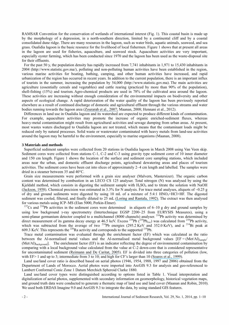
RAMSAR Convention for the conservation of wetlands of international interest (Fig. 1). This coastal basin is made up by the morphology of a depression, in a north-southern direction, limited by a continental cliff and by a coastal consolidated dune ridge. There are many resources in the lagoon, such as water birds, aquatic animals, seaweed, and sea grass. Oualidia lagoon is the basic resource for the livelihood of local fishermen. Figure 1 shows that at present all areas in the lagoon are used for fisheries, aquaculture, and seaweed stock. Aquaculture activities are very important, especially oyster farming, which has been conducted since 1970 and the lagoon has been used as the waste-disposal site for their effluents.
For the past 50 y, the population density has rapidly increased from 7,741 inhabitants in 1,971 to 15,430 inhabitants in 2004 (http://www.statistic.gov.ma/), polluting and non-polluting human activities have been established in the region, various marine activities for boating, bathing, camping, and other human activities have increased, and rapid urbanization of the region has occurred in recent years. In addition to the current population, there is an important influx of tourists in the summer, increasing the population by 54,000 (http://www.statistic.gov.ma). The main activities are agriculture (essentially cereals and vegetables) and cattle rearing (practiced by more than 90% of the population), shell-fishing (15%) and tourism. Agro-chemical products are used in 78% of the cultivated area around the lagoon. These activities are increasing without enough consideration of the environmental impacts on biodiversity and other aspects of ecological change. A rapid deterioration of the water quality of the lagoon has been previously reported elsewhere as a result of continued discharge of domestic and agricultural effluent through the various streams and water bodies running towards the lagoon area (Zourarah et al., 2007; Maanan, 2008; Hennani et al., 2012).
Differences in land use in Oualidia lagoon and its watershed are expected to produce different kinds of contamination. For example, aquaculture activities may promote the increase of organic enriched-sediment fluxes, whereas heavy-metal contamination might result from agricultural activities and sewage dumping from urban areas. At present, most wastes waters discharged to Oualidia lagoon are not treated, which means that the contaminant loads might be reduced only by natural processes. Solid waste or wastewater contaminated with heavy metals from land-use activities around the lagoon may be harmful to the environment, especially to marine organisms (Maanan, 2008). 3 Materials and methods
Superficial sediment samples were collected from 20 stations in Oualidia lagoon in March 2008 using Van Veen skip. Sediment cores were collected from stations C-1, C-2 and C-3 using gravity type sediment corer of 10 inner diameter and 150 cm length. Figure 1 shows the location of the surface and sediment core sampling stations, which included areas near the urban, and domestic effluent discharge points, agricultural dewatering areas and places of tourism activities. The sediment cores have been cut into slices of approximately 2–4 cm length and labelled. The samples were dried in a steamer between 35 and 40°C.
Grain size measurements were performed with a grain size analyser (Malvern, Mastersizer). The organic carbon content was determined by combustion in an LECO CS 125 analyser. Total nitrogen (N) was analysed by using the Kjeldahl method, which consists in digesting the sediment sample with H2SO4 and to titrate the solution with NaOH (Jackson, 1958). Chemical precision was estimated in 3.3% for N analysis. For trace metal analyses, aliquots of ~0.25 g of dry and ground sediments were digested by using 10 mL of a mixture of 5:4:1 HNO3+HCl+HF. The digested sediment was cooled, filtered, and finally diluted to 25 mL (Loring and Rantala, 1992). The extract was then analysed for various metals using ICP–MS (Elan 5000, Perkin-Elmer).
137Cs and 210Pb activities in the sediment cores were determined in aliquots of 6–10 g dry and ground samples by using low background γ-ray spectrometry (Intertechnique EGSP 2200–25 from EURYSIS Measures), using a semi-planar germanium detector coupled to a multichannel (8000 channels) analyser. 210Pb activity was determined by direct measurement of its gamma decay energy at 46.5 keV. Excess 210Pb (210Pbexc) was calculated from 210Pb activity, which was subtracted from the average of two 214Pb energies (295.2 KeV and 352.0 KeV), and a 214Bi peak at 609.3 KeV. This represents the 226Ra activity and corresponds to the supported 210Pb.
Trace metal contamination was evaluated through the enrichment factor (EF) which was calculated as the ratio between the Al-normalised metal values and the Al-normalised metal background values [EF = (Met/Al)sample/ (Met/Al)background]. The enrichment factor (EF) is an indicator reflecting the degree of environmental contamination by comparing with a local background value calculated from the value at C-2 down-core that is considered representative for uncontaminated sediment (Reimann and De Caritat, 2005). EF is divided into three categories of pollution (low, with EF> 1 and up to 3; intermediate from 3 to 10; and high for CF’s larger than 10 (Soares et al., 1999).
Land use/land cover ratio is described based on aerial photos (1946, 1954, 1988, 1997 and 2006) obtained from the Department of Lands of Morocco. Aerial photos were imported into ArcGIS 9.3 for analysis and geo-referenced to Lambert Conformal Conic Zone 1 Datum Merchich Spheroid Clarke 1880.
Land use/land cover types were distinguished according to options listed in Table 1. Visual interpretation and digitalization of aerial photos, supplemented with secondary information on geomorphology, historical vegetation maps, and ground truth data were conducted to generate a thematic map of land use and land cover (Maanan and Robin, 2010). We used both ERDAS Imagine 9.0 and ArcGIS 9.3 to integrate the data, by using standard GIS features.
International Journal of Sediment Research, Vol. 29, No. 1, 2014, pp. 1–10 - 3 -
Fig. 1 The study area showing sampling sites and land use in Oualidia lagoon
Table 1 Land use classification used for Oualidia lagoon
Land use Class description Agricultural land Arable land including paddy field and dry farmland and aquiculture Pastureland Nature and artificial pastures Construction land Land for resident, industries, commerce and roads Water Reservoirs, rivers and inland waters Salt marsh Natural salt marsh, salt ponds for salt production Dunes Sandy dunes
Data were processed using the STATISTICA 5.1 (Stat. Soft. Inc., 1998, Tulsa) in order to obtain mean values, standard
errors and confidence levels. Pearson’s Product-Moment Correlation test was used to identify significant relationships between the content of heavy metals, organic matter and clays in the sediment samples. The different statistical methods were performed with a 95% confidence interval (p < 0.05). 4 Results and discussion 4.1 Recent evolution of land use changes
Land use changes can have significant effects on runoff volume and consequently heavy metal input. To quantitatively reveal this effect for the entire watershed, an evaluation of land use change is presented first. In 2006, the main land-cover types identified at the study area were agricultural areas (40.15%), salt marsh (25.29%), pastureland (20.45%) and urban areas (11.74%) as shown in Fig. 1. The agricultural areas were mostly used for vegetable crops, followed by oyster farms. Most of the construction land extension was used for dwellings, businesses, institutions, infrastructure, and touristic zones.
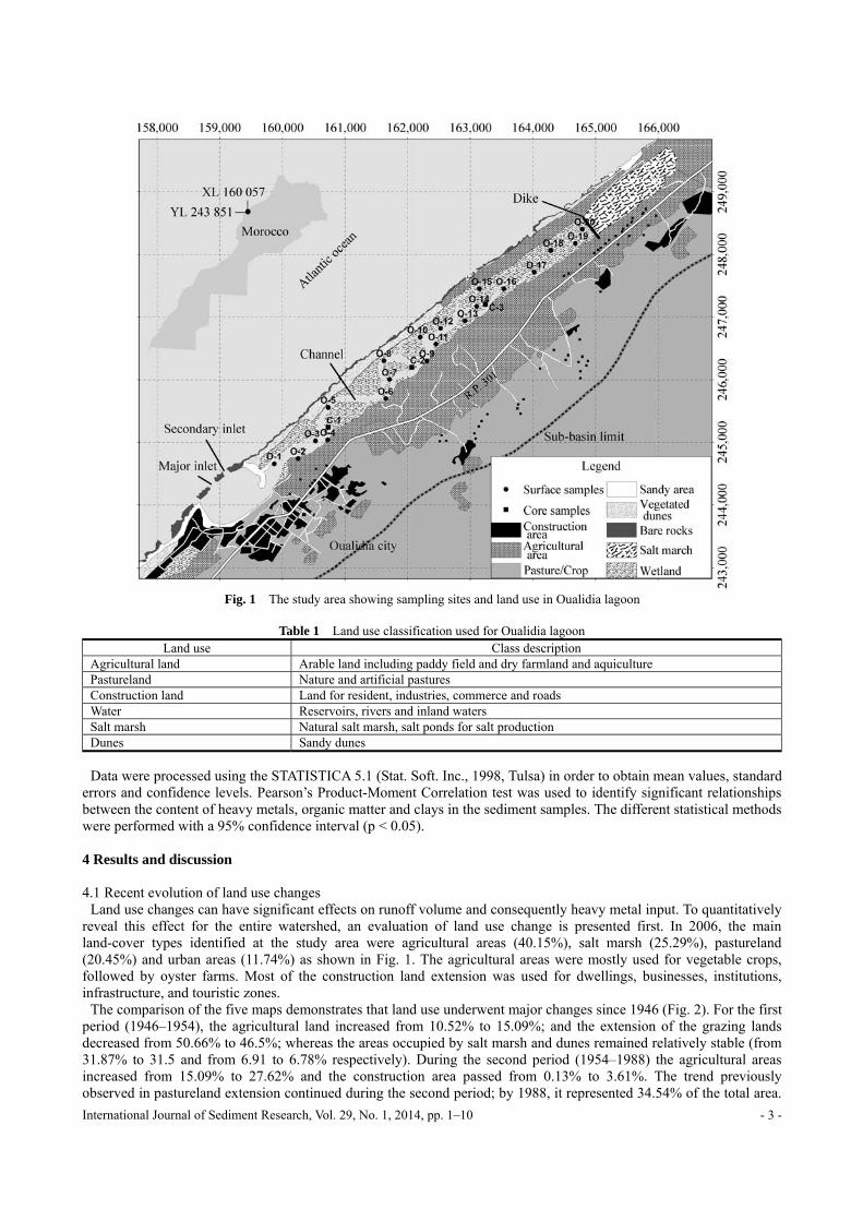
The comparison of the five maps demonstrates that land use underwent major changes since 1946 (Fig. 2). For the first period (1946–1954), the agricultural land increased from 10.52% to 15.09%; and the extension of the grazing lands decreased from 50.66% to 46.5%; whereas the areas occupied by salt marsh and dunes remained relatively stable (from 31.87% to 31.5 and from 6.91 to 6.78% respectively). During the second period (1954–1988) the agricultural areas increased from 15.09% to 27.62% and the construction area passed from 0.13% to 3.61%. The trend previously observed in pastureland extension continued during the second period; by 1988, it represented 34.54% of the total area.
- 4 - International Journal of Sediment Research, Vol. 29, No. 1, 2014, pp. 1–10
The areas of coastal dunes decreased during the second period (from 6.78 to 4.1%). The third period (1988 – 1997) was characterized by the increment in the extension of the construction area (from 3.61
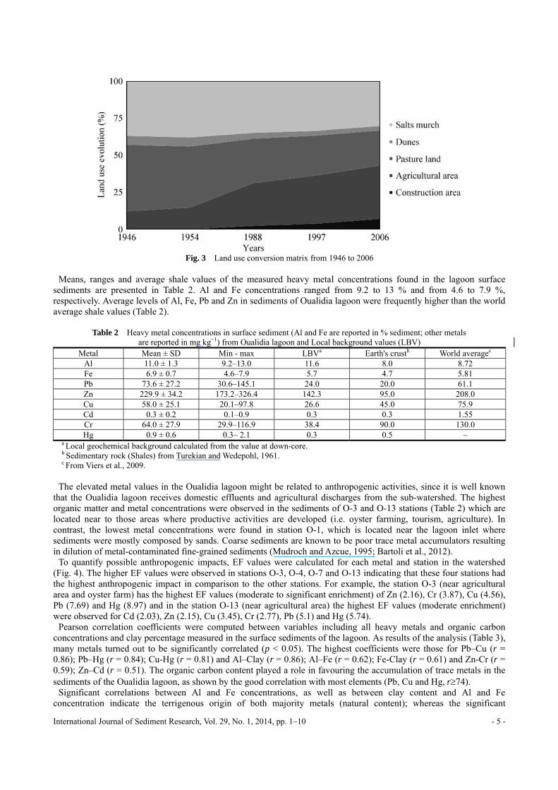
to 5.55%) and ploughed land (from 27.62% to 35.93%). The grazing lands showed still a decreasing trend (from 34.54% to 27.12%) as well as the natural areas: dunes (from 4.1% to 2.73%) and salt marsh (from 30.13% to 28.67%). During this period also started the development of artisanal mining of salt and the exploitation of sand from the dunes. The last period (1997–2006) was also characterized by an increase in land extension for agricultural and construction activities; and the reduction of grazing land, and the dunes and salt marshes areas. These evolutions of coastal land use are comparable to those reported for several coastal areas in the world (Ardli and Wolff, 2009; Silva and Tagliani, 2012; Qi and Luo, 2008). These three authors found the same trend: the development of agricultural and the construction areas (intended primarily for tourism) and disappearing natural areas (grazing land, dunes and salt marshes areas).
Fig. 2 Land use evolution in Oualidia lagoon
Inappropriate land use has been discussed as a factor that can affect human health over many years, and land use
change directly reflects changing human activities in recent decades (Pielke, 2005). Land use in the Oualidia lagoon is primarily agricultural and has remained fairly constant over the past forty years, while the lagoon is subject to diffuse inputs from agriculture (Fig. 3). Rapid agricultural intensification has occurred since the 1970s. The extensive use of fertilizers on farmlands could have an impact on the quality of the lagoon environment. As mentioned in several references, local land use can lead to vegetation damage, soil, water and land degradation, as well as local and global climate change, either directly or indirectly (Ruiz-Fernández et al., 2012; Gao et al., 2012; Lu et al., 2013). 4.2 Heavy metal spatial distribution
Surface sediments were mostly sandy (85%) close to inlets and channels and near the sandpit; and silty-clayey (>70%) towards the inner part of the lagoon, with the highest content of clays found in the northern part.
The organic carbon concentrations in the sediments ranged between 6.14 and 15.23 %. The C/N ratio compositions of the bulk sedimentary OM ranged from 5 to 15. These compositions were consistent with predominant contributions of marine organic production linked to the development in the upstream zone of an abundance of phanerogam, mostly from the decomposition of macro-algae. This fact also reflects a low-energy hydrodynamic context; which favours accumulation of organic carbon mainly due to settlement of organic-rich fine sediments. In addition, the low energy of the tidal surge allows the formation of fine and stable sediments which permits the settlement of an abundant fauna (Maanan, 2008).
International Journal of Sediment Research, Vol. 29, No. 1, 2014, pp. 1–10 - 5 -
Fig. 3 Land use conversion matrix from 1946 to 2006
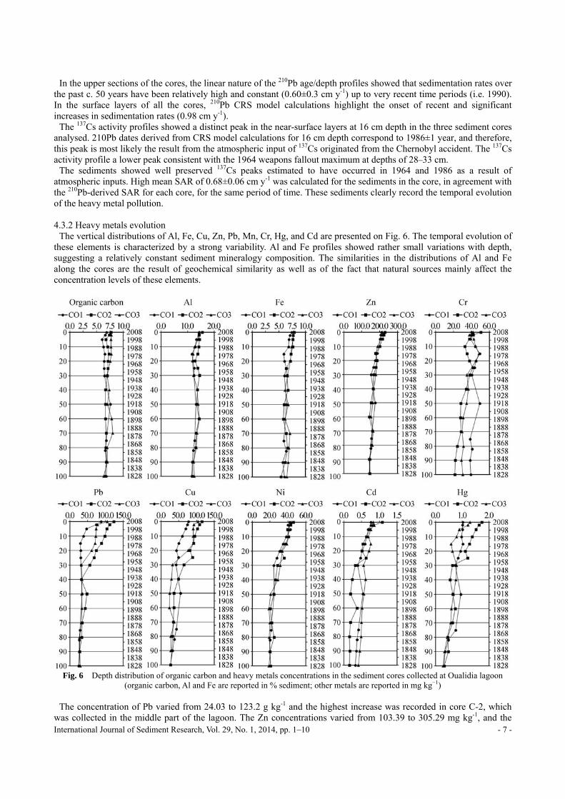
Means, ranges and average shale values of the measured heavy metal concentrations found in the lagoon surface
sediments are presented in Table 2. Al and Fe concentrations ranged from 9.2 to 13 % and from 4.6 to 7.9 %, respectively. Average levels of Al, Fe, Pb and Zn in sediments of Oualidia lagoon were frequently higher than the world average shale values (Table 2).
Table 2 Heavy metal concentrations in surface sediment (Al and Fe are reported in % sediment; other metals are reported in mg kg−1) from Oualidia lagoon and Local background values (LBV)
Metal Mean ± SD Min - max LBVa Earth's crustb World averagec Al 11.0 ± 1.3 9.2–13.0 11.6 8.0 8.72 Fe 6.9 ± 0.7 4.6–7.9 5.7 4.7 5.81 Pb 73.6 ± 27.2 30.6–145.1 24.0 20.0 61.1 Zn 229.9 ± 34.2 173.2–326.4 142.3 95.0 208.0 Cu 58.0 ± 25.1 20.1–97.8 26.6 45.0 75.9 Cd 0.3 ± 0.2 0.1–0.9 0.3 0.3 1.55 Cr 64.0 ± 27.9 29.9–116.9 38.4 90.0 130.0 Hg 0.9 ± 0.6 0.3– 2.1 0.3 0.5 –
a Local geochemical background calculated from the value at down-core. b Sedimentary rock (Shales) from Turekian and Wedepohl, 1961. c From Viers et al., 2009.
The elevated metal values in the Oualidia lagoon might be related to anthropogenic activities, since it is well known
that the Oualidia lagoon receives domestic effluents and agricultural discharges from the sub-watershed. The highest organic matter and metal concentrations were observed in the sediments of O-3 and O-13 stations (Table 2) which are located near to those areas where productive activities are developed (i.e. oyster farming, tourism, agriculture). In contrast, the lowest metal concentrations were found in station O-1, which is located near the lagoon inlet where sediments were mostly composed by sands. Coarse sediments are known to be poor trace metal accumulators resulting in dilution of metal-contaminated fine-grained sediments (Mudroch and Azcue, 1995; Bartoli et al., 2012).
To quantify possible anthropogenic impacts, EF values were calculated for each metal and station in the watershed (Fig. 4). The higher EF values were observed in stations O-3, O-4, O-7 and O-13 indicating that these four stations had the highest anthropogenic impact in comparison to the other stations. For example, the station O-3 (near agricultural area and oyster farm) has the highest EF values (moderate to significant enrichment) of Zn (2.16), Cr (3.87), Cu (4.56), Pb (7.69) and Hg (8.97) and in the station O-13 (near agricultural area) the highest EF values (moderate enrichment) were observed for Cd (2.03), Zn (2.15), Cu (3.45), Cr (2.77), Pb (5.1) and Hg (5.74).
Pearson correlation coefficients were computed between variables including all heavy metals and organic carbon concentrations and clay percentage measured in the surface sediments of the lagoon. As results of the analysis (Table 3), many metals turned out to be significantly correlated (p < 0.05). The highest coefficients were those for Pb–Cu (r = 0.86); Pb–Hg (r = 0.84); Cu-Hg (r = 0.81) and Al–Clay (r = 0.86); Al–Fe (r = 0.62); Fe-Clay (r = 0.61) and Zn-Cr (r = 0.59); Zn–Cd (r = 0.51). The organic carbon content played a role in favouring the accumulation of trace metals in the sediments of the Oualidia lagoon, as shown by the good correlation with most elements (Pb, Cu and Hg, r74).
Significant correlations between Al and Fe concentrations, as well as between clay content and Al and Fe concentration indicate the terrigenous origin of both majority metals (natural content); whereas the significant

- 6 - International Journal of Sediment Research, Vol. 29, No. 1, 2014, pp. 1–10
correlations among Pb, Cu and Hg were probably indicating that these elements have the same source, most likely related to anthropogenic activities.
Fig. 4 Distribution of enrichment factors (EF) for heavy metals in superficial sediment of Oualidia lagoon
Table 3 Pearson’s correlation among organic matter (OM), % of clay and the heavy metal content
Al Fe Pb Zn Cu Cd Cr Hg OM Al 1.00 Fe 0.62 1.00 Pb -0.10 0.10 1.00 Zn 0.14 0.34 0.49 1.00 Cu 0.02 0.19 0.86 0.41 1.00 Cd 0.17 0.11 0.27 0.51 0.49 1.00 Cr -0.25 -0.08 0.54 0.59 0.45 0.39 1.00 Hg -0.17 0.12 0.84 0.42 0.81 0.31 0.52 1.00 OM 0.10 0.30 0.89 0.40 0.84 0.32 0.30 0.74 1.00 Clay 0.86 0.61 0.17 0.27 0.27 0.23 -0.08 0.16 0.29
4.3 Trace metal contamination historical trends 4.3.1 210Pb and 137Cs
210Pb and 137Cs dating methods were used to establish sedimentation rates from the Oualidia lagoon. The profiles of 210Pb and 137Cs from the CO-2 core are displayed in Fig. 5.
Fig. 5 210Pb and 137Cs activity vs. depth in sections from the Oualidia lagoon
The near-exponential decline in 210Pb activity with depth indicates that there have been no large-scale changes in
sediment accumulation rate over time. The Constant Rate of Supply model (Appleby and Oldfield, 1978; Appleby and Oldfield, 1992) provides a good method for the modelling of historical rates of marsh sediment accumulation in coastal lagoons. Following application of the CRS model, the sedimentation rates (SAR) ranged from 0.60 to 0.98 cm y-1.
International Journal of Sediment Research, Vol. 29, No. 1, 2014, pp. 1–10 - 7 -
In the upper sections of the cores, the linear nature of the 210Pb age/depth profiles showed that sedimentation rates over the past c. 50 years have been relatively high and constant (0.60±0.3 cm y-1) up to very recent time periods (i.e. 1990). In the surface layers of all the cores, 210Pb CRS model calculations highlight the onset of recent and significant increases in sedimentation rates (0.98 cm y-1).
The 137Cs activity profiles showed a distinct peak in the near-surface layers at 16 cm depth in the three sediment cores analysed. 210Pb dates derived from CRS model calculations for 16 cm depth correspond to 1986±1 year, and therefore, this peak is most likely the result from the atmospheric input of 137Cs originated from the Chernobyl accident. The 137Cs activity profile a lower peak consistent with the 1964 weapons fallout maximum at depths of 28–33 cm.
The sediments showed well preserved 137Cs peaks estimated to have occurred in 1964 and 1986 as a result of atmospheric inputs. High mean SAR of 0.68±0.06 cm y-1 was calculated for the sediments in the core, in agreement with the 210Pb-derived SAR for each core, for the same period of time. These sediments clearly record the temporal evolution of the heavy metal pollution. 4.3.2 Heavy metals evolution
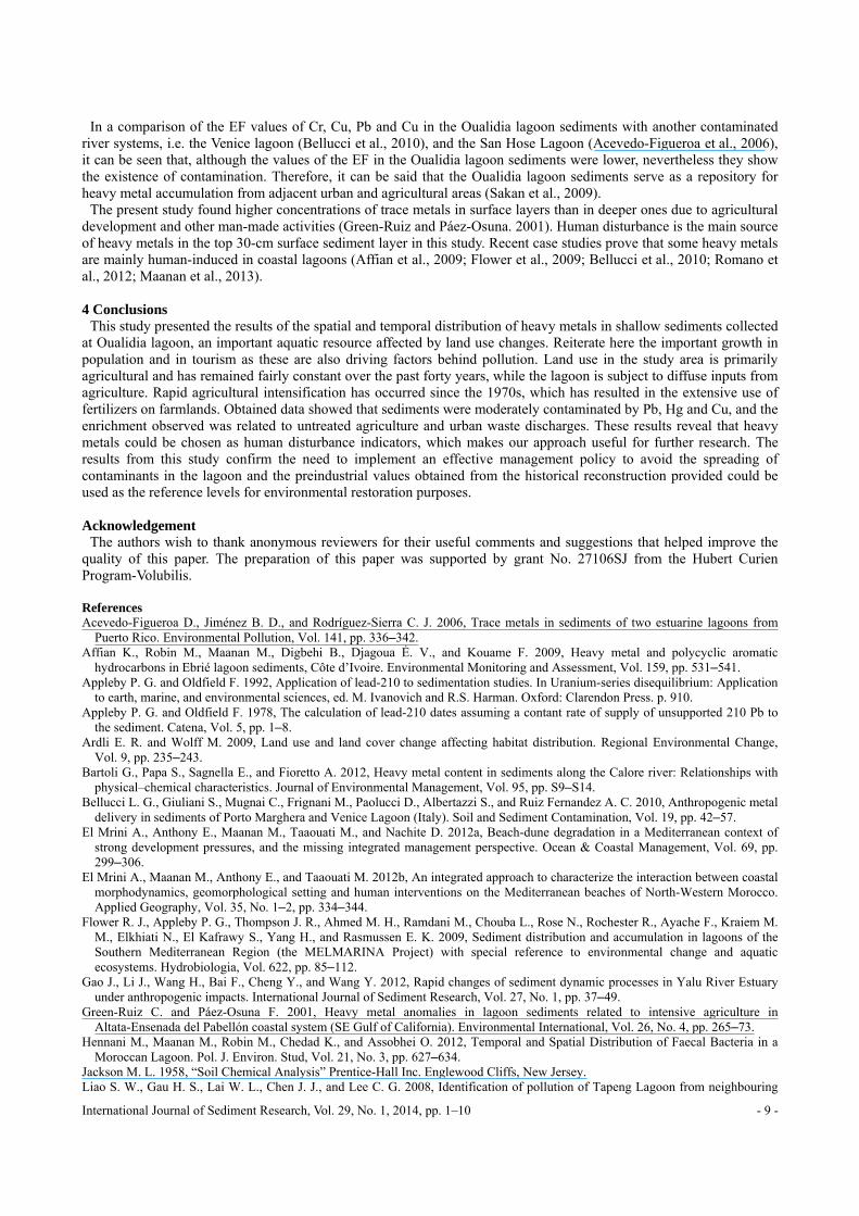
The vertical distributions of Al, Fe, Cu, Zn, Pb, Mn, Cr, Hg, and Cd are presented on Fig. 6. The temporal evolution of these elements is characterized by a strong variability. Al and Fe profiles showed rather small variations with depth, suggesting a relatively constant sediment mineralogy composition. The similarities in the distributions of Al and Fe along the cores are the result of geochemical similarity as well as of the fact that natural sources mainly affect the concentration levels of these elements.
Fig. 6 Depth distribution of organic carbon and heavy metals concentrations in the sediment cores collected at Oualidia lagoon
(organic carbon, Al and Fe are reported in % sediment; other metals are reported in mg kg−1)
The concentration of Pb varied from 24.03 to 123.2 g kg-1 and the highest increase was recorded in core C-2, which was collected in the middle part of the lagoon. The Zn concentrations varied from 103.39 to 305.29 mg kg-1, and the

- 8 - International Journal of Sediment Research, Vol. 29, No. 1, 2014, pp. 1–10
highest concentrations were observed in the top layers of the sediment core. The concentration of nickel varied from 36.53 to 74.47 mg kg-1 (Fig. 6).
Fig. 7 Depth distribution of enrichment factors (EF) for heavy metals in sediment cores collected at Oualidia lagoon
The enrichment factors estimated for heavy metals concentrations in the sediment cores C-1, C-2 and C-3 are shown in
Fig. 7. The maximum values of the EF were close to 4 for Pb, Cu and Hg (indicating moderate enrichment). It can be said that the Oualidia lagoon is slightly to moderately severely polluted with Pb, Cu, Cd and Hg, and minor polluted with Cr, Ni and Zn. Pb, Ni, Cu and Zn showed increasing EF above 30 cm depth (younger than 1954, when agriculture development increased according to the evolution of land use analyses and oyster farming installation (since 1956). The data obtained show that sediments are moderately contaminated by these metals due to agricultural drainage water and domestic wastewater (Green-Ruiz and Pàez-Osuna. 2001; Zhang and Shan, 2008).
The comparison of heavy metal contents with preindustrial, background concentrations is the best procedure for identification of metal enrichments in surface sediments and for distinction of anthropogenic and natural sources (Maanan et al., 2013). However, as already described, the concentrations of these elements are also strongly influenced by the presence of a raised fine fraction. There is an increase in the concentration from bottom to the surface of the sediment core, which confirmed the increased impact from anthropogenic activities in the sub-watershed, during the past ca. 100 years.
International Journal of Sediment Research, Vol. 29, No. 1, 2014, pp. 1–10 - 9 -
In a comparison of the EF values of Cr, Cu, Pb and Cu in the Oualidia lagoon sediments with another contaminated river systems, i.e. the Venice lagoon (Bellucci et al., 2010), and the San Hose Lagoon (Acevedo-Figueroa et al., 2006), it can be seen that, although the values of the EF in the Oualidia lagoon sediments were lower, nevertheless they show the existence of contamination. Therefore, it can be said that the Oualidia lagoon sediments serve as a repository for heavy metal accumulation from adjacent urban and agricultural areas (Sakan et al., 2009).
The present study found higher concentrations of trace metals in surface layers than in deeper ones due to agricultural development and other man-made activities (Green-Ruiz and Páez-Osuna. 2001). Human disturbance is the main source of heavy metals in the top 30-cm surface sediment layer in this study. Recent case studies prove that some heavy metals are mainly human-induced in coastal lagoons (Affian et al., 2009; Flower et al., 2009; Bellucci et al., 2010; Romano et al., 2012; Maanan et al., 2013). 4 Conclusions
This study presented the results of the spatial and temporal distribution of heavy metals in shallow sediments collected at Oualidia lagoon, an important aquatic resource affected by land use changes. Reiterate here the important growth in population and in tourism as these are also driving factors behind pollution. Land use in the study area is primarily agricultural and has remained fairly constant over the past forty years, while the lagoon is subject to diffuse inputs from agriculture. Rapid agricultural intensification has occurred since the 1970s, which has resulted in the extensive use of fertilizers on farmlands. Obtained data showed that sediments were moderately contaminated by Pb, Hg and Cu, and the enrichment observed was related to untreated agriculture and urban waste discharges. These results reveal that heavy metals could be chosen as human disturbance indicators, which makes our approach useful for further research. The results from this study confirm the need to implement an effective management policy to avoid the spreading of contaminants in the lagoon and the preindustrial values obtained from the historical reconstruction provided could be used as the reference levels for environmental restoration purposes. Acknowledgement
The authors wish to thank anonymous reviewers for their useful comments and suggestions that helped improve the quality of this paper. The preparation of this paper was supported by grant No. 27106SJ from the Hubert Curien Program-Volubilis. References Acevedo-Figueroa D., Jiménez B. D., and Rodríguez-Sierra C. J. 2006, Trace metals in sediments of two estuarine lagoons from
Puerto Rico. Environmental Pollution, Vol. 141, pp. 336–342. Affian K., Robin M., Maanan M., Digbehi B., Djagoua É. V., and Kouame F. 2009, Heavy metal and polycyclic aromatic
hydrocarbons in Ebrié lagoon sediments, Côte d’Ivoire. Environmental Monitoring and Assessment, Vol. 159, pp. 531–541. Appleby P. G. and Oldfield F. 1992, Application of lead-210 to sedimentation studies. In Uranium-series disequilibrium: Application
to earth, marine, and environmental sciences, ed. M. Ivanovich and R.S. Harman. Oxford: Clarendon Press. p. 910. Appleby P. G. and Oldfield F. 1978, The calculation of lead-210 dates assuming a contant rate of supply of unsupported 210 Pb to
the sediment. Catena, Vol. 5, pp. 1–8. Ardli E. R. and Wolff M. 2009, Land use and land cover change affecting habitat distribution. Regional Environmental Change,
Vol. 9, pp. 235–243. Bartoli G., Papa S., Sagnella E., and Fioretto A. 2012, Heavy metal content in sediments along the Calore river: Relationships with
physical–chemical characteristics. Journal of Environmental Management, Vol. 95, pp. S9–S14. Bellucci L. G., Giuliani S., Mugnai C., Frignani M., Paolucci D., Albertazzi S., and Ruiz Fernandez A. C. 2010, Anthropogenic metal
delivery in sediments of Porto Marghera and Venice Lagoon (Italy). Soil and Sediment Contamination, Vol. 19, pp. 42–57. El Mrini A., Anthony E., Maanan M., Taaouati M., and Nachite D. 2012a, Beach-dune degradation in a Mediterranean context of
strong development pressures, and the missing integrated management perspective. Ocean & Coastal Management, Vol. 69, pp. 299–306.
El Mrini A., Maanan M., Anthony E., and Taaouati M. 2012b, An integrated approach to characterize the interaction between coastal morphodynamics, geomorphological setting and human interventions on the Mediterranean beaches of North-Western Morocco. Applied Geography, Vol. 35, No. 1–2, pp. 334–344.
Flower R. J., Appleby P. G., Thompson J. R., Ahmed M. H., Ramdani M., Chouba L., Rose N., Rochester R., Ayache F., Kraiem M. M., Elkhiati N., El Kafrawy S., Yang H., and Rasmussen E. K. 2009, Sediment distribution and accumulation in lagoons of the Southern Mediterranean Region (the MELMARINA Project) with special reference to environmental change and aquatic ecosystems. Hydrobiologia, Vol. 622, pp. 85–112.
Gao J., Li J., Wang H., Bai F., Cheng Y., and Wang Y. 2012, Rapid changes of sediment dynamic processes in Yalu River Estuary under anthropogenic impacts. International Journal of Sediment Research, Vol. 27, No. 1, pp. 37–49.
Green-Ruiz C. and Páez-Osuna F. 2001, Heavy metal anomalies in lagoon sediments related to intensive agriculture in Altata-Ensenada del Pabellón coastal system (SE Gulf of California). Environmental International, Vol. 26, No. 4, pp. 265–73.
Hennani M., Maanan M., Robin M., Chedad K., and Assobhei O. 2012, Temporal and Spatial Distribution of Faecal Bacteria in a Moroccan Lagoon. Pol. J. Environ. Stud, Vol. 21, No. 3, pp. 627–634.
Jackson M. L. 1958, “Soil Chemical Analysis” Prentice-Hall Inc. Englewood Cliffs, New Jersey. Liao S. W., Gau H. S., Lai W. L., Chen J. J., and Lee C. G. 2008, Identification of pollution of Tapeng Lagoon from neighbouring
- 10 - International Journal of Sediment Research, Vol. 29, No. 1, 2014, pp. 1–10
rivers using multivariate statistical method. Journal of Environmental Management, Vol. 88, pp. 286–292. Loring D. H. and Rantala R. T. T. 1992, Geochemical analyses of marine sediments and suspended particulate matter. Earth-Science
Reviews, Vol. 32, pp. 235–283. Lu X. X., Ran L. S., Liu S., Jiang T., Zhang S. R., and Wang J. J. 2013, Sediment loads response to climate change: A preliminary
study of eight large Chinese rivers. International Journal of Sediment Research, Vol. 28, No. 1, pp. 1–14. Maanan M. 2007, Biomonitoring of heavy metals using Mytilus galloprovincialis in Safi coastal waters, Morocco. Environmental
Toxicology, Vol. 22, pp. 525–531. Maanan M. 2008, Trace metal contamination of marine organisms from the Moroccan North Atlantic coastal environments.
Environmental Pollution, Vol. 153, pp. 176–183. Maanan M., Landesman C., Maanan M., Zourarah B., Fattal P., and Sahabi M. 2013, Evaluation of the anthropogenic influx of metal
and metalloid contaminants into the Moulay Bousselham lagoon, Morocco, using chemometric methods coupled to geographical information systems. Environmental Sciences and Pollution Research. Vol. 20, pp. 4729–4741.
Maanan M. and Robin M. 2010, Geomatic solution for coastal environments, ed. Nova Science Publishers, Inc. p. 371. Maanan M., Zourarah B., Carruesco C., Aajjane A., and Naud J. 2004, The distribution of heavy metals in the Sidi Moussa lagoon
sediments (Atlantic Moroccan Coast). Journal of African Earth Sciences, Vol. 39, pp. 473–483. Mhamdi Alaoui A., Choura M., Maanan M., Zourarah B., Robin M., Freitas Conceição M., Andrade C., Khalid M., and Carruesco C.
2010, Metal fluxes to the sediments of the Moulay Bousselham lagoon, Morocco. Environmental Earth Sciences, Vol. 61, No. 2, pp. 275–286.
Mudroch A., Azcue J. M. 1995, Manual of Aquatic Sediment Sampling, ed. CRC Press, Inc., Boca Raton, FL. p 240. Pielke R. 2005,Land use and climate change. Science, Vol. 310, pp. 1625–1626. Qi S., Luo F. 2008, Land Use Change and Environmental Hazard in the Coastal Areas: The Case of Laizhou Gulf, China. Journal of
Coastal Research, Vol. 24, pp. 1189–1193. Reimann C. and de Caritat P. 2005, Distinguishing between natural and anthropogenic sources for elements in the environment:
Regional geochemical surveys versus enrichment factors. Science of the Total Environment, Vol. 337, pp. 91–107. Romano S., Mugnai C., Giuliani S., Turetta C., Huu Cu N., Bellucci L. G., Hoai Nhon D., Capodaglio G., and Frignani M. 2012,
Metals in Sediment Cores from Nine Coastal Lagoons in Central Vietnam. American Journal of Environmental Sciences, Vol. 8, No. 2, pp. 130–142.
Ruiz-Fernández A. C., Hillaire-Marcel C., Ghaleb B., Frignani M., Arvizu M. D., Raygoza-Viera J. R., and Páez-Osuna F., 2009, Trace metals (Cd, Cu, Hg and Pb) accumulation recorded in the intertidal mudflat sediments of three coastal lagoons in the Gulf of California, Mexico. Estuaries and Coasts, Vol. 32, pp. 551–564.
Ruiz-Fernández A. C., Hillaire-Marcel C., Ghaleb B., Soto-Jiménez M., and Páez-Osuna F. 2002, Recent sedimentary history of anthropogenic impacts on the Culiacan River Estuary, northwestern Mexico: Geochemical evidence from organic matter and nutrients. Environmental Pollution, Vol. 118, pp. 365–377.
Ruiz-Fernández A. C., Sanchez-Cabeza J. A., Alonso-Hernández C., Martínez-Herrera V., Pérez-Bernal L. H., Preda M., Hillaire-Marcel C., Gastaud J., and Quejido-Cabezas A. J. 2012, Effects of land use change and sediment mobilization on coastal contamination (Coatzacoalcos River, Mexico). Continental Shelf Research, Vol. 37, pp. 57–65.
Sakan S. M., Đorđević D. S., Manojlović D. D., Predraga P. S. 2009, Assessment of heavy metal pollutants accumulation in the Tisza river sediments. Journal of Environmental Management, Vol. 90, pp. 3382–3390.
Silva T. S., Tagliani P. R. A. 2012, Environmental planning in the medium littoral of the Rio Grande do Sul coastal plaine Southern Brazil: Elements for coastal. Ocean & Coastal Management, Vol. 59, pp. 20–30.
Soares H. M. V. M., Boaventura R. A. R., Machado A. A. S. C., Esteves Da Silva J. C. G. 1999, Sediment as monitors of heavy metal contamination in the Ave River Basin (Portugal): Multivariate analysis of data. Environmental Pollution, Vol. 105, pp. 311–323.
Turekian K. and Wedepohl K. H. 1961, Distribution of the elements in some major units of the earth's crust. Geol. Soc. Am. Bull., Vol. 72, pp. 175–192.
Viers J., Dupré B., and Gaillardet J. 2009, Chemical composition of suspended sediments in World Rivers: New insights from a new database. Science of the Total Environment, Vol. 407, pp. 853–868.
Yi Y., Wang Z., Zhang K., Yu G., and Duan X. 2008, Sediment pollution and its effect on fish through food chain in the Yangtze River. International Journal of Sediment Research, Vol. 23, No. 4, pp. 338–347.
Zhang W., Mu S., Zhang Y., and Chen K. 2011, Temporal variation of suspended sediment load in the Pearl River due to human activities. International Journal of Sediment Research, Vol. 26, No. 4, pp. 487–497.
Zhang H. and Shan B. Q. 2008, Historical records of heavy metal accumulation in sediments and the relationship with agricultural intensification in the Yangtze–Huaihe region, China. Science of the Total Environment, Vol. 399, pp. 113–120.
Zourarah B., Maanan M., Carruesco C., Aajjane A., Mehdi K., and Conceição Freitas M. 2007, Fifty-year sedimentary record of heavy metal pollution in the lagoon of Oualidia (Moroccan Atlantic coast). Estuarine Coastal Shelf Sciences, Vol. 72, No. 359–369.