Field Practical Report
21
THE INSTITUTE OF RURAL DEVELOPMENT PLANNING-DODOMA MANYONI DISTRICT SINGIDA REGION FIELD PRACTICAL REPORT (2013) Prepared by: Group 9 LAND AND NATURAL RESOURCE
-
Upload
independent -
Category
Documents
-
view
2 -
download
0
Transcript of Field Practical Report
THE INSTITUTE OF RURAL DEVELOPMENT
PLANNING-DODOMA
MANYONI DISTRICTSINGIDA REGION
FIELD PRACTICAL REPORT
(2013)
Prepared by: Group 9
LAND AND NATURAL RESOURCE
15th AUGUST 2013
EXECUTIVE SUMMARY
This report provides an analysis and evaluation on natural
resources found within Manyoni district for instance land,
forests, wild animals, water and Minerals. The result of all
calculations shows that land fertility, wild animals and forests
have declined in comparison to past ten (10) years. Forests
declines due to the fact that most of people in the district
depends forest for Timber production, Charcoal and Firewood as a
source of energy. Land fertility have declined because most of
the do not apply fertilizer. The disappearance of animal species
and decrease in size of the area covered by the forest is
obviously caused local agricultural methods conducted at Manyoni
District.
The study will show general picture of economic activities and
social services found in Manyoni district that exist due to bad
use of natural resource and will recommend on how to decrease the
burden of the problem.
Land ownership also have been the major problem to Manyoni
people since most of them own land Traditionally by clearing
forest and only few of them have Government title deeds.
The recommendation discussed includes the following:-
• People should use organic fertilizers such as Farm yard
manure, kraal manure and green manure which are friendly to
2
the environment so as to add nutrient in the soil make micro
organisms survive in the soil.
• The government should provide of education on the use of
bio-gas instead of using firewood and charcoal as a major
source of cooking energy.
• The government should provide the easiest access to title
deeds through different ways such as MKURABITA.
• Land zoning basing on peoples economical activities is
important in resolving land conflicts.
• The government should empower of the small scale miners
The report also investigate the fact that the analysis conducted
have limitations, some of the limitations includes Missing
values, too little knowledge of students on Statistical Package
for Social Sciences (SPSS) and Microsoft Excel.
Two major types of land ownership are also discussed which are
Customary land ownership and Statutory land ownership.
ACKNOWLEDGEMENT
We take this opportunity to express our profound gratitude and
deep regards to our Supervisor Mr. WINANI for his exemplary
guidance, monitoring and constant encouragement throughout the
course of this thesis. The blessing, help and guidance given by
him time to time shall carry us a long way in the journey of life
on which we are about to embark.
We also take this opportunity to express a deep sense of
gratitude to the Manyoni district leaders, Villagers, and other
3
government officials for their cordial support, valuable
information, and guidance which helped us in completing this task
through various stages.
We obliged to staff members of Institute of Rural Development
Planning (IRDP), for their valuable information and cordial
support provided by them in their respective fields. We are
grateful for their cooperation during the period of our
assignment.
Lastly, we thank almighty Dr. CHAYA and Mr. DANFORD CHISOMI for
their constant encouragement without which this assignment would
not be possible.
4
1.0 INTRODUCTION
Manyoni district is gifted with vast Natural resources that
include River, Dams which provide great chance for irrigation and
water for domestic purpose as well as for livestock keeping and
for being consumed by wild animals.
Other Natural resources in the district includes bee products,
Minerals, Forests and Wild animals of which can be utilized for
socio-economic gain.
2.0 METHODOLOGY
Our research methodology requires gathering relevant data from
the specified document (Questionnaire) and compiling database
known as Statistical Package for Social Science (SPSS) in order
to analyze the material and arrive at a more complete
understanding.
2.1 Study design
In this study, cross –sectional study will be used and population
will be studying are all households.
2.2 Data collection technique
In the research the technique data collection consisted of
Interview, Survey and Observation. Household were randomly
5
selected from each hamlet in its respective ward within Manyoni
district. The goal was to interview approximately 4500
participants who embody a range of Identity position and who come
from the same community in Manyoni district. We worked with Ward
Executive Officers, Village Executive Officers and Agriculture
Field Officers and Hamlet leaders to identify the potential
participants.
This investigation will utilize both Quantitative and Qualitative
data collection tools but is rooted in a qualitative position
that recognizes the importance of locating the research with the
particular social, cultural and Historical context.
3.0 FINDINGS ON NATURAL RESOURCES FOND IN MANYONI DISTRICT
3.1 Land
The district is estimated to have 6,097.43 Km2 for forestry,
15,200 Km2 for game reserves, 28,455,676 hectares for settlement,
164,332 hectares for arable farming of which part of it is
currently under use and the large portion of land suitable for
agriculture remains unutilized. Area covered by water like dams,
rivers, bore holes and springs are not yet been measured. The
district has adequate land for cash crop production. The major
6
crops grown in Manyoni district include millet, groundnuts,
paddy, sunflower, Bambara nut, maize and sweet potatoes. Paddy,
Bambara nuts and groundnuts are grown for both cash and food
crop. Sunflower is mainly grown as a cash crop.
3.1.2 Ownership of land for farming activities
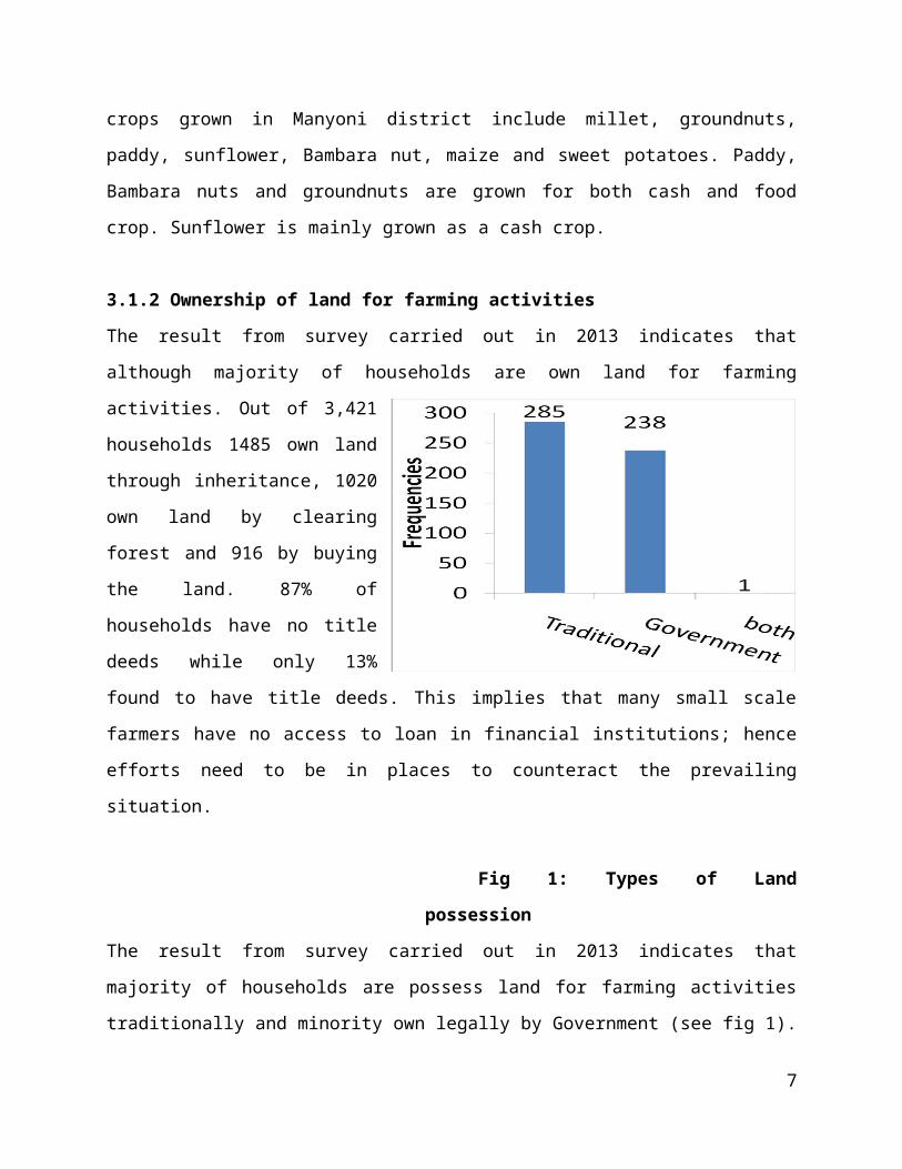
The result from survey carried out in 2013 indicates that
although majority of households are own land for farming
activities. Out of 3,421
households 1485 own land
through inheritance, 1020
own land by clearing
forest and 916 by buying
the land. 87% of
households have no title
deeds while only 13%
found to have title deeds. This implies that many small scale
farmers have no access to loan in financial institutions; hence
efforts need to be in places to counteract the prevailing
situation.
Fig 1: Types of Land
possession
The result from survey carried out in 2013 indicates that
majority of households are possess land for farming activities
traditionally and minority own legally by Government (see fig 1).
7
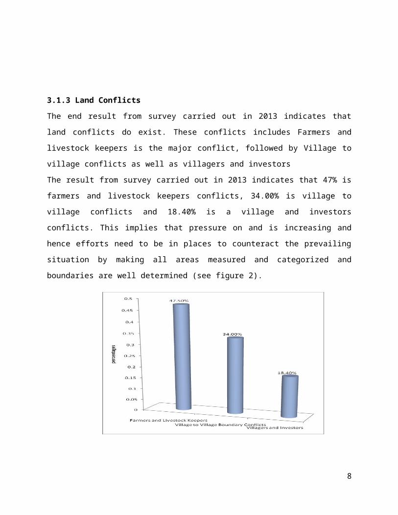
3.1.3 Land Conflicts
The end result from survey carried out in 2013 indicates that
land conflicts do exist. These conflicts includes Farmers and
livestock keepers is the major conflict, followed by Village to
village conflicts as well as villagers and investors
The result from survey carried out in 2013 indicates that 47% is
farmers and livestock keepers conflicts, 34.00% is village to
village conflicts and 18.40% is a village and investors
conflicts. This implies that pressure on and is increasing and
hence efforts need to be in places to counteract the prevailing
situation by making all areas measured and categorized and
boundaries are well determined (see figure 2).
8
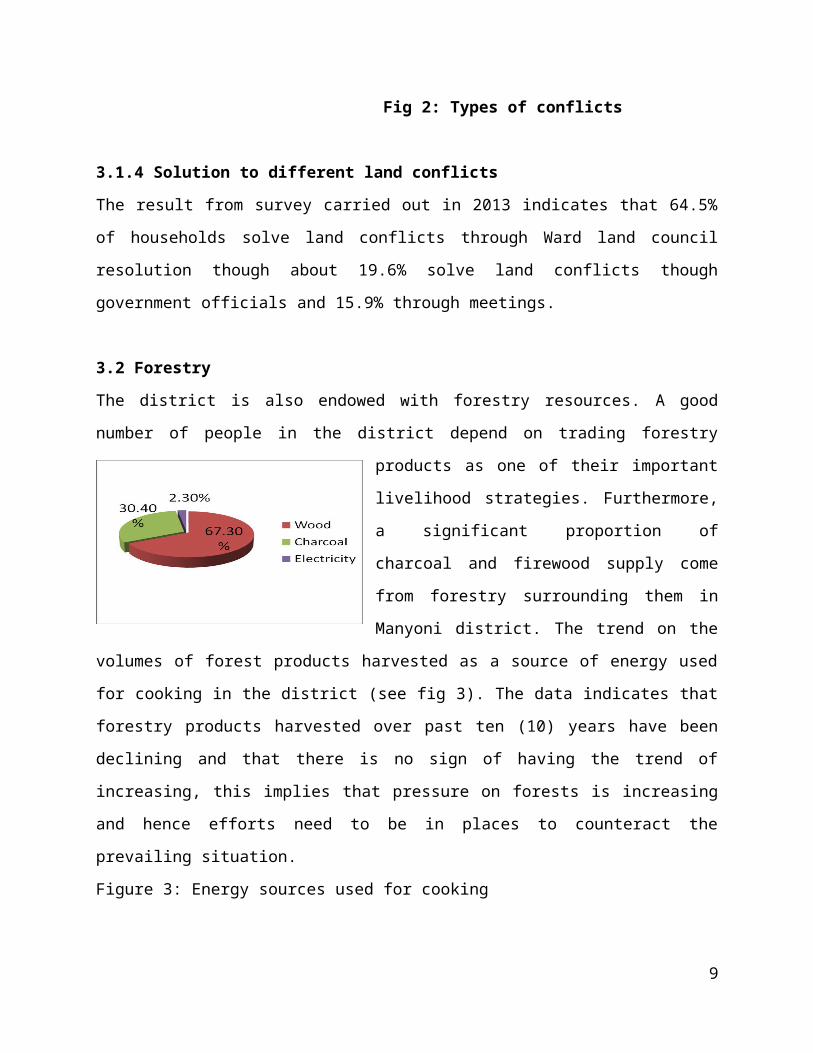
Fig 2: Types of conflicts
3.1.4 Solution to different land conflicts
The result from survey carried out in 2013 indicates that 64.5%
of households solve land conflicts through Ward land council
resolution though about 19.6% solve land conflicts though
government officials and 15.9% through meetings.
3.2 Forestry
The district is also endowed with forestry resources. A good
number of people in the district depend on trading forestry
products as one of their important
livelihood strategies. Furthermore,
a significant proportion of
charcoal and firewood supply come
from forestry surrounding them in
Manyoni district. The trend on the
volumes of forest products harvested as a source of energy used
for cooking in the district (see fig 3). The data indicates that
forestry products harvested over past ten (10) years have been
declining and that there is no sign of having the trend of
increasing, this implies that pressure on forests is increasing
and hence efforts need to be in places to counteract the
prevailing situation.
Figure 3: Energy sources used for cooking
9
3.2.1 Forest reserves
The district is estimated to have about 6,097.43 km2 covered with
Natural forests and exotic forests. Midavi, Mwarobaini and
Mikaratus trees constitute the proportion of forest in the
district.
3.2.3 Tree planting efforts in the district
Most of the tree planting efforts in the district has been
initiated by Non Governmental Organizations (NGOs). In line with
tree planting campaign they also advocate for the use of improved
cooking stoves. Although data are not available to indicate how
many trees have survive.
The outcome from survey carried out in 2013 indicates that
although greater part of households are aware of environmental
protection bylaws and tree planting campaigns in the area, many
households are still unwilling to plant trees due to fear among
themselves that the trees will not stay alive. This fear is the
results of knowledge that they do not have adequate water for
watering and their experience that most of newly established tree
seedlings are being destructed by termites.
These have been among the major forest conservation challenges in
the Manyoni district. At present, the activity of planting trees
in the district is only seriously accomplished in institutions
like primary schools and secondary schools, who plant trees
around their compounds.
10
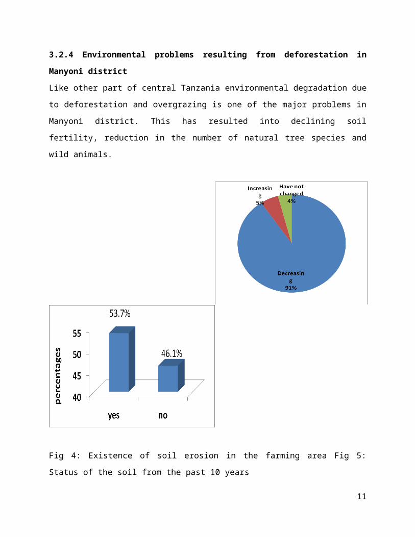
3.2.4 Environmental problems resulting from deforestation in
Manyoni district
Like other part of central Tanzania environmental degradation due
to deforestation and overgrazing is one of the major problems in
Manyoni district. This has resulted into declining soil
fertility, reduction in the number of natural tree species and
wild animals.
Fig 4: Existence of soil erosion in the farming area Fig 5:
Status of the soil from the past 10 years
11
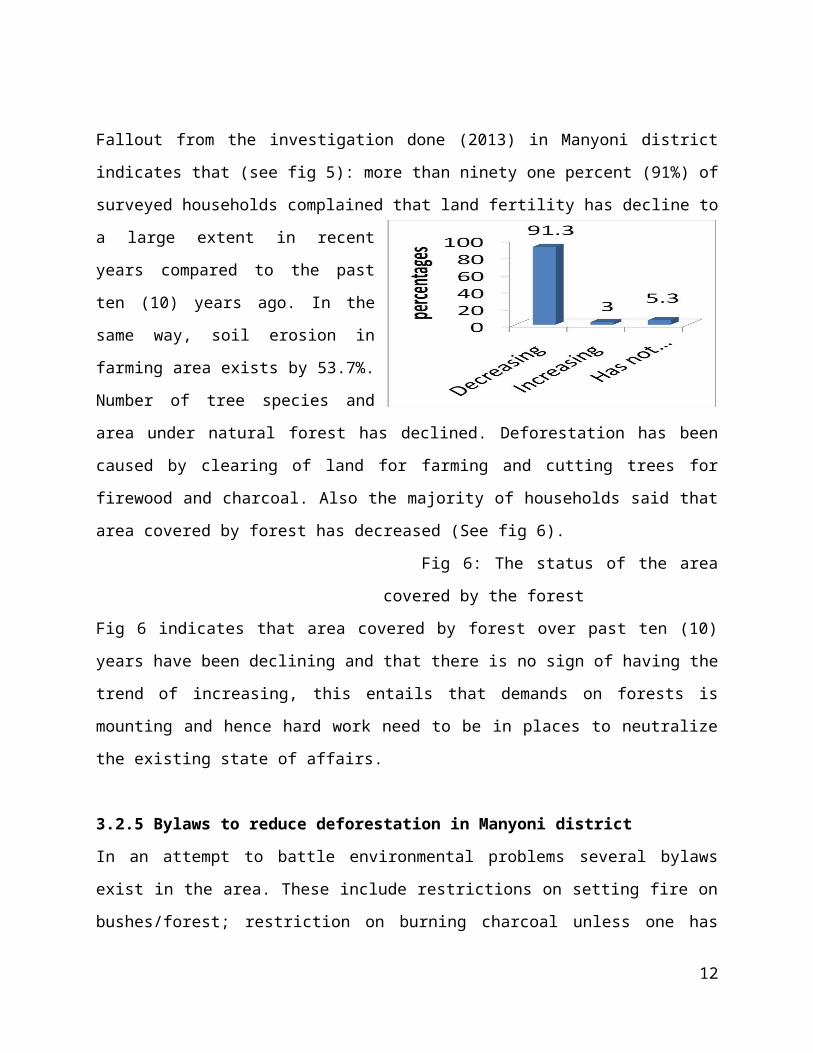
Fallout from the investigation done (2013) in Manyoni district
indicates that (see fig 5): more than ninety one percent (91%) of
surveyed households complained that land fertility has decline to
a large extent in recent
years compared to the past
ten (10) years ago. In the
same way, soil erosion in
farming area exists by 53.7%.
Number of tree species and
area under natural forest has declined. Deforestation has been
caused by clearing of land for farming and cutting trees for
firewood and charcoal. Also the majority of households said that
area covered by forest has decreased (See fig 6).
Fig 6: The status of the area
covered by the forest
Fig 6 indicates that area covered by forest over past ten (10)
years have been declining and that there is no sign of having the
trend of increasing, this entails that demands on forests is
mounting and hence hard work need to be in places to neutralize
the existing state of affairs.
3.2.5 Bylaws to reduce deforestation in Manyoni district
In an attempt to battle environmental problems several bylaws
exist in the area. These include restrictions on setting fire on
bushes/forest; restriction on burning charcoal unless one has
12
permission from Village Executive Officers; imposition of fines
to deviants; and requiring each household should plant at least
ten (10) trees each year. The result from survey carried out in
2013 indicates that 59.3% of the surveyed households agreed on
existence of bylaws on misuse of the forest resources. The data
from research done (2013) in Manyoni district point out that
29.1% of household do not know that bylaws on forest misuse do
exist.
3.3 Wild animals
There is no identified game reserve in Manyoni district, but
animals are found in some traditional forest reserves. Animals
species found in the area are Lions, Hyena and Elephants. Since
there are no identified game reserves, this sub-sector does not
contribute to the district economy.
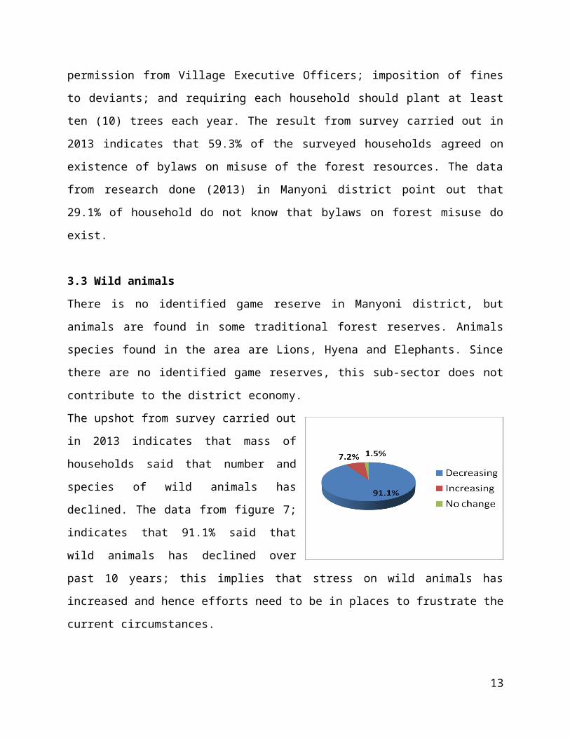
The upshot from survey carried out
in 2013 indicates that mass of
households said that number and
species of wild animals has
declined. The data from figure 7;
indicates that 91.1% said that
wild animals has declined over
past 10 years; this implies that stress on wild animals has
increased and hence efforts need to be in places to frustrate the
current circumstances.
13
Fig 7: Availability of
wild animals
3.4 Water resource
In Manyoni district there are water sources which if utilized
many economic gains can be realized. There are a seasonal rivers
and dams which supply water for paddy irrigation. Despite the
production of paddy which has been the major cash as well as food
crop in the area, fishing project can be established in viable
wards. Thus, irrigation agriculture emphasis as well as fishing
could lead to employment, improve food security and increase of
income to the district and its effect will spill over to the
districts.
3.5 Mining
Mining sector in the district is still in the infant stage;
currently what exists in the district is small scale gold mining
carried out by local people using traditional methods. Thus,
empowering of the small scale miners can lead to high production
of mines in a high quality and quantity for domestic and export
purposes.
4.0 LESSONS LEARNT
Through our research done (2013) in Manyoni district involved
different kind of learning that requires critical thinking,
Building confidence, problem-solving skills, detailed analysis
14
and synthesis of ideas as well as challenging ourselves in new
ways.
We also discovered that, research requires the highest order
of academic professionalism and integrity
It gave us an opportunity to familiarize with different
bachelor degree students, work closely with villagers and
other experienced researchers
Some of us, previously did not know how statistical Package
for Social Science (SPSS) is operated for data entry and
analysis as well as Microsoft Excel so that we can get a
useful information for sustainable development planning but
through this assignment made this possible
Lastly, though presentation we improved oral speaking skills
and confidence to stand in front of more than four hundred
(400) student and almost ten (10) lecturers
4.1 Challenges
The major challenge was Transport services. Some of students had
not been walked before for more than eight (8) kilometers all
long, but we were forced to do so because of shortage of cars.
Other social services like dispensaries, water, and communication
were not a big deal to most of us. Also, there was a language
barrier. Most of the respondents were speaking mother tongue
language like Gogo, Nyiramba though most of them were elders.
15
On our side, we were not competent enough in understanding
questions especially those who were responsible in collecting
Secondary data from the Ward
5.0 CONLUSSION AND RECOMMENDATIONS
As we saw from the above discussion, it shows that most of the
households at Manyoni district do own land. This is due to the
fact that most of them depend on agriculture (pastoralist and
farming) as the economic base.
• People should use organic fertilizers such as Farm yard
manure, kraal manure and green manure which are friendly to
the environment so as to add nutrient in the soil make micro
organisms survive in the soil.
• The government should provide of education on the use of
bio-gas instead of using firewood and charcoal as a major
source of cooking energy.
• The disappearance of animal species and decrease in size of
the area covered by the forest is obviously caused local
agricultural methods conducted at Manyoni District.
• The government should provide the easiest access to title
deeds through different ways such as MKURABITA.
• Land zoning basing on peoples economical activities is
important in resolving land conflicts.
• The government should empower of the small scale miners
16
APPENDIX I: SINDIDA REGION IN BRIEF
1.0 GEOGRAPHICAL LOCATION
Singida region is found in Tanzania main land. It located below
the equator between latitudes 3052’ and 7034’. Longitudinally,
the region is situated between 33027’ and 35026’ east of
Greenwich.
2.0 BOUNDARIES
North – Shinyanga Region
Northeast – Manyara Region
East – Dodoma Region
17
Southeast – Iringa Region
Southwest – Mbeya Region
West – Tabora Region
3.0 LAND AREA
Total land area of Singida region is about 49, 438 km2 out of
which 95.5 km2 or 0.19 percent are covered by water bodies of
lake Eyas, Kitangiri, Singidani, Kindai and Balengida. The
remaining 49,342.5 km2 is land area. It is 13th in size and
occupies about 5.6 percent of the Tanzania mainland’s total area
of 881,289 km2.
4.0 CENSUS POPULATION
According to National census in (2002): 1,370,637
According to National census in (2012): 1,090,758
APPENDIX II: MANYONI DISTRCT IN BRIEF
Manyoni district is one of the four districts in the Singida
Region. The district capital is Manyoni.
18
1.0 GEOGRAPHICAL LOCATION
Latitude: 6o23’24”
Longitude: 34o31’40”
2.0 BOUNDARIES
North – Singida Rural and Singida Urban district
East – Dodoma Region
South – Iringa Region
Southwest – Mbeya Region
West – Tabora Region
3.0 POPULATION CENSUS
According to National census in (2002): 205,423
According to National census in (2012): 296,763
19
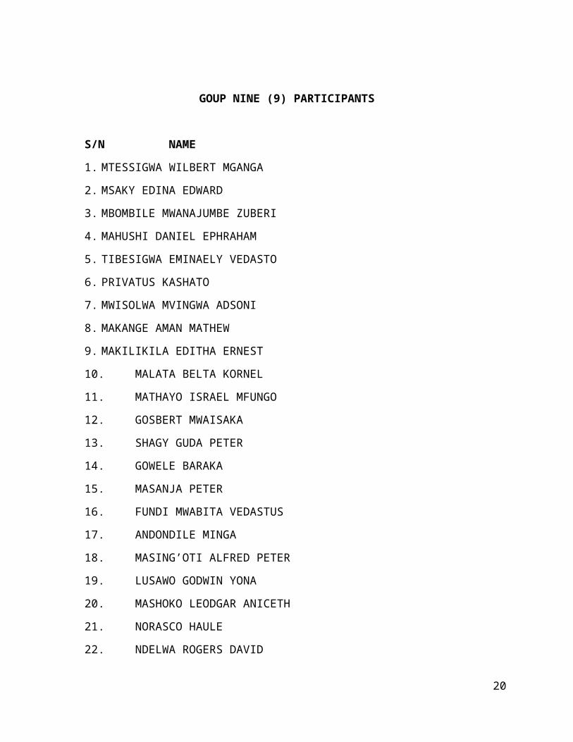
GOUP NINE (9) PARTICIPANTS
S/N NAME
1. MTESSIGWA WILBERT MGANGA
2. MSAKY EDINA EDWARD
3. MBOMBILE MWANAJUMBE ZUBERI
4. MAHUSHI DANIEL EPHRAHAM
5. TIBESIGWA EMINAELY VEDASTO
6. PRIVATUS KASHATO
7. MWISOLWA MVINGWA ADSONI
8. MAKANGE AMAN MATHEW
9. MAKILIKILA EDITHA ERNEST
10. MALATA BELTA KORNEL
11. MATHAYO ISRAEL MFUNGO
12. GOSBERT MWAISAKA
13. SHAGY GUDA PETER
14. GOWELE BARAKA
15. MASANJA PETER
16. FUNDI MWABITA VEDASTUS
17. ANDONDILE MINGA
18. MASING’OTI ALFRED PETER
19. LUSAWO GODWIN YONA
20. MASHOKO LEODGAR ANICETH
21. NORASCO HAULE
22. NDELWA ROGERS DAVID
20
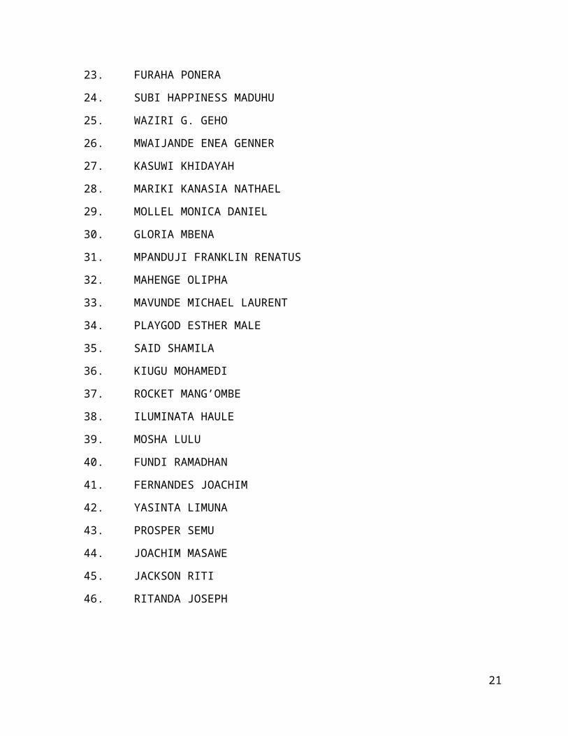
23. FURAHA PONERA
24. SUBI HAPPINESS MADUHU
25. WAZIRI G. GEHO
26. MWAIJANDE ENEA GENNER
27. KASUWI KHIDAYAH
28. MARIKI KANASIA NATHAEL
29. MOLLEL MONICA DANIEL
30. GLORIA MBENA
31. MPANDUJI FRANKLIN RENATUS
32. MAHENGE OLIPHA
33. MAVUNDE MICHAEL LAURENT
34. PLAYGOD ESTHER MALE
35. SAID SHAMILA
36. KIUGU MOHAMEDI
37. ROCKET MANG’OMBE
38. ILUMINATA HAULE
39. MOSHA LULU
40. FUNDI RAMADHAN
41. FERNANDES JOACHIM
42. YASINTA LIMUNA
43. PROSPER SEMU
44. JOACHIM MASAWE
45. JACKSON RITI
46. RITANDA JOSEPH
21