Mongolia Deer Stone Project: Field Report 2005
158
-
Upload
khangminh22 -
Category
Documents
-
view
6 -
download
0
Transcript of Mongolia Deer Stone Project: Field Report 2005
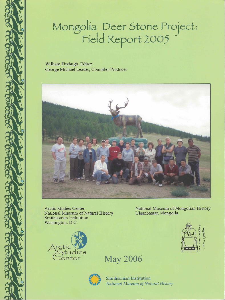

Mongolia Deer Stone Project:Field Report 2005
William W. Fitzhugh, Editor George Michael Leader, Compiler and Producer
Published by: The Arctic Studies Center National Museum of Natural History Smithsonian Institution Washington, D.C.
National Museum of Mongolian History Ulaanbaatar, Mongolia
2006
i
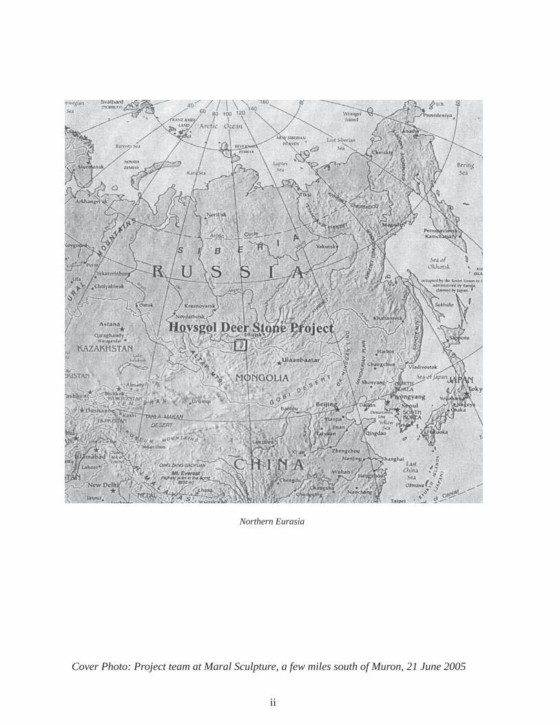
Northern Eurasia
Cover Photo: Project team at Maral Sculpture, a few miles south of Muron, 21 June 2005
ii

Contents
Part I Field report to Museum: Mongolia 2005 1-2 William W. Fitzhugh
Part II Mongolia Field Diary 2005: 15 June - 16 July 3-31 William W. Fitzhugh
Part III Deerstones and Khirigsuurs 33-55 William W. Fitzhugh
Part IV Conservation Report, 2005 Field Season 57-66 Harriet F. (Rae) Beaubien
Part V 2005 Burial Mound Survey in Hovsgol Aimag, Mongolia 67-82 Bruno Frolich
Appendix A Archaeological Sites Studied in 2005 83-88
Appendix B Materials Collected 2005 89-90
Appendix C Evdei Valley Survey and Shishegid Data 91-114
Appendix D Erkhel/Ulaan Tolgoi Data 115-134
Appendix E Deer Stone Motif Drawings 135
Appendix F Deer Stone Project Conference 137-138
Appendix G Conservation Report 139-144 Natalie Firnhaber
Appendix H Archaeology Magazine Story 145-152 Eric Powell
Appendix I Radiocarbon Dates List 153
iii

iv

Arctic Studies Center
1
Part I
Field Report to Museum: Mongolia 2005William W. Fitzhugh
The 2005 Mongolia Deer Stone Project — a joint project of the Smithsonian’s Arctic Studies Center
and the National Museum of Mongolian History and Institute of Archaeology has completed its
fourth fi eld season of education and research activities this. Like last year, our work included several
days of research conferences and museum exhibits and conservation workshops in Ulaanbaatar as
well as three weeks of fi eld research in northern Mongolia. More than thirty people were involved
this year, thirteen from the Smithsonian, representing NMNH Anthropology and Exhibts, SCMRE,
and OEC. This years’ work involved projects in archaeology (Fitzhugh), physical anthropology
(Frohlich), botany (DePriest), and remote sensing (Beaubien, Karas, Thome), conservation
(Firnhaber), and exhibits mounting and production (Thome, Rhymer).
We were very pleased to have the participation of the U.S. Ambassador to Mongolia, Pamela Slutz,
and her husband, Ronald Deutch, who joined us for a week of fi eldwork among the Tsaatan reindeer
herders in their summer tundra camps in the Sayan Mountains. The project has benefi tted during
the past year from an ambassador’s grant provided by the Department of State. The Ambassador
has been especially helpful facilitating the project through donations of aid to the Tsaatan people,
providing canvas for tents and educational assistance.
During the fi rst few days in Ulaanbaatar we hosted a research symposium sponsored together with
the American Center for Mongolian Research and the National Museum of Mongolian History. Now
in its second year, this symposium is attracting considerable attention and was attended by more than
one hundred scholars and students. This was followed by a day of museum exhibit and conservation
workshops instructed by Carolyn Thome, Paul Rhymer, Natalie Firnhaber, Rae Beaubien, and
Vicky Karas. The latter demonstrated applications of laser scanning technology to archaeological

Mongolia Report 2005
2
and museum problems. Rhymer and Firnhaber remained in Ulaanbaatar for the following week,
providing assistance and training to the museum community.
This year’s fi eld programs included deer stone analysis and excavations of associated Bronze Age
sites and monuments ; applications of laser scanning of deer stone art to provide a new method
for baseline conservation and interpretation; botanical surveys of the most inaccessible regions
of northern Mongolia along the Russia-Tuva border; and detailed mapping of Bronze Age burial
mounds and ceremonial sites. In addition to large amounts of new data from this year’s fi eldwork,
Bruno Frohlich obtained permission to export a series of mummies from the southern Gobi for
analysis and CT-scanning at NMNH. A book documenting our research to date has been published
by the Arctic Studies Center and the NMMH, and an article has appeared in Archaeology the popular
magazine (Appendix G).
The project is grateful to the many SI offi ces and units that assisted this year’s program fi nancially
and by contributions of personnel. The Deer Stone Project demonstrates the value that can be added
to coordinated research, conservation, and educational ventures through broad-based multi-unit SI
collaboration. In the future we hope to expand the project by the addition of other biology, natural
history, and art and history projects. Next year is the 800th anniversary of the Genghis Khan’s
formation of the Mongolian state, and the Smithsonian is committed to help the world learn more
about Mongolia through the organization of a festival, “Genghis Khan’s Mongolia: 800 Years of
Nationhood,” to be held at the National Musuem of Natural History on October 6-8, 2006. We are
off to a good start in taking advantage of the research and educational opportunities brought about by
the opening of this formerly closed region of Central Asia, still so little known to science and to the
rest of the world.

Arctic Studies Center
3
Part IIMongolia Field Diary 2005: 15 June – 16 July
William W. Fitzhugh
American Team:
William Fitzhugh (archaeologist NMNH/SI), Harriet Beaubien (archaeological conservator CMI/SI), Paula DePriest (botanist CMI/SI), Elizabeth Eldredge (volunteer), Natalie Firnhaber (UB only, conservator NMNH/SI), Melanie Irvine (NMNH/SI intern), Basiliki Vicky Karas (scanning scientist CMI/SI), Thomas Kelly (photographer), Eric Powell (editor, Archaeology Magazine), Paul Rhymer (UB only, exhibits specialist NMNH/SI), Dennis Rydjeski (volunteer), Carolyn Thome (model-maker OEC/SI). Ambassador Pamela Slutz and her husband Ronald Deutsh accompanied the team from Muren to the Darkhat and participated in the visit to the Tsaatan/Dukha.
Mongolian Team:
Ts. Ayush (ethnologist, NMMH), J. Bayarsaikhan (archaeologist, NMMH), Adiabold Namkhai (translator, expediter), Jugii (archaeology student), Ts. Odbaatar (archaeologist, NMMH), Oyunbileg (botanist), T. Sanjmiatav (archaeologist, MAS), Oi. Sukhbaatar (geographer, Chinghis Khan College), Tunjii (archaeology student), Odga (cook), Ugna (student), and drivers Batbaatar, Khadbaatar, Tserenam, and Tsog.
15-16 June 2005 – Wednesday-Thursday: Airborne
Leave DC (Dulles International Airport) at 1:30 pm
Mongolia Report 2005
4
We fl ew direct from DC to Seoul, Korea in 13 hours and met Dennis Ryjeski and Betsy Eldredge at the departure gate for the Korean Air fl ight to UB. Arrived in UB at 11:30 pm and were met by Adiya and Bayaraa in a bus that took us to the Zaluuchuud Hotel. All baggage arrived ok.
17-18 June 2005 – Friday-Saturday: UB
The Friday symposium workshop started at 10:00 am in the National Museum of Mongolian History with 50 people attending. Peter Marsh of the American Center for Mongolian Studies had organized the session with Bayaraa and Odbaatar. Natalie Firnhaber, Rae Beaubien, Paul Rhymer, and Carolyn Thome presented storage and conservation instruction in the morning and bracket-making in the afternoon, with sessions at both the Cultural History and Natural History museums. Peter Marsh gave me the “page proofs” for our book of 2004 conference papers, but I discovered many production problems, and so we will not get this printed in time for our departure in July. The conference was on Saturday and was attended by 100 people including Dr. Chadraa, President of the Mongolian Academy of Sciences, Dr. Enkhtuvshin, Assistant Director of MAS, and Ayudain Ochir, Director of the NMMH. We presented nine papers: fi ve by US researchers and four by Mongolian researchers. The US side presented talks ranging beyond Mongolia while the Mongolians presented material related primarily to our Hovsgol research. Sukhbaatar gave a very nice presentation on Tsaatan animal conservation and ritual showing their careful use of resources. Ayush gave a paper on the use of skis in hunting by the Tsaatan. Rae Beaubien spoke about scanning techniques with examples from Mesoamerica, and her proposed use on the deer stones, and then did a demonstration, scanning a small animal mask from the museum’s collection. This worked out very well and demonstrated the relative ease of the technique if you have the right equipment.
Peter Marsh did a great job organizing the conference and workshop with Sukhbaatar and Bayaraa. It was well advertised and ran very smoothly. In the evening we held a reception with the museum for all participants, funded by the US Embassy. Peter had rounded up some musicians to give us some local Mongolian color. He has been using his time in Mongolia to record and interview Mongolian musicians, preparing publications for the future when he hopes to land a folklore position at a university in the States. Ambassador Slutz and her husband Ron Deutsh came and made some plans with us for their participation in our project. They are driving with an embassy driver in a red-license plate (diplomatic plate) Toyota to Muron and will meet us Tuesday evening.

Arctic Studies Center
5
19 June 2005 – Sunday
I had to spend most of the day working on the manuscript and realized that it will never be
ready to print by our July departure. The crew went on a black market excursion, watching their
valuables, but nothing got stolen or pockets slit like Paul Rhymer’s last year. Peter and I went
over the manuscript for an hour in the afternoon and we agree in terms of design and illustration
requirements. In the afternoon Adiya, Paula and I went grocery shopping (Bayaraa had got the bulk
materials at the black market earlier). We also changed money – about 1200 T to the dollar, up from
1100 T last year.
20 June 2005 – Monday: UB to Khoshoot
We got off at 9:30 am in a 4-van caravan, with lots of fueling and miscellaneous stops. We had to
leave Bayaraa’s van behind to deal with the archaeology permit, which had not yet been signed.
There is a new archaeology law in force now administered by the Ministry of Education and it needs
lots of signoffs, including at the Academy of Science. Bayaraa did not catch up with us until 2:00
am at our campsite at Khoshoot Village – without the permit, because they required a $200 payment,
which he did not have.
After about an hour of driving, we hit the new “millennium highway” which has been a huge
government and external aid program to build an east-west highway across the entire country.
Today it runs 250 km west of UB, and then ends abruptly, landing you in a deeply entrenched road,
embedded between sand dunes – if you weren’t careful you could literally shoot off the end of the
highway into the bush as there is only a small pile of dirt to serve as a barrier. While on the highway
it was quite amazing to ‘fl y’ through this country at 120 km/hr after our customary ‘dirt road’ speed
of 10-20km/hr. Also amazing was how few other vehicles we met on the road – only a handful in a
couple of hours.
The weather was quite hot when you stop driving, and it hit us especially when we visited the
archaeological site of Khar Buka Balgas, an 7-8th century ruin, which we toured for an hour with
Sukhbaatar providing tour-guide instruction. Its construction has an interesting pattern of rock
block and slate construction in alternate layers. The Japanese have been working here for several
years, mostly conducting a settlement pattern study, but have fi nished now. Large sections of the
mud-mortared walls (5-6’ thick) are collapsing and need stabilization. This part of the country has

Mongolia Report 2005
6
many ruins from different periods beginning with Xiongnu (ca. 200 BC-200 AD), and Kharakhorum
is only a short distance to the south. It is a very rich agricultural and herding region – at least for
Mongolia. The little one-room blockhouse of a museum had photos of most of the sites/ruins in the
region and a few artifacts, including some birch bark manuscript fragments.
During the afternoon we traveled north overland toward the Khanuy River, but by evening we had
only got as far as Khoshoot where there are three deer stones near the edge of town, presided over
by a guy who gave us a drunken tour. All these stones had been raised and cemented into the ground
by a Russian team in 1971 with Sanjmiatav participating. We saw some of our fi rst kherigsuurs in
the country south of Khoshoot. We camped north of the town bridge (which was manned by a lady
toll-taker), after the Mongolians had been able to secure some khosuur meat pastries from the local
restaurant. Here we met a very curious pig, and the girls pioneered a pit stop beneath the bridge, not
yet having loosened their inhibitions, or their interest in using the local outhouse facilities (an old
rusted out fl atbed truck cab). Camp got set quickly along the river, which was pretty slimy with algae
and scum from the millions of animals contributing to it. Nevertheless, at our lunch site along a
similarly dirty river we saw a boy carrying home a rather large bass-like fi sh – so something survives
in these waters, and is eaten. About 2:00 am with a near-full moon showing, I heard a ruckus, which
turned out to be Bayaraa’s arrival with the news of his failed permit attempt.
21 June 2005 – Tuesday:
Khoshoot to Muron
At breakfast we heard the details
about the permit saga and how
arrangements had been made
to get it to us in Muron. Then
we struck out on the road again
northwards with me trying
out the backwards seat. Not
too nice seeing the country
pass by backwards, and soon
it was dizzying. But soon I had a respite with the appearance of a large kherigsuur and deer stone
site – in fact a slab burial that was built with deer stones as its corner posts – clearly a post-deer
stone phenomenon that borrowed the spiritual power of deer stones. It seemed that Sasha may have
Figure 1: Ferry crossing at Selenge River

Arctic Studies Center
7
been present when this grave was
excavated by Russians, maybe also
in 1971. It would be great to see what
they found and if anything could be
dated. This was a good introduction
for the crew and broke up the boring
drive. A 22-year old herder rode up
on his horse while we were there and
said no one had ever worked on this
site while he was alive. The hill to the
north of the site is called “mustache
hill,” or Sakhat, because of the thin
fringe of trees showing along the
crest of the hill. Burdnii Ekh (in
Bulgan Saikhan Sum) is the name of
the site, meaning “the source.” After
passing through Khierkhan village
and crossing a steep pass we emerged
in a small valley that had a Turkish
period site that consisted of a square
structure with low foundation walls
of cut rock (2-3 courses) which had
a center passage through the middle
of the structure that was aligned with
a very well-carved Turkic fi gure
(Odbaatar thinks it might have been moved here from somewhere else). This is in the valley of
Dalkha. The stone structure does not seem to have been excavated.
The next interesting attraction was the side valley to the Selenge River through which we
descended to reach the ferry. This valley was full of sand dunes and had none of the usual steppe-
type vegetation, but lots of elm trees and disturbed ground. Patches of what seemed to be fi re-
cracked rock were everywhere, of different varieties of stone. I couldn’t help thinking they were
archaeological sites, but I could not fi nd any fl ints or pottery, and the Mongolians said the Selenge
Valley is like this everywhere – however, by this they meant the vegetation and sand, not the rocks,
Figure 2: Turkic fi gure at Dalka Site
Figure 3: Central passage Turkic structure at Dalka
Mongolia Report 2005
8
so I think a closer look is needed.
The ferry across the Selenge is quite an elaborate affair using a wire and a pontoon 2-vehicle ferry
that has a huge rudder on the down-stream side and winches at either upstream corner, with the
pontoon upstream and shaped into bows made of sheet metal. When loaded, the ferry crew winched
against the cable pulley to tip the craft to about 30 degrees to the current and another tied the rudder
over and the current started ferrying the craft across. The ride took only 5 minutes, with a landing at
a small dock. They even had a small restaurant at the high bank side on the north shore. Once ashore
we sped over good roads to Muron in about one hour, passing large numbers of ger camps. We went
directly to the Gobi Hotel, where we found Ambassador Slutz and husband Ron Deutsh.
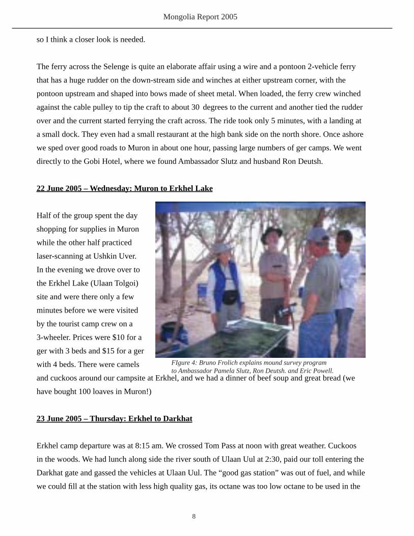
22 June 2005 – Wednesday: Muron to Erkhel Lake
Half of the group spent the day
shopping for supplies in Muron
while the other half practiced
laser-scanning at Ushkin Uver.
In the evening we drove over to
the Erkhel Lake (Ulaan Tolgoi)
site and were there only a few
minutes before we were visited
by the tourist camp crew on a
3-wheeler. Prices were $10 for a
ger with 3 beds and $15 for a ger
with 4 beds. There were camels
and cuckoos around our campsite at Erkhel, and we had a dinner of beef soup and great bread (we
have bought 100 loaves in Muron!)
23 June 2005 – Thursday: Erkhel to Darkhat
Erkhel camp departure was at 8:15 am. We crossed Tom Pass at noon with great weather. Cuckoos
in the woods. We had lunch along side the river south of Ulaan Uul at 2:30, paid our toll entering the
Darkhat gate and gassed the vehicles at Ulaan Uul. The “good gas station” was out of fuel, and while
we could fi ll at the station with less high quality gas, its octane was too low octane to be used in the
FIgure 4: Bruno Frolich explains mound survey programto Ambassador Pamela Slutz, Ron Deutsh. and Eric Powell.

Arctic Studies Center
9
ambassador’s car, so they were calculating where their half-way point would have to be.
24 June 2005 – Friday: Evdei
Stopped at the Evdei stone slab site and then visited Soye rock art site, which Tom Kelley
photographed.
25 June – Saturday: Menge Bulag
In the early morning we heard lots of cuckoos in the woods around camp. Traveled to Tsaaganuur
and met with Governor Gambaat (Davaanyam?), a former school teacher who grew up in T.N. and
became governor in December, representing the democratic party majority in T.N. which is 70%
Tsaatan. Then we proceeded to our meeting place with the Tsaatan in the valley west of Tsaaganuur
(GPS station #17: N 51° 15.020; E 099° 11.657; 1653m elev.), arriving at 1:30. Several Tsaatan on
horseback raced us to the
meeting place, at times riding
much faster than we could
drive. Some of these people
were Mongols who were
helping the Tsaatan provide
enough horse to accommodate
our team for the ride in to
Minge Bulag.
26 June 2005 – Sunday:
Menge Bulag
Delgar’s home was our kitchen. In the morning we got horses and I went to search the site down
river where Erden, Bayandalai’s son, had found a stone end scraper, but we found nothing – no
fl akes or anything! I had visited this site previously in 2004 and had recorded it as an ethnographic
Tsaatan camp.
Seventeen kids were taking part in a ‘tundra’ school in two tents donated by the British, and two
Darkhat teachers were giving instruction. We provided lots of balloon gifts and gave away copies
Figure 5: School underway in Tsaatan Tundra Camp

Mongolia Report 2005
10
of our 2004 photographs. Ed
Nef and his elder daughter and
a couple friends of theirs plus
children were also in Minge
Bulag during our visit. This
daughter lives in Seattle, WA.
27 June 2005 – Monday: M. B.
to Evdei
Overcast, rain showers. The
Tsaatan had a big gathering
for the Ambassador and
Ron’s departure, and several others of us who were heading out to the steppe again. Tsetsegma was
coming with us to get a ride in the ambassador’s car to Ulaan Uul, where she needed to see about her
daughter who was trying to get to Muron.
Left Menge Bulag tundra camp at 10:30 am and found our drivers waiting at the usual spot at
2:30pm. A good ride down; cool and not many fl ies. My horse (Zorig’s) was sure and steady and had
a good gallop in the open steppe for the last few miles. Somewhere in that stretch my saddle cushion
disappeared and I became aware of a much more painful situation, bouncing along on the hard wood
slats of the saddle. I was mightily relieved to reach the end of the road, and when Ron (ambassador’s
husband) rode in with his guide waving the missing saddle cushion, everyone had a good laugh.
There were no spills or upsets this time, and the trail was fairly dry. We passed over my spill site of
last year (when my horse — Batsaya’s — and I went thru the ice in the marsh near the end of the
trail). This time the ice was mostly melted, but there were still big 2-3 ft thick ice wedges visible
under some of the exposed peat.
After payments and goodbyes we returned to our Evdei River camp and had a quick lunch, and
Dennis, Betsy, and I joined the Mongolians at the stone slab site (Evdei 1), which during our absence
had begun to shape up, with 2 features about 80 cm below the surface east and west of the slab by
30 cm. During the next couple of hours we had sun, sleet, wind, and very much dust in the pits, and
opened a 1x2m extension on the east side to follow the feature out away from the stone slab in that
direction.
Figure 6: Menge Bulag Tsaatan tundra camp in Sayan Mountains.

Arctic Studies Center
11
I looked like a sun-tanned Mongolian when I wandered into camp with my face caked with dust.
During the afternoon while we were digging, Carolyn caught three grayling in our stream, and Tom
roasted them up with onion stuffi ng, which tasted very good, although I am always amazed that few
Mongolians eat fi sh due to Buddhist tradition. These grayling were 10-12 inches long.
We tried to work out the schedule for Rae’s group since they won’t have any scanning to do up in the
Shishiged River north of Tsaaganuur; but if they go their own way to Erkhel or Ushkin Uver, they
need a cook and interpreter, and we don’t have extras of either. We’ll see how things go tomorrow
at our site, and then fi gure it out. The team had a great game of softball in the meadow with a sock
taped up with duct tape and a stick for a bat. Hi-jinks all around, with Bayara the grand-slam homer
hero. I washed pants and shirt in evening and as a result have no dry pants for tomorrow. It was
stupid of me to bring only one long pair and pairs of shorts!
28 June 2005 – Tuesday: Evdei
This was a very cool day with periods of warmth when the lively cumulo-nimbus clouds passed
by – sometimes dropping hail-stones on us. But the thunderstorms gave a dramatic touch – some
spice for the day because they were raining elsewhere. We split into two groups, one to survey this
area of the valley for mounds, led by Odbaatar, and the other working at the Evdei-1 site. By last
night the structure began looking like a Turkish feature because of the alignment of small buried
standing stone slabs that extended east and west from the large central standing slab. But, as there
is little published information and little excavation no one has a good idea of what to expect. Sasha
has excavated one and found a horse head near the slab. In our case, the E-W slabs have been buried
by slope wash from the ravine above; normally in this type of Turkic site the small slabs extending
out from the central slabs protrude from the surface. The site is placed in the center of an alluvial
fan and the silt and rocks have added 20-30 cm of new deposits to the original ground surface when
the feature was created. So far no artifacts have been found, and the few bones recovered could well
be marmot-carried. Today we excavated to the base of the small slabs and still don’t have much
to show. Hopefully we are just not deep enough. Last year we found a Turkish stone alignment,
whose stones were all visible on the surface and extended more than 100 meters, I think. There was
a standing slab present in the center in that case also. By the end of the day we were able to trace
the pit used to set the big slab, but could not defi ne a pit or any trench for placing the small slabs.
The eastern-most slab in the eastern line had been broken, and its top was 50 cm away, marking the
ground surface of the day. The burial, if one is present, remains elusive, so we hope we can fi nd it or

Mongolia Report 2005
12
something tomorrow.
Meanwhile, the survey team (Odbaatar, Denis, and Betsy) mapped 30+ mounds along the base of
the hills on the north side of the valley. Adiya made a very tasty lunch, and Tom Kelley caught four
more grayling for dinner.
Tsog and Hatta came through during
lunch on their way to meet Ed Nef
who was coming down the mountain
with the Tsaatan today. We saw them
pass the site about 3:30, waving
goodbye on their way home. He told
me the other day when we chatted at
Batsaya’s camp that he might not be
coming to Mongolia much more – or
at least to visit the Tsaatan. I think he
is planning to turn the school over to
Orgilma, now that it is a going concern and in their new brick building.
Paula was to set off for Bus, this morning, a 7-day trip through much lower country than Menge
Bulag, and much infested with mosquitoes which were likely to be a problem for the horses, whose
eyes can become swollen shut by the bites. They have no defenses there. So Paula was going to try
and see if they would tolerate spray repellant. The result will be interesting to hear about!
The “Korean” tent is back up again – and such a comfortable space, making a real camp out of a
sleeping place.
I have my own bath spot in the stream near my tent, with some seclusion and a sandy bottom. The
only problem is the water temperature. Yesterday we saw all the snow/ice banks up the mountain that
feed it. You don’t laze around in that water, but it does the trick, as does my ‘Laundromat,’ a rubber
bag that I can fi ll, seal, and let the sun warm with a mess of dirty clothes and a dash of soap. In a day,
like sourdough bread – it’s done!
Figure 7: Tom Kelley and his greyling catch.
Arctic Studies Center
13
29 June 2005 – Wednesday: Evdei
Lots of showers last night, but they cleared by morning and we had another cool, clear day with only
a few showers. The ‘scanners’ tried their equipment in the sheep shed nearby after sunset, but it did
not work…too cold perhaps (at 50 degrees). Yesterday it had worked fi ne after a day of mysteriously
reversed images. This morning they converted their black shade tent (for scanning) into a private
shower stall, with the addition of the solar hot water shower bag of Carolyn’s – so far I haven’t seen
it in use. It’s just high enough for our tallest lady – Carolyn. Site work did not produce any major
advances by noon, although I found a charcoal sample on a 20x20 cm slab below what we think is
in situ silt predating the stone. So we have to puzzle this out. Dennis seems much improved from his
intestinal problems, which sound like my usual complaint, somehow avoided this year. The mapping
team found a deer stone lying on the surface near the mouth of the valley – a new stone, with belt,
chevron, disc, and knife. Perhaps we can scan this piece, which may be one of the northernmost deer
stones in Mongolia.
30 June 2005 – Thursday: Evdei
We profi led Evdei-1 east side bulk.
Evdei-2. We found this site with its many rectangular enclosures at the northern entrance of the
Evdei Valley. It’s the same location where the fallen deer stone was found. One of the enclosures had
a looter’s pit where we found broken ceramic fi gurine fragments, glazed ceramics, a pot hoop handle
of copper, in an enclosure measuring 50x25 paces. There were four small stone uprights midway in
its south fence/wall.
1 July 2005 – Friday: Shishiged River day trip
After the scanners and Tom and Eric left about 9:30, the archaeology team departed for a day’s
survey north of the Shishiged River, stopping at several locations en route, including the line of
khirigsuurs on a hillside south of Tsaaganuur. This hill had lots of fl inty stone and some pieces
that seemed utilized or fl aked, including a hand axe-like implement. The khirigsuur were large and
mostly at the same elevation, halfway up the hill. Some time should be devoted to checking out the
suspicious fl ints – all of a blue-black variety and slightly chalky, not of very high quality. We made
a brief stop at the ‘supermarket’ in Tsaaganuur for snacks and sodas. We then proceeded north to

Mongolia Report 2005
14
the one-car ferry which was in the
same state – very basic! – as last
year, but quite serviceable and
hand-powered. The trick is getting
your vehicle lined up properly on
the ramp. We went directly to the
chert site area (Khogorgo River
1) Bayaraa and Od had found last
year, on a terrace overlooking a
meander terrace near the mouth of
the Khogorgo River. We found no
signifi cant material here, and after a
picnic lunch, split into 3 groups to survey the region. Betsy and Dennis surveyed the south side of
the hill on the east bank of the Khogorgo River and found 3 rock art sites. Bayara, Odd, and Adiya
went around the hill the other way. Melanie, Sasha, and I went up the Khogorgo River and then
crossed to survey a bit of the north bank, where we noted a series of small rock pavement features.
Crossing back toward the southwest and the north bank of the Shishiged, we found quite a few
khirigsuur as well as a real surprise – Sasha found rock art pecked into the smooth unlichen-covered
face of a basalt/lava block. The fi rst location had some animals, and a second location pecked into
the inward-slanting face of a basalt block partly covered with earth we found a grid pattern with
a human male in the center. There were also some locations with modern graffi ti. This country is
quite interesting, with level ground broken up by low ridges of east-west oriented lava and basalt
outcrops, whose smooth lichen-free exposures were used for the art. When we rejoined the group,
we found that Dennis and Betsy had also found some rock art on the lava outcrops on the south side
of the hill west of the Khogorgo River facing the Shishiged River. Bayara, Od, and Sasha went to
make a tracing of the images, which included some deer, ibex, and mountain sheep. Sasha said all
this material was Bronze Age material. There was some modern graffi ti present indicating some
local knowledge of the art, and the ferry operator said there were more images for 20 km to the east
along the river. This is all new material not previously reported. Sasha knows of one other instance
of a man in a grid, but only a simple square arrangement. The ferry this year was in very decrepit
condition, with ramps in bad shape, and the “hitching post” to which the cable harness attaches was
fastened very poorly to the pontoon raft platform. In a storm or heavy current it might pull out, and
the ferry and vehicle would be history. The ferry is under private control now, and that seems to be
Figure 8: Mound site on terrace north of Shishiged River

Arctic Studies Center
15
the problem according to our drivers – no investment or maintenance is taking place.
Very few people (herders) live north of the river. It’s mostly empty land, with large steppe pastures,
but few animals. We had a bumpy ride home. My foot has been diffi cult today and I fell once
because it collapsed.
There was one terrace about 1.5 km up the Khogorgo River where we found 8-9 small stone rings
on the bank by the river, a nice campsite with old larch trees and some campfi res. It might be an
interesting site, though there were no other indications. The stream nearby was drying up and
isolated in the pools were quite a lot of minnows. We saved a few from their shrinking cupfuls of
water, but all seemed doomed unless there is a lot of rainfall soon. It’s been a very dry summer so
far for this part of Mongolia. Fishing is big here on the Shishiged, and we saw some local people out
fi shing in boats. This is the only time I’ve ever seen Mongolians in boats.
There are 3-4 tourist camps on the Shishiged on the south side of the river, downstream from the
ferry.
2 July 2005 – Saturday: Evdei
A full digging day out at the Evdei-2 site where we had found some looted pits inside large
enclosures marked by 5-10 cm deep trenches which probably were foundations for fences with
slotted log base-boards into which upright planks or logs thinned to ‘screw-driver’ ends fi t. Similar
constructions are still used today in Tsaaganuur as property boundary fences. The pits inside some of
the enclosures, which measured up to 50-60 m x 45 m and were strictly measured rectangles, had all
been dug into a depth of 2-3 feet. One contained very interesting ceramics including Buddhist relics
(miniature hands, feet, torsos, etc) and many other artifact fragments overlooked by the looters. It
was not clear whether these pits were trash pits or wells later used for trash, or were inside structures,
etc. We collected from 2 of these pits, and Melanie and I excavated another that seemed to be a well
that had been re-used as a trash pit and contained few artifacts and many food bones, from which
we collected a full trash bag. We surmised that those enclosures were animal pens, but why the trash
pits? And in some cases there seemed to be indications of structures or dwelling foundations. Od,
Dennis, and Betsy mapped 8-10 of these enclosures over 2-3 days. Dates seem to have been early
in the 20th century. Some local people here report there was a monastery established in the valley
north of Evdei, but after one of the monks died in the fi rst year, they decided that the location was

Mongolia Report 2005
16
not favored and moved out to the
opening of the valley at our site.
Later this monastery was burned,
perhaps during the purges in the
1930s. There should be good
records of this in UB.
Earlier, Od had found a fallen deer
stone lying on the surface in the
midst of the enclosure site north of
another “Turkish” standing stone
like that at Evdei 1. The girls had
scanned this deer stone under their “black tent” before they left, with Tom Kelley jinxing their efforts
by photographing and bringing metal into the scanning environment – or so the girls surmised – for
they lost their entire fi le about that time. Who knows? The scanner seems very fi ckle and sensitive to
low temperatures, light, and who knows what else. They fi nally did get a good record of the stone’s
simple engraving: belt, dagger, ring, and chevron.
At lunch time, Ayush arrived with
one of the Tsaatan, having spent most
of the past week doing a general
ethnographic survey in the Tsaatan
village at Menge Bulag. Everything
went well. He commissioned a pair
of skis, and bow-trap, and a few
other traditional items and we may
be able to buy duplicates. During
the afternoon we expanded the
excavations around the deer stone
(which we decided to give a new name – Evdei 3 – to distinguish it from the Buddhist village),
focusing on features that might give us C14 dates, since we guessed that some of the round cobble
pavements or oval features might give us horse heads or food remains. Od found a small bit of
charcoal 30 cm deep in the center of an oval ring, but our hopes for a horse head vanished as we
removed the capstone of rocks from the pavement feature and found only sterile gravel below. We
Figure 10: Scanning team - working on Evdei Deer Stone 1in make shift tent to control light.
Figure 9: Evedi-3 Deer Stone 1 when we turned itafter excavation.

Arctic Studies Center
17
also had suspicions about the original location of the deer stone, which was lying on the surface,
not even partly buried. Later we found buried just below it an undecorated slab like those from
Evdei-1. This was possibly a Turkish slab – it was broken in half. Another standing slab, more
square than slab-like, is 18 m south of DS-1 and the buried slab and still stands. I can’t help wonder
if the Buddhist monastery – if it stood here somewhere – had something to do with toppling all these
stones at this site (including the one we had not yet found: DS 2).
Quitting time was 8:30-9:00 pm or even later some evenings. You crawl (bounce by van) back to
camp, eat, and pile into bed. No time for other chores, like the diary or clothes washing, and it was
usually too cold by then to wash in the frigid stream. At least the weather has been very cooperative
with scattered clouds to provide some shield from the sun, which is very hot when direct. One night
the temp fell to -1 C, but mostly it dropped to 3-4 C.
3 July 2005 – Sunday: Evdei
This was the last day at the site and in the Darkhat Valley and we still had so much to learn – we had
no artifacts or horse heads and no certain info about the deer stone we’ve found. Mel and I profi led
the enclosure pit we had excavated and bagged all the bones – a good student project to identify
them and fi gure out use/breakage patterns. Betsy and Denis fi nished surveying and mapping the
enclosure sites, and while we were clearing the upper rocks and subsoil at DS-1, Bayara came back
from a walk around the area and said he may have found another deer stone only 50 meters west
of the fi rst. We checked it out and it did indeed have a belt groove like DS-1, but none of the other
motifs. We found many circular stone features around the new stone, and decided to excavate some
of this set in the afternoon. This stone setting had no rock pavements like DS-1, and when I mapped
it out, there were 9 features in a ring around the stone, more or less like the horse head features
around the Erkhel DS-4. So we had a chain of similarities and links: two deer stones with single
groove belts. The fi rst with disc, circle, pits, and a knife, and chevron; and circular features and rock
pavements; the other had only simple stone circular rings. Both occurred in a ritual complex and
were near the northern limit (for Mongolia, tho not for Russia) of deer stones. When we excavated
the rest of DS-1 and DS-2, we found nothing to date, no horse heads or artifacts, and only a single
charcoal sample from an oval feature in DS-1. The dark black earth in the DS-1 area seems to
be sterile and a result of lake sediments and earthworm activity. No charcoal or cultural material
was present. About 8:30 pm a thunderstorm struck and we rushed back to camp for dinner, and
afterwards returned to fi nish work and backfi ll.

Mongolia Report 2005
18
During the morning Adiya and Od went to Rinchinulhumbe to get gas and see the governor of the
sum we were now working in (Governor Davaanyam), because the new archaeological law required
us to report our activities at this level. The governor wondered why we had been working in his sum
for fi ve years without meeting him previously! Good question! We didn’t realize we needed to and
we were working on the other side of the sum with Tsaaganuur as our local administrative base. But
now it is obviously important, especially as the Tsaaganuur mayor gets his support for the Tsaatan
from Rinchin. The new archaeology law requires reporting on archaeological activity and proof of
back fi lling, etc. One hopes it may deter looters and help enforcement.
After dinner at 10:00, we returned to
fi nish DS-1, 2 and backfi ll. Bayara
wanted to dig one more oval feature in
DS-2 and soon after removing the turf
shouted out a fi nd. A beautiful small
end-scraper on a blade – something
rarely found after 4000 BP. Therefore
perhaps 1000 years earlier than our
Erkhel deer stone dates. This is a great
fi nd that – if confi rmed by the small
charcoal sample from DS-1 would
make our single groove deer stones prototypes of the classical forms. [IT was not confi rmed: the DS
1 sample dated ca 2500 BP like our Erkhel dates.]
We returned to camp at 11:45 pm pretty tired and chilled but excited and thinking of more work here
next year. A classic “fi nal moment” fi nd! Cold night, no bath, and looking forward to some clean
clothes.
Figure 11: A big dinner at Evdei camp.

Arctic Studies Center
19
4 July 2005 – Monday: Evdei to Erkhel
The front of last evening blew through with a few serious gusts but no problem for our Korean-made
tent (the Mongolian Museum’s tent – now scarred from battle which includes a piece that caught
fi re over the dung smudge a few days ago). We packed camp and got off by 9:00 am, took a few last
shots of the newly erected deer stone and headed south over the terrible bumpy road to Ulaan Uul.
The other van got totally “seasick” in the process and stopped and everyone piled out in a stupor and
lay about on the ground like they’d been ambushed! The rivers were all very low and were nearly
just gravel beds. Ulaan Uul was in the midst of its Naadam with everyone in the market stalls. It
seemed like nearly 20 of those small block houses were busy with sales. We bought 3 cases of beer
in honor/anticipation of 4th of July celebration in camp at Erkhel in the evening, rendezvousing with
the scanners and Bruno’s group, and bread, lunchmeat, water, and a few other goods. Lots of ladies
in beautiful, individualized dels. Lunch at the river south of town was the most picturesque ever,
with the Hovsgol range – Suridag Hovidad – looming up above the river and forest edge… a very
“Teton-esque” view of Mongolia. The trip south went quickly – 9 hours to Erkhel because we did not
stop at all the usual passes and rivers, and because everything has been so dry – almost no rain at all,
and then only showers. All the ground is parched except for the river bottoms where all the animals
are concentrated. In most other years we were wallowing in mud holes and barely surviving the river
crossings.
We arrived at the Erkhel camp about 7:00 pm and, fi nding no sign of either Bruno’s team or Rae’s,
we continued to the site where we found a note from Rae left at 3:15 saying they were staying at
the ger camp SE of Erkhel lake. And that’s where we found them, drinking beer and luxuriating in
the new camp’s facilities – hot showers, plenty of water, and low prices. We soon decided to follow
suit and booked in the whole group at $15 for foreigners and $5 for Mongolians. Extra for archery
and volleyball, which we enjoyed very much after the toughest lamb for dinner I’ve ever had.
Otherwise, the food was tasty, and the cook quite good. The entire staff is youngsters enrolled in
tourist management programs working here as summer interns for experience. According to the girls
who have been here 3 nights they all got drunk and were up half the night. The cook appeared with a
black eye the next morning. Our archery exercise was enjoyed by all and I was surprised to see that
the Mongolian men had little training in this national recreation.
Did all my dirty clothes and showered. Luxury. Dennis, Betsy, Mel and I slept in one ger, in sheets
no less. But the downside was the protective envelope which was not as secure as my tent, and I had
to fl ush a bug from my bed and a beetle that started to crawl in my ear in the middle of the night.

Mongolia Report 2005
20
Rain patters were part of the pleasant excursion from our normal routine, and everyone appreciated
it, plus of course the beer we had brought in honor of the 4th. The camp allowed us to bring in one
can each to the dinner table. Others had to be bought there!
Bruno, rumor has it from the proprietor at Ushkin Uver site, has gone to Darkhat!
6 July 2005 – Tuesday: Hatgal Trip
Cool morning after a warm night. We decided to try to fi nd Brian Long in Hatgal and check the site
he’s found. One driver stayed with camp to watch over things and the rest of us piled into two vans.
Going around the north side of Lake Erkhel we found a new deer stone site on a small knoll with
one roughly fi nished stone with rudimentary carvings, looking at fi rst like a Turkic stone. But, on
closer inspection, we found circles and deer shapes. So now we have two new deer stone sites, one
north and one east of Lake Erkhel. And this one may be an early one based on the roughly fi nished
slab and lack of many symbol elements. An interesting feature of the site is the lack of external rock
structures, which leads to the question of how we could date it.
The Hatgal road was in good shape for about half the way, but overall was much better than 4 years
ago. In Hatgal we failed to fi nd Brian, who may not have got the message we left for him at the
post offi ce through Adiya yesterday. He’d gone off in a black jeep at 9:00 am. So we played tourist
and climbed around the Hovsgol slip “Sukhbaatar” which was tied up at the “town dock,” a loose
assemblage of planks and timbers, and had its 2 diesel engines disassembled. Had it been working
you can have an excursion for 180,000T an hour. Externally, she seemed in pretty good condition.
Nicely painted and kept up. The lake water here is a milky Caribbean blue. We had a lunch of
khoshur meat pastries and the smoked fi sh a couple of ladies had sold us at the dock: trout-like fi sh
without scales and very tasty, even though being smoked black. We dropped by the hospital which
looked neat and well kept from the outside, to get advice about Odga’s toothache. She had a tooth
pulled before the expedition but it was acting up and by this morning was very painful. The dentist in
Hatgal found that a piece of the root had remained un-pulled and more work is needed, but he gave
here some pain killers.
Brian Long had not returned by 3:00, so we left a message about our camp location and invited him
to drop in. He had been expecting us but had to be on a survey today. On the way out of town we

Arctic Studies Center
21
checked a few site locations but found nothing early. The terrace and bluffs where the river forms up
south of town is a good spot for sites, but erosion has been removing the west bank. The stone front
part of town is very interesting, with groceries (“supermarket”), a restaurant/bar, and other shops and
brightly-painted signs. Looks like Mongolian cross between a Maine state Route 1 tourist trap and a
late 19th century wild western frontier cow town! There is a big impact of tourism here now – with
two tourist operations: Nature’s Door and Nomadic Expeditions (which I think is also in Hatgal).
Quite a few westerners are wandering about town and the countryside now. The locals all know
Brian (“the American”) who is now married to a Mongolian and is working on contract for some
wildlife programs. Apparently, we just missed seeing Clyde Goulden, who has just returned to UB.
7 July 2005 – Wednesday: Ulaan Tolgoi site
We had an early start today to beat the heat, so we were in the pits by 8:00 am. Bayara had turfed the
isolated “square burial” west of the deer stones, hoping to fi nd something of interest and Od and our
gang laid out a 4x4 m grid over the NE corner mound of the “big” square khirigsuur, with the hope
of dating this construction and fi guring its relationship to the deer stones. Off and on again sun and
clouds and a breeze helped us, but complicated the scanners, who had to fi ght the wind against the
huge ‘tent’ they erected over the big deer stone. Eventually with the drivers’ assistance they got the
rig up and were able to start scanning, with good results. But without Carolyn’s height they would
have had trouble getting to the top of this 3.5 m high stone, even with the ladder. We found some
sheep/goat bone and charcoal in the upper layers of the northeast corner mound; its construction on
the upper (surface) and second layer of stones to the base of the turf and windblown sand is just a
mass of boulders with no internal structure.
After lunch we returned for a hot afternoon, broken up only by a few thunder showers and a couple
of herder visitors – good looking young men who work the winter place overlooking the site. They
stayed for about 20 minutes asking few questions and unfortunately, not getting much information
from us as we did not have a very responsive PR agent. However, afterwards we talked about the
need to provide information to the local people, who tend to think we must be fi nding valuable
things or we would not be able to be working at such expensive undertakings. But after they visited
Bayara’s dig, we heard where they lived and that they were keeping a watch over the site for
plunderers. We’ve been freely borrowing poles from their sheds for our photo platforms and tent
poles for years.

Mongolia Report 2005
22
I felt really grubby by dinnertime, and managed to sponge off a bit, but decided we must get over to
the ger camp for showers and clothes washing tomorrow night. I’ve been reading Judith Lindberg’s
‘Viking Thrall Saga’ in pre-publication format; it’s quite good but with a strange language style.
8 July 2005 – Thursday: Ulaan Tolgoi
No word from Brian Long in Hatgal. We got another early start and fi nished both the “square
burial” and the NE corner mound of the
big mound. We decided in the 3 days
remaining to excavate two horse burial
mounds at the big mound (Mound 1), to
expand our dating sample in comparison
with the deer stone complex, and to see
if the early horse sacrifi ces in the inner
row of horse mounds at Mound 1 date
to the same time as the outer row of
less prestigious sacrifi ce locations – this
in reference to whether khirigsuur are
utilized for long periods of time after their construction (Allard’s argument) as sacred or sacrifi ce
sites. If we have any more time we might try to test the new Erkhel Lake North deer stone site whose
stone is quite crudely made and not engraved deeply.
Hot again, but a few clouds showed up in the afternoon, as well as a jeep with an old Mongolian
woman, in her eighties and elegantly dressed, a middle aged lady, and a Russian man, also middle
aged, who said he was a shaman and wanted the girls to remove the light shroud/tent from the big
stone so he could pray to it. They were doing so anyway, so that worked out! Then two vans pulled
up and out poured Tom Kelley and his family and friends, headed to Hovsgol and then Darkhat and
a horse trip with the Tsaatan. We gave them a tour; Tom got ‘sidetracked’ when a herd of camels
showed up moving fast toward their watering place on the west shore of Erkhel Lake. A large camel
was in the lead, and they moved incredibly fast (7-8 mph) it seemed. By 6:00, we were ready to call
it a day, had dinner, and piled into the vans and raced across the plain to the ger camp which had
been expecting us since we had a driver alert them in the afternoon. The showers were great, beers
too, and the small handyman was his cheery best, speaking Russian to me about the “Kolodny voda”
Figure 12: Scanning deer stone 2 at Ulaan Tolgoi.

Arctic Studies Center
23
which was warming up. Most people of his age worked with the Russians in the fi eld and expect
us to be or speak Russian. The young cook was not at his best and had a major stomach problem
(belly ache) and was casting about in a chef’s apron and no shirt, making him seem mostly naked.
Everyone but the Mongolians were back in camp by 11:30 with the Mongolians returning at 12:30
am.
Adiya made a grocery run to Muron that afternoon, and returned with tasty watermelons.
9 July 2005 – Friday: Erkhel
Second to last day of the project, and another hot one. We’ve fi nished early at 6:30 and are all
sitting around camp re-hydrating in the shade of the lumpy rock outcrops, all of which have special
erosional features that we interpret as iguanas, turtles, and many other forms. It’s still too hot to be in
the sun, but in the shade the midges are swarming about in between puffs of wind. At least now they
don’t raise big centimeter-sized red welts like my fi rst encounters in Ushkin Uver. Still they itch!
And like to bite in your hair and ears! DEET seems to have no effect – only smoke works. In an hour
the temperature will drop and they’ll go into the sand.
Bayara found a horse head just under the surface in his well-defi ned satellite mound, but its skull had
been crushed by a rock placed on top. Vicky and Rae demonstrated how to reinforce it with Japanese
paper applied with a water-soluble adhesive, and they showed how to make a block removal with a
plaster jacket. This, after I had taken the upper left tooth row for a C14 sample.
By mid afternoon, the old green van with Paula’s crew rolled up in a screech of brakes, and a big
reunion and story-telling got underway. They had had a great trip – for a second year in a row. Paula
was proud to say she didn’t fall off her horse! They got to Bus and Jamts and were within 1 km of
the Russian Tuva border and discovered the Tsaatan and Mongols are there panning for gold and
fi nding small amounts. They were eaten by mosquitoes, ran out of food and generally had a great
time. She already has a plan for next year. She wonders about Sanjim’s health though, as he was not
so spry this year. Our excavation at the inner gateway horse mound began to produce bone fragments
and at the end of the day with 2 levels of rocks removed, a cow or ungulate leg joint bone appeared
in good sealed context. We have one more day to fi nish it and hope for a special horse burial, so
close to the most sacred area of the mound’s gateway. But at least now we have dating samples for 3
mounds in the big Mound 1 complex.

Mongolia Report 2005
24
Our campsite looks like a major tent city now! The effect of last evening’s showers is also gone!
10 July 2005 – Saturday: Ulaan Tolgoi
The last day at Erkhel was another scorcher and at one point about noon, Adiya’s GPS indicated
38 degrees Celsius, which Mel translated into more than 100 degrees Fahrenheit; hard to believe
and I wonder how his GPS reads temps. But it was warm enough for digging, and we took our time
once we realized that we had come down upon a horse head in the north gateway mound. The head
was at the base of a dark soil level that had
been at the center of the mound – a kind of
core of soil with high carbon content and
no rocks, but only a few pieces of cracked
marrow bone, and a cow (?) limb joint. So
maybe this was all part of a ritual deposit.
The horse head was an unusual one in
having been previously exposed so that the
distal mandible on one side was charred or
eroded away and only a small fragment of
the left mandible was present. Further, these
mandible fragments were not aligned to the
east, lay on their sides, and were accompanied by a single hoof (with an unusual cut) and a fragment
of a socket like a humerus/scapula joint. It seemed this deposit had come from an earlier horse death
re-cycled here with a different ritual than seen in other horse head mounds. There also were no
vertebral elements present.
Finishing this mound before lunch,
we drove over to see if we could help
Bayara with the Erkhel Lake North deer
stone site, and found him beginning a
2x2 in an oval feature. They had already
excavated the north stone that was lying
on the surface and found it’s “down”
side heavily salt-encrusted. There was a
fi ne-line incision on its side in a chevron
Figure 13: Ulaan Tolgoi Mound 1, satellite mound A
Figure 14: Erkhel Lake East Deer Stone site.View northwest

Arctic Studies Center
25
form and several sets of deer images, a circle, etc., but much eroded and spalled in this irregularly
shaped monument. The oval feature was empty but we got good scans of both stones, and also of the
Erkhel Lake East D.S. site. Betsy did a few drawings of the images as well. She has a good eye for
the forms and has done some nice details of several stones that we can use in our forthcoming book.
After lunch we backfi lled the two Mound 1 features and packed camp while waiting for the girls,
who had not got the word that we planned to leave Erkhel this afternoon to get a head start on the
drive to Khanuy and Francis Allard’s dig. Also, the drivers wanted a night home in Muren before our
trip to UB.
We camped at the usual site on the rover south of Ushkin Uver with its sand fl ies, but we could not
care less as we needed the river for swimming and washing. Naadam is tomorrow and the horse race
will pass through Ushkin Uver at halfway.
11 July 2005 – Sunday: Ushkin Uver to Gol Mod 2
Packed up and met the drivers, three of whom had spent the night in Muren with their families. We
got into town at 10:00 am for some communications and supplies. We were able to reach Francis
Allard on his sat phone at 7:30 (“Hello, Camp Mongolia,” he answered! He has his phone on for an
hour a day in the morning breakfast hour. He was expecting us in a few days, but only Vicky and
Rae, not 20 others! But he welcomes all. A few complications have arisen with our group over the
route to take to Khanuy and home, with some of the group wanting to drop by and visit relatives,
show us volcanoes, and other sites. Fact is, we don’t have much time except to travel and see
Allard’s dig.
Some fl eeting images of Muren: horse-drawn lorries and internet bars. Naadam festival, a few
English-speaking tourists; 2 Mormon missionaries in white shirts, ties, and knapsacks; a smiling ger
herder and wife leaving gas station market for the country; white haze and fenced enclosures; a few
2-story houses to catch the breeze, up-scale; “supermarkets,” and mini-bars.
The drive to Allard’s camp was a very interesting one, mostly because it was occurring on Naadam
day and we encountered two horse races en route. The fi rst was at the fi rst sum center south of
Muren (Toson). We stopped here for about an hour while the horse-races came in. I was invited
to fi lm from the fi nish line tower. Just at the crucial moment the lead horse stopped running when

Mongolia Report 2005
26
he reached the crowd lined up in the fi nal 100 meters, thinking that the race was over, causing an
outburst from the crowd and frantic efforts by the rider, for he was only a few lengths ahead of the
second place horse. He managed to win nevertheless. As each horse and rider fi nished the families
raced off to offer praise and support. Later, there will be a parade for the winners, probably at the
beginning of the wrestling matches, as was done at the Soyo Naadam we saw a couple years ago.
We became caught up in a second race as we crossed the pass (at Rashaant sum) above the Turkic
site we visited on the way north, and found ourselves in the middle of the race, catching up with the
front-runner just at the fi nish-line. It gave you a very different feel to be in the race seeing the horses
and riders struggling, gaining, or losing ground, seeing the efforts or some riders pay off. After this
race we turned west and traveled along a ridge/plateau for a couple hours before dropping into the
Khanuy Valley, which by contrast with everything else we’ve seen till now looked very green and
lush, with grass some inches high and not crowded with animals. We stopped in the sum center,
Erden Mandal, that had a large number of concrete buildings – remnants of the socialist days, but
which now cannot be heated, and so have been left to fall to ruin. Some of the buildings were once
quite attractive but now are literally crumbling.
We had good instructions on how to fi nd Francis’ camp and had no trouble once we located the huge
khirigsuur he has been working on in the middle of the valley. It is a true monster of a mound. His
camp is up in a small pasture-basin near the south side of the valley, near some herder camps. They
were in the middle of dinner when we arrived and were not expecting us until tomorrow, but we
were quickly accommodated with facilities for our cooks and soon had a meal of our own, tent sites,
and joined them around the campfi re where they were beginning a two-day Naadam holiday. Spirits
were high – partly because local entrepreneurs had discovered how to be an obliging market for craft
sales, vodka, and other goods which they offered from “happy cars” (as Francis called them) that
drove into camp.
We had bought some refreshments at the sum center – on Od’s advice – as a hospitality gift , so
the evening was quite interesting with the crowd of young US students trading songs to guitar
accompaniment as the communal vodka cup was passed around by a self-appointed pourer who had
to judge each individual’s sobriety before pouring. Francis had a large crew, nearly 30, and we added
our 24 or so, making quite a convocation. Francis had two gers – one for a lab and another for the
Mongolians while most of the Americans were sleeping in small tents. He also has a battered cook
tent, and outdoor solar warmed shower, outhouse, and several vehicles and a wagon for transporting
gear from UB. His project is a joint one with the Institute of History and National University,
through co-director Erdenbaatar. The director of the Institute was in residence with his wife for a few

Arctic Studies Center
27
days visiting the dig.
Our crowd hit the sack when the college age crowd got into their dance party with music from
cassettes on a car system, and more wood was piled on the fi re. I got a moment of bacchanalian
display around the fi re on my video.
12 July 2005 – Monday: Gol
Mod 2 Cemetery
It was a very silent camp at 7:00
am with the Allard group snoring
soundly after the night’s party,
but the sky to the west was dark
and rumblings of thunder gave
an ominous cast to the morning.
We snuck into the kitchen and
made up our simple breakfast
before anyone but Francis was
up. By 8:00 am it was clear we
were in for a good storm, so we packed our camp into the vans. After the storm, most of which
missed us, Francis and his leaders (Brian Miller, – U Penn, Christine Lee – Phys. Anth.) and some
others took us for a tour of the Gol Mod 2 cemetery up in the hills south of his camp. This is a truly
spectacular site up in a high valley that had been fi lled with sand blown up against the hills – huge
amounts of sand, hundreds of feet thick. Blown to where it could blow no further, it packed a small
pocket valley full, creating the preferred cemetery situation for the Xiongnu. Brian thinks this is
the northern branch of this culture that formed under Chinese infl uence, separate from the southern
group that became the population of modern inner-Mongolia. The site is fantastic! Not only is there
one huge ramped mound at the entrance of the valley, but there are several more ramped mounds of
slightly smaller size and scores of smaller ramped mounds – all oriented north with square stone-
walled foundations, a site plan ultimately of Chinese derivation. Allard’s and Erdenebaatar’s groups
have mapped the entire valley, but so far have excavated only the arc of burials that lies east of the
large mound. These graves are probably the remains of court princes and retainers to the local kings
buried in the large mound. A mound similar to Gol Mod 1, located not far from our campsite, has
been excavated by the French. I saw an exhibit of some of the fi nds in the art museum in UB last
Figure 15: Gol Mod 2 Xiongnu cemetery site.

Mongolia Report 2005
28
year. There were some very nice bronzes, silks, and other material. The Russians have excavated a
similar mound south of Lake Baikal. The burial chambers of these Xiongnu mounds are as much
as 8-16 meters deep, with layers of rocks and timbers, and are very dangerous to excavate without
stepping the excavation back for a hundred meters to protect against collapsing sand walls. It seems
they chose such sandy sites for ease of excavation and to deter looters of antiquity – some of whose
remains have been found buried in their collapsed looting attempts. Francis and Erdenbaatar hope to
start the mound excavation in two years, and are contemplating the engineering problems. However,
there is a small problem of money to be solved fi rst as the Mongolians can’t contribute much other
than students, permits, and some equipment.
After lunch back at Francis’ camp (while
the Mongolian students were setting up
their Naadam wrestling match grounds and
determining who will wrestle whom the fi rst
round), Francis took us for a tour of the large
(huge!) khirigsuur he worked at down in
the valley, and explained his theories about
kheriksuur. The big mound has almost 3000
stone features surrounding the fence – horse
head mounds, and small oval or round rings
– about 1700 horse heads, and the rest, ovals.
The pattern is almost the same as our Erkhel and Darkhat fi nds: East-facing skulls, but with 30
degrees of variance in direction, which he attributes to later seasons when the sun rises further to
the south, and then back north. He fi nds some
small mounds linked to larger ones – perhaps a
young nursing colt with its mother. He’s inclined
toward a non-hierarchical model with horse
mounds being added over many years, and he
thinks variation in the east and west wall lengths
relate to the “keystone” effect of an observer
placing the square corners by sight direction of
4 people lined up by lines of sight some distance
to the west of the mound. The east wall is on
average 13% longer than the west wall. There
Figure 16: Allard/Erdenebaatar dig camp atGol Mod 2 area in Khanuy Valley.
Figure 17: Banks of Satellite mounds seen fromUst Balagyn Khirigsuur in Khanuy Valley.

Arctic Studies Center
29
are a number of slab graves along the east side of the mound outside the horse head mounds and
both Francis and Erdenbaatar think this is a late sycretism added to a khirigsuur religious base – this
is seen also with the re-use of deer stones
in slab graves at the nearby deer stone site
that Sasha worked on with the Russians. The
amazing thing about these sites is the large
number of horse head mounds organized in
ranks of hundreds, even at the deer stone site,
which we have not seen to this extent in the
northern sites. We saw some very beautifully
carved deer stones here, a few of basalt that
had remarkably and somewhat abstract deer
carvings. This site’s destruction is a real
tragedy and should become the subject of
major research and reconstruction.
After viewing the sites, we said goodbye to Rae, Vicky, and Carolyn who were to remain several
days to help Francis’ with excavation and preservation of some fragile artifacts from the Gol Mod
2 graves and would return to the US later on. Turning south into the hills, we made about three
hours headway south before camping near a herder’s place where we were served some of the best
airag and mare’s milk vodka I’ve ever had. Big thunderstorms were growling about, and after I had
got into bed, a couple of young boys I had befriended woke me with their whispering in the ante-
chamber of my tent, wanting to play and look at pictures in my camera. Many beetles about and even
in my sleeping bag! Another great sunset.
13 July 2005 – Tuesday: Kharkhorin and UB
Enroute to Kharkhorin we visited a Turkic site having an original stelae with a long inscription
inscribed in Chinese characters and in ‘runes’ nearly identical to those used by the Vikings! We
skirted the large lake north of Kharkhorin and visited its tourist camp on the south side and found
a few worked fl ints on the bluff at the east end of the lake. We had a fi ne tour of Kharkhorin and a
great meal at a tourist restaurant, and just as we returned to pile into the vans discovered car parts
strewn all over the ground and drivers scrounging about in their used part bin. It seems one of the
vans’ had a wheel bearing that had cracked and almost gave out, which could have sent us all off the
Figure 18: Remains of a previously excavated square burial at KYR 119 deer stone site in Khanuy Valley

Mongolia Report 2005
30
road or worse yet into an oncoming vehicle. Fortunately a suitable part was found and in an hour we
were hurting eastward along the most heavily traveled road in Mongolia, and as night progressed we
found ourselves lurching back and forth as the driver tried to avoid potholes and on-coming cars that
were similarly engaged in this desperate enterprise. These were actually the worse few hours of the
entire trip, and we were relieved to arrive safe (but stunned) back at our hotel in UB at 2am.
The next few days were spent in cleaning up gear and processing collections and photographs.
We had a large farewell dinner and on the 16th left UB and arrived back in Washington late in the
afternoon of the same day, gaining a day in crossing the dateline.
Although the fi eld season was relatively short, we accomplished all our major goals. About 12 deer
stones were successfully laser-scanned by Rae, Vicky, and Carolyn; we obtained many new dating
samples from deer stone sites which not only will provide better chronological control for deer
stone chronology, but will also begin the task of discerning the relationship between deer stone and
khirigsuur monuments. We excavated a Turkic stelae site and mapped others. We surveyed Evdei
Valley and located, mapped, and sampled a Buddhist monastery site dating to the late 19th/early 20th
century. We located a new rock art complex north of the Shishiged River, found several new deer
stone sites, and expanded
our knowledge of regional
relationships through a visit to
the Khanuy River sites. Finally,
our symposium and workshop
programs in UB attracted
large audiences, and the post-
conference consultations in UB
by Paul Rhymer and Natalie
Firnhaber provided important
training and assistance to
Mongolian museums and
archives.
Acknowledgments: We thank all who contributed to the project from both American and Mongolian
teams; extend appreciation to Drs. Erdenebaatar and Allard and their teams for hosting our visit to
their site area; and greatly appreciate the assistance of the Institute of Archaeology, the Mongolian
Figure 19: Group shot at Turkic monument site, north of Kharkhorin.

Arctic Studies Center
31
Academy of Science, and especially our partner institution, the National Museum of Mongolian
History and its director and senior staff, Dr. Ochir, and Bumaa, for their support and continued
contributions to our joint Deer Stone Project. I especially wish to thank Melanie Irvine for
transcribing my fi eld journal, which appears in nearly verbatim form here.
Tsaatan group at the Evdei pick-up spot

Mongolia Report 2005
32
Scanner beginning work on Deer Stone 2 at Ulaan Tolgoi

Arctic Studies Center
33
Part III
DRAFT FOR EURASIAN STEPPE SYMPOSIUM—
(illustrations not included)
Deer Stones and Khirigsuurs :
A Bronze Age Ceremonial Complex in Hovsgol, Mongolia
William W. Fitzhugh1
Abstract
This paper describes a highly visible cultural emergence that occurred in northern Mongolia during the
Late Bronze Age: the appearance of a distinctive ceremonial complex found throughout the northern
Mongolia steppe dating to ca. 3000-2000 B.P. This complex has been defi ned differently by different
authors, but its core consists of architecturally formalized stone mounds known as khirigsuur, frequently
found associated with standing stone plinths or stelae known as ‘deer stones,’ carved to represent humans
with tools, abstract symbols, and elegant stylized engravings of deer. Recent excavations at deer stone
sites in Hovsgol Aimag, northern Mongolia, reveal that deer stones date as early as cal. 3000 B.P. and are
comparable in age to khirigsuur. Their similar dates and shared feature types suggest both are expressions
of a single socio-religious system and cosmology. The Mongolian Deer Stone Complex appears to be a
Scythian pre-cursor associated with the early phase of animal-style art.
The opening of Mongolia to western science and the creation of opportunities for a new generation of Mongolian

Mongolia Report 2005
34
archaeologists has resulted in rapid advances in understanding the early history of Inner Asia. Mongolia did not
have a tradition of archaeological scholarship prior to the Soviet era, and its era of Soviet-collaborative research
left few research collections, archives, and few scientifi c reports. As Western collaborations with Mongolian
archaeologists began in the mid-1990s, interest focused on Paleolithic, rock art, and empire period studies. By
contrast, less attention has been given to studies of the Mongolian Bronze and Iron Age, for reasons seemingly hard
to explain, considering the prominence of stone mounds and monuments. Many of these sites had been studied
during the Soviet period following discovery of the archaeological treasures of the Pazyryk mounds in the Altai
(Rudenko 1970), and more recently from Arzhan; but the scant fi ndings and poor preservation at Mongolian mound
sites caused interest to wane, and even sites that had been excavated were poorly documented and are mostly
unpublished.
The result has been a surprising dearth of information on the most conspicuous, widespread archaeological horizon
in Mongolia, a Bronze and Early Iron Age presence marked by thousands upon thousands of mounds, large and
small, accompanied by an array of exquisitely carved stone monuments that despite their basic anthropomorphism
have become known as ‘deer stones.’ Representing human fi gures with bows, swords, and belts hung with daggers,
axes, and other articles of male ‘materiality,’ and displaying torsos carved with images of abstract, stylized cervids,
these deer stones and the khirigsuur mound complexes frequently associated with them extend across the entire
‘watered steppe’ and southern Sayan Mountain foothills for hundreds of kilometers, from the Altai of northwestern
Mongolia and nearby Russia nearly to Baikal and Manchuria. Deer stone studies have been conducted by Russian
archaeologists for more than one hundred years, but the resulting interpretations have been based more on historical
literature and speculative studies of deer stone art. Few excavations have been conducted at deer stone sites to
determine archaeological context, relationship to khirigsuur complexes, or their absolute age and chronological
development. This paper reports on progress on these subjects made by the Smithsonian-Mongolian Deer Stone
Project.
A Review of Deer Stones and Khirigsuurs
Khirigsuur Mounds
Of the two – mounds and deer stones – mounds are far more numerous and are the most ubiquitous archaeological
monument of the northern Mongolian steppe. Unlike simple mounds dating to other periods, Bronze Age khirigsuur
mounds in northern Mongolia have elaborate architectural structure that implies complex ceremony and deep
social investment in their construction and use(Allard and Erdenbaatar 2005; Frohlich et al. 2005). Khiriksuurs
feature a hierarchical arrangement of structural components based around a mound of boulders or a simple circular

Arctic Studies Center
35
pavement of fl at slabs or rocks. Mound sizes may range from a few meters in diameter to other as large as 50-100
m in diameter and 10-20 m high. What distinguishes khirigsuurs from other types of mounds is the presence of
additional components, most important being an open inner space delimited by a circular or square enclosure of
closely-spaced rocks some meters away from the base of the mound, creating a sacred-secular distinction between
the mound plaza and the world outside. At large khirigsuurs like Urt Bulagyn in Arkhangai Aimag, these inner
plaza can be several thousands of square meters in area. Circular fences have no other distinguishing features, but
square fences have slightly asymmetric proportions (Allard and Erdenebaatar 2005: fi g. 5) and frequently have
small rock piles at each corner, sometimes with a vertical slab erected in their centers. Round- or square-fenced
mounds may exist without other architectural elements, but next in the construction hierarchy, and correspondingly
more distant from the mound center, are two types of satellite features. A meter or so outside the fence line one
frequently fi nds and arrangement of small rock mounds 2-3 m in diameter, spaced 2-4 m apart, numbering from
one to scores or even hundreds or thousands, concentrated on the southeast side of the mound and, when numerous,
expanding around the northeast and southwest sides of the mound, always outside the fence. When the fi rst rank
of mounds fi lls the available space on the southeast side, a second rank is begun outside the fi rst, and mounds also
begin to expand in a fi rst rank from easteast along the southwest and northeast sides. A large khirigsuur such as Urt
Bulagyn had more than 1700 satellite mounds arranged in geometric rows along its southeast and southwest fence
walls. The largest khirigsuur at Ulaan Tolgoi has xxx satellite mounds arranged in xx rows with ca. xxx mounds in
each row.
The fourth nearly universal component of the complex consists of small boulder ovals or circles measuring 1-1.5
m, with an open center. These satellite features may be scattered without obvious geometric arrangement, but they
can also be found in regular lines and ranks, always beyond the small stone mounds, but with the same distribution
pattern, i.e. outward expanding ranks at large mound sites, with overfl ow around the northeast and southwest walls.
They are more likely to be found than small mounds outside the ‘back’ (northwest) fence wall and at Urt Bulagyn
the largest concentration of more than 1000 oval rings is located here. They may also be present in the open space
between the central mound and the fence, but the small stone mounds around the outside of the fence are rarely
seen in the inner plaza. Between the fence and the central mound there may be a pavement or a broad apron of
boulder pavements extending from the southeast side of the mound to the fence. Sometimes the mound plaza has
other types of boulder lines or features that resemble ‘horns’ expanding form the base of the core mound (Allard
and Erdenebaatar 2005: fi g. 3), or radiating lines of stones or other types of rock features that are not easily codifi ed
and appear less spatially controlled or standardized than the satellite mounds and ovals. Sometimes individual
stones or stone features are found beyond the ovals, and sometimes they appear to be aligned with a specifi c eastern

Mongolia Report 2005
36
orientation of the khirigsuur complex, perhaps in alignment with a rising star or the sun, or with a signifi cant
geographical feature like a prominent hill or peak (Allard and Erdenebaatar 2005:554). Khirigsuurs from northern
Mongolia, although displaying variation, follow a defi nite typological pattern somewhat different from khirigsurs
in Tuva and the Altai.
Some northern Mongolian khirigsuurs that have been excavated, and others that have been observed after being
looted, have a box-like crypt 1-1.5 m below ground level at the center of the mound. Human and animal bones
have been found in these tombs (Frohlich et al. 2005). However, many mounds excavated seem to lack obvious
burial features and human remains. Sometimes a few personal artifacts are found – small bronze buckles or horse
gear ornaments, a bronze knife, or a few fragments of ceramic, but little else. The impoverished remains recovered
from most mounds excavated in the past has discouraged archaeologists from excavating khirigsuurs, particularly
large ones. Some mounds have fl at tops, but most are conical unless they have been robbed for stones to build
other structures, a practice largely confi ned to recent times. The absence of human remains has resulted in the
idea reported by Jacobson (1993:146) that mounds were not burial structures but altars or platforms for rituals
and ceremony. However, in Hovsgol, most mounds that had been opened had distinct burial chambers and human
remains that were generally very poorly preserved. These burials are shallow and above the permafrost zone,
even where this condition is present at greater depth. Hence the absence of human remains from most Mongolian
mounds may simply be due to preservation.
Until recently, khirigsuurs have not been mapped carefully, either individually or as part of site complexes, and
have not been the subject of research with modern methods. Since the satellite mounds and ovals yielded few
artifacts, they have been ignored in favor of excavating trenches in the central mounds, and most of these have
also been relatively unproductive. New studies like those of Allard and Erdenebaatar (2005) in the Khanuy Valley
have explored a variety of long-standing questions, like the celestial alignment hypothesis, by observating mound
and horse head burial orientations (both of which orient to the east/southeast, with about 45 degrees variation); the
dimensions and shapes of ‘square’ fences (wider on the east sides than on the west sides); and the distribution of
mounds over a regional landscape. Radiocarbon dates from horse remains excavated from two satellite mounds at
Urt Bulagyn have been dated at cal. 1040-850 BC and 975-680 BC (Allard and Erdenebaater 2005:551), suggesting
the possibility of continued use at least of khirigsuurs over hundreds of years.
Similar approaches have been initiated by Bruno Frohlich using exhaustive regional surveys and GPS mapping of
mounds from selected regions near Muren and in the Darkhat valley (Frohlich et al. 2005; Wallace and Frohlich

Arctic Studies Center
37
2005). The questions addressed emphasize settlement patterns and demography, relating mounds to landscapes;
investigating relationships of size and types of mounds with landforms and orientations to landforms; using
mounds as proxy indicators of local population size; and investigating mound types as indicators of social structure
and hierarchy. Future work will explore issues of dating, gender, and age of interments with large samples of
mounds using statistical methods to resolve various questions, including the hypothesis that squared vs. round
khirigsuur refl ect the gender of the person memorialized, an idea supported by preliminary statistics that for a 1:1
ratio of squared to circular mounds in different Hovsgol survey regions (Frohlich et al. 2005:70-71).
Deer Stones
In the Hovsgol region khirigsuurs are often found by themselves and not associated with other structures; however,
most are associated with khirigsuur and some are found within khirigsuur mounds (Allard and Erdenebaater 2005:
fi g. 9) or as part of rectangular or square slab graves. While the latter have often claimed the third element of the
Late Bronze Age ceremonial complex with khirigsurs and deer stones, in the Hovsgol sites we have seen, slab
graves are intrusive and the deer stones used in their construction have been taken from their original contexts and
re-purposed for ornamental or structural uses. For this reason I do not consider slab graves as part of the Mongolian
deer stone complex.
When found in small isolated groups, deer stones often are set in seemingly shapeless clusters, but when present
in larger numbers, as at Ulaan Tolgoi (5 stones) or Ushkin Over (15 stones) they occur in north-south alignments
(Volkov 2001:78). Size can vary from broad, low stones a meter high to slender stones 2-3.5m in height. As
Jacobson (2001:33) has noted, research on deer stones is been complicated by long-standing problems of
classifi cation and terminology which has resulted in widespread confusion, especially in discussions of geographic
distribution and cultural affi liation: for instance, it has been claimed that deer stones are found as far west as the
Black Sea, Georgia, and even the Elbe (Chlenova 1962; Savinov and Chlenova 1978, cited in Jacobson 1993:142).
These stones, however, have little resemblance to classic Mongolian deer stones. Even in the more restricted region
of Mongolia, Tuva, and Altai, deer stones have various styles and exist in different cultural contexts and probably
different chronological periods. Volkov, in his descriptive inventory of Mongolian deer stone sites, identifi ed
600 deer stones. However, Jacobson notes that Kubarev (1979) reported more than 500 in Mongolia, 30 in Tuva,
and 50 in the Russian Altai, and that Schul’ts (1976) estimated “there were 42 known images from the Scythian
world” (Jacobson 1993:142). Undoubtedly the number of Mongolian stones is higher, as our surveys discovered
several unreported partially buried stones in Hovsgol, and undoubtedly many more fallen examples will be found.
Moreover, many stones were removed from their original settings in antiquity for use in slab burials and remain to

Mongolia Report 2005
38
be discovered. The problems complicating contextual, spatial, and art historical study have been compounded by
researchers of recent decades who conducted careless excavations, moved and re-erected stones, and even extracted
and dumped them in heaps – all without documentation.
While there are three or four regional deer stone variants present in the core area of Mongolia, Tuva, and Altai,
we are concerned here with the so-called ‘classic’ deer stone described by Volkov (1981, 2002), called the
‘Mongolian’ or ‘Type I’ deer stone by Jacobson (2001:34) found in northern Mongolia and Transbaikal. In its most
characteristic form, the Mongolian deer stone is a square or rectangular slab of hard rock – usually granitic and
often having an angled top – with carvings frequently wrapping around the entire body of the stone. These carvings
have been the subject of intense scholary scrutiny and interest with regard to their ‘semantics’ and interpretation.
Deer stones typically have three ornamented areas or panels, each covering about a quarter of the stone’s length,
with the fourth quarter embedded in the ground. The top panel often has a set of large round rings with dangling
ornaments carved into opposite sides of the stelae. When occurring with the carving of a human face on one of the
other sides, as in the famous Ushkin Uver Deer Stone 14 (Volkov 2002:Pl. 79), these rings are easily interpreted
as Bronze Age earrings consisting of large open hoops with pendants dangling from the bottom of the hoop. Much
more common are stones without faces, and these stones often have similar rings, with or without the dangling
ornaments. Large rings may also be found with an adjacent smaller ring, leading some to see these motifs as sun
and moon (UU#4). This identifi cation is plausible for the large and small discs sometimes engraved into the central
panel area among images of deer (UU#2, 8). Shamanistic elements are also present in these carvings. The UU#14
stone face has an intense searching look and a rounded mouth that suggests enactment of a shamanic breath ritual,
a common feature of Siberian and North American shamanism. This other-worldly, upper part of the stone is often
set off from the middle panel by a line of engraved pits or cup-like indentations.
The lower part of the stone invariably deals with a more mundane subject: personal power and status, and is
represented by a textured male warrior’s belt with hanging weapons and implements (daggers, axes, swords, etc.),
whose inventory is variable and typologically-specifi c, creating the effect of personalizing individual deer stones,
which in the other two panels essentially generic and stylized. There may also be tools and implements fl oating
above the belt in the lower part of the middle panel.
The main body of the middle panel carries images of abstract, stylized, elongated deer with a highly distinctive
peaked withers and antlers that fl ow along the back in a series of wave-like curls. The most prominent deer fi gures

Arctic Studies Center
39
are positioned singly or stacked in tightly-nested ranks, usually shown in a slanted, ascending attitude, with smaller
fi gures added into the tableau to fi ll in blank space, as though it was important to include as many of these images
as possible on one stone. While the antler form is that of the large roe deer (Asian maral / American wapiti; Cervus
elaphus sibiricus), the slender, elongated, slightly-opened snout, shown in calling mode, is anything but deer-like
and appears like the bill of a large water bird. Quite likely, the image depicts a transformed spirit, a shamanic bird-
like cervid that is usually positioned as though ascending into the sky.
In addition to the ‘standard’ elements, including the tri-partite structure (top/head, torso with deer motifs, and
warrior’s tool belt) other motifs are commonly seen. In addition to ‘sun’ and ‘moon’ discs, re-curved bows and
quivers and other implements, the central part of the ‘body’ may include an image of a special chevron or shield- or
palate-shaped emblem resembling military ‘sargeant stripes’ positioned on one of the thinner sides of the stone.
Bayarsaikhan (2005) has noted its similarity to skeleton motif found on most Siberian-Mongolian ethnographic
shaman’s drum handles and drum-beaters. This motif has also been recognized as a widespread theme in prehistoric
and historic circumpolar art.
The structure of deer stone art embodies a stylized anthropomorphic reference whose variable belt style, chevron
motif, and tool kit assemblage suggest reference to a particular individual, almost certainly a warrior or chief. This
treatment is set against a torso tableau dominated by highly styled, repetitive deer-bird images whose essential
features and style of rendition never changes, and whose only variation is the number and placement of iconic
deer on the stone. That this exact image also occurs on rock art in western Mongolia (Jacobson 2001:50) and
elsewhere suggests the existence of a widespread, formalize deer cult central to the cosmology and belief system
of this period and culture. Early in the discussion, Dikov (1958:46, cited in Jacobson 2001:35) offered the opinion
that deer stones were erected in commemoration for powerful warriors and chiefs and that the three panels refl ect
cosmology of heavens, earth, and underworld, and this idea has evolved through the writings of Novgorodova and
Savinov (Jacobson 2001:38). Given the ancient practice of tattooing known archaeologically from Pazyryk, and
inferred from Asian rock art, Jomon fi gurines, and ethnographic clothing from ancient to modern times, I believe
the cultic deer image served as ‘magical armor’ to protect the wearer’s body and soul. I would not be surprised if
the very same deer images found on deer stones were tattooed on the bodies of important leaders and warriors at
this time, possibly even mirroring these exact forms. And in its deer stone context, given its co-occurrence with
shamanic elements and absence of human remains, I imagine deer stones standing in place of specifi c fallen heroes
who died elsewhere, whose spirits were dispatched to the upper world in deer stone ceremonies including shamanic
ritual, drumming, and fl ights of majestic deer-bird spirit-helpers.
Mongolia Report 2005
40
Previous Research
This review reveals a welter of research problems related to deer stones, khirigsuur, and Late Bronze Age
ceremonial life and belief systems. What was the function of the mounds? — was it for human burials, altars
for sacrifi ces or offerings, or some other purpose? Was the elaborate mound architecture and its satellite features
based on celestial or solar models, chariot wheel images, or something else? Was the purpose of the fence to
create a separate sacred space for the mound and its contents and ceremony from the worldly matters of horses
and feasting? What was the signifi cance of the square vs. round enclosures? – did they signify the gender of the
deceased, or lineages, clans, or some other concept? What were their dating ranges, and how did this relate to
demography, regional variation, and settlement patterns? There are also a host of questions about the relationship
between khirigsuurs and deer stones, if they were related at all. Even less information is available on the deer
stones themselves. What did the stones commemorate? What was the meaning of their human form, symbols,
and deer images? What was their origin and how long did they last? What was their distribution and geographic
variation? What is the age of slab burials and how to they related to the deer stone complex?
These types of questions began to be explored as early as the late 19th century by Russians scholars like G. N.
Potanin and V.V. Radlov (Jacobson 1993: 142, 2001:34; Savinov 1994). Archaeological inquiry beginning with
seminal work by A. P. Okladnikov (1954) and Dikov (1958), followed by a host of studies (see Jacobson 2001:34-
38) by Russian scholars including most prominently V. V. Volkov, who compiled an inventory and illustrated
catalog of Mongolia’s deer stones in 1981 [re-printed with better illustrations in 2002]; V. D, Kubarev’s 1979
study of the deer stone and khirigsuur complex in the Kazakhstan Altai; and D.G. Savinov’s (1994) study of deer
stones of the Kochevnikov culture. Many others have made important contributions as well, including Chlenova,
Kyzlasov, Gryaznov, Novgorodova, and others. This tradition has considered almost every possible hypothesis
regarding the ‘deer stone problem’.
In a penetrating and useful review, especially for those not reading Russian, Jacobson (2001) has documented
this long history of petroglyphic, art historical, and archaeological study by Russian scholars centered in the Altai
and western Mongolia. Together with her work, The Deer Goddess of Eurasia (1993), which includes a chapter
on khirigsuur and deer stones, and several other papers (Jacobson 2002; Jacobson, Kubarev, and Tseveendorj
2001), Jacobson provides an indispensable corpus of information crucial to a new assessment [included here for
background, not for publication].
This brief overview…can only suggest how varied and problematic have been the approaches of the last
century or so. The complexities involved in the study of deer stones, however, are rooted in a number of

Arctic Studies Center
41
methodological issues that cut across almost all the scholarship on the subject. In too many studies to date,
researchers appear to have worked on the topic without viewing the deer stones in their original locations,
or without consideration of the context beyond the immediate precincts of the stones. Possible exceptions
to this rule in Monoglia seem to have been Volkov and Novgorodova [1975], but even they ignored the
surface archaeology beyond the immediate setting of the stones they recorded. In other cases there is
inadequate consideration of the fact that the stones have clearly been reused: the nature of their original
location and function remains uncertain and even unquestioned. In yet other situations (e.g., the stones
from the Chuya steppe), we are dealing at best with fragmentary evidence found originally in damaged
settings and, since then, too often moved; such conditions hamper a reliable consideration of function and
meaning. Finally, as attractive as are the many strategies used in the interpretation of the stone’s meaning,
or what are usually referred to as their semantics, none can be said to be based on anything more than
speculation. We are, after all, considering a prehistoric period from where there are no texts to support an
interpretation of the stones in terms of solar cults, as heroized ancestors, indicators of fertility, clan leaders,
or even offi ciants of cult sacrifi ces. Moreover, there is nothing in the archaeology of related burial mounds
of altars in support any of these meanings. Using mythic traditions from other regions (e.g. the Caucasus
and the Near East) or from much later cultures (e.g., that of the Turks) to interpret anthropomorphic stones
from prehistoric North Asia can only be deemed speculative at best. It is easy to understand how stones
enwrapped with elegant deer imagery could encourage romanticized interpretations, but there has to be
some more solid basis for these interpretations than wishful mythologizing. (Jacobson 2001:38)
This trenchant assessment of a century of deer stone studies is relevant not only to deer stone research but to the
study of kherigsurs, both of which I argue are closely-related components of a single ‘Deer Stone Ceremonial
Complex’. The Smithsonian-Mongolian Deer Stone Project set out to establish a foundation for studying this
complex and to determine its relationship to Scythian culture and art. Part of our work has been oriented at the
khirigsuur studies described above. The other focus has been on deer stones. Here, our fi rst objective has been to
establish a radiocarbon chronology, since until now their dating has been based on typological comparisons of
weapons and implement. A second goal has been to systematically explore one particular deer stone site, Ulaan
Tolgoi, to determine spatial relationships, identify associated features, and learn about its long-term history and
duration of use. A third goal has been to examine the relationship between deer stones and khirigsuur mounds at
the study site. Along the way we also hope to learn something about deer stone carvings, their semantics and form,
dating, variety and symbolism, and the role they play in Mongolian Bronze Age life and cosmology. This paper
presents preliminary results in several of these areas.

Mongolia Report 2005
42
Archaeological Research
Landscape and Cosmological Models
Thirty kilometers north of Muren, a 500m ?? high conical hill, rises in the middle of a former lake bed whose
remnant water body, Lake Erkhel, is eight km to the east. The large archaeological site named for this hill, Ulaan
Tolgoi, stretches for two km around the south and east side of the hill. The site has fi ve ornamented stones and
includes one of the largest and most beautifully-carved deer stone monuments in Mongolia. This stone is made
of a slab of granite standing almost 3.5 m above ground at the south end of a north-south alignment of four other
slabs of different shapes and degrees of decoration. In 2002, Esther Jacobson visited the site with Gary Tepfer, who
photographed its stones. We visited the site for a few hours in 2001 and returned in 2002 to do some exploratory
work. During this visit we found large khirigsuur on the valley fl oor and lower fl anks of the hill with huge mounds
with large enclosures. We were surprised to discover that khirigsuur extended beyond the grassy steppe up the
steep rocky slope of the hill onto the summit. Throughout their range, khirigsuur maintained the core mound
and fence structure, diminishing only in size and number of satellite mounds and ovals. One sensed a palpable
crowding effect; more people where buried on the hill than in the valley below, which was reserved for those who
commanded huge structures. All wanted to be buried on the east and south sides of the hill, perhaps to receive
power from the fi rst rays of the rising sun.
Frohlich’s on-going surveys in the Soya region of the Darkhat Valley and near Ushkin Uver are testing these
preliminary observations in other locations and setting. Our working hypothesis is that correlations may exist
between mound density and local population size; that mound and khirigsuur size and geographic placement
refl ects the power of an eastern and probably solar reference; that the clumping of mound concentrations can be
related to social units on the ground; and that inter-regional comparisons of mound sizes and densities will reveal
social and political hierarchies at increasingly higher scales; and there such hierarchies have some variations in
economy, demography, and political geography.
The arrangement that we are beginning to see from distribution studies suggests a model that might be considered
for understanding individual, local, and regional social and spiritual obligations within a single cosmological
framework. Frohlich’s extensive GPS surveys reveal a pattern of khirigsuur placement and density in the
geographic scale around Ulaan Tolgoi that closely parallels the structure of individual khirigsuurs. It seems likely
that Ulaan Tolgoi is a sacred hill or eminence that is the community or societal equivalent of the khirigsuur’s
central stone mound, and that the east-facing khirigsuurs on Ulaan Tolgoi’s slopes are the community’s equivalent

Arctic Studies Center
43
of the placement of satellite mounds and ovals around the east side of kherigsuurs. Further, the concentration of
hillside khirigsuurs, like khirigsuur satellite mounds and ovals, diminish in numbers toward the south and north
sides of the hill and are nearly absent to the west and northwest. Replication of the khirigsuur pattern at the local
geographic scale suggests the existence of a ‘unifi ed fi eld’ cosmology at the heart of the culture’s belief system.
This arrangement suggests a hierarchy of relationships in which an individual’s relations with society – in this case
the spiritual society that exists after death – are structurally mapped out from the center of the khirigsuur as in a
kinship chart, with ‘ego’ – the deceased – at the center, with those having reciprocal social obligations with that
individual represented by horses offered in the satellite mounds, and of families or other social groups consuming
animal offerings represented in the ovals. At the local geographic level the central hill, in this case Ulaan Tolgoi,
and its universe of khirigsuurs represents the spiritual death community of ancestors bound to the spirit of the hill
itself, acting as the collective ancestral spirit of the entire local community. We may expect that higher levels of
social integration through the celebration of death and renewal ritual may follow the pattern of political hierarchy
above the local level at some regional scale. We night then expect larger ceremonial sites to be represented by
places like Ushkin Uver or other locations where the scale of khirigsuur monuments increase by a signifi cant factor,
as clearly seen in the huge monument of Urt Bulagyn and others in the Khanuy Valley. In this way the material
features of the Bronze Age belief system may replicate a shared cosmological model at the full range of social
and political scales – individual, community, regional, and macro-social scales, all of which may have separate
geographic orientations to deities, spirits, or ancestors residing in appropriately hierarchical cosmological levels
with equivalently structured topographical levels.
Deer Stone Excavations at Ulaan Tolgoi
Turning to deer stones, we spent a week each season from 2002-2005 mapping and excavating portions of the
Ulaan Tolgoi deer stone site. This site has fi ve deer stones positioned in north-south alignment in the midst of a
jumbled fi eld of rocks slabs protruding from the grassy steppe. Four of the stones are ca. 1-1.5 m tall and are boldly
ornamented, while the fi fth, the imposing DS-2 measures 3.5 m in height and is covered with exceptionally fi ne but
lightly-excavated engraving. For some reason, this site was not included in Volkov’s inventory and its art has not to
my knowledge been published. DS-2 has a diagonal zone of differential weathering that suggests it had fallen over
and remained for many years with its base buried and its upper end protruding from the ground at a 20-30 degree
angle. Local people told us it was pulled upright by a tractor and re-set several decades ago. DS-1 a few meters to
the south had also been moved and re-set in concrete by a Russian team that included our partner, T. Sanjiamatav.
No records of this work have been found to date. A slab grave a few meters west of DS-2 also seems to have been
excavated or heavily disturbed, but the area at the north end of the deer stone alignment appeared undisturbed, and

Mongolia Report 2005
44
so we decided to excavate in this area.
When we began work in 2002 we had little knowledge of the structure of a deer stone site. Although human bones
and large artifact deposits had not been reported by other excavators, deer stones had been found associated with
horse remains. We suspected that deer stones would not have been erected and dedicated without some type of
ceremony, be it animal sacrifi ce, caching, fi re, feasting, or other activity that could provide clues about ritual
practices and could help date the event. Such features were known to ococur at khirigsuur sites, whose small
satellite mounds contained horse head burials. Unlike Scythian burials of whole (or multiple) horses, khirigsuur
satellite mounds contained only single horse heads. Usually the skull and mandible, oriented facing east, were
placed in a shallow pit, with the hooves and cervical vertebra nested so closely alongside that the fl esh must
have been removed before burial, either by exposure or more likely following ceremonies and a ritual meal
accompanying the sacrifi ce of the horse. Excavators had also noted that the small open-centered round or oval
boulder rings contained deposits of highly fi red, fragmented bone, usually of sheep and goat, and sometimes of
larger animals. These features strongly suggested these rings had been used as feasting hearths, or as repositories
for the remains of feasts.
During our fi rst season in 2002 we mapped Deer Stone-5 and its surroundings, excavated a 1x2m trench 50cm
south of the deer stone, and excavated a small oval ring feature 50m east of DS-5 (Fitzhugh 2002). The purpose
of the trench was to obtain a dating sample associated with the erection of Deer Stone-5 (for details see Fitzhugh
2004:14-19). The trench was laid out E-W with the center of its north wall 75cm south of DS-5 to avoid
undermining the setting. Our excavation reached undisturbed hard plan at a depth of 40cm without encountering
a pit associated with the erection of the stone. We found four stratigraphic levels beneath a thin turf zone and
from the lowest of these levels we recovered two AMS charcoal samples from beneath a 25cm diameter cobble,
in undisturbed context, one of which was dated with results of cal. 2150-1960 BP. Immediately adjacent to the
deer stone and clearly defi ned in the north wall was a marmot burrow that terminated on top of a small slab lying
on sterile gravel 35cm below the ground, 50cm north of the rock and charcoal fi nd. The rock and the slab, both
in Level IV were culturally-placed, but their stratigraphic connection with DS-5 could not be determined. Since
we were unable to fi nd evidence of a pit associated with the monument, it appears that the stone was placed in a
narrow vertical hole just large enough for its base. Not only was there no human interment; there were also no
other bone deposits, no charcoal or evidence of fi ne, and in addition to evidence of a larger pit of sub-surface
disturbance. DS-5 seemed to have been stuck into a shallow, narrow hole in the ground. If there was evidence of
ritual, it was not evidence yet.

Arctic Studies Center
45
We also excavated one of the small open-center oval features located around the outskirts of Deer Stones-4 and -5.
This feature was located 47.5m east (100 degrees mag.) of DS-5. and was identical to oval features described above
found in the outer tier of kherisuur complexes, but in this case the oval appeared associated with the northern group
of deer stones rather than with the small khirigsuur adjacent to DS-2. In the center of the feature we found two soil
levels and in the lower level, charcoal stains and calcined bone fragments of otherwise unidentifi able small and
large mammals. Our Mongolian colleagues noted that such ovals frequently contain remains of sheep, goats, and
horses (Sanjmiatav, pers. comm. 2002).
In 2003 and 2004 we made preliminary GPS-based maps of site in the vicinity of the deer stones and nearby
mounds and began excavating DS-4 and its surroundings (Fitzhugh 2004, 2005b; Frohlich et al. 2004, 2005).
Although we were again unsuccessful in fi nding datable materials or artifacts at the base of the deer stone, this
time DS 4, excavation revealed that the surface rocks embedded in the earth around the stone sorted into discrete
1-1.5 meter diameter rock piles or pavements that at resolved into heavy boulder rings or walled chambers, each
of which contained a horse head burial. Continued work through 2005 revealed a total of seven of these features
positioned in a circular arrangement 3-4 meters from the base of DS-4. Six of the features contained horse skulls
and mandibles, most of which were buried facing east with the cervical vertebrae column along the south side
of the skull and hooves placed along the north side, but one heads was upside-down and some had different
placements or numbers of hooves and cervical vertebrae. A few intrusive sherds of Iron Age ceramic and one stone
vessel fragment were found in upper levels of the excavation outside the features, but the features themselves did
not include any artifacts or other remains except for a few hand-sized pecking stones. One feature (F4) outside the
ring of horse head burials had no horse bones but contained charcoal stains and fragments of calcined bone.
Excavations at the base of DS-4 failed to produce charcoal or other datable materials, but a charcoal sample (S7)
found a few centimeters from a pecking stone and a small piece of burned ceramic at the base of the cultural
deposit west of DS-4, but not inside a horse head feature, produced a date of cal. 3220-2950 BP. This pecking stone
had been used around its entire surface; several other pecking stones recovered around the base of the deer stone,
mostly in and between F1 and F3, were made of hard ‘greenstone’ and had battered working edges that matched
the shape of the grooves carved into the stone. The presence of pecking stones within the horse burial features
and in the lower cultural level suggest a direct link between the horse sacrifi ces and the production of deer stone
art, probably at the time of the stone’s dedication. Radiocarbon dating of horse bone and teeth from several of the
skulls found in the features surrounding DS4 cluster between cal. 2800-3200 B.P. (Table 1; Fig. x).

Mongolia Report 2005
46
Table 1. Radiocarbon Dates from Deer Stone sites in Hovsgol Aimag, 2002-2004. (Note: See updated date list in
Appendix I.)
site / feature location/year sample no. material uncorrected calib (2-sig)
Ulaan Tolgoi DS5 Erkhel / 2002 B-169296 AMS charcoal 2090 ± 40 BP BP 2150-1960
Ulaan Tolgoi DS4 S-17 Erkhel / 2003 B-182958 AMS charcoal 2170 ± 40 BP BP 2320-2050
Ulaan Tolgoi DS4 S-7 Erkhel / 2003 B-182959 AMS charcoal 2930 ± 40 BP BP 3220-2950
Ulaan Tolgoi DS4 F1 Erkhel / 2003 B-193738 AMS bone coll. 2530 ± 40 BP BP 2750-2470
Ulaan Tolgoi DS4 F2 Erkhel / 2003 B-193739 AMS bone coll. 2950 ± 40 BP BP 3240-2970
Ulaan Tolgoi DS4 F3 Erkhel / 2003 B-193740 AMS bone coll. 2810 ± 40 BP BP 2990-2800
Ulaan Tolgoi DS4, F5 Erkhel / 2004 B-207205 RAD bone coll. 2790 ± 70 BP BP 3220-2800
Ulaan Tolgoi DS4, F6 Erlhel / 2004 B-207206 RAD bone coll. 2740 ± 70 BP BP 3150-2780
Tsatstain Khosuu Tsatst. /2004 B-207207 AMS tooth coll. 2920 ± 40 BP BP 3330-3060
________________________________________________________________________________________________
The placement of these features in a circle around DS-4 suggests they were part of a single ceremony that
took place when the stone was erected. At least, they do not give the impression of an unplanned or haphazard
arrangement as might happen if the features were prepared at different times, and certainly not over a long period
of time, judging from the similar dates. Date reliability is considered high because most are collagen AMS dates
from dense horse tooth. We therefore have some confi dence that these dates provide a reliable statement about
the age of DS-4 and the manner in which it was dedicated. I believe these are the earliest reliable dates on a
Mongolian-type deer stone. Previously there has only been general agreement based on typological and associated
materials of a Late Bronze-Early Iron Age attribution (Jacobson 1993:146). A slightly earlier date has been
obtained from a horse head burial at the Tsatstain Khoshuu deer stone site south of Tsaaganuur, with a result of
cal. 3330-3060 BP, described below. It is interesting that one of the horse tooth dates from a satellite mound at Urt
Bulagyn were also in the cal. 3000 B.P. range. These dates are consistently a century or two earlier than dates from
a large suite of early Scythian sites in southern Siberia and Central Asia (Sementsov et al. 1998)
These data are relevant to a long-standing question about dating khirigsuur and deer stone sites: whether these
features were created in single or short-term events, or accumulated boulders, satellite mounds and ovals over
decades or even hundreds or thousands of years. While it is certain that such notable landscape features have
continued to play a role in the spiritual lives of successive generations, even to the present (herders frequently
deposit the remains of deceased animals inside khirigsuur fence lines), the data from Ulaan Tolgoi DS 4 lean

Arctic Studies Center
47
toward a single event interpretation for deer stone dedication and rituals featuring the sacrifi ce of horses and burial
of their heads in crypts surrounding the stone.
Khirigsuur and Deer Stones
Archaeological verifi cation of the presence of horse head mounds and feasting ovals at deer stone sites provides the
strongest evidence to date that deer stones and khirigsuur are part of a single cultural complex, not just palimpsests
of different cultures and times, as has sometimes been suggested. In order to investigate the relationship between
the two types of sites we began preliminary work in 2005 at a large square khirigsuur 100 m south of the Ulaan
Tolgoi deer stones, searching for clues about its construction and dating. This khirigsuur is the largest in the Ulaan
Tolgoi region (fi gure x). The central mound has a diameter of xx and height of xx. A large bowl-shaped depression
in the east side of the mound resulted from local herdsmen who used the site as a quarry to build a sheep corral a
kilometer north of the site. An unusual feature of the mound is the steep-sided wall of coursed boulders along the
north side of the mound. An apron of small cobbles extends from the east side of the mound to the fence wall, and
there are a number of other small architectural rock features inside the fence area. Four lines of small mounds are
found outside the east fence, and beyond, a series of oval features. The mounds and ovals extend in attenuating
numbers along the southwest and northeast sides of the fence, and a few of both are found outside the northwest
wall.
In 2005 we excavated three features here: a small stone mound at the corner where the east and north fence
intersect; a small mound in the middle of the fi rst row outside the east fence; and an oval feature at the outer margin
of the complex. Our strategy was to obtain artifacts and dating samples to determine the when the fence and its
corner mound was constructed, which we presumed would also date the central mound. The small mound near the
middle of the east fence should date a horse sacrifi ce associated with the early dedication of the mound. The outer
oval [???] should date one of the last events associated with construction of the khirigsuur. Following what one
would imagine to be the logical rules, the construction plan and or ritual associated with it required horse mounds
and ovals to ‘grow’ away from the fence line, making the outermost features either the youngest in the complex, if
they were accretional and sequential, or if the khirigsuur originated as a single staged ceremonial event, its position
had to be marked as part of a master plan. In either case these scenarios could be test by excavating and dating
enough horse heads and feasting deposits.
Although we have not yet made much progress in this direction, and dates are not yet available for the horse mound
and the oval ring, some results may be noted. The northeast fence corner mound produced a few intrusive artifacts

Mongolia Report 2005
48
and a piece of bone dating to ca. 1000 BP, but since the structure here was more in the nature of a rock pavement
than a mound, and the cultural deposit beneath was nil, we have little confi dence in the artifact associations and
data, neither of which was Bronze or Iron Age. This mound had no horse head burial or subsurface pit. The satellite
mound beside the east fence, on the other hand, was one of the larger features of this type. (All the larger satellite
mounds were in the fi rst row outside the eastern wall and became progressively smaller as the distance from the
fence line increased.) Excavation produced no artifacts of note, but we found part of a very old, eroded horse
skull and mandible buried in a central pit in the center of the mound. The horse was old and it appeared to have
died long before it had been buried here, judging from missing parts and fragmentation. This did not look like the
fresh sacrifi ce burials noted above. We do not yet have a date from this specimen. The outer oval produced a horse
head burial, facing east like those found around DS 4, but no deposits of calcined bone. This specimen also awaits
dating.
Tsatstain Khoshuu
Part of our fi eld program involves surveys in the Darkhat Valley, between Lake Hovsgol and the Sayan Mountains.
A few deer stones have been reported for this region, although they do not occur in the numbers or large clusters
known from the Muren region to the South. This area of Mongolia is physiographically, geographically, and
ethnically somewhat distinct from the Mongolia, partly due to the presence of a range of high hills separating the
Darkhat from the Monoglian steppes to the south. Physically it is the bed of a large sister lake to Hovsgol that
drained in the early Holocene, leaving extremely fl at terrain with many marshes and lakes underlain by permafrost
(which is rapidly melting today). The region lake fl oor pasture lands provide highly productive grazing, but the
region is somewhat isolated, surrounded by mountains, larch forests, and Siberian taiga. This may explain the
lower frequency of deer stones and the smaller number of large khirigsuur compared with the southern part of the
Hovsgol region.
Tsatstain Khosuu has only one deer stone and is not associated directly with khirigsuur, although they are present
in small numbers nearby. This deer stone measured a bit over a meter tall and had a square cross-section of 33cm
x 38cm. It did not carry any design of the typical deer stone designs except for an engraved circlar ring near the
peaked top of the south ?? side. Rocks were protruding from the ground to the east and south of the stone, and
upon excavating these areas we found a fragment of a deer antler. The stones formed a rocky pavement, making
it diffi cult to identify if individual rock features were present. Upon removing the upper stones, three horseheads
were found, about 3-4 meters apart, buried in shallow pits beteween 10-65cm deep. The fi rst was located near
the east side of the deer stone, buried under a thin layer of soil, and was incomplete, consisting of small pieces of

Arctic Studies Center
49
broken occiput and mandible such that its orientation could not be determined. The second was southeast of the
deer stone with its head turned to the east. The neck vertebrae were placed to the south of the head and the four
hooves were placed under the chin. The third was located seveeral meters east of the stone, its head also facing
east and the neck placed along the north side of the head. No artifacts were recovered. The horse remains from F1
produced a date of cal. 3160-2920 B.P., making it the earliest of our deer stone dates. Whether the rudimentary
nature of the deer stone engraving has any relationship to this early date or is simply a refl ection of an attenuated
ritiual form in a more marginal geographic region, remains to be explored when we obtain more data from the
Darkhat.
Evd Valley
The fi nal data on deer stones obtained during 2005 was discovery of a small cluster of stones at Evdt-3. At the
mouth of the Evdt River valley on the western side of the Darkhat lowlands. In addition to fi nding several standing
stones dating to the Turkic period (7-8th C AD), one of which we excavated, we found two and possibly a third
deer stone that had fallen and been partially buried. Cleaning the fi rst stone produced tell-tale deer stone features:
a belt, dagger, ring, and chevron on DS 1. Excavation at the base of this stone and at several rock features near
its base failed to produce any artifacts, bone, or evidence of horse heads but a charcoal sample dating ca 2800 BP
was found in an associated ring feature. However, a second stone, found nearly covered in the ground and having
only a rudimentary belt groove, was surrounded by a series of small open ovals, and in one of these we found a
stone endscraper made of dark fl int. This fi nd, made on a thick prismatic blade, gives every indication of direct
association with the feature and cannot be a chance or stray fi nd, as we found no other fl int materials in excavations
in this area. Whether part of an offering deposit or an implement lost during the construction or ritual activities, this
fi nd is the only stone tool we have found associated with a deer stone or khirigsuur site in the Hovsgol region. Once
again, this raises an interesting question regarding the chronology of rudimentary style deer stones and whether this
stone dates earlier than Ulaan Tolgoi, or refl ects the persistence of chipped stone technology in the Early Bronze
Age.
Looted Mounds and Deer Stone Quarries
In 2002, while surveying on the southwest fl ank of Ulaan Tolgoi about 1km west of the deer stone site,
we found a circular khirigsuur with a central boulder mound that had been excavated by looters only a few days
earlier. The looters had dug into the central mound, ca. 10m in diameter wide and 2m high, to a depth of about
1.75m, encountering a burial about 1.5 m below the ground surface. We found a human skull in the bottom of the
pit and collected it and a small bag of bones, including human remains, marmot, mouse, and goat or sheep. No

Mongolia Report 2005
50
horse or cattle bones were present. In this instance and others where we have encountered looted khirigsuur, human
remains are common and burial chamber structures are evident. Other looted mounds do not have remains visible,
but this is generally in cases where the burials were made close to the surface and have not been preserved. These
observations suggest that similar conditions may explain the lack of human remains in mound sites in Western
Mongolia and the Altai where it is frequently reported that khirigsuur mounds were used for ceremony and rituals,
but not for burial.
Our work in the Lake Erkhel region provides information on the possible source of granite blocks used
in the Ulaan Tolgoi site. The majority of deer stones at this site are made of high-quality granite that was not
available on site or elsewhere in the western Erkhel basin. However, the hill rising on the south side of Erkhel Lake
has abundant outcrops of excellent granite, and inspection revealed evidence of recent quarrying for architectural
building stone. Modern extraction was by the plug-and-feather technique, and in one instance a single rectangular
block of granite 15m long and 3m high had been cleanly split out of the hillside. Scattered down the hillside were
many blocks of the same thickness as deer stones. Some of these slabs had weathered out of the bedrock and had
parallel cleavages with the same deep red staining from iron deposits seen on some of the deer stone surfaces.
Quite likely Erkhel hill is the source of the Ulaan Tolgoi monument slabs.
Conclusion
At this point it is too early to offer generalizations about deer stones and khirigsuur, although some
signifi cant progress has been made. Neither we nor others to my knowledge have found human remains associated
directly with deer stones, suggesting that these monuments served a different function, more likely as cenotaphs
memorializing dead warrior, chiefs, or heros. The presence of horse head burials and oval feasting rings, and
similar radiocarbon ages is strong indication that both deer stones and khirigsuurs are related parts of a single Late
Bronze Age cultural system that may be called the “Mongolian Deer Stone Ceremonial Complex.” More work is
needed to clarify the different beliefs and rituals, but it appears likely that archaeology can provide many insights
into what has previously been a highly speculative and relatively uninformed discussion. We have found one deer
stone at Ulaan Tolgoi to be ringed by at least six horse head burials containing east-facing heads packaged with
the cervical vertebrae and one or more hooves. These features are placed in a circular arrangement around the deer
stone, arguing strongly for synchronous, planned placement ca. cal. 2900 BP. The presence of fi st-sized pecking
stones among the horse head features provides evidence of contemporaneity between the horse head burials and
the carving of the stone. It appears that in this case the erection, carving, and horse sacrifi ces were conducted
in a single ceremony. Further, it seems likely that stone features located outside the horse burials we excavated
may have been part of the dedication ritual. Parallels in the structure of khirigsuurs and the pattern of khirigsuur

Arctic Studies Center
51
locations around and on Ulaan Tolgoi hill suggest parallels in hierarchical systems of social, political, and
cosmological organization with various scales of geographic models, from mounds to hills and mountains.
Given the variation in deer stone styles, and regional variation in those styles, further dating combined with careful
stylistic studies will probably reveal where deer stones fi rst appear and how the concept spreads and develops
into the formal Mongolian style. If the Ulaan Tolgoi and Darkhat dates hold up, it is reasonable to expect a rapid
expansion of this expression wherever the ‘Mongolian style’ deer appears. Other western styles appear derivative.
I believe that we probably will fi nd that the Altai deer stone, with its looser structure and different artistic rules is
most likely derived from the Mongolian form, refl ecting the western movement of ideas and culture that eventually
developed into the Scythian culture group, carrying its animal-style art along in the process. As has been noted by
many Russian and Soviet scholars, the roots of Scythian art seem present in the form of the Mongolian deer, and
with such concepts and skills, we can easily imagine what the perishable wood, textile, and felt applications might
have been like based on Pazyryk. We may also wonder about the eastern ramifi cations of such a cultural system
and whether a connection may be found for such art through the Amur and Siberia, or Korea and the Okhotsk, to
the coasts of the North Pacifi c and Bering Sea.
Acknowledgments
I wish to thank my many Smithsonian colleagues who have participated in this research during the past several
years: Paula DePriest, Bruno Frohlich, Daniel Rogers, Matthew Gallon, Andrea Neighbors, Melanie Irvine, Greg
McKee, Deborah Bell, Sue Lutz, Carolyn Thome, Paul Rhymer and others at the Smithsonian who collaborated in
recent fi eldwork. I also thank our fi ne Mongolian partners: Ochirkhuiag, Ts. Ayush, J. Baiarsaikhan, Ts. Odbaatar,
T. Sanjmiatav, Oi. Sukhbaatar, and Adiyabold Namkhai; the late director of the National Museum of Mongolian
History, Idshinnorov, and current director, Dr. Ayudain Ochir. Our project originated in an invitation by Ed Nef
of Inlingua Services of Arlington, Virginia, to visit Mongolia, where our work has been facilitated by Dooloonjin
Orgilmaa of Santis Foundation in Ulanbaatar. Dr. D. Tseveendorj, director of the Institute of Archaeology and
Drs. Enktuvshin and Galbaatar, leaders of the Mongolian Academy of Sciences have been instrumental, as has L.
Damdinsuren, Governor of Hovsgol Aimag, and Ambassador Slutz and Scott Weinman of the U.S. Embassy. The
Dukha (Tsaatan) people all have made important contributions. Funding for the 2001-5 projects came from Ed
Nef, Robert Bateman Arctic Fund, Trust for Mutual Understanding, U.S. Department of State Ambassador’s Fund,
Smithsonian’s National Museum of Natural History, and the Arctic Studies Center. Helena Sharp assisted with the
production of fi eld reports and produced many of the illustrations in this paper.

Mongolia Report 2005
52
References
Contact address: Arctic Studies Center, National Museum of Natural History, Smithsonian Institution, Washington,
D.C., 20560; www://mnh.si.edu/arctic; e-mail: fi [email protected]
Allard, Francis, and Diimaajav Erdenebaatar, 2004. Khirigsuurs, Ritual, and Mobility in the Bronze Age of
Mongolia. Antiquity 79(2005):547-563.
Baiarsaikhan, J., 2004. Notes on Meaning of Deer Stone Iconography. In The Hovsgol Deer Stone Project, 2003
Field Report, edited by William W. Fitzhugh. Washington: Arctic Studies Center, National Museum of Natural
History, Smithsonian Institution, 35-41.
Bokovenko, N. A., 1994. Tomb of Saka Princes Discovered in the Sayan, Siberia. In New Archaeological
Discoveries in Asiatic Russia and Central Asia, edited by V. M. Masson, A. G. Kozintsev, N.F. Solovyova, and
V. Yu. Zuyev. Archaeological Studies 16:48-54.
Erdenebaatar, D., 2002. Burial Materials Related to the History of the Bronze Age in the Territory of Mongolia.
In Metallurgy in Ancient Eastern Eurasia from the Urals to the Yellow River, edited by Katheryn M. Linduff,
Chinese Series 31. Pittsburgh: Edwin Mellen Press, 190-236.
_____, 1998. Searching for the Grail: Virtual Archaeology in Yamal and Circumpolar Theory. Publications of the
National Museum, Ethnographic Series. Copenhagen: Danish National Museum 18:99-118.
_____, 2002. Yamal to Greenland: Global Connections in Circumpolar Archaeology. In Archaeology: the Widening
Debate, edited by Barry Cunliffe, Wendy Davies, and Colin Renfrew. Oxford: Oxford University Press, 91-
144.
_____, 2003. Mongolia’s Arctic Connections: The Hovsgol Deer Stone Project 2001-2002 Field Report, edited
by William W. Fitzhugh. National Museum of Natural History, Smithsonian Institution. Washington: Arctic
Studies Center, 114.
_____, 2004a. Project Goals and 2003 Fieldwork. In The Hovsgol Deer Stone Project, 2003 Field Report, edited
by William W. Fitzhugh. National Museum of Natural History, Smithsonian Institution. Washington: Arctic
Studies Center, 1-24.
_____, 2004b. The Hovsgol Deer Stone Project, 2003 Field Report, edited by William W. Fitzhugh. National
Museum of Natural History, Smithsonian Institution. Washington: Arctic Studies Center, 169.
Fitzhugh, William W., and Andrei Golovnev, 1998. The Drovyanoy 3 Shaman’s Cache: Archaeology,
Arctic Studies Center
53
Ethnography, and “Living Yamal.” Arctic Anthropology 35(2):177-198.
Frohlich, Bruno, Matthew Gallon, and David Hunt, 2003. Surveying and Excavating Bronze Age Burial
Mounds and 20th Century Mass Burials in Mongolia. Arctic Studies Newsletter 11:21-23.
Frohlich, Bruno, Matthew Gallon, and Naran Bazarsad, 2004. The Khirigsuur Tombs. In The Hovsgol Deer
Stone Project, 2003 Field Report, edited by William W. Fitzhugh. Arctic Studies Center, National Museum of
Natural History. Washington: Smithsonian Institution, 42-61.
Frohlich, Bruno, Naran Bazarsad, David Hunt, and Enkhtur Altangerel, 2004. Mass Burials at Hambin Ovoo.
In The Hovsgol Deer Stone Project, 2003 Field Report, edited by William W. Fitzhugh. Arctic Studies Center,
National Museum of Natural History. Washington: Smithsonian Institution, 92-104.
Honeychurch, William, 2004. Inner Asian Warriors and Khans: a Regional Spatial Analysis of Nomadic
Political Organization and Interaction. PhD. Dissertation in preparation, Dept. of Anthropology, University of
Michigan.
Honeychurch, William, and Ch. Amartuvshin, 2003. An Examination of the Khunnu Peeriod Settlement in the
Egiin Gol Valley, Mongolia. Studia Archaeologica 21(1):59-65.
Honeychurch, W. and Ch. Amartuvshin, in press (a). States on Horseback: The Rise of Inner Asian
Confederations and Empires. In: Asian Archaeology, edited by Miriam Stark. Cambridge: Blackwell.
Honeychurch, W. and Ch. Amartuvshin, in press (b). Survey and Settlement in Northern Mongolia: The
Structure of Intra-Regional Nomadic Organization. In, Proceedings of the University of Chicago Conference
on Eurasian Archaeology. Leiden: E.J. Brill Publishing.
Jacobson, Esther, 1993. The Deer Goddess of Ancient Siberia. A Study in the Ecology of Belief. Leiden, New
York, Kohn: E. J. Brill.
_____, 1998. The Recreation of Landscape Settings in Petroglyphs of Northern Central Asia. International Journal
of Central Asian Studies 3:192-214.
_____, 2002. Petroglyphs and the Qualifi cation of Bronze Age Mortuary Archaeology. Archaeology, Ethnology,
and Anthropology of Eurasia 3(11):32-47.
Jacobson-Tepfer, Esther, 2001. Cultural Riddles: Stylized Deer and Deer Stones of the M<ongolian Altai. Bulletin
of the Asian Institute, New Series, 15:31-56.
Jacobson, Esther, V. D. Kubarev, and D. Tseevendorj, 2001. Mongolie du Nord-Ouest: Tsagaan Salaa/Baga
Mongolia Report 2005
54
Oigor. 2 Vols. Répertoire des Pétroglyphes d’Asie Centrale: Fascicule 6. Paris: De Boccard.
Korean-Mongolian Joint Expedition, 2001. Mongol Morin Tolgoi Hyeungno Mudeom. Korean-Mongolian Joint
Research Report II for 1999 and 2000. Seoul: National Museum of Korea, National Museum of Mongolian
History, and Institute of History of the Mongolian Academy of Sciences.
_____, 2002. Korean-Mongolian Joint Expedition in Mongolia 1997-2001. Special Exhibition. Seoul: National
Museum of Korea, National Museum of Mongolian History.
_____, 2003. Hunnu Tombs at Judgiin Tolgoi in Mongolia. Research Report on Korean-Mongolian Joint
Expedition in Mongolia III. 2 vols. Seoul: National Museum of Korea, National Museum of Mongolian
History, and the Institute of Archaeology, Mongolian Academy of Sciences.
Molodin, V. I., 2000. The Pazyryk Culture: Problems of Origin, Ethnic History, and Historical Destiny.
Archaeology, Ethnology, and Anthropology of Eurasia 1(4).
Rudenko, Sergei I., 1970. Frozen Tombs of Siberia: the Pazyryk Burials of Iron Age Horsemen.Berekeley:
University of California Press.
Sanjmyatav, Tovuudorj, 1995. Mongoliin Khadni Zurag (Petroglyphs of Mongolian). Edited by N. Ser-Odzhav.
Institute of History, Mongolian Academy of Sciences. Ulanbaatar.
Schuster, Carl, 1951. Survival of the Eurasiatic Animal Style in Modern Alaskan Eskimo Art. Selected Papers of
the 29th Congress of Americanists, New York, 1949. Edited by Sol Tax. Chicago: University of Chicago Press,
35-45.
Schuster, Carl, and Edmund Carpenter, 1986. Materials for the Study of Social Symbolism in Ancient and
Tribal Art: a Record of Tradition and Continuity. 12 vols, edited and written by Edmund Carpenter, assisted by
Lorraine Spiess. 1(4). New York: Rock Foundation.
Sementsov, A. A., G. I. Zaitseva, J. Gorsdorf, A. Nagler, H. Parzinger, N. A. Bokovenko, K. V. Chugunov,
and L. M. Lebedeva, 1998. Chronology of the Burial Finds from Scythian Monuments in Southern Siberia
and Central Asia. Proceedings of the 16th International 14C Conference, edited by W. G. Mook and J. van der
Plicht. Radiocarbon 40(2):713-720.
Tseveendorj, D., N. Urtnasan, A. Ochir, G. Gongorjav (editors), 1999. Historical and Cultural Monuments of
Mongolia. Mongolian Academy of Humanties. Ulanbaatar. (in Mongolian)

Arctic Studies Center
55
(Footnotes)
1 Arctic Studies Center, Department of Anthropology, National Museum of Natural History, Smithsonian
Institution, Washington, D.C. 20013-7012. [email protected] / www.mnh.si.edu This paper DRAFT has been
prepared for the Eurasian Steppe Archaeology symposium, Feb 10-11, 2006, organized by Bryan Hanks, University
of Pittsburgh.
Tsaatan women farewell
Tsaatan men depart for Evdei

Mongolia Report 2005
56
Scan team at work at Evdei 2

Arctic Studies Center
57
Part IV
Joint Mongolian-Smithsonian Deer Stone Project Hovsgol Aimag, Mongolia
CONSERVATION REPORT2005 Field Season
SCMRE Report 5974
Submitted by
Harriet F. (Rae) Beaubien SCMRE Senior Objects Conservator
Archaeological Conservation Program manager
and
Basiliki Vicky KarasSCMRE / ACP Conservation Fellow
25 January 2006
SMITHSONIAN INSTITUTION
Museum Support Center Room F20024210 Silver Hill Road Suitland MD 20746-2863301.238.1235 Telephone301.238.3709 [email protected] E-mail
www.si.edu/scmre/ Web address

Mongolia Report 2005
58
OVERVIEW OF THE 2005 FIELD SEASON
The 2005 fi eld season was the fi rst year of conservators’ involvement in the fi eld activities of the Joint
Mongolian-Smithsonian Deer Stone Project [DSP], expanding a collaboration which began in June 2004, with
Beaubien’s participation as a workshop organizer/presenter in the DSP’s fi rst annual symposium, held in Ulaanbaatar.
Field participation in 2005 was arranged through SCMRE’s Archaeological Conservation Program [ACP].1 The
ACP group consisted of Basiliki Vicky Karas (SCMRE/ACP conservation fellow and report co-author) and Carolyn
Thome (modelmaker from the Smithsonian’s Offi ce of Exhibits Central [OEC]), in addition to Beaubien (Fig.1). The
ACP group’s primary goal during the fi eld season was to carry out a documentation program of selected deer stones
in Hovsgol Aimag, with a focus on testing the 3D scanner as a fi eld documentation tool. The conservators also came
prepared to provide assistance should any artifact conservation challenges be encountered during the project team’s
excavation activities.
The entire DSP team arrived in Mongolia on 16 June 2005, and launched the fi eld season by co-hosting the 2nd
Annual Symposium of the Joint Mongolian-Smithsonian Deer Stone Project in Ulaanbaatar (17-18 June). What the ACP
group hoped to accomplish during the fi eld season was outlined in Beaubien’s presentation, entitled Digital scanning in
an archaeological context: creative applications in Mesoamerica and Mongolia, and demonstrated by Karas’ scanning
of a wooden mask, using the portable handheld 3D laser scanner recently acquired by SCMRE. Beaubien additionally
co-presented (with NMNH conservator Natalie Firnhaber) a symposium workshop on Exhibits and storage: conservation
issues.The session included a demonstration of tests for selecting good mount-making materials, and hands-on practice
making protective storage and exhibit mounts for a variety of objects. Thome also co-presented (with NMNH exhibits
specialist Paul Rhymer) a workshop on mount-making for taxidermy specimens.
After provisioning for the fi eld, the DSP team left Ulaanbaatar for Hovsgol Aimag on 20 June; at the conclusion
of the fi eld season, the majority of the team returned to the United States on 16 July. Beaubien and Karas remained an
additional week (returning on 23 July) in order to carry out archaeological conservation work with the Khanuy Valley
Project on Early Nomadic Pastoralism [KVP] in Arkhangai Aimag.
All ACP work activities were recorded in a hardbound conservation notebook, supplemented with worksheets,
digital photographs and digital scan fi les. The original documents and additional reports are archived at SCMRE, in
Suitland, Maryland, under the following SCMRE #s: 5945 (3D laser scanning), 5974 (DSP on-site conservation), and
5999 (KVP on-site conservation). The documentation and fi eld conservation activities carried out with the Deer Stone

Arctic Studies Center
59
Project are summarized below, with selected illustrations provided in the Illustrations section (p.7 ff).
DEER STONE DOCUMENTATION
The study of deer stone art and cultural context is a research focus of the DSP, and includes mapping and selected
archaeological investigation of Bronze Age khirigsuur sites in Hovsgol Aimag. The documentation of individual
monuments, carried out by the ACP group in 2005, consisted of the following: photography of all sides with dimension
and color scales; annotated sketches with measurements and condition notes; and 3D scan data fi les. Samples were
also collected for identifi cation of stone type, lichen accretions and, in one case, organic residue likely from a ritual
application. GPS information was supplied by Denis R. Rydjeski. Other documentation, including location data collected
by the archaeological team, and drawings made by Elizabeth (Betsy) Eldredge, are on fi le with the DSP project; a
specifi c listing was not available for inclusion here.
3D laser scanning
Scanning was considered a promising documentation approach, particularly as an alternative to the only other 3D
recording method used on a deer stone – direct molding of deer stone #14 at the Ushkiin Uver site in 2002 (see Fig.6).2
This method produces accurate documentation-to-scale of topographic and dimensional aspects, and is generally
considered a relatively safe, simple and inexpensive procedure. However, all materials had to be imported into Mongolia,
the molding stage took two days, and best results required experienced personnel (including Thome) at both molding
and casting stages. Of more serious consequence is the likelihood of damaging sensitive object surfaces, such as those of
weathered deer stones, during the application and removal of mold materials. The scanning technique offers signifi cant
advantages: high-resolution dimensional and topographic information is gathered in a matter of hours and in digital
format, without directly contacting the object surface. The digital fi les can be displayed graphically and exported, with
further manipulation, for use in virtual exhibit and analysis applications, and to specialized CNC milling machines to
create high-resolution 3D models. The digital fi les themselves have a better long-term preservation prognosis than any
other 3D documentation method, with storage on CD and migration to other digital media as needed, and any number of reproductions can be made without data degradation, in contrast to a mold’s limited reusability.
For the 2005 fi eld tests, a Polhemus FastSCAN Cobra™ laser system, in conjunction with a lap-top computer
and small gas-powered generator, was used for scanning (Fig.2). Its portability and compactness were ideal for use in
the fi eld, but its light sensitivity and inability to be used in the vicinity of metal objects posed challenges in creating a
suitable scanning environment for each deer stone. The solution the ACP group developed was to construct a temporary
shelter using wooden poles, including 5-meter lengths borrowed from nearby animal corrals, draped with medium-
weight canvas and supplemented inside with light-weight black fabric (Fig.3). This provided suffi cient shade for

Mongolia Report 2005
60
scanning and accommodated people and equipment involved in the process (Fig.4).
Over a three-week period, scanning tests were conducted on twelve deer stones at six sites: Ushkiin Uver (#1),
Tsatstain Khoshun (#1), Efd Valley (#1), Erkhel/Ulaan Tolgoi (#1-#5), Erkhel East (#1-#2) and Erkhel North (#1-#2)
(Figs.5-14). The process typically included mechanical removal of dimensional accretions (mostly bird droppings and
bulky lichen) and intrusive grass or stones around the base, prior to scanning (Fig.10). Once the logistics of operating the
instrument in the fi eld had been worked out, the ACP group succeeded in producing complete raw data fi les for the ten
deer stones from the Efd and three Erkhel sites.3 The data post-processing steps are currently underway at SCMRE,
and further collaboration with OEC and other providers is anticipated in the graphic modeling and
milling stages of the project.
Documentation summary
The documentation generated by the ACP group is summarized in the chart below.

Arctic Studies Center
61

Mongolia Report 2005
62
General photographic views were taken at the sites listed above: Ushkiin Uver (22 June, 2 July), Tsatstain Khoshun and
Khog Valley (24 June), Efd Valley (29-30 June), Erkhel/Ulaan Tolgoi (23June, 2-9 July), Erkhel East 1 (9-10 July), and
Erkhel North 1 (6, 10 July). In addition, photographs were also taken of deer stones at sites visited en route: Khoshoot
(20 June) and Burdni Ekh (21 June), between Ulaanbaatar and Selenge; and at khirigsuur site KYR119 near Khanuy
Valley in Arkhangai Aimag (12vii05).
Stone samples representative of the red and yellow outcrops at Erkhel/Ulaan Tolgoi were also collected on 9
July. Various types of lichen were photographed at Ushkiin Uver on 2 July.
FIELD CONSERVATION
Erkhel/Ulaan Tolgoi, Satellite Mound B
Karas and Beaubien provided conservation assistance to the archaeological team, when a horse head deposit was
discovered on 9 July in a small mound associated with the big khirigsuur at the Ulaan Tolgoi site (Fig.15). The deposit
contained a careful arrangement of skull, cervical vertebrae and hooves. Because the skull was somewhat crushed,
it was not considered an exhibit-worthy example of such a deposit. However, it did provide an excellent opportunity
for demonstrating several techniques for stabilizing fragile fi nds, or removing complex deposits so that they could be
excavated and analyzed more carefully in a laboratory setting.
Fragile areas of the bone were stabilized by carefully attaching small pieces of a very fi ne but strong tissue4 with an
easy-to-remove adhesive5 (Fig.16). This facing held bone fragments together and protected the vulnerable portions as
cleaning progressed. Once the surrounding soil was cleared from around the sides, the conservators then demonstrated
the process of jacketing the deposit, to hold it securely together for lifting. With their assistance, several of the

Arctic Studies Center
63
archaeologists shaped a protective layer of plastic wrap and then aluminum foil closely around the deposit. Several layers
of plaster-coated gauze bandage were applied, which dried to form a rigid shell (Fig.17). A board was slid underneath
and the whole deposit was safely lifted. It was labeled and secured to a wooden plank for transport (Fig.18).
(Footnotes)
1 The Archaeological Conservation Program, administered by Beaubien, promotes the partnership of conservation and
fi eld archaeology through a variety of activities, including provision of on-site conservation assistance to participating
projects. On-site staffi ng is provided by Beaubien and ACP conservation fellows and interns, with funding support
for participant travel from the Samuel H. Kress Foundation, as well as the Smithsonian Institution and participating
archaeological projects.
2 The mold was produced over a two-day period, using silicone rubber for the primary mold and expanding polyurethane
foam for the mother mold, with a soap solution as a parting layer. The mold components were later used to create
lightweight casts at OEC, using synthetic resins that carefully reproduced the surface texture and color of the original.
One cast was given to the National Museum of Mongolian History in Ulaanbaatar for permanent display; another was
included in the 2002 exhibition Modern Mongolia-Reclaiming Genghis Khan at the Smithsonian’s National Museum of
Natural History and is now in the collection.
3 Procedures and results are described more fully in the following publications:
Beaubien, Harriet F., Basiliki Vicky Karas, and William W. Fitzhugh (forthcoming), Documenting Mongolia’s Deer
Stones: application of digital imaging technology to preservation, Third Forbes Symposium on Scientifi c Research in the
Field of Asian Art (Washington, DC: Freer Gallery of Art, Smithsonian Institution); and
Karas, Basiliki Vicky, Harriet F. Beaubien, and William W. Fitzhugh.(forthcoming), Documenting Mongolia’s Deer
Stones: application of 3D laser scanning technology to archaeological conservation, Conservation of Archaeological
Materials: current trends and future directions (Williamsburg, VA: Colonial Williamsburg Foundation).
4 Japanese tengujo tissue, a cellulose paper made of Kozo fi bers [supplier: Talas]
5 Methocel™ a methylcellulose (cellulose ether) powder, mixed with water to form a gel; thinned for use as an adhesive
[manufacturer: Dow; supplier: Talas]
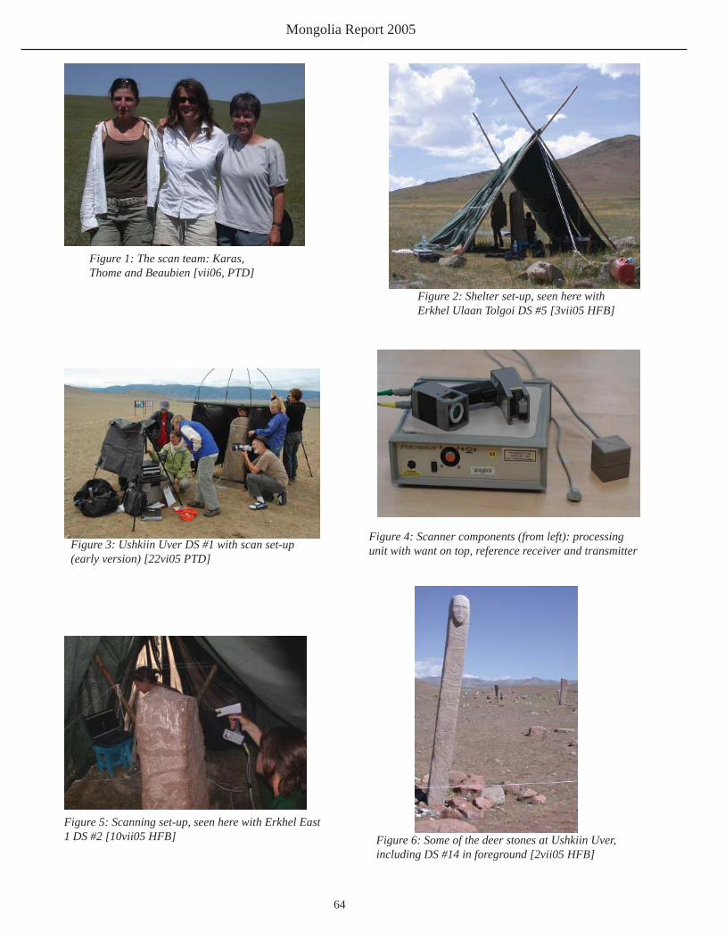
Mongolia Report 2005
64
Figure 1: The scan team: Karas, Thome and Beaubien [vii06, PTD]
Figure 2: Shelter set-up, seen here withErkhel Ulaan Tolgoi DS #5 [3vii05 HFB]
Figure 3: Ushkiin Uver DS #1 with scan set-up (early version) [22vi05 PTD]
Figure 4: Scanner components (from left): processingunit with want on top, reference receiver and transmitter
Figure 5: Scanning set-up, seen here with Erkhel East1 DS #2 [10vii05 HFB] Figure 6: Some of the deer stones at Ushkiin Uver,
including DS #14 in foreground [2vii05 HFB]

Arctic Studies Center
65
Figure 7: Tsatstain Khoshun DS #1 with scan set-up (early) [24vi05 HFB]
Figure 8: Erkhel/Ulaan Tolgoi, with deer stones(left to right) #4, #5, #,3, #2, #1. [xxxvii05 HFB]
Figure 9: Erkhel East 1, with deers #1 (foreground)and #2 [9vii05 CPT]
Figure 10: Efd Valley 3 DS #1, tipped up inpreparation for scanning [29vi05 HFB]
Figure 11: Erkhel North 1 DS #1, in as-found position[6vii05 HFB] Figure 12: Erkhel/Ulaan Tolgoi DS #2 being
groomed for scanning [7vii05 CPT]

Mongolia Report 2005
66
Figure 13: Erkhel North DS #1, positionedafter excavation [10vii05 HFB]
Figure 14: Erkhel/Ulaan Tolgoi khirigsuur, with smallmound during excavation (foreground) [pvii05 HFB]
Figure 15: Erkhel North 1 DS #2 [10vii 05HFB]
Figure 16: Foil Covered horse head deposit, beingjacked with plaster for block lifting. [9vii05 HFB]
Figure 17: Horse head deposit in situ, with fragile bonebeing stablized with tissue patches [9vii05 HFB]
Figure 18: Labeling the block-lifted horse headdeposit. [9vii05 HFB]

Arctic Studies Center
67
Part V
2005 Burial Mound Survey in Hovsgol Aimag, Mongolia
Bruno Frohlich
Department of Anthropology
Smithsonian Institution
Introduction
During the summer of 2005 we focused on the surveying of burial mounds, also known as khirigsuur in
the southern Hovsgol aimag. In 2003 and 2004 we explored several areas of interest (Ushkiin Uuver, Ulaan Tolgoi,
and Soyo) all with high concentrations of mounds. We also tested various recording procedures including advanced
GPS and GIS mapping and succeeded in combining different recording methods that allowed us to enhance our data
collection while adjusting to different logistic situations and changing recording objectives as our knowledge of mound
distributions improved (Frohlich et al 2004; Frohlich and Bazarsad 2005). Our surveys at Soyo, Ulaan Tolgoi (Lake
Erkhel), and Ushkin Uuver have shown certain consistent and well-defi ned patterns: preference for locating mounds on
the southern hill sides; a division of mounds into three major classes dependent on location; and mounds nearly equally
divided into two architectural expressions — mounds with either circular or square stone fences, respectively (Frohlich
et al 2004; Frohlich and Bazarsad 2005).
During our surveys we developed many questions. For example, researchers have suggested that the mounds are
not burials but large ritual monuments related to spiritual beliefs. This hypothesis has been asserted by Esther Jacobsen
and further supported by some excavations, including research by William Honeychurch at the Baga Gazaryn Chuluu
site (Jacobson 1993, 2002; Honeychurch and Armartuvshin 2002). After extensive excavations Honeychurch did not
fi nd any human remains in the central kherigsuur mounds. This is in part contradicted by our fi nds of human remains
in robbed and disturbed kherigsuur mounds explored by our survey teams in 2003 and 2004. Most likely the answer
is much more complicated. At this time we argue that the majority of smaller and middle size mounds are constructed
for the purpose of burials of human bodies, and larger structures and especially mounds located in close vicinity to
deer stone complexes could be ritual monuments. However, before we can answer these questions we need to develop
a comprehensive and high-quality burial mound database including survey data, excavation data, ethnographical data,

Mongolia Report 2005
68
and associated information related
to the fi nds of human and animal
remains, as well as information
on sex and age distribution,
demography, radiometric/AMS
dating of biological material, and
the correlation between biological
information and architectural
expression.
We have divided our
khirigsuur project into three
principal phases: (1) mapping
mound structures in well-defi ned
geographical areas; (2) excavations
of selected mounds; and (3) data analysis. The fi rst phase was initiated in 2003 and 2004 with surveys at Soyo and
Ulaan Tolgoi (Frohlich et al 2004; Frohlich and Bazarsad 2005) and in part completed in 2005 with a major survey of
mounds between Ulaan Tolgoi and Ushkiin Uuver. The second phase is scheduled to commence in the summer of 2006.
Depending on logistics, we plan to excavate between fi ve and eight small or medium size mounds in the Ulaan Tolgoi
and Soyo areas. Phase 3, the analytical phase, began concurrent with the fi rst two phases; however, the major emphasis
on analysis will take place after the 2006 season, when survey and excavation data can be integrated to support the
testing of various hypotheses.
Logistics
The 2005 survey team included members of the Institute of Archaeology at the Mongolian Academy of
Sciences: N. Bazarsad , B. Erdene, T. Amgalantugs, D. Adara, and D. Tumer (driver), and of the Smithsonian Institution:
B. Frohlich (Figure 1). An area between the two deer stone complexes at Ulaan Tolgoi (Lake Erkhel) and Ushkiin Uuver
(the Delger Muron River) was selected (Figure 2). The reported presence of more than 400 mounds west and north
of the Ushkiin Uuver deer stone complex and the known number of 118 mounds west of the Ulaan Tolgoi deer stone
complex strongly suggested that this specifi c area could include a large number of mounds (Frohlich and Bazarsad
2005). The result was a trapezoidal area with two parallel east - west sides north of Lake Erkhel and along the Delger
Moron River to the south and two non-parallel north - south sides between Lake Erkhel and Ushkiin Uuver on the east
side, and between 21 and 27 km on the west side. The lengths of the sides range from 21 km for the northern side to 38
km for the eastern side. The total area surveyed is approximately 850 km2 (Figure2).
In planning our survey we relied on experiences gained during the 2003 and 2004 pilot surveys at Soyo and
Ulaan Tolgoi. We succeeded in defi ning criteria for the geographical location of mounds and as well as criteria that
suggested the possibility of fi nding mounds should be very limited. This included the most likely location of mounds
Figure 1: 2005 Survey Team. From left: T. Amgalangtugs,B. Erdene, D Tumer, and D. Adara.

Arctic Studies Center
69
on southern hill sides, on areas between southern hill sides and the fl at steppe, and in the adjacent steppe landscape. We
also hypothesized that larger mounds were found on the fl at steppe (Class 1 mounds), and the smaller mounds would be
identifi ed on the upper hill sides (Class 3 mounds). This hypothesis was tested by exploring areas where mounds should
be present, and areas where we hypothesized that mounds should not be present. The latter proved to be correct in most
cases. However, the exploration of southern hill sides did not always yield the presence of mound structures. We found
that the presence of raw material such as numerous rocks of various sizes needed to be added as an important additional
criteria. Also, the density of mounds on southern hill sides ranged from a very few to extensive concentrations. This
could not always be associated with restrictions in the natural landscape such as large boulders and deep depressions,
and as such may be a function of other factors including social, economical and spiritual considerations (Frohlich and
Bazarsad 2005).
Figure 2: 2005 survey area (Landsat false color image), including mound distrobution (white).Symbols represent a total of 1,341 surveyed mounds.
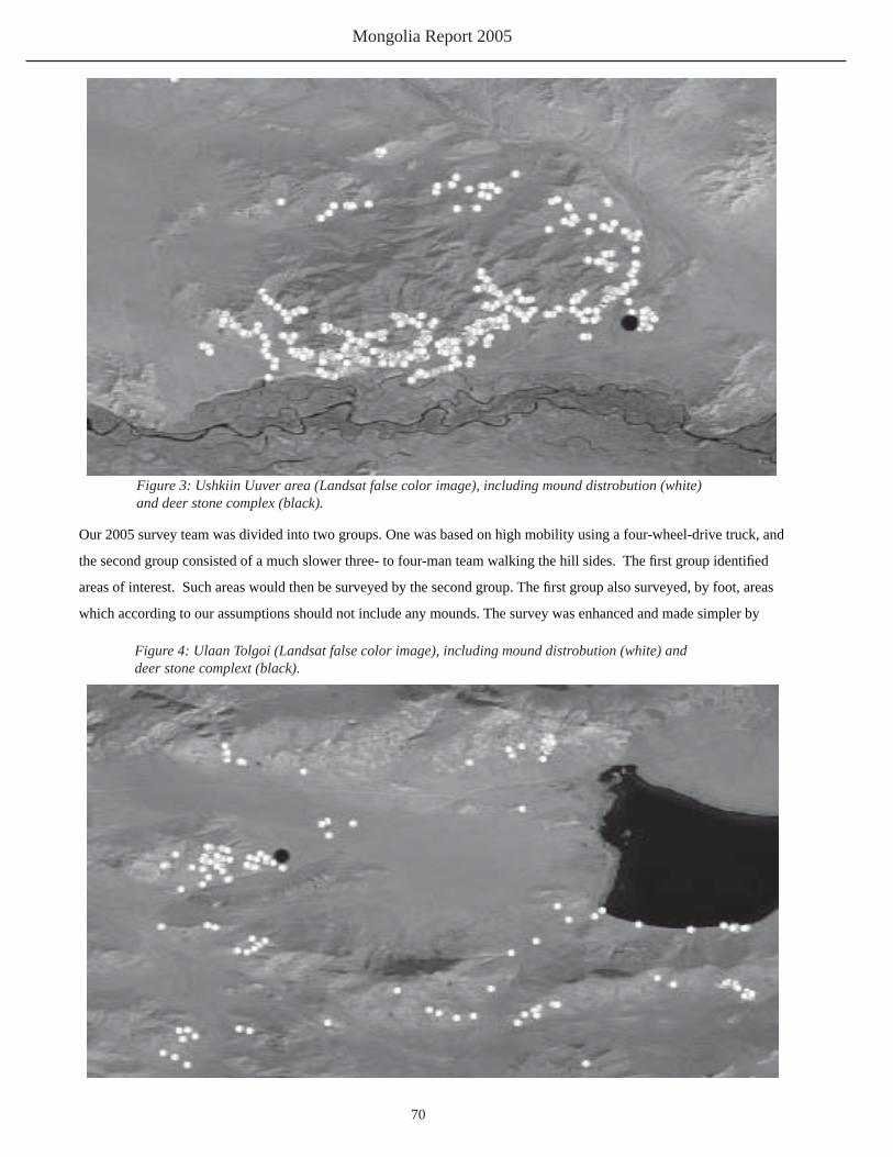
Mongolia Report 2005
70
Our 2005 survey team was divided into two groups. One was based on high mobility using a four-wheel-drive truck, and
the second group consisted of a much slower three- to four-man team walking the hill sides. The fi rst group identifi ed
areas of interest. Such areas would then be surveyed by the second group. The fi rst group also surveyed, by foot, areas
which according to our assumptions should not include any mounds. The survey was enhanced and made simpler by
Figure 3: Ushkiin Uuver area (Landsat false color image), including mound distrobution (white)and deer stone complex (black).
Figure 4: Ulaan Tolgoi (Landsat false color image), including mound distrobution (white) anddeer stone complext (black).

Arctic Studies Center
71
having access to poster size composite
Landsat images including bands 2, 4, and 5
and producing a false-color map with color
attributes close to what we would expect
if fl ying in a small airplane at low altitude
above the ground (Figure 2).
Mounds were recorded using a
combination of GPS, compass, large
measuring tapes, and basic map readings.
Metric dimensions and magnetic direction
of features were recorded manually, and
geographic positions were recorded as
longitude, latitude, and elevation and were
stored in two small GPS units (Garmin
GPS-12). At the end of each day all data
were entered into a database management
system and checked out for accuracy using
software from Hildebrand (Waypoint).
Later, and after our return to the laboratory
at the Smithsonian Institution, mounds
were displayed on geo-referenced Landsat
images and Russian topographical maps
using different colors and shape depicting
various architectural and biological
expressions. ESRI-GIS (ArcInfo/ArcMap),
and Leica Geosystems (Erdas Imagine) software were used for this purpose and also for more upcoming and advanced
analyses of distribution patterns.
Results
Mound distribution
A total of 1,223 mounds were recorded within the study area. Five hundred and three mounds were located
on the southern hill sides of the large hill complex north and west of the Ushkiin Uuver deer stone complex (Figure 3).
The remaining 720 mounds were located in various clusters of between 3-150+ mounds evenly distributed in most of
the surveyed areas and within one large cluster of 120 mounds around the Ulaan Tolgoi deer stone site (Figures 2 and
4). The 120 mounds were recorded during our 2003 and 2004 fi eld seasons (n=118) and the 2005 survey (n=2; Table
1)( Frohlich and Bazarsad 2005). Tentatively, seven clusters of mounds can be defi ned within the entire survey area.
This includes two clusters around the Ushkin Uuver and Ulaan Tolgoi deer stone complexes (Figures 3 and 4) and fi ve
Figure 5: Central and eastern part of survey area (Landsat false color image), including mound distrobution(white) and deer stone complex (black).

Mongolia Report 2005
72
smaller and less well defi ned clusters in the
area between these two deer stone complexes
(Figure 2). No mounds were associated with
a small deer stone complex located 15 km
southeast of Lake Erkhel and 17 km north of
Ushkiin Uuver, at Latitude 49o48’54.0” East
and Longitude 99o54’02.8” North (Figure 5).
In some cases geographical features could
explain the observed clustering of mounds,
but in most, no clear natural landscape feature
could explain the observed clustering. We
argue that such clustering is a function of other
factors including social, political, economic,
and spiritual elements.
Architectural variation
The basic architectural expression of mounds in the central Hovsgol Aimag has been described in earlier
fi eld reports published in the Arctic Study Center’s publication series (Frohlich et al 2004, and Frohlich and Bazarsad
2005). However, this season we realized that the architectural variation is much more elaborate than previously thought.
Although mounds deviating from the basic architecture expression are few, their special location and unique features
must be taken into consideration when the data is being analyzed and the results being discussed. This part of the study
is still in progress, and results will be reported at a later time.
The antiquity of the mounds are assumed to be between 3,500 BP and 2,000 BP, however, the temporal distance
between mounds may be signifi cantly higher than the assumed 1,500 years. Also, the question of mounds being burials
or ceremonial monuments still has to be verifi ed by excavations of selected mound structures. Small and medium size
mounds appear to be burials. At least four or fi ve robbed (looted) mounds yielded human remains when the back-dirt of
the thieves was examined in detail (Frohlich and Bazarsad 2005; Fitzhugh 2005: 24). Dating of human remains found
in center mounds, associated horse remains found in external mounds all fall within 3200 to 2000 BP (calibrated), thus
contemporary with dates obtained by Fitzhugh (2005) from external mounds and deer stone sites. Our radiometric dates,
so far, suggest contemporary dates between (1) human remains from Khirigsuur main mounds, (2) associated external
mounds (horse skeletal remains), and (3) from horse skeletal remains found adjacent to deer stones.
Some of the larger mounds (Class 1 mounds) are located on the fl at steppe. Assuming that the stones used to
build the surrounding walls were placed directly on the original surface, we hypothesized that the accumulated soil
layers represented by the soils between the lowest part of the stones and the present surface may correlate with the age
of the construction. Thus, we initiated a small pilot study in which several mounds were tested in two different areas,
Figure 6: E. Erdene (left) and T. Amgalantugs, Institute ofArchaeology, Mongolian Academy of Sciences, recording soil deposits on circular fence of a Class 1 mound.

Arctic Studies Center
73
all representing Class I mounds, defi ned as being located on the fl at steppe (Figure 6). The average depth of the stones
was found to be very similar within the same area but different between areas. We argue that this may represent some
signifi cant temporal distances between various groups of mounds. However, it might also be that these differences
result from different Aeolian and sedimentary regimes of the different areas. This hypothesis will be tested further when
returning to the fi eld in the summer of 2006.
Finally, during the 2005 season we repeated the recording of mounds recorded in 2003 and 2004, and about
20 mounds recorded early during the 2005 season were recorded again at the end of the same season but by a different
group of surveyors. This control work demonstrated that the survey data in most cases is of the highest possible quality.
Our results from the 2005 survey were fascinating. We demonstrated that some of the ideas and assumptions
developed during the 2003 and 2004 seasons could be verifi ed by the results from 2005, and also that the variability of
mound architecture and location is much more complex than seen in the limited amount of mounds surveyed during the
2003 and 2004 seasons (Frohlich et al 2004; and Frohlich and Bazarsad 2005). We have initiated close collaborations
with Francis Allard’s excavation of burial structures in the Khanuy valley and with William Honeychurch’s survey and
excavations of mounds at the Baga Gazaryn Chuluu site (Honeychurch and Amartuvshin 2003; Allard and Erdenebaatar
2002). Apparently, and although the basic khirigsuur architecture is very similar between these regions, the three
surveys also confi rm that there are variations between regions. Is such variation a function of different time periods or to
contemporary regional variation? We do not know the answer at this time.
In the following we present part of our summary statistical data as they appear at this time, based on data
from all three fi eld seasons from 2003 to 2005. However, some data is still being processed and is not included in this
publication. Also, our quality control including second and third repeat recordings of selective mounds demonstrated
that we had problems during the 2005 season recording external structures such as external mounds and stone rings.
Thus, until some of the 2005 recordings have been repeated, corrected and/or verifi ed, we will not use the complete
database to report our results pertinent to external mound structures. Finally, based on additional quality control of the
data both from repeated surveys of selected mounds during the 2005 and 2006 seasons and statistical data control in our
laboratory, we may at a later time have to slightly alter some of our numbers and results presented in this report.
Summary of statistical data
The total number of recorded mounds covering the Ulaan Tolgoi, Ushkin Uuver, and the Soyo areas is 1,619
mounds. Of these, 262 were recorded in 2003, 134 in 2004, and 1,223 in 2005. A total of 278 mounds have been
recorded in the Soyo area; 120 in the Ulaan Tolgoi area; 503 in the Ushkin Uuver ara; and 718 in the large area between
the Ushkin Uuver and Ulaan Tolgoi areas (Table 1).
Mounds are found in three major architectural confi gurations: (1) mounds with squared fences, (2) mounds
with circular fences, and (3) mounds with no visible fences (Figures 7 and 8). We have not yet identifi ed any correlation

Mongolia Report 2005
74
between shape of fences and the surrounding landscape. At this time, the selection of fence shape appears to be random.
Mounds with no fences may represent structures where the natural silting and surface deposit over time have covered
the fence, or it could be that no fence was constructed to begin with. In general, mounds with no fences are statistically
smaller than mounds with fences. It could be argued that smaller mounds may be making use of smaller stones in the
basic construction, thus fences could possible be entirely covered by silt, or smaller mounds with no fences could part of
a different architectural expression, which may include the Hunnu period.
Combining all mounds recorded from 2003 to 2005 within all four geographical locations we fi nd that out of
1,619 recorded mounds, 638 (39%) include a circular fence, 683 (42%) include a squared fence, and 298 (18%) show
no sign of fences (Table 2). This almost equal distribution between circular and squared fences is slightly different
when comparing the four surveyed geographical areas on an individual basis. For example, the numbers for Soyo are:
circular fences 121 (44%), squared fences 73 (26%), and 84 (30%) with no fences. The numbers for Ulaan Tolgoi are:
circular fences 56 (47%), squared fences 54 (45%), and 10 (8%) with no fences. Ushkin Uuver: circular fences 184
(37%), squared fences 268 (53%), and 51 (10%) with no fences. And for the area between Ulaan Tolgoi and Ushkin
Uuver: circular fences 277 (39%), squared fences 288 (40%), and 153 (21%) with no fences (Table 2). Ulaan Tolgoi
and locations between Ulaan Tolgoi and Ushkin Uuver yield almost equal numbers of mounds with circular and squared
fences. Soyo has a signifi cant higher number of mounds with circular fences and Ushkin Uuver has a signifi cant higher
number of mounds with squared fences (Table 2). Whereas the uneven distribution of mounds with circular and squared
fences at Soyo could be explained by the high number of mounds with no recorded fences (30%), this is not the case for
the Ushkin Uuver area where the number of mounds with no recorded fences represents only 10%.
Figure 7: Burial mound with circular fence.

Arctic Studies Center
75
We need to study other potential factors which may explain this discrepancy. No hypothesis explaining why
some mounds include a circular fence and some a squared fence have been published. At this time we argue that the
selection process might be a sexual dimorphic trait, i.e. males being interred in one shape of mounds and females in the
other. Upcoming excavations and the examination of human remains already retrieved may help accept or reject this
hypothesis.
In general, student t-test using metric variables between mounds with circular fences and mounds with squared
fences show no signifi cant size differences between mounds including different shape of fences. Size differences are not
statistically signifi cant in mounds located at Ulaan Tolgoi and Ushkiin Uuver (P = 0.730, and P = 0.370, respectively).
However, circular mounds tend to be larger than squared mounds in the area between Ushkiin Uver and Ulaan Tolgoi
(P=0.003). Comparative data from the Soyo area is not yet available.
During our 2003 fi eld season we developed a classifi cation system based on the location of mounds as related
to being on the fl at steppe, on hillsides (most often on the southern exposed sides), or in areas bordering the hillsides
and the fl at steppe. Thus Class 1 mounds are found on the fl at steppe (Figure 9), Class 2 mounds on the border between
steppe and hills (Figure 10), and Class 3 mounds in the hills (Figure 11). Of a total of 1,619 recorded mounds, including
recording from all three fi eld seasons, 360 (22%) are defi ned as Class 1 mounds, 651 (40%) are defi ned as Class 2
mounds, and 580 (36%) are defi ned as class 3 mounds (Table 3). Class 1 mounds are, in general, signifi cant larger than
Class 2 and Class 3 mounds, and Class 2 mounds are in general larger than Class 3 mounds. The basic statistics for
metric variables between the three classes are as follow: There are signifi cant size difference between all three classes for
the following metric variables: maximum center mound diameter, circular fence diameter, and length of northern fence
line (in squared mounds only) (P=0.000). Class 1 mounds located adjacent to deer stone complexes represent the largest
Figure 8: Four burial mounds with squared fences.

Mongolia Report 2005
76
recorded mounds, thus supporting the contemporaneous relationship between the two types of structures (Frohlich and
Bazarsad 2005).
When the distribution of mounds with circular and squared fences, respectively, are evaluated with the three
different classes of mounds, we fi nd an almost equal distribution of mounds with circular and squared fences in Class 1,
Class 2, and Class 3 mounds; however Class 3 mounds include a slightly higher numbers of mounds with no recorded
fences (n=123, 21%) versus n=58, (16%) and n=89 (14%) found in Class 1 and Class 2 mounds, respectively. This
discrepancy may be a factor of higher levels of silting and natural soil coverage of fences on a slope than on more
horizontally level surfaces. The statistics on classes of mounds are not fi nalized at this time. Surveys at Ulaan Tolgoi,
Ushkin Uuver and the large areas between, most likely include all mounds. This is not the case at Soyo, however.
Surveys north of the Khugiin Gol include Class 1 and Class 2 mounds, only. Logistic problems (weather) did not allow a
detailed exploration for Class 3 mounds in the upper hill sides facing south and toward the Khugiin Gol.
Relative dating
During observation of earlier excavated mounds by other archaeologist we observed that most likely the original
mound-builder placed the stones directly on the surface. From this we hypothesized that the thickness of silt and soil
layers found between the lowest part of stones and the present surface would refl ect the amount of silt accumulated since
the time of construction and to the present time. From this we further argue that the thickness of such layers would
become a measure of relative time differences between groups of similar classes of mounds.
To test this hypothesis we selected two areas: Class 1 mounds around the Ushkiin Uuver deer stone complex
Figure 9: Class 1 mound

Arctic Studies Center
77
and a second Class 1 group of mounds located a minimum of 6 km west and northwest of the deer stone complex. Both
groups depicted similar surface characteristics. Small test pits were excavated next to and external to well defi ned stone
fences, including squared and circular fences. Size of test pit was between 1 meter by 0.5 meter and 0.5 meter by 0.5
meter. Depths were dependent on lowest location of stone. Seventeen pits were tested in six mounds adjacent to the
Ushkiin Uuver deer stone complex. Five of the six mounds were within 0.5 km from the deer stone complex and one
mound about 1.5 km west of the deer stone complex. Twenty four pits were tested in 12 mounds located between six km
and 12 km west and northwest of the Ushkiin Uuver deer stone complex. Fifteen tested mounds were Class 1 and three
were Class 2 mounds.
Two metric variables were recorded: the vertical distance between the lowest location of the stone and the
present surface (Variable B) and the vertical distance from the present surface to the top of the stone (Variable A). The
total vertical height of the stone (variable AB was calculated by adding the two recorded variables.
We found a signifi cant difference between the amount of accumulated silt or soil between the Ushkiin Uuver
group and the mound group to the west and northwest, with the deposits at Ushkiin Uuver being less (19.0 cm) than the
similar value for the western/northwestern group (25.4 cm) (Tables 4 and 5). A Student t-test between the two groups
suggests a signifi cant difference (P=0.001). There is also a slight size difference in the size of the recorded khirigsuur
fence stones, with a vertical height measurement for the Ushkiin Uver group at 27.5 cm and 35.5 cm for the western
group (Tables 4 and 5). The Student t-test showed a signifi cant size difference, although less signifi cant that the amount
of accumulated soils between the two groups (P=0.005).
Figure 10: Class 2 mound

Mongolia Report 2005
78
Based on these preliminary pilot tests we may argue that the khirigsuur at Ushkiin Uuver are younger than the
similar mounds located west and northwest of the of the deer stone complex. Also we could argue that stones used in
the construction of fences are smaller in the mounds around the deer stone complex when compared to the stones used
in mounds located to the west. Needless to say that the numbers and sample sizes used in the statistics are small. The
sample of 17 for Ushkiin Uver and 24 for the western distribution may raise question about a normal distribution of the
data, thus the t-tests may refl ect slightly biased results. However, such data and test results raise new arguments and
hypotheses which should be tested in future excavations and surveys. This would include a comprehensive study of soil
silting in other well-defi ned areas closer to the Ulaan Tolgoi deer stone complex. The method applied in this pilot study
suggests a temporal order of sequence, thus is not an absolute result. However, with absolute dating methods, such as
radiometric and AMS dating of biological material from central mound and external mounds it should be possible to
correlate our relative dates to absolute dates and achieve a better understanding of the temporal variation of mounds
within a well-defi ned and well-understood geographical distribution. At this time several biological (horse tooth and
charcoal) dating samples from the deer stone complex at Ulaan Tolgoi have suggested dates between approximately
3,200 BP and 2,000 BP (Fitzhugh 2005). Horse tooth samples from an inner tier horse sacrifi ce satellite mound and in
outer tier horse mound at the large kherigsuur immediately south of the Ulaan Tolgoi deer stones yielded 3080-2870
BP (calibrated) and 3320-2940 BP (calibrated) (Fitzhugh 2006). Three samples from the Soyo area were submitted in
March of 2006 and the results have just been received. Soyo Mound no. S49, External Mound (horsehead remains)
yielded 3000-2780 BP (calbrated); Soyo Mound no. S49, Central Mound (human skeletal remains) yielded 3210-2880
BP (calibrated), and Soyo Mound no. S50, Central Mound (human skeletal remains) yielded two dates: 2760-2690 BP
(calibrated nad 2660-2480 BP (calibrated). Thus, human remains found in the center mounds appear to be contemporary
with horse skeletal remains found in the external mound. Two center mounds have yielded dates between 3200 BP and
2000 BP, thus showing contemporary dates with horse skeletal remains found in other external mounds and in areas
Figure 11: Class 3 mound

Arctic Studies Center
79
associated with deer stones.
We plan to expand our sample size of absolute dates from both center mounds and external mounds in
khirigsuurs located in the Ulaan Tolgoi and the Soyo areas, to conclusively establish a clear understanding of the relative
time, if any, which may exist between burial features within the same mound structures.
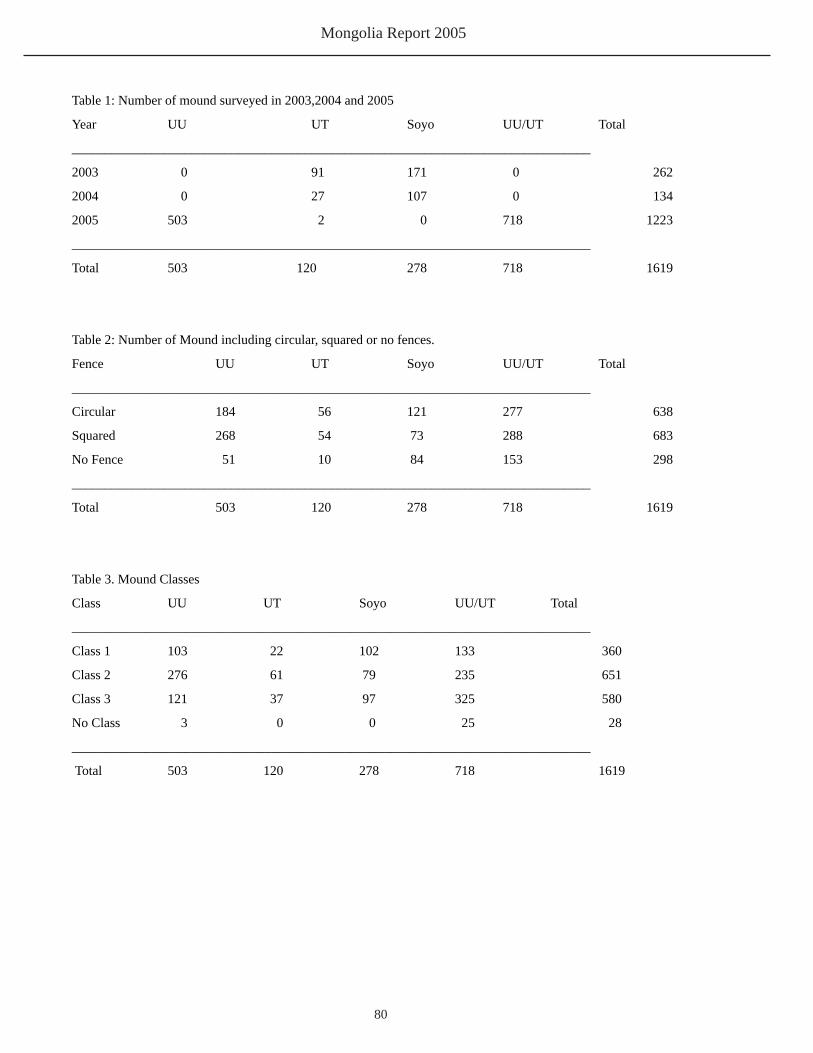
Mongolia Report 2005
80
Table 1: Number of mound surveyed in 2003,2004 and 2005
Year UU UT Soyo UU/UT Total
______________________________________________________________________________
2003 0 91 171 0 262
2004 0 27 107 0 134
2005 503 2 0 718 1223
______________________________________________________________________________
Total 503 120 278 718 1619
Table 2: Number of Mound including circular, squared or no fences.
Fence UU UT Soyo UU/UT Total
______________________________________________________________________________
Circular 184 56 121 277 638
Squared 268 54 73 288 683
No Fence 51 10 84 153 298
______________________________________________________________________________
Total 503 120 278 718 1619
Table 3. Mound Classes
Class UU UT Soyo UU/UT Total
______________________________________________________________________________
Class 1 103 22 102 133 360
Class 2 276 61 79 235 651
Class 3 121 37 97 325 580
No Class 3 0 0 25 28
______________________________________________________________________________
Total 503 120 278 718 1619

Arctic Studies Center
81
Table 4: Test pit excavations of fence stones at Ushkiin Uuver. A: vertical height of stone above present surface, B: thickness of soil deposit from the ground to the base of the stone, and AB: total vertical height of stone.
A B ABN of cases 17 17 17Minimum 2.000 8.000 10.000Maximum 25.000 29.000 48.000Range 23.000 21.000 38.000Mean 8.529 19.000 27.529Standard Dev 5.547 5.523 8.917
Table 5: Test pit excavations of fence stones at Ushkin Uuver West and Northwest: A: vertical height of fence stone above present ground surface; B: thickness of soil deposit from the ground surface to the base of the stone; and AB: total vertical height of stone.
A B ABN of cases 24 24 24Minimum 2.000 15.000 22.000Maximum 22.000 38.000 49.000Range 20.000 23.000 27.000Mean 9.292 25.375 35.500Standard Dev 4.428 5.257 7.235

Mongolia Report 2005
82
ReferencesFrancis Allard and Diimaajav Erdenebaatar, Natsagyn Batbold, and Bryan Miller
2002 A Xiongnu Cemetary Found in Mongolia. Antiquity 76:637-638.
William W. Fitzhugh
2005 The deer stone Project: Exploring Northern Mongolia and its Arctic Connections. In
The Deer Stone Project. Anthropological Studies in Mongolia 2002-2004. Editors:
William Fitzhugh, Jamsranjav Bayarsaikhan, and Peter Marsh. Published by Arctic
Studies Center, Smithsonian Institution, and National Museum or Mongolian History,
Ulaanbaatar.
William W. Fitzhugh
2006 (See this volume)
Bruno Frohlich, Matthew Gallon, and Naran Bazarsad
2004 The Khirigsuur Tombs in the Hovsgol aimag, Northern Mongolia. Mapping and
Analysis. In: The Hovsgol Deer Stone Project 2003 Field Report. Editor: William
Fitzhugh. Arctic Studies Center. Smithsonian Institution, Washington DC.
Bruno Frolich and Naran Bazardsad
2005 Burial Mounds in Hovsgol Aimag, Northern Monglia: Preliminary results from 2003-2004. In The Deer Stone
Project. Anthropological Studies in Mongolia 2002-2004. Editors: William Fitzhugh, Jamsranjav Bayarsaikhan,
and Peter Marsh. Published by Arctic Studies Center, Smithsonian Institution, and National Museum of Mongolian
History, Ulaanbaatar.
Esther Jacobson
1993 The Deer Goddess of Ancient Siberia. A study in the Ecology of Belief. Leiden, New York, Kohn: E. J. Brill.
Esther Jacobson
2003 Petroglyphs and the Qualifi cation of Bronze Age Mortuary Archaeology. Archaeology, Ethnology, and Anthropology
of Eurasia 3(11):32-47.
William Honeychurch and Ch. Amartuvshin
2003 Survey and Settlement in Northern Mongolia: The Structure of Intra-regional Nomadic Organization. In Proceedings
of the University of Chicago Conference on Eurasian Archaeology. Leiden: E. J. Brill Publishing.

Arctic Studies Center
83
Appendix A
Archaeological Sites Studied in 2005
Khoshoot
GPS: N 48° 07.478’; E102° 34.975’; 1346 elev.
3 deer stones, irregular shaped, placed upright by Sanjmiatav with Russian team in 1971
21 June 2005
Burdnii Ekh (‘source’, 1 km east of Sakhatt or ‘mustache hill’)
GPS station #11: N 48° 20.783’; E 102° 22.578’; 1375 elev.
Deer Stone site with large slab burial built with deer stone corners and retaining walls
Dalka Valley Turkic Site: rectangluar temple and statue site
GPS station #13: N 49° 17.244’; E 101° 16.285’; 1351m elev.
South of Selenge River in. 7-8th C. AD. One Turkic statue
Selenge River South Side
Sand blow areas with massive fi re-cracked rock deposits (??)
Evdei Turkic Slab Site (Evdei 1)
GPS Station #15: N 51° 07.213’; E 99° 13.303’; 1631m elev.
Two irregularly shaped and unmodifi ed standing slabs of a greenstone-type rock, placed in north-
south alignment at the base of the hill bordering the north side of the valley. Excavation resulted in
no artifact fi nds or burials, but an alignment of smaller vertical slabs extending east and west of the

Mongolia Report 2005
84
large slab. The smaller slabs had apparently once been on the surface but had been covered by 50-
75cm of slopewash.
Soyo Rock Art Site: Tolijgii Boom
We briefl y revisited this rock art site which we had seen in 2002, noting then that it had been trashed
by thieves sometime before that. Tom Kelly took a number of photographs.
Khuggin Gol: Soyo North Site
GPS station #15: N 50° 59.972’; E 99° 08.654’; 1651m elev.
One the major terrace on north side of river at Soyo, opposite the sum center buildings, in middle
of pasture. Collected some bone fragments and pieces of thick orange-surface ceramics like those
found at Soyo 3.
Menge Bulag 2
GPS: N 51° 11.907’; E 098° 54.500’; 2219m elev.
Erden, Bayandalai’s son, had found a dark chert end scraper at this former Tsaatan camp downriver
from MB-1, and we went to see what else might be there. Although carefully searching the site for
an hour, having good exposures, we found no fl akes, artifacts, or hearth rocks, or any other sign of a
site, other than Tsaatan ethnographic camp remains. I mapped this Tsaatan camp in 2004.
Evdei -1: Turkic Slab Site, Stone 1
GPS station: N 51° 07. 310’; E 99° 13.300
Two standing slabs of roughly shaped greywakie of similar rock without their edges or sides having
been trimmed or shaped, standing in north-south alignment on an alluvial fan of material eroded
from the hillside to the north. Although we saw no sign of deer stone markings we decided to
excavate the northernmost stone (stone 1) to learn about its cultural affi liation and age and features.
No other features were seen on the surface nearby, and the slabs were not associated with khirigsuurs
located further uphill on the alluvial fan.
The slabs were oriented with their fl at faces toward east and west. Excavation of Stone 1 revealed
a series of smaller slabs extending east and west of the large slab, buried ca 50-75cm below the
surface, also with their fl at sides facing east and west. These small slabs were spaced about 50-75cm
apart, apparently being part of a large line of slabs that extends east and west from the large slab for
an unknown distance, all which have been buried by alluvial deposits during the past 1500 years.

Arctic Studies Center
85
No diagnostic artifacts were recovered, only a few bone fragments and traces of charcoal and bark.
These were not features other than the buried slabs, which were set into sterile rocky soil. This slab
and alignment closely resembles one we found north of the Shishiged River, north of Tsaaganuur in
2004 and is a characteristic ceremonial feature known to date to the Turkic period, ca 700-800 AD.
Evdei 2: Buddhist Enclosure Site
(see Evdei survey report and detailed site reports for GPS locations, maps)
Evdei 3 Deer Stone Site
(see Evdei survey reports for GPS data)
Deer Stone 2 (GPS station 45: N 49° 55.0561’; E 100° 03.164’; 1720m elev.
Two fallen deer stones found in the northern area of the Evdei 2 site area. We excavated around DS
1, collecting a charcoal sample from a circular feature here; and at DS 2, to the west, we mapped
circular features and excavated the deer stone and Feature 1, in the center of which we found a dark
chert end scrapper made on a thick prismatic blade.
Hillside site south of Tsaaganuur
GPS station 30: N 51° 12.787’; E 099° 23.084’; 1638m elev.
Several khirigsuur are found on the south side of a big hill the road crosses just before reaching
Tsaaganuur. Bayaraa’s group surveyed the west end of the hill near the head of a small valley,
fi nding chert fl akes on the surface, and I found fl akes of the same material in a grassy depression,
on the hillside below a rock cairn and above the khirigsuurs, at GPS N 51° 12.786’; E 99° 22.922 at
1678m elev. However, nothing diagnostic was found, and the location may just be the source of a
good chert outcrop.
Khogorgo River 1
GPS station 32: N 51° 25.125’; E 99° 18.783’; 1591m elev.
The site is found along the crest of an eroding terrace overlooking a former embayment of the K.
river, where some of the chert fl akes were found in 2004 near the north end of the terrace. We found
a few more this year, but could not locate a concentration.

Mongolia Report 2005
86
Khogorgo River 2 Standing Stone
This site was recorded in 2005, where the road track nears the south bend of the K. river and passes
alongside a single standing slab, which is uncut, unshaped and without markings. It is probably a
Turkic slab feature, similar to the one we recorded 2-3 km to the west in 2004.
Khogorgo River 3 Stone Feature site
GPS station 33: N 51° 25.264’; E 99° 18.036’; 1585m elev.
A series of 8-10 pavement features measuring ca. 1x 1m or 1x2m diameter along the north side of
the river in a low terrace next to the stream.
Shishiged River 1 Rock Art Site
Rock art carved into lava blocks at outcrops on the level terrace north of the terrace edge
overlooking the Shishig River.
Panel 1 art with 3-4 animals at GPS station 35: N 51° 24.841’; E 99° 17.015’; 1603m elv.
Panel 2 with a complicated geometric grid with a human fi gure in the middle at GPS station 36: E
51° 24.836’; E 99° 17.078’; 1604m elev.
Shishiged River 2 Rock Art Site
Located east of the mouth of the Khogorgo River
Shishiged River Terrace Mound
A large boulder pile ca 4m in diameter and 1.5m high on the upper terrace encountered while
walking SW from KR-3 to he Shishig River bank near the rock art locations.
Shishiged River North Kherigsuur
Two circle-fence kherigsuurs below the rock art sites at GPS station 34: N 51° 24.908’; E 99°
17.168’; 1603m elev.
Erkhel Lake North Deer Stone Site
GPS station: N 49° 58.373’; E 99° 56.521; 1600m elev.
We found this deer stone site on a fl at terrace on the north shore of Erkhel Lake, just south of the
car track. One deer stone was standing and had faint but unmistakeable deer stone markings; the
other stone was to the north of the standing stone and had fallen. We excavated the stone and a
cirular boulder feature (empty) near Standing Stone 1. Both stones were laser - scanned. No bone or
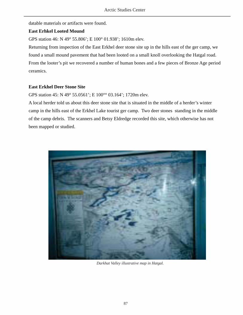
Arctic Studies Center
87
datable materials or artifacts were found.
East Erhkel Looted Mound
GPS station 46: N 49° 55.806’; E 100° 01.938’; 1610m elev.
Returning from inspection of the East Erkhel deer stone site up in the hills east of the ger camp, we
found a small mound pavement that had been looted on a small knoll overlooking the Hatgal road.
From the looter’s pit we recovered a number of human bones and a few pieces of Bronze Age period
ceramics.
East Erkhel Deer Stone Site
GPS station 45: N 49° 55.0561’; E 100°° 03.164’; 1720m elev.
A local herder told us about this deer stone site that is situated in the middle of a herder’s winter
camp in the hills east of the Erkhel Lake tourist ger camp. Two deer stones standing in the middle
of the camp debris. The scanners and Betsy Eldredge recorded this site, which otherwise has not
been mapped or studied.
Darkhat Valley illustrative map in Hatgal.

Mongolia Report 2005
88
Enroute to tundra camp with Sanjin
Ulaan Tolgoi Mound 1 with Satellite Mound A in foreground
Arctic Studies Center
89
Appendix B
Materials Collected in 2005
1. Soya North -1: - 1 bag - 3 pieces of ceramic, 1 piece of bone
2. Hillside South of Tsagaanuur: - 2 bags - Chert fi nds – possibly not cultural
3. Khogorgo River – North of Tsagaanuur: - Surface collection - A piece of chert
4. Evdei – 2 Deer Stone Site: - 2 bags - Deer Stone 1 – Circular feature, two pieces of charcoal (AMS charcoal sample) - Deer Stone 2 – South Circular feature, chert end scraper
5.Evdei -1 Turkic Stone 1: - West Side, Square 3, shoulder bone
- Square 1 possible charcoal sample from 205-215 beneath slab rock. Probably not cultural. - Bone fragments (10)
- #8 Bone fragment, Square 4- Square 1, shoulder bone- Square 1, rectangular bone- Square 1, 2 small bone fragments.
6. Evdei-3 “Monastery” Site: - (Collection from looter’s pit) - 1 bag from pit 1 with ceramic fi gures and other material.
- Looter’s pit 2 (William Fitzhugh, Melanie Irvine) surface collection and excavated material.- Looter’s pit 2 large bag of faunal remains, excavated from 1×2 meter pit.
7. Erkhel Square Burial- Bayaraa excavation: - 3 bags - 6cm - sheep vertebra - 7cm - 3 teeth - 20cm – 1 bone fragment

Mongolia Report 2005
90
8. Erkhel Lake East: 1 human burial, looted mound on low ridge - red surface pottery fragment - rim sherd
9. Erkhel Lake Deer Stone 5 - Charcoal fragments (4) from -39cm, above horse skull - Horse skull fragments
10. Erkhel Lake/Tolgoi Big Mound NE Corner Mound in fence
- Level 1: charcoal from loose fi ll (possibly intrusive)- Level 1: general bone collection (2 bags)- Level 2: bone fragments (6)- Level 3: Mandible and teeth fragments (AMS Sample)
11. Erkhel/ Ulaan Tolgoi. Big Mound (Mound 1) Outer Row Horse head burial - Horse head bones (one tooth for AMS date after Erika’s analysis)
12. Erkhel/ Ulaan Tolgoi. Big Mound (Mound 1) East Gate North Mound - Turf zone: 2 piece of charcoal, 2 bone fragments (L.?) - Level 1: Upper brown soil (bone, charcoal fragments) - Level 2: (Cow leg joint?) - Level 3: Horse Head Fragments - Level 3: Mandible fragment with charcoal inclusion. (AMS date) - Level 3: Mandible large fragment. (AMS date)
Deer Stone 2 at Ulaan Tolgoi

Arctic Studies Center
91
Appendix C
Evdei Valley Survey and Shishegid Data
2005 Evdei Survey Team

Mongolia Report 2005
92
Evdei Survey

Arctic Studies Center
93
1. Mound N-51º 07.346 E-99° 12.655 Elev. 1614m Diameter 12m
2. Mound N-51º 07.348 E-99º 12.603 Elev. 1610m Diameter 9.50m
3. Mound N-51º 07.351 E-99º 12.533 Elev 1610m Diameter 5.8m
X. Mound N-51º 07.376 E-99º 12.533 Elev. 1610m Diameter 5.2m
4. Small Circles/ Consist of small piles and small circles. N-51º 07.539 E-99º 12.096 Elev. 1627m Diameter 2.2m Diameter 1.4m
X. Low circular Mound N-51º 07.986 E-99º 10.726 Elev. 1640 Diameter ?
5. Cemetery/ Mongolian Fenced Grave N-51º 09.174 E-99º 10.434 Elev 1737m
6. Mound N-51º 07.300 E-99º 12.747 Elev 1605m Diameter 7.20m
7. Mound N-51º 07.357
E-99º 12.757 Elev 1633m Diameter 6.30m
8. Mound/ Looted N- 51º 07.285 E- 99º 12.757 Elev. 1644m Diameter 4m
9. Mound/ “45% geology” N-51º 07.361 E-99º 12.757 Elev 1633m Diameter 4m
10. Mound inside circle N-51º 07.269 E-99º 13.022 Elev. 1594m Diameter, mound 12m Diameter, circle 19m
11. Mound inside 80% ring with 8 little mounds in the ring. N-51º 07.270 E-99º 13.117 Diameter, mound 12.70 Diameter, ring 16.5 Elev. 1599m
12. Mound in Ring with 5(?) doors N-51º 07.278 E-99º 13.172 Diameter, mound 12.70m Diameter, ring 16.5m Elev. 1599m
13. Mound only N-51º 07.207 E-99º 13.759 Elev 1587m Diameter 8m (?)
14. Mound in Ring N-51º 07.214 E-99º 13.776
Evdei Survey GPS locations
(Survey by Ts. Odbaatar, Elizabeth Eldredge, and Denis Ryjeski)
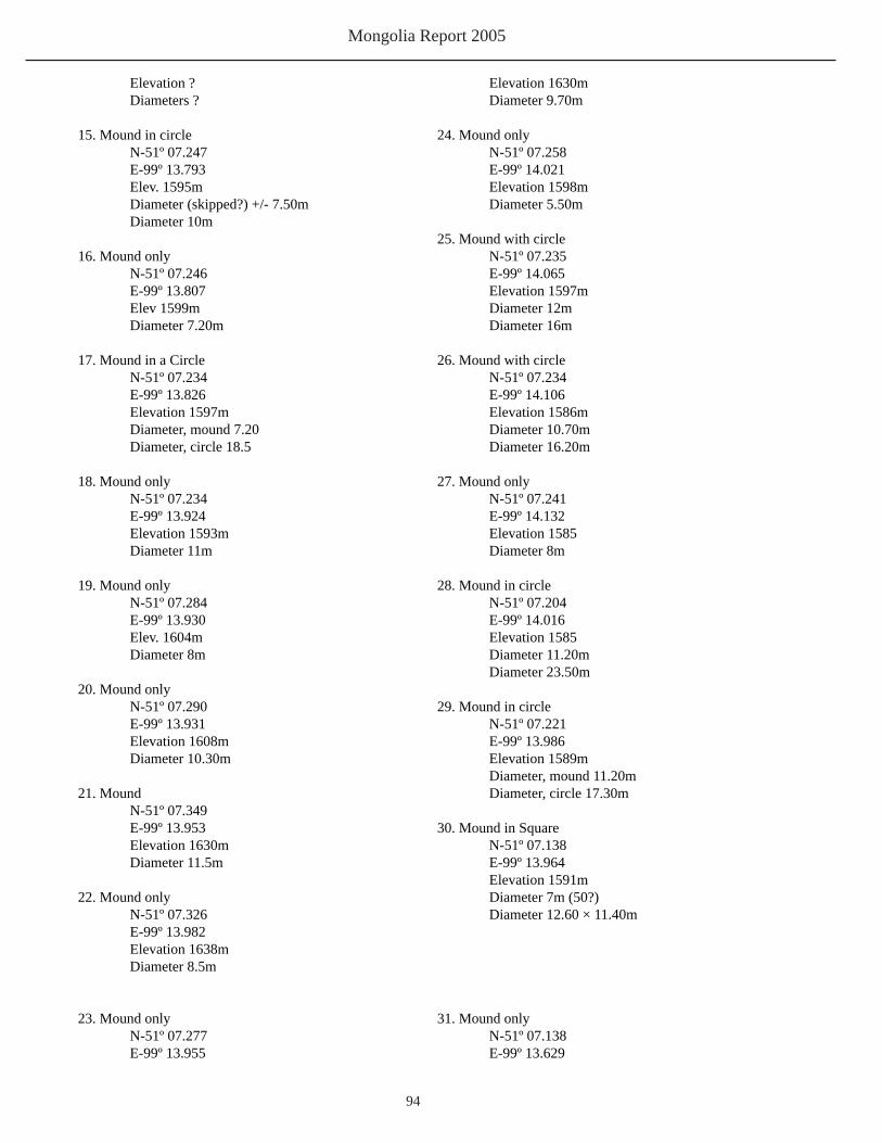
Mongolia Report 2005
94
Elevation ? Diameters ?
15. Mound in circle N-51º 07.247 E-99º 13.793 Elev. 1595m Diameter (skipped?) +/- 7.50m Diameter 10m
16. Mound only N-51º 07.246 E-99º 13.807 Elev 1599m Diameter 7.20m
17. Mound in a Circle N-51º 07.234 E-99º 13.826 Elevation 1597m Diameter, mound 7.20 Diameter, circle 18.5
18. Mound only N-51º 07.234 E-99º 13.924 Elevation 1593m
Diameter 11m
19. Mound only N-51º 07.284 E-99º 13.930 Elev. 1604m Diameter 8m
20. Mound only N-51º 07.290 E-99º 13.931 Elevation 1608m Diameter 10.30m
21. Mound N-51º 07.349 E-99º 13.953 Elevation 1630m Diameter 11.5m
22. Mound only N-51º 07.326 E-99º 13.982 Elevation 1638m Diameter 8.5m
23. Mound only N-51º 07.277 E-99º 13.955
Elevation 1630m Diameter 9.70m
24. Mound only N-51º 07.258 E-99º 14.021 Elevation 1598m Diameter 5.50m
25. Mound with circle N-51º 07.235 E-99º 14.065 Elevation 1597m Diameter 12m Diameter 16m
26. Mound with circle N-51º 07.234 E-99º 14.106 Elevation 1586m Diameter 10.70m Diameter 16.20m
27. Mound only N-51º 07.241 E-99º 14.132 Elevation 1585 Diameter 8m
28. Mound in circle N-51º 07.204 E-99º 14.016 Elevation 1585 Diameter 11.20m Diameter 23.50m
29. Mound in circle N-51º 07.221 E-99º 13.986 Elevation 1589m Diameter, mound 11.20m Diameter, circle 17.30m
30. Mound in Square N-51º 07.138 E-99º 13.964 Elevation 1591m Diameter 7m (50?) Diameter 12.60 × 11.40m
31. Mound only N-51º 07.138 E-99º 13.629

Arctic Studies Center
95
E-99º 14.252 Elevation 1584m Diameter 5m
39. Mound N-51º 07.305 E-99º 14.275 Elevation 1579m Diameter 5m
40. Mound only N-51º 07.242 E-99º 14.271 Elevation 1574m Diameter 5m
41. Mound in circle with linear feature of 5 small mounds Also 3 rings (outside?) circle N-51º 07.272 E-99º 14.351 Elevation 1573m Diameter 12.80m Circle Diameter 22m Linear Feature 14.5m long 8.5m from circle
42. Probably former Standing Stone Site – Looted N-51º 07.263 E-99º 14.566 Elevation 1570m (?)5m
43. Square of standing Stone – Excavated or Looted N-51º 07.296 E-99º 14.551 Elevation 1572m NS 2m × EW 2.2m Stone Height 40cm (fl at?)
44. Mound N-51º 07.364 E-99º 14.681 Elevation 1570m Diameter 6m
45. Mound in Circle Feature – Looted N-51º 07.345 E-99º 14.736 Elevation 1572m Diameter mound 20m Diameter circle 42m
46. Mound in circle Feature N-51º 07.371 E-99º 14.791
Diameter 7.7m Elevation 1582m
32. Standing Stone H 65m W 44cm Depth 15cm N-51º 07.119 E-99º 13.637 Elevation 1582
33. Standing Stone in Square (modern monastery?) N-51º 07.097 E-99º 13.631 Elevation 1582m H 1.50m (?) W 67 (cm ?) Th (Depth ?) 22 (cm?) Square: L 10.40m W 10.80m
34. Mound in square – Excavated or Looted. 10’ deep to where dug. N-51º 07.235 E-99º 14.230 Elevation 1565m Square Orientation: 27.80 EW × 28.80 NS 11.9m Distance from NW corner to N. Standing stone: 14m Distance from center to N. Standing stone: 13.30m
35. Mound only – Looted or excavated and backfi lled N- 51º 07.286 E- 99º 14.239 Elevation 1583m Diameter 6m
36. Mound only N-51º 07.298 E-99º 14.239m Elevation 1582m Diameter 6m
37. Mound only N-51º 07.314 E-99º 14.247 Elevation 1584m Diameter 6m 38. Mound only N-51º 07.314

Mongolia Report 2005
96
Elevation 1571m Diameter mound 17m Diameter circle 45m
47. Features(?) 6 mounds and rings (?) N-51º 07.387 E-99º 14.754 Elevation 1571m Distance to circle 37m (?)
48. Small mound N-51º 07.403 E-99º 14.733 (?) Elevation 1572m Distance (unreadable) Diameter 5m 49. (Unreadable word) Deerstone N-51º 07.402 E-99º 14.827 Elevation 1569m
Dimensions: 1.9m L, 45(cm?)W, 20(cm?) (deep?)
50. Standing Stone N-51º 07.395 E-99º 14.819 Elevation 1571m
Dimensions: 1.2m L, (11.0cm?) W, 19cm (thick/deep?)
51. Mound in circle looted feature N-51º 07.621 E-99º 14.766 Elevation 1576m Diameter mound 11m Diameter circle 22.5m
52. Mound in circle/hillside feature N-51º 07.657 E-99º 14.740 Elevation 1576m Diameter mound 8.5m Diameter circle 17.5m
53. Mound in circle N-51º 07.583 E-99º 14.467 Elevation 1599m Diameter mound 9.7m Diameter circle 15.5m54. Mound in circle Somewhat covered by outwash N-51º 07.543 E-99º 14.336 Elevation 1612m Diameter mound 11.5m
Diameter circle 19.5m
55. Mound Hillside Steep N-51º 07.543 E-99º 14.330 Elevation 1624m Diameter 6m
56. Mound/ Steep slope – Looted N-51º 07.437 E-99º 14.284 Elevation 1622m Diameter 6m
57. Odbaater No # (?) N-51º 07.462 E-99º 14.656 Elevation 1719 Maybe 20% / 80% (arch/geol.)58. Natural or Mound low hillside N-51º 07.304 E-99º 14.286 Elevation 1586m Diameter 5m 59. Mound looted /excavated attempted? N-51º 07.291 E-99º 14.222 Elevation 1570m Diameter 6m
60. STILL LOCATING FEATURE NO. 60
61. Mound N-51º 08.038 E-99º 14.382 Elevation 1724m
62. Mound square N-51º 08.618 E-99º 16.002 Elevation 1675m Size: 4.20m square. +/-
63. Mound in circle N-51º 08.571 E-99º 15.758 Diameter mound 13.5m Diameter circle 22.5m Elevation 1608m64. Mound N-51º 08.765 E-99º 15.397 Elevation 1649m Diameter 12.6m

Arctic Studies Center
97
65. Mound / High Slope ? N-51º 08.803 E-99º 15.397 Elevation 1649m Diameter 6.8m
66. Mound in circle with Square N-51º 08.848 E-99º 15.243 Elevation 1625m Diameter mound 13m Diameter circle 23m Square size: 4.0 × 3.4m Distance to ring: 5m
67. Mound N-51º 08.840 E-99º 15.223 Elevation 1624m Diameter 4.5m
68. Mound/ possibly with circle N-51º 08.857 E-99º 15.229 Elevation 1630m Diameter 2.1m
69. Mound N-51º 08.886 E-99º 15.213 Elevation 1632m Diameter 8m
70. Mound with circles N-51º 08.904 E-99º 15.213 Elevation 1666m Diameter 7m
71. Mound N-51º 08.077 E-99º 15.037 Elevation 1670m Diameter 8m
72.Campsite: N-51º 07.134 E-99º 12.340 Elevation 1567m

Mongolia Report 2005
98
Evdei 1
See General Notes for the Evdei-1 excavations in Appendix A. See 28 June diary notes.Evdei 1 Stone 1:
Recovered from Evdei 1 Stelae 1:

Arctic Studies Center
99
Evdei 1 Turkic Stone1

Mongolia Report 2005
100
Evdei 1, view northeast

Arctic Studies Center
101
Evdei 1, view south
Evdei 1, view southwest

Mongolia Report 2005
102
Evdei 1 west sid, view south
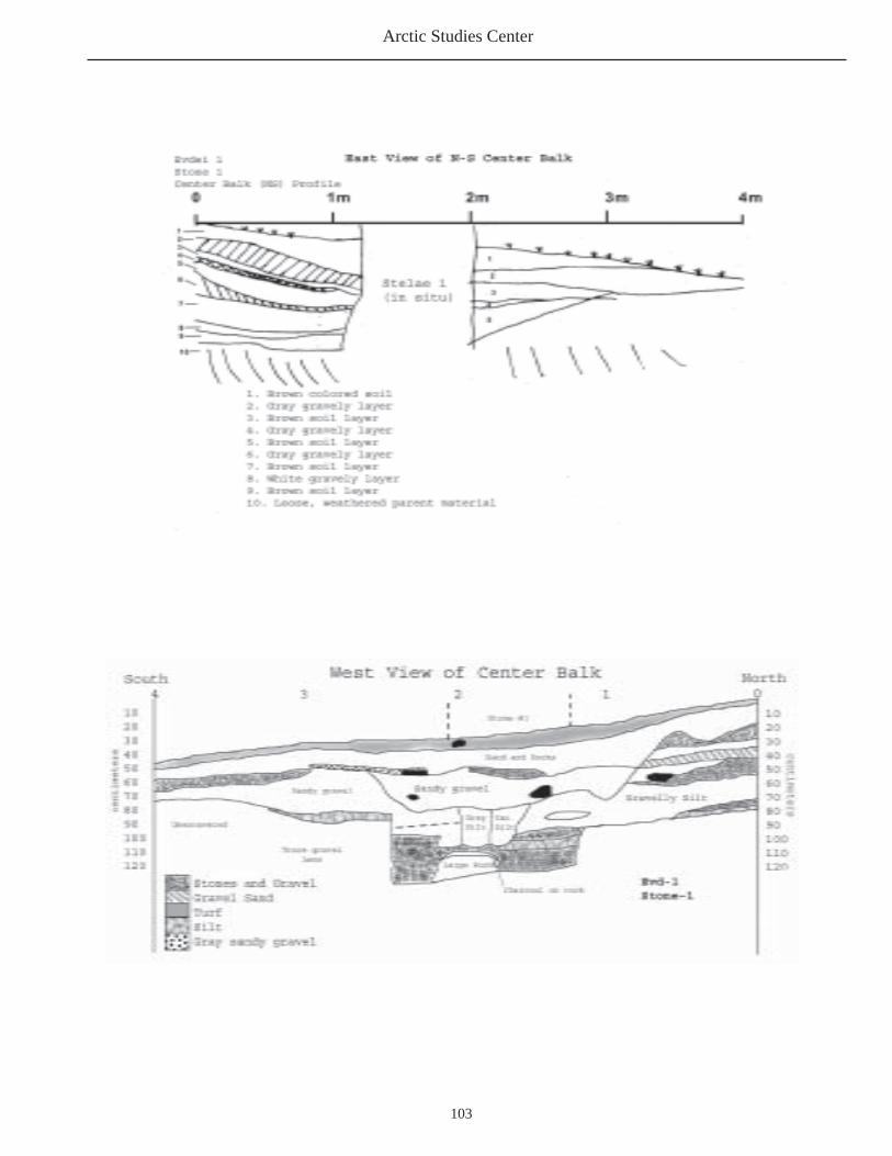
Arctic Studies Center
103

Mongolia Report 2005
104
Evdei 3:
Evdei 3 Deer Stone 1 Pit, view south, showing unmarked slab that was found beneath the deer stone
Pit A Notes: -About 8cm topsoil cover, over pavement of angular rocks. -Large angular rock layer spans entire pit, roughly 20 cm deep. -Directly below rocks is a dark brown gravelly soil which extends over pit in a shallow layer at 5cm. -Soil is patchily colored throughout, most notably a dark black stained soil lies a yellowish gravelly sand, and below this, a tan gravelly clay (lake bottom sediment), which is believed to be undisturbed, insitu soil. -Extent of pit depth ranges from about 30cm at the shallowest to 60cm at its deepest. -Black stained soil may be organically saturated soil, or depressions where newer, more organic soil has deposited. -No charcoal, artifacts or other cultural materials were recovered from any of these levels.

Arctic Studies Center
105
Evdei 3 West Deerstone ring feature

Mongolia Report 2005
106

Arctic Studies Center
107
Deer Stone 2, a fallen deer stone at Evdei 3
Fallen Deer Stone

Mongolia Report 2005
108
Evdei 2 Monastery Site Layout:

Arctic Studies Center
109
Close Up of Evd Monastery Site Features A, B, C, E, F and I:

Mongolia Report 2005
110
Close up of Evdei 2 Monastery Site Feature J,K and L:(Mapped by Odbaatar, E. Eldredge, D. Ryjesky)

Arctic Studies Center
111
Close up of Evdei 2 Monastery Site Feature ‘A’:
Close up of Evdei 2 Monastery Site Feature ‘H’:

Mongolia Report 2005
112
Evdei 2 Looters Pit
Evdei 2 Monastery Site Enclosure I:

Arctic Studies Center
113
Evdei 3 Monastery SiteEnclosure I:Excavated South Wall Side ViewExcavated by Melanie Irvine and William Fitzhugh.

Mongolia Report 2005
114

Arctic Studies Center
115
Appendix D
Erkhel / Ulaan Tolgoi Data
Bayaraa, Adiya and Dennis digging Mound 1 Satellite Mound B

Mongolia Report 2005
116
Ulaan Tolgoi Deer Stone 5Feature 1
Ulaan Tolgoi Deer Stone 5 shown with Grid
Ulaan Tolgoi Deer Stone 5 Feature 1 view north
Ulaan Tolgoi Deer Stone 5 Feature 1 level 1, view north.
Ulaan Tolgoi Deer Stone 5 Feature 1view south

Arctic Studies Center
117
Ulaan TolgoiMound 1Northeast Corner MoundJuly 9, 2005
Sketch Map of Ulaan Tolgoi: Big Mound (Mound 1)Northeast Corner Mound; Satellite Mound A; Satellite Mound B Diagram:
After excavating one of the horse head burials at Erkhel Ulaan Tolgoi Deer Stone (DS) No. 5, hopefully securing a more accurate date for that monument, we decided to test a square burial 50 meters north of the big mound because it seemed intact and Bayaara thought it might provide some artifacts and a date comparable to the DS complex. We did recover a bit of human remains from it and could date it, but found no artifacts or other human remains. Bayaara thinks the grave was probably looted, but there just may be not much remaining from such a shallow burial, only a few (20cm) below the surface. So we turned our attention to trying to establish a connection between the DS complex and the khirigsuurs – or at least some of them. Excavating the NE corner mound should provide a date for the construction of the big khirigsuur almost as accurate as dating the inside of the big mound itself.

Mongolia Report 2005
118
Level 1 Map and Artifact LocationsErkhel/ Ulaan Tolgoi Big Mound NE Corner Mound8 July 2005
2nd layer of rocks after surface rocks removed and site cleaned to upper fi ne brown soil – bones and charcoal here and above could be dating after mound constructions.

Arctic Studies Center
119
1. The interesting features of the Mound 1, Northeast corner mound were:
1. Lack of horse head 2. Presence of scattered food remains 3. No preserved artifacts of any kind (the submound “pit” may have been a rodent burrow – explaining its dark soil – but on the other hand it was more or less central in the mound plan.) 4. A clear circular construction plan to the mound with rings of blocky large rocks on the pit perimeter; fl at inward sloping rocks at the center/core (2-3 meter diameter). 5. Some sort of food ritual at least is indicated and possible deposit of perishables in the mound. No evidence of pit a pit (outline, or soil texture change was noted).
Northeast Corner Mound Finds, Level 1:1. Sheep/goat mandible fragments -20cm in upper fi ne brown sandy soil.2. Rib fragment in loose sand/brown sand. 17cm below SW corner surface.3. Two fragments, long bones. -14cm in upper brown soil.4. Three fragments of charcoal from upper fi ll backdirt (general location)4a. Long bone found in backdirt – no location.4b. Two bone fragments: a. 11.2cm in upper fi ne brown soil. b. 10cm. 1b. tooth fragment -16cm in upper fi ne brown soil. 1c. bone fragment in upper fi ne brown soil.5. Bone fragment in upper fi ne brown soil. Depth of 7cm and on top of rock.6. Bone fragment in brown soil. Depth not measured. 90 cm from east Wall, 1.90cm from north wall.
Note: The above material was found in soil between upper rock level and 2nd level rocks. This material could be intrusive and date after mound construction.

Mongolia Report 2005
120
Mound 1, Northeast Corner Mound, Level 2:7. Split long bones (cf3) -27 at junction of brown and tan soil. Cleaned and moved 62 rocks.

Arctic Studies Center
121
Ulaan TolgoiBig Mound / Mound 1Northeast Corner Mound Level 2:Excavation DiagramSoil Level 2
Partial ring of fl at (F) slabs. The other rocks were thick blocky rocks.Note:

Mongolia Report 2005
122
Northeast Corner Mound Level 3: Excavation DiagramRemoved inner rock core and slab ring, leaving blocky outer rings in place. (Not shown)Northeast Corner Mound Level 3 Notes:
There was a small pit 10cm deeper than rest of the gravelly silt level where we terminated excavation. No fi nds or charcoal or bone since #13. General change from silty brown soil at -40cm to gravelly soil at -50cm, which is the level we stopped excavation except for a pocket of brown silty soil that extended down to -73cm in the center of the feature, which ended on hard-packed gravel. Bone preservation was good throughout, so loss of deposit of bone is not likely an issue. Most of the bone was cracked fro marrow extraction of or cooking, and only fragments of probably one animal was present, at various depths, so the upper level bone may also date to the mound construction. The charcoal was only in the upper level and could be more recent, because it was very fresh and fl aky and none – unlike the bone – was found in level 2, level 3
Erkhel / Ulaan TolgoiBig Mound Level 3, NE Corner Mound 8 July 2003

Arctic Studies Center
123
Northeast Corner Mound, Level 3:
8. (Level 3) Two small bone fragments (cancellous lumps) at top of 8. Found in tan soil beneath second rock level.9. Two small bone fragments. -44 in upper tan soil. 10. Bone fragment in tan soil. -39cm.11. Sheep/goat tooth row fragment. -45cm in tan soil.12. Bone; long bone sliver in tan gravelly, silty soil. -51cm.13. Long bone fragment -54cm in silty/gravelly tan soil.

Mongolia Report 2005
124
Erkhel Satellite Mound A: (Formerly East Gate Mound)
This excavation is still in progress, but there are already some interesting points emerging. Very large surface
rocks covering the center of the mound, more than in the corner mounds, which are roughly the same size (4 × 4 meters). There are 5 of these “super” horse head mounds, 3 on the north side of the ‘East Gate’ and 2 on the south side.
After this, the mounds in the fi rst rank are somewhat smaller and with fewer large rocks on the surface – perhaps these 5 are the principle donors to the large mound ceremony. Thereafter, the mounds in the 2nd, 3rd, and 4th ranks generally decrease in size. The mound Bayaraa excavated in the 4th rank had its horse head buried only 5-10cm below the surface, with only one rock over the skull and several large boulders encircling the burial. No real mound was constructed. After removal of the top/surface rocks, a pattern similar to the construction of the NE corner mound emerged – a circular outer ring of large stones, with an intermediate ring of inward sloping slabs, and a central core of rounder/blocky smaller rocks. Some small split long bones were found scattered in the fi ll as in the corner mound. There was also a 20-30cm thick layer of black charcoal – rich soil on the west-center part of the mound that had a few small bone fragments and the joint frag of a cow or other large ungulate at its base (perhaps the small fragments elsewhere are part of the bone) – seems like same type of feasting ritual was underway here as this part of the mound fi ll was all soil and strangely free of rocks, compared with other parts of the mound. Charcoal lumps were found scattered throughout the upper mound soil (level 1) – also an indication of fi re activity associated with the mound construction.
Erkhel east gate mound 3before excavation
Erkhel east gate mound after surface rock removed

Arctic Studies Center
125
Ulaan Tolgoi Mound 1 Satellite Mound A Surface/ Level 1 Map 8 July 2005
Ulaan Tolgoi Satellite Mound A with grid

Mongolia Report 2005
126
Mound 1 Satellite Mound A. Level 1 Finds: 1. Canid (small dog/fox?) in brown soil and turf beneath/under surface rocks. Found while cleaning upper rock removal (-15 from SW corner ground). 2. Charcoal fround cleaning turf zone (multiple locations - general collection). Not shown
below. 3. Cow hoof in brown soil. -29cm in brown soil. 4. Long bone fragments -13cm in brown soil. 5. Bone fragment. -13cm in black soil. 6. Cow phalange in brown soil. -35cm in brown soil. (This packet of black, charcoal-stained (but no lumps) soil - extended down to ca -25cm between the rocks.

Arctic Studies Center
127
Ulaan Tolgoi Mound 1Satellite Mound ALevel 2 Map9 July 2005
Ulaan Tolgoi Satellite Mound A with gridview to south

Mongolia Report 2005
128
Mound , Satellite Mound A Finds:Level 2:
7. 1 piece and fragment of long bone in brown soil.8. 1 bone at -35 in brown sand.9. 2 small pieces of bone. -40cm in brown soil.10. Small bone joint fragment -34cm.11. Small bone joint fragment -35cm.12. Small bone joint fragment -52cm.13. Small bone joint fragment -15cm.14. Leg joint fragment. -28cm in brown/black soil. Most likely cow (?) joint at base of level 2. Brown/black soil just above level 3 rocks, at base of the dark soil deposit.15. Horse tooth at -52cm. Beneath level 3 rocks brown soil.16. Horse bone (?) -53cm. In brown soil.17. Partial horse head - right mandible proximal fragment, with front of mandible eroded/missing. Some evidence of weathering before burial. Two teeth in jaw and one found lose (which is listed at #15).
14,Leg Joint Fragment; 15, horse tooth; 16, horse bone.
Ulaan Tolgoi Mound 1, Satellite Mound A, Level 3

Arctic Studies Center
129
Ulaan Tolgoi, Mound 1Satellite Mound A, Level 3:Excavation Diagram
Satellite Mound A Level 3 Notes: Fragementary horse mandible found at base of sandy organic - stained deposit 20-30cm deep.The horse mandible was surrounded by rock and with fragments of bone and joints of a cow(?),about 10cm above it. The larger mandible fragment was missing its distal end and seemed tohave been very weathered at the break, as from exposure to fi re. The smaller fragment of the
left mandible was missing both its proximal and distal parts and included only the main molar portion. A few other bone parts were present (not skull parts), making the deposit appear to be a desposit of the remains of a horse that had died sometime earlier whose remains were re-interred here in fragmentary condition. There was no orientation as the parts were lying fl at and jaw was disarticulated and no maxilla present.

Mongolia Report 2005
130
Excavating the NE corner mound should provide a date for the construction of the big khirigsuur almost as accurate as dating the inside of the big mound itself.

Arctic Studies Center
131

Mongolia Report 2005
132
Erkhel Lake North Deer Stone 1
Erkhel Lake North Deer Stone 1
Erkhel Lake North Deer Stone Site. 10 July 2005.

Arctic Studies Center
133
Deer Stone Site Erkhel Lake East (see notes Appendix A)
Deer Stone 2
Deer Stones 1 and 2
Deer Stone 1
Deer Stone 1 Odbaatar and Bayaraa measure Deer Stone 1
Deer Stones
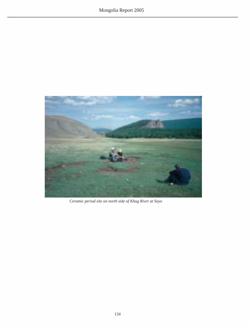
Mongolia Report 2005
134
Ceramic period site on north side of Khug River at Soyo

Arctic Studies Center
135
Appendix E
Deer Stone Motif DrawingsBy Elizabeth Eldredge

Mongolia Report 2005
136
Deer Stone Conference opens at University

Arctic Studies Center
137
Appendix F
Deer Stone Project Conference and Workshop Program Smithsonian Museum Workshops
Friday, 17 June
10:00am ‘plenary session’ [location?]Care of Collections on Exhibit and in Storage (presentation and demonstration for the whole group): Conservation concerns and solutions related to handling, mounting, and displaying museum objects, including ethnological and archaeology materials and natural history specimens. Demonstration will include test procedures to determine if materials are safe for use with museum objects.
2:00pm Afternoon Sessions [locations?]Practical Techniques for Use in Exhibits and Storage (demonstration and hands-on workshops, presented in two concurrent sections):
Group 1: Storage Supports (participants may bring small objects to use as examples in preparing a storage support)Natalie Firnhaber, Conservation, Dept. of Anthropology, Smithsonian Institution
Group 2: Bracket-Making and TaxidermyCarolyn Thome, Offi ce of Exhibits Center, Smithsonian InstitutionPaul Rhymer, Offi ce of Exhibits, National Museum of Natural History
Note:During the week of 20-24 June, Paul Rhymer and Natalie Firnhaber will be available for additional consultation on conservation, bracketing, and taxidermy. Please speak to them directly to make arrangements for meetings and/or visits to your museums.

Mongolia Report 2005
138
Conference DaySaturday, 19 June, 10 – 5
Morning Session 10-12:30
Peopling the Americas: The Mongolian- Beringian Connection
Bruno Frohlich, Department of Anthropology, Smithsonian Institution
Abstract: Anthropologists have argued for years about the fi rst peopling of theAmericas and how many waves of migrations took place. Professor William Laughlin, asingle migration proponent, proposed to test his theory by joint research with Russian Academician A. P. Okladnikov, fi rst in 1974 in the Aleutian Islands and in 1975 on Olkhon Island in Lake Baikal. Since then, new hypotheses have been proposed. Stephen Zegura proposed a two-wave migration based on Y-chromosome haplotypes that demonstrated that the Asians most closely related to American Indians came from the Lake Baikal area and northern Mongolia. In the future more sensitive analytical methods will include mtDNA, advanced statistical procedures, and enhanced studies of skeletal collections from Mongolia and Russia. This presentation will focus on the Laughlin-Okladnikov collaboration, the results of later studies, and how this affects our current Mongolian – American collaboration.
Eskimos, Vikings, and Mongolians: Cold and Frozen? Or “Empire States” of the Arctic?
William W. Fitzhugh, Arctic Studies Center, Smithsonian Institution
Abstract: It might seem hard to imagine what Erik and Red, Genghis Khan, and the some unknown Alaskan Eskimo of about 900AD had in common; but in fact Vikings, Mongols and Thule culture Inuit are responsible for three of the most widely-dispersed human expansions ever known before the Columbian era. Why are we getting such surprises from the North? And what is the future of a melting Arctic?
Reindeer Herding in Eurasia: Origins, Practices, and Relevance to MongoliaPaula DePriest, Smith. Ctr. for Materials Research and EducationWilliam Fitzhugh, Arctic Studies Center, Smithsonian Institution
Abstract:: Reindeer-herding has been a way of life and livelihood for northern Eurasian peoples for more than 2000 years. Replacing the unpredictable life of hunters and fi shermen, reindeer breeding provided a secure means of transport, clothing, shelter, tools, and food. Managing domestic reindeer is a complex task, and many ethnographic varieties are known historically. Despite its importance, the date and place where reindeer-herding originated is not known, but it has been hypothesized to have fi rst taken place in Tuva and northern Mongolia. This paper reviews reindeer biology and ecology; practices used by the Tsaatan and other reindeer-herding peoples, and theories about its history and origin.
Digital scanning in an archaeological setting: creative applications in Mesoamerica and Mongolia
Harriet F. (Rae) Beaubien (presentation) and Basiliki Vicky Karas (demonstration)Smithsonian Center for Materials Research and Education
Abstract: The most common method of digital documentation employed in an archaeological setting is photography, but several other techniques are being used creatively for the purposes of documentation and preservation. Flat-bed scanning, currently in use at the site of San Bartolo in Guatemala, and three-dimensional laser scanning, which will be tested during the Deer Stone Project’s 2005 fi eld season in Mongolia, are discussed; the 3D technique will be demonstrated.
Afternoon Session: 2 – 5 pm

Arctic Studies Center
139
Appendix G
Conservation Report 2005Natalie Firnhaber
Conservator, Department of Anthropology,National Museum of Natural History
Smithsonian Institutionfi [email protected]
Mongolian report June 15 – 26, 2005
The conservation presentation was given at the National Museum of Mongolian History on June
16 to museum staff from a variety of museums. It was primarily on storage. Four different methods
of storage were shown. A seal skin Eskimo headdress demonstrated three dimensional hat storage.
A pair of Mongolian trousers was used as a costume example, and included vacuuming and crease
removal (including testing for color bleeding), and storage. Mongolian bow and arrows were used
to show storage care of delicate feather arrow fl etchings and how to provide balanced support along
the bow. The fi nal example was artwork on paper, using a four-fl ap design with a glassine cover
over the artwork. Paul Rhymer discussed bracket making for exhibition. At the coffee break, I met
Purevsuren Soren, an archivist with the National Archives. She was interested in learning how to
identify problems in paper. A group from the Cultural Heritage Center attended the presentations.
Apparently they are the only conservators in the country and museums take their conservation
needs to their center. We arranged a visit with them. A woman presented her card from the costume
museum, which is new and still under construction, but she had questions about exhibiting costumes.
We want to visit her, but the collection is not available to see right now, and we could not arrange
anything with her.
After the break Rae Beaubien and I demonstrated several materials testing techniques. They were
the Oddy test, pH pens, and the Bielstein test. We passed around the various test results so they
could see them for themselves. We gave away pH pens and all the Oddy equipment, as well as
handouts describing how to do the tests. They practiced with the pH pens, but the room was too

Mongolia Report 2005
140
crowded and time too short to have anyone individually practice the other tests.
In the afternoon Paul and I did our workshops—he at the Natural History Museum and I stayed
at the Museum of Mongolian History and used the same room as for the presentations. I had the
participants divide themselves into groups of three. I had brought souvenirs from Washington
–baseball cap, SI keychain, ceramic disk, pen and spoon. I asked them to make storage boxes
and supports for the objects I brought. They could choose from a variety of materials (blueboard,
pellon, various papers, richfab, ethafoam) and could keep whatever they worked on. It became very
competitive, lots of energy, laughter, but not many questions. After they fi nished, I asked them to
explain their work to each other. We applauded each effort. They seemed to enjoy it and I hope got
some ideas from each other and from us.
Sunday morning, June 19, Paul and I went to the Mongolian History Museum to meet with Odbaater.
He was heading to the fi eld with Bill on Monday so this was his only day to meet with us. We looked
at his exhibits with him. He showed us an actively corroding bronze vessel. He said the Cultural
Heritage Center would do the treatment for it. We looked at a silver display with black felt under
the silver. We suggested he test for wool because of sulfi des attacking the silver and change it if
it is wool. It might be the typical wool felt we see everywhere in Mongolia. His cases were very
clean. He opens and cleans them every two months. He asked about marble statuary in the open
with no protection. It was dirty from hands touching it. I suggested how he could clean it. We
suggested he put up barriers (but it was clear he knew that should be the thing to do). Paul showed,
with a drawing, how Odbaater could exhibit small stone tools without using tape on the back, but
brass posts instead. Odbaater clearly was dedicated to his work and wanted to do it in the best way,
which for the most part, he already was. He also expressed concern about taking care of objects at
archaeological sites. I told him I would try to send him books on fi eld conservation. He was very
happy for that.
June 20 Paul and I visited the Cultural Heritage Center. We met with the director, who told us they
have 17 on the staff, nine of whom are conservators. This is the only restoration center in Mongolia
and they also serve the provincial museums. (All museums in Mongolia are government museums,
according to her) They also take care of collections in the Buddhist monasteries and the National
Library. When a monastery is restored (so many were destroyed or damaged by the Russians) the
artifacts inside are also restored. The damaged objects are brought to the center.
They had a 13th century silk archeological garment laid out for me to see. They showed me the
photos they had taken when they received it. They had washed it and fl attened it, perhaps under
glass. It was very fl at. It was in very nice condition and beautifully made. It had been found by
looters who disrupted the gravesite and threw a lot of things all over, including this magnifi cent

Arctic Studies Center
141
gown, which didn’t look magnifi cent to the looters. I did show them how to humidify and then
remove some creases in a sleeve to give it three dimensionality and prevent breaking of crease edges.
They showed us the replicas they had made, especially for Paul, as they all knew of his work with
the deer stone. They showed us their casts, which were very good. China is their main source for
all of their supplies. They are interested in having conservation specialities at the Center. Currently
the conservation staff have all had the same training. They studied this discipline at the university
under one special individual, Khishigbayar, who then became the head of this center. He earned
a Bachelors degree in Poland and a Masters in Bulgaria and studied in various other countries,
including Japan and Holland, learning different methods of conservation and restoration. He died
last year.
In the afternoon we went back to the Mongolian History Museum and met with Twl, the person in
charge of storage. Objects here were stored on metal shelves. She took us to the Museum of Natural
History because most of their storage is actually there. They said the Mongolian History Museum
was a former school and the design doesn’t include good spaces for storage. We looked at many
saddles hanging on wood supports with stirrups hanging down. They are heavy metal stirrups
hanging by leather and cloth from the saddle. Twl said the heavy stirrups needed additional support
to prevent the leather/cloth from breaking, and she had already requested this, but the director hadn’t
decided yet to have that made for them. She said one problem is that the NMNH isn’t eager to put
money into storage for the objects from NMMH. She pointed out the long windows in the storage
area. Twl had attached blue plastic to keep out the light, which did minimize it. She asked if she
should also put curtains over it. I said yes, there should be no outside light in storage. She seemed
to already know that, but maybe she appreciated support to her knowledge. Textiles (clothing) are
stored in a deep wooden drawer with each garment lying on top of each other with different kinds of
paper in between (it looks like perhaps whatever they could fi nd). I suggested she test the papers for
acidity, and also suggested using cotton cloth between each separate textile. She also has boxes of
rugs and other fl at textiles and is waiting to put them on rolls as soon as she can have rollers installed
in another room.
On Tuesday, June 21, we went to the NMNH to meet our interpreters, Chimgee and Naagi. Naagi
came back with me to the Cultural Heritage Center to pick up Ganaa who wanted me to see the
National Library collection of sudras (bound books of Buddhist texts/prayers). The Library is
a very large building, built in 1921. There are two million books, not including the sudras. We
went upstairs to a large open room that looked like an exhibit space with glass cases along the
walls. There were large windows, and all covered so no light came into the room. On exhibit were
primarily sudras, including a famous one, according to Ganaa. She said there are two famous sudras

Mongolia Report 2005
142
in Mongolian Buddhism. One is here and the other is in the Gandan Monastery. These are from the
17th and 18th Century. One is the Gan Guur and the other is the Dan Guur. They are still both being
read every day by the monks. The sudras are long narrow books with wood covers. They brought out
an 18th Century sudra which they said had been in a wet condition and they thought was moldy. It
was wrapped in a quilted cloth which appeared to have been made for it. The pages were discolored
and sticking together, but there was no moldy smell. I demonstrated how one could gently begin to
separate the pages with a thin spatula, and how not to go too far. I suggested a paper conservator
should come to show them various paper care techniques and they were very enthusiastic about
that. But this sudra was not in danger of getting worse if it was not handled. The pages are written
on both sides and they asked how they should be protected since the edges break easily. I asked
if the pages could be photocopied, but she said the monks would not want to use a copy, only the
original. The monks read 2 -3 books, usually the same ones, every day. This causes damage to the
paper. I opened the sudra very slowly and carefully to illustrate handling, which generally seemed
rough, with edge breakage as a result. I looked at the brown brittle edges of the sudras and suggested
checking for pH of these papers. Ganaa said the reason the edges are brown and breaking now is
because after the sudra is written, the edges are burned to prevent insect attacks. She said there are
almost no insect problems in the sudras.
Ganaa said paper conservation is the next most important area to learn. She actually had studied in
Japan for one year, with a scroll mounter. The idea of a paper conservator seemed a good idea to
me, as well as textile conservation. The weather here is dry and there seem to be little problems with
bugs or mould. The metals look good, the stone seemed OK and even the wood was in pretty good
condition. However, the more archaeology is done, the more they are also going to need instruction
in fi eld conservation and instruction in working with archaeology objects brought to them.
Naagi and I visited the Bohg Khan Monastery/winter palace. Exhibited were extraordinary royal
clothing with tiny coral and pearl beads and gold thread so close it looks like sheets of gold, but
exhibited in light and on hard wood supports.
On Thursday we traveled to the countryside with Jafsma, Dagema, Tsogoo and Boldoo from the
taxidermy department of the NMNH museum and Chimgee came along as our interpreter.
Friday Naagi and I went to the Mongolian History Museum. We visited with Bumaa and talked
to her about possible US internships. Afterwards Naagi and I visited the Religion Museum, the
Choijin Temple Museum. Saaral is curator of collections and met us there. She told us the temple
was built in 1904 and all of it was built for one monk, the younger brother of Bohg. It became a
museum in 1960 and before that it was an active temple. We met Pugi, director of the museum.
Five separate temples make up this one temple complex. It cannot be heated. There were UV lights

Arctic Studies Center
143
inside all case.
She asked about cleaning the metal of copper and gold images. There is a nice brown patina on the
copper. There is a smaller temple built for the Buddha with 16 scholars seated next to the Buddha.
The images were made of a combination of clay, paper and water. She showed us their storage.
The room had actually been storage for food when used as a temple. Everyhing was a jumble and
damaged. One statue made from clay and straw was crumbling; a sudra very torn at the edges was
handled by her quite roughly. Sudras were wrapped in silk cloth and tied and lying on top of each
other in large wooden boxes or stacked on unpainted wood shelves. Paintings were lying on top of
each other or were haphazardly rolled and crushing each other. There were widely spaced shelves
with open space in between. I suggested rolling paintings with a roller inside. She asked if I would
suggest changes in the exhibit, and I said the UV light inside the cases should be covered with UV
absorbing plastic and I would look for sources for her on the internet. Most of the cases were either
lit with UV tubes inside cases or illuminated by open windows. I suggested covering the windows to
prevent fading, especially of the reds in the intricate embroidered hangings.
We went back to the Natural History Museum and met up with a biologist and a botanist. They said
every year they “smoke” the collection as a pesticide. It is a poison, but they do not know what it is.
It is from China. They said the pesticide does not stay in the specimen. I told them about freezing.
They have new plant storage—wood cabinets with pressboard sides and plywood shelves. They have
2000 plants in the collection. Last year 100 mounting papers were brought (perhaps by Debbie Bell)
and have already been used
They have no minerals nor gemstones in the collection. The Mongolian geologists do not work
in the museum. They make 10 times more money working outside the museum, I was told.
Batamtsetsehe is the botanist.
We walked through the exhibit and many dried plants were fragmenting on exhibit. I suggested they
exhibit them on a slanted surface and use illustrations of plants instead of the real thing. They did
not know what I meant by illustrations. They said there is a drying method from Japan where the
plant still looks full and real but is dried. They want to know how to do that.
We met with Bumaa again. I gave her the rest of the conservation books I brought,
hygrothermometers, and handouts, hoping she will distribute as she sees fi t. We also met again with
the director. Paul mentioned to him the idea of having another deer stone made by the fellow from
the Cultural Heritage Center. The director liked the idea. I suggested having a paper conservator
come to do a workshop because we saw so many sudras that were in bad shape. I also suggested
an internship in the US for one of the conservators from the Cultural Heritage Center. He was
enthusiastic about both. He has studied the sudras and is anxious to have them cared for.

Mongolia Report 2005
144
Adiya translates Natalie Firnhaber’s conservation lecture at the museum

Arctic Studies Center
145
Figure 1: January/February 2006 Archaeology Magazine Cover
Appendix HArchaeology Magazine Story
Eric Powell

Mongolia Report 2005
146

Arctic Studies Center
147

Mongolia Report 2005
148

Arctic Studies Center
149
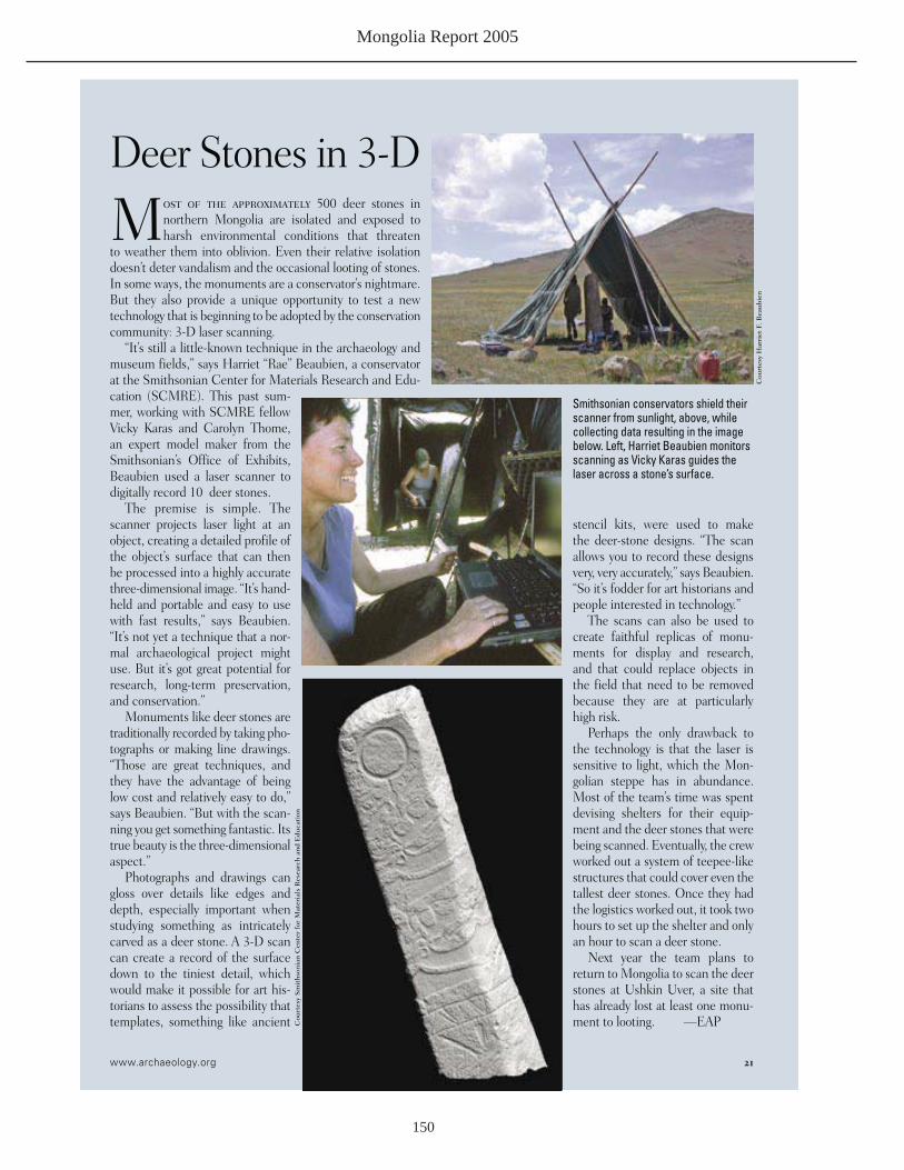
Mongolia Report 2005
150

Arctic Studies Center
151

Mongolia Report 2005
152
■

Arctic Studies Center
153
Appendix IRadiocarbon Dates List
Table 1. Radiocarbon Dates from Deer Stone Sites in Hovsgol Aimag
site / feature location/year sample no. material* uncorrected# calib (2-sig)
Ulaan Tolgoi DS5 Erkhel / 2002 B-169296 AMS charcoal 2090 ± 40 BP BP 2150-1960
Ulaan Tolgoi DS5 F1 Erkhel / 2005 B-215694 AMS tooth coll. 2800 ± 40 BP BP 2980-2790Ulaan Tolgoi DS4 S-17 Erkhel / 2003 B-182958 AMS charcoal 2170 ± 40 BP BP 2320-2050Ulaan Tolgoi DS4 S-7 Erkhel / 2003 B-182959 AMS charcoal 2930 ± 40 BP BP 3220-2950Ulaan Tolgoi DS4 F1 Erkhel / 2003 B-193738 AMS bone coll. 2530 ± 40 BP BP 2750-2470Ulaan Tolgoi DS4 F2 Erkhel / 2003 B-193739 AMS bone coll. 2950 ± 40 BP BP 3240-2970Ulaan Tolgoi DS4 F3 Erkhel / 2003 B-193740 AMS bone coll. 2810 ± 40 BP BP 2990-2800Ulaan Tolgoi DS4, F5 Erkhel / 2004 B-207205 RAD bone coll. 2790 ± 70 BP BP 3220-2800Ulaan Tolgoi DS4, F6 Erlhel / 2004 B-207206 RAD bone coll. 2740 ± 70 BP BP 3150-2780Ulaan Tolgoi Md1 SM-A Erkhel / 2005 B-215644 AMS charcoal 2980 ± 40 BP B P 3260-3000Ulaan Tolgoi Md1 SM-A Erkhel / 2005 B-215692 AMS tooth coll. 2860 ± 40 BP BP 3080-2870Ulaan Tolgoi Md1 SM-B Erkhel / 2005 B-215693 AMS tooth coll. 2950 ± 60 BP BP 3320-2940Ulaan Tolgoi Md1 NEC Erkhel / 2005 B-215643 AMS charcoal 3030 ± 40 BP BP 3350-3090Tsatstain Khoshuu Tsatst / 2004 B-207207 AMS tooth coll. 2920 ± 40 BP BP 3330-3060S49 external mound Soyo / 2004 B-216280 AMS tooth coll. 2800 ± 50 BP BP 3000-2780 +S49 central mound Soyo / 2004 B-216281 AMS bone coll. @ 2900 ± 50 BP BP 3210-2880 +S50 central mound Soyo / 2004 B-216282 AMS bone coll. @ 2560 ± 50 BP BP 2660-2480 +________________________________________________________________________________________________* collagen date; # with 13C/12C correction; @ human; + B. Frohlich samples