Field observations from the Aquila, Italy earthquake of April 6, 2009
27
Bull Earthquake Eng (2011) 9:11–37 DOI 10.1007/s10518-010-9221-7 ORIGINAL RESEARCH PAPER Field observations from the Aquila, Italy earthquake of April 6, 2009 T. Rossetto · N. Peiris · J. E. Alarcon · E. So · S. Sargeant · M. Free · V. Sword-Daniels · D. Del Re · C. Libberton · E. Verrucci · P. Sammonds · J. Faure Walker Received: 16 December 2009 / Accepted: 22 October 2010 / Published online: 12 November 2010 © Springer Science+Business Media B.V. 2010 Abstract On April 6, 2009 an earthquake of magnitude 6.2 (M w ) struck the Abbruzzo region of Italy causing widespread damage to buildings in the city of L’Aquila and surround- ing areas. This paper summarizes field observations made by the Earthquake Engineering Field Investigation Team (EEFIT) after the event. The paper presents an overview of seis- mological and geotechnical aspects of the earthquake as well as a summary of the observed damage to buildings and infrastructure. A brief overview of the earthquake casualties is also reported. Keywords L’Aquila earthquake · Field survey · Strong ground motion · Building damage T. Rossetto (B ) · E. Verrucci Department of Civil, Environmental and Geomatic Engineering, University College London, Gower Street, London WC1E 6BT, UK e-mail: [email protected] N. Peiris · D. Del Re Risk Management Solutions Ltd., 30 Monument Street, London EC3R 8NB, UK J. E. Alarcon AIR Worldwide Ltd., New London House, 6 London Street, London, EC3R 7LP, UK E. So Cambridge Architectural Research Ltd., 25 Gwydir Street #6, Cambridge CB1 2LG, UK S. Sargeant British Geological Survey, Murchison House, West Mains Road, Edinburgh EH9 3LA, UK M. Free · V. Sword-Daniels Arup, 13 Fitzroy Street, London W1T 4BQ, UK C. Libberton Sellafield Ltd., Sellafield, Seascale, Cumbria CA20 1PG, UK P. Sammonds · J. Faure Walker Department of Earth Science, University College London, Gower Street, London WC1E 6BT, UK 123
-
Upload
independent -
Category
Documents
-
view
1 -
download
0
Transcript of Field observations from the Aquila, Italy earthquake of April 6, 2009
Bull Earthquake Eng (2011) 9:11–37DOI 10.1007/s10518-010-9221-7
ORIGINAL RESEARCH PAPER
Field observations from the Aquila, Italy earthquakeof April 6, 2009
T. Rossetto · N. Peiris · J. E. Alarcon · E. So · S. Sargeant ·M. Free · V. Sword-Daniels · D. Del Re · C. Libberton · E. Verrucci ·P. Sammonds · J. Faure Walker
Received: 16 December 2009 / Accepted: 22 October 2010 / Published online: 12 November 2010© Springer Science+Business Media B.V. 2010
Abstract On April 6, 2009 an earthquake of magnitude 6.2 (Mw) struck the Abbruzzoregion of Italy causing widespread damage to buildings in the city of L’Aquila and surround-ing areas. This paper summarizes field observations made by the Earthquake EngineeringField Investigation Team (EEFIT) after the event. The paper presents an overview of seis-mological and geotechnical aspects of the earthquake as well as a summary of the observeddamage to buildings and infrastructure. A brief overview of the earthquake casualties is alsoreported.
Keywords L’Aquila earthquake · Field survey · Strong ground motion · Building damage
T. Rossetto (B) · E. VerrucciDepartment of Civil, Environmental and Geomatic Engineering, University College London,Gower Street, London WC1E 6BT, UKe-mail: [email protected]
N. Peiris · D. Del ReRisk Management Solutions Ltd., 30 Monument Street, London EC3R 8NB, UK
J. E. AlarconAIR Worldwide Ltd., New London House, 6 London Street, London, EC3R 7LP, UK
E. SoCambridge Architectural Research Ltd., 25 Gwydir Street #6, Cambridge CB1 2LG, UK
S. SargeantBritish Geological Survey, Murchison House, West Mains Road, Edinburgh EH9 3LA, UK
M. Free · V. Sword-DanielsArup, 13 Fitzroy Street, London W1T 4BQ, UK
C. LibbertonSellafield Ltd., Sellafield, Seascale, Cumbria CA20 1PG, UK
P. Sammonds · J. Faure WalkerDepartment of Earth Science, University College London, Gower Street, London WC1E 6BT, UK
123
12 Bull Earthquake Eng (2011) 9:11–37
1 Introduction
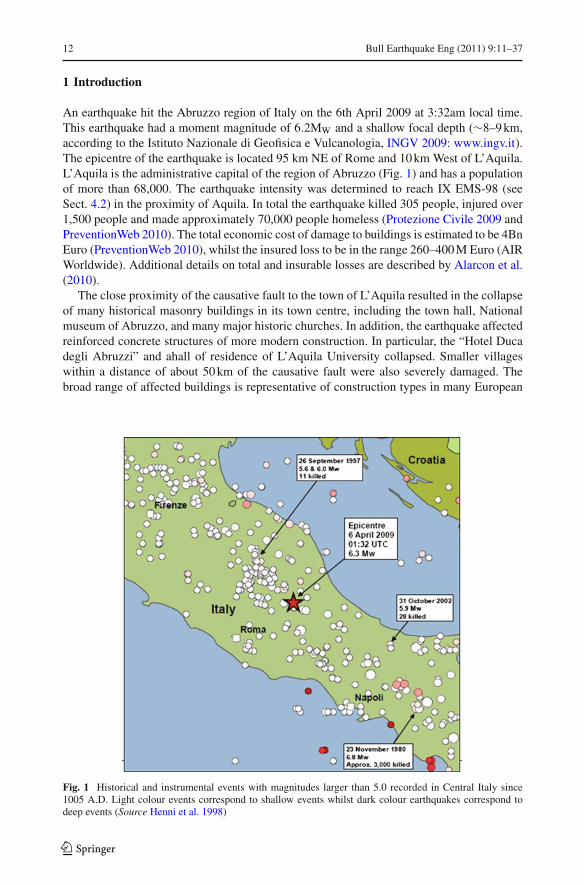
An earthquake hit the Abruzzo region of Italy on the 6th April 2009 at 3:32am local time.This earthquake had a moment magnitude of 6.2MW and a shallow focal depth (∼8–9 km,according to the Istituto Nazionale di Geofisica e Vulcanologia, INGV 2009: www.ingv.it).The epicentre of the earthquake is located 95 km NE of Rome and 10 km West of L’Aquila.L’Aquila is the administrative capital of the region of Abruzzo (Fig. 1) and has a populationof more than 68,000. The earthquake intensity was determined to reach IX EMS-98 (seeSect. 4.2) in the proximity of Aquila. In total the earthquake killed 305 people, injured over1,500 people and made approximately 70,000 people homeless (Protezione Civile 2009 andPreventionWeb 2010). The total economic cost of damage to buildings is estimated to be 4BnEuro (PreventionWeb 2010), whilst the insured loss to be in the range 260–400 M Euro (AIRWorldwide). Additional details on total and insurable losses are described by Alarcon et al.(2010).
The close proximity of the causative fault to the town of L’Aquila resulted in the collapseof many historical masonry buildings in its town centre, including the town hall, Nationalmuseum of Abruzzo, and many major historic churches. In addition, the earthquake affectedreinforced concrete structures of more modern construction. In particular, the “Hotel Ducadegli Abruzzi” and ahall of residence of L’Aquila University collapsed. Smaller villageswithin a distance of about 50 km of the causative fault were also severely damaged. Thebroad range of affected buildings is representative of construction types in many European
Fig. 1 Historical and instrumental events with magnitudes larger than 5.0 recorded in Central Italy since1005 A.D. Light colour events correspond to shallow events whilst dark colour earthquakes correspond todeep events (Source Henni et al. 1998)
123
Bull Earthquake Eng (2011) 9:11–37 13
Table 1 Hypocentre and magnitude estimates for the main shock from key reporting agencies
Agency Location Focal depth ( km) Magnitude
Latitude Longitude Mw ML
INGV 42.33 13.33 8.8 6.2 5.8
EMSC 42.38 13.32 2.0 6.3
USGS* 42.423 13.395 10.0 6.3
INGV Instituto Nazionale di Geofisica e Vulcanologia, EMSC European-Mediterranean Seismological Centre,USGS United States Geological Survey* USGS epicentral location as reported after the event. It was changed to that from the INGV
countries, making this earthquake of particular interest to the European earthquake engineer-ing community.
The UK Earthquake Engineering Field Investigation Team (EEFIT) decided to mount areconnaissance mission to the Abruzzo region following the earthquake. This paper presentssome of their findings. The paper starts with a description of the event with reference to theregion’s historical seismicity and tectonics. It then presents field observations of geotechni-cal features, damage and performance of buildings, hospitals, schools, industrial facilitiesand transportation structures. Finally a brief discussion is presented on casualties and theirrelationship with the observed building damage. Further images from the EEFIT Team fieldmission can be seen on the Virtual Disaster Viewer (www.virtualdisasterviewer.com). Thisviewer development is an ongoing project supported by EEFIT and other international earth-quake reconnaissance teams. It allows the visualisation of the geo-referenced photos takenby the team, with pre- and post-earthquake satellite images for the affected areas as well asmapped faults.
2 The L’aquila earthquake
2.1 The L’aquila event and seismic hazard in the central apennines
The MW 6.2 L’Aquila earthquake occurred in the Central Apennines (see Table 1 for epicen-ters published for the earthquake). The Central Apennines is a zone of relatively high seismicactivity and is located within the Africa-Eurasia collision zone, although the region itselfis undergoing north-east–south-west extension (e.g. Pace et al. 2006). There are numeroushigh-angle normal faults oriented roughly north-west–south-east showing several hundredsof meters of displacement (Cello et al. 1997). Many of the largest earthquakes that haveoccurred in the Italian peninsula have normal faulting mechanisms indicating extension per-pendicular to the trend of the Apennine belt.
The earthquake was a shallow (c. 10 km) normal faulting event. The focal mechanism pub-lished by the Instituto Nazionale di Geofisica e Vulcanologia (INGV) indicates that the nodalplanes are oriented roughly north-west–south-east and therefore consistent with the regionaltectonic setting. The aftershock distribution is consistent with rupture on the south-westerlydipping nodal plane. The earthquake was preceded by a prolonged swarm-like sequenceof events in the same area that began in December 2008 (see Fig. 1). The extent to whichthis sequence increased the probability of the mainshock occurring is unknown. Numerousaftershocks have occurred and are located in three clusters around the largest earthquakes of
123
14 Bull Earthquake Eng (2011) 9:11–37
the sequence (the mainshock, 7 April (5.3ML), 9 April (5.1 ML)). The zone of aftershocksis oriented approximately north-east–south-west and the mainshock delineates the westernedge of this zone.
Historically, Central Italy has experienced many destructive earthquakes (see Fig. 1);most recently, the Umbria-Marche earthquake sequence of September 1997, approximately100 km to the north-west of the 2009 event, killed 11 people and caused significant dam-age (Spence et al. 1998). Notable historical moderate magnitude (c. MW 6.5–6.7; Pace etal. 2006) earthquakes that have affected the Abruzzo region include 9 September 1349, 26November 1461 (intensity X on the Mercalli Cancani Sieberg scale at L’Aquila) and the1703 sequence (intensity XI MCS for the Norcia-L’Aquila region) (Pace et al. 2002). Interms of its felt effects, the 2009 earthquake strongly resembles the 1,461 event (Rovida etal. 2009).
Seismic hazard in the L’Aquila region has been thoroughly investigated (e.g. Romeo andPugliese 2000; Pace et al. 2006; Akinci et al. 2009) and the horizontal peak ground accelera-tion (PGA) hazard level is found to be in the order of 0.25 g for a return period of 475 years.Deaggregation analysis by Akinci et al. (2009) indicates that the 475 year PGA hazard atL’Aquila is largely controlled by large earthquakes (MW 6.5–6.7) on faults oriented parallelto the dominant structural trend. The L’Aquila fault is interpreted to contribute most to the475 year return period PGA hazard. Thus the 6 April 2009 L’Aquila earthquake could beconsidered as a “design event” for 475 year return period and consequently the performanceof buildings and other facilities in response to this event could be used to assess the seismicdesign and construction practice in the region.
2.2 Strong ground motion
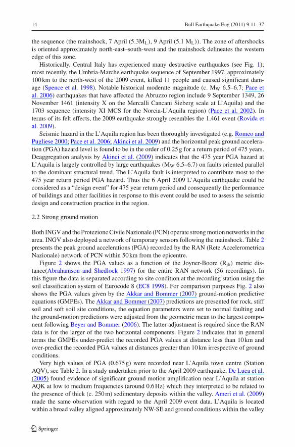
Both INGV and the Protezione Civile Nazionale (PCN) operate strong motion networks in thearea. INGV also deployed a network of temporary sensors following the mainshock. Table 2presents the peak ground accelerations (PGA) recorded by the RAN (Rete AccelerometricaNazionale) network of PCN within 50 km from the epicentre.
Figure 2 shows the PGA values as a function of the Joyner-Boore (Rjb) metric dis-tance(Abrahamson and Shedlock 1997) for the entire RAN network (56 recordings). Inthis figure the data is separated according to site condition at the recording station using thesoil classification system of Eurocode 8 (EC8 1998). For comparison purposes Fig. 2 alsoshows the PGA values given by the Akkar and Bommer (2007) ground-motion predictiveequations (GMPEs). The Akkar and Bommer (2007) predictions are presented for rock, stiffsoil and soft soil site conditions, the equation parameters were set to normal faulting andthe ground-motion predictions were adjusted from the geometric mean to the largest compo-nent following Beyer and Bommer (2006). The latter adjustment is required since the RANdata is for the larger of the two horizontal components. Figure 2 indicates that in generalterms the GMPEs under-predict the recorded PGA values at distance less than 10 km andover-predict the recorded PGA values at distances greater than 10 km irrespective of groundconditions.
Very high values of PGA (0.675 g) were recorded near L’Aquila town centre (StationAQV), see Table 2. In a study undertaken prior to the April 2009 earthquake, De Luca et al.(2005) found evidence of significant ground motion amplification near L’Aquila at stationAQK at low to medium frequencies (around 0.6 Hz) which they interpreted to be related tothe presence of thick (c. 250 m) sedimentary deposits within the valley. Ameri et al. (2009)made the same observation with regard to the April 2009 event data. L’Aquila is locatedwithin a broad valley aligned approximately NW-SE and ground conditions within the valley
123
Bull Earthquake Eng (2011) 9:11–37 15
Table 2 PGA values recorded by RAN network within 50 km of the source calculated using the Joyner-Boore(Rjb) metric definition (Source PCN) and with ground conditions defined in accordance with EC8 soil typeclassification system
Station code Province Lat N Lon E EC8 soil type PGA (g) Rjb distance ( km)
AQV L’ Aquila 42.377 13.344 B 0.675 0
AQG L’ Aquila 42.373 13.337 B 0.515 0
AQA L’ Aquila 42.376 13.339 B 0.487 0
AQK L’ Aquila 42.345 13.401 C 0.373 0
GSA L’ Aquila 42.421 13.519 A 0.152 9
CLN L’ Aquila 42.085 13.521 A 0.091 20
AVZ L’ Aquila 42.027 13.426 C 0.069 25
ORC L’ Aquila 41.954 13.642 A 0.066 37
MTR L’ Aquila 42.524 13.245 A 0.063 16
GSG L’ Aquila 42.460 13.550 A 0.030 14
FMG Rieti 42.268 13.117 A 0.027 17
ANT Rieti 42.418 13.079 A 0.026 19
CSO1 L’ Aquila 42.101 13.088 A 0.019 32
LSS Rieti 42.558 12.969 A 0.009 36
MMP1 Rieti 42.249 12.748 A 0.009 46
Fig. 2 Recorded PGA values from the entire RAN network classified according to EC8 site classification andcompared with the Akkar and Bommer (2007) GMPEs for three site classes (rock, stiff soil and soft soil)
comprise alluvium, underlain by lacustrine deposits and bedrock at depth. On the valleysides, the ground conditions comprise slope deposits of conglomerate and breccias underlainby older limestone bedrock. Ground motion site response amplification is therefore expectedwithin the valley region with corresponding relatively higher levels of damage at locationswithin the valley than on the valley slope regions (see Sect. 4.2).
123
16 Bull Earthquake Eng (2011) 9:11–37
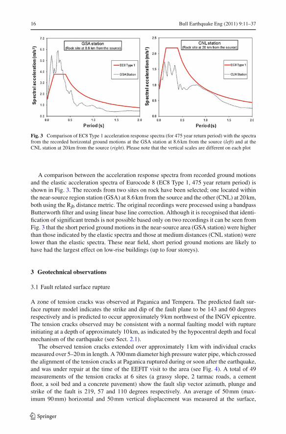
Fig. 3 Comparison of EC8 Type 1 acceleration response spectra (for 475 year return period) with the spectrafrom the recorded horizontal ground motions at the GSA station at 8.6 km from the source (left) and at theCNL station at 20 km from the source (right). Please note that the vertical scales are different on each plot
A comparison between the acceleration response spectra from recorded ground motionsand the elastic acceleration spectra of Eurocode 8 (EC8 Type 1, 475 year return period) isshown in Fig. 3. The records from two sites on rock have been selected; one located withinthe near-source region station (GSA) at 8.6 km from the source and the other (CNL) at 20 km,both using the Rjb distance metric. The original recordings were processed using a bandpassButterworth filter and using linear base line correction. Although it is recognised that identi-fication of significant trends is not possible based only on two recordings it can be seen fromFig. 3 that the short period ground motions in the near-source area (GSA station) were higherthan those indicated by the elastic spectra and those at medium distances (CNL station) werelower than the elastic spectra. These near field, short period ground motions are likely tohave had the largest effect on low-rise buildings (up to four storeys).
3 Geotechnical observations
3.1 Fault related surface rupture
A zone of tension cracks was observed at Paganica and Tempera. The predicted fault sur-face rupture model indicates the strike and dip of the fault plane to be 143 and 60 degreesrespectively and is predicted to occur approximately 9 km northwest of the INGV epicentre.The tension cracks observed may be consistent with a normal faulting model with ruptureinitiating at a depth of approximately 10 km, as indicated by the hypocentral depth and focalmechanism of the earthquake (see Sect. 2.1).
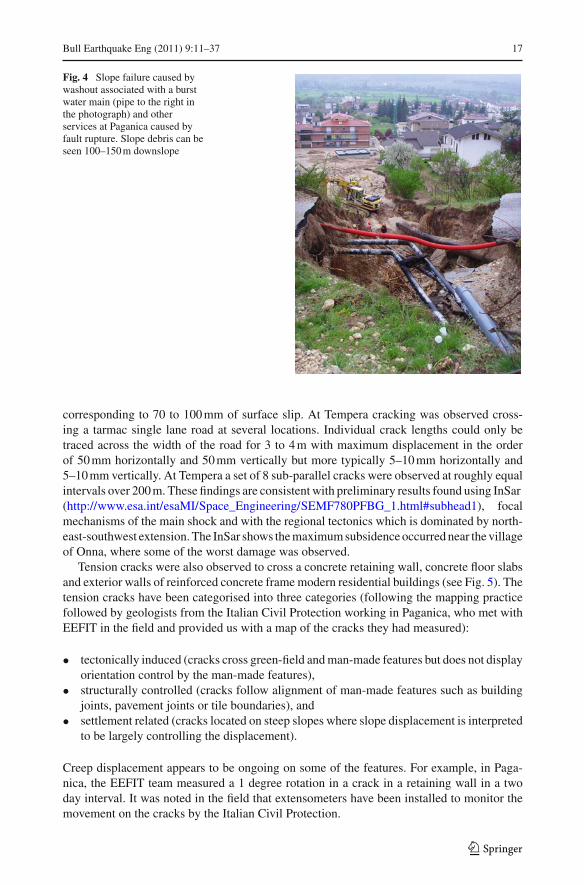
The observed tension cracks extended over approximately 1 km with individual cracksmeasured over 5–20 m in length. A 700 mm diameter high pressure water pipe, which crossedthe alignment of the tension cracks at Paganica ruptured during or soon after the earthquake,and was under repair at the time of the EEFIT visit to the area (see Fig. 4). A total of 49measurements of the tension cracks at 6 sites (a grassy slope, 2 tarmac roads, a cementfloor, a soil bed and a concrete pavement) show the fault slip vector azimuth, plunge andstrike of the fault is 219, 57 and 110 degrees respectively. An average of 50 mm (max-imum 90 mm) horizontal and 50 mm vertical displacement was measured at the surface,
123
Bull Earthquake Eng (2011) 9:11–37 17
Fig. 4 Slope failure caused bywashout associated with a burstwater main (pipe to the right inthe photograph) and otherservices at Paganica caused byfault rupture. Slope debris can beseen 100–150 m downslope
corresponding to 70 to 100 mm of surface slip. At Tempera cracking was observed cross-ing a tarmac single lane road at several locations. Individual crack lengths could only betraced across the width of the road for 3 to 4 m with maximum displacement in the orderof 50 mm horizontally and 50 mm vertically but more typically 5–10 mm horizontally and5–10 mm vertically. At Tempera a set of 8 sub-parallel cracks were observed at roughly equalintervals over 200 m. These findings are consistent with preliminary results found using InSar(http://www.esa.int/esaMI/Space_Engineering/SEMF780PFBG_1.html#subhead1), focalmechanisms of the main shock and with the regional tectonics which is dominated by north-east-southwest extension. The InSar shows the maximum subsidence occurred near the villageof Onna, where some of the worst damage was observed.
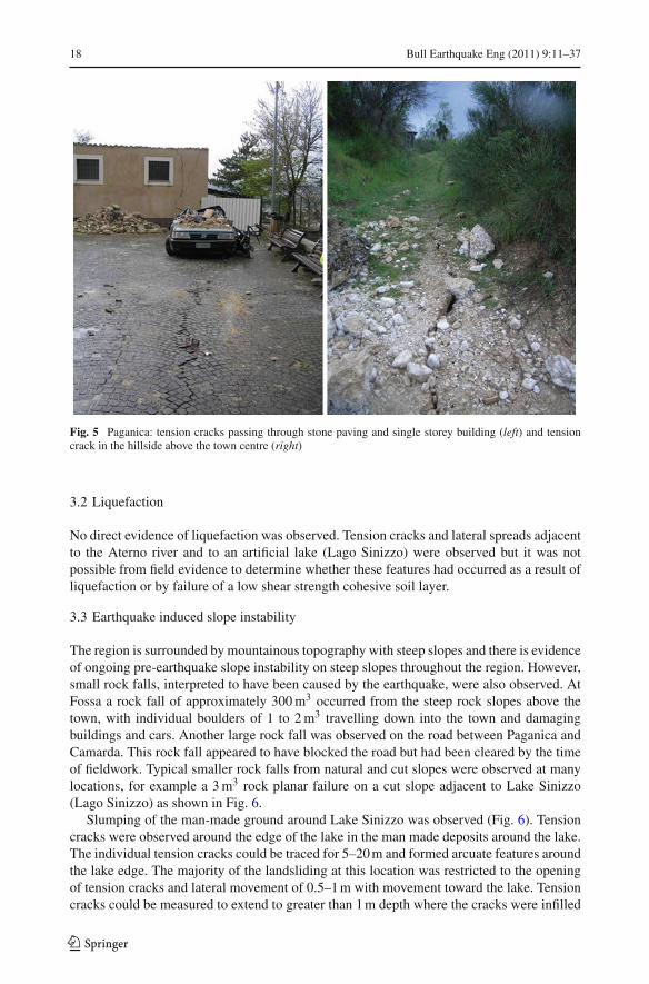
Tension cracks were also observed to cross a concrete retaining wall, concrete floor slabsand exterior walls of reinforced concrete frame modern residential buildings (see Fig. 5). Thetension cracks have been categorised into three categories (following the mapping practicefollowed by geologists from the Italian Civil Protection working in Paganica, who met withEEFIT in the field and provided us with a map of the cracks they had measured):
• tectonically induced (cracks cross green-field and man-made features but does not displayorientation control by the man-made features),
• structurally controlled (cracks follow alignment of man-made features such as buildingjoints, pavement joints or tile boundaries), and
• settlement related (cracks located on steep slopes where slope displacement is interpretedto be largely controlling the displacement).
Creep displacement appears to be ongoing on some of the features. For example, in Paga-nica, the EEFIT team measured a 1 degree rotation in a crack in a retaining wall in a twoday interval. It was noted in the field that extensometers have been installed to monitor themovement on the cracks by the Italian Civil Protection.
123
18 Bull Earthquake Eng (2011) 9:11–37
Fig. 5 Paganica: tension cracks passing through stone paving and single storey building (left) and tensioncrack in the hillside above the town centre (right)
3.2 Liquefaction
No direct evidence of liquefaction was observed. Tension cracks and lateral spreads adjacentto the Aterno river and to an artificial lake (Lago Sinizzo) were observed but it was notpossible from field evidence to determine whether these features had occurred as a result ofliquefaction or by failure of a low shear strength cohesive soil layer.
3.3 Earthquake induced slope instability
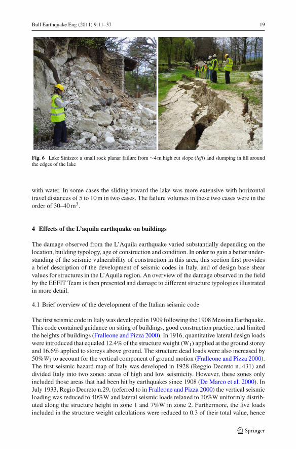
The region is surrounded by mountainous topography with steep slopes and there is evidenceof ongoing pre-earthquake slope instability on steep slopes throughout the region. However,small rock falls, interpreted to have been caused by the earthquake, were also observed. AtFossa a rock fall of approximately 300 m3 occurred from the steep rock slopes above thetown, with individual boulders of 1 to 2 m3 travelling down into the town and damagingbuildings and cars. Another large rock fall was observed on the road between Paganica andCamarda. This rock fall appeared to have blocked the road but had been cleared by the timeof fieldwork. Typical smaller rock falls from natural and cut slopes were observed at manylocations, for example a 3 m3 rock planar failure on a cut slope adjacent to Lake Sinizzo(Lago Sinizzo) as shown in Fig. 6.
Slumping of the man-made ground around Lake Sinizzo was observed (Fig. 6). Tensioncracks were observed around the edge of the lake in the man made deposits around the lake.The individual tension cracks could be traced for 5–20 m and formed arcuate features aroundthe lake edge. The majority of the landsliding at this location was restricted to the openingof tension cracks and lateral movement of 0.5–1 m with movement toward the lake. Tensioncracks could be measured to extend to greater than 1 m depth where the cracks were infilled
123
Bull Earthquake Eng (2011) 9:11–37 19
Fig. 6 Lake Sinizzo: a small rock planar failure from ∼4 m high cut slope (left) and slumping in fill aroundthe edges of the lake
with water. In some cases the sliding toward the lake was more extensive with horizontaltravel distances of 5 to 10 m in two cases. The failure volumes in these two cases were in theorder of 30–40 m3.
4 Effects of the L’aquila earthquake on buildings
The damage observed from the L’Aquila earthquake varied substantially depending on thelocation, building typology, age of construction and condition. In order to gain a better under-standing of the seismic vulnerability of construction in this area, this section first providesa brief description of the development of seismic codes in Italy, and of design base shearvalues for structures in the L’Aquila region. An overview of the damage observed in the fieldby the EEFIT Team is then presented and damage to different structure typologies illustratedin more detail.
4.1 Brief overview of the development of the Italian seismic code
The first seismic code in Italy was developed in 1909 following the 1908 Messina Earthquake.This code contained guidance on siting of buildings, good construction practice, and limitedthe heights of buildings (Fralleone and Pizza 2000). In 1916, quantitative lateral design loadswere introduced that equaled 12.4% of the structure weight (W1) applied at the ground storeyand 16.6% applied to storeys above ground. The structure dead loads were also increased by50%W1 to account for the vertical component of ground motion (Fralleone and Pizza 2000).The first seismic hazard map of Italy was developed in 1928 (Reggio Decreto n. 431) anddivided Italy into two zones: areas of high and low seismicity. However, these zones onlyincluded those areas that had been hit by earthquakes since 1908 (De Marco et al. 2000). InJuly 1933, Regio Decreto n.29, (referred to in Fralleone and Pizza 2000) the vertical seismicloading was reduced to 40%W and lateral seismic loads relaxed to 10%W uniformly distrib-uted along the structure height in zone 1 and 7%W in zone 2. Furthermore, the live loadsincluded in the structure weight calculations were reduced to 0.3 of their total value, hence
123
20 Bull Earthquake Eng (2011) 9:11–37
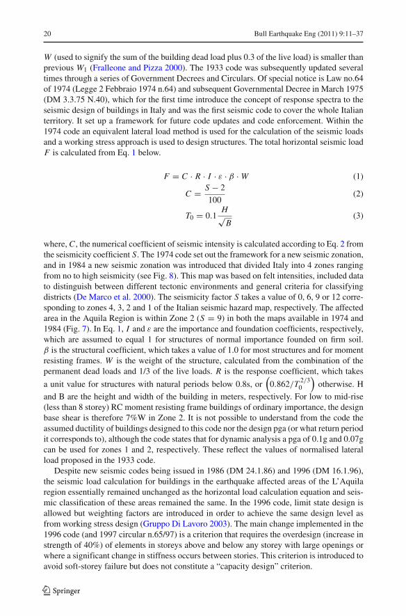
W (used to signify the sum of the building dead load plus 0.3 of the live load) is smaller thanprevious W1 (Fralleone and Pizza 2000). The 1933 code was subsequently updated severaltimes through a series of Government Decrees and Circulars. Of special notice is Law no.64of 1974 (Legge 2 Febbraio 1974 n.64) and subsequent Governmental Decree in March 1975(DM 3.3.75 N.40), which for the first time introduce the concept of response spectra to theseismic design of buildings in Italy and was the first seismic code to cover the whole Italianterritory. It set up a framework for future code updates and code enforcement. Within the1974 code an equivalent lateral load method is used for the calculation of the seismic loadsand a working stress approach is used to design structures. The total horizontal seismic loadF is calculated from Eq. 1 below.
F = C · R · I · ε · β · W (1)
C = S − 2
100(2)
T0 = 0.1H√
B(3)
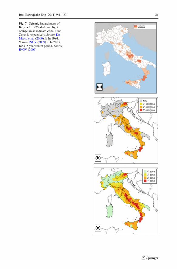
where, C , the numerical coefficient of seismic intensity is calculated according to Eq. 2 fromthe seismicity coefficient S. The 1974 code set out the framework for a new seismic zonation,and in 1984 a new seismic zonation was introduced that divided Italy into 4 zones rangingfrom no to high seismicity (see Fig. 8). This map was based on felt intensities, included datato distinguish between different tectonic environments and general criteria for classifyingdistricts (De Marco et al. 2000). The seismicity factor S takes a value of 0, 6, 9 or 12 corre-sponding to zones 4, 3, 2 and 1 of the Italian seismic hazard map, respectively. The affectedarea in the Aquila Region is within Zone 2 (S = 9) in both the maps available in 1974 and1984 (Fig. 7). In Eq. 1, I and ε are the importance and foundation coefficients, respectively,which are assumed to equal 1 for structures of normal importance founded on firm soil.β is the structural coefficient, which takes a value of 1.0 for most structures and for momentresisting frames. W is the weight of the structure, calculated from the combination of thepermanent dead loads and 1/3 of the live loads. R is the response coefficient, which takes
a unit value for structures with natural periods below 0.8s, or(
0.862/T 2/30
)otherwise. H
and B are the height and width of the building in meters, respectively. For low to mid-rise(less than 8 storey) RC moment resisting frame buildings of ordinary importance, the designbase shear is therefore 7%W in Zone 2. It is not possible to understand from the code theassumed ductility of buildings designed to this code nor the design pga (or what return periodit corresponds to), although the code states that for dynamic analysis a pga of 0.1g and 0.07gcan be used for zones 1 and 2, respectively. These reflect the values of normalised lateralload proposed in the 1933 code.
Despite new seismic codes being issued in 1986 (DM 24.1.86) and 1996 (DM 16.1.96),the seismic load calculation for buildings in the earthquake affected areas of the L’Aquilaregion essentially remained unchanged as the horizontal load calculation equation and seis-mic classification of these areas remained the same. In the 1996 code, limit state design isallowed but weighting factors are introduced in order to achieve the same design level asfrom working stress design (Gruppo Di Lavoro 2003). The main change implemented in the1996 code (and 1997 circular n.65/97) is a criterion that requires the overdesign (increase instrength of 40%) of elements in storeys above and below any storey with large openings orwhere a significant change in stiffness occurs between stories. This criterion is introduced toavoid soft-storey failure but does not constitute a “capacity design” criterion.
123
Bull Earthquake Eng (2011) 9:11–37 21
Fig. 7 Seismic hazard maps ofItaly. a In 1975, dark and lightorange areas indicate Zone 1 andZone 2, respectively. Source DeMarco et al. (2000). b In 1984.Source INGV (2009). c In 2003,for 475 year return period. SourceINGV (2009)
123

22 Bull Earthquake Eng (2011) 9:11–37
In 2003 a “new generation” code (Ordinanza PCM n. 3271) was introduced that mirroredthe development of the European seismic code Eurocode 8 (EC8 1998). Capacity design isintroduced into the code and the base shear equation is the same as that in Eurocode 8 and isreproduced in Eq. 4.
F = Sd (T1) · λ · W (4)
T1 = C · H3/4 (5)
where, Sd(T1) is the design spectral acceleration, evaluated using the same response spectrumequations as in Eurocode 8 (not reproduced here). H is the height of the structure in metersand C is a coefficient which takes the value of 0.085 for steel frame structures, 0.075 forreinforced concrete frame structures and 0.05 otherwise. λ is a coefficient that takes a valueof 0.85 if the structure is 3 or more storeys high and if T1 < 2Tc (where Tc is the perioddefining the end of the spectrum plateau, which value depends on the site soil classification),or a value of 1.0 otherwise. W is the weight of the structure, calculated from the combina-tion of the permanent dead loads and a portion of the live loads (approximately 1/3). Thebehaviour factor equation is given by:
q = q0 · K R · K D (6)
where, q0 is the basic behaviour factor which has different values for different types of struc-tural type. For example, q0 = 5.85 for a multi-storey, multi-bay moment resisting RC frame.K R is a regularity coefficient that takes a value of 1 or 0.8 for structures that are regular orirregular in elevation, respectively. K D is a coefficient that represents the ductility class andtakes a value of 1 or 0.7 for high and medium ductility classes, respectively.
A major revision of the seismic zonation of Italy also accompanies the 2003 building code.This was based on a full probabilistic seismic hazard assessment using an up to date catalogueof earthquake events (Gruppo di Lavoro 2004). The map, reproduced in Fig. 7(c), shows theseismic zones and corresponding range of pga values for anchoring the code response spec-trum. For a 475 year return period the pga anchor values are 0.35 g and 0.25 g for Zones 1and 2, respectively. For a low-rise (3 storey) regular, reinforced concrete, moment resistingframe, of normal importance sited on rock in Zone 2, the 2003 code produces design baseshears of 9.1%W and 13%W for high (q = 5.85) and medium (q = 4.1) ductility classes,respectively. These values decrease for taller RC frame buildings e.g. are 5.3%W and 7.5%W,respectively for 8 storey buildings. The 2003 code does not specify the behaviour factor for alow-ductility class, so for comparison with the 1974 code a behaviour factor of half the highductility value (i.e q = 2.93, K D = 0.5) is assumed, which produces base shear values of10%W and 18%W for a regular 8 and 3 storey RC moment resisting frame, respectively. Thisshows a1.4 to 2.6 fold increase in the design values of the earlier code. Despite the fact thatbuildings designed to the earlier code are designed using working stress methods, (hence adirect comparison of design loads with the ultimate limit state design loads of the 2003 codecannot be made), this level of increase would suggest that buildings designed to the 1974code, especially low-rise structures, would be severely damaged or collapse in the epicentralregion of the L’Aquila earthquake. The latter being typical of a 475 year return period eventin the region (see Sect. 2.2).
4.2 Overview of building stock in the affected area
The area affected by the L’Aquila earthquake presents a heterogeneous mix of building types,particularly in the residential building stock. The different ages of the buildings explains this
123
Bull Earthquake Eng (2011) 9:11–37 23
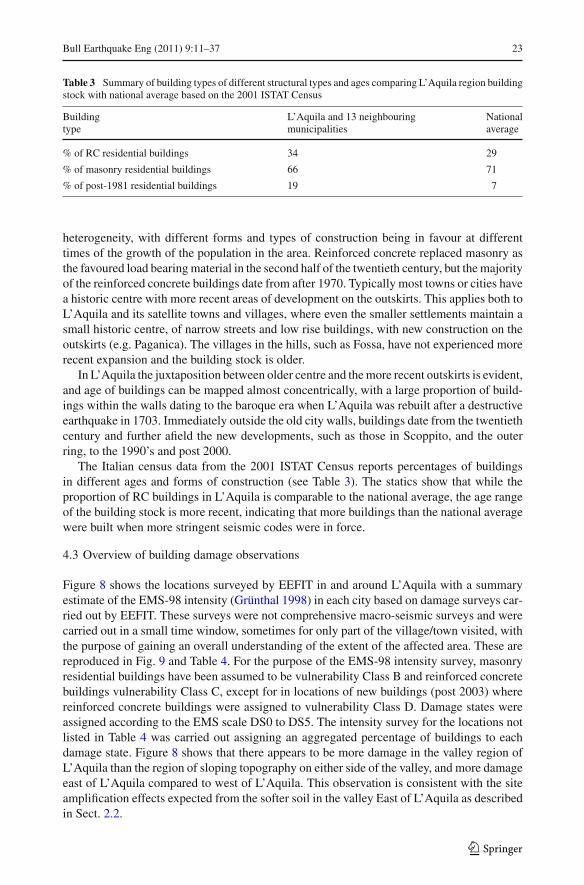
Table 3 Summary of building types of different structural types and ages comparing L’Aquila region buildingstock with national average based on the 2001 ISTAT Census
Building L’Aquila and 13 neighbouring Nationaltype municipalities average
% of RC residential buildings 34 29
% of masonry residential buildings 66 71
% of post-1981 residential buildings 19 7
heterogeneity, with different forms and types of construction being in favour at differenttimes of the growth of the population in the area. Reinforced concrete replaced masonry asthe favoured load bearing material in the second half of the twentieth century, but the majorityof the reinforced concrete buildings date from after 1970. Typically most towns or cities havea historic centre with more recent areas of development on the outskirts. This applies both toL’Aquila and its satellite towns and villages, where even the smaller settlements maintain asmall historic centre, of narrow streets and low rise buildings, with new construction on theoutskirts (e.g. Paganica). The villages in the hills, such as Fossa, have not experienced morerecent expansion and the building stock is older.
In L’Aquila the juxtaposition between older centre and the more recent outskirts is evident,and age of buildings can be mapped almost concentrically, with a large proportion of build-ings within the walls dating to the baroque era when L’Aquila was rebuilt after a destructiveearthquake in 1703. Immediately outside the old city walls, buildings date from the twentiethcentury and further afield the new developments, such as those in Scoppito, and the outerring, to the 1990’s and post 2000.
The Italian census data from the 2001 ISTAT Census reports percentages of buildingsin different ages and forms of construction (see Table 3). The statics show that while theproportion of RC buildings in L’Aquila is comparable to the national average, the age rangeof the building stock is more recent, indicating that more buildings than the national averagewere built when more stringent seismic codes were in force.
4.3 Overview of building damage observations
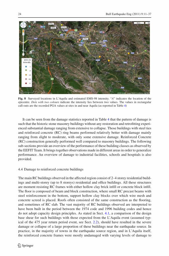
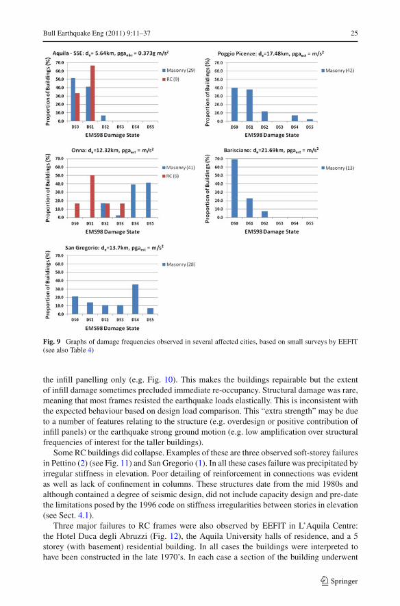
Figure 8 shows the locations surveyed by EEFIT in and around L’Aquila with a summaryestimate of the EMS-98 intensity (Grünthal 1998) in each city based on damage surveys car-ried out by EEFIT. These surveys were not comprehensive macro-seismic surveys and werecarried out in a small time window, sometimes for only part of the village/town visited, withthe purpose of gaining an overall understanding of the extent of the affected area. These arereproduced in Fig. 9 and Table 4. For the purpose of the EMS-98 intensity survey, masonryresidential buildings have been assumed to be vulnerability Class B and reinforced concretebuildings vulnerability Class C, except for in locations of new buildings (post 2003) wherereinforced concrete buildings were assigned to vulnerability Class D. Damage states wereassigned according to the EMS scale DS0 to DS5. The intensity survey for the locations notlisted in Table 4 was carried out assigning an aggregated percentage of buildings to eachdamage state. Figure 8 shows that there appears to be more damage in the valley region ofL’Aquila than the region of sloping topography on either side of the valley, and more damageeast of L’Aquila compared to west of L’Aquila. This observation is consistent with the siteamplification effects expected from the softer soil in the valley East of L’Aquila as describedin Sect. 2.2.
123
24 Bull Earthquake Eng (2011) 9:11–37
Fig. 8 Surveyed locations in L’Aquila and estimated EMS-98 intensity. “A” indicates the location of theepicentre. Dots with two colours indicate the intensity lies between two values. The values in rectangularcall-outs are the recorded PGA values at sites in and near Aquila (as reported in Table 4)
It can be seen from the damage statistics reported in Table 4 that the pattern of damage issuch that the historic stone masonry buildings without any restoration and retrofitting experi-enced substantial damage ranging from extensive to collapse. Those buildings with steel tiesand reinforced concrete (RC) ring beams performed relatively better with damage mainlyranging from slight to moderate, with only some extensive damage. Reinforced Concrete(RC) construction generally performed well compared to masonry buildings. The followingsub-sections provide an overview of the performance of these building classes as observed bythe EEFIT Team. It brings together observations made in different areas in order to generalizeperformance. An overview of damage to industrial facilities, schools and hospitals is alsoprovided.
4.4 Damage to reinforced concrete buildings
The main RC buildings observed in the affected region consist of 2–4 storey residential build-ings and multi-storey (up to 8 storeys) residential and office buildings. All these structuresare moment resisting RC frames with either hollow clay brick infill or concrete block infill.The floor is composed of beam and block construction, where small RC precast beams withsteel reinforcement in the bottom, support hollow clay blocks over which wire mesh andconcrete screed is placed. Roofs often consisted of the same construction as the flooring,and sometimes of RC slab. The vast majority of RC buildings observed are interpreted tohave been built in the period between the 1974 code and 1996 building codes and hencedo not adopt capacity design principles. As stated in Sect. 4.1, a comparison of the designbase shear for such buildings with those expected from the L’Aquila event (assumed typ-ical of the 475 year return period event, see Sect. 2.2), should have resulted in the severedamage or collapse of a large proportion of these buildings near the earthquake source. Inpractice, in the majority of towns in the earthquake source region, and in L’Aquila itself,the reinforced concrete frames were mostly undamaged with varying levels of damage to
123
Bull Earthquake Eng (2011) 9:11–37 25
Fig. 9 Graphs of damage frequencies observed in several affected cities, based on small surveys by EEFIT(see also Table 4)
the infill panelling only (e.g. Fig. 10). This makes the buildings repairable but the extentof infill damage sometimes precluded immediate re-occupancy. Structural damage was rare,meaning that most frames resisted the earthquake loads elastically. This is inconsistent withthe expected behaviour based on design load comparison. This “extra strength” may be dueto a number of features relating to the structure (e.g. overdesign or positive contribution ofinfill panels) or the earthquake strong ground motion (e.g. low amplification over structuralfrequencies of interest for the taller buildings).
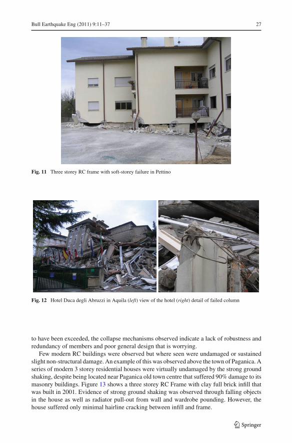
Some RC buildings did collapse. Examples of these are three observed soft-storey failuresin Pettino (2) (see Fig. 11) and San Gregorio (1). In all these cases failure was precipitated byirregular stiffness in elevation. Poor detailing of reinforcement in connections was evidentas well as lack of confinement in columns. These structures date from the mid 1980s andalthough contained a degree of seismic design, did not include capacity design and pre-datethe limitations posed by the 1996 code on stiffness irregularities between stories in elevation(see Sect. 4.1).
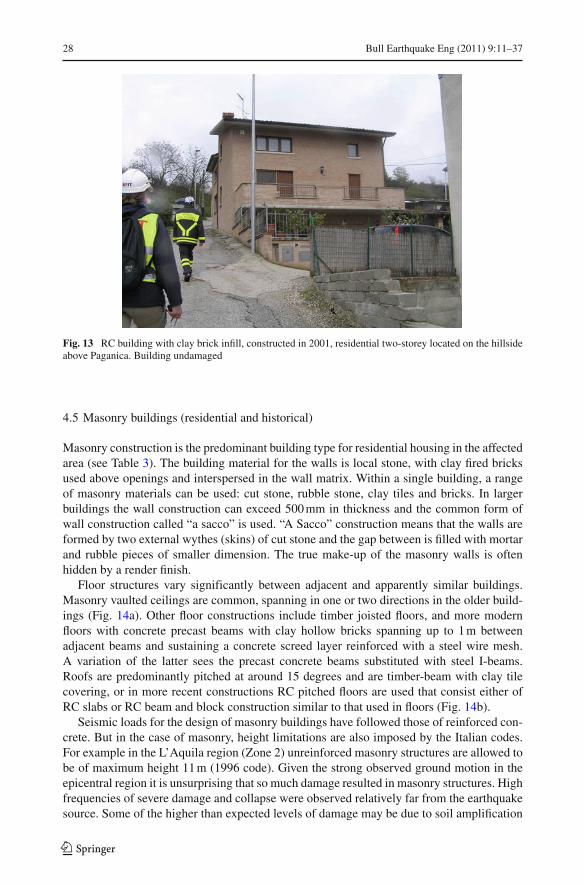
Three major failures to RC frames were also observed by EEFIT in L’Aquila Centre:the Hotel Duca degli Abruzzi (Fig. 12), the Aquila University halls of residence, and a 5storey (with basement) residential building. In all cases the buildings were interpreted tohave been constructed in the late 1970’s. In each case a section of the building underwent
123

26 Bull Earthquake Eng (2011) 9:11–37
Table 4 Building damage survey statistics collected by EEFIT
Location Epicentraldistance ( km)
PGA (g) Buildingtype
No. ofbuildings
EMS 98 Damage state
DS0 DS1 DS2 DS3 DS4 DS5
Aquila SSE 5.64 0.373 Masonry 24 13 9 2 0 0 0
Strengthened 5 2 3 0 0 0 0
masonry
RC pre-code 9 3 6 0 0 0 0
Onna 12.31 – Masonry 41 0 7 1 16 17 0
RC pre-code 6 3 1 1 0 0 1
San Gregorio 13.77 – Masonry 27 6 4 3 3 9 2
Strengthened 1 0 0 0 0 1 0
masonry
RC pre-code 2 0 0 1 0 1 0
Poggio Picenze 17.48 – Masonry 42 17 16 5 0 3 1
Barisciano 21.69 – Masonry 13 9 3 1 0 0 0
Fig. 10 RC frame building inAquila Centre with severedamage to infill but intactstructural frame
total collapse. The Hotel Duca degli Abruzzi seems to have failed through a combination ofsoft-storey mechanism formation exacerbated by sloping topography. Poor detailing of col-umn reinforcement was observed with smooth reinforcing bars and inadequate confinementsteel (Fig. 12). In the case of the halls of residence, it was not possible to identify the failuremechanism due to site clearance for rescue. However, from exposed connections and rubble,smooth reinforcement was again present. In the residential building one of the main problemsis seen to be the lack of transverse reinforcement in columns and connections. Columns seemto have failed in compression before beam yielding. Although the design loads are expected
123
Bull Earthquake Eng (2011) 9:11–37 27
Fig. 11 Three storey RC frame with soft-storey failure in Pettino
Fig. 12 Hotel Duca degli Abruzzi in Aquila (left) view of the hotel (right) detail of failed column
to have been exceeded, the collapse mechanisms observed indicate a lack of robustness andredundancy of members and poor general design that is worrying.
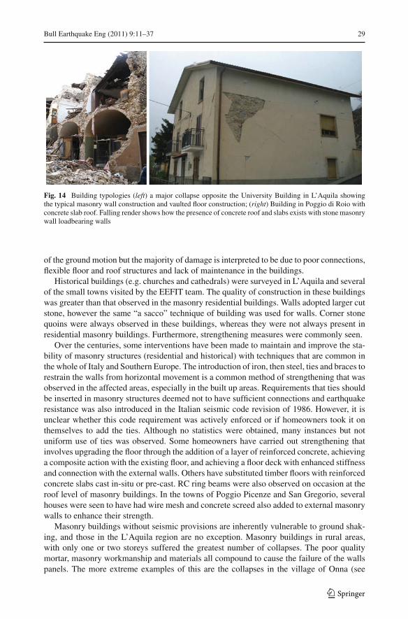
Few modern RC buildings were observed but where seen were undamaged or sustainedslight non-structural damage. An example of this was observed above the town of Paganica. Aseries of modern 3 storey residential houses were virtually undamaged by the strong groundshaking, despite being located near Paganica old town centre that suffered 90% damage to itsmasonry buildings. Figure 13 shows a three storey RC Frame with clay full brick infill thatwas built in 2001. Evidence of strong ground shaking was observed through falling objectsin the house as well as radiator pull-out from wall and wardrobe pounding. However, thehouse suffered only minimal hairline cracking between infill and frame.
123
28 Bull Earthquake Eng (2011) 9:11–37
Fig. 13 RC building with clay brick infill, constructed in 2001, residential two-storey located on the hillsideabove Paganica. Building undamaged
4.5 Masonry buildings (residential and historical)
Masonry construction is the predominant building type for residential housing in the affectedarea (see Table 3). The building material for the walls is local stone, with clay fired bricksused above openings and interspersed in the wall matrix. Within a single building, a rangeof masonry materials can be used: cut stone, rubble stone, clay tiles and bricks. In largerbuildings the wall construction can exceed 500 mm in thickness and the common form ofwall construction called “a sacco” is used. “A Sacco” construction means that the walls areformed by two external wythes (skins) of cut stone and the gap between is filled with mortarand rubble pieces of smaller dimension. The true make-up of the masonry walls is oftenhidden by a render finish.
Floor structures vary significantly between adjacent and apparently similar buildings.Masonry vaulted ceilings are common, spanning in one or two directions in the older build-ings (Fig. 14a). Other floor constructions include timber joisted floors, and more modernfloors with concrete precast beams with clay hollow bricks spanning up to 1 m betweenadjacent beams and sustaining a concrete screed layer reinforced with a steel wire mesh.A variation of the latter sees the precast concrete beams substituted with steel I-beams.Roofs are predominantly pitched at around 15 degrees and are timber-beam with clay tilecovering, or in more recent constructions RC pitched floors are used that consist either ofRC slabs or RC beam and block construction similar to that used in floors (Fig. 14b).
Seismic loads for the design of masonry buildings have followed those of reinforced con-crete. But in the case of masonry, height limitations are also imposed by the Italian codes.For example in the L’Aquila region (Zone 2) unreinforced masonry structures are allowed tobe of maximum height 11 m (1996 code). Given the strong observed ground motion in theepicentral region it is unsurprising that so much damage resulted in masonry structures. Highfrequencies of severe damage and collapse were observed relatively far from the earthquakesource. Some of the higher than expected levels of damage may be due to soil amplification
123
Bull Earthquake Eng (2011) 9:11–37 29
Fig. 14 Building typologies (left) a major collapse opposite the University Building in L’Aquila showingthe typical masonry wall construction and vaulted floor construction; (right) Building in Poggio di Roio withconcrete slab roof. Falling render shows how the presence of concrete roof and slabs exists with stone masonrywall loadbearing walls
of the ground motion but the majority of damage is interpreted to be due to poor connections,flexible floor and roof structures and lack of maintenance in the buildings.
Historical buildings (e.g. churches and cathedrals) were surveyed in L’Aquila and severalof the small towns visited by the EEFIT team. The quality of construction in these buildingswas greater than that observed in the masonry residential buildings. Walls adopted larger cutstone, however the same “a sacco” technique of building was used for walls. Corner stonequoins were always observed in these buildings, whereas they were not always present inresidential masonry buildings. Furthermore, strengthening measures were commonly seen.
Over the centuries, some interventions have been made to maintain and improve the sta-bility of masonry structures (residential and historical) with techniques that are common inthe whole of Italy and Southern Europe. The introduction of iron, then steel, ties and braces torestrain the walls from horizontal movement is a common method of strengthening that wasobserved in the affected areas, especially in the built up areas. Requirements that ties shouldbe inserted in masonry structures deemed not to have sufficient connections and earthquakeresistance was also introduced in the Italian seismic code revision of 1986. However, it isunclear whether this code requirement was actively enforced or if homeowners took it onthemselves to add the ties. Although no statistics were obtained, many instances but notuniform use of ties was observed. Some homeowners have carried out strengthening thatinvolves upgrading the floor through the addition of a layer of reinforced concrete, achievinga composite action with the existing floor, and achieving a floor deck with enhanced stiffnessand connection with the external walls. Others have substituted timber floors with reinforcedconcrete slabs cast in-situ or pre-cast. RC ring beams were also observed on occasion at theroof level of masonry buildings. In the towns of Poggio Picenze and San Gregorio, severalhouses were seen to have had wire mesh and concrete screed also added to external masonrywalls to enhance their strength.
Masonry buildings without seismic provisions are inherently vulnerable to ground shak-ing, and those in the L’Aquila region are no exception. Masonry buildings in rural areas,with only one or two storeys suffered the greatest number of collapses. The poor qualitymortar, masonry workmanship and materials all compound to cause the failure of the wallspanels. The more extreme examples of this are the collapses in the village of Onna (see
123

30 Bull Earthquake Eng (2011) 9:11–37
Fig. 15 Severely damaged masonry church in Paganica
Sect. 4.2). Cross-iron ties, when present at all floor levels and in both horizontal directions,helped prevent or reduce out-of plane failure of external walls. The collapse of internal floorswas commonly observed when concrete beam-clay hollow block floors (or steel beam-clayhollow block) floors were used, caused by the unseating of the supporting floor beams fromthe walls. Failure was more common (e.g. in Paganica) where no steel wire mesh was used toreinforce the concrete screed floor surface. In massive buildings and monuments of L’Aquila,the thickness of the walls at lower levels meant that the tension forces that initiate collapse ofmasonry were not observed. As a result damage occurred at the higher levels of the buildings,so parapets, top corners, and church timpani were the most severely damaged (Fig. 15). Alarge proportion of buildings also suffered wide spread cracking, in the form of X-cracks dueto in-plane shear forces or cracking at the corners of openings.
4.6 Industrial facilities
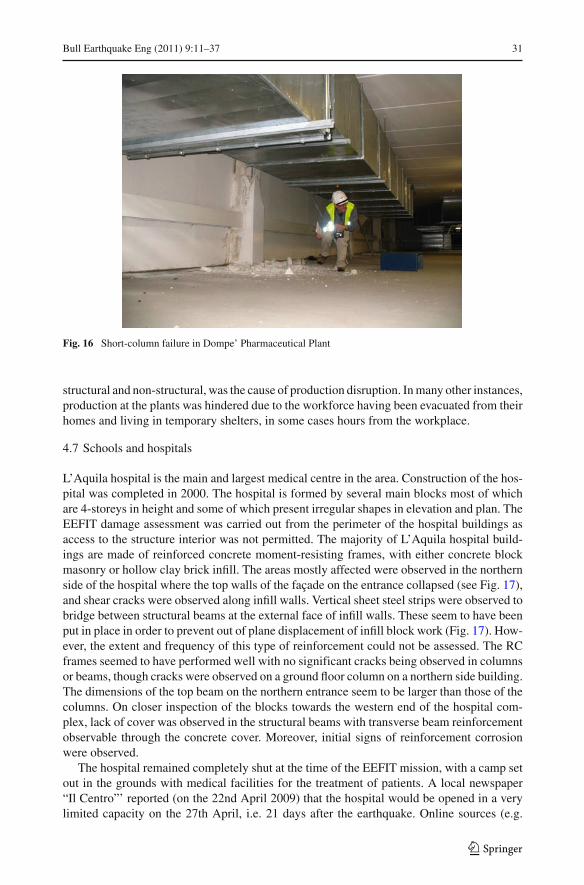
There are two industrial estates in the L’Aquila area: a few kilometres West of the City lies thePile Nucleo Industriale and to the East of the city, off the SS17 the larger Bazzano industrialestate. Industrial sheds are built with precast RC frame and precast planks. There were nomajor collapses in these structures. Only two cases of cladding collapse were observed. Itshould be noted that the EEFIT survey in these cases was not extensive and was carried outfrom the roadside. Accounts from a local consulting engineer indicate that up to 20% of thestructures suffered minor damage in the form of collapse to cladding panels. The EEFITteam was able to carry out a detailed visit to the Dompé pharmaceutical company in the PileNucleo Industriale estate where the worst reported damage to industrial buildings occurred.The building construction is in situ concrete frame and precast planks or T-beams. The majorform of structural damage consists of short-column failure (Fig. 16). The total cost of repairworks is initially estimated to exceed e10 million.
Interruption of production can be a significant contributor to the financial losses incurredby the industrial sector. Production in the Dompe’ plant was not expected to recommence untilthe 7th of May (one month after the earthquake). A pharmaceutical company in L’Aquila,which employs more than 300 people, was not expecting to reach full production until midMay (one and a half months after the earthquake). In these cases, damage to the facilities,
123
Bull Earthquake Eng (2011) 9:11–37 31
Fig. 16 Short-column failure in Dompe’ Pharmaceutical Plant
structural and non-structural, was the cause of production disruption. In many other instances,production at the plants was hindered due to the workforce having been evacuated from theirhomes and living in temporary shelters, in some cases hours from the workplace.
4.7 Schools and hospitals
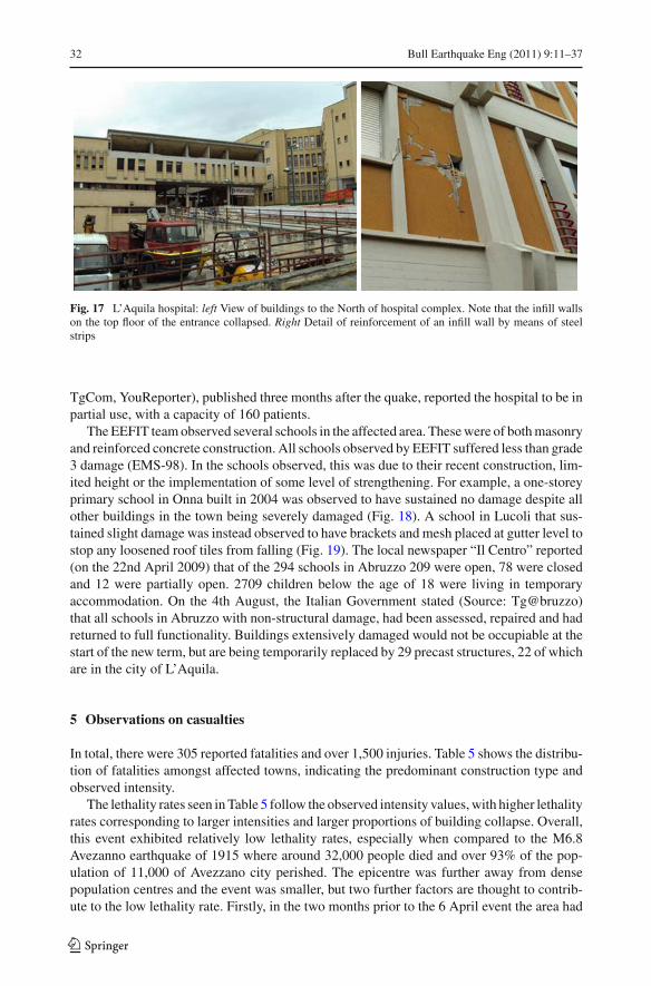
L’Aquila hospital is the main and largest medical centre in the area. Construction of the hos-pital was completed in 2000. The hospital is formed by several main blocks most of whichare 4-storeys in height and some of which present irregular shapes in elevation and plan. TheEEFIT damage assessment was carried out from the perimeter of the hospital buildings asaccess to the structure interior was not permitted. The majority of L’Aquila hospital build-ings are made of reinforced concrete moment-resisting frames, with either concrete blockmasonry or hollow clay brick infill. The areas mostly affected were observed in the northernside of the hospital where the top walls of the façade on the entrance collapsed (see Fig. 17),and shear cracks were observed along infill walls. Vertical sheet steel strips were observed tobridge between structural beams at the external face of infill walls. These seem to have beenput in place in order to prevent out of plane displacement of infill block work (Fig. 17). How-ever, the extent and frequency of this type of reinforcement could not be assessed. The RCframes seemed to have performed well with no significant cracks being observed in columnsor beams, though cracks were observed on a ground floor column on a northern side building.The dimensions of the top beam on the northern entrance seem to be larger than those of thecolumns. On closer inspection of the blocks towards the western end of the hospital com-plex, lack of cover was observed in the structural beams with transverse beam reinforcementobservable through the concrete cover. Moreover, initial signs of reinforcement corrosionwere observed.
The hospital remained completely shut at the time of the EEFIT mission, with a camp setout in the grounds with medical facilities for the treatment of patients. A local newspaper“Il Centro”’ reported (on the 22nd April 2009) that the hospital would be opened in a verylimited capacity on the 27th April, i.e. 21 days after the earthquake. Online sources (e.g.
123
32 Bull Earthquake Eng (2011) 9:11–37
Fig. 17 L’Aquila hospital: left View of buildings to the North of hospital complex. Note that the infill wallson the top floor of the entrance collapsed. Right Detail of reinforcement of an infill wall by means of steelstrips
TgCom, YouReporter), published three months after the quake, reported the hospital to be inpartial use, with a capacity of 160 patients.
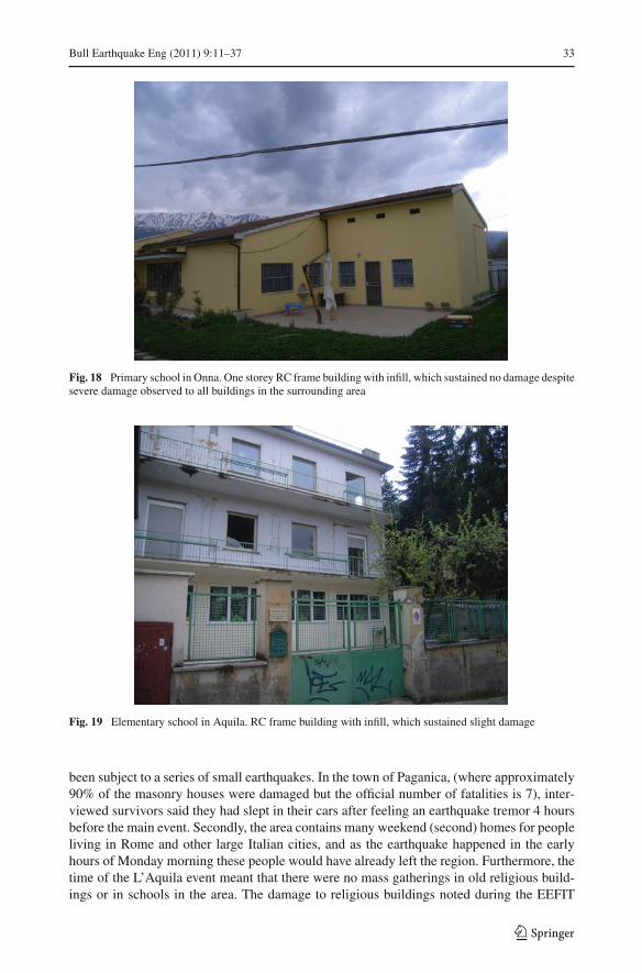
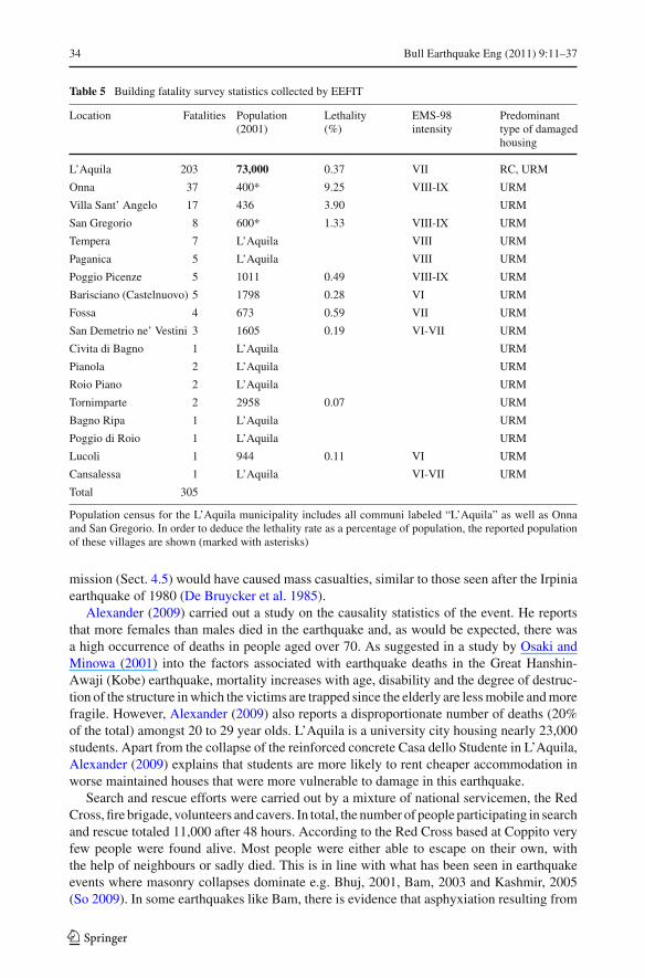
The EEFIT team observed several schools in the affected area. These were of both masonryand reinforced concrete construction. All schools observed by EEFIT suffered less than grade3 damage (EMS-98). In the schools observed, this was due to their recent construction, lim-ited height or the implementation of some level of strengthening. For example, a one-storeyprimary school in Onna built in 2004 was observed to have sustained no damage despite allother buildings in the town being severely damaged (Fig. 18). A school in Lucoli that sus-tained slight damage was instead observed to have brackets and mesh placed at gutter level tostop any loosened roof tiles from falling (Fig. 19). The local newspaper “Il Centro” reported(on the 22nd April 2009) that of the 294 schools in Abruzzo 209 were open, 78 were closedand 12 were partially open. 2709 children below the age of 18 were living in temporaryaccommodation. On the 4th August, the Italian Government stated (Source: Tg@bruzzo)that all schools in Abruzzo with non-structural damage, had been assessed, repaired and hadreturned to full functionality. Buildings extensively damaged would not be occupiable at thestart of the new term, but are being temporarily replaced by 29 precast structures, 22 of whichare in the city of L’Aquila.
5 Observations on casualties
In total, there were 305 reported fatalities and over 1,500 injuries. Table 5 shows the distribu-tion of fatalities amongst affected towns, indicating the predominant construction type andobserved intensity.
The lethality rates seen in Table 5 follow the observed intensity values, with higher lethalityrates corresponding to larger intensities and larger proportions of building collapse. Overall,this event exhibited relatively low lethality rates, especially when compared to the M6.8Avezanno earthquake of 1915 where around 32,000 people died and over 93% of the pop-ulation of 11,000 of Avezzano city perished. The epicentre was further away from densepopulation centres and the event was smaller, but two further factors are thought to contrib-ute to the low lethality rate. Firstly, in the two months prior to the 6 April event the area had
123
Bull Earthquake Eng (2011) 9:11–37 33
Fig. 18 Primary school in Onna. One storey RC frame building with infill, which sustained no damage despitesevere damage observed to all buildings in the surrounding area
Fig. 19 Elementary school in Aquila. RC frame building with infill, which sustained slight damage
been subject to a series of small earthquakes. In the town of Paganica, (where approximately90% of the masonry houses were damaged but the official number of fatalities is 7), inter-viewed survivors said they had slept in their cars after feeling an earthquake tremor 4 hoursbefore the main event. Secondly, the area contains many weekend (second) homes for peopleliving in Rome and other large Italian cities, and as the earthquake happened in the earlyhours of Monday morning these people would have already left the region. Furthermore, thetime of the L’Aquila event meant that there were no mass gatherings in old religious build-ings or in schools in the area. The damage to religious buildings noted during the EEFIT
123
34 Bull Earthquake Eng (2011) 9:11–37
Table 5 Building fatality survey statistics collected by EEFIT
Location Fatalities Population(2001)
Lethality(%)
EMS-98intensity
Predominanttype of damagedhousing
L’Aquila 203 73,000 0.37 VII RC, URM
Onna 37 400* 9.25 VIII-IX URM
Villa Sant’ Angelo 17 436 3.90 URM
San Gregorio 8 600* 1.33 VIII-IX URM
Tempera 7 L’Aquila VIII URM
Paganica 5 L’Aquila VIII URM
Poggio Picenze 5 1011 0.49 VIII-IX URM
Barisciano (Castelnuovo) 5 1798 0.28 VI URM
Fossa 4 673 0.59 VII URM
San Demetrio ne’ Vestini 3 1605 0.19 VI-VII URM
Civita di Bagno 1 L’Aquila URM
Pianola 2 L’Aquila URM
Roio Piano 2 L’Aquila URM
Tornimparte 2 2958 0.07 URM
Bagno Ripa 1 L’Aquila URM
Poggio di Roio 1 L’Aquila URM
Lucoli 1 944 0.11 VI URM
Cansalessa 1 L’Aquila VI-VII URM
Total 305
Population census for the L’Aquila municipality includes all communi labeled “L’Aquila” as well as Onnaand San Gregorio. In order to deduce the lethality rate as a percentage of population, the reported populationof these villages are shown (marked with asterisks)
mission (Sect. 4.5) would have caused mass casualties, similar to those seen after the Irpiniaearthquake of 1980 (De Bruycker et al. 1985).
Alexander (2009) carried out a study on the causality statistics of the event. He reportsthat more females than males died in the earthquake and, as would be expected, there wasa high occurrence of deaths in people aged over 70. As suggested in a study by Osaki andMinowa (2001) into the factors associated with earthquake deaths in the Great Hanshin-Awaji (Kobe) earthquake, mortality increases with age, disability and the degree of destruc-tion of the structure in which the victims are trapped since the elderly are less mobile and morefragile. However, Alexander (2009) also reports a disproportionate number of deaths (20%of the total) amongst 20 to 29 year olds. L’Aquila is a university city housing nearly 23,000students. Apart from the collapse of the reinforced concrete Casa dello Studente in L’Aquila,Alexander (2009) explains that students are more likely to rent cheaper accommodation inworse maintained houses that were more vulnerable to damage in this earthquake.
Search and rescue efforts were carried out by a mixture of national servicemen, the RedCross, fire brigade, volunteers and cavers. In total, the number of people participating in searchand rescue totaled 11,000 after 48 hours. According to the Red Cross based at Coppito veryfew people were found alive. Most people were either able to escape on their own, withthe help of neighbours or sadly died. This is in line with what has been seen in earthquakeevents where masonry collapses dominate e.g. Bhuj, 2001, Bam, 2003 and Kashmir, 2005(So 2009). In some earthquakes like Bam, there is evidence that asphyxiation resulting from
123
Bull Earthquake Eng (2011) 9:11–37 35
the dust and fine material released when buildings collapsed has contributed to deaths of itsoccupants (Hatamizadeh et al. 2006). The collapse mechanism of masonry buildings alsocreates fewer voids for occupants and reduces chances of survival. Rescue efforts may havefocused in reinforced concrete frame buildings where voids are more likely.
According to the Civil Protection, there are a total of 62,200 people displaced from theirhomes in this event of which 28,500 are living in tented villages (http://www.protezionecivile.it/, 21/5/2009). Camps were set up by the 7th April (the day after the event) around the affectedarea. Eight camps were set up in L’Aquila city and located in stadiums, sports grounds and atthe train station. The largest camp housed 4,500 people and was situated in the army barracksat Piazza D’Armi. Camps were also set up outside majorly affected towns in the L’Aquiladistrict. These camps were equipped with medical facilities, central catering and sanitationprovisions. Around 24,300 displaced people were housed in hotels near the Adriatic coastand 9,400 found accommodation with friends and family. A policy of “evacuate all” wasadopted by the Civil Protection, until all buildings are inspected by qualified engineers withearthquake engineering experience. Over 1500 engineers were deployed for this purpose,and were instructed to prioritise the assessment of lightly damaged buildings (with the aim ofquickly re-housing people), and buildings of strategic importance. Experts from the Ministryof Cultural Heritage were also sent to inspect churches and historical buildings in the area.
6 Conclusions
This paper presents a summary of the observations made by the United Kingdom EarthquakeField Investigation Team (EEFIT) during an eight day reconnaissance of areas affected bythe 6 April 2009 L’Aquila Earthquake.
Each earthquake presents a different set of findings that enhance the understanding ofbuildings and infrastructure response to the effects of ground shaking. This earthquake hasalso provided material to support research in a number of aspects of earthquake engineeringscience:
• This paper has shown that some of the RC buildings closest to the epicenter performedabove the design criteria. This is an area that deserves further research to enhance theunderstanding of “as-built” structures, and flag the buildings at risk more accurately.
• Damage to L’Aquila’s main hospital gives engineers the opportunity to better understandthe implications to serviceability of non-structural damage to key infrastructure.
• The collapse of multiple RC buildings in and around L’Aquila was a stark reminder ofthe lethality rate of RC buildings and the presence of vulnerable examples in the Euro-pean building stock. Diagnostic research of the causes of these collapses will increase theability to identify the buildings at risk and design mitigating solutions.
• The older and prevalent masonry building stock suffered widespread damage and servedas a reminder of the vulnerability of this form of construction. It was encouraging to see arelatively widespread use of strengthening measures. There was evidence of the successthe steel and iron ties had in preventing collapse, and the resulting body of knowledge fromthis event on how ties perform can help engineers demonstrate the cost and life-savingeffectiveness of introducing them extensively in existing vulnerable buildings.
The L’Aquila earthquake will also be remembered as the most damaging earthquake inWestern European and Italy since the Messina and Reggio Calabria event of 1908 to affectan urban environment. The impact of the damage on the dense urban setting exacerbatesthe impact on the economy and the ability to carry out repair work safely. The citizens of
123
36 Bull Earthquake Eng (2011) 9:11–37
L’Aquila deserve the full attention of the engineering, planning and architectural communityto bring their city back its pre-earthquake modest grandeur and bustle.
Acknowledgments Participation of T. Rossetto, S. Sargeant, E. Verrucci and E. So in the EEFIT missionwas funded by the Engineering and Physical Sciences Research Council (EPSRC), who are thanked for theirsupport. Risk Management Solutions, AIR Worldwide, Sellafields Ltd and Arup are thanked for sponsoringthe participation of their employees.
References
Abrahamson NA, Shedlock KM (1997) Overview. Seis Res Lett 68(1):9–23Akkar S, Bommer JJ (2007) Prediction of elastic displacement response spectra in Europe and the Middle
East. Earthquake Eng Struct Dyn 36:1275–1301Akinci A, Galadini F, Pantosti D, Petersen M, Malagnini L, Perkins D (2009) Effect of time dependence on
probabilistic seismic-hazard maps and deaggregation for the Central Apennines, Italy. Bull Seismol SocAm 99:585–610
Alarcon JE, Franco G, Bazzurro P, Simic M (2010) The L’Aquila (Abruzzo) earthquake of 6th April 2009—fieldsurvey and loss estimation. In: Proceedings of the 14th European conference on earthquake engineering.Paper 1420
Alexander D (2009) Mortaility and morbidity risk in the L’Aquila, Italy earthquake of 6 April 2009 and lessonsto be learned. Proceedings of the 2nd international workshop on disaster casualties, June 15–16, 2009,Cambridge, UK
Ameri G, Augliera P, Bindi D, D’Alema E, Ladina C, Lovati S, Luzi L, Marzorati S, Massa M, Pacor F, PugliaR (2009) Strong-motion parameters of the Mw=6.3 Abruzzo (Central Italy) earthquake, www.mi.ingv.it/docs/report_RAN_20090406.pdf
Beyer K, Bommer JJ (2006) Relationships between median values and between aleatory variabilities for differ-ent definitions of the horizontal component of motion. Bull Seismol Soc Am 96(4):1512–1522 (Erratum,97(5), 1769, 2007)
Cello G, Mazzoli S, Tondi E, Turco E (1997) Active tectonics in the central apennines and possible implicationsfor seismic hazard analysis in peninsular Italy. Tectonophysics 272:43–68
De Bruycker M, Greco D, Lechat MF (1985) The 1980 earthquake in southern Italy: mortality and morbidity.Int J Epidemiol 14:113–117
De Luca G, Marcucci S, Milana G, Sanò T (2005) Evidence of low-frequency amplification in the city ofL’Aquila, Central Italy, through a multidisciplinary approach including strong- and weak-motion data,ambient noise and numerical modeling. Bull Seismol Soc Am 95:1469–1481
De Marco R, Martini MG, Di Pasquale G, Fralleone A, Pizza AG, Viola V (2000) “La classificazione e lanormativa sismica Italiana dal 1909 al 1984”. Italian National Seismic Survey Report, Italy
DM 3.3.75 N.40 (1975) Disposizioni concernenti l’applicazione delle norme tecniche per le costruzioni inzone sismiche. Decreto Ministeriale 3 Marzo 1975 N.40. Published in Gazzetta Ufficiale 8 Aprile 1975,n. 93 - suppl
DM 24.1.86 (1986) Norme tecniche relative alle costruzioni antisismiche. Decreto Ministero dei Lavori Pubb-lici 24 Gennaio 1986. Published in Gazzetta Ufficiale 12 Maggio 1986, n. 108
DM 16.1.96 (1996) Norme tecniche relative alle costruzioni antisismiche. Decreto Ministero LL. PP. 16Gennaio 1996. Published in Gazzetta Ufficiale 5 Febbraio 1996, n. 29.
EC8 (1998) Eurocode 8: Design of structures for earthquake resistance. EN 1998:1, 2003, European Committeeof Standardization
Fralleone A, Pizza AG (2000) Sintesi dei cambiamenti più significativi della normativa italiana per le cost-ruzioni in zone sismiche. Italian National Seismic Survey Report, Italy
Grünthal G (ed) (1998) European macroseismic scale 1998 (EMS-98). European Seismological Commis-sion, subcommission on Engineering Seismology. Conseil de l’Europe, Cahiers du Centre Européen deGéodynamique et de Séismologie, 15, Luxembourg, pp 99
Gruppo Di Lavoro (2003) Normativa tecnica per le costruzioni in zona sismica e connessa classificazionesismica del territorio nazionale: Nota Espicativa dell’Ordinanza del Presidente del Consiglio dei Ministrin. 3274 del 20 marzo 2003 (G.U. n. 105 del 8.5.2003). Istituto Nazionale di Geofisica e Vulcanologia.Milano, Roma
Gruppo di Lavoro (2004) Redazione della mappa di pericolosita’ sismica, prevista dall’Ordinanza PCM del20 Marzo 2003, n. 3274. All.1. Rapporto conclusivo per il Dipartimento della Protezione Civile. IstitutoNazionale di Geofisica e Vulcanologia. Milano, Roma, Aprile 2004. 65pp + 5 appendices
123
Bull Earthquake Eng (2011) 9:11–37 37
Hatamizadeh P, Najafi I, Vanholder R, Rashid-Farokhi F et al (2006) Epidemiologic aspects of the Bamearthquake in Iran: the nephrologic perspective. Am J Kidney Dis 47(3):428–438
Henni PHO, Fyfe CJ, Marrow PC (1998) The BGS World seismicity database. BGS technical report no.WL/98/13
INGV (2009) Istituto Nazionale di Geofisica e Vulcanologia. www.ingv.it. Last accessed 14 August 2009Legge 2 Febbraio 1974.N.64 (1974) Provvedimenti per le costruzioni con particolari prescrizioni per le zone
sismiche. Ministero dei Lavori Pubblici, Legge 2 Febbraio 1974, n. 64. Pubblicata nella Gazzetta Ufficialedel 21 marzo 1974, n. 76
Ordinanza PCM n. 3271 (2003) Primi elementi in materia di criteri generali per la classificazione sismicadel territorio nazionale e normative tecniche per le costruzioni in zona sismica. Ordinanza n. 3274 dellaPresidenza del Consiglio dei Ministri. Published in Supplemento Ord. 72 Gazzetta Ufficiale 8 Maggio2003, n. 105
Osaki Y, Minowa M (2001) Factors associated with earthquake deaths in the Great Hanshin-Awaji earthquake,1995. Am J Epidemiol 153(2):153–156
Pace B, Boncio P, Lavecchia G (2002) The 1984 Abruzzo earthquake (Italy): an example of seismogenicprocess controlled by interaction between differently oriented synkinematic faults. Tectonophysics350:237–254
Pace B, Peruzza L, Lavecchia G, Boncio P (2006) Layered seismogenic source model and probabilisticseismic-hazard analyses in Central Italy. Bull Seismol Soc Am 96:107–132
PreventionWeb (2010): www.preventionweb.net/english/professional/news/v.php?id=14416. Last accessed12th August 2010
Protezione Civile (2009) www.protezionecivile.it. Last accessed 1st September 2009Romeo R, Pugliese A (2000) Seismicity, seismotectonics and seismic hazard of Italy. Eng Geol 241–266Rovida A, Castelli V, Camassi R, Stucchi M (2009) Historical earthquakes in the area affected by the April
2009 seismic sequence. www.mi.ingv.it/eq/090406/storia_eng.html#evento1461So EKM (2009) The assessment of casualties for earthquakes loss estimation. PhD thesis, Department of
Architecture, University of Cambridge, UKSpence R, D’Ayala D, Martin B, Marinescu J, Sabetta F, Zuccaro G (1998) The Umbria Marche earthquakes
of 26 September 1997: a field report by EEFIT, October 1988, 111 ppUSGS (2006) United States Geological Survey, www.usgs.gov
Web sources
Tg@bruzzo (2009) TERREMOTO: CHIODI, A SETTEMBRE APERTE TUTTE LE SCUOLE. tg@bru-zzo. Available at: http://tgabruzzo.blogspot.com/2009/07/terremoto-chiodi-settembre-aperte-tutte.html.Accessed October 23, 2009
Tgcom (2009) Sisma L’Aquila, riapre l’ospedale. Available at: http://www.tgcom.mediaset.it/cronaca/articoli/articolo447648.shtml. Accessed October 23, 2009
Università - L’Aquila Rinasce (2009) Available at: http://www.laquilarinasce.org/universita.html. AccessedOctober 23, 2009
YouReporter.it (2009) Ospedale San Salvatore parzialmente agibile. Available at: http://www.youreporter.it/video_Ospedale_San_Salvatore_parzialmente_agibile_1. Accessed October 23, 2009
123