“Fear God; fear the Bogaze”: the Nile mouths and the navigational landscape of the Nile Delta,...
22
This is an Accepted Manuscript of an article published by Taylor & Francis in Al-Masāq on 18 Jun 2012, available online: http://dx.doi.org/10.1080/09503110.2012.655584 “Fear God; fear the Bogaze ”: the Nile mouths and the navigational landscape of the medieval Nile Delta, Egypt. John P. Cooper Correspondence: Institute of Arab & Islamic Studies, University of Exeter, IAIS Building, Stocker Road, Exeter, Devon, EX4 4ND, England, United Kingdom. E-mail: [email protected]. Keywords Egypt, Nile, Delta, river-mouths, Alexandria, Rashīd, Rosetta, Dumyāṭ, Damietta, Tinnīs, medieval, navigation, hazards, canals, landscape. Introduction “The Turks, instructed by long and dire experience, say in a proverb well known to them, that whoever does not fear the Bogaze [i.e. the Nile mouth] does not fear God.” Anthoine Morison (fl. 1115(6)/1704) 1 For all the scholarship on the Nile and its contribution to the development of complex societies in Egypt, it is only recently that the emerging discipline of maritime archaeology has prompted researchers to take a direct and detailed interest in the practical sailing conditions experienced by past navigators on the river itself, and the influence of these conditions on the formation of the wider transport network. 2 Even Shlomo Goitein, in his magisterial six-volume work on the Cairo Geniza documents, A Mediterranean Society, devotes but a few paragraphs to matters of practical navigation that so governed the lives of navigators and the patterns of their traffic on the river. 3 The French and particularly British colonial adventures in Egypt did generate new forms of enquiry into conditions on the Nile. For example, the 1 Anthoine Morison, Relation historique d'un voyage nouvellement fait au Mont Sinaï et à Jérusalem, ed. Georges Goyon, Voyage en Egypte, Collection des voyageurs occidentaux en Égypte, 17, (Cairo: Institut Français d'Archéologie Orientale du Caire, 1976), 21. 2 Angus Graham, “Plying the Nile: Not all plain sailing” in Current Research in Egyptology 2003: Proceedings of the Fourth Annual Symposium, University College London 2003, ed. Kathryn Piquette and Serena Love (Oxford: Oxbow Books, 2005), pp. 41-56; John P. Cooper, “No easy option; the Nile versus the Red Sea in ancient and mediaeval north-south navigation” in Maritime Technology in the Ancient Economy: Ship-Design and Navigation, ed. William V. Harris and Kristine Iara. JRA Supplementary Series 84, pp. 189-210. 3 Shelomo D. Goitein, A Mediterranean Society. The Jewish communities of the Arab world as portrayed in the documents of the Cairo Geniza, volumes I-VI (Berkley & Los Angeles: University of Caifornia, 1967), I: 296-299.
Transcript of “Fear God; fear the Bogaze”: the Nile mouths and the navigational landscape of the Nile Delta,...

This is an Accepted Manuscript of an article published by Taylor & Francis in Al-Masāq on 18 Jun 2012, available online: http://dx.doi.org/10.1080/09503110.2012.655584 “Fear God; fear the Bogaze”: the Nile mouths and the navigational landscape of the medieval Nile Delta, Egypt. John P. Cooper Correspondence: Institute of Arab & Islamic Studies, University of Exeter, IAIS Building, Stocker Road, Exeter, Devon, EX4 4ND, England, United Kingdom. E-mail: [email protected]. Keywords Egypt, Nile, Delta, river-mouths, Alexandria, Rashīd, Rosetta, Dumyāṭ, Damietta, Tinnīs, medieval, navigation, hazards, canals, landscape. Introduction “The Turks, instructed by long and dire experience, say in a proverb well known to them, that whoever does not fear the Bogaze [i.e. the Nile mouth] does not fear God.” Anthoine Morison (fl. 1115(6)/1704)1 For all the scholarship on the Nile and its contribution to the development of complex societies in Egypt, it is only recently that the emerging discipline of maritime archaeology has prompted researchers to take a direct and detailed interest in the practical sailing conditions experienced by past navigators on the river itself, and the influence of these conditions on the formation of the wider transport network.2 Even Shlomo Goitein, in his magisterial six-volume work on the Cairo Geniza documents, A Mediterranean Society, devotes but a few paragraphs to matters of practical navigation that so governed the lives of navigators and the patterns of their traffic on the river.3 The French and particularly British colonial adventures in Egypt did generate new forms of enquiry into conditions on the Nile. For example, the
1 Anthoine Morison, Relation historique d'un voyage nouvellement fait au Mont Sinaï et à Jérusalem, ed. Georges Goyon, Voyage en Egypte, Collection des voyageurs occidentaux en Égypte, 17, (Cairo: Institut Français d'Archéologie Orientale du Caire, 1976), 21. 2 Angus Graham, “Plying the Nile: Not all plain sailing” in Current Research in Egyptology 2003: Proceedings of the Fourth Annual Symposium, University College London 2003, ed. Kathryn Piquette and Serena Love (Oxford: Oxbow Books, 2005), pp. 41-56; John P. Cooper, “No easy option; the Nile versus the Red Sea in ancient and mediaeval north-south navigation” in Maritime Technology in the Ancient Economy: Ship-Design and Navigation, ed. William V. Harris and Kristine Iara. JRA Supplementary Series 84, pp. 189-210. 3 Shelomo D. Goitein, A Mediterranean Society. The Jewish communities of the Arab world as portrayed in the documents of the Cairo Geniza, volumes I-VI (Berkley & Los Angeles: University of Caifornia, 1967), I: 296-299.
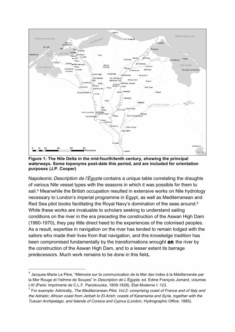
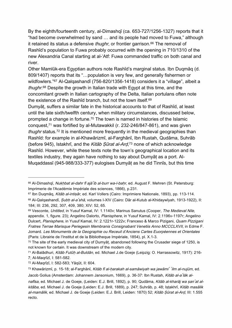
Figure 1: The Nile Delta in the mid-fourth/tenth century, showing the principal waterways. Some toponyms post-date this period, and are included for orientation purposes (J.P. Cooper)
Napoleonic Description de l’Égypte contains a unique table correlating the draughts of various Nile vessel types with the seasons in which it was possible for them to sail.4 Meanwhile the British occupation resulted in extensive works on Nile hydrology necessary to London’s imperial programme in Egypt, as well as Mediterranean and Red Sea pilot books facilitating the Royal Navy’s domination of the seas around.5 While these works are invaluable to scholars seeking to understand sailing conditions on the river in the era preceding the construction of the Aswan High Dam (1960-1970), they pay little direct heed to the experiences of the colonised peoples. As a result, expertise in navigation on the river has tended to remain lodged with the sailors who made their lives from that navigation, and this knowledge tradition has been compromised fundamentally by the transformations wrought on the river by the construction of the Aswan High Dam, and to a lesser extent its barrage predecessors. Much work remains to be done in this field.
4 Jacques-Marie Le Père, “Mémoire sur la communication de la Mer des Indes à la Méditerranée par la Mer Rouge et l’Isthme de Souyes” in Description de L’Égypte, ed. Edme François Jomard, volumes I-XI (Paris: Imprimerie de C.L.F. Panckoucke, 1809-1828), État Moderne I: 123. 5 For example: Admiralty, The Mediterranean Pilot, Vol.2: comprising coast of France and of Italy and the Adriatic; African coast from Jerbah to El-Arish; coasts of Karamania and Syria, together with the Tuscan Archipelago, and Islands of Corsica and Cyprus (London, Hydrographic Office: 1885).
In this paper, I look at the navigational conditions at a critical point on the Nile’s course through Egypt, this being where the river debouches into the Mediterranean Sea: in other words, the mouths of the Delta distributaries. I consider the impact of these conditions not only on the behaviour of those navigators venturing to transit between river and sea, but also on those power-holders in Egyptian society able to mobilise resources in order to address the challenges the mouths presented. The timeframe in question is broadly medieval Islamic, starting from the fourth/tenth century, when geographers such as Ibn Ḥawqal (fl. 366/977) start to present suitably detailed cartographic representations of the Nile Delta, and when a relatively rich corpus of historical data relating to the ports of the Delta coastal region begins to emerge. From a navigational perspective, my end-date might be taken as the close of the age of sail, since sailing navigators faced similar choices and dilemmas throughout this period: we have no reason to think that navigational conditions changed significantly, and the configuration of major Delta distributaries debouching into the sea and coastal lagoons changed little. As a result, the accounts of travellers and pilot books from a broad range of periods – up to the thirteenth/nineteenth century – can be taken as material to our understanding of the maritime landscape. That said, my focus in the eastern Delta is on the importance that perilous conditions at the Dumyāṭ (Damietta) mouth lent the island-city of Tinnīs, and indeed to the route passing Tinnīs even after the city itself was abandoned in the seventh/thirteenth century. In the western Delta, my focus is on the multifarious and ongoing efforts – individual and by the state – to make safe contact between the great seaport of Alexandria and the Nile river network in a manner that avoided the Rashīd (Rosetta) mouth, or at least mitigated the risks inherent in venturing through it. I proceed with a brief presentation of the geography of the main Delta distributaries and ports in the medieval period, followed by an exposition of the accounts that illuminate conditions at the main Dumyāṭ and Rashīd mouths. I then compare the importance of Rashīd compared to Alexandria, and Dumyāṭ compared to Tinnīs, in the light of these conditions, and look at the strategies that individuals and Egypt’s rulers adopted to mitigate the dangers these mouths represented. Finally, I consider the implications of this research for our understanding of the place of the navigator within the wider navigational landscape. The geography of the medieval Nile Delta By the fourth/tenth century – when medieval geographies start to give new resolution to the geography of the Delta – the major distributaries of the Nile had reduced considerably in number from the seven characterised by the Greco-Roman authors of Antiquity.6 Broadly speaking, the Delta had taken on the two-branched form familiar today, with the Rashīd (Rosetta) and Dumyāṭ (Damietta) branches the only
6 For a fuller discussion of the data presented by the ancient authors on the geography of Nile Delta waterways, see John P. Cooper, “The Medieval Nile: Route, navigation and landscape in Islamic Egypt”, PhD Thesis, University of Southampton, 2008, volumes I-II, I.26-37.

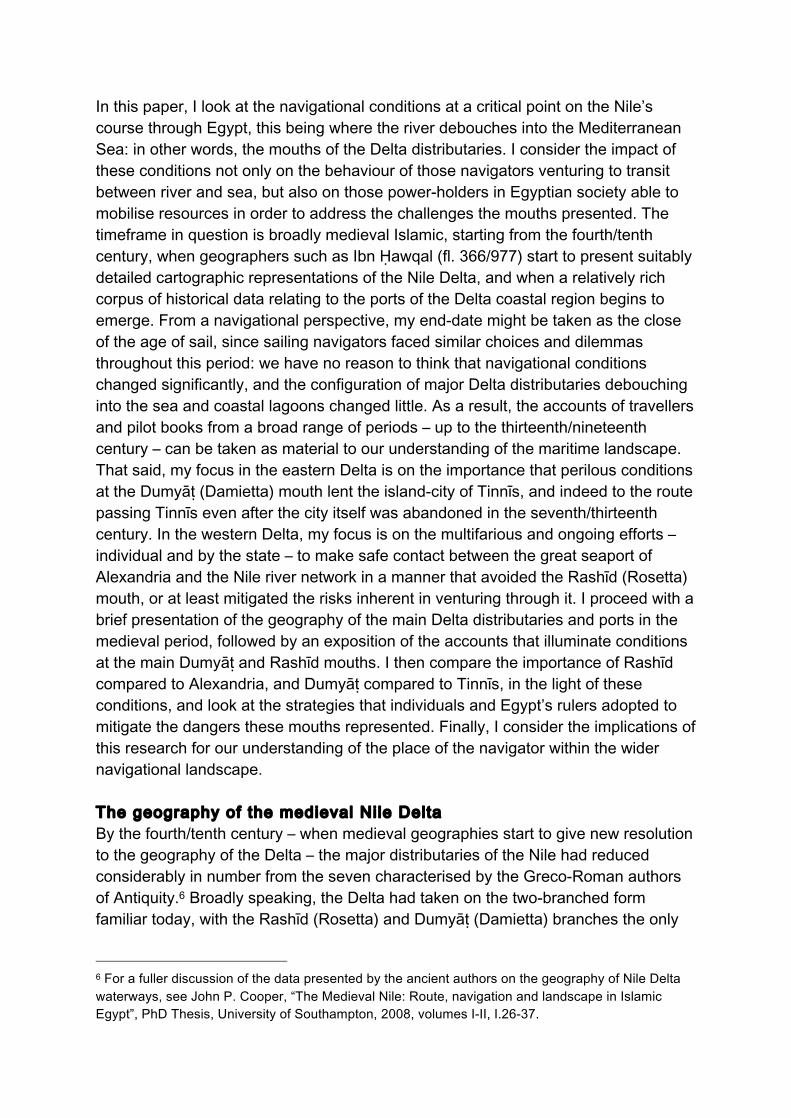
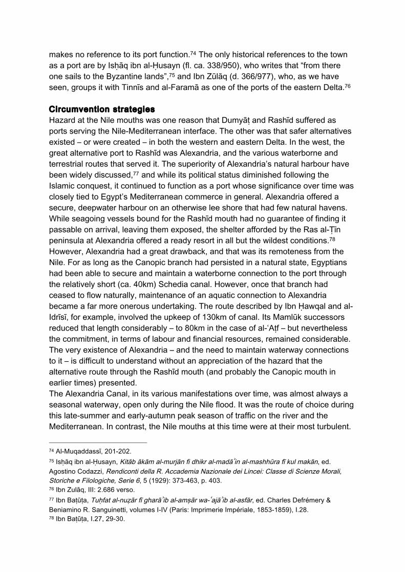
two natural distributaries debouching directly into the Mediterranean Sea (Figure 1). Other, lesser channels existed, both as natural waterways and cut canals. But these drained into the lakes and lagoons that fringed almost all the Delta coast between Alexandria in the west and the port of al-Faramā (ancient Pelusium) in the east, and that connected to the sea thereafter through their own mouths. Hydrologically speaking, the western Delta was already in the medieval period dominated by the Rashīd branch, which followed much the same course as it does today. Medieval geographers such as Ibn Ḥawqal and al-Idrīsī describe other waterways that leave and rejoin this main branch,7 but since these do not find an independent course to the sea, they are not material to this discussion. What is relevant, however, is the seasonal waterway leading to Alexandria known most commonly among medieval Arabic authors as the Khalīj al-Iskandriyya, or Alexandria Canal. Alexandria had in Antiquity been connected to the Canopic branch – then the westernmost branch of the Nile – by means of the artificial Schedia Canal, which had been excavated in the Ptolemaic era. Omar Toussoun suggests that the Canopic branch separated from what is today considered the Rashīd branch at modern Zāwiyat al-Baḥr.8 It debouched into Abū Qīr bay. By the turn of the second millennium AD, however, the Canopic branch no longer debouched into the sea,9 and its erstwhile bed had become an element, together with the Schedia Canal itself, of the medieval Khalīj al-Iskandriyya. When precisely this configuration came about is not clear, but in the early seventh century A.D., George of Cyprus cites an “Alexandria” mouth in his list of Nile mouths,10 and both Suhrāb (before 333/945) and al-Khāwarizmī (d. 235(6)/850) include a Khalīj al-Iskandriyya in their early Islamic geographies. By the time of Ibn Ḥawqal’s fourth/tenth century geography, this canal’s point of departure was some 10km further north/downstream of Zāwiyat al-Baḥr, at Shābūr, although thereafter it quickly rejoined the Canopic (and thereafter) Schedia routes.11 Al-Idrīsī (fl. 1154) describes this same route two centuries later, although he names it after Shābūr rather than Alexandria.12 By that time, there were also alternatives in place. Al-Makhzūmī (d.579(80)/1184), al-Idrīsī’s close contemporary, describes an additional Alexandria-bound canal which, confusingly, he calls the Alexandria Canal, rather than that rising at Shābūr, which he calls the Baḥr Ramsīs. Al-Makhzūmī’s 7 Ibn Ḥawqal, Kitāb ṣūrat al-ʾard, ed. Johannes H. Kramers, (Leiden: E.J. Brill, 1938-9): pp. 139-140 8 Omar Toussoun, “Mémoire sur l’Histoire du Nil, volumes. I-III”. Mémoires présentés à la Société Archéologique d'Alexandrie, volumes III-V (1925): II: 162. 9 Daniel J Stanley, Franck Goddio & Gerard Schnepp, “Nile flooding sank two ancient cities”, Nature, 412 (2001), 293-294. 10 George W.W. Murray, “George of Cyprus”, in Egypt in the Classical Geographers, main author John Ball (Cairo: Government Press, 1942), pp.176-177. 11 Ibn Ḥawqal, pp. 140-143; Al-Idrīsī, Nuzhat al-mushtaq fī ikhtirāq al-ʾafāq, ed. Enrico Cerulli, Francesco Gabrieli, Giorgio Levi Della Vida, Luciano Petech, & Giorgio Tucci (eds.), Volumes I-X (Napoli: Istituto Universitario Orientale, 1970-1984), III: 340-343. 12 Al-Idrīsī, III: 340-342.
Alexandria leaves the Rashīd branch at Babīj (modern Abīj).13 The existence of this waterway later in the century appears to be confirmed in surviving text from the Ayyūbid vizier Ibn Māmmatī (d.605/1209), who claims that if a barrage were erected across the Nile at Babīj, then the route to Alexandria would be navigable year round.14 Further changes to the waterways serving Alexandria occur in the Mamlūk period. The Sultan al-Ẓāhir Baybars (658–675/1260-1277) favoured the route described by al-Makhzūmī over that of Ibn Ḥawqal and al-Idrīsī in his re-excavation of 1264/5 (663 AH), although he shifted its mouth some 3km upstream to the village of al-Ḍāhiriyya: the toponym is perhaps a subsequent corruption of the Sultan’s name. Later, the route was altered radically, and the head of a new canal placed at al-ʿAṭf – probably in 1310 (710 AH) under the Sultan al-Nāsir Muḥammad Ibn Qalāwūn (692–693/1293-1294, 698–708/1299-1309, 1310-1341). It is a straightened version of this route that the modern Maḥmūdiyya canal follows today. However, the head shifted once again under the Sultan al-Ashraf Barsbāy (1422-1438) to al-Raḥmaniyya, perhaps in 826 AH (1422/3). Some time before the late twelfth/eighteenth century, however, that canal had fallen into disrepair, and was no longer in use.15 Finally, in 1234/1819, Muḥammad ʿAlī shifted the route back to al-ʿAṭf with his construction of the Maḥmūdiyya canal.16 Returning to the fifth/twelfth century, al-Idrīsī also alerts us to another waterway connecting the Rashīd branch to Alexandria. This is “a small arm of the Nile” that separates from its parent “close to and below Samdīsī”. It flows to “a lake”, and then through a second – presumably these are Lakes Idkū and Abū Qīr respectively – taking navigators to within six amyāl (miles) of Alexandria, From there “… people transfer from boats to land, and they travel by pack-animal to Alexandria.”17 The geographer Ibn Saʿīd (d. 1286) describes, and names, what is probably the same waterway: “When [the Alexandria canal] is not in use [i.e. when the Nile is not in flood], the lake to the east of Alexandria is used. … Boats travel on it to places on the Nile via … the al-Ḥāfir canal.”18 He believed this canal had first been excavated by the Ayyūbid Sultan al-ʿĀdil (596–614/1200-1218), but al-Idrīsī’s evidence suggests an earlier date. The canal also appears to have been contemporary to Al-Maqrīzī (765–845/1364-1442).19
13 Al-Makhzūmī, Al-minhāj fi aḥkām al-kharāj, in al-Maqrīzī, Al-Mawāʿiẓ wa-l-iʿtibār fī dhikr al-khiṭaṭ wa-l-āthār, ed. Ayman F. Sayyid, volumes I-IV, (London: Al-Furqan Islamic Heritage Foundation, 2002), I: 459-463. 14 Ibn Māmmatī, Kitāb qawānīn al-dawāwīn, ed. Aziz S. Atiya (Cairo: al-Jamʿiyya al-zirāʿiyya al-malikiyya, 1943), p. 221. 15 Carsten Niebuhr, Travels Through Arabia, volumes I-II (Ediburgh: R, Morison & Son, 1792) I: 42. 16 Toussoun, II: 209. 17 Al-Idrīsī, III: 343. 18 Ibn Saʿīd, Untitled manuscript, ed. Yusuf Kamal [Monumenta Cartographica Africae et Aegypti, Volume IV] (Leiden: Printed for the Author, 1926-53), 1.1088 verso. 19 Al-Maqrīzī, I: 459.
It is apparent from the accounts of Ibn Ḥawqal and al-Idrīsī in particular that their Alexandria Canal operated only during the Nile flood.20 It is also implicit in Ibn Māmmatī’s account that the route beginning at Abīj was also seasonal. Indeed, the struggle to keep the canal route to Alexandria open was ongoing. Al-Maqrīzī reports works carried out in 245 AH (859/60), 259 AH (873), 404 AH (1013/4), 332 AH (943/4), 662 and 664 AH (1263/4 and 1265/6), 710 AH (1310) and 826 AH (1422/3), among others at unspecified dates.21 Other authors mention works carried out under the Umayyad governor ʿAbd al-ʿAzīz (65-85/684/5-705),22 and the ʿAbbāsid governor al-Ḥārith (236–244/851-859).23 The Mamlūk-era shifts in the canal’s head to points further down the Rashīd branch appear to have been aimed at creating a shorter, more level canal that required less labour to maintain and remained open for a longer season. Indeed, the routes created by Ibn Qalāwūn and al-Ashraf Barsbāy 20 Ibn Ḥawqal, 140; al-Idrīsī, III: 342. 21 Al-Maqrīzī, I: 459-466. 22 Severus, Ibn Muqaffaʿ, Siyar al-Ābā al-Baṭāriqa, in Kamal, III: 2.687 recto-690 recto. 23 Al-Kindī, Wulāt miṣr wa qudātihā, ed. Rhuvon Guest (London: Luzac, 1912), p. 469.
Figure 2: The western Delta, showing medieval connections to Alexandria (J. P. Cooper).

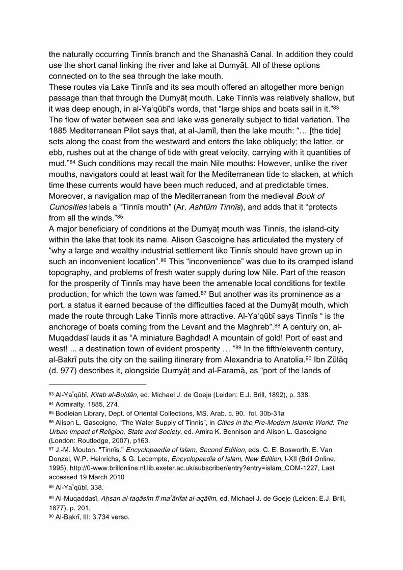
apparently succeeded, for a brief time, in establishing a year-round flow to Alexandria.24 But such results, if every truly achieved, could not be sustained: In 988/1581, for example, Jean Palerne noted that the Alexandria Canal (by then the one rising at al-Raḥmaniyya) was open for just “two or three months” each year.25 Despite its seasonality, the Alexandria Canal was clearly an important waterway to those who used it and sought to keep the connection operational. The importance of the route to Alexandria, relative to the natural Rashīd branch, is apparent in the geographies of al-Khāwarizmī, Suhrāb and Ibn Ḥawqal, who present a unified Khalīj al-Iskandriyya commencing at the Delta apex and ending at Alexandria, even though the upper portion of this route was in effect the upper reaches of the major Rashīd branch, which continued on to Rashīd and the sea. The lower reaches of this apparently unitary waterway were quite different in nature: they comprised an artificial and seasonal canal. None of the authors I have cited denote the modern Rashīd branch in the same fashion, that is, naming it after a destination port at the sea or describing it as a single route: there is no Khalīj Rashīd.26 Moreover, the route to Alexandria is presented first in the text in every case. I argue that the importance of the routes serving Alexandria, and indeed Alexandria’s very importance as a port, are is a directly consequence of conditions at the Rashīd mouth, and perhaps also the Canopic mouth that preceded it. Turning to the waterways of the eastern Delta, the course of the modern Dumyāṭ branch can again be traced in the cartography of Ibn Ḥawqal and al-Idrīsī.27 Also salient to my argument are those distributaries that flowed to Lake Tinnīs, the medieval name for modern Lake Manzala (Figures 1 & 3). Within that lake was the eponymous island-city of Tinnīs, which was served primarily by a distributary that left the Dumyāṭ branch near modern al-Manṣūra, and entered the lake near modern Manzala. This ‘Tinnīs branch’ survives today as the Baḥr Saghīr, a much straightened version of its medieval predecessor. It’s earlier course can still be traced along field boundaries, and it is this that is represented in figure 1. Al-Idrīsī (fl. 1154) also describes a Shanashā Canal (“Khalīj Shanashā”) that he says was an alternative route to Tinnīs through “Lake Zār”.28 The route is unknown today, but it departed the Dumyāṭ branch around Mit Badr Ḥalāwa.29 This route was probably only passable during the Nile flood. Finally, near medieval Dumyāṭ a short canal connected the Dumyāṭ branch to Lake Tinnīs across the narrow bar of land that 24 Al-Maqrīzī, I: 459-466. 25 Jean Palerne ‘Foresein’, Peregrinations dus Iean Palerne Foresien, secretare de seu monseigneur François de Valois, duc d'Anjou, d'Alençon &c. Frere de seu Henry III, Roy de France & de Pologne, ed. Serge Sauneron. Voyage en Égypte, Collection des voyageurs occidentaux en Égypte 2. Cairo: Institut Français d'Archéologie Orientale du Caire, 1971), p. 12. 26 Khawārizmī, Kitāb Ṣūrat al-Arḍ, ed. Hans von Mžik (Leipzig: Otto Harraffowitz, 1926), p. 15-18; Suhrāb, ʿAjāʾib al-aqālīm al-sabaʿ, British Library Oriental Manuscripts MS 23379, p. 48; Ibn Ḥawqal, 139; al-Idrīsī, III: 342. 27 Ibn Ḥawqal, 133-134; al-Idrīsī, III: 338-339. 28 Al-Idrīsī, III: 335. 29 Cooper, The Medieval Nile, I: 55-6.
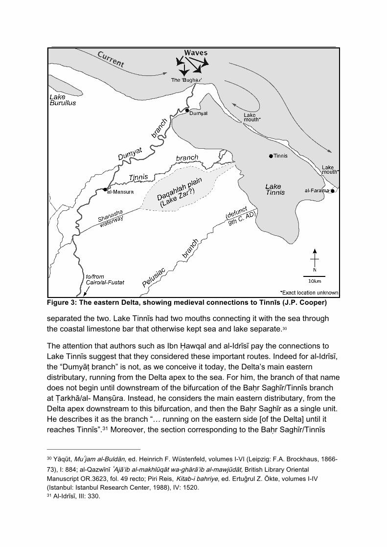
Figure 3: The eastern Delta, showing medieval connections to Tinnīs (J.P. Cooper)
separated the two. Lake Tinnīs had two mouths connecting it with the sea through the coastal limestone bar that otherwise kept sea and lake separate.30
The attention that authors such as Ibn Ḥawqal and al-Idrīsī pay the connections to Lake Tinnīs suggest that they considered these important routes. Indeed for al-Idrīsī, the “Dumyāṭ branch” is not, as we conceive it today, the Delta’s main eastern distributary, running from the Delta apex to the sea. For him, the branch of that name does not begin until downstream of the bifurcation of the Baḥr Saghīr/Tinnīs branch at Ṭarkhā/al- Manṣūra. Instead, he considers the main eastern distributary, from the Delta apex downstream to this bifurcation, and then the Baḥr Saghīr as a single unit. He describes it as the branch “… running on the eastern side [of the Delta] until it reaches Tinnīs”.31 Moreover, the section corresponding to the Baḥr Saghīr/Tinnīs
30 Yāqūt, Muʿjam al-Buldān, ed. Heinrich F. Wüstenfeld, volumes I-VI (Leipzig: F.A. Brockhaus, 1866-73), I: 884; al-Qazwīnī ʿAjāʾib al-makhlūqāt wa-ghārāʾib al-mawjūdāt, British Library Oriental Manuscript OR.3623, fol. 49 recto; Piri Reis, Kitab-i bahriye, ed. Ertuǧrul Z. Ökte, volumes I-IV (Istanbul: Istanbul Research Center, 1988), IV: 1520. 31 Al-Idrīsī, III: 330.
branch he regards as “muʿẓam al-khalīj”, “the greater part of the channel”.32 Once in Lake Tinnīs, vessels could pass on into the sea through the lake mouths. Foul Mouths The ‘Bogaze’ to which Anthoine Morison refers in the quotation that began this paper was the būghāz of Ottoman Egypt, that is, a river mouth. The word is an Arabisation of the Turkish boǧaz, meaning a throat or, geographically, a strait. It was the name given to both the main Rashīd and Dumyāṭ mouths of the Nile. Before the Ottoman conquest, medieval authors used the term ashtum, from the Greek stoma (στόμα), meaning mouth. Crucially, these mouths were turbulent and navigationally hazardous. The completion of the Aswan High Dam, and to a lesser extent other barrages built on the Nile since the nineteenth century, has had a radical effect on sedimentary dynamics in the Delta. Previously, the Nile entered the Mediterranean carrying a substantial sedimentary load,33 and the Delta shoreline was in a state of more-or-less constant progradation as a result.34 Inevitably, much of the sedimentation took place around the Rashīd and Dumyāṭ mouths.35 The result was the formation of two mini-deltas that were the focus of highly dynamic and localised deposition and erosion processes, as well as wave convergences.36 One result was that, at both main mouths, the navigable channel was narrow and constantly shifting. Another was a much-reduced draught compared to the river within and the sea outside. In the late-nineteenth century, the Rashīd mouth had a maximum draught of 2.1m, and the Dumyāṭ mouth just 1.8m, compared to 6m just upstream. 37 The great problem of the mouths was not simply the sedimentary regime, however. Most Mediterranean sailing took place in the summer months – broadly March to October – when relatively benign and predictable wind conditions prevailed in the
32 Al-Idrīsī, III: 336. 33 S.H. Sharaf El Din, “Longshore Sand Transport in the Surf Zone Along the Mediterranean Egyptian Coast”, Limnology and Oceanography, 19 (1974): 182-9, p.185. S.H. Sharf El Din, “Effect of the Aswan High Dam on the Nile Flood and on the Estuarine and Coastal Circulation Pattern Along the Mediterranean Egyptian Coast”, Limnology and Oceanography, 22 (1977): 194-207, p. 196. 34 Douglas L. Inman, David G. Aubrey & Steven S. Pawka, “Application of Nearshore Processes to the Nile Delta”, in Seminar on Nile Delta Sedimentology (University of Alexandria: Academy of Scientific Research and Technology, 1975): 205-233, p.206; Daniel J. Stanley, & Andrew G. Warne, “Nile Delta: Recent Geological Evolution and Human Impact”, Science, 260 (1993): 628-634, p. 630; Colin P. Summerhayes & Nancy Marks, “Nile Delta: Nature and evolution of continental shelf sediments”, in Proceedings of Seminar on Nile Sedimentology, (University of Alexandria: Academy of Scientific Research and Technology, 1975): 162-177, p.162. 35 Morad F. Lotfy and Omran E. Frihy, “Sediment balance in the nearshore zone of the Nile Delta coast, Egypt”, Journal of Coastal Research, 9 (1993): 654-662, p. 655. 36 Omran E. Frihy, & Deborah Lawrence, “Evolution of the modern Nile delta promontories: development of accretional features during shoreline retreat”, Environmental Geology, 46 (2004): 914-931, pp. 914-916; Inman et al, 205. 37 Admiralty, Mediterranean Pilot, Vol.2, pp. 271-272.

open sea.38 Most Nile sailing, particularly for larger vessels, began with the new flood in July/August, and lasted beyond the end of the Mediterranean season, into January-March, depending on the size of the vessel.39 Thus late summer represented the key period for Nile-Mediterranean traffic. The problem for navigators was that benign sailing conditions in the open sea made for danger at the Nile mouths. During the Mediterranean sailing season, the prevailing winds on the Egyptian coast are northwesterly,40 making it a dangerous lee shore. Such conditions rendered it difficult and risky for inbound navigators to anchor outside the Nile mouths while they waited for safe entry conditions. These winds further threatened to blow vessels out of the narrow navigable channel during the entry attempt, onto the sand bars. Moreover, while crossing the open sea, these winds also generate extensive wave fields that ultimately bear down on the Egyptian coast.41 At the mouths, these waves encountered both the shallows created by the deposition of river sediment and also the countervailing river current. The result was widespread turbulence and standing waves. What is more, since much of the navigation took place during the flood, the situation was at its most acute: the mean current velocity of the Rashīd branch at flood was twice that at low Nile, and the volume many times greater.42 Contemporary medieval accounts of conditions at the main Nile mouths are few, but nevertheless present. Al-Bakrī in the fifth/eleventh century says of the Rashīd mouth: “This is a frightening place for ships. The waves of the Nile are greatest there due to the Nile current, and banks of sand rise up beneath the water.”43 Three centuries
38 Admiralty, Mediterranean Pilot, Vol.5: Comprising the coasts of Libya, Egypt, Palestine and Syria, the south coast of Turkey, and the Island of Cyprus (London: His Majesty's Stationery Office, 1937): pp. 8-9; Fernand Braudel, The Mediterranean and the Mediterranean World in the Age of Philip II, Volumes I-II (Glasgow: Fontana, 1949), I: 246; Meteorological Office, Weather in the Mediterranean. Second edition (London: Her Majesty's Stationery Office, 1962), pp. 3-5; John H. Pryor, Geography, technology and war: Studies in the maritime history of the Mediterranean, 649-1571 (Cambridge: Cambridge University Press, 1988), pp. 16-19; Lionel Casson, Ships and Seamanship in the Ancient World (Princeton: Princeton University Press, 1971), p. 270; Goitein, I: 316-7. 39 Ibn Ḥawqal, 137; Cooper, The Medieval Nile, I: 74-95. 40 Ministry of Public Works, Climatological Normals for Egypt and the Sudan, Candia, Cyprus, and Abyssinia (Cairo: Government Press, 1922), p. 13. 41 Frihy & Lawrence, 919, 924; Mary G. Nafaa, Alfy M. Fanos, & Mohamed N. El Ganainy, “Characteristics of waves off the Mediterranean coast of Egypt”, Journal of Coastal Research, 7 (1991): 665-676, p.671; Sharaf el Din, 183; Daniel J. Stanley, & Andrew G. Warne, “Nile Delta Geography at the Time of Heracleion and East Canopus”. In Geoarchaeology: Underwater Archaeology in the Canopic Region in Egypt, ed. Daniel J. Stanley (Oxford: Oxford Centre for Maritime Archaeology, 2007): 5-22, p.7. 42 William Willcocks, The Nile in 1904 (London: E & F.N. Spon, 1904), p. 121. I have encountered no data for the Dumyāṭ branch. 43 Al-Bakrī, al-Mamālik wa-l-masālik, ed. Yusuf Kamal [Monumenta Cartographica Africae et Aegypti, volume III] (Leiden: Printed for the Author, 1933), 3.731v.
later, Abū al-Fidāʾ (671–731/1273–1331) says that “…boats entering from the sea fear it.”44 Accounts are more plentiful from the tenth/sixteenth century onward, following the Ottoman conquest of Egypt. Many of these are from European travellers, who provide first-hand accounts of the dangers of the main mouths. Some examples follow. The French pilgrim Jean Palerne exited the Dumyāṭ mouth in 988/1581. He did so: “… not without great peril, all the mouths being very dangerous, because the sea obstructs their course, which is quite straitened … It is a maxim: the more one seeks to block its course, the more the water becomes violent. A boat [caught] between two opposing currents can only become marvellously agitated, and in danger of sinking, if one does not follow the channel well.”45 Johan Wild (fl. 1021/1613) says of the Rashīd mouth: “There are large waves there, and a bore … so much so that it is dangerous to pass.”46 George Sandys (fl. 1023/1615) reports that the sand bar shifted “… according to the changes of the winds, and beating of the surges.”47 In the eighteenth century, Claude Savary (1163-1202/1750-1788) reports that: “The Bogaz [of Rashīd] … is a formidable shoal ... When the wind freshens, the waves then run mountain-high, and form whirlpools, which swallow up vessels. The Bogaz is very shallow, and … there is usually only one passage of a few toises breadth [1 toise = 1.95m], where ships can pass. The passage is continually shifting.”48 He adds that: “The bar of the Nile [at the mouth] is totally shut during two months of the year [i.e. during low Nile], and the commerce of Alexandria is interrupted.”49 Passage became easier on those relatively few days in the sailing season when the wind blew from the south, and the Mediterranean waves were driven back.50 Joseph Pitts of Exeter (fl. 1087/1677) waited “several days” for such conditions in order to
44 Abū al-Fidāʾ, Taqwīm al-buldān, ed. Joseph T. Reinaud, & William Mac Guckin de Slane (Paris: Imprimerie royale, 1840), p.117. 45 Palerne, 174. 46 Johan Wild, Neue Reysbeschreibung eines Gefangenen Christen Anno 1604, ed. Oleg V. Volkoff, Voyages en Egypte. Collection des voyageurs occidentaux en Égypte, 8 (Cairo, Institut Français d'Archéologie Orientale du Caire: 1973), p.11. 47 George Sandys, A Relation of a Iourney begun An. Dom: 1610. (London: W. Barrett, 1615), p. 116. 48 Claude É. Savary, Letters on Egypt, with a parallel between the manners of its ancient and modern inhabitants: and an account of the descent of St. Lewis at Damietta: extracted from Joinville, and Arabian authors, Volumes I-II (London: G.G.J. and J. Robinson, 1786), I.59. 49 Savary, I: 61. 50 Jean Coppin, Relation des voyages faits dans la Turquie, la Thebaide, et la Barbarie: contentant des avis politiques qui peuvent servir de lumieres aux Rois & aux Souverains de la Chrétianité, pour garentir leurs Etats des incursions des Turcs, & reprendre ceux qu'ils ont usurpé sur eux, ed. Serge Sauneron [Voyage en Egypte. Collection des voyageurs occidentaux en Égypte, 4] (Cairo: Institut Français d'Archéologie Orientale du Caire, 1970), p. 303.

pass out of the Rashīd mouth, saying that often: “… Vessels are forced to wait ten or twelve Days.”51 During the Ottoman period, and perhaps also before it, pilots were employed to monitor changes in the navigable channels.52 Such precautions did not, however, guarantee a safe passage, as Savary reports: “Night and day a boatman sounds with his lead in his hand to point to navigators the course they must pursue, but frequently … they miss the passage, strike on the sand, and in a few minutes, all is overwhelmed in a whirlpool of mud and water. Every year is marked by a great number of shipwrecks.”53 The reputation of the mouths for wrecking ships is noted by several other travelers: space considerations present the citing them all here.54 Hans Teufel (fl. 996/1588) describes his own narrow escape when leaving the Dumyāṭ mouth in November 1588: “Exiting this mouth, in a germe [= jarm, a coasting barge55] we beached on a sandbank because the violence of the sea pushed us out of the channel … our germe became almost full of water, to the point that we were in great danger. But Almighty God helped us, and each of us pushed forcefully, using oars and poles, until we were able to lift the germe off the sandbank …”56 At the same mouth in the early 1630s, Stochove (fl. 1052/1643) reports that “we ran the risk of being lost, because three times we saw our boat half covered by water”.57 Morison passed safely through the Rashīd mouth in October 1697, but saw another vessel wrecked, with great loss of life.58 The “great handicap” In her influential work on the geography of the Mediterranean, the American geographer Ellen Semple characterises the Nile mouths as “Egypt’s great handicap,” although she does not elaborate on the nature of this impediment.59 The immediate sufferers from this situation were, in the period covered by this paper, the towns of
51 Joseph Pitts, A Faithful Account of the Religion and Manners of the Mahometans (London: T. Longman, 1738), p. 93. 52 Sandys, 116. 53 Savary, I:59-60. 54 Morison, 184; Pitts, 93; Paul Lucas, Voyage du Sieur Lucas au Levant, volumes I-II (La Haye: Guillaume de Voys, 1705), I:29. 55 Cooper, The Medieval Nile, I: 80-81, 111-112; II: 144. 56 Hans C. Teufel, Voyage, ed. Nadine Sauneron & Serge Sauneron, [Voyages en Égypte. Collection des voyageurs occidentaux en Égypte, 6] (Cairo: Institut Français d'Archéologie Orientale du Caire, 1972): 147-187, p. 187. 57 Vincent de Stochove, Voyage du Sieur de Stochove faictes années 1630, 1631, 1632, 1633, ed. Baudouin van de Walle [Voyage en Égypte. Collection des voyageurs occidentaux en Égypte, 3] (Cairo: Institut Français d'Archéologie Orientale du Caire, 1975), p. 4. 58 Morison, 22. 59 Ellen C. Semple, The Geography of the Mediterranean Region: Its Relation to Ancient History (London: Constable & Co., 1932), p.152.
Rashīd and Dumyāṭ, which lie close within the mouths of their eponymous distributaries. Any endeavour to understand the relative importance of these towns compared to Egypt’s other Mediterranean coastal ports is inevitably qualitative. There are several lacunae in the data, not least the scarcity of historical texts available from before the fourth/tenth centuries. Nevertheless, both medieval Rashīd and Dumyāṭ emerge from the historical accounts as ports of relatively junior significance. The very existence of Rashīd is entirely overlooked by the historians al-Balādhurī (d. 278/892), and al-Ṭabarī (d. 310/923), by the geographers al-Khawārizmī (d. 850), al-Farghānī (fl. 246/861), Ibn Rustah (fl. 290-300/903-13), Qudāmah (d. 309/922), Suhrāb (before 945), Istakhrī (d. 346/957-8), Ibn al-Kindī (fl. before 968), al-Muhallabī (b. 385/996), and the anonymous Kitāb Ṣūrat al-Arḍ (288/before 901) and Ḥudūd al-ʿĀlam (372/983). Others note only its geographical location.60 The ʿAbbāsid Kitāb al-Istibṣar61 and al-Idrīsī name Rashīd as a populous settlement, but acknowledge no port function for it. Meanwhile, al-Maqrīzī gives an indication of Rashīd’s relative insignificance in the sixth/twelfth century, when he reports government revenue for towns of the Delta in the year 585 AH (1189/90). Even though this was before the great Mamlūk refurbishments of the Alexandria Canal, which further disadvantaged the town, Rashīd produced revenues of just 1,000 dinars, compared to 800,138 from nearby Alexandria, and 1.2 million from the Delta as a whole.62 By the seventh/thirteenth century, during the latter part of which Egypt’s rulers carried out improvements to the canal connections to Alexandria, Rashīd appears to have gone into abeyance. Even though Crusader armies were at this time targeting Egypt, texts such as La Devision de la Terre de Oultremer (610/1214), De Situ Civitatum Egypti, the Peregrinatio of Thetmer (613/1217), and the Speculum of de Beauvais (d. ca. 662/1264) fail to note even Rashīd’s existence. Oliver of Padeborn (d. 624/1227) believed the town was “in ruins”.63 Meanwhile, Yāqūt, says in was a “small town”,64 and the Devise des Chemins de Babiloine describes it as a “village”.65
60 Ibn Zūlāq, Faḍāʾil Miṣr, ed. Yusuf Kamal, [Monumenta Cartographica Africae et Aegypti, volume III] (Leiden: Printed for the Author, 1933), 2.685v; Ibn Yūnis, al-Zidj al-Kabīr al-Hākimī, ed. Yusuf Kamal, [Monumenta Cartographica Africae et Aegypti, volume III] (Leiden: Printed for the Author, 1933), 3.707r; Abū al-Salt, in Yāqūt, Muʿjam al-Buldān, ed. Heinrich F. Wüstenfeld (Leipzig: F.A. Brockhaus, 1866-73, volume IV), p. 548; Abū Sāliḥ, Taʾrīkh, ed. Basil T.A. Evetts (Oxford: Clarendon Press, 1895), p. 10-11; Benjamin of Tudela, Massaʾot Binyamin, ed. Yusuf Kamal, [Monumenta Cartographica Africae et Aegypti, volume III] (Leiden: Printed for the Author, 1934), 4.879v-r, p.879r. 61 Kitāb al-Istibṣār, ed. Yusuf Kamal, [Monumenta Cartographica Africae et Aegypti, volume III] (Leiden: Printed for the Author, 1934), 4.908v-915r, p.908r. 62 Al-Maqrīzī, I.233. 63 Oliver of Padeborn, Historia Damiatina, ed. Yusuf Kamal, [Monumenta Cartographica Africae et Aegypti, volume III] (Leiden: Printed for the Author, 1934), 4.937v-938v, p.938v. 64 Yāqūt, II. 781-782. 65 La Devise des Chemins de Babiloine, in Itinéraires à Jérusalem et Descriptions de la Terre Sainte Rédiges en Français , ed. Henri V. Michelant and Gaston Reynaud (Geneva: Imprimerie Jules-Guillaume Fick, 1882), pp.239-252, p.245.
By the eighth/fourteenth century, al-Dimashqī (ca. 653-727/1256-1327) reports that it “had become overwhelmed by sand … and its people had moved to Fuwa,” although it retained its status a defensive thughr, or frontier garrison.66 The removal of Rashīd’s population to Fuwa probably occurred with the opening in 710/1310 of the new Alexandria Canal starting at al-ʿAtf: Fuwa commanded traffic on both canal and river. Other Mamlūk-era Egyptian authors note Rashīd’s marginal status. Ibn Duqmāq (d. 809/1407) reports that its “…population is very few, and generally fishermen or wildfowlers.”67 Al-Qalqashandī (756-820/1356-1418) considers it a “village”, albeit a thughr.68 Despite the growth in Italian trade with Egypt at this time, and the concomitant growth in Italian cartography of the Delta, Italian portulans often note the existence of the Rashīd branch, but not the town itself.69 Dumyāṭ, suffers a similar fate in the historical accounts to that of Rashīd, at least until the late sixth/twelfth century, when military circumstances, discussed below, prompted a change in fortune.70 The town is named in histories of the Islamic conquest,71 was fortified by al-Mutawakkil (r. 232-246/847-861), and was given thughr status.72 It is mentioned more frequently in the medieval geographies than Rashīd: for example in al-Khawārizmī, al-Farghānī, Ibn Rustah, Qudāma, Suhrāb (before 945), Istakhrī, and the Kitāb Ṣūrat al-Arḍ,73 none of which acknowledge Rashīd. However, while these texts note the town’s geographical location and its textiles industry, they again have nothing to say about Dumyāṭ as a port. Al-Muqaddassī (945-988/333-377) eulogises Dumyāṭ as he did Tinnīs, but this time
66 Al-Dimashqī, Nukhbat al-dahr fī ajāʾib al-burr wa-l-baḥr, ed. August F. Mehren (St. Petersburg: Imprimerie de l'Académie Impériale des sciences, 1866), p.231. 67 Ibn Duqmāq, Kitāb al-intiṣār, ed. Karl Vollers (Cairo: Imprimiere Nationale, 1893), pp. 113-114. 68 Al-Qalqashandī, Ṣubḥ al-aʿshā, volumes I-XIV (Cairo: Dār al-Kutub al-Khidaywīyah, 1913-1922), II: 184; III: 236, 292, 307, 409, 380; XIV: 52, 65. 69 Vesconte, Untitled, in Yusuf Kamal, IV: 1.1140v; Marinus Sanutus (Cooper, The Medieval Nile, appendix. 1, figure. 23); Angelino Dalorto, Planisphere, in Yusuf Kamal, IV: 2.1196v-1197r; Angelino Dulcert, Planisphere, in Yusuf Kamal, IV: 2.1221r-1222v; Franceso & Marco Pizigani, Quam Pizzigani Fratres Terrae Marisque Periegesin Membranis Consignabant Venetiis Anno MCCCLXVII, in Edme F. Jomard. Les Monuments de la Geographie ou Receuil d’Anciens Cartes Euorpéennes et Orientales (Paris: Librairie de l’Institut et de la Bibliotheque Impériale, 1854), pl. X.1-3. 70 The site of the early medieval city of Dumyāṭ, abandoned following the Crusader siege of 1250, is not known for certain. It was downstream of the modern city. 71 Al-Balādhuri, Kitāb Futūḥ al-Buldān, ed. Michael J.de Goeje (Leipzig: O. Harrassowitz, 1917): 216-7; Al-Maqrīzī, I: 581-582. 72 Al-Maqrīzī, I: 582-583; Yāqūt, II: 604. 73 Khawārizmī, p. 15-18; al-Farghānī, Kitāb fī al-ḥarakah al-samāwiyah wa jawāmiʿ ʿilm al-nujūm, ed. Jacob Golius (Amsterdam: Johannem Jansonium, 1669), p. 36-37: Ibn Rustah, Kitāb al-aʿlāk al-nafīsa, ed. Michael J. de Goeje, (Leiden: E.J. Brill, 1892), p. 90; Qudāma, Kitāb al-kharāj wa ṣanʿat al-kitāba, ed. Michael J. de Goeje (Leiden: E.J. Brill, 1889), p. 247; Suhrāb, p. 48; Iṣṭakhrī, Kitāb masālik al-mamālik, ed. Michael J. de Goeje (Leiden: E.J. Brill, Leiden: 1870) 52; Kitāb Ṣūrat al-Arḍ, III: 1.555 recto.
makes no reference to its port function.74 The only historical references to the town as a port are by Isḥāq ibn al-Ḥusayn (fl. ca. 338/950), who writes that “from there one sails to the Byzantine lands”,75 and Ibn Zūlāq (d. 366/977), who, as we have seen, groups it with Tinnīs and al-Faramā as one of the ports of the eastern Delta.76 Circumvention strategies Hazard at the Nile mouths was one reason that Dumyāṭ and Rashīd suffered as ports serving the Nile-Mediterranean interface. The other was that safer alternatives existed – or were created – in both the western and eastern Delta. In the west, the great alternative port to Rashīd was Alexandria, and the various waterborne and terrestrial routes that served it. The superiority of Alexandria’s natural harbour have been widely discussed,77 and while its political status diminished following the Islamic conquest, it continued to function as a port whose significance over time was closely tied to Egypt’s Mediterranean commerce in general. Alexandria offered a secure, deepwater harbour on an otherwise lee shore that had few natural havens. While seagoing vessels bound for the Rashīd mouth had no guarantee of finding it passable on arrival, leaving them exposed, the shelter afforded by the Ras al-Ṭīn peninsula at Alexandria offered a ready resort in all but the wildest conditions.78 However, Alexandria had a great drawback, and that was its remoteness from the Nile. For as long as the Canopic branch had persisted in a natural state, Egyptians had been able to secure and maintain a waterborne connection to the port through the relatively short (ca. 40km) Schedia canal. However, once that branch had ceased to flow naturally, maintenance of an aquatic connection to Alexandria became a far more onerous undertaking. The route described by Ibn Ḥawqal and al-Idrīsī, for example, involved the upkeep of 130km of canal. Its Mamlūk successors reduced that length considerably – to 80km in the case of al-ʿAṭf – but nevertheless the commitment, in terms of labour and financial resources, remained considerable. The very existence of Alexandria – and the need to maintain waterway connections to it – is difficult to understand without an appreciation of the hazard that the alternative route through the Rashīd mouth (and probably the Canopic mouth in earlier times) presented. The Alexandria Canal, in its various manifestations over time, was almost always a seasonal waterway, open only during the Nile flood. It was the route of choice during this late-summer and early-autumn peak season of traffic on the river and the Mediterranean. In contrast, the Nile mouths at this time were at their most turbulent.
74 Al-Muqaddassī, 201-202. 75 Isḥāq ibn al-Ḥusayn, Kitāb ākām al-murjān fi dhikr al-madāʾin al-mashhūra fī kul makān, ed. Agostino Codazzi, Rendiconti della R. Accademia Nazionale dei Lincei: Classe di Scienze Morali, Storiche e Filologiche, Serie 6, 5 (1929): 373-463, p. 403. 76 Ibn Zulāq, III: 2.686 verso. 77 Ibn Baṭūṭa, Tuḥfat al-nuẓār fī gharāʾib al-amṣār wa-ʿajāʾib al-asfār, ed. Charles Defrémery & Beniamino R. Sanguinetti, volumes I-IV (Paris: Imprimerie Impériale, 1853-1859), I.28. 78 Ibn Baṭūṭa, I.27, 29-30.

Thus, while the canal was not open year-round, it was at least in operation during the key commercial season, and the most dangerous period for traversing the Rashīd mouth. When the Alexandria Canal was closed, navigators, and merchants, faced choices. From at least as early as the sixth/twelfth century, the al-Ḥāfir canal was, as we have seen, available to them as an alternative for at least some of the season in which the Alexandria canal was dry. The cutting beween the Rashīd branch and Lake Idkū was probably only about 5km long: al-Maqrīzī says it was “half a day” long.79 Most of the route was across Lakes Idkū and Abū Qīr, which al-Idrīsī tells us carried vessels to a lake shore close to Alexandria: the final leg was covered by transshipment onto pack animal. By taking this route, navigators were again able to avoid the Rashīd mouth on their journey to Alexandria. Navigators and merchants could therefore make strategic choices about when to travel that affected their risk profile. For example, a Geniza letter dated 23 October 1140 from a merchant in Alexandria urges its recipient in al-Fusṭāṭ (Cairo) to send him merchandise “quickly”, before the Alexandria canal fell out of use.80 To delay would have been to narrow the shipper’s options, and perhaps compel him to take another, perhaps riskier, route. Of course, the very fact that accounts of travelers passing through the Rashīd (and Dumyāṭ) mouth exist demonstrates that, in certain eras and in certain seasons, the sea route to Alexandria via the mouth was indeed ventured. In such circumstances, a number of technological and practical precautions could be taken to mitigate the risk. First, the flat-bottomed jarm (pl. jurūm) – more substantial than Nile river craft, yet drawing less water than sea-going craft – was often used to traverse the mouths.81 Moreover, as we have seen, pilots with local expertise were employed both to monitor change in the navigable channel, and to pilot craft through it. In addition, merchants sometimes hedged their risk, sending bulky lower-value goods by way of the Rashīd mouth, while dispatching lighter and more valuable merchandise on the land-route that followed the coast between Alexandria and the river at Rashīd.82 It is in these appraisals of risk – based, no doubt, on experience, socially-reproduced knowledge, and personal appreciations of need – that the hand of the individual navigator and merchant can be discerned. In the eastern Delta, navigators did not have to rely on excavated and seasonal canals to secure an alternative link between Nile and Mediterranean that avoided a hazardous Nile mouth – in this case that at Dumyāṭ. Already available to them were
79 Al-Maqrīzī, I: 1.459 80 Goitein, I: 298. 81 Samuel Keichel, Voyage, ed. Ursula Castel, Nadine Sauneron, & Serge Sauneron, Voyages en Egypte. Collection des voyageurs occidentaux en Égypte, 6 (Cairo: Institut Français d'Archéologie Orientale du Caire, 1972), p.44; Gabriel Brémond, Viaggi Fatti nell'Egitto, ed. Georges Sanguin, Voyage en Egypte. Collection des voyageurs occidentaux en Égypte, 12 (Cairo: Institut Français d'Archéologie Orientale du Caire, 1974), p.37. 82 Coppin, 162; Brémond, 37.
the naturally occurring Tinnīs branch and the Shanashā Canal. In addition they could use the short canal linking the river and lake at Dumyāṭ. All of these options connected on to the sea through the lake mouth. These routes via Lake Tinnīs and its sea mouth offered an altogether more benign passage than that through the Dumyāṭ mouth. Lake Tinnīs was relatively shallow, but it was deep enough, in al-Yaʿqūbī’s words, that “large ships and boats sail in it.”83 The flow of water between sea and lake was generally subject to tidal variation. The 1885 Mediterranean Pilot says that, at al-Jamīl, then the lake mouth: “… [the tide] sets along the coast from the westward and enters the lake obliquely; the latter, or ebb, rushes out at the change of tide with great velocity, carrying with it quantities of mud.”84 Such conditions may recall the main Nile mouths: However, unlike the river mouths, navigators could at least wait for the Mediterranean tide to slacken, at which time these currents would have been much reduced, and at predictable times. Moreover, a navigation map of the Mediterranean from the medieval Book of Curiosities labels a “Tinnīs mouth” (Ar. Ashtūm Tinnīs), and adds that it “protects from all the winds.”85 A major beneficiary of conditions at the Dumyāṭ mouth was Tinnīs, the island-city within the lake that took its name. Alison Gascoigne has articulated the mystery of “why a large and wealthy industrial settlement like Tinnīs should have grown up in such an inconvenient location”.86 This “inconvenience” was due to its cramped island topography, and problems of fresh water supply during low Nile. Part of the reason for the prosperity of Tinnīs may have been the amenable local conditions for textile production, for which the town was famed.87 But another was its prominence as a port, a status it earned because of the difficulties faced at the Dumyāṭ mouth, which made the route through Lake Tinnīs more attractive. Al-Yaʿqūbī says Tinnīs “ is the anchorage of boats coming from the Levant and the Maghreb”.88 A century on, al-Muqaddasī lauds it as “A miniature Baghdad! A mountain of gold! Port of east and west! ... a destination town of evident prosperity … ”89 In the fifth/eleventh century, al-Bakrī puts the city on the sailing itinerary from Alexandria to Anatolia.90 Ibn Zūlāq (d. 977) describes it, alongside Dumyāṭ and al-Faramā, as “port of the lands of 83 Al-Yaʿqūbī, Kitab al-Buldān, ed. Michael J. de Goeje (Leiden: E.J. Brill, 1892), p. 338. 84 Admiralty, 1885, 274. 85 Bodleian Library, Dept. of Oriental Collections, MS. Arab. c. 90., fol. 30b-31a 86 Alison L. Gascoigne, “The Water Supply of Tinnis”, in Cities in the Pre-Modern Islamic World: The Urban Impact of Religion, State and Society, ed. Amira K. Bennison and Alison L. Gascoigne (London: Routledge, 2007), p163. 87 J.-M. Mouton, "Tinnīs." Encyclopaedia of Islam, Second Edition, eds. C. E. Bosworth, E. Van Donzel, W.P. Heinrichs, & G. Lecompte, Encyclopaedia of Islam, New Edition, I-XII (Brill Online, 1995), http://0-www.brillonline.nl.lib.exeter.ac.uk/subscriber/entry?entry=islam_COM-1227, Last accessed 19 March 2010. 88 Al-Yaʿqūbī, 338. 89 Al-Muqaddasī, Aḥsan al-taqāsīm fī maʿārifat al-aqālīm, ed. Michael J. de Goeje (Leiden: E.J. Brill, 1877), p. 201. 90 Al-Bakrī, III: 3.734 verso.

Byzantium, the Frankish periphery, Cyprus, the whole length of the Levant coast and the entrepôts of Iraq.”91 Nāṣir i Khusraw (394-480/1004-1088), who arrived in Tinnīs by ship from the Levant in 1048, says of the Fāṭimid town: “ … there are at any given time at least a thousand ships at anchor belonging both to private merchants and the sultan.”92 The native official Ibn Bassām al-Tinnīsī (ca. fifth/eleventh-sixth/twelfth centuries) says that in his time: “The number of exporting qawārib, kamāʾim and ʿushariyyāt [types of vessel] that arrive from the Levant route each year is near five hundred.” on the Nile side, “… they come in from the regions of Cairo, Upper Egypt, Alexandria and the remote countryside. They are innumerable they are so many.”93 Ultimately, Tinnīs’s navigational advantages were not enough to guarantee its prosperity. In the late sixth/twelfth century, the Ayyūbid leader Salāḥ al-Dīn had Dumyāṭ built up as a major fortification and river-mouth control, while ordering the abandonment of Tinnīs as a civil settlement in 588 AH (1192-1193). This left only a fort at Tinnīs, which the Egyptian authorities proceeded to raze following the Crusader siege of 614/1218.94 Between 585 AH (1153/54) and 625 AH (1218), Tinnīs proved repeatedly to be vulnerable to siege from Christian raiders. Dumyāṭ, with its huge fortifications and defensive chain slung across the river, was better defended and more easily supplied and relieved. The priorities of a threatened Ayyūbid and later Mamlūk state thus shifted away from navigational ease in favour of more effective defense of the realm. Thereafter, the navigational norms of the eastern Delta appear to have been overturned. Arab and Crusader texts from the time describe Dumyāṭ as the “key of Egypt”,95 through which merchant vessels “from Venice, Antioch, Genoa, Armenia, Greece, Egypt and other ports and islands of the sea”96 were obliged to pass, and where customs controls were exercised. Whereas the Dumyāṭ mouth had been a place navigators preferred to avoid, it now appears to have become an obligatory passage for those entering the eastern Delta: hence it was that the travellers Palerne, Sandys, Wild, Coppin and Stochove passed this way in later centuries. However, the switch to Dumyāṭ was not as radical, from a navigational perspective, as at first it seems. Even though Tinnīs itself was abandoned, navigators continued to use routes through the lake in order to avoid the Dumyāṭ mouth. It was at Tinnīs, and not Dumyāṭ, where Niccolò di Poggibonsi (fl. 745-750/1345-1350) arrived on a
91 Ibn Zulāq, Faḍāʾil miṣr, ed. Yusuf Kamal, III: 2.685 recto. 92 Nāṣir i Khusraw, Safarnama, ed. Wheeler M. Thackston (New York: Centre for Iranian Studies, Colombia University, 1986), p. 39. 93 Al-Tinnīsī, Anīs al-jalīs fī akhbār tinnīs, ed. Jamāl A. al-Shayyāl, (Cairo: Maktabat al-Thaqāfa al-Dīniyya, 2000), p. 40. 94 Cooper, The Medieval Nile , II: 157. 95 Abū Shāma (1203-1267),Kitāb al-Rawḍatayn, ed. Charles Barbier de Meynard (Paris, Imprimèrie Nationale, 1898), p. 167-168. 96 De Situ Civitatum Egypti Regalium, ed. Yusuf Kamal, III: 4.933 verso.

ship from Beirut in 745/1345, en route to Cairo.97 In the ninth/fifteenth century, Ghillebert de Lannoy (fl. 823-824/1421-1422) makes clear that vessels continued to use the short canal connecting the Dumyāṭ branch to the lake, and thence the lake mouth, in order to avoid the Dumyāṭ mouth. Indeed, he gives a detailed description of both route and logistics: “In the town of Damietta there is yet, parting from the Nile river, a narrow branch of running water, made by hand like a trench, passing through the gardens of the town for a good four miles, [and] which flows a good six miles from Damietta into a large lake of salt water called Lescaignon [i.e. Lake Tinnīs] … Through this riverlet, which is [just] two or three feet [60-90 cm] deep when the water of the great river is low, go many small unladen gripperies [a vessel type] from Damietta into this Lescaignon lake, which is deep enough for them. There they wait for goods to be loaded onto them: other smaller boats come from Damietta carrying these goods, which they load onto these gripperies and germes [Ar. jarm (sing.)]. This place where they load, also on the lake, is 25 or 30 miles from Damietta. Then, thus laden, they go the length of the lake of Lescaignon, which has a depth of four or five feet of water, to the mouth of the port of Tinnīs … where the high sea reaches. And [thus] by this straight river, coming normally from Damietta, these small vessels porter their goods, so that they do not have to go through the large mouth of the river at Damietta, which is so dangerous.”98 At times during low Nile when this canal was too shallow for them, the larger vessels sailed out through the Dumyāṭ mouth empty: they then entered the lake via its sea mouth, and loaded their cargoes within the lake at the same site as vessels arriving directly through the Dumyāṭ canal. They then returned out to sea via the lake mouth.99 Thus, even when Dumyāṭ had become the chief port of the eastern Delta, the routes that avoided the Dumyāṭ mouth continued to be used. Discussion The rootedness of maritime landscape studies in a particular environmental context often inspires interpretations that are products of the particular environmental conditions – meteorological, hydrographical, geological – influencing maritime activity, and the human technological responses to such conditions. Johan Rönnby expresses this as a dilemma: “How should an academic discipline, which is defined by its studies in a certain physical milieu, avoid the trap of environmental determinism and still be able to argue for the special influence of the maritime factor?”100 In an era when many in mainstream archaeology and landscape studies
97 Niccolò di Poggibonsi, Libro d’Oltromare, ed. T. Bellonini and E. Hoade (Jerusalem: Fransiscan Press, 1945), p. 84. 98 Ghillebert de Lannoy, Oeuvres, (Voyages et ambassades), ed. Charles Potvin. (Louvain: Imprimerie de P. et J. Lefever, 1878). p. 136-137. 99 Ghillebert de Lannoy, Oeuvres, p. 137. 100 John Rönnby, “‘Maritime Durees’ Long-Term Structures in a Coastal Landscape”, Journal of Maritime Archaeology, 2 (2007): 65-82, p. 65.
have eschewed concepts of environmental determinism, functionalism, and system theory101, has the very notion of a ‘maritime cultural landscape’ been left high and dry? Or does the very nature of maritime activity make it an ideal context in which to explore the three-way encounter between agency, society, and environment? As Fraser Sturt argues, any exclusively humanist interpretation of a maritime landscape – sea, coast, lake, or river – is lacking if it does not admit a role for the bio-physical environment in somehow constraining and enabling maritime activity.102 Certainly, scholars of maritime landscapes have tended to admit something approaching a structuring role for the environment. Pioneers such as Christer Westerdahl drew on the structuralist Fernand Braudel’s conceptions of “inner seas”,103 as well as on transport geography, to propose a model of the maritime cultural landscape that was directly related to ship technology and the physical milieu. He proposed a notion of structured ‘transport zones’ within the landscape, defined by a given ship technology that was “intimately adapted to the natural geography of the zone in question.”104 At the meeting point of these zones were transition points marking the limit of a given technology’s effectiveness: “At the transition to another zone there are often found natural obstacles of different kinds (the river mouth banks, other sediments in sea routes, mountain ranges, rapids or cataracts, with portages, hauling or carrying sites, dangerous points, promontories and shallows/banks[)]. They mean the reloading of cargo and the change of means of transport at a well-defined site (transit/ion point, transit/ion/ pivot) [sic.], for an accompanying water or land transport in the new zone.”105 What emerges is a model of maritime activity within landscape that is rooted in the physical environment, and constrained by the available technological responses to it. Such an unequivocally structural approach to the maritime landscape is perhaps no longer current, and indeed has been criticised, notably by A.J. Parker, both for its lack of empathy with the “sailor”, and for its predictive shortcomings.106 Certainly, it flies in the face of wider theoretical trends since Christopher Tilley’s articulation of a phenomenological approach to landscape in 1994,107 which heralded a new era that 101 Matthew Johnson, Archaeological Theory: An Introduction, (Oxford: Blackwell, 1999). p. 75, 98-108. 102 Fraser Sturt, “Local knowledge is required: a rhythmanalytical approach to the late Mesolithic and early Neolithic of the East Anglian Fenland, UK”, Journal of Maritime Archaeology, 1 (2006): pp. 119–139 103 Fernand Braudel, The Mediterranean and the Mediterranean World in the Age of Philip II, volumes I-II (Glasgow: Fontana, 1949). 104 Christer Westerdahl, “The maritime cultural landscape. On the concept of the traditional zones of transport geography”, http://www.abc.se/~m10354/publ/cult-land.htm, (1998). Last accessed 18 March 2010. 105 Westerdahl 1998; See also Christer Westerdahl, “Maritime cultures and ship types: brief comments on the significance of maritime archaeology”, International Journal of Nautical Archaeology 23(4) (1994): pp. 267-269. 106 A.J. Parker, “Maritime Landscapes”, Landscapes, 1 (2001): 22-41. 107 Christopher Y. Tilley, A phenomenology of landscape: places, paths, and monuments, (Oxford: Berg Publishers, 1994).

favoured ontological and cognitive themes within landscape study, and that largely set aside the thorny problem of environmental constraint-and-facilitation. Moreover, much enquiry has also gone into the notion of human engagement with the landscape through labour and the insights this can yield into past existence.108 So, in identifying the Nile mouths as somehow determinant in human navigation of the Nile-Mediterranean interface, are we reverting to deploying environmentally deterministic arguments to explain navigational behaviour and maritime landscapes? From a structuralist perspective, the Nile mouths begin to resemble the ‘transit points’ of Westerdahl, separating the ‘transport zones’ of Nile and Mediterranean, each of which contain ship technologies appropriate to the prevailing conditions found there. But while such a characterisation achieves a certain descriptive success, it does little to illuminate the societal forces deciding and indeed creating the routes in question, nor does it acknowledge a role for the navigator as agent in strategising his or her route on the basis of personal knowledge and risk-reward assessments. Instead, human responses to the Nile mouths should perhaps be seen on three different and interacting levels – the environmental, the societal and the individual. Certainly, the bio-physical environment – hydrological, meteorological, sedimentological, and oceanographic – must be recognised in forming the uniquely challenging locales represented by the Nile mouths, just as they also formed the naturally occurring river channels, lakes and open sea that made water-borne movement possible in the first place. However, the case of the Alexandria canals in particular demonstrates that medieval Egyptian society was capable, as a collective, of responding to such environmental ‘givens’ with radical and far-reaching landscape responses. It was only through a socially organised and centrally orchestrated response that Alexandria retained a connection to the Nile at all. Clearly, it was not within the gift of the individual navigator, faced with the hazards of the Rashīd mouth, to overcome those hazards by creating a canal: this was a decision taken by high-level power-holders. Moreover, there were times when those holding power were able and willing to mobilise the maintenance of the canal(s) on an annual basis, and on occasion to create a new route through the labours of those over whom they held power. In this regard, al-Maqrīzī reports the arguments advanced by the governor of Alexandria, who was lobbying Ibn Qalāwūn, ultimately successfully, to undertake a re-routing of the canal. These were that the canal would improve the transport of food and goods to and from the city; boost customs revenues from trade through the port; increase kharāj (land tax) revenues by extending irrigation; and enable new settlements to be built along its course.109
108 See, for example, Tim Ingold, “The temporality of the landscape”. World Archaeology, 25 (1993), 152–74, Mark Edmonds, “Taskscape, technology and tradition” Analecta Praehistorica Leidensia, 29 (1997). 99-110, Matthew Johnson, Ideas of Landscape (Oxford: Blackwell Publishing, 2007), p. 147. 109 Al-Maqrīzī, I: 463-465.
From the arguments the governor deploys, the place and needs of the individual navigator can be seen as a component of, and in dialectic with, the interests of the Mamlūk state. Improving the lot of the navigator and merchant of river-transported goods also served the exchequer because it increasing customs revenues. In addition, the port of Alexandria needed potable water, deliverable only through a canal. Thus, the benefits accruing to navigators are components of a wider complex of social interests, orchestrated by the power-holders within Egyptian society. The options open to the navigator and merchant were circumscribed both by the ‘naturally’ presented maritime landscape, and by the modified landscape created by Egypt’s rulers and the labour over which they held power. However, such a situation does not necessarily relegate the individual navigator from decisive agent to systemic cog. Nor does it liberate him or her from the constraints and facilitations of both bio-physical and socio-political environments. I have already argued that the interests of navigators were, to an extent, being met in so far as they concurred with those of the state. In addition, on an individual level, navigators enjoyed choice and faced constraint within the context of the bio-physical environment – part anthropogenic, part ‘natural’ – in which they found themselves. By timing their movements, and adapting optimizing strategies, they could choose from a variety of routes, basing that choice on an assessment of need, skill, capacity and risk. The somewhat different situation in the eastern Delta, meanwhile, stands as a warning against over-reliance on environmentally deterministic explanations for navigational practice. It is the case that an appreciation of the hazards of the Dumyāṭ mouth lends a useful perspective to our understanding of Tinnīs as the pre-eminent sea-facing Nile port of the eastern Delta, at least for the period between the demise of the Pelusiac branch in third/ninth or fourth/tenth centuries110 and the abandonment of the city in the seventh/thirteenth centuries: Tinnīs benefited from the preference of navigators for a route that avoided the Dumyāṭ mouth, yet still gave ready access to the sea. Ultimately, however, the needs of the navigator in the eastern Delta were not paramount. Under naval attack from Christian armies, Egypt’s rulers took the decision to abandon Tinnīs in favour of a more defensible Dumyāṭ. Even then, however, navigators adapted their strategies in a manner that continued to minimise their exposure to the risks determined by the environmental conditions prevalent at the būghāz, and the route to the sea via the lake continued to be exploited.
110 Cooper, The Medieval Nile , I: 64.