Fathers of American Geometry : Nathaniel Bowditch and Benjamin Peirce
23
Fathers of American Geometry Nathaniel Bowditch and Benjamin Peirce Joel Silverberg Abstract. Nathaniel Bowditch ( 1773 – 1838) was one of the last, and most prominent, of a series of self-taught American scientists and mathematicians of the 18th century, while his prot´ eg´ e, Benjamin Peirce (1809 – 1880) was among the first, and most prominent, of the university trained scientists and mathe- maticians of the 19th century. Their work and careers intertwined repeatedly over the course of their lives. Both were deeply involved in the development of Harvard University – Bowditch as a Fellow of the Corporation and Peirce as one of its most influential faculty members. Their most well known collaboration was on a four volume translation of Laplace’s Trait´ e de m´ ecanique c´ eleste. I will examine the details of a lesser known collaboration – the development of a navigational method for determin- ing one’s latitude, based upon two observations of the solar altitude, together with the elapsed time between the two observations. The method was first published for the use of seamen in the 1826 edition of Bowditch’s New Amer- ican Practical Navigator. Shortly after Bowditch’s death, Peirce provided a detailed view of the methodology and mathematical derivations behind the methods in the Navigator in his Elementary Treatise on Plane and Spherical Trigonometry (1840). Nathniel Bowditch (1773–1838) ´ etait l’un des derniers et plus importants d’une s´ erie d’autodidactes scientifiques am´ ericains et math´ emataiciens du 18e si` ecle, alors que son prot´ eg´ e Benjamin Peirce (1809 – 1880) fut parmi les pre- mier et les plus importants des scientifiques de formation universitaire et les mat´ ematiciaens du 19` eme si` ecle. Leur travail et leur carri` ere li´ es `a plusieurs reprises au cours de leur vie. Tous deux on ´ et´ e profond´ ement impliqu´ e dans le d´ eveloppement de Harvard University – Bowditch titre Fellow de l’Universit´ e et de Peirce comme l’un de ses professeurs les plus influents. Leur collaboration la plus connue ´ etait sur une traduction en quatre volumes de la Trait´ e de m´ ecanique c´ eleste (1799) par Pierre-Simon Laplace. Je vais examiner les d´ etails d’une collaboration moins connu - le d´ eveloppement d’une m´ ethode de navigation permettant de d´ eterminer sa latitude, bas´ ee sur deux observations de la hauteur du soleil, ainsi que le temps ´ ecoul´ e entre les deux observations. La m´ ethod a d’abord ´ et´ e publi´ e` a l’usage des marins et des navigateurs dans l’´ edition de 1826 du son New American Practical Navigator. Peu de temps apr` es la mort de Bowditch, Peirce a fourni une vue d´ etaill´ ee de la m´ ethodologie et des d´ erivations math´ ematiques derrire les m´ ethodes dans le Navigateur dan son emphElementary Treatise on Plane and Spher- ical Trigonometry (1840). 1
Transcript of Fathers of American Geometry : Nathaniel Bowditch and Benjamin Peirce

Fathers of American GeometryNathaniel Bowditch and Benjamin Peirce
Joel Silverberg
Abstract. Nathaniel Bowditch ( 1773 – 1838) was one of the last, and most
prominent, of a series of self-taught American scientists and mathematicians ofthe 18th century, while his protege, Benjamin Peirce (1809 – 1880) was among
the first, and most prominent, of the university trained scientists and mathe-
maticians of the 19th century. Their work and careers intertwined repeatedlyover the course of their lives. Both were deeply involved in the development
of Harvard University – Bowditch as a Fellow of the Corporation and Peirce
as one of its most influential faculty members.
Their most well known collaboration was on a four volume translation of
Laplace’s Traite de mecanique celeste. I will examine the details of a lesser
known collaboration – the development of a navigational method for determin-ing one’s latitude, based upon two observations of the solar altitude, together
with the elapsed time between the two observations. The method was first
published for the use of seamen in the 1826 edition of Bowditch’s New Amer-ican Practical Navigator. Shortly after Bowditch’s death, Peirce provided
a detailed view of the methodology and mathematical derivations behind the
methods in the Navigator in his Elementary Treatise on Plane and SphericalTrigonometry (1840).
Nathniel Bowditch (1773–1838) etait l’un des derniers et plus importants
d’une serie d’autodidactes scientifiques americains et mathemataiciens du 18esiecle, alors que son protege Benjamin Peirce (1809 – 1880) fut parmi les pre-mier et les plus importants des scientifiques de formation universitaire et les
matematiciaens du 19eme siecle. Leur travail et leur carriere lies a plusieurs
reprises au cours de leur vie. Tous deux on ete profondement implique dans ledeveloppement de Harvard University – Bowditch titre Fellow de l’Universite
et de Peirce comme l’un de ses professeurs les plus influents.
Leur collaboration la plus connue etait sur une traduction en quatre volumesde la Traite de mecanique celeste (1799) par Pierre-Simon Laplace. Je vais
examiner les details d’une collaboration moins connu - le developpement d’unemethode de navigation permettant de determiner sa latitude, basee sur deuxobservations de la hauteur du soleil, ainsi que le temps ecoule entre les deuxobservations. La method a d’abord ete publie a l’usage des marins et des
navigateurs dans l’edition de 1826 du son New American Practical Navigator.Peu de temps apres la mort de Bowditch, Peirce a fourni une vue detaillee
de la methodologie et des derivations mathematiques derrire les methodesdans le Navigateur dan son emphElementary Treatise on Plane and Spher-ical Trigonometry (1840).
1

2
Nathaniel Bowditch
Nathaniel Bowditch was born to Habakkuk Bowditch and Mary Ingersoll on March26, 1773, in the town of Salem, Massachusetts. Although his father had beeninvolved in shipping and maritime trade as a shipmaster and cooper, the loss of hisship, reversals in business fortunes, and the general deprivations engendered by theRevolutionary War had forced his family into poverty. The fourth of seven children,Bowditch’s schooling ended at the age of ten, when he began working in his father’scooperage shop. In 1785, at the age of twelve, he was apprenticed as a bookkeeperand clerk to the ship-chandlery shop of Hodges and Ropes for a nine-year indenture— bound to that apprenticeship he turned twenty-one.
It was during this apprenticeship, in his free time during the evenings, that Bowditchbegin to read widely in order to keep his mind active and escape the tedium of hissituation. In 1787 he began to study and teach himself algebra. Intrigued by thediscoveries of Sir Isaac Newton, he taught himself Latin in 1790, using only a Latin–English dictionary and a Bible, in order to read the Principia. That same year theRopes and Hodges chandlery was sold to Samuel C. Ward. Any hopes of beingreleased from his apprenticeship due to the sale of the business so that he mightpursue his education were dashed when he learned that his indenture had been soldto the new owners along with the business. He continued to read in science andmathematics as opportunities presented themselves.
In 1791, Bowditch was granted reading privileges at the Philosophical Library,founded in 1781 from the spoils of war. The ship Pilgrim, a privateer sailing outof Beverly, captured the Duke of Gloucester, the first of nine valuable prizes, onSeptember 5, 1781, in the Irish Channel. The Duke of Gloucester had sailed forBristol from Galway that same day with a load of kelp and the library of RichardKirwan (1733-1812). Kirwan had recently been elected a Fellow of the Royal Societyfor his research in chemistry, and anticipated re-locating indefinitely from his familyestate, Castle Cregg in County Galway, to London. His library was captured withthe ship and the 116 volumes were transferred to the Pilgrim and subsequentlyauctioned on April 12, 1781 in Salem. [7]
A group of prominent Salem citizens purchased these books and established thePhilosophical Library for the benefit of the members. From the works contained inKirwan’s collection, Bowditch copied all of the mathematical works from the Trans-actions of the Royal Society and taught himself differential and integral calculus.Again, using only a Bible and a dictionary he teaches himself a new language —this time French — in order to read the works of some of the Continental mathe-maticians and scientists.
Completing his apprenticeship in 1794, Bowditch shipped as a second mate andclerk aboard the ship Henry with Captain Henry Prince from Salem to the Isleof Bourbon (the island now called Reunion, located in the Indian Ocean, betweenMadagascar and Maritius.) The year-long voyage proved a successful one, andhis knowledge of French proved valuable to his Captain. A few months later he

NATHANIEL BOWDITCH AND BENJAMIN PEIRCE 3
shipped again with Captain Prince, but this time as a supercargo1 aboard theAstrea to Lisbon, Madeira, and Manilla. After a year on shore, he sailed on theAstrea to Cadiz and Alicant on the Mediterranean coast of Spain (August 1798 –April 1799). After a two month leave on shore he sailed yet again on the Astreafrom Boston to Batavia (now Jakarta, Indonesia) and Minilla, departing in July1799 and returning in September 1800.
His five years at sea were not a time, however, where he put his studies aside.As clerk and supercargo he had much time at sea to continue his studies. Heperfected his French and reaad the first volume of Laplace’s Traite de mecaniqueceleste which had been published in 1798. And he recalculated many of the tablesin the primary navigational manual of the day, John Hamilton Moore’s PracticalNavigator. He published the first American edition this this work in 1799, makingmany corrections. He published a second edition in 1800 and intended to produce athird in 1801. His publisher, however, convinced him that between correcting errorsin the tables, altering the structure of the book, and improving the explanationsand exposition of the methods, he had made so many changes in the original thatit could be published as a new work under his own name. In 1802, Edmunt Blountpublished this new work, under the name The New American Practical Navigatorby Nathiel Bowditch.
This new work was very well received, both in America and in England, andBowditch received increasing honors and recognition from the scientific and aca-demic communities. Editions were published in Britain in 1802 and again in 1809.There were ten editions published during his lifetime betwen the years 1799 and1837. By the time the United States government purchsed the copyright and theplates from the Bowitch family and other rights from Blunt, there had been 35editions. Bowditch’s Navigator continued to be published under that name untilmodern times, undergoing major revisions in 1882, 1903, and 1958. The most recentedition, published in 2002, is the 78th edition. [7, 17]
Primarily on the basis of his New Practical Navigator Bowditch was elected to theAmerican Academy of Arts and Sciences in 1799 and was awarded an honoraryMaster of Arts degree by Harvard University in 1802. In November of 1802 hesailed as part owner and Master2 of the Putnam, a three masted, heavily armedschooner (armed for defense against both the forces of Napolean and the dangerhead-hunters in their ports of call) from Salem to Sumatra for pepper. He returnedhome through a three day blizzard, tying up at his dock in Salem, and walking backto his house in the height of the storm on Christmass Day of 1803. Bowditch wasmade wealthy by the voyage, and he never put to sea again.
1A supercargo is a representative of the ship’s owner on board a merchant ship. The supercargo is responsible for overseeing the cargo and its sale at the ports visited during the journey.
He decides what is to be sold at each port of call, in what amounts, and at what price. He also
decides what may be purchased at a port of call for sale at other ports later in the voyage and isresponsible for buying and receiving goods to be carried on the return voyage to the home port.
2During Bowditch’s day, the commanding officer of a commerical vessel was sometimes re-ferred to as the Master or Shipmaster, reserving the title Captain for the commanding officer ofa military vessel.

4 JOEL SILVERBERG
He devoted the remainder of his life to the business world, turning down multipleoffers of academic positions, in order to have the funds and time to devote to hisscientific and mathematical inquiries. His founded and led the Essex Fire andMarine Insurance Company in Salem from 1804 until 1823. During that time hepublished many articles on celestial mechanics, mathematics, comets, and terrestrialmagnetism. He published in the Memoirs of the American Academy of Arts andSciences, The Analyst, the Mathematical Diary, and the North American Review,as well as in British and Continental journals. [5]
He was offered the chair of mathematics at Harvard in 1806, was elected to theAmerican Philosophical Society (1809), elected as an Overseer at Harvard (1810),offered the chair of mathematics at the University of Virginia (1818). He taughthimself German (1818) in order to read the works of German mathematicians andboth read and contributed to Baron Zachs’, Monatliche Correspondenz . In 1819 hewas elected to the Royal Society of London, the Royal Society of Edinburgh, and theRoyal Irish Academy, and joined the Irish Royal Academy, the Royal AstronomicalSociety of London, and the Royal Academies of Palermo and Berlin. In 1820 hewas offered the chair in mathematics at the United States Military Academy (WestPoint).
Bowditch Birthplace, Ssalem Bowditch Home, North Street, Salem
Mt Auburn Cemetary, Cambridge Portrait by Charles Osgood, 1835
Last painting by Gilbert Stuart (1828).Considered by the family of Bowditch
to be the best of various paintings made,although it was unfinished when the artist died.
NATHANIEL BOWDITCH AND BENJAMIN PEIRCE 5
In 1823 he moved to Boston to lead the Massachusetts Hospital Life InsuranceCompany. He served two years as a Fellow of the Corporation at Harvard Uni-veristy and works on publishing his four volume translation of Laplace’s Traite deMecanique Celeste. He refused outside financing, wishing to maintain completeeditorial control of the project, eventually putting $12,000 of his own money intothe project. The first volume was published in 1829. The second and third vol-umes appear in 1832 and 1834. Volume four, nearly complete at his death in 1838was completed by Benjamin Peirce and published posthumously in 1839. In hisintroduction, Bowditch explains that he has added missing intermediary steps thatLaplace omitted, has noted recent improvements and advances, and has suppliedthe sources from which Laplace had drawn, but to whom no credit had been given.
Benjamin Peirce
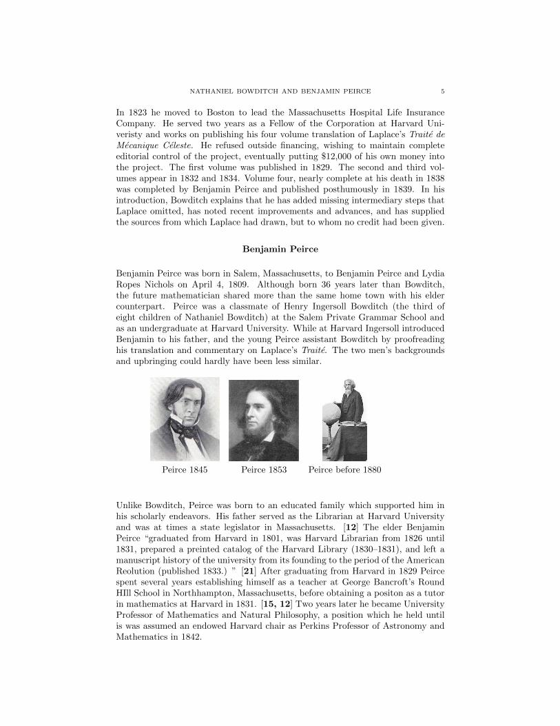
Benjamin Peirce was born in Salem, Massachusetts, to Benjamin Peirce and LydiaRopes Nichols on April 4, 1809. Although born 36 years later than Bowditch,the future mathematician shared more than the same home town with his eldercounterpart. Peirce was a classmate of Henry Ingersoll Bowditch (the third ofeight children of Nathaniel Bowditch) at the Salem Private Grammar School andas an undergraduate at Harvard University. While at Harvard Ingersoll introducedBenjamin to his father, and the young Peirce assistant Bowditch by proofreadinghis translation and commentary on Laplace’s Traite. The two men’s backgroundsand upbringing could hardly have been less similar.
Peirce 1845 Peirce 1853 Peirce before 1880
Unlike Bowditch, Peirce was born to an educated family which supported him inhis scholarly endeavors. His father served as the Librarian at Harvard Universityand was at times a state legislator in Massachusetts. [12] The elder BenjaminPeirce “graduated from Harvard in 1801, was Harvard Librarian from 1826 until1831, prepared a preinted catalog of the Harvard Library (1830–1831), and left amanuscript history of the university from its founding to the period of the AmericanReolution (published 1833.) ” [21] After graduating from Harvard in 1829 Peircespent several years establishing himself as a teacher at George Bancroft’s RoundHIll School in Northhampton, Massachusetts, before obtaining a positon as a tutorin mathematics at Harvard in 1831. [15, 12] Two years later he became UniversityProfessor of Mathematics and Natural Philosophy, a position which he held untilis was assumed an endowed Harvard chair as Perkins Professor of Astronomy andMathematics in 1842.

6 JOEL SILVERBERG
During his tenure at Harvard, he wrote and published a wide variety of textbooks,devoted himself to issues of educational reform, worked to introduce an elective sys-tem so that only the most talented, dedicated students need take advanced mathe-matics courses, and was instrumental in attracting talented new faculty to Harvard.He was active in both pure mathematics and applied mathematics, with a specialinterest in astronomy. He was involved in bitter disputes concerning the discoveryof the planet Neptune and the nature of the rings of the planet Saturn. Perhapshis greatest contributions, however, were as a builder of national institutions forthe furtherance of American involvement in mathematics, science, and technology.His was intrumental in the founding of the Lawrence Scientific School at Harvard,the Harvard Observatory, the Smithsonian Instituton, the Dudley Observatory atAlbany, and the National Academy of Sciences. [15, 12] In 1852 he was appointeddirector of longitude determinations for the U.S. Coastal Survey, and was namedSuperintendant of the Coastal Survey in 1867 on the death of Alexander DallasBache.
His honors both home and abroad were many, including, in 1852, the first ap-pointment of an American to the Royal Society since that of Nathaniel Bowditch in1818. Bowditch was elected to the Royal Society in the company of Babbage (1816),Poisson (1818), and Gompertz (1819) and Fourier (1823), while Peirce shared thehonor with Stokes (1851), Cayley (1852), Dirichlet (1855), and Boole (1857) — finecompany indeed.

NATHANIEL BOWDITCH AND BENJAMIN PEIRCE 7
Collaborations between Bowditch and Peirce
The best known mathematical collaboration is undoubtably their work on Laplace.Peirce was an promising undergradutate at Harvard while Bowditch was laboring onhis translation of Laplace’s Traite. Introduced by Bowditch’s son, Peirce became aproof reader and perhaps research assistant for Bowditch. When Bowditch becamea leading member of Harvard’s faculty, Bowditch was active in the University’sadministration through his membership on their board of trustees and fellows, andboth men were active in various reforms and transformations at Harvard. FollowingBowditch’s death in 1838, Peirce undertook to oversee the publication of the finalvolume of Bowditch’s translation of Laplace, and also published a textbook entitledAn Elementary Treatise on Plane and Spherical Trigonometry, with their applica-tons to navigation , surveying, heights and distances, and spherical astronomy, andparticularly adapted to explaing the construction of Bowditch’s navigator and thenautical almanac. This work, first published in 1840, is both a treatise on theapplicatons of spherical geometery and trigonometry and a tribute to Bowditch,explaining in detail the mathematics behind the methods published in The NewAmerican Practical Navigator.

8 JOEL SILVERBERG
In this paper, we will take a closer look the mathematical derivations of one of themethods discussed in Peirce’s treatise. The 1826 edition of Bowditch’s Navigatorintroduced a novel method for determining the latitude of a sailing vessel giventhe altitude of the sun above the horizon at two points in time and the time thathas elapsed between the two observations. An older, more arcane method, firstproposed by Cornelis Douwes of Amsterdam, appears in all of Bowditch’s earliereditions.
The modern reader or listener might ask:“Why was he concerned about the lati-tude? Finding the latitude is easy, just measure the altitude of the sun at noon.Wasn’t the determination of longitude the big challenge of the time, which resultedin the race to build a practical chronometer ? ” That is a fair question, and onethat deserves a comprehensive answer. A second cluster of questions might be lessobvious. There were already methods to find latitude given two solar observationsand the elapsed time between them when Bowditch first went to sea. One of themwas in Moore’s Practical Navigator which was Nathaniel’s constant companion onhis voyages. Why did he feel a need to invent a new and different method? Whatare the advantages of his method? How did he describe the method? How did hederive it ?
Let us first address the reasons why such a method might be needed. The primarymethod for keeping track of a ship’s position was that of dead reckoning (or deducedreckoning). A log was maintained of the estimated speed and direction of theship at all times. The compass provided an indication of the direction of theship (subject to errors of magnetic variation, among other things) and the log-lineprovided an estimate of “speed through the water” (which is different from speedover the bottom or speed with respect to the land.) Starting at a known positionat the port of departure, the ship’s position may be calculated by the application oftrigonometric techniques – with or without taking into consideration the sphericalnature of the ocean’s surface. [18] Clearly there was a need to validate theseestimated position from time to time, since each new estimate, depended upon theaccuracy of all preceeding estimates. Cumulative errors could be deadly, not justin a figurative sense, but in a literal sense as well. There were but four possiblechecks on the accuracy of the calculated positions, two of which were only partialvalidation until the last quarter of the eighteenth century.
The most accurate methods were (1) to arrive at a destination (island or town onthe mainland) whose location was known; (2) to be able to observe the direction(with respect to ”North”) of at least two two visible objects (island, headland,lighthouse, tower, etc.) whose positions were known. Then a line of reciprocaldirection (the original direction plus or minus 180 degrees) could be drawn on achart from each of the sighted objects. The point on the chart where these linescrossed on the chart would indicate the location of the ship. However, once out ofsight of land, neither method is of any value.
The remaining methods provide only knowledge of the ship’s latitude, but no in-formation about the longitude. The first method is to observe the altitude of thePolaris, the “Pole Star” above the horizon during the twilight preceeding the sun-rise or following the sunset. Only at those times will both the star and the horizon

NATHANIEL BOWDITCH AND BENJAMIN PEIRCE 9
be visible. At other times, the altitude above the horizon can not be determined.The altitude will be the same as the latitude of the observer. There is some errorintroduced since the pole star does not sit precisely at the celestial north pole, buta small distance away from it. There were available corrections to account for thissource of error.
Determining Latitude: The Noon Sight. The second method is to observethe altitude of the sun at local apparent noon. Were the sun on the celestialequator, then the latitude of the observer and the altitude of the sun would becomplementary angles. However, the sun does not lie on the celestial equator excepton the days of the equinox, but is north of the equator during the summer of thenorthern hemisphere and south of the equator during the winter of the northernhemisphere. The Nautical Almanac, in fact any almanac will list the declination ofthe sun for every day of the year. The declination is the number of degrees aboveor below the equator of the position directly under the sun. A simple addition orsubtraction will compensate for the displacement of the sun from the equator andwill allow the observer to determine his latitude from the solar altitude at localapparent noon (that is, when the sun is over the same meridian as the observer. )At local apparent noon, the sun will be directly south of the observer. It will alsobe at the highest point in the arc it travels in the sky from sunrise to sunset. Inpractice the altitude is measured in the neighborhood of mid-day, and when thealtitude stops rising and begins to decrease, the maximum altitude will occur. Thatmaximum altidue is corrected for the declination of the date of the observation andused to determine the latitude. If the latitude of the dead reckoning agrees withthe noon-sight or polar-sight, the dead reckoning would be conisdered correct (eventhough the longitude might be in error).
The mid- to late- eighteenth century saw a convergence of advances that provideda way to determine the longitude. Two competing methods overtook other possibleappoaches . . . the method of lunars and the development of chronometers. Bothrequired the deveopment of accurate tables of the positions of stars, sun, moon,and planets for each hour of every day from some reference meridian (Greenwichand Paris were the most prominent, but not only reference locatons), and bothrequired the determination of local apparent time, preferably when the sun wasdue east or due west, or as close to those positions as possible.
The common idea behind both longitude by lunars and longitude by chronometerwas to determine, through observations of celestial objects, the apparent time atthe reference meridian, together with the apparent (i.e. solar) time at the observer’sunknown location. The difference in time can be converted to a difference in lon-gitude. But whether one determines the time at Greenwich (or Paris) through theobservation of the moon, stars, or planets, or whether one determines the time atGreenwich through consulting a chronometer set to Greenwich (or Paris) time, thenavigator is left with the same problem of determining the local apparent time atthe location of the ship. Knowledge of the time on the prime meridian, withoutknowledge of the local appraent time on ship, does not and can not tell the sailorhis longitude. Neither can any watch or chronometer, however accurate, tell thesailor his local apparent time, since the apparent time depends upon the observer’slocation, and clocks and watches do respond to changes in positon by changing

10 JOEL SILVERBERG
the time reported. Watches measure ‘clock (position independent) time,’ not ‘solar(position dependent) time.’ The method used to determine the local apparent timeon board ship was known, appropriately enough as a “time sight.” The altitudeof the sun was measured when it was in the Eastern sky or in the Western skyand when it was at least fifteen or twenty degrees above the horizon. The altituderestriction was imposed to avoid the errors caused by refraction when the sun isclose to the horizon. The restriction that the sun be in the Eastern or Westernsky is imposed so that small errors in measuring solar altitude correspond to smallerrors in longitude. [20]
Determning Longitude: The Time Sight. Picture a spherical triangleformed by the geographical position of the sun, the celestial north pole, and thezenith (the point directly over the observer.) The three sides of that triangle arethe complement of the declination, the complement of the observer’s latitude, andthe complement of the solar altitude. What is desired is the angle at the celestialpole. Opposite the polar angle is the side between the zenith and the sun. Thelength of that side is the zenith distance of the sun, i.e. the complement of thesolar altitude. Adjacent to the polar angle are two sides, one of which connects thepole with the zenith. The length of that side is the complement of the observer’slatitude. The second side adjacent to the polar angle connects the pole with thesun. The length of that side is the complement of the solar declination. The solardeclination is tabulated in the Nautical Almanac for each day of the year. Thelatitude was determined by performing a noon sight. Knowing three sides of thetriangle, the polar angle can be calculated using the spherical law of cosines forsides. The polar angle tells us how many hours from local apparent noon we are atthe time of the “time sight.” If the sun is east of due south, it is the time beforenoon, else the time after noon. The local apparent time, together with knowledgeof the time in Greenwich — whether determing by the use of a chronometer or bythe method of lunar distances — our longitude is determined through the differencein those times.
But, two complications often arise. If the ship has moved in the hours betweenthe noon sight and the time sight, adjustments for the motion of the ship mustbe made. Any eastward or westward movement changes the local apparent time,while movement northward or southward may change the latitude. The navigatorwould use the observed speed and direction of the ship to predict and correct formovements that may have occurred during the interval, and normally, this is areasonable accomodation. But, what if the sky was cloudy at noon? We wouldneed to estimate our latitude based either the dead reckoning, which is uncertain,or upon the last available ”noon sight.” But the previous noon was more thantwenty-four hours ago, and the ship may have travelled two-hundred miles in theinterim. The speed and direction of the ship over that course of time may havebeen quite variable, and the dead reckoning more unreliable. What if the ship hasbeen in a storm for the last three or four days? The last available noon sight mighthave been eighty or ninety hours ago, and the ship may have travelled six-hundredor seven-hundred miles. To use dead reckoning to estimate our latitude under thoseconditions would be little better than guessing. Suppose that the next opportunityfor a clear view of the sun is not at noon, but in the early morning or late afternoon.

NATHANIEL BOWDITCH AND BENJAMIN PEIRCE 11
We can not do a time sight to determine our longitude without assuming a latitudeand we have no reliable estimate of our latitude. It is precisely for this situationthat Douwes developed at that Bowditch includes this method. It provides a wayto use the position of the sun at times other than noon to determine the latitude,so that the local apparent time can be used to find the longitude (with or withouta chronometer.)
Determining Latitude when Noon or Polar Sights are not available – Douwes’Method of Double Altitudes. Moore, and others before him, used a fairly convolutedmethod for determining the latitude by using two solar observations, separated byan interval of an hour or more. The elapsed time between the observations wasmeasured by a pocket watch. The long term accuracy of a chronometer (accuracyover many months) since only the elapsed time, and not the precise times of eachmeasurement were required. The watch may not be accurate, in fact the watchmay run fast or slow. But it will not gain or lose time over the interval of an houror two, and all that is required is to accurately measure the elapsed time betweenthe two solar observatoins. Neither will the watch tell us ‘solar’ or apparent time,but again, that is not required — only the elapsed time will be used.
The method included in most navigation manuals of Bowditch’s time, and themethod included in Bowditch’s Navaigator until the revised edition of 1826, wasfirst developed by Cornelis Douwes, examiner of sea officers and pilots under theCollege of Admiralty at Amsterdam and published in the Actes de l’Academie deHaarlem in 1754. [23, p. 297] , [22, p. 158], [21, p. 224] . The key sphericaltriangle in celestial navigation is the Navigational or Astronomical Triangle, whosevertices are the elevated celestial pole (a pole of the celestial equator), the observer’szenith (which is a pole of the observer’s horizon), and the geographical position ofthe sun (or other celestial body).
The sides of this triangle are the zenith distance of the sun, the polar distance ofthe sun, and the distance between the zenith and the celestial pole. These sidesare the complements of the solar altitude, the solar declination, and the observer’slatitude respectively. The declination for the date of the observation is tabulatedin the Nautical Almanac, while the solar altitude is measured by the sextant. Thelatitude is unkown and to be determined. The vertex angle opposite the zenithdistance measures the difference in longitude between the meridian that passesthrough the position of the observer and the meridian that passes through thegeographic position of the sun. The difference in the longitude of their meridianscan be converted to local apparent time, since the meridian of the sun moves fifteendegrees of longitude during each hour of the day.
The central equation in celestial naviation is the spherical law of cosines for sides,which links precisely those four quantities. The difficulty is that we have oneequation, but two unknowns — the local apparent time before or after noon, and theobserver’s latitude. This method utilizes two solar observations, and assumed thatneither the solar declination nor the observer’s latitude has changed between thetwo observations. This gives the mathematician two equations, but three unkowns. . . the observer’s latitude, the local apparent time of the first observation, and thelocal apparrent time of the second observation. The stopwatch provides a third

12 JOEL SILVERBERG
equation . . . the difference in the two local apparent times is measured, and thusknown. So the navigator has three equations and three unknowns, but they theseequations are not linear, and the variables can not be isolated for solution. Anadditional complication is added by the necessity for using logarithmic calculationsin the absence of electronic aids such as calculators or computers. The equationsrequire a considerable degree of manipulation to convert sums and differences oftrigonometric functions into products and quotients so that logarithmic tables canbe employed.
Let P andZ represent the polar, zenith, positions, and let S1 and S2 representthe solar positions when the first and second observations are made. Let h1and h2 represent the solar altitudes and let t1 and t2 represent the time untilnoon for the two observations. Finally, let D be the solar declination for theday and L be the unknown latitude of the observer. Applying spherical law ofcosines for sides to the triangle PZS1 gives the equation sinh1 = sinL sinD +cosL cosD cos t1. Similarly, the law of cosines for triangle PZS2 give the equationsinh2 = sinL sinD + cosL cosD cos t2. Subtracting these two equations give ussinh1 − sinh2 = cosL cosD(cos t1 − cos t2).
A commonly used trigonometric identity is employed to replace the difference ofcosines by a product of sines : cos t1 − cos t2 = 2 sin t1+t2
2 · sin t2−t12 . The half-
sum of times is called the middle time and the half-difference of times is calledthe half elapsed time . Douwes, Moore, Bowditch, and others included tables withcolumns labeled “log elapsed time” and “ log mid time” to ease the burden ofmanipulting these quantities. The way in which these tables were used will beexplained in a few moments. With this subsitution, the previous equation becomessinh1 − sinh2 cosL cosD · 2 sin t1+t2
2 sin t2−t12 , which Douwes uses to determine the
value of the middle time, but rather than solve the equation for the middle time,instead he isolates the value of twice the sine of the middle time.
2 · sin t1+t22 = (sinh1 − sinh2) secL secD csc t2−t1
2 .
The tables provided for this method specify the values of the log-cosecant of thehalf-elapsed time and for the log-sine of twice the middle time. Furthmore, thesetables are indexed by hour angles, that is by degrees of longitude converted intohours, minutes and seconds of time. The sailor takes the observed lapsed time,divides in in half and looks up the value of the log-cosecant corresponding to thathour angle, in the column for half-elapsed time. To this are added the log-secantsof L and D, and the log of the differences in the natural sines of the altitudes.The resulting sum is looked up in the body of the table under the column labeledmiddle time. That column contains the log-sine of twice it’s arguments, so therow corresponding to that entry specifies the middle time in hours, minutes andseconds.
By either adding or subtracting the half-sum and half-differences, either t1 or t2can be determined. Douwes solves for the time of the observation closest to noon,that is for the observation with the greater of the two measured solar altitudes.Suppose that the time of the observation with the greater solar altitude is t2.

NATHANIEL BOWDITCH AND BENJAMIN PEIRCE 13
Then sinh2 = sinL sinD + cosL cosD cos t2. Adding and subtracting cosL cosDto the right hand side, we have sinh2 = sinL sinD + cosL cosD − cosL cosD +cosL cosD cos t2. The trigonometric identity for the cosine of the difference of twoangles lets us express this as sinh2 = cos(L−D) − cosL cosD(1 − cos t2). Douwesisolated the term for cos(L−D) to get the equation
cos(L−D) = sinh2 + cosL cosD(1 − cos t2).
The dead reckoning latitude is used for L on the right hand side of the equation,along with the computed apparent local time (t2) based upon that value, to findcos(L−D) and therefore the value of L−D. Since D is known, we may solve forthe latitude, L.
If the value of L so determined agrees with the value of L used on the right handside of the equation, this value is accepted as the correct value for latitude. If theydisagree the entire procedure is repeated from the very begining using the new valueof L , finding a new values for middle-time, and a new value for t2 and finally a newvalue for L. This continues until the assumed value for L agrees with the calculatedvalue for L. The final value of middle-time can be used to reset the ship’s watch tobe correct for apparent local time.
Bowditch’s Method of Double Altitudes. The algebraic complexities, the uncer-tainty of convergence or speed of convergence, the arithmetic burden on the sailorall beg for a better approach to the solution of this problem.
Bowdith’s goal was to provide a simpleand robust method by which a naıveuser of arithmetic could quickly and re-liably determine the latitude of the ob-server, given the declination of the sun,the altitudes of the sun at two points oftime, and the elapsed time between thetwo observations. The method shouldrequire as few trigonometric evalua-tions as possible, must use logarithmsas much as possible to avoid multi-plication of trigonometric function val-ues, and should avoid going in andout of logarithms unnecessarily. It wasalso desireable to replace the method ofDouwes with a method that would de-termine the latitude without resortingto an iterative sequence of approxima-tions which converge to the actual lat-itude. Whether the method of Douwesalways converges, or with what speed, or under what conditions seems not to havebeen examined by Douwes or his followers, nor by Bowditch or Peirce.
Several auxiliary lines are added to the diagram. The midpoint, m, of the greatcirce arc between X and Y is found. A connecting arc is drawn between the zenith(z) and m and between the pole (p) and m. Lastly, a perpendicular arc is drawn

14 JOEL SILVERBERG
from the zenith to the arc connecting the pole with m. These lines divide certainoblique triangles into pairs of right angled triangles, which simplifies the algebrarequired for the problem.

NATHANIEL BOWDITCH AND BENJAMIN PEIRCE 15
The triangle Xmp has a right angle atm. Side Xp is the complement of thesolar declination D. Angle Xpm is one-half the elapsed time τ. Two parts ofa right sperical triangle being known,the remaining parts are determined. Ifside Xm is called A and B is the decli-nation of the midpoint m then the lawof sines gives sinA = sin τ
2 sin(90◦−D)while the law of cosines for sides givescos(90◦ −D) = cosA cos(90◦ −B).
Isolating the terms involving A andB we get sinA = cosD sin τ
2 andsinB = sinD secA. For reasons thatare not clear, Bowditch and Peirce pre-fer these equations in their invertedform: cscA = secD csc τ
2 and cscB =cscD cosA.
Side Xm has been determined by solv-ing for A in the previous equations.Side Xz is the complement of the mea-sured solar altitude h1. But since thetriangle is oblique, we lack sufficient in-formation to determine the other sidesor angles. Two new variables are intro-duced: F is the length of side mz andθ is the angle zmp. Note that the vetexangle Xmz is the complement of angleθ.
The law of cosines for sides is ap-plied to relate the known and unknownquantities. Hence, cos(90◦ − h1) =cosA cosF + sinA sinF cos(90◦ − θ).Simplifying,
sinh1 = cosA cosF + sinA sinF sin θ.
A similar situation exists in the triangleY mZ. The side mY is known to be Aand the side Y z is the complement of the second measured altitude, h2. The vertexangle zmY is (90◦ + θ). Applying the law of cosines, cos(90◦ − h2) = cosA cosF +sinA sinF cos(90◦ + θ).
Simplifying, we have sinh2 = cosA cosF − sinA sinF sin θ.

16 JOEL SILVERBERG
Adding and substracting the equationsfor sinh1 and sinh2, we get sinh1 +sinh2 = 2 cosA cosF and sinh1 −sinh2 = 2 sinF sinA sin θ.
Introducing the half sum of the alti-tudes and the half difference of the al-titudes, let hs = h1+h2
2 and let hd =h1−h2
2 . This allows us to replace thesum (or differnce ) of sines by a prod-uct: sinh1 + sinh2 = 2 sin(hs) cos(hd)while sinh1−sinh2 = 2 cos(hs) sin(hd).Making these substitutions we get, fi-nally, sinhs coshd = cosA cosF andcoshs sinhd = sinA sinF sin θ.
The triangle Zrm has a right angle atr. Two new variables are introduced: C
is the length of side zr and ζ is the length of side mr. Side zm is represented by theundetermined variable F and the angle at m is represented by the undeterminedvariable θ. Using the law of sines, sinC = sinF sin θ, and using the law of cosines,cosF = cos ζ cosC.
In the previous figure we saw thatcoshs sinhd = sinA sinF sin θ and sosubstituing sinC for sinF sin θ, we havecoshs sinhd = sinA sinC.
Since C is the only undetermined quan-tity in this equations, we dtermine itsvalue by isolating the term involving C.That is , sinC = coshs sinhd cscA.
Similarly, substituting cos ζ cosC forcosF in the other equation, sinhs coshd =cosA cosF = cosA cos ζ cosC.
The values of A and C havingbeen previously dtermined, cos ζ =sinhs coshd secA secC or in its in-verted form: sec ζ = cschs sechd cosA cosC.
One last variable, E, is introduced todenote the declination of point R. Re-calling that B is the declination of pointm, and that ζ is the distance from m to r, it follows that since mr + rp =mp, ζ + (90◦ − E) = (90◦ −B). Solving for E, E = B + ζ.

NATHANIEL BOWDITCH AND BENJAMIN PEIRCE 17
Finally, consider the triangle zpr withright angle at r. The hypothenuse ofthis triangel, zp is the complement ofthe desired latitude.
Side zr has the known value C and siderp is the complement of the declinationof r which is the known value E. The re-maining quanititues can be determinedthrought the usual means. In partic-ular, if L denotes the desired latitude,then cos(90◦L) = sinL = cosC sinE.
A corollary is also provided byBowditch (and Peirce). The hour an-gle zpm is the mean between the hourangles zpX and zpY. If H representsthe hour angle zpm, then another ap-
plicaton of Napier’s rules yields tanH = tanC secE.
In summary, to find the latitude, L, measure the solar altitudes, h1 and h2, notingthe elapsed time, t, between the observations. The Nautical Almanac provides thedeclination of the sun, D on the date in question.
We determine each of the following variables, in turn :
• A = length of XM = length of MY.• B = complement of the declination of point M.• C = length of arc ZnR• E = declinaton of R• ζ = length of arc RM = E −B• L = the desired latitude• H = the hour angle ZnPM
by using the following equations in the order given, solving for A,B,C, ζ, E, and Lin turn. If desired, H may also be determined.
• cscA = cscD sec t2
• sinB = sinD secA• sinC = cos h1+h2
2 sin frach1 − h22 cscA
• sec ζ = csc h1+h2
2 sec h1−h2
2 cosA cosC• E = B + ζ• sinL = cosC sinE• tanH = tanC secE.
A comparison of the methods of Douwes and Bowditch shows that the new methodis considerably more complex in its algebra and trigonometry. However, whenthe method is put in the hands of navigators, along with tables to support thesecalculations, a considerable advance in simplicity has in fact been achieved. Bothmethods use identical tables. The entry into the tables is an hour angle, which

18 JOEL SILVERBERG
is a diffence in longitude expressed in hours, minutes and seconds, rather thandegrees minutes and seconds. Conversion between the two systems, if desired isaccomplished throught the conversion that each hour of time is equivalent to fifteendegrees of longintude. Tables are provided for that conversion as well. The body ofthe table includes three columns, labeled half-elapsed time, middle–time, and rising(or log–rising). The first column (half–elapsed time) contains the log(csc(t)) wheret is the entry value into the table; the second column (middle–time) contains thevalue 5 + log(2) + log(sin(t))or , equivalently,5 + log(2 · sin(t)); the third column(log-rising) contains the value 5 + log(1 − cos t). Note that (1 − cos t) is in fact theversed sine of t, and is related to the half-angle trigonometric identity. The versedsine of t is equal to twice the square of the sine of one-half of t. The constant 5 isused adjust for the fact that the various trigonometric tables in these manuals arebased upon circles of differing radii. Tables of natural trig functions used a radiusof 1. However tables of logs of trig functions, in order to avoid asking navigators towork with negative logarithmic values, employed radii large enough so that valuesof all trig functions tablulated were greater than one, and thus their logs were allpositive. The the most commonly used radius in Bowditch and Moore’s manualswas 105. This has the effect of adding 5 to what we would consider the appropriatetable values. These indices were added and subtracted as the need arose to keepnegative logarithmic values out of the calculations, and removed when needed. Thevalues tablulated correlate with the equations and formulas for which the tables areused, to lessen the computational details that the navigator must keep in mind.

NATHANIEL BOWDITCH AND BENJAMIN PEIRCE 19
It may prove instructive to step through the calculations and tables employed bysome of the simpler methods.
Sample Noon Sight Calculations
Suppose you find yourself sailing in northern latitudes on a fine spring day withclear skies. You consult the Nautical Almanac for the date (May 20) and find thatthe declination of the sun is 20◦0′ N. As noon approaches you observe that the solaraltitude to reaches a maximum of 59◦20′ above the horizon. What is your latitude?
Since at local apparent noon, the sun is 59◦20′ above the horizon, the angle fromthe zenith to the sun is the complement of the solar altitude, or 30◦40′. This iscalled the zenith distance of the sun. Since the sun lies 20◦ north of the equator,the distance from the zenith to the equator must be 20◦ + 30◦40′ or 50◦40′. Thedistance between the equator and the zenith (the point under which the observerstands) is the Latitude. Hence our latitude is 50◦40′ N.
Sample Time Sight Calculations
As determined from the above noon sight, the ship’s latitude is 50◦40′ N. The shiphas been becalmed all afternoon and has not moved. The sun is begining to setin the western sky, and we measure a solar altitude of 22◦30′. What is the localapparent time?
If h is the solar altitude, L is the ship’s latitude, D is the solar declination, and θis the local hour angle, then the law of cosines specifies applied to the navigationaltriangle specifies that sinh = sinL sinD + cosL cosD cos θ. Adding cosL cosD toeach side of the equation, we have sinh+ cosL cosD = cosL cosD + sinL sinD +cosL cosD cos θ. From the trigonometric identity for the cosine of the differenceof two angles, it follows that sinh + cosL cosD = cos(L − D) + cosL cosD cos θ.Grouping the terms involving cosL cosD we have [cosL cosD][1− cos θ] = cos(L−D) − sinh. Hence
1 − cos θ = [cos(L− d) − sinh] secLsecD.
Taking the log of each side , log(1 − cos θ) = log[cos(L −D) − sinh] + log secL +log secD. The expression 1 − cos θ is in fact the versed sine of the angle θ. Tablesof log–versed sines, called log risings were tabulated as functions of the angle θexpressed in units of time. Thus one could consult a table of risings and directlyextract the hour angle or local time to or from noon.
log(1− cos θ) = log[cos(34◦40′)− sin(22◦30′)] + log sec(54◦40′) + log sec 20◦. log(1−cos θ) = 4.643247 + 0.198027 + 0.027014 = 4.868288. The tables of risings providethe local time with a single table lookup. We find 4.86869 in the body of the tablein the “rising” column, and the row indicates a local apparent time of 4 hours and59 minutes from noon. Since the observation was in the afternoon in the westernsky, the time is 4:59 p.m. If we had observed the rising sun, with the same altitudein the eastern sky, we would subtract this value from noon, and get 7:01 a.m. asthe local time.

20 JOEL SILVERBERG
I conclude this paper by presenting the reader with a set of sample calculations, fordetermining the latitude through the method of double altitudes — the first exampleemploying the method of Cornelis Douwes and the second employing the methodintroduced in Bowditch’s 1826 edition. For those who may find some pleasure inworking through the details of these calculations, it is my hope that the derivations,diagrams, and explanations I have provided will guide you through the labyrinthinto safe harbors, with understanding and confidence. May you be blessed with fairwinds and following seas on your journeys.
Method of Cornelis Douwes — first published in 1759

NATHANIEL BOWDITCH AND BENJAMIN PEIRCE 21
Method Introduced in 1826 Bowditch
22 JOEL SILVERBERG
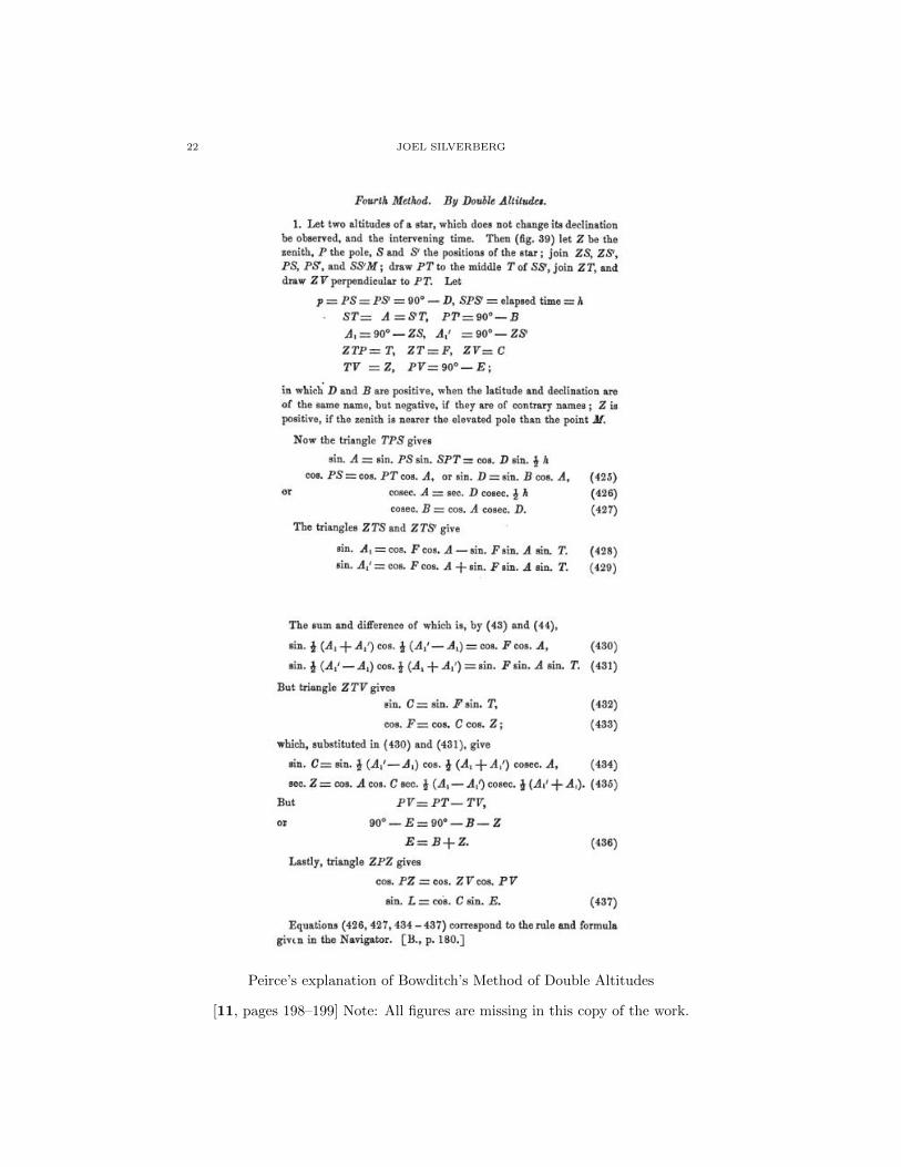
Peirce’s explanation of Bowditch’s Method of Double Altitudes
[11, pages 198–199] Note: All figures are missing in this copy of the work.

NATHANIEL BOWDITCH AND BENJAMIN PEIRCE 23
References
1. John Hamilton Moore, The Practical Navigator, and Seaman’s New Daily Assistant, London,
1791.2. Nathaniel Bowditch, The New American Practical Navigator, Newburyport, 1807.
3. Nathaniel Bowditch, The New American Practical Navigator, New York, 1826.
4. Nathaniel Bowditch. 2012. Encyclopdia Britannica Online. Retrieved 24 September, 2012,from http://www.britannica.com/EBchecked/topic/76106/Nathaniel-Bowditch
5. Marc Rothenberg, Nathaniel Bowditch, American National Biography 3 (Oxford, 1999), 270-
272.6. Nathaniel Ingersoll Bowditch, Memoir of Nathaniel Bowditch, by his son, Nathaniel Ingersoll
Bowditch. Originally prefixed to the fourth volume of the Mcanique cleste, 3d ed, J. Wilsonand son,Cambridge, 1884
7. Salem Massachusetts, the City Guide,Nathaniel Bowditch, 1773–1838, Scientist,
http://www.salemweb.com/tales/bowditch.shtml8. Jean Lee Latham, Carry On, Mr. Bowditch, Houghton Mifflin, Boston, 1955.
9. J J O’Connor and E F Robertson, Nathaniel Bowditch, MacTutor History of Mathematics
archive, http://www-history.mcs.st-andrews.ac.uk/Biographies/Bowditch.html10. Pierre Simon, Marquis de Laplace, Mecanique Celeste, Translated, with a Commentary
by Nathaniel Bowditch, with a Memoir of the Translator, by his son, Nathaniel Ingersoll
Bowditch, Little and Brown, Boston, 1839.11. Benjamin Peirce, An Elementary Treatis on Plane and Spherical Trigonometry, Boston, 1861.
Retreived 24 September, 2012 from http://www.google.com/books?id=cE47AQAAIAAJ
12. Amy Ackerberg. ”Peirce, Benjamin”; http://0-www.anb.org.helin.uri.edu/articles/13/13-01291.html; American National Biography Online Feb. 2000.
13. Carolyn Eisele, ”Peirce, Benjamin”; Complete dictionary of Scientific Biography, 2008. Re-treived 21 Sep. 2012 from htttp://www.encyclopedia.com
14. F P Matz, Benjamin Peirce, American Mathematical Monthly (2), 1895.
15. Edward R Hogan, Of the Human Heart: A Biography of Benjamin Peirce, Associated Uni-versity Presses, Cranbury, NJ, 2008.
16. Connaisance des Temps, Paris, 1808.
17. Frank E. Reed, Historical Navigation Books Online, Retrieved 24 September, 2012, fromhttp://www.fer3.com/arc/navbooks2.html
18. Joel Silverberg, The Sailings: The Mathematics of Eighteenth Century Navigation in the
American Colonies, Proceedings of the Canadian Society for History and Philosophy of Math-ematics, Volume 18, 2005, Pages 173 – 199.
19. Joel Silverberg, Nautical Astronomy: From the Sailngs to Lunar Distances, Proceedings of
the Canadian Society for History and Philosophy of Mathematics, Volume 19, 2006, Pages265–288.
20. Joel Silverberg, Circles of Illumination, Parallels of Equal Altitude and le Calcul du PointObserve: Nineteenth Century Advances in Celestial Navigation , Proceedings of the Canadian
Society for History and Philosophy of Mathematics, Volume 20, 2007, Pages 272–296.
21. Staff Commander W. R. Martin, R.N., A Treatise on Navigation and Nautical Astronomy,Longmans, Green, and Co., London, 1891.
22. Andrew Mackay, The Complete Navigator: or, and easy and familiar guide to the theory andpractice of naviagion. With all the Requisite Tables &c., &c., Philadelphia, 1807.
23. Andrew Mackay, The Theory and Practice of Finding the Longitude at Sea or Land: to whichare added various methods of determing the Latitude of a Place, and the Variation of the
Compass with New Tables, Aberdeen, 1801.
Providence, Rhode Island, USA
E-mail address: [email protected]