EXECUTIVE SUMMARY 1. Project Background The traffic ...
27
Project: Preparation of Feasibility-cum-Preliminary Design for 6/8 laning of Existing 4 lane NH-3 from Ch.539.500 (Vadape) to Ch.563.000 (Thane) NH-3 to be executed as BOT (Toll) Project on DBFOT Pattern Sheet 1 of 27 Document: 47406400/RH/Rep-07 August, 2017 Executive Summary Revision: R9 Final Feasibility Report Roads & Highways EXECUTIVE SUMMARY 1. Project Background The traffic growth in the past few decades, particularly last decade which saw a phenomenal growth in commercial and industrial activity has affected the road network system of India, which includes Highways, State Highways, Major District Roads and Rural Roads. In order to overcome such capacity shortage, the Ministry of Road Transport and Highways (MoRT&H) Govt. of India (GOI) has come up with major investment plan with Public Private Partnership under NHDP, which includes upgradation of existing facilities, construction of new corridors for ensuring safe, smooth and uninterrupted flow of traffic and maintenance thereof with modification, repairs and improvement to the project in compliance with specifications and standards. The existing section of NH 3 from Vadape (km 539+500) to Thane (km 563+000), 23.50 km in length was initially constructed as a 2 lane road from km 539+500 to km 560+000 and 4 lane road for remaining length up to km 563+000 by Government of Maharashtra in the year 1985. The work of improvement and maintenance of this corridor was entrusted to M/s. Ideal Road Builders Ltd (IRB) in Sept, 1995 with Concession Period of 7 years 8 months starting from 11.06.1997. As the riding quality on the bypass improved, the traffic increased considerably over the years reaching 47000 PCU /day by year 1997. It was then decided to widen this corridor to uniform 4 lane including construction of a new 2 lane bridge at Kasheli and new 2 lane ROB through the present Concessionaire by extending the Concession Period upto 13.05.2017 i.e. 18 years 6 months duly considering compensation for unfinished Concession Period as on 31.12.2001. Approval to the proposal was received from MOST, GOI on 02.09.1998. The existing road from Vadape (km 539+500) to Thane (km 563+000) experienced tremendous growth in Traffic once 4 laning was done, as it is a vital link connecting NH-8, NH-3, NH-4 and NH-17 bypassing Mumbai City. The traffic has increased considerably after development of surrounding network and growth of urban conglomerates like Thane Municipal Corporation (TMC), Kalyan Dombivli Municipal Corporation (KDMC), Navi Mumbai Municipal Corporation (NMMC) and Bhiwandi Nisampur Municipal Corporation BNMC). Keeping this in view, GOM / GOI has initiated 6/8 laning of this corridor considering present traffic and projected traffic in horizon years. Accordingly, MORTH through Public Works Department (PWD) of Government of Maharashtra (GOM) represented by Chief Engineer, National Highway (Public Works), Region, Konkan Bhavan who is the authority engaged in maintenance of National Highways in Maharashtra initiated the improvement and upgradation and has decided to undertake Feasibility cum-Preliminary Design Report of Six/Eight Laning of the section from Km 539+500 (Vadape) to Km 563+000 (Thane) as
-
Upload
khangminh22 -
Category
Documents
-
view
3 -
download
0
Transcript of EXECUTIVE SUMMARY 1. Project Background The traffic ...

Project: Preparation of Feasibility-cum-Preliminary Design for 6/8 laning of Existing 4 lane NH-3 from Ch.539.500 (Vadape) to Ch.563.000 (Thane) NH-3 to be executed as BOT (Toll) Project on DBFOT Pattern Sheet 1 of 27 Document: 47406400/RH/Rep-07 August, 2017 Executive Summary Revision: R9
Final Feasibility Report Roads & Highways
EXECUTIVE SUMMARY 1. Project Background
The traffic growth in the past few decades, particularly last decade which saw a phenomenal growth in commercial and industrial activity has affected the road network system of India, which includes Highways, State Highways, Major District Roads and Rural Roads. In order to overcome such capacity shortage, the Ministry of Road Transport and Highways (MoRT&H) Govt. of India (GOI) has come up with major investment plan with Public Private Partnership under NHDP, which includes upgradation of existing facilities, construction of new corridors for ensuring safe, smooth and uninterrupted flow of traffic and maintenance thereof with modification, repairs and improvement to the project in compliance with specifications and standards. The existing section of NH 3 from Vadape (km 539+500) to Thane (km 563+000), 23.50 km in length was initially constructed as a 2 lane road from km 539+500 to km 560+000 and 4 lane road for remaining length up to km 563+000 by Government of Maharashtra in the year 1985. The work of improvement and maintenance of this corridor was entrusted to M/s. Ideal Road Builders Ltd (IRB) in Sept, 1995 with Concession Period of 7 years 8 months starting from 11.06.1997.
As the riding quality on the bypass improved, the traffic increased considerably over the years reaching 47000 PCU /day by year 1997. It was then decided to widen this corridor to uniform 4 lane including construction of a new 2 lane bridge at Kasheli and new 2 lane ROB through the present Concessionaire by extending the Concession Period upto 13.05.2017 i.e. 18 years 6 months duly considering compensation for unfinished Concession Period as on 31.12.2001. Approval to the proposal was received from MOST, GOI on 02.09.1998.
The existing road from Vadape (km 539+500) to Thane (km 563+000) experienced tremendous growth in Traffic once 4 laning was done, as it is a vital link connecting NH-8, NH-3, NH-4 and NH-17 bypassing Mumbai City. The traffic has increased considerably after development of surrounding network and growth of urban conglomerates like Thane Municipal Corporation (TMC), Kalyan Dombivli Municipal Corporation (KDMC), Navi Mumbai Municipal Corporation (NMMC) and Bhiwandi Nisampur Municipal Corporation BNMC). Keeping this in view, GOM / GOI has initiated 6/8 laning of this corridor considering present traffic and projected traffic in horizon years. Accordingly, MORTH through Public Works Department (PWD) of Government of Maharashtra (GOM) represented by Chief Engineer, National Highway (Public Works), Region, Konkan Bhavan who is the authority engaged in maintenance of National Highways in Maharashtra initiated the improvement and upgradation and has decided to undertake Feasibility cum-Preliminary Design Report of Six/Eight Laning of the section from Km 539+500 (Vadape) to Km 563+000 (Thane) as

Project: Preparation of Feasibility-cum-Preliminary Design for 6/8 laning of Existing 4 lane NH-3 from Ch.539.500 (Vadape) to Ch.563.000 (Thane) NH-3 to be executed as BOT (Toll) Project on DBFOT Pattern Sheet 2 of 27 Document: 47406400/RH/Rep-07 August, 2017 Executive Summary Revision: R9
Final Feasibility Report Roads & Highways
Bhiwandi Bypass through Public-Private Partnership on Design, Build, Finance, Operate and Transfer (DBFOT) basis. M/s Consulting Engineering Services (India) Private Limited have been engaged as Consultant by PWD vide work order no. NHD-(H)/AB/TC/1389 dated 3rd June 2010 for rendering consultancy services for preparation of Feasibility-cum-Preliminary Design for the Bhiwandi Bypass on DBFOT pattern. Further, MoRT&H vide letter no RW/NH/12014/88/2011/MAH(P-6) dated 10 December 2014 and PWD vide letter no NHD-III/Tender/3636 dated 16 December 2014 have approved the variation estimate submitted by Consultant for carrying out the additional services and updating the Final Feasibility Report from time to time since 2011. Accordingly, the Final Feasibility report was submitted on 27 Feb 2015. Further PWD NHD-Thane/PB-1/2796 dated 14 December 2015 instructed the consultant to update the cost as per Thane DSR 2015-16 and revise the financial analysis and submit the revised Final Feasibility report. Further meeting with CE-P6 MoRTH, New Delhi on dated 4th & 5th February 2016, CE-P6 suggested revising Final Feasibility Report considering the 15 years concession period. Later the project was transferred to NHAI from PWD during the period from June 2016 to Dec 2016 and a tripartite agreement was signed between NHAI, PWD NH division, Thane and M/s Consulting Engineering Services (India) Private Limited on 27th January 2017.Accordingly all the documents elated to feasibility was handed to NHAI by PWD for implementation of the project. Further NHAI issued RFQ to prequalified bidders in the month of February 2017. Consultant provided support during bid process from February 2017 to March 2017. But none of the qualified bidder submitted the bid on bid due date i.e 14th March 2017. In view of this NHAI vide letter no.NHAI/BOT/11019/01/RFQ/Vad-Thane/2016/96958 dated 21st March 2017 asked the consultant to carry fresh traffic surveys, update the cost estimate to bring it to 2017 level and update the financial report and feasibility report as variation.
2. Description of the Project Road
National Highway–3 (NH-3) is a busy corridor with exceptionally high traffic connects the Mumbai, Thane, Nashik, Dhule, Indore, Gwalior, Dholpur and Agra via Wadiware, Chandwad, Malegaon, Songir, Shirpur, Dharampuri, Dewas, Shajanpur, Sarangpur, Guna, Shivpuri.National Highways - 211, 50, 6, 59A, 86, 12, 76, 25, 92, and 118 intersect NH 3 at different places. The project corridor Vadape-Thane Section of NH 3 starts from 539+500 km (Vadape) and ends at 563+000 km (Thane near Majiwade Junction). It is a well designed four lane divided corridor carrying heavy traffic. The total length of the stretch is 23.50 km. The project corridor traverses through plain terrain. There are 5 major junctions and 8 minor junctions along the project stretch, where traffic diversion is considerable. Number of Godowns/ Warehouses, villages are situated along the
Project: Preparation of Feasibility-cum-Preliminary Design for 6/8 laning of Existing 4 lane NH-3 from Ch.539.500 (Vadape) to Ch.563.000 (Thane) NH-3 to be executed as BOT (Toll) Project on DBFOT Pattern Sheet 3 of 27 Document: 47406400/RH/Rep-07 August, 2017 Executive Summary Revision: R9
Final Feasibility Report Roads & Highways
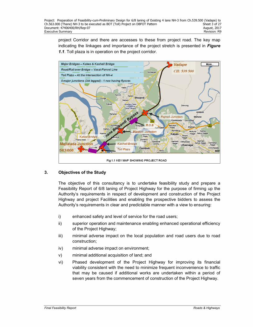
project Corridor and there are accesses to these from project road. The key map indicating the linkages and importance of the project stretch is presented in Figure 1.1. Toll plaza is in operation on the project corridor.
3. Objectives of the Study The objective of this consultancy is to undertake feasibility study and prepare a Feasibility Report of 6/8 laning of Project Highway for the purpose of firming up the Authority’s requirements in respect of development and construction of the Project Highway and project Facilities and enabling the prospective bidders to assess the Authority’s requirements in clear and predictable manner with a view to ensuring:
i) enhanced safety and level of service for the road users;
ii) superior operation and maintenance enabling enhanced operational efficiency of the Project Highway;
iii) minimal adverse impact on the local population and road users due to road construction;
iv) minimal adverse impact on environment;
v) minimal additional acquisition of land; and
vi) Phased development of the Project Highway for improving its financial viability consistent with the need to minimize frequent inconvenience to traffic that may be caused if additional works are undertaken within a period of seven years from the commencement of construction of the Project Highway.
Project: Preparation of Feasibility-cum-Preliminary Design for 6/8 laning of Existing 4 lane NH-3 from Ch.539.500 (Vadape) to Ch.563.000 (Thane) NH-3 to be executed as BOT (Toll) Project on DBFOT Pattern Sheet 4 of 27 Document: 47406400/RH/Rep-07 August, 2017 Executive Summary Revision: R9
Final Feasibility Report Roads & Highways
The Executive Summary with reference to each chapter is given below
4. Chapter 1: Introduction This chapter gives the project background; project in brief, objective & scope of study, deliverables and essence of present Report. Based on the primary and secondary data that includes the data from traffic surveys, further analysis of traffic data in particular, consultants have made improvement proposals which include widening scheme, geometric & pavement design, flyovers, interchange, vehicular subways etc. Preliminary cost estimate has also been prepared for suggested improvements and Financial Analysis has also been worked out based on cost, traffic forecast and latest toll policy published in January 2014 accordingly.
5. Chapter 2: Engineering Survey and Investigations Following are the various engineering surveys and investigations other than traffic surveys.
Road Inventory Survey
Pavement Condition Survey
Bridge Inventory Survey
Bridge Condition Survey
Axle Load Survey
Topographic Survey
Geo-technical Investigation
An inventory of the Project Road was carried out through dimensional measurement and visual inspection. Features like chainage, terrain and land-use, height of fill or depth of cut, width of pavement and shoulders (both paved and earthen), type of railway crossing, important road junctions and geometric deficiencies, utilities etc., were recorded using formats as suggested by IRC. Terrain & Climate: The road alignment traverses on a generally coastal plain terrain between altitudes of 5 m to 35 m above mean sea level. Average rainfall is of the order of 2000 mm – 4000 mm per year spread over 4 monsoon months. Land Use Pattern: Majority of abutting land use is barren followed by commercial and others based on inventory data.
Land Use Type Land Use Pattern (%)
Agriculture 4
Barren /Semi Barren 65
Semi Urban 18
Commercial/Industrial 10
Other 3
Project: Preparation of Feasibility-cum-Preliminary Design for 6/8 laning of Existing 4 lane NH-3 from Ch.539.500 (Vadape) to Ch.563.000 (Thane) NH-3 to be executed as BOT (Toll) Project on DBFOT Pattern Sheet 5 of 27 Document: 47406400/RH/Rep-07 August, 2017 Executive Summary Revision: R9
Final Feasibility Report Roads & Highways
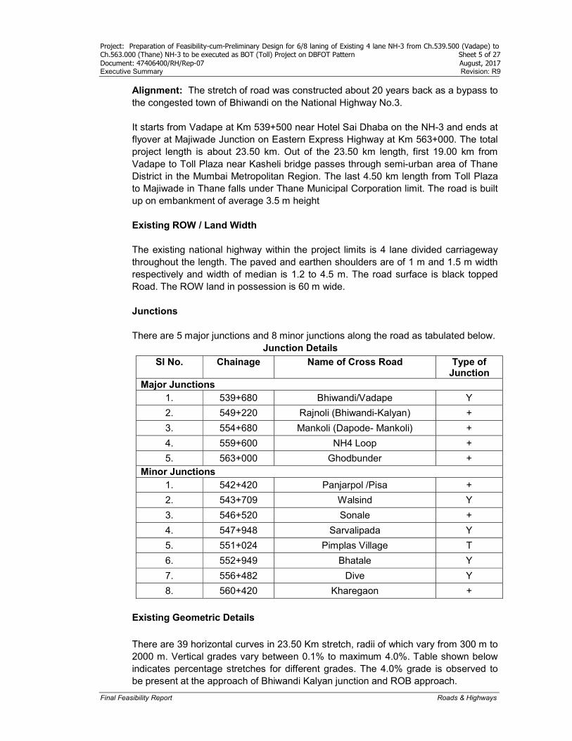
Alignment: The stretch of road was constructed about 20 years back as a bypass to the congested town of Bhiwandi on the National Highway No.3. It starts from Vadape at Km 539+500 near Hotel Sai Dhaba on the NH-3 and ends at flyover at Majiwade Junction on Eastern Express Highway at Km 563+000. The total project length is about 23.50 km. Out of the 23.50 km length, first 19.00 km from Vadape to Toll Plaza near Kasheli bridge passes through semi-urban area of Thane District in the Mumbai Metropolitan Region. The last 4.50 km length from Toll Plaza to Majiwade in Thane falls under Thane Municipal Corporation limit. The road is built up on embankment of average 3.5 m height
Existing ROW / Land Width The existing national highway within the project limits is 4 lane divided carriageway throughout the length. The paved and earthen shoulders are of 1 m and 1.5 m width respectively and width of median is 1.2 to 4.5 m. The road surface is black topped Road. The ROW land in possession is 60 m wide. Junctions There are 5 major junctions and 8 minor junctions along the road as tabulated below.
Junction Details
Sl No. Chainage Name of Cross Road Type of Junction
Major Junctions 1. 539+680 Bhiwandi/Vadape Y
2. 549+220 Rajnoli (Bhiwandi-Kalyan) +
3. 554+680 Mankoli (Dapode- Mankoli) +
4. 559+600 NH4 Loop +
5. 563+000 Ghodbunder + Minor Junctions
1. 542+420 Panjarpol /Pisa +
2. 543+709 Walsind Y
3. 546+520 Sonale +
4. 547+948 Sarvalipada Y
5. 551+024 Pimplas Village T
6. 552+949 Bhatale Y
7. 556+482 Dive Y
8. 560+420 Kharegaon + Existing Geometric Details There are 39 horizontal curves in 23.50 Km stretch, radii of which vary from 300 m to 2000 m. Vertical grades vary between 0.1% to maximum 4.0%. Table shown below indicates percentage stretches for different grades. The 4.0% grade is observed to be present at the approach of Bhiwandi Kalyan junction and ROB approach.

Project: Preparation of Feasibility-cum-Preliminary Design for 6/8 laning of Existing 4 lane NH-3 from Ch.539.500 (Vadape) to Ch.563.000 (Thane) NH-3 to be executed as BOT (Toll) Project on DBFOT Pattern Sheet 6 of 27 Document: 47406400/RH/Rep-07 August, 2017 Executive Summary Revision: R9
Final Feasibility Report Roads & Highways
Steep Road Gradient at ROB
Existing Alignment Gradient Details
Gradient (%)
Percentage of stretch
0-0.2 26.86 0.2-0.5 13.82 0.5-1 19.00
1-2 26.43
2-3 9.71
3-4 4.19
Embankment Height: The 91% length of project highway is constructed on embankment. The high embankment is observed at the approaches of two major bridges and ROB location. The observed maximum height of embankment at bridge approaches is 6-8 m, at ROB approaches is 8-10 m and the average embankment height is 3.75 m along the project highway. Side Drain: The side drains of the project highway are open and unlined. The side drains are not in working condition as water logging was observed during the monsoon period at many locations along the project highway. There is unauthorized filling done along the road alignment to provide accesses to private properties which clogged the side drains causing flooding during rains. Structures An inventory of the existing bridges and structures along the project corridor was carried out and existing structures are categorized in four types (major, minor bridges, ROBs and culverts) as below. Total number of structures
No. of major bridges : 2
No. of minor bridges : 3
No. of Railway over bridges : 1
No. of Pipe culverts : 72
No. of slab culverts : 10
No. of box culverts : 3
Project: Preparation of Feasibility-cum-Preliminary Design for 6/8 laning of Existing 4 lane NH-3 from Ch.539.500 (Vadape) to Ch.563.000 (Thane) NH-3 to be executed as BOT (Toll) Project on DBFOT Pattern Sheet 7 of 27 Document: 47406400/RH/Rep-07 August, 2017 Executive Summary Revision: R9
Final Feasibility Report Roads & Highways
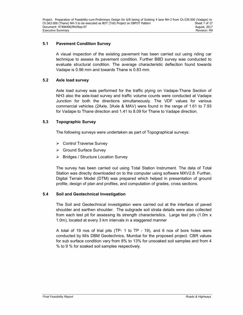
5.1 Pavement Condition Survey
A visual inspection of the existing pavement has been carried out using riding car technique to assess its pavement condition. Further BBD survey was conducted to evaluate structural condition. The average characteristic deflection found towards Vadape is 0.96 mm and towards Thane is 0.83 mm.
5.2 Axle load survey
Axle load survey was performed for the traffic plying on Vadape-Thane Section of NH3 also the axle-load survey and traffic volume counts were conducted at Vadape Junction for both the directions simultaneously. The VDF values for various commercial vehicles (2Axle, 3Axle & MAV) were found in the range of 1.61 to 7.93 for Vadape to Thane direction and 1.41 to 8.09 for Thane to Vadape direction.
5.3 Topographic Survey
The following surveys were undertaken as part of Topographical surveys:
Control Traverse Survey
Ground Surface Survey
Bridges / Structure Location Survey
The survey has been carried out using Total Station Instrument. The data of Total Station was directly downloaded on to the computer using software MXV2.8. Further, Digital Terrain Model (DTM) was prepared which helped in presentation of ground profile, design of plan and profiles, and computation of grades, cross sections.
5.4 Soil and Geotechnical Investigation The Soil and Geotechnical investigation were carried out at the interface of paved shoulder and earthen shoulder. The subgrade soil strata details were also collected from each test pit for assessing its strength characteristics. Large test pits (1.0m x 1.0m), located at every 3 km intervals in a staggered manner A total of 19 nos of trial pits (TP- 1 to TP - 19), and 6 nos of bore holes were conducted by M/s DBM Geotechnics, Mumbai for the proposed project. CBR values for sub surface condition vary from 8% to 13% for unsoaked soil samples and from 4 % to 9 % for soaked soil samples respectively.
Project: Preparation of Feasibility-cum-Preliminary Design for 6/8 laning of Existing 4 lane NH-3 from Ch.539.500 (Vadape) to Ch.563.000 (Thane) NH-3 to be executed as BOT (Toll) Project on DBFOT Pattern Sheet 8 of 27 Document: 47406400/RH/Rep-07 August, 2017 Executive Summary Revision: R9
Final Feasibility Report Roads & Highways
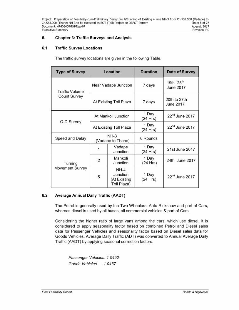
6. Chapter 3: Traffic Surveys and Analysis 6.1 Traffic Survey Locations
The traffic survey locations are given in the following Table.
Type of Survey Location Duration Date of Survey
Traffic Volume Count Survey
Near Vadape Junction 7 days 19th -25th June 2017
At Existing Toll Plaza 7 days 20th to 27th June 2017
O-D Survey At Mankoli Junction
1 Day (24 Hrs)
22nd June 2017
At Existing Toll Plaza 1 Day
(24 Hrs) 22nd June 2017
Speed and Delay NH-3
(Vadape to Thane) 6 Rounds
Turning Movement Survey
1 Vadape Junction
1 Day (24 Hrs)
21st June 2017
2 Mankoli Junction
1 Day (24 Hrs)
24th June 2017
5
NH-4 Junction
(At Existing Toll Plaza)
1 Day (24 Hrs)
22nd June 2017
6.2 Average Annual Daily Traffic (AADT)
The Petrol is generally used by the Two Wheelers, Auto Rickshaw and part of Cars, whereas diesel is used by all buses, all commercial vehicles & part of Cars. Considering the higher ratio of large vans among the cars, which use diesel, it is considered to apply seasonality factor based on combined Petrol and Diesel sales data for Passenger Vehicles and seasonality factor based on Diesel sales data for Goods Vehicles. Average Daily Traffic (ADT) was converted to Annual Average Daily Traffic (AADT) by applying seasonal correction factors.
Passenger Vehicles: 1.0492
Goods Vehicles : 1.0467
Project: Preparation of Feasibility-cum-Preliminary Design for 6/8 laning of Existing 4 lane NH-3 from Ch.539.500 (Vadape) to Ch.563.000 (Thane) NH-3 to be executed as BOT (Toll) Project on DBFOT Pattern Sheet 9 of 27 Document: 47406400/RH/Rep-07 August, 2017 Executive Summary Revision: R9
Final Feasibility Report Roads & Highways
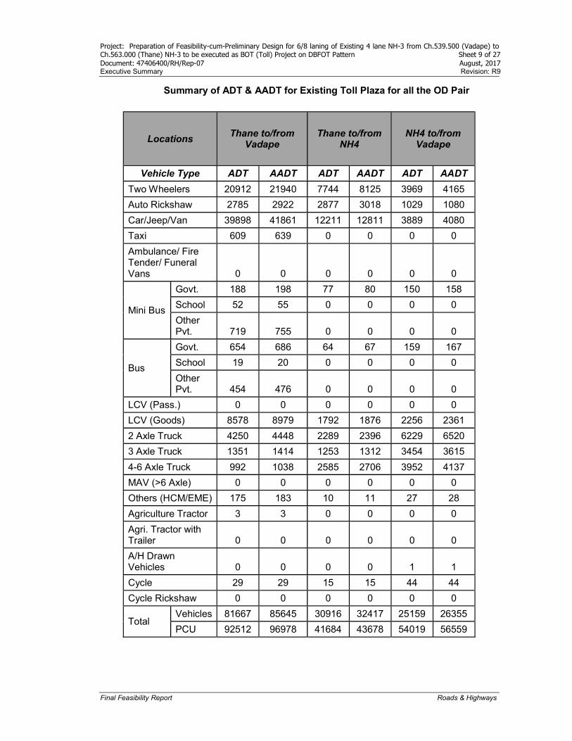
Summary of ADT & AADT for Existing Toll Plaza for all the OD Pair
Locations Thane to/from
Vadape Thane to/from
NH4 NH4 to/from
Vadape
Vehicle Type ADT AADT ADT AADT ADT AADT
Two Wheelers 20912 21940 7744 8125 3969 4165
Auto Rickshaw 2785 2922 2877 3018 1029 1080
Car/Jeep/Van 39898 41861 12211 12811 3889 4080
Taxi 609 639 0 0 0 0
Ambulance/ Fire Tender/ Funeral Vans 0 0 0 0 0 0
Mini Bus
Govt. 188 198 77 80 150 158
School 52 55 0 0 0 0
Other Pvt. 719 755 0 0 0 0
Bus
Govt. 654 686 64 67 159 167
School 19 20 0 0 0 0
Other Pvt. 454 476 0 0 0 0
LCV (Pass.) 0 0 0 0 0 0
LCV (Goods) 8578 8979 1792 1876 2256 2361
2 Axle Truck 4250 4448 2289 2396 6229 6520
3 Axle Truck 1351 1414 1253 1312 3454 3615
4-6 Axle Truck 992 1038 2585 2706 3952 4137
MAV (>6 Axle) 0 0 0 0 0 0
Others (HCM/EME) 175 183 10 11 27 28
Agriculture Tractor 3 3 0 0 0 0
Agri. Tractor with Trailer 0 0 0 0 0 0
A/H Drawn Vehicles 0 0 0 0 1 1
Cycle 29 29 15 15 44 44
Cycle Rickshaw 0 0 0 0 0 0
Total Vehicles 81667 85645 30916 32417 25159 26355
PCU 92512 96978 41684 43678 54019 56559

Project: Preparation of Feasibility-cum-Preliminary Design for 6/8 laning of Existing 4 lane NH-3 from Ch.539.500 (Vadape) to Ch.563.000 (Thane) NH-3 to be executed as BOT (Toll) Project on DBFOT Pattern Sheet 10 of 27 Document: 47406400/RH/Rep-07 August, 2017 Executive Summary Revision: R9
Final Feasibility Report Roads & Highways
6.3 Lane Requirement The projected sectional traffic is compared with Design Service Volume (DSV) to assess the up gradation requirement for the corridor under prevailing roadway conditions. Capacity augmentation is generally warranted for roads that cater to traffic volumes in excess of the DSV at LOS B. As the PCU’s exceed 95000, 8 lane Divided carriageway is warranted and the project road caters for PCUs more than 95000. Due to this, at certain sections widening to more than 8 lane is necessary. The Lane requirement relevant to the PCU’s has been tabulated below for the current and the horizon years.
Section wise Lane Requirement
No Project Road
Sections
2017 2020 2025 2030 2035 2040
PCUs Lanes PCUs Lanes PCUs Lanes PCUs Lanes PCUs Lanes PCUs Lanes
I
Road Section Before Toll
140656 8 162827 8* 207813 >8 265228 >8 338505 >8 432028 >8
II
Road section between Toll plaza and Mankoli Junction
152428 8* 176454 8* 225206 >8 287426 >8 366836 >8 468186 >8
III
Road section between Mankoli Junction and Rajnoli Junction
139298 8* 161255 8* 205807 >8 262667 >8 335237 >8 427857 >8
IV
Road section between Rajnoli and Vadape
70164 6 81224 6 103664 8 132305 8 168858 8 215510 >8
Note: *Level of Service C
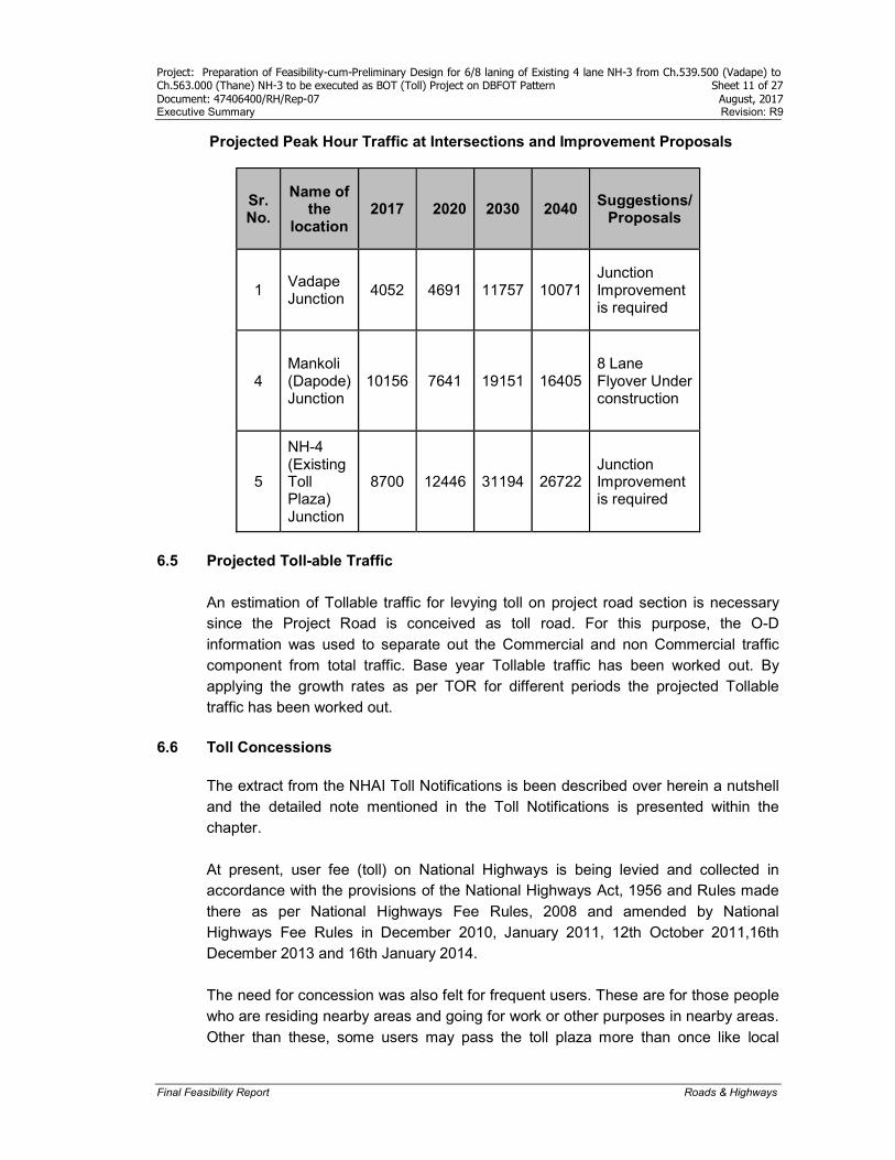
6.4 Junction Improvement Proposals
The criteria for grade separation at intersection are based on IRC: 92-1985 "Guidelines for the Design of Interchanges". The guidelines suggest that a grade separated intersection besides other warrants is justified when the total traffic on the intersection is in excess of 10000 PCUs per hour. To assess the requirement of grade separation at intersections, peak hour traffic was projected and type of improvement presented in Table below.
Project: Preparation of Feasibility-cum-Preliminary Design for 6/8 laning of Existing 4 lane NH-3 from Ch.539.500 (Vadape) to Ch.563.000 (Thane) NH-3 to be executed as BOT (Toll) Project on DBFOT Pattern Sheet 11 of 27 Document: 47406400/RH/Rep-07 August, 2017 Executive Summary Revision: R9
Final Feasibility Report Roads & Highways
Projected Peak Hour Traffic at Intersections and Improvement Proposals
Sr. No.
Name of the
location 2017 2020 2030 2040
Suggestions/ Proposals
1 Vadape Junction
4052 4691 11757 10071 Junction Improvement is required
4 Mankoli (Dapode) Junction
10156 7641 19151 16405 8 Lane Flyover Under construction
5
NH-4 (Existing Toll Plaza) Junction
8700 12446 31194 26722 Junction Improvement is required
6.5 Projected Toll-able Traffic
An estimation of Tollable traffic for levying toll on project road section is necessary since the Project Road is conceived as toll road. For this purpose, the O-D information was used to separate out the Commercial and non Commercial traffic component from total traffic. Base year Tollable traffic has been worked out. By applying the growth rates as per TOR for different periods the projected Tollable traffic has been worked out.
6.6 Toll Concessions
The extract from the NHAI Toll Notifications is been described over herein a nutshell and the detailed note mentioned in the Toll Notifications is presented within the chapter. At present, user fee (toll) on National Highways is being levied and collected in accordance with the provisions of the National Highways Act, 1956 and Rules made there as per National Highways Fee Rules, 2008 and amended by National Highways Fee Rules in December 2010, January 2011, 12th October 2011,16th December 2013 and 16th January 2014. The need for concession was also felt for frequent users. These are for those people who are residing nearby areas and going for work or other purposes in nearby areas. Other than these, some users may pass the toll plaza more than once like local
Project: Preparation of Feasibility-cum-Preliminary Design for 6/8 laning of Existing 4 lane NH-3 from Ch.539.500 (Vadape) to Ch.563.000 (Thane) NH-3 to be executed as BOT (Toll) Project on DBFOT Pattern Sheet 12 of 27 Document: 47406400/RH/Rep-07 August, 2017 Executive Summary Revision: R9
Final Feasibility Report Roads & Highways
jeeps, buses etc. So toll concessions to these users are categorized under following criteria:
Return Traffic 25 per cent discount for users who make return journey within 24 hours may be allowed. This means that 2 single journeys on payment of one and half times of single journey rate will be allowed if the users return within 24 hours.
Monthly passes
For monthly passes, a discount of 1/3 of amount otherwise payable for 50 single journeys, to be rounded off to nearest five rupees, could be allowed. The number of journeys against such a pass would, however, be restricted to 50, to be performed within a month.
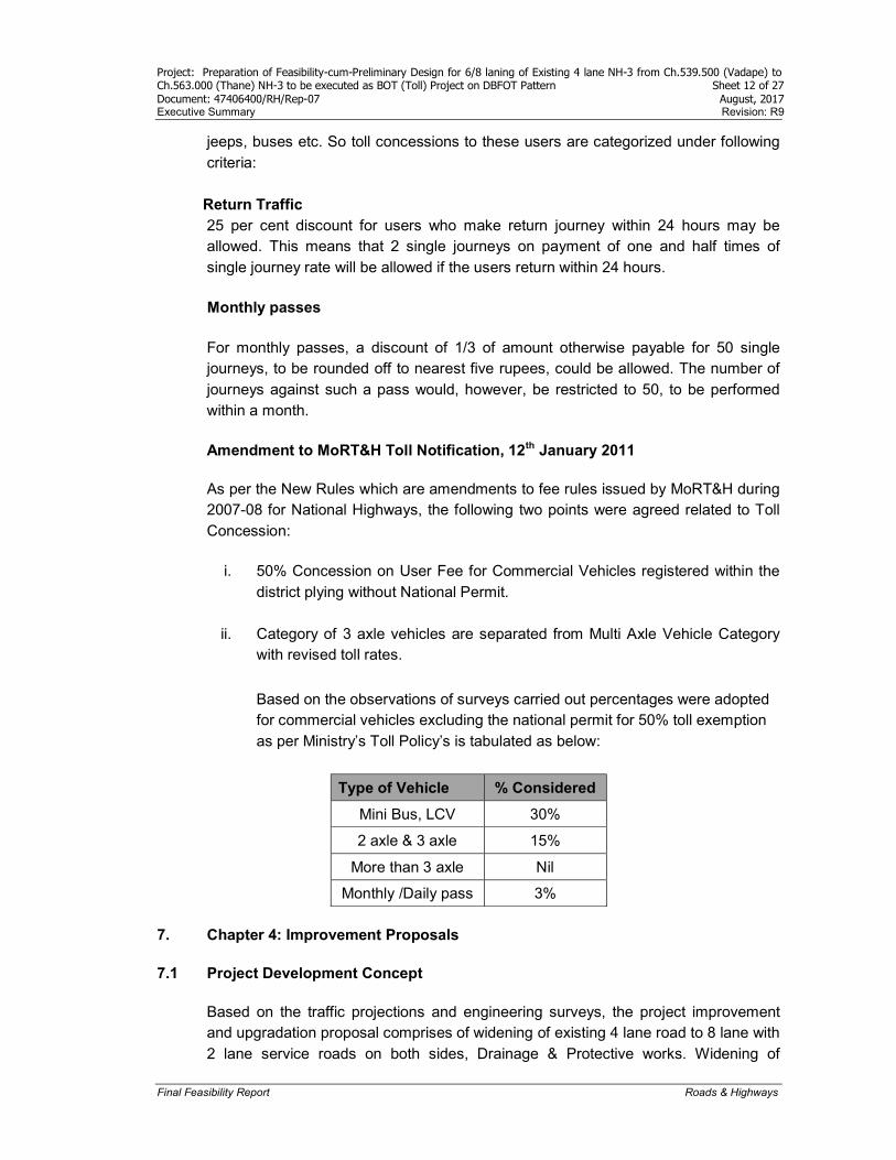
Amendment to MoRT&H Toll Notification, 12th January 2011
As per the New Rules which are amendments to fee rules issued by MoRT&H during 2007-08 for National Highways, the following two points were agreed related to Toll Concession:
i. 50% Concession on User Fee for Commercial Vehicles registered within the district plying without National Permit.
ii. Category of 3 axle vehicles are separated from Multi Axle Vehicle Category with revised toll rates.
Based on the observations of surveys carried out percentages were adopted for commercial vehicles excluding the national permit for 50% toll exemption as per Ministry’s Toll Policy’s is tabulated as below:
Type of Vehicle % Considered
Mini Bus, LCV 30%
2 axle & 3 axle 15%
More than 3 axle Nil
Monthly /Daily pass 3%
7. Chapter 4: Improvement Proposals
7.1 Project Development Concept
Based on the traffic projections and engineering surveys, the project improvement and upgradation proposal comprises of widening of existing 4 lane road to 8 lane with 2 lane service roads on both sides, Drainage & Protective works. Widening of
Project: Preparation of Feasibility-cum-Preliminary Design for 6/8 laning of Existing 4 lane NH-3 from Ch.539.500 (Vadape) to Ch.563.000 (Thane) NH-3 to be executed as BOT (Toll) Project on DBFOT Pattern Sheet 13 of 27 Document: 47406400/RH/Rep-07 August, 2017 Executive Summary Revision: R9
Final Feasibility Report Roads & Highways
existing bridges and cross drainage structures to suit to the flanking road way, construction of service roads, flyovers, ROB and vehicular subways, Junction Improvement and other facilities. The design standards have been formulated based on IRC Codes and Manual of Specification and Standards for Six Laning (MORTH). AASHTO Geometric design guidelines have also been referred wherever the IRC codes are silent.
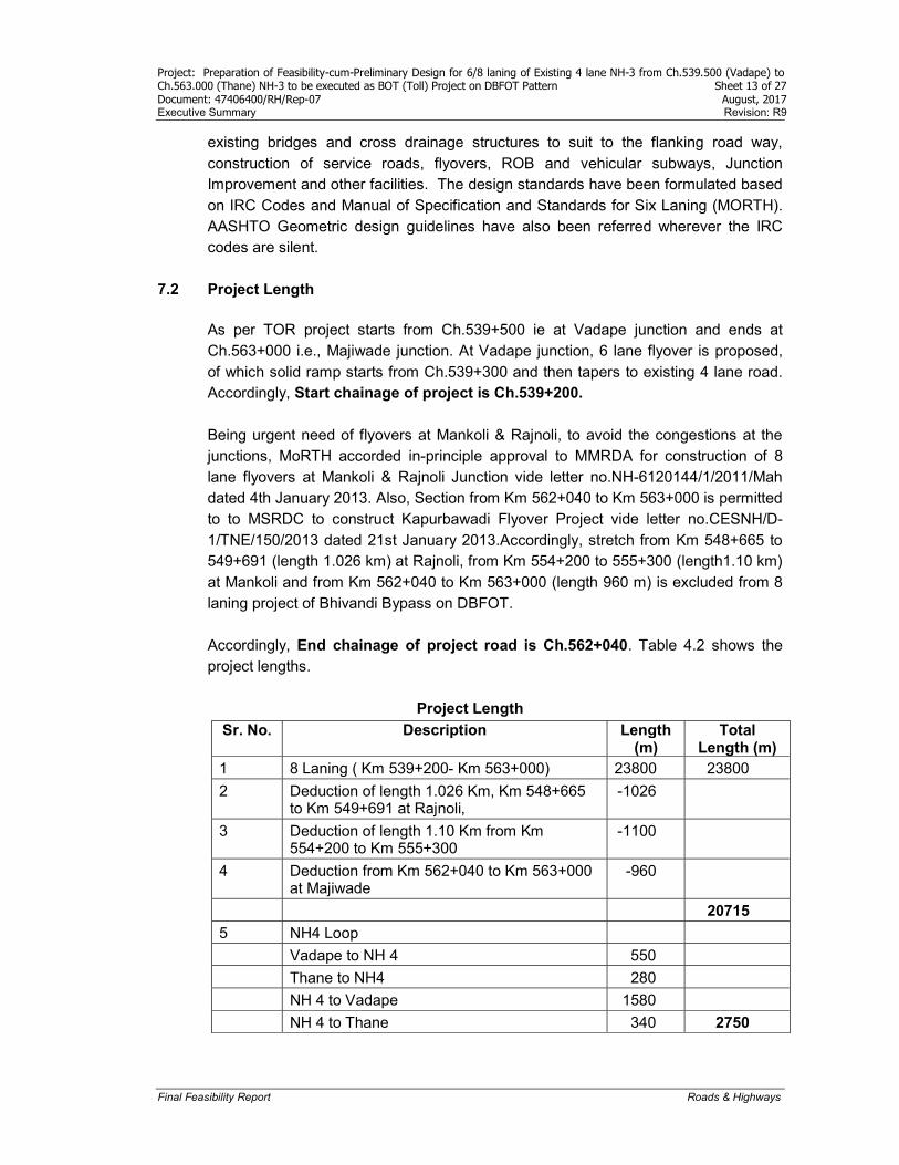
7.2 Project Length As per TOR project starts from Ch.539+500 ie at Vadape junction and ends at Ch.563+000 i.e., Majiwade junction. At Vadape junction, 6 lane flyover is proposed, of which solid ramp starts from Ch.539+300 and then tapers to existing 4 lane road. Accordingly, Start chainage of project is Ch.539+200. Being urgent need of flyovers at Mankoli & Rajnoli, to avoid the congestions at the junctions, MoRTH accorded in-principle approval to MMRDA for construction of 8 lane flyovers at Mankoli & Rajnoli Junction vide letter no.NH-6120144/1/2011/Mah dated 4th January 2013. Also, Section from Km 562+040 to Km 563+000 is permitted to to MSRDC to construct Kapurbawadi Flyover Project vide letter no.CESNH/D-1/TNE/150/2013 dated 21st January 2013.Accordingly, stretch from Km 548+665 to 549+691 (length 1.026 km) at Rajnoli, from Km 554+200 to 555+300 (length1.10 km) at Mankoli and from Km 562+040 to Km 563+000 (length 960 m) is excluded from 8 laning project of Bhivandi Bypass on DBFOT. Accordingly, End chainage of project road is Ch.562+040. Table 4.2 shows the project lengths.
Project Length
Sr. No. Description Length (m)
Total Length (m)
1 8 Laning ( Km 539+200- Km 563+000) 23800 23800
2 Deduction of length 1.026 Km, Km 548+665 to Km 549+691 at Rajnoli,
-1026
3 Deduction of length 1.10 Km from Km 554+200 to Km 555+300
-1100
4 Deduction from Km 562+040 to Km 563+000 at Majiwade
-960
20715
5 NH4 Loop
Vadape to NH 4 550
Thane to NH4 280
NH 4 to Vadape 1580
NH 4 to Thane 340 2750
Project: Preparation of Feasibility-cum-Preliminary Design for 6/8 laning of Existing 4 lane NH-3 from Ch.539.500 (Vadape) to Ch.563.000 (Thane) NH-3 to be executed as BOT (Toll) Project on DBFOT Pattern Sheet 14 of 27 Document: 47406400/RH/Rep-07 August, 2017 Executive Summary Revision: R9
Final Feasibility Report Roads & Highways
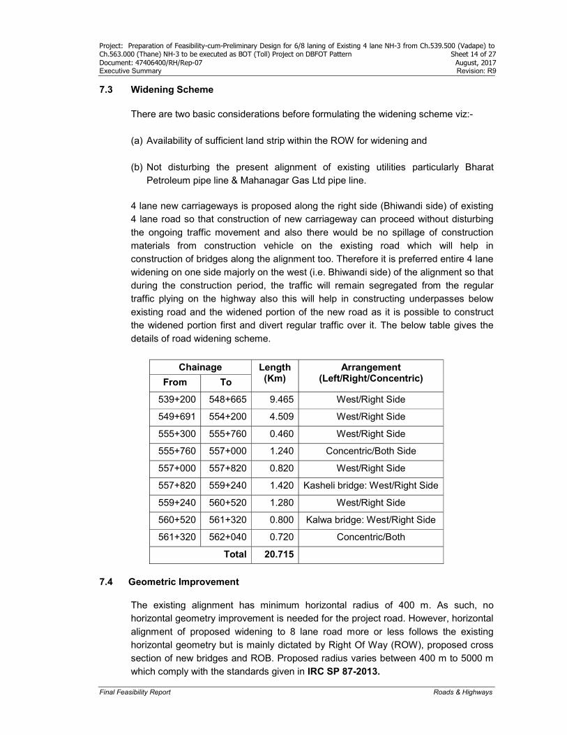
7.3 Widening Scheme There are two basic considerations before formulating the widening scheme viz:- (a) Availability of sufficient land strip within the ROW for widening and (b) Not disturbing the present alignment of existing utilities particularly Bharat
Petroleum pipe line & Mahanagar Gas Ltd pipe line. 4 lane new carriageways is proposed along the right side (Bhiwandi side) of existing 4 lane road so that construction of new carriageway can proceed without disturbing the ongoing traffic movement and also there would be no spillage of construction materials from construction vehicle on the existing road which will help in construction of bridges along the alignment too. Therefore it is preferred entire 4 lane widening on one side majorly on the west (i.e. Bhiwandi side) of the alignment so that during the construction period, the traffic will remain segregated from the regular traffic plying on the highway also this will help in constructing underpasses below existing road and the widened portion of the new road as it is possible to construct the widened portion first and divert regular traffic over it. The below table gives the details of road widening scheme.
Chainage Length (Km)
Arrangement (Left/Right/Concentric) From To
539+200 548+665 9.465 West/Right Side
549+691 554+200 4.509 West/Right Side
555+300 555+760 0.460 West/Right Side
555+760 557+000 1.240 Concentric/Both Side
557+000 557+820 0.820 West/Right Side
557+820 559+240 1.420 Kasheli bridge: West/Right Side
559+240 560+520 1.280 West/Right Side
560+520 561+320 0.800 Kalwa bridge: West/Right Side
561+320 562+040 0.720 Concentric/Both
Total 20.715
7.4 Geometric Improvement
The existing alignment has minimum horizontal radius of 400 m. As such, no horizontal geometry improvement is needed for the project road. However, horizontal alignment of proposed widening to 8 lane road more or less follows the existing horizontal geometry but is mainly dictated by Right Of Way (ROW), proposed cross section of new bridges and ROB. Proposed radius varies between 400 m to 5000 m which comply with the standards given in IRC SP 87-2013.
Project: Preparation of Feasibility-cum-Preliminary Design for 6/8 laning of Existing 4 lane NH-3 from Ch.539.500 (Vadape) to Ch.563.000 (Thane) NH-3 to be executed as BOT (Toll) Project on DBFOT Pattern Sheet 15 of 27 Document: 47406400/RH/Rep-07 August, 2017 Executive Summary Revision: R9
Final Feasibility Report Roads & Highways
Vertical Geometry
Vertical geometry is dictated by proposed vertical clearances at bridges for navigational span, subways, ROB and proposed pavement crust etc. Vertical geometry of existing road is poor at some locations regarding sight distances, gradient and longitudinal drainage. As per road widening proposal, new 4 lane road can be constructed first without disturbing the existing traffic, vertical geometry of existing road can be improved by diverting the traffic on newly constructed 4 lane road. As it is proposed that both carriageways at the same level follow the same grade even it is less than 0.5% as longitudinal drainage point of view. Accordingly, vertical geometry is prepared for both the carriageways separately.
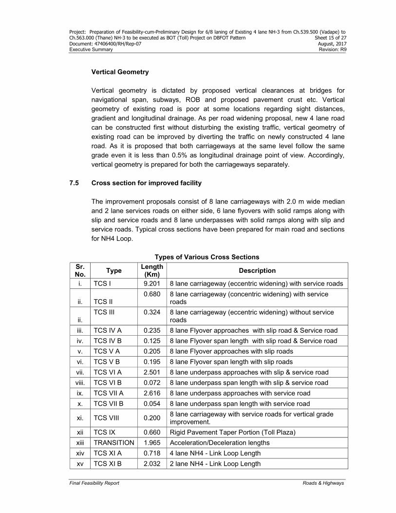
7.5 Cross section for improved facility
The improvement proposals consist of 8 lane carriageways with 2.0 m wide median and 2 lane services roads on either side, 6 lane flyovers with solid ramps along with slip and service roads and 8 lane underpasses with solid ramps along with slip and service roads. Typical cross sections have been prepared for main road and sections for NH4 Loop.
Types of Various Cross Sections
Sr. No.
Type Length (Km)
Description
i. TCS I 9.201 8 lane carriageway (eccentric widening) with service roads
ii. TCS II 0.680 8 lane carriageway (concentric widening) with service
roads
ii. TCS III 0.324 8 lane carriageway (eccentric widening) without service
roads
iii. TCS IV A 0.235 8 lane Flyover approaches with slip road & Service road
iv. TCS IV B 0.125 8 lane Flyover span length with slip road & Service road
v. TCS V A 0.205 8 lane Flyover approaches with slip roads
vi. TCS V B 0.195 8 lane Flyover span length with slip roads
vii. TCS VI A 2.501 8 lane underpass approaches with slip & service road
viii. TCS VI B 0.072 8 lane underpass span length with slip & service road
ix. TCS VII A 2.616 8 lane underpass approaches with service road
x. TCS VII B 0.054 8 lane underpass span length with service road
xi. TCS VIII 0.200 8 lane carriageway with service roads for vertical grade improvement.
xii TCS IX 0.660 Rigid Pavement Taper Portion (Toll Plaza)
xiii TRANSITION 1.965 Acceleration/Deceleration lengths
xiv TCS XI A 0.718 4 lane NH4 - Link Loop Length
xv TCS XI B 2.032 2 lane NH4 - Link Loop Length
Project: Preparation of Feasibility-cum-Preliminary Design for 6/8 laning of Existing 4 lane NH-3 from Ch.539.500 (Vadape) to Ch.563.000 (Thane) NH-3 to be executed as BOT (Toll) Project on DBFOT Pattern Sheet 16 of 27 Document: 47406400/RH/Rep-07 August, 2017 Executive Summary Revision: R9
Final Feasibility Report Roads & Highways
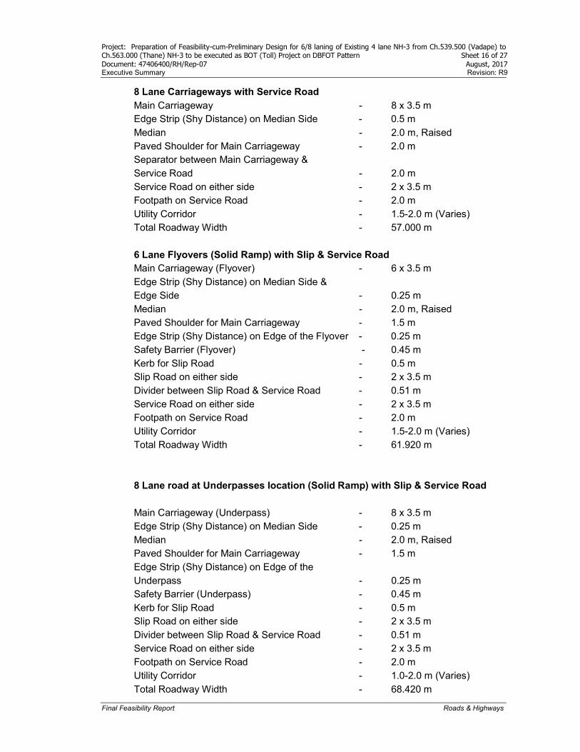
8 Lane Carriageways with Service Road Main Carriageway - 8 x 3.5 m Edge Strip (Shy Distance) on Median Side - 0.5 m Median - 2.0 m, Raised Paved Shoulder for Main Carriageway - 2.0 m Separator between Main Carriageway & Service Road - 2.0 m Service Road on either side - 2 x 3.5 m Footpath on Service Road - 2.0 m Utility Corridor - 1.5-2.0 m (Varies) Total Roadway Width - 57.000 m 6 Lane Flyovers (Solid Ramp) with Slip & Service Road Main Carriageway (Flyover) - 6 x 3.5 m Edge Strip (Shy Distance) on Median Side & Edge Side - 0.25 m Median - 2.0 m, Raised Paved Shoulder for Main Carriageway - 1.5 m Edge Strip (Shy Distance) on Edge of the Flyover - 0.25 m Safety Barrier (Flyover) - 0.45 m Kerb for Slip Road - 0.5 m Slip Road on either side - 2 x 3.5 m Divider between Slip Road & Service Road - 0.51 m Service Road on either side - 2 x 3.5 m Footpath on Service Road - 2.0 m Utility Corridor - 1.5-2.0 m (Varies) Total Roadway Width - 61.920 m 8 Lane road at Underpasses location (Solid Ramp) with Slip & Service Road Main Carriageway (Underpass) - 8 x 3.5 m Edge Strip (Shy Distance) on Median Side - 0.25 m Median - 2.0 m, Raised Paved Shoulder for Main Carriageway - 1.5 m Edge Strip (Shy Distance) on Edge of the Underpass - 0.25 m Safety Barrier (Underpass) - 0.45 m Kerb for Slip Road - 0.5 m Slip Road on either side - 2 x 3.5 m Divider between Slip Road & Service Road - 0.51 m Service Road on either side - 2 x 3.5 m Footpath on Service Road - 2.0 m Utility Corridor - 1.0-2.0 m (Varies) Total Roadway Width - 68.420 m
Project: Preparation of Feasibility-cum-Preliminary Design for 6/8 laning of Existing 4 lane NH-3 from Ch.539.500 (Vadape) to Ch.563.000 (Thane) NH-3 to be executed as BOT (Toll) Project on DBFOT Pattern Sheet 17 of 27 Document: 47406400/RH/Rep-07 August, 2017 Executive Summary Revision: R9
Final Feasibility Report Roads & Highways
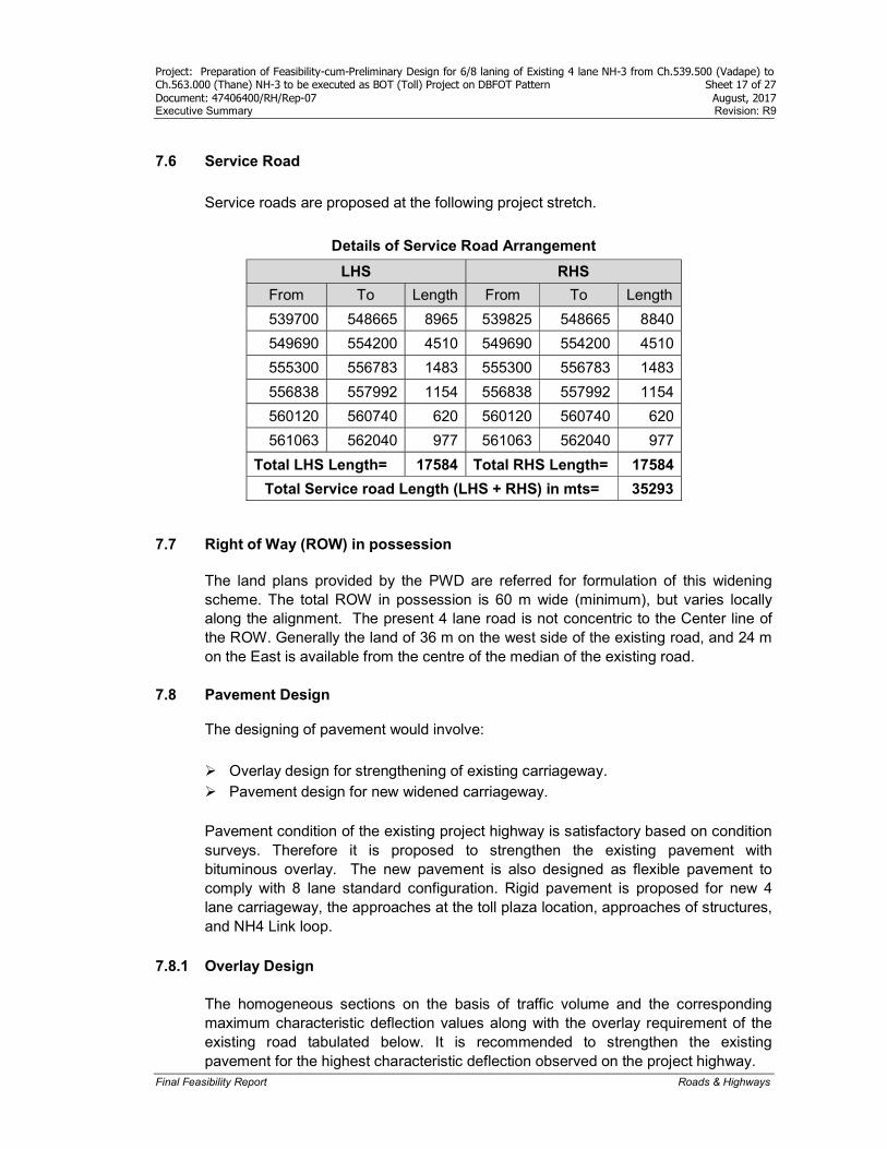
7.6 Service Road
Service roads are proposed at the following project stretch.
Details of Service Road Arrangement
LHS RHS
From To Length From To Length
539700 548665 8965 539825 548665 8840
549690 554200 4510 549690 554200 4510
555300 556783 1483 555300 556783 1483
556838 557992 1154 556838 557992 1154
560120 560740 620 560120 560740 620
561063 562040 977 561063 562040 977
Total LHS Length= 17584 Total RHS Length= 17584
Total Service road Length (LHS + RHS) in mts= 35293 7.7 Right of Way (ROW) in possession
The land plans provided by the PWD are referred for formulation of this widening scheme. The total ROW in possession is 60 m wide (minimum), but varies locally along the alignment. The present 4 lane road is not concentric to the Center line of the ROW. Generally the land of 36 m on the west side of the existing road, and 24 m on the East is available from the centre of the median of the existing road.
7.8 Pavement Design
The designing of pavement would involve:
Overlay design for strengthening of existing carriageway. Pavement design for new widened carriageway. Pavement condition of the existing project highway is satisfactory based on condition surveys. Therefore it is proposed to strengthen the existing pavement with bituminous overlay. The new pavement is also designed as flexible pavement to comply with 8 lane standard configuration. Rigid pavement is proposed for new 4 lane carriageway, the approaches at the toll plaza location, approaches of structures, and NH4 Link loop.
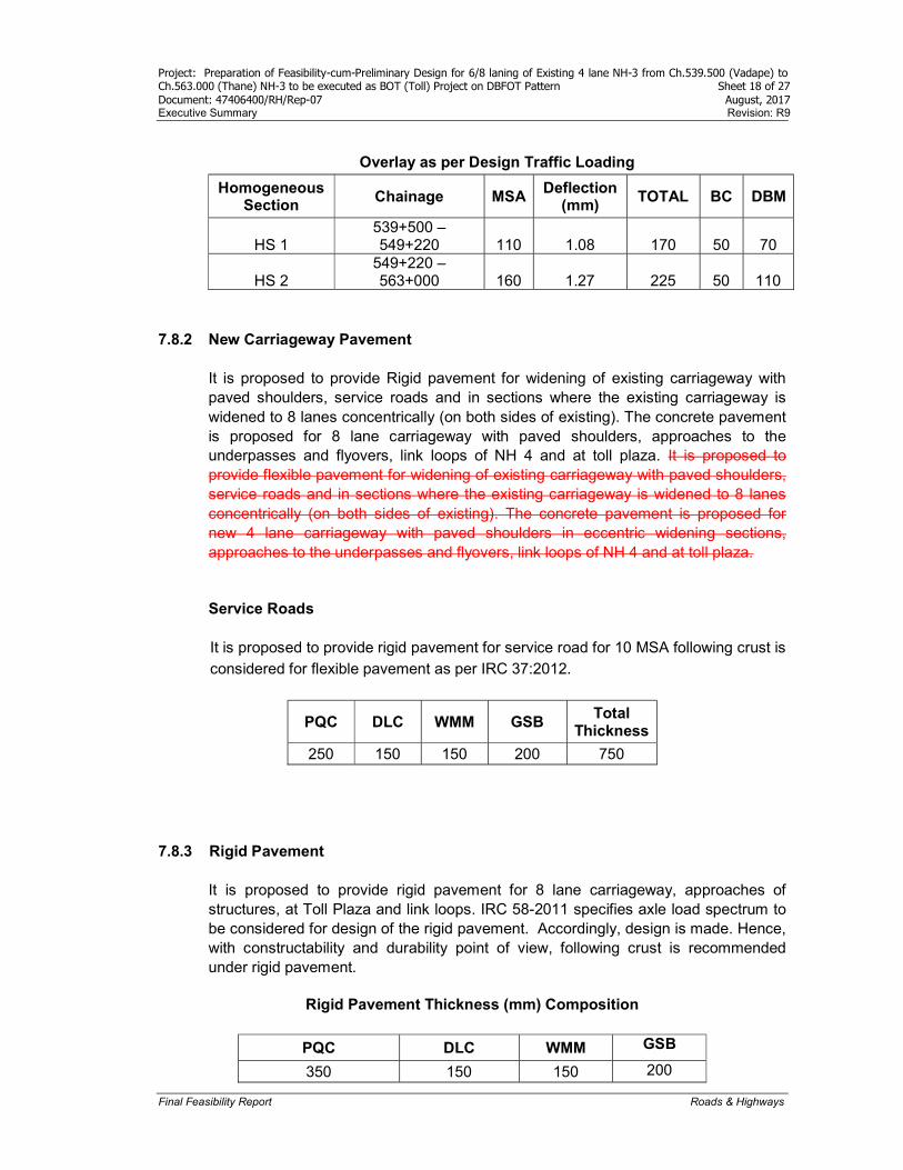
7.8.1 Overlay Design
The homogeneous sections on the basis of traffic volume and the corresponding maximum characteristic deflection values along with the overlay requirement of the existing road tabulated below. It is recommended to strengthen the existing pavement for the highest characteristic deflection observed on the project highway.
Project: Preparation of Feasibility-cum-Preliminary Design for 6/8 laning of Existing 4 lane NH-3 from Ch.539.500 (Vadape) to Ch.563.000 (Thane) NH-3 to be executed as BOT (Toll) Project on DBFOT Pattern Sheet 18 of 27 Document: 47406400/RH/Rep-07 August, 2017 Executive Summary Revision: R9
Final Feasibility Report Roads & Highways
Overlay as per Design Traffic Loading
Homogeneous Section
Chainage MSA Deflection
(mm) TOTAL BC DBM
HS 1 539+500 – 549+220 110 1.08 170 50 70
HS 2 549+220 – 563+000 160 1.27 225 50 110
7.8.2 New Carriageway Pavement It is proposed to provide Rigid pavement for widening of existing carriageway with paved shoulders, service roads and in sections where the existing carriageway is widened to 8 lanes concentrically (on both sides of existing). The concrete pavement is proposed for 8 lane carriageway with paved shoulders, approaches to the underpasses and flyovers, link loops of NH 4 and at toll plaza. It is proposed to provide flexible pavement for widening of existing carriageway with paved shoulders, service roads and in sections where the existing carriageway is widened to 8 lanes concentrically (on both sides of existing). The concrete pavement is proposed for new 4 lane carriageway with paved shoulders in eccentric widening sections, approaches to the underpasses and flyovers, link loops of NH 4 and at toll plaza.
Service Roads It is proposed to provide rigid pavement for service road for 10 MSA following crust is considered for flexible pavement as per IRC 37:2012.
PQC DLC WMM GSB Total
Thickness
250 150 150 200 750 7.8.3 Rigid Pavement
It is proposed to provide rigid pavement for 8 lane carriageway, approaches of structures, at Toll Plaza and link loops. IRC 58-2011 specifies axle load spectrum to be considered for design of the rigid pavement. Accordingly, design is made. Hence, with constructability and durability point of view, following crust is recommended under rigid pavement.
Rigid Pavement Thickness (mm) Composition
PQC DLC WMM GSB
350 150 150 200

Project: Preparation of Feasibility-cum-Preliminary Design for 6/8 laning of Existing 4 lane NH-3 from Ch.539.500 (Vadape) to Ch.563.000 (Thane) NH-3 to be executed as BOT (Toll) Project on DBFOT Pattern Sheet 19 of 27 Document: 47406400/RH/Rep-07 August, 2017 Executive Summary Revision: R9
Final Feasibility Report Roads & Highways
7.9 Intersections 7.9.1 Grade separators at Major Junctions
There are 5 major and 8 minor junctions along the project corridor. As an improvement for these major junctions, 6 lane Flyovers at Vadape, Mankoli and at Rajnoli (with full-fledged interchange) are proposed. However, MoRTH accorded approval to MMRDA for construction of 8 lane flyovers at Mankoli & Rajnoli Junction vide letter no.NH-6120144/1/2011/Mah dated 4th January 2013 and excluded from the scope of 8 laning of project road. Also, Section from Km 562+040 to Km 563+000 is excluded and given to MSRDC under Construction of Kapurbawadi Flyover Project vide letter no. CESNH/D-1/TNE/150/2013 dated 21st January 2013. Accordingly, the stretch from Km 548+665 to Km 549+691 (length 1.026 km) at Rajnoli, from Km 554+200 to Km 555+300 (length1.10 km) at Mankoli and from Km 562+040 to Km 563+000 (length 960 m) has been excluded from 8 laning project of Bhivandi Bypass on DBFOT. However, the flyover at Vadape is proposed as part of 8 laning of the project and included in the scope of 8 laning of project.
7.9.2 Grade Separated Junctions / locations (Vehicular Underpasses)
8 minor junctions are proposed for with 7 Vehicular underpasses (VUPs) of 15 x 5.5 m and one Vehicular underpass (VUP) of 12 x 4.0 m
7.10 Toll Plaza
13+13 toll booth lanes are proposed for main carriageway including one lane for oversize vehicles of width 4.5 m on either side and 7 toll lane for link loop from NH4 to Vadape and 5 toll lane from Vadape to NH4 link loop are proposed.
7.11 Highway Drainage
There are toe drains all along the road in the present case. The existing 4 lane road is proposed to be widened to 8 lanes with 4 lanes (2+2) of service road on either side of the road. To protect the road surface from flooding, rain water needs to be collected efficiently for disposal. Road side drains are proposed on both side of the road to collect rain water from the main carriageway. This can be achieved by providing minimum longitudinal gradient and cross slope of 2.0% from the median towards both the edges of the Main carriageway. All the drains are proposed to connect with existing culverts.
7.12 Bus Bays
City Transport Office is consulted for proposing the location of bus bays/bus stops. Bus bays could not be accommodated in proposed ROW of 60 m. Moreover, there are existing water mains on either side of the road due to which it may be difficult to

Project: Preparation of Feasibility-cum-Preliminary Design for 6/8 laning of Existing 4 lane NH-3 from Ch.539.500 (Vadape) to Ch.563.000 (Thane) NH-3 to be executed as BOT (Toll) Project on DBFOT Pattern Sheet 20 of 27 Document: 47406400/RH/Rep-07 August, 2017 Executive Summary Revision: R9
Final Feasibility Report Roads & Highways
construct extra lane for bus bays. However, bus stops may be proposed at the locations suggested by City Transport given in Table shown below.
Sr. No Chainage Name of Place
1 539+680 Vadpe
2 542+413 Panjarpol Junction
3 544+186 Walsindh
4 546+446 Sonale
5 550+740 Pimplas
6 552+309 Ovale
7 556+000 Dive
8 560+620 Kharegaon
7.13 Truck Lay-bys
Truck lay bays and rest areas are already available at most of the fuel stations. In addition to the existing fuel station two truck lay bay locations are identified and selected along the project corridor. The identified 2 locations given in following table are parallel to the main carriageway to facilitate easy maneuvering of commercial vehicles and obviously be separated from the carriageway by means of providing physical barrier.
Sr No Chainage Location (RHS/LHS)
1 555+240 to 555+640 RHS
2 555+700 to 556+020 LHS
Project: Preparation of Feasibility-cum-Preliminary Design for 6/8 laning of Existing 4 lane NH-3 from Ch.539.500 (Vadape) to Ch.563.000 (Thane) NH-3 to be executed as BOT (Toll) Project on DBFOT Pattern Sheet 21 of 27 Document: 47406400/RH/Rep-07 August, 2017 Executive Summary Revision: R9
Final Feasibility Report Roads & Highways
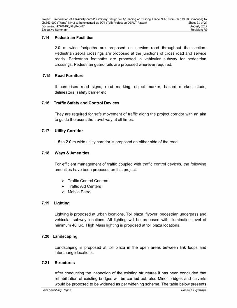
7.14 Pedestrian Facilities 2.0 m wide footpaths are proposed on service road throughout the section. Pedestrian zebra crossings are proposed at the junctions of cross road and service roads. Pedestrian footpaths are proposed in vehicular subway for pedestrian crossings. Pedestrian guard rails are proposed wherever required.
7.15 Road Furniture It comprises road signs, road marking, object marker, hazard marker, studs, delineators, safety barrier etc.
7.16 Traffic Safety and Control Devices
They are required for safe movement of traffic along the project corridor with an aim to guide the users the travel way at all times.
7.17 Utility Corridor 1.5 to 2.0 m wide utility corridor is proposed on either side of the road.
7.18 Ways & Amenities
For efficient management of traffic coupled with traffic control devices, the following amenities have been proposed on this project.
Traffic Control Centers Traffic Aid Centers Mobile Patrol
7.19 Lighting
Lighting is proposed at urban locations, Toll plaza, flyover, pedestrian underpass and vehicular subway locations. All lighting will be proposed with illumination level of minimum 40 lux. High Mass lighting is proposed at toll plaza locations.
7.20 Landscaping Landscaping is proposed at toll plaza in the open areas between link loops and interchange locations.
7.21 Structures
After conducting the inspection of the existing structures it has been concluded that rehabilitation of existing bridges will be carried out, also Minor bridges and culverts would be proposed to be widened as per widening scheme. The table below presents
Project: Preparation of Feasibility-cum-Preliminary Design for 6/8 laning of Existing 4 lane NH-3 from Ch.539.500 (Vadape) to Ch.563.000 (Thane) NH-3 to be executed as BOT (Toll) Project on DBFOT Pattern Sheet 22 of 27 Document: 47406400/RH/Rep-07 August, 2017 Executive Summary Revision: R9
Final Feasibility Report Roads & Highways
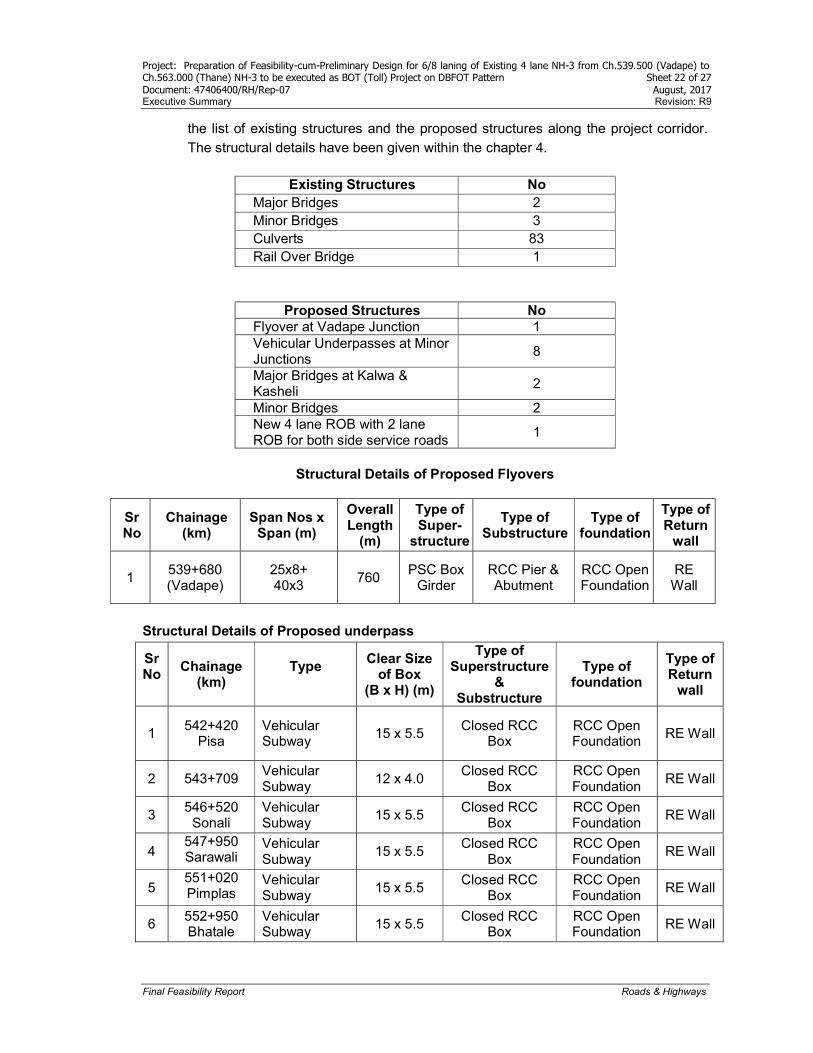
the list of existing structures and the proposed structures along the project corridor. The structural details have been given within the chapter 4.
Existing Structures No
Major Bridges 2 Minor Bridges 3 Culverts 83 Rail Over Bridge 1
Proposed Structures No Flyover at Vadape Junction 1 Vehicular Underpasses at Minor Junctions
8
Major Bridges at Kalwa & Kasheli
2
Minor Bridges 2 New 4 lane ROB with 2 lane ROB for both side service roads
1
Structural Details of Proposed Flyovers
Structural Details of Proposed underpass
Sr No
Chainage (km)
Type
Clear Size of Box
(B x H) (m)
Type of Superstructure
& Substructure
Type of foundation
Type of Return
wall
1 542+420
Pisa Vehicular Subway
15 x 5.5 Closed RCC
Box RCC Open Foundation
RE Wall
2 543+709 Vehicular Subway
12 x 4.0 Closed RCC
Box RCC Open Foundation
RE Wall
3 546+520
Sonali Vehicular Subway
15 x 5.5 Closed RCC
Box RCC Open Foundation
RE Wall
4 547+950 Sarawali
Vehicular Subway
15 x 5.5 Closed RCC
Box RCC Open Foundation
RE Wall
5 551+020 Pimplas
Vehicular Subway
15 x 5.5 Closed RCC
Box RCC Open Foundation
RE Wall
6 552+950 Bhatale
Vehicular Subway
15 x 5.5 Closed RCC
Box RCC Open Foundation
RE Wall
Sr No
Chainage (km)
Span Nos x Span (m)
Overall Length
(m)
Type of Super-
structure
Type of Substructure
Type of foundation
Type of Return
wall
1 539+680 (Vadape)
25x8+ 40x3
760 PSC Box
Girder RCC Pier & Abutment
RCC Open Foundation
RE Wall
Project: Preparation of Feasibility-cum-Preliminary Design for 6/8 laning of Existing 4 lane NH-3 from Ch.539.500 (Vadape) to Ch.563.000 (Thane) NH-3 to be executed as BOT (Toll) Project on DBFOT Pattern Sheet 23 of 27 Document: 47406400/RH/Rep-07 August, 2017 Executive Summary Revision: R9
Final Feasibility Report Roads & Highways
Sr No
Chainage (km)
Type
Clear Size of Box
(B x H) (m)
Type of Superstructure
& Substructure
Type of foundation
Type of Return
wall
7 556+480
Anjur Diwe Vehicular Subway
15 x 5.5 Closed RCC
Box RCC Open Foundation
RE Wall
8 560+420
Kharegaon Vehicular Subway
15 x 5.5 Closed RCC
Box RCC Open Foundation
-
Structural Details of Proposed Major Bridges
Sr No
Existing Chain-age
Design Chain-age
Span Arrange-ment Span (m)
Side Overall Width (m)
Type of Super-Structure
Type of Sub-Structure
Type of found-ation
Type of Return wall
1 558+552 558+580 (Kasheli)
15 x 54.5
RHS 17.50 PSC Box Girder
RCC Pier & Abutment
Well Found-ation
RE Wall
2 561+100 560+910 (Kalwa)
51+97+ 51
RHS 17.50 PSC Box Girder
RCC Pier & Abutment
Well Found-ation
RE Wall
Structural Details of Proposed Minor Bridges
Sr No
Existing Chainage
(km)
Design Chainage
(km)
Span Nos x Span (m)
Overall Length
(m)
Type of Super-
structure
Type of Sub-
structure
Type of found-ation
Type of Return
wall
1 550+166 550+190 1 x 7.80 7.80 RCC Slab RCC
Abutment
Open Foundati
on
RCC Return Wall
2 556+810
556+810
26.5 26.5
PSC Girder &
RCC Deck Slab
RCC Abutment
RCC Open
Foundation
RCC Return Wall
Details of Proposed ROB for New 4 Lane Carriageways
and Service Road
Sr No
Existing Chainag
e (km)
Design Chainage
(km)
Span Nos x
Span (m)
Overall
Length (m)
Type of Super-
structure
Type of Sub-
structure
Type of Found-ation
Type of Return
wall
1 551+525 551+527 20+40+20
80 Composite Type
RCC Pier &
Abutment
RCC Open
Found-ation
RCC Return Wall
Project: Preparation of Feasibility-cum-Preliminary Design for 6/8 laning of Existing 4 lane NH-3 from Ch.539.500 (Vadape) to Ch.563.000 (Thane) NH-3 to be executed as BOT (Toll) Project on DBFOT Pattern Sheet 24 of 27 Document: 47406400/RH/Rep-07 August, 2017 Executive Summary Revision: R9
Final Feasibility Report Roads & Highways
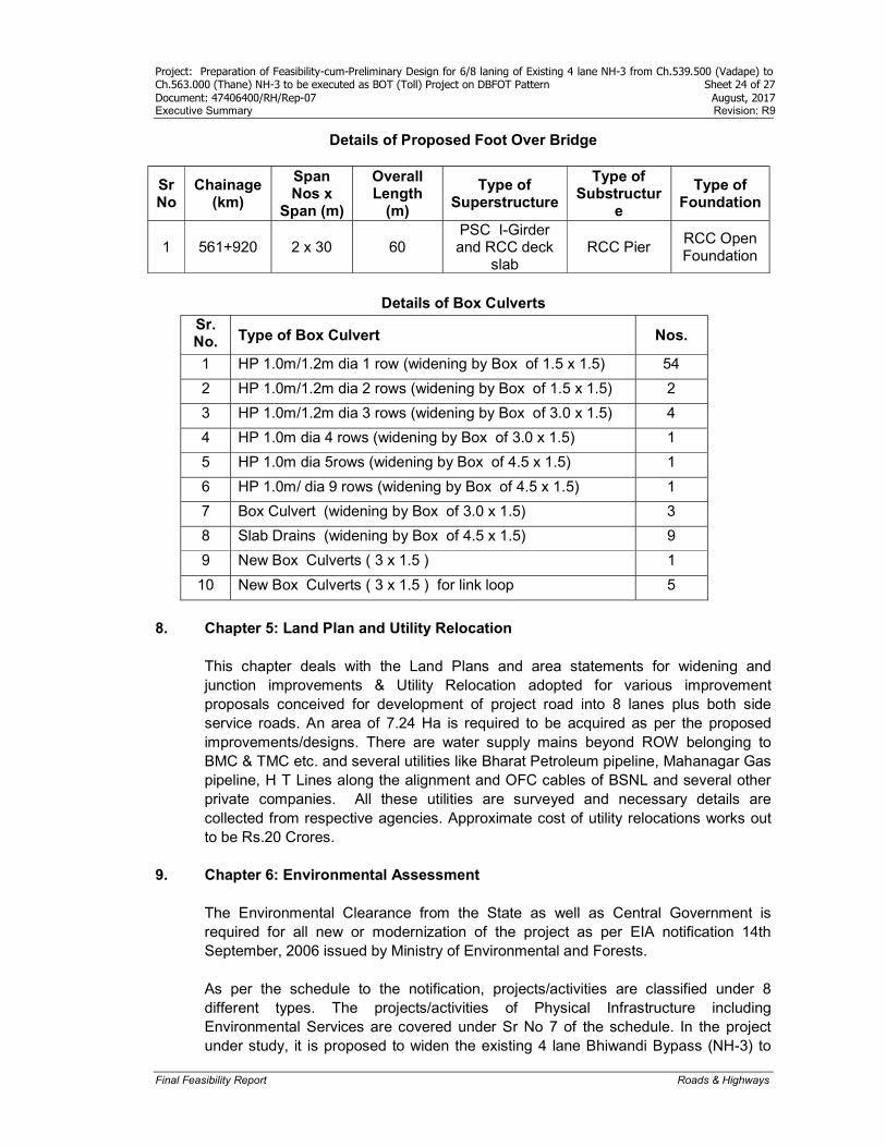
Details of Proposed Foot Over Bridge
Sr No
Chainage (km)
Span Nos x
Span (m)
Overall Length
(m)
Type of Superstructure
Type of Substructur
e
Type of Foundation
1 561+920 2 x 30 60 PSC I-Girder and RCC deck
slab RCC Pier
RCC Open Foundation
Details of Box Culverts
Sr. No. Type of Box Culvert Nos.
1 HP 1.0m/1.2m dia 1 row (widening by Box of 1.5 x 1.5) 54
2 HP 1.0m/1.2m dia 2 rows (widening by Box of 1.5 x 1.5) 2
3 HP 1.0m/1.2m dia 3 rows (widening by Box of 3.0 x 1.5) 4
4 HP 1.0m dia 4 rows (widening by Box of 3.0 x 1.5) 1
5 HP 1.0m dia 5rows (widening by Box of 4.5 x 1.5) 1
6 HP 1.0m/ dia 9 rows (widening by Box of 4.5 x 1.5) 1
7 Box Culvert (widening by Box of 3.0 x 1.5) 3
8 Slab Drains (widening by Box of 4.5 x 1.5) 9
9 New Box Culverts ( 3 x 1.5 ) 1
10 New Box Culverts ( 3 x 1.5 ) for link loop 5
8. Chapter 5: Land Plan and Utility Relocation
This chapter deals with the Land Plans and area statements for widening and junction improvements & Utility Relocation adopted for various improvement proposals conceived for development of project road into 8 lanes plus both side service roads. An area of 7.24 Ha is required to be acquired as per the proposed improvements/designs. There are water supply mains beyond ROW belonging to BMC & TMC etc. and several utilities like Bharat Petroleum pipeline, Mahanagar Gas pipeline, H T Lines along the alignment and OFC cables of BSNL and several other private companies. All these utilities are surveyed and necessary details are collected from respective agencies. Approximate cost of utility relocations works out to be Rs.20 Crores.
9. Chapter 6: Environmental Assessment The Environmental Clearance from the State as well as Central Government is required for all new or modernization of the project as per EIA notification 14th September, 2006 issued by Ministry of Environmental and Forests. As per the schedule to the notification, projects/activities are classified under 8 different types. The projects/activities of Physical Infrastructure including Environmental Services are covered under Sr No 7 of the schedule. In the project under study, it is proposed to widen the existing 4 lane Bhiwandi Bypass (NH-3) to
Project: Preparation of Feasibility-cum-Preliminary Design for 6/8 laning of Existing 4 lane NH-3 from Ch.539.500 (Vadape) to Ch.563.000 (Thane) NH-3 to be executed as BOT (Toll) Project on DBFOT Pattern Sheet 25 of 27 Document: 47406400/RH/Rep-07 August, 2017 Executive Summary Revision: R9
Final Feasibility Report Roads & Highways
6/8 lanes. The total length of the road including link/loop to NH4 is @ 23.5km. As per the project/activity at Sr No 7(f), the project is required to obtain environmental clearance if the length of the National Highway is greater than 30km and land acquisition is more than 20m. In the present context the length of the project road is less than 30km and additional land acquisition for ROW required is less than 20m. Hence the project is not required to obtain environmental clearance from state/central government. As per CRZ notification, following activities are declared as prohibited within coastal regulation zone i.e. “land reclamation, bunding or disturbing the natural course of sea water except those required for construction or modernisation or expansion of ports, harbour, jetties, wharves, quays, slipways, bridges and sea-links and for other facilities that are essential for activities permissible under the notification or for control of coastal erosion and maintenance or cleaning of water ways, channels and ports or for prevention or sandbars or for tidal regulators, storm water drains or for structures for prevention of salinity ingress and sweat water recharge.” Though the constructions of bridges are permitted in CRZ, formal approval from Maharashtra Coastal Zone Management Authority is required.
10. Chapter 7: Project Cost
10.1 Costing Data
Cost estimate is purely based on quantities and unit costs of important items like earth work, pavement etc. Quantities were calculated based on the data obtained from detailed reconnaissance and inventory of the project road, topographical surveys, and records received from PWD and guidelines given in TOR. The unit costs are calculated for the items briefed below. Block cost rates for each item of the work have been taken, using either information from recent similar type of contracts or published information such as PWD latest available Schedule of Rates 2015-16, Thane District and for bridges, flyover and grade separated structures, and ROBs the unit rates are as per Sq m basis and the Sq m rates were obtained from the similar ongoing projects in the region. For important items like earthwork, pavement and concrete, rate analysis has been worked out considering rates, lead & royalty charges as per latest Thane DSR 2015-16 received from PWD and Indian Oil website is referred for base rate of Bitumen prices applicable from July 1,2017, for cement rates NHAI portal is referred and for steel SAIL website is referred for latest available rates.
10.2 Contingencies Contingencies in the cost estimate to cover the physical and price contingencies, interest during construction, other financial cost which includes interest on the capital to be raised by concessionaire, financial overheads, insurance charges and independent Engineer charges is added to total project cost.
Project: Preparation of Feasibility-cum-Preliminary Design for 6/8 laning of Existing 4 lane NH-3 from Ch.539.500 (Vadape) to Ch.563.000 (Thane) NH-3 to be executed as BOT (Toll) Project on DBFOT Pattern Sheet 26 of 27 Document: 47406400/RH/Rep-07 August, 2017 Executive Summary Revision: R9
Final Feasibility Report Roads & Highways
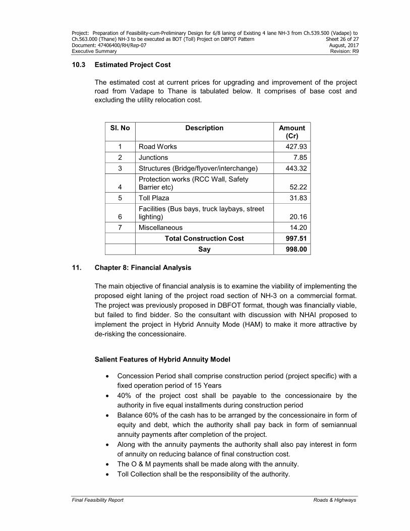
10.3 Estimated Project Cost
The estimated cost at current prices for upgrading and improvement of the project road from Vadape to Thane is tabulated below. It comprises of base cost and excluding the utility relocation cost.
Sl. No Description Amount (Cr)
1 Road Works 427.93
2 Junctions 7.85
3 Structures (Bridge/flyover/interchange) 443.32
4 Protection works (RCC Wall, Safety Barrier etc) 52.22
5 Toll Plaza 31.83
6 Facilities (Bus bays, truck laybays, street lighting) 20.16
7 Miscellaneous 14.20
Total Construction Cost 997.51
Say 998.00
11. Chapter 8: Financial Analysis The main objective of financial analysis is to examine the viability of implementing the proposed eight laning of the project road section of NH-3 on a commercial format. The project was previously proposed in DBFOT format, though was financially viable, but failed to find bidder. So the consultant with discussion with NHAI proposed to implement the project in Hybrid Annuity Mode (HAM) to make it more attractive by de-risking the concessionaire.
Salient Features of Hybrid Annuity Model
Concession Period shall comprise construction period (project specific) with a fixed operation period of 15 Years
40% of the project cost shall be payable to the concessionaire by the authority in five equal installments during construction period
Balance 60% of the cash has to be arranged by the concessionaire in form of equity and debt, which the authority shall pay back in form of semiannual annuity payments after completion of the project.
Along with the annuity payments the authority shall also pay interest in form of annuity on reducing balance of final construction cost.
The O & M payments shall be made along with the annuity.
Toll Collection shall be the responsibility of the authority.

Project: Preparation of Feasibility-cum-Preliminary Design for 6/8 laning of Existing 4 lane NH-3 from Ch.539.500 (Vadape) to Ch.563.000 (Thane) NH-3 to be executed as BOT (Toll) Project on DBFOT Pattern Sheet 27 of 27 Document: 47406400/RH/Rep-07 August, 2017 Executive Summary Revision: R9
Final Feasibility Report Roads & Highways
11.1 Financial Viability Tentative implementation program is proposed as follows:
Invitation of Bids 14th Aug, 2017
Receipt of bids from Concessionaire 29th Sept, 2017
Bid Evaluation, Approval of Bids & LOA 30th Oct, 2017
Signing of Contract 30th Nov, 2017
Commercial Operation Date 01st Aug, 2020
Financial Year for First Year of Operations 31st Mar, 2021
Financial Year for Last Year of Operations 31st July, 2035
Date of Civil Construction Cost 31st July, 2017
Life Cycle Cost Project life cycle cost defined as Net Present Value (NPV) of the quoted bid project cost plus NPV of the operations and maintenance (O&M) cost for the entire operations period is the bid parameter. Bid is awarded to the concessionaire quoting lowest NPV for project life cycle cost. The bid price for the project is Rs.1285.75 cr. (for 15% EIRR).
Sensitivity Analysis The below Table 8.10 shows the sensitivity analysis with bid project cost and O & M cost.
12. Chapter 9: Conclusions
The analysis concludes and recommends that the project should be taken up on Hybrid Annuity mode which is expected to mitigate the credit risk to considerable extent notwithstanding inherent execution challenges and extent of aggressive bidding. It provides stable cash flow to the concessionaire in the operational phase. Project IRR before tax is around 12.14% and equity IRR is around 15% which is expected to incentivize the developers for the bidding. Debt Service Coverage ratio (DSCR) is also expected to be comfortable notwithstanding increase in O&M expenses and movements in the bank rate.
BID PRICE
O&M Price
1285.746 6.5 7 7.5 7.8 8 8.5 9 9.5
800.0 767.9 772.4 776.9 779.3 781.4 785.9 790.4 794.9
825.0 790.0 794.5 799.0 801.4 803.5 808.0 812.5 817.0
850.0 812.2 816.7 821.2 823.6 825.7 830.2 834.7 839.2
852.6 814.5 819.0 823.5 825.9 828.0 832.5 837.0 841.5
875.0 834.4 838.9 843.4 845.8 847.9 852.4 856.9 861.4
900.0 856.5 861.0 865.5 867.9 870.0 874.5 879.0 883.5
925.0 878.7 883.2 887.7 890.1 892.2 896.7 901.2 905.7