'Excavations in the City of London Second Interim Report, 1974-1978' in Trans London & Middlesex...
68
EXCAVATIONS IN THE CITY OF LONDON SECOND INTERIM REPORT, 1974-1978 TONY DYSON and JOHN SCHOFIELD INTRODUCTION This second report on the Museum of London Department of Urban Archaeology's excavations in the City of London is designed to serve two purposes. It is intended primarily to outline the main findings of the three years 1976-8, and secondly to provide a general synthesis of the results and conclusions arising from the whole excavation programme since 1974. Such a treatment frequently requires some further consideration of the earlier sites described in the First Interim Report (Antiq. J. 67 (1977) 31-66), and it has also been thought useful to include relevant evidence derived from the more recent excavations of 1979-80 where issues of particular interest, such as the evolution of the Roman waterfront and defences or the redevelopment of the city in the later Saxon period, have been significantly advanced. 'Main findings' and 'issues of particular interest' are somewhat arbitrary terms, and call for explanation. At the time of writing (Spring 1981), a total of fifty-three sites has been excavated or observed, while the records of exactly twice as many sites again, investigated by the Guildhall Museum before 1974, have also to be assimilated and written up. Quite apart from the uneven progress in the post-excavation treatment of individual sites in such a programme, a report of the present kind is necessarily selective in several respects. Only a limited discussion of the finds evidence as such is possible. The overall approach is largely topographical, although the material has been chosen and arranged to illustrate discernible historical developments of a more general significance. Tor this reason many sites have been omitted altogether, and it is hoped that a coherent treatment of the post-medieval period will be possible in a subsequent report. In the cases of many of the sites which are discussed the detailed archaeological description has been deliberately restricted; where possible, some recompense is made in the illustrations and references. I ROMAN When the Department was set up at the end of 1973, proportionately more was known of the archaeology of Roman London than of any other period, and as recently as 1965 the subject had been disciplined and rendered accessible by a book which was, and remains, a classic of its kind. 1 Thus particular problems and obscurities were already conveniently defined, many of them primarily topographical: the nature of the road system, for example, of the Forum, and of the waterfront (of which virtually nothing was known until the Custom House excavation of 1973). Since 1974 much more has been learnt about some, though by no means all, of such topics—notably the waterfront, forum and defences—while three large scale excavations in the north-west quarter of the City have provided a coherent outline of the development of London in the first and second centuries. Each of these will be reviewed but each also contributes to questions of a different and more general order. The discovery of the late 4th-century riverside wall, for example, has given a fresh perspective to the problematic character of late Roman London. Ultimately, enquiries of this kind depend upon the establishment of a comprehensive and reliable framework of reference for the dating of artefacts, and in this respect the setting up of a 24
-
Upload
independent -
Category
Documents
-
view
2 -
download
0
Transcript of 'Excavations in the City of London Second Interim Report, 1974-1978' in Trans London & Middlesex...
EXCAVATIONS IN THE CITY OF LONDON SECOND INTERIM REPORT, 1974-1978
T O N Y D Y S O N and J O H N SCHOFIELD
INTRODUCTION This second report on the Museum of London Department of Urban Archaeology's excavations in the
City of London is designed to serve two purposes. It is intended primarily to outline the main findings of the three years 1976-8, and secondly to provide a general synthesis of the results and conclusions arising
from the whole excavation programme since 1974. Such a treatment frequently requires some further consideration of the earlier sites described in the First Interim Report (Antiq. J. 67 (1977) 31-66), and it has also been thought useful to include relevant evidence derived from the more recent excavations of 1979-80 where issues of particular interest, such as the evolution of the Roman waterfront and defences or the redevelopment of the city in the later Saxon period, have been significantly advanced.
'Main findings' and 'issues of particular interest' are somewhat arbitrary terms, and call for explanation. At the time of writing (Spring 1981), a total of fifty-three sites has been excavated or observed, while the records of exactly twice as many sites again, investigated by the Guildhall Museum before 1974, have also to be assimilated and written up. Quite apart from the uneven progress in the post-excavation treatment of individual sites in such a programme, a report of the present kind is necessarily selective in several respects. Only a limited discussion of the finds evidence as such is possible. The overall approach is largely topographical, although the material has been chosen and arranged to illustrate discernible historical developments of a more general significance. Tor this reason many sites have been omitted altogether, and it is hoped that a coherent treatment of the post-medieval period will be possible in a subsequent report. In the cases of many of the sites which are discussed the detailed archaeological description has been deliberately restricted; where possible, some recompense is made in the illustrations and references.
I R O M A N When the Department was set up at the end of 1973, proportionately more
was known of the archaeology of Roman London than of any other period, and as recently as 1965 the subject had been disciplined and rendered accessible by a book which was, and remains, a classic of its kind.1 Thus particular problems and obscurities were already conveniently defined, many of them primarily topographical: the nature of the road system, for example, of the Forum, and of the waterfront (of which virtually nothing was known until the Custom House excavation of 1973). Since 1974 much more has been learnt about some, though by no means all, of such topics—notably the waterfront, forum and defences—while three large scale excavations in the north-west quarter of the City have provided a coherent outline of the development of London in the first and second centuries. Each of these will be reviewed but each also contributes to questions of a different and more general order. The discovery of the late 4th-century riverside wall, for example, has given a fresh perspective to the problematic character of late Roman London. Ultimately, enquiries of this kind depend upon the establishment of a comprehensive and reliable framework of reference for the dating of artefacts, and in this respect the setting up of a
24
Excavations in the City of London Second Interim Report 1974—1978 25
pottery typc-scrics which at present contains sherds representative of over 2000 distinct types has already proved an invaluable tool. Thus a recent reassessment of material recovered both before and since 1974 has contributed to a general reconsideration of the nature of the early settlement of London.
EARLY S E T T L E M E N T In the absence of any evidence of permanent pre-Roman settlement it was
assumed until recently that, like the bridge upon which it depended, London originated in, or immediately after, A D 43 from a military supply base which played an important part in the early campaigns north of the Thames. This conclusion is now less certain. In the first place it receives little support from an examination by the Department of (literally) some tons of excavated material, which shows that in no instance is it possible to ascribe pottery groups to the AD 40s and that, indeed, groups predating A D 60 are notably uncommon. 2 The absence of such groups and the rarity of individual Claudian vessels is remarkable: a Claudian group might be expected to include the mortarium Camulodunum 191, a widespread flagon Camulodunum 161, and certainly early types of terra rubra and terra nigral Of these only the mortaria are known, and in extremely small quantities. Samian shows a similar pattern, and although previous collections of 'Arretine' ware have been cited as evidence of early occupation, much of these is now recognised as not of London origin;4 from among huge collections of samian the earliest types found in Britain seem to be very uncommon in percentage terms.5 The ceramic evidence, then, would suggest that the Roman settlement was founded around AD 50, or perhaps a little later, rather than as the immediate result of an invasion crossing in AD 43. A similar conclusion has been reached by the Southwark and Lambeth Archaeological Excavation Commit tee , whose examination of two roads converging upon the southern bridgehead suggests that they were constructed in the period c. A D 50—65.'' This might imply that the river was originally crossed by a ford between Westminster and Lambeth—on which the established courses of Watling Street north and south of the Thames are aligned— particularly as one of the two excavated roads also led in the direction of Lambeth. Finally, a reassessment of the earliest London coinage has revealed a high proportion of irregular Claudian imitations, suggesting a foundation date of c. A D 50-55.7
BASILICA A N D F O R U M Were it indeed the case that the Roman settlement began not earlier than AD
50, and therefore after the military phase which immediately followed the invasion, the origin of London is more likely to have been primarily administrative and commercial—the latter much as Tacitus described the city of AD 60. Decisive evidence, however, is still lacking, even in the area to the north of the bridgehead where it is clear that the earliest settlement lay, regulated by an elementary street plan, and including what was to become the site of the basilica and forum on either side of the modern Gracechurch Street (Site 1).
26 Tony Dyson and John Sdwfidd
Much of the complexity of this structure, or structures, was compounded until recently by the inherent problems of collating evidence derived from numerous excavations, scattered over a huge site and conducted at different times by a variety of observers over the last century. Even so, in 1965 Ralph Merrifield was able to distinguish between three separate phases: a small, pre-Boudican and possibly public building with stone foundations beside a main east-west road; a much larger group of buildings, almost certainly public, constructed after the destruction of AD 60 on a slightly different alignment; and, finally the replacement of this by a vast basilica and forum not completed before the reign of Hadr ian / More recently, this outline has been further refined concurrently by excavation and by Peter Marsden's and Sara Parfitt's careful replotting of the disparate structural evidence on an enlargement of the 50 inch Ordnance Survey in preparation for a detailed report on the site. Checked by measurement on the ground, this exercise has removed many of the discrepancies in the alignment of related structures, sometimes of up to 6m, which had arisen from the use of different plans of varying accuracy on different sites (Fig. 2). The resulting reconstruction has now made possible a more positive interpretation of the successive building phases. In particular, it seems that the post-Boudican 'second phase' building represents an early basilica and forum which predated a far larger rebuilding in the early second century.1' Meanwhile, Departmental excavations supervised by Andy Boddington in 1976 at 160-2 Fenchurch Street (Site 2) located the debris of the first phase of buildings destroyed in A D 60, as well as the south-east corner of the second forum, while in 1977 observations conducted by Peter Marsden in a Post Office service tunnel beneath Gracechurch Street further identified and fixed the relative positions of previously encountered structures across the length of the whole site.
First Phase (pre-Boudican) This comprised a large gravelled area in the southern half of the site which
extended south to the main east-west street of the city, beneath the modern Fenchurch Street. After an initial phase of occupation represented by traces of timber-framed buildings, a major redevelopment occurred which featured a range of timber, clay and brick buildings some 75m long and 27m wide, fronting onto the street to the east of the gravelled area. The buildings were first located by Brian Philp in 1968,"' and again found further east at 160-2 Fenchurch Street in 1976; the gravel surface was recorded in the Post Office tunnel in 1977. Little definite can be said of the nature of this phase. N o certain trace of specifically military activity has been found in any part of the site, and although it is possible that the main street and gravel spread had their origin beside the principia of an invasion period camp, it is more likely, since the buildings to the east were of a non-military character, that the open area served as a market place. One of the rooms encountered at 160-2 Fenchurch Street contained a large quantity of burnt grain, e l m thick, and almost certainly of Boudican date; analysis by Peter Boyd suggests that it was possibly a Mediterranean import, intended for sowing. If so, this might also indicate that the use of these buildings was commercial.
Excavations in the City of London Second Interim Report 1974-1978
CT j q IF iT II -I
7J
o> JU # 7 /
- V \\ £c\
r H t f ^
28 Tony Dyson and John Sdwfidd
Second Phase (? first basilica and forum) (Fig. 2) Within some thirty years of the fire of AD 60 the first complex was built,
measuring overall 104.5m north to south, and 52.7m east to west. Except for the south wall it was characterised by buttressed outer walls and by particularly deep foundations whose construction is unusual in Roman London. To the north was a hall, 44.5m long and 22m wide, comprising nave, side aisles and tribunal. The elongated court was surrounded by ranges of rooms, while the south wing apparently featured an outer portico which fronted towards the street. Other streets apparently lay to the east and west; the eastern being of minor character and c. 4m wide. The date of this second phase appears to be Flavian; a coin o f Vespasian was found by Frank Cottrill among Flavian pottery in a rubbish pit below the north-east part of the complex," while Philp also located Flavian pottery below the eastern road.
Several problems arise from the interpretation of this building. Its basic plan -would suggest a basilica and forum,12 but this would imply an early municipal status for London for which there is no other evidence at this period. The basilica would seem to compare more closely with Gaulish than with British exemplars, and the whole complex was notably small when compared, for example, with the fora of Silchester and Wroxeter and, indeed, with its own successor, which was over four times larger. Though the building is unlikely to have stood longer than some fifty years, it nevertheless required partial modification which still conformed to the same plan. Finally, the whole complex lay on an orientation which differed from that shared by both the first and third phase buildings, but which was also shared by other structures to the south of the main street, outside the complex.
Third Phase (second basilica and forum) (Fig. 3) The second complex occupied an area of c. 170m square. Its central feature
was a large courtyard surrounded on three sides by a colonnaded inner portico 9m wide. Beyond this lay a range of large chambers, presumably shops, while a second portico 5.5m wide lay outside. The south-east corner of this forum and the junction of the outer portico of the south and east wings were revealed during the excavations at 160-2 Fenchurch Street in 1976 (PL 1). On the fourth side lay the basilica, of which the floors of the nave and side aisles were encountered in the Post Office tunnel in 1977 (PI. 2). The hall was at least 30m wide, and comprised a nave at the east end of which (and probably at the west end also) was an apsidal tribunal. Beyond the north aisle lay ranges of rooms which no doubt accommodated the city council. The floor of the forum courtyard was another feature observed in the service tunnel where it was represented by a patchy surface of mortar gravel and earth level with the floor of the basilica. Near the centre of the courtyard, the tunnel penetrated a small structure with stone walls, a sunken floor and a lining of stiff clay which appears to have served as a shallow ornamental pool. The entire building occupied its own insula, the forum facing the main east-west street, while new north-south streets, the eastern of which apparently led to Bishopsgate, flanked its sides.
The date of this phase cannot be closely established. Various excavators have
Excavations in the City of London Second Interim Report 1974-1978
>"J>-S ipjn,, . , , „ , , ,
liH
' II *
30 Tony Dyson and John Schofield
observed that nothing later than the end of the 1st century was found beneath the structure, but pottery and a coin of Hadrianic date (unpublished) were recovered by Adrian Oswald in 1939 above the demolished walls of the previous building and beneath the white concrete floor then identified as part of the third phase. The available evidence thus indicates that this basilica and forum was not completed before the reign of Hadrian.
0 ipom
Fig. 3. Plan of the Hadrianic forum and basilica.
Excavations in the City of London Second Interim Report 1974—1978 31
T H E G P O , MILK STREET A N D WATLING C O U R T SITES Of the three distinct phases of the basilica and forum site, at least two, the
pre-Boudican and Flavian, are also reflected in excavations conducted since 1974 on sites which, though somewhat humbler, were recorded more systematically and in greater detail. They will first be considered separately.
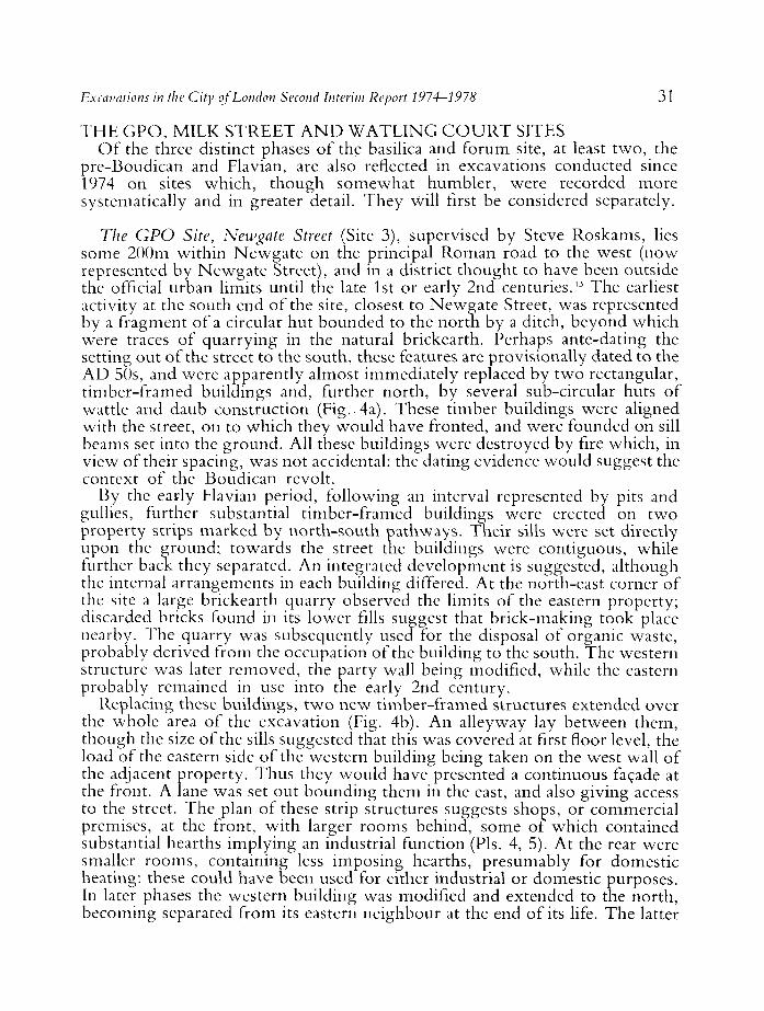
The GPO Site, Newgate Street (Site 3), supervised by Steve Roskams, lies some 200m within Newgate on the principal Roman road to the west (now represented by Newgate Street), and in a district thought to have been outside the official urban limits until the late 1st or early 2nd centuries." The earliest activity at the south end of the site, closest to Newgate Street, was represented by a fragment of a circular hut bounded to the north by a ditch, beyond which were traces of quarrying in the natural brickearth. Perhaps ante-dating the setting out of the street to the south, these features are provisionally dated to the AD 50s, and were apparently almost immediately replaced by two rectangular, timber-framed buildings and, further north, by several sub-circular huts of wattle and daub construction (Fig. 4a). These timber buildings were aligned with the street, on to which they would have fronted, and were founded on sill beams set into the ground. All these buildings were destroyed by fire which, in view of their spacing, was not accidental: the dating evidence would suggest the context of the Boudican revolt.
By the early Flavian period, following an interval represented by pits and gullies, further substantial timber-framed buildings were erected on two property strips marked by north-south pathways. Their sills were set directly upon the ground; towards the street the buildings were contiguous, while further back they separated. An integrated development is suggested, although the internal arrangements in each building differed. At the north-east corner of the site a large brickearth quarry observed the limits of the eastern property; discarded bricks found in its lower fills suggest that brick-making took place nearby. The quarry was subsequently used for the disposal of organic waste, probably derived from the occupation of the building to the south. The western structure was later removed, the party wall being modified, while the eastern probably remained in use into the early 2nd century.
Replacing these buildings, two new timber-framed structures extended over the whole area of the excavation (Fig. 4b). An alleyway lay between them, though the size of the sills suggested that this was covered at first floor level, the load of the eastern side of the western building being taken on the west wall of the adjacent property. Thus they would have presented a continuous facade at the front. A lane was set out bounding them in the east, and also giving access to the street. The plan of these strip structures suggests shops, or commercial premises, at the front, with larger rooms behind, some of which contained substantial hearths implying an industrial function (Pis. 4, 5). At the rear were smaller rooms, containing less imposing hearths, presumably for domestic heating: these could have been used for either industrial or domestic purposes. In later phases the western building was modified and extended to the north, becoming separated from its eastern neighbour at the end of its life. The latter
32 Tony Dyson and John Schofield
L. J ;
UJ
V W ^
CO
o rt rs bfi u
& ^ Z o Qrv.
OS
t*
Excavations in the City of London Second Interim Report 1974-1978 33
was largely unaltered when both structures were destroyed in the Hadrianic fire of c. A D 125. The resulting debris, spread across the whole site, incorporated partially articulated fallen walls of dried and fired bricks which had collapsed from internal and external frameworks respectively (PI. 3).
The two buildings appear to have been replaced immediately by structures of exactly the same plan and purpose: evidently the plots were too valuable to be left vacant for any length of time. These were dismantled by the end of the 2nd century, and were sealed by a thick stratum of dark earth into which the foundations of the church of St. Nicholas Shambles were to be cut in the 10th or 11th centuries.
At Milk Street (Site 4), supervised by Steve Roskams in 1977, the earliest occupation was represented by a series of slots cut into the natural brickearth, which seems to have been extensively deturfed for the purpose. Their profile, position and consistency of depth suggest foundations for a large timber building, though no coherent plan could be recovered. Their alignment, however, differed from that of the known street pattern, which is presumed to be later. The building was systematically dismantled and the slots were found to be filled with brickearth containing finds of c. AD 70. Above the slots was a late Flavian domestic building of high quality. Of timber-frame construction, it was set on brickearth sills and featured concrete and tessellated floors as well as, in its destruction debris, painted plaster. In plan it comprised a northern and western range of rooms flanking a gravelled area to the south-east. In addition a sequence of sixteen north-south rammed-gravel metallings, up to 2m deep and flanked by a series of drainage ditches, represented a Roman street which bounded the site to the east. This street, recorded some 30m further south on the Cheapside bath-house site,14 was aligned with the late Flavian structure, suggesting that the gridding of this part of the city took place in the late 1st century, thus ante-dating, and perhaps determining the position and alignment of, the late 1st to early 2nd century Cripplegate Fort. The depth of the metallings cannot be explained by traffic wear alone, and presumably also reflects the need to keep pace with the constantly rising ground level of the successive buildings which adjoined the road.
Early in the 2nd century the site was partly occupied by much flimsier timber buildings and elsewhere was used for rubbish tipping. One set of these structures was destroyed in the Hadrianic fire of c. A D 125. This was soon replaced by a timber structure, containing a mosaic floor of Antonine date (PI. 6), which, when dismantled c. A D 170, was in turn replaced by a deposit of dark earth up to l m thick.
Watling Court (Site 5), supervised by Dominic Perring, the third of this group of excavations, disclosed two rectangular timber-framed structures aligned north-south and apparently fronting onto a road to the south, off site. N o pre-existing ground surface survived, and it seems probable that the site had been cleared, if not terraced, beforehand. These buildings were destroyed by fire, probably in A D 60-80.
34 Tony Dyson and John Scho field
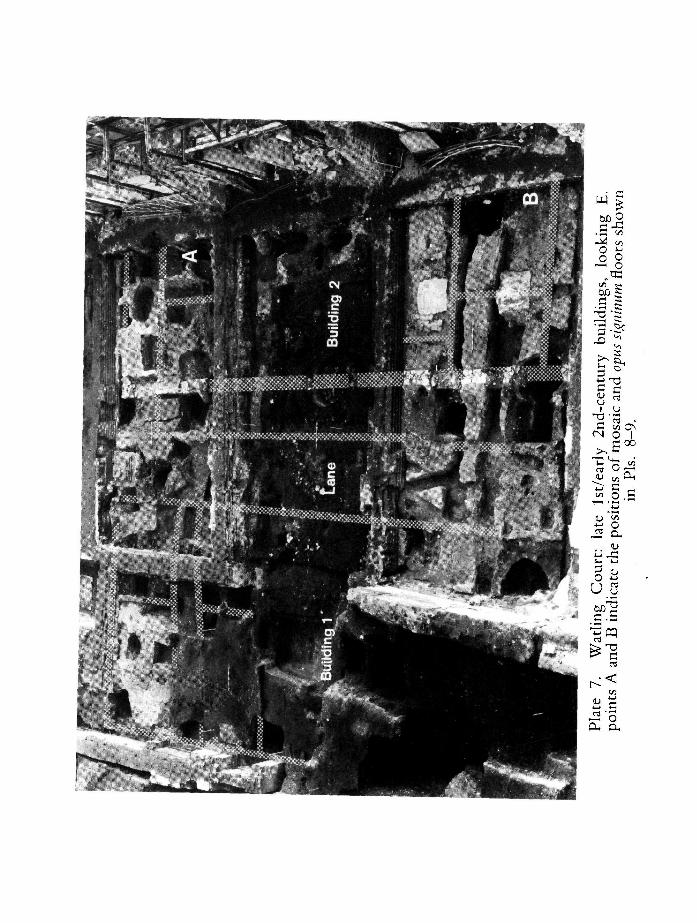
Little evidence survived for the period immediately after the fire, but by the end of the 1st century the site had been completely redeveloped. Evidence of three main buildings and three alleyways was retrieved (PI. 7), which apparently respected the boundaries established by their predecessors. In places the walls survived to a height of over 1 m above the contemporary ground surface. In construction they varied considerably, though all were built of mudbrick or puddled clay, usually infilling a timber frame. Most walls were plastered, and some of these decorated. Traces of three mosaic pavements were uncovered, along with five opus signinutn floors patterned with impressed tesserae, two of which featured mosaic roundels not paralleled in Britain (Pis. 8, 9). Like tesserae found in an early 2nd century context at Cannon Street,15 these appear to date well before the main phase of mosaic-laying in Britain, c. AD 150-200."' All the buildings were destroyed by fire in the early 2nd century, probably in c. A D 125.
Thereafter, the site was fully redeveloped, although the new buildings were less substantial than those they replaced. Again, however, they appeared to respect pre-existing property boundaries. A third fire, possibly of Antoninc date, destroyed these buildings; no late Roman activity was identified, and finds of the 3rd and 4th centuries were scarce. As elsewhere, the late Roman to middle Saxon periods were represented by a thick horizon of dark earth. A similar layer, up to 0.5m ^thick, sealed a sequence of 1st and 2nd-century buildings recorded at Well Court , close by, in 1979 (Site 6). These fronted on to a north-south aligned road, between 6 and 8m wide, on average 4m to the east of Bow Lane.
These three major sites, similar in size and scale of excavation, serve as a significant indicator of the main outline of the development of early Roman London. Each lay in the north-western quarter of the city, one of them outside the original urban limit. Within that area they were fairly widely separated, so that they need not necessarily be expected to share similar characteristics, and it would be inappropriate to impose too rigorous a pattern upon them. Nevertheless, a fairly consistent outline emerges. All three produced evidence of early buildings (only at the G P O site were these definitely pre-Boudican) of uncertain usage, so that, as is also the case with the Forum site, there is again no conclusive evidence of specifically civilian or specifically military occupation. The buildings at the G P O site were aligned with Newgate Street, a major and early thoroughfare which led to the west.
O n each site at some point in the Flavian period substantial buildings of a very pronounced character, whether domestic or (as at the G P O site) industrial, -were installed. At Milk Street and Watling Court these were accompanied by streets and, at the G P O and Watling Court sites, by alleys also. At these last two sites as well the boundaries, and even the plan, of the Flavian buildings were reproduced by their successors after the fire off. AD 125, and at Watling Cour t possibly pre-Flavian boundaries were perpetuated. Where this phenomenon occurs it seems that, once established, the original type of occupation remained essentially unchanged, though the quality of the buildings themselves varied. In all three cases the Flavian period seems to have witnessed
Excavations in the City of London Second Interim Report 1974-1978 35
the most remarkable development. At the G P O and Watling Court sites the Flavian buildings survived until the fire of c. AD 125, and at the latter site were replaced by structures of poorer standard, as had already been the case at Milk Street before the fire. Thereafter the relative status of each site varied widely before all fell out of use by the end of the 2nd century.
THE W A T E R F R O N T Before assessing the problems of the later 2nd-century occupation of these
three sites, it is convenient to review the evidence from the early waterfront of the City. To the extent that London's character was determined by its role as a port it was always clear that the waterfront area south of the modern Thames Street should provide an archaeological paradigm of the development of the city at large. Before 1973, however, no opportunity for excavation in this area had arisen, but in that year the examination of the Custom House site (Site 7) by Tim Tat ton-Brown for the Guildhall Museum (before the present Department was established) underlined the archaeological potential of this zone as clearly as it indicated an encouragingly high degree of preservation and survival. There was evidence of two distinct phases of waterfront development of which the first was represented by a series of horizontal east-west beams supported in front by posts and planks. Pottery from the clay, mortar and chalk packed behind these timbers dated from the later 1st century or the first quarter of the 2nd, and seemed to indicate that the structure was built by the early part of Hadrian's reign.17 In the second phase, some 6m to the south, a much more elaborate box-timber quay, resembling that at Xanten, was erected, according to pottery evidence, in the second half of the 2nd century.'" From 1974 a whole scries of waterfront sites was made available by redevelopment, notably in the bridgehead area, and in broad outline produced further evidence of these two distinct phases of development. Generally speaking, the late 1st and early 2nd-ccntury phase consisted of hillside revetments and a substantial quay on the north side of Thames Street, while the later 2nd or early 3rd-century structures lay to the south of the street and represented extensive quays. In fact, the interposition of Thames Street presents a grave practical problem as in no case has a complete section been obtained across the whole waterfront zone, linking the early foreshore with the hillside revetments behind.
The evidence for lst-century activity on the waterfront should be forthcoming from recent excavation and observations at Peninsular House (Site 8) and Miles Lane (Site 10) on the north side of Thames Street. At the former, supervised by Gustav Milne, a massive timber-framed structure has been found, traced for 15m across the southern edge of the site, which comprised four horizontal tiers of timber baulks each up to 400mm X 600mm in section. To the north, a series of tie-backs braced the revetment, which was backfilled with packed, rcdeposited, clay and river gravels; below it and to the south riverlaid deposits were recorded. Subject to further finds analysis, a quay of lst-ccntury date appears to be indicated. On the higher ground behind, the Billingsgate Buildings excavation (Site 9), supervised by David Jones, produced evidence or three successive artificial terracings of the hillside.''' These were represented by three sets of oak posts supporting horizontal planks which
36 Tony Dyson and John Scho field
retained dumps of building rubble, soil and domestic refuse. They were installed in the late 1st and early 2nd centuries, and were all buried and destroyed by the late 2nd century. N o buildings of this period were found on the site, though several are recorded close by, and it is unlikely that the building debris dumped behind the revetments was brought in from any great distance.
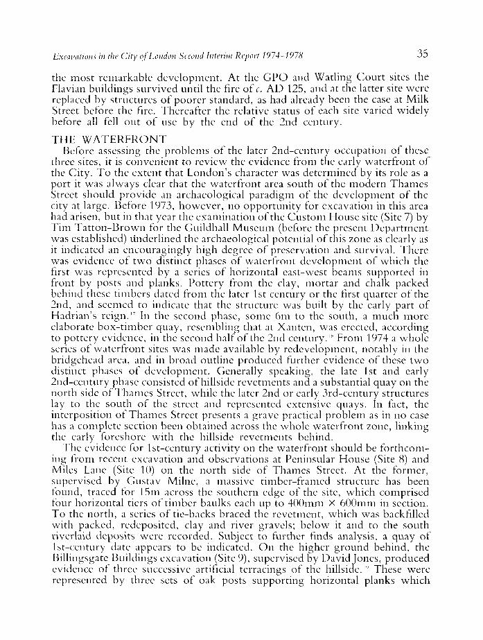
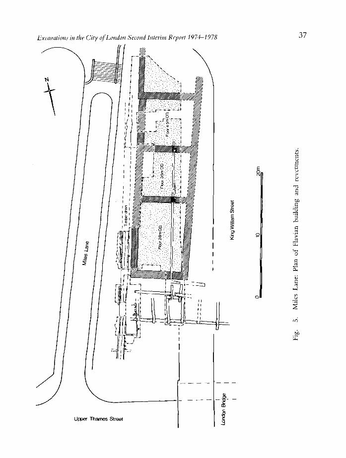
A clearer notion of the relation of revetments to buildings emerges from the excavations on the east side of Miles Lane (Site 10), supervised by Louise Miller, immediately upstream of the approach to the present London Bridge (Fig. 5). The potential of this site had been apparent since 1920 when Frank Lambert observed part of a Roman building, timber structures and a drain.2" The present excavation, like the work at Billingsgate Buildings, revealed no trace of the river's edge, but the terracing, consolidated by timber revetments, was of early Flavian date. Set upon this was an imposing Flavian building of possibly official character, perhaps a warehouse, 23m X 9m, with masonry foundations l m wide and 1.30m high. Above these the walls, of Kentish ragstone with tile courses at intervals, survived to a height of 1.2m. Along the west side of the building lay a timber-lined drain which, on the evidence of pottery found within it, had first silted up in the early 2nd century. Traces of a second, much slighter, masonry building of Flavian date were found to the south. This was demolished in the late 1st century, possibly when a second revetment, c. 0.8m above the first, was installed. Beyond the drain a gravel surface was laid by the end of the 1st century, and probably represents a street believed to lie beneath Miles Lane beyond the western limit of the site.
At Miles Lane, Peninsular House, and at the Roman Palace site east of Dowgate,2 ' the revetments were designed primarily to provide level terraces for the accommodation of buildings. These three sites would also suggest that the southern extremities of each series of revetments terminated in a waterfront.22
The levels of the 2nd or 3rd-century quay surfaces—so far as they can be estimated—were at + 0.3m O . D . at Seal House (Site 12) and at + 1.0m O . D . at N e w Fresh Wharf, whereas on the north side of the street the corresponding points of the structures were generally in excess of l m higher. Despite these problems, there can be little doubt of the general intensity of activity on the waterfront in the late 1st and early 2nd centuries, corresponding with a peak in private and public development at the same period in the rest of the City.
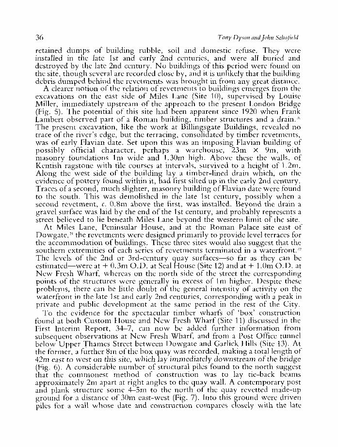
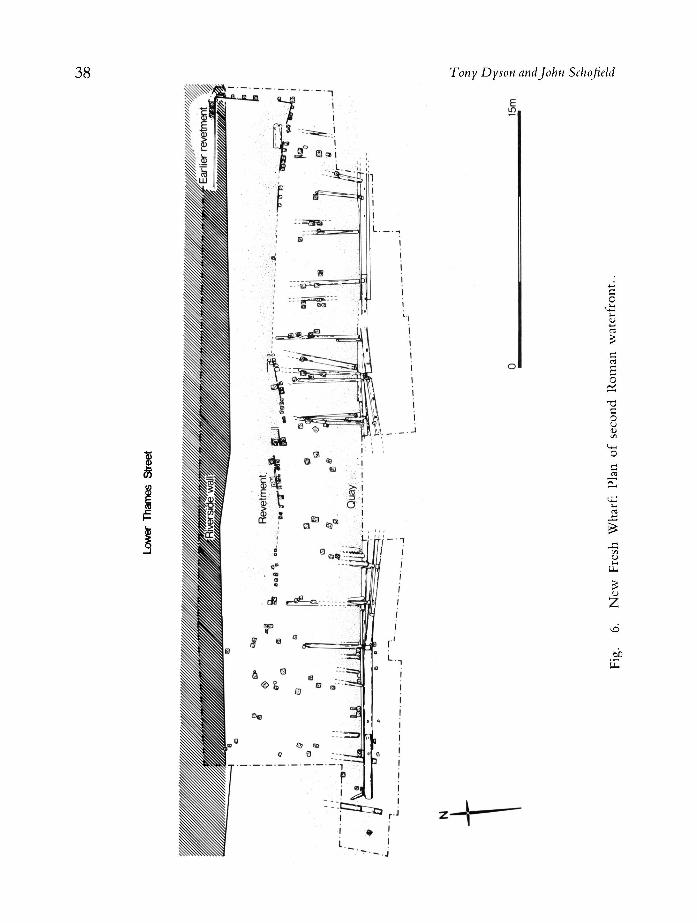
To the evidence for the spectacular timber wharfs of 'box' construction found at both Cus tom House and N e w Fresh Wharf (Site 11) discussed in the First Interim Report, 34-7, can n o w be added further information from subsequent observations at N e w Fresh Wharf, and from a Post Office tunnel below Upper Thames Street between Dowgate and Garlick Hills (Site 13). At the former, a further 8m of the box quay was recorded, making a total length of 42m east to west on this site, which lay immediately downstream of the bridge (Fig. 6). A considerable number of structural piles found to the north suggest that the commonest method of construction was to lay tie-back beams approximately 2m apart at right angles to the quay wall. A contemporary post and plank structure some 4—5m to the north of the quay revetted made-up ground for a distance of 30m east-west (Fig. 7). Into this ground were driven piles for a wall whose date and construction compares closely with the late
Excavations in the City of London Second Interim Report 1974-1978 37
In
a
to
>
G
a
o
Oi
G
J
Upper Thames Street
38 Tony Dyson and John Schofield
<D
I
E
'-t
c o
c rt £ o
"O C O u u <A
< * * O
UL,
z
50 IE
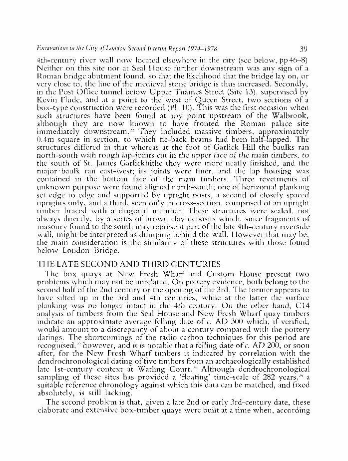
Excavations in the City of London Second Interim Report 1974-1978 39 4th-century river wall now located elsewhere in the city (see below, pp 46-8) Neither on this site nor at Seal House further downstream was any sign of a Roman bridge abutment found, so that the likelihood that the bridge lay on, or very close to, the line of the medieval stone bridge is thus increased. Secondly, in the Post Office tunnel below Upper Thames Street (Site 13), supervised by Kevin Flude, and at a point to the west of Queen Street, two sections of a box-type construction were recorded (PI. 10). This was the first occasion when such structures have been found at any point upstream of the Walbrook, although they are now known to have fronted the Roman palace site immediately downst ream." They included massive timbers, approximately 0.4m square in section, to which tie-back beams had been half-lapped. The structures differed in that whereas at the foot of Garlick Hill the baulks ran north-south with rough lap-joints cut in the upper face of the main timbers, to the south of St. James Garlickhithe they were more neatly finished, and the major 'baulk ran east-west; its joints were finer, and the lap housing was contained in the bot tom face of the main timbers. Three revetments of unknown purpose were found aligned north-south; one of horizontal planking set edge to edge and supported by upright posts, a second of closely spaced uprights only, and a third, seen only in cross-section, comprised of an upright timber braced with a diagonal member. These structures were sealed, not always directly, by a scries of brown clay deposits which, since fragments of masonry found to the south may represent part of the late 4th-century riverside wall, might be interpreted as dumping behind the wall. However that may be, the main consideration is the similarity of these structures with those found below London Bridge.
T H E LATE S E C O N D A N D T H I R D C E N T U R I E S The box quays at N e w Fresh Wharf and Custom House present two
problems which may not be unrelated. On pottery evidence, both belong to the second half of the 2nd century or the opening of the 3rd. The former appears to have silted up in the 3rd and 4th centuries, while at the latter the surface planking was no longer intact in the 4th century. On the other hand, C14 analysis of timbers from the Seal House and N e w Fresh Wharf quay timbers indicate an approximate average felling date of c. A D 300 which, if verified, would amount to a discrepancy of about a century compared with the pottery datings. The shortcomings of the radio carbon techniques for this period are recognised,23 however, and it is notable that a felling date of c. A D 200, or soon after, for the N e w Fresh Wharf timbers is indicated by correlation with the dcndrochronological dating of five timbers from an archaeologically established late lst-century context at Watling Court.24 Although dendrochronological sampling of these sites has provided a 'floating' time-scale of 282 years,25 a suitable reference chronology against which this data can be matched, and fixed absolutely, is still lacking.
The second problem is that, given a late 2nd or early 3rd-century date, these elaborate and extensive box-t imber quays were built at a time when, according
Tony Dyson and John Schofteld
i
c
o o
c o
o c
o a, £ o U
z
6C
in
Excavations in the City of London Second Interim Report 1974-1978 41
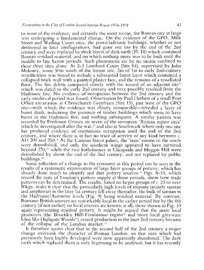
to most of the evidence, and certainly the most recent, the Roman city at large was undergoing a fundamental change. On the evidence of the G P O , Milk Street and Watling Court sites, the post-Hadrianic buildings, whether or not destroyed in later conflagrations, had gone out use by the end of the 2nd century and were replaced by thick layers of dark earth (PL 11) which contained Roman residual material, and on which nothing more was to be built until the middle to late Saxon periods. Such phenomena are by no means confined to these three sites alone. At 2-3 Lombard Court (Site 14), supervised by John Maloney, some 50m south of the forum site, 2m of 1st to early 2nd-century stratification was found to include a substantial burnt layer which contained a collapsed brick wall with a painted plaster face, and the remains of a tessellated floor. The fire debris compared closely with the record of an adjacent site26
which was dated to the early 2nd century and very possibly resulted from the Hadrianic fire. N o evidence of occupation between the 2nd century and the early medieval period was found. Observation by Paul Herbert of a small Post Office excavation at Christchurch Greyfriars (Site 15), just west of the G P O site—with which the evidence was closely comparable—revealed a layer of burnt daub, indicating the presence of timber buildings which seem to have burnt in the Hadrianic fire, and nothing subsequent. A similar pattern was recorded by Professor Grimes on seven of the seventeen 'Roman minor sites' which he investigated after the war,27 and also at Southwark where only one site has produced evidence of continuous occupation until the end of the 2nd century, and where there is in fact no trace of activity of any kind between c. A D 200 and 250.2t< At the Cannon Street palace, the 'state' rooms to the north were demolished, and only the southern wings appeared to have survived beyond 270,2'' while the two bath-houses at Cheapside and Huggin Hill were demolished by about the end of the 2nd century, and not replaced by public buildings.3"
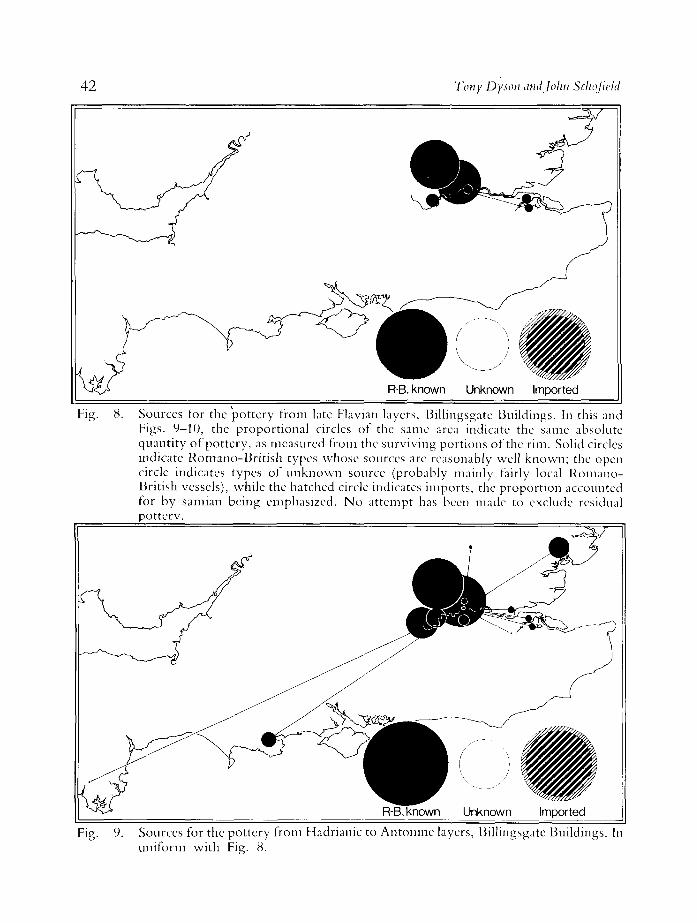
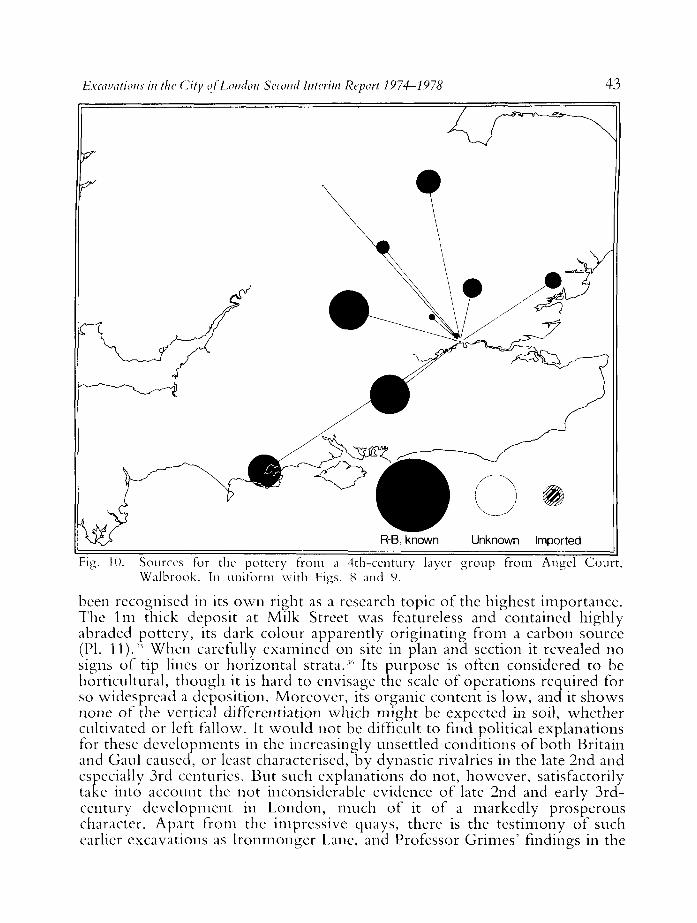
Some reflection of a change in the economy at this period can be seen in the results of a systematic examination of large layer groups of pottery, which has already done much to identify and date pottery sources.31 Figs. 8—10, which record the state of London's pottery supply at those periods, show how trade patterns can be determined. The results, based on larger groups of c. 25 to over 80kgs, make it clear that the particularly high levels of imports (mainly samian and amphorae) in the later 1st century fell away thereafter, the bulk of samian in the Hadrianic/Antonine levels '(Fig- 9) being residual material. By contrast, Romano British sources are remarkably local in the earlier period but by the 4th century (if not earlier) no local sources are known at all, those shown in Fig. 10 again representing residual pottery. It might be argued that the main local producers (the Brockley Hill-Verulamium region32 and more local greyware kilns like Highgate Woods33) ceased production in the later 2nd century because of the collapse of the London market.34
It therefore seems clear that in the second half of the 2nd century a major change overtook the character of Roman London, so that sites which had previously been highly developed were now apparently abandoned. The dark earth which replaced them is only beginning to be analysed, but it has recently
42 Tony Dyson and John Schoficld
Fig. 8. Sources for the pottery from late Flavian layers, Billingsgate Buildings. In this and Figs. 9-10, the proportional circles of the same area indicate the same absolute quantity of pottery, as measured from the surviving portions of the rim. Solid circles indicate Romano-Bri t ish types whose sources are reasonably well known; the open circle indicates types of unknown source (probably mainly fairly local Romano-British vessels), while the hatched circle indicates imports, the proportion accounted for by samian being emphasized. N o attempt has been made to exclude residual pottery.
Fig. 9. Sources for the pottery from Hadrianic to Antonine layers, Billingsgate Buildings. In uniform with Fig. 8.
Excavations in the (lity of London Second Interim Report 1974-1978 43
Fig. 10. Sources for the pottery from a 4th-ccntury layer group from Angel Court , Walbrook. In uniform with Figs. 8 and 9.
been recognised in its own right as a research topic of the highest importance. The 1m thick deposit at Milk Street was featureless and contained highly abraded pottery, its dark colour apparently originating from a carbon source (PI. 11).-" When carefully examined on site in plan and section it revealed no signs of tip lines or horizontal strata."' Its purpose is often considered to be horticultural, though it is hard to envisage the scale of operations required for so widespread a deposition. Moreover, its organic content is low, and it shows none of the vertical differentiation which might be expected in soil, whether cultivated or left fallow. It would not be difficult to find political explanations for these developments in the increasingly unsettled conditions of both Britain and Gaul caused, or least characterised, by dynastic rivalries in the late 2nd and especially 3rd centuries. But such explanations do not, however, satisfactorily take into account the not inconsiderable evidence of late 2nd and early 3rd-century development in London, much of it of a markedly prosperous character. Apart from the impressive quays, there is the testimony of such earlier excavations as Ironmonger Lane, and Professor Grimes' findings in the
44 Tony Dyson and John Schofield
middle Walbrook, epitomised by the Mithraic temple.37 The late Roman phase of occupation in South wark, which appears to date from the mid 3rd century, is distinguished by buildings of stone which were more widely spaced than the clay and timber structures they replaced.3" Excavations in London since 1974 have produced relatively little evidence for the 3rd and 4th centuries, but more than sufficient to illustrate the point. The Harp Lane site (Site 16) revealed three Roman stone buildings associated with terraces which date to the 3rd century or later, and which appear to have been occupied in the 3rd and 4th centuries; the Billingsgate bath-house close by had already been shown to be occupied well into the 5th century (First Interim Report, 54-6). In particular, the carved stones recovered from the riverside wall included parts of a lavishly ornamented monumental arch probably erected not earlier than the late 2nd or early 3rd centuries, and of a 'screen of gods ' which cannot at present be dated more closely than the 2nd or 3rd centuries, and a relief of four Mother Goddesses probably of 3rd-century date. It is quite likely that all these monuments derive from a development, otherwise unrecorded, in the south-western area of the city, possibly of Severan date.w
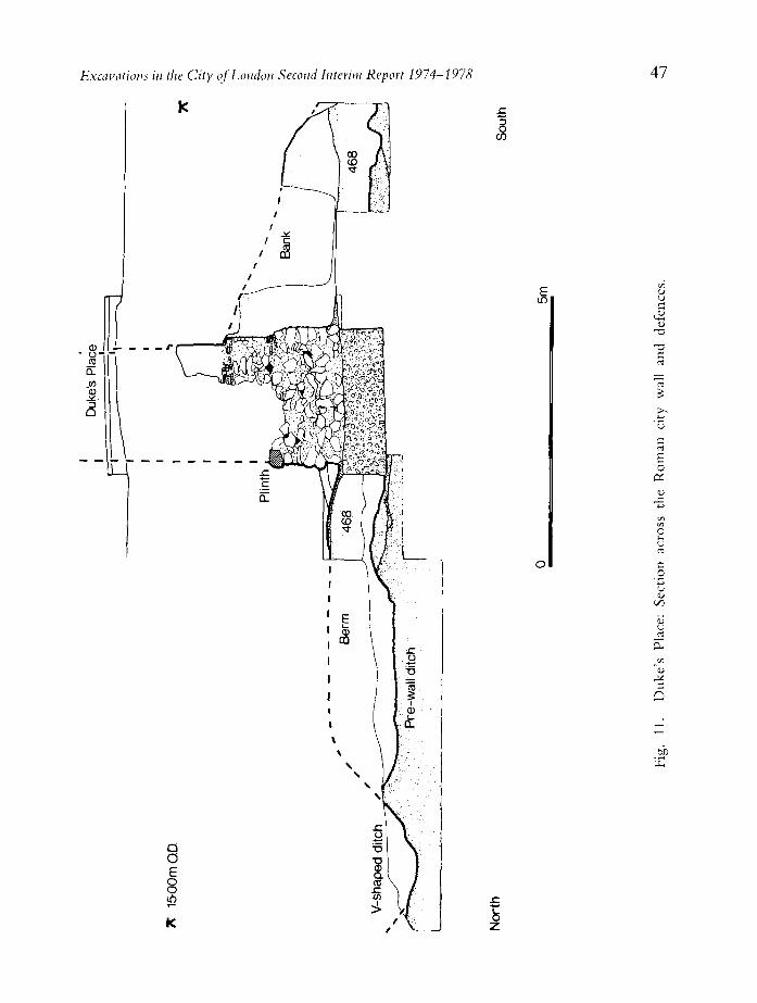
T H E D E F E N C E S Confronted by the contradiction between the abandonment of several private
properties and the flourishing of public undertakings by c. AD 200, it seems safer to account for the testimony of the G P O , Milk Street and Watling Court sites in terms of 'change' rather than of 'decline'. The urban defences, which would hardly have been erected in order to fortify a moribund city, were built at some date later than A D 183-4, and earlier than AD 225.4" The cutting of a pedestrian subway across the line of the wall at 2-22 Dukes Place has provided an opportunity of excavating a section through the whole defensive sequence from Roman to post-medieval date on the eastern side of the city (Site 17, supervised by John Maloney).41 The earliest dated feature of the site was a shallow, flat-bottomed cut in the natural subsoil, located at two points some 50m apart (Fig. 11). It measured 4m wide and barely 0.6m deep, and had remained open long enough for a layer of soil to accumulate at the bottom. The backfill above the silt contained pottery of c. A D 120, and the articulated remains of two human skeletons. Too slight to have been a defensive ditch, and unlikely to have been a drainage channel or a remnant of brickearth quarrying, its most remarkable aspect was its relation to the later wall, with which it ran parallel less than 2m distant from the external face. N o evidence has been found to suggest that London had a defensive circuit prior to the late 2nd century, but since some of the major cemeteries in use from the Flavian period were located just outside the limits of the wall, it is likely that the pomerium was already formally marked out, possibly by some such feature as this.42
O n top of this feature was a large dump of brickearth (Fig. 11, Context 468) which yielded pottery ofc. A D 180. Through this deposit was cut the trench for the foundations of the city wall. Above the clay and flint foundation a ragstone rubble footing, 1.15m high, supported the main body of the wall, which survived to its full width, 2.7m, and to a height of 1.70m above the plinth.43

Excavations in the City of London Second Interim Report 1974-1978 45
The pitch of the ragstone masonry, seen in longitudinal section (PI. 12), indicates that this portion of the wall was constructed from east to west. Both sides of the wall were faced with blocks of ragstone, which retained a rubble core of ragstone, laid in courses, each of which was capped with a layer of concrete which only partially percolated between the stones, thus leaving voids. The ornamental red sandstone plinth, with a chamfered edge, on the external face of the wall was mirrored by a triple facing course of tiles on the internal face. Four courses of ragstone above this level a triple course of bonding tiles was carried through the full thickness of the wall. O n the internal face, between the top and second tile, was an offset which reduced the width of the wall by 0.12m.
While these details conform to a common pattern, 44,an unusual feature of the construction of the wall at Dukes Place was the fact that the base of the plinth was apparently not level with, or just above, the contemporary ground surface. On both sides of the wall, at the juncture of the clay and flint foundation with the masonry footing, was a layer of mortar on which the internal bank was formed and which must therefore indicate the contemporary ground surface. Presumably the level was unusually low at this point since, even after a substantial preparatory dumping of brickearth, the plinth was still 1.15m above the mortar surfaces which resulted from the construction work. Another unusual feature of a nearby section of the wall, briefly observed, was an offset between the top and second tile of a triple bonding course on the external face. Ths observation may indicate that different stretches of the wall were built by different gangs.45
The bank against the internal face had clearly formed after the construction of the wall; its full height was not seen, but it was recorded tailing off 4m away from the wall.4'' Pottery from the bank, like that found below and above the mortar spread, dates to c. A D 180, and therefore further corroborates the general terminus post quern for the construction of the land wall.
Outside the walls, little is known in detail about the cemeteries of London; few of the graves or cremations have been accurately recorded. Recently, however, the opportunity arose to examine a small area of the cemetery to the north-west of the city in the area now occupied by St. Bartholomew's Hospital (Site 18), supervised by David Bentley. Eighteen burials, including four children, were excavated, all aligned with their heads to the west. Seven appeared to have suffered from osteoarthritis. The majority of the arthritis occurred in the vertebrae and occasionally in the hip joint.
The second most common pathological condition was periostitis in the tibia: an inflammatory reaction following either an injury or infection. One woman had seven Roman bronze bracelets and two finger rings on her chest, perhaps hanging from her neck, and in the grave was a small bronze bell. Coins with some of the other burials indicate that this part of the cemetery was in use from the late 2nd century and as late as the reign of Constans. It is possible that some of these burials are Christian.
At Dukes Place, the fill of the V-shaped ditch, normally associated with the wall and whose inner edge is usually found c. 3.5m from its external face (Fig.
46 Tony Dyson and John Schofteld
11), was found to contain a coin of Constans (AD 341-6). Although the deposit was not sealed, the coin may have some bearing on the date of the adjacent Bastion 6, which projected forward from the wall by c. 5.8m and would therefore have necessitated the backfilling of the ditch. More recently at Crosswall (Site 19), also supervised by John Maloney, the V-shaped ditch was seen to be cut by a broad ditch. Further north, the foundation of a previously unrecorded bastion (to be known as 4A) was revealed to be rectangular: 6.7m wide, it projected 5.7m from the wall.
The bastions, which were added to the land wall at a later date, have always presented a problem. Where examined, those on the western side of the city are of post-Roman date, and most were probably built in the early 13th century when there is ample evidence of concern with the defences at large. In view of the testimony of William fitzStephen, writing in the late 12th century just before this activity, that there were already ancient ' towers ' along the land wall, the possibility remains that some were Roman. There is, indeed, less doubt about the group of solid-core bastions on the eastern side of the city, which was more directly exposed to the danger of raids from the sea. These included much Roman material in their construction, notably monuments from the extramural cemeteries, which must have been salvaged at a period when they were still visible on the ground. It has always seemed likeliest that these bastions share the same date as the bastions added to the walls of most Roman towns in Britain after the mid 4th century.
The evidence of the coin of Constans from the ditch close to Bastion 6, and of coins of Magnentius or Decentius (AD 351-53) and of Gratian (AD 367-75) in layers lying over the footing of the bastion,47 seems to confirm this likelihood, for which considerable support has also been provided by the discovery of the riverside wall at Baynard's Castle (Site 20, see First Interim Report, 45—51) in 1974—6,4K at the Tower of London (by the Department of the Environment) in 1977,49 and at N e w Fresh Wharf in 1978. On the eastern part of the Baynard's Castle site, and also at N e w Fresh Wharf, the wall was founded upon a 'raft' of rammed chalk, itself supported upon parallel rows of oak piles driven vertically into the ground. Samples from the Baynard's Castle piles indicated a felling date of c. A D 330 in radio carbon terms which, when calibrated, would bring the wall's construction closer to A D 400; while a section of the later phase of the wall, which lacked chalk and pile foundations, also discovered at the Tower produced coinage of Valentinian II (AD 388-92) in material dumped against its internal face very soon after construction.5" The river wall, moreover, shared distinctive characteristics with the construction of the eastern bastions of the land wall.51 Unlike the land wall itself, both contained re-used material—most particularly monumental stonework and both, also unlike the land wall, made use of chalk, both in the core of the walls and to provide a platform for the foundations. Patches of pink mortar, found with crushed tile and reddened flints in the riverside wall, have also been recorded in the bastions.
There is now, therefore, considerably stronger reason for supposing that the defences of Roman London were greatly strengthened in the second half of the 4th century by the addition of the eastern bastions, at much the same period as
Excavations in the City of London Second Interim Report 1974-1978 47
0)
o -
in
3 Q
177
•Iu
3 o
Q 0 E o o
T3 C
'G a
o
c o
on
a,
o 3
Q
2
48 Tony Dyson and John Schofield
the construction of the riverside wall. The precise date (or dates) is less certain; the evidence from the Tower would suggest that one phase of the wall, at least, was the work of Stilicho (between A D 395 and 399), following the edict of Arcadius and Honorius which in A D 396 authorised urban authorities to undertake fortification using, where necessary, material from disused temples and other buildings. Since, however, the whole programme would have been a huge undertaking, the possibility might also be considered that some of the work was undertaken by Constans, who visited Britain in AD 342-3, or by Theodosius who , having relieved London, 'restored the cities and the defences' in the early 370s. At all events, though relatively little is known of the character of intramural London at this period, it is clear from the attention paid to its defences that the town was still considered to be a place of consequence by those who would defend it, and presumably by those who would attack it, within two decades of the final withdrawal of Roman troops from the province.
II S A X O N The mysterious dark earth which on several recent sites was found to have
replaced earlier buildings by the end of the 2nd century, as well as accentuating the uncertain nature of the later Roman occupation of London also epitomises the problem of Dark Age and early Saxon settlement.52 On the one hand, the earliest structures to appear on, or partly within, this material date only from the 8th/9th century or later; on the other, documentary references to London, though scarce, do at least make it clear that by the last quarter of the 7th century the city was already a notable urban centre, an established port and market accessible to Continental traders.5 ' Only to a very limited extent is this discrepancy redressed by pottery evidence. Sherds of grey pimply hand-made vessels in the Roman tradition, found in the destruction layers of the Billingsgate bath-house, may well prove to be of 5th-century date.54 The only securely stratified finds of early Saxon date include a hand-made, chaff-tempered urn and were recovered from a dumping layer which preceded the collapse of the Roman riverside wall.55 From some unrecorded location a biconical pot with rouletted decoration has been tentatively attributed to a German provenance of the late 6th to early 7th century; another is thought to be from northern France and of the second half of the 6th century.5'' At least ten stratified sherds of mid-Saxon Ipswich ware have recently been recovered from Peninsular House (Site 20).57 Similar finds are recorded from Battersea, and from Arundel House and the Savoy, both in the Strand.5"
T H E W A T E R F R O N T It is perhaps wor th noting that, rare as they are, a high proportion of these
early finds has been found in the immediate vicinity of the Thames. This accident is suggestive of an earlier analogy: what on inland sites could be taken as evidence for a 2nd-century depopulation and decline was nevertheless accompanied at the turn of the 2nd and 3rd centuries by distinctive and confident new development on the waterfront. As a test of conditions in the
Excavations in the City of London Second Interim Report 1974-1978 49
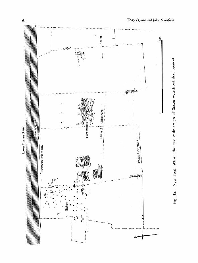
Middle Saxon period, the excavations at N e w Fresh Wharf (Site 11) supervised by John Schofield and Louise Miller, close to the medieval and—almost certainly—earlier bridges, as well as to the Peninsular House and Billingsgate bath-house finds spots, were inconclusive. It could certainly be shown that from the 5th century the Roman timber waterfront had been allowed to silt up and decay, but it was difficult to attach a firm date to the subsequent partial dismantling of the Roman structures to accommodate a bank of timber-laced rubble (First Interim Report, 35-7) (Fig. 7, 12). At one point the bank was covered by birch logs dated by C14 to AD 760 ± 100, and these in turn supported layers of planks, some of them from a clinker-built boat, to form a surface or 'hard', subsequently seen to extend for 19m towards Billingsgate. Mainly to the west of the bank, though partly overlapping and apparently contemporary with it, a large number of vertical oak posts, arranged in fourteen rows from north to south and in nine rows from east to west, formed a grid of stakes which may have extended farther out into the river beyond the southern limit of excavation. The stakes, which were chamfered and bore pointed tops, were comparatively short to the north but towards the river projected up to 2.5m from the contemporary shore. They were dated by C14 to AD 870 ± 60s'' and though only one was suitable for dendrochronological analysis it was seen to be c. 65 years earlier than samples from a succeeding embankment (see below, p. 61), dated absolutely to felling dates in the second half of the 10th and the early years of the 11th centuries,6" and by C14 to AD 940 ± 80.''1 Thus a date in the late 9th or early 10th century seems to be indicated for the stakes and for the rubble bank contemporary with them. An analogy with similar stake installations at Hedeby, for which both defensive and anti-erosive purposes were suggested, would also favour this general date, although the date of the birch logs may also indicate earlier activity.
For the development of the Saxon waterfront generally one of the most interesting aspects of the N e w Fresh Wharf excavations and subsequent observations of the site was that the 19m long bank was only the extremity of an installation which evidently continued beyond the eastern limit of investigation. More recently, the discovery of an elaborate section drawing of 1875 which records the stratigraphy below the western wall of the Billingsgate Market building, revealed that both the rubble bank and its late 10th or early 11th-century successor still exist at a point 59m to the east of the N e w Fresh Wharf site, and within 30m of the site of medieval Billingsgate to which they almost certainly continued. Billingsgate, first recorded c. 1000,''2 was one of three specific places on the waterfront to be mentioned in, or as dating from the Saxon period, and it is notable that, like its companions, Queenhithe and Dowgate/ '3 it was to maintain a distinct pre-eminence as a landing place throughout the medieval period. This in itself would suggest that the earliest Saxon activity on the river was .concentrated at these three locations, while the fact that in the Billingsgate and Dowgate areas were situated the only London churches to be built south of Thames Street—St. Magnus Martyr and St. Botolph Billingsgate, and All Hallows the Great and Less—would again imply that at an early date the principal activity of these particular districts was
50 Tony Dyson and John Schofield
a. _o
> o
-a
c o X rt
c/5 I n
O
<U
b£
O
z
Excavations in the City of London Second Interim Report 1974-1978 51
centered on the Thames. Queenhithe, Billingsgate and Dowgate thus represent the likeliest locations for the port recorded by the end of the 7th century, but Queenhithe and Dowgate (the latter in 1959-60 producing evidence of the pottery-strewn late Saxon foreshore and revetments''4) no longer survive archacologically intact. A fuller understanding of the development of the Saxon waterfront is crucially dependent on the excavation of the Billingsgate lorry park site, to the east of New Fresh Wharf, intended for redevelopment in the near future.
Of relevance to a probable late 9th early 10th-century date for the first Saxon embankment at N e w Fresh Wharf, on the periphery of Billingsgate, Queenhithe has recently been reassessed in the light of two purported land grants of Alfred.'" Though the existing texts are late in date and irregular in form, and have consequently often been dismissed individually as fabrications, they appear in quite different sources, and can be shown to derive from originals of at least late 10th-century date in one case, early 10th in the other. One of them, dated 898/9 and issued in the specific context of a discussion of the restoration of London, conferred on Archbishop Plegmund of Canterbury and Bishop Waerferth of Worcester, two dignitaries closely associated with Alfred's work, the right of mooring at adjacent properties at what later became known as Queenhithe. In the case of Bishop Waerferth, this grant supplemented an earlier award of 889, three years after Alfred's recapture of London from the Danes. On this occasion market rights were granted close to the 'trading shore' (ripa etntoralis) and, although no specific location is given, measurements arc provided from which the proportions of the plot can be shown to correspond most closely with a medieval 'insula' immediately north of Queenhithe. The fact that measurements are given at all would suggest that the north-south lanes leading to the river and mentioned as bounds in 898/9 did not yet exist in 889. Between them, the two grants were clearly concerned with the promotion of riverborne trade, a conclusion which is reinforced by Bishop Waerferth's involvement with the fortification o{ his own town of Worcester and with the establishment there of a market on terms which closely resemble those applying to London. At Worcester, moreover, Waerferth was collaborating with the Mercian ealdorman Ethelred, to w h o m Alfred had entrusted the custody of London, who had attended the restoration council which resulted in the grant of 898/9, and whose name was then shared by Queenhithe (Aetheredes hyd) itself.
This demonstration that London, and in particular its waterfront, was significantly involved in Alfred's general programme of urban restoration might provide a context for the stake installations and embankment at N e w Fresh Wharf. The stakes lay within 45m of the site of the 12th-century stone bridge, itself in all probability close to the line of its late Saxon predecessor which is first recorded c. 1000. There is reason to suppose that this bridge was constructed at the turn of the 9th and 10th centuries, a period when both Alfred and Edward the Elder were concerned with establishing opposing defences across rivers at several strategic points in the east Midlands, where at Nott ingham at least a bridge was built between them.'' ' The defences at
52 Tony Dyson and John Schofield
Southwark, a place for which there is no evidence of any significant settlement earlier in the post-Roman period,''7 are recorded (as Suthringa gewearch) in the Burghal Hidage; their appearance in this document strongly suggests that they were part of the Alfredian reformation of London, and it would be difficult to explain what useful purpose they might have served if it was not to secure a southern bridgehead.f,K In that event the N e w Fresh Wharf stakes may have been intended to close a gap between the northern bridgehead and the end of the first, rubble, embankment near Billingsgate, a short distance downstream.
MID T O LATE S A X O N BUILDINGS A N D STREETS Away from the Thames and provisionally dated from at least the early 9th to
the 11th centuries overall, a series of timber buildings has been found on six different sites since 1974. All these buildings would appear to conform to one of three distinctive types, which will first be identified with their exemplars. Apart from structural variety, however, it is apparent from the relation of most of these buildings to Roman or to later streets (or in at least one case to both) that uniform developments of a more general and perhaps more significant nature were occurring on many of these sites; some in the 9th or 10th centuries, and in one case in the mid-Saxon period. Because of this, and because very often two types of building were found on a single site, it will also be necessary to summarise each excavation in turn, noting the interim pottery dates currently available and the relation to streets before finally attempting any general conclusion.
The three distinctive building types arc termed 'ground-level', 'sunken floored' and 'large cellared':
1) Ground-level, exemplified at Peninsular House (Site 8), Milk Street (Site 4), Well Court (Site 6) and G P O (Site 3; First Interim Report, 52, Fig. 14). The foundations of the G P O building, which measured at least 9m X 4m, were represented by timber slots in the contemporary- ground surface, and by 'post-in-trench' construction. The latter technique was also in evidence at Well Court , where the holes of a double line of posts were detected for a short distance against the gravelling of the contemporary road surface. Inside the building was evidence of baking, and ovens were also found on the internal surfaces at Peninsular House, again close to a contemporary street, but where no evidence of external walls was recovered. The regular intervals between the ovens at Peninsular House (Fig. 13) suggested a form of ' s t r ip ' development in which individual properties were of an equal size. Neither walls nor floor surfaces were found at Milk Street, but the existence of party walls at right angles to the street may be indicated by the distribution of pits. Except at the G P O site, all buildings of this type fronted immediately on to adjacent streets. The date-range was wide: mid-Saxon and later at Peninsular House; 9th century for the two building phases at Well Court; and 10th and 11th century at Milk Street and G P O .
2) Sunken-floored; Bread Street (Site 21; First Interim Report, 54), and Milk Street. Buildings of this category featured floors set at c. 0.5m below the contemporary ground surface, and, as they survived, were less than 5m long.
Excavations in the City of London Second Interim Report 1974-1978 53
Structure 1 at Milk Street (Fig. 15) was lined by planks held in place by uprights set into circular post-holes. The Bread Street building survived as a series of irregular post-holes set against the cut faces of the pit; projecting from the western side were traces of a porch whose floor lay at an intermediate level between the exterior ground surface and the floor of the pit.69 Though the porch faced towards Bread Street, the building lay some 11m distant from the medieval and modern frontage and was not aligned with it; it may not be later in date than the mid 9th century. The Milk Street structure was set against the edge of a Roman street from which it was probably entered, and is dated by pottery to the 9th century; a second phase would appear to date from the late 9th or early 10th centuries.
3) Large-cellared; Watling Court (Site 5); Well Court (Site 6). The floors of buildings of this type lay at up to 2m below the contemporary ground surface, and were substantially longer than those of the simple sunken-floored variety: up to 13-15m. The construction of the Watling Court examples was notably more elaborate: a characteristic double lining of horizontal planking, fixed both inside and outside the posts, was recorded, and there was evidence of sill beams set into the floor of the pits, and of joists and floor planking (PI. 13). A further case of this general type was found by Professor Grimes at Cannon Street, and was dated to the 10th and 11th centuries;7" a comparable date is suggested in these cases; an 11th-century date seems to be indicated at Watling Court . In all cases, these large-cellared buildings lay at least 4—8m distant from the nearest medieval and modern streets.71
Peninsular House (Site 8) O n the site, supervised by Gustav Milne, on the west side of Botolph Lane
and to the north of Thames Street close to the N e w Fresh Wharf-Billingsgate area, both the earliest buildings and levels of Botolph Lane, separated by 2m of later intrusion, overlay a grey, sandy silt deposit up to 0.4m deep. Though there was insufficient t ime for a complete investigation of features sealed beneath this deposit, it was clear that no surfaces existed below of the type found above it. Sherds of Ipswich ware of the mid-Saxon period were recovered from the lowest levels of the deposit; while pottery from the upper levels was invariably Roman, suggesting that the material was redeposited rather than a gradual accumulation (Fig. 14). The surface had been levelled and rammed firm; above it, beaten earth and brickearth surfaces interpreted as internal floors were associated with the remains of domestic hearths and ovens and with several further sherds of mid-Saxon pottery. Some ovens included walls strengthened with wattlework. Altogether fourteen Saxon buildings, not all contemporary, were identified in three separate areas: six were apparently destroyed by fire. In each area the sequences differed, suggesting separate building plots whose individual widths appear to be reflected by the intervals of c. 4m between the hearths excavated (Fig. 13). Like the hearths and ovens, the floors showed considerable evidence of wear, repair and replacement. The dates of the later phases have not yet been established, but are probably 10th century. Three sections across Botolph Lane were examined over a distance of 14m; overlying the grey silts were deposits of compacted gravels, stones or cobbles,
54 Tony Dyson and John Sdwfield
V . . '
_../ Hearth
Building EP
/ /
Building EM
3 8 * H e a r t h
.•••• .. . ... , • * • . ' ; • . • • ? . . ; -PJ-irr--- •
•^ . • - / o . ^o. ••• :.° "••fS.-" • o ° o i a K e " " " • — • • - • / * ' . :>:;>••• <:(. • , - ho les
_ . . ' • - - . • .- -':sl:: '• ' \ •
Beaten earth floor
?Yard surface - • - * .'^
Building EG
I I
£
0 5m
Fig. 13. Peninsular House: plan of Saxon hearths alongside Botolph Lane.
0m
*(pp^ ^ . * » • *
Plate 1. Roman forum at 160-2 Fenchurch Street: The outer wall of the S portico of the second forum, looking S. The pier above is part of the foundations
of St. Dionys Backchurch.
Plate 2. Roman forum, Gracechurch Street tunnel: two mortar floors of the nave of the second basilica, the upper overlaid by building debris probably of the
building's destruction.
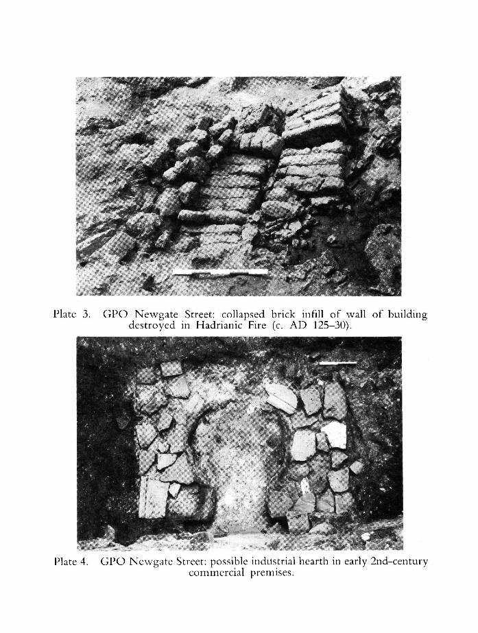
Plate 3. G P O Newgate Street: collapsed brick infill of wall of building destroyed in Hadrianic Fire (c. A D 125-30).
Plate 4. G P O Newgate Street: possible industrial hearth in early 2nd-century commercial premises.

Plate 5. G P O Newgate Street: interior of early 2nd-century Roman building, showing domestic hearth with ash spread (right), burnt studs of timber
framework (middle) and chevron internal wall decoration (left).
mm i Plate 6. Milk Street: 2nd-century mosaic.

fiNS '*?••*, * i •
' • • / ."̂ W-
w -
:
Plate 8. Watling Court: black and white mosaic fragment at point A on PL 7, looking N.
• . • .
Plate 9. Watling Court: opws signinum floor with inlaid mosaic roundels, at point B on PL 7, looking N.
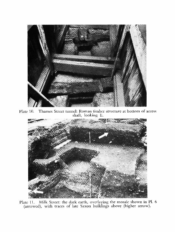
Plate 10. Thames Street tunnel: Roman timber structure at bottom of access shaft, looking E.
Plate 11. Milk Street: the dark earth, overlaying the mosaic shown in PI. 6 (arrowed), with traces of late Saxon buildings above (higher arrow).
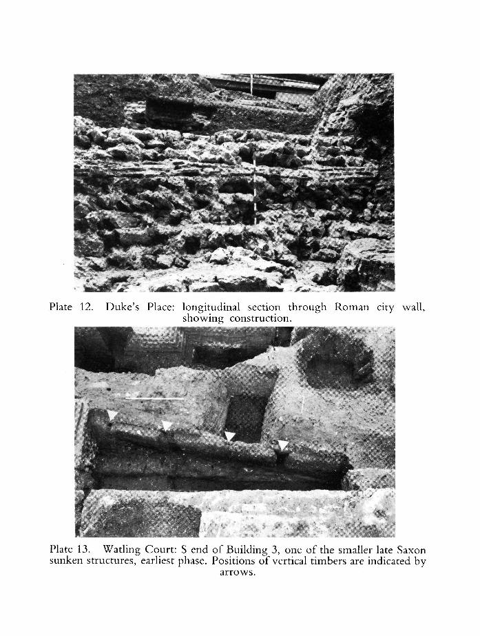
Plate 12. Duke's Place: longitudinal section through Roman city wall, showing construction.
Plate 13. Watling Court: S end of Building 3, one of the smaller late Saxon sunken structures, earliest phase. Positions of vertical timbers are indicated by
arrows.
bC KT
• • - > • * _ » - ^
Plate 15. Milk Street: early medieval undercroft foundations, looking S.
^ V JpN;V-'''
B^- .rf-^^B H r
' « - ' •
BSu,
v < *
• f t ' ' •-'*
• ^ 3 •
•TV t . .
• JB
hmamJP'j
Plate 16. Watling Court : medieval foundation, possibly the rear of a house, and adjacent chalk well, of a property fronting onto Basing Lane (now lost).
Plate 17. Watling Court: northern part of the site looking E, showing medieval and later cesspits arranged at the N ends of properties N of Basing Lane (off the site to the right), backing onto the medieval alley which ran up the
middle of the area shown.
Plate 18. Duke's Place: medieval doorway inserted into the city wall, probably by the adjacent Holy Trinity Priory, 13th or 14th century.
Excavations in the City of London Second Interim Report 1974-1978 55
contrasting with the brickearth floors c. 2m to the west (Fig. 14). Though no dating evidence was recovered from the road itself, the lower surface incorporated a higher proportion of ragstone and tegulae fragments than the upper surfaces in which a corresponding increase in the use of large, water-worn flint cobbles was recorded, perhaps comparable with the crushed flints used for the streets at Winchester attributed to an Alfredian refounding ,72
Layers of silt c. 100mm thick, representing an accumulation of mud or rubbish, overlay two of the earliest surfaces but were absent from the later, more compacted, metallings.
Botolph Lane Pavement
Fig. 14. Peninsular House: section through Botolph Lane, looking north.
Milk Street (Site 4) On the eastern side of the site, excavated by Steve Roskams, the first phase of
a sunken Structure 1 was represented by a pit c. 4.5m north-south X 3m east-west which cut c. 0.5m into the existing stratigraphy to reach a stabler, late 2nd-century Roman surface (Fig. 15). Only on the south side did the posts survive to be recorded; here three vertical internal posts set into circular holes retained a plank lining against the face of the cut. The central post was retained in the second phase, perhaps implying that it supported a ridge pole. The

56 Tony Dyson and John Schofield
eastern side of the building coincided with the inner edge of the ditch on the west side of the Roman road, from which an entrance into the pit was represented by a sloping hollow and a step. In a second phase, the two outer posts on the southern side were replaced, and a hearth laid near the middle of the north end. Fragments of Structure 2, of unknown size, lay further south and were recorded 3m west of the Roman road. The dark earth had been cleared over an area larger than the intended building; the shallow cut, whose base also coincided with the latest Roman horizon, was lined with brickcarth. Structure 3, 3m X at least 2.5m, cut the south-east corner of Structure 1 and occupied the middle of the Roman road. An initial cut 0.8m deep was sealed with silt and
B
2m
Fig. 15. Milk Street: plan of Saxon hut.
Timber revetment
B
Infill of
/ initial cut
Excavations in the City of London Second Interim Report 1974-1978 57
layers of brickearth. O n the evidence of pottery similar to that recovered from the first embankment at N e w Fresh Wharf, Structure 1 is of probable late 9th to early 10th-century date. Structures 2 and 3 are undated, though Structure 3 was later than Structure 1, of which it may have been a replacement. On the western side of the site, against Milk Street, the dark earth was overlain by traces of cellarless buildings of the 10th and 11th centuries, dated by pottery which seems to indicate a change from shelly wares to the hand-made, sand-tempered wares which predominated in the 11th century. Their alignments, indicated by the patterns of successive pits, suggest that they were served by Milk Street rather than by the Roman street which probably served the 9th to 10th-century sunken-floored structures on the east side of the site.
Well Court (Site 6) Observations by Peter Cardiff, John Millner and Dominic Perring on the east
side of Bow Lane revealed road gravelling laid over the dark earth, 0.6m above the latest Roman level and extending c. 1.5m-1.7m to the east of the present frontage. The Roman street, which evidently converged with the present street further south, lay c. 4m to the east of Bow Lane below the dark earth. Level with, and immediately against, the edge of the metalling were two parallel lines of post-holes set within a trench. Both lines were slightly bowed in plan, perhaps to accommodate an internal feature; just inside were found an oven, carbonised grain and fragments of querns, suggestive of a bakehouse. The road could not be dated, but 9th-century pottery was recovered from the demolition phase of the building which was replaced, also in the 9th century, by a structure fronting onto the present frontage of Bow Lane. This was also set in a trench, and a large number of small stake-holes were found between the load bearing post-holes, though no daub was found.
To the east of these structures, a building of large-cellared type was recorded in section. Aligned north-south, its western limit lay between 13 and 15.5m from the present Bow Lane frontage: it extended east by at least 4.1m but by less than 6.5m. Its pit cut into the dark earth by l m , though elsewhere on the site the dark earth was 1.3m deep. A trench was found at the foot of the sloping cut—either for a sillbeam or for 'post-in-trench' construction. Possible evidence for an entrance on the eastern side in the form of an upward slope might indicate that access was other than from the buildings on Bow Lane. N o dating evidence has yet been identified.
Watling Court (Site 5) On the west side of Bow Lane excavations supervised by Dominic Perring
revealed three sunken buildings. The north, south and east limits of Building 1 survived; the western limit was cut by a modern intrusion c. 2m wide. N o evidence was found on the far side, and the building covered an area 15m north-south X ? c. 6m east-west. The cut was slope-sided, and at its foot was a continuous slot cut. In the sillbeam, where located, were rectangular slots for studs set regularly within extremes of 0.85m to 1.05m between the centres of the studs. The outer plank wall was 0.5m inside the cut, and a second plank
58 Tony Dyson and John Scho field
lining was attached to the inner faces of the studs: the internal dimensions were 13.65m north to south and ? c. 5.4m east to west. Half-split timbers of ' D ' section, laid horizontally and longitudinally down the centre of the floor presumably represented joists which stopped c. l m short of either end. Other longitudinal joists were also found near the sides. Though smashed when the pits were backfilled, further planking was apparently laid above the joists as a floor. N o hearths or other internal features were observed in the 60% of the interior of the building examined. The surviving depth of the cut was 0.6m, but 1.3m to the west of the structure the dark earth survived to at least 2.25m above the level of the base of the cut, indicative of depth. The'occupation debris was of late 10th and more definitely 11th-century date; the building was backfilled in the 11th century. T o the south the cut was 4—5m north of the modern Cannon Street frontage, and presumably still further from the medieval Basing Lane which Cannon Street replaced when extended in the last century. The building was precisely aligned with medieval frontages on all sides.
Building 2, 7m to the north of Building 1, was of identical construction; only the south and east limits were located and its area was in excess of 5.6m north-south X 6.4m east-west. The area between the planked double-lining was 4 .8m+ north-south X 5 .6m+ east-west. The cut survived to a depth of 0.7m, though a total depth of 1.6m-1.8m is likely. The backfill was of 11th-century date, and the building itself cut other features of the same date, including Building 3. Building 3 lay immediately to the east of Building 2, and was heavily cut by later instrusions. The north and south limits were intact; its width was c. 4m, and its length was traced for 1.4m from east to west. The construction was not identical with that of Buildings 1 and 2; no sill beam was found, and the uprights were circular in section. There was some evidence of plank lining, though whether 'double' is uncertain. The uprights, which were set in a trench, were spaced between 0.6m and 0.85m apart (PI. 13). The floor level was 0.4m higher than that of Building 2, and 1.05m higher than that ot Building 1. Building 3 was cut by Building 2 and itself cut a pit containing 11th-century material; it is possible that originally, though not in its later use, it served as a porch of Building 2.
O n the basis of these excavations and of provisional pottery dating, ground level buildings can be said to date from at least the 9th to the 11th centuries. The rarity of this form of construction in London, compared with many other late Saxon towns, is most probably to be attributed to the destruction of the higher levels by the ubiquitous Victorian cellars. Sunken-floored buildings would appear to date from the 9th or early 10th centuries, as in the case of Structure 1 at Milk Street, although it is possible that others persisted as an archaic type, suited to some particular function or locality, at a later date. The large-cellared buildings date consistently from the (? late) 10th and 11th centuries. In no one case where more than one type was found on a single site has it been possible to record any direct relationship between them; to establish, as for example at Well Court , whether the ground-level and large-cellared buildings existed contemporaneously, or as parts of a single property. The only topographical constant which applies to these categories is that the large-cellared buildings were
Excavations in the City of Loudon Second Interim Report 1974—1978 59
invariably found well away from street frontages, perhaps for ancillary storage. Street frontages, on the other hand, seem to have been favoured by ground level buildings which, as at Peninsular House and Well Court, contained hearths and/or ovens and may thus have served a commercial or domestic purpose: some of the pits at Milk Street were of primarily industrial function.
Of especial interest is the question of the relation between buildings and streets, whether Roman or more recent. At Milk Street a Roman road at the eastern edge of the site probably survived to serve a late 9th or early 10th-century structure whose subsequent extension or replacement effectively blocked it; while on the western side of the site buildings which originated in the 10th century were aligned on the present Milk Street. This would appear to indicate the substitution of a new street 25m to the west of the Roman metallings. Current excavations at Ironmonger Lane (Site 22), supervised by Jennie Norton, have shown that an east-west Roman street, c. 80m north of Cheapside, survived intact until it was partially encroached in the 9th century; by the end of that century it was apparently crossed by a building which probably fronted on the new north-south alignment of Ironmonger Lane. Elsewhere new streets were laid out where Roman throughfares had evidently not survived in this way. At Well Court buildings of probable 9th-century date constructed against the earliest metallings of Bow Lane overlay a deposit of dark earth 0.6m deep beneath which a Roman street lay on a slightly different alignment, at this point c. 4m to the east of the present lane. N o Roman predecessor was found to underlie the south end of Botolph Lane, and none was found to the west of the lane on the Peninsular House site. To the extent that the Bread Street building, which may be of mid Saxon date, lay on a different alignment from that of the street, it may predate it.
This evidence of the widespread establishment of new streets and adjoining properties, occasionally replacing Roman thoroughfares, in the late Saxon period calls into question the origin of the overall medieval and modern street plan of London. Here, particularly in the area to the east of St. Paul's cathedral, the elements of a rectangular 'grid' system have been discerned, and the suggestion made a decade ago that, as elsewhere, this pattern arose from the Alfredian restoration of towns at the turn of the 9th and 10th centuries." This possibility is now clearly strengthened by the close comparison between the new streets at Winchester, superseding the Roman pattern and attributed to the Alfredian refounding of the city,74 and the present evidence from London, notably at Milk Street and, though less clearly, at Bow and Ironmonger Lanes. At the same time a general context is provided by the documentary evidence of commercial activity, and apparently of new streets, at Queenhithe in the late 9th century. Provisionally at least the comparison is also supported by dating evidence, though it is clear that more work is required before an absolute sequence can be more satisfactorily established. In any case, it should be stressed that no single date can be applied to all these sites: Botolph Lane (closer to the waterfront, and in particular to the Billingsgate area) can be securely dated to the mid Saxon period, which implies that to some extent these developments were foreshadowed in the 8th or early 9th centuries. While the two early
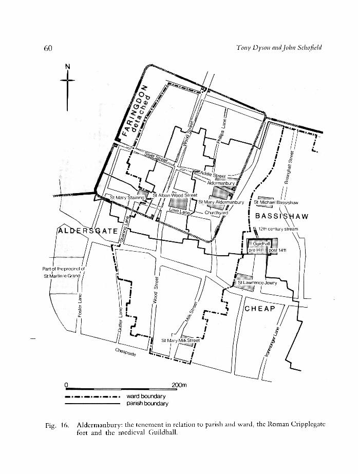
60 Tony Dyson and John Schofield
N
Part of the precinct of
St Martin le Grand
200m
ward boundary parish boundary
Fig. 16. Aldermanbury: the tenement in relation to parish and ward, the Roman Cripplcgatc fort and the medieval Guildhall.
Excavations in the City of London Second Interim Report 1974-1978 61
building phases at Bow Lane arc both 9th century, the second represented an encroachment on the original line of the lane, which is itself undated: the earlier phase may well be prc-Alfredian.
Ill LATE S A X O N Apart from the later building phases at Peninsular House, and the complex
sequences of interlocking industrial and refuse pits at Milk Street, both of which can be expected to yield much additional information as post-excavation work continues, the single most important archaeological discovery of this period was the later of the two embankments at N e w Fresh Wharf. The stakes and bank of probable late 9th or early 10th-century date were consolidated by two layers of clay dumped around a core of rough boxes of logs and planking laid upon the brushwood matting of the existing embankment (Fig. 12, PL 14). These dumps extended south from the Roman river wall, below the present southern edge of Thames Street, for a distance of some 20m. Further dumps of clay, stone and timber raised the bank by some 2m, and in form as well as date it closely resembled the Anglo-Scandinavian bank along the river Foss at York, which prevented flooding and possibly served for unloading boats. The London bank appeared to extend across the width of at least five properties, distinguishable both by the posts and planks of fences aligned north to south, and by slight differences in their individual construction. Dendrochronological analysis of samples of timber from the boundary fences indicates felling dates of 964 ± 9, 976 ± 9, 1000 ± 9,75 compared with a CI 4 date of A D 940 ± 80.7" This would imply the existence of separate properties in, or soon after, the later 10th century, and it is notable that one of the property divisions was seen to coincide with the line of a medieval alleyway for which there is documentary evidence by the mid 12th century.
N o doubt distinct from the humbler buildings excavated, there are occasional references from the mid 9th century to individual hagas and burhs in London, some given specific names such as Ceolmundingachaga near the 'Westgate', given to Worcester cathedral in 855, or the 'burh of St. Paul's' mentioned c. 975. These apparently record the residences or estates of prominent individuals77 or of communities, some based outside the city. Stacningahaga, together with its parent manor of Staines (Middlesex), was given to Westminster Abbey by Edward the Confessor, and can be identified with the parish of St. Mary Staining, recorded in 1190 as ecclesiam dc Stainingehaga. Staeningahaga would seem to represent a case, very common by the time of the Domesday survey, of a rural estate holding property in the local urban centre. So also might Basingahaga, first mentioned in 1160-80 and now represented by the uniquely coterminous ward and parish of Bassishaw, except that the name apparently derives from Basing in Hampshire, two counties distant from London. Stacningahaga and Basingahaga are however the only two names of this type recorded in London, and they are linked by two curious coincidences. Both Basing and Staines lay on, or close to, the course of the Roman road which led from Newgate, close to the hagas, to Silchester, and the hagas themselves lay just outside the lines of the east and south walls respectively of the Roman
62 Tony Dyson and John Schofteld
Cripplegate fort. Since the discovery of the fort, whose north and west walls had been incorporated within the Roman city wall, its enclosure (assuming that the internal walls survived) has often been suggested as a likely location for the Saxon royal palace which, according to two very late but independent medieval traditions, lay in the Aldermanbury area, close to the east wall of the fort.™
The potential interest of the fort site in the post-Roman period, and the subject ofburhs and hagas generally, is currently being reassessed in the course of documentary work on the medieval tenement of Aldermanbury, 'the fortified manor of the alderman', which gave its name to the present street to the east, and to the parish at whose centre it stood immediately to the north of the church of St. Mary Aldermanbury (Fig. 16). It is clear that the church originally belonged to the tenement, and as late as the 14th century the two were directly connected by a postern. In c. 1127 Aldermanbury was described as a soke, or private jurisdiction, in a context which shows that it ranked in size or importance with the City wards, while in the mid 13th century the local ward, later to be known as Cripplegate, was referred to as Aldermanesgarde. The extensive privileges attached to the tenement at this period, exceptional for any secular property, can only be compared with a handful of franchises granted to such specially favoured religious institutions such as St. Paul's cathedral and the priory of Holy Trinity Aldgate: they would appear to be equivalent to those of the wards themselves. This unusual prominence may perhaps be related to two further circumstances, themselves probably connected. The frontage of the tenement, which still projects conspicuously into the street of Aldermanbury, corresponds precisely with that of the assumed east gatehouse of the Roman fort, and whereas elsewhere modern streets within the former enclosure closely followed the lines of the Roman streets, Addle Street by the late medieval period had been redirected by some 30m from the gatehouse site to run along the north side of the tenement. This would suggest that at some date after the demolition of the wall the gatehouse still survived to serve some purpose which justified the diversion of the street. N o date can be put to this development, but Roman gatehouses are known to have survived the Dark Ages as residences for local dignitaries—for a bishop at Trier and, it would seem, for kings and earls at York.™
A possible link with a London palace is strengthened by the fact that in the years during and after the completion of Edward the Confessor's new palace at Westminster, a considerable amount of land in the Cripplegate area was awarded to various beneficiaries including Westminster Abbey (which received Staeningahaga and Staines) and the royal college of St. Martin le Grand. A late 11th-century source quoted by Matthew Paris notes that the liberties of the former palace site adjacent to St. Alban Wood Street were preserved by a 'small house', an interesting statement in view of the exceptional early-medieval soke of Aldermanbury, its name and its proximity to the Guildhall 90m to the south-east, where the medieval aldermen convened at the court of Husting. A comparison with Winchester, where the gihalda of 1148, supervised by a royal official, was also established on the boundary of a recently abandoned royal palace/" perhaps at one of its gates, provides an analogy for the close
Excavations in the City of London Second Interim Report 1974—1978 63
institutional—and topographical—connexion between royal and civic government in the late 11th and early 12th centuries. While decisive evidence is lacking, it could be suggested on circumstantial grounds that when a new palace was built at Westminster much of the old site was disposed of, but that part of the area, with its eastern gatehouse and the palace liberties, was reserved for a royal official, the alderman, needed to supervise the king's interests in London. This might be considered as an intermediate stage before the establishment of the Guildhall on its present site, probably in the 1120s when the citizens also won the right of electing a sheriff, as a centre of government for the leaders of the wards, themselves now called aldermen. Professor Grimes' excavation of the site of St. Mary Aldermanbury produced no definite evidence of the date of the original church,"' while his investigation of the nearby church of St. Alban Wood Street uncovered stone foundations not inconsistent with Matthew Paris's claim that it existed in the 8th century."2
The recent examination of the south end of the G P O site (Site 3), supervised by Alan Thompson, revealed the church of St. Nicholas Shambles, first recorded c. 1187 and demolished in 1551. The earliest structure was two-celled and measured at least c. 20m X 8.5m. The foundations consisted of alternating courses of lightly pounded gravel and fragments of Roman building material; ragstone, opus signinum and roofing tiles, set into the underlying dark earth. This material had not been recovered from the immediate vicinity since the Roman buildings below the dark earth were of brick earth and timber. Because so much of the archaeological deposits had been removed by the insertion of modern basements, the dating of this first phase is difficult; it is provisionally set at the 10th or 11th centuries. An early alternative dedication was St. Nicholas Aldred, and it is notable that the same personal name occurs in Aldersgate, 200m to the north-east, which was recorded as Ealdredesgate in c. 1000. The recovery of one charcoal burial from the northern cemetery admits the possibility that some of the earlier burials may be associated with the first church.
IV MEDIEVAL Compared with the quality of the archaeological evidence for the Roman
period, or even in recent months for the Saxon period, in London generally the medieval findings have so far proved disappointing. In the inland area of the City only deeper medieval features such as cess pits and wells normally survive (PI. 16). These can, however, as at Watling court (PI. 17), indicate the layout of medieval tenement plots and so be compared with the documentary evidence. Occasionally, the deeper foundations of stone undercrofts are also recorded; in this way a 12th or 13th-century undercroft with additional foundations, perhaps indicative of a rear stair, has been traced at Milk Street (Fig. 17, Pi. 15). Close to London, a 13th-century analogy of almost identical dimensions survives under the Angel Hotel at Guildford,"1 but it is clear that at London at least such buildings were regarded as a comparative rarity in the early 13th century. Medieval occupation or ground surfaces rarely survive, though an important exception, currently bening analysed, is the northern and middle
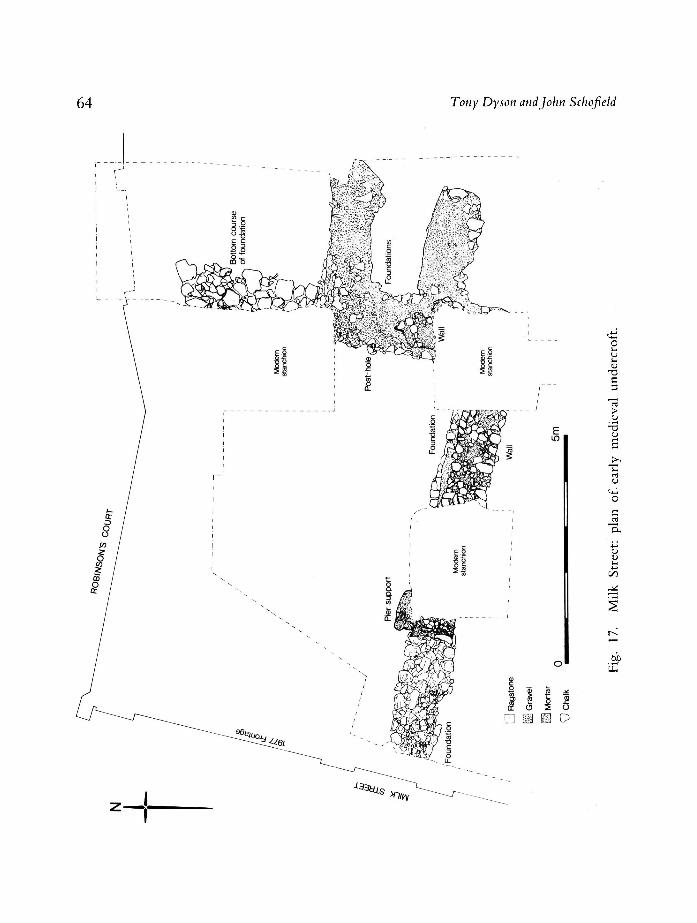
64 Tony Dyson and John Schofield
E
o
C 3
> o
-3
o
J
Rag
stom
Gra
vel
Mor
tar
Cha
lk
D U O
h-
i
Excavations in the City of London Second Interim Report 1974-1978 65
areas of the G P O site where remains of 13th-century buildings were recorded below the gardens of the adjacent Greyfriars. There can be little doubt that the poor survival of the medieval levels is largely a consequence of the insertion of deep cellars favoured by Victorian and modern buildings, and the point is emphasised by the two exceptions, the waterfront and the defences, with which this section of the report is almost exclusively concerned. O n the waterfront in particular, the relative height of the water table has usually discouraged the provision of basements, and the raising of the level of Thames Street after the Great Fire contributed further to the preservation of underlying structures and deposits.
T H E W A T E R F R O N T O f those waterfront sites which produced evidence of Roman or Saxon
activity, only N e w Fresh Wharf (Site 11) just upstream of Billingsgate, exhibited any recognizable continuity of occupation into the medieval period. Here the late Saxon embankments of the 9th-10th, and lOth- l l th centuries, the latter divided into individual properties by fences of which some coincided with later tenement boundaries (Fig. 12), were extended in the early or mid 12th century to the line of the first vertical revetment, c. 8m further south. From the beginning, the embankments were built out from the surviving courses of the riverside wall, which at this point lay along the south side of Thames Street. A similar arrangement is suggested by another late Saxon embankment found in a comparable position south of the street at Dowgate in 1959-60."4 At Queenhithe, the third of the recorded pre-Conquest harbour areas, the late 9th-century mooring places were separated from their property plots by the 'city wall', almost certainly the Roman riverwall on the line of Thames Street."'
Elsewhere on the waterfront, however, excavation to the south of Thames Street has failed to produce evidence of occupation or activity earlier than the 12th, or even 13th, century. Investigation at Seal House (Site 12), supervised by John Schoficld, revealed no late Saxon embankment such as occurred at N e w Fresh Wharf or Dowgatc: the earliest post-Roman structure was a mid 12th-century timber revetment found at c. 21m south of Thames Street. The first such structure at Custom House (Site 7) dated from the late 13th century,"6
and it is perhaps significant that until this period the enrolled deeds of the local parishes of All Hallows Barking and St. Dunstan in the East reveal that the property market was notably more active in the northern, Tower Street, area than on the waterfront, where relatively large properties still held by a handful of owners would also suggest minimal capital development."7 A similar pattern emerged at the opposite end of the waterfront at Baynard's Castle (Site 20), where the earliest revetments dated from the late 12th or early 13th centuries.88
The likelihood is thus increased that the earliest post-Roman riverfront activity was largely confined to the three pre-Conquest havens of Queenhithe, Billingsgate and Dowgate, while the possibility that west of Queenhithe and east of Billingsgate, at least, the laying out of Thames Street proceeded in tandem with the development of the waterfront is suggested by the fact that at Baynard's Castle the earliest level of the street, based on the collapsed
66 Tony Dyson and John Schofield
river-wall, roughly coincided with the date of the revetments to the south"'' (First Interim Report, 59).
O f the three early centres, Dowgate, first mentioned in connexion with French and German merchants, seems to have been a largely private preserve for the use of particularly active continental traders. In this case, and also with the more general public landing places at Queenhithe and Billingsgate, there was always a marked concern by Crown and City to ensure that goods coming into London should land at the appropriate place. This was primarily for ease of taxation and supervision, but also because landing and trading facilities ultimately derived from jealously guarded royal prerogatives;'"1 similar restrictions were still evident as late as 1559, when the number of'licensed' quays in London was limited to nine. The clear implication would seem to be that outside the authorized centres, and apart from the smaller private franchises granted for example to prominent ecclesiastics, there was no automatic right of mooring except for non-taxable cargoes carried by small, local vessels. Confirmation of this was supplied by the Trig Lane tenements (Site 23) which can be regarded as typical private citizens' holdings: none of the successive revetments was high enough to accommodate any but the smallest vessels, such as could alone negotiate the three river stairs 6 to 7m apart which project from the 14th and 15th-century frontages. It is notable, too, that with the necessary exception of fishmongers, a high proportion of the occupants of the private riverfront tenements in the medieval period consisted of metalworkers, dyers and tilers. For such trades location on the waterfront is more likely to be explained by their constant need for water and their obnoxious working conditions than by any special need for immediate access to riverborne traffic.
The important distinction between the functions of the ordinary private waterfront tenements—the vast majority—on the one hand, and both the public and specially privileged private landing places on the other, has been obscured by the usual medieval practice of describing all indiscriminately as 'wharves' or 'quays' . At this period, however, these terms were applied less exclusively to harbours and mooring places than subsequently became the case. They could also denote the basic river frontages designed primarily to contain the highest tides and which, being in the interests of the city at large, were customary and approved: even a riverside church could have one. Different from these in degree rather than in kind were revetments which contained sufficient new ground for additional buildings, as in the phrase kayum domorum, and which more specifically denoted land reclamation: where these extended into the current of the Thames, however, they were illegal, presumably because they obstructed, or threatened to compete with, the official landing places. For while each of the three phenomena described by the terms 'wharf and 'quay' were physically similar as being the point where land and water met, once distinguished they reveal the complexity and variety of motivation which contributed to the gradual southward progression of the London waterfront.
Extending from c. 20m south of Thames Street (at Seal House and N e w Fresh Wharf) by the mid 12th century to an average distance of between 50-100m by the mid 17th century at the latest, this process was achieved by means of a
Excavations in the City of London Second Interim Report 1974-1978 67
succession of revetments, almost all of timber and each backfilled by refuse to form a level surface. Often surviving to heights of 2m or more, the revetments are characterized by a vertical arrangement of posts, as distinct from the 'horizontal' tradition typified at Bryggen in Norway.9 1 The London examples fall into front and back-braced varieties (Fig. 18), except for cases at the Mermaid Theatre site (Site 24) and at Trig Lane (Site 23: Group 3, c. 1295) which were braced both in front and behind. The front-braced type, as also at Trig lane, Seal House and Custom House, were current until the turn of the 13th and 14th centuries, after which the back-braced variety predominated— though a more sophisticated form of front-brace at Custom House dated from the later 14th century. Three 14th-century revetments at Trig Lane employed a system of edge-trenching at the junction of the horizontal tie-back (Group 7) or back-brace base plate (Groups 10 and 11) with the vertically set posts or staves (Fig. 18). The intractable joint of exceptional strength thus produced is unparalleled in any medieval building on dry land, the closest analogy being the joint between the beam and ribs of such vessels as the Bremerkogge, which was contemporary with the Group 11 revetment of c. 1380. Free tenons were sometimes seen to join adjacent stave members on the Group 10 structure, which also bore a series of assembly marks incised upon the face of the timbers, demonstrating that it was a prefabricated structure installed from west to east.
Until recently it was generally assumed that the waterfront progression achieved by these means largely arose from the need to acquire extra land at the expense of the river. It now seems more likely, however, that this motivation was principally confined to the period up to the late 13th century and that thereafter, as was demonstrated by the excavations supervised by Gustav Milne at Trig Lane'2, quite different factors prevailed. Here, well away from the central section of the waterfront and 150m upstream of Queenhithe, 48m of the total progression of 60m had been reclaimed by c. 1280, the date of the northernmost revetment (Group 2) in the area excavated. Documentary evidence supplies some clues as to the formation of the intervening zone, some of it possibly of natural strand, between the northern limit of the site and Thames Street. The line of an earlier frontage c. 18m to the north of the Group 2 revetment seems to be indicated in late 17th-century plans by parallel deflections in the courses of Trig and Boss Lanes on either side of the site, deflections matched by kinks in the intermediate property boundaries. Moreover, it can be shown that by 1256 one, and by 1273 two, of the three tenements into which the area between the lanes had been equally divided were now also subdivided into northern and southern portions. It.is at least likely that this subdivision was occasioned by an earlier phase of reclamation, possibly from the line of deflections shown by the post-medieval plans. Indeed, since that line was itself c. 30m south of Thames Street, more than one phase may have been involved before c. '1280: well before the end of the 12th century, Kingsgate, at the foot of Boss Lane, had been an established landing place for the king's wine. Elsewhere, reclamation appears to have begun by the mid 12th century, when the earliest Seal House revetment was established at 21m south of Thames Street. It is notable that in both distance and date this structure

68 Tony Dyson and John Schoficld
0 5m
Fig. 18. Medieval riverfront revetment types in London (river to right). Front-braced (13 to 14th century): a, Cus tom House I; b , Seal House III; c, Trig Lane G6; d, Custom House II. Front and Back-braced (13th century): c, Mermaid Theatre; f, Trig Lane G3. Back-braced (14th to 15th century): g, Trig Lane G7; h, Trig Lane G i l ; i, Trig Lane G12.
Excavations in the City of London Second Interim Report 1974-1978 69
closely compares with the earliest vertical revetment at N e w Fresh Wharf, 7m south of the late Saxon embankment on the far side of London Bridge. As no revetments of earlier than 12th-century date have yet been found it may be that this period marked the beginning of the process of reclamation elsewhere than at Queenhithe, Billingsgate and Dowgate.
From the end of the 13th century, however, it is apparent that the excavated revetments at Trig Lane were no longer intended to enclose such large areas of newly recovered land. O f the fifteen distinct modifications to the Trig Lane waterfront between c. 1280 and c. 1440 only four involved any significant progression; three amounting to 3m apiece and the fourth to 6m. The Group 10 revetment of c. 1365 was seen to supersede a much repaired and fundamentally unstable frontage which comprised sections of the Group 3, 4 and 6 revetments. Since it would have been difficult to replace this structure in situ", the easier and sounder solution was adopted of installing an entirely new revetment a little further to the south. Moreover, the new Group 10 revetment, like the Group 11 revetment of c. 1380, was built at two distinct levels of which the upper was replaceable, while the Group 12 structure also replaced the upper stage of the Group 10 revetment some sixty years after the lower had been built. This facility was evidently intended to reduce the decay to which the upper staging was especially vulnerable from the constant rise and fall of the tide. Thus at Trig Lane the modest progression of the riverfront from the late 13th century, far from being intended to acquire additional ground or access to deeper water for berthing, was caused by the persisting need to maintain the frontage against tidal action. Even for this purpose considerable pains were taken to postpone the construction of new revetments by the provision of replaceable staging.
H o w far this restraint was imposed by general legal restrictions or by the financial limitations of individual occupants is uncertain. In part the case of Trig Lane may well reflect the sharp fall in economic activity, demand for property and density of settlement in London after the Black Death. "4 O n the other hand, even when limited to maintenance, there was little overall consistency in the rate of progression even between the three Trig Lane tenements. Documentary evidence shows that the tenements, though usually under single ownership, were almost invariably in separate occupation. Excavation suggested that the decision to extend a revetment was that of the individual occupant: on any one occasion one or two tenements might be involved, but rarely all three. Thus a uniform frontage seems almost to have been accidental, and here, no doubt, the authorities' concern to check the rate of progression was confronted by a fundamental problem. The man who lawfully extended his frontage to maintain it in good order invited a similar response from his neighbour, if only because of the insanitary consequences of an indented riverwall. In the 15th century, and doubtless much earlier, the City was compelled to admit that these constituted justifiable cause for levelling up the waterfront.'5 The ultimate solution to this dilemma seems to have been provided by the general introduction of stone walls, much less susceptible to decay or erosion. It is significant that the installation of stone quays, as at Trig Lane in c. 1440 and at Seal House by the late 15th century, or as at Dublin by the early 14th,'*
70 Tony Dyson and John Scho field
effectively marked the end of the progression process. This consequence, however, presumably depended upon a fairly consistent provision of stone revetments along the waterfront as a whole. Though a stone revetment existed immediately to the west of the timber revetments at Trig Lane as early as the outset of the 14th century, their continuing advance was to render it redundant: by the mid 15th century, however, both the fully excavated tenements and their neighbour to the west were fronted by a continuous stone wall on the same alignment.
W A T E R F R O N T BUILDINGS N o doubt because of the relative distance of the Trig Lane site from Thames
Street, comparatively little coherent evidence survived of the medieval buildings constructed above the level of the revetments." A more comprehensive impression of waterfront buildings and tenements was available from Seal House (First Interim Report, 37-9), and particularly from N e w Fresh Wharf (Site 11); since the latter also represent the best preserved medieval domestic structures so far excavated in London they call for special attention. In the medieval period the N e w Fresh Wharf site comprised seven tenements situated between the churches of St. Magnus Martyr to the west and St. Botolph Billingsgate to the east; excavation disclosed the northern halves of tenements 2-7 (Figs. 19, 20). The first extension of the later Saxon embankment occurred in the early 12th century, and four of the tenements (Nos. 3-6) involved the provision of the earliest vertical revetments; the wharf surfaces may have been cobbled, as indicated at one point, or planked. Also in the 12th century, or possibly in the early 13th when the wharves were again extended southwards, stone building foundations were laid upon, or cut into, the reclamation deposits.
Buildings of this period included Building A-B on Tenement 4 (Fig. 19) which comprised two rooms 6m and 8.5m long, the larger to the south, which were linked by a door; these were ground level undercrofts since the medieval Thames Street was subsequently seen to be level with their floors. This wharf, double the size of the neighbouring properties, may be identified with the two wharves at Roderesgate recorded in 1147/67. Building D on Tenement 6, whose revetment was aligned with the front-braced revetment of Tenement 5, and possibly with that of Tenement 4, was a substantial 12th-century stone building which occupied over half the property: a yard or wide alley to the west did not quite reach the street. T w o rooms were indicated: a smaller chamber to the north, and to the south a main undercroft measuring internally 8.3m X 4m, whose floor, in contrast with Building B, was c. l m below contemporary street level. O n Tenement 7, nearest St. Botolph Billingsgate, was a similar but larger undercroft, Building C, also of 12th-century date. This comprised one cellar, possibly vaulted in 3 X 2 bays, which extended across the full width of the property: a door leading to the quay stood at the south-east corner. In the early 13th century the revetments of Tenements 3-5 and 7 were extended c. 10m further into the river, and consisted of a stone river wall which protruded at least 1.95m beyond the line of Tenement 6. Its level was slightly lower than that of the street.
Excavations in the City of London Second Interim Report 1974-1978 71
Site of the church of St Botolph
b£
g is '3 > u
~3 o
o a
"E.
u u UH
snuEeiM jg jo gainijo
72 Tony Dyson and John Schofield
Site of the church of St Botolph E 8n
Hammond's Quay
(afi C
3
>
z o
taB
snu6ey\| ;s JO u.amu.0
Excavations in the City of London Second Interim Report 1974-1978 73
Most, if not all, of the seven tenements appear to have been rebuilt in the late 13th and early 14th century (Fig. 20). In the west, the boundary between Tenements 2 and 3 was re-established, and with it the first recognizable buildings on Tenement 2 were represented by two parallel foundations of arched construction based on timber piles. One formed the tenement boundary, while its neighbour to the west marked the internal side of a private alley (Building F) which still existed in 1666. A new building, G, on Tenement 3 comprised four rooms, or a large subdivided cellar with two rooms behind; access was from Rothcrsgate to the east. Each cellar had a slightly different floor level: that at the front was 0.5m below the contemporary Thames Street, perhaps to allow for illumination from windows on the street side. Building G is recorded as having a wharf in 1278, while Building F to the west was described as a newly-built house in 1293; both were probably rebuilt at about this period.
Tenement 4, to the east of Rothersgate, was rebuilt in the early 14th century and at least eight rooms of the resultant Building K were traced during excavation. N o internal alley was observed and, as with Building G, access was presumably from Rothersgate. The alley implied in 1349 by the reference to Tenement 5 as le Brodegate appeared fragmentarily along the west side of Building E, and of its replacement, Building L. These surfaces, like Building L, dated from the late 13th century, and apparently consisted of two rooms running back from the street. Behind the larger front room the alley widened alongside a second room, possibly the kitchen, with a hearth against the alley side, and a further room to the south. Building D on Tenement 6 was radically rebuilt to form Building H in the first half of the 14th century. The undercroft was demolished and was replaced by a new building of two rooms similar to Building L: the alley now lay down the east side, rather than the west as previously. The walls of the rear cellar were faced in a chalk and knapped flint chequerwork, one of the earliest instances of this fashion. Beneath the alley was a garderobe pit, fed by an intramural chute, which served the upper storey above. Behind the main house, which was probably of three storeys on cellars, further cellars flanked the alley. Other rooms to the south were apparently later and perhaps arose from the partition of the property; by 1589-1615 the tenement was divided laterally.
Building J on Tenement 7, the rebuild of the 12th century Building C, dated from the first half of the 16th century. Almost certainly there was an intermediate rebuilding or adaptation of the 13th or 14th centuries which was not archaeologically detectable: in 1407 the tenement included chambers bounded on one side by an alley next to the hall, and on the other by a wooden staircase leading to the wharf. Building J was a house of two rooms founded upon the undercroft of Building C, and was flanked by an alley on the eastern side. Alongside this, to the rear, were subsidiary rooms to the nearest of which, and to the house itself, a stair well gave cellar access. The original brick floor of the rear room was replaced by pine boards which, with staging against the east wall, were buried in the debris of the Fire of 1666.
74 Tony Dyson and John Schofield
Jugs
Cooking pots
Bowls
Dishes
Other
a
-"CT-
**£?-
6-
1250 1300 1350 1400 1450
Fig. 21. Medieval pottery: common types of Surrey ware at Trig Lane.
The N e w Fresh Wharf buildings may be summarised thus. In the 12th and early 13th centuries stone vaults existed south of Thames Street, the most substantial on the two eastern properties, nearest Billingsgate. These were either at ground level (D) or up to l m below the contemporary street. Perhaps in conjunction with the extension of the wharves five, possibly six, of the tenements were rebuilt in the period c. 1270 to c. 1350. Except for the two tenements on either side of the public lane of Rothersgate, each new building featured an internal alley down one side. These buildings were apparently of a common design: a street range two rooms deep, the alley widening behind to serve as a light-well and to give access to a further range of buildings which in one case probably included a kitchen. In one case lateral subdivision of these properties is recorded by 1326: subsequent rebuilding was confined to extensions and minor alterations, at least at cellar level, with the exception of Tenement 7 which was redeveloped in the early 16th century.
Excavations in the City of London Second Interim Report 1974—1978 75
One further consequence of the waterfront excavations has been the revision of the chronology of medieval pottery types.98 From dated contexts at Trig Lane several groups of pottery, some very large, have received preliminary sample study in order to produce a series of dated cross-sections of London's pottery, and to compare conventional pottery dates with those obtained from dendrochronology." The main results of this study are summarised here.
Seven groups have been examined, ranging in date from c. 1270 to c. 1440 (Fig. 21). By far the most common type of pottery present is Surrey white ware,"'" which comprised about 25-30% of all the pottery in the 13th-century groups, 60-80% in the 14th and 80% or more in the 15th, presenting an excellent opportunity to study the development of the Surrey white ware over a period of about 170 years. At least four centres of production are represented: Cheam (pottery present from the late 13th century to end of the sequence), Kingston (pottery present from the start of the sequence to the late 14th century), Farnborough Hill (?) (pottery dominating the late 14th and 15th-century groups) and an unknown source producing fine sandy fabrics, mainly in the 13th century.
The most common types of vessels produced in the various Surrey white wares are jugs and pitchers, cooking pots, bowls and small dishes or 'lids', which are found through the sequence. Other types which occur less frequently are lobed cups, dripping pans, money boxes, skillets and chafing dishes. Distinct chronological trends can be seen in the forms of the more common types, and are illustrated in Fig. 21. Each illustration is a 1/12 reduction of a vessel found in a dated group (except the lobed cup, money box and chafing dish), although the reconstructions may be based on more than one vessel of the same type. The horizontal lines give the date ranges of these forms, i.e. they link all the dated groups in which they are found. Broken lines indicate areas of doubt. This figure can be used to show suggested date ranges of the forms present, or 'typical' assemblages at different dates. Future work, especially on pottery from Seal House (First Interim Report, 37-9) will extend the range of groups dated by dendrochronology back to the early 12th century, thus providing a reasonably secure dating framework for much of London's medieval pottery.
THE D E F E N C E S In addition to the excavation of Roman and later city ditches to the north of Ludgate (Site 25; First Interim Report, 44-5), two investigations have been conducted on the north-east sector of the wall between Aldgate and Bishopsgate: Dukes Place (Site 17), supervised by John Maloney, and 47-56 Houndsditch (Site 26), supervised by Charlotte Harding."" Neither site produced any evidence of Dark Age or Saxon activity, but both indicated the presence of two ditches of medieval date, while Dukes Place (PI. 18) also featured a private postern, built into the fabric of the Roman wall between the mid 13th and mid 15th centuries. At Houndsditch the earlier of the two ditches was observed within c. 12m of the external face of the wall. It had been dug into the natural brickearth and extended for 8.5m to the northern limit of the
76 Tony Dyson and John Schoficld
excavation; the greatest recorded depth was 1.5m and its alignment was approximately parallel with the line of the wall. The profile was platter-shaped, and the fills consisted of a homogenous deposit of dark clays with bands of silt and sand. An examination of samples indicates a slow-moving, unpolluted environment in the lower levels, and more stagnant conditions in the upper levels where discolorations in the clay represented decayed vegetable matter. The earlier ditch at Dukes Place, which lay 18.45m from the wall and extended 4.8m to the limit of excavation, contained a similarly homogenous fill from which was recovered a single sherd of late 13th-century date.
The later ditch survived to a depth of 1.35m at Houndsditch, where the outer edge was c. 17m from the wall, compared with a depth of 2.3m and an inner edge less than 5.8m from the wall at Dukes Place: the Houndsditch profile was flat-bottomed with straight sides at 30° to the horizontal. At both sites the fills consisted of fairly clean silts and sands along the sides and bottom, the central fills being mainly of contaminated silts with bands of humus, sand and silts with molluscs. The fills yielded a quantity of late 15th and early 16th-century pottery; the levels of the bands of mollusca indicating that the ditch was half-filled by the early 16th century in the course of rain-washed silting and refuse dumping. A pit dug through the backfill at Dukes Place, presumably later in date than the original function of the ditch, provided six whole pots of late 16th to early 17th-century date, and a stoneware sherd dated 1591.
The early ditch, whose outer edge lay at a distance from the wall of at least 21-22m and with no sign of an external lip, was presumably that to which there are several references at the beginning of the 13th century and which briefly anticipated a series of murage grants from 1221; attention to the defences was one of the demands made on King John by the Londoners in 1215. "'2 The later ditch was not as extensive, being at least 12m, but probably no more than 18m, wide. O n the evidence of pottery recovered from the upper fills at Houndsditch it was dug some time after the early 14th century and before the late 15th, the date of pottery found in its fill. One possible context is the casting and cleansing of the ditch by Mayor Joceline in 1477, who is recorded at the same date as organizing the repair of the wall between Aldgate and Aldersgate. Further support for this attribution was provided by three brick arches abutting the internal face of the wall at Dukes Place, and part of a series which continued beyond the sides of the excavation. The upper layers of the trench which enabled the footings of the arches to be founded upon the Roman bank contained pottery of 15th-century date. These brick arches also compare with a similar series extending over 61m between Aldermanbury and Coleman Street which were discovered by Professor Grimes, who first suggested this date;'"3
both cases bore exactly the same relationship to the wall and the Roman bank. The reinforcement of the inner face of the Roman wall by brick arches also
put an end to the use of a private postern, represented by moulded greensand jambs and bearing traces of iron hinges, which had been inserted into the fabric of the wall so that its threshold rested upon the first triple-tile course above the plinth. A sherd of Saintonge pottery embedded in the mortar of the doorway indicated that it had been constructed after the mid 13th century. The area
Excavations in the City of London Second Interim Report 1974-1978 77
inside the wali was occupied from the earJy 12th century by the priory of Holy Trinity Aldgate, and the position of the postern aligned with the j amb of a second doorway, its threshold 0.65m lower, found in a wall 4m to the south. The position of this second wall appears to correspond with the north end of the priory's dorter range, as recorded in a plan of 1592, which is known to have possessed a vaulted basement. The doorway in the city wall represents the only known case of the kind in London, and was presumably intended for direct access to the priory's extensive extra-mural properties, which included the ward of Portsoken. In 1122, Holy Trinity was given permission to encroach upon the public right of way between the wall and the precinct, and between 1264 and 1274—.-closer to the date of the postern—the prior is recorded as having enclosed part of the highroad from Aldgate to Bishopsgate. This highway still survived after the Dissolution, and is presumably represented by the 4m interval between the city wall and the priory buildings in 1592.
C H U R C H E S Though by no means all the hundred or so churches which London possessed by the mid 13th century were rebuilt after the fire of 1666, and several failed to survive the Reformation, the accident of modern redevelopment has provided only limited opportunity for their investigation. The most comprehensive examination took place in 1977-8 at St. Nicholas Shambles'"4 (Site 3, supervised by Alan Thompson) which had been demolished in 1551 when the congregation was transferred to the former church of the Friars minor (Christchurch Greyfriars) nearby. The pre-Conquest phase of St. Nicholas' has already been described (above, p. 63); the earliest structure of the 10th or 11th centuries was extended by the early 12th century by substantial chalk and gravel foundations which elongated the existing chancel to the east, though on a slightly narrower plan. It is probable that this extension comprised the new chancel, the earlier structure being modified to serve as the nave. The third phase, dated to the late 12th to early 13th centuries (the church was first recorded c. 1187), was represented by the enlargement to the north of both chancel and nave, the walls of which were carried on foundation arches of ragstone and flint set in mortar. In this phase the enlarged chancel (or the old chancel with a chapel) now measured c. 6m X 9m, while an aisle c. 5m X 9m to the north of the nave was truncated at its western end by the insertion in this or the previous phase of a parsonage in the north-west corner of the churchyard. The overall dimensions of the church at this date were c. 26m by 13m. The fourth and final phase, given a provisional date in the second half of the 13th or early 14th centuries, consisted of a rebuilding of the east end of the church with massive foundation arches of ragstonc and chalk in a matrix of hard, yellow mortar. Protruding from the north west corner of the chancel was located a small structure measuring 4.0m square, possibly a sacristy or chapel. Most of the southern side of the church was inaccessible, but foundations revealed at the south-east corner of the excavation suggest that a south aisle may also have existed in the fourth phase.
The northern churchyard produced over 300 skeletons in six basic grave-types, of which the commonest was simple interment. Other types
78 Tony Dyson and John Schofield
included pillow and cist-graves and one charcoal burial possibly associated with the Phase 1 church. There was no correlation between the grave-types and either age or sex; perhaps the rudimentary cist forms, in imitation of stone coffins, were the exceptional cases their numbers suggest. Data from the 226 articulated skeletons is being tabulated to provide statistics on skull form, dental condition, etc., within the various age and sex groups. Bone measurements from 29 immature skeletons are being correlated with the results of similar work on bones from St. Bride Fleet Street, carried out by Mrs. Rosemary Powers (British Museum, Natural History). Other pathology from the group includes benign osteomata of cranial vaults and long bones, osteoarthritis— mainly at the spine and hip joints—a high incidence of periostitis and osteomyelitis on tibiae and fibulae shafts, and slight bone changes caused by vitamin deficiencies. The articulated skeletons exhibited traces of caries on only 6% of the examined teeth (as against 22% in modern British populations); just over half (52%) of the teeth examined had calculus deposit on them; 40% of the teeth exhibited periodontal disease, with evidence that it grew worse with age. Abcesses were most prevalent in the mature (35-45 years) group.
Analysis also suggests that 76% of the sample died before the age of 35, and only 5% reached 45, with no difference in death-rates between the sexes. This contrasts strongly with the documentary analysis of a medieval London population group, 97 rich merchants drawn from the whole city who died in the period 1448-1520, studied by Professor Thrupp.1"5 The sample may not be strictly comparable, as no member was below 22; but it is striking that 82% reached 35 and 6 1 % reached 45: 10% died in their seventies, and the mean life expectancy was 49-50 years. The mean life expectancy of the St. Nicholas group will probably be found to drop when unarticulated bones are considered, since this will include a high proportion of infants whose bones are more susceptible to disturbance and dispersal than adult bones.
O n the far side of King Edward Street a 5m sq. excavation (Site 15), supervised by Paul Herbert, was conducted in the southern aisle of the conventual church (constructed 1302-50) of the Greyfriars, subsequently the parish church of Christchurch Greyfriars until its destruction in 1940. The excavation complemented an investigation of the east end of the church in 1973.1"7 Any Saxon deposits had been removed by twelve rubbish pits which went out of use in the early 13th century, but between that date and the erection of the conventual church at least five buildings were constructed; the floors were composed of gravel, crushed chalk and brickearth, the walls of chalk and mortar and, later, of timber. It is probable that they represent early activity by the Friars minor who held land in the area from 1225. On the north side of the trench an octagonal ragstone column foundation with a square base was exposed, while, on the south side, the foundations of the south wall of the conventual church was found to be constructed upon arches and resting on natural ballast. As noted in several of his other city churches, Wren's post-Fire church was built directly upon the medieval foundations.
At St. Margaret Lothbury (Site 27), observations by Alan Thompson in the course of repair works at the north-east corner of the church revealed the north,
Excavations in the City of London Second Interim Report 1974-1978 79
and part of the cast, wall of the original fabric, first recorded in c. 1197. The most interesting observation was the lengthening of the north wall as part of an extension of the east end of the church across the course of the Walbrook recorded in 1440; both the large arch in the foundation of the wall and part of the culvert which it spanned were noted. The wall had been repaired in the 17th century when the church was rebuilt on the existing foundations after the Great Fire.
NOTES 1. R. Mcrrifield, The Roman City of London (London
1965); complemented by his Roman London (London 1969) in which a thematic treatment, often in greater detail, is adopted.
2. Reported by Chris Green, Finds Section. 3. Personal communication from Valcry Rigby. 4. T. Davies-Royce and F. Oswald 'Roman London:
its initial occupation as evidenced by early types of terra sigillata' Archaeologia 78 (1928) 73-102. But see-now G. Marsh 'Nineteenth and twentieth century antiquities dealers and Arretine ware from London' Trans. London Middlesex Archaeol. Soc. 30 (1979) 125-9.
5. Personal communication from Geoff Marsh, Museum of London.
6. Eds. J. Bird, A. H. Graham, H. Sheldon and P. Townend Southwark Excavations 1912-14 London Middlesex Archaeol. Soc. & Surrey Archacol. Soc., Joint Publication No. 1, 1 (1978) 20-28.
7. 'Ibid., 2, 587-600. 8. Mcrnfield (op. cit. in Note 1) 138-40. 9. P. R. V. Marsden 'The discovery of the civic centre
of Roman London' eds. J. Bird, H. Chapman and J. Clark Collectanea Londiniensia: studies presented to Ralph Merrifield, London Middlesex Archaeol. Soc, Special Paper 2 (1978) 89-103.
10. B. Philp 'The Forum of Roman London: Excavations of 1968-9' Britannia 8 (1977) 9-15.
11. Marsden (op. cit. in Note 9) 100-1. 12. Ibid., 96-8. 13. Cf. P. R. V. Marsden 'Two Roman public baths in
London', Trans. London Middlesex Archaeol. Soc. 27 (1976) 47-8.
14. Ibid., 42, 45-6; Fig 11. 15. A. Boddington & M. Rhodes 'Excavations at 48-50
Cannon Street . . . 1975' Trans. London Middlesex Archaeol. Soc. 30 (1979) 7, 24-6.
16. A. Rainey Mosaics in Roman Britain (Newton Abbot 1973) 14.
17. T. Tatton-Brown 'Excavations at the Custom House Site . . . 1973: Part 1' Trans. London Middlesex Archaeol. Soc. 25 (1974) 122.
18. Ibid., 122-28. 19. D. Jones & M. Rhodes Excavations at Billingsgate
Buildings ('Triangle'), Lower Thames Street, 1974 London Middlesex Archaeol. Soc, Special Paper 4 (1981) 2-7, 17-18.
20. F. Lambert 'Some Recent Excavations in London' Archaeologia, 71 (1921) 62-72.
21. P. R. V. Marsden 'The excavation of a Roman palace site in London, 1961-72' Trans. London Middlesex Archaeol. Soc. 26 (1975) 62; Fig. 17A.
22. P. R. V. Marsden 'The excavation of a Roman palace site in London: additional details' Trans. London Middlesex Archaeol. Soc. 29 (1978) 99.
23. J. A. Campbell, M. S. Baxter & L. Alcock 'Radio carbon dates for the Cadbury massacre' Antiquity 53 (1979) 31-36.
24. R. A. Morgan & J. Schofield 'Tree rings and the archaeology of the Thames waterfront in the City of London' in Dendrochronology in Europe, ed. J. M. Fletcher, British Archaeol. Reports, International Series, 51 (1978) 223-38.
25. Communication by J. Hillam, University of Sheffield. Much progress has now (July 1981) been made in applying absolute dates to this scale; see J. Hillam & R. Morgan 'Dcndro dates from Sheffield' Current Archaeol. 80 (1981) 286-7.
26. P. R. V. Marsden 'Some discoveries in the City of London, 1954-9' Trans. London Middlesex Archaeol. Soc, 22 (1968) 32-8.
27. W. F. Grimes The Excavation of Roman and Medieval London (London 1968) 118-50.
28. Southwark Excavations, 1912-4 (op. cit. in Note 6) 1, 36-9.
29. Marsden (op. cit. in Note 21) 77-8. 30. Marsden (op. cit. in Note 13) 46, 51. 31. Reported by Chris Green, Finds Section. 32. C. Saunders and A. B. Havercroft 'A kiln of the
potter Oastrius and related excavations at Little Munden Farm, Bricket Wood' Herts. Archaeol. 5 (1977) 109-56.
33. A. E. Brown and H. L. Sheldon 'Highgate Wood: the pottery and its production' London Archaeol. 2, no. 9 (1974) 222-31.
34. A possibility suggested by P. Marsden. 35. Reported by Peter Boyd, Environmental Section. 36. Confirmed by P. R. Taylor of the Institute of
Archaeology, University of London. 37. Grimes (op. cit. in Not.e 27) 98-117. 38. Southwark Excavations 1972-4 (op. cit. in Note 6)
39-40. 39. R. Merrifield in C. Hill, M. Millett and T. Blagg
The Roman Riverside wall and monumental arch in London, London Middlesex Archaeol. Soc, Special Paper 3 (1980) 203-4.
40. Merrifield, Roman London, 118-20. 41. For a full interim account of these excavations sec J.
Maloney 'Excavations at Dukes Place: the Roman defences' London Archaeoi. 3, No. 11 (1979) 292-97.
42. Cf.}. S. Reid The Municipalities of the Roman Empire (London 1913) 29-30; A. L. F. Rivet Town and Country in Roman Britain (London 1964) 78.
43. The full height of the wall was probably 'at least 6.0m'; see R. Merrifield A Handbook to Roman London (London 1968) 19.
44. Mcrrifield (op. cit. in Note 1) 104-5. 45. For evidence that the walls of Rome were con
structed in lengths of 4.5m-6m, see M. Todd The
80 Tony Dyson and John Sclwficld
Walls of Rome (London 1978) 31 . 46. This is probably indicative of its normal width . 47. P . R. V. Marsdcn Roman London (London 1980)
172. 48. N o w published; see N o t e 39 above. 49. G. Parnell 'Excavat ions at the T o w e r of London,
1976-7' London Archaeol. 3, no. 4 (1977) 97-9 , and 'An earlier R o m a n riverside wall at the T o w e r of London ' London Archaeol. 3, no. 7 (1978) 171-76. See also J. Hil lam and R. Morgan 'The dating of the Roman riverside wall at three sites in London ' London Archaeol. 3, n o . 11 (1979) 283-8 .
50. Ci. Parnell, ibid. 51 . Hill, Millett and Blagg (op. cit. in N o t e 39) 68-9 . 52. The mos t recent account of the evidence for Saxon
London is in M . Biddle, D . Hudson & C. Hcigh-way The Future of London's Past (Worcester 1973) 16—25. See also J. CVark Saxon and Norman London (London 1980).
53. T . Dyson 'London and Southwark in the seventh century and later: a neglected reference' Trans. London Middlesex Archaeol. Soc. 31 (1980) 83-95.
54. P. Marsdcn (op. cit. in N o t e 47) 180-6. 55. M. Rhodes 'The Saxon Pot tery ' , in Hill, Millett and
Blagg (op. cit. in N o t e 39) 97-8 . 56. V. Evison A Corpus of Wheel-thrown pottery in
Anqto-Saxon Graves, Royal Archaeol. Inst. M o n o graph, 1979, Figs. 14f and 15h.
57. Peninsular House and N e w Fresh Wharf: M. Rhodes pers. c o m m ; Baynard 's Castle, M. Rhodes (op. cit. in N o t e 39).
58. Battcrsea: in L. E. Wcbster \andJ . Cherry 'Medieval Britain in 1977', Medieval Archaeol. 22 (1978, 142-188) 148; Arundel House: J. Haslam in M. J. H a m m c r s o n 'Excavat ions on the Site of Arundel H o u s e in the Strand, W . C . 2 , in 1972' Trans. London Middlesex Archaeol. Soc. 26 (1975, 209-251) 221; Savoy Place: M . O . L . Ace. N o . A27145; see J. G. Hurs t in 'Anglo-Saxon Pot tery - A S y m p o s i u m ' Medieval Archaeol. 3 (1959, 1-78) 20, 23 .
59. Harwel l 1422. 60. C o m m u n i c a t e d by J. Hi l lam, Univers i ty of
Sheffield. 61 . Harwel l 2542. 62. Ethclred II, Code IV: A. J. Rober tson The laws of
the hint's of England from Ldward to Henry I (Cambr idge 1975) 71 ff.
63 . H. A. C r o n n e and R. H . C. Davis Rcgesta Return Anglo-Normannorum 3 (Oxford 1969) 'no . 502.
64. Commun ica t ed by P. R. V. Marsdcn. 6x5. T. Dyson ' T w o Saxon land grants for Queenh i the '
in eds. J. Bird, H. C h a p m a n and J. Clark, Collectanea Londiniensia: studies presented to Ralph Merrifield London Middlesex Archaeol. Soc., Special Paper 2 (1978) 200-15.
66. M. Biddle ' T o w n s ' in The Archaelogy of Anglo-Saxon England cd. D . M. Wilson (London 1976) 135-6.
67. Southwark Excavations 1972-74 (op. cit. in N o t e 6) 48.
68. T. Dyson (op. cit. in N o t e 53) 68-93 . 69. P. R. V. Marsden, T. Dyson and M. Rhodes
'Excavat ions on the site of St. Mildred 's church, Bread Street . . . 1973-4' Trans. Loudon Middlesex Archaeol Soc. 26 (1975) 181-85.
70. W. F. Grimes (op. cit. in N o t e 27) 157-60; Figs. 3 4 - 5 .
71 . Prel iminary s ta tement on structures at Bailgate (Lincolnshire Museums Information Sheet: Archaeolo
gical Series 20 (1980)). 72. 'Ed. M. Biddle, Winchester in the Larly Middle A?es
(Oxford 1976) 450. 73. M. Biddlc and D. Hill 'Late Saxon planned towns '
Autiq. I 51 (1971) 83. 74. Winchester (op. cit. in N o t e 72) 277-9, 450. 75. C o m m u n i c a t e d bv J. Hil lam. Univers i ty of
Sheffield. 76. Harwell 2542. 77. F. M. Stenton ' N o r m a n London ' in Preparatory to
Analo-'Saxou England ed. D . M. Stenton (Oxford 1970) 35-6 .
78. Cf. Biddle, Hudson & Heighway , (op. cit. in Note 52), 20.
79. York Archaeological Trus t Two Thousand Years of York: the archaeological story (York 1978) 13.
80. Winchester (op. cit'. in N o t e 72) 336. 8 1 . Medieval Archaeol. 13 (1969) 251. 82. Grimes (op. cit. in N o t e 27) 206-7. 83. M. Wood The English Medieval House (London
1965) 87. 84. See above p. 51, communica ted bv Peter Marsden. 85. T. Dyson (op. cit. m N o t e 65) 202; and in Hill,
Millet and Blagg (op. cit. in N o t e 39) 9. 86. T. T a t t o n - B r o w n (op. cit. in No te 17) 128. 87. T . Dyson in T . T a t t o n - B r o w n , ibid., 144, 147,
n.19; and in ibid., 'Excavations at the Cus tom House Site . . . 1972, Part 2' Trans. London Middlesex Archaeol. Soc. 26 (1975) 110-13.
88. Hill, Millett and Blagg (nji. rit. MI Note 39) \(\ 89. Ibid., 46, 7 2 - 3 . 90. For this, and the following, paragraph sec, T.
Dyson 'The terms " q u a y " and ' ' 'wharf ' and the early medieval London waterfront ' in Waterfront Archaeology in Britain and northern Europe, eds. G. Milne and B. Hobley, C B A (1981) 37-8 .
9 1 . G. Milne 'Medieval riverfront revetment construction in London ' in 'The Archaeology of medieval ships and harbours in Northern Europe cd. S. McGrai l , British Archaeological Reports , International Series 66 (1979) 145-53.
92. A prel iminary account of the Tr ig Lane excavations has been published: G. and C. Milne 'Excavat ions on the Thames waterfront at Trig Lane, London, 1974-6' Medieval Archaeol. 22 (1978) 84-104, in which the dating of individual g roups has n o w been revised. The final report has n o w been completed, and publication is expected in 1982.
93. G. Milne 'Medieval waterfront reclamation in London ' in op. cit. in N o t e 90, 32-6 .
94. Commun ica t ed by Dr. D . J. Keene, Institute of Historical Research, Universi ty of London.
95. Calendar of letter Book L . . . of the City of Loudon, 180.
96. G. Milne (op. cit. in N o t e 90) 36. 97. G. & C. Milne 'Medieval Buildings at Trig Lane'
London Archaeol. 4 (1981) 31-7 . 98. By Clivc O r t o n , formerly of the Finds Section,
w h o contr ibuted this s u m m a r y . 99. C. O r t o n , 'Surrey Ware ' in Milne and Milne
(for thcoming); sec N o t e 92. 100. J. Haslam Mcdicual Pottery (Aylesbury 1978) 20-2 . 101. A provisional account of these sites has been
published by J. Maloney and C . Hard ing 'Dukes Place and Houndsdi tch : the medieval defences' London Archaeol. 3 no. 12 (1979) 347-54.
10^ M Bateson 'A London Municipal Collection' English Hist. Review 17 (1907) 726.
Excavations in the City of London Second Interim Report 1974-1978 81
103. W. F. Grimes (<>/;. at. in Note 21) 79-84. Street, 1973' Tram. London Middlesex Archaeol. 104. See also A. Thompson 'St. Nicholas-in-thc- Soc. 25 (1974) 220-34.
Shambles', Current Architect. 6 (1979) 176-79. 106. S. Thrupp The Merchant Class of Medieval London, 105. T. Johnson 'Excavations ar Cbri.stclnirch Newgate 1300-1501) (Michigan 1977 ed.) 194-5.
The Society is grateful to the Department of the Environment for a grant towards the cost of publishing this report.