Cinderella River - Low Resolution pr.pdf - Middlesex ...
84
Middlesex University Research Repository An open access repository of Middlesex University research Read, Simon ORCID: https://orcid.org/0000-0002-2380-5130 (2017) Cinderella River: The evolving narrative of the River Lee. http://hydrocitizenship.com, London, pp. 1-163. . [Book] Published version (with publisher’s formatting) This version is available at: Copyright: Middlesex University Research Repository makes the University’s research available electronically. Copyright and moral rights to this work are retained by the author and/or other copyright owners unless otherwise stated. The work is supplied on the understanding that any use for commercial gain is strictly forbidden. A copy may be downloaded for personal, non-commercial, research or study without prior permission and without charge. Works, including theses and research projects, may not be reproduced in any format or medium, or extensive quotations taken from them, or their content changed in any way, without first obtaining permission in writing from the copyright holder(s). They may not be sold or exploited commercially in any format or medium without the prior written permission of the copyright holder(s). Full bibliographic details must be given when referring to, or quoting from full items including the author’s name, the title of the work, publication details where relevant (place, publisher, date), pag- ination, and for theses or dissertations the awarding institution, the degree type awarded, and the date of the award. If you believe that any material held in the repository infringes copyright law, please contact the Repository Team at Middlesex University via the following email address: [email protected] The item will be removed from the repository while any claim is being investigated. See also repository copyright: re-use policy:
-
Upload
khangminh22 -
Category
Documents
-
view
2 -
download
0
Transcript of Cinderella River - Low Resolution pr.pdf - Middlesex ...

Middlesex University Research RepositoryAn open access repository of
Middlesex University research
http://eprints.mdx.ac.uk
Read, Simon ORCID: https://orcid.org/0000-0002-2380-5130 (2017) Cinderella River: Theevolving narrative of the River Lee. http://hydrocitizenship.com, London, pp. 1-163. . [Book]
Published version (with publisher’s formatting)
This version is available at: https://eprints.mdx.ac.uk/23299/
Copyright:
Middlesex University Research Repository makes the University’s research available electronically.
Copyright and moral rights to this work are retained by the author and/or other copyright ownersunless otherwise stated. The work is supplied on the understanding that any use for commercial gainis strictly forbidden. A copy may be downloaded for personal, non-commercial, research or studywithout prior permission and without charge.
Works, including theses and research projects, may not be reproduced in any format or medium, orextensive quotations taken from them, or their content changed in any way, without first obtainingpermission in writing from the copyright holder(s). They may not be sold or exploited commercially inany format or medium without the prior written permission of the copyright holder(s).
Full bibliographic details must be given when referring to, or quoting from full items including theauthor’s name, the title of the work, publication details where relevant (place, publisher, date), pag-ination, and for theses or dissertations the awarding institution, the degree type awarded, and thedate of the award.
If you believe that any material held in the repository infringes copyright law, please contact theRepository Team at Middlesex University via the following email address:
The item will be removed from the repository while any claim is being investigated.
See also repository copyright: re-use policy: http://eprints.mdx.ac.uk/policies.html#copy

1
All rights reserved. No reproduction, copy or transmission of this publication may be made without written permission. No paragraph of this publication may be reproduced, copied or transmitted save with written permission or in accordance with the provisions of the Copyright, Designs and Patents Act 1988 (as amended) Any person who does any unauthorised act in relation to this publication may be liable to criminal prosecution and civil claims for damages.
Cinderella River© Simon Read 2017
Editor: Penny Rogers (SfEP)
Publication commissioned by
through the Arts & Humanities Research Council Connected Communities programme
All images by Simon Read unless otherwise credited
Printed by CDS (Corporate Document Services) Design and layout by U2R Design
October 2017
Penny
Inserted Text
Add full stop after closing bracket.

32
Simon ReadSimon Read is a visual artist and Associate Professor of Fine Art at Middlesex University London. As someone who has an intimate understanding of coastal dynamics, he has used his position as a senior academic to foster discussion on an interdisciplinary and international basis over the vital importance of understanding the cultural implications of environmental change.
Aside from the study that generated this publication, he is actively engaged at a community level in Suffolk with estuary management schemes. Ongoing and recent research projects include CoastWEB, funded by the Natural Environment Research Council and led by Plymouth Marine Laboratory, to use locations on the Welsh coast in a study of the community benefits of a healthy intertidal saltmarsh environment.
His studio work has been exhibited widely both in the UK and abroad and is held in several major national and international collections. He has carried out several public commissions, including “A Profile of the River Thames, from Thames Head to Sea Reach” for the Thames Flood Barrier (1996) and “Memory and the Tideline” for the flood defence works on Poole Town Quay (2001).
Simon Read owes his interest in coastal dynamics to a lifelong enthusiasm for all things marine and to a life afloat and aground on the Suffolk coast.

54
ContentsHydrocitizenship 7The River Lea or Lee 8Cinderella River 9Tidal reaches of the Lower Lee 13Walking the Line 23Olympic Park 31Tottenham Hale to Walthamstow Marshes 37Walthamstow Wetlands and Woodberry Down 41Broxbourne to Tottenham 55Ware to Broxbourne 61Ware to Welwyn Garden City 71Hatfield to Hertford 77Harpenden to Hatfield 83Hatfield Park 87Leagrave to Harpenden 95The alternative source of the River Lea, Houghton Regis 107River Lee Country Park and Sculpture Trail 115The New River, Old New River and Turkey Brook 121A summary of findings 127In conclusion 152Appendix 157Notes 161Bibliography 163Websites 165

76
HydrocitizenshipThe research for this study took place under the auspices of the three year Hydrocitizenship project, started in 2014, completed in October 2017 and funded as part of the Arts & Humanities Research Council Connected Communities programme. Conceived as a partnership of eight academic institutions (University of the West of England, Bath Spa University, University of Bristol, Newcastle University, University of Manchester, Bangor University, Brighton University, Middlesex University London) spread over four case-study areas and stakeholder communities in Borth, Bristol, the Lee Valley and Shipley, this project seeks to explore and reflect upon changing perceptions of water as amenity, asset and threat. Coming at a time when there is growing pressure upon water infrastructure due to the rapid expansion of urban settlements and the uncertainties of climate change, there is a profound lack of public awareness of the delicate balance essential to ensure that what is taken for granted does not become corrupted, commodified, depleted or, indeed, flood our homes.
Hydrocitizenship represents more than the condition of living with or on water – it reflects an imperative to challenge societal assumptions over what has been divested of its mystery and has become taken for granted as a utility; this has not always been so and will no doubt change again. According to location living with water can be as various as living with unpredictability, negotiating conflicting demands at times of scant supply or fostering a responsible stewardship approach to vulnerable wetland. In combination, the case-study sites embody a range of water environments from the exposed coastal frontage of Borth to the equally vulnerable set-tlement of Shipley, Yorkshire, that lives in a state of continuous adaptation beside the flash-flood-prone River Aire. In Bristol the tidal River Avon has been tidied away into the New Cut, and become peripheral to the expand-ing city, yet it remains a residual presence and, due to its immense tidal range, a constant threat. Finally the River Lee, the subject of this publi-cation, is a complex and pervasive presence adopting in turn the guise of drinking water supply, natural habitat, drain, navigation, flood control and recreational facility on its labyrinthine journey through continuous wetland from Luton, Bedfordshire to metropolitan London and the tidal Thames.
Penny
Cross-Out
Penny
Inserted Text
three-year [add hyphen]

98
Cinderella River
Any river is a compound of its own narratives, and none more so than the River Lee. Unlike the River Thames for which it is one of the major tributaries, the Lee or Lea has consistently eluded stereotype due to the multiplicity of its channel systems and the huge range of functions it has been required to perform between its source and where it debouches at the Thames Estuary.
When is the Lea not the Lea?
Historically spelled as Lea, it remains so from its source to where it is subsumed as the River Lee Navigation at Hertford, beyond which it reverts to its original spelling only where the course of the old river has been retained as an overflow or flood relief channel. Although the long distance path that follows the river from its source through London to the Thames is known as the Lea Valley Walk, the Lee Valley Park Authority, after its inauguration in 1967, gave preference to the spelling more familiar in the lower reaches and in London. But, consistently inconsistent to the end, the site of its confluence with the Thames is Leamouth.
This is a particularly utilitarian watercourse, which as a consequence does not possess sufficient genius loci to divert it from whatever purpose it might be called upon to serve and whichever zone it passes through: for example, it enjoys a little flourish as the picturesque lakes set in the Capability Brown designed parkland of Luton Hoo, after which, with immediate insouciance, it slips downstream and into a waste-water treatment plant on an industrial scale. Along the entire length of the Lee Valley the river weaves itself into a complex labyrinth of flood-mitigation measures, navigable waterways, freshwater supply, habitat and drain.
My approach to the Hydrocitizenship Lee Valley case study has been to identify what is unique about the River Lee – the common characteristics and the recurrent themes as I follow its curiously fractured journey to London’s River Thames.
What have I discovered? For a great many urban dwellers the Lee Valley is a vital but informal open space. Although historically it has been a Cinderella of a river, both created by and enabling the working industrial landscapes of East London and beyond, now it is undergoing comprehensive transforma-tion into a wetland landscape of such a high level of biodiversity that it has become a model for other major metropolitan environments in the UK and Western Europe. Perhaps this is because it has always been such a busy, marshy and inhospitable place that, since 1965, its post-industrial landscape has by increments been reborn as a luminous green thread that now runs through densely built Stratford, Hackney, Tottenham, Walthamstow and Edmonton
The River Lea or Lee and its catchment
River Thames
Trinity Buoy WharfThree Mills
Greenwich
Olympic Park
Woodberry Down
Tottenham
Enfield
Turkey Brook
River Lea
River Mimram
River Beane
Rive
rs R
ib &
Qui
nn
River A
sh
Rive
r Sto
rt
Rive
r Lee
Broxbourne
Cheshunt
Myddleton House
HoddesdonHatfield
Chapter references
Welwyn Garden
City
LutonLeagraveHoughton
Regis
Harpenden
Hertford
Ware
Rye House
River Lee Country Park
Wheathampstead
Luton Hoo
Walthamstow Wetlands
Walthamstow Marshes
New River
Penny
Inserted Text
Thames, [add comma]
Penny
Cross-Out
Penny
Inserted Text
long-distance [add hyphen]

1110
out into the open waterlands of the Lee Valley Regional Park. It is bounded to the west by the mainline railway from Liverpool Street Station, further north by the mainline from King’s Cross, and to the east by the Chiltern Hills; and it is fringed by the substantial ribbon developments of Enfield, Waltham Forest, Cheshunt, Broxbourne, Ware and Hertford that just dip their toes in the water. The subsequent explosion of dormitory settlements for London has subsumed the distinctive memories of all of these unglamorous places, finishing where it starts at perhaps the most unglamorous of all, Luton, where, according to the pamphlet published by the Civic Trust in 1964, the river rises unceremoniously in Luton Sewage Works at Leagrave some 90 kilometres north of Leamouth on the Thames. Although the veracity of this claim might be doubtful, it chimes well with the place it holds in the public imagination as the most prosaic and workaday of rivers.
By visiting, talking and walking, I have sought to gain insight into this most complex water environment. I have followed its continual metamorphosis from the growth of industrial East London and the spread of the metropolis over its satellite settlements as continuous conurbation, to the incremental giving back of the wetland environment to nature and for societal well-being in the late twentieth and early twenty-first century. It includes the stimulus given to the Lee Valley as a unique environment by the creation of the Lee Valley Regional Park in 1966, the construction of the Queen Elizabeth Olympic Park for 2012 and the Walthamstow Wetlands initiative, now fully open to the public.
After exploring the variety of locations along the length of the river, I have discovered that certain themes recur predicated upon access, amenity, conserved habitat, water quality and flood-risk management. This text is the first step in an evidential study of the continuous but nuanced interface between people and a water landscape and of how, through partnerships forged at national, regional, local and community level, every effort is made to enable, reconcile and harmonise the conflicting range of demands inflicted upon the river and its environs.
Simon Read
Middlesex University London
(Opposite) Confluence with the River Beane

1312
Tidal reaches of the Lower Lee from Trinity Buoy Wharf to Three Mills
A walk with Graeme Evans, Ozlem Edizel and Lorraine Leeson
18th June 2014
This walk, starting from Canning Town Docklands Light Railway Station, is circuitous which is not a surprise given that the lower tidal Lee follows a serpentine route. Trinity Buoy Wharf is a busy enterprise and has made a speciality out of being a visitor-friendly cultural site, with plenty of tidal-themed art. It may, however, seem quite claustrophobic, crowded with so much idiosyncratic stuff that it is difficult to know where to look without distraction. This does not necessarily detract from the works, but adds up to a manic sense of place, exacerbated by the Emirates Airline Cable Car, the O2 Stadium, the Antony Gormley figure and the Richard Wilson slice of ship, all within immediate view and all contributing to the urban clutter of the area. The works that form the visitor experience are all positive, worthy and instructive but there are simply too many. The “Alunatime” work, produced by the Aluna Foundation, responds to the phases of the moon and tidal cycles; “Tidal Sonification” is a sound sculpture by John Eacott and Andrew Baldwin driven by a sensor submerged on the Thames Clipper Maintenance Pier; Marcus Vergette’s “Tidal Bell” is tucked away by the quay. It goes on. There is a garden shed artwork evoking Faraday’s development of the electric light for the lighthouse by Ana Ospina and Fourth Wall Creations, an upside-down plexiglass lattice “Light Bulb” that echoes the light tower and much, much more including a very grand lightship and the remains of the transom from the Thames Barge, Winfred.
The Bow Creek/Limmo Ecology Park is a complete contrast. It occupies the entire peninsula bounded by a very tight meander in the lower estuary and fixed by the engineered entrainment of its course. Given that the Docklands
Trinity Buoy Wharf
(Opposite) Low-water junk

1514
Limmo Ecology ParkTrinity Buoy Wharf Docklands Light Railway at Limmo Ecology Park
Transom of Thames Sailing Barge “Winfred”“Thames Sonification” by John Eacott and Andrew Baldwin Inside Faraday’s shed
“Light Bulb” by Claire Morgan
Penny
Cross-Out
Penny
Inserted Text
"Tidal Sonification" [as in text, and I've checked name again on web]
Penny
Cross-Out
Penny
Inserted Text
sailing barge [lower case]

1716Cody DockRough-sleepers camp
Across a new bridge exiting the park and down a forbidding flight of steps, there is a sign stating portentously “Pollution Control Valve Down Steps”. It is not clear which steps this refers to, but this is where the flyover from Canning Town creates a snug, sheltered area that has become colonised by some rough sleepers. This is a civilised space, surprisingly well appointed and orderly. It looks like home, is private and intensely territorial. I am an intruder. Cody Dock, just one reach upstream from Trinity Buoy Wharf, has an utterly different agenda: while Trinity Buoy Wharf is unashamedly, if alternatively, marketed, this is a project driven by a proactive community group, who, although they have no money, are high on ideas and idealism. However, they operate in the context of inexorable development and realise that the key to the promotion of their plans lies in their ability to harness institutional support and partnership, which they manage with tremendous ingenuity and determination. Two of the group happen to be ex-Middlesex fine art students and yet another is a media technician currently working at Middlesex University.
On the day of our visit Cody Dock was host to a large team of volunteers from Royal Sun Alliance, who were busy erecting shuttering screens and dismantling the wharf safety rails in preparation for setting them further back. Simon Myers, the site manager, talked us through the ongoing projects and future plans, leaving us in no doubt that in the fullness of time
Limmo Ecology Park
Light Railway cuts it in two over much of its length, it is a triumph of landscape management by the Lee Valley Regional Park Authority, which has maintained it since 2006.
It combines both fresh and salt/brackish vegetation as a succession. Control is understated: a swale feature ensures tidal flow through an upper reed bed (phragmites australis) and fresh water pumped from an aquifer beneath the site feeds a wetland within the body of the park.
Kick-started by the Parks Authority, the site has developed its own momentum and biodiversity: in a single visit we heard chiffchaff and reed warbler and saw flocks of goldfinch. On the low tide reach below, mallard and heron mooch around the familiar low-water urban junk, while cormorant stand drying their wings on the mudflats, all testifying to the rehabilitation of the river environment. The question arises who might be responsible for clearing the detritus that, at a single glance, is a promiscuous collection of oil drum, fire extinguisher, steel fencing, assorted plumbing, bedstead, the inevitable shopping trolley and a bathtub.
Penny
Cross-Out
Penny
Inserted Text
Rough-sleepers' camp [add apostrophe]

1918
(Opposite Top left and right) Three Mills. (bottom left) Sluice Prescott Channel, (bottom right) Prescott Channel
there would be a thriving arts and residential boating community with the additional asset of a working dry dock. The intention is to demolish the concrete bund across the dock entrance and reinstate the lock gates to facilitate a mooring facility; after which the expectation is that it will become a self-funded amenity. There are plans afoot for an enhanced, ecologically rich footpath link along the river towards Bromley-by-Bow and a much heralded sculpture trail; both of these have a significant input from Cody, aka Gasworks Dock. All of this can only happen through a heady mix of optimism, opportunism and persuasion. Already new alliances have been forged with organisations such as the Friends of the Leeway Group to restore and enhance the Fat Walk (a term coined for the breadth of the walkway rather than the breadth of its walkers) and Thames 21, a volunteer group committed to the integrity of the Thames and River Lee riparian environment (see following chapter).
Our next call, just below the Olympic Park, was Three Mills at Bromley-by-Bow. This is a conservation site owned by the River Lea Tidal Mill Trust. Although this has been an active mill site since at least the seventeenth century, the surviving buildings date mainly from the nineteenth century. These have had a chequered career, falling into disrepair, bombed in the Second World War and later partially restored, but the architecture is significant and is sufficiently intact to be Grade I listed. This is another community-driven enterprise, aided and abetted by its obvious heritage value. As a part of the rehabilitation of the site for the Olympics, the Three Mills Lock on the Prescott Channel coupled with the Three Mills River Weir were constructed. Such work may facilitate the reinstatement of a functioning mill, further enhancing its value as a visitor destination. Its current attraction relies upon its value as a relic of our industrial heritage, an intimate backwater that softens the brutality of a functional tideway and introduces a slower-paced contrast to the frenetic busyness of the East Cross Route at Bromley-by-Bow.
ReflectionsThese locations afford insight into four particular ways in which the public are invited to engage with a river environment. Trinity Buoy Wharf is welcoming and “alternative”, but is aggressively managed both as a visitor destination and a fashionable place to run an enterprise or to hold events. Although the intention is to be light-touch, it is emphatically a place of business and suffers from that curiously manic tendency in a British urban environment, to be intolerant of any empty space, filling it with features and artworks that jostle for attention and look random.
Bow Creek Ecology Park is an unlikely oasis: a small piece of biodiversity only a stone’s throw from a frantic urban intersection and bisected by the Docklands Light Railway. It is skilfully but discreetly managed as a small park with safe amenities such as pond dipping for school parties and clubs. Possibly due to careful management by Lee Valley Regional Park Authority, it has not yet turned into another kind of social/antisocial space and become rubbished. Paradoxically it has hidden corners that shelter other life forms, that of the dispossessed for example.
Cody Dock is an exemple of what can be done with intelligence and commitment to social ideals and can work only if endorsed by the community. The aim is that it should ultimately be considered a community asset and is a model for how inner-city environments could be.
Three Mills is much more inherently a part of the local landscape, although once again the key to its success is the willing enthusiasm of volunteers to run it and devise a strategy to ensure its continued rehabilitation.
Penny
Cross-Out
Penny
Inserted Text
(Opposite, top left and right) Three Mills; (bottom left) Sluice, Prescott Channel; (bottom right) Prescott Channel
Penny
Sticky Note
Simon I strongly urge you to use suggested amendments for captions - please note I had made corrections to punctuation/spelling etc as well as refinements to style.

2120
(Opposite) Floating weed and detritus, Prescott Channel

2322
Walking the Line
7th October 2015
Not to be confused with Johnny Cash, The Line is a sculpture trail linking the Olympic Park and the O2 Stadium that roughly traces the Greenwich Meridian. It follows the course of the tidal Lee between Three Mills and Cody Dock from where it continues to North Greenwich via the Royal Victoria Dock and the Emirates Airline Cable Car. This project is an initiative of art dealer Megan Piper, in collaboration with Clive Dutton, to create an outdoor exhibition space open to residents and the visiting public; it provides the opportunity to see lesser-known works by better-known artists in a lesser-known area of London.
While it is a great opportunity to experience contemporary artworks on a day out, it is probably fair to say that none of these works was either conceived or selected because of any thematic connection with the location other than considerations of access and visibility. It would be easy to criticise the trail on the basis that it does not correspond to something that was never intended, but this should not detract from the experience of an orthodox but upmarket sculpture trail in a workaday landscape. It could be an advance guard of the metropolitan aspirations of an edgeland landscape that will sooner or later succumb to the growth of the city eastward. The forces of regeneration are at work to make this area of London more acceptable and inviting and the sculpture trail is in the vanguard, working in tandem with improvements to habitat and accessibility under the auspices of the Lee Valley Regional Park Authority.
Between Three Mills and Cody Dock, the trail punctuates the Fat Walk (see preceding chapter). The immediate landscape of the path has been softened by planting undertaken by the charitable organisation Thames 21; its riverside fringe has undergone a great deal of environmental enhancement,
which also serves to soften and disguise the utilitarian flood-management function of the tidal channel.
The sculpture trail provides clues to a thread that draws the visitor into a hitherto uncelebrated part of East London. It is not unusual within urban regeneration programmes to use artwork to connote a sense of caring; where historically a site might have been considered hazardous to visit, artworks can create a domesticating effect, apparently making it feel cared for and therefore safer to visit.
Not so far away, on the tidal river side of the floodwall, a shopping trolley shares its final resting place with other junk. I have never been tempted to push a shopping trolley into the river and wonder what strange urge compels anyone to do so. (I agree it is probably easier to give it a burial at sea than take it back to its supermarket of origin.) On my perambulations between Luton and Leamouth I have come across several shopping trolleys. If this is indeed a uniquely British phenomenon, it might be worthwhile listing it as a traditional custom and holding re-enactments upon set dates in the calendar year, when suitably dressed shoppers could compete to push trolleys into watercourses. Of course it requires a certain amount of strength and bravado to wheel a trolley down to the river, lift it over a flood barrier and drop it in. In which context, whoever dumped the bath or even the scooter at Three Mills should be considered heroes. Before shopping trolleys, broken bedsteads were the instrument of choice, as comic song-writers Flanders and Swann celebrated in their song “Bedstead Men”.1
Although no thematic link will have been intended, there is marvellous serendipity in the double helix tower made of shopping trolleys, “DNA DL90” by Abigail Fallis, standing right on the bank of the Lee. While this is as an allegory of the hold that consumerism has upon our society to (Opposite) Quantum Cloud by Anthony Gormley
Penny
Cross-Out
Penny
Inserted Text
(Opposite) "Quantum Cloud" by Antony Gormley [I restyled and corrected name spelling. Names of artworks have double quote marks]

2524
the extent that it has become integral to our genetic make-up, its present location combined with the monumentalisation of the shopping trolley makes it doubly ironic.
The works along the way appear to be opportunist; it is not apparent that they should connect in any way, each one is a self-contained item and consequently there is sufficient distance between them to ensure that no cross-contamination of the viewing experience will happen.
Just recently a student asked me what I thought of the idea of a statue of a man looking at his mobile phone, given that the phone has given rise to a particular body language not commonplace before its use. Sadly, such an artwork already exists. Sheltering under the trees on Three Mills Green, a bronze Afro-Caribbean giant stares intently into his mobile. This work by Thomas J. Price belongs in a tradition of monumental figure sculpture and confers a profoundly statesmanlike quality to the subject.2
We now happily accept as utterly normal the spectacle of somebody clutch-ing their ear, shouting at something and gesticulating with their free hand. In 1990, I ran a photographic workshop for artists in Zambia on behalf of NORAD (Norwegian Government Aid Agency). One day I was in a taxi going to work and spotted a young man evidently with a mobile phone to his ear. I said to the driver that I didn’t think they had a mobile network in Zambia yet. His answer was, “No it’s made of wood.”
The Line becomes a guessing game since the absence of explicit context adds its own level of confusion. At Cody Dock what at first sight is an overblown gateau set on the cropped grass turns out to be “Sensation” by Damien Hirst from the “In-A-Gadda-Da-Vida” exhibition (Tate Gallery, 2004); it represents a cross-section of the human dermis, colour-coded like a textbook diagram. Knowledge vies with sensual pleasure when the work is experienced directly, away from the promotional machinery of the gallery. It can also be in conflict or unwitting harmony with the urban streetscape
when experienced out of context, to the extent that the steel girder “Work 700” by Martin Creed at the Royal Victoria Dock appears to be a part of street furniture when you lean over it to look for the art.
Aside from the directly borrowed or commissioned works, there are several others already on site that have been co-opted into The Line. These include Anthony Gormley’s “Quantum Cloud” that I first experienced when it was commissioned for the Millennium celebrations, when it stood in splendid isolation on its own pier; and as you walked past, according to your parallax relation to it, a figure magically coalesced from a cloud of steel. Now, like many of our visitor hotspots, the site has gone mad; the sculpture still exists but is dwarfed by the white pylons for the cable car and the pontoons put in place to ensure that shipping will not collide with them. The Thames Clipper jetty at north Greenwich is immediately adjacent, further cluttering the view of the work with its pontoon, canopies, timber waiting room and ticket office. In typical British fashion of never leaving well alone and where there is space, why not cram in another piece of infrastructure, the Gormley sculpture appears beleaguered and its impact siphoned away.
Just around the corner on the foreshore stands another veteran of the Millennium celebrations. This is “Slice of Reality”, the centre section of a condemned dredging ship; the bridge is still used by artist Richard Wilson as an office/drawing room while his son uses the deck below for drum practice. Other works have now joined this eclectic mix, including Alex Chinneck’s “A Bullet from a Shooting Star”, a replica of an electricity pylon precariously balanced on its tip. Commissioned by London Design Festival in collaboration with Greenwich Peninsula, this has come to stay for the time being until the vacant real-estate opportunity that it occupies is realised. Until then it remains, a light-hearted but heavy-handed gag that nonetheless is an agreeable surprise when you chance upon it. Perhaps this seems an unnecessarily jaundiced view, but I have to admit to severe mis-givings over the relationship between the longevity of art in a public place and the job it is expected to do. In this respect, were it not so outrageously compromised by the infrastructure that now surrounds it, I would say that the sculpture by Antony Gormley alone retains the power to intrigue and if (Opposite left) “DNA DL90” by Abigail Fallis (Opposite right) “Network” by Thomas J Price
Penny
Cross-Out
Penny
Inserted Text
(Opposite, left) “DNA DL90” by Abigail Fallis; (right) “Network” by Thomas J. Price
Penny
Cross-Out
Penny
Inserted Text
[Delete note indicator]
Penny
Cross-Out
Penny
Inserted Text
and, if [add comma]

2726
I were consultant for the site, I would recommend its immediate relocation to where it can function as it was originally intended.
The Thomson and Craighead signpost showing the distance that it is away from itself around the Greenwich Meridian is another one-liner and just as well that its presence is temporary. The reification of an idea as an artefact is always problematic and I guess that the signpost denoting “Here” is a fine example since it has to be present to be what it is but intrinsically can never be any more than what it is: a statement of the obvious.
The Line is a metropolitan initiative and, as such, it is perfectly predictable that works reflecting Britain’s place in the global art world should predominate. Although it is disappointing that an opportunity like this should respond to the exclusivity of the art market, it is worthwhile remembering that this is the principal mechanism through which art as artefact is disseminated. Art that addresses the identity of specific locations or concerns generally happens via quite different and rather more obscure mechanisms. This project is geared to a particularly orthodox view and purpose for the art object and in this instance is predicated upon the assumption that the landscape it occurs within is for the time being its showcase and that the overriding sentiment is of the magnanimity of the exercise that could, to the more critical viewer, be overweening self-regard.
Taken overall, once we accept the premise of a sculpture trail for namedroppers, I am surprised at finding myself in favour of the Damien Hirst work, purely on the basis that it is immediately engaging and seems to be what it isn’t. The principle that I follow is that the work should keep on giving no matter how often it is viewed; this would be the case with Gormley’s “Quantum Cloud” if it had not become crowded out by the urban paraphernalia of the site. Standing prominent above the water on the quayside at the Royal Victoria Dock, “Vulcan” by Eduardo Paolozzi is a vintage work. Belonging to the established tradition of the freestanding monumental figure, it is an habitué of sites such as this, notwithstanding the inherited discourse of the man-machine. It is a stereotype in a stereotypical
location, but can be greeted like an old and trusted friend who holds no surprises and is part of the furniture.
The trail ends at the O2 Stadium, where an immense stainless-steel, twisted Obelisk seems to mark its terminus. This work does not appear to be credited to a specific artist and therefore occupies a peculiar limbo as a “not art” artwork. So perhaps it is fitting that this short journey through nameable names is completed at an apparently anonymous architectural feature.
Walking the walkMy purpose for the walk was to take advantage of The Line to introduce fourteen students from the new intake of the Middlesex University BA Fine Art Programme to art in the London cityscape and to experience it for myself. We do this exercise in one form or another every year and as such it is an excuse to meet the students informally, introduce them to each other, perhaps get lost, and not to forget the experience of art outside of the gallery context.
From Bromley-by-Bow Underground Station, a short walk beneath the busy main road and right turn by Tesco brings us to Three Mills. This is an incongruously impressive heritage site lurking in the shadow of a post-industrial wasteland and is an appropriate staging post for a relaxed stroll through East London’s changing landscape. However, it was not to turn out quite this way since, before long – in fact just after the first sculpture – the day began to take its own course. The signs were inconsistent and the directions unclear, causing us to become entangled in a labyrinth of recycling compounds, dogs barking behind chain link fencing and an old pub with UKIP posters in the window. This was more of a cultural experience than originally planned, and as the requests for the toilet became more urgent the novelty began to wear thin.
(Opposite) Walking the Line, 7th October 2015

2928
ReflectionsI have used my perambulations through the Lee Valley to discuss the use of art where it has occurred, and in each case have reflected upon its purpose either overtly stated or implied. The approach to The Line is distinct from the use of art within the Olympic Park where there is a blurred distinction between landscape features and sculpture (it nevertheless plays to local conditions including the site itself, its purpose and the mechanism whereby it came about). In less high-profile locations such as the Sustrans cycle route or the Upper Lea Valley Walk at Luton different criteria apply for commissioning work circumscribed by the intended public use of the location.
The Line is a continuing story: more pieces are being added to the trail and those already in place will be changed. However, I doubt very much that the driving principle will change. So far as I can gather, the current works are loaned on a two-yearly cycle and although the approach will continue to reflect an opportunistic approach on the basis of who knows who, it is nevertheless a welcome initiative.
My fundamental criticisms are:
Just as at Trinity Buoy Wharf, there is a tendency not to know when to stop: you cannot see the site for the art or the art for the site. Perhaps it is the premium on space in a crowded island that makes this normal or perhaps it is the propensity to take the utmost advantage of every opportunity. Whatever the reason, the outcome frequently is that quality tends to be submerged in visual clutter.
Although it is a welcome initiative, the approach to this project does very little to address the problematic of the work of art in the public environment. It reflects a very conservative and not always appropriate use of art and artists where the conversation that art can have with place as a component and commentary is much more of a challenge.
In this instance art is an add-on and its use is unclear; it would benefit from a more strategic approach to commissioning or selection. This is not to say that it should be used instrumentally as appears to be the policy for the Olympic Park, which caused the “Arcelor Mittal Orbit” by Anish Kapoor to be so heavily compromised to the extent that any purpose, poetry or meaning has long since leached away.
This is one of those places where you can see where you are and where you should be if you look over the barriers, but getting there is another matter. Surrounded by familiarity but unable to reach it – the river is to the left and the Olympic Park behind us – the roads conspire to lead us away from rather than towards our first stop at Cody Dock. This area is a fragment of the ruined no man’s land of portakabins, containers and scrapyards that characterised the area between Bow and Stratford before the construction of the Olympic Park. For those able to remember, it is redolent of old London gangland and has probably not changed a great deal since the reign of Ronnie and Reggie Kray. This is London, where it is always easy to stray into alien territory, particularly in the East End where the landscape is dynamic and prone to transformation within the space of a year as the inexorable tide of gentrification works its way East.
After enquiring at a reassuringly friendly UKIP pub and resorting to GPS, we arrived eventually at Cody Dock, realising along the way that if only we had doubled back earlier, we could have crossed a bridge that would have taken us down the Fat Walk and into Cody Dock by the back door. At Cody Dock, director Simon Myers informed us that we could buy neither lunch nor hot drinks because the electricity supply had broken down, but he would give us a brief introduction to the Cody Dock project and point us in the direction of the Abigail Fallis shopping trolley tower and Damien Hirst’s monumental slice of skin.
Next stop was to be the Royal Victoria Dock via Star Lane DLR station, where two of our party took the opportunity to take a train in the opposite direction and head back to civilisation. At the Royal Victoria Dock the group dwindled a little more, possibly because the day was getting on and they had had enough and very likely because the escape route via the station was too tempting. This was a pity since another cultural experience lay ahead on the Emirates Airline Cable Car over the river to North Greenwich and the final stage of the trail. Here we mislaid another member of the group when we boarded the cable car and only realised that she was no longer with us once we were suspended over the river. Although she followed us across the river, the scent must have gone cold because she did
not catch up for the remainder of the walk. So, by the time we reached the end of the trail outside the O2 Stadium at the base of the Obelisk, we were down to nine, which by the normal standards for a first expedition over quite a long day was not at all bad.
Penny
Highlight
This should not be italics. Art works are roman with double quotes.

3130
Olympic Park
A walk with Graeme Evans, Ozlem Edizel and Lorraine Leeson
25th June 2014
In order to establish continuity with the visit to sites on the tidal section, I started this particular visit by walking to the Olympic Park from Bromley-by-Bow Station via the watercourses. Although slowing the pace by entering the green, low-tide silence of Three Mills was immediately pleasurable, the going soon became complex and frustrating. Reassured now and again by recurrent views of the “Arcelor Mittal Orbit” by Anish Kapoor, I repeatedly found the way barred by construction sites and bypasses. And so, baffled from the beginning, I entered the Olympic Park a very long way from our planned rendezvous at the Timber Lodge in the ecological wetland area.
This is a contradictory landscape, constructed to contain crowds but with a sense of intimacy designed into it. It is still a young landscape: as opposed to the more formal areas, the ecological zone has yet to grow into itself to discover its own balance. This is dingly-dell land, a pastoral echo of Danny Boyle’s heritage vision of England.
But nature is nothing if not opportunistic and with discreet management, the native English planting in the ponds and meres has become rapidly colonised by fauna indigenous to the wetlands of the Lee Valley. Due to the absence of fish, the idea of an otter holt is fanciful, but coot and moorhen are successfully breeding. Insulated from their natural predators such as pike, they afford an illusion of untrammelled nature. Indeed, in their own decorative way, they contribute to the consistency of the wildlife corridor.
Built to accommodate crowds, the park has huge open thoroughfares and gathering spaces that are now for the greater part oddly desolate, animated on the day of our visit by crocodiles of chattering schoolchildren in hazard
jackets. But, with their semi-hard surfaces and open vistas, these spaces appear alien, generous and exotic in a curiously Parisian way. The landscape itself is a celebration of a people, its aspirations and the Olympic ideal; it is a fantasy film set and a far cry from the super-sized retail development in adjacent Westfield.
Although the waterways that girdle the site are highly regulated elaborations of what was already there, they afford a lower-level reflective retreat from the milling crowds who, in times of spate, are safely immune from the whisper of flood. Although the graded banks that drop to the watercourse, in engineering terms, provide flood resilience to the site, they are also an opportunity to participate in the landscape on more than one physical level.
Exiting the site via the Greenway, on the top of Joseph Bazalgette’s huge sewer tunnels, the “View Tube” at one end gives the opportunity to overlook the whole site. Just to give a little hint of the huge and smelly engineering triumph running directly beneath our feet, the regular concrete blocks with ordinance datum heights cast into them confirm that this is after all a sophisticated drain.
Dropping down to street level, we are in the Victorian factory land of Hackney Wick, where a distinct urban bohemianism rubs shoulders with high-end studio facilities: Bridget Riley has her studio here. Emerging from Dace Road on to the junction of the River Lee Navigation and the old River Lea, we find ourselves on a towpath that runs beside the Olympic Park and overlooks Fish Island.
Forman’s, the fish smokery and restaurant, stands pink and prominent on the opposite bank. Next door is Stour Space, a smaller homespun restaurant and studio complex with a floating plein air eatery moored alongside; boats saunter past at eye level. Don’t take your keys out of your pocket, and keep your eye on your mobile phone: they are sure to drop between the boards and be lost forever. The walk back via the Olympic Park to Stratford is desultory, ending in the grotesque anticlimax of Westfield Shopping Centre, which also happens to be a major visitor attraction.
(Opposite) Approaching the Olympic Park
Penny
Cross-Out
Penny
Inserted Text
and, [add comma]

3332
(Opposite, top left) “Steles” by Hackney-based artist Keith Wilson (opposite top right) barge at Old Ford Lock (opposite bottom left) Wetland (opposite bottom right) lower landscaping
ReflectionsThe whole area of the Olympic Park is redolent of the principle of con-trol. Allowing complete public access will have major implications for its management especially for those areas that are sensitively planted, ecologically controlled and therefore vulnerable. The principle of different levels of accessibility through a management strategy as exercised in other parts of the Lee Valley could be a solution for the way that the park may be regulated.
The expectation of accommodating very large crowds comfortably is a major aspect of the design of the park alongside water control in an area that could be prone to flooding either from tidal action or from the River Lea in spate. There is too much valuable infrastructure on the site to permit even a hint of risk. At this point the decorative, playful aspects of the design may be considered a calculated distraction from its underlying purpose.
Westfield Shopping Centre, Stratford
Penny
Cross-Out
Penny
Inserted Text
(Opposite, top left) "Steles" by Hackney-based artist Keith Wilson; (top right) Barge at Old Ford Lock; (bottom left) Wetland; (bottom right) Lower landscape [Change of style and punctuation]

3534

3736
Tottenham Hale to Walthamstow Marshes via Lee Navigation
15th July 2014
Starting at Tottenham Hale Underground Station, I followed the signs to Lee Valley Park in search of the river. After a labyrinth of service roads, main roads and overpasses and a number of dead ends and diversions, I found myself in Clendish Marsh. This is an area of scrub dissected by a network of managed pathways, setting the tone for other peri-urban marshland explored during the day, where degrees of impenetrability guarantee balance between protected habitat and public access.
On one side there are the long-standing and obviously very much loved Hale allotments. The same tenants have held many of the plots over generations, with the result that they are not only beautifully kept but they boast established orchards and a very mature vine. This stands in marked contrast to the immediately adjacent open public parkland, which is characterised by a diametrically opposite strategy, allowing native species to do their own thing and fight it out amongst themselves. As a result the landscape is an anarchic succession of common-land vegetation, with clumps of bramble festooned with a blanket of flowering bindweed.
It is an interesting insight into the management regime for these public sites, and the degree to which the strategy is to hold them in a state of perpetual limbo or to accept that succession will happen and that other pioneer species such as silver birch or sycamore typical of this kind of land will be allowed to establish.
From Clendish Park to Ferry Lane, the path runs between the allotments on one side and a fenced-off concrete drain channel on the other, beyond which is the Lee Navigation lined by a live-aboard community with its own
Hale allotments
haphazard, anarchic lifestyle. The vessels are, for the greater part, retired working boats roofed over and managed idiosyncratically, usually with the emphasis upon what keeps the weather out rather than consistency in appearance. When boats are not used, they rapidly degrade to the state of sheds on the water, which nonetheless betray a defiant sense of independence and individuality. Beyond the moorings, the revetment bank of Lockwood Reservoir gives the illusion of seclusion and enclosure.
The riverside path downstream from Tottenham Lock is well used and reasonably well managed, apart from the public benches, where the obvious solution to litter disposal is a deft toss over the shoulder. Across the river, beneath Warwick Reservoir, is a swannery, plus a few insouciant loitering geese. Some swans are busy picking up waterweed and dropping it in one place to achieve sufficient elevation above water level to establish a nest. Others just hang around and preen. About 4–5 metres above them rears an impressive canopy of giant hogweed.
(Opposite) Swannery, Tottenham

3938
(Opposite) Walthamstow Marshes and Clendish Park
Right beside the river path is a tiny, wonky cabin cruiser covered in rubbish and old furniture. It appears to be derelict, but closer inspection reveals, beside the cabin door, the slogan “Coz I like it” and, glimpsed through the window, a young overweight man crouching shirtless in the cabin.
Walthamstow Marshes form a completely accessible public park. There is a specific management strategy well tuned to its unique biodiversity and addressing the needs of the immediate urban population, with the attendant wear and tear that comes with all weathers and seasons. Although this is an urban wetland, its maintenance regime includes the rotation of a herd of belted Galloway cattle to keep vegetation at a manageable level while enhancing and retaining the rich biodiversity of the marshland.
This ancient wetland continues to be the subject of intense study: given its status as an unimproved wet grassland and, particularly, in respect of its urban location, the flora is very diverse. In this fleeting visit, the diversity ranges from the ubiquitous bramble, couch and clover to vetch, bindweed, dock, cow parsley in the meadowland, tall stands of phragmites out in the wet and, in the ditches, well-established clumps of bulrush. Tree growth, both opportunist and intended, ranges from birch to ash and willow, alder and poplar.
Looking up and listening out, this is a busy place, criss-crossed by train lines and cable pylons. The London Eye can easily be seen from here. The sounds: a medley of trains, road traffic, sirens, aeroplanes and birdsong.
Concentration of litter, Tottenham

4140
Decommissioned pumping apparatusMarine Engine House
The Copper Mill
Walthamstow Wetlands and Woodberry DownThis chapter provides background information about two significant projects within the Lee Valley. I set out here my notes from meetings with staff involved with the projects held over 2014–16.
Meeting with Kirsty Halford (Visitor Experience Manager), Thames Water
18th November 2014
Since the Hydrocitizenship research project coincided with the development of the Walthamstow Wetlands, it made sense to discuss with staff of Thames Water their aims and aspirations for the project and to gauge whether there might be potential for collaboration in any shape or form. Although in the end there was no scope for tangible engagement, the contact that we established and the discussions that followed contributed valuably to our research into the broader development of the Lee Valley as a recreational amenity and ecological asset. What follows is a digest of our meetings and discussions over the project to turn a strategic water resource into a public park.2
Walthamstow Wetlands is an ambitious initiative to open up the reservoirs to the south of Forest Road, Tottenham Hale, as a public park. These are Reservoirs 1–5, East Warwick and West Warwick. While Thames Water currently owns and operates all of the reservoirs including those to the north of Forest Road, London Wildlife Trust is responsible for managing the access and interpretation of the wildlife amenity. The London Borough of Waltham Forest is a major partner and fund holder for the project, but, since it is contiguous to and an extension of its interests, the Lee Valley Regional Park Authority has a strong involvement with its development, (Opposite) View over Coppermill River

4342
Wetland habitatThe wetland habitat will be greatly enhanced by working with the landscapes wherever possible to provide shelter and feeding zones suitable for as wide a range of waterfowl as feasible without compromising the essential function of a secure water supply. The priority is to make it welcoming for both seasonal and resident bird populations, which means that conservation measures will be put in place to allow a range of public access from year round through seasonal to total exclusion for particular areas. This will become a major balancing act between the benefits of a wetland zone and a link in a chain of habitats across London and the need to safeguard the integrity of the water supply.
The London Borough of Waltham Forest has awarded the contract for the habitat design to an engineering partnership that, although it has no track record in environmental engineering, is working closely with London Wildlife Trust. Due to the importance of the site as a strategic water resource, works carried out must be robust, sustainable and of a high engineering standard. The principal works are resilient barriers inserted into the shallow areas and back-filled using silt recycled from the bed of the reservoirs. These are planted with phragmites australis (common reed) to create complex shallows channels and islands. Although not dissimilar in principle to the work undertaken at the Woodberry Nature Reserve at East Reservoir, Stoke Newington (also managed by London Wildlife Trust) it cannot have the same degree of intimacy due to the difference in scale. The operational responsibility for the habitat resides with London Wildlife Trust which also retains responsibility for conservation and crucially the inter-face with the public by developing a programme of conservation-related recreation and education, for which a new officer post has been created.
AnglingReservoirs 1, 2 and 3 are stocked with coarse fish while 4 and 5 have trout. Angling is permitted subject to an Environment Agency rod licence and is regulated by Thames Water. East Warwick Reservoir is a fly-fishing
reservoir and is fished by members of the Walthamstow Fly Fishing Club. It is anticipated that the arrangements enjoyed by the fishing community will continue as before after the site has been opened to the public. The reservoirs have been fished for generations and Thames Water values the proprietorial interest that the fishing community takes in the well-being of the amenity.
Cycle routeA north–south cycle route is already established between Black Horse Lane and Tottenham Hale but the emphasis remains upon recreational usage rather than as a thoroughfare. The path is closed within the entire site at dusk. A fund of £250,000 was secured in March 2015 for the cycle link to the East Reservoir Nature Reserve at Woodberry Down, Stoke Newington.
Constraints to public accessSince the reservoirs will remain operational as a major water supply for London, there are certain priorities that inevitably limit both public access and the nature of activities that can be conducted on site.
Water securityTogether the reservoirs play a strategic role in supplying London’s drinking water. Any initiative such as opening them up to the public must not compromise their fundamental function. This will impact not only upon the policy for public access, but also the range of permissible activities in, on, or around the reservoirs. Thames Water is cautious over the range of freedoms that it can allow the visiting public and therefore is inclined to strictly limit access to pathways and visitor areas within the site.
Pink-footed geese
and both the Environment Agency and Natural England have an overview and advisory role.
There will be future changes in governance of the site away from exclusive control by Thames Water to management by private water supply companies. Inevitably this will necessitate re-negotiation of the customer–consumer relationship. The site will continue to have strategic importance as a water supply for London, and therefore public access and the range of permissible activities will be strictly controlled. There are two decommissioned buildings of considerable architectural merit on the site: the Marine Engine House and Copper Mill. The former will become the visitor centre and education facility; access to the latter is likely to be restricted to the installation of a viewing platform installed in its tower.
The aims of the Hydrocitizenship research project and that of the new Wetlands Park coincide in the ambition to raise public awareness of water as both amenity and hazard. Although the site will remain fully operational, its biodiversity will be enhanced through increasing the range of habitats by redistribution and concentration of accumulated sediments to create
substantial reedbeds, particularly within the older excavated reservoirs 1–5. This will enhance the natural capital of the Lee Valley by contributing valuable nesting, roosting and feeding areas for both resident and seasonal migratory wildfowl and will bolster the continuity of a habitat corridor that reaches well into inner city via the New River to the East and West Reservoirs at Stoke Newington. As an amenity this will open up substantial areas of standing water that have been off-limits for more than a century.
Meeting with Dave Mooney at Walthamstow Reservoirs
3rd October 2014
EducationBy providing access to the Walthamstow Reservoirs, Thames Water is creating an opportunity for the public to gain a better understanding of our relationship to water utilities through times of plenty and times of scarcity. The visitor experience will shed light upon our daily use of water as an essential amenity that must be carefully safeguarded, not only in the interests of supply but also in terms of public health. As London continues to grow, its consumption of its water resources will increase to the extent that demand could outstrip supply. In this respect, it is timely for communities to be brought into a greater awareness of the careful husbandry necessary to ensure our water supply into the future.
Until recently, in the interests of public health and safety and the security and consistency of supply, it has been expedient to limit public access to all except licensed fishing groups. Water supply has been taken for granted as provided by a benign authority with scant regard given to where it is drawn from and how it reaches our taps. However, in times beset by alternate seasonal scarcity and flood, it is vital to raise the level of awareness of natural resources: that these are not consistent, and that in order to regulate supply a balance must be achieved in order to achieve the many demands resulting from contemporary lifestyles.

4544
East Reservoir, Stoke Newington
Habitat creation works in progress
Visit to Walthamstow Reservoirs and Woodberry Nature Reserve with Dave Mooney
26th March 2015
This visit enabled a comparative discussion about progress at the Walthamstow Wetlands site and the approach to Woodberry Wetland Nature Reserve at the East Reservoir at Stoke Newington. Since my initial visit in October 2014 a great deal of clearing up and landscaping had been carried out at the Walthamstow Reservoirs. In particular, Network Rail had completed works upon the viaduct that passes over the top end of the site and had made good and re-landscaped the area around it. The cycle path connecting Ferry Road to Blackhorse Lane was progressing well. Apart from the welcome news that there would be funding for a cycle route to the other London Wildlife Trust site at Woodberry Nature reserve, major work upon the site was yet to be implemented at this stage.
The East and West Reservoirs, Stoke NewingtonThames Water handed over the West Reservoir to Hackney Borough Coun-cil when it ceased to be an operational site in the 1980s. It is now leased to Greenwich (Better) Leisure as a water sports/outdoor swimming activity centre. The East Reservoir is still maintained as an operational reservoir; it continues to be supplied by the New River, while also fulfilling the role of nature reserve. The site of the original filter beds has been given over to housing; instead the water is pumped to the Coppermill Treatment Works at Walthamstow. Both reservoirs and the New River that supplies them are classified as being of Metropolitan Importance for Nature Conservation.
Entrance to the Low Maynard Reservoir
Public health and safetyOperational reservoirs appear to be placid lakes, however the reality is entirely the opposite: unlike a lake there is constant exchange of water which generates strong sub-surface currents that ensure the water never develops stratification and is therefore always cold. Reservoirs are engineered to securely hold huge volumes of water; they can be extremely deep and, if entered, are not always easy to get out of.
HabitatThere are specific locations and times of the year where and when access will be limited in order to avoid disturbance, particularly during the breeding season for waterfowl. This also restricts the kinds of public activities permissible within the site.
Wildlife amenitySince the design of the site is in the hands of the contracted landscape engineer, any potential for intervention through the Hydrocitizenship partnership such as boardwalks, floating islands or planting is unlikely. Even if this did develop as a discussion, there is no scope for funding infrastructure works.
Articulating the water amenityThis could equally well reflect both bodily functions and those of a domestic system, from supply, consumption through to ejection as grey or black waste or possibly recycling.
Water auditA water audit would make visible the invisible such as diurnal, weekly and
seasonal rhythms of consumption. Data about perioodic fluctuations both in supply and demand can provide the basis for interactive works for the visitor resource centre.
Specific characteristics of the water in a reservoirAlthough apparently still, this is always moving, creating distinct types of turbulence and a lack of temperature stratification.
Public understanding of the value of waterThis is a complex area and one that may not be directly addressed by singular bright ideas. But the issue may be made tangible in the visitor resource centre by articulating the processes water has to go through before it comes out of the tap.
ConclusionsAll of the above rely on a willing host. In this instance a programme is already developed, which makes it unlikely that an external partnership such as with Hydrocitizenship would be welcome. This is regrettable since the research programme has a great deal of expertise to offer at a public interface level.
Penny
Cross-Out
Penny
Inserted Text
issues [plural]

4746
(Opposite top left) Construction site for Network Rail (opposite top right) Site cleared after completion of work (opposite bottom left) Rubbish grab on the New River (opposite bottom right) Sluice feeding the East Reservoir
Woodberry Down Nature ReserveThis is a work in progress; it is a more low-key operation than the Walthamstow Wetlands project, and as such it is an intimate visitor experience. Enabled by funding for landscaping work of £120,000, the project is to redeploy the accumulation of silt in the bed of the reservoir to create a complex system of reed-beds and sheltered areas for waterfowl. The method is to create enclosed areas using pilings, brushwood bundles and silt curtain material3 and back-fill these with silt dredged up on site. Due to the relatively small scale of the project, it has been possible to design and manage it in-house using one contractor, Salix, which has extensive experience in wetland remediation projects.
This reserve has already been operating modestly with support from the London Wildlife Trust funded by Hackney Borough Council, and has established a strong basis for a rich habitat. Acknowledged as a stopping-off point for migratory bird communities it boasts an impressive list of both resident and visiting species. Apart from the songbirds that one would normally expect in a suburban environment there are some particular to a water environment including reed bunting, little egret, mallard, tufted duck, pochard, mute swan, greylag, pink-footed and canada geese. Seasonal visitors include wintering wildfowl such as wigeon, scaup, shoveller and gadwall. In the summer, reed warbler, sedge warbler, Cetti’s warbler, chiffchaff, little ringed plover, swift, swallow and house martin are all regular visitors. Occasional vagrants include water rail and the bittern.
Penny
Cross-Out
Penny
Inserted Text
(Opposite, top left) Construction site for Network Rail; (top right) Site cleared after completion of work; (bottom left) Rubbish grab on the New River; (bottom right) Sluice feeding the East Reservoir
Penny
Cross-Out
Penny
Inserted Text
[delete definite article, as per Trust style]

4948
(Opposite) Reservoir 2 with accumulating sediment
Meeting with Steven Swaby at Walthamstow Wetlands
21st January 2016
Scope of the projectSteven Swaby is an arts consultant who was engaged to advise upon the arts strategy for the Walthamstow Wetlands project through 2015–16. Although much of the initiative was already in the hands of the Real Studios design team we did not allow this to limit the scope of a “blue skies” discussion about the site and the potential for intervention across the entire project. While we acknowledged that the Engine House was in the hands of the designer, we considered there might be potential to act in an advisory capacity upon realising the theme of the building in terms of displays and whether these should be interactive or passive. However, the articulation of the landscape was more open to interpretation.
The CoppermillThis is an asset that has not been explored beyond its potential as a viewing tower. It would be advantageous to secure a further source of funding to develop a use for that part of the building not needed for operational purposes,such as temporary exhibitions or installations.
The Engine HouseWe discussed the thematic use of the building with particular emphasis upon a central “sculptural feature”. While there may be an advantage in terms of maintenance to a passive object that reflects a watery theme and references the memory and specific identity of the site, I suggested that this is a waste of an opportunity to create a first-hand intervention that directly responds to the site itself and the purpose of a visitor facility.
I understood that the thinking was for a central sculptural intervention rising through the floors of the building. As a single object this would require minimum maintenance, but ultimately it would cease to be a dynamic presence and, like many installations, become passive and eventually invisible. This is of course a challenge that whoever may be engaged to carry out the work must rise to.
We discussed the potential to bring water into the building in either a literal or mediated form. The central void could house a vortex, similar to but larger than the one on display in the National Maritime Museum in Greenwich. An encapsulated whirlpool could pass between top floor and ground floor. These ideas developed from our conversation about the potential for a column of water that fluctuates to reflect the volume of visitors through the building and the changing rate of consumption of water through a day.
We discussed a microcosmic–macrocosmic view of the consumption of water and production of waste through the body in relation to that of a building and extrapolated to a neighbourhood, borough or city. On this basis the building could be considered an organic entity in terms of its consumption of water and its drainage. This could take the form of a continual digital display and would echo the visitor interaction with the building, fluctuating and building up during peak periods. The principle here would be to reflect upon individual, local and global use of water resources and the methodology would be to introduce a digital slave system on those systems already in place.
We considered the use of sound gathered from the immediate site and transferred into the building as an ambient presence. This could work at several levels. Following the example of the installation at the main entrance to the National Maritime Museum, where the sea is a sonic presence beneath the gratings set beside the main access path (creating an atmospheric introduction to the museum), you do not have to go far to find water in a range of forms at the Engine House, including the water pumped into the Coppermill Stream from the New River. The Engine

5150
House is sandwiched between the slow-moving channel to the west and the Coppermill Stream to the east. Since it is a pumping station there are culverted flows beneath the building. These could all be direct sources for live sound transferral.
We discussed the range of water sounds that could be introduced into the building from drips to actual flow, from the meditative to the dynamic. Avoiding lavatorial references, the building has its own ambient waterscape through its services and plumbing.
We discussed the possibility of the central feature as a sound waterscape and birdscape that could become an organic tree form composed of wiring and speakers that passes through one floor and into the other.
Any of these ideas could be the basis for a direct collaboration with a sound artist.
Since it enjoys vistas over the entire site, the upper level of the Engine House, designated as gallery/viewing space, should be a contemplative space, with an emphasis upon comfortable seating directly corresponding to the view. The soundscape/central feature rising through the floors will act as a backdrop. My understanding is that this would be a welcome oasis after the more frenetic visitor facility downstairs.
Landscape featuresWe agreed that these should be minimal and low key. The emphasis is to extend the current landscaping strategy to enable habitat creation and facilitate appropriate visitor access. Some careful thought will be given to the current use of trees in the landscape, their screening function, habitat value and landscape character and how the priority of a working water resource can be managed discreetly.
We discussed signage, information and interpretation and agree that the orthodox approach may be inadequate for the need to reflect upon the temporal–seasonal experience of the landscape, where the significance of species may be lost upon the occasional visitor at random times of year.
There are a number of bird hides, which all urgently need remedial attention if not rebuilding. These should incorporate the hard facts of habitat species and recognition. The information will need to be in a resilient form but could be detailed enough to read in a sheltered space.
We have discussed other forms of low-key interventions that punctuate the walk through the site. These could be granite slabs with inscriptions, images or imprints embedded in them; their role could be as much to excite curiosity as to provide answers. In this respect I suggest looking at a project that I completed for the floodwall on Poole Town Quay, “Memory and the Tideline”, which took as its theme what is left behind on the strandline once the tide has receded. I suggest the strategy rather than the particular solution since this arose from a particular location and project brief.4
Another example of a low-key intervention is the work carried out on the Upper Lea at Luton where artist Isabella Lockett collaborated with stonemason Gary Churchman and poet John Hegley to produce a series of low pyramidal half-mile waymarkers. John Hegley conducted a series of writing workshops with schoolchildren and local community members to come up with a series of aphoristic poetic thoughts that were cut into stone and integrated into the waymarkers.5 This is a subtle way of bringing community presence and authorship into a site that is all-too-often given over to interventions that are dropped from above with very little consultation and very little sense of community ownership. I am strongly reminded of the film Wings of Desire directed by Wim Wenders, in which a guardian angel has the capacity to hear the inner voices of individuals in the crowd. This is a reminder that when we go for a walk we are not just in the physical landscape but also in our own internal landscape. When the mind wanders personal preoccupation and direct sensory experience weave in and out of each other.
(Opposite left) Silt curtain installation (opposite right) Erecting silt curtains to hold sediment
Penny
Cross-Out
Penny
Inserted Text
(Opposite, left) Silt curtain installation; (right) Erecting silt curtains to hold sediment [make style consistent]

5352
We discussed aspects of the landscape that are truly invisible or occur so incrementally that we may not be aware of them while they are happening.
• The levels in the reservoirs change due to incoming water supply in relationship to demand.
• The trees surrounding the reservoirs have an impact upon them: the amount of water that is drawn off in high summer through transpira-tion as opposed to the winter months and the difference this can make to water levels.
• The contradictions between a still, flat body of water that is nevertheless undergoing constant and dynamic change through supply at one point, extraction from another and regulatory overflow at yet another. It could be a challenge to make flow and consequent temperature gradients within a reservoir more perceptible.
Institutional collaborationWe have already established an interest in community interface through the Hydrocitizenship project. We welcome the opportunity to discuss the development of appropriate and workable solutions, but unfortunately it is not within our scope to contribute in a tangible way to the amenity.
Within Middlesex University Fine Art Programme, there is a pathway dedicated to Art and Social Practice; as such there is a strong interest in partnerships to explore the interface between the user community and the amenity. Our Fine Art Programmes both at undergraduate and postgraduate levels are predicated upon an open and organic approach to Fine Art Practice. We welcome any opportunity to explore how a site might be articulated through artistic intervention. This could happen as direct fieldwork or accumulative projects that could become temporary public displays within project spaces.
Some conclusionsOur discussion was based upon an integrated approach to the site and the need to make the operation of a water resource tangible, with the intention to demystify the process of supplying a clean and reliable water supply for a major metropolis.
I recommend a collaborative approach to the amenity that incorporates the science and engineering of delivering a water supply and allows a level of insight to the complexity of its strategic management. The fundamental message is that this is not an infinite resource and that responsibility for its conservation lies as much with the individual as with the institution.
It has been made clear that the Walthamstow Wetlands will become a public amenity but not a public park; and that as a wetland, habitat and strategic resource, access to and activity within the site will be strictly regulated. It is vital to pitch this in such a way that it is not heavy-handed or overtly restrictive. As a major part of London’s water infrastructure, there will be some precautionary measures; these could give a negative impression of “damage limitation” and should therefore be built into the management of the site in an understated way. To this end it is in everyone’s interest that clear insight is given about the essential character of the site, including an information strategy to promote its uniqueness as a positive aspect of the experience.
(Opposite) Dredging operation

5554
Broxbourne to Tottenham
28th May 2014
An overcast day, drizzling slightly: the intention was to walk from Broxbourne to Ware but due to the labyrinth of footpaths, car parks and watercourses, it turned out otherwise. It was only when I realised that the railway was still to my right did I discover that I was walking south along the River Lee Navigation rather than north.
This scarcely mattered since this was my first foray into the Lee Valley, so going in whichever direction was exciting enough. It became immediately evident how complex the waterscape is due to the huge range of functions it has had and still does have. Each area’s specific purpose determines how more or less accessible it is than others. Biodiversity and wilderness are secured through degrees of wetness and impenetrability of undergrowth, with the effect that distinct zones have developed that signal a range of usage.
The Lee Valley’s historic legacy of intensive industrial usage now lends itself to being a richly biodiverse wetland. The complex inheritance of water utilisation informs the current landscape character where navigable watercourse, gravel pit, reservoir, drain, sewerage and waste management, flood-control facility, leisure amenity and habitat sit in very close proximity and are now homogenised as continuous wetland, where the only water bodies that are secured from public access are the major reservoirs.
My decision to make a linear walk meant that although there is plenty to observe, the complexity of place could only be touched upon through short diversions along random footpaths. This leads me to conclude that, unlike other national trails such as the Thames Path, this is a path that invites
chance and serendipitous discovery. Once on the towpath, the richness of the natural environment became immediately apparent. The cuckoo was calling, reed warbler and chiffchaff echoed in the wet woodland, a green woodpecker laughed in the distance. There was a barn owl quartering a meadow near Cheshunt, common tern patrolling the length of the river, sleek cormorant diving on fish and standing to dry their wings in the sun on the opposite bank, greylag geese and all the other more usual waterfowl such as coot, moorhen, mallard and swan were in abundance. All of this and more was evident within the first half hour of alighting from the train.
At a lock near Broxbourne, I spotted a trail of bubbles on the surface followed immediately by a coot with a freshwater crayfish in its beak. This was a surprise to me since I had never before considered coot to be a predatory species, but they are known opportunists, unlike the lugubrious and purposeful heron flying over. The struggle with the crayfish was prolonged; it was dropped and dived on again and again until it was in small enough pieces to be consumed.
It is encouraging that the geomorphology of the Lee Valley does not make it feasible to be given over entirely to a leisure amenity, with the effect that it is feasible to walk directly into a wetland landscape from close to the centre of London. And so, in spite of the concentration of urban infrastructure such as road, rail, electricity, water supply and drainage, it affords a level of tranquillity that could be just about anywhere.
The White Water Centre on Cheshunt Marsh is an incongruous feature courtesy of the Olympics; a chicane of water pumped from the groundwater and gravity fed through plastic baffles and overfalls gives an insight into a water dynamic belonging to an utterly alien topography.
In relation to the underplayed and modest mixture of urban and gentle green landscape, this is an exotic intrusion, the only equal in elevation to the King George and William Girling Reservoirs a few miles downstream. (Opposite) Bridge from Broxbourne Station

5756DisCatcher
It feels and looks like a wet ski run with overhead wires and guide rods; although utterly artificial, water is water and it always holds the same fascination. Here the waveforms are clean and perfect; the gyres and overfalls, remote from their untidy mountain relatives, are geometrically pure. I guess this means that competition must be more readily computable, predicated so far as water will allow, upon predictability.
Closing in on London the presence of the urban community and industrial hinterland becomes insistent and the watercourse consistently more drab. However, some effort has been made to soften the steel sheet pile banks with floating planters chained to the side attracting river growth such as yellow flag iris, watercress and even luxuriant elder bushes. I presume the intention is to introduce an element of biodiversity that does not interfere with the flood containment role of the watercourse. As I climbed up to the nightmarishly busy road complex and retail park at Tottenham, I began to appreciate the extraordinary contrast with the green world that I had just left.
ReflectionsThe railway acts as a natural dividing line between the settlement and the wetland. This probably mirrors the purpose that the wetland historically served: once it was canalised, the River Lee Navigation became a safe and reliable thoroughfare for transporting freight, especially where this was of a delicate, volatile or even explosive nature, such as from the ordnance factories in the valley. Much of the sand and gravel for building London was extracted here and transported by water. The New River was cut to bring fresh drinking water right into central London in the seventeenth century, supplying the East and West reservoirs near Manor House. Historically, the Lee Valley was very busy and it is now a triumph that a post-industrial landscape such as this should become a credible wilderness. Like any other industrial environment, it corresponds directly to the development of working communities on its periphery and a transport infrastructure
that would in due course exploit the Valley as a corridor to the rest of the region and beyond. The balance between community and its hinterland was always there except now the community is no longer dependent upon the immediate environment for its sustenance and is predominately focused upon the metropolis for its raison d’être.
The Lee Valley has passed through several ages and is now entering another that, paradoxically, owes its integrity to its time as a polluted wasteland; it is beginning to realise its potential as a model of how urban societies can live in harmony with nature without turning it into municipal parkland.
The Lower Lee Valley supplies water to London via a complex of massive reservoirs; it is also a flood plain and therefore must be managed. It has sub-stantial areas of standing water in the form of redundant gravel pits; these in turn are both habitat and leisure amenity. The Lee Valley Navigation, at present, is for the greater part devoted to recreational boating while the other watercourses still serve the purpose of water supply, drainage and flood control.
The landscape could be considered to be a meeting of indifference and intention, where its management happens in a zone of necessity beyond public opinion, but is responded to by the public and used subjectively in a way that in turn influences the management strategy.
(Opposite) Lee Vally Park near Broxbourne

5958
(Opposite top left) Whitewater Centre (opposite top right) Floating planters with flag iris (opposite bottom left) Hire boat centre at Broxbourne (opposite bottom right) Hire company moorings (Above) Abject armchair.
Penny
Cross-Out
Penny
Inserted Text
(Opposite, top left) Whitewater Centre; (top right) Floating planters with flag iris; (bottom left) Hire boat centre at Broxbourne; (bottom right) Hire company moorings (Above) Abject armchair

6160
Ware to Broxbourne
25th July 2014
This promised to be an uncomfortably hot day, predicting up to 30°C in central London, so suitably prepared with light clothes and a straw hat, I boarded the train to Ware at Liverpool Street. Down on the towing path at Ware, the riverside houses and apartment blocks are upmarket – many have their own private river frontage, so plenty of lifestyle is on show.
At the end of the first reach there is a footbridge and weir leading to a back channel that connects with the River Ash and eventually feeds into Stanstead Mill Stream. Both stream and path are overgrown; the stream is heavily encroached upon by vegetation, in particular by Himalayan balsam, which threatens to choke it. The path that follows the stream is not a thoroughfare and only stays barely passable as an access to fishing sites leased to the Ware Angling Club on the adjacent flooded gravel digging. Although coarse fishing rules apply, there are no restrictions to fishing the small back channel where I met two teenagers who told me that since early that morning, they had caught two 1kg trout and a pike of nearly 2kg, all of which they had dutifully returned to the water.
Between them the Stanstead Mill Stream and the Lee Valley Navigation enclose an overgrown island of flooded gravel diggings and huge mature stands of poplar. Amwell Nature Reserve occupies one complex of flooded diggings and is home to a project to encourage re-colonisation of the valley by native water vole. Originally the diggings were vigorously opposed as a profligate waste of extremely fertile brickearth topsoil that formed the basis for the market gardening industry in the Lee Valley. However, they are now valued as the core of a wetland corridor that reaches right into metropolitan London. As the land rises from the gravel beds and alluvial clays of the valley bottom, it gives way to undulating chalk upland, now largely devoted
Himalayan balsam, Stanstead Stream
Poplar grove, Stanstead Stream(Opposite) Dobbs Weir

6362
Undercroft A414
to arable production. At the time of this visit, the view up from the river was of lush wheat land.
This detour was a short respite from a monoscape of gravelled towpath and canalised riverbank through which the Lee Valley Navigation barely flows. The immediate river corridor was intimate because the bordering vegetation and tree growth were so lush in summer that there were few prospects of a landscape beyond its confines other than those that follow the line of the watercourse. This creates an intimate linear society where ways of life reflect or take advantage of the water environment within which the boating community has prominence.
Along the towpath, sporadic narrowboats are moored up or on the move. While some moorings are emphatically for the brief stop over, others have well and truly dug themselves in. Some of these boats are utterly dilapidated with junk piled high on the cabin top and green mould taking over the folksy paintwork, while others are obviously loved. Those with the owner out on the day job are quiet and padlocked, but valuable equipment such as generating sets and bicycles have been trustingly left out on deck. This is a community of sorts and there is a strong sense of interdependence; the narrowboat dwellers look out for each other. Parts of the riverbank have become cluttered by boat owners’ property: bicycles, motorbikes, cars, plastic crates and even the odd clotheslines on cleared patches of grass beside the towpath. There is a blurred distinction between ownership and vagrancy.
Why is a solitary boat moored up in such an unsympathetic place as beneath the busy A414 flyover bridge? It could be that the responsibility for the land and riverbank beneath the bridge falls between authorities with the effect that the owner of the vessel can take advantage of legal vagaries to establish temporary tenure. It could be that it is dry and has a sense of enclosure. Otherwise there is little else to recommend it; the fenced-off understorey of the roadway is a dingy gravel landscape that tapers away to nothing where it meets the adjacent hillside; the rumble of the traffic
above is constant and echoes eerily. The boat floats in limbo, peripheral but nonetheless secure and contained.
This privilege is shared with those other opportunists who hang around: the kids who possess the concrete pillars with graffiti and, on the day of my visit, a man with a bicycle, sitting on the river wall, his back to the river, gazing absently into the gloomy recesses under the bridge. It is apparently neutral territory, semi-enclosed and clandestine. Perhaps this affects behaviour: people dump stuff. Just across the river there is something ruined and indefinable, not nasty but mysterious; it could be a wrecked and disintegrating boat or it could be an article of furniture, maybe both; junk attracts junk.
Continuing downstream, the heat of the day became oppressive, a thunderhead was gathering and there was distant bass rumbling distinct from the constant roar of jets overhead on the approach to Stanstead. The abundant vegetation on the bank added to a sense of claustrophobia; in the hedge were hanging unseasonably ripe clusters of blackberries.(Opposite top left) Stanstead Stream (opposite top right) Mooring beneath A414
(opposite bottom) Dilapidated narrowboat
Penny
Cross-Out
Penny
Inserted Text
(Opposite, top left) Stanstead Stream; (top right) Mooring beneath A414; (bottom) Dilapidated narrowboat [replace for consistency]
Penny
Cross-Out

6564
Approaching Rye House, the number of holidaying narrowboats increased; one hire company with a flotilla of foolproof craft named them after characters in The Wind in the Willows: Mr Mole emerged from the lock with a party on board, the ladies in the bow, all pink and white with sunglasses, while the men congregated aft at the business end. The delegated skipper was identifiable by the sailor hat stacked on top of his Panama. The men were having such a jolly time playing the part, expecting to be photo-graphed, they all turned towards me grinning broadly and saluting as they passed. The ladies just looked quizzical.
There is a river crossing at Rye House and a tempting escape route via the railway station, but over the bridge there is an equally tempting pub called, unsurprisingly, “The Rye House”. This is not the original Rye House, which is, or rather was, straight across the road where a beautifully conserved medieval gatehouse is all that survives of a moated and fortified manor house dating from the fifteenth century. The pub is much newer, built in the 1600s as “The Kings Arms”; it only adopted the name once the original Rye House had become just a memory. Aside from the odd bit of Victoriana, its frontage is dominated by a pair of Jacobean curved-bay casement windows taking up the entire two storeys of the building either side of the main entrance.
The original Rye House had a chequered history: the land was granted to one Andres Pederson in 1433 for his services during the Hundred Years War; it became the home of the Parr family between 1515 and 1531 (Catherine Parr, Henry VIII’s last wife, lived there as a child). In 1683 the house was occupied by Richard Rumbold, one of the conspirators in what became known as the Rye House Plot to assassinate Charles II and his brother James Duke of York as they passed Rye House on their way to Newmarket races. The journey never happened due to a fire in Newmarket, the plot was discovered and Rumbold was duly executed in Edinburgh in 1685. The house fell into ruin over the intervening centuries to become as it is now, according to Lee Valley Park Authority’s own guide, an exquisite fragment of fifteenth-century “bling”.
Little else of note has happened there except between 1870 and 1920, when, included in a pleasure park, it housed the Great Bed of Ware. Maybe this is fanciful but the shift from privilege to proletarianism signalled by the pleasure park at Rye House led to the erection of a greyhound stadium on the site in 1930s, which eventually became the Kart Raceway that it is today. Perhaps this is what is behind the comment on the tripadvisor website: “The Rye House” is a “big family pub frequented by local pikeys. What can I say? Don’t leave any valuables in the car, which is parked out of sight of the pub! Can be lively.”
The Kart Raceway backs directly onto the river; it has a control tower and is festooned with chequer flags. Obviously a popular venue for go karting but, when I passed, a few desultory karters were doing the circuit and some bored boys were throwing stones at a floating can, missing so wildly that I had to duck.
Back to another reality, the Gas Turbine Power Station at Rye House looms in that no man’s land between the New River and the Lee Valley Navigation. At 715MW, it provides enough power to service nearly all of Hertfordshire and is the hub for a huge complex of powerlines and substations that radiate outwards and dominate the landscape. It is a reminder that although this may be a regional park, it is also a substantial linear settlement, and a concentration of infrastructure, rail, road, water as well as energy. The uneasy juxtaposition of past and present, urban community and natural habitat, leisure amenity and conserved wetland is an overarching aspect of the place; its heartbeat is characterised by porosity.
Immediately downstream is the lock and weir where the River Stort enters the Lee. At the lock, an old lady adroitly positioned her narrowboat in the chamber, a little nudge on the bowthruster and it was just a matter of adjusting a short length of line to hold her against the wall as the level dropped. Not a word spoken in a well-rehearsed and coordinated procedure.
(Opposite left) Ryehouse Gatehouse (opposite top right) Rye House Kart Circuit. (opposite bottom right) The Rye House public house.
Penny
Cross-Out
Penny
Inserted Text
(Opposite, left) Rye House Gatehouse; (top right) Rye House Kart Raceway; (bottom right) "The Rye House" pub [change for consistency, punctuation etc.

6766
A garden at the confluence of the Rivers Stort and Lee
There is a small settlement of moored boats at the confluence of the Stort and the Lee Navigation; each has its own garden, gate (“Beware of the dog”) and all the paraphernalia of domesticity. Some sites are more cared for than others; one in particular, well inside the Stort, has a very well-tended vegetable garden sloping down to the mooring. Everything is spick and span, including the boat itself with a smart little wheelhouse. Taking pictures, I was challenged by the stocky owner who asked whether he could help me, in other words, “What do you want?” To which I asked if he minded me taking photographs and said how beautiful his garden is. He shrugged, said that I was welcome and disappeared below. This is the same everywhere for a marginal way of life: secure insecurity or insecure security, always under scrutiny, never certain, always on your guard. Own a piece of land and keep a boat on it and you are rich. Own a boat and have the use of a bit of land and, in popular opinion, you are a vagrant, tolerated out of goodwill until such a time that the owner or authority considers your presence inconvenient.
The River Stort also marks the re-emergence of the Lee Valley Flood Relief Channel that ducks, dives and meanders around the River Lee Navigation from Ware to Stratford. Here the channel passes into the North Lagoon of Nazeing Meads and passes out again at the bottom of the South Lagoon to link through and around the chain of lakes to become a concrete drain that eventually emerges via Prescott Channel at Three Mills into Bow Creek. Work began on the channel in 1947 and it was not completed until 1976. Since then, its capacity has been put to the test three times: in 1987, 1993 and 2000.
Here, the rain that had been threatening all day started in earnest and soon became very heavy indeed. In some respects it introduced another aspect of waterscape; it is another dimension that chimes with the river and its vegetation, all vertical and horizontal. It brings to mind those paintings by Jacob van Ruisdael of flat landscapes played upon from above by dramatic weather systems. Where for the Dutch this was a symbol for resilience, for me, at the best, it reasserted the continuity between above and below, but otherwise it made me very, very wet. Sadly, my elegant Panama hat had turned into a straw bucket with a narrow brim. But at this stage I was not yet wet enough to give up, and decided to keep moving. The rain slackened and I left my dubious shelter under the bushes in the belief that it could not get much worse. In those thoughtful pauses after the rainstorm there were small glimpsed vignettes along the way: the huge scrapyard cheek by jowl with a Sainsbury’s distribution centre in the industrial wasteland between the watercourses; a new development pegged out with bright yellow spikes had a newt screen surrounding its single bit of standing water, a concession towards habitat protection; a derelict dock – perfectly square, its walls of perpendicular steel piling – overhung with trees and brambles dripping into the still water, a forlorn elegy to the once-busy waterway.
Dobbs Weir is an unusually complex piece of engineering: the vertical overfall is not the usual straight span but is closer to what is known as a duck-bill weir, where the water falls into a series of slots, making the surface area that it drops over greater. The purpose is to facilitate higher volumes of water when the river is in spate. The weir is overgrown with semi-mature
(Opposite) Storm near Dobbs Weir.

6968
trees clinging to its structure; whether this is intended is questionable but as such it looks like a gothic ruin with a modern maintenance gantry running above it. Immediately downstream is a stonework apron that directs the overflow into the weirpool below. Aside from this there are two further sluices in such poor condition that they are presently out of use and padlocked shut.
At this stage since the rain had not appreciably slackened, I decided to take a short cut beside the road to Broxbourne Station. This was not a good idea; the storm had left a large amount of standing water level with the pavement and it only took one speeding van to push up a huge wave from which there was no escape. Having avoided a complete drenching out by the river I ended the day wringing wet in sight of the station.
ReflectionsThe theme of the day seemed to have become the juxtaposition of dissimilar functions within a confined landscape. Rye House is a good example of extreme hybridity: contradictory features such as the gatehouse, the pub and the stadium are integrated into an environment that includes major infrastructure such as a power station, a substantial sewage works and the railway. In combination, this should create a discordant, degraded landscape but somehow these functions manage to remain discrete.
The boating community is complex and would reward further research. People end up on boats for all kinds of reasons, some because they want to, others because it is affordable and has subsequently become a way of life. But many are single men of a certain age, possibly with a great deal of personal baggage, who perforce have found themselves living solitary lives afloat, for whom loneliness and independence are close relations.
(Opposite top) Riverfront housing at Ware. (opposite bottom) New development at Rye House Power Station
Penny
Cross-Out
Penny
Inserted Text
(Opposite, top) Riverfront housing at Ware; (bottom) New development at Rye House Power Station [replace for consistency]

7170
Ware to Welwyn Garden City
4th September 2014
From Ware the nature of the river begins to change. It is no longer characterised by the biodiversity of a highly managed regional park flanked by intensively farmed upland and linear urban settlements, all transfixed by a web of infrastructure that converges on London. Once past Hertford, where its purpose as a navigation ceases, it becomes a rural river where the historic need to create a head of water for milling has left its mark.
At Ware, the onset of autumn was manifest in a subdued and overcast day; the languid flow of the river was only apparent in the leaf fall upon its surface. All was quiet and introspective; a solitary lady was painting the gazebos from across the river. The gazebos of Ware overhang the river at the bottom of townhouse gardens and are perhaps relics of a more gracious past where owners could participate in the life of the river from a detached point of view. They date from that time when part of the wealth of the town was derived from the transport of malt for the London brewing industry by barge. Their presence lends a cultivated and genteel character reminiscent of the Isis or the Cam. Gazebos or garden houses have certainly been fashionable since the Renaissance but they experienced an upsurge in popularity as a result of an interest in chinoiserie in the eighteenth and nineteenth centuries, influenced by publications such as Rural Architecture in the Chinese Taste (1750) by John and William Halfpenny. This is a more salubrious alternative to the practice in similar sized industrial towns, where low-lying marshland was developed for workers’ housing and where waste from slum dwellings drained directly into the river. For example, in High Wycombe in Buckinghamshire the Wye was a convenient open sewer for the workers in the furniture industry well into the twentieth century.
There is a short, green interlude in the river path between Ware and Hertford. On the outskirts of Ware, an elegant weir overfalls as two sheer
sheets of water set at right angles to each other and flanked by a lock complete with bypass channel and Victorian garden. The quiet neatness is only disturbed by the background susurration of the weir. Not much further on, an elegant viaduct, carrying the A10, its pillars scarified by graffiti, swings across lush water meadows into Hertford. As the land levels, the silhouette of a gaunt industrial building appears against the skyline. This is the Gauge House where the New River, that has been supplying London with fresh water since 1613, is siphoned off to supplement the original sources at nearby Chadwell and Amwell Springs, completing its journey at the East Reservoir in Stoke Newington. English Heritage manages the Gauge House, while the New River itself is the responsibility of Thames Water. The immediate flood plain valley is subject to a sensitive stewardship regime to restore the original marshland habitat. To this end it is grazed by a mixed herd of beef cattle and sheep.
(Opposite) Hazard marker Gazebos at Ware

7372
Walking the river is always a mixture of huge vistas and intimate surprises. It can be a sensory concentration of mysterious shady side channels that have a clear function only to those who know; but to those who don’t, they are luminous, green and tantalisingly inaccessible. Enter a lock chamber and sepulchral stillness is animated by the gush of water through the join in the lock gates. But if you happen to be afloat there is that little piece of magic when, with no greater effort than closing a gate and opening a sluice, you rise through dark into light. Above the lock the light turns from green to blue and the river snakes off towards the horizon.
Individualised, well-established moorings line the approach to Hertford. These boats are unlikely to go anywhere, hunkered down for the long haul with garden sheds, trellises and washing lines that betoken tenure. Some are long-term projects that have paused and held their breath for long enough to require urgent maintenance if only to retain the condition of a work in progress. Distinct from houses, this is the stuff of dreams and sturdy individualism that maintains independence while gradually losing traction upon reality. It is a fragile and vulnerable world, always under scrutiny, separated from orthodox living by choice and circumstance, never quite fixed but never free.
The river happened to be low on the day of my visit and the big apron of the weir crossed by a smart causeway bridge just before Hertford was overflowing demurely; if it were in spate and full to capacity I wouldn’t fancy the chances of the twiggy coots nest perched precariously on a jammed tree trunk on the sill.
Just alongside an improbably abundant allotment site, there was a much used and comfortably shabby narrowboat; the Lion is one of those peripatetic craft committed by licence to roam the inland waterways indefinitely, a way of life parcelled up into fortnightly sojourns that bind the owner to a similarly itinerant community. As I approached, the owner emerged with a little Jack Russell, just in time to engage in conversation. Falling into step with him on his dog walk, he introduced himself as Roger
and told me that he and his wife have lived afloat for several years. They are free from the need to be connected to a specific site through working from the boat. Their independence suits them well and the national canal network is their oyster. He commented on the hospitality and comparative friendliness of different communities along the way, but also the lack of rubbish collection points along the Lee Navigation due to (in his view) a misguided policy decision by Lee Valley Regional Park Authority to encourage visitors to take their rubbish home with them. He also remarked upon the abundance of wild horseradish and regretted that it was not enough to his taste for him to render it down for horseradish sauce.
Passing into Hertford, Victorian terraces cluster to the waterfront and there is an apparent easy intimacy between the river and life on its fringe that is a legacy of its time as a workaday community. Just a bridge away the scent fades and the river is lost where the channel splits at a weir. The river path evaporates and the watercourse forms a partial moat around the Jacobean castle, ducks away under a main road and is inaccessible until it emerges
Narrowboat “Lion”
(Opposite top left) The Gauge House (opposite top right) Hertford allotments. (opposite bottom left) ‘Work in progress’ (opposite bottom right) HertfordWeir
Penny
Cross-Out
Penny
Inserted Text
(Opposite, top left) The Gauge House; (top right) Hertford allotments; (bottom left) "Work in progress"; (bottom right) Hertford Weir [change for consistency, punctuation etc]

7574
once again on the outskirts of town in a pasture beside the football ground. From there on the way is impassable.
It was never part of the plan to walk as far as Welwyn Garden City. It seemed like a good idea at the time to follow that route out of Hertford since it promised to lead back to the river at some point. But this was not to be: the Chain Walk passes a riding stables and then leads under the railway viaduct, where it becomes a well used cycle path that follows the course of a redundant railway line connecting Hertford to Welwyn. It is a perfect green way, rising gently through dense wood into rich farmland and, although nominally still part of the Lee Valley Regional Park, it soon leaves the river behind. Since it is not far to Welwyn, curiosity prompted me to carry on and head back home from there. Apart from some blatant fly-tipping, this is a pleasant and very well maintained trail and obviously a favourite commuting route between the two towns, but, due to the metalled surface, it was very hard on the feet.
Reaching the outskirts of Welwyn Garden City is straightforward enough but finding the town centre is another matter. At every junction in the maze of arterial roads approaching the centre a reassuring road sign promised that the station was no more than 2 miles away, until inevitably I was back where I had started. After I asked for help, a kind lady showed me a way that took just ten minutes, obvious if you are local and aware that some wag had turned the signposts around. Even outside the station, it was a challenge to find the entrance, which proved to be hidden deep inside a shabby shopping mall, obvious for those who know, or for those who arrive by car.
ReflectionsAs the river approaches the limit of navigation, the extensive wetland character of the lower reaches is diminished. Once past the point where
the New River is siphoned off from the old, it ceases to be a labyrinth of channels, interconnecting reservoirs and gravel diggings. It becomes singular, constrained not only by its sheet-piled banks but also by the built environment. However, beyond Hertford it changes again into a modest rural watercourse and remains as such except where it is dammed to create leisure amenities such as Stanborough Park and a boating lake outside Welwyn, Lemsford Springs Nature Reserve or the Broadwater, an ornamental lake at Brocket Park.
The end of the navigation also signals the limit of the boating community, which is a significant part of the life of the river upstream from Leamouth, and with the start of Lee Valley Navigation, is subject to the regulatory controls imposed by the Canal and River Trust.
Correspondingly, once the inherent need for a continuous towpath ceases, public access is sporadic and relies for continuity upon links in the existing footpath network, until it becomes the Upper Lea Valley Walk just outside Harpenden where it joins the Chiltern Way and continues into Luton.
Between Welwyn and Luton the character of the river is no longer singular and controlled, its relationship with communities and landscape is serendipitous, sometimes formal but often left to its own devices, to meander within its own water meadows.
(Opposite top left) Head of navigation, Hertford (opposite top middle:) River Lea, Hertford Castle (opposite top right) River Lea leaving Hertford (opposite bottom left) The Chain Walk. (opposite bottom middle) Viaduct on the Chain Walk (opposite bottom right) Fly-tipping outside Welwyn Cattle at Chadwell Spring
Penny
Cross-Out
Penny
Inserted Text
(Opposite, top left) Head of navigation, Hertford; (top middle) River Lea, Hertford Castle; (top right) River Lea leaving Hertford; (bottom left) The Chain Walk; (bottom middle) Viaduct on the Chain Walk; (bottom right) Fly-tipping outside Welwyn [change of style, corrected spelling, hyphenation]

7776
Hatfield to Hertford
22nd June 2016
Although it was out of order in time, the intention for the day was to complete a missing link in my two-year perambulations along the River Lee. This section of the walk is notionally the 12 kilometres between Mill Green in Hatfield and Hertford; but the detours and diversions make it much longer. According to the designated Lea Valley Walk, the path almost immediately leaves the river and heads towards Welwyn Garden City, only joining it again on the outskirts of Hertford. But since the overall intention was to explore the condition and character of the river along its entire course, to miss out the upper reaches beyond navigation because of the vagaries of the footpath network would distort my account. It is on its upper reaches that the river still holds the traces of the dynamic, uncon-strained behaviour characteristic of a higher rural flood plain. However, it is never entirely left to its own devices and continues to be controlled and monitored for flood management and drainage purposes and made to perform as a destination for treated effluent from surrounding settlements.
Therefore, the plan was to identify access points to the river and public paths along the way and stitch them together with brief recourse to the verges of busy minor and arterial roads where necessary. Although by sticking carefully to the map, this was a successful exercise, it was also a salutary lesson in the benefits of joined-up footpath networks that alleviate the otherwise unpleasant experience of negotiating the busy hinterland of London and road networks with no adequate pedestrian provision.
The morning was damp, a fine drizzle in the air, but with the promise of gradually clearing during the course of the day. From Hatfield Station the first stop was Mill Green: this is a working mill that has been operating continuously since the tenth century and still supplies stone-ground wholemeal flour for local bakers. This is where, on 15 April, I completed
my walk from Harpenden at the point where the river disappears under the A414 dual carriageway to emerge transformed as an ornamental lake in Hatfield Park (see following chapter). Originally there were two wheels operating at Mill Green for which a sluice just upstream supplies the mill leat. The power transmitted through an undershot wheel is impressive, even more so in that it is consistent, renewable and free, as long as there is sufficient flow. Watching the massive wheel and the equally colossal timber gears that drive the stones is a demonstration of the power that can be derived from the concentration of a modest force at a single point. Moreover, the energy is truly renewable, used and used again upstream and downstream with no loss to anyone. It is indeed baffling why the principle of a direct and unmediated source of power of such simplicity and elegance is not still commonplace. When the wheel is not in operation, a turn of a gear closes the sluice and diverts the millstream to the outside of the building and back to the main river.
Where the river emerges at the eastern end of Hatfield Park there is a public bridleway that follows it for approximately 3 kilometres. To reach it from Mill Green, it was necessary to walk about 800 metres along the boundary fence of Hatfield Park beside the busy dual carriageway of the A414 before joining the footpath down to the old sawmill. Although this was not a pleasant experience, the alternative was a wide detour around two sides of a triangle across Mill Green Golf Course and back down Gypsy Lane, which in retrospect might have been wiser.
Just inside Hatfield Park is the pent-up Broadwater, which originally supplied the head of water to drive the Cecil Sawmill. Although this is no longer operational, there is a mechanical sawmill on site that manufactures fencing units with all of the mess, noise and clutter of a modern industrial unit. Just beyond there is a gate that opens on to a lane leading directly to the silent, green and shaded river; it loses nothing of this character for much of its course into Hertford. Apart from odd weirs, flumes and other control points, it runs oblivious to the busy human landscape under stands of field poplars, through tangles of bramble, nettle, dock and cow parsley. Here Hatfield and District Angling Society has staked out its territory: at
(Opposite) Members of the Hatfield and District Anglers Association
Penny
Cross-Out
Penny
Inserted Text
Angling Society [change style of name as per your text]

7978
intervals, glimpsed through gaps in the hedge, discrete fishing platforms, each numbered and out of sight of each other, allow anglers to do what they do best, to reflect and dream in purposeful solitude.
At one gap, I was drawn by the desultory conversation of two men passing the time of day, one on the bank and the other below by the water, speaking over his shoulder while devoting his attention to line and bait. Since there was no wall of solitude around them I felt able to intervene, asking what they caught and whether it was exclusively coarse fish; they answered with some diffidence but genially enough that almost anything came by including rudd, roach and bream. They attributed the amount of fish in the river to the higher concentration of nutrients washed out from the sewage works at Mill Green, which nourishes the vegetation and enriches the habitat; in high summer, when the flow is low, it contributes to de-oxygenation and kills off both vegetation and fish. Although the water is too nutrient-rich for trout, so long as the flow is sufficient other fish thrive. The fishing community is a consistent presence along the entire river and is both barometer and check upon its condition. Anglers bring an intense awareness of the state of the river through hours and days spent in quiet observation. Since each stretch of the river falls under the stewardship of one fishing association or other, there is an enhanced sensitivity to its every nuance. By contrast, however, on those stretches such as at Luton and Leagrave where the wider community is not quite so aware of codes of behaviour, there are admonitory signs with the schema of fish and campfire struck out.
Beside one vacant platform there is a poignant, ad hoc memorial to Vic from Di and Dee. They obviously knew where his ghost was most likely to linger, and this serves as a reminder of the fierce sense of ownership and belonging that anglers have for their own patch.
The route that follows the river from where it leaves Hatfield Park to where it passes under Holwell Bridge on the B1455 is as lush as any other along the way. This is a rich alluvial flood plain that supports arable farmland:
broad beans were growing in the damp lower soils by the river and where the valley slopes gently upwards was covered in wheat. Although the path is so overgrown that at times it is barely discernible, this is a rich habitat. Standing still for just a moment, I heard a reed warbler spinning out its song, and saw damselflies flitting in the tangle of nettles and grasses and a tiny shrew duck for cover. Although this may be a timeless stretch, it is no more than 3 kilometres before it meets yet another busy road.
The B158 Hertford Road has no pedestrian provision and there was more than its fair share of construction traffic to be endured before I regained the riverside path. Access to this is via a huge landfill site, the destination for all of the big tipper trucks on the road. The path is a track that leads off from the tip between the river and banks of vegetated spoil, opening out to a huge open meadow with the proud sign “RESTORED BY SQ ENVIRONMENTAL”, a reminder that this is a landscape in transition. After a small farmstead and up a hill, I was back in horse country. A young couple were digging in water pipes to a trough. Working in the hot sun, they each had a pint of beer to hand, and while the dreadlocked boy in the trench muttered and fumbled away at plastic junctions his girlfriend stabbed half-heartedly at the ground with a spade. As I passed a strong Irish accent informed me that although “they may be beautiful, they are a devil of
Lea Valley Walk near Hatfield(Opposite) Memorial
Penny
Sticky Note
Simon If you delete 'By contrast' and change the beginning of the sentence to 'However, ...', a line could be saved in this paragraph, meaning all paragraphs will move up 1 line on this page and last line of final paragraph can be brought in from top of page 81.

8180
a lot of work”, “they” of course being the horses.
Intermittently it is easy to be lulled away from where you are; the green way and water meadow were so lush and the water meadow, such a stereotype that it was a surprise to emerge from a woody tunnel upon a construction site and realise that, although still hidden from view, I was no more than a few kilometres from Hertford. Here is the village of Hertingfordbury and if I passed through it I would find the River Mimram, a tributary of the Lea, but instead I decided to follow the official path up to the Cole Green Way at the former Hertingfordbury Station on the redundant Hertford and Welwyn Junction Railway line. This was the path I mistakenly took out of Hertford when I ended up at Welwyn Garden City well over a year ago. This time, I knew where I was, it is familiar territory, under the viaduct for the main line to the north, passing the old-fashioned Hertford Town Football Club, past the makeshift stables, over the river, past allotments and into suburban Hertford.
ReflectionsThis was a walk of some variety, a combination of tedious roadside footslogging relieved by brief pastoral interludes. I have become an aficionado of the various moods of the water, where it flows sluggishly through thick weed or ripples over clean gravel beds, or falls with a brief rush and roar over a hidden weir, or whispers like silk through an engineered flume. Following a river is to become consumed by what it can be according to where it is. The upper reaches, because they are not entrained in a barely-moving navigation, are full of incident and gentle anarchy. Notwithstanding the controls it must pass through and the treated wastewater that it must carry, the river still endeavours to be much more than a utilitarian muddy ditch. This can be credited to the interested stakeholder groups, including the angling community, and to the overview of the exemplary Lea Valley Partnership.
This section of the river is limited as a social amenity because of the discontinuity in footpath access. This does not mean that it is any the less valuable as an experience, but is most likely to be used by walkers from the broader footpath network, local residents, and, of course, the anglers. It is debatable, who is responsible for maintaining the footpath network where it crosses agricultural land and becomes, to an extent, permissive. Normally the local authority would be responsible but given its status as a national path and the opportunistic use of other existing routes such as the national cycle network, management is a matter of shared responsibility. However, it is clear that some of these paths are not used intensively and have become overgrown and very soft underfoot.
(Opposite) Weir downstream of Hatfield Park
Development site near Hertingfordbury

8382
Harpenden to Hatfield
15th April 2016.
The defunct Luton, Dunstable and Welwyn Railway Line passes through well-established suburbia about 1.5 kilometres from Harpenden Station. This line used to serve the towns of the Upper Lea Valley and so is well suited to be repurposed as a core element of the footpath and cycle network from Luton to about 1.5 kilometres beyond Harpenden. It subsequently re-emerges, as the Ayot Greenway into Welwyn just beyond Wheathampstead.
This is the Lea Valley Walk, elusive at times but consistently linking and exploiting existing pathways to create a continuous long-distance trail. The objective was to test the path’s continuity between Harpenden and Hertford, where, on a previous visit, I had become quite bamboozled after leaving Hertford and ended up walking into Welwyn along a completely separate redundant railway line.6 Of course, in retrospect it would have been wise to refer to a guide book rather than relying exclusively on a combination of hunch and the OS Explorer Map. Now, well advanced in my serendipitous exploration of the Lee Valley, I had just acquired a copy of Walking the Lea Valley Walk by Leigh Hatts.7 It might have been a good idea to have bought a copy when I started on this project over a year earlier, but, if I had I may not have been so inclined to let myself be driven by my curiosity.
Still within Harpenden is Batford Springs Local Nature Reserve, managed by the Batford Springs Volunteer Group, which, as the Upper Lea Management Group, put in place or refurbished most of the infrastructure including bridge, weir, sluice and stepping-stones. This is a visitor-friendly site that provides a rich but understated mixture of amenity and habitat while still within suburban Harpenden. It is evident that its success is the direct result of the efforts of an independent volunteer group that has become empowered by taking the initiative and working in partnership with local NGOs such as Herts and Middlesex Wildlife Trust.
Through a gap in the hedge there is a scruffy water meadow, where dogs are exercised and children play, and where fallen trees, part dismem-bered, wait to be removed once the ground is firm enough. Here I met a weather-tanned lady who evidently spent as much time out of the house as possible. This was her patch and she monitored the coming and going of wildlife with avid enthusiasm. To her these few acres are a universe; she recounted the birds that she had already seen this season apart from the treecreeper she had just photographed. These included blackcap, kingfisher, chiffchaff, greater spotted woodpecker, buzzard and red kite. Indeed, as if on cue, we heard the woodpecker drumming and saw a magnificent red kite quartering the field across the river. “They never take live prey you know, just carrion, I have even seen them picking up worms driven to the surface by heavy rainfall.”
This was a water meadow, flood-plain type of walk, where the state of the meandering channel remains consistent while the landscape it passes through is in continuous transformation from ornamental lake to recreational amenity according to its ownership and the tasks the river is obliged to perform. The path itself has a cavalier relationship with the river: it colonises existing footpaths wherever convenient and deviates into the hinterland where land ownership makes it unavoidable.
At Brocket Hall the right of way departs the river to climb through bluebell woods to meet the golf course, where, rather than creep around the edge, it invites you to stride boldly straight down the middle (at your peril). A tantalising glimpse of the stately pile and ornamental Broadwater Lake gives a taste of how the other half would like to live. It is a fantasy, like walking onto a film set, which is exactly the function it serves now and again.8
In marked contrast and not far beyond Brocket Park is the proletarian Stanborough Park, part of the masterplan for Welwyn Garden City. It features two lakes, a northern one devoted to boating for the visiting public and a southern one for competition sailing. Together they occupy 11 hectares and are fed by a combination of ground water and the River Lea. The park was reclaimed from a defunct quarry site and incorporates
(Opposite) Meander beyond Wheathampstead
Penny
Cross-Out
Penny
Inserted Text
[Delete full stop]
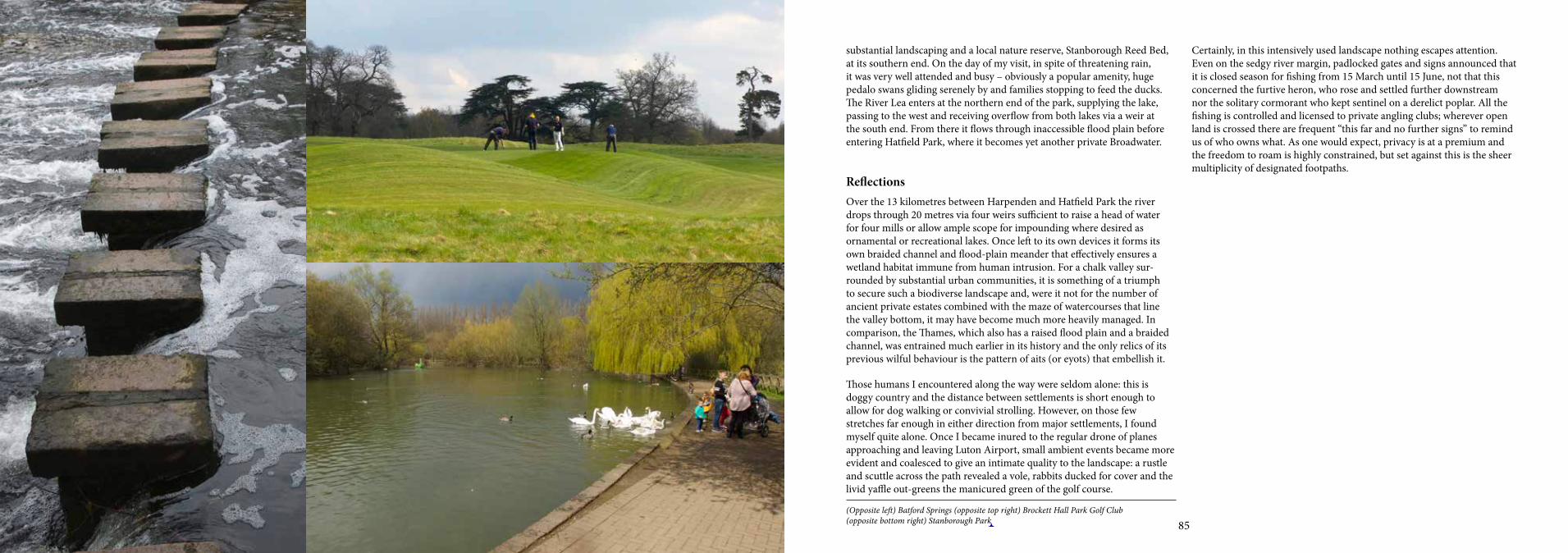
8584
substantial landscaping and a local nature reserve, Stanborough Reed Bed, at its southern end. On the day of my visit, in spite of threatening rain, it was very well attended and busy – obviously a popular amenity, huge pedalo swans gliding serenely by and families stopping to feed the ducks. The River Lea enters at the northern end of the park, supplying the lake, passing to the west and receiving overflow from both lakes via a weir at the south end. From there it flows through inaccessible flood plain before entering Hatfield Park, where it becomes yet another private Broadwater.
ReflectionsOver the 13 kilometres between Harpenden and Hatfield Park the river drops through 20 metres via four weirs sufficient to raise a head of water for four mills or allow ample scope for impounding where desired as ornamental or recreational lakes. Once left to its own devices it forms its own braided channel and flood-plain meander that effectively ensures a wetland habitat immune from human intrusion. For a chalk valley sur-rounded by substantial urban communities, it is something of a triumph to secure such a biodiverse landscape and, were it not for the number of ancient private estates combined with the maze of watercourses that line the valley bottom, it may have become much more heavily managed. In comparison, the Thames, which also has a raised flood plain and a braided channel, was entrained much earlier in its history and the only relics of its previous wilful behaviour is the pattern of aits (or eyots) that embellish it.
Those humans I encountered along the way were seldom alone: this is doggy country and the distance between settlements is short enough to allow for dog walking or convivial strolling. However, on those few stretches far enough in either direction from major settlements, I found myself quite alone. Once I became inured to the regular drone of planes approaching and leaving Luton Airport, small ambient events became more evident and coalesced to give an intimate quality to the landscape: a rustle and scuttle across the path revealed a vole, rabbits ducked for cover and the livid yaffle out-greens the manicured green of the golf course.
Certainly, in this intensively used landscape nothing escapes attention. Even on the sedgy river margin, padlocked gates and signs announced that it is closed season for fishing from 15 March until 15 June, not that this concerned the furtive heron, who rose and settled further downstream nor the solitary cormorant who kept sentinel on a derelict poplar. All the fishing is controlled and licensed to private angling clubs; wherever open land is crossed there are frequent “this far and no further signs” to remind us of who owns what. As one would expect, privacy is at a premium and the freedom to roam is highly constrained, but set against this is the sheer multiplicity of designated footpaths.
(Opposite left) Batford Springs (opposite top right) Brockett Hall Park Golf Club (opposite bottom right) Stanborough Park
Penny
Cross-Out
Penny
Inserted Text
(Opposite, left) Batford Springs; (top right) Brocket Hall Golf Club; (bottom right) Stanborough Park [consistent style, corrected spelling]

8786
Hatfield Park
5th May 2016
The Upper Lea is rich in old country estates. Most have become repurposed, but some, such as Hatfield House, are still occupied by the same families with long histories. In 1607 the ownership of Hatfield House was transferred to the Cecil family when James I persuaded Robert Cecil, 1st Lord of Salisbury to swap Theobalds Park near Cheshunt for Hatfield Park. The association of the Cecil family with the royal family dates back to Robert Cecil’s father, Lord Burghley, who was chief minister to Queen Elizabeth I.
The intention for the day was to locate the fragment of the River Lea that passes under the A414 Hertford Road and crosses the northern end of the park. Once inside the park, there are a number of designated circular walks; about halfway along the longest “red” woodland walk, the river emerges from under a concrete bridge through which the disturbed water from the leat at Mill Green can just be glimpsed. Fish were jumping in the shade of the bridge. Just beyond a timber weir structure the river widens to become an ornamental lake. The woods slope down to the water and it was absolutely silent but not quite deserted; an elderly gentleman sitting on a bench absorbed in a book studiously ignored me. A yellow wagtail was hawking for flies from the weir. A little further on was a pair of great crested grebes; the male dived and emerged with a small fish, which he kept to himself – diving and swimming, he distanced himself from his mate before, with a vigorous shake of the head, he stretched upwards and gulped it down.
This particular Broadwater Lake was originally impounded to give a head of water for the Cecil Sawmill: there is a brick-built bridge across the river that may have once served a serious purpose, but is now closed off except for park maintenance, providing an arcadian backdrop to the scene.9 To
complete the picture, the faux medieval vineyard with its knapped-flint gatehouse and crenellated boundary wall sweeps down to the banks of the lake. Directly in sightline of the gatehouse, its gateway frames a folly tower on the opposite side of the river. From a purposeful use of the river, the penned up Broadwater has become a pastoral make-believe.
Overlooking the lake there is an idiosyncratic memorial dedicated in 2008 to the Rhodesian Light Infantry Battalion. This is a sculpture of a trooper cast from spent shell cases; wearing very short shorts and clutching an automatic rifle, he casts a quizzical gaze over a landscape that is anything but the African bush. There is a tangled web of associations, interests and coincidences that tie this sculpture back to Hatfield Park. The monument was originally located at Cranborne Barracks, Salisbury in what was then Southern Rhodesia and is now Zimbabwe. In 1980, upon independence and on the correct supposition that it would not be respected by the new regime, it was removed to South Africa where it stayed until South Africa’s independence when, again, it was assumed that the ANC would also not value it. After time spent alternately in storage in Bristol and out on loan for exhibition, the current Lord Salisbury agreed to take it out of its box and locate it permanently in Hatfield Park. The coincidence of the headquarters
(Opposite) Queen Elizabeth I and courtiers, Hatfield House The Broadwater, Hatfield Park

8988
of the Rhodesian Light Infantry at Cranborne Barracks in Salisbury, Southern Rhodesia and the titles of the current incumbent of Hatfield House, Robert Gascoyne-Cecil, Viscount Cranborne, Marquis of Salisbury, imply family interest, consolidated by the death of his brother, Lord Richard Cecil, when he was a journalist covering the conflict. In 1978 when the struggle for independence for Southern Rhodesia was approaching its grisly end, Lord Cranborne, as MP for South Dorset, spoke forcefully for the removal of Ian Smith as head of state and his replacement by lay preacher Abel Muzorewa. This of course came to naught when Zanu PF prevailed in the elections and Robert Mugabe, its founder and leader, became president of Zimbabwe.
This was a momentous time, and one that the Cecil family played no small role in. It is a compelling experience to sit in one environment and reflect upon events that connect our story with other far-flung events. But it is in the nature of monuments that either they revert to stereotype and drift into the background or that they should inspire reflection and excite curiosity.
The Rhodesian Light Infantry Battalion was considered quite glamorous and attracted substantial numbers of volunteers at the time of the struggle for independence for Southern Rhodesia. A colonial counter-insurgency force could scarcely be considered a just cause; but these were the dying years of empire when predominantly white colonial communities were in such deep peril that a force explicitly created to safeguard them would inherit an heroic sense of purpose. As the popularity of this rather irregular but ruthlessly efficient battalion grew so its nicknames proliferated. Initially known as “The Saints”, at their seventh anniversary celebrations they were toasted by Ian Smith as “incredible”, thenceforth becoming “The Incred-ibles”. 3 Commando earned the soubriquet “The Lovers” in reference to their notoriety amongst the young women of Salisbury. One thing leads to another and it was duly proposed that the unit should adopt a phallus as its battle emblem; a banana was used instead, and that is how it remained, on a shield against a green ground, partially obscured by the numeral 3 with the word “Lovers” above and “Commando” below.
Ancient settled landscapes transcend their own topography; they are palimpsests animated by the stories that they accumulate. These then exert a strong influence upon how the landscape develops and how it is managed, which in our transformed world provide a key for how public access is facilitated. I have, for example, never seen so many riven oaks all gathered in one place as at Hatfield Park; they are so many and so highly prized that there is a published guide to the ancient trees of the park. It is significant that in 1558 Princess Elizabeth was informed of her accession to the throne while sitting beneath an oak tree in the park; although this particular tree no longer exists, a substitute was planted in 1985 at the same spot by the reigning monarch, Elizabeth II.
The former royal hunting park is traversed by intersecting rides that have since become public paths on the principle that the sport of kings can be adapted to facilitate and control public incursion and be a basis for wildlife stewardship. The visitor is reminded that the woodland is managed as a wildlife sanctuary and is therefore discouraged from straying from the well-mown path, with the strict enjoinder that public safety can be guaranteed only on designated pathways. In this way a balance is achieved between relatively untrammelled woodland and open public access, which reinforces the sense that this is a controlled experience where the visitor is tolerated within defined limits. The theme of participant versus spectator is enacted through the Lee Valley on many levels; the permutations in approach to access are a tangible manifestation of the kinds of control deemed necessary to conserve the integrity of particular landscapes. These range from an overt strategy where there are real risks or vulnerabilities, such as at the Walthamstow Wetlands, and where the visitor experience is heavily circum-scribed, to the more subtle approach in those open areas within London such as Hackney Marsh where levels of husbandry determine accessibility and, by default, safeguard biodiversity. In Hatfield Park, proprietorial prerogative determines the ground rules for the visitor experience. This is quite predictable given that you must pay to enter and that the experience is to a large extent managed for you, but it is still pleasant enough and not exceptionally onerous as it can be under the management of other more paternalistic organisations.
(Opposite left) Troopie. (opposite right) Riven oak.
Penny
Cross-Out
Penny
Inserted Text
(Opposite, left) "Troopie"; (right) Riven oak [change of style, case and punctuation]

9190
Arriving at last in front of Hatfield House, I was confronted by an enormous and incongruous water feature: “Renaissance” by sculptor Angela Conner is a bold departure from the more orthodox decorative fountain that we expect in a stately home garden. Two tapered stainless steel curved troughs, from which water cascades, rise from a pool from which a golden globe emerges periodically in a mist of spray. Although quirky and reminiscent of baroque automata, it does not transcend its own functionalism, but is certainly a testimony to the traditions of uncompromising aristocratic patronage. It may come as no surprise that the sculptor already has a reputation as a society sculptor making figurative sculptures and portrait busts of subjects such as HM the Queen, Prince Charles and the Duchess of Cornwall as well as ornamental kinetic sculpture features for sites such as Park West Plaza, Dublin and Chatsworth House.10
ReflectionsBeyond Hertford where the Lea ceases to be navigable its course reverts to the meanders that are typical for a higher flood-plain landscape. Where it has been impounded to create ornamental or recreational lakes, this is frequently through the re-use of sections historically dammed up to provide a head of water for mill workings, as at Hatfield Park, or through the reclamation of redundant quarry works, as at Stanborough Park. Although Welwyn Garden City, founded by Sir Ebenezer Howard in the 1920s, had an impact upon the wider landscape and Luton, Harpenden, Hatfield and Hertford have expanded substantially, very little else has impacted upon the relationship between the river and its hinterland for around 300 years. The landscape of privilege created by large private estates may have altered through shifts in ownership, but where this has happened it has become re-invented as parkland or golf course and has retained its basic configuration intact. Correspondingly, since the river passes through so much private land access can be erratic; indeed not far beyond Hatfield Park the Lea Valley Walk parts company with the river and does not reconnect with it before it enters Hertford. In the interim, it detours close to Welwyn Garden
City and eventually turns back to regain Hertford via the Chain Walk, which was where I missed my way before and found myself well on the way to Welwyn (see Chapter “Ware to Welwyn Garden City”). According to the OS map there is a footpath that follows the river for a further 2 kilometres beyond Hatfield Park, which became the subject of a subsequent visit (see Chapter “Hatfield to Hertford”).
Although the network of footpaths in the Upper Lea Valley does not stick to the river, it is comprehensive and generally well signposted and documented, although the Ordinance Survey map may not be as explicit as it could be. Overall, access to local and long-distance footpath networks through rural Hertfordshire and beyond is impressive. Given the particular relationship between large urban settlements and rural countryside in Hertfordshire, the pressure upon the landscape is enormous, which explains both the comprehensiveness and formality of the footpath network and the intensity of its use. This is a variant upon how access is configured on the Lower Lee where long-distance linear access already exists via the Lee Valley Navigation and the New River, and in London where the priority is upon accessible recreational space. In short there is no single rubric for how access is enabled, determined as it is by the nature and size of the community that it facilitates.
(Opposite) Woodland ride, Hatfield Park Bench inscription, Hatfield Park

9392
In his Regional Plan for London, Sir Patrick Abercrombie wrote of his aspiration for the Lee Valley Regional Park as a “green wedge” penetrating the industrial heartland of London. The original proposal in 1964 emphasised it as “an area for recreation, sport, entertainment and leisure for the people of the East End and North East London and for those who live in the Counties of Hertfordshire and Essex”.11 At this stage the need to enhance and safeguard the natural environment was yet to be the major policy driver that it has since become.
The fiftieth anniversary of the Lee Valley Regional Park in 2016 was the occasion for the new initiative, Vibrant Partnerships, that places the management of all of the assets within the Lee Valley Regional Park, including the athletics and sports resources inherited from the 2012 Olympics, under the control of a single charitable organisation, the Lee Valley Leisure Trust. While this appears to cement the original mission of the Lee Valley Park, it acknowledges the need to manage some extremely valuable infrastructure assets and ensure that they retain their value into the future.
In parallel to this the Lee Valley Regional Park Authority is mandated to expand its environmental remit by collaborating with other organisations within London and beyond that include Thames 21, London Wildlife Trust, Herts and Middlesex Wildlife Trust, Groundwork Trust, all under the auspices of the River Lea Catchment Partnership. Answering to a “catchment-based approach” promoted by Defra in 2012 and driven by the European “Water Framework Directive”, the catchment partnership has adopted the initiative to bring the River Lea and all of its tributaries up to a sound ecological condition.12
In this way the management of the Lee Valley continues to evolve and remain responsive to new challenges represented by the incremental growth of London and the changes in its demography, the effects of agricultural and hard-surface runoff and treated human waste upon water quality and the ongoing effects of climate change.
(Opposite) “Renaissance” by Angela Conner
Penny
Cross-Out
Penny
Inserted Text
Water Framework Directive, [delete quote marks around Directive as in other instances in your text]

9594
Leagrave to Harpenden
1st April 2015
The priority I had set for the day was to identify the source of the River Lea. According to the map it is on Leagrave Common, a ten-minute walk from Leagrave Station, two stops up the Bedford line from Luton. This is a plausible location for the source of the river: at the upper end of an ancient wet coppice known as Rotten Spinney and adjacent to a neolithic earthwork called Waulud’s Bank. The approach via a busy intersection with the B579, Luton Road, although easily negotiable, is enough to dispel the aura of an ancient site. Like all urban-fringe green space, it is under pressure and perhaps owes its survival to its archaeological importance and inherent common land status. On the horizon is an estate of three 1960s residential tower blocks and in the foreground at the foot of the hill a boarded up Nissen hut. I crossed the road behind a young woman with a pram and, at a discreet distance, followed her up the hill over the rough pasture towards where the spring should be – over the rampart of Waulud’s Bank, through a hole in the hedge giving sight of a boggy wooded valley, which must be Rotten Spinney. Over recent months the valley has been quite drastically cleared: at its head is a concrete chamber with a grating across the front, through which some intrepid boy must have squeezed to leave his tag beside the culvert from which the River Lea emerges as an inconsequential dribble.
Given the amount of water flowing through Leagrave Marsh, it is hardly a surprise that there are other contenders for the source of the River Lea – at Houghton Regis and Lewsey, both on the other side of the M1. Both springs rise in municipal parks and their combined flow, which is much more substantial than it is at the accepted source, is also acknowledged as the River Lea by the Ordnance Survey. The courses of the two rivers Lea meet in the wetland area of Marsh Farm, which until reclamation took place to create a sports amenity in the 1960s was a much more substantial marsh.
(Opposite) Five Springs, Leagrave Common. Culvert at the source of the River Lea, Five Springs
Chamber entrance at the source of the River Lea, Five Springs
Penny
Cross-Out
Penny
Inserted Text
B579 [delete comma]
Penny
Cross-Out
Penny
Inserted Text
Common [delete full stop]

9796
Over recent years Leagrave Marsh has received a great deal of attention and has undergone remedial work to protect and enhance its biodiversity and improve public access. The excellent River Lea Catchment Partnership has identified landscape improvement of the Five Springs area as key to the homogeneity of the entire marsh. The project was led by Groundwork and funded by London Luton Airport, Luton Borough Council and a Biffa Award of £25,000 from the Landfill Communities Fund. There has certainly been renewed interest in the value of wetland nationally and the intention of this project is to save it as a relic of what was a much larger marsh, to reassert its landscape character and to enhance the continuity of the biodiversity of the wetland corridor, an ongoing concern through the Lee Valley. Certainly it has a fundamental role as flood containment: however, even in this fragmented and compromised state, the marsh hosts a number of rare plants such as common twayblade, spotted orchid and marsh marigold. Although the small wet woodland of Rotten Spinney is predominantly alder and willow, rare examples of bay willow are also found there.
The management work carried out on the upper valley nearer the spring is the outcome of a project to enhance biodiversity and to create a public amenity; it has involved clearance of elder and invasive species such as Canadian golden rod, pollarding of the upper region at Rotten Corner to allow more light to promote waterplants and understorey growth and the creation of 100 metres of boardwalk and 300 metres of bark-mulch pathway. This was all accomplished by voluntary labour on a job-creation scheme overseen by Groundwork;13 a further benefit for all participants was the acquisition of skills and training towards a CSCS (Construction Skills Certification Scheme) qualification for the construction industry and City and Guilds Health and Safety in a Construction Environment.
Although at the time of my visit, the flow at the head of the river at Leagrave seemed puny, the size of the culvert from which it issues betokens something much more substantial during winter months. Combined with
the amount of run-off from the extensive Five Springs Tower Estate that drains into the river, the capacity of the channel system to contain local floodwater is vital. Further downstream the need to manage run-off from the surrounding housing estates makes further demands upon the river as a drain; consequently, flood-risk management and the need to provide green open space combine to create a linear park that connects into central Luton via the formal Edwardian Wardown Park.
The pathway from Luton to Harpenden and beyond has been adopted by Sustrans as a part of its national cycle network. An element of the Sustrans strategy is to commission artworks as a means of articulating the landscapes that it passes through; sometimes this takes the form of temporary or ephemeral events, but there are also permanent sculptural commissions that serve as waymarkers. Some of these reference the memory and livelihoods of Luton. One, by Isabella Lockett, refers to the millinery industry when Luton’s hat makers visited the Leagrave Marsh for a day out of picnics and bathing, hence the title of the work “Blockers Seaside”. The original commission was for nine bronze hats mounted on poles in the marsh at Leagrave; sadly, within two years, six had been stolen, leaving three that were removed for safekeeping by the Luton Borough Council.
All too frequently this is the fate experienced by many commissioned artworks. However, one series of waymarkers, also initiated and coordinated by Isabella Lockett, remains, intriguing, battered, but intact. These are half-mile markers between Leagrave Marsh and Luton called The Layering of Time. They are low, pyramidal forms constructed from bands of the geology of the area, such as limestone and flint. This project was a collaboration between the poet John Hegley and stonemason Gary Churchman, who cut into each marker texts gathered by Hegley from a series of workshops with local children and adults. These texts are in some cases so badly distressed or overgrown with moss that they are scarcely decipherable; they are full of non-sequiturs and consequently quite enigmatic:
“Sometimes a poem is less of an invention and more of a thing, to find its truth, a kind of archaeology, a job of unearthing and piecing together and sometimes a piece doesn’t fit because it’s part of something else and
(Opposite top left) Leagrave Marsh (opposite top right) Rotten Spinney. (opposite bottom left) “The Layering of Time” (opposite bottom right) River Lea at Rotten Spinney
Penny
Cross-Out
Penny
Inserted Text
(Opposite, top left) Leagrave Marsh; (top right) Rotten Spinney; (bottom left) "The Layering of Time"; (bottom right) River Lea at Rotten Spinney [change of style and punctuation]
Penny
Cross-Out
Penny
Inserted Text
Simon Delete 'a number of' to shorten this paragraph by 1 line. This will mean final line of musing on page 97/8 can be brought in to page 97, and whole musing then on one page]

9998
Where the buses wait beside the airport terminal, the long-distance Sustrans path resumes, turning up and away from the main road and along the side of the ridge leading out of town. Above is the main railway line north and below, running along the river valley, the main road between Harpenden and Luton. The trail, hovering between the two, overlooks Luton Hoo Park. It is a pity that the park is not open to the casual visitor since it is another flourish in the narrative of the river. In 1762 the 3rd Earl of Bute commissioned a grand house from Robert Adam and a landscape scheme from Capability Brown, a feature of which was the proposal to dam up the River Lea and create two decorative lakes. Now it is a luxury hotel, spa and golf course and off-limits to the visiting public. However, incongruously, it is also host to the landlocked Luton Sea Cadets, the oldest troop in the country. Where better to learn not to drown, undertake basic training in seamanship, canoeing and sailing than on the landlocked lakes of Luton Hoo where the hazards are not quite so unpredictable as on the open coast. However, nothing is immune from the outside world: recently the lakes suffered the vicissitudes all too familiar in our overloaded water
Derelict filter beds outside Luton
River Lea outside LutonGreen embankment, Luton
sometimes it’s just a bit of rubbish.”
“Stone/Leisure/What is this life if full of care.”
“Hand me dear adorable your lips of tenderness. Oh I’ve loved you faithfully and well these years or a bit less. I wasn’t a success.”
“Thank God that’s done and I’ll take the road, quit of my youth and you the Roman Road to Wendover, Tring and Lilley Hoo and a freeman may do.”
“I want to be a loving Dad and be there for my children.”
As intimate little asides, these are inscrutable and often inarticulate musings dignified in stone. After crawling around to trace the letters they leave the reader feeling self-conscious, flummoxed and slightly prurient. Perhaps this is deliberate: to draw the viewer in and provoke questions rather than supply answers. The texts reflect the random thoughts of a solitary rambler: indiscriminate, inconsequential and something to mull over along the way.
These half-mile markers usher us via the meandering channel through Limbury Meads, all that remains of a once extensive water meadow and orchard, but now a green respite between a clutter of housing estates where the river is joined by Cats Brook. This part of suburban Luton is a place of barely residual memory. Its ancient poetry is preserved in the road name, Icknield Way, and has become domesticated by its passage through Luton and out the other side, leaving in its wake Icknield Primary School and the prosaic Icknield Veterinary Centre. Sustrans, according to habit, has done a tremendous job, avoiding the busy roadway, taking advantage of established tracks, paths and the redundant railway line into Harpenden and beyond with scarcely a break until well past Welwyn and into Ware.
The river continues to grow and is joined by Riddy Brook, before Bide a While, which is another green area that has changed and changed again. Bide a While is a much softer and less municipal park, originally put down
to orchard in 1920 by one George Farr, who ran it as a smallholding, even to the extent of constructing a cellar for cultivating mushrooms. However, in doing this he imbued the space with such a sense of intimacy that it became an attraction for local people, causing them to bide a while. Just across the brook, a young track-suited man was lying in the shade of a tree, picking the violets that were growing profusely and filling his rucksack with transient fragrance. This was a charming, and slightly bucolic interlude on
the way into Luton, which is heralded by the municipal Wardown Park. This is a proper Edwardian park with a proper red-brick mansion where the river correspondingly makes a little flourish with ornamental lakes and a fountain, ducks and decorous swans. A low, concrete stadium overlooks an open playing field: young footballers were playing at one end; at the other, a solitary gymnast, totally self-absorbed, hurled himself into the air, gyrating and landing on his feet, over and over. Being the school holiday, people were out strolling, families enjoying their time together but wrapped up to beat the chill wind.
At the end of the park the river once again becomes a utilitarian gulley running beside the A6 New Bedford Road into central Luton where it dives underground, only to properly re-emerge in a recreation ground at the other side of town. Getting lost on the chase through town and diverted away from the park gates for Luton Hoo (no public access), I only caught up with the river again at the bottom of a footpath beside a huge hydroponic embankment wall that carries road traffic towards the airport. Enlarged by urban drainage, the river is shabby and unkempt beside a derelict filter bed.
Wardown Park, Luton

101100
systems and were contaminated by sewage overflow from urban Luton, destroying the fish stocks. In collaboration with the River Lea Catchment Partnership, the Environment Agency has now installed containment booms and set up a water-quality monitoring programme managed by the Catchment Partnership.
Although the Sustrans cycle trail follows a safe route away from the busy road and is carefully landscaped to soften the impact of the main railway line to the north, it was frustrating to be detached from but flirting with the water below. The path has been planted with hedgerow trees, which are yet too new to have the effect of a green corridor, but it was easy to imagine the experience that it will become. Interspersed here and there are artworks that celebrate aspects of place: overlooking Luton Hoo Park are three life-size laser-cut corten steel silhouettes representing Capability Brown, Eric Morecambe and a sea cadet. These were made by Laser Process, a Staffordshire engineering company; like much public sculpture, they send out an ambiguous message, reminders of where we are and odd facts about the place, but also an extremely resilient and heavy-handed signal that this is a cherished and welcoming amenity.
A little further on another symbol of revival, a red kite soared overhead, chattering to its mate in the tree tops of the estate below; and above in the higher thermals there soared a pair of buzzards squealing to each other. Of course they were all taking advantage of the upwards air currents caused by the ridge that I was walking along, apparently oblivious to the roar of the express trains passing continuously close by. Nature isn’t fussy and it is well known that red kite thrive as scavengers with a special taste for road kill. The path soon slides downhill crossing the Lower Luton Road by a new steel bridge. By now the cycle path has annexed the redundant branch line to Wheathampstead skirting the edge of Harpenden. The strength of Sustrans is that it is opportunist in taking advantage of any available linear route that links settlements; sometimes these are long-forgotten trackways and frequently railway lines that probably fell victim to Beeching in the 1960s to thrive again in another guise. This particular line passes what was
evidently a small station at New Mill End, still with fragmentary platform, but now, having been a house for almost as long as it served the railway, has turned its back upon its past just as upon its next door neighbour, the colossal sewage works beside the river.
Along its entire course, the River Lea is consistently inconsistent. There is no pause for it to adapt to its identity; immediately downstream of the arcadian landscape of Luton Hoo is the prosaic sewage works of New Mill End. From here the river passes under an ancient bridge and into water meadow and parkland that characterise the remainder of its course to Harpenden. It is beginning to feel like a real rural river; a substantial mill and leat block and divert it over a weir. This is smart country, horse country; the river nudges through alder, willow, poplar and ash, creating islands and burrowing through roots. The trees and vegetation begin to typify what we know of the river on the rest of its way into London complete with the floating detritus that gets caught up in the branches and is left behind from times of spate.
(Opposite) Sculpture commissioned by Sustrans, Luton
Sustrans cycle path near Luton Hoo
Penny
Cross-Out
Penny
Inserted Text
on, [add comma]

103102
At the edge of Harpenden, the redundant railway turns into an alleyway through a housing estate and then into a residential cul-de-sac: all was quiet, nobody about apart from a solitary teenager scooting around the driveway of a house. As the road turns uphill and away from the river, the period of the housing shifts from pre-war semi-detached to solid Edwardian villas in bespoke gardens, before turning left to the mainline railway station.
ReflectionsUnlike the Thames, the River Lea is not a national icon. Its several identities correspond to the multiplicity of tasks it must perform. It is consistent only in its landscape character and its water quality, which, according to the criteria of the European Water Framework Directive, hovers between poor and moderate and only registers as good on the upper reaches of one of its tributaries, the River Ash.
It is probably indicative of its renewed status and the publication of the Water Framework Directive, which the UK has signed up to, that there is such a high level of awareness of the state of health of the river and its tributaries. The River Lea Valley Catchment Partnership is a good example of community, wildlife trust and government agency partnership with an overview through its individual zones and tributaries of the condition of the entire Lea Valley Catchment. Through this network, community engagement is extremely well coordinated for major infrastructure works, maintenance and monitoring. It also strives for a consistent level of engagement and community awareness for all parts of the catchment.
The Luton Lea Catchment Partnership is well established and includes: Groundwork, Luton and Bedfordshire, Cranfield University, Environment Agency, Affinity Water, thw Wildlife Trusts of Bedfordshire, Cambridgeshire and Northamptonshire, London Luton Airport, Friends
of the Earth, Luton Friends of Parks & Green Spaces, Luton Borough Council, Thames Water, University of Bedfordshire, Vauxhall and Certsure Professional Services. Scope for community engagement is built into this partnership, both as a network of volunteers and as an educational service, to the extent that most projects can only happen with substantial input at a community level, which in turn heightens a sense of ownership and engagement with the well-being of the landscape and a broader awareness of how water environments work.
(Opposite top left) Mill End, Luton (opposite top right) Sewage works at Mill End. (opposite bottom left) River Lea approaching Harpenden (opposite bottom right) Water meadows, Mill End.
Penny
Cross-Out
Penny
Inserted Text
the [typo]
Penny
Cross-Out
Penny
Inserted Text
Groundwork Luton [delete comma for correct name style]
Penny
Cross-Out
Penny
Inserted Text
the Environment Agency, [correct title]
Penny
Cross-Out
Penny
Inserted Text
Bedfordshire Vauxhall [delete comma for correct title]
Penny
Cross-Out
Penny
Inserted Text
(Opposite, top left) Mill End, Luton; (top right) Sewage works at Mill End; (bottom left) River Lea approaching Harpenden; (bottom right) Water meadows, Mill End [change of style and punctuation]

105104(Opposite) Approaching Harpenden.
Penny
Cross-Out
Penny
Inserted Text
[delete page number]

107106
The alternative source of the River Lea, Houghton Regis
27th May 2015
Behind what appears to be a small public convenience in a corner of The Green in Houghton Regis, there is a concrete-and-brick cistern draining into a deep, narrow channel. On the day of my walk, the water that gathered there and trickled away looked clean enough but probably was not; a furry grey deposit had settled upon its bed where the flow was least. This is Houghton Brook, a contender for the alternative source of the River Lea. In spite of its apparent insignificance, the depth of its excavated channel indicates much stronger flows at times of consistent rainfall when it must manage surface water run-off from the surrounding housing estates.
Houghton Brook was included in a successful Heritage Lottery Fund bid starting in 2015. The initial focus was upon the zone around Houghton Hall Park.14
“Following the successful award of a Heritage Lottery Fund Parks for People (PfP) First Round (Development Stage), the partnership developed landscape proposals (landscape, conservation, and management and maintenance plans) for a Round Two bid to the Heritage Lottery Fund Parks for People programme in August 2014. The bid was successful and works will start in 2015.
“The work involves clearing silt along the length of Houghton Brook and replacing it with river-washed gravel. We will also plant native shrubs (including hazel, hawthorn and guelder rose) along Northern Bank and install willow spilling barriers at regular 30m intervals on alternate sides.”
An anathema of housing and trading estates baffled my route from Leagrave Station, some so new that they were not even on my map. Many of these were predictions of what is to come in the form of unkempt scrub, fluorescent painted poles, earthen tracks and a pastel mixture of chalk and topsoil, the recent scars left by excavation works for installing drains.
The further I penetrated into housing-estate land the more elegiac of a pastoral past the street names became: Pastures Way, Wheatfield Road, Threshers Close. Perhaps it is not just Britain that insists upon naming places after what is no longer there. To some, Threshers Close might only be meaningful as a direction to the nearest off-licence.
Finding the spring was tortuous; it was obviously at the top of Houghton Hall Park, but where exactly was not clear and how to find the park was a challenge in itself. Eventually, after a lot of asking, I found the entrance was just a gap between two well signed and manicured trading estates,
(Opposite) Houghton Brook at Knapp’s Farm Leisure Garden, Leagrave
The alternative source at The Green, Houghton Regis

109108
leading directly into the semi-managed woodland and open parkland of the original estate. Even then it was easy to get confused by the rides, open vistas and enclosed woodland paths that made up the park. Under other circumstances, such as in the Bois de Boulogne, it might be a pleasure to amble in parkland large and complex enough to become lost, but on that day my senses were tuned to every green declivity in the landscape should it yield a spring and I was distracted. When I eventually located the spring, it was not in the park at all but beyond it and, of course, it was an anticlimax.
Could this really be the contender for source of the River Lea marked on the Ordnance Survey map? The only way to find out was to follow it and see whether it did in fact join up with the official source at Leagrave Common, which is what I did and which initially was simple because a public footpath follows the stream’s course until it reaches the outer limit of the housing estates, where it takes off across derelict farmland due for development in the very near future. A gang of workers was busy burying drains in a long trench with the use of a heavy digger; and, subject to a Tree Preservation Order, an ancient poplar had been cruelly lopped and corralled by a shuttered fence to protect it from the accidental depredations of the construction process. Another low shuttering fence enclosed a meander, with wire mesh extending the barrier into the stream bed. This is most likely evidence of a reptile directive from Natural England implemented by the Wildlife Trust, to protect the newts in the area; conversely it could be an exclusion zone to keep them out against the eventuality of major excavation work to create the proposed flood-storage facility on Houghton Brook, identified by the Environment Agency in its consultation document for a flood strategy for the Luton area:15
• Flooding is a frequent problem for the people and businesses of Luton, with 14 floods having taken place over the last 50 years.
• A great deal of the flooding is from the River Lee and other smaller watercourses such as Houghton Brook, Lewsey Brook and Cat Brook.
(Opposite top left and right) Houghton Brook (Opposite bottom) Houghton Hall Park Pathway between Houghton Brook and housing estate
Penny
Cross-Out
Penny
Inserted Text
(Opposite, top left and right) Houghton Brook; (bottom) Houghton Hall Park

111110
• It is estimated that without any effort to reduce flood risk, the River Lee and other watercourses would flood almost 300 properties during a major flood.
• In the future, as climate change alters our weather patterns, the number of homes affected could rise to around 500.
• Our work has shown us that in order to manage the flood risk from the watercourses in the Luton area, we need to improve and deliver many different things.
• Some of these can be done within five years, such as the construction of a new flood storage area on the Houghton Brook. Others can only be addressed in the next 5–25 years and a few things will need work over the long-term, meaning 25–100 years.
The above is an indicator of the future but for the present the infant river is unloved, its course blocked by “beaver dams” of sticks and bits of fallen tree, rubbish bags, upholstery cushions and plastic paraphernalia of the construction industry, all gathered from times when the stream is a torrent of run-off from the hard surfaces further upstream.
This happens anywhere. There was a time when I worked regularly in Lusaka, Zambia, where the capacity of the drains is vast but, since there is no money to clean the streets, they are always clogged during the rainy season, and disastrously so since, combined with inadequate sewerage systems, on an annual basis the result is an outbreak of cholera and typhoid. This is extreme and I would not predict anything like this in the UK, but the symptoms of public insouciance over care for the immediate environment are just the same everywhere.
With the M1 in sight, the stream becomes almost bucolic with crumbling banks, and watercress, overhung by hawthorn and elder. Then it was gone,
under the motorway via a concrete tube. Emerging on the other side, it is marked as a line of luxuriant growth and it passes through yet more housing estates, where the footpath that keeps it company has become dignified as Riverside Way.
The volume of water remained uniformly slight and had even dried out in one place, due to the underlying chalk geology or transpiration from the mature trees that line its course. However, where this had happened, it was immediately augmented by flow from Lewsey Brook, delivering a pretty respectable juvenile river before diving beneath the railway embankment to join its sister Lea in Leagrave Marsh.
ReflectionsAs is evidenced by the depth of the excavated channel of the stream and the number of business-like storm drains built into it, the primary function of the watercourse is a surface water drain for the surrounding estates. This is not necessarily at odds with the aim to enhance its ecological value, but can only work if the brook is valued and maintained. This is a challenge given the perceived status it has acquired as a feature of a common ground of footpaths and open green areas in a residential area, creating a buffer zone, a thoroughfare, a place of play riddled by desire lines and, sadly, a dump.
Compared to the rest of the upper reaches of the Lea, there is a sur-prising concentration of junk along the stretch between the spring and (Opposite top left) Lopped poplar (opposite top right) Enclosure
(opposite bottom left and right) “Beaver Dams” on land due for development
Dried-out river bed Influx from Lewsey Brook
Penny
Cross-Out
Penny
Inserted Text
(Opposite, top left) Lopped poplar; (top right) Enclosure; (bottom left and right): “Beaver dams” on land due for development [change of style and case]

113112
the culvert under the railway at Leagrave, including two fake leather upholstery cushions, several black plastic bags of rubbish, a wheelie bin, plastic construction-site fencing and pedestrian signs, a plastic bollard, a child’s scooter, several footballs, logs from ground clearing operations, building materials, plastic bottles and drink cans and a trio of supermarket trolleys. Wherever a watercourse is considered neutral territory, whether it is managed or not by a local authority, it is a magnet for trash. During the course of my walk along the river, I have observed some outrageous examples of fly-tipping and seriously endemic littering. It is an opportunist human trait, the spoor by which we mark our passage; sometimes it is neat and deliberate, sometimes random, always unthinking, whether it is a truckload of builders’ waste, a fridge or a coke can.
Houghton Brook will become increasingly integrated into the suburban network of a town set to carry on expanding in the immediate future. A model for how this might happen is already extant in the Limbury Meads area of Luton: the tension between public amenity, local distinctiveness and a flood-management facility is apparent in the compromise solutions reached by the local authority. As the town continues to grow, if the brook is not to be culverted (unlikely), it will become a stronger feature in the landscape. It is encouraging to see evidence of this already in the tree protection measures already in place on the land to be developed towards the M1.
The proposals signalled by the River Lea Catchment Partnership in its management plan to improve the biodiversity of Houghton Brook should be taken as an example of the approach to the improvement of the entire watercourse. However, without an enhanced sense of public ownership and responsibility, it will continue to be perceived as someone else’s responsibility and, as a consequence, there is no reason why it should not continue to be abused. A positive indicator is that an education programme has been built into the management plan to emphasise the importance of public stewardship in the effort to improve the quality of the river environment and to raise the level of public awareness of the biodiversity of the freshwater habitat.
(Opposite) Storm drain, development site
Trolleys dumped outside Houghton Regis

115114
River Lee Country Park and Sculpture Trail
3rd March 2017
Having walked the length of the River Lee and reflected upon the range of interactions between the river and its communities, I had not fully appreciated the degree to which the River Lee Country Park is a much more concentrated experience until I had the opportunity to visit it. Running north to south between Waltham Abbey and Broxbourne with the River Lee Navigation and the flood relief channel as the principal watercourses, it encapsulates much of what is typical of the Lee Valley landscape. Wide-open marshy grasslands crossed by drainage channels combine with broad lakes that occupy the redundant gravel diggings. Of these, Seventy Acre Lake is an intensively managed wetland habitat. It boasts the Bittern Information Point, which is a well-appointed hide that overlooks reed beds occupied by a small bittern colony. Although a welcome respite from the rain, at the time of my visit all of the bitterns were hiding; but there was an exquisite great crested grebe diving just outside and a shameless pair of mating coots.
As is normal for any public park, there is a plethora of signage; it is an unfortunate characteristic of interpretation boards that the casual visitor may be informed upon what might be seen through dedicating time and patience, but otherwise unlikely to experience first-hand. This applies to both the elusive bittern and the largely nocturnal otter. There is a degree of satisfaction in being made aware of what lurks either out of sight or out of season in the park, but I struggle with the formulaic approach. I understand that it is a challenge to know how best to configure information, since, for most of us, it is the wrong time of the year, wrong weather, too distracting or maybe just the wrong mood for it to be a satisfying experience. The reality for the greater part is that although this may be a way of accounting
(Opposite) “The Giant’s Chair” Woodland shrine
Penny
Cross-Out
Penny
Inserted Text
"The Shrine" [The name as in trail literature, and used double quotes]

117116
for the flora and the fauna of the site, it is an indirect experience and there-fore a surrogate for what we might have seen. All kinds of strategy including the use of new technology could be deployed to enrich the experience but, sad to say, the more mediated this is the more unlikely it is to tie in with the here and now. Just a cursory stroll through the park is punctuated by insistent signage that provides data, presents homilies and even the odd poetic serving suggestion for the landscape.16
This gives the impression of an institutional neurosis that, if the park is not sufficiently interpreted, it will not be valued. But who really needs to know that “24,000 tons of soil were brought to the Lee Valley White Water Centre to create the slopes needed to produce fast flowing rapids. That’s about the same weight as 15 London Eyes.”? This kind of clutter is instrumental in converting a primary experience of place into one that is secondary to its interpretation.
Although the original purpose of my visit was to track down the sculpture trail, once I arrived, the question of how it is integrated into the ecology and landscape of the park become a greater preoccupation. Starting from Cheshunt Railway Station, I chose the circular walk that includes the greatest number of sculptures. In this instance the copious interpretation boards serve a tangible purpose to ensure the visitor can navigate from one artwork to the other and is informed upon the thematic relationship with the park, its landscape, wildlife and history.
Much of the sculpture is simply and robustly produced; nearly all of it is of timber that could conceivably have been procured from the park itself as a by-product of routine maintenance but probably was not. Many of the pieces were commissioned from Treesculpture, a syndicate of artisan woodcarving sculptors who specialise in working to a theme defined by the client and the location. There is a strong sense of stylistic and material homogeneity throughout and an apparent adherence to the need for the work to be physically as well as thematically contiguous to the landscape. Certainly there is nothing particularly alien in the use of material and,
(Opposite) “The Banded Demoiselle” Details from “Stag Beetles” sculpture

119118
given the foul weather when I walked the site, I was forcibly reminded that a characteristic of the works is that they have their own life cycle and will eventually decay.
The themes of the works on the trail fall roughly into three categories: the biodiversity of the park, a fantasy upon the ancient history of the area as the frontier between the kingdom of Wessex and Danelaw (harking back to an even more ancient culture of earth and water spirits) and finally the industrial heritage that is the carcass, over which the wet landscape we enjoy today is laid. Not that all of this is explicit in the work, but it is implicit in the carvings of creepy crawlies nestling in the bole of a trunk while giant stag beetles lock horns above, in the green god who greets us on the pathway, the bittern who watches over a junction of pathways and the otter erect and alert, ready to bolt.
To me there are several roles that sculpture can play in a landscape. Although I find myself in favour of the endeavour to engage and intrigue I have doubts over work that is bound too tightly to thematic concerns, in that although it may do a job, this can limit its scope. An exception to this is the imposing and daft giant’s chair that stands sentinel by the way: I would have felt cheated if I hadn’t gone out of my way to find it and sit in it. There is something melancholic about these works, but if only for the sincere effort at human engagement. I warm to them more than to the formulaic corten steel figures favoured by Sustrans.17 However, the experience is definitely patchy and when it comes to the Earth, Air, Fire and Water group of works on Turnershill Marsh, I cannot be so enthusiastic since they stretch the capability of timber to represent abstract values. The concentration of individual pieces is too great and feels cluttered, which is a pity since, although in some instances the intention is unclear, each piece should have something particular to offer.
There are other works that are not made of wood and these range from the slightly kitsch damselfly on lily pads to absurd heaps of concrete boulders that signify the sand and gravel industry – glistening rich brown in the rain,
they resemble giant heaps of something else quite unintended.
ReflectionsThe most significant memory of my day in the River Lee Country Park was the subdued atmosphere; the steady and consistent rain induced a moody, low-key sensation of place. The light, filtered by heavy cloud, gave a limited tonal register that served to intensify colour, so that everywhere I looked was pure local colour that made even the most banal subjects exotic, such as the rich umber winter marsh against the fresh green of wet grass. By contrast, this had the effect of rendering the subject I had come to seek out quite dull because the form of the sculpture was flattened. Unalleviated by direct light, it caused surface effects such as rainwater staining to predom-inate. As I have previously observed, weather, light and mood can make a radical difference to the experience of place, especially when mediated by a camera.
(Opposite) Woodland floor
Penny
Cross-Out
Penny
Inserted Text
the works [if you make this adjustment, the final line of last paragraph in this column will fit in the column]

121120
being”. However grudging it may appear, this is no more than Thames Water exercising its authority over its own infrastructure and not so odd once you are familiar with the phraseology. Having worked with the Environment Agency over a great many years I have become accustomed to agency speak; the unstated message in the “permissive right” term is understood, but the note of caution implicit in Thames Water’s use of language, took me back to our initial meeting over the degree of access that could be allowed to an operational area of water infrastructure at Walthamstow Wetlands (see Chapter “Walthamstow Wetlands and Woodberry Down”). Couched in the language are caveats and conditions that leave no doubt over who retains the initiative, in the nicest possible way.
The New River, Old New River and Turkey Brook
10th February 2016
An arrangement to attend a team meeting at Myddleton Hall with Stephen Wilkinson (Director), Paul Roper (Volunteers and Community Engage-ment Officer) and Claire Martin (Planning Strategy and Policy Team) of the Lee Valley Regional Park Authority (LVRPA) became an opportunity for me to spend the morning exploring the New River within the immediate landscape.18 The New River is, of course, not new at all but is an artificial watercourse completed in 1613 to carry drinking water to London from the Upper Lea in Hertfordshire. The most convenient route for the original New River was to hug the 30-metre contour line, flirting with but not absorbing Turkey Brook, running parallel to its course as it passes through Forty Hall Park. At a later date this became as we see it now, rationalised and straightened out via a short culverted section. It remains a key element in London’s water supply to this day.
Turkey Brook runs beneath Turkey Street Station, from where, after a short walk up Turkey Street through nondescript suburbia, I reached the busy A10 Cambridge Road and, once through an underpass, the promise of a quieter edgeland. This was truly the fringe of London greenbelt with all those characteristic and miscellaneous land uses such as stud farm, golf course, woodland burial site, Tottenham Hotspurs Training Ground, Capel Manor Horticultural College including cattery and dog kennels, children’s adventure park and Myddleton House, my destination. Turkey Street ends directly opposite Myddleton House. Halfway along there is a traffic island that effectively blocks the rat run from end to end; this is where the road rises over the New River and where a wrought-iron access gate to the New River Path bears a curiously equivocal sign – “Non Public Right of Way, but the owner allows the public to use it at their own risk for the time
(Opposite) Turkey Brook in Forty Hall Country Park
New River at Turkey Street

123122
Although both the watercourse and the path itself are functional, together they afford a consistent, green 45 kilometre interlude between Hertford and Stoke Newington that passes through a range of landscape from the deeply rural to uncompromisingly urban. Culturally we are waking up to the lack of access to green space in our increasingly urbanised existence, as a consequence of which consideration is now being given to the health and well-being benefits of easily accessible green space for all of us. Thus, in congested and complex cities such as London, plans are being devised so that those green assets that are already in place, but have until now acted as oases, may be linked up and made more easily accessible. One such long-distance trail, the London Loop (the London Outer Orbital Path) takes optimal advantage of the green spaces of outer London and visits Turkey Brook and Forty Hall Country Park on the section between Enfield Lock and Cockfosters.
It is particularly significant that 2016, the fiftieth anniversary of the Lee Valley Regional Park Act, was marked by a reassessment of its role and coincided with renewed sensitivity to the social benefits of freely acces-sible open space, particularly where there is scope to explore beyond the constraints of the city in a way that does not necessarily depend upon transportation to reach it. The New River Path19 and the Lea Valley Path together form a core asset from which landscape can be experienced within, through and beyond the urban envelope.
A path that passes either through a predetermined landscape or that a landscape has developed around is incidental to the communities that surround it; the traveller is an outsider and has a fragmentary experience of other people’s lives, looking into back gardens and other private spaces that would not normally be on display and picking up details of narratives that may appear incongruous because of their isolation in time and place. Set around the raised beds of a neat vegetable garden behind Capel Manor Primary School was a small Calvary of crucified scarecrows, silent witnesses to the plunder of pigeons. I was certain there was no underlying ecumenical intention.
This way leads onwards to the M25, where the river disappears under a concrete slab that crosses the motorway boxed up and slung beneath a service bridge, and re-emerges in Theobald’s Park where it inherits a much more rural character. Here, however, I turned back towards Myddleton House to allow sufficient time to take a look at the old New River and its link with Turkey Brook. A short cut through a hole in the fence into an austere caravan park at Bulls Cross Farm, led me to a fragment of the Ermine Way and down to another bridge close by Cheshunt Cemetery and Woodland Burial Site. Perched above the roar of the traffic, their siting ensures that, whatever the intention, the dead will neither rest in peace, but nor will they be lonely. Directly across the bridge is a gabled cottage with a large workmanlike garden and further along a sign indicates the cattery and doggery at Capel Manor, followed by the super-smart training facility for Tottenham Hotspurs, which is the immediate and unseemly neighbour to Myddleton House and garden. The sound of coaches shouting at purple-clad footballers on one side of the hedge while, on the other, middle-aged and elderly visitors admired the gardens reminded me of the
(Opposite top left:) Pipe bridge, (opposite top right) Boxed river (opposite bottom left) Beaver dam (opposite bottom right) Scum
Primary school scarecrows
Penny
Cross-Out
Penny
Inserted Text
(Opposite, top left) Pipe bridge; (top right) Boxed river; (bottom left) "Beaver dam"; (bottom right) Scum [change of style, punctuation, case]

125124
incongruity of a visit I made to the Kroller Muller Museum near Arnhem in the Netherlands, during a military exercise at the neighbouring army base: art under shellfire.
Travelling upstream, Turkey Brook passes beneath Bulls Cross and into Forty Hall Estate via a flood resilient bridge, the capacity of which belies the currently docile state of the watercourse. Further upstream, judging by the amount of detritus gathered high on the banks and the deep-cut profile of the channel, it is evident that, in times of spate, it can be a torrent. Its normal state is mildly boisterous in comparison to the sedate New River and although there is evidence here and there of ancient ruined infrastructure, it is evident from where it has been artificially trained to create a rhythm of shallow gravel beds and overgrown islands, that its biodiversity has been discreetly managed for fish, plants and water organisms supporting a coarse fishery that includes dace. It is unclear how intensive the management is since there are a great many blockages of branches and rubbish, including on the day of my visit a forlorn and abandoned teddy bear. This could have been waiting to be cleared by Enfield Council or a modest example of the use of debris to regulate flow at times of spate.20 Forty Hall Country Park is ancient parkland and part of the Forty Hall Estate, which is now owned and managed by London Borough of Enfield and a public amenity. The Turkey Brook flows through it, creating a series of ornamental fishing lakes that, in turn, drain back into the brook. Departing the park Turkey Brook passes through a heavily built-up area that has had a negative effect upon water quality due to discharge of domestic pollutants, and eventually joins the River Lee Navigation below Enfield Lock.
ReflectionsThe use of the New River Path is heavily constrained by Thames Water, its owner. The New River is still a strategic part of London’s water infrastructure and will most likely continue to be so; as a consequence the access footway that follows the New River is likely to remain a permissive path into the future.
The path is austere but given that the New River was laid out with the need to use the topography to best advantage following the 30 metre contour to ensure a gradient of 10cm/km over its entire length, the landscape that it passes through was not a consideration. Due to the imperative to follow a level, this means that for the contemporary walker the visual experience of the landscape is arbitrary and can be surprising.
In anticipation of increased footfall, Thames Water commissioned environmental regeneration charity Groundwork21 to conduct a feasibility study for landscaping works along the way. Given that there is little space other than for a footpath, along most of the route there is not a great deal of scope beyond improving the resilience of the pathway and adding picnic areas.
Turkey Brook is managed as much as possible as a biodiverse stream, which, in its upper reaches, is consistent with its location in Forty Hall Country Park. It also operates as a flood channel for which it is engineered to have a greater capacity when needed. Rather than connecting into the New River, as one would expect, it passes directly through to the Lee Valley Navigation.
(Opposite) Lost teddy
Penny
Cross-Out
Penny
Inserted Text
flood-resilient [add hyphen]

127126
A summary of findings from the Lee Valley case study
In the context of the Lee Valley, hydrocitizenship might be taken as describing an open and unstable relationship between the notion of citizenship, the Lee Valley in all its complexity, and water. Citizenship here refers to membership of some form of community as a lived set of shifting relations and connections. In this case, the notion of community centres on the many types, layers and levels of dynamic relationship and connectivity that go to make up what we call the “Lee Valley” as place and on a specific individual’s sense of responsibility to it. But hydrociti-zenship explicitly links those relationships and connections to water, to an underlying assumption that water is the common bond to which a new, expanded sense of community and citizenship might be seen to refer.
The principle of hydrocitizenship has to be tempered by the need to negotiate in practice the many contingencies and conundrums thrown up by the range of different situations, for example in relation to planning, economics, social expectations, etc., currently enacted in the Lee Valley. Negotiating this means keeping an awareness of this principle so that the narrative of the River Lee can evolve in ways that are more inclusive of an expanded sense of ecological concern.
This book does not promote hydrocitizenship as a given concept, something to be signed up to or rejected. Rather it enacts hydrociti-zenship as a complex, sometimes fragmented, and always “watery”, conversation, with the River Lee running through it as a guiding thread. I suggest it should be read accordingly, less as an authoritative account of a research process in the academic mode (notwithstanding its “summary of findings”), than as an invitation to join a rich, in-formative and ongoing conversation. One that has already prompted thought and action and, read sympathetically, will continue to do so both in the Lee Valley and, by implication, elsewhere.22
The preceeding text is distilled from a commentary upon the first draft of Cinderella River by the artist and academic Dr Iain Biggs.23 As a partner in the programme from its inception in 2014 his insights serve not only to shed light upon the concept of hydrocitizenship, but also my interpretation and contribution to it. This study is not intended as a guide to the river; it is rather a reflection upon the range of identities adopted by a very utilitarian watercourse. In turn mundane and canalised or lightened by transformative interventions such as at Luton Hoo or Stanborough Park, the river provides drinking water for the metropolis and acts as its drain, is a recreational amenity, and yet it manages to be a rich and biodiverse landscape.
As one of the case studies in the Hydrocitizenship programme, the River Lee produces its own particular insights into the relationships between communities and water. These can be characterised as zones ranging from the intensely metropolitan, through peri-urban landscapes of the fringe of London and commuter belt to what can be considered countryside, solici-tously managed but in many respects compromised by those infrastructure networks that it is bound to accommodate. Due to lack of previous experience of the river, the approach I have adopted has been one of gradual familiarisation. It has become an unfolding narrative distilled from targeted walks and visits over a three-year period. It seemed essential to gain first-hand experience and the only way to do this was to walk its entire length from its source to where it meets the tidal Thames. This, I believed, would give pace and tempo to my reflections upon key themes such as flood control, drainage, potable water supply, public access, recreational amenity, and ecological integrity as they weave in and out of each other.
This has been a haphazard and serendipitous process, which may not correspond to best research practice. I have visited the Lee in all seasons but this is only pertinent where it affects the condition of the river and therefore the experience, such as when after heavy rainfall the level is high and in spate or in high summer when lush riverside foliage hems it in with a sense of intimacy and seclusion. The walks have set a trail determined more by thematic correspondences than by linear continuity. This has allowed connections and coincidences to happen that give insight into an integrated

129128
Reservoir, Low Maynard Reservoir, High Maynard Reservoir, Walthamstow Reservoirs 1–5 and Warwick Reservoirs East and West.
• The New River was an audacious project driven by extreme necessity to establish a clean supply of water for the city of London at a time when the existing supply was either woefully inadequate or utterly contaminated. It is a 32km aqueduct starting just beyond Hertford and following the 100m contour to end at Sadler’s Wells; along the way it supplies the East and West Reservoirs at Stoke Newington. It is all the more remarkable since it was designed, engineered and constructed between 1609 and 1613.
• The reservoir complex reflects advances in water treatment and purification in the nineteenth century allowing water to be abstracted, stored and safely supplied much closer to point of use.
The principle of an aqueduct is that it transfers water from one location to another at a controlled level like a canal. Embedded as part of the landscape, it lends itself to other purposes. Since 1992, Thames Water has been working with communities to develop footpath access along its entire length, even following as closely as possible those sections that have become culverted. The path occupies the maintenance access beside the river, so it has been not much more than a strategic decision to allow it to be a permissive right of way and has required modest investment to make it happen.
The major reservoirs are another matter. As highly vulnerable and potentially hazardous strategic infrastructure assets, access to the visiting public has customarily been restricted to licensed anglers. Thames Water, the regulator of the sites, maintains the reservoirs as secure, relatively featureless and sterile environments; its reasoning being that their sole purpose is reliable storage and supply of water for the metropolis. Reservoirs 1–5, the first to be opened, correspond most to naturally occurring lakes in that they were landscaped and include islands; reservoirs 1-3 were excavated rather than embanked. When these first five reservoirs
were opened between 1860 and 1866, they quickly became a popular site for the visiting public, and within the boroughs of Walthamstow and Tottenham they acquired the reputation of a people’s park. With greater regulation and after further construction, the reservoirs became off-limits until 2010 when the Walthamstow Wetlands initiative was launched to restore public access to the site. Opened in 2017, as befits a potentially hazardous operational industrial site with well-established habitat value, there are very strict controls and constraints upon how the public may use it and, regrettably, there is no automatic freedom to roam. This said footpaths and cycle ways traverse the area, facilitating links between neighbouring boroughs for which for the best part of a century the fenced off reservoirs were effectively a barrier.
Where the New River passes through Stoke Newington, it feeds the East and West Reservoirs; while the West Reservoir has become a privately owned water sports centre, the East Reservoir is still a part of the water infrastructure managed by Thames Water, but has become transformed by London Wildlife Trust as Woodberry Wetlands, a wildlife reserve with open public access.
Given that until recently the reservoirs within the Lee Valley were either strictly off-limits or permitted access only to licensed anglers, the move to create new public access is a courageous leap into the unknown for regulatory organisations such as Thames Water and is, therefore, being approached with caution.
Waste-water management
The Lee Valley is very densely settled; most urban settlements between Enfield and Ware stick judiciously to the higher ground west of the railway line between London Liverpool Street and Hertford. Given the challenge of managing the waste of such a large urban community within a major wetland environment, there are very substantial and elaborate sewage treatment works along the entire length of the river. Regulated by the European Water Framework Directive, it is a considerable task to achieve a
1. Water infrastructureI do not believe that there are any rivers in the UK that are truly wild and from which water is not abstracted for industrial, agricultural or domestic purposes. The Lee has been a major provider of drinking water for London and for its expanding satellite communities since the inauguration of the New River in 1613. But a fundamental difference between the River Lee and other major rivers is the degree to which the natural course of the river has been forsaken for the benefit of the functions that its waters must serve; indeed from Broxbourne it is difficult to determine which of the various channels, if any, is the original river. It is an understatement to say that it has become tamed over the centuries, but, together, the watercourses, backwaters that have long forgotten why they were dug, millstreams, lakes and flooded gravel workings combine in a unique wetland where surprise and mystery are a direct result of generations of interference and amnesia.
Drinking water supply
The two principal examples of abstraction for potable water supply are the New River and the reservoir system that stretches continuously from Enfield to Walthamstow. South from Enfield, these are King George’s Reservoir, William Girling Reservoir, Banbury Reservoir, Lockwood
system and a genius loci that would otherwise have eluded me.
I have identified several interlocking themes that change their relationship according to location. For this reason I have observed closely the relationship between the river and its hinterland along its entire course. I have separated these themes according to categories based around biodiversity, access, management, recreational amenity, supply, drain, and flood control. The river is in such close proximity to metropolitan London that the range of functions it must perform in its service has subsumed its identity. This influence has been remarkably consistent for centuries but never the same in kind, and the landscape bears the scars. Now the priorities have changed and what was once the handmaiden of the city has since become its refuge and playground.
By a process of distillation I have identified four key themes that form a common thread through this study and which I believe represent the essence of hydrocitizenship in relation to the Lee Valley and beyond:
1. Water infrastructure: including drinking water supply, waste-water management, flood control, standing water and navigation
2. Public access: involving footpaths, how access can be controlled, how different cultures interpret access, fishing, leisure boating, living on the water and living by the river
3. Wetland biodiversity: reflecting upon the influence of statutory designations, management of ecosystems and programmes for public engagement
4. Art and the Lee Valley: a summary of the various discussions of art and how it has been used along the river as a means to engage the public more closely with the landscape and its identity.
Penny
Cross-Out
Penny
Inserted Text
1–3 [Replace hyphen with en rule (as in 2 lines above)]

131130
Standing water
Not many of those water bodies that characterise the Lee Valley are naturally occurring; where they have not been artificially created as reservoirs they are either long-disused gravel pits that have become flooded by groundwater or have been created for other purposes, for example to create a head of water for mill workings such as the Cecil Sawmill in Hatfield Park or ornamental lakes at Luton Hoo. As a result of the construction boom during the twentieth century, the gravel extraction industry began to occupy much of the land that in previous centuries had been devoted to market gardening, with the resulting standing water in the Lee Valley qualifying as a significant wetland.
Although water quality is a consistent priority, the intensity of use of the wetlands reflects the location of the Lee Valley and the Regional Park in relationship to London to the south and a continuous linear community following the course of the river to Hertford and beyond. As a consequence, consistent with the original proposal for a regional park, there is a strong commitment to provide recreational amenity. This is most certainly subject to interpretation and to a large extent recreational use of the wetland
landscape need not be inconsistent with its environmental integrity. There are specific areas set aside for water sports and public recreation, such as Hertfordshire Young Mariners Base near Cheshunt and Stanborough Park that serves Welwyn Garden City, but, for the greater part, these are discreet interventions where any impact upon the overall tranquillity is confined to dinghy sailing and to the hire of the exuberant pedalos of Stanborough Park.
Otherwise, the use of lakes and redundant gravel diggings is limited to angling and wildlife conservation. Those lakes that are fished are stocked with coarse fish and with carp; while some of the reservoirs in Walthamstow are stocked with trout. Certainly there is no conflict so far as wildlife conservation is concerned; if anything, a healthy fish community promotes higher water quality, which encourages a growing colony of predator species such as heron, cormorant and otter. There is even the intention to encourage osprey to visit and perhaps breed, which is the subject of ongoing negotiations with the Osprey Project at Rutland Water.
A curious rivalry has arisen between the Lee Valley Regional Park and the London Wetland Centre in Barnes over their much-prized bittern colony and the efforts made by the Lee Valley Park to encourage the bitterns by extending the reed-bed habitat at Seventy Acre Lake near Cheshunt and at Rye Meads. Such initiatives demonstrate that it is possible to retain healthy wetland habitat in close proximity to intensely settled areas such as Broxbourne and Cheshunt and ensure cohabitation of humans with European threatened species such as the bittern and watervole.25
Navigation
Apart from permissive use of the Flood Relief Channel by kayaks, permitted navigation in the Lee Valley is limited to the River Lee Navigation. This is a canalised river that incorporates the River Lea. It runs between Hertford Castle Weir and the final lock giving access to the tidal reaches of the River Lee at Bow Creek, thence to the River Thames at Leamouth.
Hertfordshire Young Mariners Base, Cheshunt
high level of water purity in a watercourse that must inevitably carry a high level of treated effluent. An optimistic view of this is that a watercourse may change but not always for the worse and that, with careful stewardship, it can retain its biodiversity. As was pointed out to me by the anglers on the Lea at Hatfield, the presence of the Mill Green Sewage Works has raised the nutrient levels in the river promoting a greater amount of aquatic vegetation, with the effect that the water quality is good for coarse fish, but too rich for trout. However, in high summer, when flows are low, there is algal bloom and de-oxidation, killing coarse fish and trout alike.24
Obviously the bigger the community, the greater the challenge, and given a pattern of long periods of heavy rainfall the capability of waste-management systems to cope with higher levels of run-off and treated waste is frequently stretched to breaking point. The first indicator of failure is the presence of dead fish floating to the surface as has happened on the Lower Lee as a result of effluent seepage from Deephams Sewage Treatment Works, Edmonton.
Flood control
The Flood Relief Channel follows a course complementary to the other watercourses and waterbodies of the Lee Valley; it services them and acts as a regulator and safety valve, sometimes exploiting defunct gravel diggings or old millstreams such as Horsemill Stream and Cornmill Stream near
Cheshunt, or co-opting the original River Lea. To all intents and purposes the designated Flood Relief Channel flows from Feildes Weir at Rye House and runs as far as the Waterworks Centre and Middlesex Filter Beds at Hackney Marshes where it disappears underground to join the River Lea after it drains off the Lee Navigation at Lea Bridge, finally joining the tidal Lee at Hackney Marsh before it enters the Olympic Park. It performs a vital role of regulating the system and adds a level of complexity that by default contributes to the richness of the water landscape, its sense of mystery and seclusion and, most certainly, its biodiversity.
The channel is regulated upstream by the state-of-the-art Fishers Green Sluice and David Stoker Radial Gates: Fishers Green Sluice serves to maintain a constant water level in the Horsemill Stream for fishery and environmental reasons and to maintain the level of the River Lee Navigation, while the Radial Gates automatically regulate levels at times of high flow by releasing flood waters downstream. This flood-control asset is managed by the Environment Agency and is an upstream component of a bafflingly complex system to regulate flow between the disparate watercourses in the Lee Valley.

133132
river, sometimes occupying an escarpment overlooking the valley, other times diving into cuttings and woods that are quite remote. Rather than paying lip-service to a walk related to the river, this is a rich meander that visits all aspects of the landscape of the Lee Valley. At Brockett Hall Park it rises through a high (in summer) bluebell beech hanger to emerge incongruously upon a manicured golf course, continuing through unkempt woodland to the river and, via a flooded footway under the A1, emerging in Stanborough Park, a people’s park thronging with visitors and early season pleasure boaters. One of the delights of the Lea Valley Walk is that it visits all shades of landscape and usage. There is something marvellously serendipitous in surrendering to the experience of being ushered through a landscape where the consistent inconsistency has become its leitmotif.
This is a marked contrast to the experience of the Lee Navigation from the towpath: although by no means dull, neither is it unpredictable. So long as the river is followed, it is impossible to get lost, there is no change in elevation and the experience of walking a metalled path is more conducive to the wandering mind than the concentrated effort of orientation on the upper reaches where mud and dense undergrowth can be as much the norm as the beaten track.
Control of access
Access to the Lee Valley Regional Park is completely open; restrictions are applied only in the interests of conservation, where there are severe public safety issues or where water-management infrastructure is located. Control of access to environmentally sensitive areas is discreet where a strategy of graduated accessibility appears to be in place:
• Access is ensured throughout the park by a comprehensive network of surfaced footpaths. These frequently pass through close-cropped grass, suitable for picnic and play. Alternatively they pass through rough meadow safeguarding a level of biodiversity, fringed with a border of mown grass. It is possible to go dryshod at any time of the year in any footwear.
• Generally, all surfaced pathways are open to cyclists. There are routes that are also designated cycle ways as part of the Sustrans network. These connect with other long-distance paths including the Lee Valley Navigation and popular commuting routes such as the Cole Green Way that occupies the redundant Hertford–Welwyn Junction Railway and the Luton, Dunstable and Welwyn Railway Line that has become subsumed by the Upper Lea Valley Walk.
• Meadow areas are generally rough grass with lanes mown across them to allow easy walking in ordinary shoes.
• Rough meadowland is frequently a precursor to scrubland that is allowed to become overgrown as a habitat for invertebrates and small mammals. These areas are foraging territory for predatory species such as barn owl and several species of raptor, including sparrowhawk, hob-by, merlin and red kite. They are are accessible in walking or wellington boots but do not lend themselves to trainers. The public are not actively discouraged from entering them, but neither are we encouraged.
• Being wet marshland, the rough scrub can quickly become colonised by wetland vegetation such as common reed, sedge rush and cow parsley.
Although the River Lea was used for navigation from medieval times, it was not until 1577 when a pound lock26 was built at Waltham Abbey that control of water level was taken seriously to facilitate the continuity of navigation. Before then the primitive expedient of using “staunches” contrived from a single lifting gate set into a weir was the means by which freight could be moved up or downstream. These were the equivalent of the notorious “Flash Locks” of the Thames that were a source of contention with the millers since the head of water to drive a mill would be lost temporarily every time the staunch was removed to allow a boat through.
The Lea was used for commercial traffic from the 1570s when grain was shipped from Hertford to London; and its use continued until 1980, notably for timber to Edmonton, gunpowder to the Royal Gunpowder Mills at Waltham Abbey and steel to the rolling mills at Brimsdown. Although the Lee Navigation still exists, it is now fundamentally a recreational waterway with a substantial community of live-aboard boaters – either on permanent moorings or perpetually on the move27 – and a thriving hire boat sector. The Lee Navigation has a well-established towpath along its entire length; it has by default become a public right of way and a part of a rich footpath network for the Lee Valley and beyond.
2. Public accessIn the Civic Trust’s A Lea Valley Regional Park (1964), the case was put forward for an amenity that would transform the industrial wasteland that much of the Lee Valley had become. The aspiration was to combine the “damp and derelict, unheeded and ill-kempt” metropolitan wastelands with upwards of 6,000 acres of uncommitted land, much of which was already protected as green belt, to create a playground for East London where “Izaak Walton’s river could again give delight as a place of leisure and recreation”.28 With the inauguration of the Lee Valley Regional Park Authority (LVRPA) in 1966 and the opening of the Queen Elizabeth II Olympic Park in Stratford in 2012, that dream has become a reality.
Footpaths
By 1993 the entire Lee Valley had become accessible via the footpath network. The Lee Valley Walk is a continuous trail that links Five Springs at Leagrave outside Luton to East India Dock. The rural section between Luton and Hertford opportunistically occupies routes already established for other purposes, such as the Sustrans Cycle Path29 and previously existing rights of way. Because of the preponderance of private estates along the Upper Lea, the Upper Lea Valley Walk has a flirting relationship with the

135134
Taking Queen Elizabeth Olympic Park as a case study site, her research reflects upon how open public spaces are used by communities in relation to the intentions behind their design: the most significant is that there are differences in perception of green space across different ethnic groups, from Afro-Caribbean, Indian, Pakistani, Bangladeshi to white British, and according to other criteria such as age, gender and income group.
According to the study, the white British educated community favours landscapes that enshrine informal nature and where there is an element of wildness, but this holds little interest or is repellent to other ethnicities. Members of the Afro-Caribbean community are recorded as activity-orientated and see little merit in walking through and looking at nature: a visit to a park should have a purpose, albeit playing with the children or playing football. British Bangladeshi respondents reveal that wild places make them feel exposed, vulnerable and insecure.
Certain kinds of municipal parks are under-used by the Muslim community because of the freedom to exercise dogs, regarded by them as both intimidating and unclean. Certainly, taking the example of Victoria Park in the East End of London serving a multi-ethnic community, it was reported that allowing dogs to roam free in the park further discomfits the Muslim community.
The perception of safety plays a prominent role in urban green space. This has very little to do with nature, in fact it can be perceived as antipathetic to nature by the avoidance of those areas that could contain threat such as shrubbery or woodland. This is one of the reasons why members of the British Pakistani, Indian and Bangladeshi communities state a preference for formally laid out and controlled parks. It is also a reason why there is a degree of gender preference for sites that are not conducive to loitering. By using the Queen Elizabeth Olympic Park for her case study, Bridget Snaith has been able to encompass a range of landscape types from the informal to the intensely formal to explore the degree to which her findings are corroborated by day-to-day use.32
I wanted to discover if this pattern continues as the River Lee and all of its associated waterways and channels depart London. Although the riverscape has little opportunity to be truly rural and is never far from densely populated urban centres, my own observations show that its use varies considerably according to context. The river path both on the upper Lea and on the Lee Navigation tends to be used by a mixture of commuters and dedicated, constitutional and dog walkers, and these people are predominantly white. But once we arrive at a formal attraction, the number of user groups immediately expands to include a broader ethnicity and age range.
I observed this phenomenon at Wardown Park in Luton: a generic municipal park with playing fields, ornamental lake and fountain – something for all sectors of society, well used and, above all, safe. This was in marked contrast to my experience on the rest of my walk along the Lee Valley, which was predominantly solitary, punctuated by encounters with dog walkers and usually within 3 kilometres of a settlement.
I had a similar experience when I entered Stanborough Park by the back door, via a tunnel shared by the river under the Great North Road. Stanborough Park was designed as a pleasure park for Welwyn Garden City. It covers 50 hectares and incorporates two lakes; the North Lake is given over to pleasure boating and has ornamental gondolas for hire, while
communities, this model does not fit all needs and is most definitely out of the comfort zone of many.
Landscape architect Bridget Snaith has made a detailed investigation of the use of public green space by different social and ethnic minority groups, and her findings show that this is subject to huge variation, both in the kinds of space preferred and the frequency of use. She has used two significant studies that establish links between open green space, its frequency of use by the local community and the tangible effect that it has upon health; these are a Natural England study on the use by children, of urban green space30 and CABE’s Community Green, which highlights the under-use of parks by ethnic-minority groups.31
In her study, she identifies the following range of generic park types and uses these as a basis for a survey including a questionnaire, interviews and focus groups and a combination of spatial analysis and user counting:
• Capability Brown: a managed picturesque landscape
• St James Park: a well maintained Victorian Park
• Perennial flowers: municipal park with flower borders
• Marsh: boardwalks through extensive reed beds
• Neoclassical: classical buildings and formally planted lawns and trees
• Thames Barrier: French design, lines of planting, lawns and hedges
• Richmond Park: expansive vista, long grass, parkland trees.
• Geometric: symmetrical garden with formal highly coloured flowerbeds
• Ecological: wild planting with the use of contemporary sculpture.
For the walker this provokes another level of uncertainty over how soft the ground is underfoot, although this is frequently not a limitation for dogs. In particularly sensitive areas, owners are advised to keep their dogs under control. Given that many of these areas harbour wetland birds such as the bittern or marshland nesting birds such as reed warbler, sedge warbler and reed bunting, uncontrolled dogs can be a severe threat to the habitat value of the wetland landscape.
• Rough areas also incorporate willow, poplar and other native varieties including oak, ash and sycamore. While these are vital habitat, their condition is regularly and closely monitored to ensure the public safety.
• Those environmentally sensitive areas that are set aside as habitat may be fenced off and strictly off-limits to the public; these include the reed-fringed gravel pit at Amwell near Hertford, which is a sanctuary for watervole, and Seventy Acre Lake near Cheshunt. However, it is encouraging how little overt control of access is exercised in the Lee Valley. This is due to a highly developed management strategy that ensures a complete range of habitat alongside low-key limitation of human impact.
Cultural elements of access
Communities Officer for LVRPA Paul Roper told me of his regret that he had not been successful in attracting ethnic minority community members to work as volunteers in the park and that the demography of the volunteer workforce is predominantly white, middle-class and middle aged or retired. This seems to reflect a perceived cultural empathy for certain kinds of public space, where the semi-natural park is a definite preference for that social group; and where, for other social groups, there may not be the time or interest to invest in landscapes for which they feel little connection. It should be no surprise that those social groups that feel they have inherited a particular model for a relationship with nature – solitary, romantic and contemplative – should be the most active in conserving it. However, particularly in the context of contemporary multi-ethnic urban
Penny
Cross-Out
Penny
Inserted Text
middle-aged [add hyphen]
Penny
Cross-Out
Penny
Inserted Text
children [delete comma]
Penny
Cross-Out
Penny
Inserted Text
Snaith [for clarity]
Penny
Cross-Out
Penny
Inserted Text
lakes: [replace semicolon with colon]

137136
than others. Most stretches of the river are leased to angling clubs and associations, some of which, such as the River Lea Angling Club, offer day membership, but many do not. The entire river has the normal range of coarse fish including roach, rudd, dace, perch, bream, tench, carp, chubb and pike. The Walthamstow Reservoirs have been fished for a very long time and are open to anglers with an Environment Agency rod licence at a daily rate. Reservoirs 1–3 are stocked with coarse fish, while 4 and 5 are stocked with trout for fly-fishing only.
Although coarse fish will tolerate certain variations in water quality, they are nevertheless vulnerable to changes in oxygen levels caused by lower water flow in summer, varying amounts of nutrient in the system caused by treated and untreated sewage or farming run-off. Storm run-off from road networks that drains oils, copper grit and rubber into the system and leaching of herbicides and pesticides from agricultural land will further raise levels of toxicity in the water. In recent years, due to the inability of Deephams Sewage Treatment Works to cope with increased amounts of sewage and run-off in the Tottenham area, this has become a major source of pollution south of Tottenham Lock – with disastrous effect upon the fish population. Meanwhile, below the lock, the charity Thames21 has signified that the entire tidal Lee is too polluted to support fisheries.33 Some remedial measures are being put into place, including the planting of reed beds, some floating examples of which can be seen adjacent to Three Mills at Bromley-by-Bow, but it will be a while before the beneficial effects are seen.
Leisure boating
Aside from the navigational use of the tidal and canalised River Lee, there has been extensive alternative recreational use of the water, even before the setting up of the Lee Valley Regional Park. Competitive rowing on the Lee was popular in the 1860s: at one time there were up to forty rowing clubs on the river. Spring Hill was considered the Henley of the Lee but its character was coloured very much by the local Hackney community: in the 1869 August Regatta, tradespeople raced for trophies and prize money. The Lea Rowing Club has been in existence since this time and survives today at its
base at Spring Hill, Clapton.
The London Summer Olympics in 2012 provided further infrastructure for recreational and sports boating in the Lee Valley, including the White Water Centre that is now the base for the Lee Valley Paddlesports Club. Pre-existing facilities include the Herts Young Mariners Base Outdoor Centre near Cheshunt where kayaking and dinghy sailing are taught, the quaint Ramney Marsh Cruising Club near Broxbourne, and the incongruously landlocked but long-established Luton Sea Cadet Corps on the lake in grounds landscaped by Capability Brown at Luton Hoo. Other organisations include Stanborough Park Activity Centre that hosts Welwyn Garden City Sailing Club and provides other water-based activities such as sailboarding, canoeing and powerboating, Fishers Green and Broxbourne Sailing Clubs that occupy redundant gravel pits near Broxbourne, King George Sailing Club using King George Reservoir, Chingford and the modest but thriving T. S. Bulwark, Clapton and Hackney Sea Cadet Unit. Taken with the availability of all manner of boats for hire and bookable cruises in the Lee Valley from companies such as Lee Valley Boat Centre,
the South Lake has its own dinghy sailing club and caters for competitive sailing. There is something for everyone and, on the occasion of my visit, given that it was mid-week, mid-April and squally weather, it was nevertheless busy. The cafe was full, the pleasure boats were bumbling around, family groups were feeding the ducks and swans, I considered the range of age groups and ethnicities to be representative of the community of neighbouring Welwyn.
Certainly there are identifiable impacts of other user groups upon the River Lee and its environs and I wondered in passing whether the sign with fish and camp fire struck out at Leagrave was a less than subtle hint addressed to the resident immigrant community about that perverse English hobby of catching fish and putting them back in the water again.
Given the high quality of its brickearth soils, allotments are very highly sought after the length of the valley and, whether in Tottenham or in Hertford, they are evidently much prized and remain in the same families long term. Gardening is an activity that draws people together and it is a pleasure to see mature plots in allotments such as those in Clendish Park, Tottenham managed by family groups and reflecting the broad ethnicity of the immediate borough. Access to green space and recreation need not be limited to the stereotype of a walk in the park or kicking a ball around, and perhaps a common love of nurture can be the ground upon which communities meet.
Fishing
Anglers and fishing associations are barometers of the state of the river: they exert a beneficial influence not only upon water quality, but also upon the use and abuse of the river. Since there are always members on the spot to signal any changes and to monitor its condition they are best placed to report spillages, agricultural seepage or run-off, dumping, fly-tipping or unregulated fishing.
Just about the entire river is subject to fishery regulation, some areas more
Penny
Cross-Out
Penny
Inserted Text
swans. [replace comma with full stop]

139138
the popularity of those boroughs that have traditionally been considered undesirable. This is partly due to the inexorable march of the city eastwards and the rush to colonise traditionally poor or working-class areas. This is London and erstwhile unfashionable areas such as West Ham, Stratford and Bromley-by-Bow, with extra impetus from the Olympic effect, are attracting attention. Of course if the area is right, the proximity of water and a river view add to its desirability, which in turn is a driver for the environment itself becoming a pleasure to visit. There are some inconsistencies, particularly in London where communities are perpetually in transition. Residents of council flats with a view over the water may be inclined to look inwards to their community and use the outward-facing balcony for bicycles and bulky storage, whereas, for an incomer, the view over the water is valued and the barbecue and lounger have pride of place.
Fish Island in Hackney Wick has become a point of issue and probably, like London’s Docklands, it will fall victim to the march of regeneration; those properties colonised by artists and new fringe industries because of their cheapness are certain to be displaced. For this reason it would be
probably erroneous to treat this as a community in all terms other than its commonality with other similar temporary and opportunist urban communities that benefit from a pause in the process of regeneration. Perhaps it is always true that communities are passing through and that their needs and identity remain vital in spite of the volatility of the property market, where all that is needed is a dip in the economy or a change of political circumstances to set it all on the move again.
A current source of dispute (January 2017) is a proposal by Lee Valley Regional Park and Waltham Forest Council to sell off 5 acres of green open land beside the Waterworks Centre on Leyton Marshes for housing, to fund a new ice rink. The local community consider this to be in direct contravention of the Act of Parliament, by which the park was founded, but the LVRPA, trading as Vibrant Partnerships, would prefer this course of action to arousing the hostility of other local authorities by exercising its right as a metropolitan park to draw a precept from the London boroughs and Essex and Hertfordshire county councils. Through the Act of Parliament it was also empowered to borrow and to make charges. However, the authority has always avoided doing so, preferring to operate within its means, but now it claims that it cannot afford a new ice rink without a sell-off, to which a large part of the local community would say, “Well don’t then.” Under the strapline of “Save Lea Marshes” the campaign to halt development is ongoing.34
There will always be pressure for development in a metropolitan environment and it comes in all shapes and sizes. Therefore it is encouraging that there is a community prepared to remind the LVRPA of its stewardship duties. This is not just a scrap of ancient common land in East London; it is the beginning of a remarkable green corridor that stretches uninterrupted into a wetland maze of tributaries, waterways, reservoirs and lakes reaching deep into Hertfordshire and Essex.
The water effect is consistent for new developments the length of the river: just outside of Ware is a light industrial area on the river that is gradually becoming riverfront housing with private quayside. For other places
Broxbourne, or the Lee & Stort Boat Company, there is certainly no shortage of access to the water from Hertford to the Olympic Park.
Living on the river
Residential boating has been growing on the River Lee since the Lee Navigation ceased to be used for commercial purposes. The drivers for this are:
• The increase of access to a joined-up navigable waterways network
• The increase in popularity of living on the water and the corresponding increase of facilities for the boating community
• The high cost of accommodation ashore in London.
There are a number of moorings along the Lee that have become more or less permanent, but these are very highly sought after and frequently do not
have convenient access to water supply or pump-out facility for waste. There are some moorings that are managed directly by boatyards to whom the boat-owner pays rent. There are also marinas that offer all of the necessary facilities plus laundry, an administrative service and security. There is a great deal of competition for secure moorings and, as a consequence, they change hands for significant sums of money.
Another more loose-footed boating community pays a standard licence fee to the Canal and River Trust and accepts the condition to remain peripatetic and never stay in a single location for any longer than two weeks before moving on. Several boaters have adopted this as a way of life and have become part of a transient village on the waterways that surround London. They even have the option to translocate seasonally or, of course, permanently as the will takes them.
Obviously there are complicating issues, particularly when boaters want to lay up somewhere secure for the winter or when they need to establish a permanent base such as when they are a family unit with children of school age. Of the various mooring facilities in the Lee Valley there are five marinas of which two – Lee Valley Marina at Stanstead Abbotts and Springfield Marina at Spring Hill, Clapton – are managed by the LVRPA through Vibrant Partnerships. The other marina facilities I have managed to locate include a modest collection of moorings just beside the weir in Hertford East, as the river is leaving Hertford; a marina at Roydon on the Stort just before it joins the Lea; Hallingbury Marina near Bishop’s Stortford; and South Island Marina at Ponders End. Although there are maintenance, chandlery and brokerage facilities at the marinas, there are other marine businesses and boatyards located along the river: these include the Lee Valley Boat Centre at Broxbourne and Broomfield Marine Services, Enfield.
Living by the river
With the transition of the Lee Valley from industrial wasteland to rich and accessible wetland landscape, there has been a corresponding rise in

141140
depending on their nuisance value. Himalayan balsam clogs watercourses and will affect capacity for flood control if left unmanaged; when the sap of giant hogweed comes into contact with the skin, particularly in sunlight, it causes burns and blistering; Japanese knotweed is notorious as an aggressive alien; floating pennywort is now extremely common and has the effect of de-oxygenating still water and therefore destroying the water’s habitat value. The Lee Valley is also host to invasive fauna, in particular the American signal crayfish, which was introduced in the 1960s and has now almost entirely displaced our native species.
Statistically Lee Valley Regional Park alone has eight Sites of Special Sci-entific Interest. The Lea Valley Special Protection Area (SPA) and Ramsar Site are comprised of Amwell, Rye Meads, Turnford, Cheshunt Pits and Walthamstow Reservoirs. These are a significant part of a greater mosaic of habitats that include thirty-one County Wildlife Sites, eleven Areas of Metropolitan Importance and twenty-six Areas of Borough Importance. The overview of these sites and the rest of the Lee Valley is coordinated via the Biodiversity Action Plan (BAP), Habitat Action Plan (HAP) for the water environment and Species Action Plans (SAP) for rare and threatened wildlife.
Enshrined in the vision for the park is the ideal that “all areas can offer value and can contribute to the development of the Park as a regional scale biodiversity resource” coupled with the undertaking to “ensure that any future development and management of the wider Park will appropriately balance the protection and enhancement of biodiversity with other uses, needs and aspirations”. As custodian of a public amenity, the LVRPA strives to enhance public access to and experience of nature:
“We want experience and interaction with nature to be an integral part of visiting the Park. Park wide access to nature can only be delivered through partnership; other landowners can play a key role to enable access to (and through) large areas of the Park, as well as help maintain and enhance biodiversity values.” This aim is shared by other key organisations such as Hertfordshire and
Middlesex Wildlife Trust, London Wildlife Trust and the RSPB.
As discussed earlier in this document, ecological integrity can be achieved through the application of a subtle landscape management regime that involves no more than varying levels and frequency of maintenance, and which resorts to physical barriers only where there is an identifiable human risk or where a site is particularly sensitive.”38
Public engagement
I have mentioned the River Lea Catchment Partnership elsewhere in this text in appreciation of its activities to promote biodiversity through the entire catchment and through its policy for public engagement:
“The catchment based approach was piloted by Defra in 2012 and launched nationally in 2013. The aim is to establish catchment partnerships formed of local people, landowners and statutory bodies, which will work collaboratively across all the catchments in England. The hope is that this collaborative, bottom-up approach will be more successful at improving our rivers than previous approaches, which were led from above by statutory organisations. The ultimate aim of the catchment based approach is to help the UK meet our targets under the WFD.” 39
A great deal of the River Lea catchment, particularly its network of tributaries and especially the upper reaches, is on private land, and therefore positive relationships with stakeholders are crucial; likewise local networks of voluntary participants are essential for carrying out work on the ground, such as basic maintenance of watercourses and routine monitoring for water quality. It is heartening that in the Lee Valley Regional Park and beyond there is such a positive attitude to public engagement. This is common to all environmental organisations, such as the regional wildlife trusts, seeking through community partnership to foster a sense of ownership and responsibility for landscapes at a local level and pride in what is accomplished.
the river does what it does: houses turn their backs upon it as it passes through Limbury Meads in Luton and residents acknowledge it only as a handy dump for garden waste. It tries its best but for a town like Luton, long inured to the river as a ditch, it scuttles through, dives into culverts, emerges triumphantly in Wardown Park, but reverts to a drain as it enters the city centre. In short, for some places, the river remains uncelebrated where for others it is adopted as an enhancement of the identity of place.35
3. Wetland biodiversityStatutory designations
It will come as no surprise that in the original proposal for the Lee Valley Regional Park in 1964 emphasis was entirely upon recreation and no mention was made of ecological value. This was a long time before the European Habitats Directive 1992, the Water Framework Directive 2000, the Birds Directive 2009 and the formation of a network of county and metropolitan wildlife sites given ecological value in statutory designations such as SSSI (Site of Special Scientific Interest), SPA (Special Protection Area) and Ramsar Site (Convention on Wetlands of International Impor-tance, set up in Ramsar, Iran, 1971).
Apart from the recognition and protection accorded by specific envi-ronmental designations, one important characteristic of the European Directives is that they place value upon a whole ecosystem and not just isolated sites within it. Crucially, the Water Framework Directive takes an integrated approach to the river basin and its catchment. For the River Lee this incorporates all of the water systems within the river basin plus the complex of tributaries that feed into the main river. This holistic approach was not so evident before, since responsibility for condition was adopted on a piecemeal basis by a variety of authorities, such as national agencies, local authorities, county councils, water utility providers and private owners, but now the responsibility for this function has been absorbed by the excellent programme developed by the River Lea Catchment Partnership.36
Ecosystem management
The Lee Valley Regional Park Authority (LVRPA) has had a hand in the management of the ecosystems outside the boundaries of the park itself and has taken direct responsibility and influenced management strategies in the tidal reaches and, through the Vibrant Partnerships initiative, in areas such as Walthamstow and Hackney Marshes. Although it is not within the scope of this document to list all of the interventions undertaken by the LVRPA, it is worthwhile mentioning East India Dock and the landscaping work undertaken to create an inner city wetland habitat and the Limmo Peninsula Ecology Park located in a tight bend of the river at Bow Creek and bisected along its length by the Docklands Light Railway. For both of these sites there is a strategy to foster a characteristic wetland ecosystem that is echoed along the extent of the Lee Valley. As such, these sites are a welcome introduction to a wetland ecology experience in an urban context. This theme is developed further along the tidal reaches of the River Lee by Thames21 with riparian initiatives to soften engineered flood channel through planting reed beds and encouraging opportunistic riverside vegetation by lining hard revetment surfaces with coir blanket held in place by steel mesh. Not only does this encourage a rich tidal estuary habitat, it also softens and enhances the experience of the riverside walk (in this respect, the Fat Walk).
To even the most casual observer travelling into or out of London on the Stansted Express, the Lee Valley has a distinctive landscape and it is remarkable how consistent the marshland ecology is across the entire catchment; indeed the surrounding chalkland geology and the valley floor soil and mineral deposits are also consistent. Walking the river, it is apparent that once human activity has been removed from a site, it is not long before it is reclaimed by indigenous species almost without the need for human agency.37
It should, however, be remarked that since the Lee Valley has historically undergone a great deal of disturbance, it plays host to several invasive plant species, some of which are controlled more rigorously than others

143142
4. Art and the Lee ValleyIt has struck me that where art has been used along the river as it passes from Lea to Lee and back again, it assumes a particular relationship with the anticipated user community. This could be as a branding strategy, or perhaps a way of injecting a note of care into a transitional urban land-scape. There is not a great deal of artwork along the river, but where it is used it begs the question of the purpose it is required to serve since only exceptionally, such as at Trinity Buoy Wharf, does it occur for its own sake.
I write this with some feeling since, in my own career, I have been involved in the question of whether and, if so, how to place art in a landscape environment, and I have always come firmly down against adding art to a place that just does not need it. In this respect I have striven to make any work a component of what is there rather than an add-on. This is therefore the rubric that I am inclined to apply to my observations of how and why art is used along the River Lee.
The arts community of metropolitan London
In the first instance, it might be appropriate to distinguish art that may or may not have been specifically commissioned for a riverside site from art that has come from a deliberate commissioning strategy, wherein concept, relationship to the community, material and degree of permanence have all been material considerations. For example, within metropolitan London, it is perhaps axiomatic that a more pluralistic and knowing approach to an arts initiative prevails, reflecting the extremely cosmopolitan character of the arts community in London and particularly within the Bow and Hackney nexus. Inevitably the location for an artwork in this context can be as much about what it intends in relation to current discourse in art as to how it is located.
At its best the presence of such a tremendous arts community on the doorstep is a rich resource that guarantees a level of ingenuity and inventiveness that would normally have to be shipped into other more isolated environments. This could be seen as an invitation to the fickle and
wayward, but very often, when a project works it injects a level of intrigue into an issue that might otherwise be a challenge to promote. Love the Lee is a campaign run by the charitable organisation Thames21 to promote a high level of concern for and awareness of the River Lee and its environs; in 2014 it commissioned the “Surface Tension” project from sonic artist Rob St John.
Surface Tension is a field recording, photography and writ-ing project by Rob St. John exploring pollution, life and biodiversity along the River Lea in East London.
It was commissioned in Summer 2014 by the Thames21 charity for the “Fixing Broken Rivers” project as part of the Love the Lea Campaign, which raises awareness and takes practical action to improve water quality of the rivers of the Lea Catchment.40
For this work Rob St John made a sonic map of the River Lee, capturing the incidental sounds along the river, which, while capturing intriguing
The disused Lord Napier pub, Hackney Wick
It is clear that although tremendous efforts are made to ensure that the habitat value of the entire catchment is as high as it possibly can be, this is very much in the context of extremely dense areas of urban settlement with all the stresses that they place upon water quality and biodiversity through run-off from roads, storm-water drains, household drainage and raw sewage. Following the Lee beyond London, this situation does not alter a great deal, since continuous urban development borders the river until at least Broxbourne. It is a tremendous challenge but the reward is a continuous green corridor from central London for about 80 kilometres into rural Hertfordshire and beyond via the national footpath network. Through the application of vigilance and sensitivity such a corridor is not only a rich experience for the human visitor, but is also proof that it does not have to be at the expense of wildlife. It is a pleasant surprise that right in the middle of Stoke Newington is Woodberry Down Nature Reserve occupying what was once the East Reservoir marking the terminus to the
New River. Similarly the Walthamstow Reservoirs were no-go areas to all but the angling community. As of autumn 2017 they are reconfigured as wildlife wetland and open to the public. Both of these sites are strategically managed by London Wildlife Trust on behalf of Thames Water and the local authorities.
In this way, managing ecological integrity throughout the Lee Valley is a matter of coordinated effort on a national, regional, metropolitan and local level and played out through a partnership of national, regional and local authorities with statutory agencies, wildlife trusts and the LVRPA with the support of the voluntary sector. For this to work, it is vital that the value of the entire wildlife corridor and its complex network of interdependent habitats continues to be recognised in the context of increasing pressure for development across the region.
Penny
Cross-Out
Penny
Inserted Text
The disused "Lord Napier" pub, Hackney Wick [I've added quote marks for pub name, as elsewhere]
Penny
Cross-Out
Penny
Inserted Text
“Surface Tension” [not italic]
Penny
Cross-Out
Penny
Inserted Text
Love the Lea [not italic, and spell as per campaign name, as elsewhere in this text]

145144
The Line is London’s first dedicated modern and contemporary art walk. The route links two significant London sites, the Queen Elizabeth Olympic Park and the O2 Stadium, following the waterways and the line of the Meridian. It is a worthy project: at first glance, it makes enormous sense that high-profile artworks, held in store awaiting a suitable context for them to be brought out again, are released to form a constantly changing outdoor exhibition. By its nature, there is a certain random if considered character to this exercise, which probably makes it more appropriate to a metropolitan cultural environment where the provenance of individual works is more likely to be appreciated than for areas upstream where different rules apply.
The Olympic Park betrays a distinct approach to the use of art, design and architecture. The reason for this is partly that it had to be conceived, designed and built within a very short timescale. The emphasis was upon an integrated project constructed around a single principle – the Olympic
Games – with the caveat that its afterlife as a public park would require further consideration. Therefore, for logistical reasons it appears that where art has been integrated into the design, engineering and architecture of the site, such as the primary coloured piers set like colossal wax crayons in the River Lee, they have become to all intents and purposes anonymous design features.
However, the single most prominent sculptural intervention on the site is of course the huge “ArcelorMittal Orbit” designed by Anish Kapoor and the engineer, Cecil Balmond. This initiative came about as a result of a meeting between Boris Johnson and Lakshmi Mittal of the steel producer Arcelor Mittal, who agreed to provide all the steel. Anish Kapoor conceived the structure as a metaphorical journey from dark into light as the visitor ascends the tower. As it took shape, so the ramifications of its “more-than-sculpture” function threatened to compromise the formal excitement of the structure itself. Adding a participatory character is always a risk, which has now become compounded by the further addition of a corkscrew slide by sculptor Carsten Höller. To me this is a good example of how an ambitious project can become ambiguous through the proliferation of its functions at the expense of both its impact and meaning.
It could be said that the inclusion of the Carsten Höller slide is as much an element of the legacy of the Olympic Park as all of the other transfor-mations that have taken place to make the park into an inclusive public amenity. Now is the time for the site to adjust, to learn itself and adapt to public need. This is a herald of a new period in its life.
At completely the other end of the scale is the apparently random collection of artists’ interventions at Trinity Buoy Wharf, which seems to stem from the idiosyncratic vision of one individual. Certainly, from the container architecture to Jem Finer’s “Art Angel” project for a thousand years, “Long Player” or the “Tidal Bell” by Marcus Vergette that is only heard at a spring tide, it is the rule to expect the unexpected. The feel of this place is all rather manic and funky. I have the impression that the approach is opportunistic, inclusive and is inclined to take a positive view of what turns up, including the wonderful lightship on the Quay that now doubles as a recording
“Force Field Arcadia” by Todd Hanson, Olympic Park 2013-14
mixtures of wild nature and human nature, testify to the rumbling immediacy of the city. However, most intriguing within this work are those recordings that have a transformative and mysterious element, such as the whining and rattling of a ship’s propeller as heard by a hydrophone, the moorhen’s call slowed down or the wonderful recording on a tape that has been dunked in river gunk for a month and allowed to break down through the replay.
Artist, Loraine Leeson worked on another intervention for Three Mills at Bromley-by-Bow during May/June 2017, as a part of her “Active Energy” initiative. Nominally this was a Hydrocitizenship project but in reality it was a continuation of an initiative set up in 2008 to find ways to re-engage and re-invest the life knowledge of a group of elderly East End men (the Geysers). The intention was to set up active collaborations with other community members to experiment with innovatory technology such as water and wind-powered turbines to flag up the importance and accessibility of renewable energy. The aim of this particular project is to
construct a floating tidal water wheel to drive a turbine that will in turn pump oxygen into the tidal reach immediately downstream of Three Mills.41
The purpose of both “Surface Tension” and “Active Energy” is not so much to generate appropriate models that can be rolled out in instrumental ways but more to act as a catalyst in a conversation that needs to be put more center stage; thus art will not preach, but will fire the imagination.
Similarly, there are examples of arts initiatives in the city that are as committed to preserving the cultural landscape as to placing work within it. Bow Arts has recently received a Heritage Lottery award for the project Raw Materials, dedicated to research of the industrial heritage of River Lee Valley. This is an affirmation of the cultural identity of the Lee Valley, the opening chapter of which is an exploration of the timber industry, from its import to the furniture trade that grew up along the banks of the river. This is happening at a significant moment of change, where traces of the industrial past of the area is becoming inexorably buried beneath a tide of a new waterscape of housing development, leisure amenity and light industry.42
The use of high profile artists
All art in a public location is, to a greater or lesser extent, site specific; what makes a difference is the purpose of the work and the degree to which it is intended to interact with the location. In 2014 art dealer Megan Piper and urban-regeneration expert Clive Dutton launched an urban sculpture trail that would broadly follow the Greenwich Meridian between Three Mills at Bromley-by-Bow and North Greenwich. Sculptures along the Line string together a range of sites from the seriously run-down industrial wasteland immediately to the south of the Olympic Park and those areas of docklands that experienced a rebirth over a generation ago. Although this is probably a subtext, it is not unusual to deploy high-profile artworks as a means to raise awareness of inner-city environments due for imminent redevelopment. Not wishing to be too cynical this is the vanguard of a campaign to take an area that has become so degraded as to have lost its memory and give it a new identity with very little to remind us of the old East End.
“Stream Wheel”, the outcome of the Active Energy project
Penny
Cross-Out
Penny
Inserted Text
Artist Loraine [delete comma]
Penny
Cross-Out
Penny
Inserted Text
water- and [add hyphen (to show it would be water-powered)]
Penny
Cross-Out
Penny
Inserted Text
"Stream Wheel", part of the "Active Energy" project [I've added double quote marks as in rest of text]
Penny
Cross-Out
Penny
Inserted Text
centre [correct spelling]
Penny
Cross-Out
Penny
Inserted Text
"Arcelor Mittal Orbit" [space]
Penny
Cross-Out
Penny
Inserted Text
Tod [correct spelling]

147146
biodiversity. It was acknowledged that art should play a role in the interface between the visiting public and place. Although it was acknowledged that this would be heavily circumscribed, and a design team has been working on the concept of interpretation with a specially appointed consultant, Steven Swaby, there has been little progress made to determine a strategy for art for the site.
Interestingly there has been one example of an artist in residence on the Walthamstow Wetlands: Silvia Krupinska a student from the Art and Science MA at Central St Martins College, UAL, who requested access and soon became adopted by London Wildlife as an unofficial artist in residence. Since 2015, Silvia has been a constant presence responding to seasonal change on the reservoirs, making small interventions that not only contextualise the subtle changes in the landscape from day to day, but also perhaps afford some clues as to the access that art can give for the curious that signage can never accomplish.45
Art complementing landscape
As the River Lee passes beyond London, the perceived need for art un-dergoes a shift to how it may complement a landscape environment. This relates strongly to the planning term “placemaking” which encapsulates “the design of a place in such a way as to not only help the understanding of its surroundings, but also help enhance a sense of community, belonging and the sense of ownership, resulting in interventions that are popular and long lasting”.46 Artworks are tools in this strategy, and where they are de-ployed along the upper Lea Valley Walk the intention is to promote a sense of distinctiveness, excite the curiosity and, to a certain extent, establish a brand. This may seem a little harsh because there are good examples where artists have involved the community and the experience of the landscape has reinvented itself. It is also a well-established practice to use art to confer a quality of care and a human dimension to a place that could otherwise be considered neutral.
At Luton, there are two examples of landscapes that have undergone considerable improvement, both of which are in the context of the Upper Lea Valley Walk and associated with the Sustrans cycle network: to the north of the town centre at Leagrave and where the path crosses a flood plain between housing estates at Limbury Meads, there is a single site for which Isabella Lockett became the lead artist in 2005.47 The commission was broken down to two separate units, one of which was the work she carried out in a corner of Leagrave Marshes called “Blockers Seaside”. The other project was the community collaboration by the poet John Hegley and letter cutter Gary Churchman, called “The Layering of Time”. Although this last project was an intriguing and peculiarly evocative piece of work, the lettering has eroded to the extent that it is not all completely discernible.
The question that springs to mind here is one of the predictable longevity of an artwork and the tribulations of working within a public open landscape environment. When I visited the site in April 2015, “Blockers Seaside” was no more than a memory and the John Hegley work was degraded to the extent that within the next ten years, it will have become illegible. This
Temporary installation, Walthamstow Wetlands © Silvia Krupinska
studio. Trinity Buoy Wharf Trust was set up in 1998 with a 125-year lease from Tower Hamlets. The vision of the trust is to promote the arts for the people of London; it is a commercial site, bound by its lease to feed back 25 per cent of its income into its arts activities.
The presence of graffiti has an alienating influence upon some members of the local communities. There is, however, a counter-current of street artists that strive to reclaim the streets with art to make them feel safer, as opposed to the aim of tagging, which by association is more aggressive and territorial. The “Mural on the Marsh” is a good example of street art beyond graffiti. According to its facebook page:
In the summer of 2013, 12 local and international artists got together to turn this unloved & isolated RAILTRACK intersection space into a series of street art commissions which depict & celebrate the wildlife of the marshes. Conceived & curated by Walthamstow campaigner & co-ordinator Fabien Ho from Fabsternation, funded by Lee Valley Regional Park with the support of Cllr Clare Coghill, the project was delivered with the help of East London based Global Street Art. The aim is to reclaim the space through public art, make it feel safer, and remind visitors to stop and stare, and appreciate just how fortunate we are to have so much wildlife around us.
This work is a tremendously optimistic gesture and a tour de force of virtuoso painting. It is located at a footpath junction in the middle of Walthamstow Marsh, where it passes beneath the railway. As a functional piece of engineered concrete, it would invite abuse if an alternative purpose were not established, so it would be difficult to find a reason to object to an initiative that not only aims to enhance the experience of the site but also draws attention to its richness as a habitat.
Street art is of course an international phenomenon and is positively encouraged in some contexts. There are other sites on the urban Lee where an unlovely post-industrial landscape can be made idiosyncratic and attractive through ambitious decorative schemes carried out on a
semi-voluntary basis. This can be seen on the opposite side of the Lee from the White Building on White Post Lane in Hackney Wick.43 Here is a work by artists Mark Lyken and Teo Moneyless, initiated by the Canals Project with the Canal and River Trust and commissioned by the Legacy List. Also commissioned were: Ekta Ekta from Gothenburg, Zezao from Sao Paulo and Graphic Surgery, Erris Huigens and Gysbert Zijkstra from Amsterdam. It is in the very nature of these works that they are temporary, some more than others due to their vulnerability to weather, vandalism and being overwritten.44
From Walthamstow to Enfield is almost continuous reservoirs, the group of nine furthest south is also the oldest and is the subject of a project to open them up to the public as the Walthamstow Wetlands. Although degrees of access to the wetlands have already been discussed under “Drinking Water Supply”, Thames Water, with London Wildlife and London Borough of Waltham Forest have identified the particular need for an educational programme that not only informs about the logistics of water supply, but also its status as an important urban wetland site with its own unique
Graffiti commissioned from Mark Lyken and Teo Moneyless

149148
is the risk that one takes with public commissions and it emphasises the need for direct responsibility and an ongoing maintenance schedule to be in place for all external works, but sadly, although this might be the case for fenceposts and signage, it is generally not so for art. Built into the John Hegley work is the intervention undertaken with a community, which will have been a worthwhile exposure to an artist’s process for those who experienced it. However, when I visited the site in 2015, the information leaflet available only mentioned the marker stones but not how they came about or their authorship. From the Sustrans perspective, they are “part of a large scale artwork titled Layering of Time denoting the layers of geology for the area. This artwork was commissioned by Sustrans and includes carvings of poems and quotes by local people of all ages.”48 It is in this way that objects may evolve into the future while their original purpose becomes buried. Ironically this echoes my belief that art in a public environment should become indistinguishably a part of place, but not quite in the way I had intended.
The Sustrans cycle path recommences on the immediate outskirts of Luton, close to both Luton Airport and the mainline railway where it follows the route of the defunct Dunstable to Welwyn Railway Line. At a point overlooking Luton Hoo woods and estate there is a bench with three extremely resilient ghosts. These are works in corten steel commissioned by engineering company Laser Process, depicting Eric Morecambe, Capability Brown and a Luton Sea Scout all of whom are associated with the area and so tick the localism box, would be extremely difficult to destroy and, materially speaking, will only improve with age. But they will remain as interesting as they are formulaic. Sustrans has commissioned versions of these works relating to local celebrities through its entire national cycle network, so wherever you go you will know where you are or, rather, whose company you are in.
When art is commissioned privately, there is of course nobody to answer to. Art is incorporated into the landscape of Hatfield Park under the ownership of the current Lord Salisbury (Robert Gascoyne-Cecil, Viscount Cranborne, Marquis of Salisbury): within the woodland oak benches with
short homilies upon countryside behaviour are sited along the designated pathways, while dominating the frontage of the house is a not-so discreet stainless steel water sculpture by Angela Conner. This makes me wonder, given national sensitivities to heritage, whether planning permission should be sought within a private park because the sheer incongruity of the sculpture contrasts strongly with the enjoinder carved on one bench to “Take only photographs, leave only footprints, kill only time”, which speaks of old-fashioned aristocratic stewardship.
Lee Valley Park Artwork Walks 1/2/3 are three walks of varying lengths in the River Lee Country Park. They are punctuated by commissioned artworks, all of which invite the viewer to become directly or physically engaged. Many are made of timber and therefore will weather to become increasingly integrated into the landscape until they eventually degrade and decay.49 These sculptures have a definite social function and are a part of the brand of the park. The thematic links between the park, its biodiversity and the use of raw timber reinforce their purpose as waymarkers and emphasise the character of a hybrid social and a quasi-natural landscape.
This is an aspect of a much broader arts strategy developed by the LVRPA since its foundation in 1966. It is perhaps appropriate to recall that it was established with the intention for it to be “East London’s playground”50 and that from the time it was first mooted to its inauguration marks the Labour victory in 1964 and a resounding mandate for Harold Wilson’s government in the election of 1966. This resonates with the vision for the park to be for the people and that this should be monumentalised by the best of contemporary architecture. Ironically this ambition had to wait for the Olympic Games in 2012 to come about, and then the similarity between proposals such as the “permanent circus” and the contemporary arena is quite striking.
The LVRPA has a record of commissioning arts initiatives, which continues to reflect the public experience of the landscape. Although this is by no means sustained or consistent, there was a period in the 1990s when, under the stewardship of Visual Arts Officer Debra Reay, an innovative
Carved lintel, vineyard, Hatfield Park

151150
an august body as Defra should fund it, I felt that it was arrogant to propose the transformation of both a landscape and community without taking into account the societal implications.
It becomes clear from this summary that although the arts have become a means to engage communities and promote access throughout the Lee Valley, there is much more grass-roots engagement in the Hackney Marshes and beyond through direct action and profile raising initiatives such as Love the Lee, and supported by the voluntary group, Thames21. Together these have provided a context for many artists and like-minded individuals, including the self-styled Jon the Poacher who has domesticated himself to the extent that he is very happy to promote the art of foraging in the marshes by taking groups out on expeditions.
Prominent among the grass-roots champions of the Lee Valley and, in particular, Walthamstow Marshes is artist Fiona McGregor. Her poetic and erudite explorations of the lore and biodiversity of the marsh can be experienced through her website www.footworks.me.uk. Through consistent campaigning, Fiona has become a catalyst within her community for the well-being of a modest landscape that is all too frequently taken for granted and therefore open to abuse. Her work has made me aware of the uniqueness of a location remarkable for its biodiversity and for its survival, against all the odds, since medieval times.
The involvement of the arts ranges from the intensely individualistic and idiosyncratic that is characteristic of liminal and fringe communities under pressure from a continually expanding metropolis, to more directly purposeful works collected or commissioned with a specific intention in mind, predominantly to capture the social accessibility of particular landscapes.
It is demonstrable that the strategy for art within the Lee Valley has been frequently opportunistic and to an extent has been commissioned for instrumental purposes. Hardly ever is it there for the art itself. Is this a problem? Probably not, for it is utterly consistent with the original ideas and stated aims of a people’s park.
programme was set up with the expressed intention to work with local communities. In 1994 the authority adopted a Strategy for Public Art, which was followed in 1995 by commissioning the “Green Chain” report from Peter Dunn and Loraine Leeson working as “The Art of Change”, which advocated embedding art as a public experience. Significant among the initiatives that arose from this consultation was an ambitious project to place artists in schools within the Lee Valley called “Beyond the Classroom”, for which Loraine Leeson was both adviser and participant.
Many projects generated at this time were essentially ephemeral, for example the programme of events on 15 May 1997 at Three Mills, coordinated by drummer and member of the Bow Gamelan Ensemble, Paul Burwell. Other examples range from one-off talks to permanent sculptural commissions in collaboration with public art commissioning agencies, such as Public Art Development Trust, which was responsible for “Nature’s Throne” by Paula Haughney and “Rise and Shine Magic Fish” by Kate Malone at Middlesex Filter Beds in 1990 and “Sun Fountain” by Charlie Hooker at Lee Valley Leisure Centre 1994.
To complete this review of arts engagement in the Lee Valley, it is perhaps appropriate to mention one-off projects such as a study by the Harrison Studio Partnership, funded by Defra and coordinated at Gunpowder Park in Enfield by the Bright Sparks programme: this was a component of a larger project called Greenhouse Britain carried out between 2007 and 2009 that explored and proposed solutions to global warming at three sites in Britain. These were a village in the Pennines, working with the Land Planning Group of Sheffield University, a study of Bristol City and a project for the Lee Valley. The proposal for the Lee Valley was to redesign the watershed as a refuge for communities flooded out of residential areas in London’s flood plain.
The London venue for this work was the London Wildlife Trust Annual Conference in 2007 and the exhibition was at the Ecology Centre at Gunpowder Park, Enfield.51 Although it was a great coup to net the Harrison Studio to make a study for the Lee Valley and surprising that such
“Greenhouse Britain” by Newton Harrison and Helen Mayer Harrison
Penny
Cross-Out
Penny
Inserted Text
as the Public [add 'the']
Penny
Cross-Out
Penny
Inserted Text
[delete]
Penny
Cross-Out
Penny
Inserted Text
Centre in 1994 [add 'in']
Penny
Cross-Out
Penny
Inserted Text
profile-raising initiatives such as the Love the Lea campaign supported by voluntary group Thames21. [revise for correct punctuation and spelling of campaign title (no italics)]

153152
for its management are complex. As the population continues to grow within the metropolis and beyond, it is not just human footfall that will become a challenge to management strategies, but also the effect that this expanding population has upon water quality, particularly considering the management of waste, sewage and hard-surface run-off. Given increasingly unpredictable weather patterns, the stress upon waste and floodwater management is frequently overwhelming, particularly in the Lower Lee.
The more that I explore the Lee Valley, the more I recognise what I have left unexplored. I understand that the landscape is in constant evolution and new initiatives are being undertaken. For example, the Walthamstow Wetlands are still under development and not quite open to the public; not satisfied with the project to grow a breeding colony of bitterns at Seventy Acre Lake near Cheshunt, Lee Valley Regional Park Authority has an ambition to introduce osprey; and the River Lea Catchment Partnership continues to strive towards meeting the standards set by the Water Framework Directive. Incrementally small measures contribute to enhanced biodiversity and improved public experience of the Lee Valley landscape. Vibrant Partnerships has embarked upon an ambitious programme to promote and harmonise all of the assets that have come under its management, including marina facilities at Springfield and Stanstead Abbots. The challenge is to foster diverse use of the regional park while aiming towards greater economic self-sufficiency. Since its inception, funding for the park has been raised by a precept upon the rates of all London boroughs. It is argued that the regional park is for all of London, but not all of London agreed. This debate rumbles on and recently there has been a call for a review, which has increased the sensitivity of the Lee Valley Regional Park Authority to the need to generate its own income.
In this study I have used the term “hydrocitizenship” as a key to community engagement with complex water landscapes such as the Lee Valley. The Lee Valley’s range is tremendous and the pressures upon it enormous; it is home to a huge community with the expectation that this will continue to grow. The impact of such a substantial population, both within metropolitan London and upon its fringes, is felt in ways that go beyond the demand
for housing into increased pressure upon recreational access and the consequent need to manage footfall and disturbance of sensitive habitat. It would be a pity if negative impact became a criterion for landscape management, but in a covert way it already has: in this document I have given examples of how subtle adjustment to the levels of intervention can be a means to ensure access, while mitigating the effects of disturbance. On the Suffolk coast, where I live, an increase in the local population has placed significant pressure upon rights of way, which has impacted severely upon the ecosystem; and it is not only human disturbance but also the effect that allowing dogs to run free can have upon wildlife. This is echoed in the Lee Valley, where there is an obligation to accommodate all levels of public use and where, although it may be perfectly feasible to use varying levels of landscape maintenance to act as a default deterrent for human interference, this will not apply to dogs, in particular in those instances where they are allowed to run free near sensitive habitats.52
In this respect the strategy for enabling human access is a delicate exercise and demands greater attention be given to ways of engaging communities. There is a growing awareness and sense of ownership in the River Lee catchment landscape, and there is active engagement from the voluntary sector, not just to pitch in where teamwork is needed but also to carry out monitoring programmes on a citizen science basis and contribute to the management process. The physical area covered by this study is vast and it is obvious that there must be an integrated policy for its management and a comprehensive approach to implementation. However, given the immense pressures experienced by a landscape in such close proximity to a major metropolis, it is vital to foster a greater involvement from the communities that live in it and use it. While it may be practical to establish stewardship in landscapes where there are small settlements and a correspondingly more tangible sense of ownership, the experience is often more neutral for city dwellers, for whom the landscape is a commodity to be visited on a day out, but not engaged with. To all intents and purposes a benign authority manages it on their behalf so that, at the end of the day, they can walk away from it without a second thought.
In conclusionThis has been a complex document to put together, particularly because I have wanted to look beyond the material garnered from wandering the Lee Valley, to explore its memory through its archives and reflect upon the range of perceptions of the river and its management strategy. Of course this document can only serve as a snapshot of a moment in the evolution of a post-industrial fluvial landscape. 2016 was the fiftieth anniversary of the Act of Parliament that set up the Lee Valley Regional Park with a very particular mission to create a people’s park for London’s East End: a “green wedge” that would provide leisure and recreational space for a growing metropolis. Since 1966 this goal has been more than fulfilled with the added benefit of an increasingly biodiverse landscape and the impetus created by the 2012 Olympics.
To mark its fiftieth anniversary, the Lee Valley Regional Park Authority commissioned a publication from Tony Travers: “From Wasteland to Playground, Lee Valley Regional Park at 50”. This provides a comprehensive summary of the development of the park from its inception, through the extra impetus given by the Olympics to the present day and looking forward to the future.
2016 saw the foundation of Vibrant Partnerships, the initiative by Lee Valley Regional Park Authority to draw all of its assets into one integrated management plan, ensuring that the recreational service it provides for the community is comprehensive and inclusive, and that it continues to enhance the ecological integrity of the entire watershed. From Leamouth to Leagrave every effort has been taken to ensure continuous safe public access and a rich and biodiverse wildlife corridor. This has been enabled through partnerships of the LVRPA itself, charitable trusts, wildlife trusts, local authorities and county councils, water utilities companies including Thames Water, the river authorities, Port of London Authority, national government through Defra and the Environment Agency and Natural England. This could not happen, however, without sponsorships, grant aid and the enthusiastic support of an army of volunteers.
Taken as a single integrated landscape the Lee Valley catchment is immense; considering the complexity of the river – its tributaries, the watercourses that it has spawned and the lakes and reservoirs that it fills, the waste that it manages and the communities it serves – it is unsurprising that the systems
Lea Valley Regional Park proposal, Civic Trust 1966

155154
should even be considered negotiable in this manner. We have perhaps become so beguiled by our own hubris that we have fallen blindly into that old anthropocentric trap of applying the same flawed mechanisms that got us into this pickle to navigate our way out of it.
However, we are where we are and nature in the Lee Valley seems to be coming to its own arrangement in spite of (as well as because of) a management plan. A clue to the richness of the habitat value of the Lee Valley lies in the landscape itself: although it enjoys a conservation strategy appropriate to as a continuous wetland, its integrity is safeguarded through comprehensive agreements to regulate access to guarantee minimal disturbance in order to facilitate an enhanced wildlife experience for visitors. Every opportunity is taken to extend the wetland corridor by creating major new habitats: these include the Walthamstow Wetlands initiative and smaller but equally valuable staging posts in the inner city such as Woodberry Down reservoir in Stoke Newington by partnerships of the local authority, Thames Water and London Wildlife Trust. An indicator of this careful attention to the continuity of habitat is the experience I had on my very first site visit, getting off the train at Broxbourne and immediately descending into another world: it was late May, I could hear the chiffchaff echo in the bordering woods, and then the cuckoo. Common terns were patrolling the length of the Navigation, occasionally folding up to crash-dive into the water and emerge nonchalantly with small fish. Cormorants spread their wings on the opposite bank, apparently disregarding the bustle on the towpath of joggers, dog walkers, commuting cyclists and families out for a stroll.
Even unwelcome nature flourishes in spite of human efforts to eradicate it: the American signal crayfish has managed to outcompete and gobble up its British competitor along with almost anything else it can lay its claws upon through the entire complex of the Lee Valley. I was amazed to watch a coot worrying one into fragments before consuming it. However, it seems unstoppable, just like the infestation of channel systems by Himalayan balsam or the huge stand of giant hogweed dwarfing a swannery in Tottenham. The success of the Lee Valley owes as much to its powers
of adaptation and opportunism as to human design: for example coarse fish live abundantly and dangerously in the nutrient-rich waters close to sewage works where trout cannot survive. Parallel to best practice to create archetypes such as a bittern colony near Cheshunt or even to encourage the osprey to take up residence, the hybridity of the human landscape flavours the ecology with quirkiness and unpredictability when a screech heralds an invasion of bright green cockatoos and we are momentarily transported to somewhere exotic. This is change and it cannot be denied that co-existence brings flavour to another order of green infrastructure where, like it or not, wilding, re-wilding and human interference are close partners.
It has become clear that more attention must be paid to the diversity and scale of the communities that inhabit landscapes. As more of the Lee Valley is opened up for public access, there will be a need for alternative models of experiencing green infrastructure that connects cityscape to hinterland. Although cities are becoming more and more congested, it is encouraging that consideration is being given to the escape routes; for example, within the city there are already continuous walks such as the London Loop linking urban green space around all of outer London. Once on the Lee Valley Walk, it is possible to walk for 80 kilometres from East India Dock to Luton and have minimal contact with the road networks. The tracks and trails that constitute this path are to a large extent already in existence, they may be redundant railway lines or convenient green open space, but this is all done with immense thought and belief in the beneficial experience of striking out from the busyness of urban streetscape and transport infrastructure.
The broader sociological context for this study is that of ecosystem services value of landscape. In this instance it is a criterion against which the benefit that the natural environment provides for human health and well-being may be measured. A great many studies have been carried out nationally and internationally upon the economic benefits of easy access to green infrastructure for mental and physical health. This ranges from the plain obvious that more exercise in a green environment promotes a healthier lifestyle, to an increasing body of evidence that living in a locality with a strong ingredient of green infrastructure contributes enormously to mental well-being and relief from stressful urban living.
Given that the Lee Valley is so intrinsically linked to urban settlements, it is no surprise that it occupies a strategic role in the social cohesion and health of the communities that live within its reach. Although the concept of ecosystem services has been around for a while, it has only recently begun to attract serious study and to generate a metric that can yield a monetary value in terms of savings, particularly when applied to healthcare. Natural England has undertaken extensive studies to ascertain the value placed upon the natural environment by the population and the
benefits for health of access to and engagement in green space. The findings are significant: if people have good access to green space they are 24 per cent more like to be physically active. If this effect were universal and the population of England were afforded equitable good access to green space it is estimated that the life-cost averted saving to the health service would be in the order of £2.1 billion per annum. There is indeed growing evidence that green infrastructure within the urban environment promotes positive health outcomes, following a reduction of noise, ozone levels and personal exposure to particulates and mitigates some of the harmful effects of air pollution.53
The European Centre for Environment and Human Health at the Medical School of Exeter University was commissioned by Defra to provide a study upon the research to date upon the links between human health and well-being and access to green infrastructure; this was published in March 2017 as “Evidence Statement on the Links between Natural Environments and Human Health”.54 The conclusions of the report are pretty persuasive and reference data upon everything from reduced mortality to better foetal growth and higher birth weights as benefits of access to the natural environment. Aside from the obvious advantage of taking exercise in the countryside, the report gives positive links concerning perceived health status, mortality, maternal health, pregnancy outcomes and children’s cognitive development. Other benefits are recorded, such as physical activity (in selected groups), social contact and community cohesion.
Taken together it is easy to appreciate the value that green infrastructure has for communities whose lifestyle does not automatically bring them into close contact with the natural environment and it is understandable that a measure should be adopted to regulate expenditure upon it. But it is a sad indictment that we should need to instrumentalise nature to the degree that we can only justify spending money upon it in strict proportion to the amount that it serves us. Of course it substantiates the environmental argument to be able to set it on a pragmatic basis and although it is vital that client Earth should have advocacy that establishes equivalence in our fiscal system, it is regrettable that the integrity of the natural environment
Penny
Cross-Out
Penny
Inserted Text
particulates, [add comma for sense]
Penny
Cross-Out
Penny
Inserted Text
for example, [add comma]

157156
Appendix
Lee Valley Regional Park Authority Myddleton House,
27th June 2014
A meeting between Steve Wilkinson (Head of Planning and Strategic Part-nerships), Paul Roper (Communities Officer) and Graeme Evans, Ozlem Odizel and Simon Read (Middlesex University) and Neil Ravenscroft (Brighton University).
This was a day set aside to establish contact and exchange information with staff of the Lee Valley Regional Parks Authority (LVRPA) at the headquarters at Myddleton House, Bulls Cross, Enfield. The closest over-ground station is Turkey Street and first impressions were of an ambiguous, negotiable territory, just inside the M25: almost London but not quite country.
The LVRPA is financed by a precept on council tax. Therefore, there is an obligation for it to be both democratic and representative of its people; this is not simple. Access and the need to accommodate shifting demand within the management plan are recurrent issues: there is the need to identify the range of interests that influence the nature of the water landscape in the Lee Valley and how they all must harmonise with each other; this cannot be accounted for by a combination of the Canal and River Trust, Local Authorities and Water Utilities Companies, because other functions must be added, including waste and sewerage and flood-risk management and other uses and ownerships of water bodies from reservoirs to flooded gravel diggings.
A great deal of thought is devoted to communities, and community benefit: given the diversity of the urban communities around north London and Walthamstow, it is vital to develop sensitivity to their needs, and conversely to encourage a greater understanding of the landscape and its biodiversity.
The Walthamstow Wetlands Project is a very good example of the principle of cultural ecosystem services;55 directed and managed by Rose Jaijee of Waltham Forest Council, this is an initiative that places the community at its core, and is one that the LVRPA advised us to use as a case study.
We discussed the challenge of how to engage a realistic cross-section of the community, particularly in the north London area:
• There is substantial voluntary support: the friends of the Lee Valley Park number into thousands, of which about 200 are actively engaged as helpers. However, the community volunteers do not represent a very wide demographic, being predominantly white, middle-class and middle to old aged.
• In an urban environment community engagement may not be determined by location. Although local communities use the site, they may not be directly interested or involved in it. Community is more determined by interest. “Community without propinquity” summarises this situation, not unlike the art world, which shares all of the characteristics of a village or a family but is not defined by its location.
• There are some exceptions, including the boating fraternity who are where they are because of the water and the availability of moorings. A shared way of life drives a strong interdependency that binds it together.
Further reflectionsThe support for the LVRPA is determined culturally by historical consensus, denoting nature as an inherited ideal and the acceptance of institutional management of the natural environment. This may not be shared by other cultures, particularly immigrant communities. British ideals of the natural environment are quite distinct and it begs the question of what the Asian view of nature might be, or what links can be forged with the West Indian world-view. Would it be too strong a claim that it is predominantly those

159158
disappearing and as a consequence diminishing our knowledge, under-standing and sense of responsibility for natural systems.56 His thesis is that our society has become so accustomed to a mediated existence that it has become incapable of negotiating any experience beyond what is electronically supplied. The trigger for this work was the discovery that a great many words for natural systems were to be culled from The Junior Oxford Dictionary due to their falling out of daily usage. These words include acorn, adder, beech, bluebell, buttercup, catkin, conker, cowslip, cygnet, dandelion, fern, hazel, heather, heron, ivy, kingfisher, lark, mistletoe, nectar, newt, otter, pasture, willow. Simultaneously several new words were to be included, amongst which: attachment, block-graph, blog, broadband, bullet-point, celebrity, chatroom, committee, cut-and-paste, MP3 player, voice-mail. The justification for this was the shift of a child’s life experience from direct interaction with the natural world to an admission that this had become secondary and mediated. Although this might be an accurate reflection and an acceptance of the state of society, it is nonetheless an indictment and a warning that if we are unable to even recognise our natural environment, we shall never be qualified to establish sufficient understanding to accept communal responsibility for its well-being.
If just for this reason alone, it is a vital responsibility of organisations like the LVRPA to consider strategies for introducing the immediate community to the continuum of the natural environment. This is not just about names and words: it is a reflective and reflexive relationship with natural systems that can foster a sense of awareness and responsibility that may help equip our adaptation to a changing environment. Discussion with Paul Roper over the volunteering programme revealed that the demography of the volunteer community is predominantly white, middle-class, middle-aged or retired, which probably also reflects the social group that most values the park itself. Of course there are certain barriers for other age groups to get involved due to the lack of availability of free time. It has been noted, however, that ethnic groups do not become involved, although they most certainly take advantage of the amenity, particularly the sports opportunities. The reasons for this are complex and are most likely associated with the integrity of a particular community
and the possibility that it is just not a part of their culture. Certainly where landscape management is concerned, British parkland is a very particular landscape and it is no surprise that only those communities for whom it resonates are likely to care enough to become involved.
The Thames Estuary Partnership has explored initiatives to work with ethnic groups living in boroughs that border the Thames and have enjoyed some success with the Bangladeshi community, building on the initiative to take them out on boat trips upon the river and to explore similarities and differences with the Ganges and the Patma rivers. Given time and resource it may be rewarding to explore points at which communities already intersect and whether there is scope to build upon this. One of these could be gardening; in an earlier chapter I noted a very harmonious mixture of community tenants on Hale Allotments in Clendish Park, Tottenham.57 We also discussed other frameworks for volunteering and agreed that by its very nature, corporate partnerships deliver a wider range of participants in terms of status, gender age and ethnicity.
The LVRPA has the difficult task of harmonising the use of the park, in particular where there could be conflict in its regulation. In a previous essay, I have commented upon how this can be affected to an extent by the level of management of land from the accessible to the completely inaccessible. However, some quite thorny problems arise that cannot be solved quite so deftly. For example, at Daubeney Fields by Hackney Marshes, there has been an application for a further eight residential moorings on the River Lee Navigation. The land is owned by the LVRPA and although it is understood that residential boat owning goes a small way to addressing the need for housing, there is the threat that it may clog up the channel for other user groups, in particular, the Lea Rowing Club,58 one of the few active clubs on the river. As can be appreciated, although very slight, a racing scull takes up a lot of space: the oars themselves are each around 3 metres long and a scull, depending upon how many rowers, up to 11 metres. The issue of both clearance and turning a scull is understandably considerable, so it is little wonder that the rowing club has objections.
with a British cultural memory who feel that a particular view of nature and the natural landscape is their birthright? If so, giving meaning to landscape for a range of ethnic communities is a challenge that requires some understanding of the belief systems and behavioural patterns determined by their cultural legacy.
• Are there particular characteristics that can be harnessed, such as festivals?
• Can equivalent experience be used as a point of reference, such as Bangladesh where water landscape is a common denominator?
• Sport cuts across all communities. There is the Herts Young Mariners Base at Cheshunt and the Olympic White Water Centre at Waltham Cross.
• Gardening: the Lee Valley is a great market gardening area providing vegetables and herbs for London. Herbs are supplied for the Asian food industry from Lee Valley farms.
• Lee Valley Farm: there is a strong connection with London City Farms. A major annual event for city farms is held at Capel Manor at Bulls Cross. This is very much a transcultural sector.
The current programme of management is paternalistic: volunteers accept and embrace a particular culturally indexed view of landscape, access, what is parkland, biodiversity etc. This may not be shared across all ethnic groups, classes and age ranges.
Lee Valley Regional Park Authority, Myddleton House
10th February 2016
This was an opportunity to update on the progress of the Hydrocitizenship
project; those present were Stephen Wilkinson, Paul Roper and Claire Martin of the LVRPA and Graeme Evans, Ozlem Edizel and Simon Read representing Hydrocitizenship.
Although the agenda for the afternoon’s meeting started as an update on the activities of Hydrocitizenship, the meeting was most productive when the discussion turned to levels of community engagement in the Lee Valley Park and thoughts of how this may be enhanced into the future.
Since the previous meeting in 2014, Lee Valley Leisure Trust Ltd has been set up, trading under the banner of Vibrant Partnerships. This is a charitable organisation established in April 2015 to run the fourteen major sports venues and other sites owned by LVRPA. These include Lee Valley White Water Centre at Waltham Cross, Lee Valley Velo Park, Queen Elizabeth Olympic Park, Lee Valley Hockey and Tennis Centre, Queen Elizabeth Olympic Park, Lee Valley Athletics Centre, Lee Valley Riding Centre, Lee Valley Ice Centre, a visitor farm, two marinas, and three camping and caravan parks.
Due to the Olympic legacy there is an increased number of sports assets that must be managed and marketed. This signals an extension of the health and well-being agenda that the park had already adopted, with specific emphasis upon fitness and inclusivity and social cohesion for a highly concentrated urban community. Since the opening of the Thames Path in 1996 there has been an emphasis upon the long-distance trail and the public health benefits of being able to take exercise in an amenable environment. It is no coincidence that, at the opening of the Thames Path, BUPA became its principal sponsor; as an exercise in the re-assimilation of the meaning of leisure, it took the initiative from Allied Domecq who owned pub outlets in the Thames Valley.
This reflects a national project to improve the health of the population through exercise and to renegotiate a relationship with the natural environment which, for many of us, is none too soon. Robert MacFarlane’s Landmarks (2015) is a paean to a taxonomy of landscape that is rapidly

161160
Notes1 Bedstead Men, Flanders and Swann, 1964 2 For further information, see Chris Blandford Associates (2010), “Walthamstow Reservoirs Feasibility
Study: Masterplan, Management Plan and Business Plan” (April), https://branding.walthamforest.gov.uk/Documents/walthamstow-reservoir-feasibility-study.pdf.
3 Silt curtains are screens made of geotextile material suspended between posts and anchored at the bottom. Their function in this instance is to retain pumped sediment and hold it in place until it has settled or become stabilised by the root system of the reedbed.
4 https://www.simonread.info/portfolio-items/memory-and-the-tideline-2001/5 See Chapter “Leagrave to Harpenden”.6 See Chapter “Ware to Welwyn Garden City”7 Leigh Hatts, Walking the Lea Valley Walk (Cicerone 2015), commissioned by Lee Valley Regional
Park Authority8 Brockett Hall was built to the designs of Sir James Paine in 1760. The park was originally laid out in
the mid-eighteenth century. It is now owned on long leasehold by Club Corporation Asia.9 This bridge was built in 1881, giving access to the warren, which has more recently been planted with
native English hardwoods. It is an echo of the bridge that crosses the Broadwater at Brocket Park, a pale reflection of the bridge at Stourhead.
10 www.angelaconner.com11 Civic Trust, A Lea Valley Regional Park: An essay in the Use of Neglected Land for Recreation and
Leisure” (July 1964), p. 1812 River Lea Catchment Partnership, http://www.riverleacatchment.org.uk13 Groundwork is a national charity that works with communities across the UK to create better
environments in which to live and work in a more sustainable way and to improve their economic prospects.
14 http://www.riverleacatchment.org.uk/index.php/luton-lea-cmp/luton-lea-projects/574-renaissance-and renewal
15 “Managing the Flood Risk in and around Luton”, https://consult.environment-agency.gov.uk/file/1331599)
16 Shakespeare’s Sonnet 18, “Shall I compare thee to a summer’s day”, is presented as a laminated sign complete with dog rose motif, screwed to a post looking outwards over a landscape that cannot be entered.
17 See Chapter “Leagrave to Harpenden”.18 For an account of this meeting, see Appendix.19 https://www.thameswater.co.uk/tw/common/downloads/aboutus/new-river-path-booklet. pdf20 I have since come across the strategy of constructing debris dams in catchment areas to alleviate
flooding further downstream. This was trialled as part of the solution to extreme flooding.21 www.groundwork.org.uk/22 Iain Biggs, Notes on Cinderella River, email exchange, 16 June 201723 www.iainbiggs.co.uk
24 See Chapter “Hatfield to Hertford”.25 Sites within Lee Valley Regional Park such as Rammey Marsh in Enfield, Walthamstow Marsh in east
London and Gunpowder Park in Waltham Abbey are home to water voles; Rye Meads in Hoddesdon is popular with bitterns. (See Lee Valley Regional Park Authority, Saving Britain’s Wildlife in the Lee Valley, “http://www.leevalleypark.org.uk/en/content/cms/corporate/about-us/news/copy-of-saving-britains-wildli/”.)
26 A pound lock on a waterway allows a boat to move from one level to another by impounding water in a chamber through the use of lock gates. Through the combined use of locks and weirs, levels are maintained at different elevations and rates of flow can be regulated.
27 The Canal and River Trust permits licensed boats to use the navigable water ways, but imposes a two week limit on any stopover.
28 Civic Trust, A Lea Valley Regional Park (1964), p. 529 Already occupying redundant railway lines30 A. Hunt, D. Stewart, J. Burt & J. Dillon, (2016), Monitor of Engagement with the Natural Environment:
A Pilot for an Indicator of Visits to the Natural Environment by Children Results from years 1 and 2 (March 2013–February 2015), Report NECR208 (Natural England 2016)
31 CABE Space, Community Green: Using Local Spaces to Tackle Inequality and Improve Health (London 2010)
32 Bridget Snaith, ‘Parks and Prejudice’, Landscape: The Journal of the Landscape Institute (Summer 2016)
33 Thames21 is a non-statutory organisation committed to the health of London’s river network; its vision is “to put healthy rivers back at the heart of community life”. It provides an educational programme aimed at informing and empowering communities to directly enhance and transform rivers through a range of interventions from rewilding the banks of the rivers to regular litter-picks. Working with schoolchildren both in the classroom and on site, it fosters research to monitor water quality and litter and to trace sources of pollution. Thames21 promotes the cleaning up of the River Lee through its “Love the Lea” campaign. See www.thames21.org.uk.
34 The campaign may be followed at https://saveleytonmarsh.wordpress.com and www.saveleamarshes.org.co.uk.
35 To be fair, since the river rises just outside Luton, there is not a great deal of it to celebrate and it should be acknowledged that Leagrave Marsh has a long history of popularity with the local community, known as the “Hatters Seaside” for the workers in the hatting industry and now carefully managed as a wetland through the initiative of the River Lea Catchment Partnership in collaboration with Groundwork UK. See Art and Access “Blockers Seaside”, Isabella Lockett.
36 www.riverleacatchment.org.uk37 http://www.leevalleypark.org.uk/pdfconsultation/bio/benefits/38 See Chapter “Broxbourne to Tottenham”39 http://www.riverleacatchment.org.uk/index.php/the-catchment-based-approach/
background-to-the-caba40 https://surfacetension.org.uk41 www.cspace.org.uk
Reflections and observations:The LVRPA is at a transitional point where it needs to reflect upon what it has accomplished in its first fifty years and respond to a broader agenda in the future.
• As a park that did not previously exist in any kind of integrated form, Lee Valley Regional Park has become an amenity, tuned for a growing urban community that nevertheless has acquired a unique wetlands ecology.
• The population of East London and the communities that line the Lee will continue to grow and exert increasing pressure upon the park for recreation, which in turn may have an impact upon its ecology.
• There will be increasingly conflicting demands made by the local communities upon the facilities of the park.
• The current complex of watercourses and water bodies secures the biodiversity of the region. At present these are intelligently managed to minimise impact from increasing visitor numbers, disturbance and footfall.
• Since the London Olympics, the provision of additional sports facilities has increased its scope and has attracted a broader user community.
• The growing emphasis upon public health and well-being will influence the development of the park. This will raise the significance of the long-distance path complex and may well cause the need to reconsider the distinction between cycle and walking provision.
Penny
Cross-Out
Penny
Inserted Text
observations [delete colon]
Penny
Cross-Out
Penny
Inserted Text
"Bedstead Men" [add quote marks for song title]
Penny
Cross-Out
Penny
Inserted Text
Brocket [correct spelling]
Penny
Cross-Out
Penny
Inserted Text
Park: An Essay in the Use of Neglected Land for Recreation and Leisure [correct style - italics, upper case, no quote marks]
Penny
Cross-Out
Penny
Inserted Text
two-week [add hyphen]
Penny
Highlight
[italic]
Penny
Cross-Out
Penny
Inserted Text
Years [upper case]
Penny
Highlight
[italic]
Penny
Cross-Out
Penny
Inserted Text
"Parks and Prejudice", [double quote marks]

163162
BibliographyChris Blandford Associates (2010), “Walthamstow Reservoirs Feasibility Study: Masterplan, Management Plan and Business Plan” (April), https://branding.walthamforest.gov.uk/Documents/walthamstow-reservoir-feasibility-study.pdf
CABE Space (2010), Community Green: Using Local Spaces to Tackle Inequality and Improve Health (London)
Civic Trust (1964), A Lea Valley Regional Park: An Essay in the Use of Neglected Land for Recreation and Leisure (London)
Environment Agency (2013), Lower Lee Flood Risk Management Strategy: Environmental Report (Bristol)
European Centre for Environment and Human Health (2017), “Evidence Statement on the Links between Natural Environments and Human Health” (DEFRA, March), https://beyondgreenspace.files.wordpress.com/2017/03/evidence-statement-on-the-links-between-natural-environments-and-hu-man-health1.pdf
Harrison, H. M. & Harrison, N. (2017), The Force Majeure: From 2007 to the Present and Beyond (The Harrison Studio)
Hatts, L. (2015), Walking the Lea Valley Walk (Milnthorpe, Cicerone Press)
Hunt, A., Stewart, D., Burt, J. & Dillon J. (2016), Monitor of Engagement with the Natural Environment: A Pilot for an Indicator of Visits to the Natural Environment by Children – Results from Years 1 and 2 (March 2013–February 2015), Report NECR208 (Bristol, Natural England)
Lee Valley Park Authority Saving Britain’s Wildlife in the Lee Valley. http://www.leevalleypark.org.uk/en/content/cms/corporate/about-us/news/copy-of-saving-britains-wildli/
Lewisohn, C. (ed.) (2013), The Canals Project Fanzine
Luton Borough Council (2013), Upper Lea Valley Walk, http://www.travelluton.co.uk/downloads/lea_valley_walk_July_2013.pdf
Luton Borough Council (2015), Local Flood Risk Management Stragy, https://www.luton.gov.uk/Environment/Lists/LutonDocuments/PDF/Local%20flood%20risk%20management%20strategy.pdf
Macfarlane, R. (2015), Landmarks (London, Hamish Hamilton)
Natural England (2009), “An Estimate of the Economic and Health Value and Cost Effectiveness of the Expanded WHI Scheme 2009”, TIN055 (Natural
42 www.rawmaterials.bowarts.org43 The White Building is a centre for art, technology and sustainability, developed in partnership with
the London Legacy Development Corporation. It comprises a shared residency studio, a flexible event space and screening lab and studios. It also houses the Crate Craft Brewery Bar and Pizzeria.
44 C. Lewisjohn (ed.), The Canals Project Fanzine (2013)45 www.silviakrupinska.net46 Sustrans, Design Manual. Chapter 3. Placemaking. (2014) at http://www.sustrans.org.uk/sites/default/
files/images/files/Route-Design-Resources/Placemaking-03-11-14.pdf47 See Chapter “Leagrave to Harpenden”.48 Luton Borough Council, Upper Lea Valley Walk, (2013) http://www.travelluton.co.uk/downloads/
lea_valley_walk_July_2013.pdf49 https://www.visitleevalley.org.uk/en/content/cms/nature/nature-reserve/river-lee-country-park/
sculptures/50 Civic Trust, A Lea Valley Regional Park, p. 551 http://theharrisonstudio.net/greenhouse-britain-2007-200952 Some attempt to address this issue can be seen in the area set aside for exercising dogs in the River
Lee Country Park.53 Natural England, “An Estimate of the Economic and Health Value and Cost Effectiveness of the
Expanded WHI Scheme 2009”, TIN055 (Natural England 2009, Peterborough), at http://publications.naturalengland.org.uk/publication/35009
54 https://beyondgreenspace.net/.../defra-evidence-statement-on-the-links-between-natural-environments-and-human-health1.pdf43
55 “Ecosystem services” is the term used to identify the benefits accrued by society from a healthy ecosystem. A cultural ecosystem service is an expression of a benefit that is essentially non-material and of a spiritual or recreational nature.
56 Robert MacFarlane, Landmarks (Hamish Hamilton, 2015)57 See Chapter “Tottenham Hale to Walthamstow Marshes.”58 learc.org.uk
Penny
Cross-Out
Penny
Inserted Text
C. Lewisohn (ed.), The Canals Project Fanzine (2013) [revise for correct spelling, notes style]
Penny
Cross-Out
Penny
Inserted Text
Walk [delete full stop]
Penny
Cross-Out
Penny
Inserted Text
Chapter 3. Placemaking [Delete full stop]
Penny
Cross-Out
Penny
Inserted Text
An Estimate of the Economic and Health Value and Cost Effectiveness of the Expanded WHI Scheme 2009, [delete quote marks]
Penny
Cross-Out
Penny
Inserted Text
(Natural England 2009), [Delete place name]
Penny
Cross-Out
Penny
Inserted Text
Landmarks (Hamish Hamilton 2015) [Italics for title and delete comma]
Penny
Cross-Out
Penny
Inserted Text
Marshes". [correct order of punctuation]
Penny
Highlight
[italics for book title]
Penny
Highlight
[italics for book title]
Penny
Highlight
[italics for book title]
Penny
Highlight
[italics for book title]
Penny
Highlight
[italics for book title]
Penny
Highlight
[italics for book title]
Penny
Highlight
[italics for book title]
Penny
Highlight
[italics for book title]
Penny
Highlight
[italics for book title]
Penny
Highlight
Penny
Sticky Note
[italics for book title and delete quote marks]
Penny
Cross-Out
Penny
Inserted Text
Defra [correct style]
Penny
Cross-Out
Penny
Inserted Text
Lee Valley Park Authority, Saving Britain’s Wildlife in the Lee Valley, at http://www.leevalleypark.org.uk/en/content/cms/corporate/about-us/news/ copy-of-saving-britains-wildli/ [as per correct style]
Penny
Sticky Note
Simon Start this entry at top of next page so it's all together.

165164
Websites• Bow Arts: www.rawmaterials.bowarts.org
• Iain Biggs: www.iainbiggs.co.uk
• Angela Conner, sculptor: www.angelaconner.com
• C Space: www.cspace.org.uk
• Certsure Professional Services: certsure.com/
• Groundwork: www.groundwork.org.uk
• The Harrison Studio: http://theharrisonstudio.net/greenhouse-britain-2007-2009
• Silvia Krupinska, ecological artist: www.silviakrupinska.net
• Lea Rowing Club: www.learc.org.uk
• Lee Valley Regional Park: www.leevalleypark.org.uk
• Fiona McGregor: www.footworks.me.uk
• Simon Read: www.simonread.info
• River Lea Catchment Partnership: www.riverleacatchment.org.uk
• Save Lea Marshes: https://saveleytonmarsh.wordpress.com and www.saveleamarshes.org.co.uk
• Surface Tension: https://surfacetension.org.uk
• Sustrans: www.sustrans.org.uk
• Thames21: www.thames21.org.uk
England, Peterborough), at http://publications.naturalengland.org.uk/publication/35009
Snaith, B. (2016), “Parks and Prejudice”, Landscape: The Journal of the Landscape Institute (Summer)
Sustrans (2014) “Sustrans Design Manual Chapter 3” Placemaking, http://www.sustrans.org.uk/sites/default/files/images/files/Route-Design-Resources/Placemaking-03-11-14.pdf
Thames Water (2015), The New River Path: A Walk Linking Hertford with Islington, https://corporate.thameswater.co.uk/-/media/site-content/thames-wa-ter/corporate/aboutus/community/great-days/recreational-sites/the-new-river/riverpathbooklet.ashx
Travers, Tony (2017), “From Wasteground to Playground: Lee Valley Regional Park at 50” (Lee Valley Regional Park Authority July 2017)
Penny
Highlight
[italics for journal title]
Penny
Cross-Out
Penny
Inserted Text
From Wasteground to Playground: Lee Valley Regional Park at 50 [italics, no quote marks for book title]
Penny
Cross-Out
Penny
Inserted Text
[delete date]
Penny
Highlight
[italics]
Penny
Cross-Out
Penny
Inserted Text
Design Manual. Chapter 3. Placemaking, [change style]
Penny
Sticky Note
[For alphabetical order, place Certsure after Iain Biggs entry]