EXAM 14 St Ives Golf Course Appeal Decision - of ...
28
www.planningportal.gov.uk/planninginspectorate Appeal Decision Inquiry held on 3 November 2015 Site visit made on 6 November 2015 by R P E Mellor BSc DipTRP DipDesBEnv DMS MRICS MRTPI an Inspector appointed by the Secretary of State for Communities and Local Government Decision date: 16 December 2015 Appeal Ref: APP/H0520/W/15/3007954 Land at the former St Ives Golf Course, Houghton Road, St Ives, Cambs PE27 6RW The appeal is made under section 78 of the Town and Country Planning Act 1990 against a refusal to grant full and outline planning permission. The appeal is made by BDW Developments and Trustees of St Ives (Hunts) Golf Club against the decision of Huntingdonshire District Council. The application Ref 1301895OUT, dated 29 November 2013, was refused by notice dated 23 January 2015. The development proposed is was first described in the application as: ‘Outline application for 125 dwellings; details of access, layout, appearance and scale included (with ;landscaping reserved for subsequent approval) and a full application for 59 dwellings as Phase 1; together with change of use of land to a country park including provision of a cycle path and drainage’. Decision 1. The appeal is allowed and planning permission is granted for: 122 dwellings – details of access, layout, appearance and scale included (with landscaping reserved for subsequent approval); outline application for 3 dwellings – all matters reserved for future consideration apart from access; full application for 59 dwellings as phase 1; change of use of land to parkland including provision of a cycle path and drainage’ on land at the former St Ives Golf Course, Houghton Road, St Ives, Cambs PE27 6RW in accordance with the terms of the application, Ref 1301895OUT, dated 29 November 2013, subject to the conditions set out on the attached schedule. Procedural Matters 2. The proposal is a hybrid application. Whilst full details are provided for Phase 1, landscaping is a reserved matter for Phases 2, 3 and 4 and the application is consequently in outline in that respect. On plots 161, 162 and 163 the appearance, layout and scale are also now reserved following an amendment of the outline application to remove these details. 3. The strategic open space on the site is agreed not, on its own, to comprise a more extensive country park; the main parties agree that it should therefore be described instead as ‘parkland’. 4. In a statement of common ground the Appellants and the Council have agreed the following revised description. ‘Hybrid application – outline application for 122 dwellings – details of access, layout, appearance and scale included (with EXAM/14
-
Upload
khangminh22 -
Category
Documents
-
view
1 -
download
0
Transcript of EXAM 14 St Ives Golf Course Appeal Decision - of ...
www.planningportal.gov.uk/planninginspectorate
Appeal Decision Inquiry held on 3 November 2015
Site visit made on 6 November 2015
by R P E Mellor BSc DipTRP DipDesBEnv DMS MRICS MRTPI
an Inspector appointed by the Secretary of State for Communities and Local Government
Decision date: 16 December 2015
Appeal Ref: APP/H0520/W/15/3007954
Land at the former St Ives Golf Course, Houghton Road, St Ives, Cambs PE27 6RW
The appeal is made under section 78 of the Town and Country Planning Act 1990
against a refusal to grant full and outline planning permission.
The appeal is made by BDW Developments and Trustees of St Ives (Hunts) Golf Club
against the decision of Huntingdonshire District Council.
The application Ref 1301895OUT, dated 29 November 2013, was refused by notice
dated 23 January 2015.
The development proposed is was first described in the application as: ‘Outline
application for 125 dwellings; details of access, layout, appearance and scale included
(with ;landscaping reserved for subsequent approval) and a full application for 59
dwellings as Phase 1; together with change of use of land to a country park including
provision of a cycle path and drainage’.
Decision
1. The appeal is allowed and planning permission is granted for: 122 dwellings –
details of access, layout, appearance and scale included (with landscapingreserved for subsequent approval); outline application for 3 dwellings – all
matters reserved for future consideration apart from access; full application for59 dwellings as phase 1; change of use of land to parkland including provisionof a cycle path and drainage’ on land at the former St Ives Golf Course,
Houghton Road, St Ives, Cambs PE27 6RW in accordance with the terms of theapplication, Ref 1301895OUT, dated 29 November 2013, subject to the
conditions set out on the attached schedule.
Procedural Matters
2. The proposal is a hybrid application. Whilst full details are provided for Phase1, landscaping is a reserved matter for Phases 2, 3 and 4 and the application isconsequently in outline in that respect. On plots 161, 162 and 163 the
appearance, layout and scale are also now reserved following an amendment ofthe outline application to remove these details.
3. The strategic open space on the site is agreed not, on its own, to comprise amore extensive country park; the main parties agree that it should thereforebe described instead as ‘parkland’.
4. In a statement of common ground the Appellants and the Council have agreedthe following revised description. ‘Hybrid application – outline application for
122 dwellings – details of access, layout, appearance and scale included (with
EXAM/14
Appeal Decision APP/H0520/W/15/3007954
www.planningportal.gov.uk/planninginspectorate 2
landscaping reserved for subsequent approval); outline application for 3
dwellings – all matters reserved for future consideration apart from access; full application for 59 dwellings as phase 1; change of use of land to parkland
including provision of a cycle path and drainage’. That description has been adopted for this decision.
5. I share the conclusion of the District Council in a screening opinion dated
13 September 2013 that this is not development for which an Environmental Impact Assessment is required.
The Site and its Surroundings
6. The appeal site comprises the larger western part of a former golf course that adjoins the south west corner of the built up area of the town of St Ives. The
former clubhouse and associated residential accommodation is not part of the appeal site and would be retained. The golf club has relocated to a new site
and the eastern part of the course has recently been developed for housing by the Appellants pursuant to an allocation in the Huntingdonshire Local Plan Alteration 2002. Vehicular access to the appeal site would be through that
development.
7. The relatively flat northern half of the site would be developed for housing. It
fronts Houghton Road which is the main road into St Ives from the west and Huntingdon. It is also used by the Huntingdon-Cambridge bus that elsewhere follows a guided busway along a former railway line. The southern half of the
site slopes down into the valley of the Great Ouse. It would be developed as parkland with public access. There are numerous mature trees across the site,
many of which are protected by tree preservation orders and would be retained. The parkland and the trees are major constraints on the site’s net developable area.
8. To the west of the site is a private property known as The How which has its own private drive from Houghton Road. There are 2 undetermined planning
applications to develop a total of 8 dwellings within the grounds of the existing house on that land. Beyond The How to the west is a field known as the BBSRC field that was formerly partly occupied by buildings associated with the
Biotechnology and Biological Sciences Research Council when that institution occupied Houghton Grange, which is now a vacant listed mansion house on
wooded land to the west of the BBSRC field.
9. There is recent housing development opposite the BBSRC field on the north side of Houghton Road at Slepe Meadow. A traffic light controlled junction has
been constructed on a widened Houghton Road which provides access to that development and which would also serve an allocated housing development
within the grounds of Houghton Grange by means of a new access road across the BBSRC field.
10. To the west of Houghton Grange lies open land and houses in extensive grounds, beyond which is the built up area of the village of Houghton and Wyton. The village is little visible from the main road which passes to the
north of the built up area. Neither is there currently significant inter-visibility between the village and the town of St Ives.
Main Issues
11. The main issues are considered to be:
Appeal Decision APP/H0520/W/15/3007954
www.planningportal.gov.uk/planninginspectorate 3
a) Whether the proposed development would accord with the development plan.
This would include consideration of how any potentially conflicting provisions of the different parts of the development plan should be addressed.
b) What other material considerations might affect the determination of the appeal. In particular:
i. Whether there is now a 5 year supply of housing in Huntingdonshire
District? If there is not a 5 year supply, whether any development plan policies for the supply of housing are out of date?
ii. With regard to national planning policy and guidance and the progress of local plan making, would the grant of planning permission undermine the plan-making process by predetermining decisions about the scale or
location of new development that are central to either the emerging Huntingdonshire Local Plan to 2036 or to the emerging Houghton and
Wyton Neighbourhood Plan?
iii. What benefits the development may bring, and whether any adverse impacts of allowing the appeal would significantly and demonstrably
outweigh those benefits taking account of policies in the National Planning Policy Framework and any other material considerations?
c) Whether the submitted Section 106 planning obligations make adequate provision for necessary infrastructure and mitigation and are compliant with relevant policy and regulations?
Policy Context
12. Section 38(6) of the Planning and Compulsory Purchase Act 2004 requires that
the appeal is to be determined in accordance with the provisions of the development plan unless material considerations indicate otherwise.
13. The development plan here includes:
the saved policies of the Huntingdonshire Local Plan (1995) (the HLP)
the saved policies of the Huntingdonshire Local Plan Alterations (2002) (the
HLPA)
the Huntingdonshire Core Strategy (2009) (the CS)
14. These 3 documents were produced at different dates and for different
purposes. They were also required to have regard to changing external policy contexts including first the Cambridgeshire Structure Plan, then its review, and
finally its replacement by the East of England Regional Plan (since also withdrawn). Section 38(5) of the Planning and Compulsory Purchase Act 2004 provides that: ‘If to any extent a policy contained in a development plan for an
area conflicts with another policy in the development plan the conflict must be resolved in favour of the policy which is contained in the last document [to
become part of the development plan]’.
15. The Council is preparing a Local Plan which would replace the CS, the HLP and
the HLPA. It is a material consideration. However, whilst it has been through several consultation exercises it has not yet reached the stage of formal pre-submission consultation and can presently only attract limited weight.
Appeal Decision APP/H0520/W/15/3007954
www.planningportal.gov.uk/planninginspectorate 4
16. The appeal site is outside but close to the boundary of the emerging Houghton
and Wyton Neighbourhood Plan. The Neighbourhood Plan is currently more advanced than the Local Plan since it has reached the examination stage and
thus attracts more weight. However some of its proposals are in conflict with the draft Local Plan and it has yet to be determined whether it satisfies the ‘basic conditions’ for a Neighbourhood Plan including whether it is in general
conformity with existing strategic policies in the CS.
17. Other important material considerations include the National Planning Policy
Framework (the Framework). It is expanded upon in the Planning Practice Guidance (the PPG) which is also material. However that guidance is not itself policy and therefore attracts less weight.
18. The southern part of the site is within the St Ives Conservation Area.
Reasons
Issue (a) Whether the Proposal Accords with the Development Plan
Huntingdonshire Local Plan (1995)
19. The HLP was required to be in general conformity with the then Cambridgeshire
Structure Plan (since replaced). Amongst other things the HLP set a target for housing supply up to 2001 and it allocated land for development as well as
setting out development control policies.
20. The Council claims that the appeal proposal is in conflict with HLP Policies En15 and En17. The HLP does not include a defined settlement boundary for the
town of St Ives but it is not disputed by the parties that the appeal site lies outside the ‘built-up framework’ of the town for the purposes of saved HLP
Policy En17 ‘Development in the Countryside’. That policy generally seeks to restrict development in the countryside to that which is essential for specified purposes and which do not include general housing development. The appeal
proposal is thus in literal conflict with Policy En17. However that policy defined settlement areas in the context of the then defined need for housing
development. Those needs have changed in the 20 years since the HLP was adopted.
21. HLP Policy En15 is one of a suite of 3 saved policies collectively entitled ‘Open
Space and Frontages’ and which also share several paragraphs of supporting text. En15 states that: ‘On the open spaces and gaps for protection identified
on the inset maps development which would impair their open nature will not normally be allowed’. By including the word ‘normally’ it allows for exceptions but does not indicate in what circumstances they may arise.
22. The key for the Local Plan Proposals Map does not identify to which policy the map notations relate. However one notation is described on the key as: ‘Open
Spaces and Gaps for Protection’ and must therefore relate to Policy En15 since it includes that phrase. That policy notation on the Inset Map for St Ives is a
series of open circles. In some places these are spread across areas of open space either within or adjoining the built-up area. It is not disputed that these notations seek to protect the whole of the relevant area of open space that is
covered by the circles. But elsewhere the circles only form only a line along the edge of a road or built development. A line of such circles is shown along
the appeal site’s frontage to Houghton Road. It continues westwards to a point
Appeal Decision APP/H0520/W/15/3007954
www.planningportal.gov.uk/planninginspectorate 5
partway along the frontage of the nearby field known as the BBSRC field. The
purpose of these lines of circles was disputed by the parties at the Inquiry.
23. The Appellants maintain that the purpose of the designation is to protect the
green approach to St Ives along this main road. They point to the similar designation along the frontage of the adjacent recent development to the east which was constructed on part of the same former golf course. That
development results from an HLPA allocation. However the HLPA did not review or alter the Policy En15 notation.
24. Later, in 2005 and some 10 years after the adoption of the HLP, the District Council prepared the ‘St Ives West Urban Design Framework Interim Planning Guidance’ (2005)(the IPG) to guide the development of the three HLPA site
allocations west of St Ives. HLP Policy En15 overlaps one of these site allocations but wais not included in the list of relevant policies in the IPG.
25. The IPG is not part of the development plan but it does refer to 3 ‘strategic objectives’ of the Council. One is ‘to retain and strengthen the ‘green corridor’ approach to St Ives’. Another is: ‘to preserve a landscape gap between St Ives
and Houghton village’. However neither objective is cross referred to any relevant development plan policy and little weight can be accorded to them,
particularly in respect of land that was not allocated for development.
26. When negotiating the design of the eastern golf course scheme the Council sought that its northern frontage be set back from Houghton Road behind an
area of open space which approximates to the position of the En15 policy circles. However that development was not also set back from its road
frontage to the east where there is another line of circles. Nevertheless the design of the appeal scheme adopts a similar approach on the Houghton Road frontage in that development would be set back from Houghton Road, retaining
a green corridor.
27. Whilst the protection of the green approach into St Ives results in a clear
planning benefit, if that was the policy maker’s only intention it does not explain why the line of circles continues around the southern edge of the built up area of St Ives even in places where there are no roads. This includes a line
of circles along the edge of nearby school buildings which divides the school from its open playing fields. The overall impression is of a form of surrogate
development boundary around the southern edge of the built up area; however that is not clearly expressed in the policy or the supporting text and it is not obvious what if any gap or open space is being protected. Moreover,
since housing and many other forms of built development outside the built up area would in any event have conflicted with Policy En17, such an additional
policy was unnecessary and would have had little practical effect.
28. The District Council and some interested persons suggest that the line of circles
may represent the edge of a protected gap between St Ives and the village of Houghton and Wyton. Certainly the policy includes the phrase ‘gaps for protection’ and it is not uncommon to find designated gaps between
settlements on development plan proposals maps and policies maps. But if that was the intention here I would expect it to be more clearly expressed.
Notably, neither the policy nor its supporting text indicate that the intended role of the ‘gaps for protection’ is as a means of preserving the separate identities of settlements. Also it would be very unusual to define a policy gap
only along one edge and to do so would seriously hinder its interpretation and
Appeal Decision APP/H0520/W/15/3007954
www.planningportal.gov.uk/planninginspectorate 6
implementation. Neither does the supporting text provide any clarification as
to what is meant here by a gap and how it is to be defined. An alternative explanation is that Policy En15 refers instead to gaps made by open spaces
within the built up area.
29. At the Inquiry the Council acknowledged in closing that Policy En15 is ‘not the easiest to interpret.’ I consider that the policy is unclear in its application and
aims. Therefore it is not possible to conclude definitively as to whether or not the appeal proposal is in conflict with that policy, particularly as the policy
wording allows for exceptions in undefined circumstances.
30. Policy En14 is the third policy in the suite and it states: ‘The District Council will not normally allow development on open spaces, frontages and gaps in the
built up framework or immediately adjacent to the built up framework which have intrinsic environmental qualities in themselves or by virtue of longer
distance views which they allow’. Its interpretation is hampered in that: it does not clearly relate to any notation on the proposals map; it again uses the term ‘normally’; and it is unclear what kind of gap is being referred to.
Neither is its role expressed as being to maintain the separate identity of settlements. In any event the Council has not claimed any conflict with that
policy and did not refuse planning permission because of any intrinsic environmental qualities of the site or to protect any long distance view. I conclude that there is no clear conflict with the policy.
Huntingdonshire Local Plan Alterations (2002)
31. The remit of the HLPA was to alter the HLP to implement the housing related
requirements of the Cambridgeshire Structure Plan up to 2006. This included a new target for housing provision and the allocation of additional housing land. The HLPA included 3 formal site allocations for housing development west of St
Ives. However it did not review the HLP development control policies.
32. The first allocation was the now completed housing development on the
eastern part of the same former golf course of which the appeal site forms the larger western part. The second allocation was on the northern side of Houghton Road within St Ives town at Slepe Meadow and is also now complete.
The third was at Houghton Grange within the grounds of that listed mansion in Houghton and Wyton parish. That latter development has not been
implemented (except for the shared traffic light controlled road junction). To the east and west that site would not be contiguous with the present built up areas of either Houghton village or St Ives. However to the north east only the
width of Houghton Road would separate the Houghton Grange housing site in Houghton and Wyton from the Slepe Meadow housing within the boundary of
St Ives Town. The town and parish boundaries here overlap and are marked by signs in such a way that the St Ives sign on the north side of the road is
well to the west of the Houghton and Wyton Parish sign on the south side of the road, thereby confusing the separate identity of the settlements.
33. Much has been made by the Houghton and Wyton Parish Council and other
interested persons of comments made by the Local Plan Inspector in her Report on the HLPA Inquiry. These comments generally relate to the Inspector’s
consideration of the above 3 proposed housing allocations in the HLPA. It is apparent that many of the representations that had been made to the Inspector about the sites concerned what effect these developments may have
on the ‘gap’ between the 2 settlements.
Appeal Decision APP/H0520/W/15/3007954
www.planningportal.gov.uk/planninginspectorate 7
34. Whether or not there was intended in the HLP to be a protected gap in policy
terms there is a physical gap between the settlements on the south side of Houghton Road. The HLPA Inspector made frequent reference to that gap
when commenting on the individual site allocations. She also recommended alterations to the supporting text of the HLPA which include references to such a gap. Confusingly in two places she recommended different changes to the
wording of what was then paragraph 1.25 of the draft HLPA and which subsequently became paragraph 1.24. The Council revised the wording further
in the finally adopted plan. The relevant text there states with reference to the proposed allocation for housing of the eastern half of the golf course: ‘… maintenance of the green wedge between it and Houghton Grange is vital to
the separate physical identity of St Ives and Houghton. Development of these sites, and of the land allocated to the north of Houghton Road, will be guided
by development briefs to ensure that the intervening land is safeguarded.’ The appeal site would lie within the eastern edge of the area described.
35. Whilst the phrase ‘green wedge’ is a familiar policy term that has been used by
other local planning authorities as a means to control development between 2 built up areas, it does not appear in any of the Huntingdonshire development
plan policies and was not used or recommended by the Inspector in her report on the HLPA. Neither, given the limited remit of the HLPA and the lack of relevant consultation, was it open to the Inspector to recommend, or the
Council to create, new development control policies for land outside the allocated sites, or to alter those that already existed in the HLP.
36. The wording recommended in the Inspector’s Report at paragraph 1.4.12.23 includes in reference to the allocations at Houghton Grange and the St Ives Golf Course (eastern part) the comment that: ‘maintenance of the gap between
the two sites is vital to the separate physical identity of St Ives and Houghton’. But it does not refer to any new policy means to secure that objective, nor
could it. However HLP Policy En17 remained in effect and would then have prevented general housing development on unallocated land outside the built up area of St Ives or the settlement boundary of Houghton. HLP Policy En15
might also have been relevant depending on how it was interpreted. The Inspector’s recommended wording continued: ‘Development of the sites will be
guided by development briefs.’ That would be a proper use of briefs to implement the formal HLPA allocations for development on these 2 sites so long as the brief was only of direct relevance to those developments.
37. The different wording recommended by the HLPA Inspector for the same paragraph at 2.4.2.63 of the Report includes the statement: ‘A comprehensive
Development Brief will be prepared for this area which will protect the important open gap between St Ives and Houghton; provide a framework for
the residential development of these two sites; and provide a guide to the uses, including recreation, which would be suitable within this gap.’ That to my mind would not be a proper use for a development brief since it would be
seeking to create surrogate new development control policies for land which is not allocated in the development plan and without following the proper
statutory procedures. That would be similar to the incorrect approach taken by the St Ives West Urban Development Framework in 2011. That document was quashed by the Courts on the application of the Parish Council and is not
material to the current appeal.
Appeal Decision APP/H0520/W/15/3007954
www.planningportal.gov.uk/planninginspectorate 8
38. The HLPA Inspector’s reference to recreation uses in the gap appears to
contradict her own reasoning at paragraph 1.4.12.20. There she commented (correctly) that the allocation of land for any purpose other than housing was
beyond the scope of the Alteration and that a reference to the provision of recreation facilities in the gap was inappropriate.
39. I acknowledge that the wording of HLPA paragraph 1.24 and of the Inspector’s
Report has misled the Houghton and Wyton Parish Council and others into believing that the HLPA provides explicit development plan support for the
protection of a gap or green wedge between St Ives and Houghton. However given the limited remit of that Plan and the lack of a relevant policy it is concluded that the HLPA does not provide such support and I accord little
weight to paragraph 1.24 insofar as this appeal is concerned. What can be said is that the HLPA included 3 development allocations which overrode any
development constraints in HLP Policies En15 and En17 but only in relation to the allocated sites themselves. It did not alter the application of those policies to other unallocated land such as the appeal site.
The Core Strategy (2009)
40. The CS is a strategic document which was prepared when the East of England
Regional Plan was in place. The CS does not include development control policies or identify specific development allocations, as is confirmed by CS paragraph 1.4. Under the system set up by the 2004 Act those matters were
to be dealt with respectively by subsequent Development Plan Documents (DPD) as part of a Local Development Framework. That would have included a
proposed Development Management DPD and also a Planning Proposals DPD. The District Council could have continued with the preparation of those documents (as many other authorities have done) but chose instead to
abandon them in favour of the emerging Huntingdonshire Local Plan to 2036 (the HLP2036). That would also replace the CS but it is not yet at an advanced
stage.
41. In consequence of the abandonment of the Planning Proposals DPD there are no mapped housing allocations that relate to the CS housing policies. It is
nevertheless material to this appeal that CS Policy CS 2 ‘Strategic Housing Development’ sets a minimum housing target for the period 2001 to 2026 of
14,000 homes and that it also proposes locations to accommodate strategic housing growth. The CS proposes 500 homes in the St Ives Spatial Planning Area of which about 400 would be on greenfield land and at least 100 would be
on previously developed land. Provision would be in the ‘following general locations:
In a significant greenfield development to the west of the town
In the redevelopment of previously developed land within the built-up area
of the town’
42. The CS does not define how many dwellings would be within the ‘significant green field development’. However whilst not part of the development plan,
the background evidence for the CS included a Strategic Housing Land Availability Assessment (SHLAA) carried out in 2008 which considered all the
available land adjoining the built up framework of St Ives. The SHLAA had concluded that the appeal site and adjoining land at The How were together suitable for the development of 350-380 dwellings. No other suitable
Appeal Decision APP/H0520/W/15/3007954
www.planningportal.gov.uk/planninginspectorate 9
greenfield sites outside the town were identified by the SHLAA 2008. It also
concluded that the BBSRC field between The How and Houghton Grange was not then considered suitable for residential development.
43. The St Ives Spatial Planning Area used by the CS is defined in words but not on a map. CS paragraph 5.6 states that it includes the town of St Ives (which has a defined town boundary) and also development at London Road just south of
the town in the parishes of Hemingford Grey and Fenstanton. It does not refer to any land within the parish of Houghton and Wyton. It is not disputed that
the appeal site lies within the town boundary of St Ives and it is therefore certainly within the St Ives Spatial Planning Area. However, on the day that the CS Inspector’s Report was submitted to the Council in July 2009 (and
before the CS was adopted in September 2009) an order was made whereby the nearby BBSRC field was to be moved from St Ives town to the adjacent
parish of Houghton and Wyton by altering the parish/town boundary. However that order only came into effect in April 2010, after the adoption of the CS.
44. CS paragraph 5.2 refers to the Key Diagram which: ‘illustrates the locations
and directions of growth for the new homes … identified in the Strategic Housing Development … policies’. The key diagram is reproduced at a small
scale and it lacks the Ordnance Survey base that would be required for a Local Development Framework Proposals Map or a Local Plan Policies Map. However it uses arrows to represent the location and direction of growth of residential
development. One arrow extends west from the south western corner of the St Ives built up area where the appeal site is clearly located. There are similar
arrows extending from other settlements.
45. The key diagram is an important material consideration even though it does not define the boundaries of an allocated site. It does support the policy
statement that there would be significant greenfield development to the west of the town. There is also acknowledgement in the CS text that development
would be within the St Ives Spatial Planning Area. The diagram, the SHLAA 2008 background evidence, and the fact that the land on the north side of Houghton Road was already allocated for housing development as far west as
the town boundary, all support the contention that the location for housing growth could only have been intended to be west of the town and south of
Houghton Road. No other location was available that would have met all these criteria. That location must have included at least the present appeal site and probably also the adjoining land at The How.
46. That the SHLAA 2008 indicated that these 2 sites could accommodate most if not all of St Ives’ identified need for greenfield development whilst
simultaneously advising that the adjacent BBSRC land (and other land west of the town) was not suitable for housing would suggest that it was these 2 sites
and not the BBSRC land which were then in the minds of those who drafted the CS and which were relied on by the CS Inspector.
47. The CS Inspector commented in his report at paragraph 3.44 that he: ‘…
agreed with the District Council that ‘separation between St Ives and Houghton should be retained.’ However there is no corresponding statement in the CS
itself and no CS policy to that effect. That the CS Inspector found Policy CS 2 to be sound with its reference to significant greenfield development west of St Ives must mean that he did not consider that the existing physical gap between
the settlements would remain unchanged. Nevertheless the CS did not define
Appeal Decision APP/H0520/W/15/3007954
www.planningportal.gov.uk/planninginspectorate 10
how much of the land should be built upon and how much should be open
space. Neither did it define an outer boundary for development other than by the provision that development would be within the St Ives Spatial Planning
Area.
48. There is no evidence that the CS Inspector was aware of the proposed boundary change between St Ives and Houghton at the time that he wrote or
submitted his report. Neither had that change come into legal effect at the date that the CS was adopted. It is thus at least arguable that for the
purposes of the CS the St Ives Spatial Planning Area remains that defined by the town/parish boundaries at the date of adoption of the CS. There is some evidence that planning officers only realised that the boundary had changed in
late 2010 when they attended a local meeting to consider development west of St Ives. An Independent Investigation of a complaint by the Parish Council was
critical of the District Council’s internal communication and its external consultation procedures in relation to this matter.
49. The SHLAA 2008 had indicated that the appeal site and The How together had
a capacity for 350-380 dwellings. However within 2 years of adoption of the CS, further investigation and a new SHLAA (2010) had halved the estimate of
the net developable area. This was due mainly to landscape considerations and to the placing of tree preservation orders on many of the mature trees which are now proposed to be retained in the appeal scheme. In consequence of the
reduced development area the appeal proposal would only provide 184 dwellings. The current planning applications for the adjacent land at The How
would add only a further 8 dwellings1. That would make a total of only 192 dwellings as against the CS greenfield allocation for St Ives of 400 dwellings and the SHLAA estimate of 350-380 dwellings capacity on these 2 sites.
50. An attempt in 2011 by the District Council to adopt a non-statutory Urban Design Framework to identify all of the land between the St Ives built up area
and Houghton Grange for development was quashed by the High Court on the application of the Parish Council and is not material to this appeal.
51. Whilst I consider that Policy CS 2 could not realistically be implemented without
development on the appeal site, the wording of Policy CS 2 does not require that all of the 400 greenfield houses be developed only on the appeal site and
The How. Whether any of the remaining development proposed by CS 2 could be developed on the adjacent BBSRC field would be subject firstly to a determination as to whether that land remains within the St Ives Spatial
Planning Area for the purposes of the CS. Secondly, emerging policy in the Houghton and Wyton Neighbourhood Plan to protect that land as a gap and
greenspace would also be an important material consideration (see below). If the Neighbourhood Plan is found to be in general conformity with the strategic
policies of the development plan and is made as part of the development plan to include that policy, it would then override Policy CS 2 by reason of Section 38(5). However the issue in relation to the BBSRC field might not finally be
resolved until the HLP2036 reaches adoption in its final form since by reason of S38(5) that could potentially override the HWNP if there was ‘to any extent’ a
conflict.
1 The agent for the owners of The How has stated to the Inquiry that the owners may seek a modest number of
additional dwellings there.
Appeal Decision APP/H0520/W/15/3007954
www.planningportal.gov.uk/planninginspectorate 11
52. The appeal site is on the edge of the Great Ouse Valley. Figure 5.1 of the CS
indicates very diagrammatically that the Great Ouse Valley would be one of 3 areas identified by CS Policy CS 9 for Strategic Greenspace Enhancement. The
main parties agree that the objectives of that policy can be satisfied by the appeal scheme’s parkland proposals and are not incompatible with residential development on other parts of the site. However they are a constraint which
limits the site’s overall capacity for housing.
53. The Council has no design objections to the appeal scheme and neither the
Council nor any other person at the Inquiry argued that the density of development on the appeal site should be approximately doubled in order to accommodate the full CS 2008 figure for this location. Indeed the Houghton
and Wyton Parish Council agrees that the reduced housing numbers for the golf course site [compared to the SHLAA 2010 indicative capacity] are a benefit of
the proposal. As the net developable area is only about 5ha then to accommodate as many as 400 dwellings would require development at about 80 dwellings per hectare. That would probably require a multi-storey flatted
development that is unlikely to provide a suitable type and mix of dwellings. If it required taller buildings it would be potentially damaging to the landscape
setting of the Great Ouse Valley.
54. My overall conclusion on the development plan is that the appeal proposal is not in conflict with the CS and that it would contribute to its strategic aims for
housing growth at this location. The CS also remains consistent with more recent national policy which seeks to boost the supply of housing to address
local housing needs. There is no conflict with any policy in the HLPA. To the extent that there is ‘to any extent’ a literal conflict with HLP Policy En17, or a potential conflict with HLP Policy En15 (depending upon the interpretation of
that unclear policy), then Section 38(5) of the 2004 Act applies and that conflict should be resolved in favour of CS Policy CS 2 as the most recent policy
to be adopted. In that regard Policy CS 2 is sufficiently specific that there should be housing development in this general location on greenfield land in the countryside outside the built up framework of St Ives as to outweigh the
potential or actual conflict with HLP Policies En15 and En17 respectively.
55. The development of the appeal site is necessary to address the strategic
objectives of Policy CS 2 as part of a plan-led system. It is highly improbable that the strategic policy could have been implemented without developing the appeal site. However to seek now to accommodate on the appeal site and the
adjoining land at The How all of the 400 greenfield houses which CS 2 sought to locate at St Ives (or even the 350-380 identified in the SHLAA 2008) would
be likely to conflict with other CS policy objectives including CS 9. It is therefore concluded that the appeal proposal remains in overall accord with the
development plan notwithstanding that it cannot provide for all of the greenfield development sought by Policy CS 2.
56. Paragraph 14 of the Framework provides that proposals which accord with the
development plan should be approved without delay. However, as the parties have disputed whether the proposal does accord with the development plan,
and because there may be material considerations which indicate that the appeal should be determined other than in accordance with the Plan, it remains necessary to address any other relevant material considerations.
Appeal Decision APP/H0520/W/15/3007954
www.planningportal.gov.uk/planninginspectorate 12
Issue (b) Other Material Considerations
(i) Housing Supply
57. Paragraph 49 of the Framework refers to the national policy presumption in
favour of sustainable development and provides that: ‘Relevant policies for the supply of housing should not be considered up to date if the local planning authority cannot demonstrate a five year supply of deliverable housing sites’.
58. In this case a lack of a 5 year supply could mean that Policies En17 and possibly En15 would be considered out of date as they apply to the appeal site.
However, as I have concluded that they are already outweighed by the more recent Policy CS 2 it would not affect the conclusion that those policies should not be applied in a way that would prevent the development of the appeal site.
59. The Council relies on its 2014 Annual Monitoring Report (AMR) published in January 2015 which concluded that there was a 5.21 years supply of housing at
the chosen date of 31 March 2014. That supply of housing was based on engagement with the housebuilding industry in the summer/autumn of 2014. Those figures are becoming dated with a new AMR to be published shortly. In
the meantime the Appellants have suggested that delivery on a large strategic site at St Neots has been delayed and that this alone would prevent the Council
from demonstrating a 5 year supply. However this does not amount to a comprehensive review of the overall position on housing supply and I therefore prefer the Council’s evidence.
60. Whilst this appeal is to be determined on its own merits, I note that, like the eastern part of the former St Ives Golf Course, part of the St Neots site
benefitted from an HLPA housing allocation. The remainder of the St Neots site similarly shares with the appeal site the distinction of having been identified as a growth location by Policy CS 2 with a locational arrow on the key
diagram. That site was apparently granted planning permission without the benefit of a further allocation in a DPD. Whilst the Council suggests that the St
Neots site lacked the same policy constraints as the appeal site, the report on the relevant planning application confirms that, like the appeal site, the St Neots site was subject to HLP Policy En17 which sought to preclude housing
development in the countryside. The only material policy difference between the sites would be if LP Policy En15 applies only to the present appeal site and
not to the St Neots site. However the intention and interpretation of that policy remains unclear for reasons set out above.
(ii) Emerging Policy
61. The District Council refused permission in part on the basis that the appeal proposal is claimed to be premature to the emerging Huntingdonshire Local
Plan to 2036 (HLP2036) and would prejudice the proper planning of the area by ‘predetermining the location of development which will affect the long term
relationship of St Ives with the surrounding countryside and nearby settlements’. Houghton and Wyton Parish Council supports the District Council’s position. The appeal site is within St Ives but St Ives Town Council
did not object to the proposed development and did not take part in the Inquiry.
62. The emerging development plan has no statutory status and can only be an ‘other material consideration’. The Framework at paragraph 216 advises that
Appeal Decision APP/H0520/W/15/3007954
www.planningportal.gov.uk/planninginspectorate 13
the weight to be accorded to emerging plans depends, in summary, on three
facts: how far advanced they are in preparation; the extent to which there are unresolved objections; and the degree of consistency with relevant policies in
the Framework.
63. The PPG expands on these tests. At paragraph 21b-014-20140306 it advises that: ‘… in the context of the Framework and in particular the presumption in
favour of sustainable development arguments that an application is premature are unlikely to justify refusal of planning permission other than where it is clear
that the adverse impacts of granting permission would significantly and demonstrably outweigh the benefits taking the policies in the Framework and any other material considerations into account’.
64. The PPG paragraph continues: ‘Such circumstances are likely, but not exclusively, to be limited to situations where both:
a) The development proposed is so substantial, or its cumulative effect would be so significant, that to grant planning permission would undermine the plan-making process by predetermining decisions about the scale, location
or phasing of new development that are central to an emerging Local Plan or Neighbourhood Planning; and
b) the emerging plan is at an advanced stage but is not yet formally part of the development plan for the area.’
65. The PPG further advises that: ‘Refusal of planning permission on the grounds of
prematurity will seldom be justified where a draft Local Plan has yet to be submitted for examination’. That situation applies here where the draft
HLP2036 has yet to be submitted. The District Council acknowledges that the HLP2036 does not qualify under criterion (b). Neither has the District Council provided convincing evidence that decisions about development on the appeal
site are ‘central’ to the emerging HLP2036 in the terms of criterion (a). The District Council only points out that that the PPG wording allows for exceptions
and asserts that a departure from the guidance is justified.
66. The most recent draft HLP2036 proposes as allocation SI 1 the development of the appeal site for housing and open space in a similar form and density to that
proposed in the appeal scheme. As part of the same allocation it also proposes the development for housing of the adjacent land at The How (within the
present boundary of St Ives) and also the incorporation of the Houghton Grange site that is a remaining unimplemented allocation from the HLPA. More controversially, the same allocation SI 1 would include the additional
development of the adjacent BBSRC field between The How and Houghton Grange which is now within Houghton and Wyton parish. The total draft
allocation of 500 homes would approximate to all 400 greenfield dwellings proposed in CS Policy CS2 together with the 100 dwellings on the Houghton
Grange site that was already allocated for development in the HLPA.
67. If the appeal scheme goes ahead in advance of the HLP2036 together with the developments on The How and at Houghton Grange (but without the BBSRC
field) then there would remain an outstanding Policy CS 2 requirement for about another 210 dwellings west of St Ives. That would equate to only 1% of
the total proposed housing allocations for 21,000 dwellings in the HLP2036 and would thus not be ‘central’ to overall housing delivery in that Plan.
Appeal Decision APP/H0520/W/15/3007954
www.planningportal.gov.uk/planninginspectorate 14
68. Development of the BBSRC field was opposed by the SHLAA 2008 but was then
supported by the SHLAA 2010. It is strongly opposed by Houghton and Wyton Parish Council who have also criticised the process of preparing the SHLAA
2010. The District Council reports that there have been some objections to the proposed SI 1 housing allocation as a whole including the appeal site. The Parish Council adds that: ‘Most objectors … want to see a reduction to the
house building numbers suggested for the area explicitly written into the [HLP2036] and would not want to see the whole of the golf course developed –
particularly the southern slopes nor gap completely removed’.
69. The appeal proposal is not in conflict with those objections. It provides for fewer houses than were indicated for this site in the SHLAA 2008, it avoids
housing development on the southern slopes (which would become parkland), and it would only reduce and not remove the physical gap between St Ives and
Houghton. I have concluded above that existing CS Policy CS 2 already supports the development of at least the appeal site. That policy is not out of date or inconsistent with national policy and it continues to attract the
statutory weight of an adopted development plan.
70. The appeal proposal has been designed to stand alone but its layout would also
be compatible with the more comprehensive development of the adjoining land envisaged by the draft HLP2036. It thus would not prejudice that development. If the HLP2036 does reach adoption in its present format the
effect would be that development on the south side of Houghton Road would be continuous between the existing edge of the built up area as far as (and
including) the Houghton Grange land. However the HLP2036 does not propose development of the open farmland and large gardens to the west of Houghton Grange where an open gap would remain between Houghton Grange and the
main body of this large village.
71. In the meantime the Houghton and Wyton Neighbourhood Plan (the HWNP) is
currently at the relatively advanced examination stage. It thus currently attracts more weight than the HLP2036, albeit less than the statutory weight of the adopted CS. The HWNP continues to support housing development at
Houghton Grange. However, in contrast to the HLP2036, the HWNP proposes policies that the BBSRC field should remain open as a protected gap and green
space east of Houghton Grange. I have not been informed as to whether there are objections to those policies but I note that there is a current planning application for housing development on that land which would be in conflict
with those policies (Ref 1301056OUT).
72. In the HWNP some of the open land and gardens to the west of Houghton
Grange would be brought within the settlement boundary for the village. Whilst that land is not proposed to be allocated for development, other HWNP
policies would in principle allow for built development within that settlement boundary. If such development went ahead it would reduce or remove that existing physical gap in development.
73. Whether the HWNP is adopted in an unchanged form would depend firstly upon the outcome of its examination. Secondly, after that examination the District
Council is required to formally determine whether the HWNP meets the ‘basic conditions’ for such a Plan which would include whether it is in general conformity with the strategic policies of the development plan. In this case the
District Council acknowledges to the Inquiry that Policy CS 2 is a strategic
Appeal Decision APP/H0520/W/15/3007954
www.planningportal.gov.uk/planninginspectorate 15
policy. As Policy CS 2 may only apply within the St Ives Spatial Planning Area,
that would be subject to whether it is determined that CS 2 does or does not now apply to land which was within St Ives town at the date of adoption of the
CS but which is now within Houghton and Wyton parish. That is not for me to determine.
74. Nevertheless the appeal site is not itself within the area covered by the HWNP
and thus would not be subject to its provisions. The future of the BBSRC field and whether there should be a gap in development on either or both sides of
Houghton Grange can be determined through the outcome of the HWNP and/or the HLP2036 processes. I do not consider the future of the field to be prejudiced by the appeal proposal. Whether, Policy CS 2 would justify the
granting of planning permission for housing development of the BBSRC field in the context of the emerging HWNP and in advance of a new adopted
development plan policy is not for me to determine.
75. It is concluded that, because the draft HLP2036 is not at an advanced stage, the dismissal of the appeal on the grounds of prematurity to that plan would
not accord with national guidance. Development on the appeal site would not be central to that plan or to the relationship between St Ives and the nearby
settlement of Houghton. This is because even with the appeal development a gap would remain between the settlements south of Houghton Road on both sides of Houghton Grange. Neither would refusal on the grounds of
prematurity be justified by any exceptional circumstances given that the appeal proposal would be consistent with the adopted development plan and with the
draft policies in the HLP2036. In particular, the dispute between the District and Parish Councils regarding the future of the BBSRC field is not an exceptional circumstance to justify dismissal of the appeal in relation to the
appeal site.
76. Whilst the HWNP is at a more advanced stage than the HLP2036, the District
Council has not claimed that a decision to develop the appeal site would prejudice that emerging plan. But in any event the appeal site is not within the area of the HWNP. Also whether that plan should include policies to protect the
remaining gap from development is currently the subject of a separate examination. A further opportunity to consider the future of that land will arise
as and when the HLP2036 is submitted for public examination.
(iii)The Balance of Benefits and Adverse Impacts
77. It is a material consideration that a presumption in favour of sustainable
development is at the heart of national policy in the Framework and that the Framework is more up to date than the adopted development plan. The
Framework describes 3 dimensions to sustainable development: economic, social and environmental.
78. Taking the Framework policies into account, and in accordance with its Section 1, the development would have important economic benefits through employment in the construction of the housing (including in the supply chains
of materials, fittings and furnishings) and in the local economic contribution from future residents. There would be important social benefits from the
provision of market and affordable homes for the residents in accordance with Section 6 of the Framework and in the creation of public recreational land on the open space in accordance with Section 8. The laying out of the parkland
and other landscaping would also have benefits for the environment and

Appeal Decision APP/H0520/W/15/3007954
www.planningportal.gov.uk/planninginspectorate 16
biodiversity in accordance with Sections 7 and 11. These outweigh some loss
of wildlife habitat elsewhere on the site. In accordance with Section 4 of the Framework the site would also be sustainably located with access to
employment and facilities by means other than the car including cycling facilities and proximity to the (part) guided busway between Huntingdon and Cambridge which represents a major investment in local transport
infrastructure.
79. The only adverse impacts identified by the District Council are environmental.
They relate to the loss of open countryside and the narrowing of the existing gap between the settlements. However those are inevitable landscape and visual consequences of the identification by the adopted CS (after a public
examination) of a need for greenfield development west of St Ives. That development must necessarily have included at least the appeal site. The
Council’s draft HLP2036 allocation would have the same consequences for the appeal site as the appeal proposal itself. Having viewed the site and its surroundings and having regard also to the conclusions of the landscape
evidence I do not consider that development at the proposed scale and density with its unusually extensive open space and landscaping would have a
materially adverse effect on the landscape of the area including the Great Ouse valley and the green approach to St Ives.
80. English Heritage (now Historic England) identified that the housing
development might have some (less than substantial) adverse impact on the character and appearance of the adjacent St Ives Conservation Area. Detailed
design of the 3 nearest dwellings is reserved for subsequent approval because it is intended that they be purpose designed for their sensitive location. I share EH view that the harm would be limited and I consider that it would be
outweighed by the public benefits of providing the housing and parkland. That would avoid conflict with the objectives of Section 12 of the Framework.
81. The District Council suggested at the Inquiry that if the appeal were to be dismissed on the grounds of prematurity the acknowledged benefits of the provision of the housing and parkland would only be delayed rather than lost.
However the Government has stressed the need to boost housing supply and it is already 6 years since this location was identified for housing in the CS and
more than 2 years since the subject planning application was submitted. The appeal scheme would provide less than half the housing growth originally identified for this general location by CS 2 but it would still enable early
delivery of a significant amount of housing. To delay all housing provision pending another examination of another plan by another Inspector would
probably mean that planning permission would not be granted until another 2 years from now and that housing delivery would not commence until some
later date. That unnecessary delay would significantly degrade the value of the benefit and it would contravene the imperatives in the NPPF to approve proposals that accord with the development plan without delay and to boost
housing delivery.
82. It is concluded that the adverse impacts do not significantly and demonstrably
outweigh the benefits and that this would be a sustainable development in the terms of the Framework.
Appeal Decision APP/H0520/W/15/3007954
www.planningportal.gov.uk/planninginspectorate 17
Issue (c) S106 Planning Obligations
83. Two draft planning obligations under Section 106 of the 1990 Act were considered at the Inquiry. Signed versions dated 23 November 2015 were
submitted after the Inquiry, as agreed. Statements of compliance with the requirements of the Community Infrastructure Levy Regulations 2010 (as amended) were submitted by the District and County Councils.
84. The S106 Planning Agreement between the landowners and the District Council covers the provision of 35% affordable housing. This is less than the CS target
of 40% provision but is agreed between the main parties to be sufficient having regard to the considerable public benefit from the provision of strategic green space. The agreement also covers the provision and future maintenance of
that green space, the laying out of other open space, sustainable urban drainage matters, and a contribution to the provision of wheeled bins. I
consider that it is necessary, fair and reasonable and satisfies the CIL Regulations. The obligations have been taken into account in this decision and permission would not be granted without them.
85. The S106 Unilateral Undertaking by the landowners would be to the benefit of Cambridgeshire County Council and it provides for contributions towards
education, highways improvements, and library services. Contributions of this type are normally only sought by the planning authority for developments which exceed 200 dwellings. The appeal proposal is below this threshold but
the CS and the draft HLP2036 both identify that the appeal development could be part of a larger development. The undertaking would therefore come into
effect only if (within 5 years) planning permission is also granted for housing development at The How or on the BBSRC land which takes the total development over that 200 dwelling threshold. I am satisfied that the
provisions of the undertaking are necessary, fair and reasonable, and that they satisfy the CIL Regulations. They have been taken into account in this decision
and permission would not be granted without these obligations.
Planning Conditions
86. Planning conditions have been suggested by the District Council in the event
that the appeal is allowed and they were discussed at the Inquiry. They are included on the attached schedule with reasons for their application. There are
some minor wording changes. An onerous requirement of the Travel Plan condition is unnecessary and has been removed. A condition relating to play space and play equipment has also been removed as it is covered by a S106
planning obligation.
Other Matters
87. Account has been taken of all other matters raised in representations. Some local residents object to construction traffic being taken through the adjacent
recent housing development and also consider that traffic from the development would add unacceptably to existing congestion in the area. However, those objections are not supported by the highway authority or the
planning authority in the light of the submitted transport assessment. There are alternative means of travel to and from the site for residents. In the event
that other development takes the number of dwellings on this and nearby land above the 200 dwelling threshold, as explained above, the planning obligation
Appeal Decision APP/H0520/W/15/3007954
www.planningportal.gov.uk/planninginspectorate 18
makes provision for a contribution to works to facilitate an increase in junction
capacity at the A1123/Ramsey Road junction.
88. Construction traffic would only be for a limited period. At the Inquiry the
Appellant said that consideration would be given to the creation of a direct temporary construction access from Houghton Road. However that cannot be assured and would depend upon the response of the Highway Authority. Some
other matters raised are addressed by the planning conditions.
89. Neither these nor the other matters raised outweigh the conclusions on the
main issues.
Conclusions
90. For the above reasons it is concluded that the proposed development would be
in overall accord with the aims of the adopted development plan, would not prejudice the emerging development plan, and that in any event the benefits
would outweigh the adverse impacts such that this would be a sustainable development to which the Framework presumption in favour of such development should apply. The appeal should therefore be allowed.
R P E Mellor
INSPECTOR
Appeal Decision APP/H0520/W/15/3007954
www.planningportal.gov.uk/planninginspectorate 19
SCHEDULE OF CONDITIONS
1. Time limit for phase 1
Development comprising plots 1 to 59 and the change of use of land to parkland and provision of a cycle path and drainage for which full planning permission is
hereby granted shall be begun before the expiration of three years from the date of this permission.
Reason To comply with Section 91 of the Town and Country Planning Act 1990, as amended.
2. Reserved matters for phases 2, 3 and 4 (except plots 161, 162 and 163)
Approval of the landscaping reserved matter for phases 2, 3 and 4 (as shown on Phasing Plan C1463 040 REV A) comprising plots 60 to 184 (but excluding plots
161, 162 and 163) shall be obtained from the Local Planning Authority in writing before any development in these phases is commenced.
Reason To enable the Local Planning Authority to control the development in detail and to comply with Section 92 of the Town and Country Planning Act 1990, as amended.
3. Time limit for submission of reserved matters phases 2, 3 and 4 (except plots
161, 162 and 163) Application for approval of the landscaping reserved matter for phases 2, 3 and 4
(as shown on Phasing Plan C1463 040 REV A) comprising plots 60 to 184 (but excluding plots 161, 162 and 163) shall be made to the Local Planning Authority
before the expiration of three years from the date of this permission. Reason To enable the Local Planning Authority to control the development in detail and to
comply with Section 92 of the Town and Country Planning Act 1990, as amended.
4. Time limit for commencement of development in phases 2, 3 and 4 (except plots 161, 162 and 163)
Development of phases 2, 3 and 4 (as shown on Phasing Plan C1463 040 REV A) comprising plots 60 to 184 (but excluding plots 161, 162 and 163) for which
outline planning permission is hereby granted shall be begun not later than the expiration of two years from the approval of the reserved matter.
Reason To enable the Local Planning Authority to control the development in detail and to comply with Section 92 of the Town and Country Planning Act 1990, as amended.
5. Reserved matters for plots 161, 162 and 163
Approval of the details of the appearance; landscaping; layout; and scale (hereinafter called the "reserved matters") for plots 161, 162 and 163 shall be
obtained from the Local Planning Authority in writing before any development of these plots is commenced.
Appeal Decision APP/H0520/W/15/3007954
www.planningportal.gov.uk/planninginspectorate 20
Reason
To enable the Local Planning Authority to control the development in detail and to comply with Section 92 of the Town and Country Planning Act 1990, as amended.
6. Time limit for submission of reserved matters for plots 161, 162 and 163
Application for approval of the reserved matters for plots 161, 162 and 163 shall be made to the Local Planning Authority before the expiration of three years from
the date of this permission. Reason To enable the Local Planning Authority to control the development in detail and to
comply with Section 92 of the Town and Country Planning Act 1990, as amended.
7. Time limit for commencement of development on plots 161, 162 and 163 Development of plots 161, 162 and 163 shall be begun not later than the
expiration of two years from the final approval of the reserved matters or, in the case of approval on different dates, the final approval of the last such matter to be
approved. Reason To enable the Local Planning Authority to control the development in detail and to
comply with Section 92 of the Town and Country Planning Act 1990, as amended.
8. Development in accordance with approved plans
The development hereby permitted shall be carried out in accordance with the
following approved plans: Reason
For the avoidance of doubt to ensure that the development is carried out in accordance with the approved plans.
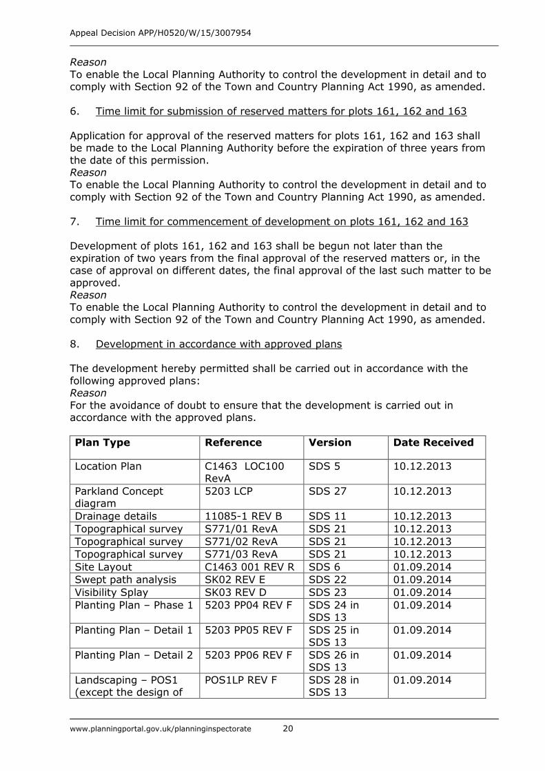
Plan Type Reference Version Date Received
Location Plan C1463 LOC100 RevA
SDS 5 10.12.2013
Parkland Concept diagram
5203 LCP SDS 27 10.12.2013
Drainage details 11085-1 REV B SDS 11 10.12.2013
Topographical survey S771/01 RevA SDS 21 10.12.2013
Topographical survey S771/02 RevA SDS 21 10.12.2013 Topographical survey S771/03 RevA SDS 21 10.12.2013
Site Layout C1463 001 REV R SDS 6 01.09.2014 Swept path analysis SK02 REV E SDS 22 01.09.2014
Visibility Splay SK03 REV D SDS 23 01.09.2014
Planting Plan – Phase 1 5203 PP04 REV F SDS 24 in SDS 13
01.09.2014
Planting Plan – Detail 1 5203 PP05 REV F SDS 25 in SDS 13
01.09.2014
Planting Plan – Detail 2 5203 PP06 REV F SDS 26 in SDS 13
01.09.2014
Landscaping – POS1 (except the design of
POS1LP REV F SDS 28 in SDS 13
01.09.2014
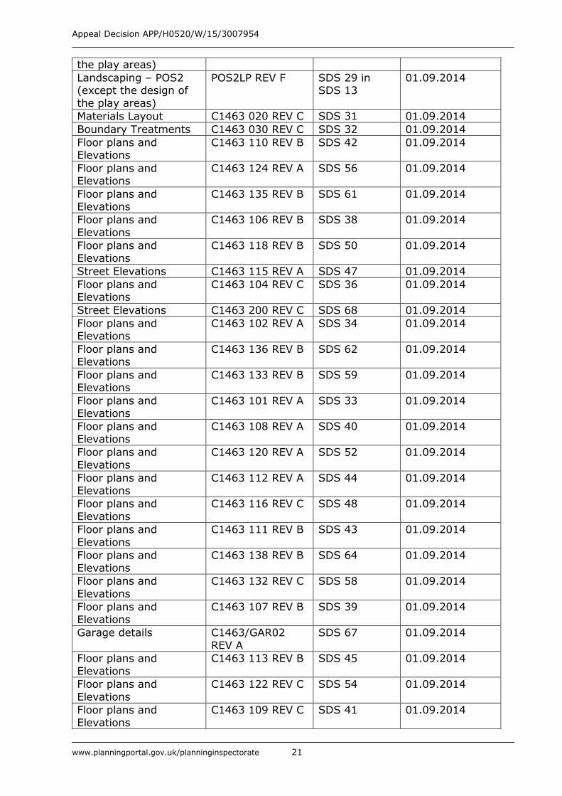
Appeal Decision APP/H0520/W/15/3007954
www.planningportal.gov.uk/planninginspectorate 21
the play areas)
Landscaping – POS2 (except the design of
the play areas)
POS2LP REV F SDS 29 in SDS 13
01.09.2014
Materials Layout C1463 020 REV C SDS 31 01.09.2014
Boundary Treatments C1463 030 REV C SDS 32 01.09.2014
Floor plans and Elevations
C1463 110 REV B SDS 42 01.09.2014
Floor plans and Elevations
C1463 124 REV A SDS 56 01.09.2014
Floor plans and Elevations
C1463 135 REV B SDS 61 01.09.2014
Floor plans and
Elevations C1463 106 REV B SDS 38 01.09.2014
Floor plans and
Elevations C1463 118 REV B SDS 50 01.09.2014
Street Elevations C1463 115 REV A SDS 47 01.09.2014
Floor plans and Elevations
C1463 104 REV C SDS 36 01.09.2014
Street Elevations C1463 200 REV C SDS 68 01.09.2014
Floor plans and Elevations
C1463 102 REV A SDS 34 01.09.2014
Floor plans and Elevations
C1463 136 REV B SDS 62 01.09.2014
Floor plans and Elevations
C1463 133 REV B SDS 59 01.09.2014
Floor plans and Elevations
C1463 101 REV A SDS 33 01.09.2014
Floor plans and
Elevations C1463 108 REV A SDS 40 01.09.2014
Floor plans and
Elevations C1463 120 REV A SDS 52 01.09.2014
Floor plans and
Elevations C1463 112 REV A SDS 44 01.09.2014
Floor plans and
Elevations C1463 116 REV C SDS 48 01.09.2014
Floor plans and
Elevations C1463 111 REV B SDS 43 01.09.2014
Floor plans and
Elevations C1463 138 REV B SDS 64 01.09.2014
Floor plans and
Elevations C1463 132 REV C SDS 58 01.09.2014
Floor plans and
Elevations C1463 107 REV B SDS 39 01.09.2014
Garage details C1463/GAR02
REV A SDS 67 01.09.2014
Floor plans and
Elevations C1463 113 REV B SDS 45 01.09.2014
Floor plans and
Elevations C1463 122 REV C SDS 54 01.09.2014
Floor plans and
Elevations C1463 109 REV C SDS 41 01.09.2014
Appeal Decision APP/H0520/W/15/3007954
www.planningportal.gov.uk/planninginspectorate 22
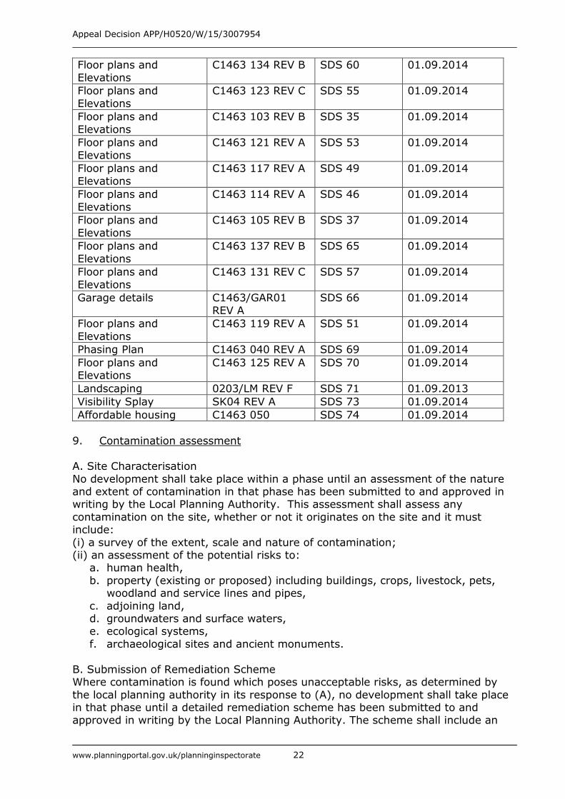
Floor plans and
Elevations C1463 134 REV B SDS 60 01.09.2014
Floor plans and
Elevations C1463 123 REV C SDS 55 01.09.2014
Floor plans and
Elevations C1463 103 REV B SDS 35 01.09.2014
Floor plans and
Elevations C1463 121 REV A SDS 53 01.09.2014
Floor plans and
Elevations C1463 117 REV A SDS 49 01.09.2014
Floor plans and
Elevations C1463 114 REV A SDS 46 01.09.2014
Floor plans and
Elevations C1463 105 REV B SDS 37 01.09.2014
Floor plans and
Elevations C1463 137 REV B SDS 65 01.09.2014
Floor plans and
Elevations C1463 131 REV C SDS 57 01.09.2014
Garage details C1463/GAR01
REV A SDS 66 01.09.2014
Floor plans and
Elevations C1463 119 REV A SDS 51 01.09.2014
Phasing Plan C1463 040 REV A SDS 69 01.09.2014
Floor plans and Elevations
C1463 125 REV A SDS 70 01.09.2014
Landscaping 0203/LM REV F SDS 71 01.09.2013 Visibility Splay SK04 REV A SDS 73 01.09.2014
Affordable housing C1463 050 SDS 74 01.09.2014
9. Contamination assessment
A. Site Characterisation
No development shall take place within a phase until an assessment of the nature and extent of contamination in that phase has been submitted to and approved in writing by the Local Planning Authority. This assessment shall assess any
contamination on the site, whether or not it originates on the site and it must include:
(i) a survey of the extent, scale and nature of contamination; (ii) an assessment of the potential risks to:
a. human health,
b. property (existing or proposed) including buildings, crops, livestock, pets, woodland and service lines and pipes,
c. adjoining land, d. groundwaters and surface waters, e. ecological systems,
f. archaeological sites and ancient monuments.
B. Submission of Remediation Scheme Where contamination is found which poses unacceptable risks, as determined by
the local planning authority in its response to (A), no development shall take place in that phase until a detailed remediation scheme has been submitted to and approved in writing by the Local Planning Authority. The scheme shall include an
Appeal Decision APP/H0520/W/15/3007954
www.planningportal.gov.uk/planninginspectorate 23
appraisal of remedial options and proposal of the preferred option(s), all works to
be undertaken, proposed remediation objectives and remediation criteria. The scheme must ensure that the site will not qualify as contaminated land under Part
2A of the Environmental Protection Act 1990 in relation to the intended use. C. Implementation of Approved Remediation Scheme
Where a detailed remediation scheme has been required and approved under (B) within a phase, no occupation of any part of the permitted development which has
been identified in the scheme as being subject to contamination shall take place in that phase until the approved scheme has been implemented and a verification report, including the results of sampling and monitoring carried out in accordance
with the approved verification scheme to demonstrate that the site remediation criteria have been met, has been submitted to and approved in writing by the local
planning authority. The report shall, if required by the local planning authority, also include a reassessment of the long-term monitoring of pollutant linkages, maintenance and arrangements for contingency action. The long-term monitoring
and maintenance proposals shall be implemented as finally approved.
D. Reporting of Unexpected Contamination If, during development, contamination not previously identified is found to be present at the site:
(i) it shall be reported to the local planning authority within 1 working day; (ii) no further development (unless otherwise agreed in writing by the local
planning authority) shall be carried out until site investigations have been carried out and a remediation strategy has been submitted to and approved in writing by the local planning authority detailing how this unsuspected contamination will be
dealt with; (iii) the remediation strategy shall be implemented as approved
(iv) no occupation of any part of the permitted development identified in the remediation strategy as being affected by the previously unidentified contamination shall take place until:
a. the approved scheme has been implemented in full and any verification report required by the scheme has been submitted to and approved in
writing by the local planning authority; b. if required by the local planning authority, any proposals for long-term
monitoring of pollutant linkages, maintenance and arrangements for
contingency action have been submitted to and approved in writing by the local planning authority.
(v) the long-term monitoring and maintenance plan shall be implemented as approved.
Reason: Because the land includes a former brickworks site and to ensure that risks from land contamination to the future users of the land and neighbouring land are
minimised, together with those to controlled waters, property and ecological systems, and to ensure that the development can be carried out safely without
unacceptable risks in accordance with policy H37 of the Huntingdonshire Local Plan 1995.
10. Fire hydrant provision
No development above slab level shall take place until a scheme for the provision of fire hydrants has been submitted to and approved in writing by the local planning authority. The scheme shall include a phasing plan. No dwelling unit
Appeal Decision APP/H0520/W/15/3007954
www.planningportal.gov.uk/planninginspectorate 24
hereby permitted shall be occupied until the fire hydrant serving it has been
installed and made operative in accordance with the approved phasing plan. Reason
To ensure the provision of fire hydrants as part of the development in the interests of public safety.
11. Foul drainage scheme
No development shall commence until details of the foul water drainage for the site have been submitted to and approved in writing by the Local Planning Authority. The development shall be carried out in accordance with the approved scheme and
implemented in accordance with a phasing plan approved as part of the scheme such that no dwelling hereby permitted is occupied until the drainage works
connecting it to an existing public sewer have been implemented. Reason To ensure satisfactory disposal of foul drainage in accordance with policy CS8 of
the Huntingdonshire Local Plan 1995.
12. Surface water drainage scheme No development shall take place until a surface water drainage scheme for the site,
including proposals for the long-term management and maintenance of the infrastructure, has been submitted to and approved in writing by the local planning
authority. The development shall be carried out in accordance with the approved scheme and implemented in accordance with a phasing plan approved as part of the scheme. Thereafter the surface water drainage scheme shall be maintained
and managed in accordance with details approved as part of the scheme. Reason To prevent the increased risk of flooding, both on and off site in accordance with
policy CS8 of the Huntingdonshire Local Plan 1995 and to ensure the satisfactory
management of the surface water scheme in perpetuity. 13. Access to development not served by an adopted highway
No development shall commence until (i) a plan showing the extent of the road
network within the site which is to be adopted by the local highway authority and (ii) a scheme for the construction and long term management of any development roads which are not to be publicly adopted has been submitted to and approved in
writing by the local planning authority. The scheme shall include: a. road and footway cross-sections showing their construction;
b. details of lighting; c. the provision to be made for access to these roads by local authority
refuse collection vehicles.
The development shall be carried out in accordance with the approved scheme. Reason
In the interests of residential amenity and highway safety. 14. Community safety / crime prevention
No development above slab level shall take place within a phase until a scheme of
security measures and lighting for any rear parking courts within that phase has been submitted to and approved in writing by the local planning authority. The
Appeal Decision APP/H0520/W/15/3007954
www.planningportal.gov.uk/planninginspectorate 25
relevant elements of the approved scheme shall be implemented before the plots
to which they relate are first occupied. Reason
In the interests of residential amenity and community safety. 15. Light pollution
No development shall commence within phase 4 (as shown on Phasing Plan C1463
040 REV A) or the parkland until a scheme for highway lighting has been submitted to and approved in writing by the local planning authority. The development shall be carried out in accordance with the approved scheme. The approved lighting
shall not be altered nor shall any additional street lighting be installed. Reason
In the interests of visual amenity and community safety. 16. Scheme for the provision of a footpath/cycleway link to Westwood Road
No development shall commence in phase 4 (as shown on Phasing Plan C1463 040
REV A) until a scheme for the provision of a footpath/cycleway linking the development to Westwood Road, including a programme for its implementation, has been submitted to and approved in writing by the local planning authority. The
development shall be carried out in accordance with the approved scheme. Reason
In the interests of residential amenity. 17. Provision of Residential Travel Plan
No dwelling shall be occupied until the submitted residential travel plan has been
implemented and shall be operated and retained thereafter from the date of its implementation. Every year following the occupation of the fiftieth unit on the site and on subsequent anniversaries until the end of the third year after the
completion of the residential units, results of the annual Travel Plan monitoring survey and a report on any necessary corrective actions and the programme for
their implementation shall be submitted to and approved in writing by the local planning authority. Any corrective actions shall be taken in accordance with the programme specified in an approved report.
Reason. To secure a sustainable development through the encouragement of sustainable
travel. 18. Construction Management / Construction Traffic Management Plan
Notwithstanding the information submitted with the application, no development
shall take place, including any works of demolition, until a Construction Method Statement has been submitted to, and approved in writing by, the local planning authority. The approved Statement shall be adhered to throughout the construction
period. The Statement shall provide for: (i) points of access to the site to be used by construction traffic and times of
ingress and egress (ii) the parking of vehicles of site operatives and visitors (iii) loading and unloading of plant and materials
(iv) location of the construction compound and storage areas for plant and construction materials
Appeal Decision APP/H0520/W/15/3007954
www.planningportal.gov.uk/planninginspectorate 26
(v) the erection and maintenance of security hoardings
(vi) wheel washing facilities and their use (vii) measures to control the emission of dust and dirt during construction
Reason In the interests of residential amenity and highway safety.
19. Tree Protection
No equipment, machinery or materials shall be brought onto any phase of the development until the scheme of protection for the existing trees within and adjoining that phase (as agreed to be retained) has been installed in accordance
with the details contained in the Arboricultural Method Statement dated June 2014. The protection measures shall be maintained for the full duration of development in
that phase and until all equipment, materials and surplus materials have been removed. Nothing shall be stored or placed in any area fenced in accordance with this condition and the ground levels within those areas shall not be altered, nor
shall any excavation be made, without the written consent of the Local Planning Authority. If any tree protection fencing is damaged all operations shall cease until
it has been repaired in accordance with the approved details. Reason In order to ensure that damage does not occur to the trees/hedges during building
operations
20. Replacement of defective landscaping
If within a period of 5 years from the date of the planting of any tree or shrub on
any part of the site, it or any tree or shrub planted in replacement of it, is removed, uprooted or destroyed or dies, another tree or shrub of the same species
and size as that originally planted shall be planted at the same place, unless the Local Planning Authority gives its written consent to any variation. Reason
To ensure that the landscape scheme is properly maintained in accordance with Policies En20 and En25 of the Huntingdonshire Local Plan 1995.
21. Construction waste audit and strategy
No development shall commence until a Construction Waste Audit and Strategy has
been submitted to and approved in writing by the local planning authority. The development shall be carried out in accordance with the approved document.
Reason To minimise and sustainably manage waste in accordance with Policy CS28 of the adopted Cambridgeshire and Peterborough Minerals and Waste Core Strategy July
2011.
22. Construction of road link to the boundary with The How
The road link to land to the west shown on site layout drawing C1463 001 REV R shall be constructed up to the site’s boundary with the property known as The How
before development commences in phase 2. Reason
To ensure that it is possible to form a road connection with land to the west in the event that land comes forward for development in the interests of the proper planning of the area.
Appeal Decision APP/H0520/W/15/3007954
www.planningportal.gov.uk/planninginspectorate 27
23. External materials
No development shall commence within a phase until details of the type, colour and texture of all materials to be used for the external surfaces of the buildings in general accordance with the Materials Layout drawing C1463 020 REV C have been
submitted to and approved in writing by the local planning authority. The development shall be carried out in accordance with the approved details.
Reason To enable the Local Planning Authority to retain control of the development in the interests of visual amenity in accordance with Policy En25 of the Huntingdonshire
Local Plan, 1995.
24. Levels No development shall commence within a phase (as shown on Phasing Plan C1463
040 REV A) until details of the proposed finished floor levels of all buildings and the levels of the site and any changes proposed to the site have been submitted to and
approved in writing by the local planning authority. The development hereby approved shall then be constructed in accordance with the approved levels details unless otherwise agreed in writing by the Local Planning Authority.
Reason In the interests of residential amenity.
25. Traffic noise
No development shall commence above slab level on the plots adjacent to Houghton Road (plots 4-9, 26-34 and 49-52) until a traffic noise assessment to
include any recommended mitigation measures has been submitted to and approved in writing by the local planning authority. The development shall be carried out in accordance with any mitigation measures specified in the approved
assessment. Reason
In the interests of residential amenity 26. Community Infrastructure Levy Phasing
Development shall be undertaken in phases in accordance with Phasing Plan C1463
040 REV A or such other plan as may be approved in writing by the local planning authority prior to the commencement of any phase to which it relates.
Reason To allow for phasing of Community Infrastructure Levy payments.
Appeal Decision APP/H0520/W/15/3007954
www.planningportal.gov.uk/planninginspectorate 28
APPEARANCES
FOR THE LOCAL PLANNING AUTHORITY:
Mr M Bedford of Counsel, instructed by Ms S Tracey, Legal Services Manager, Huntingdonshire District
Council He called Mr P Bland BA(Hons)TCP
MRTPI
Planning Services Manager (Policy )
Huntingdonshire District Council
FOR THE APPELLANTS:
Mr C Katkowski Of Queen’s Counsel, instructed by Messrs Bidwells
He called
Mrs S Rawlings MA(Hons) MRTPI AIEMA
Planning Consultant, Bidwells
INTERESTED PERSONS:
Mrs H Boothman Member of Houghton and Wyton Parish Council and Neighbourhood Plan Working Group
Mr H Death Local Resident, Houghton Hill
Ms B Flanagan Member of Hemingford Abbots Parish Council Mr O Aremu Principal Lawyer, Cambridgeshire County Council
Mr A Proietti Principal Planner, Cambridgeshire County Council DOCUMENTS SUBMITTED AT THE INQUIRY
1. Appellants’ Opening Submissions
2. Huntingdonshire District Council Opening Statement
3. Draft S106 Planning Agreement between the landowners and HDC
4. HDC Community Infrastructure Regulations Statement of Compliance
5. R on Application of Cherkley Campaign Ltd v Mole Valley DC and
Longshot Cherkley Court Ltd EWCA Civ 567
6. CCC Community Infrastructure Regulations Statement of Compliance
7. Written Position Statement by Andrew S Campbell Associates Ltd on behalf of Mr & Mrs Wadsworth of The How
8. Statement read out by Mrs Boothman
9. Statement read out by Mr Death
10. Statement read out by Ms Flanagan
11. 11a S106 Planning Agreement and 11b S106 Unilateral Undertaking
12. Closing submissions by HDC and appended court decisions (12A-12D)
13. Closing submissions by the Appellants