Evaluation of the Use of Rural Transportation Infrastructure in Evacuation Operations
20
1 Evaluation of the Use of Rural Transportation Infrastructure in Evacuation Operations Zhirui Ye Jaydeep Chaudhari Janelle Booth Benedict Posadas National Evacuation Conference New Orleans, LA February 3-5, 2010
Transcript of Evaluation of the Use of Rural Transportation Infrastructure in Evacuation Operations

1
Evaluation of the Use of Rural Transportation Infrastructure in
Evacuation Operations
Zhirui YeJaydeep Chaudhari
Janelle BoothBenedict Posadas
National Evacuation ConferenceNew Orleans, LA
February 3-5, 2010

2
Outline
• Background• Objective of study• Methodology and results• Conclusions

3
Background• Rural roads comprise 80% of national road
miles (3.1 million rural road miles)• 90% of rural roads are two lanes or less• Rural populations are more automobile
dependent than urban populations.• Nearly 40% of the country’s transit-
dependent population (FHWA)
• Studies found a lack of coordination between urban and rural evacuation planning efforts(Meit, M., Briggs, T., & Kennedy, A. (2008).)

4
Objective and Study Area
• Evaluate the use of rural transportation infrastructure in evacuations operations.
• Study area: Northern Gulf Region (NGR)– Predominantly rural communities– 24 counties and 4 parishes– 75% of population live in rural or suburban
settings

Study Area
5


7
Survey Methodology• Survey was distributed to 33 agencies within the
NGR– Emergency Management Agencies (EMAs) and
district DOTs.– 18 responses (response rate: 55%): 4 AL, 5 MS, 4
LA, and 5 FL.• Major topics
– Evacuation routes and evacuee flow– Use and efficiency of evacuation tools– Evacuation preparation– Issues or barriers in evacuation events
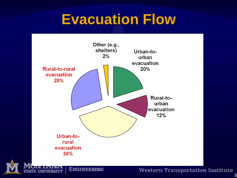
8
Evacuation Flow

9
Evacuee Flow
Evacuees stay in your area due to
altered weather condition
12%
Evacuees coming to
your area for shelter11%
Evacuees passing
through your area53%
Local evacuees
leaving your area24%

10
Evacuation Routes
Source: maps.google.com

11
Communication
Communication Devices / SystemsUse Efficiency
Number of Responses Total Score Number of
ResponsesAverage
ScoreDial (Reverse) 911 16 20 14 2.38
Dial 511 15 7 12 1.5
Loudspeakers 15 4 12 1
Siren System 15 5 13 2
Highway Advisory Radio (HAR) 16 24 13 1.88
Roadside Information Locations 16 14 12 1.83
Newspapers 18 40 15 1.93
Flyers 16 14 11 1.57
Television 17 50 15 2.73
Public Address and Emails 14 26 12 1.8
Cell Phones 15 21 12 1.9
Emergency Alert Systems 16 20 13 2

12
Traffic Control Traffic Control Devices/Systems
Use Efficiency
Number of Responses Total Score Number of
ResponsesAverage
Score
Portable Traffic Signal 15 10 12 2.2
Ramp Meters 16 7 13 2.33
Traffic Signs 17 40 16 2.57
Channelization Devices (cones and barricades, concrete barricades) 16 32 16 2.75
Temporary Pavement Markings 16 6 13 2.33
Dynamic Message Signs (DMS) 17 24 15 2.78
Traffic Management Centers 17 13 15 2.5
Human Directives (Police, Army, and Volunteers) 18 35 17 2.47

13
Use of Weather and Condition Assessment Tools
Weather and Condition Assessment ToolsUse
Not Used Low Medium High
National Weather Service 0 0 0 18
Clarus Initiative (Established by the FHWA Road Weather
Management Program)11 2 1 0
FHWA Road Weather Management Program 11 2 1 0
Evacuation Traffic Information System (ETIS) 8 1 4 1
Evacuation Travel Demand Forecasting System 9 1 2 2
Hazards U.S.Multi-Hazard (HAZUS-MH MR2-Developed by FEMA) 6 4 3 1

14
Evacuation Preparation- Preparation Time

15
Evacuation Preparation- Roadside Amenities
45
21 1
4
0 01
12
1011 11
14
11
1312 12
21
2
4
1 1
45
3
0
2
4
6
8
10
12
14
16
18
Food Lodging Health carefacilities
Shelters Vehiclerepairshops
Parking FuelStation
Firefightingfacilities
Ambulatoryfacilities
Roadside Amenities
No.
of R
espo
nses
Not Available Some Available Adequately Available

16
Barriers to Emergency Management Activities
Barriers/ObstaclesEmergency Management Activity
Mitigation Preparedness Response Recovery
Lack of operating budget 12 9 8 8
Funding restrictions to provide service 6 4 4 4
Lack of workforce 5 5 6 5
Having to plan ahead 1 1 0 0
Lack of roadside assistance 1 2 3 0
Lack of roadside amenities 1 2 2 0
Odd weather conditions 2 1 2 1
Service boundaries/jurisdiction 1 0 1 0
Lack of medical facilities 1 2 3 1
Lack of communication facilities 1 2 3 1
Lack of traffic control services 2 1 1 1
Lack of vehicles to access flood-affected area 1 0 5 2

17
Conclusions• Rural areas need to be considered while
urban evacuation planning.• Rural transportation infrastructure is under
stress during evacuation.• Limited resources including smaller and
less diverse workforce• Estimation of evacuees- a challenging task• Incompetent communication network for
coordination.

Acknowledgements
• Sidney Massey, Project Director• Amanda Seymour, Assistant Project Director
Center for Urban Rural Interface StudiesCoastal Research and Extension Center, Biloxi
Mississippi State Universityhttp://curis.msstate.edu/
18

19
Thank you www.westerntransportationinstitute.org
?

References:• Federal Highway Administration. Planning.
http://www.fhwa.dot.gov/planning/rural/planningfortrans/2ourrts.html (Accessed on May 15,2009)
• Meit, M., Briggs, T., & Kennedy, A. (2008). Urban to rural evacuation: planning for rural population surge. Research Report, Bethesda, MD: The Walsh Center for Rural Health Analysis.
• Burkett, V. R., Hyman, R. C., Hagelman, R., Hartley, S. B., & Shephard, M. (2008). Impacts of Climate Change and Variability on Transportation Systems and Infrastructure: Gulf Coast Study, Phase 1, Chap. 2: Why Study the Gulf Coast? Retrieved October 30, from U.S. Climate Change Science Program website: http://www.climatescience.gov/Library/sap/sap4-7/final-report/sap4-7-final-front-matter.pdf
• Google Maps. www.maps.google.com ( Accessed on January 15,2010)
20