Evaluation of landslide susceptibility of Sete Cidades Volcano (S. Miguel Island, Azores)
7
Natural Hazards and Earth System Sciences (2005) 5: 251–257 SRef-ID: 1684-9981/nhess/2005-5-251 European Geosciences Union © 2005 Author(s). This work is licensed under a Creative Commons License. Natural Hazards and Earth System Sciences Evaluation of landslide susceptibility of Sete Cidades Volcano (S. Miguel Island, Azores) A. Gomes, J. L. Gaspar, C. Goulart, and G. Queiroz Centro de Vulcanologia e Avaliac ¸˜ ao de Riscos Geol ´ ogicos, Universidade dos Ac ¸ores, Rua M˜ ae de Deus, 9500-801 Ponta Delgada, Portugal Received: 2 November 2004 – Revised: 7 February 2005 – Accepted: 15 February 2005 – Published: 1 March 2005 Abstract. Sete Cidades is an active central volcano with a summit caldera located in the westernmost part of S. Miguel Island (Azores). Since the settlement of the Island, in the 15 th century, many landslide events occurred in this volcano, causing extensive damages in buildings and infrastructures. The study of historical records and the observation of new occurrences showed that landslides in the region have been triggered by heavy rainfall periods, earthquakes and erosion. In order to assess landslide susceptibility at Sete Cidades Volcano, landslide scars and associated deposits were mapped through aerial photographs and field surveys. The obtained data were inserted in a GIS to produce a land- slide distribution map. It was concluded that the high den- sity landslide areas are related with (1) major scarp faults, (2) the margin of fluvial channels, (3) the sea cliffs and (4) volcanic landforms, namely the caldera wall. About 73% of the mapped events took place in areas where pyroclastic deposits are the dominant lithology and more than 77% oc- curred where slopes are equal or higher than 20 ◦ . These two parameters were integrated and used to generate a prelimi- nary susceptibility map. The incorporation of vulnerability data into the GIS al- lowed concluding that 30% of dwellings and most of the roads on Sete Cidades Volcano are located in areas where landslide susceptibility is high to very high. Such conclu- sion should be taken into account for emergency and land use planning. 1 Introduction The Azores archipelago is formed by nine volcanic islands and is located in the Atlantic Ocean, between 37 ◦ –40 ◦ N lat- itude and 25 ◦ –31 ◦ W longitude (Fig. 1). The geological setting of the Azores region is dominated by the existence of a mantle plume where the American, Correspondence to: A. Gomes ([email protected]) Eurasian and African plates meet (White et al., 1979; Searle, 1980). The Mid-Atlantic Ridge and the Terceira Rift are the most important tectonic structures recognised in the area (Fig. 2), being the main source of the seismic and volcanic activity registered in the region (Machado, 1959; Weston, 1964). Since the settlement of the archipelago, in the 15 th century, many destructive earthquakes, volcanic eruptions and landslides were responsible for several deaths and sub- stantial damage. S˜ ao Miguel, with about half of the Azores inhabitants, is the largest island of the archipelago and is located in the east- ern part of the Terceira Rift. The island is formed by several volcanic edifices placed along a general E-W direction and is crossed by NW-SE, NE-SW, WNW-ESE and E-W regional tectonic structures (Fig. 3). Sete Cidades Volcano is located in the westernmost part of S. Miguel occupying an area of about 110 km 2 . It is an active central volcano with a sum- mit caldera and its eruptive history was marked by two dis- tinct periods: the first one was dominated by the extrusion of lava flows forming the basal part of the volcanic edifice; the second, starting 36 000 years ago, was characterised by the emplacement of major pyroclastic flows and tephra fall deposits. 2 Historical accounts and recent events Since the settlement of the island many catastrophic land- slides occurred at S. Miguel Island. The largest event was triggered by the 1522 AD earthquake and destroyed the for- mer capital of the Azores, Vila Franca do Campo, located in the south flank of Fogo Volcano, killing about 5000 people (Marques et al., 2004) 1 . At Sete Cidades Volcano, the history reveals that land- slides have also been the cause of extensive damages in build- ings and infrastructures. The study of historical records and 1 Marques, R., Gaspar, J. L. and Zˆ ezere, J. L.: Reconstruction of the 1522 earthquake-induced landslide of Vila Franca do Campo (S˜ ao Miguel Island, Azores), Eng. Geology, in revision, 2004.
-
Upload
independent -
Category
Documents
-
view
3 -
download
0
Transcript of Evaluation of landslide susceptibility of Sete Cidades Volcano (S. Miguel Island, Azores)

Natural Hazards and Earth System Sciences (2005) 5: 251–257SRef-ID: 1684-9981/nhess/2005-5-251European Geosciences Union© 2005 Author(s). This work is licensedunder a Creative Commons License.
Natural Hazardsand Earth
System Sciences
Evaluation of landslide susceptibility of Sete Cidades Volcano(S. Miguel Island, Azores)
A. Gomes, J. L. Gaspar, C. Goulart, and G. Queiroz
Centro de Vulcanologia e Avaliacao de Riscos Geologicos, Universidade dos Acores, Rua Mae de Deus, 9500-801 PontaDelgada, Portugal
Received: 2 November 2004 – Revised: 7 February 2005 – Accepted: 15 February 2005 – Published: 1 March 2005
Abstract. Sete Cidades is an active central volcano with asummit caldera located in the westernmost part of S. MiguelIsland (Azores). Since the settlement of the Island, in the15th century, many landslide events occurred in this volcano,causing extensive damages in buildings and infrastructures.The study of historical records and the observation of newoccurrences showed that landslides in the region have beentriggered by heavy rainfall periods, earthquakes and erosion.
In order to assess landslide susceptibility at Sete CidadesVolcano, landslide scars and associated deposits weremapped through aerial photographs and field surveys. Theobtained data were inserted in a GIS to produce a land-slide distribution map. It was concluded that the high den-sity landslide areas are related with (1) major scarp faults,(2) the margin of fluvial channels, (3) the sea cliffs and (4)volcanic landforms, namely the caldera wall. About 73%of the mapped events took place in areas where pyroclasticdeposits are the dominant lithology and more than 77% oc-curred where slopes are equal or higher than 20◦. These twoparameters were integrated and used to generate a prelimi-nary susceptibility map.
The incorporation of vulnerability data into the GIS al-lowed concluding that 30% of dwellings and most of theroads on Sete Cidades Volcano are located in areas wherelandslide susceptibility is high to very high. Such conclu-sion should be taken into account for emergency and landuse planning.
1 Introduction
The Azores archipelago is formed by nine volcanic islandsand is located in the Atlantic Ocean, between 37◦–40◦ N lat-itude and 25◦–31◦ W longitude (Fig. 1).
The geological setting of the Azores region is dominatedby the existence of a mantle plume where the American,
Correspondence to:A. Gomes([email protected])
Eurasian and African plates meet (White et al., 1979; Searle,1980). The Mid-Atlantic Ridge and the Terceira Rift arethe most important tectonic structures recognised in the area(Fig. 2), being the main source of the seismic and volcanicactivity registered in the region (Machado, 1959; Weston,1964). Since the settlement of the archipelago, in the 15th
century, many destructive earthquakes, volcanic eruptionsand landslides were responsible for several deaths and sub-stantial damage.
Sao Miguel, with about half of the Azores inhabitants, isthe largest island of the archipelago and is located in the east-ern part of the Terceira Rift. The island is formed by severalvolcanic edifices placed along a general E-W direction and iscrossed by NW-SE, NE-SW, WNW-ESE and E-W regionaltectonic structures (Fig. 3). Sete Cidades Volcano is locatedin the westernmost part of S. Miguel occupying an area ofabout 110 km2. It is an active central volcano with a sum-mit caldera and its eruptive history was marked by two dis-tinct periods: the first one was dominated by the extrusionof lava flows forming the basal part of the volcanic edifice;the second, starting 36 000 years ago, was characterised bythe emplacement of major pyroclastic flows and tephra falldeposits.
2 Historical accounts and recent events
Since the settlement of the island many catastrophic land-slides occurred at S. Miguel Island. The largest event wastriggered by the 1522 AD earthquake and destroyed the for-mer capital of the Azores, Vila Franca do Campo, located inthe south flank of Fogo Volcano, killing about 5000 people(Marques et al., 2004)1.
At Sete Cidades Volcano, the history reveals that land-slides have also been the cause of extensive damages in build-ings and infrastructures. The study of historical records and
1Marques, R., Gaspar, J. L. and Zezere, J. L.: Reconstructionof the 1522 earthquake-induced landslide of Vila Franca do Campo(Sao Miguel Island, Azores), Eng. Geology, in revision, 2004.

252 A. Gomes et al.: Evaluation of landslide susceptibility
Table 1. Lithological classes and landslide density per km2.
Lithological Outcropping Outcrop Number of % of landslide Landslideclass area (km2) area % landslides (over the total) density per km2
L1 21,90 16,63 41 4,6 1,87L2 35,74 27,13 197 22,2 5,51L3 74,07 56,24 648 73,1 8,74
11
Fig.1 – Geographical location of the Azores archipelago.
Fig. 2 - Main tectonic structures in the Azores region. MAR – Mid-Atlantic Ridge; EAFZ – East
Azores Fracture Zone; TR – Terceira Rift; GF – Gloria Fault (in: Gaspar et al., 1999).
Fig. 1. Geographical location of the Azores archipelago.
11
Fig.1 – Geographical location of the Azores archipelago.
Fig. 2 - Main tectonic structures in the Azores region. MAR – Mid-Atlantic Ridge; EAFZ – East
Azores Fracture Zone; TR – Terceira Rift; GF – Gloria Fault (in: Gaspar et al., 1999).
Fig. 2. Main tectonic structures in the Azores region. MAR – Mid-Atlantic Ridge; EAFZ – East Azores Fracture Zone; TR – TerceiraRift; GF – Gloria Fault (in: Gaspar et al., 1999).
the observation of new occurrences showed that heavy rain-fall, earthquakes and erosion have triggered landslides in theregion. On 8 December 1713, several landslides took place inthe W flank of the volcano and important debris flows devel-oped along some streamlines. Those events occurred associ-ated to an intense seismic crisis that began on 14 Novemberand lasted for about three weeks (e.g. Queiroz, 1997; Sil-
12
Fig. 3 – Main morphological provinces of S. Miguel Island (Zbyszewski, 1961). 1 – Sete Cidades
Volcano; 2 – Picos Volcanic System; 3 – Fogo Volcano; 4 – Achada das Furnas Volcanic System;
5 – Furnas Volcano; 6 – Povoação Volcano; 7 – Nordeste Volcanic Complex; 8 – North Platform
(in: Wallenstein, 1999). – Study area; - Vila Franca do Campo, the former capital of Azores.
Fig. 4 – Landslide scar generated during the January 2002 episode (Photo from CVARG).
Fig. 3. Main morphological provinces of S. Miguel Island(Zbyszewski, 1961). 1 – Sete Cidades Volcano; 2 – Picos VolcanicSystem; 3 – Fogo Volcano; 4 – Achada das Furnas Volcanic System;5 – Furnas Volcano; 6 – Povoacao Volcano; 7 – Nordeste VolcanicComplex; 8 – North Platform (in: Wallenstein, 1999).� – Studyarea; blue• – Vila Franca do Campo, the former capital of Azores.
veira, 2002). No casualties were reported at the time. On 21November 1988, landslides occurred following a 5.8 mag-nitude earthquake with epicentre 20 km west of the island.Most of the events were of debris flows type and cut the mainroads around the volcano.
More recently, in January and February 2002, several land-slides triggered by heavy rainfall associated with strong windoccurred in the SW flank of the volcano. At that time manydwellings were affected and roads cut (Malheiro and Dias,2002) (Figs. 4 and 5). In February 2003, many landslideswere observed in the NE sector of the volcano also triggeredby an intense rainfall phenomenon (Fig. 6) and in October ofthe same year a road was cut in the W coast when a landslideoccurred in the cliff as result of the normal coastal erosionprocess (Marques and Amaral, 2003) (Fig. 7).
In general, important landslides happen in Sete CidadesVolcano at least once a year, causing damages in dwellings,roads and other basic infrastructures.
Taking into account the idea that many landslides takeplace in zones already affected in the past (Carrara et al.,1995; Parise and Wasowski, 1999; Zezere, 2001) and theprinciple that geological and geomorphological conditionsverified in past landslides can be identical in futures events(Carrara et al., 1998), it is crucial to recognise the distributionof past landslides and to analyse the local factors that mayhave contributed to their occurrence. With the purpose to as-sess landslide susceptibility at Sete Cidades Volcano, threemain parameters were considered at this stage: (1) the land-slide distribution, (2) the lithology and (3) the slope steep-ness.

A. Gomes et al.: Evaluation of landslide susceptibility 253
12
Fig. 3 – Main morphological provinces of S. Miguel Island (Zbyszewski, 1961). 1 – Sete Cidades
Volcano; 2 – Picos Volcanic System; 3 – Fogo Volcano; 4 – Achada das Furnas Volcanic System;
5 – Furnas Volcano; 6 – Povoação Volcano; 7 – Nordeste Volcanic Complex; 8 – North Platform
(in: Wallenstein, 1999). – Study area; - Vila Franca do Campo, the former capital of Azores.
Fig. 4 – Landslide scar generated during the January 2002 episode (Photo from CVARG).
Fig. 4. Landslide scar generated during the January 2002 episode(Photo from CVARG).
3 Landslide mapping
Landslide scars, and when possible the associated deposits,were mapped using aerial photographs (1:8000 and 1:15 000)from different years (1974, 1977, 1982, 1995 and 1998) andseveral field surveys were conducted to characterise the mostrecent events. A total of 886 landslides were recognised, cor-responding to more than 31% of the total events mapped inS. Miguel Island (Valadao et al., 2002).
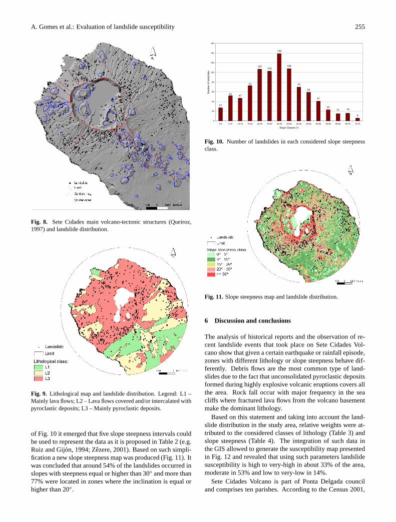
The obtained data were introduced in a Geographic Infor-mation System (GIS) to produce the landslide distributionmap presented in Fig. 8. The higher density landslide areasreveal a close relationship with the observed geological andgeomorphological structures including (1) major scarp faults,(2) the margin of fluvial channels, (3) the sea cliffs and (4)volcanic landforms, namely the caldera wall and some cindercones.
Specific evaluations of landslide susceptibility have shownspecific differences between seismic and rainfall triggeringevents (Brabb, 1995). Unfortunately, except for the 2002and 2003 recent events it was not possible to establish anyrelation between landslides and their trigger mechanisms.
4 Lithological classes
Three main classes of lithology were established for thisstudy based in the S. Miguel Island Geological Map (Moore,1991) and considering the vulcanostratigraphy of Sete
13
Fig. 5 – January 2002 landslide deposit affecting the wall of a house (Photo from LREC).
Fig. 6 – Landslide scar and associated deposit formed in February 2003 (Photo from CVARG).
Fig. 5. January 2002 landslide deposit affecting the wall of a house(Photo from LREC).
Cidades Volcano (Queiroz, 1997): (1) class L1, essentiallycomposed by lava flows; (2) class L2, characterized by bothpyroclastic deposits and lava flows; and (3) class L3, wherepyroclastic deposits are the dominant volcanic products.
The spatial distribution of such classes in the volcano re-gion (Fig. 9) allowed to conclude that 56% of the area is gen-erally covered by pyroclastic deposits while only 16,6% iscomposed by superimposed lava flows (Table 1). The analy-sis of the landslide distribution taking into account the lithol-ogy indicates that 73% of the events occurred in zones wherepyroclasts are dominant and just 4,6% took place in areascovered by lava flows. This difference persists when it isconsidered the landslide density per square kilometre (Ta-ble 1) and is due to the fact that the majority of the youngpyroclastic products that cover the all area are of fall originand form unconsolidated deposits that are more straightfor-wardly removed. This observation also explains why debrisflows are the most common type of landslides that occur inSete Cidades Volcano while rock fall events are restricted tothe sea cliffs where lava flows are the dominant lithology.
5 Slope steepness
In order to study the relation between landslide distributionand slope steepness a digital elevation model was created

254 A. Gomes et al.: Evaluation of landslide susceptibility
13
Fig. 5 – January 2002 landslide deposit affecting the wall of a house (Photo from LREC).
Fig. 6 – Landslide scar and associated deposit formed in February 2003 (Photo from CVARG).
Fig. 6. Landslide scar and associated deposit formed in February2003 (Photo from CVARG).
Table 2. Number and percentage of landslides vs. slope steepnessclasses.
Slope steepness class (◦) Number of landslide % of landslide
0–5 27 3,05–15 99 11,215–20 73 8,420–30 210 23,7≥30 477 53,8Total 886 100
Table 3. Weight given to the lithology classes.
Lithology Landslide Weightclasses susceptibility
L1 Very-low to low 1L2 Moderate 2L3 High to very-high 3
with the GIS ArcView® 3.3 software using the elevationcontour lines from the 2001 digital S. Miguel Military Map(Sheets 26, 27 and 31 in 1:25 000) published by the Instituto
14
Fig. 7 – Road cut in the NW coast of Sete Cidades Volcano as result of the October 2003 event
(Photo from CVARG).
Fig.8 – Sete Cidades main volcano-tectonic structures (Queiroz, 1997) and landslide distribution.
Fig. 7. Road cut in the NW coast of Sete Cidades Volcano as resultof the October 2003 event (Photo from CVARG).
Table 4. Weight given to the slope steepness classes.
Slope steepness Landslide Weightclass susceptibility
0◦–15◦ Very-low to low 115◦–20◦ Moderate 2≥20◦ High to very-high 3
Table 5. Number and percentage of dwellings in areas with differ-ent landslide susceptibility.
Susceptibility Number of dwellings % of dwellings
Very-low to low 261 6Moderate 2784 64
High to very-high 1305 30
Geografico do Exercito. The automatic procedure providedby the GIS to produce the slopes map was first applied con-sidering cells with 10 m width and class divisions every 5◦.
The number of landslides falling in each class is presentedin Fig. 10, showing a normal distribution with a maximumvalue in the slope class of 30◦–35◦. Analysing the histogram
A. Gomes et al.: Evaluation of landslide susceptibility 255
14
Fig. 7 – Road cut in the NW coast of Sete Cidades Volcano as result of the October 2003 event
(Photo from CVARG).
Fig.8 – Sete Cidades main volcano-tectonic structures (Queiroz, 1997) and landslide distribution.
Fig. 8. Sete Cidades main volcano-tectonic structures (Queiroz,1997) and landslide distribution.
15
Fig. 9 – Lithological map and landslide distribution. Legend: L1 – Mainly lava flows; L2 – Lava
flows covered and/or intercalated with pyroclastic deposits; L3 – Mainly pyroclastic deposits.
Fig. 10 – Number of landslides in each considered slope steepness class.
27
47
107103
139
108
70
59
41
23
6
73
52
1615
0
20
40
60
80
100
120
140
160
0-5 5-10 10-15 15-20 20-25 25-30 30-35 35-40 40-45 45-50 50-55 55-60 60-65 65-70 70-75
Slope Classes (º)
Num
ber o
f lan
dslid
es
Fig. 9. Lithological map and landslide distribution. Legend: L1 –Mainly lava flows; L2 – Lava flows covered and/or intercalated withpyroclastic deposits; L3 – Mainly pyroclastic deposits.
of Fig. 10 it emerged that five slope steepness intervals couldbe used to represent the data as it is proposed in Table 2 (e.g.Ruiz and Gijon, 1994; Zezere, 2001). Based on such simpli-fication a new slope steepness map was produced (Fig. 11). Itwas concluded that around 54% of the landslides occurred inslopes with steepness equal or higher than 30◦ and more than77% were located in zones where the inclination is equal orhigher than 20◦.
15
Fig. 9 – Lithological map and landslide distribution. Legend: L1 – Mainly lava flows; L2 – Lava
flows covered and/or intercalated with pyroclastic deposits; L3 – Mainly pyroclastic deposits.
Fig. 10 – Number of landslides in each considered slope steepness class.
27
47
107103
139
108
70
59
41
23
6
73
52
1615
0
20
40
60
80
100
120
140
160
0-5 5-10 10-15 15-20 20-25 25-30 30-35 35-40 40-45 45-50 50-55 55-60 60-65 65-70 70-75
Slope Classes (º)
Num
ber o
f lan
dslid
es
Fig. 10. Number of landslides in each considered slope steepnessclass.
16
Fig. 11 – Slope steepness map and landslide distribution.
Fig. 12 – Landslide susceptibility map and buildings distribution.
Fig. 11. Slope steepness map and landslide distribution.
6 Discussion and conclusions
The analysis of historical reports and the observation of re-cent landslide events that took place on Sete Cidades Vol-cano show that given a certain earthquake or rainfall episode,zones with different lithology or slope steepness behave dif-ferently. Debris flows are the most common type of land-slides due to the fact that unconsolidated pyroclastic depositsformed during highly explosive volcanic eruptions covers allthe area. Rock fall occur with major frequency in the seacliffs where fractured lava flows from the volcano basementmake the dominant lithology.
Based on this statement and taking into account the land-slide distribution in the study area, relative weights were at-tributed to the considered classes of lithology (Table 3) andslope steepness (Table 4). The integration of such data inthe GIS allowed to generate the susceptibility map presentedin Fig. 12 and revealed that using such parameters landslidesusceptibility is high to very-high in about 33% of the area,moderate in 53% and low to very-low in 14%.
Sete Cidades Volcano is part of Ponta Delgada counciland comprises ten parishes. According to the Census 2001,

256 A. Gomes et al.: Evaluation of landslide susceptibility
16
Fig. 11 – Slope steepness map and landslide distribution.
Fig. 12 – Landslide susceptibility map and buildings distribution.
Fig. 12. Landslide susceptibility map and buildings distribution.
11 429 peoples lives around the volcano. A detailed field sur-vey allowed identifying 7019 buildings in the area, 4351 ofwhich are dwellings (Gomes, 2003). The incorporation ofthe inhabited areas in the GIS (Fig. 12) show that 22% (957)of the houses are placed in zones with high to very-high sus-ceptibility and only 7% (304) in areas of low to very-lowsusceptibility. The majority of the residences, 71% (3090)are located in areas of moderate susceptibility.
Bearing in mind that the rupture surface of a landslidedevelops behind the slope face it is clear that even flat ter-rains can be involved in such occurrences if adjacent to in-clined planes. Field observations following the 1997 RibeiraQuente rainfall catastrophic event (Gaspar et al., 1997) andthe 1998 Faial earthquake (Senos et al., 1998) allowed to ver-ify that landslide rupture surfaces in zones with similar geol-ogy than the one observed at Sete Cidades Volcano occur fre-quently 5 to 10 m to the interior of the mobilized slopes. As-suming a buffer of 10 m behind the zones with higher steep-ness, namely the margin of valleys, the sea cliff, scarp faultsand the caldera rim, it comes out that the number of dwellingsin high to very-high landslide susceptibility zones increase to30% (Table 5).
The simple methodology that was developed in this studyfor Sete Cidades Volcano emphasized that landslide riskanalysis need to be taken into account concerning land useand emergency planning. Future efforts should consider thevulnerability of houses, basic infrastructures and economicfactors.
Acknowledgements.This work was supported by Project CARIGE“Carta de Riscos Geologicos da Regiao Autonoma dos Acores”,contact SRPCBA DIV 060402, and Project EXPLORIS “Explosiveeruption risk and decision support for EU populations threatenedby volcanos” contract PROID 095.
Edited by: P. ReichenbachReviewed by: M. Parise and G. F. Wieczorek
References
Brabb, E. E.: The San Mateo County California GIS project for pre-dicting the consequences of hazardous geologic processes: Ge-ographical Information Systems in Assessing Natural Hazards,edited by Carrara, A. and Guzzeti, F., Kluwer Academic Pub-lishers, 299–334, 1995.
Carrara, A., Cardinali, M., Guzzetti, F., and Reichenbach, P.: GIStechnology in mapping landslide hazard, Geographical Informa-tion Systems in Assessing Natural Hazards, 135–175, 1995.
Carrara, A., Guzzetti, F., Cardinali, M., and Reichenbach, P.: Cur-rent limitations in modelling landside hazard, in: Proceedings ofIAMG’98, edited by: Buccianti, A., Nardi, G., and Potenza, R.,195–203, 1998.
Gaspar, J. L., Trota, A., Queiroz, G., Ferreira, T., and Alves,P.: Plano Municipal de Emergencia da Vila do Porto, ilha deSanta Maria, Centro de Vulcanologia e Avaliacao de RiscosGeologicos, Universidade dos Acores, 1999.
Gaspar, J. L., Wallenstein, N., Coutinho, R., Ferreira, T., Queiroz,G., Pacheco, J., Guest, J., Tryggvason, E., and Malheiro, A.:Consideracoes sobre a ocorrencia dos movimentos de massa reg-istados na madrugada de 31 de Outubro de 1997 na ilha deS. Miguel, Acores, Relatorio Tecnico-Cientıfico 17/DGUA/97,Centro de Vulcanologia, 28, 1997.
Gomes, A.: Contribuicao para o estudo dos riscos geologicos noVulcao das Sete Cidades (S. Miguel, Acores), Tese de Mestradoem Vulcanologia e Riscos Geologicos, Universidade dos Acores,129, 2003.
Machado, F.: Submarine pits of the Azores plateau, Bulletin Vol-canologique, Serie II, Tome XXI, 108–116, 1959.
Malheiro, A. and Dias, I.: Parecer sobre a seguranca de sete mora-dias na Freguesia da Candelaria, Nota tecnica 51/2002, Labo-ratotio Regional de Engenharia Civil, 23, 2002.
Marques, R. and Amaral, P.: Avaliacao do Risco geologicoassociado a um movimento de vertente na freguesia dosMosteiros (ilha de S. Miguel), Relatorio Tecnico-Cientıfico DTC44/CVARG/03, Centro de Vulcanologia e Avaliacao de RiscosGeologicos, 8, 2003.
Moore, R. B.: Geologic map of Sao Miguel, Azores, 1:50 000, U.S.Geological Survey Miscellaneous Investigations Series, Map I,2007, 1991.
Parise, M. and Wasowski, J.: Landslide activity maps for landslidehazard evaluation: three case studies from Southern Italy, NaturalHazards, 20, 159–183, 1999.
Queiroz, G.: Vulcao das Sete Cidades (S. Miguel, Acores), Historiaeruptiva e avaliacao do hazard, Tese de Doutoramento no ramode Geologia especialidade de Vulcanologia, Departamento deGeociencias, Universidade dos Acores, 226, 1997.
Ruiz, R. and Gijon, M.: Methodology for landslides hazard map1:10 000 in the area of Monachil (Granada, Spain), 7th Interna-tional IAEG Congress, 2059–2064, 1994.
Searle, R.: Tectonic pattern of the Azores spreading centre andtriple junction, Earth Planet. Sci. Lett., 51, 415–434, 1980.
Senos, M. L., Gaspar, J. L., Cruz, J., Ferreira, T., Nunes, J. C.,Pacheco, J., Alves, P., Queiroz, G., Dessai, P., Coutinho, R.,Vales, D., and Carrilho, F.: O terramoto do Faial de 9 de Julho de1998. Proceedings do “1◦ Simposio de Metereologiae Geofısicada APMG”, 61–68, 1998.
Silveira, D.: Caracterizacao da sismicidade historica da ilha de SaoMiguel com base na reinterpretacao de dados de macrossısmica:contribuicao para a avaliacao do risco sısmico, Tese de Mestradoem Vulcanologia e Riscos Geologicos, Universidade dos Acores,

A. Gomes et al.: Evaluation of landslide susceptibility 257
149, 2002.Valadao, P., Gaspar, J. L., Queiroz, G., and Ferreira, T.: Landslides
density map of S. Miguel Island, Azores archipelago, Nat. Haz.Earth Sys. Sci., 2, 1–6, 2002,SRef-ID: 1684-9981/nhess/2002-2-1.
Wallenstein, N.: Estudo da historia recente do comportamento erup-tivo do Vulcao do Fogo (S. Miguel, Acores). Avaliacao prelimi-nar do hazard, Tese de Doutoramento no ramo de Geologia espe-cialidade de Vulcanologia, Departamento de Geociencias, Uni-versidade dos Acores, 266, 1999.
Weston, F.: List of recorded volcanic eruptions in the Azores withbrief reports, Bol. Mus. Lab. Min. Geol. Fac. Ciencias de Lisboa,10, 1, 3–18, 1964.
White, M., Tapia, M. and Schilling, J.: The petrology and geo-chemistry of the Azores Islands, Contrib. Mineral. Petrol., 69,201–213, 1979.
Zbyszewski, G.:Etude geologique de l’ıle de S. Miguel (Acores),Comunicacoes dos Servicos Geologicos de Portugal, tomo XLV,79, 1961.
Zezere, J. L.: Distribuicao e ritmo dos movimentos de vertente naregiao a Norte de Lisboa, Centro de Estudos Geograficos,Areade Geografia Fısica e Ambiente, 167, 2001.