Evaluation of CIMO Weather Radars Survey and Web-based ...
71
Evaluation of CIMO Weather Radars Survey and Web-based Weather Radar Database O. Sireci (Turkey) Instrument and Observing Methods Report No. 118
-
Upload
khangminh22 -
Category
Documents
-
view
1 -
download
0
Transcript of Evaluation of CIMO Weather Radars Survey and Web-based ...
Evaluation of CIMO Weather Radars Survey and Web-based Weather Radar Database
O. Sireci (Turkey)
Instrument and Observing Methods
Report No. 118
This publication is available in pdf format, at the following link:
http://library.wmo.int/opac
© World Meteorological Organization, 2015 The right of publication in print, electronic and any other form and in any language is reserved by WMO. Short extracts from WMO publications may be reproduced without authorization, provided that the complete source is clearly indicated. Editorial correspondence and requests to publish, reproduce or translate this publication in part or in whole should be addressed to: Chairperson, Publications Board World Meteorological Organization (WMO) 7 bis, avenue de la Paix Tel.: +41 (0) 22 730 8403 P.O. Box 2300 Fax: +41 (0) 22 730 8040 CH-1211 Geneva 2, Switzerland E-mail: [email protected]
NOTE
The designations employed in WMO publications and the presentation of material in this publication do not imply the expression of any opinion whatsoever on the part of WMO concerning the legal status of any country, territory, city or area, or of its authorities, or concerning the delimitation of its frontiers or boundaries. The mention of specific companies or products does not imply that they are endorsed or recommended by WMO in preference to others of a similar nature which are not mentioned or advertised. The findings, interpretations and conclusions expressed in WMO publications with named authors are those of the authors alone and do not necessarily reflect those of WMO or its Members.
This publication has been issued without formal editing.
iii
Table of Contents
Table of contents iii Foreword v Executive summary vii
1. Introduction 1 2. Overview of the questionnaire and spread sheet 1
3. Distribution and Replies 2
4. Evaluation of Questionnaire Replies 4 Q.1. Institute/Organization name and information 4 Q.2. Main requirements of the organization for radars 5 Q.3. Consultancy service needed on radars 6 Q.4. Consultancy service needed on radars 6 Q 5. The communication type for data transmission between remote radars and the
operating centre
Communication data rates
Back-up method available for the communication
7
Q 6. Method is being used for data quality checking that is done in the signal or data processor
Type of correction algorithms improving data quality in the system
Average number of rain gauges for each radar
Using distrometer for data comparison
8
Q 7. Frequency of Preventive Maintenance for the main parts of the radars?
Maintenance of radars after warranty period
Main problems faced by radar engineers in operating radars and solution methods
Upgrade on weather radars
Countermeasures taken for lightning
Calibration on the radar
Frequency of the calibration carried out
10
Q 8 Types of training have been carried out for operating radars. Collaboration with other countries or manufacturers
Recommendation about “training” of radar engineers and operators
The mission, the education level and the number of the staff working on radar related works.
15
Q 9. Operation procedures
16
Q 10. Utilization of weather radars in the Organization
Monitoring of the radar
The number of remote terminals
Advanced use of radar data
Operating system running on the radar servers
Name of the radar control and data acquisition software
Name of the product generation software
Display of radar products
The user interface of the radar control/data acquisition software
The method used for controlling the radar network, task schedule and product schedule.
Assumed radar-coverage area of the country
Approximate percentage of radar-coverage area to country’s area
Number of radar systems integrated in network
Products are generated in operating centre
System back-ups
17
iv
Q 11.Exchange/disseminate radar data with other countries and/or organizations
The telecommunication method used for international data exchange/dissemination.
Exchange formats
The data type archived
Raw Data Archive strategy
Product Archive strategy
The archiving media type and capacity (for each one/total)
Database for archived radar data stored in
Archiving software
Parameters recorded and/or archived
Data formats supported in radar data production
25
Q 12.Number of data bits for archiving 31 Q 13.Synergetic usage of radars with other instruments and data sources 32 Q 14.Mobile weather radars used 32 Q 15.Experiences and recommendation on weather radar operations. 33
5. Evaluation of Excel Sheets 35 Q 1.Number of weather radars operated by NHMSs 35 Q 2.Ground height of radars 36 Q 3.Tower Heights 37 Q 4.Band of Weather Radars 37 Q 5. Beam width in weather radars 38 Q 6. Pulse widths used in weather radars 39 Q 7. PRFs used in weather radars 39 Q 8. Signal processors used in weather radars 40 Q 9. Transmitter types used in weather radars 41 Q 10.Receiver types used in weather radars 41 Q 11.Polarization of weather radars 42 Q 12.Radar manufacturers 42 Q 13.Lowest elevation angle used in weather radars 43 Q 14.Highest elevation angle used in weather radars 44 Q 15.Cycle time in weather radars 45 Q 16.MDS in weather radars 45 Q 17.Z-R relations used in weather radars 46
6. Worldwide weather radar database web page 47
7. Conclusion 49 Appendix A: Survey specimen-Word form document 50 Appendix B: Survey specimen-Excel spread sheet 63 Appendix C: WMO Letter to PRs on Weather Radar Survey 64
v
FOREWORD Over the last few decades, the global deployment and use of weather radars has increased markedly, yet until recently an effective means of ascertaining the details of national networks and radar particulars was lacking. This has now changed. In 2006 the Commission for Instruments and Methods of Observation (CIMO) requested the CIMO Expert Team on Remote-Sensing Upper-Air Technology and Techniques (ET RSUT&T) to establish a fully comprehensive database on the global use of weather radars. As a first step in establishing the database, a questionnaire seeking information on operational radars was prepared and distributed to all WMO Members. It requested information on radar site(s), radar hardware characteristics, owner and data products and applications. The Survey was aimed at gathering information with which to initially populate the data base, though as well as facilitating development of the database, it ultimately served a broader purpose. This report provides an analysis of the 66 responses to that survey, that were initially provided by WMO Members. The analysis provides a wealth of information which, as well as having been of particular value for the Turkish State Meteorological Service’s on-line development of the global weather radar data base, will also provide key information for any organization setting out to implement or upgrade a weather radar network. I wish to express my sincere gratitude, on behalf of the Commission for Instruments and Observations, to the members of the Expert Team which initially prepared and distributed the survey, and in particular to the lead author of this report, Oguzhan Sireci (Turkey), who took on the significant task of analyzing and reporting on the responses. Thanks are also due to two anonymous reviewers of the draft report.
(Prof. B. Calpini) President Commission for Instruments and Methods of Observation
vi
Executive Summary Doppler Weather Radars have been and will continue to be a very important meteorological tool for severe weather warnings, precipitation estimation and its spatial distribution, air traffic management, disaster management, numerical weather prediction (verification and data assimilation), agriculture, hydrology, weather modification and climate applications. Their use and the quality of the radar data is now a global resource. Radar networks have been developed in many countries and often have competing requirements resulting in multiple networks created by different internal agencies and not just National Meteorological and Hydrological Services (NHMS). The Commission for Instruments and Methods of Observation (CIMO) requested the CIMO Expert Team on Remote-Sensing Upper-Air Technology and Techniques (ET RSUT&T) to establish a fully comprehensive database on the global use of weather radars. As a first step in establishing the database, a questionnaire seeking information on operational radars was prepared and distributed to all WMO Members. It requested information on radar site(s), radar hardware characteristics, owner and data products and applications. The Survey was aimed at gathering information with which to initially populate the data base. There are several reasons for conducting the survey and establishing the database:
To present a comprehensive web-based database for radar network planning information and resource allocation for all Members;
To assist the widespread international exchange of radar data;
To gather radar information to assist in protecting radio-frequency spectrum allocations;
To assess the global state of weather radars and radar data quality and related issues like Z/R relations, maintenance, calibration methods and correction algorithms;
To identify common issues/problems and potential solutions;
To refine WMO radar training objectives This report provides an analysis of the replies to the CIMO survey. Although radars operated by NHMSs are the focus of these initial statistics, it is planned to continue the survey using an interactive web site, and to seek information on radars operated by establishments other than NHMSs. The radar survey is composed of a questionnaire (Word document) and a spread sheet (Excel document) and is available from: http://www.wmo.int/pages/prog/www/Questionnaires.html Replies to the questionnaire have been very encouraging. The process of gathering replies from WMO Members who have not responded to the questionnaire and from those who replied to the questionnaire but have not completed the spread sheet will be continued. Methods for collecting the required data from operators of weather radars other than NHMSs (such as universities, airports, TV stations) will be investigated and followed up. The resulting data will be displayed on a website hosted by Turkish State Meteorological Service (TSMS). URL address for weather radar database web page will be: http://wrd.mgm.gov.tr . This URL will be accessible through a link from WMO's website. Design and development of the weather radar database web page is being carried out in collaboration with WMO. However, OPERA has supported the database by opening its database to the study and sharing its experience. Section 1 of this report describes the study. Section 2 provides an overview of the questionnaire and spread sheet and in section 3 the distribution method and information regarding the replies is provided. In section 4 and 5, analysis of the replies to the questionnaire and spread sheets respectively and key findings is provided. Information about the current status of the world-wide weather radar database web page study has been provided in section 6. Appendix A contains a copy of the Survey questionnaire and spread sheet. I would like to thank Isabelle Rüedi and Paul Joe for contributions to the survey and Roger Atkinson for editing this report.
Evaluation of CIMO Weather Radars Survey and Web-Based Weather Radar Database
1
1. Introduction
Doppler Weather Radars have been and will continue to be a very important meteorological tool for severe weather warnings, precipitation estimation and its spatial distribution, air traffic management, disaster management, numerical weather prediction (verification and data assimilation), agriculture, hydrology, weather modification and climate applications. Their use and the quality of the radar data is now a global resource. Radar networks have been developed in many countries and often have competing requirements resulting in multiple networks created by different internal agencies and not just National Meteorological and Hydrological Services (NHMS). The fourteenth session of the Commission for Instruments and Methods of Observation (CIMO-XIV) requested the CIMO Expert Team on Remote-Sensing Upper-Air Technology and Techniques (ET RSUT&T) to establish a fully comprehensive database of the global use of weather radars. As a first step, a survey on weather radars has been conducted by WMO to reveal current operational weather radars. Several reasons for establishing this database are:
Presenting a comprehensive web-based database for radar network planning information and resource allocation for all WMO Members;
Assisting a wide spread international exchange of radar data;
Gathering radar information to protect radio-frequency spectrum allocation;
Presenting common issues/problems and potential solutions gathered by the questionnaire.
This report provides an analysis of the replies to the CIMO survey on weather radars and current status of the study. Weather radars operated by NHMSs are considered in these statistics. The survey is to be continued via an interactive web site and information of radars operated by establishments other than NHMSs are planning to be added. In section 2, an overview of the questionnaire and spread sheet and in section 3 distribution method and information regarding with collected replies have been provided. In section 4 and 5, analysis of replies to the questionnaire and spread sheets respectively and key findings has been provided. Information about the current status of the world wide weather radar database web page study has been provided in section 6. Appendix A contains a copy of the Survey questionnaire and spread sheet.
2. Overview of questionnaire and spread sheet
The survey has four main sections on the following themes: a. Radar site(s) information b. Radar hardware characteristics c. Owner information d. Data, products and applications The radar survey is composed of a questionnaire (Word document) and a spread sheet (Excel document) and is available from: http://www.wmo.int/pages/prog/www/Questionnaires.html
The “Questionnaire on Weather Radars” is at Annex I and the “Spread sheet” is at Annex II of this report.
Evaluation of CIMO Weather Radars Survey and Web-Based Weather Radar Database
2
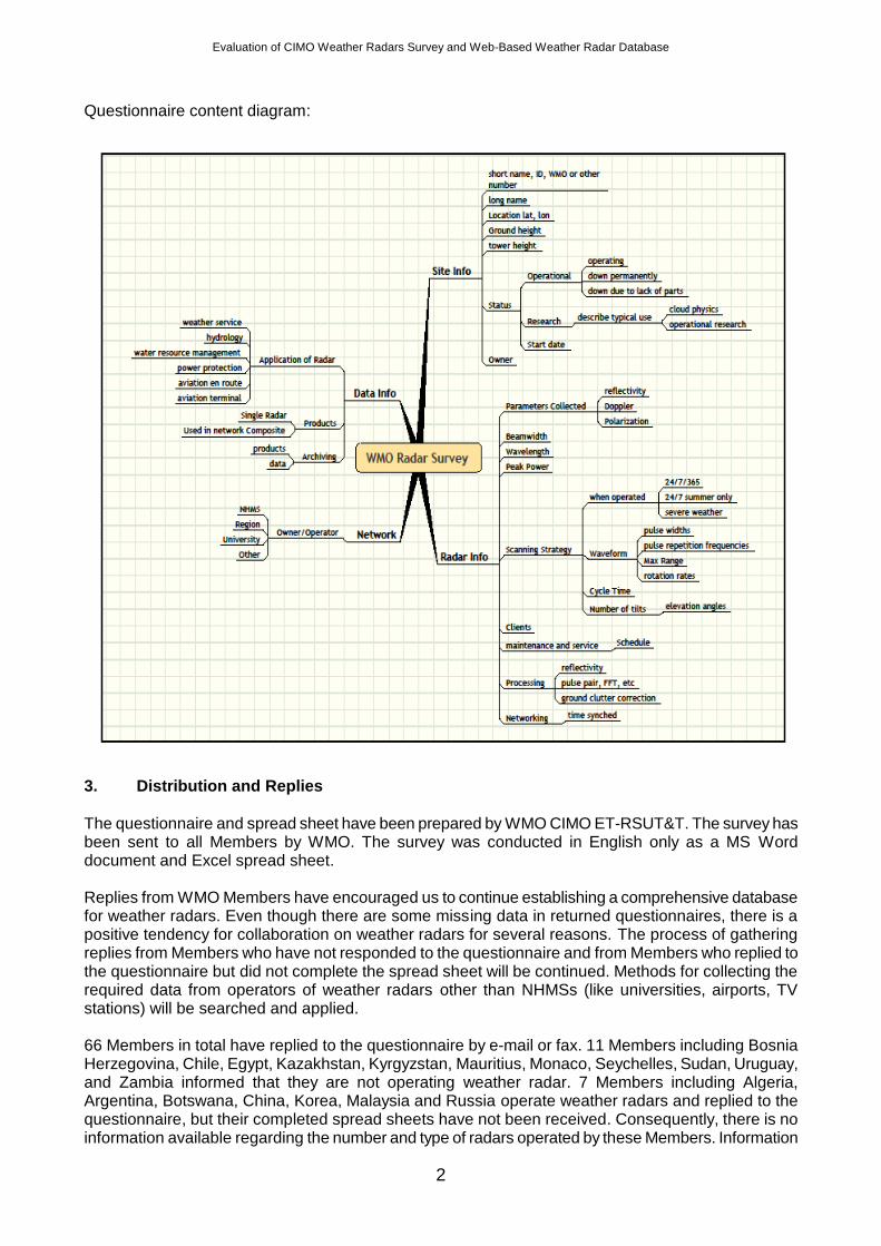
Questionnaire content diagram:
3. Distribution and Replies
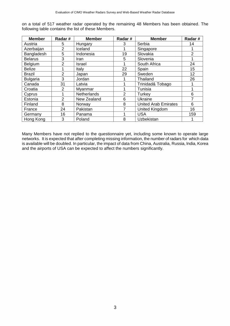
The questionnaire and spread sheet have been prepared by WMO CIMO ET-RSUT&T. The survey has been sent to all Members by WMO. The survey was conducted in English only as a MS Word document and Excel spread sheet. Replies from WMO Members have encouraged us to continue establishing a comprehensive database for weather radars. Even though there are some missing data in returned questionnaires, there is a positive tendency for collaboration on weather radars for several reasons. The process of gathering replies from Members who have not responded to the questionnaire and from Members who replied to the questionnaire but did not complete the spread sheet will be continued. Methods for collecting the required data from operators of weather radars other than NHMSs (like universities, airports, TV stations) will be searched and applied. 66 Members in total have replied to the questionnaire by e-mail or fax. 11 Members including Bosnia Herzegovina, Chile, Egypt, Kazakhstan, Kyrgyzstan, Mauritius, Monaco, Seychelles, Sudan, Uruguay, and Zambia informed that they are not operating weather radar. 7 Members including Algeria, Argentina, Botswana, China, Korea, Malaysia and Russia operate weather radars and replied to the questionnaire, but their completed spread sheets have not been received. Consequently, there is no information available regarding the number and type of radars operated by these Members. Information
Evaluation of CIMO Weather Radars Survey and Web-Based Weather Radar Database
3
on a total of 517 weather radar operated by the remaining 48 Members has been obtained. The following table contains the list of these Members.
Member Radar # Member Radar # Member Radar #
Austria 5 Hungary 3 Serbia 14
Azerbaijan 2 Iceland 1 Singapore 1
Bangladesh 5 Indonesia 19 Slovakia 2
Belarus 3 Iran 5 Slovenia 1
Belgium 2 Israel 1 South Africa 24
Belize 1 Italy 22 Spain 15
Brazil 2 Japan 29 Sweden 12
Bulgaria 3 Jordan 1 Thailand 26
Canada 31 Latvia 1 Trinidad& Tobago 1
Croatia 2 Myanmar 1 Tunisia 1
Cyprus 1 Netherlands 2 Turkey 6
Estonia 2 New Zealand 6 Ukraine 7
Finland 8 Norway 8 United Arab Emirates 6
France 24 Pakistan 7 United Kingdom 16
Germany 16 Panama 1 USA 159
Hong Kong 3 Poland 8 Uzbekistan 1
Many Members have not replied to the questionnaire yet, including some known to operate large networks. It is expected that after completing missing information, the number of radars for which data is available will be doubled. In particular, the impact of data from China, Australia, Russia, India, Korea and the airports of USA can be expected to affect the numbers significantly.
Evaluation of CIMO Weather Radars Survey and Web-Based Weather Radar Database
4
4. Evaluation of Questionnaire Replies
This initial analysis was performed manually. Further analysis will be able to be realized automatically after all data is stored in the database. The survey results are presented in the form of graphs of the statistics related to each question. Key findings have been presented whenever it’s possible after each question. For pie charts, statistics are provided relative to the number of replies unless otherwise specified.
Question 1 and 1.1: Member and Institution/Organization Name
Member and Organization information has been gathered by these questions.
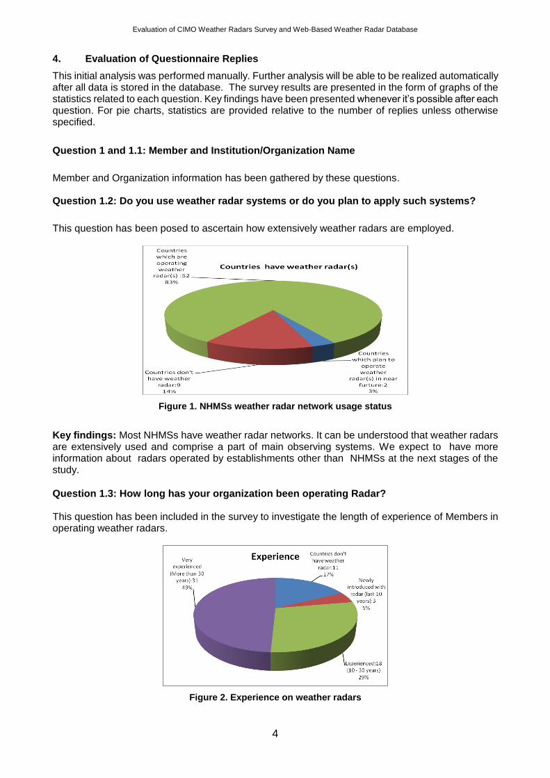
Question 1.2: Do you use weather radar systems or do you plan to apply such systems?
This question has been posed to ascertain how extensively weather radars are employed.
Figure 1. NHMSs weather radar network usage status
Key findings: Most NHMSs have weather radar networks. It can be understood that weather radars are extensively used and comprise a part of main observing systems. We expect to have more information about radars operated by establishments other than NHMSs at the next stages of the study.
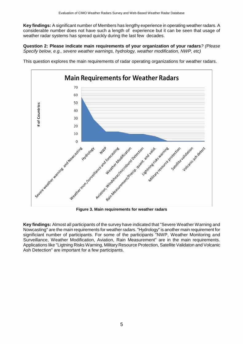
Question 1.3: How long has your organization been operating Radar? This question has been included in the survey to investigate the length of experience of Members in operating weather radars.
Figure 2. Experience on weather radars
Evaluation of CIMO Weather Radars Survey and Web-Based Weather Radar Database
5
Key findings: A significant number of Members has lengthy experience in operating weather radars. A considerable number does not have such a length of experience but it can be seen that usage of weather radar systems has spread quickly during the last few decades.
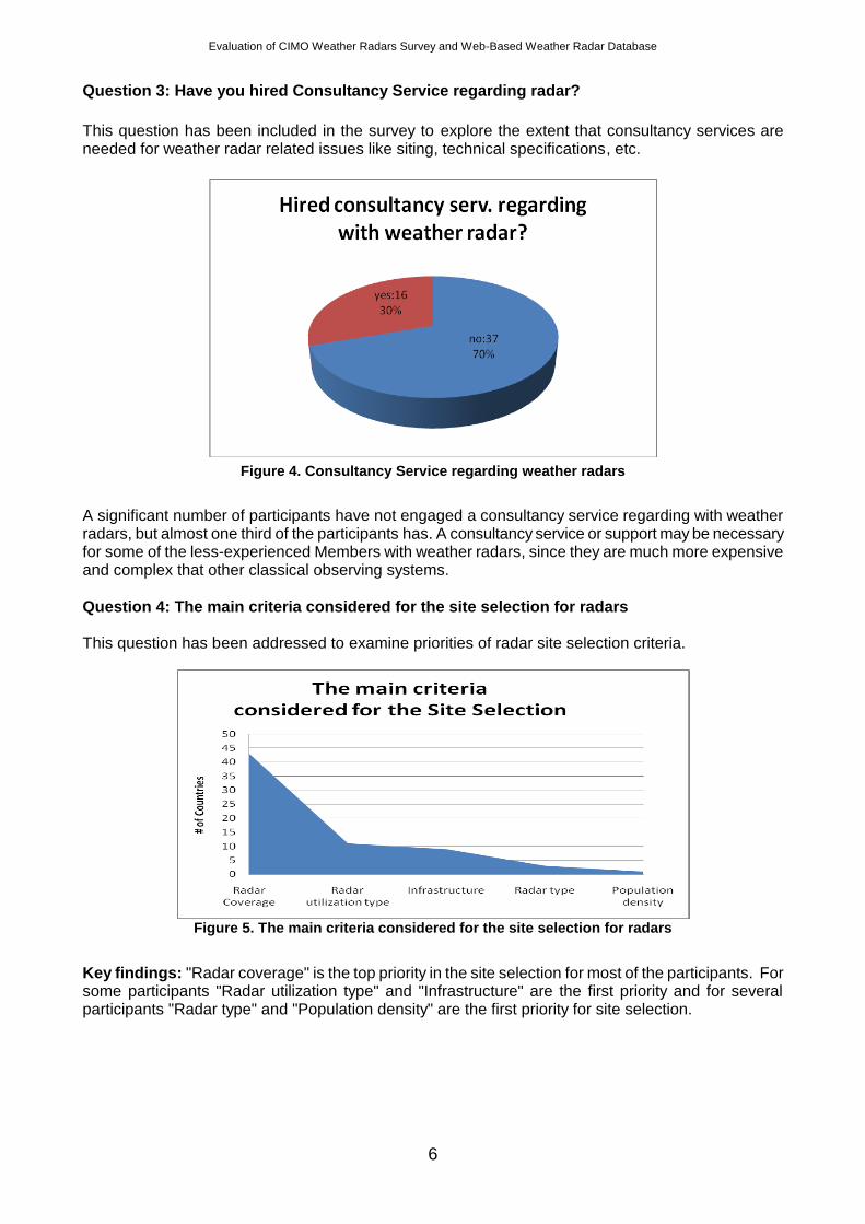
Question 2: Please indicate main requirements of your organization of your radars? (Please Specify below, e.g., severe weather warnings, hydrology, weather modification, NWP, etc) This question explores the main requirements of radar operating organizations for weather radars.
Figure 3. Main requirements for weather radars
Key findings: Almost all participants of the survey have indicated that "Severe Weather Warning and Nowcasting" are the main requirements for weather radars. "Hydrology" is another main requirement for significiant number of participants. For some of the participants "NWP, Weather Monitoring and Surveillance, Weather Modification, Aviation, Rain Measurement" are in the main requirements. Applications like "Ligtning Risks Warning, Military Resource Protection, Satellite Validaton and Volcanic Ash Detection" are important for a few participants.
Evaluation of CIMO Weather Radars Survey and Web-Based Weather Radar Database
6
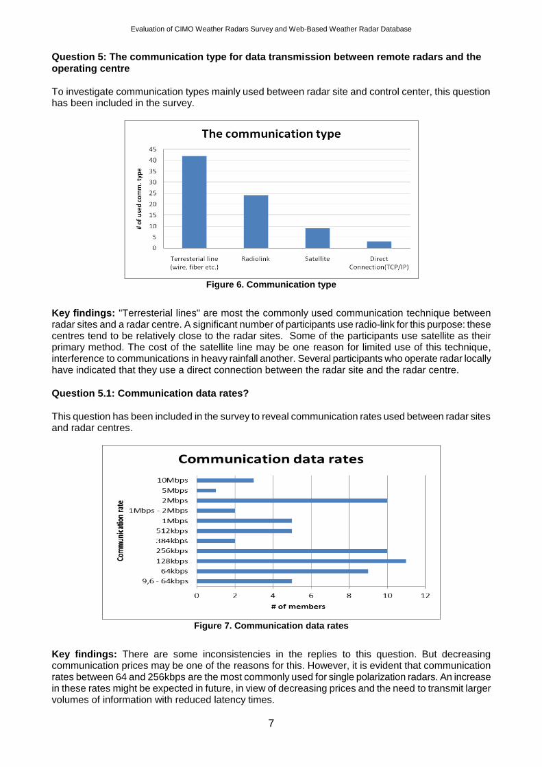
Question 3: Have you hired Consultancy Service regarding radar?
This question has been included in the survey to explore the extent that consultancy services are needed for weather radar related issues like siting, technical specifications, etc.
Figure 4. Consultancy Service regarding weather radars
A significant number of participants have not engaged a consultancy service regarding with weather radars, but almost one third of the participants has. A consultancy service or support may be necessary for some of the less-experienced Members with weather radars, since they are much more expensive and complex that other classical observing systems.
Question 4: The main criteria considered for the site selection for radars This question has been addressed to examine priorities of radar site selection criteria.
Figure 5. The main criteria considered for the site selection for radars
Key findings: "Radar coverage" is the top priority in the site selection for most of the participants. For some participants "Radar utilization type" and "Infrastructure" are the first priority and for several participants "Radar type" and "Population density" are the first priority for site selection.
Evaluation of CIMO Weather Radars Survey and Web-Based Weather Radar Database
7
Question 5: The communication type for data transmission between remote radars and the
operating centre To investigate communication types mainly used between radar site and control center, this question has been included in the survey.
Figure 6. Communication type
Key findings: "Terresterial lines" are most the commonly used communication technique between radar sites and a radar centre. A significant number of participants use radio-link for this purpose: these centres tend to be relatively close to the radar sites. Some of the participants use satellite as their primary method. The cost of the satellite line may be one reason for limited use of this technique, interference to communications in heavy rainfall another. Several participants who operate radar locally have indicated that they use a direct connection between the radar site and the radar centre.
Question 5.1: Communication data rates?
This question has been included in the survey to reveal communication rates used between radar sites and radar centres.
Figure 7. Communication data rates
Key findings: There are some inconsistencies in the replies to this question. But decreasing communication prices may be one of the reasons for this. However, it is evident that communication rates between 64 and 256kbps are the most commonly used for single polarization radars. An increase in these rates might be expected in future, in view of decreasing prices and the need to transmit larger volumes of information with reduced latency times.
Evaluation of CIMO Weather Radars Survey and Web-Based Weather Radar Database
8
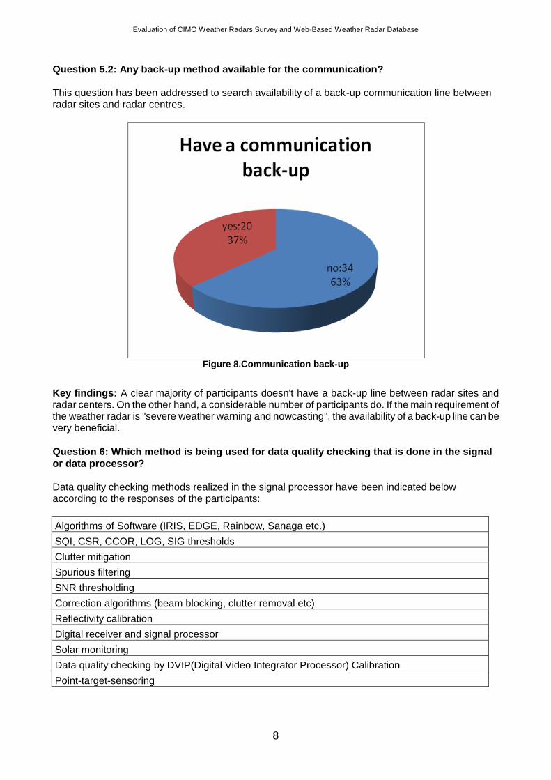
Question 5.2: Any back-up method available for the communication?
This question has been addressed to search availability of a back-up communication line between radar sites and radar centres.
Figure 8.Communication back-up
Key findings: A clear majority of participants doesn't have a back-up line between radar sites and radar centers. On the other hand, a considerable number of participants do. If the main requirement of the weather radar is "severe weather warning and nowcasting", the availability of a back-up line can be very beneficial.
Question 6: Which method is being used for data quality checking that is done in the signal
or data processor?
Data quality checking methods realized in the signal processor have been indicated below according to the responses of the participants:
Algorithms of Software (IRIS, EDGE, Rainbow, Sanaga etc.)
SQI, CSR, CCOR, LOG, SIG thresholds
Clutter mitigation
Spurious filtering
SNR thresholding
Correction algorithms (beam blocking, clutter removal etc)
Reflectivity calibration
Digital receiver and signal processor
Solar monitoring
Data quality checking by DVIP(Digital Video Integrator Processor) Calibration
Point-target-sensoring
Evaluation of CIMO Weather Radars Survey and Web-Based Weather Radar Database
9
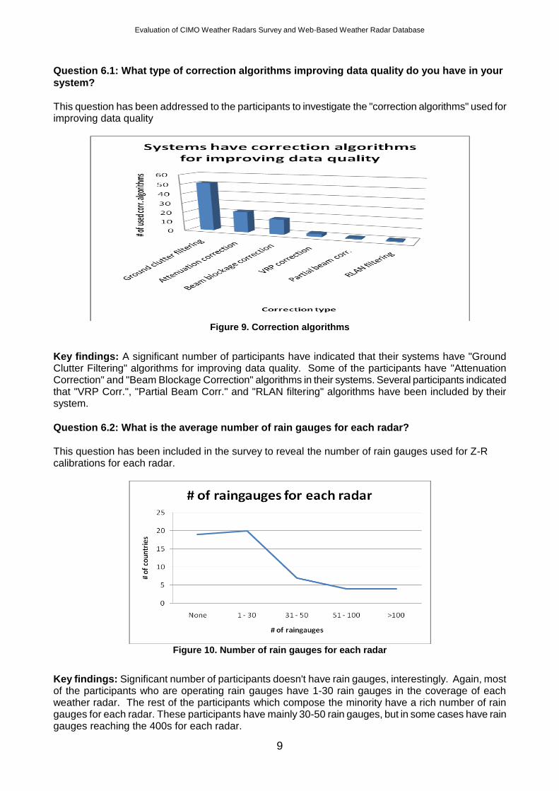
Question 6.1: What type of correction algorithms improving data quality do you have in your
system?
This question has been addressed to the participants to investigate the "correction algorithms" used for improving data quality
Figure 9. Correction algorithms
Key findings: A significant number of participants have indicated that their systems have "Ground Clutter Filtering" algorithms for improving data quality. Some of the participants have "Attenuation Correction" and "Beam Blockage Correction" algorithms in their systems. Several participants indicated that "VRP Corr.", "Partial Beam Corr." and "RLAN filtering" algorithms have been included by their system.
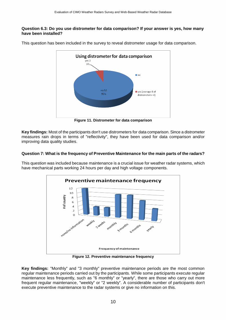
Question 6.2: What is the average number of rain gauges for each radar?
This question has been included in the survey to reveal the number of rain gauges used for Z-R calibrations for each radar.
Figure 10. Number of rain gauges for each radar
Key findings: Significant number of participants doesn't have rain gauges, interestingly. Again, most of the participants who are operating rain gauges have 1-30 rain gauges in the coverage of each weather radar. The rest of the participants which compose the minority have a rich number of rain gauges for each radar. These participants have mainly 30-50 rain gauges, but in some cases have rain gauges reaching the 400s for each radar.
Evaluation of CIMO Weather Radars Survey and Web-Based Weather Radar Database
10
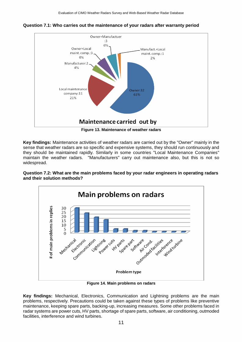
Question 6.3: Do you use distrometer for data comparison? If your answer is yes, how many
have been installed?
This question has been included in the survey to reveal distrometer usage for data comparison.
Figure 11. Distrometer for data comparison
Key findings: Most of the participants don't use distrometers for data comparison. Since a distrometer measures rain drops in terms of "reflectivity", they have been used for data comparison and/or improving data quality studies.
Question 7: What is the frequency of Preventive Maintenance for the main parts of the radars?
This question was included because maintenance is a crucial issue for weather radar systems, which have mechanical parts working 24 hours per day and high voltage components.
Figure 12. Preventive maintenance frequency
Key findings: "Monthly" and "3 monthly" preventive maintenance periods are the most common regular maintenance periods carried out by the participants. While some participants execute regular maintenance less frequently, such as "6 monthly" or "yearly", there are those who carry out more frequent regular maintenance, "weekly" or "2 weekly". A considerable number of participants don't execute preventive maintenance to the radar systems or give no information on this.
Evaluation of CIMO Weather Radars Survey and Web-Based Weather Radar Database
11
Question 7.1: Who carries out the maintenance of your radars after warranty period
Figure 13. Maintenance of weather radars
Key findings: Maintenance activities of weather radars are carried out by the "Owner" mainly in the sense that weather radars are so specific and expensive systems, they should run continuously and they should be maintained rapidly. Similarly in some countries "Local Maintenance Companies" maintain the weather radars. "Manufacturers" carry out maintenance also, but this is not so widespread.
Question 7.2: What are the main problems faced by your radar engineers in operating radars
and their solution methods?
Figure 14. Main problems on radars
Key findings: Mechanical, Electronics, Communication and Lightning problems are the main problems, respectively. Precautions could be taken against these types of problems like preventive maintenance, keeping spare parts, backing-up, increasing measures. Some other problems faced in radar systems are power cuts, HV parts, shortage of spare parts, software, air conditioning, outmoded facilities, interference and wind turbines.
Evaluation of CIMO Weather Radars Survey and Web-Based Weather Radar Database
12
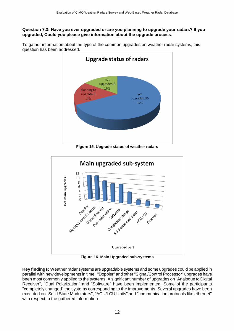
Question 7.3: Have you ever upgraded or are you planning to upgrade your radars? If you
upgraded, Could you please give information about the upgrade process.
To gather information about the type of the common upgrades on weather radar systems, this question has been addressed.
Figure 15. Upgrade status of weather radars
Figure 16. Main Upgraded sub-systems
Key findings: Weather radar systems are upgradable systems and some upgrades could be applied in parallel with new developments in time. "Doppler" and other "Signal/Control Processor" upgrades have been most commonly applied to the systems. A significant number of upgrades on "Analogue to Digital Receiver", "Dual Polarization" and "Software" have been implemented. Some of the participants "completely changed" the systems corresponding to the improvements. Several upgrades have been executed on "Solid State Modulators", "ACU/LCU Units" and "communication protocols like ethernet" with respect to the gathered information.
Evaluation of CIMO Weather Radars Survey and Web-Based Weather Radar Database
13
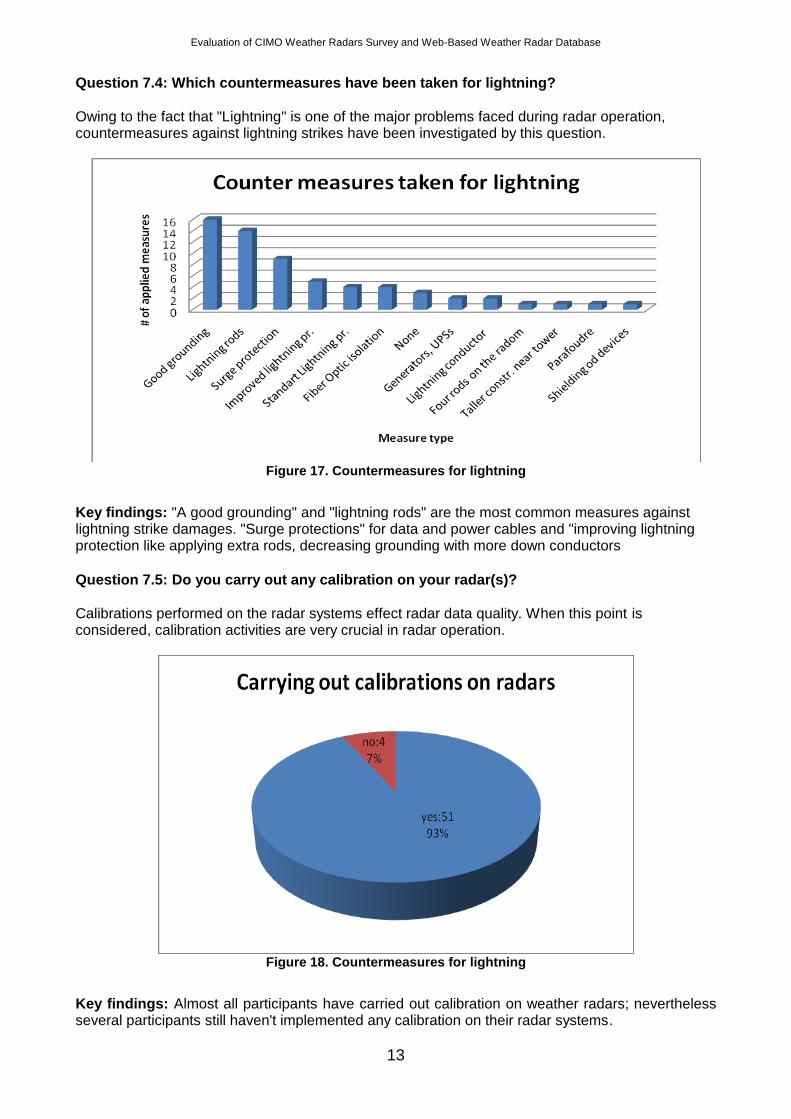
Question 7.4: Which countermeasures have been taken for lightning?
Owing to the fact that "Lightning" is one of the major problems faced during radar operation, countermeasures against lightning strikes have been investigated by this question.
Figure 17. Countermeasures for lightning
Key findings: "A good grounding" and "lightning rods" are the most common measures against lightning strike damages. "Surge protections" for data and power cables and "improving lightning protection like applying extra rods, decreasing grounding with more down conductors
Question 7.5: Do you carry out any calibration on your radar(s)?
Calibrations performed on the radar systems effect radar data quality. When this point is considered, calibration activities are very crucial in radar operation.
Figure 18. Countermeasures for lightning
Key findings: Almost all participants have carried out calibration on weather radars; nevertheless several participants still haven't implemented any calibration on their radar systems.
Evaluation of CIMO Weather Radars Survey and Web-Based Weather Radar Database
14
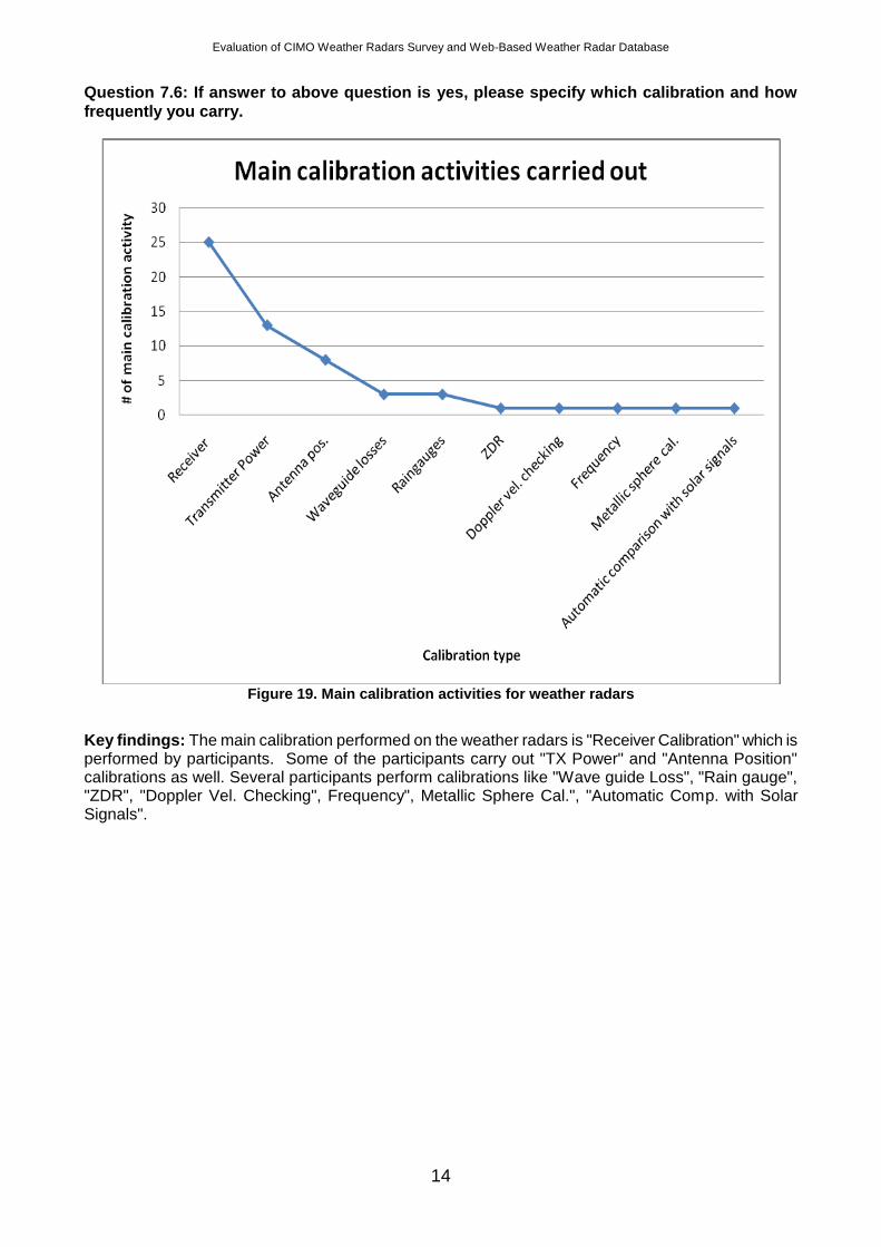
Question 7.6: If answer to above question is yes, please specify which calibration and how
frequently you carry.
Figure 19. Main calibration activities for weather radars
Key findings: The main calibration performed on the weather radars is "Receiver Calibration" which is performed by participants. Some of the participants carry out "TX Power" and "Antenna Position" calibrations as well. Several participants perform calibrations like "Wave guide Loss", "Rain gauge", "ZDR", "Doppler Vel. Checking", Frequency", Metallic Sphere Cal.", "Automatic Comp. with Solar Signals".
Evaluation of CIMO Weather Radars Survey and Web-Based Weather Radar Database
15
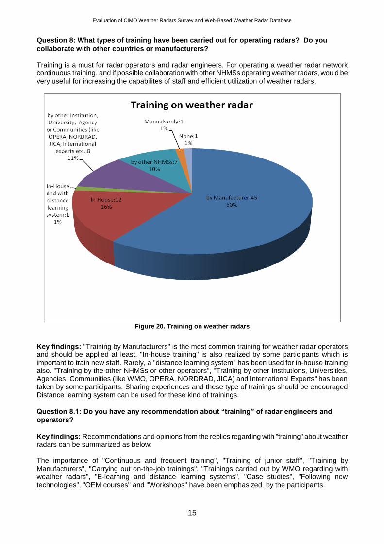
Question 8: What types of training have been carried out for operating radars? Do you
collaborate with other countries or manufacturers?
Training is a must for radar operators and radar engineers. For operating a weather radar network continuous training, and if possible collaboration with other NHMSs operating weather radars, would be very useful for increasing the capabilites of staff and efficient utilization of weather radars.
Figure 20. Training on weather radars
Key findings: "Training by Manufacturers" is the most common training for weather radar operators and should be applied at least. "In-house training" is also realized by some participants which is important to train new staff. Rarely, a "distance learning system" has been used for in-house training also. "Training by the other NHMSs or other operators", "Training by other Institutions, Universities, Agencies, Communities (like WMO, OPERA, NORDRAD, JICA) and International Experts" has been taken by some participants. Sharing experiences and these type of trainings should be encouraged Distance learning system can be used for these kind of trainings.
Question 8.1: Do you have any recommendation about “training” of radar engineers and
operators?
Key findings: Recommendations and opinions from the replies regarding with "training" about weather radars can be summarized as below: The importance of "Continuous and frequent training", "Training of junior staff", "Training by Manufacturers", "Carrying out on-the-job trainings", "Trainings carried out by WMO regarding with weather radars", "E-learning and distance learning systems", "Case studies", "Following new technologies", "OEM courses" and "Workshops" have been emphasized by the participants.
Evaluation of CIMO Weather Radars Survey and Web-Based Weather Radar Database
16
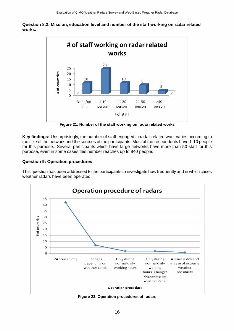
Question 8.2: Mission, education level and number of the staff working on radar related
works.
Figure 21. Number of the staff working on radar related works
Key findings: Unsurprisingly, the number of staff engaged in radar-related work varies according to the size of the network and the sources of the participants. Most of the respondents have 1-10 people for this purpose.. Several participants which have large networks have more than 50 staff for this purpose, even in some cases this number reaches up to 840 people.
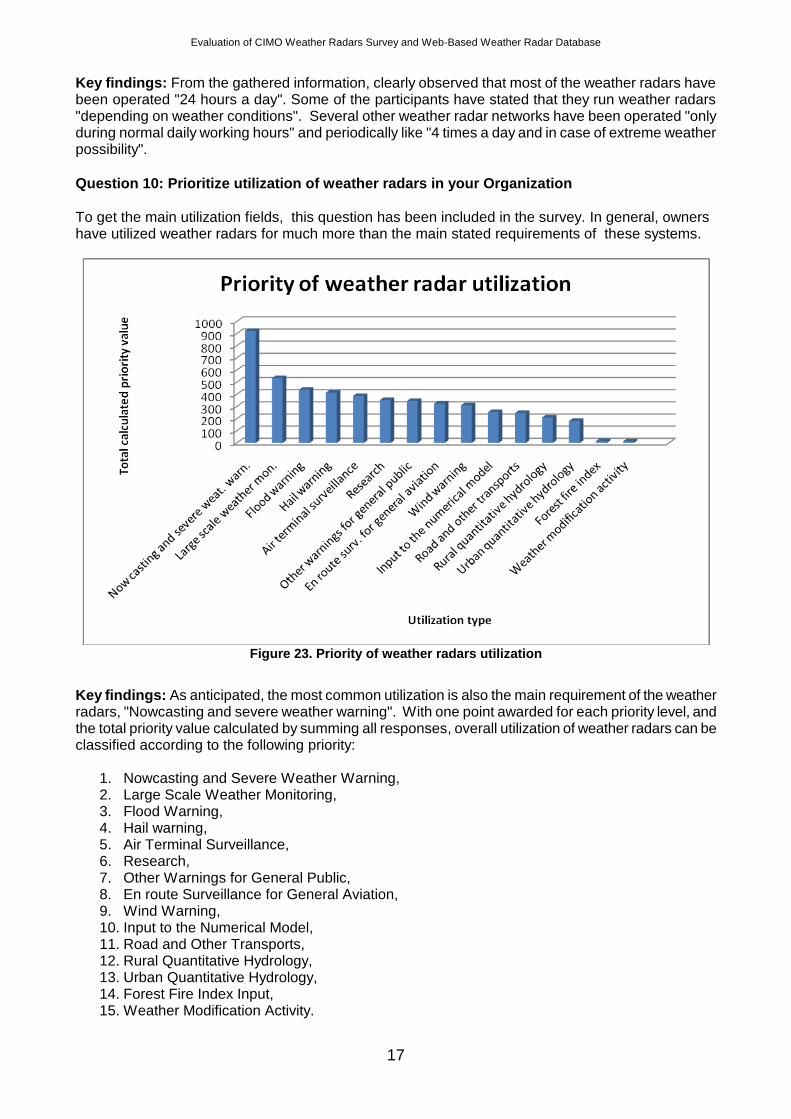
Question 9: Operation procedures
This question has been addressed to the participants to investigate how frequently and in which cases weather radars have been operated.
Figure 22. Operation procedures of radars
Evaluation of CIMO Weather Radars Survey and Web-Based Weather Radar Database
17
Key findings: From the gathered information, clearly observed that most of the weather radars have been operated "24 hours a day". Some of the participants have stated that they run weather radars "depending on weather conditions". Several other weather radar networks have been operated "only during normal daily working hours" and periodically like "4 times a day and in case of extreme weather possibility".
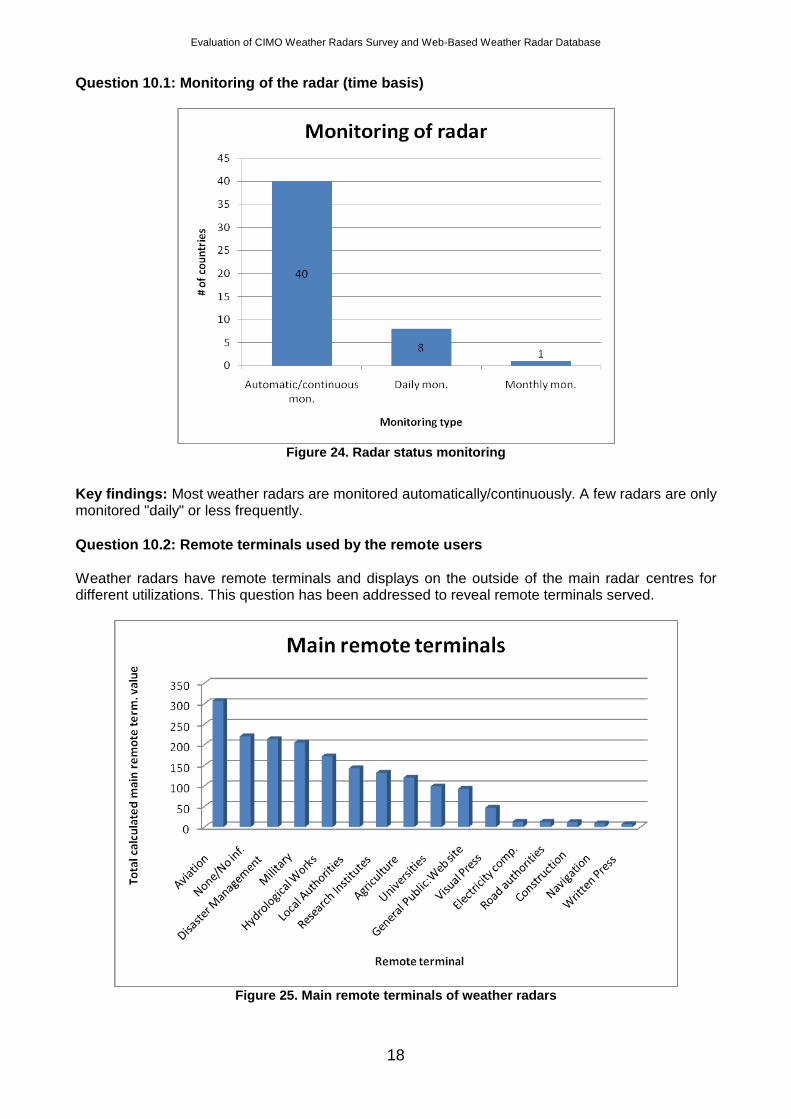
Question 10: Prioritize utilization of weather radars in your Organization
To get the main utilization fields, this question has been included in the survey. In general, owners have utilized weather radars for much more than the main stated requirements of these systems.
Figure 23. Priority of weather radars utilization
Key findings: As anticipated, the most common utilization is also the main requirement of the weather radars, "Nowcasting and severe weather warning". With one point awarded for each priority level, and the total priority value calculated by summing all responses, overall utilization of weather radars can be classified according to the following priority:
1. Nowcasting and Severe Weather Warning, 2. Large Scale Weather Monitoring, 3. Flood Warning, 4. Hail warning, 5. Air Terminal Surveillance, 6. Research, 7. Other Warnings for General Public, 8. En route Surveillance for General Aviation, 9. Wind Warning, 10. Input to the Numerical Model, 11. Road and Other Transports, 12. Rural Quantitative Hydrology, 13. Urban Quantitative Hydrology, 14. Forest Fire Index Input, 15. Weather Modification Activity.
Evaluation of CIMO Weather Radars Survey and Web-Based Weather Radar Database
18
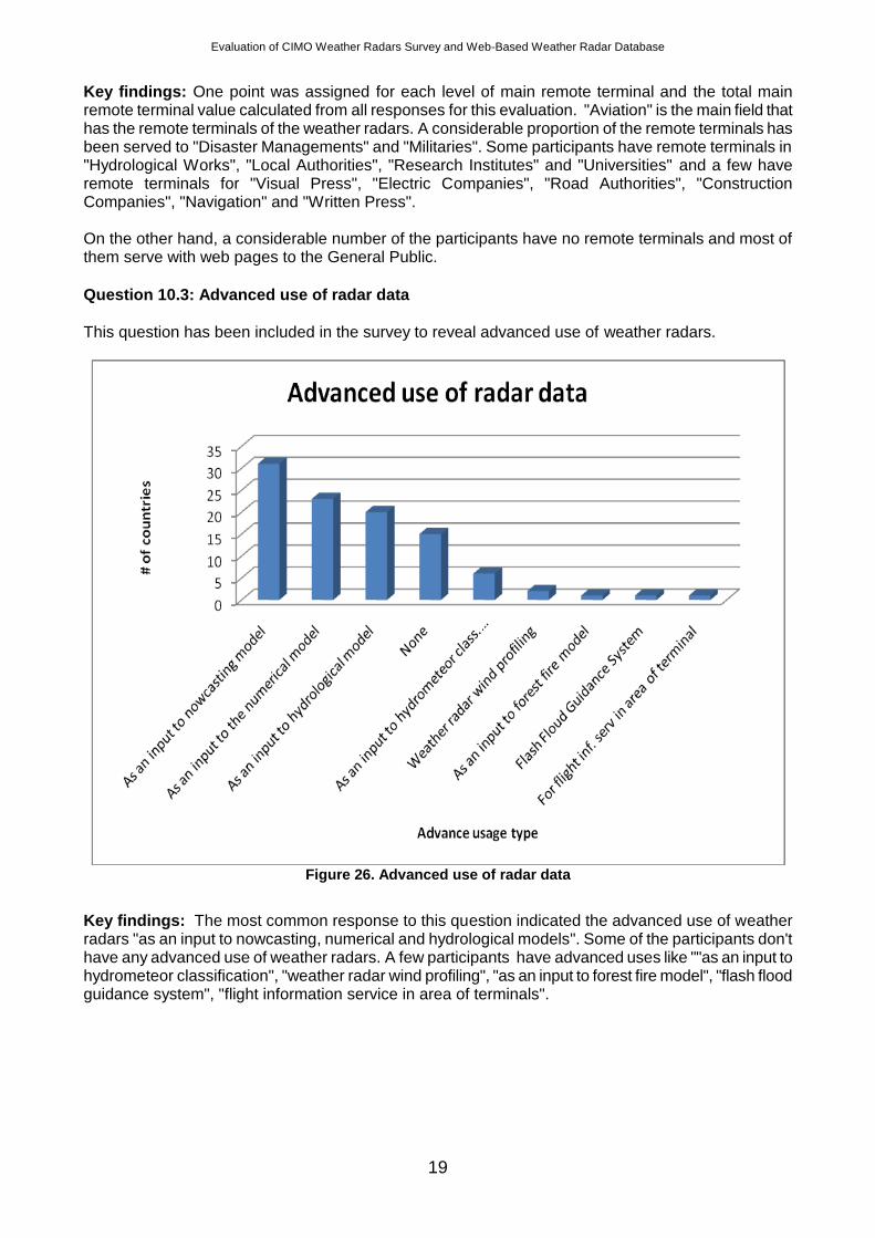
Question 10.1: Monitoring of the radar (time basis)
Figure 24. Radar status monitoring
Key findings: Most weather radars are monitored automatically/continuously. A few radars are only monitored "daily" or less frequently.
Question 10.2: Remote terminals used by the remote users
Weather radars have remote terminals and displays on the outside of the main radar centres for different utilizations. This question has been addressed to reveal remote terminals served.
Figure 25. Main remote terminals of weather radars
Evaluation of CIMO Weather Radars Survey and Web-Based Weather Radar Database
19
Key findings: One point was assigned for each level of main remote terminal and the total main remote terminal value calculated from all responses for this evaluation. "Aviation" is the main field that has the remote terminals of the weather radars. A considerable proportion of the remote terminals has been served to "Disaster Managements" and "Militaries". Some participants have remote terminals in "Hydrological Works", "Local Authorities", "Research Institutes" and "Universities" and a few have remote terminals for "Visual Press", "Electric Companies", "Road Authorities", "Construction Companies", "Navigation" and "Written Press". On the other hand, a considerable number of the participants have no remote terminals and most of them serve with web pages to the General Public.
Question 10.3: Advanced use of radar data
This question has been included in the survey to reveal advanced use of weather radars.
Figure 26. Advanced use of radar data
Key findings: The most common response to this question indicated the advanced use of weather radars "as an input to nowcasting, numerical and hydrological models". Some of the participants don't have any advanced use of weather radars. A few participants have advanced uses like ""as an input to hydrometeor classification", "weather radar wind profiling", "as an input to forest fire model", "flash flood guidance system", "flight information service in area of terminals".
Evaluation of CIMO Weather Radars Survey and Web-Based Weather Radar Database
20
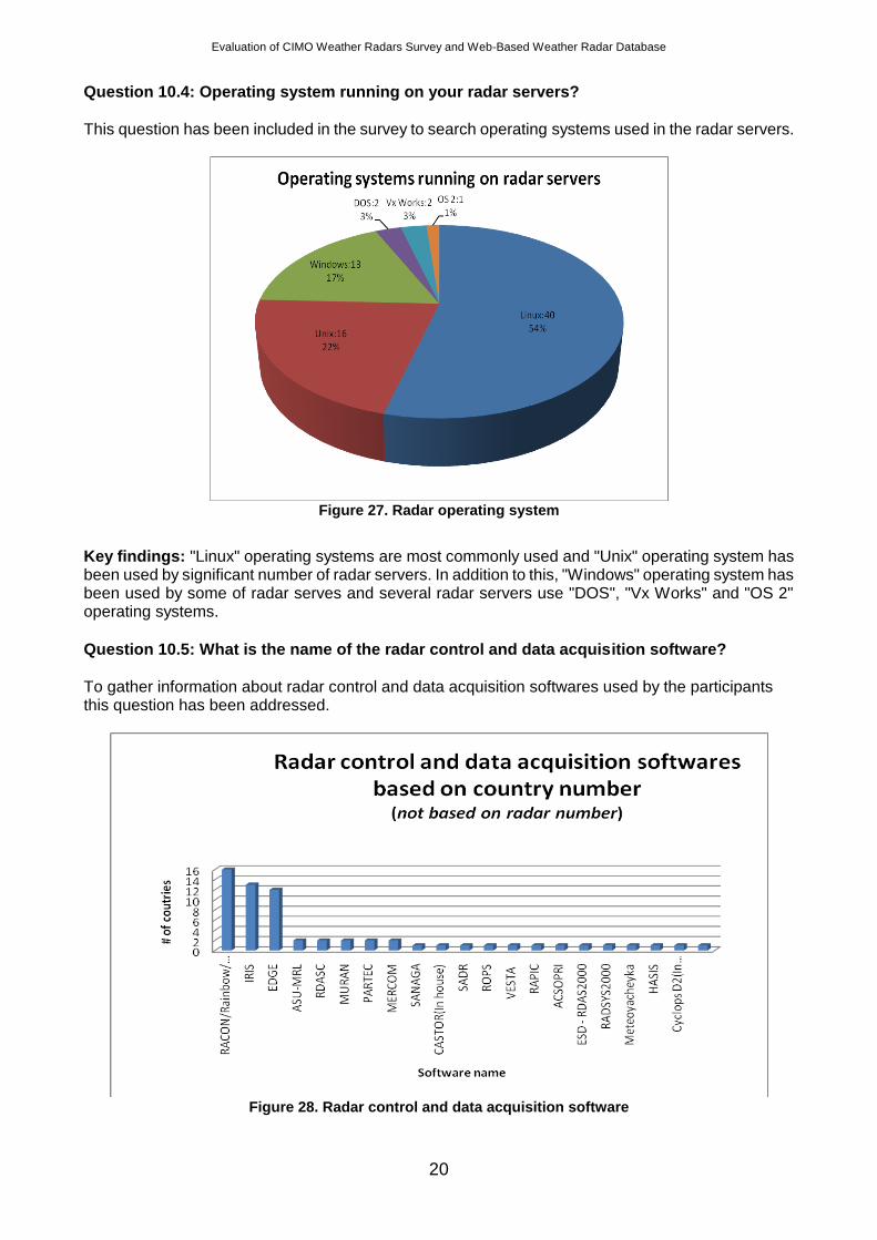
Question 10.4: Operating system running on your radar servers?
This question has been included in the survey to search operating systems used in the radar servers.
Figure 27. Radar operating system
Key findings: "Linux" operating systems are most commonly used and "Unix" operating system has been used by significant number of radar servers. In addition to this, "Windows" operating system has been used by some of radar serves and several radar servers use "DOS", "Vx Works" and "OS 2" operating systems.
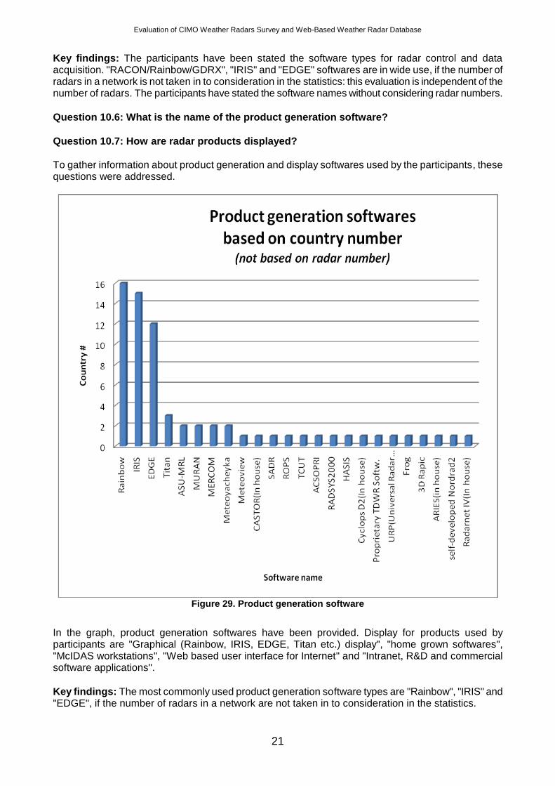
Question 10.5: What is the name of the radar control and data acquisition software?
To gather information about radar control and data acquisition softwares used by the participants this question has been addressed.
Figure 28. Radar control and data acquisition software
Evaluation of CIMO Weather Radars Survey and Web-Based Weather Radar Database
21
Key findings: The participants have been stated the software types for radar control and data acquisition. "RACON/Rainbow/GDRX", "IRIS" and "EDGE" softwares are in wide use, if the number of radars in a network is not taken in to consideration in the statistics: this evaluation is independent of the number of radars. The participants have stated the software names without considering radar numbers.
Question 10.6: What is the name of the product generation software?
Question 10.7: How are radar products displayed?
To gather information about product generation and display softwares used by the participants, these questions were addressed.
Figure 29. Product generation software
In the graph, product generation softwares have been provided. Display for products used by participants are "Graphical (Rainbow, IRIS, EDGE, Titan etc.) display", "home grown softwares", "McIDAS workstations", "Web based user interface for Internet" and "Intranet, R&D and commercial software applications".
Key findings: The most commonly used product generation software types are "Rainbow", "IRIS" and "EDGE", if the number of radars in a network are not taken in to consideration in the statistics.
Evaluation of CIMO Weather Radars Survey and Web-Based Weather Radar Database
22
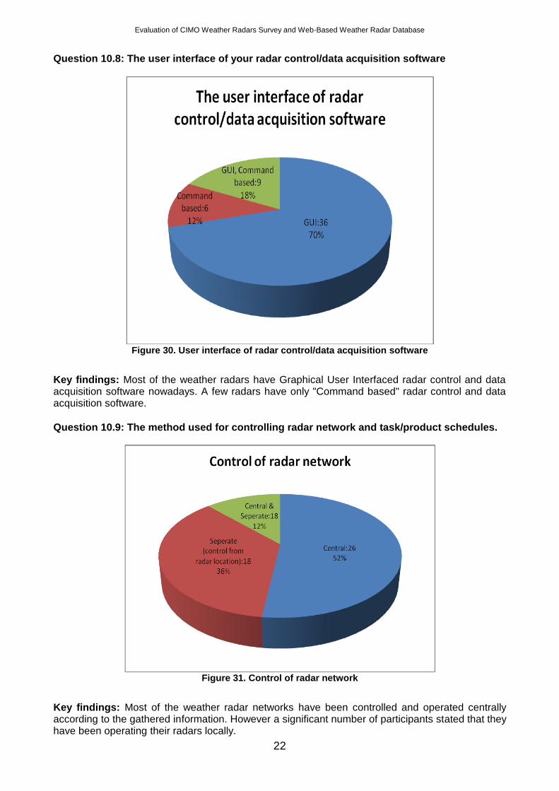
Question 10.8: The user interface of your radar control/data acquisition software
Figure 30. User interface of radar control/data acquisition software
Key findings: Most of the weather radars have Graphical User Interfaced radar control and data acquisition software nowadays. A few radars have only "Command based" radar control and data acquisition software.
Question 10.9: The method used for controlling radar network and task/product schedules.
Figure 31. Control of radar network
Key findings: Most of the weather radar networks have been controlled and operated centrally according to the gathered information. However a significant number of participants stated that they have been operating their radars locally.
Evaluation of CIMO Weather Radars Survey and Web-Based Weather Radar Database
23
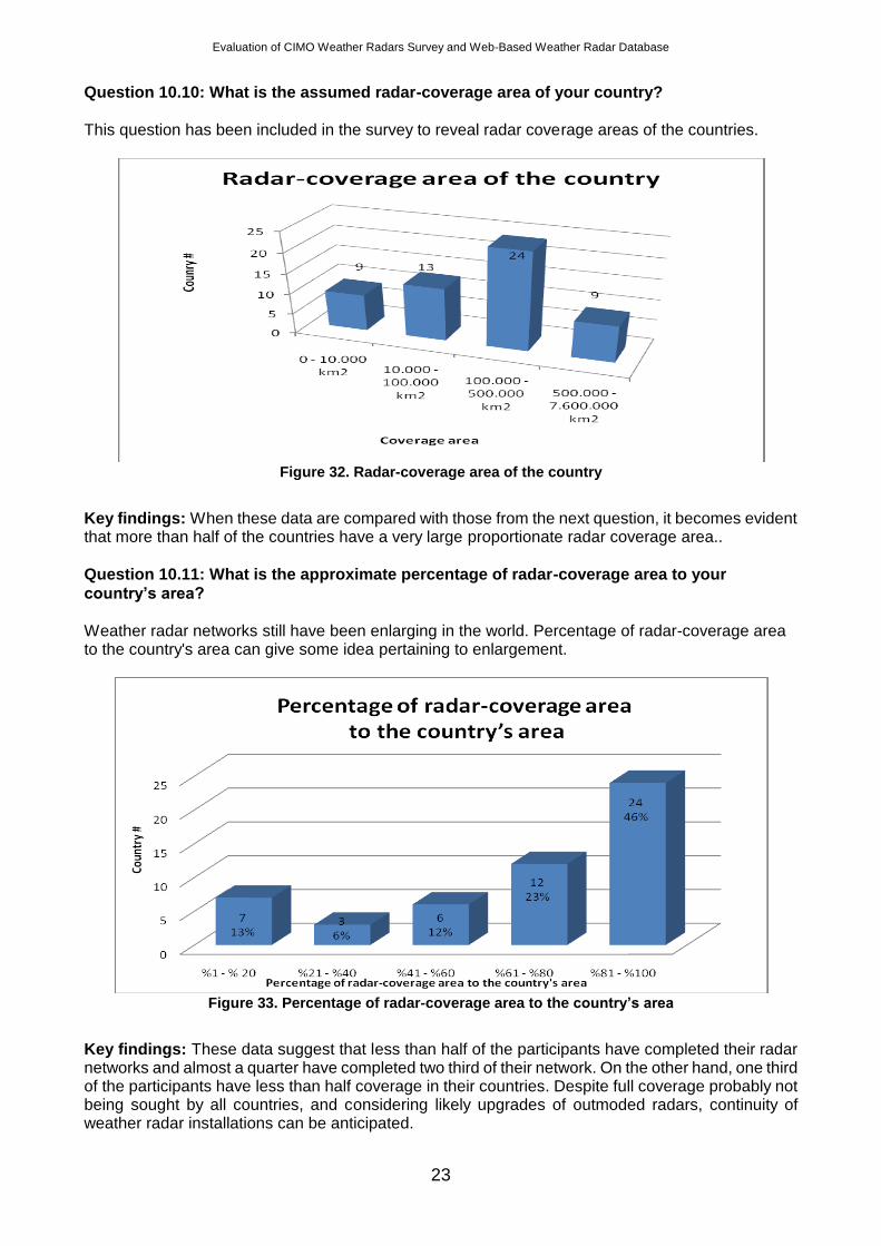
Question 10.10: What is the assumed radar-coverage area of your country?
This question has been included in the survey to reveal radar coverage areas of the countries.
Figure 32. Radar-coverage area of the country
Key findings: When these data are compared with those from the next question, it becomes evident that more than half of the countries have a very large proportionate radar coverage area..
Question 10.11: What is the approximate percentage of radar-coverage area to your
country’s area?
Weather radar networks still have been enlarging in the world. Percentage of radar-coverage area to the country's area can give some idea pertaining to enlargement.
Figure 33. Percentage of radar-coverage area to the country’s area
Key findings: These data suggest that less than half of the participants have completed their radar networks and almost a quarter have completed two third of their network. On the other hand, one third of the participants have less than half coverage in their countries. Despite full coverage probably not being sought by all countries, and considering likely upgrades of outmoded radars, continuity of weather radar installations can be anticipated.
Evaluation of CIMO Weather Radars Survey and Web-Based Weather Radar Database
24
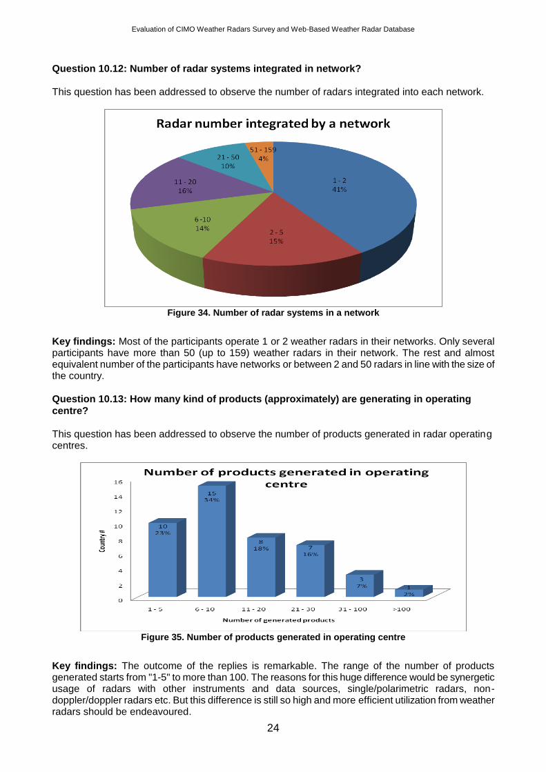
Question 10.12: Number of radar systems integrated in network?
This question has been addressed to observe the number of radars integrated into each network.
Figure 34. Number of radar systems in a network
Key findings: Most of the participants operate 1 or 2 weather radars in their networks. Only several participants have more than 50 (up to 159) weather radars in their network. The rest and almost equivalent number of the participants have networks or between 2 and 50 radars in line with the size of the country.
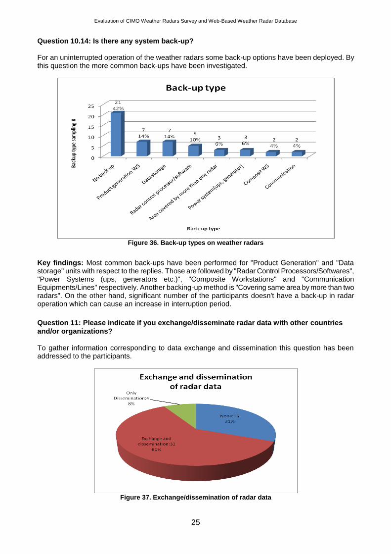
Question 10.13: How many kind of products (approximately) are generating in operating
centre?
This question has been addressed to observe the number of products generated in radar operating centres.
Figure 35. Number of products generated in operating centre
Key findings: The outcome of the replies is remarkable. The range of the number of products generated starts from "1-5" to more than 100. The reasons for this huge difference would be synergetic usage of radars with other instruments and data sources, single/polarimetric radars, non-doppler/doppler radars etc. But this difference is still so high and more efficient utilization from weather radars should be endeavoured.
Evaluation of CIMO Weather Radars Survey and Web-Based Weather Radar Database
25
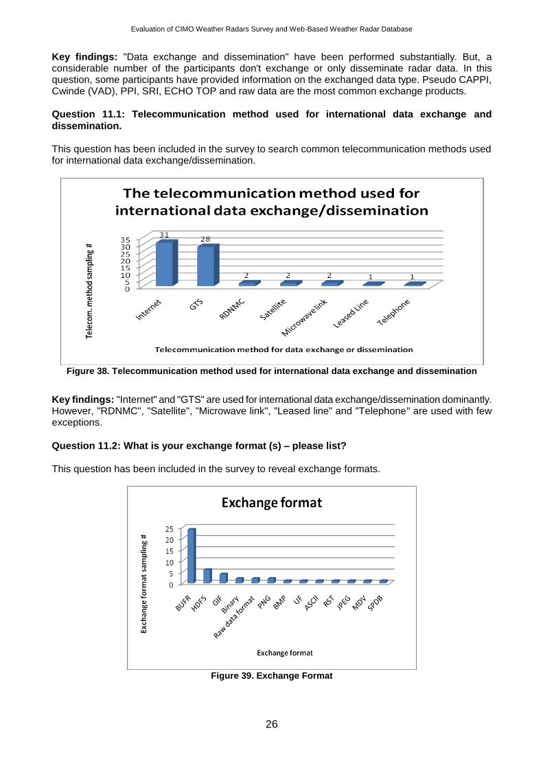
Question 10.14: Is there any system back-up? For an uninterrupted operation of the weather radars some back-up options have been deployed. By this question the more common back-ups have been investigated.
Figure 36. Back-up types on weather radars
Key findings: Most common back-ups have been performed for "Product Generation" and "Data storage" units with respect to the replies. Those are followed by "Radar Control Processors/Softwares", "Power Systems (ups, generators etc.)", "Composite Workstations" and "Communication Equipments/Lines" respectively. Another backing-up method is "Covering same area by more than two radars". On the other hand, significant number of the participants doesn't have a back-up in radar operation which can cause an increase in interruption period.
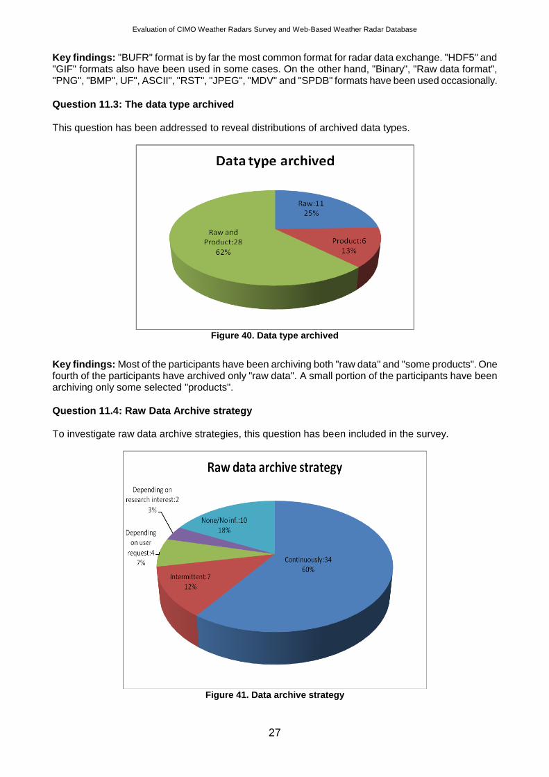
Question 11: Please indicate if you exchange/disseminate radar data with other countries
and/or organizations?
To gather information corresponding to data exchange and dissemination this question has been addressed to the participants.
Figure 37. Exchange/dissemination of radar data
Evaluation of CIMO Weather Radars Survey and Web-Based Weather Radar Database
26
Key findings: "Data exchange and dissemination" have been performed substantially. But, a considerable number of the participants don't exchange or only disseminate radar data. In this question, some participants have provided information on the exchanged data type. Pseudo CAPPI, Cwinde (VAD), PPI, SRI, ECHO TOP and raw data are the most common exchange products.
Question 11.1: Telecommunication method used for international data exchange and
dissemination.
This question has been included in the survey to search common telecommunication methods used for international data exchange/dissemination.
Figure 38. Telecommunication method used for international data exchange and dissemination
Key findings: "Internet" and "GTS" are used for international data exchange/dissemination dominantly. However, "RDNMC", "Satellite", "Microwave link", "Leased line" and "Telephone" are used with few exceptions.
Question 11.2: What is your exchange format (s) – please list?
This question has been included in the survey to reveal exchange formats.
Figure 39. Exchange Format
Evaluation of CIMO Weather Radars Survey and Web-Based Weather Radar Database
27
Key findings: "BUFR" format is by far the most common format for radar data exchange. "HDF5" and "GIF" formats also have been used in some cases. On the other hand, "Binary", "Raw data format", "PNG", "BMP", UF", ASCII", "RST", "JPEG", "MDV" and "SPDB" formats have been used occasionally.
Question 11.3: The data type archived
This question has been addressed to reveal distributions of archived data types.
Figure 40. Data type archived
Key findings: Most of the participants have been archiving both "raw data" and "some products". One fourth of the participants have archived only "raw data". A small portion of the participants have been archiving only some selected "products".
Question 11.4: Raw Data Archive strategy To investigate raw data archive strategies, this question has been included in the survey.
Figure 41. Data archive strategy
Evaluation of CIMO Weather Radars Survey and Web-Based Weather Radar Database
28
Key findings: "Continuous" archiving of raw data is the most common used strategy while a significant number of the participants don't archive raw data. Some of the participants have been archiving raw data "intermittently". Again several participants have been archiving raw data "depending on user request" and "depending on research interest".
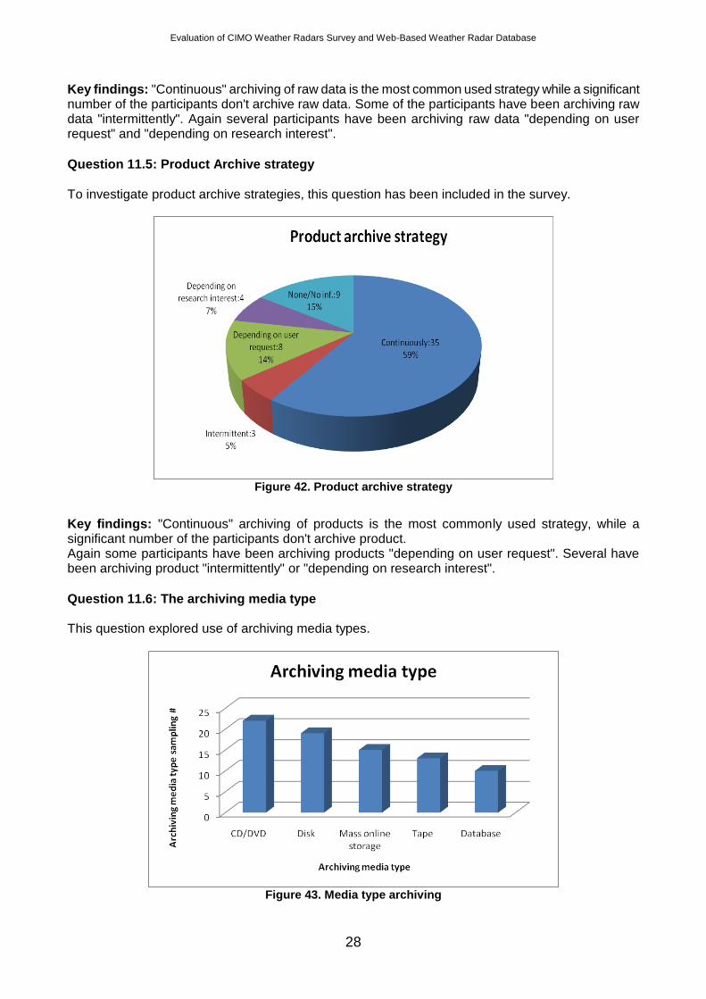
Question 11.5: Product Archive strategy
To investigate product archive strategies, this question has been included in the survey.
Figure 42. Product archive strategy
Key findings: "Continuous" archiving of products is the most commonly used strategy, while a significant number of the participants don't archive product. Again some participants have been archiving products "depending on user request". Several have been archiving product "intermittently" or "depending on research interest".
Question 11.6: The archiving media type This question explored use of archiving media types.
Figure 43. Media type archiving
Evaluation of CIMO Weather Radars Survey and Web-Based Weather Radar Database
29
Key findings: "CD/DVD" and "Disk" media types are the most commonly used for archiving radar data. "Mass online storage", "Tape" and "Database" media types are used.
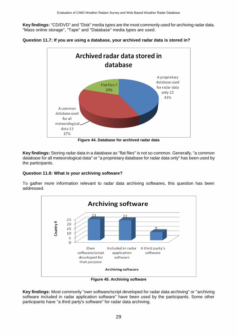
Question 11.7: If you are using a database, your archived radar data is stored in?
Figure 44. Database for archived radar data
Key findings: Storing radar data in a database as "flat files" is not so common. Generally, "a common database for all meteorological data" or "a proprietary database for radar data only" has been used by the participants.
Question 11.8: What is your archiving software?
To gather more information relevant to radar data archiving softwares, this question has been addressed.
Figure 45. Archiving software
Key findings: Most commonly "own software/script developed for radar data archiving" or "archiving software included in radar application software" have been used by the participants. Some other participants have "a third party's software" for radar data archiving.
Evaluation of CIMO Weather Radars Survey and Web-Based Weather Radar Database
30
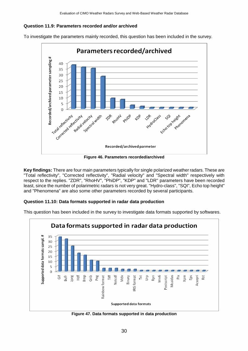
Question 11.9: Parameters recorded and/or archived
To investigate the parameters mainly recorded, this question has been included in the survey.
Figure 46. Parameters recorded/archived
Key findings: There are four main parameters typically for single polarized weather radars. These are "Total reflectivity", "Corrected reflectivity", "Radial velocity" and "Spectral width" respectively with respect to the replies. "ZDR", "RhoHV", "PhiDP", "KDP" and "LDR" parameters have been recorded least, since the number of polarimetric radars is not very great. "Hydro-class", "SQI", Echo top height" and "Phenomena" are also some other parameters recorded by several participants.
Question 11.10: Data formats supported in radar data production This question has been included in the survey to investigate data formats supported by softwares.
Figure 47. Data formats supported in data production
Evaluation of CIMO Weather Radars Survey and Web-Based Weather Radar Database
31
Key findings: "GIF", "BUFR" and "JPEG" are the most widespread formats supported by softwares. "HDF", "BMP", "GRIB" and "PNG" are some other formats considerably supported by softwares. A wide range of formats also supported the softwares listed in the graph.
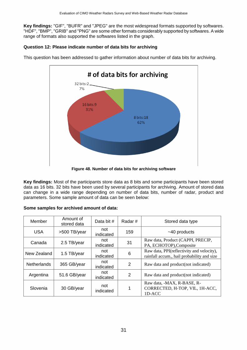
Question 12: Please indicate number of data bits for archiving
This question has been addressed to gather information about number of data bits for archiving.
Figure 48. Number of data bits for archiving software
Key findings: Most of the participants store data as 8 bits and some participants have been stored data as 16 bits. 32 bits have been used by several participants for archiving. Amount of stored data can change in a wide range depending on number of data bits, number of radar, product and parameters. Some sample amount of data can be seen below:
Some samples for archived amount of data:
Member Amount of stored data
Data bit # Radar # Stored data type
USA >500 TB/year not
indicated 159 ~40 products
Canada 2.5 TB/year not
indicated 31
Raw data, Product (CAPPI, PRECIP,
PA, ECHOTOP),Composite
New Zealand 1.5 TB/year not
indicated 6
Raw data, PPI(reflectivity and velocity),
rainfall accum., hail probability and size
Netherlands 365 GB/year not
indicated 2 Raw data and product(not indicated)
Argentina 51.6 GB/year not
indicated 2 Raw data and product(not indicated)
Slovenia 30 GB/year not
indicated 1
Raw data, -MAX, R-BASE, R-
CORRECTED, H-TOP, VIL, 1H-ACC,
1D-ACC
Evaluation of CIMO Weather Radars Survey and Web-Based Weather Radar Database
32
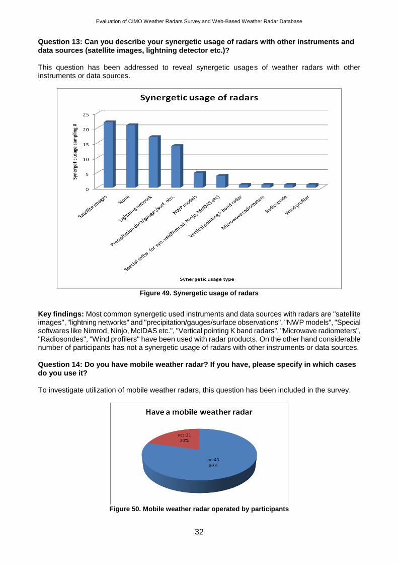
Question 13: Can you describe your synergetic usage of radars with other instruments and
data sources (satellite images, lightning detector etc.)?
This question has been addressed to reveal synergetic usages of weather radars with other instruments or data sources.
Figure 49. Synergetic usage of radars
Key findings: Most common synergetic used instruments and data sources with radars are "satellite images", "lightning networks" and "precipitation/gauges/surface observations". "NWP models", "Special softwares like Nimrod, Ninjo, McIDAS etc.", "Vertical pointing K band radars", "Microwave radiometers", "Radiosondes", "Wind profilers" have been used with radar products. On the other hand considerable number of participants has not a synergetic usage of radars with other instruments or data sources.
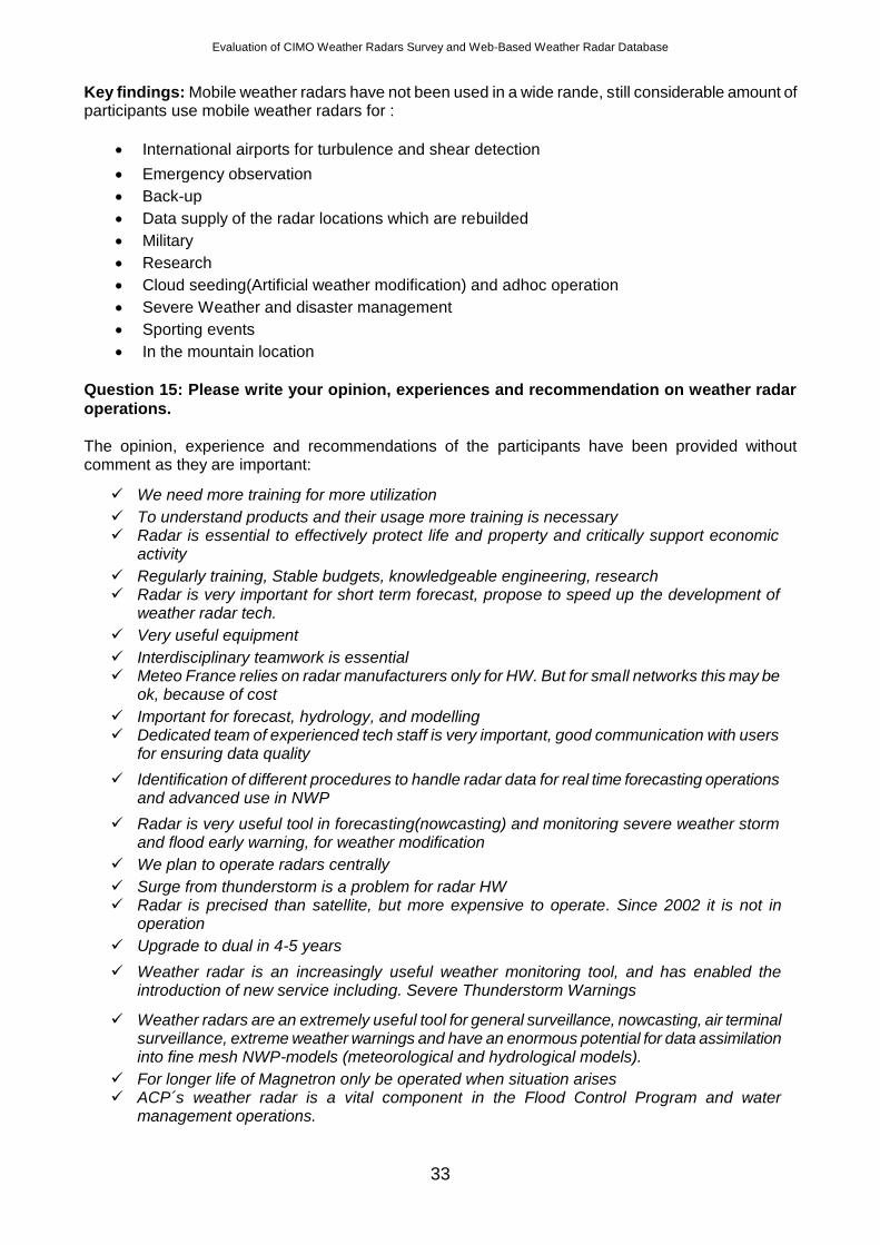
Question 14: Do you have mobile weather radar? If you have, please specify in which cases
do you use it?
To investigate utilization of mobile weather radars, this question has been included in the survey.
Figure 50. Mobile weather radar operated by participants
Evaluation of CIMO Weather Radars Survey and Web-Based Weather Radar Database
33
Key findings: Mobile weather radars have not been used in a wide rande, still considerable amount of participants use mobile weather radars for :
International airports for turbulence and shear detection
Emergency observation
Back-up
Data supply of the radar locations which are rebuilded
Military
Research
Cloud seeding(Artificial weather modification) and adhoc operation
Severe Weather and disaster management
Sporting events
In the mountain location
Question 15: Please write your opinion, experiences and recommendation on weather radar
operations.
The opinion, experience and recommendations of the participants have been provided without comment as they are important:
We plan to operate radars centrally
Surge from thunderstorm is a problem for radar HW Radar is precised than satellite, but more expensive to operate. Since 2002 it is not in
operation
Upgrade to dual in 4-5 years
Weather radar is an increasingly useful weather monitoring tool, and has enabled the introduction of new service including. Severe Thunderstorm Warnings
Weather radars are an extremely useful tool for general surveillance, nowcasting, air terminal surveillance, extreme weather warnings and have an enormous potential for data assimilation into fine mesh NWP-models (meteorological and hydrological models).
For longer life of Magnetron only be operated when situation arises ACP´s weather radar is a vital component in the Flood Control Program and water
management operations.
We need more training for more utilization
To understand products and their usage more training is necessary Radar is essential to effectively protect life and property and critically support economic
activity
Regularly training, Stable budgets, knowledgeable engineering, research Radar is very important for short term forecast, propose to speed up the development of
weather radar tech.
Very useful equipment
Interdisciplinary teamwork is essential Meteo France relies on radar manufacturers only for HW. But for small networks this may be
ok, because of cost
Important for forecast, hydrology, and modelling Dedicated team of experienced tech staff is very important, good communication with users
for ensuring data quality
Identification of different procedures to handle radar data for real time forecasting operations and advanced use in NWP
Radar is very useful tool in forecasting(nowcasting) and monitoring severe weather storm and flood early warning, for weather modification
Evaluation of CIMO Weather Radars Survey and Web-Based Weather Radar Database
34
Weather radars are most effective for nowcasting and are vital for weather modification use. Its value will significant increase in future
We have good experiences in observing convective clouds and measuring their parameters
Necessary 24h/7d operation, volume scan, min. 10minutes interval, automatic radar status monitoring tools, automatic calibration tools
This is very important for aircraft. The information incorporated into networks of radars represents big interest. Radars MRL-1 and MRL-2 which are used should be replaced with modern
Amazing tools that helps the forecaster in prediction accurate forecast and it gives you the ability to issue warning ahead of the event. Moreover very good tools for doing researches too
The WSR-88D network has proven itself to save lives and reduce injuries by helping more than double the tornado lead time from 5 to 13 minutes ( Simons, K. M. and D. Sutter, 2005: WSR-88D radar, tornado warnings, and tornado casualties. Weather Forecasting, 20, 301-310), improving support to the National Airspace System, and aiding the economy. Many important non-meteorological uses for the radar data have evolved such as detecting smoke plumes, tracking bird migrations and habitat usage, and tracking volcanic ash plumes. The distribution of WSR-88D products and raw data in real time has been the basis for increased growth in the commercial weather sector and use by the general public to aid their daily planning and monitoring of severe weather. The use of archived radar products and raw data has been important for developing new and testing and improved meteorological algorithms on the WSR-88D, training radar operators/forecasters, and educating a new generation of meteorologists. The continuous centralized support of the system (WSR-88D Radar Operations Centre, National Logistics Support Centre, National Reconditioning Centre, and the WSR-88D triagencies) is necessary to keep the network operating at peak capability while ensuring the network's maintainability and viability for 25+ years.
Good meteo radar is very useful and necessary
Essential tool for weather monitoring, nowcasting and rainfall measurements Radar data in our case is not used effectively. We have a large network with signification
resolution and accuracy that will only be enhanced by the new systems. There are currently insufficient human resources to dedicate to the analysis and processing of radar data. More research needs to be done for generating products for use by the general public.
Need comprehensive training and calibration
Keeping experienced staff and training of new staff dealing with radars including software, network and hardware people is very important for continuous operation of a radar network. Collaboration with other members which are operating radar is another important issue for sharing good and bad experiences. Sharing information can be achieved regional meetings, trainings, seminars, workshops and conferences. In this scope, regional training centres can be used more effectively and wide spread. Establishing a maintenance plan like training maintenance people, buying spare parts or making maintenance contract with manufacturer or other maintenance company is an important issue too.
Weather radar remains an essential observational system within UK Met Office, especially with respect to the forecasting of severe weather and flooding events. In recent years, technological advances have allowed improvements in many areas, with digital signal processing enabling more data to be extracted from the radar equipment to the benefit of customers. Increased availability and reduced costs of both communications bandwidth and computing power have similarly enabled improvements to the data transferred from site, the degree of processing and the delivery to customer. Advances in remote connectivity has reduced maintenance costs as fault diagnosis, fault resolution and software upgrades can in some cases be carried out from a central location without a requirement to visit sites.
Evaluation of CIMO Weather Radars Survey and Web-Based Weather Radar Database
35
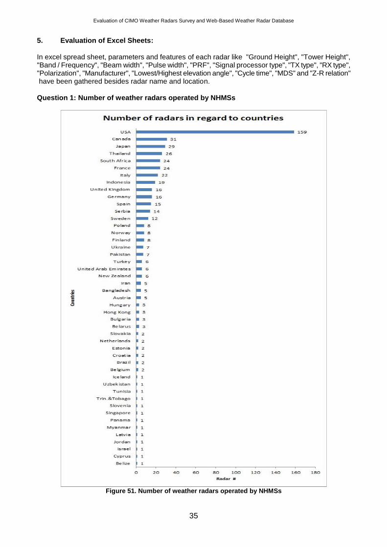
5. Evaluation of Excel Sheets:
In excel spread sheet, parameters and features of each radar like "Ground Height", "Tower Height", "Band / Frequency", "Beam width", "Pulse width", "PRF", "Signal processor type", "TX type", "RX type", "Polarization", "Manufacturer", "Lowest/Highest elevation angle", "Cycle time", "MDS" and "Z-R relation" have been gathered besides radar name and location.
Question 1: Number of weather radars operated by NHMSs
Figure 51. Number of weather radars operated by NHMSs
Evaluation of CIMO Weather Radars Survey and Web-Based Weather Radar Database
36
In accordance with the replies, the number of radars tends to increase with the country’s area, level of development and frequency of exposure to heavy rain. USA has the most number of weather radars used by NOAA, although FAA's weather radars have not been included to the survey yet. After excel sheet of the survey filled by the Members which have large networks like China, Russia etc. the graph will be updated.
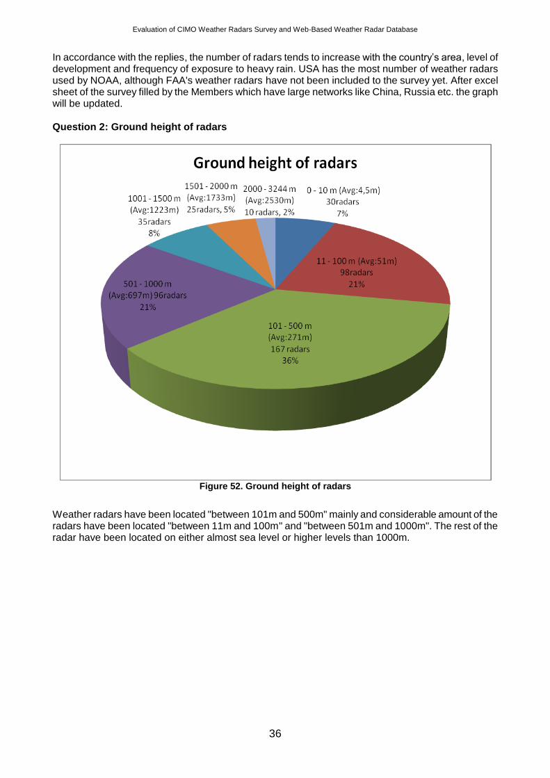
Question 2: Ground height of radars
Figure 52. Ground height of radars
Weather radars have been located "between 101m and 500m" mainly and considerable amount of the radars have been located "between 11m and 100m" and "between 501m and 1000m". The rest of the radar have been located on either almost sea level or higher levels than 1000m.
Evaluation of CIMO Weather Radars Survey and Web-Based Weather Radar Database
37
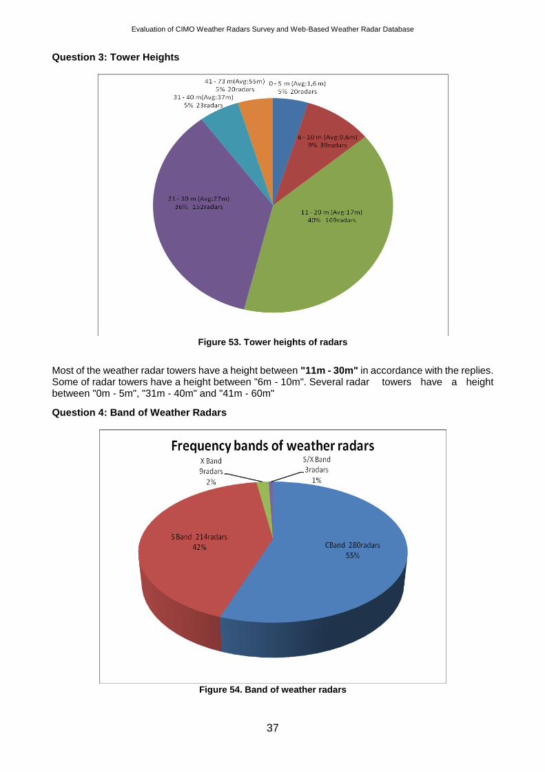
Question 3: Tower Heights
Figure 53. Tower heights of radars
Most of the weather radar towers have a height between "11m - 30m" in accordance with the replies. Some of radar towers have a height between "6m - 10m". Several radar towers have a height between "0m - 5m", "31m - 40m" and "41m - 60m"
Question 4: Band of Weather Radars
Figure 54. Band of weather radars
Evaluation of CIMO Weather Radars Survey and Web-Based Weather Radar Database
38
Used frequency of the electromagnetic wave defines the band of the radar. "C Band" is the most commonly used band in wetaher radars. "S Band" is also another main band used for weather radars. USA has a great contribution to that with high number of S Band radars. "X Band" radars are not so common according to present replies. It can be expected that China can have contribution with its high number of X Band radars after filled excel sheet received.
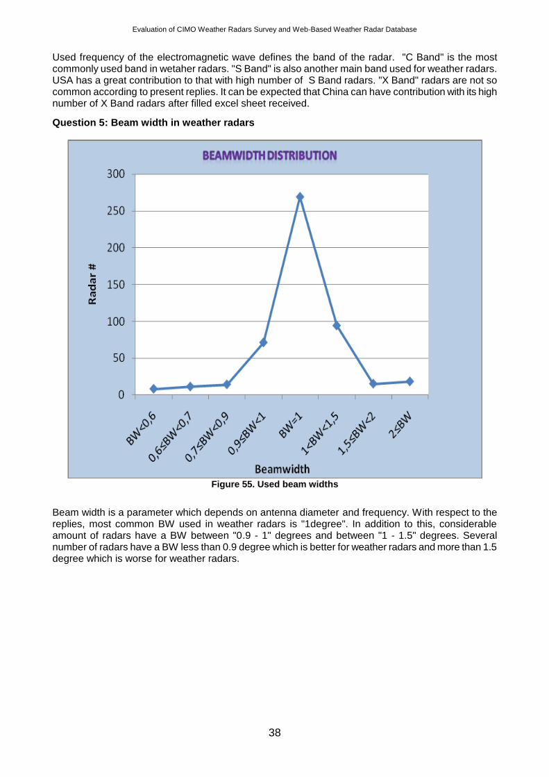
Question 5: Beam width in weather radars
Figure 55. Used beam widths
Beam width is a parameter which depends on antenna diameter and frequency. With respect to the replies, most common BW used in weather radars is "1degree". In addition to this, considerable amount of radars have a BW between "0.9 - 1" degrees and between "1 - 1.5" degrees. Several number of radars have a BW less than 0.9 degree which is better for weather radars and more than 1.5 degree which is worse for weather radars.
Evaluation of CIMO Weather Radars Survey and Web-Based Weather Radar Database
39
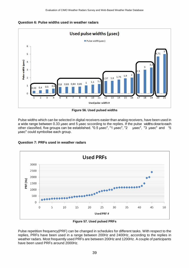
Question 6: Pulse widths used in weather radars
Figure 56. Used pulsed widths
Pulse widths which can be selected in digital receivers easier than analog receivers, have been used in a wide range between 0.33 μsec and 5 μsec sccording to the replies. If the pulse widths close to each other classified, five groups can be established. "0.5 μsec", "1 μsec", "2 μsec", "3 μsec" and "5 μsec" could symbolise each group.
Question 7: PRFs used in weather radars
Figure 57. Used pulsed PRFs
Pulse repetition frequency(PRF) can be changed in schedules for different tasks. With respect to the replies, PRFs have been used in a range between 200Hz and 2400Hz, according to the replies in weather radars. Most frequently used PRFs are between 200Hz and 1200Hz. A couple of participants have been used PRFs around 2000Hz.
Evaluation of CIMO Weather Radars Survey and Web-Based Weather Radar Database
40
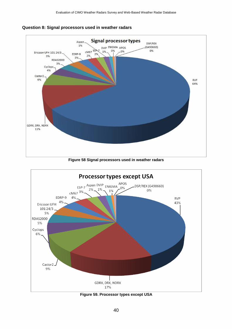
Question 8: Signal processors used in weather radars
Figure 58 Signal processors used in weather radars
Figure 59. Processor types except USA
Evaluation of CIMO Weather Radars Survey and Web-Based Weather Radar Database
41
In a wide range of signal processor types have been used in weather radars. "RVP" signal processor is the most commonly used processor type. "GDRX, DRX and NDRX" signal processor types have been used also by considerable amount participants. Two different graph have been prepared since USA has a great effect to the distribution. "Castor", "Cyclops", "RDAS2000", "Ericsson", "EDRP-9", "cM67", "ESP-7", "Aspen", "DVIP", "ENIGMA", "APOS" and "DSP/REX(G490660) are other signal processor types. While some of them are new in the market, some others have not been manufactured anymore.
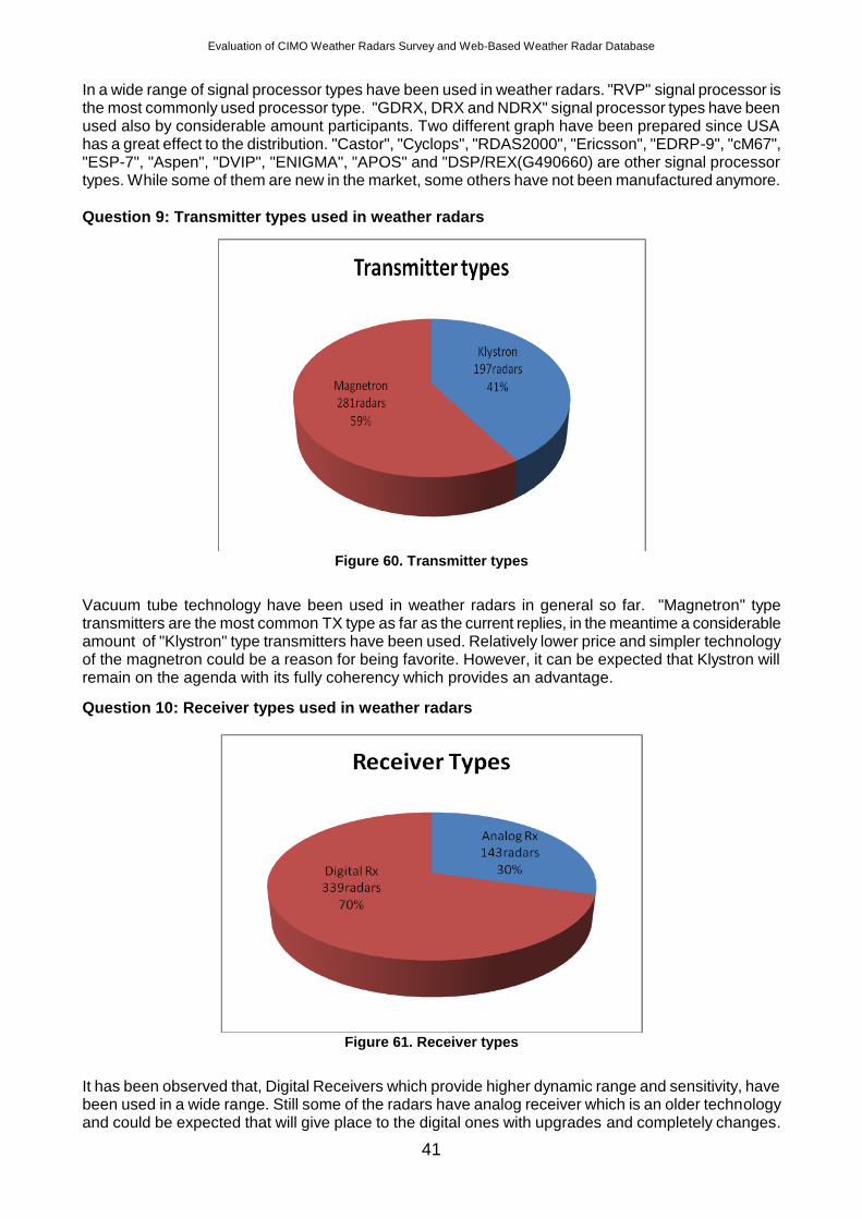
Question 9: Transmitter types used in weather radars
Figure 60. Transmitter types
Vacuum tube technology have been used in weather radars in general so far. "Magnetron" type transmitters are the most common TX type as far as the current replies, in the meantime a considerable amount of "Klystron" type transmitters have been used. Relatively lower price and simpler technology of the magnetron could be a reason for being favorite. However, it can be expected that Klystron will remain on the agenda with its fully coherency which provides an advantage.
Question 10: Receiver types used in weather radars
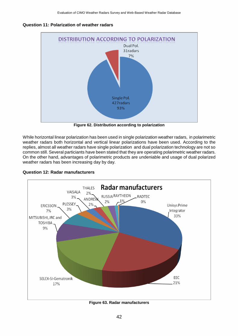
Figure 61. Receiver types
It has been observed that, Digital Receivers which provide higher dynamic range and sensitivity, have been used in a wide range. Still some of the radars have analog receiver which is an older technology and could be expected that will give place to the digital ones with upgrades and completely changes.
Evaluation of CIMO Weather Radars Survey and Web-Based Weather Radar Database
42
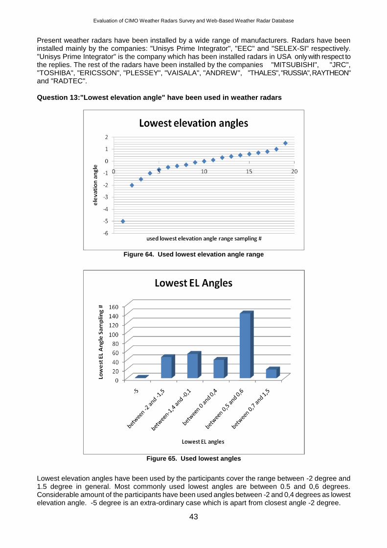
Question 11: Polarization of weather radars
Figure 62. Distribution according to polarization
While horizontal linear polarization has been used in single polarization weather radars, in polarimetric weather radars both horizontal and vertical linear polarizations have been used. According to the replies, almost all weather radars have single polarization and dual polarization technology are not so common still. Several particiants have been stated that they are operating polarimetric weather radars. On the other hand, advantages of polarimetric products are undeniable and usage of dual polarized weather radars has been increasing day by day.
Question 12: Radar manufacturers
Figure 63. Radar manufacturers
Evaluation of CIMO Weather Radars Survey and Web-Based Weather Radar Database
43
Present weather radars have been installed by a wide range of manufacturers. Radars have been installed mainly by the companies: "Unisys Prime Integrator", "EEC" and "SELEX-SI" respectively. "Unisys Prime Integrator" is the company which has been installed radars in USA only with respect to the replies. The rest of the radars have been installed by the companies "MITSUBISHI", "JRC", "TOSHIBA", "ERICSSON", "PLESSEY", "VAISALA", "ANDREW", "THALES", "RUSSIA", RAYTHEON" and "RADTEC".
Question 13:"Lowest elevation angle" have been used in weather radars
Figure 64. Used lowest elevation angle range
Figure 65. Used lowest angles
Lowest elevation angles have been used by the participants cover the range between -2 degree and 1.5 degree in general. Most commonly used lowest angles are between 0.5 and 0,6 degrees. Considerable amount of the participants have been used angles between -2 and 0,4 degrees as lowest elevation angle. -5 degree is an extra-ordinary case which is apart from closest angle -2 degree.
Evaluation of CIMO Weather Radars Survey and Web-Based Weather Radar Database
44
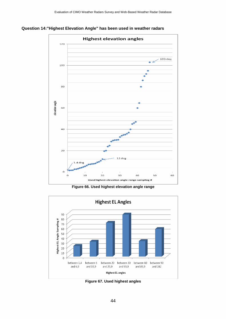
Question 14:"Highest Elevation Angle" has been used in weather radars
Figure 66. Used highest elevation angle range
Figure 67. Used highest angles
Evaluation of CIMO Weather Radars Survey and Web-Based Weather Radar Database
45
Highest elevation angles have been used by the participants cover the range between 1.4 degree and 103 degree. This huge difference is so remarkable. Most commonly used highest angles are between 20 and 60 degrees.
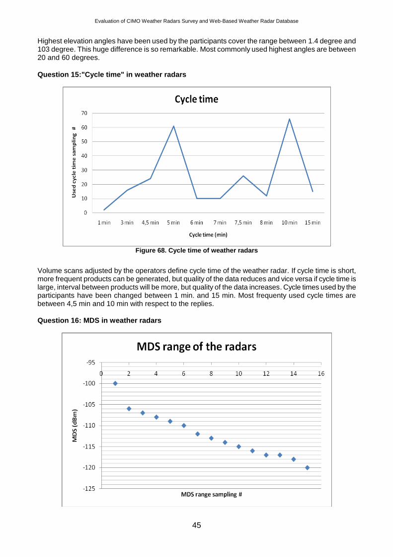
Question 15:"Cycle time" in weather radars
Figure 68. Cycle time of weather radars
Volume scans adjusted by the operators define cycle time of the weather radar. If cycle time is short, more frequent products can be generated, but quality of the data reduces and vice versa if cycle time is large, interval between products will be more, but quality of the data increases. Cycle times used by the participants have been changed between 1 min. and 15 min. Most frequenty used cycle times are between 4,5 min and 10 min with respect to the replies.
Question 16: MDS in weather radars
Evaluation of CIMO Weather Radars Survey and Web-Based Weather Radar Database
46
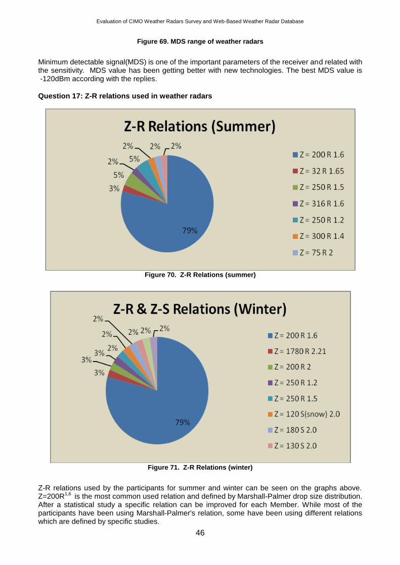
Figure 69. MDS range of weather radars
Minimum detectable signal(MDS) is one of the important parameters of the receiver and related with the sensitivity. MDS value has been getting better with new technologies. The best MDS value is -120dBm according with the replies.
Question 17: Z-R relations used in weather radars
Figure 70. Z-R Relations (summer)
Figure 71. Z-R Relations (winter)
Z-R relations used by the participants for summer and winter can be seen on the graphs above. Z=200R1,6 is the most common used relation and defined by Marshall-Palmer drop size distribution. After a statistical study a specific relation can be improved for each Member. While most of the participants have been using Marshall-Palmer's relation, some have been using different relations which are defined by specific studies.
Evaluation of CIMO Weather Radars Survey and Web-Based Weather Radar Database
47
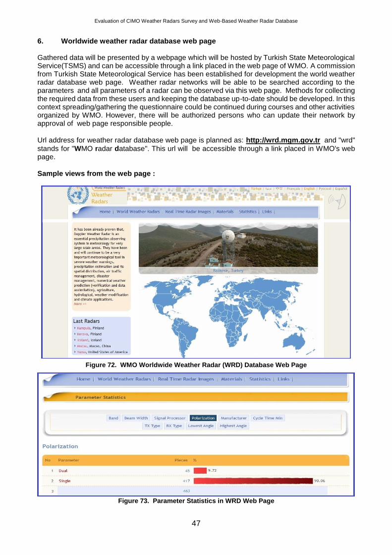
6. Worldwide weather radar database web page Gathered data will be presented by a webpage which will be hosted by Turkish State Meteorological Service(TSMS) and can be accessible through a link placed in the web page of WMO. A commission from Turkish State Meteorological Service has been established for development the world weather radar database web page. Weather radar networks will be able to be searched according to the parameters and all parameters of a radar can be observed via this web page. Methods for collecting the required data from these users and keeping the database up-to-date should be developed. In this context spreading/gathering the questionnaire could be continued during courses and other activities organized by WMO. However, there will be authorized persons who can update their network by approval of web page responsible people.
Url address for weather radar database web page is planned as: http://wrd.mgm.gov.tr and "wrd"
stands for "WMO radar database". This url will be accessible through a link placed in WMO's web page.
Sample views from the web page :
Figure 72. WMO Worldwide Weather Radar (WRD) Database Web Page
Figure 73. Parameter Statistics in WRD Web Page
Evaluation of CIMO Weather Radars Survey and Web-Based Weather Radar Database
48
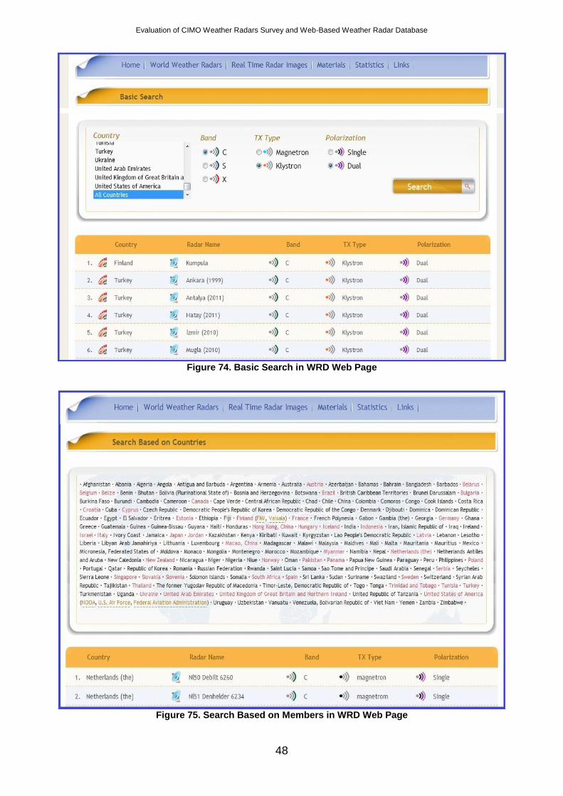
Figure 74. Basic Search in WRD Web Page
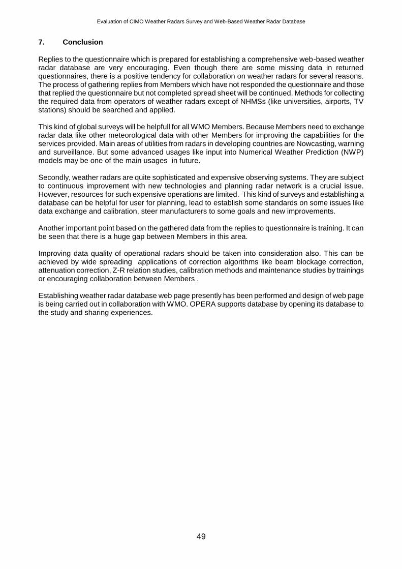
Figure 75. Search Based on Members in WRD Web Page
Evaluation of CIMO Weather Radars Survey and Web-Based Weather Radar Database
49
7. Conclusion
Replies to the questionnaire which is prepared for establishing a comprehensive web-based weather radar database are very encouraging. Even though there are some missing data in returned questionnaires, there is a positive tendency for collaboration on weather radars for several reasons. The process of gathering replies from Members which have not responded the questionnaire and those that replied the questionnaire but not completed spread sheet will be continued. Methods for collecting the required data from operators of weather radars except of NHMSs (like universities, airports, TV stations) should be searched and applied. This kind of global surveys will be helpfull for all WMO Members. Because Members need to exchange radar data like other meteorological data with other Members for improving the capabilities for the services provided. Main areas of utilities from radars in developing countries are Nowcasting, warning and surveillance. But some advanced usages like input into Numerical Weather Prediction (NWP) models may be one of the main usages in future. Secondly, weather radars are quite sophisticated and expensive observing systems. They are subject to continuous improvement with new technologies and planning radar network is a crucial issue. However, resources for such expensive operations are limited. This kind of surveys and establishing a database can be helpful for user for planning, lead to establish some standards on some issues like data exchange and calibration, steer manufacturers to some goals and new improvements. Another important point based on the gathered data from the replies to questionnaire is training. It can be seen that there is a huge gap between Members in this area. Improving data quality of operational radars should be taken into consideration also. This can be achieved by wide spreading applications of correction algorithms like beam blockage correction, attenuation correction, Z-R relation studies, calibration methods and maintenance studies by trainings or encouraging collaboration between Members . Establishing weather radar database web page presently has been performed and design of web page is being carried out in collaboration with WMO. OPERA supports database by opening its database to the study and sharing experiences.
Evaluation of CIMO Weather Radars Survey and Web-Based Weather Radar Database
50
APPENDIX A: Word form document
WORLD METEOROLOGICAL ORGANIZATION Commission for Instruments and Methods of Observation
CIMO-OPAG on Upper-air Observation Technologies Remote Sensing Upper-Air Technology and Techniques Expert Team
QUESTIONNAIRE
On
WEATHER RADARS
Several objectives for this survey. Primarily, it is to assess the global state of weather radars. Weather radars
have traditionally been used for local or regional applications but with long term climate studies, use of radar for
validation of high resolution Numerical Weather Prediction, use in assimilation into NWP models and distributed
hydrological models, cross-border data exchange, their use and the quality of the radar data is now a global
resource. The purpose of the survey is to begin to assess the availability, the uses and the quality of the radar data
and the practices of radar maintenance and support.
The survey will also help in the global protection of radio-frequencies used by weather radar. The information
requested in the spread sheet will help demonstrate the widespread use of weather radar and the technical
specification. Even partial information would be useful.
This is an important time in weather radar and we appreciate the time to fill out the survey. It should not take long
to fill out.
Evaluation of CIMO Weather Radars Survey and Web-Based Weather Radar Database
51
1. Member
1.1 Institute/Organization:
1.2 Do you use weather radar systems or do you plan to apply such systems?
Yes....................... No.....................
(If your answer is Yes, you are invited to answer following questions)
1.3 How long has your organization been operating Radar:
2. Please indicate main requirements of your organization of your radars?(Please Specify Below,
e.g., severe weather warnings, hydrology, weather modification, NWP, etc)
3. Have you hired Consultancy Service regarding radar? Yes No
If you checked yes, what kind of Consultancy Service did you hire?
(Please Specify Below)
4. The main criteria considered for the site selection for radars (select only one criteria)
- Radar coverage area.................................................................................
- Radar type...............................................................................................
- Radar utilization type (e.g. occurrence of meteorological phenomena
to be monitored)…………….……….……………………………..................
- Infrastructure (Power, Access road, communication, etc.)............................
- Other................................................................................................... ...
(Please List)
5. The communication type for data transmission between remote radars and the operating centre
- Satellite.......................................................................................................
- Terrestrial line (Leased line/Dial-up)..............................................................
Evaluation of CIMO Weather Radars Survey and Web-Based Weather Radar Database
52
- Radio link............................................................................................... .....
- Other...........................................................................................................
(Please List)
5.1. Communication data rates (e.g. 128 kbps, etc.)?
5.2. Any back-up method available for the communication?
Yes....................
(Please write down the type)
No.………………
6. Which method is being used for data quality checking that is done in the signal or data processor?
Please Specify:
6.1. What type of correction algorithms improving data quality do you have in your system?
Ground Clutter Filtering ........................................................................
Beam blockage correction.........................................................................
Attenuation correction…….........................................................................
Other……................................................................................................
6.2. What is the average number of rain gauges for each radar?
6.3. Do you use distrometer for data comparison? If your answer is yes, how many have been
installed?
Evaluation of CIMO Weather Radars Survey and Web-Based Weather Radar Database
53
7. What is the frequency of Preventive Maintenance for the main parts of the radars?
7.1 Who carries out the maintenance of your radars after warranty period?
Manufacturer............................................................................................
Local Maintenance Company……………………………………………........
Owner................................................................................................... ..........
7.2 What are the main problems faced by your radar engineers in operating radars and
solution methods? (Mechanical, lightning, electronically, communication, etc)
7.3. Have you ever upgraded or are you planning to upgrade your radars? If you upgraded,
Could you please give information about the upgrade process.
7.4. Which countermeasures have been taken for lightning?
7.5. Do you carry out any calibration on your radar(s)?
Yes....................... No.....................
7.6. If answer to above question is Yes, please specify which calibration and how frequently you
carry.
8. What types of training have been carried out for operating radars? Do you collaborate with other
countries or manufacturers?
8.1 Do you have any recommendation about “training” of radar engineers and operators?
8.2 The mission, the education level and the number of the staff working on radar related
works.
Mission Education Number
Evaluation of CIMO Weather Radars Survey and Web-Based Weather Radar Database
54
9. Operation procedures
- Only during normal daily working hours...........................................................
- 24-hour a day..............................................................................................
- Changes depending on weather conditions.....................................................
- Only for extreme weather conditions.............................................................
- Other..........................................................................................................
(Please list)
10. Prioritize utilization of weather radars in your Organization (if more than one, please mark with
priority of each item as 1, 2, 3 ...)
- Large scale weather monitoring...................................................
- Hurricane or tornado warning......................................................
- Now casting…...............................................................................
- Input to the numerical model.........................................................
- Flood warning...............................................................................
- Wind warning................................................................................
- Hail warning..................................................................................
- Other warnings for general public.................................................
- Air terminal surveillance................................................................
- En route surveillance for general aviation.....................................
- Road and other transports.............................................................
- Rural quantitative hydrology.........................................................
- Urban quantitative hydrology........................................................
- Research.........................................................................................
- Other..............................................................................................
(Please list)
Evaluation of CIMO Weather Radars Survey and Web-Based Weather Radar Database
55
10.1 Monitoring of the radar (time basis)
- Automatic/continuous monitoring........................................
- Daily monitoring...................................................................
- Weekly monitoring...............................................................
- Monthly monitoring..............................................................
- Other.....................................................................................
(Please list)
10.2 The number of remote terminals used (by the remote users) (if more than one, please mark
with priority of each item as 1, 2, 3 ...)
- Disaster Management...........................................................
- Local Authorities..................................................................
- Hydrological Works.............................................................
- Aviation................................................................................
- Agriculture............................................................................
- Construction..........................................................................
- Navigation.............................................................................
- Military.................................................................................
- Research Institutes................................................................
- Universities...........................................................................
- Visual Press..........................................................................
- Written Press........................................................................
- Other.....................................................................................
(Please list)
10.3 Advanced use of radar data
- As an input to the numerical model................................................
- As an input to your nowcasting model..........................................
Evaluation of CIMO Weather Radars Survey and Web-Based Weather Radar Database
56
- As an input to hydrological model..................................................
- As an input to hydrometeor classification method.........................
- Other………………………………......................................................
(Please list)
10.4 Operating system running on your radar servers?
- UNIX................................................................................................
- Linux.....................................................................................................
- Windows.........................................................................................
- Other...............................................................................................
(Please list)
10.5 What is the name of the radar control and data acquisition software?
10.6 What is the name of the product generation software?
10.7 How is radar products displayed?
10.8 The user interface of your radar control/data acquisition software
- GUI.................................................................................................
- Command based..............................................................................
- Other
(Please list)
Evaluation of CIMO Weather Radars Survey and Web-Based Weather Radar Database
57
10.9 The method used for controlling the radar network, task schedule and product schedule.
- Central............................................................................................ .....
- Separate (from the radar location)........................................................
- Other.............................................................................................. .....
(Please list)
10.10. What is the assumed radar-coverage area of your country? km2
10.11. What is the approximate percentage of radar-coverage area to your country’s area? %
10.12. Number of radar systems integrated in network?
10.13. How many kind of products (approximately) are generating in operating centre?
10.14. Is there any system back-up?
- Yes
(Please write down the system that has back up)
- No
11. Please indicate if you exchange/disseminate radar data with other countries and/or organizations?
Exchange/Dissemination Name of the Member/Organization Type of Data
11.1. The telecommunication method used for international data exchange/dissemination.
- Internet …………………………………………..........................
- GTS …………………………………………..........................
- Teletype...........................................................................................
- Telephone........................................................................................
- Radio telegraph...............................................................................
- Radio teletype.................................................................................
Evaluation of CIMO Weather Radars Survey and Web-Based Weather Radar Database
58
- Microwave......................................................................................
- Satellite..........................................................................................
- Other..............................................................................................
(Please list)
11.2. What is your exchange format (s) – please list?
11.3. The data type archived
- Raw.................................................................................................
- Product...........................................................................................
(Please list the product types)
- Other.........................................................................................
(Please list)
11.4. Raw Data Archive strategy
- None..................................................................................
- Continuously..................................................................................
- Intermittent....................................................................................
- Depending on user requests..........................................................
- Depending on research interest.....................................................
- Other.............................................................................................
(Please list)
11.5. Product Archive strategy
- None..............................................................................................
- Continuously..................................................................................
- Intermittent....................................................................................
Evaluation of CIMO Weather Radars Survey and Web-Based Weather Radar Database
59
- Depending on user requests..........................................................
- Depending on research interest.....................................................
- Other.............................................................................................
(Please list)
11.6. The archiving media type and capacity (for each one/total) (please write in details as dds-3 24
GB, 500 GB disk)
- Mass On-Line Storage..............................................................................
- Tape.......................................................................................................
- Disk.......................................................................................................
- CD/DVD................................................................................................
- Database.................................................................................................
- Other......................................................................................................
(Please list)
11.7. If you are using a database, your archived radar data stored in
- Flat Files …………………………………………................................
- A proprietary database used for radar data only....................................
- A common database used for all meteorological data............................
- Other................................................................................................
(Please list)
11.8. Is your archiving software
- Included in your radar application software.........................................
- A third party’s software.....................................................................
- Your own software/script developed for that purpose...........................
- Other...............................................................................................
(Please list)
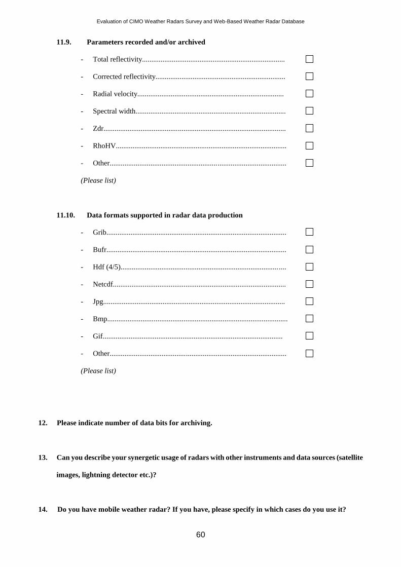
Evaluation of CIMO Weather Radars Survey and Web-Based Weather Radar Database
60
11.9. Parameters recorded and/or archived
- Total reflectivity.............................................................................
- Corrected reflectivity......................................................................
- Radial velocity...............................................................................
- Spectral width.................................................................................
- Zdr..................................................................................................
- RhoHV............................................................................................
- Other...............................................................................................
(Please list)
11.10. Data formats supported in radar data production
- Grib.................................................................................................
- Bufr.................................................................................................
- Hdf (4/5).........................................................................................
- Netcdf.............................................................................................
- Jpg..................................................................................................
- Bmp.................................................................................................
- Gif.................................................................................................
- Other...............................................................................................
(Please list)
12. Please indicate number of data bits for archiving.
13. Can you describe your synergetic usage of radars with other instruments and data sources (satellite
images, lightning detector etc.)?
14. Do you have mobile weather radar? If you have, please specify in which cases do you use it?
Evaluation of CIMO Weather Radars Survey and Web-Based Weather Radar Database
61
15. Please write your opinion, experiences and recommendation on weather radar operations.
16. Please, write your opinion on quality of this questionnaire.
a. Please, grade this questionnaire respect to its quality.
1 2 3 4 5
(Quality increases from 1 to 5. For example if you think, this questionnaire is very good, choose 5
or if you think it is very bad, choose 1)
17.
Title First Name Family Name
Institution :
Position :
Address :
Telephone :
Telefax :
E-mail :
URL / http :
18. Please nominate an expert person for further contact:
Title First Name Family Name
Institution :
Position :
Address :
Telephone :
Telefax :
E-mail :
URL / http :
Evaluation of CIMO Weather Radars Survey and Web-Based Weather Radar Database
62
Prepared by CIMO-OPAG on Upper-air Observation Technologies
Remote Sensing Upper-Air Technology and Techniques Expert Team
(ET-B.3_RSUT&T)
Mr. Oguzhan SİRECİ Dr. Paul Joe
Electronics Engineer Research Scientist
Turkish State Meteorological Service Environment Canada
[email protected] [email protected]
Please, return the completed forms to the following address:
Isabelle Rüedi
Senior Scientific Officer
Observing Systems Division
Observing and Information Systems Department
World Meteorological Organization
Tel: + 41 22 730 82 78
Fax: +41 22 730 80 21
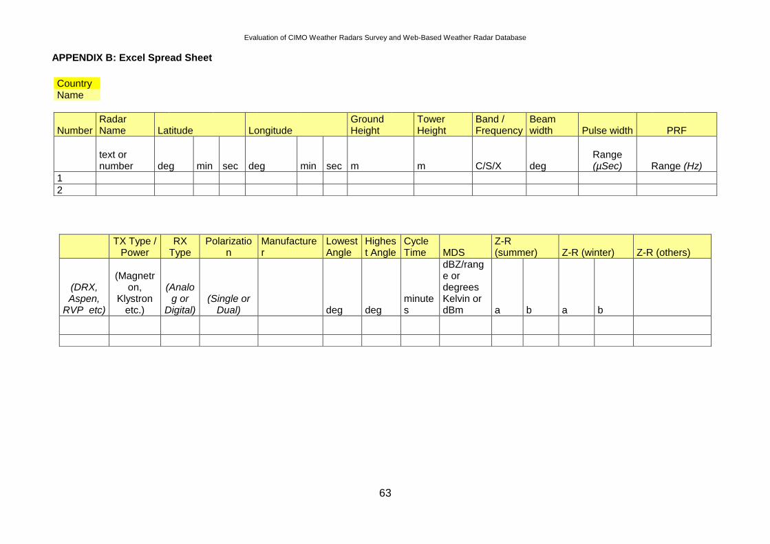
Evaluation of CIMO Weather Radars Survey and Web-Based Weather Radar Database
63
APPENDIX B: Excel Spread Sheet
Country
Name
Number Radar Name Latitude Longitude
Ground Height
Tower Height
Band / Frequency
Beam width Pulse width PRF
text or number deg min sec deg min sec m m C/S/X deg
Range (µSec) Range (Hz)
1
2
TX Type /
Power RX
Type Polarizatio
n Manufacturer
Lowest Angle
Highest Angle
Cycle Time MDS
Z-R (summer) Z-R (winter) Z-R (others)
(DRX, Aspen,
RVP etc)
(Magnetron,
Klystron etc.)
(Analog or
Digital) (Single or
Dual) deg deg minutes
dBZ/range or degrees Kelvin or dBm a b a b
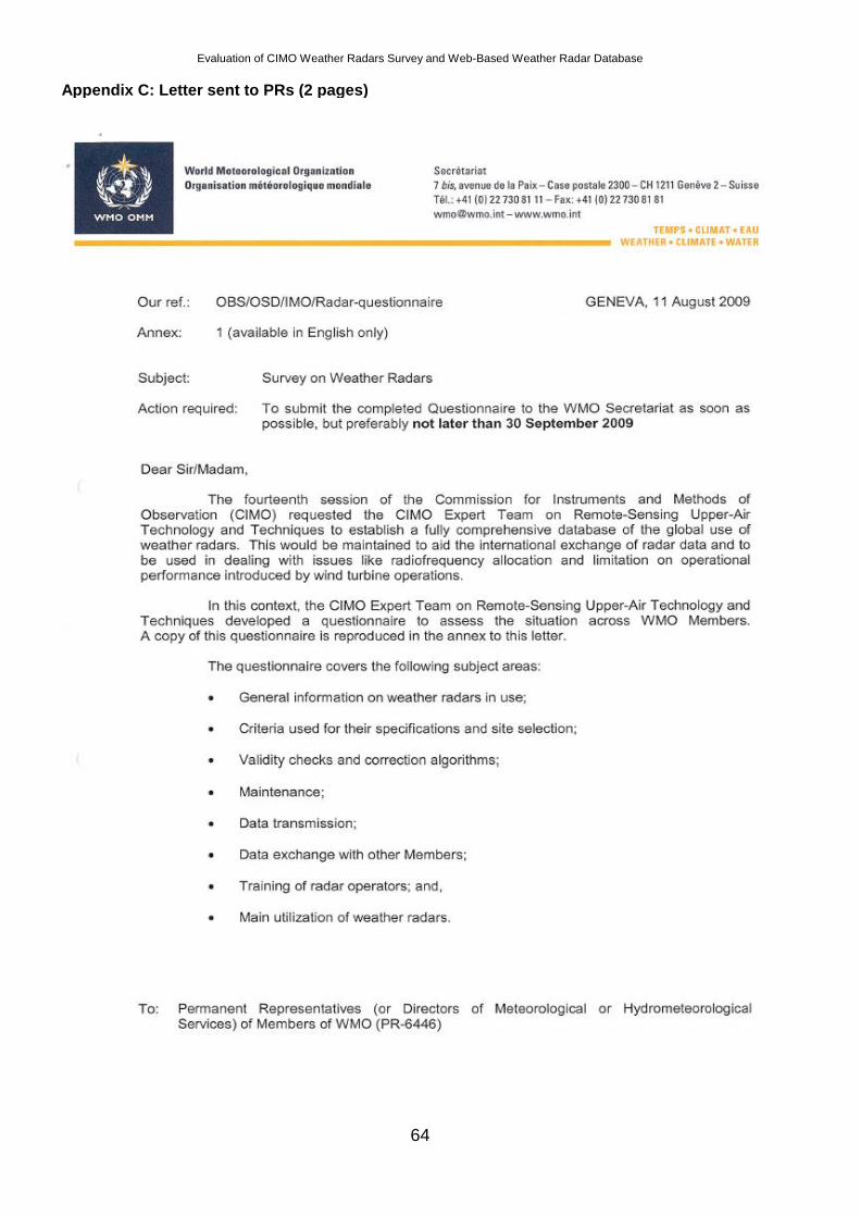
Evaluation of CIMO Weather Radars Survey and Web-Based Weather Radar Database
64
Appendix C: Letter sent to PRs (2 pages)
Evaluation of CIMO Weather Radars Survey and Web-Based Weather Radar Database
65