![Lippke (2012.2), Rez. Kutter, AOAT 346 [ZDPV 128-1]](https://static.fdokumen.com/doc/165x107/6320757cc5de3ed8a70dbc3b/lippke-20122-rez-kutter-aoat-346-zdpv-128-1.jpg)
ESM 346 ENVIRONMENTAL PLANNING AND ...
157
ESM 346 ENVIRONMENTAL PLANNING AND MANAGEMENT Course Team: Dr. Eseigbe, Joseph Omon (Writer)- Ambrose Alli University Ekpoma, Edo State NATIONAL OPEN UNIVERSITY OF NIGERIA
-
Upload
khangminh22 -
Category
Documents
-
view
1 -
download
0
Transcript of ESM 346 ENVIRONMENTAL PLANNING AND ...
ESM 346ENVIRONMENTAL PLANNING AND MANAGEMENT
Course Team: Dr. Eseigbe, Joseph Omon (Writer)-Ambrose Alli UniversityEkpoma, Edo State
NATIONAL OPEN UNIVERSITY OF NIGERIA

ESM 346 COURSE GUIDE
ii
© 2021 by NOUN PressNational Open University of Nigeria,Headquarters,University Village91 Cadastral ZoneNnamdi Azikiwe ExpresswayJabi – Abuja
e-mail: [email protected]: www.nou.edu.ng
All rights reserved. No part of this book may be reproduced, in anyform or by any means, without permission in writing from the publisher.
Published ByNational Open University of Nigeria
Printed 2021
ISBN: 978-078-085-080-X
All Rights Reserved

ESM 346 COURSE GUIDE
iii
CONTENTS PAGE
Introduction………………………………………….. ivWhat You Will Learn in This Course………………. vCourse Aims…………………………………………. vCourse Objectives…………………………………… vCourse Requirements……………………………….. viCourse Materials……………………………………. viStudy Units…………………………………………. viText Books and References………………………… vii
ESM 346 COURSE GUIDE
iv
INTRODUCTION
ESM346: Environmental Planning and Management is a three (3) creditunit course designed for undergraduate students of EnvironmentalScience in 300 level.
This course is made up of five modules with 21 units. The course willexpose the students to a clear understanding of the planning andmanagement of most of the resources and problems in our environment.The knowledge gained will also assist the students and all those whomay come across the material involving environmentally orientedproblems and proffer solutions to them. It covers those topics onEnvironmental Planning and Management which directly affects humanexistence on the face of the earth.
The course is divided into five (5) modules. Module one deals with thephilosophy of planning, the Nature of Planning, Planning and theEnvironment, history of Environmental Planning and Types of Planningand trends in the formation of urban centre. Module two is on process ofplanning and environment, models of urban land use planning, stages ofthe planning process, community facility planning and urbanization andenvironment.
Module three is on environmental pollution such as air, soil, water andnoise pollution Module four is on waste management systems andpractices and the different types of solid wastes and the disposalmethods. Module five deals on environmental hazards such asearthquakes, volcanic eruption, flood and drought.
ESM 346 COURSE GUIDE
v
WHAT YOU WILL LEARN IN THIS COURSE
ESM 346: Environmental planning and Management consists of five (5)main components arranged in the form of modules and units. The courseis structured in such a way that the students are exposed to the planningof the environment and types of planning and the management of someenvironmental issues. In short the course covers environmental issuessuch as natural resources management, processes, tools and standardsfor environmental management. The course also covers wastemanagement systems and practices. The causative factors andmanagement of some basic natural hazards such as pollution, flood,drought and earthquakes..
COURSE AIMS
The aim of this course is to expose the students to environmentalplanning and the management of some basic pressing needs of theenvironment. The course provides information on environmentalplanning and management as panacea for national development and forthe management of some ecological problems and to provide solution tothe growing and increasing environmental problems due to urbanizationand population explosion.
COURSE OBJECTIVES
In addition to the aims of this course, the following objectives areachieved in this course:
1. Stimulate your interest in environmental planning andmanagement.
2. Enhanced the student ability and skills of identifying andanalyzing environmental problems of development planning inthe society.
3. Equip the students with the skills required in the practice ofenvironmental planning and management.
4. Enable the students serve as teachers and environmentalists,planners, personnel officers, administrators, politicians etc.
5. Analyse the causes and provide solutions to some basicecological problems like flooding, pollution, solid wastes,drought etc.
6. Create awareness among the students on how to optimallymanage resources of the environment without jeopardizing theneeds of future generation.
7. The students will be exposed to some environmental laws andpractices in Nigeria.
ESM 346 COURSE GUIDE
vi
8. Students will acquaint themselves with the different types of solidwaste and how to optimally manage them.
COURSE REQUIREMENTS
To complete this course, students are required to read each study unit ofthe material and other textbooks, journal or any other relevant materialthat may be provided by the National Open University of Nigeria. Eachunit contains questions, self-assessment exercise in most cases and atcertain points in the course; you would be required to submitassignments for assessment purpose. At the end of the course, there is afinal examination. The course should take a total of about 17 weeks tobe completed.
COURSE MATERIAL
Students will be provided the following materials for this course:
1. Course guide: The material you are reading now is called courseguide which introduces you to the course
2. Study guide: This is the textbook prepared for the purpose of thiscourse by the National open University of Nigeria. You will begiven a copy of the book for your personal use.
3. Textbooks: At the end of each module/unit, list of textbooks areprovided for your consultation. Students are not restricted to thelisted text books alone though most of the texts used in preparingthis course materials were adapted from the referenced books.
MODULE I: THE PHILOSOPHY OF PLANNING
Unit I: The Nature of PlanningUnit 2: Planning and the EnvironmentUnit 3: History of Environmental Planning and Types of PlanningUnit 4: Trends in the Formation of Urban Centre
MODULE 2: THE PROCESS OF PLANNING ANDENVIRONMENT
Unit 1: Models of urban Land use planningUnit 2: Stages of the Planning ProcessUnit 3: Community Facility PlanningUnit 4 Urbanization and Environment
ESM 346 COURSE GUIDE
vii
MODULE 3: SOLID WASTE
UNIT 1: Types of Solid WasteUNIT 2: Solid Waste ManagementUNIT3: Causes of Solid Waste PollutionUNIT 4: Disposal Methods of Solid Waste
MODULE 4: ENVIRONMENTAL POLLUTION
Unit 1 Air pollutionUnit 2 Soil PollutionUnit 3 water PollutionUnit 4 Noise pollution
MODULE 5: NATURAL HAZARDS
Unit 1 - EarthquakesUnit 2 - Volcanic EruptionsUnit 3 - FloodsUnit 4 - DroughtsUnit 5 - landslides and Avalanche
A number of exercises are provided at the end of each unit to enable thestudents to brainstorm. This is to enable the students to evaluatethemselves on the level of understanding of the various units discussed.
TEXTBOOKS AND REFERENCES
The following textbooks will provide further useful informationregarding the areas covered in the course. Students are advised toconsult more recent textbooks.
Aziengbe, F. I. (2004). The Basics of Geomorphology. Nono Publishers.Benin City, Edo State
Ajith Sankar, R. N. (2015). Environmental Management. OxfordUniversity Press. India.
Akpofure, Rim-Rukeh (2009). Environmental Science., An Introduction.Kraft Books Limited. Ibadan, Oyo State.
Ayoade, J. O. (2003). Tropical Hydrology and water Resources. AgboAreo Publishers. Ibadan.
ESM 346 COURSE GUIDE
viii
Basorun, J.O. (2004). Basic Elements of Urban and Regional Planning.Shalom Publishers. Akure, Ondo State.
Cunningham, W.P. and (Cunningham, M. A. (2011) Principles ofEnvironmental Science. Inquiry and Applications. Sixth Edition.McGraw Hill Publishers. United States.
Eseigbe, J.O. (2019). Foundation Topics in Fluvial Geomorphology andHydrology. DD Concept Publishers, Ekpoma, Edo State.
Ivbijaro, F. A. (2012). Sustainable Environmental Management inNigeria. Edited by Matt. F. A. Ivbijaro and Akintola, F.Second Edition. Book Builders Editions Africa. Ibadan, Nigeria.
Ojeifo, M. O. (2005). Elements of Planning and Design. Easy-WayPublishers. Benin City, Edo State.
Praveen, K. P., Subha, G. and Rajesh, W. (2017). EnvironmentalPollution and Safety Measures: International Issues and ItsGlobal Impact in Global Progress in Development of SustainableEnvironment. Discovery Publishing House PVT.Ltd. India.
Santosh Kumar Garg (2010). Ecology and Environmental Studies.Khanna Publishers. Indian
Stridhar, M.K.C. (2012). From Urban Wastes to SustainableManagement in Nigeria. A Case Study in SustainableEnvironmental Management in Nigeria. Second edition, Editedby Ivbijaro, F.A. and Akintola, F. Published by the BookBuilders. Ibadan.
Suresh, K. Dhameja (2013). Environmental Science. S.K. Kataria andSons Publishers. India.
Surrender Singh (2015). Geography. McGraw Hill Education (India)New Delhi.

ESM 346 COURSE GUIDE
ix
ESM 346: Environmental planning and management is a coursedesigned for students of the Department of Environmental Science. Bythe time you finish studying this course, you will be able to answer basicquestions regarding planning and the management of our environment.ESM 346: Environmental Planning and Management
CONTENTS PAGES
MODULE I THE PHILOSOPHY OFPLANNING……………………….. 1
Unit I The Nature of Planning……………….. 1Unit 2 Planning and the Environment………... 6Unit 3 History of Environmental Planning
and Types of Planning………………… 13Unit 4 Trends in the Formation of
Urban Centre…………………………. 23
MODULE 2 THE PROCESS OF PLANNINGAND ENVIRONMENT…………… 28
Unit 1 Models of urban Land use planning….. 28Unit 2 Stages of the Planning Process………. 37Unit 3 Community Facility Planning………… 47Unit 4 Urbanization and Environment………. 56
MODULE 3 SOLID WASTE…………………. 68UNIT 1 Types of Solid Waste……………….. 68UNIT 2 Solid Waste Management…………... 73UNIT3 Causes of Solid Waste Pollution……. 79UNIT4 Disposal Methods of Solid Waste….. 83
MODULE 4 ENVIRONMENTALPOLLUTION………………………. 88
Unit 1 Air pollution………………………… 88Unit 2 Soil Pollution……………………….. 101Unit 3 water Pollution……………….…….. 106Unit 4 Noise pollution…………………….. 110
MODULE 5 NATURAL HAZARDS…………… 117
Unit 1 Earthquakes ………………………. 117Unit 2 Volcanic Eruptions………………… 123Unit 3 Floods……………………………... 133Unit 4 Droughts…………………………... 139Unit 5 landslides and Avalanche………… 146
ESM 346 MODULE 1
1
MODULE 1 THE PHILOSOPHY OF PLANNING
Unit I The Nature of PlanningUnit 2 Planning and the EnvironmentUnit 3 History of Environmental Planning and Types of
PlanningUnit 4 Trends in the Formation of Urban Centre
UNIT 1 THE NATURE OF PLANNING
CONTENTS
1.0 Introduction2.0 Objectives3.0 Main Body/Main contents
3.1 Definitions of Planning3.2 Conceptual Framework for a Systematical Planning3.3 The Need for Planning
4.0 Conclusion5.0 Summary6.0 Assignment7.0 References
1.0 INTRODUCTION
Environmental planning and management are strategic challengesconfronting humanity in the 21st century. All through the life time ofman, he is in constant need of basic items which are needed for hissurvival. Apart from clothes, shelter, food and water man requirescomfort and personal development for optimum adaptation to theenvironment. Man does this by exploring the resources of theenvironment.
ESM 346 ENVIRONMENTAL PLANNING AND MANAGEMENT
2
2.0 OBJECTIVES
By the end of this unit and the relevant readings, candidates should beable to:
(a) Give different definitions of planning(b) Draw and analyse a conceptual framework for planning(c) Have a full knowledge of how to plan for environmental
features/resources(d) Familiarize with some planning terminologies.
1.0 Main Body
3.1 Definitions of Planning
To plan means to prepare a scheme of events, to arrange beforehand orthe procedure for carrying out an activity. In this regards, planninginvolves sequence of stages in achieving set goals. Ordinarily, planningcould mean a blue print for the future. On the other hand, it could meanpolicy actions set out in a chronological order to regulate an activity. Itcould also mean a systematic arrangement of things to be done. Planningcan as well be regarded as a process whereby our knowledge of theworld and the mechanisms of our memory help to control our rationalsocial actions in realizing a desirable end.
Planning is also a process which involves a method or doing something.It could also mean an orderly sequence of action that will lead to theachievement of a stated goal or goals.
3.2 Conceptual framework for a Systematic Planning
Planning is an important motivator of behaviour. As one desires todevelop, certain patterns of bahaviour which are related to thesatisfaction of the basic needs evolve. These behaviours patterns to alarge extent are founded on decisions which entail choice making amongalternatives. Planning embraces the simple process of determiningappropriate future action through a sequence of choices (Basorun, 2004).On this note, five fundamental points are necessary in a systematicapproach to effective planning as illustrated below.

ESM 346 MODULE 1
3
Conceptual Framework for a Systematic Planning
In environmental planning and management studies, several terms areused to describe various aspects of resources and their management.Such terms include analysis, assessment, evaluation, appraisal, planning,management and development. Assessment, evaluation and appraisal areusually used synonymously to convey the process of finding out ordeciding, the amount of value of a resource for a particular purpose.This is a component part of resource analysis. A resource analysis seeksto understand the fundamental characteristics of a resource as well as theprocess through which the resource is allocated and utilized (Ayoade,2003). Resource development represents the actual exploitation of aresource to satisfy human needs. During the process of development, thenatural resources are transformed into a usable commodity or service.Resource management is concerned with the control or direction ofresource development. It represents the actual decision concerningpolicy or practice as to how resources are allocated and under whatcircumstances resources may be developed.
Resource management and resource planning are closely related. Therecan be no proper management without planning. Resource planning inturn depends on proper resource analysis. So resources analysis,planning and management are all interrelated. Planning is a part ofmanagement, for example water resources planning aims at achieving anorderly development of water resources to meet present and futuredemands. It essentially resolves in three issues: the availability of water,the future requirements of water for various uses and how these can bemet. Planning can be described as a set of procedures for determiningappropriate future action through sequences of choices.
CREATION OF IDEAL
GOALREALIZATION
PERCEPTION OFCONSTRAINTS
ESTABLISHMENT OFOPTIONS
ASSESSMENT OFAVAILABLE RESOURCES
ESM 346 ENVIRONMENTAL PLANNING AND MANAGEMENT
4
Planning is purely an idea that transcends all the facets of humanendeavors that involve human efforts. Man is the manager andadministrator of his limited resources. This motivates man to incorporatea sense of planning. That is, he tries to first identify his needs, looks atthe opportunities available and by power of his reasoning makes use ofwhat he has to achieve what he wants. Man engages in a number ofoccupation ranging from farming, manufacturing, trading, mining,construction to vocational and civil services in order to acquire basicneeds like food, clothes and shelter as well as material wealth. The onlyproblem is scarcity which is the major problem man is met to face at alltimes. In some cases therefore, the desire for a particular want warrantsthe setting of a series of options from which the most preferred isselected based on the quantity of available resources.
The issue of planning extends beyond the scope of choice making to theresultant processes of resources allocation. Though planning is a way ofmaking choice among options that appear open for the future, it alsoentails securing the implementation which depends on the allocation ofthe necessary resources. These resources could be natural (in renewableand non-renewable forms) or human in terms of technology, artifactscapital, culture and population. The allocation of these resources in themost effective way is crucial to successful planning implementation.
3.3 The Need for Planning
Man plans to be able to solve his immediate problems and to advancesolutions to the problems that may crop up in the future so as toguarantee human existence on the earth surface. Planning is important toany successful environmental management systems. Planning offers away to optimization of resources. Planning leads to preventive measuresand anticipation of future environmental changes. It positionorganizations to take competitive advantage rather than responding onlyto challenges as they occur.
Effective planning also smoothens out implementation and minimizesenvironmental burden since many of the sources of environmentalburdens would have been anticipated and addressed.
Planning also helps address “what if” or sensitivity analysis questions.Thus different scenarios and alternatives will be anticipated, investigatedand prototypes booked as to identify at least good solution that may notnecessarily be optimal but give a good resolution to the environmentalproblem.
We also plan to tackle the problems of outward and upward growth oftowns and cities, traffic congestion in our towns, to tackle the problem
ESM 346 MODULE 1
5
of building decay, waste disposal, air and water pollution. Other areasthat require adequate planning are population control measures, food,clothing and shelter. These needs are required by man to ensureoptimum adaptation to the environment to which he belongs.
4.0 CONCLUSION
In this unit, we examined the different definitions of planning, theconceptual framework for a systematic planning and the need for us toplan for both physical and human resources of the environment.
5.0 SUMMARY
(a) Planning is the systematic arrangement of things to be done. Itcould also mean a blueprint, for the future.
(b) The conceptual framework for a systematic planning involves –creation of idea, perception of constraints, assessment ofavailable resources, establishment of options and goal realization.
(c) The need for planning is bore out of the desire for man to be ableto meet his requirements in the area of shelter, air, clothing, foodand to manage the resources of the environment optimally.
6.0 TUTOR-MARKED ASSIGNMENT
(a) List and discuss the fundamental issues considered in asystematic approach to planning with a simple illustration.
(b) List and explain the need for effective planning.
7.0 REFERENCES
Ayoade, J. O. (2003). Tropical Hydrology and water Resources. AgboAreo Publishers. Ibadan.
Basoru, J. O. (2004). Basic Elements of Urban and Regional Planning.Shalon Publishers. Akure, Ondo State.
Ivbijaro,F. A. (2012). Sustainable Environmental Management inNigeria.Edited by Matt. F. A. Ivbijaro and Akintola, F. SecondEditions. Book Builders Editions Africa. Ibadan, Nigeria.
ESM 346 ENVIRONMENTAL PLANNING AND MANAGEMENT
6
UNIT 2 PLANNING AND THE ENVIRONMENT
Contents
1.0 Introduction2.0 Objectives3.0 Main content
3.1 Planning and the Environment3.2 Environmental imbalances caused by Human activities3.3 Irreversible impacts of Human activities on the
environment3.4 Need for sustainable development
4.0 Conclusion5.0 Summary6.0 Tutor marked Assignments7.0 Self-Assignment8.0 References
1.0 INTRODUCTION
Planning is as old as man himself. Man in this context refers to men,women and children, whose needs, interests and wishes togetherdetermine the essence of planning. The activities of man are morecomplex compared to other animals. The man is capable of modifyingthe environment to suit his needs and aspirations. Simply because of theactivities of man, he is made to constitute some nuisance to theenvironment in the areas of pollution, congestion in terms of housing,traffic and competition. The environment generally is made up of theecosystem. And so the feelings, attitudes and emotions of people aremanaged in such a way that proposed plans are carried out basically soas to achieve maximum satisfaction.
2.0 OBJECTIVES
By the end of this unit, students should be able to:
Understand what is planning and the environment. Environmental imbalances caused by human activities. Irreversible impact of human activities on the environment. Need for suitable development.
ESM 346 MODULE 1
7
3.0 MAIN BODY
3.1 Planning and the Environment
We have already known what planning and environment are about in thepreceding paragraphs. What is now relevant is what are the things weplan for in the environment. The Centre for African Settlement Studiesand Development (CASSAD, 1997) see the environment as comprising:
1. Air, land and water2. Plant and animal life, including man3. The social, economic and cultural conditions that influence the
life of man or a community.4. Any buildings, structures, machines or other devices made by
man.5. Any solid, liquid, gas, odour, heat, sound vibration or radiation
resulting directly or indirectly from the activities of man or thecommunity.
6. Any part or combination of the forgoing and the inter-relationships between any two or more of them.The Environment is more or less a compound of so manyelements which are either natural or artificial or manmade. Theseelements as exemplified by CASSAD, 1997 require adequateplanning so as to enhance sustainability of the resources and thequality of the environment. A good example is when you have astream in a place we must use such a stream sustainably so thatthe stream will stand the test of time, enhance its quality, dredgeit occasionally to avoid silting of the water, avoid dumping refuseor waste into it and to avoid carrying out human activities likefarming, building, amongst others on the stream.
3.2 Environmental imbalance caused by Human Activities
Human activities and technological advancements, made to enjoyluxurious life have caused severe irreversible imbalances in the naturalenvironment. The various human activities that have caused severealterations in the ecosystems and the pollution o the environment ingeneral are categorized into the following five major types:
1. Agriculture2. Industrialization3. Urbanization4. Transportation5. Mining
ESM 346 ENVIRONMENTAL PLANNING AND MANAGEMENT
8
Agriculture: The development of agriculture has been most importantsingle event in the history of man and the evolution of human culture.With the development and increase in human population, the agricultureon more and more land, has been practiced to grow crops. Initially, thehumans have grown only the food crops to eat and quench their hunger;but later on, they have started growing several kinds of cash crops. Notonly they have brought a large part of the forest land under agriculture,but also they have started using fertilizers and pesticides to increase cropproduction per unit of agricultural area.
Over the years, man has converted major portions of the forest land toagricultural land and damaged the ecosystem and the environment ingeneral. Additional destruction of the forest land for agriculture alwayshas serious consequences on climate, water cycle and mineral balanceon earth. This man also lead to extinction of plants and animals if notwell planned for and managed.
Industrialization: Industrialization means, development of industries ofvarious kinds. These industries cause maximum environmentalimbalance and instability by polluting water, air and land to such anextent that all these issues need detailed discussions. Students areadvised to read more materials.
Urbanization: The urbanization is the process of urban development,under which mass migration of people from rural areas to theindustrialized urban areas, take place due to increased job opportunities.The urbanization is thus accompanied with industrialization.Urbanization can lead to increased population, production of enormousquantity of sewage and domestic waste, waste water, pollution (air, landand water). Urbanization can also lead to a process whereby the nearbyareas undergo considerable modifications. For example, the mining ofsand for construction in urban centers is usually done in nearby villagesand towns.
Transportation: In olden days, people used to travel largely on foot oron bullock carts or horse carts or on bicycles. For long overseasjourneys, water transport through boats or ships was being used thoughon a very small scale and mostly unmechanised. All these non-mechanized modes of transportation were largely non-polluting as theywere causing little adverse impact on the environment. Later the trainsstarted plying using wood and coal to generate heat for producing streamto run them along with smoke to cause air pollution and noise. With thediscovery of oil, and ways of extraction, the use of petrol and dieselbecame more prominent in rain transport, besides the advent of busesand trucks plying on roads for public use. After which people startedusing cars for transportation which became mind boggling. After which
ESM 346 MODULE 1
9
air transportation came on board. This today has resulted to someadverse impact on the environment. The adverse impact of roadtransportation which requires adequate planning can be grouped into:
- Energy consumption- Land consumption- Loss of agricultural land- Loss of wild life habitat- Air pollution- Water and land pollution- Noise pollution
Mining – Mining is the extraction of minerals and ores from the earth’scrust. The large scale industrial and urban growth that has happenedaround the world in the last decades would not have been made possiblewithout the increased output of our mineral resources. Mining providesus coal for energy requirements, metals for making machines andengines, ores for making chemicals and fertilizers, rocks and stones forbuildings, bridges and dams, gold, diamond and other precious stonesfor Jewry making. In response to the increase demand due toindustrialization, urbanization and modernization, the exploitation ofmineral resources has increased tremendously.
3.3 Irreversible Impact of Human Activities on theEnvironment
Any undesirable change in the physical, chemical and biologicalproperties of the environment is called environmental pollution. Manynatural occurrences can lead to environmental pollution. For example,volcanic eruption can release enormous amount of dust particles andpoisonous gases into the environment which can result into drasticenvironmental change. A good example is the volcanic eruption ofCameroon in August 1986 which affected the environment by toxicemissions killing 1700 people and serious health challenge to over10,000 Persons. Similarly, other natural hazards that can causeenvironmental imbalance area:
Earthquakes, Tsunamis, Cyclone, Floods, Landslides and Avalanches,Forest fire Droughts and Desertification.
Man made activities that can bring changes to our environment thatcannot be easily reversed are:
- Conversion of forest land into agricultural land.- Release of extra ordinary amounts of Co2 and CFS into the
atmosphere
ESM 346 ENVIRONMENTAL PLANNING AND MANAGEMENT
10
- Increased human population which further increases pressure onthe ecosystems in the areas of forest, rivers, oceans etc.
3.4 The Need for Sustainable Development
In order to avoid large scale impact of human activities on theenvironment, there is need to thoroughly study the adverse impactsbefore taking up any major activity. In order to assess such possibleadverse environmental impact of a proposed developmental activity, anEnvironmental Impact Assessment (EIA) is prepared along withpreparing an environmental management plan to initiate the possibleenvironmental problems that may emanate from the execution of such aproposed activity. The entire aim is to attain sustainable developmentwhich is to meet the needs of the present without compromising theneeds of future generation.
Sustainable development is defined as that development which is freefrom environmental degradation, poverty and depletion of naturalresources base. Sustainable development is that development whichmeets the needs of the present without compromising the ability of thefuture generations to meet their own needs. This definition ofsustainable development was infact promulgated for the first time in theU.N. report titled “our common future” presented in 1987 by the WorldCommission on Environmental and Development”. The documentpresented by the commission titled “Our Common Future” has created aconsciousness of this need to harmonize environmental protection witheconomic development on a global scale.
The necessity of sustainable development will therefore help to solve thefollowing problems:
It will compel industrialists and government agencies to considerall aspects of their developmental proposals as to minimize theuse of natural resources and adverse environmental impacts.
The implementation of the 4rs of resource utilization such as:recycling, reuse, reduce and restoration
The concept will also force engineers, scientists and allstakeholders to develop technologies which are efficient,productive and profitable.
The concept will also put into consideration their impacts onhealth, environment, resource and energy conservation, wastemanagement and social impacts such as the publicinconveniences, unemployment, crime etc.
ESM 346 MODULE 1
11
4.0 CONCLUSION
In this study, we examined planning and the environment,environmental imbalance caused by human activities, irreversibleimpact of human activities on the environment and the need forsustainable development.
5.0 SUMMARY
A) Most of the things we plan for in the environment include amongothers: Air, land and water; plants and animals; socio-economicand cultural conditions. Pollution affecting man, and anybuildings, structure, machines or any devices made by man
B) Environmental imbalance caused by man which include:Agriculture, industrialization, urbanization, transportation andmining.
C) Irreversible impacts of human activities on the environmentwhich include release of extra ordinary amounts of Co2 and CFCsinto the atmosphere. Also, increased human population hasfurther led to pressure on the ecosystems.
D) The need for sustainable development which will help to compelindustrialists and government agencies to abide by the rules andregulations of setting them up; the implementation of the 4rs ofresources utilization; force engineers and scientists to developtechnologies that will foster developments and the considerationof their impact on the health, environment, resources and energyconservation available.
6.0 TUTOR-MARKED ASSIGNMENT
1. List and explain the main things that require adequate planning.2. With suitable examples, discuss the various human activities that
have cause severe alteration in the ecosystems.3. Give reasons why we need sustainable development of our
resources.
ESM 346 ENVIRONMENTAL PLANNING AND MANAGEMENT
12
7.0 SELF-ASSESSMENT EXERCISE
What is planning?
What is Sustainable Development?
REFERENCES
Santosh Kumar Garg (2010). Ecology and Environmental Studies.Khanna Publishers. New Delhi,
Basorun, J. O. (2004). Basic Elements of Urban and Regional Planning.Shalom PublishersAkure, Ondo State

ESM 346 MODULE 1
13
UNIT 3 TRENDS IN THE FORMATION OF URBANCOMMUNITY
1.0 Introduction2.0 Objectives3.0 Main Body
3.1 Man in the Neolithic times3.2 Band3.3 Village3.4 City/Urban
4.0 Conclusion5.0 Summary6.0 Tutor marked Assignments7.0 References
1.0 INTRODUCTION
The pattern of human settlements shows that the development has been agradual process over a time span and a product of two main changes.The first is the transition from hunting and fishing to agriculture in theNeolithic era when people started to constitute groups (smallcommunities) on the basis of mutual dependence and concern. Thesecond is the emergence of growth centers at specific locations.However, this part of the lecture intends to highlight on themorphological structure or sequence of stages of urban formation andthe need to plan for them at different stages.
2.0 OBJECTIVES
By the end of this unit, candidates should be able to:
Know the development of a city center from a band. Differentiate between settlement patterns Know the characteristic features to differentiate a village, town or
city Know the basic functions of every settlement pattern
3.1 Man in the Neolithic Era
Quite a number of investigations carried out about the history of man,have yielded findings which are helping us to understand how the stagesof development of his intelligence have greatly influenced changes inhis environmental conditions. Common knowledge of the world aboutthe existence of man and the emergence of human society stems from

ESM 346 ENVIRONMENTAL PLANNING AND MANAGEMENT
14
the discoveries of Dr. Louis Leakey’s pioneer excavations at OlduvaiGeorge in Northern Tanzania, in about one-and-half to two million yearsago, the basis upon which it was suggested that Africa, indeed, mayhave been the birthplace of humanity.
Through the findings an entirely adequate ground was established toshow that the early types of men (Hominids) a little different fromourselves were first discovered in Africa. These hominids, about 1.35metres tall, were in the likeness of man found in small groups on lakeshores in Savannah countries. They were slightly wiser than the apesand could interact more easily but the small brains behind their massivefaces could not let them learn to come to terms quickly with theirenvironment in a manner to maintain a state of equilibrium. Attempts todistinguish themselves from other animals led to eventual emergence ofthe ability to make crude stone tools in form of choppers’ which theyused to do some minor works.
About a million year ago, a breakthrough was recorded as mantransformed the choppers to double-edged hand axe, scrapper and ahammer stone. This invention enhanced man’s ability to hunt, improvehis food supply by killing other animals, and confidentially live in largegroups. Thereafter, some other species of man developed all over theworld such as, the “Neanderthal’ in North Africa, Europe and Asia, andthe “Rhodesiods in South of the equator in Africa.
3.2 Band
This is the first and in fact, the starting point of community formation. Itrepresents the original form of the local group at the lowest level ofsocial organization. At this elementary stage, a group of persons,sometimes of the same social or economic background combine to livetogether under a leader and for a common purpose. These could bemigratory hunters, farmers, fishermen and nomads whose primaryobjective is to carry out the same duty around a single location. For themere fact that this group lacks organized set of habits that will enablethem meet the challenges of their new environment more effectively, thecommunity is characterized by temporary structures, erected to providetentative shelter. As activities of members become regular each daythereafter the decision to settle permanently is held by majority to beable to raise a family and put an end to wandering.

ESM 346 MODULE 1
15
Characteristics
1. The community is purely a small group2. In most cases, the group comprises mainly males3. The community is made up of a very small group, usually lesser
than ten people.4. The settlement lacks permanent structures because of the
uncertainty of tenure5. By this nature, the community hardly attracts development in
terms of social infrastructure like good road, electricity, potablewater and entertainment.
3.3 Village
The village is a transitional community, which marks the beginning ofpermanent settlement. It is different from the band in many respects,looking at the developmental state at any one time. The community canbest be described as a cluster of local people within a small geographicalconfine, shearing a feeling of togetherness interacting in an organizedcontext, and enjoying similar style of living with a limited range ofoccupation. One significant fact about the village is that, people havecome to accept their environment, and take over responsibility,particularly farming for their own survival. Because of the constancy inthe practices of agriculture therefore, there is gradual progress in thedevelopment of farming skills and erection of permanent structures.Some pre-conditions are necessary for this kind of community toemerge. These include:
(a) The physical environment must be such that would support plantand animal life even to the point of providing agriculturalsurpluses.
(b) The environment must be able to accommodate and support areasonable population on a relatively little land area.
(c) The area should be able to encourage certain level of permanenceof settlement in terms of food production through domesticationof plants and animals to sustain a complete life circle.
With all these pre-conditions in place a social organization in the formof a village is subsequently established, abstracting many of the essentialfeatures of a rural setting. As a social group on a low scale eachindividual receives recognition, understanding and co-operation in theperformance of those duties relevant for the community to functionmore satisfactorily.
ESM 346 ENVIRONMENTAL PLANNING AND MANAGEMENT
16
Characteristics
The community comprises people who are mainly agrarians.
1. As a local territory, it covers relatively small area of land2. The settlement is associated with garden plots located in-between
houses for the purpose of food production.3. The community is a collection of very small homogenous
population ranging from six to sixty families or maximum of fivethousand population.
4. The spiritual and ritual inclination of people is undefined as eachhousehold worships its own god or shrine
5. The social structure of the community allows only, the traditionalhead and the elders to have responsibility of ensuring moralityand social justice among the people as well as organizing theaffairs of the community.
6. People in this locally enjoy a feeling of neighbourhood, whichencourages collective participation in the execution ofcommunity projects like construction of market, roadmaintenance etc.
7. The community operates periodic market, whereby market daysare spaced in time to allow effective demand for commoditiesproduced in the locality.
8. On account of financial constraints, the village lacks essentialsocial amenities and services like; electricity, pipe-borne water,telecommunication etc nearly to raise the living standard ofpeople.
9. The community experiences poor transport services as activitiesof people are located within working distance to ensure proximityand reduce amount of energy spent on commuting.
3.4 Town
The word town is so flexible in definition. This flexibility is to theextent that there are as many towns as there are enough parameters todescribe them. Whichever way it is perceived, evidence from varioussources have certainly confirmed it to be an offshoot of the village, andindeed an intermediate point of transition between the village and thecity in other words, it is an aerial unit that is less in size than that of acity constituted by people who are culturally conditioned through timeand spatial relationship, with a sub-urban outlook.
In planning, the importance of town is not underestimated. It hasremained the home of every man to which he claims a strong tie. As thebasis of all human life, it produces quite a complex pattern of activities

ESM 346 MODULE 1
17
which approximates more and more closely to that which is desired forplanning purpose. It is an area of specific location which is in someways distinctive from other areas. First, it is independent on its own inone part and dependent on metropolitan jurisdiction on the other.Second, it is a community of relatively larger space, holding largerpopulation that has come through a gradual development in agriculturaltechnology, transport and communication, as well as exchange of goodsamong village communities. Invariably, the town is a product of somebasic conditions which include:
(i) Surplus of food production.(ii) Effective management of the group of food producers(iii) Existence of class of traders and merchants(iv) Availability of market space and(v) Effective transportation.
Improvement in local transport for instance, makes it possible for foodsurplus to be assembled in the town. Effective management of tradersand merchants bring about proper co-ordination of exchange of goodsalso in town as new social institutions eventually emerge to make thefood surplus available to urban dwellers. The moment a communityattains this status, attention of government is given to the provision oflocal trade centres, social services like schools, health centres, water,electricity etc to sustain its benefit and survival. On this note, theemergence of town cannot be viewed solely as a culmination ofeconomic phenomenon, but social changes in the localities within whichit is established.
In the discussion of the structure of existing African towns, plannershave been able to distinguish the traditional town from the modern town.Typical of the traditional towns are majority of the old towns in Nigeria,which had existed before the advent of colonial rule. Many of thesetowns were founded in response to security needs, while others were inresponse to geographical and historical factors. These communities wereunplanned; at the main core is usually the location of the central marketand the King’s palace. In other parts of such towns are residentialquarters of various size and shape, all in a cluster form without referenceto any road network. The modern towns on the other hand include thenew or satellite own, and those founded by the European powers duringcolonial rule which were planned form the onset, with sufficient spacefor streets to accommodate modern vehicular traffic. In any case,wherever a town exists, different economic bases are exhibited with amixture of different social groups and classes, which stimulate itsgrowth.
ESM 346 ENVIRONMENTAL PLANNING AND MANAGEMENT
18
Characteristics
(i) As a relatively larger community it constitutes the nucleus orfocal point of activities for other smaller communities in itsregion.
(ii) The town usual has a population of between twenty and hundredthousand people.
(iii) It represents a socio-political unit on its own, with a well-definedadministrative structure and cultural traits.
(iv) The geographical limit of the town is often delineated by theextent of homogeneity of cultural dialects.
(v) The town dominates central goods and services like, schools,health care and communication, which it distributes to its ruralhinterland.
(vi) Contrary to what obtains in the village, the town witnessespronounced division of labour as each person concentrates on thatactivity from which he enjoys the highest output.
3.5 City/Urban
The city or urban settlement is a spectacular level of development on thecontinuum of community. It is perceptually different from the extendedscope and complexity of the environment, which makes possible furtherdevelopment of complicated pattern of physical, social and economicattributes. On the basis of the processes involved in its formation aspreviously discussed, it does not imply any other identity more than arelatively large, dense and permanent settlement of sociallyheterogeneous individuals.
Generally, a city is considered a place with a relatively large populationthat has a certain legal status, granted by the national or provincialgovernment, and that is associated with specific administrative or localgovernment structures. City development is not only a pre-colonial butalso a post-independence phenomenon especially in Nigeria. We seethrough series of investigations, time and again concrete evidence thatthe town begins to metamorphose into city at a point when thosephysical and economic factors involved in its growth start to manifest.For instance, during the colonial era, this development was caused bythe selection of a few of the existing towns as centres of administrationfrom which the colonial officials could govern the territory under theircontrol. These towns were linked by roads and railways to enable themconstitute commercial centres, with those along the coast, as majorports.
ESM 346 MODULE 1
19
The restructuring of the national economy with the introduction ofNational Development Plans aided the post-independence re-organization process as attention as on industrialization of the towns(administrative centres) which eventually developed to urban areas. InNigeria there were only four major urban centres which representedregional headquarters as at the time of independence in 1960. Theseinclude; Ibadan, Lagos, Enugu and Kaduna. By 1963, the number rose tofive with Benin City as new headquarters of Mid-western region. Thenumber further rose to thirteen in 1967 when the country wasreconstituted into twelve states. In 1976, the number went up to twentywith the then nineteen states. With the present thirty six states, one canthink of about twenty five cities or urban centres all over the countrythat have attained the United State standard of one hundred thousandpopulation. For the purpose of identification, scholars in variousdisciplines have evolved three broad perspectives for the definition ofurbanity in recent years. These include:
(a) Legal and administrative perspectives(b) Definition using minimum population(c) Functional definition
From the legal and administrative angle, the urban community is definedbased on the charter granted by authority of the government withinwhose jurisdiction the place is located. That is, once a particular placemeets the minimum requirements set (by the act of parliament, bill ordecree of the government of a region or nation, it automatically derivesits legal recognition as an urban centre. Using population criterion, ameasure of intensity of certain phenomena are considered which covers,population, housing units, families, percent of land occupied bybuildings, employment per given area etc to qualify a place as urban.The functional description is associated with; social, cultural, industrial,commercial, religious, artistic, educational, military, political andadministrative activities, which are all grouped as urban functions.
These urban centres have persistently attracted many people from therural areas taking advantage of their strategic locations. In their variouscapacities as either national, regional or local government headquarters,they have witnessed tremendous increase in the provision of social andor infrastructural facilities, industries, urban services as well asexpansion of economic and administrative functions. School leavers andothers, move into the city in search of elusive jobs. The basic amenitiesand higher order services in these areas have equally remained a majorattraction for better living. On account of the weak and depressed natureof rural economy rural-urban migration therefore, becomes a regularoccurrence. As urban population increases, many families in a desperatebid to satisfy the appetite for self-contained accommodation put up
ESM 346 ENVIRONMENTAL PLANNING AND MANAGEMENT
20
buildings in the outskirts. This process continues in a sporadic manneronly for the spatial organization of the city to assume a magnificentdimension.
Characteristics
(1) It spreads over a relatively large space of land as a result of therapid physical development of a number of quarters or sectorsthat group around separate nuclei which constitute the CentralBusiness District (CBD).
(2) The urban centre has always remained the seat of government oradministrative headquarters for the region within which it islocated.
(3) Majority of the urban centres represent industrial places wheredifferent categories of workers are employed in manufacturingoccupations.
(4) It is often characterized with congestion or over-crowding, beingthe definite end of rural migrants, and having accommodated asubstantial population, usually over a hundred thousand peoplewho engage in non-agricultural occupation.
(5) It is a community with high economic advancement in terms ofnumerous commercial activities and high productive efficiency ofgoods which are re-distributed to other smaller communities in itsreligion.
(6) It is a major location of the ‘elite’ and other skilled workerswhere advanced training re acquired in various fields.
(7) It is equally a community of higher order services such as tertiaryinstitutions, specialist hospital, pharmaceutical institutes,stadium, amusement parks, radio and television stations etc.
(8) It is a place where rarest articles are found example of which are,vehicles, heavy machinery and plants, sophisticated electronicsand so on.
(9) It is a major transport co-coordinating centre such as, airports,sea-ports, railway terminal, motor parks, bus stop and trafficlights.
(10) It is the base for certain sensitive activities like; defense andsecurity, military barracks, prisons and police headquarters.
4.0 CONCLUSION
In this unit, we examined trends in the formation of an urban centre.This starts from man in the Neolithic times, through band, village, town,and urban/city centre.
There is a growing realization of the need to pay more attention to thesedevelopmental trends, especially as it borders on the spatial implication
ESM 346 MODULE 1
21
of the urban economy both at the national and state levels. The studyhelps us to appreciate that changes in the status of these communitieshelp in the transformation of the socio-spatial structures of theirproductive capacities, and the continuity from the past and theircontemporary changes in time and space.
Human communities are indifferent all over. The truth of this lies in thefact that, there is a strong relationship between a place and the numberof people that settle therein. That is, the higher the number of people, thehigher the relative size of the settlement. The trends in the formation ofurban communities, as we have them today, began with man in theNeolithic era. It is evident that each of the stages identified in order ofprecedence has its own peculiar characteristics, which changethroughout the transition period.
Indeed, it has to be understood that unless we have adequate knowledgeof classifying these communities, we will not be able to understand thedifferences in their structural systems, which is strategic to planning.The manner in which a planner undertakes his planning dependsdecisively on the size of the community, the people concerned, theirattitudes and the anticipated reactions to planning approaches.
5.0 SUMMARY
Man in the Neolithic era represents the starting point of man in his questto live on the earth’s surface. It was the period of dark ages when mantried to distinguish himself from other animals through some basicinventions like conversion of crude stones to make choppers.
A band is the starting point of community development made up ofsmall group not more than ten persons.
A village is a transitional community, which makes the beginning ofpermanent settlement. The population is not usually more than 5000persons.
A town is the home of every man, the population is usually betweentwenty and hundred thousand.
An urban centre is the spectacular level of development in a community.The city centre is made up of population of over a hundred thousandpersons with all the characteristic features like functions andadministrative qualities on a high standing.
ESM 346 ENVIRONMENTAL PLANNING AND MANAGEMENT
22
6.0 TUTOR MARKED ASSIGNMENTS
A. Distinguish between human settlement in the Neolithic era and aband.
B. List and explain the basic features of rural areasC. Outline and discuss the three broad perspectives for the definition
of urban city.
Self-Assessment Exercise
- What is a Band?- What is a Village?- What is a Town?- What is a City?
7.0 REFERENCES
Basorun, J.O. (2004). Basic Elements of Urban and Regional Planning.Shalom Publishers. Akure, Ondo State.Onokerhoraye, A.G. and Omua, G. ed (1986). Urban Systems andPlanning. The Geography and Planning Series, University of Benin,Benin City.
ESM 346 MODULE 1
23
UNIT 4 HISTORY OF ENVIRONMENTAL PLANNINGAND TYPES OF PLANNING
1.0 Introduction2.0 Objective3.0 Main Body
3.1 Evolution of Planning3.2 Types of Planning
4.0 Conclusion5.0 Summary6.0 Tutor-Marked Assignments7.0 References
1.0 INTRODUCTION
Evolution and History of Environmental Planning entails the beginningof planning till date. This unit will acquaint the students of where we arecoming from regarding planning and what is currently obtainable. Thedifferent types of planning are also enumerated.
2.0 OBJECTIVES
By the end of this unit, students should be able to:
1. Trace the history of environmental planning2. The types of planning3. Identify the major planning tasks associated with the medieval
and renaissance times4. Know the social and economic problems that prompted
environmental planning at the time of industrial revolution in the18th century.
3.0 MAIN BODY
3.1 Evolution of Urban Planning
Urban planning is known to have passed the following five evolutionarypasses namely, medieval, baroque, renaissance, industrial andcontemporary phases.
Medieval Period
Settlement pattern and types during this period were inclined to defenceconsideration hence settlements were small, buildings were compactwith narrow streets, congested buildings without open spaces and

ESM 346 ENVIRONMENTAL PLANNING AND MANAGEMENT
24
without any form of protection against fire outbreak, epidemics,earthquakes etc and when any of these thus happen large part of thecities are destroyed.
Baroque Period
Defence was not only an important element during this period, it was aperiod characterized by progressive energy, which was otherwisechanneled towards improvement of parts of towns and settlements. Itwas also a period that conscious effort was made to combat hygienethrough increase of knowledge in science and technology. Significantly,the discovery of the roman vault for the channelization of sewage,drainage and water was developed. Finally, the baroque witnessed asignificant progress in landscape architecture where large expanse ofland were acquired by kings, princes, army generals, wealthy nationalsan aristocratic class for development of houses, mansions and residentialareas.
Renaissance Period
This was a period of re-discovery. It was a time man discovered that hecould subdue nature. It was a time of increase in the knowledge ofscience and technology. It was a time human limitation and inhibitionwere been removed and all creative energy was released. Consequentlygreat artists, architects and engineers were discovered andcommissioned to prepare development plans, create large express waysfor ceremonies. Taking into cognizance the discovery of the wheel cartand the growth in inter communal trade, great houses were built forkings and emperors. All these helped to sharpen settlements streetswidened and there was a more organized utilization of space. It was atthis time the foundation of town planning was laid. Because of the needto improve public environmental hygiene, new consciousness tolandscape was born. Selected areas of towns such as king palaces andreligious centres were developed. This was also a period that thephilosophy of town planning began.
Industrial revolution Period
The industrial resolution of 1760 to 1790 resulted in innovations, whichsharpen the discipline of planning. It was a period of unlimited increasein industrial production and the concentration of large factories. It wasalso a period for the discovery of railways, stream engines and motorcars. The industrial revolution period had two impacts on settlements.
(a) It helped to improve and widen streets and hence a betterappreciation of open space.
ESM 346 MODULE 1
25
(b) It led to the clearance of large expanse of land for the building offactories, industries and buildings.
The construction of factories and industries led to massive movement ofpeople from the rural areas to the urban areas leading to congestion ofbuildings by people. The resultant habitable conditions were sodeplorable that London was referred to as smoking city in the earlycentury. It was a time factories were located to houses, markets andrailway stations because of this, compatibility of land use, the gains thatwere recorded during the renaissance period wiped away. However thediscovery of motor cars and railway led to the dispersal of settlementsand population which helped to decongest the big cities as at that time.Since the discovery of railway and motor cars, it has made it easier forpeople to travel from their place of residence to their working places.
Contemporary Period
It was in the industrial revolution period that city managers, architectsand engineers became more concerned about the importance of cities.Consequently people like Pane Gannier, Robert Owen, Thomas Mooreand James Burkinham began to philosophize on how to make the citiesmore habitable. It was at that time that concepts and principles of townplanning began to crystallize. It was at this time also that appreciation ofthe concept; principles that were hitherto applied to king palaces wereapplied to cities. Significantly, it was the Second World War thatmodified the birth and presence of town and country planning. Townand country planning was introduced to Africa in the early 1940’s. InNigeria, it was introduced in 1946 through the first town and countryordinance modeled after the British town and country planning.
3.2 Types of Planning
Four types of planning can easily be identified. They are; physical,economic social and environmental planning.
Physical Planning
Physical planning, sometimes referred to as land-use planning, isconcerned with the spatial arrangement (organization) or urban and ruralland-uses for the purpose of creating functionally efficient andaesthetically pleasing physical environment for living, working,circulation and recreation. Land subdivision plans, master plans, localplans are examples of physical plans. Physical planning is more closelyassociated with panning at the regional, urban and local scale; itinvolves intervening in, controlling market mechanism and reconciling

ESM 346 ENVIRONMENTAL PLANNING AND MANAGEMENT
26
public and private objective towards achieving good spatial qualities andrelationships of development.
Economic Planning
Economics is the science of the management of resources. Economicplanning involves the calculating and controlling the allocation ofresources. It is primarily concerned with facilitating the working of themarket forces. Economic planning is considered to be a national andregional approach. National economic policies on industrialdevelopment, housing subsidy and health expansion programmes arebound to be put into practice within the resources available togovernment. The resources are required to be equitably distributed forthe overall wellbeing of the citizenry. The process of the distribution andmanagement of these resources is what is termed economic planning.
Social Planning
Social planning is concerned with improving the social condition ofpeople. It is more appropriately seen as the organization of resources tocombat problems such as poverty, discrimination or deprivation. Socialissues that require planning include education, health, water, housing,and employment.
Environmental Planning
Environmental planning is concern with those plans meant to preserveor improve the quality of the environment. Environmental planning isdone in the process of project establishment. It is required that impactassessment is carried out to determine the amount of harm or success aproject is likely to cause to the environment. If the establishment is notenvironmentally friendly as it is with most oil exploratory, appropriatemeasures aimed at reducing the amount of harm are taken in the processof development and operation. In the process of project development,impact assessment is carried out to evaluate the degree or amount ofdamage that is likely to be done to the environment and what the impactof these damage would be felt by the inhabitants of the area in relationto the derivable advantages. This is what is referred to as EnvironmentalImpact Assessment (EIA).
4.0 CONCLUSION
We have seen clearly in this chapter that environmental planning is aseparate activity on its own, which came up to enhance the quality ofhuman surroundings. We have seen how the first public Health Acts wasintroduced in the early 19th Century in Britain to foster this. We have

ESM 346 MODULE 1
27
equally sent e evolution of planning and the different types of planningin this context.
5.0 SUMMARY
A. The medieval period – settlement pattern was based on defenseon defense of the area. This resulted to congested buildings andsmall settlements. No recourse to environmental disaster such asepidemics, earthquakes, tsunami etc.
B. Baroque period – This was a period of defense, increasedknowledge to combat epidemics, control of waste water and theadequate land use planning.
C. Renaissance Period – This was the period of discovery. Therewas high knowledge in the area of science and Technology.
D. Industrial Revolution Period – Resulted in innovations that led tothe widen of streets and clearance of large expense of land forfactories.
E. Contemporary period – when professionals (Architects,Geographers, Planners, Engineers) became more interested aboutthe importance of cities.
F. Types of Planning range from physical, Economic, Social andEnvironment Planning.
6.0 TUTOR-MARKED ASSIGNMENTS
1. List and discuss the major planning tasks associated with themedieval and renaissance period.
2. What are the social and economic problems that promptedenvironmental planning.
Self-Assignment
Students should know the different stages in the development ofenvironmental planning.
7.0 REFERENCES
Basorun, J.O. (2004). Basic Elements of Urban and Regional Planning.Shalom Publishers. Akure, Ondo State.
Ojeifo, O.M. (2005). Elements of Planning and Design. DonaldPublishers. Benin, Benin City.
ESM 346 MODULE 2
28
MODULE 2 THE PROCESS OF PLANNING ANDENVIRONMENT
Unit 1 Models of urban Land use planningUnit 2 Stages of the Planning ProcessUnit 3 Community Facility PlanningUnit 4 Urbanization and Environment
UNIT 1 MODELS OF URBAN LAND USE PLANNING
1.0 Introduction2.0 Objectives3.0 Main Body
3.1 Types of models3.2 Models of urban land use
1.0. conclusion1.0 Summary1.0 Tutor marked Assignments7.0 References
1.0 INTRODUCTION
There is no universal agreed definition of the term model. In the field ofapplied sciences, it is analogous to theory and concept. Theories areestablished relationships, while concepts are new ideas conceived bysomeone. On the other hand, models are skeletal representation ofreality. However, the world model is used merely to refer to anestablished object or action that conveys information in reality. It is anabstraction from reality which is used to gain conceptual clarity in orderto reduce the variety and complexity of the real world to a level we canunderstand and clearly specify.
2.0 OBJECTIVES
By the end of this unit, the students should be able to:
Know most of the models commonly used for land use study Relate the present ay city built-up to the models Differentiate the different models using simple illustration.
ESM 346 ENVIRONMENTAL PLANNING AND MANAGEMENT
29
3.0 MAIN BODY
3.1 Types of Models
Various discussions on the types of model such as are given in sometests, render sufficient basis in this context. Actually, there is a cleardifference in the way models are made. Apart from the fact that, they arein different relationship with the situations they represent, they do notoccupy the same space at the same time. We may in some instances,notice a kind of similarity in the shape of two or more models, but on acloser look, it is inevitable that differences will appear in theinformation they offer. Generally, three broad types of model have beenidentified; iconic, analogue and symbolic models.
(a) Iconic Model: Iconic model which is more of pictorial model, isthe exact representation of the original. It shows the main featuresand exhibit specific relationship to what it represents. Paintings,drawings, especially of two and three dimensional designs ofbuildings, sculptures and photographs of structures or scenes aregood examples of this type of model, which are quite useful inplanning researches.
(b) Analogue model: The distinctive feature of this model is that, itconsiders only, the significant characteristic of what is to berepresented and presents them with appropriate and conciseelements as are necessary to express the essential parts of thephenomenon of a very wide range. For instance, one can easilyconstruct the picture of a country or state on a map. Likewise theland use or road network pattern of a city or region. In this case,abstractions of outlines, contours and graphical representationsintroduced on map are genuinely related to those aspects of thereal situation which they symbolize. This model, just like theiconic model, is regarded as ‘physical model’ on account of theconcrete posture.
(c) Symbolic model: This model is of mathematical orientation. Theapproach which is a little complex is built on mathematicalconcept which was derived from real life situations. Upon theknowledge of the significance of certain parts of an activity orobject, some numerical statements or equations are developed toestablished a satisfactory relationship between them e.g.X = fx
fi.e. mean = total number of cases
total number of occurrencesor
Volume of a cube = Length x breadth x height
ESM 346 MODULE 2
30
It is absolutely an ‘abstract model’ because, in most cases, the model isrepresented with conventional symbols, which are subsequentlysubjected to mathematical manipulations to enable the researcher,comprehends the reality of the situation investigated. The mathematicalmodel canbe categorise into three viz:
(i) Descriptive models(ii) Predictive models(iii) Planning models
According to him, descriptive models “are of scientific value becausethey reveal much about the structure of the environment, reducing theapparent complexity of the observed world to the coherent and rigorouslanguage of mathematical relationship”. As the name implies, they arebasically meant for description of a particular circumstance, a termreasonable evaluation of the variables concerned. The models have notbeen found suitable for forecasting; as they tend not to supply adequateinformation about the future.
Predictive models, on the other hand, are purely ‘forecasting models’.Being future oriented models, they try to reveal possible change in thefuture after thorough analysis especially through ‘extrapolationtechniques’ of the present situation as dictated by the past events. Themodels which could be ‘deterministic’ or ‘probabilistic’ in nature areuseful in simulating future rather than current situations. Specifically,they are essential tools applied to issues that relate to population forecastand land use planning.
The planning models are also known with three other different names;prescriptive, normative and optimizing models. They are callednormative models because they set the norms against which societalbehaviour may be compared. They are concerned with “what ought to be“rather than “what is” and to this extent they are prescriptive in nature.As planning models, they help to communicate ideas and opinion aboutwhat is desirable or the impacts of a policy decision on a subject matteror a system of interest. Although the notion of prescription in thiscontext, is not entirely uncontroversial, however, there is sufficientcommon understanding that the models are useful for planning.
By using models to study phenomena, a problem is translated into morefamily or convenient terms such that a useful model involves a moresimplified, accessible, observable, controllable, rapidly developing oreasily formulated phenomenon from which conclusions can be deduced,which in turn can be re-applied to the original system or real world.
ESM 346 ENVIRONMENTAL PLANNING AND MANAGEMENT
31
3.2 Models of Urban Land Use Planning
Consequent upon series of studies conducted on the nature of urban landuse structure by pioneer urban analysis, a number of approaches haveemerged in the form of models, attempting to describe the internalstructure of contemporary cities. The rationale behind each concert maymake sense to some extent, especially when the substantivedevelopmental; stages are keenly followed. Those ones we shallexamine below, were worked on in much greater details, and will nodoubt serve as vehicle for most of our intensive sustained focus on therealities, reasoning skills and techniques designed to help studentsacquire basic planning background on city development. Emphasis shallbe laid on the five major ones for now i.e. the concentric, sector, multi-nuclei, population density gradients and the land value models.
The Concentric Ring Theory
This is one of the theories used to describe urban land use patternstoday. Ernest W. Burgess developed this theory in 1925 in his study ofChicago City in the United States. This model was developed as anapplication to urban land use of Von Thunen’s earlier theory relating torural land around a city. The main thrust of the model is that a cityextends radially from its center to form zones outward (Basorun, 2004).He explained the composition of each zone as follows:
Zone I: The Central Business District – This zone is the headquarters ofeconomic, social civic and political life. The heart of this district is thedown town retail district with its department stores, smart shops, officebuildings, clubs, banks, hotels and museums.
Zone II: The zone in Transition. – Areas of residential deteriorationcaused by the encroachment of business and industry from zone I. Azone in transition with a factor, an outer ring of retrogressingneighborhoods, of firs settlement immigrant colonies, of rooming housedistrict, of homeless-men areas, resorts of gambling, sexual vice andbreeding place of crime. As families and individuals prosper, the escapefrom this area into zone III beyond, leaving behind as marooned aresiduum of the defeated, leaderless and helpless.
Zone III: This is the zone of independent workingmen’s home largelyconstituted by neighborhood of second immigrant settlement. Itsresidents are those who desire to live close but not too close to theirwork.
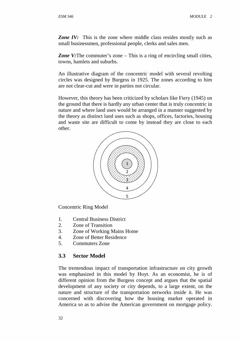
ESM 346 MODULE 2
32
Zone IV: This is the zone where middle class resides mostly such assmall businessmen, professional people, clerks and sales men.
Zone V:The commuter’s zone – This is a ring of encircling small cities,towns, hamlets and suburbs.
An illustrative diagram of the concentric model with several revoltingcircles was designed by Burgess in 1925. The zones according to himare not clear-cut and were in parties not circular.
However, this theory has been criticized by scholars like Fiery (1945) onthe ground that there is hardly any urban center that is truly concentric innature and where land uses would be arranged in a manner suggested bythe theory as distinct land uses such as shops, offices, factories, housingand waste site are difficult to come by instead they are close to eachother.
Concentric Ring Model
1. Central Business District2. Zone of Transition3. Zone of Working Mains Home4. Zone of Better Residence5. Commuters Zone
3.3 Sector Model
The tremendous impact of transportation infrastructure on city growthwas emphasized in this model by Hoyt. As an economist, he is ofdifferent opinion from the Burgess concept and argues that the spatialdevelopment of any society or city depends, to a large extent, on thenature and structure of the transportation networks inside it. He wasconcerned with discovering how the housing market operated inAmerica so as to advise the American government on mortgage policy.
1
2
3
4
5
ESM 346 ENVIRONMENTAL PLANNING AND MANAGEMENT
33
He believes there is a strong correlation between ‘rent’ and ‘housing’situation. Using retail value therefore, as a surrogate of housing quality,Hoyt demonstrated how residential land uses tended to be arranged insectoral pattern, radiating outwards from the city centre along transportroutes.
According to him, thirty American cities where sampled andarrangements of housing units were found to be in organized pattern ofrent; the basis on which the following facts are established:
(a) Highest rental areas stretch continuously outwards from the citycenter in sectoral pattern.
(b) The high rent areas’ extension usually occurs along racial lines ortransport routes from the center to the outermost part of the city.
(c) Middle-range rental areas often encloses or bounds the highestrental areas.
(d) In most cases, the middle-range rental areas, demarcate the high-rent and low-rent residential areas.
(e) Normally, the low-rent areas of the city frequently locateopposite the high-renal areas.
In conclusion, he maintains that the sectoral development of the city is afunction of the established lines of travel which facilitate movement tothe CBD, for enhancement of economic activities as well as socialinteractions.
3.4 Multi nuclei Model
It could be argued that the attempt to marry the principles of concentricand sector models together, led to the emergence of multi-nucleiconcept. The concentric model for instance, at its best, is operationalespecially at the early stage of city formation. It stimulates existingcommunal function to such an extent in the city as to warrant thedesignation of a centre of nucleus. The subsequent expansion of the cityand the complexity of the total environment make possible furtherdevelopment of new centers at the periphery. Perhaps, on this note,Harris and Ullman developed the multi-nuclei model, to suggest that thecity with its extended geographical region, comprises as many segmentsas possible, each grouping a round a separate nucleus or center.
At this point, it is necessary to examine more closely the nature andfunctions of these centers so as to understand the key factors responsiblefor their creation. “Although most of the centres are similar, variousareas that constitute them have developed some specialized functionswhich make each a completely different order. It could be argued
ESM 346 MODULE 2
34
however, that four basic actors are crucial to the development of theseseparate nuclei as enumerated thus:
(a) Certain activities concentrate at specific locations because of thepresence of specialized facilities required to function. A goodexample is a quarry located near rock outcrops; just as furnitureworkshops often group around sawmills or timber sheds.
(b) Closely related functions tend to locate in close proximitybecause of the profit that could be derived from such act. Forinstance, it is common to find the welder, painter, motormechanics and vehicle spare parts sellers operating in the sameenvironment due to the complementary nature of their jobs.
(c) Conversely, conflicting activities that are likely to be detrimentalto each other, just like the residential and industrial districts willneed to be located in opposite direction for the sake ofconvenience.
(d) On account of the variation in rents in different parts of the city,the most desirable site therefore is dependent upon the ability ofprospective developers to pay for the price.
What this illustration has demonstrated is that, various nuclei are formedspontaneously as the city develops. When differ areas of specializedactivities are stimulated, specific central functions are evoked. Thenumber increase as the existing ones are absorbed only for the others tobe created at the outer zone. This gives a perspective of developmentfrom the spatial to the full understanding of the process as an exercise inspatial perception.
3.5 Land Value Model
This model focuses on land value, and shows the basic structure ofbusiness activities and residential land use in relation to the populationdensity gradient of the city. To some extent, the relative strength of acity reflects the purchasing power of its own residents – a large numberof whom depends directly or indirectly on trading.
Usually, its trade is drawn from its rural hinterland, its urban yield, itsservice and market areas which are still considered as its ‘sphere’ ofinfluence. Retail and wholesale functions which need to be central totheir market, and offices often eyed by the labour pool are concentratedin the central part of the city where the transport systems are focused.The result of this is the development of series of zones in which majorland uses like, commercial, industrial and residential terminate, based onrent parable on land and transport services form the city center.
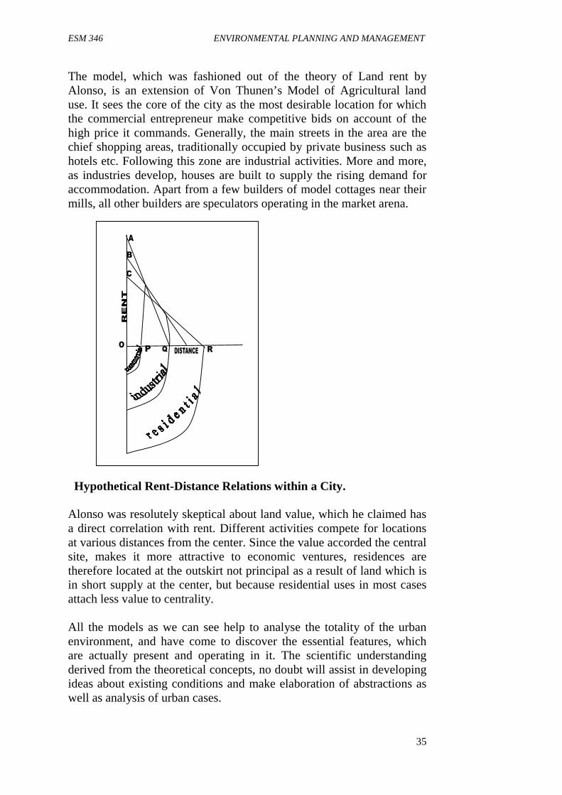
ESM 346 ENVIRONMENTAL PLANNING AND MANAGEMENT
35
The model, which was fashioned out of the theory of Land rent byAlonso, is an extension of Von Thunen’s Model of Agricultural landuse. It sees the core of the city as the most desirable location for whichthe commercial entrepreneur make competitive bids on account of thehigh price it commands. Generally, the main streets in the area are thechief shopping areas, traditionally occupied by private business such ashotels etc. Following this zone are industrial activities. More and more,as industries develop, houses are built to supply the rising demand foraccommodation. Apart from a few builders of model cottages near theirmills, all other builders are speculators operating in the market arena.
Hypothetical Rent-Distance Relations within a City.
Alonso was resolutely skeptical about land value, which he claimed hasa direct correlation with rent. Different activities compete for locationsat various distances from the center. Since the value accorded the centralsite, makes it more attractive to economic ventures, residences aretherefore located at the outskirt not principal as a result of land which isin short supply at the center, but because residential uses in most casesattach less value to centrality.
All the models as we can see help to analyse the totality of the urbanenvironment, and have come to discover the essential features, whichare actually present and operating in it. The scientific understandingderived from the theoretical concepts, no doubt will assist in developingideas about existing conditions and make elaboration of abstractions aswell as analysis of urban cases.
ESM 346 MODULE 2
36
4.0 CONCLUSION
In this unit, the models discussed have identified in system terms, theelements or importance in the structuring organizations and have relatedthem in actual terms to the urban development process. This will enableus take informed decisions in our planning approaches especially inurban areas.
5.0 SUMMARY
We have iconic, analogue and symbolic models. Concentric modelsuggests that the city is a complex entity which often exhibit concentricpattern of growth of six notable zones.
Sector model explains the impact of transportation infrastructureon city growth as exemplified by Hoyt.
Multi-nuclei model: An attempt to marry the concentric andsector model led to the multi-nuclei model. The model suggeststhat the city with its extended geographical region is made up ofmany segments as possible and each grouping around a centre.
Land value model- This model shows the basic structure ofbusiness activities and residual land use in relation to the densityof population of the cit.
6.0 TUTOR-MARKED ASSIGNED
1(a) What is a model?(b) Discuss briefly the three types of model.
2. Using suitable illustrations, discuss the concentric pattern of theurban growth as conceived by Burges.
Self-Assignment
(1) Distinguish between sector and multiple nuclei models.(2) What is land value model about?
7.0 REFERENCES
Basorun, J.O. (2004). Basic Elements of Urban and Regional Planning.Shalom Publishers. Akure, Ondo State.
Ojeifo, O.M. (2005). Elements of Planning and Design. DonaldPublishers. Benin, Benin City.

ESM 346 ENVIRONMENTAL PLANNING AND MANAGEMENT
37
UNIT 2 STAGES OF THE PLANNING PROCESS
1.0 Introduction2.0 Objectives3.0 Main body
3.1 Stages of the planning process4.0 Conclusion5.0 Summary6.0 Activity7.0 References
1.0 INTRODUCTION
Planning is necessary to bring change in the behavior of man when itbecomes very necessary. Virtually all aspects of man’s way of life tobring development in all sectors require adequate planning. Examples ofareas where we require adequate planning are: Traffic Control,Agriculture, Infrastructural development, industrial development and soon. And so anything man does requires continuous planning in naturewith some systematic framework within which certain elements ofcontrol and monitoring are put in place to ascertain the effectiveness ofplanning. The process of doing this is what this unit is all about.
2.0 OBJECTIVES
At the end of this unit, students should be able to:
List the process involve for effective planning of any project. Justify the need for effective planning. Justify the need for monitoring and review after plan
implementation.
3.0 MAIN BODY
3.1 Stages of the Planning Process
Ideally, one should aim at making the planning process as meaningful aspossible. There need arrange the stages in a logical order, so that acommon principle is maintained, and that the changes envisaged in aparticular situation will have the potentiality of transfer to relatedsituations. As a matter of fact, concepts of the planning process do notapply uniformly to different circumstances; they are formed out of theplanner’s experience of grappling with the numerous aspects of theenvironment. A particular planning task or problem dictates the
ESM 346 MODULE 2
38
techniques to be adopted as information required at each stage are notlikely to be the same. This therefore, suggests that an appropriateprocess is that which is relevant to the situation at hand, and in sufficientvariety to ensure the realization of a specific goal.
In general, especially as it applies to land use planning, the processcould be broken down into a series of simple sequential stages asindicated in the diagram below. These stages are designed to presentinformation and at the same time evoke a response in the desireddirection. Moreover, the sequential presentation of the material will nodoubt enable the planner make appropriate prediction in advance of planimplementation and effect correction where necessary.
Stage I: Identification of planning context
This is the first step of the panning process, where the planning task orproblem is recognized and identified. A true problem is in the form ofcertain deficiency or difficulty caused by people in an environment,which might appear to be unexpected, abnormal and or unacceptable.One problem so identified, can never be similar to another or a previousone. Each is usually unique in relation to the people the timing and thecontext, hence, demands a different solution. For example, a cluster ofsettlements might be considered for establishment of educationalinstitution, based on the population and the location to an existing one,far way. This does not necessarily imply that the same type of institutionwill be proposed for similar settlings elsewhere. What is importanthowever is that the identification of problem should be closelydependent upon the circumstances and the significance to the society inquestion. It is the central point around which planning activities or thepanning processes are meant to revolve.

ESM 346 ENVIRONMENTAL PLANNING AND MANAGEMENT
39
Stage 2: Determination of Scope
Actually, the ability to plan successfully underlies the ability of theplanner to think logically. A particular problem cannot spread over anunlimited space, neither can it be indefinite. This suggests that theplanner must be able to classify his problem unambiguously and
Identification of Planning Context
Determination of Scope PreliminaryInvestigation
Identification of Goals andObjectives
Data Collection
Data Analysis
Identification ofConstraints
Generation ofAlternative Proposals
Modification of Goals andObjectives
Plan Design
Plan Evaluation
Plan Implementation
Monitoring and Review
The Planning Process
ESM 346 MODULE 2
40
recognize the criteria for demarcating the affected area. Havingdiscovered that an area lacks a specific facility, there is need to embarkon preliminary investigation perhaps, through reconnaissance survey, toidentify the affected settlements and determine the geographicalcoverage. The best way by which one can approach this, is to group thearea into a unit, using common traits like; dialect historical and politicalaffiliation, as well as relationship between people preferably, a base mapof the area may be procured at this stage or a new one prepared incasenone exists, for perfect demarcation. Thereafter, the particular type offacility (educational, health, transportation, welfare etc) that is sorequired is equally determined. The essence of determination of scopetherefore, is to mark the limit of study, establish a ground for a trueunderstanding of the gravity of the problem and to demonstrateconvincingly the need for a particular proposal or planning research.
Stage 3: Establishment of Goal and Objectives
Establishment of goal originates from scope determination. It is thespecific aim one hopes to achieve after identifying the needs, problemsand aspirations of the people. It is, indeed, a broad statement of theplanner’s intention which is objectively defined. Still using the currentexample, the preliminary investigations might reveal that the area inquestion requires a secondary school. This remains the overall goal,which is based on simple perceptual appearance, and considerednecessary to improve the standard of education in the area. Toaccomplish this goal, certain objectives are set out, representing moreprecise means through which the goal could be achieved. Consideringthe significance of these objectives to the evaluation process, key areoften stated in testable manner and in logical sequence, such that thedesired end is gradually realized. On the proposed secondary school, theobjectives might therefore include:
(a) To examine the level of illiteracy in the area;(b) To identify the existing primary schools and people with
elementary education that will service the high school and(c) To provide secondary education for the people.
All these are extrapolated from the existing situation. The planner isnow able to reason by hypothesis, or rather propositions as he tries toimagine the relations between relevant variables, without necessarilyestablishing the relationships until the evaluation stage.
Stage 4: Data Collection

ESM 346 ENVIRONMENTAL PLANNING AND MANAGEMENT
41
Planning data are facts or information required when a phenomenon isbeing examined for decision making. Data collection stage is essentiallystructured for the gathering of statistical information about the past andpresent state of the event under investigation. This enables the planner tohave a full knowledge of the circumstances surrounding his research andmake, a generalization about the population of interest. The success ofany survey to a great extent depends upon data collected, the systematicorganization and the manner in which they are serially analyzed for theprojection of a meaningful design. Numerous procedures exist for datacollection. A researcher might decide to embark on total, purposive orscientific sampling, just as time and scope of research permit. In anycase,, it is important to note that, the framework of collection must beclosely related to the planning activity, and be skillfully designed so thata satisfactory result is eventually obtained. There are four broad sourcesof field data
(i) The primary source(ii) The semi-secondary source(iii) The secondary source(iv) Use of Satellite and Geographic Information System (GIS)
Satellite is quite useful in collecting data relating to physiographic,geological and hydrological studies. GIS on the other hand, is thecurrent fastest growing segment of computer technology, introduced inthe form of maps to provide information and data about land, theenvironment and natural resources. For instance, ‘in the United States ofAmerica, geographical data in government represents as much as 85% ofthe total governmental database. It is estimated that between 60% and80% of all data held by government departments in Britain is geo-spatial.
Secondary sources refer to data already collected, processed, analysed,sometimes interpreted and reconstructed by other researchers, which areusually presented in tables, diagrams, figures and charts. Others includetextbooks, extracts from newspapers, Journals, reports and monographs.The GIS and the electronic media, in a way, belong to this category. Thesemi-secondary sources are similar to the secondary sources except that,the information so collected are still left in the raw form unprocessed forproper planning. Examples include registration of marriages, births, anddeaths kept in separate files in the local government councils orhospitals.
The primary source relates to fresh or raw data obtained by theresearcher directly from the field. This is usually done through the use ofquestionnaires, research schedule, observations and controlledexperimentations, interviews and the use of electronic and photographic

ESM 346 MODULE 2
42
equipment. The set of questions contained in the questionnaire areprepared in connection with the study. These are unambiguously statedand produced in many copies for the target population to obtaininformation that will guide in decision making. The questionnaires areadministered through he mail, telephone or face-to-face contact with therespondents. The interview method is more of verbal interactionbetween the researcher and the respondents. In this case, the researcherprepares well framed questions, goes to the field, asks the respondents,and records responses himself. This is very useful, especially when thetarget population is elite. Observation method is actually an on-the-sitesituation investigation, for the purpose of ascertaining to exact positionof the study area, in terms of location, the inhabitants (people),vegetation, climate, topography, and other barriers like rivers, rocks,hills, gullies and so on. The point of view here tallies with thepreliminary investigation carried out in stage two. Through datacollection, the researcher can easily identify legal and politicalconstraints as well as other severe limitations in respect of landacquisition. This is necessary particularly in transportation planning,environmental planning and land use planning.
Stage 5: Data Analysis
This is a stage, where researcher carefully separates the data alreadycollected into parts, in order to understand and explain in detail theresults of his study. In urban and regional planning, there are three broadtechniques of data analysis, which include:
(i) Using descriptive statistics, by organizing numerical data forsimple calculation and graphic display. Here data are summarizedor grouped only to determine either the mean, mode, median,standard deviation or variance after which they may be presentedin tables, charts and graphs.
(ii) Using inferential statistics, whereby the researcher can make ageneralization or draw an inference from a segment of populationin respect of any existing trends or relationships between keyvariables of research. The method involves the use of advancedstatistics like; Chi-squared, Student’s T-Test, CorrelationAnalysis, Linear and Multiple Linear regression Analysis.
(iii) Using quantitative models, which are mathematical in approach,for testing existing theories that have been applied in theresearch. The models which are descriptive, predictive,prescriptive and analytical in nature provide the basis forunderstanding what prompts what, in a real life situation. Thistechnique is very useful in transportation planning.

ESM 346 ENVIRONMENTAL PLANNING AND MANAGEMENT
43
It is necessary to emphasizes that, the method of analysis to beemployed in any research should be determined by the type of datacollected, the information required and the planning task above all.
Stage 6: Modification of Goals and Objectives
It is essential that a detailed study is always made to help in a problem-involving activity by judicious use of data analysis. Such analysis, to aconsiderable length, must have taken into account, the logicalconnections between research variables. If eventually, the result of theanalysis varies greatly with the common goal earlier established, theneed therefore arises for modification of the goal as well as theobjectives to make them more acceptable and realistic. For instance, theanalysis of data collected on the proposed secondary school mightindicate that about 65% of people in the area were in the age-bracket 30-40 years, which by all standards are above secondary-school going age.Invariably, the initial goal becomes irrelevant together with theobjectives. At this point, he modification might warrant a completechange of proposal to teaching of vocational skills with new set ofobjectives. If on the other hand, it was discovered that 80% hadelementary education out of which 75% are in 10-20 years age group,then the proposal is in order, while only the objectives may be modifiedin scope to accommodate new findings. This goes a long way to reduceconflicts among the objectives and help to determine alternatives toachieving the goal.
Stage 7: Plan Design
At this stage, the planner decides on the general arrangement of thedifferent parts of the proposed plan during which alternative proposalsare generated. The alternatives will show how to achieve the same endby using so many means. Actually, there is not just only one solution toa particular problem. In reference to the constraints identified duringfield survey, possible solutions are set forth preferably in maps or charts,each having the chance of being selected. Cost of execution, publicparticipation and other planning rules which are supposed to guideagainst irregularities, are related to data analysis, and enables theplanner to be consistent about many of them, even though they areclearly fairly complex. By this, the planner will, of course, establish thathe understands the picture of his plan before attempting to implement it.In a nutshell, the alternative concepts initiated at this stage are meant torepresent land use or development policies or the existing or envisagedphysical or spatial, social or economic problems in the humanenvironment.
ESM 346 MODULE 2
44
Stage 8: Plan Evaluation
The idea of evaluation springs from a particular view of the planningprocess. That is, the realization of a workable plan, the alternative plans,even though well-conceived, are bound to have different implications onthe set goal in terms of short and long term consequences. On this note,it is necessary to ashes their merits, on the bass of the advantages anddisadvantages of each. Assessment in this context means evaluation,whereby all the courses of action or alternative ways of realizing planare compared and measured, using such sophisticated techniques likeCost-Benefit, Goal Achievement Matrix, Cost-Goal Analysis etc to beable to form opinion about the amount, value and quality of each, afterwhich the best is chosen, being obviously acceptable. Physical attributesof the different plans are converted to mathematical values that caneasily be measured and computed. The significance of this is that, itenables the researcher to develop good judgement ability, and decideson appropriate solution when presented with a type of problem.
Stage 9: Plan Implementation
This is a crucial sage of the planning process where plan actions,activities or proposals that have been officially decided are executed. Itinvolves the planner becoming aware of the nature of the acceptedproposal and becoming competent enough in applying it to the relevantsituation. It is important to note that, although the initiation of a proposalis essential, it is useless as long as it cannot be implemented. It shouldbe a solution of real-life problem that could be executed within aspecific framework. Planning Authority (in respect of publicdevelopment0 and private sector to be involved at this stage are clearlyspecified with strict development control measures put in a place toensure god co-ordination for plan realization. What was initially anobjective action is now transformed into concrete activity. Eventually, eplanner will see how is ideas are working out in practice, and when, andwhere to make necessary adjustment in the process.
The logical structure of most plans usually demands phasing of activitiesat this implementation stage. This technique allows for the attainment ofproject gradually in sages over a period of time. Most often, these stagesof development are scheduled to overlap so that as a particular phase ofdevelopment is in progress, the demand for a new one to take off isstimulated based on its relevance to the former. Volume of work andperiod of completion of the phases are made to vary in a way that theproposals could be realizable within the plan period. The sensitivenature of this stage, argues the need for a great deal of experience, as

ESM 346 ENVIRONMENTAL PLANNING AND MANAGEMENT
45
well as adoption of a consistent technique so that cases of inadequaciesand abandonment are avoided in project execution.
Stage 10: Monitoring and Review
The two elements involved at this final stage have a similar focus. Theyoffer approaches which help to assess whether the implementation issuccessful or has failed completely. Monitoring and review which aresimultaneously carried out at this level imply total appraisal of planregularly, to ascertain the effectiveness of the implementation strategy.The first consideration is to determine the extent to which the goal andobjectives have been achieved. Secondly, is the decision on the level atwhich the target population has been directly or indirectly affected bythe plan. If an appreciable progress has been noticed, then the plan couldbe regarded as a normal one. If on the other hand, it is evident that theprocess has failed to yield the expected results, then it is essential toreturn to an earlier stage re-assess the planning context, re-state the goaland objectives and begin a review of activities in some or all the stagesagain.
4.0 CONCLUSION
This unit 2 underpins the way in which planning for any project shouldbe structured and provides approaches to designing and implementingplanning projects. Though the approaches provided are not absolute butthey provide the framework or a meaningful planning.
5.0 SUMMARY
The process of planning entails 10 sages though not in absolute terms.These are: Identification of Problem, Scope Determination, Goals andObjective, Data Collection, Data Analysis, Modification of goals andObjectives Plan design, Evaluation, Implementation, Review andMonitoring.
6.0 ACTIVITY/TUTORED MARKED ASSIGNMENT
1. List and briefly explain with illustrations, the process of planning.2. What is monitoring and review necessary after plan
implementation?
Self-Assessment Exercise
Choose a project of your choice, and list the planning process to attainthe desired aim and objectives.

ESM 346 MODULE 2
46
7.0 REFERENCES
Basorun, J.O. (2004). Basic Elements of Urban and Regional Planning.Shalom Publishers. Akure, Ondo State.
Ojeifo, O.M. (2005). Elements of Planning and Design. DonaldPublishers. Benin, Benin City.
ESM 346 ENVIRONMENTAL PLANNING AND MANAGEMENT
47
UNIT 3 COMMUNITY FACILITY PLANNING
1.0 Introduction2.0 Objectives3.0 Main Body
3.1 Preparation of Community Facility Plan3.2 Planning Requirements for Community Facility3.3 Factors that determine the location of facilities in Urban
Areas3.4 Location of Service Centres in Urban Areas
4.0 Conclusion5.0 Summary6.0 Tutor-Marked Assignment7.0 References
1.0 INTRODUCTION
There is usually a need to plan the location of facilities in communitycentres. The community centres are those service centres that areprovided in a community of 2-6 neighbourhoods. These facilitiesinclude among others: schools (from Nursery, Primary and secondaryschools, postal Agency, A police station market, library, museum,Banks, Hospitals and recreation centres. The requirements, factors thatdetermine the location ofa cities in urban areas and the location ofservice centres are all looked into in this unit.
2.0 OBJECTIVES
By the end of this unit, you should be able to:
Prepare a community facility plan. Explain the factors that determine the location of facilities in
urban areas. The requirements from effective community facility The location of service centres in urban areas.
3.0 MAIN BODY
3.1 Preparation of community Facility Plan
The planning process, is more or less an organized structure of planningthat enables us to direct our course and meet new problems of differentnature more effectively. It tries to establish a principle which can beapplied to various environmental problems, with a few modifications insome cases. Restructuring of this process as indicated below helps to
ESM 346 MODULE 2
48
illustrate alternative way of preparing a community facility plan,especially, when it has become increasingly evident that an existingfacility is in short supply.
This model is activated by growth and environmental changes that nowaffect the structural components of the community. From the viewpointof treating the community as a whole, which is consistent with modernplanning, a comprehensive survey is first conducted on the existingfacility that is considered inadequate. This could be; water, electricity,roads, health centres, churches, libraries etc. The reactions of people tothe need for such facility during survey; describes the way in which theinadequacy has affected their economic or social system. Throughappropriate data collection process, a considerable amount ofinformation is gathered on the existing facility and the possible causes ofshortage. The present population is examined and later projected to aplan period, to establish the need, for improvement and or extension asthe case may be; the basis for which goals and objectives are formulated.Apparently, this method involves placing people in unique position ofdeciding what they want. Genuine regard for their feelings, leads togeneration of alternative proposals in line with existing planningstandards. The proposals are evaluated and recommendationssubsequently made with designs for implementation, preferably inphases, and in tune with the allocated resources. The results obtainedfrom this process are consistent with those of the former. As can be seenfrom (Fig. 5 and 6), the predominant process in the two texts, eventhough differently arranged, are of similar intention of gaining adequatecontrol over the process of urban development. Not that alone, theillustrations are means of raising our understanding of analytic andinterpretive strategies, identifying the material facts, the key issues, andrelevant routines that fit the area of environmental planning.
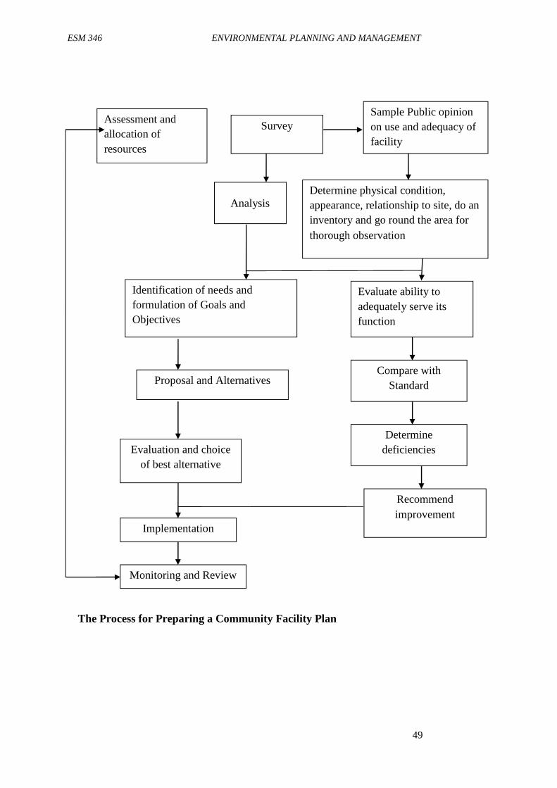
ESM 346 ENVIRONMENTAL PLANNING AND MANAGEMENT
49
Assessment andallocation ofresources
AnalysisDetermine physical condition,appearance, relationship to site, do aninventory and go round the area forthorough observation
Identification of needs andformulation of Goals andObjectives
Compare withStandard
Evaluate ability toadequately serve itsfunction
Recommendimprovement
Proposal and Alternatives
Evaluation and choiceof best alternative
Implementation
Monitoring and Review
The Process for Preparing a Community Facility Plan
SurveySample Public opinionon use and adequacy offacility
Determinedeficiencies
ESM 346 MODULE 2
50
3.2 Planning Requirements for Community Facilities
The following planning requirements are essential in the location ofcommunity facilities. They are discipline, system sizing, designparameters and cost.
Discipline
This identifies who is being planned for and also who is responsible forthe provision of the facility. Largely, we plan for the people andgovernment in most cases is responsible for the provision of facility. Inplanning the facility therefore, the people that make up the area mustfirst be considered. What is considered about the people are theirdemographic structure, that is the population dynamics, sex and agestructure and the economic base. Also considered are the employmentstructure and dynamics and lastly the pattern of settlement.
System Sizing and Design Parameters
The three factors that must be considered here are:
(a) The Ultimate Extent of Service Area: Here we consider thegeographic area or spatial area the facility is expected tocover. Also the number of the years that the facility isexpected to provide optimum services is considered.
(b) The Ultimate Area Service Population: The present and theexpected total population the facility is to serve areconsidered. Also considered are the population structure anddynamics as well as the expected demand changes.
(c) The Project Per Capital Service Level requirement: Here weconsider socio-economic changes and prospects of the people,changes in social and economic values such as changes inincomes, occupation etc of the individuals or groups canlargely influence the planning of facilities. A rise in the percapital income of people would mean a change in taste andpreference.
Cost
Cost is a vial instrument in the planning and location of any facility.Costs considered area; cost of development, future operating cost andreplacement cost.
(a) Cost of Development: This is the actual cost required for theprovision of the facility. These include the cost of buying thematerials locally or cost of importation of the materials, amount
ESM 346 ENVIRONMENTAL PLANNING AND MANAGEMENT
51
spent on technical knowledge, inform of training of local people,labour, and cost of construction.
(b) Future Operating Cost: This include the cost of running thefacility in terms of the materials, personnel, and the generallength of time that a facility would be used before replacement.
(c) Replacement Cost: These include the technology required forreplacement and the cost of meeting frequent breakdowns.
Generally there are three types of costs that are expected to be borne bythe people in the provision of community facilities; these are economiccost, physical cost and social cost.
1. Economic Cost: This refers to the economic implication of theprovision of facilities. Usually, the resources used in theprovision of facilities come from the state. These resources arepartly from the taxpayer, therefore how much is required for thelocation of a facility vis-à-vis the effect on the resources of thestate and the burden on taxpayer is considered under economiccost.
2. Physical Cost: This is the cost of altering the stability of thephysical environment. In other words we must count the cost ofdamage done to the soil, vegetation, water and even air in theprovision of a facility.
3. Social Cost: Social cost involves that cost that is imposed on theindividual and the community in the process of providing thefacility. For example, the inability to use a road because of theconstruction of underground channel or the disruption of waterflow due to the construction of roads is counted as social cost.When a community shrine is made to give way for theconstruction of a good road, it can be counted as social cost onthe community.
The location of these services either at the neighborhood or communitylevel requires easy accessibility and adequate space (land) allocation.
3.3 Factors Determining the Location of Service Facilities inUrban Areas
Demographic Factor
The demographic factors considered in the location of urban facilityinclude the total population of the urban area, the structure of thatpopulation, its age and sex structure, birth and death rate, dependencyratios, net migration, rate of urbanization etc. these could determine the

ESM 346 MODULE 2
52
type and the amount of facility to be located. In the location of healthand educational facilities for instance, what must be considered are thetotal population size and their distribution. This will enable the plannersto know the exact numbers of such faculties needed and where theyshould be located. Also with the understanding of the age and sexstructure, it becomes very easy to know the type of facilities to belocated. Generally there are the infants and adolescents of between 0-4and 0-19 years, there are the adults of between 145-59 and 15-64 yearsand there are the aged of 60 or 65 years and above. In the location offacilities, if the population of the urban area constitute more infants andadolescents , if the population of the urban area constitute more infantsand adolescents, it would mean that certain basic facilities needed forthe development of youths may be located, for example childcarecentres, nursery and primary schools.
The sex structure determines the composition of male and femalepopulation. If more females constitute the urban population femaleoriented facilities such as maternity homes, children hospital, skillacquisition and women centres may be located.
Accessibility Factor
In the location of public facilities, accessibility must be considered.According to Moseley (1979), accessibility is the ease with whichpeople in an area obtain or reach necessary services. Accessibility is themajor factor that determines the size and extent of interaction betweendwellers and facilities. The physical dimension of accessibility shouldbe the major concern of the planner, this is meant by the position, timeand spatial distance that separate the individual from the facility.Accessibility depends on the individual capacity to incurred movementcost in term of transport cost or the cost of using his time. Facilitiesmust therefore be located in such a way that minimum distance wouldseparate the facility from the intended users.
Economic Considerations
This consideration includes the general economy of the area, theoccupation, incomes, financial cost of materials and provision, thedistributive system and the technology. Essentially any urban facility tobe located must be financed by the provider. If the government, whichprovides most of the urban facility, is not financially buoyant, then someneeded facilities are not likely to be located. For example there are somefacilities that are beyond the finances of the local government e.g.telephone services and hospitals. The cost of provision, maintenance andcontinuous service of these facilities is borne by the people. A very

ESM 346 ENVIRONMENTAL PLANNING AND MANAGEMENT
53
weak economy obviously would not be able to pay or sustain for certainservices. This may amount to these facility not located or may be locatedin fewer numbers.
To a large extent the location of certain facilities in an urban area woulddepend on the income and occupation of the people. Urban centres withmainly secondary and tertiary activities and with high incomes wouldattract a god number and types of specialized facilities.
Political Consideration
The political arrangement of an area determines to a great extent theease and convenient with which services are located and administeredfor the overall welfare, growth and development of the populace. In thisregard we may wish to determine or establish whether it isdecentralized, secular or fragmented. We may also wish to determineand establish whether the political arrangement is dictatorial ordemocratic. These differences could influences the ease with whichpolicies on urban facility location can be made and implemented. Thepolitical consideration may also do with the intentions of thegovernment of the day. When the plight of the people is upper most intheir minds, then the location of facilities becomes easy. Also politicalstability and administrative processes are essential in the location ofurban facilities.
Physical and Environmental Factors
In the location of a city in the urban, the physical and environmentfactors that must be considered include the topography of the area, soil,climate, land and vegetation. Urban areas with very bad terrain orundulating relief may become difficult for the location of facilities. Thedifficulty may be in terms of cost of provision. Except the provider hasthe financial resources or the technology to overcome the imposingconstraint, otherwise such areas may either avoided. Soil is anotherfactor that may be considered. Marshy soil or flooded land areas maynot be a good choice for the location of urban facilities.
Expected Attendance Pattern
Patronage is a very vital factor in the location of urban faculties. It refersto the number of people ready and willing to use a facility this dependson the nature of the facility, the population, location and accessibility. Ifthe nature of a facility is that which the people desire example, schools,hospital and maternity’s, it is expected that attendance would be high.Also the population of the area can determine the level of patronage of afacility if the population is large, there is certainly going to be good
ESM 346 MODULE 2
54
patronage. For instance if the population of infants and adolescents islarge in an area, it is sure to favour the location of nursery, primary andsecondary schools. The other factors is accessibility. If the area ofchoice of location is that which is too far away from the population oron a rugged terrain, tis may affect accessibility and hence the level ofpatronage.
3.4 Location of Service Centres in Urban areas
The location for service centres can be in any one or more of thefollowing urban areas:
A nursery school, primary school, shopping centre or market, a numberof retail shops at good locations, neighbourhood park for informaloutdoor locations, health centres, places of worship, postal agency,banks, police stations, post offices, service industries, library and anyother places in and around the urban centre. There is a need to properlyplan for the location of these service centres in order to have asustainable environment devoid of diseases, traffic and other relatedproblems in urban areas.
4.0 CONCLUSION
In this unit, we have looked at the way in which community facilityplans are prepared. Also, the requirements and factors necessary forurban facility plan. The essence is that this knowledge will help tomanage waste, pollution, soil erosion, drought and desertification and allother ecological problems confronting any modern society.
5.0 SUMMARY
Community facility plan entails putting people in sensitive positions soas to determine what they want. Genuine regards for their feelings willhelp in the development of community facility plan. Also, therequirements for community facilities are Discipline, system sizing anddesign, and cost. On the other hand, the factors that determine thelocation of community facilities are demographic, accessibility,economic, political, physical and environmental factors.
6.0 TUTOR MARKED ASSIGNMENT
1. Explain the process for preparing a community facility plan.2. List and explain the factors that determine the location of
community facility plans.

ESM 346 ENVIRONMENTAL PLANNING AND MANAGEMENT
55
Self-study exercise
Why do we need Community Facility plan?
7.0 REFERENCES
Basorun, J.O. (2004). Basic Elements of Urban and Regional Planning.Shalom Publishers. Akure, Ondo State.
Ojeifo, O.M. (2005). Elements of Planning and Design.DonaldPublishers. Benin, Benin City.
ESM 346 MODULE 2
56
UNIT 4 URBANIZATION AND ENVIRONMENT
1.0 Introduction2.0 Objectives3.0 Main Body
3.1 Factors that can lead to the location of settlement3.2 Urbanization and Environmental Quality3.3 Urban Renewal Strategies3.4 Housing
4.0 Conclusion5.0 Summary6.0 Tutor-Marked Assignment7.0 References
1.0 INTRODUCTION
The economic activities that are located in a place goes a long way todetermine their potentials. These economic activities range fromcommerce, education, entertainment, personal service and professions.The difference between a band, village, town and a city is based on theavailable economic activities of an area. For detailed knowledge of thedifference between land, village, town and city, students are advised tosee module one of this course.
2.0 OBJECTIVES
By the end of the unit, you should be able to:
- Factors that have led to the growth of settlements- Urbanization and Environmental quality- Urban renewal strategies- Qualities of good housing.
3.0 MAIN BODY
3.1 Location of Settlements
A close look at the towns and cities reveal that they have certainadvantages of site and position which have enabled them to grow. Thesite of a town or city is its topographical location. The following aresome of the more favourable combinations of site and situation whichhave led to the establishment and growth of settlements.
ESM 346 ENVIRONMENTAL PLANNING AND MANAGEMENT
57
Fertile alluvial plain: The basic requisite of human existence is foodand water. A fertile alluvial plain traversed by rivers is the best forraising food crops and maintaining a secure water supply. A level plainalso facilitates the movement of people and goods. It is an ideal situationfor the exchange of products ideas.
A natural focus of routes: These are the nodal towns. By virtue of theirgeographical location in relation to the region, many towns assumeprominence as centers of road, rail, or water and communication. Peoplecongregate to provide commercial and social services that passingtravelers can make use of. Ibadan and Kano (both in Nigeria) owe muchof their importance to their respective central locations in flourishingfarming regions with trade routes both by rail and by road converging onthem.
Sites for generating hydroelectric power: Waterfalls are natural sitesfor generating hydroelectricity. Where such a site occurs, the availabilityof cheap power attracts industrial concerns. These require labour andprovisions and a settlement is very likely to grow up, taking advantageof the cheap power. For example New Bussa which is close to KainjiDam of Nigeria.
By the side of Lakes: Lakes provide fish, water and a means of inlandtransport. Some of the known tourist centers are located on or near lakesbecause of their scenic beauty and recreational facilities. Entebbe is alakeside town of Lake Victoria whose importance is further enhanced byits proximity to the capital, Kampala.
Mineral weekly: Settlements have grown to considerable size purelybecause of the presence of minerals. For example, Jos (Nigeria) grew asa result of the discovery of tin on the Jos Plateau.
Good site for defense: This was a deciding factor in ancient times whendefensive strategy, executed at the right moment, could save the wholecommunity. Some of the older towns that grew up with defensive sitesinclude Peking, the ancient and present capital of China. Ibadan(Nigeria) is sited on seven hills which provided protection for the earlysettlers during the years of Yoruba warfare of the eighteen andnineteenth centuries.
Urbanization and its Dynamics
Urbanization is the increase over time in the population of cities inrelation to the region’s rural population. In terms of place, urbanizationmeans increased spatial scale and/or density of settlement and/orbusiness and other activities in the area over time. The process could
ESM 346 MODULE 2
58
occur either as natural expansion of the existing population, thetransformation of peripheral population from rural to urban, incomingmigration or a combination of these. Historically, urbanization is closelyassociated with industrialization. When more and more inanimatesources of energy were use enhance lump productivity(industrialization), surpluses resulted in both agriculture and industry.
Reasons for Urbanization
In 1800, only about 2 percent of the world’s population lived in urbanareas. The world’s urban population has grown from 2 percent to nearly50 percent of all people. The most striking example of urbanizationtrend is United States of America. In the United States, about 5 percentof the population lived in cities in 1800, but about 50 percent of thepopulation lived in cities by 1920. Throughout the 19th century, the USwas urbanizing. Today, about 80 percent of the US population live incities and suburbs.
3.2 Urbanization and Environmental Quality
Urbanization has significantly improved the economic prospects andquality of life for a large and increasing proportion of the people of thearea. Despite this benefit of urbanization, many policy makers continueto view the cities/towns with concern. They cite the profound effect oncultural modifications, difficulty in maintaining public infrastructure andservices, the proliferation of slums (informal settlement), worseningenvironmental conditions, and increasing social problems associatedwith unemployment and underemployment. Details of some theseeffects are:
Distortion of the land use pattern: The rapid rate of urban populationgrowth has remarkable effects on the pattern of land use within theurban centers in the country. Studies of pre-colonial land use pattern intraditional Nigerian cities for example indicate that there was harmonyand orderliness.
Urban solid waste management: One environmental feature associatedwith rapid urbanization is the rising volume of solid wastes generated inthe urban areas. Although comprehensive studies of the nature of solidwastes in Nigerian cities have not been undertaken, there is evidencethat the volume has been quite high in the major urban centers.. In theurban centers in Nigeria, heaps of garbage at almost every busy junctionis a common site. This is clear evidence that the rate of urban solidwaste generation far exceeds the rate of waste evacuation. Accumulated
ESM 346 ENVIRONMENTAL PLANNING AND MANAGEMENT
59
waste is a major public health issue and a vital factor affecting thequality of the environment.
Urban transportation: Modern forms of transportation are associatedwith urban growth in Nigeria. In fact, the rapid development of someurban centers such as Lagos, Port-Harcourt, Kaduna, and Aba isexplained largely by their strategic location with respect to modernmeans of air, water, rail-land transport. Transportation within urbanareas and between them and other towns and cities in Nigeria haveremarkable environmental implications for urban dwellers.
One major means of modern transport with remarkable impact on theurban environmental in Nigeria is road transport (motor vehicle). One ofthe primary sources of environmental problems associated with motorvehicle transportation in most urban areas relates to unavailability ofgood road network. This has led to motor vehicle traffic concentrated onthe few available roads and the resulting traffic jam that has seriouslycontributed to the deteriorating urban physical environment of mostlarge cities. Another source of urban environmental deteriorationassociated with the motor vehicle transportation especially in Nigeria isthe haphazard parking of vehicle along the few major roads in the urbancenters and the parking of vehicles on sidewalks and pedestriancrossing. Another visible problem occasioned by motor vehicle transportis the littering of virtually any available space by unserviceable andaccident (junk) vehicles.
Urban air quality: Air pollution has been regarded as a problemassociated with urban centers especially in advanced and developingcountries where the level of industrialization is quite high. Generallymost air pollution in urban areas comes from the combustion of fossilfuels, in industrial process, for heating and electricity generation and bymotor vehicles. High levels of air pollution have serious healthimplication for man. For example, high levels of carbon monoxide havethe potential of causing oxygen starvation and if prolonged may result todeath.
Urban water quality: Adequate and clean water supply for drinking,personal hygiene and other domestic purposes is essential to publichealth and wellbeing. Urban sources of water include springs, streams,hand-dug wells, borehole, rainwater from roots of buildings using potsand other containers. In Nigeria for example, rapid urban growth,increasing economic and technological development and social changehave brought so much pressure on the available source of water supply.As a result water supplies are irregular and unreliable, and people areforced to resort to collect water from unclean sources such as pounds.The health implications of using polluted water are quite obvious. Water
ESM 346 MODULE 2
60
related diseases such as dysentery. Cholera, typhoid, guinea worm andbilharzias common in Nigeria.Urban environmental noise: Noise as an urban environmental nuisanceis largely associated with the increasing pace of social change andindustrialization. Indiscrimate blasting of motor vehicle horns, the use ofgigantic loud speakers fixed to mosques and churches, mobile musicrecord sellers, mobile advertisers, and indiscriminate increase in volumeof household electronic gadgets are major sources of environmentalnoise. The overall effects of the combination of these sources of urbannoise have been the emergence of noise pollution in most centersespecially in developing countries such as Nigeria. The health impact ofnoise on urban inhabitants is now being given more serious attentionand its effects range stress and loss of hearing.
Urban flood and environmental quality: In rapidly urbanizing citiessuch as Port Harcourt and Lagos, flood and flash floods are commonsights. The intensity of flood problem over time and space in Nigerianurban centers is closely related to the rapid rate of urban expansion,especially where the provision for an adequate urban water runoffsystem is lacking and if available, it is usually blocked by solid waste.Urban flood results in disasters such as structural and erosional damage,disruption of socioeconomic activities, transport, communications, lossof lives and property, displacement of people and destruction of theurban environment in general.
Loss of sense of community: In urban centers, there is a loss of a senseof community. In many places, people stay within their homes and donot routinely walk through the neighbourhood. This pattern of behaviourreduces human interactions, isolates people from their neighbours andgreatly reduces the sense of community.
Loss of open space: One of the important features of a pleasing urbanlandscape is the presence of open space. Open fields and parks allowpeople to visually escape from the congestion of the city. Urbanizationhas consequently taken up all available spaces for the purpose ofdevelopment.
3.3 Urban Renewal Strategies
The challenge of urban environmental management in developingcountries during the coming decades will be enormous with thecontinuing urban population growth. Nigeria as a developing countryneeds a sound philosophy of environmental management in the urbancentres located in various states. Such a philosophy should aim at the
ESM 346 ENVIRONMENTAL PLANNING AND MANAGEMENT
61
radical redirection of the pattern of urban growth as well as the creationof an urban environment which satisfies basic human needs and values.Development of efficient public transportation system: One majorsource of urban air pollution is automobiles. A situation where anindividual car with its single occupant going to work, to shop or to eat ameal, is a constant source of air pollution in the urban centres. However,this source of air pollution can be reduced through the provision of anefficient public transportation system. This can be achieved through theprovision of major urban mass transit systems such as buses, good roadnetwork and railways.
Utilization of the low-cost, non-polluting energy sources: One of themajor sources of atmospheric turbidity is vehicular emissions anddomestic sources. To reduce the release of atmospheric pollutants fromthese sources, people should be encouraged to walk or use small, low-speed energy efficient vehicles such as bicycles, motorized tricycles etcfor local trips. Also, efficient energy sources such as natural gas shouldbe used at the domestic levels.
Urban solid wastes management: The challenge of urban solid wastesdisposal in urban centers is enormous in view of the continuing rapidrate of urban population growth. The basic problem in urban solidwastes management in developing countries today is that solid wastesare generated faster than they can be satisfactorily disposed of. Twomajor policy issues that can be employed in solving this problem are:the development of an institutional framework for solid wastes disposaland the application of reuse and recycling technology. Such institutionalframework should involve: (i) involvement of federal authority in urbansolid waste management, (ii) construction of a sanitary landfill for thedisposal and management of such wastes, (iii) involvement of localcommunities in solid wastes management and (iv) the introduction ofuser-charge payment.
Controlled rural-urban migration: Urbanization is associated withindustrialization and the creation of employment opportunities in theurban centres. Consequently, people move to the cities where theybelieve there are better opportunities for employment and better livingconditions. With the present situation, rural-urban migration willcontinue to increase in Nigeria except an effect is made to improveconditions in the rural areas. In this respect, a programme of integratedrural development should be adopted and implemented. Two majorissues should be emphasized in any programme of integrated ruraldevelopment. The first relates to the importance of encouraging thedevelopment of medium-size towns in rural areas to facilitate thedistribution of social amenities to rural dwellers. A second policy issuein integrated rural development is in the need of improving the income

ESM 346 MODULE 2
62
of rural dwellers through major investments in agriculturalmodernization, including mechanization, cooperative land tenurereforms, the provision of credit facilities to farmers, and use offertilizers.
Upgrading of slums and squatter settlements: To date, very littleattention has been paid by public authorities to the problems ofimproving the environment of the low quality residential areas in urbancentres. A large proportion of the housing in the identified slums can beimproved byre-roofing, enlarging windows, painting, landscaping andintroducing better air circulation and sanitation. The worst part of theslum areas could be cleared to provide space for roads, schools, markets,open space etc.
Urban land use management: The present patterns of land ownershipand land transfer in Nigeria’s major cities are grossly unsuitable forproper urban development and land use control. In major urban centresin Nigeria, land is associated with individuals and groups of familiesrather than the community at large. This system of land ownershipsubjects properly developers to carry out uncoordinated landdevelopment in the cities. A major urban land policy option in thisregard relates to the effective implementation of the Land Use Act of1978 which vested the ownership of all land in public authorities.
Participatory approaches: Development approaches in the last twodecades in the world have moved from top-down strategy to bottom-upapproaches. This is concerned with the need to involve local communityinstitutions and individuals in routine management decisions that affectthem. Citizen participation is an essential element in solving urbanenvironmental problems because they are direct receivers ofenvironmental problems and generators of urban wastes.
Environmental education: The single most important activity that willenhance environmental management and sustainable development in themedium to long term is to raise well-informed future generations with astrong commitment to sustained management of natural resources. Thus,environmental education should be an integral component of the formaland informal education system. A comprehensive programme ofenvironmental education and awareness to provide people withinformation on the nature of Nigeria’s urban environment, sources andcauses of environmental pollution as well as the implications of someattitudes to the environment should be developed. Information on theenvironment may be communicated.
3.4 Housing
ESM 346 ENVIRONMENTAL PLANNING AND MANAGEMENT
63
The Universal Declaration of Human Rights Article 25 states that“everyone has the right to standard and adequate living conditions,health and wellbeing of himself and of his family including housing”.Suitable shelter is commonly accepted as a basic human need. A houseis a building or structure, which is made up of a room or group of roomsfor the purpose of living or sleeping by human occupants.
Quantities of Good Housing
Any housing unit, which is intended for use of living, sleeping, cookingand eating must meet the minimum standards. An example of a goodhouse is shown fig. 9.5. This is because good housing conditions createa foundation for healthy, social, economic and political development.The following are the minimum conditions that a housing unit mustpossess:
Sanitary services: Every good house should have adequate sanitaryservices such as toilets, bathrooms and cooking space. The importanceof such sanitary services cannot be overemphasized. Good toilets suchas water.
Hydrologic drought: This is defined in terms of reduction of streamflow, reduction in lake or reservoir storage and lowering of groundwater levels.
Water management drought: This type of drought is defined by watersupply shortages caused by the failure of water management practices orfacilities such as an integrated water supply system and surface orsubsurface storage to bridge normal or abnormal dry periods andequalize the water supply throughout the year.
In addition C. W. Thornthwaite, the eminent applied climatologistwhose pioneering water balance studies made a major contribution tothe understanding of aridity, recognized four types of drought, definedin terms of agricultural requirements. These are:
Permanent drought: Here there is insufficient moisture for anything butthe xerophytic plants which have adapted to the arid environment.However, crops can be produced in such areas, but only at great expenseor under exceptional circumstances.
Seasonal drought: Arid conditions prevail for part of the year, but arebalanced by a distinct wet season. Much of India, the Sahel and thesouthern parts of Africa experience such seasonal drought. Agricultureis carried out often very successfully during the wet season and even

ESM 346 MODULE 2
64
during the dry season if the moisture from the preceding rainy seasoncan be retained.Contingent drought: There is adequate supply of moisture to meet cropneeds. However, irregular and variable precipitation is characteristic ofcontingent drought and serious agricultural problems arise because theagricultural system is not set to cope with unpredictable and lengthyperiods of inadequate precipitation.
Invisible drought: Here crops appear to be growing well, even to theexperienced observer, and there is no obvious lack of precipitation.However, moisture requirements are not being met, the crop is notgrowing at its optimum rate and potential yield from the land is reduced.The effects of invisible drought can only be identified usingsophisticated instrumentation and statistical techniques. Invisibledrought can be dealt with relatively easily by irrigation. In EasternBritain, for example, supplementary moisture has been supplied to sugarbeet and potato crops since at least the late 1950s to deal with thatproblem. Also in Northern Nigeria irrigation is commonly andextensively practiced in their agricultural system.
4.0 CONCLUSION
In this unit, we have knowledge of the factors that can lead to theemergence of settlements which require planning, the quality of anenvironment, strategies for urban renewal and housing qualityrequirements. All these require proper planning in order to have asustainable environmental quality.
5.0 SUMMARY
The factors that can lead to the growth of settlements are: fertile soil,natural routes systems, sites for generating hydroelectricity, presence ofminerals and so on. Also, distortion of land use pattern, slums, wastes,transportation, pollution of air, water and land, flood and loss of openspace are discussed as factors of environmental quality. Factors of urbanrenewal strategies include: use of nonpolluting energy like solar,development of efficient transport, proper waste management, controlledrural-urban migration and so on. And quality housing which includeprovision of good sanitary service, good ventilation, basic facilities athome and use of quality materials.
6.0 Tutor Marked Assignment
A. What is a settlement? Discuss the conditions that promotelocation of settlements.

ESM 346 ENVIRONMENTAL PLANNING AND MANAGEMENT
65
B. List and discuss the possible strategies that can be used tomanage urban environment.
7.0 REFERENCES
Basorun, J.O. (2004). Basic Elements of Urban and Regional Planning.Shalom Publishers. Akure, Ondo State.
ESM 346 ENVIRONMENTAL PLANNING AND MANAGEMENT
68
MODULE 3 SOLID WASTE
UNIT 1 Types of Solid WasteUNIT 2 Solid Waste ManagementUNIT3 Causes of Solid Waste PollutionUNIT 4 Disposal Methods of Solid Waste
UNIT 1 TYPES OF SOLID WASTE
1.0 Introduction2.0 Objectives3.0 Main Body
3.1 Classification of solid wastes3.2 Types of solid Wastes
4.0 Conclusion5.0 Summary6.0 Tutor-Marked Assignment7.0 References
1.0 INTRODUCTION
Waste is anything which is no longer relevant to the disposer. Wastecould also be defined as unavoidable material which results from anactivity without immediate economic demand and which must bedisposed. Wastes are normally classified into three which are: solidwaste, liquid waste and gaseous waste. Liquid wastes are effluents fromindustrial activities, domestic liquid, acid waste and waste oil fromworkshops. On the other hand, gaseous wastes are waste substances likeair. They are neither liquid nor solid that move freely to fill anyavailable space in the atmosphere. Examples of gaseous wastes arewaste from gas flaring, particulate dust, cement factories, quarrying andcigarette fumes.
Solid waste, which is the focus of this module, is defined as the non-gaseous and non-liquid waste resulting from the activities of theinhabitants of a particular residential area. The activities of man ondomestic, commercial and industrial processes give rise to undesirableeffects on land, sea, air and water which are pollutants of all kinds. Theterm solid waste includes all those solid and semi-solid materials that arediscarded through human activities. The solid waste generated throughdomestic and commercial activities is classified as municipal solid wasteand it is also called refuse.

ESM 346 MODULE 3
69
2.0 OBJECTIVES
By the end of this unit, candidates should be able to:
Know what solid waste is about Classify solid waste Determine the different types of solid waste
3.0 MAIN BODY
3.1 Classification of Solid waste
Solid waste can be classified based on a number of factors. On the basisof physical property, wastes can be classified using parameters such ascombustibility and degradability. There are biodegradable wastes likeagricultural wastes. These are materials that are broken down overtimeby the action of micro-organisms such as aerobic and anaerobic bacteria.Non-degradable wastes are materials that are not broken down bybiological processes and thus persist for a long time in the medium inwhich they are disposed. Examples are mining and mineral wastes,plastics and bottles.
On the basis of utility, wastes can also be classified as re-useable(recyclable or convertible) and non-reusable ones. On the basis ofenvironmental risk, solid wastes have been classified according to therisk or danger they pose to man, the fauna and flora. Such wastes maybe lethal of medium risk, toxic or hazardous. There are also non-toxicand non-hazardous wastes. The indiscriminate disposal and dumping ofindustrial, commercial and household wastes such as food waste, paper,polythene, textiles, scrap metals, glasses, wood and plastic on streetcorners and gutter is still very common in Nigerian cities
3.2 Types of Solid Waste in Nigeria
In Nigeria, we have different types of solid waste. The most commonones are discussed in the preceding paragraphs:
Municipal solid wastes: In Nigeria, municipal domestic solid wasteshave heavy content of food waste, leaves, polythene, rags, tin andbottles. It is important to mention here that the composition of domesticwaste in Nigeria varies from season to season and from the food items ingreat demand. For example, between March and April (the peak ofmango harvest) solid wastes in Nigeria urban centers have high contentof mango seeds and fruits. But between May and August (season of
ESM 346 ENVIRONMENTAL PLANNING AND MANAGEMENT
70
maize and pear) domestic wastes in urban centers have high compositionof leaves mainly from corn cobs.
Industrial solid wastes: These include cartons, boxes, buildingmaterials, crates, woods and celluloid materials, chemical wastes suchalcohol, organic acids, fats and oils of vegetal and animal origins,materials containing ammonia, phosphates, nitrates (these are inorganicsubstance). Industrial wastes may be hazardous and non-hazardouswastes.
Agricultural Solid Wastes: In Nigeria most urban centers performagricultural functions. Consequently, waste from animal manure, cropresidues like thrashing of grains, cassava tuber peels and various byproducts of food production like the extracting of palm kernel oil cangenerate a lot of solid waste that find their way to urban solid wastedepots.
Mining and mineral wastes: Mining waste include earth rocks, sand,salt, discarded equipment that result from ore processing and mineralrefining plants like slag, ash and mine water.
Construction and demolition wastes: These are generated frombuilding, civil and Mechanical engineering activities. Constructionwaste consists of unwanted material produced directly or incidentally bythe construction of industries. This includes building materials such asroads, insulation, electrical wiring, tree trumps and rubbles.Construction waste may also include lead, asbestos or other hazardoussubstances. Others are wood damaged or unused materials, bricks andconcrete. Observational research has shown that this can be as high as10 to 15% of the materials that go into a building, a much higherpercentage than the 2.5-5% usually assumed by quantity surveyor andthe construction industry.
Certain components of construction waste are toxic when theydecompose in landfill because the leachates in them can cause toxic gastoxic gas because of the hydrogen sulphide which they contain.
Healthcare wastes: One type of solid waste that is not often talkedabout in Nigeria is hospital waste. Though it is least discussed, it is oneof the most hazardous because of the increasing number of public andprivate clinics. These are wastes from dispensaries, laboratories, clinics,hospitals, nursing homes for the elderly and blood banks. Wastes fromhospitals are contaminated materials like bandages, sharp objects likesyringes, disposable scalpels, blades and expired drugs.

ESM 346 MODULE 3
71
Heath care wastes also include biomedical wastes. The infectious andbiomedical wastes from hospitals and nursing homes, although aresupposed to be collected and disposed off separately and not mixed withthe municipal solid wastes, yet they continue to form part of themunicipal waste that are generated in Nigeria. Biomedical wastes arehighly infectious and contain a lot of pathogens making these wastes tobe hazardous to the soil, air, land and the atmosphere. The polluted soilwill again transmit the contaminants to the vegetation that will grow inthem which can cause disease to animals and human beings that mayhave needs for them.
Radioactive (Nuclear) wastes: These wastes emit neutrons, alpha, betaor gamma radiation as result of nuclear decay. Also included here areexhaustible fumes of cars, machinery, chimney, generation plants,bombs and missiles.
Human and animal wastes: These include excreta, animal dung ordroppings, dead human beings and animals.
4.0 CONCLUSION
As the population of human beings continue to increase coupled withincreased human activities, there is bound to be increase in the amountof solid waste been generated. The classification of these wastes isimportant so as to meet sustainable development. This is why we haveexamined the different types of solid waste in this unit.
5.0 SUMMARY
The different types of solid waste range from hospital waste, miningwaste, agricultural waste and so on. The classification can be based onphysical, chemical and biological wastes which are degradable and nondegradable.
6.0 TUTOR MARKED ASSESSMENT
1. List and discuss, the different types of solid waste generated inNigeria.
2. classify solid wastes on the basis of the refuse that are generateddomestically

ESM 346 ENVIRONMENTAL PLANNING AND MANAGEMENT
72
7.0 REFERENCES
Ajith Sankar, R. N. (2015). Environmental Management. OxfordUniversity Press. India.
Akpofure, R. (2009). Environmental Science: An Introduction. KraftPublishes. Delta State Nigeria.
Nigeria Institute of Safety Professionals (2003). Contractor EmployeeHSE Training Manual. Level 3 Published by ECNEL Ltd. PortHarcourt.

ESM 346 MODULE 3
73
UNIT 2 SOLID WASTE MANAGEMENT
1.0 Introduction2.0 Objectives3.0 Main Body
3.1 Management of Urban Solid Waste in Nigeria3.2 Impact of poor solid waste management
4.0 Conclusion5.0 Summary6.0 Tutor-Marked Assignment7.0 References
1.0 INTRODUCTION
The management of solid waste requires a holistic approach. Thesewastes are movable objects which the user is ready to dispose off. Solidwaste management simply refers to the collection, transfer, treatment,recycling, resource recovery and disposal of solid waste generated.
2.0 OBJECTIVES
By the end of this unit, you should be able to:
Suggest the best ways to manage solid waste The impact of solid waste The problems of solid waste management
3.0 MAIN BODY
3.1 Management of Urban Solid Waste in Nigeria
It must be re-emphasized that the volume of solid waste generated doesnot invariably measure the degree to which the environment or groundwater resources will be polluted. Thus if the waste can be evacuated anddisposed off satisfactorily and as fast as it is generated and collected,there would be no accumulation and hence no insult, abuse andpollution. It is when evacuation and disposal perpetually lag behind therate of generation that solid waste becomes an environmental nuisance.Solid waste management therefore concerns the interplay amonggeneration, storage, presentation, collection and disposal. Though, if notwell disposed off can as well as contaminated groundwater resources nomatter how far the wastes are taken to from the city center.
There are two broad systems of solid waste management, namely publicand private, the former being the more conventional and traditional. In
ESM 346 ENVIRONMENTAL PLANNING AND MANAGEMENT
74
the public solid waste management system, the waste disposal unitseems to have been the most common arrangement varieties of whichhave at different times been established. Usually the waste disposal unitis established at the local council level as an operational section of thehealth department. Operationally, the unit is responsible for locatingpublic garbage collection depots in different parts of Nigeria whereresidents dump their solid wastes. However, this arrangement is nolonger too functional.
Apparently, in realization of the problems and non-performance of localcouncils, solid waste disposal units regarding urban environmentalmanagement, the Ministry of Environment is charged with theresponsibility of waste management and disposal. Simply because of thefact that the ministry of Environment and Waste Management Boardcannot really meet its statutory obligation as a result of shortage ofequipment, funds and personnel. Solid waste management and disposalis being contracted out to private companies to join hands with theministry in order to meet the requirements of waste management.
There are four major differences between the public and private systemsof waste disposal in some states as revealed by this study. First, whilethe former is provided as an essential public social service, the latter is acontractual arrangement between a private firm, institution orestablishment and the individual beneficiary – the refuse generator.Secondly, while in the public arrangement the service is free, the privateorganization requires a user-charge. Thirdly, while the publicarrangement is supposed to cover the whole area comprehensively orconcentrate more where the rate of solid waste generation is higher, thespatial scope of private arrangements depends on affordability.Consequently, the private arrangement is restricted to the governmentReservation Areas (GRA) and other medium and high incomeneighbourhood. Finally, while the public system relies more on the useof the depot as the mode of presenting solid waste for collection, theprivate system is organized on a house to house basis in places likeBenin City in Edo State, The Federal Capital Territory, Abuja and someother states.
Solid waste management is aimed at strategies adopted to adopt the 4rsof the use of wastes. These 4rs are reduce, reuse, recycling andrestoration. Nigeria solid waste which is generated at the rate of about0.4kg per head per day is rich in organic matter amounting to between60 and 80 per cent. Integrated waste management is now in vogueglobally. While open dumping of solid waste is practiced all over thecountry, efforts are been made by the federal government to ensure otherviable methods for hygienic disposal by legislation have not been widelyachieved. Segregation, recycling, incineration, composting and waste to

ESM 346 MODULE 3
75
energy conversion are options that have been adopted. Among theefforts made by previous government in Nigeria in managing solidwaste are: Pace Setter Organic Fertilizer Plant in Ibadan, Oyo State,Forcados in Delta State owned by Shell Petroleum DevelopmentCorporation and managed by the appointed contractor, the Alesinloyemarket solid waste recycling complex in Ibadan is vested in AlesinloyeMarket traders association. In the early 1970’s, Lagos State governmentacquired incinerators and never used them because of operational costand inadequate technological knowhow. They were sold almost threedecades later. Today, many state governors including Lagos Stategovernment have built incinerators, bought mixers, Bagging machinesand other equipment required for the proper management of solid waste.Recycling: This is the process of minimizing the generation of solidwastes by recovering usable products that might otherwise becomewaste. Examples are the recycling of plastics, aluminum cans, wastepapers, bottles and tyres. The tyre companies have developed plants torecover carbon black gas, oils and other products by destructivedistillation of old tyres. Recycling helps to conserve natural resourcesand eliminate wastages so as to attain sustainable development. Untilrecently in Nigeria, the emphasis has been on recovery and reuse whichhas now changed to recover and recycle. The change from reuse torecycle has occurred due to changing life style for healthy living and theattitudes of people to the kinds of products use. Of all the wide varietyof recyclable materials that are generated in Nigeria, it is the steel oriron, paper and plastics that get the highest attention.
Reuse: Solid wastes can be directly utilized. Fly ash and bottom ashfrom industrial installations can be used as a cement substitute inconcrete for dams, highways, and other major constructions. Municipalsolid wastes can be used to produce heat or electricity duringincineration. Biogas can also be generated from waste which can beused as a source of energy. Used chemical containers can be returned tothe manufacturer for refill.
Restoration: Restoration of used dump sites or landfill is key to themanagement of solid wastes in Nigeria. In some circumstances, valuablematerials can be recovered from solid wastes, lessening disposalproblems and financial costs. Groups of young men and women arealways seen picking out materials that can be useful. Items that have hadresale value include rags, newspapers,, cardboard, bottles, rubber,plastics, tin cans, some metals, glass, old radio sets and refrigerators andcar scraps. This scavenging business is very unhygienic in nature inNigeria.
Reduce: This is one of the most vital operations in solid wastemanagement if the waste is to be safely and efficiently disposed of and

ESM 346 ENVIRONMENTAL PLANNING AND MANAGEMENT
76
efficient recovery, reuse and recycling are to be undertaken. It involvesthe reduction in the production of solid wastes by all the generators ofthe waste. separation of wastes into their various kinds which mayinclude newspaper, metals, plastics, wood, and glass may equally help inthis regards.. It can be achieved mechanically or manually. For example,magnetic materials such as iron can be separated from non-magneticmaterials by using magnet. In some organizations, the process ofsegregation is aided by the provision of coloured bins to reduce theamount of solid wastes so generated. Yellow coloured bin can be usedfor the collection of special waste such as medical waste and electronicwaste, blue bin can be used for the collection of recyclable waste, andgreen coloured bin used for the collection of domestic wastes. Solidwastes can be greatly reduced if households and producers minimize theuse of certain resources. For example, households can reduce the use ofnon-reusable polythene bags to re-usable and recyclable ones. Producerscan as well reduce wastes so generated by adopting various greenerproduction processes including reduction in their packaging so thatpaper wastes can be minimized
1.1 Impact of Poor Solid Waste Management
The challenge of urban solid waste management are enormous. Thevolume of solid waste that are visible in our towns and cities todayemitting odour and causing aesthetic nuisance is a measure of the extentof failure of the current practice. The environmental effects of poor solidwaste management are enumerated below:
Flooding: Solid waste such as refuse can cause serious problem offlooding especially when discharged into drains. It is a common practicein most parts of the country especially developed areas for people todump refuse into drains whenever it rain. This is done without recourseto what such an action will cause to the people at the low land areas.
Effects on aesthetics: Solid waste such as heaps of refuse scraps andgarbage are unsightly. They destroy the beauty of our towns and cities.
Effect on land use: Solid wastes of all kinds occupy land space andhence obstruct land use for farming, recreation, transportation and so on.Effect on health: The disposal of solid waste can have a long time effecton people. The practice can cause diseases such as cholera, rashes,pollutes water bodies, dysentery, hepatitis and so on. There is a directlink between poor urban solid waste management and public healthespecially in terms of water related diseases.
Effects on aquatics: When solid wastes are discarded into water bodiessuch as streams, rivers, lakes and even ocean, it can result into the death
ESM 346 MODULE 3
77
of animals. This is because the quality and potability of the water wouldhave been infringe upon by the wastes.
Effect on transportation. Solid waste most times do cause traffic jam inour towns and cities
1.2 Problems of Solid Waste Management
The problems of solid waste management are:
Lack of waste data so as to be able to know the record of theamount and type of solid waste been generated.
Poor solid waste disposal option is also common in both theurban and non urban areas.
Lack of modern technology to manage solid waste Lack of unified rules and regulations. Even when they are
present, the implementation of the laws is always a problem. Lack of awareness regarding the danger of indiscriminate
disposal of solid waste. The traditional institution should beinvolved in this regard. This will make any available informationto trickle down to the grass root properly.
Neglect of informal sector like solid waste pickers and buyers.They remove good percentage of the municipal wastes that aregenerated. So, the work of scavengers should not becommonized.
4.0 CONCLUSION
This unit has exposed us to the management of solid waste, its impactand the problems of solid waste management
5.0 SUMMARY
To manage solid waste properly, we must put into consideration the 4Rsmethods of solid waste management. These are: Recycling, reuse,restoration and reduce. The effects of poor solid waste management areon health hazard, destruction of the beauty of our environment, traffic,flooding and so on. The problem of solid waste management are lack ofwaste data, lack of enough disposal options, lack of awareness, lack ofmodern techniques and so on.
6.0 TUTOR-MARKED ASSIGNMENT
1. Discuss the likely problems of solid waste management.2. List and discuss the best ways to manage urban solid wastes.

ESM 346 ENVIRONMENTAL PLANNING AND MANAGEMENT
78
7.0 REFERENCES
Ajith Sankar, R. N. (2015). Environmental Management. OxfordUniversity Press. India.
Akpofure, R. (2009). Environmental Science: An Introduction. KraftPublishes. Delta State Nigeria.
Nigeria Institute of Safety Professionals (2003). Contractor EmployeeHSE Training Manual. Level 3 Published by ECNEL Ltd. PortHarcourt.

ESM 346 MODULE 3
79
UNIT 3 CAUSES OF SOLID WASTE GENERATIONAND POLLUTION
1.0 INTRODUCTION
There are many reasons for the huge generation and pollution of solidwastes in our towns and cities. The generation of these sometimes isinevitable because of our level of advancement in terms of educationand the resources required to dispose off these solid waste so generated.
2.0 OBJECTIVES
By the end of this unit, you should be able to provide answers to thefollowing:
The reasons for the huge solid waste been generated in Nigeria The policies for solid waste management. And The way to implement the policies regarding solid waste
management
3.0 MAIN BODY
3.1 Causes of solid Waste Generation and Pollution
The main reasons for the huge generation and quantity of solid wastenoticed in Nigeria today are due to:
(a) Over Population: As the population of people generating wasteskeeps increasing, the quantity of solid waste been generated willcontinue to increase. This is the main reason why the urbancenters generate more solid waste than the towns or rural areas.
(b) Technology: This is the amount of pollution produced per unit ofeconomic good. Rapidly growing technologies for mosteconomic goods will result to a shift in technology from thereturnable packaging to a non returnable one which results tomore solid wastes. Returnable bottles are today been replaced bynon returnable cans, bottles, paper board and plastic containers.Packaging is responsible for the huge volume of pollution ofsolid waste because packaging materials like plastics and cans arenon- biodegradable and can persist in landfills for a long time.Plastics can be recycled to make new ones but recycled materialssoon lose strength and then become susceptible to rain and winds.
(c) Affluence is another cause of solid waste pollution. This is theper capita consumption or production of goods and services. Withaffluence, there is a tendency to declare items as been fashionable
ESM 346 ENVIRONMENTAL PLANNING AND MANAGEMENT
80
and not fashionable. The ones that are out of faction are thrownaway to constitute part of solid waste.
(d) Poor enforcement of the rules and regulations regarding solidwaste is another factor that can increase solid waste pollution.The laws are there in every local, state and at the national levelsbut the implementation of the laws has always been the problem.
(e) Creation of awareness is also very important. Many people arenot aware of the danger of depositing solid waste in unapproveddumps. Other factors are lack of waste data, poor waste disposaloptions and inefficient waste collection system.
3.2 Solid waste management policy and its implementation nNigeria
The national waste management policy is embodied in the NationalPolicy on the Environment (NPES formulated in 1989 and revised in1999) Federal Ministry of Environment. The objective policiesformulated culled from Federal Ministry of Environment include amongothers:
- Study of the most reliable treatment systems that are appropriatefor domestic and industrial wastes.
- Design and specify appropriate waste disposal and managementsystems that take into account the geological and environmentalsetting, encourage recycling and guarantee the safety of surfaceand underground water systems.
- Set up and enforce standards for sanitary facilities for thedisposal of human and other solid wastes in dwellings, housingestates and public facilities in both urban and rural areas.
- Establish monitoring programmes and stations or the control ofthe disposal of leachates from dump sites into surface and groundwater systems.
- Establish an early warning systems for the identification ofpotential waste disposal hazards.
- Provide and utilized information on the appropriate methods andtechnologies for the treatment, reuse and disposal of waste.
- Encourage source reduction, reuse, recycling of wastes and therecovery of valuable products from wastes (the 4rs)
- Regulate, register and licence all major land based waste disposalsites.
- Establish a mechanism for the identification and clean up ofabandoned land-based waste dumps.
The implementation of these waste polices in Nigeria is carried out bythe Federal, State and Local government areas. At the federal level, it is
ESM 346 MODULE 3
81
the Federal Ministry of Environment, which took over from FederalEnvironmental Protection Agency (FEPA) in 1999. The law establishingthe Federal Ministry of Environment focuses on three main principles:(a) precautionary principle or the pollution prevention pays principle,the polluter pays principle and the user pays principle.
The precautionary principle seeks to minimize the level of hazards topublic health and to prevent or minimize to the barest minimum thedamage that are done to the environment. It is a guiding principle ofenvironmental policies enacted by the government. On the other hand,the polluter pays principle stressed that anyone who damages theenvironment should be made to pay for the cost of such damages. This isapplicable, where the polluters are identifiable and apprehendedotherwise the public pays principle will apply. The public pays principleis the use of public funds to finance solid waste disposal andmanagement. The user pays principles states that those who useenvironmental equipment and services must pay for the use of suchservices.
The policy of waste management can be found in the following decreesand guidelines – Federal Government of Nigeria Decree 42 of 1988makes it a criminal offence to trade in toxic wastes. Also, the FEPA,National guidelines and standard for Environmental pollution control inNigeria (March 1991). This is the main law that helps to monitor andcontrol all forms of solid wastes in Nigeria.
Other related laws regarding solid wastes according to the Ministry ofEnvironment (2012) are: FEPA: Environmental Impact AssessmentDecree 86 of 1992. The decree makes it compulsory for any majordevelopment project to undergo Environmental Impact Assessment(EIA). Also, Environmental Audit Report (EAR) which compel allfacilities in operation to make available to the Federal Ministry ofEnvironment an environmental audit report regularly every three yearsfor some specified facilities and two years for other facilities that treathazardous materials. FEPA: Waste Management Regulations of 1991.This regulates the collection, treatment and disposal of solid andhazardous wastes from municipal and industrial sources. And FEPA:Pollution Abatement in Industries and facilities generating wastes.Regulations S.1.9.of 1991. These regulations impose restrictions on therelease of toxic substances so that permissible level is not exceeded.
However, the states and the local governments are to collaborate theefforts of the Federal government in the implementation of thesepolicies. They assist in the area of land provision, supervision of solidwaste management bye-laws, mobilize grassroots participation in solidwaste management, empower sanitary inspectors amongst others.
ESM 346 ENVIRONMENTAL PLANNING AND MANAGEMENT
82
4.0 CONCLUSION
The main purpose of any law is to regulate anything that is not properlydone or behaviour of people. Solid wastes policies should be properlyadhered to in order to avoid solid wastes in our environment. This willhelp to take care of the factors that cause solid waste in our society.
5.0 SUMMARY
The causes of solid waste are lack of awareness of the people,implementation of the laws regarding solid waste, poor technicalknowhow and affluence. The laws or policies necessary for solid wastemanagement include the provision and utilization of information on theappropriate methods and technologies for the treatment, reuse anddisposal of waste. Encourage source reduction, reuse, recycling ofwastes and the recovery of valuable products from wastes (the 4r.Regulate, register and license all major land based waste disposal sites,establish a mechanism for the identification and clean up of abandonedland-based waste dumps amongst others.
6.0 TUTOR-MARKED ASSIGNMENT
1. List and discuss, the causes of solid wastes2. Itemize the policies regulating solid waste management and
disposal
7.0 REFERENCES
1. Akpofure, R. (2009). Environmental Science: An Introduction.Kraft Publishes. Delta State Nigeria.
2 Nigeria Institute of Safety Professionals (2003). ContractorEmployee HSE Training Manual. Level 3 Published by ECNELLtd. Port Harcourt.

ESM 346 MODULE 3
83
UNIT 4 DISPOSAL METHODS OF SOLID WASTE
1.0 INTRODUCTION
In this unit, attention is mainly on the disposal methods of solid wastes.The nature and kind of a place determines the type of disposal method tobe used. The ways to manage solid waste properly are also outline
2.0 OBJECTIVES
By the end of this unit, you should know:
- The methods of solid wastes disposal- The best way to have a sustainable waste disposal- The best way to advice agencies and government on how to
dispose solid waste.
3.0 MAIN BODY
3.1 Solid Waste Disposal Methods in Nigeria
The disposal of solid waste was not a serious issue before the 1960’s asearlier pointed out. But as population keeps increasing, vacant lands toassimilate solid wastes so generated became a major problem. Solidwastes disposal involves the collection, transportation and deposition ofthe wastes so generated. Solid wastes in Nigeria are collected fromhouses,, roads, streets, markets and from commercial buildings by theprivate or municipal sweepers and scavengers with bags and trucks orwheelbarrow, the wastes are later sold or discarded depends on the typeof solid wastes involved. The choice of a site to dump the wastes is amatter of what is available than what is suitable. Most of the disposaloptions available in Nigeria for wastes include among others thefollowing.
Open Dumps: Open dumps entail the disposal of solid waste alongcorners, markets, in burrowed pits or in drainage systems. Disposal inopen dump sites is the most commonly practiced method in Nigeria.Open dumps requires low investment, with low operating cost. Opendumps produce health hazards and air pollution problems and it is not anacceptable method of solid waste disposal (Akpofure, 2009). In Nigeria,dump sites are uncovered and used by virtually all wastes collectors.They can cause public health problems by encouraging the growth offlies population, which can cause typhoid fever, cholera, dysentery,tuberculosis, skin diseases amongst others. Open dumps also results tohigh concentration of leachates as they are exposed to all forms of
ESM 346 ENVIRONMENTAL PLANNING AND MANAGEMENT
84
climatic elements which help to decompose them. The leachates fromopen dumps sites of solid waste can result into ground watercontamination and the impoverishment of soil might also result due tohigh temperature of the soil.
Another good method of disposing solid in Nigeria is compostingmethod. Composting of refuse is a biological method of decomposingsolid wastes. This can be affected by aerobic or anaerobic condition orboth. The end product is manure called compost or humus which is in agreat demand in most advanced countries of the World for farmingpurpose. Composting is considered to be an aerobic process, because itinvolves piling up of refuse and its regular turning, either manually or bymechanical devices so as to ensure sufficient of air and oxygen duringthe decomposition by bacteria and fungi.
Composting requires sorting of solid waste into its organic and inorganiccomponents. This can be achieved either at the source by the separatecollections of garbage (organic waste) and trash (inorganic waste) or atthe receiving facility by using magnetic separators to remove ferrousmetal and magnetic separators to remove glass, aluminum and plasticmaterials. The remaining largely organic waste is grounded, mixed andbulky agents such as sewage sludge, wood chips, sawmills dust are thencomposted (Akpofure, 2009). Composting can be used for soilimprovement. Compost can be rich in nutrient. It is used in garden,landscaping and for farming purpose.
Sanitary landfill: This is a method that involves a carefully preparedland on which waste is spread in thin layers, compacted and coveredwith fresh layers of soil on a daily basis. The wastes are placed onlandfill and are allowed to decompose. Sanitary landfills are landdisposal sites for solid waste at which the waste is spread in layers andare compacted by heavy bulldozers before another layer is spread. Whenthe refuse is 3m deep, it is covered by a thin layer of sand which is againcompacted at the end of each operating day (Akpofure, 2009). If thesites of sanitary landfill are well sized, it has the advantage of reducinghealth hazards emanating from wastes. Also, public health problems arereduced and air pollution is minimized. The main disadvantage of thissystem is contamination of ground water and even surface water in mostcases. And it can as well affect the bacteriological activities within thecrust of the earth.
Encapsulation Method of Solid Waste disposal can also be used. Thisinvolves the use of plastics or concrete to package materials that are notreadily degradable and buried in landfills or thrown into the sea.However, dumping them in seas is today being discouraged because ofmarine life present in the sea.

ESM 346 MODULE 3
85
Incineration – This is a method of waste disposal that involves theburning of refuse at high temperatures to leave ash. The ash producedamount to less of the original solid wastes volume which must still beproperly disposed off. Though this can result to air pollution, modernincinerators have been developed with air pollution control devices. Ingeneral incineration may be considered as an alternative method oftreating some non-recoverable wastes. The most important thing is toensure that the process is well managed. The possibility of recovery ofraw materials is very small, although some scraps may be usable by thesteel industry after incineration. In Nigeria, most of the dump sites areburnt during the dry season so as to reduce the quantity of solid waste,kill dangerous animals in the waste especially reptiles, reduce the odourand help to kill bacteria in dump sites.
Ocean or sea dumping: This method is today highly discouraged. Citieslike Lagos and those who live in riverine areas still dump their refuse inoceans and other water bodies. This practice should be discouraged as itcan lead to the pollution of both surface and underground water bodies.Akpofure (2009) stressed that life began on the sea and also depends onthe sea. Human activities should not lead to the death of the sea animals.The main disadvantages of this system is that the lighter and bulky partsof the refuse do not settle down, instead remains floating and tend toreturn to the shore especially at high tides. It can also lead to thedestruction of the aesthetic nature of the sea.
Underground disposal: This is a method of solid waste disposal that isvery good to dispose certain hazardous wastes. There are some wastesthat are very poisonous and dangerous to human existence on the earth’ssurface. Underground waste disposal may be economical and at thesame time environmentally friendly. In fact, disposal of solid waste isone of the major causes of ground water pollution in Nigeria. If the
Burning Refuse at Ikhueniro Dump Site in Benin City.

ESM 346 ENVIRONMENTAL PLANNING AND MANAGEMENT
86
waste materials contains soluble products, they will infiltrate aandpercolate the land thereby leading to ground water contamination.
Communal Pit Disposal Option: The simplest solid waste disposaloption is where consumers dispose waste directly into a communal pit.The size of this pit will depend on the population of the area. It is rapidto implement and requires little operation and maintenance. The maindisadvantage is the danger it normally pose to the environment and theinhabitants. It is more or less for family use.
3.2 Urban Solid Waste Management: The Way Forward
Waste generation, handling and disposal are a daily event. Thefollowing suggestions will promote good management system of solidwaste:
- Waste should be segregated at source before reuse, recycling,reduction and restored. The method of separation of these wastesmake it easier for to manage for whatever purpose.
- The activities of scavengers or waste pickers should beencouraged and legalized
- Recycling plants should be established in all towns and cities.- Documentation of the amount of solid waste generated is also
very important.- Construction of sanitary landfill is necessary- Traditional institutions should be involved in the management
and disposal of solid waste.
4.0 CONCLUSION
The proper disposal of solid waste is very important so as to have asustainable waste management. Hence, we have looked at the differentmethods of solid waste disposal and the way forward. Solid wastedisposal is a problem in Nigeria with areas of heavy populationconcentration receiving the greatest impacts. The impacts are measuredbased on the accessibility to approved dump sites, the way of life of thepeople, preparation of the commonly consumed food items and locationof markets in relation to drainages. The dumping of refuse in residentialareas is also disturbing as revealed by this unit.
5.0 SUMMARY
The methods of solid wastes disposal are - Sanitary landfill,incineration, composting, encapsulation, community pit method andopen dump method. The solution to all these, is segregation of solid
ESM 346 MODULE 3
87
waste at source, scavengers or waste pickers should be encouraged andlegalized and the use of recycling plants.
5.0 TUTOR-MARKED ASSIGNMENT
1. List and discuss the best ways to control solid waste in our townsand cities
2. Discuss the methods of solid waste disposal in any urban area ofyour choice
6.0 REFERENCES
Ajith Sankar, R. N. (2015). Environmental Management. OxfordUniversity Press. India.
Akpofure, R. (2009). Environmental Science: An Introduction. KraftPublishes. Delta State Nigeria.
Nigeria Institute of Safety Professionals (2003). Contractor EmployeeHSE Training Manual. Level 3 Published by ECNEL Ltd. PortHarcourt.
ESM 346 MODULE 4
88
MODULE 4 ENVIRONMENTAL POLLUTION
Unit 1 Air PollutionUnit 2 Soil PollutionUnit 3 Water PollutionUnit 4 Noise Pollution
UNIT 1 AIR POLLUTION
1.0 INTRODUCTION
The Types of Environmental Pollution we have are: Air pollution, Waterpollution, Marine pollution, Soil pollution, Noise pollution, Thermalpollution and Radioactive pollution. Air pollution problems aregenerally associated with the arrival of the industrial revolution.Population explosion has led to urban growth, extensive industrialdevelopment and automobile revolution, all of which are to be blamedfor threatening to make the earth’s environment unbearable for futuregenerations.
The release of poisonous gases like carbon monoxide, nitrous oxide andcombustion products from industries and automobiles disturb thebalance among the air components i.e. pollute the air so as to affect boththe living as well as the nonliving components of the biosphere. Besidesthese are the natural sources of pollution such as volcanic eruptions,dust-storms, forest fires etc. which make the environment detrimental toour health. All these have made it impossible to ignore any longer theserious consequences of air pollution.
2.0 OBJECTIVES
By the end of this unit, students should be able to provide solutions tothe following:
The meaning of air pollution. Explain the causes of air pollution The impact of air pollution to our environment The control of air pollution
3.0 MAIN BODY
3.1 Meaning of air pollution
Ecosystem is a natural unit of living community (plants and animals)and non-living environment. The biotic and abiotic communities are

ESM 346 ENVIRONMENTAL PLANNING AND MANAGEMENT
89
constantly interacting and exchanging materials and energy betweenthemselves. The life in an ecosystem depends upon the environmentwhich provides energy in the form of sunlight and nutrients for theliving components of the ecosystem.
In a homeostatic ecosystem there is a balance between the livingorganisms and the environment. Disturbance in any component of theenvironment is likely to have a harmful effect on the ecosystem. Anychange in the environment which contributes to its deterioration is calledpollution of the environment and the agent which causes the pollution iscalled the pollutant. This change in the physical, chemical or biologicalcharacteristics of our physical environment (air, water and land) isundesirable and harms human life, other living organisms and culturalassets. The resulting impact on the environment has been so massivewith far-reaching consequences that the very existence of life isthreatened. There are many definitions of Air Pollution. Some of thedefinitions are:
(a) “Air pollution may be defined as any atmospheric condition in whichcertain substances are present in such concentrations that they canproduce undesirable effects on man and his environment.”
(b) Air pollution is the excessive concentration of foreign matter in theair which adversely affects the wellbeing of individuals or causesdamage to property.
(c) Air Pollution means the presence in the outdoor atmosphere of oneor more contaminants such as dust, fumes, gas, mist, odour, smokeor vapour in quantities of characteristics and of duration as to beinjurious to human, plant or animal life or to property or whichreasonably interferes with the comfortable enjoyment of life andproperty.
3.2 Causes of Air Pollution
There are two main causes or sources of air-pollution:
(a) Natural(b) Manmade or Anthropogenic.
Natural Causes or Sources
Natural sources cause large scale of air pollution which is beyond thecontrol of man.
(a) Natural contaminants usually present in the air are pollen. Fungalspores, cysts, bacteria and marsh-gas. Methane CH4 or marsh-gasis a hydrocarbon, which is formed by decay of vegetable matter
ESM 346 MODULE 4
90
in marshy places, (i.e. anaerobic decomposition of organicmatter).
(b) Carbon monoxide from the breakdown of methane.(c) Volcanic eruptions release many gas and volcanic ash
which cause air pollution.(d) Forest fires release smoke and harmful trace gases.(e) Electric storms and solar fares pollute the air by the
harmful chemicals they produce.(f) Salt spray from oceans.(g) Dust storms.
Manmade or Anthropogenic Causes or Sources
In contrast to the natural sources of air pollution manmade orAnthropogenic sources pose problems seer enough to endanger life andproperty. Rapid industrialization, automobile revolution anddeforestation are the inevitable consequences of over population.
Industries are the source air pollutants like SO2 gas, NH3 NO2, HF, HCIgas, and H2S gas besides dust, fumes etc.
Automobiles also cause hazardous pollutants as by-products of thecombustion of fossil fuels. Advanced agricultural techniques likespraying of crops for pest and weed control releases many pollutants likechlorinated hydrocarbons, organic phosphates, arsenic and lead etc.
In the race for power, man indulges in many nuclear energy activitiesinvolving widespread use of radioactive materials. Nuclear explosionsand explosives used in war result in radioactive fallout comprisingradioactive pollutant.
Classification of Air Pollution Sources
The man-made sources of air pollution are broadly categorized intothree:
(a) Point or Stationary Sources: the point or stationary sources of airpollution are best exemplified by industries as they add pollutantsto the air at particular points from their tall chimneys.
(b) Pollutants from such point-sources affect only restricted areas.(c) Line or Mobile Sources: The line or mobile sources of air
pollution and the automobile as these add pollutants along narrowbelts and over long distances.
(d) Area sources: towns and Cities add smoke and gases over widearea and so qualify as area sources of air pollution.
ESM 346 ENVIRONMENTAL PLANNING AND MANAGEMENT
91
The air pollutants can as well be classified in two different waysaccording to origin and according to state of matter.
According to Origin
According to their origin the air pollutants are classified into twocategories:
(a) Primary Pollutants(b) Secondary Pollutants
Primary Pollutants: Those pollutants that are emitted directly from thesources and are found in the atmosphere in the form in which they wereemitted are called primary pollutants.
Examples of primary pollutants are Sulphur Oxides, Nitrogen oxides,hydrocarbons, ash, smoke, dust, fumes, mist, sprays, radioactivecompounds etc.
Secondary Pollutants: Those pollutants that are formed in theatmosphere by chemical interactions between primary pollutants andatmospheric constituents are called secondary pollutants. These areusually formed by a photochemical reaction or by hydrolysis oroxidation reactions in the atmosphere. Examples of secondary pollutantsare Ozone, sulphur trioxide, peroxyacyl nitrate (PAN), aldehydes,ketones etc.
According to State of Matter
According to this property the air pollutants can be classified into twomain categories:
(a) Gaseous air pollutants(b) Particulate air pollutants
Gaseous Air Pollutants: These are pollutants occurring in the gaseousstate at normal temperature and pressure. Common gaseous pollutantsare carbon dioxide (CO2) nitrogen oxides (NOx), Sulphur oxides (SOx),hydrocarbons and photochemical oxidants.
(I) Oxides of Carbon
These include Carbon monoxide (CO) and Carbon dioxide (CO2)(A) Carbon monoxide (CO)
ESM 346 MODULE 4
92
Nature
(a) Colourless, odourless, tasteless gas which is chemically inertunder normal conditions of temperature and pressure.
(b) Has no effect on life and property at normal concentrations(0.1ppm) but at higher concentration it seriously affects humanmetabolism.
Effect
(a) CO has a very high affinity for haemoglobin and on inhalation,combines selectively with haemoglobin of the blood (Hb) andforms carboxyhaemoglobin (COHb), thereby reducing theoxygen carrying capacity of the blood.
This affects the central nervous system causing laziness and exhaustion.
(b) CO impairs a person’s time interval discrimination, reducesvision and causes cardiovascular disorders.
(c) High CO level is potentially deadly and fatal to human life as COis a very dangerous asphyxiate.
Sources
(a) Transportation sources (Traffic jams)(b) Solid waste disposal(c) Forest fires(d) Coal refuse (charcoal stoves)(e) Coal mines(f) Gas heaters
Detection and Analysis: Numerous detection methods are available orboth intermittent and continuous sampling of carbon monoxide. Thesemethods use gravimetric, chemical, electrochemical and calorimetricprocesses. Methods for monitoring ambient air quality standards for COare gas chromatography, catalytic conversion and flame ionizationdetection.
Control: Adsorption, condensation and combustion are basic technicalcontrol methods for CO and use of these methods can control almost allcarbon monoxide emissions. Control of CO at the source is for moredesirable than control by dilution in the ambient air.
ESM 346 ENVIRONMENTAL PLANNING AND MANAGEMENT
93
(B)Carbon Dioxide (CO2)
The content of CO2 in the air has increased by approximately 15%during the last century inspite of the fact that photosynthesizing greenplants balance the CO2-O2 ratio to a large extent. Furthermore, thisincrease has been accompanied by a corresponding decrease inatmospheric oxygen.
CO2 is comparatively less dangerous than CO and merely causes nauseaand headache. Its major effect is on the climate of the earth. CO2 absorbsinfrared terrestrial radiators and continuous increase in CO2
concentrations could result in raising the temperature of the earth’ssurface so significantly that Arctic ice would melt causing a rise in theoceanic level. As a consequence the coastal towns would be flooded.
Sources of CO2
(a) Fossil fuel combustion(b) Jet planes use O2 and release CO2
(c) Agricultural practices (e.g. Deforestation)(d) Forestry
(II) Oxides of Nitrogen
These include Nitrogen monoxide (NO) and Nitrogen dioxide (NO2)NO is a colourless, odourless gas which is oxidized to NO2 throughsecondary photochemical reactions. Being heavier than air, NO2 isreadily soluble in water and forms nitric acid, which falls out in the rain.NO is an inert gas but like CO, it can also combine with haemoglobin toreduce the oxygen carrying capacity of the blood.
It is only moderately toxic as its concentration in the air is not highenough to become a health hazard.
NO2 is relatively more toxic as it irritates the alveoli of the lungs andhigh concentrations may even cause acute bronchitis.
Sources of NO2 Pollution
(a) Fuel combustion in automobile and industries(b) Lightening(c) Forest fires(d) Bacterial decomposition of organic matter(e) Natural ionizing radiations.
ESM 346 MODULE 4
94
Detection and Analysis: Monitoring for NO requires that nitric oxidefirst be converted to No2 and its concentration determined indirectly.New methods for measuring NO and NO2 have been developedincluding chemiluminescense, ultraviolet spectrophotometry, electricaltransducers and dispersive infrared spectrometry. Other detectiontechniques use lasers, ion selective electrodes or pulverized ultravioletfluorescence.
Control: Most control measures for NO2 emissions have been directedat modification of combustion conditions to decrease NO2 productionand at utilization of various devices to remove NO2 from exhaust gasstreams.
(III) Oxides of Sulphur
These include sulphur dioxide (SO2) and Sulphur trioxide (SO3)
Nature: SO2 is a colourless gas having a characteristic sharp, pungentand suffocating odour. It is photochemically oxidized to SO3 it is highlysoluble in water and along with SO3 forms sulphuric or sulphurous acidand is quickly washed out of the atmosphere by rain (acid rain).
Effects: (a) They are power pollutants and tend to irritate the mucousmembranes of the respiratory tracts.
(b) Higher concentrations cause bronchitis(c) They readily attack building materials especially marble,
limestone and mortar.(d) Clothes, leather and paper are also affected.
Plants are particularly sensitive to high concentrations of SO2 and sufferfrom chlorosis (disappearance of chlorophyll), metabolic inhibition,plasmolysis and even death.
Sources of SO2 Pollution
(a) Burning of solid and fossil fuels(b) Transportation
Direction and Analysis: Continuous and intermittent sampling iscommonly used for SO2 detection. The chlorimetric, conductometricand coulometric methods are the most commonly used direct methodsfor continuous monitoring. Other direct monitoring techniques for SO2
are spectroscopic, utilizing infrared or ultraviolet absorption as well asflame photometric methods. The methods of control include burningfuel with less sulfur, removing sulfur from fuel, converting coal by
ESM 346 ENVIRONMENTAL PLANNING AND MANAGEMENT
95
liquefaction, cleaning up the combustion products by tall stacks andalternative energy sources
Particulate pollutants are categorized according to size, mode offormation (source) or physical state.
(1) Aerosols: These include all air borne suspensions of solid orliquid particles smaller than 1mm.
(2) Examples of aerosols are dust, smoke, mist and fumes.(3) Dust: it consists of small solid particles (size 1 to 200mm), which
are formed by the breaking up of larger masses of rock and soileither by natural disintegration or by mechanical processes ofcrushing, grinding or blasting etc. They remain suspended in airtemporarily but ultimately settle under the influence of gravity.
(4) Smoke: It consists of fine solid particles (size 0.1 to 1mm)resulting from the incomplete combustion of organic particleslike coal, wood, tobacco or other chemical process. Depending onthe nature of the material burnt, smoke may have differentodours.
(5) Fumes: These are fine solid particles (size 0.1 to 1mm) formed bythe condensation of vapours of solid materials. They are odorousvapours which may or may not be visible and are usually releasedfrom chemical or metallurgical processes.
(6) Mist: It consists of liquid droplets (size smaller than 10mm)formed by the condensation of vapous in the atmosphere or arereleased from industrial operations (such as formation ofsurphuric acid mist).
(7) Fog: If the mist is made up of water droplets whose concentrationis high or dense enough to obscure vision, then the mist is calleda fog.
(8) Flyash: This consists of finely divided noncombustible particlespresent in the gases arising from fuel combustion. it containsinorganic metallic or mineral substances released when theorganic part of coal is burnt.
(9) Soot: incomplete combustion of carbon containing materialsrelease carbon particles impregnated with ‘tar’. A collection ofsuch particles is soot.
(10) Natural Particulates: Natural particulates are pollen grains sporesbacterial viruses, protozoa, fungal spores and volcanic dust.
3.3 Effects of Air Pollution
Mainly due to rapid industrialization and automobile revolution suchhigh concentrations of the pollutants are discharged into the atmospherethat it is beyond the self-cleansing capacity of the environment to nullify

ESM 346 MODULE 4
96
their effect. As a result air pollutants adversely affect the health ofhumans and animals and damage plants and property.
Effects of Air Pollution on Human Health
Air pollutants have many acute as well as chronic effects on humanhealth. These are:
(a) Irritation of the respiratory tract(b) Irritation of eye, nose and throat(c) Lead particulates (from automobile exhausts) cause lead
poisoning resulting in convulsions, delirium, coma and evendeath.
(d) Cadmium particulates (through cigarette smoking) causecardiovascular diseases, kidney and liver damage and even death.
(e) Nickel particulates (in tobacco smoke) result in respiratorydamage.
(f) Mercury (Combustion of fossil fuels, plants) results in nerve,brain and kidney damage.
(g) Radio-active fallout has somatic and genetic effects on futuregenerations.
Effects of Pollutants on Animals
When the animals feed upon the particulate coated plants (especiallywith Fluorine, Lead, Arsenic) they get affected with Arsenic poisoning(cattle and sheep) and Arsenic poisoning (cattle). Lead poisoning resultsin bronchitis and lack of appetite in pet animals.
Effects of Pollutants on Plants
Spraying of pesticides, and other agricultural practices have exposed theplants to a large number of air pollutants, adversely affecting theirgrowth and metabolism by destroying chlorophyll and disruptingphotosynthesis.
(a) SO2 bleaches the leaf surface and causes chlorosis (i.e. loss ofchlorophyll and yellowing of the leaf) especially in leafyvegetables.
(b) NO2 causes premature leaf fall (abscission) and suppressedgrowth of plant resulting in reduced yields of crop plants.
(c) Ozone causes necrosis (dead areas on a leaf structure) anddamages leaves.
(d) PAN (peroxyacylnitate) damages leafy vegetables causingpremature fall discoloration and curling of sepals.
ESM 346 ENVIRONMENTAL PLANNING AND MANAGEMENT
97
Effects of Air Pollution on Materials
Materials are affected by air pollutants in the following four ways:
(a) Corrosion.(b) Abrasion.(c) Deposition and removal of materials.(d) Chemical attack.
The damages caused to various materials by air pollutants are:
(a) SO2 Acid rains and aerosols damage the building materials.(b) Paint are discoloured by SO2 H2S and particulates.(c) Metals undergo corrosion and tarnishing by SO2 and Acid gases.(d) Paper becomes brittle and leather undergoes disintegration by
SO2 and Acid gases.(e) Ozone, SO2 NO2 and acid gases discolour, deteriorate and
reduce the tensile strength of textiles.
Effect of Air Pollution on Climate
Due to deforestation and fuel combustion in industries and automobiles,CO2 content of the atmosphere is expected to double by the year 2020.This increase will change the climate of the earth by changing thefactors controlling the climate (e.g. composition of gases). This increaseof SO2 will increase the atmospheric temperature of the earth, resultingin the melting of polar ice, glaciers etc, which will consequently causethe flooding of coastal towns (i.e. Green house effect). Pattern ofrainfall, if changed, will affect agricultural output.
The thinning of the ozone layer in the stratosphere by the action ofaerosols will increase the penetration of harmful ultraviolet rays to earthand this will cause blindness, sunburn, inactivation of proteins, RNAand DNA.
Effect of Air Pollution on Aesthetic Beauty
The aesthetic beauty of nature is not visible. Reduction in visibilityresults from scattering of light by air borne particulates (0.1 to 1mmsize). This also leads to safety hazards in the haze formed by dust andsmoke in the air, industries, automobiles, sewage and garbage heapsemit foul odours causing further loss of aesthetic beauty.
ESM 346 MODULE 4
98
3.4 Control of Air Pollution
The following methods are most effective for dealing with the control ofair pollution.
(a) Source Correction Methods(b) Pollution Control equipment(c) Diffusion of pollutant in air(d) Vegetation(e) Zoning(f) Enforcement of air pollution standards(g) Recycling(h) Modification of combustion process
Source Correction Methods
Industries make a major contribution towards causing air pollution.Formation of pollutants can be prevented and their emission can beminimized at the source itself. By carefully investigating, the earlystages of design and development in industrial processes e.g, thosemethods which have minimum air pollution potential can be selected toaccomplish air pollution control at source itself. These source correctionmethods are:
(I) Substitution of Raw Materials
If the use of a particular raw material results in air pollution, then itshould be substituted by another purer grade raw materials whichreduces the formation of pollutants. Thus,
(a) Low sulphur fuel which has less pollution potential can be usedas an alternative to high Sulphur fuels, and,
(b) Comparatively more refined Liquid Petroleum Gas (LPG) orLiquefied Natural Gas (LNG) can be used instead of traditionalhigh contaminant fuels such as coal.
(II) Process Modification
The existing process may be changed by using modified techniques tocontrol emission at source. For example
(a) If coal is washed before pulverization, then fly-ash emissions areconsiderably reduced.
(b) If air intake of boiler furnace is adjusted, then excess fly-ashemission at power plans can be reduced.
ESM 346 ENVIRONMENTAL PLANNING AND MANAGEMENT
99
(III) Modification of Existing Equipment
Air pollution can be considerably minimized by making suitablemodifications in the existing equipment.
(a) For example, smoke, carbon-monoxide and fumes can be reducedif open hearth furnaces are replaced with controlled basic oxygenfurnaces or electric furnaces.
Diffusion of Pollutants in Air
The dilution of the contaminants in the atmosphere is an approach to thecontrol of air pollution. If the amount of pollutants released into theatmosphere is minute, it may not be noticed since the atmosphere caneasily absorb the pollutants. Unlike when the amount of pollutants are sohigh that the environment in the area may not be able to absorb.
Recycling
Flue gases should be recycled or used for other processes. For example,sulphur oxide removed by the contact process of sulphuric acid shouldbe used up in another process.
4.0 CONCLUSION
Knowledge about air pollution is very to sustainable environment. If wemust have an environment that we can refer to as our own in the nearfuture, then we must plan for air pollution that is increasing everyday asa result of increase in human activities and population.
5.0 SUMMARY
X Air Pollution means the presence in the outdoor atmosphere of one ormore contaminants such as dust, fumes, gas, mist, odour, smoke orvapour in quantities of characteristics and of duration as to be injuriousto human, plant or animal life or to property or which reasonablyinterferes with the comfortable enjoyment of life and property
X The causes of air pollution are both natural and manmade. The naturalsources are: Fungal spores, cysts, bacteria and marsh-gas. carbonmonoxide. volcanic eruptions, forest fires, electric storms and solarfares, salt spray from oceans and dust storms. On the other hand thehuman causes are rapid industrialization, automobile revolution anddeforestation are the inevitable consequences of over population.
ESM 346 MODULE 4
100
X The effects of air pollution are mainly on human health, plants andanimals, aesthetic quality of the environment and on climate. And
X The control methods of air pollution are: Source correction methods,pollution control equipment, diffusion of pollutant in air, vegetation,zoning, enforcement of air pollution standards, recycling andmodification of combustion process
6.0 TUTOR MARKED ASSIGNMENTS
1. List and discuss five possible ways we can employ to control airpollution
2. What are the possible effects of air pollution
Self Assessment
What is air pollution? List the causes of air pollution
7.0 REFERENCES
AjithSankar, R. N. (2015). Environmental Management OxfordUniversity Press. India.
Akpofure, Rim-Rukeh (2009). Environmental Science., An Introduction.Kraft Books Limited. Ibadan, Oyo State.
Cunningham, W.P. and (Cunningham, M. A. (2011) Principles ofEnvironmental Science. Inquiry and Applications. Sixth Edition.McGraw Hill Publishers. United States.
Praveen, K. P., Subha, G. and Rajesh, W. (2017). EnvironmentalPollution and Safety Measures: International Issues and ItsGlobal Impact in Global Progress in Development of SustainableEnvironment. Discovery Publishing House PVT.Ltd. India.
Suresh, K. Dhameja (2013). Environmental Science. S.K. Kataria andSons Publishers. India.
ESM 346 ENVIRONMENTAL PLANNING AND MANAGEMENT
101
UNIT 2 SOIL POLLUTION
Contents
1.0 INTRODUCTION
Soil pollution is the reduction in the productivity of soil due to thepresence of soil pollutants. Soil pollutants have an adverse effect on thephysical, chemical and biological properties of the soil and reduce itsproductivity.
Pesticides, fertilizers, organic manure, chemicals, radioactivity, wastes,discarded food, clothes, leather goods, plastics, paper, bottles, tins-cansand carcasses – all contribute towards causing soil pollution. Chemicalslike iron, lead, mercury, copper, zinc, cadmium, aluminum, cyanides,acids and alkalies etc are present in industrial wastes and reach the soileither directly with water or indirect through air. (e.g. through acid rain).The improper and continuous use of herbicides, pesticides andfungicides to protect the crops from pests, fungi, etc alter the basiccomposition of the soils and make the soil toxic for plant growth.
2.0 OBJECTIVES
By the end of this unit, you should be able to know:
Determine the sources of soil pollution Effects of soil pollution The control of soil pollution
3.0 MAIN BODY
3.1 Sources of Soil pollution
Soil pollution are many and they emanate from different sources such ashomes, offices, underground storage pipes and tanks, leachates fromdecomposed solid waste, runoff from refuse dumps or agricultural sites,spillage of crude and pipelines.
Some pollutants from the aforementioned sources are:
Agricultural waste. This class of waste contain fertilizers andherbicides.
Metal scraps. These are heavy metals Crude oil. Product of petroleum exploration
ESM 346 MODULE 4
102
Mining waste. Contain such metals such as lead, zink,phosphorous etc
Organic chemicals. These are organic substances such aspesticides, hydrocarbons
Sewage: These are biological waste that can be oxidized bymicroorganisms.
Refuse: These are perishable waste that are combustible or noncombustible like papers, plastics, glasses, wood, cans
Garbage: These are purified waste fro food substances such asmeat, fish, fruits and all forms of vegetable
3.2 The Effects of soil Pollution
Effects on human health
The major concern is that there are many sensitive land uses wherepeople are in direct contact with soils such as residences, farmlands,schools and playground. There is also a broad spectrum of health effectssuch as headache, nausea, fatigue, eye irritation or skin rash for somesoil pollutants such as chlorinated solvent. In addition soil pollutantssuch as refuse and garbage promote the breeding of disease vectors(such as mosquitoes, rats,). Also, soil pollutants such as broken bottlesmay inflict injuries on man and make him stand the risk ofcontamination of diseases.
Lead is especially hazardous to young children, in which group there is ahigh risk of developmental damage to the brain and nervous system.While to all populations kidney damage is at risk. Chronic exposure tobenzene at sufficient concentrations is known to be associated withhigher incidence of leukemia. Mercury and cyclodienes are known toinduce higher incidences of kidney damage. PCBs and cyclodienes arelinked to liver toxicity. Organophosphates and carbamates can induce achain of responses leading to neuromuscular blockage.
Effects on ecosystem
Not unexpectedly, soil pollutants can have significant, deleteriousconsequences on the ecosystem. There are radical soil chemistrychanges, which can arise from the presence of many hazardouschemicals even at low concentration of the contaminant species. Thesechanges can manifest in the alteration of metabolism of endemicmicroorganisms, and arthropods. The result can be virtual eradication ofsome of the primary species. Even if the chemical effect on lower lieforms is small. The lower pyramids levels of the food chain may ingestalien chemicals, which normally become more concentrated for eachconsuming level of the food chain. For example, the effect of DDT on
ESM 346 ENVIRONMENTAL PLANNING AND MANAGEMENT
103
avian leads to the weakening of egg shells, increased chick mortality andpotential species extinction.
Effects on agriculture: soil pollutants typically alter plant metabolism,most commonly to reduce crop yields.
Effects on aquatic system: Soil pollutants can also be washed into areceiving water body (stream, rivers and lakes) thus affecting the qualityof the water body (interferes with the suitability of water for drinkingpurposes) and may affect marine life.
Effects on land use: Soil pollutants such as garbage and refuse andscrap metals occupy land space and hence obstruct land use for farmingand other purposes.
Effects on aesthetics: Soil pollutants such as heap of garbage andrefuses and scrap metals can be unsightly. They litter streets, roadsideverges, beaches and leisure areas.
3.3 Soil pollution control
Soils have suffered from several decades of damage on a scale that wemust not allow to continue. The reasons for this neglect are many. But,if we are to ensure the protection o global soils into the future there mustbe much stronger awareness and acceptability among the public, policymakers and land users of the need to preserve soils for current and futuregenerations.
To ensure that this takes place, the following control and mitigationmeasures are suggested.
Use of appropriate cropping/farming practices: Studies on farmingpractices such as polyculture, crop rotation, intercropping, cover crops,use of natural manure, reduced use of synthetic pesticides and selectivetree cutting have been reported to control soil erosion and mitigate theaccumulation of soil contaminants.
Reuse and recycling technique: In this era of massive wastegeneration and diminishing raw material, reuse and recycling should beencouraged. Recycling conserves not only resources but fuel as well.Recycling operations also emit less pollutants than the original process.Examples of recycling operations include the conversion of oldnewspaper to new paper, spoiled meat can be used to produce animalfeeds, saw-dust particles can be used to make particle board. Reuse ofplastic containers should also be encouraged.
ESM 346 MODULE 4
104
Use of sanitary Landfill: A sanitary landfill is open where garbage andrefuse is confirmed to the smallest practical area, and waste reduced tothe smallest practical volume. The area is covered with a layer of earth.Incineration: Incineration is a method of disposing waste by acontrolled combustion of combustible waste at a very high temperature.The ashes from the incineration need to be disposed into the landfillarea.
Composting: Composting has been defined as the biodegradation ofthe organic constituents of solid waste through aerobic microbial activityresulting in stable humus-like soil called compost which can be used toprovide nutrient and replenish depleted organic matter lost throughintensive farming.
4.0 CONCLUSION
A good soil is the kind that can support the growth of plants, resist soilerosion and reduce negative impacts on associated air and waterresources. The importance of soil must not be taken for granted. Tounderstand the fundamental nature of soil pollution, it is necessary toenvision the variety of mechanisms for pollutants to become entrained insoil. And so, the causes, effects and control of soil pollution awarenessmust be created among the citizenry.
5.0 SUMMARY
The causes of soil pollution are garbage, mining waste, organicchemicals, crude oil products and agricultural waste. The effects of soilpollution are mainly on human health, aquatics, land use and onaesthetics. In order to control soil pollution, good awareness must becreated, good farming practices, recycling, composting and sanitarylandfill.
6.0 TUTOR MARKED ASSIGNMENTS
1. How are soils polluted? Explain the various sources soilpollution.
2. List and explain the best ways to control soil pollution
7.0 REFERENCES
Akpofure, Rim-Rukeh (2009). Environmental Science., An Introduction.Kraft Books Limited. Ibadan, Oyo State.
ESM 346 ENVIRONMENTAL PLANNING AND MANAGEMENT
105
Cunningham, W.P. and (Cunningham, M. A. (2011) Principles ofEnvironmental Science. Inquiry and Applications. Sixth Edition.McGraw Hill Publishers. United States.
Praveen, K. P., Subha, G. and Rajesh, W. (2017). EnvironmentalPollution and Safety Measures: International Issues and ItsGlobal Impact in Global Progress in Development of SustainableEnvironment. Discovery Publishing House PVT.Ltd. India.
Santosh, K.G. (2010). Ecology and Environmental Studies. KhannaPublishers, Indian.
Suresh, K. Dhameja (2013). Environmental Science. S.K. Kataria andSons Publishers. India.

ESM 346 MODULE 4
106
UNIT 3 WATER POLLUTION
Contents
1.0 INTRODUCTION
Over 97 percent of the entire earth surface is covered with water.Despite the abundance of water less than one percent is available forhuman use in the form of surface waters. The hydrological cycle beginswith condensation of atmospheric water and its precipitation as rain orsnow which ultimately falls on the earth’s surface. Then it flows intosurface sources of water such as lakes, streams, rivers and ponds etc.The rain water or melted snow, which enters the ground by infiltration,constitutes the groundwater which percolates through the subsoil andreaches the aquifers or porous rocks where it accumulates as theunderground water source. Underground water is eventually dischargedinto surface waters. Evaporation from surface waters returns the waterback into the atmosphere to repeat the cycle. At one point or the otherboth surface and underground water resources are polluted.
2.0 OBJECTIVES
By the end of this unit, candidates should know the causes of waterpollution, effects of water pollution and the control methods.
3.0 MAIN BODY
3.1 Causes of Water Pollution
There are two major causes/sources of water pollution, namely pointsource and diffused sources
Point Sources
Those sources which can be identified at a single location are known aspoint sources. Infiltration of industrial effluents, municipal sewage etccontaminates the ground water and cause water pollution.
The water pollution caused by point sources can be minimized if alldomestic sewage, industrial effluents, cattle field and livestockwastewaters etc are central collected, treated up to requisite acceptablelevels and reused for different beneficial purposes.

ESM 346 ENVIRONMENTAL PLANNING AND MANAGEMENT
107
Diffused Sources
Those sources whose location cannot be easily identified are calleddiffuse sources.
In this case, the pollutants scattered on the ground ultimately reach thewater sources and cause water pollution, for instance, agriculture(pesticides, fertilizers), minimizing, construction etc.
The water pollution caused by diffused sources like agriculture can becontrolled by changing the cropping patterns, tillage practices andadvanced for management practices which do not contaminate the waterbodies.
3.2 Effects of Water Pollution
All organisms need water for their metabolic activities. It is even used asa habitat by many organisms. Besides direct consumption (washing,bathing, drinking) man uses water for multitude of purposes likeirrigation, industry, navigation, recreation, construction work, powergeneration and waste disposal.
Different types of water uses require different levels of water purity withthe highest level of purity being required for drinking water. Pollutantsbring about many physical and chemical changes in water, for instance,suspended particles make water turbid; dyes, chromium and ironcompounds change the colour of water; phenols, oils, detergents,hydrocarbons, chlorine etc impact an unpleasant taste on water.Generally, the effects of water pollution can be felt more on thefollowing: Aquatic plants, recreation, vegetation and surface water
As it is a vital resource essential for sustaining life, contamination ofwater has immediate as well as far reaching effects on the health andenvironment of living organisms. And so the effects can be examinedunder the following:
Effects on aquatic life (Plants and Animals), Nuisance and aestheticeffects, eutrophication, effects on recreation and human healthEffects of groundwater pollution are mainly felt on vegetation, humanand animal health.
Health Hazards of Water Pollution
(a) Phosphorus and Nitrates from fertilizers and detergentscontaminate surface waters where they act as nutrients and

ESM 346 MODULE 4
108
promote the growth of oxygen consuming algae which reduce theDO (Dissolved Oxygen) level of water, killing fish and otheraquatic organisms.
(b) Industrial effluents result in the addition of poisonous chemicalssuch as Arsenic, Mercury, Cadmium, Lead etc., which killaquatic organisms and may reach human body throughcontaminated food (i.e. fishes etc.).
(c) Domestic, commercial and industrial effluents (petroleumrefineries, paper mills, breweries, tanneries, slaughter houses)contaminate the water with organic pollutants. These providenutrition for micro-organisms which decompose the organicmatter and consume oxygen and reduce the Do level of theaquatic system thereby killing the aquatic organisms.
(d) Non-biodegradable pesticides (especially organochlorines) travelthrough food chains and ultimately reach humans where theyaccumulate in the fatty tissues and affect the nervous system.
(e) Waterborne infectious enteric diseases like typhoid, bacillarydysentery, cholera and amoebic dysentery are the predominanthealth hazards arising from drinking contaminated water.
(f) Fluoride containing pollutants cause fluorosis i.e. neuromuscular,respiratory, gastro intestinal and dental problems.
(g) Thermal pollution of war reduces the DO (Dissolved Oxygen)level for the aquatic system making it incapable of supportinglife.
(h) Oil pollutants have been known to be responsible for the death ofmany water birds and fishes.
(i) Radio-active pollutants (from mining and refining of Uranium,Thorium and nuclear power plants) enter humans through foodand water and accumulated in the blood, thyroid gland, liver,bones and muscles.
3.3 Control Measures of Water Pollution
Water at the domestic or industrial levels has always been contaminatedin one way or the other. Most of the methods we can adopt for controlare: Primary treatment which includes screening, comminuting, gritremover, skimming tanks, sedimentation, Flotation, and neutralization.Secondly, we have the secondary or biological control treatment. This isa method that involves: Activated sludge process and trickling filters.Thirdly, we have the tertiary or advanced wastewater treatment
Legislation, education and technology can also help in preventing andcontrolling both surface and ground water pollution. Many othermethods exist which are concerned about the point and non pointmethods of control. Non point pollution control include reduction in theneed for fertilizers by planting crops that will be able to absorb Nitrogen

ESM 346 ENVIRONMENTAL PLANNING AND MANAGEMENT
109
from the atmosphere, control of grazing because of animal wastes,through afforestation in order to reduce flooding and soil erosion andprevention of storm water pollution. The point pollution control arethrough clean ups using mechanical, chemical and natural methods.Prevention of sewage is the best method of control of most waterpollution that may crop up because of running water that may spread itas fast as possible.
4.0 CONCLUSION
In this unit, we examined the causes of water pollution, the effect ofwater pollution and the control measures of water pollution.
5.0 SUMMARY
Water can get contaminated by two major causes/sources, namely pointsource and diffused sources. The use for which water is put intodetermines the quality of such water. The knowledge of the physical,chemical and biological characteristics is necessary for determinationbefore water can be used. The control measures of water are throughlegislation, education, technology, primary and secondary treatmentplants
6.0 TUTOR MARKED ASSIGNMENTS
1. What is water pollution? Discuss, the health implication of waterpollution
2. Discuss, the control measures of water pollution on humanhealth
7.0 REFERENCES
Suresh, K. Dhameja (2013). Environmental Science. S.K. Kataria andSons Publishers. India.
Akpofure, Rim-Rukeh (2009). Environmental Science., An Introduction.Kraft Books Limited. Ibadan, Oyo State.
ESM 346 MODULE 4
110
UNIT 4 NOISE POLLUTION
Contents
1.0I NTRODUCTION
Sound, a normal feature of our life, is the means of communication andentertainment in most animals, including human beings. It is also a veryeffective alarm system. A low sound is pleasant whereas a loud sound isunpleasant and is commonly referred to as ‘noise’. Noise can be definedas an unpleasant and unwanted sound.
Noise is a physical form of pollution and is not directly harmful to thelife supporting systems namely air, soil and water. Its effects are moredirectly on the receiver i.e. man. Noise pollution is the result of modernindustrialized urban life and congestion due to over population.
Even though noise pollution is not fatal to human life, yet its importancecannot be overlooked because repeated exposure to noise reduces thesleeping hours and productivity or efficiency of a human being. Itaffects the peace of mind and invades the privacy of a human beings.
2.0 OBJECTIVES
By the end of this unit, students should be able to:
- Know the causes or sources of noise pollution- The effects of noise pollution- Control of noise pollution
3.0 MAIN BODY
3.1 Sources of Noise Pollution
Major causes/sources of noise pollution are:
(i) Industrial Sources
Progress in technology (industrialization) has resulted in creating noisepollution. Textile mills, printing presses, engineering establishments andmetal works etc contribute heavily towards noise pollution.
In industrial cities like Lagos, Port Harcourt, Kaduna, Kano etc., oftenthe industrial zones are not separated from the residential zones of thecity especially in the case of small scale industries. These operate from
ESM 346 ENVIRONMENTAL PLANNING AND MANAGEMENT
111
workshops located on the ground floors of the residential areas andcause annoyance, discomfort and irritation to the residents exposed tothe noise that is inevitably produced.
(ii) Transport Vehicles
Automobile revolution in urban centres has proved to be a big source ofnoise pollution. Increasing traffic has given rise to traffic jams incongested areas where the repeated hooting of horns by impatientdrivers pierces the ears of all road users. Noise from airplanesconstitutes an increasing serious problem in big cities like Lagos andAbuja airport situated in the vicinity of population centres and the airplanes pass over residential areas. Heavy trucks, buses trains, jet-planes,motor-cycles, scooters, mopeds, jeeps – the list of vehicles is endless butthe outcome is the same which is noise pollution.
(i) Household
The household is an industry in itself and is a source of many indoornoises such as the banging of doors, noise of paying children, crying ofinfants, moving of furniture, loud conversation of the inhabitants etc.Besides these are the entertainment equipment in the house, namely theradio, record-players and television sets.
Domestic gadgets like the mixer-grinders, pressure coolers, desertcoolers, air-conditioners, exhaust fans, vacuum cleaners, sewing andwashing machines area all indoor sources of noise pollution.
(ii) Public Address System
In Nigeria, people need only the slightest of an excuse for using loudspeakers. The reason may be a religious function, birth, death, marriage,elections, demonstration, or just commercial advertising. Public system,therefore, contributes in its own way towards noise pollution.
(iii) Agricultural Machines
Tractors, thrashers, harvesters, tube wells, powered tillers etc, have allmade agriculture highly mechanical but at the same time highly noisy.Noise level 90 dB to 98 dB due to running of farm machines have beenrecorded.
ESM 346 MODULE 4
112
(iv) Defense Equipment
A lot of noise pollution is added to the environment by artillery, tanks,launching of rockets, explosions, exercising of military airplanes andshooting practices.
Screams of jet engines and sonic booms have a deafening impact on theears and in extreme case have been known to shatter the window panesand old dilapidated buildings.
(v) Miscellaneous Sources
The automobile repair shops, construction-works, blasting, bulldozing,stone crushing etc are other sources of noise pollution.
3.2 Effects of Noise
Noise is generally harmful and a serious health hazard. It has far-reaching consequences and has many physical, physiological as well aspsychological effects on human beings.
Physical Effects
The physical manifestation of noise pollution is the effect on hearingability. Repeated exposure to noise may result in temporary orpermanent shifting of the hearing threshold of a person depending uponthe level and duration of exposure. The immediate and acute effect ofnoise pollution is impairment of hearing (i.e. total deafness).
Human ears have sensor cells for hearing. If these cells are subjected torepeated sounds of high intensity before they have an opportunity torecover fully, they can become permanently damaged leading toimpairment of earring. Besides the sensory cells, the delicate tympanicmembrane or the ear drum can also be permanently damaged by asudden loud noise such as an explosion.
Physiological effects
The physiological manifestations of noise pollution are several asmentioned below:
(a) Headache by dilating blood vessels of the brain.(b) Increase in the rate of heart beat.(c) Narrowing of arteries

ESM 346 ENVIRONMENTAL PLANNING AND MANAGEMENT
113
(d) Fluctuations in the arterial blood pressure by increasing the levelof cholesterol in the blood.
(e) Decrease in heart output.(f) Pain in the heart.(g) Digestive spasms through anxiety and dilation of the pupil of the
eye, thereby causing eye-strain.(h) Impairment of night vision.(i) Decrease in the rate of colour perception.(j) Lowering of concentration and effect on memory.(k) Muscular strain and nervous breakdown.
Psychological Effect
The psychological manifestations of noise pollution are:
(a) Depression and fatigue which considerably reduces the efficiencyof a person.
(b) Insomnia as a result of lack of undisturbed and refreshing sleep.(c) Straining of senses and annoyance as a result of slow but
persistent noise from motorcycles, alarm clocks, call bells,telephone rings etc.
(d) Affecting the psychomotor performance of a person by a suddenloud sound.
(e) Emotional disturbance.
For a talkative person, the most important effect of noise pollutionwould invariably be that noise interferes with our conservation.
So, noise is annoying and the annoyance depends on many factors notmerely the intensity of the sound but also repetition, because even asound of small intensity (e.g. dripping tap or clicking of clock) maybecome annoying, simply by repetition.
3.3 Control at Receiver’s End
For people working in noisy installations, ear-protection aids like ear-plugs, ear-muffs, noise helmets, headphones etc must be provided toreduce occupational exposure.
Suppression of Noise at Source
This is possible if working methods are improved by:
(a) Designing, fabricating and using quieter machines to replace thenoisy ones.
(b) Proper lubrication and better maintenance of machines.
ESM 346 MODULE 4
114
(c) Installing noisy machines in sound proof chambers.(d) Covering noise-producing machine parts with sound-absorbing
materials to check noise production.(e) Reducing the noise produced from a vibrating machine by
vibration damping i.e. making a layer of damping material(rubber, neoprene, cork or plastic) beneath the machine.
(f) Using silencers to control noise from automobiles, ducts,exhausts etc. and convey systems with ends opening into theatmosphere.
(g) Using glass wool or mineral wool covered with a sheet ofperforated metal for the purpose of mechanical protection.
Other Methods of Controlling Noise Pollution
Increased distance between source and receiver by zoning of noisyindustrial areas, bus terminals and railway stations, aerodromes etc awayfrom the residential areas would go a long way in minimizing noisepollution.
There should be silence zones near the residential areas, educationalinstitutions and above all, near hospitals.
Sound Insulation at Construction Stages
(a) Sound travels through the cracks that get left between the doorand the wall. For reducing noise, this space (jamp frame gap)should be packed with sound absorbing material.
(b) Sound insulation can be done by constructing windows withdouble or triple panes of glass and filing the gaps with soundabsorbing materials.
(c) Acoustical tiles, perforated plywood etc can be fixed on walls,ceilings, floors etc. to reduce noise (especially from sound proofrecording rooms etc).
Planting of Trees
Planting green trees and shrubs along roads, hospitals, educationalinstitutions etc. help in noise reduction to a considerable extent.
ESM 346 ENVIRONMENTAL PLANNING AND MANAGEMENT
115
Legislative Measures
Strict legislative measures need to be enforced to curb the menace ofnoise pollution. Some of these measures could be:
(a) Minimum use of loudspeakers and amplifiers especially nearsilence zones.
(b) Banning pressure horns in automobiles.(c) Framing a separate Noise Pollution Act.
4.0 CONCLUSION
From the above discussion, it is evident that noise is not merely anuisance but is a serious environmental problem and a health hazard.Like all other pollutions, noise pollution needs to be controlled bymeasures which will maintain the acceptable levels of noise pollutionfor human beings and building. If possible, sound level meter should beprovided by the authorities and wealthy individuals to always determinenoise level. It is not expensive anyway.
5.0 SUMMARY
In this unit, we have examined the main causes of noise pollution whichrange from industrial, vehicular movement, public address system andso on and the effects of noise pollution with the attendant consequences.
6.0 TUTOR MARKED ASSIGNMENTS
1. List and explain the causes of noise pollution2. Using local examples, discuss the possible consequences of noise
pollution
Self Study
Self Study assessment
What are the control measures of noise pollution
ESM 346 MODULE 4
116
7.0 REFERENCES
Cunningham, W.P. and (Cunningham, M. A. (2011) Principles ofEnvironmental Science. Inquiry and Applications. Sixth Edition.McGraw Hill Publishers. United States.
Akpofure, Rim-Rukeh (2009). Environmental Science., An Introduction.Kraft Books Limited. Ibadan, Oyo State.
Praveen, K. P., Subha, G. and Rajesh, W. (2017). EnvironmentalPollution and Safety Measures: International Issues and ItsGlobal Impact in Global Progress in Development of SustainableEnvironment. Discovery Publishing House PVT.Ltd. India.
Suresh, K. Dhameja (2013). Environmental Science. S.K. Kataria andSons Publishers. India.

ESM 346 ENVIRONMENTAL PLANNING AND MANAGEMENT
117
MODULE 5 NATURAL HAZARDS
Unit 1 - EarthquakesUnit 2 - Volcanic EruptionsUnit 3 - FloodsUnit 4 - DroughtsUnit 5 - landslides and Avalanche
UNIT 1 EARTHQUAKES
1.0 Introduction2.0 Objectives3.0 Main Body
3.1 What is Earthquake3.2 Causes of Earthquakes3.3 Magnitude of Earthquakes3.4 Effects of Earthquakes3.5 Distribution of Earthquakes
4.0 Conclusion5.0 Summary6.0 Tutor marked Assignment7.0 References
1.0 INTRODUCTION
An earthquake is defined as a natural vibration of the ground or the crustof the earth produced by forces called earthquake forces or the seismicforces. Many of these vibrations are very feeble and may not even befelt to any appreciable extent, by human beings. Some other vibrationsmay be severe and may cause the collapse and rupture of buildings andother structures bringing large scale destruction and disaster in theirwake.
2.0 OBJECTIVES
By the end of this unit and the relevant study of the texts, candidatesshould be able to:
explain what earthquakes are explain the causes of earthquakes explain the magnitude of earthquakes discuss effects of earthquakes explain the distribution of earthquakes.

ESM 346 MODULE 5
118
3.0 MAIN BODY
3.1 What is Earthquake?
Earthquake is something which causes the shaking of the Earth; and assuch, all our buildings and structures erected on the Earth’s surface, starttrembling, as and when a quake comes. An earthquake, is therefore,defined as natural vibration of the ground (or the Earth’s crust) producedby forces, called the earthquake forces or the seismic forces.
Many of these vibrations are very feeble, and may not even be felt toany appreciable extent, by human beings. Some other vibrations,however may be very severe, and may cause the collapse and rupture ofbuildings and other structures, bringing large scale destruction anddisaster in their wake.
3.2 Causes of Earthquakes.
There has remained a lot of controversy on the possible causes ofearthquakes, since time immemorial; and various theories have beenpropagated on the same. However, the latest theory of tectonic plateshas been able to offer convincing explanations for all types of geologicalphenomena, like formation of faults and folds in the crystal rocks,eruptions of volcanoes, and occurrences of earthquakes, etc. Accordingto this modern concept of tectonic plates, the upper part of the Earth (upto about 100km depth or so) is made up of a few large shells like bodies,called plates. These plates are made up of solid rigid and cooled rocks ofthe crust and the mantle, and each plate has its open boundaries. Thepart of the mantle lying immediately beneath these plates is very hot,flexible, and dynamic. These plates are, thus, floating over this dynamicmantle, and do more in different directions. Due to their movements,these plates are referred to as tectonic plates.
It should be noted that the continents are not the independent plates, butare usually parts of composite plates that contain both continental andoceanic segments. For example, the North American plate includesNorth America continent and the adjacent western half of the AtlanticOcean. Similarly, the Indian Australian Plate includes the Australiancontinent, India (part of Asia Continent) as well as parts of IndianOcean. The African Plate, similarly includes Africa Continent and partsof Indian Ocean, as well as parts of both North and South AtlanticOceans. As the Earth’s plate move, everything on them includingfeatures as large as continents and oceans, move with them.
Aristotle (384-322BC) was the first person to speculate on the possiblecause of earthquakes when he said that air was trapped in subterranean
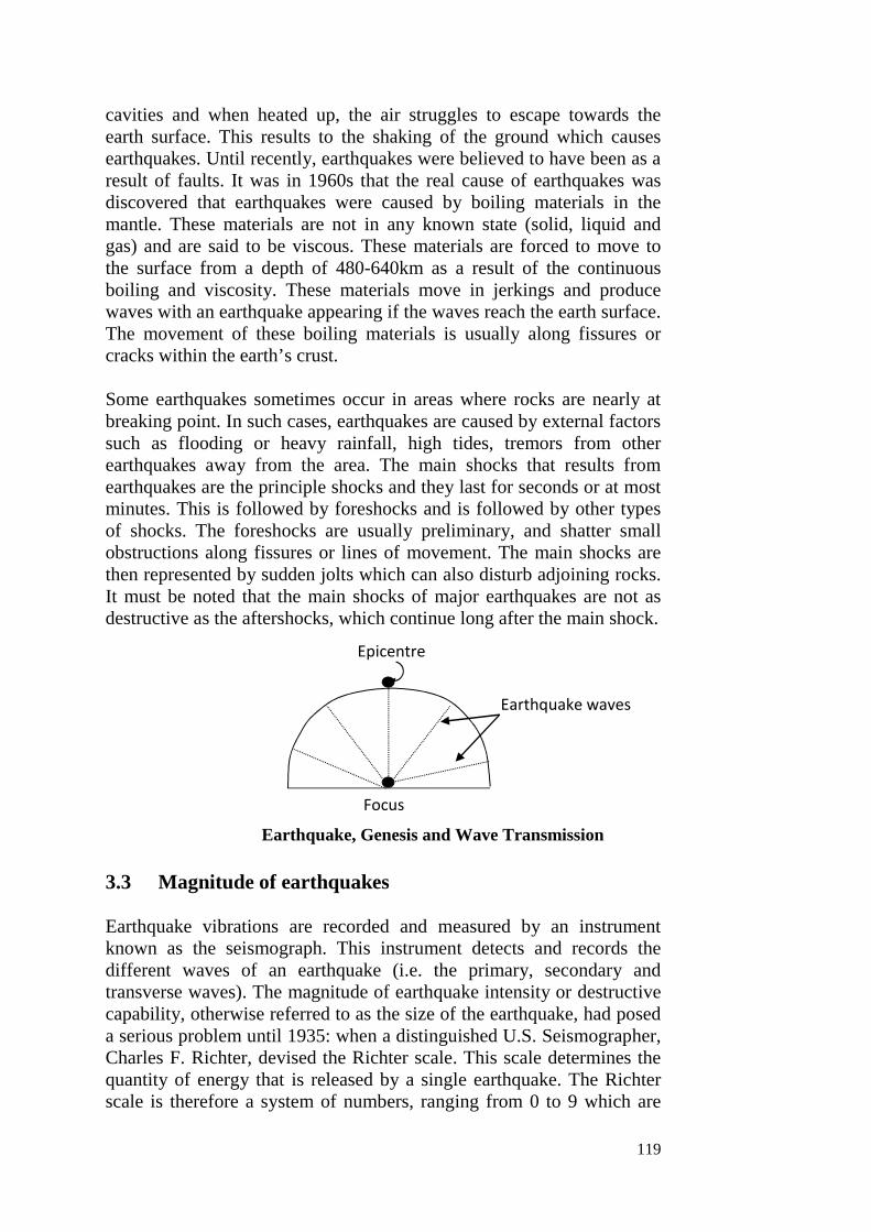
119
cavities and when heated up, the air struggles to escape towards theearth surface. This results to the shaking of the ground which causesearthquakes. Until recently, earthquakes were believed to have been as aresult of faults. It was in 1960s that the real cause of earthquakes wasdiscovered that earthquakes were caused by boiling materials in themantle. These materials are not in any known state (solid, liquid andgas) and are said to be viscous. These materials are forced to move tothe surface from a depth of 480-640km as a result of the continuousboiling and viscosity. These materials move in jerkings and producewaves with an earthquake appearing if the waves reach the earth surface.The movement of these boiling materials is usually along fissures orcracks within the earth’s crust.
Some earthquakes sometimes occur in areas where rocks are nearly atbreaking point. In such cases, earthquakes are caused by external factorssuch as flooding or heavy rainfall, high tides, tremors from otherearthquakes away from the area. The main shocks that results fromearthquakes are the principle shocks and they last for seconds or at mostminutes. This is followed by foreshocks and is followed by other typesof shocks. The foreshocks are usually preliminary, and shatter smallobstructions along fissures or lines of movement. The main shocks arethen represented by sudden jolts which can also disturb adjoining rocks.It must be noted that the main shocks of major earthquakes are not asdestructive as the aftershocks, which continue long after the main shock.
3.3 Magnitude of earthquakes
Earthquake vibrations are recorded and measured by an instrumentknown as the seismograph. This instrument detects and records thedifferent waves of an earthquake (i.e. the primary, secondary andtransverse waves). The magnitude of earthquake intensity or destructivecapability, otherwise referred to as the size of the earthquake, had poseda serious problem until 1935: when a distinguished U.S. Seismographer,Charles F. Richter, devised the Richter scale. This scale determines thequantity of energy that is released by a single earthquake. The Richterscale is therefore a system of numbers, ranging from 0 to 9 which are
Epicentre
Earthquake waves
Focus
Earthquake, Genesis and Wave Transmission

ESM 346 MODULE 5
120
ascribed to represent the index of earthquake energy at its source(focus). Accordingly therefore, earthquake of a magnitude of 2.5 hasreleased energy of not less than 10 ergs (i.e. the approximate quantity ofenergy released when 3,800 litres of gasoline is burnt). Mostearthquakes are however, minor and not destructive. Such earthquakesmeasure less than 4.5 on the Richter scale. A severe or destructiveearthquake is that which measures up to 6.0. Earthquakes of up to 7.0are regarded as major earthquakes.
The highest of 8.6 was recorded in 1964 in Alaska (U.S.A.). The 21st
September 1999 earthquake in Taiwan measured 7.1 on the Richterscale; and two weeks earlier another devastating earthquake in Turkeywas 6.8.
More than a million earthquakes occur annually. In fact, an earthquakeoccurs every few seconds on the average. Many of these earthquakes arehowever minor and very slight. Severe earthquakes averagely occurevery two to three weeks. In terms of energy released, one majorearthquake may release more than all the thousands of minorearthquakes that occur throughout the year.
3.4 Effects of Earthquakes.
Earthquakes like volcanoes can cause lots of destruction to localities andthe surrounding environment, when they are of severe nature. Althoughminor earthquakes do often occur without causing any prominentadverse effects, but the major earthquakes like the one that occurred inPeru on 31-5-1970 damaging over 85,000sg.km area, cause widespreadadverse environmental impacts.
Earthquakes can sometimes raise the ground level, or sink it. Rivers mayalter their course, lakes may be destroyed or even created, therebycausing immense adverse impacts on the systems of the environment.Severe earthquakes may also cause severe landslides, blocking rivers,causing abnormal flooding. When very high magnitude arthquakes occurbelow the floors, they may cause giant waves, called tsunamis, whichmay travel over long distances, causing catastrophic devastation near thesea shores and islands.
Severe earthquakes of the past have, in fact, caused most catastrophic allover the world. Earthquake in a matter of seconds destroyed large citiesand taken thousand lives. A sixteen century earthquake in China claimedabout 8.5 lives. In 1923, an earthquake of magnitude of 8.3 near Akyo(Japan) claimed about 1- 43 lives. In 1976, a catastrophic earthquake ofmagnitude 8.0 in Tangshan (China) claimed about 3-6 lives. In 1990, a

121
strong earthquake of 7.7 magnitude in Mangil (Northern Iran) consumedaround 40,000 lives.
In summary, the results of earthquakes are: Landslides, tsunamis, fire,sound, flooding, loss of lives and properties, destruction of infrastructureand spread of diseases.
3.5 Distribution of earthquakes
The distribution of earthquakes corresponds largely with the areas ofvolcanicity. The areas characterized by devastating earthquakes occurwithin two belts; (i) The primary belt of earthquakes which occursaround the circumpacific belt, and especially around the ‘pacific ring offire’. About 80% of severe earthquakes have so far been recorded withinthis belt (ii) the second belt, known as the secondary belt of earthquakes,is the Mediterranean-Himalayan belt, which stretches from theMediterranean area and extends eastward to Asia. More than 15% ofsevere earthquakes have occurred within this belt. Less than 5% of theearthquakes are thus shared by the other parts of the world.
Generally, no part of the world is completely free from earthquakeoccurrence, although most places experience slight earth tremors. Itshould be noted that areas that have witnessed earthquakes before arecapable of future occurrence, as repetitions have been found to beinevitable.
4.0 CONCLUSION
In this unit, we examine earthquakes as it relates to meaning, causes,magnitude, effects and distribution.
5.0 SUMMARY
Earthquakes are shaking of the ground which is caused by the breakingand shifting of sub surface rocks under intense pressure. Earthquakes arecaused by faults and the boiling of materials in the mantle. The resultanteffects are: landslides, tsunamis, fire, sound and death of plants andanimals. Earthquakes are common around the circumpacific beltespecially the pacific ring of fire. This is where we have more ofearthquakes. The secondary belt of earthquakes is around theMediterranean area.
6.0 TUTOR MARKED ASSIGNMENT
A. What are earthquakes? Discuss the causes of earthquakesB. List and explain the effects of earthquakes
ESM 346 MODULE 5
122
Self Assessment Exercise
How can we forecast or avert the occurrence of earthquakes in an area?
7.0 REFERENCES
Chop, D. C. (2007). A Synthesis of Physical Geography. JoycePublishers. Kaduna, Nigeria
Praveen, K. P., Subha, G. and Rajesh, W. (2017). EnvironmentalPollution and Safety Measures: International Issues and ItsGlobal Impact in Global Progress in Development of SustainableEnvironment. Discovery Publishing House PVT.Ltd. India.
Santosh, K.G. (2010). Ecology and Environmental Studies. KhannaPublishers, Indian.

123
UNIT 2 VOLCANIC ERUPTION
1.0 Introduction2.0 Objectives3.0 main Body
3.1 What is volcanicity?3.2 Intrusive features of Volcanicity3.3 Extrusive features of volcanicity3.4 Impact of volcanicity on climate
4.0 Conclusion5.0 Summary6.0 Tutor Marked Assessment7.0 References
1.0 INTRODUCTION
Volcanicity refers to the various process by which molten magmaescapes with great force through areas of weaknesses such as joints,cracks and faults, either to be intruded or extruded before cooling tosolidity. The major intrusive volcanic landforms are – Dykes, sills,laccoliths, lopoliths, phocoliths and Batholiths. The extrusive volcaniclandforms are gaseous materials, solid materials and liquid materials.The impact of volcanic eruptions suggests that it can cause the coolingof the environment, which is only local and not global. Moreover, thechanges in ecosystems and environment are reversible over a passage oftime.
2.0 OBJECTIVES
By the end of this unit, students should be able to know what volcanicityis all about, know the intrusive and extrusive landforms that can resultfrom volcanic eruption and the impact it has on climate.
3.0 MAIN BODY
3.1 What is volcanicity?
Volcanicity refers to the various processes by which molten magmaescapes with great force through areas of weaknesses such as joints,cracks and faults, either to be intruded or extruded before cooling tosolidify.
The cooling and solidification of molten magma result in the formationof different volcanic landforms. The classification of volcanoes depends
ESM 346 MODULE 5
124
solely on the mode of formation. In that case, two categories of volcaniclandforms appear, and they are (1) intrusive and (2) extrusive volcanoes.
3.2 Intrusive Volcanic Landforms
These are the landforms that cannot be seen initially on the surface ofthe earth’s crust because the molten magma, which formed it, wasintruded beneath the surface. These landforms are also known asinvisible volcanic landforms. The outstanding characteristics of volcaniclandforms depend on whether the lava is mobile or viscous and also onthe bedding plain into which lava is intruded. Mobile lava is watery andcan spread out very quickly before solidifying to form low-lying sheetsof lava. Viscous lava on the other hand, is thick and does not spread outto cover large areas before solidifying to form dome-shaped, mountainsand hills.
Types of Intrusive Volcanic Landforms
The major intrusive volcanic landforms are discussed below:
Dykes
These are igneous rocks formed from the intrusion of molten magma inan area of weakness that cut across the country rocks vertically. Theyusually form swamps of small pillars of hills after the overlyingsedimentary rocks have been removed by the agencies of denudation.On exposure, these walls of hills usually develop small depressions atthe top in which water collects and flow down the steep slopes in theform of waterfalls. The rounded surface or head of rocks over which thewater plunges downwards is known as the lip of the fall while the area atthe bottom at which the water actually plunges is known as the plungingpool.
The most outstanding example of a dyke in the world is the ClevelandDyke in North West England. In Wet Africa, examples include theWestern dyke of Jos and the dykes of futa-jalon highlands in Guinea.
Sills
These are similar magmatic. Intrusion but instead of the molten magmabeen intruded vertically, it is intruded along the bedding plains of theexisting sedimentary rocks horizontally before cooling to solidify. Sillsare of varying degree of thickness and they extend for severalkilometers. Example is the Great Whim Sill of Great Britain, whichconsists of dolerites. There are also examples of sills which have beenexposed by the agencies of denudation in the Jos Plateau of Nigeria.
125
Loccoliths
These volcanic intrusive landforms that have blistered domed shapedsurfaces with a flat base or bottom. It is formed as a result of massiveaccumulation of magma along horizontal bedding plains of rocksconsequently arching up the overlying layers of rocks to attain a similardomed shape.
Sills are usually supplied with magma along a conduit pipe below.When smaller loccoliths are formed along the bedding plains of the rockstrata directly the mother laccolith, the landform then become a CedarTree laccolith.
Example of lacolith and cedar tree laccoliths can be found in the HenryMountains of Utah on the west of river Colorado where G.K. Gilbertidentified five different categories of them after an intensive study of thearea between 1975-76. He produced a thesis on these landforms, whichhas been accepted as geomorphological essay.
Lopoliths
In this, magma is intruded into a curved area of weakness near thesurface of pre-existing country rocks before solidifying. When exposedby the agents of denudation, lopoliths attain the shape of a saucer toform a shallow basin, which, at times, contain water. The Bushveldlopolith of Tran svaal in South Africa is the world best example.
Phacoliths
There are lens-shaped intrusive landforms which develop from thesolidification of magma in area of weakness at the anticline or at thebottom of a syncline in a folded mountain structure. Example is in theCordon Hills of shropshire, England.
Plutonic Plug or Bysmalith
This is a very great type of lacolith, which has attained an imaginablevertical height. Similarly, the overlying rock has been arched up, butunlike the loccoliths, the size of a bysmalith is very steep and plungeddownwards to an unknown depth. Example can be found in MountainHomes, England.
Batholiths
These are the largest intrusive volcanic landforms. They are domedshaped at the top, with very steep sides that extend downwards for
ESM 346 MODULE 5
126
several miles. When exposed by the agents of denudation, they formmassive residual mountains e.g. the coastal Batholiths of BritishColumbia and the Wicklow Mountains of Ireland.
It is generally believed that large masses of magma arising upwardsmetamorphosised the country rocks with which they come into contact.These metamorphosed rocks together with the solidified magma giverise to extensive batholiths sometimes hundreds of kilometers is extent.They are the most spectacular of the intrusive landforms.
Theories of Batholiths formation
Two theories exist for the formation or batholiths, The first is that ofCauldon Subsidence or Engulfment and the second is ThermalGranitization. The theory of cauldron subsidence states that very greattectonic earth movements have made massive areas of rocks to collapseinto a reservoir of hot magma below which later solidified together withthe rocks to form a batholith.
The second stipulates that hot magma escaping through area ofweakness have come in direct contact with the country rocks. The heatof the magma which is transferred into, rocks change both their structureand mineral composition thus transforming them into very hard igneousrocks by process of thermal granitization. With time, surrounding softrocks are removed by the agencies of denudation, while the massivemetamorphic rock remain standing to form a batholith.
The small particles of metamorphic rocks directly above the batholith iscalled exnolith: Small batholith is known as stocks or bosses.
Volcanic Plug or Spine
This is a very hard large mass of rock. Which results from thesolidification of magma that block the volcanic vent. When exposed toagencies of denudation. It usually form residual volcanic mountainswhich attain great height. An example is the Tangeb Plug betweenGombe and River Benue in Nigeria. The Devil Towers in the state ofWyoming. U.S.A the Guater Mellon plug or Santigo, and the Mamelksplug near Darker in Senegal are well known.
3.3 Extrusive features of volcanicity
As the name implies these are the volcanic landforms that could be seenwith the naked eyes on the surface of the earth’s crust right from thetime they are formed. These landforms come into existence as a result of
127
frequent volcanic eruption and accumulation of the materials that resultfrom the eruption. Therefore, volcanic materials are three types:
Gaseous Materials
These include carbon dioxide, hydrogen, sulphur, oxygen and othergasses. The interactions of these gasses result in volcanic explosionsaccompanied with fire, steams, hot water, ashes and dust.
Solid Materials
These are solid fragmentary materials that are ejected from volcanicvent during an eruption. They are collectively known as pyroclast orvolcanic bombs. They include solid lavas, ash, dust, mud and brecia
Liquid Materials
These are magma in the form of lava that are either basic or acidic.
Types of Volcanoes
Volcanoes can either be active, dormant or extinct. Active volcanoes arethose that are still erupting or which erupted within a few days, monthsor years ago. For example, Cameroun Mountain in West Africa is anactive volcanic mountain.
Dormant volcanoes are volcanoes that erupted long time ago and stillshow some sign of possible eruption in the future. In other words, theseare ‘sleeping’ volcanoes and could ‘wake-up’ anytime. The Jos Plateauis an example of dormant volcano.
Extinct volcanoes are volcanoes that that erupted long time ago and lostall signs of it being erupting again in the future. The kilimajarooMountain in East Africa is an example of an extinct volcano.
Extrusive Volcanic Landforms
Landforms associated with extrusive volcanoes are carefully discussedbelow
Volcanic Cones, Ash and Cinder Cones
These are made up of accumulation of fragments of solid materials suchas lapills (small stones and pebbles), dust and ashes. Their slopes are notsteep neither are they too gentle, but are converse at the top and slightly
ESM 346 MODULE 5
128
concave at the bottom. Examples of ash and cinder cone are the cindercone near Naples Mountain, Paricutin, Mexico and one of the grasslandsof Northern Tanzanian formed among dissected volcanic hills and whichhas developed residual patterns of drainage. The lava flow is so viscousthat they solidified after a short distance.
Basic Lava Shields or Cone
These are formed from the solidification of basic lava, which containlow percentage of silica. Therefore, fluid spread vary fast to cover widearea before cooling down to solidify. These cones, which are flat, havemany gentle concave slopes and erupts without explosion. For example,the Hawaii type has the best-developed lava domes. In West Africa,volcanic cones are found in the Cameroun and Jos Plateau, Nigeria.
Acidic Lava Dome
These volcanic cones are formed from the accumulation andsolidification of acidic lava which are viscous and contain highpercentage of silica and therefore does not flow to cover an extensivearea before cooling down to solidify to form lenticular dome-shapedmountains whose slopes are convex and very steep. The Central Maasifin Frances is an example.
Composite Cones
These are made up of ash and lava. They form the most imposing andthe hardest volcanic mountains in the world, always fed with magmafrom a conduit below.
These volcanoes usually have several major and minor vents throughwhich magma and other materials are extruded. Mountain Sicily in Etna.Mountain Versuvis in Italy and Mountain Stromboli in the same locationcommonly referred to as the “Light House” of the Mediterranean areexamples of composite cones. Composite volcanoes are also known asStrato volcanoes.
Multiple Volcanoes
These are volcanoes that have several major vents. Prominent examplesare found in New Zealand.
Crater and Caldera
When a volcano erupts the materials may collapse into the magma in thevent below. This gives rise to a wide opening or depression known as a

129
crater, which may be several miles across. When rain falls, watercollects in the depression to form a crater lake. For example, the greatcrater lake of Oregon, U.S.A, which is about 6 miles across with theWizard Island at the middle and the Panyam crater in Northern Nigerianear Pashine. The crater lake of mountain kilimajaroo in East Africanand lake Busumptusi in Ghana are other examples.
A school of taught claims that the lake was formed as a result of watercollection in a crater, while other school of taught claims that the lakewas formed as a result of meteoritic depression. That is, meteoriticwhich falls from the sky and hit the surface of the land that results in thedepression.
A caldera is formed when a very destructive volcanic eruption orexplosion occurs. Thus making materials at the sides to collapse into thedepression below during each eruption. This result is a very wide, fairlyshallow and gentle sided depression known as caldera which is muchwider than a crater.
A crater is deeper and steeper inside than a caldera, while a caldera iswider, less shallow and gentle inside than crater. When rain falls andcollects in a caldera, it forms a caldera lake. For example, lake Toba inSumatra, the Katmair caldera lake in Alaska, U.S.A, which stretchedover 21/2 miles across and the great crater lake of Oregon in U.S.A.
Minor Volcanic Landforms
These include:
Solfatara
These are the volcanoes, which emit hot steams and sulphuric gases
Mud Volcanoes
These volcanoes emit hot steam, and mud and dust.
These above three examples of minor volcanic forms can be seen inIceland, Greenland, Sicily and New Zealand
Fumaroles
These volcanoes emit hot steam and other types of gases apart fromsulphur and carbon dioxide. For example, as in the valley of tenthousand slopes in Alaska, USA.
ESM 346 MODULE 5
130
3.4 Impact of Volcanicity on Climate
The planet earth, on which we are living, is almost a circular body,having a radius of 6370km . This entire 6370 km thickness of Earth canbe divided into the following three major layers:
(i) The crust(ii) The mantle(iii) The core.
The interior of the Earth is extremely hot, as hot as about 11000C, whichmay be partly due to the amount of original heat left behind at the timeof its formation, and partly due to the heat generated by radioactiveelements present inside the Earth’s crust. So much so, that certain place,the interior crystal rocks exist in molten state. This molten material orliquid rock, heavily charged with gases and volatile substances existingbelow the Earth’s surface, is called the magma. This magma differs fromthe molten rock in the same way as soda water differs from the ordinarywater.
Due to the intense pressure inside the crust, the magma remains in aviscous state. But whenever, this pressure is released, because of thepresence of fractures, fissures, and other weaker planes in the Earth’scrust, the viscous hot matter melts, and injects up, along these weaksurfaces. When the cracks extend up to the surface, the magmatic matteralso starts erupting over the ground; when after its extrusion, it is calledthe lava. The process of magma intrusion (i.e, movement of magmawithin the Earth’s crust) and its eruption is known as the eruption of avolcano or a volcanism or volcanic activity.
A frequently erupting volcano is known as an active volcano; one withrare eruptions is called a dormant volcano; while the volcanoes whichhave stopped their eruptions for a long geological time, are called theextinct or dead volcanoes.
The volcanoes, thus, throw out molten material on the ground surface,which gets accumulated around the central opening or vent, forming acone shaped mountain. Such mountains may largely vary in their height,ranging from a few hundred metres to thousands of metres. The eruptionof volcanoes brings out large scale devastation of the nearby habitationsas well as of the entire surrounding ecosystem. As a matter of fact, avolcano may throw out, with great force, the gaseous, liquid, as well assolid materials, causing large scale impact on environment and climateof the area.

131
The impacts of volcanic activity on climate have been causingtemporary cooling of the environment, but the impacts are only local orregional, but not global. Moreover, the changes in ecosystems andenvironment are reversible over a passage of time. Explosive eruptionsemits huge quantities of gases and fine grained debris into theatmosphere which may remain there for months or years. This may filterout a portion of the incoming solar radiation which in turn will lower thetemperature in the lower atmosphere.
4.0 CONCLUSION
In this unit, we examined volcanic eruption, intrusive and extrusivelandforms as a result of volcanicity and its impact on climate.
5.0 SUMMARY
A. Volcanicity refers to the processes by which molten magmaescapes with great force through areas of weaknesses such asfaults, joints and cracks.
B. Intrusive volcanic landforms include Dykes, sills, Locoliths,Lopoliths, Phacoliths, Batholiths and so on.
C. Extrusive volcanic landforms are gaseous, solid and liquid innature.
D. The impact of volcanic eruption is mainly on the physicalenvironment and other terrestrial bodies.
6.0 Tutor marked Assessment
1. List and discuss the intrusive volcanic landforms known to you.2. Of what impact is volcanic activity on climate?
Self exercise
What is volcanicity?What are the external features of volcanicity?
7.0 REFERENCES
Aziegbe, F. I. (2004). The Basics of Geomorphology. Nono Publishers.Benin City, Edo State
Chop, D. C. (2007). A Synthesis of Physical Geography. JoycePublishers. Kaduna, Nigeria

ESM 346 MODULE 5
132
Santosh, K.G. (2010). Ecology and Environmental Studies. KhannaPublishers, Indian.

133
UNIT 3 FLOODS
1.0 Introduction2.0 objectives3.0 Main Body
3.1 Causes of Flooding3.2 Types of Flooding3.3 Effects of Flooding3.4 Prevention and Control of floods
4.0 Conclusion5.0 Summary6.0 Tutor marked Assignment
1.0 INTRODUCTION
Flood is a body of water that inundates normally dry lands. Most floodsare harmful. They may destroy homes and properties and even washaway top soils, leaving the land barren for meaningful use.
2.0 OBJECTIVE
By the end of this unit, candidates should be able to:
Know the types of floods The causes of floods Effects of floods Means of prevention and control of floods
3.0 MAIN BODY
3.1 Causes of Flooding
From a geological perspective, floods are a natural consequences ofstream flow in a continually changing environment. Floods have beenoccurring throughout earth history, and are expected so long as the watercycle continues to run. Floods are caused by the changing pattern of thewater cycle.
A number of factors can contribute to flooding. Most of these factorsare:
Heavy rainfall over a short period of time: When rain falls on thesurface of the earth, some of the water is evaporated and returned to theatmosphere, some of it infiltrates the soil and moves downward into theground water system, and some are intercepted by depressions and
ESM 346 MODULE 5
134
vegetation. What remains on the surface of the earth and eventuallyflows into streams is called runoff.In general:
Runoff = precipitation – infiltration – interception - evaporation.
Evaporation tends to be the least of these quantities, particularly overshort periods of time and thus precipitation, infiltration and interceptionare the most important variables that determine runoff and eventualdischarge into streams. If rainfall is heavier than normal in a particulararea and infiltration, interception and evaporation are low then runoffcan be high.
Dam and levee failures: Dams occur as both natural and humanconstructed features. Natural dams are created by volcanic events,landslides, or blockage by ice. Human constructed dams are built forwater storage, generation of electrical power and flood control. All typesof dams may fail with the sudden release of water into the downstreamdrainage. Levee systems designed to prevent flooding can also fail. Bothdams and levees failure can result to catastrophic flooding. For example,the St. Francis Dam near Saugus, California, failed in 1929 killing 450people.
Natural factors: Areas around coastlines become subject to flooding asa result of tsunamis, hurricanes (cyclonic storms) and unusually hightides. In addition, long-term processes like subsidence and rising seaslevel as a result of global warming can lead to the encroachment of thesea on the land.
Drainage modification (urbanization): Urban flooding occurs intowns located on flat or low lying terrain especially where little or noprovision has been made for surface drainage or where existing drainagehas been blocked with urban waste (refuse and eroded soil sediments).For example, the Ogunpa flood disaster that occurred in Ibadan, Nigeriain 1984 was caused by the blocking of waterways with refuse.
Destruction of wetlands: The destruction of wetlands may alsocontribute to moderate floods. The wetlands are the swampy land alongthe edges of some rivers. When it rains, the wet soil and mud of awetland acts like a sponge and stores the extra water. In the Niger Deltaarea of Nigeria for example, much of the wetland has been drained foroil and gas activities or for farmland. The only place floodwater can gois up and over its normal river banks and into areas where it can causemajor damage.

135
Other causes of flooding are: Agricultural activities, topography of anarea, lack of enough vegetal cover, soil type or geology of the area andadherence to land use pattern
3.2 Types of Flooding
River Flooding: Flooding along rivers is a natural and inevitable part oflife. Some floods occur seasonally especially during the wet seasons.Torrential rains from decaying hurricanes or tropical systems can alsoproduce river flooding.
Coastal Flooding: Winds generated from tropical storms and hurricanesor intense offshore low pressure systems can drive ocean water inlandand cause significant flooding. Escape routes can be blocked off andblocked by high water. Coastal flooding can also be produced byearthquakes or volcanic activity.
Urban flooding: As land is converted from field or woodlands to roadsor parking lots, it loses its ability to absorb rainfall. Urbanizationincreases runoff 2 to 6 times over what would occur on natural terrain.During periods of urban flooding, streets can become swift movingrivers, while basements can become death traps as they are filled withwater.
Flash flooding: Flash floods occur within a few minutes or hours ofexcessive rainfall, a dam or levee failure, or a sudden release of waterheld by an ice jam. Flash floods can roll boulders, tear out trees, destroybuildings and bridges, and scour out new channels. Rapidly rising watercan reach heights of 30 feet or more. Furthermore, flash flood-producingrains can also trigger catastrophic mud slides. There is not always awarming that these deadly and sudden floods are coming. Most flooddeaths are due to flash flood. Several factors contribute to flash flooding.The two key elements are rainfall intensity and duration. Intensity is therate of rainfall, and duration is how long the rain lasts. Topography, soilconditions, and ground cover also play important roles.
3.3 Effects of Flooding
Floods are among the most frequent and costly natural disasters in termsof human hardship and economic loss. As much as 90 percent of thedamage related to all natural disasters (excluding drought) is caused byfloods and associated debris flow.
Physical damage: Flood can roll boulders, tear out trees, destroybuildings and bridges. Economic losses occasioned by floods can becolossal. For example, in the United States between 1992 and 2001; the
ESM 346 MODULE 5
136
economic loss of floods was put at 4.1 billion dollars annually. Also inSokoto, Nigeria, the flood of 1987 was reported to have destroyed 85,000 hectares of land estimated at 41 million naira.
Casualties: People and livestock die due to drowning in floods. It alsoleads to epidemics and diseases. Between 1972 and 2001 an average of127 people a year were reported killed by floods (mostly by flashfloods) in the United States of America. In the Duguri flood in BornoState, Nigeria 200 people were reported killed.
Water supplies: Floods may contaminate sources of drinking water andcan also destroy sources of drinking water making clean drinking waterscarce, especially if sewerage treatment plants are flooded.
Crops and food supply: Flooding of farmland usually results in croploss and reduction of food supply.
Disruption of electrical services: Flooding may bring down electricpoles, causing a major disruption in electricity supply.
Disruption in transportation systems: Roads may be blocked by floodwater making vehicular movement difficult. Bridges and railwayssystems may be destroyed by flood water.
Erosion: Massive amounts of erosion can be accomplished byfloodwater. The high velocity of flood waters allows the water to carrymore sediment load. When the floodwater retreats, the sediments are leftbehind. Sediment deposited by flood waters could also help to increaseagricultural productivity.
Job loss: Jobs may be lost due to the disruption of services, destructionof business (although jobs may be gained in the construction industry tohelp rebuild or repair flood damage).
Destruction of wildlife habitat: Floods may also destroy wildlifehabitats.
3.4 Prevention and Control of floods
There are myriad of ways to prevent and control flood. The key actionfor effective control of flood lies in appropriate planning for regulatingthe use of flood-prone land.
Development of flood plains should be prohibited: Laws should bepassed that restrict construction and habitation of flood plains. Existing
137
developments that have enhanced flooding problems in an area shouldbe demolished.
Channel modification: In order to construct roads, channelmodification should involve increasing the channel cross sectional areaso that higher discharge will not increase the stage of the river. In otherwords, by enlarging the cross-sectional area, higher discharge can beheld within the channel.
Construction of dams: Dams can be used to hold water back so thatdischarge from downstream can be regulated at a desired rate.Constructed dams have spillways that can be opened to reduce the levelof water reservoir behind the dam. Thus, the water level can be loweredprior to a heavy rain, and more water can be trapped in the reservoir andreleased later at a controlled discharge.
Construction of levees: Levees are embankments composed mainly ofearthen materials that are used to prevent annual flooding.
Use of sandbags: Placing sandbags along the riverbeds and placinglarge rocks on banks to prevent erosion can also help in floodmanagement. This process has a limit regarding the volume of waterinvolve. Sandbags do not control or prevent flooding, when the volumeand current of the water are unprecedented
Flood plain management: A non-structural approach to floodmanagement will involve flood plain layout by government. Areassusceptible to flooding should be appropriately mapped out forgovernment to buy the rights to the land.
Flood forecasting: Another non-structural approach will be theapplication of flood forecasting and installation of early warningsystems that people can be informed well in advance of any impendingfloods.
Clearing drainage channels: Individuals should avoid clogging orblocking waterways and drainage channels with solid wastes.
4.0 CONCLUSION
In this unit, we have learnt something about flood as a natural disaster.The types causes, effects, prevention and control of floods.
ESM 346 MODULE 5
138
5.0 SUMMARY
Floods are defined as extremely high flows of river or any other waterbody, whereby water overflows its banks or confined water channels.The types of floods are river flooding, coastal flooding, urban floodingand flash flooding. The causes of flooding are heavy rainfall, dam andlevee failure, urbanization, natural factor and the utilization of wetlands.
The effects of flooding are loss of lives, destruction of transport systems,electrical services, farms lands, job losses, erosion and wildfire. Floodscan be prevented and controlled by prohibition of flood maindevelopment, construction of dams, reservoirs, use of sand bags, floodsfor casting and the construction of retaining walls.
6.0 TUTOR – MARKED ASSESSMENT
1. (a) What is flood?(b) List and discuss the possible causes of flood.
2. What are the steps we need to take in order to avert the negativeimpact of flooding?
7.0 REFERENCES
Akpofure, Rim-Rukeh (2009). Environmental Science., An Introduction.Kraft Books Limited. Ibadan, Oyo State.
Cunningham, W.P. and (Cunningham, M. A. (2011) Principles ofEnvironmental Science. Inquiry and Applications. Sixth Edition.McGraw Hill Publishers. United States.
Eseigbe, J.O. (2019). Foundation Topics in Fluvial Geomorphology andHydrology. DD Concept Publishers, Ekpoma, Edo State.
Santosh Kumar Garg (2010). Ecology and Environmental Studies.Khanna Publishers. Indian
139
UNIT 4 DROUGHTS
1.0 Introduction2.0 Objectives3.0 Main Body
3.1 What is drought?3.2 Economic Impact of drought3.3 Social effects of droughts
3.4 Environmental losses of drought3.5 Control of drought & desertification4.0 Conclusion5.0 Summary6.0 Tutor Marked Assignment7.0 References
1.0 INTRODUCTION
The word drought is loosely used with that of desertification. Drought isthe degradation of the land in arid, semi arid and sub humid dry areascaused by climatic change and human activities. Drought can turnproductive land into non productive one.
The economic and environmental impact of drought include – Reducedcrop yield, death of tree crops, fire, reduced pasture production,promotion of conflict between herders and farmers, increased solarradiation on the earth surface and physiological effects on plants.
To combat drought, we need to have knowledge of the following facts:Land use planning system, terracing, mulching, control of livestock, useof good irrigation system and raising awareness among the citizenry.
2.0 OBJECTIVES
The objectives for this unit four is to enable the students to:
know what is drought the economic impact of drought social effects of drought the environmental losses because of drought the control of drought

ESM 346 MODULE 5
140
3.0 MAIN BODY
3.1 What is drought?
A drought, usually, is not thought of as a natural disaster, like anearthquake, or a volcano, or a flood, or a fire, which are sudden andfrightening events. This is because, a drought, unlike a tornado or anearthquake, usually does not have a sudden beginning or end. We cansee a tornado and feel an earthquake, but we cannot see a drought. Atthe most, we can see the after-effects of a drought, because a droughtoccurs through a slow process of not getting sufficient water.
A drought is said to be occurring at a place when the place does not getas much water as we expect or need, over a significant period of time.As it happens slowly, we only see its effects. A drought usuallyoriginates from a deficiency of precipitation (rainfall or snowfall) overan extended period of time, resulting in water shortage at some area. Theshortfall in precipitation cannot be defined in terms of quantum, since adrought in Libya may occur when rainfall is much short of its averageannual rainfall of 18cm for a continued number of years; while adrought in Mali may be said to be there, if rain does not fall after aperiod of only about 6 days.
Since drought do not cause too many fatalities (deaths) as the peoplemigrate to other places, people do not realize that a drought is a veryserious and costly natural hazard. As a matter of fact, the U.S. FederalEmergency Management Agency has estimated that droughts cost theUnited States an average loss of 6-8 billion dollars every year, making itthe costliest natural disaster.
As and when a drought occurs, it can have far-reaching impacts. That isbecause water is an important and essential requirement of all livingbeings. Even the abiotic world, like land and soil, need water to stayintact. All plants, animals and humans need water for their survival,besides its requirements for other human necessities and luxuries of life.
3.2 The Effects of drought
The effects of drought are multifaceted, affecting every area of humanendeavor such as political, economy and cultural as exemplified below:Reduced crop yields: The most immediate consequence of drought is areduction in crop production, due to inadequate and poorly distributedrainfall. Farmers are faced with harvesters that are too small to feed theirfamilies and fulfill their other commitment.
141
Death of tree roots: The effects of droughts are damage and death oftrees. In the root system of a tree, feeder roots and roots hairs areresponsible for the bulk of water supplies. As the soil dries, largeportions of these roots will be at the risk of damage. When feeder rootsand root hairs dry up and die, the plant eventually dies.
Heightened potential of wild land fires: Extended periods of drynessis a potential cause of wild land fires.
Physiological effects on plants: Drought triggers many changes in themetabolism, which can substantially alter the physiology of a plant.These changes include levels and types of hormones produced by theplant and alterations of basic processes such as photosynthesis. Droughtalso influences factors that determine the number of leaves that willemerge in every year, flower production and opening and closing of thestomata.
Heightened potential for pest attack on trees: For nearly all treespecies, there are opportunistic insects and pathogens that takeadvantage of stressed trees. Wood boring insects such as bronze birchborer, two lined chestnut borer, and bark beetles noticeably increaseduring periods of drought. Spider mites, scales insects and lace bugsalso increase. Pathogens that take advantage of weakened trees includecanker diseases, vascular wilts, roots rots and wood rots. Stressed treesalso show increased sensitivity to air pollutants, fungicides andpesticides.
Low rainfall causes poor pasture growth and may also lead to a declinein fodder supplies from crop residues. Insufficient levels of fodderaround the village lead to weight loss and increased deaths among stock,especially where immigrant herds put further pressure on limitedpastures.
Promotion of conflict between pastoralists and farmers: Droughtaffects food security of the people living in the affected areas. The mostand frequent strategy of survival is for the people to move from theaffected areas to an areas that are accessible in natural resources. Thisstrategy often leads to conflict between different ethnic groups, familiesand individuals.
Increased reflection of solar radiation: Overgrazing and wood-cuttingincrease the surface albedo and disrupts the regional radiation balance.Surface heating declines as more solar radiation will be reflected andthis in turn will cause some cooling of the atmosphere. This coolingencourages subsidence and helps to reduce the likelihood ofprecipitation by retarding convective activity.
ESM 346 MODULE 5
142
The impacts of drought may be economic, environmental, and social:The economic impacts of droughts include:
(i) Loss of crops and money to farmers, and reduced business for all(ii) Loss of trees and timber, causing loss to timber industry
(iii) Loss of business for those who manufacture and sell boats andfishing equipment, as they cannot see such items, because lakeswill dry up.
(iv) Loss of business to those who deal on fisheries and relatedproducts.
(v) Loss of business to manufacturers, who manufacture goodsrequired in agriculture like tractor manufacturers, or fertilizermanufacturers.
(vi) Loss of business to those who deal on food processing activities.(vii) Reduced navigability of rivers, leading or increased cost of
transportation to be done by roads or railways.(viii) Curtailed production of hydropower.
3.3 Social Effects of Drought
The social effects of droughts include:
(i) Large scale migration of people from drought-affected rural areasto urban areas
(ii) Loss of income, mental and physical stress(iii) Health and nutritional problems(iv) Famine, hunger, and all round chaos(v) Loss of human life due to heat, hunger, depression etc.
Usually, most of the environmental impacts of droughts remaintemporary, as the damaged ecosystems recover and return to theiroriginal conditions, following the end of the drought. However, a fewmay linger on for somewhat longer time before returning to theiroriginal state. It would only be very rare, when some endangered speciesare completely lost.
3.4 Environmental losses of drought
The environmental losses of drought include:
(i) Losses or destruction of fish and wild life habitat(ii) Lack of food, drinking water for humans, and animals
(iii) Increase in diseases in humans and wild animals, because ofreduced food and water supplies.
143
(iv) Migration of wild animals in search of water to far off places,leading to loss of wild life in the drought-sticken areas, andpresence of excess wild life in areas not affected by drought.
(v) Increased stress to endangered species, leading to their extinctionand loss of biodiversity.
(vi) Loss of trees and other vegetation due to non-availability of water.(vii) Loss of reservoirs, lakes and ponds
(viii) Reduced flow from streams and springs(ix) Loss of wetlands(x) Changes in salinity levels in estuaries
(xi) Increased ground water depletion, land subsidence, and reducedrecharge
(xii) Reduced water quality in available nearby water sources, due toincreased salt content, water temperature, pH, DO, and turbidity.
(xiii) Increased number of fires and loss of forests and human habitats(xiv) Increased soil erosion due to winds and reduced soil air quality(xv) Degraded landscape
3.5 Control of Drought
It is estimated that by 2025, 61 percent of the world’s 3257 millionhectares of productive dry land (i.e. lands where stock are grazed andcrops grown without irrigation) will be severely desertified. Theproblem is clearly enormous. According to United Nations Conferencefor Combating Drought and Desertification, almost 25million tons offertile soil disappears every year with one third of the planet’s surfaceand over 2502 million people threatened by drought desertification. Thefollowing are some measures that can be employed to combat the effectsof desertification and drought.
Good Land Use Planning: This should not only consider the best useof the land but also the carrying capacity of that land under a particularuse. For example, placing restrictions on grazing and cultivation on aparticular land based on the conditions in that particular area. Good landuse planning would recognize that certain areas are best left as woodlandand would prevent the clearing of that land for the expansion ofcultivation or the provision of fuel wood.
Afforestation: This involves the planting of trees. Trees help to anchorthe soil, act as wind breaks and absorb potentially damaging rainfall.However, it should be started that drought-resistant plants such asdogoyaro and pines should be planted.
Terracing: Erosion by surface runoff on steep slopes can be plantedwith grasses in rows along the contours of the hillside.
ESM 346 MODULE 5
144
Alternative energy resource: The removal of trees for firewood andthe subsequent damage to the land may be reduced if other types of fuelcan be used. Another option is to use only the branches and not thewhole tree, preserving the roots which help to bind the soil.
Control of livestock: Reducing numbers of livestock and the use offencing to exclude grazing has been shown to be very effective inreducing the damage caused by overgrazing.
Weather forecasting: Through scientific and technologicaldevelopment, long-range drought forecasting can be carried out. Thiswill help in preparing for any unforeseen harsh weather conditions.
Use of appropriate irrigation systems: Irrigation when appropriatelymanaged will help to minimize sedimentation, salinization and water-logging.
Raising awareness: Raising awareness amongst the people will help intheir response to government programmes. For example, June 17th ofevery year is a day observed annually throughout the world to combatdrought.
4.0 CONCLUSION
In this unit four, we examined what is drought, the economic and socialimpact of drought, the environmental losses as a result of drought, andthe control mechanism of drought.
5.0 SUMMARY
A drought is said to be occurring at a place when the place does not getas much water as it is expected or needed, over a significant period oftime.
The economic impact of drought includes loss of valuable agriculturallands and crops, loss of business, reduced navigation of water amongstother. The environmental losses are: destruction of fish and wildlife,lack of food and water, loss of biodiversity, changes in salinity level andso on. On the other hand, the social effects of drought are loss ofincome, health and nutritional problems, farm, loss of human lives etc.And to combat drought, we need terracing, control livestock, weatherforecast, creating awareness and good land use planning.
145
6.0 TUTOR MARKED ASSESSMENT
(1) List and discuss the methods we can adopt to ameliorate theimpact of drought.
(2) What are the social and economic impact of drought?
7.0 REFERENCES
Akpofure, Rim-Rukeh (2009). Environmental Science., An Introduction.Kraft Books Limited. Ibadan, Oyo State.
Santosh Kumar Garg (2010). Ecology and Environmental Studies.Khanna Publishers. Indian

ESM 346 MODULE 5
146
UNIT 5 LANDSLIDES AND AVALANCHE
1.0 Introduction2.0 Objective3.0 Main Body4.0 Conclusion5.0 Summary6.0 Tutor Marked Assessment7.0 References
1.0 INTRODUCTION
A landslide is the movement of rock and soil down a slope. Landslidesrange in size from a single boulder in a rock fall to a debris avalanche,which may have huge volumes of rock and soil capable of coveringmany kilometers. The causes, prevention and the impact of landslidesare discussed in this unit.
2.0 Objectives
By the end of this unit, candidates should be able to:
Know what landslides and Avalanches stand for The causes of slide hazards Prevention and correction of landslides The impact of landslides.
3.0 MAIN BODY
3.1 What is Landslide?
Slopes are the most common land forms, especially in hilly areas.Although most slopes appear stable and static, but they are actuallydynamic systems, like rivers. Landslides are the natural phenomena thatwould occur with or without human activity. However, human use andinterest has somewhere increased the chances of landslides, such as onhill side developments, because of over-steepening of slopes; andsomewhere decreased the chances of landslides due to protective andstabilization measures adopted by man at fragile slopes.
The word ‘landslides’, is actually used for rock-slides or rock-falls,caused by the movement of one solid rock mass over another. Otherevents, somewhat resembling the landslides, are earth flows (mudflows), and snow-slides called avalanches.
147
A landslide or a rock slide, actually represents the movement of onesolid mass over another. The weak or superficial mass fails along adefinite failure plane, called the shear surface, or the slip surface.
Rock slides, which represent the sliding of one rock mass over another,are very much susceptible to develop easily, if the planes of weakness(such as bedding or jointing) area parallel to the slope, and especiallywhen the slope is undercut by a river.
3.2 The Causes of Landslides
Landslides have, in fact, been causing good enough loss of human life inthe United States. Each year, about 25 people are killed by landslides;and this number increase to between 100 and 150 if we include collapseof trenches and other excavations also, which, in fact, are not strictlylandslides, but earth-slides.
Water and vegetation are the two important factors that influencelandslides. Chemical action of water gradually causes chemicalweathering of rocks, making them prone to landslides. Vegetation, onthe other hand, consolidates the slope material, provides cohesion by itsroot system, and also retards the flow of water and its erosion capacity.Human activities such as mining and removal of trees have also beenfound to cause landslide.
The landslides can also be accelerated by earthquakes, vibrations orsaturation of the unconsolidated sediments with water. The road orhouse building activities near the standing slopes may also cause land-slides. The steeper slopes are more susceptible to landslides. The majorcauses of landslides are: Internal property of the earth materials, thegeomorphic setting of the environment and independent external factors.
3.3 Prevention and correction of landslides
It is usually difficult to prevent landslides. However, they can becontrolled and minimized by stabilizing the hill slopes when we adoptthe following measures:
X By providing proper drainage of water through the rocks;X By providing stone lining on fragile slopes of unconsolidatedmaterial;X Mapping the areaX Evaluating man’s influence on landX Identifying and recognizing slide prone areasX Adopting land use zoning methodIn the correction of landslides, the following methods could be used:
ESM 346 MODULE 5
148
X The cut slope angle could be flattened to increase its stabilityX The use of retaining structure like concrete walls, pilings and so on.Could be constructedX Unstable materials could be totally or partially removed from slopesX The use of rock bolts to hold unstable rocks to stable onesX Ground water pressure can be decreased in an unstable area toincrease stability.
3.4 The impact of landslides
While a smaller and moderate landslides, blocking traffic-way may offersome mild local environmental challenges, as it may result in destructionof some trees existing on the sliding rock mass, and killing of a fewhumans and animals trapped in the falling rocks and debris; but severelandslides may create lots of environmental problems, particularly if alandslide happens to block a flowing river, thereby creating anunplanned and unsafe dam type structure across the river, leading tocollection of water upstream. Such collection of water may not onlyflood and submerge the upstream area, but may even destroy anddamage the entire river’s ecosystem, besides resulting into the huge lossof forest existing on the slided rocks. Moreover, such a temporaryobstruction is likely to breach at any time, leading to release of hugequantity of pounded up water, bringing floods and consequentialdestruction downstream.
Avalanche is a mass of snow that slides down a mountain slope. Mostavalanches result from weather conditions that cause snow on amountain slope to become unstable. Such disturbances, like heavywinds, earth tremors, and explosions can send the snow sliding down themountain. Even humans, during their skying operation, have startedmany avalanches.
Three kinds of avalanches have been recognized; i.e. (i) dry snowavalanche; (ii) wet snow avalanche and (iii) slab or solid avalanche.
A dry snow avalanche consists of powdery snow and air that may movedown faster than 150km/h or so. A wet snow avalanche is a mass of wetdense snow that typically moves slower than a dry snow avalanche. In asolid avalanche, a solid portion of snow breaks loose, as a slab, andsplits into pieces as it slides.
Experts can often recognize the conditions that lead to avalanches bystudying the terrain, snow weather in an area. To help controlavalanches, they use explosives to reduce snow build ups. They alsoreplant trees on slopes and erect barriers

149
4.0 CONCLUSION
Landslides are now common in our society today because of the needfor man to explore natural resources. While some are man induced, mostthe landslides are also caused naturally.
5.0 SUMMARY
Landslides are earth or rock materials flowing in a cliff. The causes oflandslides range from weak geology of the area involve, external factorssuch as flooding, farming, mining etc. The preventive measures are theuse of rock bolts, evaluation of man’s influence on land, land use zoningsystem and so on.
6.0 TUTOR MARKED ASSESSMENT
1. (a) What do we mean by landslides?
(b) Discuss the causes and the impact of slide hazards
7.0 REFERENCES
Akpofure, Rim-Rukeh (2009). Environmental Science., An Introduction.Kraft Books Limited. Ibadan, Oyo State.
Cunningham, W.P. and (Cunningham, M. A. (2011) Principles ofEnvironmental Science. Inquiry and Applications. Sixth Edition.McGraw Hill Publishers. United States.
Praveen, K. P., Subha, G. and Rajesh, W. (2017). EnvironmentalPollution and Safety Measures: International Issues and ItsGlobal Impact in Global Progress in Development of SustainableEnvironment. Discovery Publishing House PVT.Ltd. India.
Santosh Kumar Garg (2010). Ecology and Environmental Studies.Khanna Publishers. Indian
Suresh, K. Dhameja (2013). Environmental Science. S.K. Kataria andSons Publishers. India.