Erwin Gáll, The Significance of the Sites “Aşezare” and “Necropolă” on “Dealul...
42
ZIRIDAVA STUDIA ARCHAEOLOGICA 28 2014
-
Upload
museumarad -
Category
Documents
-
view
3 -
download
0
Transcript of Erwin Gáll, The Significance of the Sites “Aşezare” and “Necropolă” on “Dealul...

ZIRIDAVASTUDIA ARCHAEOLOGICA
282014


ZIRIDAVASTUDIA ARCHAEOLOGICA
282014
Editura MEGACluj-Napoca
2014
MUSEUM ARAD

MUSEUM ARAD
EDITORIAL BOARDEditor‑in‑chief: Peter Hügel.Editorial Assistants: Florin Mărginean, Victor Sava.
EDITORIAL ADVISORY BOARDM. Cârciumaru (Târgoviște, Romania), S. Cociș (Cluj‑Napoca, Romania), F. Gogâltan (Cluj‑Napoca, Romania), S. A. Luca (Sibiu, Romania), V. Kulcsár (Szeged, Hungary), T. Miklós (Budapest, Hungary), J. O'Shea (Michigan, USA), K. Z. Pinter (Sibiu, Romania), I. Stanciu (Cluj‑Napoca, Romania), I. Szatmári (Békéscsaba, Hungary).
In Romania, the periodical can be obtained through subscription or exchange, sent as post shipment, from Museum Arad, Arad, Piata G. Enescu 1, 310131, Romania.Tel. 0040–257–281847.
ZIRIDAVASTUDIA ARCHAEOLOGICA
Any correspondence will be sent to the editor: Museum Arad
Piata George Enescu 1, 310131 Arad, ROe‑mail: [email protected]
The content of the papers totally involve the responsibility of the authors.
Layout: Francisc Baja, Florin Mărginean, Victor Sava
ISSN‑L 1224–7316
Editura Mega | www.edituramega.roe‑mail: [email protected]

Contents
Ion Pâslaru, Vitaly PozhidaevPercentages in the Study of neolithic Pottery 7
Székely ZsoltContributions to the history of archaeological research in Macea, the settlement in Topila (Arad County) 21
Călin Ghemis, Tudor Rus, Robert KovacsBetween sacred and profane – a discovery belonging to the Coţofeni Culture inside “Stanu Cerbului” cave (Bihor County) 31
Victor Sava, Luminiţa Andreica, Xenia Pop, Florin GogâltanOut of ordinary or common burial practice? A Funerary Discovery from the Baden Settlement at Sântana “Cetatea Veche” 39
Luminiţa AndreicaMusculoskeletal Markers as Evidence of Physical Activity and Social Differentiation in the Lower Mureş Valley during the Late Bronze Age 77
Alexandru BerzovanPreliminary Considerations on the Dacian Habitation in Vărădia de Mureş “Dealul Cetate”, Arad County (2nd century BC – 1st century A.D.) 87
Ştefana Cristea“I am Horus the Savior”. Representations of Horus‑Harpokrates in Roman Dacia 115
Csaba SzabóNotes on the Mithraic small finds from Sarmizegetusa 135
Csaba Szabó, George Valentin Bounegru, Victor SavaMithras rediscovered. Notes on CIMRM 1938 149
Norbert KapcsosThe Sarmatian Graves of the 4R Archaeological Site Dated to the Third‑Fourth century A.D. Additional Data on the Sarmatian Burial Rite in the Lower Mureş Region 157
Dan Băcueţ-CrişanOn the Two‑Room Dwelling from Precinct IV of the Early Medieval Fortification in Dăbâca (Cluj County) and the Chronology of the First Stage of Fortification 173
Aurel DragotăEggs as Offerings in Tenth‑Eleventh Century Necropolises 183
Imre Szatmári, György KerekesMedieval Villages in the Fields Surrounding Mezőhegyes 193
Erwin GállThe Significance of the Sites “Aşezare” and “Necropolă” on “Dealul Viilor” in the Development of Habitat in the Micro‑area of Sighişoara during the Middle Ages (Twelfth‑Thirteenth Century). Human Landscape of the Sighisoara Region from the 12th–13th Centuries 209

Anca Nițoi, Claudia UrduziaElements of Fortification of the Medieval and Early Modern City of Sibiu. The Tower Gate and the Gate’s Bastion. Historical and Archaeological Considerations 243
Zsuzsanna Kopeczny, Florin MărgineanMedieval Stove Tiles in the Collection of the Museum of Banat Discovered in the Fortification of Şoimoş (Arad County) 259
Abbreviations 273

ZIRIDAVA, STUDIA ARCHAEOLOGICA, 28, p. 209–242
The Significance of the Sites “Aşezare” and “Necropolă” on “Dealul Viilor” in the Development of Habitat in the Micro-area of Sighişoara during the
Middle Ages (Twelfth-Thirteenth Century). Human Landscape of the Sighisoara Region from
the 12th–13th Centuries*
Erwin Gáll1
Abstract: The paper aims at presenting habitat aspects from the archaeological sites”Aşezare” and “Necropolă”, attempting to integrate them in the archaeological landscape of the area of Sighişoara during the twelfth‑thirteenth century, i.e. in a wider context, that of eastern Transylvania.
Keywords: Sighişoara, Middle Ages, twelfth‑thirteenth century, “Dealul Viilor”, “Aşezare” and “Necropolă”.
Topographic location of the sites
From a topographical and geographical perspective, the area of Sighişoara (Germ.: Schäßburg; Hung.: Segesvár), Mureş County, is located in a narrow spot in the valley of River Târnava Mare, looking like a gorge cut in a system of terraces, modeled in hard sub‑layers of Pontian grit stone. This micro‑morphology renders the area a key‑position in the corridor of River Târnava Mare.The gorge is a mandatory point in one’s passage towards the eastern and south‑eastern part of Transylvania. The two archaeological sites, called”Aşezare” and “Necropolă”, are located ca. 4 km away from this gorge. On the basis of their location and extent, one cannot exclude the fact that they are in fact two parts of the same site, of the inhabited habitat on “Dealul Viilor”2.
The site of “Dealul Viilor” is located on the north‑eastern border of the city of Sighişoara, on the first and second terrace on the right bank of River Târnava Mare. Seen from a distance, “Dealul Viilor” seems a huge amphitheater oriented southwards, at the north‑eastern edge of the city of Sighişoara. Its western end is marked by an almost vertical cliff that is the clay extraction place where the Brick Factory (the present‑day SICERAM) obtained the needed primary material for almost a century. Above the factory, to the north‑east, one finds the small settlement called “Cătunul Viilor”.
The north‑western area of this ample hilly formation called “Dealul Viilor” is dominated by another strong promontory affected by a natural erosion process: “Cornul Viilor”. At the base of this promontory, in the area of the four isolated households, the excavated archaeological site is situated in the lower areas probably extending further up the hill, which Radu Harhoiu, the coordinator of the excavation, labeled as “Aşezare”3.
The systematic research carried out in the site called “Aşezare” led to the discovery of 127 archaeo‑logical complexes (pit‑houses, pottery workshops/kilns/ovens, household refuse pits etc.) dated to the third‑eighth centuries and the twelve century (Pl. 2)4.
* English translation: Ana M. Gruia.1 I would like to thank Mr. Nicolae Teșculă, director of the History Musem Sighisoara, for his kind help in composing the
documentation and making photographs of the archaeological finds at the History Museum of Sighisoara.2 Harhoiu‒Baltag 2006‒2007, Vol. I., 5‒6.3 Harhoiu‒Baltag 2006‒2007.4 Harhoiu–Baltag 2006–2007.

210 ◆ Erwin Gáll
Fig. 1. Sighişoara‑Dealul Viilor, the sites of “Aşezare” and “Necropolă” (after Harhoiu−Gáll 2014, Fig. 1).
Fig. 2. Sighişoara‑Dealul Viilor,the sites of “Aşezare” and “Necropolă” (graphic reconstruction by D. Spânu), (after Harhoiu−Gáll 2014, Fig. 2).
On another terrace, also on the right bank of River Târnava Mare, ca. 350 m upstream (east‑wards) from the spot called “Aşezare”, one finds the spot that we call “Necropolă”, where archaeo‑logical research performed starting with 1989 (interrupted between 1997 and 1999 due to lack of funding), has lead to the identification and research of some significant archaeological remains (412 complexes) dated to the Bronze Age (Wietenberg and Noua cultures), the post‑Roman era, and the beginning of the Middle Ages. Post‑Roman complexes consists of several necropolises (end of the third century‑beginning of the fourth century; fourth century5; sixth century), some complexes were from settlements (pottery kiln dated to the fourth century; eighth‑century dwelling), while the beginning of the Middle Ages is illustrated by a large necropolis dated to the twelfth century and habitation structures (dwellings, household refuse pits, oven) – (Pl. 3)6.5 Harhoiu 2014, 153–205.6 Harhoiu 2014, 153–154.

The Significance of the Sites “Aşezare” and “Necropolă” on “Dealul Viilor” in the Development of Habitat ◆ 211
193 tombs, containing 205 skeletons, were also researched on the site called “Necropolă”7. Among them, on the basis of aspects related to the topographic/planimetric location of the tombs and on the basis of the inventory, I connected 94 graves with 106 skeletons to the medieval necropolis (of the 12th century)8.
101 undisturbed skeletons have been recovered, while five other skeletons, from five graves, have been destroyed (graves 36, 72, 77, 95, 112). Four tombs could not be researched, due to objective reasons (graves 140, 159, 172, 173), and one pit did not contain any skeleton (157). One can thus mention an overall number of 99 graves (together with the boneless pit), that probably contained at least 110 skeletons (again, including the boneless pit) – (Pl. 3).
Objective considerations have only allowed for the research of the northern and southern areas of the cemetery, labeled in specialized literature as the ‘cemetery around the church’ (in German Friedho for Kirchhof, in English Churchyard)9. Taking into consideration the characteristics of the necropolises around the church, with several horizons of inhumations, just like the cemetery in Sighişoara “Dealul Viilor”, dated to the twelfth century10, the existence of a church there is very likely, but it could not be researched due to the road that crosses the site. Magnetometric measurements might clarify the issue.
7 Harhoiu 2014, 154.8 Harhoiu–Gáll 2014, 193–256.9 In early literature, the word coemeterium or cimiterium (gr.: koimeterion) was used exclusively for the burial places of Jews
and Christians. ‘Takaloumena koimeteria’, has appeared in an imperial edict of 259, but the word occurs in Tertullian’s De anima ([...]in coemeterio corpus corpori iuxtacollocando spatium accessui communicasse LI) (Tertulliani Liber de Anima: http: //www.tertullian.org/latin/de_anima.htm.) and must be even older. Originally, the part of a Christian cemetery above the ground was called coemetarium, the underground section was called crypta (gr.: krypte). In the early Christian period the graves of Christians were not separated from those of other religions, but from the 2nd century on memorials were built on the graves of the martyrs, which resulted in the creation of places of worship. From the 4th century on the so called adsanctos burials spread both in the West and in the East. Graveyards were out of the boundaries of towns until the 7th century – there were several churches in a city, but there only a few individuals, mostly persons revered as saints, or privileged people (as the emperors in the Apostoleion) were buried. According to Roman, Jewish etc customs, graveyards were outside the boundaries of towns or alongside roads or in free lands forming smaller or larger clusters (depending on whether it was a big town or a small village). There was not set rule in the territory of the East empire, therefore we cannot talk about a system, but there are certain cases, e. g. in Kom al‑Ahmar, Egypt, where there are thousands of graves in different orientation around and inside the church.The evolution of the conversion to Christianity on the territory of the Merovingian realm and the involvement of the Germanic aristocracy in this process can be observed well. Whereas around 600 they were buried in the ‘sacred area’, which was in the possession of the community, in rows of graves (Reihengräberfeld); around 800 the dead were buried around churches in the settlements. Based on the analysis of the cemeteries in southern Germany the nobility built numerous ‘private churches’ in their own courts by the end of the 7th century in the Alemanni territories. They used them as burial places, as places of remembrance and as a representation of their social position and the symbol of their Christian religion. So the cemeteries of this type may have appeared on the territory of the former Merovingian realm in the 6th–7th centuries. In the Rhine region churches were built in the cemeteries used in earlier times and these cemeteries were used further, whereas on the left bank of the Rhine and S of the Danube churches were never built in the site of former temples but in other places. Cemeteries with rows of graves were abandoned around the middle of the 8th century, although there are some data that they were used later too (e. g. Griesheim). During the Carolingian era common people were forced to bury their dead around churches, and were regulated by the decrees of the synod of Aachen in 836 and the synod of Tibur in 895. The spread of churchyards in Europe in the 8th–9th centuries is the most important and obvious sign of institution‑alised Christianity in the territories occupied or influenced by the Carolingian empire. From the end of the 10th to the 12th century, Christianity and its state institutions triumphed in Central‑ and Northern Europe. As a result, from the 11th century, churchyard cemeteries can be documented in Poland, as well as in Northern‑ Europe, mainly in Denmark, the southern regions of Norway and Southern‑Sweden, here probably due to missionaries coming from the East.In conclusion it can be stated that churchyards, which ‘came into fashion’ in the 7th– 8th centuries, became the obvi‑ous archaeological symbol of institutionalised Christianity in time. Churches and the graveyards around them are the archaeological signs of the western Christian state, bishopries, parishes and Christian communities. In short: medieval (western) Europe.The Hungarian folk version of the Latin word, cinterem means not just the cemetery itself, but the chamber of the church intended for wake and the graveyard around the church. The word cinterem found its way as a loanword into the Transylvanian dialect of the Romanian language as ţintirim. The German name of the cemetery is Friedhof, ‘the yard of peace’ or ‘garden of peace’ with the right of an asylum, it is originally Freithof (=umfriedeter Ort), i. e. a closed yard in connection with asylum right (Freiung means ‘setting free’ or asylum). Bollók 2015; Böhme 1993, 397–534; Böhme 2000, 75–109; Hassenpflug 1999, 61–62; Kieffer‑Olsen 1997, 185–189; MKL 2007; Schulze‑Dörrlamm 1993, 557–620; Szőke 2005,19–30.Their synthetic analysis in the Transylvanian Basin: Gáll 2013a, 135–250.
10 The analysis of the chronological aspects of the necropolis on “Dealul Viilor” has revealed that the first burials can be dated to the first decades of the twelfth century, which means that the population settled there around that time; on the

212 ◆ Erwin Gáll
Some observations on the polyfunctional character of the settlement(s) and its (their) organization and extent (Pl. 2–3)
Fifteen complexes, dated to the twelfth century, have been researched on the spot “Aşezare”, located 300 m north‑eastwards of the spot called “Necropolă”, at the base of the promontory11. Among them, six were household refuse pits (complexes 7a, 8a, 18, 34, 43a, 127), seven are pit‑houses (complexes 11, 27, 66, 67, 78, 102, 104=119) – (Pl. 5‒8), and two are probably open‑air ovens12 (complexes 7b, 7c) – (Pl. 4). Out of the seven dwellings, complexes 11, 66, 67, 78 had hearths (some with stones, as for example in complexes 11 and 78, others were made just of clay, as in the case of complexes 66 and 67), while complexes 27, 102, 104–119 never had a hearth13. It is difficult to establish their functionality, as the inventory did not differ from those of the others. We should wonder if they were only inhabited during the summers or if they were used as storage buildings. In this direction, paleoclimatic research could provide interesting results. In general, until the middle of the thirteenth century, the summers were warm and the winters mild, generally droughty, a phenomenon labeled in specialized literature as the Medieval Warm Period14, that might explain the existence of these complexes that lacked fire instal‑lations (Pl. 2)15. One should mention dwelling 27 due to its round ground plan, a shape also identified in other micro‑regions16.
The archaeological inventory ofthe researched dwellings and ovens mainly consisted of pottery fragments, among which fragments from clay cauldrons (for example complexes 7c, 67, 104=119) (Pl. 4/1, Pl. 5/1), but also other pottery categories, typical to the eleventh‑thirteenth century. (Pl. 4/1‒3, Pl. 5/1‒4, Pl. 5/1, Pl. 6/1‒9, 11, Pl. 7/1‒7, Pl. 8/1‒4).
Besides pottery, there were also other categories of items. Thus, one spur was identified in each of the two complexes (7b and 27), (Pl. 4/4, Pl. 5/5) that can be dated to the twelfth‑thirteenth century17. The function of one item remains unclear; it is the tip of an object discovered in complex 104=119 that Radu Harhoiu defined as the tip of a sword blade (Pl. 8/5)18. The iron object, consisting of articulated rods, found in complex 43a (a household refuse pit) might have been, according to Radu Harhoiu, part of the structure of a scales (Pl. 6/10)19. Other categories of inventories are represented by a glass bead (complex 27), a button (complex 27), a key (complex 34), and loom weights (complexes 11 and 66) (Pl. 4/1)20. Animal bones21 were also identified in some complexes, but they have not been analyzed archaeo‑zoologically.
On the basis of the on‑site distribution of the complexes, one cannot talk of a systematic struc‑turing of the settlement, as this is determined by the small size of the surface that has been researched archaeologically. As one can see, these complexes were identified over the surfaces labeled T1 and T2, while on T3, located in the westernmost part of the excavation, only a single household refuse
contrary, the coin hoard in tomb 28B represents the last period of use of the necropolis, dated to the end of the twelfth century or the beginning of the subsequent century, Harhoiu–Gáll 2014, 193–256.
11 Harhoiu–Gáll 2014, 231.12 On the open‑air ovens in Szer, also divided in two groups: made of burnt clay and with a stone structure, see: Vályi
1989–1990, 135–157.13 As Miklós Takács has convincingly argued, the hearths inside the stone and clay dwellings cannot be chronologically
separated, an idea erroneously perpetuated in Hungarian archaeological works. Takács 1993, 21.14 The cooling of the climate can be dated to the final part of the thirteenth century, especially in the northern European
area, in Greenland and Island. Vadas–Kiss 2009, 242–243.15 On the basis of literary sources on the climate during the twelfth and thirteenth centuries, one nevertheless knows of
cases of harsh winters, with very low temperatures. Thus, Byzantine sources of 1125–1126 mention the fact that very low temperatures had been recorded that year in the southern regions of the Hungarian Kingdom, just like in the Czech Lands and in Moravia. Kiss 2000, 259.
16 On these shapes, see Takács 1993, 17–18, Fig. 1. 17 Harhoiu–Baltag 2006–2007, Vol.I: Fig. 677. The spurs from the complex 7b (type B/2) and 27 (type B/3) have been dated
from the first half of the 12th century to the middle part of the 13th century (type B/2), respectively from the second half of the 12th century to the middle part of the 13th century. Ruttkay 1976, 349‒350, Abb. 72.
18 Harhoiu–Baltag 2006–2007, Vol. II: 94.19 Harhoiu–Baltag 2006–2007, Vol. II: 53, Pl. 94/4.20 Harhoiu–Baltag 2006–2007, Vol.I: Fig. 680, 682, Vol. II: 20–21, 42–43, 47, 74, Pl. 31/11, Pl. 74/8, Pl. 153/11.21 Harhoiu–Baltag 2006–2007, Vol. I: 94.

The Significance of the Sites “Aşezare” and “Necropolă” on “Dealul Viilor” in the Development of Habitat ◆ 213
pit has been discovered: complex 127 (containing pottery fragments and animal bones). This means that the settlement did not extend to the western part or, in any case, not too much. On the contrary, the westwards hypothetical extension of the settlement is very probable, but only new archaeological excavations could verify it.
As for the other part of the site on “Dealul Viilor”, much better data is available on the settlement’s structure. As one can see on the ground plan of the spot “Necropolă”, aspects revealing the habitat during the twelfth century are known from 10 complexes: pit‑houses (3 or 4), household refuse pits (3), ovens (2)22. As indicated on the ground plan of the excavation, five dwellings have been identified on the second terrace, above the necropolis; they are in fact built in a line, following the edge of the terrace. Besides them, one can also mention a large pit23 discovered between dwellings 377 and 381 that might have been, in my opinion, a cellar24. The oven recorded under no. 365 was either an open‑air oven. Unfortunately, due to lack of funding, the excavation was not extended eastwards, along the line of the terrace. Nevertheless, on the basis of the results reached there, related to the structure of the settlement during the twelfth century, one can say that the dwelling remains indicate the existence of a street network, or at least the idea of such a system, with an east‑west axis (maybe according to the position of the church?). One must mention the fact that during the Middle Ages, the roads were always built according to the churches25; the distribution of the houses that followed the axis of the road can thus always be associated to a hypothetical church. New excavations should be performed to the north‑east and the south‑west, so that our observations could go beyond the stage of hypoth‑esesand be scientifically demonstrated (Pl. 3).
In connection with the two agglomerations of habitat structures, one should wonder if they belonged to a compact, ample settlement or, as István Méri noted some 60 years ago, they were dispersed, un‑systematized, and the houses organized in groups26, but the settlement complexes were ‘skewed’ in only a few locations27. Méri’s observations were somehow confirmed by recent excava‑tions, thought not fully28. Thus, over the last period, habitat patterns indicate a more diverse picture. Settlements extending over several hectares have been identified in Hajdúdorog29 and Attila Türk made similar observations in case of the area aroundthe city of Szentes30. By contrast, while excavating for the future highway around Budapest, Ákos Tibor Rácz was able to observe that the huts were organ‑ized in nests, with ca. 100/200 m among them31. He was also able to observe that in Gyál‑site 3a, the huts were built close to each other32, a situation very similar to the one encountered in Sighișoara – “Dealul Viilor”, on the spot of “Necropolă”33. According to the archaeologist from Budapest mentioned above, the frequent traces of habitation along the route of the M0 highway can be connected to the periodic move / swarming of these villages from one place to another.
In a recently published article, Rácz expressed his opinionon the development of habitat struc‑tures between the tenth and the fourteenth century in the Carpathian Basin, according to three chronological groups: those of the tenth century, those of the eleventh and twelfth centuries, and those of the thirteenth century respectively34. According to him, the existence of regular structures of habitat, property, and maybe traces of streets can only be discussed for the latter period35. Accepting
22 Harhoiu–Gáll 2014, 196.23 The complex descends, vertically, to the depth of 2.5 m, where it forms a step, and then it deepens in the living soil
down to the depth of 4 m. When identified, the pit measured 5 × 5 m. At the base, the pit measured 2.50 m in diameter. Harhoiu–Gáll 2014, 196.
24 See an analogy in: Rácz 2013, 45.25 Stibrányi 2008, 189–196; Duby 1984, 45–47.26 Méri 1952, 49–67. 27 Méri 1963, 273‒281.28 Their synthetic analysis in the Carpathian Basin: Takács 2010, 1‒67.29 Fodor 2005, 201.30 Türk 2005, 213.31 Rácz 2010, 71.32 Rácz 2010, 71.33 Harhoiu–Gáll 2014, 231.34 Though he did not explain how one can interpret some situations in which exhaustively uncovered necropolises indicate
communities just as numerous during the tenth and the eleventh century, as in the case of the necropolises in Ibrány‑Esbóhalom, Püspökladány‑Eperjesvölgy and Sárrétudvari‑Hizóföld. Istvánovits 2003, 67‒120; M. Nepper 2002, 128‒389.
35 Rácz 2013, 42.

214 ◆ Erwin Gáll
Rácz’s suggestion, the habitat structures uncovered on the site “Necropolă” should be dated to the thirteenth century, which is in total contradiction to both the archaeological material recovered from the complexes under discussion and to the existence of the cemetery dated to the twelfth century. One can ask: is it mandatory to create rigid stages, generalizing according to macro‑regions, in a Darwinian style36, certain aspects that rather belong to micro‑regional issues and/or event or local communities (the organization of the micro‑community)?
Fig. 3. Archaeological sites along the route of highway no. 0 near Budapest (after Rácz 2010, 1. ábra).
Returning to the situation in Sighişoara, at this stage of research one cannot decide if, indeed, the community/communities on “Dealul Viilor” lived in an extended settlement or in distinct settlements, structured according to clusters located some distance apart.
At the same time, compared to the number of skeletons in the necropolis, it is clear that the entire population interred in the cemetery on the site “Necropolă” did not inhabit just the twelve researched pit‑houses. The settlement must haveextended over a much wider area or the inhabitants of a much wider area (from several settlements) were interred in the necropolis. In order to clarify the point, field researches should be conducted in the area between the two spots (“Aşezare” and “Necropolă”). They should indicate if the terrace was used for habitation or if these habitat structures were grouped in clusters. At the same time, field walks should also be extended in the area of “Dealul Viilor”, towards Reisellbach Creek. Taking into consideration the geo‑morphological traits of the area, I tend to think that the hill’s terraces were used for habitation over its entire eastern extent, towards Reisellbach Creek. Naturally, these hypotheses might only be confirmed by future research.
Despite the fact that one does not know to what extent some pieces of information can be relevant for the micro‑region of Sighişoara – “Dealul Viilor”37, a certain picture of the demographic situation in a certain micro‑region can be provided by the first source on the monastery in Tihany
36 For a criticism of Darwinism, see: Kuhn 2006.37 One must mention the fact that the settlement is not fully researched even after one century of field investigations. The
extent of these settlements and the number of houses must have been extremely varied. The largest excavation was per‑formed in the settlement of Bratei, but it also just partially uncovered, revealing 31 pit‑houses, 18 household annexes, 3 household ovens, one pottery kiln, one tool deposit, and 112 pits with diverse functions. For various reasons, the use of 11 complexes could not be identified. Ioniţă 2009, 11–21.

The Significance of the Sites “Aşezare” and “Necropolă” on “Dealul Viilor” in the Development of Habitat ◆ 215
(1055),that mentions that the settlement around the monastery housed 139 people who were serv‑ants of the edifice (for example 60 servants [mansio, mansus], 20 cavalry servants, 10 fishermen, etc.)38.
Ștefan I’s law from the beginning of the eleventh century according to which ten villages hadto build one church indicates a low demographic situation, with small villages that one can only label as villages from a technical perspective39. There was nevertheless a demographic growth until the twelfth century, both through the growth of the population and through new immigrants from the territory of the Hungarian Kingdom. This demographic situation is perfectly presented by the better excavated sites.
As long as the extent and size (both geographic and demographic) of the settlement remain unknown, one can only discuss hypotheses on the status of this/these community/communities. In case of the analysis of the settlement pertaining to the necropolis, one must nevertheless mention that, as in the case of other abandoned settlements, the main problem is the selection of the object‑sthat the inhabitants performed before leaving. The settlement was not abandoned due to an outer aggression, so that the inhabitants took with them the military equipment that was highly valued during that time (especially the swords). Therefore, this outer source is also very problematic. After repertorying the inventory discovered inside the twelfth‑century settlement I was only able to detect weapons or horse tack elements in three cases: the tip of a sword (?) and two spurs40, besides a large quantity of pottery. Two arrowheads were also discovered as isolated finds, but they probably also belong to the twelfth‑century chronological horizon.
To all these archaeological indications one can add certain anthropological observations from the necropolis41. Thus, skeletons in tombs 94 and 151, located on the edge of the northern area, lack the skull42. The skull in tomb 45 displays traces of a wound that healed before the time of death, thus also indicating the violent activities of some of the community’s members43. This can also indicate military occupations or aggressive conflicts in which some of the community members were involved.
The discarded items discovered inside the great pit that I have interpreted as a sort of cellar clearly indicate the existence of local pottery production and the loom weights are connected to weaving‑related activities. If the iron item might be identified with one of the elements in the iron‑made struc‑ture of scales it were proof of a polyfunctional, stratified society and proof of commerce in Târnave Valley.
The topographical location of the settlement and of the necropolis might explain some aspects related to the status and role of the community near Târnava Mare. Even if the narrative sources of the era do not provide conclusive data, the settlement might have functioned as a customs point in the transportation of salt towards the west. One argument supporting this hypothesis might be the hoard in Sânpaul‑Bélabánvára, with coins issued by Ladislas I (1077−1095), Coloman I the Book‑lover (1095−1116) and Béla II (1131−1141)44.
The absence of chemical analyses of the bones deprives us of essential data on the lifestyle and diet of the community in Sighişoara – “Dealul Viilor”, though experts believe that animal husbandry was the most important activity until the fourteenth century45. The careful analysis of the surrounding landscape of the settlement and necropolis on “Dealul Viilor”, the wide area and the proximity of water sources, makes one presume that the husbandry of large animals by the community on “Dealul
38 Írott Források 1050–1116, 22−23.39 The laws issued by Stefan I include significant data on the strictly hierarchical character of the houses. Thus, curtisidenti‑
fied the residence of the elite, a sort of manor house. There does not seem to be any clear difference between domus and mansio, while the lowest place in the hierarchy was held by mansiuncula. ÁKÍF 1999.
40 Harhoiu–Baltag 2006–2007, Vol. I: 17, 43, 94, Vol. II: Pl. 26/5, pl. 73/10, Pl. 183/9.41 As institutionalized Christianity spread, the archaeological indications of the settlements’ status in general and the sta‑
tus of their members in particular disappear (or at least their image of life and hierarchy in the afterworld). By compari‑son to the Christian centuries, for example, on the basis of funerary rituals, of anthropologic analysis, and of the struc‑ture of the inventory, I suggested the existence in Cluj of some military communities during the ‘pagan’ tenth century. Gáll 2013b, 461–481; Gáll 2013c, 826‒831, 911‒915.
42 Harhoiu‒Gáll 2014, 224.43 Harhoiu‒Gáll 2014, 224.44 Orbán 1868, 166; Kanozsay–Banner 1964, 21–23; Kovács 1997, Tab. 83. a–b.45 Kordé 1991, 22, footnote 132.

216 ◆ Erwin Gáll
Viilor”46 was essentially determinedalso by climate evolution47. To this end, the archaeo‑zoological analysis of the bone material recovered during the archaeological research of the complexes dated to the twelfth century would have been very important.
Comparing the settlement in Sighişoara to the well‑researched one from Bratei48, one clearly notes the difference between them in the quantity of archaeological inventories, that can be inter‑preted (besides a hypothetical difference in status between the two communities) through the manner in which they were abandoned. Thus, unlike in Bratei, the settlement in Sighişoara was very prob‑ably abandoned intentionally, as nothing indicates that the inhabitants left in a hurry; instead,they took with them everything precious. The settlement in Bratei must have been abandoned rapidly49, in a great hurry, since the inventory contained a variety of categories of valuable items: earrings, arrowheads, horse tack items, spurs, tools and utensils, sickles, knives, chisels, tongs, flint steels, bone perforator, whetstones, spindle weight, chain with two fasteners, plowshare, hub, pickaxe, hatchet, coulter, door iron fittings, coins, animal bones and an impressive quantity of pottery50. Another thing worth mentioning is, after performing a statistical analysis of the categories of items, the contra‑diction between the quantity of weapons and that of horse tack items discovered in the different complexes of the settlement. Thus, there were just two arrowheads preserved51 and 12 spurs in eight complexes, which is a record of harness items found in the TransylvanianBasin52. This richness of the inventory can be explained through the context in which the settlement was abandoned, with the inhabitants taking the weapons in a rush and leaving those categories of objects they could not use in a military conflict.
On the basis of all these data recovered from the necropolis and the settlement(s), namely pottery, weapons, one iron element from scales (?), harness elements, traces on the skeletons inside tombs 45 and 76, and the skeletons without skulls in tombs 94 and 15153, the topography of the place and the area surrounding the site, one can presume the existence of a social polyfunctionality in the settle‑ment, as well as the social‑economical variety of the community in “Dealul Viilor”, which was a settle‑ment that the inhabitants abandoned intentionally towards the end of the twelfth century or the beginning of the thirteenth century54.
The settlements on “Dealul Viilor” and contemporary discoveries in the micro-region of Sighişoara
On the basis of the available material, the necropolis and the settlement parts can probably be dated to/from the end of the twelfth century until the beginning of the reign of Béla III or the begin‑ning of the thirteenth century. In the micro‑region, one earth‑and‑timber fortification must have been contemporary to the necropolis and settlement on “Dealul Viilor”, i.e. the royal fortification that controlled the gorge and the roads that crossed there55. According to Gheorghe Baltag’s supposition, the timber fortification must have been located on top of the present‑day School Hill, as it enjoys
46 The analysis of the zoo‑archaeological material from the contemporary settlement in Brateiis very important to this; it revealed the following species: bovine 54% (Bos Taurus 331 bones), ovicaprine 19.1% (Ovis aries/ Capra hircus 117 bones), swine 18% (Sus scrofa domesticus 110 bones), equidae 6.2% (Equus caballus 38 bones), canidae 0.6% (Canis familiaris 4 bones), domestic fowl 0.4% (Gallus domesticus 3 bones), goose 0.1% (Anser domesticus 1 bone), hare 1% (Lepus europaeus 6 bones), deer 0.1% (Cervus elaphus1 bone), mollusk 0.1% (1 shell). Ioniţă 2009, 43, Pl. 274. Márta Daróczi‑Szabó’s archaeo‑zoological analyses performed on more than 400 bones from 13 Arpadian settlements revealed similar percent‑ages. Daróczi‑Szabó 2008, 99–101. The future results of the analysis of the bones from Kána will be interesting, as the lot includes more than 15000 bones collected from the territory of the village that extended over 16 hectares.
47 Unfortunately, data on climate evolution and thus on the surrounding environment make exclusive reference to plain areas, i.e. the northern and north‑western regions of the Hungarian Kingdom during the eleventh and twelfth centuries. See Kiss 2000, 249–263.
48 Unfortunately Adrian Ioniţă was able to publish without its ground plan. Ioniţă 2009.49 Budapest‑Kána, asettlement from the 12‒13th centuries was likewise evaluated. Terei 2010, 81‒112.50 Ioniţă 2009, 23–46.51 Ioniţă 2009, 35, Pl. 12, Pl. 251.52 The complete absence of saddle stirrups is to be noted. Ioniţă 2009, 35–36, Pl. 16, Pl. 130, Pl. 147, Pl. 186, Pl. 192.53 Harhoiu‒Gáll 2014, 224.54 Harhoiu‒Gáll 2014, 219‒222.55 Baltag 2004, 24.

The Significance of the Sites “Aşezare” and “Necropolă” on “Dealul Viilor” in the Development of Habitat ◆ 217
special strategic value56. Still, the connected settlement could not be identified to the present stage of research, but I cannot agree to the above mentioned archaeologist from Sighişoara who believes that in the absence of a settlement identified in the area of the fortification, the settlement on “Dealul Viilor” was “the Szekler village of the early fortification”57. The great distance between the fortifica‑tion inSighişoara and the settlement on “Dealul Viilor” (3.7 km) clearly proves that, from a strategic perspective, the fortification was useless. The archaeological examples from other micro‑regions, for example thearea of Cluj‑Napoca or Dăbâca58, indicate that settlement networks developed around early medieval power centers, closer or farther from the power center nucleus. It is for future research to identify, if possible, the early fortification (Segesvár) after which the future Saxon city took its name, Schässburg (Sighişoara)59. Gh. Baltag’s observationson “the human activity on School Hill top” during the twelfth‑thirteenth century could be indications of this60. Thus, as he noticed, ample leveling works of the plateau were performed prior to the construction of the large‑size church on top of School Hill. Remains of an older wall were found on the hill’s northern slope. Even if the earth‑and‑timber fortification has not been identified yet, the earliest tombs discovered at “Biserica din Deal”, together with the church, indicate the twelfth century61, and were thus contemporary to the settlement and the necropolis on “Dealul Viilor”. According to Daniela Marcu‑Istrate, the first church was round and it was in use when the first burials were performed in tombs with cephalic niche (anthropomorphic graves) – (Pl. 9/1).
Tomb 4, with cephalic niche, discovered at “Biserica Mănăstirii”, was used during the same chron‑ological interval, though the author of the excavation, i.e. Angel Istrate, dated it later, during the thirteenth century, connecting it to the Tatar invasion62. Daniela Marcu‑Istrate and Angel Istrate’s observations on the research of these sites will be very important in the clarification of the issue.It remains doubtful whether these two sites can be dated to the same time period or the graves excavated by Anghel Istrate belong to a site dating from a later period.
Unfortunately, the archaeological material from the courtyard of Vlad Dracul’s House (Piața Muzeului no. 5) have not been published either, though they have been performed in 1976. Gheorghe Baltag dated the pottery recorded from the site during the thirteenth century, but provided no argu‑ment in support of it63. However, in the History Museum of Sighișoara I have been found a spur from the courtyard of Vlad Dracul’s House64, which can we include in the type B/3 of Ruttkay’s typology65. The analogy of the spur is known from the site in “Dealul Viilor – “Așezare” complex 27 and has been dated from the second half of the 12th century to the middle part of the 13th century66.
One coin issued by Béla III (1172–1196) (Huszár no. 72)67 can be dated to the same period; it was recovered from S. Roth’s courtyard68.
From a topographic perspective, the tomb (?) discovered on the place of the former municipal stadium69 was close to the site in “Dealul Viilor”, ca. 2 km away westwards; probably on the basis of the sword discovered inside it, the tomb was attributed to a Germanic/Saxon70. Unfortunately, the lack of a context prevents us from forming a clearer picture of this possible funerary site, i.e. one does not know if there were one or more tombs. The sword with an H pommel71, according to Karl Zeno Pinter, can be dated to the middle of the thirteenth century72, i.e. the funerary horizon that succeeded the
56 Baltag 2004, 24. 57 Baltag 2004, 24.58 Gáll et al. 2010, Pl. 1; Gáll–Laczkó 2013, Pl. 14.59 Baltag abstracted the different theories regarding the name of the city; see Baltag 2004, 24–27.60 Baltag 1979, 92–93, Pl. LIV–LV; Baltag 2004, 27.61 Marcu 2000, 96.62 Istrate 2006, 328–329.63 Baltag 1979, 24.64 History Museum of Sighisoara, Inv. no. 10125.65 Ruttkay 1976, 349‒350, Abb. 72.66 Ruttkay 1976, 350.67 Huszár 1979, 40.68 It would be interesting to identify this plot on site. Sabău 1958, 293/39.69 History Museum of Sighisoara, Inv. no. 2485.70 Pinter 2007, 37.71 Oakeshott 1997, 95.72 Pinter 2007, 92–93.

218 ◆ Erwin Gáll
chronological horizon of the necropolis in “Dealul Viilor” might be connected either to some repre‑sentatives of the Germanic population that the king settled there73 or, in my opinion, to some indi‑vidual part of the pagan population on the existence of which around Sighişoara, nevertheless, the narrative sources are silent74.
Fig. 4. Sighișoara‑Municipal Stadium (1957) (photo by D. Spânu).
There was discovered an axe on the territory of the town, which we can date back, probably to the 13‒14th (or 15th) centuries, unfortunately we do not known exactly the place of discovery75.
Fig. 5. Sighișoara‑stray find on the territory of the town (unpublished) (photo by D. Spânu).
Unfortunately, in the case of the coins identified in the Sighișoara Museum (from the time of Andrew I to the 13th century) we have no clues as to where they were find. It is mostunfortunate that there is no evidence whether the coins minted during the reigns of Andrew I and Ladislaus I were found near Sighișoara or elsewhere76.
73 Pinter 2007, 37.74 Western European weapons are also known from the graves of Cumans who have moved to Hungarian Kingdom, and this
makes me note that one should not, mechanically (maybe neither otherwise) equate material culture elements to ethnic identity. Pálóczi Horváth 1994, 143; Gulyás−Gallina 2014.
75 History Museum of Sighisoara.Inv. no. P53/10297.76 In the Sighișoara Museum the following coins were identified by us: Andrew I (1046−1060): Huszár (later H): no. 9 (Inv.
no. N. I./7921); Béla II (1131−1141): H50(N. I. 7922); Brakteates (Béla III or Béla IV): H191 (N. I. 7923 and 7925) and H200 (N. I. 7924); Andrew II (1205−1235): H266 (N. I. 7926); Béla IV (1235−1270): H306 (N. I. 7929); H320 (N. I.
0 5 cm
0 5 cm
1, a–b

The Significance of the Sites “Aşezare” and “Necropolă” on “Dealul Viilor” in the Development of Habitat ◆ 219
Fig. 6. Archaeological discoveries in the area of Sighişoara dated to the twelfth and thirteenth centuries (original map taken from Google Earth; drawn by E. Gáll).
In my opinion, the un‑researched fortification in Albeștimight belong to this period. Gh. Baltagdated it to the Early Middle Ages just on the basis of the pottery recovered from the territory of the fortification and on the basis of the pottery recovered from the settlement located at the foot of the hill, though he was unable to perform any excavation. It is very important to note that there is no archaeological indication of the existence of earth‑and‑timber fortifications during the Migration Era, i.e. during the Early Middle Ages, until the eleventh century. All of these errors are connected to Kurt Horedt’s error of interpretation in relation to Moreşti77. The fortification in Albeşti – “Valea Şapartocului” (one cannot exclude the fact that it might also be a prehistoric earthen fortification) is, according to its shape, rather a medieval fortification, from the twelfth‑fourteenth century. New archaeological excavations are needed in order to clarify this issue (Pl. 9/2).
According to Gh. Baltag’s observations, the existence of a settlement in Albeşti‑“Canton” is not excluded and it might include a twelfth‑century stage.
All these data are significant from several perspectives: 1. They prove the fact that several funerary areas existed in the area, used during the twelfth
and thirteenth centuries (“Dealul Viilor”, “Biserica Mănăstirii”, “Biserica din Deal”),and of several communities, respectively, the clarification and more detailed comparative analysis of which will only be possible after the publication of the sites researched by Daniela Marcu Istrateand Angel Istrate;
2. The tomb that contained as inventory a sword and a vessel represents, in my opinion, an obvi‑ously pagan funerary expression, in agreement with data from the medieval narrative sources collected by Gyula Kristó78 that mention, several times, “pagan” tombs at the borders between settlements79.
3. If it will be proven that the fortification in Albeşti belongs to the twelfth century, it were evidence of the fact that there was a privatecastlebesides the royal one, confirming the supposed exist‑ence of lay properties mentioned in existing records.
7927); H336 (N. I. 7928); Stephen V (1270−1272): H343 (N. I. 7930); H351 (N. I. 7932); H357 (N. I. 7931); Andrew III (1290−1301): H410 (N. I. 7934); H420 (N. I. 7933). Huszár 1979, 32, 38, 53, 60, 64, 65, 66, 67, 68, 73, 74. The coins were published by Chirilă–Gudea–Moldovan1972, 79, Pl. VIII–XII.
77 Horedt 1979, 81–88.78 Kristó 1981, 21–23.79 “Pagan tombs” are mentioned twice, for example, in Béla II’s fake document of 1138. Kristó 1981, 23.

220 ◆ Erwin Gáll
At the current state of research, there is no evidence of a very possible contact between the Magyar‑speaking population and the Germanic population settled there by the king. And if such contacts existed, what did they actually consist of? Could there have been a mix or maybe just cultural influences between these populations80? Local conflicts? Commercial contacts? Which are the scientific means of identifying such contexts (if they existed)? In any way, the settling here of the Germanic popula‑tion did not necessarily and unequivocally mean that the previous population moved elsewhere. The example of the Szeklers from Keisd81 is also illustrative of this, as they moved there from a settlement located 13 km away from Sighişoara, in the valley of RiverKeisd. This example also showsus that it is not excluded that at least during a first stage, these communities coexisted in the same geographical area, and one must not presume, automatically, that the Magyar‑speaking populations were colonized eastwards, especially since the example of the community in Saschiz, settled later in the Turda–Arieş region, proves precisely the opposite direction (from the east towards the west) of colonization82.
On the other hand, a simple, dual separation Saxons‑Szeklers of an archaeological material that is rather opaque to ‘ethnical’ interpretations (in general secondary big group83), as traditional archaeo‑logical literature used to contain, represents in fact:
a. an abuse towards data provided by archaeology84;b. the transfer of fourteenth‒sixteenth century realities of Szekler and Saxon states, already
formed since another period, socially and ethnically more fluid, i.e. that of the twelfth‒first half of the thirteenth century.
The image of the written sources stresses the existence of a royal fortification (castrum Sex85) during the twelfth century in Sighişoara and this presumes the existence in the area of a habitat, dense from a medieval perspective: royal properties, fortification districts, but also communities of servants who took care of the royal properties or of the lay private properties, in other words the existence of much more complex social and economic realities, of a stratified society, according to the medieval sense of the term.
At the same time, there is no narrative source available for the social realities and the devel‑opment of properties in the area of Sighişoara. The micro‑region in question belonged to the wide territory of the county of Fehér/Alba. Due to the imprecision of the narrative sources, the existence of the different types of properties known from the Hungarian Kingdom (royal properties, fortifi‑cation districts, communities of servants who took care of the royal properties, lay private proper‑ties), but also of population conglomerates86 on its territory, one cannot form a clear opinion on the status and group identity, born of its statute, of the community on “Dealul Viilor”. I have to mention that besides the Szekler military garrisons87 one also knows of large lay and ecclesiastic properties
80 The burnt log houses, built in the so‑called Fachwerkstyle and a Grappe bronze vessel, discovered in Cristuru Secuiesc are interesting and relevant for this. In this case (as well), one can wonder if these archaeological discoveries indicate adoptions of elements from the German cultural milieu or the presence of a Germanic population in Cristuru Secuiesc. Radiocarbon analyses have dated these complexes between 1150 and 1250. Benkő 1992,28, 166–171; Benkő 2010,233. Undoubtedly, the contacts between the communities in Terra Siculorum andTerra Saxorumwere much more complex and varied, thus, in my opinion it is a mistake to interpret the archaeological record too rigidly, i.e. Germans or Szeklers, because in the second half of the 12th century the communities of hospes were not endogamous groups!
81 Niedermaier 1979, 68.82 Niedermaier 1979, 68; Benkő 2012, 156.83 For example: Cooley 1909; Bodnár 2006, 179‒200. 84 On this issue, see also: Brather 2004, 517−567.85 Baltag 2004, 25.86 One must mention the toponym Drăuşeni, that is, in Hungarian, Darócz, indicating the occupation connected to certain
stages of the hunt, for example the skinning of hunted animals. In connection to the name Darócz, G. Heckenast noted that it represented the populations that served the king and was typical especially to the twelfth century: Heckenast 1970, 26–27. North‑east from Sighişoara one reaches Şoimuşu Mic and Şoimuşu Mare, with toponyms also connected to hunting. On the connection between the names of settlements and Arpadian‑Era occupations, see: Heckenast 1970. On settlement names during the Arpadian Era, see: Kristó et al. 1973–1974, 26–27; Kristó 2005, 117–133.
87 In the case of the Szeklers, the duties and military privileges determined the formation of a group that had, at the base of its identity, the military function, obtaining privileges of self‑organization during the Middle Ages and that, during the twelfth century, featured in narrative sources under different forms (Kordé 1994, 623). Two main trends have been created on the issue of the origin of this population, currently called Szeklers: 1. Population of Magyar origin (E. Mályusz, L. Benkő, I. Bóna, J. Balázs); 2. Auxiliary, military population of Turkic origin (Gy. Györffy, Gy. Kristó, I. Fodor, L. Makkai) (Kordé 1994, 624).Without going into details on the origin of these two theses, I nevertheless need to remark that the

The Significance of the Sites “Aşezare” and “Necropolă” on “Dealul Viilor” in the Development of Habitat ◆ 221
Turkic thesis is strongly based on the retrospective tendency (this type of analysis relies on the eighteenth‑century evolu‑tionist philosophy, namely on Charles Darwin’s theory, about this question, see: Kuhn 2006) in research, predominant in the Eastern‑European historiographies and archaeologies, while the other mostly relies on linguistic, archaeological, ethnographic, and toponymic analyses. It is nevertheless certain that the Szeklers, as a distinct (military) group, as self‑standing entity, first feature in the narrative sources during the first half of the twelfth century (1116), but their character is insufficiently clearly stated. During a time when the old forms of social organization were compromised, i.e. destroyed, new, secondary social groups emerged, that gained in importance and prestige on the scale of social and military organization. The political and military history of the Hungarian Kingdom during the eleventh century (on the history of the eleventh century, see Kristó 1999; Kristó 2003) brought about the disappearance of the old forms of social organization and of the old, ‘pagan’ values, and the creation of new social forms, but also the imposition, by the central power, of a new set of values, foreign, and eventually antagonistic to the previous ones. This historical context, determined by inner and external wars (during the eleventh century, for example, there were numerous military conflicts between the Hungarian Kingdom and the Roman‑German Empire: 1030, 1041–1044, 1051–1052, 1060), led to and determined the onset of new social and military forms that, on the one hand managed to preserve some of the old organi‑zational structures, and on the other hand, through the obtaining of new privileges, created a group with a special social identity, based on the function and prestige of the military identity, originating in Western European, namely Frankish forms of organization. In my opinion, the onset and coagulation of the new entity with precise military and political role took place during the eleventh century. The result of this social and institutional‑political process can be glimpsed at in the 1116 written source that includes the first mention of the group as a new political and military entity. The fact that the Szeklers do not feature in the sources of the previous century can be explained through the fact that they did not exist yet back then as a social and military‑political entity. I must also mention the fact that the nobility wasalso formed during the eleventh century as a new social entity of the Western European type (numerous Western European knights were included in the noble elite formed during the eleventh century) that was, during the Hungarian Middle Ages, also a nation. This observation of mine is also supported by a negative argument: different ethnic groups are mentioned in the sources over the territory of the kingdom during the eleventh century (ethnicities, though the term is hard to use for the Hungarian Middle Ages) that settled in the kingdom, among which the Pechenegs or the German and Italian guests. The Pechenegs are first mentioned as part of the kingdom’s military structure in the army of King Andrew I (1046–1060), namely during the war against Henry III at the western borders of the kingdom (1044). In this equation it has no rel‑evance and one cannot even establish the kind of origins (biological, cultural) of the members of the micro‑communities belonging to this social‑military‑political layer and the constant idea of where they came from. In order to understand the Szekler phenomenon one must not seek to find where they came from, but when they were organized and by whom. At the same time, the specific peculiarities of the different groups of Szeklers are attested both by linguistic data and toponyms that in their turn support a social‑military‑political construction of the kingdom during the eleventh century.Linguistic analyses have stresses, on the one hand the fact that the inhabitants of the present‑day Szekler Land speak dif‑ferent forms of Hungarian, and on the other hand the total absence of elements from a “Turkic” language (Kristó 1996, 66–68; Benkő 1990, 114–116). At the same time, both the analysis of toponyms and that of the written sources have identified traces of some communities of Szeklers in various parts of the CarpathianBasin, a fact that stresses again the diversity of origin of the individuals who formed this social‑military layer.On the basis of these data I believe that the ‘birth’ of Szekler identity relied on an institutional process (political and mili‑tary), organically connected to social causes of the eleventh century. The formation and evolution of the Szekler entity, from a social group to one of the medieval nations can no doubt be explained on the basis of gradually obtained rights; along this idea, after their settlement in the Szekler Land, territoriality and autonomy, in medieval terms, of course, were important factors. If during the eleventh century one can speak of the birth of this entity, another issue is the Szekler genesis on the ter‑ritory of the present‑day SzkelerLand. At the same time, one must state that Szekler ethnogenesis (like other ethno‑geneses) must not be and should not be, in fact, researched mainly from a biological perspective, but foremost from an institutional and sociological perspective; biological analysis must only play and additional role.In my opinion, the “birth” of the Szekler entity on the territory of the Terra Siculorum, i.e. in the upper basins of rivers Mureş, Târnavas, and Olt is the result of an institutional development, while in the organization of the Szekler communi‑ties in the seats, besides the socially and militarily privileged group settled by the royalty, the groups of Slavic‑speaking population played a role, as revealed by the large number of Slavic toponyms in the area of the Three Seats andGiurgeu‑lui Basin, but also groups of ‘Hungarians’ (Rácz 2003, 10) arrived previously and subsequently the settlement of these groups on the territory of eastern Transylvania. I must mention that one cannot exclude smaller Germanic, Slavic and Vlachs (Romanians) groups. In conclusion, the Szekler medieval political entity, with a significant role in the military structure of the kingdom (its eastern and south‑eastern policy), was ‘born’ in the area we call today the Szekler Land.Political organization was born in these areas starting from the privileges granted by the kings and expressed through the institutional organization into seats.The determinant factors of this institutional development were: the royalty, as the central power, with a special inter‑est in the existence and survival of a professional light cavalry (besides the implementation of the heavy cavalry, of the Western European type) and the elites of that military layerthat managed to support and develop the military privileges, the result being the onset of the medieval institutional structure called seat, and the Szekler medieval nation respectively, led by their comes who was directly subordinated not to the voivode but to the king. It is the Western European‑type of Transylvanian medieval reality, but with oriental roots of the military and social structures. András Sófalvi’s words are suggestive for this: “Terra Siculorum made the Szekler a Szekler”. Sófalvi 2003, 41.

222 ◆ Erwin Gáll
in the area, to which the king had donated significant domains along River Târnava Mare88. During the above mentioned period, in eastern and south‑eastern Transylvania one can already speak of a dense network of settlements that is a clear indication of the fact that the territories were not only conquered, but also institutionally organized by the Hungarian kings.
After mapping all old and new discoveries, that I have attempted here, future research will have to go further and identify the different types of early power centers (royal, ecclesiastic, lay) that were responsible for organizing the networks of settlements, commercial networks, colonization actions, etc. Through the efforts, mainly those of the last years, a significant number of archaeological sites, of various categories (fortification, church, cemetery around the church, settlement, hoard) I was able to document a dense network of habitation during the 12th, mainly from the second half of this century, mainly the churchyards89 inAvrămeşti, Brădești, Chilieni, Cristuru Secuiesc, Drăuşeni, Feldioara, Mugeni, Odorheiu Secuiesc – “Szentimre”, Peteni, Petriceni, Reci, Ulieş, Viscri, Zăbala. Based on the finds and mainly the coins dating these sites, I recommend the following chronological system:
Fig. 7. Chronological table of churchyards from East and South‑East Transylvania Transylvania (12‒13th centuries).
Starting withthe 12th century we can date the manorial, motte‑type constructions in Băile Tuşnad – “Vártető” (12‒15th centuries), Ocland (12‒13th centuries), Racoşu de Jos‑Rika (12‒13th centuries), Racu (Ciuc) – “Pogányvár” (12‒13/14th centuries); royal fortifications like the one in Hărman (12‒13th centuries), Odorheiu Secuiesc – “Budvár” (12‒15th centuries), Ungra (12‒13th centuries) or Praid – “Rapsonné” (12/13th‒14th centuriescenturies). Based on the data provided by András Sófalvi90 we can draw thefollowing chronological system:
88 Two lay and one ecclesiastic domain are known: Baltag 2004, 21–22.89 The churchyards from Forțeni, Jacodu, Merești, Satu Mare and Sâncrăieni have been dated from the 13th century.90 Sófalvi 2011, Tab. 1.

The Significance of the Sites “Aşezare” and “Necropolă” on “Dealul Viilor” in the Development of Habitat ◆ 223
Fig. 8. Chronological table of castles from East and South‑East Transylvania (12‒13th centuries).
In the case of rural settlements (or archaeological materials probably from un‑researched settle‑ments) (Aldea, Angheluș, Bădeni, Brădeşti, Cernat, Chilieni, Chinuşu, Ciceu, Cireşeni, Ciucsângeorgiu, Comăneşti, Corund, Cotormani, Dârjiu, Firtuşu, Forţeni, Gârciu, Hoghia, Iaşu, Jacodu, Jigodin, Leliceni, Lueta, Mărtiniş, Mereşti, Mugeni, Ocland, Oderheiu Secuiesc – “Kadicsfalva”, Obrăneşti, Poloniţa, Rareş, Satu Mare, Satu Nou, Văleni, Misentea, Racu, Sfântu Gheorghe – “Bedeháza”, Şumuleu, Sâncrăieni, Sântimbru, Sânsimion, Tăietura, Tămaşu, Tăureni, Teleac, Tomeşti, Tuşnad Sat, Turia, Ulieş, Vasileni) we can not to date more preciselyand we are quite far from being able to give a more exact date within these two centuries and therefore we used a more general dating referring to the 12th‒13th centuries. Based on the archaeological finds we can date from the 12th centurythe settlements of Angheluș, Cernat, Chilieni, Cotormani, Cristuru Secuiesc, Mugeni, Poloniţa, Reci, Sâncrăieni, Sfântu Gheorghe – “Bedeháza”, Sighișoara – “Dealul Viilor”, Turia, Ungra, Văcărești and the treasures from Sânpaul and Zagon.
We can only hope that such things as a more exact dating of the earthenware can be achieved by carrying out much more exact excavations and interdisciplinary researches91 in the area of the former seats of Odorhei and Cristurul Secuiesc, in the area of the seat of Ciuc, or Three Seats (for the mapping of these points, see also Annex 1):
Fig. 9.b. Twelfth‑century archaeological discoveries from South‑East Transylvania (the actual stage of the research) (drawn by A. Drăgan and E. Gáll) (see Annex 1).
91 Wilson et al. 2009, 2407‒2415.

224 ◆ Erwin Gáll
Fig. 9.b. Twelfth and thirteenth‑century archaeological discoveries from South‑East Transylvania(the actual stage of the research) (drawn by A. Drăgan and E. Gáll) (see Annex 1).
These sites clearly show the result of the colonising policy of the kingdom, which was started already in the 12th century (or towards the end of the 11th century) in the Transylvanian Basin. Another issue that should be clarified is that of the (inter)dependence relations between the early microre‑gional centers and the center of the county of Alba92.
In the 12th century in Transylvania, a considerable amount of archaeological signs seem to show a “westernisation” in many different aspect of life ranging from the material culture and the dwelling places to funerary customs and fashion, which had no antecedent in the 11th century. Among the fashion products of the 11th century, the hair pins with with sphere‑shaped ends are completely unknown, it appeared as a fashion product of the western world in the Transylvanian Basin93. Besides the hair pins with sphere‑shaped ends, a long, shirt‑like, straightly tailored piece of clothes called Cotte also became in fashion, whose vertical cut was held together by a metal buckle (Drăuşeni‑Grave 15,94 Sighişoara – “Dealul Viilor” Grave 119/C95, Zăbala‑Grave 130)96. In Cristuru Secuiesc, Elek Benkő excavated the remains of a Fachwerk‑like dwelling house with beams, where a bronze pot, Grappé that was imported from the west was also found97. It goes to show one concrete fact, namely that apart from the migrations that also appear in the written records, the Hungarian Kingdom (including its eastern part) deeply integrated into the western culture. Moreover, a funerary fashion unknown in the cemeteries of earlier ages can be registered in the 12th century Transylvanian Basin98.
It shows a deep transformation of the Hungarian Kingdom, which can be best described with Erik Fügedi’s words: ... e folyamatban két partner vett részt: Magyarország és Nyugat-Európa. Európa kitágult, magához vonzotta a Kárpát-medencét (... “there were two participants in this process: Hungary and Western Europe. Europe has expanded attracting the Carpathian Basin to itself...”)99.92 On the comitats of the Hungarian Kingdom, see: Kristó 1988.93 Nyárádi–Gáll 2014, u. pr.94 Dumitrache 1979, Fig. 9. 95 Harhoiu‒Gáll 2014, 201, Pl. 6/M. 119C.96 Benkő 2012, 121–122, Fig. 28.97 Benkő 2012, 93.98 On the analysis of the funerary customs, fads of the 10th–11th centuries, see Gáll 2013c, 593‒640.99 Fügedi 1981, 401. Also on the 12th century, see: Berend‒Urbańczik‒Wiszewszki 2014.

The Significance of the Sites “Aşezare” and “Necropolă” on “Dealul Viilor” in the Development of Habitat ◆ 225
Fig. 10. Elements of western fashion in the material culture and the funerary customs in Transylvania in the 12th century (after Nyárádi–Gáll 2014, Map 3).
The research of these aspects is mainly a task for archaeology and its auxiliary sciences.
Erwin Gáll“Vasile Pârvan” Institute of Archaeology, BucharestBucharest, [email protected]

226 ◆ Erwin Gáll
Annex 1: List of archaeological sites from the twelfth−thirteenth centuryin eastern Transylvania (Fig. 7)
1. Aldea (Germ.: Abstdorf; Hung.: Abásfalva): Nyárádi–Sófalvi 2012, 170.2. Armăşeni (Germ.: ‑; Hung.: Csíkménaság): Botár 2009, 67–75.3. Avrămeşti (Germ: ‑; Hung.: Szentábrahám): Benkő 1992, 213, 223, Abb. 34.4. Bădeni (Germ.: ‑; Hung.: Bágy): Sófalvi–Demjén–Nyárádi 2008, 91–92.5. Băile Tuşnad (Germ.: Bad Tuschnad; Hung.: Tusnádfürdő): Sófalvi 2011, 247: Tab. 1, Footbote 25. 6. Bârzava (Germ.: ‑; Hung.: Csíkborzsova): Botár 2008, 76.7. Brădeşti (Germ.: ‑; Hung.: Fenyéd): Zsolt Nyárádi’s information. Nyárádi‒Sófalvi 2012, 170.8. Caşinu Mic (Germ.: ‑; Hung.: Kiskászon): Benkő 2010, 223.9. Chilieni (Germ.: ‑; Hung.: Kilyén): Székely 1986, 216–224; Benkő 2012, 86.10. Chinuşu (Germ.: ‑;Hung.: Kénos): Nyárádi–Sófalvi 2012, 170.11. Ciceu (Germ.: ‑; Hung.: Csíkcsicsó): Botár 2008, 76.12. Cireşeni (Germ.: ‑; Hung.: Sükő): Nyárádi–Sófalvi 2012, 170.13. Ciucsângeorgiu (Germ.: ‑; Hung.: Csíkszentgyörgy): Botár 2008, 76.14. Comăneşti (Germ.: ‑; Hung.: Homoródkeményfalva): Nyárádi–Sófalvi 2012, 170.15. Corund (Germ.: ‑; Hung.: Korond): Nyárádi–Sófalvi 2012, 170.16. Cotormani (Germ.: ‑; Hung.: Kotormány): Botár 2008, 76.17. Cristuru Secuiesc (Germ.: Szeklerkreuz; Hung.: Székelykeresztúr)‑Keresztúrfalva: Benkő 1992, 176–179; ‑Roman Catholic Church: Benkő 1992, 152‒158; Sófalvi–Demjén–Nyárádi 2008, 80–81.18. Dârjiu (Germ.: ‑; Hung.: Székelyderzs): Nyárádi–Sófalvi 2012, 170.19. Drăuşeni (Germ.: Draas;Hung.: Homoróddaróc): Dumitrache 1979, 155–198; Marcu 2002, 41–78.20. Făgăraş (Germ.: Fogarasch;Hung.: Fogarasch): Bóna 1990, 163.21. Feldioara (Germ.: Marienburg; Hung.: Földvár): Ioniţă–Căpăţănă–Boroffka–Boroffka–Popescu 2004.22. Filia‑Dobeni (Germ.: ‑; Hung.: Erdőfüle): Bordi 2003, 4–6; Bordi 2004, 5–10; Sófalvi‒Demjén–Nyárádi 2008, 87–88.23. Firtuşu (Germ.: ‑; Hung.: Firtosváralja, Besenyőfalva): Nyárádi–Sófalvi 2012, 170.24. Forţeni (Germ.: ‑; Hung.: Farcád): Sófalvi–Demjén–Nyárádi 2008, 86; Benkő 2010, 225, Footnote 23; Nyárádi–Sófalvi 2012, 170, 173, Fig. 3.25. Gârciu (Germ.: ‑;Hung.: Göröcsfalva): Botár 2008, 76.26. Hărman (Germ.: Honigberg;Hung.: Szászhermány): Alexandrescu, Pop, Marcu 1973, Pl. V‒VI.27. Hoghia (Germ.: ‑; Hung.: Hodgya): Nyárádi–Sófalvi 2012, 170.28. Jacodu (Germ.: Ungarisch‑Sacken; Hung.: Magyarzsákod): Soós 2007, 111–128.29. Iaşu (Germ.: ‑; Hung.: Jásfalva): Nyárádi–Sófalvi 2012, 170.30. Lăzarea (Germ.: Grünberg;Hung.: Gyergyószárhegy;Old Romanian: Sarhighi, Giurgeu‑Sarheghi): Benkő 2010, 225, Note 31.31. Leliceni (Germ.: ‑; Hung.: Csíkszentlélek): Botár 2008, 76. 32. Lueta (Germ.: ‑; Hung.: Lövéte): Botár 2008, 76.33. Mărtiniş (Germ.: ‑; Hung.: Homoródszentmárton): Nyárádi–Sófalvi 2012, 170.34. Mereşti (Germ.: ‑; Hung.: Homoródalmás): Benkő 2010, 223, Fig. 1/2; Nyárádi–Sófalvi 2012, 170.35. Misentea (Germ.: ‑; Hung.: Csíkmindszent): Botár 2008, 76; Botár 2009, 77–85.36. Mugeni (Germ.: ‑; Hung.: Bögöz): Sófalvi 2010, 31–36; Nyárádi 2013, 9–17.37. Obrăneşti (Germ: ‑; Hung.: Ábránfalva): Nyárádi–Sófalvi 2012, 170.38. Ocland (Germ.: ‑; Hung.: Oklánd): Benkő 2010, 235, Fig. 6/1; Sófalvi 2009, 16, Fig. 8; Nyárádi–Sófalvi 2012, 170.39. Odorheiu Secuiesc (Germ.: Odorhellen; Hung.: Székelyudvarhely) “Budvár”, ‑“Szentimre”, – “Kadicsfalva”: Sófalvi 2011, 247: Tab. 1; Sófalvi–Demjén–Nyárádi 2008, 90–91; Nyárádi 2012, 155–192; Nyárádi–Sófalvi 2012, 170.40. Peteni (Germ.: ‑; Hung.: Székelypetőfalva): Székely 1990a, 87–110.41. Petriceni (Germ.: ‑; Hung.: Kézdikővár): Székely 1990b, 11–12, Fig. 12–13.42. Poloniţa (Germ.: ‑; Hung.: Székelylengyelfalva): Nyárádi–Sófalvi 2012,173, 175, 179, Fig. 26–28.43. Praid (Germ.: ‑; Hung.: Parajd): Sófalvi–Szász 2000, 5–10, 99–104; Nyárádi–Sófalvi 2012, 170; Sófalvi 2011, 246: Tab. 1.44. Racu (Germ.: ‑;Hung.: Csíkrákos): Botár 2008, 76; Sófalvi 2011, 246: Tab. 1.45. Rareş (Germ.: ‑; Hung.: Recsenyéd): Nyárádi–Sófalvi 2012, 170.46. Reci (Germ.: ‑; Hung.: Réty) – “Dobolyka”: Székely 1990b, 7–10, Fig. 14–15; ‑west of the village: Székely 1990b, 6.47. Rugăneşti (Germ.: ‑; Hung.: Rugonfalva): Benkő 1991, 15–16.48. Satu Mare (Germ.: ‑; Hung.: Máréfalva): Sófalvi–Demjén–Nyárádi 2008, 94–95.

The Significance of the Sites “Aşezare” and “Necropolă” on “Dealul Viilor” in the Development of Habitat ◆ 227
49. Satu Nou (Germ.: ‑; Hung.: Homoródújfalu): Nyárádi–Sófalvi 2012, 170.50. Sâncrăieni(Germ.: Heilkönig;Hung.: Csíkszentkirály) – “Brickyard”: Preda 1959, 831‒832, 847‒853; Székely 1990b 4, Fig. 2; ‑Bors house: Botár 2008, 76; Botár 2009, 23–37; Benkő 2012, 81; – “Kencseszeg”: Botár 2009, 36‒37; ‑“Karimósarka”: Botár 2009, 23.51. Sânpaul (Germ.: ‑; Hung.: Homoródszentpál): Orbán 1868, 166; Kanozsay–Banner 1964, 21–23; Kovács 1997, Tab. 83. a–b.52. Sânsimion (Germ.: ‑; Hung.: Csíkszentsimon): Botár 2008, 76.53. Sântimbru (Germ.: ‑; Hung.: Csíkszentimre): Botár 2008, 76.54. Sfântu Gheorghe, (Germ.: Sankt Georg; Hung.: Sepsiszentgyörgy) – Bedeháza: Horedt 1956, 7–39; Székely 1971, 141–165.55. Sighişoara (Germ.: Schäßburg; Hung.: Segesvár) – “Biserica din Deal“; “Biserica Mănăstirii“; “Dealul Viilor“, – „Vlad Dracul’s House“, – „School Hill“: Baltag 1979, 75‒106; Marcu 2000, 96–97; Istrate 2006, 328–329; Harhoiu–Baltag 2006–2007; Harhoiu–Ioniţă 2008, 199–223; Harhoiu–Gáll 2014, 193–256.56. Şumuleu‑Ciuc (Germ.: Schomlenberg;Hung.: Csíksomlyó) – „Fodor garden“: Benkő 2012, 73, Note 261; – „Saints Peter and Paul Church”: Botár 2008, 76; Botár 2009, 39–53.57. Tăietura (Germ.: ‑; Hung.: Vágás): Nyárádi–Sófalvi 2012, 170.58. Tămaşu (Germ.: ‑; Hung.: Székelyszenttamás): Nyárádi–Sófalvi 2012, 170.59. Tăureni (Germ.: ‑; Hung.: Bikafalva): Nyárádi–Sófalvi 2012, 170.60. Teleac (Germ.: ‑; Hung.: Telekfalva): Nyárádi–Sófalvi 2012, 170.61. Tomeşti (Germ.: ‑; Hung.: Csíkszenttamás): Botár 2008, 76; Botár 2009, 11–21.62. Turia (Germ.: ‑; Hung.: Torja): Székely 1985–1986, 197–210.63. Tuşnad Sat (Germ.: ‑; Hung.: Nagytusnád): Botár 2008, 76.64. Ulieş (Germ.: ‑; Hung.: Kányád): Derzsi–Sófalvi 2008, 267–285.65. Ungra (Germ.: Galt; Hung.: Ugra, Szászugra; Old Romanian: Ugrona): Popa, Ştefănescu 1980, 496–503.66. Vasileni (Germ.: ‑; Hung.: Homoródszentlászló): Nyárádi–Sófalvi 2012, 170.67. Văcăreşti (Germ.: ‑; Hung.: Vacsárcsi): http: //www.szekelyhon.ro/aktualis/csikszek/szora‑birjak‑a‑vacsarcsi‑romokat68. Văleni (Germ.: ‑; Hung.: Patakfalva): Nyárádi–Sófalvi 2012, 170.69. Vârghiş (Germ.: ‑; Hung.: Vargyas): Bartók 1996, 175–180; Sófalvi–Demjén–Nyárádi 2008, 85; Bordi 2007, 287–300; Sófalvi 2009, 16, Fig. 8; Sófalvi 2011, 247: Tab. 1.70. Vânători (Germ.: Diewaldsdorf, Teufelsdorf, Truffelsdorf; Hung.: Héjjasfalva, Héjásfalva; Old Romanian: Haşfalău): http: //erdelyi‑templomok.weebly.com/erdeacutelyi‑koumlzeacutepkori‑templomok‑‑biserici‑medi‑evale‑din‑transilvania.html.71. Viscri; (Germ.: Deutsch‑Weißkirch; Hung.: Szászfehéregyháza): Dumitrache 1981, 253–285; Velter 2002, 186, 352.72. Zagon (Germ.: ‑; Hung.: Zágon): Velter 2002, 181–196. 73. Zăbala (Germ.: ‑; Hung.: Zabola): Székely 1993–1994, 277–305.74. Jigodin (Germ.: ‑; Hung.: Csíkzsögöd): Benkő 2012, 80. 75. Angheluș (Germ.: ‑; Hung.: Angyalos) – „Templom nyír“: Székely 1990b, 5‒6, III. tábla; Benkő 2012, 86‒87.76. Cernat (Germ.: ‑; Hung.: Csernáton): Székely 1974‒1975, 65; Székely 1990b, 4‒5, 11, 3. ábra, 2. tábla; Benkő 2012, 86‒87.77. Albești (Germ.: Weissenkirch; Hung.: Fehéregyháza) – “Cetate” (?): Baltag 1979, 103, Pl. 63/2, Pl. 64/1; – “Canton” (?): Baltag 1979, 101, Pl. 64/5−6.
WRITTEN SOURCES
ÁKÍF 1999 Az államalapítás korának írott forrásai. Szegedi Középkortörténeti Könyvtár 15. Ed.: Gy. Kristó. Szeged 1999.
Írott Források1050–1116 Írott források az 1050−1116 közötti magyar történelemről. Szegedi Középkortörténeti Könyvtár 22. Ed.: F. Makk, G. Thoroczkay. Szeged 2006.
BIBLIOGRAPHY
Alexandrescu, Pop, Marcu 1973
A. D. Alexandrescu, I. Pop, M. Marcu, Raport asupra săpăturilor de la Hărman, jud. Braşov (1961–1970). MCA 10, 1973, 231–259.
Baltag 1979 Gh. Baltag, Date pentru un studiu arheologic al zonei municipiului Sighișoara (Donées scientifique pour une étude archéologique de la zone du municipe de Sighişoara). Marisia 9, 1979, 75‒106.

228 ◆ Erwin Gáll
Baltag 2004 Gh. Baltag, Sighișoara‒Schässburg‒Segesvár. Cluj‑Napoca 2004.Bartók 1996 B. Bartók, Ruinele bisericilor romanice şi gotice târzii de la Vârghiş, jud. Covasna (The
Ruins of the Romanesque and Gothic Period at Vargyas/Vârghiş, CovasnaCounty). Acta Siculica 1996/1, 175–180.
Benkő 1990 L. Benkő, Adalékok a székelyek korai történetéhez. EM 52 [1], 1990, 109–122.Benkő 1991 E. Benkő,Rugonfalva középkori emlékei. EM 53/1–2, 1991, 15–28.Benkő 1992 E. Benkő, A középkori Keresztúr-szék régészeti topográfiája (Die archäologische
Topographie des mittelalterlichen Stuhles Keresztúr). VAH 5. Budapest 1992.Benkő 2010 E. Benkő, A középkori székelyek (The Szeklers in the Middle Ages). In: E. Benkő–Gy.
Kovács (Szerk./Eds.), A középkor és a kora újkor régészete Magyarországon (Archaeology of the Middle Age and the Early Modern Period in Hungary). Budapest 2010, 221−254.
Benkő 2012 E. Benkő, A középkori Székelyföld (The Szekler Land in the Middle Ages). Budapest 2012.Berend‒Urbańczik‒Wiszewszki 2014
N. Berend, Pr. Urbańczik, Pr. Wiszewszki, Central Europe in the High Middle Ages Bohemia, Hungary and Poland, c.900–c.1300. Cambridge 2014.
Bodnár 2006 G. Bodnár, A csoport. In: M. Juhász−I. Takács (Eds.), Pszichológia. Budapest, 2006, 179−200.
Bollók 2015 Á. Bollók, Studies in mortuary practices in EarlyByzantium. Mainz 2015 (under preparation).
Bóna 1990 I. Bóna, Siebenbürgen im mittalterlichen Königreich Ungarn. Kurze Geschichte Siebenbürgens. B. Köpeczi (Hrsg.). Budapest 1990, 107–240.
Bordi 2003 Zs. L. Bordi, A középkori Dobo falu régészeti kutatása. EL 4, 2003, 4–6.Bordi 2004 Zs. L. Bordi, A középkori Dobo falu plebánia templomának régészeti feltárása. EL 5,
2004, 5–10.Bordi 2007 Zs. L. Bordi, Fortificaţiile medievale timpurii din pădurea Rika. Turnul estic (A Rika-erdei
kora középkori erődítményrendszer. A keleti torony/The Early Medieval Fortifications of the Rika Forest. The Eastern Tower). Acta Siculica 2007, 287–300.
Botár 2008 I. Botár,Csík Árpad-kori települestörténetének kérdései a helynevek es a régészeti adatok fényében. In: I. Hoffman–V. Tóth (Eds.), Helynévtörtenetitanulmányok. Debrecen 3, 2008, 71–94.
Botár 2009 I. Botár, Kövek, falak, templomok. Csíkszereda 2009.Botár 2011 I. Botár, Medieval Finds from Cotormani. Marisia 31, 2011, 299–312.Böhme 1993 H. W. Böhme, Adelsgräber im Frankreich. Archäologische Zeugnisser zur Herausbildung
einer Herrenschicht unter der merowingischen Königen. JbRGZM 40, 1993, 397‒534.Böhme 2000 H. W. Böhme, Neue archäologische Aspekte zur Christianisierung Sddeutschlands
während der jungeren Merowingerzeit. In: W. Berschin‒D. Geuenich‒H. Steuer (Hrsg.), Mission und Christianisierung am Hoch‑ und Oberrhein (6.‒8.Jahrhundert). Stuttgart 2000, 75‒109.
Brather 2004 S. Brather, Ethnische Interpretationen in der frühgeschichtlichen Archäologie, Geschichte, Grundlage und Alternativen. Berlin–New York 2004.
Cooley 1909 Ch. H. Cooley, Social Organization. New York 1909.Chirilă, Gudea, Moldovan 1972
E. Chirilă, N. Gudea, Gh. Moldovan, Tezaure şi descoperiri monetare din Muzeul munic-ipal Sighişoara. Sighișoara 1972.
Daróczi‑Szabó 2008 M. Daróczi‑Szabó, Állatartás a középkori falvainkban. In: A. Kubinyi, J. Laszlovszky, P. Szabó (Eds.), Gazdaság és gazdálkodás a középkori Magyarországon: gazdaságtör‑ténet, anyagi kultúra, régészet. Budapest 2008, 99‒101.
Derzsi‒Sófalvi 2008 Cs. Derzsi, A. Sófalvi, Régészeti kutatások a kányádi középkori templomnál [2005–2006] (Cercetări arheologice la biserica medievală din Ulieş [2005–2006] – Archaeological researches at the medieval church of Kányád[2005–2006]). Acta Siculica 2008, 267–285.
Duby 1984 G. Duby, A katedrálisok kora. Művészet és társadalom 980−1420. Budapest 1984.Dumitrache 1979 M. Dumitrache, Cetatea sătească din Drăuşeni, jud. Braşov. Ansamblu de arhitectură
medievală. Cercetări arheologice 1973–1977 (La forteresse villageoise de Drăuşeni, dép. Braşov, ensemble d’architecture médiévale. Recherches archéologiuques 1973–1977). Cerc. Arh. 3, 1979, 155–198.

The Significance of the Sites “Aşezare” and “Necropolă” on “Dealul Viilor” in the Development of Habitat ◆ 229
Dumitrache 1981 M. Dumitrache, Evoluţia cetăţii ţărăneşti de la Viscrii, jud. Braşov în lumina cercetărilor arheologice şi de arhitectură (The evolution of the peasant fortress at Viscri, Braşovcounty, in the perspective of archaeological and architectural research). Cerc. Arh. 4, 1981, 253–285.
Fodor 2005 I. Fodor, Árpád‑kori templom körüli temetők Hajdúdorog határában (Churchyards from the Arpadian Period [11−13th Centuries]). In: Á. Ritoók– E. Simonyi (Eds.), A középkori templom körüli temetők kutatása. OpHung 6. Budapest 2005, 197−212.
Fügedi 1981
Gáll 2013a
E. Fügedi, Kolduló barátok, polgárok, nemesek. Budapest 1981.E. Gáll, The analysis of churchyard cemeteries in Transylvania Basin from the 11th–13th centuries. On the beginning of institutionalised Christianity. Marisia 33, 2013, 182–302.
Gáll 2013b E. Gáll, The Question of the Centres of Power in the light of the necropolises from the 10thcentury in Transylvanian Basin. The case of the Cluj’s necropolises. In: M. Hardt, O. Heinrich‑Tamáska (Eds.), Macht des Goldes, Gold der Macht Herrschafts‑ und Jenseitsrepräsentationen zwischen Antike und Frühmittelalter im mittleren Donauraum. Akten des 23. Internationales Symposium Grundprobleme der früh‑geschichtlichen Entwicklungim mittleren Donauraum, Tengelic, 16.–19. 11. 2011. Forschungen zu Spätantike und Mittelalter2. Weinstadt 2013, 461–481.
Gáll 2013c E. Gáll, Az Erdélyi-medence, a Partium és a Bánság 10‒11. századi temetői (10th and 11th Century burial sites, stray finds and treasures in the Transylvanian Basin, the Partium and the Banat). Szeged 2013, Vol. I‒II.
Gáll–Laczkó 2013 E. Gáll, N. Laczkó, Doboka várkomplexuma. Tudomány – tudománypolitika és régészet a ‘60-as évektől napjainkig (The fortress complex of Dăbâca/Doboka/Dobeschdorf. Science – political-science and archaeology from the 60’s to our days). In: L. Révész–M. Wolf (Eds.), A honfoglalás kor kutatásának legújabb eredményei. Tanulmányok Kovács László 70. születésnapjára. Budapest–Szeged, 2013, 83–125.
Gáll et al. 2010 E. Gáll, B. Gergely, Sz. Gál, La răscruce de drumuri. Date arheologice privind teritoriul oraşului Cluj-Napoca în secolele X–XIII (At Crossroads. Archaeological data concerning the territory of Cluj-Napoca City in the 10th and the 13th Centuries). Cluj‑Napoca 2010.
Gulyás–Gallina 2014 Gy. Gulyás−Zs. Gallina, Magányos kun lósír Csanádpalotáról. In: Sz. Rosta (Ed.), Carmen Miserabile. A tatárjárás magyarországi emlékei. Ünnepi kötet Pálóczi‑Horváth András 70. születésnapjára. Kecskemét 2014.
Harhoiu 2014 R. Harhoiu, Ein Gräberfeld des 4. Jahrhunderts in Schässburg–Weinberg (rum. Dealul Viilor)–Fundstelle „Gräberfeld” [Gräberfeld 2]. S. Cociş (Hrsg.): Archäologische Beiträge. Gedenkschrift zum hundertsten Geburtstag von Kurt Horedt. Patrimonium Archaeologicum Transylvanicum 7. S. Cociş–A. Ursuţiu (Eds.). Cluj‑Napoca 2014, 295–323.
Harhoiu‒Baltag 2006–2007
R. Harhoiu–Gh. Baltag, Sighişoara – „Dealul Viilor”. Monografie arheologică I–II (with summary). (Vol. I: 2006, vol. II: 2007). Cluj‑Napoca 2006–2007.
Harhoiu‒Gáll 2014 R. Harhoiu, E. Gáll, Necropola din secolul XII de la Sighişoara-Dealul Viilor, punctul „Necropolă”. Contribuţii privind habitatul epocii medievale timpurii în Transilvania estică (Das Gräberfeld des 12. Jhs. von Sighişoara‑Dealul Viilor, Fundstelle „Gräberfeld” („Necropolă”). Beiträge zum mittelalterlichen Habitat aus Ostsiebenbürgen [12.–13. Jhs.]). AnB S.N., 22, 2014, (u. pr.).
Harhoiu‒Ioniță 2008 R. Harhoiu, A. Ioniţă, Cercetări arheologice la „Sighişoara-Dealul Viilor”, punctul „Necropolă”. Un tezaur monetar din secolul al XII-lea (Archäologische Grabungen in Sighişoara [Schässburg] Fundstelle „Dealul Viilor-necropolă [Weinberg-Gräberfeld]”. Ein münzshatzfund aus dem 12. Jahrhundert). In: D. Ţeicu, I. Cândea (Coord./Eds.), Românii în Europa medievală. Studii în onoarea profesorului Victor Spinei. Brăila 2008, 199–223.
Hassenpflug 1999
Heckenast 1970
E. Hassenpflug, Das Laienbegräbnis in der Kirche. Historisch-archäologische Studien zu Alemannen im früher Mittelalter. Freiburger Beitrage zur Archäologie und Geschichte des ersten Jahrtausends. Rahden 1999.G. Heckenast, Fejedelmi (királyi) szolgálónépek a korai Árpádkor-ban. Értekezések a történeti tudományok köréből 53. Budapest 1970, 26–27.
Horedt 1956 K. Horedt, Aşezarea de la Sf. Gheorghe-Bedeháza. MCA 2, 1956, 7–39.Horedt 1979 K. Horedt, Morești. Grabungen in einer vor- und frühgeschichtlichen Siedlung in
Siebenbürgen. Bukarest 1979.

230 ◆ Erwin Gáll
Huszár 1979 L. Huszár, Münzkatalog Ungarn von 1000 bis heute. München 1979.Ioniţă 2009 A. Ioniţă, Aşezarea din secolele XII–XIII de la Bratei (The 12th – 13th Century Settlement
of Bratei/Die Siedlung des 12.–13. Jhs. von Breitau (Bratei). Alba Iulia 2009.Ioniţă et al. 2004 A. Ioniţă, D. Căpăţănă, N. Boroffka, R. Boroffka, A. Popescu, Feldioara-Marienburg.
Contribuţii arheologice la istoria Ţara Bârsei−Archäologische Beiträge zur Geschichte des Burzenlandes. Bucureşti 2004.
Istrate 2006 A. Istrate, Sighişoara, jud. Mureş. Punct: Cetate, Biserica Mănăstirii. CCA, Campania 2005. A XL‑a Sesiune Naţională de rapoarte arheologice Constanţa, 31 mai – 3 iunie 2006. W. pl. 2006, 328–329. (http: //cimec.ro/Arheologie/cronicaCA2006/cd/index.htm).
Istvánovits 2003 E. Istvánovits, A Rétköz honfoglalás és kora Árpád-kori emlékanyaga (Das landnahme- und arpadenzeitliche Nachlassmaterial des Rétköz). Régészeti gyűjtemények Nyíregyházán 2. Magyarország honfoglalás és kora Árpád‑kori sírleletei 4. Nyíregyháza 2003.
Kanozsay–Banner 1964 M. Kanozsay–J. Banner, Torma Károly leveleiből (Ausgewählte Briefe von Professor C. Torma). DissArch 6, 1964, 17–53.
Kieffer‑Olsen 1997 Kieffer‑Olsen,Christianity and Christian Burial. The religious background, and the transi-tion frompaganism to Christianity, from the perspective ofa churchyard archaeologist. In: C. K. Jensen ‒ K. H.Nielsen (Eds.), Burial and Society. Aarhus 1997,185–189.
Kiss 2000 A. Kiss, Időjárási adatok a XI–XII. századi Magyarországról. In: F. Piti, Gy. Szabados (Eds.), „Magyarok eleiről”. Ünnepi tanulmányok a hatvan esztendős Makk Ferenc tiszteletére. Szeged 2000, 249–263.
Kordé 1991 Z. Kordé, A székelykérdés története. Székelyudvarhely 1991.Kordé 1994 Z. Kordé, Székelyek. Gy. Kristó: Korai magyar történeti lexikon (9–14. század).
Budapest 1994, 623–625.Kovács 1997 L. Kovács, A kora Árpád-kori pénzverésről. Érmetani és régészeti tanulmányok a Kárpát-
medence I. (Szent) István és II. (Vak) Béla uralkodása közötti időszakának (1000–1141) érméiről (Über die ungarische Münzprägung in der frühen Arpadenzeit. Numismatisch-archäologische Studien über die Münzen aus dem Zeitraum zwischen der Regierungszeiten Stephans I (des Heiligen) und Bélas II (des Blinden) (1000–1141) im Karpatenbecken). VAH 7. Budapest 1997.
Kristó 1981 Gy. Kristó, Sírhelyekre vonatkozó adatok korai okleveleinkben. ActaHist 71, 1981, 21–27.
Kristó 1988 Gy. Kristó, A vármegyék kialakulása Magyarországon. Szeged 1996.Kristó 1996 Gy. Kristó, A székelyek eredetéről. Szeged 1996.Kristó 1999 Gy. Kristó, A tizenegyedik század története. Budapest 1999.Kristó 2003 Gy. Kristó, Magyarország története 895–1301. Budapest 2003.Kristó 2005 Gy. Kristó, Settlement Name Giving in the Age of Árpáds. In: S. Maticsák (Ed.),
Onomastica Uralica 3. Settlement Names in the UralianLanguages. Debrecen–Helsinki 2005, 117–133.
Kristó et al. 1973–1974 Gy. Kristó, F. Makk, L. Szegfű, Adatok “korai” helyneveink ismeretéhez I–II. Acta Universitatis Szegediensis de Attila József nominatae. ActaHist 44, 1973–1974.
Kuhn 2006 W. Kuhn, A darwinizmus buktatói. Egy évszázados tévedés vége. Budapest 2006.Marcu 2000 D. Marcu, Sighişoara, jud. Mureş. Punct: Biserica din Deal. CCA, Campania
1999. A XXXVl‑a Sesiune Naţională de rapoarte arheologice Deva, 24 – 28 mai 2000. Without place 2000, 96–97. (http: //cronica.cimec.ro/detaliu.asp?k=949&d=Sighisoara‑Mures‑Biserica‑din‑Deal–1999).
Méri 1952 I. Méri, Beszámoló a Tiszalök-rázompusztai és Túrkeve-mórici ásatások eredményeiről I (Bericht über die Resultate der Ausgrabungen vonTiszalök‑Rázompusztaund Túrkeve-Móric I). AÉ 79, 1952, 49‒67.
Méri 1963 I. Méri, Árpád‑kori szabadban levő kemencék (Freistehende Backöfen aus der Regierungszeit des Hauses Árpád 10.‒13. Jh.). AÉ 89, 1963, 273‒281.
MKL 2007 Magyar Katolikus Lexikon. I. Diós (Főszerk.). Budapest 2007.M. Nepper 2002 I. M. Nepper, Hajdú-Bihar megye 10.–11. századi sírleletei (Die Grabfunden aus dem
10.–11. Jh. in Komitat Hajdú-Bihar). Magyarország honfoglalás kori és kora‑Árpád‑kori sírleletei 3. Budapest–Debrecen 2002.
Niedermaier 1979 P. Niedermaier, Geneza oraşului Sighişoara. RMM‑MIA 48/2, 1979, 67–74.

The Significance of the Sites “Aşezare” and “Necropolă” on “Dealul Viilor” in the Development of Habitat ◆ 231
Nyárádi 2012 Zs. Nyárádi, A perished medieval settlement in Udvarhelyszék. Marisia 32, 2012, 155–192.
Nyárádi 2013 Zs. Nyárádi, Bögöz középkoriközépkori temploma és temetője. Isis 13, 2013, 9–17, 129.Nyárádi–Gáll 2014 Zs. Nyárádi–E. Gáll, Az Erdélyi-medence „nyugatiasodása”. Migráció és/vagy akkul-
turáció? Hajtű-viselet a 12. századi Erdélyi-medencében (The westernization of the Transilvanian basin. Migration and/or aculturalization? Hairdress in 12th century in Transilvanian basin). In: B. Major–Zs. Petkes–B. Sudár–A. Türk (Eds.), Hadak útja 24. A népvándorláskor fiatal kutatóinak konferenciája. Budapest‑Esztergom 2014 (under preparation).
Nyárádi–Sófalvi 2012 Zs. Nyárádi–A. Sófalvi, A régészet szerepe a középkori és fejedelemség kori székely falvak történetének kutatásában. Esettanulmány négy Székelyudavrhely melletti település vonatkozásában (The Role of Archaeology in the Research of Medieval and Early Modern Period Settlements. Case Study of Four Villages near Székelyudvarhely). Tanulmányok a székelység középkori és fejedelemség kori történelméből. Énlaki Konferenciák III. In: A. Sófalvi–Zs. Visy (Eds.), Énlaka–Székelyudvarhely 2012, 169–200.
Oakeshott 1997 E. Oakeshott, The Sword in the Age of Chivalry. Woodbridge 1997.Orbán 1868 B. Orbán, A Székelyföld leírása történelmi, régészeti, természetrajzi és népismereti szem-
pontból. Vol. I. Pest 1868.Pinter 2007 K. Z. Pinter, Spada şi sabia medievală în Transilvania şi Banat(secolele IX–XIV) (Säbel in
Siebenbürgen und im Banat [9. bis 14. Jahrhunderts]). Sibiu 2007.Popa, Ştefănescu 1980 R. Popa, R. Ştefănescu, Şantierul arheologic Ungra (jud. Braşov). Mat. şi Cerc. Arh.
14, 1980, 496–503.Preda 1959 C. Preda, Săpături arheologice de la Sâncrăieni. MCA 6, 1959, 831‒832, 847‒853.Rácz 2005 T. Á. Rácz, Háromszék első magyar telepesei és a határvédelem. EM 65/1–2, 2003, 1–15.Rácz 2010 T. Á. Rácz, Árpád‑kori települések szerkezetének sajátosságai Pest megyében. Kutatások
az M0-s autópálya és a 4-es számú elkerülő főút nyomvonalában (Characteristics of the Structure of Árpádian-era Settlements. Investigations Along the Line Followed by the M0 Motorway and the Highway 4 Bypass). In: E. Benkő, Gy. Kovács (Eds.), A középkor és a kora újkor régészete Magyarországon/Archaeology of the Middle Age and the Early Modern Period in Hungary. Budapest 2010, 69–79.
Rácz 2013 T. Á. Rácz, Társadalmi különbségek a Magyar Királyság központi területeinek 10–14. századi falusias településein (Social differences within 10th–14th centuries rural settlement types in the central area of the Hungarian Kingdom). M. Varga (Ed.): Fiatal Középkoros Régészek IV. Konferenciájának Tanulmánykötete. Kaposvár 2013, 41‒52.
Ruttkay 1976
Sabău 1958
A. Ruttkay, Waffen und Reiterausrüstung de 9. bis zur ersten Hälfte des 14. Jarhunderts in der Slowakei (II). SlovArch 24/2, 1976, 245‒396.I. Sabău, Circulaţia monetară în Transilvania secolelor XI–XIII, în lumina izvoarelor numismatice (Denežnoe obraščenie v Transil’vanii XI–XIII vekov v srete numizmatičeskih istočnikov/La circulation monétaire en Transylvanie aux XIe–XIIIe siècles à la lumière des sources numismatiques). Stud. şi Cerc. Num. 2, 1958, 269–301.
Schulze‑Dörrlamm 1993 M. Schulze‑Dörrlamm, Bestattungen in den Kirchen Grosmährens und Böhmens während des 9 und 10. Jahrhunderts. JbRGZM 40, 1993, 557−620.
Sófalvi 2003 A. Sófalvi, Településszerkezeti kutatások a Sóvidéken. A székely településrend és gazdál-kodás tanulságai (Cercetări privind structura aşezărilor din Ţinutul Ocnelor/Reseacrhes in Settlement Structure in the Salt Region). Areopolisz3, 2003, 34–65.
Sófalvi 2009 A. Sófalvi, Kustaly vára. Castrum 9/1, 2009, 5–30.Sófalvi 2010 A. Sófalvi, A régészet tanúvallomása a bögözi templomról – egy megelőző feltárás ered-
ményei. Civil kezdeményezések és műemlékvédelem a Kárpát-medencében. Konferencia, Bögöz 2010. június 11–13. Bögöz 2010, 31–36.
Sófalvi 2011 A. Sófalvi, Aszékelység középkori várai – Kísérletegy székelyföldi vártipológia kidol-gozására. In: Gy. Terei, Gy. Kovács, Gy. Domokos, Zs. Miklós, M. Mordovin (Eds.), Várak nyomában. Tanulmányok a 60 éves Feld István tiszteletére. Budapest 2011, 241–249.
Sófalvi‒Demjén‒Nyárádi 2008
A. Sófalvi, A. Demjén, Zs. Nyárádi, Cercetarea bisericilor medievale din scaunul Odorhei, jud. Harghita (Archaelogical Researches of Medieval Churces in Udvarhelyszék, HarghitaCounty). ArhMed 8, 2008, 79–119.

232 ◆ Erwin Gáll
Sófalvi–Szász A. Sófalvi, T. A. Szász, Sófalva középkori temploma. Hazanéző 11/2, 2000, 5–10Soós 2007 Z. Soós, Cercetări arheologice la biserica unitariană de la Jacodu (jud. Mureş)
(Archaelogical Research of the Jacodu Unitarian Church, Mureş County). ArhMed 6, 2007, 111–128.
Stibrányi 2008 M. Stibrányi, A Sárvíz középkori települeshálózatának vázlata, avagy a templom es a hozzá vezető út (Outline of the settlement pattern of Sárvíz, or the church and the road leading to it). Alba Regia 37, 2008, 189–196.
Székely 1971 Z. Székely,Unele probleme ale cercetării epocii feudale timpurii în sud-estul Transilvaniei (sec. X‒XIII). Aluta 3, 1971, 141‒165.
Székely 1974‒1975 Z. Székely, Délkelet-Erdély a VI‒XIII. században. Aluta 6‒7, 1971, 63‒69.Székely 1985–1986 Z. Székely, Pecenegii în sud-estul Transilvaniei. Aluta 17–18, 1985–1986, 197–210.Székely 1986 Z. Székely, Cimitirul si biserica datînd din feudalismul timpuriu de la Chilieni (oraşul Sf.
Gheorghe,jud. Covasna) (Early Medieval Cemetery and Church from Chilieni [Town Sf. Gheorghe, Covasna County]). MCA 16, 1986, 215–224.
Székely 1990a Z. Székely, Necropola medievală de la Peteni, com. Zăbala, jud. Covasna (Das mittelalter-liche Gräberfeld von Peteni, Gem. Zăbala, Krei Covasna). SCIV 41, 1990, 87–110.
Székely 1990b Z. Székely, Kora középkori települések a Székelyföldön (XI–XIV. század) (Früchmittelalterliche Siedlungen im Szeklerland [XI–XIV. Jhdt.]). VTT 1, 1990, 3–19.
Székely 1993‒1994 Z. Székely, A zabolai (Zăbala – Románia) kora-középkori temető (Das mittelalterliche Gräberfeld von Zabola/Zăbala – Romänien). VMMK 19–20, 1993–1994, 277–305.
Szőke 2005 B. M. Szőke, Templom, egyén és közösség a Karoling Birodalom keleti peremterületén. A. Ritoók–E. Simonyi (Eds.): A középkori templomkörüli temetők kutatása. OH 6. Budapest 2005, 19−30.
Takács 1993 M. Takács, Falusi lakúházak és egyéb építmények a Kisalföldön a 10–16. században (Kutatási eredmények és további feladatok) (Dörfliche Wohnhäuser und sonstige Gebäude in derKleinen Tiefebene vom 10. bis zum 16. Jahrhundert [Forschungsergebnisseund weitere Aufgaben]). Gy. Perge, M. Cseri (Eds.): A Kisalföld népi építészete. Szentendre‑Győr 1993, 7–51.
Takács 2010 M. Takács, Árpád‑kori falusias települések kutatása Magyarországon 1990 és 2005 között (The Researching of Árpádian era [Eleventh Thirteenth‑century] Village‑like Settlements in Hungary Between 1990 and 2005). E. Benkő–Gy. Kovács (Eds.): A középkor és a kora újkor régészete Magyarországon (Archaeology of the Middle Age and the Early Modern Period in Hungary). Budapest 2010, 1‒67.
Terei 2010 Gy. Terei, Az Árpád-kori Kána falu (Kána, a Village from the Árpádian Era). E. Benkő, Gy. Kovács (Eds.): A középkor és a kora újkor Régészete Magyarországon/Archaelogy of the Middle Ages and the early Modern Period in Hungary. Budapest 2010, 81‒112.
Türk 2005 A. Türk, Árpád‑kori, templom körüli temető feltárása Szentes‑Kaján, Temetőhalmon (Előzetes beszámoló a 2000–2001. évi ásatásokról). Á. Ritoók, E. Simonyi (Eds.): A középkori templom körüli temetők kutatása. OpHung 6. Budapest 2005, 213−219.
Vadas–Kiss 2009 A. Vadas, A. Kiss, Európa klimatikus viszonyai a középkorban, különös tekintettel a 14. századi változásokra (The climatic conditions of the Middle Ages in Europe with special regard to the fourteenth century). Soproni Szemle 63/2, 2009, 239–252.
Vályi 1989–1990 K. Vályi, Külső kemencék Szer Árpád-kori településén (Aussenöfen an dem frühmittelal-terlichen Fundort Szer). MFMÉ StudArch 1989‒1990/1, 135–157.
Velter 2002 A. Velter, Transilvania în secolele V–XII. Interpretări istorico-politice şi economice pe baza descoperirilor monetare din bazinul carpatic, secolele V–XII. Bucureşti 2002.
Wilson et al. 2009 M. A.Wilson, M. A. Carter, Ch. Hall, W. D. Hoff, C. Ince, S. D. Savage, B. Mckay, I. M. Betts, Dating fired-clay ceramics using long-term power law rehydroxylation kinetics. Proceedings of the Royal Society 465, 2009, 2407–2415.

The Significance of the Sites “Aşezare” and “Necropolă” on “Dealul Viilor” in the Development of Habitat ◆ 233
Plate 1. Sighișoara‑“Dealul Viilor” (topographical positions of archaeological sites) (after Harhoiu−Gáll 2014, Pl. 1).
Dealul Viilor‘Aşezare’
Dealul Viilor‘Necropolă’
0 1 km
Brick factory
Sighişoara
Târnava M
are
Dealul Viilor‘Aşezare’
Dealul Viilor‘Necropolă’
Târnava Mare
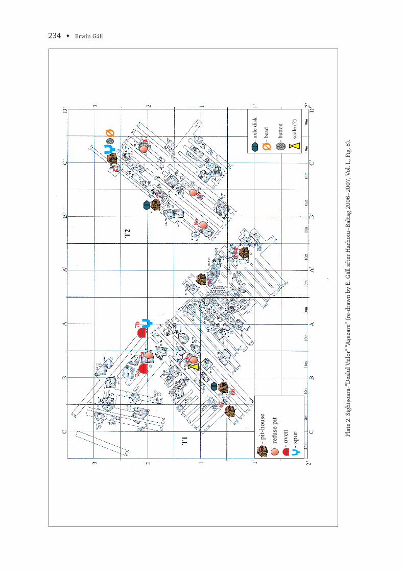
234 ◆ Erwin Gáll
Plat
e 2.
Sig
hișo
ara‑
“Dea
lul V
iilor
” “A
șeza
re” (
re‑d
raw
n by
E. G
áll a
fter
Har
hoiu
−Bal
tag
2006
−200
7, V
ol. I
., Fi
g. 8
).
66
67
27
11
7b7c
7a
78
104
18
34
43a
- pi
t-ho
use
- re
fuse
pit
- sp
ur
- ov
en
8a
- sc
ale
(?)
- bu
tton
- be
ad
- ax
le d
isk

The Significance of the Sites “Aşezare” and “Necropolă” on “Dealul Viilor” in the Development of Habitat ◆ 235
Plate 3. Sighişoara‑“Dealul Viilor” ‘Cemetery’” (after Harhoiu‒Gáll 2014, Pl. 2).
0 30 m

236 ◆ Erwin Gáll
Plate 4. Sighişoara‑“Dealul Viilor” “Aşezare” complex 7b: 1–2; complex 7c: 1; complex 43a: 1 (after Harhoiu−Baltag 2006−2007, Vol. II, Fig. 1090, Pl. 26/1−4, pl. 27, pl. 94/4).
Oven (complex 7b)
1
2
3
4
3
0 5 cm
0 5 cm
Pit (complex 43a)
Pit (complex 7c)
0 5 cm 1 1
Oven (complex 7b)

The Significance of the Sites “Aşezare” and “Necropolă” on “Dealul Viilor” in the Development of Habitat ◆ 237
Plate 5. Sighişoara‑“Dealul Viilor” “Aşezare” complex 27: 1–5; complex 67: 1–2 (after Harhoiu−Baltag 2006−2007, Vol. II, Fig. 1099, fig. 1104, Pl. 73/1−3, 8, 10, pl. 67/1, 10).
spur
1
pit-house (complex 27)
2
34
5
0 5 cm
Oven (complex 67)
0 1 m
0 5 cm1
- 1,35
2
Oven (complex 67)
pit-house (complex 27)
Oven 2/1988 (complex 67)
- 1,30- 0,90
- 0,60
- 0,60- 0,60
A
AB
B
N
Oven 2/1988 (complex 67)
complex 68

238 ◆ Erwin Gáll
Plate 6. Sighişoara‑“Dealul Viilor” “Aşezare” complex 66: 1–11 (after Harhoiu−Baltag 2006−2007, Vol. II, Fig. 1104, Pl. 153/1−11).
-1,45 m
-1,45 m
-0,95 m-0,90 m
-1,55 m
Oven (complex 66)
Oven (complex 66)
1 2
3 4
5 6
7 8
9
10
11
N
Oven 1/1982 (complex 66)
0 5 cm
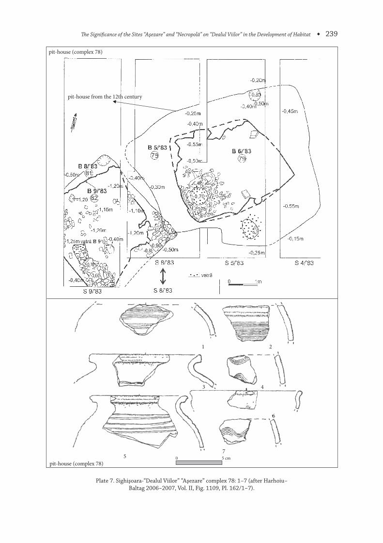
The Significance of the Sites “Aşezare” and “Necropolă” on “Dealul Viilor” in the Development of Habitat ◆ 239
Plate 7. Sighişoara‑“Dealul Viilor” “Aşezare” complex 78: 1–7 (after Harhoiu−Baltag 2006−2007, Vol. II, Fig. 1109, Pl. 162/1−7).
pit-house (complex 78)
pit-house from the 12th century
1 2
3 4
5 7
6
pit-house (complex 78)0 5 cm

240 ◆ Erwin Gáll
Plate 8. Sighişoara‑“Dealul Viilor” “Aşezare” complex 104=119: 1–5 (after Harhoiu−Baltag 2006−2007, Vol. II, Fig. 1110, Pl. 183/1−4, 9).
0 1 m
1 2
3 4
5
pit-house (complex 104=119)
pit-house (complex 104=119)
0 5 cm

The Significance of the Sites “Aşezare” and “Necropolă” on “Dealul Viilor” in the Development of Habitat ◆ 241
Plate 9. Sighişoara‑“Biserica din Deal”; Albeşti‑“Cetate” (valley of Şapartoc) (after Baltag 1979, Pl. 55/1, Pl. 63/2).
church from the 12th century
Sighișoara-‘Biserica din Deal’
Albești-’Cetate’ valley of Șapartoc
0 52 m
N
2
1


ZIRIDAVA, STUDIA ARCHAEOLOGICA, 28, p. 273–274
Abbreviations
ActaArchHung Acta Archaeologica Academiae Scientiarum Hungaricae. Budapest.
ActaHist Acta Historica. Szeged.
Acta Siculica Acta Siculica. Sfântu Gheorghe.
Aluta Aluta. Revista Muzeului Național Secuiesc Sfântu Gheorghe.
Alba Regia Alba Regia. Annales Musei Stephani Regis. Székesfehérvár.
AMN Acta Musei Napocensis. Cluj‑Napoca.
AMP Acta Musei Porolissensis. Muzeul Judeţean de Istorie şi Artă Zalău. Zalău.
ATS Acta Terrae Septemcastrensis. Sibiu.
AISC Anuarul Institutului de studii clasice Cluj Napoca. Cluj‑Napoca.
AnB S.N. Analele Banatului – serie nouă. Timişoara.
Apulum Apulum. Alba‑Iulia.
AÉ Archaeologiai Értesitõ. Budapest.
Areopolisz Areopolisz. Történelmi‑ és társadalomtudományi tanulmányok Odorheiu Secuiesc / Székelyudvarhely.
ArhMed Arheologia Medievală. Iași.
ArchRozhl Archeologické Rozhledy. Praga.
ArhVest Arheološki Vestnik. Ljubljana.
Banatica Banatica. Muzeul Banatului Montan. Reșița.
BHAUT Bibliotheca Historica et Archaeologica Universitatis Timisiensis.
BAR International Series British Archaeological Reports, International Series. Oxford.
BAM Brukenthal Acta Musei. Sibiu.
BMMK A Békés Megyei múzeumok közleményei, Békéscsába.
CAH Communicationes Archaeologicae Hungariae. Budapest.
Cerc. Arh. Cercetări Arheologice. Bucureşti.
CIL Corpus Inscriptionum Latinarum.
CIMRM Corpus Inscriptionum et Monumentorum Religionis Mithriacae.
CCA Cronica Cercetărilor arheologice din România. Bucureşti.
Crisia Crisia, Muzeul Ţării Crişurilor. Oradea.
Dacia N.S. Dacia. Recherches et Découvertes Archéologiques en Roumanie, Bucureşti; seria nouă (N.S.): Dacia. Revue d’Archéologie et d’Histoire Ancienne. Bucureşti.
DissArch Dissertationis Archaelogicae (Budapest).
Dolg Dolgozatok. Szeged.
EphNap Ephemeris Napocensis. Cluj‑Napoca.
EL Erdővidéki Lapok. Barót/Baraolt.
EM Erdélyi Múzeum. Kolozsvár/Cluj‑Napoca.
Isis Isis. Erdélyi Magyar Restaurátor Füzetek. Cluj‑Napoca / Kolozsvár.
JbRGZM Jahrbuch des Römisch‑Germanischen Ztentralmuseums Mainz. Mainz.
Marisia Marisia. Studii și materiale. Arheologie – Istorie – Etnografie. Târgu‑Mureș.
MCA Materiale şi Cercetări Arheologice. București.

274 ◆ Abbreviations
MFMÉ StudArch A Móra Ferenc Múzeum Évkönyve. Studia Archaeologica. Szeged.
MFMÉ MonArch A Móra Ferenc Múzeum Évkönyve. Monumenta Archeologica. Szeged.
OpArch Opvscvla Archaeologica. Zagreb.
OpHung Opuscula Hungarica. Budapest.
Pontica Pontica, Constanţa.
PZ Prähistorische Zeitschrift. Berlin.
RMM‑MIA Revista Muzeelor și Monumentelor – seria Monumente Istorice și de Artă. București.
Sargeția NS Sargeția NS. Deva.
SlovArch Slovenská Archeológia. Nitra.
Soproni Szemle Soproni Szemle kulturtörténeti folyóirat. Sopron.
StudCom Studia Comitatensia. Tanulmányok Pest megye múzeumaiból. Szentendre.
ŠtudZvesti Študijne Zvesti Arheologického Ústavu Slovenskej Akademie Vied. Nitra.
Stud. şi Cerc. Num. Studii şi Cercetări de Istorie Veche şi Arheologie. Bucureşti.
SCIVA Studii şi Cercetări de Istorie Veche (şi Arheologie). Bucureşti.
StComSatuMare Studii şi Comunicări. Satu Mare.
Thraco‑Dacica Thraco‑Dacica. Bucureşti.
VMMK A Veszprém megyei Múzeumok Közleményei. Veszprém.
VTT Veszprémi Történelmi Tár. Veszprém.
Ziridava Ziridava, Complexul Muzeal Arad. Arad.