urban poverty alleviation strategies a study of six cities (in india)
Twenty-Seventh Annual ESRI International User Conference
San Diego, 18-22 June 2007
Environmental Trends Analysis (ETA): Tools for
Poverty Alleviation
Lars T. Soeftestad • James J. Tarrant • Lauren M. Sorkin 1/
Abstract. Environmental Trends Analysis (ETA) is a set of tools and approaches used to assess changes in natural resources over time, and to evaluate the impacts of various management and policy regimes on natural resources. ETA is evolving partly as a result of the growth of the vast opportunities inherent in GIS, and partly in reaction to experiences with GIS, specifically some problems connected with application of GIS at different societal scales, particularly in developing countries. ETA addresses situations in which inter-disciplinarity, cross-cultural validity, and cultural variation are important, as well as the vast complexity of Nature-Culture interactions.
The paper reports on the new USAID FRAME project on ETA, including its inter-disciplinary nature, objectives, goals and the emerging global community of practice. It also presents applications of ETA, especially to empower communities, as well as arguments for why and how ETA extends the reach, impact, and potential of GIS.
1 Introduction
In section 2, Environmental Trends Analysis (ETA) is presented, together with Amartya Sen’s “Capability Approach,” which constitute the paper’s analytical framework. Also in this section, the FRAME project is presented. Section 3 contains a case study, namely a World Bank supported project in Mauritania, “Technology Fosters Tradition”, and how in this project GIS and traditional participa-tory field observation and methods, utilizing local people, are being combined in production of maps. The model for how to do this, Social GIS (SGIS), is outlined. Finally, aspects of this project that lends itself to ETA are presented. Section 4 contains a discussion of key aspects of ETA, including commu-nication, knowledge, and knowledge management, while section 5 contains conclusions and recom-mendations.
2 Environmental Trends Analysis
2.1 Background
Knowledge is the result of lessons learned from human experience and experiments in the real world. It can be transmitted from one person to another, in so doing helping humans to avoid mistakes and collectively to create more complex societies and technology. For these reasons, knowledge is extremely valuable. The process of organizing and transmitting knowledge between peers has come to be called, recently, “Knowledge Management” (KM). Education, information dissemination, religion, indeed most human social interactions involve some degree of KM and so this is not a new concept. However, the term KM, as used nowadays, usually entails the use of technology or facilitation techniques to help create, store, or transmit information and knowledge.
Official foreign assistance agencies, foundations and other “donors” working in developing and transition countries2/ have always used some forms of KM as a part of their assistance programs. 1/ Lars T. Soeftestad (Supras Consult, Norway), James J. Tarrant (International Resources Group, USA), Lauren M.
Sorkin (International Resources Group, USA). Corresponding author: Lars T. Soeftestad – [email protected]. This version, which was prepared in November 2007, is slightly changed relative to the conference version.
2/ “Developing countries” refers to the large group of countries in Africa, Asia, and Latin America that achieved indepen-dence in the 50+ years after World War II. “Transition countries” normally refers to the nations of Central and Eastern
– 2 –
Historically this has taken the form of small armies of consultants, trainers, and other knowledge workers cooperating directly with newly independent governments or economically poor disen-franchised communities with very little institutional or governance capacity. Private sector companies, operating through market and non-market interactions also did a great deal of KM, including the collection and use of data to improve their daily operations or to guide market development as well as train workers that they employed in their countries of operation.
However, over time, donors, in particular, realized that this “retail” model of transmitting knowledge to build modern, thriving economies suffered from a number of drawbacks. First, the implicit if not explicit model of interaction was largely unilateral. Developing countries received knowledge from developed countries and essentially tried to copy those models of development. Rarely was there any recognition or reflection that: (1) Western industrial models were not necessarily culturally or developmentally appropriate to every country and (2) Feedback and dialogue during the technical assistance and training process could be used to create more synthetic and more appropriate development models. Second, the explosion of information and communication technology (ICT), especially since the 1980s, radically transformed the landscape of knowledge-based interactions. These included mobile telephony, globalization, the Internet, micro-computerization and miniaturiza-tion as well as the development of specific knowledge creation tools such as wiki technology and geographical information systems (GIS) amongst others.
Bilateral donors such as the U.S. Agency for International Development (USAID) and multilateral donors, like the World Bank, among other donors have been increasingly interested in KM mecha-nisms. USAID, amongst others, has supported knowledge based networks in the scientific commu-nity, especially the Consultative Group on International Agricultural Research (CGIAR) and specific projects that seek to build more informal and broader networks of knowledge users, one of which is the subject of this paper.
2.2 Analytical Framework: Sen’s “Capability Approach”
Within the development community a group emerged in the 1980s, consisting of some donor agency professionals, development consultants, and NGOs in response to the growing realization that traditional models of development – when applied uniformly across the developing world – often led to unstable, elite-based and distorted societies, dependent upon foreign assistance and/or resource exploitation by multinational companies and state-owned enterprises. Often these aid programs failed to create the kind of broad-based, entrepreneurial and more equitable societies that most professionals regarded as essential to free, democratic and thriving states. If anything, the trends identified in the 1980s have worsened since the end of the cold war and the relative decrease of development assistance since that time have arguably contributed to the emergence of a web of fragile, unstable or failed states.
For those development efforts focused on natural resource management (NRM), these patterns have been even more strikingly apparent. It is now nearly axiomatic that being an oil producing country often leads to the development of authoritarian, unstable polities with narrowly-based, poorly-developed economies. Conversely, there are countries with poor resource endowments that nevertheless have begun to develop more democratic and more broadly diversified if still relatively poor economies.
Land and natural resources are fundamental to most developing and even some transitional economies because most developing countries have large rural populations engaged in subsistence agriculture. Above all, control over the land and natural resources have a fundamental bearing on local, regional, and national development. Indeed, this was recognized early in the development field as seen in the focus on land reform and redistribution in the 1950s and 1960s. In the 1970s and early 1980s, large integrated rural development and river basin development projects were aimed at moder-nizing rural sectors and building relatively sophisticated institutional mechanisms for governing the use of land-based resources. Most of these efforts were not sustainable because they were imposed
Europe and the former Soviet Union that have been in transition from command to market-oriented economies and, in many cases, more pluralistic polities.
– 3 –
from above and failed to engage rural and urban elites or national governments that exercised control over the natural resources. By the late 1980s and 1990s, “participatory” and “sustainable” develop-ment approaches were lauded as a new way of managing natural resources for economic development.
In the wake of this experience, voices of thinkers such as the Nobel-prize winner, Amartya Sen, gained increased traction. Sen’s basic concept of development is that “the expansion of the capabi-lities” of people to lead the kind of lives they value – and have reason to value,” constitute freedom.3/ For Sen, traditional measures of development such as growth in gross national product are poor indicators of development because they do not signal when broad development is reached. Proof of this can be found in many countries widely exploiting natural resources and reporting relatively high GNPs while harboring impoverished and economically backward societies. Sen argued that through a focus on the “capabilities” of people, for example, the extension of basic education, women’s rights, health care, social safety nets, microfinance, and other empowering mechanisms; structural development could be more adequately measured. Growth in real incomes is, of course, important but, as Western economies increasingly have begun to realize, income does not guarantee broad-based development or lead to individual well-being.
Sen’s approach therefore requires continuous and deep involvement of the public in economic decision-making and, by necessity, a more democratic polity. For Sen and others who agree with him, this scenario necessarily requires a focus on creating and supporting the development of bottom-up, participatory institutions with real governance capabilities, especially over NRM.4/
Development practitioners focused on environment and NRM have developed this paradigm in the design and implementation of development projects during the last 20 years. In USAID, in the late 1990s, the lessons learned from observation of decades of development efforts – largely in sub-Saharan Africa, the region with the largest impoverished rural populations, least developed national institutions and most fragile or failed states – led to the creation of the analytical framework Nature, Wealth and Power.5/ This framework helped practitioners to identify challenges and opportunities for development by looking at the dynamics of the natural resource base (Nature), livelihood options (Wealth), and governance structures (Power).
Nature, Wealth and Power or NWP, as it is commonly known, presented a strong argument for the Sen approach to development, in particular a focus on empowering the rural poor who were both the most directly dependent upon natural resources for their subsistence and livelihoods but also the least likely to exercise effective control over those resources. To give one example, the legacy of most African colonial era administrations was often to establish strict state control over all common lands, including forests, pasture lands, and sub-soil resources. This pattern had a direct impact on accelerating the degradation of those resources and the spread of desertification, especially in West Africa. Conversely, where control of land was devolved to individuals or communities and the subsequent empowerment of populations to develop and market the products from their own woodlands, land resources and rural livelihoods have begun to recover.
In the late 1990s, USAID created one of the first of that agency’s KM-dedicated projects to explore the NWP thesis and to develop a “Community of Practice”6/ (CoP) on NRM in Africa. The project, called FRAME, had a mission to build knowledge sharing networks of NRM professionals and to help NRM practitioners and decision makers to access and use the existing body of knowledge on successful NRM experiences. The program’s two main goals have been to: 3/ From Amartya Sen. 1999. Development as Freedom, as quoted in Peter Evans. 2001. “Collective capabilities, culture,
and Amartya Sen’s Development as Freedom” in Symposium on Development as Freedom by Amartya Sen, p. 55. 4/ “Governance,” this discussion, is not the same as government. Governance means the set of policies, rules and practices
used to organize and manage an institution. Hence, institutions from families, companies, NGOs, and governments all practice governance.
5/ USAID, WRI, IRG, Winrock and CIFOR, Nature, Wealth and Power. 2002. USAID, Washington DC. 6/ The term Community of Practice refers to Lave and Wenger’s (1991) concept of “a set of relations among persons,
activity and world, over time and in relation with other tangential and overlapping CoPs.” For the purposes of this discussion, we would add that: (1) Members usually have a shared set of interests and are motivated to do something about them, (2) CoPs are often self-generating, the membership is self selecting, and (3) CoPs are not necessarily co-located but can be dispersed spatially quite far, especially nowadays.
– 4 –
Foster discussion on emerging trends in environmental and natural resource management across disciplinary and geographical boundaries.
Provide timely and relevant information on innovative and strategic options to address these issues.
FRAME began by trying to build a CoP that could provide informal mentoring to USAID on improved NRM project designs and implementation modalities. However, as is often the case with CoPs, the project, over time, became more user-defined in terms of activities and objectives, although project staff and USAID’s managers have continued to be actively involved in supporting the network through workshops, meetings and support for a website that employed an interactive, collaboration-focused platform.7/ An interesting aspect of the FRAME project has been the diversity of its membership, ranging from Western and African professionals working on NRM to ministers and other decision-makers in the region to NGOs, large and small, and sustainability advisors for private companies.
2.3 Access to Empowering Information – Environmental Trends Data
and Analysis (ETA)
An early and continuing focus of the FRAME project has been on identifying tools that could assist professionals and policy makers in making more empirically-based and informed decisions on NRM. FRAME calls this user community “Environmental Trends Data and Analysis” or ETA. The commu-nity is defined as a group of experts from around the world dedicated to an interdisciplinary approach to NRM with a strong interest in decision support tools and governance issues. FRAME’s ETA network started out with an interest in modelling approaches and methodologies that could assist decision-makers with management of important natural resources, for example, watersheds, forests, landscapes with important biodiversity resources and others. Geospatial information and especially GIS were slow to emerge for several reasons. In the 1990s, GIS technologies were expensive, required extensive training and powerful computing capabilities that were rare in Africa. In addition, many governments with a monopoly on telephony and geospatial information regarded public access of such information as a perceived national security threat. As noted previously, many governments in Africa and elsewhere did not regard public participation or democratic governance as being real dev-elopment objectives except rhetorically.
However, as we explore below, the governance situation has evolved over time, due to several converging trends. First, the unit cost of data storage and analysis has fallen dramatically over just the last 10 years as Moore’s Law,8/ new kinds of data gathering technologies and more powerful computer algorithms have continued to play important roles. Second, demands from developing country publics, international NGOs, some private corporations and donor organizations for greater accountability and transparency from developing country governments have put pressure on governments to open up their decision making processes, at least to some extent, and in a few countries to a significant extent. The announcement of the U.N. Millennium Development Goals9/ in 2000 was an important stimulus for change, particularly in Africa. Third, tools for utilizing geospatial information have expanded and become more easily accessible to the public. Google Earth™ is just one example of this trend. Fourth, the industry leader, ESRI’s Arc GIS suite of products has become somewhat more accessible. Finally, and even more important, a new generation of developing country professionals has emerged that is computer literate and comfortable with the Internet, mobile telephony and the rapidly proliferating programs and applications available for using geospatial information for industries ranging from the tourism and travel industry to natural resource and environmental management, disease transmission and prevention and even “e-government.” 7/ The website program is called Simplify™, which is a product of the Tomoye Corp. of Ottawa, Canada. 8/ Moore’s Law refers to the formulation of Intel founder Gordon Moore in 1975 that, due to advances in technology com-
puting “power” (as measured by the number transistors on an integrated circuit) would double every two years, though not indefinitely of course.
9/ Eight development goals, including eradication of HIV/Aids, environmental sustainability, and others. This led to the US Government’s creation of the Millennium Challenge Corporation to channel development assistance to countries with more open, transparent and accountable governments and free market economies.
– 5 –
Since 2002, FRAME has enlisted a number of individuals with geospatial analysis capability that have formed a CoP and interacted with each other on African NRM topics. Probably the longest and most important collaboration in this regard has been a stocktaking10/ exercise on farmer-assisted natural forest regeneration in Niger. This exercise involved collaboration with the U.S. Geological Survey (USGS), a range of NRM professionals in West Africa, USAID officials and environmental NGOs using focused interviews, surveys, geospatial imagery as well as aerial photography and workshops to develop a synthesis-based body of knowledge of the trends and forces responsible for a remarkable reversal of land degradation and desertification in four regions of Niger.
A turning point was reached this year when national and international policy makers and administrators were made aware of the amazing changes that occurred in Niger over the past of 20 years. The immediate target of the GIS study was a presentation to the annual meeting of the U.N. Convention to Combat Desertification (UNCCD), where satellite images combined with ground truthing photographs and extensive analysis of documentary and survey data revealed the region’s dramatic recovery from drought. Contrasting the four regions in 1975 with the same areas in 2005 provided a powerful visual storyline that narrative alone could not have achieved. The Niger example, far from being overlooked, landed its GIS and multimedia storyline on the front page of the New York Times this year.
In 2006, the Global Spatial Data Infrastructure Association invited the staff of IRG,11/ which has implemented the FRAME project on behalf of USAID since 1998, to present ETA’s approach and cases at the Global Spatial Data Infrastructure’s ninth plenary meeting (GSDI-9) in Santiago, Chile. Six individuals representing a wide range of GIS users provided case studies of their approach. They ranged from small-scale researchers and NGOs in Africa to the large Mekong River Basin Commis-sion in south east Asia. All of the individuals and cases were concerned about the interface between GIS and the complex, often localized knowledge of the NRM user, particularly subsistence-level users and how this rich body of data and information could enrich and inform GIS data layers of serious policy and planning importance at the national level.
2.4 Human Capacity to Gather and Analyze Information about Environmental Trends
As globalization proceeds apace bringing with it much greater interdependence among nations, the pace and nature of development has accelerated increasing incomes and prosperity to some countries while making others more unstable and vulnerable to exploitation. In addition, the issue of global climate change has led to new attention to the issue of vulnerability and adaptation (i.e., which countries and which economic sectors within countries will become vulnerable to the impacts of climate change and how these countries and sectors will adapt to these changes). For some countries, particularly small island countries, the threat is an existential one as sea levels rise. In most other countries, increasingly unpredictable and unstable weather patterns, prolonged drought and shifts in climate regimes will have profound effects on agriculture, the fate of coastal cities, and the availabi-lity of water supplies to name just a few impacts. For all the reasons mentioned above and others, the collection, analysis and dissemination of geospatial information and technology is rapidly becoming a high priority for most nations as well as large and small businesses and many NGOs.
Still, humans have been adapting to climate change for a long time. Indeed, a number of scientists believe that human evolution was, in part, due to changes in Africa’s climate millions of years ago that favored selective traits in our ancestors that made them more adaptable to a wider range of environments. Humans have a unique capacity to collect a range of sensory data about their surround- 10/ “Stocktaking” refers to a methodology for looking back on the long-term impacts of usually a bundle of development
interventions focused on a significant development issue. It seeks to identify the mix and weight of changes in governance policies, individual rights, institutional changes, field activities (including training and technological diffusion) as well as exogenous forces (for example, globalization or climate change) in order to develop useful lessons learned and models for replication of successful outcomes.
11/ IRG is International Resources Group, a professional services firm, based in Washington DC, which has managed hundreds of development projects in environment, natural resource management, energy and relief and reconstruction in 137 countries over the last 29 years.
– 6 –
dings, synthesize these data into useful information and then adapt their local environment to suit their needs. As noted earlier, this synthesized information leads to the creation of knowledge about which adaptations work and which do not. In traditional situations, this knowledge gradually became a part of the local community’s lore or culture.12/ Over time, this embedded knowledge may have become part of a religion, body of customary law and/or informal and formal education systems (master-apprentice systems, formal education systems and others).
Important geographical information is often bound up with social norms, practices and organizational structures. For example, in many societies practicing shifting cultivation in tropical forest ecosystems, land tenure is communal and productive lands in a rotation may be given to different households in a complex distribution that includes both productive plots and less productive plots, supporting a balanced social mix and allowing recently farmed plots to go into fallow and recover their fertility. Looked at from the standpoint of a Midwest corn farmer, such a land distribu-tion looks bizarre and chaotic but in fact such rotations have been quite sustainable for thousands of years. In addition, scientists have recently realized that inhabited tropical forests ranging from Borneo to the Amazon are, in fact, mostly human-altered forests and so what appears to be a diverse and “natural” forest is one that, in fact, has been substantially altered from its pre-human structure.
2.5 Communication, Information and Environmental Trends Analysis
As noted earlier, the organization and diffusion of knowledge has become increasingly more rapid and layered in complexity. In the development field, communication of knowledge has long been a difficult and evolving subject. Top-down models of development are still practiced using communication that is one-way and supply driven. Experts told the ignorant what to do and one important purpose of communication was to reinforce both the source of knowledge and power hier-archies. Local or indigenous knowledge was either ignored or actively suppressed for political and economic reasons. Modern forms of knowledge and value systems were imposed on communities often without any dialogue. In some cases, for example, the Masai tribe of East Africa, the culture accepted what it found useful and rejected much of the rest in order to preserve its cultural identity. In many other cases, such selective pushback did not happen.
The cliché “knowledge is power” only tells part of the story. Knowledge is insufficient without the means to act upon that knowledge. Therefore efforts to empower people with “useful” knowledge and mechanisms for sharing it effectively have become the focus of participatory development. In the 1980s, many development professionals began to realize that indigenous communities13/ knew much more about what worked and what did not work in their local environments than they did and that this knowledge could and should be used as a base upon which to ensure that development interventions were more sustainable. This was especially true for environmental, agricultural and natural resource development interventions.
A critical part of this interaction with local communities was the development of awareness of potentiality. Of the many tools that emerged to empower communities, one of the most important from the communications standpoint, was “community mapping.” Essentially, community mapping is an interactive process in which indigenous communities take the initiative to “map” their environment and the boundaries of their effective control of resources. For some kinds of resources, those boundaries may be very restricted; for others they may be very large. Modern communication and knowledge intermediary mechanisms such as GIS have the power to incorporate and transmit such knowledge to decision makers in both visual and empirical formats that previously were unheard of. GIS data layers, informed by indigenous knowledge have had powerful communicating impacts on various audiences whether donors, local, and national governments or academia.
In agriculture, a similar phenomenon has occurred with farmer school programs, first pioneered by the FAO in Asia. A variety of these experiments have occurred in which the experience and 12/ “Community” for this purpose could be a village, an extended family or clan, a tribe or ethnic group or other recognized
social formation. 13/ We use this term as shorthand for a variety of entities, including neighborhoods, municipalities, unstructured physical
groupings, professional bodies, and CoPs.
– 7 –
practice of farmers is transmitted directly to agricultural extension officers and then laterally to other farmers facing similar problems, whether they be pest control or drought tolerant varieties or post-harvest processing technologies. In essence, the students are teaching the teachers. Critically, bottom-up expressions of NRM knowledge in developing countries depend upon visual and multimedia-based communication mechanisms. GIS can play a powerful role in empowering local NRM governance interactions as it already has done in the United States.
3 Case: Wetlands and traditional property rights in Mauritania
3.1 Setting
Located in West Africa, Mauritania is a country apart, in several respects. It is large compared with its neighbours; it has a very long coastline while also covering a large part of the Sahara and the Sahel. At the same time the variations in climate is quite large, with the region along the southern border providing possibilities for agriculture and irrigation. In cultural terms it is also different, in that one smaller group, Maure, of Arab descent, divided and subdivided in a number of tribes and clans, is de facto an elite in cultural, political and economic terms, with various peoples of African descent positioned in a sub-dominant position. In between them, so to speak, are the Haratin or Black Maure, descendants of former slaves of the Maure, over the centuries partly intermarried with Maure. For this reason, peoples of African descent are usually referred to as “Black Africans.”
The region of concern in this paper is the southern border region, which is semi desert and contains a large number of various categories of ephemeral wetlands. In this area live Maure, Haratin, and Africans, while African pastoralists travel through and live in the area during their annual migrations.
3.2 Issues and Problems
A number of issues are characteristic of the country as such as well as of the southern region where the ephemeral wetlands are found.14/
3.2.1 Changes in Land Use, Increase of Incidents of Conflict
Over the last 25 years the isohyet for 400 mm precipitation has moved approximately 40 km southwards in the Sahel. This is partly responsible for the increase in desertification in the east of Mauritania. As a consequence rain fed agriculture is no longer possible in many places. New land for cultivation is marginally productive.15/ However, local agricultural farmers, encouraged by the Government and donors, continue to plant north of this benchmark isohyet. At the same time, pastoral people, mostly Maure, have descended south, following the annual rains, and are raising their animals in areas where they have not been seen in 30 years, creating a new ethnic mix.16/ Pastoral grazing areas further south for use during the transhumance have been otherwise appropriated and shut off to these pastoralists as a result of a conflict between Mauritania and Niger.17/ This creates conflicts between pastoralists and agriculturalists as well as among pastoralists.18/
Mauritania’s traditional social organization has undergone drastic changes over the last 25 years. In sub-Saharan Africa, the rapid increase in population in many countries places too large a burden on traditional systems of land ownership. The population has doubled, pastoral areas are unable to absorb
14/ Part of the material to follow is adapted from the 2002 Concept Note and the 2004 Presentation prepared in connection
with the World Bank Technology Fosters Tradition project (see below on this project). 15/ Kevin Cleaver and Gotz Schreiber. 1995. The downward spiral in Sub-Saharan Africa: Population growth, agricultural
decline and destruction of the environment. Washington DC: World Bank. 16/ Comment contributed by Thomas Sommerhalter, GTZ, Manager GIRNEM project, in 2004. 17/ Transhumance denotes a specific form of pastoralism in which migration routes are fixed between two or more loca-
lities, and takes place at specific times of the year, that is, seasons. 18/ The most dramatic of these conflicts was the 1998 war between Mauritania and Senegal, triggered by pastoralists
moving south across the Senegal river.
– 8 –
this increase given the existing strain on these already meagre resources, and the increasing desertifi-cation is also an important factor. As a result, large numbers of the rural population have migrated to urban areas, notably Nouakchott.19/
The Government program in support of the rural population emphasized irrigated agriculture, which accordingly receives most funding. Rain fed agriculture ranks a distant second. Livestock has received veterinarian services in the recent past, but, even though it is considered an important sector in the overall drive for poverty reduction, has not received much support. There are also problems caused by large pastoral herds owned by wealthy individuals with government influence. These owners, which as a rule live outside and could be termed “absentee owners,” ignore customary rules and do not consult local communities before using pastoral areas.20/
3.2.2 The Rural Economy: Livestock, an Undervalued Asset
The livestock sector is probably the largest employer in the country. Mauritania has more than 4 million UBT of livestock, consisting of camels, cattle, goats, and sheep. At least one herder is required for every 70 UBT.21/ This implies at least 57,000 herders employed all year around. If peripheral industries such as, for example, construction of and maintenance of wells, drawing water and commercialization, are taken into account, the number of employed increases further.22/ At the same time pastoralism represents core values of Mauritanian culture. Its demise would have a profound negative impact for society, beyond mere economic loss.
Yet the Mauritanian government neglects the sector. There are several possible explanations for this lack of government support:
Rural Mauritanians, that is, the Maure, come from a livestock background, believe they know the field, and see no reason to change current methods.
The last century has ingrained the idea of pastoralism as an outdated, inefficient system detrimental to the environment.
Donor initiatives attempting to reform the sector over the last 25 years have failed and pre-sently there appears to be little interest in investing in the sector.
There is an enormous conceptual gap regarding what to do about pastoralism.
After 50 years of lack of assistance to the sector, there are few institutions with the capacity to safeguard, develop and modernize pastoralism. In the late 1990s, however, a regional initiative embracing the Sahel adapted training models for pastoralists.23/ But there is no educational institution in the Sahel that trains pastoralists, and the World Bank projects in the area have not significantly changed this picture.
Despite little or no government support, pastoralism remains Mauritania’s only viable sector in the rural areas. Whereas the statistical evidence for agricultural production in irrigated agriculture is precise, it becomes less reliable in the case of rain fed agriculture, and involves pure estimates for pastoralism. Therefore, comparisons are difficult to make. Anecdotal evidence, however, seems to indicate that the overall value invested in livestock is about double the value of all crops. The economic assessment of the value of nomadic livestock is rendered more difficult by two character-istics of this sector: (1) The extent of the trade in camels, cows, sheep and goats across the interna-tional borders is not known and (2) Herds are sometimes kept for purposes of status only, and not for economic reasons.
19/ Nouakchott presently accounts for the highest urban population growth rate in all of Africa. 20/ Comment contributed by Thomas Sommerhalter, op. cit. 21/ The average weight of adult cattle in the tropical zones varies from 200 to 400 kg. A tropical livestock unit may
accordingly be defined as an animal with an average weight of 250 kg. This is the UBT (Unite Bovin Tropical). This French term corresponds to the LSU (Livestock Standard Unit) in English-speaking countries. Conversions: (1) 1 adult head of cattle = 1 horse = 1 camel = 1 UBT, (2) 1 sheep = 1 goat = 0.12 UBT, and (3) 1 calf = 0.7 UBT.
22/ Comment contributed by Thomas Sommerhalter, op. cit. 23/ The West Africa Pilot Pastoral Program (WAPP), implemented jointly by the World Bank and FAO.
– 9 –
3.2.3 Traditional Knowledge: Undervalued in Modern Legislation
The Mauritania legal system is the result of three distinct sources of law which overlap and are not always coherent: (1) The traditional customary rules and regulations, (2) The Sharia Islamic law system24/ and (3) The French civil law system.25/ All three sources of law coexist, but neither is professionally implemented. This legal pluralism creates uncertainty as to how property rights will be determined, and this can result in decreased tenure security.26/
Since 1968, Mauritania has tried to harmonize the civil law with the Islamic legal rules. This work has been assisted by World Bank funding. Despite considerable efforts, it has not yet led to any tangible results in practice.
A credible and effective legal system, which guarantees social peace, and is the foundation of any society, depends on the voluntary adherence of the citizens. The citizens will only respect a legal system that reflects their values. A legal reform, which is needed in Mauritania in view of the fast-changing society from a tribal context to a modern state, would have to build on the traditional values that are shared by the majority of society. In order to facilitate the legal reform necessary in Mauritania, these local values first have to be recognized, defined and evaluated. The Code Pastoral represents a first effort in this direction.27/
3.2.4 Natural Resource Management, Conflicts and Governance
The broader context for NRM and conflict management lies with the rule of the state and the quality of governance. The resolution of conflicts is closely linked to development strategies and manage-ment of natural resources, and peace and stability are understood to be necessary preconditions for development.
The World Bank 2000 study Can Africa Claim the 21st Century establishes four broad pillars of support to Africa’s development, one of which is reducing conflict and improving governance.28/ Whether at the local or the regional level, conflicts in Africa represent a serious problem.29/
Due to the declining attention to traditional values in Mauritania, together with the diminishing authority of the tribal hierarchic structure, destructive environmental behaviour increases. The modern administration cannot curtail such misuse, because of competing interests and lack of oversight. As indicated, the existing conflict-avoidance or conflict mediation institutions are largely discredited. Rural communities elected to administrate the property have no legal power to deal with NRM issues.
3.2.5 The Technological Challenge
New technology would have to be utilized in order to document traditional land use knowledge, and do so in an effective and transparent way for local stakeholders. However, using new technology may be difficult. Rights cannot be mapped; only plots or spaces where a group or an individual holds rights that have yet to be described. GIS is not always useful to show flows and movement because the movements seldom follow the same pattern – it depends on when the rains occur and the subsequent
24/ This is rite Malekite, one of the four schools in Islamic law. 25/ A number of distinct bodies of knowledge exist in Mauritania. These knowledge systems (KS) are, in order of the
present-day priority: Western, French, Arab, Maure and, at the bottom, Traditional. However, depending upon the sphere of culture considered, the order will differ, for example, in the religious sphere the Arab KS is located above the French KS. The KSs are to some extent relative, for example, the Maure KS can be understood as traditional in relation to the French KS. As already hinted at, these KSs correspond partly to legal regimes.
26/ Ruth Meinzen-Dick and Rajendra Pradham. 2002. Legal pluralism and dynamic property rights. 27/ Code Pastoral was enacted by Mauritania in 2001. It was initiated by a local pastoral organization with support from
GIRNEM, a GTZ project. 28/ The other three pillars are: investing in people, increasing economic competitiveness and diversification, and improving
aid effectiveness while reducing aid dependency. 29/ According to a World Bank estimate around 2 percent of per capita GDP are lost annual due to conflicts.
– 10 –
availability of grass.30/ A risk may be perceived in the marginalization of already-marginalized populations through the use of advanced ICT. However, focused and special training of selected members of the communities will contribute to their mastering the modern technology necessary for continuous follow-up. The easy acceptance of ICTs in these wetlands areas have been demonstrated by a GTZ-funded institution building project in which local associations quickly learned how to use Internet,31/ and as witnessed by the boom of expansion of cellular phones and Internet services in Mauritania.
3.2.6 Land Management and Poverty Reduction
Documentation of land ownership and land use will aid in the alleviation of poverty. Secure tenure encourages land users to manage the land properly.32/ It builds confidence and thereby fosters investment, such as planting of trees for future use as charcoal. Secure property rights will also promote efficient management of common property resources. People often fail to adopt technologies for NRM because of a lack of secure property rights and a lack of collective action.33/ Additionally, the creation of registries would allow the poor to formalize their ownership rights and interests and thereby create ‘legal assets.’34/ Furthermore, it has been argued that formalized ownership rights and interests will reduce social and economic inequalities among those with and those without use and access rights.35/
The documentation of local land use practices and patterns is aimed at reinforcing the adherence to land use rights. They should be recorded in local languages. The transparency of the governing land use rights in the project area, and the adherence of the local population and the administration to these rules, is expected to contribute to limiting the amount of conflicts, and to increased success in mediating conflicts.
Transparency of the land/use rights will also clarify access to land use and therewith provide a data source for further exploration of other issues and concerns, such as gender. Transparency of land use rights as a data source can be used to study equity disparities among different social groups also, such as old-young, rich-poor, or availability of access to natural resources by former servants or slaves. The ownership – or lack thereof – of livestock would provide a useful source of data for studying inequalities as well.
3.2.7 Problems
By way of summarizing the above exposition, these are the key problems faced by the Mauritanian agricultural and rural economic systems:
The rural-to-urban migration. Pastoralism provides high returns and is the only feasible form of resource use in large areas
of the country, yet receives low priority compared with rain fed and irrigated agriculture. Desertification (man-induced and through the southward movement of the 400 mm isohyet)
and deterioration of wetlands and marginal areas. Demographic pressure leads to unsustainable land-use activities and in- and out-migration. Traditional communal property rights’ systems are in flux.
30/ This flow and movement relates specifically to the changes in migration of animals, ranging from the daily migrations
of animals belonging to sedentarized people to the larger annual migrations or animals belonging to pastoralists. Other examples of flows include hunting and gathering activities following the changing availability of, for example, seeds, nuts, and medicinal plants, and, to a lesser extent, the rotation of agricultural plots.
31/ Projet d’Assistance aux Communités (PAC). 32/ This has been documented across the world. Consult, for example, Abhijit v. Bannerjee, Paul Gertler and Maitreesh
Ghatak. n.d. Empowerment and efficiency: Tenancy reform in West Bengal. 33/ Anna Knox and Ruth Meinzen-Dick. 1999. CAPRi: Property rights, collective action and technologies for natural
resource management. 34/ Hernando De Soto has worked on this since the early 1990s, and has had success with his model, which is now
expanded beyond South America. 35/ Cecilia Siac. n.d. Registries: A tool for empowerment of the poor and facilitator of economic integration.
– 11 –
Formally, the Government has abolished the tribes, the tribal structures and with it the tribes’ use rights to particular territories. All natural resources are today owned by the state, and all citizens are free to utilize natural resources anywhere at any time with asking permission from anybody.
Lack of traditional institutions for mediating conflicts over natural resources within and across ethnic groups, and between traditional institutions and the administration.
Legislation is ill adapted to local conditions.
3.3 Approach: World Bank Technology Fosters Tradition
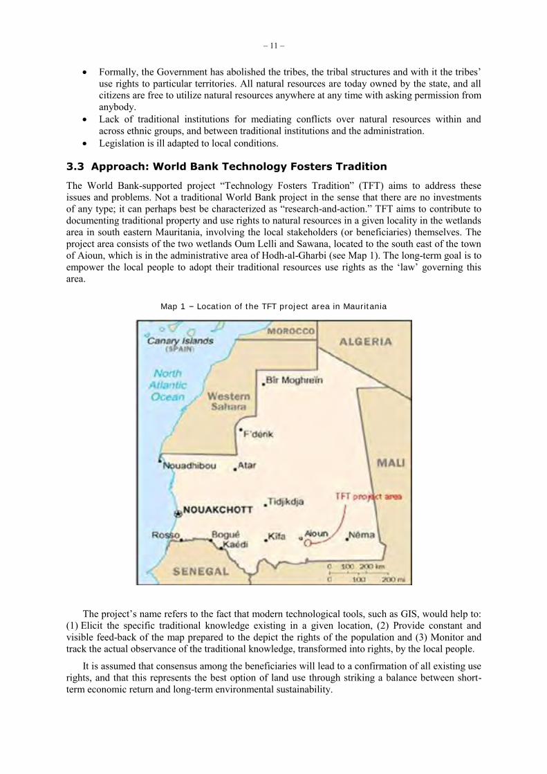
The World Bank-supported project “Technology Fosters Tradition” (TFT) aims to address these issues and problems. Not a traditional World Bank project in the sense that there are no investments of any type; it can perhaps best be characterized as “research-and-action.” TFT aims to contribute to documenting traditional property and use rights to natural resources in a given locality in the wetlands area in south eastern Mauritania, involving the local stakeholders (or beneficiaries) themselves. The project area consists of the two wetlands Oum Lelli and Sawana, located to the south east of the town of Aioun, which is in the administrative area of Hodh-al-Gharbi (see Map 1). The long-term goal is to empower the local people to adopt their traditional resources use rights as the ‘law’ governing this area.
Map 1 – Location of the TFT project area in Mauritania
The project’s name refers to the fact that modern technological tools, such as GIS, would help to: (1) Elicit the specific traditional knowledge existing in a given location, (2) Provide constant and visible feed-back of the map prepared to the depict the rights of the population and (3) Monitor and track the actual observance of the traditional knowledge, transformed into rights, by the local people.
It is assumed that consensus among the beneficiaries will lead to a confirmation of all existing use rights, and that this represents the best option of land use through striking a balance between short-term economic return and long-term environmental sustainability.
– 12 –
The focus, then, is to collect data on traditional NRM, including specifics of resources, localities, and times/dates, and add this information to satellite images, to produce unique, detailed, and completely new types of maps.36/ These maps will serve to document to the local people, as well as all other stakeholders (in particular outsiders, including the relevant ministries) the extent, character, and detail of this resource utilization. In lieu of any proofs of ownership or use rights, these maps would be the next best alternative to this. Given the distance – in understanding less than in geographic terms – between the Government and local people (in spite of a rather devolved administrative apparatus), it would be best if the maps could be taken to authorities and used in a show-and-tell.
There are four key aspects to this approach, worth referring to:
It is strongly inter-disciplinary, and bridges a number of separate disciplines. It integrates modern – in the sense of Western – knowledge with traditional non-western
knowledge, through the preparation of resource utilization maps. It presupposes the availability of very specific local knowledge, which as a rule is not docu-
mented. It presupposes the availability of local capacities to elicit this knowledge. By the same token,
it contributes to building such capacities.
It should be noted that, while GIS is featured prominently in this approach, it should not be concluded that GIS is uniquely positioned to perform this task – or even that it could not be done without using GIS. There are alternative approaches that also serve well. One such approach is presently being implemented by a GTZ project in some of the communities in the same area where the TFT is operating.37/ However, this is not the place and time to comparing different approaches.
3.4 The Methodology: The Social GIS Model
3.4.1 Background
There are two fundamental positions behind the methodology developed for this project that applies to using GIS in development cooperation more generally:
The approach has to build upon the lessons of the role that ICTs play in development coopera-tion, as well as the value- and knowledge-specific nature of the relationship between techno-logy and culture, as outlined earlier in this paper.
An eclectic approach is necessary in order to achieve the goals. Towards this, it is argued for a fusion of traditional mainstream GIS with the available alternative methods – often referred to as ‘participatory mapping’ – that are based in local culture and emphasize local knowledge and intermediate technologies for how to study and represent this knowledge.38/
The approach developed in connection with this project represents an optimal and adaptive approach to collecting, analyzing, representing, and disseminating relevant data. It represents the best effort to integrate socially and culturally sensitive considerations and approaches to working with GIS. This model is termed “Social Geographic Information Systems” (SGIS) or “Social GIS.”39/
The model consists of two separate yet closely linked parts, namely GIS and Participatory Mapping (PM). During implementation the two parts are implemented partly in parallel and partly serially. Throughout the process, they interact and this may result in the necessity of making changes in actual implementation. The overall implementation of the model is to be understood as an unfold- 36/ The maps presented below (Maps nos. 2-4) are simple one-layered maps. Final maps will include more information, as
meta-data added to existing layers, but particularly in new data layers that will present the data collected by the TFT project on NRM practices and resource use.
37/ Kirsch-Jung, Karl Peter and Lars T. Soeftestad. 2006. “Local agreements as a tool to achieve sustainable management of natural resources: an example from Mauritania.” Paper prepared for the 11th Conference of the International Asso-ciation for the Study of Common Property (IASCP), Bali, Indonesia, 18-22 June 2006.
38/ For an overview over these approaches, see Lars T. Soeftestad. 2007. “Social geographic information systems (SGIS): Integrating GIS and participatory mapping.” [online] URL: www.supras.biz/portfolio/research/socialgis1.html.
39/ Cf. Soeftestad (2007) op. cit., for details.
– 13 –
ing process, and a particular step in the process does not necessarily follow from the preceding one, but may be changed according to experiences gained in the course of implementation. The manual presented below is accordingly organized akin to a decision-tree approach for how to construct a specific SGIS application that is optimally adapted to a specific situation and locality. This means that decisions and choices made in anyone step may impact, determine, channel, or facilitate the choices – including which choices are available – in the following steps.
The essence of SGIS is how to connect and integrate these two elements of GIS and PM. The point of departure is: (1) GIS has to adapt to the specific local situation and (2) The specific character of PM to be used has to be decided upon. 40/
3.4.2 The Model: Geographic Information Systems
In this part GIS has to be adapted to, or targeted to, the specific local situation. The technology involved may consist of remote sensing technology, specifically satellites and satellite mapping technology, GIS software and/or Global Positioning Systems (GPS). This part consists of six steps, each consisting of one or more decisions to be made and tasks to be performed.
1. Satellite photography. The initial question is whether to make and utilize satellite photo-graphs at all. It is important to realize that this is not a necessary precondition. In several projects the necessary maps, in the form of simple sketch maps or physical relief models, can be produced at the local level. If the purpose is participative action research mapping then maps produced by the local people may suffice. However, if the target group is the public sector and/or the political apparatus in the capital, it may be necessary to go with satellite maps as the basis for the maps to be prepared. Also, if it is decided to make satellite maps, it is not necessarily so that they have to be made at the beginning of the project.
2. Choice of satellite photography provider. It is of course crucial to get as detailed as possible images of the area in question. Of the available earth observation satellites, the TFT project opted for QuickBird, as it collects the highest resolution imagery, namely panchro-matic imagery at 60-70 cm resolution as well as multi-spectral imagery at 2.4 meter and 2.8 meter resolutions.
3. Timing of satellite photography. It is important to take pictures when the cloud covers is as little as possible. This means that one should plan on making photographs during the dry season. Even so, because the satellite providers have their own criteria for optimal cloud cover, they will postpone shooting until near perfect conditions are available, and this means that one may wait for weeks until such time as the frames can be shot. If there are plans to utilize existing satellite imagery, for example, Corona, it may be a good idea to make sure that the new pictures are taken at roughly the same time of the year. In areas that are inundated following annual rains, it is not a good idea to take pictures in the weeks and even months after the rains as many features of the landscape will be covered by water.
4. Defining frames. Satellite providers operate within certain given technological limitations. In the case if QuickBird this is mainly that a maximum frame for one pass of the satellite is 64 km2. Given this total area, one can construct an area that is optimally suited to the task at hand. Another consideration is the angle of photography. In any given pass, QuickBird can take pictures within a specific parameter of angles.
5. Use of Global Positioning System (GPS). Whether to use GPS or not depends upon a number of considerations, including cost, availability of local staff/persons to use them, and actual need. The latter depends largely on whether the more exact location that GPS provides is really necessary.
The individual and collective decisions made in Steps 1-5 will impact or determine the choices to be made under the following stages.
40/ In the presentation of the model below only key issues and arguments are included. For further details cf. Soeftestad
(2007) at: www.supras.biz/portfolio/research/socialgis1.html.
– 14 –
3.4.3 The Model: Participatory Mapping
In this part the specific character of Participatory Mapping (PM) to be used has to be decided upon. This will depend on a number of considerations, including resources available, time at hand, capacities of the local population, and goals with the exercise. Essentially, other variables kept constant, the extent to which the data collection can be done in a participatory way depends on the capacity of the local population. This part contains six steps, each consisting of one or more decisions to be made and tasks to be performed.
6. Assessment. Involves operationalizing the project documents, that is, determining essenti-ally how to achieve project goals. The primary and necessary condition is that the local involvement is to be maximized, at all steps in the implementation.
Overall Situation. Does the project documentation provide a realistic and correct picture of the situation at the local level?
Human Capacities. Are there local people that can work on the project? If so, do they have the necessary capacities, that is, training? If so, are they available, and when are they available?
Means. What are the implications of the answers for how the project is implemented, that is, what means to employ to achieve the goals? This involves specifically decisions on the extent to which local people can be involved in this step of the overall mapping exercise, and what their responsibilities and tasks will be.
7. Data collection. This concerns collection of the necessary data to be used in the mapping. An important factor to consider here is the earlier assessment of local human capacities (see Step 6). In general it is necessary or advisable to identify and organize the collection of mini-mally four sets of data. These can be collected bey means of either (large scale) surveys using prepared questionnaires or else using key informants and in-depth interviewing. Combina-tions of these two are of course possible. In the case of an area with many communities and people it is advisable to sample the population, at the community level and/or the household level.
Socio-economics. Necessary for context, description, interpretation, and analysis. A detailed survey that should be based on 1-year recall.
Toponymy. Locate in space the places where resource utilization is taking place.
Resource Use. Who does what, where, when, why, how, and with what outcome?
Common Property Rights. Who have what rights of use and ownership to what type of resources, and located where? Who recognize these rights?
In the case of collecting data on toponymy, resource use, and common property rights, it is convenient to organize this as group interviews. Moreover, it will be very useful to provide opportunities for respondents to draw simple sketch maps to illustrate their responses regar-ding the location of place names, where specific resources are found, and the location or areas under specific property rights.
8. Output I. This is the first step of outputs (see Step 10 which also contains output), and applies to projects where satellite imagery is not used, and where maps are made locally with a usually heavy input of work and knowledge by local people. In case of large-data collection exercises it will be necessary to enter the data into a database for analysis, to be followed by map making based on available satellite photographs or locally available topographic maps. In either case this may be done locally or elsewhere.
Data Assessment. Quality and preliminary analysis.
Creating a database. In the case of larger data collection exercises, using surveys with several questions and respondents it will be necessary to create a database. This
– 15 –
will typically be done using a relational-type of database program, for example, MS Access.
Data Analysis. To be done by means of a relevant program, for example, SPSS.
Mapping. In the case of projects that do not rely on satellite imagery, the necessary map(s) will be made locally together with local people, for example, building physi-cal models as in Participatory 3-Dimensional Modelling (P3DM).41/
9. Integration with GIS. In situations where satellite images have been used, or where avail-able local topographical maps have been digitized, it is necessary to combine the two, that is, the digitized maps and the relevant data that were collected (see Step 7). This requires some necessary preliminary work and consideration.
Vision. Discuss and reach agreement with all relevant stakeholders (specifically the local people) regarding the overarching goals with the maps. Who will the maps be aimed at? What purpose do they serve?
GPS. Depending upon the quality of the data regarding locations of resource usage, etc., it may at this point be necessary to ground-truth the data using GPS.
Conflicts. The data gathered will, as a rule, speak to potential, latent, or emerging conflicts between different groups, usually along lines of kinship, ethnicity, and/or subsistence practices. It is important that the respective stakeholders reach agreement on the overarching principles for how to represent these types of data, in order to ensure final acceptance by these same groups.
Strategy / Tactics. What to include on the map(s), and how to include it, will depend on strategic/tactical considerations, including the relationship between the local and the national level, what the national level know about the local level, and what is assumed to be realistic in terms of goal achievement.
Thematic Layers. Depending on the amount and character of data to be included on the map(s), it is advisable to locate data on separate thematic layers. Some general advice on what type of data to be added to which layer might be considered.
Temporal Data. Agreement on how to include data collected at different points I time to be reached.
Legend. Reach agreement on symbols to be used. This is no small matter, especially in situations of opposing groups claiming rights of use and/or access to specific resources.
10. Output II. This is the second step of outputs (see Step 8 which also contains output), and applies to projects where satellite imagery is used.
Map Creation. The actual process of adding data to the digitized maps.
11. Feedback to local people. This is the crucial step of giving the output, as it were, back to the local people.
Feedback. In projects that rely strongly or largely on use of local input this process will often be noticeably easier, as well as have greater effect. This is the case on the short term, but especially on the longer term.
The individual and collective decisions and choices made in Steps 6-11 will impact or determine the choices to be made under the following stages.
41/ Cf. Soeftestad (2007), op. cit., for details on this method.
– 16 –
3.4.4 Macro-Level Integration and Implementation
This concerns the important part of the strategy and tactics to be followed and employed once the product, that is, the map or maps, are ready. Above, a number of key steps in the SGIS model have been outlined, together with the decision/making process that determines the partly parallel and partly serial nature of the implementation of the model. Having arrived thus far, as will be clear, it becomes progressively more difficult to provide clear-cut advice and guidance for action. This is so because the tasks at hand are not any more contained to the fairly straightforward techniques of employing GIS and PM, and doing so at the local level. Quite to the contrary, at stake now is to engage the larger society, including the civil society and public sector, but especially the political apparatus. Here there are few known facts and correspondingly many unknown facts. This part contains three steps, each consisting of one or more decisions to be made and tasks to be performed.
12. Analysis. Integrated analysis of the available data and knowledge. This to be done from the point of view of what this will be applied to, that is, what the goals are.
13. Tactics / Strategy. This concerns preparing a plan for actually reaching the goals, and how this will be achieved through the involvement of relevant stakeholders. The relevant stake-holders will often be found in the public sector, and intermediate goals involving such stake-holders may include, for example, legal reform.
14. Politics. This concerns actual implementation. The model aims at the practical and technical aspects of producing cartographic output. What happens next is not part of the model per se. This is so because the political-economical-social-situation at the local and national levels in a country together with the combined goals-means set-up of anyone project will differ often markedly. In this situation it is difficult to give anything but general advice.
3.5 The Outcome
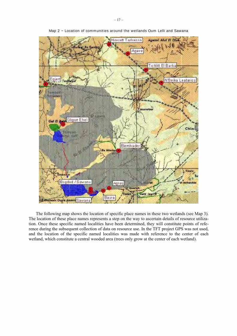
In the TFT project the SGIS approach has been utilized. In Step 10 a number of preliminary maps have been prepared, using data from one community.42/ They will be briefly presented below.
The following map shows the location of a number of communities at the circumference of the two wetlands Oum Lelli and Sawana (see Map 2). Almost all households in these communities are dependent upon resources in the wetlands throughout the year, or in specific seasons.
42/ This is the community of Hovrett Tadreissa, located along the paved road going through Aioun and continuing east into
Niger (located in the upper right corner in Map 2). Hovrett Tadreissa was founded in 1938 by Maure, members of the Ehel Amar Taleb faction of the Oulad Nasser tribe. They used to pitch camp here during the annual migrations.
– 17 –
Map 2 – Location of communities around the wetlands Oum Lelli and Sawana
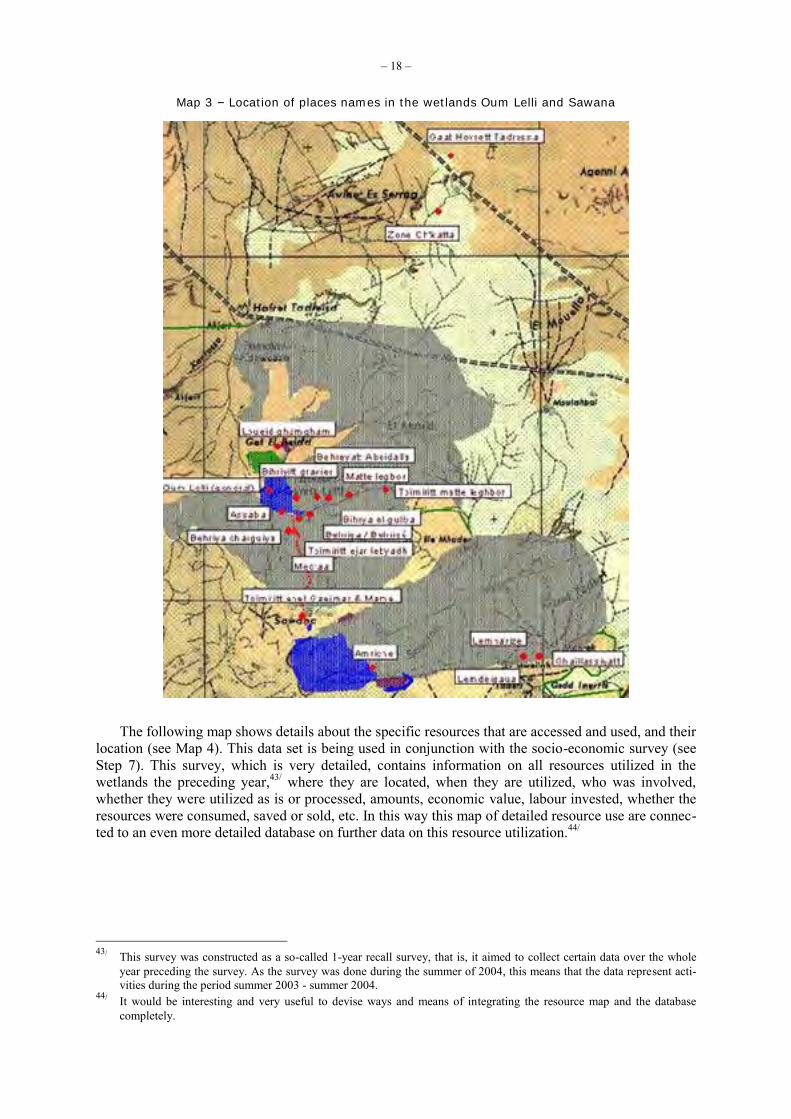
The following map shows the location of specific place names in these two wetlands (see Map 3). The location of these place names represents a step on the way to ascertain details of resource utiliza-tion. Once these specific named localities have been determined, they will constitute points of refe-rence during the subsequent collection of data on resource use. In the TFT project GPS was not used, and the location of the specific named localities was made with reference to the center of each wetland, which constitute a central wooded area (trees only grow at the center of each wetland).
– 18 –
Map 3 – Location of places names in the wetlands Oum Lelli and Sawana
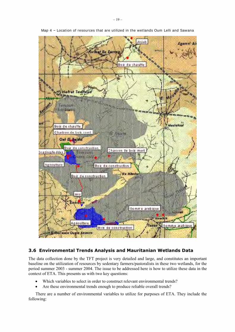
The following map shows details about the specific resources that are accessed and used, and their location (see Map 4). This data set is being used in conjunction with the socio-economic survey (see Step 7). This survey, which is very detailed, contains information on all resources utilized in the wetlands the preceding year,43/ where they are located, when they are utilized, who was involved, whether they were utilized as is or processed, amounts, economic value, labour invested, whether the resources were consumed, saved or sold, etc. In this way this map of detailed resource use are connec-ted to an even more detailed database on further data on this resource utilization.44/
43/ This survey was constructed as a so-called 1-year recall survey, that is, it aimed to collect certain data over the whole
year preceding the survey. As the survey was done during the summer of 2004, this means that the data represent acti-vities during the period summer 2003 - summer 2004.
44/ It would be interesting and very useful to devise ways and means of integrating the resource map and the database completely.
– 19 –
Map 4 – Location of resources that are utilized in the wetlands Oum Lelli and Sawana
3.6 Environmental Trends Analysis and Mauritanian Wetlands Data
The data collection done by the TFT project is very detailed and large, and constitutes an important baseline on the utilization of resources by sedentary farmers/pastoralists in these two wetlands, for the period summer 2003 - summer 2004. The issue to be addressed here is how to utilize these data in the context of ETA. This presents us with two key questions:
Which variables to select in order to construct relevant environmental trends? Are these environmental trends enough to produce reliable overall trends?
There are a number of environmental variables to utilize for purposes of ETA. They include the following:
– 20 –
Changes in tree cover in the center of wetlands. Changes in vegetation coverage more generally. Number and total size of areas under permanent agriculture. Number of animals, broken down for camels, cattle, goats, and sheep, as owned by sedentary
farmers. Number of animals, broken down for camels, cattle, goats, and sheep, as owned by pasto-
ralists. Characteristics of wetlands as ecosystem, that is, amount of stress at this level.45/ Climatic variables, including temperature (daily and seasonal variations), rainfall (amount and
timing), and the position of the 400 mm isohyet.
Some of these variables might most practically be constructed as composite variables. As an example, an indicator for the level of stress in wetlands would most practically be arrived at indirectly, through the use of other variables.
The question now becomes the following: Are data on these variables, as located in the natural domain/system, enough to construct acceptable environmental trends for the ongoing and future changes in these wetlands? The experience with the TFT project is that they are necessary, but not sufficient. There are other variables, located in the social domain/system, which are equally important, in and off themselves. Furthermore, because these variables are inextricable linked with the above variables in the natural system, these social variables provide crucial background on how to understand and interpret changes in the natural system variables, and vice versa.46/ A list of these social variables would include the following:
Demography, in particular in-migration, and specifically as regards sedentarized people.47/ Decentralization and the role of the state. Diminishing role of the traditional law. Privatization of land and water. Changes in productive systems. Absentee pastoralism and agriculture. Increase in sedentarization. Increase in valuation of land. Decreased respect for environmental protection. Increase in infrastructure developments. Increase in conflicts. Increase in outside concern with biodiversity protection.
Several of these variables directly or indirectly affect the property rights structure in the wetlands, and this can be understood as an overarching variable that is key for understanding the social changes currently underway. For example, privatization of land and water include: (1) Creation of fences to protect agricultural crops against domesticated animals, (2) Creation of dams that prevent water from reaching the center of the wetlands and (3) Privatizing wells, which traditionally was available to everybody and provided water to thirsty animals and man alike. 45/ The wetlands are a non-equilibrium system. The availability of water – when, where, how long, and how much –
determine the operation and productivity of the system, and, accordingly, the level of stress. 46/ Following from this, it should be considered whether these two categories of variables – that is, the variables in the
natural system and the variables in the social system – should be treated together or separately. That is, whether we should operate only with variables that are used to construct environmental trends as such, or whether we should operate also with variables that are used to construct environmental and social trends separately (and accordingly, talk about both ETA and Social Trends Analysis, or STA). An argument in favour of the latter approach would be that the social variables in this way would be sure to be understood, defined, and utilized optimally, and that their impact on the outcome of the trends analysis would be accorded the right relevance. Operationalization of some of the social variables needs to be considered carefully.
47/ In Soeftestad (2006), op cit., population increase (specifically as regards sedentary farmers), together with deserti-fication, is considered as two key drivers of the overall and integrated natural-social system in the wetlands, while a number of trends originating in the social and ecological systems are identified. The drivers and trends are understood to interact, and operate within and between the interacting natural and social systems, at several levels.
– 21 –
In the case of the Mauritanian wetlands, using the 2003-2004 data set as a starting point, ETA can be done in two ways: comparing it with available data from a point of time in the past, or with a future point in time. More generally: ETA can be done along a time continuum: back in time and into the future.
3.6.1 Past Comparisons
Given available data on the situation at a past point in time, it might be possible to understand more of how the situation in the wetlands is evolving, at an ecosystem level and at the species level.
Discussing with key informants, certain facts concerning the changes underway in the two wetlands have become clear.48/ Only a few decades back there was hardly anybody that lived perma-nently in the wetlands. The pastoralists would arrive with their animals from the border region with Niger during the annual rains, which begin in late July or early August, and stay on for some weeks. In Oum Lelli and Sawana they made makeshift camps in order for the animals to enjoy the new grass of the season, before continuing the migration further north and into the interior of Mauritania. Several months later they would return, and stop over in Oum Lelli and Sawana again. Today this migratory process still goes on. However, the demographic data tells a story of decreasing migrations going into the interior of Mauritania, and an increasing tendency for pastoralists to stay longer periods in Oum Lelli and Sawana. At the same time the number of sedentary people has exploded. There are now 11 communities located at the circumference of Oum Lelli and Sawana, of which more than half were established since the early 1970s. These people survive on a combination of farming and pasto-ralism. This type of pastoralism is not migratory, the animals (which include goats and sheep, but also cows and camels) return home every night. The most important type of conflict occurs during the annual migrations through the wetlands in the summer, and when the animals return south during the winter. At these times there are repeated situations where animals encroach on the steadily increasing areas devoted to agricultural fields, where mostly rice is grown.
There has been no relevant work done in the past in terms of collecting detailed data on resource utilization. Part of the changes the area has undergone can, however, be understood indirectly, through analysis of other data sets. In particular, census data and vital statistics, which are fairly detailed, and of relatively good quality, speaks to a fairly dramatic population growth since the so-called Sahel crisis in the 1980s. These data would seem to substantiate the picture presented by the key informants.
While statistical data on resource utilization in the past are not available, there are satellite images. The Corona satellites photographed extensively also in this area over several years. A detailed search of the available images has been done, and a set of images from 3 February 1968 is especially good.49/ They were taken during the middle of the dry season. A preliminary analysis of the Corona images makes it clear they can be used to understand changes in this area over time. Two examples will serve to explain: (1) The previous rainy season (1967) must have been pretty good, because there is evidence of a lot of grass cover, together with grass fire scars, and also active burning and (2) It is clear that the forest vegetation covered a larger area than today. The latter is quite crucial information, as the local population argues that the forest cover is decreasing dramatically, partly because the species do not reproduce, and partly due to active felling to produce charcoal.50/
48/ The key informant was Mohamed Ould Saleh, Maure and leader of the Abdel Wahab faction of the Oulad Nasser tribe.
He lives in Gligue Ehel, a community located just north of Oum Lelli wetland (see Map 2). He was well over 80 years when he was interviewed in 2004, and he had a detailed memory of all key events in the history of his tribe, including the factional politics internally in the tribe, and the relations with neighbouring and sometimes warring tribes.
49/ G. Gray Tappan of the USGS Center for EROS at Sioux Falls, South Dakota located the Corona images, and he also provided advice in analysing them. We are grateful to him for this.
50/ The reason why this particular species of tree, a member of the acacia family, does not reproduce since quite a number of years, is not quite clear, but an important factor appears to be that animals are staying for longer periods in the wetlands and trample and destroy new samplings. It is important to understand that there is only one species of tree that can survive in this fairly harsh environment, a combination of long months without water, and a period of several months where all vegetation is under several meters of water. Felling of trees is done mostly by outsiders who – in a situation of de facto open access and no enforcement – can cut trees without any risk.
– 22 –
3.6.2 Future Comparisons
The TFT project will close this year, and there are no plans for a continuation. There will thus be no possibility for ensuring that the maps are being followed up and acted upon. At a macro-level, in order to understand the ongoing changes in the environmental and social systems in the wetlands areas, and how these two systems interact, it would be advisable to collect comparable data at one point in the future, together with shooting new satellite images.
This would constitute a real test – as well as a concrete and instructive application – of how ETA can be used to understand the changes in these two wetlands.
4 Discussion
The term communication was addressed initially. The experiences with the TFT project provide further reason why this is a key issue. There are two aspects – or problems – connected with commu-nication, namely expression and translation. The problem of expression addresses our ability to express our thoughts, in general. The problem of translation addresses our ability to translate these thoughts, taking the idiosyncrasies of our listener or audience into consideration. What we are able to express we also have to be able to translate for it to make any/optimal sense from the point of view of the recipient. The expression bit is taking place internally, and is an intellectual process. The transla-tion bit is the essence of the communication between two parties. The larger the difference between the two parties, for example, in terms of scientific background/training or culture, the more important the translation becomes. A favourable outcome of joint decisions and activities depends on this trans-lation. The recipient party has to send the communicated message into another translation, back again, as it were. Put differently, the recipient interprets the received translation. This is largely an auto-mated process, and is guided, structured, and constricted by the recipient’s cultural context for inter-pretation as well as scientific area of concern.
There are a number of people involved in the TFT project in various capacities that all partake in communicative acts of key importance to the project, and where these considerations are very important to keep in mind. These people include: the project manager (which is Lars, one of the authors), his two assistants, the staff at the Norwegian GIS consultancy firm that commissioned the satellite photographs, the local field assistants (all of them primary school teachers), the GTZ staff in Aioun, the GTZ staff in Nouakchott, representatives of relevant national and regional ministries located in Aioun and Noakchott, the local people (farmers and pastoralists), the tribal leaders, the local people hired to prepare and evaluate the various survey forms prepared, the local people hired to translate to and from Arabic and French, and the interpreters hired to translate between the local Arabic dialect and French. Specifically on languages: counting all languages in use in the project, namely Arabic (classical and local), English, French and German, furthermore speaks to the com-plexity of communication, and the importance of understanding the expressed and translate back and forth in a communicative setting. Furthermore, these stakeholders represent different cultures, with different values, and have widely different training. Finally, it needs to be made clear that the content of all of this communicative action centers around an imposed activity, namely a development project, and that we, the outsiders, implicitly impose our own view of how to approach and talk about this activity – and no more so than when it comes to the advanced technology involved, namely GIS and satellite photography. Small wonder, than, if some of this communicative action is characterized by incomplete or even wrong expression and translation, as a result of two large differences between the two parties to the communication. We would do well to keep this in mind as we contemplate the a priori success of applying GIS to these rural traditional cultural settings. The essence of GIS is that it excels in treating data, but that it is very bad at addressing knowledge, which we understand as data-in-context, specifically a cultural context.
By the same token, Sen’s concept of development as increasing people’s capabilities for living the lives they want is also relevant to this discussion of Mauritania. While technology can contribute to increasing such capabilities and there is no doubt that the Internet, wireless telephony, and KM tools such as GIS have done so, even in relatively isolated countries like Mauritania, improving poor
– 23 –
people’s access to education, secure property rights, and social equality are likely to have a much more profound impact on their development since, in many cases, the elites are more likely to capture and benefit disproportionally from new technology than are the rural poor.
The societal and developmental role of GIS – which, presumably is what this is all about – is to apply it in support of the major agendas of this day and age, including furthering co-management, decentralization, democracy, devolution and transparency, in the aid of increasing the well-being of the disadvantages masses in developing and transition countries.51/ Thus, the challenge of GIS is how to sensitize and humanize it to play a key role in this crucial agenda. The task of scaling GIS to serve various needs within development cooperation, that is, aligning the needs of the various stakeholders with the means at disposal, in this way becomes a humanizing project, addressing both inter-personal and inter-cultural relations. GIS must strive to emulate key elements and values of the countries and cultures in which it is being implemented. At the same time, as ICT is being applied to the area of inter-cultural communication, it must contribute to bridging and aligning the diversity and hetero-geneity of cultures. In this way – and only in this way – may GIS contribute to engender a cultural pluralism, and a plurality of knowledge systems.
5 Conclusions and Recommendations
We would like to end by presenting some conclusions and recommendations, directed at key ETA and/or GIS stakeholders, as follows:
For ESRI: While more and more people in the developing world are becoming computer-literate and applications for ARC-GIS more diverse, the Google Earth approach to make geographical information accessible and easy to manipulate has shown how large this market can be if the technology is made more accessible and cheaper. Furthermore, it is a challenge to produce software that are better able to address and represent the crucial difference and linkage between data and knowledge, where knowledge is understood as data-in-context, that is, cultures.
For FRAME’s ETA Core Team: Continue to develop the CoP of “bottom-up” participatory approaches to GIS as these will continue to be of interest to donors, NGOs, and even the private sector different reasons.
For FRAME/USAID: USAID has gradually realized that KM is not simply a better email system and a faster Internet connection but involves learning to leverage knowledge resources more efficiently in an era of declining funds for assistance and multiplying development problems. Modern telecommunication and computer technology has transformed assistance from a “retail” approach to one-to-one relationships to a more “wholesale” approach of using the web, distance learning and CoPs dispersed over space and time. FRAME is set up to support communities directly and to facilitate communication with them over an interactive website.
For the World Bank (IBRD): The conclusions and recommendations listed above for FRAME/USAID apply also to the World Bank. Furthermore, within the realm of KM where the Bank aims to put its collective knowledge at the disposal of all stakeholders, it should aim at employing culturally sensitive GIS applications that is built around a major involvement and participation by beneficiaries. The SGIS model outlined above would provide a founda-tion and point of departure for such work. Such work should be user driven, and should be defined as part and parcel of ICT-based networks, understood as CoPs. Finally, communi-cation between members of such CoPs should not be limited to cover only the Internet and email, but potentially include also, for example, cell phone and radio.
51/ Cf. Soeftestad, Lars T. 2001. Aligning needs and means: On culture, ICT and knowledge in development cooperation.
CBNRM Net Papers, no. 2 (August 2001). [online] URL: www.cbnrm.net/resources/papers.
Copyright © 2022 FDOKUMEN