Environmental Project Report.pdf - City of Brampton
55
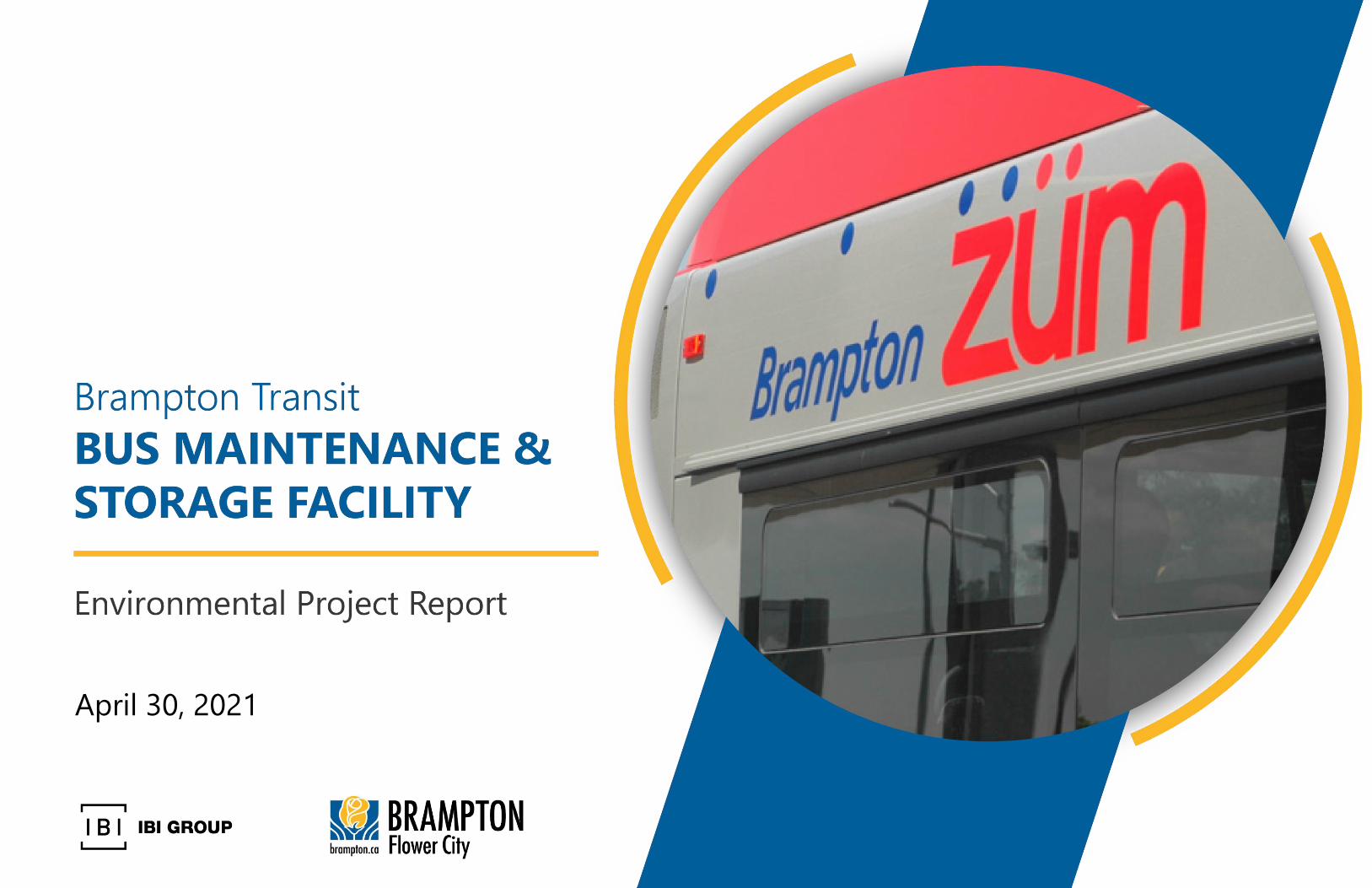
April 30, 2021
-
Upload
khangminh22 -
Category
Documents
-
view
3 -
download
0
Transcript of Environmental Project Report.pdf - City of Brampton
April 30, 2021
BRAMPTON TRANSIT BUS MAINTENANCE AND STORAGE FACILITY
Environmental Project Report
April 30, 2021 i
Executive Summary
ES 1. Introduction
The City of Brampton (the City) is Canada’s ninth largest with a population of 593,638, and among the fastest
growing large municipalities in the country. The City owns and operates the local public transit agency, Brampton
Transit, which is enhancing the transit network to meet current service pressures and future service demands from
projected population and employment growth.
Brampton Transit currently operates its 450-vehicle fleet (490 standard bus equivalents) at two bus maintenance
and storage facilities: the Clark Garage and the Sandalwood Garage. The facilities were constructed in 1980 and
2008, respectively, and have been expanded multiple times since opening. Combined, the facilities have a storage
capacity of between 549 (optimum) and 616 (maximum) standard bus equivalents (SBEs). Optimum capacity
assumes the most functional layout for operations and maintenance and indoor storage for the entire fleet.
Maximum capacity assumes full utilization of all available space, including mixing articulated and conventional
buses, utilizing service lanes and outdoor storage space, running buses on the road later at night, and storing
buses at other off-site locations. Maximum capacity is not ideal for storage and maintenance but can be a short-
term solution for small fleet growth.
The City and Brampton Transit are seeking to develop a new maintenance and storage facility (MSF) to
supplement the Clark and Sandalwood Garages, to support the continued expansion of transit service. The City
followed the Transit Project Assessment Process (TPAP) per Ontario Regulation (O. Reg.) 231/08. This
Environmental Project Report (EPR) describes the project and consultation undertaken before and during the
TPAP.
Study Area
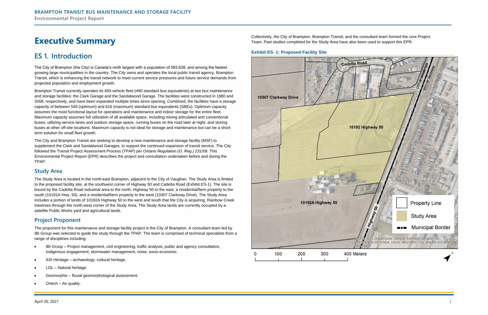
The Study Area is located in the north-east Brampton, adjacent to the City of Vaughan. The Study Area is limited
to the proposed facility site, at the southwest corner of Highway 50 and Cadetta Road (Exhibit ES-1). The site is
bound by the Cadetta Road industrial area to the north, Highway 50 to the east, a residential/farm property to the
south (10191A Hwy. 50), and a residential/farm property to the west (10307 Clarkway Drive). The Study Area
includes a portion of lands of 10192A Highway 50 to the west and south that the City is acquiring. Rainbow Creek
traverses through the north-west corner of the Study Area. The Study Area lands are currently occupied by a
satellite Public Works yard and agricultural lands.
Project Proponent
The proponent for this maintenance and storage facility project is the City of Brampton. A consultant team led by
IBI Group was selected to guide the study through the TPAP. The team is comprised of technical specialists from a
range of disciplines including:
• IBI Group – Project management, civil engineering, traffic analysis, public and agency consultation,
Indigenous engagement, stormwater management, noise, socio-economic.
• ASI Heritage – archaeology, cultural heritage.
• LGL – Natural heritage.
• Geomorphix – fluvial geomorphological assessment.
• Ortech – Air quality.
Collectively, the City of Brampton, Brampton Transit, and the consultant team formed the core Project
Team. Past studies completed for the Study Area have also been used to support this EPR.
Exhibit ES- 1: Proposed Facility Site
BRAMPTON TRANSIT BUS MAINTENANCE AND STORAGE FACILITY
Environmental Project Report
April 30, 2021 ii
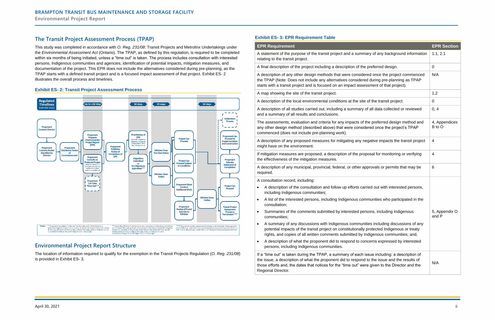
The Transit Project Assessment Process (TPAP)
This study was completed in accordance with O. Reg. 231/08: Transit Projects and Metrolinx Undertakings under
the Environmental Assessment Act (Ontario). The TPAP, as defined by this regulation, is required to be completed
within six months of being initiated, unless a “time out” is taken. The process includes consultation with interested
persons, Indigenous communities and agencies, identification of potential impacts, mitigation measures, and
documentation of the project. This EPR does not include the alternatives considered during pre-planning, as the
TPAP starts with a defined transit project and is a focused impact assessment of that project. Exhibit ES- 2
illustrates the overall process and timelines.
Exhibit ES- 2: Transit Project Assessment Process
Environmental Project Report Structure
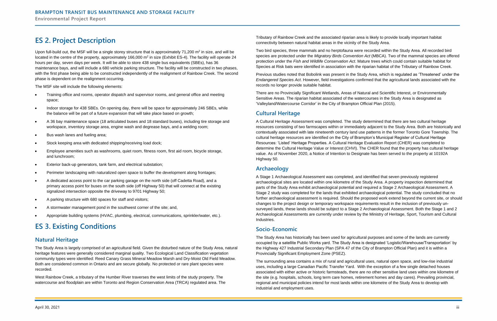
The location of information required to qualify for the exemption in the Transit Projects Regulation (O. Reg. 231/08)
is provided in Exhibit ES- 3.
Exhibit ES- 3: EPR Requirement Table
EPR Requirement EPR Section
A statement of the purpose of the transit project and a summary of any background information
relating to the transit project.
1.1, 2.1
A final description of the project including a description of the preferred design. 0
A description of any other design methods that were considered once the project commenced
the TPAP (Note: Does not include any alternatives considered during pre-planning as TPAP
starts with a transit project and is focused on an impact assessment of that project).
N/A
A map showing the site of the transit project. 1.2
A description of the local environmental conditions at the site of the transit project. 0
A description of all studies carried out, including a summary of all data collected or reviewed
and a summary of all results and conclusions.
0, 4
The assessments, evaluation and criteria for any impacts of the preferred design method and
any other design method (described above) that were considered once the project’s TPAP
commenced (does not include pre-planning work).
4, Appendices B to O
A description of any proposed measures for mitigating any negative impacts the transit project
might have on the environment.
4
If mitigation measures are proposed, a description of the proposal for monitoring or verifying
the effectiveness of the mitigation measures.
4
A description of any municipal, provincial, federal, or other approvals or permits that may be
required.
6
A consultation record, including:
• A description of the consultation and follow up efforts carried out with interested persons,
including Indigenous communities;
• A list of the interested persons, including Indigenous communities who participated in the
consultation;
• Summaries of the comments submitted by interested persons, including Indigenous
communities;
• A summary of any discussions with Indigenous communities including discussions of any
potential impacts of the transit project on constitutionally protected Indigenous or treaty
rights, and copies of all written comments submitted by Indigenous communities; and,
• A description of what the proponent did to respond to concerns expressed by interested
persons, including Indigenous communities.
5, Appendix O and P
If a “time out” is taken during the TPAP, a summary of each issue including: a description of
the issue; a description of what the proponent did to respond to the issue and the results of
those efforts and, the dates that notices for the “time out” were given to the Director and the
Regional Director.
N/A
BRAMPTON TRANSIT BUS MAINTENANCE AND STORAGE FACILITY
Environmental Project Report
April 30, 2021 iii
ES 2. Project Description
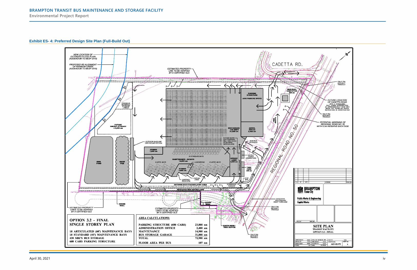
Upon full-build out, the MSF will be a single storey structure that is approximately 71,200 m2 in size, and will be
located in the centre of the property, approximately 166,000 m2 in size (Exhibit ES-4). The facility will operate 24
hours per day, seven days per week. It will be able to store 438 single bus equivalents (SBEs), has 36
maintenance bays, and will include a 680 vehicle parking structure. The facility will be constructed in two phases,
with the first phase being able to be constructed independently of the realignment of Rainbow Creek. The second
phase is dependent on the realignment occurring.
The MSF site will include the following elements:
• Training office and rooms, operator dispatch and supervisor rooms, and general office and meeting
space;
• Indoor storage for 438 SBEs. On opening day, there will be space for approximately 246 SBEs, while
the balance will be part of a future expansion that will take place based on growth;
• A 36 bay maintenance space (18 articulated buses and 18 standard buses), including tire storage and
workspace, inventory storage area, engine wash and degrease bays, and a welding room;
• Bus wash lanes and fueling area;
• Stock keeping area with dedicated shipping/receiving load dock;
• Employee amenities such as washrooms, quiet room, fitness room, first aid room, bicycle storage,
and lunchroom;
• Exterior back-up generators, tank farm, and electrical substation;
• Perimeter landscaping with naturalized open space to buffer the development along frontages;
• A dedicated access point to the car parking garage on the north side (off Cadetta Road), and a
primary access point for buses on the south side (off Highway 50) that will connect at the existing
signalized intersection opposite the driveway to 9701 Highway 50;
• A parking structure with 680 spaces for staff and visitors;
• A stormwater management pond in the southwest corner of the site; and,
• Appropriate building systems (HVAC, plumbing, electrical, communications, sprinkler/water, etc.).
ES 3. Existing Conditions
Natural Heritage
The Study Area is largely comprised of an agricultural field. Given the disturbed nature of the Study Area, natural
heritage features were generally considered marginal quality. Two Ecological Land Classification vegetation
community types were identified: Reed Canary Grass Mineral Meadow Marsh and Dry-Moist Old Field Meadow.
Both are considered common in Ontario and are secure globally. No protected or rare plant species were
recorded.
West Rainbow Creek, a tributary of the Humber River traverses the west limits of the study property. The
watercourse and floodplain are within Toronto and Region Conservation Area (TRCA) regulated area. The
Tributary of Rainbow Creek and the associated riparian area is likely to provide locally important habitat
connectivity between natural habitat areas in the vicinity of the Study Area.
Two bird species, three mammals and no herptofauna were recorded within the Study Area. All recorded bird
species are protected under the Migratory Birds Convention Act (MBCA). Two of the mammal species are offered
protection under the Fish and Wildlife Conservation Act. Mature trees which could contain suitable habitat for
Species at Risk bats were identified in association with the riparian habitat of the Tributary of Rainbow Creek.
Previous studies noted that Bobolink was present in the Study Area, which is regulated as ‘Threatened’ under the
Endangered Species Act. However, field investigations confirmed that the agricultural lands associated with the
records no longer provide suitable habitat.
There are no Provincially Significant Wetlands, Areas of Natural and Scientific Interest, or Environmentally
Sensitive Areas. The riparian habitat associated of the watercourses in the Study Area is designated as
‘Valleyland/Watercourse Corridor’ in the City of Brampton Official Plan (2015).
Cultural Heritage
A Cultural Heritage Assessment was completed. The study determined that there are two cultural heritage
resources consisting of two farmscapes within or immediately adjacent to the Study Area. Both are historically and
contextually associated with late nineteenth century land use patterns in the former Toronto Gore Township. The
cultural heritage resources are identified on the City of Brampton’s Municipal Register of Cultural Heritage
Resources: ‘Listed’ Heritage Properties. A Cultural Heritage Evaluation Report (CHER) was completed to
determine the Cultural Heritage Value or Interest (CHVI). The CHER found that the property has cultural heritage
value. As of November 2020, a Notice of Intention to Designate has been served to the property at 10192A
Highway 50.
Archaeology
A Stage 1 Archaeological Assessment was completed, and identified that seven previously registered
archaeological sites are located within one kilometre of the Study Area. A property inspection determined that
parts of the Study Area exhibit archaeological potential and required a Stage 2 Archaeological Assessment. A
Stage 2 study was completed for the lands that exhibited archaeological potential. The study concluded that no
further archaeological assessment is required. Should the proposed work extend beyond the current site, or should
changes to the project design or temporary workspace requirements result in the inclusion of previously un-
surveyed lands, these lands should be subject to a Stage 2 Archaeological Assessment. Both the Stage 1 and 2
Archaeological Assessments are currently under review by the Ministry of Heritage, Sport, Tourism and Cultural
Industries.
Socio-Economic
The Study Area has historically has been used for agricultural purposes and some of the lands are currently
occupied by a satellite Public Works yard. The Study Area is designated ‘Logistic/Warehouse/Transportation’ by
the Highway 427 Industrial Secondary Plan (SPA 47 of the City of Brampton Official Plan) and it is within a
Provincially Significant Employment Zone (PSEZ).
The surrounding area contains a mix of rural and agricultural uses, natural open space, and low-rise industrial
uses, including a large Canadian Pacific Transfer Yard. With the exception of a few single detached houses
associated with either active or historic farmsteads, there are no other sensitive land uses within one kilometre of
the site (e.g. hospitals, schools, long term care homes, retirement homes and day cares). Prevailing provincial,
regional and municipal policies intend for most lands within one kilometre of the Study Area to develop with
industrial and employment uses.
BRAMPTON TRANSIT BUS MAINTENANCE AND STORAGE FACILITY
Environmental Project Report
April 30, 2021 iv
Exhibit ES- 4: Preferred Design Site Plan (Full-Build Out)
BRAMPTON TRANSIT BUS MAINTENANCE AND STORAGE FACILITY
Environmental Project Report
April 30, 2021 v
Air Quality
An Air Quality Assessment was completed. Existing conditions data was gathered from an air quality monitoring
station in Brampton. Data was gathered from 2014 to 2018 to develop a baseline to compare future projections.
The results showed that the Study Area has consistently remained below the AAQC guideline for nitrogen dioxide.
Transportation
A Transportation Impact Assessment was completed for the Brampton Transit Bus Maintenance and
Storage Facility. The study first analyzed existing traffic conditions in the area to provide a baseline for the
future analysis.
Overall, under 2019 existing conditions, the Study Area intersections all operate with critical movements,
especially at intersections crossing other east-west corridors. Most notably, the intersections of Coleraine
Drive / Major Mackenzie Drive and Castlemore Road / Rutherford Road operate with high delays and
queues.
ES 4. Impact Assessment, Mitigation and Monitoring
Section 4 of the EPR documents the potential impacts, and the proposed mitigation and monitoring measures. The
following section summarizes these impacts and measures.
Natural Heritage
There are limited impacts to vegetation and wildlife habitats.
Potential impacts to wildlife and birds will be directly associated with impacts to vegetation that comprise their
habitat. The majority of the site has been influenced by human activity, primarily agriculture and manicured lawn.
Potential impacts include permanent removal of existing vegetation that may result in habitat loss, clearing of
trees, and noise, dust and vibration associated with short-term construction activities.
To mitigate impacts, measures include compliance with MBCA for tree removal and clearing of vegetation (e.g.
removing trees outside of nesting season), and allowing any animal found within the construction area to leave on
its own.
Cultural Heritage
A Heritage Impact Assessment should be conducted prior to construction for a resource that may be
impacted by the project.
The Cultural Heritage Assessment determined that there are two cultural heritage resources within the Study Area,
both of which are identified in the City of Brampton’s Municipal Register of Cultural Heritage Resources: ‘Listed’
Heritage Properties.
Cultural Heritage Resource #1 (10192A Highway 50)
Impacts to cultural heritage resource #1 are anticipated to include the demolition of several outbuildings on the
property, removal of agricultural fields, tree clearing, grading, and property acquisition.
A Cultural Heritage Evaluation Report was completed to determine the property’s Cultural Heritage Value or
Interest. The Cultural Heritage Evaluation Report found that the property has design/physical value as a
representative example of an Italianate house with Romanesque Revival influences, and historical/associative
value for its association with the Johnston family, and contextual value for its role in supporting and maintaining the
agricultural character of the area.
Where feasible, the preferred alternative should be designed in a manner that avoids all impacts to the cultural
heritage resource. If impacts are unavoidable, a provisional Heritage Impact Assessment should be conducted.
In October 2019, a Heritage Permit application was approved for the demolition of some buildings on the property,
including one framed storage building, two steel framed storage buildings and three framed lean-tos, and the
relocation and restoration of two timber barns. The permit application was issued with the following conditions:
• That prior to the disassembling of the timber barns, the applicant submit documentation in the form of
photographs and measured drawings of the two timber barns to be relocated to City of Brampton
Heritage staff and the Peel Archives; and,
• That photographs of the completed restoration of the timber barns be shared with the Brampton
Heritage Board.
City Heritage staff confirmed they have received the necessary documentation for the restoration of the two timber
barns, and that the work has been completed.
Cultural Heritage Resource #2 (10307 Clarkway Drive)
No direct impacts are anticipated to cultural heritage resource #2. Indirect impacts are anticipated to include
grading, tree clearing, and property acquisition adjacent to the cultural heritage resource.
An Heritage Impact Assessment was conducted in 2016 and determined that the farmscape did not retain
significant cultural heritage value. Due to the distance from the residence on Clarkway Drive, and the fact that the
proposed undertaking is anticipated to be confined to the limits of the resource, it is recommended that the City of
Brampton consider waiving the requirement for this Heritage Impact Assessment. Staging and construction
activities should be suitably planned to avoid impacts to cultural heritage resource.
Archaeology
The site has low archaeological potential, and no further investigation is required at this time.
The Stage 2 study was completed for the lands that exhibited archaeological potential. The study concluded that
no further archaeological assessment is required. Should the proposed work extend beyond the current site, or
should changes to the project design or temporary workspace requirements result in the inclusion of previously un-
surveyed lands, these lands should be subject to a Stage 2 archaeological assessment. Details are provided in
Appendix C.
Socio-Economic
The MSF will create jobs and increase local spending during construction and operations.
The MSF will result in temporary and permanent changes to land use and the socio-economic environment, but
the changes are anticipated to be minor and not adverse. The socio-economic impact assessment was undertaken
to evaluate compliance of the MSF with prevailing policy and planning objectives and to determine how the
construction and operation of the MSF may impact land use, built form, aesthetics and community cohesion, as
well as population and employment.
As a result of construction, surrounding lands will experience temporary minor disruption by way of increased
traffic, noise, vibration, dust and change to the visual landscape and aesthetics. The development and execution
of a Construction Management Plan and Communication Plan, which outline best practices and mitigation
BRAMPTON TRANSIT BUS MAINTENANCE AND STORAGE FACILITY
Environmental Project Report
April 30, 2021 vi
measures, will help minimize negative impacts resulting from construction. While the development and ongoing
operations of the MSF will result in permanent changes to the existing rural landscape and result in increased
traffic and activity, the project complies with prevailing land use policies and planning objectives.
The project will result in positive socio-economic impacts through the creation of jobs and spending during
construction and operations. The new MSF and growth fleet improve mobility and support economic development
and urban growth.
Noise
All noise levels will meet MECP exclusionary limits.
Based on the findings of the noise assessment, acoustic barriers will be installed around mechanical equipment on
the south rooftop, an acoustic barrier will be constructed along the south property line that will consist of an
acoustic wall, earth berm, or a combination of these. The garage bay doors must remain closed to provide
mitigation from impact wrench use. With these mitigation measures in-place, daytime and nighttime noise levels
will meet the MECP exclusionary limits. The noise assessment is available in Appendix F.
Air Quality
All emission levels will be below Ministry of the Environment, Conservation and Parks guidelines.
An Air Quality Assessment was completed to determine potential impacts of the undertaking. Emissions from the
vehicles operations, vehicle maintenance, heating systems, and emergency generators at the site are considered
as part of the future analysis. Nitrogen dioxide was determined to be the only significant contaminant that will be
released from the site. The emission estimates were entered into a dispersion model used to assess the effects of
the new facility on air quality in the area.
The maximum combined concentrations for each contaminant were determined to be below their respective
guidelines. No adverse impacts are anticipated.
Geotechnical and Hydrogeology
The remediation of the site will remove contaminants from previous agricultural uses, which will have
a net positive effect on source water protection.
Contaminants were found on the site, related to its previous agricultural uses. There will be a positive net effect on
groundwater as a result of site remediation activities to remove contaminants. The need to monitor groundwater
quality will be determined during detail design. The City has agreed to the TRCA’s request to monitor the wells on
site for a minimum of 12 months. See Section 3.6 for more details
Transportation
The MSF will not have an adverse impact on future traffic conditions on the surrounding area.
The Transportation Impact Assessment was completed to analyze traffic and bus-related operations for two
horizon years, 2031 and 2041. A Transportation Impact Assessment was completed for the Brampton Transit Bus
Maintenance and Storage Facility, including traffic and bus-related operations. As part of the future condition,
vehicular access to the site will be provided by two locations, the first at Cadetta Road and the second at the
existing farm property driveway opposite of the Fastfrate Entrance.
There are a number of planned changes to the future road network. For the purpose of this study, only the
widening of Highway 50 is included in both the 2031 and 2041 horizons. For 2041 scenarios, only the two site
accesses were analyzed.
Generally, as part of future total conditions in 2041, traffic operations deteriorate slightly with the introduction of the
site generated traffic. Notably, the northbound left-turn movement at Cadetta Road is critical and is expected to
experience longer delays but with sufficient reserve capacity (v/c = 0.80). Overall, the two site accesses will remain
at acceptable levels-of-service. The conclusions are summarized below:
• Under 2031, the Highway 50 intersections with Cadetta Road and the south site access driveway
operate with enough capacity, while the major intersections at Coleraine / Major Mackenzie Drive and
Castlemore / Rutherford Road operate with longer delays and queues.
• Under 2041, the Highway 50 intersections with Cadetta Road and the south site access driveway
continue to operate acceptably with residual capacity.
• The subject site is expected to generate a total of 95 and 107 two-way trips for passenger vehicles in
the a.m. and p.m. peak hours, respectively. Separately, a total of 13 and 20 bus trips are expected to
be generated. It is noted that majority of site generated trips are generated outside of background
peak periods, and is expected to minimally impact the local road network.
• Under 2031 future total conditions, overall traffic for the study intersections is marginally affected by
the site generated demands, and where operational issues are expected to arise without the
proposed facility.
• Under 2041 future total conditions, the two site accesses will operate at acceptable levels-of-service,
with improvements required for the left-turn movement.
The following improvement measures are recommended to mitigate any potential traffic and safety impacts on the
surrounding road network:
• Extend the northbound left-turn lane at Cadetta Road from 30 m to 90 m.
• Add an auxiliary southbound right-turn (30 m) lane at Cadetta Road.
• Provide a northbound left-turn (60 m) lane at the south site access driveway.
• Add an auxiliary southbound right-turn (30m) lane at the south access driveway.
Extreme Weather
The Project has the potential to help mitigate the impacts of severe weather.
The frequency of extreme weather events is increasing and affects many aspects of daily life. The proposed
increase in impervious surface area increases the potential for sediment laden runoff to impact offsite aquatic
habitats during extreme weather events. To mitigate the potential impacts, mitigation measures have been
identified and no net effects are anticipated (see Section 4.8). Mitigation includes adhering to low impact
development guidelines and developing an erosion and sediment control plan.
The project has the potential to help mitigate the impacts of extreme weather on Brampton. The facility will help to
enhance local transit service across the City. New and expanded services can help change travel modes, which
support’s the City’s transportation demand management efforts to cope with traffic congestion and eliminate the
need for new or expanded road infrastructure.
ES 5. Consultation Process
Section 5 of this EPR details the consultation program initiated by the City of Brampton for the Maintenance and
Storage Facility (MSF) in October 2019 as part of the pre-planning phase and continued during the formal TPAP.
BRAMPTON TRANSIT BUS MAINTENANCE AND STORAGE FACILITY
Environmental Project Report
April 30, 2021 vii
Notification Protocol
A number of communication channels and methods were used to notify stakeholders of events, provide project
updates and give the opportunity to provide feedback and ask questions. These included:
• Project webpage on the City of Brampton website;
• Emails to interested parties on the master contact list;
• Emails to those who asked to received project updates;
• Targeted mail-outs that reached property owners, occupants and businesses within 500 metres of the
site;
• Notifications in the Brampton Guardian newspaper;
• Public Open House comment forms, surveys and videos;
• Summary reports after each Public Open House;
• Social media postings from the City of Brampton;
• Notice of TPAP Commencement; and,
• Notice of Completion of the EPR.
The public, stakeholders, regulatory agencies, Indigenous communities and other interested parties had options to
interact with the project team via:
• Contacting the project team directly via email and mail;
• Meetings, phone calls and video calls;
• Public Open Houses; and,
• The project webpage.
Master Contact List
A contact list of City staff, regulatory agencies, the local conservation authority, Indigenous communities, nearby
property owners/occupants, elected officials, community groups, and interested members of the public was
compiled prior to the start of the pre-planning phase. The contact list was carried forward into the pre-planning
phase and the TPAP, and was continually updated in response to stakeholder interest and feedback.
Consultation during the Pre-Planning Phase
Activities undertaken during the pre-planning phase included:
• Engaging and consulting with the Director of the Environment Assessments and Permissions Branch
at the Ministry of Environment, Conservation and Parks;
• Creating and updating a project webpage on the City of Brampton’s website;
• Preparing a contact list;
• Public Open House #1, held on November 18, 2019, in-person at the Gore Meadows Community
Centre. A notification was mailed to property owners and occupants within 500 metres of the site and
published two times in the Brampton Guardian newspaper;
• Public Open House #2, held virtually from June 17, 2020 to July 15, 2020 on the project webpage due
to COVID-19 restrictions. A notification was mailed to property owners and occupants within 500
metres of the site and published two times in the Brampton Guardian newspaper;
• Engaging with Indigenous communities identified as having a potential interest in the project; and,
• The draft EPR and supporting technical reports were circulated prior to starting TPAP to technical
agencies and the local conservation authority.
Consultation during the Transit Project Assessment Process
Consultation undertaken during the TPAP included:
• Engaging and consulting with the Environmental Assessment Branch of the Ministry of the
Environment, Conservation, and Parks, and other impacted utilities and agencies;
• Consulting with stakeholders within 500 metres of the study area;
• Posting the draft EPR to the project webpage;
• Updating the draft EPR based on comments from technical reviewers and other consultation;
• Maintaining of the Master Contact List;
• Public Open House #3, held from January 21, 2021 to February 4, 2021 to present the preferred
design of the MSF; and,
• Engaging with Indigenous communities identified as having a potential interest to the project.
Consultation with the Ministry of the Environment, Conservation and Parks
On behalf of the City of Brampton, IBI Group provided a letter to the Director of the Environmental Assessment
Branch at the Ministry of the Environment, Conservation and Parks (MECP) on November 19, 2020, to assist in
identifying Indigenous communities which may have an interest in the MSF project. This consultation adheres to
the requirements of O. Reg. 231/08.
Public Open House #3
Public Open House #3 was held virtually between January 21, 2021 to February 4, 2021. The purpose of the event
was to:
• Confirm the preferred project design;
• Share the findings and recommendations of the draft Environmental Project Report and supporting
studies; and,
• Present the expected future environmental conditions, including potential impacts and mitigation
measures.
General Public and Property Owner Correspondence
The general public, businesses, community groups, and property owners were consulted through various methods
and events throughout the pre-planning and TPAP phases. This consultation included email, mail correspondence,
and phone calls.
BRAMPTON TRANSIT BUS MAINTENANCE AND STORAGE FACILITY
Environmental Project Report
April 30, 2021 viii
Indigenous Community Engagement
The following list of Indigenous communities was identified by the City of Brampton, and confirmed with the MECP,
as having an interest in the MSF project. The City communicated the project to the identified list through email and
mailed letters. The communities are:
• Alderville First Nation
• Curve Lake First Nation
• Hiawatha First Nation
• Mississaugas of the Credit First Nation
• Mississaugas of Scugog Island First Nation
Future Consultation
Consultation related to the MSF will continue after the TPAP. The City will continue to work with interested
persons, businesses, agencies and utility/property owners during detail design and before/during construction.
ES 6. Required Permits and Approvals
Section 6 identifies permits and approvals that may be required during the subsequent phases of planning,
construction and operations of the MSF project. The need for the following permits will be confirmed during detail
design.
At the provincial level, the following permits may be required:
• Environmental Compliance Approvals (ECA) for new/relocated sanitary sewers, new/relocated storm
sewers and outfalls, stormwater quality controls, sewer use for discharge of dewatering effluent (in
compliance with s. 53 of the Ontario Water Resources Act (OWRA) and relevant the Ministry of the
Environment, Conservation and Parks guidelines), as appropriate. Should potable water lines be
relocated, ECA will be sought from MECP prior to relocation.
• An Environmental Activity and Sector Registry (EASR) registration with the Ministry may be required
as construction dewatering is estimated to be greater than 50,000 L/day but less than 400,000 L/day.
Once the details on the proposed excavations are finalized during detail design, the need for an
EASR or Permit to Take Water (PTTW) will be re-assessed using any additional hydrogeological data
collected.
• Excess Soil Management Strategy.
• If species at risk are identified within the construction influence zone, Ministry of Natural Resources
and Forestry (MNRF) will be contacted to determine how specimens should be treated.
At the municipal level, the following permits and approvals may be required:
• Brampton City Council approval.
• Tree Preservation By-law.
• Demolition permits.
• Building permits.
• Planning Act approvals, including Site Plan Approval and any other related permits from the City, as
required.
• Work will generally be conducted in accordance with noise control by-laws (By-law 93-84). Special by-
laws may be enacted for construction and maintenance activities that must be conducted outside the
prescribed hours of operation.
• Region of Peel driveway (access) approval to the Regional road.
• A resource-specific HIA should be completed for Cultural Heritage Resource 1 by a qualified heritage
professional as per City of Brampton Official Plan clause 4.10.1.11. The HIA will need to be presented
to the Brampton Heritage Board.
• Rainbow Creek and associated floodplain are within TRCA regulated areas. Any work within these
areas require a permit from TRCA under O. Reg. 166/06 Development, Interference with Wetlands
and Alterations to Shorelines and Watercourses Regulation.
The MSF will need to connect with local utilities to service the site. The following agreements may need to be
sought:
• Utility crossing agreements.
• Hydro connection applications and service agreements.
• Gas connection applications and service agreements.
• Telecommunication connection service agreements.
ES 7. Commitments to Future Action
Section 7 of this EPR identifies commitments to future work to be completed during detail design, and both prior to
and during construction. All commitments to future work should be reviewed during detail design and prior to
project construction. This includes future consultation, environmental monitoring and the social, cultural and
natural environment.
BRAMPTON TRANSIT BUS MAINTENANCE AND STORAGE FACILITY
Environmental Project Report
Table of Contents
April 30, 2021 a
Executive Summary ........................................................................................................................ i
ES 1. Introduction ......................................................................................................................... i
ES 2. Project Description .......................................................................................................... iii
ES 3. Existing Conditions .......................................................................................................... iii
ES 4. Impact Assessment, Mitigation and Monitoring ............................................................ v
ES 5. Consultation Process ...................................................................................................... vi
ES 6. Required Permits and Approvals .................................................................................. viii
ES 7. Commitments to Future Action ..................................................................................... viii
1 Introduction ................................................................................................................................ 1
2 Design Approach and Project Description ............................................................................. 6
3 Existing Conditions ................................................................................................................... 9
4 Impact Assessment, Mitigation and Monitoring ................................................................... 17
ERROR! REFERENCE SOURCE NOT FOUND.
Environmental Project Report
Table of Contents (continued)
March 18, 2021 b
5 Consultation ............................................................................................................................. 28
6 Permits and Approvals ........................................................................................................... 37
7 Commitments to Future Works .............................................................................................. 39
Appendix A: Design Drawings
Appendix B: Environmental Impact Study (EIS)
Appendix C: Archaeology Assessment Stages 1 and 2
Appendix D: Cultural Heritage Resource Assessment & Heritage Impact Assessment
Appendix E: Socio-Economic
Appendix F: Noise Assessment
Appendix G: Air Quality
Appendix H: Fluvial Geomorphology
Appendix I: Geotechnical Investigation
Appendix J: Hydrogeological Study
Appendix K: Environmental Site Assessment 1 and 2
Appendix L: Stormwater Management
Appendix M: Traffic Impact Study
Appendix N: Functional Servicing Report
Appendix O: Consultation Record (Pre-TPAP)
Appendix P: Consultation Record (TPAP)
Errata to the Environmental Project Report
BRAMPTON TRANSIT BUS MAINTENANCE AND STORAGE FACILITY
Environmental Project Report
April 30, 2021 c
Exhibits
Exhibit 1-1: Proposed Facility Site .................................................................................................. 1
Exhibit 1-2: Map of the Realignment of Rainbow Creek relative to the Garage Site ...................... 2
Exhibit 1-3: Preferred Design Concept for the Northeast Public Works Satellite Yard ................... 2
Exhibit 1-4: Transit Project Assessment Process1 .......................................................................... 3
Exhibit 1-5: EPR Requirement Table .............................................................................................. 5
Exhibit 2-1: Comparison of Alternatives Considered ...................................................................... 6
Exhibit 2-2: Summary of Assessment of Alternative Options During the Pre-TPAP Period ........... 7
Exhibit 2-3: Preferred Design Site Plan (Full-Build Out) ................................................................. 8
Exhibit 3-1: Stationary Noise Level Criteria .................................................................................. 11
Exhibit 3-2: Receiver Locations (Off-site) ..................................................................................... 12
Exhibit 3-3: Brampton Monitoring Station Data for Significant Contaminants .............................. 12
Exhibit 3-4: Study Area Subsurface Conditions ............................................................................ 12
Exhibit 3-5: Existing Peak Flow Conditions ................................................................................... 13
Exhibit 3-6: Transportation Analysis Study Area ........................................................................... 14
Exhibit 3-7: Intersection LOS Reference ....................................................................................... 14
Exhibit 3-8: 2019 Existing Conditions Traffic Volumes ................................................................. 15
Exhibit 3-9: Existing Traffic Analysis (All Movements) Summary ................................................. 15
Exhibit 4-1: Acoustic Assessment Summary Table ...................................................................... 19
Exhibit 4-2: Acoustic Assessment Summary Table (Emergency Generators) ............................. 20
Exhibit 4-3: Air Quality Assessment Summary ............................................................................. 20
Exhibit 4-4: Stormwater Pond Storage Volume Requirements ..................................................... 23
Exhibit 4-5: Flood Control Storage Volume Requirements ........................................................... 23
Exhibit 4-6: 2031 Future Background Traffic Volumes ................................................................. 24
Exhibit 4-7: 2031 Future Total Traffic Volumes ............................................................................. 25
Exhibit 4-8: 2041 Future Background Traffic Volumes ................................................................. 25
Exhibit 4-9: 2041 Future Total Traffic Volumes ............................................................................. 26
Exhibit 4-10: Recommended Storage Lengths for Site Accesses ................................................ 26
Exhibit 4-11: Brampton's Greenhouse Gas Emission Reduction Targets (2019) ......................... 27
Exhibit 5-1: List of Community Stakeholders, Public Agencies and Utilities ................................. 28
Exhibit 5-2: Screenshot of the Project Webpage during pre-planning .......................................... 29
Exhibit 5-3: Notification Details for Public Open House #1 ........................................................... 30
Exhibit 5-4: Summary of POH #1 Meeting Details ........................................................................ 30
Exhibit 5-5: Notification Details for Public Open House #2 ........................................................... 31
Exhibit 5-6: 'How to Participate' in Open House #2 section taken from the notification ............... 31
Exhibit 5-7: Screenshots of Open House #2 Narrated Videos #1 and #2 ..................................... 31
Exhibit 5-8: Summary of POH #2 Meeting Details ........................................................................ 31
Exhibit 5-9: Summary of Agency Consultation during Pre-Planning Phase ................................. 32
Exhibit 5-10: Reports that Agencies Provided Comments On ...................................................... 33
Exhibit 5-11: Publication Details for Notice of Commencement of TPAP ..................................... 33
Exhibit 5-12: Publication Details for Notice of Open House #3 ..................................................... 34
Exhibit 5-13: 'How to Participate' in Open House #3 section taken from the notification ............. 34
Exhibit 5-14: Screenshot of Open House #3’s Narrated Video ..................................................... 34
Exhibit 5-15: Summary of POH #3 Meeting Details ...................................................................... 34
Exhibit 5-16: Summary of Agency Consultation During TPAP ..................................................... 35
Exhibit 5-17: Summary of Indigenous Community Consultation During TPAP Phase ................. 35
Exhibit 5-18: Publication Details for Notice of Completion ............................................................ 36
Exhibit 7-1: Commitments to Future Work for Consultation, Social, Cultural and Natural Environment ................................................................................................................ 39
Exhibit 7-2: Commitments to Future Work for Environmental Monitoring During Design and Construction ................................................................................................................ 39
Exhibit 7-3: Commitments to Future Work for Social, Cultural and Natural Environment ............ 40

BRAMPTON TRANSIT BUS MAINTENANCE AND STORAGE FACILITY
Environmental Project Report
April 30, 2021 d
Acronyms
AAQC – Ambient Air Quality Criteria
BRT – Bus Rapid Transit
CHER – Cultural Heritage Evaluation Report
CHVI – Cultural Heritage Value or Interest
EA – Environmental Assessment
EASR – Environmental Activity and Sector Registry
ECA – Environmental Compliance Approvals
EPR – Environmental Project Report
ESC – Erosion and Sediment Control
ESCP – Erosion and Sediment Control Plan
GGH – Greater Golden Horseshoe
GTA – Greater Toronto Area
GTHA – Greater Toronto and Hamilton Area
HIA – Heritage Impact Assessment
HCM – Highway Capacity Manual
HOV – High Occupancy Vehicle
HVAC – Heating ventilation, and air conditioning
LID – Low Impact Development
LOS – Level of Service
LRTP – Long Range Transportation Plan
MBCA – Migratory Birds Convention Act
MECP – Ministry of the Environment, Conservation and Parks
MESP – Master Environmental Servicing Plan
MHSTCI – Ministry of Heritage, Sport, Tourism and Cultural Industries
MMAH – Ministry of Municipal Affairs and Housing
MNRF – Ministry of Natural Resources and Forestry
MSF – Maintenance and Storage Facility
NAPS– National Air Pollution Surveillance
OLA – Outdoor Living Area
ORM – Oak Ridges Moraine
OWRA – Ontario Water Resources Act
POH – Public Open House
PPS – Provincial Policy Statement
PSEZ – Provincially Significant Employment Zone
PTTW – Permit To Take Water
RTP – Regional Transportation Plan
SBE – Standard Bus Equivalents
SCS – Site Condition Standards
SPA – Secondary Plan Area
STS – Sustainable Transportation Strategy
SWM – Stormwater Management
tCO2e – Tonnes of Carbon Dioxide Equivalent
TIS – Traffic Impact Study
TPAP – Transit Project Assessment Process
TMP – Transportation Master Plan
TRCA – Toronto and Region Conservation Authority
WHPA – Wellhead Protection Area
ZBL – Zoning By-law
BRAMPTON TRANSIT BUS MAINTENANCE AND STORAGE FACILITY
Environmental Project Report
April 30, 2021 1
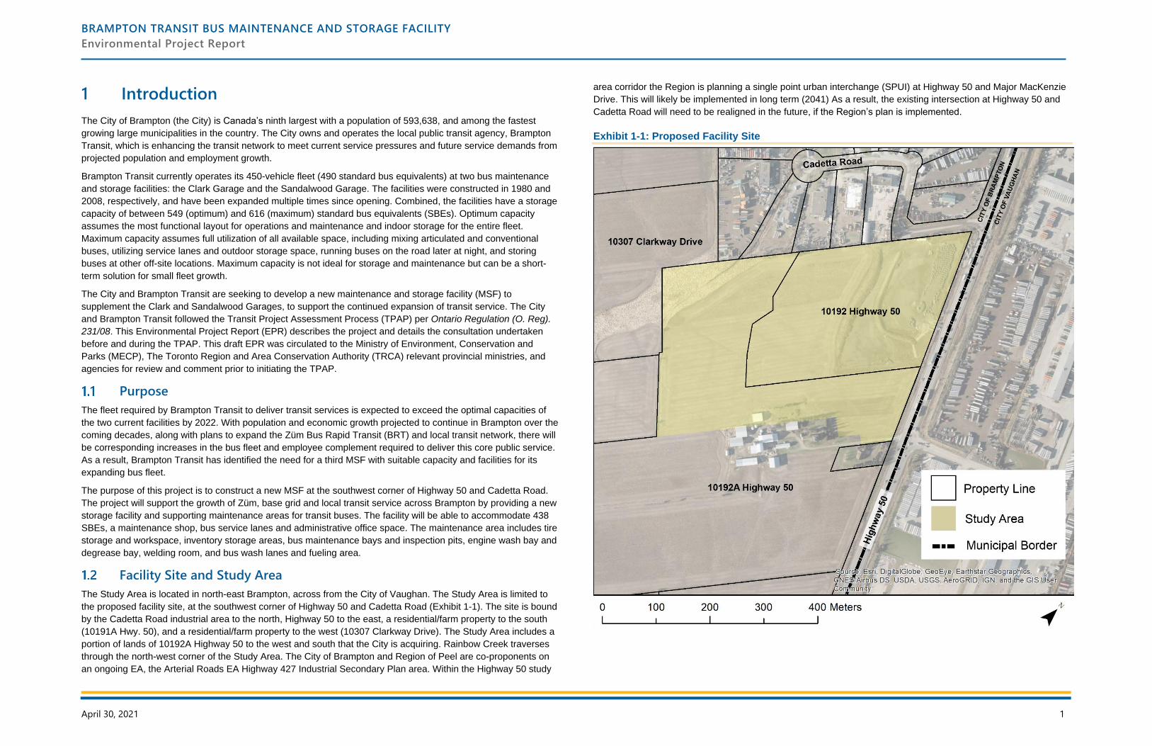
1 Introduction
The City of Brampton (the City) is Canada’s ninth largest with a population of 593,638, and among the fastest
growing large municipalities in the country. The City owns and operates the local public transit agency, Brampton
Transit, which is enhancing the transit network to meet current service pressures and future service demands from
projected population and employment growth.
Brampton Transit currently operates its 450-vehicle fleet (490 standard bus equivalents) at two bus maintenance
and storage facilities: the Clark Garage and the Sandalwood Garage. The facilities were constructed in 1980 and
2008, respectively, and have been expanded multiple times since opening. Combined, the facilities have a storage
capacity of between 549 (optimum) and 616 (maximum) standard bus equivalents (SBEs). Optimum capacity
assumes the most functional layout for operations and maintenance and indoor storage for the entire fleet.
Maximum capacity assumes full utilization of all available space, including mixing articulated and conventional
buses, utilizing service lanes and outdoor storage space, running buses on the road later at night, and storing
buses at other off-site locations. Maximum capacity is not ideal for storage and maintenance but can be a short-
term solution for small fleet growth.
The City and Brampton Transit are seeking to develop a new maintenance and storage facility (MSF) to
supplement the Clark and Sandalwood Garages, to support the continued expansion of transit service. The City
and Brampton Transit followed the Transit Project Assessment Process (TPAP) per Ontario Regulation (O. Reg).
231/08. This Environmental Project Report (EPR) describes the project and details the consultation undertaken
before and during the TPAP. This draft EPR was circulated to the Ministry of Environment, Conservation and
Parks (MECP), The Toronto Region and Area Conservation Authority (TRCA) relevant provincial ministries, and
agencies for review and comment prior to initiating the TPAP.
Purpose
The fleet required by Brampton Transit to deliver transit services is expected to exceed the optimal capacities of
the two current facilities by 2022. With population and economic growth projected to continue in Brampton over the
coming decades, along with plans to expand the Züm Bus Rapid Transit (BRT) and local transit network, there will
be corresponding increases in the bus fleet and employee complement required to deliver this core public service.
As a result, Brampton Transit has identified the need for a third MSF with suitable capacity and facilities for its
expanding bus fleet.
The purpose of this project is to construct a new MSF at the southwest corner of Highway 50 and Cadetta Road.
The project will support the growth of Züm, base grid and local transit service across Brampton by providing a new
storage facility and supporting maintenance areas for transit buses. The facility will be able to accommodate 438
SBEs, a maintenance shop, bus service lanes and administrative office space. The maintenance area includes tire
storage and workspace, inventory storage areas, bus maintenance bays and inspection pits, engine wash bay and
degrease bay, welding room, and bus wash lanes and fueling area.
Facility Site and Study Area
The Study Area is located in north-east Brampton, across from the City of Vaughan. The Study Area is limited to
the proposed facility site, at the southwest corner of Highway 50 and Cadetta Road (Exhibit 1-1). The site is bound
by the Cadetta Road industrial area to the north, Highway 50 to the east, a residential/farm property to the south
(10191A Hwy. 50), and a residential/farm property to the west (10307 Clarkway Drive). The Study Area includes a
portion of lands of 10192A Highway 50 to the west and south that the City is acquiring. Rainbow Creek traverses
through the north-west corner of the Study Area. The City of Brampton and Region of Peel are co-proponents on
an ongoing EA, the Arterial Roads EA Highway 427 Industrial Secondary Plan area. Within the Highway 50 study
area corridor the Region is planning a single point urban interchange (SPUI) at Highway 50 and Major MacKenzie
Drive. This will likely be implemented in long term (2041) As a result, the existing intersection at Highway 50 and
Cadetta Road will need to be realigned in the future, if the Region’s plan is implemented.
Exhibit 1-1: Proposed Facility Site
BRAMPTON TRANSIT BUS MAINTENANCE AND STORAGE FACILITY
Environmental Project Report
April 30, 2021 2
Background
The City has adopted a policy foundation aimed at expanding the mobility choices available in Brampton. Recent
plans support enhancing local transit as part of Brampton’s multi-modal transportation system.
City of Brampton Transportation Master Plan (2015)
The City of Brampton approved the draft Transportation Master Plan (TMP) in July 2015. The plan “provides a
blueprint for strategic planning and decision-making to achieve a balanced transportation network that addresses
the City’s growth and development needs over the long term.” The plan sets out ambitious goals “to increase the
number of people travelling by modes other than the personal automobile during the peak periods.” The local
transit mode share target is set at 16% for peak periods by 2041, an increase from 7% in 2011.
The TMP recognizes the importance of transit in achieving a sustainable and balanced transportation network and
with forecasted population and employment growth “there will be an opportunity for transit to play a greater role as
part of the overall transportation system.”
Brampton Transit Five Year Business Plan (2017)
Brampton Transit’s Five Year Business Plan sets a simple, yet compelling, vision for the organization – Brampton
Transit: Connecting you to everyday. To achieve the vision, the Business Plan establishes three strategic
directions:
1. Be Customer-Focused: Our Business is People First.
2. Be Forward-Thinking: Be Responsive to Current Needs with an Eye to the Future.
3. Be Community-Responsive: Align Planning and Delivery of Services with Broader Community
Objectives.
The report identifies a five-year service strategy that will increase local transit service across Brampton, with
resources being added to the Züm, Base Grid, and local services to increase ridership demand, encourage growth,
and respond to increased traffic congestion, service delays and construction. Acquisition of new vehicles required
to grow service will expand the total bus fleet from 419 in 2017 to 513 by 2022. The plan concludes that by 2022,
the fleet will exceed the optimum capacity of the two existing garages, and a new facility will be required.
Master Environmental Servicing Plan: Highway 427 Industrial Secondary Plan Area (2016, revised 2019)
The Study Area is in the lands known municipally as the Highway 427 Industrial Secondary Plan, or “Area 47”. A
Master Environmental Servicing Plan was completed for the area in 2016 (revised 2019) to “investigate and
inventory the natural resources which could potentially be impacted by future urban development within the Area
47 Study Area and to identify constraints and opportunities associated with the proposed land use changes”.
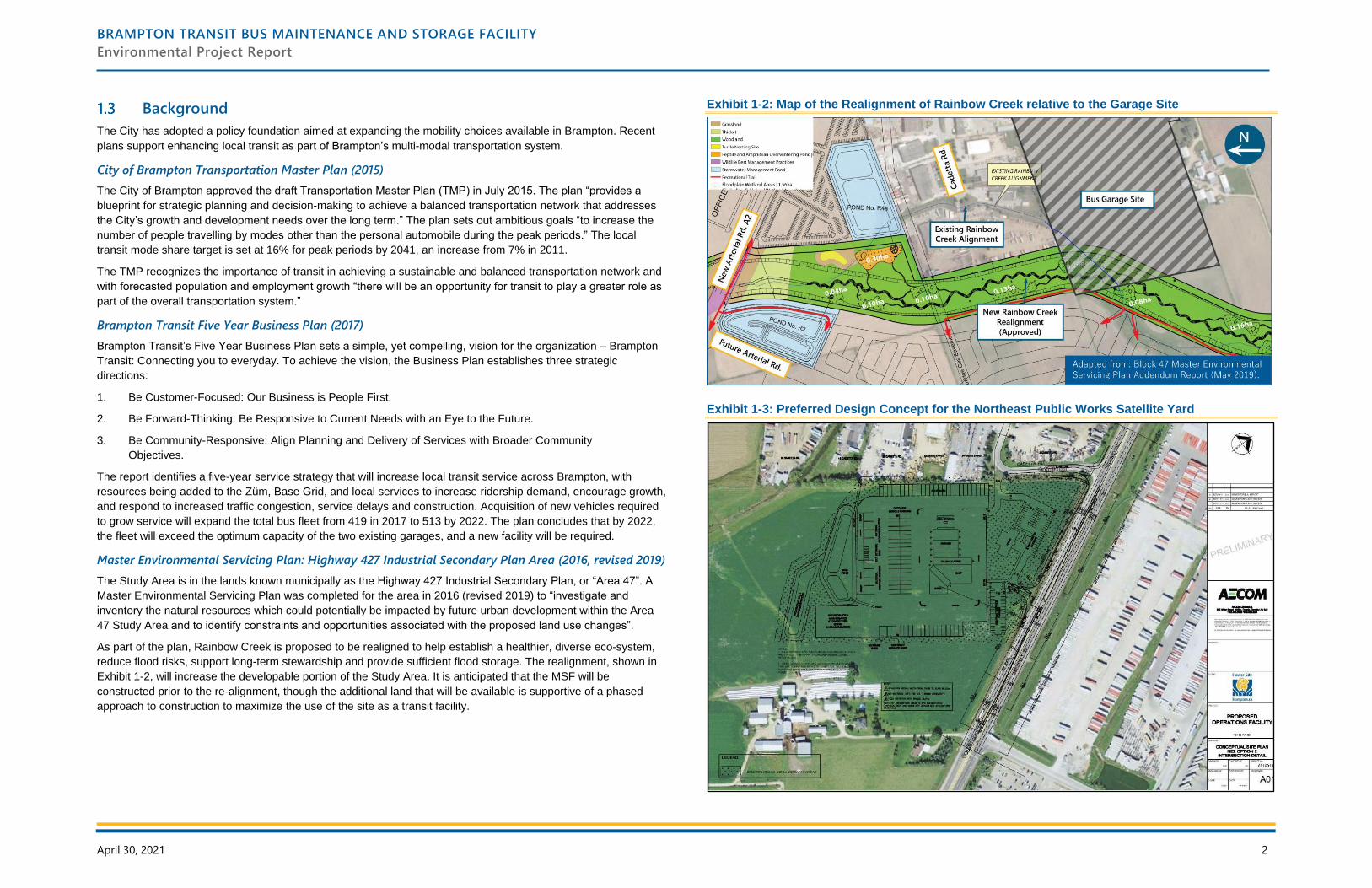
As part of the plan, Rainbow Creek is proposed to be realigned to help establish a healthier, diverse eco-system,
reduce flood risks, support long-term stewardship and provide sufficient flood storage. The realignment, shown in
Exhibit 1-2, will increase the developable portion of the Study Area. It is anticipated that the MSF will be
constructed prior to the re-alignment, though the additional land that will be available is supportive of a phased
approach to construction to maximize the use of the site as a transit facility.
Exhibit 1-2: Map of the Realignment of Rainbow Creek relative to the Garage Site
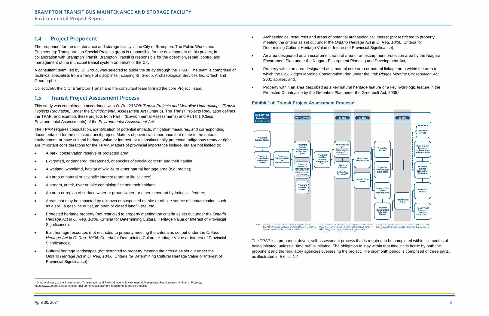
Exhibit 1-3: Preferred Design Concept for the Northeast Public Works Satellite Yard
BRAMPTON TRANSIT BUS MAINTENANCE AND STORAGE FACILITY
Environmental Project Report
April 30, 2021 3
Project Proponent
The proponent for the maintenance and storage facility is the City of Brampton. The Public Works and
Engineering: Transportation Special Projects group is responsible for the development of this project, in
collaboration with Brampton Transit. Brampton Transit is responsible for the operation, repair, control and
management of the municipal transit system on behalf of the City.
A consultant team, led by IBI Group, was selected to guide the study through the TPAP. The team is comprised of
technical specialists from a range of disciplines including IBI Group, Archaeological Services Inc, Ortech and
Geomorphix.
Collectively, the City, Brampton Transit and the consultant team formed the core Project Team.
Transit Project Assessment Process
This study was completed in accordance with O. Re. 231/08: Transit Projects and Metrolinx Undertakings (Transit
Projects Regulation), under the Environmental Assessment Act (Ontario). The Transit Projects Regulation defines
the TPAP, and exempts these projects from Part II (Environmental Assessments) and Part II.1 (Class
Environmental Assessments) of the Environmental Assessment Act.
The TPAP requires consultation, identification of potential impacts, mitigation measures, and corresponding
documentation for the selected transit project. Matters of provincial importance that relate to the natural
environment, or have cultural heritage value or interest, or a constitutionally protected Indigenous treaty or right,
are important considerations for the TPAP. Matters of provincial importance include, but are not limited to:
• A park, conservation reserve or protected area;
• Extirpated, endangered, threatened, or species of special concern and their habitat;
• A wetland, woodland, habitat of wildlife or other natural heritage area (e.g. prairie);
• An area of natural or scientific interest (earth or life science);
• A stream, creek, river or lake containing fish and their habitats;
• An area or region of surface water or groundwater, or other important hydrological feature;
• Areas that may be impacted by a known or suspected on-site or off-site source of contamination, such
as a spill, a gasoline outlet, an open or closed landfill site, etc.;
• Protected heritage property (not restricted to property meeting the criteria as set out under the Ontario
Heritage Act in O. Reg. 10/06, Criteria for Determining Cultural Heritage Value or Interest of Provincial
Significance);
• Built heritage resources (not restricted to property meeting the criteria as set out under the Ontario
Heritage Act in O. Reg. 10/06, Criteria for Determining Cultural Heritage Value or Interest of Provincial
Significance);
• Cultural heritage landscapes (not restricted to property meeting the criteria as set out under the
Ontario Heritage Act in O. Reg. 10/06, Criteria for Determining Cultural Heritage Value or Interest of
Provincial Significance);
1 Ontario Ministry of the Environment, Conservation and Parks, Guide to Environmental Assessment Requirements for Transit Projects, https://www.ontario.ca/page/guide-environmentalassessment-requirements-transit-projects
• Archaeological resources and areas of potential archaeological interest (not restricted to property
meeting the criteria as set out under the Ontario Heritage Act in O. Reg. 10/06, Criteria for
Determining Cultural Heritage Value or Interest of Provincial Significance);
• An area designated as an escarpment natural area or an escarpment protection area by the Niagara
Escarpment Plan under the Niagara Escarpment Planning and Development Act;
• Property within an area designated as a natural core area or natural linkage area within the area to
which the Oak Ridges Moraine Conservation Plan under the Oak Ridges Moraine Conservation Act,
2001 applies; and,
• Property within an area described as a key natural heritage feature or a key hydrologic feature in the
Protected Countryside by the Greenbelt Plan under the Greenbelt Act, 2005.1
Exhibit 1-4: Transit Project Assessment Process1
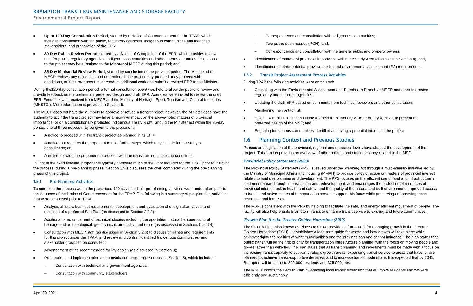
The TPAP is a proponent driven, self-assessment process that is required to be completed within six months of
being initiated, unless a “time out” is initiated. The obligation to stay within that timeline is borne by both the
proponent and the regulatory agencies overseeing the project. The six-month period is comprised of three parts,
as illustrated in Exhibit 1-4:
BRAMPTON TRANSIT BUS MAINTENANCE AND STORAGE FACILITY
Environmental Project Report
April 30, 2021 4
• Up to 120-Day Consultation Period, started by a Notice of Commencement for the TPAP, which
includes consultation with the public, regulatory agencies, Indigenous communities and identified
stakeholders, and preparation of the EPR;
• 30-Day Public Review Period, started by a Notice of Completion of the EPR, which provides review
time for public, regulatory agencies, Indigenous communities and other interested parties. Objections
to the project may be submitted to the Minister of MECP during this period; and,
• 35-Day Ministerial Review Period, started by conclusion of the previous period. The Minister of the
MECP reviews any objections and determines if the project may proceed, may proceed with
conditions, or if the proponent must conduct additional work and submit a revised EPR to the Minister.
During the120-day consultation period, a formal consultation event was held to allow the public to review and
provide feedback on the preliminary preferred design and draft EPR. Agencies were invited to review the draft
EPR. Feedback was received from MECP and the Ministry of Heritage, Sport, Tourism and Cultural Industries
(MHSTCI). More information is provided in Section 5.
The MECP does not have the authority to approve or refuse a transit project; however, the Minister does have the
authority to act if the transit project may have a negative impact on the above-noted matters of provincial
importance, or on a constitutionally protected Indigenous Treaty Right. Should the Minister act within the 35-day
period, one of three notices may be given to the proponent:
• A notice to proceed with the transit project as planned in its EPR;
• A notice that requires the proponent to take further steps, which may include further study or
consultation; or,
• A notice allowing the proponent to proceed with the transit project subject to conditions.
In light of the fixed timeline, proponents typically complete much of the work required for the TPAP prior to initiating
the process, during a pre-planning phase. Section 1.5.1 discusses the work completed during the pre-planning
phase of this project.
1.5.1 Pre-Planning Activities
To complete the process within the prescribed 120-day time limit, pre-planning activities were undertaken prior to
the issuance of the Notice of Commencement for the TPAP. The following is a summary of pre-planning activities
that were completed prior to TPAP:
• Analysis of future bus fleet requirements, development and evaluation of design alternatives, and
selection of a preferred Site Plan (as discussed in Section 2.1.1);
• Additional or advancement of technical studies, including transportation, natural heritage, cultural
heritage and archaeological, geotechnical, air quality, and noise (as discussed in Sections 0 and 4);
• Consultation with MECP staff (as discussed in Section 5.2.6) to discuss timelines and requirements
for this project under the TPAP, and review and confirm identified Indigenous communities, and
stakeholder groups to be consulted;
• Advancement of the recommended facility design (as discussed in Section 0);
• Preparation and implementation of a consultation program (discussed in Section 5), which included:
− Consultation with technical and government agencies;
− Consultation with community stakeholders;
− Correspondence and consultation with Indigenous communities;
− Two public open houses (POH); and,
− Correspondence and consultation with the general public and property owners.
• Identification of matters of provincial importance within the Study Area (discussed in Section 4); and,
• Identification of other potential provincial or federal environmental assessment (EA) requirements.
1.5.2 Transit Project Assessment Process Activities
During TPAP the following activities were completed:
• Consulting with the Environmental Assessment and Permission Branch at MECP and other interested
regulatory and technical agencies;
• Updating the draft EPR based on comments from technical reviewers and other consultation;
• Maintaining the contact list;
• Hosting Virtual Public Open House #3, held from January 21 to February 4, 2021, to present the
preferred design of the MSF; and,
• Engaging Indigenous communities identified as having a potential interest in the project.
Planning Context and Previous Studies
Policies and legislation at the provincial, regional and municipal levels have shaped the development of the
project. This section provides an overview of other policies and studies as they related to the MSF.
Provincial Policy Statement (2020)
The Provincial Policy Statement (PPS) is issued under the Planning Act through a multi-ministry initiative led by
the Ministry of Municipal Affairs and Housing (MMAH) to provide policy direction on matters of provincial interest
related to land use planning and development. The PPS focuses on the efficient use of land and infrastructure in
settlement areas through intensification and redevelopment, and encourages the protection of resources of
provincial interest, public health and safety, and the quality of the natural and built environment. Improved access
to transit and active modes of transportation serve to support this focus while preserving or improving these
resources and interests.
The MSF is consistent with the PPS by helping to facilitate the safe, and energy efficient movement of people. The
facility will also help enable Brampton Transit to enhance transit service to existing and future communities.
Growth Plan for the Greater Golden Horseshoe (2019)
The Growth Plan, also known as Places to Grow, provides a framework for managing growth in the Greater
Golden Horseshoe (GGH). It establishes a long-term guide for where and how growth will take place while
acknowledging the realities of what municipalities and the province can and cannot influence. The plan states that
public transit will be the first priority for transportation infrastructure planning, with the focus on moving people and
goods rather than vehicles. The plan states that all transit planning and investments must be made with a focus on
increasing transit capacity to support strategic growth areas, expanding transit service to areas that have, or are
planned to, achieve transit-supportive densities, and to increase transit mode share. It is expected that by 2041,
Brampton will be home to 890,000 residents and 325,000 jobs.
The MSF supports the Growth Plan by enabling local transit expansion that will move residents and workers
efficiently and sustainably.
BRAMPTON TRANSIT BUS MAINTENANCE AND STORAGE FACILITY
Environmental Project Report
April 30, 2021 5
2041 Regional Transportation Plan (2018)
The 2041 Regional Transportation Plan (RTP) was developed and adopted by Metrolinx. The plan provides a
mobility blueprint for the Greater Toronto and Hamilton Area (GTHA), and contains long-term network plans
related to rapid transit, frequent transit, and regional cycling.
This Projects supports the RTP by helping to strengthen and support the Züm BRT, base grid and local transit
routes within Brampton. Brampton Transit will play a key role in delivering the Frequent Rapid Transit Network and
providing first and last mile connections to the regional transit system.
Peel Region Long Range Transportation Plan (2019)
The Long Range Transportation Plan (LRTP) guides transportation planning needs in the region to 2041, based on
population and employment forecasts from the Growth Plan for the GGH. The preferred alternative to addressing
growth is to “invest in a combination of planned road improvements and active transportation infrastructure to
achieve a 50% sustainable mode share.” The plan identifies that Highway 50 through this area may be widened in
the future.
The MSF supports the LRTP by enabling local transit growth to promote sustainable travel and meet the City of
Brampton’s sustainable mode share target of 48% as identified in the LRTP.
Peel Region Sustainable Transportation Strategy (2018)
The Sustainable Transportation Strategy (STS) is an action plan that outlines the Region’s roles and
responsibilities to significantly increase the proportion of trips made by walking, cycling, transit, carpooling, and
trips avoided through teleworking. Some of the key actions under Transit include: improve connections to transit,
explore new technologies and business models to support transit, and promote transit use across the Region.
Study Organization
The requirements of the TPAP and corresponding sections of this EPR are outlined in Exhibit 1-5. This exhibit has
been prepared to facilitate the review of the EPR by outlining where the information is located within the report.
Exhibit 1-5: EPR Requirement Table
EPR Requirement EPR Section
A statement of the purpose of the transit project and a summary of any background
information relating to the transit project.
1.1, 2.1
A final description of the project including a description of the preferred design. 2.2
A description of any other design methods that were considered once the project commenced
the TPAP (Note: Does not include any alternatives considered during pre-planning as TPAP
starts with a transit project and is focused on an impact assessment of that project).
Not Applicable
A map showing the site of the transit project. 1.2
A description of the local environmental conditions at the site of the transit project. 3
A description of all studies carried out, including a summary of all data collected or reviewed
and a summary of all results and conclusions.
3, 4
The assessments, evaluation and criteria for any impacts of the preferred design method and
any other design method (described above) that were considered once the project’s TPAP
commenced (does not include pre-planning work).
4, Appendices B to N
EPR Requirement EPR Section
A description of any proposed measures for mitigating any negative impacts the transit project
might have on the environment.
4
If mitigation measures are proposed, a description of the proposal for monitoring or verifying
the effectiveness of the mitigation measures.
4
A description of any municipal, provincial, federal, or other approvals or permits that may be
required.
6
A consultation record, including:
• A description of the consultation and follow up efforts carried out with interested persons,
including Indigenous communities;
• A list of the interested persons, including Indigenous communities who participated in the
consultation;
• Summaries of the comments submitted by interested persons, including Indigenous
communities;
• A summary of any discussions with Indigenous communities including discussions of any
potential impacts of the transit project on constitutionally protected Indigenous or treaty
rights, and copies of all written comments submitted by Indigenous communities; and,
• A description of what the proponent did to respond to concerns expressed by interested
persons, including Indigenous communities.
5, Appendix O and P
If a “time out” is taken during the TPAP, a summary of each issue including: a description of
the issue; a description of what the proponent did to respond to the issue and the results of
those efforts and, the dates that notices for the “time out” were given to the Director and the
Regional Director.
Not Applicable
BRAMPTON TRANSIT BUS MAINTENANCE AND STORAGE FACILITY
Environmental Project Report
April 30, 2021 6
2 Design Approach and Project Description
This section discusses the development of the study area boundaries, facility requirements and development
process, and provides a description of the transit project. It defines the principle elements of the MSF and
discusses project implementation.
Study Area Boundaries and Facility Requirements
The purpose of this study is to develop a new MSF to supplement existing garages in order to support the
continued expansion of transit service. The study area for this TPAP was determined based on the limits of the
Municipal Class EA completed in 2012 for the Works and Transportation Satellite Yards (AECOM, 2012). While
the Study Area is no longer planned to support a public works yard, elements of the background technical studies
completed as part of this study will be referenced within this report.
Requirements of the new facility were developed as part of the feasibility study based on the identified study area,
and refined in consultation with the Project Team. Program requirements of the facility include, but are not limited
to:
• Bus Storage and Maintenance – the facility needs to be able to store and maintain a minimum of
246 single bus equivalents (SBEs) on opening day, with space for a future expansion that can
accommodate up to 192 additional SBEs (438 total). The maintenance areas need to provide space
for repair and service bays, washing bays, paint and body shops, degreasing bays, other functional
area, and material storage.
• Future Electrification – needs to be able to convert the facility to support a 100% electric bus fleet at
a future date, without compromising the overall capacity of the facility.
• Staff and Visitor Parking – an appropriate number of automobile parking spots is required for staff
and visitors to the site, either at surface level or in a parking structure.
• Operational Space – adequate areas to support operational functions such as training rooms,
operator lunch, fitness and quiet rooms, and general space and meeting rooms.
• Separation of Traffic – minimizing the number of conflict points between bus, vehicular, and
pedestrian traffic on-site to increase safety.
• Sustainability – include sustainable features including reclaimed water systems and storage,
landscaping, a stormwater management pond, low-impact development features, covered bike
parking and can accommodate the future transition to a fully electric, zero carbon bus fleet.
2.1.1 Development of the Preferred Concept
The design process aimed to minimize potential impacts to the surrounding community from the start. Five
alternatives were developed and assessed during pre-planning. These reflected the program requirements
discussed in Section 2.1. The integrative design approach has helped to identify opportunities for synergies across
disciplines and building systems. The alternatives included:
• Various orientations and siting of features, including a multi-storey facility;
• An option that does not require the realignment of Rainbow Creek; and,
• Alternative location of storage, maintenance and office space.
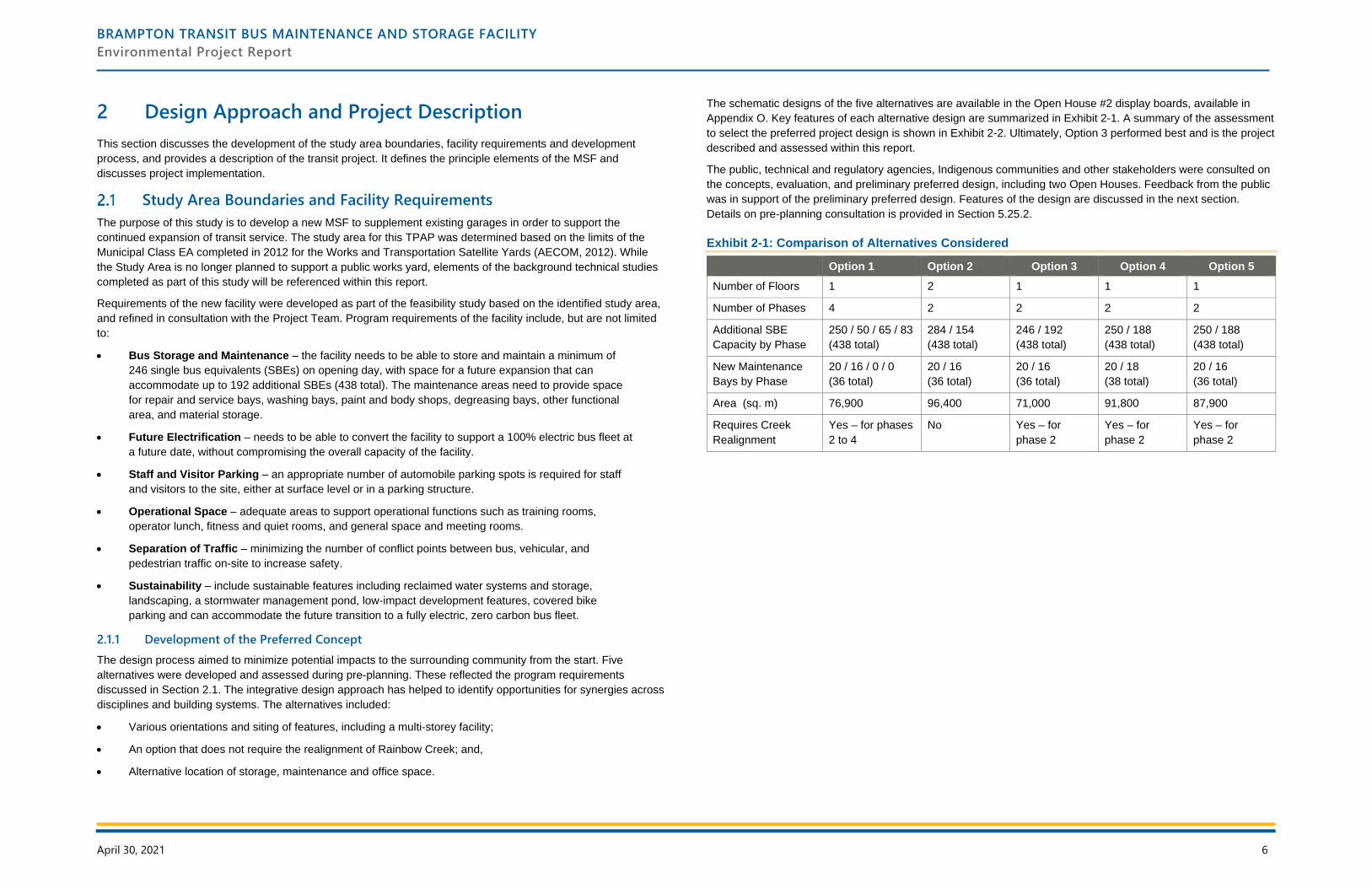
The schematic designs of the five alternatives are available in the Open House #2 display boards, available in
Appendix O. Key features of each alternative design are summarized in Exhibit 2-1. A summary of the assessment
to select the preferred project design is shown in Exhibit 2-2. Ultimately, Option 3 performed best and is the project
described and assessed within this report.
The public, technical and regulatory agencies, Indigenous communities and other stakeholders were consulted on
the concepts, evaluation, and preliminary preferred design, including two Open Houses. Feedback from the public
was in support of the preliminary preferred design. Features of the design are discussed in the next section.
Details on pre-planning consultation is provided in Section 5.25.2.
Exhibit 2-1: Comparison of Alternatives Considered
Option 1 Option 2 Option 3 Option 4 Option 5
Number of Floors 1 2 1 1 1
Number of Phases 4 2 2 2 2
Additional SBE
Capacity by Phase
250 / 50 / 65 / 83
(438 total)
284 / 154
(438 total)
246 / 192
(438 total)
250 / 188
(438 total)
250 / 188
(438 total)
New Maintenance
Bays by Phase
20 / 16 / 0 / 0
(36 total)
20 / 16
(36 total)
20 / 16
(36 total)
20 / 18
(38 total)
20 / 16
(36 total)
Area (sq. m) 76,900 96,400 71,000 91,800 87,900
Requires Creek
Realignment
Yes – for phases
2 to 4
No Yes – for
phase 2
Yes – for
phase 2
Yes – for
phase 2
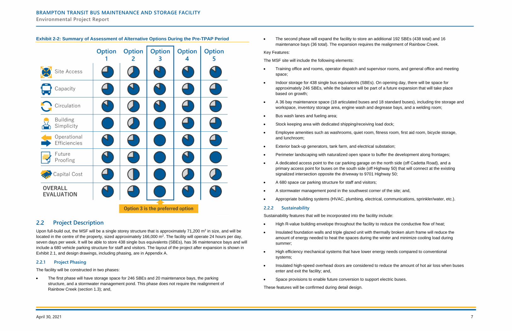
BRAMPTON TRANSIT BUS MAINTENANCE AND STORAGE FACILITY
Environmental Project Report
April 30, 2021 7
Exhibit 2-2: Summary of Assessment of Alternative Options During the Pre-TPAP Period
Project Description
Upon full-build out, the MSF will be a single storey structure that is approximately 71,200 m2 in size, and will be
located in the centre of the property, sized approximately 166,000 m2. The facility will operate 24 hours per day,
seven days per week. It will be able to store 438 single bus equivalents (SBEs), has 36 maintenance bays and will
include a 680 vehicle parking structure for staff and visitors. The layout of the project after expansion is shown in
Exhibit 2.1, and design drawings, including phasing, are in Appendix A.
2.2.1 Project Phasing
The facility will be constructed in two phases:
• The first phase will have storage space for 246 SBEs and 20 maintenance bays, the parking
structure, and a stormwater management pond. This phase does not require the realignment of
Rainbow Creek (section 1.3); and,
• The second phase will expand the facility to store an additional 192 SBEs (438 total) and 16
maintenance bays (36 total). The expansion requires the realignment of Rainbow Creek.
Key Features:
The MSF site will include the following elements:
• Training office and rooms, operator dispatch and supervisor rooms, and general office and meeting
space;
• Indoor storage for 438 single bus equivalents (SBEs). On opening day, there will be space for
approximately 246 SBEs, while the balance will be part of a future expansion that will take place
based on growth;
• A 36 bay maintenance space (18 articulated buses and 18 standard buses), including tire storage and
workspace, inventory storage area, engine wash and degrease bays, and a welding room;
• Bus wash lanes and fueling area;
• Stock keeping area with dedicated shipping/receiving load dock;
• Employee amenities such as washrooms, quiet room, fitness room, first aid room, bicycle storage,
and lunchroom;
• Exterior back-up generators, tank farm, and electrical substation;
• Perimeter landscaping with naturalized open space to buffer the development along frontages;
• A dedicated access point to the car parking garage on the north side (off Cadetta Road), and a
primary access point for buses on the south side (off Highway 50) that will connect at the existing
signalized intersection opposite the driveway to 9701 Highway 50;
• A 680 space car parking structure for staff and visitors;
• A stormwater management pond in the southwest corner of the site; and,
• Appropriate building systems (HVAC, plumbing, electrical, communications, sprinkler/water, etc.).
2.2.2 Sustainability
Sustainability features that will be incorporated into the facility include:
• High R-value building envelope throughout the facility to reduce the conductive flow of heat;
• Insulated foundation walls and triple glazed unit with thermally broken alum frame will reduce the
amount of energy needed to heat the spaces during the winter and minimize cooling load during
summer;
• High efficiency mechanical systems that have lower energy needs compared to conventional
systems;
• Insulated high-speed overhead doors are considered to reduce the amount of hot air loss when buses
enter and exit the facility; and,
• Space provisions to enable future conversion to support electric buses.
These features will be confirmed during detail design.
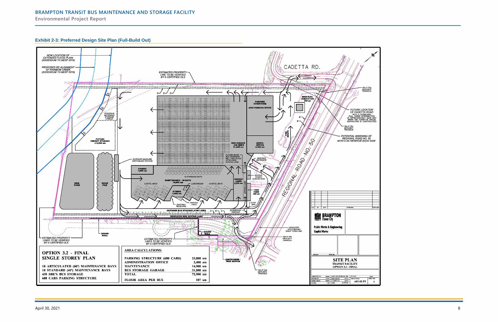
BRAMPTON TRANSIT BUS MAINTENANCE AND STORAGE FACILITY
Environmental Project Report
April 30, 2021 8
Exhibit 2-3: Preferred Design Site Plan (Full-Build Out)
BRAMPTON TRANSIT BUS MAINTENANCE AND STORAGE FACILITY
Environmental Project Report
April 30, 2021 9
3 Existing Conditions
This section discusses the existing conditions within the Study Area in the context of the built, natural, socio-
economic and cultural environments. These conditions were used to establish a baseline to compare and evaluate
the anticipated effects of the project. Certain components of this section have been informed by technical studies,
which are provided in the following appendices:
• Appendix B: Environmental Impact Study
• Appendix C: Archaeology (Stages 1 and 2)
• Appendix D: Cultural Heritage Resource Assessment and Cultural Heritage Evaluation Report
• Appendix I: Geotechnical Investigation
• Appendix J: Hydrogeological Study
• Appendix K: Environmental Site Assessment Phases 1 and 2
• Appendix E: Socio-Economic • Appendix L: Stormwater Management
• Appendix F: Noise Assessment • Appendix M: Traffic Impact
• Appendix G: Air Quality Assessment • Appendix N: Functional Servicing
• Appendix H: Fluvial Geomorphology • Appendix O: Consultation (Pre-TPAP)
• Appendix P: Consultation (TPAP)
Natural Heritage
The following sections provide a summary of the existing natural heritage conditions within the Study Area. More
information is available in the Environmental Impact Study contained in Appendix B.
3.1.1 Physiography and Soils
The Study Area is located within the Iroquois Plain physiographic region in southern Ontario, a lowland region
bordering Lake Ontario. Soils surrounding the Study Area are classified as Peel clay and Bottomland. Peel clay
soils are imperfectly drained and exhibit a smooth, gently sloping topography. These soil types consist of lacustrine
clay over gritty clay or clay till, which can be up to one metre deep. Erosion is minimal with these soil types.
3.1.2 Aquatic Species and Habitat
West Rainbow Creek, a tributary of the Humber River, traverses the western limits of the study property. The
watercourse and floodplain are within Toronto and Region Conservation Area (TRCA) regulated area. A Natural
Heritage Report was prepared for Huntington Road Part A and Part B Langstaff Road to Nashville Road Schedule
‘C’ Municipal Class Environmental Assessment. The Study Area for the Huntington Road project is downstream of
the Study Area.
Field investigations were undertaken in November 2019. The review confirmed that the channel was poorly
defined through a 50 to 80 metre wide corridor of grasses and cattails. During the spring freshet period, it
appeared that a defined channel of approximately 1 to 3 metres wide flows through the site though herbaceous
vegetation. Based on previous fisheries work conducted on this channel at Castlemore Road, approximately 1 km
downstream, it was confirmed that the channel is dry for most of the year and supports intermittent flows.
The substrate throughout the study reach consists of fine materials such as silt and organic material. The Rainbow
Creek Tributary generally consists of simple aquatic habitat and it is likely that a community of tolerant, warmwater
forage fish species uses the channel seasonally based on the intermittent flow conditions.
3.1.3 Trees and Vegetation
The geographical extent, composition, structure and function of the vegetation communities were identified through
air photo interpretation and a field investigation. Field investigations were undertaken in November 2019. These
investigations were used to confirm the boundaries and to conduct botanical surveys.
The Study Area is largely comprised of an agricultural field. Two Ecological Land Classification vegetation
community types were identified within the Study Area: Reed Canary Grass Mineral Meadow Marsh and Dry-Moist
Old Field Meadow. All of the vegetation communities identified within the Study Area are considered widespread
and common in Ontario and are secure globally.
A total of 35 plant species were recorded within the Study Area. Approximately 35% of the plant species are native to Ontario and 65% plant species are non-native. No Endangered, Threatened, or Special Concern plants, or plants considered regionally or locally rare were identified within the Study Area.
3.1.4 Wildlife and Wildlife Habitat
Field investigations were conducted in November 2019, to document wildlife and wildlife habitat. It should be noted
that because the field investigations were conducted in the late Fall, the species identified may not be
representative of the wildlife community (e.g., breeding birds).
Wildlife and wildlife habitat were found to be distributed across the entire Study Area, however given disturbed
nature of the Study Area, natural heritage features were generally considered marginal quality. The feature which
offers the highest quality wildlife habitat is the Tributary of Rainbow Creek and associated riparian area. Habitats
associated with the Tributary of Rainbow Creek north-south running riparian area is likely to provide locally
important habitat connectivity, between natural habitat areas in the vicinity of the Study Area. These natural areas
provide the most suitable wildlife habitat in the Study Area; however, only a low to moderately diverse assemblage
of bird and mammal species were documented within these habitats. The weakly defined channel and associated
aquatic vegetation associated with the watercourse have the potential to function as amphibian breeding habitat;
however, its function is expected to be limited given the level of disturbance found across the Study Area.
No herpetofauna species or habitat were observed in the Study Area during field investigations.
Two bird species were identified within the Study Area during the 2019 field investigation: Mourning Dove and Black-capped Chickadee. Since surveys were conducted out of season, the species identified are not expected to be representative of the breeding bird community. Targeted Bobolink surveys were conducted by AECOM in 2011. The results from these surveys found two Bobolink individuals identified within the Study Area and several more individuals on lands immediately adjacent.
A total of three mammal species were confirmed: short-tailed shrew, coyote and racoon. Within the Study Area, a
mammal movement corridor was identified within the naturalized portion of the Tributary of Rainbow Creek. This
corridor was identified as being locally significant as it provides opportunity for wildlife movement through natural
areas in an otherwise highly fragmented/disturbed landscape.
3.1.5 Species at Risk
All recorded bird species are protected under the Migratory Birds Convention Act (MBCA). The Bobolink is
recommended by Bird Studies Canada as priority species for conservation in Peel Region, considered to be of
regional concern by the TRCA, and is regulated as ‘Threatened’ under the Endangered Species Act. However,
Bobolinks are commonly associated with agricultural lands and meadows. Field investigations noted that
agricultural lands associated with the records were now covered by row crop and no longer suitable for this
species.
BRAMPTON TRANSIT BUS MAINTENANCE AND STORAGE FACILITY
Environmental Project Report
April 30, 2021 10
Two of three confirmed mammals (Coyote and Racoon) are offered protection under the Fish and Wildlife
Conservation Act.
Mature trees were identified in the riparian habitat of Rainbow Creek. They may contain suitable habitat for
Species at Risk bats, although none were identified during the field investigation.
3.1.6 Designated Natural Areas
There are no Provincially Significant Wetlands, Areas of Natural and Scientific Interest, or Environmentally
Sensitive Areas located within 120 m of the Study Area. The riparian habitat associated of the watercourses in the
Study Area is designated as ‘Valleyland/Watercourse Corridor’, as per Schedule D of the City of Brampton Official
Plan (2015).
Cultural Heritage
3.2.1 Archaeology
ASI was retained to undertake a Stage 1 Archaeological Assessment. The background study for the Stage 1
Archeological Assessment was completed in October 2019. The study determined that seven previously registered
archaeological sites are located within one kilometre of the Study Area. Of the seven, one is located within the
Study Area, but does not have further Cultural Heritage Value or Interest (CHVI).
A property inspection was completed, which determined that parts of the Study Area exhibit archaeological
potential and will require a Stage 2 Archaeological Assessment. The Stage 2 assessment was completed on
September 17 to 18, 2020. Details are included in Appendix C.
3.2.2 Built Heritage Resources and Cultural Heritage Landscapes
ASI was retained to conduct a Cultural Heritage Resource Assessment for the Study Area. Primary and secondary
sources and historical mapping was reviewed to identify early settlement patterns and broad agents or themes of
change in a Study Area. To augment the data, federal, provincial, and municipal databases and/or agencies are
consulted to obtain information about specific properties that have been previously identified and/or designated as
retaining CHVI.
A field investigation was undertaken in October 2019 to confirm the location and condition of previously identified
cultural heritage resources. The field investigation was also used to identify cultural heritage resources that had
not been previously identified on federal, provincial, or municipal databases.
Based on the results of the background research and field review, two cultural heritage resources were identified
within and/or adjacent to the Study Area. The cultural heritage resources include two farmscapes (10192A
Highway 50 and 10307 Clarkway Drive), both of which are included on City of Brampton’s Municipal Register of
Cultural Heritage Resources: ‘Listed’ Heritage Properties.
A Cultural Heritage Evaluation Report (CHER) was completed for 10192A Highway 50, following O. Reg. 9/06. The
evaluation determined that the property has design/physical value as a representative example of an Italianate
house with Romanesque Revival influences, historical/associative value for its association with the Johnston
family, and contextual value for its role in supporting and maintaining the agricultural character of the area. The
Cultural Heritage Resource Assessment and CHER are provided in Appendix D.
Socio-Economic Environment
IBI Group was retained by the City of Brampton to conduct a socio-economic environment assessment for the
proposed Brampton MSF. The assessment focused on the MSF site and adjacent lands, but also considered a
one kilometre surrounding area, which includes lands within the City of Brampton and the City of Vaughan, and the
larger municipal and regional context. A range of secondary source data and materials were reviewed for the
assessment of land use policies and regulations, existing and anticipated future land use, built form, community
features, population and employment, including technical studies completed for the TPAP. Details are provided in
Appendix E.
3.3.1 Land Use Policy and Regulations
The site is designated ‘Greenfield Area’ by the Growth Plan for the Greater Golden Horseshoe (May 2019).
Through Amendment 1 to the Growth Plan, which came into effect August 28, 2020, the site is further designated
as ‘Provincially Significant Employment Zone (PSEZ)’ within Zone 15 (Toronto, York, Peel). The PSEZ designation
is intended to protect and preserve lands for future employment and industrial uses. Provincial D-6 Guidelines
provide further direction for land use and ensuring compatibility between industrial facilities and sensitive land
uses.
The site is designated ‘Urban System’ by the Region of Peel Official Plan (2018). Schedule A (General Land Use
Designations) of the City of Brampton Official Plan (2015) designates the site as ‘Industrial’, within a ‘Special Study
Area’ and ‘Corridor Protection Area’:
• The Corridor Protection Area is an area being protected for the accommodation of the arterial road
network and high order transportation facilities required within the north east area of Brampton and in
the adjacent areas of Vaughan and Caledon and to support the extension of Highway 427. The
Corridor Protection Area policies were appealed to the Ontario Municipal Board (OMB) by the North
West Brampton Landowners Group.
• As per policy 4.4.2.1, the Industrial designation shall provide for the development of industrial,
manufacturing, distribution, mixed industrial/commercial, commercial self-storage warehouses, data
processing and related uses and limited office uses, and may also permit limited service and retail
uses, open space, public and institutional use as practical appropriate subject to the appropriate sub-
designations and policies in the relevant Secondary Plan.
• The site is located in the Clarkway Drive/Castlemore Road/Mayfield Road Special Study Area and
policies of the Official Plan requires more detailed land use and design analysis to be undertaken as
part of the Secondary Planning process.
The site is located within the Highway 427 Industrial Secondary Plan (SPA 47). Schedule SP47(a) designates the
site as ‘Logistic/Warehouse/Transportation’. SPA 47 was adopted in 2014 but is only partially in effect and many
policies and provisions remain under appeal, including policies pertaining to the
‘Logistic/Warehouse/Transportation’ designation remain under appeal. Lands to the north and south are also
designated as ‘Logistic/Warehouse/Transportation’ by SPA 47 and lands to the west are designated ‘Valleyland’.
Lands to the east are predominantly designated ‘General Employment’ by Schedule C of the City of Vaughan
Official Plan, with small areas designated as ‘Natural Areas’.
The site is currently zoned Agricultural by the City of Brampton Zoning By-law (ZBL). Provision 6.33.1 of the ZBL
permits public uses in all zoning categories. The ZBL defines Public Use as, ‘uses that are owned or leased by a
public authority for community, recreational, administrative, educational, health care, protection, waste disposal,
utility or other governmental purposes, and includes accessory uses to public use.’
The west portion of the site is located within the regulated area of the Toronto and Region Conservation Authority.
3.3.2 Land Use - Site and Surrounding Context
The 16.6-hectare (ha) site is municipally known as 10192 Highway 50 and is located in northeast Brampton near
the western border of the City of Vaughan. The site historically has been used for agricultural purposes and some
BRAMPTON TRANSIT BUS MAINTENANCE AND STORAGE FACILITY
Environmental Project Report
April 30, 2021 11
of the lands are currently occupied by a satellite Public Works yard. West Rainbow Creek traverses through the
western limits of the site. While the site does contain a range of plant species and wildlife habitat, provincial,
regional and municipal land use plans and policies do intend for the site to be developed with industrial uses.
The following land uses currently abut the site:
• North: Cadetta Road and small industrial are containing transportation and construction-related
businesses and other industrial uses within one and two-storey buildings. Many of the businesses
have outdoor storage;
• South: Farm with a two-storey residential dwelling and numerous agricultural buildings (e.g. barns and
silos). The property is in the process of being designated as of November 2020, as a Notice of
Intention to Designate has been served;
• West: natural open space and agricultural land; and
• East: Highway 50, industrial uses within one and two-storey buildings and the Canadian Pacific
Railway transfer yard.
The surrounding lands contain a mix of rural and agricultural uses, natural open space and low-rise industrial uses.
With the exception of a few single detached houses associated with either active or historic farmsteads, there are
no other sensitive land uses within one km of the site (e.g. hospitals, schools, long term care homes, retirement
homes and day cares). There are no community amenities or parks within one km of the site and no sidewalks or
bicycle paths on Highway 50 or Cadetta Road.
While most of the surrounding lands are largely undeveloped at this time, the lands are within the urban boundary
and anticipated to develop in the future, primarily with industrial uses. There are appears to be four active
development applications within one km of the site, all of which are for industrial / transportation-related uses.
The Site and the surrounding area are part of the traditional territory of the Mississaugas of the Credit,
Anishinabek, Huron-Wendat, Haudenosaunee, Ojibway-Chippeawa and Métis People. This territory is covered by
the Upper Canada Treaties, specifically Treaty 19 and 13A.
3.3.3 Population and Employment
At the time of the 2016 Census the City of Brampton had a population of 593,638 and 189,200 jobs. Given the
site’s location within a historically rural area of the City that is primary designated for industrial uses, few people
live within proximity to the site. The site is located within Dissemination Area (DA) 35211648 and at the time of the
2016 Census this 1.37 sq. km. area was home to only 478 people residing within 162 private dwellings. Lands to
the east of the site, fall within DA Area 35191271, which is 25.59 sq. km. and was home to 1,1012 people and DA
35190192 which is 17.80 sq. km. and was home to 4,968 people.
There are approximately twenty businesses located within one km of the site, the majority of which are industrial
(e.g. Forrest Contractors, Bolton Ready Mix, Pilen Contraction of Canada; Roma Building Restoration; Cadetta
Concreate and Drain; and Tristar Coatings Limited. Apra Truck Lines Transport, C Valley Paving, SLH Transport
Inc., JB Express). Other places of employment within proximity to the site include industrial/commercial businesses
(e.g. Emery Wood Mouldings and Greenside Garden Centre) and agricultural operations.
Provincial, regional and municipal policies intend for the Study Area and surrounding lands are largely to be
utilized for industrial / employment uses. As such, little or no population growth is expected but the number of
businesses and jobs in expected to increase over the next few decades.
Noise
The MECP noise guideline NPC-300 “Stationary and Transportation Sources – Approval and Planning” identifies
four classifications for where a noise receptor can be located. The Study Area is representative of a “Class 1 area”
which is an area with an acoustical environment typical of a major population centre, where the background sound
level is dominated by the activities of people, usually road traffic, often referred to as “urban hum.”
The MECP criteria for noise levels resulting from stationary noise sources for a Class 1 area are in Exhibit 3-1. The
criteria specifies that noise caused by the emergency generators during non-emergency times, such as during
testing and maintenance, can be 5 dBA greater than those for stationary noise listed in Exhibit 3-1. The Plane of
Window point in space corresponding with the location of the centre of a window of a noise sensitive space, such
as a private residence.
Exhibit 3-1: Stationary Noise Level Criteria
Time Period Location Class 1
0700 – 1900 Outdoor Living Area 50 dBA
1900 – 2300 Outdoor Living Area 50 dBA
0700 – 1900 Plane of Window 50 dBA
1900 – 2300 Plane of Window 50 dBA
2300 – 0700 Plane of Window 45 dBA
The guideline limits can be simplified into three categories:
• 50 dBA limit during daytime hours (0700 – 2300);
• 45 dBA limit during nighttime hours (2300 – 0700); and,
• 55 dBA during daytime hours when testing and maintaining the on-site emergency generators.
A Noise Baseline and Impact Assessment titled “Municipal Operations Centres Class EA – Northeast Yard – Noise
Baseline and Impact Assessment” was previously completed for the City of Brampton by AECOM (March 2012).
The previous report was prepared in support of an Environmental Assessment of the proposed Brampton
Municipal Operations Centre that had previously been proposed on the subject lands.
The previous study included on-site noise monitoring to establish the ambient background noise levels for two
sensitive receiver locations adjacent to the site (Exhibit 3-2). The noise monitoring done in 2012 found that the
ambient noise limits exceed the Class 1 limits. In order to be conservative in the assessment and mitigation of the
proposed site at this preliminary stage of the project design, it is proposed that the exclusionary limits provided in
Table 3-1 be applied as the criteria for the site.
Both receivers are located at the worst-case locations, which is typically the most exposed residential lot and
building surface for daytime and nighttime noise. As all receivers for this analysis are two storey residential
buildings, the receiver locations are situated flush with the building façade on each floor of the building to represent
the outside of bedroom and living room windows. In terms of Outdoor Living Areas (OLAs) receiver locations, all
are considered to be located at the most exposed building location and coincide with the building façade receiver
locations. If noise levels exceed maximum allowed levels, on-site mitigation must be provided to protect the entire
property from noise impacts, not only at the specific receiver locations. The full report is available in Appendix F.
BRAMPTON TRANSIT BUS MAINTENANCE AND STORAGE FACILITY
Environmental Project Report
April 30, 2021 12
Exhibit 3-2: Receiver Locations (Off-site)
Receiver Location Represents MECP Exclusionary Limits
DAYTIME NIGHTTIME
Receiver 1 10192 Highway 50,
Residential House
Façade Floors 1-2,
OLA
50 dBA 45dBA
Receiver 2 10192 Highway 50,
Residential House
Façade Floors 1-2,
OLA
50 dBA 45 dBA
Air Quality
ORTECH Consulting Inc. was retained to conduct an Air Quality Assessment for the proposed Brampton MSF.
The Air Quality Assessment is an evaluation of the potential impacts this development might have on air quality in
the area surrounding the proposed facility. To assess the existing air quality conditions, the following guidelines
were referenced to help identify potential contaminants of interest:
• MECP Air Contaminants Benchmarks ACB List: itemizes contaminants and their corresponding
benchmarks, and is used to assess a facility’s potential contribution of contaminants to the air. The
benchmarks are based on maximum ground‐level concentrations; and,
• MECP Ambient Air Quality Criteria (AAQC): provides emission concentration guidelines for air
contaminants to protect against adverse effects on health and the environment. The AAQC value for
each contaminant and its applicable averaging period is used to assess the maximum predicted effect
at off‐site receptors derived from dispersion models.
A review of MECP and National Air Pollution Surveillance (NAPS) ambient monitoring stations in Ontario
was undertaken to identify monitoring stations that are in proximity and that would be representative of
background contaminant concentrations in the Study Area. The MECP-operated Brampton station (NAPS ID
#60428) is the most representative. It is located closest to the Study Area, in the same air shed, 15
kilometres away.
The most recent five years of ambient air quality monitoring data publicly available from the selected station was
summarized. For the assessed contaminants, data was available up to 2018. The highest maximum value over a
5-year period for each contaminant and averaging period was selected to represent existing concentrations in the
Study Area. Using the maximum ambient concentration is a very conservative assumption because it represents
an absolute worst-case scenario, which likely only occurred for one hour or one day over the five-year period. For
this reason, it is often suggested that the 90th percentile background concentration be selected to represent a
reasonable worst-case scenario. However, in order to build conservatism into the results, the maximum
background concentration was selected.
Exhibit 3-3 provides the average, 90th percentile and maximum concentration for each significant contaminant.
Exhibit 3-3: Brampton Monitoring Station Data for Significant Contaminants
Contaminant
(Avg. Period)
Guideline
(µg/M3)
Statistic Ambient Monitoring Data (µg/M3) % Of
Guideline 2014 2015 2016 2017 2018 Max.
NO2 (1 hr) 400 Maximum 134 122 104 102 106 134 33%
90th Percentile 49 47 47 41 39 49 12%
Mean 22 20 20 17 16 22 5%
NO2 (24 hr) 200 Maximum 89 70 70 61 66 89 45%
90th Percentile 41 42 41 34 32 42 21%
Mean 21 20 20 17 16 21 11%
The results show that the Study Area has consistently remained below the AAQC guideline for nitrogen dioxide.
The full report is available in Appendix G.
Physical Environment
3.6.1 Fluvial Geomorphology
GEO Morphix Ltd. conducted a fluvial geomorphological assessment of Rainbow Creek. The assessment included
a review of previously completed studies, topographic and geologic mapping, and a confirmatory field
reconnaissance, which was completed in November 2019.
The desktop assessment revealed that reaches proximal to the subject lands had been significantly impacted by
agricultural land use practices including the removal of natural riparian vegetation and channelization /
straightening. Two reaches (Reach RCT-3 and Reach RCT-4) are located within the Study Area.
Reach RCT-3 conveys flows in a generally northeast to southwest orientation through agricultural fields. Due to
site access limitations, approximately 60 m of this reach was field confirmed in the upstream extent of the Study
Area. The reach generally lacked a defined channel, with the exception of the upstream area, where bankfull
channel width and depth were approximately 1.5 m and 0.15 m, respectively. Riffles and pools were absent and
channel bed and bank materials were comprised of clay and silt. Riparian vegetation consisted of grasses, and
was approximately 4-10 channel widths across. There was also extensive vegetation encroachment within this
portion of Rainbow Creek. There was no evidence of active erosion.
Reach RCT-4 extended from the upstream limit of Reach RCT-3, through the industrial area associated with
Cadetta Road north of the subject lands. Due to site access limitations, only the downstream section,
approximately 110 m in length, was assessed in the field. This reach consisted of a single, low gradient perennial
channel with a bankfull width and depth of approximately 3.5 m and 0.45 m, respectively. Similar to Reach RCT-3,
the channel did not have riffles or pools, and channel substrate was composed of clay and silt. Riparian vegetation
consisted of grasses and extended approximately 4-10 channel widths. Erosion was present in less than 5% of the
reach. Details are provided in Appendix H.
3.6.2 Subsurface Conditions
At the ground surface, the eastern section of the Study Area has an area covered with loose overburden asphalt,
ranging in thickness between 300 mm to 1200 mm, while the balance of the site has 100 mm to 200 mm of topsoil.
The Study Area is underlain by soils that are highly varied in composition, generally made up of the materials
presented in. Detailed subsurface conditions are provided in Soils Profile and Data Collection in Appendix I.
Exhibit 3-4: Study Area Subsurface Conditions
Material
Layers
(from
Silty Clay Fill
Depth: to 2.3 m below surface
Compaction: very soft to hard
Other materials: sand, rootlets
Sandy Silt Clay to Sandy Clayey Silt Till
Depth: 0.6 to 2.3 m below surface
BRAMPTON TRANSIT BUS MAINTENANCE AND STORAGE FACILITY
Environmental Project Report
April 30, 2021 13
Surface
Down)
Compaction: stiff to hard
Other materials: gravel
Sandy Silt to Silt Till (in some locations)
Depth: 2.3 to 9.8 m below surface
Compaction: compact to very dense
Other materials: clay, gravel
Silty Sand to Sand Till (in some locations)
Depth: 3.6 to 9.1 m below surface
Compaction: compact to very dense
Other materials: clay, gravel
3.6.1 Groundwater
As part of the site investigation, two monitoring wells were installed, in addition to ten pre-existing monitoring wells
from the geotechnical investigation within the Study Area. Groundwater levels in the Study Area were observed at
elevations of 204.68 m to 209.46 above mean sea level, or 0.4 and 4.4 m below ground surface. The highly varied
subsurface materials have highly varied hydraulic conductivities. The highest groundwater elevation appears to be
centred around the northeastern portion of the site, with the inferred shallow groundwater flow interpreted to be
from the northeast portion of the site and generally flows south/southwest towards the boundaries of the site.
Water infiltrates the site through the ground surface, and the groundwater flow is not expected to be influenced by
subsurface utilities. Detailed subsurface conditions are provided in Hydrogeological Study (Appendix J), and the
Phase I and II Environmental Site Assessment reports in Appendix K.
A review of MECP water well records identified nine water supply wells for domestic/industrial use within a 300 m
radius, six of which are located on the industrial properties located on Cadetta Road to the north. It is not known
how many of these wells are currently in use. The wells were drilled from 1966 to 2000 and installed to depths of
approximately 12 m to 37 m below ground surface. A full listing is available in Appendix J.
Hydro-stratigraphic Units
The groundwater system within the watershed consists of three principal aquifers:
• The upper aquifer system or Oak Ridges Moraine (ORM) aquifer complex occurs within deposits of
the ORM and the Mackinaw Interstadial Unit;
• The intermediate aquifer or Thorncliffe aquifer complex occurs within the Thorncliffe formation; and,
• The deep aquifer system or Scarborough aquifer complex occurs within the deposit of the
Scarborough formation.
The Thorncliffe and Scarborough aquifers are separated from the ORM aquifer by layers of Newmarket till. The
Newmarket till effectively forms a protective barrier for the deeper aquifers.
Groundwater Flow
Groundwater flow within the shallow aquifer system is generally from the topographic highs associated with the
ORM towards the topographic lows associated with the major stream channels and Lake Ontario. In the shallow
groundwater flow system, groundwater flow patterns are influenced by ground surface topography, but are more
significantly influenced by the network of local watercourses. Local deflections in flow direction towards tributary
streams and their associated valleys can be expected.
Well Head Protection Area
The closest municipal drinking water supply well is Kleinburg #3 (Region of York), which is located approximately
3.5 km northeast of the Site. This well was installed in Scarborough Aquifer Complex, with an average daily
pumping rate of 761 m3/day. The Site is located approximately 1.6 kilometres from Well Head Protection Area
(WHPA)-D, also known as the 25-year time-of-travel zone. A map and additional details are available in Appendix
J.
Highly Vulnerable Aquifer
The Intrinsic Susceptibility Index method was used to map highly vulnerable aquifers in the Source Protection
Plan. Vulnerability was measured on a 10-point scale, reflecting how quickly water (and pollutants) moves from the
ground surface to the aquifer. The closest highly vulnerable aquifer is located approximately 2.5 km northeast of
the Site, where WHPA-B of municipal well Kleinburg #3 is delineated, with a vulnerability score of 6. A map and
additional details are available in Appendix J.
3.6.2 Site Contamination
Some contamination within the Study Area were based on levels that exceed MECP Table 8 Generic Site
Condition Standards (SCS) for Uses within 30 m of a Water Body in a Potable Groundwater Condition (2011). The
following contaminants were identified to have exceeded the SCS limits for metals and inorganics: electrical
conductivity, pH levels, and molybdenum concentrations in groundwater. The contaminants are consistent with
agricultural land uses, including the storage of farm equipment and machinery. Details on the contaminant types,
locations and levels are provided in the Phase I and II Environmental Site Assessment reports in Appendix K.
3.6.3 Stormwater
Stormwater from the study area is discharged into a combination of the West Rainbow Creek and the drainage
ditch along Highway 50. The site is a farm field with no structures, and the total imperviousness within the Study
Area is approximately 17% with an overall runoff coefficient of 0.36.
The existing drainage area of the site can be broken into two sections:
• Catchment Area 1: the western portion of the site (64% of the area) has a direct sheet flow in the
West Rainbow Creek and a runoff coefficient of 0.25; and,
• Catchment Area 2: the remaining 36% of the eastern site area discharges into the Highway 50 ditch,
and has a runoff coefficient of 0.55.
The existing condition peak flows are shown in Exhibit 3-5. Further details can be found in the Stormwater
Management Report in Appendix L.
Exhibit 3-5: Existing Peak Flow Conditions
Catchment ID Area (Ha) Flow (m3/s)
2-Year 5-Year 10-Year 100-Year
Catchment 1 (West) 10.62 0.592 0.782 0.908 1.306
Catchment 2 (East) 6.07 0.740 0.978 1.136 1.634
Total 16.69 1.332 1.760 2.044 2.940
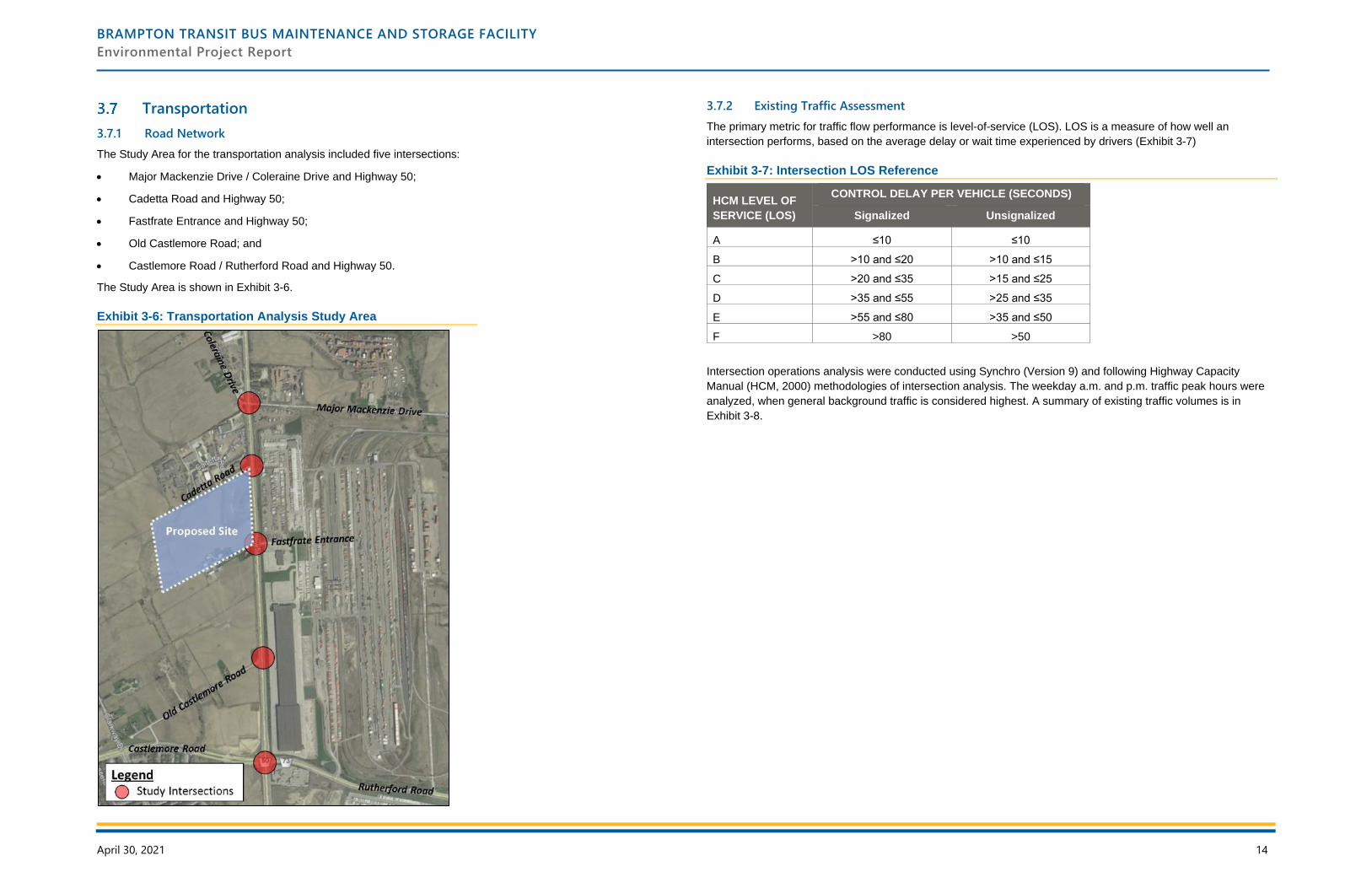
BRAMPTON TRANSIT BUS MAINTENANCE AND STORAGE FACILITY
Environmental Project Report
April 30, 2021 14
Transportation
3.7.1 Road Network
The Study Area for the transportation analysis included five intersections:
• Major Mackenzie Drive / Coleraine Drive and Highway 50;
• Cadetta Road and Highway 50;
• Fastfrate Entrance and Highway 50;
• Old Castlemore Road; and
• Castlemore Road / Rutherford Road and Highway 50.
The Study Area is shown in Exhibit 3-6.
Exhibit 3-6: Transportation Analysis Study Area
3.7.2 Existing Traffic Assessment
The primary metric for traffic flow performance is level-of-service (LOS). LOS is a measure of how well an
intersection performs, based on the average delay or wait time experienced by drivers (Exhibit 3-7)
Exhibit 3-7: Intersection LOS Reference
HCM LEVEL OF
SERVICE (LOS)
CONTROL DELAY PER VEHICLE (SECONDS)
Signalized Unsignalized
A ≤10 ≤10
B >10 and ≤20 >10 and ≤15
C >20 and ≤35 >15 and ≤25
D >35 and ≤55 >25 and ≤35
E >55 and ≤80 >35 and ≤50
F >80 >50
Intersection operations analysis were conducted using Synchro (Version 9) and following Highway Capacity
Manual (HCM, 2000) methodologies of intersection analysis. The weekday a.m. and p.m. traffic peak hours were
analyzed, when general background traffic is considered highest. A summary of existing traffic volumes is in
Exhibit 3-8.
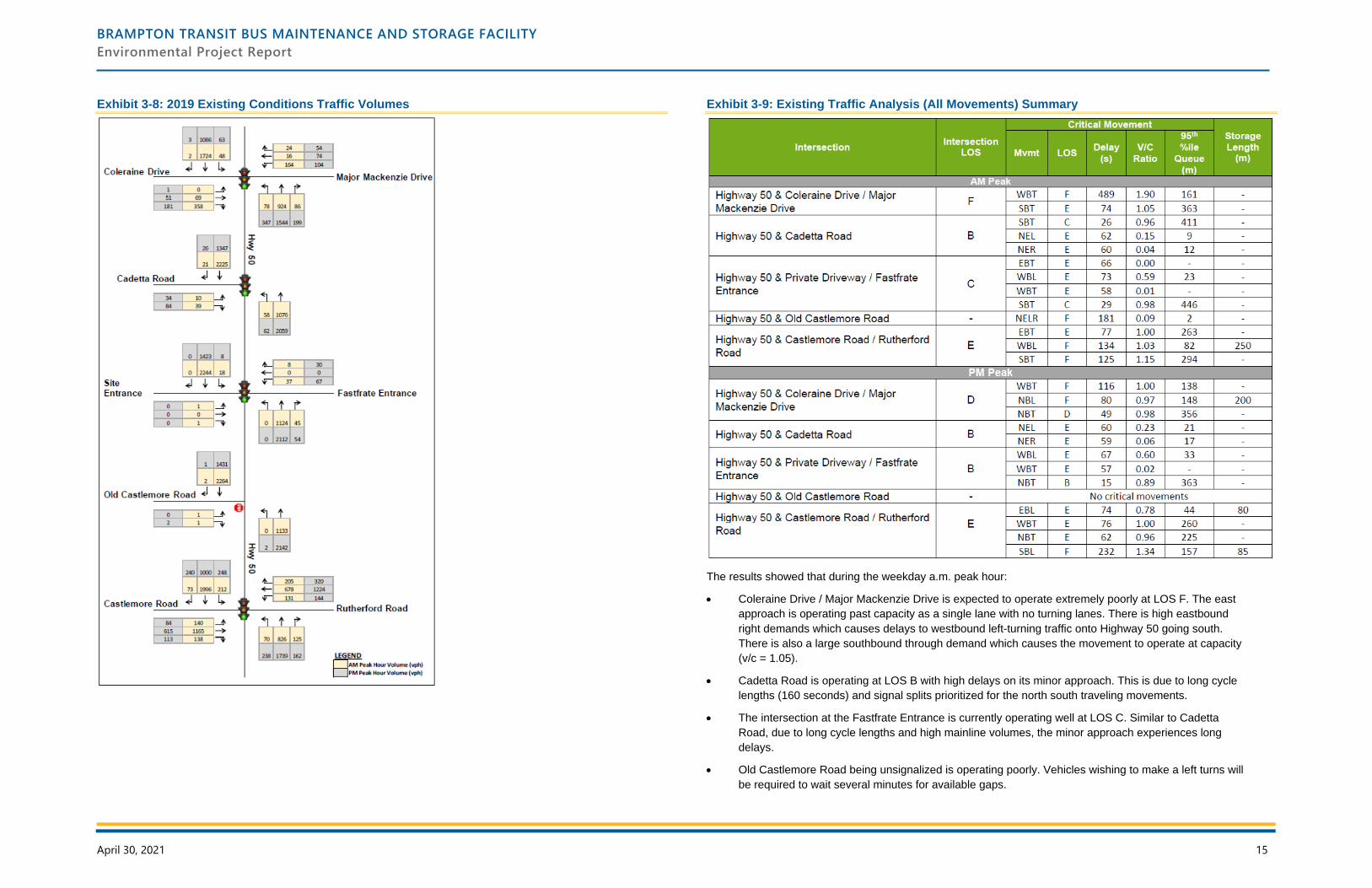
BRAMPTON TRANSIT BUS MAINTENANCE AND STORAGE FACILITY
Environmental Project Report
April 30, 2021 15
Exhibit 3-8: 2019 Existing Conditions Traffic Volumes
Exhibit 3-9: Existing Traffic Analysis (All Movements) Summary
The results showed that during the weekday a.m. peak hour:
• Coleraine Drive / Major Mackenzie Drive is expected to operate extremely poorly at LOS F. The east
approach is operating past capacity as a single lane with no turning lanes. There is high eastbound
right demands which causes delays to westbound left-turning traffic onto Highway 50 going south.
There is also a large southbound through demand which causes the movement to operate at capacity
(v/c = 1.05).
• Cadetta Road is operating at LOS B with high delays on its minor approach. This is due to long cycle
lengths (160 seconds) and signal splits prioritized for the north south traveling movements.
• The intersection at the Fastfrate Entrance is currently operating well at LOS C. Similar to Cadetta
Road, due to long cycle lengths and high mainline volumes, the minor approach experiences long
delays.
• Old Castlemore Road being unsignalized is operating poorly. Vehicles wishing to make a left turns will
be required to wait several minutes for available gaps.
BRAMPTON TRANSIT BUS MAINTENANCE AND STORAGE FACILITY
Environmental Project Report
April 30, 2021 16
• Castlemore Road / Rutherford Road is expected to operate poorly at LOS E. The eastbound through
and its opposing westbound left movements are at capacity, operating at LOS E and F respectively.
With the large southbound through demands, the movement is also overcapacity.
During the weekday p.m. peak hour:
• Coleraine Drive / Major Mackenzie Drive is expected to operate with moderate congestion at LOS D.
The east approach continues to operate at capacity. There are heavy northbound demands, with the
northbound left and northbound through and right operating slightly below capacity.
• Cadetta Road is currently operating well at LOS B. The minor approach continues to operate with
modest delays but under capacity.
• The intersection at the Fastfrate Entrance is also operating well at LOS B. The east approach
experiences some delays. The northbound through on Highway 50 causes the movement to be
critical but with low overall average delays.
• Castlemore Road / Rutherford Road is experiencing high delays with critical movements for all
approaches. The eastbound left and its opposing westbound through movements are either critical or
at capacity. The high northbound through and southbound left demands causes the conflicting
movements to experience long delays, both of which are near or overcapacity.
Overall, the study intersections are operating with moderate/long delays with the a.m. peak being more critical. All
study intersections are operating with critical movements, most notably Coleraine Drive / Major Mackenzie Drive
and Castlemore Road / Rutherford Road intersections.
It is also observed that traffic is generally oriented south during the a.m. peak hour and north during the p.m. peak
hour. With high demands on the mainline, the minor streets experience longer delays merging onto Highway 50
with minimal available gaps.
3.7.3 Active Transportation
There are currently no sidewalks or bicycle lanes within the Study Area. Active transportation facilities have been
proposed in the Highway 50 & Mayfield Road Class Environmental Assessment (Region of Peel, 2012) and are
expected to a part of the future road configuration. A multi-use path trail is planned on the west side on Highway
50 as well as a potential 1.5 m sidewalk on the east side. Based on the Region of Peel’s LRTP (2019), the existing
cycle route south of Castlemore Road / Rutherford Road is proposed to be extended through the Study Area to
Mayfield Road with connections to Coleraine Drive. These projects are currently underway and should provide
safe, connected and protected cycling and pedestrian network surrounding the subject lands.
3.7.4 Transit System
Given the current land-use and location of the bus facility, it is expected that very few bus routes will be in service
along Highway 50 within the study horizon. Since the site is a bus facility, where multiple routes begin and end
their trips, staff may have opportunities to receive a ride during regular hours. Some staff will not be able to access
the site via transit, as they will need to begin their work hours before or after transit operation hours.
BRAMPTON TRANSIT BUS MAINTENANCE AND STORAGE FACILITY
Environmental Project Report
April 30, 2021 17
4 Impact Assessment, Mitigation and Monitoring
Impact assessments were completed to identify how the undertaking may affect the natural and cultural
environment. Mitigation measures are proposed to minimize potential negative impacts and result in a net benefit
to the environment. Impacts and mitigation measures are outlined in the following sections, by study.
Natural Heritage
The following section identifies the potential impacts of the proposed improvements on the natural heritage
features within the study area. Mitigation measures to help minimize potential negative impacts are proposed.
4.1.1 Aquatic Habitat and Communities
Potential Impacts
The proposed site development is not expected to impact the watercourse or its associated riparian area.
Mitigation
Consideration for the quantity and quality of drainage and/or stormwater inputs should be implemented, and the
function of the feature should be maintained through site controls and mitigation measures during construction.
4.1.2 Vegetation and Vegetation Communities
Potential Impacts
Construction will result in the removal of 8.62 ha of naturalized and anthropogenically disturbed lands. The largest
area of impact (7.39 ha) will be human influenced land, including agricultural and manicured areas. In addition,
1.23 ha of dry-moist old field meadow will be removed.
All of the vegetation communities identified within the study area are considered to be widespread and common in
Ontario and secure globally. No plant species at risk were identified during the investigation.
Net Effects
Net effects are limited to a minor loss of old field meadow vegetation, while the overall significance of the impact to
the human influenced lands is considered low. There will be no impacts on rare, threatened or endangered
vegetation communities.
4.1.3 Wildlife and Wildlife Habitat
Potential Impacts
Potential impacts to wildlife would be directly associated with impacts to vegetation, which comprises their habitat:
• Displacement of/disturbance to wildlife and wildlife habitat;
• Barrier effects and interruptions to wildlife passage corridors;
• Disturbance to wildlife from noise, light and visual intrusion;
• Potential impacts to migratory birds; and,
• Displacement of rare, threatened or endangered wildlife or significant wildlife habitat.
Mitigation
Proposed mitigation measures include:
• Compliance with the MBCA for tree removal and clearing of any vegetation. The MBCA protects the
nests, eggs and young of migratory birds. Compliance measures will include seasonal avoidance of
bird nesting season (late March to late August), or nest surveys by a qualified biologist to search for
and avoid active nests during nesting season. While no nesting birds were observed, there was
evidence of nesting behaviour in the area.
• Avoiding the disturbance of any animal found within the construction area, and allowing it to leave on
its own. Photos for identification should be taken of animals observed onsite, if possible. If Threatened
or Endangered species are discovered during site preparation or construction, activities will stop, or
be modified to avoid negative impacts to SAR until further direction is provided by the MNRF. In the
event of such a discovery, MNRF District office should be contacted promptly.
• Further consultation with MECP will take place during detail design regarding any general habitat
protection measures that will be required for the wildlife species at risk that are or have the potential
to be located in the vicinity of the study area and are regulated as ‘Endangered’ or ‘Threatened’ under
the Endangered Species Act.
• To reduce the impact of noise and light, tree/shrubs plantings can be used to reduce noise/light
disturbance and to increase natural cover along this feature. Directional lighting should also be
considered along this feature to reduce light pollution within the natural area associated with this
watercourse. Both of these will be considered during detail design.
Net Effect
Potential net effects are limited to minor loss of wildlife habitat. No new barriers or wildlife/vehicle conflicts will be
created as a result of the new facility.
Cultural Heritage
4.2.1 Archaeology
As part of the Stage 1 Archaeological Assessment, the property inspection determined that portions of the Study
Area exhibit archaeological potential. These areas required a Stage 2 Archaeological Assessment, which was
conducted from September 17 to 18, 2020, in accordance with the Ontario Heritage Act (1990, as amended in
2018) and the 2011 Standards and Guidelines for Consultant Archaeologists, administered by the Ministry of
Heritage, Sport, Tourism and Culture Industries (MHSTCI, 1990). The assessment consisted of a pedestrian
survey at a minimum of 5 m intervals, and test pit surveys in areas where pedestrian surveys were not feasible.
Stage 1 is currently under review by MHSTCI and will be completed by March 31, 2021. Stage 2 has been
completed and will be filed with MHSTCI during detail design. Stages 1 and 2 are currently under review by
MHSTCI.
Potential Impacts
The Stage 2 assessment determined that there is low archaeological potential, and the study area does not require
further archaeological assessment.
BRAMPTON TRANSIT BUS MAINTENANCE AND STORAGE FACILITY
Environmental Project Report
April 30, 2021 18
Mitigation
Should the proposed work extend beyond the current Study Area, or should changes to the project design or
temporary workspace requirements result in the inclusion of previously un-surveyed lands, these lands should be
subject to a Stage 2 archaeological assessment.
4.2.2 Built Heritage Resources and Cultural Heritage Landscapes
The Cultural Heritage Resource Assessment determined that there are two cultural heritage resources, consisting
of two farmscapes, within the Study Area. Both cultural heritage resources are identified in the City of Brampton’s
Municipal Register of Cultural Heritage Resources: ‘Listed’ Heritage Properties. As of November 2020, 10192A
Highway 50 is in in the process of being designated.
Potential Impacts
Potential impacts are provided below, by cultural heritage resource.
Cultural Heritage Resource #1 (10192A Highway 50)
Impacts to cultural heritage resource #1 are anticipated to include the demolition of several outbuildings on the
property, removal of agricultural fields, tree clearing, grading, and property acquisition. The entire northern portion
of active agricultural land is anticipated to be directly impacted, as are several late twentieth or early twenty-first-
century outbuildings directly adjacent to the agricultural fields. The residence and nineteenth-century outbuildings
are not anticipated to be directly impacted. The property is in the process of being designated as of November
2020, as a Notice of Intention to Designate has been served.
A Heritage Permit application was submitted in October 2019 for the demolition of one framed storage building,
two steel framed storage buildings and three framed lean-tos, and the relocation and restoration of two timber
barns. The heritage permit application was approved by City Council on October 23, 2019 (Council Resolution:
HB066-2019/PDC170-2019/C400-2019), subject to the following conditions:
• That prior to the disassembling of the timber barns, the applicant submit documentation in the form of
photographs and measured drawings of the two timber barns to be relocated to City of Brampton
Heritage staff and the Peel Archives; and,
• That photographs of the completed restoration of the timber barns be shared with the Brampton
Heritage Board.
City Heritage staff confirmed they have received the necessary documentation for the restoration of the two timber
barns, and the work has been completed.
A CHER was completed in January 2021, following O. Reg. 9/06. The evaluation determined that the property has
design/physical value as a representative example of an Italianate house with Romanesque Revival influences,
historical/associative value for its association with the Johnston family, and contextual value for its role in
supporting and maintaining the agricultural character of the area. The CHER recommended that a Heritage
Impact Assessment (HIA) be conducted during the detail design phase to assess potential impacts and determine
appropriate mitigation measures.
Cultural Heritage Resource #2 (10307 Clarkway Drive)
No direct impacts are anticipated to cultural heritage resource #2. Indirect impacts are anticipated to include
grading, tree clearing, and proposed property acquisition of the property adjacent to the cultural heritage resource.
Mitigation
Mitigation measures are provided below, by cultural heritage resource.
Cultural Heritage Resource #1 (10192A Highway 50)
Where feasible, the preferred alternative should be designed in a manner that avoids all impacts to the cultural
heritage resource. The CHER recommended that a HIA should be conducted, given the cultural heritage value of
the property. The Cultural Heritage Resource Assessment should be updated with his information. The HIA will be
presented to the Brampton Heritage Board.
Prior to the disassembling of the timber barns, documentation in the form of photographs and measured drawings
of the two timber barns that are to be relocated must be submitted to City of Brampton Heritage staff and the
Region of Peel Archives. Additionally, photographs of the completed restoration of the timber barns must be
shared with the Brampton Heritage Board.
Cultural Heritage Resource #2 (10307 Clarkway Drive)
Impacts are anticipated to be confined to the adjacent property parcel. No direct impacts are anticipated to the
cultural heritage resource. ASI conducted a HIA for the farmscape at 10307 Clarkway Drive in 2016 as part of
another project and determined that the farmscape did not retain significant cultural heritage value following an
evaluation with O.Reg 9/06 (ASI, 2016).
Staging and construction activities should be suitably planned to avoid impacts to cultural heritage resources. The
full report is available in Appendix D.
Socio-Economic
4.3.1 Land Use
Potential Impacts
The development of the MSF will result in changes to the existing agricultural land use and natural open space on
the property, both during construction and permanently with the final development and operation of the facility. The
change in land use, along with the transition of the rural naturalized landscape to a more urban industrial
environment, is consistent with prevailing policies and planning objectives. Minimal impact is expected to
surrounding lands during construction and operations (e.g. noise, vibration, dust, light and traffic). The only
sensitive uses within proximity to the Study Area are the few single residential dwellings associated with either
active or historic farmsteads. The closest residential dwelling is located approximately 70 metres south of the
proposed outdoor bus exiting lane and staging area for the MSF. The construction and operation of the MSF
should not interfere with current local agricultural operations or negatively impact existing industrial operations and
future industrial development.
Mitigation
A development plan which protects for key cultural and natural heritage features and the execution of a
Construction Management Plan and Communication Plan which outlines best practices and mitigation measures
will help minimize negative impacts resulting from construction and ongoing operations. Operations of the MSF will
be carried out in accordance with applicable regulation, standards and best practices.
Net Effects
Net effects are limited to the change from agricultural land use and rural landscape to a more urban industrial
environment, as intended by prevailing planning policies. The MSF may facilitate additional industrial or
employment-related development in the area.
BRAMPTON TRANSIT BUS MAINTENANCE AND STORAGE FACILITY
Environmental Project Report
April 30, 2021 19
4.3.2 Population and Employment
Potential Impacts
The construction and operation of the MSF is expected to have minimal negative impact on the existing local
population given there are few people residing within proximity to the proposed facility (i.e. three residential
dwellings exist within approximately one kilometre of the Study Area) and because planning policies restrict new
residential from being developed within employment or industrial areas. The MSF and growth fleet will help to
expand the existing transit service. This will benefit the broader municipal and regional population by allowing for
increased access to transit, more mobility mode choice, transportation cost savings and improved air quality.
Both the construction and ongoing operations of the MSF will create new jobs (direct and indirect) and increased
local spending. The construction and operation of the MSF should have negligible impacts on the estimated 20
businesses located within approximately one kilometre of the Study Area, but the project may help stimulate
further economic development and growth within the planned industrial node. The MSF and associated increase in
transit service also has the potential to stimulate broader economic development and growth.
Mitigation
Through the EA process, continual information exchanges and opportunities for meaningful involvement will help
reduce any potential negative impacts on local residents and businesses. Operations of the MSF will be carried out
in accordance with applicable regulation, standards and best practices.
Net Effects
Overall, the MSF is expected to have a net positive effect. The effects of the MSF include the creation of jobs and
spending during construction and operations of the facility and the potential for expanded transit service to
stimulate local and broader municipal economic development and growth. Local and regional populations will
benefit from increased levels of transit service and associated health, economic and community benefits.
Noise
4.4.1 Potential Impacts
To assess how future noise levels will be impacted by MSF operations, future sound levels were modelled with the
Cadna A v2020 software package and compared to the MECP exclusionary limits. The approach uses “worst-
case” operational assumptions for the facility, including a diesel bus engine fleet. The on-site noise sources include
air-handling units, rooftop electric fans, rooftop air-conditioning units, forklifts, compressors, a transformer, impact
wrenches, snow melting devices, a dump truck/snow plough, fueling vehicles, bus traffic, bus brake testing area,
and emergency generators. The modelling was completed for Phase 1 and for the Phase 2 future building
expansion. The full methodology, sound power levels and other assumptions are available in Appendix F.
Daytime and nighttime noise levels produced by the on-site noise sources at the existing off-site residential
receivers defined in Section 3.4 are summarized in
Exhibit 4-1. Given that the proposed unattenuated noise levels exceed the MECP exclusionary limits, mitigation
measures are required. With mitigation measures, daytime and nighttime noise levels will meet the MECP
exclusionary limits at Receiver 1 and Receiver 2.
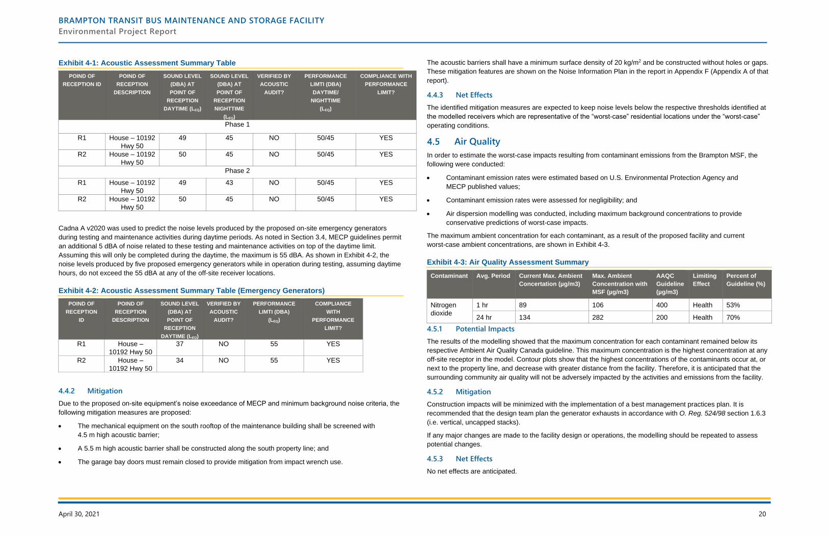
BRAMPTON TRANSIT BUS MAINTENANCE AND STORAGE FACILITY
Environmental Project Report
April 30, 2021 20
Exhibit 4-1: Acoustic Assessment Summary Table
POIND OF
RECEPTION ID
POIND OF
RECEPTION
DESCRIPTION
SOUND LEVEL
(DBA) AT
POINT OF
RECEPTION
DAYTIME (LEQ)
SOUND LEVEL
(DBA) AT
POINT OF
RECEPTION
NIGHTTIME
(LEQ)
VERIFIED BY
ACOUSTIC
AUDIT?
PERFORMANCE
LIMTI (DBA)
DAYTIME/
NIGHTTIME
(LEQ)
COMPLIANCE WITH
PERFORMANCE
LIMIT?
Phase 1
R1 House – 10192
Hwy 50
49 45 NO 50/45 YES
R2 House – 10192
Hwy 50
50 45 NO 50/45 YES
Phase 2
R1 House – 10192
Hwy 50
49 43 NO 50/45 YES
R2 House – 10192
Hwy 50
50 45 NO 50/45 YES
Cadna A v2020 was used to predict the noise levels produced by the proposed on-site emergency generators
during testing and maintenance activities during daytime periods. As noted in Section 3.4, MECP guidelines permit
an additional 5 dBA of noise related to these testing and maintenance activities on top of the daytime limit.
Assuming this will only be completed during the daytime, the maximum is 55 dBA. As shown in Exhibit 4-2, the
noise levels produced by five proposed emergency generators while in operation during testing, assuming daytime
hours, do not exceed the 55 dBA at any of the off-site receiver locations.
Exhibit 4-2: Acoustic Assessment Summary Table (Emergency Generators)
POIND OF
RECEPTION
ID
POIND OF
RECEPTION
DESCRIPTION
SOUND LEVEL
(DBA) AT
POINT OF
RECEPTION
DAYTIME (LEQ)
VERIFIED BY
ACOUSTIC
AUDIT?
PERFORMANCE
LIMTI (DBA)
(LEQ)
COMPLIANCE
WITH
PERFORMANCE
LIMIT?
R1 House –
10192 Hwy 50
37 NO 55 YES
R2 House –
10192 Hwy 50
34 NO 55 YES
4.4.2 Mitigation
Due to the proposed on-site equipment’s noise exceedance of MECP and minimum background noise criteria, the
following mitigation measures are proposed:
• The mechanical equipment on the south rooftop of the maintenance building shall be screened with
4.5 m high acoustic barrier;
• A 5.5 m high acoustic barrier shall be constructed along the south property line; and
• The garage bay doors must remain closed to provide mitigation from impact wrench use.
The acoustic barriers shall have a minimum surface density of 20 kg/m2 and be constructed without holes or gaps.
These mitigation features are shown on the Noise Information Plan in the report in Appendix F (Appendix A of that
report).
4.4.3 Net Effects
The identified mitigation measures are expected to keep noise levels below the respective thresholds identified at
the modelled receivers which are representative of the “worst-case” residential locations under the “worst-case”
operating conditions.
Air Quality
In order to estimate the worst-case impacts resulting from contaminant emissions from the Brampton MSF, the
following were conducted:
• Contaminant emission rates were estimated based on U.S. Environmental Protection Agency and
MECP published values;
• Contaminant emission rates were assessed for negligibility; and
• Air dispersion modelling was conducted, including maximum background concentrations to provide
conservative predictions of worst-case impacts.
The maximum ambient concentration for each contaminant, as a result of the proposed facility and current
worst-case ambient concentrations, are shown in Exhibit 4-3.
Exhibit 4-3: Air Quality Assessment Summary
Contaminant Avg. Period Current Max. Ambient
Concertation (µg/m3)
Max. Ambient
Concentration with
MSF (µg/m3)
AAQC
Guideline
(µg/m3)
Limiting
Effect
Percent of
Guideline (%)
Nitrogen
dioxide
1 hr 89 106 400 Health 53%
24 hr 134 282 200 Health 70%
4.5.1 Potential Impacts
The results of the modelling showed that the maximum concentration for each contaminant remained below its
respective Ambient Air Quality Canada guideline. This maximum concentration is the highest concentration at any
off-site receptor in the model. Contour plots show that the highest concentrations of the contaminants occur at, or
next to the property line, and decrease with greater distance from the facility. Therefore, it is anticipated that the
surrounding community air quality will not be adversely impacted by the activities and emissions from the facility.
4.5.2 Mitigation
Construction impacts will be minimized with the implementation of a best management practices plan. It is
recommended that the design team plan the generator exhausts in accordance with O. Reg. 524/98 section 1.6.3
(i.e. vertical, uncapped stacks).
If any major changes are made to the facility design or operations, the modelling should be repeated to assess
potential changes.
4.5.3 Net Effects
No net effects are anticipated.
BRAMPTON TRANSIT BUS MAINTENANCE AND STORAGE FACILITY
Environmental Project Report
April 30, 2021 21
4.5.4 Monitoring
Upon final selection of equipment and exhaust fans for the facility, the City will need to register in the
Environmental Activity and Sector Registry.
Geotechnical and Hydrogeology
4.6.1 Fluvial Geomorphology
A fluvial geomorphological assessment was undertaken for Rainbow Creek. The meander belt widths were tested
for two scenarios: the current Rainbow Creek alignment, as well as a realignment of the creek that is proposed by
other works.
Potential Impacts
A Master Environmental Servicing Plan (MESP) was completed in 2016 for an adjacent development, referred to
as Area 47. As part of the development, there were plans to realign Rainbow Creek. In 2019, an addendum was
created for the MESP to present an alternative natural corridor design. The design offers a significant improvement
to channel form and function when compared to existing conditions, and the corridor was designed to convey the
Regional storm and eliminate the flooding hazard within the existing Cadetta Road industrial area, immediately
north of the subject lands.
The corridor alignment proposed through the MESP addendum would result in a shift of the Rainbow Creek
channel to the west, upstream of the subject lands, adjacent to Cadetta Road. Within/immediately adjacent to the
subject lands, the corridor would result in an overall shift to the east. Notably, the proposed realignment would
result in a significant reduction in the floodplain, as it is designed to safely convey the Regional storm event. This
would therefore result in a reduced hazard to the future transit facility. As the timing of implementation of the
naturalized corridor is currently uncertain, meander belt widths for the existing channel and proposed realigned
corridor were reviewed. Meander belts widths determined as part of the MESP study were refined.
Mitigation
Meander belt widths were determined using empirical modelling. The recommended meander belt width for Reach
RCT-4 is 25 metres. Although the modelled belt width for Reach RCT-3 was 10 metres, as a conservative
approach a meander belt width of 25 m was applied. These value includes a 20% factor of safety and is
considered a theoretical belt width given the exiting channel is poorly defined, vegetation controlled, and has
limited erosion/migration potential.
Erosion control requirements for the realigned channel were outlined in the MESP. To minimize downstream
erosion, a stormwater retention of 5 mm is required. This is to be achieved through onsite controls or conveyance
LID techniques (e.g., bioswales). Extended detention storage is also required to capture and release runoff from a
25 mm storm event over 48 hours.
Net Effects
From a geomorphological perspective, the capture and gradual release of all storm events up to the 25 mm event
was anticipated to provide control for over 90% of all storm events in a typical year. While proposed through the
MESP, the mitigation measures are carried forward as they were found to be suitable for the proposed works.
Details are provided in Appendix H.
4.6.2 Groundwater and Site Contamination
Potential Impacts
Groundwater levels could be reduced by construction activities, such as deep foundation and large excavation.
There are 28 registered wells within 300 metres of the Study Area.
During construction, short-term discharge of water from dewatering may need to be released to the natural
environment or directed to the Region of Peel or the City of Brampton sewer systems.
The improper handling and storage of fuel and other chemicals during construction can pose a risk to groundwater.
Discharge from construction activities could also potentially impact groundwater quality.
Mitigation
Dewatering will occur only in the surficial/shallow hydro-stratigraphic units and the existing water supply wells are
not expected to be used. During detail design, potential chemical impacts are to be noted in the tender documents
along with appropriate mitigation measures that the contractor is to implement. If short-term discharge of water
from dewatering is released to the local sewer systems, the discharge water quality needs to meet Provincial
Water Quality Objectives (PWQO) or the sewer discharge limits.
Monitoring wells within the Study Area that are no longer in use should be decommissioned prior to the
commencement of construction activities by a licenced well contractor in accordance with O. Reg. 903. If any of
these existing wells are retained for continued monitoring and sampling purposes, they should be clearly marked
and protected during proposed construction activities
Prior to construction at the site, the status of all water wells within the 500 m radius of the site should be confirmed.
If wells are identified, the City will create and implement a monitoring and mitigation program to predict and/or
confirm effects on water wells during construction and outline a response should these wells become affected by
construction activities.
Refueling of pumps and construction equipment will be conducted away from excavations and dewatering
operations.
A plan will be developed to guide the handling, management and disposal of groundwater encountered during site
work. The plan should include, but not be limited to plans for encountering productive water bearing zones,
mitigating potential impacts to surface water and groundwater users, and groundwater monitoring plans.
Net Effects
There will be a positive net effect on groundwater as a result of site remediation activities to remove contaminants.
Monitoring
Under the advice of the TRCA, groundwater level monitoring will continue at the installed monitoring well for a
minimum of 12 months.
4.6.3 Source Water Protection
Potential Impacts
The Credit Valley – Toronto and Region – Central Lake Ontario Source Projection Plan, dated March 25, 2019,
identifies 21 prescribed threats for which they provide policy direction on. Of these listed threats, the following may
potentially apply to this project:
• Threat 2: The establishment, operation or maintenance of a system that collects, stores,
transmits, treats or disposes of sewage. Potential impacts exist when establishing, operating or
BRAMPTON TRANSIT BUS MAINTENANCE AND STORAGE FACILITY
Environmental Project Report
April 30, 2021 22
maintaining a system that collects, stores, transmits, treats or disposes of sewage such as stormwater
management facilities designed to discharge stormwater to land or surface water; and sanitary
sewers and related pipes.
• Threat 12: The application of road salt. The application of road salt can pose a risk to drinking
water sources. This impact occurs as a result of salt being used for winter maintenance on all
Brampton and Peel right-of-way corridors, and properties with driveways, walkways, sidewalks and
parking lots. This impact does not solely apply to the new operations and maintenance facility.
• Threat 15: The handling and storage of fuel. The improper handling and storage of fuel and other
chemicals during construction and operation of the facility can pose a risk to any drinking water
sources.
• Threat 16: The handling and storage of dense non-aqueous phase liquid. See fuel for potential
impacts.
• Threat 16: The handling and storage of an organic solvent. See fuel for potential impacts.
• Threat 20: An activity that reduces the recharge of an aquifer. The construction of impervious
surfaces may impede the ability for the aquifer to recharge.
Mitigation
Sewage Systems
The project will discharge into existing sanitary, storm and/or onsite storage tank network, and no new discharges
are anticipated. If any new storm or sanitary sewers are required, approval from MECP through an Environmental
Compliance Approval (ECA) will be required prior to construction. This gives approval under Section 53 of the
OWRA. This approval applies to all new sewers and stormwater management facilities proposed as part of the
project and will need to be obtained at the detail design stage prior to construction.
Road Salt
The City maintains best practices in regard to road salt management, while the Region of Peel, who maintains
Highway 50, have a Salt Management Plan. The City follows legislation that exists to safeguard that these items
do not become a risk to drinking water sources.
Fuel and other Chemicals
During detail design of the operations and maintenance facility, potential chemical uses and impacts are to be
noted in the tender documents along with appropriate mitigation measures that the contractor is to implement.
Potential chemical uses and impacts for the facilities operation will be considered and any required approvals will
be obtained prior to the start of operations
Groundwater Recharge
The footprints of buildings and structures will be minimized to reduce the impacts of surface hardening on the
groundwater recharge. Other mitigation measures to reduce the impact include minimizing ground disturbance
areas during construction and implementing low impact development or green stormwater practices and
management systems during the design of the facility.
Net Effects
Sewage Systems
No net effects to source water from the new sewers are anticipated as existing storm and sanitary discharges will
be used, which will have no net effect. If new storm or sanitary sewers are required, they will be subject to ECA
approval, which will safeguard the protection of sources of municipal drinking water against existing and potential
impacts.
Road Salt
No net effects to source water are anticipated, given the limited increase in area where road salt may be used,
relative to all other surfaces in the City.
Fuel and other Chemicals
No net effects to source water are anticipated, given the appropriate handling of fuel and other chemicals during
both construction and operation.
Groundwater Recharge
There will be minimal impact on groundwater recharge. The removal of contaminants will be an improvement.
Monitoring
The contract administrator will monitor construction activities to safeguard that no intentional discharges occur to
the environment. This information is to be included in the Environmental Plan for approvals and should include
such items as the following:
• Refueling and cleaning of equipment is to occur away from any watercourse;
• Fuel spill equipment should be available for emergency spills of deleterious substances; and,
• A contact list for any further required equipment or materials should be prepared and made available
for emergency use.
4.6.4 Stormwater
Potential Impacts
The proposed facility will increase impervious surface areas within the Study Area, reducing infiltration of
precipitation and increased runoff. After Phase 2 of construction, the impervious area will increase to 68.5% and
the run-off coefficient will increase to 0.70.
Mitigation
The site will be discretized as one catchment area in the proposed condition (Catchment 3) for both Phase 1 and
Phase 2 of construction. Runoff from the entire site will be collected by a proposed storm sewer system and
conveyed to a proposed stormwater management pond in the southwest quadrant of the site. The stormwater
management pond will be equipped with orifice control at the outlet in order to control the rate of discharge into
West Rainbow Creek. The proposed MSF building will be equipped with roof drains to direct roof water towards the
pond. All post-development on-site runoff will ultimately discharge into West Rainbow Creek through the
stormwater management pond.
The total pond volume is the sum of permanent pool volume and the active storage volume, which is the sum of
the flood control and erosion control volumes discussion in the next two subsections. Therefore, a storage volume
of 10,658 m2 is needed.
BRAMPTON TRANSIT BUS MAINTENANCE AND STORAGE FACILITY
Environmental Project Report
April 30, 2021 23
Exhibit 4-4: Stormwater Pond Storage Volume Requirements
Permanent Pool Volume (m3) Active Storage Volume (m3) Total Storage Volume (m3)
Quantity Control Flood Control Erosion Control Total
3,307 4,700* 2,921 7,632 10,658
* Flood Control Volume rounded up from 4,652.77 m3 to 4,700 m3 for a more conservative approach
Water Quantity (Flood) Control
As a result of the new satellite yard development, water quantity (flood) control is required for the entire site. Since
the site is located within the Humber River watershed, unit flow control is required for all design storms (2 to 100
year events). Unit flow equations for each storm event were taken from Table E.1 of Appendix A within the TRCA
Stormwater Management Criteria (August 2012) guidelines based on Sub-Basin 36 (Equation F).The flood control
storage volume requirement for the satellite yard was calculated to be 4652.77 m3 and determined by the Modified
Rational Method with an inflow rate equal to the 100-year ultimate condition uncontrolled flow for the entire site
(5.65 m3/s) and an outflow rate equal to the 100-year controlled discharge (0.39 m3/s). Orifice control is proposed
at the stormwater management pond outlet to control the discharge into West Rainbow Creek.
Exhibit 4-5 summarizes the flood control storage volume requirements on site. Sizing calculation for orifice controls
will be provided in the detail design.
Exhibit 4-5: Flood Control Storage Volume Requirements
Flow (m3) Flood Control Required Storage Volume (m3)
Ultimate Condition 100-Year
Uncontrolled Rate
100-Year Controlled
Release Rate
5.653 0.390 4,652.77
Water Quality Control
As stipulated in the TRCA Stormwater Management Criteria (August 2012), quality control requirements for the
site must comply with Enhanced Level Protection, defined by the MECP as 80% total suspended solids removal.
For the satellite yard, water quality control is achieved through implementation of the stormwater management
pond, specifically through the Permanent Pool volume.
Interpolating the data within Table 3.2 of the MECP’s Stormwater Management Planning and Design Manual
(March 2003), based on a site imperviousness of 68.5% under ultimate conditions, the water quality unit storage
requirement for the proposed stormwater management pond is 222 m3/ha. Subtracting the 40 m3/ha Extended
Detention volume requirement and multiplying by total site area results in a Permanent Pool volume of 3037 m3 for
the proposed stormwater management pond to address water quality control for the site.
Erosion Control
As stipulated in the TRCA Stormwater Management Criteria (August 2012), to address erosion control for sites
with a stormwater management pond, extended detention of the 25 mm storm event is required for a period of 48
hours. The resulting erosion control storage volume for the site is 2,921 m3.
Net Effects
No net effects to stormwater are anticipated. Sizing calculations of the orifice controls will be provided during detail
design.
Monitoring
A monitoring strategy will be developed as part of detail design to monitor that the implemented stormwater
management infrastructure meets design requirements
Transportation
The site is proposed to have two accesses. Vehicle access is proposed at Cadetta Road (north access) which is
currently a signalized intersection. The second access is located at the opposite leg of the Fastfrate entrance. This
second access will connect to the existing farm property driveway (south access).
The future condition analysis considered planned road widenings within the Study Area. These improvements
include: a new arterial road connecting to the west leg of Major Mackenzie Drive intersection, widening of Highway
50 and Major Mackenzie Drive, and a potential construction of a single point urban interchange at Highway 50 &
Major Mackenzie Drive around 2041.
The 2012 Environmental Assessment for Highway / Regional Road 50 completed by HDR projected a widening of
Highway 50 to 6 lanes with left turn lanes by 2031. Growth rates were extracted by comparing the EMME model
morning and evening peak hour outputs received from the City for 2011 and 2041, which include widening to 3
lanes in each direction, as well as the planned GTA West corridor located north of the study corridor.
These EMME model outputs for the relevant sections of Highway 50 adjacent to the Study Area and the calculated
compound annual growth rate. While the 2041 traffic analysis only uses the Highway 50 volumes and growth rates,
the total calculated growth rate includes the volume changes for Cadetta Road and Castlemore Road.
Resulting calculations showed southbound volumes are significantly higher in the a.m. peak period and lower in
the p.m. peak, and the opposite for northbound volumes. This behaviour is expected and should reflect commuters
going to and from work. There are negative growth rates for northbound Highway 50 in the a.m. peak period, and
southbound in the p.m. peak period. This is likely due to traffic diverted to other major north-south corridors such
as the planned Highway 427 extension.
From this calculation using total volumes, a compound annual growth rate of 1.3% was used in projecting future
traffic volumes. Population and employment growth rates from the Region of Peel were also considered for the
period between 2011 and 2041. These compound annual growth rates of 1.27% and 1.36%, respectively, support
the chosen 1.3% growth rate for future traffic.
4.7.1 2031 Background Volumes
Using the growth rates, existing traffic volumes were grown to the 2031 horizon. These volumes represent future
base conditions and do not include trips generated from the bus facility. Overall, with the assumed widening of
Highway 50 and the adopted lane configurations from the EA, all study intersections north of Castlemore Road /
Rutherford Road improved due to increased capacity on the mainline. The volumes are shown in Exhibit 4-6.
At Highway 50 and Coleraine Drive, the westbound left movement is operating past capacity with high delays
during the two peak periods (a.m. and p.m.). The minor approaches for these intersections, including the proposed
site accesses continue to operate with high delays, but with sufficient capacity. This is not uncommon for side-
streets on major arterial roadways, and is considered acceptable operations.
At the intersection of Highway 50 and Castlemore Road / Rutherford Road, Highway 50 has been already
widened. As a result, the intersection did not see an improvement and is operating at / near capacity with LOS F
and E during a.m. and p.m. peak hours, respectively. With increased background volumes, several new
movements are now critical with some operating past capacity. Rutherford Road is identified in the York Region
TMP as widening to six lanes for Transit / HOV lanes and is subject to a future EA. As there may not be an
BRAMPTON TRANSIT BUS MAINTENANCE AND STORAGE FACILITY
Environmental Project Report
April 30, 2021 24
increase in capacity for general purpose traffic, the configuration analyzed kept four through lanes east-west for
this study.
Exhibit 4-6: 2031 Future Background Traffic Volumes
4.7.2 2031 Future Total Volumes
The future total volumes represent all traffic expected in the 2031 horizon including traffic generated from the bus
facility. These volumes are shown in Exhibit 4-7.
For the future total conditions, traffic operations are expected deteriorate slightly for the study intersections.
Marginal amounts of passenger and bus fleet vehicles are to be introduced to the study intersections. All of those
demands will be assigned to the two site accesses of Cadetta Road and Fastfrate Entrance. These two
intersections are expected to remain at acceptable LOS (A and B) but with some delays on the minor approaches.
Although there are limited amounts of traffic introduced, Highway 50 and Castlemore Road / Rutherford Road will
deteriorate during the p.m. peak hour and now operate at LOS F. Overall, traffic for the study intersections is
marginally affected by the site generated demands, and where the operational issues arise regardless of the
presence of the proposed facility
4.7.3 2041 Future Background
Using the growth rates, existing traffic volumes were grown to the 2041 horizon. These volumes represent future
base conditions and do not include trips generated from the bus facility. As stated earlier, due to uncertainty with
the major roadway improvements, the 2041 scenarios are limited to the two site accesses.
With the future background growth, the two intersections will remain at acceptable LOS (A & B) and with sufficient
capacity for its movements. Although there will be delays experienced by the minor approaches, the two
intersections are expected to accommodate future volumes (Exhibit 4-8).
BRAMPTON TRANSIT BUS MAINTENANCE AND STORAGE FACILITY
Environmental Project Report
April 30, 2021 25
Exhibit 4-7: 2031 Future Total Traffic Volumes
Exhibit 4-8: 2041 Future Background Traffic Volumes
4.7.4 2041 Future Total Volumes
The future total volumes represent all traffic expected in the 2041 horizon including traffic generated from the bus
facility. These volumes are shown in
Exhibit 4-9.
For the future total conditions, traffic operations deteriorate slightly with the introduction of the site generated
traffic. The northbound left-turn movement at Cadetta Road is critical and is expected to experience longer delays
but with sufficient reserve capacity (v/c = 0.80). Overall, the two site accesses will remain at acceptable LOS.
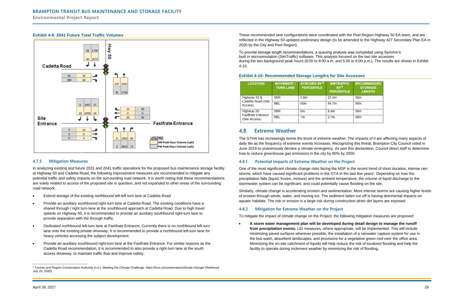
BRAMPTON TRANSIT BUS MAINTENANCE AND STORAGE FACILITY
Environmental Project Report
April 30, 2021 26
Exhibit 4-9: 2041 Future Total Traffic Volumes
4.7.5 Mitigation Measures
In analyzing existing and future 2031 and 2041 traffic operations for the proposed bus maintenance storage facility
at Highway 50 and Cadetta Road, the following improvement measures are recommended to mitigate any
potential traffic and safety impacts on the surrounding road network. It is worth noting that these recommendations
are solely related to access of the proposed site in question, and not expanded to other areas of the surrounding
road network.
• Extend storage of the existing northbound left-left turn lane at Cadetta Road
• Provide an auxiliary southbound right-turn lane at Cadetta Road. The existing conditions have a
shared through / right turn-lane at the southbound approach at Cadetta Road. Due to high travel
speeds on Highway 50, it is recommended to provide an auxiliary southbound right-turn lane to
provide separation with the through traffic.
• Dedicated northbound left-turn lane at Fastfrate Entrance. Currently there is no northbound left-turn
lane onto the existing private driveway. It is recommended to provide a northbound left-turn lane for
heavy vehicles accessing the subject development.
• Provide an auxiliary southbound right-turn lane at the Fastfrate Entrance. For similar reasons as the
Cadetta Road recommendation, it is recommended to also provide a right-turn lane at the south
access driveway, to maintain traffic flow and improve safety.
2 Toronto and Region Conservation Authority (n.d.). Meeting the Climate Challenge. https://trca.ca/conservation/climate-change/ (Retrieved July 20, 2020).
These recommended lane configurations were coordinated with the Peel Region Highway 50 EA team, and are
reflected in the Highway 50 updated preliminary design (to be amended to the Highway 427 Secondary Plan EA in
2020 by the City and Peel Region).
To provide storage length recommendations, a queuing analysis was completed using Synchro’s built in microsimulation (SimTraffic) software. This analysis focused on the two site accesses during the two background peak hours (8:00 to 9:00 a.m. and 5:00 to 6:00 p.m.). The results are shown in Exhibit
4-10.
Exhibit 4-10: Recommended Storage Lengths for Site Accesses
Extreme Weather
The GTHA has increasingly borne the brunt of extreme weather. The impacts of it are affecting many aspects of
daily life as the frequency of extreme events increases. Recognizing this threat, Brampton City Council voted in
June 2019 to unanimously declare a climate emergency. As part this declaration, Council direct staff to determine
how to reduce greenhouse gas emissions in the city by 80% by 2050.
4.8.1 Potential Impacts of Extreme Weather on the Project
One of the most significant climate change risks facing the MSF is the recent trend of short duration, intense rain
storms, which have caused significant problems in the GTA in the last few years2. Depending on how the
precipitation falls (liquid, frozen, mixture) and the ambient temperature, the volume of liquid discharge to the
stormwater system can be significant, and could potentially cause flooding on the site.
Similarly, climate change is accelerating erosion and sedimentation. More intense storms are causing higher levels
of erosion through winds, water, and moving ice. The sediment laden run off is having detrimental impacts on
aquatic habitats. The risk or erosion is a large risk during construction when dirt layers are exposed.
4.8.2 Mitigation for Extreme Weather on the Project
To mitigate the impact of climate change on the Project, the following mitigation measures are proposed:
• A storm water management plan will be developed during detail design to manage the runoff
from precipitation events. LID measures, where appropriate, will be implemented. This will include
minimizing paved surfaces wherever possible, the installation of a rainwater capture system for use in
the bus wash, absorbent landscapes, and provisions for a vegetative green roof over the office area.
Minimizing the on-site catchment of liquids will help reduce the risk of localized flooding and help the
facility to operate during inclement weather by minimizing the risk of flooding;
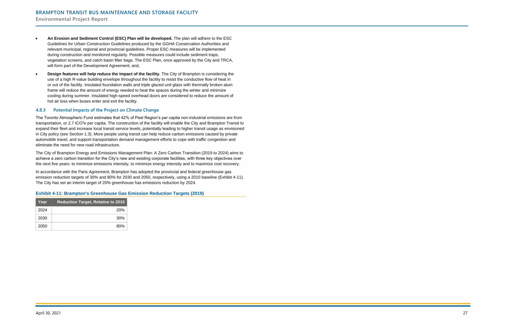
BRAMPTON TRANSIT BUS MAINTENANCE AND STORAGE FACILITY
Environmental Project Report
April 30, 2021 27
• An Erosion and Sediment Control (ESC) Plan will be developed. The plan will adhere to the ESC
Guidelines for Urban Construction Guidelines produced by the GGHA Conservation Authorities and
relevant municipal, regional and provincial guidelines. Proper ESC measures will be implemented
during construction and monitored regularly. Possible measures could include sediment traps,
vegetation screens, and catch basin filter bags. The ESC Plan, once approved by the City and TRCA,
will form part of the Development Agreement; and,
• Design features will help reduce the impact of the facility. The City of Brampton is considering the
use of a high R-value building envelope throughout the facility to resist the conductive flow of heat in
or out of the facility. Insulated foundation walls and triple glazed unit glass with thermally broken alum
frame will reduce the amount of energy needed to heat the spaces during the winter and minimize
cooling during summer. Insulated high-speed overhead doors are considered to reduce the amount of
hot air loss when buses enter and exit the facility.
4.8.3 Potential Impacts of the Project on Climate Change
The Toronto Atmospheric Fund estimates that 42% of Peel Region’s per capita non-industrial emissions are from
transportation, or 2.7 tCO2e per capita. The construction of the facility will enable the City and Brampton Transit to
expand their fleet and increase local transit service levels, potentially leading to higher transit usage as envisioned
in City policy (see Section 1.3). More people using transit can help reduce carbon emissions caused by private
automobile travel, and support transportation demand management efforts to cope with traffic congestion and
eliminate the need for new road infrastructure.
The City of Brampton Energy and Emissions Management Plan: A Zero Carbon Transition (2019 to 2024) aims to
achieve a zero carbon transition for the City’s new and existing corporate facilities, with three key objectives over
the next five years: to minimize emissions intensity, to minimize energy intensity and to maximize cost recovery.
In accordance with the Paris Agreement, Brampton has adopted the provincial and federal greenhouse gas
emission reduction targets of 30% and 80% for 2030 and 2050, respectively, using a 2010 baseline (Exhibit 4-11).
The City has set an interim target of 20% greenhouse has emissions reduction by 2024.
Exhibit 4-11: Brampton's Greenhouse Gas Emission Reduction Targets (2019)
Year Reduction Target, Relative to 2010
2024 20%
2030 30%
2050 80%

BRAMPTON TRANSIT BUS MAINTENANCE AND STORAGE FACILITY
Environmental Project Report
April 30, 2021 28
5 Consultation
An extensive engagement program was undertaken during the pre-planning and formal consultation phases. This
ensured that stakeholder feedback was integrated into the planning and impact assessment and that requirements
of O. Reg. 231/08 were met.
The following sections documents the approach taken to consultation, and the consultation activities and findings
during pre-planning and the formal consultation phases. The details are contained in Appendix O (Pre-Planning)
and Appendix Q (Formal Period).
Overview of Consultation Activities
Consultation is an integral component of TPAP and essential to the successful completion of this project. The
consultation approach aimed to be inclusive and clear to help build confidence among stakeholders that their
participation would have a meaningful impact on decision-making and the outcomes of the study. The Project
Team recognizes the expectation of stakeholders that their input will contribute to decision-making.
The requirements of the Freedom of Information and Protection of Privacy Act and the Ontarians with Disabilities
Act were met. All public open house locations were accessible, and all materials conform to the ‘A’ level or higher
of the WCAG 2.0 protocol.
5.1.1 Consultation Record
Comments, questions, and feedback arising from consultation activities were documented throughout the study
process. The input was incorporated into the design/planning of the facility and this EPR, where appropriate. The
consultation record, available in Appendix O, contains all of the materials produced for consultation activities,
including:
• A Comment Tracking Table, that summarizes all correspondence between stakeholders and the
Project Team;
• Copies of written communication between stakeholders and the Project Team;
• Copies of notices, public open house materials, and digital content; and,
• A commitments registry which tracks commitments made during the TPAP.
5.1.2 Identification of Potentially Interested Parties
A stakeholder list was created during the pre-planning phase that was updated throughout the project. The initial
list was developed using a variety of sources, including:
• The MECP’s Government Review Team list;
• The City of Brampton’s Environmental Assessment contact list;
• A list of property owners and occupants 500 m of the Study Area from the municipal tax roll; and,
• A desktop review to identify potentially interested parties near the Study Area.
The identified groups are listed in Exhibit 5-1. Contacts for Indigenous communities were identified by MECP and
detailed in Section 5.1.3. The list was updated as groups provided the level of involvement they wanted to have,
and as additional contacts were recognized. The project mailing lists are included in Appendix H.
Exhibit 5-1: List of Community Stakeholders, Public Agencies and Utilities
Local Government Property Owners and Occupants
Brampton Fire Services
Brampton Transit
City of Brampton: Public Works
City of Brampton: Transportation
Peel District School Board
Peel Regional Police
Region of Peel: EMS
Region of Peel: Infrastructure Planning
Region of Peel: Transportation
Region of Peel: Water and Wastewater
Town of Orangeville: Public Works
City of Vaughan: Transportation
The owner and occupant of every properties within
500 metres of the Study Area
Utilities and Transportation
407 ETR
Alectra
Bell Canada
Candevcon
CN Rail
CP Rail
Cogeco Peer
Enbridge Gas Distribution Inc.
Hydro One Telecom Inc.
Rogers Cable Communications
Telus
Telus Network
Zayo
Provincial Government and Agencies
Ministry of Transportation
Ministry of Heritage, Sport, Tourism and Culture
Industries
Ministry of Environment, Conservation and Parks
Ministry of Natural Resources and Forestry
Toronto Region Conservation Authority
Credit Valley Conservation Authority
5.1.3 Indigenous Communities
A letter was sent by the City of Brampton to the Director, Environmental Assessment and Permissions Branch of
MECP on October 1, 2019, per O. Reg 231/08. The letter requested the Ministry’s assistance to identify
Indigenous communities that may have an interest in this study. Additional information on the project was provided
to the Ministry on October 15, 2019. The Ministry provided additional information via e-mail on November 8, 2019.
The following communities were identified and confirmed, and included in the project mailing list:
• Alderville First Nation;
• Curve Lake First Nation;
• Hiawatha First Nation;
• Mississaugas of Scugog Island First Nation; and,
• Mississaugas of the Credit First Nation.
Communication with Indigenous communities was done through email, mailed letters, and phone calls. They were
provided with all notices, access to materials, in addition to community-specific engagement opportunities. Refer to
the consultation record in Appendix O for more detail.
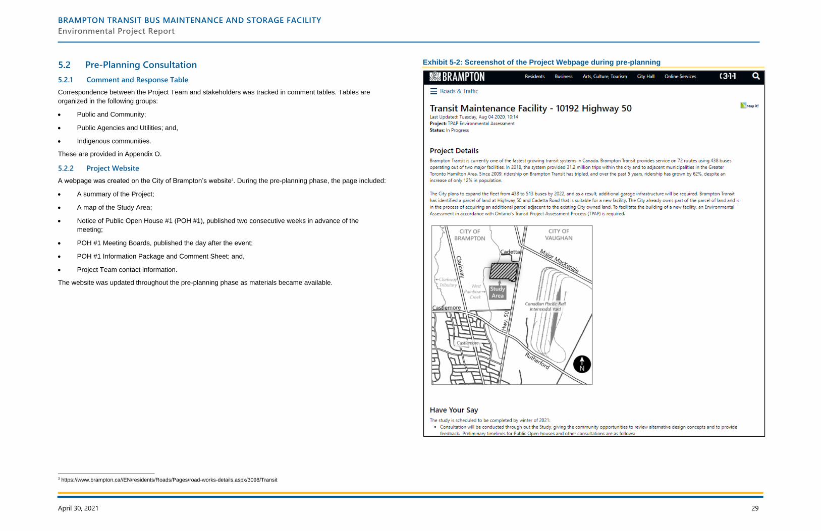
BRAMPTON TRANSIT BUS MAINTENANCE AND STORAGE FACILITY
Environmental Project Report
April 30, 2021 29
Pre-Planning Consultation
5.2.1 Comment and Response Table
Correspondence between the Project Team and stakeholders was tracked in comment tables. Tables are
organized in the following groups:
• Public and Community;
• Public Agencies and Utilities; and,
• Indigenous communities.
These are provided in Appendix O.
5.2.2 Project Website
A webpage was created on the City of Brampton’s website3. During the pre-planning phase, the page included:
• A summary of the Project;
• A map of the Study Area;
• Notice of Public Open House #1 (POH #1), published two consecutive weeks in advance of the
meeting;
• POH #1 Meeting Boards, published the day after the event;
• POH #1 Information Package and Comment Sheet; and,
• Project Team contact information.
The website was updated throughout the pre-planning phase as materials became available.
3 https://www.brampton.ca//EN/residents/Roads/Pages/road-works-details.aspx/3098/Transit
Exhibit 5-2: Screenshot of the Project Webpage during pre-planning
BRAMPTON TRANSIT BUS MAINTENANCE AND STORAGE FACILITY
Environmental Project Report
April 30, 2021 30
5.2.3 Public Open House #1 (POH #1)
The first public meeting, POH #1 was held on Monday, November 18, 2019 at the Gore Meadows Community
Centre (10150 The Gore Road, Brampton) from 6:30 to 8:30 p.m. The event followed a drop-in format, and was
the first public consultation event for the project.
The purpose of the POH was to:
• Introduce the study to the public and stakeholders;
• Review why Brampton Transit requires a third maintenance and storage building;
• Provide an opportunity to participate in the planning and decision making process;
• Understand community concerns with the project; and,
• Provide comments to the City of Brampton, Brampton Transit and consultants, IBI Group.
Notification
Notice of POH #1 was provided to stakeholders, residents, and the broader public through a variety of channels. A
summary of the channels used to disseminate the notice is provided in Exhibit 5-3.
Event Format
The event had a drop-in format, and members of the Project Team and the Ward 3 Councillor were in attendance.
Attendees were:
• Asked to sign-in and were asked to indicate if they wanted to join the project mailing list;
• Able to review 14 presentation boards that provided information on the facility, and included
interactive boards. Boards were posted to the website the following day;
• Provided comments forms for written feedback and questions;
• Invited to ask questions and give input to the Project Team in-person;
• Invited to submit any additional comments, questions, or feedback to the Project Team by email, mail,
or phone by December 2, 2019.
Exhibit 5-3: Notification Details for Public Open House #1
Channel Date Stakeholder Group
Newspaper November 7 and 14, 2019 General public
Mail (Canada Post) November 7, 2019: all property owners and
occupants within 500 metres of the site
November 11, 2019: Indigenous Communities
Property owners and occupants;
Indigenous communities
Email November 4 and 11, 2019: agencies and
utilities
Elected officials; public agencies
and utilities; Indigenous
communities; members of the
public that requested notification
Project Website4 November 4, 2019 General public
4 https://www.brampton.ca//EN/residents/Roads/Pages/road-works-details.aspx/3098/Transit
Exhibit 5-4: Summary of POH #1 Meeting Details
Attribute Details
Date and Time Monday, November 18, 2019, 6:30 to 8:30 p.m.
Location Gore Meadows Community Centre (10150 The Gore Road, Brampton)
Number of Attendees that
Signed-In
Six
Information Presented • Purpose of the POH and background information on Brampton
Transit’s growth
• The need for a third transit MSF and the spatial requirements
• Overview of the EPR and the technical studies that will be
completed
• Interactive boards where attendees were asked to rate how
concerned they were related to different potential impacts that the
MSF may have (e.g. air quality, noise, traffic, etc.)
• Next Steps and Project Team contact information
Feedback at POH #1
Recurring themes and findings from the questions, comments and feedback indicate that:
• There are concerns about the potential impacts the facility may have on various environmental
factors.
• There is support for the facility to enable enhanced transit.
The POH #1 Summary Report is available in Appendix O.
Other Public Submissions
No other public submissions were received.
5.2.4 Public Open House #2 (POH #2)
Due to the COVID-19 pandemic, the second POH transitioned from an in-person event to being held virtually on
the City of Brampton’s website from Wednesday, June 17 to Wednesday, July 15, 2020. The Open House was
open for a four week period to allow additional time for individuals to review the materials, given that many
households were facing new demands (e.g. childcare and education).
The objectives of the event were to:
• Review alternative site concepts for the proposed bus maintenance & storage facility;
• Share the emerging findings and recommendations of the technical studies;
• Provide an opportunity to participate in the planning and decision-making process; and,
• Allow an opportunity for residents and stakeholders to be involved in the planning and decision-
making process.
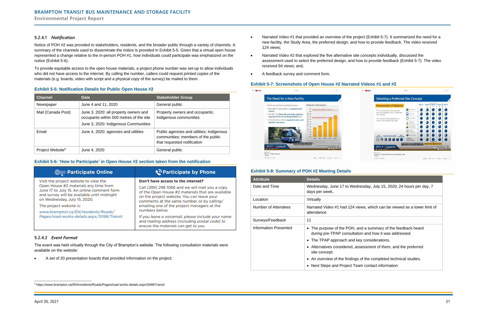
BRAMPTON TRANSIT BUS MAINTENANCE AND STORAGE FACILITY
Environmental Project Report
April 30, 2021 31
Notification
Notice of POH #2 was provided to stakeholders, residents, and the broader public through a variety of channels. A
summary of the channels used to disseminate the notice is provided in Exhibit 5-5. Given that a virtual open house
represented a change relative to the in-person POH #1, how individuals could participate was emphasized on the
notice (Exhibit 5-6).
To provide equitable access to the open house materials, a project phone number was set-up to allow individuals
who did not have access to the internet. By calling the number, callers could request printed copies of the
materials (e.g. boards, video with script and a physical copy of the survey) be mailed to them.
Exhibit 5-5: Notification Details for Public Open House #2
Channel Date Stakeholder Group
Newspaper June 4 and 11, 2020 General public
Mail (Canada Post) June 3, 2020: all property owners and
occupants within 500 metres of the site
June 3, 2020: Indigenous Communities
Property owners and occupants;
Indigenous communities
Email June 4, 2020: agencies and utilities Public agencies and utilities; Indigenous
communities; members of the public
that requested notification
Project Website5 June 4, 2020 General public
Exhibit 5-6: 'How to Participate' in Open House #2 section taken from the notification
Event Format
The event was held virtually through the City of Brampton’s website. The following consultation materials were
available on the website:
• A set of 20 presentation boards that provided information on the project;
5 https://www.brampton.ca//EN/residents/Roads/Pages/road-works-details.aspx/3098/Transit
• Narrated Video #1 that provided an overview of the project (Exhibit 5-7). It summarized the need for a
new facility, the Study Area, the preferred design, and how to provide feedback. The video received
124 views;
• Narrated Video #2 that explored the five alternative site concepts individually, discussed the
assessment used to select the preferred design, and how to provide feedback (Exhibit 5-7). The video
received 94 views; and,
• A feedback survey and comment form.
Exhibit 5-7: Screenshots of Open House #2 Narrated Videos #1 and #2
Exhibit 5-8: Summary of POH #2 Meeting Details
Attribute Details
Date and Time Wednesday, June 17 to Wednesday, July 15, 2020; 24 hours per day, 7
days per week.
Location Virtually
Number of Attendees Narrated Video #1 had 124 views, which can be viewed as a lower limit of
attendance
Surveys/Feedback 11
Information Presented • The purpose of the POH, and a summary of the feedback heard
during pre-TPAP consultation and how it was addressed.
• The TPAP approach and key considerations.
• Alternatives considered, assessment of them, and the preferred
site concept.
• An overview of the findings of the completed technical studies.
• Next Steps and Project Team contact information
BRAMPTON TRANSIT BUS MAINTENANCE AND STORAGE FACILITY
Environmental Project Report
April 30, 2021 32
Feedback at POH #2
Recurring themes and findings from the questions, comments and feedback indicate that:
• Attendees are supportive of the preferred Option 3 design. Comments suggest that Option 3 has
many desirable design features and that the project reflects a thoughtful planning process. The design
suggestions, such are relocating the back-up generators, can be considered during detail design.
• Sustainable design features should be incorporated wherever possible. Design features such as
energy efficiency, electric buses, and low-impact stormwater runoff were mentioned as measures that
the project team should consider for reducing the facility’s environmental impact. These can be
investigated as the design of the facility advances.
• There is an interest in understanding the project timeline and funding sources. Given the
overall positive reception of this new facility, individuals are interested in learning more about the
facility’s implementation, particularly the construction timelines. As the timeline depends on funding,
the project team will provide a high-level overview during POH #3.
• Residents view the facility as a step toward better transit. Multiple respondents noted that the
facility would enable Brampton Transit to expand service across the city, which was viewed as a
community benefit.
The POH #2 Summary Report is available in Appendix O, and includes all comments received.
5.2.5 Other Public Submissions
No other public submissions were received during the pre-planning period.
5.2.6 Public Agencies and Utilities Consultation
The purpose of consultation with public agencies and utilities during the pre-planning phase centred on the
following topics:
• Introduce the Project to relevant stakeholders;
• Seek guidance on agency requirements for the MSF; and,
• Understand each agency’s desired level of involvement and fulfill any data requests.
All agencies received the notifications for POH #1 (Section 5.2.3.1) and POH #2 (Section 5.2.4.1). Each
notification provided information that:
• Introduced the Project and outlined the Study Area;
• Invited them to POH #1 and POH #2, respectively, and to review the information available on the
webpage;
• Provided contact information of the Project Team; and,
• Invited them to confirm their involvement, and if alternate contacts may need to be included.
A Technical Advisory Committee meeting was held on May 28, 2020. There were a total of 27 attendees from the
Toronto and Region Conservation Authority, City of Vaughan, Telus, Hydro One and the Region of Peel. Minutes
of that meeting are available in Appendix O.
A summary of contact with agencies is summarized in Exhibit 5.8. Correspondence with these groups can be
found in Appendix O.
Exhibit 5-9: Summary of Agency Consultation during Pre-Planning Phase
Agency Comments Response
Toronto and Region
Conservation Authority
Provided a list of initial design comments (e.g. buffer from
creek) and a list of documents that must be submitted to
them as part of the TPAP/EPR review. The TRCA noted
that 12 months of groundwater well monitoring is
required.
Design comments
have been considered
and incorporated as
appropriate. The
documents will be
submitted as part of
the EPR Review.
City of Vaughan Interested in receiving a copy of the Traffic Impact Study,
once it’s available.
Agreed to send a copy
of the report. Report
sent on 2020-12-10.
5.2.7 Indigenous Communities Consultation
During pre-planning, City staff directly engaged with Indigenous communities that had been identified by MECP.
The intent was to understand:
• Their level of interest in the Project;
• Identify any concerns they may have; and,
• Determine the community’s consultation needs and requirements.
The Project Team provided each community with an opportunity to participate in the consultation process, and
strived to be flexible to meet the specific and unique needs of each community.
• Mailing all identified communities a letter that included a map of the Study Area, an overview of the
Project, contact information for the City’s Project Manager, and an invitation to POH #1. The letter
noted the boards would be available on the website following the meeting;
• Mailing all identified communities a letter with an invitation to POH #2, and offered to meet with any
communities; and,
• Providing relevant documentation and materials, when requested.
No comments were received from Indigenous communities during pre-planning. A copy of all correspondence is
provided in Appendix O.
5.2.8 Agency Review of Draft Technical Reports and Draft EPR
The complete draft EPR was provided to MECP on September 22, 2020 for technical review prior to initiating
TPAP. Additional regulatory agencies were provided with the draft EPR and supporting studies, and invited to
provide their comments. Exhibit 5-10 lists the agencies that provided comments as of March 4, 2021.
BRAMPTON TRANSIT BUS MAINTENANCE AND STORAGE FACILITY
Environmental Project Report
April 30, 2021 33
Exhibit 5-10: Reports that Agencies Provided Comments On
Agency
Report
Commented On MECP MHSTCI MNRF RoP TRCA
Draft EPR ✓ ✓
Indicated they had
no comments ✓ ✓
Environmental Impact
Study ✓
Archaeology
Assessment Stage 1
✓
Cultural Heritage
Resource Assessment
✓
Socio-Economic
Noise ✓
Air Quality
Fluvial Geomorphology
Geotechnical
Investigation
Hydrogeological ✓
Environmental Site
Assessment 1 and 2
Stormwater
Management
✓ ✓
Traffic Impact Study ✓
Functional Servicing
Report
Consultation Record
TPAP Consultation
5.3.1 Notice of Commencement
The Notice of TPAP Commencement was issued on November 19, 2020 as per O. Reg. 231/08. The Notice was
circulated to Indigenous communities listed in Section 5.1.3 and property owners, occupants and businesses
within 500 metres of the study area on November 13, 2020. Agencies and utilities listed in Section 5.1.2 were
circulated on November 19, 2020, unless they asked to be removed from the project mailing list.
A summary of the channels used to disseminate the Notice is provided in Exhibit 5-11. The circulated agencies,
utilities, and Indigenous communities from the Master Contact List can be viewed in Appendix P.
Exhibit 5-11: Publication Details for Notice of Commencement of TPAP
Channel Date Of Publication Stakeholder Group
Newspaper November 19 and 26, 2020 General public
Mail (Canada Post) November 13, 2020 Property owners and residents/businesses; Indigenous
communities
Email November 19, 2020 Elected officials; public agencies and utilities; members
of the public that requested notification
Project Website November 19, 2020 General public
5.3.1 Public and Community Consultation
Project Website
The project website, discussed in Section 5.2.2, was updated and maintained throughout the TPAP. Additional
information included on the page included:
• Notice of TPAP Commencement;
• Notice of POH #3, published two weeks in advance of the virtual event;
• Information videos; and,
• POH #3 Meeting Boards.
The project website continued to have a map of the study area, project team contact information, and project
overview.
Public Open House #3
Due to the ongoing COVID-19 pandemic, the third public Open House was held virtually on the City of Brampton’s
website from Thursday, January 21 to Thursday, February 4, 2021. The Open House was kept open for a two
week period to allow time for individuals to review the materials. The objectives of the event were to:
• Confirm the preferred project design;
• Share the findings and recommendations of the draft EPR and supporting studies;
• Present the expected future environmental conditions, including potential impacts and mitigation
measures;
• Provide an opportunity to participate in the planning and decision-making process; and,
• Provide comments to the City of Brampton, Brampton Transit and the consultants, IBI Group.
Details are available in the Consultation Summary Report in Appendix P.
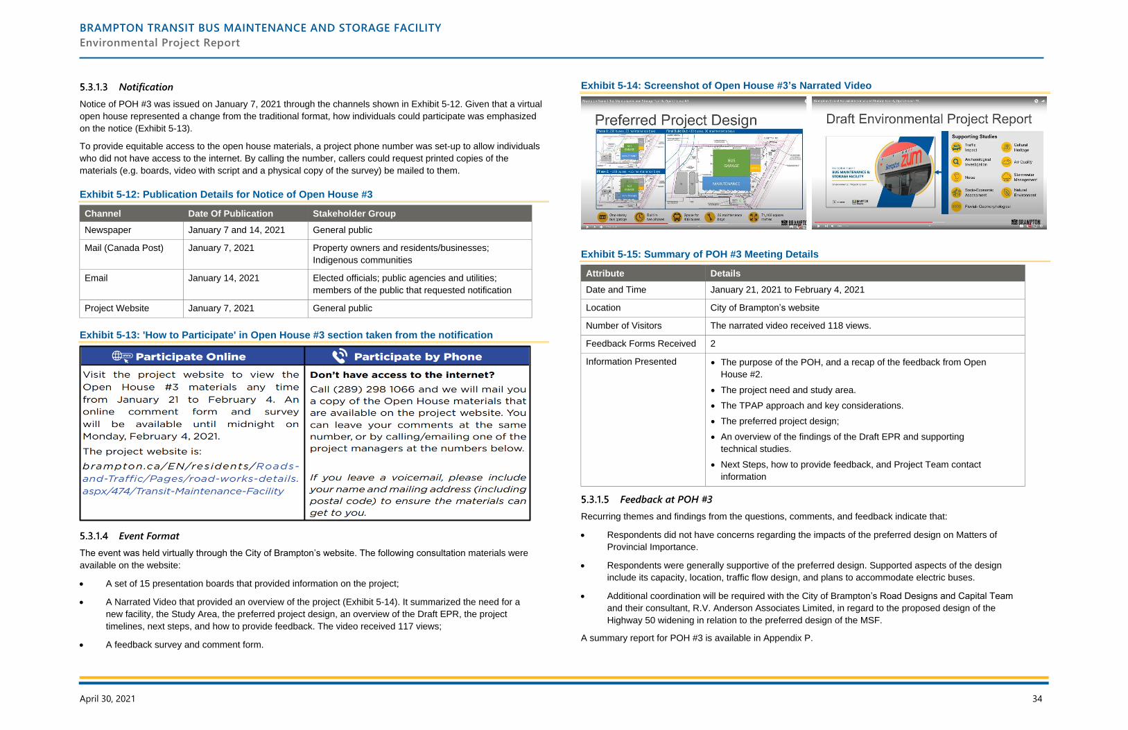
BRAMPTON TRANSIT BUS MAINTENANCE AND STORAGE FACILITY
Environmental Project Report
April 30, 2021 34
Notification
Notice of POH #3 was issued on January 7, 2021 through the channels shown in Exhibit 5-12. Given that a virtual
open house represented a change from the traditional format, how individuals could participate was emphasized
on the notice (Exhibit 5-13).
To provide equitable access to the open house materials, a project phone number was set-up to allow individuals
who did not have access to the internet. By calling the number, callers could request printed copies of the
materials (e.g. boards, video with script and a physical copy of the survey) be mailed to them.
Exhibit 5-12: Publication Details for Notice of Open House #3
Channel Date Of Publication Stakeholder Group
Newspaper January 7 and 14, 2021 General public
Mail (Canada Post) January 7, 2021 Property owners and residents/businesses;
Indigenous communities
Email January 14, 2021 Elected officials; public agencies and utilities;
members of the public that requested notification
Project Website January 7, 2021 General public
Exhibit 5-13: 'How to Participate' in Open House #3 section taken from the notification
Event Format
The event was held virtually through the City of Brampton’s website. The following consultation materials were
available on the website:
• A set of 15 presentation boards that provided information on the project;
• A Narrated Video that provided an overview of the project (Exhibit 5-14). It summarized the need for a
new facility, the Study Area, the preferred project design, an overview of the Draft EPR, the project
timelines, next steps, and how to provide feedback. The video received 117 views;
• A feedback survey and comment form.
Exhibit 5-14: Screenshot of Open House #3’s Narrated Video
Exhibit 5-15: Summary of POH #3 Meeting Details
Attribute Details
Date and Time January 21, 2021 to February 4, 2021
Location City of Brampton’s website
Number of Visitors The narrated video received 118 views.
Feedback Forms Received 2
Information Presented • The purpose of the POH, and a recap of the feedback from Open
House #2.
• The project need and study area.
• The TPAP approach and key considerations.
• The preferred project design;
• An overview of the findings of the Draft EPR and supporting
technical studies.
• Next Steps, how to provide feedback, and Project Team contact
information
Feedback at POH #3
Recurring themes and findings from the questions, comments, and feedback indicate that:
• Respondents did not have concerns regarding the impacts of the preferred design on Matters of
Provincial Importance.
• Respondents were generally supportive of the preferred design. Supported aspects of the design
include its capacity, location, traffic flow design, and plans to accommodate electric buses.
• Additional coordination will be required with the City of Brampton’s Road Designs and Capital Team
and their consultant, R.V. Anderson Associates Limited, in regard to the proposed design of the
Highway 50 widening in relation to the preferred design of the MSF.
A summary report for POH #3 is available in Appendix P.
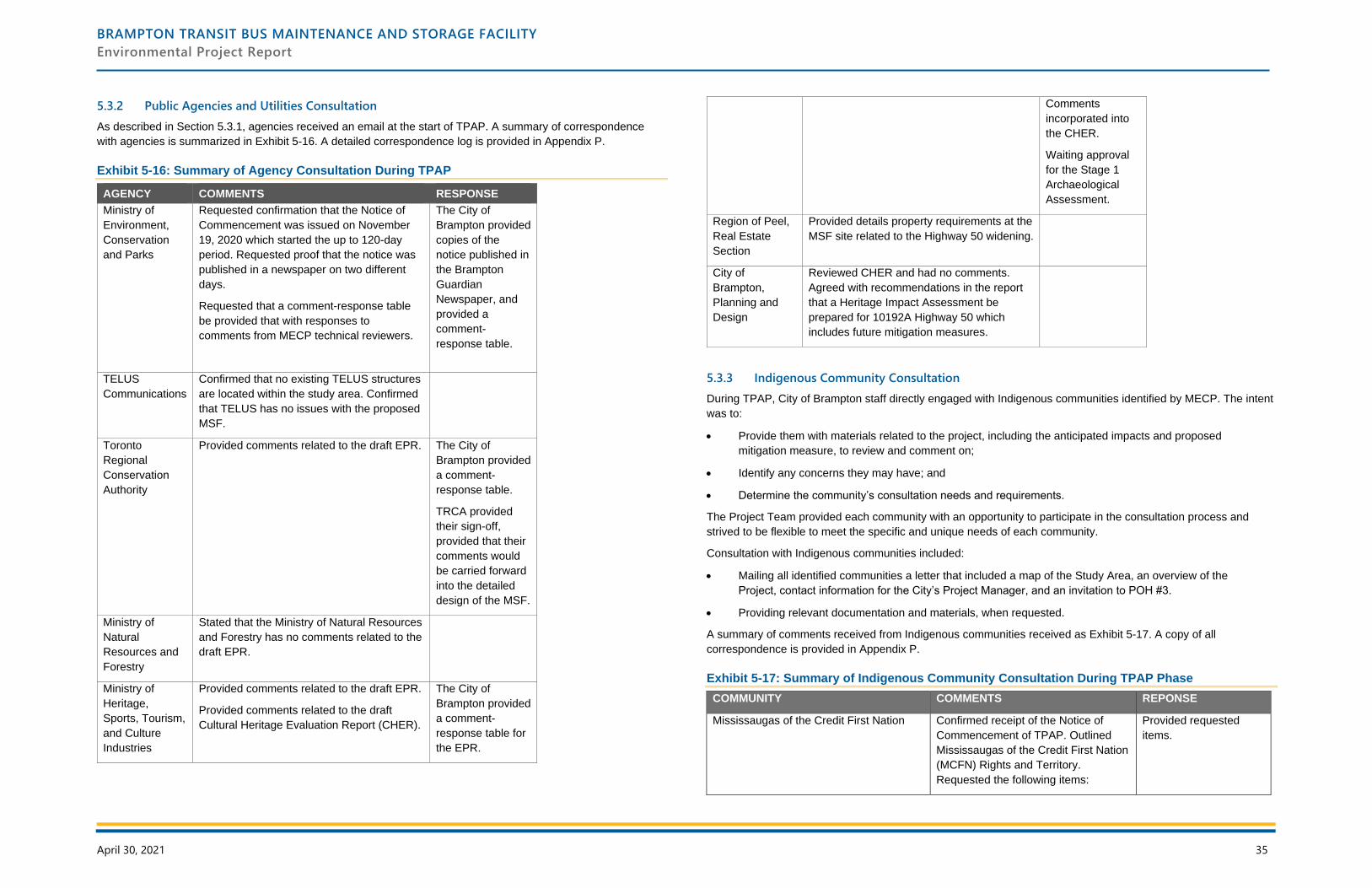
BRAMPTON TRANSIT BUS MAINTENANCE AND STORAGE FACILITY
Environmental Project Report
April 30, 2021 35
5.3.2 Public Agencies and Utilities Consultation
As described in Section 5.3.1, agencies received an email at the start of TPAP. A summary of correspondence
with agencies is summarized in Exhibit 5-16. A detailed correspondence log is provided in Appendix P.
Exhibit 5-16: Summary of Agency Consultation During TPAP
AGENCY COMMENTS RESPONSE
Ministry of
Environment,
Conservation
and Parks
Requested confirmation that the Notice of
Commencement was issued on November
19, 2020 which started the up to 120-day
period. Requested proof that the notice was
published in a newspaper on two different
days.
Requested that a comment-response table
be provided that with responses to
comments from MECP technical reviewers.
The City of
Brampton provided
copies of the
notice published in
the Brampton
Guardian
Newspaper, and
provided a
comment-
response table.
TELUS
Communications
Confirmed that no existing TELUS structures
are located within the study area. Confirmed
that TELUS has no issues with the proposed
MSF.
Toronto
Regional
Conservation
Authority
Provided comments related to the draft EPR. The City of
Brampton provided
a comment-
response table.
TRCA provided
their sign-off,
provided that their
comments would
be carried forward
into the detailed
design of the MSF.
Ministry of
Natural
Resources and
Forestry
Stated that the Ministry of Natural Resources
and Forestry has no comments related to the
draft EPR.
Ministry of
Heritage,
Sports, Tourism,
and Culture
Industries
Provided comments related to the draft EPR.
Provided comments related to the draft
Cultural Heritage Evaluation Report (CHER).
The City of
Brampton provided
a comment-
response table for
the EPR.
Comments
incorporated into
the CHER.
Waiting approval
for the Stage 1
Archaeological
Assessment.
Region of Peel,
Real Estate
Section
Provided details property requirements at the
MSF site related to the Highway 50 widening.
City of
Brampton,
Planning and
Design
Reviewed CHER and had no comments.
Agreed with recommendations in the report
that a Heritage Impact Assessment be
prepared for 10192A Highway 50 which
includes future mitigation measures.
5.3.3 Indigenous Community Consultation
During TPAP, City of Brampton staff directly engaged with Indigenous communities identified by MECP. The intent
was to:
• Provide them with materials related to the project, including the anticipated impacts and proposed
mitigation measure, to review and comment on;
• Identify any concerns they may have; and
• Determine the community’s consultation needs and requirements.
The Project Team provided each community with an opportunity to participate in the consultation process and
strived to be flexible to meet the specific and unique needs of each community.
Consultation with Indigenous communities included:
• Mailing all identified communities a letter that included a map of the Study Area, an overview of the
Project, contact information for the City’s Project Manager, and an invitation to POH #3.
• Providing relevant documentation and materials, when requested.
A summary of comments received from Indigenous communities received as Exhibit 5-17. A copy of all
correspondence is provided in Appendix P.
Exhibit 5-17: Summary of Indigenous Community Consultation During TPAP Phase
COMMUNITY COMMENTS REPONSE
Mississaugas of the Credit First Nation Confirmed receipt of the Notice of
Commencement of TPAP. Outlined
Mississaugas of the Credit First Nation
(MCFN) Rights and Territory.
Requested the following items:
Provided requested
items.
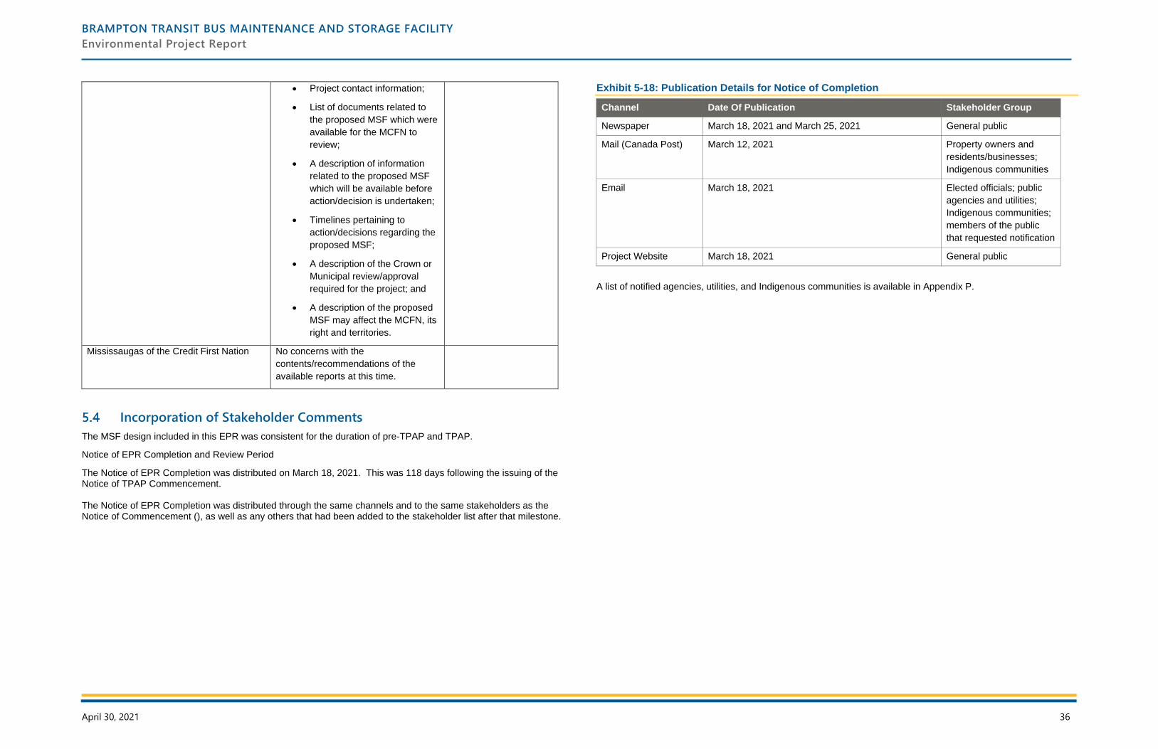
BRAMPTON TRANSIT BUS MAINTENANCE AND STORAGE FACILITY
Environmental Project Report
April 30, 2021 36
• Project contact information;
• List of documents related to
the proposed MSF which were
available for the MCFN to
review;
• A description of information
related to the proposed MSF
which will be available before
action/decision is undertaken;
• Timelines pertaining to
action/decisions regarding the
proposed MSF;
• A description of the Crown or
Municipal review/approval
required for the project; and
• A description of the proposed
MSF may affect the MCFN, its
right and territories.
Mississaugas of the Credit First Nation No concerns with the
contents/recommendations of the
available reports at this time.
Incorporation of Stakeholder Comments
The MSF design included in this EPR was consistent for the duration of pre-TPAP and TPAP.
Notice of EPR Completion and Review Period
The Notice of EPR Completion was distributed on March 18, 2021. This was 118 days following the issuing of the Notice of TPAP Commencement. The Notice of EPR Completion was distributed through the same channels and to the same stakeholders as the Notice of Commencement (), as well as any others that had been added to the stakeholder list after that milestone.
Exhibit 5-18: Publication Details for Notice of Completion
Channel Date Of Publication Stakeholder Group
Newspaper March 18, 2021 and March 25, 2021 General public
Mail (Canada Post) March 12, 2021 Property owners and
residents/businesses;
Indigenous communities
Email March 18, 2021 Elected officials; public
agencies and utilities;
Indigenous communities;
members of the public
that requested notification
Project Website March 18, 2021 General public
A list of notified agencies, utilities, and Indigenous communities is available in Appendix P.
BRAMPTON TRANSIT BUS MAINTENANCE AND STORAGE FACILITY
Environmental Project Report
April 30, 2021 37
6 Permits and Approvals
Federal
At the federal level, no permits or approvals are anticipated to be required for this project. The MSF project is not a
“designated” project as defined in the Regulations Designating Physical Activities under the Canadian
Environmental Assessment Act, as amended in 20146 .
The Minister of the Environment may designate a project not currently identified in the regulations if the project
may cause adverse environmental effects or there are public concerns about such effects. If required, the City will
prepare a project description for review by the Canadian Environmental Assessment Agency during detail design.
Provincial
At the provincial level, the following permits and approvals may be required during detail design and construction.
The need for these permits and approvals will be confirmed during detail design.
Ministry of the Environment, Conservation and Parks
• ECA for new/relocated sanitary sewers, new/relocated storm sewers and outfalls, stormwater quality
controls, sewer use for discharge of dewatering effluent (in compliance with s. 53 of the OWRA and
relevant MECP guidelines), as appropriate. Should potable water lines be relocated, ECA will be
sought from MECP prior to relocation.
• An EASR registration with the Ministry may be required as construction dewatering is estimated to be
greater than 50,000 L/day but less than 400,000 L/day. Once the details on the proposed excavations
are finalized during detail design, the need for an EASR or PTTW will be re-assessed using any
additional hydrogeological data collected.
• Excess Soil Management Strategy.
• If species at risk are identified within the construction influence zone, MNRF will be contacted to
determine how specimens should be treated.
Technical Standards & Safety Authority
• Approval for any fuel and/or chemical storage tanks, if required.
Municipal
At the municipal level, the following permits and approvals may be required. The need for these permits and
approvals will be confirmed during detail design:
• Brampton City Council approval.
• Tree Preservation By-law.
• Demolition permits.
• Building permits.
• Planning Act Approvals, including Site Plan Approval and any other related permits from the City, as
required.
6 https://laws-lois.justice.gc.ca/eng/regulations/SOR-2012-147/page-3.html#h-1
• Work will generally be conducted in accordance with noise control by-laws (By-law 93-84). Special by-
laws may be enacted for construction and maintenance activities that must be conducted outside the
prescribed hours of operation.
• Region of Peel driveway (access) approval to the Regional road.
• A resource-specific HIA should be completed for Cultural Heritage Resource 1 by a qualified heritage
professional as per City of Brampton Official Plan clause 4.10.1.11. The HIA will need to be presented
to the Brampton Heritage Board.
• Rainbow Creek and associated floodplain are within TRCA regulated areas. Any work within these
areas require a permit from TRCA under O. Reg. 166/06 Development, Interference with Wetlands
and Alterations to Shorelines and Watercourses Regulation.
Utilities
The MSF will need to connect with adjacent utilities to service the site. The following agreements will be sought:
• Utility crossing agreements.
• Hydro connection applications and service agreements.
• Gas connection applications and service agreements.
• Telecommunication connection service agreements.
Mechanism for Changes to the Approved Plan
This project was assessed under the TPAP (O.Reg. 231/08). This document forms the summary of the planning
and design process, assessment of impacts and associated mitigation measures, and commitments to future work.
The project presented in this EPR is not a static plan, nor is the context in which it is being assessed, reviewed,
approved, constructed, and used. Given the potential for changes to the project resulting from the approvals, detail
design, and construction processes, it is prudent to include in the EPR a comment on the responsibilities of the
proponent, should changes be required. The following sections outline how such changes will be addressed.
6.5.1 Design Refinement
This EPR identifies and presents the impacts associated with the project, and the property envelope within which
the project can feasibly be constructed. The actual layout of project elements (e.g. building locations, paved
surface areas, driveway locations, etc.) are subject to detail design. Any variation from that shown in this EPR,
unless it results in an environmental impact which cannot be accommodated within the committed mitigation
measures, does not require additional approval under O. Reg 231/08.
6.5.2 Environmental Project Report Addendum Process
After the Statement of Completion, if a change is made to the project that is inconsistent with this EPR, an
Addendum to the EPR must be issued, and include the following information:
1. A description of the change;
2. The reasons for the change;
BRAMPTON TRANSIT BUS MAINTENANCE AND STORAGE FACILITY
Environmental Project Report
April 30, 2021 38
3. The proponent’s assessment and evaluation of negative impacts that the change might have on the
environment;
4. A description of any measures proposed by the proponent for mitigating the negative impacts that the
change might have on the environment; and,
5. A statement of whether the proponent is of the opinion that the change is a significant change to the
transit project, and the reasons for the opinion.
If the proponent is of the opinion that the proposed change to the transit project is significant, then the proponent
must publish a Notice of EPR Addendum in a manner similar to a Notice of Completion, as well as a notice on its
website. The Notice of EPR Addendum must also be provided to the Director of the Environmental Assessment
and Permissions Branch, the MECP Regional Director, every property owner within 30 m of the site change,
Indigenous communities, and any other person who, in the proponent’s opinion, may be interested, and every
person who has made a written request for notices about the project.
6.5.3 Environmental Project Report Addendum Timelines
The process and timelines for making objections and for the Minister to act with respect to the proposed change
are similar in the addendum process as in the process leading to the Notice of Completion:
• 30 Day Public Review Period, started by Notice of EPR Addendum, that provides review time for
public, regulatory agencies, Indigenous communities and other interested parties. Objections to the
project may be submitted to MECP during this period.
• 35 Day Ministerial Review Period, started by conclusion of the previous period. The Minister reviews
any objections and determines if the project may proceed, may proceed with conditions, or if the
proponent must conduct additional work and submit a revised EPR to the Minister.
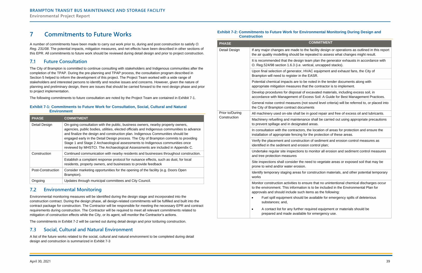
BRAMPTON TRANSIT BUS MAINTENANCE AND STORAGE FACILITY
Environmental Project Report
April 30, 2021 39
7 Commitments to Future Works
A number of commitments have been made to carry out work prior to, during and post construction to satisfy O.
Reg. 231/08. The potential impacts, mitigation measures, and net effects have been described in other sections of
this EPR. All commitments to future work should be reviewed during detail design and prior to project construction.
Future Consultation
The City of Brampton is committed to continue consulting with stakeholders and Indigenous communities after the
completion of the TPAP. During the pre-planning and TPAP process, the consultation program described in
Section 5 helped to inform the development of this project. The Project Team worked with a wide range of
stakeholders and interested persons to identify and resolve issues and concerns. However, given the nature of
planning and preliminary design, there are issues that should be carried forward to the next design phase and prior
to project implementation.
The following commitments to future consultation are noted by the Project Team are contained in Exhibit 7-1.
Exhibit 7-1: Commitments to Future Work for Consultation, Social, Cultural and Natural Environment
PHASE COMMITMENT
Detail Design On-going consultation with the public, business owners, nearby property owners,
agencies, public bodies, utilities, elected officials and Indigenous communities to advance
and finalize the design and construction plan. Indigenous Communities should be
engaged early in the Detail Design process. The City of Brampton commits to providing
Stage 1 and Stage 2 Archaeological assessments to Indigenous communities once
reviewed by MHSTCI. The Archaeological Assessments are included in Appendix C.
Construction Continued communication with nearby residents and businesses throughout construction.
Establish a complaint response protocol for nuisance effects, such as dust, for local
residents, property owners, and businesses to provide feedback
Post-Construction Consider marketing opportunities for the opening of the facility (e.g. Doors Open
Brampton).
Ongoing Updates through municipal committees and City Council.
Environmental Monitoring
Environmental monitoring measures will be identified during the design stage and incorporated into the
construction contract. During the design phase, all design-related commitments will be fulfilled and built into the
contract package for construction. The Contractor will be responsible for meeting the necessary EPR and contract
requirements during construction. The Contractor will be required to meet all relevant commitments related to
mitigation of construction effects while the City, or its agent, will monitor the Contractor’s actions.
The commitments in Exhibit 7-2 will be carried out during detail design and prior to/during construction.
Social, Cultural and Natural Environment
A list of the future works related to the social, cultural and natural environment to be completed during detail
design and construction is summarized in Exhibit 7-3
Exhibit 7-2: Commitments to Future Work for Environmental Monitoring During Design and Construction
PHASE COMMITMENT
Detail Design If any major changes are made to the facility design or operations as outlined in this report
the air quality modelling should be repeated to assess what changes might result.
It is recommended that the design team plan the generator exhausts in accordance with
O. Reg.524/98 section 1.6.3 (i.e. vertical, uncapped stacks).
Upon final selection of generator, HVAC equipment and exhaust fans, the City of
Brampton will need to register in the EASR.
Potential chemical impacts are to be noted in the tender documents along with
appropriate mitigation measures that the contractor is to implement.
Develop procedures for disposal of excavated materials, including excess soil, in
accordance with Management of Excess Soil: A Guide for Best Management Practices.
General noise control measures (not sound level criteria) will be referred to, or placed into
the City of Brampton contract documents
Prior to/During
Construction All machinery used on-site shall be in good repair and free of excess oil and lubricants.
Machinery refuelling and maintenance shall be carried out using appropriate precautions
to prevent spillage and in designated areas.
In consultation with the contractors, the location of areas for protection and ensure the
installation of appropriate fencing for the protection of these areas.
Verify the placement and construction of sediment and erosion control measures as
identified in the sediment and erosion control plan;
Undertake regular site inspections to monitor all erosion and sediment control measures
and tree protection measures
Site inspections shall consider the need to vegetate areas or exposed soil that may be
prone to wind and/or water erosion.
Identify temporary staging areas for construction materials, and other potential temporary
works
Monitor construction activities to ensure that no unintentional chemical discharges occur
to the environment. This information is to be included in the Environmental Plan for
approvals and should include such items as the following:
• Fuel spill equipment should be available for emergency spills of deleterious
substances; and,
• A contact list for any further required equipment or materials should be
prepared and made available for emergency use.
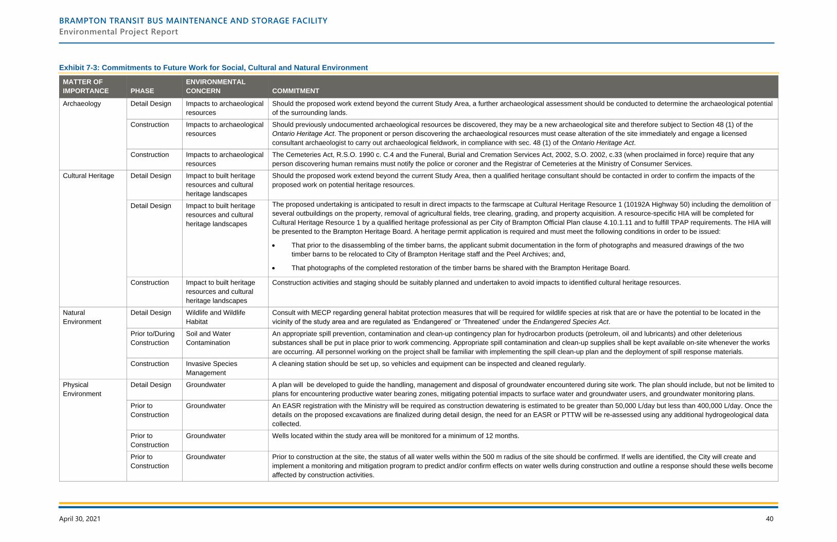
BRAMPTON TRANSIT BUS MAINTENANCE AND STORAGE FACILITY
Environmental Project Report
April 30, 2021 40
Exhibit 7-3: Commitments to Future Work for Social, Cultural and Natural Environment
MATTER OF
IMPORTANCE PHASE
ENVIRONMENTAL
CONCERN COMMITMENT
Archaeology Detail Design Impacts to archaeological
resources
Should the proposed work extend beyond the current Study Area, a further archaeological assessment should be conducted to determine the archaeological potential
of the surrounding lands.
Construction Impacts to archaeological
resources
Should previously undocumented archaeological resources be discovered, they may be a new archaeological site and therefore subject to Section 48 (1) of the
Ontario Heritage Act. The proponent or person discovering the archaeological resources must cease alteration of the site immediately and engage a licensed
consultant archaeologist to carry out archaeological fieldwork, in compliance with sec. 48 (1) of the Ontario Heritage Act.
Construction Impacts to archaeological
resources
The Cemeteries Act, R.S.O. 1990 c. C.4 and the Funeral, Burial and Cremation Services Act, 2002, S.O. 2002, c.33 (when proclaimed in force) require that any
person discovering human remains must notify the police or coroner and the Registrar of Cemeteries at the Ministry of Consumer Services.
Cultural Heritage Detail Design Impact to built heritage
resources and cultural
heritage landscapes
Should the proposed work extend beyond the current Study Area, then a qualified heritage consultant should be contacted in order to confirm the impacts of the
proposed work on potential heritage resources.
Detail Design Impact to built heritage
resources and cultural
heritage landscapes
The proposed undertaking is anticipated to result in direct impacts to the farmscape at Cultural Heritage Resource 1 (10192A Highway 50) including the demolition of
several outbuildings on the property, removal of agricultural fields, tree clearing, grading, and property acquisition. A resource-specific HIA will be completed for
Cultural Heritage Resource 1 by a qualified heritage professional as per City of Brampton Official Plan clause 4.10.1.11 and to fulfill TPAP requirements. The HIA will
be presented to the Brampton Heritage Board. A heritage permit application is required and must meet the following conditions in order to be issued:
• That prior to the disassembling of the timber barns, the applicant submit documentation in the form of photographs and measured drawings of the two
timber barns to be relocated to City of Brampton Heritage staff and the Peel Archives; and,
• That photographs of the completed restoration of the timber barns be shared with the Brampton Heritage Board.
Construction Impact to built heritage
resources and cultural
heritage landscapes
Construction activities and staging should be suitably planned and undertaken to avoid impacts to identified cultural heritage resources.
Natural
Environment
Detail Design Wildlife and Wildlife
Habitat
Consult with MECP regarding general habitat protection measures that will be required for wildlife species at risk that are or have the potential to be located in the
vicinity of the study area and are regulated as ‘Endangered’ or ‘Threatened’ under the Endangered Species Act.
Prior to/During
Construction
Soil and Water
Contamination
An appropriate spill prevention, contamination and clean-up contingency plan for hydrocarbon products (petroleum, oil and lubricants) and other deleterious
substances shall be put in place prior to work commencing. Appropriate spill contamination and clean-up supplies shall be kept available on-site whenever the works
are occurring. All personnel working on the project shall be familiar with implementing the spill clean-up plan and the deployment of spill response materials.
Construction Invasive Species
Management
A cleaning station should be set up, so vehicles and equipment can be inspected and cleaned regularly.
Physical
Environment
Detail Design Groundwater A plan will be developed to guide the handling, management and disposal of groundwater encountered during site work. The plan should include, but not be limited to
plans for encountering productive water bearing zones, mitigating potential impacts to surface water and groundwater users, and groundwater monitoring plans.
Prior to
Construction
Groundwater An EASR registration with the Ministry will be required as construction dewatering is estimated to be greater than 50,000 L/day but less than 400,000 L/day. Once the
details on the proposed excavations are finalized during detail design, the need for an EASR or PTTW will be re-assessed using any additional hydrogeological data
collected.
Prior to
Construction
Groundwater Wells located within the study area will be monitored for a minimum of 12 months.
Prior to
Construction
Groundwater Prior to construction at the site, the status of all water wells within the 500 m radius of the site should be confirmed. If wells are identified, the City will create and
implement a monitoring and mitigation program to predict and/or confirm effects on water wells during construction and outline a response should these wells become
affected by construction activities.
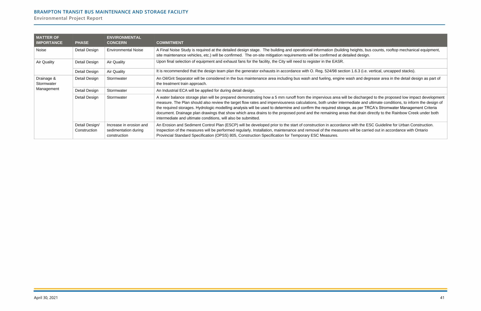
BRAMPTON TRANSIT BUS MAINTENANCE AND STORAGE FACILITY
Environmental Project Report
April 30, 2021 41
MATTER OF
IMPORTANCE PHASE
ENVIRONMENTAL
CONCERN COMMITMENT
Noise Detail Design Environmental Noise A Final Noise Study is required at the detailed design stage. The building and operational information (building heights, bus counts, rooftop mechanical equipment,
site maintenance vehicles, etc.) will be confirmed. The on-site mitigation requirements will be confirmed at detailed design.
Air Quality Detail Design Air Quality Upon final selection of equipment and exhaust fans for the facility, the City will need to register in the EASR.
Detail Design Air Quality It is recommended that the design team plan the generator exhausts in accordance with O. Reg. 524/98 section 1.6.3 (i.e. vertical, uncapped stacks).
Drainage &
Stormwater
Management
Detail Design Stormwater An Oil/Grit Separator will be considered in the bus maintenance area including bus wash and fueling, engine wash and degrease area in the detail design as part of
the treatment train approach.
Detail Design Stormwater An Industrial ECA will be applied for during detail design.
Detail Design Stormwater A water balance storage plan will be prepared demonstrating how a 5 mm runoff from the impervious area will be discharged to the proposed low impact development
measure. The Plan should also review the target flow rates and imperviousness calculations, both under intermediate and ultimate conditions, to inform the design of
the required storages. Hydrologic modelling analysis will be used to determine and confirm the required storage, as per TRCA’s Stromwater Management Criteria
document. Drainage plan drawings that show which area drains to the proposed pond and the remaining areas that drain directly to the Rainbow Creek under both
intermediate and ultimate conditions, will also be submitted.
Detail Design/
Construction
Increase in erosion and
sedimentation during
construction
An Erosion and Sediment Control Plan (ESCP) will be developed prior to the start of construction in accordance with the ESC Guideline for Urban Construction.
Inspection of the measures will be performed regularly. Installation, maintenance and removal of the measures will be carried out in accordance with Ontario
Provincial Standard Specification (OPSS) 805, Construction Specification for Temporary ESC Measures.

BRAMPTON TRANSIT BUS MAINTENANCE AND STORAGE FACILITY
Environmental Project Report
April 30, 2021 42