ENVIRONMENTAL IMPACT ASSESSMENT OF ABUNDANT LEAD LANDFILL ON GROUNDWATER AND SOIL QUALITY
10
International Water Technology Journal, IWTJ Vol. 4 - N2, June 2014 142 ENVIRONMENTAL IMPACT ASSESSMENT OF ABUNDANT LEAD LANDFILL ON GROUNDWATER AND SOIL QUALITY Waled A. Dawoud 1 , Abdelazim M. Negm 2 , Mahmoud F. Bady 3 , and Nasser M. Saleh 4 1 PhD Student, Environmental Engineering Dept., School of Energy and Environmental Engineering, Egypt-Japan University of Science and Technology (E-JUST), New Borg Al-Arab City, Postal Code 21934, Alexandria (Teaching Assistant, Benha University), E-mail: [email protected] 2 Chair of Environmental Engineering Dept., School of Energy and Environmental Engineering, Egypt-Japan University of Science and Technology (E-JUST), New Borg Al-Arab City, Postal Code 21934, Alexandria (Seconded from Zagzig University) E-mail: [email protected], [email protected] 3 Assistant Professor, Environmental Engineering Dept., School of Energy and Environmental Engineering, Egypt-Japan University of Science and Technology (E-JUST), New Borg Al-Arab City, Postal Code 21934, Alexandria (Seconded from Assiut University), E-mail: [email protected] 4 Associate Professor, Faculty of Engineering at Shoubra, Benha University, E-mail: [email protected] ABSTRACT Soil contaminated with lead poses high risk to human health through direct ingestion or drinking contaminated groundwater. Hence, monitoring and prediction of lead migration are a major public health concern. A three dimensional finite difference model using Modflow-MT3DMS mass and contaminant transport modules was developed to assess groundwater and soil quality in the area of the abandoned landfill of the Awadallah lead (Pb) smelter located in northeastern of Greater Cairo, Egypt. The dimensions of the landfill extend for 190 m length, 100 m width, 1.0–3.5 m depth and located in the core of the over populated residential area of Shoubra El Kheima city with 160 m separating distance from Ismailia Canal. The studied area is characterized by silts and sandy clay deposits overlaying a graded sand and gravel. The main aquifer belongs to the Quaternary formation (Nile-recharged formation). The mathematical model was verified using collected geophysical and subsurface investigation data. Contaminant concentration in ground and surface water were predicted using the verified numerical model. The Lead contamination affects the unsaturated zone and the phreatic aquifer up to a depth of approximately 10 m. Predicted concentrations of Lead in groundwater slightly exceeded the safe limits identified by the US-EPA. Lead in soil samples revealed elevated concentrations around the landfill, whereas a gradual decrease in concentrations was predicted in the northwestern direction. Different mitigation scenarios were carried out to prevent further migration of lead, and the best scenario was to convert the landfill into a sanitary landfill. Keywords: Modflow-MT3DMS, Lead Migration, Soil Quality, Groundwater Quality Received July, 2013, accepted March 2014. 1. INTRODUCTION Lead, which has been recognized as one of the most hazardous heavy metals among environmental pollutants, is quite harmful to human beings and the environment (Finzgar et al. [1]). Not only can Lead in soil, reduce the output of crops, but also affect human health through the food chain, inhalation, and ingestion (Ricardo et al. [2]). As a kind of toxicant to the central nervous system, lead is much more serious to health and the intelligence of children (Cui et al. [3]). Meanwhile, lead will
Transcript of ENVIRONMENTAL IMPACT ASSESSMENT OF ABUNDANT LEAD LANDFILL ON GROUNDWATER AND SOIL QUALITY

International Water Technology Journal, IWTJ Vol. 4 - N2, June 2014
142
ENVIRONMENTAL IMPACT ASSESSMENT OF ABUNDANT LEAD
LANDFILL ON GROUNDWATER AND SOIL QUALITY
Waled A. Dawoud
1, Abdelazim M. Negm
2, Mahmoud F. Bady
3, and Nasser M. Saleh
4
1 PhD Student, Environmental Engineering Dept., School of Energy and Environmental Engineering,
Egypt-Japan University of Science and Technology (E-JUST), New Borg Al-Arab City, Postal Code
21934, Alexandria (Teaching Assistant, Benha University),
E-mail: [email protected] 2 Chair of Environmental Engineering Dept., School of Energy and Environmental Engineering,
Egypt-Japan University of Science and Technology (E-JUST), New Borg Al-Arab City, Postal
Code 21934, Alexandria (Seconded from Zagzig University)
E-mail: [email protected], [email protected] 3 Assistant Professor, Environmental Engineering Dept., School of Energy and Environmental
Engineering, Egypt-Japan University of Science and Technology (E-JUST), New Borg Al-Arab City,
Postal Code 21934, Alexandria (Seconded from Assiut University),
E-mail: [email protected] 4 Associate Professor, Faculty of Engineering at Shoubra, Benha University,
E-mail: [email protected]
ABSTRACT
Soil contaminated with lead poses high risk to human health through direct ingestion or drinking
contaminated groundwater. Hence, monitoring and prediction of lead migration are a major public
health concern. A three dimensional finite difference model using Modflow-MT3DMS mass and
contaminant transport modules was developed to assess groundwater and soil quality in the area of
the abandoned landfill of the Awadallah lead (Pb) smelter located in northeastern of Greater Cairo,
Egypt. The dimensions of the landfill extend for 190 m length, 100 m width, 1.0–3.5 m depth and
located in the core of the over populated residential area of Shoubra El Kheima city with 160 m
separating distance from Ismailia Canal. The studied area is characterized by silts and sandy clay
deposits overlaying a graded sand and gravel. The main aquifer belongs to the Quaternary formation
(Nile-recharged formation). The mathematical model was verified using collected geophysical and
subsurface investigation data. Contaminant concentration in ground and surface water were predicted
using the verified numerical model. The Lead contamination affects the unsaturated zone and the
phreatic aquifer up to a depth of approximately 10 m. Predicted concentrations of Lead in
groundwater slightly exceeded the safe limits identified by the US-EPA. Lead in soil samples revealed
elevated concentrations around the landfill, whereas a gradual decrease in concentrations was
predicted in the northwestern direction. Different mitigation scenarios were carried out to prevent
further migration of lead, and the best scenario was to convert the landfill into a sanitary landfill.
Keywords: Modflow-MT3DMS, Lead Migration, Soil Quality, Groundwater Quality
Received July, 2013, accepted March 2014.
1. INTRODUCTION
Lead, which has been recognized as one of the most hazardous heavy metals among environmental
pollutants, is quite harmful to human beings and the environment (Finzgar et al. [1]). Not only can
Lead in soil, reduce the output of crops, but also affect human health through the food chain,
inhalation, and ingestion (Ricardo et al. [2]). As a kind of toxicant to the central nervous system, lead
is much more serious to health and the intelligence of children (Cui et al. [3]). Meanwhile, lead will

International Water Technology Journal, IWTJ Vol. 4 - N2, June 2014
143
pollute underground water by leaching. Lead is not biodegradable and will remain in the ecosystem for
a long time, so it is hard to totally remediate lead-contaminated soil since the harmfulness of lead are
long-term and latent (Xiao et al. [4]). Therefore, remediation of lead-contaminated soil is always
considered as an important environmental issue.
During the early 1990s, lead was one of the main pollutants affecting the lives of Egyptian residents.
Diagnosed cases of lead poisoning and measurable levels of lead in the blood were more than twenty
times higher than for adults in the United States. In addition, lead levels in the air of Cairo
neighborhoods were more than thirty times higher than world health standards. Most of the lead in
Cairo’s air was coming from the uncontrolled emissions of secondary lead smelters in the densely
populated area of Shoubra El Kheima which was responsible for more than 70% of the lead pollution
in the air [1]. Shoubra El Kheima is the fourth largest city in Egypt; it is located in the Al Qaliubyia
governorate with a total population of 1,099,354 at the 2012 Census [2]. The city was primarily
inhabited by workers (and their families), who have worked in the surrounding factories since the
1940s.
Awadallah Lead Smelter is one of the smelter located in Shoubra El Kheima; this smelter began
operations in 1979 and ceased smelting in August, 2001. The main raw material for the plant was used
batteries. Approximately, 20,000 tons of batteries were recycled per year, producing 11,000 tons of
lead ingots. The smelter has an area of approximate 1550 m2 with a total volume of building material
of about 553 m3 equipped with few environmental control equipment as shown in Fig. 1. After the
smelting process stopped, the plant was used only in refining and manufacturing lead products
(USAID Report [5]). The smelter used to dispose its waste in the studied landfill, which distant 500m
northwest of the smelter. The landfill is located within the flood plain of the Nile River.
The topography of the area is almost flat with an average altitude of 17 meters above mean sea
level. The climate of the site is considered arid. Annual rainfall is about 25 mm/year. The smelter lies
within a mixed industrial and residential area. The site is located approximately about 210 meters
north of a soccer field, and about 10 meters south of housing blocks. Underlying the landfill, there are
two hydro-geologic units, an upper silt and clay layer and a major alluvial aquifer. The water table is
between 5.0 – 6.0 meters below the ground surface. One hundred and sixty meters to the south of the
site is the Ismailia Canal, which is a source of recharge to the aquifer.
Fig. 1: Old lead smelting operation in Awadallah Lead Smelter
To stop the leaching toxic of lead in soil below the limit values prescribed in the standards and meet
the requirements of the corresponding land use types and water quality; some physical, chemical,

International Water Technology Journal, IWTJ Vol. 4 - N2, June 2014
144
biological and composite methods can be used to stop, absorb, fix, degrade, and transform the lead in
soil (Li et al. [6]).
The aim of this paper is to achieve a good knowledge of the present hydrogeological and hydro-
chemical conditions of the landfill site and to evaluate the efficiency of possible scenarios to achieve
the environmental limits in the pollutant concentration both in soil and water. The proposed scenarios
are construction of the cutoff wall between the Ismailia Canal and the landfill, covering the existing
landfill to prevent water recharge, and converting the landfill to sanitary landfills. The proposed
scenarios were investigated numerically using visual Modflow-MT3DMS software. The numerical
model results were first verified using field measurements, and then different scenarios were carried
out.
2. SITE DESCRIPTION
The study area is located in a mixed industrial and residential area of Shoubra El Kheima,
northeastern Cairo, south of Al Qaliubyia Governorate, 3300 m east of the Nile River, 160 m north of
the Ismailia Canal as shown in Fig. 1. The topography of the area is characterized by gentle slopes
with gradual increase in altitude ranging from 16 to 27 m amsl as shown in Fig. 2. The area is
characterized by arid climatic conditions (Atta [7]). USAID Report [8] describe the climatic features of
the area as:
An annual mean air temperature of 19.9 °C and the average monthly temperature reach its
maximum value in July and August (26.9 °C) and its minimum value in January (11.2 °C).
Average annual relative humidity is approximately 68 percent.
Rainfall is very limited. The average annual rainfall is about 25.5 mm. The majority of the
rainfall is limited to three months (December through February).
The dominant winds over the year have a northern component with an annual mean velocity of
12.27 km/h. The dominant winds over the winter season trend SSW, S, and SW. The affecting
dominant winds over the summer period are multidirectional and trend NNW, N, and NNE.
Fig. 2: Location of the studied area
Study Area
Ismailia Canal

International Water Technology Journal, IWTJ Vol. 4 - N2, June 2014
145
Fig. 3: Site Topography (reproduced from Khalil, 2012)
3. SITE ENVIRONMENTAL ISSUES
The abundant lead landfill poses a multitude of health and safety hazards to nearby residents, and
the environment. Exposure to toxic elements associated with batteries such as lead, cadmium, arsenic,
antimony, and selenium can have a profound effect on long-term human health. Children and young
adults can be exposed to lead through inhaling or ingesting high levels of contaminated fugitive dust.
Fugitive dust from the landfill could be blown and deposited on agricultural products; onto the waters
in the Ismailia Canal; and on the water treatment plant of Amiriya which is located about 300 meters
downwind of the landfill.
Among all the contaminants found at the site, lead is of most concern. Lead exposure affects many
organ systems, including cardiovascular, renal, and hepatic. The most sensitive is the central nervous
system and it can damages kidneys and the immune system, particularly in children (USAID Report
[8]). Unborn children can be exposed to lead through their mothers; causing harmful effects include
premature births, smaller babies, decreased mental ability in the infant, learning difficulties, and
reduced growth in young children. High lead and other metals were found at high levels in soil
samples, and water samples at the site. Soil samples showed up 3000 mg/L/kg concentration of lead
(Khalil [9]) which is more than five times the U.S. Environmental Protection Agency (US EPA) limits
(600 mg/L/kg). Groundwater sampling from wells drilled on and near the site showed a lead
concentration range between 0,033 mg/L to 0,036 mg/L (Khalil [9]) which is more than double the US
EPA limits.
4. HYDROGEOLOGICAL SETTING
4.1 Geology
The area, in general, is a part of the Northern tip of the Nile Delta and alluvial plain (Atta [7]). Such
silty and sandy clay deposits (Holocene-Q3) are overlaying graded sand and gravel Pleistocene aquifer
(Pleistocene-Q1). The main aquifer belongs to the Quaternary formation (Nile-recharged formation)

International Water Technology Journal, IWTJ Vol. 4 - N2, June 2014
146
(Maha [10]). Boreholes in the study area indicated four subsurface layers, from top to bottom as
follows:
1. A surface layer characterized by a mixture of silty and sandy clay cap (Holocene-Q3) and
different building wastes. This layer characterized by thickness ranges from 0.1 to 1.5 m.
2. A second layer of silty and sandy clay cap (Holocene-Q3). This layer characterized by thickness
ranges from 1.5 to 11.5 m.
3. A third layer of mixed sand and gravel (Pleistocene-Q1). This layer represents the aquifer and
characterized by thickness ranges from 100 to 130 m.
4. A fourth layer exists below the aquifer and consists of very impermeable rigid clay.
4.2 Hydrodynamic Parameters
In the study area, the predominant flow of the groundwater is from the south to the north and from
the west to the east (Atta [7]; Maher [11]). There are some secondary movements due to some
depletion in the groundwater level due to excessive pumping (Safar et al. [12]). The main source of
groundwater recharge is the River Nile and Ismailia canal (Fig. 2). The secondary recharge source is
seepage from sewage system and drainage networks. The groundwater discharge is mainly from water
wells (Safar et al. [12]).
The main aquifer belongs to the Quaternary formation that is a Nile River recharged formation. The
Holocene (Q3) layer is about 15 m thick and the thickness of the Pleistocene (Q1) is not definitely
known but extends beyond 200 m deep. The layers forming the aquifer can be classified into the
following (USAID Report [13]):
1. A clay cap that is the surface layer over the aquifer was formed from clay precipitants that belong
to the Holocene Era. The thickness of this layer ranges from 2 to 10 m. This semi-permeable layer
allows for water penetration to the aquifer.
2. Sand and gravel layers of the aquifer follow the contour of the surface layer. The thickness of this
layer ranges from 100 to 130 m. Previous studies indicated that the average hydraulic conductivity
is 30 m/day and the average transmissivity is 1000 m2/day.
3. The lower clay layer, where it exists, below the aquifer consists of very rigid clay and is
considered to be impermeable.
International Water Technology Journal, IWTJ Vol. 4 - N2, June 2014
147
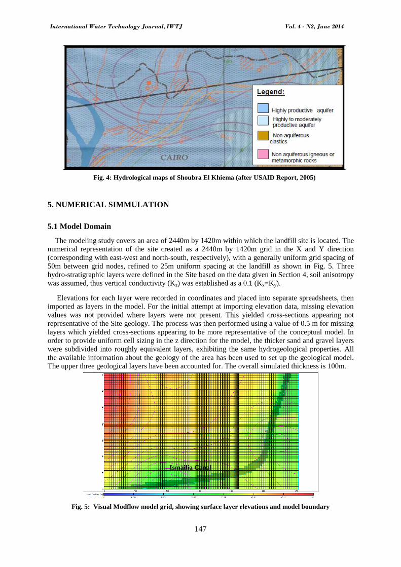
Fig. 4: Hydrological maps of Shoubra El Khiema (after USAID Report, 2005)
5. NUMERICAL SIMMULATION
5.1 Model Domain
The modeling study covers an area of 2440m by 1420m within which the landfill site is located. The
numerical representation of the site created as a 2440m by 1420m grid in the X and Y direction
(corresponding with east-west and north-south, respectively), with a generally uniform grid spacing of
50m between grid nodes, refined to 25m uniform spacing at the landfill as shown in Fig. 5. Three
hydro-stratigraphic layers were defined in the Site based on the data given in Section 4, soil anisotropy
was assumed, thus vertical conductivity (Kz) was established as a 0.1 (Kx=Ky).
Elevations for each layer were recorded in coordinates and placed into separate spreadsheets, then
imported as layers in the model. For the initial attempt at importing elevation data, missing elevation
values was not provided where layers were not present. This yielded cross-sections appearing not
representative of the Site geology. The process was then performed using a value of 0.5 m for missing
layers which yielded cross-sections appearing to be more representative of the conceptual model. In
order to provide uniform cell sizing in the z direction for the model, the thicker sand and gravel layers
were subdivided into roughly equivalent layers, exhibiting the same hydrogeological properties. All
the available information about the geology of the area has been used to set up the geological model.
The upper three geological layers have been accounted for. The overall simulated thickness is 100m.
Fig. 5: Visual Modflow model grid, showing surface layer elevations and model boundary
Ismailia Canal

International Water Technology Journal, IWTJ Vol. 4 - N2, June 2014
148
5.2 Boundary Conditions
As shown in Fig. 5, Ismailia canal was modeled as a river boundary (Waterloo [14]). The source of
groundwater contaminant under this research study is the lead in the landfill, which will infiltrate the
soil surface and recharge into the groundwater aquifer with rainfall and any surface water recharge.
The infiltration pattern in the area is complex and influenced by industrial activities. The better the
description of recharge pattern has been obtained using information regarding the areas in which
groundwater may be recharged.
The rainfall recharge was taken 25.5mm/yr. No flow boundary has been applied, but this has been
verified the possibility that there should be fluxed across parts of these boundaries. The lower clayey
horizon has been selected as the lower model boundary.
5.3 MT3DMS Contaminant Transport Simulation
The high concentration of lead has been detected both in the soil and water samples collected in the
study area. The major problem is to evaluate the possible migration of the heavy metals into the
groundwater aquifer. With this aim, a set of transport simulations have been addressed, describing the
contaminant movement in the subsurface for different scenarios.
Preliminary advection-dispersion transport simulations mainly for lead that have a lower affinity
for the aqueous phase, the simulation of the behavior described above would require the knowledge of
the distribution coefficient Kd to simulate the reactive nature of the metal with a linear isotherm, Bees
and Sharp [15] recommend a value of 4.6 ml/g as a mean value. Longitudinal and transversal
dispersivities have been set to 50 and 5.0m, respectively (Fetter [16]). Due to the lack of data to
implement an accurate adsorption/de-sorption model; only preliminary simulation has been run using
the Modflow-MT3DMS contaminant transport module. Hence, model results have been used for the
purpose of evaluating the possible "best" scenario to stop the migration of lead from the landfill.
5.4 Model Validation
The MT3DMS simulation was incorporated into the transient MODFLOW simulation model. The
MT3DMS model was validated by comparing numerical model predictions with the results of
Geotechnical and geophysical investigation carried by Sadek et al. [17] and Khalil [9], the results of
the numerical model prediction in line with the observed data are presented graphically in Fig. 6.
a.
International Water Technology Journal, IWTJ Vol. 4 - N2, June 2014
149
b.
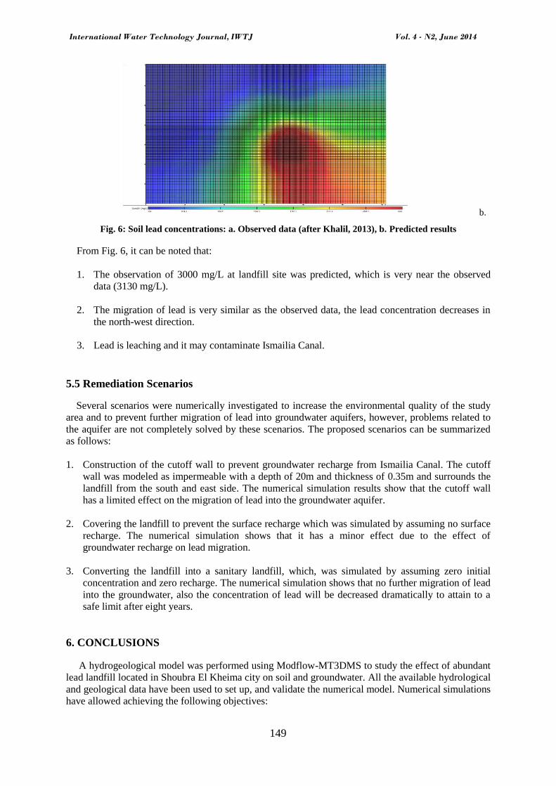
Fig. 6: Soil lead concentrations: a. Observed data (after Khalil, 2013), b. Predicted results
From Fig. 6, it can be noted that:
1. The observation of 3000 mg/L at landfill site was predicted, which is very near the observed
data (3130 mg/L).
2. The migration of lead is very similar as the observed data, the lead concentration decreases in
the north-west direction.
3. Lead is leaching and it may contaminate Ismailia Canal.
5.5 Remediation Scenarios
Several scenarios were numerically investigated to increase the environmental quality of the study
area and to prevent further migration of lead into groundwater aquifers, however, problems related to
the aquifer are not completely solved by these scenarios. The proposed scenarios can be summarized
as follows:
1. Construction of the cutoff wall to prevent groundwater recharge from Ismailia Canal. The cutoff
wall was modeled as impermeable with a depth of 20m and thickness of 0.35m and surrounds the
landfill from the south and east side. The numerical simulation results show that the cutoff wall
has a limited effect on the migration of lead into the groundwater aquifer.
2. Covering the landfill to prevent the surface recharge which was simulated by assuming no surface
recharge. The numerical simulation shows that it has a minor effect due to the effect of
groundwater recharge on lead migration.
3. Converting the landfill into a sanitary landfill, which, was simulated by assuming zero initial
concentration and zero recharge. The numerical simulation shows that no further migration of lead
into the groundwater, also the concentration of lead will be decreased dramatically to attain to a
safe limit after eight years.
6. CONCLUSIONS
A hydrogeological model was performed using Modflow-MT3DMS to study the effect of abundant
lead landfill located in Shoubra El Kheima city on soil and groundwater. All the available hydrological
and geological data have been used to set up, and validate the numerical model. Numerical simulations
have allowed achieving the following objectives:

International Water Technology Journal, IWTJ Vol. 4 - N2, June 2014
150
A good knowledge of the main features of the flow field that acts as the forcing factor of the
transport of lead in the subsurface
A preliminary evaluation of the possibility of the contaminants distributed in the area to reach the
Ismailia Canal
The landfill poses a harmful health effect due to high concentration of lead soil and in
groundwater.
The landfill contaminates the groundwater aquifer due to leaching of lead and a remediation action
should be carried out.
The best remediation action to prevent lead leachate from the landfill into the aquifer is to transfer
the landfill into a sanitary landfill.
ACKNOWLEDGMENTS
The first author is thankful to the Egyptian Ministry of Higher Education (MoHE) for funding his
PhD studies as a scholarship. Also great thanking is due to Egypt-Japan University of Science and
Technology (E-JUST) for offering the tools and equipment needed for the research. This study was
partially supported by JSPS Core-to-Core Program, B. Asia-Africa Science Platforms
REFERENCES
[1]. Finzgar, N., Kos, B., Leštan, D. Washing of Pb contaminated soil using [S,S] ethylenediamine
disuccinate and horizontal permeable barriers, Chemosphere 57 (7), pp. 655-661, 2004.
[2]. Ricardo, M. Cao, X. D., Chen, M., & Ma, L. Q. Field assessment of lead immobilization in a
contaminated soil after phosphate application, Science of the Total Environment 305, pp. 117-
127, 2003.
[3]. Cui, X. T., Luan, W. L., Niu, Y. B., Li, S. M., & Song, Z. F. An assessment of the heavy metal
pollution and potential ecological hazards in urban soil of Tangshan City, Geology in China 38,
pp. 1379-1386, 2011.
[4]. Xiao, C., Li, L., Zha, Z. Y. Research Progress in Lead Contaminated Soil Remediation
Technology, Journal of Chongqing Technology and Business University: Natural Science Edition
29, pp. 99-104, 2012.
[5]. USAID Report. Preliminary Assessment, Awadallah Secondary Lead Smelter in Shoubra El
Kheima, Chemonics International Inc., Washington DC, USA, 2003.
[6]. Li, J.S., Wang, P., & Liu, L. Environmental Prediction Model for Dynamic Release of Lead in
Contaminated Soil under Washing Remediation, EJGE, Vol. 18, pp. 55-70, 2013.
[7]. Atta, A.S. Studies on the groundwater properties of the Nile Delta, Egypt. M.Sc. Thesis, Faculty
of Science, Cairo University, 1979.
[8]. USAID Report. Environmental Impact Assessment for Seoudi Secondary Lead Smelter,
Chemonics International Inc., Washington DC, USA, 2005.
[9]. Khalil, M.H. Magnetic, geo-electric, and groundwater and soil quality analysis over a landfill
from a lead smelter, Cairo, Egypt. Journal of Applied Geophysics, Volume 86, p. 146-159, 2013.

International Water Technology Journal, IWTJ Vol. 4 - N2, June 2014
151
[10]. Maha, A.S. Prevailing Characteristics of Greater Cairo Aquifer system, M.Sc. Thesis, Faculty of
Science, Cairo University, 1984.
[11]. Maher, A.H. Environmental problems related to groundwater conditions in some regions with
greater Cairo, M.Sc. Thesis, Faculty of Science, Cairo University, 1996.
[12]. Safar, Z., Labib, M.W., & Khalil, M.H. Baseline study of the impact of lead smelters and lead
foundries in Egypt for 1998 to 2006, Proceedings of the Air and Waste Management Association's
100th Annual Conference and Exhibition, Pittsburgh, Pennsylvania, USA, 1, pp. 661–675, 2007.
[13]. USAID Report. The Cairo Air Improvement Project, Helping Millions Live Healthier Lives,
Chemonics International Inc., Washington DC, USA, 2004.
[14]. Waterloo Hydrogeologic. Visual MODFLOW v. 4.1 User’s Manual, Waterloo Hydrogeologic,
Inc., Waterloo, Ontario, Canada, 2005.
[15]. Baes, C. and Sharp, R. A proposal for estimation of soil leaching and leaching constants for use
in assessment models. Journal of Environmental Quality, Vol. 12, pp. 17–28, 1983.
[16]. Fetter, C. W. Contaminant Hydrogeology, New York: Macmillan Publishers, New York, 1993.
[17]. Sadek, M. A. & Abd El-Samie, S. G. Pollution vulnerability of the Quaternary aquifer near
Cairo, Egypt, as indicated by isotopes and hydrochemistry, Hydrogeological Journal, Vol. 9, pp.
273–281, 2001.
Internet Resources
[1]. http://en.wikipedia.org/wiki/Shubra_El-Kheima, Last accessed in 19th June 2013.
[2]. http://egypt.usaid.gov/en/successstories/Pages/CleanerAirMakesBreathingEasy.aspx,Last
accessed in 20th June 2013.