Irrigation Development for Water Abundant Assam - 456 records
15
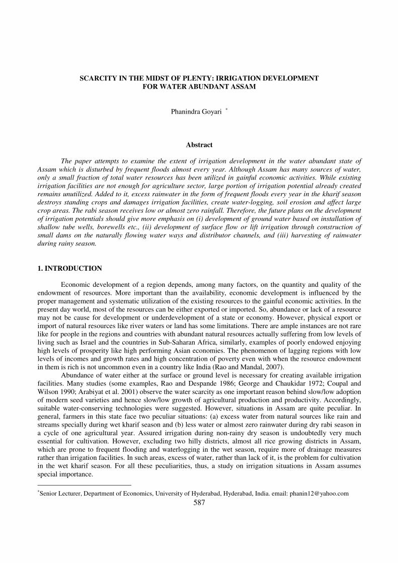
587 SCARCITY IN THE MIDST OF PLENTY: IRRIGATION DEVELOPMENT FOR WATER ABUNDANT ASSAM Phanindra Goyari * Abstract The paper attempts to examine the extent of irrigation development in the water abundant state of Assam which is disturbed by frequent floods almost every year. Although Assam has many sources of water, only a small fraction of total water resources has been utilized in gainful economic activities. While existing irrigation facilities are not enough for agriculture sector, large portion of irrigation potential already created remains unutilized. Added to it, excess rainwater in the form of frequent floods every year in the kharif season destroys standing crops and damages irrigation facilities, create water-logging, soil erosion and affect large crop areas. The rabi season receives low or almost zero rainfall. Therefore, the future plans on the development of irrigation potentials should give more emphasis on (i) development of ground water based on installation of shallow tube wells, borewells etc., (ii) development of surface flow or lift irrigation through construction of small dams on the naturally flowing water ways and distributor channels, and (iii) harvesting of rainwater during rainy season. 1. INTRODUCTION Economic development of a region depends, among many factors, on the quantity and quality of the endowment of resources. More important than the availability, economic development is influenced by the proper management and systematic utilization of the existing resources to the gainful economic activities. In the present day world, most of the resources can be either exported or imported. So, abundance or lack of a resource may not be cause for development or underdevelopment of a state or economy. However, physical export or import of natural resources like river waters or land has some limitations. There are ample instances are not rare like for people in the regions and countries with abundant natural resources actually suffering from low levels of living such as Israel and the countries in Sub-Saharan Africa, similarly, examples of poorly endowed enjoying high levels of prosperity like high performing Asian economies. The phenomenon of lagging regions with low levels of incomes and growth rates and high concentration of poverty even with when the resource endowment in them is rich is not uncommon even in a country like India (Rao and Mandal, 2007). Abundance of water either at the surface or ground level is necessary for creating available irrigation facilities. Many studies (some examples, Rao and Despande 1986; George and Chaukidar 1972; Coupal and Wilson 1990; Arabiyat et al. 2001) observe the water scarcity as one important reason behind slow/low adoption of modern seed varieties and hence slow/low growth of agricultural production and productivity. Accordingly, suitable water-conserving technologies were suggested. However, situations in Assam are quite peculiar. In general, farmers in this state face two peculiar situations: (a) excess water from natural sources like rain and streams specially during wet kharif season and (b) less water or almost zero rainwater during dry rabi season in a cycle of one agricultural year. Assured irrigation during non-rainy dry season is undoubtedly very much essential for cultivation. However, excluding two hilly districts, almost all rice growing districts in Assam, which are prone to frequent flooding and waterlogging in the wet season, require more of drainage measures rather than irrigation facilities. In such areas, excess of water, rather than lack of it, is the problem for cultivation in the wet kharif season. For all these peculiarities, thus, a study on irrigation situations in Assam assumes special importance. * Senior Lecturer, Department of Economics, University of Hyderabad, Hyderabad, India. email: [email protected]
-
Upload
khangminh22 -
Category
Documents
-
view
2 -
download
0
Transcript of Irrigation Development for Water Abundant Assam - 456 records
587
SCARCITY IN THE MIDST OF PLENTY: IRRIGATION DEVELOPMENT
FOR WATER ABUNDANT ASSAM
Phanindra Goyari ∗
Abstract
The paper attempts to examine the extent of irrigation development in the water abundant state of
Assam which is disturbed by frequent floods almost every year. Although Assam has many sources of water,
only a small fraction of total water resources has been utilized in gainful economic activities. While existing
irrigation facilities are not enough for agriculture sector, large portion of irrigation potential already created
remains unutilized. Added to it, excess rainwater in the form of frequent floods every year in the kharif season
destroys standing crops and damages irrigation facilities, create water-logging, soil erosion and affect large
crop areas. The rabi season receives low or almost zero rainfall. Therefore, the future plans on the development
of irrigation potentials should give more emphasis on (i) development of ground water based on installation of
shallow tube wells, borewells etc., (ii) development of surface flow or lift irrigation through construction of
small dams on the naturally flowing water ways and distributor channels, and (iii) harvesting of rainwater
during rainy season.
1. INTRODUCTION
Economic development of a region depends, among many factors, on the quantity and quality of the
endowment of resources. More important than the availability, economic development is influenced by the
proper management and systematic utilization of the existing resources to the gainful economic activities. In the
present day world, most of the resources can be either exported or imported. So, abundance or lack of a resource
may not be cause for development or underdevelopment of a state or economy. However, physical export or
import of natural resources like river waters or land has some limitations. There are ample instances are not rare
like for people in the regions and countries with abundant natural resources actually suffering from low levels of
living such as Israel and the countries in Sub-Saharan Africa, similarly, examples of poorly endowed enjoying
high levels of prosperity like high performing Asian economies. The phenomenon of lagging regions with low
levels of incomes and growth rates and high concentration of poverty even with when the resource endowment
in them is rich is not uncommon even in a country like India (Rao and Mandal, 2007).
Abundance of water either at the surface or ground level is necessary for creating available irrigation
facilities. Many studies (some examples, Rao and Despande 1986; George and Chaukidar 1972; Coupal and
Wilson 1990; Arabiyat et al. 2001) observe the water scarcity as one important reason behind slow/low adoption
of modern seed varieties and hence slow/low growth of agricultural production and productivity. Accordingly,
suitable water-conserving technologies were suggested. However, situations in Assam are quite peculiar. In
general, farmers in this state face two peculiar situations: (a) excess water from natural sources like rain and
streams specially during wet kharif season and (b) less water or almost zero rainwater during dry rabi season in
a cycle of one agricultural year. Assured irrigation during non-rainy dry season is undoubtedly very much
essential for cultivation. However, excluding two hilly districts, almost all rice growing districts in Assam,
which are prone to frequent flooding and waterlogging in the wet season, require more of drainage measures
rather than irrigation facilities. In such areas, excess of water, rather than lack of it, is the problem for cultivation
in the wet kharif season. For all these peculiarities, thus, a study on irrigation situations in Assam assumes
special importance.
∗
Senior Lecturer, Department of Economics, University of Hyderabad, Hyderabad, India. email: [email protected]
588
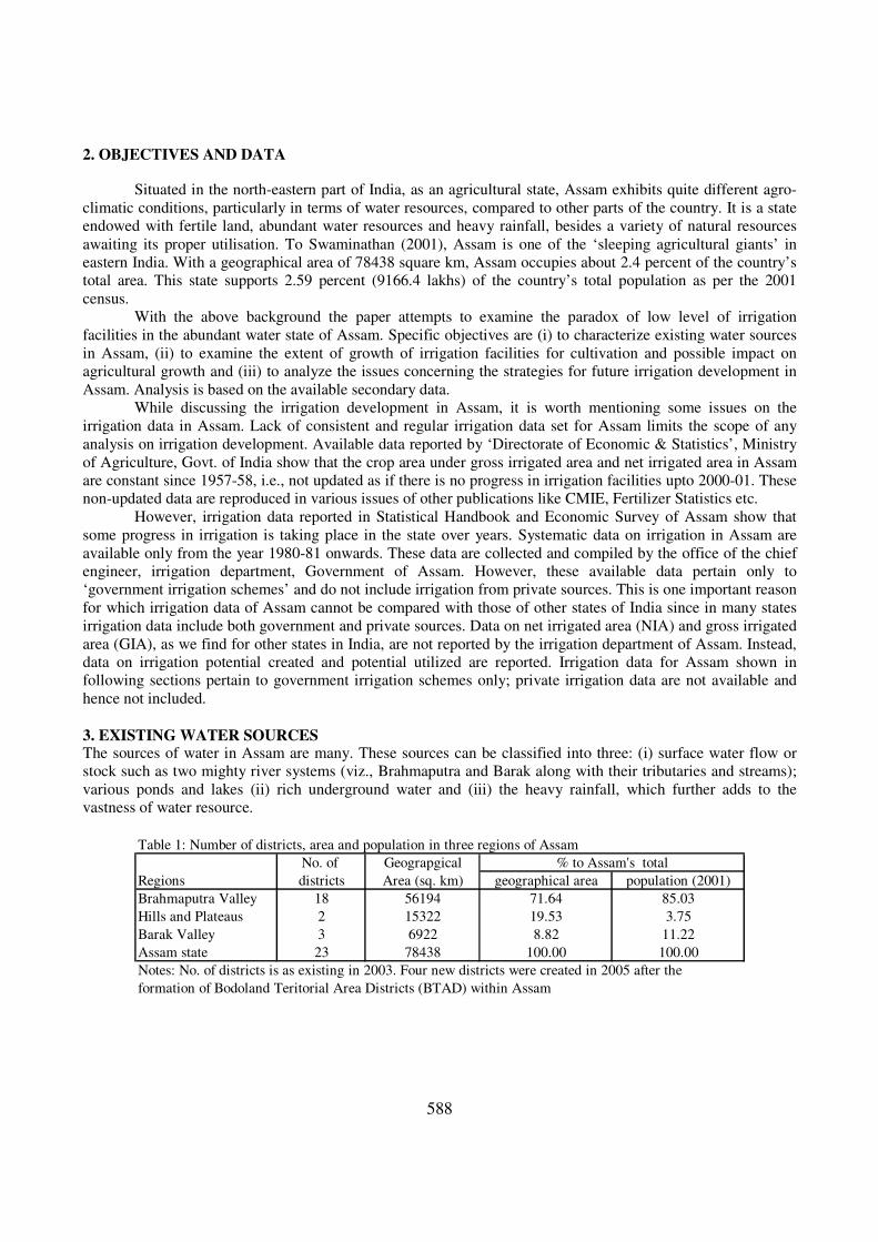
2. OBJECTIVES AND DATA
Situated in the north-eastern part of India, as an agricultural state, Assam exhibits quite different agro-
climatic conditions, particularly in terms of water resources, compared to other parts of the country. It is a state
endowed with fertile land, abundant water resources and heavy rainfall, besides a variety of natural resources
awaiting its proper utilisation. To Swaminathan (2001), Assam is one of the ‘sleeping agricultural giants’ in
eastern India. With a geographical area of 78438 square km, Assam occupies about 2.4 percent of the country’s
total area. This state supports 2.59 percent (9166.4 lakhs) of the country’s total population as per the 2001
census.
With the above background the paper attempts to examine the paradox of low level of irrigation
facilities in the abundant water state of Assam. Specific objectives are (i) to characterize existing water sources
in Assam, (ii) to examine the extent of growth of irrigation facilities for cultivation and possible impact on
agricultural growth and (iii) to analyze the issues concerning the strategies for future irrigation development in
Assam. Analysis is based on the available secondary data.
While discussing the irrigation development in Assam, it is worth mentioning some issues on the
irrigation data in Assam. Lack of consistent and regular irrigation data set for Assam limits the scope of any
analysis on irrigation development. Available data reported by ‘Directorate of Economic & Statistics’, Ministry
of Agriculture, Govt. of India show that the crop area under gross irrigated area and net irrigated area in Assam
are constant since 1957-58, i.e., not updated as if there is no progress in irrigation facilities upto 2000-01. These
non-updated data are reproduced in various issues of other publications like CMIE, Fertilizer Statistics etc.
However, irrigation data reported in Statistical Handbook and Economic Survey of Assam show that
some progress in irrigation is taking place in the state over years. Systematic data on irrigation in Assam are
available only from the year 1980-81 onwards. These data are collected and compiled by the office of the chief
engineer, irrigation department, Government of Assam. However, these available data pertain only to
‘government irrigation schemes’ and do not include irrigation from private sources. This is one important reason
for which irrigation data of Assam cannot be compared with those of other states of India since in many states
irrigation data include both government and private sources. Data on net irrigated area (NIA) and gross irrigated
area (GIA), as we find for other states in India, are not reported by the irrigation department of Assam. Instead,
data on irrigation potential created and potential utilized are reported. Irrigation data for Assam shown in
following sections pertain to government irrigation schemes only; private irrigation data are not available and
hence not included.
3. EXISTING WATER SOURCES The sources of water in Assam are many. These sources can be classified into three: (i) surface water flow or
stock such as two mighty river systems (viz., Brahmaputra and Barak along with their tributaries and streams);
various ponds and lakes (ii) rich underground water and (iii) the heavy rainfall, which further adds to the
vastness of water resource.
Table 1: Number of districts, area and population in three regions of Assam
No. of Geograpgical
Regions districts Area (sq. km) geographical area population (2001)
Brahmaputra Valley 18 56194 71.64 85.03
Hills and Plateaus 2 15322 19.53 3.75
Barak Valley 3 6922 8.82 11.22
Assam state 23 78438 100.00 100.00
Notes: No. of districts is as existing in 2003. Four new districts were created in 2005 after the
formation of Bodoland Teritorial Area Districts (BTAD) within Assam
% to Assam's total
589
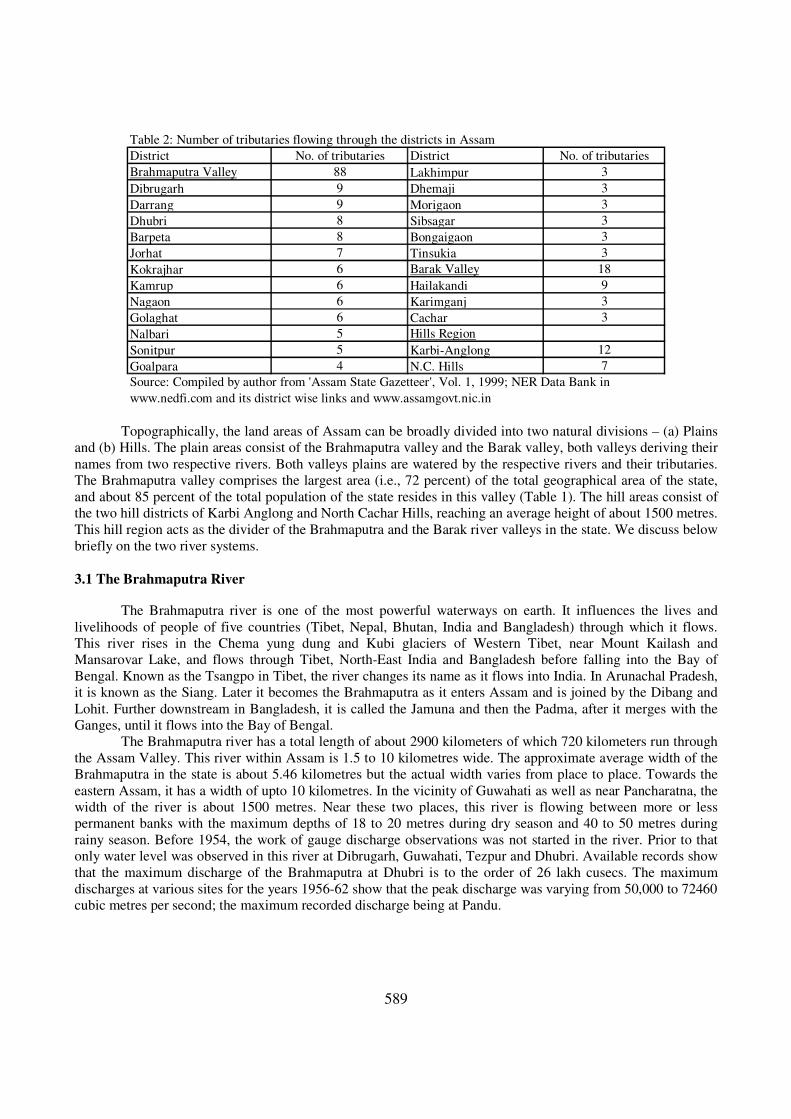
Table 2: Number of tributaries flowing through the districts in Assam
District No. of tributaries District No. of tributaries
Brahmaputra Valley 88 Lakhimpur 3
Dibrugarh 9 Dhemaji 3
Darrang 9 Morigaon 3
Dhubri 8 Sibsagar 3
Barpeta 8 Bongaigaon 3
Jorhat 7 Tinsukia 3
Kokrajhar 6 Barak Valley 18
Kamrup 6 Hailakandi 9
Nagaon 6 Karimganj 3
Golaghat 6 Cachar 3
Nalbari 5 Hills Region
Sonitpur 5 Karbi-Anglong 12
Goalpara 4 N.C. Hills 7
Source: Compiled by author from 'Assam State Gazetteer', Vol. 1, 1999; NER Data Bank in
www.nedfi.com and its district wise links and www.assamgovt.nic.in
Topographically, the land areas of Assam can be broadly divided into two natural divisions – (a) Plains
and (b) Hills. The plain areas consist of the Brahmaputra valley and the Barak valley, both valleys deriving their
names from two respective rivers. Both valleys plains are watered by the respective rivers and their tributaries.
The Brahmaputra valley comprises the largest area (i.e., 72 percent) of the total geographical area of the state,
and about 85 percent of the total population of the state resides in this valley (Table 1). The hill areas consist of
the two hill districts of Karbi Anglong and North Cachar Hills, reaching an average height of about 1500 metres.
This hill region acts as the divider of the Brahmaputra and the Barak river valleys in the state. We discuss below
briefly on the two river systems.
3.1 The Brahmaputra River
The Brahmaputra river is one of the most powerful waterways on earth. It influences the lives and
livelihoods of people of five countries (Tibet, Nepal, Bhutan, India and Bangladesh) through which it flows.
This river rises in the Chema yung dung and Kubi glaciers of Western Tibet, near Mount Kailash and
Mansarovar Lake, and flows through Tibet, North-East India and Bangladesh before falling into the Bay of
Bengal. Known as the Tsangpo in Tibet, the river changes its name as it flows into India. In Arunachal Pradesh,
it is known as the Siang. Later it becomes the Brahmaputra as it enters Assam and is joined by the Dibang and
Lohit. Further downstream in Bangladesh, it is called the Jamuna and then the Padma, after it merges with the
Ganges, until it flows into the Bay of Bengal.
The Brahmaputra river has a total length of about 2900 kilometers of which 720 kilometers run through
the Assam Valley. This river within Assam is 1.5 to 10 kilometres wide. The approximate average width of the
Brahmaputra in the state is about 5.46 kilometres but the actual width varies from place to place. Towards the
eastern Assam, it has a width of upto 10 kilometres. In the vicinity of Guwahati as well as near Pancharatna, the
width of the river is about 1500 metres. Near these two places, this river is flowing between more or less
permanent banks with the maximum depths of 18 to 20 metres during dry season and 40 to 50 metres during
rainy season. Before 1954, the work of gauge discharge observations was not started in the river. Prior to that
only water level was observed in this river at Dibrugarh, Guwahati, Tezpur and Dhubri. Available records show
that the maximum discharge of the Brahmaputra at Dhubri is to the order of 26 lakh cusecs. The maximum
discharges at various sites for the years 1956-62 show that the peak discharge was varying from 50,000 to 72460
cubic metres per second; the maximum recorded discharge being at Pandu.
590
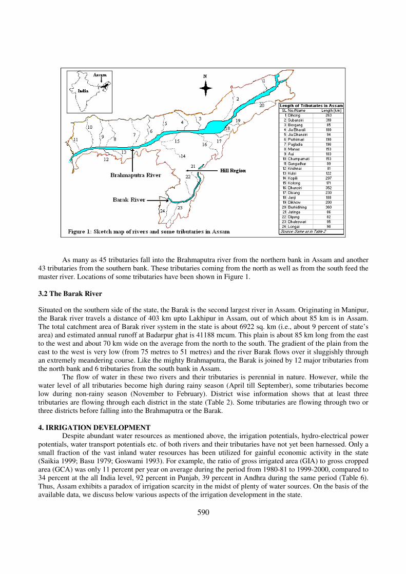
As many as 45 tributaries fall into the Brahmaputra river from the northern bank in Assam and another
43 tributaries from the southern bank. These tributaries coming from the north as well as from the south feed the
master river. Locations of some tributaries have been shown in Figure 1.
3.2 The Barak River
Situated on the southern side of the state, the Barak is the second largest river in Assam. Originating in Manipur,
the Barak river travels a distance of 403 km upto Lakhipur in Assam, out of which about 85 km is in Assam.
The total catchment area of Barak river system in the state is about 6922 sq. km (i.e., about 9 percent of state’s
area) and estimated annual runoff at Badarpur ghat is 41188 mcum. This plain is about 85 km long from the east
to the west and about 70 km wide on the average from the north to the south. The gradient of the plain from the
east to the west is very low (from 75 metres to 51 metres) and the river Barak flows over it sluggishly through
an extremely meandering course. Like the mighty Brahmaputra, the Barak is joined by 12 major tributaries from
the north bank and 6 tributaries from the south bank in Assam.
The flow of water in these two rivers and their tributaries is perennial in nature. However, while the
water level of all tributaries become high during rainy season (April till September), some tributaries become
low during non-rainy season (November to February). District wise information shows that at least three
tributaries are flowing through each district in the state (Table 2). Some tributaries are flowing through two or
three districts before falling into the Brahmaputra or the Barak.
4. IRRIGATION DEVELOPMENT Despite abundant water resources as mentioned above, the irrigation potentials, hydro-electrical power
potentials, water transport potentials etc. of both rivers and their tributaries have not yet been harnessed. Only a
small fraction of the vast inland water resources has been utilized for gainful economic activity in the state
(Saikia 1999; Basu 1979; Goswami 1993). For example, the ratio of gross irrigated area (GIA) to gross cropped
area (GCA) was only 11 percent per year on average during the period from 1980-81 to 1999-2000, compared to
34 percent at the all India level, 92 percent in Punjab, 39 percent in Andhra during the same period (Table 6).
Thus, Assam exhibits a paradox of irrigation scarcity in the midst of plenty of water sources. On the basis of the
available data, we discuss below various aspects of the irrigation development in the state.
591
4.1 Irrigation Utilization Rate The information on the irrigation potential created and utilized in Assam has some interesting trends.
Data in Table 3 show that the irrigation potential created in Assam has been increasing steadily over the years
since 1980-81. The irrigation potential created in the state was about 255 thousand hectares per year on average
during the period 1980-81 to 1984-85. This increased to more than 484 thousand hectares per year on average
during the quinquennium 1995-96 to 1999-2000. However, the irrigation potential utilized has not been able to
keep a pace with that of the potential created. The utilization rate of the irrigation facilities in the state has been
declining with much fluctuations from period to period. Out of the total irrigation potential created, only 60
percent was being utilized during the period 1980-81 to 1984-85. The recent period available data showed only
about 19 percent irrigation utilization rate as a whole per year in the state.
Table 3: Irrigation potential created and utilized in Assam
Period created utilized utilization
(Averages) (thousand ha) (thousand ha) rate (%)
A B C D=(C/B)*100
1980-81 to 1984-85 254.5 151.8 60
1985-86 to 1989-90 461.5 222.1 48
1990-91 to 1994-95 454.0 191.7 42
1995-96 to 1999-00 484.3 115.3 24
2000-01 to 2002-03 545.8 102.5 19
Note: Data are from the Office, Chief Engineer, Irrigation Department, Govt. of Assam
Source: Compilations and calculations are by the author
Irrigation potential
Looking across regions, available data (Table 4) show the most efficient utilization of the irrigation
potential is in the hill region of the state during 1992-93 to 1996-97. The utilization rate in the hill region has
been the highest followed by the Brahmaputra valley among three regions. The utilization rate for the hill region
was higher than even the state average level during 1992-93 to 1999-00. But, during the same period, two other
regions had the utilization rate lower than the state average level in each year. Barak valley witnessed the lowest
absolute areas of irrigation potential created and utilized as well as the rate of irrigation potential utilization
during the period mentioned above. The irrigation utilization rate in the hilly region was 72 percent in the year
1992-93 against the state average of 47 percent in the same year. The Brahmaputra and the Barak valleys could
utilize only 44 percent and 32 percent respectively, of the total potential created in that year. The high irrigation
utilization rate in two hill districts indicate the efficient use of scarce resource created in the region. Like at the
state level, all three regions witnessed a fall in the rate of irrigation utilization over the years.
Table 4: Region wise utilization rate of irrigation potential in Assam (1992-93 to 1996-97)
Valley and
Region 92-93 93-94 94-95 95-96 96-97 92-93 93-94 94-95 95-96 96-97 92-93 93-9494-95 95-96 96-97
Brahmaputra
Valley 420 430 439 441 442 187 110 131 93 97 44 26 30 21 22
Barak Valley 11 11 12 12 12 4 1 1 1 0 32 6 11 7 2
Hill Region 25 25 26 27 27 18 19 15 19 16 72 76 59 73 61
Assam 456 466 477 480 481 215 130 147 113 114 47 28 31 24 24
Notes and Source: Same as in Table 3
Utilization rate (%)Irrigation potential created (000 ha) Irrigation potential utilized (000 ha)
Several factors may be responsible for the low rate of utilization of the irrigation potential created in the
state. Defective irrigation management, lack of co-ordination among various implementing agencies and several
technical defects cannot be ruled out. Economic Survey, (Assam, 2003-04) states, “apart from non-practicing of
cropping pattern as per approved/designed cropping pattern of the irrigation schemes and lack of eagerness on
the part of the farmers to utilize irrigation water due to lack of awareness about the role played by irrigation in
592
increasing yield rates of crops, non-repair of schemes due to paucity of fund, non-energisation of pump sets and
erratic supply of electricity in case of electrical lift irrigation schemes etc are some of the reasons of under-
utilization of available irrigation potential from government schemes”.
Data on the utilization pattern also can tell us one root cause of the low utilization rate. As per the
available data, more than 93 percent of the total irrigation potential utilization in the state comes from
government canals. In this source, mere creation of irrigation potential is not enough. Irrigation from canals
needs the construction of proper distribution channels, sluice gates etc. and proper maintenance of those
infrastructures. But occurrence of frequent floods, specially during kharif season every year, in the state has
been destroying infrastructures including irrigation. Floods destroy canals, distribution channels, sluice gates,
dams etc. Once destroyed or broken, it takes time to reconstruct those facilities. In this way, the utilization of
created irrigation potential becomes a great problem. Ultimately the available irrigation facilities created remain
unutilized.
4.2 Season Wise Irrigation Facilities In Assam, kharif season is still the main season for rice cultivation. The irrigation potential created and
utilized during the kharif season have been higher than during the rabi & pre-kharif seasons (Table 5). Thus the
irrigation utilization rates during the kharif season have also been higher than rabi and pre-kharif seasons. While
only about 9 percent of the irrigation potential created was utilized in the state during rabi and pre-kharif
seasons, more than 30 percent was utilized during kharif season in the year 1996-97. But the utilization rates in
both seasons have been declining over the years.
This season wise irrigation information makes us aware of one important thing about the need of
irrigation development more during rabi season. Because, heavy rainfall and consequent flood there from during
the kharif season have been disturbing cultivations. But during the rabi season many farmers get neither much
needed assured water nor rainwater. The cropping pattern analysis for Assam shows that the summer rice and
other rabi crops (such as vegetables, fruits and spices) are emerging as important crops in recent years (Goyari
2007). Hence, if farmers are provided with assured irrigation water, the summer or rabi season can be made one
of the important seasons for cultivation. This trend demands development of more irrigation facilities to be used
during summer season as well as better utilization of already created irrigation facilities.
Table 5: Season wise irrigation potential created and utilized in Assam (thousand ha)
Year Kharif
Rabi & Pre-
Kharif Kharif
Rabi & Pre-
Kharif Kharif
Rabi & Pre-
Kharif
A B C D E F = (D/B)*100 G = (E/C)*100
1996-97 332.0 148.8 100.1 14.0 30.2 9.4
1997-98 332.2 148.9 101.6 12.9 30.6 8.6
1998-99 334.0 150.0 101.2 15.8 30.3 10.5
1999-00 341.4 154.1 97.8 21.2 28.7 13.8
2000-01 344.6 159.4 99.9 14.8 29.0 9.3
2001-02 348.8 164.5 99.3 13.7 28.5 8.4
2002-03 353.7 166.4 71.9 7.5 20.3 4.5
1996-97 to 2002-03 341.0 156.0 96.0 14.3 28.1 9.1
Notes and Source: Same as in Table 3
Utilization rate (%)
Irrigation potential Irrigation potential
created upto the year utilized during the year
4. 3 Source Wise Irrigation Facilities Source wise, major portion (more than 94 percent) of the irrigation facilities comes from the
government canals. Second important source is tubewells. Irrigation from tanks is almost non-existent in the
state. Both the canal and tubewell irrigation facilities in absolute terms have shown a declining trend particularly
after mid-1980s. The canal irrigation facilities were about 208 thousand ha during the period 1985-86 to 1989-
90; it fell to about 100 thousand ha during the period 2000-01 to 2002-03. Irrigation facilities from tubewells
593
also declined by 12000 ha during the same period. However, in terms of percentage shares, the contribution of
canal irrigation towards the total irrigation facilities increased over the period and that of tubewells declined.
The share of canal irrigation in the total irrigation potential utilized in the state was 96.5 percent during 1980-81
to 1984-85; this increased to 97.7 percent during 2000-01 to 2002-03.
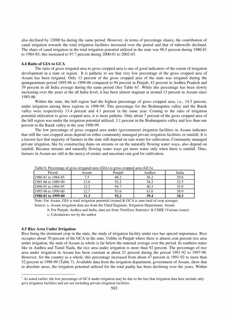
4.4 Ratio of GIA to GCA The ratio of gross irrigated area to gross cropped area is one of good indicators of the extent of irrigation
development in a state or region. It is pathetic to see that very low percentage of the gross cropped area of
Assam has been irrigated. Only 13 percent of the gross cropped area of the state was irrigated during the
quinquennium period 1995-96 to 1999-00 compared to 94 percent in Punjab, 43 percent in Andhra Pradesh and
39 percent in all India average during the same period (See Table 6)1. While this percentage has been slowly
increasing over the years at the all India level, it has been almost stagnant at around 13 percent in Assam since
1985-86.
Within the state, the hill region had the highest percentage of gross cropped area, i.e., 14.5 percent,
under irrigation among three regions in 1998-99. This percentage for the Brahmaputra valley and the Barak
valley were respectively 13.4 percent and 4.1 percent in the same year. Coming to the ratio of irrigation
potential utilization to gross cropped area, it is more pathetic. Only about 7 percent of the gross cropped area of
the hill region was under the irrigation potential utilized; 3.1 percent in the Brahmaputra valley and less than one
percent in the Barak valley in the year 1998-99.
The low percentage of gross cropped area under (government) irrigation facilities in Assam indicates
that still the vast cropped areas depend on either community managed private irrigation facilities or rainfall. It is
a known fact that majority of farmers in the state still depend on rain water for cultivation. Community managed
private irrigation, like by constructing dams on streams or on the naturally flowing water ways, also depend on
rainfall. Because streams and naturally flowing water ways get more water only when there is rainfall. Thus,
farmers in Assam are still at the mercy of erratic and uncertain rain god for cultivation.
Table 6: Percentage of gross irrigated area (GIA) to gross cropped area (GCA)
Period Assam Punjab Andhra India
1980-81 to 1984-85 7.5 88.2 36.2 29.8
1985-86 to 1989-90 13.0 92.2 38.2 32.5
1990-91 to 1994-95 12.2 94.7 40.3 35.9
1995-96 to 1999-00 12.7 93.6 43.0 38.9
1980-81 to 1999-00 11.3 92.2 39.4 34.3
Note: For Assam, GIA is total irrigation potential created & GCA is sum total of crop acreages
Source: a. Assam irrigation data are from the Chief Engineer, Irrigation Department, Assam
b. For Punjab, Andhra and India, data are from 'Fertilizer Statistics' & CMIE (Various issues)
c. Calculations are by the author
4.5 Rice Area Under Irrigation Rice being the dominant crop in the state, the study of irrigation facility under rice has special importance. Rice
occupies about 70 percent of the GCA in the state. Unlike in Punjab where there is almost cent percent rice area
under irrigation, the state of Assam as whole is far below the national average over the period. In southern states
like in Andhra and Tamil Nadu, the rice area under irrigation is more than 92 percent. The percentage of rice
area under irrigation in Assam has been constant at about 21 percent during the period 1991-92 to 1997-98.
However, for the country as a whole, this percentage increased from about 47 percent in 1991-92 to more than
52 percent in 1998-99 (Table 7). Available data from the irrigation department, government of Assam, show that
in absolute areas, the irrigation potential utilized for the total paddy has been declining over the years. Within
1 As noted earlier, the low percentage of GCA under irrigation may be due to the fact that irrigation data here include only
govt irrigation facilities and are not including private irrigation facilities.
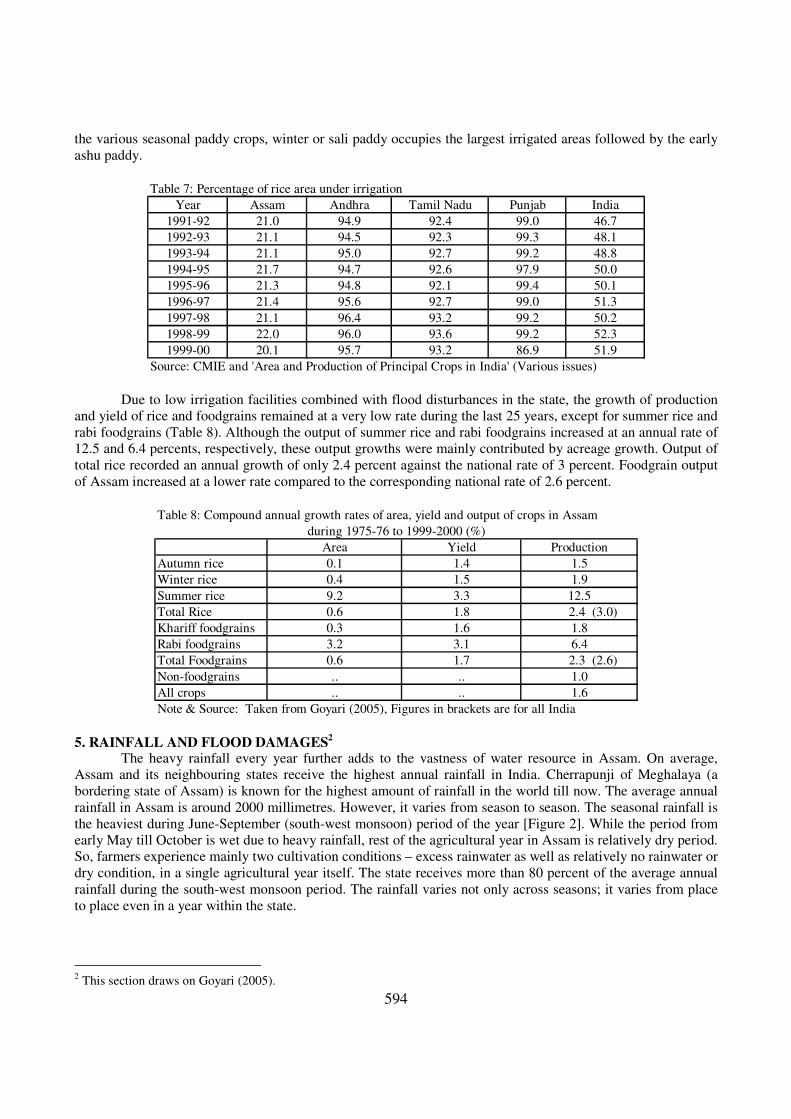
594
the various seasonal paddy crops, winter or sali paddy occupies the largest irrigated areas followed by the early
ashu paddy.
Table 7: Percentage of rice area under irrigation
Year Assam Andhra Tamil Nadu Punjab India
1991-92 21.0 94.9 92.4 99.0 46.7
1992-93 21.1 94.5 92.3 99.3 48.1
1993-94 21.1 95.0 92.7 99.2 48.8
1994-95 21.7 94.7 92.6 97.9 50.0
1995-96 21.3 94.8 92.1 99.4 50.1
1996-97 21.4 95.6 92.7 99.0 51.3
1997-98 21.1 96.4 93.2 99.2 50.2
1998-99 22.0 96.0 93.6 99.2 52.3
1999-00 20.1 95.7 93.2 86.9 51.9
Source: CMIE and 'Area and Production of Principal Crops in India' (Various issues)
Due to low irrigation facilities combined with flood disturbances in the state, the growth of production
and yield of rice and foodgrains remained at a very low rate during the last 25 years, except for summer rice and
rabi foodgrains (Table 8). Although the output of summer rice and rabi foodgrains increased at an annual rate of
12.5 and 6.4 percents, respectively, these output growths were mainly contributed by acreage growth. Output of
total rice recorded an annual growth of only 2.4 percent against the national rate of 3 percent. Foodgrain output
of Assam increased at a lower rate compared to the corresponding national rate of 2.6 percent.
Table 8: Compound annual growth rates of area, yield and output of crops in Assam
during 1975-76 to 1999-2000 (%)
Area Yield Production
Autumn rice 0.1 1.4 1.5
Winter rice 0.4 1.5 1.9
Summer rice 9.2 3.3 12.5
Total Rice 0.6 1.8 2.4 (3.0)
Khariff foodgrains 0.3 1.6 1.8
Rabi foodgrains 3.2 3.1 6.4
Total Foodgrains 0.6 1.7 2.3 (2.6)
Non-foodgrains .. .. 1.0
All crops .. .. 1.6
Note & Source: Taken from Goyari (2005), Figures in brackets are for all India
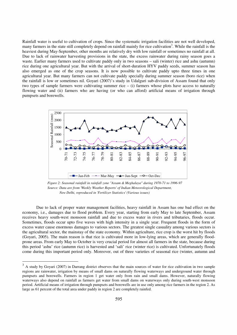
5. RAINFALL AND FLOOD DAMAGES2
The heavy rainfall every year further adds to the vastness of water resource in Assam. On average,
Assam and its neighbouring states receive the highest annual rainfall in India. Cherrapunji of Meghalaya (a
bordering state of Assam) is known for the highest amount of rainfall in the world till now. The average annual
rainfall in Assam is around 2000 millimetres. However, it varies from season to season. The seasonal rainfall is
the heaviest during June-September (south-west monsoon) period of the year [Figure 2]. While the period from
early May till October is wet due to heavy rainfall, rest of the agricultural year in Assam is relatively dry period.
So, farmers experience mainly two cultivation conditions – excess rainwater as well as relatively no rainwater or
dry condition, in a single agricultural year itself. The state receives more than 80 percent of the average annual
rainfall during the south-west monsoon period. The rainfall varies not only across seasons; it varies from place
to place even in a year within the state.
2 This section draws on Goyari (2005).
595
Rainfall water is useful to cultivation of crops. Since the systematic irrigation facilities are not well developed,
many farmers in the state still completely depend on rainfall mainly for rice cultivation3. While the rainfall is the
heaviest during May-September, other months are relatively dry with low rainfall or sometimes no rainfall at all.
Due to lack of rainwater harvesting provisions in the state, the excess rainwater during rainy season goes a
waste. Earlier many farmers used to cultivate paddy only in two seasons – sali (winter) rice and ashu (autumn)
rice during one agricultural year. But with the arrival of short-duration HYV paddy seeds, summer season has
also emerged as one of the crop seasons. It is now possible to cultivate paddy upto three times in one
agricultural year. But many farmers can not cultivate paddy specially during summer season (boro rice) when
the rainfall is low or sometimes nil. Goyari (2007)’s study in Udalguri sub-division of Assam found that only
two types of sample farmers were cultivating summer rice – (i) farmers whose plots have access to naturally
flowing water and (ii) farmers who are having (or who can afford) artificial means of irrigation through
pumpsets and borewells.
Figure 2: Seasonal rainfall in rainfall zone "Assam & Meghalaya" during 1970-71 to 1996-97
Source: Data are from 'Weekly Weather Reports' of Indian Meteorological Department,
New Delhi, reproduced in 'Fertilizer Statistics' (Various issues)
0
500
1000
1500
2000
2500
70
-71
72
-73
74
-75
76
-77
78
-79
80
-81
82
-83
84
-85
86
-87
88
-89
90
-91
92
-93
94
-95
96
-97
Sea
son
al R
ain
fall
(m
m)
Jan-Feb Mar-May Jun-Sept Oct-Dec
Due to lack of proper water management facilities, heavy rainfall in Assam has one bad effect on the
economy, i.e., damages due to flood problem. Every year, starting from early May to late September, Assam
receives heavy south-west monsoon rainfall and due to excess water in rivers and tributaries, floods occur.
Sometimes, floods occur upto five waves with high intensity in a single year. Frequent floods in the form of
excess water cause enormous damages to various sectors. The greatest single casuality among various sectors is
the agricultural sector, the mainstay of the state economy. Within agriculture, rice crop is the worst hit by floods
(Goyari, 2005). The main reason is that rice is cultivated more in low-lying areas, which are generally flood-
prone areas. From early May to October is very crucial period for almost all farmers in the state, because during
this period ‘ashu’ rice (autumn rice) is harvested and ‘sali’ rice (winter rice) is cultivated. Unfortunately floods
come during this important period only. Moreover, out of three varieties of seasonal rice (winter, autumn and
3 A study by Goyari (2007) in Darrang district observes that the main sources of water for rice cultivation in two sample
regions are rainwater, irrigation by means of small dams on naturally flowing waterways and underground water through
pumpsets and borewells. Farmers in region 1 get water only from rain and small dams. However, naturally flowing
waterways also depend on rainfall as farmers get water from small dams on waterways only during south-west monsoon
period. Artificial means of irrigation through pumpsets and borewells are in use only among rice farmers in the region 2. As
large as 61 percent of the total area under paddy in region 2 are completely rainfed.
596
summer rice)4, winter rice is the most popular among farmers due to easy availability of rainwater. But excess
rainwater disturbs farmers in the form of floods. Floods in early parts of the rainy season mainly damage the
‘ashu’ rice crop. But the floods occurring late in the season are the most devastating as they damage the standing
‘sali’ rice, the main ‘kharif’ crop of the state.
Flood damages have various effects on the agricultural sector in the state. First, occurrence of frequent
floods is one of the major factors, which has been hindering farmers from adopting the improved agricultural
production techniques in Assam, mainly during sali (winter rice) season. Due to frequent floods, in fact, many
farmers have adopted a risk averse strategy of not using purchased inputs such as HYV seeds, chemical
fertilizers, pesticides etc. Cultivation of winter rice starts in June-July. During this period, the rainfall is the
highest. Paddy fields, most of which are low-lying areas, are flooded with excess water. Excess water washes
away chemical fertilizers from one plot to other plots. So many farmers do not apply fertilizer in the winter rice
even if some farmers can afford to apply it. Moreover, HYV paddy varieties, most of which are of short-height,
are damaged due to flooding. Although excessive rain water is not so much a problem for cultivation of autumn
and summer paddy, farmers do not want to apply chemical fertilizers even in the autumn and summer paddy
mainly due to less irrigation facilities. Secondly, frequent floods in the state, as mentioned already, have been
able to shift the cropping pattern as well to some extent especially among three varieties of rice during the last
three decades (Goyari, 2007). Area wise and production wise, winter rice has traditionally been the most
important among three categories followed by autumn rice. However, the acreage shares of winter rice and
autumn rice in total rice area have been continuously declining during 1975-76 to 1999-00. On the contrary, the
importance of summer rice, which is grown during flood-free season, in the total area under rice, has been
increasing continuously. Winter rice used to occupy more than 71 percent of the total area under rice during
1975-’79. But it came down to 68.3 percent during 1995-99, i.e., a fall of about 3 percentage points during the
period under reference. Autumn rice also lost its area importance by almost the same percentage points like
winter rice. The autumn rice acreage share in total area under rice declined from 27.1 percent during 1975-79 to
23.7 percent during 1995-99. All these losses in areas went to summer rice. Summer rice, which used to occupy
less than 2 percent, comprised 8 percent of the total area under rice in the state in recent years. Data show us that
this increase became sharp especially after 1990-91. The main reason behind the fall in the winter + autumn rice
and the rise in the summer rice is due to floods in the state of Assam. To avoid crop losses due to frequent
floods, many farmers in the state have adopted a risk averse strategy of not cultivating winter and autumn rice.
Thus, any development policy in Assam should think of the flood controlling measures also. Without
controlling floods, none of the productivity enhancement packages will bear desired fruits. While most of the
flood control measures undertaken so far are of short-term nature, concerted policy decisions on long term
measures, both of the state and central governments are needed to solve flood problems permanently.
6. GROUND WATER AND SHALLOW TUBEWELLS (STWs) As stated earlier, Assam is still having a huge potential for development of irrigation based on ground
water resources. Different surveys have found that there is tremendous scope for developing ground water based
irrigation system in most parts of the state. Findings of some studies may be quoted here. Das (1984) wrote “the
entire Brahmaputra valley can be considered as a vast reservoir of ground water. The water table is generally
within 5 meters below the land surface except in a narrow belt of 10 to 15 kilometers of width in the northern
side running along the foothills of the Himalayas. In this belt, water table generally lies at a depth of 15 to 35
meters below the surface. Development of irrigation from ground water through shallow and deep tubewells is
feasible in the entire Brahmaputra valley”. He further states that “The sediments comprising the water bearing
horizons of the Barak valley down to 50 meters are predominantly clayey and do not support good tubewells. It
is, therefore, considered that tubewells in this region can not be successful”. The prospect of ground water
irrigation in the hilly region (comprising two districts of NC Hills and Karbi Anglong), to him, is generally
limited to the small intermountain valleys. He states, “In the limestone terrains such as the Umrang basin of
Karbi Anglong, the sinkholes of various sizes, if interconnected, are capable of yielding large quantities of
4 Each category derives its name from the season in which the crop is harvested and not by the cultivation period. Winter
rice is cultivated in early June-July and harvested in November-December. Autumn season is from February to June-July.
Summer rice season is usually from November to April-May.
597
ground water”. Goyari (2007), in his field surveys in Udalguri sub-division on the northern bank of Brahmaputra
valley found that ‘generally, for dugwell, it is easy to get ground water by digging 2 to 4 meters inside the
ground’ in 2005. However, ‘for borewell and tubewell operations, it is necessary to put water pipe about 10 to
13 meters inside the ground. But for effective discharge of water, some farmers (who are using borewells) put
water pipes to even 30 meters inside the ground’. Compared to findings in Assam, in an article on tubewell
drilling in Punjab, Agnihotri (2004) quotes the statement of one driller, ‘To ensure good water discharge, we
have to dig 300 to 375 metres in Derabassi block. Earlier, 120 metres of drilling used to be sufficient.’
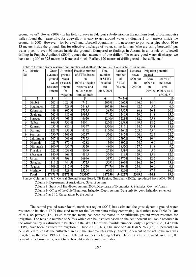
Table 9: Ground water resource and numbers of shallow tube wells (STWs) installed in Assam
SL. District Gross Utilizable Feasible number Total Balance Net area Irrigation potential
No. dynamic ground of STWs based number number sown created
ground water on of STWs of (000 ha) Area As % of
water resource 100% utilizable installed STWs in (000 ha) net sown
resource (mcm) resource and till feasible 1999-00 in area
(mcm) for 0.0216 mcm June, 2001 1999-00 (Col. 9 as %
irrigation annual draft of Col. 8)
1 2 3 4 5 6 7= 5-6 8 9 10
1 Dhubri 1205.1 1024.3 47421 20798 26623 146.6 14.4 9.8
2 Bogaigaon 622.2 528.9 24485 10789 13696 92.7 5.5 6.0
3 Kokrajhar 949.8 807.3 37375 3850 33525 86.8 26.1 30.1
4 Goalpara 565.4 480.6 19935 7442 12493 79.0 11.8 15.0
5 Barpeta 1133.9 963.8 44620 12406 32214 182.6 55.8 30.6
6 Nalbari 866.3 736.4 34091 12508 21583 149.3 18.2 12.2
7 Kamrup 1035.4 880.1 39357 15206 24151 174.5 33.1 18.9
8 Darrang 1121.7 953.5 44142 11500 32642 203.6 55.4 27.2
9 Sonitpur 1530.7 1301.0 60237 5763 54474 160.9 52.3 32.5
10 Lakhimpur 707.8 601.6 27853 1901 25952 97.2 10.4 10.7
11 Dhemaji 1023.7 870.1 40282 1360 38922 54.7 6.0 11.1
12 Dibrugarh 1100.9 935.7 43320 4800 38520 127.5 11.8 9.2
13 Tinsukia 1222.3 1039.0 48099 2580 45519 96.9 5.6 5.8
14 Sibasagar 1140.9 969.8 44895 3700 41195 129.0 15.9 12.3
15 Jorhat 938.9 798.1 36946 3172 33774 116.0 12.2 10.6
16 Golaghat 1111.2 944.5 43725 5091 38634 116.3 16.2 13.9
17 Nagaon 1309.2 1112.9 51520 17476 34044 234.4 16.0 6.8
18 Morigaon 386.4 328.4 15204 6908 8296 101.4 87.3 86.1
Total 17971.7 15275.8 703507 147250 546257 2349.3 454.1 19.3
Source: Column 3, 4 & 5: Central Ground Water Board, NE Region, Guwahati (2002), reproduced from ADR (2002)
Column 6: Department of Agriculture, Govt. of Assam
Column 8: Statistical Handbook, Assam, 2004, Directorate of Economics & Statistics, Govt. of Assam
Column 9: Office of the Chief Engineer, Irrigation Dept., Assam (Data only for govt. irrigation schemes)
Column 7 and 10: Calculations by the author
The central ground water Board, north east region (2002) has estimated the gross dynamic ground water
resource to be about 17.97 thousand mcm for the Brahmaputra valley comprising 18 districts (see Table 9). Out
of this, 85 percent (i.e., 15.28 thousand mcm) has been estimated to be utilizable ground water resource for
irrigation. The feasible number of STWs which can be installed based on the cent percent utilizable resource in
the whole valley is estimated to be about 7.04 lakh. Out of this feasible numbers, only 21 percent (i.e., 1.47 lakh
STWs) have been installed for irrigation till June 2001. Thus, a balance of 5.46 lakh STWs (i.e., 79 percent) can
be installed to irrigate the cultivated areas in the Brahmaputra valley. About 19 percent of the net sown area was
irrigated in the year 1999-00 from different sources including STWs. Hence, a vast cultivated area, i.e., 81
percent of net sown area, is yet to be brought under assured irrigation.

598
7. FUTURE IRRIGATION DEVELOPMENT STRATEGIES: SOME ISSUES Findings from the above analysis have important bearings on the policies for irrigation and agricultural
development of the state. Large potential of untapped irrigation potential, both surface and ground water, still
exists in Assam. Although summer season is emerging as one of the important crop seasons for paddy
cultivation, irrigation facilities in this season are not enough and not available in many places. Unlike in the wet
sali season, the cultivation of paddy in the summer is largely conditioned by the availability of irrigation.
Summer season is dry, with very less or sometimes no rainfall. Only those farmers can cultivate summer rice,
who can afford pumpset and borewell irrigation or whose plots have access to naturally flowing water. Had
there been available irrigation facilities, many farmers would have cultivated paddy in summer season.
Moreover, summer season is flood-free season. Farmers’ fear of costly inputs such chemical fertilizers being
washed away or short-height HYV paddy plants being damaged by floods is not there in summer season.
While the lack of irrigation is one important reason for many farmers not cultivating summer rice, there
are other reasons also for not cultivating lands during summer or rabi season in the state. Traditional varieties of
paddy seeds like haldharam, maisali maima, maibra etc. do not grow well during summer season as
climate/humidity is not suitable for those varieties. Even if there is irrigation facility, many farmers do not
cultivate traditional paddy seeds during summer season. However, with the arrival of new paddy seeds (i.e., high
yielding varieties), most of which are not season-specific, now farmers can cultivate paddy during summer
season also. Secondly, many farmers have been traditionally cultivating only rice in their lands. For many
farmers, rice cultivating plots are different from land plots meant for vegetables and other crops. Rice is
generally grown only in low-lying areas which are not suitable for vegetables like cabbage, potato etc. Like
traditional rice seeds, some varieties of vegetables and fruit crops do not grow well during summer season due
to unsuitable humidity conditions. Cultivation of rabi crops like vegetables, fruits, spices is still not wide spread
during summer season due to lack of proper facilities like marketing centres, storage, price support, transport
network, food processing etc. Thus, along with irrigation development schemes, the government should give
emphasis on the development of those related infrastructure facilities.
Since big irrigation projects are costly and, in most cases, beyond the resource capacity of the state’s
exchequer, Assam can depend more on small and minor irrigations by harnessing groundwater for future
irrigation development. It is true that large scale development of ground water based irrigation systems may lead
to new problems like depletion/lowering of water table. Many studies conducted in others parts of India and
abroad have revealed this problem. For Assam as whole, it is too early to face such problem. Added to it, the
state as a whole generally receives heavy rainfall during kharif season, which acts as a replenishment of the
natural water resources of the state.
Assam, in general, still has a vast potential of developing irrigation facilities based on ground water
through installation of shallow tube wells and borewells. Harnessing of groundwater through shallow tube wells
and dug wells are both affordable and easily accessible to average farmers5. Moreover, these facilities can be
created in a fairly short period of time at the household level. With a view to explore ground water for
cultivation, the government of Assam enthusiastically initiated the scheme of installation of shallow tubewells
(STWs) in 1996-97. This programme was launched under the Samridha Krishak Yojana (SKY) with finance
from NABARD and Assam Rural Infrastructure and Agricultural Service Project (ARIASP) financed by the
World Bank. Taking into account the technical and geo-physical parameters across districts, only 18 districts of
the Brahmaputra Valley of the state were selected for this scheme. Official records claim that shallow tube well
program has worked well in the state (ADR, 2002). But the low percentage of gross irrigated area to gross
cropped area in all three regions of the state indicate that there is a great need of creating large irrigation
facilities in the state. It was observed that there is a balance of 546257 STWs still feasible to be installed in 18
plain districts of the Brahmaputra valley (Table 9, column 7). The government should spend money to install
these feasible tubewells. During 1997-98, the total cost of each STW including the installation charge was
approximately Rs. 23,000. Under the STW scheme, the government was bearing 67 percent or two-thirds (about
Rs. 15333) of the total cost and the balance amount (Rs. 7666) had to be borne by the beneficiaries. This amount
5 ADR (2002, p.163) also emphasized the development of irrigation in the state through the utilization of the abundant
ground water by installation of STWs.
599
was too high and was beyond the resource capacity of for many small and marginal farmers. Share-croppers or
the tenants till now have no access to this irrigation facility. Since free power or electricity subsidy is not
possible in Assam, which is given to farmers like in Andhra Pradesh, the government of Assam can bear the
higher cost of STWs. Even if the state government bears 80 percent (Rs. 18400) of each STW cost, it will have
to spend about 1000 crores of rupees to install all the feasible number of STWs in the Brahmaputra valley. Such
facilities, if created may irrigate about 81 percent of the net cropped area in the Brahmaputra valley.
Another aspect of small and minor irrigation development in Assam is to support financially the
community managed small dam private irrigations. This kind of private irrigation systems still exists in many
villages in the state. Because of the presence of available naturally flowing water ways, small streams and rivers,
lakes, etc., Assam has tremendous potential of developing small and minor irrigation systems in the form of
surface flow irrigation and lift irrigation through construction of small dams and distributor channels. The state
government should encourage and give financial support. This type of small irrigation is feasible almost in every
district where naturally flowing water ways are present. Unlike STWs installation, this small dam based
irrigation system will not cost much on the government exchequer. While installation of STWs may solve
irrigation problem in the short run and even medium run, the state government should always try to explore
harnessing water from rivers and tributaries to solve the irrigation problems of the state for sustainable
agriculture development in the long run.
Due to large initial investment and long gestation period involved, large scale irrigation systems based
on big dams and large canals have several limitations in the state. Moreover, due to heavy rainfall and frequent
floods every year, possibility of large scale irrigation systems being destroyed and causing great loss is obvious.
Any scheme of development of surface water irrigation system requires the integration with flood control
measures.
Although Assam receives heavy rainfall every year, no effort or scheme has been undertaken to store it.
Every year, it is being wasted. Harnessing water resources in those methods will help farmers not only in the
summer but also in other seasons of the year. Development of more irrigation facilities based on ground water
will really help farmers, especially to cultivate summer paddy on a larger scale. Rainwater harvesting schemes,
if adopted and implemented properly, will certainly be useful not only for irrigation but also for other purposes.
Creation of irrigation facilities, whatever may be the type of irrigation, is important for all seasons. But,
for sustainable irrigation development, importance should be given to the development of an institutional set up
which can integrate irrigation creators, users and maintainers. Active participation of farmers is necessary for
the success in any scheme of irrigation and overall agricultural development. Formation of so many new
committees may not bring good results. Instead, existing institutional schemes like “Farm Management
Committee (FMC)”, “Water Users’ Association (WUA)” etc. should be strengthened and expanded in all
corners of the state. Only 450 WUAs have been formed upto 2002-03 by the irrigation department of Assam.
Majority of villages still do not have FMCs. Such committees or associations, through mutual discussions, can
perform several activities, such as collection of irrigation service charges, maintenance of irrigation channels
and small repairs besides selecting cropping pattern, crop rotation and improved farm practices. The existing
tenancy and land reform programmes should also be implemented in the state more vigorously.
8. CONCLUSION The paper attempted to examine the extent of irrigation development in the water abundant state of
Assam whose economy is damaged by frequent floods almost every year. Irrigation development in Assam
exhibits the paradox of scarcity in the midst of plenty of water sources. Although Assam has many sources of
water like two great perennial rivers and their enormous tributaries, ground water and heavy rainfall, the ratio of
GIA to GCA was only 11 percent per year on average during the period 1980-81 to 1999-00, compared to 34
percent at the all India level and 92 percent in Punjab. The low percentage of gross cropped area under
(government) irrigation facilities in Assam indicates that still the vast cropped areas depend on either
community managed private irrigation facilities or rainfall. This finding shows us some useful information.
First, in many districts, inspite of presence of perennial water ways, irrigation potentials have not been exploited
or harnessed. Second, it is also possible that these waterways may not be suitable for irrigation. Third, another
possibility is that there may be several technical, financial and institutional problems in harnessing water in
those rivers and tributaries for irrigation purposes. A separate in-depth study is required to understand the
600
irrigation potentials of each and every waterway in the state as well as various problems encountered in
harnessing existing water sources for irrigation.
While existing irrigation facilities are not enough for agriculture sector, large portion of irrigation
potential already created has been remaining unutilized every year. Added to it, excess rainwater in the form of
frequent floods every year in the kharif season has been destroying standing crops and irrigation facilities,
creating water-logging and affecting crop areas. But, the summer or rabi season suffers from low or zero
rainfall. Although summer season is emerging as one of the important crop seasons for paddy cultivation,
irrigation facilities in this season are not available.
Keeping in mind the existing agro-climatic conditions, availability of water sources and irrigation needs,
the future plans on the development of irrigation potentials in Assam should give more emphasis on the
following points: (i) development of ground water based on installation of shallow tube wells, borewells etc., (ii)
development of surface flow or lift irrigation through construction of small dams on the naturally flowing water
ways and distributor channels, and (iii) storing or harvesting of rainwater during rainy season and utilizing it
during dry season.
Active participation of people at the grass root level is necessary for the success in any scheme of
irrigation and overall agricultural development. To ensure it, already existing institutional schemes such as
FMC, WUA etc. should be strengthened and expanded in all corners of the state.
REFERENCES:
Agnihotri, P. (2004), Tubewells, Drilling for Deep Trouble, Tribune India, Feb 16, Chandigarh, India.
Arabiyat, T.S.; Segarra, E. and J.L. Johnson (2001), Technology Adoption in Agriculture: Implications for
Ground Water Conservation in the Texas High Plains, Resources, Conservation and Recycling, Vol. 32,
pp.147-156.
Basu, S.R. (1979), Development of Water Resource of North-Eastern Region of India – Some Issues,
Geographical Review of India, Vol. 41(1), pp. 72-76.
Centre for Monitoring Indian Economy (CMIE), (Various Issues), Mumbai.
Central Ground Water Board, Reports of North-East Region, Guwahati
Coupal, R.H., and P.N. Wilson (1990). Adoption Water-Conserving Irrigation Technology: The Case of Surge
Irrigation in Arizona, Agricultural Water Management, Vol. 18, pp. 15-28.
Das, M. (1984), Structural Analysis of Peasant Agriculture in Assam, Inter-India, New Delhi.
George, P.S. and V.V. Chaukidar (1972), Modernization of Paddy Rice System and Challenges Ahead, Indian
Journal of Agricultural Economics, April-June.
Govt. of India (2002), Assam Development Report (ADR), Planning Commission, New Delhi.
Govt. of India, Directorate of Economics & Statistics, New Delhi.
----- Area and Production of Principal crops in India (Various Issues).
----- Indian Agricultural Statistics (Various Issues).
----- Indian Agriculture in Brief (Various Issues).
Govt. of Assam, Directorate of Economics & Statistics, Guwahati.
----- Statistical Handbook, Assam (Various Issues).
----- Economic Survey, Assam (Various Issues).
----- Assam State Gazetteer, Volume No.1, 1999.
Goswami, D.C. (1993), ‘Zonal Planning in Water’ in M.S. Adiseshiah (ed.), Planning Perspective for the North
–Eastern and Easter Zone, Lancer, New Delhi, pp. 9-22.
Goyari, P. (2008), Adoption of Modern Agricultural Technology: A Micro Level Study in Assam, Unpublished
Ph.D. thesis submitted to the University of Hyderabad, Hyderabad, India.
601
Goyari, P. (2005), Flood Damages and Sustainability of Agriculture in Assam, Economic and Political Weekly,
Vol. XL (26), June 25, pp. 2723-2729.
NER Data Bank, North Eastern Development Finance Corporation Ltd. (NEDFi), Guwahati.
Rao, D.M. and R.S. Despande (1986), Agricultural Growth in India – A Review of Experiences and Prospects,
Economic and Political Weekly, September 20.
Rao, M.Govinda and Subrata Mandal (2007), Resource Endowment, Fiscal Flows and Regional Equity in Indian
Federalism, Working Paper, NIPFP, New Delhi.
Saikia, A. (1999), ‘Hydro Power Resources in North-East India: An Overview’ in Ray, B.D. and R.P. Athparin
(eds.), Water and Water Resource Management, Omsons Publications, New Delhi.
Swaminathan, M.S. (2001), Livelihood Security Must be the Bottomline, Frontline, February 3.
Internet Sources: www.nedfi.com, www.neportal.org and www.assamgovt.nic.in
------x------