EIS 614 Environmental impact statement - Amazon AWS
384
EIS 614 Environmental impact statement : extraction of white silica sand from the Northern Dune, Tanilba, New South Wales
-
Upload
khangminh22 -
Category
Documents
-
view
0 -
download
0
Transcript of EIS 614 Environmental impact statement - Amazon AWS

EIS 614
Environmental impact statement : extraction of white silica sand
from the Northern Dune, Tanilba, New South Wales

ENVIRONMENTAL tMPACT STATEMENT NSW DEPT PIARY JNUS1RIES
AA018204
iXTRACTION OF WHITE SILICA SAND NORTHERN DUNE, TANILBA, N.S.W.
For: ACI INDUSTRIAL MINERALS DIVISION & N.S.W. GLASS AND CERAMIC SILICA SAND USERS ASSOCIATION LIMITED
Prepared by:
OUTLINE PLANNING CONSULTANTS PTY LTD TOWN PLANNERS
Telephone: (02) 905 1332 Facsimile: (02) 905 2303 December 1989

ACI INDUSTRIAL MINERALS DIVISION N.S.W. GLASS AND CERAMIC SILICA SAND USERS ASSOCIATION LIMiTED
:'p) AGRUJLU'
PPTRSOP4 242
ENVIRONMENTAL IMPACT STATEMENT
EXTRACTION OF WHITE SILICA SAND FROM THE NORTHERN DUNE, TANILBA, NEW SOUTH WALES
Prepared by:
OUTLINE PLANNING CONSULTANTS PTY LTD TOWN PLANNERS
Telephone: (02) 905 1332 Facsimile: (02) 905 2303 December 1989

FORM 4
ENVIRONMENTAL PLANNING AND ASSESSMENT ACT, 1979
SECTION 77(3)(d)
ENVIRONMENTAL IMPACT STATEMENT EXTRACTION OF WHITE SILICA SAND
NORTHERN DUNE, TANILBA, N.S.W.
CERTIFICATE
This is to certify that this Environmental Impact Statement has been prepared in accordance with Clause 34 of the Environmental Planning and Assessment Regulation, 1980, as set forth in the accompanying pages.
!1 GARY PEACOCK B.T.P. (U.N.S.W.)
Director OUTLINE PLANNING CONSULTANTS PTY. LTD.
DECEMBER 1989

Contents Page
0. SUMMARY AND OVERVIEW 0.1
INTRODUC11ON 1.1
1.1 TERMS OF REFERENCE 1.1 1.2 SIGNIFICANCE OF NORTHERN DUNE SAND
DEPOS1S 1.1 1.3 BACKGROUND TO PROPOSAL 1.2 1.4 INDUSTRY OVERVIEW 1.3 1.5 OBJECTIVES OF THE PROPOSAL 1.4 1.6 NEED FORTHE PROPOSAL 1.5 1.7 E.I.S. REQUIREMENTS 1.6 1.8 SCOPE AND CONTENT OF E.I.S. 1.8
EXISTING ENVIRONMENT 2.1
2.1 REGIONAL SETTING 2.1 2.2 SITE DESCRIPTION 2.2 2.3 CLIMATE 2.2 2.4 CEGv1ORHPHOLCX3Y 2.3 2.5 SOILS 2.3 2.6 TOPOGRAPHY 2.5 2.7 }-MJR1cGY 2.5 2.8 FLORA AND FAUNA 2.7 2.9 VISUALASSESSMENT 2.16 2.10 BUSHFIREHAZARD 2.18 2.11 ABORIGINAL ARCHAEOLOGY 2.18 2.12 EXISTING LAND USE: SITE AND SURROUNDS 2.20 2.13 ACOUSTICENVIRONMENT 2.22 2.14 TRANSPORT ROUTES AND ACCESSIBILITY 2.23 2.15 LAND USE PLANNING 2.29
DESCRIPTION OF PROPOSAL 3.1
3.1 GENERAL DESCRIPTION AND SETTING 3.1 3.2 ThE SAND RESOIJRCE 3.1 3.3 PROPOSED EXTRACTION PLAN 3.2 3.4 EXTRACTION AND PRODUCTION RATES 3.6 3.5 PLANT DESCRIPTION 3.7 3.6 SAND EXTRACTION PROPOSAL HOURS OF
OPERATION AND EMPLOYMENT 3.7 3.7 ENERGYUSPE 3.8 3.8 ACCESS AND HAUL ROUTES 3.9 LAND MANAGEMENT AND REHABIUTATION 3.8

I
P PROPOSED ENVIRONMENTAL SAFEGUARDS AND IMPACT ASSESSMENT 4.1
4.1 EFFECTS ON SITETOPOGRAPHY 4.1 4.2 HYIJRcX.cGY 4.2 4.3 IMPACTS ON FLORA AND FAUNA 4.4
I 4.4 ACOUSTICAL IMPACTS 4.10 4.5 AIR QUALITY IMPACTS 417
I
4.6 TRAFFIC AND ACCESS IMPACTS
4.7 ABORIGINAL ARCHAEOLOGY 4.18 4.20
4.8 VISUAL IMPACT ASSESSMENT 4.21 4.9 IMPACT ON AGRICULTURE 4.23 4.10 LAND USE IMPACTS 4.24 I 4.11 SOCIO-ECONOMIC IMPACTS 4.25 4.12 ENERGY CONSIDERA11ONS 4.27 4.13 COMPATIBILITY WITH PLANNING CONTROLS,
I POUCIES AND GUIDEUNES 4.28
JUSTIFICATION OF THE PROPOSAL 5.1
CONTINUITY OF SUPPLY TO ESSENTIAL INDUSTRIES 5.1 I
5.1 5.2 FEASIBLE ALTERNATIVES TO THE PROPOSAL 5.1 5.3 CONSEQUENCES OF NOT PROCEEDING WITH
I
THE PROPOSAL 5.4 SITE PLANNING ALTERNATIVES
5.2 5.3
5.5 JUSTIFICATION FOR THE PROPOSAL 5.4
I APPENDIX 1 ADVICE FROM GOVERNMENT AUTHORITIES A.1 APPENDIX 2 RESPONSE DOCUMENT A.2 APPENDIX 3 METEOROLOGICAL DATA A.3
I APPENDIX 4 VEGETATiON AND REHABIUTATION REPORT A.4 APPENDIX 5 FAUNA REPORT A.5
I APPENDIX 6 ARCHAEOLOGICAL REPORT APPENDIX 7 ACOUSTIC REPORT
A.6 A.7
I I I I I

outline planning
?) consultaiiS
0. SUMMARY

I outline planning
I 0. Summary consultants
1 0.1 SCOPE OF THE PROPOSAL
This Environmental Impact Statement (E.l.S.) has been prepared by Outline Planning Consultants Pty. Ltd. on behalf of ACI Industrial Minerals Division I and the New South Wales Glass and Ceramic Silica Sand Users Association Limited ("The Glass Sand Association").
I This E.I.S. has been prepared to assess the potential environmental impacts of a proposal to extract approximately 1 million tonnes of white silica sand from the central part of the Northern Dune, Tanilba in the Shire of
I Port Stephens, for a period of approximately 11 - 12 years. The subject lands are under Crown ownership.
1 0.2 NEED FOR THE PROPOSAL
The white silica sand resources of the subject site are one of the only major sources of high grade white silica sand remaining in the Tilligerry I Peninsula. In obtaining development consent for the extraction of sand from this deposit, the Glass Sand Association will be assured of a
I continuous, medium-term, readily available supply of glass sands to meet essential industry needs.
The Glass Sand Association currently extracts high grade white silica sand
I from Crown lands to the south of Lemon Tree Passage Road near Tanilba Bay (P.0.86/25). The reserves on these lands have a life of approximately
I one month. Reserves available on AOl's freehold property on Portion 265 at Tanilba, are capable of meeting only the next 11 /2 years demand for this sand. A longer term resource needs to be secured.
I 0.3 GENERAL DESCRIPTION OF SITE AND PROPOSAL
The subject site forms a part of the Northern Dune and has an area of
I approximately 71.1 hectares and has a total length of 1.8 kilometres, or about 25% of the total length of the Northern Dune. Some 35 hectares within this site will be subject to extraction. This extraction area is
I reduced by a further 1 hectare should the existing residences on neighbouring lands to the east of the site remain occupied.
I Over 1 million tonnes of high grade white glass sands have been identified on the subject site. The material to be extracted will be used for industrial (clear) glass production. The sand deposits found on the subject site to be worked have indicated depths of between 1-8 metres I approximately.
The sand resource is proposed to be won by the use of a bulldozer and
I front-end loader at the rate of 85,000 tonnes per annum for the first ten years of operation, increasing to 120,000 tonnes thereafter. It is proposed to extract approximately 1 million tonnes of white silica sand from the
I proposed site which, on current forecasts, would last for approximately 11-12 years. Other features of the proposed development are described in the following.
1 0.1
I

outline planning
1 consultants
Access to the white sand reserves within the subject site will be via Oyster Cove Road from Lemon Tree Passage Road, and then by way of tracks through the centre of the dune system. These tracks will be substantially upgraded to accommodate the passage of haul vehicles. No haul routes are proposed to run through any urban centres.
It is proposed that extraction be undertaken in a staged manne, with extraction involving a maximum disturbed area of only 3 hectares at any one time (1 ha cleared, 1 ha worked, 1 ha rehabilitated), with extraction on that part of the site west of Oyster Cove Road occurring along one side of the dune system at a time i.e. south side of dune worked first, followed by north side of dune.
A bulldozer will selectively strip and stockpile the grey organic sandy topsoil for immediate respreading over finished areas, and a front-end loader will develop a dry extraction face as. it selectively wins and tips sand directly into a truck at the mine face. Extraction of sand from each worked area will take approximately, on average, fivemonths per hectare.
The sand extraction and delivery operations will occur between the hours of 6 a.m. to 4 p.m., Monday to Friday. Operation of the site quarry will on average employ up to three persons, including one plant operator, one truck operator, and one site manager/ rehabilitation manager.
Haulage trucks will carry worked sands from the proposed extraction area on the subject site to the sand processing plant on Portion 265, some 4.2 kilometres away. Average daily truck movements will range between 24-60 truck movements. In practice, the number ol trucks per hour wll vary between 2-3 trucks, and the number of hours of daily operations ranging from 6-10 hours.
It is proposed that all areas affected by extraction will be rehabilitated and replanted on a progressive basis. The rehabilitation and land management techniques to be employed include the stripping of topsoil for later respreading; use of brush matting revegetation; replanting of Koala food trees on the site; retention of scattered mature trees in the mine path to act as a seed source; use of drainage and sediment controls, and regular monitoring of the rehabilitation areas.
As a part of the rehabilitation program, it is proposed to undertake a replanting program on rehabilitated areas to encourage the growth of trees for Koalas, and to optimise the potential for movement of Koalas in the vicinity of the Northern Dune. In association with the above, a significant proportion of the trees found within the site will be retained during the sand extraction program and additional trees will be planted as extraction progresses. Importantly, a 40 metres strip of forest will be retained along either side of Oyster Cove Road within the subject site. This veg3tation will be important as part of the Koala corridor which will be maintained and developed along the northern shore of the Titligerry Peninsula.

r outline ç planning
Iconsultants
It is proposed that extraction proceed in accordance with acceptable noise I control parameters as determined by the State Pollution Control
Commission. In this regard, steps will be taken to ensure that no extractive operations occur within 250 metres of occupied residences, in
I the case of treated machinery, and in the case of untreated machinery, a 500 metre buffer distance will be required. Should the residences to the
I east become unoccupied, extraction within 250 metres would be possible.
0.4 ENVIRONMENTAL CONSIDERATIONS AND IMPACT ASSESSMENT
I
A range of environmental constraints have been recognised and taken into account in the planning of the subject development and when incorporating specific safeguards.
IMajor Environmental Issues
Following extensive consultations with relevant government agencies and
I other organisations, a number of major environmental issues have emerged in regard to the proposed development. These may be summarised as follows:
I* Traffic and truck haul routes. * Effects on groundwater. * Noise impacts. * Rehabilitation
I
* Native flora and fauna/Koala impacts.
In addition to the above, the Director of the Department of Planning has
I advised of a number of matters to be specifically addressed in the Environmental Impact Statement. Some of these issues are listed in the above, with those additional matters not included in th.e above comprising:
I* Effects of RAAF Bombing Range operations. * A succinct summary of the proposal indicating environmental
safeguards and map of proposed mining areas.
I* Results of community consultations on the proposal. This issue is
addressed in the response document contained in APPENDIX 2 of
I
the E.I.S.
Consideration of Issues and Impacts
I
A consideration of the existing environment of the subject site and surrounding localty and the environmental impacts associated with the proposed development are described in the following continuous table. In
I particular, emphasis will be given to the major environmental issues described above.
Each of the environmental issues discussed in the E.I.S are described in
I summary form with the existing environment described in the first column of the table and an assessment of the environmental effects arising from the proposed development in the second column of the table. In analysing
I the environmental impacts associated with the proposal, regard is had for both short-term and long-term effects.
1 0.3
I

Table 0.1 Environmental considerations and impacts
outline planning
1 consultants
Existing Environment
TOPOGRAPHYiVISUAL QUALITY (Sections 2.4 and 2.9)
The subject site is located on a generally low sand-dune system which runs in an east-west direction and which forms a part of the Northern Dune complex. The topogra-phy of the site is generally flat to undulating, with steeper areas encountered on the sides of some of the larger dunes. The majority of the dune has a height ranging from 1 1-17 metres, rising to 22 metres in the largest dune to the west of the site. To the east of Oyster Cove Road the large dune there has a maximum height of 24 metres. The site possesses only a low to medium visual prominence and uniformity of tree coverage and is considered to possess a low to medium visual quality ranking. It is understood that the subject site has not been identified as being of any major visual significance in any past studies.
Environmental impacts
(Section 4.1 and 4.8)
Short-term: In the short-term, the impact of the proposal on the topog-raphy and visual environment of the locality will not be significant. In the initial stages, extractive operations will commence in a comparatively low-lying dune located to the west of Oyster Cove Road. This area will be screened from the road through the use of a 40 metre wide buffer zone between the carriageway and the first stage extrac-tion area Extractive operations will not be visible from any nearby residences.
Longer-term: The proposed extraction operations will result in a lowering of the level of the dune by between 1-2 metres in flatter areas and low-lying dunes, and by between 3-8 metres in the two more &vateddunes. A reduction in the height of the two larger dunes will be discernible from a number of points along Oyster Cove Road and from a number of residences at Oyster Cove. These changes are an un-avoidable result of the extraction of sand from these deep deposits, however, extractive operations on all other parts of the dune are generally well-screened and buffered from surrounding viewing points by virtue of the retention of major stands of vegetation along the northern side of the dune, the use of a 40 metre wide vegetative buffer area along either side of Oyster Cove Road, and the screening effect of existing stands of vegetation and landforms out-side the subject site.
Overall impacts will be minim ised by sensitive restoration using mining methods which retain corridors of vegetation along the continuous length of the dune during any extrac-tive operation and the replanting of each successive min-ing stage using native vegetation blending with the neigh-bouring landscape. Besides a resuftant overall reduction in the height of the dune system of the subject site by between 1-8 metres, the impacts associated with the proposal in terms of topography and visual quality should not be great.
GROUNDWATER RESOURCES: (Section 2.7)
The area the subject of the proposed development abuts a gazetted water reserve and water catchment under the control and management of the Hunter Water Board. These lands form a part of the Tomago Sandbeds. Water is extracted from these underground water reserves by way of a series of bores. The Hunter Water Board has advised of its requirements in respect of extraction from the subject lands and the measures required to be followed in order to protect existing groundwater reserves in the ccaty.
(Section 4.2)
Short term/Longer term: By adhering to these conditions imposed by the Hunter Water Board, and assuming adequate and proper rehabili-tation is carried out after extraction of the sand, it is considered that the likely impact of the development on the Tomago Sandbeds water resource will be negligible. (Advice from Hunter Water Board, March 1989).

I Existing Environment
Environmental impacts
I FLORA AND FAUNA (Section 2.8) (Section 4.3)
The subject site is typical of many areas of forest/heath found along the central coast of New South Wales.
While none of the plant communities found on the site are unique to the Tilligerry Peninsula, and in fact are wide-spread regionally, they do contain a wide variety of floris-tically diverse habitats, some relatively undisturbed, others variously disturbed by influences such as fire and weeds. None of the vegetation species found on the subject site are classified as rare or threatened Australian plants.
The vegetation found on the subject site comprises in the main a Low Dense Woody Scrub, which covers almost 43% of the site area. A Low Dense Scrub with a variable tree cover of low to medium height covers a further 16% of the total site area. A Low to Medium Woodland with dense shrub layer is to be found to the west of the large dune in the western section of the site. This vegetation community covers 9% of the site. A Medium to Tall Open Forest community, considered attractive to Koalas,is to be found on the more elevated dunes and on lands located along the northern section of the subject site. This vegetation community covers approximately 20% of the site. A small Swamp Woodland, considored also attractive Koalas, is located in the central part of the site on its northern boundary, located between the stands of Medium to Tall Open Forest.
Cleared and/or disturbed lands comprise approximately 12% of the site area and are found typically in the vicinity of all major roads and tracks.
The fauna found on the subject site are typical of that of other areas elsewhere on the Tilligerry Peninsula and the habitat characteristics are similar to that found in other areas of heath and forest/heath. The faünal species recorded in the study area are regarded as being relatively common throughout their range. Two species of mammal found within the Northern Dune which have a population status of common, but limited, are the Koala and New Holland Mouse.
The faunal study undertaken concludes that Koalas move around the Tilligerry Peninsula possibly utilising the North-ern Dune as part of a corridor. However, it is far more likely that Koalas prefer the areas of Swamp Mahogany at Big Swan Bay for feeding and as a corridor. The Northern Dune is not a prime feeding area for Koalas. It is suggested that Koalas move around the developed area at Oyster Cove by passing into the Northern Dune.
On a regional basis, the Northern Dune area and the subject site can be classified as having a moderate conser-vation habitat significance. On a local basis, the Northern Dune can be considered of greater habitat importance, however, it is not the only example, as there are other forested dunes along the southern side of the Tilligerry Peninsula.
Short term: During the firstfourto five years of operation, extraction will be limited to that area to the west of Oyster Cove Road. The area of the dune there to be effected by extraction will comprise a strip of land located on the southern side of dune system. The northern area will remain untouched during this period.
Overall, the proposed sand extraction operations will affect a total of approximately 35 hectares, or 49% of the total site area. The affected area includes Modium to Tall Open Forest, Woodland and Scrubland and covers the dunes and ridges within the site. The low lying and swamp areas will not be disturbed. These vegetation types are wide-spread regionally. No rare or endangered species will be threatened by the development. It is proposed to retain a near continuous corridor of natural vegetation along the northern boundary of the subject site west of Oyster Cove Road, with a 40 metre wide buffer zone being retained either side of Oyster Cove Road. In addition, the mining stages have been designed so as to ensure that there would be a continuous strip of tree coyestll retained within the duneto be worked at any one time. Thus, in the western section of the site there will be about a five year difference between the extraction of the southern p'art and the northern part, enabling sufficienttimeforthe establishment of some ground cover on the worked area before the ad-joining area is worked.
The extraction of sand from the subject site will have some short-term impacts. The removal of parts of the forest/ heath habitat will adversely affect the survival of some of the native faunal species known from the area, however, it is unlikely that the loss of some individuals will result in any significant changes to the species overall status, either on a local, state or nation-al basis.
Following the comprehensive fauna survey undertaken, it is concluded that the sand extraction proposal will not adversely affect the continuing presence of the Koala in the locality, as much of the forested habitat will be left intact; Koalas are capable of living within a 'patchy" environment.
The main corridor and habitat for Koalas along the Tilligerry Peninsula is probably within the Swamp Mahogany habitat on the Northern and Southern shores of the Peninsula.
It has been recommended by the fauna consultant that a value of 100 metres should be used as the size of an effective wildlife corridor. A corridor of this width already exists along much of the northern and southern shores of the Tilligerry Peninsula, and in addition there are sufficient patches along the Northern Dune for Koalas to exploit this "patchy" environment. A sizeable proportion of the trees along the Northern Dune will be retained during the sand extraction and additional trees will be planted as extraction
I I I L I I I I I I I I
0.5

Existing Environment
Table 4.1: Vegetation Impacts Within Subject Site
Vegetation Existing Area %ot Area of Community Area Affected Vegetation Vegetation
(ha) by extraction Affected unaffected (ha) (ha) (ha)
A Low Dense Scrub 30.45 8.25 27% 22.2
31 Low Dense Scrub with Red Blood Wood 2.7 2.7 1001% 0
82 Low Dense Scrub with Less than Less than Sydney Peppermint 0.1 0.1 100% 0
83 Low Derse Scrub with Red BloodwoodiSydney Peçerrnnt 8.65 6.85 791% 1.8
C Low-Medium Woodland 6.2 3.5 56% 2.7
0 Medlum-TaJI Open Forest 14.1 9.75 69% 4.35
G Swarrpland
Cleared/Dturbed Land
0.3 0
8.6 3.75
01%
44%
0.3
4.85
TOTAL 71.1 ha 34.9ha 49% 36.2 ha
The ACI rehabilitation areas on the already worked Crown lands Permissive Occupancy at Tanilba Bay shows the signs of the development of a stable ecosystem which, over time, will develop into a heath/forest habitat which, if notthe same as, will be similar to other communities found else-where on the Tilligerry Peninsula.
The rehabilitated areas are about two thirds of the way along its colonisation sequence. The percentage trapping rates for mammals in the rehabilitation area is similarto that found for the Northern Dune, indicating that population numbers may be similar. The sequence of development is apparent, and the area appears to be at a stage where the thrub and other understorey vegetation are capable of supporting mammal species representative of the region, but there is still time required for the development of taller and larger trees and of greater amounts of litter. When these two habitat parameters develop, it is likely that a full range of native species representative of the fauna of Tilligerry Peninsula will be found.
Environmental Impacts
progresses. lmpertantly, a 40 metre strip of forest will be retained along either side of Oyster Cove Road within the subject site. This vegetation will be important aspart of the Koala corridor movement which will be maintained and developed along the northern shore of the Peninsula.
Longer term: Only one half (50%) of the site vegetation will be affected by extractive operations. Lands affected by extraction will be progressively rehabilitated and replanted as extraction progresses through the site. It is noteworthy that areas to be extracted and subsequently rehabilitated will be planted with native vegetation and Koala food trees, thus enhanc-ing the suitability of this location in the longer term to Koala habitats and movement corridors.
it is proposed that the areas worked will be successfully rehabilitated and replanted with native species. ACI has many years experience in mine rehabiliation in the local area. In the Crown lands Permissive Occupancy extraction area south of Lemon Tree Passage Road, Tanilba Bay, ACI's rehabilitation techniques have successfully restored the original tree, shrub and ground cover species. Tree heights of 7 to 15 metres have been attained in 7 to 10 years. Similar results are expected forthe same vegetation types within the subject site.
Particular care will be taken to re-establish species which are used by Koalas. For example, in low lying areas close to the watertable, Swamp Mahogany, a prime food tree, will be planted. Blackbutt, another prime food tree, is proposed to be planted on shallower soils. Other trees proposed in more elevated areas include Scribbly Gum and Red Blood-wood. It is very likely thatthe amount of habitat suitable for Koalas will actually be increased through the replanting program. Presently, the subject site supports an area of approximately 14.4 hectares of prime Koala habitat. With completion of rehabilitation and the establishment of re-plantings, a total area of 39.55 hectares will be planted out to Koala food trees.
The faunal species recorded in the subject site and the Northern Dune area are regarded as being relativcly common throughout their range and any loss of these species from the extraction areas will not significantly affect the overall population or conservation status. Animas found within the locality are also found in other parts of the Peninsula, as well as in parts of the subject site not proposed for extraction. Thus there is an immediately adjoining source of species capable of colonising the worked areas.
R.A.A.F. OPERATIONS (Section 2.12)
A Commonwealth defence facility is located to the west of the subject site.
(Section 4.10)
The R.A.A.F. have advised that the proposed development should not have any effects on their operations.
0.6

Existing Environment
ACOUSTIC ENVIRONMENT (Section 2.13)
The acoustic environment of the subject site is typical of that of a quiet rural area surrounded by generally undevel-oped lands. The main existing background noise sources are general rural activities, road traffic, distant boats, and bird life. The nearest residences to the subject site are as to lows:
One residence located some 160 metres to the east of the site on freehold land within the central part of the Northern Dune. One residence located some 220 metres to the east of the site on freehold land within the central part of the Northern Dune. A group of residences situated on Oyster Cove Road, Oyster Cove. The nearest resi-dence is approximately 260 metres away from the northern boundary of the subject site. A group of residences at Oyster Cove, lo-cated west of (c) above, the closest resi-dence being approximately 275 metres away from the northern boundary of the site.
Only one residence is located on the proposed truck haul route between the subject site and the existing sand treatment plant on Portion 265; a rural residence on Portion 271, Lemon Tree Passage Road. This residence is suated some 70 metres from the road edge.
Environmental Impacts
(SectIon 4.4)
Short term/Long term: The proposed internal haul routes will maintain suitable separation distances from dwellings. The temporary haul roads will pass through the dune and exit to Oyster Cove Road. The haul route will then run along a short length of Lemon Tree Passage Road and travel east to the sand treatment plant at Portion 265. This route will pass by one dwelling on Lemon Tree Passage Road, situated approxi-mately 70 metres back from the road line.
Based on a consideration of the nature of the operations and proposed haul routes, and the recommended acoustic safeguardsto be employed, it is concluded.thatthere will be minimal potential for adverse noise impacts to be regis-tered by occupants of adjoining residences or of the occu-pants of the residence (on Portion 271) located along the proposed haul route.
This conclusion is made in the case of residences outside of a 250 metre radius of any proposed extraction works employing new and acoustically treated machinery. For untreated machinery the desired level of 45 dBA may be exceeded wherever it operates within 500 metres of residences. Whilesoeverthe existing two residences within the central part of the Northern Dune are occupied, noise restrictions would apply such that there is no extractive operations within 250 metres of the residences where the machinery is new and acoustically treated, with a buffer distance of 500 metres from the residences where un-treated machinery is to be employed.
In the case of the proposed truck haul route, the acoustic consultants recommend that haul routes should be located so as to maintain a separation distance of at least 50 metres from any dwelling. The proposed development achieves this requirement in that the nearest dwelling to the pro-posed haul route, on Portion 271 Lemon Tree Passage Road, is located approximately 70 metres back from the road line.
I
I
I
I
I
I
I
I
I
I
I
I
I
AIR QUALITY (Sections 2.3, 2.5)
(SectIon 4.5)
The existing air quality within the site and nearby area is good, typical of that of other rural areas in the Port Slephens Shire. The average rainfail of the locality is 1,325mm per annum, with an average yearly pan evaporation rate of 1,770mm. Winds are onshore during the summer, with westerly winds prevailing in winter. Southerly wiids are common throughout the year. The majority of the subject site is well vegetated and with the exception of the most elevated parts of the dunes, is well sheltered from prevail-ing winds. The silica sand to be extracted is inherently granular in nature and will generally be moist.
Short term/Long term: The proposed development may give rise to some air pollution in the form of localised and sporodic dust emis-sions. The impact of the proposed extractive development on air quality is anticipated to be not significant due to the combined effects of the influences of the nature of the operational activities and intermittent nature of extractive works, the rate of mining and rehabilitation works, the comparatively small areas affected by extractive opera-tions at any one time, and the nature of the sand deposits themselves.
I
I
I
I
I
1 0.7

Existing Environment
Environmental Impacts
The nature of the proposed sand extraction activities are such that all areas proposed to be extracted will be sur-rounded by significant stands of vegetation. The sheltered nature of the deposits within these forested areas should minimise the potential for dust nuisance to occur. In addition, the proposed extraction areas will be set back a reasonable distance from nearby residences as follows:
Short term (4 to 5 years) - from residences immedi-ately east of the site, by 730 metres. From resi-dences at Oyster Cove, a minimum distance of 570 metres. Longer term (11 to 12 years) - from residences immediately east ol the site, by 250 metres (a vege-tated hill acting as a buffer), and from Oyster Cove residences a minimum of 260 metres (separated by a small dune and dense vegetation).
TRAFFIC AND ACCESS
(Section 2.14)
The proposed truck haul route from the subject site to the Portion 265 sand treatment plant is via Oyster Cove Road and Lemon Tree Passage Road. The total distance traversed is some 4.2 kilometres. Oyster Cove Road is a minor rural road linking the settlement of Oyster Cove to Lemon Tree Passage Road. This road is a two lane road with a sealed carrigeway width of approximately 6 metres in good condition. Presenttrafficflowvolumes are low (172 vehicles counted during a traffic survey). Oyster Cove Road currently carries heavy articulated vehicles to and from the Philips Oyster Farm and processing plant.
Lemon Tree Passage Road is an arterial road linking the settlements of Tanilba Bay, Mallabula and Lemon Tree Passage to centres to the west, and elsewhere in the Port Stephens Shire. The road is a two laned divided carriage-way with a 100km/hr speed limit applying. The road has a sealed carriageway width of generally 6.0 metres widening to 8 metres or more adjacent to the existing access point to the AOl sand processing plant on Portion 265 and within the nearvicinity of the intersection of the road with Oyster Cove Road. The surface condition of Lemon Tree Passage Road within two kilometres either side of the intersection with Oyster Cove Road shows frequent examples of damage to the pavement edge. During a one day survey of vehicles passing along this road some 3,389 vehicles were counted, of which heavy vehicles accounted for 8.6% of all traffic flows, or 292 vehicles per day. Heavy truck movements associated with AOl's operations (west of Portion 265) presently account for only 24 movements per day, or 8% of all heavy vehicles.
(Section 4.6)
Short term/Long term: The proposed development will result in an average addi-tional 24 to 60 truck movements per day along the pro-posed haul route. This will increase existing traffic levels on Oyster Cove Road by between 14% to 35%, and will increase traffic levels on Lemon Tree Passage Road by between 0.7% to 1.8%.
In summary, the proposal will result in only a small increase in overall traffic levels and heavy vehicle levels on Lemon Tree Passage Road. The proposed development will lead to a significant increase in heavy traffic levels on Oyster Cove Road, although not to unmanageable proportions. Regular maintenance of the road carriageway will be required during the duration of extraction operations.
ARCHAEOLOGICAL SITES (Section 2.11)
An archaeological survey was undertaken of the subject site by Brayshaw McDonald Pty. Ltd. The archaelogical survey found that there are no sites revealed by the survey lying within the lands the subject of the development application proposed to be extracted or affected by truck haul routes.
(Section 4.7)
Short term/Long term: Given the absence of any archaeological sites within the area affected by the proposed development, it is concluded that the proposal will lead to no adverse environmental efiects on known archaeological sites.

I Existing Environment
VISUAL ENVIRONMENT (Section 2.9)
The subject site forms a part of a much larger near coastal landscape characterised by a continuous, or near-continu-ous, heathlands, scrublands and forest cover running along the southern side and northern side of Lemon Tree Pas-sage Road. This vegetation is broken in places due to land clearing for housing, agriculture, government uses, mineral sand mining and sand extraction. Vegetation cover on the area the subject of the iDroposed development ranges from Tall Open Forest on the larger dunes to Low-Medium Woodlands with shrub understorey, adjoining Heaths, Scrublands, areas previously mined, and Swamp Forest fringing the southern shores of Big Swan Bay.
In general, it is concluded that the Northern Dune pos-sesses only a low to medium visual prominence and uniformity of tree coverage, and is considered to possess a generally low - medium visual quality ranking.
Views of the subject site from surrounding residences are limited in the main to the more elevated dunes. In general, views of the subject land from Lemon Tree Passage Road is extremely limited, wth glimpses only possible from a number of viewing points, making the subject site less sensitive to visual chare or land clearing impacts.
AGRICULTURE (Section 4.22)
An assessment of the agricultural suitability of the subject site was undertaken. The site is assessed as comprising Class 4 and 5 land. Land here is suited only for rough grazing and/or is not suited for agriculture. Agricultural production potential is very low to zero. The land has severe or absolute constraints to production imposed by environmental factors prevailing on the site.
I LAND USE (Section 2.12)
The area located either side of the subject site, and that which would be directly affected by the proposal, includes vacant Crown land whicn includes low lying areas to the north of the Northern Dune, previously worked for mineral sand mining, and the vegetated lands of the Northern Dune including that part of the dune falling within the Hunter Water Board water catchment area.
The two residences located to the east of the proposed extraction area which would be subject to some significant changes in noise and visual impacts are the only residences in the immediate vicinity of the proposed devel-opment to the east of the site.
To the north of the site is the settlement of Oyster Cove, a area zoned under the provisions of Port Stephens L.E.P. 1987 4(c) Waterfront Industrial "C", a centre for the local oyster growing industry in this part of the Port Stephens Shire.
To the west of the development site is largely undeveloped lands, including lands owned by the Commonwealth and used for military purposes.
To the south of the proposed development area is the water catchment area under the care, control, and manag-ment of the Hunter Water Board.
I
I
I
I
I
I
I
I
I
I
I
I
I
I
I
I
Environmental Impacts
(Section 4.8)
Short term/Long term: In general, the impact of the proposed development on the visual character and landscape of the locality will not be great.
The environmental impacts associated with the proposal in terms of visual impact has been minimised by appropriate screening and buffering of the operation and by sensitive restoration using native vegetation blending with the neigh-bouring landscape.
From the residences at Oyster Cove views of the site to the east of Oyster Cove Road are largely shielded by existing trees located between the site and the residences. From these residences, views are possible of the more elevated western parts of the subject site. Once extraction occurs in these areas a noticeable reduction in the height of tree cover in this area will be discernible once worked
A 250 metre buffer zone will be provided between the proposed development and occupied dwellings located immediately east of the subject site.
(Section 4.22)
Short term/Long term: Given the low agricultural value of the subject se, it is considered that the impact of the proposal on the agricul-tural worth of the subject land is negligible.
(Section 4.10)
Short term/Long term: The proposed development is set back a reasonable distance (minimum 250 metres east side of Oyster Cove Road, minimum 500 metres west side) and is located on the opposite side of the dune separating the proposal from the two residences located immediately east of the subject site. Notwithstanding the small visual impacts associated with the proposed development as seen from residences at Oyster Cove and the changed traffic levels on Oyster Cove Road, it is considered that the proposed develop-ment is not incompatible with the predominantly industrial character of this oyster growing centre. The proposed development is set back a reasonable distance from resi-dences at Oyster Cove (minimum 260 metres) and is buffered by existing stands of vegetation. The proposed development will have no significant adverse impacts on lands to the west owned by the Commonwealth and used for military purposes. In respect of lands under the care, control and management of the Hunter Water Board, located to the south of the site, the proposed development is to be undertaken in a manner in accordance with the requirements of the Board to ensure the protection of the ground water reserves.
I

Existing Environment Ereti
MINERAL SAND MINING (Section 4.13)
It is understood that RZ Mining have made a number of mining lease applications over lands within and adjoining the Northern Dune, however, it is uncertain as to what areas are to be affected by mineral sand mining.
(Section 4.13)
Clause 37 of Port Stephens Local Environmental Plan 1987 gives priority to silica sand extraction over other land uses where suitable silica deposits are identified. The uncertain nature of existing mineral sands applications makes it not possible to satisfactorily determine impacts.
SOCIO-ECONOMiC IMPACTS (Section 3.6)
Presently the Glass Sand Association operates from a sand pit located at Tanilba Bay, to the south of Lemon Tree Passage Road. This operation employes on average 3 people including one plant operator, one loader/ truck operator, and one site manager/rehabilitation manager.
Currently, five full-time staff are employed at the process-ing plant site on Portion 265. They are as follows:
one quality control technician; two full-time plant operators; one position alternating between plant operation and rehabilitation work on extraction sites; one plant superintendent.
The high grade white silica sands to be extracted from the subject site on the Northern Dune are an essential resource for Sydney and Newcastle glass, ceramic and chemical industries. The reliance by these industries on the Tilligerry Peninsula white silica sands is due to:
The Tilligerry/Tanilba deposits are the closest available reserves of high-grade silica sand to the Sydney metropolitan area.
The white glass sand attains high chemical purity and homogeneity after beneficiation, which is vital in glass and sodium silicate manufacture.
The natural physical characteristics of the white sand is ideally suited to glass industry requirements.
The Till ig erry/Tan ilba white silica sand deposits are of regional, if not state significance. They are the only remaning major white silica sand deposits in the region, and are the only economic deposits presently existing in the state. The only other afternative supply of sand of this type is to be found interstate, however, this would not be economic to freight such a long distance to Sydney and Newcastle markets.
(Section 4.11)
The proposed extractive development will ensure the maintenance of employment levels for a company with a proven track record and history of involvement in the extraction of sand from dune deposits in the Tilligerry Peninsula. The proposed development will ensure the maintenance of the level of local employment for plant personnel, road transport and earthmoving contractors.
The glass industries of Sydney and Newcastle are depend-ent on a readily available supply of high quality white silica sands. The total number of people directly employed in these industries is approximately 1,750 people. There would be the potential for significant adverse impacts on these employment levels should the presently available source of this white silica sand case.
Given the nature of the proposed operation, there will be significant expenditure, both locally and in glass industry plants in Sydney and Newcastle, on direct employment and capital equipment. The income generated by the proposal would embrace wages and salary bills for direct, indirect and induced employment, together with the multiplier ef-fects from income expenditure.
The subject site contains a major economic deposit of high grade white silica sand, containing approximately 1 million tonnes of sand.
The proposal will enable the supply of an essential re-source to the Sydney and Newcastle glass, ceramic and chemical industries.
The proposal will make a significant contribution towards reducing the known shortage of high grade silica sand in the state.
The deposits contain a large proportion of the region/ state's current short-medium term sources of high quality silica sand.
0.10

I oitJinplanning
0.6 STATUTORY PLANNNG CONSIDERATIONS consultarits
I Development for the purpose of silica sand extraction on the subject site is a permissible use with the consent of Council and the
I
concurrence of the Directcr of the Department of Planning.
The site is covered by the provisions of Clause 37 of Port Stephens
I Local Environmental Plan 1987, as amended. The underlying object of Clause 37 is to protect valuable and rare high grade silica sand deposits on the Tilligerry Peninsula, including those found on the subject site.
The proposed development is also compatible with Hunter Regional Environmental Plan 1989. The subject site has been specifically identified in the Plan as being underlain by white silica sand deposits of
I regional significance, and specific planning measures put in place to ensure that extraction may occur.
I It is of relevance to note that neither the local or regional plans identify the subject site as being of any environmental or conservation
Isignificance.
0.7 CONCLUSiONS
The proposed development has the potential for some adverse impacts on the natural environment and other land uses, however, in general these
I impacts can be overcome to an acceptable degree through the implementation of the planning, design and rehabilitation measures proposed.
I The subject site contains a major economic deposit of high grade white silica sand containina approximately 1,000,000 tonnes of sand. The
Iproposal will enable the longer term supply of an essential resource to the Sydney and Newcastle glass, ceramic and chemical industries. The deposits contain a large proportion of the region/States current short to
I medium term sources of high grade white glass sand.
I I I I I
0.11
I

I I I I
/ NO EXRACTION W1THN 250 METRES OF /
\ OCCUPIED REST6NCES (EXTRACTION MAY ' . y r co NNOCCURIFDUILOINGSVACANTORREMOE ?c. -
- -!.
- -' -
(i
-- - -* o-"-' \7'(
- •_—I
BIG SWAN BAY
'7
BOUNDARY OF SUBJECT SITE
I86
r--- L-
- - 1 INDICATIVE BOUNDARY OF EACH MINING STA GE
f.. DIRECTION OF EXTRACTION
-- ON-SITE HAUL ROAD
4 OYSTER COVE ROAD ACCESS POINTS FROM
CONTOUR INTERVAl. 1 METRE VERTiCAL DATIJU Al-ID.
OUTLINE (( )) PLANNING ( CONSULTANTS
PTY LTD
Town Pfanners
Telephone: (02) 905 1332 FacsImile: (02) 905 2303
December 1989
I I I I I I I
SUBJECT SITE AND PROPOSAL
I I

I I I I I I I I I 1 I I I I I I I I I I I
I!
BIG SWA N BAY
-..
41
- --
IMAlag
Date of Photography 30th January 1986

I Graha
Oyster Co
............. ............... ............... Reservo:r
M edo w i e
ff5 Swamp
I RICHARDSON
flTo ondlerrace
10
Nelson Bay
A BAY TANL B
TAN IL B A
MAL LAB U LA
... ... ..... .. . .. .. . ......... .. . ..... .
OYSTER COVE
BOUNDARY OF
I
SUBJECT SITE
/
U
Port on 265
PROPOSED EXTRACTION AREA
PROPOSED TRUCK HAUL ROUTE
Newcastle
( ,7OUTLINE
) PLANNING
(( )CONSULTANTS c'PTY LTD
Town Planners
Telephone: (02) 905 1332 Facsimile: (02) 905 2303
December 1989
ACI Industrial Minerals Division & The Glass Sand Association
LOCALITY PLAN
0 300 600 900 12DO 1500 METRES
Scale 1:30,000

outline planning
) consuItans
1. INTRODUCTION

outline planning
I consultants
1. Introduction
1.1 TERMS OF REFERENCE
U This Environmental Impact Statement (E.I.S.) has been prepared by Outline Planning Consultants Pty. Ltd. on behalf of ACI Industrial
I Minerals Division and the New South Wales Glass and Ceramic Silica Sand Users Association Limited ("The Glass Sand Association").
I This E.I.S. has been prepared to assess the potential environmental impacts of the proposed extraction of approximately 1 million tonnes of white silica sand from the central part of the Northern Dune, Tanilba, in
I the Shire of Port Stephens, for a period of approximately 11 to 12 years. The subject lands are under Crown ownership.
I This document is intended for use by Port Stephens Shire Council in its determination of this devetopment application pursuant to Section 90 of
Ithe Environmental Planning and Assessment Act, 1979.
1.2 SIGNIFICANCE OF NORTHERN DUNE SAND DEPOSITS
I The white silica sand deposits of the Northern Dune at Tanilba are of regional, if not state, significance. Extensive exploration by the
I industry and by government agencies has defined all significant potential sources of white glass sand within 200 kilometres of Sydney. These studies reveal that high grade, white silica sand deposits are
I scarce and that the deposits of the Tilligerry Peninsula represent the only significant major source of this grade of sand close to Sydney.
I The regional and state significance of the Tilligerry Peninsula white glass sand deposits is recognised in the Hunter Regional Environmental Plan 1989.
The Tilligerry Creek-Tanilba area of Port Stephens Shire contains unusually pure dune deposits of clear glass-making sand. Industries in Newcastle and Sydney have taken steps to secure the long-term availability of this area and to avoid sterilisation by incompatible surface uses, until the deposit is worked. (Department of Planning [1989] "Hunter Regional Environmental Plan 1989: Background Report")

(r \ outline planning consultants
Similarly, the importance of the Northern Dune Sand deposits are also recognised pursuant to the provisions of Port Stephens Local Environmental Plan (L.E.P.) 1987. Under this L.E.P., the subject site is zoned No. 1(a) Rural "A" Zone and is affected by the provisions of Clause 37 of this plan. The underlying object of Clause 37 is to protect valuable and rare high grade silica sand deposits in the Tilligerry
1.3 BACKGROUND TO PROPOSAL
It is relevant to understand some of the background to the present development application and environmental impact statement.
In 1977 ACI Resources Limited, in the name of ACI Operations Pty. Ltd., was granted the right to extract white silica sand from Crown lands south of Lemon Tree Passage Road, Tanilba Bay (Permissive Occupancy 77/13). By 1986 this deposit was depleted and an application was granted to extract white silica sands from nearby Crown lands. These extensions were granted as P.O. 86/25 and P.O. 86/27 to the N.S.W. Glass and Silica Sand Users Association Limited, with ACI Industrial Minerals as both the operator and administrator on behalf of the Association.
An application and accompanying E.I.S. was submitted to Port Stephens Shire Council by the Glass Sand Association and ACI Industrial Minerals Division in October 1987, seeking Council's consent to the extraction of white silica sand from the entire Northern Dune. This application covered lands where sand extraction was a prohibited use. The E.I.S. was determined by Council to be "incomplete" and an amended application called for, to be supported by an amended E.I.S. In February 1989 an amended E.I.S. was lodged by ACI Industrial Minerals Division on behalf of the Glass Sand Association to extract sand from those lands within the Northern Dune where sand extraction was a permissible use.
By way of letter dated 11th September, 1989 Port Stephens Shire Council advised of the deficiencies of the amended E.I.S. and called for further town planning and environmental investigations to be undertaken. This letter of advice is contained in APPENDIX 1 of this report. This E.I.S. has been prepared having regard for the issues indicated in Council's correspondence. This E.I.S. also draws on the findings and recommendations of various government authorities and other organisations in respect of the exhibited February 1989 E.I.S. This current application applies to the same area the subject of the February 1989 E.I.S., with the exception being the deletion of proposed extraction areas at the eastern-most section of the Northern Dune.
1.2

1 outline planning Consultants
1 1.4 INDUSTRY OVERVIEW
Australian Consolidated Industries (ACI) through its subsidiary
I Australian Glass Manufacturers Co., has been manufacturing glass products from its Waterloo plant in Sydney for over 80 years. The Waterloo plant employs in excess of 650 people and manufactures a
I wide range of glass products including amber, green and white glass bottles, and Crown-Corning ware. The New South Wales plant currently relies on all of its glass sands from its two sand extraction sites near
I Tanilba in the Port Stephens shire. Only one of these sites supplies white sand, needed for making clear glass products.
I ACI Industrial Minerals Division supplies beneficiated high grade white silica sand from Tanilba to the member companies of the Glass Sand
IAssociation, namely:
ACI Operations Pty. Ltd. - supplying Australian Glass
I Manufacturers Co. and Pilkington (Australia) Limited.
Smorgon Glass Containers
I • ICI Australia Investment Pty. Limited
Electric Lamp Manufacturers of Australia Pty. Limited
ACI Crown Glassware Ltd.
The total number of people directly employed in industries utilising this high grade silica sand, including the Sydney and Newcastle based glassworks, is approximately 1,750 people.
ACI Industrial Minerals Division is both the operator and administrator
I of the Glass Sand Association.
Current supplies of white silica sand are being won from the Glass Sand
I Association's last remaining Permissive Occupancy (P.O. 86/25) near Tanilba at the rate of up to 85,000 tonnes per annum.
I Reserves of this P.O. are rapidly nearing depletion. Extraction is to shortly recommence at freehold land owned by ACI Operations on
I
Portion 265, the site of ACI's existing sand processing plant, at Tanilba Bay. This deposit has reserves capable of meeting only very short term glass sand needs (i.e. 11/2 years supply).
1.3

(r \ outline planning consultants
1.5 OBJECTIVES OF THE PROPOSAL
The objectives of the proposal are to selectively extract high grade white silica sands from deposits on the Northern Dune, Tanilba, and to utilise the derived sands for industrial (clear) glass production. The high grade silica sands are an essential future resource for the Sydney and Newcastle glass, ceramic and chemical industries.
It is proposed to extract approximately 1,000,000 tonnes of white silica sand within the area of Crown lands proposed to be extracted, which on current forecast would last for approximately 11 -12 years.
The proposed extraction program has the following features:
disturbance of approximately 35 ha out of a total site area of 71 ha (or 49% of the total site area). This is reduced to 34 hectares of extraction area should the existing dwellings situated to the east of the site remain occupied;
access to the white sand reserves within the area under the current development application on the Northern Dune will be via Oyster Cove Road from Lemon Tree Passage Road and then by way of tracks along the northern edge of the dune system. These tracks will be substantially upgraded to accommodate the passage of haul vehicles. No haul routes are proposed to run through any urban centres.
staged extraction involving a maximum disturbed area of only 3 ha at any one time (1 ha cleared, 1 ha worked, 1 ha rehabilitated);
extraction of sand to a limited depth, at least one metre above the watertable, or to Waterloo rock, or to R.L. 9 metres A.H.D., which ever is encountered first, to ensure that no extraction affects any groundwater reserves under the Northern Dune;
employment of rehabilitation techniques which have been proven to minimise erosion and which encourage the effective rehabilitation and revegetation of worked areas. ACI Industrial Minerals Division has a proven track record and •history of involvement in the successful rehabilitation of previously worked sand deposits in the Tilligerry Peninsula area
I
I
1.4

I outline planning consultants
I (f) as a part of the rehabilitation of all worked areas, it is proposed to undertake a replanting program on rehabilitated areas to encourage the growth of trees for
I
Koalas, and to optimise the potential for movement of Koalas in the vicinity of the Northern Dune.
1 1.6 NEED FORTHE PROPOSAL
The Glass Sand Association currently extracts approximately 85,000
I tonnes per annum of high grade silica sand from its existing operations from Permissive Occupancy (P.O.) No. 86/25, located to the south of the village of Tanilba Bay. At the time of writing, the reserves at this
I location have a life of approximately 1 month.
With the depletion of the reserves on P.O. No 86/25 it is proposed that
I extraction from AOl Operations Pty Ltd freehold land on Portion 265, on which the existing AOl processing plant is situated, will commence
I shortly. This site has been found to possess reserves of high grade white silica sand to meet only approximately the next 11/2 years of demand. The need for the extraction of high grade white glass sands
Ifrom the Northern Dune include:
(a) the Glass Sand Association will be assured of a
I
continuous, readily available supply of glass sands for industry needs;
I (b) the high grade silica sands are an essential future resource for the Sydney and Newcastle glass, ceramic and chemical industries;
U (c) there are no other feasible alternative sources of white glass sand currently available in New South Wales. The
I only other presently available alternative source of this sand type is to be found interstate, however, it is not economic to freight sand from such a distance to supply
I the Sydney and Newcastle glass industries;
employment in the glass industry is assured. The total
I number of people directly employed in the industries utilising this high grade silica sand, including Sydney and Newcastle based glass industries, is approximately
1 1,750 people;
the reserves of white silica sand on AOl's existing
I freehold Portion 265 are not adequate to meet even medium term sand needs.
1.5

outline planning
\ 9 Consultants
I
1.7 E.I.S. REQUIREMENTS
I Development within the area proposed for sand extraction is subject to the provisions of Part IV of the Environmental Planning and Assessment (E.P.A.) Act, 1979, and an E.I.S. is required with respect to development on the subject site.
The proposed development comprises an "extractive industry", as defined, and is a designated development requiring the preparation of an E.I.S. by virtue of s.77(3)(d) of the Environmental Planning and Assessment Act. This is a provision of Part IV of the Act.
Clause 34 of E.P.A. Act Regulation
Under Part IV of the Act the proposed development is "designated development". Under Clause 34 of the E.P.A. Act Regulation the following matters must be included in any E.I.S.:
a full description of the proposed development;
a statement of the objectives of the proposed development;
a full description of the existing environment likely to be affected by the proposed development, if carried out;
identification and analysis of the likely environment interactions between the proposed development and the environment;
analysis of the likely environmental impacts or consequences of carrying out the proposed development (including implications for use and conversion of energy);
justification of the proposed development in terms of environmental, economic and social considerations;
measures to be taken in conjunction with the proposed development to protect the environment and an assessment of the likely effectiveness of those measures;
ILl

I outline planning
\ ) consultants
I (gi) details of energy requirements of the proposed
I development and measures to be taken to conserve energy;
any feasible alternatives to the carrying out of the proposed development and the reasons for choosing the latter; and
consequences of not carrying out the proposed development.
Director's Specifications: Clause 35 of Regulation
The Director of the Department of Planning was consulted regarding the preparation of the E.I.S. for the proposed sand extraction of sand from the Northern Dune at Tanilba. The Director advised by two letters dated 18th April 1988 and the 21st March 1986 that a number of matters should be addressed in the E.I.S. (see APPENDIX 1).
Those matters to be specifically addressed in this letter of advice are as follows:
Examine impact on wetland vegetation, groundwater and adjacent Tilligerry Creek system (advice dated 21st March 1986). These issues are addressed in Sections 2.4, 2.5, 2.6, 2.7, 2.8, 3.9, 4.2 and 43 of the E.I.S.
Effects on Hunter Water Board's Tomago Sandbeds Water Supply (advice dated 21st March 1986) This issue is addressed in Sections 2.7 and 4.2 of the E.I.S.
Effects of R.A.A.F. Bombing Range operations (advice dated 21st March 1986). This issue is addressed in Sections 2.12 and 4.10 of the E.I.S.
Effects on the access road to Oyster Cove (advice dated 21st March 1986). This issue is addressed in Sections 2.12, 2.14 and 4.6 of the E.I.S.
A succinct summary of the proposal indicating environmental safeguards and map of proposed mining areas (advice dated 18th April 1988). This matter is addressed in Sections 3 and 4 of the E.I.S.
I
I
I
I
1.7

(7 outline planning
?) consultants
A clear presentation of residential acoustic impacts and mitigating measures including appropriate buffer zones (advice dated 18th April 1988). The acoustic environment and impacts associated with the proposal are addressed in Sections 2.13 and 4.4 of the E.I.S.
Rehabilitation concepts and proposal for the mining areas, in relation to retained vegetation (advice dated 18th April 1988). This issue is discussed in Sections 2.8, 3.9 and 4.3 of the report.
Results of community consultations on the proposal (advice dated 18th April 1988). The E.I.S. addresses the concerns expressed by the community to the three prior exhibitions of a proposal to extract silica sand from the Northern Dune. The response document is contained in APPENDIX 2of this E.I.S.
Discussions have been held with relevant government agencies as they relate to the above identified issues, and they include the Hunter Water Board (water supply), R.A.A.F., Soil Conservation Service (rehabilitation, drainage), National Parks and Wildlife Service, Department of Mineral Resources and Energy, State Pollution Control Commission (noise impacts), Port Stephens Shire Council, and the Department of Planning.
1.8 SCOPE AND CONTENT OF THE E.I.S.
The E.I.S. has been prepared by Outline Planning Consultants, acting as principal consultant to ACI Industrial Minerals Division, with technical assistance provided by the following specialists:
Nerina du Preez - Biological investigations, flora assessment, rehabilitation.
Mt. King - Zoological studies, Ecological Surveys habitat assessment.
Robert Fitzell Acoustics - Noise impact assessment.
Brayshaw McDonald - Aboriginal archaeology.
The reports of the above specialist consultants are contained in the Appendices to the report.
iII

(2 outline planning
) consultants
I
The following describes the structure of the E.I.S. for the Northern
I Dune.
0. Executive Summary provides a summary of the findings and
Iconclusions of the E.I.S., including an assessment of the environmental impact of the proposal.
ISection 1 - Introduction, contains the terms of reference to the E.I.S. report, an industry overview, the objectives of the proposal, the need
I for the proposal, statutory requirements for the preparation of an E.I.S., and the scope and content of the E.I.S.
I
Section 2 - Existing Environment, describes both the natural and man- made environment of the site and surrounding lands.
I
Section 3 - Description of the Proposal, provides a detailed description of the proposed development.
I
Section 4 - Proposed Environmental Safeguards and Impact Assessment, discusses the potential impacts associated with the proposed development on the site and surrounding lands, and the
Ienvironmental safeguards employed.
Section 5 - Justification of the Proposal, discusses the reasons why
Iextraction of high grade white silica sand should occur on the site.
I I
U I I I
1.9

I I I I
outline planning
') consultants
2. EXISTING ENVIRONMENT

outline planning
\ ) consultants
2. Existing Environment
2.1 REGIONAL SETTING
The area subject to the sand extraction proposal comprises rural lands owned by the Crown located on the Tilligerry Peninsula, in the Shire of Port Stephens in the Hunter Region of New South Wales. The subject development application seeks consent to extract over part of an elevated dune system known as the Northern Dune, located to the south of Oyster Cove and situated to the west of the village of Tanilba Bay. The Hunter Water Board Tomago Sandbeds Catchment area abuts the southern boundary of the site. The accompanying diagram shows the area of the Northern Dune affected by the subject development application.
The dune system referred to as the Northern Dune is located
Iapproximately 15 kilometres north-east of Williamtown an occupies an area of approximately 7 kilometres in length and 600 metres in width along the northern side of Tilligerry Peninsula between the township of
ITanilba Bay in the north-east and the Williamtown R.A.A.F. Saltash Air-To-Ground Gunnery Range to the west.
The area of the dune the subject of this development application is approximately 1.8 kilometres in length, or about 25% of the total length
Iof the Northern Dune.
The Northern Dune is transected by Oyster Cove Road. The oyster
I growing centre of Oyster Cove lies some 280 metres to the north of the proposed extraction area, with the village of Tanilba Bay abutting the most easterly extent of the Northern Dune. The area the subject of this
I development application lies some 2.7 kilometres to the west of the township of Tanilba Bay. The Northern Dune deposit lies approximately 4.2 kilometres by road from the sand processing plant on ACI's freehold
IPortion 265, situated adjecent to Lemon Tree Passage Road.
The site is accessible to Newcastle, and thence to Sydney markets via
I Oyster Cove Road, Lemon Tree Passage Road, and Nelson Bay Road. The urban centre of Newcastle (population 132,000) lies some 26
I kilometres to the south-west of the Northern Dune.
The Hunter Region is a major industrial and mining area, possessing significant coal, non-coal and extractive resources including heavy
I mineral sands, construction sands and glass-making sands. The glass making sands of the Tilligerry Peninsula have been identified as being of regional significance in the recently released Hunter Regional
IEnvironmental Plan 1989.
1 2.1

outline planning 1 consultants
2.2 SITE DESCRIPTION
The subject site has an area of approximately 71.1 hectares and has a total length of 1,800 metres and a width of between 250 metres to 500 metres.
All of the lands the subject of this development application are owned by the Crown, with formerly mined Crown lands located to the north with lands under the control of the Hunter Water Board located to the south. An area of privately lowned lands abut the eastern-most boundary of the development area.
These lands are described as follows.
PROPERTY DESCRIPTION OWNERSHIP
Pt. Portion 186 Crown Land Pt. Portion 125 Crown Land
Unnumbered Portion located south of Por 186 and west of Por 125, affected in part by ML 13 and ML 16 Crown Land
Unnumbered Portion located between Por 125 and Por 278 Crown Land
Pt. Portion 278 Crown Land
Pt. Portion 158 and adjoining reserve Crown Land
2.3 CLIMATE
In summary, the average rainfall of the locality is 1,325mm per annum, with highest rainfall during the winter months. Available records from the nearby R.A.A.F. base at Williamtown indicates an average yearly pan evaporation rate of 1,770mm. Average evaporations exceeds rainfall in many months of the year. Winds are on-shore during the summer, with westerly winds prevailing in winter. Southerly winds are common throughout the year (see APPENDIX 3).
The dominant factor controlling the climate of the Tanilba Bay/Tilligerry Peninsula is its proximity to the coast and the subsequent influence of sea breezes and seasonal variations. The majority of the subject site is well vegetated with tall open forest, and with the exception of the most elevated parts of the dunes, is well sheltered from prevailing winds.
2.2

I
BIG SWAN BAY
BOUNDARY OF SUBJECT SITE
r'or. 186 I -
I
01
/
I / -
C.
ID
/
/ OYSTER COVE\KNN
260
All
I C
7
!c
CONTOUR INTERVAL 1 METRE VERTICAL DATUM A.H.D.
I.
OUTLINE )) PLANNING
( CONSULTANTS 'PTY LTD
Town Planners
Telephone: (02) 905 1332 Facsimile: (02) 905 2303
December 1989
ACI Industrial Minerals Division & The Glass Sand Association
I
SITE
0 50 100 150 200 250ni
Scale 1: 5,000

I I I I I I I I I I I I I I I I I I I I I
VA
w
0900 February
0900 July 1500 July
Percent frequency, wind speed group by wind direction
£
S
Wind rose data for Williamtown for February and July, 0900 and 1500
Speed
Categories
km/hr
E w
w
1500 February
N
S
N
S
0-5
6-10
11 - 15
16-20
21-25
over 25
E
E

outline planning
) consultants
In the afternoon in summer some 80% of the winds are from the south-east vector with dominant wind speeds being the 11-20km/hr and 21-30 km/hr groups. A significant secondary factor is the north-east sea breeze.
In winter, however, the situation is somewhat reversed. In the morning 75% of the wind is from the west and north-west with a dominant wind speed group of 11-20 km/hr. In the afternoon some 51% of the wind is still from the west and north-west with also south-west and south-blowing winds (27% of the time).
2.4 GEOMORPHOLOGy
The Tilligerry Peninsula is a generally low-lying coastal area, characterised by extensive sand and estuarine deposits with a number of isolated rocky hills. The hills are of volcanic and sedimentary rock, and are located at Tanilba Bay and Malabula/Lemon Tree Passage. Stretching along the length of the peninsula are sands comprising former beach ridges. In more elevated areas, these ridges give rise to the Tanilba Northern Dune, to the north of Lemon Tree Passage Road, and to sand dunes running parallel to and to the south of Lemon Tree Passage Road.
In the lower lying areas to the north of the Northern Dune, running along the margins of Big Swan Bay, are estuarine deposits, including sands and muds.
2.5 SOILS
The distribution of soil types on the Northern primarily by lithology and slope position. A undertaken by AOl Industrial Minerals Division to of sand deposits and soil types.
Dune is controlled drilling program was determine the nature
Following a drill hole program, winnable white glass sands to a maximum depth of 3.0 metres or more has been identified in a number of the more elevated parts of the dune system. These sand deposits become thinner the nearer one goes to the base of the dunes.
Deposits with white sand to a depth greater than 1.0 metres are considered to be significant deposits capable of extraction. The analysis finds acceptable levels of sand on the Northern Dune well suited for white glass making purposes.
2.3

(r \ outline planning consultants
Thedeposits of the Newcastle-Port Stephens area are the products of marine, aeolian and terrestrial processes which have operated during the Late Quaternary period. The marine-aeolian deposits are contained in two sand barriers known as the Inner Barrier and Outer Barrier.
The Northern Dune lies within the Inner Barrier which is the last
I interglacial age. It now stands higher than the present sea level and is composed of beach ridges and longitudinal dunes.
The Tanilba Northern Dune is a discontinuous series of rounded dunes of varying height, separated by low lying areas with little or no sand and swamps.
Most of the ridges are covered by low to medium vegetation, whereas the swales are mostly wet and contain peat less than one metre thick.
The beach ridges have been reworked since the last interglacial period into parabolic and longitudinal dunes. The individual dunes are now stabilised by vegetation.
A summary of the strata intersected by drillings on the Northern Dune is as follows:
I
Range of Thickness/Depth
Log Description
I I I
Om - 1 .3m (thickness)
0.2m - 9.4m (thickness)
Om - 10.4m (depth)
Grey organically contaminated sandy topsoil
Fine grained clean white sand containing a small percentage of heavy minerals
Soft yellow, dark brown, black Waterloo Rock or water table (limit of testing).
The soils over much of the area are sandy podzols and are characterised by distinctive soil horizons. At the surface there is a dark grey organic Al horizon, on average 30 centimetres deep, which is commonly described as topsoil and is of prime importance for rehabilitation.
Below this layer is a layer of strongly leached white sand, the A2 horizon, up to 10 metres deep in places. This is the layer to be removed by extraction/mining operations. Below the white sand is a dark brown organic bound B horizon, which often forms a hard pan known as Waterloo Rock.
I
I
I I I I I
I h I I I
2.4

Horizon
AO
Al
A2
El
B2
TYPICAL PODZOL SOIL PROFILE WITHIN THE MINING PATH
Black, undecomposed plant material
(1-3cm)
Black to dark grey to grey loamy sand
fairly high in organic content
(0.2-1.3 metres)
White to light grey, low in organic
matter and strongly leached.
(0.2-9.4 metres)
Thin, dark brown to black, high organic
content (often called "Waterloo Rockt'
or "Coffee Rock") (10 - 30 cm)
Yellow to light orange sand, no organic
material except where long roots form
pipes through it.

I I BIG SWAN BAY
U
I I
Por /7
BOUNDARY OF SUBJECT SITE
t P0r186 I b
//
OYSTER COVE \
7 S
/
,
AIN
:r
Un
07
I L EGEN D
031 I i/ •• 34 De th of hite ,
I CONTOUR INTERVAL 1 METRE VERTICAL DATUM A.H.D.
I
OUTLINE (L )) PLANNING
((U CONSULTANTS c'PTY LTD
Town Planners
Telephone: (02) 905 1332 FacsimIle: (02) 905 2303
December 1989
ACI Industrial Minerals Division & The Glass Sand Association
WHITE SAND THICKNESS
) 0 50 100 150 200 250cn
Scale 1:5000
I II VT III 0 I I
tR. White sand terminates in Waterloo Rock
V I White sand terminates in Water Table
] White sand thickness less than im
between 1- 2m
between 2- 3m
is greater than 3m

I outline planning
?) consultants
I I Where Waterloo Rock occurs above water table within the current
development application area, it will become the pit floor and will represent a physical limit to extractive operations. Where Waterloo
I Rock is not encountered above water table, extraction will be limited to im above the water table or R.L. 9m whichever is encountered first. In selecting extraction limits as application area boundaries, almost all of
Ithe low lying areas have been excluded.
In many areas within the dune system the water table is close to the
I surface, lying in the A2 horizon of a podzol, or on peaty soil. Areas containing white sand less than 1 metre in thickness above the water table have been excluded from the area under the development
Iapplication.
I 2.6 TOPOGRAPHY
The topography of the land to be extracted and land over which the truck haul routes are proposed is generally flat to undulating, with steeper
I areas encountered on the sides of some of the larger dunes.
To the east of Oyster Cove Road, the topography is characterised by
I generally flat land interspersed with a number of dunes, of maximum height ranging from R.L.18 - 20m A.H.D. located on those dunes in the most easterly part of the proposed extraction area, to R.L. 24 metres
I A.H.D. on the dune nearest Oyster Cove Road.
I To the west of Oyster Cove Road lies a continuous vegetated sand dune system. Elevations range from R.L. 11.2 - 16.8 metres on that part of the dune nearest Oyster Cove Road, to as high as R.L. 22 metres A.H.D. on
I that part of the dune most removed from Oyster Cove Road. Slopes range from 0 - 1% on the lands lying at the base of the dune system, with undulating to rolling topography generally found on the dunes nearest
I Oyster Cove Road, with rolling to very steep topography (10 - 20%+ slope) found on the most westerly dunes.
2.7 HYDROLOGY
2.7.1 Surface Hydrology
Due to the permeable nature of the underlying sands and the generally low lying topography in the locality, very few well defined watercourses drain the area. Immediately to the south of the Northern Dune are located generally flat to undulating lands which drain generally to the south and east towards Tilligerry Creek. Waters drain from these areas across a relatively broad front into wetland areas which lie along the northern perimeter of Tilligerry Creek.
I 111 I 2.5

outline planning
) consultants
The Northern Dune lies some 200 to 700 metres to the south of Big Swan Bay. Waters draining from the Northern Dune into Big Swan Bay do so across a relatively broad front, in places following intermittent watercourses, and thence running into the forest and wetland areas located on the southern margins of Big Swan Bay.
In general, drainage from the Northern Dune onto lands the subject of this development application is generally good, however, where depressions occur impeded drainage is likely. A small number of areas of impeded drainage are situated within the area subject to this development application.
Lands subject to the 1 in 100 year flood are generally confined to lands lying at the base of the Northern Dune with localised ponding in localised depressions. Flooding impacts are generally confined to relatively short periods of time, with the 1 in 100 year flood level for the locality in the vicinity of 2.0 metres A.H.D., allowing for a 1.0 metre storm surge.
2.7.2 Groundwater
Supplies of low salinity, high yield ground water are found under much of the coastal sandbeds along almost the entire coast line of the Hunter Region. Large areas of the Tilligerry Peninsula (Tomago Sandbeds) are defined water catchment under the Clean Waters Act 1970. Most parts of this catchment is managed and controlled by the Hunter Water Board. The groundwater reserves in the Tilligerry area provide the potable water requirements of the general locality. Water is extracted from the underground water reserves by way of a series of bores.
The area the subject of the proposed development abuts a gazetted water reserve catchment under the control and management of the Hunter Water Board. A number of pumping stations are located midway between the Northern Dune and Lemon Tree Passage Road.
The Lemon Tree Passage Water Treatment Works is situated some 2.7 kilometres away from the most easterly part of the subject extraction area.
The Hunter Water Board has advised ACI Industrial Minerals Division of its requirements in respect of the extraction from the subject lands. By way of letter dated 21st September, 1988, reconfirmed by way of letter dated 8th March, 1989, the Hunter Water Board advises that the extraction of silica sand along the Northern Dune will be subject to the following condition.
2.6

l outline planning
1 consultants
I Silica sand extraction on the Northern Dune must extend no
I
' deeper than 1 metre above the watertable prevailing at the time, or no deeper than R.L. 9m A.H.D., which ever is the higher, the exception being that the areas where the highest recorded
I water table is lower than R.L. 9m A.H.D., extraction is allowed below R.L. 9m A.H.D., but no deeper than 1 metre above the highest recorded water level.
I (extract from H.W.D. letter dated 21st September 1988)
I The Water Board indicates in its 1988 advice that it would be monitoring mining depths periodically to make sure that the above condition would be adhered to. The cost of this monitoring would be
Iborne by the Applicant.
Further to the above, the Water Board indicates that provided the above
I conditions are adhered to, impacts on the Tomago Sandbeds would be negligible.
I " Under these conditions, and assuming adequate and proper rehabilitation is carried out after extraction of the sand, the
I development Hunter Water Board is satisfied that the likely impact of this
on the Tomago Sandbeds water resource is negligible.
I
(extract from H.W.B. letter dated 8th March 1989)
2.8 FLORA AND FAUNA
I A comprehensive assessment of the flora and fauna communities on the site and in the immediate locality was undertaken by Nerina du Preez,
I biologist, and Martin Denny, zoologist of Mt. King Ecological Surveys. Their reports are contained in full in Appendices 4 and 5.
I2.8.1 Flora
The flora survey of the site and surrounding locality was undertaken by
INerina du Preez, biologist.
From a sub-regional perspective, the Tilligerry Peninsula supports
I vegetation communities common to coastal areas on the N.S.W. coast. Vegetation communities include:
I (a) Forest/Open Forest
This general community type is found on hills and dunes and
I varies depending on soil type. In summary they are:
1 2.7

outline planning consultants
* Where soil cover is thin, the dominant tree is Spotted Gum (Eucalyptus maculata), interspersed with Bastard Mahogany (E. umbra), Brown Stringybark (E. capitellata), and near the waterfront, Forest Red Gum tereticornis). These areas are generally disturbed due to fires.
* Further south, where mantling sands occur, tree species are Smooth-barked Apple ________ costata), Blackbutt (E. piluraris) and Red gumm if era).
Woodlands
Open forests give way to woodland in less elevated dune situations. The tree species are characterised by Scribbly Gum (Fucalyptus haemostoma), commonly in association with Red Bloodwood. In some areas Red Bloodwood and Sydney Peppermint (F. pipereta) form the tree cover.
crublands and Heath
Scrublands occur on lower lying dunes, and these grade into heath or wet heath areas. The scrublands are dominated by Walium Banksia, Ball Honey Myrtle and Paperbark Tea Tree (Leptospermum attenuatum). Sedges and rushes are also commonly found. On wet heaths the characteristic species are Banksias, Paperbarks, Hakeas and Tea Trees, with Rushes. This community is widespread across the centre of the Tilligerry Peninsula.
Swamplands
The wet heaths merge into swamplands where the water table is either at or above ground level. The "shrubby" swamps typically contain Bottlebrush species (notably Callistempn citrinus), Hakeas, Paperbarks, Banksias and Rushes. At the other end of the scale, swamplands dominated by closed forest contain tall Broad-leaf Paperbarks (Melaleuca guinguineryj), with Sedge understorey, or forests of Swamp Mahogany (E. robusta) over dense sedge and shrub understorey.
the dominant (An ç op ho r a
Bloodwood (E
I
I I [1
I

outline planning
J consultants
Estuarine Wetlands
These consist of forest, low forest and sedgeland characterised by Grey Mangrove (Avicenna marina) and Swamp Oak (Casuarina lauca) over and interspersed with sedgeland and saltmarsh. These wetlands skirt the peninsula, including the shores of Big Swan Bay.
The accompanying diagram illustrates the major vegetation types found on the Tilligerry Peninsula.
Some of the principal features of vegetation coverage of the Tilligerry Peninsula are as follows.
The major stands of forest and swamp forest, considered a prime habitat for Koalas, is located between Mallabula and Lemon Tree Passage, with a generally wide corridor of this vegetation association stretching parallel to the northern shores of Tilligerry Creek.
A smaller, more patchy and discontinuous area of Forest/Open Forest runs along the southern shores of Tanilba Bay and Big Swan Bay.
Woodlands predominate over much of the Northern Dune, with only patches of Forest/Open Forest becoming prevalent in the more westerly parts of the dune system.
The Northern Dune is characterised by a number of small
I swamplands on the northern edge of the dune, with Scrubland and Heathlands lying at the base of the dunes.
I Site Vegetation
The vegetation and land cover on the subject site comprises the following:
(a) Community A: low dense woody scrub. Approximate area 30.45 hectares.
This vegetation community is dominated by Banksia aemula (Wallum Banksia) Melaleuca nodosa (Ball Honey Myrtle) and Leptospermum attenuatum (Paperbark Tea Tree). These scrubby tree average approximately t 2 to 3 metres in height. There is a middle storey of woody shrubs averaging 1 to 1.5 metres in height including Calytrix tetragona (Fringe Myrtle) and Amperea xiphocloda (Broom Spurge) being characteristic of this community. The field layer (i.e. ground cover) is often dense and consists of sedges and rushes.

outline planning
?) consultants
Community A is associated with low lying areas, with elevation of generally 8 to 10 metres, and it covers approximately 43% of the subject site.
(b) Community B: low dense scrub with a variable tree cover.
Community A grades into community B as the elevation rises. Community B is distinguished by the presence of Eucalyptus gummifera (Red Bloodwood), occurring mostly in small stunted clumps averaging from 3 to 5 metres in height. Eucalyptus piperita (Sydney Peppermint) is also common in this community, also stunted and does not occur in any other community. The tree cover varies from 5 to 50%, averaging 30%. There is a dense middle storey of Banksias and Paperbark Tea Tree, reaching 1.5 to 2 metres in height with the grass Xanthorrhoea australis being more abundant than in community A. Ground layer consists mainly of sedges.
Community B occurs on elevations from 9 to 24 metres and covers approximately 11 .45 hectares of the site, or approximately 16% of the total site area.
Community B has been surveyed in detail and three subgroups have been identified in the flora investigations. These categories are as follows:
* Bi Red Bloodwood low to medium dense scrub.
* B2 Sydney Peppermint low to medium scrub.
* B3 Red Bloodwood/Sydney Peppermint low to medium scrub.
In general community B is found on the lower lying dunes on the site with the Bi sub-community found on lands generally above R.L. 11 metres A.H.D., the B2 sub-community found in one small sheltered area, and the B3 sub-community found on the lower dunes generally below R.L. 11 metres A.H.D.
(C) Community C: low to medium woodland with dense shrub layer, distinguished from community B by the presence of Eucalyptus haemastoma (Scribbly Gum). Approximate area 6.2 hectares.
2.10

I The Scribbly Gum stands vary in form from small stunted
I clumps on the southern side of the dunes, to medium trees up to 10 metres tall on the northern side. Eucalyptus çiummifera is very common in association with Scribbly
1 Gum. Banksia aemula. Leptospermum attenuatum and Xanthorrhoea australis are as common here as in community B, and form a dense shrub layer covering 50 to 90%. The
I ground layer is reduced, mainly consisting of leaf litter or rushes, especially Hypplaena fastiçiiatia.
I Community C occurs in elevations from 7 to 13 metres, and covers approximately 9% of the subject site. This community is confined to the elevated slopes near the
I western bounds of the subject site.
(d) Community D: medium to tall open forest. Approximate area 14.1 hectares.
I This is a medium to tall open forest with a more open shrub layer and distinct field layer of lillies or sedges. The upper storey is dominated by Ançiophora costata (Smooth-barked
I Apple) and Eucalyptus gummifera, which form a canopy from 8 to 20 metres tall, covering 30 to 70%. Banksia aemula is a common species here also, with a lower shrub layer
I containing many of the same species as communities A, B and C. The ground layer is distinguished by a presence of sedges, rushes and other grasses.
Community D occurs in a range of elevations from 8 to 15 metres and is generally found in the more northerly parts ol the subject site. The two largest dunes found on the subject site are covered by this vegetation community. The community covers approximately 20% of the subject site.
(e) (f) Communities E and F: found elsewhere on the Northern Dune, are not to be found within the subject site.
(g) Community G: Medium dense swamp woodland with shrub and sedge layers, occurring in swampy situations. Approximate area 0.3 hectare. The upper storey of this vegetation community is dominated by Melaleuca guinguenervia (Broad-leaf Paperbark) growing to about 4 metres and Eucalyptus robusta growing 8 to 10 metres high, together forming about 90% cover. The creeper Kennedia rubicunda (Dusky Coral Pea) is prolific, climbing over the shrubs and trees.
2.11

(r outline planning
\ ) consultants
The Bush Pea and Yellow Tea Tree form the shrub layer, with a ground layer consisting of sedges and rushes.
This community covers only less than 1% of the subject site at an elevation of about 8 metres and occurs on the edge of a disturbed area. The community itself appears partially disturbed. It is likely that this is a remnant of the vegetation which occurred on the northside of the subject site prior to the area being mined for mineral sands.
(h) Cleared land: cleared and/or disturbed lands comprise approximately 8.6 hectares, or 12% of the site area.
Cleared and/or disturbed lands are confined in the main to areas immediately adjacent to major access tracks and to the electricity substation located near the western boundary of the subject site.
Vegetation Assessment
The subject site and the Northern Dune is typical of that of other forest/heath land found along the central coast of New South Wales.
While none of the plant communities found on the site and the Northern Dune are unique to the Tilligerry Peninsula, and in fact are widespread regionally, they do contain a wide variety of floristically diverse habitats, some relatively undisturbed, others variously disturbed by influences such as fire and weed infestation.
None of the vegetation species found on the subject site are classified as rare threatened Australian plants.
2.8.2 Fauna
A reconnaissance for the survey of fauna found on the Northern Dune and immediate environs was carried out by Mount King Ecological Surveys in September and October 1989.
During the survey by Mount King Ecological Surveys 19 mammal, 57 bird, 4 reptile and 5 amphibian species were located within the Northern Dune area. This assemblage of fauna represents a sizable proportion of that recorded or predicted for Tilligerry Peninsula.
2.12

PHOTOGRAPH - View from northern boundary of site, west of Oyster Cove Road, of sedge swamp (foreground) and low dense woody scrub on more elevated lands.
PHOTOGRAPH - Medium to Tall Open Forest located on that part of the site to the west of Oyster Cove. This Forest is not affected by the proposed development.

I Li I I I I U
PHOTOGRAPH A view from immediately east of the eastern boundary of the subject site, looking east towards existing dwelling on Portion 155 (Lot 11 D.P. 601306). Note the screening effect of existing vegeta-tion.
I I I I I I I
*
I PHOTOGRAPH - View looking west from Portion 155 of Medium to Tall Open Forest on elevated dune located east of Oyster Cove Road. Extraction will not be visible from residences if 250 metre noise buffer is retained.

outline planning
1 consultants
I The subject site and the Northern Dune is typical of many areas of forest heath found along the central North Coast of New South Wales and is typical of the "Wallum" heath lands found in south-eastern
I Queensland. Both the faunal assemblage and the habitat characteristics are similar to that found in other areas of heath and forest heath.
I Despite the relatively high floristic diversity of heathlands, faunal productivity is low due to the low nutrient status of the substrate. Thus the abundance and diversity of heathland animals are low and this
I is shown to be true in the case of the foliage and litter insects, birds and mammals.
Both the heath and the forest habitat support a wide range of bird and
I mammal species, with the forest habitat being slightly more productive because of its greater variety of structure.
I The faunal species recorded in the study area are regarded as being relatively common throughout their range and any loss of these species from the area proposed to be extracted will not significantly affect
I their overall population or conservation status.
Mammals
A wide range of native mammals was located within the Northern Dune area. The species range from the large Eastern Grey Kangaroo to marsupial mice and native rodents, and included several arboreal marsupials. Both the Grey Kangaroo and the Rednecked Wallaby were only observed within parts of the Northern Dune, but there was ample evidence of their presence throughout the general locality.
Two medium sized mammals frequently found within areas of bushland, namely, the Echidna and the Bandicoot, were located within the Northern Dune area.
A range of small ground mammals in the study area is typical of that found along the coast of New South Wales. Swr farboreal species were locate during the survey. These were the Common Brushtail and Ringtailed Possums, Sugar Glider and the Koala. The Possums were found in dune forest and amongst the Swamp Mahogany community near Big Swan Bay. The Sugar Glider was also found in the area nearest the Big Swan Bay. The Common Brushtail Possum was located throughout the Peninsula, with definite sightings at the ACI sand processing plant on Portion 265, located south of Lemon Tree Passage Road, Tanilba Bay, and on the Tomago Sandbeds. The Koala was sighted within the dune forest and in the Swamp Mahogany community near Big Swan Bay, and on the Peninsula near Tanilba Bay.
2.13

outline planning
\ 1 Consultants
Avifauna
Several raptors (five) were found within the Northern Dune study area, although none could be considered to be permanent residents. The White -Bellied Sea Eagle is known to nest on Portion 265 near Tilligerry Creek, and it is expected that the other raptors (Black Shouldered Kite, Whistling Kite, Brown Falcon, Australian Kestril) would nest in the more extensive forest to the north and west.
Other species found in and around the Northern Dune study area include two species of quail (Stubble Quail, Redbacked Button Quail), several species of parrot, and a wide range of large and small birds species in more timbered habitats. The latter species included the migratory Korel and Dollar Bird, with other large species such as the Channelbilled Cuckoo and the Peasant Caucal were frequently observed in the dune forest and heath.
Spotlighting revealed two nocturnal birds, the Tawny Frogmouth and the Whitethroated Nightjar. No owls were observed during the survey. There were several species of Kingfisher in the area.
Herpetofauna
Although a few species of reptile were recorded within the study area during the course of the survey, many more would be expected. Species found during the survey included the Lace Monitor and the Striped Skink. One snake (Redbellied Blacksnake) was observed, but it was expected that there would be others present.
A higher proportion of amphibians were located during the survey. The frogs came from a variety of terrestrial habitats, but were mainly associated with wet low lying areas.
Faunal status
For mammals, the status of all species recorded from the survey area is either abundant or common, that is, the species are in relatively high numbers throughout their range. Some species, however, have limited range. The Common Dunnart, Koala and the New Holland mouse have a population status of Common, limited, that is, their range or preferred habitat is limited and loss of preferred habitat may result in a change in status far more readily than that of a species with a wider range. Partly for this reason, the Koala and the New Holland mouse are listed in Schedule 12 (Part 1 Fauna of Special Concern, Endangered Species) of the New South Wales National Parks and Wildlife Act, 1974.
2.14

outline planning
?) consultants
I For birds, most species found within the survey area have an Australian population status of either abundant, common or moderately common. These species cannot be considered as being under threat locally
I throughout their range, although there are several that may be locally threatened.
I No birds were located in the Northern Dune area which are classified as scarce or rare in the State.
IA number of birds were considered as being either uncommon or scarce in the Newcastle region, however, all are commonly found throughout their range and have an abundance of preferred habitat along the New
I South Wales coast.
Two species of bird found within the Northern Dune can be considered to
I be of conservation significance. These are the White-bellied Sea Eagle and the Fork-tailed Swift. Both are the subject of listed agreements between Australia and Japan and China for the conservation of
I migratory species and are included in Schedule 12 of the New South Wales National Parks and Wildlife Act.
The Koala - a special case
I
Although there has not been a detailed survey of the distribution of Koalas on the Tilligerry Peninsula, there is sufficient evidence to indicate that Koala are present on the Peninsula. Studies by the New
I South Wales National Parks and Wildlife Service conclude that the Koala occurs principally in the central and northern coast ranges and adjacent slopes. It is of relevance to note that concentrations of sightings occur
I on the north coast around Port Stephens.
It has been suggested by Clulow (1989) that the preferred food trees for
I Koalas on the Tilligerry Peninsula are Forest Redgum (Eucalyptus tereticornis) and Swamp Mahogany (E. robusta). Two of the four sightings during the most recent fauna survey were in the Swamp
I Mahogany community, and one of the two sightings of Koalas in Portion 265 was in a Swamp Mahogany tree.
I Within the Northern Dune study area no Forest Redgum has been found, and Swamp Mahogany is not a common tree. Other food trees for Koalas have been found within the study area, such as Scribbly Gum, but the
I Northern Dune could not be considered as a prime feeding area for Koalas.
2.15

Rather, the strip of Swamp Mahogany community along the northern and southern shores of Tilligerry Peninsula could be more attractive to Koalas. The large area of Tall Open Forest between Mallabula and Lemon Tree Passage would also be a prime feeding habitat for Koalas.
The Northern Dune could, however, possibly form part of a corridor for Koalas to move along the Peninsula between Lemon Tree Passage and the Tornago Sandbeds to the west. At present the distribution of trees along the Northern Dune is far less than that available to Koalas along the northern shores of the Peninsula, that is, Big Swan Bay or along the northern shores of Tilligerry Creek.
It is concluded that from the results of the present survey of the Northern Dune area and from other information that Koalas move around Tilligerry Peninsula possibly utilising the Northern Dune as part of the corridor. However, it is far more likely that Koalas prefer the areas of Swamp Mahogany at Big Swan Bay for feeding and as a corridor. It is suggested that Koalas move around the developed area at Oyster Cove by passing into the Northern Dune in the vicinity of Oyster Cove Road.
29 VISUAL ASSESSMENT
The general visual character of the site is established by its topographic characteristics and pattern of vegetation cover.
The subject site forms a part of a much larger near coastal landscape characterised by a continuous, or near-continuous, heathlands, scrublands and forest cover running along the southern side and northern side of Lemon Tree. Passage Road. This vegetation is broken in places due to land clearing for housing, agriculture, government uses, mineral sand mining and sand extraction. Vegetation cover on the area the subject of the proposed development ranges from Tall Open Forest on the larger dunes to Low-Medium Woodlands with shrub understorey, adjoining Heaths, Scrublands, areas previously mined and Swamp Forest fringing the southern shores of Big Swan Bay.
Views from Lemon Tree Passage Road
Views of the subject lands from Lemon Tree Passage Road is limited, due to the screening effect of existing dense, tall stands of vegetation running along the northern side of Lemon Tree Passage Road. In general, even the trees on the more elevated parts of the Northern Dune the subject of this development proposal are, in the main, screened from view (however, glimpses of parts of the Northern Dune are possible from a number of limited viewing points) making the subject site less sensitive to visual change or land clearing.
2.16

/7 OUTLINE (L b)) PLANNING (?' CONSULTANTS
'PTY LTD
Town Planners
Telephone: (02) 905 1332 Facsimile: (02) 905 2303
December 1989
ACI Industrial Minerals Division & The Glass Sand Association
LAND USE: TILLIGERRY
4 PENINSULA - 0 300 600 900 1200 1500 METRES
Scale 1:30,000
OYSTER COVE
00
ell
- - - SUBJECT SITE
_ Newcast
LAND USE AND VEGETATION TILLIGERRY PENINSULA
Urban settlements
Forest and Forest Swamp
F\77y Woodland
Scrubland and Heath
Swamp
Estuarine Wetland
ii
• Residences near site or along haul route
Sand extraction sites
Oyster Processing Centre
Parachute Landing Area
PROPOSED EXTRACTION AREA

BIG SWA N BAY
275
or , I
If ----' / MAN --
BOUNDARYOF
SUBJECTSITE
POr. 186 L-. - - - /
IC
fill
SH
ME
ME A.
I --- •• - - --- - zTJ / 0 -------
TIIIIID\ ;" CIL_
± I
çO KEY: VEGETATION COMMUNITIES *.* LIMIT OF PROPOSED EXTRACTION
lao I1L COMMUNITY A: Low Dense Woody Scrub
I • 0'ffi COMMUNITY 131: Low Dense Scrub +
Low Red Bloodwood
COMMUNITY 82: Low Dense Scrub + - - Low Sydney PeppermInt OUTLINE ACI Industrial Minerals Division
COMMUNITY B3: Low Dense Scrub + J) PLANNING & The Glass Sand Association Low Red BloOdwood/Sydney Peppermint CONSULTANTS
COMMUNITY C: Low to MedIum Woodland PTY LTD
_____
Town Planners SITE VEGETATION COMMUNITY D: MedIum to Tall Open Forest
l
COMMUNITY G: Swamp Woodland Telephone: (02) 905 1332
CONTOUR INTERVAL 1 METRE I CLEARED/DISTURBED
Facsimile: (02) 905 2303 o 50 100 150 200 250m
VER11CAL DATUM A.H.D. December 1989 Scale 1:5,000
i
Source: Nerina du Preez, Botanical Consultant

outline ç planning J consultants
Views from Oyster Cove Road
Views into the subject lands from Oyster Cove Road vary according to location. From the village of Oyster Cove, short range views are possible of that part of the Northern Dune immediately east of Oyster Cove Road. The lands falling within the visual catchment of Oyster Cove are characterised by a continuous forest and heathland cover in elevated dunal areas. These forested dunes are comparatively low in elevation and have a low to medium visual prominence. Because of the general uniformity of colour and appearance, the vegetated areas of the Northern Dune appears as a dull green carpet over rolling hills. As seen from Oyster Cove, the Northern Dune does offer some visual relief to the flat coastal plains surrounding the village.
Opposite the proposed entry points to the Northern Dune, located either side of Oyster Cove Road, views of the Northern Dune are by roadside vegetation running either side of Oyster Cove Road. These stands are comparatively dense and contain many tall trees.
When viewed from Oyster Cove Road, some 1.5 kilometres to the south of the proposed haul truck entry points to the Northern Dune from Oyster Cove Road, the dominant view is that of heathlands and scrub in the immediate vicinity of the road and the Northern Dune appearing as a low rise in the middle distance covered by woodland or forest. When seen from this viewpoint, the Northern Dune clearly provides some relief in the landscape, however, its visual prominence and significance is considered to be low - medium.
Views from Tanilba Bay township
Views of the Northern Dune from the village of Tanilba Bay are generally limited. In the main, existing stands of vegetation fringing the western perimeter of Tanilba Bay effectively screen views of most of the Northern Dune, in particular that part of the Northern Dune nearest Tanilba Bay. Glimpses of the Northern Dune are possible from more elevated parts of Tanilba Bay and from residential areas in the more northerly parts of the village. Given the pattern of vegetative cover along that part of the Northern Dune nearest Tanilba Bay, and the generally low rise nature of the hills in this area, the visual prominence and significance is considered to be low - medium.
I I I I I I I I I I I I I I
I I
2.17

outline planning
?) consultants
Summary
In general, it is concluded that the Northern Dune possesses only a low to medium visual prominence and uniformity of tree coverage, and is considered to possess a generally low - medium visual quality ranking.
The subject site has not been identified as being of any visual significance in the Hunter Regional Environmental Plan or in the National Trust's Tomaree Peninsula Landscape Study.
2.10 BUSHFIRE HAZARD
The present policy of the Department of Planning with regard to bushfires is set out in Circular No. 010, (formerly D.E.P. Circular No. 74) "Planning in Fire Prone Areas". The Circular provides advice on the method of assessment of fire hazard in any particular locality and on the basis of an assessment of conditions operating in any particular area rankings for Low, Medium or High fire hazard areas can be mapped accordingly.
Based on the methodology used in the above Circular, the subject site would fall into a Low fire hazard rating category in the case of Swamp Forest and most Woodland areas, with a Medium fire hazard rating applying to steeper slopes generally up to about 10 - 20%, and a High fire hazard rating for vegetated lands on slopes generally in excess of 20 - 30% grade.
2.11 ABORIGINAL ARCHAEOLOGY
The Port Stephens area was traditionally occupied by the Worimi speaking people,and the locality and the subject site is within the present boundaries of the Worimi Local Aboriginal Land Council,
The nature of Aboriginal seasonal exploitation of different resource zones and pattern of movement in the Port Stephens area has not yet been addressed in any comprehensive manner. Site recording has largely been the result of accidental discovery and only recently part of systematic archaeological survey.
An archaeological survey was carried out by consulting archaeologists Brayshaw McDonald Pty. Ltd. over that part of the Northern Dune, the subject of the previous (February 1989) Environmental Impact Statement.
I
2.18

I
I
I
._. ----- PHOTOGRAPH - A view looking SE of residences on Frederick Drive, Oyster Cove.
Most views of site obscured by vegetation located between site and residences.
Residences in central
part of Oyster Cove
* - .... • 1 - _____
PHOTOGRAPH - A view looking west from Frederick Drive, Oyster Cove, towards elevated dune on western section of site. Extraction and loss of tree cover will be evident in last stage of extraction program. Extraction on lower dunes will not be visible.
I
I
I
I
I
I
I
I
I
I
I
I
I
I
I
I

outline planning
?) consultants
I
I Prior to the archaeological survey the Worimi Local Aboriginal Land Council had a survey for Aboriginal sites carried out by the Regional Land Council Site Curators Barry Longbottom of the Metropolitan
I Regional and John Clark of the Mid-North Coast Region (Longbottom and Clark 1987). At two locations they found what may have been stone artefacts, although in both cases the possibility was suggested that
I they may have been a component of introduced road base. Otherwise the only evidence of Aboriginal occupation reported was a sparse smattering of cockle and limpet shells. The report also recommended
I that the Land Council should be informed if burials were unearthed during sand extraction.
The National Parks and Wildlife Service Register of Sites was consulted, as were relevant documents and consulting reports, to determine the nature and location of sites occurring in the locality.
The field work was carried out on the 2nd October, 1989, by archaeologists Mary Dallas and Helen Brayshaw.
On the basis of information to hand about the Tilligerry Peninsula area, the following site types could be expected:
Shell middens - accumulation of shell fish remains perhaps containing other cultural material, but probably small in size. Thin surface scatters of artefacts could result from mobile hunting activities. Single occurrences might relate to tool loss or abandonment or, or tool maintenance.
Burials - which are generally only visible where subsurface sediments and their contents have been exposed by disturbance or erosion.
Scarred Trees - The result of the removal of bark or wood for the manufacture of canoes, containers or shelter. There is evidence of Aborigines in the area using bark for all these purposes in historic times.
Survey results
Four Aboriginal archaeological sites were identified during the investigation. All sites are located on the north facing slope of sand dunes approximately 0.5 to 15 metres above the swampy flats to the north. Stone artefacts were present at all sites and shells at two of the sites.
I
I
I
I
I
I
2.19

outline planning
) consultants
None of these archaeological sites were found within the area the subject of this development applicaflon.
The sites are as follows:
Site 1: A small shell midden containing one stone artefact located on Portion 158 to the north of the subject site.
Site 2: A shell midden with stone artefacts located on a north facing slope of a dune 0.5 to 3 metres above a swampy flat located in the eastern part of the Northern Dune.
Site 3: Stone artefacts found on a disturbed site approximately 15 metres above a swampy flat to the north, located in the most easterly part of the Northern Dune.
Site 4: Stone artefacts found on a north facing slope of a dune in a seres of blown out depressions between the road and what was formerly the upper dune and which is now an excavated pit. The site occurs on white sand in a strip parallel to the road and approximately 1 - 2 metres above the swampy flat, located at the eastern-most extremity of the Northern Dune.
Of the three sites within the study area, sites 3 and 4 have been disturbed to such a degree that only minor salvage investigation would be appropriate. Site No. 2, however, contains both shells and artefacts, and being situated lower on the dune is more likely to be in a stable context and therefore to have undisturbed stratified subsurface deposit. The scientific significance of this site is potentially high. The consultant archaeologists recommend that this site should be preserved without any further disturbance. They recommend that a buffer zone be provided around this site and that the site should be fenced off.
2.12 EXISTING LAND USE: SITE AND SURROUNDS
2.12.1 Subject Lands
In the main, the subject site comprises an area covered with natural vegetation ranging from a Low Dense Scrub and Heathland, to a Low to Medium Woodland with dense shrub layer, to a Medium to TaIl Open Forest in the more easterly and westerly margins of the dune system. Approximately 12% of the total site area is cleared.
2.20

outline planning
1 Consultants
2.12.2 Surrounding Lands
The land to the south-west end of the dune system is freehold land. A parachute drop range is located to the south-east of the subject site, within lands under the control and management of the Hunter Water Board. An R.A.A.F. Bombing Range lies in the near vicinity of the Northern Dune and the subject site, located to the west.
Residential development is located to the north of the Northern Dune, at nearby Oyster Cove on the southern shores of Big Swan Bay, some 280 metres to the north of the subject site. The village of Tanilba Bay lies some 2.7 kilometres away from the eastern bounds of the subject site.
Industrial and commercial activities carried out near the Northern Dune are the Philips Oyster Farm and Oyster Processing Plant at Oyster Cove. The village of Oyster Cove is not designated for residential purposes; all of this settlement is designated under Council's Local Environmental Plan 1987 as being zoned for industrial purposes.
The nearest residences to the subject site are as follows:
I (a) One residence located some 160 metres to the east of the site on freehold land within the central part of the
i
Northern Dune.
One residence located some 220 metres to the east of the site on freehold land within the central part of the I Northern Dune.
A group of residences situated on Oyster Cove Road, Oyster I Cove. The nearest residence is approximately 260 metres away from the northern boundary of the subject site.
I A group of residences at Oyster Cove, located west of (c) above, the closest residence being approximately 275
1 metres away from the northern boundary of the site.
An isolated residence on Portion 5, on the shores of Big
I Swan Bay, some 520 metres to the north of the site.
Only one residence is located on the proposed truck haul route between the subject site and the existing sand treatment plant on Portion 265; a rural residence on Portion 271, Lemon Tree Passage Road. This residence is situated some 70 metres from the road edge.
I I I I I U I
Li
1 2.21

outline planning I
2 consultants
2.13 ACOUSTIC ENVIRONMENT
The acoustic environment of the Northern Dune has been assessed by noise consultants Robert Fitzell Acoustics Pty Ltd and is included in the Appendix to this report.
The acoustic environment is typical of that of a quiet rural area surrounded by generally undeveloped lands. The main existing background noise sources are general rural activities, road traffic, distant boats, and birdlife.
The nearest residences to the proposed development lie immediately to the east and north of the site.
It is proposed to extract that part of a elevated sand dune located immediately to the west of these central residences, also having the potential to affect the acoustic environment. There are also a number of residences located at the nearby centre of Oyster Cove, located some 260 metres to the north of the proposed point of intersection of the haul routes with Oyster Cove Road.
Background noise level surveys have therefore been conducted with specific regard to the above residential sites located in the near vicinity of the subject site and the proposed development (including proposed truck haul routes).
The background noise levels adjacent to the Northern Dune area was found to be relatively low, in the order of 30 dBA. The summary of background noise level measurements is given in the accompanying table. It is noteworthy, however, that no R.A.A.F. activities were noted in relation to the parachute training area and noise from aircraft passing overhead. R.A.A.F. activities will significantly affect the background noise level amenity of the area, although it will be short term and intermittent in nature only and will probably not influence long term background noise levels.
For planning purposes, the State Pollution Control Commission recommends a noise goal for the 1-90 background level of 45 dBA maximum for residential areas such as will be affected at various times by the proposed development. This figure is the ultimate background level which should be allowed for total development in the area. It is recommended that individual developments be restricted to a level of 1-90 background plus 5 dBA, in this instance 36 dBA for daylight hours. An 1-90 level of 45 dBA may be allowed in circumstances where it unlikely that any further development will take place in the area (as is the case on the Northern Dune).
I
2.22

(?2 outline planning
1 consultants
Table 2.1: Background Noise Levels Northern Dune and Environs (dBA)
Location Time L90 Lb Lob Leq Comment
1 0648-0658 34.0 40.0 46.0 38.0 Dawn, distant tractor (Oyster audible, birds and
Cove, residences distant road noise immediately east
of site) 2 0710-0720 34.5 40.0 43.5 37.9 Distance traffic,
(Tanilba Bay) distant birds, distant dogs
2 0940-0950 31.5 41.5 47.0 37.7 Distant boats, traffic
1 1315-1325 28.0 32.5 41.5 31.4 Distant aviary
2 1425-1435 29.0 36.0 43.5 34.5 Distant traffic
Source: Robert Fitzell Acoustics (refer to diagram in APPENDIX 7 for location of noise measuring points).
Note: Background noise readings for Location 1 are the same as for Location 12 (i.e. residences located immediately to the east of the subject development site, on Portions 155 and 147).
2.14 TRANSPORT ROUTES AND ACCESSIBILITY
2.14.1 Transport Network
Oyster Cove Road
Current access to the subject site on the Northern Dune is by Oyster Cove Road.
Oyster Cove Road is a minor rural road linking the settlement of Oyster Cove with the nearby centres of Tanilba Bay, Mallabula and Lemon Tree Passage (to the east) and with centres elsewhere in the Port Stephens Shire.
2.23

(2 Outline planning consultants
Oyster Cove Road is a two lane road with a 100 km/hr speed limit applying. This road has a sealed carriageway width of generally 6.0 metres in a formation of approximately 8.0 metres wide. This road intersects with Lemon Tree Passage Road some 2.3 kilometres to the south of the existing access points to Northern Dune.
The surface condition of Oyster Cove Road between the access points and the intersection with Lemon Tree Passage Road is in a reasonably good condition, with some potholes and spot patching evident. In general, the edges of the road formation are in good condition,
Lemon Tree Passage Road
Lemon Tree Passage Road is an arterial road linking the settlements of Tanilba Bay, Mallabula and Lemon Tree Passage to centres to the west, and elsewhere in the Port Stephens Shire. The road is a two laned divided carriageway with a 100 km/hr speed limit applying.
Lemon Tree Passage Road has a sealed carriageway width of generally 6.0 metres and a formation between 8.0 and 9.0 metres wide, widening to 8 metres or more adjacent to the entry point to the existing sand processing plant operated by AOl on Portion 265 (passing lanes either side of the road) and 8 metres within the near vicinity of Lemon Tree Passage Road and Oyster Cove Road. The surface condition of Lemon Tree Passage Road within 2 kilometres either side of the intersection point with Oyster Cove Road shows frequent examples of damage to the pavement edge, with many potholes in evidence. This is with the exception of that part of Lemon Tree Passage Road near the Oyster Cove Road intersection, which is in a excellent condition.
Presently AOl Industrial Minerals and the Glass Sand Association contribute to a road maintenance levy used by Port Stephens Shire Council for the purpose of maintaining Lemon Tree Passage Road. It is not known if a similar levy applies to other sand extraction sites in the locality.
Oyster Cove Road currently carries heavy articulated vehicles to and from the Philips Oyster Farm and Processing Plant. Existing traffic volumes are discussed in the following subsection.
2.24

outline planning consultants
Internal Access Roads
The first point of contact with the traffic stream is at the intersections of the internal access roads on either side of with Oyster Cove Road. The sight distance from the two intersection points to the north and south is as follows:
* from east access point - sight distances of 250 metres to the south, and 200 metres to the north;
* from west access point - sight distances of 350 metres to the north and unlimited to the south.
From the existing formed access track, west of Oyster Cove Road, sight distances are 100 metres to the north and 350 metres to the south.
In respect of the existing access track running to the east of Oyster Cove Road, much of the roadway between Oyster Cove Road and the cottages located on freehold land some 280 metres away is bitumen sealed, with the remainder of the track running along the northern fringe of the subject area being constructed to a gravel standard only. The condition of the gravel road is fair to very poor, with parts of this track inaccessible during sometimes of the year. Large potholes are evident along much of the course of this track.
The internal access road proposed to serve the extraction operations on the eastern side of Oyster Cove Road (i.e. the east access road) is located 100 metres to the south of the above road and is constructed to a 4 - 5 metre bitumen standard and is in very good/excellent condition.
The existing internal access track located to the west of Oyster Cove Road runs along the northern margins of the Northern Dune. The condition of this road is to a gravel standard and road formation width of approximately 4 metres, with a road surface in a fair to poor condition. Potholing is evident along the length of this access track. It is proposed to build a new access road to the south of this track, within the dune system. This road will enter Oyster Cove Road some 200 metres to the south of the existing formed track.
I
2.25

I
ITable 2.2: Traffic Flows Lemon Tree Passage 25th July 1989 - By Vehicle Type
Vehicular TIME Type 6am 7am 8am 9am 10am 11am 12noon 1pm 2pm 3pm 4pm 5pm
to to to to to to to to to to to to Total
7 8 9 10 11 12 1 2 3 4 5 6
1. Motorbikes
(a)Ebound 1 1 2 0 0 0 1 1 1 0 3 4 14 (b)Wbound 6 2 0 0 0 0 0 0 1 4 0 0 13
Sub Total 27
2. Cars
(a)Ebound 4 44 70 64 79 87 96 91 130 165 221 246 1,297 (b)Wbound 181 222 158 133 105 102 79 97 94 68 88 47 1,374
Sub Total 2,671
3. Light trucks
& commercials
(a)Ebound 6 10 5 16 10 18 15 24 24 24 32 10 194 (b)Wbound 26 16 14 22 18 9 12 20 19 17 18 14 205
Sub Total 399
4. Heavy trucks (4 wheeled)
(a)Ebound 2 11 14 11 13 8 5 6 9 5 5 3 92 (b)Wbound 6 12 13 8 6 8 3 4 12 7 2 1 82
Sub Total 174
5. Heavy trucks (more than 4 wheels)
(a)Ebound 6 7 4 6 5 10 1 8 4 2 1 0 54 (b)Wbound 9 7 7 6 5 9 6 6 4 2 3 0 64
Sub Total 118
TOTAL 247 332 287 266 241 257 218 257 298 294 373 325 3,389
Source: Outline Planning Consultants, ACI Industrial Minera's. Location: Lemon Tree Passage Road at intersection with Oyster Cove Road. 2.26
I I I I I
r I I I I I I I
I I I I

Table 2.3: Traffic Flows Oyster Cove Road 25th July 1989 - By Vehicle Type
Vehicular TIME Type 6am 7am 8am 9am lOam 11am 12noon 1pm 2pm 3pm 4pm 5pm
to to to to to to to to to to to to Total 7 8 9 10 11 12 1 2 3 4 5 6
1. Motorbikes
(a)Ebound 0 1 0 0 0 0 0 0 0 0 0 0 1 (b) W bound 0 0 0 0 0 1 0 0 0 1 0 0 2
Sub Total 3
2. Cars
(a)Ebound 4 1 6 3 6 7 5 3 10 3 4 11 63 (b)Wbound 3 5 3 4 6 6 5 9 9 10 13 5 78
Sub Total 141
3. Light trucks
& commercials
(a)Ebound 0 0 0 1 0 0 0 0 4 1 1 0 (b) W bound 0 0 0 0 0 2 0 2 3 0 0 0
Sub Total 14
4. Heavy trucks (4 wheeled)
(a) F bound 0 2 0 0 1 0 0 1 1 0 0 0 5 (b)Wbound 0 1 0 0 0 1 1 1 0 1 0 1 6
Sub Total 11
5. Heavy trucks (more than 4 wheels)
(a) E bound 0 0 1 0 0 0 0 0 0 0 0 0 1 (b)Wbound 0 0 1 0 0 1 0 0 0 0 0 0 2
Sub Total 3
TOTAL 7 10 11 8 13 18 11 16 27 16 18 17 172
Source: Outline Planning Consultants, ACT Industrial Minerals. 2.27
I

outline planning consultants
2.14.2 Traffic Flows
Advice from Port Stephens Shire Council indicates that no recent traffic counts have been undertaken on either Lemon Tree Passage Road or Oyster Cove Road. In order to obtain more up-to-date data on traffic flows, a traffic count was undertaken of traffic flows on Lemon Tree Passage Road at the intersection of this road with Oyster Cove Road, and traffic flows on Oyster Cove Road. The survey recorded hourly movements in each direction for the following vehicle types between the hours of 6am to 6pm on the 25th July, 1989:
* motorbikes * cars * light trucks and commercials * heavy trucks (4 wheeled) * heavy trucks (more than 4 wheels)
The full results of the traffic survey is contained in tables 2.2. and 2.3.
Key results of the traffic survey are summarised in the following.
I I I I I I I I I
Flow Type/Period/Features
Surveyed traffic flow
Average hourly flow 6.00am to 4.00pm
Peak hour flows
% Heavy vehicles
Traffic Flow on Lemon Tree Passage Road
3,389 vehicles
269 vehicles
332 vehicles (7am - 8am) 373 vehicles (4pm - 5pm) 325 vehicles (5pm - 6pm)
292 vehicles (8.6% of traffic)
ILI I 1 I I
Flow Type/Period/Features
I Surveyed traffic flow
I Average hourly flow 6.00am to 4.00pm
I Peak hour flows
% Heavy vehicles
I
Traffic Flow on Oyster Cove Road
172 vehicles
14 vehicles
27 vehicles (2pm - 3pm)
14 vehicles (8.1% of traffic)
2.28
I

outline planning
\ ?) consultants
During the same survey period, sand truck movements between Portion 265 and ACI's existing sand extraction operations on P.O. 86/25, east of the site, and sand truck movements from Portion 265 travelling to the west of the site, were recorded.
In this survey 34 truck movements were registered at the processing plant site attributable to vehicles coming to and from P.O. 86/25 (these vehicular movements would not have been registered at the traffic survey point on Lemon Tree Passage Road west of the site).
In the case of trucks carrying processed sand from Portion 265 a total of 24 truck movements were recorded (i.e. 12 trucks entering the site, 12 trucks leaving). These movements occurred between the hours of 6am and 1pm, with no truck movements thereafter.
Based on the above, it is concluded that heavy truck movements on Lemon Tree Passage Road (west of the site) associated with ACI's operations, account for 24 out of a total of 292 heavy truck movements, or 8% of the total.
Based on the survey results, it is concluded that Lemon Tree Passage Road functions as a rural arterial road with relatively low traffic volumes. Heavy vehicles constitute approximately one out of every twelve (8.6%) vehicles using this road, or 292 vehicles per day. Heavy truck movements associated with ACI's operations account for only 24 movements per day (8% of all heavy vehicles). Oyster Cove Road. on the other hand, functions as a minor rural road with very low traffic volumes. Heavy vehicles constitute approximately 1 out of every 12 (8.1%) vehicles using this road. Overall heavy vehicle traffic levels on Oyster Cove Road is presently very low (14 vehicles/day).
2.15 LAND USE PLANNING
2.15.1 Existing Settlements
The Tilligerry Peninsula is a rural area with most of its population located within the centres of Tanilba Bay, Lemon Tree Passage and Mallabula, with existing permanent population in the order of 6,000 persons or more in total. All of these centres are established tourist areas, in the main for caravaning and holiday homes.
There is presently a number of undeveloped, zoned urban areas at the above centres yet to be utilised for housing, with some of these undeveloped urban lands known to be prime koala habitats.
2.29

(2 \ outline planning
) consultants
2.15.2 Environmental Planning Instruments
State & Regional
The property is affected by a number of State and Regional planning instruments. None of these planning instruments place any additional restriction on the property except the following:
State Environmental Planning Policy No. 11 ("SEPP 11") requires that referral of development applications to the Traffic Authority of New South Wales where the proposed development is likely to cause increased traffic, as set out in Schedules 1 and 2 to the Policy (copy of which are attached). The proposed development falls within Schedule 1 paragraph (m) "extractive industries".
State Environmental Planning Policy No. 14 - Coastal Wetlands was gazetted on the 12th December, 1985 and has the aim of ensuring that coastal wetlands are preserved and protected in the environmental and economic interests of the State. The policy applies to developments that have the potential to damage or destroy wetlands. Under the provisions of S.E.P.P. No. 14 land outlined by the outer edge of a heavy black line on the map accompanying this plan is affected by the policy.
The nearest wetlands to the Northern Dune affected by S.E.P.P. No. 14 are
Ilocated to the north of the Northern Dune at the following locations:
* Wetland Area No. 796, located immediately adjacent to the
1 village Tanilba Bay.
* Wetland Area No. 795, located approximately 600 metres to the
I north of the Northern Dune on the southern shores of Big Swan Bay.
I * Wetland Area No. 789, located on the western shores of Big Swan Bay.
I * Wetland Area No. 791, situated on a part of a small island some 550 metres to the north-west of the settlement of Oyster Cove
l
and approximately 700 metres to the north of the Northern Dune.
I * Wetland Area No. 790, located in the lower reaches of Twelve Mile Creek and Saltwater Creek, located some 650 metres to the north-west of the Northern Dune.
1
I I I I I I I I I I
1 2.30

Ton
OF V
03g —4
(D 2 -10rc
5Zr
Drzm (0 G)
( c4
r\) (I)
1 7 CL oc
ci) cft.
b
in 0
ØØ 125 \#
f SUBJECTSITE #
12
low
goofs
— — — — — — — — — — — — — — — — — — — — —

I outline planning
.2 consultants
I I
The lands the subject of this development application to extract white silica sand from the Northern Dune, are well removed from and do not form a part of any of these designated wetland areas.
I Hunter Regional Environmental Plan 1989
I
The Hunter Regional Environmental Plan (R.E.P.) 1989 is dated 8th December 1988 and was placed in Government Gazette No. 32 dated 17th March 1989.
I The objectives of Part 6 of the plan - Natural Resources, Division 1 - Mineral resources and extractive materials - encourages extractive
' industries to be undertaken subject to a consideration of certain matters.
Clause 101 of the plan provides for a number of matters to be accounted for when a consent authority considers any extractive industry proposal including:
I • consideration of conservation value of land and applying post- extractive land use conditions. These issues are addressed in I Sections 2.7, 2.8, 2.9, 2.12, 3.3, 3.9, 4.1, 4.2, 4.3 and 4.10 of the
I E.l.S.;
I . consultation with relevant Departments. In this regard, these bodies comprise the Department of Planning, Department of Minerals and Energy, Department of Agriculture and Fisheries, ' Department of Lands, the Soil Conservation Service and the Forestry Commission. Advice from Council is that all of these Departments etc. have been consulted in respect of the
1 February 1989 E.I.S. and their comments received. Discussed further in APPENDIX 2.
I • progressive rehabilitation measures. these matters have been addressed in Sections 2.7 and 4.2 of the E.I.S.;
I • groundwater/surface water effects. These matters have been addressed in Sections 2.7 and 4.2 of the E.I.S.;
I • transport routes. This issue has been assessed in Sections 2.12, 2.13, 2.14, 3.8, 4.4 and 4.6 of the E.I.S.;
I • regard for any relevant Total Catchment Management strategies. Catchment issues are addressed in Sections 2.6, 2.7, 3.9, 4.1, 4.2 and 4.10 of the E.I.S.
2.31

outline planning
\ consultants
Clause 44 of the Hunter R.E.P. refers to development within water catchment or aquifer recharge area. The subject site abuts a catchment area of the Hunter Water Board's Tomago Sandbeds. Discussed in Sections 2.7 and 4.2 of the E.I.S.
Clause 147 refers to policies for pollution control of designated developments, including sand extraction. These policies relate to a number of issues including air pollution, the need for appropriate buffer zones to ensure that noise, dust and vibration are maintained at acceptable levels and technologies to apply to control pollution. These issues are discussed in Sections 2.3, 2.4, 2.5, 2.6, 2.7, 2.12, 3, 4.2, 4.4, 4.5, 4.6, 4.9 and 4.10 of the E.I.S.
The provisions of Clause 7 of Hunter R.E.P. 1989 is also particularly relevant. The clause provides that in the case of a development requiring development consent:
of
then the consent authority, the Director ..., should, in carrying out its or his or her function under the Act or under the instrument concerned, and for the purposes of advancing the aims and objectives of this plan ... consider the content of the background report and the objectives, policies and principles contained in this plan and relevant to the matter. (excerpt from Clause 7 of Hunter R.E.P. 1989)
to
The Tilligerry Creek - Tanilba area of Port Stephens Shire contains unusually pure dune deposits of clear glass making sand. Industries in Newcastle and Sydney have taken steps to secure the long-range availability of this area, and to avoid sterilisation by incompatible surface uses, until the deposit is worked. (page 59 of background report)
The above statement reinforces and gives importance to the need for glass sand extraction to occur on the land the subject of the E.I.S.
It is noteworthy that Map 4A of the Hunter R.E.P. 1989 clearly identifies the Tanilba Northern Dune as a regionally significant source of industrial glass sand (see R.E.P. plan).
Local Planning
Under the provisions of Port Stephens Local Environmental Plan (L.E.P.) 1987 the subject land is zoned No. 1(a) Rural "A" Zone. Accordingly, the whole of the Development Site is subject to Part IV of the Environmental Planning and Assessment Act.
2.32

CAThGOy* co,,.wrry 1 2 = Ivy .I nd
Otri.l sane (9mssfo%a,dry) Cistruct,n said Ri'wsr said aid grov4W
- Clay,' sh.
- Daisidn tcx z.
bs.s
*1 s.oirvss PrO~ or indicat.d 2 Pmaources i$r.d or fr.our.be guoiçica s.ttwig
H(JTER REGIONAL ENVIRONMENTAL. PLAN 1989
LOWER HUNTER EXTR11VE MATER LALS AND
NON—CQALL MINERAL RESOFICES Map 4a
I I I I I I I I 1 I I I I I I I I I I I I
g2 OUTLINE PLANNING
(( )) CONSULTANTS PTYLTD
Town Planners
Telephone: (02) 905 1332 Facsimile: (02) 905 2303
December 1989
ACt Industrial Minerals Division & The Glass Sand Association
HUNTER REGIONAL PLAN
km2 0 2 4 6km

(r \ outline planning
) consultants
The subject site is affected by the provisions of Clause 37 of Port Stephens L.E.P. 1987. The underlying object of Clause 37 is to protect valuable and rare high grade silica sand deposits in the Tilligerry Peninsula.
The following is an extract from Port Stephens Local Environmental Plan 1987 (Amendment No. 17) which contains the most recent changes to Clause 37.
Land containing silica deposits 37. (1) This clause applies to the whole of the land edged orange
on the map. (2) The object of this clause is to ensure that the extraction of any
silica from deposits in any such land is not jeopardised. (3) Notwithstanding any other provision of this plan, any land to
which this clause applies may be developed for the purposes of mineral sand mining , silica extraction, a mine or any extractive industry.
(4) Such land shall not be developed for any purpose (including any purpose referred to in subclause (3)) except with the consent of the Council, after consultation with the Director-General of the Department of Minerals and Energy, and with the concurrence of the Director of Planning.
(5) The council shall not consent to development (other than development for the purposes of silica extraction) on any such land unless it is satisfied that there is no readily extractable silica in the land or, if there is any such silica, that the development will not adversely affect its extraction or its protection and conservation.
(6) The council shall not consent to any development (including development for the purposes of silica extraction) on any land to which this clause applies:
unless it is satisfied that the development will not adversely affect the extraction of silica that is readily extractable from any other such land; and unless an environmental impact statement has been prepared and submitted for council's consideration.
(7) In considering whether to grant concurrence, as referred to in subclause (4), the Director shall take into consideration - (a) the likelihood of the proposed development increasing
vehicular traffic on any road in the vicinity of the development or increasing the demand for public amenities and public services within the locality; and
2.33

outline planning
) consultants
I I
(b) whether any environmental issues are involved in or raised by the proposed development and, if so, whether adequate safeguards have been or will be provided to protect the
Ienvironment of the locality; and
(c) the need to impose conditions relating to the rehabilitation of the land after the mineral sand and mining or silica
I extraction has taken place. (8)
In t his clause, "silica extraction" means - (a) the winning of silica; or
I
(b) an industry or undertaking, not being a mine, for the purpose of , or which depends on, the winning of silica from the land on which the industry or undertaking is carried out.
1 Development for the purpose of silica sand extraction is a permissible use, subject to the consent of Council, after consultation with the
I
Director-General of the Department of Mines and Energy, and with the concurrence of the Director of the Department of Planning.
I Clause 6 of Port Stephens L.E.P. 1987 adopts a number of provisions of the Environmental Planning and Assessment Model Provisions, 1980. Those relevant to the proposal are discussed in the following.
I Clause 5(1) of the Environmental Planning and Assessment Model Provisions, 1980, requires a Council to consider the visual impact of
I any development on land within view of any waterway or adjacent to, inter alia, any main or arterial road, public reserve or land zoned as
1 open space. Visual 4.10 of the E.I.S.
issues are discussed in Sections 2.9, 2.12, 4.8 and
I generating Clause 5(2) of the Model Provisions requires a
developments in terms of adequacy consideration of traffic
of exits and entrances, on-site parking, and the loading, fueling and unloading of vehicles.
I particular Traffic and access issues
Section are addressed in Sections 2.14, 3 (in
3.8), and 4.6 of the E.I.S.
I Clause 5(4) of the Model Provisions applies to Councils consideration of extractive industries, and the "advisability of imposing conditions to secure the reinstatement of the land, to facilitate the removal of waste
I material or refuse, to secure public safety in the neighbourhood and to protect the amenity of the neighbourhood". These matters are addressed in Section 3 of the report.
LI I 1 2.34

a
it 17 -ZT -
57
50
I
lG sw
AY
OUTLINE (L )) PLANNING ( 'CONSULTANTS
'PTYLTD
Town Planners
Telephone: (02) 905 1332 Facsimile: (02) 905 2303
December 1989
ACI Industrial Minerals Division & The Glass Sand Association
EXiSTING ZONINGS
0 300 600 900 12.00 1500 METRES
Scale 1:30,000
130 C
41 993d
1447 C
/ / 76
DEFENCE
I'
~010 4t 50
BOUNDARY OF \\\\ 5726 -3070
443723
\
-
1928- 3070 246372 Pt I? I
\erve
/588J\6;%972
I
J $11 1 21554369
—1 \
CONTROLLED DEVELOPMENT AREA _____ c c c- (Refer to C1.37)
46 991T 58
I 73
62,03 w
, 17RJ
125
60 ;
I I I I I

PHOTOGRAPH - View of Oyster Cove Road looking north towards the Northern Dune. The existing road is in a good condition. Low heath is located either side of road.
- '! ...
PHOTOGRAPH - View of intersection of Oyster Cove Road (left) with Lemon Tree Passage Road (right) looking east. Sand treatment plant located 1.9 kilometres to east of this intersection.

PHOTOGRAPH - A view to the east towards Oyster Cove Road (foreground) and the existing sealed access road, proposed to serve the extraction area east of Oyster Cove Road.
Proposed access point
western extraction area
- q .
; .. ..
4 4 1 .. C
ir9 ................................•
PHOTOGRAPH - A view looking to the south towards Oyster Cove Road (to right of photo) and sealed access road to the east of this road. Proposed access point to extraction area west of Oyster Cove Road is indicated. A 40m corridor to be retained either side of Oyster Cove Road.

(7 outline planning
) consultants
3. DESCRIPTION OF PROPOSAL

3. Description of Proposal
3.1 GENERAL DESCRIPTION AND SETTING
outline planning
1 consultants
I
I The proposal involves the extraction of high grade white silica sand from selected parts of the Northern Dune, affecting an area of approximately 35 hectares or 49% of the total site area. The sands are proposed to be hauled by truck to the existing sand treatment plant on Portion 265 located some 4.2 kilometres away by road to the south of the subject site, where they would then transported from the treatment site to supply the Sydney and Newcastle Glass, Ceramic and Chemical Industries. It is proposed to extract approximately 1.3 OlIlion tonnes of white silica sand from the deposits on the Northern Dune over a period of between 11 to 12 years.
The area the subject of this development application comprises a part only of the Tanilba Northern Dune and covers approximately 71 hectares of vacant Crown land with only 35 hectares subject to extraction. This extraction area is reduced by a further 1 hectare should the existing occupied residences remain on the lands situated to the immediate east of the site
3.2 THE SAND RESOURCE
3.2.1 Reserves
Approximately 35 hectares out of a total site area of 71 hectares (approximately 49% of the total area) of the area under the development application contains adequate white silica sands capable of efficient extraction, that is, sand of depth equal to or greater than 1 metres above a level 1 metre above watertable or above Waterloo rock or above R.L. 9m A.H.D., whichever is encountered first.
Hand auger grid drilling was conducted at approximately 50 metre centres on traverse lines spaces between approximately 100 - 300 metres apart along the length of the Northern Dune system and defined reserves to indicate the status.
The accompanying diagrams illustrate the depth of white silica sands encountered on the Northern Dune, the subject of this development application, as indicated by the drill hole results. The maximum thickness of white silica sand recorded within the area under the development application is 9.0 metres.
Indicated raw white silica sand reserves within the area under the development application have been estimated to be approximately 1,000,000 tonnes (conversion factor equals 1.5 tonnes/cubic metre).
I
I
I
El
3.1
I

I outline planning
1 consultants
I I
At current and forecast raw white sand usage rates which are estimated to be:
First 10 years = 85,000 tonnes per annum,
I Thereafter = 120,000 tonnes per annum, The area under the development application would last the Glass Sand Association approximately 11 to 12 years.
3.2.2 Sand Grades
I To meet glass grade specification the white silica sands of the Tilligerry Peninsula must have the 18# BSS (0.83 mm) oversize fraction removed by screening, the -150#BSS (0.105 mm) fines fraction removed
I by washing, and the heavy mineral fraction removed by gravity spiral and Wet High Intensity Magnetic Separation (WHIMS).
I In the laboratory this benefication process is simulated by washing, screening and bromoform heavy mineral separation.
Analytical results indicate that the white sand deposits encountered on the Northern Dune is well within specifications for Glass Sand Association and users after beneficiation to remove oversize organic debris, oversize silica, and clay finds and heavy minerals.
The major requirement for high grade white silica sand for glass manufacture is that the iron content preferably be consistently less than 0.01%, expressed as Fe203. The white silica sand of the Northern Dune meets this limitation consistently after beneficiation. Physically the laboratory beneficiated product sands are well within industry specifications.
3.3 PROPOSED EXTRACTION PLAN
Extraction Program
The white silica sand resource within the current development application area of Tanilba Northern Dune will be extracted by dry methods.
A bulldozer will selectively strip and stockpile the grey organic sandy topsoil, (at an estimated rate of 5 days/hectare), for immediate respreading over finished areas, (at an estimated rate of 5 days/hectare), and a front-end loader will develop a dry extraction face as it selectively wins and tips sand directly into a nominal 25 tonne truck (net weight - 40 tonnes total gross weight) at the mine face. Where the sand deposit is shallow a bulldozer will be initially used to work the deposit.
I I I I I L I I I I I
3.2

outline planning
?) consultants
The accompanying diagram illustrates the mining equipment and the mining method to be employed. Where the thickness of sand drops below 2 metres, a bulldozer will be used to push up raw white sand into a stockpile from which the front-end loader will load trucks.
Sand extraction will not win sand thinner than 1 metre above Waterloo Rock basement or above a level which is 1 metre above the water table prevailing at the time of the extraction operation, or below R.L. 9m A.H.D., whichever is encountered first.
The mining operation will adopt the noise control treatment and mining plan recommendations as presented in the noise impact assessment report.
At any given time no more than 1 hectare will be in the process of being mined, with no more than 1 hectare cleared in anticipation of mining, with no more than 1 hectare under the topsoil respreading phase.
In this way a progressive extraction and rehabilitation program can be established.
The extraction of sand by a front-end loader and truck would take on average, approximately 5 months per hectare, whilst the bulldozer will strip 1 hectare in approximately 5 days and topdress 1 hectare in approximately 5 days. Hence the operation of bulldozer is a minor activity compared with the front-end loader and with truck movements associated with the haulage of untreated sand.
As it will take, on average, 5 months to mine the first hectare, the topsoil from the first cleared hectare will mainly be used for topdressing access road embankments and other development scars existing. When the second hectare is stripped the topsoil will be transferred directly to the completed first hectare, so, on average, the bulldozer will only be active for approximately 10 days every 5 months.
It is proposed that extraction proceed in accordance within acceptable noise control parameters as determined by the State Pollution Control Commission. In this regard, steps will be taken to ensure that no extractive operations occur within 250 metres of occupied residences, in the case of treated machinery, and in the case of untreated machinery a 500 metre buffer distance will be required between extractive operations and these residences. Conditions attached to any approval granted to the company by the S.P.C.C., under the State Pollution Control Commission Act, will require that an L.90 level of 45 dBA not be exceeded at any residential premises. These noise limits will be of particular significance in the case of neighbouring occupied dwellings located immediately to the east of the site. Should these dwelling become unoccupied, extraction to the eastern boundaries of the site would be possible.
3.3

I outline planning ' c?) consultants
The final profile plan depicts a final surface contours on completion of
I
the proposed development. In slightly yet will retain a similar
most cases topographic
the dunes will shape to the
be lowered original dune.
In general, the topography will be lowered by 1 to 2 metres in the flatter areas and by between 3 to 8 metres in the more elevated dune
I areas.
I In order to minimise adverse visual impacts from that part of Oyster Cove Road nearest the Northern Dune, it is proposed that a 40 metre undisturbed buffer zone will be left either side of the formed
I carriageway of Oyster Cove Road adjoining the Northern Dune.
Processing plant
I In the context of the proposed development, it is instructive to briefly describe the nature of operations at ACI's existing sand processing on Portion 265, south of the Northern Dune. This sand treatment plant is
I the subject of a current development consent.
I
The processing plant will remain on its existing site on freehold land owned by AOl Operations, situated on Portion 265, only 4.2 kilometres away by road to the south of the Northern Dune. The existing plant on
I
Portion 265 is treating sand presently being extracted from Permissive Occupancy (P.O.) 86/25, with extraction shortly commence within Portion 265 itself. The sand treatment plant has been used exclusively
I
for the receiving, treatment, stockpiling and dispatch of raw, product and by-product sands derived from its extractive operations. The existing processing plant comprises administrative buildings,
I
weighbridge, sheds, machinery storage, stockpiles, roads, workshops, processing plant and water bores. These features may be summarised as follows:
I(a) Main office building, located adjacent to the main entry road into the compound in the north-east corner of Portion
I 265, with a total floor area of approximately 51m2 and of variable height 2.75 - 3.0m. This building houses:
I
* administrative office * general office * amenities and washing area
I
* quality control laboratory
(b) Amenities block, located near the processing plant, with a floor area of 25.5m2 and of approximate height 3 metres.
I 3.4
I

outiine planning
!) consultants
(C) Weighbridge, located to the north of the main office building, level with the natural ground level. The weighbridge is of steel plate construction and has dimensions of approximately 19m x 3m. It is used for weighing of all haul vehicles transporting sand. A small weighbridge office, of floor area approximately 2m2, lies adjacent to the weighbridge.
Processing plant. The processing plant houses equipment necessary to obtain the various grades of product sands from extracted material. The building is on two levels and has a total floor area of 85.5m2 and dimensions of 9m x 9.5m. The base of the plant contains bins and pumps. The floor level is 3.9 metres above the ground and contains banks of spirals (for refining the sand and removing impurities) and wet high intensity magnetic separator. The roof is located 5.2m above the floor level. An open annex, level with the first floor, contains screens and has dimensions of 4m x 9.1m above the natural ground level. Any reject sands produced following sand treatment will be stockpiled on Portion 265.
Work sheds. A work shed, containing storage and work area for machinery, is located south of the main office building. the building has a floor area of 53m2 and is 3.0 - 3.5 metres high. A nearby shed, of 12m2 floor area, houses equipment used by the contractor.
Crown Glassware sand storage shed. This shed, measuring 16m x 24m in size, is an enclosed building which contains all processed Crown Corning quality sand.
The Glass grade sand storage shed is a covered area with open sides with overall dimensions of 12m x 25m and with a capacity of 750 tonnes.
Fuel tanks. There are two fuel tanks located on the site, one with a capacity of 2,300 litres for the exclusive use of ACI and the other with a capacity of 4,500 litres for the use of the contractor.
Stockpiles for sand are situated in a number of locations in and around the processing plant site, in the main located near the sand storage sheds. The stockpiles are served by. "cyclones" on towers. The heights and capacities of each cyclone tower are as follows:
3.5

(r \ outline
) planning ) consultants
Glass grade sand: Two stockpile towers approximately 11 metres in height. Maximum capacity 2,500 tonnes each.
Crown Glassware sand: Stockpile tower approximately 10 metres in height. Maximum capacity 500 tonnes.
Ceramic grade sand: Stockpile tower approximately 10 metres in height. Maximum capacity 1,000 tonnes.
Sand by-products: Stockpile tower 6 metres in height. Maximum capacity 200 tonnes.
Currently the existing operations provide for stockpiling of processed and reserved supplies of sand as follows:
Glass grade sand: 4,000 tonnes
Crown Glassware sand: 1,000 tonnes
Ceramic grade sand: 1,000 tonnes
Sand by-products:
2 -5,000 tonnes
Unprocessed sand
1,000 tonnes (as emergency reserves)
Waste Disposal
It is proposed that all trees cleared from the site will be bulldozed down to the toe of the dune system to form a windrow, for sediment and erosion control purposes. Organic waste material is removed from the site during extraction will be treated at the sand processing plant on Portion 265 and returned as organic material for respreading on worked areas. Should there be any need for burning of wastes, this will be carried out by trench burning.
3.4 EXTRACTION RATES
It is proposed to extract the resource at an average rate of approximately 85,000 tonnes per annum for the first 10 years of operations, increasing to a usage rate of 120,000 tonnes per annum thereafter.
At the lower rate of extraction, this equates with an expected average rate of extraction per month of the order of 7,000 tonnes, or approximately 320 tonnes per day.
With increased sand extraction rates after the first 10 years, the expected average rate of extraction of the deposits per month would be in the order of 10,000 tonnes per month or 455 tonnes per day.
I 3.6
Ili I I I I I

-- - -
--- - :
_- £c
r - -
PHOTOGRAPH - View of existing sand extraction site on nearby P.O. 86/25, showing a bulldozer respreading topsoil over worked sand deposit.
I
PHOTOGRAPH - View of front-end loader transferring sand extracted from worked area on P.O. 86/25 into waiting haul vehicle. Sand is then hauled to Portion 265 for treatment.

PHOTOGRAPH - ACI Industrial Minerals Division sand treatment plant on Portion 265, Tanhlba. Treatment plant contains screens, gravity spra1s and WHIMS (wet high intensity magnetic separator).
-
PHOTOGRAPH - View of product stockpiles and undercover storage for Crown Corning grade sands. Weighbridge and weigh-bridge office in foreground.

outline planning
9 consultants
3.5 PLANT DESCRIPTION
The following items of plant will be used to carry out the extractive operation. The descriptions are based on existing equipment currently used.
D.B. 14 Bulldozer - used to strip and stockpile the topsoil layer.
Caterpillar 966 Front End Loader - a rubber tyred, four wheel drive loader fitted with a 3.5m3 bucket. The vehicle will be used for: * loading haul vehicles with raw sand; * loading oversized material for return to resource area; * extraction of mine face.
Haulage Vehicles - haul trucks of 40 tonnes (total) gross weight will be employed to carry raw sand to the processing plant and processed sand away from the site to end users. Trucks used will typically be tn-axle semi-trailers which will be loaded by a front-end loader. Trucks will travel via Lemon Tree Passage Road. Contractors will be used for haulage operations.
Other Equipment - Typical earthmoving and allied equipment to be used from time to time at the extraction site and along the proposed haul routes will be:
* Caterpillar 930 front end loader, fitted with a 2.3m3 bucket.
* Caterpillar D6 bulldozer. * Caterpillar 12 Grader.
36 SAND EXTRACTION PROPOSAL: HOURS OF OPERATION AND EMPLOYMENT
The sand extraction and delivery operations will occur between the hours of 6am to 4pm, Monday to Friday. Operation of the site quarry will on average employ up to three persons including one plant operator, one truck operator, and one site manager/rehabilitation manager.
Hours of operation at the processing plant site located on Portion 265, including the entry and departure of haul vehicles is restricted to between 5.30am to 1.30 pm (up to 5.3Opm) Monday to Friday.
3.7

I (?' \ outline planning
\ ?) consultants
I Currently, five full-time staff are employed
at the processing plant
I site on Portion 265. They are as follows:
(a) one quality control technician;
I]
(b) two full-time plant operators;
(C) one position alternating between plant operation and rehabilitation work on extraction sites;
(d) one plant superintendent.
In addition to the above, there are several sub-contractors operating trucks and extraction equipment from the site and from the existing worked sand extraction site, located 800 metres away. This workforce supplies sand to reliant glass making industries in Sydney and Newcastle with a combined workforce of approximately 1,750 people.
3.7 ENERGY USAGE
The source of energy required to operate this mine, that is, to operate the earth moving equipment and heavy road transport, is diesel fuel.
It is expected that mobile equipment on the site, including existing plant, would consume approximately 100,000 litres of diesel fuel per annum. This consumption of diesel fuel equates with a primary energy use of 4.4 x 10¹² joules at a production level of 85,000 tonnes per annum, rising to 6.2 x 10¹² joules at the higher production rate of 120,000 tonnes per annum.
I 3.8 ACCESS AND HAUL ROUTES
Access to the proposed extraction areas comprising the area under the
I subject development application will be via tracks located through the centre of the dune system and from Oyster Cove Road and from Lemon Tree Passage Road. Measured from the access points of the internal
I access tracks with Oyster Cove Road haul vehicles will travel a total of approximately 4.2 kilometres along Oyster Cove Road and Lemon Tree Passage Road prior to entering the sand processing site entry point to
I Portion 265 located to the south of the Northern Dune. Haul vehicles carrying unprocessed sand from the Northern Dune to the sand processing site on Portion 265 will, as a result, travel for a distance of
I only 1.9 kilometres along Lemon Tree Passage Road, the main link route between the centres of Tanilba Bay, Mallabula and Lemon Tree Passage.
I I
3.8
II I I I I I I I

I outline planning
9 consultants
I More specifically, access to the proposed development application area
Iwill comprise the following:
For the area immediately to the east of Oyster Cove Road,
I
be afforded by Oyster Cove Road and thence by internal access track within the vacant Crown land located along an
Iexisting bitumen sealed road.
For the areas to the west of Oyster Cove Road to be afforded by Oyster Cove Road and thence by an internal access track located within the site.
In the case of that part of the site west of Oyster Cove Road all new
I
internal haul routes to be created will be constructed to a gravel standard with a minimum width of 6 metres using locally obtained road base materials. In the case of that part of the site east of Oyster Cove
I
Road, it is proposed to utilise the existing sealed road formation. Initially the access track will be cleared by a D6 Caterpillar bulldozer, gravel will be deposited by trucks, the gravel will be compressed to a
Iminimum of 15cm by a front end loader (nominated Volvo 1-120), with a gravel surface then graded by a Caterpillar grader. The road will be constructed progressively following each mining stage. Where the haul route crosses a waterline, the road will be piped prior to gravelling. The pipes used will be Monier Class Z(4) drainage pipes, of 600mm diameter. The hours of operating of road construction will be 7am to 3pm, Monday
I to Friday.
I In the case of the extraction area west of Oyster Cove Road, once the complete side/strip of the dune has been worked, and construction route has commenced, the old access route will be ripped such that the
I
remaining gravel can be reused in the construction of the new internal access route. Organic material from the processing plant will then be laid over the ripped Section of road to enable effective rehabilitation to occur.
All haul routes have been designed to follow existing contours, with minimal steep grades employed. The haul routes are located to minimise the risk of sediment entering drainage lines and involve the minimal amount of vegetation clearance from the path of the upgraded road. Any material cleared from the path of the road will be stockpiled on the subject lands and disposed of in compliance with relevant S.P.C.C. and Soil Conservation Service requirements. All roads are far enough removed from streams and wetlands to provide an effective buffer to generally contain most sediment flowing from any disturbed areas. No major causeways are proposed to be constructed along the length of this internal access route.
3.9

WATERLOO ROCK ABOVE WATER TABLE
I
Mining Final Surface (internal before ssing and rehabilitation
ou WATERLOO ROCK
WATER TABLE
WATERLOO ROCK AT WATER TABLE
: I
Min injg Final Surface
1 metre - • -
L•- :. - WATER TABLE WATERLOO ROCK
WATERLOO
LOI
WATER TA
B7:.:1T Final Surface
imetret WATER TABLE I
CD WATERLOO ROCK
I
NO WATERLOO ROCK
Mining Final Surface -
1metre WATER TABLE
Sketch diagram showing the mining depth limits I
in various Waterloo Rock/Water Table configurations
Firl!nrA I

TOPSOIL
Ill III.! IHITE SAND
lATER TABLE
Sketch diagram of mining equipment and mining method
Figure

outline planning consultants
Raw white silica sand will be removed from the extraction site by road transport. Two nominal 25 tonne trucks will be used to transport raw white sand from the subject extraction areas to AOl's Lemon Tree Passage Road treatment plant and the rate of transportation will be up to a maximum of 3 trucks per hour, however, at this rate only 6 hour days would be necessary to realise production requirements. Average daily truck movements will range between 24 to 60 truck movements.
In practice, the number of trucks per hour will vary between 2 to 3 trucks and the number of hours of daily operations ranging from 6 to 10 hours. The point of entry of trucks laden with unprocessed sand onto Oyster Cove Road from the areas immediately east and west of Oyster Cove Road will be at an intersection points illustrated.
The processed sand from Portion 265 will be transported from the existing processing plant at Portion 265 west along Lemon Tree Passage Road and existing main roads to Stockton and Newcastle, on route to Sydney. It is estimated that on current demand, approximately twelve (12) 25 tonne truckloads of processed sand will leave the treatment plant site for Sydney daily.
3.9 LAND MANAGEMENT AND REHABILITATION
Prior to stripping the topsoil, the bulldozer will strip vegetation from within each 1 hectare Mining Stage, stockpiling large organic debris into windrows for later respreading during rehabilitation. Topsoil will then be stripped and immediately spread over the previously completed Mining Stage.
The proposed rehabilitation program is described in detail in APPENDIX 4 - Vegetation and Rehabilitation Report.
The following is a summary of the measures to be employed in the sand extraction and rehabilitation phases on the site, and are based on experience gained at ACI's sand mines at Tanilba, Lang Lang (Victoria) and North Stradbroke Island (Queensland) and are as follows:
Topsoil is stripped and stockpiled for later spreading.
Organic waste from material extracted is incorporated into the rehabilitation of disturbed land as brush matting. Fine organics, which contain seed of trees and shrubs, are used as top dressing to enhance seed generation.
3.10

I
outline planning
?) consultants
(C) Rehabilitation is aimed re-establishing the vegetation
I
occurring naturally on the site and where possible, to re- establish vegetation communities considered conducive to encouraging the use of the area, once rehabilitated, by
I Wetland communities and low lying areas on shallow sand are left undisturbed.
A few scattered mature trees are to be preserved in the
I mine path to act as a source of direct seeding, a technique successfully employed in AOl's rehabilitation areas on Crown lands recently mined on the south side of Lemon Tree
I Passage Road, Tanilba Bay.
Seed is collected in large quantities for extensive use in
Idirect seeding.
The ACI nursery on Portion 265 is to be maintained for
Ipropagation of plants where required.
Seed bearing plants are harvested ahead of the mine face
Ifor use in brush matting.
I(I) Rehabilitation is regularly monitored.
The deposit is worked from east to west, considered
I
appropriate as the site can be prone to the influence of strong westerly winds. By carrying out extraction in this manner existing vegetation stands will act as an effective
Ibarrier to the effects of these winds.
A windrow will be established at the base of the extraction
I
areas to act as an effective sediment and drainage control, in particular if used in conjunction with the following measures:
* provision for regular drainage along haul routes;
I
* provision for brush matting of disturbed slopes, once extraction is complete (this will ensure little soil erosion or sedimentation occurs);
I
3.11

Outline planning
I consultants
* provision for small breaks in the windrows for drainage purposes with a major sediment trap below each major break (the latter preferably on main drainage lines). It is noteworthy that as the area to be disturbed at any one time is very small, and with only a small part of the general catchment area affected at any one time, there will be only minor surface flows generated;
* access tracks to follow contours of the land. In steeper grades, speed bumps will be required in order to divert flows;
(I) Extraction areas to be kept well above flood levels and separated by a vegetative buffer on lands well upslope of any adjoining wetlands;
Minimisation of areas disturbed at any one time (1 ha I extraction area, 1 ha stripped and cleared, 1 ha undergoing rehabilitation).
The dune deposits on lands to the west of Oyster Cove Road will be worked in two elongated strips, to allow for a vegetated corridor to be maintained along the dune at any one time.
Planting of Food Trees for Koalas
An important feature of the rehabilitation and replanting program proposed will be the planting of food trees for Koalas over most lands at the post-extractive stage.
In planning the rehabilitation program it is necessary to select those species which would be best suited to the post-extraction landscape. This is dependent on the nature of the soils and depth to watertable.
Below is a list of Koala food trees proposed to be replanted over the worked dunes within the subject site according to location.
Areas within 1 metre of the watertable
Areas more than 1 metre above watertable (i.e. more elevated dunes)
Swamp Mahogany E. robusta Scribbly Gum E.haemostoma
Blackbutt E. pilularis Red Bloodwood E. gummifera Scribbly Gum E. haemostoma Sydney Peppermint. E. piperita Brown Stringybark E. Capitellata Smooth-barked Apple Angophora
costata
3.12

Outline planning consultants
Presently, the subject site supports an area of approximately 14.4 hectares of Medium - Tall Open Forest and Swamp Forest, considered to be a prime habitat for Koalas.
With completion of rehabilitation and with the establishment of replantings, a total area of 39.55 hectares of Koala food trees will be available, representing an increase of 25.15 hectares, or a 175% increase.
3.13

,OUTLINE )) PLANNING
((' CONSULTANTS 'PTY LTD
Town Planners
Telephone: (02) 905 1332 Facsimile: (02) 905 2303
II December1989
ACI Industrial Minerals Division & The Glass Sand Association
MINING AND REHABILITATION PLAN
so 100 150 200 250m
Scale 1:5,000
DIRECTION OF EXTRACTION
ON-SITE HAUL ROAD
ACCESS POINTS FROM OYSTERCOVE ROAD
//•\ dX
\\ ' 4 \NO EXTRA
CC
CTION WITHIN 250 METRES OF
D.
27 OCCUPIED RESIDflCES (EXTRACTION MA -
I BIG SWAN BAY OYSTER COVE IF BUILDINGS
•
11
or 17
low
AA
flao
o0o, z
IckL3IF
7 zL: ?/Th:i c:ID\ 4j
hau ro
10 ad •
.. - I ' -,. - IiJ
I1\.Tu/4/ E:J
I CONTOUR INTERVAL 1 METRE VERTICAL DATUM A.H.D.
I

,OUTLINE )) PLANNING
(( CONSULTANTS c'PTYLTD
Town Planners
Telephone: (02) 905 1332 FacsimHe: (02) 905 2303
December 1989
AC! Industrial Minerals Division & The Glass Sand Association
FINAL PROFILE PLAN
0 50 100 150 200 25000
Scale 1:5,000 - --
0
27
BIG SWAN BAY OYSTER COVE /
' \K or/7
00 = = /1
Vol
-- / I \
-----
NLI
ii
co
'
\ / 00)C1
FINAL CONTOURS AFTER GLASS SAND EXTRACTION
I CONTOUR INTERVAL 1 METRE VERTICAL DATUM A.H.D.
I

BEFORE EXTRACTION AFTER EXTRACTION
77.
A'
ao
15
0 A A'
OUTLINE Th
) PLANNING (( ) CONSULTANTS
PTY LTD
Town Planners
Telephone: (02) 905 1332 Facsimile: (02) 905 2303
December 1989
CROSS-SECTIONS: EXISTING & FINAL LAND PROFILES
ACI Industrial Minerals Division & The Glass Sand Association
CROSS SECTIONS A-A', B-B', C-C'
SCALE 1:2,000
Vertical Exaggeration x 4
Gray organic sand (overburden) 1
White sand ......................1
Waterloo Rock contact ...........
Water Table .....................
C- Cl
20
15
l0
S
B' 0
,,,-,-, •,_•7 1' 7" 7•7-•-r•-'-'-)-•-,7••
1.1
.10
'
I I ITII rT
LAI

outiine planning
I 9 consultants
4. PROPOSED ENVIRONMENTAL SAFEGUARDS AND IMPACT ASSESSMENT
I
I
I

I I 4.
I
Proposed Environmental and Impact Assessment
outline planning consultants
Safeguards
1 4.1 EFFECTS ON SITE TOPOGRAPHY
The post extraction morphology and longitudinal profile after extraction
I is represented in the accompanying diagrams at the end of Section 4 of the report.
The proposed extraction operations on the Northern Dune will result in a lowering of the level of the dune deposits to be extracted by 1 to 2 metres in the flatter areas, typically characterised by the more undulating lower dunes found in the area, and by between 3 to 8 metres in more elevated dunes. The final surface will present a similar profile form to the existing surface, with elevated dunes being retained after extraction.
The site topography of lands found in the immediate environs of the extraction areas, including wetlands, and low-lying areas, will not be affected.
Given that the area of land to be worked at any one time is comparatively small (1 hectare cleared, 1 hectare subject to extraction) and that the rate of extraction over the Northern Dune will be slow - at the rate of 5 months per hectare - it is not expected that there will be any significant affect on site topography in the short to medium term. In the longer term, there will be an overall reduction in height of the Northern Dune subject to this development application, however, these impacts will be reduced by virtue of the following:
In respect of the dunes to be extracted on the western side of Oyster Cove Road, much of the areas to be disturbed will be shielded from view from that part of the Northern Dune not proposed to be extracted. Coupled with the retention of existing stands of vegetation (which include dense heath lands, scrublands and Tall Open Forest) it is likely that views of the areas to the west of Oyster Cove Road will be limited only. With subsequent rehabilitation and regrowth of vegetation on the worked areas, perceived changes to the site topography/vegetation will not be significant.
In regard to the worked lands to the east of Oyster Cove Road, changes in overall site topography will be shielded to a significant extent to the south by existing well developed stands of forest and scrubland. When viewed from the north (Oyster Cove) changes in site topography will be evident in part only, and given the depth of extraction and rehabilitation works to be undertaken, it is unlikely in the longer term that any significant change to the overall site topography/vegetation will be significant.
4.1
I
I
I
I
I
I
I
I
I

outline planning consultants
I
4.2 HYDROLOGY
4.2.1 Surface Hydrology
I The proposed extraction areas are situated on land well above the estimated 1 in 100 year flood level. Some flooding would be anticipated in low lying areas, situated at the base of the main dune system. The flooding of these low lying depressions would be of short term nature only and would not be capable of interrupting extraction operations within the subject lands.
No fuels or oils would be stored or buildings constructed on flood prone lands within the area the subject of this development.
The implications of flood events for the proposed development will therefore be minor.
4.2.2 Groundwater, Wetlands Impacts
The area the subject of the proposed development abuts a gazetted water reserve and water catchment under the control and management of the Hunter Water Board.
The Hunter Water Board has advised ACI Industrial Minerals Division of its requirements in respect of extraction from the subject lands and the need to protect existing groundwater reserves. It is proposed by the applicants to comply with these requirements, namely, that silica sand extraction on the Northern Dune must extend no deeper than 1 metre above the water table prevailing at the time, or no deeper than R. L. 9rn A.H.D., which ever is the higher, the exception being that the areas where the highest recorded water table is lower than R.L. 9m A.H.D., extraction is allowed below R.L. 9m A.H.D. but no deeper than 1 metre above the highest recorded water level.
Given the above conditions by the Water Board and their advice contained in their letters to ACt dated 21 September, 1988 and 8th March, 1989 it is concluded that under these conditions, and assuming adequate and proper rehabilitation is carried out after extraction of the sand, the Hunter Water Board would be satisfied that the likely impact of the proposed development on the Tomaga Sandbeds water resource would be negligible (see also Section 2.7.2 of report for a further discussion of this issue).
4.2

I (r \ outline
planning consultants
I
I In respect of potential drainage and wetlands impacts, the proposed development involves the carrying out of a range of measures considered appropriate to the Northern Dune and the proposal, and sufficiently
I comprehensive in scope to avoid adverse impacts. These measures include:
Extraction of the white silica by dry mining methods.
Sand extraction will extend no deeper than the limits
I imposed on ACt by the Hunter Water Board, as set down in their recent correspondence dated 21st September, 1988 and 8th March, 1989.
I. Extractive operations and all ground disturbance will be well clear of the boundaries of existing watercourses and
I wetlands areas. Windrows are proposed to be established at the base of disturbed areas and will act as an effective sediment and drainage control.
I Provision for adequate drainage and sediment traps. There will be provision for regular drainage along haul routes.
I Small drains will be provided along the windrows, with sediment traps.
I (e) The rehabilitation procedures proposed will ensure rapid stabilisation and revegetation of the worked areas and thus minimise the chance of erosion which may otherwise result
I in the deposition of sand and soil in the adjacent wetlands.
I (f) The total area to be extracted on the Northern Dune is
approximately 35 hectares, or equivalent to 49% of total site area. The area to be worked at any one time is equal to
i only 1 hectare.
Extraction will occur at a level well above the groundwater
I level, in compliance with Hunter Water Board requirements.
No mining equipment, repairs or oil changes will be carried
I out on site.
(I) Raw sand will not be washed or processed on the site. Raw
I sand will be processed at AOl's existing treatment plant on Portion 265, some 4.3 kilometres away.
I
1 4.3

outline planning consultants
4.3 IMPACTS ON FLORA AND FAUNA
4.3.1 Flora
The proposed sand extraction operations will affect some 35 hectares of the site, or 49% of the total site area, with extraction completed within approximately 11 to 12 years. The area affected by extraction reduces to less than 34 hectares should the residences located immediately to the east of the site, remain occupied. By the end of this period the entire area subject to extraction would be comprehensively rehabilitated to enable the disturbed areas to be revegetated with native vegetation, in particular with vegetation which encourages the use of the land by Koalas.
A total of about 35 hectares of presently vegetated lands within the subject site will be affected by sand extraction over the expected 11 to 12 years life of the operation. These lands will be subsequently rehabilitated and replanted following extraction. The areas affected by extraction on the site are summarised in table 4.1.
Table 4.1: Vegetation Impacts Within Subject Site
Vegetation Existing Area % of Area of Community Area Affected Vegetation Vegetation
(ha) by extraction Affected unaffected (ha) (ha) (ha)
A Low Dense Scrub 30.45 8.25 27% 22.2 Bi Low Dense Scrub with
Red Bloodwood 2.7 2.7 100% 0 B2 Low Dense Scrub with Less than Less than
Sydney Peppermint 0.1 0.1 100% 0 B3 Low Dense Scrub with
Red Bloodwood/Sydney Peppermint 8.65 6.85 79% 1.8
C Low-Medium Woodland 6.2 3.5 56% 2.7 D Medium-Tall Open
Forest 14.1 9.75 69% 4.35 G Swampland 0.3 0 0% 0.3
Cleared/Disturbed Land 8.6 3.75 44% 4.85
TOTAL 71.1 ha 34.9 ha 49% 36.2 ha
4.4

outline planning consultants
Despite the loss of some 10 hectares of forested lands considered prime habitats for Koalas, a significant corridor of these vegetation communities will be retained along the northern side of the site, west of Oyster Cove Road, and within a corridor 40 metres wide on the eastern side of Oyster Cove Road.
The northern vegetated corridor retained has a width of approximately
I100 metres or more.
The safeguards which will be adopted will aim to prevent sand and soil
I
erosion, and disturbance to adjacent wetlands and will seek to ensure the return of natural vegetation and native fauna to the Northern Dune.
I The rehabilitation measures which will assist in the achievement of these aims are as follows:
I (a) The restriction of stripping, (vegetation and topsoil), and extraction to a level either 1 metre above the prevailing water table, or Waterloo rock, or R.L. 9m A.H.D. which ever
Iis the higher.
The restriction of all operational activities and disturbed
I lands and access tracks including windrows of cleared, to the areas within the limits of sand extraction.
The retention of an existing vegetated corridor along virtually all of the length of the site west of Oyster Cove Road.
Revegetation of the extracted areas will be progressive, so that trees planted early in the life of the extractive operations will be about 11 years old by the time extraction is completed.
Extraction will be undertaken in strips smaller than the present width of tree cover on the sand dunes to be extracted, so that strips of trees will be left for several years before returning to the area to extract sand. The extracted areas will be immediately replanted. With this extraction method there will be a continuous strip of tree cover retained along the length of the dune system whilst the planted trees become established.
I I I I I I I
I I I I I
I
UP

(l' \ outline planning Consultants
The restriction of the proposed development to small (1 hectare) blocks of land so that topsoil can be transferred directly to the previously mined block, so as to realise the full regrowth potential of the seeds contained in the topsoil.
The implementation of a progressive rehabilitation programme to return native species to mined and disturbed areas in the shortest possible time.
The progressive rehabilitation program referred to in (g) above is described in the following:
The topsoil, containing most of the organic matter, nutrients, micro-organisms, plant roots and propagules, (e.g rhizomes, seeds, bulbs), will be transferred directly from the stripped areas to adjacent finished and contoured reas. Areas containing Waterloo Rock hardpan as a basement after extraction/mining, will be ripped prior to topsoil return.
Brush Matting
Brush matting consists of plant material cut ahead of the extraction/mine face and spread in a thick layer over re- topsoiled areas. The plants are selectively cut ahead of the extraction/mine face, when in seed. The brush matting is thus a form of direct seeding as well as a protective mulch. This mulch retains ground moisture, reduces wind on the soil surface, and shelters seedlings arising from the seed it contains and from the soil.
This involves harvesting mature seed when available, removing it from pods, cones, and the like, pretreating it where necessary, and sowing it directly in re-topsoiled areas under the most suitable weather conditions.
UP
outline planning
i consultants
Preserving Mature Specimens
Retaining a few scattered mature trees within the extraction area. The preserved trees react to the disturbances around them caused by sand extraction, by flowering and releasing large quantities of seed. Large numbers of seedlings are produced around the tree.
I.iit1I1
Growing native species in tubes, under nursery conditions, for planting out when established. AOl has its own nursery for this purpose on its freehold property on Portion 265 off Lemon Tree Passage Road, the site of the treatment plant. A slow release fertiliser pellet planted with each tree assists early growth and establishment.
Broad scale fertilisation, however, is strongly discouraged.
Transplanting
Transplanting of mature plants or seedlings from ahead of the face or surrounding bush.
Transplanting of mature Grass-trees (Xanthorrhoea species) will be attempted. These will be burned immediately after being moved to stimulate new growth.
Organic Screenings
Organic material screened from the sand at the plant contains seeds of several species, especially Legumes (Peas and Wattles) and it is a valuable organic mulch. It will be spread over rehabilitation areas, especially exposed positions to act as a form of direct seeding and to return some of the plant nutrients.
The rehabilitated areas will be inspected at least once a year by a botanist to assess progress and detect problem areas.
I I I I I I I I I I I I I I I I
AOl currently employs and Rehabilitation Officer to carry progress on a day to day basis.
will continue to employ a out rehabilitation and monitor
I I 1 4.7

outline planning I \ ?) consultants
4.3.2 Fauna
The faunal species recorded within the site are regarded as being relatively common throughout their range and any loss of these species from the extracted areas will not significantly affect their overall population or conservation status.
Extraction from the Northern Dune will result in the loss of about 50% of the native vegetation, with some of the forest communities, for example, Community B, being the most affected. The extensive areas of low dense woody scrub (Community A) will not be extracted to any large degree. As most of the forest habitat grows on the sand dunes proposed for mining, may animal species will be affected. Removal of their preferred habitat will result in the animals attempting to move to other areas. Behavioural and ecological studies have shown that the likelihood of colonisation of territories already occupied by similar species is remote.
Sand extraction will take place in small (1 hectare) stages, with a gradual loss of habitat as each mining block is cleared.
With the implementation of the proposed rehabilitation program for that part of the Northern Dune to be affected by sand extraction under the current development application, the natural vegetation will be progressively re-established in the area. Moreover, in some parts of the dune, improved and expanded plantings of trees considered conducive to the use of the area by Koalas will be implemented. This would mean that over time the animal species could not only become re-established in the area, but that in the case of Koalas there will be an increased potential for utilisation of the Northern Dune by Koalas.
In the meantime, the existing vegetated areas adjacent to the proposed extraction sites are considered sufficiently large enough to act as reserves for the species temporarily leaving the Northern Dune area with each successive extraction phase taking place. These adjacent vegetated areas are not proposed to be adversely affected by sand extraction activities and will provide not only a source of seeds for germination after rehabilitation, but will also act as a source of recolonizing animals.
Recolonization by most animals is dependent on the successful re- establishment of the natural vegetation. The rate and extent of recolonization will be determined by the progress and quality of vegetation regeneration. The greater the diversity of regrowth achieved, the greater is the potential for recolonization. This potential will increase as the vegetation matures in each land unit subject to extraction and subsequent rehabilitation.
I
UK

outline planning
?) consultants
At least one species considered of conservation importance, the New Holland Mouse, is known to be able to readily re-colonise areas disturbed by fire or sand-mining. Providing rehabilitation is undertaken sensitively, re-colonisation by native species of the extracted areas should occur.
Animals found within the Northern Dune area are also found in other parts of the Peninsula, as well as in parts of the dune not proposed for mining. Thus there is a source of species capable of colonising the affected areas.
A proportion of the original tree cover will not be mined within the site with about 40% of the Scribbly Gum woodland (Community C), 30% of the Angorphora open forest (Community D) and 100% of the dense Swamp Woodland (Community G) being retained.
Importantly, a 40m strip of forest will be retained either side of the road near Oyster Cove. This vegetation will be important as part of the Koala corridor which will be maintained and developed along the northern shore of the Peninsula.
I Revegetation of the extracted areas will be progressive, so that trees planted early in the life of the operation will be more than 11 years old by the time mining is finished. It has been shown that Koalas do not
I prefer trees less than 20 years old, sot it will be important that the planting of trees begins as soon as possible after approval to mine is given.
Extraction will be undertaken in strips smaller than the present width of the tree cover, and that the strips of trees be left for several years before returning to the area to extract. The extraction areas within each area should be immediately planted with suitable trees and shrubs. With this method of extraction used there would be a continuous strip of tree cover still retained as a wildlife corridor whilst the planted trees become established.
The suggested trees for planing should take into account their use as feed trees for Koalas. Thus Swamp Mahogany, Scribbly Gum, Blackbuft and Forest Red Gum should be included within the species to be planted. Local stocks of these species are available either in the dune area or nearby.
I I
I I I I k I I I I
I I I I I
1 4.9

I outline planning I 1 consultants
I The proposed development is for truck movements and sand extraction to be confined to between the hours of 6am and 4pm, Monday to Friday. I One of the most common causes of death of Koalas is by vehicle collision. Given that movement by Koalas is usually at night, the potential for adverse impacts on Koalas in this regard should be I The revegetation of the mine site has been specifically designed to assist Koalas to recolonise the area. However, the results of the revegetation will also assist in the recolonisation of the area by other native fauna. -
From the present studies of the areas rehabilitated by ACI [see separate report] it would appear that much of the fauna originally found in the mined area has colonised the rehabilitation plots. The assemblage of mammal fauna indicates that rehabilitation is still in the early phases of colonisation [dominant species were House Mouse and New Holland Mouse]. However, the assemblage of avifauna was typical of that found on the Northern Dune, although upper foliage birds were limited. A Koala was sighted within the rehabilitation area, but was found in an old "seed" tree. There was ample evidence of Koalas moving between the rehabilitation area and the Swamp Mahogany habitat next to Tilligerry Creek.
In summary, the revegetation of the extracted areas has been specifically designed to assist Koalas to recolonise the area. The results of the revegetation will also assist in the recolonisation of the area by other native fauna
4.4 ACOUSTICAL IMPACTS
A noise investigation has been undertaken by Robert Fitzell Acoustics as a part of this study and is included in APPENDIX 7.
4.4.1 Noise Level Design Goals
For planning purposes, the State Pollution Control Commission recommends a noise goal for the L90 background level of 45 dBA maximum for the residential areas such as will be affected at various times by the proposed development. This figure is the ultimate background level which should be allowed for total development in the locality. It is recommended that individual developments be restricted to level of L90 background with +5 dBA, in this instance 36 dBA, for daylight hours.
4.10

function of distance, temperature and as well as frequency content of the
* Air absorption, a
I relative humidity, source noise.
outline ç planning ) consuitants
An L90 level of 45 dBA. may be allowed in circumstances where it is unlikely that any further development will take place in the area, as appears to be the case in the area surrounding the Northern Dune. This level becomes the upper limit for noise emanating from the proposed extractive operations and which can be considered to be acceptable on the basis that the machinery is acoustically treated and the predicted attenuation levels are achieved.
4.4.2 Noise Safeguards
It is proposed that all equipment be acoustically treated and that the hours of operation are adhered to.
The majority of mining locations will be screened from dwellings in the locality by existing dune formations. Significant attenuation due to screening, in the order of 15 dBA will occur if mining machinery is situated on the remote side from dwellings of the larger dunes. The sand extraction strategy to be adopted is to retain maximum benefit of screening so as to have any residences separated from sand extraction activities by a noise barrier in the form of a dune formation.
There will be periods, however, particularly when clearing topsoil and vegetation prior to extraction, when the bulldozer will be operating in exposed locations at the top of dunes where these benefits in noise attenuation cannot be achieved. These impacts will, however, be limited in duration.
Noise propagation from the development site will occur over distances ranging to over 2,000 metres. Consequently, there will be reductions in actual noise levels at residences in the locality due to the following attenuation effects:
* Divergence, a function of distance between a source and the receiver.
* Barrier screening, a function of height of the source and receiver, and of intervening screens or ground contours.
* Vegetation absorption, a function of density of intervening vegetation.
* Ground effect, a function of height of source and receiver, and of vegetation occurring on intervening ground.
I 1 I I I I I I I I I I I I
I
I
I

I outline planning consultants
I * Wind attenuation, a function of wind velocity and distance
between source and receiver. It is noted, however, that depending on which way the winds blow perceived noise levels can actually increase should the winds be blowing in the direction of the receiver. I
* Thermal effects, a function of thermal stratification in the lower atmosphere levels. I
The operations will be scheduled under the Noise Control Act, administered by the State Pollution Control Commission (S.P.C.C.). It is a requirement that any proponent obtain approval in writing from the S.P.C.C. prior to any clearing or extraction being carried out on the site. Conditions attached to any approval granted to the proponent (in this case Glass Sand Association and ACI) by the S.P.C.C. will require that acceptable noise levels will be achieved at any nearby residential premises.
44.3 Predicted Noise Levels and Impacts
Noise levels occurring at dwellings located within the near vicinity of the proposed development, including the proposed haul route, have been assessed by acoustic consultants Robert Fitzell Acoustics Pty. Ltd. in their report dated October 1988. In view of the variety of extraction face locations, each of which will result in different noise levels at dwellings, a large number of resultant noise levels are derived. The receiver locations, for which detailed calculations are presented in the acoustic consultant's report, give resultant noise levels for approximately 250 mine face configurations, thereby giving a good indication of the range of actual mining conditions and potential impacts associated with the proposed development.
Noise will be produced by the following equipment:
Bulldozer
Front-end loader
Road-going haul trucks
The following equipment list and sound pressure levels given in the accompanying table have been used for assessing predicted noise levels as a result of the proposed development. The data represent typically values for mining operations and originate from a number of sources, including measurements at a similar mine site, using equipment operated by a sub-contractor for. ACI, approximately 3 kilometres south-east of the Northern Dune, on Portion 86/25, south of Lemon Tree Passage Road.
4.12

outline planning consultants
The data represent maximum sound power emission for mining activities using relatively new and more maintained equipment, without any noise suppression equipment fitted. The predicted noise levels include the predicted maximum level and the expected L10 for the mining processes assessed for a typical one hour period. The relationship between the maximum and 1-10 noise levels is based on survey results from the existing sand extraction site on the current Crown P.O. For the front-end loader and truck loading, the L10 has been found to be 5 dBA less than the typical maximum.
Table 4.2 illustrates typical noise levels generated for various forms of
I
equipment likely to be employed in a sand extraction operation similar to that proposed.
I Table 4.2: Equipment Activities and Noise Levels, Typical Maxima
I Noise Sound Power Level, dB re lpW Source 63 125 250 500 1k 2k 4kdBA
Bulldozer under load, uphill 117 108 104 rolling down hill 117 108 101
Front-end loader - idling 110 95 94 -load 123 123 113
Haul truck 119 119 112
Sand tip into empty truck 121 118 107
Source: Robert Fitzell Acoustics (1988)
108 112 113 101 117 105 106 106 99 111
94 96 95 85 100 113 110 107 106 116
106 103 102 95 110
103 104 100 94 109
A typical summary of the attenuation factors described above, giving resultant component noise levels at a location remote from the various activities, is given in the accompanying table. The noise impact assessment calculations described in the later part of this report is based on the assumptions and calculations contained in this table.
4.13

outline planning
?) consultants
Table 4.3: Noise Levels at a Point with Sand Extraction Plant at 300 metres, Mostly Shielded (dBA, L10)
SOUFCE SOUND POWER LEVEL (dBA re lpW) dispersion
Attenuations air ground barrier total
Resultant Lp
Control Treatment
Resultant LP
Dozer under load 112 58 2 8 0 68 44 5 39
rolling down hill 106 58 2 7 0 67 39 5 34
under load, over hill 112 58 2 3 13 76 36 5 31
FE loader idling 95 58 2 5 8 73 22 5 27
underload 111 58 2 5 8 73 38 5 33
Haul Truck 105 58 1 3 0 62 43 - 43
Sand tip into empty truck 1 04 58 1 2 0 61 4 3 - 43
Source: Robert Fitzell Acoustics (1988)
Notes: Maximum Plant Noise Level = 52 dBA Typical Plant Noise, L10 = 40 dBA
Maximum Treated Plant Noise Level = 47 dBA Typical Treated Plant Noise, L10 = 35 dBA
Noise from Extractive Operations
An assessment was undertaken of the noise levels likely to be generated by the proposed development from the dwellings located in the central portion of the Northern Dune and at Oyster Cove. Based on the findings of the acoustic consultants, it would appear that the L90 background level of 45 dBA maximum for residential areas would be exceeded whenever machinery is operating within 250 metres of the residences, with the achievement of these levels being dependent upon the machinery being in as new condition and acoustically treated, with the claimed attenuation for area and ground being realised. For untreated machinery, the desired level of 45 dBA may be exceeded whenever there is machinery operating within 500 metres of residences.
The accompanying diagram illustrates those residences lying within the critical noise buffer zones in the near vicinity of the subject site and the proposed extraction area. Only 2 dwellings lie within 250 metres of the proposed extraction area; these being situated immediately to the east of the site on Portions 155 and 147. The distances these dwellings are set back are away from the eastern boundary of the site are 160 metres and 220 metres respectively. Residences at Oyster Cove are more removed from the proposed extractive operations,, with the nearest residences being:
4.14

outline planning consultants
in the case of the nearest residence on Oyster Cove Road (Frederick Drive),situated a minimum of some 280 metres away from the extractive operations on the eastern side of Oyster Cove Road, and situated a minimum distance of approximately 500 metres away from extractive operations on the western side of Oyster Cove Road;
in the case of the nearest residence in the western part of Oyster Cove, situated a minimum distance of 400 metres from extractive operations on the western side of Oyster Cove Road and a minimum distance of approximately 500 metres from the operations proposed to be located on the eastern side of Oyster Cove Road.
Conditions attached to any approval granted to ACt and the Glass Sand Association by the S.P.C.C., under the State Pollution Control Commission Act, would require that an L90 level of 45 dBA not be exceeded at any residential premises.
Road Traffic Noise
The expected daily truck movement between the extraction area and the processing plant on Portion 265 will total up to 60 movements per day. An evaluation was made of the potential impact of haul truck noise on dwellings located either along or near the proposed haul route.
The equivalent noise level for the period 6am to 4pm due to 60 truck movements may be calculated, adding a +3 dBA safety factor to allow for potential tonality/impulsive nature which may arise if road surfaces are poor, from the above formula as follows:
I Table 4.4: Haul Truck Noise, Predicted Levels (60 truck
movements)
Distance of Haul Maximum LA, e q
I Route from dwelling Level
1 50
100 71 65
52 46
200 59 40 S 400 53 34
1 800 47 28
Source: Robert Fitzell Acoustics Pty Ltd (1988)
I Note: Noise levels for maximum truck levels only.
[
I I I I I I
11 I I I I
1 4.15

ouUine planning
?) consultants
It is expected that satisfactory haul routes maintaining suitable separation distances from dwellings will involve use of temporary haul roads passing through the dune and exiting to Oyster Cove Road. The haul route will then enter Lemon Tree Passage Road and travel east to the treatment plant at Portion 265. This route will pass one dwelling on Lemon Tree Passage Road situated approximately 70 metres back from the road line. The acoustic consultants conclude that no significant adverse noise effects will result from residences located more than 50 metres away from the proposed haul route.
Conclusions
Based on the above calculations, and the recommended acoustic safeguards to be employed, it is concluded that there will be minimal potential for adverse noise impacts to be registered by occupants of adjoining residences or of the occupants of the residence located along the proposed haul route.
This conclusion is made in the case residences outside of a 250 metre radius of any proposed extraction works employing new and acoustically treated machinery. For untreated machinery the desired level of 45 dBA may be exceeded wherever it operates within 500 metres of residences. Whilesoever the existing two residences within the central part of the Northern Dune are occupied, noise restrictions would apply such that there is no extractive operations within 250 metres of the residences where the machinery is new and acoustically treated, with a buffer distance of 500 metres from the residences where untreated machinery is to be employed.
In the case of the proposed truck haul route, the acoustic consultants recommend that haul routes should be located so as to maintain a separation distance of at least 50 metres from any dwelling. The proposed development achieves this requirement in that the nearest dwelling to the proposed haul route, on Lemon Tree Passage Road, is located approximately 70 metres back from the road line.
In summary, and on grounds of noise impacts, the subject proposal strikes a balance between the need to extract valuable white silica sand and the maintenance of reasonable amenity for nearby residents. The extractive operations are to be undertaken in a sparsely populated rural area, with only a limited number of residences situated in the near vicinity. Similarly, there is only one rural residence located adjacent to the proposed haul route, and this dwelling is sufficiently set back from this haul route to ensure that no significant adverse noise impacts arise.
4.16

! 7 ,/7®P Go 327
o; :
BIG SWAN BAY OSTER COVE
— F~j.
-\ \ 7/ \ "•/ "-J
\ \ C14
•: \ 'I,—.
P . orJ 7
/ BOUNDARY OF /
/ , •. 4P-- /t
-1----I—
I AF 04
IF It
it
it AF
It
LIMIT OF PROPOSED EXTRACTION cT ' II •• j____ O1>'
Residence
* in the case of untreated machinery, within 500 metres of any residence.
I Source: State Pollution Control Commission
I CONTOUR INTERVAL 1 METRE VERTICAL DATUM A.H.D. NQI: No extraction within 250 metres of residences while occupied
(extraction could occur if buildings were vacated or demolished).

Eoutline planning consultants
4.5 AIR QUALITY IMPACTS
The impact of the proposed extractive development on air quality is anticipatedto be not significant due to the combined effects of the influences of the nature of the operational activities and intermittent nature of extractive works, the rate of mining and rehabilitation works,
I the comparatively small areas affected by extractive operations at any one time, and the nature of the sand deposits themselves.
I The potential for dust generation during the stripping stages when vegetation and topsoil are being removed from areas ahead of the mining path, and during the rehabilitation stages when topsoil is being
I respread, will be reduced by keeping exposed areas to a minimum and developing only a single small extraction face. Exposed ground is proposed to be kept to a maximum of 3 hectares, with previously
I extracted areas rehabilitated and stabilised prior to new ground being worked for extractive operations. Because the rate of extraction is comparatively slow, stripping and clearing of the land ahead of
I extraction will only take place two to three times a year for a period of only ten days on any one event.
I In addition to the above, the silica sand being extracted is inherently granular in nature (sand sizing peak in the 60 to 100 BSS 0.25 -
I 0.145mm proximity
size range) and will generally of the water table. As a result,
be moist due to the relative dust generated from the sand
deposits should, in general, not be significant.
I The nature of the proposed sand extraction activities are such that all areas proposed to be worked will be surrounded by significant stands of
I vegetation (with the possible exception of that area immediately north of the sand dune immediately adjacent to and on the eastern side of Oyster Cove Road). The sheltered nature of the deposits within these
I forested areas should minimise the potential for dust nuisance to occur.
In addition, the proposed extraction areas and haul routes will be set
I
back a reasonable distance from exiting nearby occupied residences as follows:
I
(a) Short-term (4-5 years): From residences to the east of the site, by 730 metres. From residences at Oyster Cove, a minimum of 570 metres.
I (b) Longer term (11-12 years): From residences to the east of the site, by a minimum of 250 metres (with operations
I separated and from
from residences by a 24 metre Oyster Cove residences a minimum
vegetated dune), of 280 metres
(separated by an elevated dune and dense vegetation).
I 4.17
I LI

outline planning I
9 consultants
4.6 TRAFFIC AND ACCESS IMPACTS
4.6.1 Internal Access Routes
The proposed new internal access haul routes will be constructed to a 6 metre width with a gravel surface. The upkeep of these roads is borne by AOl Industrial Minerals and the Glass Sand Association.
The proposed new internal haul routes will be constructed to enable continuous year-round trafficability, with adequate drainage measures in place. As indicated earlier in the report, the haul route to the east of Oyster Cove Road is already sealed. To the west of Oyster Cove Road, a new internal access road will be constructed. No part of the internal access routes adjoins existing residential properties; the subject lands comprising Crown lands which are undeveloped. These haul routes are set back a reasonable distance from the existing zoned industrial settlement at nearby Oyster Cove, the closest residential property at Oyster Cove lying approximately 480 metres away from the internal access route serving the proposed extraction area located to the west of Oyster Cove Road and 380 metres from the road serving the eastern area.
4.6.2 Traffic Impacts
Haulage trucks will travel from the proposed extraction area on the Northern Dune via Oyster Cover Road and Lemon Tree Passage Road to the sand processing plant on Portion 265, located some 4.3 kilometres by road to the south of the Northern Dune. Trucks will not travel via the village of Tanilba Bay, nor is it proposed that they travel through any major centres on the way from the extraction site to the sand processing plant site.
Oyster Cove Road
The 2.4 kilometre section of Oyster Cove Road between the Northern Dune and the intersection with Lemon Tree Passage Road is a two-taned bitumen sealed rural road with good site distances and an overall width (bitumen sealed) of 6 metres and is in a good condition. Good sight distances are available from the two proposed access roads onto Oyster Cove Road. The addition of an average of an additional 24 to 60 truck movements per day on this road will increase existing traffic levels by approximately 14% to 35%. The number of heavy trucks (4-wheels or more) using Oyster Cover Road will increase from an existing level of 14 heavy trucks per day, to 38 to 74 trucks per day. Given the increased usage of Oyster Cove Road by heavy vehicles over the time span proposed, it is likely that regular maintenance and repairs to the road pavement and gravel verges will be required, however, the length of roadway requiring such works will not be great (only 2.3 kilometres in length).
[I
I
4.18

El outiine planning
) consultants
I The contribution by the applicant to roadworks that may be necessary can be determined as a condition of development consent. Currently ACI and the Glass Sand Association contribute to a road maintenance levy
I
imposed by Port Stephens Shire Council for the purpose of maintaining local roads, as a condition of sand extraction from P.O. 86/25.
I Lemon Tree Passage Road
The 1.9 kilometre section of Lemon Tree Passage Road between the intersection with Oyster Cove Road and the entrance to the sand
I processing plant site on Portion 265 is a two-laned bitumen sealed road with good sight distances and of excellent to fair condition. Nearest the intersection with Oyster Cove Road, Lemon Tree Passage Road widens to
I 8 metres (bitumen sealed). Similarly, in the vicinity of the access point to Portion 265 Lemon Tree Passage Road has been widened to enable passing lanes to be constructed on the northern and southern sides of
I the road to enable heavy vehicles to enter and leave the sand processing site without disruption to existing traffic flows. In order to assess the increase in average traffic flows along Lemon Tree Passage Road,
I account needs to be had for existing sand haul truck movements which currently rely on sand deposits on Crown lands (P.O. 86/25) located east of Portion 265 and nearing depletion. Sand trucks reliant on the I deposits on P.O. 86/25 will be transferred over to the Norther Dune, resulting in a net reduction in heavy vehicle truck movements (west
Ibound) along Lemon Tree Passage Road.
Based on the findings of the above traffic survey, it is found that heavy truck movements on Lemon Tree Passage Road associated with ACI's I operations are as follows:
I * West of Portion 265 (over which the new proposed haul
route will cover) trucks account for 24 out of a total of 292 heavy truck movements or 8% of the total. Stated
I another way, heavy truck movements along this part of the road associated with ACI's operations accounted for 0.7% of total traffic flow. With the proposed development proceeding and with increased heavy vehicular traffic from I trucks carrying unprocessed sand from the Northern Dune to Portion 265, there will be an increase of between 24 to 60 truck movements per day. This is equivalent to an increase I in traffic levels of between 0.7% to 1 .8%, or an increase of between 8.2% to 20.5% of total heavy truck movements.
I * In transferring extractive operations from P.O. 86/25 to the Northern Dune, east of Portion 265, total traffic flows along Lemon Tree Passage Road will be reduced by 34 truck
I movements per day, equivalent to 10% of vehicular flows, or equivalent to 11.6% of total heavy truck movements.
1 4.19

outline planning
) consultants
As is the case with Oyster Cove Road, the total length of road (in this case Lemon Tree Passage Road) the length of roadway subject to increased heavy truck movements will not be great, in this case equal to approximately 1 .9 kilometres.
In addition, there will be approximately 6 trips per day created by employees and visitors to the Northern Dune site. These will be light vehicles and will be not identifiably different from the majority of light vehicles currently using either Oyster Cove Road or Lemon Tree Passage Road.
The additional truck traffic generated by the proposed development will not have any discernible impact on residences fronting Lemon Tree Passage Road owing to the existing traffic on the road and the fact that all movements are to be made during daylight hours. Furthermore, the lack of hills along virtually all of the haul route between the Northern Dune and the sand processing plant on Portion 265 ensures that there will be no excessive gear changing and resultant noise impacts from this. All trucks associated with the proposed development will pass no closer than 70 metres approximately to any dwelling located along the proposed haul route.
Truck Movements: Processed Sands
The arrangements for the transport of processed sand from the treatment site on Portion 265 will not change greatly from present practices and the impacts that the transportation of processed sand has on the trucking routes to Newcastle and Sydney will vary according to the production rates generated from the Northern Dune deposits, however, the additional impacts should not be significant.
4.7 ABORIGINAL ARCHAEOLOGY
An archaeology survey was undertaken by Brayshaw McDonald Pty. Ltd. of the area proposed to be extracted as put forward in the E.I.S. by AOl Industrial Minerals Division dated February 1989. The archaeological survey found that there are no sites revealed by this survey lying within the lands the subject of this development application proposed to be extracted or affected by truck haul routes. As such, the proposed development will lead to no adverse environmental effect on known archaeological sites.
All sites of Aboriginal significance are protected by the National Parks and Wildlife Act 1974. Should any site be discovered during the extraction process, it is statutory requirement that the National Parks and Wildlife Service be notified.
4.20

outline planning consultants
I I
48 VISUAL IMPACT ASSESSMENT
Detailed consideration has been given to the location of the proposed
I extraction areas so as to minimise the visual impact from nearby viewing areas. In the siting of the proposed operations, the following considerations remain:
I* Retention of a 40 metre wide vegetated buffer zone on
I either side of Oyster Cove Road.
* Return of topsoil to finished areas will cover the remnant white sands with a grey coloured organic sand cover, which
I will be more difficult to see through the stands of trees between the proposed extraction areas and Oyster Cove
I Road.
* The areas of land to be affected at any one time by extractive operations are small only (1 hectare cleared, 1
I hectare under extraction, 1 hectare under immediate rehabilitation).
I* The proposed extractive operations will be undertaken on
the Northern Dune over an extended period with
I approximately 1 hectare of dunal deposits worked, on average, per 5 month period. Given the comparatively slow rate of extraction on the Northern Dune it is anticipated
I that the impact of the proposal, coupled with the other factors considered in this subsection, will assist in reducing considerably visual impacts.
I* The subject site forms a part of a much larger near coastal
landscape characterised by a continuous, or near continuous
I heathlands, scrublands, and forest cover running along the southern and northern side of the Northern Dune. Views of the subject lands from Lemon Tree Passage Road is limited
I due to the screening effect of existing dense tall stands of vegetation running along the northern side of Lemon Tree Passage Road. Accordingly, views of the proposed
I development from this road will be correspondingly very limited.
1 4.21

outline planning consultants
* Views into the subject lands from Oyster Cove Road will vary according to location. From the village of Oyster Cove, short range views are possible of the more elevated parts of the site west of Oyster Cove Road. Views of the site to the east are shielded by existing trees located between the site and the residences. In the case of the dunes immediately west of Oyster Cove Road, a reduction in the height of tree cover on the most elevated and westerly dunes will be discernible once worked.
This impact will be minimised by virtue of the retention of existing vegetation stands either side of Oyster Cove Road and the retention of the existing ridgeline and eastern face of this dune (the lands falling on the eastern side of this main dune are proposed to be retained in their natural state whilst so ever the two residencies to the east of the proposed development area, situated on Portions 155 and 147 remain occupied.) In the case of the majority of the dunal system located to the west of Oyster Cove Road, at present existing stands of natural vegetation and dunes will screen most views of the site. This is with the exception of the most elevated dune located near the western extremity of the proposed extraction area.
* Should the existing occupied dwellings remain on the property abutting the eastern boundary of the site, a 250 metre buffer area will be maintained between the residences and the extracting areas (which will be located behind a major dune, out of view).
In regard to the proposed extraction area located to the west of Oyster Cove Road, most extractive operations will occur on lower lying dunal areas which are screened from view by existing stands of vegetation located between the dunes and residences at Oyster Cove.
The above visual impacts are considered acceptable given that Oyster Cove is a designated industrial area - industries and other activities associated with oyster growing predominates at this settlement - with the population of Oyster Cove being very low.
In summary, the visual impact of the development will not be significant. The area proposed to be extracted has been sited away from views of the site from the urban eas of Tanilba Bay and the major rural arterial road of Lemon Tree P ssage Road. Parts only of the site will be visible from the small settic ment of Oyster Cove, however, the number of residences here is not great, nor are the adverse visual impacts great.
4.22

I outline planning
?1 consultants
I
I It is clear that the recovery of extractive materials in the Port Stephens Shire is often accompanied by visual impacts. A visual inspection of many of these sites within the Tilligerry Peninsula area
I have been identified and the location of the Northern Dune sand extraction area has less associated visual problems than many of these other sites.
1 4.9 IMPACT ON AGRICULTURE
I An assessment of the agricultural suitability of the subject land was undertaken by Outline Planning Consultants Pty. Ltd.
I Land can be placed into one of five agricultural capability classes. These classes cover land considered to be prime agricultural land (Classes 1 and 2) to very poor lands (Class 5). These five classes are as
Ifollows:
Class 1 - Land suitable for regular cultivation for cropping
I (cereals, oil-seeds, fodder, etc.) or intensive horticulture (vegetables, orchards).
I . Class 2 - Land suitable for cultivation for cropping but not suited to continuous cropping or intensive horticulture.
Class 3 - Land suitable for grazing. Well suited to pasture improvement and can be cultivated for an occasional cash crop or forage crop in conjunction with pasture management.
Class 4 - Land suitable for grazing and not suitable for cultivation. Agriculture is based on native pastures or improved pastures relying on minimum tillage techniques. Overall level of production is low. Environmental constraints make arable agriculture uneconomic.
Class 5 - Land suited for only rough grazing or land not suited to agriculture. Agricultural production is very low to zero. Severe or absolute constraints to production imposed by environmental factors.
Further information describing the methodology used for assessing the suitability of land for agricultural purposes is to be found in the Rural Land Evaluation Manual, published by the Department of Environment and Planning in November 1981.
ri I I 1
I I I I
4.23

outline planning consultants
The site is assessed as comprising Class 4 and 5 land. Land here is suited only for rough grazing and/or is not suited for agriculture. Agricultural production potential is very low to zero. The land has severe or absolute constraints to production imposed by environmental factors prevailing on the site.
Reference to the Hunter Regional Environmental Plan 1989 Map 1 - Prime Agricultural Land - indicates that the subject site and the Tilligerry Peninsula area in general do not possess land of prime crop and pasture potential.
Given the above, it is considered that the impact of the proposal on the agricultural worth of the subject land is negligible.
4.10 LAND USE IMPACTS
The area surrounding the proposed development site, and that which would be directly affected by any adverse impacts, includes vacant Crown land which includes low lying areas to the north of the Northern Dune, previously worked for mineral sand mining, and the vegetated lands of the Northern Dune including that part of the dune falling within the Hunter Water Board water catchment area.
The two residences to the east of the proposed extraction area which would be subject to some significant changes in noise and visual impacts, are the only residences in the immediate vicinity of the proposed development to the east of the site. The next nearest residence to the east is situated some 780 metres away from the eastern most boundary of the subject site, with the major settlement of Tani!ba Bay situated some 2.7 kilometres away to the east.
To the north of the site is the settlement of Oyster Cove, a area zoned under the provisions of Port Stephens L.E.P. 1987 4(c) Water Front Industrial "C", a centre for the local oyster growing industry in this part of the Port Stephens Shire. Notwithstanding the small visual impacts associated with the proposed development as seen from residences at Oyster Cove and changed traffic levels on Oyster Cove Road it is considered that the proposed development is not incompatible with the predominantly industrial character of this small centre. The subject site and the extractive operations proposed (including truck haul routes) are set back a reasonable distance from residences located at Oyster Cove. The retention of existing stands of vegetation between these residences and the proposed extraction area reduces further these visual impacts.
424

I outiine planning
) consuItans
I I including
To the west of the development site is largely undeveloped lands, lands owned by the Commonwealth and used for military
purposes. The proposed development will have no significant adverse impact on these lands. The R.A.A.F. have advised that provided any
I buildings are not excessively high to impede the path of low flying aircraft, they do not consider that extraction will have any effect on their operations. The open space potential of adjoining Crown lands to I the west will not be impaired, nor will visual impacts be significant when viewed from these lands.
I To the south of the proposed development area is the water catchment area under the care, control, and management of the Hunter Water Board. The proposed development is to be undertaken in a manner in accordance I with the requirements of the Hunter Water Board in respect of protection of the valuable groundwater reserves underlying the subject
I development site and surrounding lands. To a large extent, the proposed development will be shielded from view to the south by existing vegetated dunes and heathiands lying within the Water Reserve of the
I Hunter Water Board. The integrity of the Hunter Water Board's water catchment area is not expected to be adversely affected by the proposed development.
In summary, the effects of the proposal on land uses in the surrounding locality will not be significant.
1 4.11 SOCIO-ECONOMIC IMPACTS
1 4.11.1 Local Employment
The proposed extractive development ensure the maintenance of
I employment levels for a company with a proven track record and history of involvement in the extraction of sand from dune deposits in the Tilligerry Peninsula. The proposed development will ensure the
I maintenance of the level of local employment for plant personnel, road transport and earthmoving contractors.
I Currently the existing leases and processing plant at Portion 265 are operated by 5 personnel, full time, on-site, comprising the Plant Superintendent, Leading Hand Plant Operator, Quality Control Technician,
I Plant Operator and Plant Operator/Rehabilitation Officer, all of whom live locally.
I In addition to these personnel, contractors are hired full time to strip overburden and load and cart raw sand to the treatment plant. These
I contractors are drawn from the local area and any employment multiplier effects stimulated by the proposed development will also be experienced in the local area and sub-region.
1 4.25

ouUine planning
I consuftans
4.11.2 Glass Industry Employment
The glass industries of Sydney and Newcastle are dependent on a readily available supply of high quality white silica sands. The total number of people directly employed in these industries is approximately 1,750 people. There would be the potential for significant adverse impacts on these employment levels should the presently available source of this white silica sand cease.
4.11.3 Income Generation
Given the nature of the proposed operation there will be significant expenditure, locally and in glass industry plants in Sydney and Newcastle, on direct employment and capital equipment. The income generated by the proposal would embrace wages and salary bills for direct, indirect and induced employment, together with the multiplier effects from income expenditure.
4.11.4 A Needed Supply of Sand to the Glass Industry
The high grade white silica sands to be extracted from the subject site on the Northern Dune are an essential resource for Sydney and Newcastle glass, ceramic and chemical industries. The reliance by these industries on the Tililgerry Peninsula white silica sands is due to:
The Tilligerry/Tanilba deposits are the closest available reserves of high-grade silica sand to the Sydney metropolitan area.
The white glass sand attains high chemical purity and homogeneity after beneficiation, which is vital in glass and sodium silicate manufacture.
The natural physical granulametry of the white sand is ideally suited to industry requirements.
The Tilligerry/Tanilba white silica sand deposits are of regional, if not state significance. They are the only remaining white silica sand deposits in the region, and are the only major economic deposits presently existing in the state. The only other alternative supply of sand of this type is to be found interstate, however, this would not be economic to freight such a long distance to Sydney and Newcastle markets.
I
4.26

ouuine planning
) consuItans
The high grade white silica sands on the subject site are of strategic importance to the Glass Sand Association, providing the only future medium-term source of white glass sands within 200 kilometres of Sydney. The importance of these deposits have been given due recognition at the State and local government planning levels, expressed by way of Hunter Regional Environmental Plan 1989 and Port Stephens Local Environmental Plan 1987 (in particular Clause 37).
Shortly, ACI Industrial Minerals is to recommence extraction from its freehold land on Portion 265, south of Lemon Tree Passage Road. The white glass sand deposits on this property have current reserves with a life of approximately 11/2 years. Steps need to be taken as a matter of priority to procure further white silica sand deposits in the locality in order to meet known strong demand for this sand resource beyond this time. The Portion 265 sand deposits have the capacity to only meet very short-term sand needs.
4.12 ENERGY CONSIDERATIONS
The energy requirements for the proposed extractive operations will comprise diesel fuel for mobile plant and electrical power for the existing plant (the latter not the subject of the proposed development).
As the Northern Dune operations replace existing Permissive Occupancy
I 86/25, currently held by the Glass Sand Association, it is not expected that more equipment will be used to meet the same tonnage requirement, except for an additional haul truck to counter the time lost
I in having to transport raw sand over a greater distance to the sand treatment plant on Portion 265.
As the sand deposits on the site are thicker than on P.O. 86/25, (and
I generally thicker than all sand deposits on the southern dune, south of Lemon Tree Passage Road) resulting in the rate of extraction face
I advance being slower, and as the vegetation is less dense on the Northern Dune, clearing of the dunes in advance of extraction will be required for approximately only one-fifth of the time that is currently
I required on P.O. 86/25.
Hence, although the cartage distance is approximately 2 kilometres further to the treatment plant from the Northern Dune than from P.O.
I 86/25, and an extra haul truck is required, the level of energy consumption is expected to remain unchanged from the current level of consumption.
I Significant energy savings in melting the sands are realised in continuing to use the fine grained white glass sands of the Tilligerry
I Peninsula to manufacture glass, compared to other alternative sources such as the coarser grained Clarence Sandstones.
k I I k [1 I I I
1 4.27

ouUine planning
) consultants
Any replacement mining equipment will be similar capacity and fuel consumption as equipment currently being used. Overall, the proposal will result in a similar level of consumption of energy usage compared with the existing operations on the Tilligerry Peninsula area.
4.13 MINERAL SAND MINING ISSUE
Clause 37 of Port Stephens L.E.P. 1987 gives priority to silica sand extraction over other uses where economic deposits of silica exist. Currently R2 Minerals have in place a number of Mining Lease Applications over Crown lands in and adjacent to the Northern Dune. At this point in time, no lease applications have been approved by the relevant government authority. Furthermore, it is uncertain what the nature of the intended mineral sand mining operations are, or what parts of the Northern Dune are to be subject to mineral sand mining.
The impacts associated with mineral sand mining will become certain once the mining lease applications are resolved and a formal development proposal is submitted to the relevant government agencies.
4.14 COMPATIBILITY WITH PLANNING CONTROLS, POLICIES AND GUIDELINES
The proposed development is considered compatible with the provisions of all applicable planning instruments, policies and guidelines.
4.14.1 Existing and Proposed Local Planning Instruments
Existing local planning controls are discussed in Section 2.15.2 of the E.I.S.
The subject site falls within the local government area of Port Stephens Shire. The relevant local environmental planning instrument is Port Stephens Local Environmental Plan 1987. Clause 37 of this plan is particularly relevant. The underlying purpose of this Clause is to protect valuable and rare high grade silica sand deposits in the Tilligerry Peninsula, including sand deposits on the subject site. The former defective wording of Clause 37 has been recently rectified and an amended Clause 37 gazetted.
In terms of the amended Clause 37, the proposed development is compatible with the relevant provisions in that:
(a) The subject site falls within that part of the Northern Dune indicated on the zoning map as edged orange, that is, the land to which Clause 37 relates. [Clause 37 (1)].
4.28

1 (72 \ ouUine
planning \ consultants
I I
(b) The proposal complies with the object of Clause 37, that is,
to ensure that the extraction of any silica sand from the deposits is not jeopardised. The proposal seeks to utilise
I
the silica sand deposits, as this clause intends. [Clause 37(2)].
I
(c) The proposal is a permissible use. [Clause 37 (3)].
The development proposed will not adversely affect the
I such
extraction of silica that is readily available from any other
land. [Clause 37 (6)(a)].
I [Clause An environmental impact statement has been prepared.
37 (6)(b)].
I In terms of traffic flows in the vicinity of the
development, there will be a discernible increase in the volumes of heavy traffic travelling along Oyster Cover Road, with only a minor increase in heavy truck flows along
I Lemon Tree Passage Road. A road maintenance levy will be required in order to ensure that the roads over which the proposed truck haul routes are to be will be adequately I maintained. [Clause 37 (7)(a)].
I (g) The proposed extraction of white silica sands from the
subject site raises a number of environmental issues, however, adequate safeguards have been proposed to be
I
provided in order to ensure the protection of the environment of the locality, in particular in the longer term [Clause 37 (7)(b)].
I (h) Satisfactory rehabilitation measures have been proposed after the silica extraction has taken place on the site.
I
These measures are capable of enforcement through the imposition of appropriate development consent conditions. [Clause 37 (7)(c)].
I The issues covered by Clause 5 of the Environmental Planning and Assessment Model provisions have been addressed in the E.I.S. (see
ISections 2.9, 2.12, 2.14, Section 3, 4.6, 4.8 and 4.10 of the E.l.S.)
It is also of relevance to note that the part of the Northern Dune the
I subject of this development application does not fall within any environmental protection or similar zoning.
I Based on the above assessment, the proposal is considered compatible with local planning controls.
1 4.29

(7 ouUine
K planning ?) consultants
4.14.2 State Environmental Planning Policy No. 11 - Traffic Generating Developments
Under the provisions of the above state planning policy, referral of the subject application to the Roads and Traffic Authority may be required. The assessment in Sections 2.14, 3.9 and 4.6 of the E.I.S. shows that the proposal will lead to a significant increase in heavy traffic volumes along Oyster Cove Road, however, not to unmanageable proportions. Regular maintenance of the carriageway of this road will be required to ensure its trafficability during the duration of the proposed development on the Northern Dune.
In the case of traffic flows along Lemon Tree Passage Road, the analysis finds that the proposed development will lead to a small increase only in total traffic volumes along this route. The additional truck traffic will not have any significant adverse noise impacts, due to a combination of existing traffic levels along the haul route, the setback of dwellings from the haul route, and the fact that all movements are to be made during daylight hours.
Additionally, it is also of relevance to note that the proposed haul route has been arranged so that no trucks will travel through any built up urban residential areas and that the haul distance between the Northern Dune and the existing sand processing plant site on Portion 265, located to the south of Lemon Tree Passage Road, has been kept as short as possible. The total haul route has a distance of some 4.2 kilometres from Oyster Cove Road to the entry point to Portion 265 and is the shortest possible distance by road from the Northern Dune to ACI's sand processing plant.
4.14.3 Hunter Regional Environmental Plan 1989
The Hunter Regional Environmental Plan 1989 was gazetted on 17th March 1989.
The proposal complies with the general objectives of Part 6 of the plan - Natural Resources, Division 1 - Mineral Resources and Extractive Materials - which encourages extractive industries under appropriate conditions.
The proposal is compatible with the following provisions of Clause 101 of the plan.
(a) The proposal considers the conservation value of the land and seeks to apply appropriate post-extractive land conditions.

outiine ç planning ) consultants
Relevant authorities have been consulted.
Progressive and comprehensive rehabilitation measures have been proposed.
(d Groundwater/surface water effects have been found to be minor only.
Transport routes have been considered in the context of the proposal.
On-site catchment management strategies are proposed.
In terms of Clause 44 of the R.E.P., appropriate measures are proposed to ensure the protection of groundwater resources in the locality. Appropriate buffer zones are proposed in order to achieve acceptable noise and dust impacts, in satisfaction of Clause 47 of the R.E.P.
The regional/state significance of the Tilligerry Peninsula as a source of unusually pure white silica sand is recognised in the plan. The subject site forms a part of this designated area.
Clause 7 of Hunter R.E.P. 1989 provides that in the case of a development requiring development consent (such as the proposal):
41 then the consent authority, the Director ..., should, in carrying out its or his or her function under the Act or under the instrument concerned, and for the purposes of advancing the aims and objectives of this plan ... consider the content of the background report and the objectives, policies and principles in this plan and relevant to the matter. (excerpt from Clause 7 of Hunter R.E.P. 1989)
The Background Report to Hunter R.E.P. 1989 states that in this regard:
go Tilligerry Creek - Tanilba area of Port Stephens Shire contains unusually pure dune deposits of clear glass making sand. Industries in Newcastle and Sydney have taken steps to secure the long-range availability of this area, and to avoid sterilisation by incompatible surface uses, until the deposit is worked. (page 59 of background report)
I I I I I I I Fi I Li I 1 I 1 I 1 I I I
4.31

ouUine ç planning ?) consultants
The above aims will need to be taken into account by Council when considering the E.I.S. for the proposed extraction of sand from the Northern Dune. The above statement reinforces and gives importance to the need for glass sand extraction to occur on the land the subject of the E.I.S.
Based on the above assessment, the proposed development is compatible with the Hunter Regional Environmental Plan 1989. The subject site has been specifically identified as being underlain by white silica sand of regional importance. It is of relevance to note that the plan does not identify the subject site as possessing any environmental or conservation significance.
4.32

outiine planning
) consultants
I I I I
5. JUSTIFICATION OF I
PROPOSAL
I I I I I I 1 I
I 1 I I I

I E outline planning
) consultants
5. Justification of the Proposal
1 5.1 CONTINUITY OF SUPPLY TO ESSENTIAL INDUSTRIES
I The members of the Glass Sand Association collectively produce all of the glass containers, tableware, sheet glass, light bulbs and tubes manufactured in New South Wales. 101 uses high grade silica sand for the production of sodium silicate.
Glass furnaces run continuously 24 hours a day, 7 days a week and a
I continuous supply of glass making raw materials is critical to the viability of the glass manufacturing process.
I The total number of people directly employed in the industries utilising this high grade silica sand, including the Sydney, and Newcastle based
I Glass Works, 101's sodium including subcontractors, is
silicate production approximately 1,750
operation persons.
at Botany, Hence, the
Glass Sand Association is not only a significant employer in New South Wales, it also services and supports other related essential industries.
- As the operator and administrator for and raw material supplier to the
I Glass Sand Association, it is AOl Industrial Minerals Division's responsibility to locate, evaluate, acquire and maintain a continuous source of high grade silica sand suitable for the Glass Sand Association member industries. The sand deposits, the subject of this development I application represents the only remaining medium-term source of high grade silica sand in the Tilligerry Peninsula.
1 5.2 FEASIBLE ALTERNATIVES TO THE PROPOSAL
I High grade, white silica sand deposits are scarce within a 200 kilometre radius of Sydney. The Background Report to the Hunter Regional Environmental Plan highlights the comparative rarity of the
I white glass sands of the Tilligerry Peninsula.
The above findings are reflected in a recent study by the then
I Department of Mineral Resources of alternative sand resources in the Sydney-Newcastle area.
At present there are no secured resources and little potential for the securing of leached coastal dune deposits (such as those at Tanilba Bay) suitable for colourless glass manufacture close
I to the Sydney market. (Dept. Mineral Resources (1986) "Construction and Industrial Sand Resources of the Newnes Plateau" SR Perover, N.S.W.
I Geological Survey Report GS 1986/214, p. 102).
5.1

outline planning
) consultants
Extensive exploration by ACI over 20 years has defined all significant, potential sources of white glass grade sand within 200 kms of Sydney. The high grade white silica sand dune deposits of the Tilligerry Peninsula represent the only significant major deposits of this grade of sand close to Sydney.
The only deposits of high grade white silica sand remaining on Tilligerry Peninsula, (with the exception of the small deposits held by PB White Minerals Pty Ltd, Electric Lamp Manufacturers (Australia) Pty Ltd and Smorgon Glass Containers - all in a line either side of ACI's Portion 265 property) - are the reserves in P.O. 86/25 held by the Glass Sand Association (approx. 1 month total supply), freehold Portion 265 held by ACI Operations Pty Ltd (11/2 years supply) and elsewhere on the Northern Dune.
Scattered white silica sand deposits occur north of Port Stephens, but these are lower in grade than the Tanilba sands and product recovery rates would be lower and treatment costs higher. It is by now well understood that transport costs play a significant part in the cost to the public of the produced material. Any extraction of sands from these more northern deposits would, as a result, incur a significant freight penalty.
The sandstones of the Newnes Plateau, west of Sydney, are marginally closer than the dune deposits of Tanilba but are of much lower grade and require intensive treatment to meet glass grade specification. A new, more sophisticated plant would have to be designed and constructed at Newnes Plateau to treat these sandstones, and treatment costs would be significantly higher than at Tanilba - for a lower grade product. Development work on these sands to date have not been able to produce sands suitable for clear glass making purposes.
5.3 CONSEQUENCES OF NOT PROCEEDING WITH THE PROPOSAL
In accordance with Clause 34(i) of the Planning and Assessment Regulation, 1980, the consequences of not proceeding with the project are set out below:
A significant economic deposit of high grade silica sand, containing approximately 1 million tonnes of sand, would not be extracted.
The silica sands from this major, regionally significant deposit would not be available to the glass industry.
5.2

I outline planning
9 consultants
I (c) There is a risk of the sand processing plant on Portion 265
I having to shut down once all other alternative sources of sand are exhausted in the locality.
I (d) Sand would have to be imported from either outside the state or from other distant deposits, with resultant higher costs to the industry. One outcome could be that glass I production would be rescheduled interstate and that New South Wales glass manufacturing operations be wound
I down.
(e) Employment and positive economic benefits would not
Ieventuate.
5.4 SITE PLANNING ALTERNATIVES
I Known economic deposits of white silica sand are to be found within a limited part of the subject site. These deposits are those which can be
I extracted within acceptable environmental parameters.
It could be physically possible to mine sand deposits on that part of the
I northern face of the main dune within 250 metres of nearby residences, to the east of the site, however, unacceptable background noise levels
I
would result whilesoever these residences remain habitable.
Extraction could physically take place on lands within the buffer zone proposed 40 metres either side of Oyster Cove Road, however, this
I would not be acceptable on visual and environmental grounds.
I Rehabilitation could take place whereby existing vegetation species were replaced, with no effort made to replant trees considered attractive to Koalas. This measure would do little in encouraging the
I
increased usage of the site by Koalas as a feeding area and movement corridor.
I Existing formed tracks on the northern side of the site could have been used as truck haul routes, however, problems would arise in terms of providing adequate sight distances from the junctions of these roads
I
with Oyster Cove, potential conflict with vehicles currently using these tracks, and potential dust/visual impacts associated with their usage
I near existing residences in the locality.
In general, the site planning alternatives to the proposal are not considered warranted.
1 5.3

' outline planning
?) consultants
I 5.5 JUSTIFICATION FOR THE PROPOSAL
The justification for the proposal is based on the following economic, social and environmental considerations. Further reasons are provided in Section 1.2, 1.3, 1.4, 2.1, 3.2, 4 and 5 of the report.
5.5.1 Economic
* The subject site contains a major economic deposit of high grade white silica sand, containing approximately 1 million tonnes of sand.
* The proposal will enable the supply of an essential resource to the Sydney and Newcastle glass, ceramic and chemical i n dust r I e s.
* The proposal will make a significant, contribution towards reducing the known shortage of high grade silica sand in the state.
* The deposits contain a large proportion of the region/state's current short-long term sources of high quality silica sand.
* The proposal will be a positive addition to economic activity in the region. I
5.5.2 Social
1 * The proposal will provide continuing employment opportunities for an existing workforce in the sand extraction and glass industries.
* There will be no adverse effects on the amenity of nearby residences, provided adequate safeguards are employed.
* There will be no adverse impacts on infrastructure, health, community and educational facilities as a result of the proposal going ahead.
5.5.3 Environmental I * The faunal species recorded in the site and immediate
environs are regarded as being relatively common throughout their range and any loss of these species (with the exception of the Koala and New Holland Mouse) will not significantly affect their overall population or conservation status.
5.4 I

I ' outline
planning ' ) consultants
I I
* The revegetation of the extraction area has been specifically designed to assist Koalas to recolonise the area. The results of the rehabilitation and revegetation of
I
the site will not only increase the area planted to Koala food trees, it will also assist in the recolonisation of the area by other native fauna.
I* The proposed development seeks to encourage the use of the
site as a wildlife (and more particularly Koala) corridors the retention of a sizeable corridor of natural
Ithrough vegetation stretching from the eastern side of Oyster Cove Road along the northern side of the site and through the
I retention of strips of native vegetation during the extraction process. This will be important as part of the Koala corridor which will be maintained and developed
I
along the northern shore of the Tilligerry Peninsula.
* The high grade silica sand deposits have been recognised in
I both local and regional environmental planning instruments as being worthy of protection for future sand extraction.
I * The proposal will result in only a small increase in overall
traffic levels and heavy vehicle levels on Lemon Tree Passage Road. The proposed development will lead to a
Isignificant increase in heavy traffic levels on Oyster Cove Road, although not to unmanageable proportions. Regular
Iduring maintenance of the road carriageway will be required
the duration of extraction operations.
I
* The proposal will have no adverse impacts on groundwater, with all extraction carried out in accordance with the requirements of the Hunter Water Board.
I* The proposed extraction works will be undertaken in such a
manner as to minimise disturbance to the land and to
I
watercourses in the locality.
* No wetlands areas are to be cleared or affected.
I * The proposal will not result in any significant adverse visual impacts when viewed from Oyster Cove Road and
I
neighbouring residences.
* Sand extraction is located well above existing flood levels.
I I
1 5.5

outline planning
?) consultants
* Acoustical impacts have been shown to be within acceptable limits. The proposed development will result in a minimal potential for adverse noise impacts to be registered by occupants of adjoining residences or of the occupants of the residence located along the proposed haul route.
* Extraction will be limited to a period of approximately 11 to 12 years, with full rehabilitation and revegetation occurring both during and after extraction.
* Air pollution impacts have been found to be minimal.
* The proposal will not result in any significant adverse impact on land use either on the site or surrounding lands.
* Energy usage is likely to be maintained at levels similar to that of existing operations on AOl's existing sand extraction operations at P.O. 86/25, Tanilba Bay.
* The proposal does not affect the agricultural suitability of the land.
* The proposed development provides for the maintenance of extraction activities for a company with a proven track record and history of involvement in environmentally appropriate sand extraction and successful rehabilitation works.

(9 outline planning
?) consultants
I I
APPENDIX 1 ADVICE FROM I
GOVERNMENT
I AUTHORITIES
I I I I I I I I I I

j:-U4- b i4 '._.HHI'LL!- LIF- IiHIL. UF- LLW.
New South Wales Government
I Department of inworo..ment4n Planning
(J I Remincton Centre
175 Liverpoo' Street, Sydney 2000 N.s.w. c;Iass arid CrtiIc Box39270.P.O. Sydney 200l
I S.i I. j.ca rid Users Association Ltd. DX. 15 Sydney
G(? () BOX 3968 SYDN1Y. N.S.W. 2001
Telephone: (02) 2667111 Ext. 79/902
I. Contact:
V . Thoriison Our reference:
Your reference: 79 / 90 2
I RE: PROP081D SILICA SAND MINING NORTHERN DUNE, TANILBA,
I Thank you for your letter of 26 February, 1988, indicating
I that you are consulting with the Director with regard to the preparation of an environmental impact statement (EIS) for the above development.
As development consent is required for the proposal and it. I 3 designated development within the mean trig of Schedule 3 1 the Environmental. Planning and Assessrtiert. Regulation, 1 930, as amended, an ElS must accompany the development oi , p1ic,a_tion to the Port Stephens Shire Council, The EIS shall hn prepared in accor 1 ce with clause 34 of, the Regulation r:1 shall hear a certificate required by clause 26(1)(h) of
tin Regulation (see Attachment No.1),
In addition, pursuant to clause 35 of the Regulation, the Director requires that the following matters be specifically addressed in the EIS:
Advice previously given (DEP letter of 21 March, 1986); A succinct surrnrmary of the proposal Indicating erivi.roruiiental safeguards and map of proposed mining areas; A clear presentation of residential acoustic impact.s and mitigating measures including appropriate buffer zones: Rehabilitation concepts and proposals for the mining areas, in relation to ret.ained vegetation; lesults of conimunit.y consultations on the proposal.
1. Attachment No.2 is a guide to the type of information most i kei.y to he relevant to the devel opmeri t. you propose; not all
ni the matters raised t.brein may he appropriate for Oii Itjon in the EIS for your, proposal; equally, , ti)i?
qu i.d is not exhaustive,
I I I I I I I I I I

1'dU-b It UHHIIbtR UI- I'IHiL . UI- 1cL. bi. .. :..._.LLbt I- • ' \
\
Tn preparing your, EIS you sbould approach Port. Stephens Shire Council and take into account. any comments Council considers may apply to its determination of the proposal.
Should you require any further information regarding this matter please do not hesitate to contact. us again.
Yours faithfully,
(1iIi2444 18 APR ies I
B. Adams Manager, Assessments Branch
As Dele.gatr--_for tbe t)irecLor

I: I I ATTACHMENT
DEPARTMENT OF ENVIRONMENT AND PLANNING No.1
STATUTORY REQUIREMENTS FOR ENVIRONMENTAL IMPACT STATEMENTS.
I In accordance with Part lV of the Environmental Planning and Assessment Act,1979, an environmental impact statement (EIS)
I must meet the following requirements:
Pursuant to clause 34 of the Environmental Planning and Assessment Regulation,1980, as amended, the contents of an
I EIS shall include the following matters: (a) full description of the designated development
proposed by the development application; a statement of the objectives of the proposed I designated development; a full description of the existing environment likely to be affected by the proposed designated
I development, if carried out; identification and analysis of the likely environmental interactions batween the proposed
I designated development and the environment; analysis of the likely environmental impacts or consequences of carrying out the proposed designated development (including implications for use and
I conservation of energy); justification of the proposed designated development in terms of environmental, economic and social
I considerations, measures to be taken in conjunction with the proposed designated development to protect the environment and
assessment of the likely effectiveness of those I an measures;
(gi) details of energy requirements of the proposed development and measures to be taken to conserve
I energy; any feasible alternatives to the carrying out of the proposed designated development and reasons for
I choosing the latter; and consequences of not carrying out the proposed development.
The EIS must also take into, account any matters required by the Director of Environment and Planning pursuant to clause 35 of the Regulation, which may be included in the
I attached letter.
The EIS must bear a certificate as required by clause
I 26(1)(b) of the Regulation.
I I I

DEPARTMENT OF ENVIRONMENT AND PLANNING ATTACHMENT No.2
ADVICE ON THE PREPARATION OF AN ENVIRONMENTAL IMPACT STATEMENT (EIS) FOR AN EXTRACTIVE INDUSTRY.
A definition of extractive industry may be found in paragraph (n) to Schedule 3 of the Environmental Planning and Assessment Regulation, 1980, (as amended). These industries are operations undertaken for the purpose of winning sand, gravel, clay, turf, soil, rock, stone or similar substances. The definition of extractive industry specifically excludes coal, petroleum or minerals which are prescribed under the Mining Act, 1973. Extractive industries may take the form of dredging operations, quarrying operations, turf farms or various forms of land excavation etc. Processing of extracted material on the same site as the winning of the material may also constitute an extractive industry.
Extractive industries have prompted considerable public controversy in the past since, among other things, they affect visual amenity, generate heavy vehicle movements, raise dust and cause disturbance through noise and blasting. This is the prime reason for designation of extractive industries under the Environmental Planning and Assessment Act, 1979
The purpose of this paper is to outline various issues relevant to the preparation and consideration of an EIS for extractive industries. It is intended to assist the preparation of the EIS. However, it is the applicant's responsibility to identify and address as fully as possible the matters relevant to the specific development proposal in complying with the requirements for EIS preparation (see Attachment No.1).
The matters nominated in this paper are not intended as a comprehensive identification of all issues which may arise in respect of an extractive industry. Some of the issues nominated may not be relevant to a specific proposal. On the other hand, there may be other issues, not included, that are appropriate for consideration in the EIS.
Information provided should be clear, succinct and objective and where appropriate be supported by maps, plans, diagrams or other descriptive detail. The purpose of the EIS is to enable members of the public, the consent authority (usually the Council) and the Department of Environment and Planning to properly understand the environmental consequences of the proposed development.
2/...
I
2
I i. Description of the proposal.
The description of the proposal should provide general
I background information works proposed,
on the location and extent an indication of adjacent developments,
of the and
details of the site, land tenure, zonings and relevant forward planning proposals and any other land use
I constraints.
The EIS should address the compatibility of the proposal
I with any regional strategy for extractive industries in the area and with the provisions of the Local Environmental Plans
- for existing and proposed development.
I This section should provide specific information on the nature, intent and form of the development. It should, as far as possible, include such details as the processes
I involved (highlighting any proposed crushing or blasting), disposal of wastes, landscaping and site rehabilitation. A description should also be'provided of associated operations such as the transport of materials and use of the end product
Iif likely to have environmental implications.
Particular details that may be relevant include: Characteristics and economic significance of the resource I . Possible availability of alternative resources. Quantity of materials to be extracted. Nethods of extraction / plans of operations.
I.
Details of any blasting and/or crushing. Effects of vibrations. Type of machinery and equipment to be used.
I.
Expected life of the operation. Number of persons to be employed. Hours of operation. Details of necessary stockpiling. I . Access arrangements - truck routes, truck numbers etc. Site drainage and erosion controls.
I. Proposals for rehabilitation.
Description of the Environment.
This should provide details of the environment in the I vicinity of the development site and also of aspects of the environment likely to be affected by any facet of the proposal. In this regard, physical, natural, social, I archaeological and economic aspects of the environment should be described to the extent necessary for assessment of the environmental impact of the proposed development.
I Analysis of Environmental impacts.
Environmental impacts usually associated with extractive I industries are listed below. Where relevant to the specific proposal, these should be addressed in the EIS, taking into
Iaccount the adequacy of safeguards proposed to minimise them.
I 3/...

3
The flow of any affected rivers or watercourses. The effect of the extraction on the sediment transport rate of any affected rivers or watercourses. The bed and bank stability of any affected rivers during and after completion of the operations. Any possible siltation, sedimentation or downstream effects of the operation. Any likely cumulative effects of the proposed operation when considered together with other operations in the vicinity. Details of floods and any likely effects of the operation on flood liability of surrounding lands. The possible effects of flooding on the operation. Effects on flora and fauna. The agricultural viability of the landholding. Likely noise/vibration disturbance caused by the operations, including transport operations, on nearby residences. Other impacts of trucking movements, including access over railways and onto highways. Dust nuisance likely to be caused... Effects on water quality of nearby watercourses. Disposal of waste material. Effects on the visual environment. Any likely affectation of sites of Aboriginal archaeological or European heritage value if located in the vicinity of operations.
In addition, any potential for hazard or risks to public safety and any proposals to monitor and reduce environmental impacts should be included.
4. Contact with relevant Government Authorities.
In preparing the EIS, it is suggested that authorities, such as those listed below, should be consulted and their comments taken into account in the EIS.
The State Pollution Control Commission in regard to air, water and noise impacts and relevant pollution control legislation requirements; The Soil Conservation Service regarding appropriate erosion control and rehabilitation procedures; The Department of Agriculture if prime agricultural land may be affected by the proposal; and The Heritage Council of NSW if the proposal is likely to affect any place or building having heritage significance for the State; the National Parks and Wildlife Service if aboriginal places or relics are likely to be affected.
It is the responsibility of the person preparing the EIS to determine those Departments relevant to the proposed development.

I I
New South Wales Government
i Department of Environment and Planning
NSW Glass and Ceramic Silica Sand User Association Limited, GPO Box 3968, SYDNEY, NSW 2001 00
Remington Centre 175 Liverpool Street, Sydney 2000 Box 3927 G.P.O. Sydney 2001 DX. 15 Sydney
Telephone: (02) 266 7111 Ext. 7235
Contact: Mr. V. Thomson Ourreference:
79/902(Z)1 Your reference:
I I I I I I I I - I I I
Dear Sir,
PROPOSED SAND MINING OF THE NORTHERN DUNE TILLIGERRY PENINSULA, TANILBA, PORT STEVENS SHIRE
Thank you for your letter of 5th February, 1986, Indicating that you are consulting with the Director with regard to the preparation of an environmental impact statement (EIS) for the above development.
As development consent is required for the proposal and it is a designated development within the meaning of Schedule 3 of the Environmental Planning and Assessment Regulation, 1980, as amended, an EIS must accompany the development application to the Port Stevens Shire Council. The EIS shall be prepared in accordance with clause 34 of the Regulation and shall bear a certificate required by clause 26(1)(b) of the Regulation (see Attachment No.1).
In addition, pursuant to clause 35 of the Regulation, the Director requires that the following matters be specifically addressed in the EIS:
effects on Hunter Water Board's Tomago Sand Beds Water I Supply;
I . effects of R.A.A.F. Bombing Range operations; effects on the access road to Oyster Cove.
I 4. Attachment No.2 is a guide to the type of information most likely to be relevant to the development you propose; not all of the matters raised therein may be appropriate for
I consideration in the EIS for your proposal; equally, the guide is not exhaustive.
I 5. In preparing your EIS you should approach Port StifIsP.ns Shire Council and take into account any comments Council considers may apply to its determination of the proposal.
I 1 2/...

6. Should you require any further information regarding this matter please do not hesitate to contact us again.
Yours aithfully,
99
gh I/j Manager,*Asessments Branch Delegate for the Director

E149 302742 1L07. 89 11:38
I
MrZdent ington. PrTh ss & Ceramic Silica
Association Limited, P.WA 17
De.ar Mr. Pollington,
()' cc:rcrc MD86 h 505 GT:CL
302732
Mr. Taylor
I I I 11
Permissive Occupancy Application 1986/65 Newcastle concerning a proposal for the extraction of sand from the northern dune area of Tanilba Bay, Parish Sutton, County Gloucester.
Receipt is acknowledged of the above application and your request of 30th July, 1986 for a formal title search over the land the subject of the proposal.
Attached is a diagram which has been colour coded to assist you in preparation of the Environmental Impact Statement. The area to be considered under Permissive. Occupancy 1986/65 Newcastle is all that land colour-edged on the diagram, excluding the blue edged are.a which is freehold land.
Forrnal consent to lodgement of the development application over the affected Crown land has now been grante.d. However, the granting of this consent should not be construed as Crown Lands Office support for the proposal and any con-currence is to await comments made after the development application has been processed.
A copy of the Environmental Impact Statement is now awaited to allow further consideration of your application.
1 Yours sincerely,
G. TAYLOR for REGIONAL MANAGER
c\' b.
4 c
I ' I
An Office of the Department of Lands
I I I LI

Fbrt S'tpfrns Shire Council -
59 Port Stephens St. Raymond Terrace Tel (049) 83 1333
Telephone Enquiries: Planning Dept
File No: DA 4277/89
The Manager Outline Planning Consultants 68 Johnson Street HARBORD 2096
Dear Sir
Re: Proposed Extraction of silica Sand from the Northern Dune, NSW
I refer to your recent discussions with Genevieve Sawyer of Council's Town Planning Department and to your correspondence dated 14 August, 1989 concerning the above matter. It is hereby confirmed that Council will require additional information to be provided in relation to the development application for silica-sand extraction from the Northern Dune. The issues which require further investigation are as follows: -
Ownership
It is noted that access to the eastern silica deposit traverses land owned by the Hunter Water Board. It is therefore suggested that the current development application is invalid in the absence of the consent of the Hunter Water Board. Alternatively, it may be necessary to select an alternate haulage route.
Zoning
It is also noted that the land owned by the Hunter Water Board is zoned 7(c) and that the development application includes this land in the schedule of properties involved in the application. It is suggested that the application cannot be approved in its prescent form as silica extraction (including access thereto) is currently prohibited in the 7(c) zone. Your client will need to address the validity of the development application in relation to the zoning of all land involved in the development application. This issue was in fact raised by the Town Planning Department in a letter to ACI Resources in March 1988. (A copy of the letter is appended to the Environmental Impact Statement.)
1 of S g 11. September, 1989
~~ A MIA
All Correspondence to be addressed to the General Manager P.O. Box 42 Raymond Terrace 2324. (DX 7879 Newcastle)
-
Facsimile (049) 87 3612 1

Fbrt Stephens Shire Council AL
59 Port Stephens St. Raymond Terrace Tel (049) 83 1333
1 3. Access
The question of access is of paramount consideration. The location and tenure of all existing and proposed haulage routes must be clearly identified on a map, particularly in relation to the location of any existing dwellings. Details of any road construction/upgrading must also be clearly specified, ie, method and standard of construction, type of machinery involved (including hours of operation) etc. Any relevant environmental impacts of the construction must also be addressed, eg, air/noise pollution, drainage, removal of vegetation/effect on habitat, etc.
Traffic
More information is required in relation to the potential impact of increased heavy vehicle movement on current traffic volumes using Oyster Cove Road and Lemon Tree Passage Road. In this regard, Council has already forwarded a copy of the minutes from the local traffic meeting held on 12 July, 1989
Noise Impact
The Noise Assessment report appears to contain a number of serious inadequacies/inconsistencies as outlined in the State Pollution Control Commission correspondence. The Commission indicates that 45 dB(A) would be exceeded wherever machinery is operating within 250 metres of residences (if machinery is in new condition and accoustically treated). For untreated machinery, the desired level of 45 dB(A) may be exceeded wherever it operates within 500 metres of residences. The Environmental Impact Statement states that a level of 47 dB(A) may occur when the extraction/mine face is located within approximately 160-170 metres of dwellings.
It is strongly recommended that the Commission be consulted to determine the most appropriate method of measuring the potential noise impact and subsequently amending the location of any extraction in accordance with the Commission's Guidelines. It will also be necessary to provide an inventory of all plant equipment (including any proposed treatment to reduce noise impact).
Land Claims
The issue of land claims has not been adequately documented in the Environmental Impact Statement (particularly discussion in relation to Plan No 7). I understand that the Worimi Aboriginal Land Council discussed the proposal at a monthly meeting in August and this group should be further consulted to determine any additional requirements.
2 of 5
'AL -
11 September, 1989
I All Correspondence to be addressed to the General Manager P.O. Box 42 Raymond Terrace 2324. (DX 7879 Newcastle)
IFacsimile (049) 87 3612

Fbrt Stephens Shire Council 59 Port Stephens St. Raymond Terrace Tel (049) 83 1333
Location of Two Existina Central Residences
The precise location and property descriptions for the two central residences must be accurately identified and plotted on the maps appended to the Environmental Impact Statement. The location of these residences will require detailed consideration in relation to potential noise and traffic impact and subsequent mitigation measures.
Wildlife Habitat
The majority of the submissions received during the two exhibition periods relate to the significance of the Northern Dune in terms of flora and fauna habitat, particularly for koalas. It is noted that you propose to undertake a more detailed investigation in relation to habitat significance. Council has already provided a summary of the issues raised during the exhibition periods to assist in this regard. Please also find enclosed a copy of correspondence received from the Hunter District Water Board (indicating that the current proposal is considered unacceptable on environmental grounds). I would also refer you to the concerns outlined in the correspondence from the National Parks and Wildlife Service.
Waste Disposal
Additional information will be required in relation to the disposal of waste from the subject sites. Disposal by open burning is prohibited in Port Stephens Shire. The State Pollution Control Commission suggests alternate methods such as trench burning, burial or use of re-vegetation. The proposed methods should be stated in the Environmental Impact Statement.
Archaeology
The National Parks and Wildlife Service advises that the Environmental Impact Statement working paper relating to aboriginal sites is incomplete and probably inaccurate given the number of sites recorded on the Tilligerry Peninsula. It is recommended that the Service be consulted to ascertain what level of additional documentation should be provided.
Rehabilitation Process
As an integral part of the significant existing vegetation trees, endangered flora, etc) identified and specific measures and subsequent incorporation in The concerns expressed by the
fauna and habitat survey, (in terms of koala food will need to be clearly proposed for their retention the rehabilitation process. Forestry Commission and the
LI 3 of 5
12. September, 1989
All correspondence to be addressed to the General Manager P.O. Box 42 Raymond Terrace 2324. (DX 7879 Newcastle) Facsimile (049) 87 3612
Fbrt Stephens Shire Council 59 Port Stephens St. Raymond Terrace Tel (049) 83 1333
Soil Conservation Service (copies previously forwarded) in relation to rehabilitation techniques should also be addressed.
Deed of Agreement
The Deed of Agreement between the NSW Glass and Ceramic Silica Sand Users Association Ltd and R.Z. Mines (Newcastle) Pty Ltd, does not specify where tailings will be placed nor identify potential impacts from the placement of these tailings. It is not sufficient, for the purposes of the Environmental Impact Statement, to state that the tailings will be returned to a 'mutually acceptable site'. Notwithstanding that R.Z. Mines are uncertain as to the exact location for placement of the tailings, the current Environmental Impact Statement must specifically address the issue of where, how and when the tailings will be returned. The Environmental Impact Statement should also outline any potential impacts of returning the tailings (access, traffic, noise, air quality, effects on rehabilitation, etc).
Effect of Localized Floodin
The possible effect of localized flooding/periods of heavy rain on the extraction process has not been adequately canvassed, particularly in relation to corresponding fluctuations in the water table.
Department of Planning's Requirements
In correspondence to your client dated 18 April, 1988, the Department of Planning required a number of matters to be addressed in the Environmental Impact Statement. These matters included a requirement to provide results of community consultation on the proposal. This information does not appear to have been provided in the current Environmental Impact Statement.
Section 149 Certificate
The 149 Certificate included in the Environmental Impact Statement does not appear to relate to the land involved in the current development application, however I might add that there is no requirement to include a 149 Certificate with the Environmental Impact Statement documentation.
Given the zoning/ownership conflict in relation to the access across the land zoned 7(c), the current application cannot be considered further in its present form and further consideration should be given to withdrawing the application.
I 4 of 5
11 September, 1989
I
I
I I I LI I 1 Lj I I 1 Li 1 I I
All correspondence to be addressed to the General Manager PC, Box 42 Raymond Terrace 2324. (DX 7879 Newcastle)
I
Facsimile (049) 87 3612

FbrtShkStephens Cound 59 Port Stephens St. Raymond Terrace Tel (049) 83 1333
Should a new application be submitted, it will be necessary to obtain authorisation from all relevant owners of the land involved. It will also be essential that the land included in the application is suitably zoned to permit access to the deposit and the subsequent extraction of silica sand.
The new application should also include the additional information as outlined in this correspondence, particularly in relation to traffic, noise and habitat signficance.
Should you require any further information in relation to this matter, please do not hesitate to contact Ms Genevieve Sawyer of Council's Town Planning Department.
Yours faithfully
TW. )cu2Fv
fi W Walsh GENERAL MANAGER/SHIRE CLERK
GS/ DW
5 of 5 11 September, 1989
I All correspondence to be addressed to the General Manager PD. Box 42 Raymond Terrace 2324. (DX 7879 Newcastle)
Facsimile (049) 87 3612 1

HUNTER DISTRICT WATER BOARD • P.O. Box 5171 B, Newcastle West N.S.W. 2302. Australia
Telephone (049) 267267 Telex Watsup 28714 DX 7858
Reference: C5/2362 466/LP/LP3:30
Enquiries: Mike Day Extension: 348
21 September 1988
Exploration Manager ACI Industrial Minerals Division The Glass Sand Association P 0 Box 1
WATERLOO NSW 2017 ATTENTION: MR C R POLLINGTON
Dear Sir
RE:SILICA SAND EXTRACTION - NORTHERN DUNE, TANILBA
Thank you for your letter dated 16 September 1988.
The mining of silica sand along northern dune, Tanilba will be subject to the following condition:-
"Silica sand extraction on the Northern Dune must extend no deeper
I than 1 metre above the water table prevailing at the time, or no deeper than RL 9m AHD, whichever is the higher, the exception being that the areas where the highest recorded water table is lower than
I RL 9m AHD, extraction is allowed below RL 9m AHD, but no deeper than 1 metre above the highest recorded water level."
The Board would be monitoring mining depths periodically to make sure that the above condition is being followed.
The cost of monitoring is to be borne by the mining company.
The Board is examining other conditions of mining. Please contact Mr M Post,
I Property Manager, regarding these matters.
Yours faithfully
I N. DAY
I WATER INVESTIGATION ENGINEER
I I ImontDItrlct office Cessnock District Office M,jfI,nd District Office NeIon Bay District Office Newcastle District Office Raymord Terrace District Office Boolaroo DI,frlct Office
27 PacIfic Highway 16 Vincent Street 262 High Street 118 Magnun Street 595 Hunter Street 44 Witllam Street - - -- 143 Main Road

4 HUNTER DISTRICT WATER BOARD -i~ P.O. Box 5171 B, Newcastle West N.S.W. 2302. Australia Tele phone (049) 267267 Telex Watsup 28714 DX 7858
I Reference: MD:MJS (Disk: MARG1/17) Enquiries: M. DAY Extension: 349
8 March 1989
Mr Grenville Pollington Exploration Manager The Glass Sand Association 813 Dowling Street WATERLOO NSW 2017
Dear Sir
RE: Impact of Proposed Silica Sand Extraction from the Northern Dune Tanilba, NSW on adjoining water resources.
I refer to recent communication and, in particular, to our discussion on Wednesday 8 March 1989 and your letter of 7 March 1989, regarding the proposed silica sand extraction from the Northern Dune, Tanilba NSW. This area adjoins the Hunter Water Board's Catchment area and Water Reserves known as the Tomago Sandbeds.
Your letter states that the draft EIS and extraction proposal adhere to the same depth limitations as previously discussed, to safeguard against exposing the natural water table and/or the possiblility of salt water intrusion.
Under these conditions, and assuming adequate and proper rehabilitation is carried out after extraction of the sand, the Hunter Water Board is satisfied that the likely impact of this development on the Tomago Sandbeds water resource is negligible.
Yours faithfully,
Michael Day Water Investigation Engineer.
Stmort District Office Cessnock District Office Maitland District Office Nelson Bay District Office Newcastle District Office Raymond Terrace District Office Boolaroo District Office
627 Pacific Highway 16 Vincent Street 262 High Street 118 Mognus Street 595 Hunter Street 44 William Street 143 Main Road

outline planning
?) consultants
APPENDIX 2 RESPONSE DOCUMENT

outline planning
) consultants
RESPONSE DOCUMENT
A.1 INTRODUCTION
Pursuant to the Director's Specifications under Clause 35 of the Environmental Planning and Assessment Regulation there was a requirement to specifically address in the E.I.S the results of community consultations on the proposal. The need for such community consultations on the proposal is contained in a letter of advice from the Department of Planning to the Glass Sand Association dated 18th April 1988.
The most recent EIS for the extraction of sand from section of the Northern Dune was submitted to Port Stephens Shire Council in February 1989, and was exhibited for public comment on two occasions in 1989 (29th May to 27th June, 8th July to 7th August 1989). Numerous submissions were received from relevant government agencies and the general public. Given that the development the subject of this Environmental Impact Statement is the same as that of the exhibited EIS (the exception being the deletion of proposed extraction areas at the easternmost section of the Northern Dune) it is considered that the comments made on the February 1989 EIS are, in the main, generally applicable to the subject development application.
In preparing this EIS a number of government authorities and other
I organisations were consulted and their comments taken into account in the preparation of the EIS.
* The State Pollution Control Commission in regard to air, water and noise impacts and relevant pollution control regulation requirements.
* The Soil Conservation Service regarding appropriate erosion control and rehabilitation procedures.
* The National Parks and Wildlife Service in regard to Aboriginal places or relics likely to be affected by the proposal, vegetation and wildlife issues and, in particular, the likely impact of the proposal on Koala habitats and movement corridors.
* The Hunter Water Board in regard to its concerns in respect of environmental impacts and rehabilitation measures, and general water catchment protection issues.
* The Department of Mineral Resources and Energy in regard to sand extraction procedures generally and other statutory obligations relating to the proposed sand extraction development and other activities.
* The East Maitland Lands Office in regard to general land management and rehabilitation.
I
FJ
I
L]
I
I
I
I
I I I I I U I I
A.1

outline planning consultants
* Port Stephens Shire Council in regard to the planning, legal and environmental issues raised in its letter to Outline Planning Consultants dated 11th September, 1989.
* The Department of Planning (Sydney Head Office) in regard to the specific matters identified in the Director's Requirements issued on the 21st March 1986 and the 18th April 1988.
In addition to the above consultations, discussions were also held with the representatives of the Hunter Koala Preservation Society and the Tilligerry Bush Preservation Group. A meeting was also held with the Member for Port Stephens, the Hon.Mr Bob Martin.
In its most recent correspondence, the Department of Planning has confirmed the need that in preparing the EIS a response document be also prepared, addressing all those matters raised in public submissions received by Council in respect of the February 1989 EIS.
In consideration of this response and in recognition of the community concerns raised in respect of the February 1989 EIS the following Response Document has been prepared.
A.2 REVIEW OF SUBMISSIONS FROM GOVERNMENT AUTHORITIES
A.2.1 Introduction
This section contains a review of comments received by Port Stephens Shire Council from nine government authorities and agencies subsequent to the release of the February 1989 EIS. These government authorities were as follows:
* Port Stephens Shire Council
* Hunter Water Board
* National Parks and Wildlife Service * Shortland Electricity
* State Pollution Control Commission
* Soil Conservation Service
* East Maitland Lands Office
* Forestry Commission
* Department of Public Works * RAAF

outiine planning
9 consultants
To date, no formal response has been received by Council from the Department of Mineral Resources and Energy or the Department of Agriculture and Fisheries, however, the former government authority has been consulted by Outline Planning Consultants and the Applicant given the important role that the Department of Minerals Resources and Energy has in the consideration of any development application for a sand extraction proposal.
This section sets out to review and assess the comments contained in the submissions made by the above government authorities. Many of these authorities have diverse range of objectives and consequently differ in the issue areas relevant to their particular constitutions. Many of the comments made by the government authorities serve only to re-emphasise the major adverse and other impacts already identified in this EIS. Other comments tend to highlight the need for additional investigations or inputs into the EIS. These additional investigations and inputs have been undertaken, the results of which are included in this EIS.
The approach adopted in this section is to review each of the submissions separately, and the major issues identified in each submission.
A.2.2 PORT STEPHENS SHIRE COUNCIL
By way of letter dated 11th September 1989, Port Stephens Shire Council advised Outline Planning Consultants of the issues associated with the proposed extraction of silica sand from the Northern Dune and the additional information and investigations required.
The issues of significance identified by Council, and the comments made in relation to these issues, represent a distillation of not only Council's concerns in respect of the proposal, but also the concerns of other government authorities and organisations.
Reference was made to the need for consent from the Hunter Water Board in respect of access to the most easterly part of the Northern Dune. This issue has been resolved in that the most easterly part of the Northern Dune no longer, forms a part of this development application.
Council highlighted the existence of a (7c) zone which would be traversed by the proposed access route to the most easterly part of the dune. This concern has now been overcome by virtue of the deletion of this eastern area from the development application.
I I I 1 I I I I I I I I I I I I I I I
A.3

outline planning I consultants
Access
Council advises that the question of access is of paramount consideration. Further particulars are sought from Council in respect of all existing and proposed truck haulage routes, their relationship to the location of existing dwellings, details of road construction proposed, and any relevant environmental impacts associated with road construction or road usage.
The above access considerations have been addressed in the current EIS, in particular in Sections 2.1, 2.5, 2.6, 2.8, 2.12, 2.13, 2.14, 3 (3.8 dealing with access and haul routes), 4.2, 4.3, 4.4, 4.5, 4.6, 4.10.
Details are provided in the EIS of all existing and proposed haulage routes in relation to the location of any existing dwellings. Details of any road construction/upgrading proposed, including the method and standard of construction, type of machinery involved, and hours of operation, are considered in Section 3 of the report. The relevant environment impacts associated with road construction are addressed in detail in Section 4 of the report.
Issues relating to traffic and access are considered in Sections 2.1.2, 2.1.3., 2.14, 3.6, 3.8, 4.4, 4.5, 4.6 of the EIS.
Traffic
More information was sought from Council in relation to potential impact of increased heavy vehicle movement on current traffic volumes using Oyster Cove Road and Lemon Tree Passage Road. The EIS provides detailed information in respect of current traffic volumes using both these road, with the information derived already provided to Council. The traffic volumes measured on these roads would seem to conform well with Council's preliminary forecasts based on an extrapolation of known 1984 traffic volumes data. It is also noted that at Council's local traffic meeting held on the 12th July 1989 the proposed development was considered. The resolution of the local traffic committee was as follows:
"The Committee has no general objection to the development proposal, however some type of road upgrading is required at the intersection of Oyster Cove Road and Lemon Tree Passage Road. It was believed that passing lanes would be of a sufficient form of upgrading with a left turn into Lemon Tree Passage Road and a right turn into Oyster Cove Road."
Recom mendation
The intersection of Lemon Tree Passage Road and Oyster Cove Road is to be upgraded to Council standards. This is to include a left turn to Oyster Cove Road (see attached plan)."
A.4

outline I planning
consultants
I
I Issues relating to traffic and access are considered in Sections 2.1.2, 2.1.3., 2.14, 3.6, 3.8, 4.4, 4.5, 4.6 of the EIS.
INoise Impact
Council's correspondence refers to the February 1989 EIS Noise Survey results and the comments contained in the correspondence of the State
I Pollution Control Commission in regard to the February 1989 EIS.
I The State Pollution Control Commission was consulted to determine the appropriate method of measuring noise impacts and subsequently amending the location of any proposed extractive operations in
I
accordance with the Commission's guidelines.
Issues relating to noise and noise impacts arising from the proposed development are considered in the EIS, in particular Sections 2.13 and I 4.5. An inventory of all plant equipment proposed is contained in Section 3.5 of the report.
I Methods of treating all plant equipment to prevent noise impact is considered further in the acoustic consultant's report in APPENDIX 7 of
Ithe
Aboriginal Land Claims
I Council requests that the issue of land claims be adequately documented in the EIS. Advice from the East Maitland Lands Office is that the
I
subject site is, in part, subject to a number of Aboriginal Land Claims.
These comprise ALC 2930, ALC 2913, ALC 2931, and ALC 2918. These Aboriginal Land Claims cover most of the subject site with the
I exception of Portion 278 and the unnumbered portion to the south of Portion 158. These Aboriginal Land Claims pose no impediment too the granting of development consent for the extraction of white silica sand I from the subject site. The Aboriginal Land Claims will be determined by the Department of Lands prior to the final granting of any permissive
Ioccupancy or similar form of tenure over the subject site.
Location of two existing central residences
I In accordance with Council's advice, the precise location and property descriptions for the two central residences, located immediately adjoining the subject site to the east, have been accurately identified
I and plotted on the maps included in the Environmental Impact Statement. The location of these residences has been the subject of
I and detailed consideration in relation to potential noise and traffic impacts
subsequent mitigation measures.
I

outline planning
9 consultants
Whilst these residences are inhabited it will be a requirement of any extraction program on the subject site to adhere to the noise buffer setbacks recommended by the State Pollution Control Commission, as discussed in Sections 2.13 and 4.4 of the EIS.
Wildlife habitat
The Council's submission refers to the numerous submissions received during the two exhibition periods which describe some level of significance of the Northern Dune in terms of its flora and fauna habitat values, particularly for Koalas.
In response to the concerns raised, further, more detailed, wildlife and botanical investigations were undertaken in order to assess more fully the implications of the proposed development in terms of the perceived flora and fauna values. The results of these investigations are included in Sections 2.8 and 4.3 of the EIS. In addition, more detailed investigations were undertaken of the rehabilitation areas on ACI's exiting P.O.'s at Tanilba.
Additionally, Council points out the concerns outlined in the correspondence received from the National Parks and Wildlife Service. These concerns have now be satisfied in the key areas of concerns.
Council requests that additional information will be required in relation to disposal of waste from the subject site. Disposal open burning is prohibited in Port Stephens Shire.
The State Pollution Control Commission suggests alternative methods such as trench burning, burial or use of revegetation. These methods are discussed in the EIS and are described in Section 3 of the report.
Archaeoloçy
Concern is expressed regarding the adequacy of the Aboriginal Sites investigations, included in the February 1989 EIS. In response to these concerns the Service was consulted to ascertain what level of additional documentation should be provided. Following these discussions, an Aboriginal Site Survey was undertaken by a qualified firm of consultant archaeologists, thus satisfying the requirements of the National Parks and Wildlife Service in this regard.
The Aboriginal archaeology of the site and surrounding lands is considered in Sections 2.11 and 4.7 of the EIS.
A.6

(2 \ ouUine planning
c ?') consultants
Iflfl1fflEh.ii.it.i** As an integral part of the fauna and habitat survey, significant vegetation stands (in terms of Koala food trees, endangered flora) are clearly identified and specific measures proposed for their retention and subsequent incorporation into the rehabilitation process. Details of these investigations are to be found in APPENDIX 4 and APPENDIX 5 of the EIS. The results of these investigations are summarised in Sections 2.8, 3.9 and 4.3 of the EIS.
The concerns expressed by the Forestry Commission and the Soil Conservaton Service in relation to rehabilitation techniques have also been addressed in the EIS.
Deed of Agreement
Reference is made to the Deed of Agreement between the New South Wales Glass and Ceramic Silica Sand Users Association Limited and R.Z. Mines (Newcastle) Pty Ltd. relating to the likelihood of mineral sand mining following in the path of sand extraction in certain areas of the Northern Dune.
Advice from AOl Industrial Minerals Division is that all tailings derived following processing of the raw sands at the plant on Portion 265 will be returned to a stockpile on Portion 265.
Currently RZM have made a number of Mining Lease Applications over Crown lands in and adjacent to the Northern Dune. At this point in time, no lease applications have been approved, nor is it certain what parts of the Northern Dune are proposed to be subject to mineral sand mining.
I Effect of localised flooding
In terms of localised flooding/periods of heavy rain, advice from ACI
I Industrial Minerals Division is that extraction operations on the subject site will cease until such time as normal conditions return. Any corresponding fluctuations in the water table are not anticipated to
I impinge upon the areas the subject of the development application and subject to the proposed extractive operations (all extractive operations
I
are proposed to be undertaken at a minimum OL of 9 metres AHD, generally well removed from areas subject to fluctuations in water table.
I Matters relating to hydrology and impacts on hydrology are addressed in Sections 2.7 and 4.2 of the EIS.
I
I h Iii I I I I I I I I I
I A.7

outiine planning
I consultants
Department of Planning requirements
Council draws attention to the need to provide results of community consultation on the proposal, in accordance with the Director's Requirements from the Department of Planning dated 18th April 1988.
As a result of the extensive consultations held with a number of key government authorities and other organisations coupled with the assessment contained in this part of the EIS, the community consultation requirements have now been satisfied.
Section 149 Cerflficate
There is no requirement to include a Section 149 Certificate with the Environmental Impacts Statement documentation.
Summary
In summary, the issues and concerns raised by Council in their correspondence to the Consultants dated 11th September, 1989 have been adequately addressed in the EIS. The concerns of specific government authorities, mentioned in Council's correspondence, are now considered in the following sub-sections.
A. 2.3 STATE POLLUTION CONTROL COMMISSION
Clean Water Act
The SPCC advises that they have no requirements under the Act in respect of the proposed development.
Clean Air Act
The SPCC raises concerns in respect of dust nuisance that may arise from extraction and transport operations under certain weather conditions. The Commission advises that Council should provide for these contingencies in its approval conditions using control or operation cessation provisions.
The SPCC also notes that the February 1989 EIS did not deal with disposal of cleared vegetation. They also note that there is currently an open burning prohibition in force in the Shire of Port Stephens which prohibits disposal of open burning. The SPCC recommends alternative disposal methods such as trench burning, burial or use in revegetation should be specified.
Waste Disposal techniques employed are addressed in Section 3 of the EIS.
I
A.8

outline planning
?) consultants
The SPCC correspondence notes that the premises will be scheduled under this Act and it requires the proponent to obtain approval in writing from the Commission prior to any clearing or extraction being carried out on the site.
The Commission considers that the Noise Impact Report included in the February 1989 EIS is a thorough analysis of the noise aspects of the proposal and the figures contained in that report are not questioned. The Commission, however, provides clarification on the recommended noise levels to be achieved in order to satisfy relevant noise guidelines.
The State Pollution Control Commission advises that the noise goal for the L90 background level of 45 dBA maximum for residential areas such as will be effected at various times by this proposal, would be exceeded:
I * Whenever treated machinery is operating within 250 metres of
residences. Achievement of these levels would be dependent upon the machinery being in as new condition and acoustically
I
treated and the claimed attenuation for air and ground being realised.
* For untreated machinery, whenever machinery is operating within 500 metres of residences.
The SPCC advises that conditions attached to any approval granted to the company by the Commission under the State Pollution Control Commission Act, will require that an L90 level of 45 dBA not be exceeded at any residential premises.
Following the above comments being received by Council and notification to the Applicant, discussions were held with officers of the Commission to clarify the above issues. These issues have now been addressed in the current development application and EIS.
A. 2.4 NATIONAL PARKS AND WILDLIFE SERVICE
The National Parks and Wildlife Service has statutory responsibility for both nature conservation and certain aspects of cultural resource conservation (Aboriginal sites and relics). The review of the February 1989 EIS focused attention on the following principal areas of concern:
* Accuracy of fauna study and potential wildlife impacts, in particular in terms of impacts on Koala habitats and movement corridors.
I L I I I I r I
I I I I
I P I I me

* Rehabilitation, in particular, the Service recommended the operations of the Glass Sand Association and RZM to be synchronised to minimise demand for reworking of the Northern Dune.
* Aboriginal sites and the need for a comprehensive assessment of Aboriginal sites in the Northern Dune.
* Rezoning issues.
Fauna Survey Requirements
In compliance with the recommendations contained in the MPWS submission, a comprehensive fauna survey on lands within and adjacent to the development site were carried out. The survey encompassed lands adjacent to the Big Swan Bay foreshore to ascertain, in particular, the extent of Koala usage of both areas.
The results of the comprehensive fauna survey are contained in Section 2.8 of the EIS, with impact assessment contained in Section 4.3 of the EIS.
Re h a b I lit at ion
The Service generally supports the proposed rehabilitation program. The Service also supports the provision of Koala habitat by selective tree planting. In respect of likely future mineral sand mining on the Northern Dune, raised as an issue by the Service, the following comments are made.
At this juncture, no firm proposal is in place for the mining of mineral sands in and adjacent to the Northern Dune. Currently RZ Mining have made mining applications to the Department of Minerals and Energy. To date, no lease applications have been approved, nor have any formal mining proposals been submitted to approval agencies.
Protection of Aboriginal Sites
In accordance with the recommendations of the MPWS in their submission, a consulting archaeologist was engaged to provide an amended report which addressed the Service's concerns. The results of this survey and the consideration of impacts are contained in Sections 2.11 and 4.7 of the EIS.
Rezoning Issues
The National Parks and Wildlife Service recommends that Council consider progressive rezoning of the Northern Dune after rehabilitation. Comments are also made by the Service on the rezoning of other lands in the vicinity of the subject site.

I .. outline
I planning consultants
I The National Parks and Wildlife Service does not object to rezoning of
I those sections of the Northern Dune currently zoned 7(c) to allow extractive development of white silica sands, nor does the Service object to the proposed rezoning of Crown Lands zoned 6(a) located at
I the western extremity of the subject site.
The rezoning issues addressed in the NPWS submission are matters
I which are not the subject of this development application.
A.2.5 DEPARTMENT OF MINERALS AND ENERGY
To date, no official submission has been received from the Department of Minerals and Energy in respect of the proposed extraction of white
I silica sand from the Northern Dune.
In preparing the EIS, the Department of Minerals and Energy was
I consulted and their comments taken into account when preparing this EIS.
I A. 2.6 SOIL CONSERVATION SERVICE
By way of letter dated 27th June 1989 the Soil Conservation Service
I advised Port Stephens Shire Council of its comments in respect of the February 1989 EIS.
It would appear that generally, the Service is satisfied with the proposal and that the amended EIS "has taken reasonable account of soil, land capability and site stabilisation and revegetation aspects as required by this Service."
In regard to the other comments contained in the Soil Conservation Service's submission, the following comments are made. Firstly, it is proposed to achieve a rapid and effective revegetation of mined areas after extraction. The nature of the land management and rehabilitation measures to be employed on the site are contained in Sections 3.9 and 4.3 of the EIS. Secondly, the proposed development will ensure that the maximum stripped area at any one time does not exceed the area proposed. Furthermore, the proposal will entail a careful management of the revegetation program, as detailed in the above sections of the EIS. It is proposed that heavy brush matting will be used in the revegetation program to ensure that an effective, short term measure is in force to minimise sand drift on exposed bare areas during the establishment of more permanent species of vegetation.
I I I 1
I
A.11
I

outline
' planning ' ?) consultants
A.2.7 DEPARTMENT OF LANDS
In its correspondence to Port Stephens Shire Council dated 16th June 1989 the East Maitland Lands Office made its comments in respect of the February 1989 EIS.
The Lands Office has indicated that the February 1989 EIS has adequately addressed all of the factors that the Office wishes to be considered.
I The EIS proposes a comprehensive and detailed plant management and rehabilitation program which will satisfy the concerns of the Lands Office in regard to this issue.
I By way of letter, to the Glass Sand Association dated 24th October 1989, the East Maitland Lands Office advised of the outstanding
I Aboriginal Land Claims applying to the Northern Dune area.
2.8 FORESTRY COMMISSION
IA.
The comments were sought from the Forestry Commission of New South Wales in respect of rehabilitation measure to be employed with the
I proposed development.
I rehabilitation The Forestry Commission advises of its general satisfaction of the
land management program proposed.
IA. 2.9 HUNTER WATER BOARD
The Hunter Water Board advised Council of its comments to the February
I 1989 EIS in its letters dated 26th June 1989 and the 3rd August 1989.
The Hunter Water Board concerns in respect of the proposed ' development the subject of the February 1989 EIS may be divided into a number of issue areas. These are dealt with separately.
I Habitat/Wildlife impacts
In response to the comments made by the Hunter Water Board the
Ifollowing points are made:
* The Northern Dune area is part of the natural environment of the I Tilligerry Peninsula and is representative of sandy forest/ heath habitats found along the coast of New South Wales. On a regional basis, the area can be considered as having only a moderate conservation importance.
I I k I I
I

outline planning
) consultants
The area is classed as moderate only because it contains a relatively wide range of native species, but it does not have the diversive fauna of other coastal heath areas. On a local basis, the Northern Dune can be considered of greater importance, as it is a good example of a forest/heath dune environment within the Tilligerry Peninsula. However, it is not the only example, as there are other forested dunes alongside the Peninsula near Lemon Tree Passage and associated with the Tomago Sandbeds.
* The extraction of sand from the subject site will have some short-term impacts. It is unlikely that the loss of some individuals will result in any significant changes to the species overall status, either on a local, state or national basis.
* Following an extensive fauna survey of the Northern Dune and the surrounding shores of Big Swan Bay it is concluded that the proposed development will not adversely affect the continuing presence of the Koala in the locality.
Much of the forested habitat will be left intact. The Koala are capabe of living within a environment comprising patches of habitat, and the main corridor for Koalas along the Tilligerry Peninsula is probably within the Swamp Mahogany habitat within the northern and southern shores of the Peninsula.
* The rehabilitation of the worked areas, particularly if the extraction program is undertaken in strips (as is proposed), will allow, over the the long term, recolonisation of the affected parts of the dune. Additional plantings of Koala food trees within areas brought closer to the watertable by extraction may have a beneficial effect upon the existing native fauna.
* The extraction and rehabilitation program to be employed will ensure that there are no adverse impacts on adjacent seasonal wetlands.
* Not all vegetation is to be removed from the site. Only the central portion of the subject site will be affected by extraction, with comparatively wide bands of natural vegetation retained either side of the dune system.
* The Hunter Water Board's request for the carrying out of a comprehensive fauna survey over the Northern Dune has been satisfied.
A.13

outline planning
) consultants
Issues relating to wildlife habitats, vegetation and the impact of the proposal on these natural features is discussed in more detail in Sections 2.5, 2.6, 2.7, 2.8, 2.10, 3, 4.1, 4.2, 4.3, 4.10 of the EIS.
Waste Disposal
The concerns of the Hunter Water Board in respect of the method of disposal of removed vegetation is adequately described in Section 3 of the EIS.
The method of extraction and removal of tailings from the finished product at the sand treatment plant on Portion 265 is adequately assessed in Section 3 of the EIS.
Groundwater Impacts
In response to the concerns raised by the Hunter Water Board the proposed development will ensure that the requirements of the Hunter Water Board are met in respect of extraction depths and the protection of the underground water resources. In their letter dated 8th March 1989 the Hunter Water Board advises that there will be a need to ensure that extraction adheres to the same depth limitations as previously advised by the Board, to safeguard against exposing the natural water table and/or the possibility of salt water intrusion. These previous conditions, as outlined in the Hunter District Water Board's letter dated 21st September 1988, have been adhered to. In their most recent correspondence dated 8th March 1989, the Hunter Water Board advises that should the above conditions be met, impacts on ground water resources should be negligible.
Under these conditions, and assuming adequate and proper rehabilitation is carried out after extraction of the sand, the Hunter Water Board is satisfied that the likely impact of this development on the Tomago Sandbeds water resource is negligible.
Rehabilitation Techniques
The land management and rehabilitation techniques to be employed are described in Section 3 (in particular Section 3.9) and Section 4.3 of the EIS. In addition, detailed and comprehensive assessments by the consultant botanist and consultant fauna expert have been taken into account in formulating this program. The land management and rehabilitation program to be employed is considered to be a sound, effective means of bringing about a successful regeneration of native species of trees on the subject site once extraction is completed. AOl Industrial Minerals and the Glass Sand Association have undertaken a long-term rehabilitation program on previously worked Crown Lands south of Lemon Tree Passage Road, Tanilba Bay.
A.14

I.. outiine
I
planning consultanLs
I Comments received from other government agencies (for example the Forestry Commission of New South Wales, Soil Conservation Service)
I
indicate that the proposed land management and rehabilitation program is generally adequate.
A. 2.10 SHORTLAND ELECTRICITY
The Shortland County Council raises no objections to the proposed
I
development, however, it specifies a number of requirements in terms of operational aspects that should be adhered to should the proposed development go ahead.
I A. 2.11 NSW PUBLIC WORKS DEPARTMENT
Following consultation by Port Stephens Shire Council with the
I Department, the Department advised by way of letter dated 2nd June 1989 that it examined the above EIS and has no comments to offer.
IA. 2.12 RAAF
During the preparation of the February 1989 views of the RAAF were sought by the applicant. Their previous advice, included in the February I 1989, was that they do not consider that the proposed development will have any effect on their operations.
I By way of letter dated 11th July 1989, the Royal Australian Air Force has advised Port Stephens Shire Council that it has no further comment
Ito make on the proposal.
A.3 REVIEW OF SUBMISSIONS FROM ORGANISATIONS AND
IINDIVIDUALS
A. 3.1 Introduction
1 This sections sets out to review and assess the comments contained in submissions received from organisations and individuals following
Iexhibition of the February 1989 EIS.
The major organisations making submissions to the February 1989 EIS
I
are set down as following:
* Hunter Koala Preservation Society
I * Tilligerry Bush Preservation Group * Mr Don McNair * A number of representations made by the Member for Port
Stephens, Bob Martin MP on behalf of the Tilligerry Bush I Preservation Group, Shirley Gavenlock and the Tanilba Branch of the Australian Labor Party.
i
* Numerous other private submissions.
A.15
I

outiine ç planning ?) consultants
Given the number of submissions received from organisations and individuals, the Response Document considers the submissions in terms of the issues raised. They are discussed in the following.
A.3.2 Noise/Air Pollution
Concerns were raised concerning possible adverse noise and air pollution impacts on neighboring residences in the locality. These comments were confined primarily to residents living at Tanilba Bay and at the residence located on Portion 271, Lemon Tree Passage Road, Tanilba Bay.
The current development application proposes no sand extraction activities in the near vicinity of the township of Tanilba Bay. The subject site is located some 2.7 kilometres away from the nearest residence in this township. In respect of the residents on Portion 271, the noise consultant's report concludes that no additional adverse impacts are likely to result in terms of haul vehicles using Lemon Tree Passage Road as a result of the proposed development going ahead. (See Section 2.13 and 4.4 of the EIS).
A. 3.3 Vegetation and Wildlife
Virtually all submissions received focus their attention on vegetation and wildlife impacts, in particular the iempact of the proposed development the subject of the February 1989 EIS on Koala habitats and potential Koala movement corridors.
Issues relating to vegetation and wildlife, and in particular Koalas, are comprehensively dealt with in the flora and fauna reports contained in Appendices 4 and 5 of the EIS. In response to advice from Council and the National Parks and Wildlife Service, a comprehensive survey was carried out by an independent fauna expert thus satisfying the concerns expressed by organisations and individuals in this regard. The results of these investigations are summarised in Sections 2.8 and 4.3 of the
Specific concerns are addressed as follows:
* A detailed fauna survey was undertaken in the locality to assess impacts of the proposed development on fauna, with particular emphasis given to the impact on Koalas.
* The EIS indicates the trees considered to be of value as Koala food trees.
I
A16
I
I

E outline planning consultants
* The flora and fauna surveys showed that the Northern Dune is typical of many areas of forest/heath found along the coast of NSW. On a regional basis, the area can be considered as having only a moderate conservation importance. The area is classed as moderate because it contains a relatively wide range of native species, but does not have the diversity of fauna of other coastal dune areas. On a local basis the Northern Dune can be considered of greater importance, as it is a good example of a forest/heath dune environment within the Tilligerry Peninsula. However, it is not the only example, as there are other forested dunes alongside the Peninsula near Lemon Tree Passage and associated with the Tomago sandbeds.
* The extraction of sand from the subject site will have some short-term impacts. The removal of parts of the forest/heath habitat will adversely affect the survival of some of the native faunal species known from the area, however, it is unlikely that the loss of some individuals will result in any significant changes to the species overall status, either on a local, state or national basis.
* Following the comprehensive fauna survey undertaken it is concluded that the sand extraction proposal will not adversely affect the continuing presence of the Koala in the locality, as much of the forested habitat will be left intact, the Koalas are capable of living within a "patchy" environment, and the main corridor for the Koalas along the Tilligerry Peninsula is probably within the Swamp Mahogany habitat on the Northern and Southern shores of the Peninsula, rather than the Northern Dune.
* The rehabilitation of the areas subject to extraction will, particularly if the extraction is undertaken in strips, (as is proposed) allow over the longer term, recolonisation of the affected parts of the site. Additional plantings of Koala food trees within areas subject to rehabilitation and replanting may have a beneficial effect upon the existing native fauna. The revegetation of the mine site has been specifically designed to assist Koalas to recolonise the area.
I I
I I I I I I I I 11
I I I I I I
A17
I

outflne planning
\ ?) consultants
* From the studies undertaken by the fauna experts of the areas rehabilitated by ACI on the Crown Lands south of Lemon Tree Passage Road, it is concluded that much of the fauna originally found in extracted areas has recolonised the rehabilitation plots. It is noteworthy that there was ample evidence of Koalas moving between the rehabilitation areas on these Crown Lands the Swamp Mahogany habitat located adjacent to Tilligerry Creek.
* It has been found that a value of 100 metres should be used as the size of an effective wildlife corridor. A corridor of this width already exists along much of the northern and southern shores of the Tiligerry Peninsula and, in addition, there are sufficient patches along the Northern Dune for Koalas to exploit this "patchy" environment. A sizeable proportion of the trees found within the site will be retained during the sand extraction and additional trees will be planted as extraction progresses. Importantly, a 40 metre strip of forest will be retained along either side of Oyster Cove Road within the subject site. This vegetation will be important as part of the Koala corridor which will be maintained and developed along the northern shore of the Peninsula.
* As recommended by the fauna consultant, sand extraction will be undertaken in strips on either side of the dune system such that strips of trees will be left for several years before returning to the area to carry out extraction. The extracted areas within each strip plot will be effectively planted with .suitable trees and shrubs. Using this method of extraction, there would be a continuous strip of tree cover retained as wildlife corridor whilst the planted trees become established within the site.
* Only one half (50%) of the site vegetation will be affected by extractive operations. Lands affected by extraction will be progressively rehabilitated and replanted as extraction progresses through the site. It is noteworthy that areas to be extracted and subsequently rehabilitated will be planted with native vegetation and Koala food trees, thus enhancing the suitability of this location in the longer term to Koala habitats and movement corridors.
A18

outhne planning
) consuftants
A.3.4 GROUNDWATER IMPACTS
The proposed development is to be undertaken in such a manner as to satisfy the requirements of the Hunter Water Board in respect of ensuring the protection of ground water reserves in the locality. The Hunter Water Board has advised that provided their requirements are met and assuming adequate and proper rehabilitation is carried out after extraction of the sand, it would be satisfied that the likely impact of the proposed development on the Tomago Sandbeds water resource will be negligible. This issue is addressed in more detail in Sections 2.7 and 4.2 of the EIS.
A.3.5 REHABILITATION
The proposed rehabilitation and land management program proposed is outlined in detail in Section 3 of the EIS, in particular in Section 3.9 of the report. The rehabilitation program is also considered in Section 4.3 of the report dealing with impacts on flora and fauna.
The issue of rehabilitation is also addressed in more detail in the flora and fauna consultant's report contained in the appendices to the EIS.
A.3.6 ROADS
Concern was expressed about the further deterioration of the quality of roads in the locality resulting from usage of the road by heavy vehicles associated with the sand extraction proposal.
The assessment in Sections 2.14, 3.9 and 4.6 of the EIS shows that the proposal will lead to a significant increase in traffic volumes along
I Oyster Cove Road, however, not to unmanageable proportions. Regular maintenance of this carriageway will be required to ensure its trafficability during the duration of the proposed development on the
I
subject site.
In the case of traffic flows along Lemon Tree Passage Road, the analysis finds that the proposed development will lead to a small I increase only in both total traffic volumes and heavy traffic volumes along this route.
I Additionally, it is also of relevance to note that the proposed haul route has been arranged so that no heavy trucks will travel through any built-
Iup urban areas.
I A.19
I
I I I I I I I I U

outline planning
) consultants
A.3.7 ALTERNATIVES TO THE PROPOSAL
The alternatives to the proposal, including the consequences of not proceeding with the proposal and site plannng alternatives, are addressed in Sections 5.2, 5.3 and 5.4 of the Environmental Impact Statement.
A.3.8 REZONING ISSUES
Concern was expressed in regard to any rezoning of land zoned 6(a) or 7(c) to enable sand extraction to occur in the future. These matters fall outside the scope of the subject development application.
A.20

oufline planning
) consutans
APPENDIX 3 METEOROLOGICAL DATA
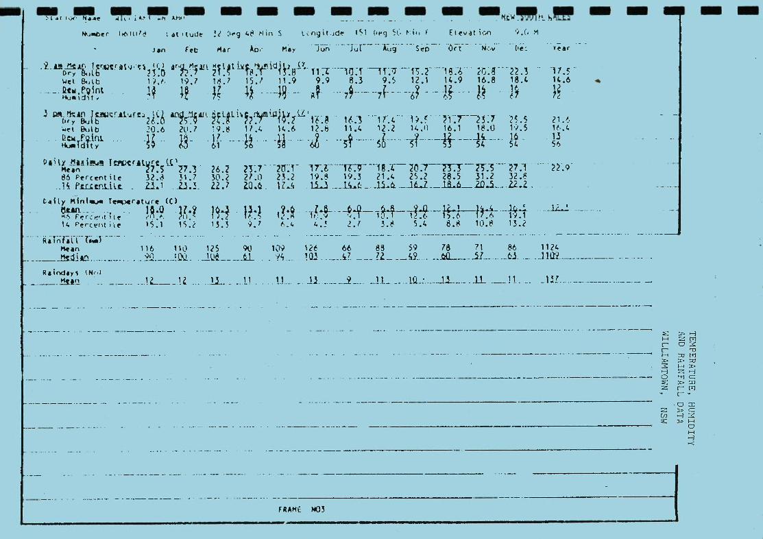
- •t - - - mmmmm NtWft - A, AM'. . .. .
(UTA at i tude g 48 Hill S .tngit.id 1.1 (itg 5(. Poif, I Elevat ion
Jan Feb Mar Ao. Play Jun iutJ Sp Ot - N: (e; rear
jPjr, Irr (i) Dry ' O
Vd ip ?
aie mjit (' c * 18T irw" T1 113 ¶ 1YI
7 20 g 223 11
Wt &,I.b 197 16.7 15.7 11.9 9.9 8.3 9• 5 12.1 14.9 16.8 18.4 14.6
firy U lb t2t 3 QL LI .
. 21 .et 8utb 20.6 20.7 1.9.8 17.4 14.6 1?.6 11.4 12.2 14.0 16.1 18.0 1i.5 16.4
Dek .. .1.. 1. .1?. .1.J.1.. .2. 51 51 0 53 54
l. 56
.1.3 56 Hu.ldlty 5') 63 61 56 58 60
oai Invicrit rC 26.7 1T. ¶6.9 i.2o773.37Js~7.1 ....
86 Percentile 32.3 51.7 30.2 27.0 23.2 19.8 19.3 21.6 25.2 28.5 31.2 32.8 .lc - 2.3. 1 j3
Calty minivAjo Te.rature (C)
14 PerceI tile 15.1 15.2 13.3 .7 .'. 4.! Li 3.8 5.4 8.8 10.8 13.2
Mean 116 110 125 90 109 121t 66 83 59 78 71 86 1124 Plied 2_JQ'1. ..J.kL ......... _.l_9.__i1..........~.3.....
Roinda1 tP4..l .!L__.12 .......U.. ..I1 ............. . .U.. 2_..... ii........U.. ._.J1.. -. ._U!......
- -
FRAME NO3

- - - - - - - - 'E" : '
:r M(s3i' OESERVATI)MS (AS PERCENTAGE OF M*1IM
A1)? !AMT :wN AM' '' 5 - .: W
LiE UiEb - i9fl _iI JjNVFMB_.. 19'Yl LLLEFR _9)1ULLiL
I S'EED 'R) I S P E E D ( K M / H R ) I S P E E D (M'HN) ______ i_ ..--.
.i.i ?i 1 1 I .i
ALI -. - -----------.
i 1 11 2 Al 41 51 A 12 1 6 11 21 31 41 51 A 1? I 1 6 11 21 1 41 ci A
TO TO I I 6 TO -)
1! T) 1 7) Y I TA T) Ti) TO TO Ti) I I I TO
I S TO TO TO TO 10 1
'0 50 UP 1 L
I D1NI
TO TO U
TO 20
i: L 3-'0 50 uP Dill 10 2Q30
I I
i41 211' I
NI ?22 6 N 231 a 1 Nt WE 1 1
222 L A
6
A WE I 1141 * 1 El 1241 8
El -
SE I * 1 1 • 1 2 2
El • 121 • a
SE I • 2 3 1 * _
4 6
( SE 1
I I 2 _
5 A _2 a a
I I 9
IS SE I
_5_I 1
_¶ 3
_3 Z5 2 * 12
_I_ IL 1 a *
2 1 • fl_ 10 SW
_ I 1 2 3 2
__1 9 SW I 1 2 3 1 7
Sw I ¶ 1 2 7 w
3 2 1
1 0 7 3 *
2 S
a 31
SW I 1 2 5
W I 1 3 6 4 3 1 • 19 W I 1 3 _6 _4 1 1 * _ *
17 IA
w I _ I
1 2 4 _P
2 • ii
-w.. .LL S_S_L..1_1_• I L.....__ w_ I_2 I
_S S II_ _ I I
7 3 1 ALL I 8 20 31 14 6 3 • ALL I 8 22 34 16 5 2 1 ALL I 10 21 34 13 3 1 a
ALL I 9 2) 28 15
NO. OF 085.1189 NO. OF 085.1237 NO. OF Oes.1200 NO. OF O8S.1208
SEPTEMBER 15URS 1ST 00 HO OCTOBER 153 HOURS 1ST NOVEMBER 1500 sOURS 1ST DEcEMBER
PELD_LLNJ1HI 1
1500 HOURS 1ST
L _$iLLD_LX..JIH1 _ _J SPED.L..XJIIw11 CALMI
SPEED (KIiR) J. CALMI
CALMI CALMI 2 I 1 6 11 21 31 41 51 A 2 I 1 6 11 21 31 41 51 A 1 I 1 6 11
_21 _
31 41 51 A I.. 4 I 1
__L_.L3 6 11 21 31 41
ULTO_TIO.IO.j._J.._---. 51 A
_ I_T _TQ_i1o!.0.1.0L_—J_--- 50
_LJO.DIRNI 5
_TA 10
_Ta_ 0
TA 3Q.40.0
_TA _TA_& UP _I
I. _I_
DIRNI TA
5 _TA_
1 TA 20
TA 30
TA 40 _TQ_&_50 UP L
DIRNI 5 1 2 3 41) 51) UP I DIRN1 5 10 20 30 40 UP I
a I_I_• - - ._2. _J(._.L_1 I j_a_____.j__ W_I _*
a *
1 I 4 4 1 11 _
NE I * 1 3 5 2 a 11 NE • 1 3 2 a a 6 NE I •
I • 1 4 3 1 9 2 10 6 1 20
NE I a 2 10 10 2 * 25 E I * 2 11 13 2 a 28
F I • 2 7 3 a 13 € SEt_• 13_J1 * 25. _Sit _* 21410
SI*1453 1 *lS _1 _* •2 ccl _* _2_U_12 _I _* _L
Ia16621 a16 SI *16731 *17 1 1 1 a * 3 sy ( * * 1 a a a * 2 SW I t ' I * • 2
5W I • a 1 1 1 1 * 4 SW I WI_ 1_2 __?_J111 WI _* * 1 _2 _2 _1_1 _ WI _ • ____
7 * t 4_4_3_3 2 4 4 3 2
_116 1 16 _
NW I a 1 3 3 2 1 1 11 _
NW I a 1 2 2 2 1 1 8 NW I I
* 1 2 3 1 1 a
NW I I _ _ 1 I ) II LI L 11) A 2 - 2 9L31_10_1_2_ 111_I _1 _7 _38 _34 _11 _4_7 _ 11.1_I _1 _7 36 _41 10 _4_
F~mo - OF oes- l iss wo. OF 085.1207 MO. OF 085.1169 NO. OF 065.1118

- --- _-_--- - - - - - - - - — a EA l a# F Nh s 1G OeS EPVAT! (A 9 tTA A1I w EI 1 -
7 .: :*'. A'S• 32 1 51 51 E 9.) N ELEV
HOuRS i_Sj__.__AU1Lil-_- __aaliuLLJ - _t 119LI.1 _ 1911
I SPEED (<M'H)
S M I H R EE () t SPEED (KM/Ha) I ---
SPEED (KM/HR) ----_-- 1 - 6 11 71 31 41 51 A
19 1 6 11 21 31 '1 51 a i. i 6 11 71 31 41 51 A 16 I I
1 TO
6 TO
11 TO
21 TO
31 TO
41 51 A TO I I
17 I I TO TO TO TO TO TO L
7) L&L_..i_LL.
7) TO TO TO T :' 2.iLi.L lflu2_
I TO TO TO TO 1) 10 1 1
I S Ja.lOifl 0 SO uP I LL1L3
I 1 fl 30 J 5' UP I
Ml I I
NI * a 1 NI * I * 1
1
N
E a * * 1
1 t • 2 E • * * 1 1 1 * •
€1 SE I
* • * t
* t
a * a 1 SE I * 1 a 2
I SE * 1 1 a 2 SE I • '
S SW I a 1 3 1 * a 6 Sw I a 1 2 a a a 4 5* I • 3 ' 7
7 1 • * 4
12 Ii) 5 ? 1 Y1
—1 5 1 • a
A 17 7 7 ? 77 I ) 10 16 3 7 1 41 W I 1 7 18 13 3 2 1 44 w I
18 4 1
2 1 ALL I 7 22 31 16 6 3 2 ALL t 5 17 33 1 6 4 1 A L L I 7 18 2 7 A_I I 9 19 5) 13 6
— N
- -- NO. OF OBS.1177 N 0. OF Oes.1 209
O. OF 095.12)9 NO. OF 095.1139
1501) HOuRS 157 ---- ------
JUNE 15)) uOuI5 LST JULY 1500 HOURS LST AUGUST 1500 HOURS LST
MAY -SP-W—-------- ._.2LLA_WtLMLJ- - - — J_&fl-U.f1JL111t1-- CAIMI CALM'
51 a CALMI
1 6 11 21 31 41 51 A CALMI
12 I 1 6 11 21 31 41 51 A 11 I 1 6 11 21 31 41 51 A 6 1 6 11 21 31 41
12 I _I T T To TO R 1 5 l 2 30 4050 uP L
- DIRNI
LO 5 10 20 30 40 50 UP L DIRN 5 10 20 30 40 50 (jP I
DIRM1 5 10 20 30 40 50 up I D I N
all * * 2 MEl 1111 * 4
NEI 112' 4 6 a
NI a a 2
(I a 3 NEI LI all' ** 3
E_J I El 1231 a 6
2 _SLt (11231 * & ..1 SL_I' 2
l2831 3 1 a a * 6
a 15 S112$51 **17 511394 1 ' '18 SI 13831 a*17
1 2 6 3 1 * * 13 1
SW I a 1 4 3 1 a ii SW I * 1 2 2 1 a * 6 221_ SW I 1 1 4 2 1 • a 9
1 22 SW I W_L_1___L__L_-3---1 22_ .___M__L
I _I
2 4 3
9 6
7 6
4 2
1 2 2 1 22
w I 1
NW I 1 2 3
5 6 3 5 5 3 2 1 20
NW I 1 2 4 3 2 2 * 14 NW I 1 2 4 4 2 1 1 15 I
NW I I
I ¶ LU 18 V 21 10 6 I 1 1? 3L I&. 1 4. 1. ALL L_L_1i.3i1-88 ALL E 6 1 3 21) 9 3 2
.iuI NO: OF 08S.1140 NO. OF OeS.1176 NO. OF OeS.1208
NO. OF 095.1209 --
a flU*ILD
-- --_--_-------- ---
UI LLS
FRAME wDS

— — on on — — — —, I-S- — -- V — —, - - -
*g 1'.2 EAST YEAR : NLM6ER •'F s:sSING u:eERvAT!:NS (AS PEICENTAGE OF MAXIMUM P'SSI8LE :
• ) 5, 151 5 E 9.'
-17 4 wi IAMTN
AAi! - i9i iU& UT EflLH --- 9II ft&.1it._.-— 9UU HOURS LL
I SPEED (K'MR) ISP'ED (KM'NR) I SPEED (KM/HP) I SPEED (KM/HP)
CAI MI - V _ V . - CLLI------ --. -- •-.-•.--.- 1 6 11 21 31 41 51 A 27 I 1 6 11 21 31 41 51 A 25 I 1 6 11 21 31 1 51 A
I 11 21 31 41 51 A 25 I I TO TO TO TO TO TO I TO TO TO TO TO TO I to ic To to il: to i _
T) 1) 10 T' 10 1 t.
7.1
_ULL—_i_fl 3)_ 10 a-iO_50_u _L_ 2MI I _S ln 20 30 Q 50 UP 1 1 5 1 51 UPi____
I NI 232'''
I NI 221 a 5 MI???' 6
_
NI 111 • 4
I_2 — 3_Li_ _12 — L _1_Li _j_ _* _11 9 El 1231 * 7 it11' 3
€11351'' fl 3 a 1 5 a
€11241' * I 1 * * 13 SE 2 6 3 SE I 1 1 4 2 * * a 9 SE I
c I * *
1 1 a 22. *
4
S E I Sw 1 1 3 1 a
A 7 Sw I 1
1 2 4 1 a *
1 1- 1 a a I 1 2 3 1 a a 8 232 At wI WI 3447' * 12 wI 369421 '26
wI 1221* * 7 ' &_ iui. -_ _3 7 * I I _J- kW I
I 4 S 4 1
I LJI_l._i_3__1----- ._23
I 1) 22 13 2 1 I
ALL 11 71 29 11 2 1• ALL I 14 20 27 11 1 1 * ALL 11 21 27 11 3 1 AL'.
NO. OF oes.1178 NO. OF 0es.1074 NO. OF -- --
oes.1239 NO. OF 065.117)
1500 HOURS 151 APRIL 15)) HOURS 1ST JANUARY 15)3 HOURS 1ST FE8RUARY 1500 HOURS 1ST MARCH
(N1WAl L__SMI (KM/HAl I
CALMI 5PFJI CM!b4I) L
CALM'
SPFFrl
CA'.MI CALMI 2 I 1 6 11 21 31 41 51 A 4 I 1 6 11 21 31 41 51 A 6 I 1 6 11 21 31 41 51 A
1 1 1 Tia
6 11 21 31 41 1 A I p in 10 1I&__ VL I TA TO TO TpIjQJI t TA
5 10 TiIQ
20 TA 30
TA 40
TA I 50 UP L
I DINNI
1(1 5
TA 13 20 30 40
in TO TAJu_L 50 UP L
DIRMI 5 1 23 3Q 40 50 UP I DIRMI 5 10 20 30 40 50 UP I DIRMI $
a I a 1 551 12
I I a I 1 V1V______
MEl * 1431 a 8 MEl * 1 *142'
1 • 2 8
Ml MEl
I * 1
I
2 231
I *
8 2 ' 7
' 13 MEl * € I ' 2 12 12 2 * 28 E I 2 1? 8 2 * 26 E 1 3
4 13 19
8 7
1 1
26 * *
€ I
cc I 1 & j1_. a
—41 _2— 32 LLJ-_ .LIL_1 _L_ i'_-___S1-- • a 1 6 6 3 a * 17 5 I * 1 9 6 1 1 18
S I * 1 6 6 3 1 * 17 5 I * 1 8 8 2 1 • 22 1 * * a 2
5 SW * * 1 1 a * 3 Sw I 1 * 2 1
SW I L*.1I.*
a 1 1 2
SW I • a 1 __L i_i_i_' 2 _A*
*111 l**
* _
5 WI
NWI _ 12332 1 * 11
2_321 _a 12
NWI *'ll'' 4 MWI *111 * * 3 I I
I _LJ_2 7 2_9_LL'
I iii_L1iJ44_i_ 1_2_* IlL_I _ 1? _47 _28 _S _I_a ILL_I _S _18 _4 _20 _8 _2
__
NO. OF OS.1043 NO. OF 085.1179 NO. OF OBS.1169 N'). OF 065.1141
PFRENT PRODU(€ _ BY_ M..1_LS. _29/ _7/86
*ANI1IIf _AliT_L€S V _THAN_U_S_
FRAME GUS
V

I I I I
(t' \ outilne planning
) consultants
I I I I I I I I I I I I I I I I I
APPENDIX 4 VEGETATION AND REHABILITATION REPORT

ADDENDUM: VEGETATION IMPACT ASSESSMENT
N. DU PREEZ
BOTANICAL CONSULTANT

TABLE OF CONTENTS:
VEGETATION IMPACT ASSESSMENT
1.0 INTRODUCTION . . .1
2.0 THE VEGETATION OF TILLIGERRY PENINSULA - A REGIONAL OVERVIEW . . .1
2.1 THE MAJOR VEGETATION COMMUNITIES . . .1
2.2 SIGNIFICANCE OF THE MAJOR COMMUNITIES ...5
3.0 IMPACT OF SAND EXTRACTION ON FLORA . . . 7
3.1 SIGNIFICANT SPECIES . . . 7
3.2 REGIONAL IMPACT . . .9
3.3 GENERAL . .10
4.0 SUMMARY . .13
5.0 REFERENCES . .14
APPENDIX: REHABILITATION OF ACI's SAND MINE, TANILBA
1.0 INTRODUCTION . .15
2.0 METHODS ..15
3.0 REULTS . .15
PLAN 1 MAJOR VEGETATION TYPES OF TILLIGERRY PENINSULA . .16
FIGURE 1 TREND OF DISTRIBUTION OF VEGETATION TYPES . .17
FIGURE 2 REHABILITATION ZONES IN P.O. 77/13 . .18
TABLE 1 REGENERATION IN MINED AREAS OF P.O. 7 7 /13 . .19

VEGETATION IMPACT ASSESSMENT
1.0 INTRODUCTION
I The vegetation and rehabilitation of the Northern Dune was
described in detail in the preceding report. In order to
I assess the impact of the proposed development on vegetation
it is necessary to consider the vegetation on a regional and
I. local level as well as at the species level. To this end
the major vegetation communities of the Tilligerry Peninsula
are described below, followed by a discussion of the
I significance of these communities. The impact of the
proposed development is then discussed in detail.
2.0 THE VEGETATION OF TILLIGERRY PENINSULA -
A REGIONAL OVERVIEW
2:1 THE MPJOR VEGETATION COMMUNITIES
The Tilligerry Peninsula supports a range of vegetation
I types from tall forest, woodland, scrubland/heath to
fresh and saltwater swamps and mangroves. The
I vegetation types are typical of those found on
quaternary sand deposits along the NSW coast. There
I have been three Environmental Impact Statements i.e.
Croft & Associates (1982), Pollington (1989) and
I Sinclair Knight & Partners (1987), which contain
vegetation studies covering parts of the Tilligerry
Peninsula and adjoining areas. These studies, aerial
I photographs and field reconnaissance were used to
produce a map of the major vegetation types (refer Plan
1 1 and map of Land Use, Tilligerry Peninsula in body of
E.I.S.)
Figure 1 shows the trend of distribution of the major
plant communities in relation to elevation.
These vegetation types are briefly described as follows
I
I I
1

2:1:1 Forest/Open Forest
There are distinct forest types which grade into
each other as the soils change. This gradation
can be seen on volcanic hills with varying depths
of mantling sands between Nallabula and Lemon Tree
Passage. When the soil cover is thin over volcanic
rock, e.g. near Mallabula Point, the dominant tree
is Spotted Gum (Eucalyptus maculata), interspersed
with Bastard Mahogany (U. umbra), Brown
Stringybark (E. capitellata) and, near the water
front, Forest Red Gum ((E. tereticornis). The
shrub layer is characterised by Bush Pea
(Pultenaea villosa, Long-leaf Hop-bush (Dodonaea
tricTuetra) and Hill Banksia (Banksia spinulosa var
collina. The ground layer is typically dominated
by Blady Grass (Imperata cylindrica). These areas
are relatively disturbed by fire. Further south
on this same group of hills where there are
mantling sands the dominant tree species are
Smooth-barked Apple (Angophora costata), Black
butt (Eucalyptus pilularis) and Red Bloodwood (E.
gummif era). There is a medium to tall understorey
of Saw-toothed Banksia (Banksia serrata). The
shrub layer typically includes Appressed Bossiaea
(Bossiaea rhombifolia), Small-leaf Parrot-pea
(Diliwynia retorta), Long-leaf Hop-bush, Grass
Tree species (Xanthorrhoea spp.), Common Aotus
(Aotus ericoides) and Bracken (Pteridium
esculentum). Species characterizing the ground
layer were Blue Paroo Lily (Dianella caerulea),
Mat-rushes (Lomandra spp.) and Kangaroo Grass
(Themeda australis). This latter forest
association is also typical of that found on the
sand dune system running down the southern side of
the Peninsula (including Portion 265), and also on
more elevated parts of the dune system on the
northern side of the Peninsula, WSW of Tanilba
Bay. This forest generally occurs on more

elevated areas but is not restricted to them.
1 2:1:2 Woodland
Open Forest gives way to woodland in less elevated
I dune situations. The tree storey is characterized
by Scribbly Gum (Eucalyptus haemastoma), commonly
I in association with Red Bloodwood. In some areas
Red Bloodwood and Sydney Peppermint (E. piperita)
I form the tree cover. There is a dense and
floristically diverse shrub layer typically
I dominated by Wallum Banksia (Banksia aemula),
Paperbark Tea-tree (Leptospermum attenuaturn),
Austral Grass Tree (Xanthorrhoea australis) and
I Small-leaf Parrot Pea. The ground layer is
reduced, mainly consisting of Leaf litter and
I rushes, especially Tassel Rope-rush (Hypolaena
fastigiata),
2:1:3 Scrublands and Heath
Scrublands occur on lower lying dunes, usually
with less than 2 metres of white sand above the
I water table or waterloo rock, and these grade into
heath and wet heath where the water table is close
I to the surface. The scrublands are dominated by
Wallum Banksia, Ball Honey Myrtle (Melaleuca
I nodosa) and Paperbark Tea-tree. Many of the shrubs
common in woodlands also occur here, such as
I Austral Grass Tree, Pink Beard Heath (Leucopogon
ericoides), Waxf lower (Eriostemen australasius),
Rosy Baeckea (Baeckea ramosissima) and Wedding
I Bush (Ricinocarpos pinifolius). There is often a
dense field layer of sedges and rushes including
I (Restio fimbriatus,) curly sedge (Caustis
recurvata) and Tassel Rope-rush. On wet heaths the
I vegetation is lower and the characteristic species
are Fern-leaf Banksia (Banksia oblongifolia),
Sieber's Paperbark (Melaleuca sieberi), Dagger
I I
1 3

Hakea (Hakea teretifolia) and Olive Tea-tree
(Leptospermum liversidgei). There is a dense field
layer of sedges and rushes, notably Cord-rush
(Restio gracilis), Scale-rush (Lepyrodia scariosa)
and Slender Twine-rush (Leptocarpus tenax).
Scrublands, heath and wet heath are widespread
across the centre of the Peninsula.
2:1:4 Swamplands
The wet heath communities described above merge
into swampland where the water table is at or
above the surface. These vary from low shrub and
sedge communities with some emergent taller
shrubs, through to closed forest over sedges. The
"shrubby" swamps typically contain Bottlebrush
species (notably Callistemon citrinus), Dagger
Hakea, Sieber's Paperbark, Fern-leaf Banksia,
Large-leaf Banksia (Banksia robur), Feather Honey
Myrtle (Melaleuca guinguenervia) and Swamp
Mahogany (Eucalyptus robusta). The shrubby swamps
are often hard to distinguish from wet heath in
aerial photographs. At the other end of the scale
there are swamps dominated by tall Broad-leaf
Paperbark with an inundated sedge understorey, or
forests of Swamp Mahogany over dense sedge and
shrub understorey including Swamp Water Fern
(Blechnum indicum), Red-fruit saw sedge (Gahnia
sieberana) and Mat Grass (Hemarthria uncinata).
2:1:5 Estuarine Wetlands
These consist of forest, low forest and sedgeland
characterized by Grey Mangrove (Avicennia marina)
and Swamp Oak (Casuarina glauca) over and
interspersed with sedgeland and salt marsh
including Juncus species, Salt couch (Paspalum
paspalodes), Saltwort (Sarcocornia guingueflora)
4

and Suaeda australis. These wetlands skirt the
Peninsula, occur on islands, and are well
developed along the shores of Tilligerry Creek.
2.2 SIGNIFICANCE OF THE MkJOR COI4XUNITIES
While none of these plant communities are unique to
Tilligerry Peninsula, and in fact are widespread
regionally, they do contain a wide variety of
floristically diverse habitats, some relatively
undisturbed, others variously disturbed by fire, weeds,
urban development and mining.
Several endangered species are known to occur on the
Peninsula, particularly in the scrubland, heath and
swamp vegetation, a large part of which are within
Hunter District Water Board Catchment areas. The
significant species occurring within the proposed Lease
area are discussed below in Section 3.1. In summary,
most occur in sections that will not be mined, and the
others are locally common in nearby areas and/or can be
regenerated.
Most of the estuarine wetlands are protected by State
Environmental Planning Policy (S.E.P.P. 14). The
proposed development does not impinge on any designated
wetlands.
The forest and woodlands, including the dune forests
and tall swamp communities are considered to be of
major significance as koala habitat and movement
corridors. In essence, the forest and woodlands along
the northern and southern edges of the Peninsula are
proposed as being significant corridors for dispersal
of koalas between colonies near Salt Ash and Medowie
and those at Tanilba Bay, Mallabula and Lemon Tree
Passage. In this regard the area proposed for sand
extraction on the Northern Dune could affect the
northern corridor in the vicinity of Oyster Cove. This
I I I I I I I I 1 I I LI I [1 I I I I I
5

is discussed more fully in the fauna report, and also
in Section 3.3 below.
I
I I I I I I I I I I I I
I I I I
sJr

I 3.0 IMPACT OF SAND EXTRACTION ON FLORA
3.1 SIGNIFICANT SPECIES
I None of the species found on the Northern Dune are
classified as rare or threatened Australian plants in
the national listing of the Australian National Parks
I and Wildlife Service (Briggs and Leigh, 1988).
I There are however a number of species considered
locally uncommon on Tilligerry Peninsula, some of which
I occur in the proposed Lease area. These are discussed
hereunder:
I Acacia baueri - This species occurs in damp heath and
was found in Low Scrubland in the eastern end of the
I Northern Dune and may occur in similar habitat in the
Lease area. Acacia species can be easily propagated
I from seed and this species will be specially grown if
found. Acacia species also regenerate readily from
I seed in the topsoil, so it is likely that the species
will regenerate naturally when topsoil is respread.
I Acacia guadrilateralis - This species was also found
in Low Scrubland and Scrub with emergent trees at the
I east end of the Northern Dune. The same comments made
for A. baueri apply here.
Blandfordia grandiflora (Christmas Bells) - These
I occur on sandy soil in damp places and were found in
swamps east of Oyster Cove Road. Swamps will not be
disturbed by the proposed development. However, this
I species is readily propagated from seed and will be
grown for ornamental purposes to plant in low-lying
I damp areas.
I Boronia pinnata - This species is widespread regionally
and was widespread on the Northern Dune in Low
Scrubland, Scrubland with emergent trees and Woodland.
1 7

It regenerates from topsoil and is not considered
threatened by the proposed development.
Darwinia leptantha and Gompholobium pinnatum - These
species are common in heath habitats and were sparsely
scattered in Low Scrubland. Darwinia are known to
regenerate readily from topsoil and thus is not
considered to be at risk. Gompholobium has been found
to regenerate from topsoil in the nearby current mining
area on Crown Land.
Hibbertia fasciculata - This is a regionally common
and widespread species. It was found scattered in Low
Scrubland on the Northern Dune. This species
regenerates readily from topsoil and is thus not
threatened by the development.
Leptospermum arachnoides - This widespread species was
only found in swampy areas on the Northern Dune. As
such it will not be disturbed by the sand extraction.
Leptospermum species are readily regenerated from seed,
brush-matting or natural regrowth from roots in topsoil
and this species will probably be established in damp
areas.
Orchidaceae - Several species of orchid were found on
the Northern Dune, all in Medium to Tall Open Forest,
including part of the proposed Lease area. The species
here were Acianthus fornicatus and Pterostylis
acuxninata. Both are widespread common species
regionally and are therefore not at risk. The
Acianthus is abundant in most forested areas of the
Peninsula and has regenerated in ACI's rehabilitated
mine areas. The Pterostylis is also common in forested
parts of the Peninsula. Pterostylis are readily grown
by vegetative reproduction and will be re-introduced to
rehabilitated areas by this method when regrowth is
suitably developed.
[;J

Xanthorrhoeaceae (Grass Trees) - Grass Trees are a
prominent feature of the Northern Dune vegetation,
particularly in Scrubland and Woodland. Based on ACI's
experience in the nearby rehabilitated Crown Land,
Grass Trees are readily re-established by direct
seeding, seed propagation and planting, or
transplanting with the correct procedure. They are
however slow growing and will take many years to reach
their current size. They will be re-established as
part of the rehabilitation programme.
3.2 REGIONAL IMPACT
The proposed sand extraction will affect approximately
36 hectares, or 50% of the total proposed Lease area.
The affected area includes Medium to Tall Open Forest,
Woodland and Scrubland and covers the dunes and ridges
in the Lease area. The low-lying and wet or swampy
areas will not be disturbed.
The proportion of each of the vegetation types to be
affected by extraction within the proposed Lease area
are as follows:
Vegetation Type Tbtal area Area Affected % of vegetation
in Lease by Extraction Type lost
(ha) (ha)
A I1 dense Scrub 30.45 8.25 27%
Bi low Scrub with Red Blooduood 2.7 2.7 100%
B2 tow Scrub with Sydney Peerrnint > 0.1 0.1 100%
B3 tow Scrub with bath spp. 8.65 6.85 79%
C tow - ditxn Woodland 6.7 3.5 56%
D Miitin - Tall Open Forest 14.1 9.75 69%
G Miiin - senp 0.3 0 0
Cleared/Disturbed 8.6 3.75 44%
TOE1L 71.1 34.9 49%

The Low dense Scrub is widespread across the Peninsula
(refer Plan 1) and only a quarter of its range in the
Lease area will be disturbed. The Low Scrub with
emergent trees (i.e. Red Bloodwood and/or Sydney
Peppermint) occurs extensively on ridges of the
Northern Dune to the east of the Lease area (refer to
Map of Vegetation of Northern Dune) and on scattered
low ridges amidst the extensive Low Scrub in the centre
of the Peninsula. Similarly, the Low to Medium
Woodland is widespread on other parts of the Peninsula,
in particular to the west of the proposed Lease area
and in disjunct localities in the southern parts of the
Peninsula. Furthermore, just under half of this
vegetation type will remain undisturbed within the
Lease area. Two-thirds of the Medium to Tall Open
Forest in the Lease area will be disturbed.
This vegetation type also occurs both east and west of
the Lease area and very much larger stands occur
between Nallabula and Lemon Tree Passage, and along the
southern side of the Peninsula. It is widespread
regionally, occurring on Tomaree Peninsula and other
quaternary sand deposits along the New South Wales
coast. It is concluded that the proposed extraction
will not have a significant impact on the regional
distribution of these vegetation types.
3.3 GENERAL
The sand extraction is expected to take approximately
11 to 12 years during which time the area will be
progressively rehabilitated so that not more than 2
hectares will be exposed at any time. The
rehabilitation techniques (described in the Vegetation
and Rehabilitation Report) are aimed at rapid re-
establishment of the natural vegetation, which will
minimise the possibility of erosion and disturbance to
adjoining areas. Nevertheless, the extraction will
have both short and long term effects on the vegetation
10

I I and landscape. These were discussed in Section 4.2 of
the Vegetation and Rehabilitation Report.
The major permanent visual impact will be the reduced
I elevation of the landscape after sand extraction. The
post mining landscape will still be undulating and will
be rehabilitated with local vegetation types suited to
I the final soil conditions. This will involve re-
establishment of Low Scrubland, Woodland and Medium to
I Tall Forest.
I It is expected that the natural vegetation will be
successfully re-established in time. ACI has many
years experience in mine rehabilitation including the
I local vegetation types. A summary of ACI's
rehabilitation experience in the Tanilba area is given
I in the Appendix at the end of this report (refer:
"Rehabilitation of ACI's Sand Mine, Tanilba"). In the
I Crown Land nearby which was an area of Medium to Tall
Open Forest, the rehabilitation techniques have
I successfully restored the original tree, shrub and
ground cover species. Tree heights of 7 top 15 metres
are attained in 7 to 10 years. Similar results are
I expected in the same vegetation type on the Northern
Dune Lease.
1 It is also expected that Low Scrubland and Woodland
I will be re-established successfully based on ACI's
experience with the same or closely related species.
I However, the appearance of these vegetation types will
be different from the original vegetation for a long
I time due to the slow growth rate of Grass Trees
(Xanthorrhoea spp.) which are abundant in these
communities.
I Particular care will be taken to re-establish species
which are used by koalas. For example in low-lying
areas close to the water table Swamp Mahogany
(Eucalyptus robusta), a prime food tree, will be
11
I planted. Blackbutt (E. pilularis), another prime food
tree which is not common in the Northern Dune, will be
I planted on shallow soil over Waterloo Rock. Also
Scribbly Gum CE. haemostoma, Sydney Peppermint (E.
I piperita), Brown Stringybark (E. capitellata), Red
Bloodwood (E. gummif era) and Smooth-barked Apple
I (Angophora costata) will be planted on low dunes. It
is very likely that the amount of habitat suitable for
koalas will actually be increased through deliberate
I effort. This will be carried out in conjunction with
advice from National Parks and Wildlife Service.
I I
I I I I I I I
12

The proposed sand extraction will affect 50% of the
vegetation on the Lease area, including scrubland, woodland
and forest and excluding swamplands. These vegetation types
are widespread regionally. No rare or endangered species
will be threatened by the development. The landscape will
be permanently lowered, but given that proven rehabilitation I techniques will be used, the natural vegetation will be re-
established in time. It is likely that habitat suitable for 1 koalas will be increased.
I
I 1 I I I I 1 I I I I
13
I 5.0 REFERENCES
I BEADLE, N.C.W., EVANS, O.D., CAROLIN, R.C. AND TINDALE, M.D.
I (1982). Flora of the Sydney Region. Third Edition.
H.H. & A.W. Reed, Sydney.
BRIGGS, J.D. AND LEIGH, J.H. (1988). Rare or Threatened
Australian Plants. 1988 Revised Edition. Special
Publication [14), Australian National Parks and
Wildlife Service. Canberra.
I CROFT & ASSOCIATES PTY. LTD (1982). Environmental Impact
Statement for Extension of Existing Mineral Sand Mining
Operations in the Tomago Sandbeds Water Supply
I Catchment Area. Rutile & Zircon Mines.
I POLLINGTON, G. R. (1989). Amended Environmental Impact
Statement - Extraction of White Silica Sand from the
I Northern Dune, Tanilba, N.S.W. The N.S.W. Glass and
Ceramic Silica Sand Users Association Limited.
I SINCLAIR KNIGHT & PARTNERS PTY. LTD. (1987). The Tomaree
Sewerage Scheme Environmental Impact Statement, for the
I Public Works Department N.S.W. on behalf of Port
Stephens Shire Council and Hunter District Water Board,
I November 1987. Report No. HSP8725.
I WRIGLEY, J.W. AND FAGG, M. (1979). Australian Native
Plants. A Manual for their Propagation, Cultivation
and Use in Landscaping. COLLINS, Sydney, London.
I I I I 1 14

REHABILITATION OF ACI's SAND MINE. TANIL
1.0 INTRODUCTION
ACI started mining silica sand for glass in the Tanilba area
in 1978. The existing mine is on Crown Land (defined as
Permissive occupancy Lease Area 77/13 with NE and SW
extensions) having a total area of 77 hectares. This area is
south of Tanilba township and covers a series of dunes
running SW and NE between Lemon Tree Passage Road and
Tilligerry Creek.
Most of the white sand reserves in the current Lease
Area have been mined out, with only a few months
reserves remaining in the SW Extension.
Rehabilitation has followed closely behind the mine
face so that no more than two hectares are exposed at
any time.
Rehabilitation is aimed at re-establishing as closely
as possible the natural vegetation of the area, and
results are monitored against a pre-mining vegetation
survey.
2.0 METHODS
The methods used for rehabilitation here are based on
similar techniques used successfully at ACI's other sand
mines in Victoria and Queensland. Techniques were refined to
suit the requirements of species at this particular site.
They are essentially as described in the rehabilitation
recommendations in the Vegetation and Rehahilitation Report.
3.0 RESULTS
Each year all the rehabilitation areas are examined and
detailed vegetation studies are made on all areas less
than 2 to 3 years old. In this way it has been
15

I I possible to build up a clear understanding of the
patterns of regeneration and work required to achieve
the desired result.
An example of the type of data recorded, extracted from a
I report prepared by the author in April 1988, is given in
Table 1. This Table gives the height and cover/abundance of
I species present in rehabilitation zones 34 to 44 which were
re-topsoiled between March 1986 and December 1987. Figure 2
shows the location of these zones in P.O. 77/13. These I areas had basically the same vegetation cover as the medium
I the
to tall forest of the Northern Dune. It can be seen that
identified in the species as common natural vegetation
are also common in regenerating areas. These include Common
I Aotus (Aotus ericoides), Appressed Bossiaea (Bossiaea
rhombifolia), Blue Paroo Lily (Dianella caerulea), Raspwort
l (Gonocarpus teucrioides) and Purple Coral-pea (Hardenbergia
violacea), all of which have regenerated from fresh topsoil.
The upperstorey species, i.e. Red Bloodwood (Eucalyptus
I gummif era), Blackbutt (E. pilularis) and Smooth-barked Apple
(Angophora costata) are also present in good proportions as
I a result of direct seeding (by hand and from preserved
mature specimens) and planting.
I A study of this data over the years has revealed the
I following pattern of regeneration:
Legumes and a few herb species are the first to appear
I and dominate. The most common primary colonizers are
Sweet Wattle (Acacia suaveolens), Appressed Bossiaea,
I Common Aotus, Broom Spurge (Amperea xiphoclada) and
Raspwort.
In areas where Blady Grass (Imperata cylindrica),
I Kangaroo Grass (Themeda australis) and/or Blue Paroo
Lily were common prior to mining, these species
I regenerate readily after mining. After three years the
Wattles start to die out, Broom Spurge and Raspwort
decrease, and other shrubs or grasses/sedges become
I 16

dominant, in proportions resembling the pre-mining
condition. The planted and seeded tree species grow at
different rates depending on aspect and seasonal
fluctuations, and eventually dominate over the shrub
layer after 5 to 7 years.
The older areas, re-topsoiled 7 to 10 years ago now
have trees from 7 to 15 metres tall, with projective
foliar cover of 50 to 100% In areas re-topsoiled 4 to
5 years ago, trees are from 2 to 5 metres in height,
with variable cover.
Erosion has not been a problem due to the rapid
germination of native seedlings from fresh topsoil.
After unusually heavy rain small washouts sometimes
form in newly topsoiled areas. This does not usually
occur as shallow furrows are left along the contour
during the re-topsoiling process, which catch the run
of. f. Washouts have been repaired successfully by
backfilling with organic screenings.
Weeds are a minor problem only and have been controlled
with herbicide.
The only other problem of any significance if from wood
cutters, 4WD vehicles and trail bikes which occasionally
drive over rehabilitated ares. These are deterred by
obstacles at entry points, signs and by burning the windrows
of logs (in safe conditions only).
17

Ton4 o Bao Boto
i
RkP
Refer also to plan entitled r y / h
SUBJECT / LAND USE : TILLIGERRY PENINSULA SITE
in body of E.I.S. /fq, 238
A B Is a d
j
4 3737 OYSER
28
7 0
31,
- -
/ /d II 4 330
32 gh lid
a w L UT,)
MAJOR VEGETATION TYPES ON TILLIGERRY PENINSULA
. - / ,,, Compiled from aerial photographs (1986), topographic
. - _.—>-) 1iJ/ 1 maps and field reconnaissance.
Upions / I/.• I /
Forest and Forest Swamp
Wdld
d and
Swamp 10
-- i: :t h _ -
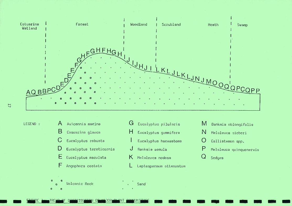
I I
Estuari.ne I Forest Woodland I Scrubland Heath Swamp Wetland I
I I
I I
I I I I
I I
I FGHF HGH G H
F 0 • .
7". j
E
0 0 0 AQBBPCD 0 0 0
0 0 0 0 .
0 0 0 0 0 -1
LEGEND : A Avicennia marina G Eucalyptus pilularis M Banksia oblongifolia
B Casuarina glauca H Eucalyptus gummifera N Melaleuca sieberi
C Eucalyptus robusta I Eucalyptus haemastoma 0 Callistemon spp.
D Eucalyptus tereticornis J Banksia aemula P Melaleuca quinquenervia
E Eucalyptus maculata K Melaleuca nodosa 0 Sedges
F Angophora costata L Leptospermum attenuatum
o o Volcanic Rock Sand
0 0
L T RCF E OJ ORN I U NJJ - - -

Caravan Park
. 424
- - - - - - - - - - - - - - - - - - - - FIGURE 2 PERMISSIVE OCCUPANCY LEASE 77/13 WITH N.E. AND S.W. EXTENSION AREAS, SHOWING LOCATION OF
ZONES 34 TO 44, USED IN TABLE 4
Golf Club
/ / / / Aboriginal
Land / / NE Extension
Mined Areas Mud Island
0,85cm = lOOm
TILLIGERRY CREEK

TABLE I REGENERATION IN NEWER* REHABILITATION ZONES OF P.O. 77/13 CURRENTLY BEING MINED
(first figure Cover/Abundsice, second figure average height in cm.)
34 35-36 37 38 39 40-41 42 44
Acacia longifolia - - - - +,40 - - -
Acacia suaveolens 3,130 4,150 3,150 4,160 1,40 3,60 2,80 1,20 Acacia terminalis
- i-,80 +,100 - - - - -
Acacia ulicifolia +,100 +,100 1,60 +,60 +,20 1,30 - +,20 Amperes xiphoclada 3,30 2,30 1,30 - 1,30 2,20 +,20 -
Angophora costata (P,S) - 3,30 +,30 +,30 s-,30 +,20 +,20 -
Aotus ericoides 1,20 2,30 1,30 - 1,30 1,20 +,20 -
Axonopus affinis - - - - 1,50 - - -
Banksis serrata (P,S) +,20 - - - 1,20 .i-,20 - -
Billardiera acandens +,20 - - - +,30 +,20 - -
Bossiaea ensata 1,30 1,30 - +,30 - +,15 - 1,15 Bossiaea heterophylla - - - - - -
- +,15 Bossiaea rhombifolia 2,30 2,30 1,30 2,100 1,30 1,20 1,20 2,20 Conyza canadensis -
- +,100 +,80 - - -
Dianella caerulea +,30 2,30 - 1,30 +,30 2,30 ±,20 Diliwynim retorta 1,40 - - - - - - -
Eucalyptus gurasifera (P,S) 1,40 2,40 1,20 1,30 2,30 1,20 +,20 1,10 Eucalyptus pilularis (P,S) 1,40 2,40 1,20 1,30 2,30 1,20 +,20 1,10 Eucalyptus piperita (P,S)
- 1,100 - 1,40 +,30 - -
Gahnja sieberana - - - - +,50 - - -
Glycine clandestina - - - - -
- +,30 -
Gompholobium latifoljum - - - - +,30 - - 1,15
Gonocarpus teucriojdea 1,20 +,2- 2,20 1,20 2,30 2,20 - -
Hardenbergia violacea 1,30 - - +,10 1,60 +,5 2,30 +,5
Hibbertja linearis 1,30 1,30 - 1,30 +,30 1,20 - -
Hypochaeris radjcata - - - - - +,20 +,20 -
Imperata cylindrica - - 5,40 1,70 +,70 +,20 2,40 -
Leucopogon ericoides +,20 2,40 - - - - - -
Lomandra filiformis - 1,30 - 1,30 - +,20 - -
Lomandra longifolia 1,30 - - - +,30 +,30 - -
Monotoca elliptica +,20 - - - - - - -
Pandorea jasminoides - - - - - +,5 - -
Persoonia levis +,15 +,15 - - +,20 1,20 +,10 -
Persoonia lanceolata - +,30 +,30 +,20 +,20 - - -
Pimelea linifolia 1,50 1,20 +,40 +,20 +,30 - - -
Platysace ericoides 1,20 1,20 1,20 +,20 ~,20 +,20 - -
Pomax umbellata +,10 - - - - 1,10 - -
Pteridium esculentum +,30 +,30 +,30 +,30 +,30 1,20 1,30 .-,20 Ricinocarpus pinifolius 1,40 1,50 1,30 - +,20 1,20 +,30 +,20 Themeda australis
- +,80 1,80 - +,80 - 1,80 2,30 Tricoryne elatior 1,20 1,30 1,30 1,30 1,30 +,20 +,20 -
Xanthorrhoea sp. (S) - - - - 1,20 - -
Xanthosja pilosa 2,20 1,20 - - - 1,20 - -
Zieria laevigata 1.30 - - - - - - -
TOTAL (% Cover, Av. Ht.cm) 80%,80 90%,120 955,150 905,160 805,30 405,20 505,20 205,20
Date of re-topsoiljng 3/86 6/86 11/86 11/86 3/87 4/87 8/87 12/87 Date of mnirrg 2 or 3 months earlier
Cover/Abundance Scale + = occasional, cover <51. 3 = any number, cover 25-50% 1 = corrxrron, cover (5% 4 = any number, cover 50-75% 2 = any number, cover 5-25% 5 r any number, cover 75-100%
Refer to Figure 2 for location of these Rehabilitation Zones within P.O. 77/13
OR
CONTENTS
PAGE
INTRODUCTION 1
METHODS 2
2.1. Data Collection 2
2.2. Data Analysis 4
2.3. Vegetation Mapping 4
2.4. Species List 4
RESULTS 5
3.1. Two - Way Table 5
3.2. Vegetation Communities 6
DISCUSSION 10
4.1 Distribution of Plant Communities 10
4.2. Consequences of Mining on Vegetation and Landscape 11
REHABILITATION 13
5.1. Basic Principles and Techniques 13
5.2. Notes on Re-establishing the Species 18
SUMI'4ARY OF RECOMMENDATIONS FOR REHABILITATION 26
REFERENCES
Table 1 - Cover/Abundance scale 2
Table 2 - The Two-Way Table 27
Table 3 - Total Species List 30
Vegetation Map.
Following page in EIS te>

ii
1.0 INTRODUCTION
The aim of this botanical survey is to identify the plant species
and communities present, and the factors affecting their distribution,
such as soils and topography. This information will form the
basis for planning the re-establishment of the natural vegetation
after mining.
ACI have been mining sand in the Tanilba area since 1979, and
are carrying out a very successful rehabilitation programme based
on data from a pre- mining vegetation survey (Gullan and Van Rees,
1980). The experience gained there and at ACI's other sand mines
is incorporated in the rehabilitation section of this report.
The "Tanilba Northern Dune" is a discontinuous series of rounded
dunes of varying height, separated by low lying areas with little
or no sand, and swamps. The study area runs WSW from Tanilba
township for 6.8 kilometres, and varies from 150 to 600 metres
wide, covering approximately 270 hectares.
The soils over much of the area are sandy podzols (Stace et al,
1972) and are characterized by distinctive soil horizons. At
the surface there is a dark grey organic Al horizon, on average
30 centimetres deep, which is commonly described as "topsoil"
and is of prime importance for rehabilitation. Below this is
a layer of strongly leached white sand, the A2 horizon, up to
10 metres deep in places. This is the layer to be removed by
mining, the white sand being of suitable grade for glass production.
The white sand overlies a dark brown organic bound B horizon,
which often forms a hardpan known as "waterloo rock". In many
areas the water table is close to the surface, lying in the A2
horizon of a podzol, or on peaty soil. The mining depth will
be limited to one metre above the water table which means that
large parts of the study area will not be mined.

I I En -J
I I j
L I I I I I I I F I I I I
I 2
2.0 METHODS
2.1 Data Collection
The vegetation survey was designed to provide quantitative data
on the species present and enable a comparison of plant community
distribution with variations in soil and topography.
With the aid of the contoured maps of white sand thickness, the
vegetation sampling sites (quadrats) were selected to cover a
wide variety of sand depths and topographic situations.
The quadrat size is the same as that used by other workers in
similar vegetation types. Accordingly, a square unit of 25 m2
was used for heath type vegetation (see Gullan 1975) and a unit of 100 m 2 for forest situations (Bridgewater 1976, Gullan etal 1976).
A complete species list was recorded for each sample site, and
each species was assigned a quantitative estimate of cover and
abundance using a scale similar to that designed by Braun-Blanquet
(1932) (See Table 1).
TABLE 1 : The Cover/Abundance scale used in data collection and the synthesis table:
+ occasional, cover < 5%
1 common, cover < 5%
2 any number, cover 5 - 25%
3 any number, cover 25 - 50%
4 any number, cover 50 - 75%
5 any number, cover 75 - 100%
Structural features measured included the estimated height of
all definable strata and the present cover of each. The strata
were divided into tree, shrub and field layers.
A labelled plant collection was made including most species recorded,
to be used as a future reference set for rehabilitation personnel.
I

3
The vegetation of the area is predominantly dense woody scrub
dominated by Banksia aemula (Wallum Banksia), LeptosDermurn attenuatum
(Paperbark Tea-tree) and Xathorrhoea australis (Austral Grass-tree).
The scrub merges into woodland with scattered to medium cover
of Eucalyptus gummifera (Red Rloodwood) and E. piperita (Sydney
Peppermint). This gives way to E. haemastoma (Scribbly Gum) -
E. gummifera woodland, which in turn gives way to tall open
forest of Angophora costata (Smooth-barked Apple) and E. gummifera
in a few areas. There are extensive swampy areas with dense
scrub of wetland species, notably Hakea teretifolia (Dagger Hakea),
Banksia'oblongifolia (Fern-leaf Banksia) and dense sedge cover.
The area immediately north of the study area has previously been
mined for mineral sands and is now covered mainly with grasses.
The disturbance from this mining extends into parts of the study
area. To the south of the dunes the vegetation is largely
undisturbethnatural low scrub, dominated by Banksia aemula, except
for the cleared parachute drop zone near Tanilba.
The study area does not appear to have burned for many years
except for a small section near Tanilba which was burned about
12 months ago.
The only other disturbances in the area are the clearings for
a power station and transmission lines, and quite a number of
tracks, some overgrown, others well maintained.

4
2.2 Data Analysis
I The data was hand sorted using a method described by Braun-Blanquet
(1932) to group quadrats with high floristic similarity. i.e. All
I sample sites which share a large number of species were placed
close together, and all species which are often found together
I in the field are placed together. The final result is a two-way
table which contains all the raw data in a sorted form (see Table 2).
I The two-way table is set out with quadrat numbers across the
top and species down the side. Each vertical column of figures
represents a list of the species found in one site and each
horizontal row represents all the sites in which one species
has been found.
I Groups of sample sites have been defined and are delineated by
vertical lines on the table. These represent the vegetation
communites and are discribed in detail in the results section.
Horizontal lines on the table delineate groups of species which
I characterize each vegetation community.
1 2.3 Vegetation Mapping
From studying the quadrat data it was possible to classify the
I vegetation into structurally and floristically different plant
communities. The boundaries of these communities were recorded
I onto contoured base plans while traversing the entire area along
all existing tracks, walking in where no tracks existed, and
I by studying the aerial photographs. All the data was then put
together to produce the final vegetation map. The quadrat sites
have also been marked on the vegetation map.
2.4 Species List
I A specie list was compiled including all species occurring in
quadrats, and any others observed during the study. This is
I given in Table 3, which also shows common names, family and plant
form.
I

5
3.0 RESULTS
3.1 Two-Way Table
A total of 35 quadrats were studied and the floristic data is
presented in the two-way table.
A study of the structural data recorded and the sorted two-way
table enables seven communities to be identified. These have
been called A to G from left to right in the table.
There is a large overlap of species in common between communities
A, B, C and D. They have been arranged in the table in order
of increading height of the upper storey, from lowest, which
is A, to the tallest, which is D.
A, B and C in particular are very similar, being distinguished
in the field (and on the Table) mainly by the presence or absence
of one or two character species (i.e. significant species).
Community D has greater floristic and structural differences
from the other 3.
In the field these communities grade into each other. The lack
of sharp discontinuity between A, B, C and D indicates a continuum
of variation which can usually be related to an environmental
gradient. In this case the gradual change appears to be related
to depth of sand above the water table or Waterloo Rock, and
topographic aspect. This is described further in the discussion
section.
Communities E, F and G are very distinct from the other communities,
and from each other, except for some overlap between E and F
where they border on each other. These three communities occur
on low lying more or less swampy areas, and differ from each
other in structure and species composition.

I 6
I 3.2 Vegetation Communities
COMMUNITY A: Banksia aemula- Melaleuca nodosa - Leptospermum
attenuatum association.
I This community is low dense woody scrub dominated by Banksia aemula
I(Wallum Banksia), Melaleuca nodosa (Ball Honey Myrtle) and
Leptospermum attenuatum (Paperbark Tea-tree). These form the
I upper storey averaging two to three metres in height and with
a total cover of 50 to 75%.
I with
There is a middle storey of woody shrubs averaging 1 to 1.5 metres, cover 50%. Calytrix of about tetragona (Fringe Myrtle)
and Amperea xiphoclada (Broom Spurge) are characteristic of this
I community. There are a number of other commonly occurring species
which also occur in communities B, C and B, such as Xanthorrhoea
Iaustralis (Austral Grass-tree), Leucopogon ericoides (Pink Beard-heath),
Eriostemon australasius (Wax-flower), Bossiaea heterophylla
I (Variable Bossiaea), Baeckea ramosissima (Rosy Baeckea), Pimelea
linifolia (Slender Rice-flower) and Ricinocarpos pinifolius
(Wedding Bush).
I The field layer (ground cover) is often very dense, 50 to 70%,
and consists of sedges and rushes. The main species are Restio
I fimbriatus (characteristic of this community only), Caustis recurvata
(Curly sedge), Schoenus ericetorum (Bog-rush), and Hypolaena
Ifastigiata (Tassel Rope-rush), averaging 50 to 100 cm in height.
The main feature distinguishing community A from B, C and D is
I the absence of tree cover.
Community A is associated with low lying areas, with elevation
of 8 to 10 metres, and it covers approximately 30% of the study area.
COMMUNITY B: Eucalyptus gummifera - Banksia aemula - Xanthorrhoea
1 australis association.
ICommunity B is low dense scrub with variable tree cover.
Community A grades into community B as the elevation rises.
I
The latter is distinguished by the presence of Eucalyptus gummifera
(Red Bloodwood), occurring mostly in small stunted clumps averaging
from 3 to 5 metres in height;
I

7
Eucalyptus piperita (Sydney Peppermint) is also common in this
community, also stunted, and does not occur in any other community.
The tree cover varies from S to 50%, averaging 30%.
There is a dense middle storey of Banksia aemula and L.eptospermum
attenuatum, reaching 1.5 to 2 metres in height and averaging
50% cover, Xanthorrhoea australis is more abundant than in Community A,
averaging 25% cover. The lower shrub layer is similar to that
of Community A except that Dillwynia retorta (Small-leaf Parrot-pea)
is much more common, averaging 25% cover, and Epacris purpurascens
is common, being mostly absent from A.
The field layer consists of sedges covering 5 to 25%, notably
Caustis peritandra which is mainly restricted to this community,
and Caustis recurvata which is also in A and C.
Community B occurs on elevations from 9 to 24 metres and covers
approximately 25% of the study area.
C01UNITY C: Eucalyptus haemastoma - Banksia aemula - Xanthorrhoea
australis association.
This is a low to medium woodland with a dense shrub layer. It
is similar structurally and floristically to community B and
is distinguished by the presence of Eucalyptus haemastoma (Scribbly
Gum). This tree varies in form from small stunted clumps on
the southern side of the dunes, to medium trees up to 10 metres
tall on the northern side. Eucalyptus gummifera is very common
in association with E. haemastoma, growing the same size, and
the total tree cover averages 30 to 50%. Banksia aemula, Leptospermum
attenuatum and Xanthorrhoea australis are as common here as in
Community B, and form a dense shrub layer covering 50 to 90%.
Many of the smaller shrubs common in A and B are also present
here, Diflwynia retorta being particularly abundant. Leptomeria
acida (Sour Current-bush) is notably characteristic of this community.
The field layer is reduced, mainly consisting of leaf litter
or rushes, especially Hypolaena fascigiata.
Community C occurs on elevations from 7 to 13 metres, and covers
approximately 20% of the area.

CO*IUNITY D: Angoohora costata - Eucalyptus gummifera - Banksia
aemula association.
This is a medium to tall open forest with a more open shrub layer
and distinct field layer of lilies or sedges.
The upper storey is dominated by Angophora costata (Smooth-barked
Apple) and Eucalyptus gurnrnifera, which form a canopy from 8 to
20 metres tall, covering 30 to 70%.
Banksia aemula is common here also, covering 10 to 300/,,, but often
growing taller (3 to 15 metres) and more slender. The lower
shrub layer contains many of the same species as communities
A, B and C. Pteridium esculentum (Austral Bracken) is unique
to Community D, as are many of the field layer species.
The field layer is distinguished by the presence of Lepidosperma
laterale (Sword-sedge), Dianella caerulea (Paroo Lily), Lomandra
species (Mat-rushes), or Themeda australis (Kangaroo Grass) or
a mixture of these covering from 5 to 40%. The small terrestrial
orchid Acianthus fornicatus is characteristically common in this
community.
Community D occurs on a range of elevations from 8 to 15 metres
but is more or less restricted to the northerly aspects of the
dune. The community covers approximately 13% of the study area.
COMMUI'TITY E: Hakea teretifolia - Banksia oblongifolia - sedge
association.
This is low dense swamp shrubland with dense rush and sedge cover
occurring where the water table is at or near the surface.
The shrub layer is composed primarily of Hakea teretifolia (Dagger
Hakea), Banksia oblongifolia (Fern-leaf Banksia), Melaleuca sieberi
(Sieber's Paperbark), Melaleuca nodosa and Leptospermum arachnoides
(Stiff Tea-tree). It covers approximately 80% and averages
1 to 2 metres in height. There are occasional stunted Eucalyptus
robusta (Swamp Mahogany) from 2 to 5 metres tall.
The field layer consists of 90-100% cover of sedges and rushes,
notably Restio gracilis (Cord-rush), Lepyrodia scariosa (Scale-rush)
and Leptocarpus tenax (Slender Twine-rush). This community occurs
at elevations of 7 to 8 metres and covers approximately 8% of the study area.
[] I I
[I] I I I IT I I L I I I

COMMUNITY F: Callisteifloricitrinus - sedge association.
This is low swamp shrubland with dense sedge and rush cover,
occurring where the water table is at or just below the surface.
The shrub layer is dominated by Callistemon citrinus (Crimson
Bottle-brush), averaging 1 to 2 metres and covering 50 to 750/"
of the area. Other swamp shrubs such as Hakea teretifolia and
Melaleuca sieberi occur sparingly in this community, but are
common on the border between this and Community E which usually
surrounds it.
Melaleuca thymifolia is a common small shrub in Community F.
The dense field layer consists of Lepyrodia interrupta (Scale-rush),
Restio gracilis, Leptocarpus tenax and other sedges.
This community covers only about 3% of the area and occurs at
elevations of about 7 metres.
COMMUNITY G: Melaleuca quinquenerVia - Eucalyptus robusta -
Kennedia rubicunda association.
This is a medium dense swamp woodland with shrub and sedge layers,
occurring in swampy situations.
The upper storey is dominated by Melaleuca quinquenervia (Broad-leaf
Paperbark) growing about 4 metres and Eucalyptus robusta growing
8 to 10 metres high, together forming about 90% cover. The creeper
Kennedia rubicunda (Dusky Coral-pea) is prolific, climbing over
the shrubs and trees.
Pultenaea villosa (Bush-pea) and Leptospermum flavescens (Yellow
Tea-tree) form the shrub layer, covering about 30% of the area.
The field layer consists of sedges and rushes, notably Gahriia
sieberana (Red-fruit Saw-sedge), Juncus contiriuus (Rush) and
Lepyrodia muelleri (Common Scale-rush), forming about 30% cover.
This community covers only about 1% of the study area, at an
elevation of 8 metres, and occurs on the edge of a disturbed
area. The community itself appears partially disturbed. It
is likely that this is a remnant of the vegetation which occurred
on the north side of the study area prior to mineral sand mining.

I
10
4.0 DISCUSSION
4.1 Distribution of Plant Communities
The distribution of the various plant communities were studied
in relation to soil type, water table depth, topography etc.,
with the aid of the contoured maps of white sand depth, drilling
data, and aerial photographs.
For the purposes of this discussion the dune series (i.e. the
study area) is taken as running more or less east-west.
COMMUNITY A: Low Dense Woody Scrub
This community occurs on elevations of 8 to 10 metres and is
associated with a white sand depth of from 0.4 to 1.7 metres
above the water table, or in some areas, waterloo rock. It is
particularly extensive on the southern side of the study area,
but also extends through the centre and on the northern side
where there is this shallow depth of sand.
COMMUNITY B: Low Dense Scrub with Variable Tree Cover
Community A gradually merges into Community B with the appearance
of Eucalyptus gummifera and/or E. piperita at elevations of
9 to 10 metres. Community B extends up to elevation of 24 metres
and is widespread on the sides and tops of the dunes from about
the centre of the dune series toward the eastern (i.e. Tanilba)
end. It is associated with from 2 to 10 metres depth of white
sand over the water table, or very commonly, over waterloo rock.
The trees are always in small stunted clumps on the southern
sides and the dune ridges. In a few areas, where Community A
merges into Community C or D on the northern side of the dune
series, Eucalyptus gummifera become taller and E. pioerita
drops out.
I
I
I
I
I
I
I
I
I
I
I
I
I
I
I
I
I
I

COMMUNITY C: Low to Medium Woodland with Dense Shrub Layer
This community occurs at elevations of 8 to 13 metres. It is
usually associated with white sand depth of two to five metres
over the water table or waterloo rock, but also occurs on shallower
sand (0.6 metres) over the water table, on the northern side
of the dune series. The trees are generally more stunted on
the southern side of the dunes and become taller on the northern
side, especially in sheltered situations on shallow sand over
the water table. This community is widespread at the west end
of the dune series and appears again at the east end.
COMMUNITY D: Medium to Tall Open Forest
This community occurs at elevations of 8 to 24 metres, and is
generally restricted to the north side of the dune series. It
overlies white sand which is from 0.5 to 8 metres deep and is
always above waterloo rock. Community D merges into Community B or C
on the southern sides of the dunes.
COMMUNITIES E, F and C: Low to Medium Swamp Shrubland with Dense Sedge Cover
These communities occur at elevations of 7 to 8.5 metres, Community F
being slightly lower and C slightly higher than E. They all
occur on the northern side of the dune series, on very shallow
sand or no sand over peaty soil, and the water table is at or
near the surface.
4.2 Consequences of Mining on Vegetation and Landscape
It is planned to mine the white sand to a depth of one metre
above the water table, or to the waterloo rock where this is
more than one metre above the water table. The water table is
generally at seven to eight metres elevation and the waterloo rock
occurs from 8.5 to 15 metres (the latter being under the higher
dunes).

I 12
I 4.2 (cant.)
The post-mining landscape will therefore be partially undulating,
I to about 15.5 metres elevation where the higher dunes are now
up to 25 metres (mainly on the eastern half of the dune series),
I and partially level, at about 9 to 10 metres elevation, mainly in
the western half of the dune series.
I From the above discussion on community distribution it is evident
thatcommunities B, C, D and part of A will be affected by mining,
while communities E, F and G will not be disturbed as they occur
on less than one metre of sand.
In planning the rehabilitation it is necessary to select the
I plant communities which would be best suited to the post-mining
landscape. In this case it would appear that Community A would
I be best suited to the more or less level areas in the western
half, where there will be one metre of sand over the water table.
I Community B does not seem to be appropriate as it is always associated
with at least two metres of white sand.
I Community C could be suitable as it sometimes occurs where the
sand is shallow over the Water table.
Community D would appear to be the most appropriate for the
I undulating areas over waterloo rock, as it does occur to some
extent on shallow sand over waterloo rock.
I I Li I I I I

13
5.0 REHABILITATION
5.1 Basic Principles and Techniques
The aim of rehabilitation after sand mining the Tanilba Northern
Dune is to re-establish the natural vegetation of the site.
A mining operation leaves behind areas devoid of organic life
and the recolonization of these areas by living organisms ("succession")
is an extremely slow and complex process (Clements, 1916). In
nature, vegetation changes in a succession may take many decades
or even centuries (Mueller-Dombois and Ellenberg 1974). This
can be greatly accelerated by restoring natural soil conditions
as closely as possible, and using a variety of techniques to
assist the re-establishment of plants.
There are a number of basic principles to apply in rehabilitation
to natural vegetation, which have been proved successful by sand
miners on the east coast of Australia. The following recommendations
are based on these and, in particular, on the experience gained
at AOl's sand mines at Tanilba, Lang Lang (Vic.) and North Stradbroke
Island (Qld.).
(a) REPLACING THE TOP SOIL
Silica sand mining of necessity drastically alters the soil profile
in that most or all of the A2 horizon of white sand is removed.
Re-establishment of natural vegetation therefore is only possible
to the extent that the modified soil profile is taken into consideration
and appropriate plant communities are selected (see Discussion).
Having selected appropriate communities, the first step in rehabilitation
is to attempt to restore the soil conditions on which these communities
occur.
The topsoil (A1 horizon) contains most of the organic matter,
nutrients, micro-organisms and plant propagules (i.e. rhizomes,
seeds, bulbs etc.), and is the zone in which 90% of the plant
roots occur. It is thus of prime importance for the vegetation
that this layer be replaced after mining.

I 14
1 1 5.1
It is also of great importance that replacement of the topsoil
I takes place as soon as possible after it is disturbed. This
is because if topsoil is stored (stockpiled) deleterious chemical
I and biological changes take place in the soil including changes
in the populations of soil micro-organisms (i.e. a reduction
I in symbiotic f'ungiand bacteria and increase in pathogenic species),
decay of plant propagules and loss of seed viability. The result
I is that regeneration is greatly retarded, depending on the period
of stockpiling.
It is recommended therefore that the mining plan be designed
I so that topsoil is not stockpiled (except of necessity in the
first block cleared). When the second block is cleared, the
I topsoil could be directly transferred to the mined-out first
block and so on.
I This process would also have the advantage that the topsoil would
contain appropriate plant propagules as it is from an adjacent
area with the same vegetation type. I Where the substrate is waterloo rock, even though several metres
of white sand may have been removed, it could still be possible
I to establish communities C or D as they also occur on shallow
sand over waterloo rock. This situation would be simulated when
I the topsoil is respread over the waterloo rock. Where mining
equipment may have caused compaction of the substrate, it is
I advisable to rip the surface prior to replacing the topsoil to
allow penetration of plant roots.
I Where the substrate is one metre depth of white sand above the
water table, it should be possible to establish communities A
or C, even if the original vegetation (and hence the topsoil)
I was community B, since many of the characteristic species are
common to all three communities. It follows that they would
I eventually become established in proportions appropriate to the
new soil conditions, i.e. as in community A or C.
I
I

15
5.1 (coot.)
As already implied, replacement of fresh topsoil leads to natural
regeneration of many species, even without further measures being
taken. In the section below on re-establishing the species,
the letter "a" denotes that that species is known to regenerate
from fresh topsoil, in ACI's experience.
There are, however, many species (notably of Myrtaceae and Proteaceae)
which do not regenerate from topsoil and need to be re-introduced
by other means, such as the methods described in "b" to "g" below.
Topsoil should not be brought in from elsewhere as it would contain
foreign (i.e. non-local) plant propagules, micro-organisms, soil
properties and probably weed species, all of which would be
unfavourable to re-establishment of the local vegetation.
BRUSH MATTING
Brush matting is composed of plant material cut ahead of the
mine face and spread in a thick layer over the re-topsoiled areas.
The plants should be selectively cut when the particular species
required are bearing mature seed. Large branches or whole plants
are better because they do not move easily in wind. The brush
matting acts as a form of direct seeding, as the drying branches
release seed onto the ground. The matting also acts as a protective
mulch retaining moisture and reducing wind at the soil surface,
sheltering its own seedlings as well as other regenerating species.
Brushmatting is very effective if correctly applied, and is
a cost-efficient way of replacing certain species which are required
in large numbers. It is especially effective for Leptosperrnum,
Melaleuca and Eucalyptus species.
DIRECT SEEDING
This involves harvesting mature seed when available, removing
it from seed cones etc., pretreating it where necessary, and
sowing it directly into retopsoiled areas at the right time
of year (usually autumn or spring). This has proven a simple,
effective method of re-establishing many species, notably
Eucalyptus, Angophora, Banksia and Xanthorrhoea.

Ir1
I 5.1 (cont.)
This method is quicker and cheaper than nursery propagation and
I planting out, and is therefore preferred where feasible.
The seed should be sown in the soil, not broadcast on the surface
I (as much is lost that way). A seeding stick or other technique
could be used to cover the seed.
It is often convenient to mix several species in appropriate
I proportions and sow them simultaneously.
I (d) PRESERVING MATURE SPECIMENS
Retaining a few scattered mature trees in the mine areas has
I proved an enormously effective method of re-establishing Eucalyptus
and Angophora in large numbers. At ACI's nearby Tanilba sand
I mine large trees are regularly left in the centre of the mine
path. It is possible to leave small "tree islands" because the
I depth of sand mined is only one or two metres. The preserved
trees to the disturbance them by flowering react mining around
and releasing large quantities of seed. Large numbers of seedlings
I are produced around the tree. To date most of these preserved
trees have survived and continue to form part of the original
I tree line.
The effectiveness of these preserved trees is far greater than
I direct seeding or planting and this process is highly recommended.
Obviously it would not be possible to preserve trees in the mining
path where the sand is more than about two metres deep. However,
I trees could be preserved in shallow sand areas, and on the edge
of deeper sand areas.
I (e) PROPAGATION
I The techniques described so far may not be suitable for all species
or situations. It will be necessary to propagate some species.
I from seed or cuttings and plant them out. ACI already has an
established plant nursery at the Plant site and is familiar
I with propagation techniques. Presumably this nursery could be
used, with seed or cuttings being collected within the study area.
LI I

17
5.1 (cont.)
Plants should be grown in tubes if possible as they develop a
better root system than those inpots. This is particularly
true for Eucalyptus species, but Banksia species appear to be
an exception. A slow release fertilizer pellet planted with
each tree helps them become established.
Broad scale fertilization however, is strongly discouraged.
Heath/scrub type vegetation such as this is adapted to the low
nutrient status of podzols and is disadvantaged in the long term
by the addition of fertilizers (Heddle and Specht, 1975; Clark, 1975).
(f) TRANSPLANTING
Transplanting of mature plants or seedlings, from the bush, is
sometimes an advantage.
Frequently a bushfire or some other disturbance causes mature
plants to shed seed and numerous seedlings appear below. Many
of these could be transplanted into pots and grown on in the
nursery, thus eliminating the seed collection and sowing process.
As most would not survive in the bush due to natural competition,
no harm is done.
Transplanting of mature plants is difficult and time consuming
but worthwhile in the case of very slow growing plants. It is
specially recommended here for Xanthorrhoea species (Grass-trees)
as they are abundant in the natural vegetation and would take
many decades to form even small plants in the rehabilitated
areas because of their extremely slow growth rate.
ACI are transplanting large grass trees with 95% success at their
Nth Stradbroke Island mine. The plants have to be excavated
carefully with a front end loader, retaining as much soil around
the roots as possible. The tree is then moved to a prepared
hole, watered in, and most importantly, - burned. The skirt
of dead leaves and some of the lower green leaves are burned,
stimulating new growth, and usually, flowering. Without this
burn the plants often die. If even a few large grass trees could
be transplanted into each rehabilitation block it would help
recreate the structure and character of the original vegetation
and provide a future seed source.

04
F] i
5.1 (cont.)
(g) ORGANIC SCREENINGS
I Organic material screened from the sand at the treatment Plant
contains seeds of several species, especially legumes (Peas and
I Wattles) and is a valuable organic mulch. It is recommended
that the screenings are returned to the mine and spread over
I rehabilitated areas, especially exposed or eroding spots, to
act as a form of direct seeding and return some of the plant
I nutrients.
I(h) MONITORING
It is recommended that the rehabilitated areas be monitored regularly,
say twice a year, to assess progress and detect problem areas.
I This would enable corrective measures to be taken early, and
modification of procedures if necessary.
5.2 Notes On Re-establishing The Species
I The following is brief description the a of significant species
which characterize the communities to be re-established, and
I notes on appropriate techniques to use.
The plants are arranged in alphabetical order for ease of reference.
I The methods described above are referred to by the letters used
above, i.e.:-
I a - Regenerates from fresh topil
b - Brush matting
- Direct Seeding I
C
d - Preserving Mature Specimens
e - Propogacion
I f - Transplanting g - Regenerates from Organic Screenings
I and are listed in order of preference after the description.
Where the comments are based on experience at ACI's other mine
I sites the source is indicated by:- L - Lang Lang, N - Nth Stradbroke
Island and T - Tanilba.
19
5.2 (cont.)
Acacia quadrilateralis (Wattle) - medium shrub, branches and
phyllodes held erect. Flowering in spring. Seed needs scarifying
(i.e. drop in boiling water, allow to cool, sow immediately).
Use e, c and try g.
Acacia ulicifolia (Juniper Wattle) - rounded prickly shrub, flowering
late winter and spring. Regenerates readily from topsoil and
organic screening (T,N), or can be direct seeded after scarifying
the seed. Use a, g or c.
Acianthus fornicatus (Pixie Caps) - small terrestrial orchid,
flowering autumn and winter. Often regenerates from fresh topsoil
or comes up in nursery pots from tubers in the potting soil M.
Use a.
Amperea xiphoclada (Broom Spurge) - small erect almost leafless
"broom" like plant with angular green stems. Regenerates readily
from fresh topsoil and needs no other measures (T,N,L). Use a.
Angophora costata (Smooth-barked Apple) - medium to tall tree
with smooth grey to salmon pink bark, and branches often gnarled
or curled. Flowers irregularly, collect seed whenever possible M.
Use d, c, b or e.
Baeckea ramosissima (Rosy Baeckea) - low sprawling slender shrub
with fine leaves and pale to deep pink flowers in spring. Other
species of Baeckea are known to regenerate from topsoil (N),
with luck that will happen to this species. If not it would
have to be propogated from cuttings, i.e. try a, otherwise e.
Banksa aemula (Wallum Banksia) - the most common plant of the
study area, a dense woody shrub averaging two to three metres
but growing much taller and more slender in tall forest. It
can regenerate from lignotubers, but is more reliable from direct
seeding or propagation from seed M. Seed cones need to be
opened in an oven or near fire. Use c, e, b, f(seedlings) or
possibly a.

I
20
5.2 (cont.)
Dianella caerulaea (Paroo Lily) - lily with long flax-like leaves,
bright blue flowers in summer followed by bright blue berries.
Known to regenerate from roots in fresh topsoil M. Can also
be propogated from seed (the fruit have to be dried immediately)
or by division. Use a or e.
Dillwynia retorta (Small-leaf Parrot-pea) - erect, fairly open
shrub with fine leaves, covered in masses of yellow and orange
pea flowers in spring. Known to regenerate readily from fresh
topsoil and organic screenings (T,N). Use a.
Epacris purpurascens (Heath) - stiff, slender shrub one to two
metres high, pointed leaves and pale pink tubular flowers in
spring. Other species of Epacris are known to regenerate readily
from fresh topsoil (L,rfl. Hopefully this will too, otherwise
propogation is from cuttings. Try a, otherwise e.
Erostemon australasius (Wax-flower) - erect shrub to 1.5 metres
with beautiful pink waxy star-like flowers, up to 3cm across,
in spring. May regenerate from fresh topsoil like other members
of the same family (e.g. Boronia and Zieria), otherwise can be
propogated from cuttings, but with some difficulty, or from seed
after chipping and washing treatment. Try a, otherwise e.
Eucalyptus capitellata (Brown Stringybark) - uncommon in the
study area but worth attention as it grows on shallow sand over
the water table in community A and therefore could do well on
the post-mining landscape. Gnarled, sometimes shrubby, small
tree or taller on northern aspect, with rough stringy bark throughout
and broad leathery leaves. May grow from preserved specimens
or direct seeding, otherwise can be propogated from seed.
Use d, c, b or e.
LI
I
I
I
I
I
I
I
I
I
I
LI
I
LI
Eli
I

21
5.2 (cont.)
Boronia pinnata (Pinnate Boronia) - variable open shrub with
fragrant pinnate leaves and deep pink flowers in spring. Other
species of Boronia are known to regenerate from fresh topsoil (N).
If that does not happen here, it can be propogated from scarified
seed or cuttings. Try a, otherwise e.
Bossiaea ensata (Sword Bossiaea) - small erect shrub with flattened
green stems, flowering in spring. Known to regenerate from fresh
topsoil M. Use a.
Bossiaea heterophylla (Variable Bossiaea) - erect slender open
shrub to one metre high, yellow and brown pea flowers most of
the year. Known to regenerate from fresh topsoil (T,N). Use a.
Brachyloma daphnoides (Daphne Heath) - erect bushy shrub 30cm
to one metre high, small tubular white flowers in spring. Other
members of the same family regenerate readily from fresh topsoil
(T,N,L) so this species probably will too. Otherwise, propogation
is from cuttings. Try a, otherwise e.
Calytrix tetragona (Fringe Myrtle) - erect heathy shrub with
fine bright green leaves, white or pinkish star-like flowers
in spring or summer. May regenerate from rhizomes in topsoil,
otherwise propogation is from cuttings as good seed is hard to
obtain. Try a, otherwise e.
Caustis pentandra (Thick Twist-rush) - rush with fairly robust
bright green stems to over one metre high. Known to regenerate
from rhizomes in fresh topsoil (L). Use a.
Caustis recurvaca (Curly Sedge) - rush with bright green stems,
ultimate braches curved into spirals. Known to regenerate from
rhizomes in fresh topsoil M. Use a.

I 22
5.2 (cont.)
Hypolaena fastigiata (Tassel Rope-rush) - erect or ascending
much branched herb with slender greyish wiry stems. Known to
regenerate from fresh topsoil (L) or can be grown by division
of the rhizomes. Use a or f.
Isopogon anemonifolius (Drumstick Cone-bush) - upright shrub
to 1.5 metres with light green, flattened, much-divided leaves
and prominent heads of yellow flowers in spring. Other species
of Isopogon have been successfully grown by braodcasting seed
cones (L), and all can be propogated from seed. Use c and e.
Lepidosperma laterale (Sword-sedge) - bright green tufted sedge
with flattened strap-like leaves and stems up to 60cm high.
Known to regenerate from fresh topsoil (L), or can be divided
and transplanted. Use a or f.
Leptomeria acida (Sour Current-bush) - erect light green leafless,
broom-like shrub to two metres with round green fleshy fruits
in spring. Members of this family are often parasitic on the
roots of other plants so this species may be difficult to propagate.
However, this species is known to regenerate in retopsoiledmined
areas (T) and hopefully will re-establish in adequate proportions.
Use a or try c.
Leptospermurn attenuatum (Paperbark Tea-tree) - stiff woody shrub
two to three metres tall, elliptic leaves 6 to 13mm long, and
white "tea-tree" flowers at variable times. Fruit drops off
after maturity so would have to be harvested soon after maturity.
Leptospermunis regenerate well from seed-bearing brush matting
(L,N) and can be propagated from seed. Use b, try c or use e.
I I I I I I I I

23
5.2 (cont.)
Eucalyptus gummifera (Red Bloodwood) - the most widespread tree
of the study area, varying in form from stunted clumps two to
three metres high in community B, through to medium or tall trees
15 to 20 metres high in communities C and D. It has rough scaly
bark throughout and large urn-shaped fruits. Profuse white flowers
are born in summer and autumn. Known to regenerate well from
preserved mature specimens and direct seeding (T), or can be
propogated from seed. Use d, c, b or e.
Eucalyptus haemastoma (Scribbly Gum) - stunted to medium tree,
often gnarled, with smooth white-grey bark mottled blue-green,
usually with insect "scribbles". Flowers autumn to spring.
Will probably regenerate from preserved mature specimens and
direct seeding, otherwise can be propogated from seed.
Use d, c, b or e.
Eucalyptus pilularis (Blackbutt) - not common in the study area
but deserves attention as it occurs on shallow sand over the
water table or waterloo rock in community D and therefore could
do well in the post mining landscape. It is a tall straight
tree 15 to 20 metres high with fine rough bark at the base and
lower trunk and smooth creamy-grey bark on upper trunk and branches
Known to regenerate prolifically from preserved mature specimens,
does well by direct sedding, and can be propogated from seed M.
Use d, c, b or e.
Eucalyptus piperita (Sydney Peppermint) - occurs on deep sand
in community B so may not do well after mining, but worth trying
over waterloo rock. Small mainly stunted tree with shortly fibrous
bark on lower trunk and larger branches, peeling in ribbons to
smooth greyish bark on upper branches. May regenerate from preserved
mature specimens or direct seeding, otherwise propogate from
seed. Use d, c, b or e.

24
I 1
5.2
Leucopogon ericoides (Pink Beard-Heath) - slender erect woody
I shrub to one metre with small leaves and tiny furry white flowers
in spring. Known to regenerate from fresh topsoil (L,T), or
I can be propogated from cuttings. Use a or e.
I Leucopogon virgatus (Common Beard-heatn) - similar to L. ericoides
but leaves are concave on upper surface and taper to a sharp
I point, whereas they are recurved and oblong in L. ericoides.
Known to regenerate from fresh topsoil CL) or can be propogated
from cuttings. Use a or e.
Lomandra species (Mat-rushes) - tufted plants with leaves varying
I from 1 to 2mm wide by 30cm long, greyish in L. glauca, to 3 to 4mm
wide by one metre long, green and glossy in L. longifolia. Known
I to regenerate from fresh topsoil (T,M,L) or can be grown from
seed. Use a, c or e.
Melaleuca nodosa (Ball Honey-myrtle) - woody shrub two to three
metres high with narrow linear leaves 10 to 25mm long and creamy
yellow flowers in globular heads in spring and summer. Melaleuca
species have been successfully grown from seed-bearing brush
matting (L,N) and are known to regenerate well from preserved
mature specimens M. They can also be propogated from seed.
Use b, d and e, try c.
Monotoca scoparia (Prickly Broom-heath) - prickly woody shrub
to one metre with dark green leaves 3 to 10mm long and tiny white
bell-shaped flowers in autumn. Known to regenerate from fresh
topsoil (L,T). Use a.
Pjmelea linifolia (Slender Rice-flower) - slender erect shrub
to one metre with terminal heads of white flowers mainly in spring.
Known to regenerate from fresh topsoil (T) or can be propogated
from cuttings. Use a or e.
I I I I I I I I I I

25
5.2 (cont.)
Pteridium esculentum (Austral Bracken) - fern with erect fairly
leathery fronds, growing from underground rhizomes. Regenerates
from fresh topsoil (L,T) and can become a prolific invader.
Use only a.
Restio fimbriatus (Cord-rush) - slender erect rush with narrow
stems and reddish brown flowerheads. Other species of Restio
are known to regenerate from fresh topsoil (L,N), and can be
grown from seed or by division. Use a, e or f.
Ricinocarpos pinifolius (Wedding Bush) - open shrub to one metre
with narrow dark green leaves and masses of white flowers in
spring. Known to regenerate from fresh topsoil (T,N). Use a.
Schoenus ericetorum (Bog-rush) - tufted rush with very slender
bright green leaves and stems and with terminal dark flower heads.
May regenerate from topsoil like other members of the same family,
or could be grown by division. Use a or If.
Tetratheca thymifolia (Black-eyed Susan) - small slender shrub
with bright pink flowers with black centres. Known to regenerate
from fresh topsoil (T,L), or can be grown from cuttings. Use a or e.
Themeda australis (Kangaroo Grass) - grass up to 50cm high with
bunched flower heads. Known to regenerate from fresh topsoil
(T), propogation from seed is difficult as seed has to be stored
6 to 11 months to overcome dormancy. Use a or try f.
Xanthorrhoea australis (Austral Grass-tree) - robust grass-tree
often forming a trunk up to two metres, with flowering spikes
from .5 to 3.5 metres long and leaves quadrangular in cross-section.
Has been successfully direct seeded, propogated from seed, and
transplanted (T,N). Use f, c and e.
Xanthorrhoea media (Forest Grass-tree) - similar to X. australis
but with narrower leaves, short trunk (10 to 80cm) and short
flowering spike (40 to 80cm). Use f, c and e.

6.0 SUMMARY OF RECOMMENDATIONS FOR REHABILITATION
It is recommended that:-
- Rehabilitation is aimed at re-establishing the plant coinmunites
which are naturally occuring on shallow white sand.
- Low lying (< im white sand) and wetland communites are left
undisturbed.
- The topsoil is respread over mined out areas without stockpiling
wherever possible.
- The subsoil is ripped prior to recovering with topsoil if it
is hard and impenetrable (e.g. waterloo rock) or compacted
from mining activities.
- A few scattered mature trees are preserved in the mine path
where mineable sand is shallow enough to make this practicable
(say 1 to 2 metres). Care is taken to preserve trees on the
edge of the mine path.
- Seed-bearing plants are harvested ahead of the mine face for
use as brush matting on retopsoiled areas.
- Seed is collected in large quantities for extensive use in
direct seeding.
- The ACI nursery is maintained for propagating plants where
the above methods are unsatisfactory.
- Organic screenings are returned to the mine and respread over
rehabilitation areas.
- Some mature grass trees are transplanted into each rehabilitation block.
- Rehabilitation is regularly monitored.
I I I I I I I I I I I I I I I I I I I I

27
I I
rAPIE 2 THE TW0..iAT TABLE
I r.1*IMUN ITT A B D F F
OIIAORAT 5 7 II Ii 17 207112 3 4 6 P9 1 2 l 6 IP 19 74 3074 25 27 11 171 It. 72 73110 7A 2 3136115
C'1ErER11A FRVr.7NIJM • • C'IlE.TEflMA ERICIIII
rl.ATY:TI(-E r.INFARIFOLIA • 2 rLATyTIcF .7UFAfl1F
BAF.CEEA BREUIFAI.IA • I 1 BAFII1EA UREUIFO! IT
1IBU1I!rlA 1ASCICULATA fl II • HIUBF:I?-1IA FAZCICU
ERI0IEIlM0U 5CABER I P I I • 41 EIlIuCTrIll.lm CX8F SELACI IJELLA ULIAIOOSA 1 I I
1111 l.A XLIX IfK r7ElJIAlIrllIIi OPIE1ITALIS • I • •
* rSEIIPAUTIIICT ORIEUT CAPITYTFIA rI.APEI,LA + 1 Ii *
CASTYTIIA GLABELLA RE.TTIO FIlIPRIATIIY 2 3 j
RESTICI F1l-IBRIATIIS CAITTAIX TETRAITOHA 3 1 1 1 1 • • I
CALYTRI'( TETRACO1IX Ar1FF.BF.A A 1 I'IIOCI XCIX I 3 1 1 • 1
AIIFEI1EA XI PIIOCLAIIY PIITITIITA TllY1.JC0lDF7, * I 3 * 1 *
* flITLIr)TA PIIYI.ICOIr AIACTA flhIAflIl IATERAI.IZ 7 •
• ACACIA JIJAIIRIIATEFI, POCTTAEA E!I7ATA 1 1 1 1 I. • I * 1 I 1 I I I30VITAEA EU5ATX CCIUICIFflliIl11 TAX I FOLIIJII I 1 1 • I • I .
• cCI1JnCrEfl1IIM TAX I Fr 1AUTII'TRPIIF.AE MET)! A I 1 2 3 1 1 1 I 2 1 I I 1 * *
XAIITIIORRIIEAE 11F1)I A SCIICEIIIS ERICETORIT1I 1 2 I 1 1 1 I I I • I
CCIIOEMIIS ERICET0RIX I1C1ROTI IA P1U1JATA • 1 2 1 * • I • 1 2 1 * • 1 1 lIrlArli IA PIIIUATA I.Cflrcf,rN AUFNOUIFOLIIJS 1 • . * + 1 * • • I
* 1$rlr(FI;nFI ANF2IOIIIFr MFI.ALEIICA lIrt)r)pA 2 3 3 4 3 2:1 2 • I 2 3t 2 • 2 31 1IEIALEIJITA N000SA IrINr)TCICA PCCIFARIA 2 2 Z 1 1 1 2 2 2 I 1 2 1 • 1 I 1 I-IINOroCA SCOFARTA
CAIISTI RECURVATA 2 2 1 1 I 2 2 1 I 1 1 I 1 2 2 1 1 • • I 1 1 • CAlJirT7 I1EnIRVATA DILIWYNIA RETORTA I I 3 1 2 2 3 2 3 2 3 2 3 3 • 3 3 2 2 2 I 3 3 3 LII.LWYIJIA RETORTA IIANICYTA AFTIIII,A 3 3 3 3 3 4 3 4 3 2 2 3 2 3 2 4 3 3 2 6 3 2 3 3 312 2 3 2 RANKSTA AFIIIILA <ANTIIORRIIOEX AIISTRALIS I I 2 • 3 3 2 2 2 2 2 Is 2 2 3 2 2 2 2 2 2 2 21+ 3 I XANTIIORRIIOEA AUSTI1T LEFTOSFERMIJH ATTEIIIJATIJFI 2 2 I 2 4 3 1 3 2 2 • * 3 2 2 1 2 1 2 2 2 I I 2 2 2 1 LEI'TOSFERMIJM ATTE!! IyrrII.AF3IA FASTIGIATA 2 3 4 21 2 3 4 2 3 2 • 1 I 3 31 2 1 HYrOLAEFIA FASTIGIA LF.IJCOPOITON ERICOIDES I I * • I 2 2 1 1 1 2 1 1 LF.IICOPT)ITON ERICOIDE
ERIOST401J AIISTRALXSIIJS I 2 1 2. • 2 2 3 3 1 1 1 I 2 1 1 1 12 1 1 • ERIOSTEMON AUSTRALI
80SS!AEA HETEROPIIYLLA 1 1 1 2 1 1 1.. 1 1 1 * 1 1 • 1 1 1 • 1 11 1 1 I 1 I B0SSIAEA HETEROPHY RRACHYLOMA DAP!IPIO(DES 1 1 1 1 • 1 1 2 1 1 2 • 1 1 • • RRVCIIYIc*IA CIAPHNOI
BAECKEA RAMOSISSIHA 2 1 I 1 1 1 11 1 2 1 1 1 1 • I • 1 1 •i. * • - BAECKEA RAMOSISSIlIX IEUCOP000N VIRGATIJS 1 1 1 1 * I I 1 I 1 I • I I I + * + * LEUCOPOGON VIRGATU
RICINOCARPOS PINIFOLIUS 2 1 2 2 I 1 1 1 1 1 2 1 I 1 1 I 1 1 1 1 1 11 I * RICINOCXRP0S PIHIF
TETRATIIECA THYMIFOLIA I I 1 • .. • I I 1 2 1 I 1 1 1 1 2 TETRATIIECA THYMIFOI
PIMELEA LI1IIFOI.IA 1 1 1 I 2-. • 1 1 .- 1 2 1 2 1 * 1 1 1 • PIMELXEA LINIFOLIA GOMPIIOLUBIIJH /IRGIFTJM • 1 + • 1 1 1 1 1 GOMPIIOLOBIIJ1I VIRc,A
IIABERTIA LINEARIS I 1 1 • 1 • 1 1 1 -2 I!IBBERTTA LINEARIS
EI'XCRIS PIJAPURASCENS • 1 2 1 1 1 1 * 1 I 1 * * 1 I I • • 1 EPACRIS PIJRPURASCE11
EUCALYPTUS GIJI11IFERA 1 2 3 3 2 2 3 3 2 3 3 2 2 I 2 ' 3 3 EUCALYPTUS GIJFITIIFEP EUCALYPTUS PIPERITA 2 2 1 3 2 3 3 EUCALYPTUS PIPERIT
(J5fl5 PENTANDRA 3 2 2 2 1 I CAIISTIS PENTANORA 7.IERIA LAETIGATA I . I • 1
ZIERIA LAEVICATA
I1AECKEA OFHSIFOLIA 1 2 I 1 1 I I BAECKEA DENSIFOIIA
PETROPHILE PIJLCHELLA * 1 1 • • • I PETROPHILE P1JLCFIELI
I 1

I 28
TABLE 2 (cont
231102829 7 Il AT 5 13.17 20 71 8 9 IS 16
1
9 26 25 27 14
: :
:2:
: 111171111A 11111A 1 1 2 2
-
I.P.rtrAF.fllA ACIDA
3 1 7 3 7 EIICAI.YPTIC IlA31A7Ti8 FUI IPT1IY YEIAYTrAlA 1I
I I • I El?I111'IWT('N .IIINIFrp.RINIIS I FIA''IV'U .III?TIlFflhIIIlT
I • • I A.TYt1IA 11IIlFTCF1 ITTYtIIA IIIIIF_TCF1IT I
• MACIA TF.flMINAl.1 ACUCIA TEIIIIIIIAIJT • •
j TTYI1IEI.IA V1I1lflU TTYIIIPI.IA VIRII'IT * •
--
2 • • c'I.ATYACF. FJIICOIUP.S Ii ATYTACE EflICflIIlE 2 •
I • I ACACIA SUAVEOI.FHS ACACIA TIIAVEOI FlIT •
I I • lCTIUOTIIS IIELIANTIII ACTIIIOHIY IIFIIA11T1II
I I I I IflTI1T E8ICfl*PFT AflhIT F.flIC"II'FS
2 I 7 I TCACIA III.II:l:FOI.IA Ar.ACIA II.ICIFIII IA •
2 2 2 Ii VNITOP1I(3RA COSTATA ANI.oFlIIRA CITYTATA
1 I I II ACIANTHIIS FORNICATIJS ACIAUTIIIIS FOANICATIIS
I 1 1 I 11 19EIIIOIIJM ESCULENIUM PIFRIUlIUl ESCULEI1TUM
3 DIMIFILA CAEBUIEA DIANEILA CAF.RIII.EA
I I
1 2 .LUIAUDAA YLAIICA I.cAIAIID8A GLAIJCA k U*IAIIDRA LOI1ITIFOI.IA
• 1 I 1 Ic*IA1IDRA L%)NTIFOLIA
• CASSYT1IA PAUICIJLATA CASSYTHA lAI1ICULATA •
3 I.EIIDOSFEIIMA LATFILALE LEPIDOSrEI1MA I.ATERALE
3 TIFMFDA AIJSTRUI.IS IIIF1IEDA AIISTRA(.IS
I • IIAADF.8AERC.LA Y101ACEA HAUDEI1 BERITIA V1OIACEA
I i MOYD1OCA F.LI.I NICA W)UOTI)CA FILIPTICA
• _________________ r,o&IOcAVF1IS TEIJCIIIOIDES GO1IOCAIIPUS TEUCIIIOIDES
• BAVESIA RO(VJR RANESIA ROBIIR
2 PULTEI1AFA rALEACEA F?JLTEI1AEA PALEACEA
1 * BAIIERA RUBIOIDES RAI)EAA RIIPIDIIIES
I * BORYTNIA PARVIFLURA BOROUIA PARVIPIORA
2 2 1 LEPTOSPEUMUM ARACIINOIDES LEPTOSPEI11IIHI ARHCIINOIDES
1 1 3 3 EIJCALYPT1JS ROBUSTA EUCALYPTUS ROBUSTA
2 3 3 4 LEI'RODIA SCARGOSA LEPYRODIA SCARIOSA
22 3 .f H HAKEA TERETIFOLIA HHEEA TERETIFOLIA
I 21 3 I 3 3 2 2' LEPTOCARPUS TENAX LEPTOCARFIAS TENAX 3 1
2 I 2 BANESIA OBLONGIFULIA AANIISIA OBLONITIFOLIA 2 I I
• 4 3 1 2 2: IIESTIO GRACILIS RESTIO GRACILIS 2 1
2 2 3t •. MELALEUCA SIENEPI MELALEUCA SIEBERU
1 • • - PERSCIONIA LANCEGLATA PERSOONIA LANCEOLAIA * • • I •
• EIlPOD1iA MINUS EI1POD1IA MINUS •
1 2 2 LEPTITSPERMIJM FLAVESCENS LEPTOSPERMI.8I FLAVESCENS + • j
2 1 BILL WYI1IA FICRIBUNDA VAR TEAETIFC OILLI4YNIA FIORIBUNDA VAR TERETIFOLIA
2 I XYRIS OPERCULATA XYRIS OPERCULATA '
I I LEPTO3PERMUM LIVERSIDCEI LEPTOSPERMUM LIVERSIDGEG
I I BAECKEA IMBRICATA BAECEEA 1MBRICATA
• : : EPACI1IS IIJLCIIELLA EPACRIS PULCHELLA .
2 LEPTOUPEI11IUM JUNIPERINWI LEPTOSIERMUM JUNIPERINIRI •
I SPRENGELIA INCARNATE
SPRENGELIA INCARNATE I SrRENITCLIA TPRFNCELIOIDES
SPRENGELIA SPRENGELIOIDES I DBOSERA SrATIIULATA
DAOSEIIA SPATNULATA I EPACAIS OBTUSIPOUA
EPACAIS OBTUSIFOLIA
I I I I I I I I I I I I I I I
I I

29
I
TAF1I.F 7 (nl.)
ccui"rziry A B C 0 F p
QIJACRAT 5 7 II 13 17 20 21 2 3 4 6 8 9 12 15 16 lB 19 26 30 24 25 27 31 32 1 14 22 23 10 26 29 33 34 35
F.F)GE -p. p.
liPI.AI.EIJCA rilYRIFOLIA I I MLALF.UCA T1IYMI F0I
cAp.I.IrRinu :I1nI!luo 1 CAI.I.ITFJ10N (!TRI
LEPYnODIA IuTFnIlIJrrA 3 • I lEI'YIlODIA INT11I1RIJ
r.AII1IIA IPflF.nAIA I I flAIINIA SSIEBRRAHA
IIF1AIF.IICA QIIIII0IIp14F.RVIA I 4 MF.I.AI.F.1ICA )lIlNQlIFI
ElI1lEfl1A RIIRICIIUOA 3 KFJINF.D1 A 11116! CUll!)
.IIlP!cTl) rUlEr I NTIII 7 JlINcII Cr)NT1NlIll
I'IIl.TEIIAF.A VIl.I.0!A 2 rlll.TF.NAEA V1IlJ)rA
I.EPYROOIA l-IIIEI.LERI 1 LEI'Y 110018 MUELLERim
MACI A 111111Ff! j
: ACACI A RAIlER!
ATR0InMA PI1IIFrII.LITM ATR0InMA FI11IFOI.,
BlI.l.ARDIEI1A ))CAUOEI1S * R!l.LARI1IF.RA )CANPF
Pl.AlJI)FOADIA C,RAUDIFIflBA * BLANPEORDIA CR4111)
P0051AF.A RlIfl!4111E01.1A • B0)CIAEA RIIOEIBIFU
CA1FIlA AC!ILF.ATA CA)INIA ACUI.AEAT)
CI.Atll!IM rp. + CLADIIJM sp.
I1AI.IFIF.l!A TI1(C.TA I 1 DAMPIERA STRICTA
PARWINIA I.EPTAUTIIA • • DARWINIA LEPTANTI'
0000NACA TRI0UFTRA * D000NACA TRIUUETI;
DR05ERA AIJ9TCIJLATA • DROSERA AURICIJLAT
E?J(7ALYPTflS CAPITIO.!.ATA EUCIILYPTIJ CAFIT
Et1CAl.YFT?J rILIILARIS * j EUCALYPTIJS PIL!JLA
E!ITOLASIA )TRICTA • ENT0LA1A STRICTA
ErAcRIS MCR0FIIYILA I EPACRIS !IACROF'IIYI
GO11IFIIOLORIIJM I.ATIFOLIUM . 1X)MPIIOLOBItIM LAT
GUMPPIOLOBIUM FINI1ATUM I• G0MFIIOLOBIU1I Film;
G0MOCARFUS MICRANTIIUS * GOMOCARI'US MICRA1I
HAKEA DACTYUDIDES * HAKEA DACTYLOIDE.
IMPERATA CYLINDRICA * IPIPERATA CYLINOR
JUNCUS so. + I JIJNCIiS sp.
LEIJC0F010N APPRESSUS * LEUCOPOGON APPRE
LEUCOFVCON DEFORMIS 1 LEIJCOPOGCN DEFOR!
LEIJCOPOGON ESQUAMATUS • LEUCOFOGOM ESQUA
LEUC0P01ON LANCEOLATIJS • • LE!JCOPOGON LANCEO!
LOMANDRA MIJLTIFLORA LOMANDRA MULTIF
LOMANDRA sp. I LOMANDRA sp.
LYPERANTHUS SIJAVEOLENS LYPERANTHUS SUAVEI
OXYLL3BIUM sp. 1 OXYLOBIUMsp.
PATER&INIA GLABRATA • PATERSONEA GLABRI
PERSOONIA LEViS , • PERSOONIA LEVIS
PG11IAX J1IBELLATA I Pc11IAX UTIBELLATA
PTEROSTYL1S AC1JMINATA 1 PTEROSTYLIS ACIJM
PTEROSTYLIS * * PTEBOSTYLXS sp.
P1JLTENAEA PALUDOSA * P1JLTENAEA PAWDO
RESTIO TETRAPHYLLIJS • RESTIO TETRAP111YLL
SCHOEHUS BREIJIFOLIUS • I SCIIOENUS BREIJIFO)
SCII!ZAEA DICIIOTcAIA I •
SCHIZAEA 010101CR
SOWERBAEA JUNCEA • SOWERBAEA JUNCEA
STYFIIELIA PINIFOLIA • STYPHELIA PINIF0)
XANT!IORRHOE.A PIACRONEIIA • XANTIIORRIIOEA MAC.
XANTMOSIA PILOSA • * XANTHOSIA PILOSA
I
I
I

I 30
TABLE 3: TOTAL SPECIES LIST FOR TANILBA NORTHERN DUNE
Fern .....F Parasite .....P
Grass G Rush .........R
Herb .....H Sedge ........Se
Iris .....I Shrub ........S
Lily .....L Tree .........T
Orchid ... 0 Twiner ....... Tw
SPECIES COMMON NAME FAMILY PLANT FORM
Acacia baueri Tiny Wattle Mimosaceae S
Acacia quadrilateralis Wattle Mimosaceae S
Acacia suaveolens Sweet Wattle Mimosaceae S
Acacia terminalis Sunshine Wattle Mimosaceae S
Acacia ulicifolia Juniper Wattle Mimosaceae S
Acianthus fornicatus Pixie Caps Orchidaceae 0
Actinotus helianthi Flannel-flower Umbelliferae H
Amperea xiphoclada Broom Spurge Euphorbiaceae S
Angophora costata Smooth-barked Apple Myrtaceae T
Aotus ericoides Common Aotus Papilionaceae S
Astroloma pinifolium Pine Heath Epacridaceae S
Baeckea brevifolia Baeckea Myrtaceae S
Baeckea densifolia Baeckea Myrtaceae S
Baeckea imbricata Baeckea Myrtaceae S
Baeckea rarnosissima Rosy Baeckea Myrtaceae S
Banksia aemula Wallum Banksia Proteaceae S/T
Banksia oblongifolia Fern-leaf Banksia Proteaceae S
Banksia robur Large-leaf Banksia Proteaceae S
Bauera rubioides Wiry Bauera Baueraceae S
Billardiera scandens Common Apple-berry Pittosporaceae S
Blandfordia grandiflora Large Christmas Bells Liliaceae L
Boronia parviflora Swamp Boronia Rutaceae S
Boronia pinnata Pinnate Boronia Rutaceae S
Bossiaea ensata Sword Bossiaea Papilionaceae S
Bossiaea heterophylla Variable Bossiaea Papilionaceae S
Bossiaea rhombifolia Appressed Bossiaea Papilionaceae S
Brachyloma daphnoides Daphne Heath Epacridaceae S
I I I I I I I I I I I I I I I I I I

31
Table 3 (cont.)
SPECIES COMMON NAME FAMILY PLANT FORM
Callistemon citrinus Crimson Bottle-brush Myrtaceae S
Calytrix tetragona Fringe Myrtle Myrtaceae S
Cassinia aculeata Common Cassinia Compositae S
Cassytha glabella Slender Dodder-laurel Lauraceae Tw/P
Cassytha pariiculata Devils-twine Lauraceae Tw/P
Cassytha pubesceris Downy Dodder-laurel Lauraceae Tw/P
Casuarina sp. She-oak Casuarinaceae T
Caustis pentandra Thick Twist-rush Cyperaceae Se
Caustis recurvata Curly Sedge Cyperaceae Se
Comesperma ericinum Heath Milkwort Polygalaceae S
Conospermum taxifolium Variable Smoke-bush Proteaceae S
Dampiera stricta Blue Danipiera Goodeniaceae S
Darwinia leptantha Narrow Scent-myrtle Myrtaceae S
Dianella caerulea Paroo Lily Liliaceae L
Diliwynia floribunda Eggs and Bacon Papilionaceae S
Diliwynia retorta Small-leaf Parrot-pea Papilionaceae S
Dodonaea triquetra Long-leaf Hop-bush Sapindaceae S
Drosera auriculata Tall Sundew Droseraceae H
Drosera spathulata Rqsy Sundew Droseraceae H
Empodisma minus Twining Rope-rush Restionaceae R
Entolasia stricta Wiry Panic Gramineae G
Epacris microphylla Coral Heath Epacridaceae S
Epacris obtusifolia Blunt-leaf Heath Epacridaceae S
Epacris puichella Wallum Heath Epacridaceae S
Epacris purpurascens Heath Epacridaceae S
Eriostemon australasius Wax-flower Rutaceae S
Eriostemon scaber Rough Wax-flower Rutaceae S
Eucalyptus capitellata Brown Stringybark Myrtaceae T
Eucalyptus gummifera Red Bloodwood Myrtaceae T
Eucalyptus haemastoma Scribbly Gum Myrtaceae T
Eucalyptus pilularis Blackbutt Myrtaceae T
Eucalyptus piperita Sydney Peppermint Myrtaceae T
Eucalyptus robusta Swamp Mahogany Myrtaceae T

I 32
Table 3 (cont.)
SPECIES COMMON NAME FAMILY PLANT FORM
Gahnia sieberana Red-fruit Saw-sedge Cyperaceae Se
Gompholobium látifoliarn Giant Wedge-pea Papilionaceae S
Gompholobium pinnatum Pinnate Wedge-pea Papilionaceae S
Gompholobium virgatum Glory-pea Papilionaceae S
Goriocarpus micranthus Creeping Raspwort Haloragaceae H
Gonocarpus teucrioides Raspwort Haloragaceae H
Hakea dactyloides Finger Hakea Proteaceae S
Hakea teretifolia Dagger Hakea Proteaceae S
Hardenbergia violacea Purple Coral-pea Papilionaceae Tw
Hibbertia fasciculata Bundled Guinea-flower Dilleniaceae S
Hibbertia linearis Guinea-flower Dilleniaceae S
Hypolaena fastigiata Tassel Rope-rush Restionaceae B
Imperata cylindrica Blady Grass Grarnineae G
Isopogon anemonifolius Drumstick Cone-bush Proteaceae S
Juncus continuus Rush Juncaceae R
Juncus sp. Rush Juncaceae R
Kennedia rubicunda Dusky Coral-pea Papilionaceae Tw
Lepidosperma laterale Sword-sedge Cyperaceae Se
Leptocarpus tenax Slender Twine-rush Restionaceae R
Leptomeria acida Sour Current-bush Santalaceae S/P
Leptospermum arachnoides Stiff Tea-tree Myrtaceae S
Leptospermum attenuatum Paperbark Tea-tree Myrtaceae S
Leptospermum flavescens Yellow Tea-tree Myrtaceae S
Leptospermum juniperinum Prickly Tea-tree Myrtaceae S
Leptospermum liversidgei Olive Tea-tree Myrtaceae S
Lepyrodia interrupta Scale-rush Restionaceae B
Lepyrodia muelleri Common Scale-rush Restionaceae B
Lepyrodia scariosa Scale-rush Restionaceae B
Leucopogon appressus Beard-heath Epacridaceae S
Leucopogon deformis Beard-heath Epacridaceae S
Leucopogon ericoides Pink Beard-heath Epacridaceae S
Leucopogon esquarnatus Swamp Beard-heath Epacridaceae S
I I I I I I I I I I I I I I I I I

33
Table 3 (cont.)
I
SPECIES COMMON, NAME
FAMILY PLANT FORM I
Leucopogon juruiperinus Long-flower Beard-heath Epacridaceae S
Leucopogon lanceolatus Lance Beard-heath Epacridaceae S
Leucopogon virgatus Common Beard-heath Epacridaceae S
Lomandra glauca Pale Mat-rush Xanthorrhoeaceae B
Lomandra longifolia Spiny-headed Mat-rush Xanthorrhoeaceae R
Lomandra multiflora Many-flower Mat-rush Xanthorrhoeaceae R
Lomandra sp. Mat-rush Xanthorrhoeaceae B
Lyperanthus suaveolens Brown-beaks Orchidaceae 0
Melaleuca nodosa Ball Honey Myrtle Myrtaceae S
Melaleuca quinquenervia Broad-leaf Paper-bark Myrtaceae T
Melaleuca sieberi Sieber's Paper-bark Myrtaceae S
Melaleuca thymifolia Feather Honey Myrtle Myrtaceae S
Monotoca elliptica Tree Broom-heath Epacridaceae S
Monotoca scoparia Prickly Broom-heath Epacridaceae S
Oxylobium sp Oxylobium Papilionaceae S
Patersonia glabrata Leafy Purple-flag Iridaceae I
Persoonia lanceolata Geebung Proteaceae S
Persoonia levis Smooth Geebung Proteaceae S
Petrophile puichella Conesticks Proteaceae S
Phyllota phylicoides Heath Phyllota Papilionaceae S
Pimelea linifolia Slender Rice-flower Thymelaeaceae S
Platysace ericiodes Heath Platysace Umbelliferae S
Platysace linearifolia Platysace Unibelliferae S
Pomax umbellata Pomax Rubiaceae H
Pseudanthus orientalis Sandhill Pseudanthus Euphorbiaceae S
Pterjdjum esculentum Austral Bracken Dennstaedtiaceae F
Pterostylis acuminata Sharp Greenhood Orchidaceae 0
Ptercstylis sp. Greenhood Orchidaceae 0
Pultenaea paleacea Chaffy Bush-pea Papilionaceae S
Pultenaea paludosa Bush-pea Papilionaceae S
Pultenaea villosa Bush-pea Papilionaceae S

34
Table 3 (cont.)
SPECIES COMMON NAME FAMILY PLANT FORM
Restio f'imbriatus Cord-rush Restionaceae R
Restio gracilis Cord-rush Restionaceae R
Restio tetraphyllus Tassel Cord-rush Restionaceae R
Ricinocarpos pinifolius Wedding Bush Euphorbiaceae S
Schizaea dichotoma Branched Comb-fern Schizaeceae F
Schoenus brevifolius Zig Zag Bog-rush Cyperaceae R
Schoenus ericetorum Bog-rush Cyperaceae R
Selaginella uliginosa Swamp Selaginella Selaginellaceae F
Sowerbaea juncea Vanilla Lily Liliaceae L
Sprengelia incarnata Pink Swamp-heath Epacridaceae S
Sprengelia sprengelioides Swamp-heath Epacridaceae S
Styphelia pinifolia Styphelia Epacridaceae S
Styphelia viridis Green Fivecorners Epacridaceae S
Tetratheca thymifolia Black-eyed Susan Tremandraceae S
Themeda australis Kangaroo Grass Graniineae G
Xanthorrhoea australis Austral Grass-tree Xanthorrhoeaceae S
Xanthorrhoea macronema Saw-edged Grass-tree Xanthorrhoeaceae S
Xanthorrhoea media Forest Grass-tree Xanthorrhoeaceae S
Xanthosia pilosa Wooly Xanthosia Umbelliferae S
Xyris operculata Yellow-eye Xyridaceae L
Zieria laevigata Angular Zieria Rutaceae S
k r] I I I I I I I I I I I [1 I I I I I

35
7.0 REFERENCES
BEADLE, N.C.W., EVANS, V.D.,. CAROLIN, R.C. and TINDALE, M.D. (1982) Flora of the Sydney Region. 3rd ed. A.H. & A.W. REED, SYDNEY.
BRAUN-BLANQUET, J. (1932) Plant Sociology. A Study of Plant Communities. Trans. G.D. Fuller & H.S. Conrad. U.S.A.
BRIDGEWATER, P.B. (1976) Studies in Victorian vegetation. I: Computer sorting of plant associations in the Northern Brisbane Ranges. PROC. ROY. SOC. VIC. 38 : 43-48.
BROOKER, M.I.H. and KLEINIG, D.A. (1983) Field Guide to Eucalypts South-eastern Australia. INKATA PRESS, MELBOURNE & SYDNEY.
CLARK, S.S. (1975) The effect of sand mining on coastal heath vegetation in N.S.W. PROC. ECOL. SOC. AUST. 9 : 1-16.
CLEMENTS, F.E. (1916) Plant succession: an analysis of the development of vegetation. PUBLS. CARNEGIE INSTN.
GULLAN, P.K. (1975) Vegetation of the Cranbourne Botanic Gardens Annexe, Victoria. Ph.D. THESIS, MONASH UNIV.
GULLAN, P.K., et al., (1976) Some aspects of the vegetation of the Dandenong Ranges, Victoria. PROC. ROY. SOC. 88 : 49-58.
GULLAN, P.K. and VAN REES, H. (1980) The vegetation and soils of Tanilba White Sand. NAT. HERBARIUM, STH. YARRA, VICTORIA.
HAGON, M.W. (1976) Germination and dormancy of Themeda australis, Danthonia spp., Stipa bigeniculata and Bothriochloa macra. AUST. J. SOT. 24 : 319-327.
HEDDLE, E.M. and SPECHT, R.L. (1975) Dark Island Heath (Ninety-Mile Plain, South Australia). VIII. The effect of fertilizers on composition and growth, 1950-1972. AUST. J. BOT. 23 : 151-164.
MUELLER-DOMBOIS, D. and ELLENBERG, H. (1974) Aims and Methods in Vegetation Ecology. WILEY, NEW YORK.
ROTHERHAM, E.R., BLAXELL, D.F., BRIGGS, B.G. and CAROLIN, R.C. (1975) Flowers and Plants of New South Wales and Southern Queensland.
SYDNEY,. A.H. & A.W. REED.
STACE, H.C.T., et al (1972) A Handbook of Australian Soils. RELLIM TECH. PUB., SOUTH AUSTRALIA.

36
I 7.0 (cont.)
I WILLIS, J.H. (1970) A Handbook to Plants in Victoria. Volume I.
IFerns, Conifers and Monocotyledons. MELBOURNE UNIVERSITY PRESS.
WILLIS, J.H. (1972) A Handbook to Plants in Victoria. Volume II. Di.cotyledons. MELBOURNE UNIVERSITY PRESS.
I WRIGLEY, J.W. and FAGG, M. (1979) Australian Native Plants. A Manual for their Propogation, Cultivation and Use in Landscaping. COLLINS, SYDNEY, LONDON.
I L1 LI
I I I I I I I I

- - - - - - - - - - - - - - - - - - - - A - Low Dense Woody Scrub (Wallum Banksla/Ball Honey
Myrtie/Faperbark Tea-tree)
B - Low Dense Scrub with Variable Tree Cover (Red Bloodwood/ Wallum Banksja/Austr Grass-tree)
1- Red B1oodwod
f :
22 Sydney Pepperint
FGURE 2.6: Location of Flora and Vegetation as Reported in Botanical Survey. (Sheet 1)
B- Red Bluoowooc and Sydney Peppermint - = - Low to Medium Woodland woth Dense Shrub Layer (Scribtly --' Gum/Wallurn Eank5ja/Austrai Grass-tree)
-."..- - - - Medium to Tall Open Forest Smooth-barked Apple/ Red -c - - - -' --- ___ _-
Bl3odwod' urrr Bansia) -_-- = - Low Dense Swanz Shrubland w ' Seag's (Dagger rkea rrea
- Low Swanp Soruoland with Dense Sedges (Crimson BOt1C-brush,' - Seage)
1' - Medium Dense Swamp Woodland Broadleaf Paoeroar Swim:
a ganv o"al-pea
47 Oda,
/ S-EET
TANILBA BAY AREA
Ct 2
SC.LE I 4000
ONTOUR :NTERVAL I METRE
.EP1:L DATUM A H ORZOhTA 0410k AM A

. - - --- - -----------
----
r
- - - - - - - - - - - - - - - - - - - - - FIGURE 2.: cat:n ;f Flora and
Jegetatzon as Reper'e in Sctani:al Sur'iey. Sr.eet 2)
SHEET 2
TANILBA BAY AREA
c_I
SCALE I4OO
CnNTOUR INTERVAL I METRE
- VERTICAl. DATUI A H C - HORIZONTAL DATUM A m C

ouUine Ec planning ?) conSultants
APPENDIX 5 FAUNA REPORT

NORTHERN D U N E F A U N A S T U D I ES
by
IIOUNT KING ECOLOGICAL SURVEYS
November, 1989

Northern Dune - Fauna Survey Page 1
NORTHERN DUNE - FAUNA STUDIES
1.0 INTRODUCTION
I
As part of an on-going sand extraction programmme, it is intended to mine selected parts of the Northern Dune area on Tilligerry Peninsula. A preliminary description of the fauna expected within the area has been produced by Peter Higgins and Nerina Du Preez [Working Paper No.2 Fauna Report], but there is now need for a site specific field survey for fauna. Of special importance is the possiblity of the presence of Koalas on the Northern Dune. These animals have been reported from various areas in Tilligerry Peninsula but there is no information available about their use of the Northern Dune area. This survey aims to rectify this situation.
In addition, there is a need for further information about the extent of re-colonisation of rehabilitated areas by native fauna. This information can be used to assess the extent of any long-term changes within mined areas on the Northern Dune.
2.0 METHODOLOGY
2.1 General Approach
Although only parts of the Northern Dune are to be mined, the entire area was surveyed for fauna. On the basis of the distribution of the major vegetation communities, six sites were selected where detailed fauna surveys were undertaken. Fauna on the remainder of the Dune was surveyed by general observation. Details on the location and general charactersitics of the six sites chosen are provided in Table 1A and Map 1. Details of the methods used to locate fauna in each site is provided in Table lB.
The fauna survey was undertaken by Dr Martin Denny and Dr David Read, using N.S.W. National Parks and Wildlife Service General Licence [Collection] No. GLE/E:97.
2.1 Techniques
This section briefly describes the methods used during the faunal survey; for more details see Denny (1984).
2.1.1 Mammals
2.1.1.1 Elliott Live Traps. Small traps (30xlOxlOcm) were set lOrn apart in a line through selected areas in all sites. A total of 1000 trap nights were completed. The traps were baited with rolled oats, peanut butter and bacon fat and a small wad of
MOUNT KING ECOLOGICAL SURVEYS PHONE/FAX: 063-322767

Northern Dune - Fauna Survey Page 2
dacron filling was placed inside each trap to provide trapped animals with protection from the cold.
At each trap site, brief descriptions of the land cover in the immediate vicinity were recorded. These descriptions provided information about the microhabitats found in the study area. Microhabitats are smaller in area than habitats and provide greater detail about the habitat preferences of trapped animals. A list of microhabitats sampled in the study area is given in Table 2, together with the percentage of traps laid in each microhabitat. The locations of the trap sites are given in Map 1.
All mammals trapped were identified, sexed and weighed, marked with a marking pen and released.
2.1.1.2 Cage Traps. Three "Bandicoot" wire traps were laid within each survey site and baited with meat and apple.
2.1.1.3 Spotlighting. Spotlighting transects were undertaken by foot and vehicle along all tracks and roads in the vicinity of each survey site. In addition, six areas were selected where systematic spotlighting was undertaken. The location of these areas are given in Table 1A and Map 1.
2.1.1.4 General Observations. Evidence of occupation of the study area by mammals also came from indirect sources. Identification of droppings, characteristic scratchings and diggings, calls, road and predator kills were used to locate mammal species. The inventory of mammalian fauna found during the survey is given in Table 4, together with the Australian population status.
2.1.2 Avifauna
Birds were observed during walking transects in each Survey Site. Transects were undertaken each morning and coincided with the inspection of Elliott traps. Other sightings of birds were obtained during spotlighting transects and general observation. Because of the large area surveyed every opportunity was taken to traverse the route by foot or vehicle and all observations of birds and other fauna was noted. Records of birds were also obtained from indirect evidence such as calls and nests. The avifauna located during the survey is listed in Table 5 together with the regional, state and Australian population status.
2.1.3 Herpetofauna
I A drift fence was established within Site 5 and sampled the heath/woodland habitats. The fence comprised a 20 metre length of fly-screen wire gauze placed in a V-shape over a series of
I
plastic buckets sunk into the ground. In addition, reptiles and amphibians were located during periods of general observation throughout the area. Frogs were also identified by recording
I their calls and comparing them with reference recordings (Grigg and Barker, 1983). A list of herpetofaunal species located in the project area is given in Table 6.
I MOUNT KING ECOLOGICAL SURVEYS PHONE/FAX: 063-322767
I 1 I [1 I I F I I I Li I I 1-1, I

Northern Dune - Fauna Survey Page 3
2.1.4 Habitat Analysis
Information on various physical parameters associated with some of the habitat types is important in assessing the value of a particular habitat for fauna. Information about the habitat was obtained from the survey area during walking transects through the area, at Sites 1, 2 and 6. The following parameters were measured:
2.1.4.1 Upper and Middle Strata Vegetation Density. During walking transects the number of trees (upper strata) and shrubs (middle strata) were counted within a strip 50m long and 2m wide. The shrub category also included emergent saplings and small trees, i.e. <2m. The density of trees and shrubs was calculated as number per hectare.
2.1.4.2 Tree and Shrub Height. Any trees or shrubs located during each transect were measured for height. Trees were measured to the nearest metre and shrubs to the nearest 20cm. Mean heights were calculated from these measurements.
2.1.4.3 Lower Strata Vegetation Density. At ten points along each transect, a quarter square metre quadrat was laid upon the ground. Visual estimates were made of the relative proportions of ground cover contributed by grass, forbs, moss, vines, rocks, ferns, litter and logs. These were measured as % cover, using canopy cover as the parameter for grass, forbs and ferns. The total % ground cover within some quadrats was more than 100% because of the overlapping nature of some of the components.
2.1.4.4 Grass and Forb Height. The average height of the grasses and forbs within each quadrat was measured to the nearest 1cm when the plants were less than 10cm tall and in 5cm intervals if taller than 10cm.
2.1.4.5 Soil Moisture. The moisture of the soil within each quadrat was measured at two places. The probe of the soil-moisture meter was sunk at least 10cm into the ground and raised slowly until the highest reading was recorded. The measured units were an arbitary scale between 0 (dry) and 10 (wet) and the results were expressed in these units.
2.1.4.6 Litter Mass. All leaf litter was cleared from each quadrat and placed in a plastic bag and weighed to the nearest lOg. Larger sticks and rocks were rejected.
2.1.4.7 Soil Penetrability. After clearing away the litter, the soil was tested in four paces for soil penetrability. Soil penetrability can be used as a measure of the ease of the soi for digging. Thus a high value for soil penetrability (measured in kg/cm2) indicates a hard soil and therefore difficulty in digging. This parameter was measured using a ttSoil_testfl Pocket Penetrometer. The results of the habitat analysis are given in Table 3.
MOUNT KING ECOLOGICAL SURVEYS PHONE/FAX: 063-322767

I Northern Dune - Fauna Survey Page 4
3.0 RESULTS
3.1 Faunal Assemblages
3.1.1 General
I During the present survey 19 mammal [7 introduced], 57 bird [1 introduced], 4 reptile and 5 amphibian species were located
I within the sizeable proportion
Northern of
Dune that
area. This assemblage of recorded or predicted for
fauna is a Tilligery
Peninsula. In a report by Clulow [1989] it is stated that it is possible that up to 35 species of native mammals, 111 species of
I birds, 39 species of reptile and 21 species of frogs may occur on the Peninsula.
I Excluding the bats [wnich were not directly surveyed during the present study], 16 species of native mammal would be expected. Of these species 12 have been found on the Northern Dune. Together with a recorded number of half of the expected native
I bird species [56] the assemblage located on the Northern Dune can be taken as a representative sample of the fauna using this part of the Port Stephens Region. Areas of about the same size surveyed within the Central Coast, using a similar amount of I effort, have yielded a similar diversity of native species to that recorded on the Northern Dune. A faunal survey in a sand
I extraction area on the inventory of 60 bird and
nearby Tomago Sandbeds 9 native mammal species
resulted in an [Rutile & Zircon
Mines Ltd, 1982].
I The assemblage of fauna contains few species that are associated with aquatic habitat. The Great Cormorant, White-faced Heron and Pacific Black Duck observed in the Northern Dune area were either ' flying across the area, or were exploiting temporary ponds of
water after rain. These three species cannot be considered as permanent residents of the dune habitat.
I 3.1.2 Mammals
A wide range of native mammals was located within the Northern Dune area. The species ranged from the large Eastern Grey Kangaroo to marsupial mice and native rodents, and included several arboreal marsupials. Both the Grey Kangaroo and the smaller Red-necked Wallaby were only observed within parts of the Northern Dune, but there was ample evidence [from their characteristically shaped droppings] of their presence throughout the study area. These macropods tend to shelter during the day within the denser parts of the forest and heath and graze on the open grassland during the evening and night. Large areas of grassland are available to the north and south of the Dune.
Two medium sized mammals frequently located within areas of bushland are the Echidna and the bandicoot. Both of these
MOUNT KING ECOLOGICAL SURVEYS PHONE/FAX: 063-322767
[1 I I I P I

Northern Dune - Fauna Survey Page 5
species were located within the Northern Dune area. The bandicoot recorded was the Northern Brown Bandicoot, which was trapped in Sites 2 and 6 [dune forest]. This species was also sighted within Area D i.e. along the shores of Big Swan Bay as well as near the Lemon Tree Caravan Park. Bandicoots, both the Northern Brindled and the Long-nosed, are commonly found in gardens and bushland surrounding residential areas in the Port Stephens Region. The Echidna was seen in Site 2, but there was evidence [from diggings in ant nests] of their presence throughout the study area. I The range of small ground mammals in the study area is typical of that found along the coast of New South Wales. Fox [1985] has postulated that a basic mammal community within a forest/heath habitat comprises one species of four natural groupings. Additional species from each group are added when greater resources are available. The four groups are: I
- dasyurid [carnivorous marsupial] - old endemic rodent [rodents that entered Australia
at least 4.5 million years ago] - new endemic rodent [rodents that have entered
Australia in the last million years] - bandicoot.
In the Northern Dune study area, there are two representatives of dasyurids [Brown Antechinus, Common Dunnart], one representative I of an old endemic rodent [New Holland Mouse], two representatives of new endemics [Black Rat, Swamp Rat], and one bandicoot. Such a range of species would indicate an area with a greater amount of resources than that supporting a "basic" community. The forest habitat i.e. Sites 2, 5 and 6, support the basic community i.e. one dasyurid [Brown Antechinus], one old endemic [New Holland Mouse], one new endemic [Black Rat] and one bandicoot. The heath habitat i.e. Sites 1,3 and 4, supports slightly more than the basic community; one dasyurid [Common Dunnart], one old endemic [New Holland Mouse], two new endemics [Black Rat, Swamp Rat] and one bandicoot, indicating a higher productivity within the heath habitat.
The absence of the Bush Rat [Rattus fuscipes] is unusual. In wetter areas i.e. Site 4, such a common native rodent is replaced by the Swamp Rat, but this animal is readily captured within a range of habitats, particularly forest and heath. However, this species has not been recorded from Tilligerry Peninsula, despite several detailed fauna surveys. It is expected that it will be present, but only in low numbers. Fox and Fox [1978] place this species at the end of a successional sequence, and it's presence in an area appears to be dependent upon the amount of litter available. This aspect of the faunal assemblage will be further discussed in Section 3.3.
Four arboreal species were located during the present survey. These were the Common Brushtail and Ringtail Possums, Sugar Glider and the Koala. The Possums were found in dune forest [Site 2] and amongst the Swamp Mahogany community near Big Swan Bay [Area D]. The Sugar Glider was also found in Area D. The
MOUNT KING ECOLOGICAL SURVEYS PHONE/FAX: 063-322767
I

I Northern Dune - Fauna Survey Page 6
I Common Brushtail Possum has been located throughout the
I
Peninsula, with definite sightings at the ACI plant near Tilligerry Creek, and on the Tomago Sandbeds. The Koala was sighted within the dune forest at Site 2, in a stand of trees in Area C, in the Swamp Mahogany community near Big Swan Bay [Area
ID] and on the peninsula near Tanilba Bay [Area F]. They were heard calling from Area F on several occasions. A detailed discussion of the distribution and status of the Koala in the
I area is provided in Section 3.4.
Several species of introduced mammal were recorded from the
I
Northern Dune area. These included species domesticated by man e.g. horse, as well as several domesticated species that have returned to the wild e.g. Feral Dog, Feral Cat. Other species were introduced either deliberately or accidently by European man to Australia and include the House Mouse and Fox. Although only recorded from some survey sites, most of the introduced mammals are expected to occur over the entire Northern Dune area. The
I presence of both the House Mouse and the Black Rat are indicative of disturbed habitat, although the New Holland Mouse will displace the House Mouse if present [Fox and Gullick, 1989].
' There were differences between the diversity of mammals located in the two major habitat types, forest and heath. The forest habitat [Sites 2,5,61 supported 8 native species whilst the heath
I
habitat [Sites 1,3,4] supported 5 species. The difference between the species diversity of the two habitats was made up of the arboreal mammals which require trees.
1 3.1.3 Avifauna
Several raptors [5] located within the Northern Dune area, although none could be considered as permanent residents i.e. breeding. All raptors utilize a wide area to search for food, and the Northern Dune would be part of their home range. The White-bellied Sea-eagle is known to nest on Portion 265 near Tilligerry Creek, and it is expected that the other raptors [Black-shouldered Kite, Whistling Kite, Brown Falcon, Australian Kestrel] would nest in the more extensive forests to the north and west.
The presence of two species of quail [Stubble Quail, Red-backed Button Quail] indicates that the area has not suffered too greatly from the depredations of cats and dogs. These species prefer grasslands and are readily susceptible to introduced predators. At the Northern Dune the quails appeared to move between the heath habitat and the extensive grasslands to the north and south of the study area. The larger Masked Lapwing appear to able to defend themselves against cats and dogs and are found in cleared areas close to residences.
Several species of parrot were observed in the area, the Eastern Rosella and Scaly-breasted Lorikeet were found in the more extensive forest areas, whilst the Yellow-tailed Black-Cockatoo was found in relatively large numbers [>20] feeding upon the
MOUNT KING ECOLOGICAL SURVEYS PHONE/FAX: 063-322767
I 1 I I
I
I

Northern Dune - Fauna Survey Page 10 1 33 Wildlife Habitat Analysis
I From the results of the survey it is possible to describe several characteristics of the major habitat types within the Northern Dune. Whilst the heath contains very few trees, the dune forest has a tree density of about 800/ha, and a sapling density of 2700/ha. Both habitats have high shrub densities in their understorey, although the shrub desnity in the heath is considerably higher [16050/ha versus 23800/ha]. Both the forest and dry heath have a low grass cover and relatively high forb cover, whereas the wet heath has a very high grass cover and a very low forb cover.
The litter cover for the forest [66%] is far higher than that recorded for the wet [25%] or the dry heath [32%]. The habitat analysis [Table 3] shows that the litter cover for the forest is 58% whilst that for the heath is about 2%. This difference is seen in the values for litter weight, where the mean weight for the two forest surveys is 65g per quadrat, and for the heath, the samples were too small to measure.
The forest litter weight of 65g per quadrat or about 300g per square metre is extremely low for a coastal forest and is equivalent to an open forest with a grassy understorey [about 500g per sq.m., Hutson and Veitch, 1985]. Litter weight for forests in N.S.W. range from 500 to 1700g per square metre, so that the values for the litter weight in the forest habitat at the Northern Dune is below the normal range. Fox and McKay [1981] found litter weights of SOOg per square metre in a habitat described as a forest with forest type understorey. This type of habitat was originally described by M.Fox [1979] having an understorey dominated by papillionaceous shrubs and associated with Eucalyptus pilularis. This type of forest understorey habitat would appear to be similar to that found at the Northern Dune. The low amounts of litter found in the Northern Dune habitats may be due to the history of fires in the area. Van Loon [1970] has shown that the amount of litter accumulation within an area is a function of the regeneration age since fire i.e. the more frequent the fire, the less litter accumulates.
The low litter weight found in the Northern Dune provides an explanation for the absence of the Bush Rat from the area. Studies by Fox and Fox [1978] and by Fox and McKay [1981] on the succession of mammals in an area disturbance by sand mining or fire show that different species prefer different conditions. The two small rodents, Mus musculus and Pseudomys novaehollandiae have habitat 'uirements are most likely completely contained within the shrub layer of heath-type species with the presence or absence of trees being unimportant. However, both dasyurids in their study [Antechinus stuartii and Srninthopsis murina] showed a preference for habitat with a forest understorey. Rattus fuscipes shows an equal preference for euther the heath or the forest understorey, but is strongly influenced by the amounts of litter available i.e. the more litter, the greater the probability of finding the Bush Rat. At the Northern Dune, there are ideal conditions for the two small
MOUNT KING ECOLOGICAL SURVEYS PHONE/FAX: 063-322767

Northern Dune - Fauna Survey Page 9
Schedule 12 [Fauna of Special Concern] of the Endangered Species Act. Again, no birds were located in the Northern Dune area which are classed as scarce or rare in the State.
The regional status of a species can be limited in it's application to assessment of conservation status. An animal that has a limited distribution in a region and is classed as scarce may be commonly found over a far larger area, and it's loss from the region would not affect the overall status of the species. In fact, the status of bird species within a region may fluctuate widely over a period of time so that a species once considered rare, may become common. Such is the case for several bird species in the Sydney Region, where the status of the Crested Pigeon was considered scarce by Hindwood and McGill [1958] but is now a relatively common bird. Morris [1987] analysed the listing of birds for the County of Cumberland by Hindwood and McGill [1958] and deleted 16 species, promoted 11 species from the original Provisional and Wrongly Recorded Lists to the main list, and added an extra 35 species. Such is the fluid nature of the occupancy of a region by mobile species such as birds that a Regional population status must be used carefully. However, Regional population status can have some local interest.
The following birds are considered as uncommon in the Newcastle Region; Stubble Quail, Brush Bronzewing, Scaly-breasted Lorikeet, Little Grassbird, Southern Emu-wren and the Pied Butcherbird. These species cannot be considered as being under any real threat, as all are well distributed in eastern Australia and are considered common throughout their range. There is an abundance of preferred habitat for these species in their range, as all are found in grassland, forest and/or heath.
The following birds are classed as scarce in the Newcastle Region; Bar-shouldered Dove, Yellow-tailed Black-Cockatoo, Channel-billed Cuckoo, Fork-tailed Swift, Scarlet Robin and Chestnut-rumped Hylacola. Again, all are commonly found throughout their range and have an abundance of preferred habitat [forest, heath] along the N.S.W. coast. The White-throated Nightjar and the Red-backed Kingfisher are classed as rare in the Newcastle Region. The Red-backed Kingfisher is not common throughout its range, but it cannot be considered as under threat. Because of its cryptic colouring and nocturnal behaviour, the White-throated Nightjar is seldom seen and is classed as uncommon throughout it's range. Whether this is due to low population numbers or to low recordings of it's presence is difficult to determine.
Two species of bird found at the Northern Dune can be considered of conservation importance. These are the White-bellied Sea-eagle and the Fork-tailed Swift. Both are listed in aggreements between Australia and Japan or China for the conservation of migratory species and are included in Schedule 12 of the N.S.W. National Parks and Wildlife Act.
MOUNT KING ECOLOGICAL SURVEYS PHONE/FAX: 063-322767
I I I I I I I I I [1 I
I I I I I I LJ

Northern Dune - Fauna Survey Page 8
of these species would be found in the Northern Dune area and are included in Table 6.
A higher proportion of amphibians were located during the survey. The frogs came from a variety of terrestrial habitats, but were mainly associated with wet low-lying areas. There are no areas of permanent open water in the Northern Dune, although the wet heath [Site 4] contained pools of water at the time of the survey.
3.2 Faunal Status
Because of the relative shortness of the present survey, it is misleading to provide population status rankings for those species located within the Northern Dune area. Population numbers vary from season to season, particularly with migratory and nomadic species, and also vary from day to day as sighting conditions change. Another problem is that a species may be scarce in one small area yet is commonly encountered over the majority of it's range. The only reliable population status rankings are those taken over a greater part of the species range and over a longer period of time. Thus population status is given for mammals and birds in Tables 4 and 5 for a far wider area than the Northern Dune or Tilligerry Peninsula. For mammals, Australian status i.e. population status throughout the species' range, is given, and for birds Australian, State and Regional [Newcastle] status are provided.
For mammals, the status of all species recorded from the Northern Dune is either Abundant or Common i.e. the species are in relatively high numbers throughout their range. However, some species have limited range and the status ranking is given with a note of caution. The Common Dunnart, Koala and the New Holland Mouse have a population status of Common, limited [Strahan, 1983] i.e. their range or preferred habitat is limited and loss of preferred habitat may result in a change in status far more readily than that of a species with a wider range. Partly for this reason, the Koala and the New Holland Mouse are listed in Schedule 12 [Part 1 Fauna of Special Concern, Endangered Species] of the N.S.W. National Parks and Wildlife Act, 1974 No. 80.
For birds, most species found at the Northern Dune have an Australian population status of either abundant, common or moderately common. These species cannot be considered as being under threat throughout their range, although there are several that may be locally threatened. The Red-backed Button-Quail, White-throated Nightjar and White-cheeked Honeyeater are regarded as uncommon throughout their range. No birds located at the Northern Dune are regarded as scarce or rare in Australia.
The State status rankings also range from abundant to uncommon, with 54 species listed as either abundant, common or moderately common. The uncommon species are the White-bellied Sea-eagle, Red-backed Button-Quail and the Channel-billed Cuckoo [see Table 5 A]. of these only the White-bellied Sea-eagle is listed in
MOUNT KING ECOLOGICAL SURVEYS PHONE/FAX: 063-322767
Northern Dune - Fauna Survey Page 7
seeds released from an area of recently burnt Banksia. Pigeons
I [Bar-shouldered Dove, Brush Bronzewing] were located in both heath and forest habitats and were frequently seen flying between the two. The introduced Spotted Turtle-Dove mainly occured in the open cleared areas, but was also seen at the edge of the
I forest habitat. Introduced bird species are not known to penetrate far into natural bushland, but prefer the mix of introduced and native vegetation at the edges of bushland or in
I gardens.
There was a wide range of large and small bird species which
I preferred the timbered habitat. This included migratory Koel and Dollarbird, both of which travel to Australia from New Guinea in October. Other large species such as the Channel-billed Cuckoo and the Pheasant Coucal were frequently observed in the dune
I forest and heath. Smaller timber birds included thornbills, Grey Fantail, robin, Rufous Whistler, fairy-wrens, Silvereye, honeyeaters and Red-browed Firetail. Many of these species were
I not restricted to forest but were found in the heath as well. Some birds ranged over all habitats and included the Black-faced Cuckoo-Shrike, Australian Raven, White-browed Scrub-wren and
I Australian Magpie.
There were several species located which were restricted to one habitat. In particular, the wet heath [Site 4] supported several
I species which are only found in wet conditions or in rank grassland. These included the Little Grassbird, Golden-headed Cisticola and Southern Emu-wren. In constrast, the
I Chestnut-rumped Hylacola was restricted to the forest habitat [Sites 2 and 5]. Although usually found in wet sclerophyll habitat, the Eastern Whipbird was recorded from both the dune
I forest and the heath.
Spotlighting revealed two nocturnal birds, the Tawny Frogmouth and the White-throated Nightjar. No owls were observed during
I the survey. There were several species of kingfisher in the area. The Sacred and Red-backed Kingfisher would use the Northern Dune for perching etc, but would mainly feed at Big Swan
I Bay. Aerial species such as the Welcome Swallow and the migratory Fork-tailed Swift hawk for insects through the area and use the tall trees for perching.
3.1.5 Herpetofauna
I Although few species of reptile were recorded in the Northern Dune area, many more would be expected. It may have been still a trifle too early into the warmer months for active movement of
I these cold-blooded animals so that only the Lace Monitor and the Striped Skink were the main species observed. One snake [Red-bellied Black Snake] was observed, but it is expected that
I there would be others present. The inventory of herpetofauna in Table 6 includes many reptiles expected at the Northern Dune. In a survey of a similar area [although containing large areas of open water] at Myall Lake National Park, Markwell and Knight
I [1986] located 15 species of frog and 16 species of reptile, many
MOUNT KING ECOLOGICAL SURVEYS PHONE/FAX: 063-322767

Northern Dune - Fauna Survey Page 11
rodents [heath understorey] and for the two dasyurids [forest understorey] but not for the Bush Rat [high litter weight].
3.4 The Koala - A Special Case
The presence of the Koala on Tilligerry Peninsula places an obligation on any development in the area which may disrupt their preferred habitat. Put simply, the preferred habitat of the Koala is that where "there are acceptable food trees" [Martin, in Strahan, 19831. This definition is also used by Clulow in his report on Koalas on Tilligerry Peninsula.
Although there has not been a detailed survey of the distribution of Koalas on Tilligerry Peninsula, there is sufficient evidence from opportunistic sightings to state that Koalas are present on the Peninsula. Sightings of Koalas in this area have been made at Lemon Tree Passage, Mullabulla, Tanilba, Tanilba public School, Tanilba Golf Links, ACI rehabilitation area, Portion 265, Oyster Cove, Browns Road, Salt Ash, Medowie, Swan Bay, Fern Bay and Williamtown. According to a survey of the Tomago Sand Beds [Rutile & Zircon Mines Ltd, 1982] Koalas were also present in this area as well. The present survey has located Koalas within the Northern Dune area, along edge of Big Swan Bay and near Tanilba Point. The number of reported sightings indicates that the area may be an important one for Koalas, and the results of the survey by N.S.W. National Parks and Wildlife Service concludes that "The koala occurs principally c n the central and northern coast ranges and adjacent slopes. Concentrations of sightings occur on the north coast around Port Stephens...." [Read et al, 1988].
Whether these Koalas move around the Peninsula is still a matter of speculation, but considering their ability to travel between areas of trees, it would be highly likely that Koalas move around Tilligerry Peninsula. Studies by Hindell and Lee [1988] and others show that the home range for Koalas in forested areas in Victoria is about 3 ha for males and 2 ha for females. They also point out that there is evidence that Koalas perceive their environment as patchy i.e. the animals concentrate their home ranges within areas of preferred food tree species. In the Northern Dune area, one would expect higher values for home ranges as the density of tree species is far less than that found in the study areas in Victoria, however, the concept of Koalas perceiving the environment as "patchy" would be relevant to Tilligerry peninsula, where the distribution of preferred food trees is limited.
There has been considerable debate about which tree species are considered acceptable as food for Koalas. Hawkes [1978] lists 35 species for N.S.W.., Wicks [1978] lists 11 definite and 9 possible Koala food trees for Port Macquarie and Congreve and Betts [1978] describes the preferences of Koalas for 11 different tree species. Read et al [1988] states that free-living Koalas have been recorded in 55 of the 211 species of varieties of eucalypts known in N.S.W. and Martin [1985] discusses the reasons for the
MOUNT KING ECOLOGICAL SURVEYS PHONE/FAX: 063-322767

I Northern Dune - Fauna Survey Page 12
I variable nature of food preferences in Koalas, pointing out that
I most hypotheses suggest that the amounts of oil, lipid and other chemicals in the leaves appear to determine the preferred food tree species. Hindell and Lee [1987] point out that the Koala is extremely fastidious in it's dietary preferences, prefering one or two of the range of eucalypt species available to the animal.
Clulow [1989] suggests that the preferred food trees for Koalas
I on Tilligerry Peninsula are Forest Red Gum [Eucalyptus tereticornis] and Swamp Mahogany [E. robusta]. The use of Swamp Mahogany by Koalas is documented for Port Macquarie [Wicks, 1978]
I and for Avalon [Smith, 1989] and it would appear to be an important food tree for these animals. Three of the four sightings during the present survey were in the Swamp Mahogany community, and one of the two sightings of Koalas in Portion 265
1 was in a Swamp Mahogany tree.
Within the Northern Dune area no Forest Red Gum has been found,
I and Swamp Mahogany is not a common tree. Where a Koala was sighted on the Northern Dune, the habitat was that associated with a small low-lying swampy area within the dune forest i.e.
I Swamp Mahogany habitat. Other food trees are found e.g. Scribbly Gum, but the Northern Dune could not be considered as a prime feeding area for Koalas. Rather, the strip of Swamp Mahogany community along the northern and southern shores of Tilligerry
I Peninsula would be more attractive to Koalas. The large area of Forest Red Gum between Mallabula and Lemon Tree Passage would also be a prime feeding habitat for Koalas.
I However, the Northern Dune could possibly form part of an important corridor for Koalas to move along the Peninsula between Lemon Tree Passage and the Tomago Sand Beds. Koalas do occupy
I the Northern Dune [as recorded during the present survey] and could possibly move between the clumps of trees scattered along the dune ridges and swales. At present the distribution of trees
I along the Northern Dune is far less dense than that available to Koalas along the northern shores of the Peninsula i.e. Big Swan Bay. The only break in the corridor formed by the Swamp Mahogany
I is that created by the development at Oyster Cove. This barrier may be bypassed by Koalas by moving into the Northern Dune at Oyster Cove Road. A Koala was observed in a clump of trees at the junction of Oyster Cove Road and the northern access road to
I the Dune [Area C].
It is concluded from the results of the present survey of the Northern Dune area and from other information, that Koalas move
I around Tilligerry Peninsula, possibly utilising the Northern Dune as part of a corridor. However, it is far more likely that Koalas prefer the areas of Swamp Mahogany at Big Swan Bay for
I feeding and as a corridor. It is suggested that Koalas move around the development at Oyster Cove by passing into the Northern Dune.
I
IMOUNT KING ECOLOGICAL SURVEYS PHONE/FAX: 063-322767

Northern Dune * Fauna Survey Page 13
I 4.0 DISCUSSION
The Northern Dune is typical of many areas of forest heath found along the Central North Coast of N.S.W. and is typical of the "Wallum" heathiands of Cooloola, in south-eastern Queensland [Dwyer et al, 1979]. Both the faunal assemblage and the habitat characteristics are similar to that found in other areas of heath and forest heath.
Despite the relatively high floristic diversity of heathlands, faunal productivity is low due to the low nutrient status of the substrate. The total energy available to animals is limited compared with habitats such as grassland where the plant biomass is similar. Thus the abundance and diversity of heathiand animals are low and this has been shown to be true in the case of foliage and litter insects, birds and mammals [see Kikkawa et al, 1979, for more information].
Both the heath and the forest habitats support a wide range of bird and mammal species, with the forest habitat being slightly more productive because of its greater variety of structure. The four arboreal mammal species were only found within the forest habitat.
The faunal species recorded in the study area are regarded as being relatively common throughout their range and any loss of these species from the mined area will not significantly affect their overall population or conservation status.
Mining of the Northern Dune will result in the loss of about 50% of the native vegetation, with some of the forest communities e.g. Community B, being the most affected. The extensive areas of low dense woody scrub [Community A] will not be mined to any large degree. As most of the forest habitat grows on the sand dunes proposed for mining, many animal species will be affected. Removal of their preferred habitat will result in the animals attempting to move to other areas. Behavioural and ecological studies have shown that the likelihood of colonisation of territories already occupied by similar species is remote [Ewer, 1968, Tyndale-Biscoe and Calaby, 1975].
At least one species considered of conservation importance, the New Holland Mouse, is known to be able to readily re-colonise areas disturbed by fire or sand-mining. Providing rehabilitation is undertaken sensitively, re-colonisation by native species of the mined areas should occur.
Animals found within the Northern Dune area are also found in other parts of the Peninsula, as well as in parts of the Dune not proposed for mining. Thus there is a source of species capable of colonising the mined areas.
MOUNT KING ECOLOGICAL SURVEYS PHONE/FAX: 063-322767

INorthern Dune - Fauna Survey Page 14
I 8. A proportion of the original tree cover will not be mined in the Northern Dune area with about 40% of the Scribbly Gum woodland [Community C], 30% of the Angophora open forest [Community D] and 50% of the dense swamp woodland [Community G]
I being retained.
It has been recommended that the width of an effective
I wildlife corridor should be at least 50 m wide on each side of a water course [Recher et al, 1987], and that a value of 100 m [i.e. both sides of the water course] should be used as the size
I of an effective wildlife corridor. A corridor of this width already exists along much of the northern and southern shores of Tilligerry Peninsula, and in addition there are sufficient patches of trees along the Northern Dune for Koalas to exploit
I this "patchy" environment. A sizeable proportion of the trees along the Dune will be retained during the sand mining and additional trees will be planted as mining progresses.
There is a sensitive area where the development at Oyster Cove has disrupted the Swamp Mahogany corridor along the northern side of the Peninsula. Importantly, a 40m strip of forest will be retained along the road near Oyster Cove. This screening vegetation will be important as part of the Koala corridor which will be maintained and developed along the northern shore of the Peninsula. Ideally, the planting of Koala food trees between the Northern Dune at Oyster Cove Road and the shoreline of Big Swan Bay would be desirable, in the long-term. In so doing, a major wildlife corridor will be re-established in this area.
Revegetation of the mined areas will be progressive, so that trees planted early in the life of the mine will be more than 10 years old by the time mining is finished. It has been shown that Koalas do not prefer trees less than 20 years old, so it will be important that the planting of trees begins as soon as possible after approval to mine is given.
It is suggested that mining be undertaken in strips smaller than the present width of the tree cover, and that the strips of trees be left for several years before returning to the area to mine. The mined areas within each area should be immediately planted with suitable trees and shrubs. If this method of mining is used then there would be a continuous strip of tree cover still retained as a wildlife corridor whilst the planted trees become established. According to the current mining plan, strip mining will be used on the Northern Dune. It is anticipated that the sand will be mined over a period of approximately 10 years, having two "passes" at the deposits in that time. Thus there will be about a 5 year dIfference between the mining of the two strips, sufficient time for the establishment of some ground cover [grass, forbs, shrubs] on the mined strip before the adjoining strip is mined.
Another method which would assist in retaining a continuous wildlife corridor is to mine in small patches, then leave an area and move on, returning to the unmined area after several years. In that time, the planted vegetation in the mined area should be
MOUNT KING ECOLOGICAL SURVEYS PHONE/FAX: 063-322767
I I [1 I I F' I I
F' I I I

Northern Dune - Fauna Survey Page 15
and move on, returning to the unmined area after several years. In that time, the planted vegetation in the mined area should be established.
The suggested trees for planting should take into account their use as feed trees for Koalas. Thus Swamp Mahogany, Scribbly Gum, Blackbutt and Forest Red Gum should be included within the species to be planted. Local stocks of these species are available either in the Dune area, or nearby.
As movement by Koalas is usually at night, no mining should occur after sunset. This will provide an opportunity for Koalas to cross the mined areas.
One of the most common causes of death for Koalas is by vehicle collision. The increased road traffic created by the mining activity could result in increased collisions with Koalas. However, if all truck movement is halted before sunset and not started until after sunrise, then this impact should not occur.
The revegetation of the mine site has been specifically designed to assist Koalas to recolonise the area. However, the results of the revegetation will also assist in the recolonisation of the area by other native fauna
From the present studies of the areas rehabilitated by ACI [see separate report] it would appear that much of the fauna originally found in the mined area has colonised the rehabilitation plots. The assemblage of mammal fauna indicates that rehabilitation is still in the early phases of colonisation [dominant species were House Mouse and New Holland Mouse]. However, the assemblage of avifauna was typical of that found on the Northern Dune, although upper foliage birds were limited. A Koala was sighted within the rehabilitation area, but was found in an old "seed" tree. There was ample evidence of Koalas moving between the rehabilitation area and the Swamp Mahogany habitat next to Tilligerry Creek.
5.0 ASSESSMENT OF IMPACTS
5.1 Importance of the Northern Dune Area
The Northern Dune area is part of the natural environment of Tilligerry Peninsula and is representative of sandy forest/heath habitats along the coast of eastern Australia. Apart from its use by the Koala, the Northern Dune is utilised by a variety of other native fauna species [see Section 3.0 and Tables for details]. On a regional basis, the area can be considered as having moderate conservation importance. The area is classed as moderate because it contains a relatively wide range of native species, but it does not have the diversity of fauna of other coastal heath areas. The absence of the Bush Rat from the area indicates an environment which is not sufficiently productive to support sufficient numbers of this common rodent.
MOUNT KING ECOLOGICAL SURVEYS PHONE/FAX: 063-322767

I
Northern Dune - Fauna Survey Page 16
I Conserved areas of forest/heath are found in the region at Myall
I Lake National Park and Booti Booti State Recreation Area. Both of these areas appear to support a wider range of bird and mammal species than that found in the Northern Dune area.
I on a local basis, the Northern Dune can be considered of greater importance, as it is a good example of a forest/heath dune
I environment within the Tilligerry Peninsula. However, it is not the only example, as there are other forested dunes along the southern side of the Peninsula, near Lemon Tree Passage and associated with the Tomago Sandbeds.
I 5.2 Assessment of Impacts
The mining of sand from the Northern Dune will have some
I short-term impacts. The removal of parts of the forest/heath habitat will adversely affect the survival of some of the native faunal species known from the area. However, it is unlikely that the loss of some individuals will result in any significant
I changes to the species' overall status, either on a local, State or continental basis. As discussed above, it is believed that the sandmining activities will not adversely affect the
I continuing presence of the Koala in the area, as much of the forested habitat will be left intact, the Koalas are capable of living within a "patchy" environment, and the main corridor for Koalas along the Tilligerry Peninsula is probably within the
I Swamp Mahogany habitat on the northern and southern shores.
There is still some uncertainty about the movements and status of
I Koalas on Tilligerry Peninsula and it is recommended that a detailed long-term study be undertaken of the Koalas on the Peninsula which could be financed by those parties interested in further development of the area. Similar studies are being
I undertaken in the Warringah, Hastings and Coffs Harbour Shires with the aim of developing an overall management plan for Koalas.
The rehabilitation of the mined areas, particularly if the mining is undertaken in strips, will allow, over the long-term,
I recolonisation of the affected parts of the Dune. Additional plantings of Koala food trees within areas brought closer to the water table by mining may have a beneficial affect upon the existing native fauna. It is recommended that follow-up studies
I be undertaken to assess the degree of colonisation by native fauna into the rehabilitated areas and to assess any impacts from the mining upon the fauna in adjoining areas on the Northern
I Dune.
I I I
MOUNT KING ECOLOGICAL SURVEYS PHONE/FAX: 063-322767

Northern Dune - Fauna Survey Page 17
6.0 REFERENCES
Bergin, T.J. 1978 The Koala. Zoological Parks Board of N.S.W., Mosman
Clulow, J. 1989 Koalas on Tilligerry Peninsula: A Population under Threat in Tilligerry Flora & Fauna Reserve Proposal by Tilligerry Bush Preservation Group
Clulow, J. 1989 A case for the extension of a Flora and Fauna Reserve zoned 7K between Lemon Tree Passage and Mallabula. in Tilligerry Flora & Fauna Reserve Proposal by Tilligerry Bush Preservation Group
Congreve, P. and T.J.Betts 1978 Eucalyptus plantations and preferences as food for a colony of Koalas in Western Australia. in Bergin
Denny, M. 1984 Rapid surveys of fauna and their habitats, in Survey Methods for Nature Conservation. Volume 1. K.Myers, C.R.Margules and I.Musto [editors] CSIRO, Canberra
Dwyer, P.D., J.Kikkawa and G.J.Ingram 1979 Habitat relations of vertebrates in subtropical heathlands of coastal Southeastern Queensland. in Heathlands and Related Shrublands R.L.Specht [editor] Elsevier Scientific Publishing Company, New York
Ewer, R.F. 1968 Ethology of Mammals Elek Science, London
Fox, B.J. 1985 Small mammal communities in Australian temperate heathiands and forests. Aust. Mamm. 8: 153-158
Fox, B.J. and M.D.Fox 1978 Recolonisation of coastal heath by Pseudomys novaehollandiae following sand mining. Aust. J. Ecol. 3: 447-465
Fox, B.J. and G.Gullick 1989 Interspecific competition between mice: a reciprocal field manipulation experiment. Aust. J. Ecol. 14: 357-366
Fox, B.J. and G.M.McKay 1981 Small mammal responses to pyric successional changes in eucalypt forest. Aust. J. Ecol. 6: 29-41
Fox, B.J., R.D.Quinn and G.J.Breytenbach 1985 A comparison of small-mammal succession following fire in shrublands of Australia, California and South Africa. Proc. Ecol. Soc. Aust. 14: 179-197
Fox, M.D. 1979 Pattern in coastal open forest. Bull. Ecol. Soc. Aust. 9: 34-35
Fox, M.D. and B.J.Fox 1986 The effect of fire frequency on the structure and floristic composition of a woodland understorey. Aust. J. Ecol. 11: 77-85
MOUNT KING ECOLOGICAL SURVEYS PHONE/FAX: 063-322767

Northern Dune - Fauna Survey Page 18
Hawkes, N.H. 1978 Identification and management of Koala eucalypt trees in New South Wales. in Bergin
Hindell, M.A. and A.K.Lee 1987 Habitat use and tree preferences of Koalas in a mixed eucalypt forest. Aust. Wildi. Res. 14: 3 49-3 60
Hindell, M.A. and A.K.Lee 1988 Tree use by individual Koalas in a natural forest. Aust. Wildi. Res. 15:1-8
Kikkawa, J.,G.J.Ingram and P.D.Dwyer 1979 The vertebrate fauna of Australian Heathlands - an evolutionary perspective, in Heathiands and Related Shrublands R.L.Specht [editor] Elsevier Scientific Publishing Company, New York
MacDonald, K. 1973 Birds of Australia A.H. & A.W. Reed, Sydney.
Markwell, K. and R.Knight 1986 An inventory of the herpetofauna of the South Eastern section of Myall Lakes National Parks, N.S.W. Hunter Wetlands Trust Scientific Paper No. 1
Morris, A.K. 1975 The birds of Gisford, Wyong and Newcastle. Aust. Birds 9:37-76
Morris, A.K. 1987 The birds of Sydney - How many species? Aust. Birds 21: 51-55
Morris, A.K., A.R. McGill and G. Holmes (1981) Handlist of Birds in New South Wales. New South Wales Field Ornithologists Club, Sydney.
I R.A.O.U. (1978) Recommended English names for Australian birds. Emu: 245-313.
Recher, H.F., J.Shields, R.Kavanagh and G.Webb 1987 Retaining
I rernanant mature forest for nature conservation at Eden, New South Wales: a review of theory and practice. in D.A.Saunders, G.W.Arnold, A.A.Burbridge and A.J.M.Hopkins [editors] Nature
I Conservation: the role of remnants of native vegetation. Surrey beatty, Chipping Norton
I Read, P.C., D.Lunney and P.Walker 1989 A 1986-87 Survey of the Koala in New South Wales and an Ecological Interpretation of its Distribution, in Proceedings of 3rd Symposium on the Biology of
I the Koala. Melbourne
Rutile & Zircon Mines [Newcastle] Limited 1982 Environmental Impact Statement for extension of existing mineral sands mining
Ioperations in the Tomago Sandbeds Water Supply Catchment Area.
Smith, P. 1989 Urban Koalas - Local Government. Unpublished
I report to Warringah Shire Council
Strahan, R. (1983) Complete Book of Australian Mammals. Angus & Robertson, Sydney.
MOUNT KING ECOLOGICAL SURVEYS PHONE/FAX: 063-322767

Northern Dune - Fauna Survey Page 19
Tyndale-Biscoe, C.H. and J.H.Calaby 1975 Eucalypt forests as refuge for wildlife Aust. For. 38: 117-133
Van Loon, A.P. 1970 All that litters is not old. Forestry Commission of N.S.W.
Wicks, J.R. 1978 Koala Preservation in an urban situation, in Bergin
MOUNT KING ECOLOGICAL SURVEYS PHONE/FAX: 063-322767
I I

Northern Dune - Fauna Survey Page 20
Table 1: Details of Survey Approach
I Table lA: Description of Survey Sites
1. Detailed Trapping Sites
I Site 1:
Map Reference: Karuah 1:25000 995760
I Located at the western end of the Northern Dune, site 1 samples part of the two most common vegetation communities - Low Dense Scrub with a variable tree cover of Red Bloodwood [Community Bl] and Low Dense Woody Scrub [Community A]. This mixture of
I communities was considered as representative of the dry heath habitat found throughout the sandy areas of the Tilligerry Peninsula. The condition of the areas was generally good, with
I some rubbish dumping and trail bike use occuring. The site is close to the R.A.A.F. bombing target.
Site 2:
Map Reference: Karuah 1:25000 003763
Site 2 was located on the sides and top of a dune near the electricity substation and sampled a mixture of Low to Medium Woodland of Scribbly Gum [community C] and Low Dense Scrub with variable tree cover of Red Bloodwood [Community Bl]. Part of the vegetation of this dune was recently burnt, however, only the unburnt section was surveyed in detail. Little disturbance of the site was noticed.
Site 3:
Map Reference: Karuah 1:25000 019768
This site was located just west of Oyster Cove Road on the dune slopes and top and extending into the lower sandy areas near the northern boundary of the Dune. The vegetation communities sampled were Low Dense Woody Scrub [Community A], Medium to Tall Forest [Community D], Red Bloodwood and Sydney Peppermint [Community B3] and Red Bloodwood [Community Bl]. The site was relatively undisturbed, although some rubbish dumping and trail bike activity had occurred along the access tracks.
Site 4:
Map Reference: Karuah 1:25000 032774
Site 4 sampled part of the wet heath [Low Dense Swamp Shrubland with Sedges, Community E] found in a low-lying area east of Oyster Cove. Although the ground was wet during the survey, there was little surface water within the site. The habitat sampled had characteristics of the extensive dry heath habitat, except that there were many examples of plants adapted to wetter
MOUNT KING ECOLOGICAL SURVEYS PHONE/FAX: 063-322767
I
I

Northern Dune - Fauna Survey Page 21
conditions e.g. sedges. The site was within a relatively undisturbed area, although there were several fresh tracks cut into the vegetation [for drilling machinery]. The site was near several houses.
Site 5:
Map Reference: Karuah 1:25000 037774
Site 5 sampled dune woodland and dry heath habitats [Low Dense Scrub with variable tree cover of Red Bloodwood and Sydney Peppermint, Community B3 and Red Bloodwood, Community Bl] within the eastern part of the Northern Dune. The survey site was located on the top and slopes of the sand dune in the middle of the Northern Dune area and the habitat was similar to that surveyed in Sites 1 and 2. The site was in relatively undisturbed condition and contained a few access tracks.
Site 6:
Map Reference: Karuah 1:25000 049777
This site samples on of the sandy knolls located along the Northern Dune and comprises dry heath and woodland habitat. The vegetation communities in Site 6 are Low Dense Scrub with a variable cover of Red Bloodwood [Community Bi] and Low to Medium Woodland of Scribbly Gum with a Dense Shrub layer [Community C]. The habitats sampled are similar to that sampled in Sites 1, 2, 3, 4 and 5. The site is relatively close to Tanilba Bay township and there is evidence of rubbish dumping and other activities associated with humans.
MOUNT KING ECOLOGICAL SURVEYS PHONE/FAX: 063-3 22767

Northern Dune - Fauna Survey Page 22
2. Spotlighting Areas
Area A
Map Reference: Karuah 1:25000 013767 [midpoint of area]
Within wooded habitat, at the top and side of a knoll, next to an area recently burnt.
Area B
Map Reference: Karuah 1:25000 016767
Next to Area 11 still in wooded habitat.
Area C
Map Reference: Karuah 1:25000 024771
Next to Oyster Cove Road, in a small patch of wooded habitat.
Area D
Map Reference: Karuah 1:25000 035780
Large patch of shoreline vegetation, comprising Swamp Mahogany-Melaleuca Forest. Area E
Map Reference: Karuah 1:25000 048780
Large area of woodland habitat to the north of the Northern Dune, near Tanilba Bay.
Area F
Map Reference: Karuah 1:25000 053785
Woodland between Tanilba Bay township and Tanilba Point, on the western side of the peninsula.
1 I I I I I I I I I
MOUNT KING ECOLOGICAL SURVEYS PHONE/FAX: 063-322767

Northern Dune - Fauna Survey Page 23 I I Table lB: Details of Survey Methodology
SITE SURVEY METHODS USED NO. Elliott Cage Drift General Habitat
Traps Traps Fence Observation Analysis
2 q 100!
* t.n, = trap nights
I 1 I I I I I I I I I I I
MOUNT KING ECOLOGICAL SURVEYS PHONE/FAX: 063-322767
I I

Northern Dune - Fauna Survey Page 24
TABLE 2: Trap Placement within the Study Area
HABITAT % TRAPS LAID CHARACTERISTIC Survey Sites
Dry Heath Wet Heath Forest 13 4 256
Upper Strata
Trees 4 8 19 42 44 68 No Trees 96 92 81 58 56 32
Middle Strata
Shrub 84 98 87 64 94 96 Sapling 12 2 3 36 6 4 Grasstree 2 0 0 0 0 0 Bracken 0 0 2 0 0 0 None 20 8 0 00
Lower Strata
Grass 28 20 94 0 37 4 Forbs 34 69 4 49 50 38 Fern 00 2 0 00 None 38 12 0 51 13 58
Ground
Litter 18 46 25 100 60 40 Bare Soil 82 54 75 0 40 60
See Table 1 and Figure 1 for description and location of sample sites.
MOUNT KING ECOLOGICAL SURVEYS PHONE/FAX: 063-322767

Northern Dune - Fauna Survey Page 25
Table 3: Characteristics of the Two Major Habitat Types on the Northern Dune
HABITAT HABITATS PARAMETERS ¶ Dune Forest ¶ Heath ¶ Units
¶ West ¶ East ¶ Overall ¶ ¶ ¶ mean S.D. n ¶ mean S.D. nT ¶ mean S.D. n ¶ ¶ ¶ ¶ ¶ ¶_____ IT ¶ ¶ ¶ 
Tree density ¶ 800 ¶ 800 ¶ 800 ¶ 0 IT /ha Shrub density ¶ 7000 ¶ 25100 IT 16050 ¶ 23800 ¶ /ha Sapling d. IT 600 IT 4800 IT 2700 ¶ 0 ¶ /ha Grass cover ¶ 4 6.6 lOST 2.6 4.3 105 3.3 ¶ 0 ¶ % Forb cover ¶12.7 7.6 101 0.2 0.4 101 6.4 ¶ 8.5 11.3 101 % Fern cover ¶ 2.5 6.3 1011 0 ¶ 1.2 ¶ 0 ¶ % Lichen cover IT 0 ¶ 4 6.5 1011 2 ¶ 0 IT % Litter cover ¶ 68 26.5 1011 48 24.6 1011 58 ¶ 1.5 4.7 1011 %
¶ ¶ if IT ¶ Tree height ¶ 7.8 2.7 811 4.3 0.4 811 6 ¶ - IT m Shrub height, ¶ 0.6 0.5 7011 0.8 0.4 25111 0.7 ¶ 0.7 0.5 23811 m Grass height ¶19.7 10.1 21138.5 34 411 29.1 IT - ¶ cm Forb height 534.3 12.5 1011 - ¶ 17.1 IT 31.4 23.1 1011 cm
IT If ¶ IT ¶ Litter weight ¶83.9 31 101146.6 31 1011 65 IT - IT gm Moisture ¶1.8 0.5 20112.9 1 2011 2.3 ¶ 2.3 1.1 2011 Penetrability ¶0.4 0.2 40110.5 0.3 4011 0.45 ¶ 0.86 0.34 4011 kg/cm2
IT 11 ¶ ¶ ¶ 11 11 ¶ ¶ 11
Description of sample sites given in text.
S.D. - Standard deviation of the mean n - Number of samples
MOUNT KING ECOLOGICAL SURVEYS PHONE/FAX: 063-322767

1 Northern Dune - Fauna Survey
I
I Table 4: Mammals Located within the Northern Dune Area
A. POPULATION STATUS
I Scientific Name Common Name
II PROTOTHERIA
TACHYGLOSSIDAE
Tachyglossus aculeatus
I MARSUPIALIA
DASYURIDAE
I Antechinus startii Sminthopsis murina
I PERAMELOIDEA
Isoodon macrourus
I PHASCOLARCTIDAE
I
Phascolarctos cinereus
PETAURIDAE
I
Pseudocheirus peregrinus Petaurus breviceps
IPHALANGERIDAE
Trichosaurus vulpecula
I MACROPODIDAE
Macropus rufogriseus
I Macropus 919
EUTHERIA
MURIDAE
I
Pseudomys novaehollandiae
Rattus lutreolus Rattus rattus
I Mus musculus
LEPORIDAE
I Oryctolagus cuniculus
MOUNT KING ECOLOGICAL SURVEYS PHONE/FAX: 063-322767
Page 26
Status Au st
A C
C
C C
Short-beaked Echidna
Brown Antechinus Common Dunnart
North Brown Bandicoot
Koala
Common Ringtail Possum Sugar Glider
Common Brushtail Possum A
Red-necked Wallaby C Eastern Grey Kangaroo A
New Holland Mouse C
Swamp Rat C Black Rat A House Mouse A
Rabbit A

Northern Dune - Fauna Survey Page 27
Scientific Name Common Name
CAN IDAE
Canis familiaris Feral Dog Vulpes vulpes Fox
FELIDAE
Felis catus Feral Cat
EQUIDAE
Equus caballus Horse
NOTES FOR TABLE 4:
Common and Scientific names from Strahari (1983).
Australian population status from Strahan (1983).
A - Abundant C - Common
Status Au s t
C A
A
C
MOUNT KING ECOLOGICAL SURVEYS PHONE/FAX: 063-322767

I Northern Dune - Fauna Survey
Page 28
I B. DISTRIBUTION WITHIN NORTHERN DUNE
Common Name 1 2
Survey D E F
Short-beaked Echidna Brown Antechinus
I Common Dunnart North Brown Bandicoot Koala
ICommon Ringtail Possum Sugar Glider Common Brushtail Possum Red-necked Wallaby
I Eastern Grey Kangaroo New Holland Mouse Swamp Rat
IBlack Rat House Mouse Rabbit Feral Dog
I Fox Feral Cat Horse
a I
Number of species: Native species
I Introduced species
I I 1 I I I 1 I
x x x
x x x x x xx x x
x x
x x x
x x x
xxx x xx
x xxx xxx x x
x x x
271122 324351
x
x x
MOUNT KING ECOLOGICAL SURVEYS PHONE/FAX: 063-322767

Northeri Dune Fauna Survey
Table 5: Avifauna Located Within the Northern Dune
A. POPULATION STATUS
Common Name Scientific Name
Page 29
Status Aust N.S.W. New
PHALACROCORACI DAE Great Cormorant
ARDEIDAE White-faced Heron
AN AT IDA E Pacific Black Duck
ACCIPITRI DAE Black-shouldered Kite Whistling Kite White-bellied Sea-Eagle
FALCONIDAE Brown Falcon Australian Kestrel
PHASIANIDAE Stubble Quail
TURNICI DAE Red-backed Button-Quail
CHARADRI IDAE Masked Lapwing
COLUMBI DAE *Spotted Turtle-Dove Bar-shouldered Dove Brush Bronzewing Crested Pigeon
CACATUIDAE Yellow-tailed Black-Cocka too
L OR I I DA E Scaly-breasted Lorikeet
Phalacrocorax carbo C C C
Ardea novaehollandiae C A C
Anas superciliosa A A C
Elanus notatus MC C MC Haliastur sphenurus C MC MC Haliaeetus leucogaster MC U MC
Falco berigora A MC MC Falco cenchroides A C C
Coturnix novaezelandiae C A U
Turnix maculosa U U ?
Vanellus miles A C C
Streptopelia chinensis C A C Geopelia humeralis A C S Phaps elegans MC MC U Ocyphaps lophotes A A C
Callyptorhynchus funereus MC MC S
Trichoglossus
C MC U chlorolepidotus
PLATYCERCI DAE Eastern Rosella Platycercus eximius A A
C
CUCULIDAE Fan-tailed Cuckoo Common Koel Channel-billed Cuckoo Pheasant Coucal
Cuculus pyrrhophanus C C Eudynamis scolopacea C MC Scythrops novaehollandiae MC U Centropus phasianinus C MC
C MC S U
MOUNT KING ECOLOGICAL SURVEYS PHONE/FAX: 063-322767

i Northern Dune - Fauna Survey Page 30
' Common Name Scientific Name Status Aust N.S.W. New
I PODARGIDAE
ITawny Frogmouth Podargus strigoides C A MC
CAPRIMULGIDAE
IWhite-throated Nightjar Caprimulgus rnystacalis U MC
APODIDAE Fork-tailed Swift Apus pacificus C MC
AL C ED IN I DA E
I Laughing Kookaburra Dacelo novaeguineae A A Red-backed Kingfisher Halycon pyrrhopygia MC MC Sacred Kingfisher Halcyon sancta C A
I CORACIIDAE Dollarbird Eurystomus orientalis MC MC
I HIRUNDINIDAE Welcome Swallow Hirundo neoxena C A
I CANPEPHAGIDAE Black-faced Cuckoo-Shrike Coracina novaehollandiae C A
IMUSCICAPIDAE Scarlet Robin Petroica multicolor MC C Rufous Whistler Pachycephala rufiventris C A Grey Shrike-thrush Colluricincla harmonica C A
I Grey Fantail Rhipidura fuliginosa C A Willie Wagtail Rhipidura leucophrys A A
I ORTHONYCHIDAE Eastern Whiphird Psophodes olivaceus C A
ISYLVIIDAE Little Grassbird Megalurus gramineus MC C Golden-headed Cisticola Cisticola exilis C A
I MALURIDAE Superb Fairy-Wren Malurus cyaneus MC A Variegated Fairy-Wren Malurus lamberti MC C
ISouthern Emu-Wren Stipiturus malachurus MC MC
ACANTHIZI DAE White-browed Scrubwren Sericornis frontalis C A
I Chestnut-rumped Hylacola Sericornis pyrrhopygius MC MC Brown Thornbill Acanthiza pusilla C A Striated Thornbill Acanthiza lineata MC A
I MELIPHAGIDAE Little Wattlebird Anthochaera chrysoptera MC C White-cheeked Honeyeater Phylidonyris nigra U A Eastern Spinebill Acanthorhynchus tenuirostris C A
I MOUNT KING ECOLOGICAL SURVEYS PHONE/FAX: 063-322767
R
S
A R C
C
A
C
S A A A A
C
U MC
A C U
C S A C
A A A

Northern Dune - Fauna Survey Page 31
Common Name Scientific Name Status Aust N.S.W. New
ZOSTEROPI DAE Silvereye
PLOCEIDAE Red-browed Firetail Double-barred Finch
GRALLINIDAE Australian Magpie-Lark
ARTAMI DAE Dusky Woodswallow
CRACTICI DAE Grey Butcherbird Pied Butcherbird Australian Magpie
CORVI DAE Australian Raven
Zosterops lateralis A A A
Emblema temporalis C A A Poephila bichenovii C A MC
Grallina cyanoleuca C A A
Artamus cyanopterus C A A
Cracticus torquatus C A C Cracticus nigrogularis C A U Gymnorhina tibicen A A A
Corvus coronoides C A A
Scientific and common names from "Recommended English Names for Australian Birds" (RAOU, 1978).
Australian status from MacDonald, 1973, New South Wales status from Morris et al, 1981, and Newcastle status from Morris, 1975. Status rankings used are:
A - Abundant C - Common MC - Moderately common U - Uncommon S - Scarce R - Rare
MOUNT KING ECOLOGICAL SURVEYS PHONE/FAX: 063-322767

INorthern Dune - Fauna Survey Page 32
B. DISTRIBUTION IN NORTHERN DUNES AREA AND PREFERRED HABITAT
Common Name Preferred Habitat Survey Sites 6
Great Cormorant F,S White-faced Heron F,S x
Black Duck F,S I Pacific Black-shouldered Kite W,G x x Whistling Kite W,G,He,F,S x x x
Sea-Eagle F,S x I
White-bellied Brown Falcon W,He,G X Australian Kestrel G,He x Stubble Quail G X X
I Red-backed Button-Quail G X Masked Lapwing G,F X X *Spotted Turtle-Dove H cleared land
Dove W,He X X X I Bar-shouldered Brush Bronzewing W,He X X X Crested Pigeon W,G X
Black-Cockatoo W x x
IYellow-tailed Scaly-breasted Lorikeet W x Eastern Rosella W,H X X Fan-tailed Cuckoo W X X X
Koel W,R x I Common Channel-billed Cuckoo W X X Pheasant Coucal W,R X X X X X
Frogmouth W X
ITawny White-throated Nightjar W X Fork-tailed Swift A X Laughing Kookaburra W,H X X X ' Red-backed Kingfisher W X Sacred Kingfisher W,F,S X Dollarbird W X X X
Swallow A X X
I Welcome Black-faced Cuckoo-Shrike W X X X X X X Scarlet Robin W,R X
Whistler W X X X X X X
IRufous Grey Shrike-thrush W,He X X X Grey Fantail W X X X X X Willie Wagtail W,G,He,R,H X
Whipbird R,W X X X I Eastern Little Grassbird F,G X Golden-headed Cisticola G X
• Superb Fairy-Wren W,G,He,R,H X X
I Variegated Fairy-Wren W,He X X X X X Southern Emu-Wren He,W X White-browed Scrubwren He,W X X X X
I Chestnut-rumped Hylacola He,W X X Brown Thornbill W,R,He X X X Striated Thornbill W X
Wattlebird W,He,H X
I Little White-cheeked Honeyeater He,W X X X X Eastern Spinebill He,W X
— Silvereye W,R,He,H X X X X X
I Red-browed Firetail W,He X X X
I MOUNT KING ECOLOGICAL SURVEYS PHONE/FAX: 063-322767

Northern Dune - Fauna Survey Page 33
Common Name
Double-barred Finch Australian Magpie-Lark Dusky Woodswallow Grey Butcherbird Pied Butcherbird Australian Magpie Australian Raven
Preferred Habitat
W,G, He G,H W W,G W,G W, G, H W ,G, He, H
Survey Sites 123456
XX xx
X X X
xxx x xxx xx
Number of species in each survey site:
16 24 19 35 18 16
Habitat preferences grouped into the following categories:
W - Woodland (dry, wet and swamp sclerophyll forest) R - Rainforest (rainforest) F - Freshwater communities S - Saltwater communities He - Heath (Heath community) G - Grassland (areas primarily cleared) H - Urban development A - Aerial
Avifaunal habitat preferences from Simpson and Day (1984)
MOUNT KING ECOLOGICAL SURVEYS PHONE/FAX: 063-322767

I I
I I Information
Northern Dune - Fauna Survey Page 34
Table 6: Herpetofauna Known or Expected on the Northern Dune
from present survey and from records of the Australian Museum and N.S.W. National Parks and Wildlife Service.
Scientific Name Common Name
I AMPHIBIANS
Litoria caerulea Litoria dentata
Green Tree Frog Bleating Tree Frog
+ Litoria peronii Peron's Tree Frog 2 Litoria verreauxii Verreaux Tree Frog
citropa Blue Mountains Tree Frog I
Litoria Litoria aurea Golden Bell Frog + Litoria freycineti Freycinet's Frog 4
fallax Bleating Tree Frog
I
Litoria Litoria gracilenta Dainty Green Tree Frog Litoria latopalmata Litoria lesueuri Lesueur's Tree Frog
ILitoria nasuta Rocket Frog Litoria phyllochroa Leaf Green Tree Frog
Limnodynates dumerilii Eastern Banjo Frog 5 F
I
+ + Limnodynastes peronil Brown-striped Frog 2 + Limnodynastes tasmaniensis Spotted Grass Frog 2
ornatus Ornate Borrowing Frog
I
Limnodynastes Pseudophryne bibronii Brown Toadlet + Ranidella signifera Common Eastern Toadlet 5 Adelotus brevis Tusked Frog
I
Heleioporus australiacus Giant Borrowing Frog Paracrinia haswelli Haswell's Frog
IREPTILES
Diplodactylus vittatus Wood Gecko
I + Varanus varius Lace Monitor 2
Arnphibolurus barbatus Bearded Dragon Amphibolurus muricatus Jacky Lizard I Ctenotus taeniolatus Copper-tailed Skink + Ctenotus robustus Eastern Striped Skink 2 6 + Lampropholis quichenoti Eastern Grass Skink 2 5
I Lampropholis mustelina Weasel Skink Tiliqua scincoides Eastern Blue-tongued Lizard
I Morelia spilotes Diamond Python Pseudonaja textilis Eastern Brown Snake + Pseudechis porphyriacus Red-bellied Black Snake 3
+ Recorded during present survey. Numbers denote survey sites.
MOUNT KING ECOLOGICAL SURVEYS PHONE/FAX: 063-322767

15
S U 1 0 N do'
/ c 'L26'J
52i /1 1/ 259 r 1 38',i 7
I L 10 SCHOO142, 1! 7 Orobillah
Qrobillah 2. Island
' ' 7
.;.. --- .
Cockle
Leases
r L
F..
/
/
,
--
. Boto Boto
Tanil a ont WunclobaL
— —
Point BIG SWAN /54
Tanilba Bay
\ BAY 21,
238 11525
127
7.
30,
P 419939 1 1513
1 / 443737 OYSER
s
/ /
8
r /
f
I - CO
12
I '
01
Tfl\A/E I 77


FIGURE 3: Part of the slopes of the dune near Oyster Cove Road [Site 3]
FIGURE 4: Part of the Wet Heath habitat [Site 4]

,-.
- -1-- ir -
AM,
A. C. I. REHABILITATION A R E A
FAUNA STUDIES
by
HOUNT KING ECOLOGICAL SURVEYS
November, 1989

Rehabilitation Areas - Fauna Survey Page 1
ACI REHABILITATION AREAS - FAUNA STUDIES
_INIQPL!cTIQN
The Glass Sand Association is committed to a rehabilitation programme within the extractd areas of the Northern Dune. The rehabiliation strategy will closely follow that used on other areas extractd by ACI Industrial Minerals Division e.g. Portion 77/13, on the southern side of Tilligerry Peninsula. The rehabiliation strategy used on Portion 77/13 is described in detail in the Working Paper No. 1 titled "The Vegetation and Rehabilitation of the Tanilba Northern Dune" by Nerina du Preez.
Although the rehabilitation of the vegetation on Portion 77/13 has been followed closely since the programmes inception, there has been no detailed studies of the use of the rehabiliation areas by fauna. A very short survey of the fauna using Portion 77/13 was undertaken by Mount King Ecological Surveys [1989] as part of a study of Portion 165. This survey located 5 mammal and 10 bird species but it was obvious that there was a potential for a greater range of fauna used the area. The present survey provides further information about the utilization of Portion 77/13 and discusses these results in terms of the proposed rehabiliation strategies for the Northern Dune.
As well as surveying Portion 77/13 for fauna, an assessment of habitat quality was also undertaken. Although only a "one-off" survey, the results were able to be used in comparison with the results from a similar study undertaken of the habitat characteristics of the Northern Dune. The comparative aspect mad.e it possible to place the habitat of rehabilitated area into a temporal sequence known to occur in coastal forest/heath habitats after severe disturbance e.g. fire, sand-mining.
M_MIHQPQLQiY
2.1 General Approach
Most of the rehabilitation area was surveyed for fauna, but particular emphasis was placed upon the oldest zones. Two sites were selected within the area, one site on the eastern side of the track to Lemon Tree Passage Road, and the other on the western side of the track [see Figure 11. Both sites sampled zones of varying ages, but there was little difference between the habitat characteristics of the two sites to warrent presenting the results separately. The ages of each zone are given in Table 1. Fauna on the remainder of the rehabilitated area was surveyed by general observation. Details of the methods used to locate fauna in each site is provided in Table 1. The fauna survey was undertaken by Dr Martin Denny and Dr David Read, using N.S.W. National Parks and Wildlife Service General Licence [Collection] No. GLE/E:97.
MOUNT KING ECOLOGICAL SURVEYS PHONE/FAX: 063-322767

Rehabilitation Areas - Fauna Survey Page 2
2.1 Techniques
This section briefly describes the methods used during the faunal survey; for more details see Denny (1984).
2.1.1 Mammals
2.1.1.1 Elliott Live Traps. Small traps (30x10:x10cm) were set lOin apart in a line through selected areas in all sites. A total of 300 trap nights were completed. The traps were baited with rolled oats, peanut butter and bacon fat and a small wad of dacron filling was placed inside each trap to provide trapped animals with protection from the cold.
At each trap site, brief descriptions of the land cover in the immediate vicinity were recorded. These descriptions provided information about the microhabitats found in the study area. Hicrohabitats are smaller in area than habitats and provide greater detail about the habitat preferences of trapped animals. A list of microhabitats sampled in the study area is given in Table 2, together with the percentage of traps laid in each microhabitat. The locations of the trap sites are given in Figure 1.
All mammals trapped were identified, sexed and weighed, marked with a marking pen and released.
2.1.1.2 Cage Traps. Three "Bandicoot" wire traps were laid within each survey site and baited with meat and apple.
2.1.1.3 Spotlighting. Spotlighting transects were undertaken by foot and vehicle along all tracks and roads in the vicinity of each survey site.
2.1.1.4 General Observations. Evidence of occupation of the study area by mammals also came from indirect sources. Identification of droppings, characteristic scratchings and diggings, calls, road and predator kills were used to locate mammal species. The inventory of mammalian fauna found during the survey is given in Table 4, together with the Australian population status.
2.1.2 Avifauna
Birds were observed during walking transects in each Survey Site. Transects were undertaken each morning and coincided with the inspection of Elliott traps. Other sightings of birds were obtained during spotlighting transects and general observation. In addition, every opportunity was taken to traverse the route by foot or vehicle and all observations of birds and other fauna was noted. Records of birds were also obtained from indirect evidence such as calls and nests. The avifauna located during the survey is listed in Table 5 together with the regional, state and Australian population status.
I I I I I I I I I k I I I I I I I I I MOUNT KING ECOLOGICAL SURVEYS PHONE/FAX: 063-322767

J?ehabilitation Areas - Fauna Survey Page 3
I 2. 1. 3 Herpetofauna
A drift fence was established within the eastern Site [Zones 27 and 28]. The fence comprised a 20 metre length of fly-screen wire gauze placed in a V-shape over a series of plastic buckets sunk into the ground. In addition, reptiles and amphibians were located during periods of general observation throughout the area. Frogs were also identified by recording their calls and comparing them with reference recordings (Grigg and Barker, 1983). A list of herpetofaunal species located in the project area is given in Table 6.
2.1.4 Habitat Analysis
Information on various physical parameters associated with some of the habitat types is important in assessing the value of a particular habitat for fauna. Information about the habitat was obtained from the survey area during walking transects through both Sites. A Students t-test was applied to the results from the habitat analysis at the Northern Dune and from that at the rehabilitation area. Any significant differences between the habitat characterstics of the two study areas is given in Table 3. The following parameters were measured:
2.1.4.1 Upper and Middle Strata Vegetation Density. During walking transects the number of trees (upper strata) and shrubs (middle strata) were counted within a strip 50m long and 2m wide. The shrub category also included emergent saplings and small trees, i.e. <2m. The density of trees and shrubs was calculated as number per hectare.
2.1.4.2 Tree and Shrub Height. Any trees or shrubs located during each transect were measured for height. Trees were measured to the nearest metre and shrubs to the nearest 20cm. Mean heights were calculated from these measurements.
2.1.4.3 Lower Strata Vegetation Density. At ten points along each transect, a quarter square metre quadrat was laid upon the ground. Visual estimates were made of the relative proportions of ground cover contributed by grass, forbs, moss, vines, rocks, ferns, litter and logs. These were measured as % cover, using canopy cover as the parameter for grass, forbs and ferns. The total % ground cover within some quadrats was more than 100% because of the overlapping nature of some of the components.
2.1.4.4 Grass and Forb Height. The average height of the grasses and forbs within each quadrat was measured to the nearest 1cm when the plants were less than 10cm tall and in 5cm intervals if taller than 10cm.
2.1.4.5 Soil Moisture. The moisture of the soil within each quadrat was measured at two places. The probe of the soil-moisture meter was sunk at least 10cm into the ground and raised slowly until the highest reading was recorded. The measured units were an arbitary scale between 0 (dry) and 10 (wet) and the results were expressed in these units.
MOUNT KING ECOLOGICAL SUIVEYS PHONE/FAX: 063-322767

7
Jehabilitation Areas - Fauna Survey Page 4
I 2.1.4.6 Litter Mass. All leaf litter was cleared from each
quadrat and placed in a plastic bag and weighed to the nearest 10g. Larger sticks and rocks were rejected.
2.1.4.7 Soil Penetrability. After clearing away the litter, the soil was tested in four paces for soil penetrability. Soil penetrability can be used as a measure of the ease of the soi for digging. Thus a high value for soil penetrability (measured in kg/cm2) indicates a hard soil and therefore difficulty in digging. This parameter was measured using a "Soil-test" Pocket Penetrometer. The results of the habitat analysis are given in Table 3.
I 3.1 Faunal Assemblages
A total of 14 [7 native] mammal, 35 bird, 5 reptile and 2
I amphibian species were located within the rehabilitation area. At the Northern Dune, 19 [12 native] mammal, 57 bird, 4 reptile and 5 amphibian species were located. Considering the shorter
I survey time and smaller area, the assemblage for the rehabilitation area was comparable. Smaller areas of habitat surveyed on the Northern Dune i.e. survey sites, yielded similar diversity values as that at the rehabilitation area. Survey
I sites sampling forest/heath on the Northern Dune [2,5 and 6] supported between 16 and 24 bird species, and between 3 and 9 mammal species.
I There were several species located in the rehabilitation area that were not found on the Northern Dune [Grey Goshawk, Purple
I Swamphen, Brown Cuckoo-dove, Peaceful Dove, Galah, Buff-rumped Thornbill, Yellow-faced Honeyeater, Striated Pardalote, Pied Currawong, Ornate Burrowing Frog, Jacky Lizard, Weasel Skink and Eastern Blue-tongued Lizard]. Variation in habitat and slightly
I different time of sampling would lead to the location of additional fauna. The number of species now known from this part of Tilligery Peninsula totals 19 mammals, 73 birds, 11 reptiles and 7 amphibians i.e. for the Northern Dune, Portion 265 and
I rehabilitation area.
1. MAMMALS
A relatively wide range of mammal species were located within the
I rehabilitation area. The seven native species are all known from the Tilligery Peninsula and are wide-spread throughout coastal N.S.N. The three arboreal species [Koala, Sugar Glider,
I Brushtail Possum] were located on old "seed" trees retained within the area for rehabilitation purposes. All three were also located outside the area, within the Swamp Mahogany community along the shores of Tilligerry Creek.
I MOUNT KING ECOLOGICAL SURVEYS PHONE/FAX: 063-322767
I
I
P
I

Rehabilitation Areas - Fauna Survey Page 5
Like most parts on the Peninsula, the ground showed an abundance of signs of the presence of bandicoots [small conical diggings], and the Northern Brown bandicoot was located in the study area. The Swamp Wallaby was found to graze within the rehabilitated areas during the evening and night, and used the denser vegetation e.g. Swamp Mahogany, for shelter during the day. This macropod was not located at the Northern Dune, where the wetter denser vegetation communities were not as close to the study area. Instead, the wallaby species located at the Northern Dune was the Red-necked Wallaby.
Trapping revealed two species of native mammal - the Brown Antechinus and the New Holland Mouse, and two species of introduced rodent [House Mouse, Black Rat]. The assemblage of mammals fits into the basic mammal community postulated by Fox [1985 and 19871 for a forest/heath habitat i.e. dasyurid [Brown Antechinus], old endemic rodent [New Holland Mouse], new endemic rodent [Black Rat] and bandicoot. However, there were not the additional representatives of each group in the rehabilitation area, as was located within the Northern Dune e.g. Common Dunnart, Swamp Rat. Additional species require greater resources, which would appear to be lacking in the rehabilitation area. Again, the absence of the usually common Bush Rat was noted.
There was a wide range of introduced mammal species [7] within the rehabilitation area, although the same assemblage was located at the Northern Dune and would probably be found within most areas on Tilligerry Penisula. With the exception of the Horse, all introduced species located were feral.
2. AVIFAUNA
Although, some of the species can be considered as transient e.g. Grey Goshawk, or were utilising temporary pools of water e.g. Purple Swamphen, the range of bird species located in the rehabilitation area was typical of that found within a forest habitat. Three pigeons were located, including the Brown Cuckoo-Dove, which is usually associated with wetter forest types. Another bird preferring wetter forest, the Eastern Wbipbird, was also located. The Galah was observed feeding on the grass seeds along the rehabilitated dune, whilst the rosella was utilising the trees and saplings.
Other birds utilizing the larger shrubs, saplings and trees i.e. upper foliage species, included the Pheasant Coucal, Channel-billed Cuckoo, Laughing Kookaburra, Dollarbird., Rufous Whistler, Grey Fantail and Tawny Frogmouth. Many species are known to prefer many parts of a forest/heath habitat. Thornbills use the upper, middle and lower foliage of trees, as well as shrubs and ground cover for feeding etc. Larger scavenging birds such as the raven, currawong and magpie use a wide range of habitats, incluing the upper tree foliage. The Black-faced Cuckoo-shrike and Welcome Swallow use a variety of tall structures for perching, including trees, powerlines and
MOUNT KING ECOLOGICAL SURVEYS PHONE/FAX: 063-322767

I Rehabilitation Areas - Fauna Survey Page 6
I antennae -
Smaller species such as the wrens, thornbills and firetail are mainly found within the shrubby understorey. Honeyeaters and the Silvereye are found in any foliage providing nectar and insects for food, and are associated with shrubs as well as trees.
Thus the assemblage of avifauna located in the rehabilitation plot is representative of that found within undisturbed forest/heath habitat, and is certainly similar to that located within the nearby Northern Dune. Many of the birds sighted moved between the surrounding forest and the rehabitation area, utilizing the variety of habitats available.
1 3. HERPETOFAUNA
The two frog species located within the rehabilitation area are
I not totally dependant upon open water. Both the Eastern Bango Frog and the Ornate Burrowing Frog are burrowing frogs that utilize a variety of habitats, including forests.
I The five reptiles located are common species within open woodland to forest habitats and have successfully adapted to a man--modified env irorment.
3.2 Status
I The Australian population status of all mammals located within the rehabilitation area is either abundant or common. Although I the Koala is classed as common, it is considered as limited [Strahan, 1983], due to it's specialised preferred habitat. For this reason, the Koala and the New Holland House are listed in ' Schedule 12 [Part 1, Fauna of Special Concern, Endangered Species] of the N.S.W. National Parks and Wildlife Act, 1974 No. 80.
I For birds, most species found in the rehabilitation area have an Australian population status of either abundant, common or
I moderately common. The White-eheeked Honeyeater is regarded as uncommon throughout their range. These species cannot be considered as being under threat throughout their range, although there are several that may be locally threatened. No birds
I located at the rehabilitation area are regarded as scarce or rare in Australia.
I The State status rankings also range from abundant to uncommon, with most species listed as either abundant, common or moderately common. The uncommon species are the Grey Goshawk and the
I Channel-billed Cuckoo [see Table 5]. Again, no birds located in the rehabilitation area are classed as scarce or rare in the State.
Keeping in mind the reservations placed upon the use of regional
MOUNT KING ECOLOGICAL SURVEYS PHONE/FAX: 063-322767
I I I I

Rehabilitation Areas Fauna Survey Page 7
I population status for assessing conservation value [see Northern Dunes report] the following birds located in the rehabilitation area are considered as uncommon in the Newcastle Region; Grey Goshawk, Brush Bronzewing, Pheasant Coucal and the Buff-rumped Thornbill. These species cannot be considered as being under any real threat, as all are well distributed in eastern Australia and, with the exception of the Grey Goshawk, are considered common throughout their range. There is an abundance of preferred habitat for these species in their range, as all are found in grassland, forest and/or heath.
The Channel-billed Cuckoo and Chestnut-rumped Hylacola are classed as scarce in the Newcastle Region. Again, all are commonly found throughout their range and have an abundance of preferred habitat [forest, heath] along the N.S.W. coast.
3.3 Wildlife Habitat Characteristics
3.3. 1 General Background
Australian literature abounds with references to the influence of various physical components of habitats upon mammal and bird distribution. One of the earliest references to such relationships is that of Marlow [1958] who pointed out that "the most important factor determining the distribution of marsupials in New South Wales is the nature and density of plant cover. Marlow's comments were taken up by other researchers until the 1970's when a greater interest in ecological relationships developed.
In 1975, Tyndale-Biscoe and Calaby described the dependence of many mammal species upon the Eucalypt forests of south-eastern Australia. Other studies in this general category include those relating mammals to broad habitat types in the arid zone [Denny, 1975], coastal lowlands [Dwyer etal, 19791 and the northern tablelands of N.S.W. [Calaby, 1966]. Kitchener [1982] used even broader categories of natural vegetation and disturbed land to predict vertebrate species' richness within the Western Australian wheatbelt.
Other studies have concentrated upon a more detailed analysis of the physical componenets of habitats. Braithwaite [in Barnett et al, 1976] pointed out that the distribution of the Swamp Rat is "closely correlated with the penetrability of the soil in which they burrow. The use of soil characteristics have also been important in explaining the distribution and drought survival mechanisms of rabbits within inland Australia [Myers and Parker, 1975, Hall and Myers, 1978].
Barnett etal [1978] found Dusky Antechinus to be significantly associated with logs; Dickman [1980] found Antechinusyjp to be associated with rocky sites; Cockburn [1981] measured structural and floral variables such as soil resistance, litter cover, vertical and horizontal vegetation diversity, during his study of Pseudomys apodemoides whilst Hockings [1981]
MOUNT KING ECOLOGICAL SURVEYS PHONE/FAX: 063-322767

Rehabilitation Areas - Fauna Survey Page 8
concentrated upon the vegetation structure and diversity when studying the habitat distribution of small mammals in south-east Queensland. Other studies include those of Stewart [1979] who measured ground cover density and type in an investigation of the distribution of small mammals near Canberra; vegetation cover in relation to the distribution of two Sminthopsis species; and the objective method of measuring the vegetation structure of animal habitats [Fox, 1979]. Recently, studies have shown that the abundance and species richness of forest and woodland bird communities are related to the structure and productivity of the plant communities in which they reside [Gilmore, 1985, Recher, 1985].
The methods used to measure the habitat characteristics on the Rehabilitation areas [as well as those used on the Northern Dune] have been developed from the studies outlined above. Tree, shrub and sapling height and density provide an indice of the complexity of upper and middle storey vegetation; forb, grass etc cover provide information about complexity of the lower storey vegetation; litter cover and weight are indices of the amount of litter available to ground fauna, and soil moisture and penetrability measurements can be used to provide an indice of the suitability of the ground for burrowing.
3.3.2 Assessment of Habitat
According to the results from the trap placement description
I [Table 2] the density of large trees within the rehabilitation area is extremely low [2%], but the numbers of shrubs and saplings are high. If the % cover of trees and saplings are
I combined, then the density of trees is about the usual value for forest habitats i.e. about 50%. Grass cover is also high, but f orb cover is low. The detailed habitat evaluation studies show
I that tree density is similar to that found in most: forest habitats, although the trees measured in this survey were relatively small and could be classed as saplings.
Litter cover and weight in the rehabilitation area were low. I Litter weight averaged about 256 g per square metre, and is extremely low for a coastal forest. Litter weights for forests in N.S.W. ranges from 500 to 1700 g per sq. m. [Hutson and I Veitch, 1985]. Fox et al [1979] point out that the average litter weight in an open eucalypt forest at Seal Rocks is 1.67 kg
I per sq. rn.,, and that this is reached about 10 years after a disturbance by fire. As with the Northern Dune, the low litter accumulation at the rehabilitation area is possibly due to recent burning of the area, with the added impact from a major
I disturbance i.e. sand extraction, between nine and four years ago. The low values for litter accumulation found at the rehabilitation area are those usually found in open forests
I within 1 to 2 years after fire [Fox eta]., 19791. In fact, the rehabilitation area was accidently burnt about 2 years ago. On the other hand, the soil moisture and penetrability values were similar to those usually found in ideal habitat for burrowing animals.
MOUNT KING ECOLOGICAL SURVEYS PHONE/FAX: 063-322767
Li
I I I I I Li LI
Rehabilitation Areas - Fauna Survey Page 9
The results of the statistical analysis showed that nearly all habitat parameters at the rehabilitation area were similar to that found on the Northern Dune. The exception being soil moisture, but the rainy weather during the survey would account for the higher value at the rehabilitation area.
The survey of the wildlife habitat parameters showed that the habitat in the rehabilitation area was similar to that found at the Northern Dune, except for two important aspects. One, the number of large trees in the rehabilitated area was less than that at the Northern Dune, although the number of saplings was roughly equivalent to the number of trees on the Dune. Secondly, the amount of litter in the rehabilitation area was lower than that found on the Northern Dune, which was very low compared with equivalent coastal forest/heath habitats. This two differences point to the conclusion that the habitat in the rehabilitation area is not as well developed as that found on the Northern Dune. This conclusion fits in with the lower mammal species diversity found in the rehabilitation area and with the postulation by Fox [1985] that higher diversity of mammals requires greater resources.
4.1 Rehabilitation and Fauna
4.1.1 Mammals
It has been pointed out by Fox [1983] that there is a well-ordered sequence of small mammal species colonising an area after disturbance. Fox [1983] states that "With minor exceptions the replacement sequence following regeneration after fire is as follows: H. mUSOU1MS: P. nvaeho11njae (or P. gracilicaudatus): . mjn: A. sturtij: R. jp (or R. 1I) and this is similar whether the habitat is dry-heath, or wet-heath, or forest."
Studies by Fox and Fox [1978] and by Fox and McKay [1981] on the succession of mammals in an area disturbance by sand mining or fire show that different species prefer different conditions. The two small rodents, Mus musculus and Pseudomys BbQ]1iiQ have habitat requirements that are most likely completely contained within the shrub layer of heath-type species with the presence or absence of trees being unimportant. However, both dasyurids in their study [Antechins atgartii and Sminthppgis mIna] showed a preference for habitat with a forest understorey. Rattus fuscipes shows an equal preference for either the heath or the forest understorey, but is strongly influenced by the amounts of litter available i.e. the more litter, the greater the probability of finding the Bush Rat.
In the rehabilitation area both the House Mouse and New Holland Mouse were found, together with the Brown Antechinus. No Bush
MOUNT KING ECOLOGICAL SURVEYS PHONE/FAX: 063-322767 1

I Rehabilitation Areas - Fauna Survey Page 10
Rats or Swamp Rats were located. Thus the rehabilitated area is
I
about two thirds of the way along it's recolonisation sequence i.e. after the dasyurid, but before the appearance of Ratus. The Northern Dune has completed it's sequence, in that the Swamp Rat is also present. The presence of native Rattus species
I appears to be dependant upon the amount of litter available - a habitat parameter in low quantities in the rehabilitation area.
I Fox and Fox [1986] suggest that the small mammals found in the dry forest/heath habitats along the N.S.W. coast possess a high resilience to disturbance, and populations can recover relatively quickly. They proposed the following hypothesis "The stress
I produced by summer drought and frequent natural disturbance has played an evolutionary role in producing communities that are more resilient to human disturbance.
However, studies by Fox and others have also shown that the response to disturbance by small mammals is not as rapid following sand mining as that following land clearing or fire [Fox and Fox, 1986, Fox, 19821. Post fire regeneration of small mammal populations to pre-fire levels appears to take about 15 years for the New Holland House [Fox, 1982], whereas a similar response by this species following sand mining takes about 20 years. The difference in the recolonisation rates following the two types of disturbance reflects the different modes of vegetation regeneration. According to the studies by Fox etc vegetation on mined areas must come from seed, while burned areas afford much more rapid regeneration from resprouting species whose rootstock survive the fires.
Most sand mining involves clearing the topsoil and overburden, removal of the ore and the subsequent replacement of overburden and topsoil. The succession that follows sand mining is in many ways closer to a primary succession than to the secondary successions with which it is most often äompared. This is because the mining process results in the complete destruction of the soil profile and creation of a new profile. However, the original topsoil with its seed bank may be replaced so that subsequent succession is not strictly a primary succession [Fox and Fox, 19841. After sand mining there appears to be a 5 year pause before the regeneration sequence takes place. This 5 year pause provides the reason for the 20 year recovery rate for the New Holland House in mined areas, compared to the 15 year recovery in burned areas.
Succession: the progressive natural development of vegetation [and fauna] towards a climax, during which one community is replaced by another. Primary succession: succession on sites which have not previously borne vegetation. Secondary succession: a succession which follows the destruction of part or all of the original vegetation of an area.
MOUNT KING ECOLOGICAL SURVEYS PHONE/FAX: 063-322767
I I I P I I H I I I I I Ij I

Rehabilitation Areas Fauna Survey Page 11
However, the type of rehabilitation studied by Fox and others is slightly different from that used at the ACI rehabilitation area. A description of the rehabilitation used in the area studied by Fox is provided in Fox and Fox [1978], and I quote from their paper.
"Preparation of the site prior to mining involves the removal of vegetation which is then usually burnt, and the scraping away of the topsoil which is stockpiled adjacent to the mining path. The initial extraction of the heavy minerals from the sand is achieved by centrifugal means in the on-site plant. The bulk of the sand is then redeposited, recontoured and the topsoil layer replaced. A cover crop of cereal (e.g. Johnson grass, Sorghum ha1epe) is then sown to stabilise the sand and provide a favourable microclimate for the germination of native seed. Ideally the topsoil acts as a reservoir for seed and this may be augmented by brush laid on the surface. In some cases seedlings of Banksia and Eucalyptus are transplanted onto the mined site." According to Appendix 1 of this paper, only three of the ten study plots were planted with tree or shrub seedlings, and no brush matting appeared to be used.
In the present [and future] rehabilitation areas associated with ACI and The Glass Sand Association, top soil is replaced, brush matting is used, organic screenings from the extracted sand is placed on the area, direct seeding [mainly native species] takes place, mature specimens are retained as a seed source and there is active planting of local native species. By using this far more complex process of rehabilitation it is possible that the sequence of regeneration of plant and animal species would be far closer to that of a secondary succession, rather that the primary succession displayed in the studies of Fox and others.
At the A.C.I. rehabilitation area, the sequence is well under way in less than the 5 years experienced by Fox. The percentage trapping rates for the mammals on the rehabilitation area is similar to that found for the Northern Dune, indicating that the population numbers may be similar. However, a greater amount of study would be required to verify this.
4.1.2 Other Fauna
There are many reports on the success of rehabilitated land in supporting native fauna [see Landline Issue No. 11, April, 1985]. It would appear that a return to a relatively wide diversity of native species can occur rapidly if conditions are right. At regenerated bauxite mining sites at Weipa 169 species of vertebrate [73% of original fauna assemblage] returned to the area within 4 years [Reeders, 1985]. Recolonisation by ant of mined areas in Western Australia shows a similar pattern to that found for cleared land [Majer etal, 19841. Fauna play an important role in nutrient cycling, enhancing soil structure, and in the consumption of plant biomass, as well as helping to promote plant diversity, acting as pollinators for plants, and dispersing seeds.
MOUNT KING ECOLOGICAL SURVEYS PHONE/FAX: 063-322767

Rehabilitation Areas - Fauna Survey Page 12
4.1.3 Future of the Rehabilitation Area
Reeders [1985] makes the point that there are many difficulties in trying to duplicate a pre-mining habitat and that duplication may not be necessary. What is necessary is regeneration able to develop into a stable ecosystem supporting the majority of local fauna. In the case of the A.C.I. rehabilitation area there are the developments of a stable ecosystem which, over time, will develop into a heath/forest habitat which, if not the same as, will be similar to that found on Tilligerry Peninsula.
The regeneration time for the A.C.I. extraction area appears to be shorter than that predicted from the work of Fox and others. This is primarily because the rehabilitation techniques used by A.C.I_ differ from that used in the area studied by Fox and others.
The sequence of development is apparent, and the area appears to be at a stage where the shrub and other understorey vegetation are capable of supporting mammal species representative of the region, but there is still time required for the development of taller and larger trees and of greater amounts of litter. When these two habitat parameters develop, then it is likely that a full range of native species representative of the fauna of Tilligerry Peninsula will be found.
To assist in the more rapid development of a better ground cover, it is recommended that increased amounts of organic screenings and brush matting be placed upon any rehabilitated areas and that more fallen trees and logs be placed on the extracted areas.
5.0 CONCLUSIONS
After a maximum recovery period of 10 years and a major fire in 1987, the habitat on the A.C.I. rehabilitation area is in remarkably good condition. Although the trees are still small, there is sufficient stock to result in a typical forest/heath habitat during the next decade. Shrub and ground cover is already similar to that found in undisturbed areas, and this is reflected in the diversity of bird and mammal species found in the area. Litter quantity, an important determinant of ground fauna distribution, is still very low but it is expected that this habitat quality will improve with time. The recent fire through the rehabilitation area would not have helped in the production of litter.
The A.C.I. rehabilitation area shows many signs of the development of a stable ecosystem which, over time, will develop into a heath/forest habitat. This habitat, if not the same as, will be similar to other communities found elsewhere on the Tilligerry Peninsula.
The rehabilitation techniques employed on the A.C.I. rehabilitation area are believed to be superior to those employed on older mining regrowth areas studied by Fox and others. The
I Li I I I I I I I I
I I I I I I I I
MOUNT KING ECOLOGICAL SURVEYS PHONE/FAX: 063-322767

Rehabilitation Areas Fauna Survey Page 13
rehabilitation techniques used by A.C.I. provided a greater amount of the basic materials needed for recovery e.g. seed trees, brush matting, plantings. This technique is far removed from the old method of "mine then leave alone", which appears to be partly used in the area studied by Fox and others.
The studies undertaken by Fox and others show that it takes 15 years for populations to recover after a natural disturbance such as fire. An additional 5 years is added to this recovery period if the disturbance was caused by sand extraction. The additional value is due to an initial time-lag brought about by changes to the soil profile and time required for plants to establish from seeds in the replaced soil. In the case of the A.C.I. technique, I believe that the initial period is shorter because of the greater availability of seed [from retained old trees and addition of native seeds], the planting of native plants and from the use of brush matting and organic screenings. However, this conclusion must be treated with caution, as the initial survey was too short to result in definite findings and further studies are required.
The retention of old "seed" trees works well in encouraging colonisatjon of the extracted area, not only of plants but of animals. Several arboreal mammal species were located in the rehabilitation area e.g. Koala, Sugar Glider, but only in the old trees. There is an opportunity when rehabilitating an extracted area of creating habitat which will be most productive for native fauna. In addition to the creation of dunes, there is an opportunity for lower, wet areas to be constructed, particularly if the extraction process lowers the ground level. Such areas could be planted with trees and shrubs favouring wetter conditions e.g. Swamp Mahogany, thus providing a greater variety of habitat for fauna.
The regeneration of litter cover is of high importance in any rehabilitation process. Increased use of organic screenings, brush matting and removed plant material on extracted areas are some of the main techniques required to assist in the rapid production of litter.
The rehabilitation area is about two-thirds of the way along its recolonisatjon sequence. The precentage trapping rates for small mammals in the rehabilitation area is similar to that found for the Northern Dune, indicating that population numbers may be similar. The sequence of development is apparent, and the area appears to be at a stage where the shrub and other understorey vegetation are capable of support:ing many of the mammal species representative of the region, but there is time required for the development of taller and larger trees and of greater amounts of litter. where these two habitat parameters develop, then it is likely that a Lull range of native species representative of the fauna of Tilligerry Peninsula will be found.
Dr Martin Denny 28 November, 1989
MOUNT KING ECOLOGICAL SURVEYS PHONE/FAX: 063-322767

1 Rehabilitation Areas - Fauna Survey Page 14
1 6.0 REFERENCES
Denny, H. 1984 Rapid surveys of fauna and their habitats. in Survey Methods for Nature Conservation. Volume 1. K.Hyers,
IC.R.Margules and I.Musto [editors] CSIRO, Canberra
Fox, B.J. 1982 Fire and mammalian secondary succession in an Australian coastal heath. Ecology 63: 1332-1341
I Fox, B.J. 1982 The influence of disturbance (fire, mining) on ant and small mammal species diversity in Australian heathiand. Proc. of the Symposium on Dynamics and Management of I Mediterranean-Type Ecosystems. U.S. Dept. Agriculture Pacific Southwest Forest and Range Experiment Station, General Technical
IReport PSW-58
Fox, B.J. 1983 Mammal species diversity in Australian heathlands: the importance of pyric succession and habitat diversity, in
I Ecological Studies, Vol. 43: Mediterranean-Type Ecosystems. F.J.Kruger, D.TMitchell and J.U.M.Jarvis [editors] Springer-Verlag, Berlin
I Fox, B.J. 1985 Small mammal communities in Australian temperate heathlands and forests. Aust. Mamm. 8: 153-158
I Fox, B.J. 1987 Species assembly and the evolution of community structure. Evolutionary Ecology 1: 201-213
Fox, B.J. and M.D.Fox 1978 Recolonisation of coastal heath by I Psms novaehollandiae following sand mining. Aust. J. Ecol. 3: 447-465
I Fox, B.J. and M.D.Fox 1986 Resilience of animal and plant communities to human disturbance. in Resilience in Mediterranean-type Ecosystems. B. Dell, A. J. H. Hopkins and
I B.B.Lamond [editors] Dr H.Junk Publishers, Nederlands
Fox, B.J., M.D.Fox and G.M.McKay 1979 Litter accumulation after
Ifire in a eucalypt forest. Aust. J. Bot. 27: 157-165
Fox, B.J. and G.H.McKay 1981 Small mammal responses to pyric
Isuccessional changes in eucalypt forest. Aust. J. Ecol. 6: 29-41
Fox, B.J., R. D. Quinn and G. J. Breytenbach 1985 A comparison of small-mammal succession following fire in shrublands of
I Australia, California and South Africa. Proc. Ecol. Soc. Aust. 14: 179-197
I Fox, M.D. 1979 Pattern in coastal open forest. Bull. Ecol. Soc. Aust. 9: 34-35
I Fox, M.D. and B.J.Fox 1986 The effect of fire frequency on the structure and floristic composition of a woodland understorey. Aust. J. Ecol. 11: 77-85
I MOUNT KING ECOLOGICAL SURVEYS PHONE/FAX: 063-322767

Rehabilitation Areas - Fauna Survey Page 15
I MacDonald, K. 1973 Birds of Australia A.H. & A.W. Reed, Sydney.
Morris, A.K. 1975 The birds of Cosford, Wyong and Newcastle. Aust. Birds 9:37-76
Morris, A.K., A.R. Mcill and G. Holmes (1981) Han12 ç Birds New South Wales Field Ornithologists Club, Sydney.
R.AOJJ. (1978) Recommended English names for Australian birds. Emu: 245-313.
Reeders, A.D.F. 1985 Vertebrate fauna in regenerated mines at Weipa, North Queensland. in Proc. Nth. Aust. mine Rehabilitation Workshop No.9 Comalco Aluminium Ltd, Weipa
Strahan, R. (1983) Complete Book of Aust1iararnmjs. Angus & Robertson, Sydney.
MOUNT KING ECOLOGICAL SURVEYS PHONE/FAX: 063-322767

I I I I I I I I I I I I I I I I I I I I I
Rehabilitation Areas - Fauna Survey Page 16
Table 1: Details of Survey Methodology
ZONE SURVEY METHODS USED NOS. Elliott Cage Drift General Habitat
Traps Traps Fence Observation Analysis
I I
I I
8,9, lOB, 1OC 75 tn.* X [1980-19823 I
I I I S
I 1 I I
14,15,16,17A 75 t.n. : ) [1982-1984] I
I I I
I I
S I I I
27, 28, 29 75 t.n. X [1985] I I I
I I 1 I
I S I I
30,31,19,20A 75 t.n. X [1984-1985] I
1 I I
1 I I----------
I
t.n. = trap nights
[1982] = Year of rehabilitation
MOUNT KING ECOLOGICAL SURVEYS PHONE/FAX: 063-322767
X
X
X
X
X
X
I Rehabilitation Areas Fauna Survey Page 17
I TABLE 2: Trap Placement within the Study Area
HABITAT % TRAPS LAID CHARACTERISTIC
Trees 2 [51] No Trees 98 [49]
Shrub 50 [84] Sapling 44 [16] None 6 [0]
Lower Strata
Grass 79 [13] Forbs 2 [45] None 19 [42]
Ground
Litter 98 [66] Bare Soil 2 [34]
Bracketed values are those for the forest habitat on the Northern Dune -
MOUNT KING ECOLOGICAL SURVEYS PHONE/FAX: 063-322767

Rehabilitation Areas - Fauna Survey Page 18
Table 3: Characteristics of the Major Habitat Type on the Rehabilitation Areas
HABITAT Rehabiliation Forest/Heath Units Students PARAMETERS Areas Nth. Dune t value
mean S.D. n mean S.D. n I I I
I
Tree density 1200 I
800 I I
/ha I I
I Shrub density 16000 16050 /ha Sapling d. 1 1800 2700 /ha Grass cover 3.1 6.7 10 3.3 5.4 10 X .198 Forb cover .5 1.58 10 6.4 4 10 .58 Litter cover 41.5 27.4 10 58 25.5 10 .55
I I
I I
I I
I I
Tree height 4.9 .86 6 6 3.5 8 in 1.7 Shrub height .78 .39 166 .7 .45 251: n .33 Grass height 27.3 24 3 :29.1 22.1 4 cm .48 Forb height - 117.1 6.2 10 cm
I I
1 I
I I
I I
Litter weight 64.4 53.7 10 185 31 10 gin .99 Moisture 1.7 .33 20 2.3 .75 20 5.8 Penetrability .5 .26 40 I .45 .25 40 kg/cm2 I .1
1 I
I I
1 I
1 I
1 I -------------------------
1 I ___ I ---------
1 I ------
S.D. - Standard deviation of the mean n - Number of samples
I I I I
LI
H
r1J
El
I MOUNT KING ECOLOGICAL SURVEYS PHONE/FAX: 063-322767
1
I I I I I E I I I

Scientific Name
MARSUP IAL IA
DASYUR IDAE
PERAMELO IDEA
IQQdQ QkEL
MACROPOD IDAE
*Walldbia biQ1Qr
PHASCOLARCT IDAE
PETAUR IDAE
tJ:M
PHALANGERIDAE
IihQ
EUTBERIA
MIJR IDAE
E9!!Y
*Rattus rattus M
LEPOR IDAE
QytQkgM QMQulus I
CAN IDAE
Canjs familiaris Vulpes YM1P
FEL IDAE
Felis catus
Brawn Antechinus
North Brown Bandicoot
Swamp Wallaby
Koala
Sugar Glider
Common Brushtail Possum
New Holland Mouse
Black Rat House Mouse
Rabbit
Feral Dog Fox
Feral Cat
I Page 19
1 I
Status Aust
I Al
C I I
C l
CI
Al
I Cl
I Al
C A
I A
I I
Rehabilitation Areas - Fauna Survey
Table 4: Mammals Located within the Rehabilitated Areas
Common Name
MOUNT KING ECOLOGICAL SURVEYS PHONE/FAX: 063-322767

I I I I I I I I I I I I
Rehabilitation Areas - Fauna Survey
EQU IDAE
Horse
NOTES FOR TABLE 4:
Common and Scientific names from Strahan (1983). Australian population status from Strahan ( 1983).
A - Abundant, C - Common
* Located during previous survey [Portion 265 report].
Page 20
C
I I I I I I I I
MOUNT KING ECOLOGICAL SURVEYS PHONE/FAX: 063-322767
I

I Rehabilitation Areas - Fauna Survey Page 21
I Table 5: Avifauna Located Within Rehabilitation Areas
I Common Name Scientific Name Status
Aust N.S.W. New
ACCIPITRIDAR *Grey Goshawk
Ac~ipiter_ngyw~hqllandiatt MC U U
RALL IDAE *Purple Swamphen Porphyropopyrjo MC A C
COLUMB IDAE *Brown Cuckoo-Dove MpygmbQinn C C Brush Bronzewing
MC MC Peaceful Dove C A
CACATU IDAE Galah Cacatua_}Q1P1II A A
PLATYCERCIDAE Eastern Rosella Platycercus eximius A A
CII CUL IDAE Channel-billed Cuckoo yh llndiae MC U Pheasant Coucal C MC
PODARG IDAE Tawny Frogmouth Polargustrigoides C A
ALCED IN IDAE Laughing Kookaburra Daceionovaeguineae A A Sacred Kingfisher Ha1consanet C A
CORACI IDAR Dollarbird EmryatQmus orientalis MC MC
H IRUND IN IDAE Welcome Swallow ena C A
CAMPEPHAG IDAE Black-faced Cuckoo-Shrike Coracina novaehollandiae C A
MUSCICAPIDAE Rufous Whistler C A Grey Fantail ginpfia C A
ORTHONYCII IDAE Eastern Whipbird Psophodes-olivaceus C A
MALUR IDAE Superb Fairy-Wren Malurus_cyanems MC A Variegated Fairy-Wren Maluruslamberti MC C
MOUNT KING ECOLOGICAL SURVEYS PHONE/FAX: 063-322767
MC U C
C
C
S U
MC
A C
C
A
C
A A
C
C

1 I I I 1
Rehabilitation Areas - Fauna Survey Page 22
Common Name Scientific Name Status Aust N.S.W. New
ACANTH IZ IDAE chite-browed Scrubwren Sericornis frontalis C A C Chestnut-rujnped Hylacola SericorDis_pyrrhgpygius MC MC S Brown Thornbill Acanthiapusi]ia C A A Striated Thornbill MC A C Buff-rumped Thornbill C A U
I I I
MEL IPHAG IDAE Little Hattlebird White-cheeked Honeyeater Yellow-faced Honeyeater Eastern Spinebill
PARDALOTIDAE Striated Pardalote
ZOSTEROP IDAE Si lvereye
PLO CE IDAE Red-browed Fi retail
CRACT IC IDAE Australian Magpie Pied Currawong
CORV IDAE Australian Raven
Anthochaera MC C A Phyijorispgra U A A
C A A anthorhnchustenuirotris C A A
Pardalotus striatus C A MC
Qtpps1atera11s A A A
Emblema-tenparalis C A A
A A A 5treper lina C A A I
I I I I I I 1 I I I
Corvus eoronoides C A A
NOTES FOR TABLE 5:
Scientific and common names from "Recommended English Names for Australian Birds" (RAOU, 1978).
Australian status from MacDonald, 1973, New South Hales status from Morris et al, 1981, and Newcastle status from Morris, 1975. Status rankings used are:
A - Abundant C - Common MC - Moderately common U - Uncommon S - Scarce R - Rare
Located during previous survey [Portion 265 report]
MOUNT KING ECOLOGICAL SURVEYS PHONE/FAX: 063-322767

Rehabilitation Areas - Fauna Survey Page 23
Table 6: Herpetofauna Known or Expected on the Rehabilitation Areas
Information from present. survey and from records of the Australian Museum and N.S.H. National Parks and Wildlife Service.
Scientific Name Common Name
AMPHIBIANS
IQiI Litoria n1it iUxi prQu]J. Litoria jr1tQri Qitr!P Litoria kitpxL frti Litoria fallax Lito gi1f Litoria_ Litoria lesueuri Litoria nasuta Litoria pbx:pa
+Limnodynates dumerilii LimnQdynastefj peroniiJ Limn.odynast.es ini + Limnodynastes ornatus
Ranidella signifera Adel.otgs brevis
Paracrinia haswelli
REPTILES
+ YiLi rLL4i
Amphibolurus barbatus + phir ai cPQ:i!s taeniolatus + Ctenotus robustiis LPXQPh11 QhQ1i + JPEoPbQII + Tiliqua scincoides
iQiJ3 spilotes Pseudon-aia ici1is Pseudechis pprphyriacus
Green Tree Frog Bleating Tree Frog Peron's Tree Frog Verreaux Tree Frog Blue Mountains Tree Frog Golden Bell Frog Freycinet's Frog Bleating Tree Frog Dainty Green Tree Frog
Lesueur's Tree Frog Rocket Frog Leaf Green Tree Frog
Eastern Banjo Frog Brown-striped Frog Spotted Grass Frog Ornate Borrowing Frog Brown Toad let Common Eastern Toad let Tusked Frog Giant Borrowing Frog Haswell's Frog
Wood Gecko
Lace Monitor
Bearded Dragon Jacky Lizard Copper-tailed Skink Eastern Striped Skink Eastern Grass Skink Weasel Skink Eastern Blue-tongued Lizard
Diamond Python Eastern Brown Snake Red-bellied Black Snake
+ Recorded during present survey.
MOUNT KING ECOLOGICAL SURVEYS PHONE/FAX: 063-322767

I I
outline planning
) consultants
I I I I I I I
APPENDIX 6 ARCHAEOLOGICAL I
REPORT

1 I I I I I 1 I
ARCHAEOLOGICAL SURVEY OF AREA OF PROPOSED SILICA SAND EXTRACTION
TANILBA NORTHERN DUNE, PORT STEPHENS, NSW
by
Helen Brayshaw
November 1989
A report to ACI Operations Pty Ltd Industrial Minerals Division
Brayshaw McDonald Pty Ltd Consultant Archaeologists
51 Thompson St, DRUMMOYNE 2047 02/8197962
I

CONTENTS
1 INTRO CTION
1
2 ENVIR MENTAL SETTING 2
3 ARCHA LOGICAL CONTEXT 3
3.1 Regic 1 Prehistory 3.2 Site ediction
4 THE S VEY 4.1 Abori nal Consultation 4.2 ProcE re 4.3 Resu, 4.4 Disc ion
5 RECO NDATIONS 10
6 REFE CES 12

F IGURES
1. Location Map Newcastle 1:250,000 14
2. Location Map 1:25,000 15
3. Sketch of Site Profiles 16
4. Sketch Plan of #2 Tanilba Bay 17
PLATES
1. Recently burnt area towards western end of study area 18
2. View south east from dune at western end of study area 18
3. #1 Oyster Cove, camera facing north 19
4. Shells and artefact at #1 Oyster Cove 19
5. #2 Tanilba Bay, camera facing north 20
6. Artefacts at #2 Tanilba Bay 20
7. #3 Tanilba Bay, camera facing north east 21
8. Artefacts at #3 Tanilba Bay 22
9. Artefacts at #4 Tanilba Bay 22
10. #4 Tanilba Bay, camera facing south west. Artefacts were exposed right foreground and towards the south west parallel to the road. 23
I 1 I I I I I I I I I I 1 I I I I I I I

1
The archaeological study which is the subject of this report was commissioned by ACI Orations Pty Ltd, Industrial Minerals Division, who prcpose to mine areas of white silica sand on the Tanilba northern dune which runs parallel to the southern shore of Big Swan Bay at the western end f Port Stephens.
The aims of Je study were to identify Aboriginal archaeological sites which would act as a constraint upon the proposed development, to assess the i :oact of the development on any sites located and advise on their protec ion and management.
The report ovides a background of local and regional archaeology and environment l context as a basis for prediction of site type and distributic and for site assessment. The field investigation strategy is escribed and results of a surface survey of areas likely to be affected y the prosal are detailed.
A survey of the area had already been carried out by Aboriginal site curators c behalf of the Worimi Local Aboriginal Land Council [Longbottoir Clark 19871.
Four sites ere identified during the survey, one of which was outside the study a -a. Two of the sites within the area, both surface scatters of stone tefacts, have been considerably disturbed. The third containing nells as well as stone artefacts, has sustained only minor disturbanc and its preservation has been recommended in this report.
1

I I I
The area of proposed sand extracLion is on elevated sections within a 4.5x0.6km strip of the Tanilba Bay northern dune. The dune extends from south west to north east parallel to and 150-1,000m south of the shore. Highest dune elevations are over 20m while the surrounding swamp flats are below lOm ASL. The surface of the white dune sand is very mobile.
Quaternary deposits of sand, silt and clay occur throughout the area, while Lemon Tree Passage, about 4km to the east, is formed of Carboniferous volcanic residuals the composition of which includes sedimentary conglomerate, siltstone and sandstone [Eigel 1966:13].
A prograded sand bay barrier around the Newcastle Bight embayrrent, stretching from the Hunter estuary to Port Stephens, features a transgressive sheet of Holocene sands grading landwards into back barrier sands or muds. The back barrier, which extends in a band from Tilligerry Creek along the southern shore of Port Stephens at Big Swan Bay to the Hunter River at Raymond Terrace and Hexham, is Pleistocene in age, dating from the last interglacial or earlier, while the accretion of foredune sands around the Bight is thought to have occurred between 6,000-3,000 years BP [Chapman et al:1982].
Areas of Holocene sands have been mined for heavy minerals; the mining of a large deposit near the southern shore of Big Swan Bay was canrrenced in 1965 [Engel 19661. Evidence of the removal of considerable dune sand is visible less than 1km west of Tanilba Bay and also at the south western end of the study area. Other European disturbance includes vehicle tracks, recent bulldozing, trannission lines and electricity substations at the south western end of the study area.
Vegetation on the dunes includes scribbly gum [Eucalyptus sc1erct!yl1a1, Angophora costata and blondwond [E gummifera], bank sia, grass trees [Xanthorrhoea australis], Grevillea sp and flannel flowers [Actinotus helianthi]. Surface visibility is in the order of 40-60% except at the southern western end of the study area where recent fire had increased visibility to 90%. The sandy loam soils of the swampy flats support dense vegetation, and surface visibility is usually less than 5%. Species noted include Gahiia sp, geebung [Persocxiia] sp, Acacia sp, bracken [Blechnum indicum], pigface [Carpobrotus glaucescens] and Harnbergia violacea]. Banksias and grevilleas also occur here and large spectacularly flowering grasstrees. Some of the vegetation appears to be regenerative, suggesting previous disturbance, nevertheless a number of species present are known to have been exploited by Aborigines for fond and for raw materials for weapons and other items of equipment [Brayshaw 19861.
Mudflats and swamps also provide favorable conditions for fish and shellfish resources. Common shellfish, in this area which formed part of the Aboriginal diet include cockle [Anacra trapezia], drift or mud oyster [Ostrea angasi], and mudwhelk [Pyrazus ebenius]. Rock oysters [Crassctrea ccmiercialis], found on rocky shores, were also part of the diet.
I I I I I I I I U r
1 I I 1 I
2

3.1 RegicnEO rehistory
The nature c Aboriginal seasonal exploitation of different resource zones and p terns of nDverrent in the Port Stephens area has not yet been serious addressed. Site recording has largely been the result of accidental d: overy and only recently part of systematic archaeological survey. Eve :he latter has been piecemeal, restricted to small areas or not full Dmprehensive. The only excavated site in the region is the Birubi r Jen excavated by Dyall [1979]. Faunal evidence at the site include: each, estuarine and rock platform shellfish along with a large nuirbe: fish species, and stone artefacts included bone points and fishho: . A basal date of 1,240+80 years BP was obtained from the site. her detailed investigation was that of stratified midden deposits in Freshwater Lagoon area by Sullivan [1980].
Further inl Smith [1987] found a large open site with over 1,000 stone artef: on a knoll in the Tomago sandbeds. The site, possibly even :arge nor to sand quarrying in the area, is adjacent to Telec :h S , a rich resource zone. I
Closc to survey area, Dallas's 19871 surface survey associated with a Tc ee sewerage scheme focused on areas between Tanilba Bay, Lerrr .ree sage, along the south side of Port Stephens to Boulder Bay d I Bay. Two occupation sites containing shellfish and arte.r ::tua: :erial at Salamander Bay [#38-5-33 - previously recorded by D\ :1] on Tilligerry Creek [#38-5-74 - Cubis 1981] were re- examr::d, o new sites were identified.
A srnal cc tration of oysters, whelks, pipis and turban shells were found v I id [1982a] near Bagnalis Beach, Port Stephens, with which there : are associated stone artefacts. At Fingal Bay and Bt HarboL Hagiunc [1 ] found a few pipis and whelks in two areas, again with no artefats, elsewhere she found a small scatter of chert flakes, and one iscIat. ake of chert.
Other middens have been located between on the Tilligerry Peninsula ierally close to Tilligerry Creek. The middens tend to be small, .: :fied and composed of 2 or 3 species of estuarine molluscs and s' facts are often absent [eg Dyall 1977]. A relatively extens: ei with four species of shellfish, but with no other focd rema:. oe artefacts, was found on Tilligerry Creek by Brayshaw [1984a :; interpreted as representing several seasons' visitations, given t rent extent of the shell remains and the thickness of the matri:. as a base camp in view of the absence of other features.
Estuar: : tend to be smaller and culturally much poorer than open beach r the region. Those of Port Stephens contrast in nature
3

I I I and extent with the open beach and headland midns of Newcastle Bight,
Birubi and Mama Point. The latter are extensive, often stratified and contain bone, stone and charcoal in a shell matrix [Starling 1971, Dyall
i 1971, Hall 1928, McCarthy 19471.
In her survey of areas of the Tilligerry Creek hinterland proposed by ACI Limited for sand mining Donlon [1988] found four sites, all
I containing scatters of cackles, whelks and rock oysters. One chert flake with platform retouch at site 4 was the only stone artefact identified. Probably because of the resources offered by a small
I nearby creek and associated swamp these sites were larger than normal for the area. They were interpreted as large "dinner-time camps" - as scribed by Sullivan [1982], ie intermediate in size between large
midns found on headlands and smaller midcns found further away from
I creeks.
Sullivan [1982] carried out a computer analysis and assessment of
I
coastal midns which indicated that coastal occupet ion sites on the north coast of New South Wales tended to be of two kinds:
I l. short-stay "dinner-time" camps with a thin layer of shell, and possibly hearthstones. Flaked artefacts are rare or absent.
2. longer-stay or more frequented campsites; these tend to be located
I
on the margins of a nurrber of environmental zones, such as near the edges of lagoons with access to beach or floodplain. As well as shell and hearthstones these middens may also contain bone and
1 flaked artefacts.
The longer-stay campsites tend to be associated with headlands or other '
features or prartinent resources, such as large swarrps, while the smaller sites occur in elevated positions on dunes but away from permanent water and other major resources.
I I I I I U I 4

3.2 Site Pi licticxi
Occupation this area was probably transitory, for gathering of shellfish du ng the summer months, the pericd when their exploitation was most ef dent in terms of return for effort [Vinniconibe 1980, Poiner 1980, 3rayshaw 1986]. In the absence of distinctive landscape features, oc :ation sites, particularly middens, could be expected on the dunes, t they would be smaller "dinner-time" camps rather than large longeii luration campsites.
Other site oes occurring in this region include scarred trees and burials. A elson Bay there is a scarred tree site [NPWS No #38-5-
611, while ials have been found at Mama Point [#38-5-34], at Anna
Bay [38-5-4 and near W±lliamtn [38-4-53].
Thus on the Asis of information to hand about the Tanilba Bay area, the following s. types could be expected:
Shell iddens - accumulations of shellfish remains perhaps contal ig other cultural material, but probidy small in size. Thin s. iace scatters of artefacts could result from mobile hunting activ: es. Single occurrences might relate to tool loss or abandc: nt, or tool maintenance.
Buria - which are generally only visible where subsurface sedimE 3 and their contents have been exposed by disturbance or
ercsi They can occur collectively in shell midden deposits or mdiv idly almost anywhere. Generally they are found in soft
sedim such as sand or sandy loam, such as that occurring in the stud a.
Scan :rees - the result of the removal of bark or wood for the rn&:iu:- -,re of canoes, containers or shelter. There is evidence of A:. r. es in the area using bark for all these purposes in hitc times [Dawson 1830, Ebsworth 18261. Scarring on a tree is unli to be of Aboriginal origin if the tree is less than 150
5

I I
4 THE SURVEY
I 4.1 Aboriginal Ccnsultaticri
The Port Stephens area was traditionally occupied by Worimi speaking
I Aboriginal people, and the proposed extraction site is within the present boundaries of the Worimi Local Aboriginal Land Council.
I Prior to the archaeological survey the Worimi Local Land Council had a survey for Aboriginal sites carried out by Regional Land Council Site Curators Barry Longbottom of the Metropolitan Region and John Clark of the Mid-North Coast Region [Longbottom and Clark 19871. At two
I locations they found what may have been stone artefacts, although in both cases the possibility was suggested that they may have been a component of introduced road base. Otherwise the only evidence of
I Aboriginal occupation reported was a sparse scattering of cockle and limpet shells. The report also reccxnrrended that the Land Council should be informed if burials were unearthed during sand extraction.
I Mr Jeff Bradford, Coordinator of the Worimi LALC, was informed of the results of the archaeological survey the day following its completion and a copy of this report will be forwarded to him.
I 4.2 Proceckre
I The NPWS Register of Sites was consulted, as were relevant documents and consulting reports, to determine the nature and location of sites
I occurring in the area.
The fieldwork was carried out on Thursday 2nd October, 1989, by archaeologists Mary Dallas and Helen Brayshaw. The Karuah 1:25,000
I topographic map together with one at a scale of 1:8,000 provided by the client were used in the field. The day was clear and sunny.
In view of the expectations about site distribution outlined above,
I attenticn was directed to areas elevated above the swampy flats, where occupation sites could be anticipated. Samples of exposed areas on the flats were also investigated. In addition mature trees were examined
I for scars.
I I Li I
2.

4.3 Results
Four Aboriginal archaeological sites were identified during the investigation. All sites are located on the north facing slope of sand dunes 0.5-15rn above the swampy flats. Stone artefacts were present at all sites and shells at two of the sites.
#1 Oyster Cove Map Ref: Karuah 1:25,000 302250 6377210 Location: About 700m south east of Oyster Cove, 50m north of the sealed road to Tanilba Bay and 40m north of a powerline service road, immediately below a road cutting into a dune south of the main road. Landform: On the north facing slope of a white sand dune 5-7m above the swampy flat. Description: In a 40xlOm strip parallel to the road shells occur at a density of >1/rn2. On the flat below shells still occur but at a much reduced density of 1/10-15sqm and there fragments of oyster predcniinate, some being quite fresh. On the slope cockle [60%] [Ariacra trapezia] and mudwhelk [40%] [Pyrazus ebenius] predaiiinate, mud oysters LOstrea ansi] also being present.
Several cockle shells appeared to have been broken and abraded in a similar part of the outer perimeter some 25-35mm long, perhaps indicative of the way they were opened.
One stone arte fact was noted on the upper slope - an amorph3us coarse grained grey silcrete flaked piece [19xl6x7mrn].
12 TarLUba Bay Map Ref: Karuah 1:25,000 304280 6377850 Location: 1,500m west of Tanilba Bay and 150m north of the road from Oyster Cove. Landform: On the north facing slope of a dune 0.5-3m above the swampy flat. Description: In a 60x20m strip parallel to the road eight stone artefacts were identified as well as dispersed shells. These were predominantly mudwhelks [60%] and cockles [40%], with a few fragments of oyster.
The stone artefacts, occurring at a maximum density of 1/rn2, were all of a baked white chert.
Mcxlified - Flake 64x54x19mm platform preparation, bulbar scar, R/U on 75% of perimeter.
Core, multiplatf armed 30x26x22mm, longest scar 21/26mm, no cortex.
Ncn-modified - cm <1 1-3 3-5 W/t L/W El 6 3 3 All platforms
focal
Parts of the dune have been bulldozed in strips recently and there has also been a degree of disturbance in the past; some of the vegetation is regenerative.
7

I I
13 Tanilba Bay Map Ref: Karuah 1:25,000 304710 6377720 Locatiai: On the southern side of the Oyster Cove - Tanilba Bay road 500msouth east of 12 Tanilba Bay Landform: On the north facing slope of a white sand dune artefacts have tumbled down where the side of the dune has been cut away. Subsequent to the removal of the section of dune there has been substantial aeolian deposit ia-i southward. The artefacts occur and about 15m above the swampy flat. Descripticii: Thirty-four stone artefacts were identified in a 40xlOm areaparallel to the road at a maximum density of 3/rn2. No shells were observed.
Moiified - Fine Grained Basic Flaked Piece 52x29x8rnrn, R/U 1 edge.
I Nai-mified - cm <1 1-3 3-5 W/L L/W El Chart Flakes 6 9 4 10 5 1
Flaked Pieces 4 5 1
I Silcrete Flakes 1 1 Flaked Pieces 3
14 Tanilba Bay I Map Ref: Karuah 1:25,000 305060 6377800
Locaticn: <Sm south of the Oyster Cove - Tanilba Bay road 300m east of 13 Tanilba Bay. Landform: On the north facing slope of a dune in a series of blown out depressions between the road and what was forrrerly the upper dune and which is now an excavated pit. Artefacts occur on white sand in a strip parallel to the road and 1-2m above above the swampy flat. Descripticn: Ten stone artefacts were identified within 40x8m at a maximum density of 1/m2, all of brittle white baked chert. No shell was seen.
Maiified - Flake 43x[9Jx8rnm longitudinally split, platform preparation Flake 46x70x20mm wider than long, R/U on distal edge Flake 27x20x7mm platform preparation, R/U around entire
perimeter on ventral surface Flake [34]x29xl5mm platform missing, bifacial R/U on 1
lateral edge Non-modified - cm <1 1-3 3-5 W/L L/J El
Flakes 3 2 2 3 Flaked Piece 1
I I I
I I I I I I
I

4.4 Discussicn
The sites found are all occupation sites consisting of sparse scatters of stone artefacts and/or shells, situated on the northern slope of sand dunes. They are probebly closer to Sullivan's dinner-time camps than the longer stay or base camps, although the two sites with artefacts only and no shells represent different site usage from those with shells.
The shellfish species occurring at the sites would be available from the nearby swampy flats. The raw materials for the stone artefacts may have been obtainable from sedimentary elements within the Nerong Volcanics occurring at Lemon Tree Passage and other points along the southern shcre of Port Stephens.
On surface appearances the sites contain only sparse evidence of occupation. However where the sand is very mobile projections of subsurface content, always risky, becane highly unreliable. In any case this type of site appears to represent the only type of surface indication of Aboriginal occupation and site usage in this landscape, a fact which enhances their inherent significance.
Of the three sites within the study area, #3 and 14 Tanilba have been disturbed to such a degree that only minor salvage investigation at the latter and artefact collection frau both would be apprcpriate in the event of their being impinged upon by the cvelopment. #2 Tanilba Bay, however, contains both shells and artefacts, and being situated lower on the dune is more likely to be in a stable context and therefore to have undisturbed stratified subsurface deposit. The scientific significance of this site is therefore potentially high.

I
L s• ~ LIDQ117.4d to',,
i
I In view of the dense vegetation cover over much of the study area, it is quite possible that some Aboriginal relics were missed during the surface survey. Should any relics be uncovered during the course of
I sand extraction, the National Parks & Wildlife Service and the Worimi Local Aboriginal Land Council should be informed. This applies particularly to burials, which may occur anywhere in coastal sandy areas.
I The following recomrrerdations are made in light of the National Parks & Wildlife Act of 1974 [as amended] whereby it is illegal to damage,
I deface or destroy a relic without written permission of the Director. Applications for such consent should be directed to the Cultural Resources Coordinator in the Central Region Office of NPWS at
I Parramatta.
Site #1 Oyster Cove is outside the study area and not likely to be impacted by the proposed development.
Site 12 Tanilba Bay should be preserved without any further disturbance. In order to achieve this an area lOOm wide and extending at least 40m south of the swamp should be fenced off. This should be
I carried out before any further bulldozing is done on the dune.
All archaeological context of site 13 Tanilba Bay has been
I disturbed. If the development is to impinge on this site the stone artefacts should be collected but no further salvage should be required.
I 4. Site #4 Tanilba Bay has sustained considerable disturbance. Nevertheless, if it is to be impinged upon by the development, prior to consent to destroy being granted
I a] the stone artefacts should be collected b] the deposit should be analysed by shovel test, for example low
on the north side of the dune where the artefacts were found, and for comparative purposes higher on the same slope.
1 5. Application for consent to destroy with salvage should be made to the National Parks & Wildlife Service in relation to sites f3 and 14
I Tanilba Bay if they are to be impinged upon by the development.
Collected artefacts should be made available to the Worimi Local
I Aboriginal Land Council for display and educational purposes.
The Worimi Local Aboriginal Land Council should be invited to participate in any future investigations of the sites.
I
10

[:1 Four copies of this report should be forwarded to the National Parks & Wildlife Service:
The Cultural Resources Coordinator Central Region National Parks & Wildlife Service FO Box 95 PARRAMATTA 2150.
One copy of the report should be forwarded to the Worimi Local Aboriginal Land Council:
Mr Jeffrey Bradford Cbairperscri & Coordinator Worimi Local Aboriginal Land Council Shop 9 Kooindah Shopping Centre TANILBA BAY 2301.
11

I 11 I
Brayshaw H. 1982 Archaeological survey of prcposed extensions at Williamtown RAAF base north of Newcastle. Report to Gutteridge Haskins & Davey Pty Ltd.
1984a Archaeological survey by Tilligerry Creek near Lemon Tree Passage, NSW. Report to Four Mile Pty Ltd through Palmer Bruyn & Walpole Pty Ltd.
1984b Archaeological survey at Carrington, Port Stephens, NSW. Report to Bradfield Properties Pty Ltd through Michael Whelan & Associates Pty Ltd.
1986 Aborigines of the Hunter Valley. Bicentennial Publication No 4, Scone & Upper Hunter Historical Society.
Byrne D. 1987 Survey for Aboriginal sites along the route of a proposed 132KV Transmission line at Newcastle Bight, NSW. Report to Forsite Landscape Architects & Planners.
Chapman D •, Geary M., Roy P. & Thom R. 1982 Coastal Evoluticxi and Coastal Erosicii in New South Wales. Sydney: Coastal Council of New South Wales.
Cubis L. 1981 A survey of Lemon Tree Passage commercial development sites. Report to East Maitland Land Board Office.
Dallas M. 1984 An archaeological study of the prcposed extensions to the Brackish Water Fish Culture Research Station at Salamander Bay, Port Stephens. Report to NSW Department of Public Works.
Dawson R. 1830 The Present State of Australia. LondDn.
Donlon D. 1988 Archaeological survey of prcposed sand mining site on Tilligerry Peninsula, NSW. Report to AOl Resources Limited.
Dyall L.K. 1971 Aboriginal occution of the New South Wales Coastline. Hinter Natural History 3 [31:158-168.
1977 Report on Aboriginal relics on an area which Australian Consolidated Industries Limited proposes glass-sand mining. [Parts of Portions 129 & 179, Parish of Sutton, County of Gloucester]. Report to ACI Limited.
1979 Preliminary report on excavation at Birubi. Report to NSW National Parks & Wildlife Service.
Ebsworth W.J. 1826 A letter book, kept at Sydney and Port Stephens. Mitchell Library, MS B852.
Engel B.A. 1966 1:250,000 Geological series, Explanatory Notes, Sheet Si 56-2. Department of Mines, Geological Survey of NSW.
12

I
I Haglund L. 1982a Archaeological survey of area near Bagnalls Beach,
Port Stephens, NSW. Report to East Maitland Land Board Office.
1982b Archaeological surveys at Fingal Bay and Boat Harbour, near Port Stephens, NSW. Report to East Maitland Land Board Office.
Hall L.D. 1928 Some Aboriginal flakes from Morna Point, NSW. Recorth of the Australian Museum 16:254-279.
Longbottom B. and Clark J. 1987 Tanilba Northern Dune survey for Aboriginal sites. Report to NSW Glass and Ceramic Silica Sand Users Association.
McCarthy F.D. 1947 An analysis of the large stone implements from 5 workshops on the north coast of New South Wales. Records of the Australian Museum 21: 411-428.
Poiner G. 1980 Coastal Aborigines of NSW, In The Morigines of New South Wales. NPWS.
Smith L. 1987 Archaeological survey of the Tomago to Karuah section of the Tomago to Taree 132KV Transmission Line. Report to NSW Electricity Ccmmission.
Starling J.A. 1971 A survey of Aboriginal sites on the north coast of NSW 1970-1971. NPWS.
Sullivan M.E. 1980 An investigation of an Aboriginal site at Stockton Bight, NSW. Report to Mineral Deposits Limited.
1982 Aboriginal shell middens in the coastal landscape of NSW. Unpublished PhD thesis, Australian National University.
Vinnicombe P. 1980 Predilection and prediction: a study of Aboriginal sites in the Gosford-Wyong Region. NPWS.
13

I I I
FIGURES

'rjwc J SJH
çJ I!
,WSkL1 L\V
)2 \\ '
-
In JBuIahde
r —t AM MUNT
--/4 c\:---
pso
Ji AN C
L
e
GA
1A Jit.
- Th
f
B h( THE BROAD
c :1J
f çC (1 MTECROf
- N 2 1
I Cek
WALL00 MT
U I U H,GHWAY
05
LIT PRODEKC BAkE TBEE
- - PO T ht STEPHEIN OLBAHI
BIG SW4N MUD POINT 4LAM4NDER B - UTH HEAD
BAY
BA - ' \ Ce
ti
AN I It
L
A POINT
Wilhamtown .-. — I FU LERTON
Lae
-I-
lit -
/,NETLE Fig 1: Location Map
CAS
HER Newcastle 1:250,000 14
/ I I

I p I 1
FIGURES

- - - .
Bav
Carcol ir Point
Is
Davis P oint
37
________________________________
C 150 \ I --
I 1- r-., PORT • -- :
\
0
II \ 1
145 STEPHENS
f/I 15 0 0
J - - - 434383 - -153 - -- / - • - - /
°MUWEE 3 - -
/ - -
K 261
I 15 - - MUE - Ubuc -
259 Evens Point
0 - sciioo
I U . - 1' OrobiUoh
142 : -
// - Orobiflah 2. island
I
oe CShell
2 2.: Point
- -
-, - 232 , • 0 ------
- ----- --
- Tonil Bo ° Point -- - - - PoJl
BIG SWAN E -cP1
BAY 35
J -. • - 14 2b2f 238
M ANILJ
7tT[- \
1AY. --
130
419939 - /
' -. 15 - -
Sr JO,- - 14 4.13737 O't -
Co
- -• _ •\ /8 —-J - - • 0 - -
12
SbUwn- °=-r-- - -• Fig 2: Location Map -- -- -- 1:25,000
-- -• - - - 15 ST( I
0 - —

1 ltl Oyster Cove
4v/ 112 Tanilba Bay
V LI
113 Tan ilba Bay
114 Tan ilba Bay
Fig 3: Sketch of Site Profiles (not to scale)
4, Shell/artefact locations
16

a Bay
% till
te.rtd SLM5
= oD
- rv1 "/fl/IJ 1t\
N Ii fl—/f 1'
/ 1/
locc.t
Cc —:7
17

PLATES


- -
- .- -- - --.- -
AW
<-,
-
- -
wilm
Who ~42
P1. 7: #3 ranjiba Bay, camerd facing north east

PI : Ar LELact- s at •t4 Tanilba Bay
22

- - - - - - - - - - - - - - - - - - - - -.
P1 1U Ian.i.iba Bav crnei: fac.iJ3i ou Lhv €::i \rtefc. were exposed rich t Foreqround and towards thewest. ara 1 .l.eJ to the rood,

I I I I I I I 1
outline planning
) consultants
ACOUSTIC REPORT
APPENDIX 7
I 1 I I I I I I I I I

ROBERT FITZELL ACOUSTICS PlY. LW. Acoustic Consultants
1/1297 Pacific Highway, Turramurra P0. Box 449, Turramurra NSW 2074.
Telephone: (02) 488 8188 Facsimile: (02) 488 9865
Directors: Robert Fitzell Valerie Bray
Associates: Don Craig
PROPOSED SILICA SAND MINING NORTHERN DUNE, TANILBA - NOISE IMPACT ASSESSMENT
Report No: H081-2 Date: October 1988
Report prepared for:
ACI Industrial Minerals Division 813 Dowling Street WATERLOO NSW 2017
This firm is a Member of AAAC and the work here reported has been performed in
accordance with the Terms of Membership
I I I I I I MEMBER FIRM OF THE ASSOCIATION OF AUSTRALIAN ACOUSTICAL CONSULTANTS

Table of Contents
INTRODUCTION ...............................................1
DESCRIPTION OF LOCALITY AND ENVIRONMENT ....................2 2.1. Amenity ...............................................2 2.2. Background Sound Levels ...............................3
DESCRIPTION OF OPERATIONS..................................6
4, MINING NOISE SOURCES .......................................8 4.1. Noise Sources and Levels ..............................8 4.2. Hours of Operation ....................................8 4.3. Period of Operation ...................................9 4.4. Road Traffic Generation ...............................9
NOISE PROPAGATION .........................................11 5.1. Dispersion Attenuation ...............................11 5.2. Air Absorption .......................................12 5.3. Barrier Screening ....................................12 5.4. Vegetation Absorption and Ground Effect..............13 5.5. Meteorological Effects ...............................16 5.6. Typical Summary Attenuation ..........................17
ASSESSMENT CRITERIA.......................................18 6.1. S.P.C.C. Criteria....................................18 6.2. Australian Standards .................................19 63. Audibility and Other Criteria........................19 6.4. Recommended Design Levels ............................20
SAND EXTRACTION NOISE IMPACT ASSESSMENT ................... 22
CONCLUSIONS AND RECOMMENDATIONS ...........................35
REFERENCES ................................................36
Appendices
NOISE MEASUREMENT PROCEDURES ..............................37 GLOSSARY OF TERMS.........................................38

Northern Dunes Tanilba 1
1. INTRODUCTION
This report analyses potential noise impact from proposed silica sand mining of the Northern dune, Tanilba.
The report describes the existing acoustical environment, in both objective and subjective terms, and predicts the changes in, or impact upon, the existing environment which would result from implementation of the proposed scheme.
The resource comprises an extensive deposit of silica sand. The sand occurs in a series of dune formations, approximately 7 kilometres in length, parallel to the south bank of Big Swan Bay. The resource extends from Tanilba Bay at the north east, past Oyster Cove and towards Moffats Swamp to the south west.
The area to be mined crosses a number of separately titled properties but would be classified as a scheduled premises under the Noise Control Act, 1975. Subsequent approval for the proposed operation will be required from the State Pollution Control Commission prior to commencement of any work.
The report concludes that noise from the proposed sand miningoperation, throughout most of the mine life, will be well below optimum criteria. Noise is shown to exceed preferred criteria whilst mining machinery is working close to the extremities of the mine area close to dwellings. These periods will be relatively short in the order of 10 percent of the mine life, and, so as to reduce potential for annoyance to residents, recommendations are made describing
I treatment scheduling and management of the extraction operations. Implementation of the proposed operation controls together with machinery treatments when working in
I
the affected areas will significantly reduce potential for adverse impact on the nearby dwellings.
I 1 I I
Robert Fitzell Acoustics Pty Ltd
I I I I I I I I I
I
Northern Dune, Tanilba 2
2. DESCRIPTION OF LOCALITY AND ENVIRONMENT
The locality surrounding the Northern Dune is rural residential with moderate traffic flows in areas bordering the Lemon Tree Passage Road corridor. The centre of the township of Tanilba Bay is located approximately 750 metres east of the mining limit. Mineable white sand is situated immediately adjacent to the Tanilba Bay township western limit. Oyster Cove is situated 4 kilometres to the south west of Tanilba approximately 200 metres north of the mining limit. Two dwellings at Oyster Cove are located 100 metres from the limit of mineable white sand.
The nearest potentially affected residences are therefore within approximately 100 metres of the limit of mineable white sand, although in both affected areas, the region from which potential noise impact on dwellings will occur is relatively small, being in the order of ten percent of the extent of the resource.
The topology and vegetation around the Northern Dune is undulating coastal heath land, contoured only slightly and well covered by undergrowth. In some areas, particularly toward Oyster Cove, vegetation ranges in size up to small trees, although in the eastern limits close to Tanilba the vegetation is largely coastal scrub.
2.1. Amenity
The areas surrounding the Northern Dune are quiet due to low population. Most of the adjacent areas are remote from traffic noise. When audible, most traffic noise arises from cars and trucks on Lemon Tree Passage Road. Lemon Tree Passage Road passes within 1 kilometre of the dune at the Tanilba Bay end of the dune and results in some audible traffic noise to assist masking of noise from the proposed operation at residences in that vicinity. Apart from isolated tractor noise arising from activities at Oyster Cove, dwellings in that vicinity experience low background sound levels.
Robert Fitzell Acoustics Pty Ltd

I I Northern Dune, Tanilba 3
I 1 2.2. Background Sound Levels
Background sound levels have been measured at Oyster Cove
I and Tanilba Bay, close to the dune locations. Measurement locations are shown on Figure 1.
Apartfrom distant traffic and resident activity, the background noise environment was observed to be primarily birds and other natural fauna. At Oyster Cove, some machinery noise is audible at times, emanating from the
I commercial developments associated with the oyster leases. At Tanilba Bay noise from nearby residences was occasionally audible - cars, lawnmowers, voices, etc.
I The background noise level adjacent to the dune area was found to be relatively steady in the order of 30 dB(A). A summary of background noise level measurements is given in
I Table 1. Based on these readings, it is proposed that criteria assessment of noise impact at the dwelling site be based on an L90 of 31 dB(A).
I During surveys, no Air Force activities were observed in relation to the parachute training area adjacent to the
I dune. Air Force activities will significantly background noise level amenity of the area,
effect although it
the will
be short term and intermittent and will not influence the
long term background noise levels relevant to environmental I impact assessment.
I I I I I 1
Robert Fitzell Acoustics Pty Ltd

Northern Dune, Tanilba 4
Table 1. Background Noise Levels, Measurement Summary, dB(A)
Location Time L90
-------------------------------------------------------------------------
------------------------------------------------------------------------Lio Lo, Leq Comment
1 0648-0658 34.0 40.0 46.0 38.0 Dawn, distant tractor audible, birds and distant road noise
2 0710-0720 34.5 40.0 43.5 37.9 Distant traffic, distant birds, distant dogs
2 0940-0950 31.5 41.5 47.0 37.7 Distant boats, traffic
1 1315-1325 28.0 32.5 41.5 31.4 Distant aviary
2 1425-1435 29.0
---------------------------------------------------------------------------
36.0 43.5 34.5 Distant traffic
Robert Fitzell Acoustics Pty Ltd

alaynbah 'oint Rookes --- - Point (ho Roy
Northern Dune, Tanilba 5
Figure 1: Site Plan and Noise Measurement Locations
Robert Fitzell Acoustics Pty Ltd

Northern Dune, Tanilba 6
3. DESCRIPTION OF OPERATIONS
The development proposal is to extract white silica sand deposits occurring in the Northern Dune. The life of the mine is estimated at approximately thirty years. The raw materials will be washed and processed through the treatment plant situated to the south of the dune on Portion 265, Lemon Tree Passage Road, briefly stockpiled and transported by road to ACI glass works operations.
The mining processes will involve removal and temporary stock piling of top soil, undergrowth and smaller trees, removal of sand by front end loader directly from the mine face, transportation from the extraction site to the treatment plant by road going haul truck, followed by regrading and replacement of top soil by bulldozer. At times the bulldozer and front end loader will be operating together although for short periods only. In general terms, stripping of vegetation and top soil for each hectare will involve bulldozer operation for approximately five days. The cleared dune will then be worked by front end loader alone for a period typically in the order of five months, followed by subsequent replacement of top soil requiring bulldozer operation for approximately five further days per hectare. Bulldozer activities are therefore a relatively minor aspect of the activites.
Extracted sand will be hauled from the dune to the treatment plant using nominal 20 tonne capacity trucks. The sand delivery truck driver will reach the extraction site, will turn off the truck engine and will then drive the front end loader to load his own truck. Allowing typical load times this procedure will permit a maximum of 5 loads per hour for a single front end loader operation, however the haul distance, the present market requirements for processed sand and the current processing rate of the plant restrict the intake of raw sand to three trucks per hour.
Noise will be produced by the following equipment:
Bulldozer Front end loader Road going haul trucks
All plant and equipment used in the mining, transportation and rehabilitation of the dune area will be owned by a sub-contractor.
Robert Fitzell Acoustics Pty Ltd

Northern Dune, Tanilba 7
DOZER
FE LOADER
Clear Site 1
Clear Next Load Truck Site Ready by FE Loader I
Empty Truck
____ Return
Dozer Haul Sand to I Offsite Treatment Plant
Re-grade Mined area
I I I I I I I I I I I I I I I I
Figure 2: Operation Flow Sheet
I I I
Robert Fitzell Acoustics Pty Ltd

Northern Dune, Tanilba 8
4. MINING NOISE SOURCES
4.1. Noise Sources and Levels
The following equipment list and sound power levels given in Table 2 have been used for the preparation of this report. The data represent typical values for mining operations and originate from a number of sources, including measurements at a similar mine site, using equipment operated by a sub-contractor for Ad, approximately 3 kilometres south east of the dune site.
The data represent maximum sound power emission for mining activities using relatively new and well maintained equipment, but without any noise suppression equipment fitted. The predicted noise levels given in Section 4 and Section 7 include the predicted maximum level and the expected Lio for the mining processes assessed for a typical one hour period. The relationship between the maximum and Lio noise levels is based on survey results from the existing mine site. For the front end loader and truck loading, the Lio has been found to be 5 db(A) less than the typical maximum.
Table 2: Equipment Activities and Noise Levels, Typical Maxima ----------------------------------------------------------------------
Source Sound Power Level, dB re lpW 63 125 250 500 1k 2k 4k dB(A)
----------------------------------------------------------------------
Bulldozer under load, uphill 117 108 104 108 112 113 101 117 rolling down hill 117 108 101 105 106 106 99 111
Front end Loader -idling
110 95 94 95 96 95 85 100 -load
123 123 113 113 110 107 106 116
Haul truck
119 119 112 106 103 102 95 110
Sand tip into empty truck
121 118 107 103 104 100 94 109
4.2. Hours of Operation
It is proposed that mining be approved to occur during the hours 0600 to 1600, Mondays to Fridays only.
Robert Fitzell Acoustics Pty Ltd
I Northern Dune, Tanilba 9
4.3. Period of Operation
I Mining of the Northern Dune is scheduled to take approximately thirty years.
4.4. Road Traffic Generation
I The expected daily truck movement between the mine face and the processing plant will total sixty movements per day. Where the truck haul route passes residential properties, it
I is necessary to evaluate impact of haul truck noise on dwellings. The guidelines of the State Pollution Control Commission in respect of haul truck noise are based on the
I day long equivalent noise level, which may be calculated from the following formula:
I LA,eq,sohr = SEL + 10 log (N) - 10 log (36000) - 20 log (r) - 8 dB(A).
I where SEL is the single event noise level, N is the number of noise events in 10 hours 36000 is a constant (no of seconds in 10 hrs)
Ir is the distance from the road
and 8 is a constant allowing for open field noise propagation.
I The equivalent noise level for the period 0600 to 1600 due to 60 truck movements may be calculated, adding a +3dB(A) safety factor to allow for potential tonality/impulsive
I nature which may arise if road surfaces are poor, from the above formula as follows:
I Table 3: Haul Truck Noise, Predicted Levels
Distance of Haul Maximum LA,q
I Route from dwelling Level
50 71 52 100 I 65 46 200 59 40 400 53 34
I 800 47 28
--------------------------------------------------
I i
Robert Fitzell Acoustics PtY Ltd

I Northern Dune, Tanilba 10
It is expected that satisfactory haul routes maintaining suitable separation distances from dwellings will involve use of temporary haul roads passing through the dune and exiting to Oyster Cove Road. The haul route will then enter Lemon Tree Passage Road and travel east to the treatment plant at Portion 265. This route will pass one dwelling on Lemon Tree Passage Road situated approximately 100 metres back from the road line.
I I
I I I I I
I I I
Robert Fitzell Acoustics Pty Ltd
I

Northern Dune, Tanilba 11
5. NOISE PROPAGATION
Noise propagation from the proposed site will occur over distances ranging to over 2000 metres. Consequently, consideration of attenuations due to numerous factors will be relevant. These are:
* Divergence, a function of distance between the source and the receiver.
* Air absorption, a function of distance, temperature and relative humidity, as well as frequency content of the source noise.
* Barrier screening, a function of height of the source and receiver, and of intervening screens or ground contours.
* Vegetation absorption, a function of density of intervening vegetation.
* Ground Effect, a function of height of source and receiver, and of vegetation occurring on intervening ground.
* Wind attenuation, a function of wind velocity and of distance between source and receiver.
* Thermal effects, a function of thermal stratification in the lower atmosphere levels.
5.1. Dispersion Attenuation
I Attenuation due to dispersion is relatively simple, and will apply to all sources. All of the activities are effective point sources at the distances involved, and attenuation at a rate of 6 dB per doubling of distance may be applied. A
I typical example propagation distance of 300 metres showing dispersion attenuation is given in Table 4. Compared with other attenuation factors described below dispersion (or
I
distance) attenuation may be seen as the major factor affecting resultant noise levels for the distances involved at this site.
I
Robert Fitzell Acoustics Pty Ltd

Northern Dune, Tanilba 12
5.2. Air Absorption
Air absorption occurs as a result of energy dissipation within the air molecules and results in attenuation rates which exceed those produced by divergence alone. Air absorption rates vary with frequency, temperature and humidity, all of which will vary from source to source and from day to day. An approximation for air absorption in dB(A) has been found, for a condition of low absorption rate at 10 degrees celsius and 50 percent relative humidity, to be:
N (air) = 4.66 * (distance/bOO) 0.55 dB(A)
where distance is measured in metres, and N (air) is the excess attenuation.
For the distances involved in this study, excess air attenuation ranges between approximately 3 dB(A) and 8 dB(A), although it should be noted that for conditions of higher air absorption the excess air attenuations will be more than 3 dB(A) higher than those predicted by this formula. The values for attenuation due to air absorption tabled in Section 6 have been derived using octave band analyses in preference to the above formula, although the results are very similar.
5.3. Barrier Screening
The majority of mining locations will be screened from dwellings. Significant attenuation due to screening, in the order of 15dB(A), will occur when mining machinery is situated on the remote side from dwellings of the larger dunes. The major strategy to be adopted to retain maximum benefit of screening will be to mine so as to maintain screening. There will be periods, however, particularly when clearing top soil and vegetation prior to extraction, when the bulldozer will be operating in exposed locations at which screening can not be achieved.
Robert Fitzell Acoustics Pty Ltd

I Northern Dune, Tanilba 13
5.4. Vegetation Absorption and Ground Effect
Excess attenuation will occur if noise propagation occurs through vegetation or to locations for which the noise
I propagation path remains within 1-3 degrees of the mean ground profile. The U.S. Department of Transportation adopts a value of 5 dB(A) per 30 metres up to a maximum of
I 10 dB(A) for excess attenuation due to vegetation, and reported measurements of attenuation rates through open forest in Australia indicate rates of 2-3 dB(A) per 100
I metres for surveys over distances up to 300 metres.
Excess attenuation due to ground absorption has been measured at a Coffs Harbour site through ground and
I vegetation comparable with that occurring at Tanilba. The results of these tests are reported in Figure 5 and the values have been used in this report. Comparison with
I values given in other accepted literature may be made with reference 2 (CONCAWE, 1981) from which the data of Figure 4 have been obtained. Whilst results of analysis presented in Section 7 of this report are given in dB(A), most
I calculations are derived from octave band data.
Where barrier effects are present, it is considered good
I practise to limit ground attenuation to approximately 1 dB(A) per 100 metres. This methodology is necessary to account for the elevated path from the top of the barrier to the receiver, for which ground effects are limited.
Robert Fitzell Acoustics Pty Ltd

I Northern Dune, Tanilba 14
I I
/5 I
10
5
dLS 0
-5
-10
I
I I I I I I I
7 15 JO 60 125 250
L),s tonce, me fr-es
I I
Figure 3: Ground Attenuation Test Measurements I I I
Robert Fitzell Acoustics Pty Ltd
I

Northern Dune s Tanilba 15
a° 500
aS 1000
5. -
(0 -
100 2w 5(X) (000 Z000
/57Lance ,77'fES
Figure 4: Ground Attenuation Values from Reference 2.
Robert Fitzell Acoustics Pty Ltd

Northern Dune, Tanilba 16
5.5. Meteorological Effects
Excess attenuation effects of wind may be considerable but are obviously transient. Downwind propagation is comparable to a state of temperature inversion where noise from a distant source follows a curved elevated path through the atmosphere and results in higher noise levels at some distance from the source when compared with calm or neutral atmospheric conditions. An important distinction between down-wind and temperature inversion propagations is that wind induces noise in trees and can result in masking of other noises.
Atmospheric thermal effects on noise propagation can be significant. These effects can be particularly strong in valleys over large expanses of water where local temperature inversion states can occur regularly.
Reference 1 provides calculation data from which the effects of downwind noise propagation may be estimated and these have been used to confirm the findings of this report. An alternative, but simpler, approach is to assume that the temperature inversion conditions will eliminate ground and intermediate low barrier effects, but that dispersion, air absorption rates and the effect of large barriers close to the source or receiver remain applicable.
Consequently, for longer propagation distances when wind is blowing toward the receiver noise levels may be approximately 8 dB(A) higher than under stable conditions. Similarly, under conditions of unstable atmosphere, such as during thermal updrafts and wind currents on hot days, noise from distant sources will 'waft' with noise level fluctuating approximately 10 dB(A).
Surface wind analyses issued by the Bureau of Meteorology for Williamtown indicate that morning breezes tend to dominate from the north west and western direction in the winter months, and from the east in the summer months. Similar, though less distinct wind patterns, occur in the afternoon. In respect of dwellings at the Tanilba Bay end of the dune wind conditions will be detremental during morning operations in winter, but beneficial during summer. Wind effects will not significantly alter attenuation between the mine face and the dwellings at Oyster Cove.
Robert Fitzell Acoustics Pty Ltd

Northern Dune, Tanilba 17
5.6. Typical Summary Attenuation
A typical summary of the attenuation factors described above, giving resultant component noise levels at a remote location is given in Table 4 below. The conclusions described in more detail later in this report are based on multiple detailed calculations similar to those described in Table 4.
Table 4: NOISE LEVELS AT DWELLING, dB(A), Lie WITH PLANT OPERATING AT 300 NETRES, NOSTLY SHIELDED
--------------------------------------------------------------------------------------------------------------------------
Source Sound Power Level -------------Attenuations -------------Resultant Control Resultant (dB(A) re 1 pW) dispersion air ground barrier total LP Treatment L
--------------------------------------------------------------------------------------------------------------------------
Dozer under load rolling down hill under load, over hill
FE Loader idling under load
Haul Truck Sand tip into empty truck
---------------------------
112 58 2 8 0 68 44 5 39 106 58 2 1 0 61 39 5 34 112 58 2 3 13 16 36 5 31
95 58 2 5 8 13 22 5 21 111 58 2 5 8 73 38 5 33 185 58 1 3 0 62 43 - 43 104 58 1 2 0 61 43 - 43
Maximum Plant Noise Level 52 dB(A)
Typical Plant Noise, Lia 40 dB(A)
Maximum Treated Plant Noise Level 47 dB(A)
Typical Treated Plant Noise, Lin 35 dB(A)
Robert Fitzell Acoustics Pty Ltd

Northern Dune, Tanilba 18
6. ASSESSMENT CRITERIA
6.1. S.P.CC. Criteria
The proposed development will be classified as a scheduled premises under the Noise Control Act. Specifically, the scheduled premises classification requires that the site area available to be worked equal or exceed 20,000 m2 , or 2Ha. It will therefore be necessary to make future application to the State Pollution Control Commission of NSW for statutory approval to proceed with the proposed extraction works.
The SPCC may be expected to examine the Environmental Impact Statement report and to indicate the need for approval or for a future license, to comment on the adequacy of proposed noise control measures and to comment on the acceptability of the proposed development having regard to their guidelines for approval. Current guidelines are documented in the Environmental Noise Control Manual issued by the S.P.C.C. Whilst extractive industries are not specificafly included in the guideline recommendations, the following criteria from the manual would be expected to apply:
Road Traffic:
Section 157. Maximum A-weighted equivalent noise level of 52.5 dB(A), measured at 1 metre from residential facades, due to traffic generated by the development.
Truck Movement: Section 24. U Substantially reduced 6am - 7am Normal frequency 7am - 6pm
Background Noise Level: As measured.
Machinery Noise: The LA,lo measured within 1 metre of any residential boundary or other noise sensitive area for at least a 15 minute period shall not exceed the background level by more than 5 dB(A).
I 1-1,
I Robert Fitzell Acoustics Pty Ltd
1

INorthern Dune, Tanilba 19
I
e) Assessment: In most instances involving residential receivers, the recommended limit for noise emission from plant or proposed developments is an Lto noise level not exceeding the background L90
plus 5 dB(A). In some instances, the appropriate criteria may be theoretical sound levels based on noise quality objectives rather than specific existing levels.
6.2. Australian Standards
AS1055 gives limited criteria for assessment of the magnitude or seriousness of intrusive noise in residential areas. It is stated in the 1984 edition that where the adjusted maximum A weighted sound level exceeds the A-weighted background sound level, the noise is likely to be annoying, and that differences of 5 dB or less may be of marginal significance with respect to annoyance (Appendix A, AS1055.2-1984).
6.3. Audibility and Other Criteria
It is important to consider audibility of noise. In general terms any noise event which has an A-weighted sound level 5 dB(A) above the existing background may be heard. In many instances a 5dB increase in just one octave band alone may be heard, particularly where the intrusive noise is relatively steady and may be identified over a time period. In general the guidelines issued by the S.P.C.C. allow that noise may be just audible.
Other criteria have been used by various authorities, particularly the concept of equivalent energy noise level where the steady state noise level having equal energy as the time varying noise level is used. These criteria are frequently used where intermittent or occasional noise is concerned. The value of 55dB(A) equivalent energy sound level (Leq) is widely proposed as an acceptable community noise impact level for many sources. These criteria assume that approximately 12 to 17 percent of persons subject to that level will be highly annoyed by the intrusive noise. The proportion of persons moderately affected by the same noise appears to be two to three times this number.
I L11
I I I 1 I I 1 Robert Fitzell Acoustics Pty Ltd

Northern Dune, Tanilba 20
Equivalent energy criteria have been adapted with the intent of giving a better assessment of nuisance in specific situations in the United States Environmental Protection Agency levels document report 550/9-74-004. The method requires corrections to be made to equivalent energy criteria as outlined for the Northern Dune locality below:
Table 5: LA,eq noise level corrections, dB(A) -------------------------------------------------------
Year-round operation Quiet rural community Some prior experience
noise
Total Penalty
with the intruding
0 +10
+0
+10
The EPA method recommends an LDN no higher than 48 dB(A) for daytime only operation. The daily Leq for the mining operation is predicted at approximately 45 to 50 dB(A) at the nearest dwelling during the periods when treated mining plant is close, and well below 45 dB(A) for most of the mine life.
6.4. Recommended Design Levels
The proposed extraction work involves a small number of noise sources operating at various locations with respect to any single or group of dwellings. Consequently, the distances between extraction activities and dwellings and therefore the resultant noise levels, will vary considerably over the life of the resource. In view of small areas exposed to higher noise levels, it is recommended that the noise quality objectives of the State Pollution Control Commission, together with the recommended outdoor background sound levels given in the SPCC manual, be used as the basis for establishing acceptable levels of noise intrusion.
The following noise levels are recommended as maximum Lio levels measured over a typical one hour operation period for the closest dwelling sites.
Robert Fitzell Acoustics Pty Ltd

Northern Dune, Tanilba 21
Table 6: Recommended Noise Levels at Nearest Dwellings
Period Maximum LA,io
Typical levels over extended periods 45 dB(A) (SPCC manual Sections 20-21)
Short term high exposure periods of four weeks or less (Lio = L90 + 20) 51 dB(A)
(SPCC manual Section 171-1) ------------------------------------------------------------
Robert Fitzell Acoustics Pty Ltd

Northern Dune, Tanilba 22
7 SAND EXTRACTION NOISE IMPACT ASSESSMENT
Noise levels occurring at dwelling sites within the Tanilba township and at Oyster Cove have been assessed in detail for extraction work occurring throughout a range of locations. In view of the variety of extraction face locations, each of which will result in different noise levels at dwellings, the large number of data of resultant noise levels are presented in graphical form.
The receiver locations, for which detailed calculations are presented in the following figures, are indicated on the location plan Figure 1. The results shown on the following figures give resultant noise levels for approximately 250 mine face configurations, thereby properly reflecting the range of actual mining conditions. Consequently, the information shown provides a very reliable estimate of typical noise levels associated with the mining activities. The graphs showing detailed computation results refer to mining activities occurring within approximately 600 metres of dwelling sites. Whilst noise generation will still occur at all locations of mining, distances to dwellings become so large that noise levels during the majority of the mine life will be below levels of any concern.
Figure 9A indicates variation in noise level occurring at Location 9 on Figure 1 due to the mining activities, for the period during which mining will occur at the north eastern extremity of the northern dune. It is estimated that the period of activity covered by Figure 9A will be approximately five years. The summary results indicate that noise levels within a zone extending to 600 metres will range typically around 44 dB(A) for well maintained and modern equipment, reducable to typically 39 dB(A) for new equipment fitted with noise suppression treatment. For short periods when the mining face reaches within approximately 150 metres of dwellings, the noise level will rise above 56 dB(A), or 51 dB(A) for treated equipment. Over distances ranging from 200 to 400 metres, considerable screening of noise from the mining equipment occurs as a result of the dunes creating barriers. Consequently, noise level over this range of distance is relatively uniform.
Robert Fitzell Acoustics Pty Ltd

I I I I I I I I I I I I I I I I I I I I I
Northern Dune, Tanilba 23
Figure 9A: Hourly L10 noise levels from Front End Loader and truck activity noise at junction of Tilligerry Track and Tanilba Ave, Tanilba.
dB(A)
I C 1 F I I I LI
Robert Fitzell Acoustics PtY Ltd

Northern Dune, Tanilba 24
Figure 9B provides important additional information regarding the true level of noise impact from the mining process. Figure 9B provides a summary of time spent working the excavation face at various distances from dwellings. As a specific example, mining at faces located a distance of 250 metres from the dwelling occurs for thirty two days, whilst mining at faces located a distance of 140 metres from the dwelling occurs for eighteen days. Total time mining at 100 metres or less from dwellings is twenty six days. The variation in time with distance occurs due to the non regular format of the dunes. An important feature, evident from Figure 9B, is that the closer excavation distances correspond with progressively shorter mining periods.
Figure 9B: Front End Loader - days working at various distances from dwellings
Days
110
100
90
80
70
60
50
40
30
20
10
0
Distance from extraction site, metres
Robert Fitzell Acoustics Pty Ltd

Northern Dune, Tanilba 25
Figure 90: Front End Loader - days exposure to hourly L10 noise levels at SW Tanilba town limit
25 35 45 55
Hourly L10 noise level, dB(A)
eated Plant
65 Treated Plant
days
110
100
90
80
70
60
50
40
30
20
10
0
Figure 9C provides an alternative indication of expected noise levels for the same period. Figure 9C is a probability distribution, showing predicted exposure periods at various noise levels resulting from mining. Figure 90 indicates the most commonly occurring Lio level will centre around 45 dB(A) for untreated plant, or 40 dB(A) for treated plant. Occasional higher noise level periods, such as the highest levels of around 65 dB(A), can be observed to occur for periods less than 10 days.
Robert Fitzell Acoustics Pty Ltd

Northern Dune, Tanilba 26
Similar analyses of noise level at two further locations on the perimeter of the Tanilba township and at isolated dwellings at Oyster Bay are given in Figures 10 to 12. In
general, the additional locations at Tanilba show similar, although slightly lower, noise impact when compared with Location 9. In the case of Oyster Bay, the results of Figure 12A show a more uniform reduction in noise with distance, since screening effects by the dunes are lower. As a result, for the period during which mining is close to the dwellings (inside approximately 500 metres), the typical Lio noise level shown in Figure 12C is found to be approximately 48 dB(A) for untreated plant and 43 dB(A) for treated plant.
Figure 1OA: Front End Loader noise, L10 noise level variation vs various distances from Tanilba Ave south of Tilligerry Track
dB(A)
Robert Fitzell Acoustics Pty Ltd

Northern Dune, Tanilba 27
Figure lOB: Operating periods at various distances from Tanilba Ave south of Tilligerry Track
days
110
100
90
80
70
60
50
40
30
20
10
0
Distance from excavation face, metres
Robert Fitzell Acoustics Pty Ltd

Northern Dune, Tanilba 28
Figure 100: Operating periods at various noise levels at Tanilba Ave south of Tilligerry Track
25 35 45 55
dB(A)
eated Plant
65 Treated Plant
days
110
100
90
80
70
60
50
40
30
20
10
0
Robert Fitzell Acoustics Pty Ltd

I I I I I I I I I
Northern Dune, Tanilba 29
Figure hA: Front End Loader - L10 noise level variation vs distance of mining from Tanilba Ave at Clemenceau Crescent
dB(A)
Robert Fitzell Acoustics Pty Ltd

Northern Dune, Tanilba 30
Figure 11B: Operating periods at various distances Tanilba Ave at Clemenceau Crescent
days
110
100
90
80
70
60
50
40
30
20
10
0
Distance from excavation face, metres
Robert Fitzell Acoustics Pty Ltd

25 35 45 55
dB(A)
eated Plant
65 Treated Plant
days
110
100
90
80
70
60
50
40
30
20
10
0
I I I I I I I I I
Northern Dune, Tanilba 31
Figure 110: Operating periods at various distances Tanilba Ave at Clemenceau Crescent
Robert Fitzell Acoustics Pty Ltd

dB(A)
6
6
5
5
5
4
4
a
3
3
2
2
Northern Dune, Tanilba 32
Figure 12A: L10 noise level of Front End Loader activities vs distance of extraction face from dwellings at Oyster Bay,
Robert Fitzell Acoustics Pty Ltd

Northern Dune, Tanilba 33
Figure 12B: Front End Loader - days working at various distances from dwellings at Oyster Bay
days
110
100
90
80
70
60
50
40
30
20
10
0
Distance from extraction face, metres
Robert Fitzell Acoustics Pty Ltd

Northern Dune, Tanilba 34
Figure 12C: Front End Loader - days exposure to hourly L10 noise levels at Oyster Cove dwellings.
25 35 45 55
dB(A)
eated Plant
65 Treated Plant
days
110
100
90
80
70
60
50
40
30
20
10
0
Noise of the bulldozer activities are not shown separately as they have been found to closely follow the front end loader predicted levels. Whist the dozer will not be so well screened, it will benefit from higher ground attenuation affects. Additionally, the periods of exposure to bulldozer noise will be limited to approximately ten days each five months.
Robert Fitzell Acoustics Pty Ltd

Northern Dune, Tanilba 35
8. CONCLUSIONS AND RECOMMENDATIONS
Recommended noise criteria have been described in Section 4 above. For optimum conditions, it is considered desirable that noise levels occurring throughout exposure periods less than twenty working days should not exceed an Lio of 51 dB(A). However, throughout longer periods, such as the five year period occurring whilst mining close to extremities of the resource and described in detail above, it is desirable that the Lio noise level not exceed 45 dB(A). Based on these criteria, it may be seen from the results above, that conditions of excess noise may occur with noise suppression treated equipment when mining closer than approximately 150 metres from dwellings.
I In the case of relatively new plant, factory fitted noise control kits can achieve approximately 5 dB(A) noise reduction when used in conjunction with a residential grade
I exhaust muffler. Both of these treatments are recommended whilst extraction is proceeding within a distance of approximately 500 metres of dwelling sites, and the benefits
I are shown above. Allowing for treated equipment typical daily Lio noise levels for mining between 150 and 600 metres from dwellings, are predicted as:
Tanilba township
40 - 45 dB(A) Oyster Bay
43 dB(A)
As may be observed from Figures 9A, bA, hA and 12A, noise from the mining will be well below recommended criteria, and well belowexisting noise, at all distances beyond those shown on the graphs.
Trucking haul routes should be located so as to maintain a separation distance of at least 50 metres from any dwelling.
Mining closer than 500 metres from dwellings must be sequenced so as to progress from the remote side of dunes in order to comply with the mine plan used for this assessment. This sequence ensures the maximum benefit from shielding of noise by natural topography.
Robert Fitzell Acoustics Pty Ltd

Northern Dune, Tanilba 36
9. REFERENCES
State Pollution Control Commission, "Environmental Noise Control Manual, as amended 30 August 1986.
CONCAWE, "The Propagation of Noise from Petroleum and Petrochemical Complexes to Neighbouring Communities, Report No. 4/81.Den Haag 1981.
Australian Standard 1055-1984, Parts 1-3, "Acoustics-Description and Measurement of Environmental Noise.
May, Daryl N., Ed., "Handbook of Noise Assessment, Van Nostrand Reinhold Company, 1978.
Robert Fitzell Acoustics Pty Ltd

1
Northern Dune, Tanilba 37
Appendix A. NOISE MEASUREMENT PROCEDURES
In order to prepare this noise impact assessment a number of noise measurements have been taken, both within and outside the development locality. Australian Standard 1055.1-1984 describes noise measurement procedures appropriate to various situations. Measurements have been taken in accordance with the procedures applicable to the measurement described in AS1055.
The following readings have been taken:
- Typical maxima noise levels in dB(A) associated with various events
- Average minima background noise levels in dB(A)
- Statistical distribution samples of background noise in dB(A)
- Narrow band period average analysis of equipment and plant noise
- Equivalent continuous noise levels in dB(A) for truck noise.
The following instruments have been used:
Precision Sound Level Meters:
Bruel & Kjaer type 2231 Bruel & Kjaer type 2203 Bruel & Kjaer type 2215
Microphones: Bruel & Kjaer types 4165, 4155
Pistonphone Calibrator: Bruel & Kjaer type 4220
Tape Recorder: Uher 4200 Report Monitor
Graphic Level Recorders: Bruel & Kjaer type 2306 Bruel & Kjaer type 2305
Dynamic Signal Analyser: Hewlett Packard type 3561A
In accordance with the Terms of Membership of the A.A.A.C. we submit our instrumentation to the manufacturer for periodic equipment calibration checking, as well as carrying out regular instrument calibration checks in our laboratory and during field measurements.
I I I I Iii I
Robert Fitzell Acoustics Pty Ltd
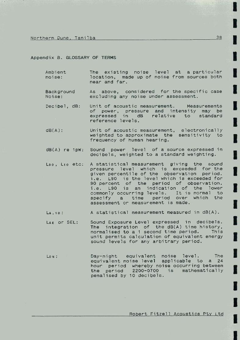
Northern Dune, Tanilba 3_
Appendix B. GLOSSARY OF TERMS
Ambient The existing noise level at a particular noise: location, made up of noise from sources both
near and far.
Background As above, considered for the specific case Noise: excluding any noise under assessment.
Decibel, dB: Unit of acoustic measurement. Measurements of power, pressure and intensity may be expressed in dB relative to standard reference levels.
dB(A): Unit of acoustic measurement, electronically weighted to approximate the sensitivity to frequency of human hearing.
dB(A) re lpW: Sound power level of a source expressed in decibels, weighted to a standard weighting.
L9o, Lio etc: A statistical measurement giving the sound pressure level which is exceeded for the given percentile of the observation period. i.e. L90 is the level which is exceeded for 90 percent of the period of observation. i.e. L90 is an indication of the lower commonly occurring levels. It is normal to specify a time period over which the assessment or measurement is made.
LA,io: A statistical measurement measured in dB(A).
LAE or SEL: Sound Exposure Level expressed in decibels. The integration of the dB(A) time history, normalised to a 1 second time period. This unit permits calculation of equivalent energy sound levels for any arbitrary period.
LDN: Day-night equivalent noise level. The equivalent noise level applicable to a 24 hour period whereby noise occurring between the period 2200-0700 is mathematically penalised by 10 decibels.
Robert Fitzell Acoustics Pty Ltd

I Northern Dune, Tanilba 39
I I A mathematically derived level equal in total
energy to the varying level for the measurement period. For a constant and unchanging noise, the instantaneous level and
I the Log are equal.
Sound Power The level of total sound energy radiated per
I Level: unit time by a source, expressed in decibels, equal to 10 times the logarithm to the base 10 of the sound power of the source relative
Ito a reference power of 1 picowatt. Sound power cannot be measured directly but must be calculated from sound intensity level
Imeasurements.
Sound The level, expressed in decibels, equal to 20 Pressure times the logarithm to the base 10 of the
I Level: ratio of the r.m.s. sound pressure to a reference pressure of 20 micropascal. Sound pressure level is measured using a microphone
I
and a sound level meter, and varies with distance from the source and the environment.
Robert Fitzell Acoustics Pty Ltd