Egloff, et al Biamanga 2005
121
BIAMANGA and GULAGA Aboriginal Cultural Association with Biamanga and Gulaga National Parks
Transcript of Egloff, et al Biamanga 2005
BIAMANGA and GULAGAAboriginal Cultural Association with Biamanga and Gulaga National Parks
Brian Egloff , Nicolas Peterson and Sue Wesson
Cultural Heritage Research CentreUniversity of Canberra, Australia
BIAMANGA and GULAGAAboriginal Cultural Association with Biamanga and Gulaga National Parks
Copyright © Office of the Registrar, Aboriginal Land Rights Act 1983 (NSW) 2004.
First published in 2005 by the Office of the Registrar, Aboriginal Land Rights Act 1983 (NSW),
Level 13, Tower B, Centennial Plaza, 280 Elizabeth Street, Surry Hills NSW 2010.
Phone 61 2 9219 0700, Fax 61 2 9219 0770.
National Library of Australia Cataloguing-in-Publication data: Egloff, Brian, 1940- .
Biamanga and Gulaga: Aboriginal cultural association with the Biamanga and Gulaga National Parks.
Bibliography
ISBN 0 9581920 2 2.
1. New South Wales. Aboriginal Land Rights Act 1983.
2. Aboriginal Australians - New South Wales - Biamanga National Park - Social life and customs.
3. Aboriginal Australians - New South Wales - Gulaga National Park - Social life and customs.
4. Aboriginal Australians - New South Wales - Biamanga National Park - Rites and ceremonies.
5. Aboriginal Australians - New South Wales - Gulaga National Park - Rites and ceremonies.
6. Biamanga National Park (N.S.W.) - Social life and customs.
7. Gulaga National Park (N.S.W.) - Social life and customs.
I. Peterson, Nicolas, 1941- . II. Wesson, Sue C., 1955- . III. New South Wales. Office of the Registrar, Aboriginal
Land Rights Act 1983. IV. Title.
305.89915099447
Editorial coordination by Rachel Lenehan, Office of the Registrar.
Design: Rachel Madden (Buckingoodesign)
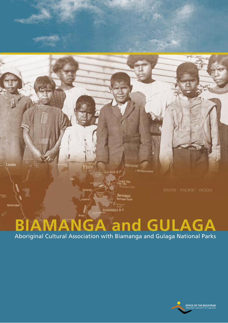
Front cover photo: Aboriginals at Lake Wallaga Misssion Station. A photographic postcard from the
1920's taken by an unknown photographer. Map of study area showing the location of Biamanga and Gulaga
National Parks and the Yuin cultural area.
A note about the captions.
The original captions describing the photos from the Corkhill Collection have been reproduced in full. As such
they reflect the language and attitudes held by Australians in the late 1800’s and early 1900’s towards Aboriginal
people. Although some of the terminology is outdated or even offensive, the captions are presented without
alteration for historical accuracy. Additional information about the photos produced during the research is
presented in Italics.
Photo's reproduced by permission of the National Library of Australia and South Australian Museum Archives.
Printed in Australia by Finsbury Press on Envirocare 100% recycled paper.
Since 1996 Aboriginal people have been able to request the entry of their name in the Register of Aboriginal Owners, held by the Registrar of the Aboriginal Land Rights Act 1983 (NSW). Aboriginal Owners are central to the legal process under the National Parks and Wildlife Act 1974 (NSW) that provides for Aboriginal ownership and joint management of land in New South Wales recognised as being of Aboriginal cultural significance and high conservation value. For the Registrar to enter the name of an Aboriginal person in the Register of Aboriginal Owners, they need to provide information about their family history and their cultural area and cultural association with the land. Since 2000, the Office of the Registrar has initiated research projects to gather this information in coordination with Aboriginal people, for lands that are to be jointly managed.
This report is a revised version of the original research report produced by the authors for the Office of the Registrar, Aboriginal Land Rights Act 1983 (NSW) in December 2001, as part of a research project on the Biamanga and Gulaga National Parks. Only minor changes have been made to reflect amendments to relevant legislation and to enliven the words with photos and maps. For the first time, historical photos from the National Library of Australia and the South Australian Museum have been brought together with a discussion on Aboriginal cultural association with the Biamanga and Gulaga National Parks and surrounding country.
This report is primarily for Aboriginal people who are from the south coast of New South Wales and the wider Aboriginal community. It is hoped that researchers and people with an interest in Aboriginal culture and history of the far south coast of New South Wales will find this book of interest also.
The information contained in the report, particularly the family histories should be regarded as work in progress. New information emerges as people meet and talk and remember, fitting together the pieces of a puzzle to form a picture of life and experiences. Most importantly, it is acknowledged that Aboriginal people are associated with, and connected to Biamanga and Gulaga National Parks and their land, by ways and means and forms not expressed in this report.
Please contact the Office of the Registrar with your comments about this report.
Stephen WrightRegistrar, Aboriginal Land Rights Act 1983 (NSW)
Foreword
iii

1 The Research Project 1
1.1 Overview 1
1.2 Biamanga National Park 3
1.3 Gulaga National Park 4
1.4 Associated Places of Aboriginal Significance 5
1.5 Methodology 5
2 Cultural Area and Descent 8
2.1 Marriage Networks from the Earliest Ethnography 9
2.2 Howitt's Evidence on Cultural Groupings and Ceremonial Interaction 13
2.3 Linguistic Evidence 16
2.4 Modifications Through Political Process 22
2.5 Descent Within the Cultural Area 23
2.6 Definition of the Cultural Area and Descent for the Purposes of this Report 25
3 History of the Aboriginal Inhabitants of the Cultural Area 28
3.1 Chronology of Contact 28
3.2 Aboriginal Reserves 31
3.3 Leaving Delegate 44
3.4 Leaving Braidwood 46
3.5 Conclusion 50
4 Cultural Association 51
4.1 Early Evidence for Cultural Association 52
4.2 The 1883 Initiation 52
4.3 Special Significance of the Mountains 53
4.4 The Battle to Protect Mumbulla Mountain and the Public Emergence of Indigenous Knowledge 54
4.5 Renewing the Dreaming 56
4.6 Contemporary Notions of Cultural Association 58 4.7 Definition of Cultural Association for the Purposes of this Report 60
5 Original Aboriginal Inhabitants 61
6 Conclusion 75
Appendixes 77
A A.W. Howitt and The Native Tribes of South-East Australia B Norman Tindale: Mapping of Aboriginal 'Tribes' and his research at Wallaga Lake C Register of the National Estate D Land Rights, Aboriginal Owners and Joint Management E Research Project Schedule F About the authors
Bibliography 111
Contents
iv
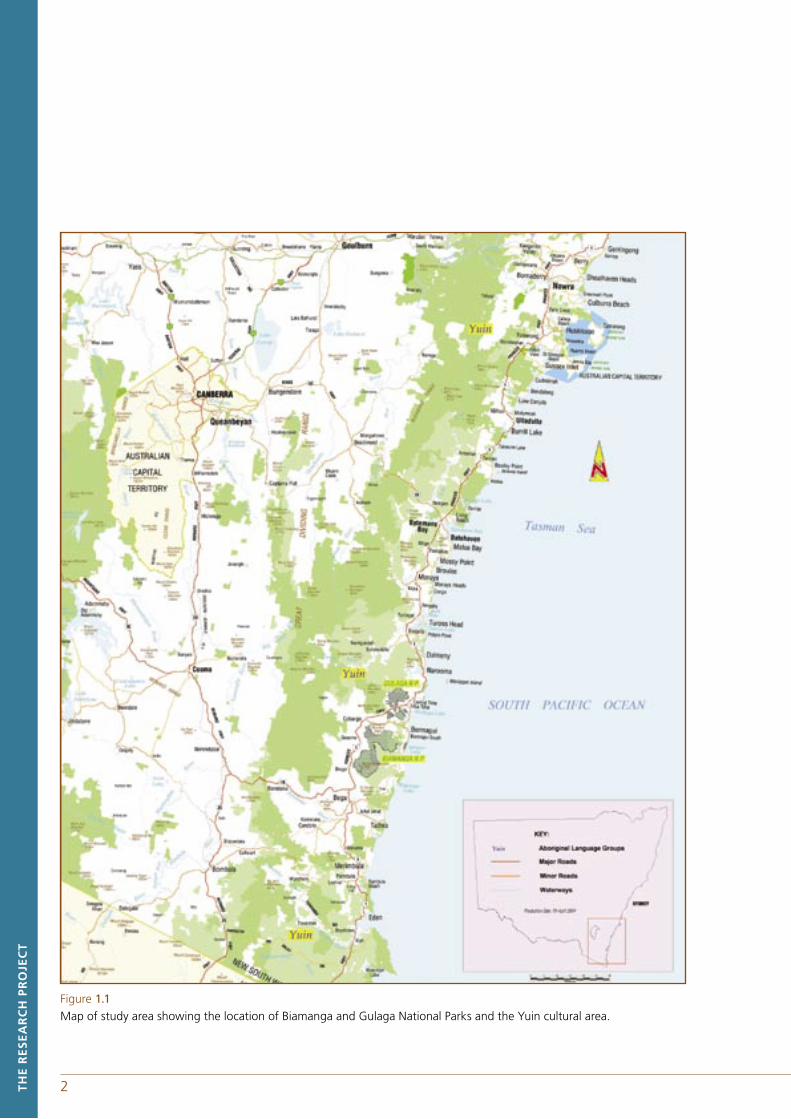
Figures 1.1 Map of study area showing the location of Biamanga and Gulaga National Parks and the Yuin cultural area.
1.2 Schematic map of Biamanga and Gulaga National Park (H.Egloff).
1.3 Schematic map of Biamanga National Park (H.Egloff).
1.4 Schematic map of Gulaga National Park (H.Egloff).
2.1 Home range of far south coast gatherings including those attending the 1883 initiation as recorded by A.W. Howitt.
2.2 Language distribution in south-eastern New South Wales from Tindale (1974) and Eades (1976).
2.3 Languages of the study area.
2.4 Map showing Local Aboriginal Land Councils, far south coast of New South Wales.
Tables2.1 Population of Wagunga & Wonderral, Murrah, Brogo, Worerkerbrimmitter and Wadder Waddo groups.
2.2A lntermarriage on the far south coast indicated by Robinson's field journals and notebooks.
2.2B lntermarriage on the far south coast with Lake Tyers & far east Gippsland partners indicated by Robinson’s field journals and notebooks.
2.2C lntermarriage on the far south coast with Monaro indicated by Robinson’s field journals and notebooks.
2.3 Characteristics of the remnant vocabulary lists for far south coast, New South Wales.
3.1 Pastoral stations in the first decade of British settlement in the region of Mumbulla and Gulaga Mountains.
3.2 Residents of Wallaga Lake in 1883 from Howitt's blanket census and gathered genealogies.
3.3 Wallaga Lake families in 1891 from the New South Wales census and gathered genealogies.
3.4 Wallaga Lake station residents in 1911 from Trenchard and gathered genealogies.
3.5 Families shown and appearing at least twice in censuses for Wallaga Lake between 1883 and 1938.3.6 Previous places of residence and destination or occupation of primary school students at Wallaga Lake School between 1926 and 1949.
3.7 The exodus of families from Delegate Aboriginal Reserve.
3.8 The exodus of families from the Braidwood area.
v
vi
Acknowledgements
In the late seventies four elders led the Aboriginal land rights movement on the south coast of New South Wales. Their actions provided the spirit in which the research was undertaken and the writing of the report. We have to acknowledge those elders; Jack Campbell at Jerrinja, George Brown at Wreck Bay, Ted Thomas at Wallaga Lake and Percy Mumbler at Browns Flat. Sadly, Guboo Ted the last of these elders passed away during the final stages of the production of this report.
The authors acknowledge the contribution of many Koori families from the south coast as well as the Eden, Bega, Merrimans, Wagonga and Cobowra Local Aboriginal Land Councils. It is impossible to name all the individuals that have given their time and personal and family memories but we thank you for your patience and hospitality.
The South Australian Museum must be thanked for their permission to reproduce the photographs taken at Wallaga Lake by Norman Tindale. The National Library of Australia kindly provided photographic material as did Leslie and Richard Bate from Tilba Tilba and Lynne Thomas from Wallaga Lake.
Staff from the National Parks and Wildlife Service (Department of Environment and Conservation), in particular Trisha Ellis the editor of Coastal Custodians at Narooma, and Stephen Wright, Rachel Lenehan and Adam Black from the Office of the Registrar are to be thanked for facilitating the process that led to the publication of this report.
1 The Research Project
The purpose of the Biamanga and Gulaga National Park research project, the end product which is this report, is to enable the recognition of the original Aboriginal ownership of land and to involve Aboriginal people in the joint management of land subject to certain conditions. These two areas are located close together on the south coast of New South Wales. The summit of Mumbulla Mountain, which dominates Biamanga National Park, is 23 kilometres south-west of Bermagui while Mount Dromedary, the dominant feature of Gulaga National Park, is 13 kilometres in a north and westerly direction from Bermagui. The study is set within the broader cultural context of the south coast and immediate hinterland of New South Wales; covering an area lying south of the Shoalhaven River to the border with Victoria and inland to the watershed of the Snowy Mountains.
1.1 OVERVIEWAs part of its land rights policy, the New South Wales government has passed legislation to enable the recognition of the original Aboriginal ownership of lands. Under the provisions of the National Parks and Wildlife Act 1974 (NSW) and the Aboriginal Land Rights Act 1983 (NSW), certain lands can be transferred to Aboriginal ownership with the title being held by the relevant local Aboriginal land council(s). The land is then leased back to the Minister administering the National Parks and Wildlife Act 1974 (NSW), which is currently the Minister for the Environment, so that the land is accessible by the general public. For lands to be available for return to Aboriginal ownership on these conditions, they must first be placed on Schedule 14 of the National Parks and Wildlife Act 1974 (NSW) by an act of the Parliament of New South Wales.
Section 171 of the Aboriginal Land Rights Act 1983 (NSW) states that the name of an Aboriginal person must not be placed in the register unless theAboriginal person:
a) is directly descended from the original Aboriginal inhabitants of the cultural area in which the land is situated, and
b) has a cultural association with the land that derives from the traditions, observances, customs, beliefs or history of the original Aboriginal inhabitants of the land, and
c) has consented to the entry of their name in the register.
Aboriginal people may request of the Registrar that their name be entered on the register of Aboriginal owners for particular lands, in this case the two parks, Gulaga and Biamanga. This Report assists the Registrar when making a determination on an application to register as an Aboriginal owner for the Biamanga National Park and Gulaga National Park in accordance with the criteria stated in the Aboriginal Land Rights Act 1983 (NSW). Specifically it is to provide the Registrar with advice about the following:
a) the cultural area in which the parks are situated,
b) the nature of the cultural association Aboriginal people have with the Biamanga National Park and Gulaga National Park derived from the traditions, observances, customs, beliefs or history of the original inhabitants of the land, and
c) the ways an Aboriginal person with a cultural association to land within the Biamanga and Gulaga National Parks may be directly descended from the original inhabitants.
TH
E R
ES
EA
RC
H P
RO
JEC
T
1
2 3TH
E R
ES
EA
RC
H P
RO
JEC
T
Figure 1.1Map of study area showing the location of Biamanga and Gulaga National Parks and the Yuin cultural area.
2 3 TH
E R
ES
EA
RC
H P
RO
JEC
T
This chapter provides the formal information on the history and dedication of the two parks, their heritage status and that of associated lands, and then outlines the methodology on which this report is based. Chapter two looks at how the cultural area can be defined. Chapter three traces the history of the Aboriginal inhabitants of the cultural area from the time they appear in the historical record as named individuals. Chapter four considers the notion of cultural association and chapter five discusses who the Aboriginal owners are for the purposes of the Act.
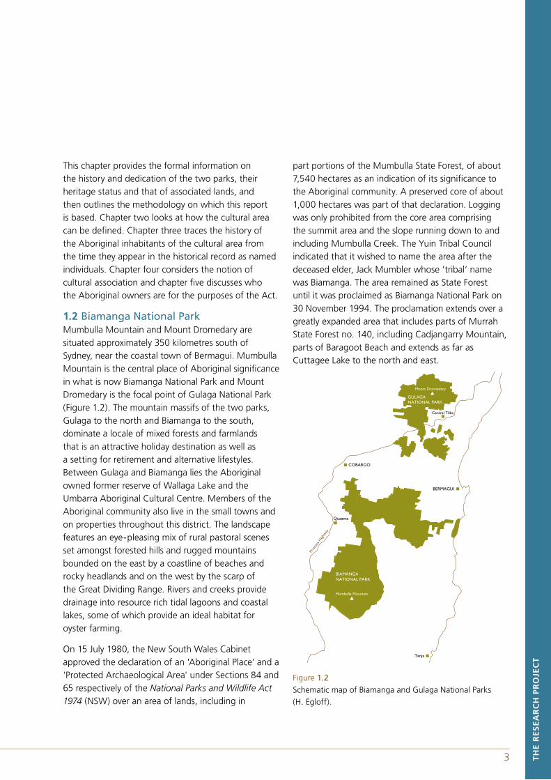
1.2 Biamanga National ParkMumbulla Mountain and Mount Dromedary are situated approximately 350 kilometres south of Sydney, near the coastal town of Bermagui. Mumbulla Mountain is the central place of Aboriginal significance in what is now Biamanga National Park and Mount Dromedary is the focal point of Gulaga National Park (Figure 1.2). The mountain massifs of the two parks, Gulaga to the north and Biamanga to the south, dominate a locale of mixed forests and farmlands that is an attractive holiday destination as well as a setting for retirement and alternative lifestyles. Between Gulaga and Biamanga lies the Aboriginal owned former reserve of Wallaga Lake and the Umbarra Aboriginal Cultural Centre. Members of the Aboriginal community also live in the small towns and on properties throughout this district. The landscape features an eye-pleasing mix of rural pastoral scenes set amongst forested hills and rugged mountains bounded on the east by a coastline of beaches and rocky headlands and on the west by the scarp of the Great Dividing Range. Rivers and creeks provide drainage into resource rich tidal lagoons and coastal lakes, some of which provide an ideal habitat for oyster farming.
On 15 July 1980, the New South Wales Cabinet approved the declaration of an 'Aboriginal Place' and a 'Protected Archaeological Area' under Sections 84 and 65 respectively of the National Parks and Wildlife Act 1974 (NSW) over an area of lands, including in
part portions of the Mumbulla State Forest, of about 7,540 hectares as an indication of its significance to the Aboriginal community. A preserved core of about 1,000 hectares was part of that declaration. Logging was only prohibited from the core area comprising the summit area and the slope running down to and including Mumbulla Creek. The Yuin Tribal Council indicated that it wished to name the area after the deceased elder, Jack Mumbler whose ‘tribal’ name was Biamanga. The area remained as State Forest until it was proclaimed as Biamanga National Park on 30 November 1994. The proclamation extends over a greatly expanded area that includes parts of Murrah State Forest no. 140, including Cadjangarry Mountain, parts of Baragoot Beach and extends as far asCuttagee Lake to the north and east.
Figure 1.2Schematic map of Biamanga and Gulaga National Parks (H. Egloff).
BERMAGUI
GULAGANATIONAL PARK
Mount Dromedary
Central Tilba
Prin
cess
High
way
BIAMANGANATIONAL PARK
COBARGO
Tanja
Quaama
Mumbulla Mountain
10 KM
4
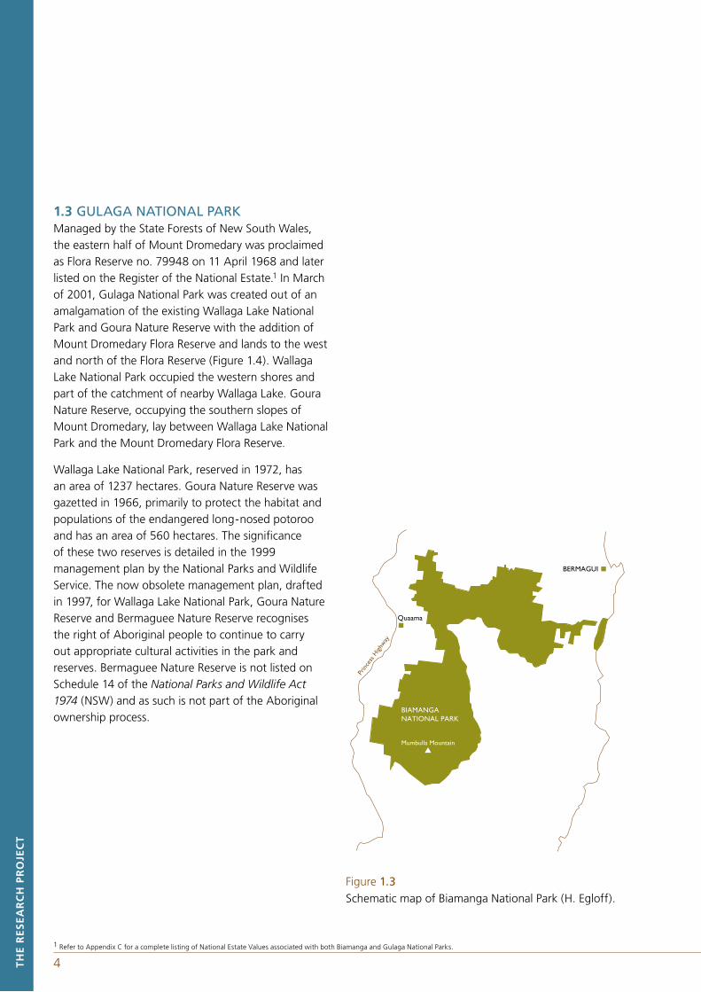
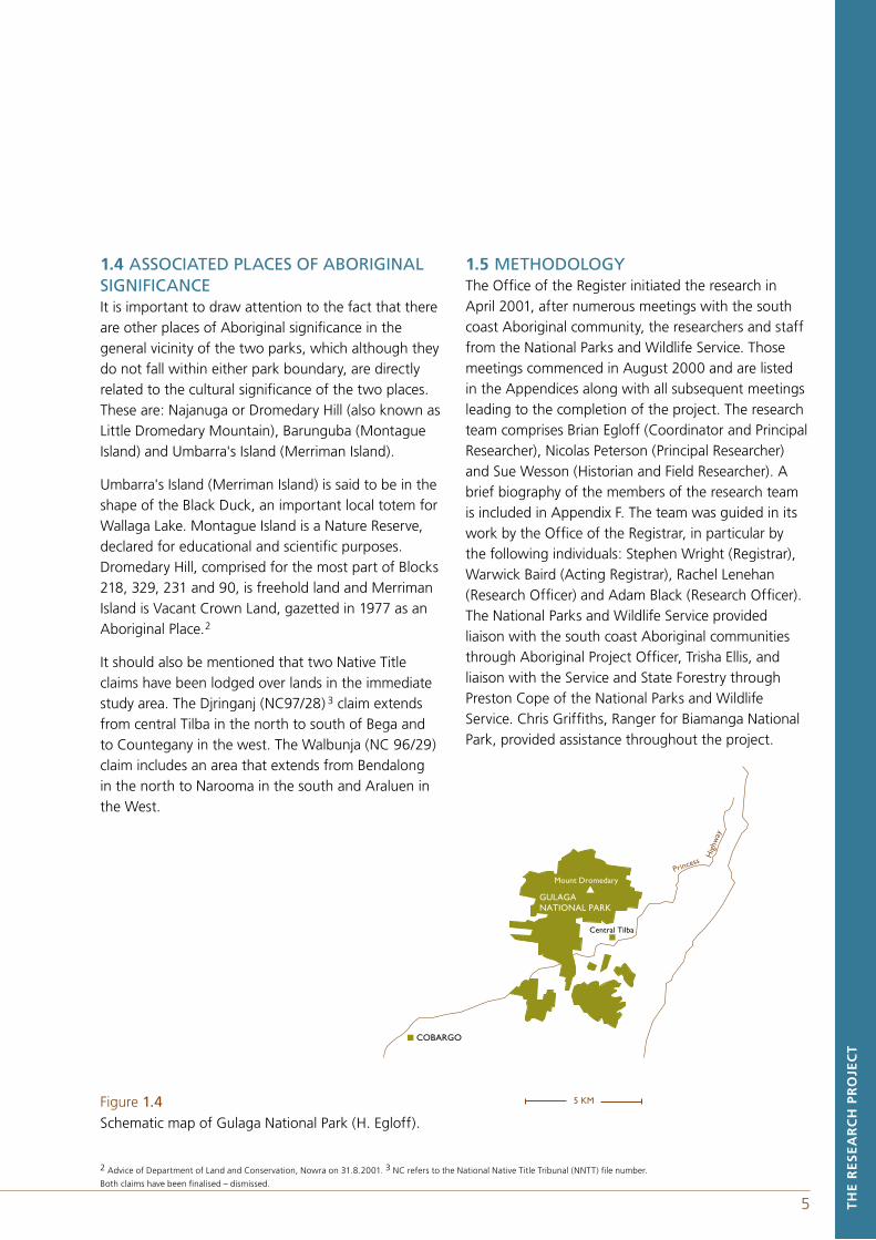
1.3 GULAGA NATIONAL PARKManaged by the State Forests of New South Wales, the eastern half of Mount Dromedary was proclaimed as Flora Reserve no. 79948 on 11 April 1968 and later listed on the Register of the National Estate.1 In March of 2001, Gulaga National Park was created out of an amalgamation of the existing Wallaga Lake National Park and Goura Nature Reserve with the addition of Mount Dromedary Flora Reserve and lands to the west and north of the Flora Reserve (Figure 1.4). Wallaga Lake National Park occupied the western shores and part of the catchment of nearby Wallaga Lake. Goura Nature Reserve, occupying the southern slopes of Mount Dromedary, lay between Wallaga Lake National Park and the Mount Dromedary Flora Reserve.
Wallaga Lake National Park, reserved in 1972, has an area of 1237 hectares. Goura Nature Reserve was gazetted in 1966, primarily to protect the habitat and populations of the endangered long-nosed potoroo and has an area of 560 hectares. The significance of these two reserves is detailed in the 1999 management plan by the National Parks and Wildlife Service. The now obsolete management plan, drafted in 1997, for Wallaga Lake National Park, Goura Nature Reserve and Bermaguee Nature Reserve recognises the right of Aboriginal people to continue to carry out appropriate cultural activities in the park and reserves. Bermaguee Nature Reserve is not listed on Schedule 14 of the National Parks and Wildlife Act 1974 (NSW) and as such is not part of the Aboriginal ownership process.
BERMAGUI
Prin
cess
High
way
BIAMANGANATIONAL PARK
Quaama
5 KM
Mumbulla Mountain
TH
E R
ES
EA
RC
H P
RO
JEC
T
1 Refer to Appendix C for a complete listing of National Estate Values associated with both Biamanga and Gulaga National Parks.
Figure 1.3Schematic map of Biamanga National Park (H. Egloff).
4
Figure 1.4 Schematic map of Gulaga National Park (H. Egloff).
GULAGANATIONAL PARK
Mount Dromedary
Central Tilba
COBARGO
5 KM
Hig
hway
PrincessT
HE
RE
SE
AR
CH
PR
OJE
CT
2 Advice of Department of Land and Conservation, Nowra on 31.8.2001. 3 NC refers to the National Native Title Tribunal (NNTT) file number.
Both claims have been finalised – dismissed.
5
1.4 ASSOCIATED PLACES OF ABORIGINAL SIGNIFICANCEIt is important to draw attention to the fact that there are other places of Aboriginal significance in the general vicinity of the two parks, which although they do not fall within either park boundary, are directly related to the cultural significance of the two places. These are: Najanuga or Dromedary Hill (also known as Little Dromedary Mountain), Barunguba (Montague Island) and Umbarra's Island (Merriman Island).
Umbarra's Island (Merriman Island) is said to be in the shape of the Black Duck, an important local totem for Wallaga Lake. Montague Island is a Nature Reserve, declared for educational and scientific purposes. Dromedary Hill, comprised for the most part of Blocks 218, 329, 231 and 90, is freehold land and Merriman Island is Vacant Crown Land, gazetted in 1977 as an Aboriginal Place.2
It should also be mentioned that two Native Title claims have been lodged over lands in the immediate study area. The Djringanj (NC97/28) 3 claim extends from central Tilba in the north to south of Bega and to Countegany in the west. The Walbunja (NC 96/29) claim includes an area that extends from Bendalong in the north to Narooma in the south and Araluen in the West.
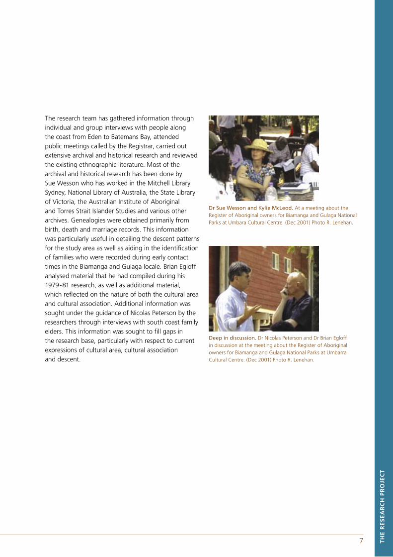
1.5 METHODOLOGYThe Office of the Register initiated the research in April 2001, after numerous meetings with the south coast Aboriginal community, the researchers and staff from the National Parks and Wildlife Service. Those meetings commenced in August 2000 and are listed in the Appendices along with all subsequent meetings leading to the completion of the project. The research team comprises Brian Egloff (Coordinator and Principal Researcher), Nicolas Peterson (Principal Researcher) and Sue Wesson (Historian and Field Researcher). A brief biography of the members of the research team is included in Appendix F. The team was guided in its work by the Office of the Registrar, in particular by the following individuals: Stephen Wright (Registrar), Warwick Baird (Acting Registrar), Rachel Lenehan (Research Officer) and Adam Black (Research Officer). The National Parks and Wildlife Service provided liaison with the south coast Aboriginal communities through Aboriginal Project Officer, Trisha Ellis, and liaison with the Service and State Forestry through Preston Cope of the National Parks and Wildlife Service. Chris Griffiths, Ranger for Biamanga National Park, provided assistance throughout the project.

6 7
The Registrar, Stephen Wright. Talking to a gathering at Umbarra Cultural Centre. (Dec 2001). Photo R. Lenehan.
Prior to the research beginning, the National Parks and Wildlife Service commenced an awareness raising campaign with a series of community meetings convened by Aboriginal Projects Officer, Trisha Ellis, and with the publication of a newsletter titled Coastal Custodians. Throughout the research, the Office of the Registrar has held meetings with the south coast Aboriginal community to facilitate their input into the project, provide information about the register of Aboriginal owners and the Aboriginal ownership and joint management process.
The research brief from the Office of the Registrar required that a separate report be produced for each park and that the research team assist at least ten Aboriginal people to register as Aboriginal owners for each park. With the agreement of the Registrar and the Aboriginal community, it was decided that a single report covering both parks would be sufficient as the same community of people had interests in both parks. One report would lighten the demands placed on the community members participating in the review process.
Aboriginal owners. Pictured from left to right Dr Nicolas Peterson, Amanda Markham, Phillip Sullivan, Warwick Baird (Acting Registrar).
A meeting of academics & researchers to discuss the register of Aboriginal owners held on the 6 Nov 2001 at Narooma. Also in attendance: Dr Jeremy Beckett, Dr Scott Cane, Dr Tamsin Donaldson, Dr Brian Egloff, Adrienne Howe-Pienning, Rachel Lenehan, Steve Meredith, Bradley Steadman, Peter Thompson, Trisha Ellis and Sue Wesson. Photo R. Lenehan.
TH
E R
ES
EA
RC
H P
RO
JEC
T
6 7 TH
E R
ES
EA
RC
H P
RO
JEC
T
The research team has gathered information through individual and group interviews with people along the coast from Eden to Batemans Bay, attended public meetings called by the Registrar, carried out extensive archival and historical research and reviewed the existing ethnographic literature. Most of the archival and historical research has been done by Sue Wesson who has worked in the Mitchell Library Sydney, National Library of Australia, the State Library of Victoria, the Australian Institute of Aboriginal and Torres Strait Islander Studies and various other archives. Genealogies were obtained primarily from birth, death and marriage records. This information was particularly useful in detailing the descent patterns for the study area as well as aiding in the identification of families who were recorded during early contact times in the Biamanga and Gulaga locale. Brian Egloff analysed material that he had compiled during his 1979-81 research, as well as additional material, which reflected on the nature of both the cultural area and cultural association. Additional information was sought under the guidance of Nicolas Peterson by the researchers through interviews with south coast family elders. This information was sought to fill gaps in the research base, particularly with respect to current expressions of cultural area, cultural association and descent.
Dr Sue Wesson and Kylie McLeod. At a meeting about the Register of Aboriginal owners for Biamanga and Gulaga National Parks at Umbara Cultural Centre. (Dec 2001) Photo R. Lenehan.
Deep in discussion. Dr Nicolas Peterson and Dr Brian Egloff in discussion at the meeting about the Register of Aboriginal owners for Biamanga and Gulaga National Parks at Umbarra Cultural Centre. (Dec 2001) Photo R. Lenehan.
9 CU
LTU
RA
L A
RE
A A
ND
DE
SC
EN
T
The Act provides no definition of 'cultural area'. While the term has a long history of use within anthropology (for a classic statement see A.L. Kroeber 1939 Cultural and Natural Areas of Native North America) we assume that this term is to be understood in its broadest and least technical sense as a space defined in relation to the concept of culture. In particular this means that it must encompass an area in which the inhabitants have cultural ties, that is, closely related ways of life as reflected in shared meanings, social practices and interactions. In the classic studies of cultural areas there was often a concern to encompass those cultural groups that shared a closer history and geography with each other than they did with cultures in other areas of the same order of magnitude. The important point here is that the use of the term cultural indicates that individuals are not the focus of cultural areas, although individuals may espouse different definitions of a cultural area. So that unless some rather idiosyncratic usage is adopted, which would make it possible for individuals to define a cultural area as they please, it must have some wider social significance.
While cultural areas have classically been defined in terms of whole ways of life, they have sometimes been defined in terms of a single trait. Thus depending on the criterion or criteria chosen, the spatial definition of the cultural area may differ quite substantially, so that the area may or may not coincide precisely with how the Aboriginal people in a region conceive it themselves. While such a discrepancy could be due to defining the area in terms of an obscure feature, or set of features, there are other reasons why it might not be congruent with how people think today. Thus, for example, if the cultural area were defined with a 1788 time-line in mind it would not be at all surprising to find that it was not completely congruent with understandings in 2001. More importantly, however, people today may not agree among themselves for a variety of reasons. An individual's definition could be informed by various material or political interests which might see a tendency to narrow the area
when discussing the allocation of resources and to expand the area in the context of political opposition to government and non-indigenous interests. A longer term view may show, in some regions that the geographical variations of culture and history are themselves played out within geographical constraints of one sort or another.
The importance of the definition of cultural area being worked out with respect to what is culturally appropriate, in relation to the particular locality of the lands under consideration, arises because the definition influences who may be registered as an Aboriginal owner of the lands in question, for the purposes of the Act. It is assumed that it is important that the people who end up on the register of Aboriginal owners are those who are widely accepted as appropriate by the Aboriginal community, otherwise there will be unnecessary contention with and among Aboriginal people.
In Australia, marriage networks, ceremonial interaction and language have been central to the constitution of regional cultural groupings. We begin with the earliest ethnographic evidence which provides material on marriage patterns on the far south coast at, and prior to, British colonisation. We follow this with an examination of cultural groupings and ceremonial interaction based on the work of A.W. Howitt, the chief ethnographer for the south coast, before turning to the important matter of language. We conclude the chapter by briefly considering the emergence of new regional groupings and a discussion of the notion of descent within the proposed cultural area.
2 Cultural Area and Descent
CU
LTU
RA
L A
RE
A A
ND
DE
SC
EN
T
8
9 CU
LTU
RA
L A
RE
A A
ND
DE
SC
EN
T
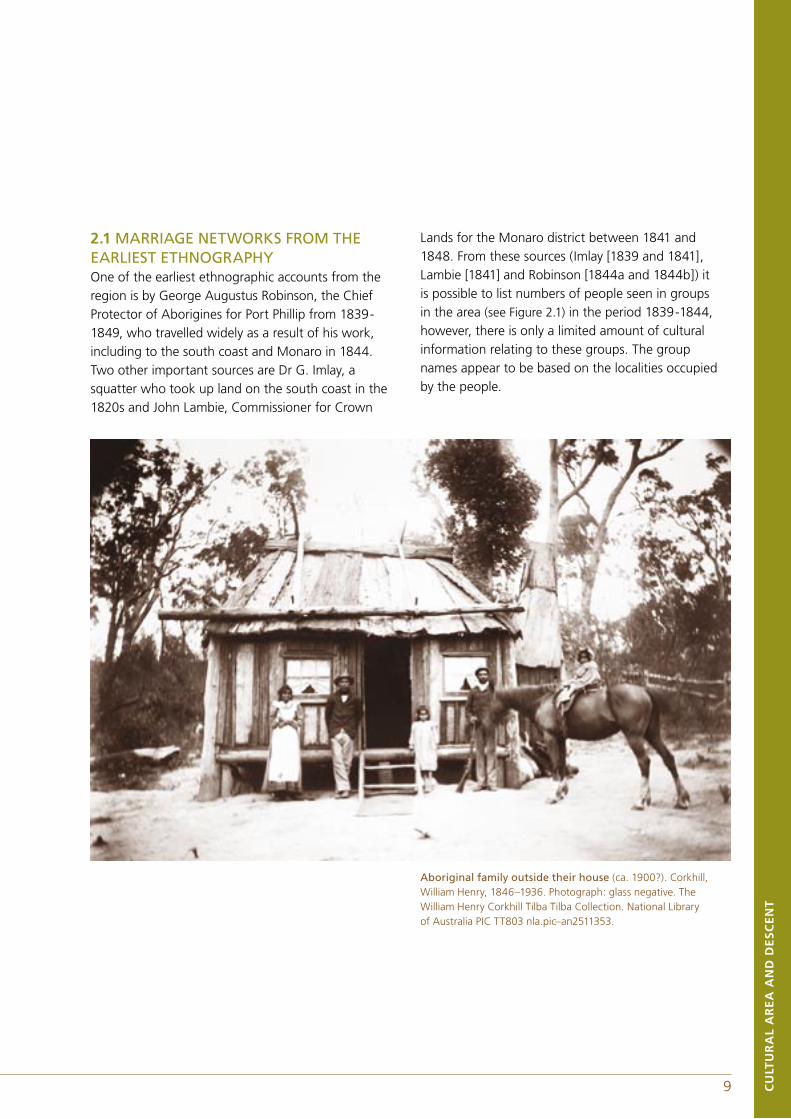
2.1 MARRIAGE NETWORKS FROM THE EARLIEST ETHNOGRAPHYOne of the earliest ethnographic accounts from the region is by George Augustus Robinson, the Chief Protector of Aborigines for Port Phillip from 1839-1849, who travelled widely as a result of his work, including to the south coast and Monaro in 1844. Two other important sources are Dr G. Imlay, a squatter who took up land on the south coast in the 1820s and John Lambie, Commissioner for Crown
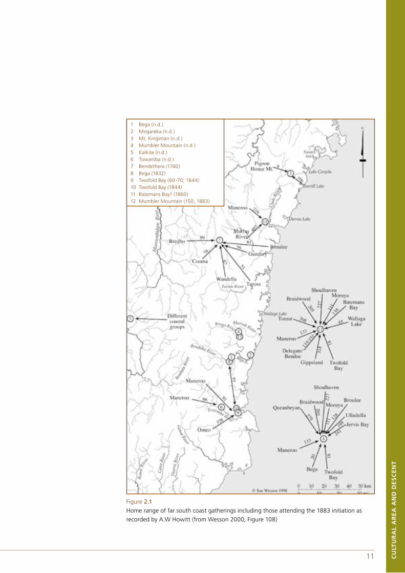
Lands for the Monaro district between 1841 and 1848. From these sources (Imlay [1839 and 1841], Lambie [1841] and Robinson [1844a and 1844b]) it is possible to list numbers of people seen in groups in the area (see Figure 2.1) in the period 1839-1844, however, there is only a limited amount of cultural information relating to these groups. The group names appear to be based on the localities occupied by the people.
Aboriginal family outside their house (ca. 1900?). Corkhill, William Henry, 1846–1936. Photograph: glass negative. The William Henry Corkhill Tilba Tilba Collection. National Library of Australia PIC TT803 nla.pic–an2511353.
10CU
LTU
RA
L A
RE
A A
ND
DE
SC
EN
T
11 CU
LTU
RA
L A
RE
A A
ND
DE
SC
EN
T
Much more significant for our purposes is the reconstruction that can be made of the marriage networks from Robinson's field journals. These provide sufficient information to show the intermarriage between far south coast groups
and those of Gippsland and the Monaro. The great majority of the marriages he records were between people living within the far south coast region, however, a small number were with people in Gippsland and on the Monaro (see Tables 2.2 a-c).
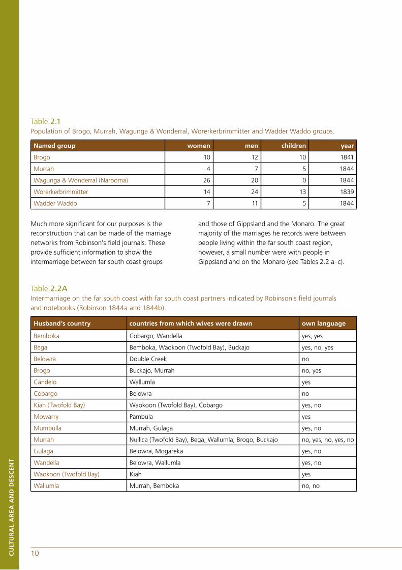
Table 2.1 Population of Brogo, Murrah, Wagunga & Wonderral, Worerkerbrimmitter and Wadder Waddo groups.
Table 2.2A Intermarriage on the far south coast with far south coast partners indicated by Robinson's field journals and notebooks (Robinson 1844a and 1844b).
Husband’s country countries from which wives were drawn own language
Bemboka Cobargo, Wandella yes, yes
Bega Bemboka, Waokoon (Twofold Bay), Buckajo yes, no, yes
Belowra Double Creek no
Brogo Buckajo, Murrah no, yes
Candelo Wallumla yes
Cobargo Belowra no
Kiah (Twofold Bay) Waokoon (Twofold Bay), Cobargo yes, no
Mowarry Pambula yes
Mumbulla Murrah, Gulaga yes, no
Murrah Nullica (Twofold Bay), Bega, Wallumla, Brogo, Buckajo no, yes, no, yes, no
Gulaga Belowra, Mogareka yes, no
Wandella Belowra, Wallumla yes, no
Waokoon (Twofold Bay) Kiah yes
Wallumla Murrah, Bemboka no, no
Named group women men children year
Brogo 10 12 10 1841
Murrah 4 7 5 1844
Wagunga & Wonderral (Narooma) 26 20 0 1844
Worerkerbrimmitter 14 24 13 1839
Wadder Waddo 7 11 5 1844
10CU
LTU
RA
L A
RE
A A
ND
DE
SC
EN
T
11 CU
LTU
RA
L A
RE
A A
ND
DE
SC
EN
T
Figure 2.1Home range of far south coast gatherings including those attending the 1883 initiation as recorded by A.W Howitt (from Wesson 2000, Figure 108)
1 Bega (n.d.)2 Mogareka (n.d.)3 Mt. Kingiman (n.d.)4 Mumbler Mountain (n.d.)5 Kalkite (n.d.)6 Towamba (n.d.)7 Bendethera (1740)8 Bega (1832)9 Twofold Bay (60-70; 1844)10 Twofold Bay (1844)11 Batemans Bay? (1860)12 Mumbler Mountain (150; 1883)
12CU
LTU
RA
L A
RE
A A
ND
DE
SC
EN
T
13 CU
LTU
RA
L A
RE
A A
ND
DE
SC
EN
T
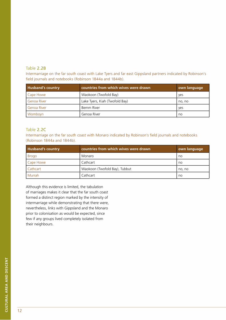
Although this evidence is limited, the tabulation of marriages makes it clear that the far south coast formed a distinct region marked by the intensity of intermarriage while demonstrating that there were, nevertheless, links with Gippsland and the Monaro prior to colonisation as would be expected, since few if any groups lived completely isolated from their neighbours.
Table 2.2BIntermarriage on the far south coast with Lake Tyers and far east Gippsland partners indicated by Robinson's field journals and notebooks (Robinson 1844a and 1844b).
Husband’s country countries from which wives were drawn own language
Brogo Monaro no
Cape Howe Cathcart no
Cathcart Waokoon (Twofold Bay), Tubbut no, no
Murrah Cathcart no
Table 2.2CIntermarriage on the far south coast with Monaro indicated by Robinson's field journals and notebooks (Robinson 1844a and 1844b).
Husband’s country countries from which wives were drawn own language
Cape Howe Waokoon (Twofold Bay) yes
Genoa River Lake Tyers, Kiah (Twofold Bay) no, no
Genoa River Bemm River yes
Womboyn Genoa River no
12CU
LTU
RA
L A
RE
A A
ND
DE
SC
EN
T
13 CU
LTU
RA
L A
RE
A A
ND
DE
SC
EN
T
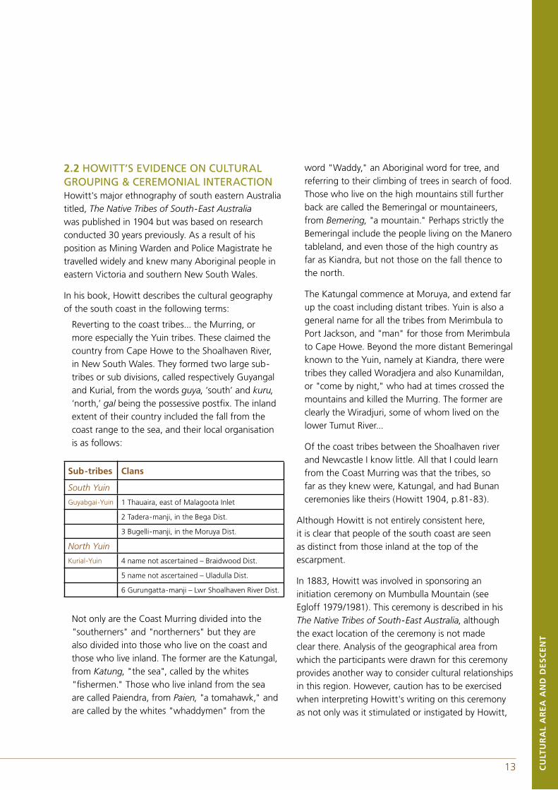
2.2 HOWITT’S EVIDENCE ON CULTURAL GROUPING & CEREMONIAL INTERACTIONHowitt's major ethnography of south eastern Australia titled, The Native Tribes of South-East Australia was published in 1904 but was based on research conducted 30 years previously. As a result of his position as Mining Warden and Police Magistrate he travelled widely and knew many Aboriginal people in eastern Victoria and southern New South Wales.
In his book, Howitt describes the cultural geography of the south coast in the following terms:
Reverting to the coast tribes... the Murring, or more especially the Yuin tribes. These claimed the country from Cape Howe to the Shoalhaven River, in New South Wales. They formed two large sub-tribes or sub divisions, called respectively Guyangal and Kurial, from the words guya, ‘south’ and kuru, ‘north,’ gal being the possessive postfix. The inland extent of their country included the fall from the coast range to the sea, and their local organisation is as follows:
Not only are the Coast Murring divided into the "southerners" and "northerners" but they are also divided into those who live on the coast and those who live inland. The former are the Katungal, from Katung, "the sea", called by the whites "fishermen." Those who live inland from the sea are called Paiendra, from Paien, "a tomahawk," and are called by the whites "whaddymen" from the
word "Waddy," an Aboriginal word for tree, and referring to their climbing of trees in search of food. Those who live on the high mountains still further back are called the Bemeringal or mountaineers, from Bemering, "a mountain." Perhaps strictly the Bemeringal include the people living on the Manero tableland, and even those of the high country as far as Kiandra, but not those on the fall thence to the north.
The Katungal commence at Moruya, and extend far up the coast including distant tribes. Yuin is also a general name for all the tribes from Merimbula to Port Jackson, and "man" for those from Merimbula to Cape Howe. Beyond the more distant Bemeringal known to the Yuin, namely at Kiandra, there were tribes they called Woradjera and also Kunamildan, or "come by night," who had at times crossed the mountains and killed the Murring. The former are clearly the Wiradjuri, some of whom lived on the lower Tumut River...
Of the coast tribes between the Shoalhaven river and Newcastle I know little. All that I could learn from the Coast Murring was that the tribes, so far as they knew were, Katungal, and had Bunan ceremonies like theirs (Howitt 1904, p.81-83).
Although Howitt is not entirely consistent here, it is clear that people of the south coast are seen as distinct from those inland at the top of the escarpment.
In 1883, Howitt was involved in sponsoring an initiation ceremony on Mumbulla Mountain (see Egloff 1979/1981). This ceremony is described in his The Native Tribes of South-East Australia, although the exact location of the ceremony is not made clear there. Analysis of the geographical area from which the participants were drawn for this ceremony provides another way to consider cultural relationships in this region. However, caution has to be exercised when interpreting Howitt's writing on this ceremony as not only was it stimulated or instigated by Howitt,
Sub-tribes Clans
South Yuin
Guyabgai-Yuin 1 Thauaira, east of Malagoota Inlet
2 Tadera-manji, in the Bega Dist.
3 Bugelli-manji, in the Moruya Dist.
North Yuin
Kurial-Yuin 4 name not ascertained – Braidwood Dist.
5 name not ascertained – Uladulla Dist.
6 Gurungatta-manji – Lwr Shoalhaven River Dist.
14CU
LTU
RA
L A
RE
A A
ND
DE
SC
EN
T
15 CU
LTU
RA
L A
RE
A A
ND
DE
SC
EN
T
but in his narrative he mixes descriptions of the ideal with the actual events that he observed, introducing some contradictions and confusions.
Howitt clearly sets out the distribution of the ceremonial networks in south-eastern NSW and gives the geographical spread of the people attending the 1883 Mumbulla mountain Bunan initiation ceremony, although this material is scattered across a number of pages. Here we list the excerpts where he discusses the attendance at the ceremony and gives information on the extent of the associated network.
Assuming that the Bunan was to be attended by the clans from Moruya, Bega, and Twofold Bay, that is, by both the Kurial and Guyangal, and that the meeting was to be near Bega... The people from Braidwood, Ulladulla, and Shoalhaven would accompany those from Moruya. With them, people from Broulee would occasionally come. Next would arrive those from Queanbeyan, then the Gurungatta from beyond Shoalhaven, with whom there might be even some from Jervis Bay; and all these people are true Kurial (Howitt 1904, pp.519-20).
The Wollongong people did not attend this ceremony, because they go to one farther up the coast. The people from Twofold Bay would arrive about the same time, and bring with them some of the Bemeringal from the country along the coast range, being some of those living to the east of the Ngarigo (Howitt 1904, p.520).
The limits within which people would come may be roughly stated as Jimberoo, Kangaroo Valley, Nowra; but at this latter place were Bemeringal, that is, those who lived upon the high tableland, who went to the ceremonies at Goulburn. Nor did the Bemeringal come to these ceremonies from as great a distance as the country of the Ngarigo (Howitt 1904, p.520).
I went to the south coast and there found about one hundred and thirty blacks, - men, women, and children, - waiting for me. They represented mainly
the two great divisions of the Murring of the south coast, but there were also people from as far as Bateman's Bay and Braidwood, who accompanied the Shoalhaven contingent. (Howitt 1904, p.527).
There were at this time two or three Biduelli men with their wives and children in the encampment, and also one of the Krauatun-galung Kurnai, with his wife and child. When these ceremonies commenced they, with one exception, went away, because neither the Biduelli or the Krauatun Kurnai had, as I have said before, any initiation ceremonies, and these men had therefore never been "made men" (Howitt 1904, p.530).
On the north side of the Talmaru was the Moruya camp, on the south side that of the men from the coast, south of Bega, while on the western side were the Bemeringal; and, as I came from that direction, my camp was with them. With me was my messenger, having in his charge my bull-roarer, and it was his duty "officially," if I may so use that word, to look after me and obey my orders (Howitt 1904, p.537).
The third boy now only remained, the smallest of the three, and in his case one of his Kabos, a man of the Ngarigo tribe,... Yibai-malian... knocked the tooth out with a few blows (Howitt 1904, pp.542-3).
The tooth would be carried by the Gommera of the place most distant from that of the youth it belonged to. He would then send or hand it to the Headman of the locality next to him, and thus it would pass from group to group of the intermarrying community which had attended the Kuringal. It conveys the message, which is that so-and-so has been made a man. Finally it returns to its owner (Howitt 1904, p.561).
The Yuin ceremonies of initiation were attended by people from a district included by Shoalhaven River, Braidwood, the southern part of Manero, and Twofold Bay. At the termination of these
14CU
LTU
RA
L A
RE
A A
ND
DE
SC
EN
T
15 CU
LTU
RA
L A
RE
A A
ND
DE
SC
EN
T
ceremonies, when the novices had gone away into the bush for their time of probation, and when the people were about to separate, there was held a kind of market, to which those articles which they had brought with them for exchange were bartered. It was held at some clear space near the camp,... (Howitt 1904, p.718 and refer to Appendixes of this work).
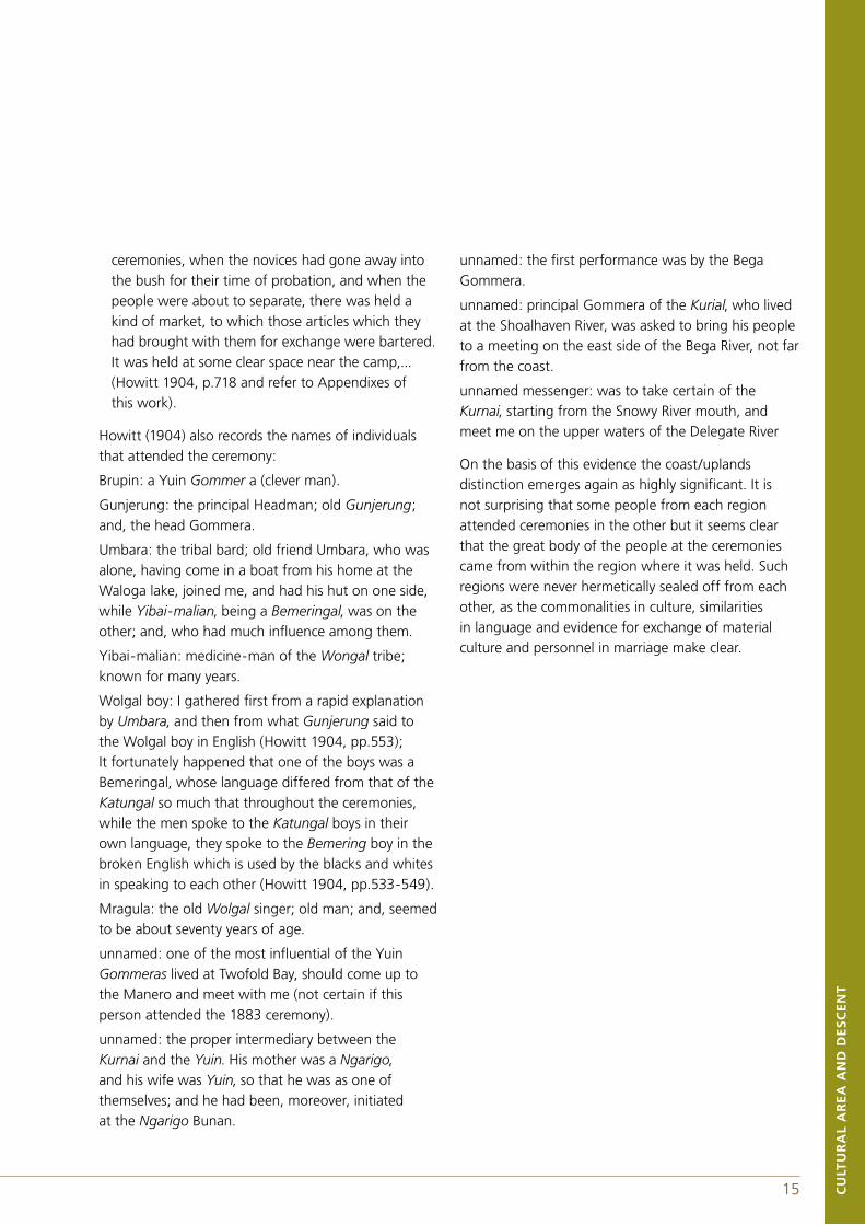
Howitt (1904) also records the names of individuals that attended the ceremony:
Brupin: a Yuin Gommer a (clever man).
Gunjerung: the principal Headman; old Gunjerung; and, the head Gommera.
Umbara: the tribal bard; old friend Umbara, who was alone, having come in a boat from his home at the Waloga lake, joined me, and had his hut on one side, while Yibai-malian, being a Bemeringal, was on the other; and, who had much influence among them.
Yibai-malian: medicine-man of the Wongal tribe; known for many years.
Wolgal boy: I gathered first from a rapid explanation by Umbara, and then from what Gunjerung said to the Wolgal boy in English (Howitt 1904, pp.553); It fortunately happened that one of the boys was a Bemeringal, whose language differed from that of the Katungal so much that throughout the ceremonies, while the men spoke to the Katungal boys in their own language, they spoke to the Bemering boy in the broken English which is used by the blacks and whites in speaking to each other (Howitt 1904, pp.533-549).
Mragula: the old Wolgal singer; old man; and, seemed to be about seventy years of age.
unnamed: one of the most influential of the Yuin Gommeras lived at Twofold Bay, should come up to the Manero and meet with me (not certain if this person attended the 1883 ceremony).
unnamed: the proper intermediary between the Kurnai and the Yuin. His mother was a Ngarigo, and his wife was Yuin, so that he was as one of themselves; and he had been, moreover, initiated at the Ngarigo Bunan.
unnamed: the first performance was by the Bega Gommera.
unnamed: principal Gommera of the Kurial, who lived at the Shoalhaven River, was asked to bring his people to a meeting on the east side of the Bega River, not far from the coast.
unnamed messenger: was to take certain of the Kurnai, starting from the Snowy River mouth, and meet me on the upper waters of the Delegate River
On the basis of this evidence the coast/uplands distinction emerges again as highly significant. It is not surprising that some people from each region attended ceremonies in the other but it seems clear that the great body of the people at the ceremonies came from within the region where it was held. Such regions were never hermetically sealed off from each other, as the commonalities in culture, similarities in language and evidence for exchange of material culture and personnel in marriage make clear.
16CU
LTU
RA
L A
RE
A A
ND
DE
SC
EN
T
17 CU
LTU
RA
L A
RE
A A
ND
DE
SC
EN
T
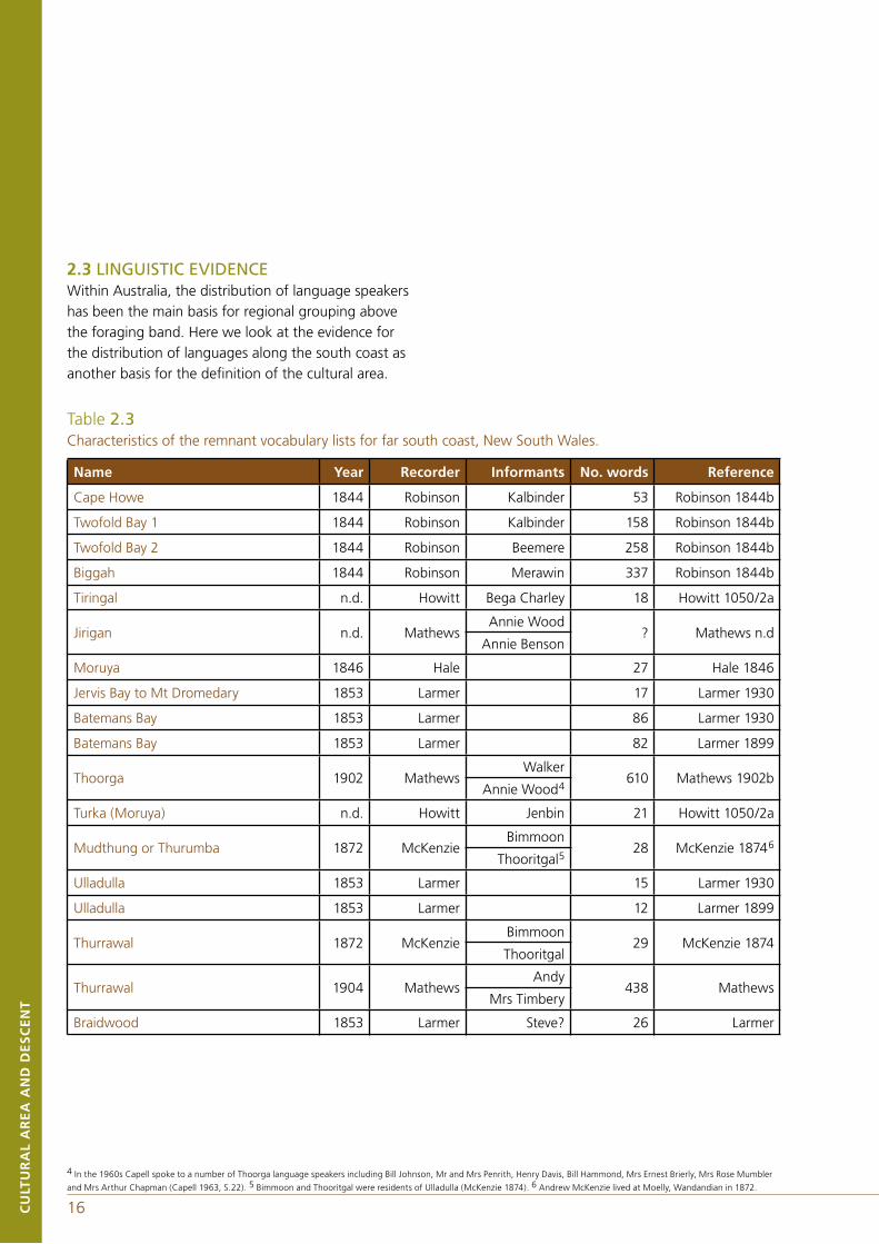
2.3 LINGUISTIC EVIDENCEWithin Australia, the distribution of language speakers has been the main basis for regional grouping above the foraging band. Here we look at the evidence for the distribution of languages along the south coast as another basis for the definition of the cultural area.
Table 2.3Characteristics of the remnant vocabulary lists for far south coast, New South Wales.
Name Year Recorder Informants No. words Reference
Cape Howe 1844 Robinson Kalbinder 53 Robinson 1844b
Twofold Bay 1 1844 Robinson Kalbinder 158 Robinson 1844b
Twofold Bay 2 1844 Robinson Beemere 258 Robinson 1844b
Biggah 1844 Robinson Merawin 337 Robinson 1844b
Tiringal n.d. Howitt Bega Charley 18 Howitt 1050/2a
Jirigan n.d. MathewsAnnie Wood
? Mathews n.dAnnie Benson
Moruya 1846 Hale 27 Hale 1846
Jervis Bay to Mt Dromedary 1853 Larmer 17 Larmer 1930
Batemans Bay 1853 Larmer 86 Larmer 1930
Batemans Bay 1853 Larmer 82 Larmer 1899
Thoorga 1902 MathewsWalker
610 Mathews 1902bAnnie Wood4
Turka (Moruya) n.d. Howitt Jenbin 21 Howitt 1050/2a
Mudthung or Thurumba 1872 McKenzieBimmoon
28 McKenzie 18746
Thooritgal5
Ulladulla 1853 Larmer 15 Larmer 1930
Ulladulla 1853 Larmer 12 Larmer 1899
Thurrawal 1872 McKenzieBimmoon
29 McKenzie 1874Thooritgal
Thurrawal 1904 MathewsAndy
438 Mathews Mrs Timbery
Braidwood 1853 Larmer Steve? 26 Larmer
4 In the 1960s Capell spoke to a number of Thoorga language speakers including Bill Johnson, Mr and Mrs Penrith, Henry Davis, Bill Hammond, Mrs Ernest Brierly, Mrs Rose Mumbler
and Mrs Arthur Chapman (Capell 1963, S.22). 5 Bimmoon and Thooritgal were residents of Ulladulla (McKenzie 1874). 6 Andrew McKenzie lived at Moelly, Wandandian in 1872.
16CU
LTU
RA
L A
RE
A A
ND
DE
SC
EN
T
17 CU
LTU
RA
L A
RE
A A
ND
DE
SC
EN
T
As far as can be ascertained from the existing record, Aboriginal people in the vicinity of Biamanga and Gulaga National Parks spoke the Jeringan and Thoorga dialects of a language that existed in a variety of forms (Jeringan, Thoorga, Mudthung or Thurumba and Tharawal). The languages extended from the Bega River through to the Illawarra (Howitt n.d.1050/2a; Mathews 1901, 1902a, b and c; McKenzie 1874; Hobbes 1881; Robinson 1844b).
Recently Wesson (2000, p.158) has constructed a map of south coast language territories by deter-mining the percentage of commonality between vocabularies by district combined with the informant's territory descriptions. Problems with methodology were experienced because vocabularies which were recorded at such disparate times as 1844 and 1907, in the context of Aboriginal migration, dispersion and dislocation, are not ideal subjects for comparison. In this period, identification with country and use of language underwent profound change and in some areas there was even a complete loss of language. In others, local languages were transformed as people speaking different dialects migrated and their dialect became incorporated into that of the country of destination.
Robinson gave no name to the language spoken by the Twofold Bay people but was told that the same language was spoken by Cape Howe, Genoa, Wongrabel, Twofold Bay and Pambula people and that it was different from the language spoken north of the Bega River. The name of this language (Thawa) was provided by Howitt's and Mathews' informants. A comparison of the vocabularies of Birdhawal, Cape Howe and Twofold Bay languages revealed that Cape Howe and Twofold Bay languages are the same but that the language, spoken by the Maap of east Gippsland & the southern Monaro, only shared five percent of their words.
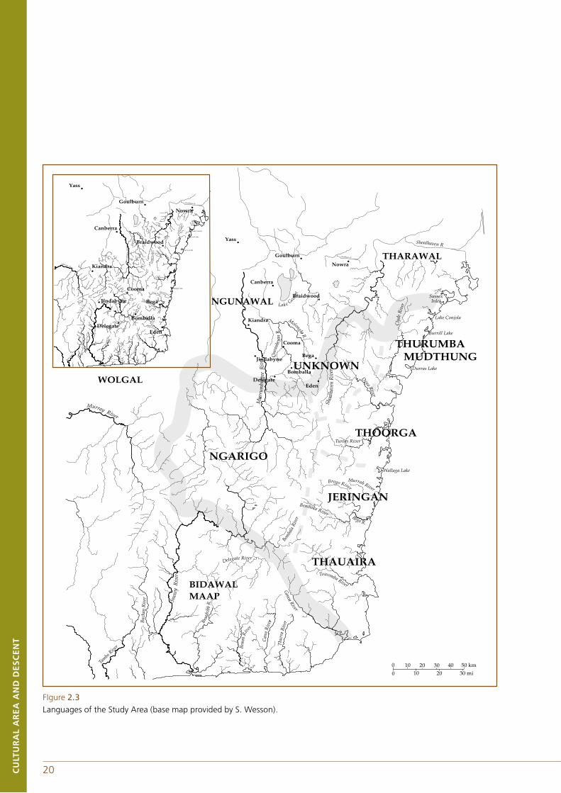
Jeringan boundaries were determined by Howitt's informants who told him that the Jeringan were at Bega and Bermagui. Braidwood language has more in common with Ngunawal and Ngarigo than Thoorga, Jeringan or Tharawal.
Howitt's informant Jenbin described Thoorga as the language spoken by the men who called themselves Yuin. He also said that at Ulladulla people spoke half Thoorga and half Tharawal. This suggests that either Ulladulla people were bilingual, or that both Thoorga and Tharawal were typically spoken in the region, or that an intermediate form of the two languages was in use in the area. McKenzie's informants named this language Thurumba and attributed it to the people of Braidwood, Ulladulla, Moruya and Jervis Bay. However Jenbin described Moruya as Thoorga speaker's country and Larmer's 1853 Batemans Bay language is the same as McKenzie's Thurumba.
Thawa, spoken south of the Bega River, appears to have ceased to be a functioning language before Jeringan or Thoorga. The loss of integrity of Thawa language was probably due to the large influx of Aboriginal migrants (speaking languages other than Thawa) from the north, south-west and west who sought work in the shore-based whaling industry, which was at its peak in the mid-nineteenth century. Of the 180 people met by Robinson during July and August at Twofold Bay, only 68 (38%) would have been Thawa speakers by birth while 71 (39%) were Jeringan and Thoorga speakers and 37 (21%) Ngarigo speakers.
18CU
LTU
RA
L A
RE
A A
ND
DE
SC
EN
T
19 CU
LTU
RA
L A
RE
A A
ND
DE
SC
EN
T
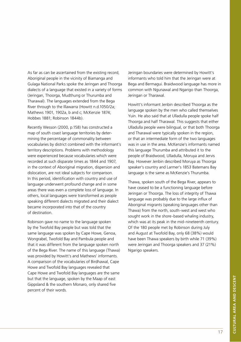
The other well known map of language distribution was constructed by Norman Tindale. Tindale visited Tilba Tilba and Wallaga Lake Government Station for a few days in the summer of 1938/39. There he interviewed residents on a range of topics including tribal boundaries and collected genealogical information. As a result of this visit and subsequent work he published a description of the coastal Yuin in his 1974 book Aboriginal Tribes of Australia. The description of this linguistic/tribal area is as follows:
Thaua: From north of Merimbula south to Green Cape; west to the scarp of the Dividing Range. Their hordes were divided into two groups, the ('Katungal) sea coast people,' and the ('Baianbal)or ('Paienbara), the tomahawk people,' those who lived in the forests; a third group, the Bemerigal or mountain people at Cooma belonged to the Ngarigo with whom the inland Thaua had some associations. An early writer whose reference I have lost7 described the Twofold Bay people, whom he called Nulliker, as diminutive in stature as compared with inland aborigines. They had folded bark canoes and ventured out to sea. Their huts were trigonal bark shelters (Tindale 1974, pp.198-99).
Djiringanj: From Cape Dromedary (Kajan) south to beyond Bega; inland to the sharp scarp of the Dividing Range east of Nimmitabel. Howitt (1904) used the term Yuin to embrace this tribe and the Thaua: the work (juin) means man; farther north, as among the Tharawal, it means 'yes'.
Figure 2.2Language distribution in south-eastern New South Wales from Tindale (1974) and Eades (1976).
7 G.A Robinson 1844.
18CU
LTU
RA
L A
RE
A A
ND
DE
SC
EN
T
19 CU
LTU
RA
L A
RE
A A
ND
DE
SC
EN
T
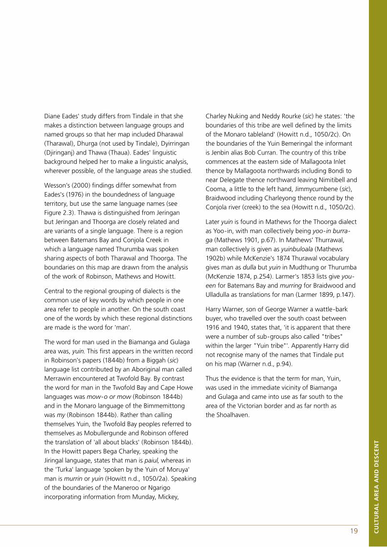
Diane Eades' study differs from Tindale in that she makes a distinction between language groups and named groups so that her map included Dharawal (Tharawal), Dhurga (not used by Tindale), Dyirringan (Djiringanj) and Thawa (Thaua). Eades' linguistic background helped her to make a linguistic analysis, wherever possible, of the language areas she studied.
Wesson’s (2000) findings differ somewhat from Eades's (1976) in the boundedness of language territory, but use the same language names (see Figure 2.3). Thawa is distinguished from Jeringan but Jeringan and Thoorga are closely related and are variants of a single language. There is a region between Batemans Bay and Conjola Creek in which a language named Thurumba was spoken sharing aspects of both Tharawal and Thoorga. The boundaries on this map are drawn from the analysis of the work of Robinson, Mathews and Howitt.
Central to the regional grouping of dialects is the common use of key words by which people in one area refer to people in another. On the south coast one of the words by which these regional distinctions are made is the word for 'man'.
The word for man used in the Biamanga and Gulaga area was, yuin. This first appears in the written record in Robinson's papers (1844b) from a Biggah (sic) language list contributed by an Aboriginal man called Merrawin encountered at Twofold Bay. By contrast the word for man in the Twofold Bay and Cape Howe languages was mow-o or mow (Robinson 1844b) and in the Monaro language of the Bimmemittong was my (Robinson 1844b). Rather than calling themselves Yuin, the Twofold Bay peoples referred to themselves as Mobullergunde and Robinson offered the translation of 'all about blacks' (Robinson 1844b). In the Howitt papers Bega Charley, speaking the Jiringal language, states that man is paiul, whereas in the 'Turka' language 'spoken by the Yuin of Moruya' man is murrin or yuin (Howitt n.d., 1050/2a). Speaking of the boundaries of the Maneroo or Ngarigo incorporating information from Munday, Mickey,
Charley Nuking and Neddy Rourke (sic) he states: 'the boundaries of this tribe are well defined by the limits of the Monaro tableland' (Howitt n.d., 1050/2c). On the boundaries of the Yuin Bemeringal the informant is Jenbin alias Bob Curran. The country of this tribe commences at the eastern side of Mallagoota Inlet thence by Mallagoota northwards including Bondi to near Delegate thence northward leaving Nimitibell and Cooma, a little to the left hand, Jimmycumbene (sic), Braidwood including Charleyong thence round by the Conjola river (creek) to the sea (Howitt n.d., 1050/2c).
Later yuin is found in Mathews for the Thoorga dialect as Yoo-in, with man collectively being yoo-in burra-ga (Mathews 1901, p.67). In Mathews' Thurrawal, man collectively is given as yuinbuloala (Mathews 1902b) while McKenzie's 1874 Thurawal vocabulary gives man as dulla but yuin in Mudthung or Thurumba (McKenzie 1874, p.254). Larmer's 1853 lists give you-een for Batemans Bay and murring for Braidwood and Ulladulla as translations for man (Larmer 1899, p.147).
Harry Warner, son of George Warner a wattle-bark buyer, who travelled over the south coast between 1916 and 1940, states that, 'it is apparent that there were a number of sub-groups also called "tribes" within the larger "Yuin tribe"'. Apparently Harry did not recognise many of the names that Tindale put on his map (Warner n.d., p.94).
Thus the evidence is that the term for man, Yuin, was used in the immediate vicinity of Biamanga and Gulaga and came into use as far south to the area of the Victorian border and as far north as the Shoalhaven.
20CU
LTU
RA
L A
RE
A A
ND
DE
SC
EN
T
21 CU
LTU
RA
L A
RE
A A
ND
DE
SC
EN
T
FIgure 2.3Languages of the Study Area (base map provided by S. Wesson).
20CU
LTU
RA
L A
RE
A A
ND
DE
SC
EN
T
21 CU
LTU
RA
L A
RE
A A
ND
DE
SC
EN
T
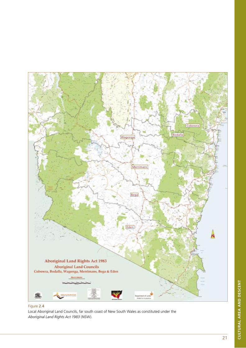
Figure 2.4Local Aboriginal Land Councils, far south coast of New South Wales as constituted under the Aboriginal Land Rights Act 1983 (NSW).
Bodalla
Cobowra
Wagonga
Merrimans
Bega
Eden
23 CU
LTU
RA
L A
RE
A A
ND
DE
SC
EN
T
2.4 MODIFICATIONS THROUGH POLITICAL PROCESSColonisation has, of course, modified much of the social and cultural behaviour described for the nineteenth century and greatly affected the pattern of settlement as the next chapter discusses in detail. Here we wish to touch briefly on events over the last thirty years that have had some impact on the way people group themselves on the south coast. In particular, since the commencement of the Aboriginal Land Rights Act in 1983 and with it the establishment of Local Aboriginal Land Councils (LALCs), the far south coast from Narooma to Eden has been divided into the following land councils running north to south: Wagonga LALC, Merrimans LALC, Bega LALC and the Eden LALC (see Figure 2.4).
Part of Biamanga National Park including Mumbulla Mountain falls within the Bega Local Aboriginal Land Council, while the northern portion of the park falls within the Merrimans Land Council with its office at Wallaga Lake. The boundary of the Wagonga Local Aboriginal Land Council, with its office at Narooma, lies close to the northern boundary of the park which has not yet been surveyed. Despite the fact that many of the members of these three land councils are all closely related to each other and many of the people in Bega and Eden, in particular, but also Narooma, were once residents of the Wallaga Lake Aboriginal Reserve, these boundaries have assumed a social and political importance beyond their original administrative intent. Those people at Wallaga Lake and near by are considered by many Kooris to be the core of the Yuin nation and the most appropriate custodians of Gulaga and Biamanga National Parks.
The establishment of at times competing Aboriginal Land Councils has sharpened the Yuin-Monaro distinction despite the many links, especially those that have been reinforced through multiple patterns of interaction post British settlement. During the Regional Forest Agreement process, to bridge this divide, a preferred scenario was developed by the Bega,
Eden and Merrimans Aboriginal Forest Management Committee (BEM or BEMAFMC). The scenario outlined preferred land tenure arrangements, including Aboriginal freehold, ownership with lease back to the Crown and joint management arrangements by Aboriginal people and the New South Wales government (New South Wales Government and Commonwealth Government 1999). The ownership with leaseback and joint management of Biamanga National Park was one of the outcomes of the negotiations between BEM and the New South Wales State government. As this process was driven principally by key elders of the three councils they feel a particular responsibility for having put in train the process to return Biamanga National Park and Mumbulla Mountain to Aboriginal ownership. Just as the land council boundaries have taken on a broader meaning in certain circumstances, so has the border between the states of New South Wales and Victoria.
CU
LTU
RA
L A
RE
A A
ND
DE
SC
EN
T
22
23 CU
LTU
RA
L A
RE
A A
ND
DE
SC
EN
T
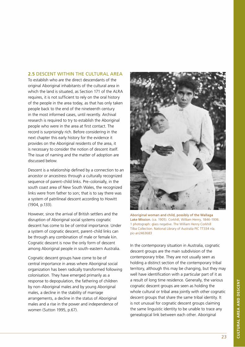
2.5 DESCENT WITHIN THE CULTURAL AREATo establish who are the direct descendants of the original Aboriginal inhabitants of the cultural area in which the land is situated, as Section 171 of the ALRA requires, it is not sufficient to rely on the oral history of the people in the area today, as that has only taken people back to the end of the nineteenth century in the most informed cases, until recently. Archival research is required to try to establish the Aboriginal people who were in the area at first contact. The record is surprisingly rich. Before considering in the next chapter this early history for the evidence it provides on the Aboriginal residents of the area, it is necessary to consider the notion of descent itself. The issue of naming and the matter of adoption are discussed below.
Descent is a relationship defined by a connection to an ancestor or ancestress through a culturally recognized sequence of parent-child links. Pre-colonially, in the south coast area of New South Wales, the recognized links were from father to son; that is to say there was a system of patrilineal descent according to Howitt (1904, p.133).
However, since the arrival of British settlers and the disruption of Aboriginal social systems cognatic descent has come to be of central importance. Under a system of cognatic descent, parent-child links can be through any combination of male or female kin. Cognatic descent is now the only form of descent among Aboriginal people in south-eastern Australia.
Cognatic descent groups have come to be of central importance in areas where Aboriginal social organization has been radically transformed following colonisation. They have emerged primarily as a response to depopulation, the fathering of children by non-Aboriginal males and by young Aboriginal males, a decline in the stability of marriage arrangements, a decline in the status of Aboriginal males and a rise in the power and independence of women (Sutton 1995, p.67).
In the contemporary situation in Australia, cognatic descent groups are the main subdivision of the contemporary tribe. They are not usually seen as holding a distinct section of the contemporary tribal territory, although this may be changing, but they may well have identification with a particular part of it as a result of long time residence. Generally, the various cognatic descent groups are seen as holding the whole cultural or tribal area jointly with other cognatic descent groups that share the same tribal identity. It is not unusual for cognatic descent groups claiming the same linguistic identity to be unable to trace any genealogical link between each other. Aboriginal
Aboriginal woman and child, possibly of the Wallaga Lake Mission. (ca. 1905). Corkhill, William Henry, 1846-1936. 1 photograph: glass negative. The William Henry Corkhill Tilba Collection. National Library of Australia PIC TT334 nla. pic-an2463683
25 CU
LTU
RA
L A
RE
A A
ND
DE
SC
EN
T
CU
LTU
RA
L A
RE
A A
ND
DE
SC
EN
T
24
people do not speak of cognatic descent groups, and indeed most may be unfamiliar with this term. They refer to themselves in terms of families in this area or say, for example, that 'I am a Haddigaddi' or who ever, the person named being as far back as common genealogical knowledge goes.
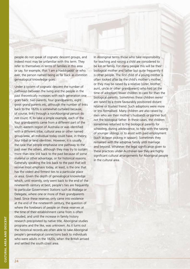
Under a system of cognatic descent the number of pathways between the living and the people in the past theoretically increases with each generation one goes back: two parents, four grandparents, eight great grand parents etc, although the number of links back to the 1820s is somewhat curtailed because, of course, links through a nonAboriginal person do not count. If, to take a simple example, each of the four grandparents came from a different part of the south-eastern region of Australia or was identified with a different tribe, cultural area or other named group/area, an individual today could have, in theory, four tribal or land identities. However, it is usually the case that people emphasise one pathway to the past over the others, although they may try to sustain more than one link back to the past because of some material or other advantage, or for historical reasons. Generally speaking the link back to the past that will receive most emphasis today, at least, is the one that has the oldest and firmest ties to a particular place or area. Given the depth of genealogical knowledge which, until recently, only went back to the end of the nineteenth century at best, people's ties are frequently to particular Government Stations such as Wallaga or Delegate, where one or more of their grandparents lived. Since these reserves only came into existence at the end of the nineteenth century, the question of where the forebears of people on these reserves at the time of their establishment came from is often clouded, and until the increase in family history research precipitated by native title, Aboriginal studies programs and the like, was unknown. As it turns out the historical records are often able to take Aboriginal people's genealogical connections back to individuals who were adults in the 1820s, when the British arrived and settled the south coast area.
In Aboriginal terms those who take responsibility for teaching and raising a child are considered to be kin or family. For many people this will be their biological mother and father but quite frequently it is other people. The first child of a young mother is often looked after by the child's mother's mother, or they may be raised by a relative (sister, brother, aunt, uncle or other grandparent) who had (at the time of adoption) fewer children to care for than the biological parents. Sometimes these children were/are raised by a more favourably positioned distant relative or trusted friend. Such adoptions were more or less formalised. Many children are also raised by men who are their mother's husbands or partner but not the biological father. In these cases, the children sometimes returned to the biological parents for schooling, during adolescence, to help with the raising of younger siblings or to assist with paid employment (such as bean picking in season). Sometimes they remained with the adoptive family until marriage and beyond. Whatever the legal significance given to these practices under Australian law they are highly significant cultural arrangements for Aboriginal people in the cultural area.
25 CU
LTU
RA
L A
RE
A A
ND
DE
SC
EN
T
Man standing with a small Aboriginal boy. (ca. 1905). Corkhill, William Henry, 1846–1936. 1 Photograph: glass negative. The William Henry Corkhill Tilba Tilba Collection. National Library of Australia PIC TT78 nla.pic–an2424416.
2.6 DEFINITION OF THE CULTURAL AREA AND DESCENT FOR THE PURPOSE OF THIS REPORTIn reaching a definition of the cultural area, it is important to have regard to both the historical evidence and the contemporary understandings of Aboriginal people. There are six reasonable possibilities for defining the cultural area associated with the two parks that we have considered. We list the possible cultural areas from the narrowest to the broadest:
1. Biamanga and Guluga: the geographical area of the two national parks.
2. Bega to Moruya: this is the area occupied by the speakers of the Jeringan & Thoorga languages, which were spoken by the original inhabitants of the two parks.
3. Twofold Bay to Moruya: this is the area occupied by the 'Southern Yuin' as defined by Howitt.
4. Twofold Bay to the Shoalhaven River including the Braidwood district: this is the area occupied by the 'Southern and Northern Yuin' as defined by Howitt. Here reference to the Braidwood district refers to that portion in reasonable proximity to the escarpment.
5. Twofold Bay to the Shoalhaven including the Braidwood district and the Monaro: this area goes well beyond that occupied by Yuin speakers to encompass the 'Bemeringal' (The mountain people which includes the Wolgal, Ngun(n)awal and Ngarigo as described by Howitt).
6. Sydney south to Gippsland and west to the Monaro: this area includes all of south-eastern Australia.
The area described in one is a very small area and given the hilly nature of the country not one in which many people would have spent much of their lives, yet the two mountains had and continue to have significance to a large number of people.
26CU
LTU
RA
L A
RE
A A
ND
DE
SC
EN
T
27 CU
LTU
RA
L A
RE
A A
ND
DE
SC
EN
T
To define the cultural area in terms of either two or three makes greater sense but it ignores the impact that the arrival of British settlers had on the distribution and relocation of the Aboriginal population so that individuals with clearly recognised ties to the mountains would be excluded.
The fourth area corresponds with the Yuin as described by Howitt and as frequently spoken of today. It allows for the inclusion of all who are acknowledged as having a role to play in the custodianship of the mountains by the local Aboriginal community and who have expressed an interest in doing so.
Areas five and six are too broad, in our opinion, given the purposes of the Act. Although there was some interaction within these wider areas and a limited amount of intermarriage, it extends the definition of the cultural area beyond the focus of the dense marriage and ceremonial network and it is not congruent with the linguistic boundaries. If one or the other of these broader areas were recognised the entailment would be that the coastal people would have to be involved in the land rights concerns of the Monaro which we do not think would be well received.
That area four includes the Braidwood district, has concerned some people as it is perceived as too far away from Biamanga and Gulaga. However it is important to remember that Moruya is close to Araluen and Aboriginal people from this area during early colonial times relocated initially both to Moruya and to Braidwood. By around 1900, the remnant population centred on Braidwood moved to the coast, some of them to the Wallaga Lake area. This gives the historical occupants of the Braidwood district a close relationship to the Moruya people. Historical sources, in particular Howitt, refer to the strong pattern of intermarriage between the people of Braidwood and Moruya as well as providing the account of the 1883 initiation ceremony where the women of the Braidwood contingent that had intermarried with the people of Moruya led the opening dances. There are
other historical recordings of the interaction of people of the Braidwood district and the coast.
Thus the most appropriate definition of the cultural area, for the purposes of the Act, is in terms of the area occupied by the Yuin which is based upon a shared language and a coastal/foothills/escarpment orientation. It was the area within which frequent intermarriage and participation in common ceremonial activities took place up to the end of the nineteenth century. As the evidence above shows, this was not a sealed off area by any means, as there were marriages with people to the west and south and participation by some people from the west, in particular, in ceremonies on the coast. However the intensity of interaction, shared culture as manifest in language similarity and geography coincided to give the Yuin area a distinctive identity.
The Yuin identity has re-emerged as a significant factor in the last thirty years. An expression of this identity is found in the current Umbarra Cultural Centre leaflet (Anon n.d.) which states:
We, the people of the Yuin Tribe at Wallaga Lake, and all the other Koori (Aboriginal) people of the South Coast, are angry at the action of the Forestry Commission in logging the western slope of Gooliga (sic) (Mt Dromedary).
26CU
LTU
RA
L A
RE
A A
ND
DE
SC
EN
T
27 CU
LTU
RA
L A
RE
A A
ND
DE
SC
EN
T
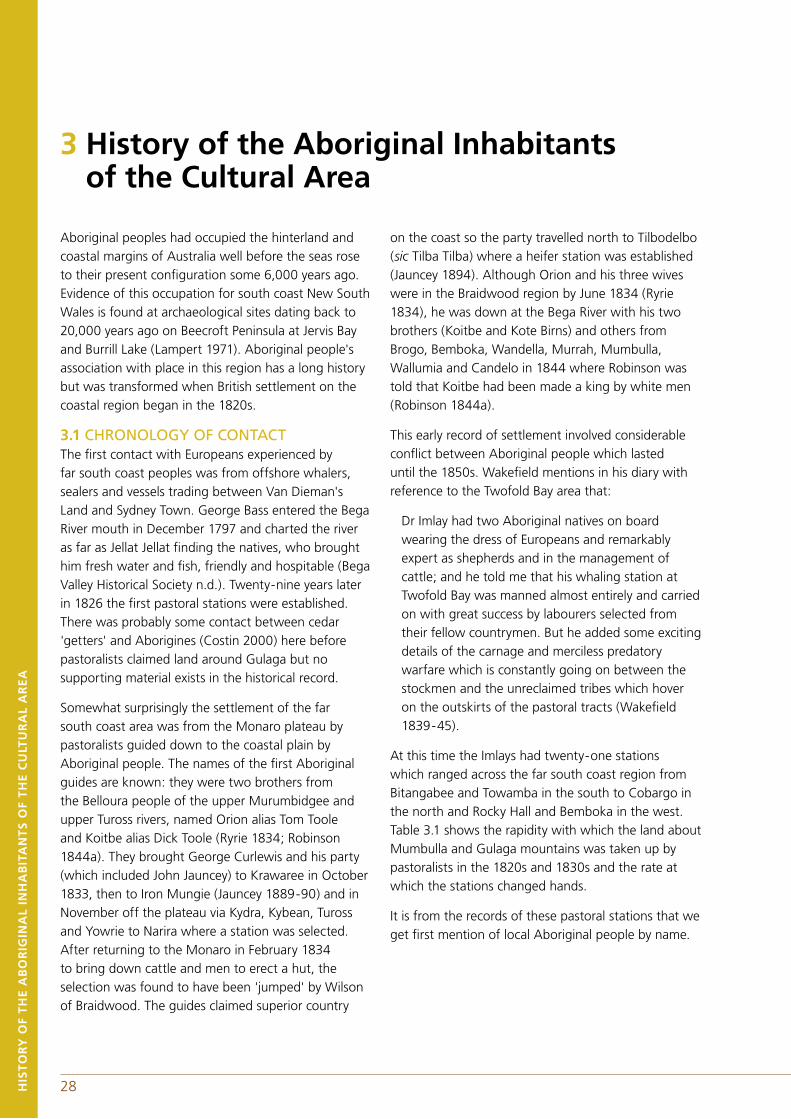
A wider perspective which matches the nineteenth century view is found in the 1979 petition to save Mumbulla Mountain from logging; signed by more than 50 people of Wallaga Lake and the surrounding district where they refer to themselves as follows:
We the tribal people of Wallaga Lake and the south coast, do not want any more sacred sites and traditional areas ruined - like initiation grou (sic): corroboree grounds, natural sacred sites, campsites and midden grounds. We grieve when they are spoilt and are offended when not consulted. We belong to the Yuin Tribe and share the one walkabout from Mallacoota in the south to the Shoalhaven River in the north. We urgently request that our special areas are registered aswe identify them.
The majority of people we spoke to about the definition of the cultural area within which Biamanga and Gulaga fall refer to the definition of Yuin as found in the work of Howitt. Sometimes this includes the people from Delegate because of the historical connections, especially as they were intensified from the late nineteenth century onwards. Such inclusion may be influenced by, for example, whether such a person is present when the question is asked and may be a matter of polite inclusiveness. However, most people on the far south coast seem to feel comfortable with the historically reported ethnographic boundaries and names, which they know to have legitimacy in the eyes of the wider Australian community, and thus accept the maps provided in the works of Howitt and Tindale.
While the reserve at Delegate is not part of the Yuin linguistic area, the cultural and social links with some of the limited number of people who lived there are very strong, especially from the late nineteenth century. While the primary identification of most descendants of people from Delegate reserve remains with the Monaro, they have cognatic descent links back to the original inhabitants of the Yuin area as well.
It can safely be said that Biamanga and Gulaga National Parks fall within the Yuin area and that this cultural area is most commonly said to extend from the Shoalhaven River in the north, to the border with Victoria in the south and westward to the eastern edge of the tablelands. According to Howitt, the Braidwood district was part of the Yuin nation but as there has been no resident Aboriginal population since the 1900s it is no longer an area that people immediately think of in association with the name. This Yuin area is defined geographically by the drainages from north to south, of the Shoalhaven River, the Clyde River, the Moruya River, Tuross River, the Bega River and the Towamba River.
28 29
Aboriginal peoples had occupied the hinterland and coastal margins of Australia well before the seas rose to their present configuration some 6,000 years ago. Evidence of this occupation for south coast New South Wales is found at archaeological sites dating back to 20,000 years ago on Beecroft Peninsula at Jervis Bay and Burrill Lake (Lampert 1971). Aboriginal people's association with place in this region has a long history but was transformed when British settlement on the coastal region began in the 1820s.
3.1 CHRONOLOGY OF CONTACTThe first contact with Europeans experienced by far south coast peoples was from offshore whalers, sealers and vessels trading between Van Dieman's Land and Sydney Town. George Bass entered the Bega River mouth in December 1797 and charted the river as far as Jellat Jellat finding the natives, who brought him fresh water and fish, friendly and hospitable (Bega Valley Historical Society n.d.). Twenty-nine years later in 1826 the first pastoral stations were established. There was probably some contact between cedar 'getters' and Aborigines (Costin 2000) here before pastoralists claimed land around Gulaga but no supporting material exists in the historical record.
Somewhat surprisingly the settlement of the far south coast area was from the Monaro plateau by pastoralists guided down to the coastal plain by Aboriginal people. The names of the first Aboriginal guides are known: they were two brothers from the Belloura people of the upper Murumbidgee and upper Tuross rivers, named Orion alias Tom Toole and Koitbe alias Dick Toole (Ryrie 1834; Robinson 1844a). They brought George Curlewis and his party (which included John Jauncey) to Krawaree in October 1833, then to Iron Mungie (Jauncey 1889-90) and in November off the plateau via Kydra, Kybean, Tuross and Yowrie to Narira where a station was selected. After returning to the Monaro in February 1834 to bring down cattle and men to erect a hut, the selection was found to have been 'jumped' by Wilson of Braidwood. The guides claimed superior country
on the coast so the party travelled north to Tilbodelbo (sic Tilba Tilba) where a heifer station was established (Jauncey 1894). Although Orion and his three wives were in the Braidwood region by June 1834 (Ryrie 1834), he was down at the Bega River with his two brothers (Koitbe and Kote Birns) and others from Brogo, Bemboka, Wandella, Murrah, Mumbulla, Wallumia and Candelo in 1844 where Robinson was told that Koitbe had been made a king by white men (Robinson 1844a).
This early record of settlement involved considerable conflict between Aboriginal people which lasted until the 1850s. Wakefield mentions in his diary with reference to the Twofold Bay area that:
Dr Imlay had two Aboriginal natives on board wearing the dress of Europeans and remarkably expert as shepherds and in the management of cattle; and he told me that his whaling station at Twofold Bay was manned almost entirely and carried on with great success by labourers selected from their fellow countrymen. But he added some exciting details of the carnage and merciless predatory warfare which is constantly going on between the stockmen and the unreclaimed tribes which hover on the outskirts of the pastoral tracts (Wakefield 1839-45).
At this time the Imlays had twenty-one stations which ranged across the far south coast region from Bitangabee and Towamba in the south to Cobargo in the north and Rocky Hall and Bemboka in the west. Table 3.1 shows the rapidity with which the land about Mumbulla and Gulaga mountains was taken up by pastoralists in the 1820s and 1830s and the rate at which the stations changed hands.
It is from the records of these pastoral stations that we get first mention of local Aboriginal people by name.
HIS
TO
RY
OF
TH
E A
BO
RIG
INA
L IN
HA
BIT
AN
TS
OF
TH
E C
ULT
UR
AL
AR
EA
3 History of the Aboriginal Inhabitants of the Cultural Area
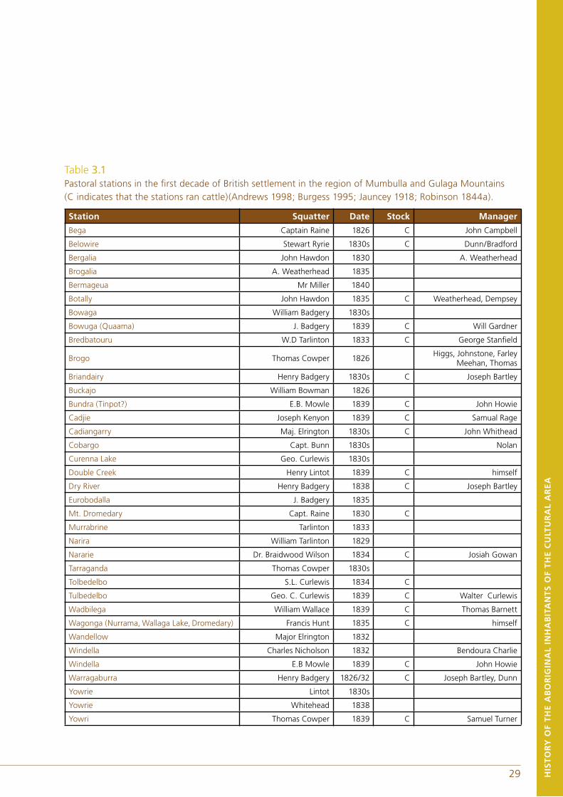
28 29 HIS
TO
RY
OF
TH
E A
BO
RIG
INA
L IN
HA
BIT
AN
TS
OF
TH
E C
ULT
UR
AL
AR
EA
Table 3.1 Pastoral stations in the first decade of British settlement in the region of Mumbulla and Gulaga Mountains (C indicates that the stations ran cattle)(Andrews 1998; Burgess 1995; Jauncey 1918; Robinson 1844a).
Station Squatter Date Stock Manager
Bega Captain Raine 1826 C John Campbell
Belowire Stewart Ryrie 1830s C Dunn/Bradford
Bergalia John Hawdon 1830 A. Weatherhead
Brogalia A. Weatherhead 1835
Bermageua Mr Miller 1840
Botally John Hawdon 1835 C Weatherhead, Dempsey
Bowaga William Badgery 1830s
Bowuga (Quaama) J. Badgery 1839 C Will Gardner
Bredbatouru W.D Tarlinton 1833 C George Stanfield
Brogo Thomas Cowper 1826Higgs, Johnstone, Farley
Meehan, Thomas
Briandairy Henry Badgery 1830s C Joseph Bartley
Buckajo William Bowman 1826
Bundra (Tinpot?) E.B. Mowle 1839 C John Howie
Cadjie Joseph Kenyon 1839 C Samual Rage
Cadiangarry Maj. Elrington 1830s C John Whithead
Cobargo Capt. Bunn 1830s Nolan
Curenna Lake Geo. Curlewis 1830s
Double Creek Henry Lintot 1839 C himself
Dry River Henry Badgery 1838 C Joseph Bartley
Eurobodalla J. Badgery 1835
Mt. Dromedary Capt. Raine 1830 C
Murrabrine Tarlinton 1833
Narira William Tarlinton 1829
Nararie Dr. Braidwood Wilson 1834 C Josiah Gowan
Tarraganda Thomas Cowper 1830s
Tolbedelbo S.L. Curlewis 1834 C
Tulbedelbo Geo. C. Curlewis 1839 C Walter Curlewis
Wadbilega William Wallace 1839 C Thomas Barnett
Wagonga (Nurrama, Wallaga Lake, Dromedary) Francis Hunt 1835 C himself
Wandellow Major Elrington 1832
Windella Charles Nicholson 1832 Bendoura Charlie
Windella E.B Mowle 1839 C John Howie
Warragaburra Henry Badgery 1826/32 C Joseph Bartley, Dunn
Yowrie Lintot 1830s
Yowrie Whitehead 1838
Yowri Thomas Cowper 1839 C Samuel Turner
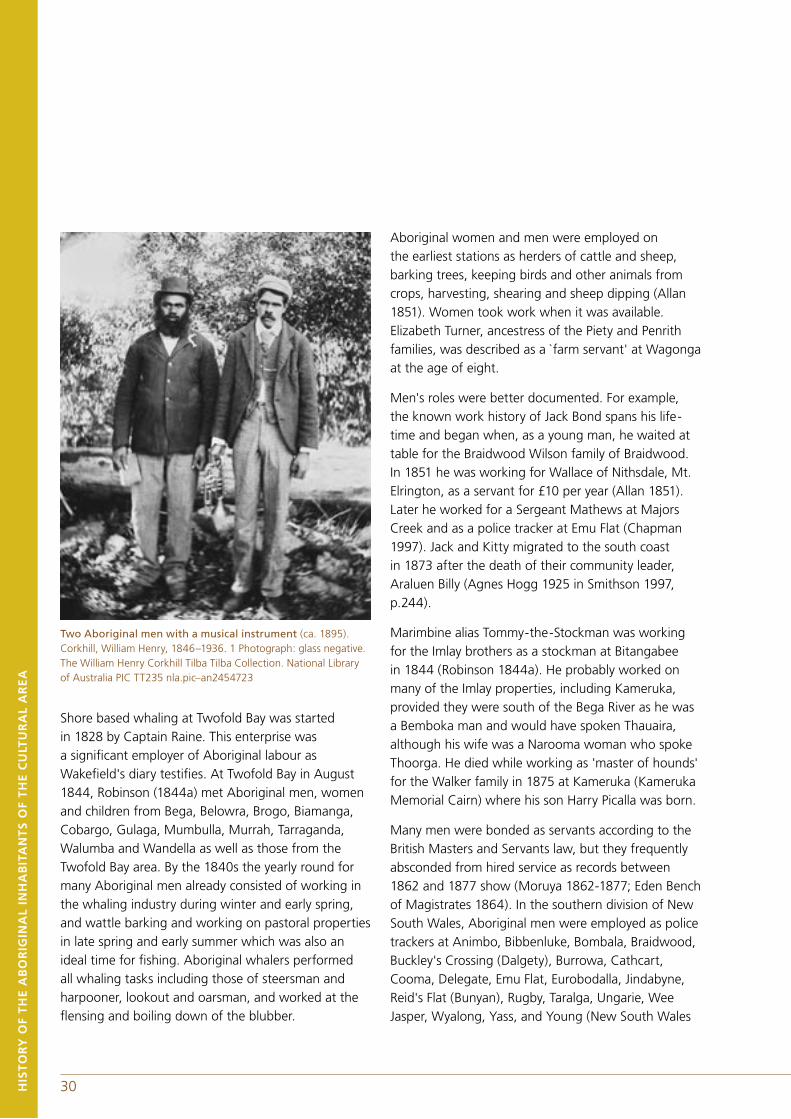
30HIS
TO
RY
OF
TH
E A
BO
RIG
INA
L IN
HA
BIT
AN
TS
OF
TH
E C
ULT
UR
AL
AR
EA
Two Aboriginal men with a musical instrument (ca. 1895). Corkhill, William Henry, 1846–1936. 1 Photograph: glass negative. The William Henry Corkhill Tilba Tilba Collection. National Library of Australia PIC TT235 nla.pic–an2454723
Shore based whaling at Twofold Bay was started in 1828 by Captain Raine. This enterprise was a significant employer of Aboriginal labour as Wakefield's diary testifies. At Twofold Bay in August 1844, Robinson (1844a) met Aboriginal men, women and children from Bega, Belowra, Brogo, Biamanga, Cobargo, Gulaga, Mumbulla, Murrah, Tarraganda, Walumba and Wandella as well as those from the Twofold Bay area. By the 1840s the yearly round for many Aboriginal men already consisted of working in the whaling industry during winter and early spring, and wattle barking and working on pastoral properties in late spring and early summer which was also an ideal time for fishing. Aboriginal whalers performed all whaling tasks including those of steersman and harpooner, lookout and oarsman, and worked at the flensing and boiling down of the blubber.
Aboriginal women and men were employed on the earliest stations as herders of cattle and sheep, barking trees, keeping birds and other animals from crops, harvesting, shearing and sheep dipping (Allan 1851). Women took work when it was available. Elizabeth Turner, ancestress of the Piety and Penrith families, was described as a `farm servant' at Wagonga at the age of eight.
Men's roles were better documented. For example, the known work history of Jack Bond spans his life-time and began when, as a young man, he waited at table for the Braidwood Wilson family of Braidwood. In 1851 he was working for Wallace of Nithsdale, Mt. Elrington, as a servant for £10 per year (Allan 1851). Later he worked for a Sergeant Mathews at Majors Creek and as a police tracker at Emu Flat (Chapman 1997). Jack and Kitty migrated to the south coast in 1873 after the death of their community leader, Araluen Billy (Agnes Hogg 1925 in Smithson 1997, p.244).
Marimbine alias Tommy-the-Stockman was working for the Imlay brothers as a stockman at Bitangabee in 1844 (Robinson 1844a). He probably worked on many of the Imlay properties, including Kameruka, provided they were south of the Bega River as he was a Bemboka man and would have spoken Thauaira, although his wife was a Narooma woman who spoke Thoorga. He died while working as 'master of hounds' for the Walker family in 1875 at Kameruka (Kameruka Memorial Cairn) where his son Harry Picalla was born.
Many men were bonded as servants according to the British Masters and Servants law, but they frequently absconded from hired service as records between 1862 and 1877 show (Moruya 1862-1877; Eden Bench of Magistrates 1864). In the southern division of New South Wales, Aboriginal men were employed as police trackers at Animbo, Bibbenluke, Bombala, Braidwood, Buckley's Crossing (Dalgety), Burrowa, Cathcart, Cooma, Delegate, Emu Flat, Eurobodalla, Jindabyne, Reid's Flat (Bunyan), Rugby, Taralga, Ungarie, Wee Jasper, Wyalong, Yass, and Young (New South Wales
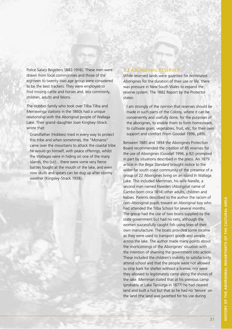
30 HIS
TO
RY
OF
TH
E A
BO
RIG
INA
L IN
HA
BIT
AN
TS
OF
TH
E C
ULT
UR
AL
AR
EA
Police Salary Registers 1882-1916). These men were drawn from local communities and those of the eighteen to twenty-two age group were considered to be the best trackers. They were employed to find missing cattle and horses and, less commonly, children, adults and felons.
The Hobbes family who took over Tilba Tilba and Merrawinga stations in the 1860s had a unique relationship with the Aboriginal people of Wallaga Lake. Their grand-daughter Joan Kinglsey-Strack wrote that:
Grandfather (Hobbes) tried in every way to protect this tribe and when sometimes, the "Monaros" came over the mountains to attack the coastal tribe he would go himself, with peace offerings, whilst the Wallagas were in hiding on one of the many islands, tho (sic)... there were some very fierce battles fought at the mouth of the lake, and even now skulls and spears can be dug up after stormy weather (Kingsley-Strack 1938).
3.2 ABORIGINAL RESERVESWhile reserved lands were gazetted for nominated Aborigines for the duration of their use or life, there was pressure in New South Wales to expand the reserve system. The 1882 Report by the Protector states:
I am strongly of the opinion that reserves should be made in such parts of the Colony, where it can be conveniently and usefully done, for the purposes of the aborigines, to enable them to form homesteads, to cultivate grain, vegetables, fruit, etc, for their own support and comfort (from Goodall 1996, p89).
Between 1885 and 1894 the Aborigines Protection Board recommended the creation of 85 reserves for the use of Aborigines (Goodall 1996, p.92) prompted in part by situations described in the press. An 1879 article in the Bega Standard brought notice to the wider far south coast community of the presence of a group of 22 Aborigines living on an island in Wallaga Lake. This included Merriman, his wife Narelle, a second man named Hawden (Aboriginal name of Cambo born circa 1814) other adults, children and babies. Parents described to the author the racism of non-Aboriginal pupils toward an Aboriginal boy who had attended the Tilba School for several months. The group had the use of two boats supplied by the state government but had no nets, although the women successfully caught fish using lines of their own manufacture. The boats provided some income as they were used to transport goods and people across the lake. The author made many points about the shortcomings of the Aborigines' situation with the intention of shaming the government into action. These included the children's inability to satisfactorily attend school and that the people were not allowed to strip bark for shelter without a license, nor were they allowed to legitimately camp along the shores of the lake. Merriman stated that at his previous camp (probably at Lake Tarourga in 1877) he had cleared land and built a hut but that as he had no 'tenure' on the land (the land was gazetted for his use during
31
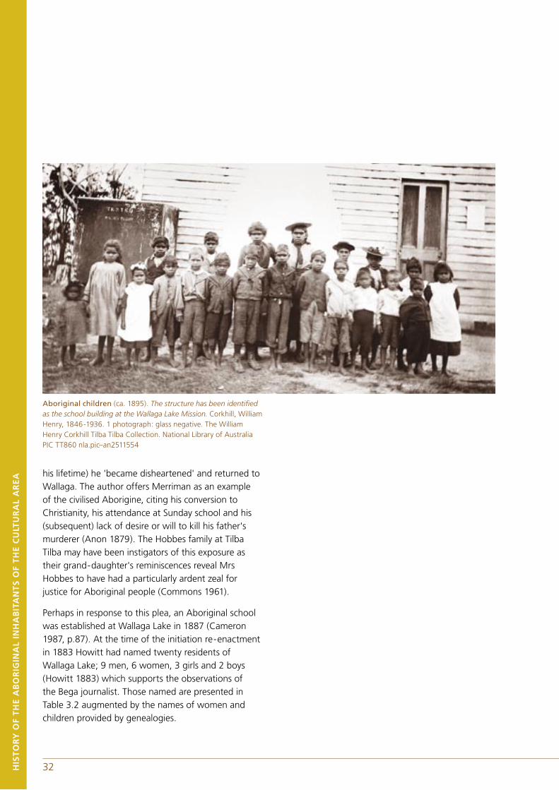
32
Aboriginal children (ca. 1895). The structure has been identified as the school building at the Wallaga Lake Mission. Corkhill, William Henry, 1846-1936. 1 photograph: glass negative. The William Henry Corkhill Tilba Tilba Collection. National Library of Australia PIC TT860 nla.pic–an2511554
his lifetime) he 'became disheartened' and returned to Wallaga. The author offers Merriman as an example of the civilised Aborigine, citing his conversion to Christianity, his attendance at Sunday school and his (subsequent) lack of desire or will to kill his father's murderer (Anon 1879). The Hobbes family at Tilba Tilba may have been instigators of this exposure as their grand-daughter's reminiscences reveal Mrs Hobbes to have had a particularly ardent zeal for justice for Aboriginal people (Commons 1961).
Perhaps in response to this plea, an Aboriginal school was established at Wallaga Lake in 1887 (Cameron 1987, p.87). At the time of the initiation re-enactment in 1883 Howitt had named twenty residents of Wallaga Lake; 9 men, 6 women, 3 girls and 2 boys (Howitt 1883) which supports the observations of the Bega journalist. Those named are presented in Table 3.2 augmented by the names of women and children provided by genealogies.
HIS
TO
RY
OF
TH
E A
BO
RIG
INA
L IN
HA
BIT
AN
TS
OF
TH
E C
ULT
UR
AL
AR
EA
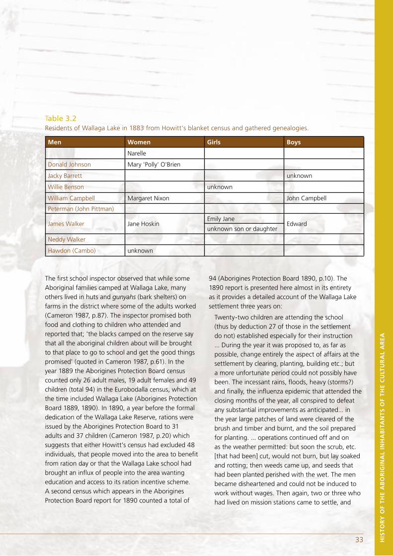
32 HIS
TO
RY
OF
TH
E A
BO
RIG
INA
L IN
HA
BIT
AN
TS
OF
TH
E C
ULT
UR
AL
AR
EA
The first school inspector observed that while some Aboriginal families camped at Wallaga Lake, many others lived in huts and gunyahs (bark shelters) on farms in the district where some of the adults worked (Cameron 1987, p.87). The inspector promised both food and clothing to children who attended and reported that; 'the blacks camped on the reserve say that all the aboriginal children about will be brought to that place to go to school and get the good things promised' (quoted in Cameron 1987, p.61). In the year 1889 the Aborigines Protection Board census counted only 26 adult males, 19 adult females and 49 children (total 94) in the Eurobodalla census, which at the time included Wallaga Lake (Aborigines Protection Board 1889, 1890). In 1890, a year before the formal dedication of the Wallaga Lake Reserve, rations were issued by the Aborigines Protection Board to 31 adults and 37 children (Cameron 1987, p.20) which suggests that either Howitt's census had excluded 48 individuals, that people moved into the area to benefit from ration day or that the Wallaga Lake school had brought an influx of people into the area wanting education and access to its ration incentive scheme. A second census which appears in the Aborigines Protection Board report for 1890 counted a total of
94 (Aborigines Protection Board 1890, p.10). The 1890 report is presented here almost in its entirety as it provides a detailed account of the Wallaga Lake settlement three years on:
Twenty-two children are attending the school (thus by deduction 27 of those in the settlement do not) established especially for their instruction ... During the year it was proposed to, as far as possible, change entirely the aspect of affairs at the settlement by clearing, planting, building etc.; but a more unfortunate period could not possibly have been. The incessant rains, floods, heavy (storms?) and finally, the influenza epidemic that attended the closing months of the year, all conspired to defeat any substantial improvements as anticipated... in the year large patches of land were cleared of the brush and timber and burnt, and the soil prepared for planting. ... operations continued off and on as the weather permitted: but soon the scrub, etc. [that had been] cut, would not burn, but lay soaked and rotting; then weeds came up, and seeds that had been planted perished with the wet. The men became disheartened and could not be induced to work without wages. Then again, two or three who had lived on mission stations came to settle, and
33
Table 3.2 Residents of Wallaga Lake in 1883 from Howitt's blanket census and gathered genealogies.
Men Women Girls Boys
Narelle
Donald Johnson Mary 'Polly' O'Brien
Jacky Barrett unknown
Willie Benson unknown
William Campbell Margaret Nixon John Campbell
Peterman (John Pittman)
James Walker Jane HoskinEmily Jane
Edwardunknown son or daughter
Neddy Walker
Hawdon (Cambo) unknown
35CU
LTU
RA
L A
RE
A A
ND
DE
SC
EN
T
they gave miserable accounts of the life there ... said it was all work and no pay, other than food, and no liberty. They impressed those at Wallaga Lake that the station was going to be a Mission, and they would not get any return for their labour. This bred a spirit of dissatisfaction that cannot be dispelled, for, like mutiny, it is well established before it is discovered. The aborigines will not work for shares of prospective profits; they are also too nomadic to stay and share such. The able bodied men are really the worst class to deal with. They will even desert a good paying employment after they have earned a little money, return to the settlement and gamble, then awaiting another job, will loiter about the place and eat of the rations of others, old and young. Most of them can obtain employment at farm-work, ploughing, haymaking, bark-getting, corn-hoeing, milking, shell-gathering for lime, potato planting, and digging etc; but no employer is sure of their services an hour together, for they will even leave off in the middle of haymaking, which a number of them take by contract ...
Improper use is made of the boats supplied by the Board. Europeans engage the aborigines to convey produce, heavy chests, timber, and such like in them, across the lake. They all know it is destruction to the boats, and the trifle they give for the conveyance barely pays wages for the work ... As regards the legitimate use of the boats, fishing within the lake, ferrying passengers across, and pleasure parties, are the general employment. Fishing with the large net recently supplied is of great importance; abundance of fish being caught therewith to supply the wants of the camp, the surplus being sold. The superintendent applied for two additional boats, one for outside fishing, and the other for the conveyance of fresh water, which has to be brought some distance... If disease or rank immorality crops up, it is generally imported from the Mission at Lake Tyre (sic), Victoria. ... Now and then there are signs of drink, but it is chiefly when the natives have just arrived from the nearest townships. Gambling is
still rampant; they will stake tobacco, knife, money, boots, anything and everything. They will neglect employment, cooking, the sick, all for the cards; yet the Superintendent is powerless to stop it. Another evil is the camp dog nuisance. Not a man, woman or child is without at least one of these mongrels of the most mangy description. They eat up whatever scrap of food is left, drink out of the vessels the family drink from, and sleep on the same blankets (Aborigines Protection Board 1890, 10).
By 1891, the families represented in the first general census to include and name Aboriginal people for Wallaga Lake are shown in Table 3.3.
34
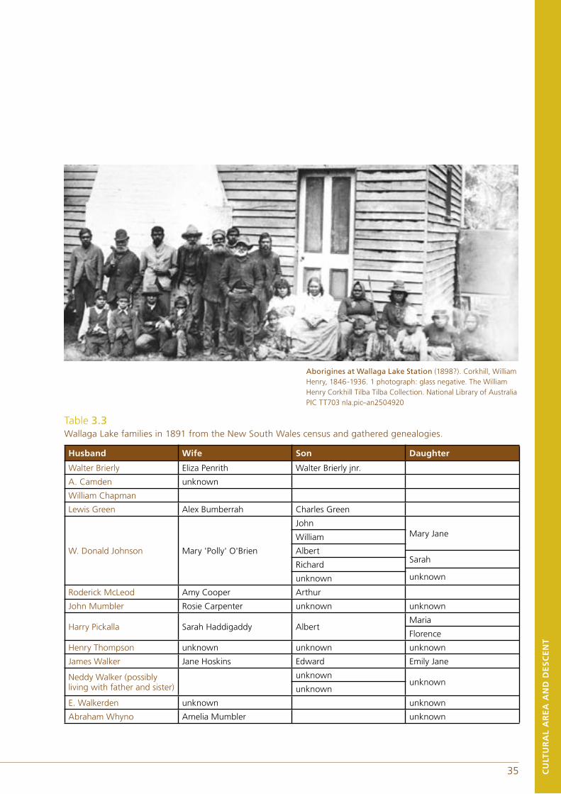
35 CU
LTU
RA
L A
RE
A A
ND
DE
SC
EN
T
Aborigines at Wallaga Lake Station (1898?). Corkhill, William Henry, 1846-1936. 1 photograph: glass negative. The William Henry Corkhill Tilba Tilba Collection. National Library of Australia PIC TT703 nla.pic–an2504920
Table 3.3 Wallaga Lake families in 1891 from the New South Wales census and gathered genealogies.
Husband Wife Son Daughter
Walter Brierly Eliza Penrith Walter Brierly jnr.
A. Camden unknown
William Chapman
Lewis Green Alex Bumberrah Charles Green
W. Donald Johnson Mary 'Polly' O'Brien
JohnMary JaneWilliam
AlbertSarah
Richardunknownunknown
Roderick McLeod Amy Cooper Arthur
John Mumbler Rosie Carpenter unknown unknown
Harry Pickalla Sarah Haddigaddy AlbertMaria
Florence
Henry Thompson unknown unknown unknown
James Walker Jane Hoskins Edward Emily Jane
Neddy Walker (possibly living with father and sister)
unknownunknown
unknown
E. Walkerden unknown unknown
Abraham Whyno Amelia Mumbler unknown
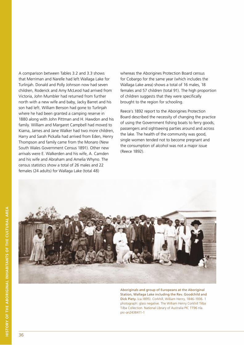
36
A comparison between Tables 3.2 and 3.3 shows that Merriman and Narelle had left Wallaga Lake for Turlinjah. Donald and Polly Johnson now had seven children, Roderick and Amy McLeod had arrived from Victoria, John Mumbler had returned from further north with a new wife and baby, Jacky Barret and his son had left. William Benson had gone to Turlinjah where he had been granted a camping reserve in 1880 along with John Pittman and H. Hawdon and his family. William and Margaret Campbell had moved to Kiama, James and Jane Walker had two more children, Harry and Sarah Pickalla had arrived from Eden, Henry Thompson and family came from the Monaro (New South Wales Government Census 1891). Other new arrivals were E. Walkerden and his wife, A. Camden and his wife and Abraham and Amelia Whyno. The census statistics show a total of 26 males and 22 females (24 adults) for Wallaga Lake (total 48)
whereas the Aborigines Protection Board census for Cobargo for the same year (which includes the Wallaga Lake area) shows a total of 16 males, 18 females and 57 children (total 91). The high proportion of children suggests that they were specifically brought to the region for schooling.
Reece's 1892 report to the Aborigines Protection Board described the necessity of changing the practice of using the Government fishing boats to ferry goods, passengers and sightseeing parties around and across the lake. The health of the community was good, single women tended not to become pregnant and the consumption of alcohol was not a major issue (Reece 1892).
Aboriginals and group of Europeans at the Aboriginal Station, Wallaga Lake including the Rev. Goodchild and Dick Piety. (ca.1895). Corkhill, William Henry, 1846-1936. 1 photograph: glass negative. The William Henry Corkhill Tilba Tilba Collection. National Library of Australia PIC TT96 nla.pic–an2438411-1
HIS
TO
RY
OF
TH
E A
BO
RIG
INA
L IN
HA
BIT
AN
TS
OF
TH
E C
ULT
UR
AL
AR
EA
36
In 1895, a German visitor named Baessler went to Wallaga Lake station on the occasion of the annual picnic for the birthday of the Prince of Wales. The following is a description of his experience and impressions of the station:
In good weather, a voyage of twenty hours by coastal steamer brings the traveller to the little southern NSW port of Birmagui (sic). From there, Wallaga Lake, which is separated from the sea only by large sand dunes, can be reached either by a ride of several hours through typical Australian scrub, or by a shorter route along the beach, which involves swimming across part of the lake. ... It was late at night by the time I reached the manager's farm ... The next morning after a refreshing night's sleep ... and after an hour's vigorous riding reached the arranged spot [for the picnic]. It was a clearing charmingly situated on top of a hill beside the lake, surrounded by towering forest trees and pleasantly cool, with a view over practically the entire lake. There was a small wooden building here, a school built by the manager (Reece), in which he taught the black and half-caste children; but there was nothing else to be seen. ... Their huts were quite close to the shore of a pretty little bay surrounded by hills, each of them located as far as possible from the others. ... Most of them were made out of solid rough hewn beams and bark ... Each of them had only one room, with a fireplace built on like a chimney-piece at one side and a little chimney above it to let out the smoke. Others were built in the shape of a tent out of boards, or simply thick bark... Every Friday all the women and children, together with those of the men who were too old and weak to work and all those who were sick, receive rations of flour, sugar and tea sufficient for the next week. The men who were capable of working were expected to do so in return for their keep... On public holidays, the whole community got meat rations from the Government, and in addition there were frequent distributions of gifts from charitable societies and individuals ... Articles of clothing, albeit mostly old and sometimes
very old, were... plentiful... If any of them became sick, they were given medicine and good care, together with woollen blankets... The Government also gave them all the tools and materials they needed to do any work; when they had decided to build new huts, they were given axes, bushknives and everything else they needed for the job... Any of the blacks who took a dislike to a station was free to move to another, and under no obligation to stay there once he got there, but could move on to another or back to the first... Those at Wallaga Lake were quite happy to stay there because of the kindness of the manager, who was always genuinely sorry to see anyone go. ... The most interesting of the guests were three old men: "King" Meriman, the former chief, now aged about 70, and two of his friends who appeared to be a little younger... King Meriman spoke three Aboriginal languages; as a boy he had been brought up by a friendly tribe and lived with another before moving back to his own. Apart from him, only a handful of the older people still spoke their tribal language, while the younger ones communicated in a corrupt form of English (Baessler 1895).
HIS
TO
RY
OF
TH
E A
BO
RIG
INA
L IN
HA
BIT
AN
TS
OF
TH
E C
ULT
UR
AL
AR
EA
37
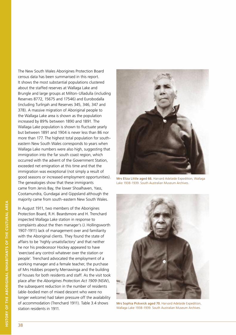
The New South Wales Aborigines Protection Board census data has been summarised in this report. It shows the most substantial populations clustered about the staffed reserves at Wallaga Lake and Brungle and large groups at Milton-Ulladulla (including Reserves 8772, 15675 and 17546) and Eurobodalla (including Turlinjah and Reserves 345, 346, 347 and 378). A massive migration of Aboriginal people to the Wallaga Lake area is shown as the population increased by 89% between 1890 and 1891. The Wallaga Lake population is shown to fluctuate yearly but between 1891 and 1904 is never less than 86 nor more than 177. The highest total population for south-eastern New South Wales corresponds to years when Wallaga Lake numbers were also high, suggesting that immigration into the far south coast region, which occurred with the advent of the Government Station, exceeded net emigration at this time and that the immigration was exceptional (not simply a result of good seasons or increased employment opportunities). The genealogies show that these immigrants came from Jervis Bay, the lower Shoalhaven, Yass, Cootamundra, Gundagai and Gippsland although the majority came from south-eastern New South Wales.
In August 1911, two members of the Aborigines Protection Board, R.H. Beardsmore and H. Trenchard inspected Wallaga Lake station in response to complaints about the then manager's (J. Hollingsworth 1907-1911) lack of management over and familiarity with the Aboriginal clients. They found the state of affairs to be 'highly unsatisfactory' and that neither he nor his predecessor Hockey appeared to have 'exercised any control whatever over the station or people'. Trenchard advocated the employment of a working manager and a female teacher, the purchase of Mrs Hobbes property Merrawinga and the building of houses for both residents and staff. As the visit took place after the Aborigines Protection Act 1909 (NSW), the subsequent reduction in the number of residents (able-bodied men of mixed descent who were no longer welcome) had taken pressure off the availability of accommodation (Trenchard 1911). Table 3.4 shows station residents in 1911.
Mrs Eliza Little aged 66. Harvard Adelaide Expedition, Wallaga Lake 1938-1939. South Australian Museum Archives.
Mrs Sophia Pickwick aged 70. Harvard Adelaide Expedition, Wallaga Lake 1938-1939. South Australian Museum Archives.
38HIS
TO
RY
OF
TH
E A
BO
RIG
INA
L IN
HA
BIT
AN
TS
OF
TH
E C
ULT
UR
AL
AR
EA
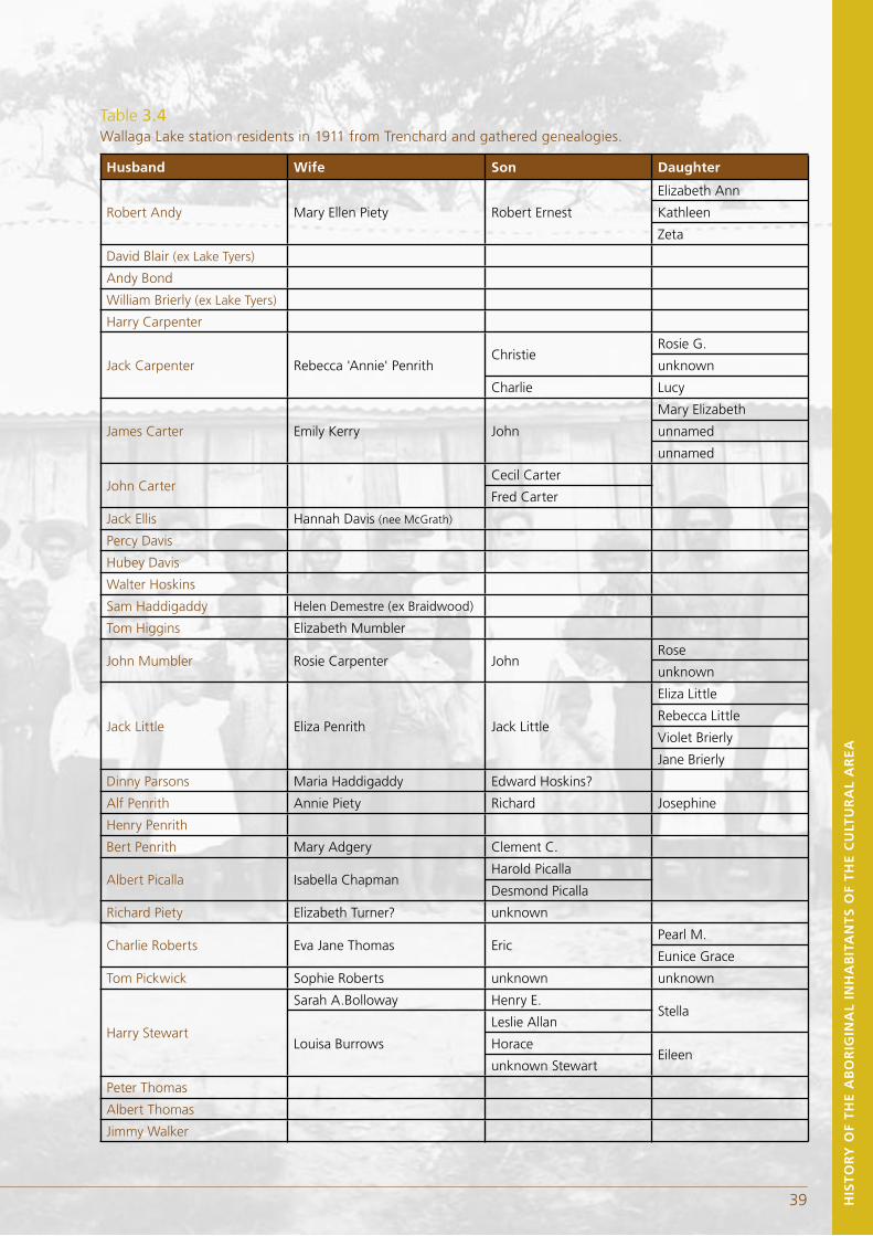
39 HIS
TO
RY
OF
TH
E A
BO
RIG
INA
L IN
HA
BIT
AN
TS
OF
TH
E C
ULT
UR
AL
AR
EA
Table 3.4 Wallaga Lake station residents in 1911 from Trenchard and gathered genealogies.
Husband Wife Son Daughter
Robert Andy Mary Ellen Piety Robert Ernest
Elizabeth Ann
Kathleen
Zeta
David Blair (ex Lake Tyers)
Andy Bond
William Brierly (ex Lake Tyers)
Harry Carpenter
Jack Carpenter Rebecca 'Annie' PenrithChristie
Rosie G.
unknown
Charlie Lucy
James Carter Emily Kerry John
Mary Elizabeth
unnamed
unnamed
John CarterCecil Carter
Fred Carter
Jack Ellis Hannah Davis (nee McGrath)
Percy Davis
Hubey Davis
Walter Hoskins
Sam Haddigaddy Helen Demestre (ex Braidwood)
Tom Higgins Elizabeth Mumbler
John Mumbler Rosie Carpenter JohnRose
unknown
Jack Little Eliza Penrith Jack Little
Eliza Little
Rebecca Little
Violet Brierly
Jane Brierly
Dinny Parsons Maria Haddigaddy Edward Hoskins?
Alf Penrith Annie Piety Richard Josephine
Henry Penrith
Bert Penrith Mary Adgery Clement C.
Albert Picalla Isabella ChapmanHarold Picalla
Desmond Picalla
Richard Piety Elizabeth Turner? unknown
Charlie Roberts Eva Jane Thomas EricPearl M.
Eunice Grace
Tom Pickwick Sophie Roberts unknown unknown
Harry Stewart
Sarah A.Bolloway Henry E.Stella
Louisa Burrows
Leslie Allan
HoraceEileen
unknown Stewart
Peter Thomas
Albert Thomas
Jimmy Walker
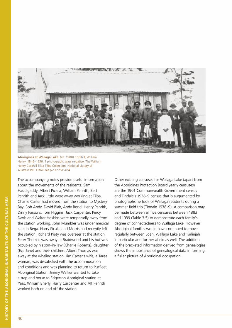
40 41HIS
TO
RY
OF
TH
E A
BO
RIG
INA
L IN
HA
BIT
AN
TS
OF
TH
E C
ULT
UR
AL
AR
EA
Aborigines at Wallaga Lake. (ca. 1900) Corkhill, William Henry, 1846–1936. 1 photograph: glass negative. The William Henry Corkhill Tilba Tilba Collection. National Library of Australia PIC TT828 nla.pic-an2511484
The accompanying notes provide useful information about the movements of the residents. Sam Haddigaddy, Albert Picalla, William Penrith, Bert Penrith and Jack Little were away working at Tilba. Charlie Carter had moved from the station to Mystery Bay. Bob Andy, David Blair, Andy Bond, Henry Penrith, Dinny Parsons, Tom Higgins, Jack Carpenter, Percy Davis and Walter Hoskins were temporarily away from the station working. John Mumbler was under medical care in Bega. Harry Picalla and Morris had recently left the station. Richard Piety was overseer at the station. Peter Thomas was away at Braidwood and his hut was occupied by his son-in-law (Charlie Roberts), daughter (Eva Jane) and their children. Albert Thomas was away at the whaling station. Jim Carter's wife, a Taree woman, was dissatisfied with the accommodation and conditions and was planning to return to Purfleet, Aboriginal Station. Jimmy Walker wanted to take a trap and horse to Edgerton Aboriginal station at Yass. William Brierly, Harry Carpenter and Alf Penrith worked both on and off the station.
Other existing censuses for Wallaga Lake (apart from the Aborigines Protection Board yearly censuses) are the 1901 Commonwealth Government census and Tindale's 1938-9 census that is augumented by photographs he took of Wallaga residents during a summer field trip (Tindale 1938-9). A comparison may be made between all five censuses between 1883 and 1939 (Table 3.5) to demonstrate each family's degree of connectedness to Wallaga Lake. However Aboriginal families would have continued to move regularly between Eden, Wallaga Lake and Turlinjah in particular and further afield as well. The addition of the bracketed information derived from genealogies shows the importance of genealogical data in forming a fuller picture of Aboriginal occupation.
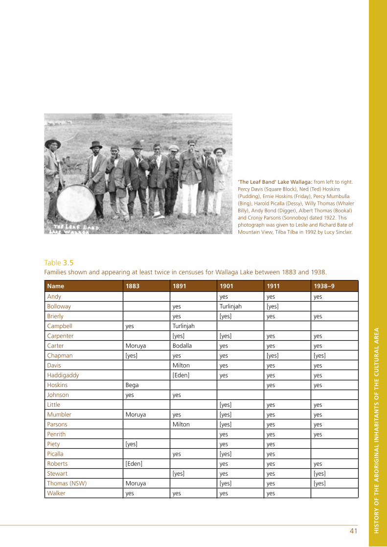
40 41
'The Leaf Band' Lake Wallaga: from left to right. Percy Davis (Square Block), Ned (Ted) Hoskins (Pudding), Ernie Hoskins (Friday), Percy Mumbulla (Bing), Harold Picalla (Dessy), Willy Thomas (Whaler Billy), Andy Bond (Digger), Albert Thomas (Bookal) and Cronjy Parsons (Sonnoboy) dated 1922. This photograph was given to Leslie and Richard Bate of Mountain View, Tilba Tilba in 1992 by Lucy Sinclair.
HIS
TO
RY
OF
TH
E A
BO
RIG
INA
L IN
HA
BIT
AN
TS
OF
TH
E C
ULT
UR
AL
AR
EA
Table 3.5 Families shown and appearing at least twice in censuses for Wallaga Lake between 1883 and 1938.
Name 1883 1891 1901 1911 1938–9
Andy yes yes yes
Bolloway yes Turlinjah [yes]
Brierly yes [yes] yes yes
Campbell yes Turlinjah
Carpenter [yes] [yes] yes yes
Carter Moruya Bodalla yes yes yes
Chapman [yes] yes yes [yes] [yes]
Davis Milton yes yes yes
Haddigaddy [Eden] yes yes yes
Hoskins Bega yes yes
Johnson yes yes
Little [yes] yes yes
Mumbler Moruya yes [yes] yes yes
Parsons Milton [yes] yes yes
Penrith yes yes yes
Piety [yes] yes yes
Picalla yes [yes] yes
Roberts [Eden] yes yes yes
Stewart [yes] yes yes [yes]
Thomas (NSW) Moruya [yes] yes [yes]
Walker yes yes yes yes
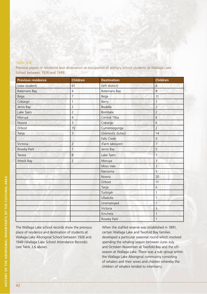
43HIS
TO
RY
OF
TH
E A
BO
RIG
INA
L IN
HA
BIT
AN
TS
OF
TH
E C
ULT
UR
AL
AR
EA
The Wallaga Lake school records show the previous place of residence and destination of students at Wallaga Lake Aboriginal School between 1926 and 1949 (Wallaga Lake School Attendance Records) (see Table 3.6 above).
When the staffed reserve was established in 1891, certain Wallaga Lake and Twofold Bay families developed a particular seasonal round which involved spending the whaling season between June–July and October–November at Twofold Bay and the off-season at Wallaga Lake. There was a sub-group within the Wallaga Lake Aboriginal community consisting of whalers and their wives and children whereby the children of whalers tended to intermarry.
Table 3.6 Previous places of residence and destination or occupation of primary school students at Wallaga Lake School between 1926 and 1949.
Previous residence Children Destination Children
(new student) 61 (left district) 6
Batemans Bay 4 Batemans Bay 8
Bega 7 Bega 11
Cobargo 1 Berry 1
Jervis Bay 2 Bodalla 2
Lake Tyers 2 Bombala 2
Moruya 4 Central Tilba 6
Nowra 3 Cobargo 6
Orbost 15 Cumeroogunga 2
Tanja 3 (Domestic duties) 14
Falls Creek 3
Victoria 2 (Farm labourer) 7
Roseby Park 1 Jervis Bay 5
Tarara 8 Lake Tyers 1
Wreck Bay 2 Moruya 3
Moss Vale 3
Narooma 5
Nowra 20
Orbost 11
Tanja 6
Turlinjah 1
Ulladulla 1
Unemployed 1
Victoria 3
Kinchela 1
Roseby Park 1
42
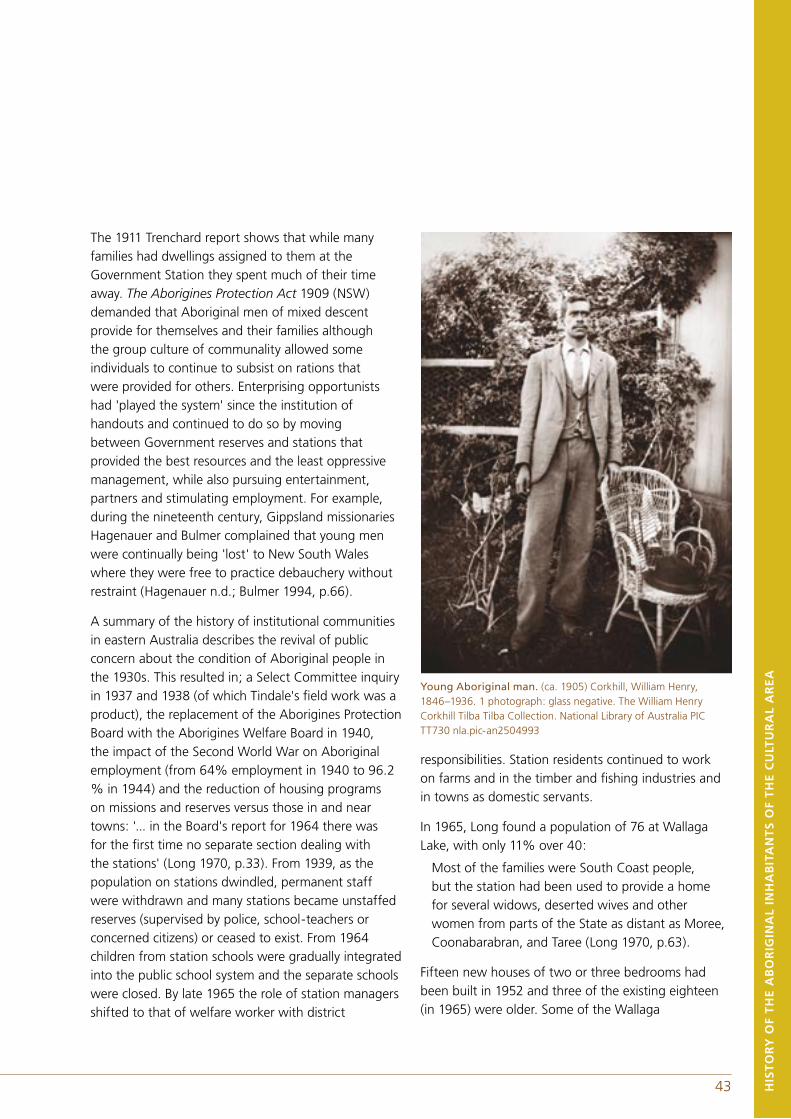
43 HIS
TO
RY
OF
TH
E A
BO
RIG
INA
L IN
HA
BIT
AN
TS
OF
TH
E C
ULT
UR
AL
AR
EA
The 1911 Trenchard report shows that while many families had dwellings assigned to them at the Government Station they spent much of their time away. The Aborigines Protection Act 1909 (NSW) demanded that Aboriginal men of mixed descent provide for themselves and their families although the group culture of communality allowed some individuals to continue to subsist on rations that were provided for others. Enterprising opportunists had 'played the system' since the institution of handouts and continued to do so by moving between Government reserves and stations that provided the best resources and the least oppressive management, while also pursuing entertainment, partners and stimulating employment. For example, during the nineteenth century, Gippsland missionaries Hagenauer and Bulmer complained that young men were continually being 'lost' to New South Wales where they were free to practice debauchery without restraint (Hagenauer n.d.; Bulmer 1994, p.66).
A summary of the history of institutional communities in eastern Australia describes the revival of public concern about the condition of Aboriginal people in the 1930s. This resulted in; a Select Committee inquiry in 1937 and 1938 (of which Tindale's field work was a product), the replacement of the Aborigines Protection Board with the Aborigines Welfare Board in 1940, the impact of the Second World War on Aboriginal employment (from 64% employment in 1940 to 96.2 % in 1944) and the reduction of housing programs on missions and reserves versus those in and near towns: '... in the Board's report for 1964 there was for the first time no separate section dealing with the stations' (Long 1970, p.33). From 1939, as the population on stations dwindled, permanent staff were withdrawn and many stations became unstaffed reserves (supervised by police, school-teachers or concerned citizens) or ceased to exist. From 1964 children from station schools were gradually integrated into the public school system and the separate schools were closed. By late 1965 the role of station managers shifted to that of welfare worker with district
Young Aboriginal man. (ca. 1905) Corkhill, William Henry, 1846–1936. 1 photograph: glass negative. The William Henry Corkhill Tilba Tilba Collection. National Library of Australia PIC TT730 nla.pic-an2504993
responsibilities. Station residents continued to work on farms and in the timber and fishing industries and in towns as domestic servants.
In 1965, Long found a population of 76 at Wallaga Lake, with only 11% over 40:
Most of the families were South Coast people, but the station had been used to provide a home for several widows, deserted wives and other women from parts of the State as distant as Moree, Coonabarabran, and Taree (Long 1970, p.63).
Fifteen new houses of two or three bedrooms had been built in 1952 and three of the existing eighteen (in 1965) were older. Some of the Wallaga
44 45
houses had been moved to nearby towns to provide accommodation for Aboriginal workers. Residents paid rent, had electricity and water, a sanitary pan and garbage service provided by the local council and were nursed by the resident Matron. The station school was closed in 1964 after 77 years of operation. Men were working in sawmills, as station labourers, on the railways and in a cheese factory. Long (1970, p.64) considered that the siting of the station was isolating and very unsuitable for the younger members of the community.
The outcome of the 1967 constitutional referendum gave Aboriginal activists knowledge of the existence of grass-roots support and encouraged them to campaign for further changes. In 1969 the station manager's position ceased to exist and the Aboriginal residents ran the Wallaga Lake station through a committee. In 1979 New South Wales politicians visited Wallaga Lake to discuss options for ownership of the land. Title for the land was given to Merrimans Local Aboriginal Land Council in 1984. For the past sixteen years Wallaga Lake Koori Village has continued to be managed by the Merrimans Local Aboriginal Land Council. There is a Community Development Employment Program in operation under which participants have contributed to capital works at the Village including house renovations and maintenance and the building of a pre-school.
3.3 LEAVING DELEGATESites on the Delegate River were regularly used by the Monaro, Omeo and Bidawal/Maap peoples on travel between far east Gippsland and the Monaro. There were also regular travel routes in use between Delegate and the far south coast at the time of Brierly's 1843 and Robinson's 1844 journeys in New South Wales. Brierly travelled with a Monaro guide, Budgenbro alias Toby, who took him up the Towamba River to Mowamba (Brierly 1843). Robinson's guides took him down Tantawanglo Mountain via Pericoe and Burragate and up Brown Mountain (Robinson 1844a).
During the gold rush at Craigie and Delegate, Aborigines were drawn to the activity and opportunities the communities provided. Celia Bond (nee McLeod) said that her grandmother, Emma Booth, and her grandmother's sister Eliza O'Rourke (nee Thorpe) were cooks and laundry workers on the tablelands during the gold rush (Norman, pers. comm., 2000).
In 1877 some of the Wolgal, Monaro and Bidawal/Maap peoples, led by Yibai Malian (Murray Jack), visited Lake Tyers Aboriginal station with a view to possibly settling there but they chose not to stay (Victoria Royal Commission on the Aborigines 1877). In 1881 Murray Jack, Munday (sic) and others offered to meet Howitt at Delegate from which point they would join others at the current camp (Clive 1881). In the late nineteenth century Monaro men were typically working on stations as labourers and stockmen, hunting, droving and mustering (Legislative Assembly of New South Wales 1893, 1894).
Delegate Aboriginal Reserve was a camping reserve situated two miles outside the township of Delegate on the edge of the southern Monaro gazetted in June 1892 (Aborigines Protection Board 1877-1886). However, the site was recorded as having been in use before gazettal by a number of Monaro, Bidawal/Maap and Gippsland peoples, usually not exceeding twenty.
HIS
TO
RY
OF
TH
E A
BO
RIG
INA
L IN
HA
BIT
AN
TS
OF
TH
E C
ULT
UR
AL
AR
EA
44 45
Not all Monaro and Bidawal/Maap Aboriginal families were based at Delegate reserve by 1892. The Moffatt and Hayes families, who were probably Bidawal/Maap, moved early to Lake Tyers and are now based in Gippsland, and the far south coast. However, Gobiam alias Billy Hayes worked as a tracker at Delegate in the late nineteenth and early twentieth centuries (New South Wales Police Salary Registers 1882-1916). The Newcong (Nuking) and Thompson families intermarried early with Omeo and Gippsland families and the surnames went out of currency. The Morris family moved to central Queensland and Helen Lassie's descendants moved to Sydney, although there is now a branch in the Jervis Bay area.
The families that are most noted for Delegate reserve are the Brindles, Booth/McLeods, Mundys, Rutherfords, Solomons and Tungais. The Brindles, Rutherfords and McLeods also worked as trackers with police at Delegate and Cooma and a member of the Solomon family worked as an assistant to a Monaro land surveyor in 1886 (Diary of Duty and Occurrences at Jindabyne Police Station 1885-1888).
The Brindle family has a historical association with Nungatta station, on the Victorian/New South Wales border. The move away from the Monaro occurred as a result of a family tragedy in which children were taken from their parents in the early twentieth century. Brindle descendants are to be found throughout New South Wales and Victoria, particularly on the far south coast between Eden and Nowra.
The family of Old Mundy, a Ngarigo man, was one of the first to locate to Delegate reserve. He came out of the Craigie Range, as did Maggie Tungai, where his son Bobby Mundy was born. Bobby married Judy Arnott, a Bidawal/Mapp woman. Their child Florrie, who was married to a tracker Joseph Richmond, died at Delegate in 1920 shortly before the Mundy family moved to the coast (Margaret Mundy, pers. comm.). For a more detailed history of the Mundy family refer to the work of Debbie and Ellen Mundy who
describe the history of their family in the Monaro and particularly at the Delegate reserve in The Aboriginal People of the Monaro (Young, Mundy & Mundy 2000, p.316-319).
The McLeod/Booth families were historically associated with the non-Aboriginal McLeods who employed many Aboriginal men, from different families and regions, all of whom took the name McLeod. Throughout the late nineteenth century there was a strong relationship between the McLeod family and both Gippsland and the far south coast resulting in intermarriages with families from both regions. The following 1964 interview with Arthur McLeod describes the exodus from Delegate of the McLeod and Solomon families:
Arthur McLeod was born in Delegate when the Kooris were still very much tribal. They lived off the land, eating only traditional foods like porcupines, kangaroos. He belonged to the Monaro tribe. When the families at Delegate heard of the Kooris down at Eden whaling, many of the men went down there to join the whaling crews. They often visited Wallaga, Lake Tyers and Orbost.
Things were getting difficult at Delegate, the tribe went to look at other areas. They all dispersed until only Arthur's family was left, (and) the Solomons. They finally went to Orbost. Some people went to Lake Tyers, others to Wallaga Lake. From Orbost Arthur's family went to Bermagui. The older people went in a horse and sulky, the children walked. Some people went into the mountains at Cann River and lived in bark humpies. They lived on hunting and they sold rabbits to feed themselves (Mathews 1964).
Celia Bond (nee McLeod) remembered walking five miles to school and back each day at Delegate reserve where there were three huts. She said that many of the children were taken away to Kinchela Boys home. Reserve residents caught eels, trout and blackfish and a Chinese gardener gave them vegetables. There were
no horses or wagons on the reserve. She was sent to a sheep station at Cooma as a young girl circa 1922 where she worked for two years (Egloff 1987).
The Rutherfords married into the Solomon family through Christina who was the mother of twelve Solomon children. The Solomons have a history of association with many of the southern Monaro stations and regularly moved between the Monaro and Gippsland. They established a family enclave at Newmerella, near Orbost, in the early twentieth century and thence to towns in east Gippsland and far south coastal New South Wales. The Tungais were a Bidawal/Maap family whose connections were with far-east Gippsland, the southern Monaro and Omeo (Howitt n.d.). The Tungais left Delegate during the early twentieth century between 1911 (when Jeff Senior was born) and 1926 (when Sarah died on the far south coast). Descendants of the Tungai family now live on the far south coast.
3.4 LEAVING BRAIDWOODAs a consequence of the dispossession resulting from the British settler pastoral invasion. Braidwood became a melting pot of Aboriginal groups from Goulburn, Bungonia, Jembaicumbene, the Shoalhaven River and the local people (Murphy 1845). As early as 1846 it was reported that ‘the Murray blacks lately killed two Braidwood blacks, and drove the whole of them down to the sea coast, where they remain...’ (Allan 1846). This was perhaps the first wholesale exodus of Braidwood peoples caused by a tribal dispute exacerbated by British settlement.
In 1872 Mondalie alias Jack Bond and his son Alick made an official deputation to Police Constable Brennan for a gazetted reserve in the region:
We have come to you to intercede for us in getting the Government to do something for us. Araluen Billy, our king, is old, and cannot live long; my wife Kitty and self are old, too. I have assisted the police for many years, and we want to get some land which we can call our own in reality, where we can settle down and the old people can call their home. Everyone objects to our hunting on his land, and we think the blacks are entitled to live in their own country
HIS
TO
RY
OF
TH
E A
BO
RIG
INA
L IN
HA
BIT
AN
TS
OF
TH
E C
ULT
UR
AL
AR
EA
Table 3.7 The exodus of families from Delegate Aboriginal Reserve.
Family Name Leaving Date Destination Now
Booth unknown Illawarra, Port Kembla Jervis Bay/Nowra
Brindle mid 1920s Children’s Home New South Wales
McLeod 1920s Orbost south coast, Gippsland
Mundy unknown Bega south coast
Rutherford unknown unknown unknown
Solomon 1920s Newmerella
far south coast
Gippsland
Melbourne
Tungai 1910–20s Bega far south coast, Illawarra
46
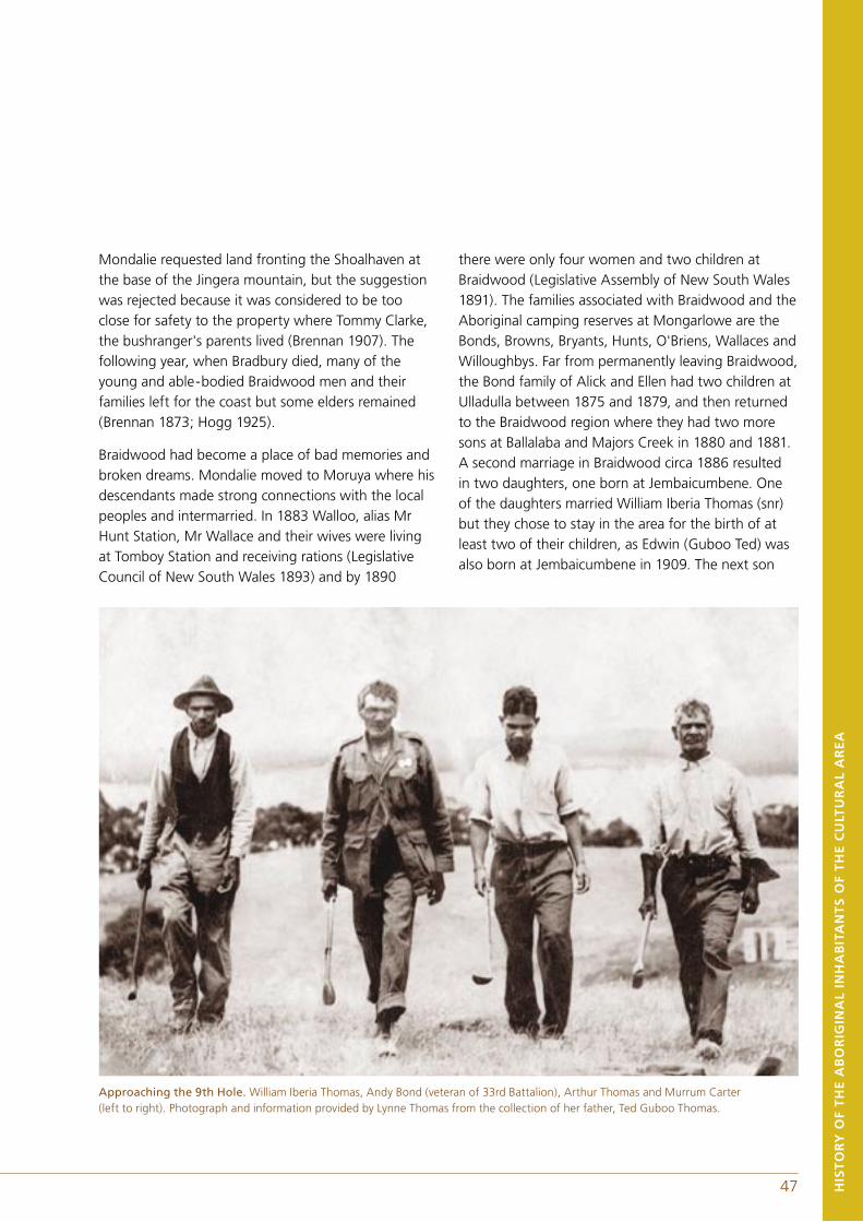
Mondalie requested land fronting the Shoalhaven at the base of the Jingera mountain, but the suggestion was rejected because it was considered to be too close for safety to the property where Tommy Clarke, the bushranger's parents lived (Brennan 1907). The following year, when Bradbury died, many of the young and able-bodied Braidwood men and their families left for the coast but some elders remained (Brennan 1873; Hogg 1925).
Braidwood had become a place of bad memories and broken dreams. Mondalie moved to Moruya where his descendants made strong connections with the local peoples and intermarried. In 1883 Walloo, alias Mr Hunt Station, Mr Wallace and their wives were living at Tomboy Station and receiving rations (Legislative Council of New South Wales 1893) and by 1890
there were only four women and two children at Braidwood (Legislative Assembly of New South Wales 1891). The families associated with Braidwood and the Aboriginal camping reserves at Mongarlowe are the Bonds, Browns, Bryants, Hunts, O'Briens, Wallaces and Willoughbys. Far from permanently leaving Braidwood, the Bond family of Alick and Ellen had two children at Ulladulla between 1875 and 1879, and then returned to the Braidwood region where they had two more sons at Ballalaba and Majors Creek in 1880 and 1881. A second marriage in Braidwood circa 1886 resulted in two daughters, one born at Jembaicumbene. One of the daughters married William Iberia Thomas (snr) but they chose to stay in the area for the birth of at least two of their children, as Edwin (Guboo Ted) was also born at Jembaicumbene in 1909. The next son
HIS
TO
RY
OF
TH
E A
BO
RIG
INA
L IN
HA
BIT
AN
TS
OF
TH
E C
ULT
UR
AL
AR
EA
Approaching the 9th Hole. William Iberia Thomas, Andy Bond (veteran of 33rd Battalion), Arthur Thomas and Murrum Carter (left to right). Photograph and information provided by Lynne Thomas from the collection of her father, Ted Guboo Thomas.
47

48 49
was born in 1911 at Tilba, where this branch of the family has remained. However, the Bonds and Thomas' continued to be great travellers and spent a lot of time visiting places of significance. For example, Peter Thomas was known to have been at Braidwood in 1911 (Trenchard 1911). Two of the sons from Ellen's first marriage had children at Wallaga Lake in 1903 and 1904 to a Bega and a Gippsland woman, one marrying in Braidwood and the other at Lake Tyers. A third son married a Penrith, but married in Nowra and had their first child in Berry in 1926.
Little is known of Margaret Bryant, for whom 8 acres was gazetted at Mongarlowe in 1885, next to her non-Aboriginal husband's 42 acres. She and her son supported her elderly husband by mining for gold and cultivating the land (Smithson 1997, p.237) but by 1890 the reserve was unoccupied (Legislative Assembly of New South Wales 1891) and was revoked in 1893 (Legislative Assembly of New South Wales 1894). A branch of the Bryant family left the area and went to live in Gippsland by 1887 as there was a Bryant born at Bairnsdale in 1887 who married a south coast woman at Lake Tyers and had their first child in 1909 at the Lake Tyers Mission Station (Lake Tyers Births). A man, who may have been Margaret's son was a Wiradjuri language informant for R.H. Mathews in 1904 (Mathews papers n.d.) suggesting that Margaret was a Wiradjuri woman, or perhaps that he was raised by Wiradjuri speakers.
Jane Brown may have been one of the women referred to in the following account by the Reverend Allan of Braidwood:
There is no disposition in the whites to intermarry with them (the Aborigines), but several shepherds of abandoned character, keep black women in their huts, and have children by them. There may be from fifteen to twenty half-castes of different ages, all following the habits of the Aborigines (Allan 1846).
Certainly, Janes’s first husband was a shepherd, probably a convict, although it has not been
investigated whether he was based originally in the Braidwood area or on the far south coast. When he married Jane in 1835 in Moruya she was probably only ten or eleven. She was said to have had six husbands in all (although only four have been recorded) and to have been a Tungai (Percy Mumbler in Robinson 1976). She left the Braidwood area as a young girl some time before 1835 and did not return. Her children were born at Moruya (1835), Kiora (1844) and Nelligen (1859-68) and she died in Batemans Bay in 1908. Her children married men and women from Ulladulla, the Clyde River, Shoalhaven (Nowra), Bega and Tilba and their children were born at Tomakin, Milton, Ulladulla, Araluen, Nelligen, Brooman, Currowan, Conjola, Batemans Bay, Bawley Point and Kioloa.
Walloo alias Mr Hunt was a Clyde River man who in 1834 was usually living at Curraduckbidy (Ryrie 1834), probably the area now included in Budawang National Park and received blankets from Ryrie at Arnprior near Braidwood. He married Jenny Namble of Broulee and had a son who married a Mumbler. Their daughter married a Penrith. Walloo was a full-blood initiated man who had had his upper incisor removed (Braidwood Gaol Entrance Book 1856-1899). In 1883 he was living at Tomboy with a group of elders.
Margaret O'Brien was an Aboriginal woman, born circa 1828, who married a non-Aboriginal man by whom she had two or three children (Allan 1851). She appeared in Rev. Allan's 1851 Braidwood census but it does not follow that her origins were in the Braidwood area. Mary O'Brien, who was born at the Majors Creek goldfields in 1860, was not Margaret's daughter but was probably related. She met and married a Broulee man with whom she had several children. She was on the far south coast by 1880 at Ulladulla and at Turlinjah in 1895. Her descendants are based on the far south coast.
Mr Wallace was one of the elders living at Tomboy in 1883 but he does not appear in the censuses of
HIS
TO
RY
OF
TH
E A
BO
RIG
INA
L IN
HA
BIT
AN
TS
OF
TH
E C
ULT
UR
AL
AR
EA
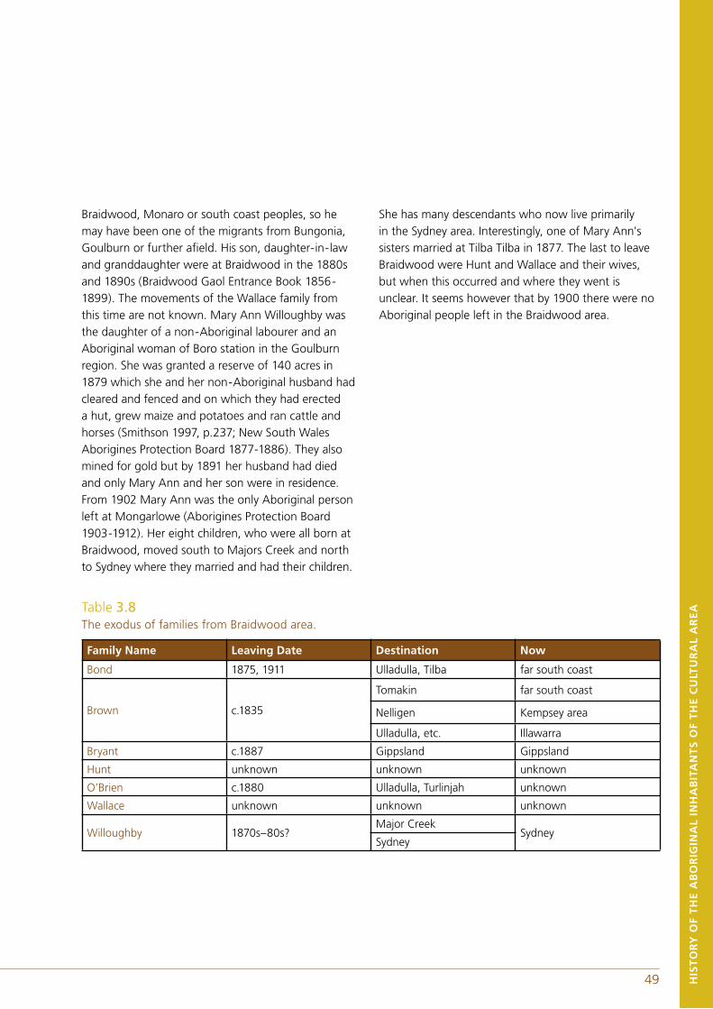
48 49
Braidwood, Monaro or south coast peoples, so he may have been one of the migrants from Bungonia, Goulburn or further afield. His son, daughter-in-law and granddaughter were at Braidwood in the 1880s and 1890s (Braidwood Gaol Entrance Book 1856-1899). The movements of the Wallace family from this time are not known. Mary Ann Willoughby was the daughter of a non-Aboriginal labourer and an Aboriginal woman of Boro station in the Goulburn region. She was granted a reserve of 140 acres in 1879 which she and her non-Aboriginal husband had cleared and fenced and on which they had erected a hut, grew maize and potatoes and ran cattle and horses (Smithson 1997, p.237; New South Wales Aborigines Protection Board 1877-1886). They also mined for gold but by 1891 her husband had died and only Mary Ann and her son were in residence. From 1902 Mary Ann was the only Aboriginal person left at Mongarlowe (Aborigines Protection Board 1903-1912). Her eight children, who were all born at Braidwood, moved south to Majors Creek and north to Sydney where they married and had their children.
She has many descendants who now live primarily in the Sydney area. Interestingly, one of Mary Ann's sisters married at Tilba Tilba in 1877. The last to leave Braidwood were Hunt and Wallace and their wives, but when this occurred and where they went is unclear. It seems however that by 1900 there were no Aboriginal people left in the Braidwood area.
HIS
TO
RY
OF
TH
E A
BO
RIG
INA
L IN
HA
BIT
AN
TS
OF
TH
E C
ULT
UR
AL
AR
EATable 3.8
The exodus of families from Braidwood area.
Family Name Leaving Date Destination Now
Bond 1875, 1911 Ulladulla, Tilba far south coast
Brown c.1835
Tomakin far south coast
Nelligen Kempsey area
Ulladulla, etc. Illawarra
Bryant c.1887 Gippsland Gippsland
Hunt unknown unknown unknown
O’Brien c.1880 Ulladulla, Turlinjah unknown
Wallace unknown unknown unknown
Willoughby 1870s–80s?Major Creek
SydneySydney
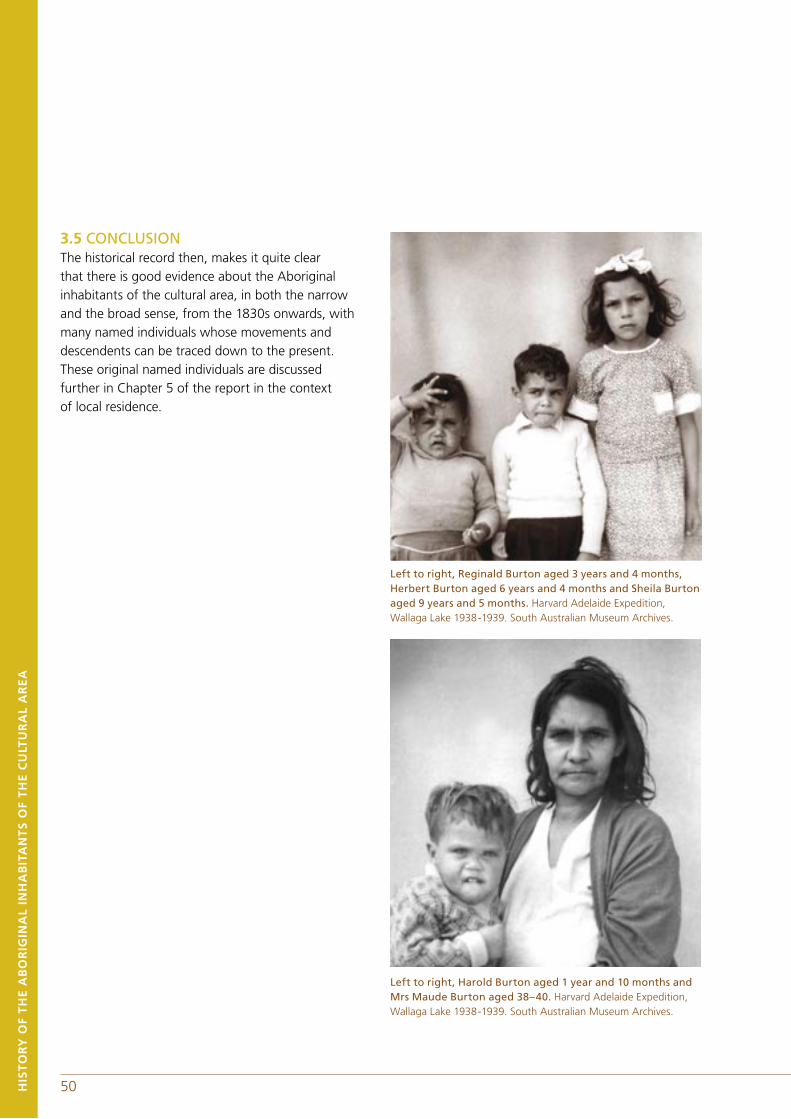
3.5 CONCLUSIONThe historical record then, makes it quite clear that there is good evidence about the Aboriginal inhabitants of the cultural area, in both the narrow and the broad sense, from the 1830s onwards, with many named individuals whose movements and descendents can be traced down to the present. These original named individuals are discussed further in Chapter 5 of the report in the context of local residence.
Left to right, Reginald Burton aged 3 years and 4 months, Herbert Burton aged 6 years and 4 months and Sheila Burton aged 9 years and 5 months. Harvard Adelaide Expedition, Wallaga Lake 1938-1939. South Australian Museum Archives.
Left to right, Harold Burton aged 1 year and 10 months and Mrs Maude Burton aged 38–40. Harvard Adelaide Expedition, Wallaga Lake 1938-1939. South Australian Museum Archives.
HIS
TO
RY
OF
TH
E A
BO
RIG
INA
L IN
HA
BIT
AN
TS
OF
TH
E C
ULT
UR
AL
AR
EA
50
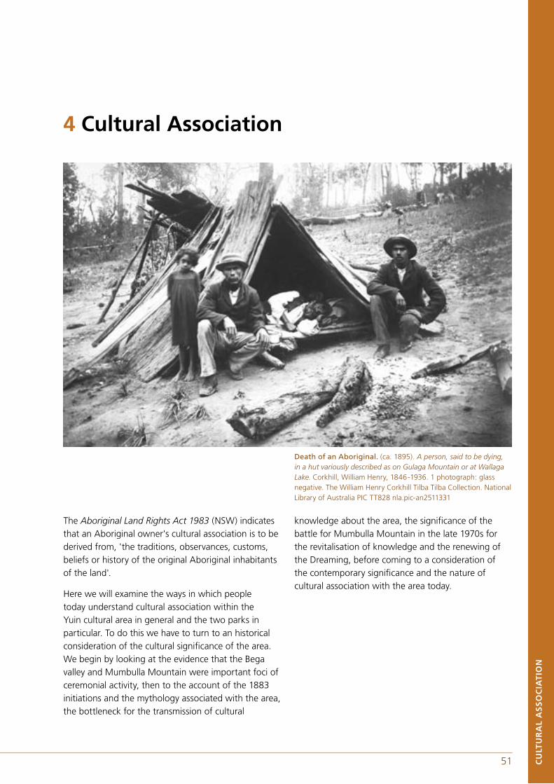
Death of an Aboriginal. (ca. 1895). A person, said to be dying, in a hut variously described as on Gulaga Mountain or at Wallaga Lake. Corkhill, William Henry, 1846-1936. 1 photograph: glass negative. The William Henry Corkhill Tilba Tilba Collection. National Library of Australia PIC TT828 nla.pic-an2511331
The Aboriginal Land Rights Act 1983 (NSW) indicates that an Aboriginal owner's cultural association is to be derived from, 'the traditions, observances, customs, beliefs or history of the original Aboriginal inhabitants of the land'.
Here we will examine the ways in which people today understand cultural association within the Yuin cultural area in general and the two parks in particular. To do this we have to turn to an historical consideration of the cultural significance of the area. We begin by looking at the evidence that the Bega valley and Mumbulla Mountain were important foci of ceremonial activity, then to the account of the 1883 initiations and the mythology associated with the area, the bottleneck for the transmission of cultural
Death of an Aboriginal. (ca. 1895). A person, said to be dying, in a hut variously described as on Gulaga Mountain or at Wallaga Lake. Corkhill, William Henry, 1846-1936. 1 photograph: glass negative. The William Henry Corkhill Tilba Tilba Collection. National Library of Australia PIC TT828 nla.pic-an2511331
knowledge about the area, the significance of the battle for Mumbulla Mountain in the late 1970s for the revitalisation of knowledge and the renewing of the Dreaming, before coming to a consideration of the contemporary significance and the nature of cultural association with the area today.
CU
LTU
RA
L A
SS
OC
IAT
ION
51
4 Cultural Association
52 53CU
LTU
RA
L A
SS
OC
IAT
ION
4.1 EARLY EVIDENCE FOR CULTURAL ASSOCIATIONIn-depth studies of the importance and significance of the cultural information provided by Robinson has yet to be undertaken, however, it is clear that as early as 1844 he was identifying individuals with particular areas of country. He mentions a group of Aboriginal people that he met at Twofold Bay on 25 August 1844 as coming from Murre/Murrier/Murrer River (Murrah), Mombuller/Mumbeller/Mombeller (Mumbulla), Kolager/Koleger (Gulaga), Bermenger (Biamanga). Interestingly Tommy aged seven, was named Koleger and his country was said to be Bermenger or he had two countries, both Koleger and Bermenger. Similarly a woman named Mary had the name Mammerger (Mummaga), a lake near Narooma, but was said to have Wandella as her country. Robinson says, 'that he, entered the head of Biggah called Mumbuller or Mumbellar, belonging to Yowege, says it is his farm' (Robinson 1844a). Robinson employed Merrewurer alias Tommy to guard and interpret for him in Bega country. Bunmilen/Yowege, Monnowerrer alias Paddy Imlay and Merrewurer alias Tommy the King were brothers and at least Yowege was involved in the custodianship of Mumbulla Mountain.
4.2 THE 1883 INITIATIONBy far the most important source of information about the cultural significance of the two mountains comes from Howitt's description of the Bunan initiation ceremony he caused to be held in 1883 (see Mulvaney 1970; Egloff 1979/1981). Howitt was familiar with members of the south coast Aboriginal community and was considered as an 'elder' (see Mulvaney 1970). He was keen to witness one of these ceremonies himself but they were held infrequently and it needed to be held at a time when he could attend. His role was to have the ceremony held; how it was conducted and where it was held was entirely in Aboriginal hands. Interestingly, however, Howitt did not make it clear as to the exact location of the ceremony
described in his 1904 book and more fully in his field notes. It was clarified through research by Egloff that beyond doubt the initiation was conducted for the most part on Mumbulla Mountain (Egloff 1979/81). Howitt was to organise another initiation ceremony in Gippsland the following year. Mulvaney (1970, p. 214) points out that Howitt's fostering of Aboriginal ceremonial practices was in direct opposition to the policies of the Board for the Protection of Aborigines and the local Ramahyuck mission superintendent.
Howitt's published description of the initiation ceremony is included in the The Native Tribes of South-East Australia. It makes clear that the ceremony included the transmission of public and secret knowledge about Aboriginal law, much of it through word and song, but also through body designs, dances, and other ritual behaviours. The young initiates were also given instruction in the significance of the landscape and codes of behaviour. The participants ascended high up the mountain, where the initiates had a tooth removed and participated in ritual activites.
An interesting aspect of the ceremonies was the attendance of Mragula, the old Wolgal singer, and the Wolgal boy whose country was a long way to the west of the coast. This is one of the clues that suggest that the 1883 initiation ceremony was not only prompted by Howitt but could well have evidenced an attempt by the Yuin to revitalise their ceremonial system by bringing in ritual expertise from a distance. This is in keeping with Howitt's (1904, p.563) brief description of the initiation ceremonies of the Wolgal and the Ngarigo which indicates that the two groups had ceremonies similar to the coastal Yuin.
52 53 CU
LTU
RA
L A
SS
OC
IAT
ION
4.3 SPECIAL SIGNIFICANCE OF THE MOUNTAINSHistorical sources support the notion of Gulaga also having a special association for Aboriginal people. Gulaga or 'Cooliga' or 'Caluga' or 'Kolager' or 'Kolegar' as it was variously recorded last century, was recognised as `the big mountain of the blackfellow' by the editor of the Bega Standard in 1879 (Pacey and Hoyer 1995, p.2).
Howitt records a 'Gulaga Creation Story' in his unpublished papers (n.d.) which provides information on how people relate to supernatural beings as well as with totemic animals:
The Bat and the Mur-an-rai (Emu-wren) are the men's brothers and Tintegallan (the tree-creeper) is the women's sister. It is said that the Mur-an-rai first made the human sexes distinct by splitting up the then existing people and by then sewing them up again. To kill a tree-creeper would greatly offend the women and cause them to fight with the men. It is said that long ago there were no men and women on the earth but only animals, birds, reptiles and so on, that there were no trees and that the earth was bare and 'like the sky as hard as a stone'. Daramulun lived on the earth with his mother Ngal-al-bal. He placed trees on the earth. At this time when the earth was only inhabited by animals the land extended far out where there is now sea. The thrush (kabboka) when out hunting killed a wallaby and gave some of it to the other birds. These looking at it and smelling it said `it is going rotten' and complained about it. The thrush being very much enraged, while the others were out hunting commenced to dance and sing the talmaru dance until he caused a furious gale of wind to arise.
Whirlwinds swept leaves, sticks and dust into the air and torrents of rain fell and drowned the whole country and all the people in it except some who turned into fish and some who crawled out on the land and became men and women. Some say that only two survived, a man and a woman, who
crawled into Mt Dromedary and then escaped and that's how all the Murring are descended. Daramulun all this time lived up in the sky with his wife and his mother Ngal-al-bal went up into the sky where he now is. It was Daramulun - the Biambun (Headman - ruler) who taught the Murring and who instituted the Bunan and its ceremonies and gave his laws to old people who first lived and who handed it down from father to son to these times.
A much more recent account of the mythological significance of Gulaga comes from the 1970s, with Guboo Ted Thomas recounting of the 'Legend of Gulaga':
To the Yuin people, Gulaga is the Mother Mountain. One day her young son came to her and asked if he could leave home, Gulaga let him so he moved far out to sea. On seeing that his big brother had left, Gulaga's baby son wanted to leave too. Because he was so young she permitted him to move only a short distance away where she could keep an eye on him. Gulaga is the Yuin name of Mount Dromedary, her baby is Nudgenooka and her other son is Barangooba.
Eileen Morgan (1994, p.xix) tells the following story in her The Calling of the Spirits:
Many, many years ago a tribe of Aboriginals lived on top of Gulaga Mountain. A lovely young girl was pregnant and her husband went hunting to get her a beautiful white fur. While he was away, a young man came to her camp and killed her. When her husband returned carrying the beautiful white fur, he found her dead, so he wrapped the fur around her.
To punish the young man, the elders of the tribe told him he had to go away, so he went and lived by him-self. Then a great earthquake came and divided the mountain, so they never saw the young man again. They called the little mountain, Najanara, after the young man. So that is why we have Gulaga, Najanara, and Montague which came up out of the sea.
54 55CU
LTU
RA
L A
SS
OC
IAT
ION
To this very day when you look up at the mountain, on the very top you will see a pregnant woman lying down. Sometimes you will see a cloud around the top of the mountain. The people say to one another, 'Well, today she is wearing her white fur'.
Merrimans Local Aboriginal Land Council in their undated (circa 1990) 'Submission on unauthorised logging of Gooliga (sic) (Mt Dromedary)' quote the following 'Dreamtime story', recorded by A.W. Howitt,:
Long ago Daramulan lived on the earth with his mother Ngalalbal. Originally the earth was bare and 'like the sky, as hard as stone', and the land extended far out where the sea is now. There were no men or women, but only animals, birds and reptiles. He placed trees on the earth.
After Kaboka, the thrush, had caused a great flood on the earth, which covered all of the east coast country, there were no people left, except some who crawled out of the water on to Mt. Dromedary.
Then Daramuulun went up to the sky, where he lived and watched the actions of men. It was he who first made the Kuringal and the bull-roarer, the sound of which represents his voice. He told the Yuin what to do, and gave them the laws which the old people have handed down from father to son to this time.
When a man dies and his tulugul (spirit) goes away it is Daramulun who meets it and takes care of it. It is a man's shadow which goes to Daramulun.
The current 'Umbarra' leaflet has a story about the Doolagar, and its association with Wallaga Lake.
Doolagarl lives in the bush between Bermagui and Mumbulla, and up on Gulaga. He is a hairy man with red eyes. He has long spindly arms, no neck and a long forehead. He walks from side to side. He frightens people by hypnotising them and putting them under his spell. He doesn't hurt you. You sometimes can feel him watching you or you hear him imitating the sounds of birds. To prevent Doolagarl from catching you, burn green bush leaves to make a fire. Doolagarl is also known as Yowie.
4.4 THE BATTLE TO PROTECT MUMBULLA MOUNTAIN AND THE PUBLIC EMERGENCE OF INDIGENOUS KNOWLEDGEThe last initiations associated with Mumbulla Mountain appear to have been around 1918 and subsequently there was a decline in the ceremonial significance of the two mountains, as they became a part of a memory culture, for all but a restricted group of older people. The specific individuals mentioned today among these older people are all male but the significance would have had to extend to their spouses and children, at the very least, even if the significance for them was different. These males were concerned to learn about the initiations that took place on the mountain, and the associated knowledge, from such people as Percy Mumbler, Percy Davis and Eric Roberts.
This interest and concern with the knowledge was not known about in the local non-indigenous community when Gubbo Ted Thomas started to lead people in protest about the logging on Mumbulla Mountain in 1977, when he asserted that it was a sacred mountain. There was considerable scepticism among the non-Indigenous population of the area. Indeed they saw the claim as opportunistic and unscrupulous. However, two quite independent sources provided compelling evidence for this significance. Tape recordings made by Janet Mathews and Louise Hercus in 1964, which remained closeted in the Australian Institute of Aboriginal and Torres Strait Islander Studies archives until the late 1970s provide a link between Aboriginal elders that had participated in the ceremonies and contemporary Yuin elders. An even more compelling source was the discovery by Egloff of an unpublished map in Howitt's papers that shows quite clearly that the 1883 Yuin initiation ceremony attended by him was held on Mumbulla Mountain (Egloff 1979/1981).
By 1976, the logging operations in the five major forests were supplying timber props to the mining industry, poles for telecommunications and logs for the local saw mills as well as for the export wood-chip industry. This heavy industrial use of the forests replaced the traditional small-scale timbering activities
54 55 CU
LTU
RA
L A
SS
OC
IAT
ION
such as sleeper cutting which once employed many families8 . As the integrated timber regime began to impact on the visual qualities of the landscape, concern was raised by the local environmentally conscious populace and the Aboriginal community that significant natural and cultural heritage values of the 'Five Forests' were being impacted upon. This prompted the New South Wales Government to appoint in 1977 an Advisory Committee on South Coast Woodchipping. By a quirk of fate the woodchipping inquiry coincided with the hearings of the Select Committee of the Legislative Assembly that visited Wallaga Lake on 7 February 1979, when claims were made to have the two mountains recognised as sacred sites.
Guboo Ted Thomas, the acknowledged spiritual leader of the Wallaga Lake Aboriginal community, who had led the protest against the desecration of the mountain, addressed the Committee in the following terms:
Why we are interested in this land here, the Mumbulla Mountain and Mount Dromedary, is that they are sacred sites, they are part of us. You have your cathedrals in Sydney where you worship. It is the same for the Aboriginal people... We do not want to lose our culture. We are trying to restore all our sacred sites. We want to retain where we worship. This is what we are looking at. That mountain up there is a powerful mountain because it draws the people back, (Egloff 1980, p.111).
He asserted that the mountain was an extremely significant landscape as not only was it the 'dreaming place' of Jack Mumbler (Biamanga) but it also was a place where sacred and secret initiations ceremonies were held.
In 1977, Brian Egloff had been appointed by the National Parks and Wildlife Service, with the approval of Ted Thomas acting as a Yuin elder, to undertake an anthropological and archaeological investigation to assess the claim for Mumbulla Mountain. Funding
for the research was derived from the wood-chipping inquiry. The investigation and report drafting was undertaken from February to May of 1979. On the whole the research supported the acceptance of the Yuin Tribal Council statements with respect to the following:
a) the Yuin Tribal Council represents Aborigines living in south coast communities, which as a body retain sufficient traditional concepts to serve as a basis for serious objections to the endangering of sacred Aboriginal sites,
b) that Mumbulla Mountain is significant by virtue of the mountain having been the locale of Aboriginal initiations which utilised a complex of sacred sites,
c) that any further substantial alteration of the landscape in the vicinity of the reported sacred sites would impair the significance and value of the area to Aborigines (Egloff 1979/1981, p.1).
That study was followed by an archaeological survey of the entirety of Mumbulla Mountain State Forest by Egloff (Byrne 1984). The random stratified survey confirmed a predictable pattern of sites being clustered on ridge spurs and on ridge-lines with a concentration in close proximity to Mumbulla Creek separated by a considerable distance from the major cluster of prehistoric sites on the coastal shores (Egloff 1984). While Denis Byrne was drafting the report of the archaeological survey, Hilary Sullivan undertook a study of 'Aboriginal Usage of the Forest Environment' (Sullivan 1982) which augmented an earlier study by Anne Bickford (1981). This was to be followed in 1983 with a published report by Sandra Bowdler titled Aboriginal Sites on the Crown Timber Lands of New South Wales.
One of the barriers that had to be overcome in order for the 1979 (1981) Mumbulla Mountain study to become widely accepted was the popular perception that the Aboriginal communities of south-eastern Australia had been assimilated and retained few if any 'traditional' cultural practices. The retention of indigenous knowledge by Aboriginal elders was only
8 Mumbulla State Forest No 605 was dedicated in the Gazette of 2 November 1917.
56 57CU
LTU
RA
L A
SS
OC
IAT
ION
reluctantly accepted by south coast communities in the late 1970s. Due to subsequent publications and awareness raising educational programs there has been a more widespread acceptance of the concept of Aboriginality as it applies to communities on the far south coast of New South Wales. The first awareness by the scientific community of the retention of traditional knowledge was raised by R. Lampert and F. Saunders (1973) in an article that detailed the traditional plant knowledge of David Carpenter, of Roseby Park, now Jerrinja, on the coast near Nowra. This was followed in 1981 by, Wreck Bay: an Aboriginal Fishing Community by Brian Egloff. This publication was the result of research initiated by the elders of Wreck Bay community and financed by the Australian Institute of Aboriginal Studies in response to the Commonwealth's attempt to abolish the community reserve. It was the idea of George Brown, a community elder, that their story had to be told in such a way that it would convince the wider Australian society that the people of Wreck Bay had maintained a community over the past half century and should be allowed to continue to do so into the future. That book was reprinted in 1990 and is now included in the New South Wales schools curriculum.
Denis Byrne (1984) published The Mountains Call me Back: a History of the Aborigines and Forests of the Far South Coast of New South Wales. This booklet was produced for a popular audience and served to make more widely available information that had been obtained as a continuation of the Mumbulla Mountain Project.
A compendium of papers was compiled by Michael Organ (1990) pertaining for the most part to the region to the north of the study area. It includes valuable information and pointed scholars toward archival material that had not been tapped previously, in particular records of blankets distributed to Aboriginal groups.
In 1990, the Forestry Commission of New South Wales commissioned a study of the sacred significance of Gulaga by the anthropologist Deborah Bird Rose. Her study is discussed in the following section of this report.
The Calling of the Spirits by Eileen Morgan, the sister of Ted Thomas, with assistance from Terry Fox, was published in 1994. This account of an Aboriginal woman's association with the south coast proved to be a welcome relief from academic accounts. Even more welcomed by the south coast Aboriginal community was the profusely illustrated Travelling with Percy by photographer Lee Chittick and long-time associate of the Wreck Bay Reserve, Terry Fox. This photographic essay, focussed on the life of the well-known Aboriginal elder Percy Mumbler, introduces the reader to a wide cross-section of the south coast Aboriginal community.
An Historical Atlas of Aborigines of Eastern Victoria and Far South-Eastern New South Wales by Sue Wesson (2000) calls upon extensive original work. The atlas was primarily informed by documentary sources housed at the major repositories of Melbourne, the State Library of Victoria, Museum of Victoria, Australian Archives and the Public Records of Victoria and in Sydney at the Mitchell Library and State Records of New South Wales, in particular the records of George Augustus Robinson
4.5 RENEWING THE DREAMINGThe battle to save the mountain from logging stimulated a wide interest, among both Aboriginal and non-Aboriginal people, in the sacredness of Mumbulla Mountain and the knowledge held by a few senior people. This culminated in a ceremony involving Aboriginal and non Aboriginal people on the top of Mumbulla Mountain before dawn on the first day of spring in 1980 (see Simpendorf 1981, p.19). Subsequently the sharing of knowledge has been restricted to the Aboriginal community and developed along gender lines. In 1990 anthropologist
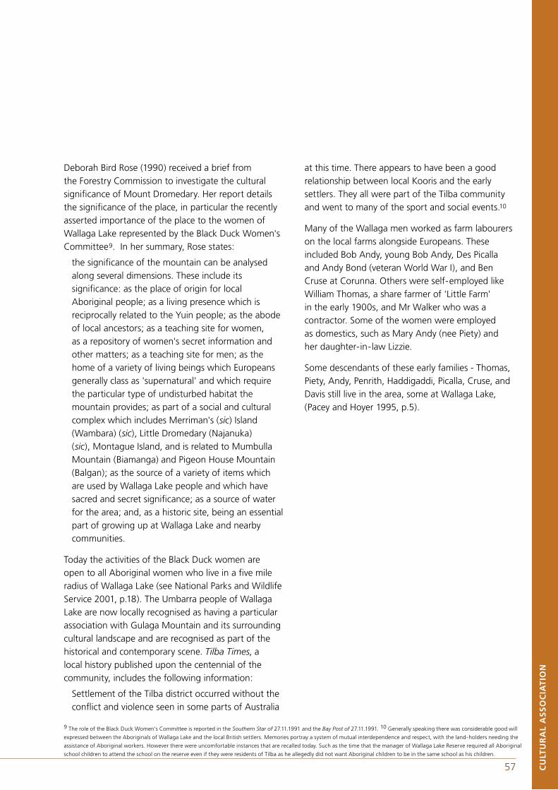
56 57
9 The role of the Black Duck Women’s Committee is reported in the Southern Star of 27.11.1991 and the Bay Post of 27.11.1991. 10 Generally speaking there was considerable good will
expressed between the Aboriginals of Wallaga Lake and the local British settlers. Memories portray a system of mutual interdependence and respect, with the land-holders needing the
assistance of Aboriginal workers. However there were uncomfortable instances that are recalled today. Such as the time that the manager of Wallaga Lake Reserve required all Aboriginal
school children to attend the school on the reserve even if they were residents of Tilba as he allegedly did not want Aboriginal children to be in the same school as his children.
CU
LTU
RA
L A
SS
OC
IAT
ION
Deborah Bird Rose (1990) received a brief from the Forestry Commission to investigate the cultural significance of Mount Dromedary. Her report details the significance of the place, in particular the recently asserted importance of the place to the women of Wallaga Lake represented by the Black Duck Women's Committee9. In her summary, Rose states:
the significance of the mountain can be analysed along several dimensions. These include its significance: as the place of origin for local Aboriginal people; as a living presence which is reciprocally related to the Yuin people; as the abode of local ancestors; as a teaching site for women, as a repository of women's secret information and other matters; as a teaching site for men; as the home of a variety of living beings which Europeans generally class as 'supernatural' and which require the particular type of undisturbed habitat the mountain provides; as part of a social and cultural complex which includes Merriman's (sic) Island (Wambara) (sic), Little Dromedary (Najanuka) (sic), Montague Island, and is related to Mumbulla Mountain (Biamanga) and Pigeon House Mountain (Balgan); as the source of a variety of items which are used by Wallaga Lake people and which have sacred and secret significance; as a source of water for the area; and, as a historic site, being an essential part of growing up at Wallaga Lake and nearby communities.
Today the activities of the Black Duck women are open to all Aboriginal women who live in a five mile radius of Wallaga Lake (see National Parks and Wildlife Service 2001, p.18). The Umbarra people of Wallaga Lake are now locally recognised as having a particular association with Gulaga Mountain and its surrounding cultural landscape and are recognised as part of the historical and contemporary scene. Tilba Times, a local history published upon the centennial of the community, includes the following information:
Settlement of the Tilba district occurred without theconflict and violence seen in some parts of Australia
at this time. There appears to have been a good relationship between local Kooris and the early settlers. They all were part of the Tilba community and went to many of the sport and social events.10
Many of the Wallaga men worked as farm labourers on the local farms alongside Europeans. These included Bob Andy, young Bob Andy, Des Picalla and Andy Bond (veteran World War I), and Ben Cruse at Corunna. Others were self-employed like William Thomas, a share farmer of 'Little Farm' in the early 1900s, and Mr Walker who was a contractor. Some of the women were employed as domestics, such as Mary Andy (nee Piety) and her daughter-in-law Lizzie.
Some descendants of these early families - Thomas, Piety, Andy, Penrith, Haddigaddi, Picalla, Cruse, and Davis still live in the area, some at Wallaga Lake, (Pacey and Hoyer 1995, p.5).
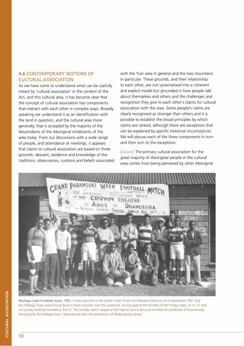
58 59CU
LTU
RA
L A
SS
OC
IAT
ION
4.6 CONTEMPORARY NOTIONS OF CULTURAL ASSOCIATIONAs we have come to understand what can be usefully meant by 'cultural association' in the content of the Act, and this cultural area, it has become clear that the concept of cultural association has components that interact with each other in complex ways. Broadly speaking we understand it as an identification with the land in question, and the cultural area more generally, that is accepted by the majority of the descendants of the Aboriginal inhabitants of the area today. From our discussions with a wide range of people, and attendance at meetings, it appears that claims to cultural association are based on three grounds: descent, residence and knowledge of the traditions, observances, customs and beliefs associated
with the Yuin area in general and the two mountains in particular. These grounds, and their relationship to each other, are not systematised into a coherent and explicit model but grounded in how people talk about themselves and others and the challenges and recognition they give to each other’s claims for cultural association with the area. Some people’s claims are clearly recognised as stronger than others and it is possible to establish the broad principles by which claims are ranked, although there are exceptions that can be explained by specific historical circumstances. We will discuss each of the three components in turn and then turn to the exceptions.
Descent The primary cultural association for the great majority of Aboriginal people in the cultural area comes from being perceived by other Aboriginal
Wallaga Lake Football team, 1931. It was reported in the South Coast Times and Illawarra Mercury on 4 September 1931 that the Wallaga Team experienced back to back victories over the weekend, wining against Mt Kembla on the Friday night, 21 to 17, and on Sunday beating Unanderra, 8 to 6. The Sunday match played at the Figtree Sports Ground included an exhibition of boomerang throwing by the Wallaga team. Reproduced with the permission of Wollongong Library.
58 59 CU
LTU
RA
L A
SS
OC
IAT
ION
people in the area to be a descendant of an early Aboriginal inhabitant of the area. As indicated above, the perceptions of connection to the area have been, until the last decade or so, dependent on oral history and greatly influenced by the impact of British colonisation on Aboriginal residence patterns. In particular, the main points of historical reference have been, and still largely remain, descent from the early inhabitants of the Wallaga Lake Aboriginal reserve, located in a central position in the Yuin cultural area, or close involvement with early settler economic activity nearby to Wallaga Lake Aboriginal Reserve, including working as farm hands or being involved in whaling. Current genealogical and historical research can complicate this because local oral history has only taken people back to the end of the nineteenth century, while archival research is now turning up links that were not previously known or, if they were, were not always well understood. As a result some people can trace links back to the cultural area, and the general vicinity of the two parks, through links neither they nor the other Aboriginal people in the area knew about until very recently. These can conflict with their long-standing identities with country or allow people to make claims that seem technical because they do not meet with the other criteria.
Residence When descent from an early inhabitant of Wallaga Lake Aboriginal Reserve or nearby, is coupled with continuous residence in the area across the subsequent generations, then people have a very strong cultural association with the area. It is, indeed, remarkable just how many of today's Aboriginal residents of the cultural area are descendants of people who have been continuously resident in the area since the formation of the Wallaga Lake Aboriginal reserve, if not the arrival of British settlers. This means that people will have had a shared history with other Aboriginal people who are in a similar position over a number of generations. It is a cultural association, because racism and legislation have led Aboriginal people to lead a life that was, in many ways, parallel to and remarkably separate from that
of the British settler society in the area and at the same time substantially separate from other regional networks such as that centring on Lake Tyers to the south and La Perouse at Sydney to the north.
There are Aboriginal people who have undisputed descent links back to residents of the cultural area in the late nineteenth century but whose most recent antecedents, or, indeed, they themselves, have not lived in the area for long or at all. Some of these are people who were removed to institutions such as the Kinchela home for boys or the home for girls at Cootamundra. Others are people who, under the pressures of the assimilation policy in the immediate post-war period, left for places like Sydney to seek work or better paying positions. As these people have reached mid-life or later, some of them have returned to live in the cultural area. Frequently their absence may be used against them in public, or behind their backs, when issues to do with rights to resources and the like come up, but nevertheless they are usually grudgingly accepted as long as they are not too forceful in advancing their claims. Some few returnees are politically experienced and likely to confront these Aboriginal community tendencies with the language of rights.
Another category of residents who have a weaker cultural association are those who lack a descent connection with the area that goes back to the nineteenth century. These are often second or third generation descendants of in-marrying people that come from places such as Lake Tyers, Tumut and Kempsey or elsewhere, who while accepted as members of the community, have no rights to speak about the land. Their cultural association is relatively weak compared to the people discussed above.
Knowledge By knowledge we refer to knowledge of the traditions, observances, customs, beliefs and community history associated with the Yuin area in general and the two mountains in particular. By its nature this is the most difficult of the three elements of cultural association to document or verify. The

60 61CU
LTU
RA
L A
SS
OC
IAT
ION
levels of knowledge and the interest in the cultural knowledge associated with the two mountains varies to a considerable degree among the inhabitants of the cultural area, ranging from a small handful of people for whom it is a major focus, to many who are aware of its existence but have no day-to-day interest in it at all. Certain individuals are widely acknowledged as principal holders of the cultural knowledge about the mountains, which has come to be shared by an increasing number of Aboriginal people in the area through formalised transmission, much of it along gender lines.
There was clearly a bottleneck in the transmission of cultural knowledge relating to the mountains, and other matters, between the 1930s and the early 1970s as the number of men with direct experience of the last initiation decreased and the pressures for assimilation increased, although, of course, there is no way to quantify this. It was in this period that any possibility of keeping the languages alive was lost, as old people often refused to speak it in front of the young or teach it to them, under the pressure of the assimilation policy. A major stimulus for the recovery and revitalisation of the reserve of cultural knowledge undoubtedly came with the battle to protect Mumbulla Mountain from logging. This brought information held by a small handful of people out into the open and led to the recovery of knowledge from anthropological and historical texts on the area that were previously unknown to the people.
At the centre of this revitalisation are people living at or in the immediate vicinity of Wallaga Lake whose names are well-known up and down the coast. Current practice involves a limited number of people in actual ritual activity on both Mumbulla and Gulaga Mountains and at other places in the locale. Some men have been undergoing instruction on Mumbulla Mountain and as a result of the cultural tours many Aboriginal and non-Aboriginal people are now familiar with some of the important places on the mountain. Gulaga is increasingly being identified by women as
of special significance to them, while at the same time acknowledging that it has significance for men as well. Other cultural revitalisation involving ritual activity takes place away from Mumbulla Mountain involving a separate sub-group of the population. As might be expected there is considerable diversity in the nature, content and depth of knowledge among community members.
It is very important to emphasise that whether or not people have an interest in the cultural knowledge associated with the two mountains both are the focus of considerable sentiment for most, if not all, Aboriginal people in the area. Gulaga has always loomed large in the life of Aboriginal people as it literally overshadows the former reserve at Wallaga Lake and stands out from over sixty kilometres to the north. From a southern perspective Mumbulla Mountain likewise dominates the Bega Valley.
4.7 DEFINITION OF CULTURAL ASSOCIATION FOR THE PURPOSES OF THIS REPORTThus we may say in conclusion that cultural association with the Yuin cultural area is complex and layered. It has three principal components: descent, residence and knowledge as elaborated on above. The longer the acknowledged descent chain, the longer the residence both as an individual and over the generations, and the more complex and actively enacted the knowledge, the stronger the cultural association. Clearly the first two are the more objective criteria but this is not to say there will not be contestation within the Aboriginal community on these matters as well as over the issue of the degree of knowledgeability.
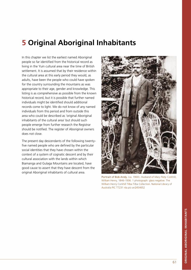
60 61 OR
IGIN
AL
AB
OR
IGIN
AL
INH
AB
ITA
NT
S
In this chapter we list the earliest named Aboriginal people so far identified from the historical record as living in the Yuin cultural area near the time of British settlement. It is assumed that by their residence within the cultural area at this early period they would, as adults, have been the people who could have spoken for the country surrounding the mountains as was appropriate to their age, gender and knowledge. This listing is as comprehensive as possible from the known historical record, but it is possible that further named individuals might be identified should additional records come to light. We do not know of any named individuals from this period and from outside this area who could be described as 'original Aboriginal inhabitants of the cultural area' but should such people emerge from further research the Registrar should be notified. The register of Aboriginal owners does not close.
The present day descendants of the following twenty-five named people who are defined by the particular social identities that they have chosen within the context of a system of cognatic descent and by their cultural association with the lands within which Biamanga and Gulaga Mountains are located, have good cause to assert that they have descent from the original Aboriginal inhabitants of cultural area.
Portrait of Bob Andy. (ca. 1900). Husband of Mary Piety. Corkhill, William Henry, 1846-1936. 1 photograph: glass negative. The William Henry Corkhill Tilba Tilba Collection. National Library of Australia PIC TT231 nla.pic-an2454652
5 Original Aboriginal Inhabitants
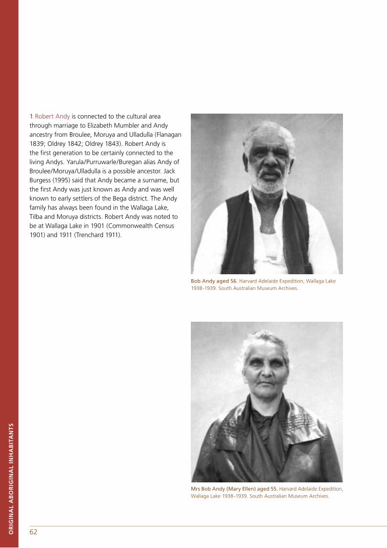
62 63
1 Robert Andy is connected to the cultural area through marriage to Elizabeth Mumbler and Andy ancestry from Broulee, Moruya and Ulladulla (Flanagan 1839; Oldrey 1842; Oldrey 1843). Robert Andy is the first generation to be certainly connected to the living Andys. Yarula/Purruwarle/Buregan alias Andy of Broulee/Moruya/Ulladulla is a possible ancestor. Jack Burgess (1995) said that Andy became a surname, but the first Andy was just known as Andy and was well known to early settlers of the Bega district. The Andy family has always been found in the Wallaga Lake, Tilba and Moruya districts. Robert Andy was noted to be at Wallaga Lake in 1901 (Commonwealth Census 1901) and 1911 (Trenchard 1911).
Bob Andy aged 56. Harvard Adelaide Expedition, Wallaga Lake 1938-1939. South Australian Museum Archives.
Mrs Bob Andy (Mary Ellen) aged 55. Harvard Adelaide Expedition, Wallaga Lake 1938-1939. South Australian Museum Archives.
OR
IGIN
AL
AB
OR
IGIN
AL
INH
AB
ITA
NT
S
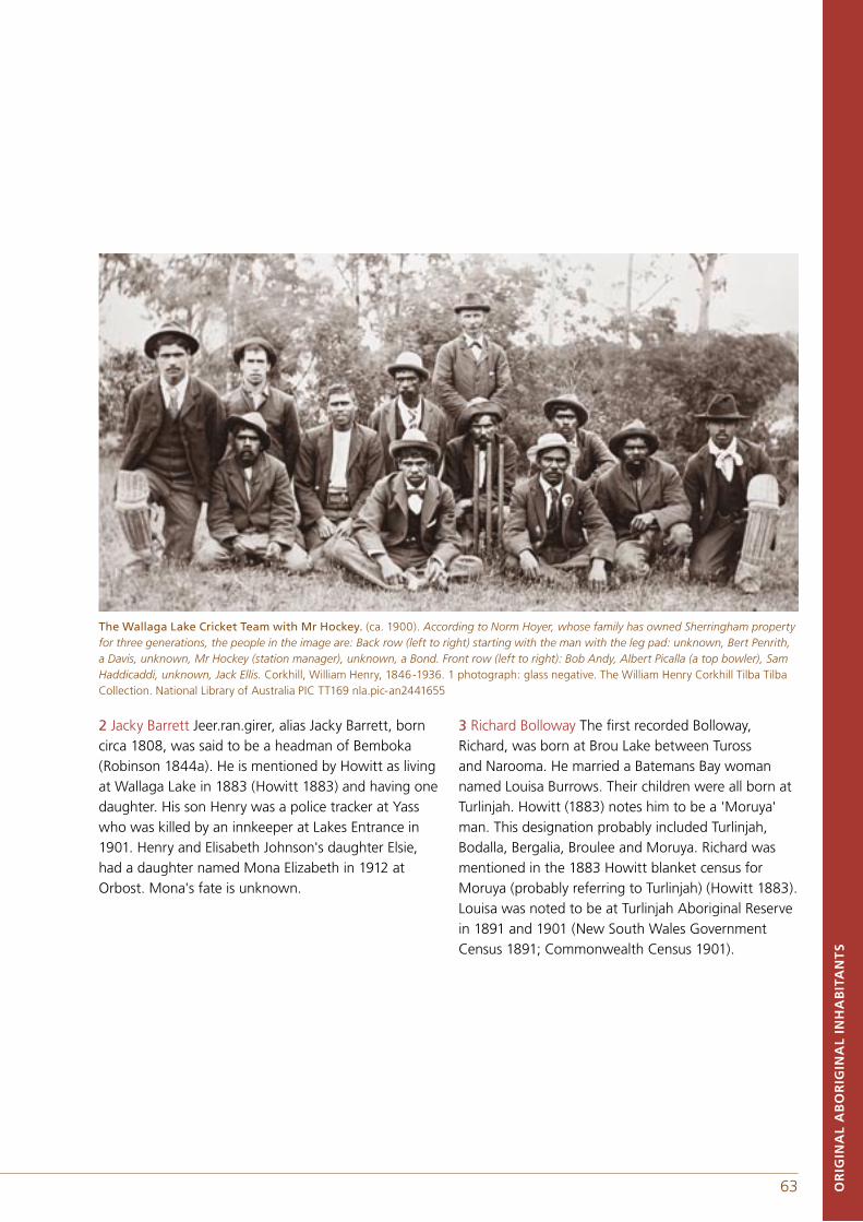
62 63
2 Jacky Barrett Jeer.ran.girer, alias Jacky Barrett, born circa 1808, was said to be a headman of Bemboka (Robinson 1844a). He is mentioned by Howitt as living at Wallaga Lake in 1883 (Howitt 1883) and having one daughter. His son Henry was a police tracker at Yass who was killed by an innkeeper at Lakes Entrance in 1901. Henry and Elisabeth Johnson's daughter Elsie, had a daughter named Mona Elizabeth in 1912 at Orbost. Mona's fate is unknown.
3 Richard Bolloway The first recorded Bolloway, Richard, was born at Brou Lake between Tuross and Narooma. He married a Batemans Bay woman named Louisa Burrows. Their children were all born at Turlinjah. Howitt (1883) notes him to be a 'Moruya' man. This designation probably included Turlinjah, Bodalla, Bergalia, Broulee and Moruya. Richard was mentioned in the 1883 Howitt blanket census for Moruya (probably referring to Turlinjah) (Howitt 1883). Louisa was noted to be at Turlinjah Aboriginal Reserve in 1891 and 1901 (New South Wales Government Census 1891; Commonwealth Census 1901).
The Wallaga Lake Cricket Team with Mr Hockey. (ca. 1900). According to Norm Hoyer, whose family has owned Sherringham property for three generations, the people in the image are: Back row (left to right) starting with the man with the leg pad: unknown, Bert Penrith, a Davis, unknown, Mr Hockey (station manager), unknown, a Bond. Front row (left to right): Bob Andy, Albert Picalla (a top bowler), Sam Haddicaddi, unknown, Jack Ellis. Corkhill, William Henry, 1846-1936. 1 photograph: glass negative. The William Henry Corkhill Tilba Tilba Collection. National Library of Australia PIC TT169 nla.pic-an2441655
OR
IGIN
AL
AB
OR
IGIN
AL
INH
AB
ITA
NT
S
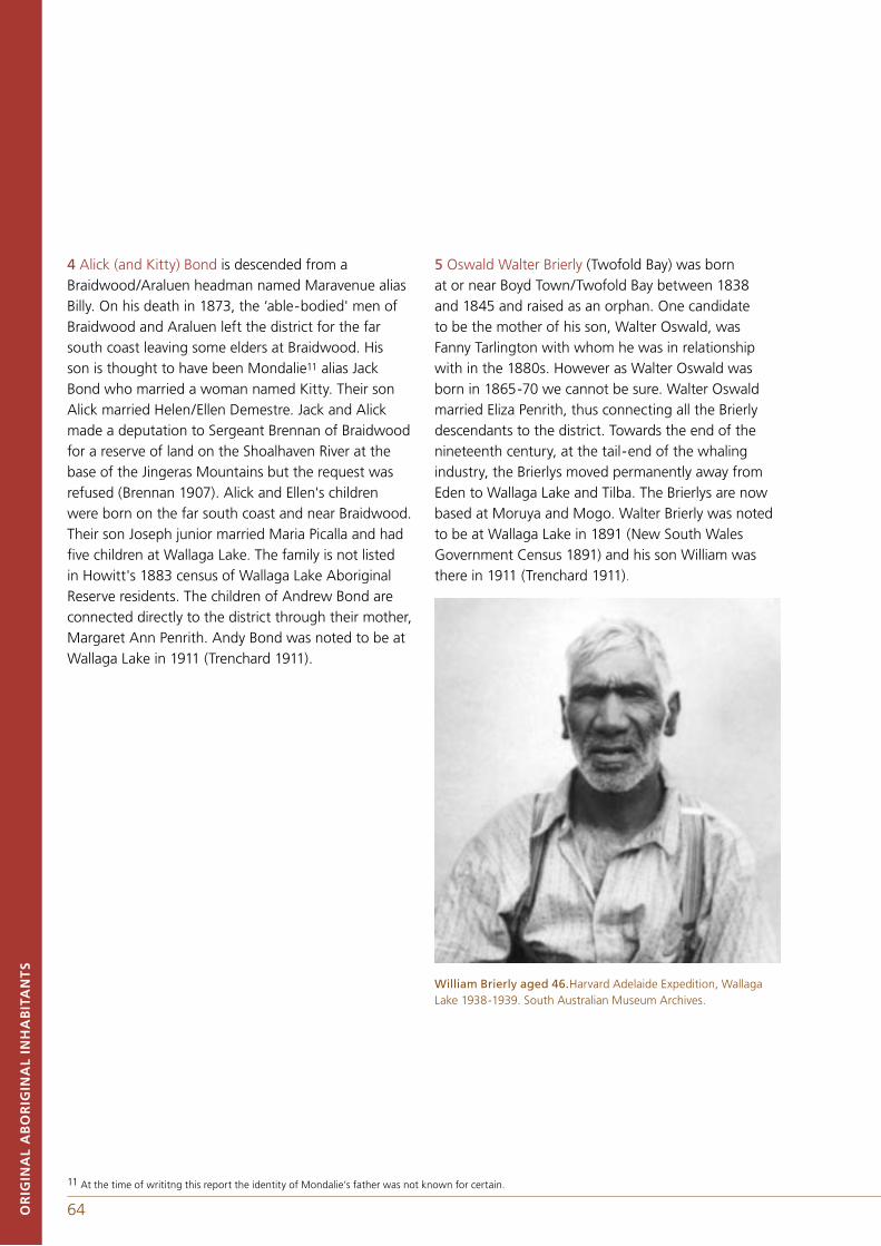
64 65OR
IGIN
AL
AB
OR
IGIN
AL
INH
AB
ITA
NT
S
4 Alick (and Kitty) Bond is descended from a Braidwood/Araluen headman named Maravenue alias Billy. On his death in 1873, the ‘able-bodied' men of Braidwood and Araluen left the district for the far south coast leaving some elders at Braidwood. His son is thought to have been Mondalie11 alias Jack Bond who married a woman named Kitty. Their son Alick married Helen/Ellen Demestre. Jack and Alick made a deputation to Sergeant Brennan of Braidwood for a reserve of land on the Shoalhaven River at the base of the Jingeras Mountains but the request was refused (Brennan 1907). Alick and Ellen's children were born on the far south coast and near Braidwood. Their son Joseph junior married Maria Picalla and had five children at Wallaga Lake. The family is not listed in Howitt's 1883 census of Wallaga Lake Aboriginal Reserve residents. The children of Andrew Bond are connected directly to the district through their mother, Margaret Ann Penrith. Andy Bond was noted to be at Wallaga Lake in 1911 (Trenchard 1911).
5 Oswald Walter Brierly (Twofold Bay) was born at or near Boyd Town/Twofold Bay between 1838 and 1845 and raised as an orphan. One candidate to be the mother of his son, Walter Oswald, was Fanny Tarlington with whom he was in relationship with in the 1880s. However as Walter Oswald was born in 1865-70 we cannot be sure. Walter Oswald married Eliza Penrith, thus connecting all the Brierly descendants to the district. Towards the end of the nineteenth century, at the tail-end of the whaling industry, the Brierlys moved permanently away from Eden to Wallaga Lake and Tilba. The Brierlys are now based at Moruya and Mogo. Walter Brierly was noted to be at Wallaga Lake in 1891 (New South Wales Government Census 1891) and his son William was there in 1911 (Trenchard 1911).
William Brierly aged 46.Harvard Adelaide Expedition, Wallaga Lake 1938-1939. South Australian Museum Archives.
11 At the time of writitng this report the identity of Mondalie’s father was not known for certain.
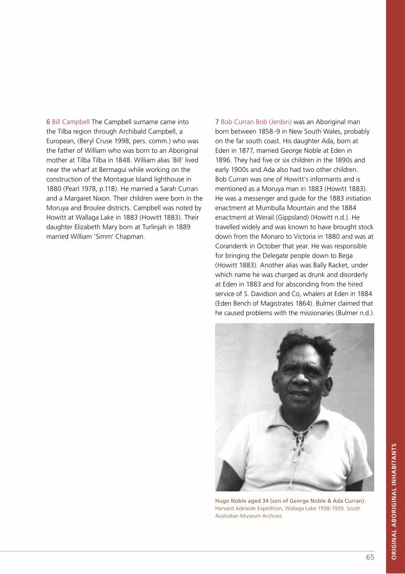
64 65 OR
IGIN
AL
AB
OR
IGIN
AL
INH
AB
ITA
NT
S
6 Bill Campbell The Campbell surname came into the Tilba region through Archibald Campbell, a European, (Beryl Cruse 1998, pers. comm.) who was the father of William who was born to an Aboriginal mother at Tilba Tilba in 1848. William alias `Bill' lived near the wharf at Bermagui while working on the construction of the Montague Island lighthouse in 1880 (Pearl 1978, p.118). He married a Sarah Curran and a Margaret Nixon. Their children were born in the Moruya and Broulee districts. Campbell was noted by Howitt at Wallaga Lake in 1883 (Howitt 1883). Their daughter Elizabeth Mary born at Turlinjah in 1889 married William 'Simm' Chapman.
7 Bob Curran Bob (Jenbin) was an Aboriginal man born between 1858-9 in New South Wales, probably on the far south coast. His daughter Ada, born at Eden in 1877, married George Noble at Eden in 1896. They had five or six children in the 1890s and early 1900s and Ada also had two other children. Bob Curran was one of Howitt's informants and is mentioned as a Moruya man in 1883 (Howitt 1883). He was a messenger and guide for the 1883 initiation enactment at Mumbulla Mountain and the 1884 enactment at Werail (Gippsland) (Howitt n.d.). He travelled widely and was known to have brought stock down from the Monaro to Victoria in 1880 and was at Coranderrk in October that year. He was responsible for bringing the Delegate people down to Bega (Howitt 1883). Another alias was Bally Racket, under which name he was charged as drunk and disorderly at Eden in 1883 and for absconding from the hired service of S. Davidson and Co, whalers at Eden in 1884 (Eden Bench of Magistrates 1864). Bulmer claimed that he caused problems with the missionaries (Bulmer n.d.).
Hugo Noble aged 34 (son of George Noble & Ada Curran). Harvard Adelaide Expedition, Wallaga Lake 1938-1939. South Australian Museum Archives
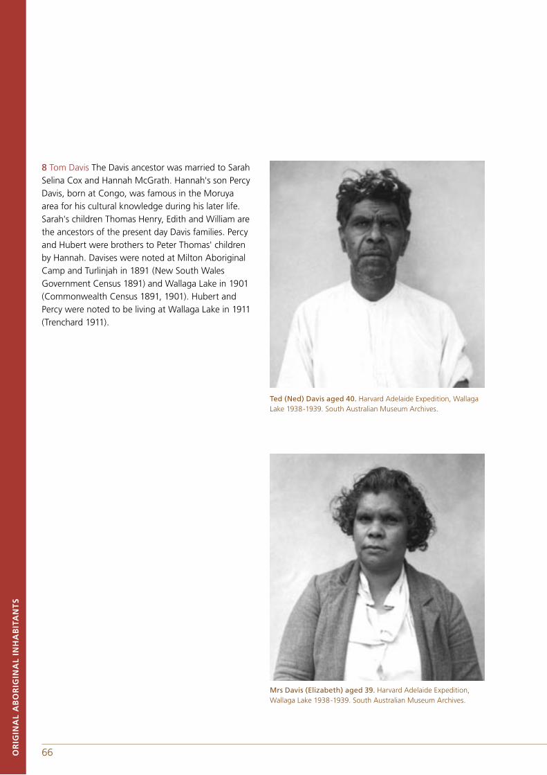
66 67OR
IGIN
AL
AB
OR
IGIN
AL
INH
AB
ITA
NT
S
8 Tom Davis The Davis ancestor was married to Sarah Selina Cox and Hannah McGrath. Hannah's son Percy Davis, born at Congo, was famous in the Moruya area for his cultural knowledge during his later life. Sarah's children Thomas Henry, Edith and William are the ancestors of the present day Davis families. Percy and Hubert were brothers to Peter Thomas' children by Hannah. Davises were noted at Milton Aboriginal Camp and Turlinjah in 1891 (New South Wales Government Census 1891) and Wallaga Lake in 1901 (Commonwealth Census 1891, 1901). Hubert and Percy were noted to be living at Wallaga Lake in 1911 (Trenchard 1911).
Ted (Ned) Davis aged 40. Harvard Adelaide Expedition, Wallaga Lake 1938-1939. South Australian Museum Archives.
Mrs Davis (Elizabeth) aged 39. Harvard Adelaide Expedition, Wallaga Lake 1938-1939. South Australian Museum Archives.
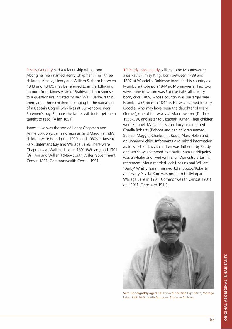
66 67 OR
IGIN
AL
AB
OR
IGIN
AL
INH
AB
ITA
NT
S
9 Sally Gundary had a relationship with a non-Aboriginal man named Henry Chapman. Their three children, Amelia, Henry and William S. (born between 1843 and 1847), may be referred to in the following account from James Allan of Braidwood in response to a questionaire initiated by Rev. W.B. Clarke, 'I think there are... three children belonging to the dairyman of a Captain Coghill who lives at Buckenbore, near Batemen's bay. Perhaps the father will try to get them taught to read' (Allan 1851).
James Luke was the son of Henry Chapman and Annie Bolloway. James Chapman and Maud Penrith's children were born in the 1920s and 1930s in Roseby Park, Batemans Bay and Wallaga Lake. There were Chapmans at Wallaga Lake in 1891 (William) and 1901 (Bill, Jim and William) (New South Wales Government Census 1891; Commonwealth Census 1901)
10 Paddy Haddigaddy is likely to be Monnowerrer, alias Patrick Imlay King, born between 1789 and 1807 at Wandella. Robinson identifies his country as Mumbulla (Robinson 1844a). Monnowerrer had two wives, one of whom was Put.tike.bale, alias Mary born, circa 1809, whose country was Burrergal near Mumbulla (Robinson 1844a). He was married to Lucy Goodie, who may have been the daughter of Mary (Turner), one of the wives of Monnowerrer (Tindale 1938-39), and sister to Elizabeth Turner. Their children were Samuel, Maria and Sarah. Lucy also married Charlie Roberts (Bobbo) and had children named; Sophie, Maggie, Charles jnr, Rosie, Alan, Helen and an unnamed child. Informants give mixed information as to which of Lucy's children was fathered by Paddy and which was fathered by Charlie. Sam Haddigaddy was a whaler and lived with Ellen Demestre after his retirement. Maria married Jack Hoskins and William 'Darky' Whitty. Sarah married John Bobbo/Roberts and Harry Picalla. Sam was noted to be living at Wallaga Lake in 1901 (Commonwealth Census 1901) and 1911 (Trenchard 1911).
Sam Haddigaddy aged 68. Harvard Adelaide Expedition, Wallaga Lake 1938-1939. South Australian Museum Archives.
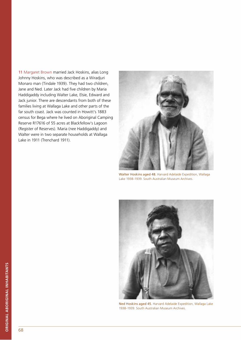
68 69OR
IGIN
AL
AB
OR
IGIN
AL
INH
AB
ITA
NT
S
11 Margaret Brown married Jack Hoskins, alias Long Johnny Hoskins, who was described as a Wiradjuri Monaro man (Tindale 1939). They had two children, Jane and Ned. Later Jack had five children by Maria Haddigaddy including Walter Lake, Elsie, Edward and Jack junior. There are descendants from both of these families living at Wallaga Lake and other parts of the far south coast. Jack was counted in Howitt's 1883 census for Bega where he lived on Aboriginal Camping Reserve R17616 of 55 acres at Blackfellow's Lagoon (Register of Reserves). Maria (nee Haddigaddy) and Walter were in two separate households at Wallaga Lake in 1911 (Trenchard 1911).
Walter Hoskins aged 48. Harvard Adelaide Expedition, Wallaga Lake 1938-1939. South Australian Museum Archives.
Ned Hoskins aged 45. Harvard Adelaide Expedition, Wallaga Lake 1938-1939. South Australian Museum Archives.
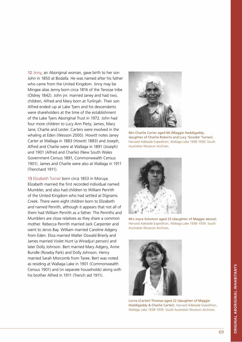
68 69
12 Jinny, an Aboriginal woman, gave birth to her son John in 1850 at Bodalla. He was named after his father who came from the United Kingdom. Jinny may be Mingee alias Jenny born circa 1816 of the Terosse tribe (Oldrey 1842). John jnr. married Janey and had two, children, Alfred and Mary born at Turlinjah. Their son Alfred ended-up at Lake Tyers and his descendants were shareholders at the time of the establishment of the Lake Tyers Aboriginal Trust in 1972. John had four more children to Lucy Ann Piety; James, Mary Jane, Charlie and Lester. Carters were involved in the whaling at Eden (Wesson 2000). Howitt notes Janey Carter at Wallaga in 1883 (Howitt 1883) and Joseph, Alfred and Charlie were at Wallaga in 1891 (Joseph) and 1901 (Alfred and Charlie) (New South Wales Government Census 1891, Commonwealth Census 1901). James and Charlie were also at Wallaga in 1911 (Trenchard 1911).
13 Elizabeth Turner born circa 1853 in Moruya. Elizabeth married the first recorded individual named Mumbler, and also had children to William Penrith of the United Kingdom who had settled at Dignams Creek. There were eight children born to Elizabeth and named Penrith, although it appears that not all of them had William Penrith as a father. The Penriths and Mumblers are close relatives as they share a common mother. Rebecca Penrith married Jack Carpenter and went to Jervis Bay. William married Caroline Adgery from Eden. Eliza married Walter Oswald Brierly and James married Violet Hunt (a Wiradjuri person) and later Dolly Johnson. Bert married Mary Adgery, Anne Bundle (Roseby Park) and Dolly Johnson. Henry married Sarah Morcomb from Taree. Bert was noted as residing at Wallaga Lake in 1901 (Commonwealth Census 1901) and (in separate households) along with his brother Alfred in 1911 (Trench aid 1911).
Mrs Charlie Carter aged 66 (Maggie Haddigaddy,daughter of Charlie Roberts and Lucy 'Goodie' Turner). Harvard Adelaide Expedition, Wallaga Lake 1938-1939. South Australian Museum Archives.
Mrs Joyce Solomon aged 23 (daughter of Maggie above). Harvard Adelaide Expedition, Wallaga Lake 1938–1939. South Australian Museum Archives.
Lorna (Carter) Thomas aged 22 (daughter of Maggie Haddigaddy & Charlie Carter). Harvard Adelaide Expedition, Wallaga Lake 1938-1939. South Australian Museum Archives.
OR
IGIN
AL
AB
OR
IGIN
AL
INH
AB
ITA
NT
S
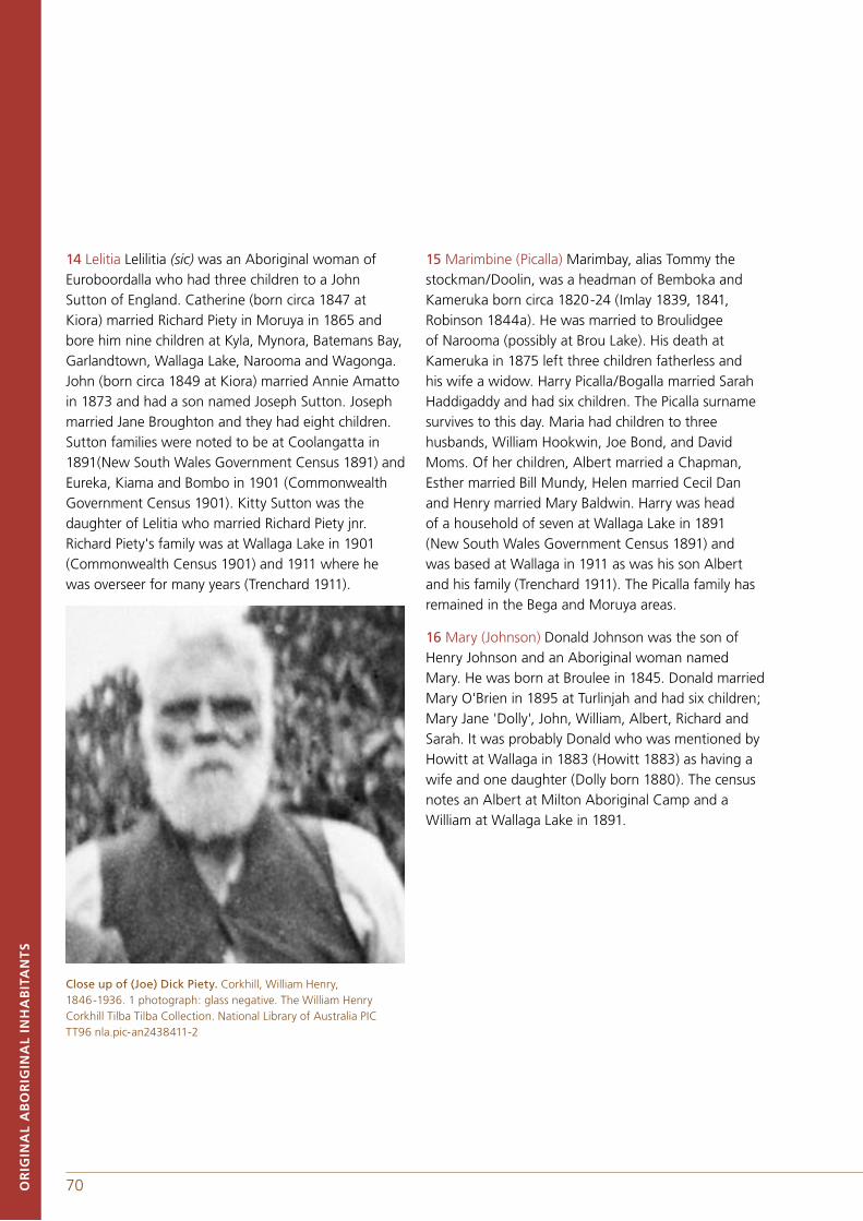
70 71OR
IGIN
AL
AB
OR
IGIN
AL
INH
AB
ITA
NT
S
14 Lelitia Lelilitia (sic) was an Aboriginal woman of Euroboordalla who had three children to a John Sutton of England. Catherine (born circa 1847 at Kiora) married Richard Piety in Moruya in 1865 and bore him nine children at Kyla, Mynora, Batemans Bay, Garlandtown, Wallaga Lake, Narooma and Wagonga. John (born circa 1849 at Kiora) married Annie Amatto in 1873 and had a son named Joseph Sutton. Joseph married Jane Broughton and they had eight children. Sutton families were noted to be at Coolangatta in 1891(New South Wales Government Census 1891) and Eureka, Kiama and Bombo in 1901 (Commonwealth Government Census 1901). Kitty Sutton was the daughter of Lelitia who married Richard Piety jnr. Richard Piety's family was at Wallaga Lake in 1901 (Commonwealth Census 1901) and 1911 where hewas overseer for many years (Trenchard 1911).
Close up of (Joe) Dick Piety. Corkhill, William Henry, 1846-1936. 1 photograph: glass negative. The William Henry Corkhill Tilba Tilba Collection. National Library of Australia PIC TT96 nla.pic-an2438411-2
15 Marimbine (Picalla) Marimbay, alias Tommy the stockman/Doolin, was a headman of Bemboka and Kameruka born circa 1820-24 (Imlay 1839, 1841, Robinson 1844a). He was married to Broulidgee of Narooma (possibly at Brou Lake). His death at Kameruka in 1875 left three children fatherless and his wife a widow. Harry Picalla/Bogalla married Sarah Haddigaddy and had six children. The Picalla surname survives to this day. Maria had children to three husbands, William Hookwin, Joe Bond, and David Moms. Of her children, Albert married a Chapman, Esther married Bill Mundy, Helen married Cecil Dan and Henry married Mary Baldwin. Harry was head of a household of seven at Wallaga Lake in 1891 (New South Wales Government Census 1891) and was based at Wallaga in 1911 as was his son Albert and his family (Trenchard 1911). The Picalla family has remained in the Bega and Moruya areas.
16 Mary (Johnson) Donald Johnson was the son of Henry Johnson and an Aboriginal woman named Mary. He was born at Broulee in 1845. Donald married Mary O'Brien in 1895 at Turlinjah and had six children; Mary Jane 'Dolly', John, William, Albert, Richard and Sarah. It was probably Donald who was mentioned by Howitt at Wallaga in 1883 (Howitt 1883) as having a wife and one daughter (Dolly born 1880). The census notes an Albert at Milton Aboriginal Camp and a William at Wallaga Lake in 1891.
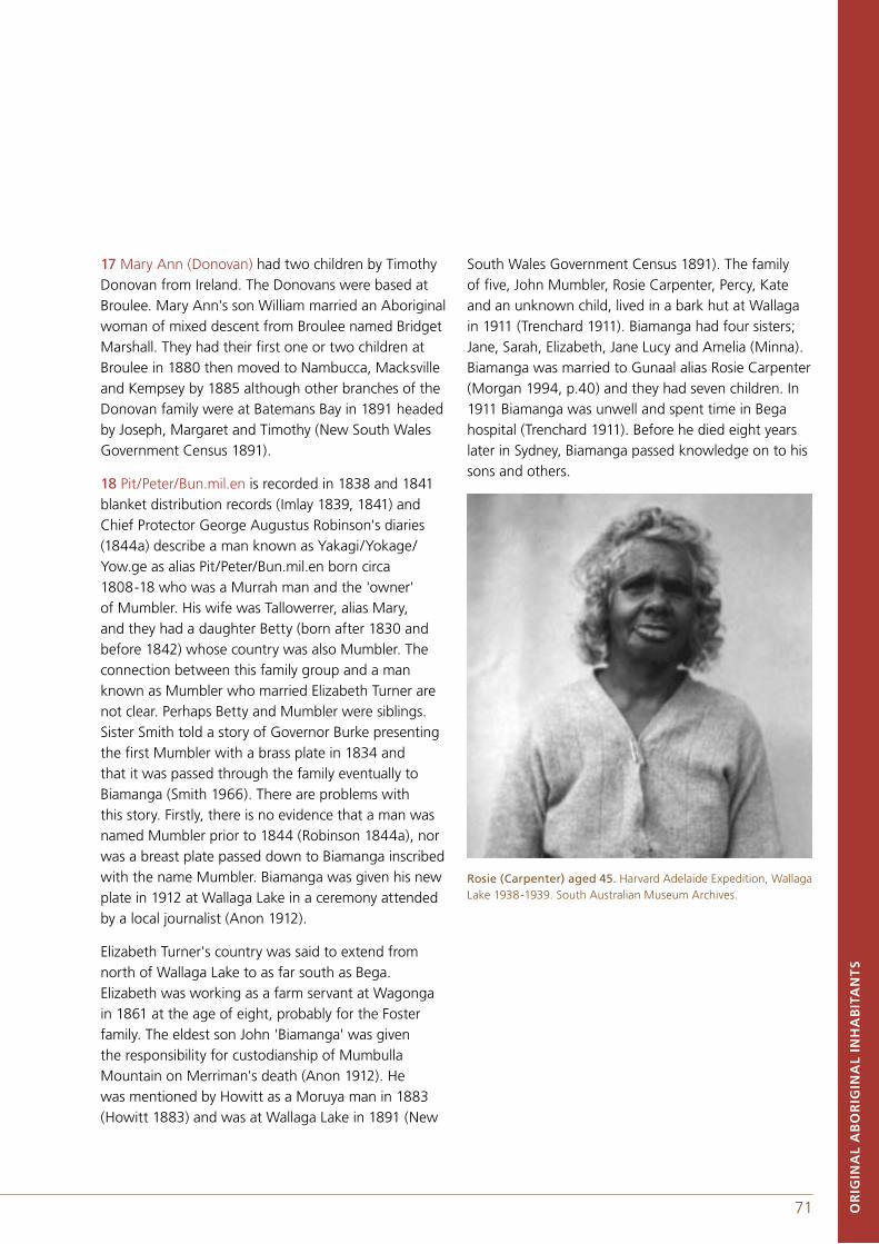
70 71
17 Mary Ann (Donovan) had two children by Timothy Donovan from Ireland. The Donovans were based at Broulee. Mary Ann's son William married an Aboriginal woman of mixed descent from Broulee named Bridget Marshall. They had their first one or two children at Broulee in 1880 then moved to Nambucca, Macksville and Kempsey by 1885 although other branches of the Donovan family were at Batemans Bay in 1891 headed by Joseph, Margaret and Timothy (New South Wales Government Census 1891).
18 Pit/Peter/Bun.mil.en is recorded in 1838 and 1841 blanket distribution records (Imlay 1839, 1841) and Chief Protector George Augustus Robinson's diaries (1844a) describe a man known as Yakagi/Yokage/Yow.ge as alias Pit/Peter/Bun.mil.en born circa 1808-18 who was a Murrah man and the 'owner' of Mumbler. His wife was Tallowerrer, alias Mary, and they had a daughter Betty (born after 1830 and before 1842) whose country was also Mumbler. The connection between this family group and a man known as Mumbler who married Elizabeth Turner are not clear. Perhaps Betty and Mumbler were siblings. Sister Smith told a story of Governor Burke presenting the first Mumbler with a brass plate in 1834 and that it was passed through the family eventually to Biamanga (Smith 1966). There are problems with this story. Firstly, there is no evidence that a man was named Mumbler prior to 1844 (Robinson 1844a), nor was a breast plate passed down to Biamanga inscribed with the name Mumbler. Biamanga was given his new plate in 1912 at Wallaga Lake in a ceremony attended by a local journalist (Anon 1912).
Elizabeth Turner's country was said to extend from north of Wallaga Lake to as far south as Bega. Elizabeth was working as a farm servant at Wagonga in 1861 at the age of eight, probably for the Foster family. The eldest son John 'Biamanga' was given the responsibility for custodianship of Mumbulla Mountain on Merriman's death (Anon 1912). He was mentioned by Howitt as a Moruya man in 1883 (Howitt 1883) and was at Wallaga Lake in 1891 (New
South Wales Government Census 1891). The family of five, John Mumbler, Rosie Carpenter, Percy, Kate and an unknown child, lived in a bark hut at Wallaga in 1911 (Trenchard 1911). Biamanga had four sisters; Jane, Sarah, Elizabeth, Jane Lucy and Amelia (Minna). Biamanga was married to Gunaal alias Rosie Carpenter (Morgan 1994, p.40) and they had seven children. In 1911 Biamanga was unwell and spent time in Bega hospital (Trenchard 1911). Before he died eight years later in Sydney, Biamanga passed knowledge on to his sons and others.
Rosie (Carpenter) aged 45. Harvard Adelaide Expedition, Wallaga Lake 1938-1939. South Australian Museum Archives.
OR
IGIN
AL
AB
OR
IGIN
AL
INH
AB
ITA
NT
S
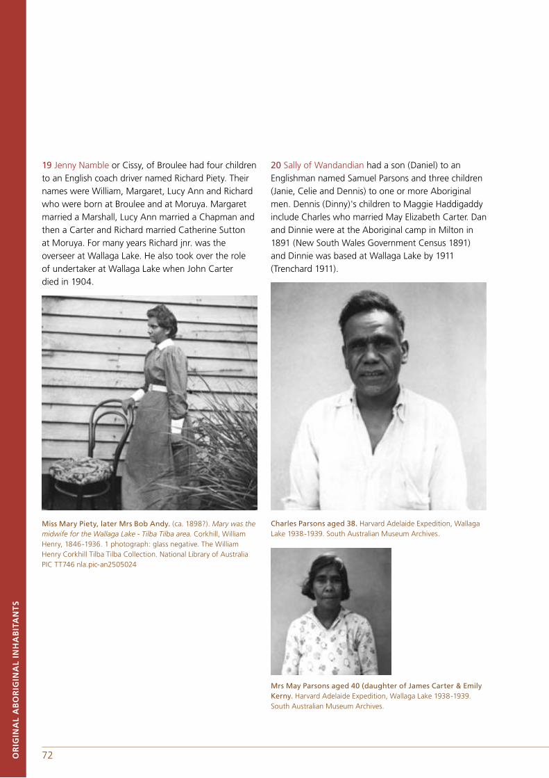
72 73OR
IGIN
AL
AB
OR
IGIN
AL
INH
AB
ITA
NT
S
19 Jenny Namble or Cissy, of Broulee had four children to an English coach driver named Richard Piety. Their names were William, Margaret, Lucy Ann and Richard who were born at Broulee and at Moruya. Margaret married a Marshall, Lucy Ann married a Chapman and then a Carter and Richard married Catherine Sutton at Moruya. For many years Richard jnr. was the overseer at Wallaga Lake. He also took over the role of undertaker at Wallaga Lake when John Carter died in 1904.
Miss Mary Piety, later Mrs Bob Andy. (ca. 1898?). Mary was the midwife for the Wallaga Lake - Tilba Tilba area. Corkhill, William Henry, 1846-1936. 1 photograph: glass negative. The William Henry Corkhill Tilba Tilba Collection. National Library of Australia PIC TT746 nla.pic-an2505024
20 Sally of Wandandian had a son (Daniel) to an Englishman named Samuel Parsons and three children (Janie, Celie and Dennis) to one or more Aboriginal men. Dennis (Dinny)'s children to Maggie Haddigaddy include Charles who married May Elizabeth Carter. Dan and Dinnie were at the Aboriginal camp in Milton in 1891 (New South Wales Government Census 1891) and Dinnie was based at Wallaga Lake by 1911 (Trenchard 1911).
Charles Parsons aged 38. Harvard Adelaide Expedition, Wallaga Lake 1938-1939. South Australian Museum Archives.
Mrs May Parsons aged 40 (daughter of James Carter & Emily Kerny. Harvard Adelaide Expedition, Wallaga Lake 1938-1939. South Australian Museum Archives.
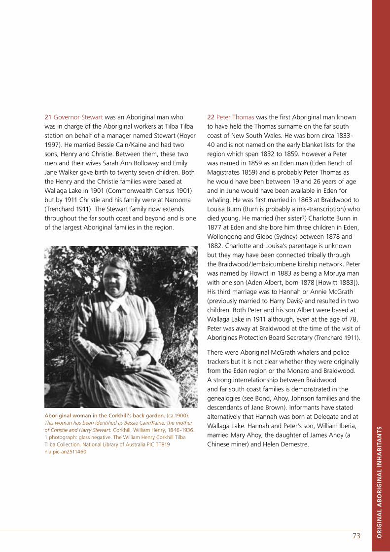
72 73 OR
IGIN
AL
AB
OR
IGIN
AL
INH
AB
ITA
NT
S
21 Governor Stewart was an Aboriginal man who was in charge of the Aboriginal workers at Tilba Tilba station on behalf of a manager named Stewart (Hoyer 1997). He married Bessie Cain/Kaine and had two sons, Henry and Christie. Between them, these two men and their wives Sarah Ann Bolloway and Emily Jane Walker gave birth to twenty seven children. Both the Henry and the Christie families were based at Wallaga Lake in 1901 (Commonwealth Census 1901) but by 1911 Christie and his family were at Narooma (Trenchard 1911). The Stewart family now extends throughout the far south coast and beyond and is one of the largest Aboriginal families in the region.
Aboriginal woman in the Corkhill's back garden. (ca.1900).This woman has been identified as Bessie Cain/Kaine, the mother of Christie and Harry Stewart. Corkhill, William Henry, 1846-1936. 1 photograph: glass negative. The William Henry Corkhill Tilba Tilba Collection. National Library of Australia PIC TT819 nla.pic-an2511460
22 Peter Thomas was the first Aboriginal man known to have held the Thomas surname on the far south coast of New South Wales. He was born circa 1833-40 and is not named on the early blanket lists for the region which span 1832 to 1859. However a Peter was named in 1859 as an Eden man (Eden Bench of Magistrates 1859) and is probably Peter Thomas as he would have been between 19 and 26 years of age and in June would have been available in Eden for whaling. He was first married in 1863 at Braidwood to Louisa Bunn (Burn is probably a mis-transcription) who died young. He married (her sister?) Charlotte Bunn in 1877 at Eden and she bore him three children in Eden, Wollongong and Glebe (Sydney) between 1878 and 1882. Charlotte and Louisa's parentage is unknown but they may have been connected tribally through the Braidwood/Jembaicumbene kinship network. Peter was named by Howitt in 1883 as being a Moruya man with one son (Aden Albert, born 1878 [Howitt 1883]). His third marriage was to Hannah or Annie McGrath (previously married to Harry Davis) and resulted in two children. Both Peter and his son Albert were based at Wallaga Lake in 1911 although, even at the age of 78, Peter was away at Braidwood at the time of the visit of Aborigines Protection Board Secretary (Trenchard 1911).
There were Aboriginal McGrath whalers and police trackers but it is not clear whether they were originally from the Eden region or the Monaro and Braidwood. A strong interrelationship between Braidwood and far south coast families is demonstrated in the genealogies (see Bond, Ahoy, Johnson families and the descendants of Jane Brown). Informants have stated alternatively that Hannah was born at Delegate and at Wallaga Lake. Hannah and Peter's son, William Iberia, married Mary Ahoy, the daughter of James Ahoy (a Chinese miner) and Helen Demestre.
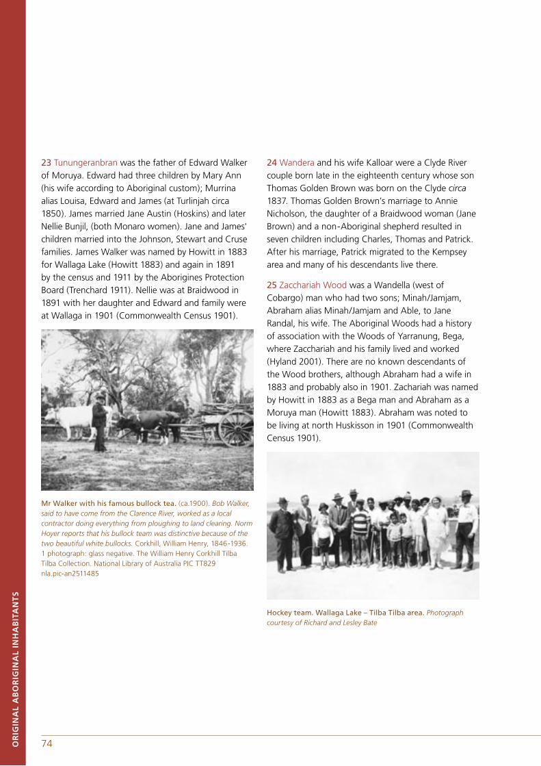
74 75OR
IGIN
AL
AB
OR
IGIN
AL
INH
AB
ITA
NT
S
23 Tunungeranbran was the father of Edward Walker of Moruya. Edward had three children by Mary Ann (his wife according to Aboriginal custom); Murrina alias Louisa, Edward and James (at Turlinjah circa 1850). James married Jane Austin (Hoskins) and later Nellie Bunjil, (both Monaro women). Jane and James' children married into the Johnson, Stewart and Cruse families. James Walker was named by Howitt in 1883 for Wallaga Lake (Howitt 1883) and again in 1891 by the census and 1911 by the Aborigines Protection Board (Trenchard 1911). Nellie was at Braidwood in 1891 with her daughter and Edward and family were at Wallaga in 1901 (Commonwealth Census 1901).
Mr Walker with his famous bullock tea. (ca.1900). Bob Walker, said to have come from the Clarence River, worked as a local contractor doing everything from ploughing to land clearing. Norm Hoyer reports that his bullock team was distinctive because of the two beautiful white bullocks. Corkhill, William Henry, 1846-1936. 1 photograph: glass negative. The William Henry Corkhill Tilba Tilba Collection. National Library of Australia PIC TT829 nla.pic-an2511485
24 Wandera and his wife Kalloar were a Clyde River couple born late in the eighteenth century whose son Thomas Golden Brown was born on the Clyde circa 1837. Thomas Golden Brown’s marriage to Annie Nicholson, the daughter of a Braidwood woman (Jane Brown) and a non-Aboriginal shepherd resulted in seven children including Charles, Thomas and Patrick. After his marriage, Patrick migrated to the Kempsey area and many of his descendants live there.
25 Zacchariah Wood was a Wandella (west of Cobargo) man who had two sons; Minah/Jamjam, Abraham alias Minah/Jamjam and Able, to Jane Randal, his wife. The Aboriginal Woods had a history of association with the Woods of Yarranung, Bega, where Zacchariah and his family lived and worked (Hyland 2001). There are no known descendants of the Wood brothers, although Abraham had a wife in 1883 and probably also in 1901. Zachariah was named by Howitt in 1883 as a Bega man and Abraham as a Moruya man (Howitt 1883). Abraham was noted to be living at north Huskisson in 1901 (Commonwealth Census 1901).
Hockey team. Wallaga Lake – Tilba Tilba area. Photograph courtesy of Richard and Lesley Bate
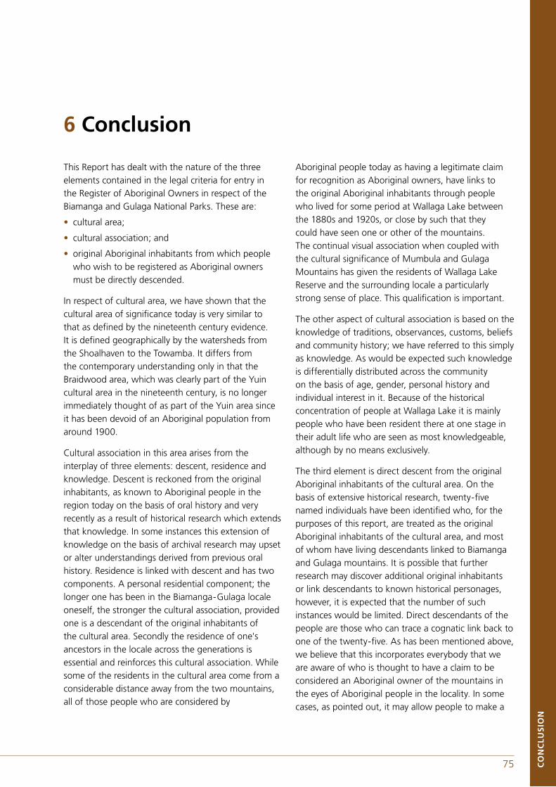
74 75 CO
NC
LUS
ION
This Report has dealt with the nature of the three elements contained in the legal criteria for entry in the Register of Aboriginal Owners in respect of the Biamanga and Gulaga National Parks. These are:
• cultural area;
• cultural association; and
• original Aboriginal inhabitants from which people who wish to be registered as Aboriginal owners must be directly descended.
In respect of cultural area, we have shown that the cultural area of significance today is very similar to that as defined by the nineteenth century evidence. It is defined geographically by the watersheds from the Shoalhaven to the Towamba. It differs from the contemporary understanding only in that the Braidwood area, which was clearly part of the Yuin cultural area in the nineteenth century, is no longer immediately thought of as part of the Yuin area since it has been devoid of an Aboriginal population from around 1900.
Cultural association in this area arises from the interplay of three elements: descent, residence and knowledge. Descent is reckoned from the original inhabitants, as known to Aboriginal people in the region today on the basis of oral history and very recently as a result of historical research which extends that knowledge. In some instances this extension of knowledge on the basis of archival research may upset or alter understandings derived from previous oral history. Residence is linked with descent and has two components. A personal residential component; the longer one has been in the Biamanga-Gulaga locale oneself, the stronger the cultural association, provided one is a descendant of the original inhabitants of the cultural area. Secondly the residence of one's ancestors in the locale across the generations is essential and reinforces this cultural association. While some of the residents in the cultural area come from a considerable distance away from the two mountains, all of those people who are considered by
Aboriginal people today as having a legitimate claim for recognition as Aboriginal owners, have links to the original Aboriginal inhabitants through people who lived for some period at Wallaga Lake between the 1880s and 1920s, or close by such that they could have seen one or other of the mountains. The continual visual association when coupled with the cultural significance of Mumbula and Gulaga Mountains has given the residents of Wallaga Lake Reserve and the surrounding locale a particularly strong sense of place. This qualification is important.
The other aspect of cultural association is based on the knowledge of traditions, observances, customs, beliefs and community history; we have referred to this simply as knowledge. As would be expected such knowledge is differentially distributed across the community on the basis of age, gender, personal history and individual interest in it. Because of the historical concentration of people at Wallaga Lake it is mainly people who have been resident there at one stage in their adult life who are seen as most knowledgeable, although by no means exclusively.
The third element is direct descent from the original Aboriginal inhabitants of the cultural area. On the basis of extensive historical research, twenty-five named individuals have been identified who, for the purposes of this report, are treated as the original Aboriginal inhabitants of the cultural area, and most of whom have living descendants linked to Biamanga and Gulaga mountains. It is possible that further research may discover additional original inhabitants or link descendants to known historical personages, however, it is expected that the number of such instances would be limited. Direct descendants of the people are those who can trace a cognatic link back to one of the twenty-five. As has been mentioned above, we believe that this incorporates everybody that we are aware of who is thought to have a claim to be considered an Aboriginal owner of the mountains in the eyes of Aboriginal people in the locality. In some cases, as pointed out, it may allow people to make a
6 Conclusion
76 77CO
NC
LUS
ION
technical claim to descent from the original Aboriginal inhabitants through a chain of connection which is not one that they have either emphasised and/or have known about previously.
Thus in respect of assistance to the Registrar in deciding who should be placed on the register we believe that the clear definition of the cultural area, and the specified list of original Aboriginal inhabitants when coupled with a demonstrated cultural association through residence of the applicant or their ancestors in the locale of Biamanga or Gulaga, should for the purposes of the Act be the criteria for accepting people. The approach adopted here is broad and inclusive so that a large number of people are eligible to register if these guidelines are accepted.
The other aspects of cultural association become, in our view, significant when it comes to the selection of Aboriginal owners for appointment to the Board of Management. We are fully aware that this is not the concern of the Registrar but we nevertheless feel that it would be remiss not to briefly comment on this since a key purpose of the register is to provide a list of people from whom a portion of the Board is chosen.
If there were complete agreement among the Aboriginal people of the region today as to who could be entered on the register of Aboriginal owners for the purposes of the Act, there would be limited significance for this report. That there is not such agreement is entirely predictable. It is due to a number of factors including: the criteria in the Act not having been drawn directly from Aboriginal understandings; the consequences of historical processes that have led to the accentuating of some links and the masking of others; and, to the nature of social process more generally. Social identity and notions of belonging are complex at all times and in all places, they are contextually dependant, often emergent and frequently contested, across the continent. How they are understood and interpreted at any particular time will be influenced by material and other interests that are fluctuating and complex. It is essential, in our
view, that in moving to the selection of the Board of Management that all the various interests in the two mountains, including gendered interests, are recognised and represented in both their varying degrees of strength of knowledge and regional dispersal.
Some of the people with the very strongest cultural associations may not wish to be involved in the Board of Management. Those that seek these positions may well be qualified in terms of the Act but motivated mainly by considerations that relate to matters within the Aboriginal community. It is vital that an effective consultative process is developed for the selection of the Board of Management if it is not to be a source of contention.
76 77 AP
PE
ND
IXE
S
A A.W. Howitt and the Native Tribes of South-East Australia B Norman Tindale: Mapping of Aboriginal 'Tribes' and his research at Wallaga LakeC Register of the National EstateD Land Rights, Aboriginal Owners and Joint Management E Research Project ScheduleF About the authors
Appendixes
78 79
APPENDIX AA. W. HOWITT AND THE NATIVE TRIBES OF SOUTH-EAST AUSTRALIAHowitt commenced anthropological investigations with Lorimer Fison in 1873, focusing upon 'classificatory systems'. Howitt's first publication was a joint authorship with Fison in 1880, titled 'From Mother-right to Father-right'. The majority of his research was undertaken and published in the period 1870-80, with his compendium volume The Native Tribes of South-East Australia being published in 1904. It is in that volume and unpublished notes and papers, comprising hundreds if not thousands of pages held by the Latrobe Library, Melbourne, and the Australian Institute of Aboriginal and Torres Strait Islander Studies, Canberra, that Howitt recorded his information on the tribes of south-east Australia.
In the introduction of The Native Tribes of South-East Australia, Howitt lists fifteen articles published between 1880 and 1901. This is a considerable number given that he did not make his livelihood as an academic but as a police magistrate in Victoria, as well as holding various public service positions and being a member of the Commission to select the site for the Federal capital (Mulvaney 1970, p.205).
THE NATIVE TRIBES OF SOUTH-EAST AUSTRALIAThe narrative of The Native Tribes of South-East Australia is divided into discussions of the various institutions that in Howitt's mind characterized and either differentiated or linked Aboriginal groups. His book commences with an overview of the origins of the 'Aborigines of Tasmania and Australia', followed by chapters which discuss 'tribal organization', 'social organization', 'relationship terms', 'marriage rules' and so forth for all of the 'tribes' known to Howitt and his correspondents. However, Howitt was in his 73rd year by the time the book was published and in John Mulvaney's (1970, p.216) words 'his anthropological field research virtually ended by 1886'. In order to distil the information relating to the Aboriginal communities of south-eastern New South Wales, in particular references to the Yuin, it is necessary to extract the pertinent information from each chapter of Native Tribes of South-East Australia.
Howitt (1904, pp.41-43) used the term tribe as meaning 'a number of people who occupy a definite tract of country, who recognise a common relationship and have a common language, or dialects of the same.' Howitt uses the term 'clan' to refer to a subdivision of a tribe with male descent and 'horde' to refer to those with female descent. The Murring of the south coast of New South Wales are referred to as a tribe synonymous with the term Yuin.
Howitt commences The Native Tribes of South-east Australia (1904, p. x, xi, xii) with a list of correspondents and the tribes described by them. He does not list correspondents for the Yuin or Murring or Wolgal, implying that he gained his information directly from Aboriginal informants.
The 'social organisation' is described by Howitt as follows:
Daramulun of the Coast Murring is referred to as a supernatural being (Howitt 1904, p.89).
The Yuin is another instance of a tribe in which the class system is in a decadent condition. There are no class names, or even traces of them, but very numerous totems scattered over the country, as is the case in the tribes with descent in the female line. But in this case the totem names are inherited from the father, and not from the mother. The totem name was called Budjan, and it was said to be more like Jola, or magic, than a name; and it was in one sense a secret name, for with it an enemy might cause injury to the bearer by magic. Thus very few
AP
PE
ND
IXE
S
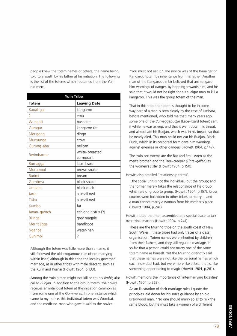
78 79
people knew the totem names of others, the name being told to a youth by his father at his initiation. The following is the list of the totems which I obtained from the Yuin old men:
Although the totem was little more than a name, it still followed the old exogamous rule of not marrying within itself, although in this tribe the locality governed marriage, as in other tribes with male descent, such as the Kulin and Kurnai (Howitt 1904, p.133).
Among the Yuin a man might not kill or eat his Jimbir, also called Budjan. In addition to the group totem, the novice receives an individual totem at the initiation ceremonies from some one of the Gommeras. In one instance which came to my notice, this individual totem was Wombat, and the medicine-man who gave it said to the novice,
"You must not eat it." The novice was of the Kaualgar or Kangaroo totem by inheritance from his father. Another man of the Kangaroo Jimbir believed that animal gave him warnings of danger, by hopping towards him, and he said that it would not be right for a Kaualgar man to kill a kangaroo. This was the group totem of the man.
That in this tribe the totem is thought to be in some way part of a man is seen clearly by the case of Umbara, before mentioned, who told me that, many years ago, some one of the Burnaggabudjin (Lace-lizard totem) sent it while he was asleep, and that it went down his throat, and almost ate his Budjan, which was in his breast, so that he nearly died. This man could not eat his Budjan, Black Duck, which in its corporeal form gave him warnings against enemies or other dangers (Howitt 1904, p.147).
The Yuin sex totems are the Bat and Emu-wren as the men's brother, and the Tree-creeper (Tinte-gallan) as the women's sister (Howitt 1904, p.150).
Howitt also detailed "relationship terms".
...the social unit is not the individual, but the group; and the former merely takes the relationships of his group, which are of group to group. (Howitt 1904, p.157). Cross cousins were forbidden in other tribes to marry ... and a man cannot marry a woman from his mother's place. (Howitt 1904, p.241)
Howitt noted that men assembled at a special place to talk over tribal matters (Howitt 1904, p.241).
These are the Murring tribe on the south coast of New South Wales... these tribes had only traces of a class organisation. Totem names were inherited by children from their fathers, and they still regulate marriage, in so far that a person could not marry one of the same totem name as himself. Yet the Murring distinctly said that these names were not like the personal names which each individual had, but were more like a Joia, that is, like something appertaining to magic (Howitt 1904, p.261).
Howitt mentions the importance of 'intermarrying localities' (Howitt 1904, p.262).
As an illustration of their marriage rules I quote the principles laid down for his son's guidance by an old Braidwood man. "No one should marry so as to mix the same blood, but he must take a woman of a different
AP
PE
ND
IXE
S
Yuin Tribe
Totem Leaving Date
Kaual-gar kangaroo
? emu
Wungalli bush-rat
Guragur kangaroo rat
Merigong dingo
Munyunga crow
Gurung-aba pelican
Berimbarminwhite-breasted
cormorant
Burnagga lace-lizard
Murumbul brown snake
Burimi bream
Gumbera black snake
Umbara black duck
Jarut a small owl
Tiska a small owl
Kumbo fat
Janan-gabtch echidna histrix (?)
Bilinga grey magpie
Merrit jigga bandicoot
Ngariba water-hen
Gunimbil ?
80 81AP
PE
ND
IXE
S
name (Mura, totem) than his own; and besides this, he must go for a wife to a place as far as possible away from his own place." This man, being of Braidwood, went to Moruya, and he had to give a sister to the brother of his wife. The old men, when at the initiation ceremonies, told me that the rule was that the "waddymen," that is, those who get their living by climbing trees for game, must go down to the sea-coast and obtain wives from the people who get their living by fishing. Thus these people, by their reciprocating local divisions, and the rules relating to them, supply each other with wives. The limits of the district within which wives were thus obtained by exchange of sisters is indicated by the round which the boy's tooth which is knocked out at the initiation ceremonies, is carried, the tooth being passed on from one Headman to another. In old times the limits were - Bem Lake, Delegate, Tumut, Braidwood, and so on to Shoalhaven, and thence following the coast to Bem lake. This Bem Lake, however, was within the country of the Krauatungaiung Kurnai, and its inclusion shows that intermarriage took place between the latter and the Yuin. That this was so is also shown by what I heard some of the Yuin say of the mother of one of them. When she was just marriageable, say about twelve or thirteen years of age, she was brought by the Krauatun-Kurnai to Twofold Bay as a wife for one of the Yuin of that place. She ran away from that place with the father of the man first mentioned, and they escaped by getting on board of a whaler which was on the point of sailing. At that time it was customary for the Twofold Bay Yuin to go as harpooners, or, as they put it, to go "spearing whales." They men, in telling me of this occurrence were unanimous in saying that, in those times if a man disregarded the above rules as to marriage, he would be killed. (Howitt 1904, pp.262-263).
I have heard it said by the Yuin that the child belongs to the father, because his wife merely takes care of his children for him, and that therefore he can do what he likes with his daughter. Marriages were solely arranged by the father, promising his daughter as an infant or in a manner of what the following will serve as a good instance. At the termination of the initiation ceremonies, at which the whole intermarrying community was present, a meeting was held near the camp at which things were bartered. At this assemblage of the initiated
men, amongst other things, marriages were discussed. A man whose son had been admitted to the status of manhood, and who would be in due time permitted to take a wife, would announce that he wanted a wife for his son. As every one knew the relationship of the man and his son towards others, and as the matter had almost certainly been discussed in the camp by those interested, some other man would say, "I will give my daughter." This also implied that the father of the boy would on his part give a daughter, own or tribal, to the brother, own or tribal, of the girl. The two thus being promised to each other, the girl is looked upon as the future wife of the boy; and when he has completed his period of probation after initiation, the marriage may be permitted. The Gommera (medicine-man, Headman) and the boy's father having consented, the latter would say to his son, "Here is your sister; take her, and go and get your wife." Thus the actual exchange of sisters is made by two young men. Occasionally the girl rebelled, and having a fondness for some other man, eloped with him. If they could escape and remain away until a child was born, nothing would be done to them, especially if the man could find a sister to exchange for her. These cases are said to have been common among the Yuin, but not so frequent as marriage by the exchange of sisters. On such an elopement a man would start well armed for fear of consequences.
The following occurrence was discussed by some of the Yuin old men in my presence. A Kangaroo man ran off with a Brown-snake girl who had been promised to another man. So soon as it was discovered, all the men there - Kangaroo, Brown-snake, and other totems - followed them. The runaways were caught, and the girl's father and brothers, and her mother's brother, fought with him, and the girl was beaten by her kindred. Subsequently her mother and sisters attacked her with their digging-sticks, against whom she defended herself as well as she could, until she was knocked down (Howitt 1904, pp.263-264):
… One of the old Murring, in speaking of these matters in the o1d days, said, "If a man were to run away with a woman who was one of his sisters, all the men would pursue him, and if he were caught, and did not give her up at once, all his own relatives would be against him. If he still refused to give her up, the Gommera of his place would probably say to his men, "This man has done very wrong, you must kill him," and if the offender were

80 81 AP
PE
ND
IXE
S
present, some one would probably drive a spear into him. His relatives would not interfere, lest they might have the same done to them.
Many of the old men among the Yuin, especially the principal Gommeras, had more than one wife, and there was one man who had ten, but not at the same time.
Men did not lend their wives to their brothers, but when a man's Kuben, that is his wife's brother, came on a visit, being unmarried, or had not brought his wife with him, his Kuben found him a temporary wife by borrowing one from a friend.
A widow went to her husband's brother if he had one. If not, her male kindred gave her to some man chosen by them.
The universal rule which forbade a man to hold any communications with his wife's mother was very strict in these tribes. He might not look at her, nor even in her direction. If his shadow happened to fall on her, he would have to leave his wife, who would return to her parents. A case happened at Jervis Bay which I heard of, where a man in a drunken state accidentally ran up against his mother-in-law, and the Gommera made him leave his wife. The law is one of those told to the novices at the initiation ceremonies, and strongly impressed on them (Howitt 1904, p.266).
I have shown in this chapter how universal the exchange of a sister for a wife is in Australian tribes, and each women is, so to speak, the "bride-price" of the other. (Howitt 1904, p.293).
Yuin tribal government was described as follows:
It is quite true that many such laws or customs are obeyed without the dread of physical punishment being inflicted for their breach, by any tribal authority, individual or collective. but such laws or customs are obeyed because the entire the native has been told, from his earliest childhood, that their infraction will be followed by some supernatural personal punishment. Take, for instance, the universal law of mutual avoidance of each other by the man and his wife's mother. I know of no rule which is more implicitly obeyed. The belief is that some result of a magical nature will follow a breach of this rule, for instance that the person's hair will become prematurely
grey. The nearest approach to a personal punishment for this offence, if it can be so called, which I have met with, was in the coast Murring tribes, where any personal contact, even accidental touching of one by the other, was punished by the man being compelled to leave the district, his wife returning to her parents (Howitt 1904, p.296).
Howitt observed that there were special rules applied to the uninitiated males.
... a novice must not receive food from the hand of a woman (Kurnai), or speak in the presence of one, without covering his mouth with the corner of his skin rug or blanket (Yuin) ... (Howitt 1904, p.297).
In speaking of the tribal councils, I have described at length the Headmen (Gommeras) of the Yuin. Similarly there were Headman, who combined the office with that of medicine-man, in the Ngarigo and Wolgal tribes (Howitt 1904, p.302).
I have shown that there are, and were, men recognized as having control over the tribes-people, and whose directions are obeyed. Such men receive designations which, in some cases, may be translated "Elder" or "Great One." This evidence justifies the conclusion that in other tribes within the area which my evidence covers there were also such Headman. No doubt, in some tribes, their power and authority have been better established than in others, while in certain of them there is a tendency for the office of headmen to be transmitted from father to son, if the latter be found worthy (Howitt 1904, p.319).
I have constantly observed in those tribes with which I have had a personal acquaintance that the old men meet at some place apart from the camp and discussed matters of importance, such as arrangements to be made for hunting game, for festive or ceremonial meeting, or indeed any important matter. Having made up their minds, one of them would announce the matter at another meeting, at which all the men would be present, sitting or standing round, the younger men remaining at the outside. At such a meeting, the younger the man the less he would have to say, indeed, I never knew a young man who had been only lately admitted to the rights of manhood presume to say anything or to take part in the discussion. All that they have to do as part of
82 83
the assembly is to listen to what the elders have to say (Howitt 1904, p.320).
It was only after I became one of the initiated in the Yuin tribe, that I was present at meetings of the old men at places apart from the camp, at which matters of tribal importance were discussed. The meeting-place where these councils are held is called by various names in different tribes. For instance by the Yuin it is Ktir-than (Howitt 1904, p.322).
In the Yuin tribe the initiated men assemble, when circumstances require it, at some place apart from the camp, where matters are discussed relating to the tribe. Women or children, that are the uninitiated members of the tribe, dare not come near the spot. I have been present at such meetings; the elder men sit in the front line, the younger farther off and the Gommeras usually a little apart from the others, although with them, and take a prominent part in the discussion. I was struck by the restrained manner of the younger men at these meetings.
At other times the Gommeras meet alone, to arrange matters for future discussion in the general meeting of the initiated men (Howitt 1904, p.325).
An instance of revenge for blood occurred almost within my actual knowledge, about the year 1865. The blacks told me of it when it happened, but as it was then supposed to have been in New South Wales, I did not pay any special attention to it. The locality was in the extreme eastern part of Gippsland in the Biduelli country, where there was a small tract of grazing ground surrounded by almost impenetrable scrubs and jungles, excepting one side where there was forest, through which a bush track led to the settlements in New South Wales. This country is now opened up by tracks cut in various directions, and is partly occupied by settlers, and in a few other places by goldminers, but at the time spoken of it was a veritable terra incognita, from which a bush track led to the nearest cattle station in New South Wales. Two white men occupied this spot, and had a blackboy from the Yuin tribe as a stockkeeper. Some of the Kurnai of the Snowy River occasionally went to Two Fold Bay, to assist in the whale-fishing as harpooners. Their road followed the sea-coast, and thus passed within about twenty miles of the tract of grazing country spoken of. A party of Kurnai,
thus travelling, were invited by the Yuin boy to visit him, which they did, and he took the opportunity, under the protection of the white men, to shoot one of the Kurnai called Bobuk (water), and to carry off his daughter Bolgan from the midst of the other Kurnai. These escaped to their own country, and the Yuin blackboy kept Bolgan as his wife. The relatives of the murdered man, however, prepared for revenge. Men both of the male and female side formed a party under the guidance of Bobuk's brother, and finding the cattle station where the murder had taken place deserted, they tracked the Yuin to the nearest Station, where they killed him and recovered Bolgan. It was the sister's son who revenged his uncle, after chasing the offender for several miles (Howitt 1904, pp.352-353).
Howitt personally knew Yuin medicine-men and in his chapter titled 'Medicine-men and magic' describes them in the following terms:
For instance in the Yuin tribe the Gommeras are credited with killing people by putting things in their food and drink. I was informed that one of these substances is a yellow powder. My informant said that he once obtained some of it from one of the old Gommeras and having rubbed it on some meat, he gave it to a kangaroo dog, who fell down and died very shortly (Howitt 1904, p.362).
In speaking of the powers of the Gommeras with a number of the old men after the ceremonies of the Yuin tribe, they all agreed that they could throw Joias at people, and therefore know when he was hurt, but a man who was so killed might be able to tell his friends, before he died, who it was had hurt him. But often, some one was able to say in such a case, "I saw so-and-so going behind him throwing Joias. The Gommera could tell the Yuin who had "caught" a deceased man. So, if they knew that he had been at some place shortly before he died - if, for instance, a Moruya man had been to Bodalla - then his father, or brothers, and a Gommera would sneak down to that place and look out for blacks. It would not matter whom they caught, any man from that place would do. I remember hearing from one of the Yuin in a case of this kind some blacks from Tumut or Goulburn came and killed about twenty-five Braidwood people - men women and children. They put some Gubburra (evil magic) in their grog, and as they were having a drunken spree, all
AP
PE
ND
IXE
S
82 83
sucking out of one bottle, they all died (Howitt 1904, p.371-372).
The Yuin called the fat-takers Bukin, and the belief extends with the same name in dialect forms across the Manero tableland to Omeo and down the Murray and Murrumbidgee waters.... (Howitt 1904, p.373).
The Bugin when hard pressed is believed to be able to turn himself into a stump, or other inanimate object, or to go down in to the ground out of sight, to escape his pursuers. Yibai-malian, the before mentioned medicine-man, professed to have saved himself from the pursuit of his enemies by having entered into a horse and thus galloped off, a feat which was thought much of by the Murring to whom he told it (Howitt 1904, p.374).
A practice analogous to that of Barn obtained in the Yuin tribe, where medicine-men, when it was deemed advisable to kill some one, or attack people in secret, went into the bush and made a Taluinara or magic fire. Round this they danced, rubbed with charcoal, and shouting the name of the person, and showing Joia, that is exhibiting magical objects after their manner at the initiation ceremonies. Having done this sufficiently, the piled a high mound of earth over the fire and drove a stake into the centre of it. This performance was to make the person or persons stupid and easily surprised (Howitt 1904, p.378).
The Yuin medicine-men are the Gommeras, but there are here, as in many other tribes specialists who practise the art of extracting evil substances, and are called Nugamunga, the nearest translation of which that I can give is "doctorhe-is". One of them sucked the place on a man where there was pain, and spat out a mouthful of blood, by which the patient felt much relieved. He also, in other cases, alleviated pain by warming his hands in the fire and placing them on the affected part. Some of these men dissipate the evil influence by blowing the place with short puffs.
One of the Yuin explained to me what his people did if they thought that they were victims of evil magic. He said, "If you think some one had put Joia on you, the only way would be to go to a Gommera and ask him to watch for when the man went out hunting, so as to be able to throw a Joia at him. This would be done by the friendly
medicine-man climbing up a big tree and "spitting" a Joia at him as he passed under it. Such was the remedy one of my Yuin friends proposed to apply to a man whom he thought to have designs upon himself. It was thought that one of the very great Gommeras could get Daramulun to slay his enemies for him (Howitt 1904, p.382).
The medicine-men everywhere were credited with the power of flying through the air - perhaps "being conveyed" would be a better term - either to distant places, or to visit the "sky-land," where dwelt, according to a widespread belief, their allies the ghosts and supernatural beings, such as Daramulun, from whom in some tribes, their magical powers were supposed to be derived. If not conveying themselves by art of magic, they were supposed to climb up by means of a cord, which they threw up, or which was let down to them from above (Howitt 1904, p.388).
The Yuin thought that a boy could be trained to be a Gommera. The Gommera Waddiman said of himself that he was taken as a boy by a great Gommera, who taught him to be one, and that he obtained his power from Daramulun (Howitt 1904, p.405).
The real old Gommeras of the Coast Murring became extinct when the before-mentioned "Waddiman" died (Howitt 1904, p.412).
With reference to Yuin songs Howitt mentioned the following:
The second version I heard sung at the Murring Kuringal in 1880 (sic 1883?) by Yibai-malian, who said that it came to his tribe, the Wolgal, many years before, having been, he believed, originally brought from the Richmond River in New South Wales. The air to which it was sung was the same as I had before heard, but the words differed from those of the first version given, being:
Mulla-mulle kuruitba tarria-rara
Platypus large rock bend of river
Guiltura nanga ebermeranga
He said the words spoke of a platypus sitting on a rock in the river, but he could not explain the second line (Howitt 1904, p.416).
In the Yuin tribe some men received their songs in dreams, others when waking. Of the latter was Umbara, the Murring bard, who composed his songs when in his
AP
PE
ND
IXE
S
84 85
boat, tossing on the waves. Some of these Murring song-makers compose social songs, others make songs for the initiations, but many of all kinds have been handed down from time immemorial, or have been brought from an unknown distance (Howitt 1904, pp.417-418).
Other poets composed under what may be called natural, as distinct from, supernatural influence. Umbara told me that his words came to him, "not in sleep as to some men, but when tossing about on the waves in his boat with the waters jumping up round him." The man was a fisher-man, and owned a good Sydney-built boat, which he managed with the aid of his wife. In the olden times these "sea-coast men" (Katungal) used to go out a mile or more from the coast in their bark canoes to spear fish.
As an example of his songs, I give one he composed when going down the coast in his boat to the Kuringal ceremonies, which are described in Chapter IX. He sang this song in the evening at the camp, beating time with two short sticks, while an apprentice and admiring audience stood round.
Umbara’s song
Gala gala binya bunninga ngali
Capsizing me striking me
windbelow ema ngarauan udja
the wind blows hard the sea long-stretched
kandubai buninga melinthi buninga
between striking hard hitting striking
ngali mulari binja buninga
me dashing up hard me striking
There is a curious instance in Umbara's song of the manner in which English words may become engrafted on the native language. Some may be freely but not incorrectly translated much as Umbara himself explained it to me, "Between the furious wind and the dashing waves of the long-stretched sea I was nearly upset." (Howitt 1904, pp.422-423).
A favorite song of this kind with the Murring is about "going to Melbourne in the steamer," (Howitt 1904, p. 424).
On the 'Beliefs and Burial Practices' of the Yuin Howitt wrote:
The Yuin believe that the thunder is the voice of Duramana. (Howitt 1904).
Among the Wolgal the white man was called Mamungan by the Ngarigo Mugan. The Yuin called both the dead man and the white man Mumu-gang (Howitt 1904, p. 445).
The practice of the Yuin tribes is that when a man dies his body is wrapped up in an opossum rug. His articles of dress or ornament are put with him, stuffed under his head, or where ever there is room. A sheet of bark is rolled round him and corded tight. His weapons are given to his friends. The medicine-man then climbs a tree, at the foot of which the corpse has been placed, and the tree must be a large and branching one. The women and children remain at the camp. All the men present, whether related to the deceased or not, climb up the tree after the medicine-man. He, being up among the branches, shouts out "Kai!" that is, "Hallo!" and looks up into the air. Then all listen careful for the voice of what is the spirit or ghost. At length there is heard a far distant reply of "Kai!". If the voice of the Tulugal is clear and distinct, he has died of some sickness, but if it is dull and choking, then he has been "caught," that is, killed by some evil magic. Sometimes the Tulugal tries to get back to the body. If the medicine-man is not strong enough to send him away, it has been said to come rushing into the tree-top with a noise like a bird flying, and to push the medicine-man down the bole of the tree by the head, and then to get into the covering of bark surrounding the corpse, from which the medicine-man has much apparent difficulty in removing him.
The Tulugal, as I have said, is the ghost, from Tulu, "a hole," or "grave," and gal, the possessive postfix, "of," or "belonging to." The word, however, means not only human ghost, but also is applied to beings who lived in trees, rocks, or caves in the mountains, and who were credited with stealing and eating children. It was said that long ago the old men use to go into the mountains, which lie at the back of the Yuin country, where they thought Tulugal might be, and after making a noise like a child crying, they would watch the Tulugal peeping out
AP
PE
ND
IXE
S
84 85
of its hole. Having found the abode, they made a fire and burned it (Howitt 1904, pp. 462-63).
According to the Yuin, the eastern neighbours of the Kurnai, before there were men there were creatures some what like human beings, but without members. Muraurai, the Emu-wren, turned them into men and women by splitting their legs, separating the arms from the sides, and slitting up their fingers, and otherwise perfecting them. (Howitt 1904, p.485).
The belief in Daramulun, the "father," and Baimban, of "master," is common to all of the tribes who attend the Yuin Kuringal I have described them at length in Chapter IX, and may now summarise the teachings of the ceremonies. Long ago Daramulun lived on the earth with his mother Ngalalbal. Originally the earth was bare and "like the sky, as hard as a stone," and the land extended far out where the sea is now. There were no men or women, but only animals, birds and reptiles. He placed trees on the earth. After Kaboka, the thrush, had caused a great flood on the earth, which covered all the coast country, there were no people left, excepting some who crawled out of the water on to Mt Dromedary. The Daramulun went up to the sky, where he lives and watches the actions of men. It was he who, first made the Kuringal and the bull-roarer, the sound of which represents his voice. He told the Yuin what to do, and he gave them the laws which the old people have handed down from father to son to this time. He gives the Gommeras their power to use the Joias, and other magic. When a man dies and his Tulugal (spirit) goes away, it is Daramalun who meets it and takes care of it. It is a man's shadow which goes up to Daramulun.
These beliefs extend along the coast, to my knowledge at least as far as the Shoalhaven River, and according to the old men who were with me at the Kuringal, as far as Newcastle. (Howitt 1904, pp.494-95).
Initiation Ceremonies, eastern type are discussed by Howitt in Chapter IX, pages 516 to 562 and are not included in this appendix.
VOCABULARYBelow are some of the key words that are found in Howitt's writings:
Bemeringal: from the country along the coast range, being some of those living to the east of the Ngarigo (Howitt 1904, p.5xx); the evening's ceremonial entertainments and proceedings were carried on alternatively by the two sections of the community - the mountain Bemeringal and the sea-coast Katungal (Howitt 1904, p.544); I have mentioned that some of the Bemeringal attended the Yuin ceremonies, but the "true Bemeringal," according to the Yuin are the Ngarigo of the Manero tableland (Howitt 1904, p.563).
Biamban: "the great master ", whose true but secret name of Daramulun it is not lawful to utter, excepting at the ceremonies, on the initiation ground (Howitt 1904, p.518).
Budjan: that is his totem name. These names are not much used, and a person does not know much of the Budjans of others. It is the personal name which is used, not the Budjan (Howitt 1904, p.560).
Bunan: a large cleared ceremonial space (Howitt 1904, pp.518 -19).
Daramulun: A figure the size, or more than the size of life is made of earth in relief representing a man in the act of dancing the magic dance, and surrounded by the impleements and weapons of the Yuin. These were, it is said, invented by him, and given by him to their fathers, that he lived beyond the sky and watched what the Murring did (Howitt 1904, p.523).
Gommera: medicine-man (status ascribed to some of the participants in the ceremony, describes the powers of the Gommeras and their ability to see in dreams what others do, and finally their power to kill by magic at a distance (Howitt 1904, pp.524-25).
Joia: a magical substance (Howitt 1904, p.524 and throughout description of Yuin ceremony).
Kabo: these guardians, two of whom are selected for each novice, are men who stand in the relation of Kabo to him; that is, who are own or tribal brothers of those girls or women who form the group from which his future wife must be taken, or, which is the same thing, are own or tribal husbands (actual or potential) of the own or tribal sisters of the novice. During the Kuringal the Kabos look after their boy and do everything for him, cook for him, bring him
AP
PE
ND
IXE
S
86 87
water, and so on. (Howitt 1904, p. 525); In his case one of the Kabos was a man of the Ngarigo tribe (Howitt 1904, p.543); The universality of the practice that the guardians of the novice are of the relation to him of sister's husband, or wife's brother, is clearly connected with the almost universal practice of betrothal, and exchange sister for sister, in marriage. As, moreover, the boy is initiated by the men of the intermarrying moiety of the tribe other than his own, those men of the group from which his future wife must come are naturally suggested as guardians and preceptors in the ceremonies. Their selection would be acceptable to both moieties, that to which the novice belongs, and that from which his wife must come. As, moreover, the relation of Kabo, to use the Yuin term of relationship, is not merely an individual, but a group of men, the arrangement would have the strength of numbers, a strong kindred behind it. Thus the novice is taken from the protection of his own kindred during the ceremonies, is placed in that of the kindred of his future wife, whose interest is that no harm should come to him. (Howitt 1904, p.640) (note on the following page is a description of the "ceremonial armistice" that allows people from a "wide radius of country" the "component parts of several tribes"..."with whom they intermarry" to attend the ceremonies thus bringing about a similarity between parts of the ceremonies in distant places).
Katungal: dance by the women of the Braidwood contingent, the wives of Katungal (sea-coasters) (Howitt 1904, p.528).
Krauatun Kurnai: live in Gippsland (Howitt 1904, p.5xx).
Kuringal: means "of the bush," or belonging to the bush," includes two slightly different forms of the initiation ceremonies, which are called respectively Bunan and Kadja-wallung. The Bunan is distinguished from the Kadja-wallung by having a circular ring of earth, within which the preliminary ceremonies take place, and a small sacred enclosure, at a distance, connected with the Bunan by a path. (Howitt 1904, pp.518-19); "of the forest" (Howitt 1904, p.617); according to the Yuin, the Kuringal extended up the coast as far as the Hunter Valley (Howitt 1904, p.566); in its form as the Bunan, is almost identical with the Burbung, and apparently more or less so with the ceremonies of tribes situated between the coast and the Great Dividing Range as far north as Port Macquarie (Howitt 1904, p.638).
Kurial: The Bunan was to be attended by the clans from Moruya, Bega, and Twofold Bay, that is, by both the Kurial and Guyangal, and that the meeting was to be near Bega. The people from Braidwood, Ulladulla, and Shoalhaven would accompany those from Moruya. With them, people from Broulee would occasionally come. Next would arrive those from Queanbeyan, then the Gurungatta from beyond Shoalhaven, with whom there might be even some from Jervis Bay; and all these people are true Kurial (Howitt 1904, pp.519-20).
Manero: Howitt's spelling of the Monaro tablelands (Howitt 1904, p.563).
Mudthi: bullroarer (Howitt 1904, p.518 and throughout description of the ceremony); whereas in tribes where there is only one, as the Murring, the women are totally excluded (Howitt 1904, p.628).
Murring: word was sent to Howitt when they were assembling, (Howitt 1904, p.518) a member of the Murring community (Howitt 1904, p.261); as with the Coast Murring (Howitt 1904, p.564)
Ngarigo: of the Manero tablelands (Howitt 1904, p.563)
Yuin: tribe (Howitt 1904, p.516)
Wirri-wirri-than: council-place (Howitt 1904, p.527)
unnamed messenger: was to take certain of the Kurnai, starting from the Snowy River mouth, and meet me on the upper waters of the Delegate River. (Howitt 1904, p.527).
AP
PE
ND
IXE
S
86 87
APPENDIX BNORMAN TINDALE: MAPPING OF THE ABORIGINAL 'TRIBES' AND HIS RESEARCH AT WALLAGA LAKEThe following information was compiled by Dr Philip Jones, Department of Anthropology, South Australian Museum and is taken directly from the web site.
Norman Barnett ("Tinny") Tindale was born in Perth on 12 October 1900 and he died at Palo Alto, California on 19 November 1993 at the age of 93.
On his first major field trip after being appointed assistant entomologist at the South Australian Museum in 1918, Norman Tindale sketched the tribal Aboriginal boundaries in the Groote Eylandt and Roper River area of the Northern Territory. His map was edited before publication and the boundaries removed on the basis that Aborigines were wanderers with no fixed attachments to land. Tindale's reaction was to dedicate his research efforts for the next two decades towards proving that Aboriginal groups did relate territorially to distinct regions that could be successfully mapped. His tribal map of Australia was first published in 1940 and revised in 1974 together with his encyclopaedia of Aboriginal tribal groups.
Tindale's first passion was entomology, indulged as a boyhood hobby in the countryside surrounding Tokyo, after his father, an accountant with the Salvation Army mission in Japan, had taken his family there to live from 1907 until 1915. Through these butterfly-collecting excursions he was first introduced to the fieldwork methods of natural science collecting, later an integral part of his anthropological expedition routine. In Tokyo itself he gained his first experience of museums and the life behind their static exhibits.
On his family's return to Australia in 1915, Tindale gained a job with the Adelaide Public Library as a cadet, biding his time until a position at the South Australian Museum became available. A few months after taking up his position at the Museum Tindale lost the sight of one eye in an explosion caused while assisting his father with photographic processing. He later recalled the Museum Entomologist, Arthur Lea, telling him, 'Tindale, you'll never make a blind entomologist, but you might make a blind anthropologist!' Tindale nevertheless forged an international reputation during his lifetime for his work on the Hepialidae moths.
Thanks to his mastery of 'street Japanese' during his Tokyo childhood, Tindale's career was interrupted by World War II - he was posted to the Pentagon in Washinton as an intelligence officer with the Japanese code-breaking unit. Assigned the rank of Wing Commander, he was flown to the crash sites of Japanese bombers in the Pacific region, with a brief to decode and translate any data which could identify the Japanese sources of vital parts and weaponry.
Tindale's family came from Taratap Station near Mt Gambier and there his mother had played as a child during the 1870s with a Tangane boy of the Coorong Aborigines, Clarence Long Milerum. Years later, visiting the region for his anthropological research, Tindale met Milerum and a long friendship developed. As an old man Milerum worked with Tindale during the 30s, making basketry and weapons and explaining his culture and traditions to museum visitors. Tindale's great unfinished project was Milerum's biography. This was intended, like the Berndts' study of the Lower Murray Yaraldi, published by Melbourne University Press in 1993, to give an insight into the pre-European culture of the Tangane people of the Coorong through the eyes of a friend and principal informant. Tindale's aim, working with the American physical anthropologist Joseph Birdsell, was to build a genealogical and sociological proof of the Aboriginal population as it mingled with the European population across Australia. Through the Aboriginal Family History Project Tindale's name has become familiar to new generations of Aboriginal people.
The South Australia Museum web site has the following information compiled by Norman Tindale on the 'tribes' or groups of the study area.
BidawalLocation: Coast between Green Cape, N.S.W., and Cape Everard (Point Hicks); inland to Delegate, N.S.W., and on headwaters of Cann and Bern rivers, chiefly in rain forest and wet sclerophyll country inhospitable to others. Two fullblood men survived in 1964 with mixed descendants living in 1970 at Nowa Nowa. Mathews placed the western boundary at Cape Conran but this area belonged to the Krauatungalung.
Co-ordinates: 149°20'E x 37°20'S
Area: 2,700 sq. m. (7,000 sq.km)
AP
PE
ND
IXE
S
88 89AP
PE
ND
IXE
S
References: Parker, 1843; Smyth, 1878; Fison and Howitt, 1880; Howitt,1884, 1904; Bulmer in Curr, 1887; Curr, 1887; Mathews, 1898 (Gr. 6468), 1907 (Gr. 6483), 1908 (Gr. 6474, 6570), 1909 (Gr.6474), 1916-1918 (Gr. 6472); Tindale, 1940, 1964 MS, 1970 MS.
Alternative Names: Birdhawal, Birtowall, Bidwell, Bidwill, Bidwelli, Biduelli, Beddiwell, Maap (['ma:p] = man), Muk-dhang (language name where ['mak] = good and ['6an] = speech), Kwai-dhang (language name given by Krauatungalung means 'rough speech').
Djiringan jLocation: From Cape Dromedary (Kajan) south to beyond Bega; inland to the sharp scarp of the Dividing Range east of Nimmitabel. This tribe was omitted in error from Tindale (1940). Howitt (1904) used the term Yuin to embrace this tribe and the Thaua; the word [juin] means man; farther north, as among the Tharawal, it means 'yes.'
Co-ordinates: 149°45'E x 36°30'S
Area: 1,200 sq. m. (3,100 sq.km)
References: Fraser, 1882; Mathews, 1896 (Gr. 6428), 1898 (Gr. 6468), 1900 (Gr. 6524), 1902 (Gr. 6563), 1902 (Gr. 6487), 1909 (Gr.6441); Howitt, 1904 (as Yuin); Capell, 1956.
Alternative Names: Dyirringan, Jeringin, Yuin (in part).
NgarigoLocation: Monaro tableland north to Queanbeyan; Bombala River from near Delegate to Nimmitabel; west to divide of the Australian Alps. The Wiradjuri considered the Ngarigo and Walgalu as one people using the name Guramal which has the basic meaning of ['gurai] or 'hostile people.' Canberra, the capital city of the federal capital territory is very close to the boundary line between this and the Ngunawal tribe. In winter these tableland people sometimes came down to the surrounding territories for shelter, hence their reputation for aggressiveness.
Co-ordinates: 148°50'E x 36°25'S
Area: 6,000 sq. m. (15,600 sq. kin)
References: Lhotsky, 1835 (2 papers), 1839; Fison and Howitt, 1880; Howitt, 1884, 1888, 1904; Queanbeyan Police Magistrate in Curr, 1887; Bulmer in Curr, 1887; Du Ve in Curr, 1887; Fraser in Threlkeld, 1892; Helms, 1896; Jardine, 1901; Mathews, 1898 (Gr. 6468), 1908 (Gr. 6570); Gale, 1927; Tindale, 1940, and MS; Broinowski, 1950; Parkes, 1952; MS, Massola, 1968; K. Hancock, 1970 pers. comm.
Alternative Names: Ngarigo (name of language), Ngarego, Ngarago, Garego, Currak-da-bidgee, Ngaryo (typographical error), Ngarico (probable typographical error), Ngarigu, Ngarrugu, Ngarroogoo, Murring (means men), Bemeringal (of coastal tribes means 'mountain men'), Guramal, Nguramal, Gur-mal (of Wiradjuri), Bradjerak (of southern coastal tribes, ['bara]=man, ['djerak]=savage or angry), Braj erak, Braj erang,'B ombala tribe,' 'Menero tribe,' 'Cooma tribe.'
NgunawalLocation: Queanbeyan to Yass, Turnut to Boorowa, and east to beyond Goulburn; on highlands west of the Shoalhaven River. Wiradjuri people came to Yass after white settlement began. The Ngunawal were closely related to the Wodiwodi of Wollongong. Canberra, the federal capital is very near their southern boundary and thus this tribe has claims to have been the one actually on the site of the capital. The Ngarigo were the people immediately to the south also with a boundary passing close to Canberra.
Co-ordinates: 149°10'E x 34° 55'S
Area: 4,200 sq. m. (10,900 sq.km).
References: W. H. F., ca. 1840; Eyre, 1845; Cameron, 1885; Bench of Magistrates in Curr, 1887; Browne in Curr, 1887; Curr, 1887; Mathews, 1896 (Gr. 6428), 1898 (Gr. 6468), 1902 (Gr. 6563), 1904 (Gr. 6574), 1908 (Gr. 6570); Howitt, 1904; Gale, 1927; Tindale, 1938 MS; Parkes, 1952 MS; Capell, 1956.
Alternative Names: Ngunuwal, Ngoonawal, Wonnawal, Nungawal, Yarr, Yass tribe. Lake George, Five Islands tribe, Molonglo tribe, ['gur:agang = no], Gurungada.
TharawalLocation: From south side of Botany Bay and Port Hacking to north of Shoalhaven River. Inland to Campbelltown and Camden. Howitt (1885:811) arbitrarily applied the name Tharawal to people of the Thaua tribe who live 175 miles (280 km.) farther south.
Co-ordinates: 150°55'E x 34° 10'S
Area: 450 sq. m. (1,200 sq.km).
References: Collins, 1798; Dumont D'Urville, 1832-1833; W. H. F., ca. 1840; Ridley, 1875, 1878; Mathews, 1898 (Gr. 6457, 6468), 1900 (Gr. 6579), 1901 (Gr. 6565), 1902 (Gr. 6563), 1904 (Gr.6451), 1907 (Gr. 6520); Howitt, 1904; Giglioli, 1911; Bucknell, 1912; Capell, 1956, 1965; Australian Encyclopedia, 1958; McCarthy, 1958; Megaw, 1967.
88 89 AP
PE
ND
IXE
S
Alternative Names: Darawa:l, Carawal (Pacific islands phonetic system, c = th), Turawal, Thurawal, Thurrawal, Thurrawall, Turu-wal, Turuwul, Turrubul, Turuwull, Ta-ga-ry (['tagara] = north), Five Islands tribe.
ThanaLocation: From north of Merimbula south to Green Cape; west to the scarp of the Dividing Range. Their hordes were divided into two groups, the ['Katungal] 'sea coast people,' and the ['Baianbal] or ['Paienbara], the 'tomahawk people,' those who lived in the forests; a third group, the Bemerigal or mountain people at Cooma belonged to the Ngarigo with whom the inland Thaua had some associations. An early writer whose reference I have lost described the Twofold Bay people, whom he called Nulliker, as diminutive in stature as compared with inland aborigines. They had folded bark canoes and ventured out to sea. Their huts were trigonal bark shelters.
Co-ordinates: 149040'E x 36°55'S
Area: 800 sq. m. (2,100 sq. km)
References: Fraser, 1882; Howitt, 1885, 1904; Ridley in Curr, 1887; Mathews, 1902 (Gr. 6563), 1903 (Gr. 6501); Tindale, 1940, and MS; Capell, 1956; Australian Encyclopedia, 1958; Wurm, 1963.
Alternative Names: Thawa, Thauaira, Thurga (language name applies also to tribes as far north as .the Wandandian), Thoorga, Du:rga, Durga, Dhu:rga, Tharawal (of Howitt, 1885:811), Tadera-manji, Guyanagal (lit. southerner), Guyangal-yuin (['uin]
['juin] = man), Murring (inland teen means 'men,' see Wandandian tribe), Katungal (sea people, a general term), Baianga (tomahawk people), Paiendra (error for Paienbra), Paienbera ('tomahawk people,' name applied to inland hordes by southern tribes).
WalbangaLocation: Cape Dromedary north to near Ulladulla; at Braidwood, Araluen, and Moruya. Inland on the Shoal-haven River. One of the coastal tribes between the Wandandian and Thaua who spoke dialects of the Thurga (Durga) language.
Co-ordinates: 149°50'E x 35°45'S
Area: 2,500 sq. m. (6,500 sq. km)
References: Larmer, 1899; Mathews, 1902 (Gr. 6563), 1903 (Gr. 6501), 1904 (Gr. 6451); Howitt, 1904; Tindale, 1940.
Alternative Names: Thurga (language name, based on ['turga] = ['tu:ga] = no; applies also to tribes as far south as Thaua), Thoorga, Bugellimanji (horde), Bargalia (a place name near Moruya), Moruya tribe.
WalgaluLocation: Headwaters of the Murrumbidgee, and Tumut rivers; at Kiandra; south to Tintaldra; northeast to near Queanbeyan. Parkes obtained some details from a Wiradjuri man at Brungle under the name Guramal or Gurmal. These notes also apply in part to the Ngarigo. Both tribes were to him ['guarai], or hostile people. The Walgalu spent their summers in the Bogong Mountains ['Bu:ga:?] southeast of Tumut. This tribe was omitted in error from my 1940 work. Mrs. J. M. Flood has drawn my attention to Howitt's note saying that the Walgalu went as far as Kauwambal on the upper Murray River, which she identifies as between Mount Kosciusko and Mount Cobberas. It can perhaps be assumed that they extended their bogong-gathering forays by following the highlands along the eastern border of Djilama-tang territory.
Co-ordinates: 148°40'E x 35°40'S
Area: 2,600 sq. m. (6,800 sq. km)
References: Howitt, 1883, 1884, 1904; Queanbeyan Police Magistrate in Curr, 1887; Bulmer in Howitt, 1904; Mathews, 1907 (Gr. 6520), 1908 (Gr. 6570), 1909 (Gr. 6441); Tyrrell, 1933; Parkes, 1952 MS; Massola, 1968; Flood, 1973 verb.
Alternative Names: Walgadu, Wolgal, Wolgah, Tumut tribe, Tumut River people (['mur:i?] = men), Guramal (of Wiradjuri- 'hostile men'),Gurmal.
WandandianLocation: Ulladulla to Shoalhaven River and Nowra. Fraser
(1882) applied the name Murring meaning 'men' to all the tribes between Shoalhaven River and Cape Howe; it is not a tribal term. Note the misprints: Jerry Bay = Jervis and Crookhaven = Shoalhaven in the Mackenzie accounts.
Co-ordinates: 150°15'E x 35°5'S
Area: 1,400 sq. m. (3,600 sq. km)
References: Ridley, 1873, 1875; Mackenzie in Ridley, 1878; Fraser, 1882; Dawsey in Curr, 1886; Mathews, 1896 (Gr. 6428), 1898 (Gr.6468), 1903 (Gr. 6501); Howitt, 1904; Enright, 1907.
90 91AP
PE
ND
IXE
S
Alternative Names: Wandandian, Tharumba (valid alternative), Kurial-yuin (northern men), Murraygaro, Jervis Bay tribe.
WiradjuriLocation: On the Lachlan River and south from Condobolin to Booligal; at Carrathool, Wagga-Wagga, Cootamundra, Cowra, Parkes, Trundle; east to Gundagai, Boorowa, and Ryistone; at Wellington, Mudgee, Bathurst, and Carcoar; west along Billabong Creek to beyond Mossgiel; southwest to near Hay and Narrandera; south to Howlong on upper Murray; at Albury and east to about Tumbarumba. They visited Yass for ceremonies with the Ngunawal tribe. The northwestern boundary was incorrectly drawn on the 1940 map. Brough Smyth shows that members of the tribe were on the Murray River at Albury, and Howitt (1884) mentions them as on the lower Tumut River but they were usurpers there in earliest white settlement times. Wiradjuri was one of the largest tribal groupings in Australia, with many hordes. Howitt mentions several of these local groups of the tribe, for example - Narrandera (prickly lizard), Cootamundra (Kuta-mundra) from kutamun turtle, Murranbulla or Murring-bulle (maring-bula, two bark canoes), and there were many others. Differences in dialect were evident in some areas, notably around Bathurst and near Albury. Maintenance of a cycle of ceremonies that moved in a ring around the whole tribal area tended to assist tribal coherence despite the large occupied area.
Co-ordinates: 147°30'E x 33°50'S
Area: 48,900 sq. m. (97,100 sq. km)
References: Taylor, 1844; Hale, 1845; Watson in Hale, 1845; Robinson, 1846; Brass plate of King Billy Griffith, 1866; Barlow, 1873; Gunther in Ridley, 1873; Ridley, 1873, 1874, 1875; Watson in Ridley, 1873; Lane in Smyth, 1878; Smyth, 1878; Withers in Smyth, 1878; Howitt, 1882, 1884, 1904; Mueller, 1882; Fraser, 1882, 1892; Cameron, 1885, 1899, 1900, 1902; Archer in Curr, 1887; Bathurst Magistrates in Curr, 1887; Bayles in Curr, 1887; Byre in Curr, 1887; Cameron in Curr, 1887; Curr, 1887; Foley in Curr, 1887; GUnther in Curr, 1887; Keightly in Curr, 1887; Pearce in Curr, 1887; Sutton in Curr, 1887; Fraser in Threlkeld, 1892; Gunther in Threlkeld, 1892; Mathews, 1895 (Gr. 6471, 6475), 1896 (Gr. 6416, 6428, 6471), 1897 (Gr. 6433, 6434, 6567), 1900 (Gr. 6524), 1901 (Gr. 6432, 6473), 1902
(Gr. 6563), 1904 (Gr. 6574, 6451), 1907 (Gr. 6580, 6423, 6520), 1908 (Gr. 6460), 1909 (Gr. 6441); Maiden, 1896, N--.,G. C., 1896; Lauterer, 1897; Bootle, 1899; Richardson, 1899, 1910; Dulhunty, 1900; Sharpe, 1901; McGuire, 1901; Richards, 1902; Walker, 1904; Parker, 1905; Anonymous, 1906; Mitchell, 1904, 1906; Giglioli, 1911; Bucknell, 1912; Brown.
Alternative Names: iradyuri, Wiradhuri, Wiraduri, Wiradjeri, Wirra' jerre', Wiradhari, Wirra-dhari, Wirradhurri, Wirra-dthoor-ree, Wirraidyuri, Wirraddury, Wiraijuri, Wirraijuri, Wi-iratheri, Wirrathuri, Wiradthuri, Wiradthery, Wirathere, Wiratheri, Wiragere, Wuradjeri, Wira-durei, Wira-shurri, Wirradgerry, Weradgerie, Woradgery, Waradgeri, Wiratu-rai, Wiradurei, Wirrajerry, Weorgery, Woradjer, Woorad-gery, Woorajuri, Woradj erg, Weerarthery (said to be Ka-milaroi name), Wirotheree, Wiratheri, Wooratheri, Wooratherie, Wiiradurei, Wirra-dthooree, Warradjerrie, Waradgery, Wayradgee, Wirrajeree, Wirradjeiy, Wir-ra' jer-ree, Wirrai-yarrai, Wirrach-arree, Wiradjwri (typographical error), Warrai Durhai, Wirraidyuri, Kunamildan (of the Thaua, means 'come by night,' i.e., night raiders), Wagga tribe (a horde).
WodiwodiLocation: North of Shoalhaven River to Wollongong; Illawarra district.
Co-ordinates: 150°40'E x 34°35'S
Area: 1,000 sq. m. (2,600 sq. km)
References: Ridley, 1875; Malone in Ridley, 1878; Mathews, 1898 (Gr.6468); Brown and Brown, 1899; Bucknell, 1912.
Alternative Names: Woddi Woddi, Illawarra (a regional name).
90 91 AP
PE
ND
IXE
S
APPENDIX CREGISTER OF THE NATIONAL ESTATEFive place reports on the Register of the National Estate Database refer to lands within Gulaga National Park and Biamanga National Park:• Mount Dromedary1 Floral Reserve (Gooliga, Gulaga), Database No: 000993, Places of significance to Aboriginal people, Legal status: Registered.
• Mount Dromedary and Surrounds (Mount Gulaga, Gooliga), Database No: 017409, Places of significance to Aboriginal people, Legal status: Under assessment.
• Mount Dromedary (in part) (Mt Gooliga, Gulaga), Data Base No. 000994, Geological sites and areas, Legal status: Removed from Register or IL, Removed from Interim List.
• Mumbulla Mountain (Biamanga) 2, Database No: 001030, Places of significance to Aboriginal people, Legal status: Registered.
• Mumbulla Coast, Database No: 0177731, Wilderness, Legal status: Under assessment.
The Place Reports are included below. Please note that some of the information included in the descriptions is incorrect, particularly references to a successful land claim for Little Dromedary Mountain or Najanuga.
Although considered for nomination to the World Heritage List as part of the serial nomination of Central Eastern Rainforests of Australia (Warren Nichols [Head of World Heritage Section] pers.comm., ) Gulaga Floral Reserve was not included in the nomination document prepared by the National Parks and Wildlife Service of New South Wales (Adam 1987) or the Nomination of Central Eastern Rainforests of Australia: for inclusion on the World Heritage List drafted by the Government of Australia (1992).
PLACE REPORTIDENTIFICATIONName of Place: Mount Dromedary Flora ReserveDatabase No: 000993File No: 1/08/271/0021Principal Group: Places of significance to Aboriginal people
STATUSLegal Status: 25/03/1986 - RegisteredAdmin Status: 25/03/1986 - Registered
LOCATIONNearest town: Central TilbaDistance (km): 1.00Direction (from town): WArea (ha): 1255.00Address: Tilba Tilba Trk, Central Tilba NSW 2546Local authorities: Eurobodalla Shire
Property Information:Forestry Commission Flora Reserve. Bodalla State Forest, Parish Narooma, County Dampier.
Location/Boundaries:About 1,255ha, lkm west of Central Tilba, comprising the Mount Dromedary Flora Reserve.
AHC Official Statement of Significance:Gulaga, Mount Dromedary, is a mythological site sacred to the Yuin Aboriginal people of the south coast of New South Wales. Gulaga was a locale of initiations where the headmen used to meet. Gulaga also plays a key role in the Yuin creation myth. The mountain also has botanical and geological significance. It is notable for its cool temperate EUCRYPHIA MOOREI rainforest and as marking the southern limit for a number of subtropical rainforest species. The variation in rainforest type from the low level warm temperate/subtropical to higher altitude cool temperate rainforest is a particular feature of the site. Geologically the isolated igneous mass of Mount Dromedary is notable for the wide range of rock types present in one association.
Description:Mount Dromedary is an igneous intrusion of upper Cretaceous age. The overlying Ordovician sediments have eroded, subsequently exposing what is now the mountain. The mountain is formed of a complex of related rock types
1 Mount Dromedary is the name given to Gulaga by Captain James Cook on 22 January 1770, the first place that he named in Australia, as he noted that it resembled the hump of a camel. Mount Dromedary is the registered place name. 2 Mumbulla Mountain is the registered place name which once referred to the State Forest. Biamanga applies to the National Park, also an Aboriginal Place under the National Parks and Wildlife Act (NSW). Mumbulla refers to Jack Mumbler or Biamanga as he was known to the Aboriginal community of Wallaga Lake.
92 93AP
PE
ND
IXE
S
(generally referred to as monzonite), the major type forming the bulk of the mountain being banatite. Locally, the banatite has weathered to produce massive and spectacular tors, and form the principal feature of the tors trail which extends eastwards along a ridge from the saddle below the summit. A number of rainforest types occur in the area. The major rainforest type at higher altitudes is cool temperate rainforest dominated by pinkwood, EUCRYPHIA MOOREI. This forest type is virtually restricted to southern New South Wales and provides a biogeographic bridge between the NOTHOFAGUS CUNNINGHAMII rainforests of Tasmania and Victoria, and the N. MOOREI forests of northern New South Wales. Lichens and tree ferns are an important component of the vegetation. Sub tropical rainforest is restricted to gullies on the lower slopes of the mountain. Species for which the mountain is the southernmost locality include ALPHITONIA EXCELSA, BALOGHIA LUCIDA, BULBOPHYLLUM EXIGUUM, CRYPTOCARYA GLAUCESCENS, FICUS OBLIQUA, HIBBERTIA SCANDENS, MALAISA SCANDENS, PARSONSIA STRAMINEA, PIPER NOVAEHOLLANDIAE, SARCOMELICOPE SIMPLICIFOLIA, SCHIZOMERIA OVATA and SOLANUM BROWNII. The largest stand of rainforest on the mountain occurs above about 700m, particularly on the eastern side of the summit. This is dominated by pinkwood, (EUCRYPHIA MOOREI) and sassafras (DORYPHORA SASSAFRAS), both frequently in the form of massive multistemmed, coppiced stools. Tall tree ferns, DICKSONIA ANTARCTICA, are abundant, and there is a rich assemblage of epiphytic ferns (particularly filmy ferns) and bryophytes. Some trees are almost enclosed with pendant skeins of the moss PAPILLARIA. The rest of Mount Dromedary is clothed with sclerophyll forest dominated by a range of EUCALYPTUS including EUCALYPTUS SIEBERI (silvertop ash), E. MUELLERI (yellow stringy bark), E. FASTIGATA (brown barrel), E. MAIDENII (maiden's gum), E. SMITHII (gully peppermint) and E. FRAXINOIDES (white ash). Aboriginal site types in locality include a quarry, open campsite, rock shelter, grinding grooves, and shell middens.
Condition:Good. Lower slopes cleared for agriculture.
Bibliographic references:Kelly, R. 1975 Investigations of Aboriginal Sites in the Wallaga Lake area of NSW. Report to NPWS. p4-5
Verbal reference sources; Ted Thomas Claims that this is an important mythological place to the Yuin tribe. (Ted
Thomas - from Wallaga.) Attachments; Maps; Bega 1 ST ED. 1:250 000, Central Tilba 1 ST ED. 1:25 000
Mt Dromedary is listed in the National Parks and Wildlife’s Aboriginal site register (site no. 62-3A-8). Egloff, B. 1981 Mumbulla Mountain. NPWS Pages 3,9,14. Howitt, A.W. 1904. Native Tribes of S.E. Australia p.495.
92 93 AP
PE
ND
IXE
S
PLACE REPORTIDENTIFICATIONName of Place: Mount Dromedary and SurroundsOther Names: Mount Gulaga, GooligaDatabase No: 017409File No: 1/08/271/0021Principal Group: Places of significance to Aboriginal people
STATUSLegal Status: 01/12/1988 - Indicative PlaceAdmin Status: 06/01/1989 - Under assessment
LOCATIONNearest town: Central TilbaDistance (km): 4.50Direction (from town): WArea (ha): 4000.00Address: Tilba Tilba Trk, Central Tilba NSW 2540Local authorities: Eurobodalla Shire
Property Information:Location/Boundaries:That portion of Bodalla State Forest bounded by Reedy Creek Road and private holdings on the west, private holdings on the south, private holdings and Mount Dromedary trail on the east, and grid line 82 on the north.
AHC Official Statement of Significance:
Description:Mt Dromedary (Gulaga) is an important mythological place for the Yuin people, and for Aboriginal people from the south coast of NSW, from Wallaga Lake and as far north as Orient Point. The mountain was named Mount Dromedary by Captain James Cook on the 22 January 1770 as he noted that it resembled the hump of a camel. It was the first place named by Captain Cook during his exploration of Australia.
Aboriginal site types in locality include a quarry, open campsite, rock shelter, grinding grooves, and shell middens. The Yuin people have a deep and significant understanding of the mountain, and this plays a definitive role in their self identity, associations with past generations, and spirituality. Gulaga is understood to be the source of the Yuin people, and accordingly has associated creation stories.
Gulaga is ringed by stones which act as guardians. The Yuin people understand that the boulders are linked to the well being of the mountain, particularly the state of the trees
and the water. The destruction of any part of this nexus would threaten the whole, a situation which is believed to be dangerous to all people who live in the area (Rose 1990: 53-4). Other features, for example caves, tors, and the summit, have special meanings and play specific roles for local people, including educational, ceremonial and healing purposes. Many of these places, activities and beliefs are restricted knowledge. 'The Tors', an area near the summit, is one area which can be openly discussed, as seen in the AHC video 'Sites We Want to Keep', in which Ann and Ted Thomas discuss the significance of the area. The Tors is an example of a place which is intrinsic to a recent renewal in women's teaching.
To the Yuin Aboriginal people Gulaga is sacred for three reasons: it is a link between past and present; it is an area of ritual activity; and it is the living presence of Creative Beings (Rose 1990:19). It is a woman and a woman's mountain, appearing in form as a reclining woman (Rose 1990:54), and serving as a repository for sacred places and items. It is also very important for Yuin men, as revealed by examining its division into an eastern and western side. The eastern side is more important to Yuin men who approach the summit from the eastern side. Some trees on the east side are understood to be male, unlike the western side, on which all the trees are understood to be female. The guardian stones which ring the mountain reflect this belief - at least one guardian stone, the Gubai stone, which relates to male initiation, is on the eastern side of the mountain. This stone was a major gathering place for the headmen of the Yuin tribe, prior to proceeding to ceremonial and educational events. Men's teaching is discussed on 'Sites We Want to Keep'. Another of the guardian stones, located on the western side of the mountain, is a woman according to Yuin belief. This relationship between orientation and gender is consistent with a pattern of similar gender distinction and spatial organisation elsewhere in Australia (see Rose 1990: 53-5) The mountain and the forest are home for local ancestors, and for the Yuin this serves as a bridge between the present and the past. It is understood that the mountain calls back the living, as well as the spirit after death, so that spirits can rest in their own land. The people indicate a strong preference to be buried on land at Wallaga Lake at the foot of the mountain. This can involve returning those who have died away from the mountain to Wallaga Lakes. Gulaga is also occupied by other Spiritual
94 95AP
PE
ND
IXE
S
Beings, most of which can not be discussed openly. One type of being is the 'Dulagal', a creature referred to by Howitt (1904: 462-3), a powerful and potentially dangerous being that can act as a protector. These creatures, and others, reside on Gulaga as it still has surviving forests.
Gulaga is intimately associated with other places in theregion. One example is a local myth which relates that Gulaga is the mother to two children; one now is Najanuga (Little Dromedary), the other Montague Island. This association to a wider complex of sites also involves totemic significance. For example, links between Gulaga and Merriman's Island (known as Wambara), recall how the Wambara people are the Black Duck People - a major local totem.
Najanuga (Little Dromedary) was subject to a successful land claim by the Wallaga Lakes Aboriginal people (Mervyn Penrith pers, comm. 1996).
The Yuin people have many sacred sites up on Gooliga. Some of them are known to other people but others are known only to them. It is up to their elders to decide what can be told about these places. The sites are sacred to them, and so is the whole mountain. The Yuin expressed that the mountain and the sites are one and the same thing, and everything that grows on the mountain is part of the mountain and part of the sites. It is all sacred to them - the rocks, the ferns and the trees. The trees are the clothing around the sites.
The significance of Gulaga to Yuin people was first documented by A. W. Howitt early this century (see Howitt 1904). More recent Yuin expressions of belief have been documented by Kelly (1975), Egloff (1979), Bryne (1984) and Bird Rose (1990). Deborah Bird Rose's recent anthropological work provides a thorough and comprehensive account of the significance of this place for local Aboriginal people. She highlights the important meaning of this place to women, a feature which had been less a priority in earlier accounts which had provided an essentially male perspective. The mountain has botanical and geological significance. It is notable geologically for the presence of a wide range of igneous rocks, and botanically for the presence of low level warm temperate/sub-tropical rainforest as well as cool temperate rainforest at the higher altitudes. These values were acknowledged
by the creation of a flora reserve. Many animals exist in the valuable habitat, with over seventeen native mammal species present, and sixty-two bird species. Several of these bird and mammals species may be endangered (Mt Dromedary working plan 1985: 7). Mt Dromedary is an isolated igneous extrusion rising 797 metres above sea level. The rocks are Upper Cretaceous age. The overlying Ordovician sediments have eroded, subsequently exposing what is now the mountain. The mountain is formed of a complex of related rock types (generally referred to as monzonite), the major type forming the bulk of the mountain being banatite. Locally, the banatite has weathered to produce massive and spectacular tors, and form the principal feature of the tors trail which extends eastwards along a ridge from the saddle below the summit. A number of rainforest types occur in the area. The major rainforest type at higher altitudes is cool temperate rainforest dominated by pinkwood, EUCRYPHIA MOOREI. This forest type is virtually restricted to southern New South Wales and provides a biogeographic bridge between the OTHOFAGUS CUNNINGHAMII rainforests of Tasmania and Victoria, and the N. MOOREI forests of northern New South Wales. Lichens and tree ferns ar an important component of the vegetation. Sub-tropical rainforest is restricted to gullies on the lower slopes of the mountain. Species for which the mountain is the southern-most locality include ALPHITONIA EXCELSA, BALOGHIA LUCIDA, BULBOPHYLLUM EXIGUUM, CRYPTOCARYA GLAUCESCEN'S, FICUS OBLIQUA, HIBBERTIA SCANDENS, MALAISA SCANDENS, PARSONSIA STRAMINEA, PIPER NOVAEHOLLANDIAE, SARCOMELICOPE SIMPLICIFOLIA, SCHIZOMERIA OVATA and SOLANUM BROWNII. The largest stand of rainforest on the mountain occurs above about 700 m, particularly on the eastern side of the summit. This is dominated by pinkwood, (EUCRYPHIA MOOREI) and sassafras (DORYPHORA SASSAFRAS), both frequently in the form of massive multi-stemmed, coppiced stools. Tall tree ferns, DICKSONIA ANTARCTICA, are abundant, and there is a rich assemblage of epiphytic ferns (particularly filmy ferns) and bryophytes. Some trees are almost enclosed with pendant skeins of the moss papillaria. The rest of Mount Dromedary is clothed with sclerophyll forest dominated by a range of EUCALYPTUS including EUCALYPTUS SIEBERI (silvertop ash), E. MUELLERI (Yellow stringy bark), E. FASTIGATA (brown barrel), E. MAIDENII (maiden's gum), E. SMITHII (gully peppermint) and E. FRAXINOIDES (white ash).
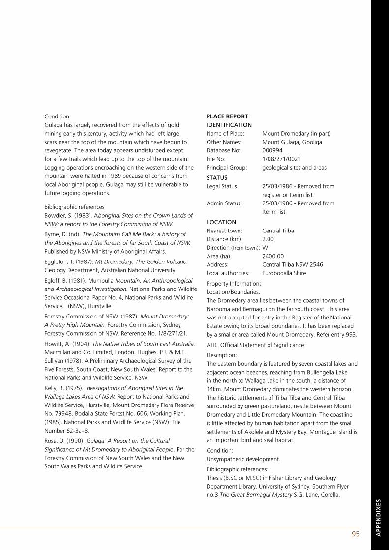
94 95 AP
PE
ND
IXE
S
ConditionGulaga has largely recovered from the effects of gold mining early this century, activity which had left large scars near the top of the mountain which have begun to revegetate. The area today appears undisturbed except for a few trails which lead up to the top of the mountain. Logging operations encroaching on the western side of the mountain were halted in 1989 because of concerns from local Aboriginal people. Gulaga may still be vulnerable to future logging operations.
Bibliographic referencesBowdler, S. (1983). Aboriginal Sites on the Crown Lands of NSW: a report to the Forestry Commission of NSW.
Byrne, D. (nd). The Mountains Call Me Back: a history of the Aborigines and the forests of far South Coast of NSW. Published by NSW Ministry of Aboriginal Affairs.
Eggleton, T. (1987). Mt Dromedary. The Golden Volcano. Geology Department, Australian National University.
Egloff, B. (1981). Mumbulla Mountain: An Anthropological and Archaeological Investigation. National Parks and Wildlife Service Occasional Paper No. 4, National Parks and Wildlife Service. (NSW), Hurstville.
Forestry Commission of NSW. (1987). Mount Dromedary: A Pretty High Mountain. Forestry Commission, Sydney, Forestry Commission of NSW. Reference No. 1/8/271/21.
Howitt, A. (1904). The Native Tribes of South East Australia. Macmillan and Co. Limited, London. Hughes, P.J. & M.E. Sullivan (1978). A Preliminary Archaeological Survey of the Five Forests, South Coast, New South Wales. Report to the National Parks and Wildlife Service, NSW.
Kelly, R. (1975). Investigations of Aboriginal Sites in the Wallaga Lakes Area of NSW. Report to National Parks and Wildlife Service, Hurstville, Mount Dromedary Flora Reserve No. 79948. Bodalla State Forest No. 606, Working Plan. (1985). National Parks and Wildlife Service (NSW). File Number 62-3a-8.
Rose, D. (1990). Gulaga: A Report on the Cultural Significance of Mt Dromedary to Aboriginal People. For the Forestry Commission of New South Wales and the New South Wales Parks and Wildlife Service.
PLACE REPORTIDENTIFICATIONName of Place: Mount Dromedary (in part)Other Names: Mount Gulaga, GooligaDatabase No: 000994File No: 1/08/271/0021Principal Group: geological sites and areas
STATUSLegal Status: 25/03/1986 - Removed from register or Iterim listAdmin Status: 25/03/1986 - Removed from Iterim list
LOCATIONNearest town: Central TilbaDistance (km): 2.00Direction (from town): WArea (ha): 2400.00Address: Central Tilba NSW 2546Local authorities: Eurobodalla Shire
Property Information:Location/Boundaries:The Dromedary area lies between the coastal towns of Narooma and Bermagui on the far south coast. This area was not accepted for entry in the Register of the National Estate owing to its broad boundaries. It has been replaced by a smaller area called Mount Dromedary. Refer entry 993.
AHC Official Statement of Significance:
Description:The eastern boundary is featured by seven coastal lakes and adjacent ocean beaches, reaching from Bullengella Lake in the north to Wallaga Lake in the south, a distance of 14km. Mount Dromedary dominates the western horizon. The historic settlements of Tilba Tilba and Central Tilba surrounded by green pastureland, nestle between Mount Dromedary and Little Dromedary Mountain. The coastline is little affected by human habitation apart from the small settlements of Akolele and Mystery Bay. Montague Island is an important bird and seal habitat.
Condition:Unsympathetic development.
Bibliographic references:Thesis (B.SC or M.SC) in Fisher Library and Geology Department Library, University of Sydney. Southern Flyer no.3 The Great Bermagui Mystery S.G. Lane, Corella.
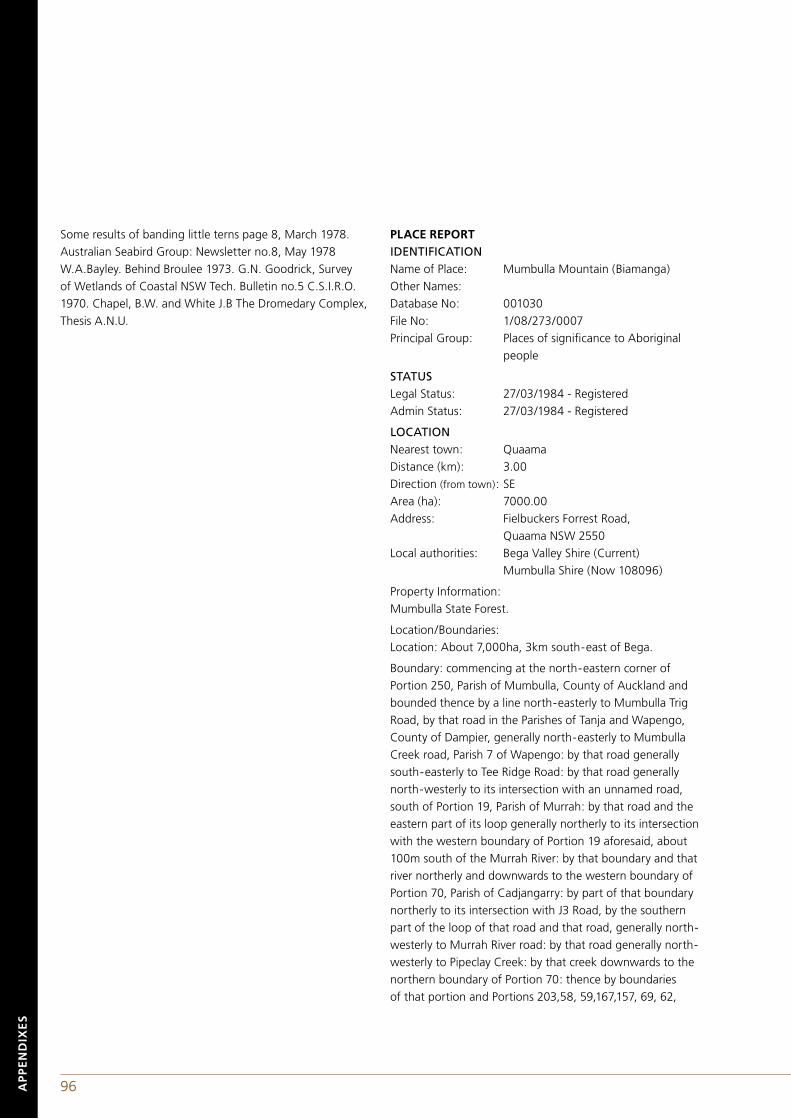
96 97
Some results of banding little terns page 8, March 1978. Australian Seabird Group: Newsletter no.8, May 1978 W.A.Bayley. Behind Broulee 1973. G.N. Goodrick, Survey of Wetlands of Coastal NSW Tech. Bulletin no.5 C.S.I.R.O. 1970. Chapel, B.W. and White J.B The Dromedary Complex, Thesis A.N.U.
PLACE REPORTIDENTIFICATIONName of Place: Mumbulla Mountain (Biamanga)Other Names: Database No: 001030File No: 1/08/273/0007Principal Group: Places of significance to Aboriginal people
STATUSLegal Status: 27/03/1984 - RegisteredAdmin Status: 27/03/1984 - Registered
LOCATIONNearest town: QuaamaDistance (km): 3.00Direction (from town): SEArea (ha): 7000.00Address: Fielbuckers Forrest Road, Quaama NSW 2550Local authorities: Bega Valley Shire (Current) Mumbulla Shire (Now 108096)
Property Information:Mumbulla State Forest.
Location/Boundaries:Location: About 7,000ha, 3km south-east of Bega.
Boundary: commencing at the north-eastern corner of Portion 250, Parish of Mumbulla, County of Auckland and bounded thence by a line north-easterly to Mumbulla Trig Road, by that road in the Parishes of Tanja and Wapengo, County of Dampier, generally north-easterly to Mumbulla Creek road, Parish 7 of Wapengo: by that road generally south-easterly to Tee Ridge Road: by that road generally north-westerly to its intersection with an unnamed road, south of Portion 19, Parish of Murrah: by that road and the eastern part of its loop generally northerly to its intersection with the western boundary of Portion 19 aforesaid, about 100m south of the Murrah River: by that boundary and that river northerly and downwards to the western boundary of Portion 70, Parish of Cadjangarry: by part of that boundary northerly to its intersection with J3 Road, by the southern part of the loop of that road and that road, generally north-westerly to Murrah River road: by that road generally north-westerly to Pipeclay Creek: by that creek downwards to the northern boundary of Portion 70: thence by boundaries of that portion and Portions 203,58, 59,167,157, 69, 62,
AP
PE
ND
IXE
S
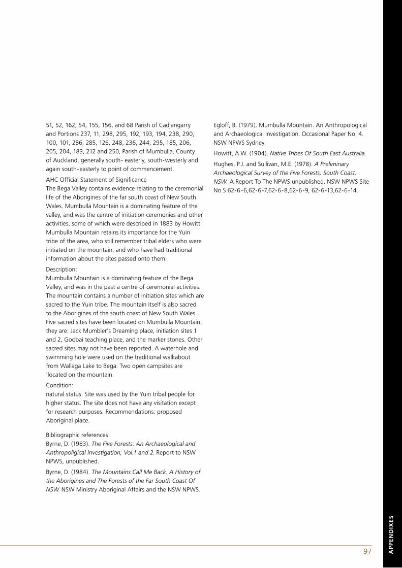
96 97
51, 52, 162, 54, 155, 156, and 68 Parish of Cadjangarry and Portions 237, 11, 298, 295, 192, 193, 194, 238, 290, 100, 101, 286, 285, 126, 248, 236, 244, 295, 185, 206, 205, 204, 183, 212 and 250, Parish of Mumbulla, County of Auckland, generally south- easterly, south-westerly and again south-easterly to point of commencement.
AHC Official Statement of SignificanceThe Bega Valley contains evidence relating to the ceremonial life of the Aborigines of the far south coast of New South Wales. Mumbulla Mountain is a dominating feature of the valley, and was the centre of initiation ceremonies and other activities, some of which were described in 1883 by Howitt. Mumbulla Mountain retains its importance for the Yuin tribe of the area, who still remember tribal elders who were initiated on the mountain, and who have had traditional information about the sites passed onto them.
Description:Mumbulla Mountain is a dominating feature of the Bega Valley, and was in the past a centre of ceremonial activities. The mountain contains a number of initiation sites which are sacred to the Yuin tribe. The mountain itself is also sacred to the Aborigines of the south coast of New South Wales. Five sacred sites have been located on Mumbulla Mountain; they are: Jack Mumbler's Dreaming place, initiation sites 1 and 2, Goobai teaching place, and the marker stones. Other sacred sites may not have been reported. A waterhole and swimming hole were used on the traditional walkabout from Wallaga Lake to Bega. Two open campsites are 'located on the mountain.
Condition:natural status. Site was used by the Yuin tribal people for higher status. The site does not have any visitation except for research purposes. Recommendations: proposed Aboriginal place.
Bibliographic references:Byrne, D. (1983). The Five Forests: An Archaeological and Anthropoligical Investigation, Vol.1 and 2. Report to NSW NPWS, unpublished.
Byrne, D. (1984). The Mountains Call Me Back. A History of the Aborigines and The Forests of the Far South Coast Of NSW. NSW Ministry Aboriginal Affairs and the NSW NPWS.
Egloff, B. (1979). Mumbulla Mountain. An Anthropological and Archaeological Investigation. Occasional Paper No. 4. NSW NPWS Sydney.
Howitt, A.W. (1904). Native Tribes Of South East Australia.
Hughes, P.J. and Sullivan, M.E. (1978). A Preliminary Archaeological Survey of the Five Forests, South Coast, NSW. A Report To The NPWS unpublished. NSW NPWS Site No.S 62-6-6,62-6-7,62-6-8,62-6-9, 62-6-13,62-6-14.
AP
PE
ND
IXE
S
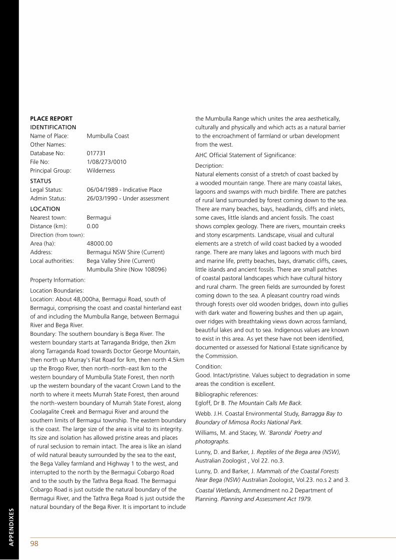
98 99AP
PE
ND
IXE
S
PLACE REPORTIDENTIFICATIONName of Place: Mumbulla CoastOther Names: Database No: 017731File No: 1/08/273/0010Principal Group: Wilderness
STATUSLegal Status: 06/04/1989 - Indicative PlaceAdmin Status: 26/03/1990 - Under assessment
LOCATIONNearest town: BermaguiDistance (km): 0.00Direction (from town): Area (ha): 48000.00Address: Bermagui NSW Shire (Current)Local authorities: Bega Valley Shire (Current) Mumbulla Shire (Now 108096)
Property Information:
Location Boundaries:Location: About 48,000ha, Bermagui Road, south of Bermagui, comprising the coast and coastal hinterland east of and including the Mumbulla Range, between Bermagui River and Bega River. Boundary: The southern boundary is Bega River. The western boundary starts at Tarraganda Bridge, then 2km along Tarraganda Road towards Doctor George Mountain, then north up Murray's Flat Road for lkm, then north 4.5km up the Brogo River, then north-north-east lkm to the western boundary of Mumbulla State Forest, then north up the western boundary of the vacant Crown Land to the north to where it meets Murrah State Forest, then around the north-western boundary of Murrah State Forest, along Coolagalite Creek and Bermagui River and around the southern limits of Bermagui township. The eastern boundary is the coast. The large size of the area is vital to its integrity. Its size and isolation has allowed pristine areas and places of rural seclusion to remain intact. The area is like an island of wild natural beauty surrounded by the sea to the east, the Bega Valley farmland and Highway 1 to the west, and interrupted to the north by the Bermagui Cobargo Road and to the south by the Tathra Bega Road. The Bermagui Cobargo Road is just outside the natural boundary of the Bermagui River, and the Tathra Bega Road is just outside the natural boundary of the Bega River. It is important to include
the Mumbulla Range which unites the area aesthetically, culturally and physically and which acts as a natural barrier to the encroachment of farmland or urban development from the west.
AHC Official Statement of Significance:
Decription:Natural elements consist of a stretch of coast backed by a wooded mountain range. There are many coastal lakes, lagoons and swamps with much birdlife. There are patches of rural land surrounded by forest coming down to the sea. There are many beaches, bays, headlands, cliffs and inlets, some caves, little islands and ancient fossils. The coast shows complex geology. There are rivers, mountain creeks and stony escarpments. Landscape, visual and cultural elements are a stretch of wild coast backed by a wooded range. There are many lakes and lagoons with much bird and marine life, pretty beaches, bays, dramatic cliffs, caves, little islands and ancient fossils. There are small patches of coastal pastoral landscapes which have cultural history and rural charm. The green fields are surrounded by forest coming down to the sea. A pleasant country road winds through forests over old wooden bridges, down into gullies with dark water and flowering bushes and then up again, over ridges with breathtaking views down across farmland, beautiful lakes and out to sea. Indigenous values are known to exist in this area. As yet these have not been identified, documented or assessed for National Estate significance by the Commission.
Condition:Good. Intact/pristine. Values subject to degradation in some areas the condition is excellent.
Bibliographic references:Egloff, Dr B. The Mountain Calls Me Back.
Webb. J.H. Coastal Environmental Study, Barragga Bay to Boundary of Mimosa Rocks National Park.
Williams, M. and Stacey, W. ‘Baronda‘ Poetry and photographs.
Lunny, D. and Barker, J. Reptiles of the Bega area (NSW), Australian Zoologist , Vol 22. no.3.
Lunny, D. and Barker, J. Mammals of the Coastal Forests Near Bega (NSW) Australian Zoologist, Vol.23. no.s 2 and 3.
Coastal Wetlands, Ammendment no.2 Department of Planning. Planning and Assessment Act 1979.
98 99 AP
PE
ND
IXE
S
APPENDIX DLAND RIGHTS, ABORIGINAL OWNERSHIP AND JOINT MANAGEMENTIn 1970, Aboriginal land rights were asserted by the Yirrkala in opposition to a mining venture on the Gove Peninsula in Arnhem Land. In this instance, the Northern Territory court determined that it had not been demonstrated that Aboriginal society had a system of proprietary land ownership. Then in 1974, the Woodward Royal Commission overturned the earlier judgement and recognised Aboriginal communities as traditional users of the landscape and as such were entitled to rights. The Commission drafted a set of provisions which needed to be met in order to assert indigenous land rights. This was followed by the Commonwealth enacting the Aboriginal Land Rights (Northern Territory) Act 1976 (C'th). The Act facilitated the return of unallocated lands, those which are neither leased nor held in freehold title nor designated by the Crown for a specific purpose, if the following conditions were met by the claimant:(a) demonstration of Aboriginal descent, a hereditary or spiritual right to the land;
(b) maintenance of traditional relationships as well as custodial obligations; and,
(c) a delineation of the boundaries.
This was followed by a model for joint management of protected areas with Kakadu being declared in 1979 as Australia's first Aboriginal owned national park (Woenne-Green 1991, p.272).
NATIVE TITLE AND ABORIGINAL LAND RIGHTSWithin the six states of Australia, legal instruments sought to redress the issue of Aboriginal land rights with varying success. Only in rare instances did these measures support indigenous people’s rights to land in the regions of Australia that had experienced early settlement by British colonists and where the indigenous tribal groups had been fragmented, forcibly relocated and while under the control of government reserve schemes combined with dispersed remnants of other 'tribal' groups.
It was not until 1992, in a review of the land rights case of the Meriam people of the Torres Straits, which had been initiated a decade earlier, that the High Court of Australia ruled that in certain circumstances a form of native title continued to exist. Conditions under which 'native title'
was deemed to continue and the precise nature of that 'title' were left for future political and judicial processes to establish. In response to this outcome, the Parliament of Australia enacted the Native Title Act 1993 (Cwlth) which sought to expedite the identification of where native title existed and clarify its relationship with other forms of land titles (Sanders 1994). To some extent this Act was based upon principles embodied in the Commonwealth's Aboriginal Land Rights (Northern Territory) Act 1976 (Cwlth). Proof that native title continued to exist fell upon indigenous communities and was exceptionally burdensome (Myers et al. 1996, pp.53-60). Native title processes proved to be cumbersome and few lands were actually returned to Aboriginal communities. However the Act did provide communities with leverage to negotiate land-useagreements in situations where native title might obtain, particularly in places where Aboriginal groups were fortunate enough to occupy their traditional lands.
The Native Title Act 1993 (Cwlth) caused considerable apprehension in the Australian pastoral settler economy which believed that they were particularly vulnerable to land claims. Following a change in the political leadership of the country, in 1998, the Act was amended with more stringent requirements required before Aboriginal claimants could lodge a claim. Immediately, Australian Aborigines brought the matter before the 18-member United Nations Committee on the Elimination of Racial Discrimination. In March of 1999, the Committee called upon the Australian government to halt the implementation of the amended Act, asserting that it breached international race rules.
OWNERSHIP AND THE JOINT MANAGEMENT PROCESSThe Government of New South Wales has provided for Aboriginal people to own lands of cultural significance under the National Parks and Wildlife Act 1974 (NSW) (NPWA). The Forestry and National Parks Estate Act 1998 (NSW) added Biamanga National Park to Schedule 14 of the NPWA as one of the outcomes of the Eden Regional Forest Agreement Process (Commonwealth of Australia and the Government of New South Wales 1999).
Although not stated in the Draft Southern Regional Forest Agreement (New South Wales Government 2001), a greatly expanded Gulaga Forest Reserve, Goura National Park and Wallaga Lake National Park were combined into one entity and listed on Schedule 14 as part of the Southern Regional Forest Agreement Process.
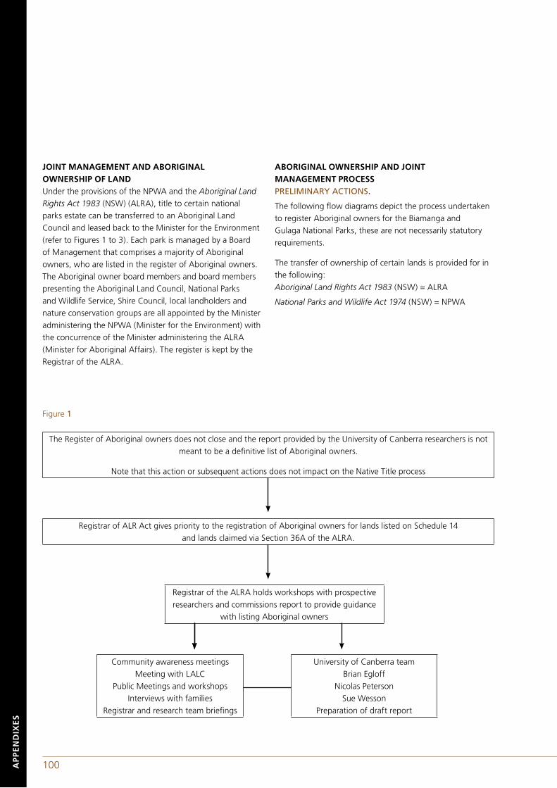
100 101AP
PE
ND
IXE
S
JOINT MANAGEMENT AND ABORIGINAL OWNERSHIP OF LANDUnder the provisions of the NPWA and the Aboriginal Land Rights Act 1983 (NSW) (ALRA), title to certain national parks estate can be transferred to an Aboriginal Land Council and leased back to the Minister for the Environment (refer to Figures 1 to 3). Each park is managed by a Board of Management that comprises a majority of Aboriginal owners, who are listed in the register of Aboriginal owners. The Aboriginal owner board members and board members presenting the Aboriginal Land Council, National Parks and Wildlife Service, Shire Council, local landholders and nature conservation groups are all appointed by the Minister administering the NPWA (Minister for the Environment) with the concurrence of the Minister administering the ALRA (Minister for Aboriginal Affairs). The register is kept by the Registrar of the ALRA.
ABORIGINAL OWNERSHIP AND JOINT MANAGEMENT PROCESS PRELIMINARY ACTIONS.
The following flow diagrams depict the process undertaken to register Aboriginal owners for the Biamanga and Gulaga National Parks, these are not necessarily statutory requirements.
The transfer of ownership of certain lands is provided for in the following:Aboriginal Land Rights Act 1983 (NSW) = ALRA
National Parks and Wildlife Act 1974 (NSW) = NPWA
Registrar of ALR Act gives priority to the registration of Aboriginal owners for lands listed on Schedule 14 and lands claimed via Section 36A of the ALRA.
Registrar of the ALRA holds workshops with prospective researchers and commissions report to provide guidance
with listing Aboriginal owners
Community awareness meetingsMeeting with LALC
Public Meetings and workshops Interviews with families
Registrar and research team briefings
University of Canberra teamBrian Egloff
Nicolas PetersonSue Wesson
Preparation of draft report
The Register of Aboriginal owners does not close and the report provided by the University of Canberra researchers is not meant to be a definitive list of Aboriginal owners.
Note that this action or subsequent actions does not impact on the Native Title process
Figure 1
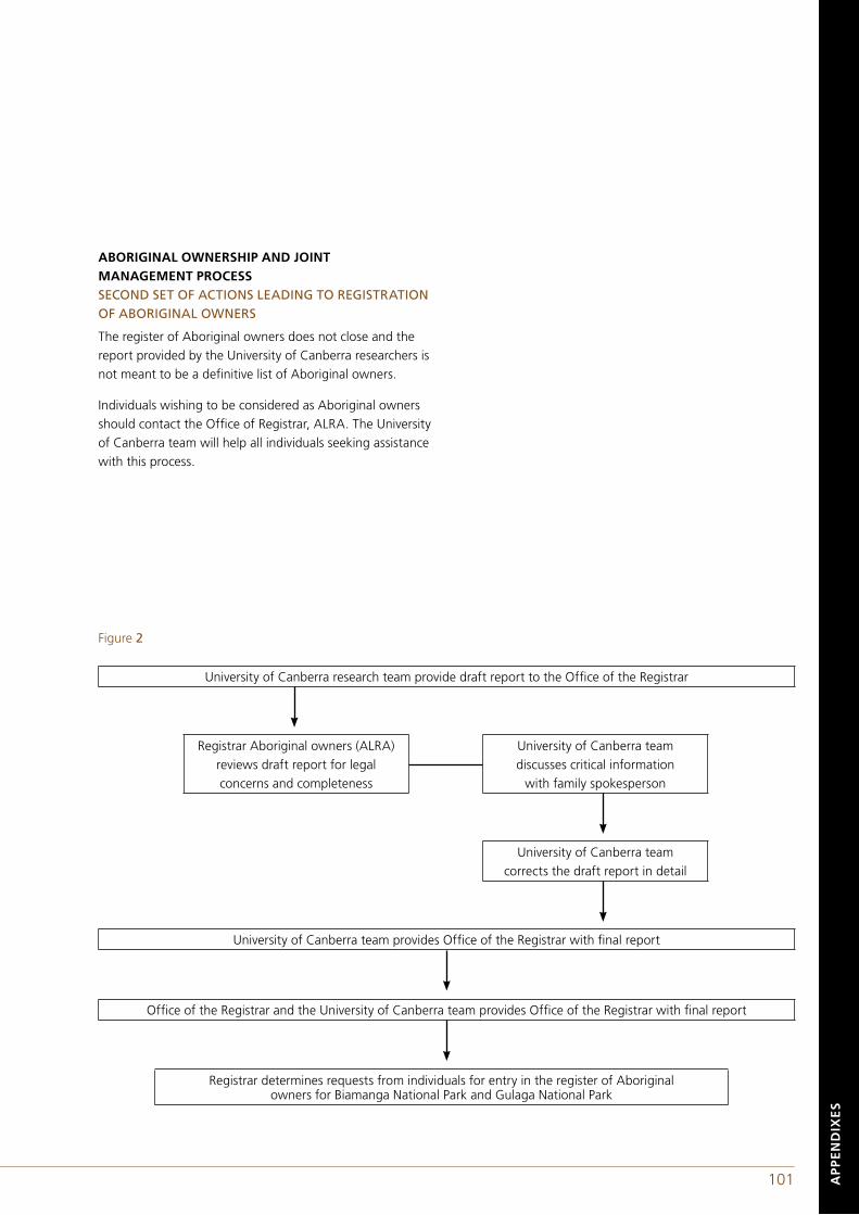
100 101 AP
PE
ND
IXE
S
ABORIGINAL OWNERSHIP AND JOINT MANAGEMENT PROCESS SECOND SET OF ACTIONS LEADING TO REGISTRATION OF ABORIGINAL OWNERS
The register of Aboriginal owners does not close and the report provided by the University of Canberra researchers is not meant to be a definitive list of Aboriginal owners.
Individuals wishing to be considered as Aboriginal owners should contact the Office of Registrar, ALRA. The University of Canberra team will help all individuals seeking assistance with this process.
University of Canberra research team provide draft report to the Office of the Registrar
Registrar Aboriginal owners (ALRA) reviews draft report for legal concerns and completeness
University of Canberra team discusses critical information
with family spokesperson
University of Canberra team corrects the draft report in detail
University of Canberra team provides Office of the Registrar with final report
Office of the Registrar and the University of Canberra team provides Office of the Registrar with final report
Registrar determines requests from individuals for entry in the register of Aboriginal owners for Biamanga National Park and Gulaga National Park
Figure 2
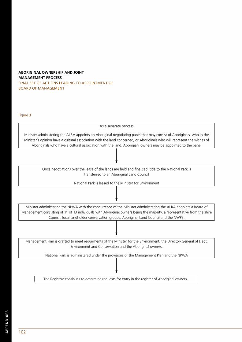
102 103AP
PE
ND
IXE
S
ABORIGINAL OWNERSHIP AND JOINT MANAGEMENT PROCESS FINAL SET OF ACTIONS LEADING TO APPOINTMENT OF BOARD OF MANAGEMENT
Once negotiations over the lease of the lands are held and finalised, title to the National Park is transferred to an Aboriginal Land Council
National Park is leased to the Minister for Environment
As a separate process
Minister administering the ALRA appoints an Aboriginal negotiating panel that may consist of Aboriginals, who in the Minister’s opinion have a cultural association with the land concerned, or Aboriginals who will represent the wishes of
Aboriginals who have a cultural association with the land. Aborigianl owners may be appointed to the panel
Minister administering the NPWA with the concurrence of the Minister administrating the ALRA appoints a Board of Management consisting of 11 of 13 individuals with Aboriginal owners being the majority, a representative from the shire
Council, local landholder conservation groups, Aboriginal Land Council and the NWPS.
Management Plan is drafted to meet requirments of the Minister for the Environment, the Director-General of Dept. Environment and Conservation and the Aboriginal owners.
National Park is administered under the provisions of the Management Plan and the NPWA
The Registrar continues to determine requests for entry in the register of Aboriginal owners
Figure 3
102 103 AP
PE
ND
IXE
S
Implementation of this process comprises four separate and distinct actions: Action by the National Parks and Wildlife Service(a) Lands are either reserved (national parks, historic sites, regional parks, and state reserve areas) or dedicated (nature reserves, karst conservation reserves or Aboriginal areas). Archaeological areas and wilderness areas are declared. Note, new amendments to the NPWA provides for the distinction between reserved and dedicated land to be removed, all classifications to land to be reserved under the NPWA.
(b) National Park is entered on to Schedule 14 of the National Parks and Wildlife Act 1974 (NSW). The seven areas of land listed on Schedule 14 as at the date of this report are: Jervis Bay National Park; Mungo National Park; Mootwingee Historic Site; Mootwingee National Park and Coturaundee Nature Reserve (as of 1998 Mutawintji National Park); Mount Grenfell Historic Site; Mount Yarrowyck Nature Reserve; Biamanga National Park; and Gulaga National Park.
Action by the Registrar of the Aboriginal Land Rights Act 1983 (NSW)(a) Registrar gives priority to the Registration of Aboriginal owners for National parks listed on Schedule 14 of the National Parks and Wildlife Act 1974 (NSW) or a Local Aboriginal Land Council claim of land under Section 36A of the Aboriginal Land Rights 1983 (NSW).
(b) Registrar in this particular instance chose to conduct consultation with Aboriginal people to determine if research was required to assist with the registration of Aboriginal Owners
(c) Office of the Registrar holds workshops with prospective researchers and commissions the compilation of a report (in this instance a joint project between the Office of the Registrar and the research team) which will aid the Registrar in assessing applicants
The register is not meant at any given time to be exhaustive or definitive, and individuals may be added to the register as applications are received and assessed by the Registrar.
Action by the Ministers administrating the Aboriginal Land Rights Act 1983 (NSW and the National Parks and Wildlife Act 1974 (NSW)
(a) Minster administrating the Aboriginal Land Rights will appoint the Aboriginal Negotiating Panel. The purposes of the negotiations for the lease is stated in Division 2, Section 71f of the National Parks and Wildlife Act 1974 (NSW)
(b) The Minister administrating the National Parks and Wildlife Act 1974 (NSW) with the concurrence of the Minister administering the Aboriginal Land Rights Act 1983 (NSW) will appoint a Board of Management consisting of 11 to 13 people, the majority being Aboriginal owners, with representatives from the Local Aboriginal Land Council(s), local government councils, conservation interests, land owners/holders and a nomination by the Director-General for the Department of Environment and Conservation.
SPIRIT OF LEGISLATIONLegislation enabling the Aboriginal ownership and joint-management process is enacted to facilitate the joining together of the National Parks and Wildlife Service of New South Wales and Aboriginal communities for the purposes of joint management of protected areas. The criteria for entry on the Register of Aboriginal owners, although superficially similar in nature to the Native Title requirements, are inclusive and not as stringent. The spirit of the legislation is to return lands and not to require Aboriginal community members to meet criteria that are all but impossible for those groups that have experienced 200 years of forced assimilation.
BOODEREE NATIONAL PARK AS A PRECEDENCEAt the very far northern coastal extremity of the Yuin culture area lies Wreck Bay, tucked away on the southern arm of Jervis Bay. Since the first quarter of the nineteenth century the lands surrounding Jervis Bay were considered by British settlers to be a marginal wasteland. The community at Wreck Bay has a somewhat unique history as the settlement was founded by Aboriginal families to serve both as a fishing camp and as a place of refuge from oppressive British/Australian social engineering practices, particularly the removal of indigenous children from their parents. The settlement also served to reinforce bonds with traditional lands. The reserve at Wreck Bay is particularly well favoured being situated on lands having the status of a Commonwealth territory. Gradually the cluster of informally constructed houses assumed a status similar to that of a
104 105AP
PE
ND
IXE
S
legally enfranchised reserve. In recent times the property surrounding Jervis Bay, previously regarded as commercially worthless, gained importance for nature conservation and coastal recreation purposes. In the 1970s the community was faced with an edict requiring them to relinquish their reserve status and allow non-Aboriginal families to live at the Wreck Bay settlement. All non-residential lands were to be forfeited and incorporated into a nature reserve. This action by the Commonwealth understandably antagonised members of the community and brought about a concerted action to counter the government's efforts to resume the Aboriginal reserve.
In reaction to the Commonwealth's 'land grab', Aboriginal elders employed and worked with an anthropologist to demonstrate their attachment to an Aboriginal heritage landscape [Egloff et al. 1990 (1981)]. Since 1975, through individual and group action, the community sought and received the free-hold title to their residential reserve. Upon gaining ownership of the reserve, the Wreck Bay community initiated a cultural and natural heritage tour service supported by Commonwealth Aboriginal project funds. As the indigenous community pressured the Commonwealth for the return of the national park lands which bordered the residential reserve, they tendered for and received contracts to undertake land management, maintenance, refuse removal and construction work for the park management authority. In 1995, the Commonwealth government returned the park lands, now named Booderee National Park in recognition of the transfer of ownership, to the indigenous community (Egloff et al.: 1995). This return of lands set in train a process where the community has leased-back the park to the Commonwealth under specific conditions which provide for an Aboriginal majority on the board of management and an increased number of positions designated for Aboriginal trainees. Sharing the indigenous heritage landscape is discussed in an article by Isabel McBryde aptly titled 'Dream the Impossible Dream?' and sub-titled 'Shared Heritage, Shared Values, or shared understanding of disparate values?'. The discussion focuses upon the recognition and sharing of disparate values. The heritage landscapes of Booderee, Gulaga and Biamanga National Parks are valued both by indigenous communities and by natural resource managers. Aboriginal values are rooted in spiritual affinities which are linked to their economic use of the landscape. Management of these
places needs to be empathetic to Aboriginal values and be a creative response rather than one imposed by judicial or political processes which tend to heighten the tension between communities holding disparate values. British/Australian 'legal processes seek to determine which party is correct and which is wrong.
In many instances both parties need to have their values recognised and a process implemented which accommodates an at times perplexing and seemingly irreconcilable set of disparate values deeply held by different sectors of the community. In the past, the process has forced accommodation upon the relatively powerless indigenous communities. Now there are salient examples throughout Australia where indigenous heritage values have led to the repatriation of heritage landscapes. Sadly, at times the government of Australia, its political leaders and local mainstream communities are too slow to recognise and accept the depth of meaning which indigenous peoples ascribe to heritage landscapes and recourse has to be made to international tribunals in order to seek just outcomes.
Bibliographic references:Egloff, Brian J. with Wreck Bay Community 1990 (1981) Wreck Bay, an Aboriginal fishing community, Aboriginal Studies Press, Canberra.
Egloff, B.J. and K. Navin and K. Officer (1995) Jervis Bay national Park and Botanic Garden as Aboriginal Land. A final report to the Minister on the significance of the land and water in the region of Jervis Bay Territory to indicate the appropriateness of a grant under the Aboriginal Land Grant (Jervis Bay Territory, Act 1886 (as amended)
McBryde, I 1995 Dream the Impossible Dream? Shared heritage, shared values, or shared understanding of disparate values?, Historic Environment, 11 (2&3):8-13.
Woenne-Green, S.R., R. Johnson and J. Kesteven 1991 Caring for Country: Aborigines and land management, Australian National Parks and Wildlife Service, Canberra.
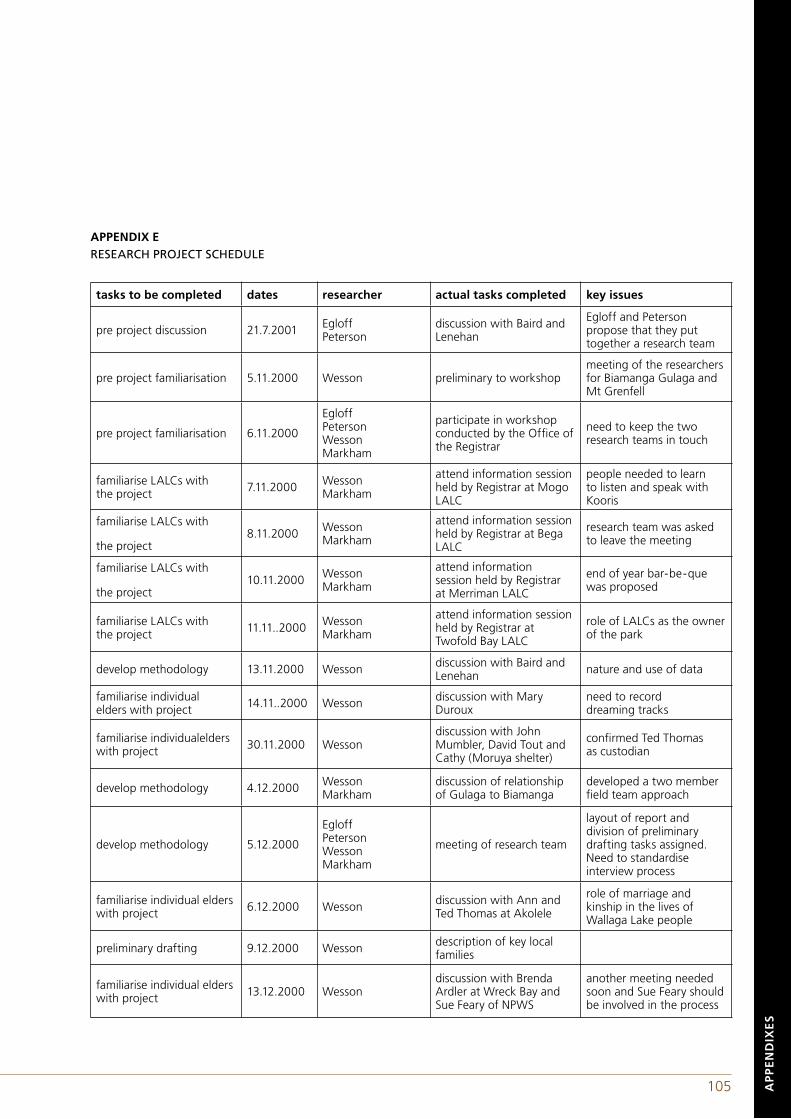
104 105 AP
PE
ND
IXE
S
APPENDIX ERESEARCH PROJECT SCHEDULE
tasks to be completed dates researcher actual tasks completed key issues
pre project discussion 21.7.2001 EgloffPeterson
discussion with Baird and Lenehan
Egloff and Peterson propose that they put together a research team
pre project familiarisation 5.11.2000 Wesson preliminary to workshopmeeting of the researchers for Biamanga Gulaga and Mt Grenfell
pre project familiarisation 6.11.2000
Egloff Peterson WessonMarkham
participate in workshop conducted by the Office of the Registrar
need to keep the two research teams in touch
familiarise LALCs with the project 7.11.2000 Wesson
Markham
attend information session held by Registrar at Mogo LALC
people needed to learn to listen and speak with Kooris
familiarise LALCs with
the project8.11.2000 Wesson
Markham
attend information session held by Registrar at Bega LALC
research team was asked to leave the meeting
familiarise LALCs with
the project10.11.2000 Wesson
Markham
attend information session held by Registrar at Merriman LALC
end of year bar-be-quewas proposed
familiarise LALCs with the project 11.11..2000 Wesson
Markham
attend information session held by Registrar at Twofold Bay LALC
role of LALCs as the owner of the park
develop methodology 13.11.2000 Wesson discussion with Baird and Lenehan nature and use of data
familiarise individual elders with project 14.11..2000 Wesson discussion with Mary
Durouxneed to record dreaming tracks
familiarise individualelders with project 30.11.2000 Wesson
discussion with John Mumbler, David Tout and Cathy (Moruya shelter)
confirmed Ted Thomas as custodian
develop methodology 4.12.2000 WessonMarkham
discussion of relationship of Gulaga to Biamanga
developed a two member field team approach
develop methodology 5.12.2000
EgloffPetersonWessonMarkham
meeting of research team
layout of report and division of preliminary drafting tasks assigned. Need to standardise interview process
familiarise individual elders with project 6.12.2000 Wesson discussion with Ann and
Ted Thomas at Akolele
role of marriage and kinship in the lives of Wallaga Lake people
preliminary drafting 9.12.2000 Wesson description of key local families
familiarise individual elders with project 13.12.2000 Wesson
discussion with Brenda Ardler at Wreck Bay and Sue Feary of NPWS
another meeting needed soon and Sue Feary should be involved in the process
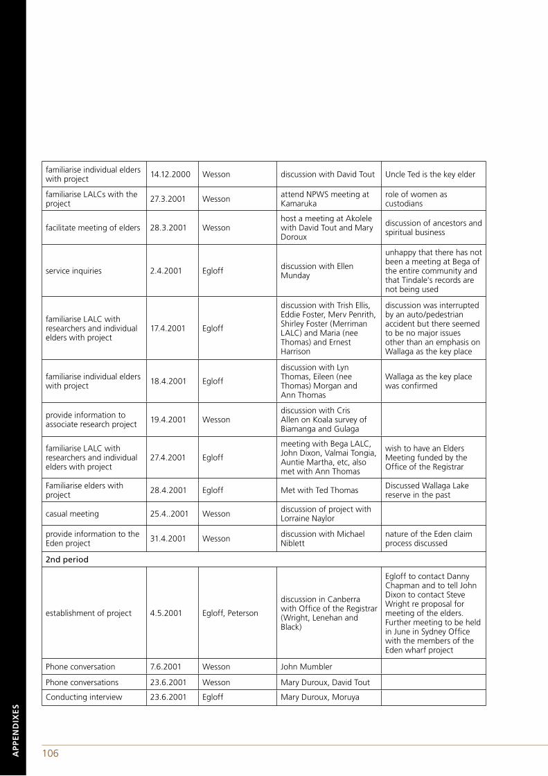
106 107AP
PE
ND
IXE
S
familiarise individual elders with project 14.12.2000 Wesson discussion with David Tout Uncle Ted is the key elder
familiarise LALCs with the project 27.3.2001 Wesson attend NPWS meeting at
Kamarukarole of women as custodians
facilitate meeting of elders 28.3.2001 Wessonhost a meeting at Akolele with David Tout and Mary Doroux
discussion of ancestors and spiritual business
service inquiries 2.4.2001 Egloff discussion with Ellen Munday
unhappy that there has not been a meeting at Bega of the entire community and that Tindale's records are not being used
familiarise LALC with researchers and individual elders with project
17.4.2001 Egloff
discussion with Trish Ellis, Eddie Foster, Merv Penrith, Shirley Foster (Merriman LALC) and Maria (nee Thomas) and Ernest Harrison
discussion was interrupted by an auto/pedestrian accident but there seemed to be no major issues other than an emphasis on Wallaga as the key place
familiarise individual elders with project 18.4.2001 Egloff
discussion with Lyn Thomas, Eileen (nee Thomas) Morgan and Ann Thomas
Wallaga as the key place was confirmed
provide information to associate research project 19.4.2001 Wesson
discussion with Cris Allen on Koala survey of Biamanga and Gulaga
familiarise LALC with researchers and individual elders with project
27.4.2001 Egloff
meeting with Bega LALC, John Dixon, Valmai Tongia, Auntie Martha, etc, also met with Ann Thomas
wish to have an Elders Meeting funded by the Office of the Registrar
Familiarise elders with project 28.4.2001 Egloff Met with Ted Thomas Discussed Wallaga Lake
reserve in the past
casual meeting 25.4..2001 Wesson discussion of project with Lorraine Naylor
provide information to the Eden project 31.4.2001 Wesson discussion with Michael
Niblettnature of the Eden claim process discussed
2nd period
establishment of project 4.5.2001 Egloff, Peterson
discussion in Canberra with Office of the Registrar (Wright, Lenehan and Black)
Egloff to contact Danny Chapman and to tell John Dixon to contact Steve Wright re proposal for meeting of the elders. Further meeting to be held in June in Sydney Office with the members of the Eden wharf project
Phone conversation 7.6.2001 Wesson John Mumbler
Phone conversations 23.6.2001 Wesson Mary Duroux, David Tout
Conducting interview 23.6.2001 Egloff Mary Duroux, Moruya
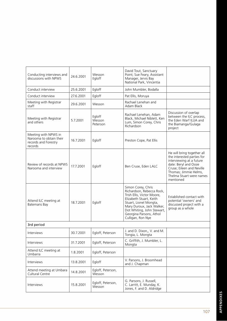
106 107 AP
PE
ND
IXE
S
Conducting interviews and discussions with NPWS 24.6.2001 Wesson
Egloff
David Tout, Sanctuary Point; Sue Feary, Assistant Manager, Jervis Bay National Park, Vincentia
Conduct interview 25.6.2001 Egloff John Mumbler, Bodalla
Conduct interview 27.6.2001 Egloff Pat Ellis, Moruya
Meeting with Registrar staff 29.6.2001 Wesson Rachael Lenehan and
Adam Black
Meeting with Registrar and others 5.7.2001
EgloffWessonPeterson
Rachael Lenehan, Adam Black, Michael Niblett, Ken Lum, Simon Corey, Chris Richardson
Discussion of overlap between the ILC process, the Eden Warf ILUA and the Biamanga/Gulaga project
Meeting with NPWS in Narooma to obtain their records and Forestry records
16.7.2001 Egloff Preston Cope, Pat Ellis
Review of records at NPWS Narooma and interview 17.7.2001 Egloff Ben Cruse, Eden LALC
He will bring together all the interested parties for interviewing at a future date: Beryl and Ossie Cruse; Eileen and Neville Thomas; Jimmie Helms, Thelma Stuart were names mentioned
Attend ILC meeting at Batemans Bay 18.7.2001 Egloff
Simon Corey, Chris Richardson, Rebecca Rock, Trish Ellis, Victor Moore, Elizabeth Stuart, Keith Stuart, Lionel Mongta, Mary Duroux, Jack Walker, Dot Whiting, John Stewart, Georgina Parsons, Athol Culligan, Ron Nye
Established contact with potential 'owners' and discussed project with a group as a whole
3rd period
Interviews 30.7.2001 Egloff, Peterson J. and D. Dixon,, V. and M. Tongia, L. Mongta
Interviews 31.7.2001 Egloff, Peterson C. Griffith, J. Mumbler, L. Mongta
Attend ILC meeting at Umbarra 1.8.2001 Egloff, Peterson
Interviews 13.8.2001 Egloff V. Parsons, J. Broomhead and J. Chapman
Attend meeting at Umbara Cultural Centre 14.8.2001 Egloff, Peterson,
Wesson
Interviews 15.8.2001 Egloff, Peterson, Wesson
G. Parsons, J. Russell, C. Larritt, E. Munday, K. Jones, F. and D. Aldridge

108 109AP
PE
ND
IXE
S
The above list does not include the time that the researchers expended drafting the report.
In addition to the activities listed above, a community meeting was held on 14 August 2001at the Umbarra Cultural Centre. The meeting was organised by the Office of the Registrar with the following individuals signing the list of attendees:
Dixon, M.Manton, Wilma Parsons, K. Dixon, C. Ellis, Trisha CampbellCruse, M. Davis jnr, W. McCarron, S. Aldridge, S. Stewert, Ossie Campbell, D. Campbell, J. Davis, Amelia Spackman, S Parsons, Norma Campbell, O.J. Brierley, B.
Interviews 16.8.2001EgloffWessonPeterson
I. White, N. Parsons, L. Connell, M. Duroux, V. and M. Tongia
Interviews 17.8.2001EgloffWessonPeterson
I. White, S. Kelly, N. and E. Thomas, O. Stewart, T. Stewart
4th period
various
Drafting of report by Egloff, Peterson and Wesson
Review of draft by Office of the Registrar ALR Act.
5th period
3.12.2001EgloffPetersonWesson
Attend public meeting called by the Registrar to review draft report
10.12.2001 Egloff
Meet at Bega ALC with John Dixon, Margaret Mundy and Jan Dowling, also Rachel Lenehan
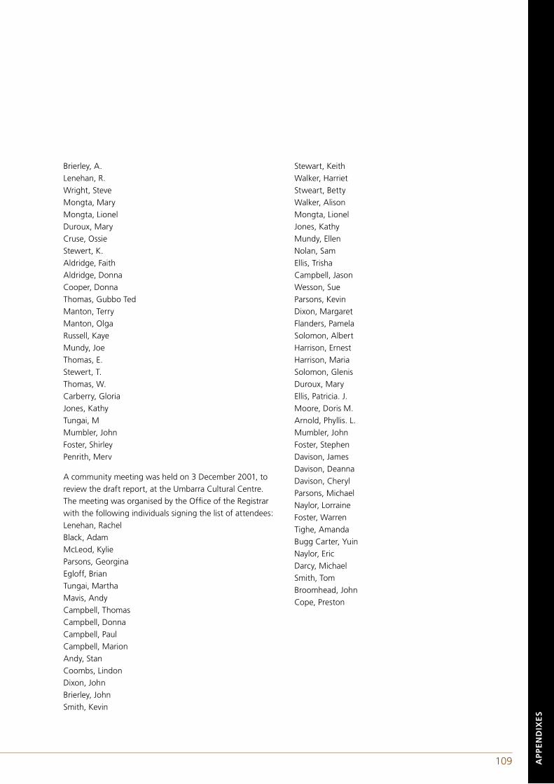
108 109 AP
PE
ND
IXE
S
Brierley, A.Lenehan, R. Wright, SteveMongta, Mary Mongta, Lionel Duroux, Mary Cruse, Ossie Stewert, K. Aldridge, Faith Aldridge, Donna Cooper, Donna Thomas, Gubbo Ted Manton, Terry Manton, Olga Russell, Kaye Mundy, Joe Thomas, E. Stewert, T. Thomas, W. Carberry, Gloria Jones, Kathy Tungai, M Mumbler, John Foster, Shirley Penrith, Merv
A community meeting was held on 3 December 2001, to review the draft report, at the Umbarra Cultural Centre. The meeting was organised by the Office of the Registrar with the following individuals signing the list of attendees:Lenehan, Rachel Black, Adam McLeod, Kylie Parsons, Georgina Egloff, Brian Tungai, Martha Mavis, Andy Campbell, Thomas Campbell, Donna Campbell, Paul Campbell, Marion Andy, Stan Coombs, Lindon Dixon, John Brierley, John Smith, Kevin
Stewart, Keith Walker, Harriet Stweart, Betty Walker, Alison Mongta, Lionel Jones, KathyMundy, Ellen Nolan, Sam Ellis, Trisha Campbell, Jason Wesson, Sue Parsons, Kevin Dixon, Margaret Flanders, Pamela Solomon, Albert Harrison, Ernest Harrison, Maria Solomon, Glenis Duroux, Mary Ellis, Patricia. J. Moore, Doris M. Arnold, Phyllis. L. Mumbler, John Foster, Stephen Davison, James Davison, Deanna Davison, Cheryl Parsons, Michael Naylor, Lorraine Foster, Warren Tighe, Amanda Bugg Carter, Yuin Naylor, Eric Darcy, Michael Smith, Tom Broomhead, John Cope, Preston
110 111BIB
LIO
GR
AP
HY
APPENDIX FABOUT THE AUTHORS
Brian Egloff BSc Hons (U Wisc), MA (UNC) and PhD (ANU)
From 1979 to 1981, Brian was employed by the New South Wales National Parks and Wildlife Service to work with Aboriginal communities and land use conflicts on the south coast. Brian teaches at the University of Canberra and maintains an ongoing research focus on Aboriginal heritage management. He advised the Minister for Aboriginal Affairs (Cwlth) on the granting of the Jervis Bay National Park to the Wreck Bay Aboriginal Community.
Nic Peterson B.A. Hons (Cambridge University), PhD (University of Sydney)
Nic lectures in anthropology at the School of Archaeology and Anthropology at the Australian National University. He has carried out research in Arnhem Land, the Tanami desert, the Torres Strait and the ACT. He has had a long-standing involvement in land rights issues and been the senior author of ten land and native title claims including the test case for native title in the sea. Recently he carried out a genealogical and social mapping research project in relation to Ngun(n)awal people for the ACT government.
Sue Wesson B.S. (La Trobe U), M Env Sci (Monash U), PhD (Monash U)
Sue has specialised in the occupation and movement of Aboriginal people in south-eastern Australia. Extracts from her doctoral work on the occupation of Aboriginal people of south-eastern Australia have been published by Monash University as An Historical Atlas of the Aborigines of Eastern Victoria and Far South-Eastern New South Wales. Utilising a range of archival records and oral history accounts, she completed her doctoral thesis on the historical geography of the Aborigines of eastern Victoria and far south-eastern New South Wales in 2002. Also in 2002 she spent time with the Stolen Generations Corporation in Alice Springs doing Link-Up work. She is currently working as a Conservation Assessment Officer in Cultural Heritage with the Department of Conservation and Environment in Sydney.
110 111 BIB
LIO
GR
AP
HY
Aborigines Protection Board 1889-92, Annual reports of the Aborigines
Protection Board of NSW, Votes and proceedings of the Legislative
Council, Australian Institute of Aboriginal and Torres Strait Islander
Studies, Canberra.
Adam, P 1987, New South Wales rainforests: the nomination for the
World Heritage List, National Parks and Wildlife Service, New South
Wales, Sydney.
Allan, J 1846, Select Committee on Aborigines, Braidwood Report,
Votes and proceedings of the NSW Legislative Council, Australian
Institute of Aboriginal and Torres Strait Islander Studies, Canberra.
Allan, J 1851, 'Return showing the numbers, names and ages of the
adult Aborigines in the district of Braidwood on 21 May 1851', Clarke
'Papers MSS 139/25, Mitchell Library, Sydney.
Andrews, A 1998, Earliest Monaro and Burragorang, Tabletop Press,
Canberra.
Anon n.d., 'Umbarra leaflet distributed at the Umbarra Cultural Centre',
publication supported by Arrilla, Commonwealth Employment Service
and Presence.
Anon 1879, 'The Tilba Tilba District', Bega Standard, November 29 1879.
Anon 1879, 'Tilba Tilba District II', Bega Standard, December 6 1879.
Anon 1912, Town and Country Journal, 2 October 1912, p.53.
Baessler, A 1895, 'A picnic with Australian Aborigines at Wallaga Lake
NSW', Pacific Portraits, trans. Doug Fraser, Legislative Research Service.
Bega Valley Historical Society n.d., 'A brief history of Bega', Bega
District News, Bega.
Bickford, A 1981, Aboriginal contact history and the environment on
the far south coast of New South Wales: extracts from references,
report for the New South Wales National Parks and Wildlife Service,
Hurstville.
Bowdler, S 1983, Aboriginal Sites on the Crown timber lands of New
South Wales, report to the Forestry Commission of New South Wales.
Braidwood Gaol Entrance Book 1856-1899, <http://www.pcug.org.au/
~ppmay/braidwood.htm>.
Brennan, M 1873, 'Letter from Brennan (Araluen) to Judge McFarlane',
in Smithson, M 1997, Munkata Yuin, an unpublished study guide for
secondary schools, p.193.
Brennan, M 1907, Reminiscences of the goldfields and elsewhere in
New South Wales, covering a period of forty-eight years service as an
Officer of Police, Brooks, Sydney.
Brierly, OW 1843, 'Diary and notes at Twofold Bay, Maneroo and
Snowy River with sketchings, December 1842 and January 1843, MS
A535, Mitchell Library, Sydney.
Brodribb, WA 1976, Recollections of an Australian squatter, Sydney.
Bulmer, J.M n.d., 'Papers', box 11, folder 10, Museum of Victoria.
Bulmer, J 1994, Victorian Aborigines; John Bulmer's recollections 1855-
1908, Campbell, R. Vanderwal ed., Museum of Victoria, Melbourne.
Butlin, N 1983, Our original aggression, Allen & Unwin, Sydney
Byrne, D 1984, The mountains call me back; a history of the Aborigines
and the forests of the far south coast of New South Wales, NSW
Ministry of Aboriginal Affairs, NSW National Parks and Wildlife Service,
Equus Publications, Sydney.
Cameron, SB 1987, An investigation of the history of the Aborigines
of the far south coast of New South Wales in the nineteenth century,
Bachelor of Letters thesis, Australian National University, Canberra.
Capell, A 1963, A notebook of general linguistics, Sydney University
Cooperative Bookshop, Sydney.
Carter, M 1979, Acculturation at Lake Tyers Aboriginal Mission Station
1862-1913, unpublished BA (Hons) thesis, La Trobe University, Bundoora.
Castle, RG and Hagen, JS 1984, 'Aboriginal unemployment in rural
New South Wales 1883-1982', in RG Castle and JS Hagen (eds),
Unemployment in the Eighties, Longman and Cheshire, Melbourne.
Castle, RG and Hagen, JS 1978, 'Dependence and independence:
Aboriginal workers on the far south coast of New South Wales 1920-
1975', in A Curthoys and A Markus (eds), Who are our enemies: racism
and the Australian working class, Hale and Iremonger, Neutral Bay.
Chittick, L and Fox, T 1997, Travelling with Percy: a south coast journey,
Aboriginal Studies Press, Canberra.
Clive, C letter to AW Howitt, 5 December 1881, Wallendibby, 'Howitt
Papers', MS 69, box 5, Australian Institute of Aboriginal and Torres Strait
Islander Studies.
Commissioner for Monero to Colonial Secretary 1924, Historical
Records of Australia, series 1, vol. 21, pp. 743-744; vol. 22, pp. 649-
650; vol. 23, pp. 491-492; vol. 24 pp. 269-270; vol. 25, pp.13-14; vol.
26, pp. 402-403.
Commons, IH 1961, 'Memories of the south coast, especially the
Bermagui, Wallaga Lake and Tilba areas', dated February 1st; 'Mother's
memories', dated August 27th 1961.
Commonwealth Census 1901, microfiche, State Records New South Wales.
Creamer, H 1984, A Gift and a dreaming: the New South Wales survey
of Aboriginal sacred and significant sites 1973-1983, New South Wales
National Parks and Wildlife Service, Sydney.
Creamer, H. 1988, 'Mythical and religious sites in New South Wales',
in Christine Haigh and Wendy Goldstein (eds), The Aborigines of New
South Wales, New South Wales National Parks and Wildlife Service, pp.
94-98.
Davidson, R 1987, Whalemen of Twofold Bay, privately published, Eden.
'Diary of duty and occurences at Jindabyne Police Station 1885 – 1888',
private collection.
Eades, D 1976, The Dharawal and Dhurga languages of the New South
Wales south coast, Australian Aboriginal Studies, Research and Regional
Studies 8, Australian Institute of Aboriginal Studies, Canberra.
Eden Bench of Magistrates 1864, 'Eden Charge Book', 2/56, State
Records New South Wales.
Eggleton, T 1987, Mt Dromedary, the golden volcano, Geology
Department, Australian National University.
Bibliography
112 113BIB
LIO
GR
AP
HY
Egloff, BJ 1979/1981, Mumbulla Mountain: an anthropological and
archaeological investigation, occasional paper no. 4, National Parks and
Wildlife Service, Sydney.
Egloff, BJ 1980, First report from the Select Committee of the
Legislative Assembly upon Aborigines: Aboriginal land rights and sacred
sites, Sydney.
Egloff, BJ 1981, Wreck Bay an Aboriginal fishing community, Australian
Institute of Aboriginal and Torres Strait Islander Studies, Canberra.
Egloff, BJ 1984, 'Sampling the Five Forests,' Site surveys and
significance assessment in Australian archaeology, in S Sullivan and
S Bowdler (eds), The Department of Prehistory, Australian National
University, pp.71-78.
Egloff, B 1987, Eden woodchip agreement study: interview with
informants, interviews with Celia Bond and Bill Thomas, sound archives,
Australian Insitute of Aboriginal and Torres Strait Islander Studies,
Canberra.
Elkin, AP 1975, 'RH Mathews, his contribution to Aboriginal studies,
part III,' Oceania, vol. 46, no. 2.
Flanagan, F 1839, 'Blanket distribution census taken 15 May 1839 at
Shannon View', 4/2433.1, State Records New South Wales.
Flood, J 1980, The Moth Hunters, Australian Institute of Aboriginal
Studies, Canberra.
Forestry Commission of New South Wales 1987, Mount Dromedary:
a pretty high mountain, Forestry Commission of New South Wales,
Sydney.
Goodall, H 1982, A History of Aboriginal communities in New South
Wales, 1909-1939, Ph.D. thesis, University of Sydney.
Goodall, H 1996, Invasion to Embassy: lands in Aboriginal politics in
New South Wales, 1770 to 1972, Allen & Unwin, St. Leonards.
Government of Australia 1992, Nomination of Central Eastern
Rainforests of Australia: for inclusion on the world heritage list,
Department of the Arts, Sport, the Environment and Territories,
Canberra.
Hagenauer, F n.d., 'Moravian papers', trans., Coral Dow 1997, National
Library of Australia, Canberra.
Harnett, CJ 1949, 'With pack horse to Lobb's Hole', The Australian Ski
Year Book, Ski Council of New South Wales.
Harrison, M 1994, Australian Alps Oral History Project, unpublished
report and tape set for the Australian Alps Liaison Committee.
Hiley, G 1996, 'Native Title Litigation', Queensland Law Society Journal,
vol. 26, no.4, pp.307-337.
Hobbes to Howitt, 16 Nov 1881 from Tilba Tilba as per Merriman
(Umbara/Jubbuck/Watten) in 'Howitt Papers', 1050/2a, State Library
of Victoria.
Hogg, A 1925, Back to Braidwood Celebrations, 22nd November to
29th November 1925, Direct Publishing Company, Sydney.
Howitt, AE 1887, 'Notes of songs and some song makers of some
Australian Tribes', Journal of the Anthropological Institute of Great
Britain and Ireland vol.16, pp. 327-335.
Howitt, AW 1883, 'List of blankets given to Aborigines in 1883 from
Eden, Bega, Wallaga, Moruya and Manero', Howitt papers, State Library
of Victoria.
Howitt, AW 1904, The Native Tribes of South-East Australia, Macmillan
and Co. Ltd., London.
Howitt, AW n.d., Howitt papers, 1050/2a, 1050/2c and 1053/5b, State
Library of Victoria.
Hoyer, N. 1997 Personal communication, 'Sheringham', Tilba. Imlay,
G 1839, 'Blanket census taken 24 September 1839, Twofold Bay',
4/2433.1, State Records New South Wales.
Imlay, G 1841, 'Blanket census taken 12 July 1841, Twofold Bay',
4/1133.3, State Records New South Wales.
Jauncey, AB 1918, 'A history of Bega 1833-1916', Journal and
Proceedings of the Royal Historical Society, pp. 297-309.
Jauncey, J 1889, 'Transcript of notes by J. Jauncey written about 1889
or 1890 describing his travels to and in Monaro 1833-1842', Mitchell
Library, Sydney.
Jauncey, J 1894, 'Unpublished speech (incomplete) written 17.3.1894
for the opening of the Wallaga Lake Bridge, read by William Henry
Corkhill in his stead', Corkhill papers, copied from the original in 1975.
Kelly, R 1975, Investigations of Aboriginal sites in the Wallaga Lakes
Area of New South Wales, unpublished report, New South Wales
National Parks and Wildlife Service, Sydney.
Kingsley- Strack, J 1938, 'Handwritten letter to Prof. Elkin', Elkin PPS,
box 168, item 4/2/66, National Library of Australia, Canberra.
Kroeber, AL 1963, (1939) Cultural and natural areas of native North
America, University of California Press, Berkeley.
Lambie, J 1842-1845, 'Census of the Aborigines in the District of
Maneroo for the years 1842-1845', New South Wales Governor's
Despatches, vols. 38, 42, 44, 47, Mitchell Library, Sydney.
Lambie, J 1841-1847, 'Census of the Aborigines of the District of
Maneroo, for the years 1841-1847’, Historical Records of Australia,
Series One. Despatches from Land.
Lampert, RJ 1971, 'Burril Lake and Currarong', Terra Australis, Research
School of Pacific Studies, The Australian National University, Canberra.
Lampert, RJ and Sanders F 1973, 'Plants and men on the Beecroft
Peninsula, New South Wales', Mankind, vol. 9, pp. 96-108.
Larmer, J 1899, 'Aborigines words and meanings', Science of Man, vol.
2, no. 8, pp.146-8.
Legislative Assembly of New South Wales 1891, 1890 Report of the
Board for the Protection of Aborigine, Government Printer, Sydney.
Legislative Assembly of New South Wales 1893, 1892 Report of the
Board for the Protection of Aborigines, Government Printer, Sydney.
Legislative Assembly of New South Wales 1894, 1893 Report of the
Board for the Protection of Aborigines, Government Printer, Sydney.
Lenehan, R and Baird, W 2001, Biamanga Gulaga Research Project Brief
to Researchers, Office of the Registrar, Aboriginal Land Rights Act 1983
(NSW),Sydney.
112 113 BIB
LIO
GR
AP
HY
Long, JPM 1970, Aboriginal settlements; a survey of institutional
communities in eastern Australia, Australian National University Press,
Canberra.
McBryde, I 1995, 'Dream the Impossible Dream? Shared heritage,
shared values, or shared understanding of disparate values?', Historic
Environment, vol.11, nos. 2 & 3, pp. 8-13.
Mathews, J 1965, 'Janet Mathews taped interview with Arthur
McLeod', sound archives, Australian Institute of Aboriginal and Torres
Strait Islander Studies, Canberra.
Mathews, RH 1896, 'The Bunan ceremony of New South Wales',
American Anthropologist, vol.99, no.10, pp. 327-344.
Mathews, RH 1897a, 'The Burbung of the New England Tribes, New
South Wales', Proceedings of the Royal Society of Victoria, vol. 9, pp.
120-136.
Mathews, RH 1897b, ‘The Burbung, or initiation ceremonies of the
Murrumbidgee tribes', Royal Society of New South Wales Journal and
Proceedings, vol. 31, pp.111-153.
Mathews, RH 1898, 'Aboriginals initiation ceremonies', Science of Man,
vol. 1, no. 4, pp. 79-80.
Mathews, RH 1900, 'Origins, organization and ceremonies of the
Australian Aborigines', Proceedings of the American Philosophical
Society, vol. 39, no. 64, pp. 556-578.
Mathews, RH 1901, 'The Thoorga language', Proceedings and
Transactions of the Royal Geographical Society of Australia,
Queensland, pp. 49-73.
Mathews, RH 1902a, 'Languages of some native tribes of Queensland,
New South Wales and Victoria', Journal of the Royal Society of New
South Wales, vol. 36, pp. 71-106.
Mathews, RH 1902b, 'The Thoorga (and Yoolumbill) languages',
Queensland Geographical Journal, vol.17, pp. 49-73.
Mathews, RH 1902c, 'The Thoorga and other Australian languages',
The American Antiquarian, vol. 24, pp. 101-106.
Mathews, RH 1907, Notes on the Aborigines of New South Wales,
Government of New South Wales, Sydney.
Mathews, RH n.d., 'Mathews Papers', MS 1606, MS 299 and MS 3179,
Australian Institute of Aboriginal and Torres Strait Islander Studies,.
McKenzie, A 1874, 'Specimens of native Australian languages', Journal
of the Anthropological Institute of Great Britain and Ireland, vol.3, no.2
pp. 248-261.
Mead, T 1961, Killers of Eden, Angus & Robertson, Sydney.
Ministry of Aboriginal Affairs 1984 Aboriginal Reserves in N.S.W.: a
land-rights research aid, Occasional Paper 4, Sydney.
Morgan, E 1994, The Calling of the Spirits, Aboriginal Studies Press,
Canberra.
Morris, W 1832, 'Blanket distribution census taken at Murramorang in
1832', 4/7092, State Records New South Wales,.
Morton, A 1954, 'On the road to assimilation, Wallaga Lake is Proud',
Dawn, vol.3, pp.3-5.
Moruya 1862-77, 'Moruya Courthouse transcription of Moruya Charge
Book 1862-1906', Moruya Warrant Book, 4/6905, State Records New
South Wales.
Mulvaney DJ 1970, The anthropologist as tribal elder, Mankind, vol. 7,
pp. 205-217.
Mulvaney, DJ 1989, Encounters in place: outsiders and Aboriginal
Australians, 1606-1985, University of Queensland Press, St. Lucia.
National Parks and Wildlife Service n.d., Biamanga Place Management
Plan, National Parks & Wildlife Service, Sydney.
National Parks and Wildlife Service 2000; 2001, Coastal Custodian,
vols. 1-5.
New South Wales Aborigines Protection Board Minutes 1877-1886,
R2847, State Records New South Wales.
New South Wales Government 2001, Draft Southern Region Forest
Agreement, New South Wales Government.
New South Wales Government Census 1891, microfilm reels 2523-8,
2532, State Records New South Wales.
New South Wales Government and Commonwealth Government 1999,
Eden Regional Forest Agreement, Regional Forest Agreements, New
South Wales Government and Commonwealth Government.
New South Wales National Parks and Wildlife Service 1999, Wallaga
Lake National Park, Goura Nature Reserve, Bermaguee Nature Reserve
Plan of Management, New South Wales National Parks and Wildlife
Service, Sydney.
New South Wales Police Salary Registers 1882-1916, microfische 1970,
State Records New South Wales.
Oldrey, W 1842-3, Blanket distribution censuses taken at Broulee on 6
May 1842 and 7 May 1843, 1916, 4/1133.3, State Records New South
Wales.
Organ, M 1990, A documentary history of the Illawara & south coast
Aborigines 1770-1850, Aboriginal Education Unit, Wollongong
University.
Pacey, L and Hoyer, N 1995, Tilba Times, Narooma Printing Services,
Narooma.
Pearl, C 1978, Five men vanished; the Bermagui mystery, Hutchinson,
Richmond, Victoria.
Perkins, JA n.d., 'Monaro district items', papers collected in nine
volumes 1823-1948, A3621 Mitchell Library, Sydney.
Peterson, N (ed) 1976, Tribes and Boundaries in Australia, Australian
Institute of Aboriginal Studies, Canberra.
Poiner, G 1976, 'The process of the year among the Aborigines of the
central and south coast of New South Wales', Archaeology and Physical
Anthropology in Oceania, vol. 11, pp. 186-206.
Reece, JD 1892, 'Wallaga Lake Aborigines station: report of the
Superintendent for the year 1892', Legislative Assembly votes &
proceedings, pp. 14-15.
Ridley, W 1886, 'Words used at Twofold Bay', in EM Curr, The
Australian Race, vol. 3, Melbourne.
114BIB
LIO
GR
AP
HY
Robinson, GA 1844a, 'Field journals April 13 - May 11 1844',
unpublished trans., by ID 1998.
Robinson, GA 1844b, 'Papers', vol. 65, trans. S Wesson 1992, A7086,
Mitchell Library, Sydney.
Robinson, GA 1846, 'Letterbook of the Port Phillip Protectorate',
A7046-8, Mitchell Library, Sydney.
Robinson, R 1976, The shift of sands: an autobiography 1952-62,
(no publisher given).
Rose, D B 1990, Gulaga: a report on the cultural significance of Mt
Dromedary to Aboriginal people, report to the Forestry Commission
of New South Wales and the New South Wales National Parks and
Wildlife Service.
Ryrie, S 1834, 'Blanket census 4 June 1834', Arnprior, 4/6666.B3, State
Records New South Wales.
Scott, WD & Company 1969, 'Report on a reconnaissance of means
of Aboriginal advancement on the South Coast of New South Wales'.
Simpendorf, P 1981, 'Guboo Ted Thomas', Phoenix rising: a linkage
towards universal consciousness, vol. 1, no. 4, pp.18-19.
Sites We Want to Keep 1988, video recording, Australian Heritage
Commission, Canberra.
Smith, B 1966, 'Interviewed at Bega by Janet Mathews', trans., T Ellis,
original tapes held Film and Sound Archives, Australian Institute of
Aboriginal and Torres Strait Islander Studies, Canberra.
Smithson, M 1997, Munkata Yuin, unpublished study guide for
secondary schools.
Sullivan, H 1982, Aboriginal usage of the forest environment, an ethno-
historical study of the south coast of N.S.W., report to the Aboriginal
and Historic Resources Section, National Parks and Wildlife Service.
Sutherland, J 1996, Fisheries, aquaculture and Aboriginal and Torres
Strait Islander Peoples: studies, policies and Legislation, Department
of the Environment, Sport and Territories, Canberra.
Sutton, P 1995, 'Country: Aboriginal boundaries and land ownership
in Australia', Aboriginal History, monograph 3.
Thomas, Guboo T 1978, 'Darma ... the Great Spirit', Aboriginal
Quarterly, vol 1, p.1.
Thomas, T 1980, Darma is working, Guboo Ted Thomas project,
Australian Institute of Aboriginal Studies, Canberra
Thompson, K 1985, A history of the Aboriginal people of East
Gippsland, report prepared for the Land Conservation Council, Victoria.
Thompson, P November 2000, Register of Aboriginal Owners, A
response to the workshop about the process of the registration
of Aboriginal Owners for the Biamanga National Park Board of
Management held at Narooma, letter to Registrar, Aboriginal Land
Rights Act 1983 (NSW).
Tindale, NB 1938-9, 'Field notes', handwritten journal, South Australian
Museum, Adelaide.
Tindale, NB 1940, 'Results of the Harvard-Adelaide Universities
anthropological expedition 1938-1939, Distribution of Australian
Aboriginal Tribes: a field survey', Transactions of the Royal Society
of South Australia, vol. 64 pp 140-231.
Tindale, NB 1974, Aboriginal Tribes of Australia: terrain, environmental
contacts, distribution, limits and proper names. 2 volumes, Australian
National University Press, Canberra.
Trenchard, M 1911, 'Census of inhabitants of Wallaga Lake Aboriginal
Reserve including details of the buildings and number of dwellers in
each', Aboriginal Protection Board Files, State Archives NSW.
Victoria Royal Commission on the Aborigines 1877, Report of the
Commissioners Appointed to Inquire into the Present Conditions of the
Aborigines of this Colony, and to advise as to the best means of caring
for, and dealing with them, in the future : together with minutes of
evidence and appendices, John Ferres, Government Printer, Melbourne.
Wakefield, EJ 1839-45, 'Diary extract in Wellings papers', box 2,
National Library of Australia, Canberra, pp. 477-79.
Wallaga Lake School Attendance Records 1926-1949, 1/5763, State
Records New South Wales.
Wallace, AS 1926, History of Cobargo.
Warner, H n.d., 'Research papers focusing on the Aborigine of Moruya,
circa 1960', MS2303, Australian Institute of Aboriginal and Torres Strait
Islander Studies.
Wellings, HP 1932, Bombala Times, 1 July 1932.
Wesson, S n.d., 'A genealogical database of eastern Victorian and
far south eastern Australian Aboriginal families developed to assist in
determining the whereabouts of Aboriginal people for Wesson’s Ph.D.
thesis on nineteenth century (1830-1910) Aboriginal movement', data
gathered primarily from birth, death, baptismal and marriage records,
augmented by archival documents and oral histories.
Wesson, S 1996, Barlings Beach Aboriginal Place Nomination 1996;
anthropological investigation, report for the Mogo Local Aboriginal
Land Council and the National Parks and Wildlife Service, Queanbeyan.
Wesson, S 2000, An historical atlas of the Aborigines of eastern
Victoria and far south eastern New South Wales, monograph no. 53,
Geography and Environmental Science Department, Monash University,
Melbourne.
Young, M, Mundy, D & Mundy, E 2000, The Aboriginal people of the
Monaro, National Parks and Wildlife Service, Sydney.