2014 - Baize et al
15
Paleoseismology and tectonic geomorphology of the Pallatanga fault (Central Ecuador), a major structure of the South-American crust Stéphane Baize a, ⁎, Laurence Audin b , Thierry Winter c , Alexandra Alvarado d , Luis Pilatasig Moreno e , Mercedes Taipe d , Pedro Reyes d , Paul Kauffmann a , Hugo Yepes d a Institut de Radioprotection et de Sûreté Nucléaire, P.O. Box 17, 92262 Fontenay-aux-Roses Cedex, France b ISTerre, IRD-CNRS-OSUG, Université de Grenoble, 1381 rue de la piscine, 38400 Saint Martin d'Hères, France c Bureau de Recherche Géologiques et Minières, Service Risques Naturels, P.O. Box 36009, 45060 Orléans Cedex 2, France d Escuela Politécnica Nacional, Instituto de Geofísica, Ladrón de Guevara E11-253 y Andalucia, P.O. Box 2759, Quito, Ecuador e Instituto Nacional de Investigación Geológico Minero Metalúrgico-INIGEMM, Sector Monteserrin, De Las Malvas E15-142 y Los Perales, Quito, Ecuador abstract article info Article history: Received 17 February 2012 Received in revised form 22 November 2013 Accepted 25 February 2014 Available online xxxx Keywords: Ecuador Pallatanga fault Morphotectonics Paleoearthquake Fault slip rate Seismic hazard The Pallatanga fault (PF) is a prominent NNE-SSW strike–slip fault crossing Central Ecuador. This structure is suspected to have hosted large earthquakes, including the 1797 Riobamba event which caused severe destruc- tions to buildings and a heavy death toll (more than 12,000 people), as well as widespread secondary effects like landsliding, liquefaction and surface cracking. The scope of this study is to evaluate the seismic history of the fault through a paleoseismological approach. This work also aims at improving the seismotectonic map of this part of the Andes through a new mapping campaign and, finally, aims at improving the seismic hazard assessment. We show that the PF continues to the north of the previously mapped fault portion in the Western Cordillera (Rumipamba–Pallatanga portion) into the Inter-Andean Valley (Riobamba basin). Field evidences of faulting are numerous, ranging from a clear geomorphological signature to fault plane outcrops. Along the western side of the Riobamba basin, the strike–slip component seems predominant along several fault portions, with a typical landscape assemblage (dextral offsets of valleys, fluvial terrace risers and generation of linear pressure ridges). In the core of the inter-Andean valley, the main fault portion exhibits a vertical component along the c. 100 m-high cumulative scarp. The presence of such an active fault bounding the western suburbs of Riobamba drastically in- creases the seismic risk for this densely inhabited and vulnerable city. To the east (Peltetec Massif, Cordillera Real), the continuation of the Pallatanga fault is suspected, but not definitely proved yet. Based on the analysis of three trenches, we state that the Rumipamba–Pallatanga section of the PF experienced 4 (maybe 5) Holocene to Historical strong events (Mw N 7). The coseismic behavior of the fault is deduced from the occurrence of several colluvial wedges and layers associated with the fault activity and interbedded within the organic black soil sequence. According to a series of 14 C datings, we document that these events occurred during the last 6500 years. The clear deformation of the shallowest layer ( 14 C: 1633 AD) is most likely associated with the 1797 Riobamba earthquake. After retrodeforming one of the 3 trenches, we estimate coseismic vertical throws (0.70 to 0.90 m). Because of bad outcrop conditions, we could not determine the horizontal component of slip and we used the slip vector determined in a previous work with a tectonic geomorphology study. Assuming this slip vector, we obtain total coseismic offsets between 3.5 and 4.5 m, indicative of earthquake mag- nitudes around c. Mw 7.5. The estimated recurrence time intervals range between 1300 and 3000 years, indicat- ing an average slip rate of c. 2.5 mm/a for the Rumipamba–Pallatanga section of the fault. © 2014 Elsevier B.V. All rights reserved. 1. Introduction The Pallatanga fault (PF) is a NNE-SSW part of the large and wide de- formation zone, sometimes referred as to the Pujili Melange (PM) (Hughes and Pilatasig, 2002), which accommodates the relative 6 ± 2 mm/a dextral displacement (e.g. compilation of GPS data in Egbue and Kellogg, 2010) between the North-Andean Block (NAB) and the South-America Plate (SAP) (Winter et al., 1993; Ego et al., 1996)(Fig. 1). The deformation pattern within this large deformation zone is still discussed. Ego et al. (1996) developed a conceptual model where two major dextral faults – the PF to the south and the Rio Chingual–La Sofia fault to the north – bound a N–S restraining bend (IAV) where compressive N–S structures are described (see also Lavenu et al., 1995; Fiorini and Tibaldi, 2011 for a description of some of these compressional features). Geomorphology xxx (2014) xxx–xxx ⁎ Corresponding author. Tel.: +33 1 58 35 93 50; fax: +33 1 58 35 81 30. E-mail address: [email protected] (S. Baize). GEOMOR-04689; No of Pages 15 http://dx.doi.org/10.1016/j.geomorph.2014.02.030 0169-555X/© 2014 Elsevier B.V. All rights reserved. Contents lists available at ScienceDirect Geomorphology journal homepage: www.elsevier.com/locate/geomorph Please cite this article as: Baize, S., et al., Paleoseismology and tectonic geomorphology of the Pallatanga fault (Central Ecuador), a major structure of the South-American crust, Geomorphology (2014), http://dx.doi.org/10.1016/j.geomorph.2014.02.030
Transcript of 2014 - Baize et al

Geomorphology xxx (2014) xxx–xxx
GEOMOR-04689; No of Pages 15
Contents lists available at ScienceDirect
Geomorphology
j ourna l homepage: www.e lsev ie r .com/ locate /geomorph
Paleoseismology and tectonic geomorphology of the Pallatanga fault (Central Ecuador),a major structure of the South-American crust
Stéphane Baize a,⁎, Laurence Audin b, Thierry Winter c, Alexandra Alvarado d, Luis Pilatasig Moreno e,Mercedes Taipe d, Pedro Reyes d, Paul Kauffmann a, Hugo Yepes d
a Institut de Radioprotection et de Sûreté Nucléaire, P.O. Box 17, 92262 Fontenay-aux-Roses Cedex, Franceb ISTerre, IRD-CNRS-OSUG, Université de Grenoble, 1381 rue de la piscine, 38400 Saint Martin d'Hères, Francec Bureau de Recherche Géologiques et Minières, Service Risques Naturels, P.O. Box 36009, 45060 Orléans Cedex 2, Franced Escuela Politécnica Nacional, Instituto de Geofísica, Ladrón de Guevara E11-253 y Andalucia, P.O. Box 2759, Quito, Ecuadore Instituto Nacional de Investigación Geológico Minero Metalúrgico-INIGEMM, Sector Monteserrin, De Las Malvas E15-142 y Los Perales, Quito, Ecuador
⁎ Corresponding author. Tel.: +33 1 58 35 93 50; fax: +E-mail address: [email protected] (S. Baize).
http://dx.doi.org/10.1016/j.geomorph.2014.02.0300169-555X/© 2014 Elsevier B.V. All rights reserved.
Please cite this article as: Baize, S., et al., Paleoof the South-American crust, Geomorpholog
a b s t r a c t
a r t i c l e i n f oArticle history:Received 17 February 2012Received in revised form 22 November 2013Accepted 25 February 2014Available online xxxx
Keywords:EcuadorPallatanga faultMorphotectonicsPaleoearthquakeFault slip rateSeismic hazard
The Pallatanga fault (PF) is a prominent NNE-SSW strike–slip fault crossing Central Ecuador. This structure issuspected to have hosted large earthquakes, including the 1797 Riobamba event which caused severe destruc-tions to buildings and a heavy death toll (more than 12,000 people), as well as widespread secondary effectslike landsliding, liquefaction and surface cracking. The scope of this study is to evaluate the seismic history ofthe fault through a paleoseismological approach. This work also aims at improving the seismotectonic map ofthis part of the Andes through a new mapping campaign and, finally, aims at improving the seismic hazardassessment.We show that the PF continues to the north of the previously mapped fault portion in the Western Cordillera(Rumipamba–Pallatanga portion) into the Inter-Andean Valley (Riobamba basin). Field evidences of faultingare numerous, ranging from a clear geomorphological signature to fault plane outcrops. Along the western sideof the Riobamba basin, the strike–slip component seems predominant along several fault portions, with a typicallandscape assemblage (dextral offsets of valleys, fluvial terrace risers and generation of linear pressure ridges). Inthe core of the inter-Andean valley, themain fault portion exhibits a vertical component along the c. 100m-highcumulative scarp. The presence of such an active fault bounding the western suburbs of Riobamba drastically in-creases the seismic risk for this densely inhabited and vulnerable city. To the east (Peltetec Massif, CordilleraReal), the continuation of the Pallatanga fault is suspected, but not definitely proved yet.Based on the analysis of three trenches, we state that the Rumipamba–Pallatanga section of the PF experienced 4(maybe 5) Holocene to Historical strong events (Mw N 7). The coseismic behavior of the fault is deduced from theoccurrence of several colluvial wedges and layers associated with the fault activity and interbedded within theorganic black soil sequence. According to a series of 14C datings, we document that these events occurred duringthe last 6500 years. The clear deformation of the shallowest layer (14C: 1633 AD) is most likely associated withthe 1797 Riobamba earthquake. After retrodeforming one of the 3 trenches, we estimate coseismic verticalthrows (0.70 to 0.90 m). Because of bad outcrop conditions, we could not determine the horizontal componentof slip and we used the slip vector determined in a previous work with a tectonic geomorphology study.Assuming this slip vector, we obtain total coseismic offsets between 3.5 and 4.5 m, indicative of earthquakemag-nitudes around c. Mw 7.5. The estimated recurrence time intervals range between 1300 and 3000 years, indicat-ing an average slip rate of c. 2.5 mm/a for the Rumipamba–Pallatanga section of the fault.
© 2014 Elsevier B.V. All rights reserved.
1. Introduction
The Pallatanga fault (PF) is a NNE-SSWpart of the large andwide de-formation zone, sometimes referred as to the Pujili Melange (PM)(Hughes and Pilatasig, 2002), which accommodates the relative6 ± 2 mm/a dextral displacement (e.g. compilation of GPS data in
33 1 58 35 81 30.
seismology and tectonic geomy (2014), http://dx.doi.org/10
Egbue and Kellogg, 2010) between the North-Andean Block (NAB)and the South-America Plate (SAP) (Winter et al., 1993; Ego et al.,1996) (Fig. 1). The deformation pattern within this large deformationzone is still discussed. Ego et al. (1996) developed a conceptual modelwhere two major dextral faults – the PF to the south and the RioChingual–La Sofia fault to the north – bound a N–S restraining bend(IAV) where compressive N–S structures are described (see alsoLavenu et al., 1995; Fiorini and Tibaldi, 2011 for a description of someof these compressional features).
orphology of the Pallatanga fault (Central Ecuador), amajor structure.1016/j.geomorph.2014.02.030

2 S. Baize et al. / Geomorphology xxx (2014) xxx–xxx
In the Andean region (like in many places worldwide),geomorphology – i.e. the analysis of landforms and related deposits –is a powerful tool to identify and characterize the geologic structures(1) that cause deformations at (or near) the surface during the Quater-nary (Costa et al., 2010), and (2) that are expected to generate seismicevents with social impact in the future (Wallace, 1986). Followingthese authors, such structures are here referred as to active faults.
In Ecuador, such mapping of active structures can be difficult be-cause of morphoclimatic conditions, especially at low elevations(below c. 2500 m a.s.l.) where steep slopes and heavy rainfall favordense forest and gravitational instability. In the Andean provinces, theidentification of neotectonic activity can be based on geomorphiccriteria because of drier and cooler climatic context (e.g. Audin et al.,2003, 2006), and most of the potential active faults identified byAlvarado (2009) at the national scale are basically supported by thatkind of data. Until now, only the “Andean section” of the PF has beenmapped in detail, along the Rio Pangor valley. The southern portion isessentially buried beneath sediments of the Guayas River and estuary,and finally poorly constrained. The northern portion was mapped dur-ing this study, northwards into the IAV (Riobamba basin).
The Rio Pangor section of the PF, cutting theWestern Cordillera andincluding the Rio Chimbo–Bucay and Rumipamba–Pallatanga portions,is a large fault zone as long as 50 to 60 km (Fig. 2), for which a previousmorphotectonic study in the Rumipamba area confirmed the Holoceneactivity and proposed a mean slip rate of 2.9–4.6 mm/a (Winter et al.,1993). These same authors suggested that the fault is probably thesource of one of the largest historical crustal earthquake in South-America; the epicenter was located close to the (current) Riobambacity (Fig. 2). This event occurred on February 4th, 1797, causing aheavy death toll of c. 12,000 fatalities (Egred, 2000). Its equivalent mo-ment magnitude has recently been assessed from macroseismic effectsby Beauval et al. (2010) at 7.6.
Fig. 1. General map of the study area. Left-hand figure presents the geodynamic context of theValley, GG: Guayaquil Gulf. To the right, a very simplified geological map focuses on the study
Please cite this article as: Baize, S., et al., Paleoseismology and tectonic geomof the South-American crust, Geomorphology (2014), http://dx.doi.org/10
The scope of this study is to assess the occurrence of potential largeearthquakes on this peculiar and well defined fault portion of the PFduring historical and pre-historical times and quantify their number,magnitudes and recurrence times. It is a first step of a larger studywhich aims at improving the seismotectonic model of the region andenhancing the seismic hazard assessment of this inhabited area(Riobamba city, 200,000 inhabitants). We base our interpretation onthe survey of three trenches and on a detailed (though preliminary)morphotectonic mapping campaign (Fig. 2), together with mineralogi-cal and dating results. The combination of these two techniques(trenching plus tectonic geomorphology) is somewhat a classical andappropriate approach to achieve an integrated study of an active fault,in order to complete its time/space scheme, especially in a first-stepstage (e.g. Burbank and Anderson, 2001; McCalpin, 2009). Examplescombining the same methods are numerous all over the world, inboth interplate (e.g. Grant and Sieh, 1993) and intraplate (e.g.Chardon et al., 2005) domains.
2. Active tectonics and seismotectonics in Central Ecuador
The Andeanmountain front of the Babahoyo platform, as well as thecartographic limits of the “arenites group of Yunguilla and Apagua for-mations” (Gobierno de Ecuador, 1993), shows several dextral large am-plitude offsets (tens of kms) at the emergence of faults related to the PMand NAB eastern boundary (Fig. 1). The timing of this offset is stilldiscussed. Witt et al. (2006), as well as other authors before them (seeWinter et al., 1993 for a list) propose that the opening of the Guayaquilgulf started 1.8Ma ago in relationwith the dextral activation of a part ofthe PM. This period (0 to 1.8 Ma) can be taken as a reference for calcu-lating a rough long-term slip rate for the fault system controlling thisbasin opening. Given that, to a first order, the PF seems to displace themountain front by about 10 km, a first estimate of 5–6 mm/a can be
Central Ecuador. NAB: North Andean Block, SAP: South American Plate, IAV: Inter-Andeanarea. PF: Pallatanga fault.
orphology of the Pallatanga fault (Central Ecuador), amajor structure.1016/j.geomorph.2014.02.030

Fig. 2.Map of the proposed segmentation of the Pallatanga fault (PF) from the western boundary of the Andes massif to the southern termination of Inter-Andean Valley. DEM is fromSouris (2001). Faults are from Alvarado (2009), with slight modifications in the Riobamba basin. Historical epicenters are from Beauval et al. (2010). CV, SV and TV are the Chimborazo,Sangay and Tungurahua volcanoes, respectively. R: Riobamba, P: Pallatanga.
3S. Baize et al. / Geomorphology xxx (2014) xxx–xxx
inferred for the displacement rate along the PF. The recent mapping byAlvarado (2009) gives an outline of the neotectonic fault network(Fig. 2). In theAndean range,while a set of potential active faults crossesthe Western Cordillera (e.g. PF), a reduced part of deformation mightconcentrate along few N–S faults. Then, most of the active faults exhibita NE-SW direction (e.g. Pucara and Llanganates faults, Fig. 2), crossingthe Cordillera Real and reaching the Sub-Andean region. A part of thedeformation might split into N–S compressive structures northward toQuito, but this general scheme favors a NAB eastern boundary shiftedto the Sub-Andean area in Northern Ecuador. Several studies provideslip rates for other faults of the PM: 7 ± 3 mm/a in northern Ecuador(Chingual fault in Ego et al., 1996); 8.5 to 11.4 mm/a in the same areaclose to the Colombian border (Tibaldi et al., 2007); and 5.8 to 8 mm/ain the Guayaquil gulf (Dumont et al., 2005). This range of values is inagreement with the relative motion of the NAB with respect to theSAP inferred from GPS (Trenkamp et al., 2002), but they require thatthe totality of relative motion is accommodated on a single segment.In between these coastal and inter-Andean sites, Winter et al. (1993)propose lower displacement rates along the PF (2.9–4.6 mm/a), sug-gesting at a first glance that other segments are deforming around thePF area. In a recent study, Nocquet andMothes (2009) conclude, accord-ing to their GPS velocity field solution, that the NAB is currently movingto the north-east (N35°E direction) at a rate of 8 mm/a.
Please cite this article as: Baize, S., et al., Paleoseismology and tectonic geomof the South-American crust, Geomorphology (2014), http://dx.doi.org/10
Few historical and instrumental crustal events are recorded in theregion andmagnitudes are belowMw=5 (Segovia, 2009). The seismo-logical network configuration unfortunately prevents assigning currentearthquakes to faults, e.g. clear alignments that could help in locatingactive faults. Finally, the most prominent features that up to now con-firm the current fault activity in the Pallatanga/Riobamba region arethe morphological evidences published by Winter et al. (1993). Themost significant earthquake during historical times occurred on the4th of February 1797. Epicentral intensity reached the XI MSK degree(Egred, 2000) (Fig. 3). The event magnitude was estimated between7.5 and 7.9 according to its macroseismic effects, whichmay be equiva-lent to amomentmagnitude ofMw=7.6 (Beauval et al., 2010). Accord-ing to Egred (2000), the region of Riobamba was a flourishing majorurban center of Central Ecuador at that time and it suffered a lot fromthe earthquake and its economic consequences. The effects were so tre-mendous that it was agreed upon displacing the city from its originalplace (today the village of Cajabamba–La Union) to its current place(city of Riobamba) in the large and flat area between the Igualata volca-no and the Peltetec range (Fig. 4). Not onlywas ground shaking destruc-tive (Io = X) and almost all the buildings collapsed, but also secondaryenvironmental effects were so great that they led to a change in the citylocation. The collapse of a part of the Cushca hill (Fig. 3) completely bur-ied thewestern part of the city. It then caused a natural dam of the river
orphology of the Pallatanga fault (Central Ecuador), amajor structure.1016/j.geomorph.2014.02.030

Fig. 3.The 1797Riobamba earthquake and its effects. Isoseismal curves are extrapolated fromobserved local intensities by Egred (2000). Environmental effects from the same bibliograph-ic source are also presented: coseismic fissures and cracks, without any size distinction, and landslides with a three level size classification deduced from Egred (2000) literal description(no quantitative estimation).
4 S. Baize et al. / Geomorphology xxx (2014) xxx–xxx
and a lastingfloodingof the plain. Fromour ownobservation,we can es-timate that the deposition area of the co-seismic landslide is as large as500 m ×500 m, with a thickness of 10 to 30 m. Following the formula-tion of Cruden and Varnes (1996), the total volume can be estimated at1 to 3.106 m3. According to the Environmental Seismic Intensity Scale(ESI-2007) proposed by the INQUA (Michetti et al., 2004), this huge
Please cite this article as: Baize, S., et al., Paleoseismology and tectonic geomof the South-American crust, Geomorphology (2014), http://dx.doi.org/10
size of landslide is common within the X to XII isoseismal contours.Similar combination of direct (shaking) and indirect (landslides, cracks,liquefaction) earthquake effects was spread over large distances, ap-proximately 200 km in north–south and 100 km in east–west directions(Fig. 3). In the epicentral area, surface crackingwas intense according tohistoric testimonies and some of them related evidences that might
orphology of the Pallatanga fault (Central Ecuador), amajor structure.1016/j.geomorph.2014.02.030

Fig. 4. Sketch map of the active fault portions recognized during the 2010 campaign, from the Rumipamba site to the Peltetec Range. Most of the evidences come from a morphologicalsignature of fault activity (see examples in Fig. 6), but some are validated by outcrops (e.g. Rumipamba and Sicalpa, see Figs. 7 and 8).
5S. Baize et al. / Geomorphology xxx (2014) xxx–xxx
match surface faulting (Egred, 2011, pers. comm.). Finally, the impact ofthe event was huge (25,000 casualties, including 12,000 deaths).
The PF may also have generated an earthquake in 1911 (epicenternearby Cajabamba, Mw = 6.1) and another one in 1961 (epicenternearby Pallatanga, Mw= 6.3 to 6.5) (Beauval et al., 2010). Morphotec-tonics and historical seismicity clearly attest to the PF seismic activity inthis region.
3. Geomorphological signature of the PF
3.1. General considerations
The PF sensu stricto comprises several portions. The faulting patternis largely masked in the Guayaquil Gulf and Babahoyo Platform area, be-cause of the thickness of young sediments. The structural segmentationof the PF and related structures is therefore difficult to assess. Neverthe-less, some authors suggest a structural link between the PF and the Gua-yaquil gulf faults (Winter et al., 1993; Dumont et al., 2005). Northward,theNE-SW-to-NNE-SSWPF is an internalmountain-range fault crosscut-ting the Western Cordillera and its N–S crest lines (Fig. 2). First, we dis-tinguish the c. 20 km-long Rio Chimbo–Bucay segment (hereafter usedin the sense of structural portion of the fault) along which the morpho-logical imprint of the PF is largely concealed, due to extensive hillslopeprocesses and landsliding. The fault then steps to the Rumipamba–Pallatanga segmentwhen reaching the Pallatanga city. The fault then fol-lows the upper course of the Pangor river in a more northerly direction(N30°). There, because of high elevation (up to 4000 m), colder anddrier conditions allow the preservation of the fault trace. Finally, thenorthernmost part of the fault is defined as the Riobamba segmentgroup (c. 20 km long) (Figs. 2 and 4), showing a complex pattern ofsub-parallel segments. The continuation of the fault to the N-NE is not
Please cite this article as: Baize, S., et al., Paleoseismology and tectonic geomof the South-American crust, Geomorphology (2014), http://dx.doi.org/10
clear towards the Igualata and Chimborazo volcanoes in which topogra-phy (resp. c. 1 Ma and c. 100 ka) does not seem disturbed by any faulttrace. Our interpretation is that the PF may undergo a wide right step-over towards the Peltetec range. This range is bounded by a major N–Sfault (with young volcanites against bedrock) underlined by large trian-gular spur facets, presumably an inactive segment of the eastern Cordil-lera. However, the NE-SW dextral Chambo fault located in the foothillsmay actually be the active fault segment (Fig. 4).
We mainly focused the mapping on the Rumipamba–Pallatanga andRiobamba segment junction. This sector appears crucial for the discus-sion of the northern continuation of the fault into the IAV, a crucialissue for NAB-bounding limit mapping and for seismic hazard assess-ment of this densely populated region. The fault can be mapped(Fig. 4) and characterized thanks to the great number of features thatconstitute the classic landform assemblage of active strike–slip faults(see McCalpin, 2009 for a synthesis), previously recognized in otherplaces in South America (i.e. Boconó fault in Venezuela: Audemardet al., 1999). These features include linear valleys or ridges (LR), swampydepressions or sag-ponds (SP), cumulative or (suspected) monogenicfault scarps (CS, SC) and sometimes uphill-facing scarps (UFS), drainageoffsets (DO, including displacement of terrace risers or entrenchedthalwegs), or more rarely spur offsets (SPO) like in Rumipamba(Fig. 4). Several natural or artificial (e.g. roadbanks) fault outcropsallowed characterizing the fault geometry, kinematics and relative age.
Along the Chambo segment in the Peltetec mountain area, landformsare less emblematic of strike–slip faulting, probably because of the highrelief front and numerous correlative landslides and other gravitationaldisturbance of bedrock (listric open-fractures). Moreover, the deepChambo River valley is partly filled with thick volcanic debris andfluvio-lacustrine deposits that partly seal and bury the fault trace. Thesesediments were deposited 3000 years ago, respectively during and after
orphology of the Pallatanga fault (Central Ecuador), amajor structure.1016/j.geomorph.2014.02.030

Fig. 5. Morphological signature and morphotectonic interpretation of the Rumipamba–Pallatanga segment of the PF, in the upstream part of the Rio Pangor (Rumipamba).A: Morphotectonic sketch map of the Rumipamba area and parallel-to-fault profiles used to reconstruct the lateral offset of landscape features due to fault activity. B: Picture illustratingthe morphological expression of the fault in the trenches' area. C: Perpendicular-to-fault profiles along cr1-cr′1 spur and V1-V′2 valley. D: Restoration map in the trenches' area, used toevaluate the lateral component of the fault movement.Modified and adapted from Winter et al. (1993)
6 S. Baize et al. / Geomorphology xxx (2014) xxx–xxx
the catastrophic debris avalanche of the Tungurahua volcano whichdammed the valley (Hall et al., 1999). Within the block east of thesuspected Rio Chambo segment, we however observe inmap view a gen-eral sigmoidal shape of large-scale landforms (crests and thalwegs) that isconsistent with a dextral movement along the fault (Fig. 4).
3.2. Geomorphological signature of the fault nearby the Rumipamba site
The Rumipamba site is at the toe of a steep range over 4000 m a.s.l.,with ancient glacial cirques. Today, the Rumipamba area is located be-tween the timberline and the snowline, with tussock grasses, shrubs,etc., the typical vegetation of the Andean páramo covering black organicandisols. At lower elevations, towards the Riobamba basin (2800m a.s.l.), slopes are rather smoother and some discontinuous canopyspots are found. In this morphoclimatic context, tectonic landformsare quite easy to observe, both in the field and by remote sensing imag-ery. Short wavelength landforms (typically 1m) in bedrock (Cretaceousand Mio-Pliocene volcanic and volcano-sedimentary series) are locallycovered by recent superficial deposits (Pleistocene to Holocene volcanicdeposits). In Rumipamba, and also along large sections of theRumipamba–Pallatanga segment, the fault shows a sharp and straightmark, dextrally displacing landforms such as drainage and bedrock
Fig. 6. Panoramic overview of the morphological signature of several active fault portions. DOpond; SPO: spur offset. A: San Juan site; B: Yacupamba site; C: Riobamba site; D: Cajabamba P
Please cite this article as: Baize, S., et al., Paleoseismology and tectonic geomof the South-American crust, Geomorphology (2014), http://dx.doi.org/10
spurs. Some landslides (of moderate size) partially mask the originallandforms. However, the fault trace creates in Rumipamba a clear andsharp break in the foothills with relative uplift of downhill features.This fault scarp faces downhill or uphill, depending on the orientationof topography, which seems typical of strike–slip faulting (McCalpin,2009). Scarp slopes are rather smoothed but still marked evidencingthe recent activity. In some places, uphill facing scarps block the drain-age and create swampy depressions or even sag ponds (Figs. 4, 5 and 6).
For the interpretation of our trench observations and analysis, it isimportant to bear in mind the methodology and the results based onthe morphotectonic quantitative analysis of Winter et al. (1993). Mea-surements of landformsweremade with a theodolite station combinedwith an infrared distance meter. By leveling a large number of pointsalong the fault trace, Winter et al. (1993) evaluated the geometry ofthe fault and determined a mean N40°E-strike and a 75°W-dip. To cor-relate morphological features, the authors applied a graphic analysis ofthe topographic signal based on the method of Peltzer et al. (1988).This method basically allows the estimation of the net slip vectorusing the offset of erosional landforms (spurs and drainage lines). Thiscan be reliably applied in Rumipamba because the sideslopes are ratherplanar and the fault is almost perpendicular to the morphologicalfeatures. This method consists of the graphic correlation of major
: drainage offset; LR: linear ridges; CS: cumulative scarp; UFS: uphill-facing scarp; SP: sagass sector.
orphology of the Pallatanga fault (Central Ecuador), amajor structure.1016/j.geomorph.2014.02.030

7S. Baize et al. / Geomorphology xxx (2014) xxx–xxx
Please cite this article as: Baize, S., et al., Paleoseismology and tectonic geomorphology of the Pallatanga fault (Central Ecuador), amajor structureof the South-American crust, Geomorphology (2014), http://dx.doi.org/10.1016/j.geomorph.2014.02.030

8 S. Baize et al. / Geomorphology xxx (2014) xxx–xxx
(1st order) then minor (2nd order) landform items of a set of parallel-to-fault topographic profiles on both sides of the fault line.
We give an example of such a graphic correlation in Fig. 5A (modifiedfrom Winter et al., 1993), where (1st order) large-scale features (drain-age axes V2 to V4 and spurs CR2 to CR4) are quite well restored after adisplacement of 950 m. One can also observe that the (1st order) largescale features show more fault displacement than the (2nd order)smaller-scale ones. For example, Fig. 5 shows that the cr1 spur is lessdextrally displaced than the large-scale CR3 spur. So, major features re-cord larger displacement than minor ones, probably because they areolder features and then cumulate a larger tectonic slip. The trench areais close to the main river course (Rio Pangor), therefore the offset land-forms were continuously reshaped by erosion at the trench site, andonly the recent shapes are preserved. At larger distances in the range,longer-term offsets are suspected to be preserved. Different profileswere performed by Winter et al. (1993), at increasing distances fromthe fault and they basically showed that the (old) large features (spursand valleys) are displaced by some hundred of meters whereas the(recent) near-field features are only displaced by tens of meters.
Dealing with the paleoseismological issue treated in the trench anal-ysis, wenow focus on the restoration of the near-field topography,whichallows the assessment of the most recent net slip vector. The trencheshave been dug where Winter et al. (1993) calculated the “recent” netslip vector: Fig. 5C and D illustrates the way the two displacement com-ponentswere assessed. A classicalway of restoration for strike–slip faultswas used (Fig. 5D) and, in that case, the current topography is restoredafter a 40 m lateral displacement. At the same site, along the cr1-cr1′ridge crossed by the fault, the vertical component can be determinedgraphically by restoring the spur slope profile. This is basically done bytranslating 8 m of its upstream and subsided section to fit with thedownstreamone (Fig. 5C). The obtained net slip vector is slightly dippingto the south-east (11.5°). This value has been checked thanks to thePelzter method along two longitudinal profiles immediately boundingthe fault: the right-lateral displacement was estimated at 27 m, the ver-tical one at 5 m, again using the cr1 crest as a piercing line. Instrumentalerrors at leveled points are very small (cms) compared to the scale ofstudied objects. The main source of uncertainty probably lies in thesmoothness of the geomorphological features themselves (e.g. width ofspurs). Winter et al. (1993) estimated that the cr1 spur offset uncer-tainties may reach 27 ± 11 m in the dextral component and 5 ± 1 min vertical. Thus, we can estimate from these values that the net slip vec-tormay range between6 and 20°, bracketing themean value (11.5°). Theslip vector value concerns the total history of the local basement spurs/related drainage generation; i.e. probably the erosional stage that lastssince the onset of Holocene (post-glacial stage). The available datings(see later), acquired during the trench investigation, actually suggestthat this recent cumulative displacement may be Holocene.
3.3. The northern continuation of the fault and its morphological imprint
According to our new mapping campaign, the PF can be extendednorth of Rumipamba in the Riobamba basin (Riobamba segmentgroup). There, it seems to divide into a NNE-SSW to N–S group of seg-ments (towards the eastern flanks of the Chimborazo volcano, lengthof 15 km at least) and another NE-SW group of segments (in theRiobamba depression, at least 20 km) (Fig. 4). The Rumipamba–Huacona (Ru–H) and Sicalpa–LaMerced (Si–LM) segments exhibit out-standing offsets of drainage features (including entrenched channels,terrace risers or valley slopes) (DO), like in San Juan where currentthalweg and two successive terrace risers are offset (Fig. 6A). In somesites, these drainage offsets are associated with linear ridges whichmay indicate local transpression along the strike–slip fault (e.g.Yacupamba site, Fig. 6B). In other places, small subsiding depressionsare observed within step-overs between fault sections (PA, see at2 km east of Cajabamba; Fig. 4). The offset values are compiled inFig. 4 and they range from 120 to 410 m. It is a difficult challenge to
Please cite this article as: Baize, S., et al., Paleoseismology and tectonic geomof the South-American crust, Geomorphology (2014), http://dx.doi.org/10
assign an age to each landform and, without any clear association withrelated superficial deposits; it seems now hazardous to interpolate aslip rate for each fault portion.
Together with a slight change in strike (from N0°–25° to N25°–45°),the segments relaying the dextral strands to the east show a perceptiblevertical component. The South-Cajabamba segment is probably a dextralsegment with lateral drainage offsets (see DO and SC close to theCajabamba Pass, Fig. 4), and the antithetic reverse displacement (RF) ob-served along the Sicalpa road (see Fig. 7) may be associated with arestraining zone in a left step-over to the Sicalpa–La Merced structuralsegment (Fig. 4, 3 km west of the Colta lake). Despite the absence ofany clear evidence, the North-Cajabamba segment is pointed out as a“reverse” section of the fault because of the high cumulative scarp thatis observed and the general transpressive context. The few small N30°normal faults observed within the uplifted block (to the west) could beshallow bending moment faults associated with this “reverse” segment.
In the Riobamba suburbs, the Lican–Riobamba (Rio–L) segment has aprobable significant vertical component as revealed by the 100 m-highscarp carved in the Upper Pleistocene volcanic debris deposited by theavalanche of the Chimborazo volcano (c. 50,000 years ago; Bernardet al., 2008) (Figs. 4 and 6C). According to Bernard (comm. pers., 2010),this cumulative scarpmight however be part of an existing feature beforethe avalanche deposition. A survey in a perpendicular-to-fault gully slopeindicates that the dextral component of the fault at this site is about 50m.
This general pattern of faulting evokes a partitioning of the dextro-reverse slip on the Rumipamba–Pallatanga segment into vertical(reverse) on the Lican–Riobamba segment and dextral on the westernsegments (Rumipamba–Huacona and Sicalpa–LaMerced). The Chambosegment, that could transfer deformation to the Peltetec Range then tothe Cordillera Real, is not well constrained but we suspect its significantrole and dextral kinematics because of the sigmoidal geometry of large-scale landforms (major crests and valleys) (Fig. 4).
4. Trench survey at Rumipamba
The existing outcrops and a test trench revealed the occurrence ofextensive and intensely weathered fine sediments (volcanic ashes).These lie on top of a Cretaceous to Miocene basement of volcanic tovolcano-sedimentary rocks.
The three excavated trenches at Rumipamba (T1 to T3; see Figs. 7and 8), as well as the road bank outcrop in Sicalpa (Fig. 7) also suggestan active fault segment (see Fig. 5 for location). Indeed, each trench re-vealed that the fault strands are emerging from a major fault affectingthe “basement” rocks up to the surface and deforming the Holocene de-posits. At Sicalpa, the fault comes up to the surface from Pleistocene de-posits (Cangahua Fm, Clapperton and Vera, 1986) and the involvementof the basement was not observed (Fig. 7). The trench sites were select-ed in depressions at the toe of the uphill-facing scarp, where there is apriori fine sedimentation with coarser intercalations deposited duringfloods, thus prone to preserving bedding planes and their deformation(e. g. Lienkaemper andWilliams, 2007).Weperformed locator trenches,perpendicular to the scarp, which effectively cut the geological fault. Aparallel-to-fault trenchwas also dug in the T2–T3 area but, unfortunate-ly, it did not expose any channel structure that could be used as a pierc-ing line to indicate and quantify the right-lateral displacement. Thequantitative results of Winter et al. (1993) were then of first interestfor our paleoseismological investigations and we used their geomor-phological “net slip vector” to address the earthquake history and sliprate as described in the following.
4.1. Sedimentological and stratigraphic description of the Rumipambatrenches
4.1.1. Sedimentary recordRecent formations in the trench and surrounding outcrops are dom-
inantly Holocene black organic soils developed on volcanic deposits
orphology of the Pallatanga fault (Central Ecuador), amajor structure.1016/j.geomorph.2014.02.030
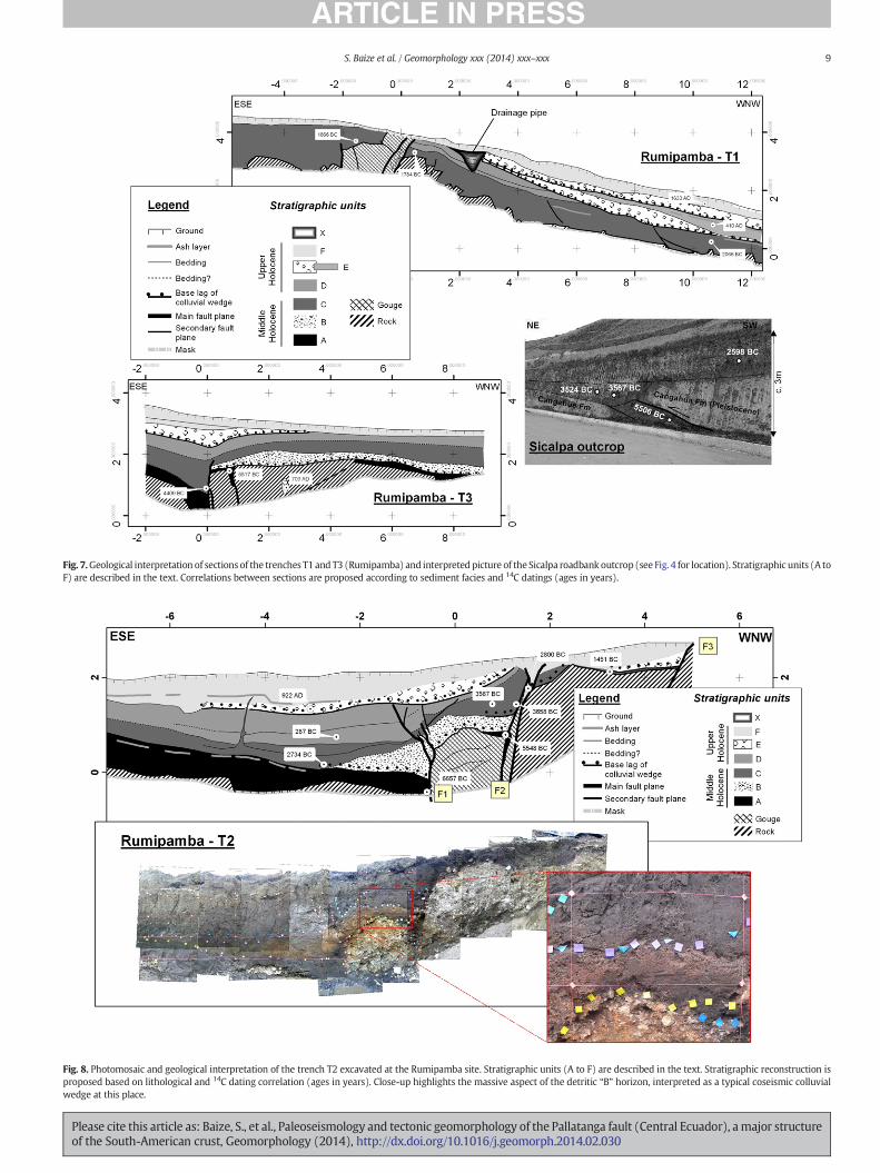
Fig. 8. Photomosaic and geological interpretation of the trench T2 excavated at the Rumipamba site. Stratigraphic units (A to F) are described in the text. Stratigraphic reconstruction isproposed based on lithological and 14C dating correlation (ages in years). Close-up highlights the massive aspect of the detritic “B” horizon, interpreted as a typical coseismic colluvialwedge at this place.
Fig. 7.Geological interpretation of sections of the trenches T1 and T3 (Rumipamba) and interpreted picture of the Sicalpa roadbank outcrop (see Fig. 4 for location). Stratigraphic units (A toF) are described in the text. Correlations between sections are proposed according to sediment facies and 14C datings (ages in years).
9S. Baize et al. / Geomorphology xxx (2014) xxx–xxx
Please cite this article as: Baize, S., et al., Paleoseismology and tectonic geomorphology of the Pallatanga fault (Central Ecuador), amajor structureof the South-American crust, Geomorphology (2014), http://dx.doi.org/10.1016/j.geomorph.2014.02.030

10 S. Baize et al. / Geomorphology xxx (2014) xxx–xxx
(andisols), frequently found in Central Ecuador (Buytaert et al., 2005).These black Holocene soils are characteristic of the Andean high-altitude grassland ecosystem (páramo) and, in Rumipamba, they aremainly developed on Holocene ash-fall deposits. This is validated byour grain-size distribution (homogenous clayey silts) and by ourminer-alogical analyses with the occurrence of amphibole, diopside and labra-dorite. The presence of wedellite – an organic mineral – in trenchsamples is consistent with the marsh and sag pond environment(Griffin et al., 1984) thatwas suspected after geomorphological apprais-al. Five samples in T1 reveal that the excavated andisol sediments con-tain 4 to 8% of organic carbon. In addition, the trenches show theoccurrence at different stratigraphic levels of several thin and lightash-fall layers that outstandingly underline the paleo-ground profile(Figs. 7 and 8). Black soils of the Sicalpa outcrop are assumed to reflectthe same pedo-sedimentological context. Volcanic material very proba-bly has come from nearby active volcanoes, like the Tungurahua (55 kmto theNE), the Sangay (62 km to the ESE) and the Chimborazo (35 km tothe north) (Fig. 2). They all underwent periodic Holocene activity (Hallet al., 1999; Monzier et al., 1999; Barba et al., 2008).
In the trenches' area, the basement rocks are Mio-Pliocene volcano-sedimentary series within the eastern (footwall) block of the fault andCretaceous-to-Eocene volcanic layers within the western (hangingwall) one. Inside the black andisol layers, several “clastic and detriticlayers” are interbedded. These matrix-supported horizons are massive,without apparent lamination, and they are poor in pebble/gravel sizeclasts. They are interpreted as local colluvium (T2) driven by gravity,or local wash slope deposits with short transport distance (T1 & T3).These contain oxidized material mixed with a blackish organic matrix,including scattered elements (grain size from coarse sand to gravel) ofbasement fragments and bioturbation remnants. The oxidized fractionleads to a reddish appearance (see Fig. 8) of these beds. Other interbed-ded layers (T1) are only distinguishable from “normal” sedimentationlayers (andisol) by the occurrence of scattered bedrock gravels/pebblesat their base. These “clastic” interbeds are 10 to 50, exceptionally 70 cmthick and are closely related to the bedrock outcrops in the fault zones.
We infer that they are the result of the erosion of an adjacent (orneighboring) basement regolith covered by ashes, outcropping duringepisodic events. These stratigraphic markers are hence considered ascolluvial wedges derived from basement scarp due to surface faulting(e.g. McCalpin, 2009).
4.1.2. Stratigraphic and chronological interpretationRadiocarbon dating of 21 samples was carried out using the Acceler-
atorMass Spectrometry of the LMC14 laboratory inGif-sur-Yvette/Saclay(France). The samples were gathered in order to cover as much as possi-ble the stratigraphy of the three excavated trenches in Rumipamba. Foursampleswere also taken at Sicalpa, 15 km away to the NE (Figs. 4 and 7).Age values range over 8000 thousand years, between cal. −6650 yearsand +1633 years and the sedimentary sequence in Rumipamba thuscovers the whole period including Middle and Late Holocene. Accordingto Niemann et al. (2009),who studied a complete record in lacustrine se-ries in the Southern Ecuadorian Andes, theMiddle Holocene (cal.−7000to −1500 years) corresponds to the Holocene optimum (warmer thantoday), with an increase in humidity and rainfall at cal. −4000 years.The Late Holocene (cal. −1500 years to Present) – i.e. the currentperiod – shows cooler and drier conditions.
According to lithological and chronological (14C datings) informa-tion, the stratigraphic sequence can be summarized as follows, frombottom to top:
• “A” is a group of organic clayey silts (andisol). Available 14C datings ofthese sediments are included between cal −6500 and −5500 years(trenches 2 and 3, Sicalpa). They are overlying the volcanic andvolcano-clastic basement (Tertiary).
• “B” is an outstanding reddish clastic horizon lying unconformablyabove older series, interpreted as related to a faulting event. It is a
Please cite this article as: Baize, S., et al., Paleoseismology and tectonic geomof the South-American crust, Geomorphology (2014), http://dx.doi.org/10
clayey matrix-supported layer, with numerous disseminated clastsand debris in T2. This massive horizon has no particular laminationor internal organization. In T2, it lays at the footwall of the mainfault zone and is quickly pinched out (70 to 0 cm): both its composi-tion and lens geometry associated with the fault here suggest a collu-vial wedge developed above the fault. In T3, it is a quite continuousbed lying above basement on the hangingwall block, with a drastical-ly different geometry compared to T2. No datings are directly avail-able and the age bracket is between layer “A” (cal. −5500 years)and layer “C” (cal. −3700 years). This layer deposition may havestarted during the climatic change which occurred in the Andes dur-ing theMiddle Holocene (−4000 years) butwe infer that it is directlyrelated to a major surface-faulting event.
• “C” is an organic clayey silt layer (Middle Holocene), which can locallycontain sharp fragments of basement (size of gravel to pebble) againstthe fault zone (T2). Calibrated ages are included in the bracket−3700to−3500 years for a first package in Rumipamba (Fig. 8) and Sicalpa(Fig. 7), and between cal. −2800 and −1500 years for a second onein T1, T2 and Sicalpa road bank section.
• “D” is a younger (Late Holocene) black and organic soil layer that iswell developed in T2 (cal −300 years) with a basal horizon withscattered clasts. In T1, “D” includes two probable distinct levels withscattered basement fragments in their base. This clastic layer may berelated to one (or several?) surface faulting event(s).
• “E” is an unconformable clastic layer found in all the sites. Only onedating is available in T2 (cal. +900 years)where the reddish color re-veals the occurrence of soil fragments and clasts (Fig. 8). In T1, thislayer seems to be duplicated in 2 reddish clastic horizons, includinga cal. +410 years soil layer. In T2 and T3, it seals the fault strands. Itis interpreted to be associated with the erosion of the fault scarpafter a late seismic event, but it has also clearly been displaced by alater event (see offset along F3 in T2).
• “F” is the youngest soil horizon. It lies with a slight unconformityabove older sediments. In T1, it has been eroded at the emergence ofthe fault zone. In T2, it is trapped inside the open fissure along F2.
Horizons “B”, “D” and “E”, interpreted as stratigraphic evidences ofpaleoearthquakes, present drastically different geometries in the threetrenches. The basic reason is that the trenches are, despite their proxim-ity, in different morphological contexts. T1 is located in the valley bot-tom (V0, Fig. 5A) and the local slope in the fault area has remained asa transport surface influenced by the entrenched Rio Pangor channel,despite the downhill uplift along the fault. Then, horizons “D” and “E”are not there classical colluvial wedges but ratherwash-slope colluviumderived from the uphill fault activity. By contrast, T2 has been dug acrossa preserved uphill facing slope, allowing for accumulation of fault-scarpderived colluvium (“B”, “D”, “E” colluvial-wedge deposits) (see Fig. 8).T3 is located in a similar morphological context as T1, dug in a localsmall gully, connected to the Rio Pangor channel (see Fig. 5D): “B” and“E” look more like slope or runoff deposits derived from actual colluvialwedges outcropping in the close T2-area.
4.2. Deformation of Holocene sediments and paleoseismologicalinterpretation
4.2.1. Description of deformation featuresThe three trenches and the road bank outcrop at Sicalpa all show
surface faulting in Holocene sediments. The fault zones show differentpatterns. They include:
• In trench 2 (Fig. 8), themain fault zone is 3 meter wide and constitut-ed of 3 splays. A “reverse” strand (the easternmost) with severalsplays is represented by slip planes, exhibiting a clear upward termi-nation beneath the “E” layer. The “central” strand (with apparent nor-mal throw) is perhaps themost significant in the sense of deformationintensity, with tectonic lenses or collapse features involving andisol
orphology of the Pallatanga fault (Central Ecuador), amajor structure.1016/j.geomorph.2014.02.030

11S. Baize et al. / Geomorphology xxx (2014) xxx–xxx
sediments, breccia of volcanic basement, shear planes, etc. At the NWside, a third “normal” splay has been recognized andwe suspect that itaffects the “E” and even “F” layers. As for T1 (see below), the basementwas recurrently outcropped during fault activity. The total verticaloffset of the Holocene base (“A” layer) reaches 3 m (assuming that“A” was deposited then eroded on the westernmost block of thetrench). This vertical offset was created during the last 6500 years(considering the age of the first evidence of paleo-earthquake). Asoft-sediment deformation feature appears at the −4 m row, withan upward dyke injection of “C” horizon sediments, probably duringthe last recorded seismic event.
• In trench 1 (Fig. 7), several splays with an apparent reverse compo-nent are organized as a positive flower structure (width: 3 m), thatlead the basement to the surface and to be eroded. Beneath thewest-verging fault splay, several “colluvial layers” develop along theslope. The total vertical offset of the Holocene base is about 1.5 for“C” layer sediments and it was created during the last 2500 years(the age of the first paleoseismic layer in that trench). In the lowerpart of the trench, sediment pile is also deformed by listric and prob-ably gravitational faults (layer “C”).
• In trench 3 (Fig. 7), the main fault plane is vertical. It cuts “A” and “B”horizons and seems absorbed within black soils suspected to belongto the “C” and “D” horizons. A subsidiary fault plane has been pointedout at almost 1m to the NW. This last plane clearly deforms and dragsalong the upper part of the “A” layer and it is sealed by the “B” layer.The fault zone never reached the free surface after the “C”–“D” depo-sition, and paleoearthquakes have not been recorded by specific collu-vial wedges. The potential stratigraphic record of very recent tectonicactivity is here the thickening of upper layers (“F” and “E”) above thefault footwall. In addition, we quote a finger-shape feature containingandisol of “E” layer, infiltrated downward within the basement.
• At Sicalpa (Fig. 7), the road bank section shows an outstanding flatfault with an apparent reverse component (dip: 20°) where Pleisto-cene Cangahua tuff overthrusts the Holocene black soil. It is notclear whether or not the observed Holocene fault plane is linked to abasement structure. Considering its location, it may be interpretedas an antithetic fault of the main structure (reverse South-Cajabamba segment).
An interesting result is the age-depth graph (Fig. 9). The samples thatwere extracted out of the fault zones fit well with an age/depth polyno-mial curve, while the other samples spread outside. The first populationis referred to as a “normal sedimentation” group. This group represents a
Fig. 9. Depth vs Age graph of the dating samples (ages in year
Please cite this article as: Baize, S., et al., Paleoseismology and tectonic geomof the South-American crust, Geomorphology (2014), http://dx.doi.org/10
regular accumulation along the mountain slopes of volcanic ashes thatare progressively edaphized. The other population of samples representseither the fault zone (behaving as an uplifted positive flower structure)or some singular features like fault-related fissures.
4.2.2. Retrodeformation of trench 2 and proposal of a paleo-earthquakecatalogue
Geometrical retrodeformation to assess total offsets is a priori a dif-ficult task with only vertical sections across strike–slip faults. This is es-pecially true in our case because of the lack of direct observation of eachearthquake slip vector both in magnitude (e.g. offset piercing line) andin direction (e.g. rake of slickenlines). Stratigraphy and deformation ofsediments provide nonetheless the best evidence for determining thenumber, magnitude and age of paleoearthquakes, one of the crucialsteps in seismic hazard studies. This effort is then performed on thebasis of T2 section where the stratigraphic series is more complete(“A” to “F” layers), datings are available and some units can be correlat-ed from one side of the fault to the other. In T1 and T3, the fault splaysare obvious but correlations are difficult. In T2, the fault splits into 3fault splays propagating from the basement fault gouge up to the Holo-cene deposits and even the ground surface. The fault zone throws theeastern block downwards by about 2.5–3 m. Intercorrelation betweenT1, T2, T3 and S based on stratigraphic and chronological controls servedas a basis to the following discussion.
The section is basically simplified for retrodeformation purpose(Fig. 10). We restore the initial continuity of stratigraphic layers bysubtracting step-by-step the vertical offsets along each fault strand.This work assumes the following:
• Strata are horizontal in the trench vicinities. This hypothesis is not re-gionally true but it is fully reliable at the scale of observation, becausesedimentary units are primarily ash falls from remote volcanoes anduniformly deposited along gentle slopes (less than 5%).
• The rake of slip events is taken from the slip vector determined fromthe geomorphological analysis by Winter et al. (1993) in the trenchzone. According to geomorphological observations, we excavatedalong the main strike–slip fault trace, not a restraining/releasingbend (Fig. 5).
• Wepostulate that the rake remains constant in time at scale of the site(trench T2).
Fig. 10 illustrates the preferred solution for retrodeformation oftrench 2. Results, in terms of earthquake paleomagnitudes and related
s) excavated in the 3 trenches and the outcrop of Sicalpa.
orphology of the Pallatanga fault (Central Ecuador), amajor structure.1016/j.geomorph.2014.02.030
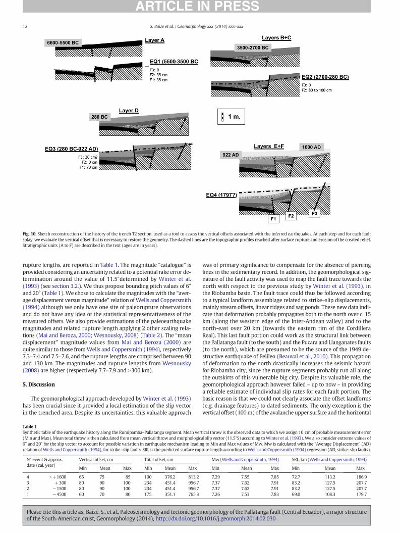
Fig. 10. Sketch reconstruction of the history of the trench T2 section, used as a tool to assess the vertical offsets associated with the inferred earthquakes. At each step and for each faultsplay, we evaluate the vertical offset that is necessary to restore the geometry. The dashed lines are the topographic profiles reached after surface rupture and erosion of the created relief.Stratigraphic units (A to F) are described in the text (ages are in years).
12 S. Baize et al. / Geomorphology xxx (2014) xxx–xxx
rupture lengths, are reported in Table 1. The magnitude “catalogue” isprovided considering an uncertainty related to a potential rake error de-termination around the value of 11.5°determined by Winter et al.(1993) (see section 3.2.). We thus propose bounding pitch values of 6°and 20° (Table 1).We chose to calculate themagnitudeswith the “aver-age displacement versusmagnitude” relation ofWells and Coppersmith(1994) although we only have one site of paleorupture observationsand do not have any idea of the statistical representativeness of themeasured offsets. We also provide estimations of the paleoearthquakemagnitudes and related rupture length applying 2 other scaling rela-tions (Mai and Beroza, 2000; Wesnousky, 2008) (Table 2). The “meandisplacement” magnitude values from Mai and Beroza (2000) arequite similar to those fromWells and Coppersmith (1994), respectively7.3–7.4 and 7.5–7.6, and the rupture lengths are comprised between 90and 130 km. The magnitudes and rupture lengths from Wesnousky(2008) are higher (respectively 7.7–7.9 and N300 km).
5. Discussion
The geomorphological approach developed by Winter et al. (1993)has been crucial since it provided a local estimation of the slip vectorin the trenched area. Despite its uncertainties, this valuable approach
Table 1Synthetic table of the earthquake history along the Rumipamba–Pallatanga segment. Mean ver(Min andMax).Mean total throw is then calculated frommean vertical throwandmorphologic6° and 20° for the slip vector to account for possible variation in earthquake mechanism leadinrelation ofWells and Coppersmith (1994), for strike–slip faults. SRL is the predicted surface rup
N° event & approx.date (cal. year)
Vertical offset, cm Total offset, cm
Min Mean Max Min Mean Max
4 N+1600 65 75 85 190 376.2 813.23 +300 80 90 100 234 451.4 956.72 −1500 80 90 100 234 451.4 956.71 −4500 60 70 80 175 351.1 765.3
Please cite this article as: Baize, S., et al., Paleoseismology and tectonic geomof the South-American crust, Geomorphology (2014), http://dx.doi.org/10
was of primary significance to compensate for the absence of piercinglines in the sedimentary record. In addition, the geomorphological sig-nature of the fault activity was used to map the fault trace towards thenorth with respect to the previous study by Winter et al. (1993), inthe Riobamba basin. The fault trace could thus be followed accordingto a typical landform assemblage related to strike–slip displacements,mainly streamoffsets, linear ridges and sag ponds. These new data indi-cate that deformation probably propagates both to the north over c. 15km (along the western edge of the Inter-Andean valley) and to thenorth-east over 20 km (towards the eastern rim of the CordilleraReal). This last fault portion could work as the structural link betweenthe Pallatanga fault (to the south) and the Pucara and Llanganates faults(to the north), which are presumed to be the source of the 1949 de-structive earthquake of Pelileo (Beauval et al., 2010). This propagationof deformation to the north drastically increases the seismic hazardfor Riobamba city, since the rupture segments probably run all alongthe outskirts of this vulnerable big city. Despite its valuable role, thegeomorphological approach however failed – up to now – in providinga reliable estimate of individual slip rates for each fault portion. Thebasic reason is that we could not clearly associate the offset landforms(e.g. drainage features) to dated sediments. The only exception is thevertical offset (100m) of the avalanche upper surface and the horizontal
tical throw is the observed data to which we assign 10 cm of probable measurement erroral slip vector (11.5°S) according toWinter et al. (1993).We also consider extreme values ofg to Min and Max values of Mw. Mw is calculated with the “Average Displacement” (AD)ture length according toWells and Coppersmith (1994) regression (AD, strike–slip faults).
Mw(Wells and Coppersmith, 1994) SRL, km (Wells and Coppersmith, 1994)
Min Mean Max Min Mean Max
7.29 7.55 7.85 72.7 113.2 186.97.37 7.62 7.91 83.2 127.5 207.77.37 7.62 7.91 83.2 127.5 207.77.26 7.53 7.83 69.0 108.3 179.7
orphology of the Pallatanga fault (Central Ecuador), amajor structure.1016/j.geomorph.2014.02.030

Table 2Results here presented are provided by 2 other scaling relations from the study measurements of offsets (see Table 1). Concerning Mai and Beroza (2000), magnitude and fault length(at depth) are calculated from observed displacement (mean value) thanks to the “effective” relation (“mean coseismic slip”, strike–slip faults). Concerning Wesnousky (2008),magnitude and surface rupture length are calculated thanks to the power-law relation (“average” or “maximum displacement”).
Event Total offset, cm(mean values)
Relation for SS andMean coseismic slipMai and Beroza (2000)
Power-law relations for SSWesnousky (2008)
Average displacement Maximum displacement
Mw L, km Mw SRL, km Mw SRL, km
4 376.2 7.31 98.6 7.78 353.8 7.14 64.72 & 3 451.4 7.43 125.0 7.91 508.5 7.21 79.11 351.1 7.26 90.1 7.73 308.0 7.04 55.8
13S. Baize et al. / Geomorphology xxx (2014) xxx–xxx
displacement (50 m) of an assumed later creek, nearby Riobamba. Thecorresponding 112m total throw can be assumed to have occurred dur-ing the last 50 ka (age of the volcanic avalanche, according to Bernardet al., 2008), leading to a 2.2 mm/a slip rate. This estimate is probablyan upper bound value, because part of the apparent vertical componentmay be a pre-existing morphological feature (Bernard, 2010, pers.comm.). Elsewhere, for example along the Ru–H and Si–LM structuralsegments, the large-scale landform offsets (deeply entrenched channelsand valleys, terrace risers of Chimborazo river) seem to decrease to theN, with maximum values of 400 m on both fault portions. Adding theoffsets along these 3 main fault portions of the Riobamba fault group,we obtain a cumulated offset of c. 1000 m in agreement with the onealong the (unique) Pallatanga–Rumipamba segment, south of theCajabamba Pass.
By performing a retrodeformation of the trench, we infer (at least) 4strongpaleoearthquakeswith individual vertical throws from0.70mupto 0.90 m (Table 1). Assuming a slip vector dipping of 11.5° (Winteret al., 1993), the total mean throws are between 3.8 and 4.5 m, whichprovidesmagnitudes around 7.5. To generate such earthquakes, the em-pirical scaling relations (see Tables 1 and 2) suggest that the fault rup-ture can be as long as 90 to 130 km, meaning that the inferredruptures probably may have extended all along the structural segmentsof the PF here described (i.e. Rio Chimbo–Bucay, Rumipamba–Pallatanga and Riobamba Group) (Fig. 11), then reaching the current
Fig. 11. Graph illustrating the various estimations of slip rates in the area of theRumipamba–Pallatanga portion of the Pallatanga fault. GPS value (dotted line) (Nocquet,2012, pers. comm.) is extrapolated to longer time spans; white squares refer to the valuesfrom themorphological survey byWinter et al. (1993); black diamond refers to this work(according to measured vertical offsets in trench and 14C datings).
Please cite this article as: Baize, S., et al., Paleoseismology and tectonic geomof the South-American crust, Geomorphology (2014), http://dx.doi.org/10
city of Riobamba. The geomorphological signature of the last surfaceruptures cannot be identified, except a few hundred meters north ofthe Cajabamba Pass, where a 1 m-high scarp dammed a channel andcreated a sag pond (Fig. 4). For thefirst time in Ecuador, paleoseismic in-vestigations hence prove the occurrence of (at least) 4 strong crustalevents which have shaken the Riobamba region during the Holocene,if the reported colluvial layers are effectively associated with surfacerupture. We even likely evidenced on the Pallatanga fault the trace ofsurface faulting associated with the Riobamba earthquake (1797)(event 4) because the youngest soils (1500 years AD) are deformed inRumipamba. Magnitudes inferred from the geological signal are inagreement with the independent estimate of the Riobamba earthquakeby Beauval et al. (2010). Recurrence intervals of these events seem var-iable (1000 to 3500 years) with a mean value around 1500 years. Withthe few available data, one can claim that the fault segment is rathercharacterized by constant coseismic displacement per event (verticalcomponent 70–90 cm) at the studied site, i.e. the fault behaves accord-ing to a uniform slip model. However, to bemore conclusive, more dataare required elsewhere along the fault. The trench survey and its inter-pretation include uncertainties. One of themajor limitations to the pro-posed scenario basically comes from the nature of the sedimentaryrecord itself. The absence of any lamination and the massive pattern ofdeposits prevent – except for a few rare cases – the identification ofsmall offsets, fault plane propagation, upward termination, and otherspecific useful markers. The earthquake occurrence has been inferredfrom a specific sedimentary signature that is, in this case, a change ingrain nature and size. It is also possible to estimate that small displace-ment (below 5 cm and perhaps below 10 cm) can hardly be detected.Then considering the dextral kinematics of the fault (with a constantslip vector; Winter et al., 1993), the paleoearthquake detection thresh-old in our trenches can be estimated at Mw = 6.5. It then arises theissue of a possible mistake in estimating the number of significantevents, which is a crucial point in seismic hazard assessment(McCalpin, 2009). Retrodeformation of T2 can also lead to an additionalpaleoearthquake because of (weak) arguments (e.g. unconformity be-tween “E” and “F” in fault zone). Moreover, the event 2, recorded in T2and also in T1, is associated in this last trenchwith 2 successive colluvialwedges. If we assume this is not partly due to external processes (e.g.climate), then the issue of possible under-representation of earthquakenumber in T2 appears (and correlative overestimation of magnitude) inour final results. In addition, the 3 trenches revealed variable tectono-sedimentary signals. These limitations weaken the above conclusionsdealing with magnitudes of paleoearthquakes and hazard assessmentfor the PF, and we clearly need additional investigations to strengthenthe results. Finally, our results of magnitude estimation have to be care-fully considered. The relationship between “displacement” and “magni-tude” was used to assess the event magnitude; while we have nocontrol on the statistical representativeness of our site (no other similardata from trenches are available for the PF). As suggested by the map-ping performed (Fig. 4), the site of trenching is probably located about20 km south of the northern fault portion tip. This relative locationnonetheless precludes any conclusion regarding the statistical meaningof the measured offset. Even if the overall form of slip-length profiles is
orphology of the Pallatanga fault (Central Ecuador), amajor structure.1016/j.geomorph.2014.02.030
14 S. Baize et al. / Geomorphology xxx (2014) xxx–xxx
roughly triangular and asymmetric in many cases (Manighetti et al.,2005), there is a large variability (even at the first order scale) of thispattern. The historical examples clearly show a large and rapid variabil-ity of slip, independent of the kinematics the magnitude (e.g. Barkaet al., 2002; Lee et al., 2003). For instance, during the Landers event(Mw= 7.3; 1992), the amount of slip gently decreased from theMaxi-mum Displacement point towards the rupture tips (Sieh et al., 1993),whereas during the Denali event (Mw = 7.9, 2002), abrupt decreaseswere observed at each tip of the segment rupture (Eberhart-Phillipset al., 2003). So, this aspect has clearly to be validated and newtrenching sites must be analyzed to increase the slip vs rupture lengthdataset.
We are thus aware that our “paleoseismic approach” contains a sig-nificant amount of uncertainty. To address the issue of seismic hazard,we can also follow a slip rate approach. Our results based on radiometricdatings outstandingly validate the rate published by Winter et al.(1993). Trenches show a mean vertical displacement of 3.25 m ofrecent soils (cf Table 1) — i.e. a total offset of 16.3 m, assuming the11.5°-dipping slip vector proposed by Winter et al. (1993). This hasbeen produced during the last 6500 years. This leads to a mean sliprate of c. 2.5 mm/a. Accordingly, if we assume a total fault surface of100 × 20 km2 (only 70 km have beenmapped up to now), we can basi-cally calculate the recurrence time ofMw=7 or 7.5 earthquakes. This isobtained by dividing the seismic moment of this assumed earthquakeby the total fault moment (slip rate × surface rupture area), followingthe “maximum magnitude model” as described by Wesnousky (1986).Such a calculation gives recurrence times of 200 and 1100 years,respectively.
The total displacement rate of the North-Andean Block with respectto South America ranges between 6 and 8mm/a (Trenkamp et al., 2002;Nocquet and Mothes, 2009; Egbue and Kellogg, 2010). Nocquet (2012,pers. comm.) calculated a dense field velocity in the Equatorian Andesand the velocity vectors of 4 stations (see Fig. 2, TORR, TOTO, MIGUand ZAGR) can be used to assess the current (horizontal) slip rate ofthe PF. This calculation assumes that the fault is vertical and thatits strike is N26°E. For the 2 pairs of stations (TORR/TOTO andMIGU/ZAGR), the parallel-to-strike component of slip rate is close to4 mm/a. This geodetic value can be compared with our geologicalvalue (despite the slight dip angle of the slip vector attached to thisslip value). It is significantly higher than our finding, and we here for-mulate some comments. First, this difference does not necessarilymean a contradiction. Geological and geodetical slip ratesmay be differ-ent in a given region, even in plate boundary areaswhere tectonic load-ing is constant over several million years. Tectonic loading may not beequally distributed within a fault system during a reduced time span(shorter than the seismic cycle duration), because of transient phenom-ena (e.g. clustered earthquakes, postseismic strain accumulation; e.g.Oskin et al., 2007). Geodetic and geologic rates thus represent differenttimewindows in the seismic cycle history and the formermay not be assteady as the latter. Moreover, it must be stressed that the ‘GPS-basedslip rate value’ here integrates a large volume of crust that either en-compasses unknownactive faults or accommodates strain in a distribut-ed way. Regarding the first alternative, Alvarado (2009) shows apossible active fault system, running N–S through theWestern Cordille-ra (see Fig. 2). We also have to take into account that the “GPS-base sliprate value” is clearlywithin the range of the values obtained by themor-phological study ofWinter et al. (1993). According to these authors, the“Holocene” value (c. 4 mm/a) is significantly higher than the “Holo-cene” value from our geological approach (2.5 mm/a) that includes ab-solute dating of sediments. We then provisionally formulate thehypothesis that the offset features are older than postulated by Winteret al. (1993): the cr1 crest line displaced by 40 m (Fig. 4) may havebeen shaped during a Late Glacial ice advance (N10 ka) insteadof duringthe Holocene (c. 10 ka). The 1st-order large-scale features, displaced bymore than 1000 m in Rumipamba and in other localities, may be as oldas 400 ka considering a steady slip rate of 2.5 mm/a.
Please cite this article as: Baize, S., et al., Paleoseismology and tectonic geomof the South-American crust, Geomorphology (2014), http://dx.doi.org/10
6. Conclusion
The Pallatanga fault (PF) is a segment of the large scale deformationzone that accommodates the relative displacement between the SouthAmerica Plate and the North Andean Crustal Block. A field campaignallowed the improvement of the fault trace map, based on its morpho-logical imprint. An emblematic assemblage of landforms characterizesthe fault trace and attests the dextral kinematics with a slight verticalcomponent (mainly linear ridges, drainage offsets, and cumulativescarps and counterscarps).
Starting from a previous detailed geomorphological survey (Winteret al., 1993), the study is focused on the stratigraphic and sedimentolog-ical record of the fault activity in the locality of Rumipamba. Accordingto a trench survey and 14C datings, we evidenced for the last6500 years the occurrence of (at least) 4 large-magnitude events (Mw≥ 7) during this first paleoseismic study in Ecuador.Moreover,we prob-ably found out in Rumipamba the preserved surface rupture of the lasthistorical earthquake that destroyed the nearby city of Riobamba in1797 (magnitude about 7.6, Beauval et al., 2010). The mean recurrencetime of the prehistorical and historical earthquakes is estimated atabout 1500 years. Finally, the inferred Holocene slip rate (c. 2.5 mm/a) is slightly lower than the longer-term slip rates estimated byWinter et al. (1993) on the basis of morphological evidences. Anyway,this rate is too low regarding the relative displacement rate of NAB/SAP determined from GPS data (Nocquet andMothes, 2009) and pointsout a slip deficit along this structure. These results emphasize the issueof seismic hazard for the inhabited basin of Riobamba. Additional stud-ies are needed to provide a better understanding of the hazard associat-ed with this fault. It will be necessary to continue the mapping of activesegments to the north and the north-east, to complete the faultmap andcharacterize the entire Pallatanga fault system segmentation. We alsoplan to increase the dataset of paleoseismic events and fault throws(new trenches, new datings), in order to constrain the fault slip-length profile and to better understand the seismic cycle on thesemajor crustal and active tectonic structures. Finally, the intensity data-base of the 1797 earthquake includes a rich set of environmental effects,which may be quantified thanks to remote sensing, field work and becompared with the Environmental Seismic Intensity scale (ESI-2007;Michetti et al., 2004).
Acknowledgments
The authors are grateful to Carlos Costa, Franck Audemard and PabloSilva Barroso for their review and comments, which improved theman-uscript. This research was funded by the French Agency for Research(“Agence Nationale pour la Recherche”, ANR) within the “Andes DuNord 2007” project (ADN ANR-07-BLAN-0143), the French “Institut deRecherche pour le Développement” and the “Institut de Radioprotectionet Sûreté Nucléaire”.
The authors give special thanks to the peoplewhomake this researchpossible: the local communities, the various authorities of Ecuador whomake this research possible (government of Chimborazo Province, Pre-fecture of Colta Canton Municipal Head of Colta, Political Headquartersof Juan de Velasco government district), the “Institut de Recherche pourle Développement” staff of Quito, and the “Escuela Politecnica Nacional deQuito”. We are also grateful to MM P. Podwojewski (IRD), J. Poulenard(Savoie University), B. Bernard (IRD) and D. Andrade (EPN-IG Quito)for the provided information. Datings were performed at the LMC14laboratory of Saclay and Gif-sur-Yvette, France (J.-P. Dumoulin andC. Moreau). Geochemical results were performed at the IRSN (S. Bassotand A. Mifsud) and at the ISTERRE laboratory (B. Lanson).
References
Alvarado, A., 2009. Mapa de fallas y pliegues cuaternarios del Ecuador, database. InternalReport. Instituto Geofisico, Escuela Politecnica Nacional (15 pp.).
orphology of the Pallatanga fault (Central Ecuador), amajor structure.1016/j.geomorph.2014.02.030

15S. Baize et al. / Geomorphology xxx (2014) xxx–xxx
Audemard, F., Pantosti, D., Machette, M., Costa, C., Okumura, K., Cowan, H., Diederix, H.,Ferrer, C., participants of the South American Field Workshop on Paleoseismology,1999. Trench investigation along the Mérida section of the Boconó fault (centralVenezuelan Andes), Venezuela. Tectonophysics 308, 1–21.
Audin, L., Herail, G., Riquelme, R., Darrozes, J., Martinod, J., Font, E., 2003. Geomorpholog-ical markers of faulting and neotectonic activity along the Western Andean Margin,Northern Chile. J. Quat. Sci. 18, 681–694.
Audin, L., David, C., Hall, S., Farber, D., Hérail, G., 2006. Geomorphic evidences of recenttectonic activity in the forearc, southern Peru, special volume on neotectonics inSouth America. Rev. Asoc. Geol. Argent. 61, 545–554.
Barba, D., Robin, C., Samaniego, P., Eissen, J.P., 2008. Holocene recurrent explosive activityat Chimborazo volcano (Ecuador). J. Volcanol. Geotherm. Res. 176, 27–35.
Barka, A., Akyüz, H.S., Altunel, E., Sunal, G., Çakir, Z., Dikbas, A., Yerli, B., Armijo, R., Meyer,B., de Chabalier, J.B., Rockwell, T., Dolan, J.R., Hartleb, R., Dawson, T., Christofferson, S.,Tucker, A., Fumal, T., Langridge, R., Stenner, H., Lettis, W., Bachhuber, J., Page, W.,2002. The surface rupture and slip distribution of the 17 August 1999 Izmit earth-quake (M 7.4), North Anatolian Fault. Bull. Seismol. Soc. Am. 92, 43–60. http://dx.doi.org/10.1785/0120000841.
Beauval, C., Yepes, H., Bakun, W.H., Egred, J., Alvarado, A., Singaucho, J.-C., 2010. Locationsand magnitudes of historical earthquakes in the Sierra of Ecuador (1587–1996).Geophys. J. Int. 181, 1613–1633. http://dx.doi.org/10.1111/j.1365-246X.2010.04569.x.
Bernard, B., van Wyk, B., de Vries, B., Barba, D., Leyrit, H., Robin, C., Alcaraz, S., Samaniego,P., 2008. The Chimborazo sector collapse and debris avalanche: deposit characteris-tics as evidence of emplacement mechanisms. J. Volcanol. Geotherm. Res. 176, 36–43.
Burbank, D.W., Anderson, R.S., 2001. Tectonic Geomorphology. Blackwell Science, Malden(USA) (274 pp.).
Buytaert, W., Sevink, J., De Leeuw, B., Deckers, J., 2005. Clay mineralogy of the soils in thesouth Ecuadorian paramo region. Geoderma 127, 114–129.
Chardon, D., Hermitte, D., Nguyen, F., Bellier, O., 2005. First paleoseismological constraintson the strongest earthquake in France (Provence) in the twentieth century. Geology33, 901–904.
Clapperton, C.M., Vera, R., 1986. The Quaternary glacial sequence in Ecuador: a reinterpre-tation of the work of Walter Sauer. J. Quat. Res. 1, 45–56.
Costa, C.H., Audemard, F.A., Audin, L., Benavente, C., 2010. Geomorphology as a tool foranalysis of seismogenic sources in Latin America and the Caribbean. In: Latrubesse,E. (Ed.), Natural Hazards and Human-Exacerbated Disasters in Latin America. SpecialVolumes of Geomorphology. Developments in Earth Surface Processes, 13. Elsevier,Amsterdam, pp. 29–47.
Cruden, D.M., Varnes, D.J., 1996. Landslide types and processes. In: Turner, K.A., Schuster,R.L. (Eds.), Landslides: Investigation andMitigation. Transport Research Board SpecialReport, 247, pp. 36–75.
Dumont, J.F., Santana, E., Vilema, W., 2005. Morphologic evidence of active motion of theZambapala Fault, Gulf of Guayaquil (Ecuador). Geomorphology 65, 223–239.
Eberhart-Phillips, D., Haeussler, P.J., Freymueller, J.T., Frankel, A.D., Rubin, C.M., Craw, P.,Ratchkovski, N.A., Anderson, G., Carver, G.A., Crone, A.J., Dawson, T.E., Fletcher, H.,Hansen, R., Harp, E.L., Harris, R.A., Hill, D.P., Hreinsdottir, S., Jibson, R.W., Jones, L.M.,Kayen, R., Keefer, D.K., Larsen, C.F., Moran, S.C., Personius, S.F., Plafker, G., Sherrod,B., Sieh, K., Sitar, N., Wallace, W.K., 2003. The 2002 Denali fault earthquake, Alaska:a large magnitude, slip-partitioned event. Science 300, 1113–1118.
Egbue, O., Kellogg, J., 2010. Pleistocene to present North Andean “escape”. Tectonophysics489, 248–257.
Ego, F., Sébrier, M., Lavenu, A., Yepes, H., Egues, A., 1996. Quaternary state of stress in theNorthern Andes and the restraining bend model for the Ecuadorian Andes.Tectonophysics 259, 101–116.
Egred J., El terremoto de Riobamba, 2nd volume, 2000, Abya-Yala, Riobamba, (107 pp.)Fiorini, E., Tibaldi, A., 2011. Quaternary tectonics in the central Interandean Valley,
Ecuador: fault-propagation folds, transfer faults and the Cotopaxi Volcano. Glob. Plan-et. Change 90–91, 87–103.
Gobierno de Ecuador, 1993. Mapa geológico de la República del Ecuador, 1:1,000,000scale.
Grant, L.B., Sieh, K., 1993. Stratigraphic evidence for seven meters of dextral slip on theSan Andreas Fault during the 1857 earthquake in the Carrizo plain. Bull. Seismol.Soc. Am. 83, 619–635.
Griffin, G.M., Sawyer, R.K., Melkote, S.R., 1984. Weddellite occurrence in peats and otherorganic-rich sediments of Florida. J. Sediment. Res. 54, 861–868.
Hall, M.L., Robin, C., Beate, B., Mothes, P., Monzier, M., 1999. Tungurahua Volcano,Ecuador: structure, eruptive history and hazards. J. Volcanol. Geotherm. Res. 91, 1–21.
Hughes, R., Pilatasig, L., 2002. Cretaceous and Tertiary terrane accretion in the CordilleraOccidental of the Andes of Ecuador. Tectonophysics 245, 29–48.
Lavenu, A., Winter, T., Davila, F., 1995. A Pliocene–Quaternary compressional basin in theInter-Andean depression, central Ecuador. Geophys. J. Int. 121, 279–300.
Please cite this article as: Baize, S., et al., Paleoseismology and tectonic geomof the South-American crust, Geomorphology (2014), http://dx.doi.org/10
Lee, Y.H., Hsiehb, M.-L., Lua, S.-D., Shiha, T.-S., Wua, W.-Y., Sugiyamac, Y., Azumad, T.,Kariya, Y., 2003. Slip vectors of the surface rupture of the 1999 Chi-Chi earthquake,western Taiwan. J. Struct. Geol. 25, 1917–1931.
Lienkaemper, J.L., Williams, P.L., 2007. A record of large earthquakes on the southern Hay-ward fault for the past 1800 years. Bull. Seismol. Soc. Am. 97, 1803–1819. http://dx.doi.org/10.1785/0120060258.
Mai, P.M., Beroza, G.C., 2000. Source scaling properties from finite-fault-rupture models.Bull. Seismol. Soc. Am. 90, 604–615.
Manighetti, I., Campillo, M., Sammis, C., Mai, P.M., King, G., 2005. Evidence for self-similar,triangular slip distributions on earthquakes: Implications for earthquake and faultmechanics. J. Geophys. Res. 110, B05302. http://dx.doi.org/10.1029/2004JB003174(25 pp.).
McCalpin, J.P., 2009. Paleoseismology, 2nd ed. Academic Press, Elsevier, Amsterdam (613 pp.).Michetti, A.M., Esposito, E., Mohammadioun, B., Mohammadioun, J., Gürpinar, A., Porfido,
S., Rogozhin, E., Serva, L., Tatevossian, R., Vittori, E., Audemard, F., Comerci, B., Marco,S., McCalpin, J., Mörner, N.A., 2004. The INQUA scale: an innovative approach forassessing earthquake intensities based on seismically-induced ground effects in theenvironment. In: Vittori, E., Comerci, V. (Eds.), Special Paper, Memorie Descrittivedella Carta Geologica d’Italia, vol. LXVII, 120 pp.
Monzier, M., Robin, C., Samaniego, P., Hall, M.L., Cotton, J., Mothes, P., Arnaud, N., 1999.Sangay volcano, Ecuador: structural development, present activity and petrology. J.Volcanol. Geotherm. Res. 90, 49–79.
Niemann, H., Haberzettl, T., Behling, H., 2009. Holocene climate variability and vegetationdynamics inferred from the (11,700 cal. yr BP) Laguna Rabadilla de Vaca sediment re-cord, southeastern Ecuadorian Andes. The Holocene 19, 307–316.
Nocquet, J.M., Mothes, P., 2009. Geodésia, geodinámica y ciclo sísmico en Ecuador. In:Collot, J.Y., Sallares, V., Pazmiño, N. (Eds.), Geología y geofísica marina y terrestredel Ecuador: desde la costa continental hasta las Islas Galápagos. CNDM/IRD/INOCAR,Guayaquil (Ecuador)/Marseille (France), pp. 83–94.
Oskin, M., Perg, L., Blumentritt, D., Mukhopadhyay, S., Iriondo, A., 2007. Slip rate of theCalico fault: implications for geologic versus geodetic rate discrepancy in the EasternCalifornia Shear Zone. J. Geophys. Res. 112, B03402. http://dx.doi.org/10.1029/2006JB004451 (16 pp.).
Peltzer, G., Tapponnier, P., Gaudemer, Y., Meyer, B., Shunmin, G., Kelun, Y., Zhitai, C.,Huagung, D., 1988. Offsets of late Quaternarymorphology, rate of slip, and recurrenceof large earthquakes on the Chang Ma fault (Gansu, China). J. Geophys. Res. 93,7793–7812.
Segovia, M., 2009. Análisis espacio-temporal del Enjambre de Puerto López entre enero yfebrero de 2005 con observaciones de la estación de banda ancha de OTAVALO. (Mas-ter thesis) Université de Nice, France (47 pp.).
Sieh, K.E., Jones, L., Hauksson, E., Hudnut, K., Eberhart-Phillips, D., Heaton, T., Hough, S.,Hutton, K., Kanamori, H., Lilje, A., Lindvall, S., McGill, S.F., Mori, J., Rubin, C., Spotila,J.A., Stock, J., Thio, H.K., Treiman, J., Wernicke, B., Zachariasen, Z., 1993. Near-field in-vestigations of the Landers earthquake sequence, April to July 1992. Science 260,171–176.
Souris, M., 2001. Repùblica del Ecuador: modelo numérico del relieve, escala 1:1000000.Edition IGM, Quito, Ecuador.
Tibaldi, A., Rovida, A., Corazzato, C., 2007. Late Quaternary kinematics, slip-rate and seg-mentation of a major Cordillera-parallel transcurrent fault: the Cayambe-Afiladores-Sibundoy system, NW South America. J. Struct. Geol. 29, 664–680.
Trenkamp, R., Kellogg, J.N., Freymueller, J.T., Mora, H.T., 2002. Wide plate margin defor-mation, southern Central America and northwestern South America, CASAGPS obser-vations. J. S. Am. Earth Sci. 15, 157–171.
Wallace, R.E., 1986. Active Tectonics: Studies in Geophysics. National Academic Science,Washington DC (266 pp.).
Wells, D.L., Coppersmith, K.J., 1994. New empirical relationships among magnitude, rup-ture length, rupture width, rupture area and surface displacement. Bull. Seismol. Soc.Am. 84, 974–1002.
Wesnousky, S.G., 1986. Earthquakes, Quaternary faults, and seismic hazard in California.J. Geophys. Res. 91, 12,587–12,631.
Wesnousky, S.G., 2008. Displacement and geometrical characteristics of earthquake sur-face ruptures: issues and implications for seismic-hazard analysis and the processof earthquake rupture. Bull. Seismol. Soc. Am. 98, 1609–1632. http://dx.doi.org/10.1785/0120070111.
Winter, T., Avouac, J.P., Lavenu, A., 1993. Late Quaternary kinematics of the Pallatangastrike–slip fault (Central Ecuador) from topographic measurements of displacedmorphological features. Geophys. J. Int. 115, 905–920.
Witt, C., Bourgois, J., Michaud, F., Ordoñez, M., Jiménez, N., Sosson, M., 2006. Developmentof the Gulf of Guayaquil (Ecuador) during the Quaternary as an effect of the NorthAndean block tectonic escape. Tectonics 25, TC3017. http://dx.doi.org/10.1029/2004TC001723 (22 pp.).
orphology of the Pallatanga fault (Central Ecuador), amajor structure.1016/j.geomorph.2014.02.030