Effect of asymmetrical street aspect ratios on microclimates in hot, humid regions
21
ORIGINAL PAPER Effect of asymmetrical street aspect ratios on microclimates in hot, humid regions Adeb Qaid & Dilshan R. Ossen Received: 17 January 2014 /Revised: 15 July 2014 /Accepted: 15 July 2014 # ISB 2014 Abstract Asymmetrical street aspect ratios, i.e. different height-to-width (H 1 /W-H 2 /W) ratios, have not received much attention in the study of urban climates. Putrajaya Boulevard (northeast to southwest orientation) in Malaysia was selected to study the influence of six asymmetrical aspect ratio scenar- ios on the street microclimate using the Envi-met three-di- mensional microclimate model (V3.1 Beta). Putrajaya Boule- vard suffers from high surface and air temperature during the day due to the orientation, the low aspect ratio and the wide sky view factor. These issues are a common dilemma in many boulevards. Further, low and high symmetrical streets are incompatible with tropical regions as they offer conflicting properties during the day and at night. These scenarios are examined, therefore, to find asymmetrical streets which are able to reduce the impact of the day microclimate on boule- vards, and as an alternative strategy fulfilling tropical day and night climatic conditions. Asymmetrical streets are better than low symmetrical streets in enhancing wind flow and blocking solar radiation, when tall buildings confront winds direction or solar altitudes. Therefore, mitigating heat islands or improving microclimates in asymmetrical streets based on tall buildings position which captures wind or caste shades. In northeast to southwest direction, aspect ratios of 0.8–2 reduce the morning microclimate and night heat islands yet the negative effects during the day are greater than the positive effects in the night. An aspect ratio of 2–0.8 reduces the temperature of surfaces by 10 to 14 °C and the air by 4.7 °C, recommended for enhancing boulevard microclimates and mitigating tropical heat islands. Keywords Asymmetrical Street H 1 /W-H 2 /W . Tropical climate . Urban microclimate . Putrajaya Boulevard . Numerical modelling Introduction Urban heat island can undermine a comfortable lifestyle (Yang et al. 2010). Creating thermally comfortable environments and quality microclimates is a complex task confronting urban designers and climatologists. The causes of heat islands and poor microclimates on a citywide scale are complex and mostly related to the configuration of urban streets (Goh and Chang 1999; Oke 1981). The configuration of urban geome- tries is usually represented by height-to-width (H/W) aspect ratios. These H/W aspect ratios are the main physical factor affecting incoming and outgoing radiation, radiation flux and wind flow (Xi et al. 2012; Johansson 2006); (Marciotto et al. 2010). They also affect the behaviour of air and surface temperatures (Bourbia and Awbi 2004a; Andreou and Axarli 2012). They are a physical factor in urban canyons introduced to control the urban heat islands, ameliorate urban microcli- mates and enhance outdoor thermal comfort. The available knowledge about the relationship between microclimates and H/W ratios is largely confined to symmet- rical H/W aspect ratios; information about asymmetrical H/W aspect ratios is very limited. Low and high symmetrical street H/W aspect ratios have been used in several studies that present conflicting day and night time needs in the tropics and seasonal needs elsewhere. The uniqueness of these studies is in highlighting the influence of asymmetrical H/W aspect ratios on microclimates and heat islands in tropical regions. Tropical climates have not been discussed in studies on asym- metrical streets. This represents a serious difference between the present work and the previous research of Ali-Toudert and Mayer (2007) and Swaid (1992). Further, these studies A. Qaid (*) : D. R. Ossen Faculty of Built Environment, Universiti Teknologi Malaysia, Skudai, 81310, Johor Johor bahru, Malaysia e-mail: [email protected] Int J Biometeorol DOI 10.1007/s00484-014-0878-5
-
Upload
teknologimalaysia -
Category
Documents
-
view
2 -
download
0
Transcript of Effect of asymmetrical street aspect ratios on microclimates in hot, humid regions

ORIGINAL PAPER
Effect of asymmetrical street aspect ratios on microclimatesin hot, humid regions
Adeb Qaid & Dilshan R. Ossen
Received: 17 January 2014 /Revised: 15 July 2014 /Accepted: 15 July 2014# ISB 2014
Abstract Asymmetrical street aspect ratios, i.e. differentheight-to-width (H1/W-H2/W) ratios, have not received muchattention in the study of urban climates. Putrajaya Boulevard(northeast to southwest orientation) in Malaysia was selectedto study the influence of six asymmetrical aspect ratio scenar-ios on the street microclimate using the Envi-met three-di-mensional microclimate model (V3.1 Beta). Putrajaya Boule-vard suffers from high surface and air temperature during theday due to the orientation, the low aspect ratio and the widesky view factor. These issues are a common dilemma in manyboulevards. Further, low and high symmetrical streets areincompatible with tropical regions as they offer conflictingproperties during the day and at night. These scenarios areexamined, therefore, to find asymmetrical streets which areable to reduce the impact of the day microclimate on boule-vards, and as an alternative strategy fulfilling tropical day andnight climatic conditions. Asymmetrical streets are better thanlow symmetrical streets in enhancing wind flow and blockingsolar radiation, when tall buildings confront winds direction orsolar altitudes. Therefore, mitigating heat islands or improvingmicroclimates in asymmetrical streets based on tall buildingsposition which captures wind or caste shades. In northeast tosouthwest direction, aspect ratios of 0.8–2 reduce the morningmicroclimate and night heat islands yet the negative effectsduring the day are greater than the positive effects in the night.An aspect ratio of 2–0.8 reduces the temperature of surfacesby 10 to 14 °C and the air by 4.7 °C, recommended forenhancing boulevard microclimates and mitigating tropicalheat islands.
Keywords Asymmetrical Street H1/W-H2/W . Tropicalclimate . Urbanmicroclimate . Putrajaya Boulevard .
Numerical modelling
Introduction
Urban heat island can undermine a comfortable lifestyle (Yanget al. 2010). Creating thermally comfortable environments andquality microclimates is a complex task confronting urbandesigners and climatologists. The causes of heat islands andpoor microclimates on a citywide scale are complex andmostly related to the configuration of urban streets (Goh andChang 1999; Oke 1981). The configuration of urban geome-tries is usually represented by height-to-width (H/W) aspectratios. These H/W aspect ratios are the main physical factoraffecting incoming and outgoing radiation, radiation flux andwind flow (Xi et al. 2012; Johansson 2006); (Marciotto et al.2010). They also affect the behaviour of air and surfacetemperatures (Bourbia and Awbi 2004a; Andreou and Axarli2012). They are a physical factor in urban canyons introducedto control the urban heat islands, ameliorate urban microcli-mates and enhance outdoor thermal comfort.
The available knowledge about the relationship betweenmicroclimates and H/W ratios is largely confined to symmet-rical H/W aspect ratios; information about asymmetrical H/Waspect ratios is very limited. Low and high symmetrical streetH/W aspect ratios have been used in several studies thatpresent conflicting day and night time needs in the tropicsand seasonal needs elsewhere. The uniqueness of these studiesis in highlighting the influence of asymmetrical H/W aspectratios on microclimates and heat islands in tropical regions.Tropical climates have not been discussed in studies on asym-metrical streets. This represents a serious difference betweenthe present work and the previous research of Ali-Toudert andMayer (2007) and Swaid (1992). Further, these studies
A. Qaid (*) :D. R. OssenFaculty of Built Environment, Universiti Teknologi Malaysia,Skudai, 81310, Johor Johor bahru, Malaysiae-mail: [email protected]
Int J BiometeorolDOI 10.1007/s00484-014-0878-5
pursued a different way of discovering the effects of asym-metrical streets, depending on different scenarios created bymanipulating the height of buildings (on both street sides) andthe sky view factor (SVF).
Asymmetrical street canyons were proposed as an alterna-tive strategy to mitigate the night time heat islands in tropicalregions and to improve daytime microclimates in PutrajayaBoulevard, Putrajaya,Malaysia. Putrajaya Boulevard is a 100-m wide ceremonial parade which passes through massivegovernment administrative buildings. It orientates toward thenortheast and southwest directions with low aspect ratios andwide SVF, thus exposing the urban surfaces to direct solarradiation during the day (Ahmed et al. 2014). These issues arecommon features in boulevards elsewhere. Putrajaya Boule-vard is divided into several components: Two sidewalks atboth edges of the street, two street lanes for vehicles and awide pedestrian street at the centre of the boulevard. Thisstudy will investigate the influence of different asymmetricalstreet scenarios on a boulevard and its components. Theoutcomes of this study are potentially significant for otherboulevards that share similar components and likely facesimilar issues. However, the study highlighted the effect ofthe different asymmetrical aspect ratios on the urban street andstreet components as a general and the analysis are guidedtoward local urban planning measures to be implemented inPutrajaya Boulevard.
Background on street H/W aspect ratio
Climatic research on urban canyons and street design studiesare linked to H/W aspect ratios. The first climatic studyrelating to street H/W aspect ratios was conducted by Oke(1988a) in ‘rational cities’ (old, big cities characterised byuniform building heights). Arnfield (1990) argued that theconcept of street H/W aspect ratio was related to seasonalsolar access. Street H/W aspect ratios in these two importantstudies and in other published studies in this area have onlyinvestigated symmetrical streets where the height of thebuildings in proportion to street width, and to otherbuildings in the area, have little variation.
The studies that investigated symmetrical streets were con-ducted in different climates to examine various climatic ob-jectives such as microclimates, urban heat island intensity andoutdoor thermal comfort. For example, in hot, humid, tropicalclimates, Ahmed (1994) discovered that H/W aspect ratioaffected thermal comfort (in Dhaka, Bangladesh). Emmanueland Johansson (2006) also studied the effect of H/W aspectratios on microclimates and thermal comfort in Colombo, SriLanka. Salleh (2006) investigated the effect of the differentH/W aspect ratios on the microclimate of Kuala Lumpur,Malaysia. Another study conducted in the hot and humidtropical climate of Singapore was undertaken by Goh and
Chang (1999) who investigated urban heat island intensityfor different H/W aspect ratios. In a hot, dry climate,Johansson (2006) studied the effect of H/W aspect ratios onthermal comfort and microclimates (in Fez, Morocco). An-other study in the same climate was conducted by Ali-Toudertet al. (2005) in Beni-Isguen, Algeria. EL-Oued City, Algeriawas the site of a similar study conducted by Bourbia and Awbi(2004b) to determine how H/W aspect ratios affect shadingand surface temperatures. H/W aspect ratios in relation tomicroclimates were also investigated in the Mediterraneanclimate of Athens, Greece, by Giannopoulou et al. (2010)and Tinos, Greece by Andreou and Axarli (2012). A recentstudy by Andreou (2013) investigated thermal comfort fordifferent symmetrical streets oriented in different directions.
Most of the above studies claim that in the low-mid latitudesummertime and in the tropics over the year, high symmetricalH/W aspect ratios (building height two times the street widthor beyond), increase the heat island intensity at night andimprove the microclimate during the day. Simultaneously, alow symmetrical H/W aspect ratio (building height of onetimes the street width or below), decreases the heat islandintensity at night and worsens the microclimate during theday. In the winter in low-mid latitudes, low symmetrical H/Waspect ratios offer warmth in the daytime and cold night timemicroclimates. Conversely, high symmetrical H/W aspect ra-tios cause a warm night time and a cold daytime microclimate.These results were confirmed by research Oke et al. (1991);Arnfield (2003); Johansson and Emmanuel (2006).
In tropical climates, poor night time microclimatic condi-tions with a high H/W aspect ratio cause the air flow tostagnate and the stored heat negatively affects climate condi-tions. Daytime microclimatic conditions are better for theseaspect ratios due to sufficient shading patterns. The daytimemicroclimatic conditions of streets with low H/Waspect ratiosare dependent on the effect of direct sunshine. At the sametime, these improve the climate at night due to the stored heatbeing conveniently released. Based on these previous studies,the high and the low H/W aspect ratios are not climaticallyappropriate as they present conflicting day and night timeneeds in tropical climates, and conflicting seasonal needs atlow-mid latitudes. Hence, asymmetrical streets present a ‘zoneof compatibility’ Oke (1988a), that can meet all climaticneeds at all times. Oke (1988a) pointed out that achievinga ‘zone of compatibility’ is a challenging task for urbandesigners.
However, the most serious issue facing asymmetricalstreets can be seen when tall buildings are opposite lowbuildings in a canyon. Oke (1988a), Penwarden (1975) andStathopoulos et al. (1992) reported that tall buildings createpoor dispersion of solar access and create high wind speeds atstreet level. This is a preferred characteristic in tropical cli-mates where the wind in such region is steady and static,because it enhances microclimatic conditions (Johansson
Int J Biometeorol
and Emmanuel 2006; Emmanuel et al. 2007) as it moves air tothe street level.
Urban street canyons are classified as symmetrical if therows of buildings have an almost equal height, or asymmetri-cal if the buildings have significantly different heights(Ahmad et al. 2005; Vardoulakis et al. 2003). However, cli-matic studies on the effect of asymmetrical streets have beenlargely abandoned. In the literature, asymmetrical streets wereconfused with symmetrical streets in several of the studiesdiscussed above. Furthermore, the effect of building heightson the climate at street level has not received much attention.According to Johansson and Emmanuel (2006), each urbanconfiguration has a different influence on the climate at streetlevel. Moughtin (2003) stated that urban street geometry canbe more complex when it is asymmetrical. Each building orgroup of buildings in an urban canyon has its own microcli-mate that can change the larger local environment (Bourbiaand Awbi 2004b). Takebayashi and Moriyama (2012) alsopointed out that since there are variations in building heights,the symmetrical street H/W aspect ratio is not always repre-sentative of real urban canyons. Real cities often presentirregular building patterns in urban canyons (Ratti 2005; Chenet al. 2012).
A common hypothesis is that when a street is flanked byhigher buildings on one side and low buildings on the otherside particularly for north-south, northeast-southwest ornorthwest-southeast street directions, then the climate of thestreet should be different even when the difference in buildingheights is little, because the height of each side has its owneffect to the width of the street, receiving different sun angles;this influences the climate of the urban canyon. The climaticinfluence of the slight differences of opposite building wallswas confirmed by Nunez’ (1974) study of the urban canyonenergy balance of the north-south street direction. Therefore,such street H/W aspect ratios must be studied individually todiscover influence on microclimate. Takebayashi andMoriyama (2012) emphasised that the difference in heightbetween the highest and lowest building has a great influenceon the microclimate of the street. This implies that such streetaspect ratios cannot be considered as typical H/Waspect ratiosfor whole streets.
However, most studies related to asymmetrical street H/Waspect ratios were interested in urban airflow, air pollution,pollutant dispersion and wind behaviour (Ahmad et al. 2005;Xia and Leung 2001; Venegas and Mazzeo 2000; Theurer1999; Xie and Huang 2007). In addition, the study of surfacesirradiated to reflect daylight and illuminate buildinginteriors on the opposite side of a street were considered(Tsangrassoulis et al. 1999; Robinson and Stone 2004).
A study by Swaid (1992) tested the influence of asymmet-rical streets on microclimates using a Cluster Thermal TimeConstant (CTTC) model in a Mediterranean climate. Howev-er, the author reported that applying this concept was costly
and can be an impractical solution in a real system. Regard-less, this concept has inspired methods for controlling theclimate of streets by manipulating building heights on bothsides (Emmanuel 2005).
Ali-Toudert and Mayer (2007) investigated the effect oftwo asymmetrical canyon profiles, in low latitude climates,related to human thermal sensation during the daytime mea-suring three thermal variables (physiological equivalent tem-perature, PET, mean radiant temperature (Tmrt) and air tem-perature (Ta)). The study was conducted in an old city wherethe building height is uniform and the streets are narrow. Thestudy of climatic influence, daytime ‘micro-climate’ and‘night-time heat island’ effect, of asymmetrical street in dif-ferent regions including tropics is desirable.
Asymmetrical H/Waspect ratios are a prevailing character-istic in modern city cores and have a substantial influence ontheir microclimates. The different heights found in asymmet-rical streets are a key issue correlated to urban microclimates.Canyon asymmetry has not been studied extensively in rela-tion to its climatic aspects; tropical climatic regions in partic-ular have been paid little attention. In an effort to address thisgap, this study focused on the following two objectives: (1) toinvestigate the influence of the H/W aspect ratio of asymmet-rical streets on the microclimates of spacious streets(boulevards); and (2) to examine the extent to which theH/W aspect ratio can be used as a strategy to enhance thedaytime microclimate of Putrajaya Boulevard in Malaysia,which is oriented northeast to southwest, and to mitigate nighttime heat islands in tropical regions. The investigation wasconducted numerically and the buildings were positioned onboth sides of the urban boulevard. Their effects were exam-ined by looking at climatic factors such as air, surface and walltemperature; solar radiation flux; and wind velocity.
Methodology
The objectives of the present study were accomplished usingdata obtained from field measurements and through numericalsimulation models. The field measurement data were used tovalidate the model and as input data to simulate asymmetricalH/W aspect ratio scenarios. The numerical simulation wasused to investigate the effect of six scenarios on the daytimemicroclimates and night time heat islands.
Case study and climate
The study was conducted in Putrajaya Boulevard in Malaysia(2.55° N, 101.41° E). This boulevard is oriented from thenortheast to the southwest. The length and width of the bou-levard is 4 km and 100m, respectively. The average buildingheight is 80 m and the H/Waspect ratio is 0.8. The street wasflanked by a string of massive buildings, with an occasional
Int J Biometeorol

large opening allocated to trees. Some of these spaces willremain open until the master plan is completed. The streetwas designed to be wide and open, making it very hot duringthe day, especially at noon. The climate of Malaysia is hotand humid with uniform air temperature during the yearwith an average maximum of 27.5 °C, an average minimumof 25 °C and average humidity of 62.6 %. The sunrise inMalaysia starts at about 7:00 a.m. and sunset 7:00 p.m.,receives about 12 h of the sunshine over the year. Due tointermediate sky conditions, the cloud cover cuts off asubstantial amount of sunshine and thus solar radiation. Itis, therefore, on the average, receiving about 6 h of sunshineand 4.39 kW hm−2 solar radiations per day. Winds aregenerally light and variable with speeds averaging around0–7.5 m/s (Shahidan et al. 2012).
The orientation of the boulevard is one of the worst in termsof how the street direction intersects with the sun path. Basedon the results of Ali-Toudert and Mayer (2007) in low latitudeclimate and Salleh (2006) in tropical climate, the street’sorientation makes it warmer than north to south or northwestto southeast orientated streets which intersect with the sun
path. Accordingly, the positive and the negative climatic in-fluence of the proposed asymmetrical aspect ratios H1/W-H2/W would be more pronounced in such an orientation relativeto streets directed otherwise. In fact, the worst street directionis east to west that affects on street microclimate conditions.However, since the east to west street orientation climate isaffected by its orientation corresponding to the sun’s trajectory(Ali-Toudert and Mayer 2006, 2007; Bourbia and Awbi2004a; Salleh 2006), different asymmetrical heights likelywould not considerably influence the street climate. In accor-dance with this hypothesis, the north to south, northwest tosoutheast and east to west street orientations were excludedfrom the present study, but they need to be further clarified;the present study is confined to the northeast to southwest as tothe Putrajaya Boulevard orientation.
Field measurement procedures
The Dataran Perbadanan at the middle of the Putrajaya Bou-levard was selected to collect field data, see Fig. 1a, b. AHOBO weather station was placed near the Palace of Justice
a
b c
N
NN
Fig. 1 Putrajaya Boulevard (a); measured area and the place of measurements (b); and drawing area and the place of the predicting data (c)
Int J Biometeorol

facing the boulevard (100 m) to measure solar radiation, airtemperature and relative humidity. The data were collected overthe week of 13 July to 19 July 2012. The overall wind velocityin the area was very light, and sometimes stagnated, and wasmeasured for 3 days between 14 July and 16 July 2012 at 4 hintervals from the middle of the street. The data from 15 July2012 was selected for validation and for the simulation as thesky was clear and cloudless on this date. Instruments andthe height of the measurement were illustrated in Table 1).
Overview of Envi-met model
Since the study aims to predict the effects of different proposedurban canyons on the day and night time microclimate, anumerical simulation is an appropriate method and the Envi-met model is perfectly suited for this task. Envi-met deals withfew climatic parameter inputs, and the output is a complexmeteorological parameter (see (Bruse 2004). It is the mostpopular urban environment model and has widely been usedby climate researchers in many different climate regions includ-ing tropical climates. It has been validated and used in manyaspect ratio studies (Ng et al. 2012; Emmanuel et al. 2007;Emmanuel and Fernando 2007; Taleb and Abu-Hijleh 2013;Wania et al. 2012; Paramita and Fukuda 2013; Ali-Toudert andMayer 2006, 2007). Envi-met has also been validated andutilised by Shahidan et al. (2012) for heat island studies inthe same area of this study (Putrajaya Boulevard). This studyuses the latest complete version of Envi-met (V3.1 Beta).
Envi-met is capable of calculating air temperature, energybudget of the surface ground and walls, wind velocity andshort-wave radiation flux. It can also estimate the value of theSVF for each vertical grid, Z. These parameters were requiredto assess the effect of each proposed urban canyon to achievethe study objectives. The model equations for these factorswere explained by Ali-Toudert and Mayer (2006) and furtherexplained by Bruse and Fleer (1998), Bruse (1999) andHuttner) (2012).
Input and output data of Envi-met model validation
In order to validate the model, the study area and the mea-surement data from the middle of the boulevard was used as
input data for the Envi-met model (see Fig. 1c). The layout ofthe area was developed based on a satellite image obtainedfrom Google Earth Pro software and field measurements. Thearea domain in Envi-met was as follows: X=230, Y=190 andZ=30. This domain allows for the details of the existingcondition objects to be indicated, with a grid cell size of xz=2 m, dy=2 m and dz=0.5 m. These values give a high qualityoutput resolution. A telescoping method was applied to verti-cal grids to create sufficient space between the highest objectin the domain and the top model border. Telescoping started at2 m height, extended with a factor of 20 %. The model wasrotated out of the grid north by 45° to fit the existing directionof the street. The heights of the buildings were obtained fromGoogle Earth Pro Software whilst the height of the trees wasestimated from field measurements. Trees and grass wereselected from the database of the model as described below:
1) Dm trees 20 m dense, distinct crown layer: represents thehigh canopy and dense trees.
2) DO trees 20 m dense, no distinct crown layer: representdense trees without a canopy.
3) T1 trees 10 m very dense, leafless base4) l1 trees light 15 m5) Lg Luzerne 18 m: represents the low lying grass.
Groundmaterials (sidewalks, walking streets and street lanes)were selected from the model database to match existing condi-tions. The ground material included asphalt in the street lanes,concrete pavement, white and gray granite and polished whitegranite in walking streets and sidewalks. The average albedo forthe walls was 0.3 and for the roof 0.5 (Shahidan et al. 2012). Theinitial air temperature input was 303.15~30 °C, the default solarradiation input was (1) of 1,000 W/m2 as this value was themaximum solar radiation intensity measured. The specific hu-midity in height for 2,500 mg water/kg air was 7, and theroughness length was equal to 0.1. The indoor temperature wasa constant 293 K ~19.85 °C, the heat transferred wall and roofwas a constant 1.94 and 6 W/m2 k, respectively. Loamy soilcovered the whole area before construction took place.
Wind velocity (m/s) and relative humidity (%) are the inputparameters that can affect the predicted air temperatures.These variables can cause the model to overestimate or
Table 1 Measurement instruments
Variables Instruments Accuracy Height(m)
Air temperature/Relativehumidity
HOBO Pro v2 temp/RH,Data loggers U23 Average±0.21 ° C to 50 ° C 1.25 m
Solar radiation Silicon pyranometer smart sensor, S-LIB-M003 ±10 W/m2 or±5 %, whichever is greater in sunlight; additionaltemperature induced error±0.38 W/m2/° C from +25 ° C
2 m
Wind velocity LUTRON LM-8000 (anemometer, hygrometer,light metre and thermometer)
≦ 20 m/s; ± 3%; > 20 m/s; ± 4%F.S. 1.5 m
Int J Biometeorol

underestimate day and night air temperatures. These parame-ters were adjusted many times to better correlate with themeasured data for validation purposes. For better results, windvelocity data was changed to the lowest value (0.7 m/s) so thatmodel would run. Using values greater than 0.7 m/s causedtemperature trends to completely change. This low wind ve-locity was acceptable within this region. On the other hand,decreasing the values resulted in multiple errors. The relativehumidity was set to 74 %. The wind direction was southwestas this is the prevailing wind direction over the city from Juneto September (Malaysian Meteorological Department). Theair temperatures (°C Ta) were obtained from a receptor de-fined in the model so as to be in the same location of theHOBO weather station. The data height was extracted at thesame height the measurement data was obtained. The simula-tion ran for 24 h on 15 July 2012 from 6:00 a.m. to 6:00 a.m.the following day.
Model evaluation
A series of tests (input data) were utilised to obtain an accuraterange for the actual and the predicted air temperatures. Thetemperature was an important climate factor utilised to vali-date the performance of models in many published studies.Six statistical parameters were calculated in this paper toevaluate the performance of the model used for the predicteddata (P) and the observed data (O). The statistical measure-ments were coefficient of determination (R2), mean bias error(MBE), root mean square error (RMSE), systematic root meansquare error (RMSES), unsystematic root mean squareerror (RMSEU), magnitudes and the average relative errorindex of agreement (d). Several studies have emphasisedthe usefulness of RMSE, i.e. its systematic and unsystem-atic components, and the index agreement (d) for evalu-ating model performance (Yahia and Johansson 2013).Different measures provide rigorous and useful informa-tion regarding overall model performance (Herbert et al.1998; Oke 1988b).
For a good correlation between the predicted (P) and themeasured (O) data, the coefficient of determination value (R2)should be between 0.5–1 and the index of agreement (d)should be equal to 1, indicating perfect model performance.This index gives the degree to which the prediction is errorfree (Tanimoto et al. 2004; Oke 2006). The RMSES valueshould be low and the RMSEU value should approachthe overall RMSE value. RMSEU and RMSES compo-nents are important as they can indicate possible errorsin design of the model. However, based on evaluationof previous literature, the predicted (P) and the observed(O) air temperature in Fig. 2a, b, indicates an (R2) of0.69<1, which is a statistically significant correlation.Additionally, the index of agreement (d) was 0.6<1indicating that the model performed well. The RMSEU
was close to the overall value of RMSE and the RMSES
was lower than 1. According to Herbert et al. (1998), alarge RMSEU value indicates that the model is as goodas possible under present conditions.
Proposed urban geometry model, description of inputand output data
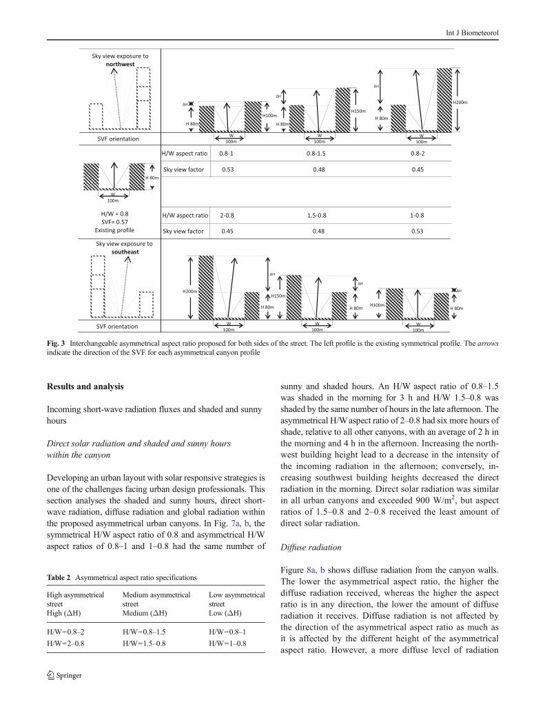
Three asymmetrical urban geometries were proposed for useon either side of the boulevard. For example, when one side ofthe street had fixed average building heights (existing profile)of 80 m, the opposite side used buildings with heights 150 to200 m which is 1.5 to 2 times of the width of the street. Thisheight pattern reflected the symmetrical aspect ratio principlesproposed by Ali-Toudert and Mayer (2006)), Arnfield (1990)and Oke (1988a). In another example, the asymmetrical H1/W-H2/W aspect ratios for one side of the canyon were calcu-lated as 0.8–1, 0.8–1.5 and 0.8–2, whilst ratios for the build-ings on the opposite side were accounted as 1–0.8, 1.5–0.8and 2–0.8, respectively (see Fig. 3). The asymmetrical streetswere classified as high, medium or low based on the differ-ence in heights between the two sides of the street (seeTable 2).
The ratio for the asymmetrical streets in this study wascalculated based on the height of each building on one side ofthe street to determine its individual ratio (Fig. 4). An asym-metrical urban canyon was chosen to examine the microcli-mate of the boulevard because urban canyons maintainopenness. This openness is not presented in high sym-metrical streets. Furthermore, previous literature notesthat symmetrical streets have different influences onday and night microclimates that are not appropriate fortropical regions. In this study, the maximum buildingheight for the proposed streets was two times the streetwidth, which is the maximum value that does not changethe character of the boulevard. This height created a deepurban canyon. To meet urban canyon requirements, thelength of the proposed urban canyon must be six timesthe height of the buildings (Ali-Toudert and Mayer 2006;Oke 1988a), whilst the canyon building depth was 40 m,which is the average building depth of the boulevardstreet buildings (Fig. 5).
The proposed canyon length and the building height weretoo massive to include within the Envi-met domain area. There-fore, the area examined was reduced to fit within the Envi-metmodel area of 100×100×30 by adopting telescopic scaling. Themain domain grid was set to X=32, Y=65 and Z=30 with griddx=5, dy=5 and dz=0.21. The height of the buildings startedtelescoping at 0.01 m and increased in increments of 20 %.
The proposed canyon was divided into three areas toreflect actual street cross sections (two 30-m sidewalks,two 10-m lanes and a 20-m walking street; see Fig. 6).The proposed canyon building walls and roof albedo
Int J Biometeorol

were the same as in the validation model. The vegetation inthis study was excluded, and the sky was assumed to be clearwith no cloud cover. Input data for urban surface materials,roof albedo and climate data input were the same as in thevalidation model. The simulation of the proposed scenariosran for 24 h to predict the microclimate during both the dayand the night, starting at 6:00 a.m. and ending at 6:00 a.m. thefollowing day.
Direct solar radiation, the sunny and shaded hours ofthe day, the distribution of the air temperature and thesurface day and night time temperatures were obtainedfrom receptors located along the street cross section inthe middle of each cell for each component. Other datawere collected at 1.20 m above the ground except for thesurface temperature data, which was extracted from thestreet cell (z=0). The surface temperatures of the north-west and southeast walls were extracted from the z grid
1.50 m above ground level. The SVF value was obtained0.10 m above street level; this is the height of the SVFground (SVFg; see (Svensson 2004). The effect of the airtemperature on street level components was displayedusing Golden Surfer 10 software. This software is capa-ble of determining air temperature distribution and wasutilised by Ali-Toudert and Mayer (2007). Diffuse radi-ation (W/m2) and global radiation (W/m2) during the dayand night wind velocity were obtained from the middleof the streets at a height of 1.20 m. The middle of thestreet was sectioned at the x axis to present the verticalair temperature within the canyons, as well as the inten-sity of the air temperature near the walls of buildings andat street level.
H.W Ratio of
H1
Wand
H2
Wð1Þ
Fig. 2 a compression betweenthe observed (O) and thepredicted (P) air temperature and,b evaluation of the observed (O)and the predicted (P) airtemperature
Int J Biometeorol
Results and analysis
Incoming short-wave radiation fluxes and shaded and sunnyhours
Direct solar radiation and shaded and sunny hourswithin the canyon
Developing an urban layout with solar responsive strategies isone of the challenges facing urban design professionals. Thissection analyses the shaded and sunny hours, direct short-wave radiation, diffuse radiation and global radiation withinthe proposed asymmetrical urban canyons. In Fig. 7a, b, thesymmetrical H/W aspect ratio of 0.8 and asymmetrical H/Waspect ratios of 0.8–1 and 1–0.8 had the same number of
sunny and shaded hours. An H/W aspect ratio of 0.8–1.5was shaded in the morning for 3 h and H/W 1.5–0.8 wasshaded by the same number of hours in the late afternoon. Theasymmetrical H/Waspect ratio of 2–0.8 had six more hours ofshade, relative to all other canyons, with an average of 2 h inthe morning and 4 h in the afternoon. Increasing the north-west building height lead to a decrease in the intensity ofthe incoming radiation in the afternoon; conversely, in-creasing southwest building heights decreased the directradiation in the morning. Direct solar radiation was similarin all urban canyons and exceeded 900 W/m2, but aspectratios of 1.5–0.8 and 2–0.8 received the least amount ofdirect solar radiation.
Diffuse radiation
Figure 8a, b shows diffuse radiation from the canyon walls.The lower the asymmetrical aspect ratio, the higher thediffuse radiation received, whereas the higher the aspectratio is in any direction, the lower the amount of diffuseradiation it receives. Diffuse radiation is not affected bythe direction of the asymmetrical aspect ratio as much asit is affected by the different height of the asymmetricalaspect ratio. However, a more diffuse level of radiation
Fig. 3 Interchangeable asymmetrical aspect ratio proposed for both sides of the street. The left profile is the existing symmetrical profile. The arrowsindicate the direction of the SVF for each asymmetrical canyon profile
Table 2 Asymmetrical aspect ratio specifications
High asymmetricalstreetHigh (ΔH)
Medium asymmetricalstreetMedium (ΔH)
Low asymmetricalstreetLow (ΔH)
H/W=0.8–2 H/W=0.8–1.5 H/W=0.8–1
H/W=2–0.8 H/W=1.5–0.8 H/W=1–0.8
Int J Biometeorol

exceeding 60 W/m2 was obtained for the symmetricalH/W aspect ratio of 0.8, and for the low asymmetricalaspect ratio of H/W 0.8–1, H/W 1–0.8 was 60 W/m2.Diffuse radiation in medium and high aspect ratios ofH/W 1.5–0.8, H/W 2–0.8, H/W 0.8–1.5 and H/W 0.8–2exceed 50 W/m2, respectively.
Global radiation
Figure 9a, b displays global radiation, which is the sumof the incoming radiation from direct short-wave anddiffuse radiation. The maximum global radiation was1,000 W/m2, which occurred at noon in all canyons.Medium and high H/W asymmetrical aspect ratios of0.8–1.5, and of 0.8–2, respectively, received global ra-diation from 11:00 a.m. to 2:00 p.m. Streets with H/Wratios of 1.5–0.8 and of 2–0.8 received global radiationfrom 10:00 a.m. to 1:00 p.m. This meant that time ofmaximum exposure to solar radiation differed by anhour. However, all canyons received an average of 4 hof exposure to full global radiation. Symmetrical H/W aspectratios and low aspect ratios received 5 h of intense globalradiation from 10:00 a.m. to 2:00 p.m.
Air temperature
Daytime
Figure 10a, b shows the variations in day and night air tem-peratures for all asymmetrical aspect ratios and for symmetri-cal H/W aspect ratios of 0.8. In Fig. 10a, there was a signif-icant contrast in daytime air temperatures between the twourban canyons and for different H/W aspect ratios. Highbuildings facing northwest (southeast buildings) in urbancanyons with asymmetrical H/W aspect ratios contribute toan increase in air temperature at 12:00 p.m., 1:00 p.m.,2:00 p.m. and 3:00 p.m. The highest air temperature occurredin situations where the H/W aspect ratio was 0.8–1.5 and theair temperature exceeded 38 °C. However, all asymmetricalaspect ratios that have high buildings in the southeast sidesignificantly maintained lower air temperatures during themorning hours; the morning temperatures decreased as build-ing height increased.
In contrast, medium and high asymmetrical H/W aspectratios of 1.5–0.8 and 2–0.8 decreased afternoon air tempera-tures, even though the air temperature rose during the morninghours. However, the higher a building was in a northwestdirection, the more air temperature declined into theafternoon.
The difference in air temperature varies in low asymmetri-cal H/W aspect ratios of 0.8–1 and 1–0.8 during the morningand afternoon, respectively, were negligible. The significantdifferences in air temperature occurred with medium and highasymmetrical H/Waspect ratios of 0.8–1.5, 1.5–0.8, 0.8–2 and2–0.8. The maximum air temperature ranged from 4.7 to 5 °Cbetween the opposite high asymmetrical H/W aspect ratios of0.8–2 and H/W of 2–0.8 which all occurred at morning andnoon time. However, H/W aspect ratios of 0.8–2 created themost heat stress in urban canyons in the afternoon and
Fig. 4 Components of asymmetrical aspect ratio
Fig. 5 Dimensions of thesimulation canyons
Int J Biometeorol

negatively affected the air temperature, particularly on thewalking street, in street lanes and on sidewalks that facednorthwest (see Fig. 11). The air temperature in these canyons
was higher than it was in the existing urban canyon with anH/W aspect ratio of 0.8. The air temperature of asymmetricalaspect ratios continually fluctuated during the day leading to
Fig. 6 A typical cross section (A-B) and street components
Fig. 7 a and b the intensity of direct solar radiation and the sunny and the shaded hours for all northwest and southeast asymmetrical profiles and theexisting symmetrical profile with H/W aspect ratio of 0.8
Int J Biometeorol

improved morning or afternoon microclimates. The air tem-perature of the symmetrical streets with H/W aspect ratios of0.8 rose continuously through the day thus worsening themicroclimate compared to asymmetrical H/W aspect ratios.
Night time
Figure 10b shows the variation in air temperatures of all urbancanyons during the night. The air temperature varied but wassignificantly lower for medium and high asymmetrical H/Waspect ratios of 0.8–1.5 and 0.8–2. Air temperature was higherfor medium and high asymmetrical H/W aspect ratios of 1.5–0.8 and 2–0.8. The highest night time air temperature wasfound for the opposite low asymmetrical H/Waspect ratios of1–0.8 and 0.8–1. However, opposite area aspect ratios of 1–0.8 experienced air temperatures that was 2 °C higher. Thisimplies that the asymmetrical aspect ratios H/W that havesmall differences in opposite building height cause high airtemperature heat islands at night, regardless of the location orthe height of the small building compared to the symmetrical
H/W aspect ratios or asymmetrical aspect ratios that havehigher differences in buildings that face each other. The airtemperature of symmetrical urban canyons with an H/Wof 0.8was constant and of medium range.
Vertical air temperature in urban canyons
The two asymmetrical H/W aspect ratios of 2–0.8 and 0.8–2and symmetrical H/W aspect ratios of 0.8 above were furtherinvestigated to determine the vertical air temperature distribu-tion within the urban canyon. According to Fig. 12, the H/Waspect ratio of 2–0.8 had the highest vertical air temperature inthe morning above the northwest sidewalk. Symmetrical H/Waspect ratios of 0.8 experienced the highest vertical air tem-peratures within the canyon at noon and in the afternoon. AnH/W aspect ratio of 0.8–2 increased afternoon air tempera-tures, which were intensified above the sidewalk close to thefacade that faced northwest. This would certainly have had anegative effect on the indoor climate of the closest buildings.However, the highest air temperature was observed nearer to
Fig. 8 a and b diffuse solar radiation for all northwest and southeast asymmetrical profiles and for the existing symmetrical profile with a H/W aspectratio of 0.8
Int J Biometeorol

the ground. In addition, the lowest air temperature was record-ed higher up from the ground. Higher air temperatures werefound between two objects in the canyon. This implied thatconfiguration of an asymmetrical urban canyon can affect airtemperature and has the ability to concentrate air temperatureat different levels of the canyon.
Surface temperature
Temperature of wall and ground surfaces at daytime
Urban surface temperature is an essential factor that canintensify street temperatures by absorbing incoming radiationand causing an urban heat island. Building configurations andaspect ratios are key issues in controlling exposure to solarradiation and mitigating urban surface temperatures. The dis-tributions of ground surface and wall temperatures in differenturban canyons during the day and during the night are pre-sented in Fig. 13a, b. The temperature of the ground surfaceswas very high, exceeding 50 °C. According to Nichol (1996),this is due to the high angle of the sun in tropical regions, as
much of the short-wave radiation on building facades isreflected and absorbed by the street surface making thestreet surface uncomfortably hot. Accordingly, it wasobserved that surface temperatures were higher on the streetsthan the walls. Takebayashi and Moriyama (2012) claimedthat this is due to higher levels of daily net solar radiationfalling on the roads and the roofs compared to the amount ofradiation on the walls because of the greater solar altitude.This means that the altitude of the sun in tropical climates hasa greater influence on canyon climate. Shading ground sur-faces to reduce air temperature is a possible solution andshould be taken into consideration in the design process.
Figure 13a shows that the H/Waspect ratios of 0.8–1, 0.8–1.5 and 0.8–2 lead to increased ground surface temperaturesduring the day, especially on lanes composed of asphalt. Incontrast, H/W aspect ratios of 1–0.8, 1.5–0.8 and 2–0.8 werethe most asymmetrical aspect ratios and they kept groundsurface temperatures lower by 5 to 14 °C at noon. The positiveeffect of these asymmetrical aspect ratios on surfaces weremore pronounced in the afternoon when their walls facedsoutheast, blocking intense solar radiation.
Fig. 9 a and b global solar radiation for all asymmetrical profiles facing northwest and southeast and for the existing symmetrical profile with a H/Waspect ratio of 0.8
Int J Biometeorol

Sidewalk B (Fig. 13a) and wall B (Fig. 13b) facing north-west experienced higher surface temperatures at noon in allasymmetrical urban canyons except when the aspect ratio was1.5–0.8 and 2–0.8. In these instances, the surface and walltemperatures were 7–10 °C lower as they block the intenseradiation. Asymmetrical aspect ratios of 0.8–1.5 and 0.8–2reduced surface temperatures in the morning, which was nothigh relative to the temperature in the afternoon.
Temperature of wall and ground surfaces at night
The ground surface and wall temperatures during the night arepresented in Fig. 14a, b. As can be seen in both graphs, theH/W aspect ratio of 1–0.8 as opposite to the H/W aspect ratioof 0.8–1 worsened surface and wall temperatures in the can-yon, and even increased night surface temperatures more thanother proposed aspect ratios. This implies that small buildingsadversely affected surface temperatures and a smaller sym-metrical H/Waspect ratio of 0.8 was better than an H/Waspectratio of 0.8–1 as surface temperature was moderate at the walland ground levels. However, H/W aspect ratios of 0.8–2 and0.8–1.5 had the lowest surface temperature during the night.
Surface and wall temperatures for asymmetrical H/W aspectratios of 2–0.8 and 1.5–0.8 increased by almost 1 °C at thesurface and by almost 2 °C at wall level compared to aspectratios of 0.8–2 and 0.8–1.5. The different surface temperaturesfor the walls at night were limited and insignificant comparedto their height differences during the daytime with tempera-tures below 28 °C.
Wind velocity
The prevailing winds in Malaysia in July (measured andsimulated) are light, variable, less than 7.7 m/s and the pre-vailing wind direction is from the southwest (Malaysian Me-teorological Department). The actual wind speed in the sym-metrical canyon of the boulevard was measured between 0–1.6 m/s and the predicted wind speed in the simulated sym-metrical canyon was also small and ranged between 0–1.5 m/s. However, the wind speeds in asymmetrical urban canyonsincreased to 2.75 m/s as can be seen in Fig. 15a. These resultsimply that asymmetrical aspect ratios increase wind velocityin urban canyons relative to their symmetrical aspect ratio andthat they influence air velocity, thus positively affecting the
Fig. 10 Variations in airtemperature during the day (a)and at night (b)
Int J Biometeorol

microclimate during the day and reducing night time heatislands.
High and lowwind speeds in the canyonsweremainly due tothe prevailing winds in the city and not to the asymmetricalurban geometric profiles, even though these geometrical profilescan influence the velocity of the wind as can be seen inFig. 15a, b. In these figures, the highest wind speed was forH/W aspect ratios of 0.8–1 and 0.8–1.5 from 7:00 a.m. to
8:00 a.m. but the longest lasting and highest wind speedsoccurred between 7:00 a.m. and 11:00 a.m. with an aspect ratioof 0.8–2. This implies that increasing the height of buildings inthe southeast increased air flow for several hours in themorning.This would explain the lower air and surface temperatures inthese canyons during the morning hours. On the other hand,wind speeds in asymmetrical streets with H/W aspect ratios of1–0.8, 1.5–0.8 and 2–0.8 during the daywere very low, between
Fig. 11 Air temperature distribution for street components with H/W aspect ratios of 0.8–2 and 2–0.8 and the existing H/W aspect ratio of 0.8
Int J Biometeorol

1 and 1.5 m/s. This indicated that these urban canyons reducedwind flow and their air and surface temperature were higherrelative to other asymmetrical aspect ratios. The influence oflow air speed on air temperature and surface temperature wasminimal. Therefore, the decrease in air and surface temperaturesduring the day was likely due to shading by opposite buildings,which decreased exposure to solar radiation.
Discussion and conclusion
This study was based on the premise that the majority of thebuildings on one side of the street are high whilst most of thebuildings on the opposite side are low. Consequently, theratios were individually calculated and the height of eachbuilding had its own ratio to the street width, affecting the
Fig. 12 a, c vertical air temperature in an asymmetrical urban canyon with H/Waspect ratios of 2–0.8, 0.8–2 and b symmetrical H/Waspect ratios of 0.8
Int J Biometeorol

daytime microclimates and the night time heat islands. Differ-ent building heights were studied on both sides of the sym-metrical street on Putrajaya Boulevard in order to understandthe negative and the positive climate influence of such sce-narios on street microclimates and heat islands. The extent towhich these urban canyons had the potential to offer alterna-tive strategies to tackle climatic issues, to enhance the daytimemicroclimates of Putrajaya Boulevard, and to mitigate thenight time heat island of tropical regions were considered.Additionally, these strategies could not change the character ofthe street and had to maintain its feeling of openness. Asym-metrical aspect ratios (H/W) had not been extensively studiedin the past, and this study attempted to investigate their influ-ence on an urban boulevard in a tropical climate.
An analysis of the results revealed that direct solarradiation decreased when the height of the buildings
increased regardless of the direction the building faced.However, increasing the height of northwest facing build-ings shaded the canyon during the morning time; converse-ly, increases in the height of southeast facing buildingsextended the amount of shade on the canyon ground andwould increase the hours of shade during the later, criticalafternoon hours.
The analysis also showed that buildings facing north-west were warmer during the day and the night thanbuildings facing southeast on the opposite side of thestreet. This finding confirms similar findings experimen-tally obtained on the same street (Ahmed et al. 2014).The high H/W aspect ratio of 2–0.8 and the medium H/W aspect ratio of 1.5–0.8 resulted in the best asymmet-rical urban canyons for mitigating daytime air tempera-tures (including the temperatures of walls and ground
Fig. 13 Ground surface temperatures (a) and wall temperatures (b) during the day
Int J Biometeorol

surfaces), especially for walking streets, sidewalk sur-faces and walls that faced northwest. However; a highasymmetrical H/W aspect ratio of 2–0.8 created the bestcanyon microclimate where surface temperatures werereduced by 10 to 14 °C and where the afternoon airtemperature was lower by 4.7 °C, compared to otherurban canyons. The air temperature was reduced due tolong hours of shading that reached up to 4 h from thenortheast buildings. By adding trees parallel to thisasymmetrical street, urban shading would have a twofoldeffect on the surface and air temperatures by reducingthe rise of temperatures during the morning to the noonon sidewalks that face southeast. However, these treescould trap the heat at night, causing a minimal heat
island; the large area open to the sky with lower build-ings would help release confined heat. This aspect ratio,therefore, is recommended for Putrajaya Boulevard tomitigate the existing high surface, air temperature at thestreet components (sidewalks and walking street, wall)and the daytime microclimate. However, high horizontaland vertical air temperatures were observed during themorning on the sidewalks of these two asymmetricalcanyons when they faced southeast, but this effect canbe controlled by adequate tree shade. Trees block solarradiation and increase the amount of shade during thecritical afternoon hours. Overall, taller northwest build-ings created the best noon time microclimates. The airtemperature at night in streets with asymmetrical H/W
Fig. 14 Ground surface temperature (a) and wall temperature (b) at night
Int J Biometeorol

aspect ratios of 2–0.8 were slightly higher relative toother canyons due to the low wind speed and the highwall areas that faced the solar radiation generated by thesunset, transferring the intense absorbed heat to the can-yon. This suggests that the reason for heat islands indeep canyons with deep symmetrical H/W aspect ratioscould be due to the height of the walls that face sunsetradiation and the low wind speed penetrating. Such wallsshould be considered during the design process to avoidnocturnal heat islands by increasing the depth of thebuildings that are exposed to sunset radiation in orderto delay the transfer of heat absorbed by the canyon,increasing albedo of the building façade, or by using adouble façades to control heat transfer.
On the other hand, the high H/W aspect ratio of 0.8–2 and the medium H/W aspect ratio of 0.8–1.5 have theworst urban microclimate conditions in the afternoon,where the temperature is high in the boulevard, as inother tropical regions, and needs to be reduced. TheseH/W aspect ratios are better at reducing the morningtemperatures and mitigating the night heat island com-pared to other canyons. Reducing the heat island in0.8–2 and 0.8–1.5 aspect ratios is largely due to theincrease of the wind speed to 1.1 and 2.5 m/s. Howev-er, the negative effects of these aspect ratios on the
noon and afternoon microclimate were greater than thepositive effect they had on mitigating night time heatislands. Greater building heights on the southeast sideworsened the urban canyon climate, particularly duringthe day and for wall temperatures and sidewalk surfacesthat faced northwest they increased vertical air temper-atures close to the building façades. This suggests that agreen façade would minimise exposure to and the re-flectivity of incoming solar radiation. Building façadeswith high albedo is not advisable in these situations astheir high solar reflectance leads to increased air tem-peratures at the urban canopy level and on canyonground surfaces.
Opposite medium asymmetrical streets with H/W as-pect ratios of 0.8–1 and 1–0.8 worsen the nocturnal tem-perature of the walls, ground surfaces and the air temper-ature at street. These two urban canyons had small build-ings on one side, implying that smaller buildings (LowΔH) on one side of an asymmetrical urban canyon causenocturnal heat islands. Surface and air temperature ofthese two asymmetrical streets were higher than the sur-face and air temperatures associated with symmetricalaspect ratios that have a similar low building on bothsides of the street.
Implications for urban planning
& The different asymmetrical streets show a disparity inclimate patterns during day and night times. Asym-metrical urban canyons are a new strategy that can beused as flexible geometrical forms that can controlthe microclimates and heat islands found in urbantropical regions by blocking or admitting solar radia-tion and air flow through manipulation of the heightsof building on each side of the street. It is a strategicmechanism for creating a harmonious and a dynamicurban pattern at street level by directing shading orexposing the surface. Asymmetrical urban geometryattempts to create openness and an enclosed street atthe same time.
& Asymmetrical aspect ratios offer an alternative geom-etry for improving the shading umbrella concept asdescribed by Emmanuel (2005). The tall buildings ofthe asymmetrical street play an important role in en-hancing wind velocity at street level and these resultsare in agreement with the views put forth by Emman-uel et al. (2007); Johansson and Emmanuel (2006).Tall buildings that block the western sun in the after-noon are preferred over tall buildings that block theeastern sun.
& High asymmetrical aspect ratios are ideal, namelybetter than low symmetrical streets, and is an
a
bFig. 15 Daytime (a), and night time (b) wind velocity
Int J Biometeorol

improvement over deep symmetrical canyons in trop-ical climates as deep canyons trap and store heat atnight and block air flow, which is essential in tropicalregions. The different building heights in asymmetri-cal canyons have the ability to enhance air flow and torelease confined heat.
& The analysis suggests that the influence of two op-posite asymmetrical aspect ratios such as the H/Waspect ratios of 0.8–2 and of 2–0.8 have differentinfluences on daytime microclimate conditions andnight time heat islands, despite having similar SVFvalues, as shown in Fig. 3. This implies that thevalue of sky view is not a decisive factor affectingurban canyon microclimates or heat islands unlessits orientation is considered, as suggested by Krügeret al. (2011) who claimed that ‘SVF is a limitedparameter to define the irregularity of the physicalgeometry for the purpose of daytime outdoor stud-ies’. The night time results for the two oppositeasymmetrical streets were varied, despite the similar-ity of their sky view values indicating that this valueis not relevant for night time studies. Further studyis needed to investigate the effect of the sky viewvalue and orientation created by different asymmet-rical aspect ratios on the day and night time airtemperatures.
& The lesson that can be grasped from the asymmetricalboulevard study is that the design and the position ofthe boulevard components in the street level such asthe two sidewalks, the two street lanes, walking streetsshould be subjected to the high or the low buildingsposition rather than organised in a symmetrical way.For example, the sidewalks should not be designedwith similar width on both sides, ensuring better shad-ing conditions and less sun exposure, maximising thesidewalk areas near tall buildings to take advantage ofthe shading provided by the buildings and plantheights and dispersed trees to protect it from thesunrise or the sunset radiation. On the other hand,minimising the sidewalk width adjacent to low build-ings covered by building shading during the morningor evening time and planting low and dense trees fornoon time protection are recommended. Street lanestherefore should shift from broad sidewalks tonarrower ones, in such an arrangement to enhancestreet climate conditions.
& The different heights of the buildings on asymmetricalstreets should carefully positioned in the design process:Improvement of the microclimate involves tall buildingsblocking solar access and increase the shading pattern;whilst mitigating the heat island effect involves using tallbuildings that capture the wind and enhance the windvelocity.
Further studies are also needed to understand theeffect of high asymmetrical aspect ratios in regions thathave summer and winter seasons, as the deep symmet-rical H/W aspect ratios increase the temperature ofurban canyons during the night in the summer anddecrease the temperature during the day in the winter.This study found that the high asymmetrical aspectratios could change the climate of urban canyons inthese regions by decreasing the temperature of urbancanyons during the night in the summer and increasingthe temperature during the day in the winter. A furtherstudy is also needed to gauge a principle aspect ratio(H/W) for asymmetrical streets as has been establishedfor symmetrical streets. A prevailing principle forasymmetrical streets requires comprehensive observa-tion and inventory of city streets and different buildingheights.
References
Ahmad K, Khare M, Chaudhry KK (2005) Wind tunnel simulationstudies on dispersion at urban street canyons and intersections—areview. J Wind Eng Ind Aerodyn 93(9):697–717. doi:10.1016/j.jweia.2005.04.002
Ahmed KS (1994) A comparative analysis of the outdoor thermal envi-ronment of the urban vernacular and the contemporary develop-ment: case studies in Dhaka Paper presented at the Architecture ofthe Extremes. (Proceedings of the 11th PLEA InternationalConference,Dead Sea, Israel), The Desert Architecture Unit, Ben-Gurion Univ. of the Negev 3–8 July 1994
Ahmed A, Ossen D, Jamei E, Manaf N, Said I, Ahmad M (2014) Urbansurface temperature behaviour and heat island effect in a tropicalplanned city. Theor Appl Climatol:1–22. doi:10.1007/s00704-014-1122-2
Ali-Toudert F, Mayer H (2006) Numerical study on the effects of aspectratio and orientation of an urban street canyon on outdoor thermalcomfort in hot and dry climate. Build Environ 41(2):94–108. doi:10.1016/j.buildenv.2005.01.013
Ali-Toudert F, Mayer H (2007) Effects of asymmetry, galleries, over-hanging facades and vegetation on thermal comfort in urban streetcanyons. Sol Energy 81(6):742–754. doi:10.1016/j.solener.2006.10.007
Ali-Toudert F, Djenane M, Bensalem R, Mayer H (2005) Outdoor ther-mal comfort in the old desert city of Beni-Isguen, Algeria. Clim Res28(3):243–256. doi:10.3354/cr028243
Andreou E (2013) Thermal comfort in outdoor spaces and urban canyonmicroclimate. Renew Energy 55(0):182–188. doi:10.1016/j.renene.2012.12.040
Andreou E, Axarli K (2012) Investigation of urban canyon microclimatein traditional and contemporary environment. Experimental investi-gation and parametric analysis. Renew Energy 43(0):354–363. doi:10.1016/j.renene.2011.11.038
Arnfield AJ (1990) Street design and urban canyon solar access. EnergyBuild 14(2):117–131. doi:10.1016/0378-7788(90)90031-D
Arnfield AJ (2003) Two decades of urban climate research: a review ofturbulence, exchanges of energy and water, and the urban heatisland. Int J Climatol 23(1):1–26. doi:10.1002/joc.859
Int J Biometeorol

Bourbia F, Awbi HB (2004a) Building cluster and shading in urbancanyon for hot dry climate: part 1: air and surface temperaturemeasurements. Renew Energy 29(2):249–262. doi:10.1016/S0960-1481(03)00170-8
Bourbia F, Awbi HB (2004b) Building cluster and shading in urbancanyon for hot dry climate: part 2: shading simulations.Renew Energy 29(2):291–301. doi:10.1016/S0960-1481(03)00171-X
Bruse M (1999) Die Auswirkungen kleinskaliger Umweltgestaltung aufdas Mikroklima Entwicklung des prognostischen numerischenModells ENVI-met zur Simulation der Wind-, Temperatur- undFeuchteverteilung in städtischen Strukturen. s.n.]. Available viahttp://worldcat.org. http://www-brs.ub.ruhr-uni-bochum.de/netahtml/HSS/Diss/BruseMichael/diss.pdf
Bruse M (2004) ENVI-met 3.0: updated model overview,Bochum, Germany (http://www.envi-met.com) accessed on 2june 2013
Bruse M, Fleer H (1998) Simulating surface–plant–air interactions insideurban environments with a three dimensional numerical model.Environ Model Softw 13(3–4):373–384. doi:10.1016/S1364-8152(98)00042-5
Chen L, Ng E, An X, Ren C, Lee M, Wang U, He Z (2012) Skyview factor analysis of street canyons and its implications fordaytime intra-urban air temperature differentials in high-rise,high-density urban areas of Hong Kong: a GIS-based simula-tion approach. Int J Climatol 32(1):121–136. doi:10.1002/joc.2243
Emmanuel R (2005) An urban approach to climate sensitive design:strategies for the tropics. Spon Press
Emmanuel R, Fernando HJS (2007) Urban heat islands in humid and aridclimates: role of urban form and thermal properties in Colombo, SriLanka and Phoenix, USA. Clim Res 34(3):241–251. doi:10.3354/cr00694
Emmanuel R, Johansson E (2006) Influence of urban morphologyand sea breeze on hot humid microclimate: the case ofColombo, Sri Lanka. Clim Res 30(3):189–200. doi:10.3354/cr030189
Emmanuel R, Rosenlund H, Johansson E (2007) Urban shading—a design option for the tropics? A study in Colombo, SriLanka. Int J Climatol 27(14):1995–2004. doi:10.1002/joc.1609
Giannopoulou K, Santamouris M, Livada I, Georgakis C, Caouris Y(2010) The impact of canyon geometry on intra urban and urban:suburban night temperature differences under warm weather condi-tions. Pure Appl Geophys 167(11):1433–1449. doi:10.1007/s00024-010-0099-8
Goh KC, Chang CH (1999) The relationship between height to widthratios and the heat island intensity at 22:00 h for Singapore. Int JClimatol 19(9):1011–1023. doi:10.1002/(SICI)1097-0088(199907)19:9<1011::AID-JOC411>3.0.CO;2-U
Herbert JM, Johnson GT, Arnfield AJ (1998) Modelling the thermalclimate in city canyons. Environ Model Softw 13(3–4):267–277.doi:10.1016/S1364-8152(98)00027-9
Huttner S (2012) Further development and application of the 3D micro-climate simulation ENVI-met. Johannes Gutenberg-Universität,Mainz
Johansson E (2006) Influence of urban geometry on outdoor thermalcomfort in a hot dry climate: a study in Fez, Morocco. BuildEnviron 41(10):1326–1338. doi:10.1016/j.buildenv.2005.05.022
Johansson E, Emmanuel R (2006) The influence of urban design onoutdoor thermal comfort in the hot, humid city of Colombo, SriLanka. Int J Biometeorol 51(2):119–133. doi:10.1007/s00484-006-0047-6
Krüger EL, Minella FO, Rasia F (2011) Impact of urban geometry onoutdoor thermal comfort and air quality from field measurements in
Curitiba, Brazil. Build Environ 46(3):621–634. doi:10.1016/j.buildenv.2010.09.006
Marciotto ER, Oliveira AP, Hanna SR (2010) Modeling study of theaspect ratio influence on urban canopy energy fluxes with a modi-fied wall-canyon energy budget scheme. Build Environ 45(11):2497–2505. doi:10.1016/j.buildenv.2010.05.012
Moughtin JC (2003) Urban design: street and square. Architectural Press,Elsevier
Ng E, Chen L, Wang Y, Yuan C (2012) A study on the coolingeffects of greening in a high-density city: an experience fromHong Kong. Build Environ 47(0):256–271. doi:10.1016/j.buildenv.2011.07.014
Nichol JE (1996) Analysis of the urban thermal environment withLANDSAT data. Environ Plan B: Plan Des 23(6):733–747
Nunez M (1974) The energy balance of an urban canyon. University ofBritish Columbia, Vancouver, B.C. official portal MalaysiaMeteorological Department (MMD) http://www.met.gov.my/accessed on 10 june 2013
Oke TR (1981) Canyon geometry and the nocturnal urban heat island:comparison of scale model and field observations. J Climatol 1(3):237–254. doi:10.1002/joc.3370010304
Oke TR (1988a) Street design and urban canopy layer climate. EnergyBuild 11(1–3):103–113. doi:10.1016/0378-7788(88)90026-6
Oke TR (1988b) The urban energy balance. Prog Phys Geogr 12(4):471–508. doi:10.1177/030913338801200401
Oke TR (2006) Initial guidance to obtain representative meteorologicalobservations at urban sites. Instruments and observing methods.World Meteorological Organization
Oke TR, Johnson GT, Steyn DG,Watson ID (1991) Simulation of surfaceurban heat islands under ‘ideal’ conditions at night part 2: diagnosisof causation. Boundary-Layer Meteorol 56(4):339–358. doi:10.1007/bf00119211
Paramita B, Fukuda H (2013) Study on the affect of aspect building formand layout case study: Honjo Nishi Danchi, Yahatanishi,Kitakyushu-Fukuoka. Procedia Environ Sci 17(0):767–774. doi:10.1016/j.proenv.2013.02.094
Penwarden ADWAFE (1975) Wind environment around buildings. H.M.Stat. Off, London
Ratti C (2005) The lineage of the line: space syntax parameters fromthe analysis of urban DEMs. Environ Plan B: Plan Des 32(4):547–566
Robinson D, Stone A (2004) Solar radiation modelling in the urbancontext. Sol Energy 77(3):295–309. doi:10.1016/j.solener.2004.05.010
Salleh E (2006) 11 TROPICAL URBANSTREETCANYONS. Tropicalsustainable architecture: social and environmental dimensions: 201
Shahidan MF, Jones PJ, Gwilliam J, Salleh E (2012) An evaluation ofoutdoor and building environment cooling achieved through com-bination modification of trees with ground materials. Build Environ58(0):245–257. doi:10.1016/j.buildenv.2012.07.012
Stathopoulos T, Wu H, Bédard C (1992) Wind environment aroundbuildings: a knowledge-based approach. J Wind Eng Ind Aerodyn44(1–3):2377–2388. doi:10.1016/0167-6105(92)90028-9
Svensson MK (2004) Sky view factor analysis—implications for urbanair temperature differences. Meteorol Appl 11(03):201–211. doi:10.1017/S1350482704001288
Swaid H (1992) Intelligent urban forms (IUF) a new climate-concerned,urban planning strategy. Theor Appl Climatol 46(2–3):179–191.doi:10.1007/bf00866098
Takebayashi H, Moriyama M (2012) Relationships between theproperties of an urban street canyon and its radiant environ-ment: introduction of appropriate urban heat island mitigationtechnologies. Sol Energy 86(9):2255–2262. doi:10.1016/j.solener.2012.04.019
Taleb D, Abu-Hijleh B (2013) Urban heat islands: potential effect oforganic and structured urban configurations on temperature
Int J Biometeorol

variations in Dubai, UAE. Renew Energy 50(0):747–762. doi:10.1016/j.renene.2012.07.030
Tanimoto J, Hagishima A, Chimklai P (2004) An approach forcoupled simulation of building thermal effects and urbanclimatology. Energy Build 36(8):781–793. doi:10.1016/j.enbuild.2004.01.019
Theurer W (1999) Typical building arrangements for urban air pollutionmodelling. Atmos Environ 33(24–25):4057–4066. doi:10.1016/S1352-2310(99)00147-8
Tsangrassoulis A, Santamouris M, Geros V, Wilson M,Asimakopoulos D (1999) a method to investigate the poten-tial of south-oriented vertical surfaces for reflecting daylightonto oppositely facing vertical surfaces under sunny condi-tions. Sol Energy 66(6):439–446. doi:10.1016/S0038-092X(99)00018-3
Vardoulakis S, Fisher BEA, Pericleous K, Gonzalez-Flesca N (2003)Modelling air quality in street canyons: a review. Atmos Environ37(2):155–182. doi:10.1016/S1352-2310(02)00857-9
Venegas L, Mazzeo N (2000) Carbon monoxide concentration in a streetcanyon of Buenos Aires City (Argentina). Environ Monit Assess65(1–2):417–423. doi:10.1023/A:1006425111499
Wania A, Bruse M, Blond N, Weber C (2012) Analysing the influence ofdifferent street vegetation on traffic-induced particle dispersionusing microscale simulations. J Environ Manag 94(1):91–101. doi:10.1016/j.jenvman.2011.06.036
Xi T, Li Q, Mochida A, Meng Q (2012) Study on the outdoor thermalenvironment and thermal comfort around campus clusters in sub-tropical urban areas. Build Environ 52(0):162–170. doi:10.1016/j.buildenv.2011.11.006
Xia J, Leung YCD (2001) Pollutant dispersion in urban street canopies.Atmos Environ 35(11):2033–2043. doi:10.1016/S1352-2310(00)00422-2
Xie X, Huang Z (2007) Impact of aspect ratio and surface heating onpollutant transport in street canyons. J Mech Sci Technol 21(11):1781–1790. doi:10.1007/BF03177433
YahiaM, Johansson E (2013) Influence of urban planning regulations on themicroclimate in a hot dry climate: the example of Damascus, Syria. JHous Built Environ 28(1):51–65. doi:10.1007/s10901-012-9280-y
Yang F, Lau SSY, Qian F (2010) Summertime heat island intensities inthree high-rise housing quarters in inner-city Shanghai China: build-ing layout, density and greenery. Build Environ 45(1):115–134. doi:10.1016/j.buildenv.2009.05.010
Int J Biometeorol