Dwarakeswar River FINAL FEASIBILTY REPORT - Inland ...
134
Inland Waterway Authority of India Cluster – I : Dwarakeswar River Final Feasibility Report Revision 0 November 2016 Consultancy Services for preparation of Two Stage Detailed Project Report (DPR) of National Waterway 35, Cluster-I: Dwarakeswar River FINAL FEASIBILTY REPORT
-
Upload
khangminh22 -
Category
Documents
-
view
0 -
download
0
Transcript of Dwarakeswar River FINAL FEASIBILTY REPORT - Inland ...

Inland Waterway Authority of India
Cluster – I : Dwarakeswar River
Final Feasibility Report
Revision 0
November 2016
Consultancy Services for preparation of Two Stage Detailed Project Report (DPR) of
National Waterway 35, Cluster-I: Dwarakeswar River
FINAL FEASIBILTY REPORT

Project IWAI Cluster-I, Dwarakeswar River
Owner IWAI, Ministry of Shipping
Consultant Egis India Consulting Engineers
Consultancy Services for preparation of Two Stage Detailed Project Report (DPR) of
National Waterway 35, Cluster-I: Dwarakeswar River
FINAL FEASIBILITY REPORT
Authors
Project Team : Team Leader + 7-Experts
Technical Manager:
Ashish Khullar
Project Manager:
Akshat Singhal
Project No:
PT/EIPTIWB003
Report No:
PT/EIPTIWB003/2016/FR/003
Approved by:
Dr. Jitendra K. Panigrahi
0 Feasibility Report Nov 2016 DM AK JKP
Revision Description Date Prepared By Checked By Approved By
Version :
Final
Report Classification: Restricted
Distribution
IWAI
Digital Number of copies
3

Consultancy Services for preparation of Two Stage Detailed Project Report (DPR) of
National Waterway 35, Cluster-1: Dwarakeswar River
Final Feasibility Report
Rev. 0 - Nov 2016 Page I of IV
TABLE OF CONTENTS
ACKNOWLEDGEMENT ................................................................................................................. 1
SALIENT FEATURES .................................................................................................................... 2
1.0 CONTEXT .................................................................................................................. 5
2.0 OBJECTIVE ............................................................................................................... 8
3.0 REPORT STRUCTURE.............................................................................................. 10
4.0 INTRODUCTORY CONSIDERATIONS ..................................................................... 12
4.1 Details Of National Waterway 35 (DWARAKESWAR River) ................................................. 12
4.2 Characteristics of Dwarakeswar River .............................................................................. 12
4.3 Methodology Adopted to Undertake Study ....................................................................... 15
4.3.1 Classification of Waterways .......................................................................... 15
4.3.2 Measures to Improve the Depth ................................................................... 17
4.3.3 IWT Terminal Planning ................................................................................ 20
4.3.4 Identification of IWT Terminals .................................................................... 21
4.3.5 Rapid EIA ................................................................................................... 22
4.3.6 Concept Design and Cost Estimates .............................................................. 23
4.3.7 Financial and Economic Analysis ................................................................... 23
4.3.8 Implementation & Monitoring Mechanism ..................................................... 24
5.0 COLLECTION AND REVIEW OF DATA ..................................................................... 25
5.1 Primary Data.................................................................................................................. 25
5.2 Review of Secondary data .............................................................................................. 26
6.0 ANALYSIS OF PRESENT STATE OF AFFAIRS .......................................................... 29
6.1 Existing Dams, barrage & Locks ...................................................................................... 29
6.2 Existing Bridges Along the Waterway ............................................................................... 29
6.3 Existing High Tension Lines and other cross structures ..................................................... 30
6.4 Hindrances/ Encroachment along the Waterway .............................................................. 30
6.5 Forest Area / Protected Area / Defence Area .................................................................... 31
6.6 Road and Rail Infrastructure ........................................................................................... 31
Consultancy Services for preparation of Two Stage Detailed Project Report (DPR) of
National Waterway 35, Cluster-1: Dwarakeswar River
Final Feasibility Report
Rev. 0 - Nov 2016 Page II of IV
7.0 RECONNAISSANCE SURVEY ................................................................................... 32
7.1 Detail Methodology for Survey ........................................................................................ 32
7.1.1 Resource for Survey Work ........................................................................... 33
7.1.2 Geodetic Parameters ................................................................................... 34
7.1.3 Survey Data Processing ............................................................................... 35
7.2 Description of Bench Marks/ Reference Levels ................................................................. 35
7.3 Levelling of Temporary Tide Poles ................................................................................... 36
7.4 Hydrographic Survey ...................................................................................................... 37
7.5 Water Depth .................................................................................................................. 37
7.6 Soil Characteristics ......................................................................................................... 39
7.7 Tidal Waterway Section .................................................................................................. 39
8.0 MARKET ANALYSIS ................................................................................................ 40
8.1 Land Use Pattern ........................................................................................................... 40
8.2 Crops /Agriculture products ............................................................................................ 40
8.3 Availability of Passenger Ferry Services ........................................................................... 43
8.4 Existing Jetties and Terminals ......................................................................................... 44
8.5 Historical and tourist place along Dwarakeswar Waterway ................................................ 44
8.6 Availability of Construction Material ................................................................................. 44
8.7 Industries along the waterway ........................................................................................ 44
8.8 Existing water sport and recreational activities and future probability ................................ 45
8.9 Estimated Cargo movement ............................................................................................ 45
9.0 OBSERVATION AND INFERENCE ............................................................................ 47
9.1 Waterway ...................................................................................................................... 47
9.2 Least Available Depth (LAD) ........................................................................................... 47
9.3 Cross - structures ........................................................................................................... 48
9.4 SWOT Analysis ............................................................................................................... 48
9.5 Summary ....................................................................................................................... 50
9.6 Critical areas requiring detailed investigations .................................................................. 51
9.7 Survey and Investigations required for stage – II studies ................................................. 51
9.8 Way Forward: Waterway Development ............................................................................ 52
Consultancy Services for preparation of Two Stage Detailed Project Report (DPR) of
National Waterway 35, Cluster-1: Dwarakeswar River
Final Feasibility Report
Rev. 0 - Nov 2016 Page III of IV
LIST OF TABLES
Table 1: National Waterways of Cluster - 1 .................................................................................................... 6
Table 2: Description of River ....................................................................................................................... 12
Table 3: Details of Sand Check Dams located along the alignment ................................................................ 29
Table 4: Details of existing Major Road bridges en-route Dwarakeswar Waterway .......................................... 29
Table 5: Details of Existing High Tension Lines ............................................................................................ 30
Table 6: Details of Wooden/ Bamboo bridges located along the Waterway .................................................... 30
Table 7: Forest Cover in Project districts ...................................................................................................... 31
Table 8: Railway station within 5.0 Km radius of Dwarakeswar Waterway ..................................................... 31
Table 9: Major Road crossing or within 5.0 Km radius of Dwarakeswar Waterway .......................................... 31
Table 10: List of Equipment Mobilised for Survey ......................................................................................... 33
Table 11: Details of Survey Boats Used ....................................................................................................... 34
Table 12 : Temporary Benchmark Dwarakeswar River .................................................................................. 36
Table 13: Survey Length of Waterway ......................................................................................................... 37
Table 14: Water Depth along the Waterway ................................................................................................ 38
Table 15: Soil Characteristics along Dwarakeswar Waterway ........................................................................ 39
Table 16: Land Use Pattern along Waterway................................................................................................ 40
Table 18: Average Production and Productivity of major crops in Bankura district (2004-09)........................... 41
Table 18: Average Production and Productivity of major crops in Bardhhaman district (2004-08) .................... 42
Table 19: Hooghly district-Average Production and Productivity of major crops (2004-09) .............................. 43
Table 20: Existing Ferry locations along Dwarakeswar River ......................................................................... 43
Table 21: Cargo Movement in National Waterway – 1 from 2002 – 2015 ....................................................... 45
Table 22: Waterway length with varying LAD ............................................................................................... 47
Table 23: Minimum Horizontal and Vertical Clearance along Waterways ........................................................ 48
Table 24: Locations along the waterway requiring detail investigation in Stage-II .......................................... 51
Consultancy Services for preparation of Two Stage Detailed Project Report (DPR) of
National Waterway 35, Cluster-1: Dwarakeswar River
Final Feasibility Report
Rev. 0 - Nov 2016 Page IV of IV
LIST OF FIGURES
Figure 1: Layout Map of Cluster 1 National Waterways ................................................................................... 7
Figure 2: Framework of Studies .................................................................................................................... 9
Figure 3: Layout Map of Dwarakeswar River Waterway ................................................................................ 14
Figure 4: Graph showing Chart Datum/Sounding Datum w.r.t. MSL along Dwarekeswar River ........................ 37
Figure 5: Forecasted Cargo Potential ........................................................................................................... 46
Figure 6: SWOT Analysis ............................................................................................................................ 49
LIST OF ANNEXURES
Annexure 1: Levelling Results ..................................................................................................................... 53
Annexure 2: Observed Water levels at Tide Poles ......................................................................................... 55
Annexure 3: Water Depth along Dwarakeswar Waterway ............................................................................. 58
Annexure 4: Photographs along Dwarakeswar Waterway ........................................................................... 122
LIST OF ABBREVIATIONS
IWAI Inland Waterways Authority of India
IWT Inland Water Transportation
MOS Ministry of Shipping
NW National Waterway
DPR Detailed Project Report
WW Waterway
AtoN Aid to Navigation
VC Vertical Clearance
HC Horizontal Clearance

Consultancy Services for preparation of Two Stage Detailed Project Report (DPR) of
National Waterway 35, Cluster-1: Dwarakeswar River
Final Feasibility Report Rev. 0 - Nov 2016
Page 1 of 128
ACKNOWLEDGEMENT
Egis India Consulting Engineers Pvt Ltd (EIPL) express their gratitude to Shri Amitabh
Verma, IAS, Chairman, for spending their valuable time and guidance for completing this
Project of "Feasibility report of two stage detailed project report of National Waterway 35,
Cluster – I, Dwarakeswar River. EIPL would also like to thanks Shri Pravir Pandey, Vice
Chairman IA&AS.
EIPL wishes to express their gratitude to Cdr. P.K. Srivastava, Hydrographic Chief,
IWAI for his guidance and inspiration for this project. EIPL would also like to thank Sh.
Rajiv Singhal, A.H.S., IWAI for their invaluable support and suggestions provided
throughout the project duration. EIPL is pleased to place on record their sincere thanks to
other staff and officers of IWAI for their excellent support and co-operation throughout the
project duration.

Consultancy Services for preparation of Two Stage Detailed Project Report (DPR) of
National Waterway 35, Cluster-1: Dwarakeswar River
Final Feasibility Report Rev. 0 - Nov 2016
Page 2 of 128
SALIENT FEATURES
Sl. No. Particulars Details
1. Name of Consultant Egis India Consulting Engineers Pvt. Ltd.
2. Cluster number Cluster I
3. Waterway stretch
(from. To, total length)
Dwarakeswar River (National Waterway 35)
(From Bridge near Abantika Lat 23° 6'54.76"N, Long 87°18'46.99"E
to confluence of Dwarakeswar and Silai rivers at Pratappur Lat
22°40'16.94"N, Long 87°46'42.57"E);
Total Length: 113 Km
4. Navigability status
a)
Tidal & non tidal
portions (from ... to,
length, average tidal
variation)
Tidal portion: 0 – 6.5 Km
Non-tidal: 6.5 - 113 km
Tidal variation: 0.7 m.
b)
LAD status
Survey period (.. to ..)
< 1.0 m (km)
1.m to 1.5 m (km)
1.5 m to 2.0 m (km)
> 2.0 m (km)
0 – 30
Km
30-60
Km
60 -90
Km
90 –
113
Km
Total
Km
Survey
Period 12th Jan to 23rd Jan 2016
< 1.0 m 20.37 26.04 29.94 23.00 99.35
1 to 1.5 m
(km) 3.38 2.09 0.00 0.00 5.47
1.5 to 2.0 m
(km) 2.90 1.10 0.00 0.00 4.01
> 2.0 m
(km) 3.34 0.77 0.06 0.00 4.17

Consultancy Services for preparation of Two Stage Detailed Project Report (DPR) of
National Waterway 35, Cluster-1: Dwarakeswar River
Final Feasibility Report Rev. 0 - Nov 2016
Page 3 of 128
Sl. No. Particulars Details
c)
Cross structures
i) Dams, wires, barrages
etc (number, with
navigation locks or
not).
ii) Bridges, Power cables
etc [number, HC (...
to ...). VC (.. to ..)]
i) Dams, Weirs, Barrages, Locks = 2 numbers of Sand check dams.
ii) Bridges = 2 numbers, HC (8.0 m), VC (8.0 m to 6.0 m)
iii) Power Cable = 4 numbers (VC = 7.0 m to 4.0 m)
*Vertical clearance is above HFL on the basis of visual
assessment.
d) Avg. discharge & no. of
days
Request for discharge data was made to CWC, however the same is
still awaited. Shall be provided in DPR Stage.
e) Slope (1 in ..) Approximate slope of waterway is 1 in 2500.
f) Consultants inference
The waterway has a tidal stretch of 6.5 Km from Ghatal towards
upstream with a maximum tidal variation of about 0.7 m. This
portion is feasible for year round navigation.
The horizontal and vertical clearance of existing cross-structures
is in the range of 8 m and 6m - 8m respectively.
4.17 Km stretch of waterway have draft more than 2.0 m, 4.01
Km stretch have draft of 1.50 m to 2.0 m, 5.47 km have draft of
1.0 m to 1.50 m and remaining 99.35 km stretch of waterway
have less than 1.0 m draft with respect to chart datum.
Taking in to account the tidal effect, the LAD of 1.0 m can be
increased to 1.2 m in the tidal stretch.
Considering the length of the river, availability of numerous
minor and major industries and connectivity with rail and road
network with 5km reach across the bank , the river has huge
economic potential for development as a Waterway
The capacity of the waterway can be enhanced by constructing
check dams and lockgates, however the same shall be appraised
only during Stage-2 of the studies on the basis of detail
investigations.
The waterway has a huge potential considering its connectivity
with Rupnarayan Waterway and thereby with National waterway
-1 and Haldia Port.
Consultancy Services for preparation of Two Stage Detailed Project Report (DPR) of
National Waterway 35, Cluster-1: Dwarakeswar River
Final Feasibility Report Rev. 0 - Nov 2016
Page 4 of 128
Sl. No. Particulars Details
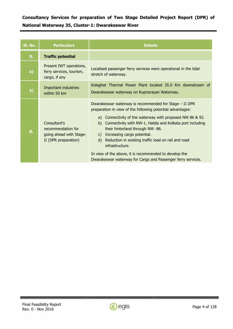
5. Traffic potential
a)
Present IWT operations,
ferry services, tourism,
cargo, if any
Localised passenger ferry services were operational in the tidal
stretch of waterway.
b) Important industries
within 50 km
Kolaghat Thermal Power Plant located 35.0 Km downstream of
Dwarakeswar waterway on Rupnarayan Waterway.
6.
Consultant's
recommendation for
going ahead with Stage-
II (DPR preparation)
Dwarakeswar waterway is recommended for Stage – II DPR
preparation in view of the following potential advantages:
a) Connectivity of the waterway with proposed NW 86 & 92.
b) Connectivity with NW-1, Haldia and Kolkata port including
their hinterland through NW -86.
c) Increasing cargo potential.
d) Reduction in existing traffic load on rail and road
infrastructure.
In view of the above, it is recommended to develop the
Dwarakeswar waterway for Cargo and Passenger ferry services.
Consultancy Services for preparation of Two Stage Detailed Project Report (DPR) of
National Waterway 35, Cluster-1: Dwarakeswar River
Final Feasibility Report Rev. 0 - Nov 2016
Page 5 of 128
1.0 CONTEXT
IWAI, Ministry of Shipping, Government of India is exploring the potential of additional waterways
across the country for year round commercial navigation, for this it is planned to conduct a Feasibility
Study and recommending thereafter the possibility of Composite and Integrated development of
National waterways to achieve navigation and to develop water transport facilities across India. Upon
completion of feasibility study, IWAI will select the stretches having potential for navigation to
undertake a Detailed Project Report. The DPR stage would include detailed hydro-graphic surveys and
investigation, traffic survey, proposed location for terminals and cost assessment etc.
There are 106 new waterways has been identified and declared as national waterways as per “The
National Waterway Act, 2016”, No. 17 of 2016, published in the Gazette of India, Part – II- Section 1
no. 18, New Delhi, Saturday, March 26/2016/Chaitra 6, 1938 (Saka), by Ministry of Law and Justice
(Legislative Department).
Out of these 106 waterways, IWAI had invited international online bids for preparation of 2 stage
Detailed Project Report (DPR) for National waterways, in a set of 8 Clusters from Cluster I to VIII
through Tender No. IWAI/PR/40NW/2015/I. Egis Consulting Engineers was awarded the work for
Cluster I and Cluster III respectively.
This feasibility report provides the technical viability of throughout the year inland navigation in the
waterways, by taking into account the constraints and other functions of the rivers/canals such as
water conveyance, tidal effects, floods, draughts, existing structures etc.
As stated above, 7 rivers out of 106 National waterways are clubbed in Cluster – I of two stages DPR
studies for inland waterways project. The detail descriptions of these 7 waterways are presented in
Table 1. The total length of stretches of 7 rivers under Cluster – I is 820 km. Among these 7
waterways, 5 are connected to the National Waterway 1 between Farakka to Haldia.

Consultancy Services for preparation of Two Stage Detailed Project Report (DPR) of
National Waterway 35, Cluster-1: Dwarakeswar River
Final Feasibility Report Rev. 0 - Nov 2016
Page 6 of 128
Table 1: National Waterways of Cluster - 1
S. No River
National
Waterway
No.
Length
(km) Description
1. Ajoy River National
Waterway 7 96
From Bridge on Morgram-Panagarh State Highway
No 14 at Illambazar Lat 23°36'56.10"N, Long
87°31'58.07"E to confluence of river Ajay with
river Bhagirathi at Katwa Lat 23°39'23.33"N, Long
88° 7'56.72"E
2. Damodar River National
Waterway 29 130
From Krishak Setu, Bardhman on State Highway
No 8 at Lat 23°12'39.83"N, Long 87°50'53.85"E to
confluence with Hooghly river near Purbba
Basudebpur at Lat 22°21'0.58"N, Long 88°
5'19.31"E
3. Dwarakeswar River National
Waterway 35 113
From Bridge near Abantika Lat 23° 6'54.76"N,
Long 87°18'46.99"E to confluence of
Dwarakeswar and Silai rivers at Pratappur Lat
22°40'16.94"N, Long 87°46'42.57"E.
4. Ichamati River National
Waterway 44 64
From Bridge on Border Main Road at Gobra near
Bangladesh Border at Lat 22°53'49.64"N, Long
88°53'48.87"E to near Bangladesh Border at
Bansjhari Mallikpur Lat 22°39'6.71"N, Long
88°55'35.35"E.
5. Rupnarayan River National
Waterway 86 72
From confluence of Dwarakeswar and Silai rivers
at Pratappur Lat 22°40'16.94"N, Long
87°46'42.57"E to confluence with Hooghly river at
Geonkhali Lat 22°12'41.58"N, Long 88° 3'13.99"E
6. Silabati River National
Waterway 92 26
From Barrage near Shimulia village at Lat
22°34'53.20"N, Long 87°38'30.54"E to confluence
of Dwarakeswar and Silai rivers at Pratappur Lat
22°40'16.94"N, Long 87°46'42.57"E.
7. Subarnarekha River National
Waterway 96 314
From Chandil Dam at Lat 22°58'29.39"N, Long 86°
1'14.03"E to confluence with Bay of Bengal at Lat
21°33'28.75"N, Long 87°22'58.60"E.
The detailed layout plan of the above waterways is shown in Drawing No.
PT/EIPTIWB003/2016/FR/0001 submitted with Volume – III (Drawings) and provided in Figure 1.

Consultancy Services for preparation of Two Stage Detailed Project Report (DPR) of National Waterway 35, Cluster-1:
Dwarakeswar River
Final Feasibility Report
Rev. 0 - Nov 2016 Page 7 of 128
Figure 1: Layout Map of Cluster 1 National Waterways

Consultancy Services for preparation of Two Stage Detailed Project Report (DPR) of
National Waterway 35, Cluster-1: Dwarakeswar River
Final Feasibility Report Rev. 0 - Nov 2016
Page 8 of 128
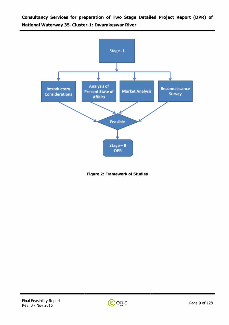
2.0 OBJECTIVE
Government of India intends to explore the potential of additional waterways across the country for
year round commercial navigation, for this it is planned to conduct a Feasibility Study and
recommending thereafter the possibility of Composite and Integrated development of National
waterways to achieve navigation and to develop water transport facilities across India. The whole of
study comprises of two stages, feasibility and DPR as Stage-I and Stage-II as presented below.
Stage-1
1A. Reconnaissance Survey
1B. Collection and review of available data
1C. Feasibility Report
Stage-2
2A. Hydrographic Survey & hydro-morphological survey
2B. Traffic Survey & Techno economic feasibility
2C. Preparation of Detailed Project Report
The current scope for stage-I is executed as per following framework as per Figure 2 .
Consultancy Services for preparation of Two Stage Detailed Project Report (DPR) of
National Waterway 35, Cluster-1: Dwarakeswar River
Final Feasibility Report Rev. 0 - Nov 2016
Page 9 of 128
Figure 2: Framework of Studies
Consultancy Services for preparation of Two Stage Detailed Project Report (DPR) of
National Waterway 35, Cluster-1: Dwarakeswar River
Final Feasibility Report Rev. 0 - Nov 2016
Page 10 of 128
3.0 REPORT STRUCTURE
This report comprises of Feasibility Study for Dwarakeswar River (Length- 113 Km). The report is
arranged in following main chapters,
I. Introductory Consideration: This section comprises of,
1) Name of the river/canal;
2) Length of the river/canal;
3) State/ District through which river passes;
4) Map;
5) Characteristics of River;
a. River Course: Background/Historical information, Origin, End
b. Tributaries/ Network of Rivers/ Basin
6) Methodology Adopted to undertake the Study;
a. Primary Data
b. Secondary Data
II. Analysis of Present State of Affairs: This section comprises of,
1) Existing Dams, Barrages and Locks;
2) Existing Bridges and Crossings over River;
3) Other Cross structures, High Tension Lines, pipe-lines, cables;
4) Hindrances/ Encroachment to the Waterway;
5) Details of Protected Area- Wildlife, Defence;
6) NH/SH/MDR along and/or in vicinity;
7) Railway Line and Stations in the vicinity.
III. Reconnaissance Survey: This section provides the,
1) Methodology adopted including resources and equipment;
2) Description of Bench marks, reference levels, chart and sounding datum;
3) Details of collected water levels, discharge data, HFL and FSL;
4) Details and description of bathymetric and topographic survey including observations;
5) Detail about Soil, Water and Bank characteristics.
IV. Market Analysis: This section comprises of,
1) Land use pattern along Waterway;
2) Crop/Agriculture in the region;

Consultancy Services for preparation of Two Stage Detailed Project Report (DPR) of
National Waterway 35, Cluster-1: Dwarakeswar River
Final Feasibility Report Rev. 0 - Nov 2016
Page 11 of 128
3) Availability of Bulk/Construction Material;
4) Existing industries along waterway;
5) Details of existing Jetties and Terminals;
6) Preliminary traffic identified;
7) Existing cargo movement;
8) Prominent City/ Town/ Places of worship/ Historical places for tourism;
9) Availability of passenger ferry services;
10) Available and probable water sport/recreational facilities.
V. Observation and Inferences: This section comprises of,
1) Observation on Waterway, Length, LAD, Cross-Structures;
2) Water availability for different periods and depths;
3) Cargo/Passenger/Tourism/RO-RO facility;
4) Suitability of waterway for navigation;
5) Proposed alternative methods for making waterway feasible;
6) SWOT analysis;
7) Way forward for Stage – 2 DPR studies.
In addition to the above, following digital data and charts shall also be submitted along with this
report:
I. Bathymetric Survey: Hypack software output files with RAW, EDIT, SORT, TIDE extensions;
II. Topographic Survey: csv and xyz extension files;
III. Survey Charts: Geo-coded dxf and dwg files in scale as per width in AutoCAD formats;

Consultancy Services for preparation of Two Stage Detailed Project Report (DPR) of
National Waterway 35, Cluster-1: Dwarakeswar River
Final Feasibility Report Rev. 0 - Nov 2016
Page 12 of 128
4.0 INTRODUCTORY CONSIDERATIONS
The Consultant discussed here, the introductory considerations for feasibility and the scope of the
assignment in subsequent phase of DPR for feasible stretches.
The present feasibility report provides the technical feasibility of Dwarakeswar River, declared as
National Waterway 35, clubbed under Cluster – I, as stated in earlier sections. The detail description
of waterway analysed in this feasibility report are described in subsequent paragraphs.
4.1 DETAILS OF NATIONAL WATERWAY 35 (DWARAKESWAR RIVER)
Details of the waterway are as follows:
Table 2: Description of River
Sl. No Name of the
River Local Name
Length of
waterway (km)
State/District through
which river passes
1. Dwarakeswar
River
Dhalkisor
Dhalkishore 113
State: West Bengal
Purulia district
Bankura district
Bardhaman District
Hooghly District
4.2 CHARACTERISTICS OF DWARAKESWAR RIVER
Characteristics of Dwarakeswar River considered for waterway is described in subsequent paragraph.
River Course: It originates from Tilboni hill in Purulia district and enters Bankura district near
Chhatna, West Bengal. The river cuts across the Bankura district flowing past the district headquarters
and enters the south-eastern tip of Bardhaman District. It then passes through Hooghly District. The
Silai joins it near Ghatal and the two together is known as Rupnarayan River, which flows into the
Hooghly River near Gadiara in Howrah District.
Catchment Area: The total catchments area of the Dwarakeswar river system is 4292 Sq. Kms

Consultancy Services for preparation of Two Stage Detailed Project Report (DPR) of
National Waterway 35, Cluster-1: Dwarakeswar River
Final Feasibility Report Rev. 0 - Nov 2016
Page 13 of 128
Tributaries: Gandheswari River is a tributary, 32 kilometres of the Dwarakeswar River and flows in
Bankura district. Similarly Beko, Arkasha, Berai, Shankari are other tributaries of Dwarakeswar River
system.
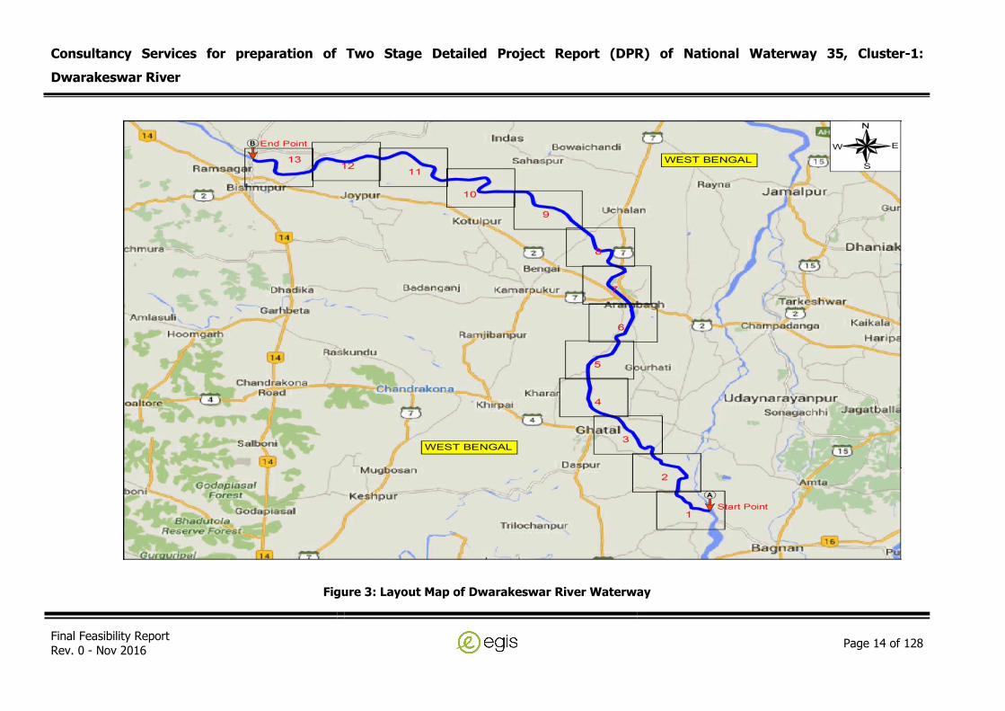
The section of the Dwarakeswar River under feasibility study for inland waterway is presented in
Drawing No. PT/EIPTIWB003/2016/FR/0004A and is also presented as Figure 3. The detail layout
maps of the waterway are shown in Drawing No. PT/EIPTIWB003/2016/FR/0004.
Consultancy Services for preparation of Two Stage Detailed Project Report (DPR) of National Waterway 35, Cluster-1:
Dwarakeswar River
Final Feasibility Report
Rev. 0 - Nov 2016 Page 14 of 128
Figure 3: Layout Map of Dwarakeswar River Waterway
Consultancy Services for preparation of Two Stage Detailed Project Report (DPR) of
National Waterway 35, Cluster-1: Dwarakeswar River
Final Feasibility Report Rev. 0 - Nov 2016
Page 15 of 128
4.3 METHODOLOGY ADOPTED TO UNDERTAKE STUDY
A detail description on Feasibility & DPR methodology and the expected outcome in fulfilling the
assignment is presented.
The feasibility study shall be carried out in accordance with TOR in the following steps:
1. Conducting Reconnaissance survey as detailed in Chapter 5.
2. Collection and review of available primary and secondary data as detailed in Chapter 6 and 7.
On the basis of detailed analysis of collected primary and secondary data, throughout the year
navigability potential of the waterway is assessed and submitted in the feasibility report.
4.3.1 Classification of Waterways
The classification of waterways by Inland Waterway Authority of India is discussed below and shall be
adopted in the study.
1. The waterways shall be classified in the following categories for safe plying of self-propelled
vessels up to 2000 tonne Dead Weight Tonnage (DWT) and tug-barge formation in push-
tow units of carrying capacity up to 8000 tonne, namely:
a. Class I - Waterways with the following configuration of navigable channel:-
i. Rivers: Minimum of 1.2 meter depth, 30 meter bottom width, 300 meter
bend radius, 4 meter vertical clearance and 30 meter horizontal clearance
between piers, and
ii. Canals: Minimum of 1.5 meter depth, 20 meter bottom width, 300 meter
bends radius, 4 meter vertical clearance and 20 meter horizontal
clearance between piers.
b. Class II - Waterways with the following configuration of navigable channel:-
i. Rivers: Minimum of 1.4 meter depth, 40 meter bottom width, 500 meter
bend radius, 5 meter vertical clearance and 40 meter horizontal clearance
between piers, and
ii. Canals: Minimum of 1.8 meter depth, 30 meter bottom width, 500 meter
bend radius, 5 meter vertical clearance and 30 meter horizontal clearance
between piers.

Consultancy Services for preparation of Two Stage Detailed Project Report (DPR) of
National Waterway 35, Cluster-1: Dwarakeswar River
Final Feasibility Report Rev. 0 - Nov 2016
Page 16 of 128
c. Class III - Waterways with the following configuration of navigable channel:-
i. Rivers: Minimum of 1.7 meter depth, 50 meter bottom width, 700 meter
bend radius, 7 meter vertical clearance and 50 meter horizontal clearance
between piers, and
ii. Canals: Minimum of 2.2 meter depth, 40 meter bottom width, 700 meter
bend radius, 7 meter vertical clearance and 40 meter horizontal clearance
between piers.
d. Class IV - Waterways with the following configuration of navigable channel:-
i. Rivers: Minimum of 2.0 meter depth, 50 meter bottom width, 800 meter
bend radius, 10 meter vertical clearance and 50 meter horizontal
clearance between piers, and
ii. Canals: Minimum of 2.5 meter depth, 50 meter bottom width, 800 meter
bend radius, 10 meter vertical clearance and 50 meter horizontal
clearance between piers.
e. Class V - Waterways with the following configuration of navigable channel:-
i. Rivers: Minimum of 2.0 meter depth, 80 meter bottom width, 800 meter
bend radius, 10 meter vertical clearance and 80 meter horizontal
clearance between piers.
f. Class VI - Waterways with the following configuration of navigable channel:-
i. Rivers: Minimum of 2.75 meter depth, 80 meter bottom width, 900 meter
bend radius, 10 meter vertical clearance and 80 meter horizontal
clearance between piers, and
ii. Canals: Minimum of 3.5 meter depth, 60 meter bottom width, 900 meter
bend radius, 10 meter vertical clearance and 60 meter horizontal
clearance between piers.
g. Class VII - Waterways with the following configuration of navigable channel:-
i. Rivers: Minimum of 2.75 meter and above depth, 100 meter and above
bottom width, 900 meter bends radius, 10 meter vertical clearance and
80 meter horizontal clearance between piers.
2. Vertical clearance for power cables or telephone lines or cables for any transmission purpose
for all the classes of waterways mentioned above shall be as follows:
a. Low voltage transmission lines including telephone lines - 16.5 meters
b. High voltage transmission lines, not exceeding 110 kilo volt - 19.0 meters
c. High voltage transmission line, exceeding 110 kilo volt - 19.0 meters
+1 cm extra for each additional kilovolt

Consultancy Services for preparation of Two Stage Detailed Project Report (DPR) of
National Waterway 35, Cluster-1: Dwarakeswar River
Final Feasibility Report Rev. 0 - Nov 2016
Page 17 of 128
3. In case of underwater pipelines, power cables and other cables, norms to be followed shall
be decided as per the site conditions and navigational requirement.
Provided that this classification shall be effective for:
a. Minimum depth of channel should normally be available for about 330 days of the year.
b. Vertical clearance at cross structure over the waterway should be available at least in central
75% portion of each of the spans in entire width of the waterway.
Reference level for vertical clearance in different types of channel shall be:
a. For rivers, over Navigational High Flood Level (NHFL), this is the highest flood level at a
frequency of 5% in any year over a period of last twenty years.
b. For tidal canals, over the highest high water level.
c. For other canals, over designed full supply level.
4.3.2 Measures to Improve the Depth
The basic parameters considered for the fairway design are:
Depth
Width
Side slopes
Bends
As explained above, as the classification of waterways in India is based on the experience gained in
various waterways, the characteristic features of the design waterways based on studies carried out
by IWAI are furnished below and the same shall be followed.
Fairway Design
The fairway depth should be good enough to ensure steerability of the vessel and to prevent bottom
feel. To meet this requirement, the minimum depth that is needed in a channel would commonly be
the sum of the draught (draft) of the vessel and other tolerance factors. The tolerance factors to be
considered are listed as:
Factor of keel clearance to avoid touching of the vessel to the ground and minimum free water
below the keel for maintaining control on manoeuvring,
Wave tolerance for the heaving and pitching of the vessel due to wave motion,

Consultancy Services for preparation of Two Stage Detailed Project Report (DPR) of
National Waterway 35, Cluster-1: Dwarakeswar River
Final Feasibility Report Rev. 0 - Nov 2016
Page 18 of 128
Squat, increase of draft due to ship motion,
Tolerance for siltation and dredging,
Increase of draught due to trim and heaving due to unequal loading and steering manoeuvre
respectively, and
Tolerance for the change of draught during the transition from salt water to fresh water.
The keel clearance factor is the prime concern of the all tolerance factors considered. As per the
standards laid down by German Code of practice (EAU 80), a 0.3 m layer of water column below the
keel of the loaded ship is sufficient for free manoeuvrability of the vessel.
IWAI’s experience in inland waterways in India and sub-continent (Bangladesh and Myanmar) shows
that the under keel clearance for free manoeuvrability of the vessel varies between 0.2 and 0.5 m
depending upon the soil characteristics of the channel bed and other parameters.
Width of a Channel
The total width of a navigation waterway (W) in general is expressed in terms of a beam of a vessel
(B). The design width for the proposed two-way navigation can be obtained as:
W = BM + BM1 + C + 2C1
Where: W = Navigation channel width for two-way navigation.
BM = Maneuvering zone for the design vessel which takes into account the directional
stability of vessel.
BM1 = Maneuvering zone for the upcoming vessel which takes into account the directional
stability of vessel.
C = Width of separating zone.
C1 = Width of the security area, between the maneuvering zone and the channel side
which is accounted for environmental and human factors including bank suction.
Values recommended by various authorities for the above equation vary within wide limits. Some of
the recommended values are presented here:
BM = 1.3 B to 3.0 B
BM = BM1
C = 0.5 B to 1.0 B
C1 = 0.3 B to 1.5 B
Where, B = Beam of a design vessel.

Consultancy Services for preparation of Two Stage Detailed Project Report (DPR) of
National Waterway 35, Cluster-1: Dwarakeswar River
Final Feasibility Report Rev. 0 - Nov 2016
Page 19 of 128
Based on the experience and recommendations of experts on Inland Waterways, the factors
considered for the present design are:
BM = 1.8 B
BM = BM1
C = 0.5 B
C1 = 0.5 B
The designed channel width = 1.8B+1.8B+0.5B+2x0.5B for two way navigation at draft level = 5.1B.
The bottom width of the channel for two-way navigation for the design vessel can generally be
considered as 5 x B.
Slopes
The selection of slope is in accordance with the soil characteristics of the bed and banks, width of the
waterway etc. The adopted channel slope shall be 1:5
Width Allowance at Bends
In bends, the width of the fairway should be more than the width of the canal that is designed for a
straight reach to allow for a drift of the vessel in a curved portion of the waterway. It means that the
vessel occupies a greater width in bends than in a straight stretch of the waterway. The drift of the
vessel depends on the radius of the bend, the speed of the vessel, wind forces, the flow pattern and
the loading of the vessel. The drift angle is larger for vessels traveling in the downstream than the
upstream direction. The drift angle is inversely proportional to the bend radius 'R', that is, the larger
the radius the smaller the value of drift angle. Unloaded ships normally subjected to more drift and
consequently take up a greater width in bends than loaded ships and therefore the proposed
allowance at the keel level of the unloaded ships is larger than the loaded ships.
Dredging of Navigational Channel
The dredging quantities for the above design channel shall be worked out based on the bathymetric
surveys carried out. The system and different type of navigation marks shall be proposed in the DPR
are given as follows:
Lateral marks, to mark the left and right sides of the navigation route to be followed by
navigator;
Bifurcation marks, to mark the middle ground between the navigation channel, bifurcated
channel and isolated dangers in the middle of the navigational channel;

Consultancy Services for preparation of Two Stage Detailed Project Report (DPR) of
National Waterway 35, Cluster-1: Dwarakeswar River
Final Feasibility Report Rev. 0 - Nov 2016
Page 20 of 128
Shore marks;
Bank wise marks, to indicate the channel at point where it approaches a bank;
Crossing marks, to indicated crossing and alignment of the channel from one bank to another;
Marks of prohibited areas, to indicate no permission of entry;
Sound signal marks, to indicate use of horning or other sound signals;
Marks for traffic control, to control up bound or down bound vessel in one way or sequence
passage or to prohibit navigation;
Marks on bridges, to indicate the passage through bridges;
Depth indicator marks, to indicate shallow areas ahead in the navigation channel;
Width indicator marks, to indicate the narrow stretches ahead in the navigational channel;
River training marks, to indicate the ongoing river training works in the river to the navigators.
4.3.3 IWT Terminal Planning
The terminal planning and design includes selection of suitable sites in the vicinity of cargo potential
considering all the relevant technical variables such as choosing the type of berthing facility and
providing of covered/open storage facility, cargo handling systems and other ancillary facilities
required for efficient terminal operation. Based on the projected traffic, the selection of various
facilities shall be planned. The cost estimate including capital and operating costs shall be estimated
for each of the proposed system considering the design. These above aspects are briefly explained in
the following subsequent sections.
Planning Considerations
The terminal facilities proposed for this project shall include the following:
i) Berthing Facilities for vessels;
ii) Cargo Storage Facilities;
iii) Cargo Handling Facilities;
iv) Other ancillary Facilities.
Terminal Facilities
The type of cargo handling system required at the terminal is generally dependent on the type of
cargo, the annual volume required to be handled and the size of the vessels. The various type of
cargo foreseen to be handled at the proposed IWT Terminals are primarily grouped into:
i) Incoming Cargo, and
Consultancy Services for preparation of Two Stage Detailed Project Report (DPR) of
National Waterway 35, Cluster-1: Dwarakeswar River
Final Feasibility Report Rev. 0 - Nov 2016
Page 21 of 128
ii) Outgoing Cargo.
These above two groups are further subdivided into bulk, bagged and other miscellaneous general
cargo for the purpose of planning the cargo handling equipment. The quantum and other cargo
compositions shall be based on the traffic study. The same may be classified as below:
Bulk Cargo - Construction materials such as Sand, stone, bricks, Marble, Iron steel, Machinery –
Light, Heavy and ODC, Mineral Ore such as coal, lime stone, iron, fly ash, copper ore etc.,
bamboo, etc.
Bagged Cargo - Cement, Fertilizer, wine and beverages, acids, cereals, cash crops, wheat, rice,
Bajra, gram, pulses, cotton, etc.
Misc. General Cargo – Consumer goods, animals, oil cake, edible oil, refined oil, paper products,
jute products, etc
Ferry – Passenger vessels for Tourists
4.3.4 Identification of IWT Terminals
Site selection is the most important as it decides the investment for establishing the terminal facilities.
Hence, proper consideration has to be given to select the most optimum location which will minimise
the capital investment and other recurring cost during operation. The selection of suitable site shall be
carried out with the view of following considerations:
Water availability near the terminal land throughout the year especially during lean season;
Stable river channel with sufficient depth;
Favourable hydraulic conditions for berthing and cargo handling;
Availability of terminal land for infrastructure, cargo storage and handling;
Traffic potential and cargo characteristics; and
Navigational safety.
The proposed IWT Terminals shall be planned with the following infrastructure facilities for operation:
i) Steel Gangway resting on a floating pontoon. The detailed engineering & design of gangway
arrangement shall be carried out during the construction stage. The preliminary layout
drawing shall be proposed in the DPR;
ii) Administration Building and Bank protection arrangement;
iii) Covered Storage Shed/Transit Shed;
iv) Open storage area;
v) Security Shed;

Consultancy Services for preparation of Two Stage Detailed Project Report (DPR) of
National Waterway 35, Cluster-1: Dwarakeswar River
Final Feasibility Report Rev. 0 - Nov 2016
Page 22 of 128
vi) Forklift Trucks, Pay loaders & Dumper tracks; and
vii) Weigh Bridge, Watch and ward, Compound wall, Firefighting arrangement, Electrical & PH
Facilities including DG.
The terminal shall be proposed with suitable mooring facilities, firefighting water line, water supply
pipeline, power line for shore connection to barges, fenders etc. Preliminary planning and master plan
shall be prepared in the DPR stage as per the relevant IS codes. It is envisaged and proposed that to
the extent possible, all shore/river bank based buildings / godown are prefabricated, pre-engineered
type conforming to the best standards in vogue in logistic / supply chain industry.
Other Alternatives to Improve for Navigation
Based on our earlier study for Ganga River between the reach from Allahabad to Ghazipur, there are
many methods available to improve river navigation. Bandalling work – it has to follow closely falling
stage of river, closing minor channels and diverting river flow in single channel to increase depth in
the navigable channel in mainly due done by bandalling. In some reaches this method becomes
successful but some river stretches remain shallow and need other training measures including
dredging. Channelization of river and Construction of barrages at suitable locations, creating ponding
conditions with required depth and navigational locks for ships and vessel movement shall be studied.
The examination of various options/measures to improve the water depth shall be studied. The most
suitable method for development shall be identified with consideration on the likely morphological,
sediment transport, and dredging aspects of different options. This task is expected to be fed back
into from the financial and economic analysis providing refinement to the proposed development until
a recommended solution is reached. The most appropriate type of river development including
drudging option along the river shall be identified and likely impacts of these developments on river
flow depths as well as sedimentation and morphology shall be investigated. This analysis will
constitute an iterative process in which problems relating to LAD will be addressed to find more
successful solutions where necessary. This will however, not be an open-ended process as the
assessment of techno-economic feasibility updation only requires an indication of the likely costs of
building and maintaining the structures which are shown to support achievement of LAD as intended.
4.3.5 Rapid EIA
Suitable Rapid Environmental Impact Assessment shall be performed and report shall be included in
final DPR. The Rapid EIA Studies can be broadly divided in to three phases.
The first phase involves identification of significant environmental components in the area
where the project is located and assessing their baseline (pre-project or existing) status within

Consultancy Services for preparation of Two Stage Detailed Project Report (DPR) of
National Waterway 35, Cluster-1: Dwarakeswar River
Final Feasibility Report Rev. 0 - Nov 2016
Page 23 of 128
the study zone. In case of existing projects, environmental performance of existing
manufacturing / pollution control plants is also required to be covered.
The second phase involves prediction of impacts on various identified significant environmental
parameters due to proposed project.
The third phase includes the evaluation of final impacts and delineation of an Environmental
Management Plan to mitigate adverse impacts on the quality of surrounding environment.
4.3.6 Concept Design and Cost Estimates
Preliminary Design shall be performed for all the structures /developmental works proposed as per the
above analysis and mathematical model studies carried out conforming to relevant IS Codes. Design
drawings shall be prepared and submitted based on the preliminary design. Bill of quantities and cost
estimates shall be prepared for all the proposed structures / developmental works. Based on the cargo
potential and other considerations necessary for locating an IWT terminal, extent of land required for
setting up of IWT terminals and other suitable locations shall be identified. Preliminary topographic
survey shall be carried out and layout plan for all suggested locations shall be prepared clearly
indicating all facilities e.g jetty, approach to jetty, bank protection, covered and open storage, roads,
office, sentry hut, boundary wall, bank protection, bunkering facility, water facility, turning circle for
IWT vessels location of depth contours of 2m and 2.5m in the river near the terminal sites.
Preliminary engineering design and drawings for setting up of terminals with related facilities including
mechanical loading/ unloading at the proposed sites shall be prepared. Also inter modal cargo transfer
facilities required at these terminals shall be indicated.
4.3.7 Financial and Economic Analysis
Financial and economic analysis through FIRR and EIRR of the project including SWOT analysis shall
be carried out for the project. For the Financial Internal Rate of Return shall be computed as follows:
Costs shall be calculated as total capital investment for the Project components, net rate of
interest charges during construction and operations & maintenance costs for the Project;
Income flows shall be calculated based on gross revenues of projected goods to be transported
through private operators with permissible assumptions such as project life etc.;
Economic Internal Rate of Return shall be computed taking into account the following factors;
The assumed life of the project as per norms;
Costs shall be calculated as Government contribution and other sources. A standard conversion
factor shall be used to reduce financial costs to economic costs;

Consultancy Services for preparation of Two Stage Detailed Project Report (DPR) of
National Waterway 35, Cluster-1: Dwarakeswar River
Final Feasibility Report Rev. 0 - Nov 2016
Page 24 of 128
Benefits shall be estimated as Government revenues, calculated as net profit share, royalties
and tax;
Social Benefits like fuel saving, reduction in environment pollution and carbon emission,
accident reduction, decongestion of rail and roads, etc.
The financial viability and sustainability of this project depend upon the adaptation to the prevailing
context in which they operate. In working out the Financial Viability and sustainability, the following
factors shall be considered.
budgeting and cost accounting systems,
resource mobilization for capital investments,
cost recovery and operational financing,
cost reduction and control.
The Profitability projections and financial analysis for each of the project components shall be worked
out in detail and presented in the report. The financial statements shall be prepared on the basis of
the suitable assumptions. The cost benefit analysis for the proposed project shall be calculated. The
Net Present Value (NPV) with interest and depreciation, IRR and preliminary expenses shall be
suitably considered and estimated. Break-even analysis shall be performed and presented in the
report.
4.3.8 Implementation & Monitoring Mechanism
Project financial structuring shall be worked out in detail which will examine the sources and
composition of funding for the project. The Project financial structuring can involve a combination of
equity, grant, debt and finance from private participation (and in some cases, contribution from user
communities). The scope and options for possible debt and private sector financing shall be reviewed
elaborately and presented in the report. The suitable monitoring mechanism shall be evolved.

Consultancy Services for preparation of Two Stage Detailed Project Report (DPR) of
National Waterway 35, Cluster-1: Dwarakeswar River
Final Feasibility Report Rev. 0 - Nov 2016
Page 25 of 128
5.0 COLLECTION AND REVIEW OF DATA
5.1 PRIMARY DATA
In order to collect primary data and to access the latest hydro-morphological condition of the
waterways reconnaissance survey was done. Following aspects had been covered in the
reconnaissance survey as per TOR:
a) Single line longitudinal survey (Bathymetric survey or Topographic survey) in the deepest
depths or lowest height lands, with the help of DGPS using Automatic Hydrographic Survey
System. Bathymetric surveys in the national waterways are to be carried out in the deepest
route. Deepest route can be accessed by taking two or three longitudinal line soundings at
equal interval. Topographic survey, if required, is to be taken up at lowest ground levels,
which can be decided on visual assessment.
b) Details (horizontal and vertical clearances above High Flood Level of bridges, aqueducts,
electric lines, telephone lines, pipe lines, cables en-route are to be collected and indicated
on the chart and also included in the report along with their co-ordinates and location.
Details about Barrages, Dams, Locks en-route are also to be collected horizontal and vertical
clearance is to be given as approximate on visual assessment.
c) Photographs are required to be submitted in the report.
d) Topographical features of the Inland Waterways.
e) Typical physical features along the alignment i.e. land use pattern:
f) Preliminary identification of stretches having year round flow and critical depth for
navigational purpose.
g) Inventory of major aspects including Inland Waterway width, Terrain, Bridges and
structures across the Inland Waterways (Type, size and location), urban areas (location
extent). Geologically sensitive areas environmental features. Hydrological features
h) Critical areas requiring detailed investigations and
i) Requirements for carrying out supplementary investigations
j) Soil (textural classifications) (only visual inspection at every 10km) and drainage conditions.
k) Type and extent of existing utility services along the alignment.
All the above details are collected during field survey as well as by interaction with the concerned
authorities from 12th January to 23rd January 2016 by the Consultant.

Consultancy Services for preparation of Two Stage Detailed Project Report (DPR) of
National Waterway 35, Cluster-1: Dwarakeswar River
Final Feasibility Report Rev. 0 - Nov 2016
Page 26 of 128
5.2 REVIEW OF SECONDARY DATA
Dwarakeswar River (also known as Dhalkishore) is a major river in the western part of West Bengal. It
originates from Tilboni hill in Purulia district and enters Bankura district near Chhatna. Its main
tributary Gandheswari rising from Bankura district meets Dwarakeswar near Bankura town. After
receiving contributions from other streams like Arkasha, Berai, Shankari etc. Dwarakeswar enters into
Hooghly district and joins with Shilabati near Ghatal of Paschim Medinipur district to form river
Rupnarayan, which finally outfalls into the Hooghly River near Gadiara of Howrah district. There is
proposal of “Dwarakeswar-Gandheswari Reservoir Project” for this basin.
Dwarakeswar Sub-basin
Status of River gauges in Dwarakeswar Sub-basin is given as below:
Gauge Station District Danger Level (DL)
(m amsl)
Extreme Danger
Level (EDL) (m amsl)
Arambag Hooghly 17.22 17.83
Source: Annual Flood Report 2014 DL is considered as HFL for assessing the Minimum Vertical Clearance
The most remarkable identity of Dwarakeswar River (200.5km long) is that, it consists of transitional
characteristics of both flash floods it its upper catchments, monsoonal flood in the middle and tidal
effect in its lower confluence simultaneously. Dwarakeswar River is a major river in the western part
of West Bengal. It originates from extended part of Chotanagpur plateau (geographical extension
86°31’E to 87°02’E) in Purulia District and ended in the alluvial tract of West Medinipur (22°42’30”N to
23°31’N) of West Bengal. The monthly mean temperature at summer is 32.55°C and in winter is
18.98°C. The average rainfall is 117.76 mm per year. The diurnal range of temperature varies from
4°C to 9°C. The upper catchments are suffering from acute scarcity of drinking water during the
months of April to May. Upper part is overcrowded by the dug well (8 to 11 well in each 200m linear
distance), middle and lower stretch of the river are overcrowded by the deep tube well irrigation (up
to the depth of 50 m).
Flash Flood and Upper Catchments of Dwarakeswar river: The incident of flash flood of the
plateau river is not new one but this type thrice combination is unique. The incident of flash occur just
in the beginning (with in the 3 to 6 days of monsoon) of monsoon (month of June). Here flash flood is
not devastating one. But it creates problem of domestic animal and causes bank erosion near Joypur
Block of Bankura District. This incident confines within its upper catchments up to Joypur Block of
Bankura District.

Consultancy Services for preparation of Two Stage Detailed Project Report (DPR) of
National Waterway 35, Cluster-1: Dwarakeswar River
Final Feasibility Report Rev. 0 - Nov 2016
Page 27 of 128
Monsoonal Flood and Middle Catchments of Dwarakeswar river: The incident of monsoonal
flood is very common in the mid of monsoon (during the months of August) particularly in Arambagh
and Khanakul Blocks of Hooghly district. The entire flood incident occurs here in the day of late
August to September. In those day, due to tidal effect in the lower catchments (which is 150 km away
from the Bay of Bengal and it meets the river Bhagirathi) the huge amount of rainwater in river basin
gets a backward onrush. Simultaneously its upper catchments consist of 12° to 21° slopes where as
the slope in the middle portion is 7°-12°. That is the reason the water in the middle part does not get
back to its upper catchments. The upper catchment’s water level getting higher and higher and its
lower potion give backward onrush of water. The middle portion of the river gets flooded. That is the
reason of monsoonal flood in its middle portion.
Tidal Flood and Middle Catchments of Drarekeshwar river: During the period of high tide
(months of monsoon), the river Rupnarayan gets backward rush of tidal water near Gadhiyara
(Meeting point of Rupnarayan and Bhagirathi) and that backward on rush of tidal water push back the
river water of Dwarakeswar near Ghatal. During the each monsoon in each lunar cycle day, the lower
catchments of Dwarakeswar is flooded by tidal effect and the middle portion get flooded partially by
release of flash flood water from upper catchments and due to the backward on rush of tidal water
from its lower part simultaneously. Here it is important to mention that river Dwarakeswar comes
Consultancy Services for preparation of Two Stage Detailed Project Report (DPR) of
National Waterway 35, Cluster-1: Dwarakeswar River
Final Feasibility Report Rev. 0 - Nov 2016
Page 28 of 128
from an area which has a chronic drought history with scanty of rainfall and flows through the area
which has chronic flood history. This river does not meet to Bay of Bengal independently. It meets
river Hooghly 240 km (150 miles) away from the Bhagirathi’s estuary. Its meeting point is quite far
from the estuary of the river Bhagirathi but in spite of that this area is tidal. This thrice combination
(flash flood in upper catchments with the zone of scanty of rainfall, middle is the zone of monsoonal
flood and the lower confluence is dominated by tidal effect) of this river of plateau region which does
not meet Bay of Bengal independently is unique in character. This thrice combination Dwarakeswar
gives a unique identity and it is very rare phenomenon. Due to this behaviour of the river,
Dwarakeswar River Basin is called as a combination of Flash Flood Zone, Monsoonal Flood Zone &
Tidal Zone.
Consultancy Services for preparation of Two Stage Detailed Project Report (DPR) of
National Waterway 35, Cluster-1: Dwarakeswar River
Final Feasibility Report Rev. 0 - Nov 2016
Page 29 of 128
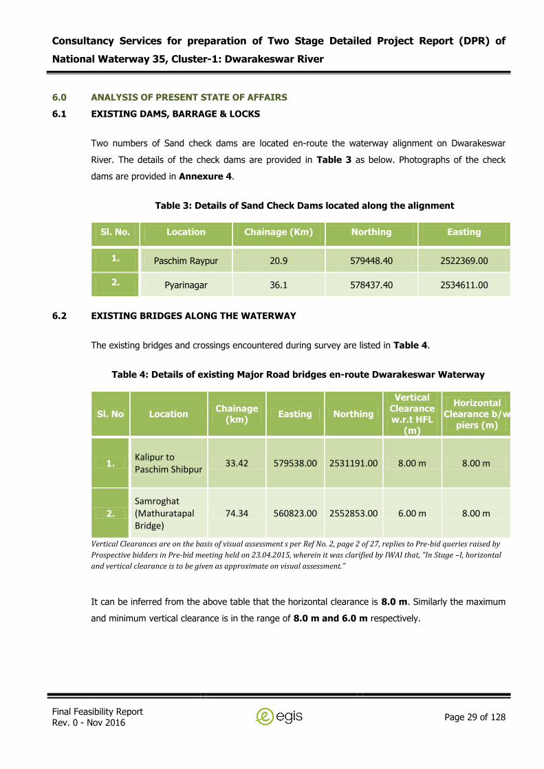
6.0 ANALYSIS OF PRESENT STATE OF AFFAIRS
6.1 EXISTING DAMS, BARRAGE & LOCKS
Two numbers of Sand check dams are located en-route the waterway alignment on Dwarakeswar
River. The details of the check dams are provided in Table 3 as below. Photographs of the check
dams are provided in Annexure 4.
Table 3: Details of Sand Check Dams located along the alignment
Sl. No. Location Chainage (Km) Northing Easting
1. Paschim Raypur 20.9 579448.40 2522369.00
2. Pyarinagar 36.1 578437.40 2534611.00
6.2 EXISTING BRIDGES ALONG THE WATERWAY
The existing bridges and crossings encountered during survey are listed in Table 4.
Table 4: Details of existing Major Road bridges en-route Dwarakeswar Waterway
Sl. No Location Chainage
(km) Easting Northing
Vertical
Clearance w.r.t HFL
(m)
Horizontal
Clearance b/w
piers (m)
1. Kalipur to Paschim Shibpur
33.42 579538.00 2531191.00 8.00 m 8.00 m
2.
Samroghat (Mathuratapal Bridge)
74.34 560823.00 2552853.00 6.00 m 8.00 m
Vertical Clearances are on the basis of visual assessment s per Ref No. 2, page 2 of 27, replies to Pre-bid queries raised by
Prospective bidders in Pre-bid meeting held on 23.04.2015, wherein it was clarified by IWAI that, “In Stage –I, horizontal
and vertical clearance is to be given as approximate on visual assessment.”
It can be inferred from the above table that the horizontal clearance is 8.0 m. Similarly the maximum
and minimum vertical clearance is in the range of 8.0 m and 6.0 m respectively.
Consultancy Services for preparation of Two Stage Detailed Project Report (DPR) of
National Waterway 35, Cluster-1: Dwarakeswar River
Final Feasibility Report Rev. 0 - Nov 2016
Page 30 of 128
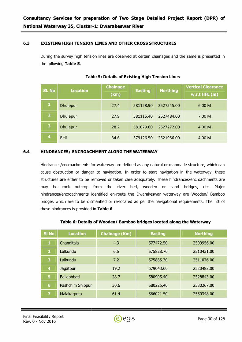
6.3 EXISTING HIGH TENSION LINES AND OTHER CROSS STRUCTURES
During the survey high tension lines are observed at certain chainages and the same is presented in
the following Table 5.
Table 5: Details of Existing High Tension Lines
Sl. No Location Chainage
(km) Easting Northing
Vertical Clearance
w.r.t HFL (m)
1 Dhulepur 27.4 581128.90 2527545.00 6.00 M
2 Dhulepur 27.9 581115.40 2527484.00 7.00 M
3 Dhulepur 28.2 581079.60 2527272.00 4.00 M
4 Beli 34.6 579126.50 2521956.00 4.00 M
6.4 HINDRANCES/ ENCROACHMENT ALONG THE WATERWAY
Hindrances/encroachments for waterway are defined as any natural or manmade structure, which can
cause obstruction or danger to navigation. In order to start navigation in the waterway, these
structures are either to be removed or taken care adequately. These hindrances/encroachments are
may be rock outcrop from the river bed, wooden or sand bridges, etc. Major
hindrances/encroachments identified en-route the Dwarakeswar waterway are Wooden/ Bamboo
bridges which are to be dismantled or re-located as per the navigational requirements. The list of
these hindrances is provided in Table 6.
Table 6: Details of Wooden/ Bamboo bridges located along the Waterway
Sl No Location Chainage (Km) Easting Northing
1 Chanditala 4.3 577472.50 2509956.00
2 Lalkundu 6.5 575828.70 2510431.00
3 Lalkundu 7.2 575885.30 2511076.00
4 Jagatpur 19.2 579043.60 2520482.00
5 Ballabhbati 28.7 580905.40 2528843.00
6 Pashchim Shibpur 30.6 580225.40 2530267.00
7 Malakarpota 61.4 566021.50 2550348.00
Consultancy Services for preparation of Two Stage Detailed Project Report (DPR) of
National Waterway 35, Cluster-1: Dwarakeswar River
Final Feasibility Report Rev. 0 - Nov 2016
Page 31 of 128
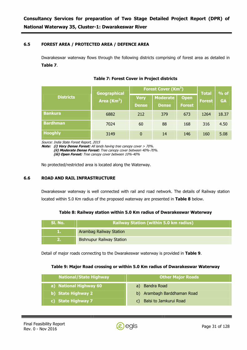
6.5 FOREST AREA / PROTECTED AREA / DEFENCE AREA
Dwarakeswar waterway flows through the following districts comprising of forest area as detailed in
Table 7.
Table 7: Forest Cover in Project districts
Districts Geographical
Area (Km2)
Forest Cover (Km2) Total
Forest
% of
GA Very
Dense
Moderate
Dense
Open
Forest
Bankura 6882 212 379 673 1264 18.37
Bardhman 7024 60 88 168 316 4.50
Hooghly 3149 0 14 146 160 5.08
Source: India State Forest Report, 2015 Note: (i) Very Dense Forest: All lands having tree canopy cover > 70%.
(ii) Moderate Dense Forest: Tree canopy cover between 40%-70%. (iii) Open Forest: Tree canopy cover between 10%-40%
No protected/restricted area is located along the Waterway.
6.6 ROAD AND RAIL INFRASTRUCTURE
Dwarakeswar waterway is well connected with rail and road network. The details of Railway station
located within 5.0 Km radius of the proposed waterway are presented in Table 8 below.
Table 8: Railway station within 5.0 Km radius of Dwarakeswar Waterway
Sl. No. Railway Station (within 5.0 km radius)
1. Arambag Railway Station
2. Bishnupur Railway Station
Detail of major roads connecting to the Dwarakeswar waterway is provided in Table 9.
Table 9: Major Road crossing or within 5.0 Km radius of Dwarakeswar Waterway
National/State Highway Other Major Roads
a) National Highway 60
b) State Highway 2
c) State Highway 7
a) Bandra Road
b) Arambagh Barddhaman Road
c) Balsi to Jamkurui Road

Consultancy Services for preparation of Two Stage Detailed Project Report (DPR) of
National Waterway 35, Cluster-1: Dwarakeswar River
Final Feasibility Report Rev. 0 - Nov 2016
Page 32 of 128
7.0 RECONNAISSANCE SURVEY
Egis, India carried out the reconnaissance survey as required for the feasibility studies and detailed as
per TOR as below:
Single line longitudinal survey (Bathymetric survey or Topographic survey) in the deepest
depths or lowest height lands, with the help of DGPS using Automatic Hydrographic Survey
System.
Horizontal and vertical clearances above High Flood Level of bridges, aqueducts, electric
lines, telephone lines, pipe lines, cables en-route are to be charted.
Details about Barrages and Dams en-route are also to be reported.
Topographical features of the Inland Waterways are to be reported.
Typical physical features along the alignment i.e. land use pattern are to be reported
Stretches having year round flow and critical depth for navigational purpose are to be
reported.
Preliminary Traffic on the Inland Waterways is to be identified.
Inventory of major aspects including Inland Waterway width, Terrain, Bridges and structures
across the Inland Waterways (Type, size and location) will be reported.
Urban areas (location extent) are to be reported.
Geologically sensitive areas environmental features are to be reported
Hydrological features are to be reported.
Critical areas requiring detailed investigations are to be reported.
Requirements for carrying out supplementary investigations are to be reported.
Visual inspection of Soil (textural classifications) are to be reported
Major Drainage conditions are to be reported.
Type and extent of existing utility services along the alignment are to be identified.
Identification of various agencies of the govt. from whom the concerned project clearances
for implementation are to be sought.
7.1 DETAIL METHODOLOGY FOR SURVEY
The surveyor deployed a team of personnel to carry out the reconnaissance survey; the detailed
methodology is described in following sub sections.
Consultancy Services for preparation of Two Stage Detailed Project Report (DPR) of
National Waterway 35, Cluster-1: Dwarakeswar River
Final Feasibility Report Rev. 0 - Nov 2016
Page 33 of 128
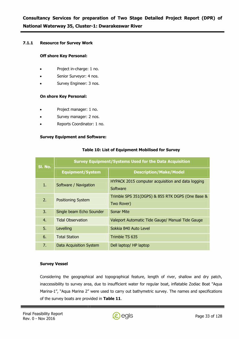
7.1.1 Resource for Survey Work
Off shore Key Personal:
Project in-charge: 1 no.
Senior Surveyor: 4 nos.
Survey Engineer: 3 nos.
On shore Key Personal:
Project manager: 1 no.
Survey manager: 2 nos.
Reports Coordinator: 1 no.
Survey Equipment and Software:
Table 10: List of Equipment Mobilised for Survey
Sl. No.
Survey Equipment/Systems Used for the Data Acquisition
Equipment/System Description/Make/Model
1. Software / Navigation HYPACK 2015 computer acquisition and data logging
Software
2. Positioning System Trimble SPS 351(DGPS) & 855 RTK DGPS (One Base &
Two Rover)
3. Single beam Echo Sounder Sonar Mite
4. Tidal Observation Valeport Automatic Tide Gauge/ Manual Tide Gauge
5. Levelling Sokkia B40 Auto Level
6. Total Station Trimble TS 635
7. Data Acquisition System Dell laptop/ HP laptop
Survey Vessel
Considering the geographical and topographical feature, length of river, shallow and dry patch,
inaccessibility to survey area, due to insufficient water for regular boat, inflatable Zodiac Boat "Aqua
Marina-1”, “Aqua Marina 2” were used to carry out bathymetric survey. The names and specifications
of the survey boats are provided in Table 11.

Consultancy Services for preparation of Two Stage Detailed Project Report (DPR) of
National Waterway 35, Cluster-1: Dwarakeswar River
Final Feasibility Report Rev. 0 - Nov 2016
Page 34 of 128
Table 11: Details of Survey Boats Used
Name of the Boat Length (m) Width (m) Draft (m)
Aqua Marina - 1 3.0 1.5 0.020
Aqua Marina – 2 2.5 1.29 0.020
7.1.2 Geodetic Parameters
The geodetic parameters used for survey were as follows:-
Global Positioning System Geodetic Parameters
Datum: World Geodetic System 1984 (WGS84)
Spheroid: World Geodetic System 1984
Semi major axis: a = 6 378 137.000 m
Inverse Flattening: 1/f = 298.257 223 563
Local Datum Geodetic Parameters
Datum: World Geodetic System 1984 (WGS84)
Spheroid: World Geodetic System 1984
Semi major axis: a = 6 378 137.000 m
Inverse Flattening: 1/f = 298.257 223 563
Datum Transformation Parameters from WGS84 to WGS84
Shift dX: 0.0 m Rotation rX: 0.000 arcsec Delta Scale : 0.0000 ppm
Shift dY: 0.0 m Rotation rY: 0.000 arcsec
Shift dZ: 0.0 m Rotation rZ: 0.000 arcsec
Local Projection and Grid Parameters 2)
Map Projection: Universal Transverse Mercator
Grid System: UTM Zone 45 N
Central Meridian: 087° 00’ 00” West
Latitude of Origin: 0° 00’ 00” North
False Easting: 500 000 m
False Northing: 0.0000
Scale factor on Central Meridian: 0.9996
Units: metres

Consultancy Services for preparation of Two Stage Detailed Project Report (DPR) of
National Waterway 35, Cluster-1: Dwarakeswar River
Final Feasibility Report Rev. 0 - Nov 2016
Page 35 of 128
Notes: 1) Hypack navigation software always uses WGS84 geodetic parameters as a primary datum for any
geodetic calculations. 2) This is the right-handed coordinate frame rotation convention used by the Hypack navigation
software.
7.1.3 Survey Data Processing
General
The survey data was logged in HYPACK On-line Survey Software, and was processed using the
HYPACK Processing, AUTOCAD and Spectra Precision Survey Office. The data was processed, checked
and verified to ensure good quality data. Single Beam (SB) Editor was used for the automated and
manual processing of logged data sets.
Navigation and Positioning
The DGPS Receiver Antenna was mounted exactly above the echo sounder transducer. The echo
sounder transducer was mounted on the side of the boat, without any offset to ensure accuracy in the
position of soundings. The bar-checks were carried out before/after each sounding session.
Transducer draft was measured and recorded, and the same was used while processing. On all such
occasions the error observed was zero or near zero. Therefore, no corrections were necessary.
Bathymetry
HYPACK Processing suite was used to import quality check and process the navigation, bathymetry
and tidal data. The data was filtered, cleaned, and combined to create geographically positioned
bathymetric data set.
7.2 DESCRIPTION OF BENCH MARKS/ REFERENCE LEVELS
Due to non-availability of any permanent BM near the project area during reconnaissance survey,
benchmarks was established by DGPS observation for 12 hours using Trimble SPS 855 positioning
system and post processing through AUSPOS and Spectra Precision Survey Office to get the value of
the TBMs with respect to MSL. The final co-ordinates of the BM and height above MSL and other
details are provided in Table 12 as below.

Consultancy Services for preparation of Two Stage Detailed Project Report (DPR) of
National Waterway 35, Cluster-1: Dwarakeswar River
Final Feasibility Report Rev. 0 - Nov 2016
Page 36 of 128
Table 12 : Temporary Benchmark Dwarakeswar River
Sl.
No. TBM Latitude Longitude Easting Northing
Chainage
(km)
CD w.r.t MSL
(m)
Ht above
MSL in m
1. Bondar
(TBM – 1) 22°40'15.51"N 87°46'45.15"E 580048.36 2507307.57 0.00 1.00 1.860
2. Baghanala (TBM – 2)
22°43'47.10"N 87°44’16.47" 575773.26 2513792.31 10.222 3.32 3.329
3.
Paschin
Raypur (TBM – 3)
22°48’42.11"N 87°46'22.83"E 579330.26 2522882.31 21.433 6.375 8.451
4. Daulatpur
(TBM – 4) 22°54'40.75"N 87°45'38.61"E 578012.73 2533904.43 35.286 8.04 12.918
5. Lakshmanhati
(TBM – 5) 23°02'06.25"N 87°40'08.64"E 568550.19 2547558.61 56.638 20.25 24.413
7.3 LEVELLING OF TEMPORARY TIDE POLES
Five temporary bench marks were established in between the course of survey at different places by
using Trimble RTK SPS 855. Auto level SOKIA B-30 was used to establish the zero of the tide gauge
with reference the TBMs. The observed readings in Auto Level are provided in Annexure 1. The
water levels observed on the tide poles during reconnaissance survey are provided in Annexure 2.
The CD/SD adopted for obtaining reduced depth along the waterway is given in Figure 4.

Consultancy Services for preparation of Two Stage Detailed Project Report (DPR) of
National Waterway 35, Cluster-1: Dwarakeswar River
Final Feasibility Report Rev. 0 - Nov 2016
Page 37 of 128
Figure 4: Graph showing Chart Datum/Sounding Datum w.r.t. MSL along Dwarekeswar River
7.4 HYDROGRAPHIC SURVEY
Single line longitudinal survey (Bathymetric survey or Topographic survey) in the deepest depths or
lowest height lands, with the help of DGPS using Automatic Hydrographic Survey System has been
carried out for the length as shown in Table 13. Total length of the Dwarakeswar Waterway as per
TOR is 113.0 km.
Table 13: Survey Length of Waterway
Total Surveyed Length of Waterway
Length of Bathymetric Survey
Length of Topographic Survey
113 Km 37.10 Km 75.90 Km
7.5 WATER DEPTH
Water depths along the waterway have been observed during Reconnaissance survey as per the
scope of works and requirement for feasibility studies. Single line longitudinal bathymetric/topographic

Consultancy Services for preparation of Two Stage Detailed Project Report (DPR) of
National Waterway 35, Cluster-1: Dwarakeswar River
Final Feasibility Report Rev. 0 - Nov 2016
Page 38 of 128
survey has been carried out for obtaining the water depth along the deepest route or lowest height
lands of waterway. The observed depth are then corrected by applying a reduction factor as provided
above for different stretches to calculate the reduced water depths available for navigation. The
reduced water depths at every 10 km interval are presented in Table 14. Detailed water depths along
the Dwarakeswar waterway is also provided in Annexure 3.
Table 14: Water Depth along the Waterway
Chainage
(Km)
Draft Variation Length of River (Km) with following draft
Max. Available (m) Min. Available (m) <1m 1.0 -1.5m 1.5 -2.0 m >2.0m
0 – 10 1.52 0.00 9.79 0.00 0.21 0.00
10 – 20 2.33 0.97 9.62 0.24 0.04 0.20
20 – 30 5.73 0.73 1.06 3.14 2.65 3.14
30 – 40 3.94 0.34 6.09 2.04 1.10 0.77
40 – 50 Topographic Survey done for full stretch 10.00 0.00 0.00 0.00
50 – 60 1.11 0.11 9.94 0.06 0.00 0.00
60 – 70 2.81 0.07 9.94 0.00 0.00 0.06
70 – 80 0.22 0.03 10.00 0.00 0.00 0.00
80 – 90
Topographic Survey done for full stretch
10.00 0.00 0.00 0.00
90 – 100 10.00 0.00 0.00 0.00
100 – 110 10.00 0.00 0.00 0.00
110 – 113 10.00 0.00 0.00 0.00
Total 99.35 5.47 4.01 4.17
It can be inferred from the above table that 4.17 Km stretch of waterway have draft more than
2.0 m, 4.01 Km stretch have draft of 1.50 m to 2.0 m, 5.47 km have draft of 1.0 m to 1.50
m and remaining 99.35 km stretch of waterway have less than 1.0 m draft with respect to
chart datum respectively.
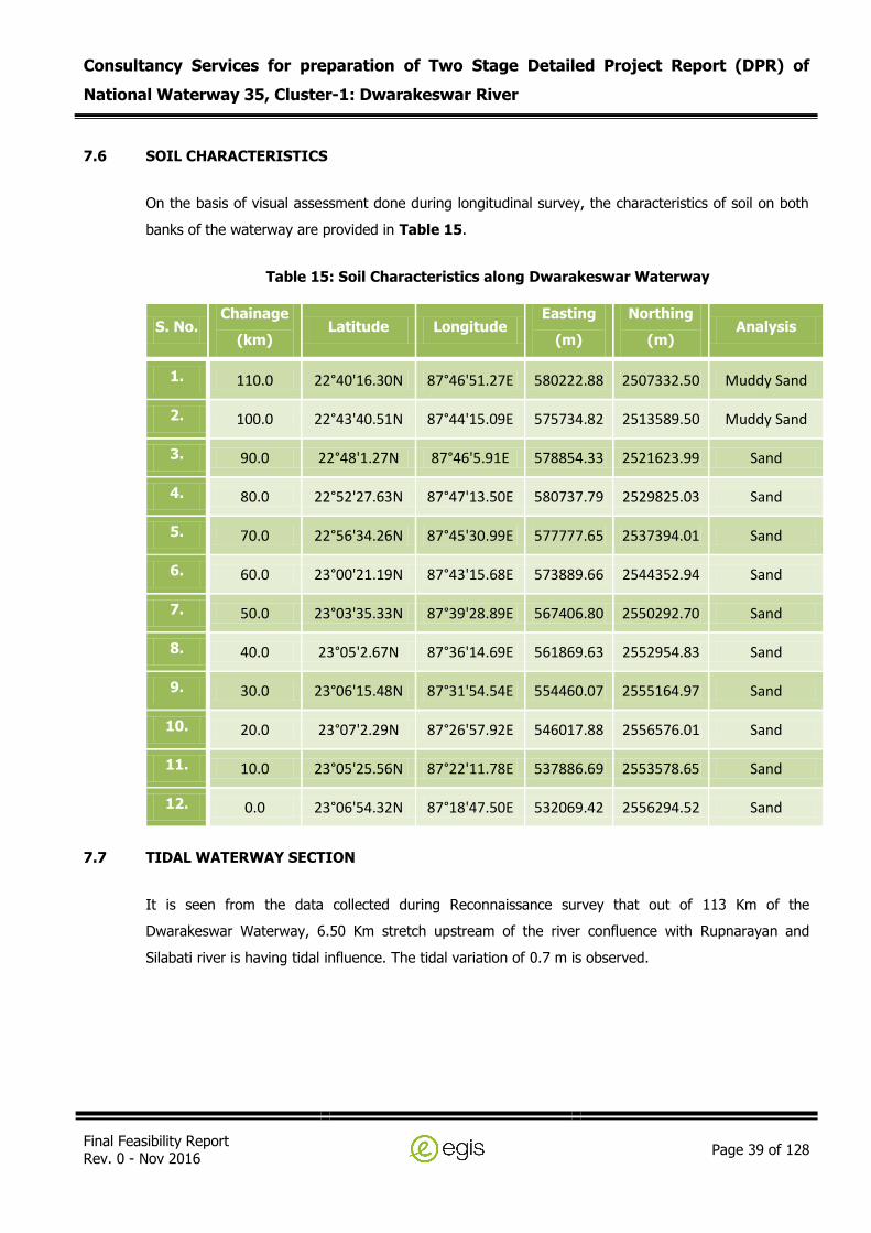
Consultancy Services for preparation of Two Stage Detailed Project Report (DPR) of
National Waterway 35, Cluster-1: Dwarakeswar River
Final Feasibility Report Rev. 0 - Nov 2016
Page 39 of 128
7.6 SOIL CHARACTERISTICS
On the basis of visual assessment done during longitudinal survey, the characteristics of soil on both
banks of the waterway are provided in Table 15.
Table 15: Soil Characteristics along Dwarakeswar Waterway
S. No. Chainage
(km) Latitude Longitude
Easting
(m)
Northing
(m) Analysis
1. 110.0 22°40'16.30N 87°46'51.27E 580222.88 2507332.50 Muddy Sand
2. 100.0 22°43'40.51N 87°44'15.09E 575734.82 2513589.50 Muddy Sand
3. 90.0 22°48'1.27N 87°46'5.91E 578854.33 2521623.99 Sand
4. 80.0 22°52'27.63N 87°47'13.50E 580737.79 2529825.03 Sand
5. 70.0 22°56'34.26N 87°45'30.99E 577777.65 2537394.01 Sand
6. 60.0 23°00'21.19N 87°43'15.68E 573889.66 2544352.94 Sand
7. 50.0 23°03'35.33N 87°39'28.89E 567406.80 2550292.70 Sand
8. 40.0 23°05'2.67N 87°36'14.69E 561869.63 2552954.83 Sand
9. 30.0 23°06'15.48N 87°31'54.54E 554460.07 2555164.97 Sand
10. 20.0 23°07'2.29N 87°26'57.92E 546017.88 2556576.01 Sand
11. 10.0 23°05'25.56N 87°22'11.78E 537886.69 2553578.65 Sand
12. 0.0 23°06'54.32N 87°18'47.50E 532069.42 2556294.52 Sand
7.7 TIDAL WATERWAY SECTION
It is seen from the data collected during Reconnaissance survey that out of 113 Km of the
Dwarakeswar Waterway, 6.50 Km stretch upstream of the river confluence with Rupnarayan and
Silabati river is having tidal influence. The tidal variation of 0.7 m is observed.

Consultancy Services for preparation of Two Stage Detailed Project Report (DPR) of
National Waterway 35, Cluster-1: Dwarakeswar River
Final Feasibility Report Rev. 0 - Nov 2016
Page 40 of 128
8.0 MARKET ANALYSIS
Preliminary market analysis has been done on the basis of reconnaissance survey, Consultants site
visit, available secondary informations and published literature at the feasibility stage of the project.
8.1 LAND USE PATTERN
Land use pattern along the Dwarakeswar River can be characterized as Agricultural and Residential as
presented in Table 16.
Table 16: Land Use Pattern along Waterway
Length (km)
Agricultural Residential
Length (km) % Length (km) %
113 110.74 98% 2.26 2%
8.2 CROPS /AGRICULTURE PRODUCTS
Dwarakeswar waterway is located along the following districts of West Bengal, namely;
Bankura
Bardhaman
Hooghly
The details of cropping system in the above listed districts are as follows:
Bankura: Rice is the main crop of this district. Though the district is prone to drought, it can raise
surplus food production in years of good rainfall. Besides rice, the major crops are Potato, wheat,
Vegetables, Mustard, Summer Til etc. Like rice, the district is also surplus in Potato & Vegetable
production. The district is lagging behind in the production of Pulses & Oilseeds. However, special
emphasis is started giving in production of Oilseeds & Pulses by introducing new varieties of Pulse
Crops like Arhar, Lentil, Gram, Khesari, Kalai, Moong etc. Ground Nut and Sunflower have also been
introduced in Rabi season to meet up the gap between demand and production of Oilseed crops.
Broccoli and Capsicum are also cultivated by farmers of this district to meet up the demand of the
local people.

Consultancy Services for preparation of Two Stage Detailed Project Report (DPR) of
National Waterway 35, Cluster-1: Dwarakeswar River
Final Feasibility Report Rev. 0 - Nov 2016
Page 41 of 128
Table 17: Average Production and Productivity of major crops in Bankura district (2004-09)
Name of
Crop
Kharif Rabi Summer Total
Production
(‘000 t)
Productivity
(kg/ha)
Production
(‘000 t)
Productivity
(kg/ha)
Production
(‘000 t)
Productivity
(kg/ha)
Production
(‘000 t)
Productivity
(kg/ha)
Major Field Crops
Rice 49.17 2602 906.33 2770 152.83 2636 1108.33 2744
Wheat - - 11.03 2073 - - 11.03 2073
Pulses - - 0.32 671 - - 0.32 671
Oilseeds - - 25.35 705 - - 25.35 705
Potato - - 682.78 19489 - - 682.78 19489
Maize 1.44 2352 - - - - 1.44 2352
Major Horticultural Crops
Cucurbits - - - - - - 161.43 13703
Brinjal - - - - - - 194.85 19504
Okra - - - - - - 64.29 11180
Cauliflower - - - - - - 145.65 27429
Cabbage - - - - - - 155.33 32495
Source: Agriculture Contingency Plan
Bardhhaman: Bardhhaman is the only district in the state of West Bengal that is fortunate both in
industry and agriculture. On an average about 58 percent of the total population belongs to the
agricultural population while the non-agricultural sector accounts for the remaining 42 percent.
The eastern, northern, southern and central areas of the district are extensively cultivated but the soil
of the western portion being of extreme lateritic type is unfit for cultivation except in the narrow
valleys and depressions having rich soil and good moisture. The cultivation in the district has
improved since 1953 with the implementation of the irrigation projects undertaken by the Damodar
Valley Corporation. Up to 1953 the cultivation was entirely dependent on the monsoon, and irrigation
facilities were rather inadequate and more or less primitive. The position has since been changed and
an all-round agricultural development has become possible. Though agriculture is largely regulated by

Consultancy Services for preparation of Two Stage Detailed Project Report (DPR) of
National Waterway 35, Cluster-1: Dwarakeswar River
Final Feasibility Report Rev. 0 - Nov 2016
Page 42 of 128
rainfall as in the other districts of the state, the developing irrigation system has been very helpful in
minimizing the effects of the vagaries of nature.
Rice is the most important crop of the district and in the alluvial plains to the east little else is grown.
The rice grown with its numerous varieties can broadly grouped under the three primary classes
distinguished from one another by distinct characteristics and there are: The Aus or autumn, the
Aman or winter and the Boro or the summer rice. Paddy covers maximum of the gross cropped area.
Among commercial crops Jute, Mesta and Sugarcane, potato, oil seeds are cultivated in marginal area
Table 18: Average Production and Productivity of major crops in Bardhhaman district (2004-08)
Name of
Crop
Kharif Rabi Summer Total
Production (‘000 t)
Productivity (kg/ha)
Production (‘000 t)
Productivity (kg/ha)
Production (‘000 t)
Productivity (kg/ha)
Production (‘000 t)
Productivity (kg/ha)
Major Field Crops
Rice 48.1 3069 1231.1 2953 642.5 3129 1921.7 3021
Wheat - - 6.7 2313 - - 6.7 2313
Pulses - - 1.2 849 - - 1.2 849
Oilseeds - - 43.1 850 - - 43.1 850
Jute 233.0 3019 - - - - 233.0 3019
Potato - - 1058.0 21674 - - 1058.0 21674
Source: Agriculture Contingency Plan
Hooghly: Hooghly is an agriculturally prosperous district of West Bengal. The land use pattern of the
district demonstrates a high proportion of net sown area as percentage of total reported area. About
70% of its population depend on agriculture and represents an important and remarkable place in the
field of agriculture in West Bengal.
Due to massive population explosion and continuous increase of pressure on land, the farmers of this
district are engaged in cultivation of all the major crops utilising the fullest potentiality of land and
natural resources. Though rice is the prime crop of the district, the agricultural economy largely
depends on potato, jute, vegetables and orchard and the cropping intensity of the district has been
escalated to 220%.

Consultancy Services for preparation of Two Stage Detailed Project Report (DPR) of
National Waterway 35, Cluster-1: Dwarakeswar River
Final Feasibility Report Rev. 0 - Nov 2016
Page 43 of 128
Vegetable is a price crop in the blocks of Haripal, Singur, Chanditala, Polba and Dhaniakhali being
grown in a relay system throughout the year. Though potato is cultivated in all the blocks of this
district in Dhaniakhali, Arambagh, Goghat, Pursurah, Haripal, Polba-Dadpur, Tarakeswar, Pandua and
Singur contributed much of its production of this district.
Table 19: Hooghly district-Average Production and Productivity of major crops (2004-09)
Name of
Crop
Kharif Rabi Summer Total
Production
(‘000 t)
Productivity
(kg/ha)
Production
(‘000 t)
Productivity
(kg/ha)
Production
(‘000 t)
Productivity
(kg/ha)
Production
(‘000 t)
Productivity
(kg/ha)
Major Field Crops
Rice 19.24 2665 16.83 2712 304.72 2953 340.79 8330
Potato - - 1960.34 20889 - - 1960.34 20889
Wheat - - 1.38 2110 - - 1.38 2110
Oilseeds - - 40.86 1127 - - 40.86 1127
Pulses - - 1.278 758 - - 1.278 758
Maize 0.46 2531 - - - - 0.46 2531
Source: Agriculture Contingency Plan
8.3 AVAILABILITY OF PASSENGER FERRY SERVICES
Locally organised passenger ferry services are located at some places along the waterway during
Reconnaissance survey. The ferry service locations along Dwarakeswar waterway are given in Table
20.
Table 20: Existing Ferry locations along Dwarakeswar River
Sl. No Location Chainage (km) Easting Northing
1. Daschim Raypur 21.5 579389.10 2522954.00
2. Dighara 24.5 580268.10 2524799.00
3. Birampur 36.6 578845.70 2534980.00
4. Mandra 38.0 579267.30 2536203.00

Consultancy Services for preparation of Two Stage Detailed Project Report (DPR) of
National Waterway 35, Cluster-1: Dwarakeswar River
Final Feasibility Report Rev. 0 - Nov 2016
Page 44 of 128
8.4 EXISTING JETTIES AND TERMINALS
The ferry services operational along the waterway is locally operated and used for passenger and
small cargo transports like fish, vegetables, agricultural goods, bricks and locally made tiles only.
As observed during the survey, temporary structures made of wooden planks, stones are used for
embarking/disembarking purposes. And no permanent structural RCC jetty is located along the
waterway.
8.5 HISTORICAL AND TOURIST PLACE ALONG DWARAKESWAR WATERWAY
Prominent places located along Dwarakeswar waterway are:
Bishnupur is an important tourist spot of Bankura district. This place has a historical importance as it
was the capital of Mallabhum. It is very famous for terracotta temples and Baluchari sarees. It is
popular for classical music dalmadal and painting. There are approximately 16 temples, most of which
are made in the decade of Mallaraja. Important temples of Bishnupur are Jor Mandir, Rasmancha,
Radhamadhab Temple, Kalachand Temple, Madan Mohan Temple, Radha-Gobinda Temple and Shyam
Ray Temple.
Joyrambati is a holy place as it was the birthplace of Sree Sree Maa Sarada Devi. Temple of Singha
Bahani Devi and Mayerepukur are also visiting sites
8.6 AVAILABILITY OF CONSTRUCTION MATERIAL
Major construction materials available along the Dwarakeswar waterway are Sand, Bricks and Tiles.
8.7 INDUSTRIES ALONG THE WATERWAY
Pottery industry is the major livelihood of the people living along Dwarakeswar waterway, due to
presence of fireclay. Haldia is a centre of industrial activity with its chemical and oil factories situated
on the banks of the river. The confluence point of Dwarakeswar and Silabati River known as Ghatal, is
famous for textile, paper, tin and bronze industries. Arambagh, the head office of Hooghly districts, is
famous for its poultries and paper industries. Besides these, rubber industry is also found in some
pockets of the catchment.
Most of the people living along the banks of waterway depend upon agriculture. Kharif and Rabi, both
types of crops are cultivated here along with Bittle tree cultivation.

Consultancy Services for preparation of Two Stage Detailed Project Report (DPR) of
National Waterway 35, Cluster-1: Dwarakeswar River
Final Feasibility Report Rev. 0 - Nov 2016
Page 45 of 128
The likely exportable items are follows:
1) Tobacco Products,
2) Construction material like bricks and sand.
3) Fresh water Fish and poultry,
4) Agriculture products including Bittle,
5) Tin and Bronze products,
6) Textile,
7) Paper,
8) Rubber products,
9) Copper and Aluminium
8.8 EXISTING WATER SPORT AND RECREATIONAL ACTIVITIES AND FUTURE PROBABILITY
Water recreational activities are currently not available along the waterway. However, the waterway
has huge potential to be developed for water sports and recreational activities especially in the tidal
stretch.
8.9 ESTIMATED CARGO MOVEMENT
Dwarakeswar waterway has huge potential for economic development considering its connectivity
with various industrial and commercial places along its way. It’s connection with Rupnarayan and
thereafter with Hooghly River, including Haldia port add to its commercial advantage.
Forecasted cargo potential has been estimated on the basis of last 13 year growth pattern of Cargo
movement from 2002-2003 to 2014 – 2015 for National waterway-1, as provided in the IWAI Annual
reports (Refer Table 21). Linear correlation between existing and declared National Waterways has
been done, to estimate the forecasted cargo potential. In Stage-I of the study a base figure of 0.0
tonnes cargo movement is assumed for estimating the forecasted figures as shown in Figure 5.
Table 21: Cargo Movement in National Waterway – 1 from 2002 – 2015
Sl. No. Year Cargo Movement for NW-1 (tonnes)
1. 2002-03 632,037
2. 2003-04 786,159
3. 2004-05 887,328
4. 2005-06 1,001,450

Consultancy Services for preparation of Two Stage Detailed Project Report (DPR) of
National Waterway 35, Cluster-1: Dwarakeswar River
Final Feasibility Report Rev. 0 - Nov 2016
Page 46 of 128
Sl. No. Year Cargo Movement for NW-1 (tonnes)
5. 2006-07 1,317,387
6. 2007-08 1,497,964
7. 2008-09 1,348,385
8. 2009-10 1,811,070
9. 2010-11 1,871,178
10. 2011-12 3,309,839
11. 2012-13 2,716,437
12. 2013-14 3,349,138
13. 2014-15 5,050,209
Figure 5: Forecasted Cargo Potential
Prima facie Dwarakeswar waterway has huge economical potential for development of Inland
waterway. Not only there is existing traffic but also the development of waterway will trigger new
traffic. Extent of development and prioritisation of inland waterways will be prepared in subsequent
phase of the DPR study.

Consultancy Services for preparation of Two Stage Detailed Project Report (DPR) of
National Waterway 35, Cluster-1: Dwarakeswar River
Final Feasibility Report Rev. 0 - Nov 2016
Page 47 of 128
9.0 OBSERVATION AND INFERENCE
On the basis of reconnaissance survey as well as primary and secondary data collected from IWAI,
central and state government departments and other stakeholders, following observations and
inferences are made on the Dwarakeswar Waterway (National Waterway 35).
9.1 WATERWAY
Dwarakeswar River originates from Tilboni hill in Purulia district and enters Bankura district near
Chhatna of West Bengal. The river cuts across the Bankura district flowing past the district
headquarters and enters the south-eastern tip of Bardhaman District. It then passes through Hooghly
District. The Silabati River joins it near Ghatal and the two together is known as Rupnarayan River,
which flows into the Hooghly River near Gadiara in Howrah District. The total catchments area of the
Dwarakeswar river system is 4292 sq. Km. The important tributaries of Dwarakeswar River system are
Gandheswari, Beko, Arkasha, Berai, Shankar. The river has a tidal stretch of 8.0 Km towards upstream
of Ghatal, with maximum tidal variation of about 0.7 m.
9.2 LEAST AVAILABLE DEPTH (LAD)
LAD of the Dwarakeswar waterway is estimated on the basis of applying exceedance probability
approach on the reduced water depth. Reduced water depth is calculated after applying corrections
on the water depths observed during single line hydrographic survey with reference to
Chart/Sounding datums. Navigable stretch available for least available depth (LAD) of <1.0 m, 1.0 m
to 1.5 m, 1.5 m to 2.0 m and >2.0 m for the waterway is presented in Table 22.
Table 22: Waterway length with varying LAD
Features Results
Waterway Length 113.0 Km
Length with Topographic Survey 75.90 Km
Length with Bathymetric Survey 37.10 Km
Maximum available draft 5.73 m
Minimum available draft 0.00 m
Waterway length with <1.0 m draft (includes length with topographic survey)
99.35 Km

Consultancy Services for preparation of Two Stage Detailed Project Report (DPR) of
National Waterway 35, Cluster-1: Dwarakeswar River
Final Feasibility Report Rev. 0 - Nov 2016
Page 48 of 128
Features Results
Waterway length with 1.0 – 1.5 m draft 5.47 Km
Waterway length with 1.5 – 2.0 m draft 4.01 Km
Waterway length with >2.0 m draft 4.17 Km
By taking into account the tidal advantage of 0.7 m in the tidal stretch of waterway. The available
draft in this stretch can be conveniently raised above 1.2 m from 1.0 m.
9.3 CROSS - STRUCTURES
During reconnaissance survey, details of cross-structures have been collected and their minimum
horizontal and vertical clearance has been evaluated on the basis of visual assessment as shown in
Table 23 below. The detailed list of cross-structures is provided in Table 4 and Table 5.
Table 23: Minimum Horizontal and Vertical Clearance along Waterways
Surveyed Length
(km)
Dams/
Barrages/Locks
Bridges/
Crossing
Min Ver. /Hor.
Clearance (m)
High-Tension
Lines
Min Ver.
Clearance (m)
113 Not Available 2 6.0 / 8.0 6 4.0
Vertical clearance is with reference to the HFL.
Horizontal Clearance is the minimum distance between the bridge piers.
9.4 SWOT ANALYSIS
SWOT analysis is a technique commonly used to assist in identifying strategic direction for an
organization or practice. It helps to make an assessment of internal environment and scrutiny of
external environment, with an objective to take maximum benefits by having an appropriate
proposition. It is preferred for the present work as it yields useful information about the future
viability of the considered inland waterway system. The predictive capabilities in the technique come
about from the consideration of system’s strengths and weaknesses in the context of the development
of Inland Waterway System, which may present opportunities and threats.

Consultancy Services for preparation of Two Stage Detailed Project Report (DPR) of
National Waterway 35, Cluster-1: Dwarakeswar River
Final Feasibility Report Rev. 0 - Nov 2016
Page 49 of 128
P
O
S
I
T
I
V
E
I N T E R N A L
N
E
G
A
T
I
V
E
STRENGTH WEAKNESS
Commitment of Govt. of India for
Developing Inland Waterways Sector.
Environmental friendly mode of
Transport
Increase in Infrastructure Facilities as
alternative mode of transport.
Comparatively high level of transport
safety.
Reliable services under predictable
weather conditions.
Low transport costs (per km) for bulk
shipments.
Long term effective cost control
measures (O&M).
Capable of bringing down decongestion
from the Road Transport.
Availability of tidal window, which provides
additional draft for navigation.
Huge Initial Investment
High Maintenance Cost
High tariff structure for Inland Transport.
Limited knowledge of IWT among
shippers.
Dependence on inter-modality for door-to
door services.
Substantial cost differentials w.r.t other
transports.
Dredging capability of GoI is 16% of
National requirement.
Availability of water throughout the year.
Trigger new traffic in the hinterland
Boost International and National trade of
commodities.
Improvement of the capacity/quality of
the Infrastructure.
Integration of Ports with Roads &
Railways.
Enhance inter-modality.
Implementation of infrastructure links.
Improved Supply-Demand logistic chains
Creation of reliable employment for the
people.
Connectivity with Rupnarayan waterway and
thereby with National waterway 1 and Haldia
port.
Lack of Skilled Man-power.
Environmental policy restrictions on
transport infrastructure policies.
Limited financial means.
Fast growing economic sectors often road
oriented: low IWT affinity.
Priority of investments in road/ rail
infrastructure as per the present scenario.
Land Acquisition
Sand mining from river bed.
OPPORTUNITY THREAT
E X T E R N A L
Figure 6: SWOT Analysis

Consultancy Services for preparation of Two Stage Detailed Project Report (DPR) of
National Waterway 35, Cluster-1: Dwarakeswar River
Final Feasibility Report Rev. 0 - Nov 2016
Page 50 of 128
The strengths and weaknesses of a system are determined by the internal elements, whereas external
forces dictate opportunities and threats. Strengths can be defined as any available resource that can
be used to improve its performance. Weaknesses are flaws/shortcomings of any system that may
cause to lose a competitive advantage, efficiency or resources. Sometimes it is recommended to
identify opportunities and threats first in order to more quickly ring to light the system’s strengths and
weaknesses. Many of the threats are based on weaknesses. Further, SWOT analysis helps in
categorizing the key internal and external factors that are important to achieving the objective. With
regards to assessing the feasibility of the waterway for navigation, this exercise will help us identify
the important factors to be considered while designing the future action for DPR study in Stage 2 and
strategic plan for its development.
9.5 SUMMARY
The salient features of the feasibility study for 113 km stretch of Dwarakeswar waterway are,
The waterway has a tidal stretch of 6.5 Km from Ghatal towards upstream with a maximum
tidal variation of about 0.7 m. This portion is feasible for year round navigation.
The horizontal and vertical clearance of existing cross-structures is in the range of 8 m and
6m - 8m respectively.
4.17 Km stretch of waterway have draft more than 2.0 m, 4.01 Km stretch have draft of
1.50 m to 2.0 m, 5.47 km have draft of 1.0 m to 1.50 m and remaining 99.35 km stretch of
waterway have less than 1.0 m draft with respect to chart datum.
Taking in to account the tidal effect, the LAD of 1.0 m can be increased to 1.2 m in the tidal
stretch.
Considering the length of the river, availability of numerous minor and major industries and
connectivity with rail and road network with 5km reach across the bank , the river has huge
economic potential for development as a Waterway
The capacity of the waterway can be enhanced by constructing check dams and lockgates,
however the same shall be evaluated only during Stage-2 of the studies on the basis of
detail investigations.
The waterway has a huge potential considering its connectivity with Rupnarayan Waterway
and thereby with National waterway -1 and Haldia Port.
Not only there is existing traffic but also the development of waterway will trigger new
traffic.
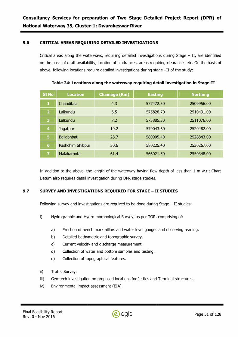
Consultancy Services for preparation of Two Stage Detailed Project Report (DPR) of
National Waterway 35, Cluster-1: Dwarakeswar River
Final Feasibility Report Rev. 0 - Nov 2016
Page 51 of 128
9.6 CRITICAL AREAS REQUIRING DETAILED INVESTIGATIONS
Critical areas along the waterways, requiring detailed investigations during Stage – II, are identified
on the basis of draft availability, location of hindrances, areas requiring clearances etc. On the basis of
above, following locations require detailed investigations during stage –II of the study:
Table 24: Locations along the waterway requiring detail investigation in Stage-II
Sl No Location Chainage (Km) Easting Northing
1 Chanditala 4.3 577472.50 2509956.00
2 Lalkundu 6.5 575828.70 2510431.00
3 Lalkundu 7.2 575885.30 2511076.00
4 Jagatpur 19.2 579043.60 2520482.00
5 Ballabhbati 28.7 580905.40 2528843.00
6 Pashchim Shibpur 30.6 580225.40 2530267.00
7 Malakarpota 61.4 566021.50 2550348.00
In addition to the above, the length of the waterway having flow depth of less than 1 m w.r.t Chart
Datum also requires detail investigation during DPR stage studies.
9.7 SURVEY AND INVESTIGATIONS REQUIRED FOR STAGE – II STUDIES
Following survey and investigations are required to be done during Stage – II studies:
i) Hydrographic and Hydro morphological Survey, as per TOR, comprising of:
a) Erection of bench mark pillars and water level gauges and observing reading.
b) Detailed bathymetric and topographic survey.
c) Current velocity and discharge measurement.
d) Collection of water and bottom samples and testing.
e) Collection of topographical features.
ii) Traffic Survey.
iii) Geo-tech investigation on proposed locations for Jetties and Terminal structures.
iv) Environmental impact assessment (EIA).
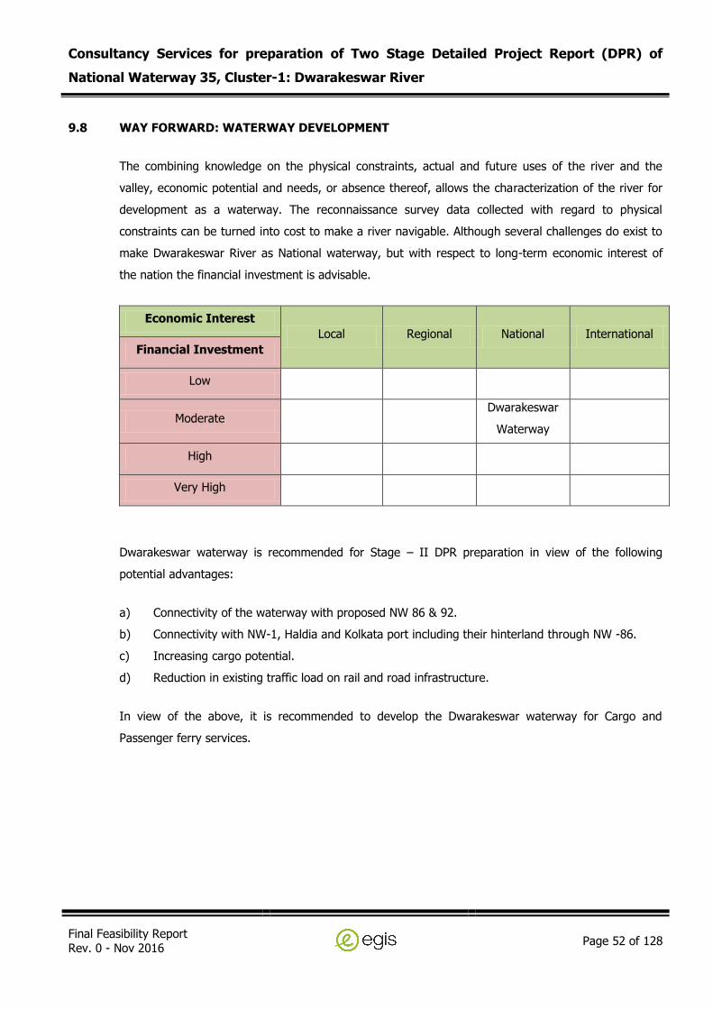
Consultancy Services for preparation of Two Stage Detailed Project Report (DPR) of
National Waterway 35, Cluster-1: Dwarakeswar River
Final Feasibility Report Rev. 0 - Nov 2016
Page 52 of 128
9.8 WAY FORWARD: WATERWAY DEVELOPMENT
The combining knowledge on the physical constraints, actual and future uses of the river and the
valley, economic potential and needs, or absence thereof, allows the characterization of the river for
development as a waterway. The reconnaissance survey data collected with regard to physical
constraints can be turned into cost to make a river navigable. Although several challenges do exist to
make Dwarakeswar River as National waterway, but with respect to long-term economic interest of
the nation the financial investment is advisable.
Economic Interest
Local Regional National International
Financial Investment
Low
Moderate Dwarakeswar
Waterway
High
Very High
Dwarakeswar waterway is recommended for Stage – II DPR preparation in view of the following
potential advantages:
a) Connectivity of the waterway with proposed NW 86 & 92.
b) Connectivity with NW-1, Haldia and Kolkata port including their hinterland through NW -86.
c) Increasing cargo potential.
d) Reduction in existing traffic load on rail and road infrastructure.
In view of the above, it is recommended to develop the Dwarakeswar waterway for Cargo and
Passenger ferry services.

Consultancy Services for preparation of Two Stage Detailed Project Report (DPR) of
National Waterway 35, Cluster-1: Dwarakeswar River
Final Feasibility Report Rev. 0 - Nov 2016
Page 53 of 128
Annexure 1: Levelling Results

Consultancy Services for preparation of Two Stage Detailed Project Report (DPR) of
National Waterway 35, Cluster-1: Dwarakeswar River
Final Feasibility Report Rev. 0 - Nov 2016
Page 54 of 128
LEVELLING BETWEEN TEMPORARY BENCH MARK 1 & TIDE POLE
BS FS HI RL REMARK BS FS HI RL REMARK
1.248 3.108 1.86 TBM 1 1.549 2.712 1.163 TIDE POLE
1.945 1.163 TIDE POLE 0.852 1.86 TBM 1
LEVELLING BETWEEN TEMPORARY BENCH MARK 2 & TIDE POLE
BS FS HI RL REMARK BS FS HI RL REMARK
0.173 4.502 3.329 TBM 2 4.344 2.754 1.41 TIDE POLE
0.664 2.039 2.127 2.463 CP 1 2.082 0.557 3.279 2.197 CP 3
0.309 1.916 1.52 2.211 CP 2 2.048 0.806 4.521 2.473 CP 4
1.11 1.41 TIDE POLE 1.192 3.329 TBM 2
LEVELLING BETWEEN TEMPORARY BENCH MARK 3 & TIDE POLE
BS FS HI RL REMARK BS FS HI RL REMARK
0.512 8.963 8.451 TBM 3 1.83 8.785 6.955 TIDE POLE
2.008 6.955 TIDE POLE 0.335 8.45 TBM 3
LEVELLING BETWEEN TEMPORARY BENCH MARK 4 & TIDE POLE
BS FS HI RL REMARK BS FS HI RL REMARK
1.294 14.212 12.918 TBM 4 0.594 9.525 8.931 TIDE POLE
0.845 2.936 12.121 11.276 CP 1 3.667 0.479 12.713 9.046 CP 4
0.58 3.073 9.628 9.048 CP 2 1.405 0.733 13.385 11.98 CP 5
0.697 8.931 TIDE POLE 0.464 12.921 TBM 4
LEVELLING BETWEEN TEMPORARY BENCH MARK 5 & TIDE POLE
BS FS HI RL REMARK BS FS HI RL REMARK
0.134 24.547 24.413 TBM 1 4.683 25.156 20.473 TIDE POLE
4.254 20.293 TIDE POLE 0.743 24.413 TBM 1
Consultancy Services for preparation of Two Stage Detailed Project Report (DPR) of
National Waterway 35, Cluster-1: Dwarakeswar River
Final Feasibility Report Rev. 0 - Nov 2016
Page 55 of 128
Annexure 2: Observed Water levels at Tide Poles

Consultancy Services for preparation of Two Stage Detailed Project Report (DPR) of
National Waterway 35, Cluster-1: Dwarakeswar River
Final Feasibility Report Rev. 0 - Nov 2016
Page 56 of 128
Bondar TBM - 1 Time (IST) in hh:mm & Hts are in Mtrs. Water Level are w.r.t. MSL.
TIME DATE WATER LEVEL
15:45 12-Jan-16 1.881
16:00 12-Jan-16 2.041
16:15 12-Jan-16 2.191
16:30 12-Jan-16 2.351
Bondar TBM -1 Time (IST) in hh:mm & Hts are in Mtrs. Water Level are w.r.t. MSL.
TIME DATE WATER LEVEL
15:00 13-Jan-16 1.107
15:15 13-Jan-16 1.077
15:30 13-Jan-16 1.197
15:45 13-Jan-16 1.397
16:00 13-Jan-16 1.617
16:15 13-Jan-16 1.747
16:30 13-Jan-16 1.927
16:45 13-Jan-16 2.092
17:00 13-Jan-16 2.228
17:15 13-Jan-16 2.317
Baghanala TBM - 2 Time (IST) in hh:mm & Hts are in Mtrs. Water Level are w.r.t. MSL.
TIME DATE WATER LEVEL
15:45 14-Jan-16 0.499
16:00 14-Jan-16 0.499
17:00 14-Jan-16 0.499
18:00 14-Jan-16 0.499
19:00 14-Jan-16 0.499

Consultancy Services for preparation of Two Stage Detailed Project Report (DPR) of
National Waterway 35, Cluster-1: Dwarakeswar River
Final Feasibility Report Rev. 0 - Nov 2016
Page 57 of 128
Paschin Raypur TBM -3 Time (IST) in hh:mm & Hts are in Mtrs. Water Level are w.r.t. MSL.
TIME DATE WATER LEVEL
10:45 18-Jan-16 5.903
14:00 18-Jan-16 5.903
17:00 18-Jan-16 5.903
Daulatpur TBM -4 Time (IST) in hh:mm & Hts are in Mtrs. Water Level are w.r.t. MSL.
TIME DATE WATER LEVEL
9:30 19-Jan-16 7.471
11:00 19-Jan-16 7.461
13:00 19-Jan-16 7.461
15:00 19-Jan-16 7.461
15:45 19-Jan-16 7.461
Lakshmanhati TBM 5 Time (IST) in hh:mm & Hts are in Mtrs. Water Level are w.r.t. MSL.
TIME DATE WATER LEVEL
10:45 20-Jan-16 20.473
12:00 20-Jan-16 20.473
14:00 20-Jan-16 20.473
14:30 20-Jan-16 20.473

Consultancy Services for preparation of Two Stage Detailed Project Report (DPR) of
National Waterway 35, Cluster-1: Dwarakeswar River
Final Feasibility Report Rev. 0 - Nov 2016
Page 58 of 128
Annexure 3: Water Depth along Dwarakeswar Waterway
(Start Chainage - 0.0 Km is at confluence of Dwarakeswar and Silai/Silabati River at Pratappur)
(End Chainage – 113.0 Km is at bridge near Abantika)

Consultancy Services for preparation of Two Stage Detailed Project Report (DPR) of
National Waterway 35, Cluster-1: Dwarakeswar River
Final Feasibility Report Rev. 0 - Nov 2016
Page 59 of 128
White Cell shows Stretch with Bathymetric Survey, showing depth (m)
Highlighted Cell shows Stretch with Topographic Survey, showing elevation (m amsl)
Chainage (Km)
Raw Depth (m)
CD/SD w.r.t MSL (m)
Observed W.L. w.r.t MSL (m)
Reduction in soundings (m)
Reduced Depth (m)
A B C D = C - B E = A-D
0.06 2.30 1.00 2.58 1.58 0.72
0.13 2.29 1.00 2.59 1.59 0.70
0.21 2.02 1.00 2.59 1.59 0.43
0.30 1.72 1.00 2.61 1.61 0.11
0.30 1.73 1.00 2.61 1.61 0.12
0.30 1.74 1.00 2.61 1.61 0.13
0.40 1.50 1.00 2.62 1.62 0.00
0.40 1.50 1.00 2.62 1.62 0.00
0.40 1.50 1.00 2.62 1.62 0.00
0.50 1.40 1.00 2.63 1.63 0.00
0.50 1.41 1.00 2.63 1.63 0.00
0.60 1.33 1.00 2.65 1.65 0.00
0.60 1.33 1.00 2.65 1.65 0.00
0.60 1.33 1.00 2.65 1.65 0.00
0.70 1.29 1.00 2.66 1.66 0.00
0.70 1.28 1.00 2.67 1.67 0.00
0.80 1.43 1.00 2.67 1.67 0.00
0.80 1.42 1.00 2.67 1.67 0.00
0.90 1.41 1.00 2.68 1.68 0.00
1.00 1.34 1.00 2.69 1.69 0.00
1.00 1.34 1.00 2.69 1.69 0.00
1.10 1.63 1.00 2.70 1.70 0.00
1.10 1.62 1.00 2.70 1.70 0.00
1.10 1.61 1.00 2.70 1.70 0.00
1.20 1.87 1.00 2.71 1.71 0.16
1.20 1.88 1.00 2.71 1.71 0.17

Consultancy Services for preparation of Two Stage Detailed Project Report (DPR) of
National Waterway 35, Cluster-1: Dwarakeswar River
Final Feasibility Report Rev. 0 - Nov 2016
Page 60 of 128
White Cell shows Stretch with Bathymetric Survey, showing depth (m)
Highlighted Cell shows Stretch with Topographic Survey, showing elevation (m amsl)
Chainage (Km)
Raw Depth (m)
CD/SD w.r.t MSL (m)
Observed W.L. w.r.t MSL (m)
Reduction in soundings (m)
Reduced Depth (m)
A B C D = C - B E = A-D
1.29 1.36 1.00 2.72 1.72 0.00
1.30 1.35 1.00 2.72 1.72 0.00
1.39 0.98 1.00 2.73 1.73 0.00
1.40 1.03 1.00 2.73 1.73 0.00
1.50 0.61 1.00 2.74 1.74 0.00
1.50 0.61 1.00 2.74 1.74 0.00
1.60 0.52 1.00 2.75 1.75 0.00
1.60 0.56 1.00 2.75 1.75 0.00
1.63 0.79 1.00 2.75 1.75 0.00
1.63 0.87 1.00 2.75 1.75 0.00
1.70 0.89 1.00 2.76 1.76 0.00
1.70 0.89 1.00 2.76 1.76 0.00
1.80 1.41 1.00 2.77 1.77 0.00
1.80 1.41 1.00 2.58 1.58 0.00
1.90 1.23 1.00 2.59 1.59 0.00
1.90 0.42 1.00 2.59 1.59 0.00
2.00 2.15 1.00 2.61 1.61 0.54
2.00 0.46 1.00 2.61 1.61 0.00
2.08 0.40 1.00 2.61 1.61 0.00
2.11 0.42 1.00 2.62 1.62 0.00
2.18 0.35 1.00 2.62 1.62 0.00
2.21 0.54 1.00 2.62 1.62 0.00
2.30 0.41 1.00 2.63 1.63 0.00
2.31 0.46 1.00 2.63 1.63 0.00
2.40 0.48 1.00 2.65 1.65 0.00
2.50 0.76 1.00 2.65 1.65 0.00

Consultancy Services for preparation of Two Stage Detailed Project Report (DPR) of
National Waterway 35, Cluster-1: Dwarakeswar River
Final Feasibility Report Rev. 0 - Nov 2016
Page 61 of 128
White Cell shows Stretch with Bathymetric Survey, showing depth (m)
Highlighted Cell shows Stretch with Topographic Survey, showing elevation (m amsl)
Chainage (Km)
Raw Depth (m)
CD/SD w.r.t MSL (m)
Observed W.L. w.r.t MSL (m)
Reduction in soundings (m)
Reduced Depth (m)
A B C D = C - B E = A-D
2.50 0.76 1.00 2.65 1.65 0.00
2.50 0.76 1.00 2.66 1.66 0.00
2.55 0.86 1.00 2.67 1.67 0.00
2.60 0.94 1.00 2.67 1.67 0.00
2.70 0.62 1.00 2.67 1.67 0.00
2.70 0.62 1.00 2.68 1.68 0.00
2.80 0.38 1.00 2.69 1.69 0.00
2.80 0.36 1.00 2.69 1.69 0.00
2.89 0.48 1.00 2.70 1.70 0.00
2.91 0.38 1.00 2.70 1.70 0.00
2.99 0.41 1.00 2.70 1.70 0.00
3.01 0.35 1.00 2.71 1.71 0.00
3.12 0.47 1.00 2.71 1.71 0.00
3.20 0.55 1.00 2.72 1.72 0.00
3.20 0.56 1.00 2.72 1.72 0.00
3.30 0.97 1.00 2.73 1.73 0.00
3.30 0.97 1.00 2.73 1.73 0.00
3.40 2.09 1.00 2.74 1.74 0.35
3.50 1.59 1.00 2.74 1.74 0.00
3.50 1.58 1.00 2.75 1.75 0.00
3.60 1.91 1.00 2.75 1.75 0.16
3.60 1.88 1.00 2.75 1.75 0.13
3.69 0.47 1.00 2.75 1.75 0.00
3.72 0.41 1.00 2.76 1.76 0.00
3.80 0.36 1.00 2.76 1.76 0.00
3.80 0.36 1.00 2.77 1.77 0.00
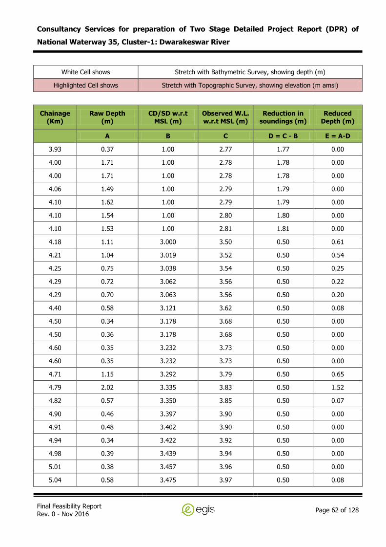
Consultancy Services for preparation of Two Stage Detailed Project Report (DPR) of
National Waterway 35, Cluster-1: Dwarakeswar River
Final Feasibility Report Rev. 0 - Nov 2016
Page 62 of 128
White Cell shows Stretch with Bathymetric Survey, showing depth (m)
Highlighted Cell shows Stretch with Topographic Survey, showing elevation (m amsl)
Chainage (Km)
Raw Depth (m)
CD/SD w.r.t MSL (m)
Observed W.L. w.r.t MSL (m)
Reduction in soundings (m)
Reduced Depth (m)
A B C D = C - B E = A-D
3.93 0.37 1.00 2.77 1.77 0.00
4.00 1.71 1.00 2.78 1.78 0.00
4.00 1.71 1.00 2.78 1.78 0.00
4.06 1.49 1.00 2.79 1.79 0.00
4.10 1.62 1.00 2.79 1.79 0.00
4.10 1.54 1.00 2.80 1.80 0.00
4.10 1.53 1.00 2.81 1.81 0.00
4.18 1.11 3.000 3.50 0.50 0.61
4.21 1.04 3.019 3.52 0.50 0.54
4.25 0.75 3.038 3.54 0.50 0.25
4.29 0.72 3.062 3.56 0.50 0.22
4.29 0.70 3.063 3.56 0.50 0.20
4.40 0.58 3.121 3.62 0.50 0.08
4.50 0.34 3.178 3.68 0.50 0.00
4.50 0.36 3.178 3.68 0.50 0.00
4.60 0.35 3.232 3.73 0.50 0.00
4.60 0.35 3.232 3.73 0.50 0.00
4.71 1.15 3.292 3.79 0.50 0.65
4.79 2.02 3.335 3.83 0.50 1.52
4.82 0.57 3.350 3.85 0.50 0.07
4.90 0.46 3.397 3.90 0.50 0.00
4.91 0.48 3.402 3.90 0.50 0.00
4.94 0.34 3.422 3.92 0.50 0.00
4.98 0.39 3.439 3.94 0.50 0.00
5.01 0.38 3.457 3.96 0.50 0.00
5.04 0.58 3.475 3.97 0.50 0.08

Consultancy Services for preparation of Two Stage Detailed Project Report (DPR) of
National Waterway 35, Cluster-1: Dwarakeswar River
Final Feasibility Report Rev. 0 - Nov 2016
Page 63 of 128
White Cell shows Stretch with Bathymetric Survey, showing depth (m)
Highlighted Cell shows Stretch with Topographic Survey, showing elevation (m amsl)
Chainage (Km)
Raw Depth (m)
CD/SD w.r.t MSL (m)
Observed W.L. w.r.t MSL (m)
Reduction in soundings (m)
Reduced Depth (m)
A B C D = C - B E = A-D
5.06 0.39 3.487 3.99 0.50 0.00
5.08 0.44 3.497 4.00 0.50 0.00
5.12 0.55 3.516 4.02 0.50 0.05
5.15 0.76 3.535 4.03 0.50 0.26
5.18 0.62 3.551 4.05 0.50 0.12
5.21 0.57 3.566 4.07 0.50 0.07
5.24 0.42 3.583 4.08 0.50 0.00
5.25 0.49 3.591 4.09 0.50 0.00
5.26 0.39 3.596 4.10 0.50 0.00
5.27 0.40 3.602 4.10 0.50 0.00
5.29 0.54 3.613 4.11 0.50 0.04
5.33 0.98 3.634 4.13 0.50 0.48
5.37 0.61 3.656 4.15 0.50 0.11
5.41 0.42 3.676 4.17 0.50 0.00
5.44 0.40 3.696 4.19 0.50 0.00
5.47 0.38 3.714 4.21 0.50 0.00
5.51 0.43 3.731 4.23 0.50 0.00
5.55 0.39 3.755 4.25 0.50 0.00
5.59 0.32 3.776 4.27 0.50 0.00
5.61 0.34 3.787 4.29 0.50 0.00
5.62 0.36 3.792 4.29 0.50 0.00
5.65 0.38 3.811 4.31 0.50 0.00
5.69 0.67 3.833 4.33 0.50 0.17
5.72 0.74 3.849 4.35 0.50 0.24
5.75 0.55 3.865 4.36 0.50 0.05
5.79 0.43 3.886 4.39 0.50 0.00
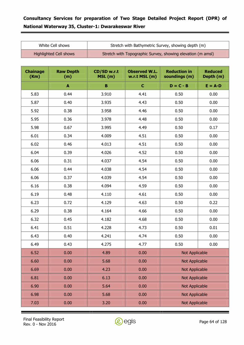
Consultancy Services for preparation of Two Stage Detailed Project Report (DPR) of
National Waterway 35, Cluster-1: Dwarakeswar River
Final Feasibility Report Rev. 0 - Nov 2016
Page 64 of 128
White Cell shows Stretch with Bathymetric Survey, showing depth (m)
Highlighted Cell shows Stretch with Topographic Survey, showing elevation (m amsl)
Chainage (Km)
Raw Depth (m)
CD/SD w.r.t MSL (m)
Observed W.L. w.r.t MSL (m)
Reduction in soundings (m)
Reduced Depth (m)
A B C D = C - B E = A-D
5.83 0.44 3.910 4.41 0.50 0.00
5.87 0.40 3.935 4.43 0.50 0.00
5.92 0.38 3.958 4.46 0.50 0.00
5.95 0.36 3.978 4.48 0.50 0.00
5.98 0.67 3.995 4.49 0.50 0.17
6.01 0.34 4.009 4.51 0.50 0.00
6.02 0.46 4.013 4.51 0.50 0.00
6.04 0.39 4.026 4.52 0.50 0.00
6.06 0.31 4.037 4.54 0.50 0.00
6.06 0.44 4.038 4.54 0.50 0.00
6.06 0.37 4.039 4.54 0.50 0.00
6.16 0.38 4.094 4.59 0.50 0.00
6.19 0.48 4.110 4.61 0.50 0.00
6.23 0.72 4.129 4.63 0.50 0.22
6.29 0.38 4.164 4.66 0.50 0.00
6.32 0.45 4.182 4.68 0.50 0.00
6.41 0.51 4.228 4.73 0.50 0.01
6.43 0.40 4.241 4.74 0.50 0.00
6.49 0.43 4.275 4.77 0.50 0.00
6.52 0.00 4.89 0.00 Not Applicable
6.60 0.00 5.68 0.00 Not Applicable
6.69 0.00 4.23 0.00 Not Applicable
6.81 0.00 6.13 0.00 Not Applicable
6.90 0.00 5.64 0.00 Not Applicable
6.98 0.00 5.68 0.00 Not Applicable
7.03 0.00 3.20 0.00 Not Applicable

Consultancy Services for preparation of Two Stage Detailed Project Report (DPR) of
National Waterway 35, Cluster-1: Dwarakeswar River
Final Feasibility Report Rev. 0 - Nov 2016
Page 65 of 128
White Cell shows Stretch with Bathymetric Survey, showing depth (m)
Highlighted Cell shows Stretch with Topographic Survey, showing elevation (m amsl)
Chainage (Km)
Raw Depth (m)
CD/SD w.r.t MSL (m)
Observed W.L. w.r.t MSL (m)
Reduction in soundings (m)
Reduced Depth (m)
A B C D = C - B E = A-D
7.09 0.00 4.87 0.00 Not Applicable
7.19 0.00 2.65 0.00 Not Applicable
7.33 0.00 2.93 0.00 Not Applicable
7.39 0.00 2.75 0.00 Not Applicable
7.51 0.00 2.92 0.00 Not Applicable
7.59 0.00 2.89 0.00 Not Applicable
7.73 0.00 2.98 0.00 Not Applicable
7.79 0.00 2.42 0.00 Not Applicable
7.90 0.00 3.15 0.00 Not Applicable
7.93 0.00 2.93 0.00 Not Applicable
7.99 0.00 3.33 0.00 Not Applicable
8.03 0.00 3.18 0.00 Not Applicable
8.09 0.00 3.27 0.00 Not Applicable
8.15 0.00 3.49 0.00 Not Applicable
8.20 0.00 3.92 0.00 Not Applicable
8.31 0.00 4.00 0.00 Not Applicable
8.41 0.00 3.42 0.00 Not Applicable
8.53 0.00 3.41 0.00 Not Applicable
8.63 0.00 2.44 0.00 Not Applicable
8.69 0.00 3.26 0.00 Not Applicable
8.82 0.00 3.22 0.00 Not Applicable
8.93 0.00 3.19 0.00 Not Applicable
8.99 0.00 3.24 0.00 Not Applicable
9.03 0.00 3.17 0.00 Not Applicable
9.11 0.00 3.11 0.00 Not Applicable
9.19 0.00 3.43 0.00 Not Applicable

Consultancy Services for preparation of Two Stage Detailed Project Report (DPR) of
National Waterway 35, Cluster-1: Dwarakeswar River
Final Feasibility Report Rev. 0 - Nov 2016
Page 66 of 128
White Cell shows Stretch with Bathymetric Survey, showing depth (m)
Highlighted Cell shows Stretch with Topographic Survey, showing elevation (m amsl)
Chainage (Km)
Raw Depth (m)
CD/SD w.r.t MSL (m)
Observed W.L. w.r.t MSL (m)
Reduction in soundings (m)
Reduced Depth (m)
A B C D = C - B E = A-D
9.32 0.00 2.67 0.00 Not Applicable
9.41 0.00 3.07 0.00 Not Applicable
9.53 0.00 4.80 0.00 Not Applicable
9.61 0.00 3.23 0.00 Not Applicable
9.68 0.00 5.34 0.00 Not Applicable
9.79 0.00 3.43 0.00 Not Applicable
9.89 0.00 3.34 0.00 Not Applicable
10.02 0.00 3.73 0.00 Not Applicable
10.10 0.00 3.41 0.00 Not Applicable
10.19 0.00 3.32 0.00 Not Applicable
10.24 0.00 3.33 0.00 Not Applicable
10.30 0.00 3.36 0.00 Not Applicable
10.41 0.00 3.54 0.00 Not Applicable
10.49 0.00 3.31 0.00 Not Applicable
10.62 0.00 3.16 0.00 Not Applicable
10.71 0.00 3.21 0.00 Not Applicable
10.79 0.00 3.16 0.00 Not Applicable
10.89 0.00 3.86 0.00 Not Applicable
10.93 0.00 3.57 0.00 Not Applicable
11.06 0.00 2.40 0.00 Not Applicable
11.11 0.00 3.65 0.00 Not Applicable
11.18 0.00 3.39 0.00 Not Applicable
11.32 0.00 3.30 0.00 Not Applicable
11.43 0.00 3.33 0.00 Not Applicable
11.52 0.00 3.28 0.00 Not Applicable
11.59 0.00 4.69 0.00 Not Applicable
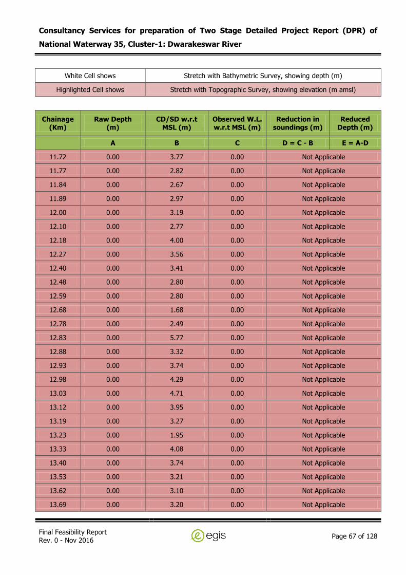
Consultancy Services for preparation of Two Stage Detailed Project Report (DPR) of
National Waterway 35, Cluster-1: Dwarakeswar River
Final Feasibility Report Rev. 0 - Nov 2016
Page 67 of 128
White Cell shows Stretch with Bathymetric Survey, showing depth (m)
Highlighted Cell shows Stretch with Topographic Survey, showing elevation (m amsl)
Chainage (Km)
Raw Depth (m)
CD/SD w.r.t MSL (m)
Observed W.L. w.r.t MSL (m)
Reduction in soundings (m)
Reduced Depth (m)
A B C D = C - B E = A-D
11.72 0.00 3.77 0.00 Not Applicable
11.77 0.00 2.82 0.00 Not Applicable
11.84 0.00 2.67 0.00 Not Applicable
11.89 0.00 2.97 0.00 Not Applicable
12.00 0.00 3.19 0.00 Not Applicable
12.10 0.00 2.77 0.00 Not Applicable
12.18 0.00 4.00 0.00 Not Applicable
12.27 0.00 3.56 0.00 Not Applicable
12.40 0.00 3.41 0.00 Not Applicable
12.48 0.00 2.80 0.00 Not Applicable
12.59 0.00 2.80 0.00 Not Applicable
12.68 0.00 1.68 0.00 Not Applicable
12.78 0.00 2.49 0.00 Not Applicable
12.83 0.00 5.77 0.00 Not Applicable
12.88 0.00 3.32 0.00 Not Applicable
12.93 0.00 3.74 0.00 Not Applicable
12.98 0.00 4.29 0.00 Not Applicable
13.03 0.00 4.71 0.00 Not Applicable
13.12 0.00 3.95 0.00 Not Applicable
13.19 0.00 3.27 0.00 Not Applicable
13.23 0.00 1.95 0.00 Not Applicable
13.33 0.00 4.08 0.00 Not Applicable
13.40 0.00 3.74 0.00 Not Applicable
13.53 0.00 3.21 0.00 Not Applicable
13.62 0.00 3.10 0.00 Not Applicable
13.69 0.00 3.20 0.00 Not Applicable

Consultancy Services for preparation of Two Stage Detailed Project Report (DPR) of
National Waterway 35, Cluster-1: Dwarakeswar River
Final Feasibility Report Rev. 0 - Nov 2016
Page 68 of 128
White Cell shows Stretch with Bathymetric Survey, showing depth (m)
Highlighted Cell shows Stretch with Topographic Survey, showing elevation (m amsl)
Chainage (Km)
Raw Depth (m)
CD/SD w.r.t MSL (m)
Observed W.L. w.r.t MSL (m)
Reduction in soundings (m)
Reduced Depth (m)
A B C D = C - B E = A-D
13.79 0.00 3.53 0.00 Not Applicable
13.89 0.00 3.22 0.00 Not Applicable
13.97 0.00 2.02 0.00 Not Applicable
14.04 0.00 3.07 0.00 Not Applicable
14.11 0.00 2.87 0.00 Not Applicable
14.19 0.00 3.33 0.00 Not Applicable
14.30 0.00 4.11 0.00 Not Applicable
14.38 0.00 3.36 0.00 Not Applicable
14.42 0.00 3.51 0.00 Not Applicable
14.53 0.00 3.68 0.00 Not Applicable
14.61 0.00 3.58 0.00 Not Applicable
14.72 0.00 3.97 0.00 Not Applicable
14.78 0.00 3.44 0.00 Not Applicable
14.83 0.00 3.45 0.00 Not Applicable
14.91 0.00 3.48 0.00 Not Applicable
14.99 0.00 4.23 0.00 Not Applicable
15.04 0.00 4.68 0.00 Not Applicable
15.12 0.00 5.45 0.00 Not Applicable
15.18 0.00 4.72 0.00 Not Applicable
15.24 0.00 4.29 0.00 Not Applicable
15.29 0.00 4.33 0.00 Not Applicable
15.37 0.00 4.89 0.00 Not Applicable
15.42 0.00 4.23 0.00 Not Applicable
15.50 0.00 4.19 0.00 Not Applicable
15.60 0.00 3.81 0.00 Not Applicable
15.71 0.00 5.17 0.00 Not Applicable

Consultancy Services for preparation of Two Stage Detailed Project Report (DPR) of
National Waterway 35, Cluster-1: Dwarakeswar River
Final Feasibility Report Rev. 0 - Nov 2016
Page 69 of 128
White Cell shows Stretch with Bathymetric Survey, showing depth (m)
Highlighted Cell shows Stretch with Topographic Survey, showing elevation (m amsl)
Chainage (Km)
Raw Depth (m)
CD/SD w.r.t MSL (m)
Observed W.L. w.r.t MSL (m)
Reduction in soundings (m)
Reduced Depth (m)
A B C D = C - B E = A-D
15.78 0.00 4.85 0.00 Not Applicable
15.82 0.00 4.98 0.00 Not Applicable
15.90 0.00 4.62 0.00 Not Applicable
16.00 0.00 4.75 0.00 Not Applicable
16.13 0.00 4.61 0.00 Not Applicable
16.23 0.00 6.01 0.00 Not Applicable
16.32 0.00 4.79 0.00 Not Applicable
16.39 0.00 5.36 0.00 Not Applicable
16.52 0.00 5.34 0.00 Not Applicable
16.59 0.00 5.47 0.00 Not Applicable
16.72 0.00 6.13 0.00 Not Applicable
16.81 0.00 5.65 0.00 Not Applicable
16.89 0.00 7.11 0.00 Not Applicable
16.93 0.00 7.11 0.00 Not Applicable
16.99 0.00 6.61 0.00 Not Applicable
17.03 0.00 4.89 0.00 Not Applicable
17.07 0.00 5.36 0.00 Not Applicable
17.15 0.00 4.77 0.00 Not Applicable
17.22 0.00 4.99 0.00 Not Applicable
17.32 0.00 5.35 0.00 Not Applicable
17.43 0.00 5.66 0.00 Not Applicable
17.52 0.00 6.10 0.00 Not Applicable
17.57 0.00 5.70 0.00 Not Applicable
17.64 0.00 6.09 0.00 Not Applicable
17.69 0.00 5.60 0.00 Not Applicable
17.73 0.00 6.11 0.00 Not Applicable
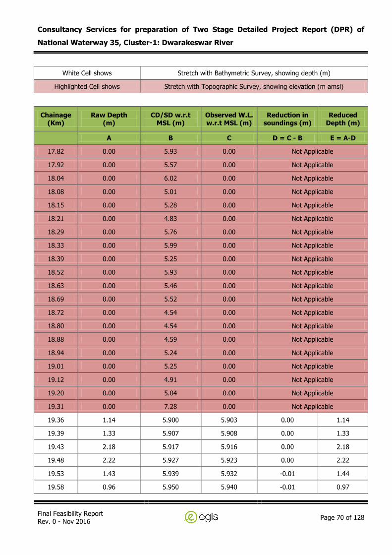
Consultancy Services for preparation of Two Stage Detailed Project Report (DPR) of
National Waterway 35, Cluster-1: Dwarakeswar River
Final Feasibility Report Rev. 0 - Nov 2016
Page 70 of 128
White Cell shows Stretch with Bathymetric Survey, showing depth (m)
Highlighted Cell shows Stretch with Topographic Survey, showing elevation (m amsl)
Chainage (Km)
Raw Depth (m)
CD/SD w.r.t MSL (m)
Observed W.L. w.r.t MSL (m)
Reduction in soundings (m)
Reduced Depth (m)
A B C D = C - B E = A-D
17.82 0.00 5.93 0.00 Not Applicable
17.92 0.00 5.57 0.00 Not Applicable
18.04 0.00 6.02 0.00 Not Applicable
18.08 0.00 5.01 0.00 Not Applicable
18.15 0.00 5.28 0.00 Not Applicable
18.21 0.00 4.83 0.00 Not Applicable
18.29 0.00 5.76 0.00 Not Applicable
18.33 0.00 5.99 0.00 Not Applicable
18.39 0.00 5.25 0.00 Not Applicable
18.52 0.00 5.93 0.00 Not Applicable
18.63 0.00 5.46 0.00 Not Applicable
18.69 0.00 5.52 0.00 Not Applicable
18.72 0.00 4.54 0.00 Not Applicable
18.80 0.00 4.54 0.00 Not Applicable
18.88 0.00 4.59 0.00 Not Applicable
18.94 0.00 5.24 0.00 Not Applicable
19.01 0.00 5.25 0.00 Not Applicable
19.12 0.00 4.91 0.00 Not Applicable
19.20 0.00 5.04 0.00 Not Applicable
19.31 0.00 7.28 0.00 Not Applicable
19.36 1.14 5.900 5.903 0.00 1.14
19.39 1.33 5.907 5.908 0.00 1.33
19.43 2.18 5.917 5.916 0.00 2.18
19.48 2.22 5.927 5.923 0.00 2.22
19.53 1.43 5.939 5.932 -0.01 1.44
19.58 0.96 5.950 5.940 -0.01 0.97

Consultancy Services for preparation of Two Stage Detailed Project Report (DPR) of
National Waterway 35, Cluster-1: Dwarakeswar River
Final Feasibility Report Rev. 0 - Nov 2016
Page 71 of 128
White Cell shows Stretch with Bathymetric Survey, showing depth (m)
Highlighted Cell shows Stretch with Topographic Survey, showing elevation (m amsl)
Chainage (Km)
Raw Depth (m)
CD/SD w.r.t MSL (m)
Observed W.L. w.r.t MSL (m)
Reduction in soundings (m)
Reduced Depth (m)
A B C D = C - B E = A-D
19.62 2.32 5.961 5.948 -0.01 2.33
19.67 2.01 5.973 5.957 -0.02 2.03
19.73 2.17 5.986 5.967 -0.02 2.19
19.78 1.96 5.999 5.976 -0.02 1.98
19.83 1.01 6.010 5.985 -0.03 1.04
19.89 1.17 6.022 5.994 -0.03 1.20
19.93 1.40 6.032 6.001 -0.03 1.43
19.98 1.02 6.044 6.009 -0.03 1.05
20.03 1.35 6.055 6.018 -0.04 1.39
20.08 1.74 6.067 6.027 -0.04 1.78
20.13 2.42 6.078 6.035 -0.04 2.46
20.18 2.62 6.090 6.044 -0.05 2.67
20.23 3.27 6.102 6.053 -0.05 3.32
20.28 2.66 6.114 6.062 -0.05 2.71
20.33 1.82 6.126 6.070 -0.06 1.88
20.38 1.65 6.138 6.079 -0.06 1.71
20.43 1.82 6.150 6.088 -0.06 1.88
20.48 1.67 6.161 6.097 -0.06 1.73
20.53 1.69 6.172 6.105 -0.07 1.76
20.58 1.45 6.184 6.114 -0.07 1.52
20.63 1.57 6.196 6.123 -0.07 1.64
20.68 2.00 6.208 6.131 -0.08 2.08
20.73 1.25 6.219 6.140 -0.08 1.33
20.78 1.39 6.230 6.148 -0.08 1.47
20.83 1.37 6.241 6.156 -0.08 1.45
20.88 1.07 6.253 6.165 -0.09 1.16

Consultancy Services for preparation of Two Stage Detailed Project Report (DPR) of
National Waterway 35, Cluster-1: Dwarakeswar River
Final Feasibility Report Rev. 0 - Nov 2016
Page 72 of 128
White Cell shows Stretch with Bathymetric Survey, showing depth (m)
Highlighted Cell shows Stretch with Topographic Survey, showing elevation (m amsl)
Chainage (Km)
Raw Depth (m)
CD/SD w.r.t MSL (m)
Observed W.L. w.r.t MSL (m)
Reduction in soundings (m)
Reduced Depth (m)
A B C D = C - B E = A-D
20.92 1.31 6.263 6.172 -0.09 1.40
20.97 1.25 6.274 6.180 -0.09 1.34
21.02 1.21 6.286 6.189 -0.10 1.31
21.07 1.26 6.296 6.197 -0.10 1.36
21.11 1.14 6.307 6.205 -0.10 1.24
21.16 1.44 6.319 6.214 -0.11 1.55
21.21 3.49 6.330 6.222 -0.11 3.60
21.26 3.68 6.341 6.230 -0.11 3.79
21.31 5.01 6.353 6.239 -0.11 5.12
21.36 5.46 6.364 6.247 -0.12 5.58
21.41 5.61 6.375 6.256 -0.12 5.73
21.46 3.65 6.387 6.264 -0.12 3.77
21.51 1.37 6.398 6.273 -0.13 1.50
21.55 1.46 6.409 6.281 -0.13 1.59
21.60 1.95 6.421 6.289 -0.13 2.08
21.65 2.10 6.431 6.297 -0.13 2.23
21.70 1.89 6.443 6.306 -0.14 2.03
21.75 1.75 6.455 6.315 -0.14 1.89
21.80 1.48 6.466 6.323 -0.14 1.62
21.82 1.32 6.472 6.328 -0.14 1.46
21.84 1.38 6.477 6.331 -0.15 1.53
21.87 1.38 6.482 6.335 -0.15 1.53
21.90 2.08 6.491 6.341 -0.15 2.23
21.95 2.93 6.501 6.349 -0.15 3.08
21.99 3.93 6.511 6.356 -0.15 4.08
22.03 2.75 6.521 6.364 -0.16 2.91

Consultancy Services for preparation of Two Stage Detailed Project Report (DPR) of
National Waterway 35, Cluster-1: Dwarakeswar River
Final Feasibility Report Rev. 0 - Nov 2016
Page 73 of 128
White Cell shows Stretch with Bathymetric Survey, showing depth (m)
Highlighted Cell shows Stretch with Topographic Survey, showing elevation (m amsl)
Chainage (Km)
Raw Depth (m)
CD/SD w.r.t MSL (m)
Observed W.L. w.r.t MSL (m)
Reduction in soundings (m)
Reduced Depth (m)
A B C D = C - B E = A-D
22.08 1.81 6.531 6.371 -0.16 1.97
22.12 3.09 6.541 6.379 -0.16 3.25
22.16 1.98 6.551 6.386 -0.16 2.14
22.20 1.57 6.560 6.393 -0.17 1.74
22.25 1.52 6.570 6.400 -0.17 1.69
22.29 1.44 6.580 6.407 -0.17 1.61
22.33 2.12 6.589 6.414 -0.17 2.29
22.41 2.54 6.608 6.428 -0.18 2.72
22.44 1.19 6.615 6.434 -0.18 1.37
22.49 1.06 6.628 6.443 -0.18 1.24
22.51 0.80 6.632 6.446 -0.19 0.99
22.53 1.13 6.637 6.450 -0.19 1.32
22.60 3.05 6.652 6.461 -0.19 3.24
22.65 2.65 6.663 6.469 -0.19 2.84
22.69 2.76 6.674 6.477 -0.20 2.96
22.74 2.45 6.685 6.486 -0.20 2.65
22.79 1.90 6.696 6.494 -0.20 2.10
22.84 2.29 6.708 6.503 -0.21 2.50
22.89 2.77 6.719 6.511 -0.21 2.98
22.94 2.61 6.731 6.520 -0.21 2.82
22.99 2.59 6.742 6.528 -0.21 2.80
23.04 2.96 6.754 6.536 -0.22 3.18
23.08 1.98 6.765 6.545 -0.22 2.20
23.13 2.72 6.776 6.553 -0.22 2.94
23.17 2.52 6.786 6.560 -0.23 2.75
23.22 1.80 6.797 6.568 -0.23 2.03
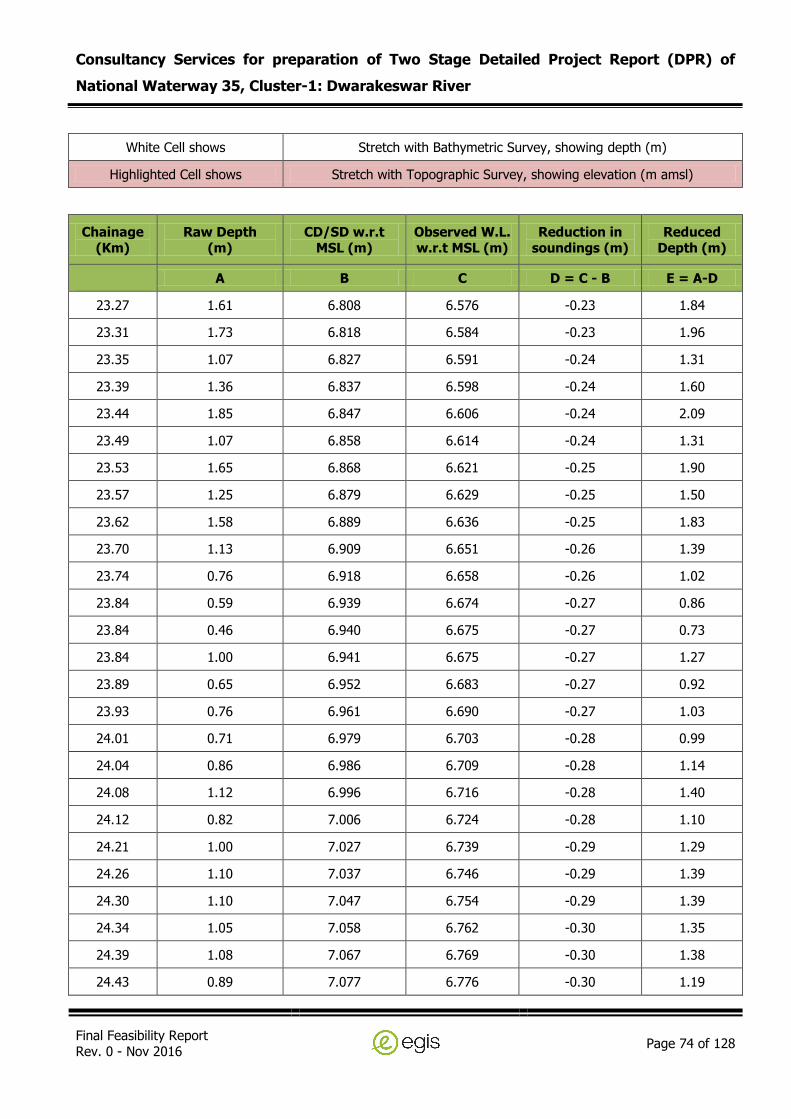
Consultancy Services for preparation of Two Stage Detailed Project Report (DPR) of
National Waterway 35, Cluster-1: Dwarakeswar River
Final Feasibility Report Rev. 0 - Nov 2016
Page 74 of 128
White Cell shows Stretch with Bathymetric Survey, showing depth (m)
Highlighted Cell shows Stretch with Topographic Survey, showing elevation (m amsl)
Chainage (Km)
Raw Depth (m)
CD/SD w.r.t MSL (m)
Observed W.L. w.r.t MSL (m)
Reduction in soundings (m)
Reduced Depth (m)
A B C D = C - B E = A-D
23.27 1.61 6.808 6.576 -0.23 1.84
23.31 1.73 6.818 6.584 -0.23 1.96
23.35 1.07 6.827 6.591 -0.24 1.31
23.39 1.36 6.837 6.598 -0.24 1.60
23.44 1.85 6.847 6.606 -0.24 2.09
23.49 1.07 6.858 6.614 -0.24 1.31
23.53 1.65 6.868 6.621 -0.25 1.90
23.57 1.25 6.879 6.629 -0.25 1.50
23.62 1.58 6.889 6.636 -0.25 1.83
23.70 1.13 6.909 6.651 -0.26 1.39
23.74 0.76 6.918 6.658 -0.26 1.02
23.84 0.59 6.939 6.674 -0.27 0.86
23.84 0.46 6.940 6.675 -0.27 0.73
23.84 1.00 6.941 6.675 -0.27 1.27
23.89 0.65 6.952 6.683 -0.27 0.92
23.93 0.76 6.961 6.690 -0.27 1.03
24.01 0.71 6.979 6.703 -0.28 0.99
24.04 0.86 6.986 6.709 -0.28 1.14
24.08 1.12 6.996 6.716 -0.28 1.40
24.12 0.82 7.006 6.724 -0.28 1.10
24.21 1.00 7.027 6.739 -0.29 1.29
24.26 1.10 7.037 6.746 -0.29 1.39
24.30 1.10 7.047 6.754 -0.29 1.39
24.34 1.05 7.058 6.762 -0.30 1.35
24.39 1.08 7.067 6.769 -0.30 1.38
24.43 0.89 7.077 6.776 -0.30 1.19

Consultancy Services for preparation of Two Stage Detailed Project Report (DPR) of
National Waterway 35, Cluster-1: Dwarakeswar River
Final Feasibility Report Rev. 0 - Nov 2016
Page 75 of 128
White Cell shows Stretch with Bathymetric Survey, showing depth (m)
Highlighted Cell shows Stretch with Topographic Survey, showing elevation (m amsl)
Chainage (Km)
Raw Depth (m)
CD/SD w.r.t MSL (m)
Observed W.L. w.r.t MSL (m)
Reduction in soundings (m)
Reduced Depth (m)
A B C D = C - B E = A-D
24.47 1.07 7.087 6.783 -0.30 1.37
24.50 1.21 7.094 6.789 -0.31 1.52
24.53 0.94 7.102 6.795 -0.31 1.25
24.57 1.19 7.111 6.801 -0.31 1.50
24.62 1.47 7.120 6.808 -0.31 1.78
24.62 1.41 7.122 6.809 -0.31 1.72
24.64 1.07 7.126 6.813 -0.31 1.38
24.65 0.52 7.128 6.814 -0.31 0.83
24.73 1.05 7.147 6.828 -0.32 1.37
24.73 1.05 7.148 6.829 -0.32 1.37
24.81 1.34 7.167 6.843 -0.32 1.66
24.82 1.24 7.167 6.843 -0.32 1.56
24.91 2.51 7.189 6.860 -0.33 2.84
24.92 3.39 7.191 6.861 -0.33 3.72
25.01 1.55 7.212 6.876 -0.34 1.89
25.04 1.20 7.220 6.882 -0.34 1.54
25.10 1.50 7.234 6.892 -0.34 1.84
25.12 1.47 7.238 6.895 -0.34 1.81
25.23 1.91 7.263 6.914 -0.35 2.26
25.24 1.67 7.265 6.915 -0.35 2.02
25.31 0.96 7.282 6.929 -0.35 1.31
25.33 1.15 7.287 6.932 -0.36 1.51
25.41 1.30 7.306 6.946 -0.36 1.66
25.44 1.32 7.312 6.951 -0.36 1.68
25.52 1.14 7.330 6.964 -0.37 1.51
25.54 1.50 7.336 6.968 -0.37 1.87

Consultancy Services for preparation of Two Stage Detailed Project Report (DPR) of
National Waterway 35, Cluster-1: Dwarakeswar River
Final Feasibility Report Rev. 0 - Nov 2016
Page 76 of 128
White Cell shows Stretch with Bathymetric Survey, showing depth (m)
Highlighted Cell shows Stretch with Topographic Survey, showing elevation (m amsl)
Chainage (Km)
Raw Depth (m)
CD/SD w.r.t MSL (m)
Observed W.L. w.r.t MSL (m)
Reduction in soundings (m)
Reduced Depth (m)
A B C D = C - B E = A-D
25.62 1.12 7.354 6.982 -0.37 1.49
25.64 1.20 7.359 6.985 -0.37 1.57
25.72 1.89 7.377 6.999 -0.38 2.27
25.75 1.53 7.383 7.003 -0.38 1.91
25.80 1.54 7.396 7.013 -0.38 1.92
25.83 1.58 7.402 7.017 -0.38 1.96
25.91 1.01 7.421 7.032 -0.39 1.40
25.93 1.69 7.426 7.035 -0.39 2.08
26.01 2.08 7.444 7.049 -0.40 2.48
26.03 2.05 7.450 7.053 -0.40 2.45
26.09 1.51 7.463 7.063 -0.40 1.91
26.12 1.64 7.470 7.068 -0.40 2.04
26.22 2.10 7.493 7.085 -0.41 2.51
26.24 1.29 7.498 7.088 -0.41 1.70
26.33 1.57 7.517 7.103 -0.41 1.98
26.35 1.48 7.522 7.107 -0.42 1.90
26.41 2.05 7.538 7.118 -0.42 2.47
26.44 2.10 7.544 7.122 -0.42 2.52
26.52 2.20 7.564 7.137 -0.43 2.63
26.55 2.25 7.569 7.141 -0.43 2.68
26.61 2.22 7.583 7.151 -0.43 2.65
26.64 2.09 7.590 7.157 -0.43 2.52
26.70 1.81 7.605 7.168 -0.44 2.25
26.73 1.77 7.611 7.172 -0.44 2.21
26.79 1.91 7.626 7.183 -0.44 2.35
26.82 1.77 7.633 7.189 -0.44 2.21
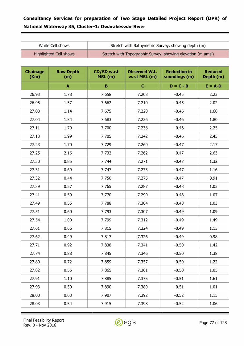
Consultancy Services for preparation of Two Stage Detailed Project Report (DPR) of
National Waterway 35, Cluster-1: Dwarakeswar River
Final Feasibility Report Rev. 0 - Nov 2016
Page 77 of 128
White Cell shows Stretch with Bathymetric Survey, showing depth (m)
Highlighted Cell shows Stretch with Topographic Survey, showing elevation (m amsl)
Chainage (Km)
Raw Depth (m)
CD/SD w.r.t MSL (m)
Observed W.L. w.r.t MSL (m)
Reduction in soundings (m)
Reduced Depth (m)
A B C D = C - B E = A-D
26.93 1.78 7.658 7.208 -0.45 2.23
26.95 1.57 7.662 7.210 -0.45 2.02
27.00 1.14 7.675 7.220 -0.46 1.60
27.04 1.34 7.683 7.226 -0.46 1.80
27.11 1.79 7.700 7.238 -0.46 2.25
27.13 1.99 7.705 7.242 -0.46 2.45
27.23 1.70 7.729 7.260 -0.47 2.17
27.25 2.16 7.732 7.262 -0.47 2.63
27.30 0.85 7.744 7.271 -0.47 1.32
27.31 0.69 7.747 7.273 -0.47 1.16
27.32 0.44 7.750 7.275 -0.47 0.91
27.39 0.57 7.765 7.287 -0.48 1.05
27.41 0.59 7.770 7.290 -0.48 1.07
27.49 0.55 7.788 7.304 -0.48 1.03
27.51 0.60 7.793 7.307 -0.49 1.09
27.54 1.00 7.799 7.312 -0.49 1.49
27.61 0.66 7.815 7.324 -0.49 1.15
27.62 0.49 7.817 7.326 -0.49 0.98
27.71 0.92 7.838 7.341 -0.50 1.42
27.74 0.88 7.845 7.346 -0.50 1.38
27.80 0.72 7.859 7.357 -0.50 1.22
27.82 0.55 7.865 7.361 -0.50 1.05
27.91 1.10 7.885 7.375 -0.51 1.61
27.93 0.50 7.890 7.380 -0.51 1.01
28.00 0.63 7.907 7.392 -0.52 1.15
28.03 0.54 7.915 7.398 -0.52 1.06

Consultancy Services for preparation of Two Stage Detailed Project Report (DPR) of
National Waterway 35, Cluster-1: Dwarakeswar River
Final Feasibility Report Rev. 0 - Nov 2016
Page 78 of 128
White Cell shows Stretch with Bathymetric Survey, showing depth (m)
Highlighted Cell shows Stretch with Topographic Survey, showing elevation (m amsl)
Chainage (Km)
Raw Depth (m)
CD/SD w.r.t MSL (m)
Observed W.L. w.r.t MSL (m)
Reduction in soundings (m)
Reduced Depth (m)
A B C D = C - B E = A-D
28.13 0.44 7.936 7.413 -0.52 0.96
28.13 0.56 7.937 7.414 -0.52 1.08
28.19 0.55 7.951 7.425 -0.53 1.08
28.22 0.51 7.959 7.430 -0.53 1.04
28.30 0.34 7.977 7.444 -0.53 0.87
28.32 0.34 7.981 7.447 -0.53 0.87
28.35 0.57 7.988 7.452 -0.54 1.11
28.40 0.75 8.000 7.461 -0.54 1.29
28.43 0.58 8.002 7.467 -0.54 1.12
28.50 0.53 8.009 7.484 -0.52 1.05
28.53 0.44 8.012 7.491 -0.52 0.96
28.59 0.47 8.017 7.506 -0.51 0.98
28.63 0.52 8.021 7.515 -0.51 1.03
28.66 0.44 8.024 7.523 -0.50 0.94
28.71 0.87 8.028 7.535 -0.49 1.36
28.74 1.95 8.031 7.542 -0.49 2.44
28.80 0.67 8.037 7.556 -0.48 1.15
28.81 0.73 8.038 7.558 -0.48 1.21
28.82 0.56 8.038 7.560 -0.48 1.04
28.85 1.79 8.041 7.566 -0.47 2.26
28.93 1.47 8.049 7.587 -0.46 1.93
28.95 1.56 8.050 7.591 -0.46 2.02
29.00 0.42 8.055 7.603 -0.45 0.87
29.03 0.44 8.058 7.611 -0.45 0.89
29.12 1.23 8.066 7.631 -0.43 1.66
29.14 1.53 8.067 7.635 -0.43 1.96
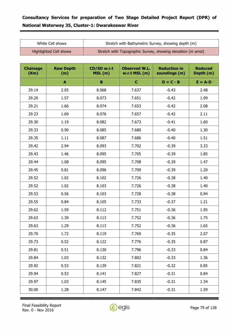
Consultancy Services for preparation of Two Stage Detailed Project Report (DPR) of
National Waterway 35, Cluster-1: Dwarakeswar River
Final Feasibility Report Rev. 0 - Nov 2016
Page 79 of 128
White Cell shows Stretch with Bathymetric Survey, showing depth (m)
Highlighted Cell shows Stretch with Topographic Survey, showing elevation (m amsl)
Chainage (Km)
Raw Depth (m)
CD/SD w.r.t MSL (m)
Observed W.L. w.r.t MSL (m)
Reduction in soundings (m)
Reduced Depth (m)
A B C D = C - B E = A-D
29.14 2.05 8.068 7.637 -0.43 2.48
29.20 1.57 8.073 7.651 -0.42 1.99
29.21 1.66 8.074 7.653 -0.42 2.08
29.23 1.69 8.076 7.657 -0.42 2.11
29.30 1.19 8.082 7.673 -0.41 1.60
29.33 0.90 8.085 7.680 -0.40 1.30
29.35 1.11 8.087 7.686 -0.40 1.51
29.42 2.94 8.093 7.702 -0.39 3.33
29.43 1.46 8.095 7.705 -0.39 1.85
29.44 1.08 8.095 7.708 -0.39 1.47
29.45 0.81 8.096 7.709 -0.39 1.20
29.52 1.02 8.102 7.726 -0.38 1.40
29.52 1.02 8.103 7.726 -0.38 1.40
29.53 0.56 8.103 7.728 -0.38 0.94
29.55 0.84 8.105 7.733 -0.37 1.21
29.62 1.59 8.112 7.751 -0.36 1.95
29.63 1.39 8.113 7.752 -0.36 1.75
29.63 1.29 8.113 7.752 -0.36 1.65
29.70 1.72 8.119 7.769 -0.35 2.07
29.73 0.52 8.122 7.776 -0.35 0.87
29.81 0.51 8.130 7.796 -0.33 0.84
29.84 1.03 8.132 7.802 -0.33 1.36
29.92 0.53 8.139 7.821 -0.32 0.85
29.94 0.53 8.141 7.827 -0.31 0.84
29.97 1.03 8.145 7.835 -0.31 1.34
30.00 1.28 8.147 7.842 -0.31 1.59

Consultancy Services for preparation of Two Stage Detailed Project Report (DPR) of
National Waterway 35, Cluster-1: Dwarakeswar River
Final Feasibility Report Rev. 0 - Nov 2016
Page 80 of 128
White Cell shows Stretch with Bathymetric Survey, showing depth (m)
Highlighted Cell shows Stretch with Topographic Survey, showing elevation (m amsl)
Chainage (Km)
Raw Depth (m)
CD/SD w.r.t MSL (m)
Observed W.L. w.r.t MSL (m)
Reduction in soundings (m)
Reduced Depth (m)
A B C D = C - B E = A-D
30.02 0.86 8.149 7.846 -0.30 1.16
30.05 0.83 8.151 7.852 -0.30 1.13
30.10 0.99 8.156 7.865 -0.29 1.28
30.12 0.99 8.158 7.869 -0.29 1.28
30.15 0.83 8.160 7.875 -0.29 1.12
30.17 1.21 8.163 7.881 -0.28 1.49
30.19 1.26 8.164 7.886 -0.28 1.54
30.21 0.73 8.166 7.891 -0.28 1.01
30.23 1.01 8.168 7.895 -0.27 1.28
30.30 0.99 8.174 7.911 -0.26 1.25
30.32 0.47 8.177 7.918 -0.26 0.73
30.35 0.79 8.179 7.924 -0.26 1.05
30.40 1.11 8.183 7.935 -0.25 1.36
30.44 1.10 8.187 7.944 -0.24 1.34
30.51 1.37 8.194 7.962 -0.23 1.60
30.54 1.20 8.196 7.969 -0.23 1.43
30.61 1.15 8.203 7.986 -0.22 1.37
30.63 0.93 8.205 7.991 -0.21 1.14
30.65 0.91 8.206 7.994 -0.21 1.12
30.70 0.52 8.211 8.006 -0.20 0.72
30.74 0.85 8.215 8.017 -0.20 1.05
30.79 0.82 8.220 8.029 -0.19 1.01
30.84 0.47 8.225 8.042 -0.18 0.65
30.93 0.30 8.233 8.062 -0.17 0.47
30.93 0.28 8.233 8.063 -0.17 0.45
30.94 0.29 8.233 8.063 -0.17 0.46
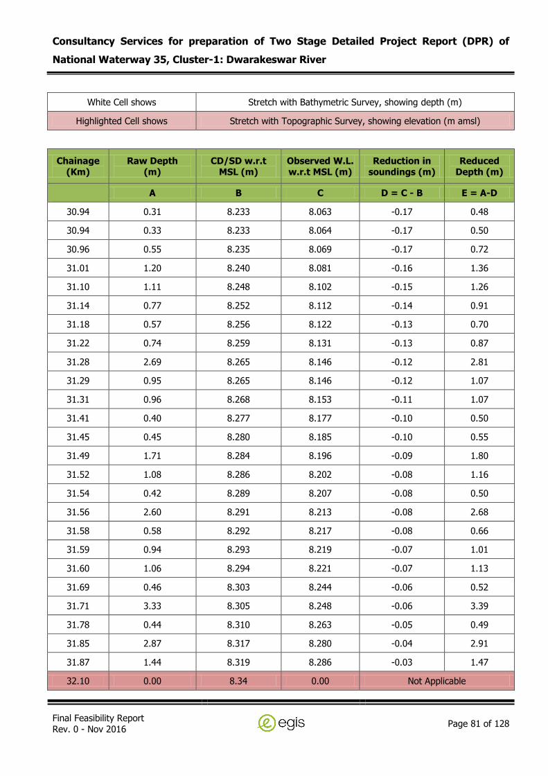
Consultancy Services for preparation of Two Stage Detailed Project Report (DPR) of
National Waterway 35, Cluster-1: Dwarakeswar River
Final Feasibility Report Rev. 0 - Nov 2016
Page 81 of 128
White Cell shows Stretch with Bathymetric Survey, showing depth (m)
Highlighted Cell shows Stretch with Topographic Survey, showing elevation (m amsl)
Chainage (Km)
Raw Depth (m)
CD/SD w.r.t MSL (m)
Observed W.L. w.r.t MSL (m)
Reduction in soundings (m)
Reduced Depth (m)
A B C D = C - B E = A-D
30.94 0.31 8.233 8.063 -0.17 0.48
30.94 0.33 8.233 8.064 -0.17 0.50
30.96 0.55 8.235 8.069 -0.17 0.72
31.01 1.20 8.240 8.081 -0.16 1.36
31.10 1.11 8.248 8.102 -0.15 1.26
31.14 0.77 8.252 8.112 -0.14 0.91
31.18 0.57 8.256 8.122 -0.13 0.70
31.22 0.74 8.259 8.131 -0.13 0.87
31.28 2.69 8.265 8.146 -0.12 2.81
31.29 0.95 8.265 8.146 -0.12 1.07
31.31 0.96 8.268 8.153 -0.11 1.07
31.41 0.40 8.277 8.177 -0.10 0.50
31.45 0.45 8.280 8.185 -0.10 0.55
31.49 1.71 8.284 8.196 -0.09 1.80
31.52 1.08 8.286 8.202 -0.08 1.16
31.54 0.42 8.289 8.207 -0.08 0.50
31.56 2.60 8.291 8.213 -0.08 2.68
31.58 0.58 8.292 8.217 -0.08 0.66
31.59 0.94 8.293 8.219 -0.07 1.01
31.60 1.06 8.294 8.221 -0.07 1.13
31.69 0.46 8.303 8.244 -0.06 0.52
31.71 3.33 8.305 8.248 -0.06 3.39
31.78 0.44 8.310 8.263 -0.05 0.49
31.85 2.87 8.317 8.280 -0.04 2.91
31.87 1.44 8.319 8.286 -0.03 1.47
32.10 0.00 8.34 0.00 Not Applicable
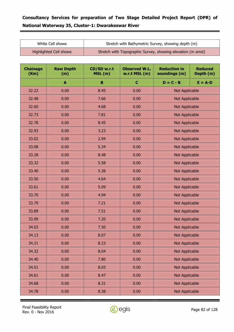
Consultancy Services for preparation of Two Stage Detailed Project Report (DPR) of
National Waterway 35, Cluster-1: Dwarakeswar River
Final Feasibility Report Rev. 0 - Nov 2016
Page 82 of 128
White Cell shows Stretch with Bathymetric Survey, showing depth (m)
Highlighted Cell shows Stretch with Topographic Survey, showing elevation (m amsl)
Chainage (Km)
Raw Depth (m)
CD/SD w.r.t MSL (m)
Observed W.L. w.r.t MSL (m)
Reduction in soundings (m)
Reduced Depth (m)
A B C D = C - B E = A-D
32.22 0.00 8.45 0.00 Not Applicable
32.48 0.00 7.66 0.00 Not Applicable
32.60 0.00 4.68 0.00 Not Applicable
32.73 0.00 7.81 0.00 Not Applicable
32.78 0.00 8.45 0.00 Not Applicable
32.93 0.00 3.23 0.00 Not Applicable
33.02 0.00 2.94 0.00 Not Applicable
33.08 0.00 5.34 0.00 Not Applicable
33.28 0.00 8.48 0.00 Not Applicable
33.32 0.00 5.58 0.00 Not Applicable
33.40 0.00 5.38 0.00 Not Applicable
33.50 0.00 4.64 0.00 Not Applicable
33.61 0.00 5.09 0.00 Not Applicable
33.70 0.00 4.94 0.00 Not Applicable
33.79 0.00 7.21 0.00 Not Applicable
33.89 0.00 7.51 0.00 Not Applicable
33.99 0.00 7.20 0.00 Not Applicable
34.03 0.00 7.50 0.00 Not Applicable
34.13 0.00 8.07 0.00 Not Applicable
34.21 0.00 8.23 0.00 Not Applicable
34.32 0.00 8.04 0.00 Not Applicable
34.40 0.00 7.80 0.00 Not Applicable
34.51 0.00 8.03 0.00 Not Applicable
34.61 0.00 8.47 0.00 Not Applicable
34.68 0.00 8.31 0.00 Not Applicable
34.78 0.00 8.38 0.00 Not Applicable

Consultancy Services for preparation of Two Stage Detailed Project Report (DPR) of
National Waterway 35, Cluster-1: Dwarakeswar River
Final Feasibility Report Rev. 0 - Nov 2016
Page 83 of 128
White Cell shows Stretch with Bathymetric Survey, showing depth (m)
Highlighted Cell shows Stretch with Topographic Survey, showing elevation (m amsl)
Chainage (Km)
Raw Depth (m)
CD/SD w.r.t MSL (m)
Observed W.L. w.r.t MSL (m)
Reduction in soundings (m)
Reduced Depth (m)
A B C D = C - B E = A-D
34.83 0.00 8.26 0.00 Not Applicable
34.92 0.00 8.45 0.00 Not Applicable
34.99 0.00 8.04 0.00 Not Applicable
35.01 0.00 8.47 0.00 Not Applicable
35.11 0.00 7.80 0.00 Not Applicable
35.23 0.00 8.25 0.00 Not Applicable
35.29 0.00 8.04 0.00 Not Applicable
35.41 0.00 8.48 0.00 Not Applicable
35.50 0.00 8.65 0.00 Not Applicable
35.60 0.00 8.26 0.00 Not Applicable
35.71 0.00 8.57 0.00 Not Applicable
35.78 0.00 8.45 0.00 Not Applicable
35.83 0.00 8.58 0.00 Not Applicable
35.90 0.00 8.34 0.00 Not Applicable
36.01 0.00 8.64 0.00 Not Applicable
36.12 0.48 8.000 7.461 -0.54 1.02
36.14 0.39 8.006 7.471 -0.53 0.92
36.22 0.58 8.026 7.507 -0.52 1.10
36.25 0.69 8.034 7.522 -0.51 1.20
36.32 1.30 8.053 7.556 -0.50 1.80
36.33 1.07 8.056 7.561 -0.50 1.57
36.38 1.14 8.069 7.584 -0.48 1.62
36.43 1.15 8.084 7.610 -0.47 1.62
36.48 1.12 8.098 7.636 -0.46 1.58
36.54 1.40 8.113 7.663 -0.45 1.85
36.59 1.10 8.128 7.689 -0.44 1.54

Consultancy Services for preparation of Two Stage Detailed Project Report (DPR) of
National Waterway 35, Cluster-1: Dwarakeswar River
Final Feasibility Report Rev. 0 - Nov 2016
Page 84 of 128
White Cell shows Stretch with Bathymetric Survey, showing depth (m)
Highlighted Cell shows Stretch with Topographic Survey, showing elevation (m amsl)
Chainage (Km)
Raw Depth (m)
CD/SD w.r.t MSL (m)
Observed W.L. w.r.t MSL (m)
Reduction in soundings (m)
Reduced Depth (m)
A B C D = C - B E = A-D
36.63 0.44 8.138 7.708 -0.43 0.87
36.71 0.38 8.160 7.747 -0.41 0.79
36.72 0.39 8.163 7.752 -0.41 0.80
36.73 0.46 8.165 7.755 -0.41 0.87
36.75 0.52 8.171 7.766 -0.41 0.93
36.80 0.99 8.185 7.791 -0.39 1.38
36.87 0.83 8.202 7.822 -0.38 1.21
36.93 0.83 8.218 7.851 -0.37 1.20
37.00 0.73 8.239 7.887 -0.35 1.08
37.01 0.91 8.242 7.893 -0.35 1.26
37.04 0.90 8.249 7.906 -0.34 1.24
37.10 1.19 8.265 7.934 -0.33 1.52
37.16 1.39 8.280 7.961 -0.32 1.71
37.21 1.67 8.296 7.989 -0.31 1.98
37.27 1.96 8.312 8.018 -0.29 2.25
37.34 3.15 8.329 8.049 -0.28 3.43
37.40 3.67 8.346 8.078 -0.27 3.94
37.46 3.21 8.363 8.109 -0.25 3.46
37.52 2.14 8.380 8.139 -0.24 2.38
37.59 2.26 8.397 8.170 -0.23 2.49
37.65 2.37 8.415 8.201 -0.21 2.58
37.71 2.24 8.432 8.231 -0.20 2.44
37.78 1.66 8.449 8.262 -0.19 1.85
37.84 1.93 8.466 8.292 -0.17 2.10
37.90 2.11 8.483 8.323 -0.16 2.27
37.97 1.53 8.500 8.354 -0.15 1.68

Consultancy Services for preparation of Two Stage Detailed Project Report (DPR) of
National Waterway 35, Cluster-1: Dwarakeswar River
Final Feasibility Report Rev. 0 - Nov 2016
Page 85 of 128
White Cell shows Stretch with Bathymetric Survey, showing depth (m)
Highlighted Cell shows Stretch with Topographic Survey, showing elevation (m amsl)
Chainage (Km)
Raw Depth (m)
CD/SD w.r.t MSL (m)
Observed W.L. w.r.t MSL (m)
Reduction in soundings (m)
Reduced Depth (m)
A B C D = C - B E = A-D
38.02 1.60 8.515 8.380 -0.14 1.74
38.09 1.42 8.533 8.412 -0.12 1.54
38.15 1.57 8.551 8.444 -0.11 1.68
38.22 1.57 8.569 8.475 -0.09 1.66
38.28 1.64 8.586 8.506 -0.08 1.72
38.34 1.15 8.602 8.535 -0.07 1.22
38.39 1.00 8.615 8.559 -0.06 1.06
38.47 0.48 8.637 8.597 -0.04 0.52
38.48 0.50 8.639 8.601 -0.04 0.54
38.49 0.41 8.642 8.607 -0.04 0.45
38.55 0.96 8.657 8.633 -0.02 0.98
38.58 0.79 8.668 8.652 -0.02 0.81
38.60 1.12 8.671 8.659 -0.01 1.13
38.62 0.70 8.678 8.670 -0.01 0.71
38.64 0.78 8.684 8.681 0.00 0.78
38.67 0.34 8.692 8.696 0.00 0.34
38.68 0.37 8.693 8.697 0.00 0.37
38.68 0.40 8.694 8.700 0.01 0.39
38.68 0.38 8.694 8.700 0.01 0.37
38.70 0.00 8.70 0.00 Not Applicable
38.79 0.00 8.93 0.00 Not Applicable
38.83 0.00 9.08 0.00 Not Applicable
38.91 0.00 9.07 0.00 Not Applicable
39.01 0.00 9.00 0.00 Not Applicable
39.12 0.00 8.65 0.00 Not Applicable
39.18 0.00 9.00 0.00 Not Applicable

Consultancy Services for preparation of Two Stage Detailed Project Report (DPR) of
National Waterway 35, Cluster-1: Dwarakeswar River
Final Feasibility Report Rev. 0 - Nov 2016
Page 86 of 128
White Cell shows Stretch with Bathymetric Survey, showing depth (m)
Highlighted Cell shows Stretch with Topographic Survey, showing elevation (m amsl)
Chainage (Km)
Raw Depth (m)
CD/SD w.r.t MSL (m)
Observed W.L. w.r.t MSL (m)
Reduction in soundings (m)
Reduced Depth (m)
A B C D = C - B E = A-D
39.31 0.00 9.09 0.00 Not Applicable
39.41 0.00 9.47 0.00 Not Applicable
39.54 0.00 9.17 0.00 Not Applicable
39.59 0.00 9.54 0.00 Not Applicable
39.63 0.00 9.36 0.00 Not Applicable
39.74 0.00 9.84 0.00 Not Applicable
39.78 0.00 10.10 0.00 Not Applicable
39.90 0.00 10.51 0.00 Not Applicable
39.94 0.00 10.73 0.00 Not Applicable
40.06 0.00 10.65 0.00 Not Applicable
40.25 0.00 10.62 0.00 Not Applicable
40.30 0.00 9.63 0.00 Not Applicable
40.41 0.00 9.67 0.00 Not Applicable
40.51 0.00 9.68 0.00 Not Applicable
40.59 0.00 9.38 0.00 Not Applicable
40.69 0.00 9.81 0.00 Not Applicable
40.73 0.00 9.90 0.00 Not Applicable
40.78 0.00 10.19 0.00 Not Applicable
40.84 0.00 9.48 0.00 Not Applicable
40.90 0.00 10.27 0.00 Not Applicable
41.00 0.00 11.34 0.00 Not Applicable
41.08 0.00 11.26 0.00 Not Applicable
41.13 0.00 10.59 0.00 Not Applicable
41.21 0.00 10.59 0.00 Not Applicable
41.29 0.00 10.74 0.00 Not Applicable
41.43 0.00 10.45 0.00 Not Applicable

Consultancy Services for preparation of Two Stage Detailed Project Report (DPR) of
National Waterway 35, Cluster-1: Dwarakeswar River
Final Feasibility Report Rev. 0 - Nov 2016
Page 87 of 128
White Cell shows Stretch with Bathymetric Survey, showing depth (m)
Highlighted Cell shows Stretch with Topographic Survey, showing elevation (m amsl)
Chainage (Km)
Raw Depth (m)
CD/SD w.r.t MSL (m)
Observed W.L. w.r.t MSL (m)
Reduction in soundings (m)
Reduced Depth (m)
A B C D = C - B E = A-D
41.52 0.00 10.03 0.00 Not Applicable
41.61 0.00 11.21 0.00 Not Applicable
41.74 0.00 11.31 0.00 Not Applicable
41.78 0.00 11.26 0.00 Not Applicable
41.84 0.00 11.29 0.00 Not Applicable
41.89 0.00 11.62 0.00 Not Applicable
41.94 0.00 11.31 0.00 Not Applicable
41.99 0.00 11.01 0.00 Not Applicable
42.03 0.00 11.05 0.00 Not Applicable
42.11 0.00 11.82 0.00 Not Applicable
42.22 0.00 11.70 0.00 Not Applicable
42.30 0.00 12.23 0.00 Not Applicable
42.39 0.00 11.28 0.00 Not Applicable
42.43 0.00 11.45 0.00 Not Applicable
42.48 0.00 11.65 0.00 Not Applicable
42.58 0.00 10.52 0.00 Not Applicable
42.69 0.00 10.66 0.00 Not Applicable
42.82 0.00 10.74 0.00 Not Applicable
42.89 0.00 11.01 0.00 Not Applicable
43.01 0.00 10.66 0.00 Not Applicable
43.08 0.00 10.49 0.00 Not Applicable
43.20 0.00 10.48 0.00 Not Applicable
43.33 0.00 11.10 0.00 Not Applicable
43.41 0.00 11.05 0.00 Not Applicable
43.47 0.00 10.87 0.00 Not Applicable
43.54 0.00 10.95 0.00 Not Applicable

Consultancy Services for preparation of Two Stage Detailed Project Report (DPR) of
National Waterway 35, Cluster-1: Dwarakeswar River
Final Feasibility Report Rev. 0 - Nov 2016
Page 88 of 128
White Cell shows Stretch with Bathymetric Survey, showing depth (m)
Highlighted Cell shows Stretch with Topographic Survey, showing elevation (m amsl)
Chainage (Km)
Raw Depth (m)
CD/SD w.r.t MSL (m)
Observed W.L. w.r.t MSL (m)
Reduction in soundings (m)
Reduced Depth (m)
A B C D = C - B E = A-D
43.61 0.00 10.81 0.00 Not Applicable
43.71 0.00 11.04 0.00 Not Applicable
43.78 0.00 11.39 0.00 Not Applicable
43.80 0.00 11.51 0.00 Not Applicable
43.89 0.00 11.83 0.00 Not Applicable
43.94 0.00 11.88 0.00 Not Applicable
43.98 0.00 11.96 0.00 Not Applicable
44.05 0.00 12.20 0.00 Not Applicable
44.09 0.00 12.19 0.00 Not Applicable
44.20 0.00 11.55 0.00 Not Applicable
44.27 0.00 11.21 0.00 Not Applicable
44.33 0.00 11.28 0.00 Not Applicable
44.42 0.00 11.73 0.00 Not Applicable
44.50 0.00 12.22 0.00 Not Applicable
44.58 0.00 12.76 0.00 Not Applicable
44.63 0.00 12.54 0.00 Not Applicable
44.68 0.00 12.65 0.00 Not Applicable
44.82 0.00 12.08 0.00 Not Applicable
44.91 0.00 14.84 0.00 Not Applicable
44.99 0.00 12.94 0.00 Not Applicable
45.04 0.00 12.42 0.00 Not Applicable
45.09 0.00 11.76 0.00 Not Applicable
45.21 0.00 12.78 0.00 Not Applicable
45.32 0.00 12.39 0.00 Not Applicable
45.41 0.00 12.21 0.00 Not Applicable
45.52 0.00 12.12 0.00 Not Applicable

Consultancy Services for preparation of Two Stage Detailed Project Report (DPR) of
National Waterway 35, Cluster-1: Dwarakeswar River
Final Feasibility Report Rev. 0 - Nov 2016
Page 89 of 128
White Cell shows Stretch with Bathymetric Survey, showing depth (m)
Highlighted Cell shows Stretch with Topographic Survey, showing elevation (m amsl)
Chainage (Km)
Raw Depth (m)
CD/SD w.r.t MSL (m)
Observed W.L. w.r.t MSL (m)
Reduction in soundings (m)
Reduced Depth (m)
A B C D = C - B E = A-D
45.58 0.00 11.76 0.00 Not Applicable
45.64 0.00 12.30 0.00 Not Applicable
45.70 0.00 13.35 0.00 Not Applicable
45.77 0.00 13.65 0.00 Not Applicable
45.82 0.00 13.92 0.00 Not Applicable
45.90 0.00 13.76 0.00 Not Applicable
45.99 0.00 14.36 0.00 Not Applicable
46.12 0.00 13.97 0.00 Not Applicable
46.21 0.00 13.91 0.00 Not Applicable
46.29 0.00 13.35 0.00 Not Applicable
46.33 0.00 13.60 0.00 Not Applicable
46.37 0.00 14.27 0.00 Not Applicable
46.51 0.00 13.69 0.00 Not Applicable
46.59 0.00 13.38 0.00 Not Applicable
46.62 0.00 13.30 0.00 Not Applicable
46.69 0.00 13.50 0.00 Not Applicable
46.80 0.00 13.14 0.00 Not Applicable
46.92 0.00 13.19 0.00 Not Applicable
47.00 0.00 13.52 0.00 Not Applicable
47.10 0.00 12.76 0.00 Not Applicable
47.20 0.00 12.88 0.00 Not Applicable
47.29 0.00 12.32 0.00 Not Applicable
47.38 0.00 12.72 0.00 Not Applicable
47.51 0.00 13.59 0.00 Not Applicable
47.62 0.00 14.58 0.00 Not Applicable
47.68 0.00 15.58 0.00 Not Applicable

Consultancy Services for preparation of Two Stage Detailed Project Report (DPR) of
National Waterway 35, Cluster-1: Dwarakeswar River
Final Feasibility Report Rev. 0 - Nov 2016
Page 90 of 128
White Cell shows Stretch with Bathymetric Survey, showing depth (m)
Highlighted Cell shows Stretch with Topographic Survey, showing elevation (m amsl)
Chainage (Km)
Raw Depth (m)
CD/SD w.r.t MSL (m)
Observed W.L. w.r.t MSL (m)
Reduction in soundings (m)
Reduced Depth (m)
A B C D = C - B E = A-D
47.74 0.00 15.38 0.00 Not Applicable
47.82 0.00 13.57 0.00 Not Applicable
47.91 0.00 14.74 0.00 Not Applicable
48.02 0.00 13.70 0.00 Not Applicable
48.10 0.00 14.09 0.00 Not Applicable
48.19 0.00 14.10 0.00 Not Applicable
48.28 0.00 14.14 0.00 Not Applicable
48.33 0.00 14.17 0.00 Not Applicable
48.42 0.00 14.97 0.00 Not Applicable
48.50 0.00 14.26 0.00 Not Applicable
48.60 0.00 14.33 0.00 Not Applicable
48.70 0.00 14.24 0.00 Not Applicable
48.80 0.00 14.67 0.00 Not Applicable
48.92 0.00 14.46 0.00 Not Applicable
49.01 0.00 15.02 0.00 Not Applicable
49.10 0.00 14.92 0.00 Not Applicable
49.19 0.00 15.11 0.00 Not Applicable
49.23 0.00 15.00 0.00 Not Applicable
49.30 0.00 15.12 0.00 Not Applicable
49.41 0.00 15.25 0.00 Not Applicable
49.49 0.00 15.50 0.00 Not Applicable
49.62 0.00 15.75 0.00 Not Applicable
49.67 0.00 16.29 0.00 Not Applicable
49.74 0.00 15.79 0.00 Not Applicable
49.79 0.00 16.23 0.00 Not Applicable
49.92 0.00 16.22 0.00 Not Applicable

Consultancy Services for preparation of Two Stage Detailed Project Report (DPR) of
National Waterway 35, Cluster-1: Dwarakeswar River
Final Feasibility Report Rev. 0 - Nov 2016
Page 91 of 128
White Cell shows Stretch with Bathymetric Survey, showing depth (m)
Highlighted Cell shows Stretch with Topographic Survey, showing elevation (m amsl)
Chainage (Km)
Raw Depth (m)
CD/SD w.r.t MSL (m)
Observed W.L. w.r.t MSL (m)
Reduction in soundings (m)
Reduced Depth (m)
A B C D = C - B E = A-D
49.98 0.00 16.27 0.00 Not Applicable
50.03 0.00 15.91 0.00 Not Applicable
50.12 0.00 15.98 0.00 Not Applicable
50.19 0.00 16.09 0.00 Not Applicable
50.30 0.00 16.61 0.00 Not Applicable
50.43 0.00 16.31 0.00 Not Applicable
50.49 0.00 16.09 0.00 Not Applicable
50.60 0.00 16.50 0.00 Not Applicable
50.68 0.00 16.36 0.00 Not Applicable
50.72 0.00 16.37 0.00 Not Applicable
50.82 0.00 16.47 0.00 Not Applicable
50.92 0.00 16.52 0.00 Not Applicable
51.00 0.00 16.81 0.00 Not Applicable
51.11 0.00 16.59 0.00 Not Applicable
51.18 0.00 16.40 0.00 Not Applicable
51.32 0.00 17.18 0.00 Not Applicable
51.42 0.00 17.21 0.00 Not Applicable
51.51 0.00 17.48 0.00 Not Applicable
51.63 0.00 17.27 0.00 Not Applicable
51.68 0.00 17.40 0.00 Not Applicable
51.80 0.00 17.27 0.00 Not Applicable
51.88 0.00 17.35 0.00 Not Applicable
51.92 0.00 17.47 0.00 Not Applicable
52.03 0.00 17.15 0.00 Not Applicable
52.09 0.00 17.55 0.00 Not Applicable
52.13 0.00 17.76 0.00 Not Applicable

Consultancy Services for preparation of Two Stage Detailed Project Report (DPR) of
National Waterway 35, Cluster-1: Dwarakeswar River
Final Feasibility Report Rev. 0 - Nov 2016
Page 92 of 128
White Cell shows Stretch with Bathymetric Survey, showing depth (m)
Highlighted Cell shows Stretch with Topographic Survey, showing elevation (m amsl)
Chainage (Km)
Raw Depth (m)
CD/SD w.r.t MSL (m)
Observed W.L. w.r.t MSL (m)
Reduction in soundings (m)
Reduced Depth (m)
A B C D = C - B E = A-D
52.19 0.00 17.86 0.00 Not Applicable
52.29 0.00 17.87 0.00 Not Applicable
52.39 0.00 17.66 0.00 Not Applicable
52.43 0.00 17.45 0.00 Not Applicable
52.51 0.00 17.94 0.00 Not Applicable
52.60 0.00 18.31 0.00 Not Applicable
52.68 0.00 17.86 0.00 Not Applicable
52.72 0.00 17.64 0.00 Not Applicable
52.79 0.00 18.01 0.00 Not Applicable
52.82 0.00 17.67 0.00 Not Applicable
52.90 0.00 17.70 0.00 Not Applicable
52.99 0.00 17.64 0.00 Not Applicable
53.03 0.00 17.88 0.00 Not Applicable
53.09 0.00 17.61 0.00 Not Applicable
53.23 0.00 18.58 0.00 Not Applicable
53.31 0.00 18.37 0.00 Not Applicable
53.39 0.00 18.44 0.00 Not Applicable
53.49 0.00 18.85 0.00 Not Applicable
53.57 0.00 18.77 0.00 Not Applicable
53.60 0.00 19.12 0.00 Not Applicable
53.70 0.00 18.87 0.00 Not Applicable
53.82 0.00 18.75 0.00 Not Applicable
53.89 0.00 18.82 0.00 Not Applicable
53.94 0.00 18.90 0.00 Not Applicable
54.01 0.00 18.57 0.00 Not Applicable
54.09 0.00 18.90 0.00 Not Applicable

Consultancy Services for preparation of Two Stage Detailed Project Report (DPR) of
National Waterway 35, Cluster-1: Dwarakeswar River
Final Feasibility Report Rev. 0 - Nov 2016
Page 93 of 128
White Cell shows Stretch with Bathymetric Survey, showing depth (m)
Highlighted Cell shows Stretch with Topographic Survey, showing elevation (m amsl)
Chainage (Km)
Raw Depth (m)
CD/SD w.r.t MSL (m)
Observed W.L. w.r.t MSL (m)
Reduction in soundings (m)
Reduced Depth (m)
A B C D = C - B E = A-D
54.21 0.00 18.74 0.00 Not Applicable
54.29 0.00 18.77 0.00 Not Applicable
54.40 0.00 19.24 0.00 Not Applicable
54.51 0.00 18.86 0.00 Not Applicable
54.61 0.00 18.77 0.00 Not Applicable
54.68 0.00 19.16 0.00 Not Applicable
54.78 0.00 19.00 0.00 Not Applicable
54.83 0.00 19.17 0.00 Not Applicable
54.90 0.00 19.13 0.00 Not Applicable
54.99 0.00 19.29 0.00 Not Applicable
55.09 0.00 18.87 0.00 Not Applicable
55.13 0.00 19.55 0.00 Not Applicable
55.19 0.00 19.41 0.00 Not Applicable
55.23 0.00 19.19 0.00 Not Applicable
55.32 0.00 19.23 0.00 Not Applicable
55.43 0.00 19.30 0.00 Not Applicable
55.49 0.00 19.31 0.00 Not Applicable
55.51 0.00 19.18 0.00 Not Applicable
55.60 0.00 19.39 0.00 Not Applicable
55.70 0.00 19.67 0.00 Not Applicable
55.78 0.00 19.63 0.00 Not Applicable
55.84 0.00 19.68 0.00 Not Applicable
55.90 0.00 19.72 0.00 Not Applicable
56.00 0.00 19.71 0.00 Not Applicable
56.07 0.00 19.77 0.00 Not Applicable
56.14 0.00 19.83 0.00 Not Applicable
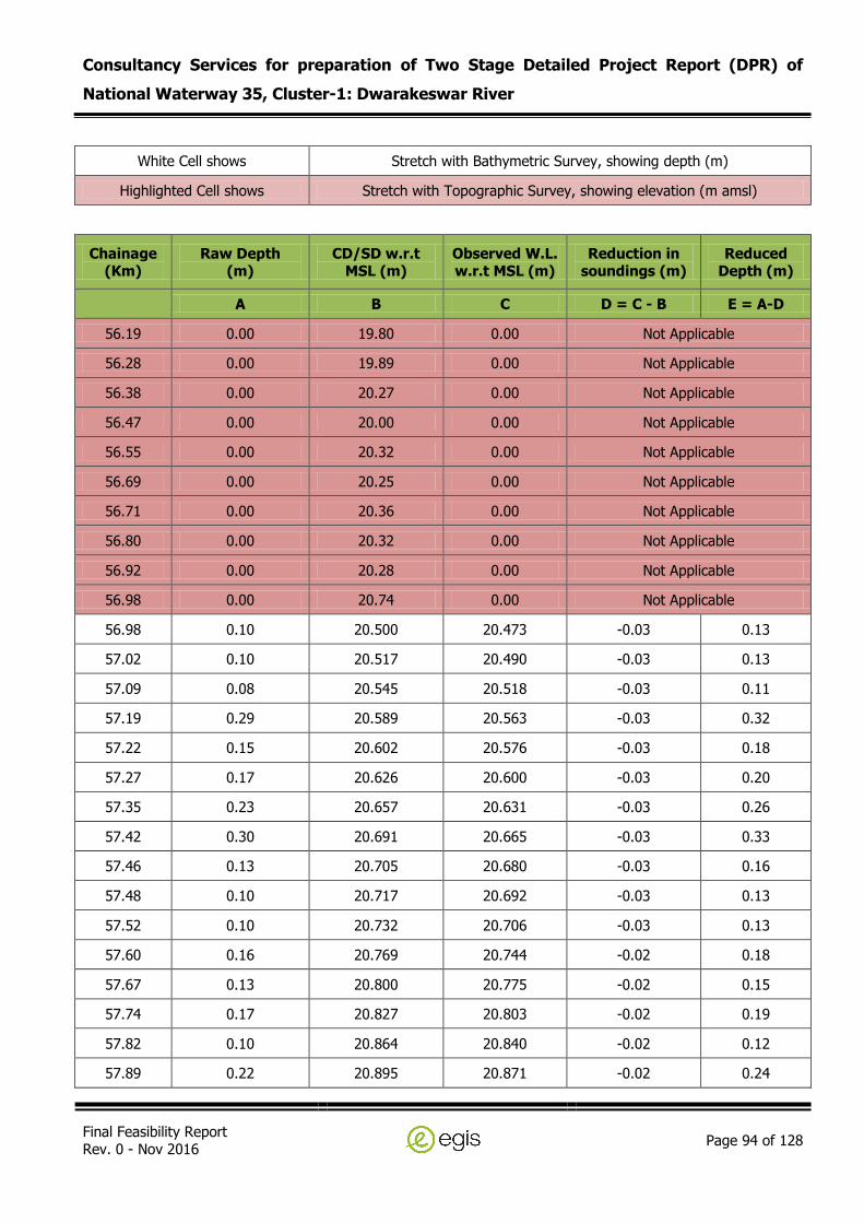
Consultancy Services for preparation of Two Stage Detailed Project Report (DPR) of
National Waterway 35, Cluster-1: Dwarakeswar River
Final Feasibility Report Rev. 0 - Nov 2016
Page 94 of 128
White Cell shows Stretch with Bathymetric Survey, showing depth (m)
Highlighted Cell shows Stretch with Topographic Survey, showing elevation (m amsl)
Chainage (Km)
Raw Depth (m)
CD/SD w.r.t MSL (m)
Observed W.L. w.r.t MSL (m)
Reduction in soundings (m)
Reduced Depth (m)
A B C D = C - B E = A-D
56.19 0.00 19.80 0.00 Not Applicable
56.28 0.00 19.89 0.00 Not Applicable
56.38 0.00 20.27 0.00 Not Applicable
56.47 0.00 20.00 0.00 Not Applicable
56.55 0.00 20.32 0.00 Not Applicable
56.69 0.00 20.25 0.00 Not Applicable
56.71 0.00 20.36 0.00 Not Applicable
56.80 0.00 20.32 0.00 Not Applicable
56.92 0.00 20.28 0.00 Not Applicable
56.98 0.00 20.74 0.00 Not Applicable
56.98 0.10 20.500 20.473 -0.03 0.13
57.02 0.10 20.517 20.490 -0.03 0.13
57.09 0.08 20.545 20.518 -0.03 0.11
57.19 0.29 20.589 20.563 -0.03 0.32
57.22 0.15 20.602 20.576 -0.03 0.18
57.27 0.17 20.626 20.600 -0.03 0.20
57.35 0.23 20.657 20.631 -0.03 0.26
57.42 0.30 20.691 20.665 -0.03 0.33
57.46 0.13 20.705 20.680 -0.03 0.16
57.48 0.10 20.717 20.692 -0.03 0.13
57.52 0.10 20.732 20.706 -0.03 0.13
57.60 0.16 20.769 20.744 -0.02 0.18
57.67 0.13 20.800 20.775 -0.02 0.15
57.74 0.17 20.827 20.803 -0.02 0.19
57.82 0.10 20.864 20.840 -0.02 0.12
57.89 0.22 20.895 20.871 -0.02 0.24

Consultancy Services for preparation of Two Stage Detailed Project Report (DPR) of
National Waterway 35, Cluster-1: Dwarakeswar River
Final Feasibility Report Rev. 0 - Nov 2016
Page 95 of 128
White Cell shows Stretch with Bathymetric Survey, showing depth (m)
Highlighted Cell shows Stretch with Topographic Survey, showing elevation (m amsl)
Chainage (Km)
Raw Depth (m)
CD/SD w.r.t MSL (m)
Observed W.L. w.r.t MSL (m)
Reduction in soundings (m)
Reduced Depth (m)
A B C D = C - B E = A-D
57.96 0.10 20.925 20.902 -0.02 0.12
58.02 0.10 20.950 20.927 -0.02 0.12
58.11 0.11 20.990 20.967 -0.02 0.13
58.18 0.25 21.021 20.998 -0.02 0.27
58.21 0.68 21.035 21.012 -0.02 0.70
58.23 1.09 21.043 21.021 -0.02 1.11
58.25 0.46 21.052 21.030 -0.02 0.48
58.29 0.40 21.066 21.044 -0.02 0.42
58.35 0.25 21.097 21.075 -0.02 0.27
58.43 0.21 21.131 21.110 -0.02 0.23
58.52 0.30 21.167 21.146 -0.02 0.32
58.61 0.40 21.210 21.189 -0.02 0.42
58.70 0.24 21.246 21.225 -0.02 0.26
58.78 0.14 21.281 21.261 -0.02 0.16
58.86 0.20 21.315 21.295 -0.02 0.22
58.93 0.20 21.348 21.328 -0.02 0.22
58.97 0.43 21.363 21.343 -0.02 0.45
59.02 0.28 21.384 21.364 -0.02 0.30
59.10 0.20 21.421 21.402 -0.02 0.22
59.14 0.20 21.439 21.420 -0.02 0.22
59.14 0.20 21.440 21.421 -0.02 0.22
59.19 0.36 21.462 21.443 -0.02 0.38
59.27 0.29 21.495 21.476 -0.02 0.31
59.32 0.20 21.516 21.498 -0.02 0.22
59.39 0.23 21.549 21.531 -0.02 0.25
59.43 0.30 21.565 21.547 -0.02 0.32

Consultancy Services for preparation of Two Stage Detailed Project Report (DPR) of
National Waterway 35, Cluster-1: Dwarakeswar River
Final Feasibility Report Rev. 0 - Nov 2016
Page 96 of 128
White Cell shows Stretch with Bathymetric Survey, showing depth (m)
Highlighted Cell shows Stretch with Topographic Survey, showing elevation (m amsl)
Chainage (Km)
Raw Depth (m)
CD/SD w.r.t MSL (m)
Observed W.L. w.r.t MSL (m)
Reduction in soundings (m)
Reduced Depth (m)
A B C D = C - B E = A-D
59.49 0.30 21.589 21.571 -0.02 0.32
59.53 0.30 21.609 21.592 -0.02 0.32
59.59 0.30 21.635 21.618 -0.02 0.32
59.66 0.29 21.663 21.646 -0.02 0.31
59.72 0.27 21.690 21.673 -0.02 0.29
59.77 0.22 21.714 21.697 -0.02 0.24
59.82 0.22 21.734 21.717 -0.02 0.24
59.89 0.33 21.765 21.748 -0.02 0.35
59.94 0.20 21.786 21.769 -0.02 0.22
59.98 0.20 21.805 21.789 -0.02 0.22
60.04 0.15 21.828 21.812 -0.02 0.17
60.10 0.20 21.858 21.842 -0.02 0.22
60.13 0.30 21.871 21.855 -0.02 0.32
60.18 0.30 21.890 21.874 -0.02 0.32
60.25 0.27 21.919 21.904 -0.02 0.29
60.33 0.20 21.954 21.940 -0.01 0.21
60.40 0.22 21.987 21.972 -0.01 0.23
60.47 0.30 22.019 22.005 -0.01 0.31
60.55 0.30 22.052 22.038 -0.01 0.31
60.62 0.20 22.081 22.068 -0.01 0.21
60.68 0.20 22.108 22.095 -0.01 0.21
60.75 0.30 22.137 22.124 -0.01 0.31
60.82 0.21 22.168 22.155 -0.01 0.22
60.90 0.27 22.203 22.190 -0.01 0.28
60.95 0.20 22.228 22.215 -0.01 0.21
61.04 0.19 22.263 22.251 -0.01 0.20

Consultancy Services for preparation of Two Stage Detailed Project Report (DPR) of
National Waterway 35, Cluster-1: Dwarakeswar River
Final Feasibility Report Rev. 0 - Nov 2016
Page 97 of 128
White Cell shows Stretch with Bathymetric Survey, showing depth (m)
Highlighted Cell shows Stretch with Topographic Survey, showing elevation (m amsl)
Chainage (Km)
Raw Depth (m)
CD/SD w.r.t MSL (m)
Observed W.L. w.r.t MSL (m)
Reduction in soundings (m)
Reduced Depth (m)
A B C D = C - B E = A-D
61.12 0.11 22.301 22.289 -0.01 0.12
61.20 0.19 22.337 22.326 -0.01 0.20
61.27 0.23 22.367 22.355 -0.01 0.24
61.28 0.47 22.371 22.360 -0.01 0.48
61.30 0.20 22.379 22.367 -0.01 0.21
61.34 0.39 22.396 22.384 -0.01 0.40
61.36 0.26 22.403 22.392 -0.01 0.27
61.40 0.21 22.421 22.411 -0.01 0.22
61.49 0.20 22.459 22.449 -0.01 0.21
61.58 0.20 22.502 22.492 -0.01 0.21
61.64 0.45 22.528 22.518 -0.01 0.46
61.64 0.32 22.528 22.518 -0.01 0.33
61.72 0.16 22.560 22.550 -0.01 0.17
61.81 0.19 22.600 22.591 -0.01 0.20
61.90 0.35 22.641 22.632 -0.01 0.36
62.00 0.30 22.682 22.673 -0.01 0.31
62.14 0.20 22.746 22.738 -0.01 0.21
62.14 0.20 22.746 22.738 -0.01 0.21
62.14 0.20 22.746 22.738 -0.01 0.21
62.19 0.40 22.768 22.760 -0.01 0.41
62.27 0.47 22.799 22.791 -0.01 0.48
62.34 0.73 22.831 22.824 -0.01 0.74
62.40 0.54 22.856 22.848 -0.01 0.55
62.46 0.35 22.883 22.876 -0.01 0.36
62.53 0.30 22.912 22.905 -0.01 0.31
62.55 0.30 22.925 22.918 -0.01 0.31
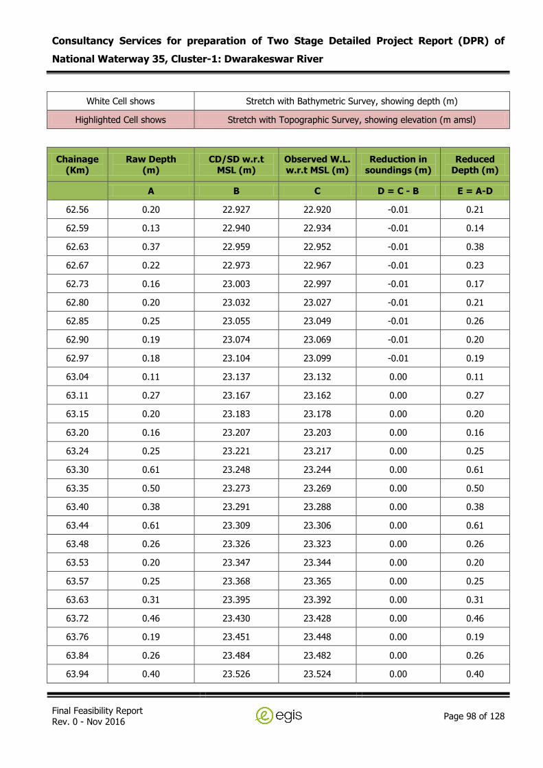
Consultancy Services for preparation of Two Stage Detailed Project Report (DPR) of
National Waterway 35, Cluster-1: Dwarakeswar River
Final Feasibility Report Rev. 0 - Nov 2016
Page 98 of 128
White Cell shows Stretch with Bathymetric Survey, showing depth (m)
Highlighted Cell shows Stretch with Topographic Survey, showing elevation (m amsl)
Chainage (Km)
Raw Depth (m)
CD/SD w.r.t MSL (m)
Observed W.L. w.r.t MSL (m)
Reduction in soundings (m)
Reduced Depth (m)
A B C D = C - B E = A-D
62.56 0.20 22.927 22.920 -0.01 0.21
62.59 0.13 22.940 22.934 -0.01 0.14
62.63 0.37 22.959 22.952 -0.01 0.38
62.67 0.22 22.973 22.967 -0.01 0.23
62.73 0.16 23.003 22.997 -0.01 0.17
62.80 0.20 23.032 23.027 -0.01 0.21
62.85 0.25 23.055 23.049 -0.01 0.26
62.90 0.19 23.074 23.069 -0.01 0.20
62.97 0.18 23.104 23.099 -0.01 0.19
63.04 0.11 23.137 23.132 0.00 0.11
63.11 0.27 23.167 23.162 0.00 0.27
63.15 0.20 23.183 23.178 0.00 0.20
63.20 0.16 23.207 23.203 0.00 0.16
63.24 0.25 23.221 23.217 0.00 0.25
63.30 0.61 23.248 23.244 0.00 0.61
63.35 0.50 23.273 23.269 0.00 0.50
63.40 0.38 23.291 23.288 0.00 0.38
63.44 0.61 23.309 23.306 0.00 0.61
63.48 0.26 23.326 23.323 0.00 0.26
63.53 0.20 23.347 23.344 0.00 0.20
63.57 0.25 23.368 23.365 0.00 0.25
63.63 0.31 23.395 23.392 0.00 0.31
63.72 0.46 23.430 23.428 0.00 0.46
63.76 0.19 23.451 23.448 0.00 0.19
63.84 0.26 23.484 23.482 0.00 0.26
63.94 0.40 23.526 23.524 0.00 0.40

Consultancy Services for preparation of Two Stage Detailed Project Report (DPR) of
National Waterway 35, Cluster-1: Dwarakeswar River
Final Feasibility Report Rev. 0 - Nov 2016
Page 99 of 128
White Cell shows Stretch with Bathymetric Survey, showing depth (m)
Highlighted Cell shows Stretch with Topographic Survey, showing elevation (m amsl)
Chainage (Km)
Raw Depth (m)
CD/SD w.r.t MSL (m)
Observed W.L. w.r.t MSL (m)
Reduction in soundings (m)
Reduced Depth (m)
A B C D = C - B E = A-D
63.96 0.21 23.535 23.533 0.00 0.21
63.96 0.38 23.535 23.534 0.00 0.38
63.96 0.29 23.535 23.534 0.00 0.29
63.98 0.10 23.545 23.544 0.00 0.10
64.06 0.07 23.578 23.577 0.00 0.07
64.15 0.23 23.619 23.618 0.00 0.23
64.23 0.26 23.653 23.652 0.00 0.26
64.28 0.43 23.677 23.677 0.00 0.43
64.31 0.41 23.688 23.688 0.00 0.41
64.38 0.22 23.721 23.721 0.00 0.22
64.45 0.30 23.748 23.748 0.00 0.30
64.52 0.34 23.779 23.780 0.00 0.34
64.60 0.30 23.814 23.815 0.00 0.30
64.66 0.23 23.843 23.844 0.00 0.23
64.72 0.20 23.866 23.867 0.00 0.20
64.76 0.20 23.884 23.886 0.00 0.20
64.83 0.16 23.917 23.919 0.00 0.16
64.90 0.15 23.947 23.949 0.00 0.15
65.05 0.40 24.010 24.012 0.00 0.40
65.05 0.30 24.010 24.012 0.00 0.30
65.05 0.30 24.010 24.013 0.00 0.30
65.05 0.31 24.010 24.013 0.00 0.31
65.08 0.40 24.022 24.024 0.00 0.40
65.15 0.35 24.054 24.057 0.00 0.35
65.23 0.29 24.089 24.092 0.00 0.29
65.28 0.26 24.110 24.113 0.00 0.26

Consultancy Services for preparation of Two Stage Detailed Project Report (DPR) of
National Waterway 35, Cluster-1: Dwarakeswar River
Final Feasibility Report Rev. 0 - Nov 2016
Page 100 of 128
White Cell shows Stretch with Bathymetric Survey, showing depth (m)
Highlighted Cell shows Stretch with Topographic Survey, showing elevation (m amsl)
Chainage (Km)
Raw Depth (m)
CD/SD w.r.t MSL (m)
Observed W.L. w.r.t MSL (m)
Reduction in soundings (m)
Reduced Depth (m)
A B C D = C - B E = A-D
65.35 0.38 24.142 24.146 0.00 0.38
65.42 0.38 24.170 24.174 0.00 0.38
65.50 0.30 24.206 24.210 0.00 0.30
65.57 0.39 24.237 24.242 0.00 0.39
65.62 0.35 24.261 24.265 0.00 0.35
65.70 0.40 24.292 24.297 0.00 0.40
65.74 0.43 24.311 24.316 0.00 0.43
65.78 0.38 24.330 24.335 0.01 0.37
65.79 0.33 24.334 24.339 0.01 0.32
65.84 0.40 24.354 24.359 0.01 0.39
65.90 0.40 24.383 24.388 0.01 0.39
65.97 0.43 24.413 24.418 0.01 0.42
65.99 0.50 24.418 24.424 0.01 0.49
66.05 0.40 24.445 24.451 0.01 0.39
66.11 0.34 24.471 24.478 0.01 0.33
66.11 0.40 24.472 24.478 0.01 0.39
66.14 0.23 24.486 24.493 0.01 0.22
66.21 0.39 24.518 24.524 0.01 0.38
66.24 0.40 24.527 24.534 0.01 0.39
66.25 0.40 24.534 24.541 0.01 0.39
66.36 0.39 24.581 24.588 0.01 0.38
66.52 0.30 24.650 24.657 0.01 0.29
66.61 0.30 24.689 24.698 0.01 0.29
66.73 0.38 24.742 24.751 0.01 0.37
66.88 0.33 24.808 24.817 0.01 0.32
66.93 0.20 24.828 24.837 0.01 0.19

Consultancy Services for preparation of Two Stage Detailed Project Report (DPR) of
National Waterway 35, Cluster-1: Dwarakeswar River
Final Feasibility Report Rev. 0 - Nov 2016
Page 101 of 128
White Cell shows Stretch with Bathymetric Survey, showing depth (m)
Highlighted Cell shows Stretch with Topographic Survey, showing elevation (m amsl)
Chainage (Km)
Raw Depth (m)
CD/SD w.r.t MSL (m)
Observed W.L. w.r.t MSL (m)
Reduction in soundings (m)
Reduced Depth (m)
A B C D = C - B E = A-D
67.02 0.25 24.870 24.879 0.01 0.24
67.11 0.29 24.906 24.916 0.01 0.28
67.20 0.21 24.947 24.957 0.01 0.20
67.29 0.33 24.984 24.995 0.01 0.32
67.29 0.36 24.984 24.995 0.01 0.35
67.29 0.21 24.985 24.995 0.01 0.20
67.32 0.36 24.998 25.009 0.01 0.35
67.38 0.30 25.023 25.034 0.01 0.29
67.46 0.35 25.061 25.072 0.01 0.34
67.55 0.31 25.099 25.111 0.01 0.30
67.63 0.40 25.135 25.147 0.01 0.39
67.74 0.38 25.182 25.194 0.01 0.37
67.81 0.22 25.213 25.225 0.01 0.21
67.89 0.30 25.249 25.262 0.01 0.29
67.97 0.21 25.283 25.296 0.01 0.20
68.07 0.20 25.324 25.337 0.01 0.19
68.18 2.82 25.372 25.385 0.01 2.81
68.27 0.24 25.411 25.425 0.01 0.23
68.35 0.10 25.447 25.462 0.01 0.09
68.45 0.18 25.489 25.504 0.01 0.17
68.54 0.18 25.532 25.547 0.02 0.16
68.65 0.10 25.576 25.591 0.02 0.08
68.72 0.19 25.607 25.623 0.02 0.17
68.80 0.11 25.645 25.661 0.02 0.09
68.90 0.33 25.688 25.704 0.02 0.31
68.99 0.34 25.728 25.744 0.02 0.32
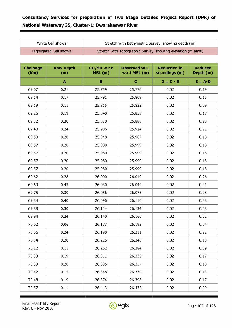
Consultancy Services for preparation of Two Stage Detailed Project Report (DPR) of
National Waterway 35, Cluster-1: Dwarakeswar River
Final Feasibility Report Rev. 0 - Nov 2016
Page 102 of 128
White Cell shows Stretch with Bathymetric Survey, showing depth (m)
Highlighted Cell shows Stretch with Topographic Survey, showing elevation (m amsl)
Chainage (Km)
Raw Depth (m)
CD/SD w.r.t MSL (m)
Observed W.L. w.r.t MSL (m)
Reduction in soundings (m)
Reduced Depth (m)
A B C D = C - B E = A-D
69.07 0.21 25.759 25.776 0.02 0.19
69.14 0.17 25.791 25.809 0.02 0.15
69.19 0.11 25.815 25.832 0.02 0.09
69.25 0.19 25.840 25.858 0.02 0.17
69.32 0.30 25.870 25.888 0.02 0.28
69.40 0.24 25.906 25.924 0.02 0.22
69.50 0.20 25.948 25.967 0.02 0.18
69.57 0.20 25.980 25.999 0.02 0.18
69.57 0.20 25.980 25.999 0.02 0.18
69.57 0.20 25.980 25.999 0.02 0.18
69.57 0.20 25.980 25.999 0.02 0.18
69.62 0.28 26.000 26.019 0.02 0.26
69.69 0.43 26.030 26.049 0.02 0.41
69.75 0.30 26.056 26.075 0.02 0.28
69.84 0.40 26.096 26.116 0.02 0.38
69.88 0.30 26.114 26.134 0.02 0.28
69.94 0.24 26.140 26.160 0.02 0.22
70.02 0.06 26.173 26.193 0.02 0.04
70.06 0.24 26.190 26.211 0.02 0.22
70.14 0.20 26.226 26.246 0.02 0.18
70.22 0.11 26.262 26.284 0.02 0.09
70.33 0.19 26.311 26.332 0.02 0.17
70.39 0.20 26.335 26.357 0.02 0.18
70.42 0.15 26.348 26.370 0.02 0.13
70.48 0.19 26.374 26.396 0.02 0.17
70.57 0.11 26.413 26.435 0.02 0.09

Consultancy Services for preparation of Two Stage Detailed Project Report (DPR) of
National Waterway 35, Cluster-1: Dwarakeswar River
Final Feasibility Report Rev. 0 - Nov 2016
Page 103 of 128
White Cell shows Stretch with Bathymetric Survey, showing depth (m)
Highlighted Cell shows Stretch with Topographic Survey, showing elevation (m amsl)
Chainage (Km)
Raw Depth (m)
CD/SD w.r.t MSL (m)
Observed W.L. w.r.t MSL (m)
Reduction in soundings (m)
Reduced Depth (m)
A B C D = C - B E = A-D
70.65 0.10 26.450 26.472 0.02 0.08
70.73 0.10 26.484 26.507 0.02 0.08
70.82 0.08 26.524 26.547 0.02 0.06
70.91 0.05 26.562 26.586 0.02 0.03
70.98 0.08 26.590 26.614 0.02 0.06
71.06 0.10 26.626 26.650 0.02 0.08
71.06 0.10 26.626 26.650 0.02 0.08
71.06 0.10 26.626 26.650 0.02 0.08
71.11 0.00 26.65 0.00 Not Applicable
71.22 0.00 26.90 0.00 Not Applicable
71.31 0.00 27.86 0.00 Not Applicable
71.43 0.00 28.45 0.00 Not Applicable
71.48 0.00 27.99 0.00 Not Applicable
71.58 0.00 29.51 0.00 Not Applicable
71.65 0.00 29.32 0.00 Not Applicable
71.75 0.00 29.26 0.00 Not Applicable
71.79 0.00 28.96 0.00 Not Applicable
71.89 0.00 29.39 0.00 Not Applicable
72.01 0.00 30.08 0.00 Not Applicable
72.11 0.00 30.69 0.00 Not Applicable
72.21 0.00 26.84 0.00 Not Applicable
72.28 0.00 27.72 0.00 Not Applicable
72.32 0.00 27.80 0.00 Not Applicable
72.39 0.00 27.77 0.00 Not Applicable
72.52 0.00 27.02 0.00 Not Applicable
72.61 0.00 27.13 0.00 Not Applicable

Consultancy Services for preparation of Two Stage Detailed Project Report (DPR) of
National Waterway 35, Cluster-1: Dwarakeswar River
Final Feasibility Report Rev. 0 - Nov 2016
Page 104 of 128
White Cell shows Stretch with Bathymetric Survey, showing depth (m)
Highlighted Cell shows Stretch with Topographic Survey, showing elevation (m amsl)
Chainage (Km)
Raw Depth (m)
CD/SD w.r.t MSL (m)
Observed W.L. w.r.t MSL (m)
Reduction in soundings (m)
Reduced Depth (m)
A B C D = C - B E = A-D
72.72 0.00 28.52 0.00 Not Applicable
72.78 0.00 28.29 0.00 Not Applicable
72.82 0.00 28.23 0.00 Not Applicable
72.92 0.00 28.21 0.00 Not Applicable
72.99 0.00 28.98 0.00 Not Applicable
73.07 0.00 29.09 0.00 Not Applicable
73.11 0.00 28.43 0.00 Not Applicable
73.23 0.00 28.16 0.00 Not Applicable
73.30 0.00 29.14 0.00 Not Applicable
73.41 0.00 28.85 0.00 Not Applicable
73.48 0.00 28.87 0.00 Not Applicable
73.52 0.00 29.12 0.00 Not Applicable
73.58 0.00 29.29 0.00 Not Applicable
73.63 0.00 29.45 0.00 Not Applicable
73.66 0.00 27.87 0.00 Not Applicable
73.71 0.00 28.16 0.00 Not Applicable
73.77 0.00 28.29 0.00 Not Applicable
73.84 0.00 28.35 0.00 Not Applicable
73.90 0.00 28.36 0.00 Not Applicable
73.99 0.00 28.65 0.00 Not Applicable
74.03 0.00 28.55 0.00 Not Applicable
74.08 0.00 28.80 0.00 Not Applicable
74.21 0.00 28.55 0.00 Not Applicable
74.30 0.00 28.33 0.00 Not Applicable
74.42 0.00 28.55 0.00 Not Applicable
74.47 0.00 28.55 0.00 Not Applicable

Consultancy Services for preparation of Two Stage Detailed Project Report (DPR) of
National Waterway 35, Cluster-1: Dwarakeswar River
Final Feasibility Report Rev. 0 - Nov 2016
Page 105 of 128
White Cell shows Stretch with Bathymetric Survey, showing depth (m)
Highlighted Cell shows Stretch with Topographic Survey, showing elevation (m amsl)
Chainage (Km)
Raw Depth (m)
CD/SD w.r.t MSL (m)
Observed W.L. w.r.t MSL (m)
Reduction in soundings (m)
Reduced Depth (m)
A B C D = C - B E = A-D
74.54 0.00 28.64 0.00 Not Applicable
74.60 0.00 28.69 0.00 Not Applicable
74.71 0.00 28.83 0.00 Not Applicable
74.79 0.00 28.60 0.00 Not Applicable
74.88 0.00 30.12 0.00 Not Applicable
74.99 0.00 30.03 0.00 Not Applicable
75.04 0.00 29.86 0.00 Not Applicable
75.09 0.00 29.75 0.00 Not Applicable
75.11 0.00 30.47 0.00 Not Applicable
75.19 0.00 30.61 0.00 Not Applicable
75.31 0.00 30.55 0.00 Not Applicable
75.34 0.00 30.46 0.00 Not Applicable
75.44 0.00 30.58 0.00 Not Applicable
75.51 0.00 29.16 0.00 Not Applicable
75.55 0.00 29.14 0.00 Not Applicable
75.63 0.00 29.27 0.00 Not Applicable
75.68 0.00 29.14 0.00 Not Applicable
75.79 0.00 29.52 0.00 Not Applicable
75.84 0.00 29.23 0.00 Not Applicable
75.89 0.00 29.29 0.00 Not Applicable
75.91 0.00 29.54 0.00 Not Applicable
75.98 0.00 29.41 0.00 Not Applicable
76.03 0.00 29.03 0.00 Not Applicable
76.11 0.00 29.08 0.00 Not Applicable
76.22 0.00 29.40 0.00 Not Applicable
76.32 0.00 29.60 0.00 Not Applicable
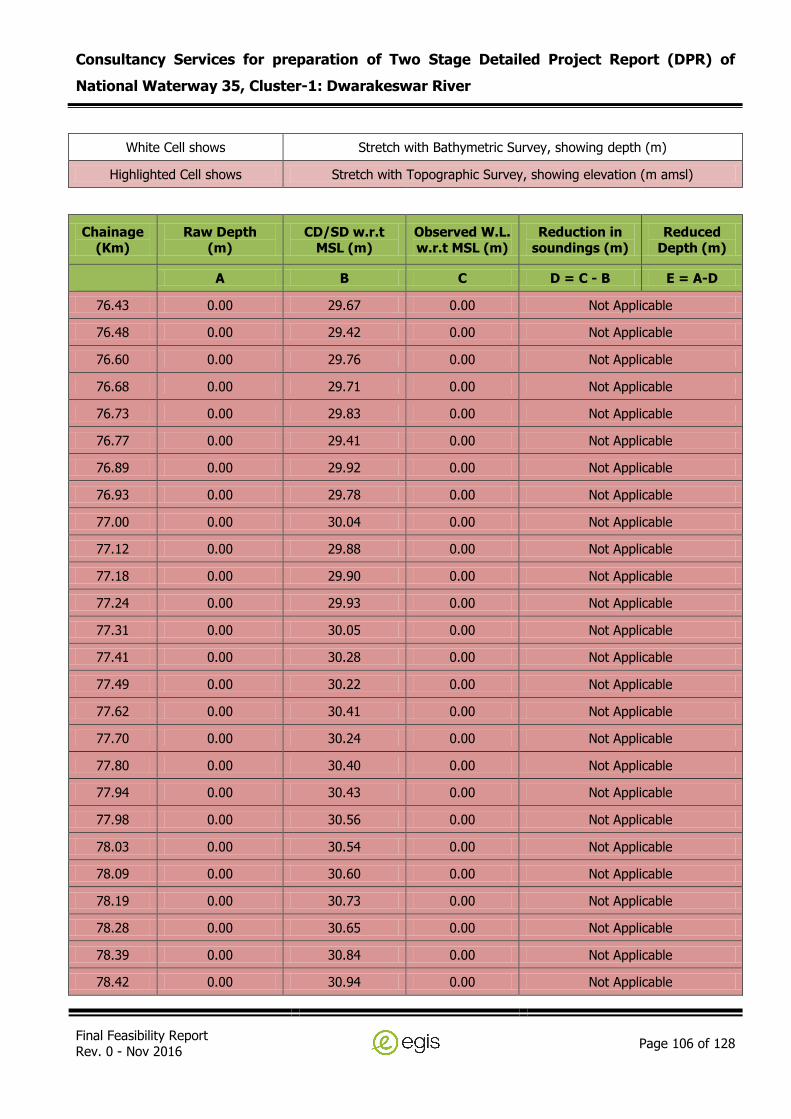
Consultancy Services for preparation of Two Stage Detailed Project Report (DPR) of
National Waterway 35, Cluster-1: Dwarakeswar River
Final Feasibility Report Rev. 0 - Nov 2016
Page 106 of 128
White Cell shows Stretch with Bathymetric Survey, showing depth (m)
Highlighted Cell shows Stretch with Topographic Survey, showing elevation (m amsl)
Chainage (Km)
Raw Depth (m)
CD/SD w.r.t MSL (m)
Observed W.L. w.r.t MSL (m)
Reduction in soundings (m)
Reduced Depth (m)
A B C D = C - B E = A-D
76.43 0.00 29.67 0.00 Not Applicable
76.48 0.00 29.42 0.00 Not Applicable
76.60 0.00 29.76 0.00 Not Applicable
76.68 0.00 29.71 0.00 Not Applicable
76.73 0.00 29.83 0.00 Not Applicable
76.77 0.00 29.41 0.00 Not Applicable
76.89 0.00 29.92 0.00 Not Applicable
76.93 0.00 29.78 0.00 Not Applicable
77.00 0.00 30.04 0.00 Not Applicable
77.12 0.00 29.88 0.00 Not Applicable
77.18 0.00 29.90 0.00 Not Applicable
77.24 0.00 29.93 0.00 Not Applicable
77.31 0.00 30.05 0.00 Not Applicable
77.41 0.00 30.28 0.00 Not Applicable
77.49 0.00 30.22 0.00 Not Applicable
77.62 0.00 30.41 0.00 Not Applicable
77.70 0.00 30.24 0.00 Not Applicable
77.80 0.00 30.40 0.00 Not Applicable
77.94 0.00 30.43 0.00 Not Applicable
77.98 0.00 30.56 0.00 Not Applicable
78.03 0.00 30.54 0.00 Not Applicable
78.09 0.00 30.60 0.00 Not Applicable
78.19 0.00 30.73 0.00 Not Applicable
78.28 0.00 30.65 0.00 Not Applicable
78.39 0.00 30.84 0.00 Not Applicable
78.42 0.00 30.94 0.00 Not Applicable

Consultancy Services for preparation of Two Stage Detailed Project Report (DPR) of
National Waterway 35, Cluster-1: Dwarakeswar River
Final Feasibility Report Rev. 0 - Nov 2016
Page 107 of 128
White Cell shows Stretch with Bathymetric Survey, showing depth (m)
Highlighted Cell shows Stretch with Topographic Survey, showing elevation (m amsl)
Chainage (Km)
Raw Depth (m)
CD/SD w.r.t MSL (m)
Observed W.L. w.r.t MSL (m)
Reduction in soundings (m)
Reduced Depth (m)
A B C D = C - B E = A-D
78.49 0.00 30.88 0.00 Not Applicable
78.53 0.00 30.97 0.00 Not Applicable
78.60 0.00 30.99 0.00 Not Applicable
78.70 0.00 31.27 0.00 Not Applicable
78.80 0.00 31.10 0.00 Not Applicable
78.89 0.00 31.46 0.00 Not Applicable
78.99 0.00 31.55 0.00 Not Applicable
79.09 0.00 31.62 0.00 Not Applicable
79.19 0.00 31.61 0.00 Not Applicable
79.23 0.00 31.67 0.00 Not Applicable
79.33 0.00 31.84 0.00 Not Applicable
79.41 0.00 31.85 0.00 Not Applicable
79.51 0.00 31.97 0.00 Not Applicable
79.62 0.00 32.04 0.00 Not Applicable
79.71 0.00 32.16 0.00 Not Applicable
79.82 0.00 32.29 0.00 Not Applicable
79.92 0.00 31.99 0.00 Not Applicable
80.02 0.00 32.68 0.00 Not Applicable
80.19 0.00 32.54 0.00 Not Applicable
80.22 0.00 32.73 0.00 Not Applicable
80.32 0.00 32.85 0.00 Not Applicable
80.40 0.00 32.80 0.00 Not Applicable
80.49 0.00 32.87 0.00 Not Applicable
80.58 0.00 32.94 0.00 Not Applicable
80.64 0.00 33.24 0.00 Not Applicable
81.06 0.00 33.18 0.00 Not Applicable

Consultancy Services for preparation of Two Stage Detailed Project Report (DPR) of
National Waterway 35, Cluster-1: Dwarakeswar River
Final Feasibility Report Rev. 0 - Nov 2016
Page 108 of 128
White Cell shows Stretch with Bathymetric Survey, showing depth (m)
Highlighted Cell shows Stretch with Topographic Survey, showing elevation (m amsl)
Chainage (Km)
Raw Depth (m)
CD/SD w.r.t MSL (m)
Observed W.L. w.r.t MSL (m)
Reduction in soundings (m)
Reduced Depth (m)
A B C D = C - B E = A-D
81.10 0.00 33.24 0.00 Not Applicable
81.20 0.00 33.29 0.00 Not Applicable
81.30 0.00 33.29 0.00 Not Applicable
81.39 0.00 33.34 0.00 Not Applicable
81.43 0.00 33.42 0.00 Not Applicable
81.48 0.00 33.42 0.00 Not Applicable
81.54 0.00 33.47 0.00 Not Applicable
81.61 0.00 33.46 0.00 Not Applicable
81.72 0.00 33.59 0.00 Not Applicable
81.77 0.00 33.62 0.00 Not Applicable
81.82 0.00 33.71 0.00 Not Applicable
81.89 0.00 33.84 0.00 Not Applicable
81.94 0.00 33.68 0.00 Not Applicable
82.01 0.00 33.72 0.00 Not Applicable
82.08 0.00 33.93 0.00 Not Applicable
82.12 0.00 33.65 0.00 Not Applicable
82.21 0.00 33.70 0.00 Not Applicable
82.31 0.00 33.69 0.00 Not Applicable
82.40 0.00 33.80 0.00 Not Applicable
82.49 0.00 33.81 0.00 Not Applicable
82.53 0.00 34.04 0.00 Not Applicable
82.62 0.00 33.90 0.00 Not Applicable
82.71 0.00 33.92 0.00 Not Applicable
82.78 0.00 33.77 0.00 Not Applicable
82.92 0.00 34.12 0.00 Not Applicable
83.02 0.00 33.99 0.00 Not Applicable

Consultancy Services for preparation of Two Stage Detailed Project Report (DPR) of
National Waterway 35, Cluster-1: Dwarakeswar River
Final Feasibility Report Rev. 0 - Nov 2016
Page 109 of 128
White Cell shows Stretch with Bathymetric Survey, showing depth (m)
Highlighted Cell shows Stretch with Topographic Survey, showing elevation (m amsl)
Chainage (Km)
Raw Depth (m)
CD/SD w.r.t MSL (m)
Observed W.L. w.r.t MSL (m)
Reduction in soundings (m)
Reduced Depth (m)
A B C D = C - B E = A-D
83.09 0.00 34.05 0.00 Not Applicable
83.19 0.00 34.35 0.00 Not Applicable
83.23 0.00 34.19 0.00 Not Applicable
83.31 0.00 34.26 0.00 Not Applicable
83.38 0.00 33.80 0.00 Not Applicable
83.51 0.00 34.22 0.00 Not Applicable
83.62 0.00 34.42 0.00 Not Applicable
83.69 0.00 34.62 0.00 Not Applicable
83.79 0.00 34.89 0.00 Not Applicable
83.91 0.00 34.72 0.00 Not Applicable
84.02 0.00 34.64 0.00 Not Applicable
84.11 0.00 34.70 0.00 Not Applicable
84.19 0.00 34.50 0.00 Not Applicable
84.31 0.00 34.90 0.00 Not Applicable
84.43 0.00 34.95 0.00 Not Applicable
84.50 0.00 35.00 0.00 Not Applicable
84.59 0.00 35.04 0.00 Not Applicable
84.69 0.00 35.16 0.00 Not Applicable
84.79 0.00 34.86 0.00 Not Applicable
84.88 0.00 35.22 0.00 Not Applicable
84.93 0.00 35.08 0.00 Not Applicable
84.99 0.00 35.09 0.00 Not Applicable
85.04 0.00 34.93 0.00 Not Applicable
85.10 0.00 35.18 0.00 Not Applicable
85.19 0.00 35.33 0.00 Not Applicable
85.31 0.00 35.47 0.00 Not Applicable

Consultancy Services for preparation of Two Stage Detailed Project Report (DPR) of
National Waterway 35, Cluster-1: Dwarakeswar River
Final Feasibility Report Rev. 0 - Nov 2016
Page 110 of 128
White Cell shows Stretch with Bathymetric Survey, showing depth (m)
Highlighted Cell shows Stretch with Topographic Survey, showing elevation (m amsl)
Chainage (Km)
Raw Depth (m)
CD/SD w.r.t MSL (m)
Observed W.L. w.r.t MSL (m)
Reduction in soundings (m)
Reduced Depth (m)
A B C D = C - B E = A-D
85.41 0.00 35.29 0.00 Not Applicable
85.50 0.00 35.52 0.00 Not Applicable
85.60 0.00 35.53 0.00 Not Applicable
85.71 0.00 35.52 0.00 Not Applicable
85.79 0.00 35.68 0.00 Not Applicable
85.83 0.00 35.60 0.00 Not Applicable
85.91 0.00 35.65 0.00 Not Applicable
86.00 0.00 35.77 0.00 Not Applicable
86.07 0.00 35.66 0.00 Not Applicable
86.14 0.00 35.71 0.00 Not Applicable
86.18 0.00 35.96 0.00 Not Applicable
86.21 0.00 35.89 0.00 Not Applicable
86.30 0.00 35.86 0.00 Not Applicable
86.41 0.00 35.91 0.00 Not Applicable
86.48 0.00 35.78 0.00 Not Applicable
86.52 0.00 35.72 0.00 Not Applicable
86.64 0.00 35.97 0.00 Not Applicable
86.69 0.00 35.89 0.00 Not Applicable
86.82 0.00 36.17 0.00 Not Applicable
86.91 0.00 36.36 0.00 Not Applicable
87.01 0.00 36.28 0.00 Not Applicable
87.09 0.00 36.54 0.00 Not Applicable
87.19 0.00 36.17 0.00 Not Applicable
87.29 0.00 36.55 0.00 Not Applicable
87.34 0.00 36.41 0.00 Not Applicable
87.39 0.00 36.82 0.00 Not Applicable

Consultancy Services for preparation of Two Stage Detailed Project Report (DPR) of
National Waterway 35, Cluster-1: Dwarakeswar River
Final Feasibility Report Rev. 0 - Nov 2016
Page 111 of 128
White Cell shows Stretch with Bathymetric Survey, showing depth (m)
Highlighted Cell shows Stretch with Topographic Survey, showing elevation (m amsl)
Chainage (Km)
Raw Depth (m)
CD/SD w.r.t MSL (m)
Observed W.L. w.r.t MSL (m)
Reduction in soundings (m)
Reduced Depth (m)
A B C D = C - B E = A-D
87.44 0.00 36.71 0.00 Not Applicable
87.49 0.00 36.81 0.00 Not Applicable
87.60 0.00 36.61 0.00 Not Applicable
87.69 0.00 37.36 0.00 Not Applicable
87.71 0.00 38.57 0.00 Not Applicable
87.79 0.00 37.35 0.00 Not Applicable
87.91 0.00 38.49 0.00 Not Applicable
88.02 0.00 38.89 0.00 Not Applicable
88.12 0.00 37.34 0.00 Not Applicable
88.20 0.00 37.37 0.00 Not Applicable
88.31 0.00 37.76 0.00 Not Applicable
88.42 0.00 38.83 0.00 Not Applicable
88.51 0.00 38.01 0.00 Not Applicable
88.60 0.00 38.30 0.00 Not Applicable
88.69 0.00 38.30 0.00 Not Applicable
88.73 0.00 38.09 0.00 Not Applicable
88.81 0.00 38.24 0.00 Not Applicable
88.91 0.00 37.48 0.00 Not Applicable
89.02 0.00 37.90 0.00 Not Applicable
89.10 0.00 38.76 0.00 Not Applicable
89.19 0.00 38.78 0.00 Not Applicable
89.30 0.00 38.93 0.00 Not Applicable
89.39 0.00 38.70 0.00 Not Applicable
89.41 0.00 38.33 0.00 Not Applicable
89.50 0.00 38.37 0.00 Not Applicable
89.58 0.00 38.81 0.00 Not Applicable

Consultancy Services for preparation of Two Stage Detailed Project Report (DPR) of
National Waterway 35, Cluster-1: Dwarakeswar River
Final Feasibility Report Rev. 0 - Nov 2016
Page 112 of 128
White Cell shows Stretch with Bathymetric Survey, showing depth (m)
Highlighted Cell shows Stretch with Topographic Survey, showing elevation (m amsl)
Chainage (Km)
Raw Depth (m)
CD/SD w.r.t MSL (m)
Observed W.L. w.r.t MSL (m)
Reduction in soundings (m)
Reduced Depth (m)
A B C D = C - B E = A-D
89.63 0.00 38.69 0.00 Not Applicable
89.71 0.00 38.82 0.00 Not Applicable
89.79 0.00 38.62 0.00 Not Applicable
89.90 0.00 38.92 0.00 Not Applicable
89.99 0.00 39.55 0.00 Not Applicable
90.04 0.00 39.86 0.00 Not Applicable
90.09 0.00 40.45 0.00 Not Applicable
90.20 0.00 40.33 0.00 Not Applicable
90.29 0.00 40.45 0.00 Not Applicable
90.41 0.00 40.09 0.00 Not Applicable
90.51 0.00 39.32 0.00 Not Applicable
90.58 0.00 39.10 0.00 Not Applicable
90.62 0.00 38.91 0.00 Not Applicable
90.69 0.00 38.95 0.00 Not Applicable
90.74 0.00 39.29 0.00 Not Applicable
90.78 0.00 38.98 0.00 Not Applicable
90.82 0.00 39.00 0.00 Not Applicable
90.88 0.00 38.90 0.00 Not Applicable
90.93 0.00 38.81 0.00 Not Applicable
90.98 0.00 39.27 0.00 Not Applicable
91.09 0.00 39.94 0.00 Not Applicable
91.13 0.00 40.16 0.00 Not Applicable
91.22 0.00 40.12 0.00 Not Applicable
91.30 0.00 40.30 0.00 Not Applicable
91.40 0.00 39.75 0.00 Not Applicable
91.52 0.00 39.46 0.00 Not Applicable

Consultancy Services for preparation of Two Stage Detailed Project Report (DPR) of
National Waterway 35, Cluster-1: Dwarakeswar River
Final Feasibility Report Rev. 0 - Nov 2016
Page 113 of 128
White Cell shows Stretch with Bathymetric Survey, showing depth (m)
Highlighted Cell shows Stretch with Topographic Survey, showing elevation (m amsl)
Chainage (Km)
Raw Depth (m)
CD/SD w.r.t MSL (m)
Observed W.L. w.r.t MSL (m)
Reduction in soundings (m)
Reduced Depth (m)
A B C D = C - B E = A-D
91.61 0.00 39.83 0.00 Not Applicable
91.69 0.00 40.32 0.00 Not Applicable
91.82 0.00 40.39 0.00 Not Applicable
91.91 0.00 40.79 0.00 Not Applicable
91.98 0.00 40.64 0.00 Not Applicable
92.03 0.00 40.43 0.00 Not Applicable
92.12 0.00 40.62 0.00 Not Applicable
92.19 0.00 39.72 0.00 Not Applicable
92.24 0.00 40.09 0.00 Not Applicable
92.29 0.00 39.74 0.00 Not Applicable
92.33 0.00 40.25 0.00 Not Applicable
92.42 0.00 40.28 0.00 Not Applicable
92.53 0.00 40.37 0.00 Not Applicable
92.58 0.00 40.06 0.00 Not Applicable
92.63 0.00 40.72 0.00 Not Applicable
92.74 0.00 40.84 0.00 Not Applicable
92.82 0.00 40.25 0.00 Not Applicable
92.91 0.00 41.30 0.00 Not Applicable
93.04 0.00 41.26 0.00 Not Applicable
93.09 0.00 40.92 0.00 Not Applicable
93.20 0.00 40.30 0.00 Not Applicable
93.28 0.00 40.22 0.00 Not Applicable
93.39 0.00 40.24 0.00 Not Applicable
93.42 0.00 40.42 0.00 Not Applicable
93.49 0.00 40.22 0.00 Not Applicable
93.58 0.00 40.14 0.00 Not Applicable

Consultancy Services for preparation of Two Stage Detailed Project Report (DPR) of
National Waterway 35, Cluster-1: Dwarakeswar River
Final Feasibility Report Rev. 0 - Nov 2016
Page 114 of 128
White Cell shows Stretch with Bathymetric Survey, showing depth (m)
Highlighted Cell shows Stretch with Topographic Survey, showing elevation (m amsl)
Chainage (Km)
Raw Depth (m)
CD/SD w.r.t MSL (m)
Observed W.L. w.r.t MSL (m)
Reduction in soundings (m)
Reduced Depth (m)
A B C D = C - B E = A-D
93.67 0.00 40.14 0.00 Not Applicable
93.73 0.00 40.10 0.00 Not Applicable
93.78 0.00 39.87 0.00 Not Applicable
93.90 0.00 40.06 0.00 Not Applicable
94.00 0.00 40.01 0.00 Not Applicable
94.10 0.00 39.39 0.00 Not Applicable
94.21 0.00 41.12 0.00 Not Applicable
94.29 0.00 40.98 0.00 Not Applicable
94.40 0.00 41.03 0.00 Not Applicable
94.52 0.00 40.95 0.00 Not Applicable
94.61 0.00 39.93 0.00 Not Applicable
94.71 0.00 40.40 0.00 Not Applicable
94.83 0.00 40.56 0.00 Not Applicable
94.91 0.00 40.73 0.00 Not Applicable
94.99 0.00 41.36 0.00 Not Applicable
95.04 0.00 41.23 0.00 Not Applicable
95.12 0.00 41.04 0.00 Not Applicable
95.19 0.00 40.05 0.00 Not Applicable
95.23 0.00 40.48 0.00 Not Applicable
95.29 0.00 40.54 0.00 Not Applicable
95.33 0.00 41.30 0.00 Not Applicable
95.38 0.00 41.00 0.00 Not Applicable
95.50 0.00 40.11 0.00 Not Applicable
95.59 0.00 40.93 0.00 Not Applicable
95.72 0.00 40.91 0.00 Not Applicable
95.81 0.00 41.10 0.00 Not Applicable

Consultancy Services for preparation of Two Stage Detailed Project Report (DPR) of
National Waterway 35, Cluster-1: Dwarakeswar River
Final Feasibility Report Rev. 0 - Nov 2016
Page 115 of 128
White Cell shows Stretch with Bathymetric Survey, showing depth (m)
Highlighted Cell shows Stretch with Topographic Survey, showing elevation (m amsl)
Chainage (Km)
Raw Depth (m)
CD/SD w.r.t MSL (m)
Observed W.L. w.r.t MSL (m)
Reduction in soundings (m)
Reduced Depth (m)
A B C D = C - B E = A-D
95.90 0.00 40.78 0.00 Not Applicable
96.02 0.00 41.02 0.00 Not Applicable
96.11 0.00 40.68 0.00 Not Applicable
96.21 0.00 41.13 0.00 Not Applicable
96.30 0.00 41.27 0.00 Not Applicable
96.40 0.00 41.22 0.00 Not Applicable
96.48 0.00 41.71 0.00 Not Applicable
96.60 0.00 41.62 0.00 Not Applicable
96.72 0.00 41.87 0.00 Not Applicable
96.78 0.00 41.26 0.00 Not Applicable
96.82 0.00 41.36 0.00 Not Applicable
96.89 0.00 41.28 0.00 Not Applicable
96.92 0.00 41.61 0.00 Not Applicable
97.02 0.00 41.25 0.00 Not Applicable
97.08 0.00 41.39 0.00 Not Applicable
97.22 0.00 41.48 0.00 Not Applicable
97.30 0.00 41.45 0.00 Not Applicable
97.40 0.00 41.46 0.00 Not Applicable
97.53 0.00 41.53 0.00 Not Applicable
97.60 0.00 41.28 0.00 Not Applicable
97.65 0.00 41.50 0.00 Not Applicable
97.76 0.00 41.88 0.00 Not Applicable
97.81 0.00 42.03 0.00 Not Applicable
97.90 0.00 41.49 0.00 Not Applicable
98.00 0.00 41.82 0.00 Not Applicable
98.09 0.00 41.52 0.00 Not Applicable
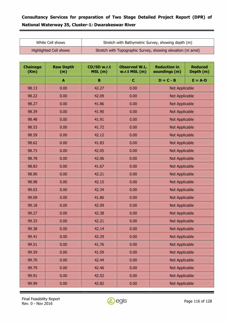
Consultancy Services for preparation of Two Stage Detailed Project Report (DPR) of
National Waterway 35, Cluster-1: Dwarakeswar River
Final Feasibility Report Rev. 0 - Nov 2016
Page 116 of 128
White Cell shows Stretch with Bathymetric Survey, showing depth (m)
Highlighted Cell shows Stretch with Topographic Survey, showing elevation (m amsl)
Chainage (Km)
Raw Depth (m)
CD/SD w.r.t MSL (m)
Observed W.L. w.r.t MSL (m)
Reduction in soundings (m)
Reduced Depth (m)
A B C D = C - B E = A-D
98.13 0.00 42.27 0.00 Not Applicable
98.22 0.00 42.09 0.00 Not Applicable
98.27 0.00 41.86 0.00 Not Applicable
98.39 0.00 41.90 0.00 Not Applicable
98.48 0.00 41.91 0.00 Not Applicable
98.53 0.00 41.72 0.00 Not Applicable
98.59 0.00 42.12 0.00 Not Applicable
98.62 0.00 41.83 0.00 Not Applicable
98.73 0.00 42.05 0.00 Not Applicable
98.78 0.00 42.06 0.00 Not Applicable
98.83 0.00 41.67 0.00 Not Applicable
98.90 0.00 42.21 0.00 Not Applicable
98.98 0.00 42.15 0.00 Not Applicable
99.03 0.00 42.34 0.00 Not Applicable
99.09 0.00 41.86 0.00 Not Applicable
99.18 0.00 42.09 0.00 Not Applicable
99.27 0.00 42.38 0.00 Not Applicable
99.33 0.00 42.21 0.00 Not Applicable
99.38 0.00 42.14 0.00 Not Applicable
99.41 0.00 42.29 0.00 Not Applicable
99.51 0.00 41.76 0.00 Not Applicable
99.59 0.00 41.59 0.00 Not Applicable
99.70 0.00 42.44 0.00 Not Applicable
99.79 0.00 42.46 0.00 Not Applicable
99.91 0.00 42.52 0.00 Not Applicable
99.99 0.00 42.82 0.00 Not Applicable

Consultancy Services for preparation of Two Stage Detailed Project Report (DPR) of
National Waterway 35, Cluster-1: Dwarakeswar River
Final Feasibility Report Rev. 0 - Nov 2016
Page 117 of 128
White Cell shows Stretch with Bathymetric Survey, showing depth (m)
Highlighted Cell shows Stretch with Topographic Survey, showing elevation (m amsl)
Chainage (Km)
Raw Depth (m)
CD/SD w.r.t MSL (m)
Observed W.L. w.r.t MSL (m)
Reduction in soundings (m)
Reduced Depth (m)
A B C D = C - B E = A-D
100.11 0.00 42.95 0.00 Not Applicable
100.18 0.00 42.92 0.00 Not Applicable
100.22 0.00 43.70 0.00 Not Applicable
100.27 0.00 43.25 0.00 Not Applicable
100.31 0.00 43.18 0.00 Not Applicable
100.43 0.00 42.20 0.00 Not Applicable
100.48 0.00 42.63 0.00 Not Applicable
100.52 0.00 42.95 0.00 Not Applicable
100.58 0.00 42.48 0.00 Not Applicable
100.63 0.00 43.24 0.00 Not Applicable
100.70 0.00 43.12 0.00 Not Applicable
100.79 0.00 42.60 0.00 Not Applicable
100.90 0.00 43.34 0.00 Not Applicable
100.99 0.00 43.25 0.00 Not Applicable
101.04 0.00 43.07 0.00 Not Applicable
101.12 0.00 43.23 0.00 Not Applicable
101.21 0.00 43.26 0.00 Not Applicable
101.31 0.00 43.71 0.00 Not Applicable
101.35 0.00 43.09 0.00 Not Applicable
101.45 0.00 43.82 0.00 Not Applicable
101.49 0.00 43.70 0.00 Not Applicable
101.61 0.00 44.20 0.00 Not Applicable
101.67 0.00 44.05 0.00 Not Applicable
101.74 0.00 44.14 0.00 Not Applicable
101.80 0.00 44.13 0.00 Not Applicable
101.90 0.00 44.18 0.00 Not Applicable

Consultancy Services for preparation of Two Stage Detailed Project Report (DPR) of
National Waterway 35, Cluster-1: Dwarakeswar River
Final Feasibility Report Rev. 0 - Nov 2016
Page 118 of 128
White Cell shows Stretch with Bathymetric Survey, showing depth (m)
Highlighted Cell shows Stretch with Topographic Survey, showing elevation (m amsl)
Chainage (Km)
Raw Depth (m)
CD/SD w.r.t MSL (m)
Observed W.L. w.r.t MSL (m)
Reduction in soundings (m)
Reduced Depth (m)
A B C D = C - B E = A-D
101.99 0.00 44.46 0.00 Not Applicable
102.12 0.00 44.20 0.00 Not Applicable
102.18 0.00 44.13 0.00 Not Applicable
102.22 0.00 44.31 0.00 Not Applicable
102.30 0.00 44.03 0.00 Not Applicable
102.33 0.00 44.16 0.00 Not Applicable
102.45 0.00 44.11 0.00 Not Applicable
102.50 0.00 44.16 0.00 Not Applicable
102.61 0.00 44.03 0.00 Not Applicable
102.70 0.00 43.70 0.00 Not Applicable
102.81 0.00 44.12 0.00 Not Applicable
102.87 0.00 44.31 0.00 Not Applicable
102.94 0.00 44.49 0.00 Not Applicable
103.02 0.00 44.75 0.00 Not Applicable
103.11 0.00 44.46 0.00 Not Applicable
103.22 0.00 44.72 0.00 Not Applicable
103.31 0.00 44.45 0.00 Not Applicable
103.37 0.00 44.75 0.00 Not Applicable
103.43 0.00 46.67 0.00 Not Applicable
103.49 0.00 45.73 0.00 Not Applicable
103.58 0.00 44.50 0.00 Not Applicable
103.64 0.00 44.53 0.00 Not Applicable
103.69 0.00 44.89 0.00 Not Applicable
103.73 0.00 44.76 0.00 Not Applicable
103.78 0.00 44.72 0.00 Not Applicable
103.81 0.00 44.90 0.00 Not Applicable

Consultancy Services for preparation of Two Stage Detailed Project Report (DPR) of
National Waterway 35, Cluster-1: Dwarakeswar River
Final Feasibility Report Rev. 0 - Nov 2016
Page 119 of 128
White Cell shows Stretch with Bathymetric Survey, showing depth (m)
Highlighted Cell shows Stretch with Topographic Survey, showing elevation (m amsl)
Chainage (Km)
Raw Depth (m)
CD/SD w.r.t MSL (m)
Observed W.L. w.r.t MSL (m)
Reduction in soundings (m)
Reduced Depth (m)
A B C D = C - B E = A-D
103.92 0.00 45.00 0.00 Not Applicable
103.98 0.00 44.77 0.00 Not Applicable
104.03 0.00 44.76 0.00 Not Applicable
104.10 0.00 44.83 0.00 Not Applicable
104.21 0.00 45.84 0.00 Not Applicable
104.30 0.00 46.45 0.00 Not Applicable
104.38 0.00 45.11 0.00 Not Applicable
104.49 0.00 45.41 0.00 Not Applicable
104.53 0.00 45.20 0.00 Not Applicable
104.59 0.00 45.01 0.00 Not Applicable
104.68 0.00 44.73 0.00 Not Applicable
104.73 0.00 45.35 0.00 Not Applicable
104.81 0.00 45.38 0.00 Not Applicable
104.92 0.00 46.36 0.00 Not Applicable
104.97 0.00 46.55 0.00 Not Applicable
105.02 0.00 45.86 0.00 Not Applicable
105.06 0.00 45.05 0.00 Not Applicable
105.14 0.00 45.76 0.00 Not Applicable
105.20 0.00 45.33 0.00 Not Applicable
105.29 0.00 44.87 0.00 Not Applicable
105.40 0.00 45.05 0.00 Not Applicable
105.43 0.00 45.27 0.00 Not Applicable
105.53 0.00 46.09 0.00 Not Applicable
105.57 0.00 46.20 0.00 Not Applicable
105.61 0.00 46.01 0.00 Not Applicable
105.69 0.00 45.51 0.00 Not Applicable

Consultancy Services for preparation of Two Stage Detailed Project Report (DPR) of
National Waterway 35, Cluster-1: Dwarakeswar River
Final Feasibility Report Rev. 0 - Nov 2016
Page 120 of 128
White Cell shows Stretch with Bathymetric Survey, showing depth (m)
Highlighted Cell shows Stretch with Topographic Survey, showing elevation (m amsl)
Chainage (Km)
Raw Depth (m)
CD/SD w.r.t MSL (m)
Observed W.L. w.r.t MSL (m)
Reduction in soundings (m)
Reduced Depth (m)
A B C D = C - B E = A-D
105.74 0.00 45.56 0.00 Not Applicable
105.77 0.00 46.25 0.00 Not Applicable
105.80 0.00 46.46 0.00 Not Applicable
105.91 0.00 46.69 0.00 Not Applicable
105.97 0.00 46.57 0.00 Not Applicable
106.00 0.00 47.10 0.00 Not Applicable
106.10 0.00 47.35 0.00 Not Applicable
106.18 0.00 45.43 0.00 Not Applicable
106.32 0.00 45.67 0.00 Not Applicable
106.40 0.00 46.27 0.00 Not Applicable
106.51 0.00 46.20 0.00 Not Applicable
106.60 0.00 46.32 0.00 Not Applicable
106.68 0.00 46.49 0.00 Not Applicable
106.72 0.00 46.52 0.00 Not Applicable
106.77 0.00 46.65 0.00 Not Applicable
106.84 0.00 46.19 0.00 Not Applicable
106.93 0.00 46.78 0.00 Not Applicable
106.99 0.00 46.81 0.00 Not Applicable
107.12 0.00 46.33 0.00 Not Applicable
107.21 0.00 45.39 0.00 Not Applicable
107.24 0.00 45.86 0.00 Not Applicable
107.29 0.00 46.48 0.00 Not Applicable
107.34 0.00 46.35 0.00 Not Applicable
107.40 0.00 46.23 0.00 Not Applicable
107.52 0.00 45.53 0.00 Not Applicable
107.59 0.00 46.32 0.00 Not Applicable

Consultancy Services for preparation of Two Stage Detailed Project Report (DPR) of
National Waterway 35, Cluster-1: Dwarakeswar River
Final Feasibility Report Rev. 0 - Nov 2016
Page 121 of 128
White Cell shows Stretch with Bathymetric Survey, showing depth (m)
Highlighted Cell shows Stretch with Topographic Survey, showing elevation (m amsl)
Chainage (Km)
Raw Depth (m)
CD/SD w.r.t MSL (m)
Observed W.L. w.r.t MSL (m)
Reduction in soundings (m)
Reduced Depth (m)
A B C D = C - B E = A-D
107.63 0.00 46.69 0.00 Not Applicable
107.69 0.00 46.19 0.00 Not Applicable
107.73 0.00 45.70 0.00 Not Applicable
107.78 0.00 46.92 0.00 Not Applicable
107.84 0.00 46.80 0.00 Not Applicable
107.90 0.00 46.67 0.00 Not Applicable
108.00 0.00 45.99 0.00 Not Applicable
108.05 0.00 46.17 0.00 Not Applicable
108.15 0.00 46.37 0.00 Not Applicable
108.19 0.00 46.70 0.00 Not Applicable
108.25 0.00 46.38 0.00 Not Applicable
108.29 0.00 46.44 0.00 Not Applicable
108.39 0.00 46.22 0.00 Not Applicable
108.39 0.00 46.20 0.00 Not Applicable
108.45 0.00 46.88 0.00 Not Applicable
108.52 0.00 46.73 0.00 Not Applicable
108.59 0.00 46.61 0.00 Not Applicable

Consultancy Services for preparation of Two Stage Detailed Project Report (DPR) of
National Waterway 35, Cluster-1: Dwarakeswar River
Final Feasibility Report Rev. 0 - Nov 2016
Page 122 of 128
Annexure 4: Photographs along Dwarakeswar Waterway

Consultancy Services for preparation of Two Stage Detailed Project Report (DPR) of
National Waterway 35, Cluster-1: Dwarakeswar River
Final Feasibility Report Rev. 0 - Nov 2016
Page 123 of 128
SAND CHECK DAM ALONG WATERWAY
SAND CHECK DAM ALONG WATERWAY

Consultancy Services for preparation of Two Stage Detailed Project Report (DPR) of
National Waterway 35, Cluster-1: Dwarakeswar River
Final Feasibility Report Rev. 0 - Nov 2016
Page 124 of 128
SAND CHECK DAM & SAND MINING ALONG WATERWAY
MAJOR ROADWAY BRIDGE CHAINAGE 41.9 KM

Consultancy Services for preparation of Two Stage Detailed Project Report (DPR) of
National Waterway 35, Cluster-1: Dwarakeswar River
Final Feasibility Report Rev. 0 - Nov 2016
Page 125 of 128
HIGH TENSION LINE CHAINAGE 84.1 KM

Consultancy Services for preparation of Two Stage Detailed Project Report (DPR) of
National Waterway 35, Cluster-1: Dwarakeswar River
Final Feasibility Report Rev. 0 - Nov 2016
Page 126 of 128
FULLY DRY PATCH CHAINAGE 22.0 KM
WOODEN BRIDGE CHAINAGE 84.3 KM

Consultancy Services for preparation of Two Stage Detailed Project Report (DPR) of
National Waterway 35, Cluster-1: Dwarakeswar River
Final Feasibility Report Rev. 0 - Nov 2016
Page 127 of 128
DRY PATCH CHAINAGE 89.0 KM BAMBOO BRIDGE CHAINAGE 93.8 KM
WATER COLUMN DUE TO SAND MINING CHAINAGE 35.0 KM
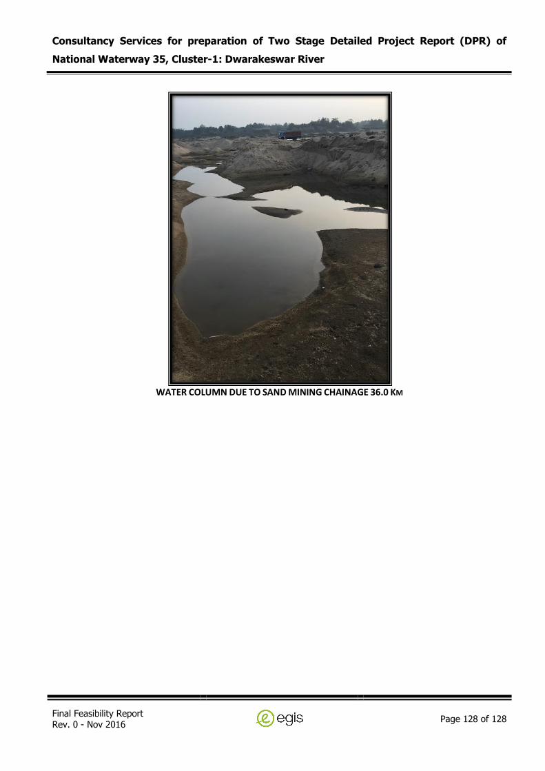
Consultancy Services for preparation of Two Stage Detailed Project Report (DPR) of
National Waterway 35, Cluster-1: Dwarakeswar River
Final Feasibility Report Rev. 0 - Nov 2016
Page 128 of 128
WATER COLUMN DUE TO SAND MINING CHAINAGE 36.0 KM