DSDP Technical Report 10 - Deep Sea Drilling Project
318
DEEP SEA DRILLING PROJECT TECHNICAL REPORT NO. 10 OPERATIONS RESUMES - PART V PRIME CONTRACTOR THE REGENTS UNIVERSITY OF CALIFORNIA SCRIPPS INSTITUTION OF OCEANOGRAPHY University of California, San Diego
-
Upload
khangminh22 -
Category
Documents
-
view
1 -
download
0
Transcript of DSDP Technical Report 10 - Deep Sea Drilling Project

DEEP SEA DRILLING PROJECTTECHNICAL REPORT NO. 10
OPERATIONS RESUMES - PART V
PRIME CONTRACTOR
THE REGENTSUNIVERSITY OF CALIFORNIA
SCRIPPS INSTITUTION OF OCEANOGRAPHY
University of California, San Diego

OPERATIONS RESUMES
LEG 45 through LEG 54
Prepared For
NATIONAL SCIENCE FOUNDATION
Under Provisions of Contract NSF C-482
By
DEEP SEA DRILLING PROJECT
Scripps Institution of Oceanography
University of California at San Diego
August 1977
M. N. A. PetersonPrincipal InvestigatorProject ManagerDeep Sea Drilling ProjectScripps Institution of Oceanography
F. C. MacTernanPrincipal EngineerDeputy Project ManagerDeep Sea Drilling ProjectScripps Institution of Oceanography

INTRODUCTION
IPOD/DSDP Technical Report Number 10 is the fifth edition of OperationsResumes published since Leg 1 started in the Gulf of Mexico on August 11,1968.
This Report tells about operational and engineering procedures used aboardD/V Glomar Challenger from Leg 45 through Leg 54.
The same successful and widely-read format established for the first fourDSDP Technical Reports citing Operations Resumes was followed in TechnicalReport Number 10.
This Technical Report, the first covering some of the International Phaseof Ocean Drilling (IPOD) cruises, gives performance achievements, drillingand coring results, drill bit performance and improvements, coring equipmentmodifications, tests of new procedures and equipment, improvement of coringprocedures, plus problems encountered and anticipated and the steps taken orproposed to eliminate the trouble.
li

ACKNOWLEDGEMENTS
Achievements by the technical staff of the International Phase of OceanDrilling of the Deep Sea Drilling Project, have, to a great extent, beenresponsible for the success and the resulting contribution to the basicearth research credited to the Deep Sea Drilling Project.
To. V. Larson, Head of Operations, and S. Serocki, Head of Engineering,and their respective staffs, i.e., B. Robson, G. Foss, R. Knapp, P. Thompson,M. Storms, B. Adams, R. Keefe and Patricia Duley, the Project gratefullyacknowledges your dediciation, talents and expertise.
Logistics, headed by R. Olivas and his entire staff also have contributedmightily to IPOD/DSDP's success with top-flight support provided forOperations, Engineering and Scientific functions.
IPOD/DSDP extends its most sincere thanks to persons named for their out-standing talent and dedication which are prime requisites for any successfulscientific venture.
F. C. MacTERNANPrincipal EngineerDeputy Project ManagerIPOD/DSDP/SIO
M. N. A. PETERSONPrincipal InvestigatorProject ManagerIPOD/DSDP/SIO
111

OPERATIONS RESUMES
Contents
Leg 45 - San Juan, Puerto Rico to San Juan, Puerto RicoNovember 30, 1975 to January 20, 1976
Dr. William G. Melson, National Museum of Natural History,Smithsonian Institution
Dr. Philip D. Rabinowitz, Lamont-Doherty Geological Observatoryof Columbia University
Cruise Operations Manager:Mr. Valdemar F. Larson, Deep Sea Drilling Project
Leg 46 - San Juan, Puerto Rico to Las Palmas, Canary IslandsJanuary 28, 1976 to March 10, 1976
Dr. Leonid Dmitriev, Academy of Sciences of the USSRDr. James Heirtzler, Woods Hole Oceanographic Institution
Cruise Operations Manager:Mr. Robert R. Knapp, Deep Sea Drilling Project
Leg 47 - Las Palmas, Canary Islands to Brest, FranceMarch 20, 1976 to May 12, 1976
Dr. William Ryan, Lamont-Doherty Geological ObservatoryDr. Ulrich von Rad, Bundesanstalt fur Geowissenschaften
und RohstoffeCruise Operations Manager:
Glen N. Foss', Deep Sea Drilling Project
Leg 48 - Brest France to Aberdeen, ScotlandMay 22, 1976 to July 13, 1976
Dr. Lucien Montadert, Institut Francais de PetroleMr. David G. Roberts
Cruise Operations Manager:Mr. Robert R. Knapp, Deep Sea Drilling Project
Leg 49 - Aberdeen, Scotland to Funchal, Madeira IslandsJuly 18, 1976 to September 4, 1976
Dr. J. R. Cann, University of East AngliaDr. Bruce Luyendyk, University of California, Santa Barbara
Cruise Operations Manager:Mr. Donald N. Collins, Husky Oil Company
IV

Leg 50 - Funchal, Madeira Islands to Funchal, Madeira IslandsSeptember 12, 1976 to November 10, 1976
Dr. Yves Lancelot, University Parix VIDr. E. L. Winterer, Scripps Institution of Oceanography
Cruise Operations Manager:Mr. Glen N. Foss
Leg 51 - Funchal, Madeira Islands to San Juan, Puerto RicoNovember 11, 1976 to January 18, 1977
Dr. Thomas W. Donnelly, State University of New YorkDr. Jean Francheteau, Centre Oceanologique de Bretagne
Cruise Operations Manager:Mr. Robert R. Knapp
Leg 52 - San Juan, Puerto Rico to San Juan, Puerto RicoJanuary 22, 1977 to March 9- 1977
Dr. Wilfred B. Bryan, Woods Hole Oceanographic InstitutionDr. Paul T. Robinson, University of California, Riverside
Cruise Operations Manager:Mr. Robert R. Knapp
Leg 53 - San Juan, Puerto Rico to Cristobal, Canal ZoneMarch 13, 1977 to April 25, 1977
Dr. Martin F. J. Flower, Imperial CollegeDr. Hubert Staudigel, Massachusetts Institute of Technology
Cruise Operations Manager:Mr. Glen N. Foss
Leg 54 - Cristobal, Canal Zone to Los Angeles, CaliforniaApril 30, 1977 to June 18, 1977
Dr. Rogert Hekinian, Cen tre Oceanologique de BretagneDr. Bruce R. Rosendahl, Duke University
Cruise Operations Manager:Mr. Robert R. Knapp

INTERNATIONAL PHASE OF OCEAN DRILLINGDEEP SEA DRILLING PROJECT
OPERATIONS RESUMELEG 45
GENERAL
Leg 45 was the first part of a two leg attempt at Deep Crustal Drilling, the first such effortduring the International Phase of Ocean Drilling of the Deep Sea Drilling Project. Thevoyage began Thanksgiving Day, November 27, 1975 when the ship arrived at San Juan,Puerto Rico and ended 54 days later on January 20, 1976 when the ship returned to SanJuan. A site slightly west of the mid-Atlantic Ridge was selected for the first Deep CrustalDrilling attempt and was occupied for 35-1/2 days. A penetration of 664.09 meters belowthe ocean floor was achieved before unstable hole conditions caused the site to be abandoned.
At this site, a modified re-entry system was used which, for the first time, allowed steelcasing to be cemented through the upper soft sediments. Seven core bits were dulled andnine re-entries were made in a water depth of 4485 meters. As recovery in the upper basaltsections was poor, the hole; was left open for possible evaluation during Leg 46 with down-hole logging instruments.
When unstable hole conditions forced an early termination of the attempted deep crustalpenetration, a site for a second attempt was then selected slightly east of the mid-AtlanticRidge. To establish its suitability for deep crustal dril l ing, a single bit pilot hole was drilled.Then the vessel returned to San Juan for resupply, crew change and repairs.
The Deep Sea Drilling Project is managed by Scripps Institution of Oceanography (SIO)under a contract with the National Science Foundation (NSF). Scientific planning is coor-dinated by SIO through the Joint Oceanographic Institutions For Deep Earth Sampling(JOIDES) organization.
Funds are provided by the American, English, French, German, Japanese and Soviet gov-ernments. Coring operations are conducted by Global Marine, Inc. (GMI) under a sub-contract with SIO.
PORT CALL - SAN JUAN, PUERTO RICO
The GLOMAR CHALLENGER arrived in San Juan, Puerto Rico at 1610 hours on Thanks-giving Day, November 27, 1975. This marked the end of a three-week Engineering Leg

where various new systems which were installed and repairs which were made at a majordry docking at Norfolk, Virginia were tested and evaluated. Only minor faults had beenfound. On Friday afternoon a critique of the Engineering Leg, chaired by the DeputyProject Manager, was held aboard the ship. Particular emphasis was placed on the varioussub-systems which would be needed during Leg 45 if the planned Deep Crustal Drilling wasto be accomplished. ~
The automatic latching mechanisms of both the 11-3/4" and 16" casing hangers, which area part of the newly designed re-entry hardware, had been found to have only a marginalamount of over-travel to insure engagement. All six hangers aboard were taken to a localmachine shop where additional over-travel was provided. When the hangers were returnedthey were assembled to verify that proper engagement was achieved. In addition, a cen-tering device (marcel ring) for the snap ring of the automatic hangers was given a test.It performed satisfactorily and the ring was guided into the throat of the re-entry conewithout difficulty.
Following the crew change on Saturday, the proper engagement of the latching mechanismswere again verified,which provided training for the new crews. Then a re-entry cone wasassembled and stowed on the starboard casing rack. Excessive coatings on the throatof the re-entry cones was reported to have created latching problems. Therefore, twoof the lower re-entry cone sections were sent to a local shipyard where the internal borewas sandblasted clean.
Only a minor amount of supplies were loaded, mainly those of an emergency nature whichhad been air freighted from the U.S. Fresh water was taken.
WEATHER
Both sites investigated were located in the area of prevailing northeast to east trade winds.Climatological averages for the area during December-January showed predominant north-east to east wind and waves. Some northerly swells due to the passage of storms over thenorthern North Atlantic Ocean were anticipated, their severity was not.
While at Site 395, two low pressure systems which formed further south than normal pro-duced northerly swells with a significant height of 15-20 feet. Fortunately the normalnortheast-east trade winds did not accompany these swells and stationkeeping was notadversely affected. At times, however, it was necessary to operate with three motorsassigned to propulsion to stem accompanying winds which exceeded 33 knots at times.
Of greater impact on operations was the continual presence of a confused sea with asmany as three swells from various directions. At times even the optimum heading produceda vessel roll of five degrees. At times the roll was accompanied by an equal amount ofpitch. These factors combined to adversely affect tripping operations. On two occasions,one of the two connecting links between the travelling block and the elevators becamedisengaged while making up a stand of drill pipe. On one occasion it went unnoticedand subsequently when a strain was taken on the drill string, the drill pipe parted due tothe eccentric loading placed on i t . Fortunately no one was injured. The safety dogs onthe dual elevators were found to be worn and were built up by welding. On another oc-casion, the elevators became unlatched.
-2 -

Another factor affecting operations was the long period of the northerly swells which gaverise to more vessel heave than normal. Shortened bit life was attributed to this heaveand caused three five-foot bumper subs to be employed in the bottomhole assembly fordril l ing. The heave compensator proved to be effective in minimizing the effect fromthese long period swells.
Only once were operations suspended because of weather. This was while running 11-3/4"casing. However, at times it appeared that operations were being conducted near thevesseMs maximum capabilities. The loss of a scanning sonar tool when the line pulledout of the rope socket can probably be traced to the excessive surge on the drill string atthat particular time.
As most of the planned work during I POD is in the northern hemisphere, it can be expectedthat weather will continue to play an important role in the success or failure of futurevoyages. Forecasting facilities were good and in all cases at least 12 to 24 hours accurateadvance warning of wind and waves conditions were provided by the weatherman. Theuse of real time satellite coverage enabled him to enhance the unusually good radiofacsimile weather maps from the U.S. This should probably continue throughout the nextyear as operations are continued in the North Atlantic.
UNDERWAY - SAN JUAN TO SITE 395 - SITE 396 TO SAN JUAN
The first site to be investigated had been designated No. 5 on the Prospectus and waslocated 1158 nautical miles east of San Juan. Due to the prevailing northeast-east tradewinds, average speed enmute was a slow 8.37 knots. During this trip from San Juan, con-siderable maintenance work was accomplished which helped prepare for the upcoming deepcrustal dril l ing.
The return from the operating area (the two sites were approximately 131 nautical milesapart) was helped by the prevailing trade winds. The average speed during the return toSan Juan exceeded 10 knots. Towed surveys were taken at full speed while underway.Both magnetometer and air gun subbottom profilers were operated. The recorder for thesubbottom profiler was modified to allow simultaneous recording of both the subbottomprofile and the magnetometer readings on the same paper. This should allow more rapidand better use of the magnetometer readings.
OBJECTIVES/STRATEGY
The prime objective of Legs 45 and 46 was a single deep penetration near the crest of mid-Atlantic Ridge to develop an understanding of the origin, structure, and composition ofthe oceanic crust. Two primary sites had been selected from extensive surveying of anarea near 23 degrees north latitude. One site was located just west of the ridge near46 degrees west longitude; the other, just east of it at 43 degrees west longitude. Bothhad overlying sediment ponds exceeding 100 meters in thickness to provide needed lateralsupport to the drilling cssembly while spudding in. Alternate sites had been surveyed forcontingency purposes.
- 3 -

Previous deep crustαl drilling attempts on Leg 34 and 37 had demonstrated that it is notalways possible to penetrate the crust in regions of thin sediment cover as found near theridge crest due to rock fractures and/or other unstable conditions. Therefore, the strategyfor Leg 45 called for the drilling of a single bit "pilot" hole when first occupying a siteto establish if the upper crust was stable and offered a reasonable opportunity for deeperdril l ing. The "pilot" hole was to be further used to establish the proper depth for washing-in of the re-entry cone/conductor casing assembly and the selection of a proper settingdepth for 11-3/4" casing. This latter casing was to be cemented through the overlyingsoft sediment layers that normally wash out and prevent effective cuttings removal whiledrilling underlying hard rocks.
SITE 3 9 5 - T H E PILOT HOLE
The Leg 45/46 Prospectus called for the investigation of a site (No. 6) east of the mid-Atlantic Ridge first. However, as the westerly site (No. 5) wasenroute, the scientificparty requested that a single bit pilot hole be drilled there before proceeding further east.
This was accomplished in a routine manner. A site with approximately 100 meters of softsediment cover was located with the subbottom profiler and a beacon was launched whileunderway. Water depth, as measured by the Precision Depth Recorder (PDR), was 4494meters. As has been the practice on the GLOMAR CHALLENGER for several years, thedrill string was not measured; only average lengths from previous measurements were used.Later this proved to be a tactical error. A pinger fitted at the core bit was used to establishthe sea floor at 4527 meters. The hole was then continuously cored to a total penetrationof 184.65 meters below the sea floor, with basalt being encountered at a sjubbottom depthof 93 meters. No hole problems were encountered. Indications from the pilot hole werethat operationally the site offered a good opportunity for a deep penetration. With thisinformation and a review of the cores recovered in the pilot hole with scientific objectives,the scientific party requested that an attempt at deep crustal penetration be made at Site395 (Prospectus No. 5).
The drill string was pulled above the mud line and then jetted into 82 meters subbottomwithout rotation. Based on this, a casing point 62 meters subbottom was selected basedon the jetability and skin friction bearing capacity of the nannoforam ooze which madeup the sediment cover.
HOLE 395A - DEEP CRUSTAL PENETRATION AND RE-ENTRY
The re-entry cone was keelhauled without incident. The basic design shown in FigureNo. 1 was used. A mud skirt extension was not required. The cone was fitted with thestandard three steel passive reflectors. In addition, between the steel reflectors,spherical, hollow 10" glass balls were fitted on five foot tethers in case the cone shouldsettle.
The five joints of 16" casing were run and hung off on top of the lower guide horn assembly
- 4 -

in the moon pool. The buttress threads on the casing made up surprisingly well . Al lmill joints had been previously tack-welded and the joints made up on the rig floor werelocked with epo×y. A bottomhole assembly (BHA) was then run with a lowering tool fittedso that the bit was located approximately six inches inside the 16" shoe. The loweringtool was attached to the casing while hanging in the moon pool with only minor difficulty.The casing was then latched into the re-entry cone and run to bottom. Lowering of there-entry cone was watched on the PDR. Adjustment of gains allowed an accurate depthreading until the cone was within 45 meters of bottom. Af this time, it was discoveredthat following the drilling of the pilot hole, the drill string had been rearranged on thepipe racker. The pipe actually being used to lower the re-entry cone was of a differentlength and not measured. As an accurate relationship of the ocean floor to drill stringmeasurements is needed to properly wash-in and set the re-entry cone, cores were takento provide the needed relationship. This was accomplished without incident and is rec-ommended for future work.
The drill pipe ocean floor depth as established by cores and average lengths of drill pipewas 4485 meters, a major difference of 42 meters from that found on the pilot hole. Sub-sequent measuring of the drill string indicated that the actual depth should have been4493 meters which compared favorably with the 4494 meters shown by the PDR. Noattempt was made to change previously reported measurements. The same drill pipe wasused each^time a re-entry attempt was made while working on the site.
The casing was jetted into 4547 meters which placed the re-entry cone base at 4485 meters.The washing-in operations was slower than anticipated and an inner barrel was dropped toprovide additional jetting*action. Approximately two hours were required to jet-in thecasing. A Rotary shifting tool was run while washing in the last joint and release of thecasing/re-entry cone from the drill string was made without incident. Later when the11-3/4" casing was run, the cone was found to have settled an additional three meterswhich placed the mud skirt at the mud line.
When release was accomplished, a 14-7/8" hole was washed down to 4572 meters and thehole was then continuously cored to 4600 meters to fit the 11-3/4" casing. Coring from4572-4600 meters was done with a minimum of circulation to avoid the hydraulic openingeffect on the bumper subs as the bottomhole assembly was not completely buried. Whileretrieving the last core from 4600 meters, the bit plugged and the drill string becamestuck. It was eventually worked free after five hours by allowing the ship's heave to knockdown on the bumper subs.
It was then necessary to pull out to unplug the bottomhole assembly. Cuttings were foundlodged as high as 90 meters above the bit. The same drill string was rerun, the hole re-entered, and cleaned out without incident. The plugging/sticking is attributed to thelow circulation rates being used and the small annular area provided by the 16" casinglowering tool.
One hundred nine meters of 11-3/4" pipe had been planned which would bring the casingto within six meters of bottom,, The casing was made up with a stab-in shoe on bottom
- 5 -

and, as with rfe 16" casing, the buttress threads made up well . The casing was hung offon top of the ban assembly in the moon pool. The running tool was made up with somedifficulty due i-roiling of the vessel.
A delay in re-efering the hole with casing was caused by high swells. After securingthe drill string:od waiting on weather five hours, the drill string with casing attachedwas again run ad the casing stabbed in the hole and hung at 4597 meters. An upwardsstrain was taker to verify latching and the cone was found to have settled three metersto 4588 meters
Release from të* casing was made by applying 5,000 ft-lbs of torque and slowly allowingthe lowering n t to unscrew. When free of the casing, the casing was cemented throughthe drill pipe ad displaced with a latch down cementing plug. The plug failed to bump.Subsequent tesrof displacement showed, that when using the measuring tanks aboard theship, that an σiount of fluid at least 10% over theoretical is needed to f i l l the drill pipe.
After the casiaçwas in place and cemented, the drill string was removed and a coringassembly made;p. On the first*re-entry attempt, the lower seven drill collars were lostwhen a bumpersβb service connection failed. The drill string apparently hit the rim ofthe re-entry coe while stabbing. No damage to the cone was observed.
Penetration rate in the basalt were higher than that usually found in the deep ocean,however, bit Ka was far shorter than anticipated. An improvement of over 30% in bitlife was noted:c*er the heave compensator was placed in service.
Re-entries (maβüvering the ship and stabbing the pipe) were different from those on pre-vious voyages ethe drill string was moving more rapidly. This required that the drill stringbe closer to tbecone while scanning and that the decision for stabbing be made while thedrill string wasiri motion. As experience was gained, the operation became fairly routine(see Figure 2)*
Near the end obit run No. 6, considerable torque was encountered beginning at a depthof 5095 meters. On the following bit, this same interval near 5095 meters continued togive problems. The interval (5095-5103 or bottom) was reamed and normal coring operationswere resumed. However whenever cftfeüiatiofi was lowered^afid/or sk>pöë^ as requited0'for retrieving cces, the core bit would plug and the drill string would become stuck.Rotation woulcbsually stop whenever circulation was first established which suggestedthat cuttings wee packing off against the drill collars and it appeared that the cuttingswere not beingemoved from the hole. To overcome the situation; various methods weretried. Increta<ksea water circulation rates and increased frequency and volume of mudslugs were used. None seemed to correct the problem. Finally, it was necessary to spotmud on botfcmtzari pol118 meters off bottom to retrieve cores. Even then there was oftentemporary sticfcig of the drill string.
The core recovεy in this interval beginning at 5095 meters to be eventual total depth at5149 meters we good, exceeding 45%. The upper part of the interval was a weathered

dolerite and/or doleritic basalt with occasional slickensides, indicating minor faulting.The lower cores were badly brecciated and when cut for sampling would fracture easily.An extremely soft material was cementing the existing fractures.
After reaching a depth of 5149 meters and after the drill string again became stuck, anattempt was made to use cement to stabilize the dolerite section. Approximately twentybarrels of cement slurry were equalized at 5120 meters and a trip was made to change dullbits. Even while pulling out of the cement, the drill string tried to stick and it was nec-essary to rotate to pull up.
Thirty six hours after the cement was in place, the location of the cement top was feltfor. The first hard resistance was encountered at 5093 meters and one and one half hourswere required to drill from there to 5101 meters. The hole was then cleaned out to 5134with no noticeable improvement in hole stability.
The drill string was then pulled above the unstable section and the inner barrel retrieved.No cement was found? In its place were cuttings followed by walnut sized dolerite pebblesand a core sized piece of dolerite in the catcher. Further attempts at stabilizing the holewith cement were considered to have a low probability of success and a sizeable risk factorto the equipment and hole. The hole was left open for possible evaluation by downholelogging instruments during Leg 46.
Before leaving the site an attempt was made to measure the sonic velocity of the coredinterval by running a hydrophone on the Schlumberger line through the bit at 5088 metersand measuring the transit time of air gun signals from the ship. Apparently these signalswere not strong enough to be heard, although signals had been received earlier when thehydrophone was suspended through the bit slightly above the mud line.
Unfortunately a stop ring, which had been placed on the hydrophone with set screws toprevent it from fully entering the hole, failed to hold. The tool apparently became bentand could not be retrieved. Pump circulation was shut off and after working the wirelineapproximately thirty minutes, the line parted at the float valve immediately above thebit. It appears that the line parted 'mmediately above the cable head.
SITE 396 - A SECOND PILOT HOLE
After unstable hole conditions were encountered at Site 395, the vessel moved to pro-spectus No. 6 to drill a pilot hole for a possible deep crustal penetration east of the mid-Atlantic Ridge,
Again, a site was selected which had over 100 meters of soft sediment cover to providelateral support to the bottomhole assembly. The water depth was 4460 meters both by PDRand drill pipe measurements (the drill string was measured using a steel tape on eachsection of pipe). Basalt was encountered at 4581 meters after a subbottom penetration of121 meters. No hole problems were encountered while coring to the total depth of 4681
- 7 -
meters; however, the penetration rates and muddy water associated with the cores re-covered suggest that sediments were encountered from 4630 to 4648 meters. No sedimentcores were recovered from this interval, however, small samples were obtained for datingpurposes and micro fossils were older.
Utilization of this site for deep crustal penetration will require a significant penetrationof fairly dense basalt with a 15" core bit. Otherwise, the site appears suitable from anoperational standpoint.
While pulling out, the bottom sediments were tested for proper re-entry cone/conductorcasing setting depths. The sediments appeared to be quite similar to those at Site 395and the same depths used there would be recommended at this site.
As sufficient 16" casing was not aboard to set a re-entry cone for Leg 46, the voyage wasdirected to return to San Juan for extensive repairs to equipment. This decision provedto be correct as a stern thruster motor bearing failed shortly after clearing the mud line.(Weather conditions in the area required that all four thrusters be used to avoid excessiveroll)
DRILLING AND CORING
Penetration rates in the basalts were high and on occasion exceeded 10 m/hr. Recoverywas low. An increase in recovery was noted whenever penetration rates became slower.With present core bit designs, it is doubtful that increased recovery wil l occur in theupper, apparently glassy sections.
At Site 395, an increased penetration rate was observed on the second hole while coringthe upper basalt section (See Figure 3). This can probably be attributed to an increasedcirculation rate which was used on the second hole and the inner barrel seal which appearsto be effective in improving bottomhole hydraulics. However, near the bottom of Hole395A, when cuttings were not being removed and the bit was becoming routinely plugged,the seal acted to restrict circulation rates when the jets became plugged.
The weather conditions during the voyage provided considerable vessel heave. It becamedifficult to keep the two upper bumper subs in neutral while drilling and it became nec-essary to operate with three upper subs (15 foot total stroke). A modified bottomhole as-sembly which consists of a core barrel, one stand of 8-1/4" drill collars, bumper sub, onestand of 8-1/4" drill collars, three bumper subs, one stand of 8-1/4" and 7-1/4" drillcollars was used during most of the voyage.
As previous attempts at deep crustal drilling had usually resulted in stuck drill pipe, tworotary drilling torque jars were made available to run when conditions warranted. Thesejars were run early at Site 395 and no problems developed. Later when trying to deter-mine why such extreme short bit i ‰ were beitvgexperienced, it appeared1 that the torquejars were hitting down on the large swells and were contributing to the shortened bit l i fe.
- 8 -
The use of mud slugs to assist in the removal of cuttings and the spotting of mud to suspendcuttings during trips has been an established practice. As bentonite is used to mix suchmud, an adequate supply of fresh water is needed. At Site 395, when unstable hole con-ditions were encountered, the supply of fresh water was nearly exhausted and the evap-orators had difficulty in adding to the supply. To conserve fresh water, the use of freshwater mud mixed with equal parts of sea water and thickened with cement was tried withencouraging results. While the resultant mud will not thicken as it is pumped down thehole and mixes with sea water (as is the case with fresh water mud), the sea water mudappeared effective in suspending cuttings on trips and connections.
CORE BITS
Due to the high penetration rctes enjoyed only the extended chisel shaped insert rollercore bits were used (Type F94CK). On Hole 395, a single bit penetration, the corebit was totally destroyed after 24.8 hours (all cones and journals were gone). On Hole396, another single bit penetration, the core bit was totally destroyed after 24.2 hours(even the shanks were gone).
On Hole 395A, six Type F94CK 10 inch core bits were used to penetrate below the11-3/4" casing. Three of the bits were used with bumper subs to control the weight onthe bit; three^were used with the heave compensator. It is conservatively estimated thatbit life was extended thirty percent when the compensator was in use.
All core bits showed some flaring of the core guide which would then impinge on thecutters. Some additional Strengthening is needed along with hard metal to control corediameters allowed to enter the inner barrel. There were occasional outsize cores observedwhich harf* jammed the inner barrel.
Two methods were used to judge whether the core bit had become dul l . One was thegauging of cores as described by Mr. Edmiston in summarizing Leg 37 operations. Theother was close observation of torque readings recorded on the drilling recorder. Bothproved effective at times. Both proved misleading at times. On Site 396, full sizedcores were obtained until the last. When the bit was pulled, it was found completelydestroyed. On Hole 395A, bit No. 7 was pulled when excessive torque was observed.The bearing seals were still effective. The troublesome unstable dolerite section had beenpenetrated and provided torque readings similar to those of a dull bit.
STATIONKEEP1NG (DYNAMIC POSITIONING)
Overall the performance was adequate. No major excursions or major lost time can beattributed to the system, however, the system did not perform up to expectations whilemaneuvering the ship in automatic for re-entry. The display on the bridge control con-sole continued to move in apparent response to vessel roll and pitch making it difficultto judge the vessel actual position (motion was approximately ten feet for each degreeof roll and/or pitch). The use of tighter gains during these maneuvers was not possibleas it would over drive the thrusters and main propulsion. The result, when tried, was a
- 9 -

constant reversal from port to starboard; from ahead to astern. Troubleshooting to findthe cause of this fault was unsuccessful.
A total of eight beacons were launched. One, a quad life or 24 day beacon, failedabruptly after reaching the ocean floor. A double life (12 day) beacon was launched atSite No. 396 when leaving and a double life beacon was launched at Site No. 395 whileenroute to San Juan. These beacons were set to facilitate navigation during Leg 46 whilerelocating the sites.
Noise was noted early during the voyage in the No. 2 stern thruster motor bearing. Itprogressively got worse and failed on the last day at Site No. 396. This bearing andthree others were replaced at San Juan.
On several occasions while readying the beacons for service, a plastic screw used tohold a magnet in place broke. This often left the beacon on with no way to shut it offuntil the defective part was drilled out. The vendor should be notified that this typeplug is unacceptable for use on the GLOMAR CHALLENGER.
RE-ENTRY EQUIPMENT
RE-ENTRY CONES, CASING HANGERS AND RUNNING TOOLS
The re-entry cone running procedures that have been developed in the past workedsmoothly. The new configuration handled as well as if not better than the previous de-signs. Latching of the 16" casing to the re-entry cone was accomplished without mishap.A "marcel" ring was installed behind the snap ring in the automatic hanger assembly andapparently took care of the misalignment reported during the Engineering Voyage.
Releasing of the 16" casing once jetted-in was accomplished with the Rotary shifting toolas designed. When recovered, the casing lowering/releasing tool which is run as partof the bottomhole assembly was found to have lost one of the six stop bolt sleeves. Asthis has been a continuing problem, a modification of the securing mechanism should beundertaken. The 16" lowering tool which in the new design acts as a stabilizing sleeveand carrier for the locking paddles, has only minimal flow by area for cuttings once thecasing is released. A modified design is needed to improve cuttings removal after releaseand to retain a leaky pack-off for jetting purposes.
The 11-3/4" casing lowering tool (hex Kelly and nut with left hand safety joint threads)worked as designed. It would be helpful to include a swivel joint below this hanger sothat the entire stinger assembly and stab-in sub need not be rotated during make up ofthe left hand lowering thread.
Engagement of the 11-3/4" hanger to the 16" casing hanger was accomplished the firsttime the casing was seated. An upstrain of over 50,000 pounds verified proper engagementand provided a good reference point for the actual final location of the 11-3/4" casing.The re-entry cone had apparently settled three meters from time of initial release.
-10-

CEMENTING
The use of α stαb-in casing shoe was successful in allowing re-entry operations to be per-formed successfully. Unfortunately the latch down plug to hold the cement in place didnot bump after displacing the drill string with a theorectical volume of sea water plus fivepercent. Subsequently, a displacement plug was used to determine actual drill pipe dis-placement as referenced to the measuring tanks on the cementing unit. This work indicatedthat it will be necessary to overdisplace approximately ten percent on future jobs.
The cementing unit which had been recently modified to include a jet mixer performed asdesigned, however, additional crew experience will be required before consistent slurryweights can be achieved. It is recommended that selected personnel be given instructionand/or experience on land operations with similar equipment.
For plugging operations, the slurry was batch mixed successfully and it is recommended forfuture use in this type of operation until crew proficiency in controlling slurry density withthe jet hopper is demonstrated.
SCANNING SONAR
The recently overhauled wireline winch (Schlumberger Mohole Unit) performed well. Thescanning sonar tool was routinely run to 4479 meters in approximately two and one halfhours and retrieved in one and one half hours. Faster speeds are possible, however thepotential of overrunning and causing damage to the line maintained this slower pace. Itwas also found necessary to circulate sea water at all times while lowering the tool toprevent the tool from "floating" and again overrunning the line.
The scanning sonar tool performed reliably with almost no problems experienced with theelectronics sections. Many problems were, however, experienced with the cable headsand in particular, the short "pig tai l" section which crossed over from the inch and onehalf Gearhardt-Owens (GO) cable head, which is fitted on the main cable, to the 3-1/2"Schlumberger CIS cable head, that is on the scanning sonar tool. This "pig tai l" sectionwas removed on one unit by modifying the Schlumberger head to accept the lower GOConnector directly. This enhanced the reliability of the system a great deal.
Some problems were experienced with poor and/or slow rotation of the scanner. This wasapparently caused by the circulation of fluid while scanning. While stopping circulationwould help, this was not feasible when close to the cone due to the quickness with whichthe re-entry had to be made. The problem was solved by proper spacing which in con-junction with the bit seal forced the fluid away from the transducer. When running casingthe pump could be shut down as no float valve was in the string to catch the transducer.
Two transducers were lost. One, lost when the first 10" bit was being stabbed, would havebeen prevented by a closer tool spacing which would have prevented the transducer fromhitting the cone. The second was. lost when the cable pulled out of a cable head whileretrieving the sonar tool. This caused the tool to fall against a closed float valve. Thiscaused the transducer to be lost, the drive shaft to be broken, and the motor housing to be
- 1 1 -

flooded. The failure was probably caused by heavy weather and resultant surges insidethe drill pipe which acted against the tool.
Re-entries were made by using both 8° and 45° transducers. The addition of a downholevideo gain control during the Engineering Voyage allowed the dampening out of the "mudring" which normally confused a 45° transducer presentation and allowed sharper imagesof the reflectors to be presented.
The glass balls which had been fitted on the rim of the cone between the passive steelreflectors gave the cone a distinctive signature when compared to previous re-entries.The return signal was not too strong from the balls and they could be easily removed bygain adjustment. The use of tethered reflectors appears to have merit where there is con-cern regarding possible settling of the re-entry cone.
Due to the weather experienced and/or water depth at Site 395, considerably more drillstring motion was observed than on previous re-entry work during Leg 37. The drill stringdid not come to rest over the re-entry cone as in the past and it was necessary to makere-entries while the drill string first began its move over the cone. It was found to behelpful to scan and make re-entries from approximately four meters above the cone. Thiswas considerably closer than on previous voyages.
As in the past, the ability to determine whether a valid re-entry had been made was aconcern as five to six additional hours are required to trip the scanning sonar tool if afalse re-entry has been made. At Site 395, both the 14-7/8" bit and 11-3/4" casingtook noticeable weight during the lowering of the first 30 meters after successful re-entries,In retrospect several stabs judged unsuccessful at the time, may have been successful.Four of thirteen attempts were judged unsuccessful with one resulting in the loss of abottomhole assembly when the drill string apparently hit the rim of the cone. Nine suc-cessful re-entries were made which included all seven of the last seven attempts.
Despite the improved ability to re-entry that came with experience, a means was stillneeded to assist in determining whether valid re-entries were being made. To this endthe scanning sonar tools were fitted with hydrophones which provided an audible signalduring and after a re-enter attempt. When used, a signal was received which appearedto be in response to the drill string moving inside the casing. The technique cannot beconsidered proven as it has not as yet been down when an unsuccessful attempt is made,however, it shows promise of providing the additional information needed.
Maneuvering of the vessel for re-entry was somewhat handicapped by the malfunctioningof the dynamic positioning system and the continual heading changes required by weatherconditions. Average maneuvering time was two hours ten minutes (See Figure 2). Theactual time to approach the target improved and methods for determining the sea floorlocation are considered adequate.
-12-

CORING EQUIPMENT
The overall recovery of cores in the basalt sections was indeed low. It is doubtful thatit can be increased significantly with the present core bit design, however, new designsnow being built which place the inner barrel closer to bottom should help.
Some improvements should be possible in the present coring system by careful review toremove all enlargements and/or restrictions from the system. Possibly a hard metal appli-cation in the throat of the bit would overcome oversize cores from jamming the innerbarrel. The entrance to the inner barrel »hould be restricted to the size of the catchers.Utilization of second hand short pieces of butyrate liner by splicing with glue was usedwith success. They had formerly been discarded. Necessary tools and techniques hadbeen worked out by the SIO laboratory officer.
The drill pipe pinger/piston corer was used- at Site 395, Pilot Hole. Location of the seabed was seen on the PDR. No core was obtained and the pinger was damaged duringhandling. The concept of a dual purpose tool is of doubtful validity and ft is recommendedthat the pinger be developed separately as a tool for locating the sea bed only.
On one occasion, a plastic sock came loose while coring soft sediments and plugged theinner barrel check valve. A stronger sock material should be developed to prevent this.
DRILLING EQUIPMENT
Even though 17.5 hours were lost in making repairs of various types, the overall equipmentperformance was good. Probably t‰ most aggravating and time consuming piece of equip-ment was the newly installed pipe stabber on which over seven hours of actual downtimewas recorded, plus many long trips where hydraulic fluid drenched the rig floor. Theproblem was in the hydraulic actuator for the gripping head that takes hold of the pipe.Adequate spares were not aboard. The unit was rebuilt by the mechanic and welderseveral times before sufficient strength was achieved in the actuator head. Once accom-plished, the unit performed well and is a decided improvement over the previous equipment,
Early in the voyage the drawworks auxiliary electric brake failed to engage several times.The fault was traced to a micro switch in the control mechanism. The underlying faultappears to be the accumulation of moisture in the box. At present, this box is coveredby plastic. In the long term, a heater or something similar is indicated.
On the voyage to Site 395 from San Juan, new vibration dampener hoses were installedin the Bowen hydraulic pump unit. Only one failure was noted during the voyage andthis was attributed to a faulty union and not vibration, In the past this has been a constantproblem area.
On two occasions a connecting link between the travelling blocks and the drill pipeelevators came loose while tripping the drill pipe during times of heavy rolling. TheSafety dogs were found to have been trimmed with a torch and were built up with weld
-13-

material. On one occasion the fault went unnoticed and, when a strain was taken onthe drill string, the S-135 drill pipe parted due to the eccentric loading. Close in-spection will be required in the future to avoid loss or in|ury.
Even though the heave compensator had been in use during the Engineering Voyage, con-siderable troubleshooting was required to isolate an electrical fault in the Ohmsteadsafety valve closing circuit. Once this was done the compensator was placed in servicein the passive mode. Handling of the cylinder was accomplished with ease even in fairlysevere weather conditions. The use of the compensator does restrict the amount of headroom for making connections. Care was required to insure that each connection was madedown fully to avoid plugged bits. A longer heavy wall pup joint beneath the power subwould be worthwhile to improve the compensator's ability to work.
On Site 396, the heave compensator was tested in the active mode and weight fluctuationsincreased. Gains were reduced and weight fluctuations decreased to that observed in thepassive mode. Troubleshooting was not successful in determining the cause and was ham-pered by inadequate documentation.
Due to engine/generator assignments the port mud. pump was used frequently. This appar-ently has not been the case in the past and the absence of a stroke indicator on this pumpmade its use awkward. A unit should be secured and installed. The presently installed6-1/2" liners provided an annular velocity of 125 fpm to carry cuttings out of the holewhen the pumps were operated at full speed. Weather considerations did not allow theassignment of sufficient generators to parallel both pumps at full speed. It is thereforerecommended that the pumps be equipped with the maximum liner size ( or 7-1/4") whichwould increase the annular velocity to 160 fpm (a twenty five percent increase).
ENGINE ROOM
No major breakdowns occurred which resulted in any downtime until after the decisionhad been reached to return to San Juan early. Then while pulling drill pipe at Site 396,the motor bearing on No. 2 stern thruster failed and had to be secured to prevent furtherdamage.
The bearing that failed had been noisy and running hot since early in the voyage. Thesame bearings on stern thruster No. 1 and bow thruster Noβ 1 are reported to be noisy.All three have been scheduled for replacement in San Juan even though installed new inNorfolk in October.
The port engine room blower required new bearings during the voyage. Generator 9Abearings which were renewed in Norfolk are also reported noisy and will be replaced.The use of considerable amounts of mud to help clean the hole at Site 395 of cuttingsdepleted the fresh water aboard. Consumption of potable water ran approximately 7,000gal/day which was nearly 40% higher than normal and the ship's evaporators thereforehad difficulty in adding to the drill water supply.
-14-

While sea water can be used in mixing muds it is doubtful that they are as effective asthe fresh water muds in cuttings removal. Therefore, attention needs to be given tominimizing the consumption of fresh water for other purposes, to assure that the maximumamount of fresh water is aboard when departing port (even if less fuel is taken) and im-proving the reliability and/or performance of the ship's evaporators. In addition, somefresh water that is now discarded ( i .e . photo wash water) could be saved for mud mixing.
A considerable effort had been made during the Engineering Voyage to make the engineroom "ship shape" after the major dry dock period in Norfolk. This work continuedduring Leg 45.
HOUSEKEEPING/STORAGE
The ship had recently been through a major dry docking. A great deal of work was re-quired to return the vessel to "ship shape" condition. With the unusually long time onsite, seamen were able to accomplish more than a normal amount of needed maintenanceand cleaning. On the return to San Juan they were assisted by the drilling crews.
Many hand rails, guards and walks were improved. Particularly to the newly overhauledcementing unit and Schlumberger Mohole winch. The walkway between the core lab andthe rig floor was widened.
Re-entry tools were cleaned and oiled promptly after each use. Scabbards were made tohold the 11-3/4" casing running tools.
COMMUNCAT1ONS
Excellent. Daily contact was maintained with the SIO radio station WWD and trafficwas cleared daily. The volume of traffic appears excessive and both SIO and GMI needto take steps to slow the flow of messages down to a more reasonable level.
Commercial facilities were available for those desiring to send messages to their homesand families. The radio officer assisted by the laboratory officer was able to completemany phone patches to the U.S. which served as a good morale booster to many duringthe holidays.
ACKNOWLEDGEMENTS
The extension of capabilities demonstrated during Leg 45 took place only through thewholehearted support and hard work of all those aboard. At times when progress was slowor difficulties were encountered, it was gratifying to know that the entire ship was concernedand ready to assist. Many times it was necessary to improvize to overcome the problems athand and there was always a spirit of helping displayed that went well beyond the normalareas of responsibilities. The dedication of the entire crew of the GLOMAR CHALLENGERand of the Leg 45 scientific party is gratefully acknowledged.
V. F. LarsonCruise Operations ManagerDeep Sea Drilling Project
1 C

HOLE 395A
FIG. 1SCHEMATIC
OF THEMECHANICALCONDITION
AT"THE SEAFLOORHOLE 395A
CASING HANGER ASSEMBLY
TOP CONE 4483 M
DRILL STRING
GUIDE CONE ASSEMBLY
DISCHARGE LINE
MUD SKIRTMUD LINE 4485 M
DIVERTER PACKOFF ASSEMBLY
TOP CASING 4488 M(16" & 11-3/4")
16" CONDUCTOR
11-3/4" CASING
SHOE 16" - 4547 M
SHOE 11-3/4" 4597 M

/20FIGURE 2
RE-ENTRY MANEUVERING TIME
SITE 395
Time required once scanning sonar on bottom until re-entry made, (successful re-entries)
Re-ent ry fs|o> Time/Date Tool Down Time Stab Made Elapsed Time
1
2
3
4
5
6
7
8
9
0225 hrs
1935 hrs
1807 hrs
2030 hrs
1920 hrs
0610 hrs
2305 hrs
2020 hrs
1434 hrs
13 Dec
16 Dec
19 Dec
24 Dec
27 Dec
30 Dec
2 Jan
5 Jan
8 Jan
0532
2030
2155
2117
2037
0816
0318
2250
1519
3 hrs
3 hrs
1 hr
2 hrs
4 hrs
2 hrs
7 min
55 min
48 min
47 min
17 min
6 min
13 min
30 min
45 min
Average Time 2 hrs 10 min
-17-


FIGURE 4
LEG 45 DRILL SITES
-19-

FIGURE 5
INTERNATIONAL PHASE OF OCEAN DRILLINGDEEP SEA DRILLING PROJECT
QPERATI Q N S S Ü M M A R Y
LEG 45
Total Days (November 27, 1975 - January 20, 1976)Total Days In PortTotal Days CruisingTotal Days On Site
53.92.4
12.439.1
Trip TimeDrilling TimeCoring TimeStuck PipeWait On WeatherPosition ShipMechanical DowntimeRe-entry TimeOther
13.10.1
14.11.00.20.30.76.13.5
Total Distance Traveled (Nautical MilesAverage SpeedNumber of SitesNumber of Holes DrilledNumber of CoresPercent of Cores With RecoveryTotal PenetrationTotal Meters DrilledTotal Meters CoredTotal Meters RecoveredPercent of Core RecoveredPercent of Total Penetration CoredMaximum Water Depth (Meters)Minimum Water Depth (Meters)
26139.1223
11296.4
1070.2376.15994.08327.6132.9692.9
4527.04460.0
-20-

FIGURE 6
DEEP SEA DRILLING PROJECTTOTAL TIME DISTRIBUTION
LEG 45
START LEG: November 27, 1975FINISH LEG: January 20, 1976TOTAL TIME: 53.9 Days
- 2 1 -

FIGURE 7
DEEP SEA DRILLING PROJECTON SITE TIME DISTRIBUTION
LEG 45
CORING TIME36.0%
WAIT ON WEATHER.5%
RE-ENTRY15.6%
v //R x f
TIME /
/
'. OTHER8.9%
TRIP33
TIME.5%
TOTAL TIME ON SITE: 39.1 DaysTOTAL SITES: 2TOTAL HOLES: 3
-22-

FIGURE 8
DEEP SEA DRILLING PROJECTSITE SUMMARY
LEG 45
Hol< LatitudeWater Number
Longitude Depth OfMeters Cores
Cores Percent OfWith Cores With Meters Meters Percent
Recovery Recovery Cored Recovered Recovered
Total Avg Time TimeMeters Penet Rate On OnDrilled Meters Pçη.e.t Hole Site
Days Days
395
395A
396
22°
22°
22°
45.
45.
58.
35'N
35' N
88'N
46°
46°
43°
04.
04
30.
90'W
,90'W
95'W
4528
4485
4460
20
67
25
20 100.0 184.65 88.36 47.85
66 99.0 587.94 105.97 18,02
22 88.0 221.49 133.28 60.17
0 184.65 7.54 3.7
76.15 664.09 6.37 31.7 35.4
0 221.49 9.13 3.7 3.7
Totals 4491' 112 108 96.4 994.08 327.61 32.96 76.15 1070.23 6.98 39.1
* Average
-23-

FIGURE 9
DEEP SEA DRILLING PROJECTBIT SUMMARY
LEG 45
Hole M f g . Size Type SerialNumber
MetersCored
MetersDrilled
MetersTotalPenet.
HoursOnBit
Condition Remarks
395 Smith 10" F94CK CC010 184.65 0 184.65 24.8 All cones & journals gone.395A Smith 14-7/8" F94CK 697AN 39.27 76.15 115.42 7.6 BT-O, SE, O395A Smith 10" F94CK CA012 0 0 0 0395A Smith 10" F94CK CA752 113.92 0 113.92 13.5 T - l , B-8, 0395A Smith 10" F94CK CA753 106.72 0 106.72 V .7 T-8, B-8, 0395A Smith 10" F94CK CA765 84.34 0 84.34 13.4 T-8, B-8, Cones Locked Skidded395A Smith 10" • F94CK CA741 124.11 0 124.11 19β4 T-8, B-8, o395A Smith 10" F94CK CA282 74.12 0 74.12 19.1 18 BT, SE, 0395A Smith 10" F94CK KK987 45.46 0 45.46 13.7 BT-O, SE, 0395A Smith 10" F94CK CA768 0 0 0 0 T - l , B - l , 0
4527.69-4712.344485 - 4600.42Lost with BHA on ocean floor.4600.42 -4714.344714.34-4821.064321.06-4905.404905.40 - 4029.51, Heave Compensator5029.51 - 5703.63, Heave Compensator
• 5103.63 - 5149.09, Heave CompensatorClean out bit - suitable for rerun.
395A Total of 9 Bits F94CK 487.94 75.15 664.09 104.4
396 Smith 10' F94CK CA766 221.49 221.49 24.2 All cones & journals gone 4460 -4681.49
- 2 4 -

FIGURE 10
DEEP SEA DRILLING PROJECT
SiteNo.
395395395395395395396396
Make
OREOREOREOREOREOREOREORE
Freq.kHz
16.013.516.016.013.516.013.513.5
SerialN umber
S/N 338S/N 314S/N 299S/N 333S/N 311S/N 336S/N 365S/N 368
BEACON SUMMARYLEG 45
Site TimeHours
15 Days10 Days1-1/2 Hrs
10 Days +
Single LifeDouble LifeQuad LifeDouble LifeDouble LifeDouble LifeSingle LifeDouble Life
1153 Hrs1200 Hrs0700 Hrs0900 Hrs0800 Hrs1900 Hrs0200 Hrs2220 Hrs
5 December21 December31 December31 December10 January15 January11 January14 January
19751975197519751976197619761976
-25-

INTERNATIONAL PHASE OF OCEAN DRILLINGDEEP SEA DRILLING PROJECT
OPERATIONS RESUMELEG 46
GENERAL
Leg 46 was the second part of a two Leg attempt at deep crustal drillingnear the Mid-Atlantic Ridge. On Leg 45, the first attempt (west of theridge) was terminated after making nine re-entries, due to unstable holeconditions. Recovery was poor. On Leg 46 a second attempt (east ofthe ridge) was again terminated after seven re-entries and again due tounstable hole conditions. Recovery was again poor. However, an exten-sive suite of wire-line logs were obtained to assist evaluation. Thismarked the first successful wire-line logging since Leg 6.
The ship departed San Juan, Puerto Rico on 28 January 1976 and arrivedin Las Palmas, Canary Islands on 10 March 1976, after 42 days at sea.During this time two holes were drilled in a sediment pond just east ofthe Mid-Atlantic Ridge. The first of the two was a pilot hole to estab-lish the amount of 16" casing needed for re-entry that could be washedor "jetted" into the ocean bottom. The second hole penetrated 405.5meters in 24 days before it had to be abandoned because of unstablehole conditions. As on the Leg 45 attempt, 16" casing was attached tothe re-entry cone and washed in until the re-entry cone was resting onthe sea floor. A 14-7/8" hole was then drilled, below the shoe of the16" casing, into the underlying basalt, 11-3/4" casing was then run andcemented through the upper sediments with the shoe firmly placed in thebasalt. A ten inch hole was then drilled to total depth.
Six core bits were used to drill the hole and seven successful re-entries were required in nearly 4500 meters of water. When the unstablehole conditions caused an early termination of drilling, a suite ofdownhole logging instruments was run successfully.
Plans to drill a single bit hole about 1000 feet away from the re-entryhole, logging of the Leg 45 hole and a rendezvous with the researchvessel Know for geophysical experiments were cancelled when the der-rick was damaged. One of the guide rails which restrains the travelingblocks broke loose and bent the derrick to such an extent that it wasunsafe to operate. The vessel then steamed to port at Las Palmas forrepairs, resupply and crew change.
The Deep Sea Drilling Project is managed by Scripps Institution ofOceanography (SIO) under a contract with the American National Science

Foundation. Scientific planning is coordinated by SIO through theJoint Oceanographic Institutions for Deep Earth Sampling (JOIDES).
Funds for these operations are supplied by the United States, Germany,Russia, Japan, England and France. Drilling and coring operations areconducted by Global Marine Inc., under a subcontract with SIO.
PORT CALL - SAN JUAN, PUERTO RICO
The Glomar Challenger arrived in San Juan, Puerto Rico at 13:18 hourson 20 January 1976, at which time Leg 45 ended. Extensive mechanicalrepairs were required. These were well beyond the normal routine andthe ship was in port for over eight days. The ship departed San Juanat 14:45 hours, 28 January 1976.
The main project was bearing replacements on all four thruster motors.An attempt to make the heave compensator operable in both the passiveand active mode was not successful. During Leg 45 one thruster motorbearing had failed and one bearing was noted to be noisy. When thefailed bearing was removed it was discovered that the new bearingsinstalled during the recent dry dock period were the wrong type.Steps were immediately taken for bearing replacement on all thrustermotors. Extensive check-out and tests of the heave compensator lastedfive days. Brown Bros. representatives in attendance were confidentthat the system could be relied upon to operate in either the passiveor active mode when they had finished. This did not prove to be thecase, subsequently.
In addition, all of the drill pipe had a tuboscope inspection. Twojoints were found suspect. The engine room had the opportunity totear down and overhaul both #9 and #11 generators.
An abnormally large supply of meat and other food was loaded and200,000 gallons of fuel was taken on. Special supplies consistingof 42 boxes of Schlumberger equipment and 1-1/2 tons of geophysicalequipment was also loaded. Over one fourth of the meat could not beloaded aboard the vessel due to insufficient storage space.
The longer than usual port call gave the drilling crew and welder theopportunity to check-out and put together a complete re-entry cone onthe dock. It was then placed on the casing rack for use at the firstsite.
OBJECTIVES
The prime objective of combining Leg 45 and Leg 46, to drill one holeas deep as possible into the ocean crust was lost when it becamenecessary to abandon Site 395A on Leg 45 because of unstable hole
-2-

conditions. However, the objective of Leg 46 continued to be maximumpenetration of the basalt near the Mid-Atlantic Ridge. There the shipheaded, to an area east of the ridge, where a pilot hole had beendrilled on Leg 45. A re-entry cone and 16" casing would be washed in,a 14-7/8" hole would be drilled into the basalt, and casing would becemented through the overlying sediments. This would prevent the uppersediments from washing out which would in turn provide for effectivecuttings removal of the basaltic rocks.
A rendezvous had been arranged with the research vessel Knorr to allowfor some geophysical experiments which required shooting explosivesat a considerable distance from the vessel and measuring the traveltime of sound to geophones in the hole. Therefore, the plan was todrill as deeply as possible until three days before the arrival ofthe Knorr. Then pull the .bit and re-enter to record a series of down-hole logs through the drilled interval. These logs would includegamma/sonic, gamma/neutron/density and gamma/dual induction. Follow-ing this a clamped geophone experiment would be conducted using theKnorr to supply and shoot the explosive charges required. Then bothships would move back to Site 395A on Leg 45, re-enter, run logs, andconduct the clamped geophone experiment again. If all was successful,the Knorr would then photograph the re-entry cone and the surroundingocean floor. Heat flow measurements would be taken during the drill-ing operation and just before start of the downhole logging program atboth locations.
SITE 396-HOLE A
As discussed above, the revised prospectus called for drilling nearSite 396, a pilot hole drilled on Leg 45. While enroute to this sitethe ship passed Site 395A and dropped a beacon to assist in locatingit when ready for logging.
After arriving in the vicinity of Site 396 additional profiling of thesediment pond was done to determine the best location for drilling. Aminimum of 100 meters of sediments was needed to support the BHA whilespudding. A new beacon was dropped, but an unexpected narrowing of thepond caused the beacon to land in outcropping basalt. Due to this un-fortunate incident the Co-Chief Scientists decided to return to thevicinity of Site 396 for coring. The beacon left there on Leg 45 wasstill operating.
The water depth as measured by the Precision Depth Recorder (PDR) atthis location was 4463 meters. The drilling assembly was made up andthe drill string was measured while running in to drill the pilot hole.The drill string located bottom at 4465 meters by coring. The pilothole was washed in to determine the amount of 16" casing to attach tothe re-entry cone. Three heat flow measurements were taken at differ-ent depths as the hole was washed-in without rotation to 123.5 meters.Based on this a casing point of 120 meters was selected for the site.
-3-

HOLE 39 5B
The re-entry cone which had been assembled in San Juan was picked up andkeel hauled with no problems. The cone used was the basic IPOD designwithout the mud skirt extension.
Eleven joints of 16" casing, totaling 120 meters, were made up and lockedwith epoxy. This string was then lowered and hung off in the moon pool.The bottom hole assembly was made up and run with the lowering tool lo-cated so that the bit was flush with the 16" casing shoe. The loweringtool was attached to the 16" casing, and the casing was then lowered in-to the cone to latch it in place. On the first attempt the snap ringwould not engage. When the casing head was pulled up to the deck, thesnap ring was found sprung about 3/4". It had apparently jumped out ofits groove on the casing head while lowering and then slid back into thegroove when pulled up. The snap ring was changed and would not engagewhen lowered again. When again pulled to the deck the snap ring wasgone. Repeated attempts were made to re-engage or retrieve the ring with-out success. After many hours the ring was finally retrieved using ahomemade fishing hook. When measured on deck the distance between theends of the ring was found to be 27". When new the distance is 3". Anew ring was then installed and this time successfully latched into thecone. After latching the casing into the cone, lowering of the casingcone was delayed seven hours until repair was made to the bow thrusters.This thruster problem was due to over heating of some relays in the en-gine room. This was cleared up by directing ventilation to the relays.The casing was then lowered and washed in to 4585 meters and released.This placed the base of the re-entry cone at 4465 meters.
After releasing the casing a 14-7/8" hole was washed for 2 meters andthen continuously cored to 4631.5 meters. The top of the basalt waslocated at 4616.5 meters. At 4631.5 meters the hole was flushed with50 BBLS. of 9.2 ppg. 68 second viscosity mud and the pipe was pulledto the shoe of the 16" casing. After waiting 30 minutes, it was runback to bottom. No fill was then found. Then 120 BBL. of 9.0 ppg. mudwas spotted and the pipe was pulled out of the hole.
163.10 meters of 11-3/4" casing was made up which would place the shoeabout 3 meters off bottom. This operation was delayed for 10 hours be-cause of a computer memory power supply failure. The problem was found,resolved, the program reloaded and normal positioning operations resumed.A total of 15 joints of 11-3/4" casing were needed. Collars were tackwelded. The cementing stinger and running tools were made up and thenlatched into the casing. The casing was then lowered to 4452 meters, onthe drill string, or 9 meters above the top of the cone which was at 4461meters. The scanning sonar equipment was then rigged, and run to thebottom of the casing. After 53 minutes of maneuvering re-entry was accom-plished. The casing was then run to bottom and hung at 4628.0 meters.A check was made to assure that the casing was latched on and then re-leased from the drill string. The mud was then circulated out and the
-4-

cementing lines were hooked up. After the 275 sacks of cement were mixed,the wiper plug was inserted and pumped down and bumped with 1000 psi.When the pressure was released, two stands of drill pipe were pulled andan attempt was made to circulate out the residual cement. Pressure up to2000 psi was unsuccessful in establishing circulation. It was finally-necessary to pressure up to 3000 psi before circulation was established.After completing this the drill pipe was pulled out of the hole to makeup the conventional coring equipment set up.
Penetration rates in the basalt were slower than rates enjoyed on Leg 45,while using more or less the same drilling weight, pump pressure and ro-tary speed. The average bit life was 12.2 hours and the average penetra-tion was about 50 meters per bit while drilling the basalt.
Re-entry never became a routine procedure even though 7 re-entries weremade while at this site. Re-entry was similar to those described in theLeg 45 summary and different from previous experiences in that the drillstring was apparently moving faster and required the sonar tool to be closerto the cone in order to stab while the drill string was in motion.
Following re-entry #5 the core recovery began to decrease quite markedly.This was attributed in part to the deteriorating weather conditions. Thedrill string was pulled after cutting only 4 cores and 5-3/4 rotationhours on the bit. Increased torquing was observed during drilling and thebit also plugged occasionally during recovery of the inner core barrel.The main reason the string was pulled however, was because the ship wasrolling 5-7° and frequently 9-11°. When the weather calmed, and a newre-entry was made it was necessary to ream 38 meters to bottom beforecoring could be started. Total core recovery for the first 3 cores afterthe new bit was reamed to bottom was 0.08 meters. After the third corebarrel was retrieved the hole was conditioned for approximately 3 hours.The first core cut following the conditioning was from 4842-4847, re-quired only 7 minutes to cut and recovered 1 meter of loose glassybasaltic sand. Before coring the next 4.5 meters 15 BBLS. of mud werespotted. This core required only 12 minutes to cut but recovery waszero (in both of the last two cores a plastic sock was used with theupper core catcher). While the last core was being cut a leak appearedin the stem of the National Swivel. The Bowen Unit was set back and theswivel replaced. After replacing the swivel, 2 more cores were cut toa total depth of 4870.5 meters. While retrieving the last core, thedrill string became stuck and circulation was lost. It required over50 minutes to free the pipe and regain circulation. It was decided atthis point that further attempts to core would unnecessarily endangerthe drill string with almost no chance of successfully deepening thehole. As in Leg 45 the hole was abandoned because of unstable holeconditions. However, the hole was filled with mud to assist the down-hole logging program.
The logging program involved running four different logs, gamma/sonic,gamma/density/neutron, gamma/dual induction and will be discussed later
-5-

in this report. Following the logging, a clamped geophone experiment wastried inside the drill pipe, and then a hydrophone was lowered into theopen hole. However, neither experiment could be considered successful,apparently the sound source used could not override the noise from thedrill pipe inside casing.
HOLE 396C
After completing the logging at Site 396B it was decided that a one bithole drilled approximately half way between 396 and 396B would add con-siderably to the data gathered so far in the area. Also there would besufficient time to accomplish the drilling before the scheduled rendez-vous with the Know.
The ship was moved into position and the drill string was made up andrun in to 4455 meters which was 10 meters off bottom. The Bowen Unitwas picked up and as the torque arm was being installed it was observedthat the starboard guide rail was approximately 2 feet lower than theone on the port side. An inspection of the crown revealed that the padeye holding the guide rail to the water table had broken. Repair oper-ations began immediately, but as daylight occurred it became evidentthat damage had been done to the derrick itself. The two cross membersat station 17 and 19 as well as the diagonal bracing had been badly bent.The aft starboard leg was also bent and slightly twisted as well as beingpinched in about 1-1/2" at and above station 17.
There was a great deal of concern that the derrick would not be safe topull the 4400 meters of drill pipe hanging in the slips. However,after about 12 hours, and consultation by radio with people on shore,it was decided to try and carefully pull the string. It was furtherdecided that when the pipe was on board, that the ship should go to LasPalmas and have the necessary repairs made on the derrick. Over 30hours were spent on this site and no cores were taken.
DRILLING AND CORING ASSEMBLY
The standard DSDP bottomhole assembly which consists of a bit, bit sub,(with float valve), core barrel, top sub, latch sub, three 8-1/4" drillcollars, one five foot stroke Baash-Ross bumper sub, three 8-1/4" drillcollars, two 51 bumper subs, two 8-1/4" drill collars, one 7-1/4" drillcollar, one 5-1/2" heavy wall drill pipe, was used while drilling 396Aand on 396B until the heave compensator was placed into operation. Themodification that was then made consisted of adding another stand (3)of 8-1/4" drill collars between the lower and upper bumper subs. Thiswas done to allow more weight to be exerted on the bit without the dan-ger of exerting too much weight on the drill pipe. For logging opera-tions the top two bumper subs were removed. This was done to reduce
-6-

the possible restrictive action created by the mandrel. The standardbottomhole assembly had been made up and run at Site 396C before the holewas aborted.
CORING AND DRILLING EQUIPMENT
The standard inner core barrel was used for all the coring on this Legand proved quite satisfactory even though the recovery was low. Theonly variation was the addition of the soft core catcher and plasticsock to the upper catcher in the bottom portion of Site 396B. Thismodification contributed to the recovery in two cores of extremelyloose, coarse, angular glassy basalt.
Only one major equipment failure occurred (other than the guide raildropping) and that was in the swivel assembly. Core 31 had been nearlycut when a stream of water appeared to spray from the packing of theswivel, however on closer observation, it was found to be a crack inthe stem of the swivel. The water would only spray when the full weightof the string was on it and not when pipe was placed on the elevators.It was necessary to change the swivel assembly for the new one put onboard in San Juan. The whole operation took about four hours.
The newly installed pipe stabber again caused trouble as it did on Leg45 with hydraulic fluid again leaking out and drenching the floor.This problem was eventµally solved when the rig mechanic found that thehead seals were not quite thick enough and the body was sealing off be-fore the seals. To overcome this, one layer of teflon tape was placedunder the seals and all leaks stopped. These repairs were made whilethe operation was waiting on the weather to improve.
The heave compensator was not picked up and put into the drilling stringuntil after re-entry No. 3 however, the bypass valve on the heave com-pensator could not be made to operate so it was set back to correctthis problem. Following re-entry No. 4 the heave compensator was againused to cut cores 19 and 20 after reaming three meters. During thistime the heave compensator did not operate with 100% efficiency.Strokes were irregular and at times would lift the weight off of thebit. The air and hydraulic pressure were adjusted and it seemed tooperate better with 2240 lb air pressure and 2310 lbs hydraulic pres-sure, however, these pressures are lower than prescribed on the chartfor a 360,000 lb load, but this has been normal in the past. Aftermaking the connection to cut core No. 21, an attempt was made to scopethe heave compensator and the piston bottomed out on the down stroke.At the same time the shear relief valve on the hydraulic line standpipe released. This valve had also released just prior to picking upthe compensator from the racker. The hydraulic pressure was regainedand the system circulated to remove any possibility of air. Eachattempt to put the compensator in operation resulted in the piston
-7-
bottoming out on the down stroke. The pressure on the anti-slingshotvalve was raised from 50 lbs to 150 lbs with nitrogen. It continued toappear that the anti-slingshot valve was not operating properly, so itwas decided to set the compensator back for reasons of safety. Eachtime the shear relief valve released it resulted in a loss of hydraulicfluid and as there was a minimum amount of fluid, it was consideredadvisable to continue to troubleshoot and save what fluid was leftfor the downhole logging program, particularly the clamped geophoneexperiment. The heave compensator was not used for the logging atSite 396A because the sea conditions did not require its use and theclamped geophone experiment was not attenuated at this site.
CORE BITS
During the drilling of Site 396A and B one 14-7/8" and five 10" bitswere used. The 14-7/8" bit was a rerun which was used for 16.93 hoursand can still be used for a re-entry operation for drilling hole forthe 11-3/4" casing. Four of the 10" bits were F94CK and one was aF99CK. The average bit life of the five bits was 12.2 hours and whenrecovered four of the five were 1/8"-1/4" out of gauge. The averagepenetration rate for these bits to cut 33 cores was 8.35 meters/hour.
The heave compensator was used only while cutting cores #19 and 20, soa comparison of the bit life while using the compensator as opposed towhen not using it could not be made.
The one F99CK bit which was used had a life of 11.86 hours which wasabout the average and cut 38 meters of core. The F94CK which followedit also cut 38 meters but lasted only 5.75 hours and the bearings wereloose when the bit was recovered. Both bits were pulled when the corediameter had decreased to 4 cm. This has been established as a fairlyaccurate appraisal of bit condition and proved to be quite valid inthe drilling on Leg 46. In all cases the decrease in diameter appearsto relate to the flaring of the core guides.
Variations in torque did not seem to relate to the bit wear so it wasused only as a plus value when core diameter had decreased and it wasdecided to pull the bit.
BEACONS
Four ORE beacons were dropped on this Leg, three double life and onesingle. However, another beacon (13.5 double life) was also used whichhad been dropped by the previous Leg to assist in returning to thatparticular drill site.
One beacon (13.5 double life) was dropped at Site 395A enroute to thearea of Site 396. This was done so the ship could return and hopefullyre-enter to carry out a downhole logging program. Another double life
-8-

was dropped but not used because it landed in an unfavorable location.It did create some positioning problems later.
The beacon that was dropped 14 January 1976 on the previous Leg was adouble life and was used for positioning until 13 February 1976. A trulygreat beacon. When this beacon weakened a 16.0 single life was droppedand worked fine for 14 days until the gains had to be turned up and thenthe double life 16.0 kHz that had been dropped and not used, caused in-terference and required an additional beacon to complete the hole. Ingeneral, all the beacons performed very well.
POSITIONING
Positioning on this Leg was generally good. Some problems were en-countered but all of these were resolved with a minimal effect on thedrilling operation. The problems that developed and their solutions arelisted in chronological order.
1. The ship started moving off position slowly because the bow thrus-ters were not operating. This turned out to be due to an over-heating of relays in the engine room. As soon as proper circula-tion was established, the problem was corrected.
2. The computer memory power supply failed. It was found that PT-17circuit breaker CB-1 popped off and would not stay reset. Allpossible problems were investigated in this area before lookingelsewhere. Then a neg 8-volt fuse in PT-16 was found to haveblown, this was replaced and the system came up. Then all volt-ages were aligned to the proper voltage, gain changes were madeand the program reloaded. The normal operation was resumed after10 hours of downtime.
3. Incoming signals from 2-16 kHz beacons caused the computer to be-come confused and tried to position on both at once. This problemwas corrected when a 13.5 kHz beacon was dropped.
4. The last problem resulted from radio transmission causing erroneousheading error, which in turn caused the thrusters to operate maxi-mum rpm, bow and stern in opposite directions. This caused theship to move off position 400 feet. The problem was a filamentvoltage ground in the radio transmitter. This was fixed and nomore problems developed.
RE-ENTRY
Re-entry enjoyed a high degree of success in that seven out of ten re-entry attempts were successful. The first re-entry stab was successful,
-9-

then the second attempt was not completed when the 8 degree transducerwas lost and the tools had to be changed. On the third attempt, afterstabbing, the string started taking weight when the first joint in thesecond stand was being lowered. The fourth re-entry attempt was notsuccessful in that soft mud was recovered in the core barrel when thestab was verified. The fifth attempt at re-entry was successful (2nd)when a verification core was taken and recovered cement which hadequalized inside the 11-3/4" casing. Each of the re-entry attemptsafter this were successful until the site was abandoned .
The sonar tool was lowered to 4445 meters in about two and one halfhours which was considered fast enough. Even at this speed, with pumpscirculating sea water, the cable was found to be kinked above the con-nector four times and required reheading before it could be run again.The tool was retrieved in about one and one half hours.
The scanning sonar performed very well and the only malfunction was theloss of the 8 degree transducer on the second re-entry attempt.
As experienced on Leg 45, the depth of water, the weather and sea condi-tions contributed to a great deal of string motion. Again, it was nec-essary to attempt re-entry when the drill string started over the coneand the 25 foot range was in use. The sonar tool usually was heldabout five meters above the cone until the targets could be identified,then was lowered to three meters for final positioning and stabbing.The rapid and eccentric motion of the drill pipe required that thetool be this close to the cone.
Most of the difficulty in re-entering was the difficulty of maneuveringthe ship over the cone after the targets were identified at about 40feet. The repositioning when using the 50 foot range finder seemed toamplify the excursions and eccentricities of the pipe motion. Anotherthing that created a problem was the poor presentation of the targetson the 25 foot range toward the end of the site drilling. It appearedthat a sediment cone had built up and was masking the targets. Possi-bly the tethering of targets on rope or light cable as was done on Leg45 would help to correct this problem. As each re-entry attempt wasmade, it seemed that there were more and more objects that were beingreflected. It would be worthwhile on future Legs to see if these samethings are observed. The belief on this Leg was that these reflectorsare objects thrown from the vessel and sink to the bottom near thearea of the cone.
-10-

LOGGING
One of the objectives of the IPOD program was to have a deep penetrationof the ocean crust with hopes that the rocks penetrated could be docu-mented with downhole logging equipment. This was to be accomplished byLegs 45 and 46. A double Leg penetration was not possible due to un-stable hole conditions developing on the Leg 45 drill sites. However,through the cooperation of Schlumberger Well Logging Services both thelogging tools and an engineer were provided at no cost other thanfreight charges and transportation for the engineer to attempt to logany hole drilled on Leg 46 and possibly the site on Leg 45. This wouldbe the first downhole logging attempted since Leg 8 in 1969.
Site 396B was drilled to a depth of 405.5 meters below the ocean floorand then had to discontinue drilling due to the same unstable hole con-ditions that terminated drilling on Leg 45. The drill string was pulledand a modified bit assembly replaced the regular drilling bit and bitsub.
The logging tools to be run were the same as those used every day forlogging wells in the petroleum industry. The hole was re-entered andthe first tool to be run was the gamma/sonic. It was run in the holeand a log recorded. When the second log, a gamma/density/neutron, wasmade up and run it appeared unable to leave the bottom of the drillpipe which was hanging about 50 meters above the shoe of the 11-3/4"casing. A centralizing spring was removed and the tool rerun. Againthe tool seemed to stop but more cable was run off and the tool cameout of the drill pipe. A partial malfunction in the tachometer gearbox showed more cable run than had actually been unspooled. This de-fect was corrected and the log was run and recorded. Due to the tach-ometer malfunction the gamma/sonic was rerun to the proper depth.When the two gamma sonic logs were compared it could be observed thatthe first run had actually logged the casing from the shoe to thebottom of the drill pipe.
The third log run was the gamma/dual induction and it was run with notrouble. A fourth log, the temperature log, was not run because thebottomhole temperatures were too low to be recorded with that particu-lar tool.
Each log was run over the same interval twice for repeat comparison.Also each tool did not reach the same total depth probably becauseof hole conditions plus the difficulty of determining when the toolhad bottomed. In addition, each log was digitized on tape which willundoubtedly help in the final interpretation of the logs. The logswere logged in feet because the equipment had been assembled in theU.S. where all recorders are in feet.
The rigging up of the first logging tool began at 10:00 on 28 February1976 and the last tool came on deck at 20:00 on 29 February 1976, for
-11-

a total logging time of 34 hours. It took this long because additionaltrips were made to relog the gamma/sonic and also to remove the bottomcentralizer spring on the gamma/density/neutron log. It is estimatedthat if the same logs are run in the future it would probably only re-quire fifteen to eighteen hours.
The initial interpretive comparisons that have been made by the sci-entists to the recovered rocks has met with a great deal of enthusiasm.It appears that the logs can supply many answers where core recoveryis low.
HEAT FLOW
There were six heat flow measurements taken on this Leg. Three weretaken while washing with a 14-7/8" bit through the sedimentary sectionwith the fourth being taken just one meter above the contact with thebasalt through the 14-7/8" bit. The fifth reading was made with the10" bit and covered the interval 4739.0 meters to 4767.5 after the fifthre-entry had been confirmed. The last reading was taken after the down-hole logging had been completed.
The heat flow measuring tool was made up and lowered on the sandline inthe inner core barrel usually reserved for the center bit. In the firstthree attempts it was lowered after a certain depth had been reached.The fourth took three measurements as a stand was lowered without cir-culating. The last reading was obtained after the core barrel wasallowed to free fall.
There are two tool set-ups depending on whether a 14-7/8" or a 10" bitis being used. When using a 14-7/8" bit the make-up from top to bottomis as follows: Top 15f section with pulling neck, a 12' section, abaffle inside turned up, 3' pup joint, 7-7/16" landing sub, 14-7/8"sub, 8-1/4" core catcher sub. With this assembly a 8" spring shouldbe placed at the top of the tool, a 8" spring at the bottom, then thesteel retainer plate which rests on the shoulder of the core catchersub through which the probe extends below the core barrel. For the10" bit the changes required are, turn the baffle plate around, changeout the 14-7/8" with a 9-3/4" sub and replace the 8" springs with 4".A 56" plastic liner should be placed in the assembly below the baffleplate in both cases.
-12-

COMMUNICATIONS
Generally, communications with WWD in La Jolla were very good. Messageswere sent and received twice daily except when atmospheric conditionsmade this impossible. WWD was using the 17 MHZ transmitter due to tech-nical problems with their 12 MHZ transmitter, however, one problem didarise due to using only the 17 MHZ frequency. Radio IRM in Italy usesthe same frequency and caused heavy interference to WWD when it was inuse, therefore, WWD could only be copied when IRM signals began tofade.
Commercial communication was possible daily but was not used to anygreat extent. Most messages sent by the foreign participants on thecruise were sent to WWD for rerouting to their desitnation, however, afew messages were sent direct.
Personal radio telephone calls were made through amateur radio operatorsand the results were very satisfying. On one occasion when commercialradio could not be contacted, the amateur operators made it possible tocomplete a very important call.
ACKNOWLEDGMENTS—————————————Although all the objectives of Leg 46 were not accomplished due to theunexpected termination of drilling, a fairly high degree of enthusiasmwas generated.
The Global crew attempted to the best of their ability to achieve themaximum success both in core recovery and re-entry. The same can besaid for the enthusiastic support supplied by the SIO technicians.In addition, the success of the logging program was realized onlythrough the diligence of Rudy Aguilar the Schlumberger logging engineer,He not only prepared his tools but was a great deal of assistance tothe electronic technicians.
The scientific party, again represented by many countries of the world,retained an enthusiastic attitude and a great deal of pleasure was de-rived from their dedication.
•J
R.R. KnappCruise Operations ManagerDeep Sea Drilling Project
-13-

196.4524
109.45
11.8
41.0
77.7
15.55
183.55
hrs.it
i i
ti
it
n
π
it
8.31.0
4 . 5
.5
1.70
3.24
.66
7.5
daysit
II
π
it
II
tt
it
DEEP SEA DRILLING PROJECTI POD
OPERATIONS RESUMELEG 46
TOTAL DAYS (20 January 1976 - 10 March 1976) 50.05
TOTAL DAYS IN PORT 8.05
TOTAL DAYS CRUISING INCLUDING SITE SURVEY 14.6
TOTAL DAYS ON SITE 27.4
Trip Time
Drilling Time
Coring Time
Positioning
Mechanical Downtime
Re-entry
W.O.W.
Other
TOTAL DISTANCE TRAVELED (Nautical Miles) 2934.8
AVERAGE SPEED (knots) 8.4
NUMBER OF SITES 0*
NUMBER OF HOLES DRILLED 2
NUMBER OF CORES ATTEMPTED 35
NUMBER OF CORES WITH RECOVERY 32
PERCENT OF CORES WITH RECOVERY 91.4%
TOTAL METERS CORED 283
TOTAL METERS RECOVERED 64.2
PERCENT RECOVERY 22.6%
TOTAL METERS DRILLED 356.5
TOTAL METERS OF PENETRATION 529.0
PERCENT OF PENETRATION CORED 53.4
MAXIMUM PENETRATION (meters) 405.5
MINIMUM PENETRATION (meters) 123.5
MAXIMUM WATER DEPTH (meters) . 4465
MINIMUM WATER DEPTH (meters) 4465
* Returned to previous site drilled on Leg 45.
-14-

SITE 396ASITE 396B
er*
LEG 46
-15-
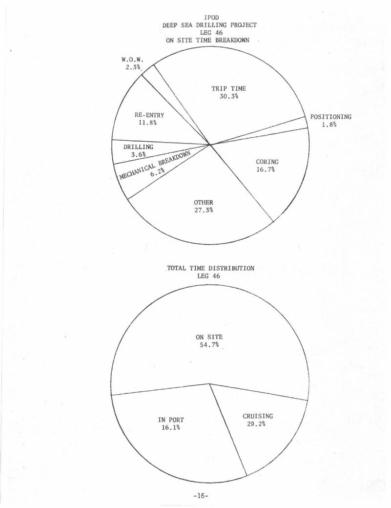
I PODDEEP SEA DRILLING PROJECT
LEG 46ON SITE TIME BREAKDOWN
W.O.W.2.3%
POSITIONING1.8%
TOTAL TIME DISTRIBUTIONLEG 46
-16-

DEEP SEA DRILLING PROJECTSITE SUMMARY
LEG 46
HOLE
396-A
396-B
396-C
LATITUDE
22°59.14'N
22°59.14'N
TOTAL:
LONGITUDE
43°30.90'W
43°30.90!W
WATERDEPTH(m)
4465
4465
4465
4465
NUMBEROFCORES
2
33
~
35
CORESWITHRECOVERY
2
30
—
32
PERCENT OFCORES WITHRECOVERY
100.0
90.9
—
91.4
METERSCORED
13.0
270.0
~
283.0
METERSRECOVERED
.64
63.56
-–64.2
' PERCENTRECOVERED
4.9
23.3
22.6
METERSDRILLED
110.5
246.0
356.5
TOTALPENET.Cm)
123.5
405.5
529.0
AVG.RATEPENET.(m/hr.)
72.6
5.9
39.3
TIMEONHOLE(hrs.)
42.7
574.7
30.3
647.7
TIMEONSITE
647.7
*
-17-

DEEP SEA DRILLING PROJECTTIME DISTRIBUTION
LEG 46
DATE
1-21-761-211-221-231-241-251-26. 1-271-28
1-281-291-301-312-12-22-32-42-5
2-52-6
HOLE .NO.
396A
CRUISE
9.324.024.024.023.024.021.815.7
165.8
TRIPS
18.39.8
28.1
DRILL CORE
. IN PORT
- EN ROl
STUCKPIPE
SAN JUAN
W.O.W.
JTE SITE 395-A § 396-A -
3.12.9
6.0
1.0.5
1.5
POSITIONSHIP
2.28.31.3
11.8
MECH.REPAIR
PORTTIME
10.724.024.024.024.024.024.024.014.7
193.4
RE-ENTRY OTHER
.36.8
7.1
TOTALTIME
10.724.024.024.024.024.024.024.014.7
193.4
9.324.024.024.023.024.024.024.01.3
177.6
22.720.0
42.7
REMARKS
Heat flow experiments.
-18-

DEEP SEA DRILLING PROJECTTIME DISTRIBUTION
LEG 46
DATE
2-6-762-7
2-82-92-102-11
2-12
2-132-142-152-162-17
2-182-192-202-212-222-232-242-252-262-272-282-29
3-1
HOLENO.
396B
CRUISE TRIPS
11.0
8.310.3
7.5
9.0
3.313.0
17.0
12.05.09.711.25
10.012.0
10.7
150.55
DRILL
.511.5
6.0
18.0
CORE
9.56.5
2.020.7
21.05.09.09.253.08.5
7.56.0
107.95
STUCKPIPE W.O.W.
5.89.75
15.55
POSITIONSHIP ,
ME CH.REPAIR
2.5
2.510.0
1.5
3.0
2.57.0
29.0
PORTTIME
•
RE-ENTRY
5.0
11.017.05.0
3.7
.57.0
9.5
1.03.5
12.02.5
77.7
OTHER
4.024.0
10.03.06.73.7
10.0
1.07.011.0
7.3
3.01.08.02.756.5
2.010.51.0
21.524.0
8.0
175.95
TOTALTIME
4.024.0
24.024.024.024.0
24.0
24.024.024.0 .24.024.0
24.024.024.024.024.024.024.024.024.024.024.024.0
18.7
574.7
REMARKS
Making up csg. § cone.Also fishing snap ring.
Heat flow measurement.Work on comp.Make up 11-3/4" csg.;repair comp.Re-enter § lmtd.11-3/4" csg.
Heave compensator opera-tion trouble.
Heat flow § logging.Logging § geophone ex-periments .Hydrophone experiments.
-19-

DEEP SEA DRILLING PROJECTTIME DISTRIBUTION
LEG 46
DATE
3-1-763-2
3-3
3-33-43-53-63-73-83-93-10
HOLENO.
396C
CRUISE
23.024.023.024.024.023.024.017.5
182.5
TRIPS
5.312.0
.5
17.8
DRILL CORESTUCKPIPE W.O.W.
POSITIONSHIP
MECH.REPAIR
12.0
12.0
PORTTIME
RE-ENTRY OTHER
.5
.5
TOTALTIME
5.324.0
1.0
30.3
23.024.023.024.024.023.024.017.5
182.5
REMARKS
Pad eye on stbd. guiderail broken; derrickdamaged.
-20-

DATE(Midnight)
FEBRUARY
56
METERSCORED
9.53.5
HOLE
METERSREC.
.6
.04
396-A
% REC.
6.0.5
CUM. TIMECORING
1.0.5
METERSDRLD.
47.563.0
CUM. TIMEDRLG.
3.12.9
TOTAL: 13.0 .64 .5 1.5 110.5 6.0
891011121314151617181920212223242526272829
35.09.5
7.542.0
38.09.519.019.0
38.0
33.519.0
HOLE
6.62.23
.8512.09
18.06.556.655.95
1.84
1.081.72
396-B
18.823.4
.828.7
47.368.935.031.3
4.8
3.29.0
4.94.0
1.012.9
9.253.636.155.71
3.7
4.13.65
14.5107.5
110.5
13.5
.084.8
4.5
4.8
TOTAL: 270.0 63.56 23.3 58.99 246.0 14.18
-21-

O
4400
4500 -
Determine csg. PT.
Keel haul re-entry cone.Run 120 m 16" csg.Jet 16" to 4585 m (Hole 396-B),Drill § core 14-7/8" hole to 4631.5 m.Start make-up 163.0 m, 11-3/4" csg.
Working on computer.Start running in R/E #1.R/E #1 run csg. to 4628 m.Cement csg. § pull out.Start.R/E #2.Verified R/E #2.DrId. out cement to 4631.5
HOLE 396A 8, B
4600 -
4700 -
4800 -
4900 -
5000 -
Trip to replace drill bit.
R/E #3.
Heave comp. set back for operation check.
Trip to replace drill bit.
R/E #4.
Trip to replace drill bit.
R/E #5.
Trip due to poor weather conditions.
W.O.W.
R/E #6.
Start replace Bowen swivel $ shaft.
Stuck drill pipe, decide toR/E #7. abandon hole.
Logging.
/ , Making geophone experiments
Abandon site.
DAYS35

in
LUi—LU
100
200
300
~ 400<atLU
z
500
600
700
800
900
HOLE 396 - A § B
JO
\
BJL
IO εo
DRILLING DAYS

• •
PENE
TRAT
ICM
ETER
S 1
•
0
50
100
150
200
250
300
350
•400
- ' ...HOLE 396A
•
-
•
•
-
• • *
-
•
>
_ - .
1 1 I
*
t •
*
I
••
-
•
• *
m
t
I
*7u
•
y • t
*
Ni
*
•
•
•
•
•
10 20 . 30 40
METERS/HOUR
90 \40+

HOLE 396B
45030
METERS/HOUR
40j
140+
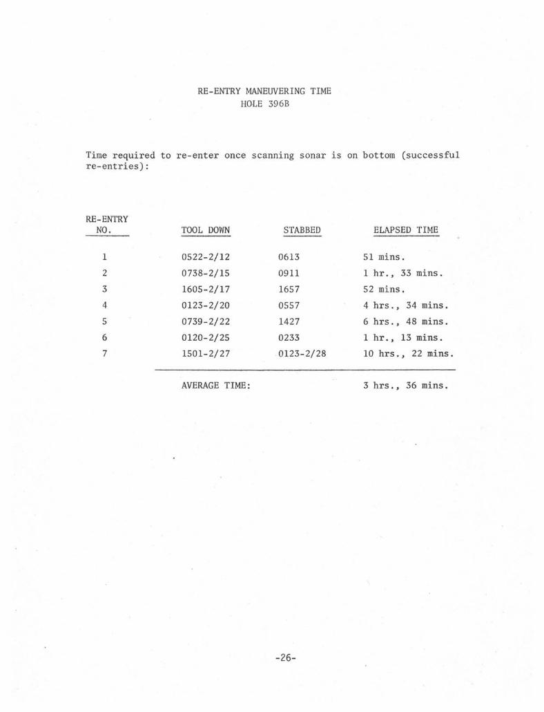
RE-ENTRY MANEUVERING TIME
HOLE 396B
Time required to re-enter once scanning sonar is on bottom (successfulre-entries):
RE-ENTRYNO.
1
2
3
4
5
6
7
TOOL DOWN
0522-2/12
0738-2/15
1605-2/17
0123-2/20
0739-2/22
0120-2/25
1501-2/27
AVERAGE TIME:
STABBED
0613
0911
1657
0557
1427
0233
0123-2/28
ELAPSED TIME
51 mins.
1 hr., 33 mins.
52 mins.
4 hrs., 34 mins.
6 hrs., 48 mins.
1 hr., 13 mins.
10 hrs., 22 mins.
3 hrs.. 36 mins.
-26-

DEEP SEA DRILLING PROJECT
HOLE
396-A
396-B
396-B
396-B
396-B
396-B
396-B
MFG.
Smith
Smith
Smith
Smith
Smith
Smith
Smith
SIZE
14-7/8"
14-7/8"
10"
10"
10"
10"
10"
TYPE
F94C
F94C
F94CK
F94CK
F99CK
F94CK
F94CK
SERIALNUMBER
AN697
AN697
KK986
CA767
SV857
CA281
CA761
METERSCORED
13.0
44.5
49.5
47.5
38.0
38.0
52.5
BIT SUMMARYLEG 46
METERSDRILLED
110.5
122.0
110.5
13.5
METERSTOTALPENET.
123.5
166.5
160.0
61.0
38.0
38.0
52.5
HOURSONBIT
2.18
13.75
18.4
17.7
11.86
5.75
7.7
CONDITION
Tl-Bl-SE
Tl-Bl-SE
T2BT-B4-0
T3BT-B8-0
T1BT-B1-0
T1BT-B6-0
T3BT-B4-I
REMARKS
Re-run
Re-run
0= 1/8" (drld. footageis cement).
0= 1/8"
0= l/8"-l/4"
0= 1/8"+
-27-

DEEP SEA DRILLING PROJECT
BEACON SUMMARYLEG 46
HOLENO.
39 5A
397
396
396B
396B
MAKE
ORE
ORE
ORE
ORE
ORE
FREQ.kHz
13.5
16.0
13.5
16.0
13.51
SERIALNUMBER
369
335
368
342
271
SITE TIMEDAYS
30
14
6+
Dropped 1910 2/3/76 double (dropped for possible re-entrylater in Leg.
Dropped 2046 2/4/76 double (after dropped site not drilled)
Dropped 2220 1/14/76 double (dropped on Leg 45).
Dropped 0716 2/13/76 single.
Dropped 2148 2/26/76 double.
-28-

FLOWB>\T INNER.
L^NID\^iG SUB
5 6 PL^<bT\CUNER.
\4 % &\T \O
-29-

DEEP SEA DRILLING PROJECTOPERATIONS RESUME
LEG 47
Leg 47 was the first voyage of the International Phase of Ocean Drilling wherethe entire emphasis was on deep continental margin drilling. The leg was dividedinto two parts allowing for one site to be investigated on the northwest Africancontinental margin and another on the western margin of the Iberian subcontinent.Each site was drilled to a record depth and nearly all scientific objectives wereachieved.
The leg commenced on March 10, 1976 at Las Palmas, Canary Islands and terminatedMay 12 at Brest, France. Brief interim port calls were made at Las Palmas todisembark an ill scientist and at Vigo, Spain for a scientific crew change.
Many voyages of the Deep Sea Drilling Project have broken operational records andLeg 47 was no exception. New milestones reached include the following:
Deepest Single Bit Penetration - - - - - - - - 1453 Meters, Hole 397ADeepest Multiple Bit Penetration 1740 Meters, Hole 398DMost Time Spent On-Site In One Leg - - - - - - 4 2 . 5 days
The total core recovery, 1812.5 meters, has been exceeded only by the Leg 42 totalfrom somewhat shallower Mediterranean and Black Sea drilling.
Total length of the leg was 62.5 days, of which 42.5 days were spent on site, 9.8days under way and 10.1 days in port. 2.7 days of operating time were lost dueto mechanical difficulties and 1.4 days of delay due to weather were experienced.
LAS PALMAS PORT CALL
Emergency derrick repairs were necessitated by the failure of a guide rail pad-eyethat effectively terminated Leg 46. In addition, extensive repairs and maintenancewere performed in the engine room. This work included a major overhaul on No. 4engine, a top overhaul and piston replacement on No. 9 engine, rear oil seal re-placement on No. 6 engine and replacement of No. 5 D.C. generator with a spareunit carried on board.
As key personnel and materials had not arrived, derrick repairs did not commenceuntil about three days after the ship s arrival in port. All lines and drillingequipment were rigged down from the upper portion of the derrick. The crown blockand gin pole assemblies were removed and set on the pier by a large shipyard crane.The top 39 feet of the derrick, including the water table, was then set on thepier and both starboard legs (two sections each) and associated bracing were re-placed while the yard crane supported the structure.

New supporting pad-eyes were installed at the top of the guide rails and fittingswere installed to provide a backup sling support in case of future pad-eye failure.
Active mode pressure transducers removed in Norfolk, Virginia were reinstalled forthe heave compensator and repairs were made to the heave compensator racker armbracket where a large crack had been found. Repairs were also made to engine roomventilation ducting and the drill pipe stabber. The fuel oil holding tanks (29and 30) were cleaned by a shipyard crew.
In addition to routine supply functions, about 600 feet of 16 inch casing for futurere-entry operations were onloaded. Fresh water and lube oil tanks were topped offwhile the derrick and engine room repairs were in progress. On the morningMarch 19, the CHALLENGER moved to the bunkering pier and began taking on fuel.Fueling and the last of the scheduled engine room work were completed at about thesame time. After tugs were alongside, consecutive problems with electrical assign-ment of No. 5 generator to propulsion and with the failure of the newly installedgovernor on No. 4 engine delayed sailing for over 15 hours. During this time itwas necessary to move from the bunkering pier to an anchorage outside the harbor.At 1415 hours on March 20, the vessel weighed anchor and departed for Site 397.
SITE 397
The beacon was dropped at Site 397 only 9-1/2 hours after getting under way fromLas Palmas. The site was located about 55 miles south of Grand Canary Island andabout 55 miles west of Cape Bojador on the African Coast. While the drill stringwas being run to the sea floor, an intermittent malfunction developed in whichelectrical power to the bow thrusters was lost. A mudline punch core was taken,but continuous coring operations did not commence until troubleshooting was com-pleted and the problem resolved. A delay of 8-1/2 hours resulted.
The hole was then continuously cored to 1000 meters below the sea floor with gen-erally excellent rates of penetration and core recovery. After about 700 meterspenetration (75 cores), backflow was noted as the core barrels were removed fromthe drill pipe indicating that the float valve above the bit was not closing prop-erly. After cutting Core No. 82, it was necessary to pump down the core breakercenter bit to dislodge material plugging the throat of the bit. Plugging problemsbegan again after Core No. 99. Repeated occurrences eventually forced terminationof drilling at 1000 meters subbottom when core could no longer be recovered.
Due to the presence of minor amounts of natural gas which persisted from veryshallow depths to total depth, the hole was filled with weighted mud before itwas abandoned. The drill string was then pulled and the bit was on deck at 1600hours on March 28.
HOLE 397A
While the drill string was on deck, about three hours were taken to pick up theheave compensator cylinder and bleed air from its hydraulic system in preparationfor its employment on the ensuing hole. Inspection of the coring equipment re-vealed both the flapper valve and the core barrel latch sleeve to be suspect of

contributing to the bit plugging problem. These were replaced, as was the bit.The bit appeared to be in excellent condition but had accumulated too many rotatinghours to be run again.
The drill string was run to the seabed and spud-in of Hole 397A occurred at 0140,March 29. Since Hole 397 had been continuously cored, the new hole was drillednearly to the previous total depth before the coring program was resumed. Acenter bit was employed to a depth of 707 meters subbottom, where it was replacedwith an inner core barrel. Spot coring was done at depths where low recovery wasrealized on Hole 397 and continuous coring was resumed at 964 meters subbottom.Due to the greater rate of penetration achieved while drilling as opposed tocoring and the elimination of time-consuming wireline trips, 1000 meters (totaldepth of Hole 397) was reached in 1.9 days instead of the 6.4 days required on397. The new bit had only about 22 hours rotating time at this depth while itsforerunner of the same model had accrued 33 hours.
Coring continued routinely to a depth of 1302 meters subbottom, where a highly in-durated Cretaceous shale was encountered. The rate of penetration dropped sharplyfrom about 13 meters per hour in the overlying mudstones to about 2.4 meters perhour in the shale. 65 rotating hours were consumed in coring from 1302 meters tothe total depth of 1453 meters. Although the diameter and condition of the coreindicated that bit failure was imminent, fairly good core recovery was attainedthrough the final core. Scheduling considerations necessitated terminating opera-tions at a depth that was apparently just short of the ultimate Jurassic objective.
Small amounts of natural gas were encountered to total depth with a notable de-crease in quantity in the lower shale section. The hole was filled with weightedmud to about 450 meters subbottom. A 20 barrel cement plug was spotted at thetop of the mud.
The drill string was on deck and the ship was under way at 0330 hours on April 7.
SITE 397 TO VIGO
Shortly before the departure of the ship from Site 397, a member of the scientificparty was stricken with a severely infected tooth. The ship s surgeon reportedthat the man was in need of prompt dental care and the vessel was detoured slightly.He was then put ashore at Las Palmas foo* required treatment. Arrangements fortreatment, transportation and lodging were handled through the vessel s LasPalmas agent. The CHALLENGER was at anchor for one hour outside Las Palmas harborwhile the man was transferred to a small boat and the necessary documents wereexchanged with the agent's representative. The total difference in time betweenthe action taken and proceeding directly to the Moroccan Basin survey site wasabout five hours. The man did not rejoin the scientific party.
Geophysical surveys requiring course changes and reduced speed were conducted asthe vessel crossed the Moroccan Basin. About nine hours were required in excessof the direct steaming time from Las Palmas to Vigo.
Shortly after departure from Las Palmas, metal fragments were found in the lubeoil filters of No. 2 engine. Inspection revealed that the main and connectingrod bearings required replacement. Adequate spares were not on board and it was

necessary to make the remainder of the transit to Vigo on five propulsion engines.This resulted in a reduction in speed of 3/4 to one knot and a time loss of approxi-mately 12 hours.
Good weather prevailed and an unexpectedly high speed was maintained until theship was about 200 miles from Vigo. Gale force head winds were then encounteredthat reduced headway to about two knots at times and delayed arrival at Vigo byabout 12 hours.
VIGO PORT CALL
The GLOMAR CHALLENGER dropped anchor in the harbor estuary of Vigo, Spain at 2300April 12 and remained there until 0600 the following morning. Parts for No. 2engine were received and the engine was reassembled and test run before the ship sdeparture. Twelve members of the scientific staff and three GMI personnel de-parted the ship in Vigo while 12 scientists, two Scripps technical personnel andtwo GMI personnel embarked. Fresh vegetables, mail and a small amount of airfreight were also onloaded.
SITE 398
The cruise to the site of Leg 47B operations was uneventful and the beacon wasdropped less than 14 hours after departure from Vigo. Site 398 was located justsouth of Vigo Seamount, about 95 miles west of Porto, Portugal.
As re-entry operations were planned at this site, the first hole (398) was anexploratory penetration primarily intended to determine the water depth and casingpoint for the main re-entry hole. To keep the re-entry area as undisturbed aspossible, the ship was offset 200 feet from the beacon before spudding the ex-ploratory hole.
The corrected precision depth recorder water depth was 3920 meters (derrick floorto the sea bottom). A punch core was attempted at 3915.5 to 3925 meters (drillpipe measurement). No weight indicator fluctuation was noted, but the drill stringwas pulled clear of bottom by an additional joint while the core barrel was re-trieved. Only a handful of sediment was recovered from the core catcher and itwas inferred that the sea floor was at or slightly below PDR depth. The bit wasagain lowered to 3925 meters without pumping and this time indication of bottomwas noted by weight indicator at 3917 meters. In the interest of saving time andof obtaining a full core, another joint was added and the bit was lowered to3934.5 m. 3917 meters was recorded as the official water depth, but was laterfound to be in error.
A third consecutive punch core was taken. At this point the sediment became toofirm for penetration with neither circulation nor rotation.
The shallow sediment was determined to be a relatively firm calcareous ooze suit-able for supporting a re-entry cone with casing. The bit was then jetted withoutrotation to a depth of 103 meters subbottom to confirm the feasibility of washingin a casing string. The plan was for an additional core to a depth of 109.5

meters, a run of a new sampler designed to recover pore water and a run of theheat flow tool. Then the bit would be pulled clear of the mudline and a secondexploratory hole spudded to provide a complete core record of the upper strati-graphic section. The downhole operations had been completed successfully and theheat flow tool was being retrieved when the sandline suddenly parted, leaving thetool and about 5000 feet of line in the drill pipe. It was considered unlikelythat time would be saved by fishing for the broken line and a pipe trip was madeto the surface to recover line and tool.
HOLE 398A
After retrieving the drill string, the ship moved off station about two miles andjettisoned the damaged sandline. As the line on the independent hydraulic sandreel was now too short, the overshot and sinker bars were switched over to thenew line on the drawworks sand reel.
Weather conditions had deteriorated to a marginal state while the drill string wasbeing pulled. Running into the hole was delayed until the next weather satelliteforecast was received. After a wait of three hours, a forecast calling for steadyor slightly improving conditions was received. Operations were considered feasibleunder existing conditions and the pipe trip to the seabed was made. Because ofweather conditions and the possibility of excursions, the bottomhole assembly waswashed in as quickly as possible with no coring or attempts to confirm water depth.The wind did not moderate and a deep short period swell developed which caused thevessel to pitch in a sharp, violent manner. The guide rails and suspended drillingequipment were subjected to considerable battering and connections were made withdifficulty. Due to the hazard to personnel and equipment, operations were haltedafter two cores and a total penetration of 210.5 meters. The drill string waspulled clear of the sea floor and an additional 30.5 hours were spent waiting forimproved weather conditions.
HOLE 398B
The drill pipe had been pulled at the rate of one stand per hour during the weathershutdown. When operations were resumed, it was necessary to run pipe some distanceback to the sea floor. As the sea conditions were still far from optimum, thebottomhole assembly was again washed in with dispatch.
Hole 398B was yet another attempt at a relatively deep exploratory penetration tocore the soft, rapidly penetrated upper stratigraphic section and to employ thevarious special tools before setting the re-entry hardware. After washing to229.5 meters subbottom and cutting one core, pore water and heat flow runs wereto be made.
The sandline parted upon pickup of the pore water tool, leaving the tool and about12,000 feet of line in the hole. It was necessary to pull the drill string torecover the line and tool. The line inside the pipe was found to be badly kinkedand twisted and only a few short pieces could be salvaged. At that point, approxi-mately 13,000 to 14,000 feet of line remained on each reel and both were too shortfor further operations at Site 398. An attempt was made to long splice the freeends of the two lines but it was unsuccessful. The lays did not match as one line

was new and the other had been somewhat stretched through repeated use. A secondattempt at splicing these two half lines was made after reeling off the line fromthe hydraulic sand reel and exposing the opposite end of the line which was stillin new condition. (As no takeup reel for this amount of line was available, twostands of drill pipe were hung off through the moon pool and the line was spooledoff below the ship). A successful long splice was made and about 3,000 feet ofline had been added to the drawworks sand reel when a snarl in the line was en-countered which would not pass through the drill pipe. It was then necessary tocut and clamp the line and lay down the drill pipe. After two or three hundredfeet of badly kinked and twisted line was recovered, it became evident that noneof the remaining line would be salvageable. The ship was again offset from thelocation and the damaged line was cut loose. At this point the total spare sand-line aboard was comprised of three pieces totaling about 12,000 feet. An urgentrequest was relayed to GMI San Diego to have a new reel of line delivered to theship while on location as soon as possible. The drawworks sand reel now heldabout 17,000 feet and, as weather conditions were favorable, it was decided torig the re-entry hardware and commence operations on the deep penetration holewithout further delay.
HOLE 398C
The last remaining first generation re-entry cone had been assembled and stowedin the starboard casing rack area. It was now transferred to the port main deckbulwark, reslung and keelhauled into place beneath the moon pool without significantdifficulty. The only irregularity was the need to reweld a sonar reflector braceat the last moment before keelhauling.
Based on the exploratory holes, 80 meters of 11-3/4 inch casing were made up and hungoff below the rig floor. The bottomhole assembly was made up and latched into thecasing and the entire string was lowered and latched into the cone. The cone was thencut loose from its slings and the drill string was run to just above the seabed.
The power sub was rigged and the casing string was washed into the sea floor.Unexpected resistance to further washing came at a drill string depth of 3980meters. The inability to wash deeper cast considerable doubt on the accuracy ofthe 3917 meter water depth determined earlier. The casing and drill string werethen pulled well clear of the mudline, the inner core barrel was replaced, and apunch core was attempted. On this attempt, the weather was nearly flat calm,rendering the weight indicator more sensitive than during times of greater vesselmotion. Bottom was "felt" at 3900 meters. As this confirmed the apparent depthto sea floor noted on the previous wash-in attempt, 3900 meters was establishedas the official water depth.
HOLE 398D
The casing was washed in to the depth reached on the previous attempt and theinner core barrel was retrieved (with no core recovery). The Rotary shiftingtool was made up on an inner core barrel and pumped to the bottom of the drillstring. Upon retrieval of the tool with the sandline, the sleeve in the casingrunning tool was shifted. The casing/cone assembly was then released withoutdifficulty.

Because of previous spot coring, it was possible to wash to 271 meters and burythe bottomhole assembly before taking the first core. Intermittent coring thencontinued to 527.5 meters where continuous coring was initiated.
The requested spare sandline was shipped by air to Vigo and then transported toSite 398 on the deck of the Spanish motor tug Vulcano. The tug made its rendezvouswith the CHALLENGER on the morning of April 26 and the reel of line, along witha quantity of fresh vegetables, was transferred without incident. While it wasnecessary to change the heading of the drill ship to provide a lee for the tug,the transfer was accomplished during a wireline trip and coring operations werenot interrupted.
Two failures of the dynamic positioning system1s vertical reference gyro occurredin the earlier stages of drilling. While it was known that an excursion off thelocation of the beacon had occurred, the distance off station was not known asthis type of failure caused loss of the positioning display. After drilling wasresumed, the amount and direction of bias of the replacement gyro was unknownand it was felt that a constant error of unknown magnitude existed in the display.The effect of this excursion of a sizeable magnitude and the lateral forces of thedrill string acting against the casing/cone assembly was not known. It was con-sidered quite possible that the casing had been kinked or broken just below thecone and that re-entry might be difficult or impossible. For this reason thefirst bit was run somewhat longer than under normal circumstances to assure pene-tration of a known seismic reflector and to accomplish one of the scientific ob-jectives before pulling out of the hole. At a depth of 974 meters and after 48rotating hours, coring operations were interrupted for the first round trip forbit change and re-entry attempt.
After the hole was filled with gel mud, the drill string was pulled to replace thebit and to return the bottomhole assembly used for lowering the re-entry cone toits normal configuration. A circulating head was installed and the pump was runwhile the bit was pulled clear of the re-entry cone in an effort to clear cuttingsfrom the cone and reflectors.
The first re-entry attempt was an exceptionally smooth operation. The logging linewas rigged and the sonar tool was run to bottom without incident. A strong sonartarget was acquired upon commencement of scanning and the ship was maneuvered toclose it. After a net movement of 150 feet forward on the spud-in heading, thestab was made. Total scanning time was one hour and forty five minutes.
The second round trip was made after only 26.7 rotating hours and was occasionedby a coring equipment malfunction rather than the condition of the bit. The innerbarrel core catcher sub had loosened and backed off while Core No. 93 was beingretrieved and the barrel was recovered open ended. The core catcher assembly,plastic liner and core remained somewhere in the drill string. One unsuccessfulattempt was made to fish for the liner with a spear. As chances of recovering allthe material in the string were considered extremely slim, it was decided to makea round trip and spend no more time fishing. 400 barrels of gel mud was displacedto the level of the sea floor and the trip began. Unfortunately the mud and sus-pended cuttings began to flow back (the flapper valve was later found to be heldopen by the core catcher sub) and completely filled the outer core barrel withcuttings and plugged all passages through the bit. This resulted in a very wet

and muddy trip. The buytrate core liner and 8.9 meters of core were recovered fromabout 230 meters above the bit and the core catcher assembly from the bit sub. For-tunately, this incident occurred in a re-entry hole as the bit neared the end of itsrun and the only operational time lost was the two hours spent on the fishing attemptThe same situation would almost certainly have resulted in the loss of a single-bithole or could easily have necessitated an additional round trip and re-entry.
After the bit and bit sub assembly were changed, the string was run to just offthe sea floor for the second re-entry attempt. The operation of the sonar toolwas tested on deck and inside the drill pipe on the run to bottom. The tool wasseated at the bit in the normal manner with the mud pump engaged to hold theflapper valve open. When the tool was energized, it operated apparently in thenormal mode for ten seconds or less. Power regulation to the tool was then lostand could not be regained, necessitating retrieval of the tool. When the toolwas recovered, it was found that the rotating shaft had broken cleanly at the topof the extender section causing the loss of extender and transducer.
A standby sonar tool was assembled and ready, but when the cable was connectedand final on-deck checkout was attempted, the conductor carrying power to thedrive motor was found to be shorted. The short was traced to the cable connectionbox on the forward bulkhead of the logging unit cab. Salt water falling from thepackoff assembly during the wireline trips had entered the connector.
After the connection box had been cleaned and sealed, the replacement sonar toolwas lowered and seated in the bit (this time with extra pump pressure). A strongtarget (apparently the re-entry cone) was detected within fifty feet when scanningcommenced. Each subsequent sweep of the scanning beam showed better resolutionof the target configuration and a reduction in range. After about five minutesthe display indicated that the bit was directly over the cone and a successfulstab was made. No maneuvering of the vessel was required.
Due to time constraints, no further re-entries were planned. The third bit wasto be run until basement was reached, until scheduling forced termination of thehole or until the bit failed. It became evident that the major scientific ob-jectives could not be attained if the ship were to depart the site in time for itsscheduled arrival in Brest. A cruise extension of up to three days was requestedby the scientific party and was granted by DSDP management. An additional develop-ment of operational significance was the loss of two of the ship s D.C. generators.This limited the vessel's stationkeeping ability while drilling and permitteddrilling operations to continue only in relatively good weather.
Although it became evident that the basement objective was not within reach, thegoal of penetration into the oldest overlying sediment unit had apparently beenattained on the morning of May 8. By this time rising winds had begun taxing thepositioning capabilities of the ship nearly to the limit and it was necessary toterminate drilling operations.
The hole was plugged in the same manner as Hole 397A. All equipment was on deckand secured for sea and the ship was under way for Brest at 0530 hours on May 9.

SITE 398 TO BREST
Because of D.C. generator failures and limited flexibility of electrical powerassignments, propulsion was again limited to five motors. Strong head winds withgusts to 40 miles per hour were encountered the first day but decreased slowly,allowing an overall speed of advance of 7.1 knots.
HYDROCARBONS
Due to increased concern over the risk of uncontrolled hydrocarbon escape fromreservoir rocks attendant to deep continental margin drilling, safety and instru-mentation procedures aboard the CHALLENGER were upgraded prior to Leg 47, Acombination of three gas chromatographs was utilized during the leg for composi-tional gas analysis and equipment for measuring the fluorescence of soluble liquidand solid hydrocarbons was also available. Stringent procedures were set up formonitoring each core for changes in gas quantity or composition and for the pres-ence of liquid hydrocarbons. Gas samples were collected through the plastic linerfrom almost every core.
At site 397, hydrocarbon gas was present in the cores from about 80 meters subbottomto the total depth of 1453 meters subbottom. The gas composition was very closelymonitored and each core was checked for fluorescence and oil staining. Thoughvariable, the volume of gas escaping from the cores was relatively low. No signsof petroleum or indications of migratory hydrocarbon accumulations were detected.
Although some gas was anticipated at Site 398, only minute traces were found. Thequantity was too small for detection by the standard Exploration Logging chroma-tograph or for meaningful analysis by the more sensitive Hewlett-Packard instrument.
DRILLING AND CORING EQUIPMENT
The standard DSDP bottomhole assembly was utilized for the majority of operations.This consisted of a bit, bit sub (with flapper valve and inner core barrel supportbearing), outer core barrel, three 8-1/4" drill collars, one 5f stroke Baash-Rossbumper sub, three 8-1/4" drill collars, two 5' stroke bumper subs, two 8-1/4"drill collars, one 7-1/4" drill collar, and one joint 5-1/2" heavy wall drill pipe.Total length of the assembly was 120 meters. On Hole 397, where use of the heavecompensator was not planned, a fourth bumper sub adjacent to the lowermost bumpersub was employed. For re-entry operations (Holes 398C and 398D - first bit), acasing running tool was placed between the seventh and eighth drill collars. Nodrilling tools were lost.
The standard DSDP wireline coring assembly was employed. Overall core recoverywas quite good. Instances of low recovery were attributed mostly to plugged bitsand (on Site 397) to intervals of unfavorable lithology. On one or two occasions,the inner barrel apparently did not latch into place and little or no core wasrecovered. A piece of core falling from the previous core barrel and lodging inthe bit or bit sub is the suspected cause.

After approximately 75 cores had been cut on Hole 397, back flow through the drillpipe on recovery of core barrels indicated that the flapper valve was not closingcompletely. This was the apparent cause of repeated bit plugging and the eventualloss of the hole. When the assembly was recovered, the flapper valve spring wasfound to be too weak to close the valve completely against gravity. It apparentlyhad been fatigued by the repeated shock and cycling of seating and retrieving innercore barrels.
On three occasions core barrels were sufficiently stuck at the bit to cause shearingof the overshot pin on the first retrieval attempt. All three were recovered onthe second wireline run. The primary cause is believed to be the packing tendencyof the shale/claystone lithologies being penetrated, possibly aggravated by in-sufficient fluid pressure at the bit.
A core catcher sub came unscrewed and was lost upon retrieval of a core on Hole398D, necessitating a somewhat premature trip for bit and re-entry. Upon reviewof the malfunction, it was noted that core catcher subs and other inner barrelconnections had been found to be loose or easily broken on several occasions afterretrieval from downhole. This is believed to be due to wear of the threaded con-nections themselves attendant to repeated assembly and disassembly. Provisionsshould be made for "retirement" of inner barrel assemblies after a certain amountof use.
SANDLINES
Some doubt remains as to the exact cause of the two sandline failures on Site 398.Both breaks occurred upon retrieval of a core barrel (with special tool) whichhad been lowered on the sandline without circulation. Both breaks were locatedabout 1000 feet below the surface. Very similar circumstances accompanied thebreakage of a line on Leg 44A when a shifting tool was being retrieved. In noneof these cases was there a pronounced increase reported on the weight indicatorbefore the failure. "Overrunning" or excessive slack and kinking due to flotationof the tool on the run in is considered the most logical cause. In all cases,however, competent operators were involved and great care was taken to avoid thissituation. It is also difficult to explain how enough slack could be introducedto kink the line several thousand feet above the tool. An alternative factor couldbe the inability of the line to untwist normally on the run to bottom with a corebarrel attached, although the overshot assembly is designed to provide for rotation,
The practice of running tools into the hole on the sandline without circulation hasbeen discontinued.
BITS
As evidenced by the penetration records set, excellent service was rendered by thetungsten-carbide roller cone core bits utilized.
Although the stratigraphic section at Site 397 was primarily chalk, mudstone andshale, intermediate length insert F94CK bits were used on both holes. The occur-rence of hard limestones and cherts had been anticipated and damage to longer
10

inserts was feared. Excellent penetration rates were enjoyed until well-induratedCretaceous shale was encountered in the lower part of Hole 397A. The rate of pene-tration then fell to about 2.4 meters per hour. In retrospect, it is felt that alonger insert F93CK bit would have given a much better shale penetration rate andwould have put the ultimate Jurassic objective within reach.
Long insert F93CK bits were used exclusively on Site 398 and provided excellentpenetration rates throughout, including the tough shales. Although considerablelimestone was encountered in the lowermost part of Hole 398D, it was relativelysoft and did no damage whatever to the cutting structure of the bit.
None of the bits failed catastrophically and the failure mode common to all wasbearing wear.
Bit "balling" was suspected in shale and claystone intervals at both sites. Inthe slower claystone coring in Hole 398D, abrupt drilling breaks would occur withup to a threefold increase in penetration rate for as much as an entire core.Examination of cores revealed no variation in lithology or physical properties andthe faster drilling was interpreted as temporary "cleaning" of the bit. Unfor-tunately the hydraulic power sub is quite limited in its RPM range and a standardrotary drilling technique of spinning the bit at high speed to clear it is notpossible.
SPECIAL TOOLS
The drill pipe pinger was modified prior to Leg 47 and now run without the pistoncoring feature. The new design provides for greater ease of handling and, hope-fully, less maintenance. The echo from the pinger was watched carefully on theprecision depth recorder during the initial drill pipe trip on Hole 397. Althoughsensitive gain adjustments were required, the pinger reading was in good agreementwith the PDR value until the power sub/swivel assembly was rigged. As soon as theassembly was made up, the mud pump was engaged and test run as per standard pro-cecure. At this point, the pinger signal was lost. Upon recovery it was found thatthe rubber face of the transmitter had been separated from the metal housing. It isnow believed that this failure may have been caused by a differential pressure whichdeveloped across the bit (and transmitter) during pumping. No spares were on boardand pinger capabilities were lost for the remainder of the leg, however, the resultsof the test were promising for the employment of the pinger in the future.
A total of four heat flow measurements were attempted. Two of the three measurementsattempted on Site 397 were successful and a geothermal gradient was determined. Theother attempt at this site failed due to the breakage of a solder wire connectionin the electronics package. The single attempt at Site 398 was also technicallysuccessful except that the tool had to be retrieved by tripping the pipe after thesandline parted. Good thermal data were recovered, however. No further runs weremade as the risks involved to both the sole remaining sandline and the high invest-ment re-entry hole were considered too great. Recent design changes in this toolshould continue to provide greater durability and ease of handling.
The in situ pore water sampler received on board at Vigo represented a type of down-hole instrumentation new to the Project. It basically consists of a sampling probe
11

which extends through the core bit and is forced into the undisturbed sedimentbelow the bit. A sampling tube runs from the tip of the probe through a timeroperated valve, into a pre-evacuated sample chamber. The entire assembly is runinside and attached to a standard diameter inner core barrel. The very first runof the sampler in Hole 398 was an unqualified operational success and a usablesample was obtained. The second attempt, on Hole 398B, resulted in the secondsandline failure. When the tool was finally recovered after tripping the pipe,it was discovered that the sampling valve had not closed fully and that sea waterhad displaced the sample from its chamber. In situ sampling attempts were dis-continued at this point for the same reasons as were the heat flow measurements.
Extender shoes for the cutting of small diameter cores had been designed by theProjects Development Engineering Section and were on board for testing and forthe evaluation of small diameter coring for pressure core barrel and other pro-grams. Unfortunately, scheduling considerations and the overall coring programrelegated these tests to fairly low priority and only one test run was made. Thefirm marly chalk cored was apparently too hard for this operation, as the cuttingstructure of the shoe was almost completely worn away. In addition, the core ob-tained was too firmly packed into the shoe and aluminum liner to be removed.Further testing was deferred until more favorable conditions can be arranged.
BEACONS
The performance of the ORE sonar beacons was more than adequate with the exceptionof two occurrences.
The original 13.5 kHz single life beacon dropped on Site 397 performed well fornearly eight days and began to fail on the final day of Hole 397 operations. Assoon as the mudline was cleared with the drill string, a 16 kHz single life re-placement was dropped. The signal strength of this beacon was unacceptably lowand the frequency was too far off specification to be accepted by the positioningsystem's filter. Positioning was switched back to the original beacon while asecond single life 16 kHz replacement was dropped. This beacon remained strong forthe duration of site occupancy (over ten additional days).
A 16 kHz double life beacon was dropped on arrival at Site 398. The beacon hadbeen running for three days due to the fact that the plastic activation plug hadbroken when the beacon was tested on rigging it up. Signal strength remained highuntil the 25th day of operation (the final day on site) when the signal droppedabruptly to a very low level. A 13.5 kHz single life replacement was droppedimmediately. The replacement signal was unstable with the pulse breaking up anddrops in the signal level. On switching back to the original beacon, it was foundthat it had regained its strength. Positioning remained on the original beaconfor the final day of site time. On departure from the site, both beacons wereemitting strong, stable pulses.
One beacon, which had been rigged up in the mud room, was found to have been damaged.The rubber transmitter diaphragm had been punctured and oil was escaping. Thebeacon was boxed for shipment from Brest to ORE for repairs.
12

DYNAMIC POSITIONING SYSTEM
Although no major excursions, equipment losses or inordinately long operationalshutdowns were attributed to dynamic positioning failures on Leg 47, several sit-uations arose in which serious consequences were averted only through the skilland vigilance of bridge personnel. A total of 12-3/4 hours of operating time waslost due to problems with the positioning system.
Probably the most serious shortcoming of the system, in terms of persistence, po-tential for disaster and difficulty of corrective action is chronic vertical ref-erence gyro failure. Four such failures occurred on Leg 47. The standard correctiveaction in such cases is to switch over to the standby gyro but in one instance thiswas done and the standby was found to be defective. Gyro failure is particularlyserious in view of the fact that the positioning display is lost. Even if manualcontrol is assumed immediately,, it is necessary to operate "blind" and rely on theattitude of the drill pipe in the guide horn for positioning until gyro functionis restored. The extent of the excursion taken is never known. The gyros aresubject to a constant error or "bias" which is relatively unimportant if the samegyro is used for the duration of a site, but which becomes significant in the eventgyros are interchanged. Another shortcoming of the gyros currently in use appearsto be their susceptibility to error introduced by the acceleration of vessel motion.During the rough weather period on Site 398, positioning was quite erratic. At onepoint, the display dot was noted to move continuously though a range of plus orminus 15 to 20 feet in the Y axis in perfect coordination with the roll of the ship.The reliability of vertical reference gyros has been poor since the inception ofthe Project.
During one period of several days duration, the system's heading control featuredeveloped the habit of abrupt failure and "locking up" the thrusters at full rpm,driving the ship off its preset heading. These failures were found to be triggeredprimarily by radio frequency interference caused by keying the vesselTs powerfulTMC transmitter on certain frequencies. Investigation of the problem revealed itto be more complex than originally thought, as the lockups were occasionally trig-gered by other means and (rarely) for no apparent reason. The problem was notfully rectified until all the following actions had been taken:
A. All parts of the bridge console and chassis were provided with RF groundstraps to the ship!s hull.
B. Additional shielding was provided from the ship s transmitting radio antennas
C. The heading encoder module in the bridge console was replaced.
D. An intermittently defective relay, also in the bridge console, was locatedand replaced.
One or more "ghost" problems persist in the electronics of the system and cause un-predictable "excursions" off the beacon. Some of these are real and require cor-rective action while others are bogus displays. Because of the extremely transientnature of these problems and because major troubleshooting cannot be done duringon-site operations, the causes are virtually impossible to ascertain. Loss of acous-tics was experienced during heavy weather on Site 398 and was apparently caused by
13

water entering the preamplifier boxes on the hydrophone trunks when seas swept overthe main deck. The location and/or method of sealing of these boxes should be sub-ject to review.
HEAVE COMPENSATOR
The ship!s vertical motion compensator continued to be plagued by peripheral me-chanical and electrical problems but was successfully employed on the latter portionof Hole 397A and for virtually all coring operations on Site 398. Its effectivemaintenance of uniform hook load is credited with being a factor in the long andproductive bit lives on both sites. Considerable heave was experienced at times onSite 398 from both seas and swells. Although lithology was probably the prime factor,heave compensation was, without a doubt, instrumental to a degree in the remarkable72.2% core recovery rate over the 1298 meters cored in Hole 398D.
The most serious and perplexing problem encountered was the tendency of the systemto dump its hydraulic fluid through some part of the maze of valves, vents and sole-noids in the hydraulic control system into a holding tank. This would cause thecompensator cylinder to "bottom out" over a period of a few seconds and would requirerecharging of the system before operations could be resumed. The malfunction wastransient in nature and would usually rectify itself before troubleshooting couldbe done. A leaky pilot spool valve and possible intermittent electrical problemshave been identified as the most likely culprits.
The compensator piston stroke indicator was repaired on three or four occasions forboth electrical and mechanical faults. A great many man hours were spent on thiscomponent alone to say nothing of the great effort expended on the former problem.
HOLE PROBLEMS
The deep penetrations at both sites were remarkably free of hole problems but sometendencies were observed which might become important factors on future deep pene-trations.
Some sticking and torquing were experienced just below 1300 meters in the upperportion of the Cretaceous shale section in Hole 397. The appearance of the coressuggested that these might be the effects of heaving shale. Just as the effectsappeared to be developing into a significant problem, however, they simple ceasedand no further difficulties were encountered on that hole.
Coincident with a period of heavy swells and considerable heave while coring Hole398D, some concern was generated by fill in the hole. As much as eight or ninemeters of fill would accumulate while the wireline trip was being made and it wasnecessary to stand back a single joint to keep the bit off bottom. This phenomenonceased when the heave decreased and is now believed to have been caused by therubbing of the drill string on the wall of the hole while the heave compensator waslocked out during the wireline trip.
14

The problem of plugged bits was a continuing, frustrating and expensive one. Nearly30 hours of operating time were consumed in clearing bits on Hole 398D alone and attimes it appeared that a pipe trip would be necessary. The plugging occurred in avariety of situations and at the slightest provocation. Without a doubt the plastic,packing character of the shale and claystone lithologies was a major factor butother ramifications, possibly depth related, may be involved.
Final inclinometer readings in deep holes 397A and 398D were 28 and 23 respec-tively. These deviations from vertical, if true, did not cause any drilling problemsaside from possibly a slight increase in torque. It may be advisable, however, toemploy a stabilizer assembly on future deep penetrations. The bits recovered fromtotal depth on both holes were measurably out of gauge and "steps" were cut intothe stabilizer pads. It is felt that the drag of these pads may contribute to thehole deviation.
ENGINEERING
The vesselfs power generating and propulsion machinery suffered a nearly unbelievablesequence of calamities from the very beginning of the leg. Steaming from Las Palmaswas delayed for 15 hours after tugs were already alongside by two unrelated break-downs. A microswitch failure in an overload trip prevented the assignment of No. 5and No. 7 engines to propulsion. As soon as this problem was solved, the newlyinstalled governor in No. 4 engine failed and had to be replaced.
This was only the beginning. During the course of the voyage, the crankshaft bear-ings (main and rod) of No. 1 Caterpillar engine failed. They were replaced in Vigo.Shortly thereafter bearing metal was found in the oil filters of No. 2 engine. Thecrankcase was cleaned and the engine operated through the leg. No. 4 D.C. gener-ator developed a ground in the armature on April 29 and was lost for the durationof the leg. On May 4, No. 6 D.C. generator shorted internally, caught fire and wasdamaged beyond shipboard repair. By the first week in May ominous noises had de-veloped in the bearings of No. 3 D.C. generator, No. 5 propulsion motor and the"B" drawworks motor. (All these generators and motors were overhauled during theNovember 1975 drydock period).
On April 15, sea water was reported leaking into both stern thrusters through failedseals. Back pressure was required to check the rising level of emulsified oil andwater in No. 1 stern thruster. Lesser amounts of water were later discovered tohave entered both bow thrusters. All four somehow continued to function for theremainder of the leg.
Other incidents included a generator flashover which incapacitated the "B" drillingswitchboard for 2-1/2 hours, the failure of one main.sea water circulating pump andthe loss of No. 1 evaporator due to a badly corroded tube nest.
DECK DEPARTMENT
Deck Department personnel figured directly in the coring operation in that they wererequired to make four long splices in sandline cables and to pour several wire ropesockets. The task of straightening and spooling salvageable sandline sections alsofell to the seaman gang.
15

The routine duties of cleaning and preservation of the ship were complicated byspillages of drilling mud and cement. Stiff headwinds during coring operationsresulted in the repeated cleaning of oily residue from the deck house and casingrack areas. A blown gasket in the heave compensator caused pydraul to be sprayedover a large newly painted area, necessitating repainting. As pydraul is an effi-cient paint remover, even normal leakage from the heave compensator system resultsin increased requirements for paint and topside maintenance.
COMMUNICATIONS
Radio communications were handled directly with Scripps Station WWD for the firstfew days of the cruise while the vessel was in the Canary Islands area. Very poorsignal quality made communications extremely difficult, however, and it was nec-essary to shift to the Navy system. Nearly all messages for the remainder of theleg were sent through Naval Communications Station Nea Makri, Greece. Most mes-sages were received via the Mercast system. Equipment failures and material re-quirements resulted in a relatively large volume of GMI traffic with commercialEuropean stations. Radio telephone communications with the U.S. on commercialchannels was fair to good and easily attained. No amateur radio communicationswere conducted.
NAVIGATION
The satellite navigation system was out of commission for about two days with apower supply problem while the ship was in transit from Site 397 to Vigo. Nav-igation by celestial fixes and LORAN A lines of position was entirely adequateduring this period. The Scripps electronics technician had effected repairs andthe unit was functional on arrival in Vigo. A technical representative was onhand to board the ship and thoroughly check out the unit while the ship was atanchor in Vigo.
A great deal of time and effort was spent by the radio officer in troubleshootingand repairing the shipfs LORAN receiver. Good LORAN A lines were obtained con-sistently and the LORAN C mode is apparently operational. Leg 47 operations werein fringe areas of LORAN C coverage and only intermittent sky waves were received.Ground wave reception should provide good fixes on forthcoming North Atlantic legs.
The recently installed Lemkuhl true bearing module was a valuable asset in theradar plotting of ship contacts. Due to the CHALLENGER's restricted maneuverabilitywhile under way, profiling and her complete immobility while on station, ship trafficwas a matter of concern throughout the leg. Site 398 was located in a major seawayand heavy traffic was encountered on the transit to Brest.
The location of drilling sites was accomplished without great difficulty, despitethe fact that the track of one of the reference profiles was found to be in errorby about five miles. Satellite navigation was used to its best advantage by firstcopying alerts of scheduled satellite overflights and then adjusting the ship'sspeed to time arrival at the immediate site area coincident with or shortly followingthe receipt of a reliable satellite fix.
16

WEATHER AND CURRENTS
Weather was generally quite good during Site 397 occupancy and did not hamperoperations. Anticipated northeast trade winds were not encountered on the transitto Vigo and better than expected speed was realized with the five available pro-pulsion engines until the ship was about 200 miles from Vigo. Gale force (UP to60 mph) head winds were then encountered from the passage of a storm front, slowingthe ship to as little as 2.4 knots and causing rolls up to 16 degrees.
Shortly after the commencement of operations at Site 398, circulation from a stronghigh pressure area in the northeast Atlantic produced steady northerly winds acrossthe Bay of Biscay with sustained velocities of 35 to 42 mph. The strong winds andrelatively short fetch resulted in short period swells up to 16 feet high. Theseproduced the "snap pitch" of the vessel which resulted in the delay of drillingoperations for 33 hours. The weather for the remainder of site occupancy was, ingeneral, unpleasantly cloudy, cool and breezy but did not interfere with operations.Several storms which would have been likely to halt operations were forecast for thearea by weather maps but all changed course or "stalled" in the Atlantic. Theoverall weather conditions at Site 398 were somewhat better than normal for thegeographic area and time of year. Weather conditions became extremely criticalduring the final few days on site in view of the ship's drastically reduced station-keeping capabilities. Frontal winds gusting to 35 mph were a decisive factor inthe termination of operations at this site. They would not have had a significanteffect had the ship been at full power.
Currents were not a significant operational factor but they were observed, at times,on both sites. They are believed to be eddies or tongues of the prominent long-shore currents located landward of the sites. The currents encountered were inter-mittent and variable in both direction and speed. At times, the drill pipe wasoffset from vertical enough to cause rig floor personnel to notify the bridge ofa possible positioning excursion. Ironically, the strongest and most persistentcurrent was experienced during the final days on site. Its direction was oppositethat of the wind and the current "assisted" the single propulsion engine in holdingposition.
PERSONNEL
With the exception of the dental infection which necessitated removal of the patientfrom the ship, no medical situations arose that could not be treated adequately bythe ship s surgeon. In addition to colds and minor injuries, about 20 cases of in-fluenza were treated. Engine room personnel were particularly hard hit and a se-vere shortage of watchstanders existed for a few days.
Global Marine personnel performed in a competent and efficient manner for the dura-tion of the cruise. They were resourceful in overcoming numerous technical dis-advantages to achieve the objectives of the drilling program. Frustrating equip-ment problems, prolonged unpleasant weather and the eleventh hour extension of analready long expedition combined to bring crew morale to an abnormally low levelduring the final days of the leg. Their professionalism, however, did not allowthis factor to affect performance.
Glen N. FossCruise Operations ManagerDeep Sea Drilling Project
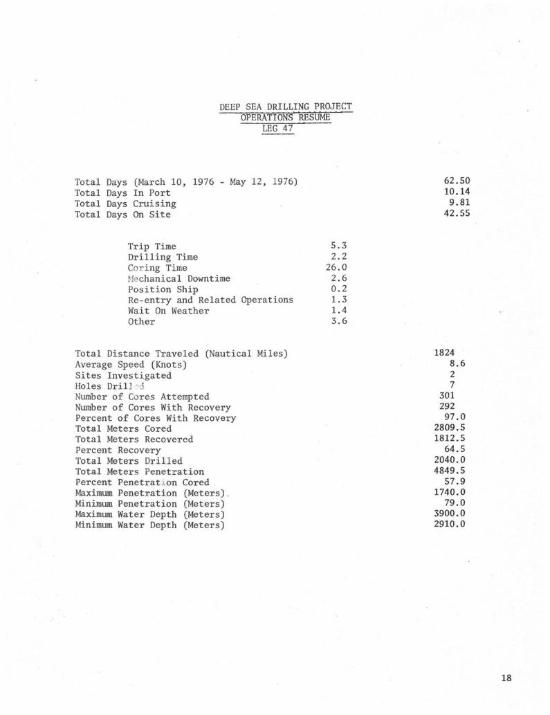
DEEP SEA DRILLING PROJECTOPERATIONS RESUME
LEG 47
Total Days (March 10, 1976 - May 12, 1976)Total Days In PortTotal Days CruisingTotal Days On Site
62.5010.149.81
42.55
Trip TimeDrilling TimeCoring TimeMechanical DowntimePosition ShipRe-entry and Related OperationsWait On WeatherOther
5.32.226.02.60.21.31.43.6
Total Distance Traveled (Nautical Miles)Average Speed (Knots)Sites InvestigatedHoles Dril]3dNumber of Cores AttemptedNumber of Cores With RecoveryPercent of Cores With RecoveryTotal Meters CoredTotal Meters RecoveredPercent RecoveryTotal Meters DrilledTotal Meters PenetrationPercent Penetration CoredMaximum Penetration (Meters),Minimum Penetration (Meters)Maximum Water Depth (Meters)Minimum Water Depth (Meters)
18248.627
30129297.0
2809.51812.564.5
2040.04849.557.9
1740.079.0
3900.02910.0
18

SITE 398
ö
CANAilY I S .
SITE 397
LEG 47 DRILL SITES 19

DEEP SEA DRILLING PROJECT
TOTAL TIME DISTRIBUTIONLEG 47
CRUISE TIME 15.7%
— > SITE TIME 68.1%
-'' START LEG:FINISH LEG:TOTAL TIME:
March 10, 1976May 12, 197662.50 Days
MECHANICAL DOWNTIME 6.1%
ON-SITE TIME DISTRIBUTION
LEG 47
CORING TIME 61.1%
DRILLING TIME 5.2%
. WΛTT ON WEATHER 3.3%
RE-ENTRY § RELATED 3.0%
POSITIONING SHIP 0.5%
TOTAL TIME ON SITE: 42.55 DaysTOTAL SITES: 2TOTAL HOLES: 7
20

10 20 30 40 50
ROTATING HOURS
60 70 80 90 100 110 120I
100
200
300 -
400-
500
600-
H0LE 398DWATER DEPTH 3900 METERSBIT #1 F93CK S/N 003BVBIT #2 F93CK S/N 002BVBIT #3 F93CK S/N 362BV
CONTINUOUSLY CORED
q
SEA
S
700
800
900 -
1000 -
o 1100i—i
E -
w
1200 -
1300-
1400
1500
1600 -
1700 -
1800 -
1900
RE-ENTRY #1
RE-ENTRY #2
T.D. 1740 M18.3 DRILLING DAYS
120.1 CUMULATIVE ROTATING HOURS
10 15
DRILLING DAYS
2021

16 24 32 40
ROTATING HOURS
48 56 64 72 80 88 96 104 112 120
200
HOLE 397A
WATER DEPTH 2910 METERSBIT F94CK S/N 352BV
400
Qi,
Iw
§i—iE-
EX3
600
800
000
1200
DRILLED_INTERVAL_ T̂
~CORED INTERVAL I
1400-
TD 1453 METERS109.2 ROTATING HRS9.7 DRILLING DAYS
4 5DRILLING DAYS
10
22

8 16 24 32 40
ROTATING HOURS
48 56 64 72 80 88 96 104 112
200
\HOLE 397
WATER DEPTH 2910 METERS
BIT F94CK S/N CA769
CONTINUOUSLY CORED
400
&
tx
<
CO
600
o
α,800
1000
1200
1400
\
\
T.D. 1000 METERS
33.0 ROTATING HOURS
6.9 DRILLING DAYS
DRILLING DAYS
23

DEEP SEA DRILLING PROJECTBEACON SUMMARY
LEG 47
SITENO
MAKE FREQ.kHz
SERIALNUMBER
SITE TIMEHOURS
REMARKS
397
397A
397A
398398A398B398C398D
398'D
ORE
ORE
ORE
OREOREOREOREORE
ORE
13.5
16
16
1616161616
13.5
217
305
345
372372372372372
358
186.9
- - -
224.5
609.9
22.3
Single life, failing on final day.
Very weak signal; defective envelope.
Single life; strong for duration.
Double life; started for test 1600 10APR plug broke-could not shut off. Total running time 28.6 days.Sharp drop in signal strength for few minutes finalday on site but regained strength.
Single life; signal weak and broken shortly afterlanding on bottom. Regained strong, stable signalwithin hours.
r-o

DEEP SEA DRILLING PROJECT
BIT SOi•JMAftY
LEG 47
HOLE MFG SIZE TYPE SERIAL
NUMBER
METERS
CORED
METERS
DRILLED
METERS
TOTAL
PENET
HOURS
ON
BIT
CONDITION REMARKS
357 .
39 7 A
39S
59 S A
3933
59 SC
39SD
39SD
393D
3ir.it π
Smith
Saith
Smith
Smith
Smith
Snith
Snúth
Ssaith
10"
10"
10"
10"
10"
10"
10"
10"
10"
F94CK
F94CK
F94CK
FO•^CK
F94CK
F93CK
F93CK
F95CK
FS3CK
CA769
352BV
CA769
CA769
CA769
0033V
003SV
002BV
362BV
931.0
467.0
35.0
19.0
9.5
551.0
332.5
414.5
19.0
9S5.0
93.0
191.5
229.5
79.0
423.0
19.0
1000.0
1453.0
126.5
.210.5
239.0
79.0
974.0
351.5
414.5
33.0 TO,B1,SE-I Throat plugged with raidstone.
109.2 TO.Bó>SF.O1/4 Moderate to high shirttail wear. All cones
loose-none leckcd-1/4" "step" in stabilizer pad
1.1 • TO,B1,SE-I Total 34.1 hours.
1.2 ? Total 35.3 hours, 1576 π.
1.0 T0,B2,SF-I Total 36.3 hours.
0.6 - - - - - Jet in only.
48.0 TC,B3-SF,I Total 1053 m, 48.6 hours.
26.7 TO,B1-SE,I Suitable for rerun.
45.4 TO,B5-SF/0 l/16Two cones soneuhat loose-drilled some limestone
NJ

DEEP SEA P M LUNG PROJECTSITE SUMMARY
LEG 47
Hole Latitude Longitude Water NuiriberDepth OfMeters Cores
Cores Percent Of Meters » Meters Percent MetersWith Cores With Cored Recovered Recovered Drilled
Recovery Recovery
Total Avg Time TinePer.et Rate On OnMeters Penet Hole Site
3D? 26° 50.65'N . 15" 10.75'W 2910
397A 26& 50.65'N 15° 10.75'W 2910
398 40s 57.6'N 10" 43.1'W 3300
393A 40" 57.ó \T 10° 43.1'W 3900
398B 40" 57.6'X 10'' 43.1'W 3900
39SC 40' 57.6'N 10° 43.1'W 5900
3SSD 40* 57.6'N 10° 43.1'W 3900
104
52
4
2
1
0
158
9S
52
4
2
1
-
135
94
100
100
100
100
-
97
< 2
.0
.0
.0
.0
-
.8
931
467
35
19
9
0
1298
.0
.0
.0
.0
.5
.0
5S4.S
242.7
22.1
17.2
S.3
O.S
936.6
59.6
52.0
63.1
90.7
86.9
- -
72.2
19.
986.
93.
191.
229.
79.
442.
0
0
0
5
5
0
0
1000.0
1453.0
126.5
21C.5
259.0
79.0
1740.0
30.3
13.5
115.0
175.4
239.0
197.5
14.5
186.9
224.5
36.4
56.5
26.5
32.0
458.5
411.4
609.9
301 292 97.0 2809.5 1812.5 64.5 2040.0 4843 18.2 1021.3


INTERNATIONAL PHASE OF OCEAN DRILLINGDEEP SEA DRILLING PROJECT
OPERATIONS RESUMELEG 48
Leg 48 of the IPOD program was designed to drill in two areas of the northeasternAtlantic Ocean. These two areas were the Bay of Biscay and the Rockall Plateau.
The leg started May 12, 1976 in Brest, France and ended 61.86 days later in Aberdeen,Scotland on July 13, 1976. During this leg the CHALLENGER traveled 1935.4 nauticalmiles and drilled ten holes at eight sites. Water depths ranged from 4414 metersto 2317 meters and averaged 3099 meters. Hole depths ranged from 72.5 meters to831.5 meters and averaged 399.2 meters. A total of 2995.5 meters were cored and1230.22 meters of core were recovered for a recovery of 41.06%.
Time distribution for the leg was 9.65 days in port, 11.41 days cruising and 40.8days on-site. The on-site time consisted of 8.6 days tripping, .09 days drilling,20.9 days coring, .6 days positioning the ship, .57 days for mechanical downtime,.54 days in re-entry operations, 1.8 days waiting on weather, and 7.7 days in mis-cellaneous activities such as picking up a new drill string and running downholelogs.
PORT CALL AND DRY DOCK - BREST, FRANCE
The GLOMAR CHALLENGER arrived in Brest, France at 0830 on May 12, 1976 at whichtime Leg 47B ended and Leg 48 began. The vessel was required to initially anchorand wait for high tide before entering dry dock.
At 1500 on May 12, the ship had entered dry dock primarily for repair of a sternthruster, which had developed a leak during Leg 47. After water was removed fromthe dry dock the stern thruster motors were landed and the drive shafts and casingswere pulled. On one of the stern thrusters it was found that the gear box boltshad loosened and allowed water to enter. This unit was replaced and both unitswere reassembled with new seals. The bow thrusters were inspected and new sealswere installed. They were not removed. While this work was being done, the mainand connecting rod bearings were replaced on engines No. 1 and No. 12. Also No. 4and No. 6 generators were replaced. The alignment of these two generators tooklonger thin was anticipated and particularly No. 6 which was not completed until2000 hours on May 21.
The cap of the heave compensator accumulator cylinder was removed and the cylinderinspected. In addition, a general inspection of the entire system was made, how-ever, final checking out of the operation had to wait until the ship was on locationand drilling.
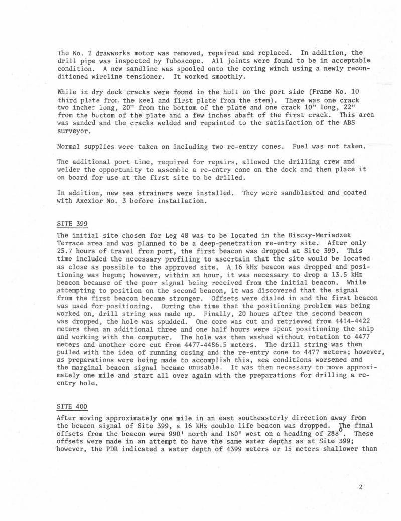
The No. 2 drawworks motor was removed, repaired and replaced. In addition, thedrill pipe was inspected by Tuboscope. All joints were found to be in acceptablecondition. A new sandline was spooled onto the coring winch using a newly recon-ditioned wireline tensioner. It worked smoothly.
While in dry dock cracks were found in the hull on the port side (Frame No. 10third plate fror>. the keel and first plate from the stem). There was one cracktwo incher long, 20" from the bottom of the plate and one crack 10" long, 22"from the bottom of the plate and a few inches abaft of the first crack. This areawas sanded and the cracks welded and repainted to the satisfaction of the ABSsurveyor.
Normal supplies were taken on including two re-entry cones. Fuel was not taken.
The additional port time, required for repairs, allowed the drilling crew andwelder the opportunity to assemble a re-entry cone on the dock and then place iton board for use at the first site to be drilled.
In addition, new sea strainers were installed. They were sandblasted and coatedwith Axexior No. 3 before installation.
SITE 399
The initial site chosen for Leg 48 was to be located in the Biscay-MeriadzekTerrace area and was planned to be a deep-penetration re-entry site. After only25.7 hours of travel from port, the first beacon was dropped at Site 399. Thistime included the necessary profiling to ascertain that the site would be locatedas close as possible to the approved site. A 16 kHz beacon was dropped and posi-tioning was begun; however, within an hour, it was necessary to drop a 13.5 kHzbeacon because of the poor signal being received from the initial beacon. Whileattempting to position on the second beacon, it was discovered that the signalfrom the first beacon became stronger. Offsets were dialed in and the first beaconwas used for positioning. During the time that the positioning problem was beingworked on, drill string was made up. Finally, 20 hours after the second beaconwas dropped, the hole was spudded. One core was cut and retrieved from 4414-4422meters then an additional three and one half hours were spent positioning the shipand working with the computer. The hole was then washed without rotation to 4477meters and another core cut from 4477-4486.5 meters. The drill string was thenpulled with the idea of running casing and the re-entry cone to 4477 meters; however,as preparations were being made to accomplish this, sea conditions worsened andthe marginal beacon signal became unusable. It was then necessary to move approxi-mately one mile and start all over again with the preparations for drilling a re-entry hole.
SITE 400
After moving approximately one mile in an east southeasterly direction away fromthe beacon signal of Site 399, a 16 kHz double life beacon was dropped. The finaloffsets from the beacon were 990' north and 180' west on a heading of 288 . Theseoffsets were made in an attempt to have the same water depths as at Site 399;however, the PDR indicated a water depth of 4399 meters or 15 meters shallower than

at Site 399. The drill string was then made up to wash a pilot hole to determinethe amount of casing that should be attached to the cone. A core was cut from4399-4408 meters and recovered 9 meters which then verified the PDR reading. Thehole was then washed as deep as possible without rotation and reached 4478 meterswhich would allow 79 meters to be washed in with the cone assembly. It required29 hours to pull the drill pipe, keelhaul the cone, make-up and latch the 16" casingand run back to bottom.
HOLE 400A
This re-entry site was spudded at 1745 and required three hours to wash in the 74.5meters of casing to 4473.5 meters. After washing in the shifting tool was run andthe 16" casing was released at 2200. The core barrel and shifting tool were re-covered and a new core barrel dropped. It then required 4-1/2 hours to set backthe Bowen unit, pick up the heave compensator, circulate air out of the system andrecharge the system, again pick up the Bowen sub and adjust the heave compensatorbefore the coring program could begin. Cores No. 1 through No. 34 (4473.5-4796.5meters) were cut using the heave compensator. After Core No. 34 was recovered, thefloat valve in the core barrel was found to be broken. Core No. 33 had 0.0 recoveryand Core No. 34 had 0.1 meter recovery. It was felt that the bit may be pluggedand plans were to drop a center bit and clear the obstruction; however, after findingthe broken check valve, it was decided to cut Core No. 35 without the heave compen-sator. Core No. 35 recovered 4.5 meters and the heave compensator was used untilCore No. 48 and was then locked out of the system because of a power unit problem.
After removing the heave compensator, recovery was good for four cores then theamount of recovery decreased. Twenty barrels of mud were spotted after Core No. 55with no improvement; however, after another 20 barrels were spotted following CoreNo. 60, recovery improved. After Core No. 73, 20 barrels of mud were again spotted.The circulating pressure was 1300 psi after dropping the inner barrel. It wasretrieved and a center bit dropped in an attempt to clear the bit. When trying torecover the center bit the pin sheared in the overshot. This was replaced and thecenter bit was recovered. Core No. 74 recovered only 0.45 meters so 228 barrels of9.4 ppg 40 sec viscosity mud was pumped into the hole and a round trip was made tosee what the problem was. When the string was recovered one cone in the bit (F93CK)was found that would not turn so the bottomhole assembly was made up with a F94CKcore bit and spaced out with a bit release sub as part of the assembly. The drillstring was run in and hung off at 4389 meters to start re-entry. The sonar re-entrytool was started in the hole at 0725 hours and the tool took weight at 0928 at3289 meters. The vessel was maneuvered and re-entry made in one hour and 23 minutes.After retrieving the sonar tool, 23 stands of pipe were run in to 5044.5 meters.Then for the next 2-1/2 hours, the heave compensator and Bowen sub were picked up.The drill string was then washed to bottom (5176.5 meters) and was hanging in thehole when the pin end of the pup joint attached to the Bowen sub broke and dropped528 joints of drill pipe plus the bottomhole assembly to the ocean floor. Therewas 5056 meters of drill pipe lost when the pin broke. Following this the Bowenunit and heave compensator was set back and a new string of drill pipe was pickedup.
During the coring operation three inclination surveys were made. Number one onCore No. 56 had no reading because the clock stopped; Number two on Core No. 58(5015-5024.5 meters) with 6° angle (good recordJ ; and Number three on Core No. 68(5100.0-5119.5 meters) with 7 45 (good record).

SITE 401
The loss of the drill string at Site 400 delayed departure for Site 401 approxi-mately 50 hours while the balance of drill pipe stored on board could be pickedup and racked. In addition, all the subs on the Bowen sub from the swivel on downwere magnafluxed as well as the two 20 foot pup joints, which were to replace theunit that failed.
Authorization was received from La Jolla on June 5 to proceed to an alternate loca-tion not previously approved by the Safety Panel, as the amount of drill pipe re-maining aboard restricted the depth of operations. It required only about fourhours of travel from the time the ship left Site 400 until the beacon was droppedat Site 401 in 2460 meters of water as shown on the PDR; however, after the ship hadbeen positioned to the desired location, the depth of water to the derrick floorwas calculated to be 2504 meters.
The drill string was made up with the heave compensator in the drilling assemblyand a mudline core was attempted from 2504-2508 meters and recovered only water.Six core attempts were made until a 8.5 meter core was recovered in the cored in-terval 2547.0-2555.5 and the mudline was considered to be at 2547.0 for all depthmeasurements at this site. After Core No. 1, the hole was washed to 2631.5 metersand was then continuously cored to Core No. 11 {.2717-2726.5 meters). At this point,the heave compensator was closed because pydraul was being lost. This problem wasremedied when it was found that a stop for a swash plate had fallen out and wasreplaced. After cutting three more cores, coring was discontinued when it becamenecessary to secure No. 2 Gyro due to a power failure. It required 2-3/4 hoursto determine the cause of the failure and make repairs. Burned out brushes werefound in the motor generator for No. 1 Gyro. Coring was then continued with theheave compensator working until the end of Core No. 20. After cutting this core,it took 15 minutes to close the cylinder. The problem was in some wiring behindthe instrument panel and was corrected so the heave compensator could be used againwhile cutting Core No. 23. Recovery had been poor from the time the gyro was re-paired (Core No. 15) and when Core Nos. 25, 26 and 27 came up with no recovery, 15barrels of mud were spotted to attempt to clean up the hole and find out if cuttingsin the hole were the problem. Pump pressure during the low recovery period wasnormal, so bit plugging was not felt to be a problem. When Core No. 28 also hadno recovery, it was decided to discontinue drilling and attempt to release the bitfor the first time and run a downhole logging program.
Preparation began by laying down 2-1/2 doubles, setting back the Bowen sub, settingback the heave compensator and picking back up the Bowen sub. Then four more doubleswere layed down and then the bit was doubled back to bottom to clean up the holewith a 20 barrel slug of 45 sec viscosity mud. The releasing tool was then loweredto release the bit; the release of the sub was shown by weight pick up, then losson the sandline weight indicator. To further assure that the bit was released, acenter bit was dropped and recovered. Then 80 barrels of 45 sec viscosity mud wasspotted and preparation for logging begun. The bottom of the drill pipe was pulledto 2666 meters so that the upper two bumper subs would have hole support.
Because of the calm seas, the sheaves were rigged in the normal manner when runningthe Schlumberger winch. An attempt was not made to use the heave compensator.

The first tool rigged was the gamma/sonic/caliper log which has two sets of springsfor centralizing the tool and for measuring the hole diameter. The tool startedin the hole at 1400 hours and came out of the drill pipe without any problem. Thetool went to 2869 meters or 17 meters from total drilled depth. This log was re-corded up to 2666 or the bottom of the drill pipe. A rerun of the logged sectionwas made and then a variable density log was run using the same tool. It was thenpulled to the surface with no trouble coming back into the drill pipe. Followingthis, the gamma induction and gamma/density/neutron logs were run without compli-cation. As each log was run, the pick up point (depth to which logging tool went)was shallower indicating that cuttings were probably filling the bottom. Anotherinteresting fact was that the gamma detected the interface of water and sea bottomat 2550 meters and not what the PDR indicated by about 45 meters. From the timethe sheaves were picked up until the last tool was on-deck required less than 15hours and all logs were of good quality.
The drill string was picked up and gear secured for the move to Site 402.
SITE 402
This site was the second of two new sites proposed for the Bay of Biscay drilling;the first being Site 401. It was close to Site 401 as it took only 4.5 hours totravel to the proposed site, do the necessary profiling and drop the beacon.
It was not possible to start making up the drill string at this site for four hoursdue to adverse weather conditions. After the drill string was made up, a mudlinecore was attempted at the depth indicated by the PDR (2335 meters); however, asat Site 401, the mudline core found bottom deeper (2355.5 meters) or 20 metersdeeper than the PDR measurement. A possible answer to the problem is that thesite was located in a small valley and possibly the PDR could be producing multiplesrather than true ocean bottom reflective data.
After the mudline core was recovered, the heave compensator was picked up and thehole was washed 42 meters to 2397.5 meters. Core No. 2 was cut and then a heatflow measurement was taken. A stand was then washed and then Core No. 3 cut andrecovered followed by a second heat flow measurement. Again, 28.5 meters werewashed and Core No. 4 cut, followed again by the third heat flow measurement. CoreNo. 5 (2483.0-2492.5 metersJ was then cut and recovered, but when the core was re-covered, a piece of metal was observed at the top of the core. The metal objectproved to be about 1/3 of the seal on the float valve and after some discussion, itwas decided to pull the string and replace the float valve. This was done becauseof the possible complications that could develop.
HOLE 402A
The necessary round trip was made to replace the float valve and the drill stringwas back on bottom in about nine hours. The hole was washed to 137 meters whichwas the total depth reached in Hole 402. Three cores were then cut and a heatflow measurement made. After this, the hole was continuously cored to Core No. 19(2663.5-2673.5 meters) where a drift shot was taken and showed only a 2 hole angle.Continuous coring continued to a total depth of 2825.0 meters.

During the drilling of this hole, the heave compensator was in the string at alltimes, however, it was taken out occasionally to see if there was any effect oncore recovery. At times, it appeared there was and then again the opposite wastrue. One thing that did seem to be consistent was that more time was required tocut a core when the heave compensator was being used. Sea conditions were idealfor drilling with a pitch and roll of about 2° as an average. The active mode wastried only once and could not be truly evaluated because of the calm sea conditions.
After the coring was completed, preparations were made to log the hole. The Bowensub and heave compensator were set back; the Bowen sub picked up; and a wiper runwas made by pulling 2 doubles and 11 stands. The string was then run back to thebit release point and 20 barrels of 9.0 ppg 60 sec viscosity mud was circulated.The bit release shifting tool was then run and the release was attempted. Thesandline weight indicator picked up to 6000 lbs and then decreased to a normal weightof 3500 lbs. When the pump was opened to 50 spm the pressure read from 500-550 lbs,so it was felt that the bit had been released. This was further substantiated whenthe tool was returned to the surface and the pipe disconnected. There was a constantheavy back flow of water indicating no float valve. The hole was then filled withmud using 150 barrels of 9.0 ppg 60 sec viscosity mud and the drill string pulledto the logging depth (2466.5 meters).
The Schlumberger sheaves were again used without the heave compensator because ofthe smooth seas. The gamma/sonic/caliper tool was made up and run in the hole. Itstopped at 2538 meters, but after picking it up and lowering it (gently spudding)three times, it broke through and stopped at 2801 meters (.24 meters off bottom).The hole was then logged back to the drill pipe with no problem. (Incidentallythe gamma tool picked the sea floor at about 2353-2355 meters which again confirmsdrill pipe measurement but does not agree with PDR) When the tool was lowered againfor a re log of the interval it would not go through an apparent bridge at 2540meters. It was thought that the large diameter of the centralizing and calipersprings may be the problem, so the tool was pulled and the gamma/induction tool,which has no springs, was made up and run in the hole. It too stopped at 2546meters and could not be spudded through the bridge. The tool was pulled to thedeck and it was decided to run in drill pipe and attempt to wash through the bridge.This would have to be done very carefully because only the top connector of the bitrelease remained on the bottom of the string. The Bowen unit was connected and thepipe washed successfully through the bridged area and to 2793.5 meters. It was notwashed deeper because of concern as to the nature of the material at 2801 wherethe gamma/sonic tool stopped. The pipe was again pulled to 2466.5 and the gamma/induction tool was made up and run in to 2804 meters with no indication of the bridgeproblem. This tool made two logging runs followed by the gamma/dnesity/neutronlog. It too went to bottom with no trouble and made two runs through the loggedinterval. The tools were layed down and the drill string was laid down and therig secured for departure to Site 403. Including the clean out run, the completelogging program was completed in 15 hours. While logging, the drill pipe was hungat 2466.5 meters to make sure that the top two bumper subs were below the mudline.
SITE 405
This site was the first hole to be drilled in the southwest Rockall Plateau and wasapproximately a two and one half day trip northwest from the Bay of Biscay.

A beacon was dropped in 2317 meters (PDR) of water which was confirmed with CoreNo. 1 (2317-2321.5 meters) which recovered 4.83 meters of soft sediments. Thehole was then continuously cored to a total depth of 2806 meters or a subbottompenetration of 489.0 meters. During the drilling, heat flow measurements weretaken following Cores Nos. 5, 11, 16, 21, 26 or until the sediments became toofirm for the heat probe to function properly.
Core recovery dropped markedly following Core No. 46 and the drill rate increasedthree to four times. The only recovery consisted of loose, fine sand and some smallrounded pebbles when using a plastic sock in the core catcher. Due to the apparentloose nature of the sediments, drilling was stopped because of the possible hazardto the drill string.
An attempt was made to log the hole. The rotary shifting tool was run and the bitwas released at 2802 meters. The hole was filled with 175 barrels of 8.9 ppg67 sec vis mud and the bottom of the drill string was positioned at 2432 meters.
The first log to be run was the gamma/sonic/caliper. The tool started in the holeat 1420 hours and cleared the bottom of the pipe (2432 meters) at 1450 hours. Acalibration check was made while running in the hole. The tool stopped at 2746meters because of an apparent bridge. The hole was logged from 2740 meters andthe tool brought back inside the drill pipe while the film was being developed.(The sea bed appeared to be at 2312 meters based on the gamma curve) After devel-oping the film, the tool was run back in the open hole and again stopped at 2761meters. It was pulled up and then run to bottom with a pick up at 2794 meters,while logging up, the tool stuck at 2778 meters and was dropped back to 2815. Whilelogging up, it stopped again at 2779 meters. When an attempt was made to drop backthe tool did not move so some slack was put in the cable. They logging up was triedagain; the tool cleared the stuck point; and the rest of the hole was logged upto 2450 meters. The tool had picked up an additional 1500 lbs which gradually wasreduced to 600 lbs. After reaching 2450 meters, the tool was dropped down in anattempt to lose the extra weight, however, this could not be accomplished, so thebalance of the hole was logged and the tool brought back on deck. There was noadditional material on the tool so the weight measurement was apparently no accurate,The gamma/induction log was made up but could not be run because the weather haddeteriorated so badly. In fact, the induction tool was damaged while trying toinsert it in the drill string. The ship waited on weather for 40 minutes and thenthe drilling crew started pulling the drill string slowly. The ocean floor wascleared at 1900 hours on the 23rd and it was not until 1100 hours on the 24th thatthe drill string was secured on deck. The ship then stood by waiting on the weatherbefore moving to Site 404.
SITE 404
After retrieving the drill string from Site 403, it was necessary to wait more than21 hours before the ship could be moved about five miles to drill Site 404.
The drill string was made up and run in to bottom. A mudline core verified thecorrected PDR depth of 2322 meters. Following the mudline core, the hole waswashed to 2343.5 meters where some resistance to drilling was encountered. A corewas cut but recovered nothing unusual so the hole was then washed to 2426 meters.Core No. 3 was cut as a check on lithology and also to ascertain if any hydrocarbons

could be detected for safety reasons. The hole was then washed to 2492.5 metersand then cored continuously to the suddenly terminated total depth of 2711.0 meters(389 meters sea bottom penetration}.
While cutting the last core, winds increased suddenly with gusts to 40 and 45 mph.The seas also increased rapidly to 10-12 feet. With the ship positioning in semi-automatic, it was decided that the drill string should be pulled. Fortunately,the heave compensator was not in the string so that it was possible to clear themudline quickly by being able to pull and lay down doubles instead of singles.Just as the string cleared the mudline, the ship moved off location 800-1200 feet.The drill string was then pulled until the bottomhole assembly was nearby to theship, but it was not possible to maintain a steady safe heading, so the bottomholeassembly was hung off until weather conditions improved. It required about ten hoursof standby before the bottomhole assembly could start to be brought aboard.
Unfortunately, because of the sudden worsening of weather conditions, it was notpossible to log this hole.
SITE 405
After retrieving the bottomhole assembly on Site 404, it was necessary to wait anadditional three and one half hours for the weather to improve before departingfor Site 405. After about 12 hours of travel, profiling and positioningwas dropped at Site 405.
Due to the fact that the bottomhole assembly had hung just below the ship for aboutten hours at Site 404, it was magnafluxed while making up the drill string at drillSite 405.
A mudline core was taken which verified the PDR depth of 2974 meters. The holewas cored continuously from there to a total depth of 3381.0 meters. Coring wasgood until approximately 3130 meters and then recovery dropped sharply. The drillrate had also increased markedly indicating a soft formation. Recovery consistedmainly of soft mud with some rather large cobbles located near the top of almostevery core. Mud was spotted twice to aid in improving recovery but had little effect.At about 3250 meters, the formation became firmer and recovery was good from thereto total depth.
When total depth was reached, the bit was released and the hole filled with 8.9 ppg62 sec vis mud preparatory to logging the hole from 3092 meters to total depth. Thefirst tool run was the gamma/sonic/ca lip er. While running in, the tool stopped atabout 3212-16 meters. Four attempts were made to penetrate the bridge and were un-successful. The hole was therefore logged from the bridge point to the bottom of thedrill string. This bridging point was coincidentally in the area of fast drillingand poor recovery mentioned earlier. After pulling the tool, the hole was carefullycleaned out to total depth. This was done carefully because the bit had been releasedand only the top connector of the bit release assembly remained at the bottom ofthe drill string. The hole was then filled with 200 barrels of 8.9 ppg 62 sec vismud and logging started again. This time the complete set of logs, gamma, sonic,neutron, density and induction were run with no problems, however, the logs did showan area of very soft material where drilling difficulties had been encountered. Thepipe was pulled in preparation for the short move to Site 406.

SITE 406
Site 406 was located only about five miles from Site 405, therefore, we were ableto start making up the drill string within 2-1/2 hours after leaving Site 405.After making up the drill string, a mudline core was taken and bottom was determinedto be 2911 meters (the PDR indicated a water depth of 2907 meters.) The hole wascored and drilled to 3334 meters and then continuously cored to a total depth of3742.5 meters. At this depth the water flow at the surface, when the core barrelwas removed, indicated that the float valve was probably stuck open. A center bitwas dropped to try and unplug the bit but, when it was recovered, the back flow ofwater continued, A core barrel was then dropped and 15 barrels of mud was pumped,however, the surface pressure indicated that the inner barrel was not seating properly,The core barrel was pulled and center bit with a longer tip was dropped. When re-trieved, back flow continued so a core barrel was again dropped. The pump pressuregauge again indicated that the barrel was not seating properly. Because of thetime factor involving our departure for Aberdeen, it was decided to discontinuedrilling and attempt to log the hole. The core barrel was recovered and a centerbit dropped for the wiper run prior to releasing the bit and filling the hole withmud.
Following the wiper run, the overshot was lowered to retrieve the center bit so theshifting tool could be lowered and the bit released. However, it came back to thesurface without the center bit and again the same way on the second attempt. Itwas decided that apparently the bit had been released in some unknown way, so loggingwould be attempted. The hole was filled with mud and the pipe pulled to loggingdepth. The first tool, the gamma/sonic/caliper, had no trouble in going out of thepipe and the rest of the logging tools were also run successfully.
When the drill string was recovered the bit, release sub, float valve and supportbearing were gone but the tool appeared not to have been shifted. The possibleanswer as to how the release was accomplished is that probably the segments whichhold the release sub had broken due to hard drilling and allowed the bit to comeoff during the wiper run. Another possibility is the failure of the "C" ring orsleeve keeper.
DRILLING AND CORING ASSEMBLY
The bottomhole assembly used on this leg was the standard DSDP assembly with theexception of those holes which were to be logged with downhole logging equipment.The standard assembly consisted of a bit, bit sub (with float valve, core barrel,three 8-1/4" drill collars, one 5-foot stroke Baash-Ross bumper sub, three 8-1/4"drill collars, two 5-foot stroke bumper subs, two 8-1/4" drill collars, one 7-1/4"drill collar and one heavy wall 5-1/2" drill pipe. When the hole was to be loggedthe bit was attached to the bit disconnect assembly which in turn was attached tothe bottom drill collar. During drilling operations, this bit disconnect assemblyis held in place by removable lugs which are held in place by a shifting sleeve.When logging depth has been reached a shifting tool is lowered and when pulled up,shifts the sleeve from behind the lugs allowing them to fall in and thus freeingthe bit. This operation was successful on four of five holes. The one exceptionwas at Site 406 where the bit released before the shifting tool had been used.There are several possible answers to the question of how this happened. They werediscussed above under the Site 406 summary.

A major loss occurred at Site 400A following the first re-entry. The re-entry hadbeen verified and the pipe washed to bottom. During a connection and while justhanging in the hole, the pup joint below the Bowen unit broke at the pin and droppedthe entire drill string composed of 528 joints of drill pipe and the bottomholeassembly to the ocean floor. This left 469 joints of pipe on board the ship.
On Site 404 drilling was terminated because of a sudden build up in wind and seas.The drill string was laid down but the bottomhole assembly hung for ten hours beforethe weather had subsided enough to bring it on board. Therefore, before runningin to drill Site 405, the bottomhole assembly was magnafluxed.
BITS
Two F93CK bits were used on this leg; one on Holes 399, 400 and 400A; the otherwas used on Hole 406. The balance of the holes were drilled using F94CK bits. Thepenetration rates for the two different type bits was quite similar. The F93CKaveraged 25.7 meters/hour while the F94CK averaged 24.0 meters/hour. It was notpossible to determine the bit condition of the bits except for one because thebalance were released for the logging program.
BEACONS
Nine beacons were used on this leg and all performed very good with the exceptionof those used at Site 399. A 16 kHz was dropped initially but after an hour ofpositioning, the signal deteriorated so much that a 13.5 kHz beacon was dropped.While attempting to position on this second beacon, it was discovered that theoriginal beacon was coming in stronger. Offsets were dialed in and the first beaconwas used for positioning. However, weather conditions worsened and this marginalsignal became unusable so the ship was moved about a mile and another beacon wasdropped.
POSITIONING
Positioning on this leg could be considered excellent except for the problems en-countered at the first site and described in the section on beacons. The only othertime that the ship moved off position was on Site 404 where extreme weather conditionsmade it impossible to hold position and therefore, the pipe was pulled and had justcleared the mudline when the ship moved off location about 800 feet. One otherproblem developed on Site 401 when it was necessary to secure the gyro compass dueto a power failure. The ship was held on location in manual and then semi-automaticmode until repairs had been made. This took about an hour and a half and was due toburned out brushes in the motor generator for No. 1 gyro.
HEAVE COMPENSATOR
The heave compensator was not used on Sites 399 and 400 because they were strictlypilot holes to find out how much casing would be necessary to attach to the re-entrycone. It was put in the system as soon as the casing and cone had been washed inat Hole 400A. Following Core No. 49, it was locked up because of a power unit problem.It was still out of the system until Core No. 74 was cut and it was decided to come
10

out of the hole and see if there was some problem with the bit due to poor recovery.It was set back until re-entry had been accomplished and was then put back in thestring. The string was washed to bottom and was hanging free when the pin brokeon the pup joint connected to the Bowen unit.
The heave compensator was used again in Hole No. 401 and was used until a swashplate plug fell out. As soon as it was replaced and container refilled with fluid,it was put back in the system. After taking Core No. 20, 15 minutes were requiredto close the cylinder. The heave compensator was finally taken out when total depthhad been drilled and logging was to start. The seas were so calm that the Schlumbergerengineer did not feel that the heave compensator would be necessary. The heave com-pensator was put in the string for Site 402 and was out for two cores while a checkvalve was being repaired. It was pulled again when logging started. Between Sites402 and 403 Mr. Lockman, GMI's Project Engineer on the heave compensator, was trans-ferred to an offshore drilling vessel (Neptune No. 7), so he could return home.Another engineer was not sent to replace him. The heave compensator was used onSite 403 as a check to see if a difference in recovery and penetration rate couldbe detected when it was used or locked out. It was decided to stop drilling andlog this site so the heave compensator was set back. After running one log theweather had become so bad that the string was pulled.
The heave compensator was not used for the balance of the leg because of the rapidlychanging weather conditions and the need to be able to quickly clear the mudline.The use of the heave compensator requires that the drill pipe be handled one jointat a time. Without the heave compensator two joints can be handled at one time.
The passive mode was used at all times except for one core taken in the active mode.Weather conditions during this period were too smooth to make a good test.
RE-ENTRY
Re-entry was scheduled for only one hole on this leg. This was Hole 400A, drilledafter determining the amount of casing that could be washed in with the cone (HoleNo. 400). The hole was drilled to 5176.5 meters (sea floor depth was 4399.0) whenrecovery became so poor it was decided to pull the string and see of something waswrong with the bit.
The string was recovered and the bit changed and run back with the pipe hanging fivemeters above the top of the cone. The sonar tool was on bottom at 0928 and at 4389meters the cone was stabbed after positioning one hour and 23 minutes. Re-entry wasverified but while the drill string was hanging after cleaning out to bottom, thepup joint pin in the Bowen unit broke and dropped the drill string to the bottom.No additional re-entries were attempted on this leg.
HEAT FLOW
Fourteen heat flow measurements were made on this leg. Ten of these were run usingthe heave compensator when it was in the drill string. Of these ten, nine weresuccessful. The one failure was when the tip of the probe was broken off during therun. The last five were run at Site 406 without the heave compensator because ofuncertain weather conditions. They too proved to provide satisfactory data.
11

The measurements were taken using the tool set up which was developed by Al Ericksonon Leg 46. Each measurement required about 1-1/2 hours to run from the time thetool started in the hole until it was back on deck.
HYDROCARBONS
Although this leg drilled through many meters of sediments, no evidence of hydro-carbons was detected. The voyage was staffed with a scientist responsible formonitoring any gases which might have been encountered.
LOGGING
This leg again enjoyed the opportunity of having downhole logging capabilities. Themoney for the program was provided by the Institute of Oceanographic Sciences ofthe National Environmental Research Council for the Department of Energy, locatedin Wormley, Godalming, Surrey, United Kingdom.
In addition to having the capability of using the re-entry technique where a coneand casing have been washed in, it was also possible to log single bit holes by re-leasing the worn out bit and then running logs in the same manner as in re-entry.Using this piece of equipment logs were run in five holes.
The logs which were run included the gamma/sonic/caliper, the gamma/neutron/densityand the gamma/induction.
These logs were run by a very capable logging engineer, Mr, Lamb, from SchlumbergerWell Services.
The results of the logs were met with a great deal of enthusiasm by the scientists onboard because it aided them in their interpretation of the part of the section wherecore recovery had not been complete.
COMMUNICATIONS
All of the project's communications were handled by the Navy's secondary circuitwhich sends outgoing traffic via the Navy station in Makri, Greece and the incomingtraffic by means of Mercast System. This involves sending traffic blind, three timesa day. As a rule, the traffic placed in San Diego by closing time would be receivedat 1000 hours on the ship the next day.
A few personal telephone calls were made via the French and English coast stations.Many personal calls were made by the amateur (ham) station, also with the help ofanother amateur radio operator on board. The total volume of traffic was ratherlight as compared with previous legs. No effort was made to contact WWD directlyin San Diego as we were out of his range during his working hours. We will be inWWD s range by the middle of the next leg.
ACKNOWLEDGEMENTS
As has been true since the program began, all of Global Marine's personnel wereextremely helpful and their performance was outstanding.
12

The Scripps' technicians also performed to their normal high degree of efficiency,particularly making sure things were accomplished on time and in an orderly manner.
The scientific group should be commended for their professional approach, cooperationand attitude throughout the leg. It was a great pleasure to be associated with sucha dedicated group during this cruise.
Robert R. KnappCruise Operations ManagerDeep Sea Drilling Project
13

INTERNATIONAL PHASE OF OCEAN DRILLINGDEEP SEA DRILLING PROJECT
OPERATIONS RESUMELEG 48
Total Days (May 12, 1976 - July 13, 1976)Total Days In PortTotal Days Cruising Including Site SurveyTotal Days On-Site
61.869.6511.4140.8
Trip TimeDrilling TimeCoring TimePositioningMechanical DowntimeRe-entryWait On WeatherOther (Includes Logging)
8.6.09
20.9.6.57.54
1.87.7
Total Distance Traveled (Nautical Miles)Average Speed (Knots)Number of SitesNumber of Holes DrilledNumber of Cores AttemptedNumber of Cores with RecoveryPercentage of Cores with RecoveryTotal Meters CoredTotal Meters RecoveredPercent RecoveryTotal Meters DrilledTotal Meters of PenetrationPercent of Penetration CoredMaximum Penetration (Meters)Minimum Penetration (Meters)Maximum Water DepthMinimum Water Depth
1935.48.78
1031830896.8%
2995.51230.22
41.06%910.5
3992.075.03%
831.572.5
44142317
14

I PODDEEP SEA DRILLING PROJECT
LEG 48TOTAL TIME DISTRIBUTION
ON-SITE 40.8 = 65.9%IN PORT 9.65 = 15.7%CRUISING 11.41 = 18.4%
ON-SITE TIME BREAKDOWN
OTHER
(INCLUDES LOGGING)
18.52%
1 24%
15

30°W• • • I i i i i I i I
A T L A NJT I C. C
O C E A N \ T× =o
B•vscay Abyssa?Plain
Depths in Metersx
-60°N
- 5 0 '
- 4 0 '
A Leg 48 Sites Dril led
16
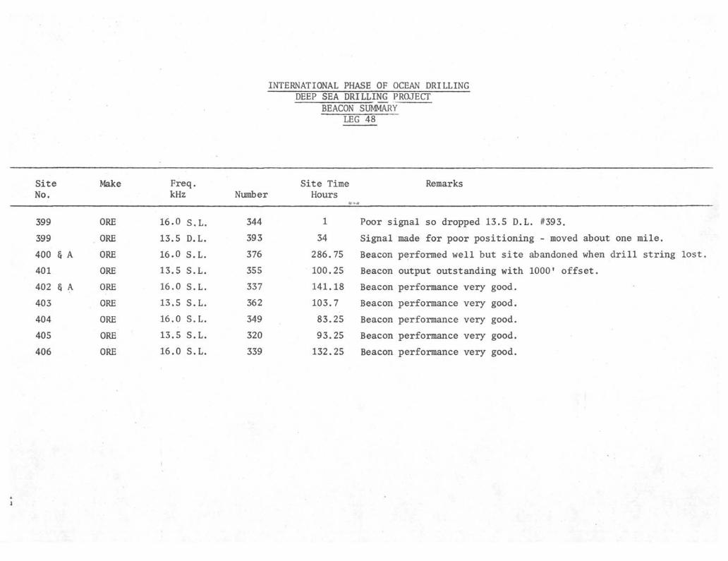
INTERNATIONAL PHASE OF OCEAN DRILLINGDEEP SEA DRILLING PROJECT
BEACON SUMMARYLEG 48
SiteNo.
Make Freq.kHz Number
Site TimeHours
Remarks
399
399
400 § A
401
402 § A
403
404
405
406
ORE
ORE
ORE
ORE
ORE
ORE
ORE
ORE
ORE
16.0 s .L,
13.5 D.L.
16.0 S.L.
13.5 S.L.
16.0 S.L.
13.5 S.L.
16.0 S.L.
13.5 S.L.
16.0 S.L.
344
393
376
355
337
362
349
320
339
1
34
286.75
100.25
141.18
103.7
83.25
93.25
132.25
Poor signal so dropped 13.5 D.L. #393.
Signal made for poor positioning - moved about one mile.
Beacon performed well but site abandoned when drill string lost.
Beacon output outstanding with 1000' offset.
Beacon performance very good.
Beacon performance very good.
Beacon performance very good.
Beacon performance very good.
Beacon performance very good.

W I M M M '*>. *
INTERNATIONAL PHASE OF OCEAN DRILLINGDEEP SEA DRILLING PRO.JECi
BIT SUMMARY
LEG 48
Hole Mfg Size
399
400
400A
400A
401
402
402A
403
404
405
400
Smith
Smith
Smith
Smith
Smith
Smith
Smith
Smith
Smith
Smith
Srr-ith
10"
10"
10"
10"
10"
10"
10"
10"
10"
10"
10"
Type
F93CK
F93CK'
F93CK
F94CK
F94CK
F94CK
F94CK
F94CK
F94CK
F94CK
F93CK
SerialNur•>b er
996-BS
996-BS
996-BS
3S9-BV
300-BV
326-BV
326-EV
356-BV
3Cc-BV
305-BV
997.BS
MetersCored
17. 5
9.0
701.0
0
265.0
42.0
332.0
4S9.0
243.5
407.0
489.5
MetersDrilled
55.0
70.0
2.0
0
76.0
95.0
137.5 •
_ _ _
145.5
.. _ _
342.0
MetersTotalPenet
72.5
79.0
777.5
0
340.0
137.0
• 4 6 9 . 5
489.0
3S9.0
407.0
831.5
HoursOnBit
1.2
.56
38.18
.25
15.26
1.73
42.23
13.23
7.S
12.6
28.4
Condition
No Wear
No Kear
TO-B1*-1
New Bit
Bit Released
TO-BO-1
Bit Released
Bit Released
TC-BO-I
Bit Released
Bit Released
Will rerun on Site 400.
Rerun from Sice 399.
*0ne cone very tight.
Washed in two singles; prepared to startcoring; string dropped.
Logged hole using bit release sub.
Rerun from Hole 400.
Sit not released for logging - will beable to be reruii.
Rerun
oo

INTERNATIONAL PHASE OF OCEAN DRILLING
Hole
399
400
400A
401
402
402A
403
404
405
406
Latitude
47° 23.40'N
47° 22.90'N
47° 22.90'N
47° 25.65'N
47° 52.48'N
47° 52.48'N
56° 08.36'N
56° 05.13'N
55° 20.18'N
55° 15.53'N
Longitude
09° 12.31'
09° 11.90'
H
W
CS° 11.90'W
0S° 48.62'
CS° 50.44'
08° 50.44'
23° 17.63'
23° 14.95'
22° 05.49"
22° 05.25'
wwwwwww
Water
Depth
Meters
4414
4399
4399
2547
23S5.5
2355.5
2317.0
2522.0
2974.0
2911.0
Number
Of
Cores
2
1
74
28
5
55
52
26
43
52
318
D£EP
Cores
Cores With
Recovery
2
1
73
24
5
34
51
26
40
52
308
SEA DRILLING
SITE SUMMARY
LEG 48
Percent Of
Cores With
Recovery
lθü.0
100.0
98.6
85.7
100.0
97.1
98.0
100.0
93.0
100.0
96.8
PROJECT
MetersCored
17.5
9.0
701.0
265.0
42.0
332.0
489.0
243.5
407.0
4^9.5
2995.5
MetersRecovered
11.77
9.0
329.39
103.22
12.19
167.5
160.83
74.87
172.05
189.42
1230.22
PercentRecovered
67.3
100.0
46.9
3S.95
29.0
50.4
32.9
50.7
42.27
5S. 69
41.06
MotorsDrilled
55.
70.
2.
76.
95.
137.
- -
133.
- -
342.
910.
0
0
0
0
0
3
0
0
5
TotalPenotMeters
72.5
79.0
777.5
340.0
137. C
469.5
489.0
389. C
4U7.0
831.5
3992.0
AvgRate
Penet
60.4
138.5
20.4
22.3
79.2
11.1
34.3
49.8
32.3
29.2
47.75
TimeOil
Hole
1. 2
.6
38.2
100.2S
32.5 •
109.3
103.7
S2. 25
93.25
137.25
698.5
TimeOn
Site
.9£>
10.98
4.17
5.9 -
4.32
3.42
3.88
5.71
40.83

D£fP 5£A DRILLING PROJECT
T/ME
LEβ -
Date
S•A •7L
S~/9 •7i
S/f.%
5l£•%
C if) π/
SOòVUs py %
• 7 ,
&?£
Si is
f/9L
j /
Crwse
*
•*
•
•
•
•
Tr/ρs
•
•
•
•
•
•
/ÒOZ
U 'If
ZZ òb
Dr///
•
•
•
•
•
1 '0
Core
•
¥
••»•
*•
3 -2f
•
StuckP//oe
v •
•
•
•
•
•
•
•
•
•
•
•
•
• •
• • .
•
•
•
•
•
3 -7f
w• s
3 r
Afsch.Repair
•
•
•
•
•
PortT/me
/r r
J</ O
J</ o
3+*0
•, •
•
•
•
/?e-
•
•
•
• • •
•
•
oràer
-
>
•
•
•
•
•
•
j</.#
2V .0
• 3
23/< ?
£3 7
3Z,v<r
/S .IS
20 .&
3s" 7f
3 - '
• 'V
o


D££P SEA DR IL LI NO PROJECT
T/ME
Date
/ Q fi/CP' ù /(*
6•f %
A •/D %
'<OTt.
U•/àQù
<j> •/a•7ù
L •)) K
• -72b lx%
á>•/5-%
6 -iffy6>• /á 7é>
• 7òfr{£> '//j '%
/ )*7 *7/(p */ / / £
ùJtHL
6 a %
StieMo.
102
Crt//se
•
•
•
••
«
•
•
•
WO
Tr/p
•
/ß>O
ù> D
•
t•z/o•i
•
•
•
•
•
Dr///
•
/'0•
•
<λ<o
./
.
•
-
•
Core
Λ/ÚS-
.
•••
Z•O
/s~•o
Z</•o
//•o
•
•
•
•
•
L
StuckP/PC
•
•
•
•
•
•
•
•
•
-
•
•
εβ -
•
•
•
3-0
3.-ù
•
•
•
•
pOJ///0tfS/i/p
<
•
A.0>
•
•
• •
•
•
i •?
Alech.Repair
£•?r•
s Tsr
••
\
••
••••
PortT/me
»
•
•
, •
•
•
ffe-
•
•
...
•
-
•
•
•
•
Of/ter
.
A/ •O
</•X
3-S••Q^
•
•
»
3 o
3 o
/ •O
/3 D
. ?.?
•
•
•
9 -Jr/&> >?r
èos
8>S~
31 -ST
£V*0
#JV %0
•2Vθ
/3 3
/09•s
/ó .7JV•Ó
<?Y o3.3
fcvar/ts
{
NJNJ


D£fP 5£A DRILLING PROJECTT/ME D/5T/?/BUr/OA/
I£6 -Date
7-1 •%H η èηl/ 's^• ' >(?
7 3 -%
74 1/,7•¥.%
7•?•%
74%7.7%
7 f ft74-71'"'"•* *fa14 %
η tnc
S/feM>..
j
Cw/se
•••
•
••••
Tr/ps
8 *S>
•*
«
•
/λ•ù
•
•
•
Dr///
\
•••
4 •zr•
•b-7
•
•
•
Core
.
•
M*Ó
A-9 -ò/f>Z)
•
71-0••
••
StuckP/pe
• ••
•
•
•
•
•
•
•
•
•
•
w.αw.
•••••
•
•
« •
•
•
•
/ 7
•
•
••
••• •
«
Afech.Repair
•
.5-
•
•
•
••
Por/T/me
•
•
.
fn/ry
•
••
••
•
•
O/Aer
1'òD/X>7S
>
•
SeJ5 .0y 7r
••
••
7/we
/i•<ö93 -IS
7 .rJ9 <&19 .0J</.<D
J9'ò9 7r
/9 Jr
£V*0
9.3
/Fe^arAs
/=IUIH /&> '.".-,

Or
100TO, 72.5/v
200
300
g 400
zUJΛΛ
UJH-UJ
500
600
700
800
900
DRILLING DAYS 25

5 0 >
100-
150-
g 200-H
H
W 250-Q
300-
350-
400-
45U —
-
P I T
£-3
i
>
t
' J
~ηTD 72. SM
•
•
i i10 20 30 40 90 140+
METERS/HOUR26

100
200
300
g 400
ZLU
α.toUJ 500
000
700 -
800
90025
DRILLING DAYS 27

0
50
100
150
zo
UJ
zUJ
200
250
300
350
400
10
/ L
• 81/5
20- -;..., 30
* METERS/HOUR
40 90 140+
28

LLJ
zUJα_t/>ex.UJ
°r3 iT^ 4θo-/\
100
200
300
µ 400
500
600
700
9003 O
DRILLING DAYS
29

100
200
300
p 400
ZLUQ_COQ£LUI—UJ
500
600
700
800
900J
DRILLING DAYS30

04θ
50
100
45
150
ZO
LU
UJQ-
UJh-UJ
200
250
300
350
400
450
33
35
39 4ö10
fiI?
n
32.
54
5 7
Ito
20 30
* METERS/HOUR
40 90 140+
31

o<t—
zLU
tx.LU
450 r
500
550
600*-
650
700
750
oo-A
800
850
900 1 J4o\
32
2O 3O ' 4θ
METERS/HOUR

100
TC 40/
200
\
\
zLU
DCLU
LU
300
g 400
500
600
700
800
T.D. 3 4O n)
9009 . tù
DRILLING DAY? 33
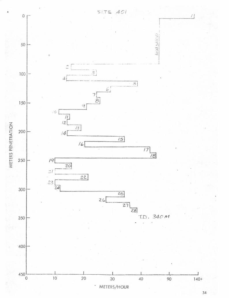
o -
50
100
150
2005
LU
CO
£ 250
300
350
400
450
SITG 40 i
r> r
7
L.
/
24
10
I
14($\
IL13
nIB
Z7zβ
T.D. 34CM
20 30
* METERS/HOUR
40 90 140+
34

zo
zIU
KTt
S. 4o
200
300
400
TO.
500
600
700
800
900(3 . 1HDRILLING DAYS
35

50
100 i/g
150 T.D.
zo 200
250
300
350
400
450'0 10
130
' METERS/HOUR
40 90 140+
36

O
<ath-LU
zLU
α_
er.
200
300 h
400
>OO
600
700
800
900
4OZ-A
DRILLING DAYS37
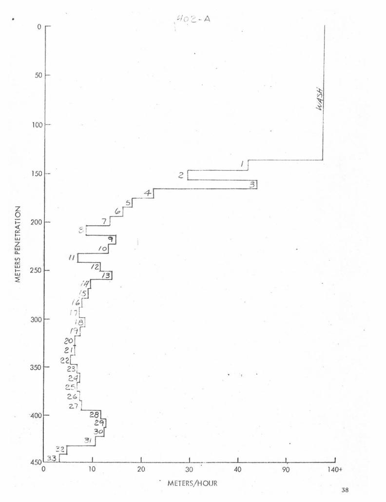
0
50
100
150
zo
UJ
zLU
200
250
300
350 -
4 0 0 -
. , . . . . n •.4
/oII
?
10
-lOZ~Δ
f
/ jz
3
20 30
* METERS/HOUR
40 90 140+
38

zoI—<
IUzUJα.
LU
450 4o2•• A
34J35 r
~ 4iyhS Λ I
500
550
600
650
700
750
800
850
900
METERS/HOUR
39

0
100
200
300
o<ac\-
zto
LUI—LU
400
500 TO. 489.0
600
700
800
9002.1
DRILLING DAYS40

/ U23
50
3
oI—<
h-LU
zDC
UJ:>
100
150
200
250
300
350
400
450
// | .
2/
4θ\
10
ri
30
20 30
* METERS/HOUR
2726
3/
111
313
40 90 140+
41

450
500
>/T£÷~ ±
sz.HZ]
550
600
o<H-LUzUJα.
650
700
750
800
850
900 X—~
* METERS/HOUR 42

100
200
300
£ 400<onJ—LU
zLUQ.
E 500
TD
600
700
800
900
DRILLING DAYS43

0
50
100
150
200
250
300
350
400
4500
/5
17
'β
4o4
1
n
-5T'
T.D. 33?
-
4
3
&
/o
10 30
METERS/HOUR
40 90 140+
44

zo<»—LU
zLUIX.<y>DC
0
100
200
300
400
500
600
700
εoo
900
r \\\-\
\\\\\\\
«
1 I i
T£ 4 OS
T D 4θ!>
•
1 1 I3 0
DRILLTKIG45

0 r-
50
100
150
zo<
zUJ
α.
onUJ
200
250
300
350 -
400
7
5
-5 r
z34
JË
zz23Z4'
4500 10 20 30
* METERS/HOUR
40 90I
140+
46

0
100
200
zo<DC
300
400
CODCLU 500
600
700
800
900
TΛ>
J u ( » y éDRILLING DAYS
7 S
47

o<an\—LUzLUß-
LU
LU
0
50
100
150
200
250
300
350
400
••
"7
δ
^ i
/ I
z
VI
1
3|
I
<
1
//_JL_ i )
10 20 30
* METERS/HOUR
90 140+
48

zo<
zU.1
UJ
450
500
550
600
650
700
750
800
850
900 —o
3<3
25Z4
2Z
i
•
i =
• .
'i
M
23 f
1/
' 3
WIV?l
HO
SJ
~T:D. 33), S/n
3g]
3 •
METERS/HOUR49

INTERNATIONAL PHASE OF OCEAN DRILLINGDEEP SEA DRILLING PROJECT
OPERATIONS RESUMELEG 49
Leg 49 of the IPOD Program was designed to drill in two regions of the NorthAtlantic Ocean, the Reykjanes Ridge and the Mid Atlantic Ridge.
The leg started July 13, 1976 in Aberdeen, Scotland and ended 53.47 days laterat Funchal in the Madeira Islands. During this voyage the GLOMAR CHALLENGERtraveled 4717.6 nautical miles and drilled 10 holes at 8 sites. Water depthsranged from 842 meters to 2987 meters and averaged 2241 meters. Hole depthsranged from 37 meters penetration below the mud line to 458.5 meters and aver-aged 268 meters. A total of 1943.5 meters was cored and 881.43 meters were re-covered, a recovery percentage of 45. —-——
Time distribution for the leg was 6.92 days in port, 23.8 days cruising, and22.75 days on-site. The on-site time consisted of 11.36 days coring, 5.16 daystripping, 0.47 days drilling or washing, 0.33 days with stuck pipe, 0.66 dayswaiting on weather, 0.97 days positioning the ship, 1 day downtime, 0.47 dayson post site surveys, and 2.33 days miscellaneous, such as heat flow measurements,pore water sampling, deviation surveys, probing the ocean bottom for enoughsediment thickness to commence coring, etc.
A tragic rig floor accident that took the life of a rotary helper occurred whileoperating on Site 409. The pin in the starboard skate of the Bowen power subtorque arm broke and allowed a 600 lb. +_ assembly to fall from the derrick. Itstruck and instantly killed Mr. Meadows.
Weather became a problem in the area of the leg where least expected, the MidAtlantic Ridge. It caused the termination of three holes and eventually causedthe length of the voyage to be shortened.
The port call that terminated the leg was changed from Las Palmas in the CanaryIslands to Funchal on Madeira Island only three days before entering port. Manylast minute arrangements were required.
PORT CALL - ABERDEEN, SCOTLAND
Leg 48 ended and Leg 49 began when the GLOMAR CHALLENGER arrived in Aberdeen,Scotland at 0420 hours on July 13, 1976. Loading of all ordinary supplies andstores was accomplished while we were moored port side to Pacific Deep Water Pier.A major amount of time was taken in loading drill pipe to replace a completestring lost during Leg 48. A total of approximately 6360 meters of drill pipeand four drill collars were taken aboard. The rules at the port of Aberdeen re-quired the use of the large, slower dockside gantry cranes instead of the cranes

aboard the vessel. Stevedores were a requirement in loading nearly all suppliesand there were numerous minor disputes to clarify the work rules. Bulk gel,barite, and cement were loaded to completely fill available storage. A total of228,692 gallons of fuel oil and 42,222 gallons of drill water were taken on aftermoving to the fuel pier.
A major overhaul was performed on engine No. 6 and new connecting rod and mainbearings were installed in engine No. 11.
The entire heave compensator system was inspected and tested by Global Marine andthe manufacturer's representatives.
At 0554 hours on July 18, 1976, the CHALLENGER got underway to begin her treknorthwest to the Reykjanes Ridge area. However, less than two hours after gettingunderway, the ship reversed course and returned to Aberdeen to disembark a seri-ously ill seaman for hospitalization. A local able-bodied seaman (United Kingdom)was signed on to replace him and the vessel was again underway at 1005 hours toresume the voyage.
SITE 407
The first site of Leg 49 was. located on the west flank of the Reykjanes Ridgeand was a single bit entry. The beacon was dropped after over five days of travelfrom Aberdeen. A 16 kHz beacon was used and 1.7 hours were spent positioning theship at a location approximately 1000 feet south and 1300 feet east of the beacon.The water depth at the drill site, as recorded by the Precision Depth Recorder(PDR), was 2482 meters corrected to the rig floor. The drill string was made upand measured by steel line as it was run to bottom. A mud line core establishedbottom at 2492.5 meters. The hole was cored continuously from the mud line tototal depth. Some minor sticking was experienced and the hole was flushed withmud at 2821.5 meters, 2850 meters, and 2897.5 meters, each time completely freeingthe tight hole. Heat flow measurements were recorded at 2688.5 meters, 2736 metersand 2783.5 meters. A hole deviation survey taken at 2935.5 meters recorded2-1/2°. Penetration ceased and the hole was terminated at 2951 meters drill pipemeasurement (DPM) from the rig floor, or 458.5 meters of penetration below themud line.
The hole was plugged with 150 barrels of 11.2 pounds per gallon mud. When thebit was pulled it was found to have two cones with the bearing life completelygone, two cones locked, and the bit out of gauge by 7/8 inch. The inserts showedvery little wear. Approximately 65% of the total penetration was in sediment andthe remainder in basalt lava. As the bearings became worn and the core diameterdecreased, the core recovery increased notably. Cutting a smaller diameter corein the basalt apparently reduced the jamming at the core catcher. If this obser-vation holds true on other sites, it might be worthwhile to redesign the bits tocut a smaller core and keep the dimensions of the core barrel assembly the sameas they presently are.
No problems were encountered at this site. The towed survey gear was streamedand a post site survey was made.

SITE 408
This site like Site 407 was also a single bit entry on the west flank of theReykjanes Ridge. However, it was necessary to make a port call in Reykjavik,Iceland to disembark an ill seaman for hospitalization and the first assistantengineer for compassionate leave and to sign on replacements for each beforework could begin. This resulted in a loss of 63.5 hours between Sites 407 and408. A 13.5 kHz beacon was dropped and 0.8 hour was spent positioning the shipover the beacon. The water depth at the drill site was 1634 meters by PDR cor-rected to the rig floor. The drill string was run to bottom and on this sitethe drill pipe pinger was put into use. The pinger and the drill string weightindicator both confirmed the PDR reading of 1634 meters. When the drill pipepinger was retrieved it was found to be leaking oil from both ends of the trans-ducer. The hole was cored continuously from the mud line to total depth withoutany problems. Heat flow measurements were taken at 1729 meters, 1805 meters, and1881 meters.
The hole was prematurely terminated at 1995 meters DPM, or 361 meters of pene-tration below the mud line, because of the necessity to again take a seriouslyill seaman into Reykjavik, Iceland for hospitalization. The hole was pluggedwith 100 barrels of 11.2 pounds per gallon mud. The bit from this hole stillhad effective seals, was in gauge, and indicated very little wear on the inserts.Approximately 91% of the total penetration was in sediment and the remainder,in basalt.
SITE 409
The third site was a single bit entry on the crest of the Reykjanes Ridge. Therewas a loss of 50.6 hours between Sites 408 and 409 because of the emergency tripinto Reykjavik with the seriously ill seaman. A 16 kHz beacon was dropped and1.1 hours were spent positioning the ship over the beacon. The water depth atthe drill site was 841 meters as measured by the PDR and corrected to the rigfloor. The bottom was found at 842 meters with the bit (DPM) and coring wasbegun at the mud line. The bottom was found to be very firm and spudding wasvery difficult. After coring one meter and recovering a small amount of sand,the hole was washed 23.5 meters and then continuously cored. Tight hole wasexperienced at 1037.5 meters and 50 barrels of mud was pumped to flush the hole.After retrieving core No. 30 at 1142 meters, the bit became plugged. The corebarrel was retrieved, dropped again, and retrieved. This slight swabbing actionapparently unplugged the bit. The hole was then flushed with 50 barrels of mudand coring continued. While making a connection to continue coring after re-trieving core No. 32 at 1161 meters, the pin connecting the starboard skate tothe Bowen power sub torque arm broke allowing the 600 pound skate to fall to therig floor. It struck and killed instantly one of the rotary helpers. The holewas immediately terminated and the drill string pulled. The vessel then proceededto Reykjavik where the body was removed and repairs were made to the failed torquearm. Total penetration from the mud line was 319 meters. The bit from this holehad effective seals when pulled, was in gauge, and showed little insert wear.Approximately 25% of the total penetration was in sediment and the remainder invesicular basalt.

SITE 410
The fourth site was on the Mid Atlantic Ridge, one weekfs travel time fromReykjavik. A 16 kHz beacon was dropped and 1.3 hours were spent positioning theship to commence operations. The water depth, as measured by the drill pipe,was.2984 meters. Coring was begun at the mud line and progressed through 340meters of sediment to the top of the basalt. The pore water sampler was runsuccessfully at 3029.5 meters, 3077 meters, 3191 meters, 3248 meters, and 3276meters. Heat flow measurements were taken at 3058 meters, 3105.5 meters, 3162.5meters and 3219.5 meters. No problems were encountered in running either instru-ment. At 3343 meters, the next connection after reaching the basalt, 100 barrelsof gel mud was spotted in the hole to aid in preventing possible sticking andthe heave compensator was picked up and put into operation. This was the firsttime that the heave compensator was used on Leg 49 and it worked very well inthe passive mode. It was not operated in the active mode on this hole. Aftercoring only 47.5 meters of basalt, the inner core barrel became stuck in theouter barrel. Three runs were made with the sandline but the pin sheared ineach case. The bit had plugged at the same time the core barrel became stuck,so there was also no circulation. Another inner core barrel was then run in onthe sandline and pulled rapidly out to effect swabbing in an effort to unplugthe bit and also free the stuck inner barrel, all to no avail. A "wet" drillstring was pulled in order to unplug the bit and recover the inner barrel. Whenrecovered, the core barrel and bit were tightly packed with coarse grained"sand" or cuttings. The last two 9.5 meter cores had cut very quickly; fasterin fact than the previous two and the very last one in only 32 minutes. This,coupled with rounded corners on the cuttings/"sand", led the author to thinkthat the fast coring had been actually a "sand". Core recovery had been pooron these last two cores so no conclusive case could be built to identify thesource of the plugging. The bit was in excellent condition (Tl-Bl-I) and wasrun in the hole twinning this lost one.
HOLE 410A
This hole was located 350 feet away from Site 410 on a course of 020 . The mudline was found by the bit at 2987 meters and washing down was begun. A totalof 325 meters was washed before continuous coring was begun. The top of thebasalt was found at 330 meters penetration. The heave compensator was not pickedup at this hole in order to save time. Because of previous lost time, a maximumpenetration was desired in the shortest possible time. Bit life was not a con-sideration. While making a connection at 3369 meters (382 meters penetration)after pulling core No. 6, the pipe became stuck and plugged. It was not possibleto circulate or rotate. This sticking followed the same pattern as in Site 410in that the penetration rate had increased on the last two cores; the very lastone being cut in only 30 minutes. After two and one half hours the pipe was pulledfree and circulation was restored. A mud flush of 100 barrels was pumped toclear the hole and several attempts were made to continue coring ahead. Eachtime the connection was made to core deeper the same sticking problem recurred.It was felt that permanent sticking and loss of a bottomhole assembly was imminentif the attempt to core ahead was continued. It was thought that the hole fromthe mud line to the top of the basalt at 330 meters was probably enlarged andfunnel shaped. This would make it impossible to circulate the cuttings/"sand"through this enlarged portion because of the loss of annular velocity. If deep

penetration was desired at this site, or any one similar to it, it is believedthat this would require setting of a re-entry cone and running casing to thetop of the basalt. This would then provide a "gauge" hole with optimum annularvelocity in which cuttings or "sand" could be circulated out to the sea floorand the hole kept clean and free of sticking.
This hole was terminated and preparations made to get underway to the next site.
SITE 411
This site presented much difficulty from two standpoints: (1) finding enoughsediment to stabilize the bottomhole assembly so that basement could be coredwithout a connection failure in the BHA; (2) keeping the sediments clear ofthe hole to prevent sticking of the drill string.
The first problem took considerable time; over 24 hours. The procedure was toposition the ship at the desired site, run the bit to bottom, and wash down asfar as possible. The sediment cover ranged from 0 to 74 meters. On the elev-enth attempt the 74 meters were found and coring operations began, The waterdepth was 1950 meters as measured by the drill string. After coring on 17 metersof basalt to a subbottom depth of 91 meters, the second problem became known.The sediment, which was foram sand, was apparently flowing into the hole whenpumping was stopped to make a connection and trying to stick the pipe. Thehole was flushed with mud to clear it and coring progressed another 19 meters.Again, on the connection, the sticking problem occurred and a mud flush made itpossible to continue. At 119.5 meters of penetration, the pipe became stuck ona connection and after two and one half hours it was worked free. After severalattempts to continue coring, even with a mud flush of 11.2 pounds per gallonmud, it was deemed impossible to get any deeper. Each time a connection wasmade the sticking problem reappeared. This hole was terminated to begin Hole 411A.
HOLE 411A
This hole was a 50 foot offset to Site 411 and was drilled in order to examinesome of the sediment that caused the sticking problems on Site 411. Here, just50 feet away, the mud line was found at 1985 meters, 35 meters deeper than Site411. Total penetration here was only 37 meters, 27.5 meters by coring and 9.5meters by washing. Very unstable foram sand was encountered as expected and thehole was abandoned as planned.
SITE 412
This hole on the Mid Atlantic Ridge was chosen to test a new style core bit.It was to have a good thickness of sediment most of which was to be cored andbasalt which would be continuously cored. The bit was a Smith F44C and is dis-cussed under core bits, The water depth, as measured by the drill string, was2624 meters. There were 160 meters of sediment and of this, 38 meters werewashed and 122 meters cored. The sediment was penetrated without problem andcore recovery was average. After cutting 11.5 meters of basalt, the bit failedand penetration ceased. When the bit was pulled it was found to have lost its

two drilling or outside cones by failure of the journals. The heave compensatorwas operated satisfactorily throughout operations at this site in the active modewith 8,000 to 10,000 pounds on the bit, with maximum weight variation +_ 1,000pounds. With exception of the premature bit failure, there were no other problemson the hole.
HOLE 412A
This hole was a twin to 412 and drilled to continue deeper at this site afterthe premature bit failure. The mud line was found at the same depth, 2624 meters,and the hole was washed down 156 meters, where continuous coring began. The topof the basalt was at 163 meters penetration. Tight hole was experienced at 203.5meters of penetration on a connection. A 75 barrel mud flush cleared the holeand coring continued. After core No. 8, at 232 meters penetration, the pipe wasstuck for one hour and while pulling on it, 75 barrels of mud was pumped. Oncefreed, the pipe was stuck again for two hours after core No. 9 at 241.5 meters.After freeing the pipe the second time it became a practice to spot 75 barrelsof mud in the hole each time a core was cut and ready to retrieve. This alle-viated the sticking problem associated with shutting the pump down to start coreretrieval and/or to make connections. The tight hole seemed to be caused byfractured basalt and aggravated by cuttings and/or soft sediment flowage. Coringcontinued to a total penetration of 294 meters below the mud line where pene-tration ceased. There was no recovery on the last 5 meters of penetration. Adeviation survey was run before tripping out and it measured 1-3/4 . When thebit was pulled it had all four cones missing.
SITE 413
This site was 1.3 miles south of Site 412 in 2608 meters of water. The hole waswashed to basement which was at 110 meters below the mud line where continuouscoring was begun. A tight hole problem, similar to Hole 412A, began at a pene-tration of 134 meters or 24 meters into the basalt. It, like Hole 412A, seemedto be caused by fractured basalt and also cuttings and/or soft sediment flowage.Mud flushes were begun at each core retrieval and allowed continued penetration.At 149.5 meters penetration the hole was terminated because of weather. A smallnearby low pressure area gave rise to winds gusting to 50 miles per hour. Allpipe was pulled and the operation began waiting on weather to improve prior tostarting Hole 413A.
HOLE 413A
After waiting on the weather 10.8 hours, pipe was run to bottom to commence 413A.After tripping in for three hours, the weather began to worsen and it was nec-essary to again wait on weather to improve. In addition to the wind and sea, aproblem developed with one of the bow thrusters. Between the weather and thethruster being down we could no longer stay on station and the hole was abandonedwithout ever spudding.
6

SITE 414
After abandoning Site 413, the ship got underway for Cruiser Seamount 407 milessoutheast and hopefully, for better weather. A beacon was dropped, the shippositioned, the pipe run and no soft sediment to stabilize the bottomhole assemblywas present. After repositioning the ship and attempting to find sufficient sedi-ment, it became obvious that Hurricane Emmy would become a threat within a matterof a few hours. So, again, without ever spudding, the site was abandoned.
WEATHER
From an operational standpoint, the weather was somewhat reversed from what wasanticipated in the two general areas of the North Atlantic ocean. The threesites in the Reykjanes Ridge area were drilled without any weather relatedproblems whatsoever. However, beginning with Site 413 on the Mid Atlantic Ridge,the weather became a problem. Winds to 50 miles per hour caused Site 413 to beterminated early. A small intense low pressure area formed northeast of the shipgiving rise to these winds and associated sea and swell.
After terminating Hole 413 and waiting on the weather to moderate for 10.8 hours,the drill string was started to bottom for Hole 413A. The weather, coupled witha thruster problem, prevented the hole ever being spudded.
The immediate forecast for the area was not good and a decision was made to travelsoutheast to the Cruiser Seamount and core there in a more pleasant meterologicalclime. However, Hurricane Emmy, which was advancing, was the immediate consider-ation.
After arriving and dropping the beacon at Site 414, the drill string failed tofind sufficient soft sediment to operate and even here Hurricane Emmy became animmediate threat. Plots and forecast of her position for the next 24 hours weresuch as to render our position untenable. Site 414 was abandoned before everspudding and the vessel headed east. Emmy eventually was to move further eastthan any other hurricane had been recorded in the past at these latitudes.
DRILLING AND CORING ASSEMBLY
The bottomhole assembly used on this leg was the standard DSDP assembly in threevariations. On the sites where the heave compensator was not used, the BHA con-sisted of a bit, bit sub with float valve, core barrel, three 8-1/4" drill collars,two 5-foot stroke bumper subs, three 8-1/4" drill collars, two 5-foot strokebumper subs, two 8-1/4" drill collars, one 7-1/4" drill collar, and one jointheavy wall 5-1/2" drill pipe. On the first site where the heave compensator wasused, one of the lower bumper subs was left out. On the remaining sites with theheave compensator in use, both of the lower bumper subs were left out.
CORE BITS
Throughout the leg Smith 10" F94CK bits were used in every hole with the excep-tion of Site 412, where the new style bit F44C was used. The 99CK bits adequately

cored soft sediment, limestone, and basalt. This bit has medium length tungstencarbide inserts with a chisel shape which seem ideal for all coring which wasdone on Leg 49. The sealed journal type bearings give reasonable life. Overallbit life was determined in every case by the bearings. When the drilling bitindustry is able to improve the seals and bearings, longer bit runs and deepersingle bit holes will be possible.
Another possibility for improving overall bit life would be to go to a large bitsize resulting in larger cones and larger bearings. Use of a larger bit suchas a 12-1/4 inch would also improve the clearance between the 8-1/4 inch drillcollars and the hole. Presently, with the 10 inch bit, there is only 7/8 inchclearance around the 8-1/4 inch collars. Some "tight hole" conditions occa-sionally experienced might be alleviated with a bigger hole.
The new style core bit, F44C, was essentially a two-cone bit in that only twoof the four cones actually drilled. The other two cones were reversed and onlyhelped trim the core to size. These cones did not come in contact with the bottomof the hole. This arrangement allowed the inner core barrel shoe to come deeperinto the bit and closer to the cones. This closeness of core barrel and coneswas to give fractured rock a better chance of getting into the barrel withoutj amming.
The recovery of soft sediment with the F44C was comparable with the F94CK. Whenthe bit penetrated basalt it failed quickly. After only 5.5 meters penetration,the drilling cones were pinched and after only 6 meters more, the cones werelost by the leg journals actually breaking off.
HEAVE COMPENSATOR
The heave compensator was not used on Sites 407, 408, and 409 because of thepossibility of bad weather. If a site had to be abandoned quickly, handling ofthe heave compensator would have slowed down the clearing of the mud line.
The heave compensator was, however, used on the remaining sites; performance isbeing evaluated in both passive and active modes,
BEACONS
Eight single life beacons, four each of 16 kHz and 13.5 kHz, were used on thisleg and all worked perfectly. The signals remained strong through abandonmentof each site. The longest use of a beacon was at Site 410 where a 16 kHz wasused 122.5 hours.
When the first beacon to be used on Leg 49 was turned on for test by removingthe magnetic plug, it could not then afterwards be turned off. A new style brassplug with magnet was substituted for the plastic plug and the beacon would notswitch off. The plastic one was then tried, but to no avail. A possible ex-planation was that the two different plugs, brass and plastic, had their magnetsinstalled with different polarity and somehow damaged the magnetically operatedswitch in the beacon. This beacon was used on Site 407 without any problems,even after operating in air for approximately two days before drop.

DRILL PIPE PINGER
The drill pipe pinger was run only once on the leg at Site 408. It worked verywell and indicated bottom at the same depth as the PDR and at the same time thatthe drill pipe weight indicator showed bottom. When the pinger was retrieved,the transducer was leaking oil from both ends. Before the transducer was madeup to run on Site 408, it showed evidence of very rough treatment from pipewrenches. The case was somewhat distorted and even though the instrument hadbeen overhauled, this distortion probably caused the seal leaks.
There was only the one transducer aboard so we were unable to run the drill pipepinger on any more of the sites.
HEAT FLOW
There were ten heat flow measurements taken on this leg; three on Hole 407,three on Hole 408, and four on Hole 410.
The heat flow measuring probe was lowered on the sandline after being made upin the inner core barrel. It took approximately one hour each time a measure-ment was made for the total operation.
No problems were encountered on any of the runs and data was recorded on each.
DYNAMIC POSITIONING
Positioning on this leg was basically good and the entire system operated re-liably, however, one hole was abandoned when a leak developed in a lubricating oilline to one of the bow thrusters. When the thruster was secured to repair theline it was necessary to abandon the hole.
The vessel was required to secure for weather due to positioning capabilitiesbefore the rig floor operations were secured due to safety concerns. The max-imum weather conditions in which the vessel was able to maintain position wasapproximately 35 mph winds.
COMMUNICATIONS
Much of the communications on Leg 49 were difficult. Because of the geographiclocation of the leg, it was not feasible to work WWD San Diego directly. Thedistance from NGR Greece made use of this only remaining Naval Radio trafficstation in the Atlantic difficult.
The Navy Mercast System was very satisfactory for incoming traffic. This nethas several stations and its coverage of the Atlantic area is very good.
When the ship was on the northern sites near Iceland, U. S. commercial stationswere not in usable range and much of our communications were via Radio Reykjavik.
On the Mid-Atlantic Ridge sites, considerable commercial traffic was sent throughWSL New Work and WCC Chatham. No amateur (ham) contacts were attempted on Leg 49.

ACKNOWLEDGEMENTS
The scientific group was made up of several nationalities who all worked togetherenthusiastically, professionally, and cooperatively. It was a very enjoyableexperience to be associated with such a fine group of dedicated scientists.
The Scripps' technicians are a marvelous band of miracle workers. ' I was amazed,on a daily basis, at the amount of work these highly-qualified professionalsdid cheerfully and efficiently. Their abilities are unlimited. It was a greatpleasure to work with them all.
For an old "oil field hand" it was a rewarding experience to work with the GlobalMarine Drilling Department aboard the Challenger. Their know-how and performancewas outstanding. Without these professionals the accomplishments of DSDP wouldbe impossible.
Donald N. CollinsCruise Operations ManagerDeep Sea Drilling Project
10

INTERNATIONAL PHASE OF OCEAN DRILLINGDEEP SEA DRILLING PROJECT
OPERATIONS RESUMELEG 49
Total Days (July 13, 1976 - September 4, 1976 53.47Total Days In Port 6.92Total Days Cruising Including Site Survey 23.8Total Days Qn-Site 22.75
Trip TimeDrilling TimeCoring TimePositioningMechanical DowntimeWait On WeatherPost Site SurveysStuck PipeMiscellaneous
5.160.4711.360.971.00.660.470.332.33
Total Distance Traveled (Nautical Miles) 4717.6Average Speed (Knots) 8.3Number of Sites 8Number of Holes Drilled 10Number of Cores Attempted 207Number of Cores with Recovery 202Percentage of Cores with Recovery 97.58%Total Meters Cored 1943.5Total Meters Recovered 881.43Percent Recovery 45.35%Total Meters Drilled 736.0Total Meters of Penetration 2679.5Percent of Penetration Cored 72.50%Maximum Penetration (Meters) 458.5Minimum Penetration (Meters) 37.0Maximum Water Depth 2987.0Minimum Water Depth 842.0
11

INTERNATIONAL PHASE OF OCEAN DRILLINGDEEP SEA DRILLING PROJECT
LEG 49
TOTAL TIME DISTRIBUTION
ON-SITE 42.6 CRUISING 44.
DAYS: ON-SITE 22.75 = 42.6%IN PORT 6.92 = 12.9%CRUISING 23.8 = 44.5%
ON-SITE TIME BREAKDOWN
CORING 49.9%
POST SITE SURVEY 2.1% j
12

60°W
M I i j I i i i i ' r M ' | i i i i | i i I i
LEG 49 ...
PROPOSED SITES 13
INTERNATIONAL PHASE OF OCEAN DRILLINGDEEP SEA DRILLING PROJECT
BEACON SUMMARYLEG 49
SiteNo.
Make Freq.kHz
SerialNumber
Site TimeHours
Remarks
407
408
409
410410A
411411A
412412A
413413A
414
ORE
ORE
ORE
OREORE
Total
OREORE
Total
OREORE
Total
OREORE
Total
ORE
On
On
On
On
16.0
13.5
16.0
16.016.0
Beacon At
13.513.5
Beacon At
13.513.5
Beacon At
16.016.0
Beacon At
13.5
410 (
411 \
412 I
413 1
340
359
341
350350
I 410 A
227227
1 411A
357357
\ 412A
343343 .
\ 413A
329
90.4
50.6
40.8
87.335.2
122.5
55.013.3
68.3
36.758.0
94.7
33.229.8
63.0
16.8
Satisfactory
Satisfactory
Satisfactory
Satisfactory
Satisfactory
Satisfactory
Satisfactory

INTERNATIONAL PHASE OF OCEAN. DRILLING
Hole
407
408 .
409
410
410A
411
411A
412
412A
413
AΛ TA
414
Latitude
63°
63°
62°
45°
45°
36°
36°
36°
36°
36°
36°
32°
56.30'N
22.63'N
36.96'N
30.51 N
30.51'N
45.97'N
45.97'N
33.74'N
33.74'N
32.39'N
•21 XO AI
03.00'N
Longitude
30° 34.61'
28° 54.71'
25° 57.14'
29° 28.56'
29° 28.56'
33° 23.30'
33° 23.30'
33° 09.96'
33° 09.96'
33° 10.69'
TTO IΛ £,Q I
27° 30.10'
W
ww
w
w
w
w
w
w
wM
w
Water
Depth
Meters
2492.5
1634.0
842.0
2984.0
2987.0
1950.0
1985.0
2624.0
2624.0
2608.0
1548.0
Number
Of
.Cores
47
38
32
41
6
5
3
15
15
5
n
0
207
DEEP SEA DRILLING PROJECT
SITE
Cores With
Recovery
45
38
32
40
6
5
3
14
14
5
n
0
202
LEG 49
Percent Of
Cores With
Recovery
96.0
100.0
100.0
98.0
100.0
100.0
100.0
93.0
93.0
100.0
- - -
97.58
Meters
Cored "'.'
458.5
361.0
295.5
387.5
57.0
45.5
27.5
133.5
138.0
39.5
0
1943.5
MetersRecovered
183.81
219.55
88.43
232.15
26.91
4.0
14.65
85.89
23.07
2.97
...
881.43
Percent
Recovered
40.0
61.0
30.0
60.0
47.0
9.0
53.0
64.0
17.0
8.0
45.35
Meters
Drilled
0
0 "
23.5
ö
325.0
74.0
9.5
38.0
156.0
110.0
o
0
736.0
TotalPenet.Meters
458.5
361.0
319.0
387.5
382.0
119.5
37.0
171.5
294.0
149.5
2679.5
•
• AvgRatePenet
19.3
34.9
24.4
26.8
63.0
19.9
52.9
40.8
18.8
37.4
TimeOnHole
87.5
48.1
38.2
86.0
33.0
47.5
9.3
33.7
54.0
31.7
4 2
10.4
TimeOnSite
90.4
50.6
40.8
87.3
35.2
55.0
13.3
35.5
58.0
33.2
29 8
16.8
,<?*,

INTERNATIONAL PHASE OF OCEAN DRILLINGDEEP SEA DRILLING PROJECT
BIT SUMMARYLEG 49
Meters HoursHole Mfg. Size Type Serial Meters Meters Total On
Number Cored Drilled Penet. BitCondition Remarks
407408
409
410
410A
411
411A
412
412A
413
413A
414
SmithSmith
Smith
Smith
Smith
Smith
Smith
Smith
Smith
Smith
Smith
Smith
10"10"
10"
10"
10"
10"
10"
10"
10"
10"
10"
10"
F94CKF94CK
F94CK
F94CK
F94CK
F94CK
F94CK
F44C
F94CK
F94CK
F94CK
F94CK
321BV302BV
301BV
303BV
303BV(RR)
358BV
358BV (RR)
765BS
353BV
360 BV
355BV
355BV
458.5361.0
295.5
387.5
57.0
45.5
27.5
133.5
138.0
39.5
0
0
0
0
23.5
0
325.0
74.0
9.5
38.0
156.0
110.0
0
0
458.5361.0
319.0
387.5
382.0
119.5
37,0
171.5
294,0
149.5
0
0
23.8
10.3
13.1
14.4
20.5
6.0
0,7
4.2
15.6
4.0
0
0
Tl,B8,0r7/8T1,B1,I
T1,B1,I
T1,B1,I
T1,B1,I
TI,Bl,0-3/8
T1,B1,I
New
New
Two cones loose - two cones locked
Aborted coring/illness.
Aborted coring/death
Terminated by stuck inner core barrel
Terminated by stuck pipe
Terminated by sticking conditions.
Terminated by scientists
Bit failed/lost drilling cones
Lost all cones
Terminated by weather
Terminated by weather
Terminated by weather.

Df£P 5£A DRILLING PROJECTT/ME D/57/?/3σr/OAf
iεe - 49Dafe
7/13/76
7/14/76
7/15/76
7/16/76
7/17/76
7/18/76
TOTAL
7/18/76
7/19/76
7/20/76
7/21/76
7/22/76
7/23/76
TOTAL
7/23/76
7/24/76
7/25/76
7/26/76
7/27/76
TOTAL
//α
407
407
C/*v/se
•
13,9
24.0
24.0
24.0
24.0
10.3
120.2
•
Tr/ps
10.0
1.5
3.5
15.0
Dr/// Core
2.0
22.0
22.0
21.5
67.5
P/joeMOM Posri/o/i
1.7
1.7
Afech.Repair
1.0
1.0
PortTm?e
19.7
24.0
24.0
24.0
24.0
5.9
121.6
f/?/ryor/ter
• 4 . 2
4.2
1.0
2.0
1.0
1.2
5.2
Tote/7/X7S
19.7
24.0
24.0
24.0
24.0
10.1
125.8
13.9
24.0
24.0
24.0
24.0
10.3
120.2
13.7
24.0
24.0
24.0
4 . 7
90.4
/Feπiar/<s
MooredAberdeen
Lost TimeSeftm^η, 111
TOTAL
- •
TOTAL
Heat Flow
Heat Flow
Deviation SuPlug Hole IVPost SiteSurvey
TOTAL

SE/I DRILL/NG PROJECT.
T/ME D/5T/?/BC/r/O/V
LEG - 49
Dafe
7/27/76
7/28/76
7/29/76
TOTAL
7/29/76
7/30/76
7/31/76
TOTAL
7/31/76
8/01/76
8/02/76
TOTAL
8/02/76
8/03/76
8/04/76
TOTAL
8/04/76
8/05/76
8/06/76
8/07/76
408
408
409
409
19.3
18.2
20.2 '
57.7
1.2
23.3
14.9
39.4
15.7
10.6
24.0-
Tr/ps
3.0 ,
2 . 3
3.7
9.0
3.5
2 . 7
6.2
Dr///
.8
.8
Core
18.5
17.8
36.3
3.2
24.0
2.0
29.2
StackP/jσe
MOM PθSrf/0/l-5/7/P
.8
.8
1.1
1.1
Afech.Repair
2.2
2.2
Por/7/???e
5.8
5.8
.7
.7
.6
24.0
13.4
/?e-fhfry
•
1.0
1.3
2 . 3
.5
3.0
3.5
7ò/x/7/ZP7S
19.3
24.0
20.2
63.5
3 .8
24.0
22.8
50.6
1.2
24.0
14.9
40.1
9 . 1
24.0
7.7
40.8
16.3
24.0
24.0
24.0
/Pewarks
ReykjavikGMI Personn<
•
TOTAL
Heat Flow
Heat Flow .Plug W/Mud
TOTAL
Reykj av ikGMI Personn
i t
1!
Computer Bxdown Pos i t i
Plugged BitCasualty 1
TOTAL
Reykj av ikDeath
UnderwaySite 410
•
5l
i.5
c l
eaor

D£fP 5EA DRILLING PROJECTT/ME D/
LEβ - 49Date
8/08/76
8/09/76
8/10/76
8/11/76
8/12/76
8/13/76
TOTAL
8/13/76
8/14/76
8/15/76
8/18/76
8/17/76
TOTAL
8/17/76
8/18/76
TOTAL
8/18/76
8/19/76
8/20/76
//α
U 0
U 0
410A
410A
.
24.0
24.0
25.0 •
24.0
24.0
17.7
189.0
3.8
24.0
Tr/ps
5.0
2.0
7.7
14.7
7.0
6.0
13.0
i2 4 . 0 j
Dr///
4.0
4.0
Core
18.0
19.5
17.5
55.0
1.0
9.5
10.5
Stack
2.5
2.5
W.0.MPos/•f/onS/?/p
1.3
1.3
Alech.Repair
3.0
3.0
Por/T/r/7β
\
fπ/ry
4 . 0
OTAer
4.0
4 5
6.5
1.3
16.3
2.2
2.2
7//T/S
2 4 . 0
24.0
25.0
24.0
24 .0
17 7
227.0
6 . 3
24.0
24.0
24 .0
9.0
8 7 . 3
15.0
. 20.2
35.2
3.8
24 .0
24.0
•
Retard ClockOne Hour
•
"•ore Wtr Samß>leat Flow 2 1leat Flow 2>orp> Wtr SflmjHeat Flow 1Stuck C.B. !
Pick Up H.C
Stuck Core 1
TOTAL
Post Site
TOTAL
•?
ib

ù££P 5£A DRILLING PROJECT
Data
8/21/76
TOTAL
8/21/76
8/22/76
8/23/76
TOTAL
//α
411
411
8/23/76 kllA
8/24/76
TOTAL
8/24/76
8/24/76
8/25/76
TOTAL
8/25/76
8/26/76
8/27/76
8/28/76
TOTAL
J8/28/76
411A
412
112
112A
U2A
Cj*t//se
6.0
57.8
1.2
Tr/ps
6.0
1.0
7.0
5.8
5.8
6 . 1
5.0
11.1
6.0
5.0
!
-.3
11.0
Dr//!
.i
.7
.2
.2
1.0
1.0
2.0
2.0
Core
2.0
9 .5
11.5
3.3
3 .3
7 . 3
10.0
17.3
1.0
21.0
. 11.5
33.5
L
StuckP/pe
-2.5
2.5
3.0
3.0
εβ -
•
49
Pos/f/onS/7/P
7.5
7.5
1.5
1.5
1.8
1.8
Alech.Repair
. 4 . 3
4 . 3
3.5
porfT/me
13.5
Of/ter
4 , 5
21.3
25.8
.2
2.3-
2.5
4.0
1.0
5.0
Tòf<s/7/X73
6 .0
57.8
18.0
24.0
13.0
55.0
11.0
2 . 3
T>.T>
1.2
20.5
15.0
35.5
9.0
24.0
24.0
1.0
58.0
. 3
/?er/?3rks
•
Probing ForSufficientSediment ToCore
TOTALPost-SiteSurvev
i t
TOTAT.
Deviation 1Magnaflux 3{Post SiteSurvev
TOTAL


0407
100
200
300
g 400
UJ
zUJa.
UJ
500
600
700
800
900• 23 24
TΠTV
25 26
DRILLING DAYS

50
100
150
200
250
300
350 U38]
3 9 Li
40
34
36
400 r 42
44
45
450 46
407
16
21
3233!
Is)
10
11
6 j _
123
5
'.—
189
1213
14
151
17
1920
18
22
23
24
251
29
31
28
_30j
26
27
~l43!
10 20 30 40
ΠETI .P.S/HOUR
90 140+

0
100
200
300
400
500
600
700
800
900
\ • ••
\
\
\
\
\
— \
- \
-
4
•
"I
408
•
1 1
•
•
• • . ' •
I I 1
30 31
DRILLING DAYS

O
zUJQ_COOHLU»—LU
0
50
100
150
200
250
300
350
400
450
—
—
—
—
4
•
36 r~
- 3 7 s38}
•
—
1
35 J
-
408
•
•
•
13
π1617
19
202122
23 j ^
2425
?27L
2829
30
3132
33 1
I
45678
14
IRI
IB
•
t i0 10 20 30 40 90 140+

100
200
300
p 400
500
600
700
800-
900
409
AUGUST 1976 DRILLING DAYS

Or409
50
100
150
200
250
300
10
32
1
s>ru i
IS
«
24 I _ -
™• —
L_16
18 |
21
25
• ü
22
23
26J_
t
31
90
fj
12
1314
17
27
2 0 J
28J
WASH
t
56
3]4 I
350
400
450 I10 20 30
METERS/HOUR
40 90 140+
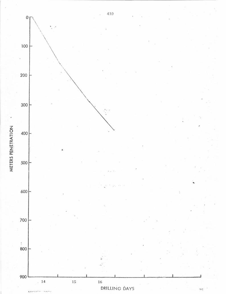
100
200
300
¥ 400
3iLU
atLUILU
500
600
700
800
\
410
90014 15 16
DRILLING DAYS

410
50
100
150
Z
o<I—UJ
zLLJ
200
250
300
35039
14
31
38:
30
35|
212223
26
^ 2 4
?7T
28
32
33
11112
23
1718
1920
34
12T
4567 i3 !9 \
10 j
400
45010 20 30 40 90 140+
20

410A
AUGUST 1976 DRILLING DAYS 30

o
IUJ
ztoQILUH-LU
0
50
100
150
200
250
300
350
400
—
—
M M
MM
«
2J— 3J
• •
é|
1
410A
•
• •
•
WAS
H
-
1 I I0 10 20 30 40
METFüS/HOUR
90 140+
•ZΛ
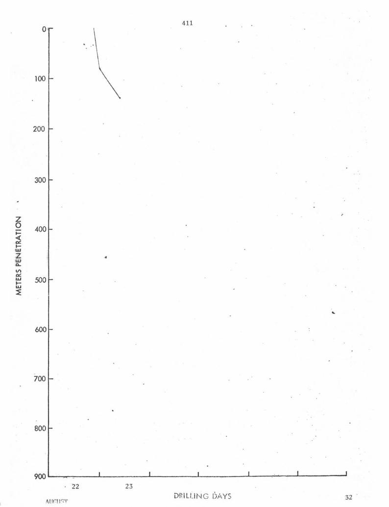
100
200
300
g 400<I—UJ
zLU
411
LUI—UJ
500
600
700
800
90022 23
DR i LUNG DAYS 32

o
UJ
UJ
LU
0
50
100
150
200
250
300
350
400
2 j
— 3-j
sl
mm
<
—
I
4
1
411
<S)<C
••
V
•
1 1
10 20 30 40
METERS/HOUR
90 140+

o
0
100
200
300
400
500
600
700
800
411A
" V-
-
-
«
-
I I ) I . I I
23DRILLING DAYS

0
50
100
150
411A
2iWASH!
o
IUJ
z
200
250
300
350
400
450 I I10 20 30 40
METERS/HOUR
90 140+

o
LUzLUQ_
IT)
LU
0
100
200
300
400
500
600
700
800
412
- V---<
" --~^•^/. •"V ..."
1 I 1
•
• ; '
I J J
24 25
DRILLING DAYS

50
100
150
15
200
250
300
350
400
412
ill
WASH
5L
3<
10
1211
WASH
450 110 20 30
METERS/HOUR
40 90 140+

0412A
100
200
300
g 400<i—tu
UJ
α.to
LU 500
600
700
800 -
900. 25
AUGUST 1976
26 27
DRILLING DAYS

50
100 -
412A
CO<
150 -
200
250 10
5
9j
2
6 I
] <
4
•
300
11171
350
400
450 I10 20 30
METERS/HOUR
40 90 140+

041.3
100
\
200
300
g 400
LU
zLUQ_COOCLULU
500
600
700
800
90028 29
DRILLING DAYS 40

0 413
50
100
150 r
200
250
300
350
400
45010 20 30 40
METERS/HOUR
90 140+
41

INTERNATIONAL PHASE OF OCEAN DRILLINGDEEP SEA DRILLING PROJECT
OPERATIONS RESUMELEG 50
Leg 50 of the Deep Sea Drilling Project represented an attempt to study the ear-liest history of the Atlantic Ocean through the sampling of Pre-Oxfordian sedimentsof the North African continental margin. Full attainment of the scientific goalswas predicated upon drilling through a sediment section of a thickness exceedingany previous penetration of the Project. Two deep penetration tries involving mul-tiple re-entry operations were made, but in both cases adverse hole conditions provedinsurmountable and the depth of penetration hoped for was not achieved.
The voyage commenced on September 4, 1976 at Funchal, Madeira Island, Portugal andended at the same port on November 10, 1976. A brief port call was also made atFunchal on October 28 for a Global Marine crew change.
The leg established DSDP records for the most time on-site (51,6 days) and the mostsuccessful re-entries (12). Nine re-entries on Hole 416A equaled the previous record.
Total length of the voyage was 66.5 days, of which 51.6 days were spent on-site,7.4 days underway and 7.5 days in port. 1.6 days of operating time were lost dueto mechanical difficulties.
FUNCHAL PORT CALL
The port call at Madeira was routine and was concerned mostly with crew change,resupply and machinery maintenance. Previously unscheduled repairs were necessitatedby a ruptured ballast tank bulkhead in the moon pool area. The damage was attri-buted to overpressuring of the tank while preparing for a mid-term inspection.
The loading of supplies and some of the maintenance was delayed because of the ne-cessity to transship oncoming surface freight from Las Palmas. The freight didnot arrive in Funchal until the fourth day after the arrival of the CHALLENGER.
The repair and subsequent testing and inspection of the tanks consumed more timethan originally estimated. This delayed the operations of replenishing fuel andwater. After tank repairs were completed, 202,000 gallons of marine gas/oil weretaken on.
Early on September 10, the ship was required to vacate her pierside berth to makeroom for another vessel. A short move was made to anchorage outside the harbor

breakwater and the ship remained at anchor until departure from port. Topping offof fresh water continued until a few hours before departure.
A rotary helper became ill on September 9 and a replacement was secured from theU. S. Departure of the vessel was delayed approximately ten hours after necessaryrepairs and resupply had been completed pending the arrival of the new man.
On September 11, after seven days and four hours in port, the CHALLENGER weighedanchor and departed for Site 415.
SITE 415
The prime drilling site of Leg 50 was located about 95 miles off Cap Tafelney,Morocco and about 270 miles from Madeira. After the transit to the immediate areaand a brief seismic profile survey, the positioning beacon was dropped at DSDPSite 415. Less than 40 hours had elapsed since departure from port.
An initial hole was drilled to confirm the feasibility of re-entry operations atthe location to determine the optimum length of conductor casing required and toconduct downhole tests not considered advisable in the re-entry hole. The pro-jected total depth of the hole was to be about 500 m with openhole well logs tobe run before abandonment. This exploratory hole also provided a good opportunityfor the precise determination of water depth. The initial water depth for Site415 as determined by the Precision Depth Recorder was 2803 m. The drill pipe wasmeasured as it was run to the sea floor. The drill pipe pinger, attached to aninner core barrel, was carried down in position at the bit and was monitored con-stantly with the Precision Depth Recorder. A depth of 2817 m was determined bythis method. Offsets of 200 feet west and 100 feet north were introduced intothe dynamic positioning system so that bottom sediment disturbance resulting fromthe exploratory drilling would not adversely affect the re-entry cone setting later,After the pinger had been retrieved, a standard inner barrel was pumped down and apunch core taken to 2824.5 m total depth. (This established the official spud timeof the site at 0824, September 14). Although the sea floor was not "felt" by theweight indicator, a nine-meter sediment core was recovered. The condition of thecore indicated that the heave of the vessel could have caused some additional softsediment to be "pumped" into the core barrel and the pinger depth was accepted asofficial.
To determine the optimum point for setting conductor casing, the drill bit wasjetted in to a depth of 2891 m without rotation. The calcareous ooze encounteredwas unexpectedly firm, apparently as a result of the erosion of uncompacted sedi-ment by bottom currents. When 21 minutes were required to jet the final 9.5 m,it was felt that the sediments were sufficiently consolidated to support the weightof the re-entry cone and both conductor and surface casing strings. It was alsofelt that difficulties could be encountered in attempting to jet the 16" conductorcasing into the sediment beyond this depth. (Although a 14-7/8" bit was to be runwith the casing string, a 10" bit was used on the exploratory hole to provide asuitable hole diameter for logging). At this point, 74 m below sea floor (BSF),pump pressure was cut and rotation of the pipe was employed to cut a core.

Drilling and coring continued to a total depth of 3100 m BSF. At this point therate of penetration had slowed to about 13 m/hr and it was felt that drilling tothe initial goal of 500 m would consume an inordinate amount of time that couldbe used in pursuit of the deep drilling objectives.
After a wireline run to release the bit assembly, the hole was filled with ben-tonite gel mud for logging. Borehole compensated sonic, dual induction-laterolog,and combination formation density-compensated neutron logs were run. All threelogs included a natural gamma ray log for correlation purposes. After loggingwas completed, the hole was filled with weighted gel mud and abandoned.
Five cores were recovered from Hole 415. Two wireline runs each were made forin-situ pore water samples and for temperature probe measurements.
HOLE 415A
After operations were completed at Hole 415, the positioning offsets were removedand the vessel was returned to the position of the beacon. As the drill pipepinger had been in place a few meters off bottom at the time of offsetting, thewater depth could be monitored fairly accurately while the ship was moved. Thenorthwesterly direction of the offset had been chosen to minimize any depth dif-ference resulting from regional slope and depth readings at the two locationsagreed within one or two meters.
The pinger had been damaged upon retrieval from the previous run and was out ofcommission for the duration of the voyage. The precision depth recorder wasused, however, to follow the distinct reflection of the re-entry cone as it waslowered toward the sea floor. When the bit was at a depth of 2797 m and the topof the cone was at 2727 m, the PDR showed a distance of 75 m from the top of thecone to the sea floor which indicated a water depth of 2802 m. This was believedto be a false indication and after the bit had been lowered to 2807 m and the drillstring raised one joint, the inner core barrel was retrieved. The barrel containedonly water and the PDR indication was proven invalid. The option of pulling"water cores" until sediment was recovered in the core barrel was rejected as tootime consuming in light of the information gained on the exploratory hole. Thestring was lowered and the weight indicator registered bottom at about 2817 m.Circulation was broken and the jetting operation began. It was calculated fromthe length of the casing string that the mud skirt of the cone should reach thesea floor or 2817 m when the bit had been washed to 2885 m. When the bit reached2880 m (mud skirt 2812 m) the rate of penetration had dropped sharply. Less thanone meter had been made in about 1-1/2 hours jetting with full pump pressure. Thisis the same effect experienced when a cone reaches the mudline. At the time, itappeared that the water depth could have been as much as five meters shallowerthan the drill pipe measurement if the interface sediments were too soft to"take weight". In any case, it was reasoned that, if the cone were released alittle above the sea floor, it would settle into position when the 14-7/8" bitdrilled out from beneath the 16" shoe. Continuing to jet and possibly forcingthe cone into the sediment was considered a greater risk. The shifting tool wasrun on the sandline and the casing/cone assembly was released with the mud skirtat a depth of 2812 m.
After the release had been verified by weight indication and by free rotation, a14-7/8" hole was drilled to a total depth of 3161.5 m. At this depth the pene-tration rate had decreased to less than 10 ra/hr and geological information indicatedno merit in a longer surface casing string. This interval was drilled with acenter bit and no cores were taken. A wiper trip was made with the bit pulledabove the casing shoe and run back to total depth. The hole was then flushed andfilled with mud and the drill string was retrieved.
As soon as the bit was on deck, preparations were made for running the 11-3/4"surface casing string. At this point a three-hour delay in operations was ex-perienced when the propeller of No. 1 bow thruster apparently became fouled. Whenthis problem had been resolved, 331 m of surface casing was made up, attached tothe drill string, and lowered to within a few meters of the sea floor.
The first re-entry attempt was fairly routine. After the logging sheaves hadbeen rigged and the equipment assembled, the sonar tool was lowered into placeat the casing shoe. One hour and 55 minutes were required to acquire the target,maneuver the ship into position with offsets to the positioning system, and toallow the drill string to swing over the cone. (The target image on the sonarscreen was normal in all respects). After the casing had been stabbed into the coneand the sonar tool retrieved, the casing was lowered into place.
The casing hanger was "felt" to latch into the cone when the casing shoe was at3151 m. (This would have located the mud skirt at 2816.5 m or 3.5 meters abovethe top of the 11-3/4" casing) Latching was verified by picking up on the drillstring and noting a weight increase. This indicated that the re-entry cone hadsettled 4.5m. It is necessary to transfer the weight of the surface casingstring to the conductor casing/cone assembly to allow the releasing mechanism tofunction. The drill string was lowered carefully to put the running tool "inneutral", but each time this apparently had been accomplished, the weight indi-cation returned. When the weight had stabilized enough to permit rotation of thedrill pipe and disengagement of the surface casing, the casing shoe had beenlowered an additional four meters to a depth of 3155 m. This placed the mud skirtat 2820.5 m and the top of the cone at about 2818 m.
After the casing had been released, the cementing equipment was rigged up. 515sacks of neat cement were mixed and displaced into the annulus around the casing.No significant problems were experienced in the cementing operation except thatthe plug apparently did not clear the drill pipe and latch into the casing shoeuntil 1000 psi pump pressure had been maintained for several seconds.
The drill pipe was then pulled clear of the mudline where it was flushed of anyremaining cement. After tripping the pipe, a standard bottomhole assembly and10" bit were made up and the string run back for the second re-entry attempt.
As the positioning offsets from the first re-entry remained in effect, littlechange was necessary and a stab was made after 44 minutes of scanning. The targetimage was distinct and normal in appearance except that one of the reflectorsappeared to be partially obscured. The weight indicator registered contact withthe cone as the stab was made. All factors indicated a successful re-entry andthe sonar tool was pulled. The standard practice of running two or three standsof drill pipe to verify re-entry was followed on this occasion and no weight drop was
seen on the indicator until a slight "dragging" tendency was noted on the secondverification stand. The first notable resistance was felt when the bit reached2853 m. At this point the pipe was rotated and appeared to be free. An attemptto take a core from the interval 2853-2864 m was then made. Recovery was limitedto a trace of material resembling a mixture of drilling mud and ooze. Anotherjoint of drill pipe was added to the drill string (to 2873.5) and still the weightindication was inconclusive. A second core was attempted to 2881 m. This timesediment was recovered and a miss was confirmed. Since samples were collected,the cores were designated as taken from the aforementioned depths at Hole 415B.
The drill string was pulled back to re-entry position and the sonar tool runback to the bit. After one hour and 20 minutes scanning, another re-entry stabwas made. Again, the driller reported "hitting" the cone. The sonar tool waslowered to the bit and indication of transducer rotation was lost indicating thatthe tool was in sediment. The drill string was immediately pulled clear andscanning recommenced. The third stab was successful.
After running the bit to the cement top, 23 m of firm cement were drilled beforedrilling out the casing shoe and latch-down plug. The hole was cleaned to totaldepth and five meters of new hole were drilled before the center bit was retrieved.
A core barrel was pumped down and the first core of the hole was cut. When theovershot was nearly to bottom on the retrieval run, the sandline was found tohave jumped the crown sheave. Efforts to put the line back onto the sheave resultedin kinking and serious damage to the line. Despite the damage, the core wasretrieved safely, but it was necessary to shift the retrieval tools to the draw-works sandline.
Recovery in the first core was limited to a few inches of cuttings and to pebblesof chert and other hard material. Nothing of full core diameter was present.Following Core No. 1, 57 m were drilled before pump pressure was reduced andCore No. 2 attempted. Nothing was recovered in this core barrel. As a core suit-able for hydrocarbon monitoring was required before drilling ahead, the subsequentjoint was also a coring attempt. Again, there was no recovery. The driller1spump pressure gauge indicated that the barrels were seating properly upon landingat the bit and it was reasoned that the core guide of the bit itself was pluggedor damaged and was preventing any material from entering the inner barrel. Aninner barrel with a small diameter extender was pumped down in an attempt to"punch" any obstruction from the bit. This barrel also appeared to seat normallyand the extender was recovered clean and unmarked. A fourth attempt to recover acore was made and was to be the final attempt before a round trip to resolve theproblem. This time the core catcher held a biscuit-shaped chunk of heavy metalabout 2-1/2 inches in diameter and 1-1/2 inches thick. Examination revealed it tobe the remains of the latch-down cementing plug which had been drilled with thecasing shoe. On the fifth attempt, a sediment core was recovered.
A temperature probe measurement was made following Core No. 5. Due to the degreeof induration of the sediments and to risk of damaging the sandline, this was thefinal temperature measurement attempted.
Drilling and spot coring proceeded virtually without incident to a depth of1079 m BSF, The presence of cuttings accumulation in the hole was expressed as

an increase in pump pressure and torque when drilling was resumed after pulling aninner barrel at 1041 meters BSF. The standard action of pumping a slug of ben-tonite mud to clear the annulus was taken. High torque and pump pressure wereexperienced after making a connection at 1079 m BSF. While attempting to "work"the pipe free, it became vertically and rotationally stuck. Because of highannular back pressure, it was necessary to equalize the hydrostatic heads withweighted mud before breaking the drill pipe connection. After working and pullingone or two joints, rotation was regained but sticking tendencies persisted untilfifteen singles had been laid down. As the bit was near the end of its rotatinglife, the power sub/swivel and heave compensator assemblies were set back and atrip for a new bit was made before attempting to clean the hole to total depth.
While the drill string was on deck, line was spooled off the primary sandline reelthrough the moon pool until the damaged section was exposed. The line was thenclamped off, the damaged section removed, and a long splice installed. The coreretrieval tools were shifted back from the drawworks sandline for future coringoperations.
The stabilizers and the diverter packoff assembly were deleted from the bottomholeassembly as they were considered possible contributors to the downhole problems.
On the next re-entry, the sonar presentation indicated that the primary sonar re-flectors, mounted on the lip of the cone, were at least partially obscured bycuttings or had been pulled down to the mudline. It was difficult to distinguishthe reflector images from that of the bottom. ("Bottom returns" can normally beminimized by reducing the gain settings of the sonar). Despite this complication,re-entry was accomplished after only 45 minutes scanning time by referencing onthe three glass ball "auxiliary targets" floating on tethers above the cone.
On the trip into the hole, the drill string first began to "take weight" atabout 540 m BSF. Torquing began at about 880 m and progress came to a virtualhalt at about 1010 m. After working pipe, rotating and making a little progressat a particularly "hard" spot for about an hour, the abnormal torquing ceased andthe weight on the bit began to decrease slowly and evenly with rotation. Thesenormal drilling parameters indicated that the hole had probably been side trackedabout 65 to 70 meters short of total depth. At this point, it was considered prudentto make a short trip to determine hole conditions at and above this trouble spotbefore proceeding. Ten doubles were pulled with no resistance, but problems re-turned almost immediately on attempting to run back toward bottom. Even moredifficulty was encountered in getting down on this attempt. At one point the pipewas again stuck for several minutes. After struggling approximately seven hourswithout reaching the original sidetrack point, attempts at further drilling progresswere abandoned.
A core taken from near the top of the "problem interval" was comprised of badlyfractured claystone. It was apparent that the material was fractured in-situas some of the fractures exhibited calcite healing.
The bit was pulled clear of the lowermost sticking conditions and a through-pipegamma ray log was run.
The hole was abandoned by placing a plug of 200 barrels of barite mud.

SITE 416
After failing at Site 415 to penetrate the thick sediment section overlying thestrata of primary scientific interest, the vessel moved to a location where thesediments were thinner and seismic records indicated the possible absence of thefractured shale interval encountered at Site 415. Water depth was considerablygreater at the new location, however, and the scientific potential was not asgreat. Site 416 was situated about 80 miles west of the Moroccan coast, 120 milesnortheast of Site 415 and two miles west of DSDP Site 370.
Transit time between the sites was about 15 hours. The initial penetration wasagain an exploratory hole to determine water depth and the conductor casing point.Geological records from Hole 370 and the fact that hole problems were not en-countered at that site, indicated that little advantage would be gained by settingan 11-3/4" surface casing string.
The precision depth recorder reading was 4201 meters after stationing had beenestablished over the beacon. The drill string was lowered and a punch core wastaken to a depth of 4205 meters before the bit was pulled clear of the mudline.Spud time was established as 0017, September 30. The weight indicator registeredbottom at 4204 meters. 1.3 meters of core was recovered, consisting of very soft,brownish ooze overlying firm, greenish clay. An official water depth of 4203 mwas recorded.
Pump circulation was started and the 14-7/8" bit was jetted ahead to establishthe firmness of the sediment. After the first double stand, weight began to falloff slowly and pump strokes were increased from 20 to 50 and then to 65 as the nextdouble was pumped down. On the next stand,, two pumps at 40 spm were utilized.Jetting continued in this manner to 4309.5 m. The Martin-Decker weight indicatorsbehaved in a manner indicating that normal penetration was being made. At thispoint, the feasibility of setting up to 100 meters of 16" casing was consideredestablished. Pump circulation was reduced and a core was attempted at 4309.5-4319 meters. The fact that rotation was not required to penetrate this intervalwas initially considered to be an indication that the bit had "broken through"the clay and entered an interval of softer ooze.
To save the time of a wireline trip, the core barrel was retrieved with the drillstring.
The string was never rotated until the power sub had been set back and the tripout began. On attempting to use the rotary table to back off the tool joints,resistance to rotation was noted. As this suggested a bent bottomhole assembly,the pneumatic pipe spinner was used for the remainder of the trip and the pipewas not rotated.
On retrieval of the bottomhole assembly, the 5-1/2 inch drill pipe joint, locatedabove the drill collar, was found to be severely bent. The threads in the boxconnection of the top drill collar were damaged and the mandrels of both bumpersubs were bent to the extent that it was necessary to torch cut the mandrels toremove the subs from the string.
As the drill string had not been rotated during its retrieval, the BHA was

retrieved with sediment still adhering to it. The sediment was found to be cakedalong one side of the drill collars only. Virtually the entire assembly hadcollected the soft brownish ooze while green clay was found only on the outer corebarrel. The inner barrel was empty except for a trace of greenish clay similar inage and composition to that at the bottom of the first core.
This evidence implies that the bit failed to respud after the punch core had beenretrieved. For some reason, possibly a plugged jet in the core bit or horizontaldrill string motion, the drill string apparently "kicked off" vertical and slidalong the sea floor instead of penetrating the ooze/clay interface.
HOLE 416A
The geology of the mudline punch core and of the shallow sediment cores fromSite 370 was carefully reviewed. This information, together with considerationsof the overall objectives and time available, prompted a decision to set there-entry cone and conductor casing without a second attempt at an exploratory pene-tration.
Due to the unusual stresses that the bottomhole assembly had probably been sub-jected to on the exploratory attempt, the assembly was given a precautionarymagnaflux inspection before further operations were undertaken.
The final re-entry cone remaining on board had been assembled during the transitfrom Site 415 and was keelhauled into place below the moon pool without delay. Asno surface casing was to be set, 40 meters of conductor casing was judged to beadequate to support its own weight and that of the re-entry cone in the clay and/orooze sediments present. The casing, cone and bottomhole assembly were made up,connected and run to the sea floor without incident.
The clay proved to be stiffer than anticipated and over 20 hours were required tojet the casing in. After a successful wireline trip to release the casing/coneassembly, a round trip was made to replace the 14-7/8" core bit with a new 10"bit.
The first re-entry operation progressed smoothly and a successful stab was madeafter 33 minutes of scanning time.
Drilling and spot coring proceeded with only minor difficulties to a depth of764 m below sea floor. There pump pressure, while core barrel No. 6 was beingpumped down, indicated the throat of the core bit to be plugged. The inner barrelwas retrieved and an inner barrel with an extended shoe was pumped down to clearthe bit. Conditions were back to normal after the retrieval of this barrel. Atotal of 3-1/2 hours were expended.
Early on October 6, after a depth of 920 m had been reached, it was necessaryto discontinue rotating drilling operations due to excessive vessel motion. Windand current conditions had combined in a direction about 80 divergent from thatof a strong swell. The ship was unable to develop enough side thrust to maintaina heading that would keep the swell induced roll within the seven degree safeoperating limit. To avoid lost operating time while awaiting the moderation of
forces, a trip for bit change was begun. About three fourths of the core bit'slife expectance had been consumed.
Weather conditions abated and vessel motion was within safe operating criteriabefore the bit had been pulled clear of the mudline. Therefore the bit was runback to total depth and drilling operations were resumed. Although no hole pro-blems had been encountered in drilling to this point, some drag was experiencedin pulling the drill string and the time consumed by the "wiper trip" was con-sidered well spent from the standpoint of hole conditioning. Some resistance wasencountered at one or two points while returning to total depth.
At a depth of 1093 m BSF, signs of possible bit failure were noted. As loggingwas scheduled for the first bit change, a second wiper trip was made to ensurethe best possible hole conditions for the logging operations. No resistance wasencountered in pulling the bit to the casing shoe. On the trip back to bottom,however, a solid bridge was hit at 684 m BSF. Attempts to clear the partiallyplugged bit and to wash through the obstruction with the circulating head weresuccessful and resulted in a ruptured circulating hose. Further attempts afterreplacing the hose also failed and it was necessary to pick up the power sub forthe remainder of the trip to total depth. Only minor obstructions were encounteredafter the aforementioned bridge had been cleared. After total depth had beenregained, the hole was flushed and filled with drilling mud and the drill stringretrieved. The string "pulled tight" as the bit passed 684 meters but did notbecome stuck.
A special logging adapter and short bottomhole assembly were installed and the drillstring was run in to just above the sea floor in preparation for re-entry.
On commencement of sonar scanning, the image appeared to be that of bottom at veryclose range. The range indicated that the transducer was very near the level ofthe top of the cone and that it would be necessary to raise the end of the pipeto acquire the target at any distance greater than a few tens of feet from thedrill string. It was inferred that the drill string measurement was somehowerroneous and that it would probably be necessary to retrieve the sonar tool andset back one joint of drill pipe. In order to save this operating time, raisingthe drill pipe a few feet was considered. If the target were at short rangeraising the pipe a few feet might have provided target acquisition and enoughclearance to make the re-entry. In an effort to raise the triple stand in thederrick three to four feet, the vertical clearance was misjudged and the travellingblock came into contact with the upper logging sheave. The sheave was tipped enoughto allow the logging cable to jump off the sheave. This damaged the cable andelectrical continuity was lost.
It Was not considered feasible to splice the logging cable aboard the CHALLENGER.This cable was damaged near its midpoint and either end would have been too shortfor future operations at this site. It was therefore necessary to replace theentire winch drum and logging cable with a spare unit (a ten to twelve hour job)before any further re-entry or logging operations could be conducted.
Due to time constraints, it was decided to postpone logging plans until the nextbit change. The winch drum interchange operation was conducted concurrently witha round trip for a core bit and drilling bottomhole assembly. The drumwas a major operation and was accomplished through extraordinary effort on thepart of a few individuals, as the drilling crew was not available to assist.

The anomalous sonar presentation remained unexplained as the drill pipe tally andbottomhole assembly measurements had been carefully scrutinized with no errorsfound. Downhole and surface electronics had been rechecked with no fault found.As a precaution, the subsequent re-entry attempt was made with a different down-hole tool. This re-entry was routine and was accomplished after 55 minutes scanningtime. The sonar range to bottom agreed with drill string measurements.
On attempting to run to bottom, a bridge was encountered at 465 m BSF that requiredthe rigging of the power sub to wash through. Several more obstructions were en-countered and rotation of the bit was required to reach total depth. Twelve hourswere required for this portion of the trip.
Continuous coring commenced at 1177 meters, the approximate depth reached byHole 370. Drilling problems began at 1214 meters. The pipe became vertically androtationally stuck while core barrel No. 13 was being pumped down. The pipe workedfree about the time the barrel landed and a mud slug appeared to clear the hole.From this point on a persistent tendency for "fill" to accumulate during wirelinetrips was noted. The lithology being penetrated was shaly and highly fissile.Cores had a deeply eroded "corrugated" appearance and considerable flaky spalled-off material was present in the liners.
While core barrel No. 15 was being pulled, the pipe again became stuck. Circulationwas maintained but high back pressure indicated a large amount of material insuspension in the annulus. After equalizing hydrostatic pressure with weightedmud, the pipe could be worked vertically. Six joints were pulled before rotationwas regained.
During the nearly seven hours required to free the drill pipe, power to the bowthrusters was lost twice resulting in excursions of approximately 300 and 425 feet.
Due to the development of hole problems, the heave compensator was set back beforeoperations resumed. This was necessary due to the severely restricted verticalclearance in the derrick when the heave compensator and power sub/swivel assembliesare both in use. A double stand could again be "worked" without breaking a con-nection.
The following day, bow thruster problems were again experienced and an excursionto about 500 feet was taken. Drilling operations were halted for about 1-1/4 hours.
Coring operations continued through the life of this bit to 1404 meters BSF with-out further sticking problems, although three to four meters fill between coreswas common.
Due to the previous hole problems, it was considered quite possible that totaldepth would not be regained after changing bits. A through-pipe gamma ray/com-pensated neutron log was considered advisable for purposes of correlation and ofseismic reflector identification. The hole was slugged with mud to flush cuttingsfrom the annulus. Two singles were set back, the power sub was rigged down andpreparations for logging were made.
While the first logging sonde was being lowered through the drill pipe, wind andcurrent conditions reached the point where thrusters were forced to run at maximum
10

rpm and three propulsion engines were required for stationkeeping. Under thesemarginal conditions, it was not considered advisable to continue the loggingoperation. The sonde was retrieved, the sheaves rigged down and the drill stringwas pulled without further delay.
The stabilizers were removed from the bottomhole assembly in an effort to alleviatethe sticking tendencies. As a trend toward a harder lithology had been noted inthe cores, a type F94CK bit was run.
As the core bit neared re-entry position a few meters off the sea floor, positioningsystem problems developed. Weather conditions remained marginal and frequenttemporary loss of acoustics was being experienced due to wave action and thrusterwash around the positioning hydrophones.
The DPS computer would "trip out" following loss of acoustics and, on each occasion,several minutes of manual mode positioning would be required before normal posi-tioning could be resumed. Despite efforts to correct the malfunction, nine hoursand moderating weather were required before the system remained in the automaticmode continuously for one hour and it was deemed safe to proceed with re-entryoperations.
On commencement of sonar scanning, an apparent bottom image at "too close" rangewas again observed. This time a check was made by raising the sonar tool in thepipe. The range to "bottom" increased when the tool was raised and continued to doso as the tool was pulled up inside the drill pipe. It was also noted that therange decreased after the cable tension indicator registered seating of the tooland slacking off of the cable. The image resembled bottom return even to theelliptical trace normally associated with the heave of the vessel. No re-entrytarget was acquired.
There was no reason to doubt the drill pipe measurement in this instance and thesonar tool was pulled for a replacement. The backup tool functioned normally andthe target was detected at a distance of over 300 feet. Due to the distance,plotting and maneuvering were required and two hours and twenty minutes scanningtime elapsed.
The re-entry was verified and the logging sheaves rigged down. The bottomholeassembly had barely been run through the cone when the positioning computer againwent off the line. An excursion of approximately 2000 feet and a delay of one houroccurred before stationing was regained. This generated considerable concern forthe drill string. However, no weight was lost and cautious engagement of the powersub resulted in no abnormal torque.
At 380 meters BSF, a bridge was struck that could not be washed out with the aux-iliary circulating head. The power sub was rigged and the bridge was quicklycleared. Due to the inherently slower operation with the power sub in the string,the trip to total depth required twelve hours even though no more significantobstructions were encountered.
After three meters of new hole had been made, the inner barrel was retrieved. Thecore liner was found to be nearly filled with cuttings, including a considerableamount of coarse, angular gravel composed mainly of chert and Porcellanite. The
11

liner was jammed with large chert pebbles.
Shortly after coring recommenced, it became evident that the switch to the F94CKbit with its shorter inserts had been a move in the wrong direction. The lithologybegan a trend back to softer, more waxy claystone and one full core cut at onlyabout 1.3 meters per hour. The bit was pulled after cutting 47 meters in 27rotating hours - about half the rate of the previous F93CK bit.
Hole conditions, however, had shown a marked improvement and after the third fullcore it was considered safe to rig the heave compensator. The compensator was inthe string for two cores before the trip was made. During this interval, com-parison tests were made between active and passive modes of operation.
After replacing the bit with a new F93CK, the trip to sea floor and re-entry pro-ceeded smoothly with only 31 minutes scanning time required. This time the pipewas run to about 1655 meters BSF before the power sub was required. Consequently,it required only about six hours to run from the re-entry cone to three standsoff total depth. The back pressure resulting from suspended material in theannulus caused the bit to become plugged while the connection was being made.Circulation was regained after working the pipe for several minutes. A "pill"of weighted mud was started down the pipe to counteract the back pressure. Thebit and the mud reached the bottom of the hole at about the same time. Immediatelythereafter, the pipe torqued and became rotationally stuck for about 20 minutesand increased pump pressure indicated annular plugging tendencies.
After the mud had been pumped around, coring recommenced but the penetration rateremained rather slow. Sporadic torquing persisted and almost always occurredfollowing a connection or the arrival of a mud slug at the bit.
On October 23, it became evident that two core bits would be required to continuecoring until the scheduled time of departure for crew change. The bit in use waspulled somewhat early in an effort to divide the rotating time more equally betweenthe bits and to reduce the risk of running a bit to destruction.
After over three hours were required to replace a burst hydraulic hose leading tothe power sub, an uneventful trip for a bit change was made.
As re-entry preparations were being made, rain squalls with wind gusts to 36 mphpromised to make precise positioning difficult. Initial detection of the re-entrycone at a range of 350 feet, however, postponed the requirement for precise posi-tioning. Plotting and maneuvering procedures were initiated and the range wasclosed to about 60 feet after two changes of the positioning offsets. Subsequentmovements of the ship proved ineffective in reducing the distance to the targetbelow about 40 feet. The target appeared to be "moving" in a southeasterlydirection. The core bit was successfully stabbed nearly seven hours afterscanning began. The final offsets indicated the ship to be over 200 feet fromthe point of the original 60 foot range reading. A 20 minute interruption of thescanning occurred when power to the sonar tool was lost. Troubleshooting revealedthat the shooting safety switch in the logging cab had been opened inadvertently.A delay of about the same duration occurred when a faulty relay in the positioningsystem caused the vessel to take a 400 foot excursion away from the target.
12

The pipe was run to a depth of 1170 meters BSF before an obstruction was encoun-tered that required the employment of the power sub. Below that point seriousproblems with bit plugging and rotational sticking were encountered. The final170 meters were particularly difficult as the bit took weight and rotation wasrequired to work past apparent "ledges" in the hole. About 13 hours were requiredto run from 1170 meters to total depth at 1586 meters BSF.
During this time, a 40 minute delay was experienced when the positioning computeragain tripped off following a loss of acoustics.
Two cores were cut with scattered incidences of torquing and annular plugging ason the previous bit. The second core cut very slowly and required over sevenhours cutting time.
When the inner core barrel (No. 55) was retrieved, it was discovered that thelanding sub had backed off from the core barrel. The landing sub, inner barrelsub, core catcher assembly, core liner and an unknown quantity of core thereforeremained somewhere inside the drill string.
Fishing and retrieving the entire assemblage was the only hope of avoiding around trip of the drill pipe. A wireline spear constructed for retrieving plasticliners was run into the pipe on the sandline. The sandline weight indicator reg-istered contact with something about 1800 meters below the ship. The line wasretrieved but nothing was recovered. On the second attempt, some weight was takenmomentarily at about 5000 meters but the spear was lowered until the weight in-dicator and the flag on the sandline indicated that it stopped very close to thebit. The fishing tool was retrieved with the entire plastic liner firmly impaled,but without core or subs. One desperation attempt was made to fish the subs witha special tubing spear. This could only be successful if core recovery had beenextremely low as the presence of core above the subs would prevent engagement ofthe spear. When the first attempt was unsuccessful, it was conceded that furtherefforts would be a waste of time and that a pipe trip was the only recourse.
As only about one day remained before the deadline for departure for Madeira, therewas no time to run back to bottom with the bit. The only possible productive useof the days operating time on site appeared to be a through-pipe gamma ray/com-pensated neutron log. In view of hole conditions, however, the merits of such alog did not appear to outweigh the risk of sticking the drill string and therebylosing the hole. After a phone patch to GMI San Diego produced assurances thatthe crew change could be made one day early, the final decision was made to departfor port as soon as the drill string was pulled.
Due to the length of the expected absence from the site, the hole was filled withbentonite gel mud. A second sonar beacon (of alternate frequency) was launchedbefore the mudline was cleared and was observed until the vessel departed thesite.
The transit to Funchal was uneventful except that unexpectedly strong headwindswere encountered the second day. They reduced the ship s speed to an average of7.8 knots and delayed arrival by eight to ten hours.
A new drilling line was installed while the vessel was underway. As this wouldhave been required before the next round trip, several hours of operating timewere saved by scheduling circumstances.
13

SECOND FUNCHAL PORT CALL
The CHALLENGER arrived at Funchal, Madeira at 1555, October 28, 1976. Principalactivities included full GMI and partial SIO crew changes, unloading of 62,000gallons of marine gas/oil and 121,000 gallons of fresh water and onloading offresh vegetables and vital spares. Two members of the scientific party departed ;the ship. An observer representing the National Science Foundation and a GMIauditor jointed the ship. The vessel was underway on her return to Site 416after only 8-1/2 hours in port.
Inclement weather continued through the first day of the return transit. Thequartering seas increased the speed of advance somewhat, but caused the vesselto roll as much as 20 degrees. These conditions provided an opportunity for anengineering evaluation of the Muirhead-Brown roll stabilization system.
HOLE 416A CONTINUATION
On approaching the site, the original 16 kHz beacon was detected at a distanceof about one half mile. After the ship had passed over the beacon, geophysicalgear was retrieved and the ship positioned over the beacon without difficulty(the original beacon was utilized because it was believed to be closer to the conethan the subsequently dropped 13.5 kHz beacon). Rig operations recommenced at1637, October 30, after an absence from the site of less than 91 hours.
During the trip to the sea floor, the bow thruster problem reappeared but fullcapabilities were regained after about 15 minutes.
The initial sonar range to the re-entry cone target was 380 feet. A successfulstab was made after one hour and forty one minutes of plotting and maneuvering.
The first substantial bridge was encountered at about 860 meters BSF. Attemptsto wash through with the auxiliary circulating head were unsuccessful and thepower sub was rigged. After washing ahead to about 1490 meters BSF, "tight" holeconditons were encountered and seven additional hours were required to work pipeto total depth. High torque was nearly continuous and repeated vertical stickingoccurred, but annular plugging tendencies were not significant.
After the previous total depth was reached, two cores were cut without problemsother than torquing tendencies. A marked increase in rate of penetration overthat of previous cores was noted, but recovery was quite low.
During the retrieval of Core No. 57, the already high torque began to increase.While the next inner barrel was being pumped down, the pipe began to stick rota-tionally. The pipe was worked free after one and one half hours, but the bit hadbecome plugged in the process. The inner core barrel was retrieved. Torque droppedoff considerably in this interval but the pipe again became stuck vertically.Rotation was finally regained after working the pipe for three hours and pulling10 very tight joints of pipe. At this point, a center bit was pumped down andretrieved in an unsuccessful effort to clear the throat of the bit and regaincirculation. A "wiper run" was completed and the bit pulled into the conductorcasing. After further efforts to regain circulation failed, the drill string waspulled. The outer core barrel was recovered nearly full of cuttings.
The core barrel was cleared and a bit release assembly installed. The ninth re-entry
14

was the fastest of the site, primarily because the cone was initially acquiredby the sonar at a range of less than 50 feet. The drill string swung over thecone and the stab was made after 18 minutes scanning.
Pipe was run to about 810 meters BSF before the power sub was required. The holeappeared to be "tight" as weight was taken and torquing was experienced. Afterwashing down three stands, however, conditions appeared back to normal and thepower sub was set back. Resistance was again encountered at 1230 meters and thepower sub was rigged again.
Three and one half hours were required to work and ream pipe to a depth of 1555meters BSF where progress came to a virtual halt. Three hundred barrels of gelmud were pumped around in an effort to flush the hole. Serious torquing andsticking tendencies persisted after the mud had cleared the sea floor and no pro-gress was being made toward reaching total depth. It became evident that furtherdrilling efforts would be futile and the decision was made to log and abandon thehole.
The hole was filled with gel mud and the wireline shifting tool was run to releasethe core bit and lower bit sub assembly. The pipe was pulled to 4300 meters forthe open hole logging attempt. The drill string pulled tight nearly continuouslythrough the bottom 500 meters of the hole.
The sheaves were rigged and the gamma ray/sonic/caliper log sonde was run downthe drill pipe. The tool came to a stop at the approximate location of the bitsub. The sonde was found to be stuck but was pulled free after working 20 minutes.The caliper arms of the logging tool with an outside diameter of nearly four incheswere thought to be the source of the problem. The tool was retrieved, the caliperwas removed and the tool was again lowered only to stop at the same point. It wasthen inferred that the bit assembly had failed to release. When the sonde couldnot be persuaded to go beyond the end of the pipe, it became necessary to make around trip to "open up" the drill pipe.
After the logging equipment was rigged down and the pipe pulled, it was discoveredthat the bit assembly had been released. The end of the pipe (bit release sub topconnector) had become jammed with shale cuttings and rock fragments. Circulationhad been maintained through the openings in the side of the connector.
The top connector was removed and the special logging adapter was installed. Theinitial pipe trip and re-entry preparations were routine. The sonar system appearedto be functioning normally on commencement of scanning, but the re-entry cone targetcould not be detected within the 500 foot range capability of the system. After onehour a move of about 300 feet to the northwest was made but the target failed toappear. The vessel was returned to the offsets of the previous re-entry. It didnot seem reasonable that the cone would be so far from the drill string and a mal-function of the downhole tool was therefore suspected. After 108 minutes scanningtime, the tool was retrieved and replaced by a backup tool.
During the scanning interval, bow thruster power was lost on two occasions but wasquickly regained.
The second tool also failed to acquire the target on initial scanning and it becameapparent that the target was not within the detection range of the sonar. A checkof recent satellite navigation printouts indicated the ship to be located several
15

hundred feet north of the calculated mean position based on earlier readings.
The positioning offsets were changed from 300 N 120 E to 50 N 130W and thetarget was finally acquired at a range of over 400 feet. Standard plotting andmaneuvering procedures were initiated and the range was gradually reduced. A suc-cessful stab was made with offsets of 50 N 300 E after four hours and fourteenminutes of scanning.
After the sonar tool had been retrieved, three stands of pipe were run to put theend of the pipe at the desired logging depth of 4300 m (97 m BSF).
The gamma ray/sonic/caliper tool was again made up and run down the pipe. Oncemore the sonde failed to pass beyond the end of the pipe. Attempts to retrievethe tool found it to be firmly wedged at or near the end of the pipe. After thecable had been worked one hour without freeing the tool, greater pull was exertedand the cable suddenly came free. Electrical continuity to the tool was lost andit was felt that the tool had been pulled off at the cable head weak point. Itwas noted, however, that there was no apparent loss of weight. The logging cablewas retrieved and the tool was found to be attached and intact. Inspection re-vealed that the weak point had begun to yield when the tool pulled free and thatconductors had parted in the cable head assembly.
The cable head was repaired and the caliper arms were again removed. On the nextattempt the tool passed unimpeded into open hole. Bridging was encountered atabout 690 meters BSF. At one point the tool appeared to work its way to about847 m, but after attempts to raise the tool and "spud" for more depth, 685 mbecame the total penetration for the first log run. The subsequent gamma ray/compensated neutron/formation density and gamma ray/dual induction logs reachedthe same depth. The small, lightweight high resolution thermometer was run lastand only reached a total depth of 4790 meters (587 m BSF).
The logging apparatus was rigged down and an attempt was made to wash the open endeddrill pipe to total depth. It was hoped that, after cleaning the hole to totaldepth, the pipe could be raised above the bottom of the first logged interval andthe remainder of the hole could be logged.
The power sub was picked up at 635 m BSF and the string was washed down easily toabout 5000 meters (800 m BSF). No indication of any obstruction was noted as thepipe passed the point where the logging tools had been stopped. Torquing beganat about 5000 meters and strong backflow was noted on the next connection. At 5040meters, rotational sticking began and it became evident that open ended pipe wouldnot reach total depth.
A pipe trip was made and a bit release assembly and used bit were installed. Duringthe trip, the original 16 kHz beacon had begun to lose signal strength and posi-tioning was switched over to the "fresher" 13.5 kHz beacon. It was therefore antic-ipated that some repositioning of the ship would be required before re-entry couldbe made. New offsets of 470 S 140 W had been introduced to put the ship at theapproximate location of the 13.5 kHz beacon. The target was acquired shortly afterthe scan commenced and the ship was maneuvered to the final stabbing offsets of50 S 30 W. The twelfth and final re-entry was made after one hour and forty nineminutes of scanning.
The first bridge was struck by the bit at about 760 m BSF and the power sub wasrigged. Only widely scattered tight spots and bridges were encountered as the
16

string was washed in to a depth of 1433 m BSF (the approximate top of the worsthole conditions).
After the hole was filled with mud, the inner barrel was retrieved and the shiftingtool was run to release the bit. The string was then raised in the hole to putthe end of the pipe at about 410 meters BSF for the second log run.
The gamma ray/sonic tool was again the first to be run. The tool was stopped bya bridge at 700 meters and could only be worked down to 723 meters.
The logging sonde was pulled and yet another attempt was made to clean the hole.The now open ended drill string was carefully lowered in an attempt to wash throughthe bridging interval. Progress came to a halt at about 830 meters. It was decidedthat conditions did not warrant further logging efforts and that the site shouldbe abandoned.
The hole was again filled with mud and the drill string retrieved. The vessel wassecured for sea and was underway at 1500 hours on November 8.
The return transit to Funchal was uneventful and Leg 50 came to its official con-clusion at 0616 on November 10 as the first mooring line was put over.
DRILLING AND CORING EQUIPMENT
The standard DSDP bottomhole assembly was utilized for all routine drilling andcoring operations. This consisted of a core bit, bit sub (with flapper valve andinner core barrel support bearing), outer core barrel assembly, three 8-1/4" drillcollars, one 5' stroke Baash-Ross bumper sub, three 8-1/4" drill collars, one ortwo 5f stroke bumper subs, two 8-1/4" drill collars, one 7-1/4" drill collar andone joint 5-1/2" range three drill pipe. The assembly was modified to space outfor running casing strings of varying length. Where bit release capabilities weredesired, the bit sub was replaced by the special bit release sub. Only one upperbumper sub was employed when continuous use of the heave compensator was antici-pated.
Stabilizers were run in the lower stand of drill collars at approximately 20 and30 meters above the bit on both deep penetration attempts. In both cases they wereremoved as a precaution on the first bit change after hole problems were encountered,No significant deviations or rates of deviation from vertical were noted, eitherbefore or after the stabilizers were removed from the string. At Hole 416A, serioushole problems and sharply lower core recovery were noted in the hole section justbelow the point where the stabilizers had been removed. This may have been acoincidence or may have resulted from the unstabilized bit "walking" in the hole.
The outer core barrel (8-1/4" x 4-1/8" range two drill collar) was found to havea three to four inch bend upon retrieval after the 14-7/8" hole for surface casinghad been drilled. Two bumper subs and a joint of 5-1/2" drill pipe were severelybent on the aborted exploratory Hole 416. At the same time the threads weredamaged in the rotary connection box of the 7-1/4" drill collar. One joint of 5"drill pipe was bent when a stand of pipe was picked up from the automatic piperacker and was accidentally caught under the jaws of the pipe stabber. The 5"joint immediately above the bottomhole assembly was found to be bent on the first
17

pipe trip following the 2000 foot positioning excursion on Hole 416A. On the finaltrip out of the hole before departing the site, the fourth joint above the bottom-hole assembly was found to be bent (apparently during the final attempt to washdown for logging). Another joint of drill pipe had been removed from service atHole 415 after the caliper logging tool had failed to pass below 165 m in the drillstring. The inside diameter of the pipe was found to be at or below the minimumdrift of four inches.
Coring equipment difficulties were minimal except for the instance in which a landingsub backed off the inner barrel. As this occurred while the barrel was being re-trieved, the core was left in the pipe which precluded retrieval of the subs byfishing. Steps to prevent recurrence of this problem are being investigated.
SANDLINES
The core retrieval sandline was damaged on two occasions. On the very first corebarrel retrieval, the warning flag was missed and the retrieval assembly was jammedinto the ball valve at the top of the swivel. The impact parted the sandline atthe winch and jarred the inner barrel loose from the overshot. (The inner barrelthen fell back to the bit and the drill pipe pinger was destroyed). Only about200 feet of line was lost and a new socket was poured. The second incident occurredas the wireline trip was being made to recover the first core from Hole 415A. Ananomalous weight indication led to the discovery that the line had jumped the uppersheave. The line was damaged in an attempt to resheave it. As the damage was about10,000 feet from the end of the line, it was necessary to change over to the draw-works sandline until a long splice could be made on the next bit trip.
Both of the installed sandlines were new at the beginning of the leg and were coatedwith a sticky black asphaltic substance. This material was exuded from the linesin considerable quantity during the first half of the leg and became ubiquitousabout the ship. Accumulations inside the drill pipe resulted in an unacceptablyhigh degree of core contamination and seriously degraded the quality of organicgeochemistry sampled. It was necessary to remove quarts of the material from theovershot assembly after each wireline trip. The line tar buildup is believed tohave been responsible for one extra wireline trip by preventing the overshot fromengaging the core barrel pulling neck.
BITS
No operational problems were encountered with the tungsten carbide insert rollercone core bits. Bearing wear continued to be the failure mode and cutting struc-tures were virtually unscathed. With one exception, the ten inch bits were allof the long insert Type 93. One Type 94, with intermediate length inserts, wasrun in Hole 416A.
The rate of penetration at Hole 415A was better than expected and at Hole 416Athe rate was nearly twice that achieved over the same interval at nearby Hole 370.The difference is believed attributable to the improved drilling hydraulics gainedby used two mud pumps in the drilled interval and to the greater effectiveness ofthe F93CK core bit. Hole 370 was alternately drilled and cored using one mud pumpand a F94CK core bit. The last 250 meters of Hole 416A, however, drilled somewhatslower than had been anticipated. The lithology was well-indurated claystone with
18

thin strata of limestone and hard fine sandstone. A Type F94CK bit was run at about1400 meters BSF in an attempt to increase the rate of penetration in apparently"harder" and more calcareous sediments. The drilling rate dropped to about halfthat achieved by the preceding F93CK and the bit was pulled early in favor of another93. Of the five F93CK bits run and recovered, the only cutting structure damagenoted was one insert broken off on each of two bits. A proportionately small butsignificant amount of intercalated chert, hard limestone and hard sandstone wasdrilled. This would indicate that a bit with slightly longer chisels might beemployed successfully to increase penetration rates in continental margin drillingwhere thick sections of fine elastics are anticipated.
SPECIAL TOOLS
Special downhole tools suffered considerable misfortune on Leg 50. The use oftools run in on the wireline and/or extending through the bit is confined as muchas possible to exploratory and single bit holes due to the operational risks involved.
The downhole temperature probe instrumentation performed well and two out of threeattempts provided good results. The backup instrumentation (paper tape punch,magnetic tape recorder, etc.) consumed an inordinate amount of time for trouble-shooting and repair. They appear to require upgrading or replacement. The un-successful attempt occurred at Hole 415 when a minor bridge or cuttings fill preventedsetting the bit on bottom before time ran out on the recording tape.
The in-situ formation fluid sampler was run twice in Hole 415 but no usable sampleswere obtained. On the first run, the sampling valve was found open and investiga-tion revealed that the battery had apparently run down before the valve operatingcycle had been completed. On retrieval of the tool after the second attempt, asample of the proper volume had been obtained, but the entire filter screen assemblyand attached flow line had been pulled off the tool and lost. A chemical checkof the sample indicated that it was sea water.
The drill pipe pinger was employed on the first pipe trip to the sea floor andmade a valuable contribution in determining water depth. When the core barrelwith pinger was retrieved after it had been dropped through the drill pipe, theelectronics package and transducer were found to have been damaged by the impact.Because of this and other design problems, the retrievable pinger will be tempo-rarily taken out of service and expendable pingers will be utilized on a trialbasis.
HEAVE COMPENSATOR
The heave compensator was used for all drilling and coring operations until holeand weather conditions dictated its removal from the string. The compensator wasquite effective in minimizing hookload fluctuations. Topside components wereremarkably free of former mechanical maintenance problems and accounted for onlyabout two hours breakdown time. One of the high pressure air compressors was outof service for the entire leg for lack of parts. The other compressor required agreat deal of maintenance due to carbonization of the lubricating oil in use butcaused no lost operating time.
A representative of Brown Bros, was sent to the ship in mid-leg to evaluate the
19

operational effectiveness of the active mode of the compensator. Tests were con-ducted in both inodes while drilling. Active operation was found to reduce hydraulicpressure fluctuations in the system, but no change in hook load variation was noted.A quicker stroking response of the compensator cylinder was observed. The activesystem was found to be highly susceptible to radio transmission and other outsideinterference. Erratic behavior of the compensator resulted from this interference,and certain design changes appear to be required if the system is to be operated inthis mode.
BEACONS
Only three sonar beacons were launched in the course of the leg. The beacon uti-lized for the entire occupancy of Site 415 was a prototype Benthos double life unitfeaturing a pressure case housed in a single glass ball flotation. The compactnessand lightweight of the unit are desirable features and the signal characteristicswere entirely acceptable. The strength of the signal received at the hydrophones,however, was only about half that produced by ORE beacons in similar water depths.The bail arrangements for lifting the beacon and for suspending the weight werejudged to be underdesigned for their functions. An alternative stronger bridlearrangement was rigged aboard the ship. It is not presently known if the transmittedsignal was weak or if the attitude of the beacon on bottom was a few degrees offvertical as a result of the bridle arrangement.
The ORE 16 kHz double life (14-day rated) beacon initially dropped at Site 416 wasstill pinging when the ship departed the site 41 days later. It had been used forpositioning until three days earlier when noticeable signal degradation began.
An ORE 13.5 kHz double life dropped prior to departure for the crew change port callremained strong until final site departure 12 days later.
RE-ENTRY HARDWARE
No defects or design problems of consequence were encountered in the assembly ordeployment of the re-entry cones, casing, etc. The diverter packoff assembly wasrun initially on both sites but was removed from the drill string after hole problemsbegan. It was considered a possible hindrance to cuttings removal in the event thediverter lines had become blocked. The concavity in the top of the packoff assemblywas found to be packed full of cuttings when it was retrieved at Hole 416A. Thiswas considered an indication that the diverter system was not functioning as designed.
RE-ENTRY ELECTRONICS
The entire sonar system functioned nearly flawlessly for the 15 re-entry attempts.On one or two occasions, problems suspected to originate within the system weretraced to external causes (open switch, pipe dope, ship off station, etc.). Latein the leg an inaccuracy in the target range in the CRT display was noted. Thiswas quickly determined to be the result of pulse time delay caused by the greaterlength of the replacement logging cable. The error was removed by a simple adjust-ment .
The two "anomalous bottom image" malfunctions were reviewed and it was found that
20
the only elements of the re-entry system common to both instances were the bridgeconsole and the cable head. Both had been checked out and no fault was found.The one other circumstance noted in both occurrences was a liberal coating of pipethread compound on the transducer when it was recovered. The pipe "dope" was foundto contain over 60% powered lead. In the opinion of the sonar system manufacturer,even a thin film of this material could seriously impair the functioning of thetransducer. A change in the drilling crew s technique of applying pipe dope hasapparently eliminated the problem.
With multiple re-entry and logging attempts, the Mohole logging unit received prob-ably the heaviest usage of its career. The unit performed reliably and well.The only serious casualty was the damaged logging cable with the attendant majorreplacement project. On initial checkout and the first re-entry run, the depthometerdrive unit was "stiff" and threatened to seize up as in the past. With the exerciseof subsequent runs, however, the drive freed up completely. Late in the leg, theSpicer-Thompson retarder was noted to be running hot while in use in running thetool down the drill pipe. This is currently being investigated. Although nothingis considered wrong mechanically, prolonged periods of running under little orno load result in considerable "blow-by" of lube oil through the diesel exhaust.A trap and drain have been installed in the exhaust header in an attempt to minimizeoil spatter in the area of the unit.
LOGGING
A Schlumberger well logging engineer and two sets of instrumentation were carriedon board for the duration of the cruise to provide a varied suite of geophysicallogs for the section penetrated. The principal equipment problem encountered waswith the caliper arm assembly for the borehole compensated sonic log sonde. Thecaliper was modified to reduce the diameter sufficiently for passage through drillpipe of four inch inside diameter after the initial problem on Hole 415. Any furtherreduction in the calipers diameter would have required a more complicated modification,The modification was sufficient for the open ended pipe operation planned, but provedinadequate to clear the 3-15/16" latch sleeve when the outer core barrel was leftin the bottomhole assembly as is necessary when using the bit disconnect.
Gamma ray-sonic, gamma ray-formation density-neutron and gamma ray-dual inductionlaterolog (DIL) surveys were run on exploratory Hole 415. The quality of the logswas less than optimum due to the nature of the poorly indurated sediment penetrated.In addition, the sonic log quality was degraded by the lack of centralization normallyprovided by the caliper. The hole diameter curve, valuable for both log interpre-tation and casing point determination, was also sacrificed.
It is significant that, even though the Hole 415 logs were considered to be of poorquality by the logging engineer, the scientific staff found that a considerableamount of useful and valuable data could be obtained from the logs.
Due to hole conditions, time considerations and non-attainment of drilling objectives,an open hole logging program was not attempted at Hole 415A. Before the drill stringwas pulled, however, a through-pipe gamma ray log was run for purposes of lithologicunit correlation. Good results were obtained and again a surprising amount ofscientific information was gleaned from less than an optimum log.
At the conclusion of operations at Hole 416A, the same suite of open hole logs
21

was run with the addition of a high resolution thermometer. The results were dis-appointing in that hole conditions only permitted the shallower sediments to belogged. The gamma ray sonic log again lacked the centralization of the caliper,but a usable log was obtained. An electric (DIL) log of good quality was run, buta broken bow spring rendered the neutron-density log nearby useless. A backup toolwas on hand and it was decided to attempt to run this log on a longer interval aftercleaning the hole to bottom. (Hole cleaning attempts failed, however, and thererun was not made).
The HRT temperature log was also run but the tool could only be lowered to about585 meters BSF. The log provided a geothermal gradient determination and provedthe viability of the tool, however.
DYNAMIC POSITIONING
Two rather serious malfunctions of the dynamic position system, both intermittent,plagued the operation during the latter half of the leg. An apparently heat-relatedproblem in the relays of the bow thruster control circuitry in the engine room re-sulted in the loss of power to the bow thrusters on several occasions varying induration from one minute to over an hour. Power to the thrusters would be lost andregained again before the malfunctioning component could be identified.
The problem with the computer going off line following loss of acoustics is believedto have been resolved by replacing two circuit cards during the transit to Funchalfor crew change. Troubleshooting of this problem involved artifically inducingcomputer failure and thereby risking a positioning excursion. The problem was there-fore not resolved while the drill string was in the hole.
The reason for the changes of several hundred feet in the ship's position betweenre-entries with no change in offset settings is not completely understood. Externalforces, such as the effect of subsurface currents, have been suggested. It wasobserved on review, however, that the major shifts at Site 416 accompanied changesin the ship's heading and/or the hydrophone array in use.
HYDROCARBONS
The risk of encountering hydrocarbon accumulations is considered greater in deepcontinental margin penetrations than in other deep sea drilling. For this reasona particularly stringent program of hydrocarbon monitoring was instituted for Leg 50in accordance with recommendations of the JOIDES Panel on Pollution Prevention andSafety.
Gas samples were collected from the liners of all cores recovered and all coreswere checked for fluorescence or oil staining. The gas samples were analyzed forrelative concentrations of hydrocarbon gases by the shipTs gas chromatographs. Inaddition, a prototype unit was provided by the French to analyze sediment samples.This unit provided data on the amount and type of organic compounds present. Fromthis information, the degree of maturation of hydrocarbon compounds present andthe potential for hydrocarbon generation could be assessed. In addition, a shaledensity plot was maintained to spot any sign of undercompaction indicative ofabnormal geopressure.
22

Scientific personnel directly involved in the hydrocarbon monitoring program in-cluded a petroleum geologist, an organic geochemist and a specially trained tech-nician who operated and compiled data from the pyroanalyzer.
No hydrocarbons were detected in the shallow exploratory Holes 415 and 416. Minoramounts of gas were encountered in Hole 415A below about 300 meters BSF but anal-ysis data provided no indication of the proximity of a significant hydrocarbonaccumulation. In Hole 416A, the first gas was sampled from about 450 meters BSF.The three samples collected above the continuous coring point (about 1180 m BSF)were typical of the apparently biogenic gas sampled in Hole 370. Upon commencementof continuous coring, a sharp rise in the proportion of ethane and heavier gasesindicated a greater degree of maturation. The gas quantity, however, was minisculeand within the range of the very limited generation potential indicated for thesediments by the pyroanalyzer. The analyses were watched closely as operations pro-gressed and the ratio of methane to ethane through pentane fell to consistentlyaround 100. The gas quantity, however, continued to decrease until it was nec-essary to allow the cores to sit in rack for two hours before an adequate samplecould be obtained.
No sign of interstitial liquid hydrocarbons was observed at any time during the leg.
ENGINEERING
In general, the ship's propulsion, generating and auxiliary machinery performedexceptionally well for the duration of the leg and little adverse effect on operationsresulted.
On September 18, the propeller of bow thruster No. 1 apparently became fouled andbegan to overload its engine-generator. The thruster was deassigned for trouble-shooting. No bearing problems were indicated, but the propeller could be turnedonly with difficulty. After repeatedly "working" the thruster in both directions,the propeller began to free up gradually. Full operational capabilities were re-gained after a three hour interruption and no further problems were encounteredwith the thruster.
During routine generator cleaning and maintenance on October 24, the resistanceto ground on the field winding of DC generator 9B was found to be far below the"danger level". Considerable efforts made to correct the situation by cleaningand drying were unsuccessful. The field insulation had apparently broken down andthe generator was secured for the duration of the cruise. The unit was kept onstandby in case of emergency. Its loss had no direct effect on operations but someflexibility in power assignment was lost. If three propulsion generators had beenrequired for positioning, only one generator would have been available for thedrawworks. It was also necessary to complete the leg with two engines assignedto AC generators instead of three.
In addition to his normal duties, the ship's electrician spent a great deal of timein conducting a survey of the vessel's AC load distribution. "E-call" phone stationswere installed by the electrician on the cementing unit and on the fantail. Theseinstallations will contribute to increased operating efficiency and personnel safety.
23

DECK AND UNDERWAY
In addition to their indispensible functions of maintenance and upkeep of the ship'stopside areas, deck personnel aided the operational effort on several occasions.Their proficiency in long splicing the sandline resulted in saving the line atminimal cost in operating time. In addition to splicing wireline and handling slings,they were available to pour wire rope sockets on several occasions. Seamen were ofvaluable assistance in moving and interchanging the logging cable assemblies.
Alert and timely action by the ship's officers prevented major positioning excur-sions on several occasions when the positioning system failed.
Cruising time was limited to only a little over seven days. It was fairly unevent-ful with the exception of a period of rough weather when the ship's heading re-sulted in rolls to 20 degrees. Head winds, sea conditions and marine growth onthe hull combine to produce a below normal average speed of advance of 8.1 knots.
WEATHER AND CURRENTS
Weather conditions for the first half of the leg were generally excellent and oflittle or no operational significance. During the latter month, however, the onsetof autumn weather patterns resulted in the passage of numerous trailing fronts re-lated to North Atlantic weather systems. These conditions provided a pattern offairly heavy northwesterly swells and unsettled local weather.
On October 6, a strong northwesterly swell combined with moderate northeasterlywind and current to produce vessel motion in excess of operating limitations. OnOctober 15 and 16, wind and current combined to tax propulsion and thruster powerto the limit while thruster wash and wave action resulted in frequent loss of acousticsTemporary marginal conditions existed on several other occasions.
The currents at both sites appeared to be a combination- of open ocean, longshore andtidal elements. Definite patterns of diurnal direction changes were noted. Changesin strength were also suspected, but the CHALLENGER has no effective means ofmeasuring current velocity. The velocity of the currents did not appear to exceedabout two knots at any time. Current was not a significant individual force butchanges of direction into or out of alignment with the wind would tend to tip thebalance in times of marginal wind/swell conditions.
COMMUNICATIONS
A reliable radio link with Scripps Station WWD was not established on Leg 50 andonly a few messages were exchanged by this means.
Virtually all the message traffic was handled through the U.S. Navy's secondarycircuit. Messages to the CHALLENGER were copies from the Mercast System and outgoingtraffic was handled by the Naval Communications Station in Greece, although a fewmessages went through the stations at Guam and Northwest Cape, Australia.
24

Communications with Europe were satisfactory with several personal commercialphone calls made and messages sent.
Three commercial phone calls were made to DSDP at La Jolla via Portishead Radioin England with variable degrees of success. Numerous personal phone calls weremade via amateur radio operators for the benefit of shipboard personnel.
PERSONNEL
With the exception of a seizure suffered by a rotary helper prior to the shipfsinitial departure from port, no serious diseases or injuries occurred. A fewrather severe cases of cold and influenza-like symptoms occurred early in thecruise.
In general, shipboard morale remained high throughout the cruise. The varietyand pace of operations and the numerous problems encountered provided challengesfor virtually everone and there was little time for boredom or introspection.
The Global Marine crew once again exhibited great enthusiasm, resourcefulness andcooperation in making complex drilling and re-entry systems work and in overcomingrepeated operational problems.
Glen N. FossCruise Operations ManagerDeep Sea Drilling Project
25
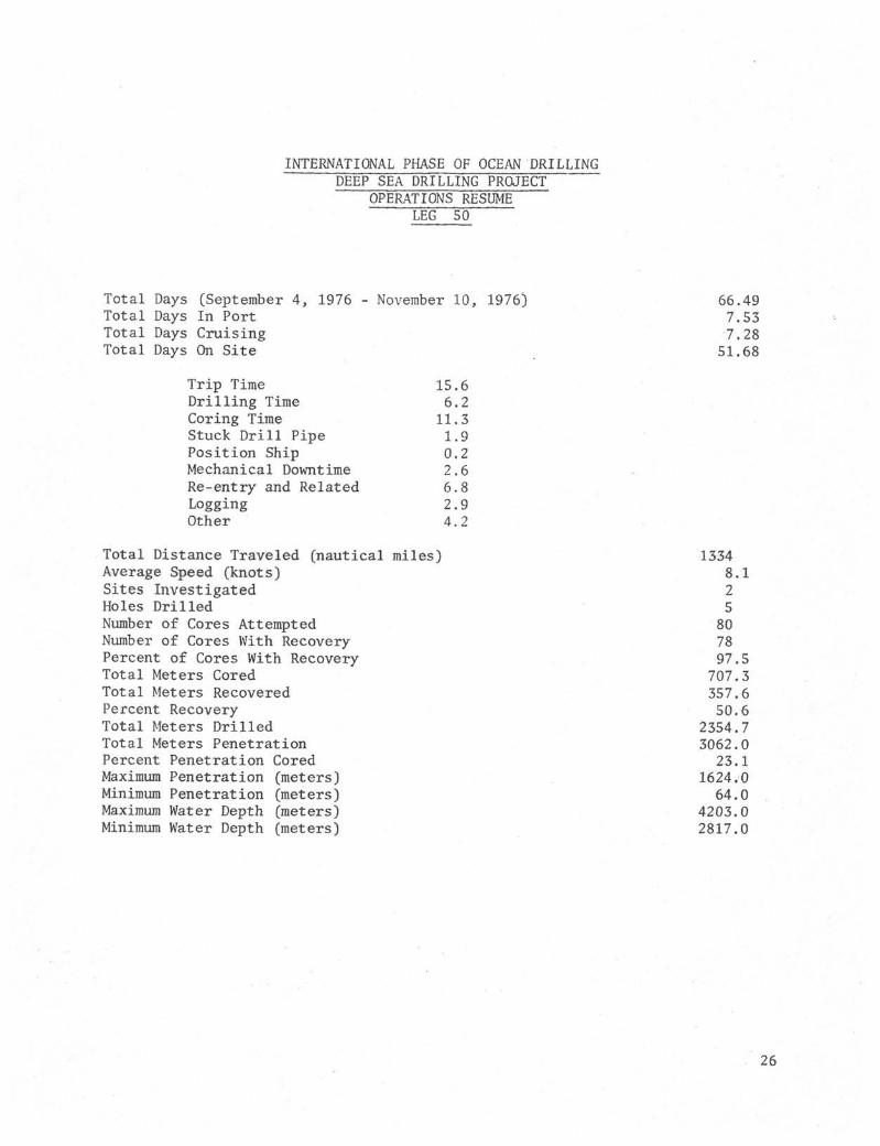
INTERNATIONAL PHASE OF OCEAN DRILLINGDEEP SEA DRILLING PROJECT
OPERATIONS RESUMELEG 50
Total Days (September 4, 1976 - November 10, 1976)Total Days In PortTotal Days CruisingTotal Days On Site
66.497.537.28
51.68
Trip TimeDrilling TimeCoring TimeStuck Drill PipePosition ShipMechanical DowntimeRe-entry and RelatedLoggingOther
15.66.211.31.90.22.66.82.94.2
Total Distance Traveled (nautical miles)Average Speed (knots)Sites InvestigatedHoles DrilledNumber of Cores AttemptedNumber of Cores With RecoveryPercent of Cores With RecoveryTotal Meters CoredTotal Meters RecoveredPercent RecoveryTotal Meters DrilledTotal Meters PenetrationPercent Penetration CoredMaximum Penetration (meters)Minimum Penetration (meters)Maximum Water Depth (meters)Minimum Water Depth (meters)
13348.125807897.5707.3357.650.6
2354.73062.023.1
1624.064.0
4203.02817.0
26

TOTAL TIME DISTRIBUTIONLEG 50
POSITION SHIP 0.4%
MECHANICAL DOWNTIME 5.0%
TART LEG: September 4, 1976FINISH LEG: November 10, 1976TOTAL TIME: 66.49 Days
.ME DISTRIBUTIONLEG 50
RE-ENTRY § RELATED13.2%
TRIP TIME 30.2%
TOTAL TIME ON SITE: 51.68 DaysTOTAL SITES: 2TOTAL HOLES: 5
27

20°
LEG 50 DRILL SITES
MADEIRA- MADEIRA
10° 0°1 '"T
MADEIRA
40°
I I I I I ! I I I I I ]
28

INTERNATIONAL PHASE OF OCEAN DRILLINGDEEP SEA DRILLING PROJECT
BIT SUMMARYLEG SO
Meters HoursHole Mfg. Size Type Serial Meters Meters Total On Condition
Number Cored Drilled Penet. BitRemarks
415
415A
415A
Smith
Smith
Smith
10" 93CJS
14-7/8" F94C
I01 F93CK
HM618
69 7 AN
958EL
415A
416
416A
416A
416A
416A
416A
416A
416A
416A
Smith
Smith
Smith
Smith
Smith
Smith
Smith
Smith
Smith
Smith
10"
14-7/8"
14-7/8"
10"
10"
10"
10"
10"
10"
10"
F93CK
F94C
F94C
F93CK
F93CK
F94CK
F93CK
F93CK
F93CK
F93CK
960EL
697AN
697AN
964EL
965EL
355BV
966EL
960EL
962EL
966EL
45.5
122.5
2.0
237.5
281.5
612.5
10.0
283.0
281.5
735.0
12.0
- -
53.
230.
47.
134,
18.
19.
0
1
0
6
8
0
42.0
998.0
86.0
- -
1.0_ _ -
_ — —
42.0
1051.0
316.1
47.0
135.6
18.8
19.0
8.1
18.0
47.1
1.5*
0.2
67.0*
59.2
57.0
27.0
51.5
12.5
2.3
TO-B2-SQ-I
TO-B1-SE-I
TO-BO-SE-I
TO-B2-SQ-I
T0-B2-SQ-I
T1-B7-0-1/8
T1-B7-I
TO-B1-I
TO-B1-SE-I
TO-BI-SE-I
Released on bottom.
Rerun. Total hrs approx. 48. Approxhalf jetting time.
3 hrs drilling cement shoe. 8 hrs w/junkfrom plug in hole.
*Sidetracked hole. Approx 17.5 hrs cleaning hole.
Apparently deflected 5 slipped on bottom.Bent BHA.
*Total jetting time. Wash in casing.
Some chert.
Claystone/shale with some hard sandstone.
Couldn t make it-drill waxy claystone.
Claystone with limestone stringers.
Total bottom hrs about 14.. Rerun after Hole 415A.
Washed in-released on bottom.
Rerun-washed, in-released in hole.

INTERNATIONAL PHASE OF OCEAN DRILLINGDEEP SEA DRILLING PROJECT
BEACON SUMMARYLEG 50
Site
415A
416A
416A
Make
BenthosDouble
OREDouble
OREDouble
Life
Life
Life
Freq.kHz
13.5
16.0
13.5
SerialNumber
002
373
367
Site TimeHours
369.3
912
289.9
Remarks
Signal about 1/2 as strong as ORE. Otherwise satisfactory,
Began to fade after 38 days.
Dropped prior to departure for crew change. Strong atfinal departure.
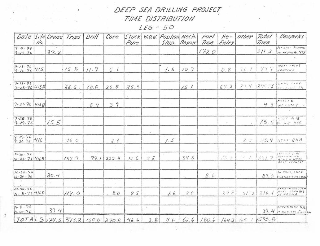
SEA DRILLING PROJECTT/ME D/57PIBUT/O//
L£6 - 5ODate
9 - /à • V é>
1
J-2S- 76
j
>Ù • 2 (> - 7 C
/ / - 8 - Vtf'
lor/)
Site//α
-y/5
lie
IS
Csv/se
Z^r. 2
/5.5"
BC.H
Tr/ps
/SB
U 5 .
•/é c
/5V 9
Dr///
/ / - ?
C1
77 /
y/3.21 /i'<?.0
Core
2S.B
3 7
2á
P/fie
2. g
Postf/o/iS/i//>
/. £
/ • ^
/é>
Aiech.Repair
/o. 7
JS /
a c
é>2.(>
por/T/r/?e
/7-.2.O
£*,
0.8
-
; • - 7
Á: ' ; >"
orAer
< i /
J : V
7öfe/7//77S
ZII•Z
'it V
/f<^/?23r/^S
•
u/Avi t• PI t/K
A» • ' ' i' •*' i>
- -' L • w ?
!
'̂ Λ - I • t i f
Hr . ' " " " 3 U
f '•'/) /V<; / V A1 f 7 et tie
C e: »•y i / ΛJ U è^ J >o A//„• r / ' t nfu QI £
/S75\ Sam

280014 15 16 17
HOLES 415 $ 415ADAYS - SEPTEMBER 1976
18 19 2Q 21 22 23 24 25 26 27 28 29
2900
3000
3100
T 1 1——I—SEA FLOOR 2817
HOLE 415A
•3200
8
3300DS
k 3400s
3500
3600 -
3700 -
3800 -
3900 1
T.D. 3100
RE-ENTRY #2
T
r ,rRE-ENTRY #3 T.D. 3896.5. . I I I 1
10 0 16 24 32ROTATING HOURS
40 48 56 64

4200
HOLES 416A § 370
OCTOBER 1976 NOVEMBER 1976
1 2 4 6 8 10 12 13 . 16 18 20 22 24 26 28 30 1 3 5 7 9 11
π r
4400
SEA FLOOR 4203
RE-ENTRY #1
4600
4800
2
Qi
5000
Zù
25200
5400
5600
5800
6000
RE-ENTRY #2
RE-ENTRY #3
RE-ENTRY #4
T.D. 5402.5 M
T.D. 5827
RE-ENTRY #5 R E. E N T R Y # 6
J L J L
RE-ENTRY #7RE-ENTRY #8
RE-ENTRY #9
I I I 10 15 30 45 60 75 90 105 120
ROTATING HOURS
135 150 165 180 195 210
33
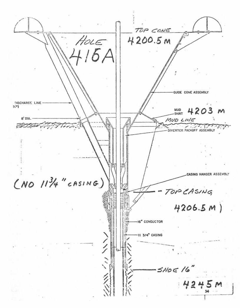
HZòO.Sm
DIVERTER PACKOFF ASSEMBLY
CASING HANGER ASSEMSLT
CNO /I3A

INTERNATIONAL PHASE OF OCEAN DRILLING
DEEP SEA DRILLING PROJECT
SITE SUMMARY
Hole
415
415A
415B
416
416A
416A
Latitude
31° 01.72'N
31° 01.65'N
31° 01.65'N
32° 50.17'N
32° 50.18'N
Continuation
Longitude
11° 39.11'W
11° 39.97'W
11° 39.97 W
10° 48.06 W
10° 48.06'W
Water
Depth
Meters
2817
2817
2817
4203
4203
4203
Number
Of
Cores
5
14
2
2
55
2
Cores WithRecovery
5
12
2 .
2
55
2
Percent Of
Cores With
Recovery
100.0
85.7
100.0
100.0
100.0
100,0
Meters
Cored
45.5
122.5
17.0
11.5
491.8
19.0
Meters
Recovered
31.3
24.7
3.1
1.3
295.3
1.9
Percent
Recovered
68.8
20.2
18.2
11.3
60.0
10.0
Meters
Drilled
237.5
957.0
47.0
1113.2
Total
Penet.
Meters
283.0
1079.5
64.0
11.5
1605.0
19.0
Avg.
Rate
Penet.
34.5
17.4
85.0
7.1
8.3
Time
On
Hole
74.7
290.3
4.3
23.4
631.9
216.1
TimeOnSite
369.3
TOTALS 80 78
871.4
97.5 707.3 357.6 50.6 2354.7 3062.0 11.1 1240.7
cπ

INTERNATIONAL PHASE OF OCEAN DRILLINGDEEP SEA DRILLING PROJECT
OPERATIONAL RESUMELEG 51
SUMMARY
Legs 51 and 52 of the IPOD Program were designed to drill a deep multiple re-entry hole to study the older western Atlantic crust. Operationally, Leg 51was manned by two different crews and their work is described separately herein.The first part, Leg 51A, consisted of the transit from Funchal and the drillingof the exploratory holes at general Site 417 at the Bermuda Rise. The secondpart, Leg 5IB, includes the setting of the re-entry cone and multiple bit runs.
SUMMARY OF LEG 51A :
After a transit of the Atlantic Ocean from Funchal Harbor, Madeira Island to SanJuan, Puerto Rico, the first part of Leg 51 began on November 23, 1976 and endedon December 13, 1976, again, in San Juan. During this part of Leg 51, theCHALLENGER traveled 868 nautical miles and drilled two holes at one site. Thewater depth at this site was 5478 meters. The two holes were 113 meters and 421meters deep, respectively. A total of 429.5 meters of cores were recovered, arecovery percentage of 58.7%.
Time distribution for Leg 51A was 5.77 days in port with an additional 1.64 daysof equipment breakdown. 4.9 days were used in cruising plus 0.4 days of asso-ciated equipment breakdown and 8.03 days on-site. The on-site time consisted of1.14 days tripping, 0.02 days drilling, 5.7 days coring, 0.28 days positioningthe ship, 0.49 days of mechanical downtime and 0.4 days in miscellaneous activities.No time was lost due to unfavorable weather conditions.
TRANSIT FROM FUNCHAL, MADEIRA TO SAN JUAN, PUERTO RICO
Leg 50 was completed on November 10, 1976 at 0626 hours when the GLOMAR CHALLENGERarrived in Funchal, Madeira. Some provisions, fuel and water were taken aboard,as well as loading 40 joints of 11-3/4" R-3 casing before the ship departed forSan Juan at 0234 hours on November 11, 1976.

During the transit, many things were accomplished. A representative from theMagnaflux Corporation was on board. Such things as the bottomhole assembly,nine sets of 250-ton and two sets of 350-ton elevators, the Bowen swivel, torquearms for the Bowen unit and heave compensator, bails, pup joints, latch subswere inspected using the "magnaflux" magnetic particles systems. In addition,the welds on the pedal stools, the mouse and rat holes, and the welding asso-ciated with the moon pool were inspected.
While this was being accomplished, a set of windshield wipers were installed onthe Schlumberger unit and the operation of its electric motor was checked. Anew sprocket assembly was installed on the pipe stabber.
All the pieces of equipment inspected were primed and painted after inspection.In addition, new handles were put on break out tongs and new clamps were installedon the tires of the heave compensator hoses.
Also, while underway, measurements were made to check out the ship s stabilizersystem. In addition, about nine hours were spent making dynamic positioningtests, but a computer problem went unsolved; to be worked on in San Juan.
The transit ended with the first line on the dock at 1936 hours on November 23,1976. Time underway was 12-1/2 days.
SAN JUAN PORT CALL
The port call in San Juan, prior to departing for Site 417, was involved withthe usual loading of supplies such as groceries, acetylene, oxygen, mud and barite.In addition, the drill pipe was given a "Sonoscope" inspection. The electricmotor for the No. 2 mud pump was used to replace a drawworks motor which wasremoved for repairs. The drawworks electric brake was inspected. Some of the250-ton elevators and the special "duomatic" elevator bushing were cracked andrepaired in San Juan. Some 250-ton and all 350-ton elevators were cracked andsent to Houston for repairs. Three re-entry cones were loaded on board withone assembled in anticipation of placing it in position during Leg 51. Whilesupplies were being loaded and repairs being made, the positioning system wasalso worked on in hopes of correcting problems that had developed on Leg 50.On November 28, after all the supplies, new equipment and repaired equipment hadbeen placed on board, the ship left the dock at 1750 hours to travel to an areaoutside the harbor where the positioning system could be checked and adjusted.
The ship traveled approximately five miles into about 2,000 feet of water and a16 kHz beacon was hung over the side to check the equipment. However, a shacklepin broke and the beacon dropped to the bottom. The testing continued for about3-1/2 hours at which time it was determined that the equipment was unsatisfactoryand it would be necessary to return to port to efficiently effect necessary re-pairs. The ship was alongside the dock at 0552 on November 29th.
While the positioning equipment was being repaired, the sandline was unspooledand respooled. During the respooling, a kink developed and it was necessary tomake a long splice before the balance of the line could be respooled.

At 0707 on November 30, the ship again left the dock to travel to the spot wherethe beacon had previously been dropped to troubleshoot the positioning system.After about 12 hours of maneuvering, the equipment appeared to be operating satis-factorily and the technicians were transferred to a tug and at 1736 the ship de-parted for Site 417.
SITE 417
The site chosen for Leg 51 was located near 25 N and 68 W at the southern endof the Bermuda Rise to evaluate the older western Atlantic Ocean crust. Thismultiple re-entry site had been shifted about five degrees south from its originallocation to take advantage of the better winter weather conditions. After ap-proximately 48 hours of travel and profiling, the beacon (13.5 kHz D.L.) wasdropped at 1810 on December 2, 1976. At 2225, the ship was positioning in anautomatic mode and makeup of the drill string was begun.
There was a difference of opinion on how to read the PDR as to what the waterdepth was at the chosen location. This difference varied from 5471 meters to5478 meters. Two water cores were taken before the correct water depth of 5478was verified with a core. The hole was then washed without rotation to 5591.0meters which established the amount of 16" casing as 113 meters that could bewashed in with the re-entry cone.
SITE 417A
After completing Hole 417, the drill pipe was pulled above the mudline and theship was offset 650 feet to the southwest at the request of the Co-Chief Sci-entists. This hole was spudded at 2015 hours on December 3. The hole was con-tinuously cored from the mudline; heat flow measurements were taken followingCores No. 6, 9, 12, 15, and 19. The heat flow measurements were discontinuedafter Core No. 19 because basaltic material was recovered in Core No. 22 andtherefore the material was considered too hard.
While cutting Core No. 47 (5895.2 - 5899.2 m), it became necessary to discontinuecoring and pull pipe to clear the mudline because both bow thrusters failed. Thepipe was pulled with no apparent damage to the drill string. However, when allof the pipe had been recovered, it was found that the bit release had been acti-vated prematurely dropping the bit and bit release sub. The bit release sub hadbeen included in the bottomhole assembly so the hole could be logged with down-hole logging equipment after the bit had been drilled to destruction. After thedrill string was recovered, the ship departed this site to return to port to makethe necessary repairs to the bow thrusters.
DRILLING AND CORING ASSEMBLY
The bottomhole assembly used on this part of Leg 51 was the standard DSDP assemblywith the exception that the bit disconnect assembly was included because it wasplanned to log the hole with downhole logging equipment after the bit was worn out.

The bottomhole assembly consisted of a bit, bit disconnect sub (with float valve),top connector core barrel, three 8-1/4" drill collars, one 5-foot stroke bumpersub, three 8-1/4" drill collars, two 5-foot stroke bumper subs, two 8-1/4" drillcollars, one 7-1/4" drill collar, one heavy wall 5-1/2" drill pipe. Core recoverywas quite good averaging 60% and this was the same for the 200 meters of claystoneas well as the 221 meters of crustal material.
The only equipment that was lost on this leg was the bit disconnect sub, bit, andinner core barrel. When it was necessary to terminate drilling due to the bowthrusters failure and weather, it was decided not to attempt to retrieve the innerbarrel before laying down the drill string. When the outer barrel reached thederrick floor, it was discovered that the bit disconnect sub had released pre-maturely and had allowed the inner barrel to drop to the bottom. The reason forthis unexpected release has not yet been determined.
BITS
Only one F-93CK bit was used on this leg for a total penetration of 584 meters.Based on the interpretation of the geophysical records, it was anticipated thatthere would be a sedimentary section of about 400 meters which resulted in theF-93CK being selected. However, when it developed that there was only 200 metersof relatively soft claystones, there was some concern that the bit would failbefore a significant amount of basalt could be penetrated. However, it was apleasant surprise that the bit had over 52 hours of rotating time and the corediameter was still better than 5.1 cm when the thrusters failed. Unfortunatelythe bit was lost when the bit disconnect sub was released. It would have beenhelpful for future drilling to see what had happened to this longer toothed bitwhile drilling in crustal material.
BEACONS
Three ORE beacons were used during this leg and all performed well. One beaconwas inadvertently dropped when the shackle pin broke at the positioning test site.The second was used for positioning while on Site 417 and 417A. The third beaconwas dropped at Site 417 prior to departure for San Juan crew change and bow thrusterrepair. This last beacon could be used to locate this area in the event that thesite is selected for the setting of a re-entry cone.
POSITIONING
Positioning was generally good on this leg, however, there were some sags of100' +_ in the "Y" occasionally in light winds. This seems to be an intermittanthardware problem and is being investigated. Winds of 40 mph were experienced nearthe end of the leg; the ship help generally within 60 feet except for gusts acrossthe bow and the "Y" would sag 100 to 200 feet. The system recovered normallyafter these gusts. The site was abandoned when an overspeed occurred on the bowthrusters causing one trunk shaft to bend and pull out of the coupling box andthe other trunk shaft to bend and shear off at the top coupling box. When thesefailures occurred, the ship was placed in manual while the drill string was re-covered .

HEAVE COMPENSATOR
The heave compensator was not used on this leg because first, the sediments weresoft and it was planned to put the heave compensator in the string when they becamefirmer. Next, at 100 + meters, the cores changed to crustal material abruptly.After four cores had been cut in this material, plans for connecting the heavecompensator were initiated. However, the hole showed a tendency to fill withrubble; therefore, it wae necessary for the safety of the drill string not toconnect the heave compensator. This proved to be fortunate because when thethrusters failed, it allowed pulling doubles instead of singles to clear themudline.
HEAT FLOW
Five heat flow measurements were taken at Hole 417A. Four of these were success-ful. The one that failed apparently did not start when activated with the magnet.The measurements were discontinued when hard crustal material was encountered. Atotal of about ten hours were required to make these measurements, or about twohours per run. This was good considering a water depth of approximately 18,000feet.
LOGGING
Downhole logging had been planned for the pilot hole, however, this was not accom-plished due to the bow thruster failure. The Schlumberger engineer had modifiedthe caliper arm to pass through the latch assembly. This problem, which appearedon Leg 50, then required the removal of the caliper assembly before the tool couldbe run into the open hole. The tool, however, could not be centralized and thedata recorded was not as reliable as desired. »*'
COMMUNICATIONS
As in the past, when the CHALLENGER has been working in this general area, dailycommunications of 17 mHz with Radio WWD were maintained with little or no inter-ference. Usually communication was best between 1600 and 2000. Likewise, voicecommunications via radio with the marine operator in Miami was good and easilyestablished at almost any time. In addition, personal telephone calls were madeeach Sunday for the convenience of everyone on board.
Both radars operated satisfactorily after considerable repair work was done onone of them by our radio operator. The total volume of traffic was normal forthe average leg and was handled with no problems.
ACKNOWLEDGEMENTS
Although this part of Leg 51 was short as compared to normal legs, the GlobalMarine personnel and Scripps technicians were extremely helpful. They performedefficiently and contributed greatly to the scientific accomplishments of the leg,

The scientific party was dedicated in achieving what scientific objectives couldbe accomplished during the abbreviated drilling period. A great deal of pleasurewas derived from their dedication and enthusiasm.
Robert R. KnappCruise Operations ManagerDeep Sea Drilling ProjectLeg 51A

INTERNATIONAL PHASE OF OCEAN DRILLINGDEEP SEA DRILLING PROJECT
OPERATIONS RESUME
LEG 51A
Total Days (November 10, 1976 - December 13, 1976) 33.2Total Days In Port 5.77In Port Downtime 1.64Total Days Cruising Including Site Survey 17.37In Transit Downtime -41Total Days On Site 8.03
Trip TimeDrilling TimeCoring TimePosition ShipMechanical DowntimeWaiting On WeatherOther
1.140.025.70.280.490.00.4
Total Distance Traveled (Nautical Miles) Including Transit $ Survey 3702Average Speed 9.14Number of Sites 1Number of Holes Drilled 2Number of Cores Attempted 48Number of Cores With Recovery 44Percentage of Cores With Recovery 91.6%Total Meters Cored 429.5Total Meters Recovered 252.21Percent Recovery 58.72%Total Meters Drilled 113.0Total Meters of Penetration 534.0Percent of Penetration Cored 80.4%Maximum Penetration (meters) 421.0Minimum Penetration (meters) 113.0Maximum Water Depth (meters) 5478.2 ̂Minimum Water Depth (meters) 5478.2

INTERNATIONAL PHASE OF OCEAN DRILLING•DEEP SEA DRILLING PROJECT
LEG 51AON-SITE TIME DISTRIBUTION
MECHANICALDOWNTIME
6.1%OTHER5.0%
DRILLING.3%
POSITION SHIP'3.5%
TOTAL TIME DISTRIBUTIONLEG 51A

INTERNATIONAL PHASE OF OCEAN DRILLINGDEEP SEA DRILLING PROJECT
BIT SUMMARYLEG 51A
Hole Mfg. Size Type SerialNumber
MetersCored
MetersDrilled
MetersTotalPenet.
HoursOnBit
Condition Remarks
417
417A
Smith
Smith
10"
10"
F93CK
F93CK
959EL
959EL
8.
421.
5
0
8.5
421.0
.4
52.6 Dropped when bit sub released.

INTERNATIONAL PHASE OF OCEAN DRILLINGDEEP SEA DRILLING PROJECT
BEACON SUMMARYLEG 51A
SiteNo. Make
Freq,kHz
SerialNumber
Site TimeHours
Test
417 t
417A
Site
\ A
ORE
ORE
ORE
16.
13.
16.
0
5
0
S.
D.
D.
L.
L.
L.
351
396
375
45+
181+
Dropped while working on positioning problemsjust outside of San Juan Harbor.
Dropped 1810 December 1, 1976.
Dropped for return to site December 10, 19762347 hours.

INTERNATIONAL PHASE OP OCEAN DRILLINGDEEP SEA DRILLING PROJECT
SITE SUMMARYLEG S1A
Hole Latitude Longitude Water Number Cores With Percent of Meters Meters PercentDepth of .Recovery Cores With Cored Recovered RecoveredMeters Cores Recovery
Meters TotalDrilled Penet
Meters
Avg. Time TimeRate On OnPenet Hole SiteM/Hr. Hr.
417 25 06.71'N
417A 25 06.63'N
68 02.57'W 5478.2 1
68 02.48'W 5478.2 47
1 100.0 8.5 3.6
43 91.5 421.0 248.61
42.4 113.0 113.0 225.0 22.6
59.0 421.0 8.Q6 170.2 192.8
Total 48 44 91.6 429.5 252.21 58.72 113.0 534.0 8.06 192.8 192.8
ssfisrA '.ateü

DEEP SEA DRILLING PROJECTTIME DISTRIBUTION
LEG - 5IA
D .fe
//- // - y(>
h - /f- ?t.
>/- 3 9 1&
α J • i t
>
J"C 7 /U 5
!
Slie//o.
in
•
C/*wse
•
Se I
....
6 / r
Tr/ps
• / ) 3
•
j
VA./
•
Dr///
o.Y
0 V
Core
-?. 7
StuckP/&e
W.O.W.Posrf/oyi5/7/p
|
i
Aiech.Repair
fO•C
31 L
u o
O•3L
CO 6
Porf7/7776
//8.Z
/re- Of/iep
> *S V
7/7773
3O9 O •
//S 2
2 7 .*
i,i 2
•
1
t
i
i
To 5*^Λ/ Jtsrt*/ \1
!
1j
I
!

SUMMARY OF LEG 5IB
Leg 5IB of the International Phase of Ocean Drilling was a continuation ofdeep crustal investigation at Site 417 on the southern Bermuda Rise. Explor-atory drilling had been done on Leg 51A to the extent allowed by a single bit.The GLOMAR CHALLENGER returned to the site on Leg 51B to set a re-entry coneand to proceed with a deep multiple-bit penetration.
The total depth of penetration achieved on Leg 51B fell short of expectationsdue to a series of operational setbacks. Site operations were terminated twodays early by a combination of a premature pipe trip and an unfortunate spateof injuries involving the rig crew. Despite these limitations, the re-entrycone was emplaced, three successful re-entries were made, downhole logs wererun and a significant amount of both sediment and basalt coring was done. Ahole reaching about 240 meters into basement and in excellent condition was leftfor further drilling on Leg 52.
The leg commenced on December 13, 1976 at San Juan, Puerto Rico and terminatedat the same port on January 17, 1977. Total length of the cruise was 35 daysof which 20.9 days were spent on site, 5.0 days under way and 9.1 days in port.1.8 days of operating time were lost due to mechanical difficulties and one dayof delay due to weather was experienced.
PORT CALL - SAN JUAN, PUERTO RICO
Leg 51B began at 0810, December 13, 1976 when the CHALLENGER berthed at IslaGrande, San Juan, Puerto Rico. The arrival was two days ahead of schedule dueto a major mechanical failure of both bow thrusters.
A one day port call had been planned for Global Marine and technical crew changesand for minimal resupply. Procurement of parts and repair of the thrusters,however, delayed the vessel's departure for an additional eight days.
As the result of a failure in the electrical feedback system controlling bowthrust er RPM, both thrust er motors had run at speeds far in excess of the system'sdesign. Both 12-foot intermediate drive shafts were severely twisted. In addition,there was damage to the shaft couplings, the lower stub shafts and the thrusterright angle gear boxes. After the 750-horsepower vertical-shaft drive motorshad been removed, it was found that the lower bearings and the shafts of bothmotors had also sustained damage.
Replacements for the intermediate shafts had to be fabricated in Holland whilethe motors were shipped by truck to a heavy machine shop in Ponce, Puerto Ricofor machining.
A thorough investigation of the cause of the overspeed failure was made. Afaulty exciter feedback relay was found to be the origin of the problem. Otherdeteriorated exciter components were found and replaced. A temporary overspeedalarm system was installed to aid bridge personnel in avoiding a runaway in thefuture.
13

Other significant maintenance items included the replacement of a main seawatercirculating pump housing, inspection and rewelding of sandline sheaves, repairof an engine room ventilation supply fan and ABS inspections.
In addition to normal resupply, 1500 sacks of bentonite, 500 sacks cement and11 drill collars were onloaded.
SAN JUAN TO SITE 417
The vessel departed her berth at 1050 hours, December 22 and proceeded to thevicinity of an acoustic beacon that had been dropped for positioning system testsat the beginning of Leg 51A. At this location, about five miles outside SanJuan Harbor, about 15-1/2 hours were spent to assure proper functioning of thepositioning system. The bow thrusters were run at progressively higher speedsto check for proper alignment and bearing installation. Response to the controlsystem was tested and exciters, feedback circuits and tachometers were recali-brated. As a final integrated test the vessel held station on the beacon inthe automatic mode for over an hour with no irregularities noted.
A harbor tug was dispatched to the CHALLENGER to remove the six personnel repre-senting GMI, General Electric and Schottel, who had remained aboard for the"sea trials".
At 0350 on December 23, the vessel set course for the Bermuda Rise operatingarea. Good weather and a following current prevailed and an unusually rapid,average speed of 9.8 knots was realized. With the aid of satellite navigation,the signal of the beacon dropped at the end of Leg 51A drilling was acquiredwithout a search pattern. The beacon was passed close aboard and a pre-sitesurvey was initiated. The survey was complete and the vessel was positioningin the automatic mode at 0630 on Christmas day.
HOLE 417B
Site 417 is located on the Bermuda Rise near its southern terminus. The siteis located about 400 miles north of Puerto Rico and 700 miles east of the tipof the Florida Peninsula. Two exploratory holes, 417 and 417A, had been drilledon Leg 51A to verify the geological and technical suitability of a multiple re-entry deep penetration at the site.
Hole 417B was an intermediate step to determine the proper length of 16-inchconductor casing to set with the cone. On the basis of wash-in tests with onlya drill bit on Hole 417, a 84.5 meter string of casing was made up and attachedto the drill string without a re-entry cone.
The water depth at Holes 417 and 417A had been determined to be 5478 meters. Thenew precision depth recorder reading was 5483 meters. As 417B was to be locatedwith reference to a different beacon from that used for the first two holes,it was considered to be several hundred feet distant. It was therefore importantto redetermine the water depth before setting the re-entry cone.
14

A positioning offset of 100 feet west was introduced prior to spudding the hole.The pipe was lowered to a depth of 5485 meters, then raised one joint while theinner core barrel was retrieved. No sediment was recovered and the procedurewas repeated with the addition of one joint of drill pipe to a depth of 5494.5 m.On the basis of 5.2 meters of soft sediment core recovered and of weight indicatorreadings, a water depth of 5489 meters was established.
The casing was then washed into the sea floor with an initial pumping rate ofabout 175 gallons per minute. This was increased as the clay sediment becamestiffer with depth to 400 gallons per minute. Washing progressed easily to adepth of 5513 meters where penetration slowed abruptly. An additional 43 minutesof pumping advanced the pipe only about three meters. The bumper subs above thecasing running tool were put in neutral and the weight of casing and bottomholeassembly rested at bottom. After 15 minutes an overpull of about 25,000 poundswas required to move the casing. The procedure was repeated for a period of 45minutes with the same results.
The test was considered complete with a total (but unexpectedly short) penetrationof 27 meters and the drill string with casing was retrieved.
As the casing string was being recovered, a weather front passed through withsqualls and wind gusts to 50 miles per hour. At one point the ship was blownan estimated 5,000 feet off station. Wind strength gradually declined to a lightbreeze during the ensuing day, but the ground swell had steadily increased to10 to 12 feet during the same period. The next step, the keelhauling of thecone, required relatively good weather and a weather delay of 25 hours was enduredwhile the swell slowly decreased.
HOLE 417C
Operations recommenced at 1000 on December 28. The re-entry cone, with an ex-pendable bottomfinder pinger attached to the mud skirt, was keelhauled intoplace beneath the moon pool without incident. A 23 meter string of 16-inchcasing was made up and hung off in the moon pool. (The casing and lower conetogether would space the casing shoe 25-1/2 meters below the mud skirt). Thebottomhole assembly was then made up. The short casing string allowed only twodrill collars below the running tool. After latching the casing to the bottom-hole assembly and the resulting assembly into the re-entry cone, the cone'ssupport slings were cut free and the trip to the sea floor began.
When about two thirds of the pipe had been run, the derrickman was seriouslyinjured in a rig accident. The extent of the injuries were not known and itwas evident that he needed medical attention ashore as soon as possible.
The ship could not depart the site for port, however, until the cone/casingassembly had been washed in and released and the drill pipe pulled. It wasfelt that our position was outside helicopter range of land. The U. S. CoastGuard was contacted by radio, however, and a helicopter was dispatched fromPuerto Rico. Even though a fueling stop was made at Turk Island, the pilot wastoo low on fuel to hover long enough after the basket litter was aboard to loadthe injured man!s suitcase.
15

The 100 foot offset was removed and bottom was again "felt" by the weight in-dicator at 5489 meters and washing commenced immediately. Progress came to avirtual halt after 16 meters penetration. The pinger showed several meters tothe sea floor, agreeing closely with drill pipe measurements. Pumping continuedat 400 gallons per minute for about four hours with slow progress being made.Although the pinger had not yet been silenced by contact with bottom sediment,its PDR traces indicated no more than one meter to the mudline when decreasesin both pump pressure and weight were noted. Cautious application of torquedid not produce free rotation but it was attained after two joints of pipe werepulled. Also, the lack of change in the pinger trace told that the cone/casingassembly was no longer attached to the drill string.
The drill string was pulled and all hands waited to see if the casing runningtool had released by itself or if the drill string itself had parted. On retrievalof the bottomhole assembly, it was found that the pin of the rotary connectionof the lowermost bumper sub had failed and disengaged from the index sub. Thebumper sub was also bent. This left the running tool still latched into thethroat of the cone with only the box of the index sub "looking up" and no rea-sonable means of re-entry or fishing.
The bottomhole assembly was magnafluxed on retrieval as is standard practiceafter it has been subjected to severe stress.
HOLE 417D
A second re-entry cone was assembled and keelhauled as before a 26 meter casingstring was made up. A bottomhole assembly with more bumper subs and modifiedweight distribution was assembled and once again the assemblage was connected.
A one thousand foot west offset was programmed to separate the two cones and toreduce chances of a re-entry attempt on the wrong cone.
After running the string to just off the sea floor, the power sub was picked upand a mudline punch core was taken. This was considered necessary due to the1000 foot move and a PDR reading of 5492 meters. The string was lowered to putthe shoe at 5496.5 m before it was pulled back. A 5.5 meter core was retrieved,indicating a depth of 5491 meters. The weight indicator "felt" bottom about twometers deeper.
The pump was started and the casing was spudded. This time washing-in proceededat a reasonable pace until the casing shoe reached a depth of 5514 meters. Atthis point progress came to an abrupt halt, strongly indicating that the mudskirt had reached the sea floor. (The only operational pinger on board had beenexpended on the first cone. Its indication would have been welcome at this point).It did not seem unreasonable that the earlier depth measurements could be off byone or two meters and the water depth was again established at 5489 m. The"rotary" shifting tool was run on the wireline to release the assembly. The pro-cedure went smoothly and the cone/casing assembly was "planted" at 2050 hours onNew Years Eve.
16

As the sediment section had been continuously cored at Hole 417A, only spotcoring was done to a depth of 144.5 meters BSF. Continuous coring began at thispoint and continued to total depth. Possibly due to the sticky nature of the clay,core recovery was not good in the sediment section which was, surprisingly, 135meters thicker than at Hole 417A.
Basalt was finally encountered in the bottom of Core No. 21. Core No. 22 gavegood recovery of basalt core but Core No. 23 came up empty. Two short coreswere attempted that recovered only pebbles. A center bit was pumped down in anattempt to clear the apparent obstruction. Upon its retrieval, another shortcore was attempted, again without success. Scarring of the center bit and corecatcher subs indicated a hard (probably metal) obstruction. It was thereforenecessary to make a round trip to clear the obstruction and to change bits. Thecore bit had 25-1/4 rotating hours. When the bit was retrieved, the flapper ofthe float valve was found to be broken off and lying across the bit seal platein the box of the bit. Both ears of the flapper were broken off and were re-covered. The pin and spring were missing.
RE-ENTRY NO. ONE
When the bit had been changed and the casing running tool removed from thebottomhole assembly, the drill string was run to within four to five meters ofthe depth of the top of the re-entry cone. The logging sheaves were rigged andthe sonar tool was lowered to the bit.
Near perfect weather and excellent range resolution by the sonar combined to producea "textbook" re-entry. The cone target was initially acquired at a range of 70feet. Plotting of the initial range and two subsequent moves of the ship gavethree range circles that intersected nearly at a common point. The ship wasoffset to locate it over the common intersection of the circles and the drill bitmoved directly over the cone. A successful stab was made after 36 minutes ofscanning time.
After retrieving the sonar tool, running a stand of drill pipe to verify re-entryand rigging down the sheaves, the bit was run to bottom and coring recommenced.No significant bottom fill was noted by the driller, but solid basalt was en-countered 10.1 meters shallower than the previously measured total depth. Thiswas attributed to previously noted discrepancies in the ship's stationkeepingamounting to up to several hundred feet.
Fourteen basalt cores were cut with the second bit. Recovery was excellent andlong, smooth core sections were recovered. The rock was quite fractured but thefractures were "healed" with calcite and alteration products. Weather was ex-cellent for most of the period and the heave compensator was used on eight cores.It was out of the string with mechanical problems for the remainder of the time.
Although no signs of failure were noted, the bit was pulled after more than 40hours. This was a truly exceptional bit life for basalt drilling and the de-cision to retire the bit was based on a desire to avert catastrophic bearingfailure or loss of gauge.
17

When the bit had been retrieved, the special open-ended logging bottomholeassembly was made up. To provide for logging all the way up to the casing shoe,this consisted only of one drill collar with sonar landing sub, a bumper sub,and a crossover sub below seven joints of 5-1/2 inch drill pipe.
RE-ENTRY NO. TWO
The second re-entry attempt began with an experiment intended to determine con-clusively that the shipfs heading had a major impact on the vessel's position.On the first re-entry, the heading had been only five degrees off the conesetting heading and the cone was found to be only 70 feet away when scanningcommenced. As weather conditions permitted it, scanning for the second re-entrybegan with the offsets used for the first re-entry but on a reciprocal heading.No target was acquired within the 500 foot range of the sonar. The ship's headingwas then reversed and, after a few minutes required for the positioning systemto "settle down", the cone target appeared near the edge of the screen. Thetarget was closed to less than one hundred feet before additional maneuvering wasdone.
Considerable difficulty was experienced in positioning the ship for the stabattempt. After plotting and maneuvering the end of the pipe to within 35 feetof the cone on the second move, numerous ensuing moves failed to swing the pipedirectly over the cone. The light bottomhole assembly is believed to haveaffected the drill string's behavior. Instead of displaying excessive motion ashad been feared, however, it appeared to "deaden" the action of the string.Movement of the end of the string did not appear to follow the ship s motion whensmall offset increments were introduced. Also, the slow "pendulum" effect whichgenerally causes the pipe to swing over the cone was greatly reduced.
A stab at a "nearly perfect" target pattern was made after two hours and 36minutes. The pipe had apparently swung clear of the cone, however, and the string"took weight". Also, the hydrophone at the sonar tool was too quiet.
The drill string was raised to its former position and the scanning recommenced.The target remained close, but repeated minor offset changes failed to put thestring in the right position. A somewhat larger stepout was attempted and thepipe swung over the target three hours and 21 minutes after the first stab.On this stab, the weight indicator showed that the pipe struck the rim of the coneand fell off to the side, taking weight from the sediment.
The pipe was again pulled back. After 20 additional minutes on the same offsets,a successful stab was made. Total time from beginning the search was six hours28 minutes.
After the sonar tool had been retrieved and the re-entry verified, loggingoperations commenced. These operations are discussed in some detail later in thisreport. They required about 54-1/2 hours, including a short trip to clean thehole.
18

RE-ENTRY NO. THREE
On this occasion, weather conditions dictated that the ship s heading be main-tained at 010 , 150 from the previous stab-in headings. Scanning commencedon the previous offsets and again, the cone target was out of sonar range. Thistime the ship was maneuvered by offsetting on the basis of satellite navigationfixes. Again, the cone target soon came into range.
The bit was again readily brought to within 40 to 45 feet of the cone but thedrill string refused to swing over the cone. Weather conditions caused posi-tioning to be somewhat unstable and the oscilloscope dot would remain only withina 60 to 80 foot radius much of the time. Several points with ranges of 35 feetwere plotted and the ship was eventually moved to the center of this pattern fora bullseye and stab after three hours and four minutes of scanning. The newoffsets differed from those of the previous stab by a linear distance of 740feet.
About 45 meters of soft clay fill was encountered following the logging. Drillingwas resumed with caution due to a thin steel standoff spring that had broken offa logging tool and remained in the hole. Although irregular torque was observedduring the first meter or two of coring, no metal fragments were found in the corebarrel.
The basalt bottom of the hole was tagged five meters high. This was again at-tributed to the fact that the ship was more directly above the hole than it hadbeen before drilling stopped prior to the trip.
Five more cores were retrieved with excellent recovery. The core catcher wasjammed on the sixth and only 2-1/2 meters were recovered. The next core barrelwas retrieved empty after having been firmly stuck at the bit. The bottom of thecore catcher was badly bent and dented. At this point another flapper valvefailure was surmised as the symptoms appeared identical. One more core barrelwas pumped down and a short core was attempted. This barrel did not stick butwas retrieved empty. Marks on the core catcher sub indicated that it had notseated completely.
Chances of rectifying the situation without a round trip were considered slim.It was estimated that it: would be possible to recover three or four additionalcores before terminating operations to return to port if the round trip werestarted immediately. The drilling joints and power sub were set back and thetrip began.
On the previous day, two members of the rig crew had been injured seriously enoughto prevent them from working. With the crew now three men short, the Captainand Drilling Superintendent decided that two round trips in such a short timewould be too hazardous for men working 18-hour days. A ship to shore phone callto San Diego was made to notify GMI and DSDP management of the situation and tofinalize plans for arrival in port two days early.
The core bit was recovered with the flapper valve intact and with no obstruction.Minor damage to the flapper and to the bit seal plate confirmed that an obstructionhad been present, however.
19

As the bottomhole assembly was being recovered, a fresh double-life acousticbeacon was launched. After the beacon had reached the sea floor and the signalquality had been verified, the positioning system was put into the semi-automaticmode and the new beacon frequency was selected. Readouts of the system indicatedthat the new beacon had drifted to a point 1320 feet west and 580 feet north ofthe re-entry cone during its descent. (The ship s heading and offsets were un-changed since the last re-entry
SITE 417 TO SAN JUAN
The difference in basement topography between Holes 417A and 417D presented aneed for additional seismic profiling across the operating area. A post sitesurvey was conducted for about four hours before the ship departed the site on aneast-southeasterly transect of the Bermuda Rise. About 13 hours later, course wasset due south for San Juan.
Good weather with light head winds was encountered and an average speed of advanceof 9.1 knots was made good.
A stop of less than one hour was made on January 16 to calibrate the main shafttachometers against computer output voltages.
At 0903, January 17, the first line was put over in San Juan and Leg 51B came toits official end.
DRILLING AND GORING EQUIPMENT
Various configurations of the standard DSDP bottomhole assembly were used dependingon casing running tool, weight and heave compensator requirements. This consistedof nine 8-1/4" drill collars (Including the outer core barrel), one 7-1/4" drillcollar, two or three five-foot stroke bumper subs and crossover and core barrelsubs. Seven joints of 5-1/2" drill pipe were run above the drill collars. Three9-7/8" stabilizers were employed in the lower portion of the assembly. They wereapparently effective as hole deviation was held to less than one degree off vertical.
The most serious drilling equipment failure was that experienced on December 29when the pin of the rotary connection of the lowermost bumper sub failed and pulledout of the box of the index sub. Both the upper and mandrel sections of thebumper sub itself were bent and the connection apparently had buckled in compressionwithout lateral support. The pin had collapsed slightly, allowing the threads todisengage. The pounding action of the heavy drilling assembly located above thesingle bumper sub during the long washing-in operation is blamed for the failure.No particular weakness in the construction of the connection is indicated.
The flapper valve failure that halted coring operations on January 3 was ini-tially believed to be the result of simple impact of the landing core barrel.Further review of this failure and of the "obstruction" that precipitated thetermination of operations on January 14 suggests that both were the result of
20

basalt core fragments in the bit. Only two core catcher malfunctions occurredon the leg and they occurred on the two cores immediately preceding the twoobstructions.
On Core No. 22, all the dogs had been stripped from the conventional core catcherby the entry of the core. The core was retained only because one of the dogs wasjammed between core and liner about a foot above the catcher. No core occupiedthe catcher itself. Although 6.6 meters were recovered, subsequent recovery ratesindicate that as much as two meters easily could have been lost. It is believedthat a piece of basalt could have acted as a fulcrum under the flapper and causedthe ears or the pin to snap upon the impact of the core barrel.
After about 2-1/2 meters had been cored on Core No. 45, a short segment of corehad jammed in the lower portion of the slip type catcher. About 6-1/2 meters ofcore had evidently been ground up between that point and the cones of the bit.A piece of basalt perched on the bit seal plate beneath the flapper could haveprevented its full opening and thus caused the failure of the inner barrel toseat fully.
The equipment failure with the gravest potential consequences occurred on January7 when a crack opened in the wall of the 20-foot drilling pup joint with the fulldrill string suspended. The approximately two cm horizontal crack was locatedabout 1.2 meters above the pin shoulder of the joint. Under tension the crackopened wide enough to spray considerable water, but it virtually disappearedwhen the drill string weight was removed. The failed joint will be sent to alaboratory for study.
After the conventional core catcher failure on Core No. 22, slip-type hard for-mation catchers were used on an alternate basis. Eleven cores were recoveredwith these catchers and no problems were encountered prior to the jam on CoreNo. 45. Ironically, the use of conventional catchers had just been discontinuedafter most of the dogs had been destroyed on Cores No. 42 and 44. The suddenupsurge in catcher problems was attributed to the more broken nature of thebasalt being cored in a fault zone.
HEAVE COMPENSATOR
The heave compensator was left out of the string until the second bit run atHole 417D. The inclusion of three bumper subs in the bottomhole assembly tofacilitate setting the re-entry cone defeated much of the compensator!s purposeas a great deal of time must then be spent drilling off the subs with the com-pensator closed and reduced weight on the bit.
As the compensator was being moved into position to be picked up following thefirst re-entry, the ram of the hydraulic rack operating cylinder snapped. Thelower end of the racker arm came into contact almost immediately with a structuralbrace of the moon pool complex. Only this prevented the heavy compensator cyl-inder from falling across the rig floor and quite possible snapping the suspendeddrill pipe. The failure occurred at the very end of the ram where it is connectedto a yoke. A pivot pin connects the yoke to the rack er arm. It is believed thatthe pin was frozen in place and that the ram was subjected to a bending momentas the racker arm traveled through its arc.
21
The compensator cylinder was picked up without further incident. After fourcores had been cut, the pilot valve began leaking and the system would not holdhydraulic pressure. Repairs to the. rack operating cylinder had not been com-pleted, but placid weather conditions prompted the decision to set the com-pensator back for repairs with the aid of the 50-ton crane and air tuggers.
The following day the racker arm had been repaired. The pilot valve assemblyhad been replaced with a rebuilt unit and the system had been tested. Afterthe compensator had been picked up and stroked out, the pilot valve again failedto hold pressure. The compensator was locked but left in the string while trou-bleshooting progressed. The problem was eventually traced to a burned-out sole-noid. The solenoid was replaced with a spare, but shortly after operations re-commenced, the replacement solenoid burned out.
Troubleshooting continued with scant time available during logging operations.The electrician eventually isolated the problem to a voltage induced into thesolenoid coil by nearby power cables which had been installed as part of an in-dicator light circuit. The final bit had already been run (with three bumpersubs) when it was determined that the compensator could be operated satisfac-torily with the already inoperative indicator circuits deenergized. Therefore,the compensator was not employed on the third bit run.
Although over 10-hours of mechanical downtime were attributed to the heave com-pensator, it is felt that its employment contributed to the long life of the seconddrill bit. (Eight of the 14 cores were cut with a heave compensated drill string).
CORE BITS
All bits used were 10-inch model F94CK Smith tungsten carbide insert roller conebits. The first bit was used only for washing in casing on Holes 417B and 417C.It was lost when the bottomhole assembly parted on 417C.
Only one core bit was given a "full" run on this leg. The second bit on Hole 417Dwas pulled after 40.5 hours and was found to be in excellent condition, thoughvery slightly under gauge. The life of this bit was about twice the historicalaverage of similar bits used in basalt drilling the Project, even though manywere run to destruction. In this case the decision to replace the bit was basedon concern that rapid bearing failure could occur that would leave a bit conein the hole and that the hard, abrasive basalt could significantly reduce bit gauge,
The other two bits run at Hole 417D were pulled early as a result of the pre-viously mentioned obstructions which prevented the recovery of core.
ACOUSTIC BEACONS
The ORE double-life beacons employed were satisfactory in all respects. AllLeg 51B on-site operations were conducted while referencing on the 16-kHz beacondropped on December 8. The 13.5 kHz beacon launched on December 2 was monitoredoccasionally and though too weak for positioning, was still operating on thevesselfs departure.
22

The longevity of these beacons supports earlier observations that a double lifebeacon has a "working life" of up to 40 days, even in relatively deep water.
The launching of a fresh 13.5 kHz beacon was delayed until just prior to vacatingHole 427. After it reached the sea floor, the positioning system was put intothe semi-automatic mode and referencing was switched from 16 kHz to 13.5 kHz.The induced "excursion" indicated that the beacon had drifted approximately 1500feet to the west-northwest before coming to rest. This procedure was repeatedafter repositioning.
The persistence of signals from both Leg 51A beacons reinforces the need for aremotely actuated means of silencing beacons that are no longer producing usablesignals. Pulses of intermittent strength or unacceptable character could "confuse"the positioning system when a new beacon of that frequency must be utilized. TheProject is currently developing a system to solve this problem.
SPECIAL TOOLS
Due to continuing design problems with the drill pipe bottom finder pinger, twoexpendable pingers manufactured by ORE were procured for trial use on Leg 5IB.One of the two units was found to be defective upon its delivery to the ship.It is being repaired under warranty. The second unit was attached to the mudskirt extension of the first re-entry cone and was activated just before thecone was keelhauled. As the cone approached the sea floor, the delay betweeninitial and reflected pulses could be read with a resolution of about two meters.Unfortunately, the cone was prematurely detached before the pinger came intocontact with the sea floor and the expected abrupt cessation of signal was notobserved. A gradually diminishing signal was observed through periodic monitoringfor four to five days.
Earlier attempts at temperature probe measurements at Site 417 had been unsuc-cessful. Conventional temperature probe measurements are considered undulyhazardous to high investment re-entry holes, but geothermal gradient data wasdeemed highly desirable at this site.
One of the existing temperature tools was modified to incorporate a short, strongprobe that extended only as far as the bit cones, a strengthened electronicssupport structure and an eight-hour recording period. The inner core barrel withtemperature tool was pumped to the bit at a very low circulation rate followingthe third re-entry. The tool remained in place as the bit was lowered nearlyto the total depth of the hole. It was then retrieved and a standard inner corebarrel was dropped.
Upon opening the tool, it was found that no data had been recorded subsequent toimpact. Inspection of the hardware revealed that the electronics and tape re-corder were undamaged, but a wire had been jarred loose where it was solderedinto the battery pack.
The battery pack has been modified and cushioned and it is anticipated that thismode of operation will be successful in the future on re-entry holes.
23

RE-ENTRY EQUIPMENT
With the exception of problems attendant to the difficulty of washing 16-inchcasing into the stiff abyssal clay, little trouble was encountered with re-entryhardware.
Because of the very short casing string, it was necessary to pass seven 8-1/4"drill collars through the latch sleeve of the lowering tool after releasing thecasing/cone assembly. Due to very limited clearance, cuttings were restrictedfrom passing between the latch sleeve and the collars and considerable torquingwas experienced during this phase of drilling. Modifications to the latch sleeveto relieve this problem are under development.
Glass balls floating six feet above the re-entry cone were again installed asauxiliary sonar reflectors. They were visible on the sonar display but it wasfortunately not necessary to use them as all primary reflectors were clearlydiscernable on all re-entries.
Both downhole and bridge electronics performed without fault on all re-entries.The recent addition of an oscilloscope at the bridge console has been valuablein that ranges can be read more accurately than on the EDO PPI display.
LOGGING UNIT
With three re-entries and several logging runs, the Mohole logging winch receiveda great deal of use. The winch unit proved dependable and no serious mechanicalproblems arose.
Bearing seals in the drive train fluid retarder failed and began leaking afterthe first few runs. Although it was necessary to add oil to the retarder fre-quently, no loss of operating efficiency occurred.
On two occasions, short delays were caused by minor mechanical failures in thedepthometer drive mechanism.
The logging cable generated considerable concern on one of the logging runs whena strand of outer armor began to unlay and became fouled at the line wiper.After about 60 meters of wire had been untangled and removed, it was found thatthe cable had been spliced and that the loose strand had pulled out where thefree end had been brazed into place. The new free end was silver brazed by theship s welder and was holding well at the end of the cruise after three addi-tional runs.
After the second re-entry, it was necessary to cut off about three meters of cabledue to fairly severe kinking. The open ended logging bottomhole assembly was inuse at this time and the sonar landing assembly was employed. It is felt thatcontact of the drag blocks of the landing sub with the inside of the drill pipeprevented the sonar tool from spinning and relieving torsional stress.
The cable was cut and reheaded on two other occasions. Kinking occurred when itwas dropped to the rig floor during the process of rigging sheaves and when excessslack accumulated due to the failure of the temperature logging tool to pass a bridge,
24

At no time were electrical problems experienced with either the cable or cableheads.
LOGGING
Logging operations were moderately successful despite several operational prob-lems that resulted in the nonattainment of two types of logs and greater timeconsumption than had been anticipated.
The first log attempted following re-entry was the high resolution thermometer(HRT). Planned logging strategy was altered in this respect because it was feltthat better temperature data could be recorded if the hole fluid were not dis-turbed by prior logging.
As soon as the sheaves were rigged, the cable tension indicator began to mal-function and was replaced.
The HRT tool was then lowered through the drill pipe, logging downward. Theend of the drill string was above the casing shoe so that open hole began at 5514meters. An initial temperature increase was noted on the recorder camera asthe tool passed the sea floor, but a constant reading with depth was noted shortlythereafter. It became apparent that the tool was malfunctioning or had stopped.The very light weight of the tool with respect to that of the line and the effectof the ship•s heave made it virtually impossible to discern from the tensiondevice whether the tool had come to rest on a bridge.
The tool was pulled and the log film was developed concurrently. The developedfilm and knots in the logging line confirmed that the tool had stopped afterlogging less than 100 meters. In addition, the thermistor "cage" at the bottomof the tool was noted to be packed full of clay. This explained the very sluggishtemperature reaction noted as the tool was being retrieved.
The HRT was set aside as it was felt that a heavier logging tool would breakthrough the shallow clay bridges. After cutting off about 180 meters of cable,cable heads, were changed and the borehole compensated sonic/gamma ray/caliper toolwas rigged.
Upon checkout after assembly of the tool, the caliper was found to be inoperative.An hour of troubleshooting determined that the problem was electrical and couldnot be solved without complete disassembly of the tool and additional hours ofdelay. It was decided to run the log without benefit of the caliper curve.
The logging tool (with caliper attached for centralization) was run into the holeand would descend no further than two or three meters below the casing.
After retrieving the tool a "short trip" was made with drill pipe to open thehole. Nothing was "felt" until the open ended pipe reached 5937 meters, where asolid obstruction was met (total depth was 5965 meters). The circulating headwas rigged, but pumping failed to reopen any additional hole. The drill pipe waspulled back inside the casing shoe and the hole was not refilled with drilling mud.
25

The caliper had been repaired during the trip and the BHC/GR/CAL tool was againrigged up. This time the tool was worked to 5565 meters after originally stoppingat 5525 meters. When further progress was stymied, the tool was again retrieved.
Four stands of drill pipe were added to the string and circulated down. Thiswas calculated to put the end of the pipe below the unconsolidated clay zone andlocated it at 5630 meters.
On the subsequent attempt, the logging sonde reached a depth of 5925 meters anda log was run from that depth into pipe. The film was developed immediately andit was discovered that one of the films had jammed in the can and the log had notbeen recorded. Also, the caliper had redeveloped its electrical problem on theway into the hole. The tool was run back to total depth and the interval was re-logged. This time good BHC and gamma ray curves were obtained, but the calipercurve was intermittent and virtually unusable. A gamma ray log was run throughpipe to the sea floor with increased sensitivity settings to provide correlationinformation.
After pulling one stand of pipe to 5602 meters, the compensated neutron/compensatedformation density/garama ray tool was rigged up. Due to the delays to this point,it was necessary to recalibrate the radioactive detectors to the sources. Onfinal checkout, the gamma ray detector was found to be malfunctioning. It wastherefore necessary to replace the entire CNT module with the spare unit (whichhad to be calibrated).
The trip into the hole with this sonde was delayed about an hour by the loosecable armor stand mentioned earlier. It was necessary to work the sonde pasttwo or three tight spots to reach the previous logging total depth.
A repeat section is routinely run with each log to check the reliability of data.In this case the curves did not repeat. This appeared to be the result of thedetectors failing to maintain contact with the wall of the borehole. After anotherlog run and failure to repeat, the sonde was retrieved. The excentralizer bellyspring at the lower end of the sonde was found to have broken in two places. Themiddle portion, about 40 cm of spring steel strap, remained in the hole. Theformation density log obtained was of qualitative value only and of little usefor detailed study. No further attempts to run this log were made as no sparespring were aboard.
The final log run was the dual induction-laterolog/gamma ray. After a minorelectrical problem in the surface electronics has been traced and rectified, aroutine log was run with good results. Total depth reached for the final logwas 5915 meters.
DYNAMIC POSITIONING
Following the initial test and calibration exercise shortly after departing SanJuan, the system!s performance was excellent.
The only exception occurred on January 1, when the stern thrusters began over-speeding intermittently. This caused a great deal of concern that another se-rious failure was imminent. Troubleshooting by the electrician, however, local-ized the problem at a faulty relay in the stern thruster feedback circuit. Therelay was replaced before it failed completely and no further difficulties wereexperienced.
26

The "Y axis sag" noted on Leg 51A did not recur on Leg 51B. For the past twolegs a discrepancy of several hundred feet in the ship s apparent position withrespect to the re-entry cone had been noted on subsequent re-entries with iden-tical positioning offsets. This appeared to be supported by satellite navigation,but little data was available to indicate the source of the inaccuracy as thepositioning system, the satellite navigation, the hydrophone array in use orelsewhere. Considerable attention was given to this problem by SIO and GMI per-sonnel during Leg 51B site occupancy. After much data collection and plottingand observations on two re-entries, the position discrepancy was confirmed tobe heading related and to be reflected accurately by the satellite navigationsystem. As a large number of SAT NAV fixes were plotted on various headings,they described a circle about 865 feet in diameter. A 300 foot diameter circlecould be ascribed to a known and predictable error caused by the 150 foot distancefrom the SAT NAV antenna to the moon pool. An additional 283 feet in radiusremained to be explained. System checks by GMI technicians led to the discoverythat the positioning system's vertical reference gyro was mounted with its axisnot exactly perpendicular to the plane of the reference hydrophones. It wastilted slightly less than one degree forward from the normal position. It wascalculated that this would produce approximately the 283 foot positioning errornoted. This, of course, would be doubled as the ship reversed its heading. Thegyro was realigned in port following the cruise and Leg 52 data are expected toreflect a return to normal positioning.
ENGINEERING
Following the major bow thruster repair in port, no lost time or operational pro-blems were experienced as a result of the shipfs propulsion or power generatingmachinery.
Good weather and numerous pipe trips provided adequate opportunity to take enginesand generators off-line for maintenance. A top overhaul of one diesel had beenscheduled for the Leg 51A/52 port call, but had been nearly completed by theship's engineering personnel prior to arrival in port.
DECK AND UNDER WAY
A total of only 4.3 days was spent cruising to and from San Juan. Good weatherprevailed during these periods and an average speed of advance of 8.94 knots wasachieved. Pre-site and post site surveys and a detour transect of the BermudaRise consumed an estimated eight hours of under way time.
Relatively good weather on-site provided the deck department with adequate con-ditions and time to perform topside preservation and maintenance work.
COMMUNICATIONS
All routine communications were handled through Scripps Station WWD without sig-nificant transmission problems or delays. The U. S. Coast Guard was in directcommunication with the ship regarding evacuation of the injured man. Many personal
27

phone calls to the United States were handled through amateur radio operators.Several phone calls to Europe were handled for scientific personnel via com-mercial radio when communications windows allowed.
WEATHER AND CURRENTS
In general, the on-site weather conditions for the duration of site occupancy-were somewhat better than the norm for the season and geographical area. Thiswas particularly true of the latter half of the period.
A frontal squall struck the vessel with little warning on December 27 as 16-inchcasing was being recovered. Wind gusts in excess of 50 miles per hour were ex-perienced and the ship was blown about 5,000 feet off station. Fortunately thedrill string was on board at the time. The casing joint being handled at thetime swung out of control and was damaged, but crew injuries were averted.
Wind and wind waves delayed the resumption of operations for several hours. Asthe wind was diminshing a northerly swell was building. The swell increased to10 to 12 feet before gradually falling off and excessive vessel motion resulted.A total of 25 hours elapsed before operations could be resumed. The lost timewould normally have been a few hours less, but the next scheduled operation wasthat of keelhauling the re-entry cone. This evolution requires considerablybetter weather than can be tolerated in other operational modes.
On two or three other occasions, moderate to heavy swells from a direction di-vergent from that of wind and/or current produced difficult positioning situationsand threatened to disrupt operations. It was considered necessary to move theshipfs head into the wind to relieve the load on the thrusters. This placedthe vessel somewhat "in the trough" and resulted in rolls that briefly reachedthe operating limitations for a rotating drill string.
Current was again a significant factor only when its force was aligned with thatof the wind in the situations described above. Current velocity was estimatedat two knots or less at all times.
The decision of the Planning Committee to move the drill site about 300 milessouth in view of seasonal weather considerations proved to be a wise one.Weather maps monitored on the ship (and northerly swells experienced) indicatedthat a great deal of inclement weather occurred in the Bermuda area. It is certainthat more operating time would have been lost at the more northerly site.
PERSONNEL
No serious illness occurred in the course of the voyage but three work relatedaccidents involving rig floor personnel resulted in serious injury. The shortageof operating personnel prompted a supervisory decision that further rig operationswould be hazardous and was a major factor in the ship s departure for port twodays ahead of schedule.
28

On December 28 a derrickman was attempting to realign a stand of drill pipe inthe automatic racker skate. He lost his footing and fell to the main deck. Thefull extent of his injuries could not be determined with shipboard facilities,but the ship s surgeon judged them sufficiently serious to warrant his removalto a hospital ashore. After the man had been evacuated to Miami by Coast Guardhelicopter, he was found to have three cracked vertebrae.
To compensate for the resulting crew deficiency, a schedule was set up for al-ternating men from the off tour to "double over" and work 18-hour shifts insteadof the usual 12.
On January 13, the other derrickman seriously injured a finger when it was caughtunder the core barrel release plate. He was unable to continue his duties. Afew hours later a rotary helper's foot was broken when a 175-pound crossoversub was dropped on it.
It should be noted that each of these men was injured while working hours beyondhis 12-hour tour.
The extraordinarily long port call took its toll in shipboard morale, but spiritsrose after the ship was under way. The cruise was relatively short and busy andmorale remained high for the duration.
The GMI crew performed in a manner consistent with their traditional high standardsof professionalism and attention to detail. The scientific staff showed greatpatience in the face of operational delays. They were able to work harmoniouslyunder a "feast or famine" workload as an effective multinational team.
Glen N. FossCruise Operations ManagerDeep Sea Drilling ProjectLeg 51B
29

INTERNATIONAL PHASE OF OCEAN DRILLINGDEEP SEA DRILLING PROJECT
OPERATIONS RESUMELEG 51B
Total Days (December 13, 1976 - January 17, 1977)Total Days In PortTotal Days Under Way
Cruising Time 4.3Mechanical Downtime 0.7
Total Days On-Site
35.049.114.99
20.94
Trip TimeDrilling TimeCoring TimeMechanical DowntimePosition ShipRe-entry § Related OperationsLoggingWait On WeatherOther
6.00.36.71.10.13.61.41.00.8
Total Distance Traveled (Nautical Miles)Average Speed (Knots)Sites InvestigatedHoles DrilledNumber of Cores AttemptedNumber of Cores With RecoveryPercent of Core With RecoveryTotal Meters CoredTotal Meters RecoveredPercent of RecoveryTotal Meters DrilledTotal Meters PenetrationPercent of Penetration CoredMaximum Penetration (Meters)Minimum Penetration (Meters)Maximum Water Depth (Meters)Minimum Water Depth (Meters)
922.29.413
484491.7371.620856210.9582.563.8532.524.0
5489.05489.0
30

DEEP SEA DRILLING PROJECT
TOTAL TIME DISTRIBUTION
LEG 5 IB
OTHER
PORT TIME 2 6 . 0 3
SITE TIME 59.8%
START LEG: December 1 3 , 1976FINISH LEG: J a n u a r y 1 7 , 1977TOTAL TIME: 3 5 . 0 4 Days
ON-SITE TIME DISTRIBUTION
LEG 5 IB
DRILLING TIME 1.23
MECHANICAL DOWNTIME 5.0%
>WAIT ON WEATHER 5.0%
^POSITIONING SHIP 0.5%
TOTAL TIME ON SITE: 2 0 . 9 4 DaysTOTAL SITES: 1TOTAL HOLES: 3
31

D££P SEA DXILUMG PROJECTT/ME D/S7JHBUT/OAf
LEG - Stδ
Date
• Λ - •?* - 76
i
/A- 31- 'U
i/-/5-77
I
TòTfilS
//o.
mß
"inc
Hllù
5O.S-
/03J
Tr/ps
30.5
S3. 6
-
ij
'. i
f
Dr///
6?
Core
/-?
'/SB. I
/6>0. 3
StackP/λ>e
\
——
MOM jPoδrfm3/?/p
IS
0.6
2 /
Aiech.Repair
/57
0.3
/. 0
H0.9
-
Por/T/me
3 / β . 6
Fn/ry
Λ;. Ù
53.é
OfAer
S3.0
fi 9
53.9
I
/G7<&/ /Tc*/?7c3rK57/X7S \
i
387. *>
S3. 5
$10. f
i
fi HB PftRlTO
•
U//ΛS TO
|
i
1
|1
\
I1

INTERNATIONAL PHASE OF OCEAN DRILLINGDEEP SEA DRILLING PROJECT
BIT SUMMARYLEG 5 I B
Hole Mfg. Size Type SerialNumber
MetersCored
MetersDrilled
MetersTotalPenet.
HoursOnBit
Condition Remarks
417B
417C
417D
417D
417D
Smith
Smith
Smith
Smith
Smith
10"
10"
10"
10"
10"
F94CK
F94CK
F94CK
F94CK
F94CK
361BV
361BV
304BV
322BV
925BV
5.5
- -
188.9
113.5
61.5
18.5 24.0
26.0 26.0
168.6 357.5
113.5
61.5
- - TO-BO-I
25.2 TO-B2SE-I
40.5 T1-B2SE-0 1/16
22.3 T0-B1SE
Wash in only.
Wash in only. Lost when BHA parted.
Pulled early. Broken Flapper - 8 hoursbasalt/
Basalt
Pulled early - Obstruction - Cored onlybasalt. May have drilled on junk.

INTERNATIONAL PHASE OF OCEAN DRILLINGDEEP SEA DRILLING PROJECT
BEACON SUMMARYLEG 51B
Site Freq. Serial Site TimeNo. Make kHz Number Hours
417 ORE Double Life 16 kHz S/N 375 843.6 Dropped at end of Leg 51A operations.2347 hrs, 10 December. In use butweakening end 5IB operations.
417D ORE Double Life 13.5 kHz S/N 304 1.2 Dropped at end of Leg 51B operations,Hole 417D.
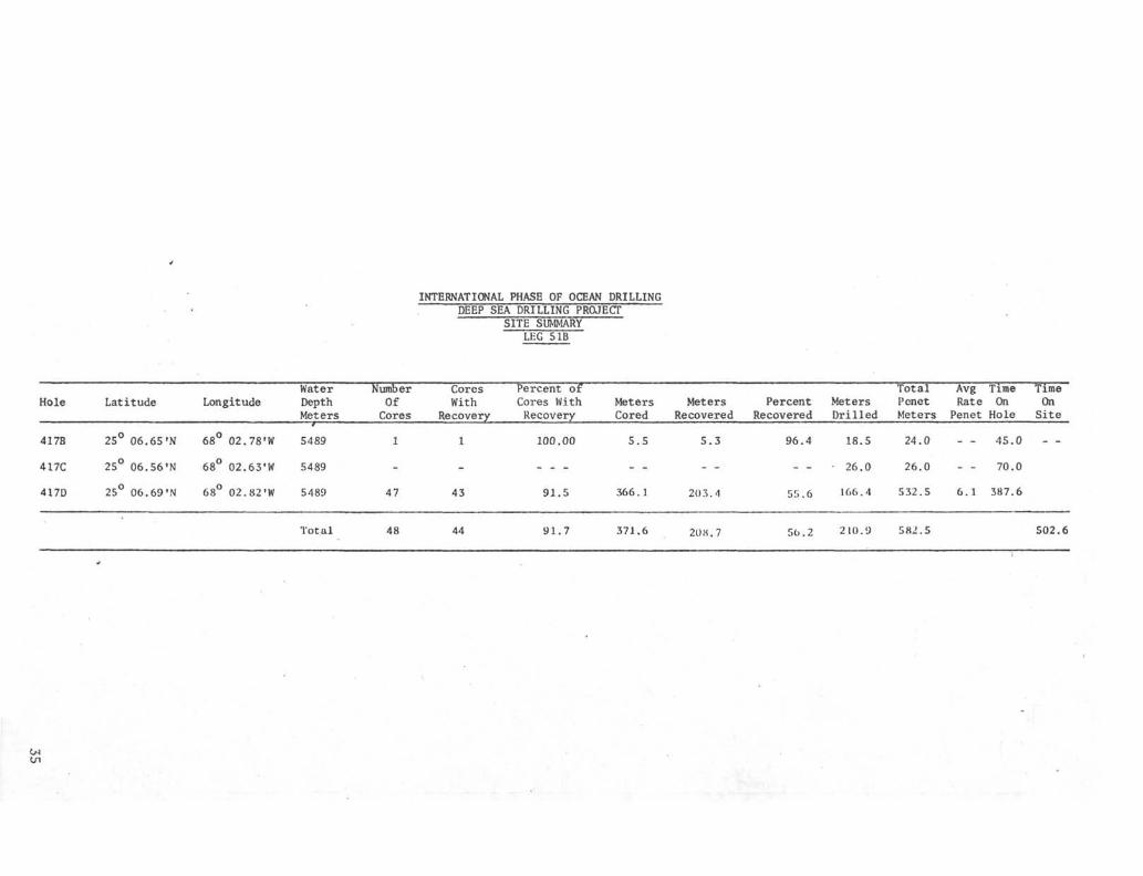
INTERNATIONAL PHASE OF OCEAN DRILLINGDEEP SEA DRILLING PROJECT
SITE SUMMARYLEG 5 IB
Hole Latitude LongitudeWaterDepthMeters
NumberOfCores
CoresWith
Recovery
Percent ofCores WithRecovery
MetersCored
MetersRecovered
PercentRecovered
MetersDrilled
TotalPenetMeters
AvgRatePenet
TimeOnHole
TimeOnSite
417B
417C
417D
25
25°
25°
06
06
06
.65
.56
.69
•N
•N
•N
68
68°
68°
02
02
02
.78
.63
.82
fW
•w•w
5489
5489
5489
Total
47
48
43
44
100.00
91.5
91.7
5.5
366.1
371.6
5 . 3
20 3 . 4
208.7
96.4
36.2
18.5
26.0
.166.4
210.9
24.0
26.0
532.5
582.5
- - 45.0
- - 70.0
6.1 387.6
502.6
C/1

5400
DEC
31
HOLE 417DJAN 77
6 7 8 1Q 11 12 13 14I
S500SEA FLOOR 5489
CASING POINT 5514
5600
PJ
H
5700Oo
GD
K
15800
g
5900 -
6000 -
RE-ENTRY #1TOP OF BASALT 5832
RE-ENTRYß2 RE r ENTRY =3
LOGGING
6021 T ,D.
610010 20 30 40 50
ROTATING HOURS
60 70 80 90


DSDP LEG 51

INTERNATIONAL PHASE OF OCEAN DRILLINGDEEP SEA DRILLING PROJECT
OPERATIONAL RESUMELEG 52
SUMMARY
Leg 52 was designed for the final drilling of a site selected and begun on Leg 51.It was to be the deep penetration of the older western Atlantic crust.
The ship returned to Site 417D, which was started on Leg 51B, on January 24, 1977.The hole was re-entered and drilling continued until February 4, 1977 when drillingwas terminated due to the loss of the bottomhole assembly of the drill string.Efforts were made to "fish" this assembly out of the hole but all efforts failed.Another deep penetration hole nearby was then begun which would hopefully be fin-ished on Leg 53.
Site 418A was started on February 13, 1977 and was drilled to sub-bottom depth of570.5 meters before the Glomar Challenger left to return to Site 417D to conductsome geophysical experiments. At Site 418A, 386.5 meters were cored and 217.74meters were recovered for a recovery percentage of 56.3%.
Time distribution for the leg was 3.6 days in port with an additional 1.3 days ofdowntime. The total time spent cruising was 5.0 days and 41.3 days were spent onsite. The on site time consisted of 16.8 days tripping, 11.5 days coring, .2 daysdrilling, .4 days positioning, 6.1 days re-entering, .9 days of mechanical down-time and 5.4 days in miscellaneous activities with the total time for the leg being51.01 days. No time was lost due to unfavorable weather conditions.
SAN JUAN PORT CALL
Before the ship returned to Site 417D, a port call in San Juan involved the usualloading of supplies such as groceries, spare parts, acetylene and oxygen. Inaddition, 202,022 gallons of marine gas-oil was taken. While the supplies werebeing loaded, the positioning system was being worked on as a result of problemson the previous leg. The main area of interest was safety tripouts for thrustersand their rotational speeds as related to positioning. After work had been donein port the ship left for a test area just outside the harbor and sea trials andadditional work was done with the thruster exciters and cut off alarm system. Theship then had to return to port for additional work and once again back to seabefore the system was considered satisfactory for normal operation. The technicianswere transferred to a tug and at 0815 on January 22, 1977, the ship departed forSite 417D.

HOLE 417D
The Challenger departed San Juan for Leg 52 on January 22, 1977 to continue dril-ling the deep crustal hole, 417D. On January 24, 1977 the 13.5 kHz beacon, whichhad been dropped on the 15th of January, was detected and the ship started homingin on it. At 1400 hours, the ship was in automatic mode over the cone and makeupof the drill string was started. The drill string was run in to 5474 meters whichplaced it, according to Leg 51B data, 16 meters above the top of the cone. There-entry sheaves and tool were made up and run in the hole to attempt the firstre-entry for Leg 52. When the tool started operating, the target was observedat a range of 500 feet. After scanning and maneuvering for 1 hour 34 minutes,the tool was directly over the cone on a 50 foot range scale and 45 scanningangle.
At this time the ship was turned 180° to check on the positioning problem whichhad been detected on Leg 51B. After the ship was turned, the target was detectedafter 28 minutes using the 8 scanning angle at a distance of 500 feet.
The problem appears to be related to the reference gyro which had a 2 inclina-tion from the vertical which could account for this dramatic change in distancefrom the target.
The ship was then returned to the original heading and after 1 hour 8 minutes,the cone was stabbed and verified as re-entry No. 1. The drill string was washedin to the old total depth of 6021 meters. Two cores were cut and recovered whenpositioning problems developed. They were serious enough that it was necessaryto stop drilling and pull the drill string. Approximately 16 hours were thenrequired to analyze the problem and make the necessary corrections.
Again, the re-entry equipment was rigged after the drill string had been run into5474 meters. However, after scanning for 26 minutes of re-entry attempt No. 2,the tool was pulled when it was discovered that only enough pipe was hanging inthe derrick to allow but 4 meters to be in the cone after the stab.
The drill string was run back after a single had been added and the last half ofre-entry No. 2 required 1 hour 30 minutes.
The drill string was lowered and Cores 50 to 60 were cut and recovered before adecrease in core diameter indicated that a bit change should be made before thebit failed and possibly leave a cone in the hole.- When the drill string was re-covered, a two hour check of the thruster operation was made and at the same timethe pup joint and saver sub were magnafluxed. The pup joint was found to be usable,however, the saver sub was determined to have a crack and was replaced.
Following the thruster testing, the drill string was made up and re-entry No. 3was completed in 19 minutes. The drill string was washed to 6128 and Cores 62 to67 were cut and recovered. After cutting Core 68, it could not be recoveredimmediately because the coring reel hydraulic pump shaft froze and it was nec-essary to rig and recover the core using the drawworks sandline. After the corewas recovered, it was necessary to pull the string because the core diameter haddecreased to 5.3 cm. When the drill string had been run in for re-entry attemptNo. 4, the original heading of 340° was used until the cone was in a position tobe stabbed. The heading was then changed 180° to 160° to establish offsets, incase due to weather or sea conditions, this heading would be required. The total

time required to make the original positioning for stabbing, the course changeand establishment of new offsets, and then return to original heading and stabfor re-entry attempt No. 4, required 6 hours 24 minutes. After the drill stringwas run in and Core 69 was being cut, the drill string weight decreased about40,000 pounds which indicated that, apparently, the bottomhole assembly had beenlost. When the drill string was recovered, it was observed that the 5-1/2" heavywall drill pipe had broken 12.18 inches above the top of the connection with the7-1/4" drill collar.
A fishing tool setup was assembled with a 7-1/4" grapple so spaced that it wouldengage the fish below the 5-1/2" drill pipe. This was necessary because therewas no fishing equipment for 5-1/2" equipment. Re-entry attempt No. 5 required5 hours 44 minutes before it succeeded in entering the cone. After the top offish was located, 40 minutes were spent trying to engage it. However, when effortsappeared to be unsuccessful, the drill string was pulled to see if the fishingtools were still intact. When they were retrieved everything was in order andthe bottom of the tool indicated that it had been in contact with the fish so itwas decided to try again. Re-entry attempt No. 6 required only 37 minutes ofmaneuvering to re-entry, however, while pulling the re-entry tool, the Schlumbergercable broke at about 4402 meters and dropped the tool and cable back to the bottomof the drill pipe. Two stands of drill pipe were added to ensure that re-entrywas deep enough to allow fishing for the cable. A fishing spear was run in onthe sandline, however, when starting out with the spear, it pulled to 14,000 lbs.The shear pins in the Otis overshot were sheared and the sandline recovered. Thespear remained in the hole. It was then decided to pull out of the hole to thetop of the cable and retrieve it. After pulling 46 stands, the cable was locatedand attached to the Schlumberger cable reel and recovered along with the spearwhich was entangled in the cable about three feet above the EDO tool. It wasthen necessary to change out the cable reel before any additional fishing attemptscould be made.
After the cable and reel were replaced, re-entry No. 7 was attempted. The toolwas lowered but after scanning for 20 minutes, the tool did not appear to beoperating properly and was pulled. Re-entry No. 8 required 2 hours 26 minutes butwhen pipe was added to verify the stab, the drill string began decreasing in weightwhich indicated that the cone had been missed. The sonar tools were rigged againand run in for attempt No. 9. However, after 48 minutes of scanning, the toolappeared damaged and was pulled. When recovered, it was found to have lost threeextenders, one drive shaft and the transducer. While the new tool was being checkedout a center bit was dropped to clear any possible tool debris that might havewedged in the drill string. After replacing the tool, it was run back in thepipe for re-entry attempt No. 10. However, after scanning for 40 minutes, thistool also would not operate satisfactorily so it was pulled and found to also havelost three extenders, the drive shaft and the transducer. The loss of this equip-ment was due in part to the original design of the tool which did not anticipatethe use of three extenders, the excessive motion of the ship and consequently thepounding of the tool on its seat in the top of the fishing tool. Following theloss of the last tool, the drill string was pulled.
A modification was then made in the fishing tool to allow the EDO equipment to beseated lower and therefore, not require the use of extenders. After these modi-fications were completed, the drill string was again run into re-entry depth andthe tool was lowered for re-entry attempt No. 11. The tool was seated and afterattempting to scan for 72 minutes with very little success, the tool was pulled.When recovered nothing appeared to be wrong but the tool was changed. Re-entry
attempt No. 12 lasted 73 minutes and was also unsuccessful. It appeared that thetool did not seat properly and as a result, the display was very poor. The depthmeasurement on the Schlumberger cable indicated that the tool was deeper than itsseat in the fishing tool which indicated that the seat had broken loose and, there-fore, allowed the tool to rotate freely and without any orientation. This factwas substantiated when the drill string was recovered. Following the recoveryof the re-entry tool, the drill pipe was pulled and the ship departed for Site418.
SITE 417D (CLAMPED GEOPHONE EXPERIMENT)
The ship returned to Site 417D at 1200 hours on March 2, 1977. The drill stringwas rigged for re-entry using the modified bit assembly for landing the EDO tooland was run in to 5478 meters by 2200 hours. The EDO tool was rigged and run in.After ten minutes it appeared that the tool was not seating properly in that therewas a loss in pump pressure. Also, the tool appeared to be only four meters frombottom and it should have been eleven. It was felt that the tool was not latchingand was, therefore, pulled. When recovered all things seemed correct but thelatch assembly was changed with stronger springs behind the latch keys. The toolwas back on bottom at 0602 hours and scanning for the cone began. After fivechanges in offsets, the cone was as close as 44 feet. However, this was theclosest the cone was approached until the tool was pulled at 1003 hours. Sevenmore changes in offsets had been made and three heading changes but the stringwas no closer to the cone. During these maneuvers, the tool again seemed notto be seating properly. Because of this the tool was pulled again. When returnedto the derrick floor and the tool was checked, it was found that the voltagecould not be regulated so the tool was changed. The latch springs were changedand the tool was run again. The tool was down at 1648 hours and scanning/locatingthe target at 200 feet. After seven offset changes the cone was no nearer than150 feet. In addition, the tool did not seem to be operating properly so at 2043hours it was pulled. After working on the tool for about an hour, it was agreedto pull the drill string and put a bit release setup onto the drill string. Thiswould make a more stable seat for the EDO tool and possibly improve the re-entrycapabilities.
The drill pipe was pulled and the bit release installed and then run back to5480.5 meters at 1730 on March 4, 1977. The tool was down and scanning at 2136hours. At 3302 hours, the cone was 40 feet away but it was not until 0457 hourson the 5th of March that a stab was made. During this time eleven offsets hadbeen made and the cone remained relatively close. But due to the erratic natureof the pipe motion and the ship s motion, it was extremely difficult and frustratingto get close enough to try and stab the cone. After this first stab it was feltthat the cone had been missed so it was pulled and scanning began again. Anotherstab was made at 0545 hours and it was felt that it too had missed. The thirdstab was made at 0724 hours and re-entry was verified at 0840 hours.
Drill pipe was then run to 5587 meters where a bridge was encountered. The Bowensub was hooked up and the drill string was washed in to 6079.0 meters. The innerbarrel was retrieved and the hole filled with 200 barrels of 8.8 ppg 155 secondviscosity mud. After the hole was filled, the Rotary shifting tool was run inand the bit released. Following this the Bowen sub was set back and pipe waspulled to 5825 meters.
At 2025 hours started running in the hole with the geophysical tool. At 2335

it had been run to 606 meters and testing began. Testing the equipment andclamping and unclamping the tool continued until 0715 hours of March 6, 1977.All shots that were fired in this experiment were 20 pounds and went off at adepth of 100 feet. The shooting program called for charges to be fired everythree minutes while steaming toward and away from the Challenger over six milecourses. Also, every ten minutes while making a circular course to the new line.Shooting began at 0715 hours and ended at 1548 hours. The geophone was then un-damped and raised to 5840 meters. Shooting began again at 1639 hours and endedat 1851 hours while on a NNE course. There were a total of 165 shots fired duringthe experiment. The tool was recovered with no trouble and then the drill pipewas pulled with the ship underway for San Juan at 0848 hours on March 7, 1977.
Shooting required for the above tests were accomplished by the NOAA vessel"Virginia Key" which made rendezvous with the Glomar Challenger on March 2, 1977.Planning for the clamped geophone experiment had been handled by Cambridge Uni-versity.
SITE 418
The ship was moved to drill Hole 418 after drilling was terminated at Hole 417Ddue to the loss of the bottomhole assembly. This hole is located about threemiles south of Site 417 at coordinates, 25 02.1'N and 68°03.5!W.
The ship arrived in the area selected and dropped a 16 kHz beacon at 0943 hours onFebruary 10, 1977 and at 1120 hours the ship was positioning in automatic andmake up of the drill string was begun. The PDR indicated a water depth of 5521meters, so a core was attempted from 5115.52 to 5525.02 and recovered six metersof soft sediments. A second core attempt of the interval 5506.02-5515.52 re-covered only water and a water depth of 5519 meters was established. The drillstring was then washed to 5591.5 meters or a 72.5 meter penetration. This wasused to determine the amount of 16" casing that would be used with the re-entrycone. The drill string was then pulled and 71.16 meters of 16" casing was madeup and hung on the drill string. This string of casing was then run to bottomand washed in to verify that it would be a satisfactory length to be washed inwith the re-entry cone. No problems were encountered in washing in and thenrecovering the casing. After the casing was latched to the cone and drill stringand at 1350 hours on February 13, 1977, the assembly was started for bottom. At0215 hours on the 14th of February the string was at 5494 meters and preparationswere made to wash in when bottom was contacted. A pinger had been attached tothe mud skirt to assist in determining when bottom was reached. However, thepresentation on the PDR gave no hint as to when the bottom would be reached, sodrill pipe measurements were used to determine when the casing should reach bottomand when it should be washed in far enough to release the cone. At 0600 hoursFebruary 14, 1977, the cone and casing were released and Hole 418A was spudded.The 16 kHz beacon began losing transmitting strength so a 13.5 kHz beacon wasdropped at 0502 hours on February 14, 1977 as a back up in case the 16 kHz beaconstopped transmitting. This proved to be a wise decision because at 1900 hourson February 14, 1977, it was necessary to change over to the 13.5 kHz beacon asthe 16 kHz unit was failing.
Because of the other holes in the area that had cored the sedimentary sectioncompletely, this hole was not continuously cored until reaching a penetration

depth of 282 meters. The top of the basalt was encountered in Core 15 at apenetrated depth of 324 meters. Following Core 20 it was decided to pull thebit because of increased torqueing while cutting the first meter of Core 21 anda decrease in core diameter in the lower part of Core 20.
After making a round trip to replace the bit, the first re-entry at this site wasattempted. The first stab was made after 2 hours 8 minutes, however, when a standof pipe was added to verify, it showed a decreased in weight indicating that thecone had been missed. The second attempt was successful after scanning for 2 hours21 minutes. One 8.5 meter core was cut and recovered 1.91 meters of basalt. Thenthe new core barrel did not seat so it was assumed that some of the core had fallenout and would not allow the core barrel to seat properly. However, when runningin to retrieve this barrel, it was found to have stopped about 800 meters fromthe derrick floor. A center bit was dropped and when retrieved, the plug hadonly been lowered about 150 feet. The center bit was dropped again with fullpump pressure. When the overshot was dropped to recover the center bit, the plugwas found to have dropped to about 5,000 feet but the overshot returned with itspins sheared. It was then necessary to pull the pipe to retrieve the core barrelbecause, apparently, the lost core material was scattered through the pipe. Afterfive stands had been pulled, the pump was hooked up and it appeared that the plugwas moving. The center bit was recovered. The hole was pumped again and appearedto be open. However, when the center bit was dropped it stopped near 7,000 feetand when dropped again it stopped at the same place and could not be recovered.Pipe was pulled and when 85 stands had been laid down the plug and wedged corebarrel were found.
In a final attempt to save trip time, the core barrel was dropped again but pump pressureindicated that the barrel had not seated. After a few more drops it was decidedthat the float valve and bit were plugged with rock fragments and, therefore, itwas necessary to pull the balance of the pipe, Indeed, when the bit was on thederrick floor, it was found to be wedged with rock fragments. The bit was changedbecause one cone was partly broken and the bearings were loose. This could havehappened when the first re-entry attempt missed.
A new bit was installed and the pipe run back to attempt re-entry No. 3. However,after 3 hours 7 minutes when the stab was made, it was felt that the cone hadbeen missed. A successful re-entry was made on the next attempt after scanningand positioning for 2 hours 14 minutes. However, when the Schlumberger cable wasrecovered, it was discovered that the EDO tool had pulled loose at the rope socket.A fishing tool was made up and on the first try the tool was recovered but thetransducer extender and stainless steel drive shaft had fallen out when the tooldropped to the bottom of the drill string. A center bit was dropped and the stringwas run in to 5872.5 where the center bit was pulled and a regular core barrel wasdropped. The string was run to bottom and a one meter core was cut and recovered.It recovered .24 meters of basalt but nothing to indicate any junk in the hole.It is believed that the EDO tool parts had been pushed into the softer clay sedi-ments above the basalt. More cores were cut and then it was decided to pull thebit. Core material was varying in diameter with many small pieces and the torquehad increased. When the bit was recovered, it was not worn excessively or damaged,so it was decided that the section being cored was badly fractured and accountedfor the bit action.
The bit was changed and the next re-entry was made after 2 hours 5 minutes ofscanning. Three cores were cut and when the third core was retrieved, only the

swivel and latch assemblies were recovered. The swivel assembly had apparently-unscrewed because when the barrel had been spaced out the latch had been cut backtwo inches too much. This did not allow the barrel to latch and then the balanceof the barrel unscrewed. The first attempt to fish the barrel out with a spearwas unsuccessful but the next attempt using a modified core barrel wedged in thefish and both were recovered.
Coring continued until the bit had 29 hours of drilling time and the string wasthen pulled. The three bumper subs were changed because a pressure drop was notedon the TOTCO while using the same number of strokes and there was concern that apossible leak was occurring.
The last re-entry at this site was successful after scanning for 1 hour 21 minutes.The drill string was run in the hole and coring continued. After the fifth corewas recovered the next barrel did not seat so it was pulled and a center bit dropped,The core barrel that had been dropped was dented on the bottom of the core catchersub and looked like it could have possibly landed on the float valve. The centerbit was pulled and the core barrel dropped again but, again, pressure build upwas not sufficient. When recovered, it had two small dents in the core catchersub. It was dropped again and plans were to cut a 2 to 3 meter core and see whatthe results would be. When the barrel landed and coring started the pressure re-turned to normal so a regular length core was cut with no trouble. The bit waspulled after 29 hours because of the time necessary to return to Site 417D andattempt the clamped geophone experiments. When the bottomhole assembly was re-covered, it was magnafluxed before it was stood back. Also, a 16 kHz beacon wasdropped for Leg 53 to return to and continue drilling.
DRILLING AND CORING ASSEMBLY
There were four bottomhole assemblies used on this leg. The first, which was usedat Site 417D, consisted of a bit, bit sub (with float valve) core barrel, latchsub, top sub, three 8-1/4" drill collars, one 5-foot bumper sub, three 8-1/4"drill collars, two 5-foot bumper subs, two 8-1/4" drill collars, one 7-1/4" drillcollar, seven joints of 5-1/2" heavy wall drill pipe. This bottomhole assemblywas lost when the bottom joint of 5-1/2" heavy wall broke 12.18 inches above theconnection with the 7-1/4" drill collar.
A bottomhole assembly used to attempt to fish the original bottomhole assembly,consisted of the fishing tool, three 8-1/4" drill collars, two 5-foot bumper subs,one set of jars, three 8-1/4" drill collars, a crossover sub and a joint of 5-1/2"heavy wall.
Fishing attempts were unsuccessful in recovering the bottomhole assembly at Hole417D so the ship was moved to location 418. The bottomhole used at this site con-sisted of bit, bit sub ( with float valve), core barrel, latch sub, top sub, three8-1/4" drill collars, one 5-foot bumper sub, three 8-1/4" drill collars, two5-foot bumper subs, five 8-1/4" drill collars, crossover sub, one joint 7-1/4"heavy wall, seven joints 5-1/2" heavy wall.
When drilling had been completed for this leg at Site 418A, the ship returned toSite 417D to re-enter and conduct some clamped geophone experiments. The bottom-hole assembly used consisted of a modified bit (for re-entry purposes), bit sub,core barrel, three 8-1/4" drill collars, two 5-foot bumper subs, three 8-1/4"drill collars, crossover sub, seven joints 5-1/2" heavy wall. When re-entry could

not be accomplished using this set up, the drill string was pulled and the modi-fied re-entry bit was exchanged for a bit release sub and a top connector and re-entry was accomplished. This change in bottomhole assembly apparently gave morestability to the re-entry tool. This was necessary due to the wind and sea con-ditions which existed at the time.
CORING AND BITS - HOLE 417D
After returning to Site 417, Hole 417D, three F94CK bits were used before lossof the bottomhole assembly caused abandonment of the hole. The first bit was usedfor 41.3 hours and cored 107 meters before it was pulled. The drill rate was 2.59meters per hour and there was a 56% recovery. When recovered, three cones showedmoderate bearing wear but the bearings were gone from the fourth cone. The corediameter had decreased to about 5.5 cm.
The next bit was pulled after only 19.6 hours and having cut only 66 meters of corebecause the core diameter had decreased rapidly to 5.2-5.3 cm. However, when thebit was recovered, no bearing problems were observed and no good explanation couldbe offered for the decrease in core diameter. The drill rate for this bit was 3.3meters per hour and a recovery percentage of 84%.
The third bit was lost with the bottomhole assembly after cutting only one 3.5meter core.
CORING AND BITS - SITE 418
Hole 418 - The first bit used at Site 418 was a F94CK and was used to take themudline core of 6 meters and then was used to determine the casing depth for there-entry cone. This required approximately 30 minutes to wash 72.5 meters withno bit rotation.
Hole 418A - This same bit was used as the first bit for Hole 418A. It drilledand cored 367 meters at an average rate of penetration of 14.9 meters per hourwith a 52.3% recovery. The next two bits used were F99CK or "button bits". Thefirst bit cut only 8.5 meters before it was pulled when part of the core fell outof the inner barrel and wedged in the drill pipe. When the bit was recovered, thebearings in one cone were loose and two inserts and part of the cone were broken.Apparently, the bit had hit the cone when re-entering. This bit toofc 2.6 hoursto cut 8.5 meters and recovered 1.91 meters of basalt. The next bit used was alsoa F99CK and cored 39 meters before it was pulled because of irregular core diameterand torquing while coring. Drill rate was 1.6 meters per hour with recovery of54.5%.
The last two bits used were F94CK and they cored 156 meters at a drill rate of2.65 meters per hour and a 60.4% recovery.
BEACONS
Three beacons were dropped at Site 417D and two were used successfully for posi-tioning. The 13.5 kHz beacon, which had been dropped just before the ship departedon Leg 51B, was used until the ship departed for Site 418. The 16.0 kHz beacon.
8

which had been dropped as a back up, was never used. However, the 13.5 kHz, whichhad been dropped when leaving for Site 418, was used for positioning while theclamped geophone experiment was conducted on the ship s return to Site 417D.
A 15 kHz beacon was dropped when Site 418 was reached. However, a 13.5 kHz beaconwas dropped when the 16 kHz began deteriorating over a 12-hour period beginningabout the time the re-entry cone was washed in. This 13.5 kHz beacon proved satis-factory for the remaining 16 days on site. Before leaving a 16.0 kHz beacon wasdropped to insure an adequate signal for returning to Leg 53.
POSITIONING
Positioning was generally good on this leg particularly after work had been doneat sea in calibrating the thruster motors.
Drilling was terminated on January 25 when positioning could not be maintained dueto the erratic operation of the thrusters. When checked, both the bow and sternthruster motor voltages indicated that they were running at 1160 rpm, or slow.However, a strob tachometer found them to be running at 1350 rpm or fast. Speedswere then set on all thruster motors using feed back rheostats and strobe light.After the adjustments, positioning was maintained with few problems for the balanceof the leg.
LOGGING
Downhole logging had been planned for this leg at Site 417D, however, the loss ofthe bottomhole assembly cancelled any plans for logging at the site. No loggingwas to be done at Site 418A because maximum hole penetration was the prime objec-tive. The Schlumberger engineer went ashore when a tug arrived with supplies andan engineer to assist with the downhole re-entry tools.
RE-ENTRY
RE-entry enjoyed varying degrees of success, failure, and frustration on this leg.The detailed description of each re-entry attempt for Site 417D and 418A are madein the beginning of this report and condensed in the charts following this section.
At Site 417D no real problem developed in re-entering until the bottomhole assemblyhad been lost. Then the problems began. The first re-entry attempt after thebottomhole assembly was lost (No. 5) required 5 hours 44 minutes. Most of thetime could be attributed to many heading changes in manual mode because of theeffects of wind and currents. The second attempt required only 37 minutes tore-entry but the Schlumberger line broke and the string had to be pulled. Sixmore attempts were made and all were either unsuccessful or equipment was lost.The fact that the fishing equipment was not properly constructed to handle theequipment was clearly demonstrated in the tool s rotation and bouncing. Thelatter condition was the main reason the drive shafts were lost, plus the factthat the EDO tool was not designed to support as many as three extenders. Butthe main concensus of opinion is that this fact plus the poor sea conditions madefor the poor success in re-entering.

When the ship was moved six re-entries were attempted and four were successfulwith an average of a little over two hours for each attempt. This is about theaverage time established for re-entry since it was started. But again, the EDOtool was in the normal tool seating position in the drill string and the weatherhad improved.
When the ship returned to Site 417D for the geophysical experiment, re-entry againtook unusually long. Again, the most apparent reason was that the re-entry toolwas placed in a modified tool arrangement because it had to operate in a toolthat would allow the geophysical tool to pass through after re-entry had beenmade.
Clearly some changes will have to be made either in the tool assembly or in theholder it will be placed in for re-entry under all conditions.
COMMUNICATIONS
Communications both radio telegraph and radio telephone were generally good duringthis leg with no excessive delays on any traffic. A considerable volume of radiotelephone traffic was handled via Radio Miami (WOM) Nearly all radio telegraphtraffic was via Radio WWD (Scripps). 17 MHZ was usable from about 1600Z throughabout 2300Z daily, but during the early part of this period interference fromRadio Rome (IRM) was pronounced and during the latter, fading and static wereusual. Optimum communication with Radio WWD was usually about 2100-2200A. 12 MHZwas also useful at times during the above period. Equipment performed well withno failures other than minor ones. The radar equipment (two Decca 914*s) alsoperformed well throughout the voyage with no breakdowns.
ACKNOWLEDGEMENTS
With all the problems that developed during this leg there was still a great dealof enthusiasm and dedication generated by all concerned. This includes the sci-entific staff, Scripps technicians and Global Marine personnel. All in all, itwas a great pleasure to be working with so many enjoyable people.
R. R. KnappCruise Operations ManagerDeep Sea Drilling Project
10

INTERNATIONAL PHASE OF OCEAN DRILLINGDEEP SEA DRILLING PROJECT
OPERATIONS RESUMELEG 52
Total Days (January 17, 1977 - March 9, 1977) 51.01Total Days In Port 3.82In Port Downtime 1.3Total Days Cruising (Including S i t e Survey) 4.5Total Days On S i t e 41.3
Trip TimeDr i l l i ng TimeCoring TimePosi t ion ShipMechanical DowntimeRe-entryOther
16.8.2
11.5.4.9
6 .15.4
Total Distance Traveled (Nautical Miles) Including Survey 878.7Average Speed 8.4Number of Sites 2Number of Holes Drilled 3Number of Cores Attempted 71Number of Cores With Recovery 71Percentage of Cores With Recovery 100.0Total Meters Cored 566.0Total Meters Recovered 335.31Percent Recovery 59.2Total Meters Drilled 187.0Total Meters of Penetration 819.5Percent of Penetration Cored 69.0Maximum Penetration (Meters) 570.5Minimum Penetration (Meters) 72.5Maximum Water Depth (Meters) 5519.0Minimum Water Depth (Meters) 5519.0
11

INTERNATIONAL PHASE OF OCEAN DRILLING
DEEP SEA DRILLING PROJECT
TOTAL TIME DISTRIBUTION
LEG 52
IN PORTDOWNTIME2.5%
ON SITE TIME BREAKDOWN
LEG 52
DRILLING TIME .6%
POSITIONING .9%
MECHANICAL DOWNTIME.2.2%
12

INTERNATIONAL PHASE OF OCEAN DRILLINGDEEP SEA DRILLING PROJECT
BEACON SUMMARYLEG 52
SiteNo. Make
Freq,kHz
SerialNumber Hours Remarks
417D
417D
417D
418 & A
418A
ORE
ORE
ORE
ORE
ORE
13.5
16.0
13.5
16.0
13.5
394
374
392
383
395
604.4
260.25
605.25
105.3
369.5
Dropped 0226 hrs 1/15/77.
Dropped 1045 hrs 1/30/77.
Dropped 2315 hrs 2/9/77.
Dropped 0943 2/10/77.
Dropped 0502 hrs 2/14/77.Started positioning on it 1900 hrs 2/14/77
418A ORE 16.0 386 131.7 Dropped 1648 3/1/77.

INTERNATIONAL PHASE OF OCEAN DRILLINGDEEP SEA DRILLING PROJECT
SITE SUMMARYLEG 52
Water Number Cores Percent Of Total Avg Time TimeHole Latitude Longitude Depth Of With Cores With Meters Motors Percent Meters Ponct Rate On On
Meters Cores Recovery .'.'.. Cored Recovered Recovered Drilled Drilled Penet Hole Site
417D
418
418A
25°25°25°
06.
02.
02.
69
08
08
•N
•N•N
68°
68°68°
02.
03.
03.
82
45
45
'W
'W '
•w
• 5489
5519
5519
22
1
48
22
1
48
100
100
100
.0
.0
.0
176.
6.
383.
5
0
5
117
6
211
.57
.0
.74
66
100
55
.6
.0
.2 187.0
176.5 2.84
72.5 96.0
570.5 5.3
517.7 517.7
68.3
494.9 563.2
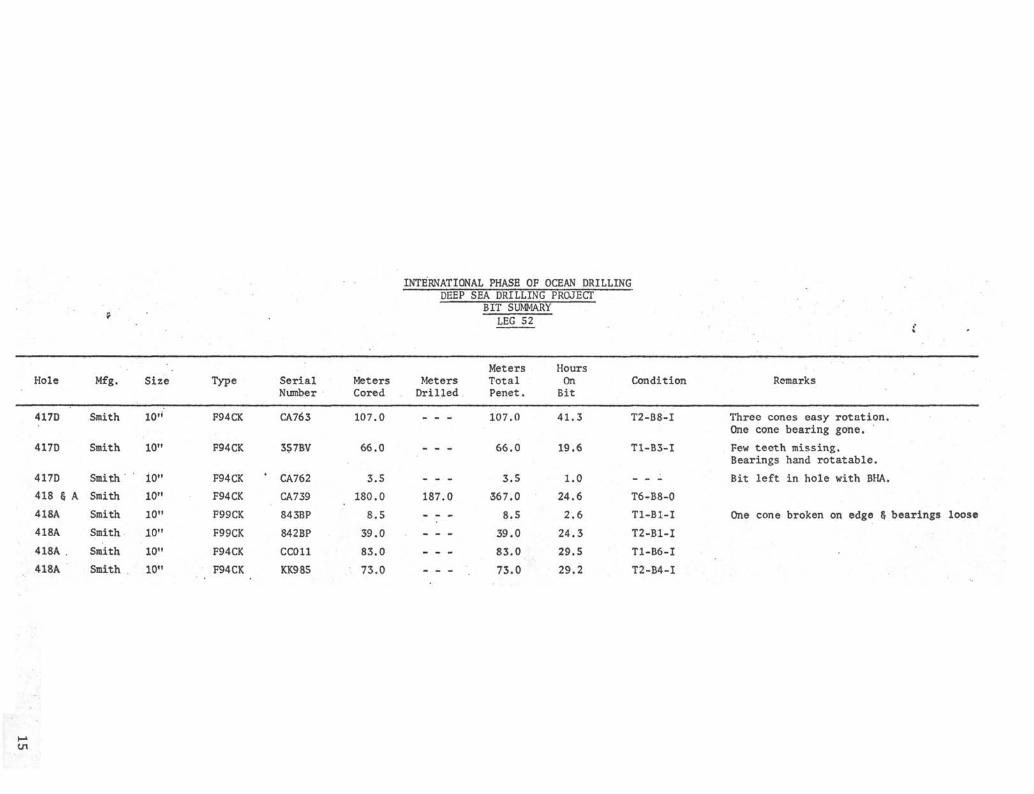
fc .
INTERNATIONAL PHASE OF OCEAN DRILLING
SerialNumber
MetersCored
DEEP
MetersDrilled
SEA DRILLINGBIT SUMMARY
LEG 52
MetersTotalPenet.
PROJECT
HoursOn iBit
Hole Mfg. Size Type Condition Remarks
417D
417D
Smith
Smith
10'
I01
F94CK
F94CK
CA763
357BV
107.0
66.0
417D
418 § A
418A
418A
418A .
418A
Smith
Smith
Smith
Smith
Smith
Smith
10"
10"
10"
10"
10"
10"
F94CK
F94CK
F99CK
F99CK
F94CK
F94CK
CA762
CA739
843BP
842BP
CCO11
KK985
3.5
180.0
8.5
39.0
83.0
73.0
187.0
107.0
66.0
3.5
367.0
8.5
39.0
83.0
73.0
41.3
19.6
1.0
24.6
2.6
24.3
29.5
29.2
T2-B8-I
T1-B3-I
_ _ _
T6-B8-0
Tl-Bl-I
T2-B1-I
T1-B6-I
T2-B4-I
Three cones easy rotation.One cone bearing gone.
Few teeth missing.Bearings hand rotatable.
Bit left in hole with BHA.
One cone broken on edge § bearings loose

RE-ENTRY MANEUVERING TIMESITE 417D
(Time required once scanning sonar tool down until re-entry stab made. Includessuccessful and unsuccessful attempts)
RE-ENTRY
1
2
3
4
5
6
NO.
(w/fishing
(w/fishing
0505
1528
0756
0822
tool)0106
tool 1316
TOOL
hrs.
hrs.
hrs.
hrs.
hrs.
hrs.
DOWN
1/25/77
1/27/77
2/31/77
2/03/77
2/05/77
2/06/77
0858
0658
0815
0923
0650
1353
STABBED
(successful)
(successful)
(successful)
(successful)
(successful)
(successful)
3
1
1
5
ELAPSEDTIME
hrs.
hr.
hr.
hrs.
53
30
19
01
44
37
min.
min.
min.
min.
min.
min.line broke)
8
9
10
11
12
13A
13B
13C
13D
0911 hrs. 2/06/77
1512 hrs. 2/07777
2254 hrs. 2/07/77
0735 hrs. 2/08/77
1404 hrs. 2/09/77
2002 hrs. 2/09/77
0130 hrs. 3/03/77
0602 hrs. 3/03/77
1646 hrs. 3/03/77
2136 hrs. 3/04/77
0500 hrs. 3/05/77
0555 hrs. 3/05/77
pulled - tool notworking right
1738 (unsuccessful)
pulled-tool damaged
pulled-tool damaged
pulledtool not working
pulledtool not rotating
pulled toolnot seating right
pulled toolnot seating right
pulled to checkoperation
0457 (unsuccessful)
0545 (unsuccessful)
0724 (successful)
20 min,
2 hrs. 26 min.
29 min,
40 min.
1 hr. 24 min,
1 hr. 13 min.
10 min.
4 hrs. 1 min.
3 hrs. 57 min.
5 hrs. 21 min.
45 min.
1 hr. 29 min.
No average calculated because of varying conditions.16

RE-ENTRY MANEUVERING TIMESITE 418A
(Time required once scanning sonar tool down until re-entry stab made,successful and unsuccessful attempts)
Includes
RE-ENTRYNO.
1
2
3
4
5
6
0256
0955
0506
0823
1249
0302
TOOL
hrs.
hrs.
hrs.
hrs.
hrs.
hrs.
DOWN
2/18/77
2/18/77
2/20/77
2/20/77
2/23/77
2/27/77
0504
1216
0813
1037
1454
0423
STABBED
(unsuccessful)
(unsuccessful)
2
2
3
2
2
1
ELAPSEDTIME
hrs.
hrs.
hrs.
hrs.
hrs.
hr.
8 min.
21 min.
7 min.
14 min.
5 min.
21 min.
Average 2 hrs. 12 min.
17

HOLE 418A
8 5/8 DISCHARGE LINE
CKOFF ASSEMBLY
MUD LINE
^CASING HANGER ASSEMS
TOP 16 " CASING
5522 m
II 3/4" CASING
SHOE 16" 5593.17 m 18

450 rSil t 4-π-D L£G52
500 h
o<onUJ
z
600
650
700
750
htfl
800
850
900\0 ao so
* METERS/HOUR
4O 140
19

0
50
100
150
o
<I—LUzLUa.inacUJt—LU
200
250
300
WA^>µ IMCONL AND
CAèiNG
W K S H•
234
~
fiI0
r
10 20 30
M•ETEl S/riòùR
40 90 140+

o<I-UJ
450
500
550
600
650
700
750
800
850
900
- 4 a-p1 B4-{35
3 G > '- • ;•^ ^ 1 • •
3 H_ = { 4 O
J4-1• 4a
143444 5
- [4(0
J 47f4δT,D, utG 5 1 5 1 0 . 5 M
-
-
-
-
-
i i i
•
: •
•
•
1 1 1
0 I0 20 20METERS/HOUR
40 \40
21

DEEP SEA DRILLING PROJECTTIME DISTRIBUTION
LEG - 52
tsi
Date
/ ?7-77/ /f-77
/ tf-97
/ ^ J *7*J
~Tαr,
/•3Z•7}
/ 13-7?
/ 3i•7?
•73rA
/ -2S-11
/17-77
Tmi) •3c•77
I Si -11
9>•t 79
Stie CM*
•
•
*
-
•/s-7
tyò//-J5*0'%
••
•
•
Tr/ps
>•
•-••*•
/OS
7-7
Dr///
••••••••
••
•
•
•
Core
•••
•
••
•••
7-0•
>>/.ö
StuckP/joe
•
•
•
•
•
•
•
•
•
•
W.OM
•
•
•
•
•
•
•
••
•
•
•
-
•
pstr
•
••••
•-
u .
.••
Atech.Repair
•
•
•
-
/s
7?mβ
J¥ ó
á</o
//?•Z•
•
•
•
•
•
•
•
•
•
•
•
•
•
9z•
/ó•S
•
OfAep
•
•
•
-
•
. •
•
•
•
rot?/
£</'-£ .
//9-zSS* 7
/ / . /
~ó t/Z-9
J¥ Ú
z</.o
j>.v•ò
fevarMs
7£STW6 úr
j

DEEP SEA DRILLING PROJECTTIME DISTRIBUTION
LEG - 52
Date
Z 2 7?
% // rη
Λ-9'-77
2 •//?9
λ të -79
\M>.
• •
t
Cw/se
•
-•
••
•
•
Tr/ps
/i•S9•o/J •tx r y9-2
K•o
7 3/j/• i
•
•
/7 D
y t>
i/ - r
Dr///
•
••
•••
•
••
•
/ •o
Core
•
y •s•
•
•
•
•
•
•
•
•
•
•
/s- ó
StackP/joe
•
•
•
•
•
•
•
•
•
•
•
•
•
•
•
-
•
*
•
•
•
•
<
•
•
•
PθJ/f/0MJ/?/&
•
•
•
Z l
/•á>
-
-
•
•
•
•
•
Afec/i.Repair
•
•
-
•
•
•
•
•
•
•
PortT/me
••
•
•
••
ffe-
9-9
/?-7
/2,ó•
72J-••••
•
•
•
otter
3 O.4/
/ò v
•7/o %*
//< ~
•/x i
/x~•
7/me
£¥>ó
/%.*?
74lpt'3
Jk¥ ó
cpy o
/r/ /-//λ><$ 4 ££Xi
<
ßUλSM/M>é>
K>

DEEP SEA DRILLING PROJECTTIME DISTRIBUTION
LEG - 52
¥
Date
A&77A n-77
ami$-/ -973X77
3 X71\dα -77£ 3W
SiteMa'
ΦfJt
t>v/se
•
•
%
•
•
SL•S
S-•O
Z '
. \//•z0
1
%
•
•
•
•
*
•
•
•
•
•<
•i
2ù
/S_X I
•
/7-s•
Dr///
•
•
-
•••
••
>
••
•
Core
Xü-ò
7-3y o
M •O
1 •o
/s•oJ<f•ü
/3•3-
IM • l1-•••
StackP/joe
•
•
•
•
•
•
•
•
•
•
•
•
•
w.aw.
••
•
•
•••
Posrf/onS/7/0
•
•
•
•
•
•
•
•
•
•
Afech.Repair
/•O
•
•
•
1-0••••
PortT/me
••••
•
/?e-Fπ/ry
/ù.O
••
/Y£3•S"
orMr
<-
M•Q
i••
6 - 7•
S•• -
7 3s-•o
• s
A•I•
Z•1/
7-s•
/ .3
Töte/
JV ó
Jl/O&/ j
y>s-
/remarks
^ ^

> ^ •' .' DEEP SEA DRILLING PROJECTTIME DISTRIBUTION
LEG - 52
.
D&fe
B ~-77
3 •7 ηη
$ 4 -If
•
••
••••
Cw/se
*
•
\
•
y zty9 2
. —
•
•
*
•
•
•
•
Tr/ps
-
•
•
•
•
•
•
•
•
•
•
•
Dr///
•
>••.•i•• r r r
•
•
•
•
•
•
•
•
•
•
Core
•
•
•
•
•
•
•
•
•
•
•
•
•
Stuck
*
—.
•
•
•
•
•
••
•
•
•
•
•
•
W.O.V.
•
•
•
•
•
•
•
•
•
•
Position
•
•
•
•
•
•
•
•
•
•
•
•
•
•
•
Afec/i.Repair
z•s
•
•
•
••
•••
PortT/we
.
•
•
•
•
•
fi*--fr>/ry
t•l
••
•mi
•••
••
Offier
3 C
•
•
••
Tote/ torn***
SZ<‰-
•
•

INTERNATIONAL PHASE OF OCEAN DRILLINGDEEP SEA DRILLING PROJECT
OPERATIONAL RESUMELEG 53
SUMMARY
Leg 53 of the Deep Sea Drilling Project marked the close of a three year programof Atlantic Ocean drilling and the close of the first portion of IPOD. Objectivesof the voyage included deepening Hole 418A at the southern extremity of the BermudaRise and sampling most of Layer 2 of the oceanic crust. The resulting penetrationwas expected to be the deepest ever achieved into the igneous rocks of the ocean.
The voyage commenced on March 13, 1977 at San Juan, Puerto Rico and terminatedat Cristobal, Canal Zone on April 25, 1977. A brief port call was made at SanJuan on April 21 to debark scientific personnel.
Hole 418A was situated in 5519 meters of water about 700 miles east of the tipof the Florida Peninsula. It had been drilled on Leg 52 to a depth of 570.5 metersbelow sea floor and 247.5 meters into basement. Leg 53 succeeded in deepeningthe hole an additional 287.3 meters. With good drilling conditions prevailing,progress survived two drill pipe failures only to be halted by a series of mis-fortunes involving the cable used to re-enter and log the hole. Hole 418A wassuccessfully re-entered a total of 13 times on Legs 52 and 53 and was considereda scientific success.
Total length of the voyage was 47.3 days, of which 34.1 days were spent on-site,8.9 days underway and 4.3 days in port. 3.3 days lost time was attributed toequipment failure (SIO AND GMI) and 0.9 day to weather delay.
PORT CALL - SAN JUAN, PUERTO RICO
The Leg 52/53 port call was relatively routine. Crew change, resupply and sched-uled machinery maintenance were accomplished.
In addition to normal resupply, three re-entry cone assemblies and 150,000 gallonsof fuel were onloaded. A replacement logging cable was received and installedand a damaged cable was sent to Houston for repair. A shipment of cores and mis-cellaneous surface freight were offloaded.
Representatives of AMF Tuboscope and National Supply were in attendance to inspectcritical drill string components and the rig s drawworks, respectively.

SAN JUAN TO SITE 418
The last mooring line was off the dock at 1210 hours on March 13. After clearingSan Juan Harbor, the CHALLENGER hove to for approximately 2-1/4 hours to test andcalibrate thruster overspeed trips.
The remainder of the voyage to the operation area was uneventful and an averagespeed of 9.1 knots was made good. Accurate navigation took the ship directlyto the immediate area of the positioning beacon dropped on Leg 52. The beacon!ssignal was acquired at a distance of two miles. Stationkeeping commenced aftera short delay to lower the hydrophones to operating position.
SITE OPERATIONS - 418A
After running pipe to just off the sea floor, the re-entry sonar tool was loweredand scanning for the re-entry cone target began. No target was acquired. Acheck of satellite navigation showed the ship s position to be nearly a halfmile from that of the cone as determined on Leg 52. The ship was slowly movedby offsets to the SAT NAV indicated location, but the cone was not detected.While scanning with the sonar, the ship was moved via a different route back tothe predicted beacon offset position. An expanding square search pattern wasthen initiated. After several unsuccessful hours of search, the ship was re-turned to the area indicated by SAT NAV. This time the cone was detected as theposition was approached. A successful re-entry stab was made at 1935 on March 16,15 hours and 12 minutes after scanning began.
A considerable discrepancy between the positioning system1s performance on Leg52 and on Leg 53 was indicated but its nature was not understood. On the fol-lowing day it was necessary to reverse the ship s heading due to weather condi-tions. The drill pipe immediately began to indicate that the ship was "off thehole" as it was pulled strongly against its restraining guide. Using the pipeas a guide. The positioning offsets were changed to minimize stress on the pipe.When the pipe again hung straight down, the offsets showed a move of nearly 4,000 feet
Troubleshooting also showed the discrepancy to be related both to heading and tothe hydrophone array in use. It was shortly discovered that a hydrophone tetherhad broken and allowed one hydrophone to drop two to three feet below the planeof the array.
After this was corrected, a relatively small heading-related error remained. Thiswas neutralized after careful SAT NAV plotting revealed its pattern and subsequentre-entries became more straightforward.
Due to a broken bumper sub washpipe, the first bit was pulled after only three cores.An unscheduled pipe trip was made after the first core on the fourth bit due to aplugged bit. This proved to be a fortuitous setback as water was discoveredspraying from a crack in the drill pipe high in the string. It is likely thatthe pipe would have parted before the next regular bit trip.
Operations continued relatively smoothly until April 4. While the sonar tool
was being run down the pipe for a re-entry, the outer armor of the logging cablebegan to unravel as the cable left the winch drum. It was determined that anold splice was unraveling and about half the strands of the outer armor wereinvolved. Though the tool was within about 60 meters of the bit, the cable wasconsidered too badly weakened to run the splice over the sheaves and completethe re-entry. The tangled armor strands were cut away and the sonar tool wasretrieved. It was then necessary to replace the winch drum and cable with a spareunit stored in the hold of the ship.
As the seven ton cable reel was being lifted out of the hold, a topping lift wireparted on the 50 ton crane. This allowed the crane boom to fall across the "corewalk" area and the cable reel to fall two decks back into the hold. Fortunately,only minor injuries were sustained by one man and the cable was undamaged. Damageto the cable shipping cradle and to the core walk structure was fairly extensiveand there was minor damage to the crane boom. After repairs to the crane, thenew cable was installed and the re-entry was accomplished without incident.
Routine coring operations had proceeded for about one day when a sudden drop inpump pressure was noted by the driller. This was being investigated when the hookload weight indication abruptly decreased by about 60,000 pounds and the heavecompensator stroked shut. There was no doubt that the drill string had twistedoff.
When the drill string was recovered, it was found that the five inch pipe hadparted about 210 meters above the bottomhole assembly. Due to the clean natureof the break and the excellent condition of the hole, chances of fishing the pipeand saving the hole seemed good.
An 8-7/8" circulating and releasing overshot carried on board was fitted with afive inch basket grapple assembly for the fishing attempt. Weather and sea con-ditions were good and the re-entry was accomplished without difficulty. Thefishing drill string was run into the hole to just above the fish. The powersub was picked up and the fish was successfully engaged at the very first contact.Circulation through the fish could not be regained and it was necessary to pull itoff bottom "dry". After pulling tight on the first two doubles, the fish cameout of the hole freely. The lower stand of drill collars and the space betweencore barrels were found to be filled with cuttings. Nearly a full core had beencut at the time of the twist-off and the inner barrel was recovered with core in-tact .
This latest core contained rocks somewhat different from those of the overlyingunit. They were also more highly fractured than most of those encountered higherin the hole. The decision was made to log the hole short of the anticipatedtotal penetration while chances of success were good.
The special open ended logging bottomhole assembly was made up to the drill stringand the pipe was run to re-entry scanning position. The sonar tool seated satis-factorily in the special landing adaptor and the re-entry cone was acquired atan initial range of 30 feet. Nearly two and one half hours were required, however,to coax the light bottomhole assembly to swing over the cone. (This lack ofresponse to ship movement has been noted previously with light bottomhole assemblies)

A successful stab was finally made and verified and the logging sheaves wererigged down. A short trip to total depth was made to clean the hole. A sedi-ment bridge about 4Q meters below the casing shoe required washing through withthe circulating head. This bridge was the only obstruction that had been en-countered consistently on previous bit trips. Two other minor bridges wereencountered in the sediment section but they "broke through" without circulation.Soft fill was encountered at 6323 m and the power sub was picked up to wash tothe total depth of 6386.6 ra. When total depth had been reached, the hole wasflushed with 30 barrels of drilling mud followed with 20 barrels of special highviscosity guar gum gel.
The pipe was then pulled to put its end at 5664 m. This was a compromise depthintended to put the less stable upper sediment section of the hole behind pipeand yet allow logging of the better indurated deeper sediments and the sediment/basalt contact. The logging sheaves and drill pipe were rigged in the re-entryconfiguration with one stand of pipe up in the derrick "on the hook". Thiswould permit lowering the pipe to clear any bridging formed by the motion of thepipe in the hole due to vessel heave.
The first logging tool, the sonic/caliper/gamma ray assembly, was run down thedrill pipe to a depth just a few meters below the end of the drill pipe. Atthis point, the cable tension indicator registered a loss of weight as the toolstopped on an obstruction. The tool was pulled back inside the pipe, the mudpump was started and the pipe was lowered to 5692 meters.
The logging tool then cleared the pipe into the open hole. The weight indicatorwas monitored closely as the tool proceeded down the hole, but the heave of theship caused continual apparent weight fluctuations approximately equal to theweight of the tool. As the length of cable paid out approached the depth of thehole, caliper and sonic log traces were noted to be behaving in a manner in-dicating no tool motion.
On reversing the winch, no "pickup" indication was noted on the tension deviceand the log traces were unchanged. After a considerable amount of cable had beenretrieved, the tension device showed a sharp increase, indicating that the toolor the cable was stuck. After pulling to the maximum recommended tension and"working" the cable for a short time without results, the drill pipe was raised.This resulted in a decrease in cable tension. As the depthometer indicated thetool to be well below the end of the pipe, it was apparent that the line itselfhad become fouled inside the pipe.
Continued "working" of the cable resulted in upward movement of about 40 meters,but no additional cable could be recovered.
The cable was then clamped off and cut at the rig floor. The drill string wasretrieved and the cable was cut as each stand was recovered. The lowermost standof five inch pipe contained the expected interval of knotted and tangled cable.
The cable was hanging free inside the bottomhole assembly obviously without theweight of the logging tool. The remaining cable was pulled from the pipe tofacilitate recovery of the bottomhole assembly.

The length of the free cable recovered was roughly equal to that of the pipeand the bitter end appeared to have been cut with a dull edge. Approximately300 meters of cable was not recovered. It is speculated that the drill stringswung away from the re-entry cone after clearing it, but while the tool andcable were still in the hole. The resulting horizontal force component couldhave caused the cable to be cut by the sonar landing shoe on the pipe or by anedge of the re-entry cone itself. If this were the case, the tool and cableremained in the hole.
It is considered possible, but less likely, that the cable parted by chafing atthe end of the pipe during the pipe trip to the surface. The tool and cablewould then have fallen to the seafloor.
Due to the likelihood of cable in the hole, it was considered imprudent to enterthe hole with a bit or with open ended pipe to attempt to wash to bottom. Thecable could have wrapped around the drill string and caused it to stick in thehole. It was therefore decided to re-enter the hole with open ended pipe and tocautiously fish for the logging line with a wireline cable spear that extendedthrough the end of the pipe.
Before a re-entry could be made, however, it was necessary to replace the loggingline on the winch. The only remaining cable on board was the one that had beenremoved earlier due to a bad splice. As the splice was closer to the drum end ofthe cable, about 2300 pounds less tension would be applied to the splice if thecable were spooled from the spare drum onto the winch drum and therefore reversed.
First, however, it was necessary to remove the approximately 1200 meters remain-ing on the winch drum and transfer it onto a wooden spool for storage. With thisdone, the full spare winch drum was lifted into place and secured for the trans-fer. After some difficulty in properly securing the drum (collector) end of thecable, respooling began. Nearly 5500 meters of cable had to be transferred beforethe splice was uncovered for inspection. It was determined that the outer armordamage was severe enough that the only feasible repair was the replacement of theouter armor for the entire interval of the splice.
While the cable transfer and splicing operations were in progress, weather con-ditions deteriorated considerably. The tedious splicing procedure was a concertedand coordinated effort involving the deck crew and the rig welder. It continuedon the damaged core walk in weather too rough for pipe handling.
Upon completion of the splice repair, transfer of the cable continued. Afterabout 1400 m additional cable had been spooled, a second defective splice wasdiscovered. Inspection revealed this to be an old splice that had been repaired,but several outer armor strands were again broken.
Sufficient cable for re-entry was now on the winch and the decision was made tocut and rehead the cable at this point. The repair job required would have beenat least as extensive as the earlier one and the cable (about 1950 m) on the"short" side of the splice appeared badly worn.
Although re-entry capability had been regained, a half day passed before weatherconditions permitted the handling of drill collars. Ten additional hours of
marginal vessel motion conditions were used in breaking down and stowing thebottomhole assembly used on the fishing job and in the magnaflux inspection ofthe drilling bottomhole assembly. The pipe trip to fish for the logging cablefinally began three days after the pipe fish had been recovered.
The new fishing bottomhole assembly was also abbreviated, but was fitted with astandard outer core barrel assembly. The assembly terminated with a truncatedand bored out bit body. A special fishing spear had been fabricated which wouldbe attached to a standard retrievable inner core barrel and which would extendthrough the lower support bearing to engage the cable fish.
The split line wiper packoff element was not installed due to a previous expe-rience with a cable splice stranding at the line wiper. This prevented thestandard practice of "pumping down" the sonar tool to minimize its floating inthe pipe.
The sonar tool was run down the pipe and landed in the normal manner. Tooloperation had been checked each thousand meters down the pipe, but power regu-lation was lost immediately when the tool was energized upon landing. A quickcheck of surface circuits determined the problem to be downhole and the tool wasretrieved. The pressure case was found to be flooded with sea water.
A backup re-entry tool was then run. The logging unit tension device indicated"set down" of the tool at the proper depth and the tool was energized. The sonarpresentation, however, indicated that the transducer was still inside the pipe.The winchman was then requested to pick up the tool and make a second attemptat seating. The tool would not move up the pipe. It was inferred that the toolhad"ufloated" enough on the down trip to form a knot or to loop around the cablehead.
The cable was repeatedly pulled to the maximum recommended tension in an attemptto free the stuck tool. At one point this apparently succeeded in moving thetool about 20 meters up the pipe. During this interval, the sonar tool abruptlywent dead. After about one hour of attempting to free it, the cable parted atthe repaired splice.
The drill string was retrieved and the broken end of the cable was encountered42 stands from the end of the pipe. Another attempt was made to pull the toolfree at this point and save some of the cable, but it remained firmly stuck.
The re-entry tool was recovered from the outer core barrel. About 40 meters atthe bottom of the cable was kinked and knotted, but much of this damage wouldhave occurred when the cable broke.
The sonar tool was checked out and found to be undamaged. Free flooding spacesin the landing sub and cable head were found to be packed with rust flakes fromthe interior of the drill pipe. The role played by the rust formed during thethree day operational hiatus is unknown. It is possible that an accumulation ofit may have impeded the downward movement of the sonar tool and permitted ex-cessive slack in the cable.
Operations at Hole 418A had come to an end as there was no logging cable re-maining of sufficient length to make a re-entry. The CHALLENGER does not havethe onboard capability to make a complete cable splice.

HOLE 418B OPERATIONS
Due to logistical and scheduling considerations, the best use of remaining Leg 53time was judged to be an additional penetration of the sediment section at Site418. Earlier coring had not produced a complete sediment record due to poor re-covery and drilled intervals.
A sediment bit and bottomhole assembly were made up and the pipe was run to justoff the sea floor. (A 400 foot north offset had been programmed to keep the drillpipe clear of the re-entry site).
The precision depth recorder reading indicated a few meters greater water depththan at Hole 418A. A mudline punch core was attempted by lowering the bit to5529.8 m and then setting back a joint of pipe. The rig weight indicator regis-tered bottom at about 5523 m. No core was recovered on the first attempt, but theliner was muddy at both ends. A second mudline core was attempted on the sameinterval and this time 50 cm of very soft clay was recovered. Water depth wasofficially established at 5523 m and spud time at 1315 hours, April 15.
Continuous coring continued smoothly and the sediment section was penetrated in2-1/2 days and 34 cores. One basalt core was cut after basement was reached.
The final pipe trip was made in very good time and the ship was under way at 1620,April 18.
SITE 418 TO SAN JUAN
After spending about seven hours conducting a post site survey, the CHALLENGERdeparted for San Juan. Strong beam winds resulted in choppy seas and held theship s average speed to 8.4 knots. Transit time was 2.0 days.
PORT CALL - SAN JUAN
The vessel anchored in San Juan Harbor at 0010 hours on April 21 for a brief stopto transfer personnel. Thirteen scientific and two GMI personnel debarked at thistime. Boarding the ship at San Juan were three of the Leg 54 scientific staff,two GMI electrical specialists, two AMF Tuboscope personnel and a replacementfor the injured cook.
A GMI engineer was also present to inspect the condition of the ship's drill piperacker during the in-port period.
In addition to personnel transfer, the time was used to onload drill pipe in-spection equipment, structural steel for core walk repairs and fresh vegetables.
The CHALLENGER was under way for Cristobal after just five hours in port.
SAN JUAN TO CRISTOBAL
Vigorous winds continued but the new course across the Caribbean put them nearly-dead on the stern and an average of 9.2 knots was made good. Marine growth onthe hull probably slowed the ship by at least 1/2 knot.

The ship was forced to proceed at about half speed for one hour while transitingthe Mona Passage. A ground relay in number three propulsion motor had trippedand it was necessary to investigate the cause before reactivating the motor.Number four propulsion motor was secured for similar reasons a few miles short ofCristobal Harbor.
The 985 mile transit was completed in 4.5 days and the anchor was dropped at 1603hours, April 25, 1977 ending Leg 53.
DRILLING AND CORING EQUIPMENT
The bottomholë assembly employed for basalt drilling at Hole 418A was somewhatlonger and heavier than the previous standard assembly. This was intended to pro-vide more drilling weight at the bit and to protect the bottom joints of drill pipefrom vibrational and compressive loading. The assembly consisted of a bit, corebarrel assembly, three 8-1/4" drill collars, one 5-foot stroke bumper sub, six8-1/4" drill collars, two bumper subs, five 8-1/4" drill collars, one 7-1/4" drillcollar and seven joints 5-1/2" drill pipe. The 5-1/2" drill pipe was rotated toput a different joint directly above the collars on each bit trip.
A more conventional assembly was utilized for sediment coring on Hole 418B. Threestands of drill collars, separated at the breaks by two bumper subs, were run abovethe core barrel assembly.
Assemblies used for fishing and logging consisted of two stands of collars separatedby one bumper sub.
A bumper sub failure necessitated pulling the first bit early. The problem wasfirst thought to be an obstruction at the bit as no pump pressure kick was observedto indicate seating of the inner barrel. After two attempts to clear the bit witha core breaker center bit, the inner core barrel became stuck and it was necessaryto retrieve the drill string. On recovery of the lowermost bumper sub, it was foundthat the wash pipe had broken at the threads. This allowed the pipe to drop downinside the bumper sub body. The up-looking end of the pipe impeded the passage ofcore barrels and fluid was allowed to escape through the ports of the bumper sub.
Sandline problems were minimal. The line used was new and therefore coated withprotective tar. Some inconvenience and lost time was anticipated as a result oftar accumulation and one extra wireline trip was required. In one case an innercore barrel was found to be stuck and not retrievable by sandline. Although attemptswere made to shear the pin and release the overshot, the core barrel remainedattached. After repeated slacking and pulling, the sandline failed about 150 metersfrom the sinker bars. Upon recovery of the drill string, the pin was found to havesheared, but the fragments failed to fall clear and jammed the release mechanism.
Basalt drilling has a history of being destructive to core catchers and catcherfailures have been responsible for round trips due to dropped core becoming lodgedin the drill pipe and/or bit. A special slip type catcher had been designed tosupplant the conventional core catcher for hard rock drilling, but jams and lowrecovery on early runs had somewhat discouraged its use. Following core catcherfailures earlier in the Bermuda Rise drilling, Leg 53 operations were begun with

specially strengthened and hardened conventional catchers alternating with sliptype catchers. After two cores with the conventional catcher assembly, itbecame evident that the dog hinge pins would continue to fail. The new hardenedpins broke cleanly where the softer old style pins had bent and twisted. Theslip type catcher was utilized for the remainder of the basalt drilling withexcellent results. Overall recovery of basalt core was 77.8% vs 52.2% for sedi-ments .
BITS
For basalt drilling, three each of F94CK and F99CK tungsten carbide insert corebits were used. Definite differences in the performance of the two models wereobserved, but insufficient data was collected for a conclusive indication of thesuperiority of either for the type of drilling. In general, the greater pene-tration rate of the F94CK was roughly offset by the longer life of the F99CK.Data are further degraded by the fact that two F99's and one F94 were pulledbefore definitive signs of failure were noted.
The heavier bottomhole assembly and the heave compensator permitted the applica-tion of 35,000 pounds bit weight (in the range recommended by bit manufacturersfor hard rock drilling). Early experimentation indicated a greater rate of pene-tration at 60 rpm than at 40. Critical drill string rpm was in the 50-55 rpmrange so this speed was not used.
The cutting structures of the F99rs were virtually undamaged, but there were aconsiderable number of broken inserts in the drive rows of the F94's. The com-bination of weight and rpm was apparently a bit too much for the longer inserts.
The only hole trouble encountered was a single instance of sudden rotational andvertical sticking. This was thought to be the result of a chert or basalt fragmentfrom uphole becoming wedged in the drill collar annulus. The rock apparentlyworked its way past the bit, as the problems abruptly ceased, only to reappearas torquing and apparent bit locking as the bit touched the bottom of the hole.Drilling parameters returned to normal after about an hour and the remainder ofthe core was cut. On retrieval of the core, its diameter was found to decreasesuddently from about 6 cm to about 5.1 cm at a point corresponding to the depthat which the sticking and torquing occurred.
The bit (F94CK) was pulled at this point and the bearings were found to be in goodcondition with effective seals. The reduced core diameter was apparently theresult of cutting structure damage only as 83 broken inserts were found. Bit lifehad been 9.7 rotating hours.
HEAVE COMPENSATOR
The heave compensator performed well for the duration of operations after an initialmodification to the control system. An electrically operated solenoid controllingthe bypass valve burned out on the very first attempt to stroke out the compensatorcylinder. The compensator remained out of the string for the entire first bitrun while repairs were effected. The rig mechanic and ship's electrician designed

and built an alternate control system in which an air operated solenoid was sub-stituted for the electrical one. This has proven to be an operationaloy satis-factory alternative.
Some problems were encountered with icing in the high pressure air drying system.In one instance this prevented recharging the air bank in time to employ thecompensator on the first core after a bit trip.
Minor problems included malfunctioning stroke indicators, difficulty in operatingthe air bank charging selector valve and a leaky stand pipe valve (O-ring dete-riorated by pydraul).
Motion compensation held drill string weight fluctuations generally within onepercent of total string weight and is felt to have contributed to extended bitlife in the basalt drilling. The compensator was employed on alternate coresthrough the soft upper sediment section at Hole 418B. Core recovery for 14 coreswith the compensator was 66.3% while 51.3% was recovered of 14 cores cut withthe compensator locked out. No discernable difference was noted in the degreeof drilling disturbance.
BEACONS
Beacon performance presented no operational problems. The 16 kHz double lifebeacon dropped on March 1 on Leg 52 was acquired at a distance of two miles asthe ship approached the site on March 13. It was used for positioning for 19additional days. The 13.5 kHz double life dropped on February 14 had marginal •-strength at the beginning of Leg 53 operations and could have been used forstationkeeping for a short time if necessary.
A fresh 13.5 kHz double life was launched on April 2 as the 16 kHz began toweaken and was used for the duration of operations.
RE-ENTRY ELECTRONICS
The re-entry sonar system saw heavy utilization with 12 re-entry starts and 9stabs into the cone. On only one occasion was operational time lost due to thefailure of a re-entry tool. No significant problems were experienced with theelectronic circuitry as such, but there were repeated failures in the mechanicaland watertight integrity of pressure cases and motor housings. Four times toolswere recovered with seawater inside the electronics housing. Only in the finalinstance did the electronics short out before a successful re-entry could be made.
In one case a successful stab was made after the transducer had apparently strucka floating target reflector and knocked out the 45 transducer crystal. The toolwas recovered with the motor shaft completely broken off.
A great deal of effort on the part of the Scripps1 Electronics Technicians andthe ship's Oiler/Machinist was required between the frequent re-entries to keepan adequate amount of equipment operational.
For more detail on the technical and procedural aspects of the re-entry operationsthe reader is referred to the Re-entry Report, Leg 53 by R. M. Byrne.
10

DYNAMIC POSITIONING
On the initial pipe trip on arrival at the drill site, the positioning displaygave false indications of stationing excursions up to 3,000 feet. These anomalieswere noted to occur during periods of radio transmission. Investigation dis-closed that a radio frequency ground had been disconnected. After this wascorrected no further difficulty of this nature was experienced.
The gross heading related positioning error encountered during and after thefirst re-entry operation was rectified by replacing hydrophone cables and re-adjusting collar clamps.
A much smaller, but significant, heading related error remains in the system.Careful plotting of SAT NAV fixes on various headings duringQthe first two bitruns revealed that, as the ship changes heading through 360 , she rotates aboutan imaginary point roughly 200 feet forward and 100 feet to starboard of themoon pool. This model was used by the Second Officer to compile a table ofoffsets required to station the vessel over the re-entry cone on any givenheading. Use of the table consistently put the drill string within 50 feet ofthe cone. Three re-entries were made with no change in the offsets set in fromthe table on the most recent heading change.
No further difficulties were encountered with the dynamic positioning systemand it performed dependably for the remainder of site occupancy.
ENGINEERING
The ship s propulsion, power generating and auxiliary machinery performed withoutadverse effect on operations for the entire on-site period. Slight delays occurredwhen the ground relay on Number Three propulsion motor tripped shortly after de-parting San Juan on April 21 and when Number Four propulsion motor tripped offthe line on the approach to Cristobal.
WEATHER AND CURRENTS
Weather conditions during the first three weeks of site occupancy were almostunbelievably good. There were many days of flat calm seas and virtually noswell or current. On one occasion a brief period of 25 to 30 knot winds andeight foot swells resulted in marginal conditions of vessel motion. Thisprompted a decision to make a round trip that was already imminent due torotating hours on the bit.
The weather deteriorated on April 10 and did not fully recover during the eightremaining days on site. A stationary trough to the south of the site producedwind, rain and clouds. Storms far to the north produced the swells. Straycurrents of up to two knots could come from any direction. Fortunately thewind and swell were aligned in a northerly direction. Vessel motion and positioning
power requirements ruled out suspended pipe operations for about 2-1/2 daysuntil conditions gradually abated. The pipe was already on deck following thelogging attempts when conditions worsened and surface work on the cable con-tinued through much of the period.
11
Continuing strong winds were a factor in the CHALLENGER1 s progress on the voyageto Panama. Speed was retarded by beam winds on the run from Site 418 to SanJuan, but this was more than offset by tail winds on the Caribbean crossing toCristobal.
COMMUNICATIONS
Radio communications with DSDP and with GMI San Diego were handled on a dailybasis through Scripps Radio Station WWD. Contact with WWD could not generallybe established prior to noon, ship s time, and on two occasions messages ofgreater urgency were relayed through the U. S. Navy circuit via Station NGR inGreece.
Two direct phone calls were made from the ship to DSDP Management.
Daily weather observations were relayed to Washington, D.C. through the U. S.Coast Guard radio station in San Juan.
The Coast Guard station and the AMVER network were instrumental in arrangingthe transfer at sea of the injured crewman to the tanker TRANSEASTERN. Had thetransfer been delayed even a few hours, it probably would have been prohibitedby weather for the remainder of the leg.
Many personal phone calls to the U. S. were handled through amateur radiooperators and calls to Europe were made through the commercial station atPortishead, England.
No significant communications equipment failures occurred.
PERSONNEL
No serious illness occurred during Leg 53, but the voyage was marred by a rashof minor injuries mostly to fingers and toes.
A finger injury resulted in the transfer of the Third Cook to a passing shipbound for the U. S. An attempt by the ship s surgeon to treat the finger andavoid partial amputation was unsuccessful. The finger was eventually amputatedat the second joint.
Shipboard morale remained high during the first month. The subsequent operationalreversals, coupled with the drastic weather change, seemed to have a depressingeffect on nearly everyone.
The GMI crew turned in a superb effort. Several serious setbacks were overcomebe their combined expertise and initiative. The scientific staff, again amultinational and multidisciplinary body, worked with admirable harmony. Theywere most patient and philosophical in the face of operational delays and problems.The SIO technical staff remained cooperative and cheerful despite a last minuteswitch from "hard rock" to "soft rock" procedures at an already hectic pointin the cruise. 0
hCfGlen N. FossCruise Operations Manager 12Deep Sea Drilling Project

DEEP SEA DRILLING PROJECTOPERATIONS RESUME
LEG 53
Total Days (March 9, 1977 - April 25, 1977) 47.33Total Days in Port 4.34Total Days Cruising 8.87Total Days On Site 34.12
Trip TimeDrilling TimeCoring TimeMechanical DowntimeRe-entry and RelatedWait on WeatherOther
10.10.011.43.33.80.94.7
Total Distance Traveled (Nautical Miles) 1867Average Speed (Knots) 8 9 5
Sites Investigated 1Holes Drilled 2Number of Cores Attempted 73Number of Cores With Recovery 72Percent of Cores With Recovery 98.6Total Meters Cored 626.9Total Meters Recovered 405.7Percent Recovery 64. 7Total Meters Drilled 0Total Meters Penetration 626.9Percent Penetration Cored 100.0^Maximum Penetration (Meters) 867.8Minimum Penetration (Meters) 329.6Maximum Water Depth (Meters) 5523.0Minimum Water Depth (Meters) 5519.0
^Combined Leg 52 and 53 penetration
13
-QLEG 53 OPERATING AREA
NARES ABYSSAL PLAIN
20°
7G' To PanamaOS'

INTERNATIONAL PHASE OF OCEAN DRILLINGDEEP SEA DRILLING PROJECTTOTAL TIME DISTRIBUTION
LEG 53
START LEG: March 13, 1977FINISH LEG: April 25, 1977TOTAL TIME: 47.33 Days
ON-SITE TIME DISTRIBUTIONLEG 53
TOTAL TIME ON SITETOTAL SITES:TOTAL HOLES:
34.12 Days12
15

£)££P S£A DRILLING PROJECTT/ME
LEG -Date
3/09/773/15/77
3/15/774/14/77
4/14/774/18/77
!4/18/77! 4/25/77
!I TOTAL1
Siie
418A
418B
Crt//se
47.0
•
|l63.7
i•
210.7
Tr/ps
221.2
21.3 .
242.5
Dr//I
0.0
Core
208.3
65.2
273.5
StackP/joe
1.0
1.0
W.OM
20.4
20.4
Posrf/onS/7/P•
0 .9
0 .9
A/ec/7.Repair
11.3
1.0
78.3
PorfT/me
99.0
5 . 1
104.1
90.7
90.7
Or//er
. 2.2
110.3
1.3
113.8
•
77X73
148.2
730.1
88.8
ban Juan toSite 418
•
!
1135.9
Site 418 toSan Juan to-Cristobal

INTERNATIONAL PHASE OF OCEAN DRILLINGDEEP SEA DRILLINQ PROJECT
SITE SUMMARYLEG 53
Hole
418A
418B
Latitude
25° 02.19'N
25° 02.17'N
Longitude
68° 03.44'W
68° 03.45'W
- WaterDepthMeters
5519
5523
NumberOfCores
38
35
CoresWith
Recovery
38
34
Percent OfCores WithRecovery
100.0
97.1
MetersCored
297.3
329.6
MetersRecovered
233.1
172.6
PercentRecovered
78.4
52.3
MetersDrilled
_ — —
TotalPenetMeters
297.3
329.6
Avg.RatePenet.
2.1
33.6
TimeOnHole
780.1
88.8
TimeOnSite
73 72 98.6 626.9 405.7 64.7 626.9 38.7 818.9
HOLE 418A - LEGS 52 S 53
418A 25° 01.10'N 68° 03.44 W 5519 86 86 100.0 680.8 444.8 65.3 187.0 867.8 4.2 1225.0
INTERNATIONAL PHASE OF OCEAN DRILLINGDEEP SEA DRILLING PROJECT
BIT SUMMARYLEG 53
Meters HoursHole Mfg. Size Type Serial Meters Meters Total On
Number Cored Drilled Penet. BitCondition Remarks
418A
418A
418A
418A
418A
418A
Smith
Smith
Smith
Smith
Smith
Smith
10"
10"
10"
10"
10"
10"
F94CK
F94CK
F99CK
F94CK
F99CK
F99CK
076CE
CA747
852BP
PC160
850BP
844BP
21.7
84.3
76.2
21.6
66.2
27.4
21.7
84.3
76.2
21.6
66.2
27.4
7.326.6
41.5
9.7
39.1
16.6
T1-B1SE-0 7/16
T2 BT-B8L-0 1/8
T1-B1SE-I
T3 BT-B2SE-I
T3BT-B2SE-I
TO-B1SE-I
9-7/8 pads. Excessive cone face wear.
All bearings gone. Two cones locked.
Good shape.
83 BKN inserts after torquing andsticking on last core (core dia 5.1 cm)
Pulled when R.O.P. dropped. Crackacross top of cone leg.
Fish out after twistoff.
418B Smith 10 1/8" F93C KN262 329.6 329.6 9.8 T1-B1SE-0 1/16 3-cone - 10m basalt - 5 broken inserts
co
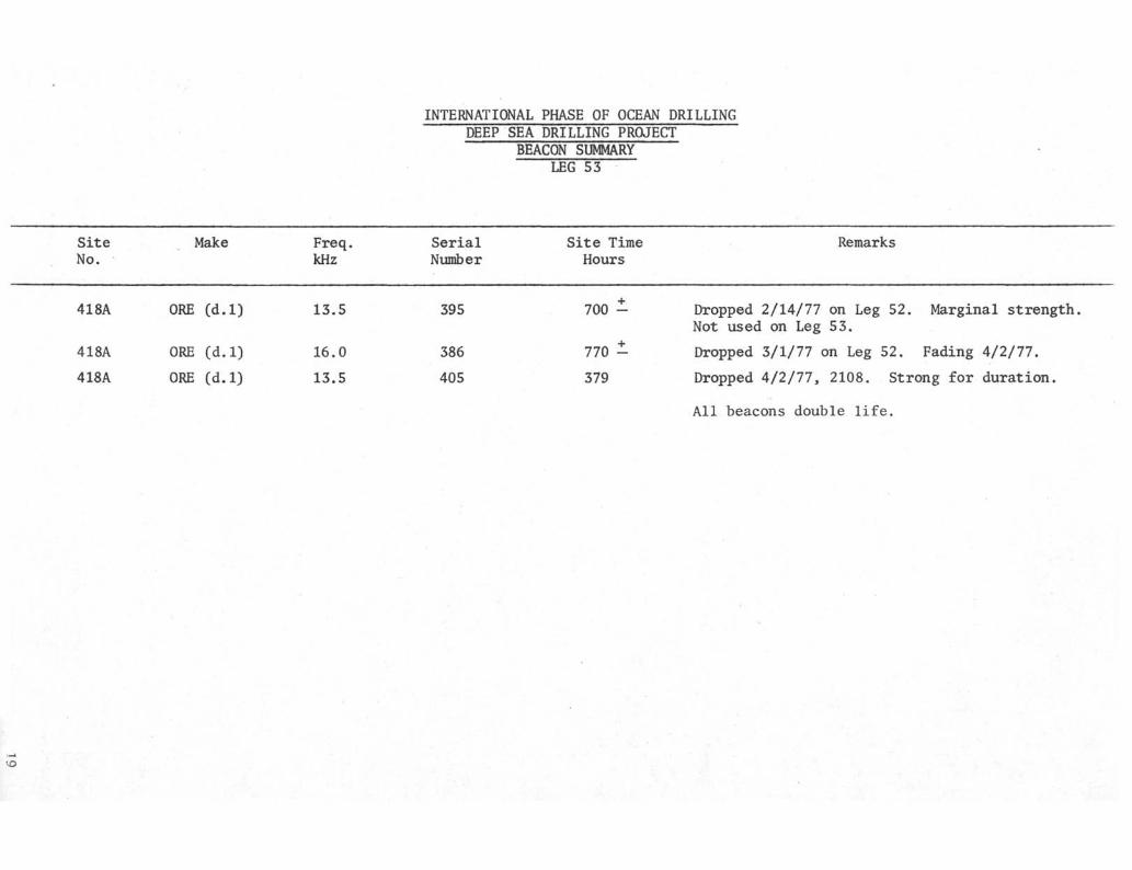
INTERNATIONAL PHASE OF OCEAN DRILLINGDEEP SEA DRILLING PROJECT
BEACON SUMMARYLEG 53
SiteNo.
418A
418A
418A
ORE
ORE
ORE
Make
(d.l)
(d.l)
(d.l)
Freq.kHz
13.5
16.0
13.5
SerialNumber
395
386
405
Site TimeHours
700 -
770 -
379
Remarks
Marginal strengthDropped 2/14/77 on Leg 52.Not used on Leg 53.
Dropped 3/1/77 on Leg 52. Fading 4/2/77.
Dropped A/2/11, 2108. Strong for duration.
All beacons double life.
•-O

5500 80
ROTATING HOURS
120 140 160 180 200 220 240 260 280T
SEA FLOOR 5519
CASING POINT 5593
TOP OF BASALT 5843
6386.8 T.D.
15 20 25 1 10 15 20 25 30
6400-
650010 5 10 15
• APRIL 1977

HOLE 418A
PASSIVE REFLECTORS
(6 § 60u)
8-5/8 DISCHARGE LINE
(3 @ 120°)8' DIA
MUD SKIRT EXTENSION
14' DIA—-f
GUIDE CONE ASSEMBLY
MUD SKIRT
DIVERTER PACKOFFASSEMBLY
MUD LINE 5519
CASING HANGERASSEMBLY
TOP 16" CASING 5522 M
16" CONDUCTOR
11-3/4" CASING (none)
SHOE 16" 5593.17 M
21

LEG 53 REENTRY REPORT
by
Robert M. Byrne
The following is a list of attempts made this Leg at Site 41SA:
12. #103
Attempt
1.
2.
3.
4.
5.
6.
7.
Tool
#101
#104
#104
#101
#105
#102
#104
Scan Time
15
6
1
3
2
hr.
hr.
hr.
hr.
hr.
12
43
35
17
55
12
min.
min.
min.
min.
min.
min.
Comments
Hydrophone malfunction placedus 2300 ft. from cone. Longsearch necessary.CONFIRMED
Hydrophone malfunction repaired.Necessary to reestablish coneposition.CONFIRMED
CONFIRMED
CONFIRMED
CONFIRMED
CONFIRMED
Loesintr cable began to unravel
8.
9.
10.
11.
#104
#104
#104
#102
2 hx.
28 min.
8 rain.
26 min.
during tool's descent. Toolpulled to replace cable.NO SHOT
CONFIRMED
CONFIRMED
CONFIRMED
Tool failed due to pressure caseflooding before reaching bottom.NO SHOT
Tool floated, cable knotted up.Tool became stuck before exitingpipe. During attempt to free toolcable parted. Tool pulled up withpipe.
SHOT
22

INTERNATIONAL PHASE OF OCEAN DRILLINGDEEP SEA DRILLING PROJECT
OPERATIONAL RESUMELEG 54
Leg 54 marked the return of the GLOMAR CHALLENGER to the Pacific Ocean for thefirst time since Leg 35. While the primary area to be investigated was theEast Pacific Rise, the ship also visited the Galapagos area to evaluate thisarea for future drilling possibilities. This additional investigation of theGalapagos necessitated an extension of six days to the total planned time ofLeg 54. Some of the scientific objectives were achieved; and some were not.Foremost was the inability to find a site suitable for placing a re-entry coneand drilling deep into the young crustal material near the ridge crest.
The leg started on April 25, 1977 in Colon, Panama and ended 53.7 days later,June 18, 1977 in Los Angeles, California. The CHALLENGER traveled 6567.5 nauticalmiles and attempted to drill 18 holes at 12 sites. Water depths varied from 2617meters to a maximum of 3848 meters. The hole depths ranged from the shallowestof 31.0 meters to the deepest of 174.5 meters. The average depth was only 80.1meters. This relatively shallow penetration was due mainly to the thin sedimentcovering and the destructive nature of the crustal material beneath the sedimentson the bits. A total of 847.0 meters of coring was attempted with 461.37 metersrecovered for a recovery percentage of 54.5%.
Time distribution for the leg was 4.6 days in port (includes 0.7 days of downtime)31.3 days cruising and 17.8 days on-site. The on-site time breakdown consistedof 6.1 days tripping, 0.2 days drilling, 8.6 days coring, 1.5 days positioningthe ship, 0.4 days of mechanical downtime, 0.1 days with stuck pipe and 0.9 daysfor miscellaneous items.
SITE 419 (HOLES 419 $ 419A)
The primary scientific objective of this leg was to determine the crustal com-position of oceanic crust associated with a fast spreading center and Site 419was the first of these sites. It was located approximately 1600 miles west ofPanama.
After arriving at the proposed location, a 16.0 kHz Benthos beacon was dropped.However, after about 30 minutes, the pulse rate doubled and it appeared to belosing strength so a 13.5 kHz beacon was rigged and dropped. The drill stringwas then made up and a mudline core was taken at 3294 meters. The hole was con-tinuously cored to 35 meters where crustal material was encountered, which couldnot be penetrated due to insufficient soft sediment support for the bottomholeassembly. The sediment thickness, which had been calculated to be 80 +_ metersfrom the geophysical data available, came as a surprise.

The drill string was then pulled to 91 meters above the mudline and the shipwas slowly moved 3,000 feet southwest of the original location. Another mudlinecore was taken at 3277 meters and then the pipe was washed in to 46 meters wherecrustal material was again encountered. Again, due to this lack of sedimentsupport for the bottomhole assembly, the site was abandoned.
While drilling Hole 419, the pore water sampler was run successfully at a bottomdepth penetration of 29 meters.
SITE 420 (HOLES 420 $ 420A)
After abandoning Site 419, the ship moved 26 miles westerly to Site 420. Whilethe ship moved to this location, bottom profiling indicated a sediment thicknessthat could support the bottomhole assembly.
When the ship was on location, the drill string was made up and a mudline coretaken at 3404 meters; the hole was then continuously cored to a subbottom depthof 147 meters. Crustal material was encountered at 115 meters. The 32 metersof basalt penetrated required more than eight hours to core. The main difficultywas in the apparent badly fractured nature of the rock as evidenced by the poorrecovery (1.22 meters). While this section was being cored, almost continuoustorquing and sticking was experienced with pulls as much as 400,000 lbs. requiredto move the pipe. In addition, more than 200 barrels of mud were spotted in anattempt to assist the coring. However, poor drilling conditions persisted andit was finally decided to abandon this hole. While coring the sediments, threesuccessful pore water sunples were obtained at subbottom depths of 23.5, 71.0and 99.5 meters.
The drill string was pulled 195 meters above the mudline and the ship was moved3,400 feet on a course of 045 . Hole 420A was spudded with a mudline core at3412 meters. The drill string was then washed down to the top of the basaltwhich was encountered at 63 meters subbottom. Again, because there was insuf-ficient support for the bottomhole assembly, the drill string was pulled tomove to a new location.
When the drill bit was pulled, it was worn out after 9.87 rotating hours. Whenrecovered, the bit was found to have no cones or core guides and the stabilizerpads had been worn off. This was further evidence of the poor drilling possi-bilities in the fractured crustal basalt.
SITE 421
This site was located only about three miles east of Site 420 and appeared tohave about 100 meters of sediment cover based on the profile geophysics.
Before the drill string could be run, about five hours were spent changing outthe diaphragm and clutch lining in the make up drum of the drawworks. Afterthis, the drill string was made up and a.mudline core was cut at 3342 meters. Thehole was then washed 85.5 meters to where the basalt was again encountered.Three 9.5 meter cores were cut in the basalt with a total recovery of 1.74 meters,

Torquing began almost as soon as the basalt was topped and continued during thetime the three cores were being cut. Also, during this coring, 300 barrels ofmud were spotted with very little increase in coring efficiency. After cuttingthe third core, two hours and 45 minutes were spent trying to get back to bottom.However, the drill bit could get only to within nine meters of the total depthof the preceding core. With occasional pulls on the drill string up to 425,000 lbs.,it was decided that this site should be abandoned. When the bit was recovered,it was about 1/8" out of gauge and all of the stabilizer pads had been destroyeddue to the abrasive nature of the basalt.
SITE 422
This site was located about 48 miles east of Site 421 and was located to try toencounter a more drillable section. After coring 46 meters of sediments, a sillor flow of basaltic material was cored. Below this another four meters of sedi-ments were cored, followed by about 9.5 meters of massive basaltic material.However, directly below this rock fractured basaltic material was again encounteredas in the previous sites. Again, torquing and sticking developed and resulted inslow penetration rates. After cutting Core No. 10, the pump pressure indicatedthat the bit was plugged so a center bit was dropped. When it was recoveredthere were four evenly spaced grooves on it and it was felt that the bearings hadfailed and that the core guides were being pushed in and not allowing a fullgauge core to be cut. Core No. 10 had only 0.17 meters recovery for 9.5 meterscored. Because of this evidence, it was decided to abandon the site.
However, when the bit was recovered, the bearings were intact as well as thecore guides. When the center bit was inserted into the bit again, it was observedthat the gauge cutting inserts did touch the center bit as though the cones hadbeen squeezed toward the center of the bit. The stabilizer pads also were abouthalf worn away from the abrasive action of the fractured basalt.
SITE 423
This site was located about ten miles east of Site 422 and was considered to bethe prime location for a location for a re-entry site in the original prospectus.However, the thin sediment cover encountered in the beginning of the leg made thissite less attractive. In order to attempt drilling this site, the bottomholeassembly was modified so there would be less chance for it to be broken off.The total length was reduced from 120+ meters to 83+ meters.
A mudline core was taken at 3177.5 meters and the hole was then continuouslycored. Basalt was topped in Core No. 5 at 38 meters and when the core barrelwas recovered, a piece of basalt was jammed in the catcher. After coring aboutten minutes on Core No. 6, the pipe torqued up and stopped rotating. The pipewas picked up and it required one hour to get back to the same depth. The pipecontinued to torque so 50 barrels of mud were spotted and the pipe worked until4.5 meters had been cored and the core barrel was recovered. Core recovery forthis core was 22 cm.

Core No. 7 required 128 minutes to core five meters and recovered 38 cm. Aftercutting Core No. 7, about eight meters of fill were encountered when the pipewas run back to bottom. While attempting to work back to bottom, the pipe wouldtorque up and stop requiring 75,000-100,000 lbs of overpull to release it. Afterabout two hours and two meters of penetration, it was decided to abandon thehole because of the risk to the drill string.
SITE 424
This site is located about 1,250 miles east-southeast from Site 423. This changein the area of investigation was due to a Project decision to include drillingtrials along the Galapagos spreading center. The basic reason for this changewas to determine the drillability of the mounds and ridges believed to be asso-ciated with geothermal activity. Two geothermal legs in this area are plannedin the future.
After arriving in the area to be tested, about five hours of profiling was donebefore a beacon was dropped at 1438 on May 22, 1977. The PDR indicated a waterdepth of 2701 meters and 2691 meters of drill string were made up and run. TheSchlumberger sheaves were made up and the re-entry tool was run as would be donefor a cone re-entry. However, this time the tool would be used in an attemptto locate the drill string directly over a geothermal mound. The basic idea forlocating and drilling a mound was to position the ship, as close as possible,to directly over the mound, pull the EDO tool, drop an inner core barrel andthen with sufficient pipe above the derrick floor, take a punch core deep enoughso the drill string would remain in the bottom while the core barrel was beingretrieved.
After about three and one half hours of positioning, it was felt that the shipwas over a mound and the EDO tool was pulled and a core barrel dropped. Thecore recovered 6.5 meters of black manganiferous material and it was felt wewere on at least a flank of the mound, if not on top. The hole was then con-tinuously cored and penetrated about 31 meters of sediment before encounteringcrustal material. A successful pore water sample was obtained approximately twometers above the sediment-crustal contact.
Drilling continued into the basalt for 45 meters before the bit wore out andthe drill string was pulled.
The normal bottomhole assembly had been changed because of the information in-dicating a relatively thin sediment thickness in this area. It consisted ofthe bit, bit sub, core barrel, top sub, head sub, three 8-1/4" drill collars, one5f bumper sub, two 8-1/4" drill collars, crossover sub, one 7-1/4" drill collar,one 5-1/2" heavy wall with an overall length of 83.5 meters and it appeared tomake the coring operation effective.
HOLE 424A
The second hole to be drilled in this area was located about 2,000 feet southerlyfrom Hole 424, hopefully in another mound chain or ridge. The move south was madeby offsetting from the beacon and using the PDR to note changes in bottom depth.

After one hour of positioning the ship, a satisfactory location was reachedand the drill string was run in to 2692 meters, During the positioning, thechanges in water depth were quite subtle and therefore, final location would bemade from the bottom configuration as seen with the re-entry tool.
The EDO tool was lowered and the search for the mound was begun at 1429 hours.Two hours and 26 minutes later a mound was believed to be located and the toolwas pulled. When the search began the bottom was located at 2716 meters andwhen the tool was pulled bottom was calculated to be 2708 meters or above amound about eight meters high.
The inner barrel was dropped and when the positioning dot was centered in thebridge console again, the pipe was lowered and a core was taken. Again, thepenetration was deep enough that the pipe would remain in the bottom while thecore was recovered. The cored material was again black manganiferous materialas at Hole 424 and was conceded to be from a mound. Two sediment cores wererecovered and the third core encountered resistance after 29 meters of pene-tration. However, after recovery of Core No. 3, it was not possible to run thebit back to total depth. One hour was spent trying to accomplish this, buttorquing and sticking was so bad that rotation was lost and pulls up to 350,000lbs were necessary to free the drill string. Apparently the basalt was badlyfractured and could not be penetrated safetly. Therefore, the hole was abandonedand the ship would be moved a short distance and another attempt would be made.
HOLE 424B
After completing the drilling of the two mound locations, the ship was movedabout 3,200 feet north of 424A and about 1200 feet north of 424 with the drillpipe pulled to 2511 meters. This site was located between mound areas andtherefore did not require the use of the EDO tool to locate the drill site.
A mudline core was taken and established bottom at 2710 meters. The hole wascontinuously cored and encountered basalt in Core No. 5 at a penetrated depthof about 38 meters. No more than five meters could be cored in Core No. 6 aftertwo hours of difficult rotating time. During this time 50 barrels of mud werespotted but failed to improve drilling conditions. Therefore, because of thetorquing, sticking, and lack of ability to core the apparently fractured material,the hole was abandoned.
HOLE 424C
After completing Hole 424B, the drill string was pulled to 54 meters above bottomand the ship was moved 650 feet north of the abandoned hole.
A mudline core was taken and as in Hole 424B, there was no manganese type materialrecovered which apparently verified the fact that these sites were not locatedon mounds. Two joints were washed and the second core encountered crustalmaterial at about 31 meters. While cutting the last part of Core No. 2, thedrill string began torquing and sticking, requiring pulls of over 300,000 lbsto free it. Core recovery from this 9.5 meter core was only 35 cm. While CoreNo, 3 was being cut only three meters were penetrated in 112 minutes and thesame torquing and sticking was experienced. Because of this, the hole wasabandoned after a total penetration of 34.5 meters.

SITE 425
This site was located about 50 miles north of Site 424 and was the last siteto be drilled in the evaluation of the Galapagos area.
After a seven hour trip, the 16 kHz beacon was dropped 0308 hours on May 26, 1977.After positioning of the ship was completed, pipe was run to 2836.5 meters. Amudline core was taken establishing bottom at 2872 meters. The hole was thenalternately cored and washed to a subbottom penetration of 62.5 meters, then thehole was continuously cored to total depth. Core No. 6 encountered basalt at about80 meters and Core No. 7 was cut with little difficulty. However, Core No. 8had trouble getting back to bottom and began torqùing, so 25 barrels of mud werespotted before retrieving the core. Core No. 9 also encountered the same troublegetting back to bottom and it required 212 minutes to cut this core. Again,mud was spotted before retrieving the core. The beginning of Core No. 10 was thesame as the two preceding cores; however, the bit plugged and the drill becamestuck after working back to bottom. It required about one hour to work the pipefree with pulls up to 425,000 pounds. During this time the bit remained pluggedand due to this difficulty in getting back to bottom, it was decided that thesite be abandoned. When the bit was recovered, all the jets were plugged withbasalt cuttings.
SITE 426
This site was located 1,362 miles west-northwest of Site 425. It was the firstsite visited after leaving the Galapagos area and returning to the PAC-4 areaand was made possible with a seven day extension for Leg 54. This first sitewas to be located on the East Pacific Rise axial crest in an attempt to recoversome of the youngest rock in this area.
After doing some preliminary profiling to determine the amount of sediment cover, a13.5 kHz beacon was dropped at 1954 hours on June 2. Positioning was begun but,before the ship was placed in the automatic mode, it was determined that the beaconwas not operating properly and a 16.0 kHz beacon was dropped for final positioning.
The drill string was made up with the short bottomhole assembly that had been usedin this area before when thin sediment cover was anticipated. Due to the fact thatthe profiles showed only a questionable 10 meter sediment thickness, it was de-cided to take a number of "mudline" cores to assist in the coring program.
The first location selected had a PDR reading of 2617 meters. The drill pipe waslowered and encountered very hard resistance at 2624 meters (no pump or rotation)and when the inner barrel was recovered, there was no evidence of sediments eventhough a plastic sock was used with soft formation catchers. The ship was thenmoved 700 feet west and with a PDR depth reading of 2621 the experiment was triedagain. The pipe stopped at 2628 meters and again no sediments were obtained.The ship was then moved an additional 2,290 feet west and a third try was made.The PDR read 2632 but water cores and no resistance were observed at depths of2637.5, 2647.0 and 2656.5 meters. Finally, hard resistance was reached at 2666meters but no sediments were recovered. Based on these six attempts, it wasdecided that this area had no sediment cover and could not be cored safely. Thesite was then abandoned.

SITE 427
This site was located about 80 miles southwest of Site 426 in the Siqueirostransform fault area. The ship departed Site 426 at 1130 hours on June 3 andit was not until 2200 hours that a possible area with enough sediment coverwas located.
A beacon was dropped and when the ship was positioning properly in automatic,running in with the drill was begun. Because of the uncertainty of the amountof sediment to be encountered (estimates ranged from 54 to 185 meters), a modi-fied bottomhole assembly (83.66 meters) was used. This assembly was first usedat Site 423 and after that whenever less than 100 meters of sediments were anti-cipated.
The PDR failed as the final approach to the site was being made so the ship'sfathometer was used and proved to be quite accurate in determining the waterdepth. It showed a water depth of 3750 meters and a Matthew's Table correctionfactor plus distance to the derrick floor brought the value to 3850. After thedrill string was run a bottom depth of 3848 meters was established with a mud-line core.
The hole was then alternately cored and washed, feeling for crustal materialuntil this was encountered after 146 meters of sediments. Two 9.5 meter basaltcores were cut with 12.06 meters recovered or about a 63% recovery factor.However, while cutting the third core, the pipe became stuck for about an hourbefore the balance of the core could be cut. When the inner barrel was re-covered it was empty. It required almost three hours to work the bit back tobottom and then the rate of penetration was so poor it was derided to abandonthe site with the assumption that the bit was worn after 12 hours of rotatingtime. When recovered, this assumption proved to be correct. The bit was prac-tically destroyed with all three cones missing and only the worn core guidesremaining.
SITE 428
This site was located about 75 miles west-northwest of Site 427 on the southside of the OCP Ridge. While enroute to this site an alternate was investigatedwith the profiling equipment but little or no sediment cover could be detectedand the ship continued on to the original destination.
After 13 hours of travel, the beacon was dropped at 0518 hours on the 6th ofJune. The drill string was made up again using the modified bottomhole assemblyof 83.66 meters because less than 100 meters of sediments were anticipated.The PDR had been repaired and indicated a bottom depth of 3299 meters and themudline core established the depth of 3301 meters.
Following the mudline core, two singles were washed in and then the hole wascontinuously cored to total depth. Basalt was topped at 61 meters in CoreNo. 5 and required 96 minutes to core six meters of this material. Core No. 6required only 44 minutes to core 9.5 meters and there was some concern that theship had moved off position. The maximum movement of the ship had been 80 feet

but the ship was again placed directly over the hole an<i the same cored intervalwas done again and required only 10 minutes to accomplish. After the core barrelwas dropped to cut Core No. 7, about six meters of fill was encountered andwhile trying to get back to bottom the pipe became stuck. Apparently the materialthat had drilled so quickly in Core No. 6 was badly fractured and had fallenin the hole. After approximately five hours of working the pipe it was pulledloose. During this time 75 barrels of mud and also 20 barrels of Halliburton"Guar Gum" were spotted in an attempt to help release the drill string. Dueto these bad hole conditions, it was decided to pull above the mudline and movea short distance and spud an "A" hole. The bit had been rotating only 2.6 hoursat this time so the move was considered a satisfactory maneuver.
HOLE 428A
The ship was moved 500 feet north and the hole was spudded in 3296 meters ofwater at 0330 on June 7th.
The string was washed to 62.5 meters where the crustal material was encountered.The hole was then continuously cored to a depth of 115 meters subbottom beforethe bit wore out.
The first two cores cut at a rate of about 3.5-4 meters/hour, however, aftercutting about five meters of Core No. 3 the bit stopped cutting and it wasfeared that the bit was worn out or damaged due to the mistreatment whiletrying to unstick the pipe at Site 428. However, when the core was retrieved,the core catcher had badly jammed so it was decided to try to core deeper.While running back to bottom some fill was encountered and torquing developed,but by working the pipe properly the bit reached bottom again and coring con-tinued. After each core the problem of reaching bottom decreased until therewas no problem before cutting Cores No. 6 and No. 7. The core diameter wasslowly decreasing indicating that the bearings were going and eventually inCore No. 7, after five meters had been cored, the bit gave out. The last corerecovered 2.74 meters of rock for five meters cored with a diameter of 4.0-4.1 cm.When the bit was recovered, one cone was missing and the bearings were gone inthe remaining three. However, it had performed well for 20.1 rotating hoursand the longest bit life for the leg. This longer bit life could be attributedto the apparently less fractured nature of the rock below the top 10-15 meters.With the amount of sediment and the nature of the rocks, this area could beconsidered a good candidate for a re-entry site on the Ease Pacific Rise.
SITE 429
This site was located due west of Site 428, a distance of 79.2 miles. It waslocated on the west flank of the East Pacific Rise and was to sample the oldestrocks (4.3 +_ million years) encountered in this area of investigation.
The ship arrived in the area about midnight on June 8 and a 13.5 kHz beacon wasdropped at 0034 hours, June 9. The PDR indicated a water depth of 3422 metersand the profiling equipment indicated about 40 meters of sediments. Theshortened bottomhole assembly was again used because of this thin sedimentarycoyer.

The drill string was made up and run in and took a mudline core 3426.0-3431.0meters. Plans were to then wash to approximately 35 meters subbottom and takea core which would span the sediment-crustal material contact. However, whilewashing in contact with the basalt was made after only 31 meters of sediments.This amount of sediment was considered insufficient to support the drill stringsafely so it was decided to abandon this location and attempt to find one withmore sediments.
HOLE 429A
After the drill string had been pulled 100+ meters above the mudline at Hole 429,the ship was moved 2,990 feet east to the new location.
The PDR indicated a water depth of 3426 meters. The pipe was then run in andwashed to 3457 meters or 31 meters subbottom where crustal resistance was en-countered. It therefore appeared as though there was no appreciable increasein sediments in this area and because time was running out before the ship hadto depart for Los Angeles, it was decided to carefully try to core the basaltwith this thin sediment cover.
Three cores were attempted with a penetration of 21.5 meters into the basaltbefore the core catcher plugged on Core No. 3 and the time had come for theship to depart. During this short coring period, 2.95 meters were recoveredand proved to be scientifically rewarding.
DRILLING AND CORING ASSEMBLIES
Three different bottomhole assemblies were used on this leg. At Sites 419, 419A,420, 420A and 421 the bottomhole assembly consisted of a bit, bit sub (with floatvalve) core barrel, top sub, latch sub, three 8-1/4" drill collars, one 5-footBaash-Ross bumper sub, three 8-1/4" drill collars two 5-foot bumper subs, two8-1/4" drill collars, one 7-1/4" drill collar and one joint of heavy wall drillpipe. This assembly was modified at Site 422 and decreased the number of bumpersubs to a total of two. From Site 423 through 429 the bottomhole assembly wasshortened appreciably due to the thin sediment cover being encountered. Thebottomhole assembly consisted of bit, bit sub, core barrel, three 8-1/4" drillcollars, one 5-foot bumper sub, two 8-1/4" drill collars, one 7-1/4" drill collarand one 5-1/2" heavy wall. This assembly was 83.66 meters in length and madepossible attempts to core crustal material with as little as 29 meters of sedi-ment cover. This shallow sediment was cored with at least one basalt corerecovered on all these last sites except at Site 426. At this site six attemptswere made to recover mudline or sediment cores and recovered nothing. Thissite was located on the Pacific Rise axial crest and apparently no sedimentcover exists. At least, of a consistancy that can be recovered with our coringequipment. Because of the lack of sediments no drilling into the crust wasattempted.
BITS
Ten bits were used during this leg to drill the 18 holes that were attempted.
9

These included one 10-1/8" F93CM, one 1Q" RBF94CK and seven 9-7/8" F94CK. Thesebits enjoyed a total rotating time of 192.77 hours or about 19 hours per bit.The rocks that were cored were about the most abrasive yet encountered duringthe CHALLENGER drilling program. The first bit run, RBF94CK, after 9.87 rotatinghours, returned to the derrick floor with all of the conefs core guides andstabilizer pads worn off as well as the body of the bit being badly worn. Thetwo F93 fared little better with the first recovered with most of the insertsbroken or missing, the bearings gone and 5/8" out of gauge and the stabilizerpads gone after 10.8 hours* The second was in worse condition with all conesgone, worn core guides and no stabilizer pads after 12 hours rotating.
The 9-7/8" F94CK bits seemed to bear the abrasive nature of the rocks somewhatbetter and only one returned missing a cone, but this was after 17.5 hours ofrotating time.
One of the most significant things was the loss of the stabilizer pads on almostall the bits. This same abrasive effect of the rocks was seen in wear on thebit sub and drill collars.
A re-entry program should be studied carefully as related to bit life and thenumber of trips that would be necessary to achieve a particularly deep pene-tration of this very abrasive rock.
Overall core recovery on this leg amounted to 54.5% with about 22% in the crustalmaterial.
BEACONS AND POSITIONING
Thirteen beacons were used on this leg, twelve ORE and one Benthos. All of theORE beacons were single life except one double life 16.0 kHz. They all per-formed satisfactorily except one 13.5 that began to weaken soon after it hadbeen dropped, so a 16.0 kHz was dropped and used for positioning. The Benthosbeacon also had to be replaced because it too began to lose strength after anhour and 16 minutes. It also began pulsing every second.
Positioning on this leg was excellent with no problems. This could probablybe attributed to the performance of the beacons and the excellent weatherconditions which were enjoyed throughout the leg.
RE-ENTRY EQUIPMENT
Re-entry equipment was used at two locations on this leg but not for re-entry.It was used to try to locate mounds or ridges created by geothermal activityin the Galapagos area.
The first time it was attempted was at Site 424. After the tool had been loweredto the bottom of the drill pipe, it required about three hours to locate thepotential target. The mound was cored with a mudline core and recovered man-ganese crustal material which is supposed to characterize a mound or ridge.
10
The second attempt was made at Hole 424A after the ship had been moved 1,750feet south where another ridge was supposed to be located. This time it tookabout two hours to locate the ridge and again was verified with a mudline corewhich recovered the same manganese crustal material.
In both cases the EDO equipment was also used to determine not only the visualcontact with the ridge but also the height that the mound was above the sur-rounding sea floor. It proved to be more accurate than the PDR which was af-fected by the pulses emitted by the EDO tool.
Two additional holes were drilled in the same general area but did not use there-entry tool and the mudline cores did not contain the manganese material, moreor less verifying the fact that the hole was not located on a ridge.
DRILLING EQUIPMENT
Following completion of drilling (Leg 53) operations on the Bermuda Rise, thehorizontal drill pipe racker was found to be in a deteriorated condition. Inter-ference between moving parts was a problem. Proper repair was judged to be amajor undertaking and for Leg 54 approximately one half of the active drill stringwas removed from the racker. This action proved sufficient to allow proper workingof the racker and was feasible due to the relatively shallow water depths ofLeg 54. Proper repairs are planned during the drydock period scheduled followingthe voyage. It was necessary to off load some of the used drill pipe to providethe necessary room for planned re-entry operations.
At the last site two malfunctions were reported in the operation of the drawworksauxiliary brake. The brake is operated by the application of electric current.The probable cause appears attributable to associated control equipment.
The heave compensator was not used during the leg because of two basic reasons.First, the weather and sea conditions were excellent and vessel motion was minimal.Second, the very fractured nature of the basaltic material required a great dealof flexibility in drilling techniques and this is not possible with the heavecompensator in the drill string.
COMMUNICATIONS
Radio telegraph communication via radio WWD (Scripps) was easy on this leg asthe vessel was in direct communication on 1710 kHz throughout the entire workingday for WWD. The volume of traffic, so transmitted, was as usual high both out-going and incoming. Radio telephone calls were made directly to WWD on severaloccasions with very satisfactory results. The volume of personal radio telephonecalls was low but consistent. Due to extreme crowding of the amateur bands notraffic for individuals was handled via the once familiar "phone patch". Allequipment worked well, the only difficulty being with the auto alarm which wasrepaired. One distress call, not in the vessel's area, was received via autoalarm.
11

PERSONNEL
Although this leg enjoyed only about 18 days on site and the balance of the timecruising, the scientific party appeared to enjoy some of their scientific ob-jectives and attempted to retain their enthusiasm.
Both Global Marine and SIO personnel people teamed together to make the leg assuccessful as possible. The drilling department should be especially commendedin obtaining crustal material under very difficult drilling conditions.
R. R. KnappCruise Operations ManagerDeep Sea Drilling Project
12

INTERNATIONAL PHASE OF OCEAN DRILLINGDEEP SEA DRILLING PROJECT
OPERATIONS RESUMELEG 54
Total Days (April 25, 1977 - June 18, 1977)Total Days In PortIn Port DowntimeTotal Days Cruising Including Site SurveyTotal Days On Site
Trip TimeDrilling TimeCoring TimePosition ShipMechanical DowntimeStuck PipeOther
6.1.2
8.61.5.4.1.9
Total Distance Traveled (Nautical Miles) Including SurveyAverage SpeedNumber of SitesNumber of Holes Drilled (Attempted)Number of Cores AttemptedNumber of Cores With RecoveryPercentage of Cores With RecoveryTotal Meters CoredTotal Meters RecoveredPercent RecoveryTotal Meters DrilledTotal Meters of PenetrationPercent of Penetration CoredMaximum Penetration (Meters)Minimum Penetration (Meters)Maximum Water Depth (Meters)Minimum Water Depth (Meters)
53.73.9.7
31.317.8
6567.59.051118
10210199.0847.0461.3754.5
435.01282.066.0174.526.0
3848.02617.0
13

-30°N
30° S
\| i i | i i i i i i i i i | i i i i j T r T i Π T I I J I I I I I I I ' I I I I I I I I T T > i r r
L E G E N D
LEG 54 DRILL SITES
14

INTERNATIONAL PHASE OF OCEAN DRILLINGDEEP SEA DRILLING PROJECTTOTAL TIME DISTRIBUTION
LEG 54
IN PORT DOWNTIME 1.3%
START LEG: April 25, 1977FINISH LEG: June 18, 1977TOTAL TIME: 53.7 Days
15

INTERNATIONAL PHASE OF OCEAN DRILLINGDEEP SEA DRILLING PROJECTON SITE TIME BREAKDOWN
LEG 54
STUCK PIPE .6%
MECHANICAL DOWNTIME
OTHER 5.3
TOTAL TIME ON SITE: 17.8 DaysTOTAL SITES: 11TOTAL HOLES: 18
16

INTERNATIONAL PHASE OF OCEAN DRILLINGDEEP SEA DRILLING PROJECT
BEACON SUMMARYLEG 54
SiteNo. Make
Freq.kHz
SerialNumber
Site TimeHours Remarks
419 Benthos 16.0 003* 1.3
419A420/420A421422423424424A424B424C425426426427428428A429429A
OREOREOREOREOREOREOREOREOREOREOREOREOREOREOREOREORE
13.5 SL16,0 DL13.5 SL16.013.5 SL16.0 SL16.0 SL16.0 SL16.0 SL16.0 SL13.5 SL16.0 SL13.5 SL16.0 SL16.0 SL13.5 SL13.5 SL
360385409388411391391391391390408389398379379397397
33.455,232.129.626.940.417.510.89.527.9Died15.641.821.136.48.816.1
*Electronics #9307 - Transducer #374 - Beacon loststrength after 1 hr 16 min. Pulsed every second.
57.6
24.9

INTERNATIONAL PHASE OF OCEAN DRILLINGDEEP SEA DRILLING PROJECT '
BIT SUMMARYLEG 54
HoleMeters Hours
Mfg. Size Type Serial Meters Meters Total OnNumber Cored Drilled Penet. Bit
Condition Remarks
419-419A
420-420A
421
422
423
424
424A424B424C
425
426
427
428428A
429429A
Smith
Smith
Smith
Smith
Smith
Smith
SmithSmithSmith
Smith
Smith
Smith
SmithSmith
SmithSmith
10"10"
9-7/8"
9-7/8
9-7/8"
10-1/8"
9-7/8"9-7/8"9-7/8"
9-7/8"
10-1/8"
10-1/8"
9-7/8"9-7/8"
9-7/8"9-7/8"
RBF94CKRB94CK
F94CK
F94CK
F94CK
F93C
F94CKF94CKF94CK
F94CK
F93CM
F93CM
F94CKF94CK
F94CKF94CK
RC902RC902
104 FJ
160FF
085FF
KN306
157FF157FF157FF
161FF
KN263
KN263
192FF192FF
917FE917FE
43.0153.0
38.0
73.0
53.5
76.0
34.046.516.5
81.5
- -
98.5
54.552.5
5.021.5
38.057.0
76.0
- -
- -
- -
_ _- -18.0
28.5
81.0210.0
114.0
73.0
53.5
76.0
34.046.534.5
110.0
76.0 174.5
22.062.5
26.031.0
76.5115.0
31.052.5
1.018.86
4.2
8.2
7.06
10.8
2.353.72.6
6.7
- -
12.0
2.617.5
.15.1
Destroyed
T1-B1-0 1/8"
T1-B1-0 1/16"
T1-B4-SQ-0 1/1
T7-B8-0 5/8"
T1-B4-SQ-0 1/8
Tl-Bl-I
Tl-Bl-I
Destroyed
20.1 hrs totalT7-B8-0
T1-B1-SE-I
Will rerun on Site 420.
Cones, core guides, stabilizer pads gone.
Stabilizer pads worn off.
Stabilizer pads starting to go.
Stabilizer pads gone. Body badly worn.
Stabilizer pads gone.
Stabilizer pads gone. Diameter at shank downfrom 9-1/4" - 8-1/2".
Pads starting to wear. (
Not rotated. Water cores.
All cones gone. Worn core guides remaining.
One cone gone. Seals gone. Stabilizer padsgone. Body of bit worn to internal threads.
Rerun on 428A; -
847.0 435.0 1282.0 192.77
do

INTERNATIONAL PHASE OF OCEAN DRILLINGDEEP SEA DRILLING PROJECT
SITE SUMMARYLEG 54
Hole
419
419A
420
420A
421
422
423
424
4 24 A
424B
424C
425
.?ft
All
428
428A
429
429A
Latitude
08°
08°
09°
09°
09°
09°
09°
00°
00°
00°
00°
01°
o
08°
09°
09°
09°
09°
55.96
55.47
00.10
00.50
01.41
10.59
08.81
35.63
35.33
35.82
35.93
23.68
47. 28
06.79
02.77
02.77
02.01
02.01
'N
'N
'N
•N
'N
•N
'N
•N
•N
'N
'N
•N
»wIN
•N
•N
'N
'N
•N
Longitude
105°
105°
106°
106°
106°
105°
105°
86°
86°
86°
86°
86°
104°
104°
105°
105°
106°
106°
41.17'W
41.22'W
06.77'W
06.36'W
03.68'W
16.27'W
06.57'W
07.82'W
07.81'W
07.82'W
07.82'W
04.20'W
K 97 WX J £. 1 fi
36.35'W
26.14'W
26.14'W
46.35'W
45.87'W
WaterDepthMeters
3294
3277
3404
3412
3342
3254.5
3177.5
2703.5
2708.0
2710.0
2710.5
2872.0
7f\λ 7-?ft%'
3848.0
3301.0
3296.0
3426.0
3426.0
NumberOf
Cores
5
1
17
1
4
10
8
8
3
6
3
9
11
6
7 •
1
3
CoresWith
Recovery
5
1
17
1
4
10
8
7
3
6
3
9
11
6
7
1
3
Permit ofCores With
Recovery
100.0
100.0
100.0
100.0
100.0
100.0
100.0
87.5
100.0
• 100.0
100.0
100.0
100.0
. 100.0
100.0
100.0
100.0
MetersCored
35.0
8.0
147.0
"6.0
38.0
73.0
53.5
76.0
34.0
46.5
16.5
81.5
98.5
54.5
52.5
5.0
21.5
MetersRecovered
21.64
4.74
95.07
6.05
11.22
46.97
27.98
36.45
13.13
29.3
7.81
43.42
57.26
36.34
16.37
4.67
2.95
PercentRecovered
61.8
59.3
64.7
100.8
29.5
64.3
52.3
47.9
38.6
63.0
47.3
53.2
58.1
66.7
31.2
93.4
13.7
MetersDrilled
_ _
38.0
- -
57.0
76.0
- -
- -
- -
- -
- -
18.0
28.5
76.0
22.0
62.5
26.0
31.0
TotalPen etMeters
35.0
46.0
147.0
63.0
114.0
73.0
53.5
76.0
34.0
46.5
34.5
110.0
174.5
76.5
115.0
31.0
52.5
Avg.RatePenet.M/HR
46.6
65.7
16.8
4.8
27.1
8.9
7.6
7.0
15.3
12.5
13.2
3.9
14.5
29.4
6.6
260.0
10.3
TimeOn
HoleHrs.
24.0
8.9
42.5
12.7
32.1
35.6
26.9
40.4
17.5
10.3
10.0
26.9
15.6
41.8
21.2
36.9
8.8
16.1
TimeOn
Site
32.
55.
32.
35.
26.
78.
26.
15.
4 1 .
58.
24.
9
2
1
6
9
2
9
8
1
9
Totals 103 102 99.0 847.0 461.37 54.5 435.0 1282.0 6.6 428.2 428.2
D£fP 5£A DRILLINGT/ME D/57J?IBUr/O//
LE6 - 5 4
Dzie1977
4/25-29
4/29
4/29-304/30-5/8/
5/8-9
5/9
5/9
5/9-11
5/11-12
5/12
Siie//o.
419
419A
420
420A
5/12-13 I 421
5/13-14
5/14-15
5/15
5/15-16
5/16-22
5/22-24
5/24-25
5/25
5/25
•
422
423
424
424A
424B
424C
Cfv/se
9.6
182.0
9.4
1.4
9 . 3
4 . 1
138.2
Tr/ps
14.0.
5.9
7.8
9.8
* 12.7
11.7
10.0
9 . 3
4 . 8
1.2
4 . 3
Dr///
.9
.8
. 5
. 3
Core
5.8
.6
26.0
.8
11.8
20.8
14.0
• 21.0
5.2
8.2
4 .9
Stack W.O.W.Posrf/o>iJ/I/P•
2.2
1.5
1.2
1.3
.9
3.1
2.0
6.6
7.5
.9
.2
Alech.Repair
16.3
2.0
5.0
PorfT/me
87.4
8.2
/?e-fh/ry
orλer
2.0
5.5
1.2
.9
3.5*
. 3
rof<i/7/^s
182.0
24.0
8.9
9.4
42.5
12.7
1.4
32.1
9 . 3
35.6
4 , 1
26.9
138.2
40.4
17 ^
10.3
/Fe/var/ts
Cristobalto Site 419Pore waterSampler
Pore Water
Attempt
j Secure for10.0 J Move

ss/i DRituNβ PROJECT
Dafe
5/25-26
5/26-27b/l/-
6/2
6/2-3
6/3
6/3-5
6/5-6
6/6-7
[6/7-8
6/8-9
6/9
6/9-10
6/10-18
TOTALS•
Siie//o.
425
426
427
428
428A
429
4*29A
C/*i//se
6 . 3
157.9 '
10.3
13.7
9.2
197.6
749.0
Trips
9.6
7.2
11.1
5.4
8.9
" 6.2
6 . 6
146.5
Dr///
.5
.2
.5
.2
• .5
4 . 5
Core
14.6
5.6
25.8
6 . 7
26.5
2.4
7.7
207.4
IStackP/pe
3.5
3.5
εβ -W.O.W.
54Posrf/onS/I/P
•
1.1
2.3
.9
1.9
.5
1.0
1:3
3$.4
Atech.Repsir
1.5
24.8
PorfT/π?e
95.6
1.5
. 5
2.0
3.5
. 5 .
21.4
Tote/
6 . 3
26.9
157.9
15.6
10.3
41.8
13.7
21.2
36.9
9.2
8.8
16.1
197.6
1289.1
/Fevzrks
Stuck PipeSet Back Sub
Vater CoresDnly
Stuck Pipe
Stuck Pipe
>lagnaflux BHA