PNEG-2072 - Bio-Dri II™ with Actuated Inlet Door - Automated ...
Upload
khangminh22Category
view
0download
0
239
RPM-BSP-ADA-1
DEVELOPMENT OF REGIONAL IMPACT
APPLICATION FOR DEVELOPMENT APPROVAL
UNDER SECTION 380.06, FLORIDA STATUTES
STATE OF FLORIDA DEPARTMENT OF COMMUNITY AFFAIRS DIVISION OF COMMUNITY PLANNING The Sadowski Building 2555 Shumard Oak Blvd. Tallahassee, Florida 32399

240
STATEMENT OF PURPOSE
The Development of Regional Impact (DRI)Application for Development Approval (ADA)is intended to provide information to local governments to assist them in making decisions concerning developments having a greater than local impact. Just as the DRI process is not intended to supplant local, state, or federal permitting procedures, neither is the ADA meant to be a substitute for substantive or technical reports required pursuant to such permits. Rather, the ADA provides a comprehensive look at a proposed development and serves as the basic data source for the preparation of the regional planning council's report and recommendations to the local government on the regional impact of the proposed development. The regional planning council, in full-filling its responsibilities as the regional planning agency under Chapter 380, Florida Statutes (F.S.), will use this base information provided by a developer to consider whether, and the extent to which:
(a) The development will have a favorable or unfavorable impact on the environment and natural and historical resources of the region;
(b) The development will have a favorable or unfavorable impact on the economy of the
region;
(c) The development will efficiently use or unduly burden water, sewer, solid waste disposal, or other necessary public facilities;
(d) The development will efficiently use or unduly burden public transportation facilities;
(e) The development will favorably or adversely affect the ability of people to find adequate
housing reasonably accessible to their places of employment; and
(f) The development complies or does not comply with such other criteria for determining regional impact as the regional planning agency shall deem appropriate.
When a developer believes that his proposed development may be a DRI, he should contact the
appropriate regional planning council as soon as possible. The regional planning council can determine if a proposed development meets or exceeds mandatory DRI review thresholds, or if a binding letter needs to be obtained from the Florida Department of Community Affairs to determine the DRI status of the proposed development.

241
Once a proposed development is determined to require DRI review, the regional planning council will assist the developer in determining the necessary information needed for a pre-application conference. The pre-application conference is a meeting between various governmental agencies to establish the parameters of the DRI. It is the initial step in the DRI process which establishes the framework for a cooperative planning effort between the developer, the local government, regional agency, and federal and state agencies
After the pre-application conference establishes the scope of the DRI review, the developer can begin the preparation of the Application for Development Approval. The developer should continue to work closely with the appropriate local government and regional planning council during the preparation of this application and its subsequent review. INSTRUCTIONS FOR THE COMPLETION OF THE APPLICATION FOR DEVELOPMENT APPROVAL A. Applicants proposing residential Developments of Regional Impact must complete Parts I
through V of this Application. Applicants proposing non-residential DRIs must complete all applicable questions in Part I through V, as well as appropriate portions of Part VI dealing with specific types of Developments of Regional Impact.
B. As provided for in Section 380.04, F.S., a DRI includes all other development customarily
associated with it. Therefore, an applicant proposing a DRI with some individual land uses that are not of DRI magnitude (for example, a 100,000 square foot neighborhood shopping center within a predominantly residential DRI)must include information regarding those land uses in the appropriate portions of this application.
C. All information supplied must be accurate, up-to-date, and complete. Where a format and units
of measure for information are specified, these must be followed. If the specified format requires the provision of information by development phases, each phase indicated must relate to those designated in Question 10, and the final entries must relate to development completion and full operation or utilization as designated in Question 10.
D. All responses to questions are to be contained in the body of the application. E. Any information pertinent to the development which has not been specifically requested in this
form may be incorporated by the applicant within an appropriate section of this application. F. All narrative responses should be in a 8 1/2" x 11" format and should begin with the appropriate
question from the application. Include a table of contents. G. Include a bibliography of the information sources utilized in answering this application, along
with the names, addresses and telephone numbers of any consultants, agencies, or other persons who contributed to or completed sections of this application.

242
H. Identify all methodologies, models, assumptions, and standards used in obtaining or evaluating any information proved in this application.
I. Applicants should be prepared to supply, upon request, relevant background data used to obtain
any information contained in this application. J. "Region" is defined as those state sub-districts which have been designated by the Executive
Office of the Governor. K. Please note when answering the questions in the ADA that the various reviewing agencies are
required to assess the proposed plan of development pursuant to the State Comprehensive Plan (SCP)contained in Chapter 187 of the Florida Statues. Starting at Question 11 of the ADA, there is a box at the beginning of each question that lists various goals and policies from the SCP. The goals and policies contained in these boxes are intended to provide general guidance as to specific policies in the SCP that pertain to a given ADA question. The information in the SCP boxes may not contain all policies in the State Comprehensive Plan that would apply to a specific situation. Elimination of ADA questions must be consistent with the legislative intent of Subsection 380.06(7), F.S., and does not preclude consideration of, recommendations regarding, or appeal on those issue areas. The elimination of questions in the ADA does not eliminate the applicability of any SCP goal or policy to the proposed development. In addition, because the SCP is a legislative statute, it is subject to change both in content and format. Therefore, the SCP should be reviewed in its entirety prior to completing the ADA to ensure that the proposed development is in compliance with the SCP.
L. Below the SCP box in Question 17:Water Supply; Question 18:Wastewater Management;
Question 19:Stormwater Management; Question 20:Solid Waste/Hazardous Waste/Medical Waste; Question 21:Transportation; and Question 26:Recreation and Open Space there is a box for level of service information. These ADA questions correspond to the public services specified in Rule 9J-5.003(77), Florida Administrative Code, that are required to adhere to con-currency requirements. The "adopted level of service standard" should be the level of service standard adopted in the comprehensive plan for the jurisdiction(s)in which the proposed development will impact the given public facility.
M. At least one copy of the competed application must be submitted to each of the following:(1)the
appropriate local government(s); (2)the appropriate regional planning agency, and (3)the Department of Community Affairs. Contact the appropriate local and regional agencies for the exact number of copies required by each agency.

243
DEVELOPMENT OF REGIONAL IMPACT APPLICATION FOR DEVELOPMENT APPROVAL UNDER SECTION 380.06, FLORIDA STATUTES TABLE OF CONTENTS PART I. APPLICATION INFORMATION QUESTION 1 - STATEMENT OF INTENT 1 QUESTIONS 2,3 - APPLICANT INFORMATION 2 QUESTIONS 4-7 - DEVELOPMENT INFORMATION 3 QUESTION 8 - PERMIT INFORMATION 3 PART II.GENERAL SECTION QUESTION 9 - MAPS 4 QUESTION 10 - GENERAL PROJECT DESCRIPTION 5 QUESTION 11 - REVENUE GENERATION SUMMARY 9 PART III.ENVIRONMENTAL RESOURCES IMPACTS QUESTION 12 - VEGETATION AND WILDLIFE 10 QUESTION 13 - WETLANDS 11 QUESTION 14 - WATER 12 QUESTION 15 - SOILS 12 QUESTION 16 - FLOODPLAINS 14 QUESTION 17 - WATER SUPPLY 15 QUESTION 18 - WASTEWATER MANAGEMENT 18 QUESTION 19 - STORMWATER MANAGEMENT 20 QUESTION 20 - SOLID WASTE/HAZARDOUS WASTE/MEDICAL WASTE 21 PART IV.TRANSPORTATION RESOURCE IMPACTSQUESTION 21 - TRANSPORTATION 23 QUESTION 22 - AIR 26 QUESTION 23 - HURRICANE PREPAREDNESS 28 PART V.HUMAN RESOURCE IMPACTS QUESTION 24 -HOUSING 29 QUESTION 25 - POLICE AND FIRE PROTECTION 31 QUESTION 26 - RECREATION AND OPEN SPACE 31 QUESTION 27 - EDUCATION 32 QUESTION 28 - HEALTH CARE 33 QUESTION 29 - ENERGY 33 QUESTION 30 - HISTORICAL AND ARCHAEOLOGICAL SITES 34 PART VI.SPECIFIC DRI INFORMATION QUESTION 31 - AIRPORTS 34 QUESTION 32 - ATTRACTIONS AND RECREATION FACILITIES 36 QUESTION 33 - HOSPITALS 38 QUESTION 34 - INDUSTRIAL PLANTS AND INDUSTRIAL PARKS 39 QUESTION 35 - MINING OPERATION 39

244
QUESTION 36 - PETROLEUM STORAGE FACILITIES 40 QUESTION 37 - PORT AND MARINA FACILITIES 41 QUESTION 38 - SCHOOLS 43

245
STATE OF FLORIDA RPM-BSP-ADA-1 DEPARTMENT OF COMMUNITY AFFAIRS DIVISION OF COMMUNITY PLANNING The Sadowski Building 2555 Shumard Oak Blvd. Tallahassee, Florida 32399 DEVELOPMENT OF REGIONAL IMPACT APPLICATION FOR DEVELOPMENT APPROVAL UNDER SECTION 380.06, FLORIDA STATUTES PART I. APPLICATION INFORMATION QUESTION 1 - STATEMENT OF INTENT 1. I,___________________________________, the undersigned owner/authorized agent of
(authorized agent) ________________________________, hereby propose to undertake a Development of
(name of development) Regional Impact as defined in Section 380.06, Florida Statutes (F.S.), and Chapter 28-24.____, Florida Administrative Code (F.A.C.).In support thereof I submit the following information concerning ___________________________, which information is true and
(name of development) correct to the best of my knowledge. ____________________ ___________________________________ Date Signature of Owner or Authorized Agent

246
QUESTIONS 2,3 - APPLICANT INFORMATION 2. Owner/Developer (name, address, phone).State whether or not the owner or developer is
authorized to do business in the State of Florida pursuant to the provisions of Chapter 407, F.S. 3. Authorized Agent and Consultants (name, address, phone). QUESTIONS 4-7 - DEVELOPMENT INFORMATION 4. Attach a notarized authorization from all persons or corporations (or authorized agents of said
persons or corporations) having fee simple or lessor estate in the site indicating that each of these parties is aware of, and concurs with, the development of this property as described in this Application for Development Approval. Include the names and addresses of all parties with an interest in the property. In addition, include descriptions of any other properties within one-half mile radius of the DRI site in which any of the parties with an interest in the DRI site hold a fee simple or lessor interest.
5. Attach a legal description of the development site. Include section, township and range. 6. Have you requested a binding letter of interpretation of DRI status or vested rights, clearance
letter, agreement or preliminary development agreement from the Department of Community Affairs? If so, what is the current status of this determination?
7. List all local governments with jurisdiction over the proposed development. QUESTION 8 - PERMIT INFORMATION 8. List all agencies (local, state and federal)from which approval and/or a permit must be obtained
prior to initiation of development. Indicate the permit or approval for each agency and its status. Indicate whether the development is registered or whether registration will be required with the Division of Florida Land Sales, Condominiums and Mobile Homes under Chapter 478, Florida Statutes. Indicate whether the development will be registered with the H.U.D., Division of Interstate Land Sales Registration or with other states.

247
PART II.GENERAL SECTION QUESTION 9 - MAPS The following maps must be provided as a part of the ADA. The appropriate scale for each map should be determined at the pre-application conference. Map A. A general location map. Indicate the location of any urban service area boundaries and
regional activity centers in relation to the project site. Map B. A recent vertical aerial photo of the site showing project boundaries which reasonably
reflects current conditions. Specify the date the photo was taken. Map C. A topographic map with project boundaries identified (contour intervals from one to five
feet should be determined in consultation with the appropriate regional planning council and other reviewing agencies at the pre-application conference).Delineate 100-year flood prone areas (including hurricane flood zones)and indicate major land surface features. If applicable, delineate the coastal construction control line.
Map D. A land use map showing existing and approved uses on and abutting the site. The uses
shown should include existing on-site land uses, recreational areas, utility and drainage easements, wells, right-of-way, and historic, archaeological, scientific and architecturally significant resources and lands held for conservation purposes.
Map E. A soils map of the site, with an identification of the source of the information. The use of
a source other than the most recently published U.S.D.A. Soil Conservation Service (SCS)soil surveys should be determined in consultation with the appropriate regional planning council and other reviewing agencies at the pre-application conference.
Map F. A vegetation associations map indicating the total acreage of each association, based on
the Level III vegetation types described in The Florida Land Use and Cover Classification System: A Technical Report, available from each regional planning council.
Map G. A location map of all transects, trap grids, or other sampling stations used to determine
the on-site status of significant wildlife and plant resources. Show location of all observed significant wildlife and plant resources, and show location of suitable habitat for all significant resources expected to be on-site.

248
Map H. A master development plan for the site. Indicate proposed land uses and locations, development phasing, major public facilities, utilities, preservation areas, easements, right-of-way, roads, and other significant elements such as transit stops, pedestrian ways, etc. This plan will provide the basis for discussion in Question 10-A as well as other questions in the ADA.
Map I. A master drainage plan for the site. Delineate existing and proposed: drainage basins,
flow direction, water retention areas, drainage structures, flow route offsite, drainage easements, waterways, and other major drainage features.(This information may be presented on two separate maps (existing and proposed), if desired.)
Map J. A map of the existing highway and transportation network within the study area. The
study area includes the site, and locations of all transportation facilities which are substantially impacted. This area should be finally defined on the basis of the findings of the traffic impact analysis, including determinations of where the criteria for a substantial impact are met. Map J will become the base for the maps requested in Question 21.
QUESTION 10 - GENERAL PROJECT DESCRIPTION Part 1 Specific Project Description A. Describe and discuss in general terms all major elements of the proposed development in its
completed form. Include in this discussion the proposed phases (or stages)of development (not to exceed five years), magnitude in the appropriate units from Chapter 28-24, F.A.C., where applicable, and expected beginning and completion dates for construction.
B. Provide a breakdown of the existing and proposed land uses on the site for each phase of
development through completion of the project. The developed land uses should be those identified in Section 380.0651, F.S. and Chapter 28-24, F.A.C. Use Level III of The Florida Land Use and Cover Classification System: A Technical Report (September 1985), available from each regional planning council. Refer to Maps D (Existing Land Use)and H (Master Plan).Use the format below and treat each land use category as mutually exclusive unless otherwise agreed to at the pre-application conference.
C. Briefly describe previous and existing activities on site. Identify any constraints or special
planning considerations that these previous activities have with respect to the proposed development.
D. If the development is proposed to contain a shopping center, describe the primary and secondary
trade areas which the proposed shopping center will serve. E. Describe, in general terms, how the demand for this project was determined.

EXISTING AND PROPOSED LAND USES (Expand as necessary to accommodate additional land uses)
PHASE
NON-RESIDENTIAL (Specify by CH 28-24 F.A.C. Land Use Type)
RESIDENTIAL
OTHER (Separate column for ROW, Open Space, Drainage, etc.)
TOTAL
ACRES
GSF/UNITS
ACRES
D.U.
NET (1) DENSITY
GROSS (1) DENSITY
ACRES
ACRES
D.U./GSF
Existing Phase 1 TOTAL
(1) Definitions of net and gross densities to be provided at the pre-application conference

250
Part 2 Consistency with Comprehensive Plans A. Demonstrate how the proposed project is consistent with the local comprehensive plan and land
development regulations. Indicate whether the proposed project will require an amendment to the adopted local comprehensive plan, including the capital improvements element. If so, please describe the necessary changes.
B. Describe how the proposed development will meet goals and policies contained in the
appropriate Regional Comprehensive Policy Plan. C. Describe how the proposed development will meet goals and policies contained in the State
Comprehensive Plan (Chapter 187, F.S.), including, but not limited to, the goals addressing the following issues: housing, water resources, natural systems and recreational lands, land use, public facilities, transportation, and agriculture.
Part 3 Demographic and Employment Information A. Complete the following Demographic and Employment Information tables. Part 4 Impact Summary A. Summarize the impacts this project will have on natural resources. B. Summarize public facility capital costs associated with project impacts using the following table:

Demographic Information Related to the Project's Population
PHASE
TOTAL DWELLING UNITS
PERSONSPER HOUSEHOLD
TOTAL POPULATION
CHILDRENPER HOUSEHOLD
TOTAL SCHOOL AGE CHILDREN
ELDERLY PER HOUSEHOLD
TOTAL ELDERLY
MF
SF
Existing Phase 1 TOTAL

Estimated Employment Generated by Project by Income Range(1)
PHASE
UNDER $10,000
$10,000-$14,999
$15,000-$19,999
$20,000-$24,999
$25,000-$29,999
$30,000-$34,999
$35,000-39,999
Over $40,000
CONSTR
NON-CONSTR
CONSTR
NON-CONSTR
CONSTR
NON-CONSTR
CONSTR
NON-CONSTR
CONSTR
NON-CONSTR
CONSTR
NON-CONSTR
CONSTR
NON-CONSTR
CONSTR
NON-CONSTR
Phase 1 TOTAL
(1)Construction employment in terms of Full-time equivalents (FTE) Non-construction employment in terms of permanent employees

253
PUBLIC FACILITY IMPACTS(1)
FACILITY
PHASE
TOTAL CAPITAL COST
RESPONSIBLEENTITY
Phase 1 TOTAL
(1)At a minimum, this table should include transportation, wastewater, potable water, recreation and open space, and education. QUESTION 11 - REVENUE GENERATION SUMMARY
See State Comprehensive Plan (Chapter 187, F.S.) GOAL (18); POLICIES ( 8), ( 9) GOAL (20); POLICY ( 7)
A. Project the funds anticipated to be generated by the project. This projection should include any
source or use of funds which could have any reasonable connection to the proposed development.
1. Make the following projections by year, including the first and last year in which any
construction and/or development takes place:
(a) Yearly ad valorem tax receipts (b) Yearly impact fees collected (c) Yearly sales tax received by local government (d) Yearly gasoline tax received by local government (e) Yearly projections of any other funds by any other sources generated as a result
of development of the proposed project within the region
2. List all assumptions used to derive the above projections and estimates, show the methodologies used and describe the generally accepted accounting principles used in all assumptions, estimates and projections.

254
PART III.ENVIRONMENTAL RESOURCES IMPACTS QUESTION 12 - VEGETATION AND WILDLIFE
See State Comprehensive Plan (Chapter 187, F.S.) GOAL( 9); POLICY ( 7) GOAL (10); POLICIES ( 1),( 3),( 4),( 6) GOAL (16); POLICY ( 2)
A. Identify the dominant species and other unusual or unique features of the plant communities on
Map F. Identify and describe the amount of all plant communities that will be preserved in a natural state following development as shown on Map H.
B. Discuss what survey methods were used to determine the absence or presence of state or
federally listed wildlife and plants.(Sampling methodology should be agreed to by the regional planning council and other reviewing agencies at pre-application conference stage.)State actual sampling times and dates, and discuss any factors that may have influenced the results of the sampling effort. Show on Map G the location of all transects, trap grids, or other sampling stations used to determine the on-site status of state or federally listed wildlife and plant resources.
C. List all state or federally listed wildlife and plant resources that were observed on the site and
show location on Map G. Given the plant communities on-site, list any additional state or federally listed wildlife and plant resources expected to occur on the site and show the location of suitable habitat on Map G. Additionally, address any unique wildlife and plant resources, such as colonial bird nesting sites and migrating bird concentration areas. For species that are either observed or expected to utilize the site, discuss the known or expected location and population size on-site, existence (and extent, if known)of adjacent, contiguous habitat off-site, and any special habitat requirements of the species.
D. Indicate what impact development of the site will pose to affected state or federally listed wildlife
and plant resources. E. Discuss what measures are proposed to be taken to mitigate impacts to state and federally listed
wildlife and plant resources. If protection is proposed to occur on-site, describe what legal instrument will be used to protect the site, and what management actions will be taken to maintain habitat value. If protection is proposed to occur off-site, identify the proposed amount and type of lands to be mitigated as well as whether mitigation would be through a regional mitigation land bank, by acquisition of lands that adjoin existing public holdings, or by other means.

255
QUESTION 13 - WETLANDS
See State Comprehensive Plan (Chapter 187, F.S.) GOAL ( 8); POLICY ( 6) GOAL (10); POLICIES ( 1),( 7),( 8) GOAL (16); POLICY ( 2)
A. If there are wetlands on the site, discuss and specify the following:
1. Acreage and percentage of property which is currently wetlands. These wetlands should be shown on Map F, Vegetation Associations and identified by individual reference numbers.(There numbers should be utilized in responding to the other sub-questions.)
2. Historic hydro periods and seasonal water elevations of on-site wetlands.
3. Acreage and location of wetlands which are to be preserved in their natural or existing
state, including proposed hydro periods, seasonal water elevations and methods for preservation.
4. Acreage and location of areas to be enhanced, including proposed hydro periods,
seasonal water elevations and methods of enhancement.
5. Actions taken to minimize or mitigate impacts on wetland areas, including maintaining the hydro period and providing buffers.
6. Acreage and location of wetlands which will be disturbed or altered, including a
discussion of the specific alterations and disturbances.
7. Precautions to be taken during construction to protect wetland areas.
8. If available, provide jurisdictional determinations. B. Provide any proposed plans (conceptual or specific)for created or enhanced wetland areas,
including littoral lake slopes, buffers, vegetative species to be planted, etc.

256
QUESTION 14 - WATER
See State Comprehensive Plan (Chapter 187, F.S.) GOAL ( 6); POLICY (19) GOAL ( 8); POLICIES ( 2),( 4),( 6),( 7),( 8),(10),(12) GOAL (10); POLICIES ( 1),( 8) GOAL (16); POLICY ( 6) GOAL (22); POLICY ( 3)
A. Describe the existing hydrologic conditions (both ground and surface water)on and abutting the
site, including identification and discussion of any potential aquifer recharge areas. Please identify and describe any Outstanding Florida Waters, Wild and Scenic Rivers, Florida Aquatic Preserves or Florida Class I or II Waters that occur within, abutting or downstream of the site.
B. Describe, in terms of appropriate water quality parameters, the existing ground and surface
water quality conditions on and abutting the site.(The appropriate parameters and methodology should be agreed to by the regional planning council and other reviewing agencies at the pre-application conference stage.)
C. Describe the measures which will be used to mitigate (or avoid where possible)potential adverse
effects upon ground and surface water quality, including any resources identified in Sub question A.
QUESTION 15 - SOILS
See State Comprehensive Plan (Chapter 187, F.S.) GOAL ( 9); POLICIES ( 6),( 9) GOAL (16); POLICIES ( 6)
A.
1. Provide a description of each of the soils indicated on Map E utilizing the following format:

Soil Description and Interpretations
SOIL NAME AND MAP SYMBOL
BRIEF SOIL DESCRIPTION
SEASONAL HIGH WATER TABLE DEPTH DURATION
PERMEABILITY RATE (in/hour)
DEGREE & KIND OF LIMITATION FOR PROPOSED USES
DEGREE & KIND OF LIMITATION FOR POND EMBANKMENTS
*
*
* appropriate responses include slight, moderate, severe, and very severe.
258
2. Describe the potential for subsidence and any unique geologic features (such as sand dunes, bluffs, sinkholes, springs, steepheads, etc.)on the site. Discuss what aspects of the site plan will be used to compensate for or take advantage of these features.
B. Where a soil presents a limitation to the type of use proposed in the development, state how the
limitation will be overcome. Specify construction methods that would be used for building, road and parking lot foundations, and for lake or canal bank stabilization as relevant.
C. What steps will be taken during site preparation and construction to prevent or control wind and
water soil erosion? Include a description of proposed plans for clearing and grading as related to erosion control.
D. To what degree and in what location(s)will the development site be altered by fill material? If
known, specify the source location and composition of the fill. Also identify the disposal location for any overburden or spoil.
QUESTION 16 - FLOODPLAINS
See State Comprehensive Plan (Chapter 187, F.S.) GOAL ( 8); POLICY ( 8) GOAL (16); POLICY ( 6)
A. Identify any pre- and post-development flood prone areas. B. Is any development proposed within a 100-year flood prone area as identified by the Federal
Emergency Management Agency? If so, indicate the appropriate Flood Insurance Rate Map (FIRM)zone designations and their locations, etc.
C. If any structures, roadways or utilities are proposed within the post-development 100-year flood
prone area, identify their location and indicate what measures will be taken to mitigate the potential flood hazard and to maintain the 100-year floodplain storage volume.
D. Discuss any potential increases in the off-site flooding due to the development of this project.

259
QUESTION 17 - WATER SUPPLY
See State Comprehensive Plan (Chapter 187, F.S.) GOAL ( 8); POLICIES ( 1),( 5),(11) GOAL (16); POLICIES ( 1),( 2),( 6) GOAL (18); POLICIES ( 1),( 2),( 3),( 4),( 6) ADOPTED LEVEL OF SERVICE STANDARD: EXISTING LEVEL OF SERVICE: LEVEL OF SERVICE AFTER PROJECT BUILDOUT:
A.
1. Provide a projection of the average daily potable and non-potable water demands at the end of each phase of development. If significant seasonal demand variations will occur, discuss anticipated peaks and duration. Use the format below:
2. Describe how this demand information was generated, including the identification of the
consumption rates assumed in the analysis. B. Provide a breakdown of sources of water supply, both potable and non-potable, by development
phase through project completion. Use the format below. C. If water wells exist on-site, locate them on Map H and specify those that will continue to be used.
Also locate on Map H all proposed on-site wells.(For residential developments, if individual wells for each lot are proposed, simply indicate the number of units to be served, general locations, and any plans for eventual phase-out.)Indicate the diameter, depth, and pumping rates (average and maximum)for each of the existing wells and project this information for the proposed wells (for lots served by individual dual wells, this information may be grouped for projection purposes).Also provide a breakdown of the wells with regard to potable and non-potable sources.
D. If on-site water wells are used, will this result in interference with other water wells or result in
adverse impacts to underlying or overlying aquifers? Document the assumptions underlying this response.
260
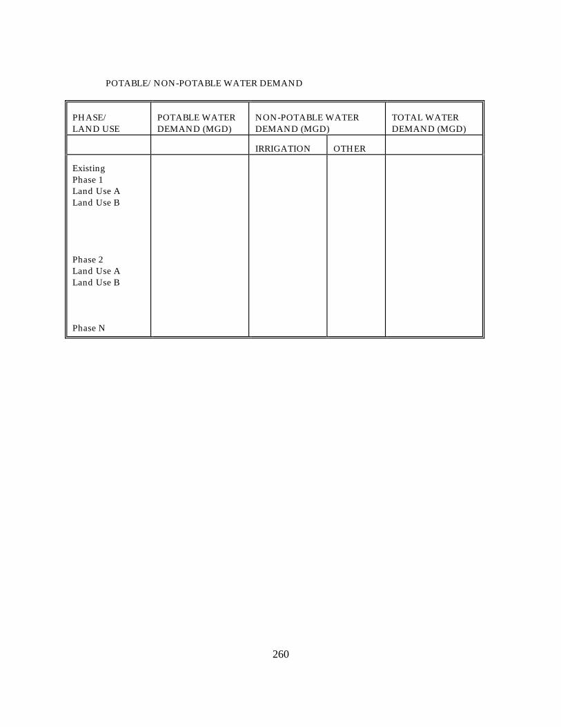
POTABLE/NON-POTABLE WATER DEMAND
PHASE/ LAND USE
POTABLE WATER DEMAND (MGD)
NON-POTABLE WATER DEMAND (MGD)
TOTAL WATER DEMAND (MGD)
IRRIGATION
OTHER
Existing Phase 1 Land Use A Land Use B Phase 2 Land Use A Land Use B Phase N

261
POTABLE/NON-POTABLE WATER SUPPLY (MGD)
PHASE
ON-SITE SUPPLY
OFF-SITE SUPPLY
GROUNDWATER
SURFACE WATER
OTHER (SPECIFY)
TOTAL
Existing Phase 1 Potable Non-Potable Irrigation Other Phase 2 Potable Non-Potable Irrigation Other Phase N
E. Who will operate and maintain the internal water supply system after completion of the
development? F.
1. If an off-site water supply is planned, attach a letter from the agency or firm providing service outlining:
(a) the projected excess capacities of the water supply facilities to which connection
will be made at present and for each phase through completion of the project,
(b) any other commitments that have been made for this excess capacity,
(c) a statement of the agency or firm's ability to provide services at all times during and after development.(This agency must be supplied with the water demand and supply tables in paragraphs A and B above).
2. If service cannot be provided at all times during and after development, identify the
required capital improvements, timing, cost, and proposed responsible entity for each phase in which service is unavailable.

262
G. Please describe any water conservation methods or devices incorporated into the plan of development. What percentage of reduction is anticipated over conventional plans?
H. Indicate whether proposed water service will be provided within an established service area
boundary. QUESTION 18 - WASTEWATER MANAGEMENT
See State Comprehensive Plan (Chapter 187, F.S.) GOAL ( 8); POLICIES (12),(13) GOAL (13); POLICY (11) GOAL (16); POLICY ( 1) GOAL (18); POLICIES ( 1),( 2),( 3),( 4),( 6),(10) EXISTING LEVEL OF SERVICE: ADOPTED LEVEL OF SERVICE STANDARD: LEVEL OF SERVICE AFTER PROJECT BUILDOUT:
A. Provide, in the table given below, the projected wastewater generation at the end of each phase of
development and proposed wastewater treatment. Identify the assumptions used to project this demand.

263
B. If applicable, generally describe the volumes, characteristics and pre-treatment techniques of any industrial or other effluents prior to discharge from proposed industrial-related use(s).
C.
1. If off-site treatment is planned, identify the treatment facility and attach a letter from the agency or firm providing the treatment outlining present and projected excess capacity of the treatment and transmission facilities through build out, any other commitments that have been made for this excess and a statement of ability to provide service at all times during or after development.
2. If service cannot be provided, identify the required capital improvements, cost, timing,
and proposed responsible entity necessary to provide service at all times during and after development.
D. If septic tanks will be used on site, indicate the number of units to be served, general locations
and any plans for eventual phase-out. E. Indicate whether proposed wastewater service will be provided within an established service
area boundary.
PHASE
WASTEWATER GENERATION (MGD)
ON-SITE WASTEWATER TREATMENT (MGD)
OFF-SITE WASTEWATER TREATMENT (MGD)
Existing Phase 1 TOTAL

264
QUESTION 19 - STORMWATER MANAGEMENT
See State Comprehensive Plan (Chapter 187, F.S.) GOAL ( 8); POLICY (12) GOAL (16); POLICY ( 1) GOAL (18); POLICIES ( 1),( 2),( 3),( 4),( 6) EXISTING LEVEL OF SERVICE: ADOPTED LEVEL OF SERVICE STANDARD: LEVEL OF SERVICE AFTER PROJECT BUILDOUT:
A. Describe the existing drainage patterns on-site as shown on Map I, including any potential
flooding and erosion problems. B. Describe the various elements of the proposed drainage system shown on Map I, including any
wetlands to be used as part of the system, and discuss the design criteria (including stage-storage/stage discharge assumption)to be used for the various elements. Provide typical cross-sections (showing dimensions, slopes and control elevations)for any proposed lakes or swales. Identify the control elevation for all drainage structures. Include information as to what design storm will be used for what portions of the system.
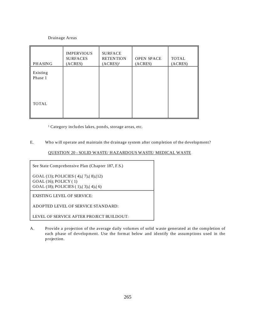
C. From Map I, indicate the total number of acres in each drainage area and specify the acreage of
any portions of drainage areas outside the site boundaries. Complete the following table for on-site drainage areas.
D. Specify and compare the volume and quality of run-off from the site in its existing condition to the
anticipated run- off at the end of each phase of development.(The parameters to be used to define "quality" and methodology should be agreed to by the regional planning council and other reviewing agencies at the pre-application conference stage.)Identify any changes in timing or pattern of water flows between pre- and post-development conditions. Indicate major points of discharge and ultimate receiving water body(ies).Indicate what provisions will be incorporated in the design of the drainage system, including a summary description of any Best Management Practices to be utilized, to minimize any increase in run-off from the site and to minimize any degradation of water quality in the ultimate receiving body over that occurring in its pre-development state.
265
Drainage Areas
PHASING
IMPERVIOUS SURFACES (ACRES)
SURFACE RETENTION (ACRES)1
OPEN SPACE (ACRES)
TOTAL (ACRES)
Existing Phase 1 TOTAL
1 Category includes lakes, ponds, storage areas, etc. E. Who will operate and maintain the drainage system after completion of the development? QUESTION 20 - SOLID WASTE/HAZARDOUS WASTE/MEDICAL WASTE
See State Comprehensive Plan (Chapter 187, F.S.) GOAL (13); POLICIES ( 4),( 7),( 8),(12) GOAL (16); POLICY ( 1) GOAL (18); POLICIES ( 1),( 3),( 4),( 6) EXISTING LEVEL OF SERVICE: ADOPTED LEVEL OF SERVICE STANDARD: LEVEL OF SERVICE AFTER PROJECT BUILDOUT:
A. Provide a projection of the average daily volumes of solid waste generated at the completion of
each phase of development. Use the format below and identify the assumptions used in the projection.

266
B.
1. Please specify the extent to which this project will contain laboratories, storage facilities, and warehouse space where hazardous materials may be generated or utilized. What types of hazardous waste or toxic materials are likely to be generated? Will a hazardous materials management plan be prepared covering all uses of hazardous materials on-site? If so, please discuss contents and enforcement provisions.
2. Please discuss what measures will be taken to separate hazardous waste from the solid
waste stream. What plans and facilities will be developed for hazardous or toxic waste handling, generation, and emergencies?
3. Please identify off-site disposal plans for hazardous waste generated by this
development and provide assurance of proper disposal by a qualified contractor.
4. What local and state regulations, permits and plans will regulate the generation and handling of hazardous waste at this development?
C. For all waste disposal planned (on or off site), attach a copy of the letter from the developer
describing the types and volumes of waste and waste disposal areas requested, and attach a letter from the agencies or firms providing services outlining:
SOLID WASTE GENERATION
PHASING
DOMESTIC SOLID WASTE
INDUSTRIAL, HAZARDOUS, MEDICAL, OR OTHER SPECIAL WASTES (Specify by appropriate units/Day)
CUBIC YARDS/DAY
TONS/DAY
Existing Phase 1 TOTAL
1. the projected excess capacity of the facilities serving the development at present and for
each phase through completion of the project,

267
2. any other commitments that have been made for this excess capacity,
3. a statement of the agency's or firm's ability to provide service at all times during and after development (the agency or firm must be supplied with the solid waste generation table in (A)above).
PART IV.TRANSPORTATION RESOURCE IMPACTS
See State Comprehensive Plan (Chapter 187, F.S.) GOAL (11); POLICY (2) GOAL (12); POLICIES (3),(4) GOAL (16); POLICIES (1) GOAL (18); POLICIES (1),(3)(4),(6) GOAL (20); POLICIES (2),(3),(8),(9),(10),(12),(13),(15) GOAL (25); POLICY ( 5) ROAD LINK/INTERSECTION: EXISTING LEVEL OF SERVICE: ADOPTED LEVEL OF SERVICE STANDARD: LEVEL OF SERVICE AFTER PROJECT BUILDOUT:
A. Using Map J or a table as a base, indicate existing conditions on the highway network within the
study area (as previously defined on Map J), including AADT, peak-hour trips directional, traffic split, levels of service and maximum service volumes for the adopted level of service (LOS).Identify the assumptions used in this analysis, including "K" factor, directional "D" factor, facility type, number of lanes and existing signal locations.(If levels of service are based on some methodology other than the most recent procedures of the Transportation Research Board and FDOT, this should be agreed upon at the pre-application conference stage.)Identify the adopted LOS standards of the FDOT, appropriate regional planning council, and local government for roadways within the identified study area. Identify what improvements or new facilities within this study area are planned, programmed, or committed for improvement. Attach appropriate excerpts from published capital improvements plans, budgets and programs showing schedules and types of work and letters from the appropriate agencies stating the current status of the planned, programmed and committed improvements.

268
B. Provide a projection of vehicle trips expected to be generated by this development. State all standards and assumptions used, including trip end generation rates by land use types, sources of data, modal split, persons per vehicle, etc., as appropriate. The acceptable methodology to be used for projecting trip generation (including the Florida Standard Urban Model Structure or the Institute of Transportation Engineers trip generation rates)shall be determined at the pre-application conference stage.
C. Estimate the internal/external split for the generated trips at the end of each phase of
development as identified in (B) above. Use the format below and include a discussion of what aspects of the development (i.e., provision of on-site shopping and recreation facilities, on-site employment opportunities, etc.)will account for this internal/external split. Provide supporting documentation showing how splits were estimated, such as the results of the Florida Standard Urban Transportation Model Structure (FSUTMS)model application. Describe the extent to which the proposed design and land use mix will foster a more cohesive, internally supported project.
INTERNAL/EXTERNAL SPLIT - VEHICLE TRIPS
VEHICLE TRIPS (ADT)
PEAK HOUR VEHICLE TRIPS
PHASING
INTERNAL
EXTERNAL
INTERNAL
EXTERNAL
Existing Phase 1
D. Provide a projection of total peak hour directional traffic, with the DRI, on the highway network
within the study area at the end of each phase of development. If these projections are based on a validated FSUTMS, state the source, date and network of the model and of the TAZ projections. If no standard model is available or some other model or procedure is used, describe it in detail and include documentation showing its validity. Describe the procedure used to estimate and distribute traffic with full DRI development in sub zones at build out and at interim phase-end years. These assignments may reflect the effects of any new road or improvements which are programmed in adopted capital improvements programs and/or comprehensive plans to be constructed during DRI construction; however, the inclusion of such roads should be clearly identified. Show these link projections on maps or tables of the study area network, one map or table for each phase-end year. Describe how these conclusions were reached.

269
E. Assign the trips generated by this development as shown in (B)and (C)above and show, on separate maps or tables for each phase-end year, the DRI traffic on each link of the then-existing network within the study area. Include peak-hour directional trips. If local data is available, compare average trip lengths by purpose for the project and local jurisdiction. For the year of build out and at the end of each phase estimate the percent impact, in terms of peak hour directional DRI trips/ total peak hour directional trips and in terms of peak hour directional DRI trips/ existing peak hour service volume for desired LOS, on each regionally significant roadway in the study area. Identify facility type, number of lanes and projected signal locations for the regionally significant roads.
F. Based on the assignment of trips as shown in (D)and (E)above, what modifications in the
highway network (including intersections)will be necessary at the end of each phase of development, to attain and maintain local and regional level of service standards? Identify which of the above improvements are required by traffic not associated with the DRI at the end of each phase. For those improvements which will be needed earlier as a result of the DRI, indicate how much earlier. Where applicable, identify Transportation System Management (TSM)alternatives (e.g., signalization, one-way pairs, ridesharing, etc.)that will be used and any other measures necessary to mitigate other impacts such as increased maintenance due to a large number of truck movements.
G. Identify the anticipated number and general location of access points for driveways, median
openings and roadways necessary to accommodate the proposed development. Describe how the applicant's access plan will minimize the impacts of the proposed development and preserve or enhance traffic flow on the existing and proposed transportation system. This information will assist the applicant and governmental agencies in reaching conceptual agreement regarding the anticipated access points. While the ADA may constitute a conceptual review for access points, it is not a permit application and, therefore, the applicant is not required to include specific design requirements (geometry)until the time of permit application.
H. If applicable, describe how the project will complement the protection of existing, or
development of proposed, transportation corridors designated by local governments in their comprehensive plans. In addition, identify what commitments will be made to protect the designated corridors such as inter-local agreements, right-of-way dedication, building set-backs, etc.
I. What provisions, including but not limited to sidewalks, bicycle paths, internal shuttles,
ridesharing and public transit, will be made for the movement of people by means other than private automobile? Refer to internal design, site planning, parking provisions, location, etc.

270
QUESTION 22 – AIR
See State Comprehensive Plan (Chapter 187, F.S.) GOAL ( 6); POLICY (19) GOAL (11); POLICIES ( 1),( 2),( 3),( 4) GOAL (22); POLICY ( 3)
A. Document the steps which will be taken to contain fugitive dust during site preparation and
construction of the project. If site preparation includes demolition activities, provide a copy of any notice of demolition sent to the Florida Department of Environmental Regulation (FDER)as required by the National Emission Standards for Asbestos, 40 CFR Part 61, Subpart M.
B. Specify structural or operational measures that will be implemented by the development to
minimize air quality impacts (e.g., road widening and other traffic flow improvements on existing roadways, etc.).Any roadway improvements identified here should be consistent with those utilized in Question 21, Transportation.
C. Complete Table 22-1 for all substantially impacted intersections within the study area, as defined
in Map J, and all parking facilities associated with the project. Using the guidance supplied or approved by the Florida Department of Environmental Regulation, determine if detailed air quality modeling for carbon monoxide (CO)is to be completed for any of the facilities listed in the table.

271
TABLE 22-1 PHASE:______(One table for each phase) YEAR OF PHASE:___ COMPLETION: __________________
PEAK HOUR TRAFFIC
MAXIMUM HOURLY SERVICE VOLUME (2)
SOURCE TYPE(1)
PROJECTED
EXISTING
PROJECTED
EXISTING
(1) Specify source type as either intersection, surface parking area, or parking deck. For each
intersection provide an approach volume for each link. For each parking facility provide the total (incoming and outgoing)volume.
(2) These should be compatible with maximum service volumes utilized in Question 21,
Transportation. D. If detailed modeling is required, estimate the worst case one-hour and eight-hour CO
concentrations expected for each phase through build out for comparison with the state and federal ambient air quality standards. Utilize methodology supplied or approved by the Florida Department of Environmental Regulation for making such estimates. Submit all air quality modeling input and output data along with associated calculations to support the modeling and explain any deviations from guidance. Provide drawings of site geometry and coordinate information for each area modeled. Show the location of the sources and receptor sites. Modeling assumptions should consider federal, state, and local government programmed link and intersection improvements with respect to project phasing. Any roadway improvements utilized in the model should be consistent with those used in Question 21, Transportation. Provide verification of any assumptions in the modeling which consider such programmed improvements. It is recommended that air quality analyses be completed concurrently and in conjunction with the traffic analyses for the project.
E. If initial detailed modeling shows projected exceedance(s) of ambient air quality standards,
identify appropriate mitigation measures and provide assurances that appropriate mitigating measures will be employed so as to maintain compliance with air quality standards. Submit further modeling demonstrating the adequacy of such measures.
272
QUESTION 23 - HURRICANE PREPAREDNESS
See State Comprehensive Plan (Chapter 187, F.S.) GOAL ( 7); POLICY (24),(25) GOAL ( 9); POLICIES ( 3),( 4)
A.
1. Identify any residential development proposed within the hurricane vulnerability zone delineated in the applicable regional hurricane evacuation study, regional public hurricane shelter study or adopted county peacetime emergency plan. If so, delineate the proposed development's location on the appropriate county and/or regional hurricane evacuation map and respond to questions B.(1)and B.(2)below. Proposed mobile home and park trailer developments should answer question B.(1), regardless of location, or answer questions B.(1)and B.(2)below, if proposed within the hurricane vulnerability zone or the high hazard hurricane evacuation area.
2. Identify any hotel/motel or recreational vehicle/travel trailer development proposed
within the high hazard hurricane evacuation area delineated in the applicable regional hurricane evacuation study, regional public hurricane shelter study, or adopted county peacetime emergency plan. If present, delineate the proposed development's location on the appropriate county or regional hurricane evacuation map and answer questions B.(1)and B.(2)below.
3. Identify whether the proposed development is location in a designated special hurricane
preparedness district. B.
1. For each phase of the development, determine the development's public hurricane shelter space requirements based on the behavioral assumptions identified in the applicable regional study or county plan. Identify the existing public hurricane shelter space capacity during the one hundred year or category three hurricane event within the county where the development is being proposed and indicate whether the county has a deficit or surplus of public hurricane shelter space during the one hundred year or category three hurricane event.
2. For each phase of the development, determine the number of evacuating vehicles the
development would generate during a hurricane evacuation event based on the transportation and behavioral assumptions identified in the applicable regional study or county plan. Identify the nearest designated hurricane evacuation route and determine what percentage of level of service E hourly directional and maximum service volume the project will utilize.

273
C. Identify and describe any action(s)or provisions that will be undertaken to mitigate impacts on hurricane preparedness.
PART V.HUMAN RESOURCE IMPACTS QUESTION 24 -HOUSING
See State Comprehensive Plan (Chapter 187, F.S.) GOAL ( 5); POLICY ( 3) GOAL (16); POLICY ( 3)
A.
1. If the proposed development contains residential development, provide the following information on Table 1 for each phase of the development.
2. What number and percent of lots will be sold without constructed dwelling units? What
is the extent of improvements to be made on these lots prior to sale? 3. What will be the target market for the residential development (break down by number,
percent and type the number of dwelling units to be marketed for retirees, families, etc.)What portion will be marketed as second or vacation homes?
B. Indicate and discuss the availability or projected availability of adequate housing and
employment opportunities reasonably accessible to the development site. Housing opportunities should be described in terms of type, tenure, and cost range and location within the following circumscribed areas: adjacent, two miles, five miles, ten miles, and within the local jurisdiction or county. Employment opportunities should be described in terms of two digit SIC code numbers located within the local jurisdiction with estimated distances or transit times to the development site.

Table 1. Dwelling Units within Development
NUMBER OF DWELLING UNITS
HOUSING COSTS(1)
SINGLE FAMILY
APARTMENT
CONDOMINIUM
MOBILE HOME
OTHER
TOTAL
Rental-Occupied D.U.s (Gross $ Rent)Range Owner-Occupied D.U.s (Dollar Value)Range
(1) Rental and cost ranges to be determined at the pre-application conference

275
C. If displacement or relocation of existing residents will occur due to the proposed development, identify the number of people that will be affected, any special needs of these people, and any provisions for addressing the effects of the relocation or displacement of these people, particularly in regards to their ability to find suitable replacement housing.
QUESTION 25 - POLICE AND FIRE PROTECTION
See State Comprehensive Plan (Chapter 187, F.S.) GOAL (16); POLICY ( 1) GOAL (18); POLICIES ( 1),( 3),( 4),( 6)
A. If police/fire services, facilities or sites will be dedicated or otherwise provided on-site, describe
them, specify any conditions of dedication and locate on Map H. B. Provide correspondence from the appropriate providers acknowledging notice of the proposed
development and phasing, and indicating whether present facilities and manpower are capable of serving the project or specifying the additional manpower/equipment necessary to serve the development. If the provider is from another jurisdiction, the letter should also identify any non-facility-related problems in providing said service.
QUESTION 26 - RECREATION AND OPEN
See State Comprehensive Plan (Chapter 187, F.S.) GOAL (10); POLICIES (11),(12),(13) GOAL (16); POLICY ( 1) GOAL (18); POLICIES ( 1),( 3),( 4),( 6) EXISTING LEVEL OF SERVICE: ADOPTED LEVEL OF SERVICE STANDARD: LEVEL OF SERVICE AFTER PROJECT BUILDOUT:
A. Describe the recreational facilities and open space (including acreage)which will be provided
on-site. Locate on Map H. Identify which of these areas or facilities will be open to the general public.
B. Will the development remove from public access lands or waters previously used by residents of
the region for hunting, fishing, boating or other recreation uses? Specify.

276
C. Will parks and open space be dedicated to the city or county? If not, who will maintain the facilities?
D. Please describe how the proposed recreation and open space plan is consistent with local and
regional policies. E. Does the project have the potential for impacting a recreation trail designated pursuant to
Chapter 260, F.S., and Chapter 16D-7, F.A.C.? If so, describe the potential impact. QUESTION 27 – EDUCATION
See State Comprehensive Plan (Chapter 187, F.S.) GOAL (16); POLICY ( 1) GOAL (18); POLICIES ( 1),( 3),( 4),( 6)
A. If the development contains residential units, estimate the number of school age children
expected to reside in the development. Use class breakdowns appropriate to the area in which the development is located (specify on chart below):
SCHOOL AGE CHILDREN BY LEVEL
PHASE
ELEMENTARY
MIDDLE
HIGH
TOTAL
Existing Phase 1
B. Will school facilities or sites be dedicated or otherwise provided on the site? C. Attach a letter from the appropriate school board, acknowledging receipt of the estimated school
age population information in (A)above, and providing a statement of what capital improvement adjustments would be necessary to accommodate these students.

277
QUESTION 28 - HEALTH CARE
See State Comprehensive Plan (Chapter 187, F.S.) GOAL ( 6); POLICY ( 2) GOAL (16); POLICY ( 1)
A. Describe the health care services and facilities that will be required to meet the health needs
generated by this project. Please provide a letter from the various providers acknowledging notice of the proposed development and ability to serve the project.
QUESTION 29 – ENERGY
See State Comprehensive Plan (Chapter 187, F.S.) GOAL (11); POLICY ( 4) GOAL (12); POLICIES ( 1),( 5),(6)
A. Provide a projection of the average daily energy demands at the end of each development phase
for each of the following: electrical power, gas, oil, coal, etc. For electrical power, also provide the peak hour demand at the end of each phase.
B. If there is to be an on-site electrical generating facility (post-construction)describe its proposed
capacity and use. C. If energy (electrical power, natural gas, etc.)is to be obtained from an off-site source, attach a
letter from the firms or agencies providing service outlining:
1. the projected excess capacities of the facilities and transmission line to which connection will be made at present and for each phase through completion of the project,
2. any other commitments that have been made for this excess capacity,
3. a statement of the supplier's ability to provide service at all times during and after
development.(The supplier must be provided with demand information in (A)above.) D. Describe any energy conservation methods or devices incorporated into the plan of development.
What considerations relative to energy conservation will be incorporated into the site planning, landscape, and building design, and equipment and lighting selection for this project?

278
QUESTION 30 - HISTORICAL AND ARCHAEOLOGICAL SITES
See State Comprehensive Plan (Chapter 187, F.S.) GOAL (19); POLICIES ( 3),( 4),( 5),( 6) GOAL (22); POLICY ( 3) GOAL (24); POLICY ( 3)
A. 1. Describe any known historical or archaeological sites on the development site.
Provide a letter from the Department of State, Division of Historical Resources (DHR) which includes a list of known sites within the development site, the likelihood of historical or archaeological sites occurring within the development site, whether a site survey is needed, and whether any known sites are significant.
2. If DHR recommends that a site survey be done, the results of such a survey, conducted
for the development site by an acceptable professional, should be provided. B. If significant historical or archaeological sites exist on-site, indicate what measures would be
taken to protect them, or to minimize or mitigate impacts to them. Where appropriate, describe the measures for providing public access to the sites.
PART VI.SPECIFIC DRI INFORMATION QUESTION 31 - AIRPORTS
See State Comprehensive Plan (Chapter 187, F.S.) GOAL (20); POLICY ( 5)
A. Airports
Existing Conditions
1. Describe any existing airport operations within the project site which includes the following information: -airport classification; -size (square feet)of the existing terminal; -number of runways and length; -location and size of clear zones; -types of aircraft which presently use the facility;

279
-location and size of fuel storage facilities; -type and annual tons of cargo; -number of annual enplaned passengers; and -if available, historical trends of number of enplaned passengers for each five-year
interval of past airport operation.
2. Provide a map showing the locations of the present flight patterns, the existing aircraft noise contours (65, 70, and 75 Ldn), and the existing land uses within these contours.
3. Describe the proposed airport facilities and services within the project site (e.g., new
structures, runways).
4. Provide projections for each five-year interval through the useful life of the project as follows:
-airport classification; -size (square feet)of the proposed terminal; -number of runways and lengths; -size and location of clear zones; -types of aircraft which would use the facilities; -size and location of fuel storage facilities; -type and annual tons of cargo; and -annual number of enplaned passengers.
B. Provide a copy of any proposed or approved Airport Layout Plan. C. If FAA authorization has been requested attach a copy of the application and FAA action, if any. D. Provide a map showing the locations of the projected flight patterns, the projected (through the
useful life of the project)aircraft noise contours (65, 70 and 75 Ldn), and the existing and future land uses within these contours. Indicate on this map the authorities and/or jurisdictions which exercise land development controls over land uses encompassed within all projected noise contours. Specify steps that will be taken to mitigate noise impacts exceeding 65+ Ldn in the surrounding community.
E. Project subsidiary development on site, adjacent to the site, or on sites over which any airport
agency or authority exercises land development controls. Include cargo authority handling facilities, warehouses, aircraft maintenance and overhaul facilities, industrial parks, etc.

280
F. Describe the existing and proposed ground passenger circulation system. What are the existing and proposed linkages to other transportation systems in the region? Specify extensions or improvements to those systems that will be required to serve the proposed facility. Identify what efforts will be made to promote public transit.
QUESTION 32 - ATTRACTIONS AND RECREATION FACILITIES
See State Comprehensive Plan (Chapter 187, F.S.) GOAL (24); POLICY ( 1)
A. What is the projected high, low, and average daily attendance at the facility? Specify the season if
applicable. Complete Figures 32.1 - 32.3. B. Estimate the number of customers utilizing transportation other than automobile to reach the
region and the site. Specify the transportation systems and facilities to be utilized, their location, present and planned capacities.
C. If any transportation systems and facilities are to be owned, operated, or managed by the
applicant, specify how these interface with other systems and facilities in the region.

281
Figure 32.1:Monthly Distribution of Attendance * Percent
50 40 30 20 10
JFMAM JJAS OND *Complete for all project phases Figure 32.2:Daily Distribution of Attendance *,** Percent
50 40 30 20 10
SMTW T FS DAY OF THE WEEK *Complete for all project phases. ** Plot separate curves for both peak and off-peak season.

282
Figure 32.3:Peak Day Hourly Distribution of Attendance by Arrival and Departure *, ** Number (Indicate scale)
8 10 12 2 4 6 8 10 12 2
AM PM AM
* Complete figure for all project phases. **Plot separate curves for arrivals and for departures by peak and off-peak season (4 graphs).
QUESTION 33 - HOSPITALS
See State Comprehensive Plan (Chapter 187, F.S.) GOAL ( 6); POLICY ( 2)
A. For the proposed development, indicate:
1. design capacity by development phase; 2. service area; 3. types of medical services to be provided: i.e., outpatient, emergency, etc.; 4. projected number of licensed beds by development phase; 5. projected utilization rate by development phase; and 6. schedule of cost per unit of service.
B. If the proposed facility is to be a part of a medical complex, specify the related facilities to be
provided. Describe the functional relationship between these facilities and the hospital. C. If an application for a certificate of need under Chapter 381.494, F.S., has been prepared, provide
a copy of the completed application along with comments by the Department of Health and Rehabilitative Services, if any.

283
QUESTION 34 - INDUSTRIAL PLANTS AND INDUSTRIAL PARKS
See State Comprehensive Plan (Chapter 187, F.S.) GOAL (16); POLICY ( 3)
A. Indicate the types of operations that will occupy the site using appropriate Division and
two-digit Standard Industrial Classifications. B. What supplier and other supporting industry are required within the region by the proposed
development? Estimate to what degree these linkages will require the location in the region of supporting industrial and commercial activity.
C. Will the proposed operations require the expansion of any transportation systems and facilities in
the region (rail, truck terminals, etc.)? D. How many shifts per day are expected and what will be the average number of employees per
shift? Specify approximate hours of shift. Will this vary through the project life? QUESTION 35 - MINING OPERATION
See State Comprehensive Plan (Chapter 187, F.S.) GOAL ( 9); POLICY ( 8) GOAL (14); POLICIES ( 2),( 3),( 5),( 6),( 7),( 8),( 9)
A. For the proposed development, indicate:
1. type of mining operation; 2. mineral being mined; 3. proposed annual area in acres to be mined and total annual area disturbed by mining,
roads, overburden deposit, processing, etc.(Specify total ultimate area to be mined or disturbed.);
4. estimated annual extraction of minerals, thickness of the ore zone, amount of material spoiled, thickness of overburden being spoiled, and spoil location; and
5. Amount and composition of waste material. B. Discuss the proposed water use plans in terms of daily withdrawal, consumptive use, source of
supply, recycling, type of use, quality and method of treatment, and point and amount of discharge.

284
C. Discuss the effects of the water withdrawals on adjacent aquifers in terms of quantity, quality and pressure. Are test wells or monitoring wells planned to evaluate draw down effects?
D. What provisions, if any, will be made for periodic inspection and maintenance of retaining dikes? E. Indicate whether on-site processing of ore or minerals is planned. If so, describe the type and
location of the processing operation. F. Identify the potential for the release of radioactive materials into ground water, surface water or
into the air. Discuss in detail what measures will be taken to prevent or minimize any such releases.
G. Reclamation - Provide a proposed reclamation program which includes the following:
1. a map showing what mined and disturbed areas are to be reclaimed; 2. estimated acreage of the total mined and disturbed areas that would be reclaimed; 3. an annual reclamation schedule which includes reclaimed acreage; 4. the proposed uses for the reclaimed land; 5. methods for reclaiming waste storage areas; 6. description of the impacts to surface drainage within reclaimed areas; 7. vegetative types to be used for reclamation; and 8. the general topography and slopes that will be created by reclamation.
H. To what location(s)will the minerals being mined on the site be shipped? Include all
trans-shipment points. Will further processing occur at these locations? I. By what transportation mode will the minerals be shipped? Specify all carriers, and provide a
percentage breakdown by mode. J. Will the proposed mining operations require any expansion of transportation facilities in the
region (rail, port, etc.)? QUESTION 36 - PETROLEUM STORAGE FACILITIES
See State Comprehensive Plan (Chapter 187, F.S.) GOAL ( 8); POLICY (10) GOAL (16); POLICY ( 6)
A. Describe any existing petroleum storage facilities within the project site.

285
B. For the proposed development, provide the following information:
-total storage capacity (in barrels); -number of tanks; -proximity of development to navigable waters (in feet); -amount of space between tanks; -type and purpose of facilities (i.e., refinery, storage trans-shipment point, pumping station, etc.); -kinds of petroleum to be stored, and amounts (in barrels) of each kind; -number and name of companies maintaining installations in the facility; and -total service area (cities, counties, consumer points, etc.).
C. Identify how these petroleum products would be transported to and from the proposed storage
facilities. D. Identify what measures during transport, transfer, and storage would be implemented to prevent
and control vapor emissions and petroleum discharges/spillages into adjoining property and/or waterways.
QUESTION 37 - PORT AND MARINA FACILITIES
See State Comprehensive Plan (Chapter 187, F.S.) GOAL ( 9); POLICIES ( 6),(10) GOAL (20); POLICY ( 5) GOAL (22); POLICY (13)
A. Provide the following information regarding existing conditions:
1. Provide on a recent aerial photo a bathymetric survey of the immediate area around the proposed marina and/or boat storage facilities including any existing navigable channels. Identify distance to the nearest inlet.
2. Describe any existing boating facilities within the project site (e.g., number of berths or
slips, types and drafts of boats using the on-site facilities).Indicate the number of transient and permanent berths or slips.
3. Identify submerged vegetative communities present (dominant species and estimated
bottom cover).

286
4. Identify known local commercial and/or recreational fisheries.
5. In estuarine habitats, identify shellfish beds. B.
1. Provide a conceptual layout and description of the proposed port or marina which includes the following: -location and arrangement of docks; -linear feet of shoreline owned by applicant; -number of wet storage facilities (e.g., berths, slips); -number of dry storage facilities (e.g., dry docks); -any supplemental anchorage areas to be designated beyond the moorings provided in
slips and dry storage; -types and drafts of boats which would use the proposed facilities; -number of permanent and transient boats; -widths and depths of turning basins; -widths and depths of navigable channels to and from the proposed boating facilities; -location and number of linear feet proposed for any shoreline stabilization; -number of boat ramps/boat lifts and trailer spaces; and -any proposed support facilities or other development.
2. Identify whether bottom land leases are necessary and if they have been obtained. 3. Describe the proposed basin's flushing system and address the extent to which it would
provide adequate circulation for cleaning and periodic change of water.
4. Discuss how domestic waste disposal from boats using the proposed facilities would be handled.
5. Discuss the potential for adverse impacts of shellfish beds or commercial and/or
recreational fisheries from the proposed development and identify what measures will be implemented to reduce or mitigate these impacts.
6. Discuss any potential impacts to the West Indian manatee caused by increased boat
traffic from the proposed project. Describe the measures which would be taken to reduce these impacts. This discussion should cover an area to the nearest inlet or approximately a 10-mile radius. Are caution signs, standard construction conditions, conservation easement(s) and/or informational displays proposed?

287
C. If applicable, what is the estimated annual amount and type of cargo shipped through the proposed facility? If passenger service is included, provide appropriate data.
D. To what extent will the proposed facility require the expansion of any transportation system and
facilities in the region (rail, truck terminal, etc.)?Specify. E. Discuss the requirements of the proposed project for any dredging or filling during construction
and any subsequent maintenance dredging and identify the location of these activities. Specify plans for disposal of spoil, including amount and location of disposal sites. Attach copies of applications or permits, if any, from local, state or federal agencies which allow the proposed dredge and fill activities.
F. Indicate whether petroleum products would be handled on-site and what measures would be
taken to reduce the risk of spills. If spills should occur (e.g., leakage from boats), explain what procedures would be used for clean-up. List spill containment, clean-up, and removal equipment to be located on the project site, and specify the location where this equipment will be stored.
G. Project and describe subsidiary development on site, adjacent to the site, or on sites over which
any port agency or authority exercises land development controls. H. If shipping is involved, will frequency or numbers of vessels using the site or maneuvering be
increased? Are wharf bumpers for manatee protection proposed? QUESTION 38 - SCHOOLS
See State Comprehensive Plan (Chapter 187, F.S.) GOAL ( 1); POLICIES (17),(18)
A. For the proposed development, indicate:
1. existing and proposed enrollment by phase, in Full Time Equivalents,
2. type of support or management (public, private or proprietary),
3. all governmental revenue sources and the level of their contributions,
4. schedule of facility utilization, and
5. academic organization and programs. B. From what counties will students be drawn? Estimate by number and percentage. C. Identify the design population of the proposed facility, and describe the methodology and
assumptions used to derive it.
Copyright © 2022 FDOKUMEN