Draft EIR Appendices - Monterey County
242
APPENDIX A Notice of Preparation for the Draft Environmental Impact Report and Comment Letters
-
Upload
khangminh22 -
Category
Documents
-
view
1 -
download
0
Transcript of Draft EIR Appendices - Monterey County

APPENDIX A
Notice of Preparation for the Draft Environmental Impact Report and Comment Letters


PLN100338 (Signal Hill [Mehdipour]) CEQA Comments regarding Notice of Preparation
Review period of February 18, 2015 through March 20, 2015
1. February 23, 2015 – unidentified 2. February 23, 2015 – Jeff Becon (can’t read handwriting) 3. February 21, 2015 – June Duran Stock 4. February 25, 2015 – George Smart 5. February 25, 2015 – Dion Neutra 6. March 16, 2015 – Christine Kantner 7. March 16, 2015 – Ilse Riebe Colby 8. March 17, 2015 – Michael Locke 9. March 17, 2015 – Patricia Leddy 10. March 18, 2015 – Barbara Lamprecht 11. March 18, 2015 – Raymond Richard Neutra 12. March 18, 2015 – Dana Balkin 13. March 18, 2015 – Sean de Courcy & Carol Roland-Nawi, California Office of Historic
Preservation 14. March 19, 2015 – Katie Butler, California Coastal Commission 15. March 19, 2015 – Nancy Runyon 16. March 19, 2015 – Frances & Albert Paley 17. March 19, 2015 – Karen Lesney 18. March 19, 2015 – Mark Edwin Norris 19. March 20, 2015 – Anthony Lombardo


APPENDIX B
Del Monte Forest Area Past and Present Projects


RECORD ID RECORD NAME DATE OPENED Entitlement APN DESCRIPTION
PLN040156 HAKIM-BABA YAGHOOB TR 3/15/2004 Permit Amendment 008-181-008-000 MINOR AND TRIVIAL AMENDMENT TO EXISTING PERMIT (PLN010379)PLN010379 HAKIM TRUST 8/17/2001 Combined Development Permit 008-181-008-000 CONTINUED FROM 7/25/02. COMBINED DEVELOPMENT PERMIT CONSISTING OF A COASTAL
ADMINISTRATIVE PERMIT TO ALLOW THE CONSTRUCTION OF A NEW TWO-STORY SINGLE FAMILY DWELLING WITH AN ATTACHED TWO-CAR GARAGE (4,251 SQUARE FEET), A COASTAL DEVELOPMENT PERMIT FOR THE REMOVAL OF 30 MONTEREY PINE TREES AND A DESIGN APPROVAL. THE PROPERTY IS LOCATED AT MORA LANE, PEBBLE BEACH (ASSESSOR'S PARCEL NUMBER 008-181-008-000), ON THE NORTHEAST CORNER OF MORA LANE AND ATAJO WAY, DEL MONTE FOREST AREA, COASTAL ZONE.
PLN080010 SEATON JACQUELINE SUCCS-TR & 1/11/2008 WAV 008-101-022-000 WAIVER OF COASTAL DEVELOPMENT PERMIT TO ALLOW FOR THE REMOVAL OF 2 PROTECTED MONTEREY PINES PINUS RADIATA MEASURING 17 AND 31-INCHES IN DIAMETER THAT ARE STRUCTURALLY UNSTABLE AND REPRESENT IMMEDIATE HAZARDS. THE PROPERTY IS LOCATED AT 4043 COSTADO ROAD, PEBBLE BEACH (ASSESSOR'S PARCEL NUMBER 008-101-022-000), DEL MONTE FOREST AREA, COASTAL ZONE.
PLN080007 SHULMAN JAY S & LOUISE SHULMAN T 1/11/2008 WAV 008-293-028-000 WAIVER OF COASTAL DEVELOPMENT PERMIT TO ALLOW THE REMOVAL OF A PROTECTED TREEPLN080009 EUBANKS GORDON & RONDA 1/11/2008 WAV 008-293-004-000 WAIVER OF A COASTAL DEVELOPMENT PERMIT TO ALLOW THE REMOVAL OF 1 MONTEREY PINE TREE
PLN070428 LEVETT DENNY & KAREN 8/13/2007 Combined Development Permit 008-201-002-000 COMBINED DEVELOPMENT PERMIT CONSISTING OF: 1) COASTAL ADMINISTRATIVE PERMIT TO ALLOW THE CONSTRUCTION OF A 1,586 SQUARE FOOT SINGLE-FAMILY HOUSE AND AN ATTACHED 2,220 SQUARE FOOT 10-CAR GARAGE WITH A GRAVEL DRIVEWAY AND 355 SQUARE FOOT PATIO 2) COASTAL DEVELOPMENT PERMIT TO CONVERT AN EXISTING HISTORIC 2-STORY HOUSE TO A CARETAKER'S UNIT WITH EXCEPTIONS FOR HEIGHT (25 FEET) AND FLOOR AREA (1,242 SQUARE FEET); 3) COASTAL DEVELOPMENT PERMIT TO ALLOW AN EXISTING HISTORIC GUESTHOUSE ABOVE A GARAGE WITH AN EXCEPTION TO FLOOR AREA (502 SQUARE FEET); AND 4) DESIGN APPROVAL. THE PROPERTY IS LOCATED AT 1600 VISCAINO ROAD, PEBBLE BEACH (APN 008-201-002-000), CARMEL LAND USE PLAN.
PLN080055 COOPER WILLIAM R & SUSAN S TR 1/31/2008 Coastal Development Permit 008-222-019-000 COASTAL DEVELOPMENT PERMIT (PER 20.64.020.C.11) AND DESIGN APPROVAL FOR THE CONSTRUCTION OF A 399 SQUARE FOOT GUESTHOUSE OVER AN EXISTING ATTACHED GARAGE, INCLUDING PARTIAL DEMOLITION OF THE EXISTING GARAGE. THE PROPERTY IS LOCATED AT 1499 BONIFACIO ROAD, PEBBLE BEACH (ASSESSOR'S PARCEL NUMBER 008-222-019-000), DEL MONTE FOREST AREA, COASTAL ZONE.
PLN080079 CHARLES GLEN & MARY ANN TRS 2/15/2008 Administrative Permit 008-401-015-000 COASTAL ADMINISTRATIVE PERMIT AND DESIGN APPROVAL TO ALLOW A 451 SQUARE FOOT FIRST-FLOOR KITCHEN ADDITION TO AN EXISITNG SINGLE FAMILY DWELLING. COLORS AND MATIERIALS TO MACTH EXISTING. THE PROPERTY IS LOCATED AT 3222 WHITMAN PLACE, PEBBLE BEACH (ASSESSOR'S PARCEL NUMBER 008-401-015-000), DEL MONTE FOREST AREA, COASTAL ZONE.
PLN080227 IGLEHEART ROBERT V & DONNA S TRS 5/12/2008 Combined Development Permit 008-233-001-000 COMBINED DEVELOPMENT PERMIT CONSISTING OF: 1) COASTAL ADMINISTRATIVE PERMIT FOR THE CONSTRUCTION OF A 342 SQUARE FOOT UPPER LEVEL ADDITION AND A 342 SQUARE FOOT LOWER LEVEL ADDITION TO AN EXISTING 2,272 SQUARE FOOT SINGLE FAMILY DWELLING WITH AN EXISTING 474 SQUARE FOOT ATTACHED GARAGE, INCLUDING 25 CUBIC YARDS OF CUT AND ZERO CUBIC YARDS OF FILL; 2) COASTAL DEVELOPMENT PERMIT TO ALLOW DEVELOPMENT WITHIN 750 FEET OF A KNOWN ARCHAEOLOGICAL RESOURCE; AND 3) DESIGN APPROVAL (DA070267). THE PROPERTY IS LOCATED AT 3884 RONDA ROAD, PEBBLE BEACH (ASSESSOR'S PARCEL NUMBER 008-233-001-000), DEL MONTE FOREST AREA, COASTAL ZONE.
Del Monte Forest Area Past and Present Projects
B-1

RECORD ID RECORD NAME DATE OPENED Entitlement APN DESCRIPTION
Del Monte Forest Area Past and Present Projects
PLN080340 MORGAN MICHAEL C & CHRISTINE R T 7/11/2008 Permit Amendment 008-371-016-000 MINOR AND TRIVIAL AMENDMENT OF A PREVIOUSLY APPROVED PERMIT PLN060295, AS AMENDED IN PLN070198, TO ALLOW CHANGES TO THE IMPERVIOUS SURFACE AREAS WITHIN THE PESCADERO WATERSHED INCLUDING USING PERVIOUS MATERIALS FOR DRIVEWAY CONSTRUCTION (4,984 SQUARE FEET) AND CONSTRUCTION OF NEW LANDSCAPE WALLS (1,081 SQUARE FEET) NEW PATIOS, AND WALKWAYS (2,810 SQUARE FEET) AND APPROXIMATELY 600 CUBIC YARDS OF GRADING, RESULTING IN A NET REDUCTION OF 845 SQUARE FEET OF IMPERVIOUS AREA. THE PROPERTY IS LOCATED 1667 CRESPI LANE, PEBBLE BEACH (ASSESSOR'S PARCEL NUMBER 008-371-016-000), DEL MONTE FOREST LAND USE PLAN, COASTAL ZONE.
PLN010326 THE VILLA DEL MAR SUB TRUST 7/19/2001 Combined Development Permit 008-491-010-000 Combined Development Permit consisting of a Coastal Development Permit for development within 100 feet of environmentally sensitive habitat (indigenous Monterey cypress habitat); and a Coastal Administrative Permit to allow 2,422 sq. ft. of additions to the basement, main floor, and second floor of an existing 7,581 sq. ft. two-story single family dwelling; and Design Approval. The property is located at 3196 Seventeen Mile Drive, Pebble Beach (Assessor's Parcel Number 008-491-010-000), Del Monte Forest area, Coastal Zone.
PLN080221 HARLAN ALAN J & MICHAEL D GINSBERG TRS 5/2/2008 Permit Amendment 008-491-010-000 MINOR AND TRIVIAL AMENDMENT TO A PREVIOUSLY APPROVED COMBINED DEVELOPMENT PERMIT (PLN010326) TO AMEND FLOOR PLAN CONFIGURATION ON EACH OF THREE (3) FLOORS. THIS REVISION WILL AFFECT THE FLOOR PLAN ON THE THREE LEVELS. THE BASEMENT FLOOR PLAN WILL BE SQUARED OFF INSTEAD OF HAVING A HALF CIRCLE EXTENSION WALL, WHICH WILL DECREASE THE COVERAGE BY 91 SQ. FT. THE FIRST FLOOR, THE LIVING ROOM WILL NOT HAVE A TERRACE BUT INSTEAD ENCLOSE THE ADDITIONAL SQ. FT. CREATED BY THE BASEMENT. THIS WILL INCREASE THE SIZE OF THE LIVING ROOM BY 146 SQ. THE SECOND FLOOR MASTER BEDROOM WILL REMAIN THE SAME SIZE AS PERMITTED, BUT A CLOSET WILL BE ADDED. THE PROPERTY IS LOCATED AT 3196 17 MILE DRIVE, PEBBLE BEACH (ASSESSOR'S PARCEL NUMBER 008-491-010-000), DEL MONTE FOREST LAND USE PLAN, COASTAL ZONE.
PLN060238 DEL MONTE FOREST FOUNDATION INC 4/7/2006 Coastal Development Permit 008-021-008-000 COMBINED DEVELOPMENT PERMIT CONSITING OF: 1) COASTAL DEVELOPMENT PERMIT AND DESIGN APPROVAL TO ALLOW A 105 SQUARE FOOT ADDITION TO AN EXISTING LEGAL NON-CONFORMING RESIDENCE AND AN INTERIOR REMODEL (STAIRWAY, BATHROOM, POWDER ROOM, LIVING ROOM AND KITCHEN); AND 2) COASTAL DEVELOPMENT PERMIT TO ALLOW DEVELOPMENT WITHIN 100 FEET OF AN ENVIRONMENTALLY SENSITIVE HABITAT. THE PROPERTY IS LOCATED ON SPYGLASS HILL ROAD, PEBBLE BEACH (AKA 1153 THE DUNES, (ASSESSOR'S PARCEL NUMBER 008-021-008-000) , COASTAL ZONE.
PLN080410 ROBERT LOUIS STEVENSON SCHOOL 9/4/2008 Administrative Permit 008-022-023-000 COASTAL ADMINISTRATIVE PERMIT FOR THE CONSTRUCTION OF A 281 SQUARE FOOT BATHROOM FACILITY AND A 1,745 SQUARE FOOT DECK WITH A RENOVATION TO AN EXISTING PARKING AREA FOR COMPLIANCE WITH HANDICAP PARKING REQUIREMENTS; 2) A WAIVER TO ALLOW THE REMOVAL OF 7 HAZARDOUS AND DISEASED MONTEREY PINES RANGING IN SIZE BETWEEN 7, 8, 12, 21, 25, AND 35 INCHES IN DIAMETER MEASURED AT BREAST HEIGHT (DBH) AND ONE 6 &11 INCH DOUBLE STEMMED COAST LIVE OAK AT DBH; AND DESIGN APPROVAL. THE PROPERTY IS LOCATED AT 3152 D FOREST LAKE ROAD, PEBBLE BEACH (ASSESSOR'S PARCEL NUMBER 008-022-023-000), DEL MONTE FOREST LANDS USE PLAN.
B-2

RECORD ID RECORD NAME DATE OPENED Entitlement APN DESCRIPTION
Del Monte Forest Area Past and Present Projects
PLN080369 CLAREMONT PROFITS LIMITED 7/31/2008 Administrative Permit 008-302-014-000 COASTAL ADMINISTRATIVE PERMIT FOR THE CONVERSION OF 500 SQUARE FOOT EXISTING GARAGE TO MEDIA ROOM REMOVAL OF A 128 SQUARE FOOT STORAGE SHED, AND THE CONSTRUCTION OF A NEW 851 SQUARE FOOT ATTACHED THREE-CAR GARAGE AND A 775 SQUARE FOOT ADDITION TO THE UPPER FLOOR FOR A BEDROOM SUITE WITH SITTING AREA AND BATHROOM TO AN EXISTING TWO-STORY SINGLE FAMILY DWELLING; AND DESIGN APPROVAL. THE PROPERTY IS LOCATED AT 1277 PADRE LANE, PEBBLE BEACH. (ASSESSOR'S PARCEL NUMBER 008-302-014-000), DEL MONTE FOREST LAND USE PLAN, COASTAL ZONE.
PLN090028 SAWYER JOSEPH D & JEAN A SAWYER 1/22/2009 Minor and Trival Amendment 008-171-042-000 MINOR AND TRIVIAL AMENDMENT TO ALLOW CONVERSION OF EXISTING BUILDING SPACE FROM UNIMPROVED CRAWL SPACE TO LIVING AREA IN THE LOWER LEVEL OF AN APPROVED SINGLE FAMILY RESIDENCE RESULTING IN OF AN INCREASE IN THE FLOOR AREA RATIO FROM 16 PERCENT TO 20 PERCENT AND APPROVAL TO ADD A FIREPLACE AND WINDOW IN THE SOUTH ELEVATION. PROJECT IS LOCATED AT 3106 FLAVIN LANE, PEBBLE BEACH. (APN 008-171-042-000) DEL MONTE FOREST, COASTAL ZONE
PLN080372 MORGAN LESLIE C & BETTY F MORGAN 8/1/2008 Combined Development Permit 008-351-033-000 COMBINED DEVELOPMENT PERMIT CONSISTING OF 1) A COASTAL ADMINISTRATIVE PERMIT FOR THE CONSTRUCTION OF A 820 SQUARE FOOT SECOND STORY ADDITION TO AN EXISTING 5,000 SQUARE FOOT RESIDENCE WITH AN ATTACHED GARAGE; 2) A COASTAL DEVELOPMENT PERMIT TO ALLOW DEVELOPMENT WITHIN 750 FEET OF A KNOWN ARCHAEOLOGICAL RESOURCE; AND 3) DESIGN APPROVAL. THE PROPERTY IS LOCATED AT 1516 RIATA ROAD, PEBBLE BEACH (ASSESSOR'S PARCEL NUMBER 008-351-033-000), DEL MONTE FOREST, COASTAL ZONE.
PLN080514 BROWN LENORE A & CHARLES W TRS 11/12/2008 Variance 008-521-003-000 A VARIANCE TO ALLOW A 108 SQUARE FOOT ADDITION TO AN EXISTING 3,267 SQUARE FOOT SINGLE FAMILY RESIDENCE RESULTING IN AN INCREASE IN ALLOWABLE FLOOR AREA RATIO FROM 88.6% TO 91.6% IN THE MDR ZONING DISTRICT; AND DESIGN APPROVAL. THE PROPERTY IS LOCATED AT 3307 17 MILE DRIVE, PEBBLE BEACH (ASSESSOR'S PARCEL NUMBER 008-521-003-000), DEL MONTE FOREST, COASTAL ZONE.
PLN080515 MONTGOMERY WILLIAM ET AL 11/13/2008 Variance 008-551-009-000 VARIANCE TO ALLOW A REMODEL AND ADDITION (178 SQ FT) TO AN EXISTING SINGLE FAMILY DWELLING RESULTING IN AN INCREASE IN ALLOWABLE FLOOR AREA RATIO FROM 62.1 % TO 64.9% IN THE MDR ZONING DISTRICT; AND A DESIGN APPROVAL. THE PROPERTY IS LOCATED AT 3301 17 MILE DRIVE #18, PEBBLE BEACH (ASSESSOR'S PARCEL NUMBER 008-551-009-000), DEL MONTE FOREST AREA, COASTAL ZONE.
PLN080522 LOEST GARY E & LAURA A 11/18/2008 Combined Development Permit 008-341-014-000 COMBINED DEVELOPMENT PERMIT CONSISTING OF 1) A COASTAL ADMINISTRATIVE PERMIT TO ALLOW THE DEMOLITION OF AN EXISTING 1,110 SQUARE FOOT SINGLE FAMILY DWELLING AND CONSTRUCTION OF A NEW 4,917 SQUARE FOOT, 2-STORY SINGLE FAMILY DWELLING INCLUDING A 476 SQUARE FOOT GARAGE ATTACHED BY A 255 SQUARE FOOT PORTE COCHERE AND APPROXIMATELY 750 CUBIC YARDS OF GRADING (500 CUBIC YARDS CUT/250 CUBIC YARDS FILL); 2) A COASTAL DEVELOPMENT PERMIT TO ALLOW DEVELOPMENT ON SLOPES GREATER THAN 30%; AND 3) A DESIGN APPROVAL. THE PROPERTY IS LOCATED AT 1508 BONIFACIO ROAD, PEBBLE BEACH (ASSESSOR'S PARCEL NUMBER: 008-341-014-000) DEL MONTE FOREST AREA, COASTAL ZONE.
PLN080493 PEBBLE BEACH COMPANY 10/29/2008 Coastal Development Permit 008-312-002-000 A COMBINED DEVELOPMENT PERMIT CONSISTING OF A COASTAL DEVELOPMENT PERMIT TO ALLOW THE EXPANSION OF AN EXISTING DRIVING RANGE AND A COASTAL DEVELOPMENT PERMIT TO ALLOW REMOVAL OF 33 MONTEREY PINE TREES AND GRADING CONSISTING OF 1146 CUBIC YARDS OF CUT AND 20 CUBIC YARDS OF FILL. THE PROPERTY IS LOCATED AT 3250 STEVENSON DRIVE, PEBBLE BEACH (ASSESSOR'S PARCEL NUMBER 008-312-002-000) DEL MONTE FOREST AREA, COASTAL ZONE.
B-3

RECORD ID RECORD NAME DATE OPENED Entitlement APN DESCRIPTION
Del Monte Forest Area Past and Present Projects
PLN080375 ROBERT LOUIS STEVENSON SCHOOL 8/4/2008 General Development Plan 008-022-020-000 COMBINED DEVELOPMENT PERMIT CONSISTS OF: 1) A COASTAL DEVELOPMENT PERMIT, GENERAL DEVELOPMENT PLAN, AND DESIGN APPROVAL TO ALLOW THE ADDITION OF 4,343 SQUARE FEET TO THE EXISTING DOUGLAS HALL ADMINISTRATION BUILDING WITH DETACHED GARAGE; ADD 7,948 SQUARE FEET TO THE EXISTING CASCO DORMITORY; RELOCATE THE SCHOOLS MAIN ENTRY OFF OF FOREST LAKE ROAD AND RELOCATING PARKING AREAS FOR DOUGLAS HALL AND CASCO DORMITORY; INSTALL UP TO 4 TEMPORARY MODULAR UNITS TO BE UTILIZED AS OFFICES AND DORMITORY ROOMS INCLUDING 42 TEMPORARY PARKING SPACES FOR ADMINISTRATION STAFF, RESIDENTS AND STUDENTS DURING CONSTRUCTION; ALLOW THE PROPOSED ADDITIONS TO AN EXISTING HISTORIC STRUCTURE (DOUGLAS HALL); 2) A COASTAL DEVELOPMENT PERMIT TO ALLOW THE REMOVAL OF 23 MONTEREY PINES RANGING IN SIZE FROM 6 TO 29 INCHES IN DIAMETER; GRADING OF 2,200 CUBIC YARDS (1,900 CUBIC YARDS OF CUT AND 300 CUBIC YARDS OF FILL); 3) A COASTAL DEVELOPMENT PERMIT FOR DEMOLITION OF AN EXISTING 2,973 SQUARE FOOT DILAPIDATED STRUCTURE ON THE OPPOSITE SIDE OF FOREST LAKE ROAD FROM THE MAIN CAMPUS. THE STEVENSON SCHOOL IS LOCATED AT 3152 FOREST LAKE ROAD PEBBLE BEACH, (ASSESSOR'S PARCEL NUMBERS 008-022-003-000, 008-022-020-000, 008-022-023-000, AND 008-031-002-000) CENTRALLY LOCATED WITHIN THE PEBBLE BEACH AREA WITHIN THE DEL MONTE FOREST LAND USE PLAN AREA, COASTAL ZONE
PLN090184 PEBBLE BEACH COMPANY 5/21/2009 Combined Development Permit 008-401-010-000 COMBINED DEVELOPMENT PERMIT CONSISTING OF: 1) A COASTAL ADMINISTRATIVE PERMIT FOR THE DEMOLITION OF A 2,700 SQUARE FOOT ACCESSORY STRUCTURE (MAINTENANCE BUILDING), AND 2) A COASTAL DEVELOPMENT PERMIT TO ALLOW DEVELOPMENT WITHIN 750 FEET OF A KNOWN ARCHAEOLOGICAL RESOURCE. THE PROJECT IS LOCATED AT 3213 WHITMAN LANE, PEBBLE BEACH (ASSESSOR'S PARCEL NUMBER 008-401-010-000), DEL MONTE FOREST, COASTAL ZONE.
PLN090160 SCHWAB CHARLES R & HELEN O SCHWA 5/5/2009 Minor and Trival Amendment 008-403-002-000 MINOR AND TRIVIAL AMENDMENT TO A PREVIOUSLY APPROVED COMBINED DEVELOPMENT PERMIT (PLN980540) TO ALLOW DEVELOPMENT WITHIN 750 FEET OF A KNOWN ARCHAEOLOGICAL RESOURCE AND A DESIGN APPROVAL TO ALLOW THE CONSTRUCTION OF A 540 SQUARE FOOT ATTACHED TRELLIS WITH STONE COLUMNS AT THE SOUTHWEST CORNER OF AN EXISTING TWO STORY SINGLE FAMILY DWELLING. MATERIALS AND COLORS TO MATCH THE EXISTING RESIDENCE. THE PROPERTY IS LOCATED AT 3221 LIVE OAK MEADOW ROAD, PEBBLE BEACH (ASSESSOR'S PARCEL NUMBER 008-403-002-000), DEL MONTE FOREST, COASTAL ZONE.
B-4

RECORD ID RECORD NAME DATE OPENED Entitlement APN DESCRIPTION
Del Monte Forest Area Past and Present Projects
PLN090130 BLACKSTOCK III 4/13/2009 Permit Amendment 008-481-010-000 AMENDMENT TO A PREVIOUSLY APPROVED COMBINED DEVELOPMENT PERMIT (PLN060328) AND APPLICATION (PLN070289). THIS AMENDMENT WILL RECOMBINE THE PROJECT COMPONENTS, SEPARATED BY THE ZONING ADMINISTRATOR ON MAY 31, 2007, AND WILL REDUCE THE OVERALL SIZE OF THE PROJECT. COMBINED DEVELOPMENT PERMIT CONSISTING OF: 1) A COASTAL ADMINISTRATIVE PERMIT TO ALLOW THE REMODEL OF AN EXISTING 4,818 SQUARE FOOT TWO-STORY SINGLE FAMILY DWELLING WITH AN ATTACHED 676 SQUARE FOOT GARAGE, INCLUDING THE CONSTRUCTION OF 1,149 SQUARE FEET OF FIRST FLOOR ADDITIONS AND 2,764 SQUARE FEET OF SECOND FLOOR ADDITIONS, AND INCLUDING MODIFICATION OF THE EXISTING DRIVEWAY AND PATIO AREAS, AND THE CONSTRUCTION OF AN ATTACHED SEVEN (7) FOOT GARDEN WALL (140 LINEAR FEET); 2) A COASTAL DEVELOPMENT PERMIT TO ALLOW THE CONSTRUCTION OF AN 850 SQUARE FOOT CARETAKER UNIT WITH AN 800 SQUARE FOOT ATTACHED GARAGE; 3) A COASTAL ADMINISTRATIVE PERMIT TO ALLOW THE CONSTRUCTION OF A 425 SQUARE FOOT GUEST HOUSE, INCLUDING GRADING CONSISTING OF 290 CUBIC YARDS OF CUT AND 55 CUBIC YARDS OF FILL; 4) A COASTAL DEVELOPMENT PERMIT TO ALLOW DEVELOPMENT WITHIN 100 FEET OF ENVIRONMENTALLY SENSITIVE HABITAT; 5) A COASTAL DEVELOPMENT PERMIT TO ALLOW DEVELOPMENT WITHIN 750 FEET OF A KNOWN ARCHAEOLOGICAL RESOURCE; AND 6) DESIGN APPROVAL. THE PROJECT IS LOCATED AT 1134 MADRE LANE, PEBBLE BEACH (ASSESSOR'S PARCEL NUMBER 008-481-010-000), DEL MONTE FOREST AREA, COASTAL ZONE.
PLN090061 RACHLEFF ANDREW S & DEBRA S RACH 2/19/2009 Combined Development Permit 008-442-011-000 COMBINED DEVELOPMENT PERMIT CONSISTING OF: 1) A COASTAL ADMINISTRATIVE PERMIT FOR THE CONSTRUCTION OF A 301 SQUARE FOOT SECOND STORY ADDITION TO AN EXISTING 5,323 SQUARE FOOT SINGLE FAMILY DWELLING, THE CONSTRUCTION OF A 518 SQUARE FOOT ACCESSORY STRUCTURE, AND THE DEMOLITION AND REMOVAL OF 1,363 SQUARE FEET OF IMPERVIOUS SURFACE COVERAGE; 2) A VARIANCE FROM THE PESCADERO WATERSHED STRUCTURAL AND IMPERVIOUS SURFACE COVERAGE LIMITATIONS TO ALLOW THE CONVERSION OF 1,363.2 SQUARE FEET OF IMPERVIOUS SURFACE COVERAGE TO 517.8 SQUARE FEET OF STRUCTURAL COVERAGE (NET REDUCTION OF 845.4 SQUARE FEET OF COVERAGE); AND 3) DESIGN APPROVAL. THE PROJECT IS LOCATED AT 3290 STEVENSON DRIVE, PEBBLE BEACH (ASSESSOR'S PARCEL NUMBER 008-442-011-000), DEL MONTE FOREST AREA, COASTAL ZONE.
PLN080531 EDWARDS WILLIAM CLEVELAND TR 11/21/2008 Coastal Development Permit 008-471-013-000 COASTAL DEVELOPMENT PERMIT TO ALLOW DEVELOPMENT WITHIN 750 FEET OF A KNOWN ARCHAEOLOGICAL RESOURCE, AND A DESIGN APPROVAL FOR CONSTRUCTION OF TWO SIX-FOOT HIGH PILASTERS AT AN EXISTING DRIVEWAY ENTRANCE WITH LIGHT FIXTURES. MATERIALS CONSIST OF STONE VENEER UNITS AND DARK BRONZE LIGHT FIXTURES. THE PROPERTY IS LOCATED AT 3233 17 MILE DRIVE, PEBBLE BEACH (ASSESSOR'S PARCEL NUMBER 008-471-013-000), DEL MONTE FOREST LAND USE PLAN, COASTAL ZONE.
PLN090368 PARKMAN ROBERTSON TR ET AL 10/30/2009 008-231-013-000 Permit to allow the removal of 4 Monterey Pine trees damaged by a storm. The trees have been determined to be hazardous by Frank Ono and have received ratings ranging from 10 for one (1) tree to 11 for three (3) trees. Replacement of downed trees recommended by arborist is 1:1 ratio. The property is located at 1407 Lisbon Lane, Pebble Beach (Assessor¿s Parcel Number 008-231-013-000), Del Monte Forest Land Use Plan.
PLN060606 PARKMAN ROBERTSON TR ET AL 9/20/2006 Permit Amendment 008-231-013-000 Minor & Trivial Amendment to a Combined Development Permit (PLN050405) consisting of 1) Coastal Development Permit to construct a new 810 square foot caretaker's unit; 2) Coastal Development Permit to remove (4) four Monterey pine trees (two living, two dead). Minimal cut and fill is required (15 cu. yds. cut/ 15 cu. yds. fill); and 3) Design Approval. The property is located at 1407 Lisbon Lane, Pebble Beach (Assessor's Parcel Number: 008-231-013-000), Del Monte Forest Area, Coastal Zone.
B-5

RECORD ID RECORD NAME DATE OPENED Entitlement APN DESCRIPTION
Del Monte Forest Area Past and Present Projects
PLN090241 MAGOWAN MERRILL L TR ET AL 7/8/2009 Administrative Permit 008-351-022-000 COASTAL ADMINISTRATIVE PERMIT AND DESIGN APPROVAL TO ALLOW THE CONSTRUCTION OF A 1,735 SQUARE FOOT ADDITION TO AN EXISTING 3,202 SQUARE FOOT SINGLE FAMILY DWELLING. THE ADDITION CONSISTS OF: 408 SQUARE FEET TO THE MAIN LEVEL (THE CONVERSION OF PORTIONS OF THE 481 SQUARE FOOT GARAGE TO A VESTIBULE, HALL, LAUNDRY ROOM, AND STORAGE), A NEW 773 SQUARE FOOT GARAGE, A NEW 965 SQUARE FOOT SECOND STORY (MASTER BEDROOM AND BATHROOM) WITH A NEW 70 SQUARE FOOT BALCONY, AND 538 SQUARE FEET OF IMPERVIOUS SURFACE. MATERIALS AND COLORS ARE TO MATCH EXISTING. THE PROPERTY IS LOCATED AT 1572 RIATA ROAD, PEBBLE BEACH (ASSESSOR'S PARCEL NUMBER 008-351-022-000), COASTAL ZONE.
PLN050149 GOODMAN (MRT INVESTMENT LTD) 3/9/2005 Combined Development Permit 008-361-008-000 COMBINED DEVELOPMENT PERMIT CONSISTING OF: A COASTAL ADMINISTRATIVE PERMIT AND DESIGN APPROVAL FOR THE DEMOLITION OF AN EXISTING SINGLE FAMILY DWELLING AND THE CONSTRUCTION OF A THREE-STORY 7,056 SQ. FT. SINGLE FAMILY DWELLING WITH AN ATTACHED 984 SQ. FT. GARAGE, 175 SQ. FT. WORKSHOP, PORCH, DECK, RETAINING WALLS, AND GRADING (APPROXIMATELY 758 CUBIC YARDS CUT/320 CUBIC YARDS FILL); A COASTAL DEVELOPMENT PERMIT FOR NATIVE TREE REMOVAL (6 COAST LIVE OAKS BETWEEN 12" AND 24" IN DIAMETER, 2 LANDMARK COAST LIVE OAKS, AND 1 LANDMARK MONTEREY PINE); AND A COASTAL DEVELOPMENT PERMIT FOR DEVELOPMENT WITHIN 750 FEET OF A KNOWN ARCHAEOLOGICAL RESOURCE. THE PROPERTY IS LOCATED AT 3191 PALMERO WAY, PEBBLE BEACH (ASSESSOR'S PARCEL NUMBER 008-361-008-000), DEL MONTE FOREST AREA, COASTAL ZONE.
PLN090197 YANSOUNI CYRIL J & JEANNE P YANS 5/28/2009 Combined Development Permit 008-162-003-000 COMBINED DEVELOPMENT PERMIT CONSISTING OF: 1) COASTAL ADMINISTRATIVE PERMIT AND DESIGN APPROVAL FOR THE CONSTRUCTION OF A 66 SQUARE FOOT FIRST STORY ADDITION (ENCLOSED STAIRCASE) AND A 712 SQUARE FOOT SECOND-STORY ADDITION (BEDROOM, BATH, & CLOSETS) TO AN EXISTING TWO-STORY SINGLE FAMILY DWELLING; 2) A VARIANCE TO INCREASE THE PESCADERO WATERSHED BUILDING COVERAGE FROM 4,996 SQUARE FEET TO 5,062 SQUARE FEET AND TO REDUCE IMPERVIOUS SURFACE COVERAGE FROM 4,000 SQUARE FEET TO 3,934 SQUARE FEET (NO NET INCREASE); AND 3) A COASTAL DEVELOPMENT PERMIT FOR DEVELOPMENT WITHIN 750 FEET OF A KNOWN ARCHAEOLOGICAL RESOURCE. THE PROPERTY IS LOCATED AT 3220 MACOMBER DRIVE (ASSESSOR'S PARCEL NUMBER 008-162-003-000), IN THE PESCADERO WATERSHED AREA OF PEBBLE BEACH, DEL MONTE FOREST LAND USE PLAN.
PLN020401 HUNTER ANDREW M III 9/4/2002 Combined Development Permit 008-471-019-000 COMBINED DEVELOPMENT PERMIT CONSISTING OF: 1) A COASTAL DEVELOPMENT PERMIT FOR THE CONSTRUCTION OF AN 850 SQ. FT. DETACHED CARETAKER'S UNIT; 2) A VARIANCE TO REDUCE THE REQUIRED REAR SETBACK FROM 50 FEET TO 20 FEET 6 INCHES; AND DESIGN APPROVAL. THE PROPERTY IS LOCATED AT 1238 PADRE LANE, PEBBLE BEACH (ASSESSOR'S PARCEL NUMBER 008-471-019-000), DEL MONTE FOREST AREA, COASTAL ZONE.
PLN090134 RAINS NEIL G & SHARON M BERG (JT 4/16/2009 Coastal Development Permit 008-071-018-000 COASTAL DEVELOPMENT PERMIT TO ALLOW THE REMOVAL OF THREE (3) TREES: ONE PLANTED MONTEREY CYPRESS (26 INCHES DBH) AND TWO PLANTED MONTEREY PINE (28 AND 32 INCHES DBH). THE PROPERTY IS LOCATED AT 4133 SUNRIDGE ROAD, PEBBLE BEACH (ASSESSOR'S PARCEL NUMBER 008-071-018-000), DEL MONTE FOREST AREA, COASTAL ZONE.
B-6
RECORD ID RECORD NAME DATE OPENED Entitlement APN DESCRIPTION
Del Monte Forest Area Past and Present Projects
PLN090273 POPE MICHAEL C & 7/31/2009 Combined Development Permit 008-562-015-000 COMBINED DEVELOPMENT PERMIT CONSISTING OF: 1) A COASTAL ADMINISTRATIVE PERMIT FOR A 488 SQUARE FOOT ADDITION, WHICH IS GREATER THAN 10% OF THE FLOOR AREA OF AN EXISTING 3,011 SQUARE FOOT SINGLE FAMILY DWELLING; 2) A COASTAL DEVELOPMENT PERMIT FOR DEVELOPMENT WITHIN 100 FEET OF AN ENVIRONMENTALLY SENSITIVE HABITAT; AND 3) DESIGN APPROVAL. THE PROPERTY IS LOCATED AT 1110 SPYGLASS WOODS DRIVE, PEBBLE BEACH (ASSESSOR'S PARCEL NUMBER 008-562-015-000), SOUTH OF WILDCAT CANYON ROAD, DEL MONTE FOREST AREA, COASTAL ZONE.
PLN090334 ROBERT LOUIS STEVENSON SCHOOL 10/7/2009 Minor and Trival Amendment 008-532-009-000 Minor & Trivial Amendment to amend a previously approved Combined Development Permit (PLN020257). The amendment would adopt a supplemental report to the Forest Management Plan to allow the removal of four additional Monterey Pine trees as prescribed by the forester. Trees numbered (10, 37, 98 and 99) range between 14 to 25 inches dbh and were determined to be dead or diseased and therefore a hazard to the adjacent residential structure. The property is located at 1225 Silver Court, Pebble Beach (Assessor's Parcel Numbers 008-532-009-000 and 008-532-008-000), at the intersection of Bristol Lane and Silver Court, Del Monte Forest area, Coastal Zone.
PLN070317 PACIFIC PENINSULA GROUP 6/15/2007 Combined Development Permit 008-401-002-000 COMBINED DEVELOPMENT PERMIT CONSISTING OF: 1) A COASTAL ADMINISTRATIVE PERMIT TO ALLOW THE DEMOLITION OF AN EXISTING 4,757 SQ. FT. SINGLE FAMILY DWELLING, PATIOS, DETACHED GARAGE, AND SHED; AND THE CONSTRUCTION OF A NEW THREE LEVEL 9,081 SQ. FT. SINGLE FAMILY DWELLING (2,612 SQ. FT. SUB-LEVEL) WITH ATTACHED GARAGE, AND 1,866 SQ. FT. OF PATIO, DRIVEWAY, AND RETAINING WALLS; 2) A COASTAL ADMINISTRATIVE PERMIT TO ALLOW THE CONSTRUCTION OF A 657 SQ. FT. CARETAKER'S UNIT; 3) A DESIGN APPROVAL; 4) A COASTAL DEVELOPMENT PERMIT TO ALLOW DEVELOPMENT WITHIN 100 FEET OF ENVIRONMENTALLY SENSITIVE HABITAT; AND 5) A COASTAL DEVELOPMENT PERMIT TO ALLOW DEVELOPMENT WITHIN AN ARCHAEOLOGICAL BUFFER ZONE. GRADING WILL CONSIST OF APPROX. 1,490 CUBIC YARDS OF CUT AND 400 CUBIC YARDS OF FILL. THE PROPERTY IS LOCATED AT 1548 CYPRESS DRIVE, PEBBLE BEACH (ASSESSOR'S PARCEL NUMBER 008-401-002-000), DEL MONTE FOREST AREA, COASTAL ZONE.
PLN040705 GREENAN ALICIA 11/15/2004 Administrative Permit 008-222-016-000 COMBINED DEVELOPMENT PERMIT CONSISTING OF A COASTAL ADMINISTRATIVE PERMIT AND DESIGN APPROVAL TO REPLACE AN EXISTING 1,403 SQUARE FOOT CARETAKER'S UNIT WITH AN 850 SQ. FT. SENIOR CITIZEN UNIT INCLUDING A 668 SQ. FT. TERRACE, EXERCISE SPA, AND 384 SQ. FT. ATTACHED GARAGE; VARIANCE TO EXCEED THE ALLOWABLE IMPERVIOUS SURFACE AND STRUCTURAL COVERAGE REQUIREMENTS IN THE PESCADERO WATERSHED. THE PROPERTY IS LOCATED AT 1515 BONIFACIO ROAD, PEBBLE BEACH (ASSESSOR'S PARCEL NUMBER 008-222-016-000), DEL MONTE FOREST AREA, COASTAL ZONE.
PLN050538 SHANKER ROY J & LINDA GIBSON 9/20/2005 Combined Development Permit 008-302-036-000 COMBINED DEVELOPMENT PERMIT CONSISTING OF A COASTAL ADMINISTRATIVE PERMIT AND DESIGN APPROVAL TO ALLOW CONSTRUCTION OF A 7,734 SQUARE FOOT TWO-STORY SINGLE FAMILY DWELLING WITH 445 SQUARE FOOT COVERED ENTRY, 1,547 SQUARE FOOT PORTE COCHERE WITH 936 SQUARE FOOT ATTACHED GARAGE; A COASTAL ADMINISTRATIVE PERMIT FOR AN 850 SQUARE FOOT DETACHED SENIOR CITIZEN UNIT; A COASTAL DEVELOPMENT PERMIT TO ALLOW THE REMOVAL OF 45 MONTEREY PINE TREES (38 ARE 12 TO 24 INCHES IN DIAMETER AND 9 ARE OVER 24" IN DIAMETER); AND GRADING (650 CUBIC YARDS CUT/325 CUBIC YARDS FILL). THE PROJECT IS LOCATED AT 1306 PORTOLA ROAD, PEBBLE BEACH (ASSESSOR'S PARCEL NUMBER 008-302-036-000), DEL MONTE FOREST AREA, COASTAL ZONE.
B-7
RECORD ID RECORD NAME DATE OPENED Entitlement APN DESCRIPTION
Del Monte Forest Area Past and Present Projects
PLN040574 BLUE GOOSE DEVELOPMENT LLC 9/3/2004 Administrative Permit 008-281-028-000 COASTAL ADMINISTRATIVE PERMIT TO DEMOLISH EXISTING SINGLE FAMILY DWELLING AND BUILD A NEW 10,085 SQUARE FOOT ONE STORY SINGLE FAMILY DWELLING WITH A 440 SQ. FT. SECOND STORY LIBRARY TOWER, AND ATTACHED FOUR CAR GARAGE; AND DESIGN APPROVAL. THE PROPERTY IS LOCATED AT 1123 PORQUE LANE, PEBBLE BEACH (ASSESSOR'S PARCEL NUMBER 008-281-028-000), DEL MONTE FOREST, COASTAL ZONE.
PLN040374 ROMANS THOMAS E & JUDITH M ROM 6/15/2004 Combined Development Permit 008-101-001-000 COASTAL ADMINISTRATIVE PERMIT TO ALLOW A 424 SQ. FT. FIRST AND SECOND STORY ADDITION AND REMODEL TO AN EXISTING TWO-STORY SINGLE FAMILY DWELLING; AND DESIGN APPROVAL. THE PROPERTY IS LOCATED AT 4001 COSTADO ROAD, PEBBLE BEACH (ASSESSOR'S PARCEL NUMBER 008-101-001-000), FRONTING ON AND WESTERLY OF COSTADO ROAD, DEL MONTE FOREST AREA, COASTAL ZONE.
PLN060268 HEVRDEJS FRANK J 4/24/2006 Combined Development Permit 008-222-001-000 CONSIDER A COASTAL ADMINISTRATIVE PERMIT AND DESIGN APPROVAL TO ALLOW THE CONSTRUCTION OF AN 849 SQUARE FOOT SENIOR CITIZEN UNIT WITH A 324 SQUARE FOOT PERMEABLE TERRACE; A REMODEL OF THE EXISTING SINGLE FAMILY DWELLING TO INCLUDE A 94 SQUARE FOOT ADDITION TO EXISTING TERRACE; THE ADDITION OF A 5 FOOT 6 INCH STONE AND WOOD FENCE LOCATED ON THE NORTHWEST SIDE OF THE PROPERTY; AND A VARIANCE TO EXCEED THE 4,000 SQUARE FOOT ALLOWABLE IMPERVIOUS SURFACE (4,715 SQUARE FEET PROPOSED) AND 5,000 SQUARE FOOT STRUCTURAL COVERAGE (7,235 SQUARE FEET PROPOSED) REQUIREMENTS IN THE PESCADERO WATERSHED. TOTAL COMBINED COVERAGE WAS REDUCED FROM 14,145 SQUARE FEET TO 11,950 SQUARE FEET. THE PROJECT IS LOCATED AT 3930 RONDA ROAD, PEBBLE BEACH (ASSESSOR'S PARCEL NUMBER 008-222-001-000), DEL MONTE FOREST AREA, COASTAL ZONE.
PLN060487 WHITMAN PLACE LLC 7/27/2006 Combined Development Permit 008-401-007-000 CONTINUED FROM 5/31/07. COASTAL ADMINISTRATIVE PERMIT AND DESIGN APPROVAL FOR AN ADDITION IN EXCESS OF 10% OF THE FLOOR AREA (868 SQ. FT.) TO AN EXISTING 8,605 SQUARE FOOT SINGLE FAMILY RESIDENCE; AND A VARIANCE TO EXCEED STRUCTURAL COVERAGE LIMITS IN THE PESCADERO WATERSHED BY 4,473 SQUARE FEET. IMPERVIOUS SURFACE COVERAGE HAS BEEN REDUCED BY 11,234 SQUARE FEET FOR A TOTAL OF 3,191 SQUARE FEET. NO GRADING OR TREE REMOVAL IS PROPOSED. THE PROPERTY IS LOCATED AT 3221 WHITMAN PLACE, PEBBLE BEACH (ASSESSOR'S PARCEL NUMBER 008-401-007-000), DEL MONTE FOREST AREA, COASTAL ZONE.
PLN070481 FRANKEL RUSSELL M & JULIA A 9/10/2007 Administrative Permit 008-461-013-000 COASTAL ADMINISTRATIVE PERMIT TO ALLOW THE CONSTRUCTION OF A 1,504 SQUARE FOOT ADDITION TO AN EXISTING TWO-STORY SINGLE FAMILY DWELLING INCLUDING A 966 SQUARE FOOT SECOND STORY BEDROOM, SITTING ROOM AND TWO BATHROOM ADDITIONS, 513 SQUARE FEET OF PORCHES AND PATIOS ON PORTIONS OF 30% SLOPE OVER A NEW 538 SQUARE FOOT ATTACHED GARAGE, AND A SECOND DRIVEWAY WITH TWO-FOOT TALL RETAINING WALLS; AND GRADING (272 CU. YDS) AND DESIGN APPROVAL. THE PROPERTY IS LOCATED AT 3249 17 MILE DRIVE, PEBBLE BEACH (ASSESSOR'S PARCEL NUMBER 008-461-013-000), DEL MONTE FOREST AREA.
PLN080037 PREVETT ROBERT J JR 1/28/2008 Combined Development Permit 008-191-025-000 COMBINED DEVELOPMENT PERMIT CONSISTING OF: 1) COASTAL ADMINISTRATIVE PERMIT FOR ADDITIONS TOTALLING 883 SQUARE FEET TO AN EXISTING 3432 SQUARE FOOT SINGLE FAMILY DWELLING AND DESIGN APPROVAL, AND 2) COASTAL DEVELOPMENT PERMIT TO ALLOW THE REMOVAL OF ONE MONTEREY PINE TREE (18 INCHES IN DIAMETER). THE PROJECT IS LOCATED WITHIN THE PESCADERO WATERSHED AND MEETS THE DEVELOPMENTS STANDARDS REQUIRED FOR THAT AREA. THE PROJECT IS LOCATED AT 4034 MORA LANE, PEBBLE BEACH (ASSESSOR'S PARCEL NUMBER 008-191-025-000) , DEL MONTE FOREST AREA.
B-8

RECORD ID RECORD NAME DATE OPENED Entitlement APN DESCRIPTION
Del Monte Forest Area Past and Present Projects
PLN070137 JOHNSON CRAIG LEE & CHRISTINE 3/16/2007 Coastal Development Permit 008-453-021-000 COMBINED DEVELOPMENT PERMIT CONSISTING OF A COASTAL DEVELOPMENT PERMIT TO ALLOW THE REMOVAL OF FOUR OAK TREES (15 INCHES, TWO 14 INCHES AND 8 INCHES IN DIAMETER), AND A COASTAL ADMINISTRATIVE PERMIT TO ALLOW THE DEMOLITION OF AN EXISTING CARPORT AND GARAGE AND TO CONSTRUCT A 647 SQUARE FOOT GARAGE LOCATED NEAR AN EXISTING DRIVEWAY. THE EXISTING ASPHALT DRIVEWAY TO BE REPLACED WITH DECOMPOSED GRANITE PAVING. THE PROPERTY IS LOCATED AT 1470 PADRE LANE, PEBBLE BEACH (ASSESSOR'S PARCEL NUMBER 008-453-021-000), DEL MONTE FOREST AREA.
PLN070561 SIMPSON STANLEY S & WENDY S TR 10/29/2007 Administrative Permit 008-112-025-000 COASTAL ADMINISTRATIVE PERMIT TO ALLOW DRIVEWAY IMPROVEMENTS TO INCLUDE THE CONSTRUCTION OF RETAINING WALLS ON SLOPES IN EXCESS OF 30%; AND GRADING (99 CUBIC YARDS OF CUT). THE PROPERTY IS LOCATED AT 4041 LOS ALTOS DRIVE, PEBBLE BEACH (ASSESSOR'S PARCEL NUMBER 008-112-025-000), DEL MONTE FOREST AREA, COASTAL ZONE.
PLN070613 LUCAS DONALD L & SALLY S LUCAS T 11/30/2007 EMRG 008-403-001-000 EMERGENCY PERMIT TO ALLOW THE INSTALLATION OF A CURTAIN DRAIN AND PIPE IN AN ARCHEOLOGICAL EASEMENT. THE PROJECT IS LOCATED AT 3217 LIVEOAK MEADOWS PEBBLE BEACH (008-403-001-000), DEL MONTE FOREST LAND USE PLAN AREA, COASTAL ZONE.
PLN090231 PB CYPRESS LLC 6/24/2009 Permit Amendment 008-455-007-000 THE MINOR & TRIVIAL AMENDMENT TO A COMBINED DEVELOPMENT PERMIT (PLN070607) CONSISTING OF: 1) COASTAL ADMINISTRATIVE PERMIT TO ALLOW THE PARTIAL DEMOLITION AND MAJOR REMODEL OF AN EXISTING 4,481 SQUARE FOOT ONE-STORY SINGLE FAMILY DWELLING THAT INCLUDES A 489 SQUARE FOOT ADDITION RESULTING IN A 4,970 SQUARE FOOT ONE-STORY SINGLE FAMILY DWELLING AND ASSOCIATED GRADING (LESS THAN 100 CUBIC YARDS); 2) COASTAL DEVELOPMENT PERMIT TO ALLOW THE REMOVAL OF ONE 48-INCH OAK TREE; 3) A COASTAL DEVELOPMENT PERMIT TO ALLOW DEVELOPMENT WITHIN 750 FEET OF A KNOWN ARCHAEOLOGICAL RESOURCE; 4) A VARIANCE TO EXCEED THE 4,000 SQUARE FOOT IMPERVIOUS COVERAGE LIMITATION IN THE PESCADERO WATERSHED AREA BY 3,234 SQUARE FEET, FOR A TOTAL IMPERVIOUS SURFACE AREA OF 7,234 SQUARE FEET (A REDUCTION OF 2,971 SQUARE FEET OF IMPERVIOUS SURFACE AREA FROM THE EXISTING IMPERVIOUS SURFACE AREA OF 10,205 SQUARE FEET); AND 5) DESIGN APPROVAL. THIS AMENDMENT IS TO ELIMINATE THE DEMOLITION OF THE EXISTING HOUSE AND CONSTRUCTION OF A NEW HOUSE AND TO ADD 489 SQUARE FEET TO THE EXISTING RESIDENCE.THE PROPERTY IS LOCATED AT 1476 CYPRESS DRIVE, PEBBLE BEACH (ASSESSOR'S PARCEL NUMBER 008-455-007-000), DEL MONTE FOREST AREA, COASTAL ZONE.
PLN070607 PB CYPRESS LLC 11/28/2007 Combined Development Permit 008-455-007-000 COMBINED DEVELOPMENT PERMIT CONSISTING OF: 1) COASTAL ADMINISTRATIVE PERMIT TO ALLOW THE DEMOLITION OF AN EXISTING 4,481 SQUARE FOOT SINGLE FAMILY DWELLING AND CONSTRUCTION OF A NEW 5,936 SQUARE FOOT SINGLE FAMILY DWELLING INCLUDING AN ATTACHED GARAGE, A 936 SQUARE FOOT BASEMENT, AND ASSOCIATED GRADING (APPROXIMATELY 550 CUBIC YARDS CUT/ 420 CUBIC YARDS FILL) ; 2) COASTAL DEVELOPMENT PERMIT TO ALLOW THE REMOVAL OF ONE 48 INCH OAK TREE; 3) COASTAL DEVELOPMENT PERMIT TO ALLOW DEVELOPMENT WITHIN A CULTURAL RESOURCES BUFFER ZONE; 4) VARIANCE TO EXCEED THE 4,000 SQUARE FOOT IMPERVIOUS COVERAGE LIMITATION IN THE PESCADERO WATERSHED AREA BY 4,424 SQUARE FEET, FOR A TOTAL IMPERVIOUS SURFACE AREA OF 8,424 SQUARE FEET (REDUCED 1,781 SQUARE FEET FROM EXISTING IMPERVIOUS AREA OF 10,205 SQUARE FEET); AND 5) DESIGN APPROVAL. THE PROPERTY IS LOCATED AT 1476 CYPRESS DRIVE, PEBBLE BEACH (ASSESSOR'S PARCEL NUMBER 008-455-007-000), DEL MONTE FOREST AREA, COASTAL ZONE.
B-9

RECORD ID RECORD NAME DATE OPENED Entitlement APN DESCRIPTION
Del Monte Forest Area Past and Present Projects
PLN090272 FELICITY LLC 7/30/2009 Permit Amendment 008-462-006-000 MINOR AND TRIVIAL AMENDMENT TO A PREVIOUSLY APPROVED COMBINED DEVELOPMENT PERMIT (PLN050706) CONSISTING OF: 1) A COASTAL ADMINISTRATIVE PERMIT FOR THE DEMOLITION OF 2,577 SQUARE FEET OF AN EXISTING SINGLE FAMILY DWELLING AND DEMOLITION OF AN EXISTING 480 SQUARE FOOT DETACHED GUESTHOUSE, AND THE ADDITION OF 7,089 SQUARE FEET TO THE SINGLE FAMILY DWELLING, AND GRADING OF APPROXIMATELY 890 CUBIC YARDS OF CUT AND FILL; 2) A COASTAL DEVELOPMENT PERMIT FOR THE CONSTRUCTION OF AN 850 SQUARE FOOT DETACHED CARETAKER UNIT; 3) A COASTAL DEVELOPMENT PERMIT TO ALLOW DEVELOPMENT WITHIN 50 FEET OF A COASTAL BLUFF; 4) A COASTAL DEVELOPMENT PERMIT TO ALLOW DEVELOPMENT WITHIN 750 FEET OF A KNOWN ARCHAEOLOGICAL RESOURCE; 5) A COASTAL DEVELOPMENT PERMIT TO ALLOW DEVELOPMENT WITHIN 100 FEET OF ENVIRONMENTALLY SENSITIVE HABITAT; 6) DESIGN APPROVAL; AND RESTORATION OF APPROXIMATELY 7,822 SQUARE FEET OF MONTEREY CYPRESS HABITAT AREA. THE PROPERTY IS LOCATED AT 3252 17 MILE DRIVE, PEBBLE BEACH (ASSESSOR'S PARCEL NUMBER 008-462-006-000), DEL MONTE FOREST LAND USE PLAN, COASTAL ZONE.
PLN090386 MC DOWELL THOMAS JOHN TR ET AL 11/18/2009 Minor and Trival Amendment 008-453-018-000 MINOR AND TRIVIAL AMENDMENT TO A PREVIOUSLY APPROVED COMBINED DEVELOPMENT PERMIT (PLN060729) TO ALLOW DEVELOPMENT WITHIN 750 FEET OF A KNOWN ARCHAEOLOGICAL RESOURCE FOR THE DEMOLITION, REBUILD, AND RELOCATION OF A 632 SQUARE FOOT GARAGE IN ORDER TO MEET THE TEN FOOT REQUIRED SETBACK FROM THE SINGLE FAMILY DWELLING. WITH MATERIALS AND COLORS TO MATCH EXISTING. THE PROPERTY IS LOCATED AT 1463 CYPRESS DRIVE, PEBBLE BEACH (ASSESSOR'S PARCEL NUMBER 008-453-018-000) DEL MONTE FOREST LAND USE PLAN, COASTAL ZONE.
PLN100054 DURAO MELVIN JOSEPH JR 2/4/2010 Combined Development Permit 008-202-004-000 Coastal Administrative Permit for a 1,020 square foot single story living room addition to an existing 8,016 square foot single family residence with a 452 square foot attached garage; Variance to exceed maximum allowed Pescadero Watershed coverage; and Design Approval. The property is located at 1568 Sonado Road, Pebble Beach (Assessor's Parcel Number 008-202-004-000), Del Monte Forest area, Coastal zone.
PLN070590 MCCALLISTER CRAIG A & DIANA H TR 11/13/2007 Combined Development Permit 008-392-005-000 Coastal Development Permit to allow structural alterations to a 544 square foot legal non-conforming guesthouse within the Pescadero Watershed of Del Monte Forest. Structural alterations include an interior remodel, new doors and windows, expansion of existing patio and a Design Approval (colors and materials to match the existing single family residence). The project will include reducing impervious surfaces from 9,240 square feet to 3,567 square feet, bringing the property into conformance with the Pescadero Watershed impervious surface coverage limits. The property is located at 3399 17 Mile Drive, Pebble Beach (Assessor's Parcel Number 008-392-005-000), Del Monte Forest Land Use Plan, Coastal Zone.
PLN090359 PEBBLE BEACH COMPANY 10/26/2009 Combined Development Permit 008-163-003-000 Combined Development Permit consisting of: 1) Coastal Development Permit to re-align the entrance to an existing dirt fire road (Fire Road #20) including approximately 120 cubic yards of grading (cut and fill) to improve access for large fire vehicles; 2) Coastal Development Permit for development on slopes exceeding 30%; 3) Coastal Development Permit to allow the removal of six Monterey Pine trees; and 4) Coastal Development Permit for development within 100 feet of environmentally sensitive habitat. The property is located at the intersection of Spruance Road, Midwood Lane and Sonado Road, Pebble Beach (Assessor's Parcel Number 008-163-003-000), Del Monte Forest Land Use Plan, Coastal zone.
B-10
RECORD ID RECORD NAME DATE OPENED Entitlement APN DESCRIPTION
Del Monte Forest Area Past and Present Projects
PLN100579 BYRNE MARK J TR ET AL 10/26/2010 Combined Development Permit 008-491-015-000 Combined Development Permit consisting of: 1) Coastal Administrative Permit to allow for the demolition of an existing 3,914 square foot single family dwelling and the construction of a 14,123 square foot three-level single family dwelling with a 1,046 square foot three-car attached garage, removal of 13,661 square feet of existing hardscape (patios, pathways, terraces, parking areas, driveway) and construction of 7,666 new hardscape, new fence and gate at front property line and approximately 3,150 cubic yards of grading (2,650 cut/500 fill; 2) Coastal Development Permit for development within 750 feet of known archaeological resources; 3) Coastal Development Permit for development within 100 feet of environmentally sensitive habitat; 4) Coastal Development Permit for development on slope greater than 30%; 5) Coastal Development Permit to allow the removal of one 15-inch Monterey Pine tree; 6) Coastal Development Permit to allow the construction of a 544 square foot attached Caretaker's Unit; and 7) Design Approval. The property is located at 3184 17 Mile Drive, Pebble Beach (Assessor's Parcel Number 008-491-015-000), Del Monte Forest Land Use Plan, Coastal Zone.
PLN090085 ELVES LLOYD & KIRSTEN 3/9/2009 Administrative Permit 008-071-006-000 Coastal Administrative Permit and Design Approval to add 635 square feet to an existing single story single family dwelling and new 460 square foot two-car garage The property is located at 4150 El Bosque Drive, Pebble Beach (Assessor's Parcel Number 008-071-006-000), Del Monte Forest area, Coastal Zone.
PLN990331 CHARLES CHI & RENEE 7/15/1999 Combined Development Permit 008-291-024-000 Combined Development Permit consisting of a Coastal Development Permit to allow development to be located within 750 feet of archaeological resources and a Coastal Administrative Permit and Design Approval for a new 425 square foot guesthouse. The property is fronting on and easterly of Sombria Court at 1207 Sombria Court (Assessor's Parcel Number 008-291-024-000) Del Monte Forest area, Coastal Zone.
PLN110174 HOFFMAN PAUL J & MARIANNE S TRS 4/7/2011 Variance 008-341-039-000 Combined Development Permit consisting of: 1) a Coastal Administratve Permit to allow a 1,109 square foot addition to an existing 6,393 square foot three level single family dwelling; 2) a Variance to exceed the maximum Pescadero Watershed coverage limitation to allow an increase in structural coverage from 5,168 square feet to 5,982 square feet, and a decrease in impervious coverage from 11,801 square feet to 7,521 square feet resulting in a total coverage of 13,503 square feet for a total combined reduction of 3,466 square feet; and 3)Design Approval. The property is located at 1565 Riata Road, Pebble Beach (Assessor's Parcel Number 008-341-039-000), Del Monte Forest Land Use Plan, Coastal Zone.
PLN110226 VILLA BILANCIA LLC 4/29/2011 Coastal Administrative Permit 008-453-009-000 Coastal Administrative Permit to allow the demolition of an existing 6,188 square foot existing single family dwelling and a 1,385 square foot basement to construct a 6,998 square foot two-story single family dwelling, a 564 square foot first floor attached two-car garage, a 2,760 square foot basement (garage, mechanical room, and storage space), approximate 2,500 square feet of terraces and paths, a 4,000 square foot driveway, a 350 square foot fountain with 4 garden walls and 10 retaining walls and grading consisting of 1,500 cubic yards of cut and 800 cubic yards of fill and Design Approval. The property is located at 1468 Padre Lane, Pebble Beach (Assessor's Parcel Number 008-453-009-000), Del Monte Forest Land Use Plan, Coastal Zone.
PLN110242 W&SMITH CA INC 5/5/2011 Coastal Administrative Permit 008-012-007-000 Coastal Administrative Permit to allow 1,663.6 square feet of additions and an interior remodel of an existing 4,856 square foot two-story single family dwelling with a 851 square foot attached three-car garage consisting of: additions of 663 square feet at main level and 1,006 square feet at second level and removal of 5.4 square feet on the second level; and interior remodel of 613 square feet on the main level and 507 square feet on the second level; and a Design Approval with colors and materials to match the existing structure. The property is located at 3105 17 Mile Drive, Pebble Beach (Assessor's Parcel Number 008-012-007-000), Del Monte Forest area, Coastal Zone.
B-11

RECORD ID RECORD NAME DATE OPENED Entitlement APN DESCRIPTION
Del Monte Forest Area Past and Present Projects
PLN100608 PEBBLE BEACH COMPANY 11/8/2010 Combined Development Permit 008-111-014-000 Combined Development Permit consisting of: 1) a Coastal Development Permit and Design Approval for the construction of a 800,000 gallon potable water storage tank for fire suppression adjacent to an existing 800,000 gallon tank; grading of approximately 2,100 cubic yards of cut and 1,400 cubic yards of fill; 2) a Coastal Development Permit to allow the removal of 74 Monterey pine trees; and 3) a Coastal Development Permit to allow a Lot Line Adjustment between two legal lots of 0.34 acres (Assessor's Parcel Number 008-111-014-000), and 0.39 acres (Assessor's Parcel Number 008-111-015-000) to merge the two parcels into one parcel of approximately 0.73 acres. The property is located at 4049 Sunset Lane, Pebble Beach (Assessor's Parcel Numbers 008-111-015-000 and 008-111-014-000), Del Monte Forest Area, Coastal Zone.
PLN100558 CUSACK REALTY INC 10/13/2010 Combined Development Permit 008-112-015-000 Combined Development Permit consisting of 1) a Coastal Administrative Permit to allow the construction of a 2,754 square foot single family dwelling, a 494 square foot attached garage, a 94 square foot covered entry porch, and 405 square feet of open deck more than 24" above the grade; 2) a Coastal Development Permit to allow the removal of 33 protected Monterey Pine trees (7"-12" in diameter) and two Acacia trees; grading (70 cubic yards); and Design Approval. The property is located at 4060 Sunset Lane, Pebble Beach (Assessor's Parcel Number 008-112-015-000), Del Monte Forest Land Use Plan, Coastal zone.
PLN110580 CONNOLLY PATRICK J & GINGER F TRS 11/1/2011 Rezoning 008-291-024-000 Zoning Reclassification to rezone an approximately 2 acre parcel from the "LDR/2-D (CZ)" [Low Density Residential, 2 acres per unit, Design Control Overlay District, Coastal Zone] zoning classification to the "LDR/2-D-HR (CZ)" [Low Density Residential, 2 acres per unit, Design Control and Historic Resources Overlay Zoning Districts, Coastal Zone] zoning classification. The property is located at 1207 Sombria Ct., Pebble Beach (Assessor's Parcel Number 008-291-024-000), Del Monte Forest Land Use Plan, Coastal Zone.
PLN110404 CASA ROBRO LLC 7/25/2011 Permit Amendment 008-423-039-000 Minor and Trivial Amendment to a previously approved Combined Development Permit (PC94092) and all previous permit amendments through and including Minor and Trivial Amendment PLN060648, which together allow: (1) a Coastal Development Permit for development within 750 feet of a known archaeological site; (2) a Variance to the 100 foot setback from 17 Mile Drive; (3) a Variance for exceeding the Pescadero Watershed Development Standards; and (4) a Coastal Administrative Permit and Design Approval to allow the construction of a 7,430 square foot two-story single family dwelling with an attached 584 square feet two-car garage; 1,259 square feet of balconies; a 1,133 square foot gatehouse residence to become a caretaker unit and a 244 square foot guesthouse and adjoining patio to remain, because the gatehouse and guesthouse structures and patio comprise a locally-designated historic resource; remodel of an existing entry gate; landscape elements including a fire pit; and grading of approximately 243 cubic yards cut/240 cubic yards fill. The property is located at 3350 17 Mile Drive, Pebble Beach (Assessor's Parcel Number 008-423-039-000), Del Monte Forest Land Use Plan Area, Coastal Zone.
PLN100230 EAKIN DAVID CLARKSON TR 5/4/2010 Coastal Administrative Permit 008-592-014-000 Coastal Administrative Permit to allow the construction of a 698 square foot second unit to be located below the existing 1,990 square foot single family dwelling and a Coastal Administrative Permit to all one (1) parking space within the front setback. The property is located at 4108 Pine Meadows Way, Pebble Beach (Assessor's Parcel Number 008-592-014-000), Del Monte Forest Area Land Use Plan, Coastal Zone.
PLN110273 ROBERT LOUIS STEVENSON SCHOOL 5/18/2011 Coastal Administrative Permit 008-022-038-000 Five Coastal Administrative Permits for the demolition of 4 existing faculty residences and carports comprising a total of 9,542 square feet of structure and 30,050 of impervious coverage and to allow the construction of 5 new faculty duplexes consisting of 10 residential units; each 2,392 square foot two-story residence contains 3 bedrooms with a 448 square foot detached two-car garage for a total 28,400 square feet of structures; grading consisting of 500 cubic yards of cut and fill; and 3) Design Approval. The properties are located 1235, 1239, 1241 and 1243 Faculty Road, Pebble Beach (Assessor's Parcel Numbers 008-022-036-000, 008-022-037-000, and 008-022-038-000), north of the intersection of Bristol Curve and Forest Lake Road, Del Monte Forest Land Use Plan, Coastal Zone.
B-12

RECORD ID RECORD NAME DATE OPENED Entitlement APN DESCRIPTION
Del Monte Forest Area Past and Present Projects
PLN110247 MARTINEZ MARIANO JR TR 5/6/2011 Combined Development Permit 008-201-013-000 Combined Development Permit consisting of: 1) a Coastal Administrative Permit to allow a 441.6 square foot first story addition, a 254.2 square foot garage addition, and a 422.6 second story addition to an existing 4,453 square foot two-story single family dwelling with an attached 745.3 three-car garage; the reconfiguration of an existing driveway and courtyard area reducing the non-conforming impervious coverage from 6,448.6 square feet to 1,389.1 square feet (create a new 5,059.5 square foot pervious driveway and a new 1,812.4 square foot pervious courtyard); a new 9 foot tall, 79.5 feet long courtyard wall; 77 linear feet of new garden walls 4 feet tall; 28 square feet of new courtyard steps with a new fountain and fire pit 2) a Coastal Development Permit to convert an existing 567 square foot guesthouse into a attached Caretaker's unit; 3) a Coastal Development Permit to allow development within 100 feet of environmentally sensitive habitat; and a Design Approval to allow color and material changes to the exterior of the existing residence (new white plaster siding dark brown, stained wood trim doors and windows, steel guard rails and Carmel stone veneer); grading is estimated to be less than 100 cubic yards of cut and fill. The property is located at 1631 Sonado Road, Pebble Beach (Assessor's Parcel Number 008-201-013-000), west of the intersection of Sonado and Midwood Lane, Del Monte Forest Land Use Plan, Coastal Zone.
PLN110274 PEBBLE BEACH HOMES LLC 5/19/2011 Coastal Development Permit 008-381-017-000 Coastal Development Permit to allow a Lot Line Adjustment between two legal lots of record of approximately 1.35 acres (Assessor's Parcel Number 008-381-017-000) and .99 acres (Assessor's Parcel Number 008-381-018-000). The adjustment would result in two lots of approximately: 1.24 acres (Lot 1) and 1.1 acres (Lot 2), respectively. The properties are located at 3414 17 Mile Drive, Pebble Beach, Del Monte Forest Land Use Plan, Coastal Zone.
PLN110671 DALE DENVER DUDLEY STANTON & 12/14/2011 Permit Extension 008-301-006-000 Minor and Trivial Amendment consisting of the removal of two additional Oaks 16 and 10 inches in diameter each. The previously approved project includes a Combined Development Permit (PLN070208) consisting of: 1) a Coastal Administrative Permit to allow the construction of a 6,292 square foot two-story single family dwelling including an attached garage (1,369 square feet), a detached pool house and wine cellar (501 total square feet), swimming pool and grading of 2,170 cubic yards (1,300 cut and 870 fill); (2) a Coastal Development Permit to allow the construction of a 822 square foot Caretaker's Unit with a 333 square foot attached garage and a 126 square foot covered porch; 3) a Coastal Development Permit to allow the removal of 31 Pines and 12 Oak trees. The property is located at 1264 Sombria Lane, Pebble Beach (Assessor's Parcel Number 008-301-006-000), Del Monte Forest Area, Coastal Zone.
PLN070024 CHAPPELLET CYRIL DONN TR ET AL 1/16/2007 Combined Development Permit 008-455-015-000 COMBINED DEVELOPMENT PERMIT CONSISTING OF A COASTAL ADMINISTRATIVE PERMIT TO ALLOW THE DEMOLITION OF AN EXISTING 4,584 SQUARE FOOT SINGLE FAMILY DWELLING; A COASTAL DEVELOPMENT PERMIT TO ALLOW AN EXISTING 1,323 SQUARE FEET, LEGAL NON-CONFORMING GUESTHOUSE TO REMAIN, AND A COASTAL DEVELOPMENT PERMIT TO ALLOW DEVELOPMENT WITHIN 750 FEET OF A KNOWN ARCHAEOLOGICAL SITE. THE PROPERTY IS LOCATED AT 3296 SEVENTEEN MILE DRIVE, PEBBLE BEACH (ASSESSOR'S PARCEL NUMBER 008-455-015-000), EAST OF THE INTERSECTION OF STEVENSON DRIVE AND CYPRESS DRIVE, DEL MONTE FOREST AREA, COASTAL ZONE.
PLN100009 KLAUS L GEORGE TR 1/8/2010 Coastal Administrative Permit 008-341-016-000 Coastal Administrative Permit and Design Approval to allow the demolition of an existing 4,068 square foot single family dwelling and the construction of a new 7,848 square foot two-story single family dwellng with attached 1,460 square foot three-car garage, 320 square foot portico and balconies. The existing 1,114 square foot basement will remain and be remodeled. The property is located at 3164 Palmero Way, Pebble Beach (Assessor's Parcel Number 008-341-016-000), Del Monte Forest Land Use Plan, Coastal Zone.
B-13

RECORD ID RECORD NAME DATE OPENED Entitlement APN DESCRIPTION
Del Monte Forest Area Past and Present Projects
PLN100138 PEBBLE BEACH COMPANY 3/17/2010 Coastal Plan Amendment 008-431-009-000 Summary: Local Coastal Program (LCP) Amendments to the text and policies of the Del Monte Forest Land Use Plan and Coastal Implementation Plan, including land use re-designations and zoning re-classifications at multiple locations. The project consists of the build-out development and preservation of the remaining undeveloped Pebble Beach Company properties located within the Del Monte Forest. The project would allow the renovation and expansion of visitor serving uses, creation of 90 to 100 single-family residential lots, and preservation of 635 acres as primarily forested open space. The proposed development would result in new construction at four primary sites - The Lodge at Pebble Beach, The Inn at Spanish Bay, Spyglass Hill, and the Pebble Beach Equestrian Center; consisting of the following: The Lodge at Pebble Beach - Renovation and expansion of visitor-serving and recreational facilities to include the addition of hospitality and meeting space; relocation of the Pebble Beach Golf Links Driving Range; and construction of 60 visitor-serving guestrooms; The Inn at Spanish Bay - Renovation and expansion of visitor-serving and recreational facilities, to include the addition of hospitality and meeting space; construction of 40 visitor-serving guestrooms; and construction of a surface parking lot that would provide approximately 285 parking spaces; Spyglass Hill - Construction of a 100-room resort and spa to include the addition of hospitality and meeting space, a restaurant, a 17,000 square foot spa with underground parking for approximately 40 vehicles; construction of a parking facility with one level at grade and two levels below grade to accommodate 301 vehicles, and other ancillary facilities. An alternative option would result in the subdivision of this area into 10 single-family residential lots; Pebble Beach Equestrian Center - Site redevelopment consisting of demolition of the existing equestrian facilities and construction of new equestrian facilities to include a covered arena, employee housing, barns and stalls, vehicle storage, interior roadway, parking, and accessory structures. Additionally, the proposed development would result in the relocation of existing trails and construction of new trails segments; construction/installation of internal roadway, circulation, and drainage improvements at four intersections (Congress Road and 17-Mile Drive; Congress Road and Lopez Road; and Sunridge Road and Lopez Road; and Portola Road and Stevenson Drive); and the reconfiguration/reconstruction of the main entrance/gate to the Pebble Beach/Del Monte Forest area at the Highway 1/Highway 68/17-Mile Drive intersection. The applicant proposes to pay an in-lieu fee for the required inclusionary housing units.
PLN130447 Pebble Beach Company 6/13/2013 Combined Development Permit 008-041-009-000 Combined Development Permit consisting of: 1) a Use Permit and Design Approval to allow the construction of 24 affordable housing units and a 498 square foot manager’s office building; 2) a Use Permit to allow the removal of approximately 725 trees; and associated grading. The project site is located along SFB Morse Drive, just south of the intersection with Ortega Road and adjacent to the City of Pacific Grove, Pebble Beach (a portion of Assessor's Parcel Number 008-041-009-000 also known as Area D), Del Monte Forest, Greater Monterey Peninsula Area Plan.
PLN110380 CYPRESS POINT CLUB 7/12/2011 Coastal Development Permit 008-271-006-000 Combined Development Permit consisting of 1) a Coastal Development Permit to allow the structural additions and alterations to the existing clubhouse and pro-shop within the Cypress Point Club golf links. The additions and alterations proposed to the clubhouse include a 712 square foot attached garage, enclosure of a 46 square foot porch/entry, new 712 square foot open patio expansion, remodel of existing office area into a library, remodel of the terrace dining room area by removing the existing sliding doors and replacing the doors with full height glass, and remodel existing caretaker's quarter, wine room, and garages into a larger wine and liquor room, storage room, and garages. The additions and alterations proposed to the pro-shop include a 110 square foot expansion of the existing caddy lounge which is to be remodeled into offices/lounge area, a 500 square foot sub-level addition for the new caddy lounge with associated grading (90 cubic yards cut, 0 cubic yards fill), and remodel of the existing men's locker room, pro-shop and stock room; 2) Coastal Development Permit to allow development within 750 feet of a known archaeological site; 3) Coastal Waiver to allow the removal of two hazardous landmark Cypress trees; and 4) Design Approval. The property is located at 3150 17 Mile Drive, Pebble Beach (Assessor's Parcel Number 008-271-006-000), Del Monte Forest Land Use Plan.
PLN120173 STONE THOMAS ROBERT & DIANE LEE TRS 3/8/2012 Coastal Administrative Permit 008-182-011-000 Coastal Administrative Permit and Design Approval to allow the construction of a 1,296 square foot, two-story addition to a single family dwelling. Materials and colors to consist of white clapboard siding (to match existing residence). The property is located at 4062 Mora Lane, Pebble Beach (Assessor's Parcel Number 008-182-011-000), Del Monte Forest Land Use Plan, Coastal Zone.
B-14
RECORD ID RECORD NAME DATE OPENED Entitlement APN DESCRIPTION
Del Monte Forest Area Past and Present Projects
PLN120166 LUCAS DONALD L & SALLY S LUCAS TRS AND PEBBLE BEACH CO
3/6/2012 Coastal Development Permit 008-403-001-000 Coastal Development Permit to allow development with a positive archaeological report for a follow up to an Emergency Permit (PLN070613) to allow the construction of a curtain drain system to implement drainage improvements adjacent to the top of the drainage gully which was impacted by erosion and slump sliding. The current proposal is an addition of two wood retaining walls (approximately 120 linear feet and 70 linear feet) to prevent further erosion on the bank of a drainage culvert crossing two parcels as the best long term solution to the Emergency Permit. The property is located at 3217 Live Oak Meadow Road and Pebble Beach Golf Links, Pebble Beach (Assessor's Parcel Numbers 008-403-001-000 and 008-401-022-000), Del Monte Forest Land Use Plan.
PLN100612 ABERCROMBIE LEBON G & ABERCROMBIE MARY J 11/10/2010 Combined Development Permit 008-261-005-000 Combined Development Permit consisting of: 1) a Coastal Administrative Permit and Design Approval to allow additions to and remodel of a 2,325.8 square foot one-story single family dwelling with a 449.8 square foot detached garage to include: a 1,513.4 square foot addition (master bedroom suite, media room, laundry room, office and storage), a 284.7 square foot covered front entry, a 208.9 square foot covered patio, a new roof, the installation of a roof-mounted photovoltaic system, remove asphalt driveway and replace with permeable pavers, remove concrete patio and replace with tile patio and the addition of a fire pit; 2) Coastal Development Permit to allow development within 100 feet of environmentally sensitive habitat; and 3) Coastal Development Permit to allow Ridgeline Development. The property is located at 1158 Signal Hill Road, Pebble Beach (Assessor's Parcel Number 008-261-005-000), Del Monte Forest area, Coastal zone.
PLN110034 HARKER DENNIS 1/14/2011 Combined Development Permit 008-392-005-000 Combined Development Permit consisting of: 1) a Coastal Administrative Permit to allow a remodel of an existing 1,974 square foot single family dwelling to include enclosing an existing 953 square foot attached deck, and the addition of new 960 square foot second story with 383 square feet of rear decks; Design Approval (colors and materials of tan stucco body, green trim on windows and doors and clay tile roofing materials similar to existing residence); and 2) a Coastal Development Permit for the removal of two Coast Live Oak trees (21" and 20" inches in diameter). The property is located at 3399 17 Mile Drive, Pebble Beach (Assessor's Parcel Number 008-392-005-000), Del Monte Forest Land Use Plan area, Coastal zone.
PLN120374 HARKER DENNIS & SANDRA ELIZABETH 5/30/2012 Minor and Trivial Amendment 008-392-005-000 Minor and Trivial Amendment to previously approved Coastal Development Permits (PLN070590 & PLN110034) allowing for the conversion of an existing 293 square foot storage below the existing deck of the guesthouse into a wine cellar, an outdoor fireplace, barbeque, pergola and spa at the main house, two 8,400 gallon holding tanks for a cistern; a well path, fountain, retaining wall, court entry gates with walls on the front of the property. The previous permits consist as follows: Combined Development Permit consisting of: 1) A Coastal Development Permit (PLN070590) to allow structural alterations to a 544 square foot legal non-conforming guesthouse within the Pescadero Watershed of the Del Monte Forest. Structural alterations include an interior remodel, new doors and windows, expansion of existing patio; 2) A Coastal Administrative Permit (PLN110034) to allow a remodel of an existing 1,974 square foot single family dwelling to include enclosing an existing 953 square foot attached deck, the addition of a new 960 square foot second story with 383 square feet of rear decks, and 3) A Coastal Administrative Permit for the removal of two coast live oak trees (21 and 20 inches in diameter); and Design Approval (colors and materials of tan stucco body, green trim on windows and doors and clay tile roofing materials). Total impervious surfaces will increase from 2,434 square feet to 3,521 square feet; and structural coverage will increase from 4,739 square feet to 4,963 square feet; which is within the requirements of the Pescadero Watershed. The property is located at 3399 17 Mile Drive, Pebble Beach (Assessor's Parcel Number: 008-392-005-000), Del Monte Forest Land Use Plan, Coastal Zone.
B-15

RECORD ID RECORD NAME DATE OPENED Entitlement APN DESCRIPTION
Del Monte Forest Area Past and Present Projects
PLN070511 SPINDLETOP EXPLORATION CO INC 9/20/2007 Administrative Permit 008-331-014-000 COASTAL ADMINISTRATIVE PERMIT TO ALLOW THE DEMOLITION OF AN EXISTING 5,544 SQ. FT. SINGLE FAMILY DWELLING, A DETACHED GARAGE, AND GUESTHOUSE; AND THE CONSTRUCTION OF A 7,216 SQ. FT. SINGLE FAMILY DWELLING WITH ATTACHED 484 SQ. FT. GARAGE; AND DESIGN APPROVAL; AND COASTAL WAIVER TO ALLOW THE REMOVAL OF FIVE TREES, INCLUDING THREE DEAD MONTEREY PINES AND TWO PLANTED OAKS. GRADING WILL CONSIST OF 900 CU. YDS. OF CUT AND 900 CU. YDS. OF FILL. THE PROPERTY IS LOCATED AT 1480 OLEADA ROAD, PEBBLE BEACH (ASSESSOR'S PARCEL NUMBER 008-331-014-000), DEL MONTE FOREST AREA, COASTAL ZONE.
PLN110597 SPINDLETOP EXPLORATION (HUGHES) 11/8/2011 Minor and Trivial Amendment 008-331-014-000 Minor and Trivial Amendment to a previously approved Coastal Administrative Permit (PLN070511) consisting of a Coastal Administrative Permit and Design Approval to allow the demolition of an existing 5,544 square foot two-story single family dwelling, detached garage, and guesthouse, and the construction of an approximately 8,635 square foot three-story single family dwelling including a 594 square foot attached garage, 2,500 square feet of pervious motor court and driveway area, and 600 square feet of deck area, and grading (approximately 345 cubic yards of cut, 550 cubic yards of fill, net import of approximately 205 cubic yards of fill). The previous project description for PLN070511 included the demolition of an existing 5,544 square foot two-story single family residence, detached garage, and guesthouse, and the construction of a 7,216 square foot two-story single family residence with an attached 484 square foot garage; Design Approval; and a Waiver for a Coastal Development Permit to allow the removal of five trees. The property is located at 1480 Oleada Road, Pebble Beach (Assessor's Parcel Number 008-331-014-000), Del Monte Forest Land Use Plan, Coastal Zone. Related to PLN070511.
PLN120547 YOUNG JOHN WILSON & DIANE MARY TRS 8/27/2012 Variance 008-551-007-000 Variance to exceed floor area ratio from 50% to 53% and Design Approval to allow an enclosure of a 150 square foot first floor patio, replace an existing second story deck, two new 22 inch by 36 inch skylights and an attached 8 foot plaster screen wall along the south side of the dwelling (materials and colors to match the existing). The property is located at 3301 17 Mile Drive #16, Pebble Beach (Assessor's Parcel Number 008-551-007-000), Del Monte Forest Land Use Plan, Coastal Zone.
PLN080008 HUTCHINSON NANCY G TR 1/11/2008 WAV 008-471-028-000 COASTAL DEVELOPMENT PERMIT WAIVER TO ALLOW FOR THE REMOVAL OF 2 PROTECTED MONTEREY PINES PINUS RADIATA MEASURING 18 AND 24-INCHES IN DIAMETER THAT ARE DEAD AND REPRESENT IMMEADIATE HAZARDS. THE PROPERTY IS LOCATED AT 3209 BALLENTRAE LANE, PEBBLE BEACH (ASSESSOR'S PARCEL NUMBER 008-471-028-000), DEL MONTE FOREST AREA, COASTAL ZONE.
PLN120143 MONTEREY PENINSULA COUNTRY CLUB 2/27/2012 Coastal Administrative Permit 007-371-013-000 Coastal Administrative Permit for an addition over 10% of the floor area at the Monterey Peninsula Country Club restaurant allowing demolition of 167 square feet and an addition of 463 square feet to an existing 1,467 square foot kitchen for a total of 1,763 square feet; two new firepits, new handicap ramp, 35 square foot trellis addition, and a six foot high glass enclosure at the existing patio area. Colors and materials to match existing wood siding, brown. The property is located at 2940 Seventeen Mile Drive, Pebble Beach (Assessor's Parcel Number 007-371-013-000), Del Monte Forest area, Coastal Zone.
PLN110622 BLOSSOM COVE LLC 11/17/2011 Coastal Administrative Permit 008-455-014-000 Coastal Administrative Permit to allow a 408 square foot addition to an existing 792 square foot Caretaker's Unit and conversion of the unit into a 1,200 square foot second unit, 2) a Coastal Development Permit for development within 750 of a known archaeological resource; and Design Approval. The property is located at 3294 17 Mile Drive, Pebble Beach (Assessor's Parcel Number 008-455-014-000), Del Monte Forest Land Use Plan, Coastal Zone.
B-16

RECORD ID RECORD NAME DATE OPENED Entitlement APN DESCRIPTION
Del Monte Forest Area Past and Present Projects
PLN050419 PROBASCO WILLIAM & JOAN 7/13/2005 Combined Development Permit 008-121-012-000 1.DENY AN APPEAL BY WILLIAM PROBASCO FROM THE PLANNING COMMISSION'S APPROVAL OF COMBINED DEVELOPMENT PERMIT (PROBASCO/PLN050419) THAT WAS CONDITIONED ON ELIMINATION OF A GUESTHOUSE FROM PROJECT PLANS;2.) ADOPT A MITIGATED NEGATIVE DECLARATION AND ASSOCIATED MITIGATION MONITORING AND REPORTING PLAN; AND 3.) APPROVE A COMBINED DEVELOPMENT PERMIT (PROBASCO/PLN050419) CONSISTING OF: COASTAL ADMINISTRATIVE PERMIT FOR THE CONSTRUCTION OF A 4,485 SQUARE FOOT SINGLE FAMILY RESIDENCE WITH AN ATTACHED TWO CAR GARAGE; COASTAL DEVELOPMENT PERMIT TO REMOVE 32 MONTEREY PINE TREES INCLUDING ONE LANDMARK TREE; COASTAL ADMINISTRATIVE PERMIT TO ALLOW EXCEPTION FOR THE DEVELOPMENT ON A MAN-MADE 30% SLOPE ALONG LOS ALTOS DRIVE; AND DESIGN APPROVAL.
PLN120105 3294 STEVENSON LLC 2/14/2012 Minor and Trivial Amendment 008-442-012-000 Minor and Trivial Amendment to a Combined Development Permit(PLN020373) consisting of a Coastal Development Permit and Design Approval to allow the demolition of an existing 3,257 square foot one-story single family residence and construction of new 7,945 square foot two-story single family dwelling with a basement, attached garage, new driveway, fence, retaining walls and grading (approximately 4,624 cubic yards cut/41 cubic yards fill); Coastal Administrative Permit for a 420 square foot detached guesthouse; Coastal Development Permit for tree removal (7 oak saplings less than 6" in diameter); and a Variance to exceed the 5,000 square foot structural coverage limit for the Pescadero Watershed. Total structural and impervious surface coverage will be reduced from 13,718 square feet to 8,995 square feet. The Minor and Trivial Amendment consists of the removal of 497 square feet of impervious surface; and the construction of a 495 square foot first floor addition to an existing two-story single family dwelling, resulting in a total of 8,993 square feet of structural coverage and impervious surface. A net coverage change of minus 2 square feet. Materials and colors to match the existing. The property is located at 3294 Stevenson Drive, Pebble Beach (Assessor's Parcel Number 008-442-012-000), Del Monte Forest Land Use Plan, Coastal Zone.
PLN080523 PICCININI ROBERT M & VALENTIA 11/19/2008 Variance 008-361-033-000 VARIANCE AND DESIGN APPROVAL TO ALLOW CONSTRUCTION OF A 523 SQUARE FOOT THERAPY/EXERCISE ROOM AND TO INCREASE THE PESCADERO WATERSHED BUILDING COVERAGE FROM 5,000 SQUARE FEET TO 8,014 SQUARE FEET AND TO INCREASE THE IMPERVIOUS SURFACE COVERAGE FROM 4,000 SQUARE FEET TO 11,771 SQUARE FEET. THE PROJECT IS LOCATED AT 3187 PALMERO WAY, PEBBLE BEACH (ASSESSOR'S PARCEL NUMBER 008-361-033-000), DEL MONTE FOREST LAND USE PLAN, COASTAL ZONE.
B-17

RECORD ID RECORD NAME DATE OPENED Entitlement APN DESCRIPTION
Del Monte Forest Area Past and Present Projects
PLN120714 SALADINO CRAIG A TR 10/30/2012 Minor and Trivial Amendment 008-233-007-000 Minor and Trivial Amendment (PLN120714) to a previously approved Combined Development Permit (PLN070577) which consists of: 1) a Coastal Administrative Permit to allow the demolition of a one-story single family dwelling with an attached one-car garage; 2) Coastal Administrative Permit to allow the construction of a 7,011 square foot three-story single family residence with a 753 square foot below grade attached three-car garage; 3) Coastal Development Permit to allow the construction of a 573 square foot Caretaker's Unit and grading (approx. 350 cubic yards of cut and 350 cubic yards of fill); and 4) Variance to exceed allowable coverage limits in the Pescadero watershed by increasing structural coverage from 2,607 to 5,515 square feet and reducing impervious surface coverage from 3,672 square feet to 2,569 square feet (8,200 square feet total); and Design Approval. This Minor and Trivial Amendment (PLN120714) allows modifications that result in structural coverage of 5,487 square feet and impervious surface coverage of 2,538 for a combined total of 8,025 square feet. The modifications include: 1) a new 450 square foot gravel (permeable) turn-around at the caretaker unit; 2) increase size of caretaker unit from 573 square feet to 653 square feet; 3) reduce size of main residence from 7,011 square feet to 5,591 square feet; 4) reduce size of terraces and stairs from 992 square feet to 958 square feet; and 5) the replacement of all existing exterior materials as reflected in revised Design Approval; colors and materials to consist of: brown blended clay tile roof; light tan (Aspen) color (Mission Finish) plaster exterior walls; oiled mahogany color exterior wood framed doors and windows; weathered limestone accents; aged red cedar corbels; weathered copper flashing gutters and downspouts. The property is located at 3908 Ronda Road, Pebble Beach (Assessor's Parcel Number 008-233-007-000), Del Monte Forest Land Use Plan, Coastal Zone.
PLN120681 DOBBINS JAMES M JR & NANCI ANNE TRS 10/17/2012 Combined Development Permit 008-371-009-000 Combined Development Permit consisting of: 1) Coastal Administrative Permit and Design Approval for the demolition of a 7,734 square foot single family dwelling and construction of a 10,019 square foot single family dwelling consisting of a 4,792 square foot new lower level, 5,227 square foot new main level; demolition of a 903 square foot detached garage and carport and a 282 square foot shed and the construction of a 1,045.5 square foot attached three-car garage; construction of 827 square feet of storage rooms and a 348 square foot mechanical room; construction of 2,935 square feet of promenade and terraces; removal of 20,213 square feet of hardscape (driveways, walkways, and patios) and replacing with permeable pavers; change the exterior finishes of the guest house and attached garage to match main residence; grading to consist of approximately 1,550 cubic yards of cut and 70 cubic yards of fill; 2) Coastal Development Permit for development with 750 feet of a known archaeological resource; and 3) Variance to exceed Pescadero Watershed coverage limitations of 9,000 square feet and allow impervious surface coverage of 11,354 square feet (Overall impervious coverage is to be decreased from 27,408 square feet). The property is located at 3167 Del Ciervo Road, Pebble Beach (Assessor's Parcel Number 008-371-009-000), Del Monte Forest Land Use Plan, Coastal Zone.
PLN120704 MAYES JONATHAN O & VARETTA P 10/26/2012 Coastal Administrative Permit 008-062-004-000 Coastal Administrative Permit and Design Approval to allow the removal of a roof top HVAC heating system and the surrounding lattice fence; and the construction of a 605 square foot sunroom, master bedroom and bathroom addition with one skylight, a 15 linear foot, two feet high retaining wall, a 33 linear foot, two feet high retaining wall, a new garden wall and planter, and a flagstone patio to an existing 1,100 square foot one-story single family dwelling with a 288 square foot attached carport, and 374 square feet of covered porches; and approximately 30 cubic yards of grading. Materials and colors to match the existing. The property is located at 4114 Crest Road, Pebble Beach (Assessor's Parcel Number 008-062-004-000), Del Monte Forest Land Use Plan, Coastal Zone.
B-18

RECORD ID RECORD NAME DATE OPENED Entitlement APN DESCRIPTION
Del Monte Forest Area Past and Present Projects
PLN100425 SHUTE MICHAEL R & CRISTIN A SHUTE TRS 8/11/2010 Combined Development Permit 008-302-020-000 Combined Development Permit consisting of: 1) a Coastal Administrative Permit for the demolition of a 4,712 square foot single family dwelling with attached garage, and construction of a 7,095 square foot two-story single family dwelling with 1,336 square feet in porches and 1,271 square foot attached three-car garage; 2) a Coastal Administrative Permit for the construction of a 407 square foot detached guesthouse with 51 square foot porch; 3) a Coastal Development Permit for the construction of a 849 square foot detached Caretaker's Unit with 175 square foot porch and attached 249 square foot garage; 4) a Coastal Development Permit to allow the removal of two Monterey Pine trees (21 inches and 24 inches in diameter); and grading of less than 100 cubic yards of cut/fill. The property is located at 1258 Portola Road, Pebble Beach (Assessor's Parcel Number 008-302-020-000), Del Monte Forest Land Use Plan, Coastal zone.
PLN110114 LUNDQUIST RICHARD C & MELANIE F TRS 3/10/2011 Combined Development Permit 008-472-006-000 Combined Development Permit consisting of a: 1) Coastal Administrative Permit and Design Approval to allow the construction of a detached 1,070 square foot four-car garage with planted roof (green roof), a new permeable cobblestone driveway, the replacement of an existing wood fence with a new stone wall with six 12-foot sections and one 15.5-foot section of antique bronze open-design fencing and antique bronze fencing with stone pillars at the new driveway entrance, restoration of existing paths and driveway to native Monterey Cypress habitat, grading of approximately 550 cubic yards of cut and 200 cubic yards of fill; 2) a Coastal Development Permit for the removal of one dead 7" Monterey Cypress; 3) a Coastal Development Permit for development within 100 feet of Environmentally Sensitive Habitat Area; 4) a Coastal Development Permit for development within 750 feet of a known archaeological resource; and 5) a Coastal Development Permit for development on slopes greater than 30%. The property is located at 3224 17 Mile Drive, Pebble Beach (Assessor's Parcel Number 008-472-006-000), Del Monte Forest Area Land Use Plan, Coastal Zone.
PLN120534 PAUL ANDREW 8/22/2012 Coastal Development Permit 008-422-005-000 Combined Development Permit consisting of: 1) a Coastal Development Permit to allow the conversion of an existing three-car detached garage to a 711 square foot Accessory Dwelling Unit and a 14 square foot addition to the existing attached garage, a new entry portico, new interior bunk bed walls, a new terrace including fire pit and spa, and new barbecue area in an existing courtyard, and converting approximately 7,891 square feet of the existing driveway from asphalt to permeable pavers; and 2) a Variance to exceed 9,000 square feet of impervious coverage limitation within the Pescadero Watershed to allow 15,579 square feet of Impervious surface; and Design Approval. The property is located at 3317 17 Mile Drive, Pebble Beach (Assessor's Parcel Number 008-422-005-000), Del Monte Forest Land Use Plan, Coastal Zone.
PLN120401 YOHANNAN JUDITH BELL & FRANK 6/13/2012 Coastal Administrative Permit 008-301-001-000 Coastal Administrative Permit to allow the remodel and additions to an existing 4,371 square foot two-story single family dwelling consisting of a 30.8 square foot addition to the lower floor, a 1,373.9 square foot to the main floor (master bedroom, loft, storage and new entry), a 234 square foot loft above the master bedroom on the main floor, the demolition of an existing 697 square foot two-car garage and the construction of a new 783 square foot attached three-car garage; a Coastal Administrative Permit for the construction of an 850 square foot second unit with an attached 709 square foot two-car garage/storage, approximately 651 linear feet of new retaining walls, new rotunda, courtyard and new six foot high redwood fence with stone columns fronting Sombria Lane; and Design Approval. Grading is approximately 750 cubic yards (400 cubic yards of cut and 350 cubic yards of fill). The property is located at 1256 Sombria Lane, Pebble Beach (Assessor's Parcel Number 008-301-001-000), Del Monte Forest Land Use Plan, Coastal Zone.
PLN040070 FUNCH ALLEN L JR & KAROL KEITH 2/10/2004 Administrative Permit 008-521-005-000 COASTAL ADMINISTRATIVE PERMIT FOR THE CONSTRUCTION OF ADDITIONS TO AN EXISTING 3,810 SQ. FT. ONE-STORY SINGLE FAMILY DWELLING INCLUDING A 209 SQ. FT. FIRST STORY ADDITION, A 974 SQ. FT. SECOND STORY ADDITION AND A 30 FT. SECOND STORY DECK. VARIANCE TO ALLOW AN INCREASE IN BUILDING SITE COVERAGE FROM 63.5% TO 65.9%, AND FLOOR AREA RATIO FROM 49.2% TO 68.92%; AND DESIGN APPROVAL. THE PROPERTY IS LOCATED AT 3301 17 MILE DRIVE, PEBBLE BEACH (ASSESSOR'S PARCEL NUMBER 008-521-005-000), WEST OF 17 MILE DRIVE, DEL MONTE FOREST AREA, COASTAL ZONE.
B-19

RECORD ID RECORD NAME DATE OPENED Entitlement APN DESCRIPTION
Del Monte Forest Area Past and Present Projects
PLN040361 STRAFACE FRANK J TR ET AL 6/9/2004 Variance 008-361-004-000 VARIANCE TO INCREASE THE ALLOWABLE FLOOR AREA RATIO FROM (4,698 TO 5,122) SQUARE FEET AN INCREASE OF 424 SQUARE FEET. THE PROPERTY IS LOCATED AT 3361 17 MILE DRIVE, PEBBLE BEACH (ASSESSOR'S PARCEL NUMBER 008-361-004-000), SOUTH OF PALMERO WAY, DEL MONTE FOREST AREA, COASTAL ZONE.
PLN120568 DEYERLE DANIEL S & JULIANNE WILKINSON 9/4/2012 Coastal Development Permit 008-083-005-000 Combined Development Permit consisting of: 1) a Coastal Administrative Permit to allow the construction of a new 1,578 square foot single family dwelling with an attached 780 square foot garage with art studio, 893 square feet of decks, and a 40 square foot covered porch (grading amount: 70 cubic yards cut; 300 cubic yards fill); 2) a Coastal Development Permit to allow the removal of seven (7) Monterey Pine trees (four of the trees are landmark); and 3) a Design Approval. The property is located at 4126 Sunset Lane, Pebble Beach (Assessor's Parcel Number 008-083-005-000), Del Monte Forest Land Use Plan, Coastal Zone.
PLN130002 BRANSFORD KENT JACKSON TR ET AL 1/3/2013 Design Approval 008-592-018-000 A Reasonable Accommodation and Design Approval to allow the construction of a 599 square foot single story addition to an existing one-story single family dwelling which will result in the structure exceeding the 25% site coverage and floor area ratio limits and result in a 30% site coverage and floor area ratio; reconfigure existing decks for new handicap ramp for the residence and new handicap ramp to complete handicap access from the road to the residence, and grading (approximately 50 cubic yards or less of cut and fill) to accommodate support pylons and new access ramp. The property is located at 4088 Pine Meadows Way, Pebble Beach (Assessor's Parcel Number 008-592-018-000), Del Monte Forest Land Use Plan, Coastal Zone.
PLN130299 O DONNELL WILLIAM S SR TR ET AL 12/12/2012 Coastal Administrative Permit 008-351-034-000 Coastal Administrative Permit and Design Approval to allow a 501 square foot addition and a 2,000 square foot remodel of an existing 3,685 square foot single family dwelling. The property is located in the Pescadero Wastershed and the project would meet the 9,000 square foot limitation for structure coverage. The colors and materials to match the existing. The property is located at 1564 Riata Road, Pebble Beach (Assessor's Parcel Number 008-351-034-000), Del Monte Forest Land Use Plan, Coastal Zone.
PLN060769 BRIGGS RONALD F & SUSAN S TRS 12/28/2006 Administrative Permit 008-302-013-000 COASTAL ADMINISTRATIVE PERMIT TO ALLOW A PARTIAL DEMOLTION AND REMODEL OF AN EXISTING ONE STORY 1,863 SQUARE FEET SINGLE FAMILY DWELLING AND CONSTRUCTION OF A NEW 2312 SQUARE FEET SINGLE FAMILY DWELLING. THE COLORS AND MATERIALS TO CONSIST OF NEW ANODIZED WINDOWS AND SKYLIGHTS, TWO NEW STUCCO CHIMNEYS AND STANDING SEAM METAL ROOF, COLORS WILL MATCH THE EXISTING DWELLING. THE PROPERTY IS LOCATED AT 1281 PADRE LANE, PEBBLE BEACH (ASSESSOR'S PARCEL NUMBER 008-302-013-000), FRONTING PADRE LANE, DEL MONTE FOREST AREA, COASTAL ZONE.
PLN090157 ROLLINS LARRY TR 5/1/2009 Combined Development Permit 008-341-019-000 Combined Development Permit consisting of: 1) a Coastal Administrative Permit and Design Approval to allow the construction of a 9,027 square foot two-story single family dwelling, an attached 4-car 1,399 square foot garage, 560 square feet of retaining walls, and 947 square feet of terraces, balconies, and patios; 2) a Coastal Development Permit and Design Approval to allow the construction of an 850 square foot caretaker unit; 3) a Coastal Development Permit to allow the removal of 27 Coast live oak and 27 Monterey pine trees; 4) a Coastal Development Permit to allow development within 100 feet of an environmentally sensitive habitat; and 4) a Variance to exceed the Pescadero Watershed structural limitation of 5,000 by 1,477.2 square feet. The project includes pervious surfaces for the new driveway, motor courts and guest parking area for a total of 10,955 square feet and associated grading of approximately 900 cubic yards of cut and 300 cubic yards of fill. The property is located at 1573 Riata Road, Pebble Beach (Assessor's Parcel Number 008-341-019-000), Del Monte Forest, Coastal Zone.
B-20

RECORD ID RECORD NAME DATE OPENED Entitlement APN DESCRIPTION
Del Monte Forest Area Past and Present Projects
PLN110502 UIBLE JOHN D & MARYJANE 9/16/2011 Combined Development Permit 008-381-007-000 Amendment to a previously approved Combined Development Permit (PC94177) to include a Coastal Development Permit for the demolition of an existing 2,370 square foot single family dwelling; construction of a new 7,984 square foot single family dwelling, grading and tree removal; Design Approval; front setback Variance for the existing garage; and a Variance for lot coverage. The previously approved Combined Development Permit consisting of the Variance for lot coverage approved a net result of an increase in structural coverage from 3,690 square feet to 5,616 square feet, and a decrease in impervious surface coverage from 7,252 square feet to 2,316 square feet. The project as constructed resulted in a structural coverage of 5,616 square feet, and an impervious surface coverage of 11,188 square feet. The amended Combined Development Permit consists of 1) a Coastal Administrative Permit for the demolition of a 2,486 square foot upper terrace, the removal of a 455 square foot impervious garden walk, a 7,387 square foot impervious paver driveway, and the removal of 210 square feet of lower patio; and the construction of a 2,423 square foot upper stone terrace with a 28 square foot outdoor kitchen/BBQ and firepit, a 455 square foot gravel garden walkway and a 7,387 square foot pervious driveway; 2) a Variance to exceed the 5,000 square foot Pescadero Watershed structural coverage from 5,616 square feet to 5,644 square feet and the reduction of 11,188 square feet of impervious surface to 3,073 square feet; 3) a Coastal Development Permit for development with a positive archaeological report; and a Design Approval. Materials and colors to match the existing, driveway (Eco-Venetian Permeable Pavers/Manzanita Blend). The property is located at 3426 17 Mile Drive, Pebble Beach (Assessor's Parcel Number 008-381-007-000), Del Monte Forest Land Use Plan, Coastal Zone.
PLN130109 FLUOR PETER J & FLUOR ANN K 2/15/2013 Combined Development Permit 008-391-002-000 Combined Development Permit consisting of: 1) A Coastal Administrative Permit and Design Approval to allow the construction of accessory structures to an existing 7,770 square foot three-story single family dwelling including removal of existing 483 square foot deck/terrace with spa to be replaced at the same location with a 1,148 square foot deck/terrace including a 36 square foot fire pit, infinity-edge-type spa, outdoor barbecue, pizza oven and counter areas. Project to also include a new guest parking area adjacent to the existing circular driveway turnaround, and interior and exterior remodel. Exterior changes to the single family dwelling to include new aluminum framed exterior doors and windows, new stucco finished chimney with copper cap; stucco and paint to match existing. Project also includes the removal of 3,213 square feet of impervious driveway and walkway area, to be replaced with permeable pavers, and the addition of 1,820 square feet of impervious materials. Combined impervious surface and structural coverage (within the Pescadero Watershed) of 10,092 square feet to be reduced to 8,699 square feet; and 2) a Coastal Development Permit for development within 750 feet of a known archaeological resource. The property is located at 3371 Del Ciervo Rd, Pebble Beach (Assessor's Parcel Number 008-391-002-000), at the convergence of 17 Mile Drive and Del Ciervo Road, Del Monte Forest Land Use Plan, Coastal Zone.
CMB040017 DEL CIERVO PARTNERS LP 7/15/2004 Administrative Permit 008-162-016-000 COASTAL ADMINISTRATIVE PERMIT TO ALLOW FOR THE CONSTRUCTION OF A 7,515 SQUARE FOOT TWO STORY SINGLE FAMILY DWELLING WITH AN ATTACHED 836 SQUARE FOOT GARAGE, 836 SQUARE FEET OF TERRACES, A 1,264 SQUARE FOOT STORAGE BUILDING, GRADING (APPROXIMATELY 959 CUT/ 412 FILL) AND TREE REMOVAL; AND DESIGN APPROVAL. THE SITE IS LOCATED AT 3310 KINGSLEY CT, PEBBLE BEACH, (ASSESSOR'S PARCEL NUMBER 008-162-016-000), EASTERLY OF KINGSLEY CT, DEL MONTE FOREST AREA, COASTAL ZONE
PLN120701 DAVIS BRIAN C & DORRILL A DAVIS TRS 10/26/2012 Combined Development Permit 008-112-029-000 Combined Development Permit consisting of: 1) a Coastal Development Permit for a Lot Line Adjustment to merge two existing lots of record (Assessor's Parcel Number 008-112-029-000 and Assessor's Parcel Number 008-112-030-000) into a .54 acre parcel; 2) a Coastal Administrative Permit for the construction of a 3,636 square foot bi-level single family dwelling (1,127 square feet is a lower basement) with 288 square feet of verandas, and a 104 square foot breezeway attaching a 720 square foot two-car garage; 3) a Coastal Development Permit to allow the removal of 51 Monterey Pine trees (46 of the trees are less than 12 inches in diameter and 3 are 12 inches and above in diameter) and 2 Monterey Cypress trees; 4) a Coastal Development Permit to allow development within 100 feet of ESHA; and 5) Design Approval. The property is located at 4026 Sunset Lane, Pebble Beach (Assessor's Parcel Numbers 008-112-029-000 and 008-112-030-000), Del Monte Forest Land Use Plan, Coastal Zone.
B-21

RECORD ID RECORD NAME DATE OPENED Entitlement APN DESCRIPTION
Del Monte Forest Area Past and Present Projects
PLN130248 CYPRESS POINT CLUB 4/4/2013 Rezoning 008-271-006-000 Adopt an ordinance to amend Section 20.08.060 of Title 20 (Coastal Zoning Ordinance) of the Monterey County Code to rezone a 35.3 acre parcel from the “OR-D (CZ)” [Open Space Recreation with a Design Control Overlay within the Coastal Zone] zoning classification to the “OR-D-HR (CZ)” [Open Space Recreation with a Design Control and Historic Resources Overlay within the Coastal Zone] zoning classification, upon finding that the ordinance is categorically exempt under the California Environmental Quality Act. The property is located at 3150 Seventeen Mile Drive, Pebble Beach (Assessor's Parcel Number 008-271-006-000), Del Monte Forest Land Use Plan, Coastal Zone.
PLN100550 OLD FOREST INVESTMENTS LLC A DELAWARE LLC 10/7/2010 Coastal Development Permit 008-392-007-000 Combined Development Permit consisting of a: 1) a Coastal Development Permit for development within 750 feet of a known archeological resource; demolition of an existing 400 square foot greenhouse, demolition of 261 square feet of the residence and a 348 square foot porch roof; and construction of a 1,457 square foot first floor gallery and 536 square foot bedroom on the second floor, and 2) a Variance for coverage within the Pescadero Watershed; and Design Approval. The property is located at 1658 Crespi Lane, Pebble Beach (Assessor's Parcel Number 008-392-007-000), Del Monte Forest Land Use Plan.
PLN120163 CYPRESS POINT CLUB 3/6/2012 Permit Amendment 008-271-006-000 Amendment to a previously approved Combined Development Permit (PLN970480) consisting of: 1) a Coastal Development Permit for coastal bluff restoration along the 15th and 16th greens of Cypress Point Golf Course; 2) a Coastal Development Permit for development on slopes in excess of 30 percent; and a Design Approval. The property is located westerly of 17 Mile Drive, Pebble Beach (Assessor's Parcel Numbers 008-271-006-000 and 008-272-012-000), Del Monte Forest Land Use Plan, Coastal Zone. This Amendment (PLN120163) consists of: 1) a Coastal Development Permit and Design Approval for the construction of an approximately 70 linear foot seawall along the 15th green; 2) a Coastal Development Permit to allow development on slope exceeding 30%; 3) a Coastal Development Permit to allow development within 100 feet of environmentally sensitive habitat; 4) a Coastal Development Permit to allow development within 50 feet of a coastal bluff; 5) a Coastal Development Permit to allow development within 750 feet of a known archaeological resource; and grading (approximately 50 cubic yards of cut). The property is located at 3150 17 Mile Drive, Pebble Beach (Assessor's Parcel Number 008-271-006-000), Del Monte Forest Land Use Plan, Coastal Zone.
PLN080038 WHEATLEY JACK R & MARY LOIS WHEA 1/28/2008 Minor Subdivision 008-383-003-000 Combined Development Permit consisting of 1) A Coastal Development Permit to allow a Minor Subdivision, Tentative Map, to subdivide a 3.38 acre parcel into two parcels of 1.86 acres (Parcel A) and 1.52 Acres (Parcel B) Respectively; and 2) A Coastal Administrative Permit to convert an existing 1,002 square foot single family dwelling on resulting (Parcel A) to a second unit consistent with State Law (California Government Code Section 65852.2 Et Seq.).
PLN120627 BEROLZHEIMER MICHAEL GEORGE TR 9/25/2012 Combined Development Permit 008-012-006-000 Combined Development Permit consisting of: 1) a Coastal Administrative Permit and Design Approval to allow construction of a 425 square foot guesthouse that will be attached to an existing single family residence by a wall approximately 10 feet long and 7 feet-3 inches tall, extension of an existing fence to attach to guesthouse and restoration of approximately 702 square feet of paved areas to native dune habitat; 2) a Coastal Development Permit to allow development within 100 feet of environmentally sensitive habitat; and 3) a Coastal Development Permit to allow development within 750 feet of known archaeological resources. The property is located at 1149 Spyglass Hill Road, Pebble Beach (Assessor's Parcel Number 008-012-006-000), Del Monte Forest Land Use Plan, Coastal Zone.
PLN130458 OLD FOREST INVESTMENTS LLC 6/17/2013 Permit Amendment 008-392-007-000 Amendment (PLN130458) to delete a condition of approval (Condition #6) requiring a Conservation & Scenic Easement deed from previously approved Combined Development Permit PLN100550 which consists of: 1) a Coastal Development Permit for development within 750 feet of a known archeological resource; demolition of an existing 400 square foot greenhouse, demolition of 261 square feet of the residence and a 348 square foot porch roof; and construction of a 1,457 square foot first floor gallery and 536 square foot bedroom on the second floor, and 2) a Variance for coverage within the Pescadero Watershed; and Design Approval. The property is located at 1658 Crespi Lane, Pebble Beach (Assessor's Parcel Number 008-392-007-000), Del Monte Forest Plan, Coastal Zone.
B-22
RECORD ID RECORD NAME DATE OPENED Entitlement APN DESCRIPTION
Del Monte Forest Area Past and Present Projects
PLN140097 CHAPPELLET CYRIL DONN TR ET AL 2/12/2014 Parcel Legality Determination 008-455-015-000 Legal Lot Determination for Assessor's Parcel Number 008-455-015-000
PLN130835 BROWN EDWARD Y & JUDITH D TRS 11/22/2013 Coastal Administrative Permit 008-592-012-000 Coastal Administrative Permit and Design Approval to allow a remodel and a 685 square foot addition to an existing 1,759 square foot bi-level single family dwelling to include a 165 square foot deck extension and a new 89 square foot deck on the main level. The parcel is located within a Planned Unit Development. The property is located at 4112 Pine Meadows Way, Pebble Beach (Assessor's Parcel Number 008-592-012-000), Del Monte Forest Land Use Plan, Coastal Zone.
PLN130747 ESSICK JAMES H JR & VIRGINIA R TRS 10/18/2013 Coastal Development Permit 008-302-027-000 Combined Development Permit consisting of: 1) Coastal Administrative Permit to allow the construction of a 5,132 square foot single family dwelling with a 1,126 square foot attached garage, 136 square foot mudroom, 519 square foot storage loft above the garage, 107 square foot entry portico, and 48 square foot breakfast porch. The project includes a 243 square foot conservatory, 192 square foot shop, 5 foot high garden wall, 6 foot high wood fence and entry gate, emergency generator, enclosed trash area and 1,040 cubic yards of associated grading (40 cubic yards cut, 1,000 cubic yards fill); 2) Coastal Development Permit to allow the removal of 28 dead trees (27 Monterey Pine/1 Oak); and 3) a Design Approval. The property is located at 3336 Ondulado Road, Pebble Beach (Assessor’s Parcel Number 008-302-027-000), Del Monte Forest Land Use Plan, Coastal Zone.
PLN130766 LEE LISA SUE TR 10/25/2013 Coastal Administrative Permit 008-213-007-000 Coastal Administrative Permit and Design Approval to allow a 1,350 square foot, interior second story addition to a 4,623 square foot, single family dwelling. The project also includes the demolition of an existing porch and deck, the reconstruction of a 700 square foot deck and 127 square foot porch, interior remodel, replacement of all windows and exterior doors, and relocation of an entry gate. The property is located at 1560 Viscaino Road, Pebble Beach (Assessor's Parcel Number 008-213-007-000), Del Monte Forest Land Use Plan, Coastal Zone.
PLN070333 ENEA ROBERT S ET AL 6/20/2007 Combined Development Permit 008-331-007-000 COMBINED DEVELOPMENT CONSISTING OF THE FOLLOWING: 1) A COASTAL ADMINISTRATIVE PERMIT TO ALLOW THE CONSTRUCTION OF A NEW 4,713 SQUARE FOOT THREE-LEVEL SINGLE FAMILY DWELLING, WITH AN ATTACHED 619 SQUARE FOOT GARAGE AND APPROXIMATELY 466 CUBIC YARDS OF GRADING; 2) A COASTAL ADMINISTRATIVE PERMIT TO ALLOW CONSTRUCTION OF A 849 SQUARE FOOT DETACHED SENIOR UNIT; 3) A COASTAL DEVELOPMENT PERMIT TO ALLOW THE REMOVAL OF 33 MONTEREY PINE TREES; 4) A COASTAL DEVELOPMENT PERMIT TO ALLOW DEVELOPMENT WITHIN 100 FEET OF ENVIRONMENTALLY SENSITIVE HABITAT (YADON'S PIPERIA); AND 5) A DESIGN APPROVAL. THE PROPERTY IS LOCATED AT 1440 OLEADA ROAD, PEBBLE BEACH (ASSESSOR'S PARCEL NUMBER 008-331-007-000), SOUTHEAST OF THE INTERSECTION OF FOREST LAKE AND OLEADA ROAD, DEL MONTE FOREST AREA, COASTAL ZONE.
PLN130702 KEVER K P TR & BARNES MARY M TR 10/3/2013 Coastal Administrative Permit 008-213-009-000 Coastal Administrative Permit and Design Approval to allow the demolition of the existing single family dwelling, detached garage, greenhouse, gazebo, and studio, and the construction of a 6,528 square foot, two-story, single family dwelling with an attached guesthouse (1,936 square feet of the dwelling will be maintained completely below grade). The project also includes 107 square foot entry porch, 97 square foot balcony, 318 square foot carport, the remodel of an existing caretakers unit into a 649 square foot accessory dwelling unit, 414 linear feet of retaining wall, new entry gate and column, and associated grading (485 cubic yards cut). The property proposes a total of 7,167 square feet of impervious coverage. The property is located at 1563 Sonado Road, Pebble Beach (Assessor’s Parcel Number: 008-213-009-000), Del Monte Forest Land Use Plan.
B-23

RECORD ID RECORD NAME DATE OPENED Entitlement APN DESCRIPTION
Del Monte Forest Area Past and Present Projects
PLN110441 PRAISNER MICHAEL J & JANIS A TRS 8/11/2011 Coastal Administrative Permit 008-461-006-000 Coastal Administrative Permit and Design Approval to allow the construction of a 454 square foot addition to the first floor of an existing 4,226.1 square foot two-story single family dwelling, a 101 square foot rear deck addition and demolition of two existing tower elements to re-establish the old roof line, raising the ridge and plate of the main body to establish a new main ridge line and new exterior colors and finishes. The materials to consist of; cement plaster siding, standing seam metal roof, clad windows/doors, thin stove veneer; and colors to consist of beige colors walls, weathered copper roof, milk chocolate windows/doors, buff stone veneer. The property is located at 1456 Padre Lane, Pebble Beach (Assessor's Parcel Number 008-461-006-000), Del Monte Forest Land Use Plan, Coastal Zone.
PLN100670 READ JAMES PETER 12/21/2010 Combined Development Permit 008-491-013-000 Combined Development Permit as an after-the-fact permit consisting of: 1) Coastal Development Permit allowing bluff stabilization/erosion control to prevent structural damage from tidal erosion of terrace deposits and overlying soils. The artificial rock fascia is designed to match the existing shoreline contour, texture and color; 2) A Coastal Development Permit to allow development within 100 feet of environmentally sensitive habitat; 3) a Coastal Development Permit to allow development on slopes of 30% or greater; and 4) a Coastal Development Permit for development within 750 feet of a known archaeological resource. The property is located at 3158 17-Mile Drive, Pebble Beach (Assessor's Parcel Number 008-491-013-000), fronting 17-Mile Drive, Del Monte Forest Land Use Plan, Coastal Zone.
PLN110648 MURPHY MICHAEL W & SYDNEY W 12/2/2011 Coastal Administrative Permit 008-351-017-000 Coastal Administrative Permit to allow for the demolition of more than 50% of the walls of an existing 4,584 square foot single family dwelling and the reconstruction/remodel of the single family dwelling to include a 442 square foot lower floor addition, a 1,038 square foot main floor addition, a 892.5 square foot upper floor addition, a 41 square foot garage addition, removal of an existing 539 square foot deck and replace with a new 1,220 square foot deck, 44 linear feet of retaining wall for guest parking area, and 100 cubic yards of grading for foundation; variance to allow an increase in the maximum impervious amount of 9,000 square feet by 473 square feet; and Design Approval. The property is located 3204 Palmero Way, Pebble Beach (Assessor's Parcel Number 008-351-017-000), Del Monte Forest area, Coastal Zone.
PLN130693 ACKLEY STEPHEN M & MARYAN M 9/30/2013 Coastal Administrative Permit 008-431-005-000 Combined Development Permit consisting of a Coastal Development Permit for development within 750 feet of a know archaeological resource; Coastal Administrative Permit to allow the demolition of an one-story single family residence and the construction of a multi-level single family residence with an attached garage, basement, and courtyards;a Design Approval for development within a Design Control District; and 1,080 cubic yards of cut and 275 cubic yards of fill. The property is located at 3379 Alva Lane, Pebble Beach (Assessor's Parcel Number 008-431-005-000), Del Monte Forest Land Use Plan, Coastal Zone.
PLN100095 PADRE LANE PROJECT LLC 2/23/2010 Coastal Administrative Permit 008-293-014-000 Combined Development Permit consisting of: 1) a Coastal Administrative Permit and Design Approval to allow the demolition of an existing 2,595 square foot residence and 506 square foot garage and construction of a new 8,818 square foot, two-story residence with a 980 square foot attached garage; 2) a Coastal Development Permit and Design Approval to allow the construction of a 834 square foot single story caretaker unit with a 304 square foot detached garage; and 3) a Coastal Development Permit to allow the removal of four protected trees (two 22-inch Monterey Pines and one 10-inch and one 12-inch double stump Coast live oak). The project includes site grading of approximately 1,000 cubic yards of cut and 4,600 cubic yards of fill. The property is located at 1231 Padre Lane, Pebble Beach (Assessor's Parcel Number 008-293-014-000), Del Monte Forest Land Use Plan area, Coastal Zone.
B-24

RECORD ID RECORD NAME DATE OPENED Entitlement APN DESCRIPTION
Del Monte Forest Area Past and Present Projects
PLN130838 BLACKSTOCK PETER E & BARBARA A BLACKSTOCK TRS 11/25/2013 Minor and Trivial Amendment 008-481-010-000 Minor & Trivial Amendment to a previously approved Combined Development Permit (PLN090130) consisting of: 1) A Coastal Administrative Permit to allow the remodel of an existing 4,818 square foot two-story single family dwelling with an attached 676 square foot garage, including the construction of 1,149 square feet of first floor additions and 2,764 square feet of second floor additions; 2) a Coastal Development Permit to allow the construction of an 850 square foot Caretaker's Unit with an 800 square foot attached garage; 3) a Coastal Development Permit to allow the construction of a 425 guesthouse; 4) a Coastal Development Permit to allow development within 100 feet of environmentally sensitive habitat; 5) a Coastal Development Permit to allow development within 750 feet of a known archaeological resource; and 6) design approval. The current minor and trivial amendment would allow an addition of 1,493 square feet to the first floor and removal of the previously approved second story additions, resulting in an overall net reduction of floor area ratio. The total square footage of the single family dwelling will be reduced from 9,407 square feet to 6,942 square feet. The property is located at 1134 Madre Lane, Pebble Beach (Assessor's Parcel Number 008-481-010-000), Del Monte Forest Land Use Plan, Coastal Zone.
PLN140155 PEBBLE BEACH COMPANY 3/5/2014 Minor and Trivial Amendment 007-091-028-000 Minor and Trivial Amendment to previously approved Combined Development Permits (PLN100138) to allow the modification of Condition of Approval No. 18 relating to Inclusionary Housing. The Combined Development Permits (PLN100138), which allow the development and preservation of Pebble Beach Company (PBC) properties throughout the Del Monte Forest, included a condition of approval requiring PBC to comply with the County's Inclusionary Housing Ordinance by, among other things, depositing an in-lieu fee in the amount of $5 million to be utilized for costs associated with the development of an affordable project of at least 18 units in the Greater Monterey Peninsula Planning Area. This minor amendment (PLN140155) would modify the language of the condition of approval , consistent with the Board of Supervisors' intent in adopting the condition, to indicate that the $5 million deposit by PBC shall be held by the County as security for PBC's identification, acquisition, entitlement, and construction of an affordable housing project or projects of at least 18 units in the Greater Monterey Peninsula Planning Area (including the incorporated cities located therein) within five (5) years of the recordation of the first residential subdivision Final Map. The properties are located throughout Pebble Beach (Assessor's Parcel Numbers 007-091-028-000, 007-091-033-000, 007-101-041-000, 007-991-001-000, 008-021-009-000, 008-022-024-000, 008-022-031-000, 008-022-032-000, 008-022-035-000, 008-031-014-000, 008-031-015-000, 008-031-019-000, 008-032-004-000, 008-032-005-000, 008-032-006-000, 008-034-001-000, 008-041-009-000, 008-163-001-000, 008-163-003-000, 008-163-005-000, 008-164-001-000, 008-165-001-000, 008-171-009-000, 008-171-022-000, 008-241-008-000, 008-242-007-000, 008-272-010-000, 008-272-011-000, 008-311-011-000, 008-312-002-000, 008-313-002-000, 008-313-003-000, 008-321-006-000, 008-321-007-000, 008-321-008-000, 008-321-009-000, 008-423-002-000, 008-423-019-000, 008-423-029-000, 008-423-030-000, 008-431-009-000, 008-561-020-000, and 008-991-001-000), Greater Monterey Peninsula Area Plan (Inland) and the Del Monte Forest Land Use Plan (Coastal Zone).
PLN120357 DE WITT CHARLES B TR 5/24/2012 Coastal Administrative Permit 008-392-004-000 Coastal Administrative Permit for the partial demolition of a 3,124 square foot two-story single family dwelling to construct a 7,260 square foot single family dwelling which will include a 2,760 square foot lower level, a 3,335 square foot main level including a 525 square foot attached two-car garage, a 705 square foot upper level and a 1,168 square foot basement entirely below ground, 288 square feet of garden walls, a 75 square foot fountain, a 72 square foot terrace at upper level leading to 205 square foot exterior staircase with a new 1,116 square foot permeable driveway and 120 square feet of pervious brick and stone pavers; 2) a Variance to exceed the floor area ratio from 17.5% to 22.9%; and 3) a Design Approval. Grading of approximately 500 cubic yards of cut and 300 cubic yards of fill. The property is located at 1688 Crespi Lane, Pebble Beach (Assessor's Parcel Number 008-392-004-000), Del Monte Forest Land Use Plan, Coastal Zone.
B-25

RECORD ID RECORD NAME DATE OPENED Entitlement APN DESCRIPTION
Del Monte Forest Area Past and Present Projects
PLN120683 THULL ROBERT W & ANNE L TRS 10/18/2012 Combined Development Permit 008-481-015-000 Combined Development Permit consisting of: 1) a Coastal Administrative Permit and Design Approval (materials and colors to match existing) to allow the construction of approximately 1,563 square feet of additions (1,180 square feet to the main floor, and 383 square feet to the upper floor) to an existing 6,263 square foot single family dwelling with a 960 square foot attached garage, a 100 square foot greenhouse, a 325 square foot spa, and a 144 square foot gazebo; 2) a Coastal Administrative Permit and Design Approval (materials and colors to match existing single family dwelling) to allow the construction of an 845 square foot accessory dwelling unit with a 936 square foot attached garage; 3) a Coastal Development Permit to allow development within 100 feet of environmentally sensitive habitat (Monterey Cypress habitat); 4) a Coastal Development Permit to allow development within an area of positive archaeological reports; and grading (approximately 200 cubic yards of cut and 30 cubic yards of fill). The property is located at 3187 17 Mile Drive, Pebble Beach (Assessor's Parcel Number 008-481-015-000), Del Monte Forest Land Use Plan, Coastal Zone.
PLN140264 THULL ROBERT W & ANNE L TRS 4/21/2014 Minor and Trivial Amendment 008-481-015-000 Minor and Trivial Amendment to previously approved Combined Development Permit PLN120683 to abandon detached 845 square foot accessory dwelling unit with attached 936 square foot garage, and construct an attached 651 square foot accessory dwelling unit; a 396 square foot upper level studio; a 144 square foot swim spa,144 square foot gazebo, 83 square foot greenhouse and 48 square foot electrical enclosure panel. The property is located at 3187 17 Mile Drive, Pebble Beach (Assessor's Parcel Number 008-481-015-000), Del Monte Forest Land Use Plan, Coastal Zone.
PLN070577 PEPE RICHARD & SANDRA TRS 11/5/2007 Combined Development Permit 008-233-007-000 COMBINED DEVELOPMENT PERMIT CONSISTING OF: 1) A COASTAL ADMINISTRATIVE PERMIT TO ALLOW THE DEMOLITION OF A ONE-STORY SINGLE FAMILY DWELLING WITH AN ATTACHED ONE-CAR GARAGE; AND 2) COASTAL ADMINISTRATIVE PERMIT TO ALLOW THE CONSTRUCTION OF A 7,011 SQUARE FOOT THREE-STORY SINGLE FAMILY RESIDENCE WITH A 753 SQUARE FOOT BELOW GRADE ATTACHED THREE-CAR GARAGE; AND 3) COASTAL DEVELOPMENT PERMIT TO ALLOW THE CONSTRUCTION OF A 573 SQUARE FOOT CARETAKER'S UNIT AND GRADING (APPROX. 350 CUBIC YARDS OF CUT AND 350 CUBIC YARDS OF FILL); 4) VARIANCE TO EXCEED ALLOWABLE COVERAGE LIMITS IN THE PESCADERO WATERSHED BY INCREASING STRUCTURAL COVERAGE FROM 2,607 TO 5,515 SQUARE FEET AND REDUCING IMPERVIOUS SURFACE COVERAGE FROM 3,372 SQUARE FEET TO 2,569 SQUARE FEET (8,200 SQUARE FEET TOTAL) AND DESIGN APPROVAL. THE PROPERTY IS LOCATED AT 3908 RONDA ROAD, PEBBLE BEACH (ASSESSOR'S PARCEL NUMBER 008-233-007-000), DEL MONTE FOREST AREA, COASTAL ZONE.
PLN100551 BLOSSOM COVE LLC 10/7/2010 Coastal Administrative Permit 008-455-014-000 Combined Development Permit consisting of: 1) a Coastal Administrative Permit for the demolition of an existing one-story single dwelling, three-car garage and guesthouse; carport attached to an existing Caretaker's Unit (Caretaker's Unit is to remain); 2) a Coastal Administrative Permit to allow the construction of a 7,059 square foot two-story single family dwelling with a 3,508 square foot bellow grade basement, an attached 652 square foot three-car garage with a 425 square foot second story guest studio above garage, and the renovation of a the existing 792 square foot Caretaker's Unit and replacement and relocation of driveway; entry gate including changes to existing landscape; and Design Approval. Variance to allow the reduction of impervious surface area from 10,341 square feet to 8,800 square feet and a reduction of structural coverage from 6,243 square feet to 4,998 square feet. The property is located at 3294 17 Mile Drive, Pebble Beach (Assessor's Parcel Number 008-455-014-000), fronting on 17 Mile Drive, Del Monte Forest Land Use Plan, Coastal zone.
B-26

RECORD ID RECORD NAME DATE OPENED Entitlement APN DESCRIPTION
Del Monte Forest Area Past and Present Projects
PLN090364 PELIO W LESLIE & IDAMARIE TRS 10/29/2009 Combined Development Permit 008-423-037-000 Combined Development Permit consisting of: 1) a Coastal Administrative Permit to allow the construction of a new 1,875 square foot second story with a 564.5 square foot sun deck and a 143 square foot breezeway to an existing single story residence, the remodel of an existing storage area for a new elevator and stairs, the remodel of the formal entry, and the reconstruction of a 1,449 square foot detached accessory building for garages and storage; 2) a Coastal Development to allow the construction of a 846 square foot caretaker unit; 3) a Coastal Development Permit to allow development within 750 feet of a known archaeological resource; 4) a Variance to exceed the Pescadero Watershed coverage limitations of 5,000 square feet structural and 4,000 square feet impervious surface coverage to allow 8,447.3 square feet of structural coverage (7,237.8 square feet existing) and 9,943.5 impervious surface coverage (12,583.8 square feet existing) resulting in an overall decrease of 1,430.8 square feet of coverage; and 5) a Design Approval for the proposed project and replacement of an existing 6-foot perimeter and retaining wall with materials and colors consisting of off-white stucco, flat clay tile roofing materials, and wood trim. The project includes associated grading of approximately 150 cubic yards of cut and 400 cubic yards of fill, 11,273.5 square feet of permeable driveway, 2,191 square feet of permeable walkways, and an underground cistern and French drain as part of the storm drain system. The property is located at 3346 17 Mile Drive, Pebble Beach (Assessor's Parcel Number 008-423-037-000), Del Monte Forest Land Use Plan, Coastal Zone.
PLN100640 CONNOLLY PATRICK J & GINGER F TRS 12/3/2010 Combined Development Permit 008-291-024-000 Combined Development Permit to allow 1) a Coastal Administrative Permit and Design Approval for a remodel an existing 4,125 square foot one-story single family residence and conversion of an existing 1,223 square foot attached garage to habitable space; additions include a 1,524 square foot first floor habitable addition, a 863 square foot second floor habitable addition and a new 1,130 square foot attached garage; 2) a Coastal Administrative Permit to allow a 379 square foot addition to a 435 square foot guesthouse for the conversion to an 814 square foot senior citizen unit; 3) a Coastal Development to allow the removal of one Monterey Pine tree (22" in diameter); 4) a Coastal Development Permit to allow development within 750 feet of a known archaeological resource; and grading (25 cubic yards cut/15 cubic yards fill). The property is located at 1207 Sombria Court, Pebble Beach (Assessor's Parcel Number 008-291-024-000), Del Monte Forest Land Use Plan, Coastal zone.
PLN120246 D A D PEBBLE BEACH LLC 4/9/2012 Combined Development Permit 008-361-002-000 Combined Development Permit consisting of: 1) Coastal Administrative Permit and Design Approval to allow additions to and remodel of an existing 5,360.8 square foot single-family dwelling with 1,096 square foot basement and 759 square foot attached garage to include: a) demolish an existing 425 square foot attached guesthouse on first floor; b) remove existing 6,553 square foot impermeable surface driveway and replace with 6,862 square foot permeable paving system; c) 553.2 square foot exercise room addition at lower floor; d) 440.6 square foot basement addition; e) 1,840.6 square foot first floor addition; f) remove 180 linear feet of retaining walls and construct 212 linear feet of new retaining walls; g) add 850 square foot bocci ball court; h) remodel existing balcony; and i) approximately 650 cubic yards of grading (fill); and 2) Coastal Development Permit to allow development on slopes greater than 30 percent. The property is located at 3353 17 Mile Drive, Pebble Beach (Assessor's Parcel Number 008-361-002-000), Del Monte Forest Area Land Use Plan, Coastal Zone.
PLN140373 PADRE LANE PROJECT LLC 5/20/2014 Coastal Administrative Permit 008-293-014-000 Coastal Administrative Permit and Design Approval to allow the construction of a new 422 square foot guesthouse to replace a 304 square foot detached garage approved as part of PLN100095. Materials and colors to remain as previously approved. The property is located at 1231 Padre Lane, Pebble Beach (Assessor's Parcel Number 008-293-014-000), Del Monte Forest Land Use Plan, Coastal Zone.
B-27

RECORD ID RECORD NAME DATE OPENED Entitlement APN DESCRIPTION
Del Monte Forest Area Past and Present Projects
PLN140194 HUANG STEVEN & BING HU TRS 3/27/2014 Coastal Administrative Permit 008-112-010-000 Coastal Administrative Permit and Design Approval to allow the construction of a 4,099 square foot two-story single family dwelling with a 697 square foot attached garage. The property is located at 4044 Sunset Lane, Pebble Beach (Assessor’s Parcel Number 008-112-010-000), Del Monte Forest Land Use Plan, Coastal Zone.
PLN130736 CRITCHFIELD WILLIAM MICHAEL TR 10/15/2013 Combined Development Permit 008-301-006-000 Combined Development Permit consisting of: 1) a Coastal Administrative Permit for the construction of a 5,745 square foot two-story single family dwelling with an attached 855 square foot garage, a 111 square foot entry kiosk, a 101 square foot covered mechanical/trash enclosure, a total of 1,814 square feet of covered patios, and an enclosed courtyard containing a swimming pool, spa, BBQ and fire pit; and grading (1,221 cubic yards of cut/823 cubic yards of fill); 2) a Coastal Administrative Permit for the construction of an 1,172 square foot second dwelling unit with an 86 square foot covered patio; 3) a Coastal Development Permit for the removal of 88 trees [9 dead trees, 21 protected Oak trees and 58 Pine trees (43 of which are less than 12” in diameter)]; and 4) Design Approval. The property is located at 1264 Sombria Lane, Pebble Beach (Assessor's Parcel Number 008-301-006-000), Del Monte Forest Land Use Plan, Coastal Zone.
PLN140299 PENUEL INVESTMENTS PTE LTD 4/29/2014 Combined Development Permit 008-293-025-000 A Combined Development Permit consisting of: 1) a Coastal Administrative Permit to allow the demolition of an existing single family dwelling and construction of a new 5,975 square foot, two-story, single family dwelling with a 1,652 square foot attached garage and 635 square foot guest covered parking; grading (175 cut/fill) to be balanced onsite; 2) a Coastal Development Permit to allow the removal of 10 trees (three Oaks, five Cypress and two Monterey Pines 1-18" and 1-28" in diameter); and 3) Design Approval of the proposed site improvements. The property is located at 1211 Padre Lane, Pebble Beach (Assessor's Parcel Number 008-293-025-000), Del Monte Forest Land Use Plan, Coastal Zone.
PLN120663 BARDIS CHRISTO & SARA 10/11/2012 Combined Development Permit 008-341-026-000 Combined Development Permit including: 1) a Coastal Administrative Permit to allow a 344 square foot main floor addition (new entry), a 329 square foot garage expansion, a 17 square foot bedroom addition at lower level, and a 466 square foot extension to the main level terrace to an existing 5,749 square foot two-story single family dwelling with a 8,614 square foot driveway; 2) a Variance to exceed the 9,000 square foot Pescadero Watershed limitation to reduce coverage from 17,185 impervious coverage to 14,994 square feet of impervious coverage which includes the removal of 553 square feet of terrace, 898 square feet of driveway, and the conversion of 838 square feet of motor court to eco-pavers and; 3) Design Approval. Materials and colors to match the existing. Grading of approximately 50 cubic yards of cut. The property is located at 1525 Riata Road, Pebble Beach (Assessor's Parcel Number 008-341-026-000), Del Monte Forest Land Use Plan, Coastal Zone.
PLN140156 MORGAN MICHAEL C & CHRISTINE R TRS 3/6/2014 Coastal Development Permit 008-371-016-000 Combined Development Permit consisting of 1) a Coastal Administrative Permit to allow an 804 square foot residential addition, consisting of a 469 square foot second story terrace and conversion of the 335 loggia to a game room; 2) a Coastal Development Permit for development within 750 feet of a known archaeological resource; 3) a Coastal Administrative Permit to allow a reduction of existing coverage from 18,847 square feet to 15,070 square feet of coverage; and 4) a Design Approval; colors and materials to match the existing residence.
PLN140334 LEE MARK B & DANA A LEE TRS 5/9/2014 Coastal Administrative Permit 008-073-004-000 Coastal Administrative Permit and Design Approval to allow the construction of a 2,642 square foot, two-story, single family dwelling with a 444 square foot attached garage and 437 square foot covered porch. The proposed project would substitute for the project approved under PLN030405. The property is located at 4144 Sunset Lane, Pebble Beach (Assessor's Parcel Number 008-073-004-000), Del Monte Forest Land Use Plan, Coastal Zone.
PLN110244 LEVETT DENNIS A 5/5/2011 Coastal Administrative Permit 008-521-009-000 Coastal Administrative Permit to allow an addition of 889 square feet to an existing 4,313 square foot 2 story single family dwelling which will include an approximate 760 square foot enclosed atrium, a 88 square foot entry (portion of southwest patio), a 40.8 square foot bedroom enclosure (portion of northwest patio) and interior remodel; 2) Variance to increase building site coverage from 71% to 77% and floor area ratio from 58% to 70%; and 3) Design Approval. The property is located at 3307 17 Mile Drive #9, Pebble Beach (Assessor's Parcel Number 008-521-009-000), Del Monte Forest Land Use Plan, Coastal Zone.
B-28

RECORD ID RECORD NAME DATE OPENED Entitlement APN DESCRIPTION
Del Monte Forest Area Past and Present Projects
PLN100525 FELICITY LLC 9/24/2010 Permit Amendment 008-462-006-000 Amendment to a previously approved Combined Development Permit (PLN090272) which consists of: 1) Coastal Administrative Permit for the demolition of 2,577 square feet of an existing single family dwelling, demolition of an existing 480 square foot detached guesthouse, the addition of 7,089 square feet to the single family dwelling, grading of approximately 890 cubic yards of cut and fill and restoration of approximately 7,822 square feet of Monterey Cypress habitat area; 2) Coastal Development Permit for the construction of an 850 square foot detached Caretaker's Unit; 3) Coastal Development Permit to allow development within 50 feet of a coastal bluff; 4) Coastal Development Permit to allow development within 750 feet of a known archaeological resource; 5) Coastal Development Permit to allow development within 100 feet of environmentally sensitive habitat; and 6) Design Approval. This amendment includes: 7,497 square foot addition to the lower level, new 390 square foot covered loggia on existing stone terrace at lower level, enclose existing 470 square foot covered loggia on main level, 390 square foot addition to existing main level courtyard terrace, reduce size of west wing addition by 60 square feet, approximately 900 additional cubic yards of grading (cut), reconfigure balconies, terraces and loggias on west wing addition, relocate doors and windows on west wing addition. All new development will be located within the existing/approved footprint of the structure. Colors and materials to match existing. The property is located at 3252 17 Mile Drive, Pebble Beach (Assessor's Parcel Number 008-462-006-000), Del Monte Forest Land Use Plan, Coastal Zone.
PLN140432 MONTEREY PENINSULA COUNTRY CLUB 6/10/2014 Combined Development Permit 007-361-001-000 Combined Development Permit consisting of: 1) Coastal Administrative Permit and Design Approval for the renovation of the portions of the existing Dunes Golf Course located in the Coastal Zone (Hole Numbers 9, 10, 11, 12 & 14) including replacement of the irrigation system; sand capping of the golf course; grading to adjust course contouring (approximately 34,183 cubic yards of cut and 43,398 cubic yards of fill); replacement of existing concrete cart paths with permeable surface paths; removal of cart and pedestrian crossings and construction of replacement crossings; landscaping renovation; and restoration of portions of the Sawmill Gulch adjacent to Hole Number 9; 2) Coastal Development Permit for restoration of an environmentally sensitive habitat (Sawmill Gulch); and 3) Coastal Development Permit for development within 750 feet from a known archaeological resource. The area of the development is the portion of the Monterey Peninsula Country Club Dunes Golf Course located in the designated Coastal Zone of the Del Monte Forest Land Use Plan (Assessor's Parcel Numbers 007-361-001-000 and 007-371-013-000).
PLN140715 BARDIS CHRISTO & SARA 9/12/2014 Minor and Trivial Amendment 008-341-026-000 Minor and Trivial Amendment to a previously approved Combined Development Permit (PLN120663) to allow a 201 square foot storage/laundry room addition, an 873 square foot observation deck on the roof and reduction of impervious surface coverage from 13,606 square feet to 12,768 square feet. The property is located at 1525 Riata Road, Pebble Beach (Assessor's Parcel Number 008-341-026-000), Del Monte Forest Land Use Plan, Coastal Zone.
PLN140554 FLORES ANDRES J & FLORES LESLIE P 7/18/2014 Combined Development Permit 008-072-001-000 Combined Development Permit to allow: 1) a Coastal Administrative Permit to construct a 4,061 square foot two-story single family residence; 2) Coastal Development Permit to consider the removal of 36 Monterey Pine trees; and 3) Design Approval. The project includes approximately 560 cubic yards of cut and fill. The property is located at 4134 Sunridge Road, Pebble Beach (Assessor's Parcel Number 008-072-001-000), Del Monte Forest Land Use Plan, Coastal Zone.
PLN140818 PEBBLE BEACH COMPANY 10/20/2014 Coastal Administrative Permit 008-401-018-000 Coastal Administrative Permit and Design Approval to allow the installation and use of an approximately 12,320 square foot tent structure as a temporary conference facility, and a Coastal Administrative Permit to allow development within 750 feet of known archaeological resources. The property is located at 1541 Cypress Drive, Pebble Beach (Assessor's Parcel Number 008-401-018-000), Del Monte Forest Land Use Plan, Coastal Zone.
B-29

RECORD ID RECORD NAME DATE OPENED Entitlement APN DESCRIPTION
Del Monte Forest Area Past and Present Projects
PLN140616 RAVANO INVESTMENT REALTY INC 8/5/2014 Coastal Administrative Permit 008-233-005-000 Combined Development Permit consisting of: 1) a Coastal Administrative Permit to allow the demolition of a 590 square foot garage and partial demolition of the existing single family dwelling and subsequent addition to a single family dwelling. The construction includes: a 1,315 square foot main level addition to the single family dwelling, which includes a 425 square foot guest suite resulting in a proposed 4,176 square foot residence; a 627 square foot carport, and associated grading (178 cubic yards); 2) a Coastal Development Permit to allow development within 750 feet of a known archaeological resource; and 3) a Design Approval. The property is located at 3900 Ronda Road, Pebble Beach (Assessor's Parcel Number 008-233-005-000), Del Monte Forest Land Use Plan, Coastal Zone.
PLN140914 RONDA ROAD LLC 11/18/2014 Coastal Administrative Permit 008-234-041-000 Combined Development Permit consisting of a: 1) Coastal Administrative Permit and Design Approval to allow the construction of a 848 square foot Secondary Dwelling Unit; 2) Coastal Development Permit for development within 750 feet of a known archeological resource; and 3) Coastal Development Permit to modify the nonconforming impervious coverage in the Pescadero Watershed. The property is located at 3903 Ronda Road, Pebble Beach (Assessor's Parcel Number 008-234-041-000), Del Monte Forest Land Use Plan, Coastal Zone.
PLN140834 DMN MACOMBER LLC 10/24/2014 Combined Development Permit 008-162-013-000 Combined Development Permit consisting of: 1) Coastal Administrative Permit and Design Approval to allow the construction of a 2,824 square foot two-story garage addition attached to an existing 5,641 square foot single family dwelling; 2) Coastal Development Permit to allow the removal of three (3) Monterey Pine trees (trunk diameters of 14", 20" & 28") and the relocation of one (1) 14" Oak tree; and 3) Coastal Administrative Permit for development within 750 feet of a known archaeological resource; and 4) Coastal Development Permit to modify the nonconforming impervious coverage in the Pescadero Watershed. The property is located at 3235 Macomber Drive, Pebble Beach (Assessor's Parcel Number 008-162-013-000), Del Monte Forest Land Use Plan, Coastal Zone.
PLN140444 BLOCK STEVEN J & BLOCK MELANIE A 6/16/2014 Coastal Administrative Permit 008-213-016-000 Coastal Administrative Permit and Design Approval to allow 1,157 square foot additions to the lower, first and second floors of an existing 4,557 square foot single family dwelling with 1,038 square foot attached garage resulting in a 6,752 square foot single family residence and garage. The property is located at 1552 Viscaino Road, Pebble Beach (Assessor's Parcel Number 008-213-016-000), Del Monte Forest Land Use Plan, Coastal Zone.
PLN140910 STRAINE KERRY KEVIN & MCLEON OLIVIA DEE TRS 11/14/2014 Minor and Trivial Amendment 008-012-005-000 Amendment to a previously approved Coastal Administrative Permit and Design Approval (PLN130187) to allow the demolition of a 3,464 square foot single family dwelling and associated accessory structures, and the construction of a 5,973 square foot single family dwelling which includes a sub-level second floor with a three-car garage, and associated grading (638 cubic yards cut and fill). The property is located at 1145 Spyglass Hill Road, Pebble Beach (Assessor's Parcel Number 008-012-005-000), Del Monte Forest Land Use Plan, Coastal Zone.
PLN130187 STRAINE KERRY K & MCLEOD OLIVIA DEE 3/13/2013 Coastal Administrative Permit 008-012-005-000 Coastal Administrative Permit and Design Approval to allow the demolition of a 3,464 square foot, single family dwelling and associated accessory structures, and the construction of a 6,964 square foot, two-story, single family dwelling with a 760 square attached garage. The property is located at 1145 Spyglass Hill Road, Pebble Beach (Assessor's Parcel Number 008-012-005-000), Del Monte Forest Land Use Plan, Coastal Zone.
PLN140731 PLAIN HENRY ALBERT JR & LISA MARIE TRS 9/18/2014 Combined Development Permit 008-393-003-000 Combined Development Permit consisting of: 1) a Coastal Administrative Permit to allow a 441 square foot second floor addition to existing 7,207 square foot two-story single family residence; 2) a Coastal Administrative Permit for a new 498 square foot detached garage with a 498 square foot accessory dwelling unit over the garage; 3) a Coastal Development Permit to modify the nonconforming impervious coverage in the Pescadero Watershed; and 4) Design Approval. The property is located at 3272 17 Mile Drive, Pebble Beach (Assessor's Parcel Number 008-393-003-000), Del Monte Forest Land Use Plan, Coastal Zone.
B-30

RECORD ID RECORD NAME DATE OPENED Entitlement APN DESCRIPTION
Del Monte Forest Area Past and Present Projects
PLN140888 LARSON ROY S & LARSON JOAN TRS 11/10/2014 Coastal Development Permit 008-091-004-000 Combined Development Permit consisting of a: (1) Coastal Administrative Permit to allow the construction of a 2,803 square foot single family dwelling with a 708 square foot garage; (2) Coastal Administrative Permit to allow an attached 506 square foot accessory dwelling unit; (3) Coastal Development Permit to allow the removal of 21 Pine trees and 2 Oak trees, ranging in diameter from 6”- 22”; and (3) Design Approval. The property is located 4051 Costado Road, Pebble Beach (Assessor's Parcel Number 008-091-004-000), Del Monte Forest Land Use Plan, Coastal Zone.
PLN120825 3294 STEVENSON LLC 12/11/2012 Coastal Development Permit 008-442-012-000 Coastal Development Permit to allow the removal of 1 Oak tree (split-trunk 15" and 12" dbh) and one Monterey Pine tree (32" dbh) and Design Approval for removal of existing concrete paver driveway, stone paver walkways, planter box, retaining wall (partial) and entry gate and construction of new decomposed gravel driveway and auto court, planter boxes, retaining wall and relocated entry gate with 6'-height masonry wall at property boundary. All materials and colors to match existing. Grading to consist of approximately 20 cubic yards of cut and 10 cubic yards of fill. Total impervious surface coverage to be reduced from 8,993 to 8,712 square feet. The property is located at 3294 Stevenson Drive, Pebble Beach (Assessor's Parcel Number 008-442-012-000), Del Monte Forest Land Use Plan, Coastal Zone.
PLN150061 PEBBLE BEACH COMPANY 1/26/2015 Lot Line Adjustment 008-423-040-000 Coastal Development Permit to allow a Lot Line Adjustment between two (2) contiguous legal lots of record Parcel A, 2.23 acres (Assessor's Parcel Number 008-423-044-000), and Parcel B, 13.89 acres (Assessor's Parcel Number 008-423-040-000) resulting in two legal lots of 2.68 acres (Parcel 1) and 13.44 acres (Parcel 2), respectively. The property is located at 3302 17 Mile Drive, Pebble Beach (Assessor's Parcel Numbers 008-423-044-000 and 008-423-040-000), Del Monte Forest Land Use Plan, Coastal Zone.
PLN140689 W&SMITH CA INC 9/5/2014 Permit Amendment 008-012-007-000 An Amendment to a Coastal Administrative Permit to allow 1,664 square feet of additions and an interior remodel of an existing 4,856 square foot two-story single family dwelling with a 851 square foot attached three-car garage consisting of: additions of 1,026 square feet at main level (increased from 663 square feet) and 643 square feet at second level (reduced from 1,006 square feet) and removal of 5 square feet on the second level; and a Design Approval with colors and materials to match the existing structure. The property is located at 3105 17 Mile Drive, Pebble Beach (Assessor's Parcel Number 008-012-007-000), Del Monte Forest area, Coastal Zone.
PLN150222 TORTIA INVESTMENTS LLC 3/17/2015 Combined Development Permit 008-234-027-000 Combined Development Permit consisting of: 1) Coastal Administrative Permit for development within 750 feet of a known archaeological resource; and 2) Coastal Development Permit for the removal of four Monterey Pine trees; and 3) Coastal Administrative Permit and Design Approval to demolish the existing 2,824 square foot single family dwelling and construct a 6,795 square foot two-story family dwelling with a 1,184 attached garage. The property is located at 3881 Ronda Road, Pebble Beach (Assessor's Parcel Number 008-234-027-000), Del Monte Forest Land Use Plan, Coastal Zone.
PLN140229 TOBIN THOMAS P & KAREN RILEY TOBIN 4/9/2014 Combined Development Permit 008-071-026-000 Combined Development Permit to allow: 1) a Coastal Administrative Permit and Design Approval for the construction of a 3,208 square foot two-story single family dwelling, 738 square foot first floor deck, 321 square foot second story deck, a 674 square foot attached garage and 240 cubic yards of grading; and 2) a Coastal Development Permit for the removal of 24 trees (22 Monterey Pine trees and 2 Oak trees). The property is located at 4137 Sunridge Road, Pebble Beach (Assessor's Parcel Number 008-071-026-000), Del Monte Forest Land Use Plan, Coastal Zone.
B-31

RECORD ID RECORD NAME DATE OPENED Entitlement APN DESCRIPTION
Del Monte Forest Area Past and Present Projects
PLN150011 SCOTT ROBERT C & KAREN R A TRS ET AL 1/8/2015 Coastal Development Permit 008-181-012-000 Combined Development Permit consisting of: 1) Coastal Development Permit to allow the removal of eight (8) Monterey Pine trees and three (3) Monterey Cypress trees; and, 2) Coastal Administrative Permit to allow additions/remodels to an existing 2,052 square foot single family dwelling and 720 square foot detached garage to result in a one-story 3,984 square foot single family dwelling with 602 square foot attached garage; and 3) Design Approval. The property is located at 4064 Ronda Road, Pebble Beach (Assessor's Parcel Number 008-181-012-000), Del Monte Forest Land Use Plan, Coastal Zone.
PLN140952 BRUNO JOSEPH TR ET AL 12/1/2014 Coastal Administrative Permit 008-091-038-000 Coastal Administrative Permit and Design Approval to allow the construction of a 2,715 square foot two-story single family dwelling with 150 square foot deck, 400 square foot attached garage, 440 square feet of unconditioned basement and 825 square feet of conditioned basement. Project to also include a 580 square foot entry bridge and 80 linear feet of 4' height retaining walls. The property is located at 4091 Crest Road, Pebble Beach (Assessor's Parcel Number 008-091-038-000), Del Monte Forest Land Use Plan, Coastal Zone.
PLN150008 SOUTHBROOM LLC 1/7/2015 Combined Development Permit 008-302-039-000 Combined Development Permit consisting of: 1) a Coastal Administrative Permit for the construction of a 4,450 square foot single family dwelling with an 866 square foot attached garage and 250 linear feet of retaining walls; 2) Coastal Development Permit for the removal of 38 Coast live oak trees and 24 Monterey Pine trees; and 3) a Design Approval. The property is located at 1289 Padre Lane, Pebble Beach (Assessor's Parcel Number 008-302-039-000), Del Monte Forest Land Use Plan, Coastal Zone.
PLN140392 ALLEN TIMOTHY K & LYNN M TR 5/28/2014 Coastal Administrative Permit 008-441-009-000 Coastal Administrative Permit and Design Approval for the construction of a 4,743 square foot, two-story single family dwelling with a 908 square foot underground basement and a 638 square foot attached garage. The property is located at 1487 Padre Lane, Pebble Beach (Assessor's Parcel Number 008-441-009-000), Del Monte Forest Land Use Plan, Coastal Zone.
PLN140875 UVONGO LLC 11/5/2014 Combined Development Permit 008-302-012-000 Combined Development Permit consisting of: 1) a Coastal Administrative Permit to allow the construction of a 4,039 square foot, two-story single family dwelling with two garages (856 square feet), 445 square feet of covered patio/loggia, 227 square foot deck, and 232 linear feet of retaining wall; 2) a Coastal Development Permit to allow the removal of 29 Monterey Pine trees and 17 Coast Live Oak trees; and 3) a Design Approval. The property is located at 1285 Padre Lane, Pebble Beach (Assessor's Parcel Number 008-302-012-000), Del Monte Forest Land Use Plan, Coastal Zone.
PLN150205 MID-COAST REALTY ADVISORS LLC 3/9/2015 Restoration 008-371-021-000 Restoration Plan to replace trees and vegetation impacted by construction activities (PLN120274). The property is located at 3171 Del Ciervo Road, Pebble Beach (Assessor's Parcel Number: 008-371-021-000), Del Monte Forest Land Use Plan, Coastal Zone.
PLN150538 EASTERN DEVELOPMENT CORPORATION 7/14/2015 Permit Extension 008-341-019-000 Second Two-year Extension of a previous Extension (PLN130370) to an approved Combined Development Permit (PLN090157) consisting of: 1) a Coastal Administrative Permit and Design Approval to allow the construction of a 7,628 square foot two-story single family dwelling, an attached 1,399 square foot four-car garage, 366 square feet of retaining walls, and 947 square feet of terraces, balconies, and patios. The project includes a driveway, motor courts and guest parking area for a total of 9,098 square feet, 674 square feet of stone walkway, and associated grading of approximately 900 cubic yards of cut and 300 cubic yards of fill; 2) a Coastal Administrative Permit to allow the construction of an 850 square foot accessory dwelling for caretaker use; 3) a Coastal Development Permit to allow the removal of 14 Coast Live Oak and 17 Monterey Pine trees; and 4) a Coastal Development Permit to allow development within 100 feet of an environmentally sensitive habitat area. The property is located at 1573 Riata Road, Pebble Beach (Assessor's Parcel Number 008-341-019-000), Del Monte Forest Land Use Plan, Coastal Zone.
B-32

RECORD ID RECORD NAME DATE OPENED Entitlement APN DESCRIPTION
Del Monte Forest Area Past and Present Projects
PLN130370 EASTERN DEVELOPMENT CORPORATION 5/14/2013 Permit Extension 008-341-019-000 Two-year Extension of a previously approved Combined Development Permit (PLN090157) consisting of: 1) a Coastal Administrative Permit and Design Approval to allow the construction of a 7,628 square foot two-story single family dwelling, an attached 1,399 square foot 4-car garage, 366 square feet of retaining walls, and 947 square feet of terraces, balconies, and patios. The project includes a driveway, motor courts and guest parking area for a total of 9,098 square feet, 674 square feet of stone walkway, and associated grading of approximately 900 cubic yards of cut and 300 cubic yards of fill; 2) a Coastal Administrative Permit to allow the construction of an 850 square foot accessory dwelling for caretaker use; 3) a Coastal Development permit to allow the removal of 14 Coast live oak and 17 Monterey pine trees; and 4) a Coastal Development Permit to allow development within 100 feet of an environmentally sensitive habitat area. The property is located at 1573 Riata Road, Pebble Beach (Assessor's Parcel Number 008-341-019-000), Del Monte Forest, Coastal Zone.
PLN150353 POT D OR LLC & JEV THOUSAND OAKS LLC AND MID-COAST REALITY ADVISORS LLC
5/4/2015 Combined Development Permit 008-371-020-000 Combined Development Permit consisting of a: 1) Coastal Development Permit to allow a Lot Line Adjustment of 0.12 acres between two parcels: Parcel A (Assessor's Parcel Number 008-371-020-000 - 1.56 acres) and Parcel B (Assessor's Parcel Number 008-371-021-000 - 1.79 acres) resulting in an equal exchange; and 2) Coastal Administrative Permit and Design Approval to allow the demolition of the existing single family dwelling and the construction of a 3,737 square foot single family dwelling, a 483 square foot detached garage, a 403 square foot detached guesthouse, and 789 square feet of deck area. The properties are located at 3171 & 3173 Del Ciervo Road, Pebble Beach (Assessor's Parcel Numbers 008-371-020-000 & 008-371-021-000), Del Monte Forest Land Use Plan, Coastal Zone.
PLN100178 COLSON ERIC RICHARD TR ET AL 4/7/2010 Coastal Administrative Permit 008-212-019-000 Combined Development Permit consisting of 1) a Coastal Administrative Permit and Design Approval to allow a 660 square foot addition to an existing 3,844 square foot single family dwelling, the demolition of a 720 square foot three-car carport, the construction of a new 480 square foot two-car garage, 2,146 square feet of new uncovered patios with an outdoor BBQ area, 167 linear feet of retaining walls, and a fountain; and 2) a Coastal Development Permit to allow the removal of one 17-inch diameter Monterey cypress. Grading consists of approximately 120 cubic yards of cut and fill. The property is located at 1507 Viscaino Road, Pebble Beach (Assessor's Parcel Number 008-212-019-000), Del Monte Forest Land Use Plan area, Coastal zone.
AP94039 LARKEY RICHARD 5/10/1994 Administrative Permit 008-472-006-000 TREE REMOVAL (1)
PLN150542 JOHNSON MARK H TR (KING KELLY) 7/15/2015 Coastal Administrative Permit 008-171-017-000 Coastal Administrative Permit to allow the demolition of a 3,149 square foot one-story single family dwelling and attached garage. The property is located at 4048 Sunridge Road, Pebble Beach (Assessor's Parcel Number (008-171-017-000), Del Monte Forest Land Use Plan, Coastal Zone.
PLN150466 FINLEY ALFRED LEE & SUSAN NEWTON 6/19/2015 Coastal Administrative Permit 008-191-030-000 Coastal Administrative Permit to allow the demolition of a 2,360 square foot single family dwelling with an attached garage, and the construction of a 4,374 square foot single family dwelling with a 598 square foot garage, a 97 square foot covered entry porch, a 535 square foot covered patio; a Coastal Administrative Permit to allow a 410 square foot guesthouse; and a Design Approval. The property is located at 4031 Sunridge Road, Pebble Beach (Assessor's Parcel Number 008-191-030-000), Del Monte Forest Land Use Plan, Coastal Zone.
PLN130215 3196 LLC 3/22/2013 Permit Amendment 008-491-010-000 Amendment to the Conservation and Scenic Easement for a previously approved permit (PC06613). The property is located at 3196 17 Mile Drive, Pebble Beach (Assessor's Parcel Number 008-491-010-000), Del Monte Forest Land Use Plan, Coastal Zone.
B-33

RECORD ID RECORD NAME DATE OPENED Entitlement APN DESCRIPTION
Del Monte Forest Area Past and Present Projects
PLN150503 WAS & HCS PB LLC 7/1/2015 Coastal Administrative Permit 008-393-008-000 Coastal Administrative Permit and Design Approval to allow the remodel and expansion of a single family residence consisting of a 67 square foot main floor addition, 871 square foot basement addition, and a 450 square foot addition to the 748 square foot caretakers unit, creating an accessory dwelling unit of 1,198 square feet. The property is located at 3392 17 Mile Drive, Pebble Beach (Assessor's Parcel Number 008-393-008-000), Del Monte Forest Land Use Plan, Coastal Zone.
PLN150700 FRENCH BARBARA CHERNUS 9/30/2015 Coastal Administrative Permit 008-032-020-000 Coastal Administrative Permit and Design Approval to allow the construction of a 5,250 square foot single family dwelling with attached 780 square foot garage. The property is located at 27 Poppy Lane, Pebble Beach (Assessor's Parcel Number 008-032-020-000), Del Monte Forest Land Use Plan, Coastal Zone.
PLN060040 BERNSTEIN HOWARD M 1/18/2006 WAV 008-361-017-000 WAIVER OF COASTAL DEVELOPMENT PERMIT TO REMOVE 3 HAZARDOUS MONTEREY PINE TREES MEASURING 37", 22" AND 19" IN DIAMETER RESPECTIVELY. MONTEREY PINES WILL BE REPLACED WITH THE SAME ON A 1 TO 1 RATIO.
PLN110605 ALDRICH RICHARD D & JOAN B TRS 11/15/2011 Combined Development Permit 008-231-012-000 Combined Development Permit consisting of: 1) a Coastal Administrative Permit and Design Approval for a remodel and 1,611 square foot addition to an existing 4,316 square foot single family dwelling and the remodel and addition to an existing 912 square foot one-story detached garage to include a 722 square foot expansion to the first floor to create an attached garage; 2) a Coastal Administrative Permit to allow for a 783 square foot caretaker unit as a second floor addition to the garage (grading to consist of 10 cubic yards of fill); and 3) a Variance to allow increase structural coverage from 5,257 square feet to 7,590 square feet and reduce impervious surface coverage from 5,314 square feet to 601 square feet. Overall lot coverage is to be decreased from 10,571 square feet to 8,191 square feet. The property is located at 1415 Lisbon Lane, Pebble Beach (Assessor's Parcel Number 008-231-012-000), Del Monte Forest Land Use Plan, Coastal Zone.
PLN120518 4157 SUNRIDGE LLC 8/16/2012 Coastal Administrative Permit 008-071-013-000 Coastal Administrative Permit and Design Approval to allow a 380 square foot first floor addition and 1,080 square foot second floor addition to an existing dwelling (total of 1,460 square feet). The addition includes a new 79 square foot covered porch, new second floor fireplace, 228 square foot upper terrace, and a 195.5 covered loggia. The property is located at 4157 Sunridge Road, Pebble Beach (Assessor's Parcel Number 008-071-013-000), Del Monte Forest Land Use Plan, Coastal Zone.
PLN150836 THULL ROBERT W & ANNE L TRS 12/7/2015 Minor and Trivial Amendment 008-481-015-000 Minor and Trivial Amendment of a previously approved Combined Development Permit PLN140264 to remove condition 6 requiring expansion of the existing conservation scenic easement and modify condition 7 to delete the reference to the amendment area;there by allowing the amendment area to be excluded from the conservation and scenic easement . The property is located at 3187 17 Mile Drive, Pebble Beach (Assessor's Parcel Number 008-481-015-000), Del Monte Forest Land Use Plan, Coastal Zone.
PLN150336 PACIFIC LANAI PROPERTIES LLC 4/28/2015 Combined Development Permit 008-032-014-000 Coastal Administrative Permit to allow the construction of a 4,714 square foot one-story single family dwelling with an 1,170 square foot garage; and Coastal Administrative Permit to allow the construction of a 425 square foot detached guest house; and Design Approval. The property is located 32 Poppy Lane, Pebble Beach (Assessor's Parcel Number 008-032-014-000), Del Monte Forest Land Use Plan, Coastal Zone.
PLN140112 FELICITY LLC 2/20/2014 Permit Extension 008-462-006-000 Extension to a previously approved permit (PLN100525). The property is located at 3252 17 Mile Drive, Pebble Beach (Assessor's Parcel Number 008-462-006-000), Del Monte Forest Land Use Plan, Coastal Zone.
PLN160088 HALL RUPERT C & YVONNE D TRS 2/10/2016 Coastal Administrative Permit 008-532-006-000 Coastal Administrative Permit to allow a 794 square foot second story with a 92 square foot balcony to an existing 3,381 square foot single family dwelling. The property is located at 1219 Bristol Lane, Pebble Beach (Assessor's Parcel Number 008-532-006-000), Del Monte Forest Land Use Plan, Coastal Zone.
B-34

RECORD ID RECORD NAME DATE OPENED Entitlement APN DESCRIPTION
Del Monte Forest Area Past and Present Projects
PLN150778 DOBBINS JAMES M & NANCI ANNE TRS 11/3/2015 Coastal Development Permit 008-261-002-000 Coastal Development Permit for development within 100 feet of environmentally sensitive habitat and a Design Approval for minor reductions and additions to an existing dwelling. The property is located at 3145 17 Mile Drive, Pebble Beach (Assessor's Parcel Number 008-261-002-000), Del Monte Forest Land Use Plan, Coastal Zone.
PLN150544 CORTEZ PACIFIC LLC 7/15/2015 Coastal Administrative Permit 008-341-046-000 Combined Development Permit consisting of: 1) a Coastal Administrative Permit to allow a single-family dwelling; 2) a Coastal Administrative Permit to allow a guesthouse; 3) a Coastal Development Permit to allow removal of 8 trees; and 4) a Design Approval. The property is located at 3187 Cortez Road, Pebble Beach (Assessor's Parcel Number 008-341-046-000), Del Monte Forest Land Use Plan, Coastal Zone.
PLN150578 PEBBLE BEACH COMPANY 8/4/2015 Coastal Administrative Permit 008-032-010-000 Coastal Administrative Permit and Design Approval to allow the construction of a 4,970 square foot two-story single family dwelling with an attached garage, removal of 41 Monterey Pine trees, and 100 cubic yards of grading. The property is located at 24 Poppy Lane, Pebble Beach (Assessor's Parcel Number 008-032-010-000), Del Monte Forest Land Use Plan, Coastal Zone.
PLN150569 BCW PEBBLE LLC 7/29/2015 Coastal Administrative Permit 008-032-009-000 Coastal Administrative Permit and Design Approval to allow the construction of a 5,534 square foot two-story single family dwelling with attached garage, approximately 7,476 square feet of impervious surface coverage, and approximately 100 cubic yards of related grading. The project includes the removal of 34 Monterey Pine trees. The property is located at 22 Poppy Lane, Pebble Beach (Assessor's Parcel Number 008-032-009-000), Poppy Hills Subdivision Area F-2, Del Monte Forest Land Use Plan, Coastal Zone.
PLN150830 LKTKR HOLDINGS II LLC 12/1/2015 Combined Development Permit 008-371-005-000 Combined Development Permit consisting of a Coastal Administrative Permit to allow the construction of a single-family residence, related grading, and retaining walls; a Coastal Development Permit to allow the removal of eight (8) oak and six (6) Monterey pine trees; a Coastal Development Permit for development within 750 feet of an archaeological resource; and a Design Approval. The property is located 3183 Del Ciervo Road, Pebble Beach (Assessor's Parcel Number 008-371-005-000), Del Monte Forest Land Use Plan, Coastal Zone.
PLN150792 LE VETT DENNIS A & LE VETT JEANNE COX & PEBBLE BEACH COMPANY
11/12/2015 Lot Line Adjustment 008-521-009-000 Coastal Development Permit for a Lot Line Adjustment between two parcels: Unit #9 (0.17 acres) and Pebble Beach Company Townhouse Common Area (2.45 acres). The properties are located at 3307 17 Mile Drive, Unit # 9, Pebble Beach (Assessor's Parcel Numbers 008-521-009-000 and 008-521-010-000), Del Monte Forest Land Use Plan, Coastal Zone.
PLN160178 MURRAY JAMES G III TR (HEVRDEJS FRANK J & MICHELLE H)
3/14/2016 Coastal Administrative Permit 008-371-013-000 Coastal Development Permit for development within the 750 feet of an archaeological buffer zone; and a Coastal Administrative Permit for the demolition of a 6,510 square foot single family dwelling and carport. The property is located at 1691 Crespi Lane, Pebble Beach (Assessor's Parcel Number 008-371-013-000), Del Monte Forest Land Use Plan, Coastal Zone.
PLN160242 HARLAN ALAN J & MICHAEL D GINSBERG TRS 4/1/2016 Minor and Trivial Amendment 008-162-021-000 Minor and Trivial Amendment to a Combined Development Permit (PLN000358) and Coastal Administrative Permit (PLN020211) to allow conversion of an existing detached guesthouse into an accessory dwelling unit. The property is located at 3360 Kingsley Court, Pebble Beach (Assessor's Parcel Number 008-162-021-000), Del Monte Forest Land Use Plan, Coastal Zone.
PLN160378 JOHNSON RUPERT H JR & MARYELLIE K TRS 6/3/2016 Design Approval 008-281-024-000 Design Approval to allow the demolition of a 614 square foot deck, planter boxes and stairs, and the construction of a 1,236 square foot deck, a 60 square foot outdoor kitchen and barbecue with a 60 square foot steel trellis, a new metal entry gate with columns at the driveway, a 16 square foot bronze and glass entry awning, new wood garage door, built in exterior spa, new planters, garden shed lattice changed from diagonal to vertical and new generator on 12' x 12' concrete pad with surrounding fencing to match existing. Materials and colors to match existing. The property is located at 1159 Sombria Lane, Pebble Beach (Assessor's Parcel Number 008-281-024-000), Del Monte Forest Land Use Plan, Coastal Zone.
PLN980263 RANSOM NANCY BUCK TR 5/13/1998 Administrative Permit 008-234-010-000 Coastal Administrative Permit to remove (2) monterey pines. The property is fronting on and westerly of Cantera Court at 1264 Cantera Court (Assessor's Parcel Number 008-234-010-000), Del Monte Forest Area, Coastal Zone.
B-35

RECORD ID RECORD NAME DATE OPENED Entitlement APN DESCRIPTION
Del Monte Forest Area Past and Present Projects
PLN160194 BERTE LARRY E & SOBKOWICZ DIANE 3/17/2016 Combined Development Permit 008-341-015-000 Combined Development Permit consisting of: 1) Coastal Administrative Permit and Design Approval for a 185 square foot first floor addition and 850 square foot second floor addition to an existing 3,284 square foot single family dwelling, and a 710 square foot addition to an existing 410 square foot attached accessory dwelling unit; 2) Coastal Development Permit for the removal of three Monterey Pine trees; and, 3) Coastal Administrative Permit for development on 30% slopes. The property is located at 1512 Bonifacio Road, Pebble Beach (Assessor's Parcel Number 008-341-015-000), Del Monte Forest Land Use Plan, Coastal Zone.
PLN160368 WIGGANS THOMAS & WIGGANS KATHRYN TRS 5/31/2016 Combined Development Permit 008-453-003-000 Coastal Administrative Permit to allow demolition of an existing residence and a Coastal Administrative Permit to allow demolition within 750 feet of a known archaeological resource. The property is located at 3330 Stevenson Drive, Pebble Beach (Assessor's Parcel Number 008-453-003-000), Del Monte Forest Land Use Plan, Coastal Zone.
PLN150477 HUANG STEVEN & HU BING TRS 6/23/2015 Combined Development Permit 008-234-001-000 Combined Development Permit consisting of: 1) a Coastal Administrative Permit for the construction of a 7,760 square foot two-story single family dwelling with a 478 square foot garage, a 360 square foot attached garage, 466 square feet of first floor porches, and 340 square feet of second story balconies; and 2) Coastal Administrative Permit for the construction of an attached 956 square foot guest house; 3) Coastal Development Permit for the removal of 28 Monterey Pine trees; and 4) Design Approval. The property is located at 1264 Lisbon Lane, Pebble Beach (Assessor's Parcel Number 008-234-001-000), Del Monte Forest Land Use Plan, Coastal Zone.
PLN150809 GEREMIA FRANK 11/18/2015 Combined Development Permit 008-112-036-000 Combined Development Permit including a: 1) Coastal Development Permit for a Minor Subdivision of an approximately 0.54 acre parcel into two lots of approximately 0.25 acres (Lot 41) and 0.29 acres (Lot 42), respectively, and 2) a Coastal Administrative Permit to allow the construction of a 2,860 square foot two story single family residence with 532 square foot attached garage and 765 square foot veranda on the newly created Lot 42. The property is located at 4026 Sunset Lane, Pebble Beach (Assessor's Parcel Number 008-112-036-000), Del Monte Forest Land Use Plan, Coastal Zone.
PLN160190 BALLANTRAE GROUP LLC 3/16/2016 Combined Development Permit 008-471-028-000 Coastal Administrative Permit to allow a 2,781 square foot addition to an existing single family dwelling; Coastal Administrative Permit to allow the construction of an accessory dwelling unit; Coastal Administrative Permit to allow development within 750 feet of an archaeological resources; Waiver of Coastal Development Permit to allow the removal of 2 dead Monterey Pines; and Design Approval. The property is located at 3209 Ballantrae Lane, Pebble Beach (Assessor's Parcel Number 008-471-028-000), Del Monte Forest Land Use Plan, Coastal Zone.
PLN160414 VAN VALKENBURGH JOHN E TR 6/21/2016 Permit Amendment 008-371-025-000 Minor and Trivial Amendment for modifications to an existing Scenic Easement to include landscaping improvements that were permitted outside of the scenic easement. The property is located at 3177 Del Ciervo Road, Pebble Beach (Assessor's Parcel Number 008-371-025-000), Del Monte Forest Land Use Plan, Coastal Zone.
PLN150500 PANATTONI CARL D & MARY JANE TRS 6/30/2015 Combined Development Permit 008-455-008-000 Combined Development Permit to allow: 1) a Coastal Development Permit for a Lot Line Adjustment to merge three legal parcels resulting into two parcels; 2) a Coastal Administrative Permit and Design Approval to allow the demolition of an existing 5,370 square foot single family dwelling; and allow the construction of a 12,064 square foot two-story single family dwelling with attached 591 square foot garage on the lower parcel, 3) a Coastal Administrative Permit for the construction of a 2,204 square foot single family dwelling with a 781 square foot attached garage on the upper parcel, and 4) Design Approval. The properties are located at 1476 and 1482 Cypress Drive, Pebble Beach (Assessor's Parcel Numbers 008-455-007-000, 008-455-008-000 and 008-411-017-000), Del Monte Forest Land Use Plan, Coastal Zone.
B-36

RECORD ID RECORD NAME DATE OPENED Entitlement APN DESCRIPTION
Del Monte Forest Area Past and Present Projects
PLN160070 MILLER CHARLES C III & ALLEN PINNEY L 2/4/2016 Coastal Administrative Permit 008-471-003-000 Coastal Administrative Permit and Design Approval to allow demolition of an existing single-family dwelling and the construction of a 7,025 square foot single-family dwelling with a detached 618 square foot garage; and a Coastal Administrative Permit to allow development within 750 feet of a known archaeological resource. The property is located at 1264 Padre Lane, Pebble Beach (Assessor's Parcel Number 008-471-003-000), Del Monte Forest Land Use Plan, Coastal Zone.
PLN150579 PEBBLE BEACH COMPANY (BCW PEBBLE LOT 6 LLC) 8/4/2015 Coastal Administrative Permit 008-032-013-000 Coastal Administrative Permits and Design Approval to allow the construction of a 6,697 square foot two-story single family dwelling with attached garage and the construction of a detached 650 square foot accessory dwelling unit. The project also involves the removal of 98 Monterey pine trees between 6 to 24 inches in diameter, 200 cubic yards of grading (200 cubic yards of cut and 150 cubic yards of fill). The property is located at 30 Poppy Lane, Pebble Beach (Assessor's Parcel Number 008-032-013-000), Del Monte Forest Land Use Plan, Coastal Zone.
PLN150566 ALLEN TIMOTHY K & ALLEN LYNN M TRS 7/28/2015 Coastal Administrative Permit 008-032-012-000 Coastal Administrative Permits and Design Approval to allow the construction of a 7,689 square foot, two-story single family dwelling with an attached garage and the construction of a detached 600 square foot accessory dwelling unit. The project includes the removal of 87 Monterey pine trees between 8 inches to 20 inches in diameter and 250 cubic yards of grading (250 cubic yards of cut/150 cubic yards of fill) and associated retaining walls. The property is located at 28 Poppy Lane, Pebble Beach (Assessor's Parcel Number 008-032-012-000), Del Monte Forest Land Use Plan, Coastal Zone.
PLN150548 3196 LLC 7/17/2015 Combined Development Permit 008-491-010-000 Combined Development Permit consisting of: 1) a Coastal Administrative Permit to allow demolition of a 10,891 square foot single family dwelling with a 718 square foot attached garage, and construction of a 10,773 square foot two-story single-family dwelling with basement and a 500 square foot detached garage; 2) a Coastal Administrative Permit to allow construction of a 390 square foot accessory dwelling unit above the detached garage; 3) a Coastal Development Permit to allow development within 100 feet of environmentally sensitive habitat; 4) a Coastal Development Permit to allow development within an area of positive archaeological reports; 5) Amendment to an existing Conservation and Scenic Easement to adjust and add additional easement area; and 6) Design Approval. The property is located at 3196 17 Mile Drive, Pebble Beach (Assessor's Parcel Number 008-491-010-000), Del Monte Forest Land Use Plan, Coastal Zone.
PLN160076 HEISER ERIC & REBECCA 2/5/2016 Coastal Administrative Permit 008-293-024-000 Combined Development Permit consisting of: 1) a Coastal Administrative Permit to allow the construction of a 9,086 square foot single family dwelling with a 850 square foot garage, a 503 square foot loggia, a 126 square foot covered terrace, a 64 square foot spa, and associated retaining walls; 2) a Coastal Development Permit for the removal of six protected trees; and 3) a Design Approval. The property is located at 1246 Portola Road, Pebble Beach (Assessor's Parcel Number 008-293-024-000), Del Monte Forest Land Use Plan, Coastal Zone.
PLN160642 HEVRDEJS FRANK 9/30/2016 Coastal Administrative Permit 008-031-024-000 Coastal Administrative Permit and Design Approval to allow the construction of a 5,089 square foot two-story single family dwelling with a 992 square foot attached three-car garage and mechanical room, approximately 4.5 cubic yards of grading, and a six foot high wood fence. The property is located at 1425 Viscaino Road, Pebble Beach (Assessor's Parcel Number 008-031-024-000), Del Monte Forest Land Use Plan, Coastal Zone.
PLN160822 CHERNUS MICHAEL J & ADRIENNE CHERNUS TRS 12/14/2016 Coastal Administrative Permit 008-032-021-000 Coastal Administrative Permit and Design Approval to allow the construction of a 3,079 square foot single family dwelling with a 870 square foot garage, 375 square foot rear deck, 120 square foot side deck, and 107 square foot porch. The project also includes the removal of 21 Monterey Pine trees in the building footprint and 34 hazardous Monterey Pine trees. The property is located 25 Poppy Lane, Pebble Beach (Assessor's Parcel Number 008-032-021-000) Del Monte Forest Land Use Plan, Coastal Zone.
B-37

RECORD ID RECORD NAME DATE OPENED Entitlement APN DESCRIPTION
Del Monte Forest Area Past and Present Projects
PLN120274 MID-COAST REALITY ADVISORS LLC 4/20/2012 Combined Development Permit 008-371-021-000 Combined Development Permit consisting of: 1) a Coastal Administrative Permit to allow the demolition of an existing 5,471 square foot single family dwelling and construction of a new 9,214 square foot single family dwelling which includes an attached caretaker unit (685 square feet), attached three-car garage (987 square feet), terrace (2,234 square feet) patios and decks (597 square feet), and associated grading (700 cubic yard cut, 700 cubic yards fill). The existing driveway will be reshaped and replaced with permeable interlocking concrete pavers; 2) a Coastal Administrative Permit for development within 750 feet of a known archaeological source; 3) a Coastal Development Permit to allow the removal of two Monterey Pine tree (16 and 32 inches in diameter); and 4) a Design Approval. The property is located at 3171 Del Ciervo Road, Pebble Beach (Assessor's Parcel Number 008-371-021-000), Del Monte Forest Land Use Plan, Coastal Zone.
PLN160179 CASANOVA 5 SW LLC 3/14/2016 Combined Development Permit 008-491-012-000 Coastal Administrative Permit and Design Approval to allow the demolition of an existing 5,392 square foot one-story single family dwelling and construction of a 8,303 square foot two-story single family dwelling; Coastal Administrative Permit to allow development within 750 feet of known archaeological resources; and Coastal Administrative Permit to allow development within environmentally sensitive habitat (Monterey Cypress habitat). The property is located at 3188 17 Mile Drive, Pebble Beach (Assessor's Parcel Number 008-491-012-000), Del Monte Forest Land Use Plan, Coastal Zone.
PLN160591 BENSON STEPHEN G & CHRISTINE M TRS 9/13/2016 Coastal Administrative Permit 008-332-007-000 Coastal Administrative Permit and Design Approval to allow the demolition of a single family dwelling and the construction of a two-story 3,818 square foot single family dwelling and 294 square foot of decking. Materials and colors to consist of sandstone stucco body with stone accent and dark satin bronze and black window trim. The property is located at 1432 Riata Road, Pebble Beach (Assessor's Parcel Number 008-332-007-000), Del Monte Forest Land Use Plan, Coastal Zone.
PLN120103 CHAPPELLET CYRIL DONN TR ET AL 2/14/2012 Permit Extension 008-455-015-000 Extension of a previously approved Combined Development Permit (PLN070024) consisting of a Coastal Administrative Permit to allow the demolition of an existing 4,584 square foot single family dwelling; a Coastal Development Permit to allow an existing 1,323 square feet, legal non-conforming guesthouse to remain, and a Coastal Development Permit to allow development within 750 feet of a known archaeological site. The property is located at 3296 17 Mile Drive, Pebble Beach (Assessor's Parcel Number 008-455-015-000), east of the intersection of Stevenson Drive and Cypress Drive, Del Monte Forest Land Use Plan, Coastal Zone.
PLN160029 FELICITY LLC 1/19/2016 Permit Extension 008-462-006-000 Five-year extension of PLN140112. The property is located at 3252 17 Mile Drive, Pebble Beach (Assessor's Parcel Number 008-462-006-000), Del Monte Forest Land Use Plan, Coastal Zone.
PLN160710 KA RESIDENTIAL LLC 10/28/2016 Coastal Administrative Permit 008-502-002-000 Coastal Administrative Permit and Design Approval for a remodel and addition to an existing one-story single family dwelling consisting of: 1) a 98 square foot entry addition, the conversion of the existing two-car garage to a bedroom, bathroom and game room; and construction of an attached 768 square foot three-car garage; new doors, windows and skylights; and 2) materials and colors to match the existing residence. The property is located at 1564 Deer Path, Pebble Beach (Assessor's Parcel Number 008-502-002-000), Del Monte Forest Land Use Plan, Coastal Zone.
PLN170143 FJUGSTAD GEIR 2/21/2017 Coastal Administrative Permit 008-213-001-000 Coastal Administrative Permit and Design Approval for the remodel and 1,057 square foot addition to an existing 2,727 square foot dwelling. The property is located at 1536 Viscaino Road, Pebble Beach (Assessor's Parcel Number 008-213-001-000), Del Monte Forest Land Use Plan, Coastal Zone.
PLN170148 DI GRAZI DEREK TR ET AL 2/22/2017 Coastal Administrative Permit 008-411-006-000 Coastal Administration Permit for the demolition of an existing 5,156 square foot single family dwelling, 704 square foot garage and accessory structures. The property is located at 1552 Cypress Drive, Pebble Beach (Assessor's Parcel Number 008-411-006-000), Del Monte Forest Land Use Plan, Coastal Zone.
B-38

RECORD ID RECORD NAME DATE OPENED Entitlement APN DESCRIPTION
Del Monte Forest Area Past and Present Projects
PLN150716 LUNDGREN JOHN F & TAMARA L 10/7/2015 Combined Development Permit 008-371-009-000 Amendment to an approved Combined Development Permit (PLN120681) to allow the reduction and redesign of an approved single family dwelling; Coastal Administrative Permit and Design Approval to convert a legal non-conforming guesthouse into an Accessory Dwelling Unit; and rescind the approval of a Variance to exceed the Pescadero Watershed impervious surface limitation. The property is located at 3167 Del Ciervo Road, Pebble Beach (Assessor's Parcel Number 008-371-009-000), Del Monte Forest Land Use Plan, Coastal Zone.
PLN170097 CYPRESS MANOR LLC 2/2/2017 Minor and Trivial Amendment 008-491-015-000 Minor and Trivial Amendment to a previously approved Combined Development Permit (PLN100579) to revise landscaping plans with minor re-shaping of exterior stairs and patios. The property is located at 3184 17 Mile Drive, Pebble Beach (Assessor's Parcel Number 008-491-015-000), Del Monte Forest Land Use Plan, Coastal Zone.
PLN160779 YOST CHARLES DANIEL & KATHRYN MALEA TRS 11/22/2016 Coastal Administrative Permit 008-391-001-000 Coastal Administrative Permit and Design Approval to allow an addition of more than 10% of floor area to an existing single family dwelling. The addition consists of 150 square feet to the first floor and 1,249 square feet to the second floor. Materials and colors to match the existing single family dwelling. The property is located at 3365 17 Mile Drive, Pebble Beach (Assessor's Parcel Number 008-391-001-000), Del Monte Forest Land Use Plan, Coastal Zone.
PLN170015 AT&T SERVICES INC 1/9/2017 Use Permit 008-401-001-000 Coastal Development Permit to allow assemblages of people (maximum of 175 guests per day) for no more than 10 days per calendar year to only occur during the annual AT&T Pebble Beach Pro-Am Golf Event and Periodic US Open Championship. The project involves no construction or changes to the existing structures. The property is located at 1557 Cypress Drive, Pebble Beach (Assessor's Parcel Number 008-401-001-000), Del Monte Forest Land Use Plan, Coastal Zone.
PLN170153 PEBBLE BEACH COMPANY 2/23/2017 Minor and Trivial Amendment 008-431-009-000 Minor and Trivial Amendment to a previously approved permit (PLN100138) which included a Coastal Development Permit and Design Approval to allow construction of accessibility, circulation, and parking improvements at The Lodge at Pebble Beach. This minor amendment would allow the demolition of a gas station and conversion of the area to a surface parking lot. The property is located at 3305 17 Mile Drive, Pebble Beach (Assessor's Parcel Number 008-431-009-000), Del Monte Forest Land Use Plan, Coastal Zone.
PLN170324 PEBBLE BEACH COMPANY 3/31/2017 Minor and Trivial Amendment 008-401-018-000 Minor and Trivial Amendment to a previously approved Coastal Administrative Permit (PLN140818) to allow the installation and use of an approximately 12,320 square foot tent structure as a temporary conference facility. This minor amendment would increase the square footage by 2,146 square feet to 14,466 square feet and revise the timeframe of use from February 18, 2015 - February 18, 2018, to July 1, 2017 - August 1, 2019. The property is located at 1541 Cypress Drive, Pebble Beach (Assessor's Parcel Number 008-401-018-000), Del Monte Forest Land Use Plan, Coastal Zone.
PLN150312 BONE UTA M TR 4/20/2015 Coastal Administrative Permit 008-282-005-000 Coastal Administrative Permit and Design Approval to allow a 1,808 square foot addition to an existing 2,853 square foot single family dwelling and attached garage resulting in a 4,242 square foot single family dwelling with 985 square foot attached garage. The property is located at 1139 Portola Road, Pebble Beach (Assessor's Parcel Number 008-282-005-000), Del Monte Forest Land Use Plan, Coastal Zone.
PLN160609 OCONNOR PATRICK C & BONNIE J 9/16/2016 Combined Development Permit 008-371-026-000 Coastal Administrative Permit and Design Approval to allow construction of a 1,125 square foot two-story addition to a single-family dwelling, and a Coastal Administrative Permit to allow development within 750 feet of a known archaeological resource. The property is located at 3195 Del Ciervo Road, Pebble Beach (Assessor's Parcel Number 008-371-026-000), Del Monte Forest Land Use Plan, Coastal Zone.
PLN160786 PACANSKY THOMAS J & BEVERLY J 11/29/2016 Coastal Administrative Permit 008-191-015-000 Coastal Administrative Permit and Design Approval to allow a 536 square foot addition to an existing single family dwelling. The property is located at 4028 Ronda Road, Pebble Beach (Assessor's Parcel Number 008-191-015-000), Del Monte Forest Land Use Plan, Coastal Zone.
B-39

RECORD ID RECORD NAME DATE OPENED Entitlement APN DESCRIPTION
Del Monte Forest Area Past and Present Projects
PLN160117 EL WHY SQUARE LLC 2/22/2016 Combined Development Permit 008-491-021-000 Combined Development Permit consisting of: a Coastal Administrative Permit a d Design Approval to allow the demolition of an existing 6,871 square foot single family dwelling with a 1,550 square foot attached garage and construction of a 13,130 square foot single family dwelling with a 754 square foot attached garage; 2) Coastal Development Permit to allow development within an environmentally sensitive habitat area; and 3) Coastal Development Permit to allow development within 750 feet of a known archaeological resource. The property is located at 3168 17 Mile Drive, Pebble Beach (Assessor's Parcel Number 008-491-021-000), Del Monte Forest Land Use Plan, Coastal Zone.
PLN130005 CONCORD TRUST COMPANY LLC TR & KIM HEESUN 1/4/2013 Combined Development Permit 008-162-007-000 Combined Development Permit consisting of: 1) a Coastal Administrative Permit to allow the construction of a 12,082 square foot, three-story single family dwelling; 2) a Coastal Administrative Permit to allow development within 750 feet of a known archaeological resource; 3) a Coastal Development Permit to allow the removal of three Oak trees and seven Monterey pine trees; and 4) a Design Approval. The property is located at 3260 Macomber Drive, Pebble Beach (Assessor's Parcel Number 008-162-007-000), Del Monte Forest Land Use Plan, Coastal Zone.
PLN150669 NASE WERNER JR TRUST 9/15/2015 Combined Development Permit 008-232-003-000 Combined Development Permit consisting of: 1) a Coastal Administrative and Design Approval for the construction of a 5,385 square foot one-story single family dwelling with an attached garage, and covered porch; 2) a Coastal Development Permit for the removal of 44 Monterey pine trees; and 3) a Coastal Development Permit for development within 100 feet of Environmental Sensitive Habitat (ESHA - Yadon's Piperia and Monterey Pine forest). The property is located at 1412 Lisbon Lane, Pebble Beach (Assessor's Parcel Number 008-232-003-000), Del Monte Forest Land Use Plan, Coastal Zone.
PLN060404 MACKENZIE GRAEME F TR (BALL SARAH E & DAVID M)
6/19/2006 Combined Development Permit 008-533-007-000 Combined Development Permit consisting of: 1) Coastal Development Permit for the removal of four Monterey Pine trees of 15, 8 and two at 6 inches in diameter; 2) Coastal Administrative Permit and Design Approval to allow the construction of a 959.5 square foot three bedroom, one bathroom addition to a one-story single family dwelling. The materials and colors are to match the existing residence. The property is located at 1230 Silver Court, Pebble Beach (Assessor's Parcel Number 008-533-007-000), Del Monte Forest Land Use Plan, Coastal Zone.
PLN160821 SKINNER ROBERT J JR & STEFANIE A 12/14/2016 Coastal Administrative Permit 008-281-020-000 Coastal Administrative Permit and Design Approval to allow a remodel and addition to an existing single family dwelling including demolition of more than 50% of the exterior walls resulting in a new 15,319 square foot single family dwelling; A Coastal Administrative Permit to allow the demolition of an existing 880 square foot accessory dwelling unit and construction of a 1,200 square foot accessory dwelling unit in the same place; and Coastal Administrative Permit to allow development within 750 feet of known Archaeological Resources. The property is located at 1151 Sombria Lane, Pebble Beach (Assessor's Parcel Number 008-281-020-000), Del Monte Forest Land Use Plan, Coastal Zone.
PLN120132 SOKOLOV IGOR TR 2/23/2012 Restoration 008-351-028-000 Restoration plan to partially clear Code Enforcement CE090213 that requires re-establishment of Oak trees along the front of the property line and a portion on-site. The Pebble Beach Company shall be on-site to monitor any and all replanting and shall confirm the eight trees on the property remain in their original boxes. The property is located at 3349 17 Mile Drive, Pebble Beach (Assessor's 008-351-028-000), Del Monte Forest Land Use Plan, Coastal Zone.
PLN160746 LEWIS WILLIAM R MD & DUNCAN B LEWIS TRS 11/9/2016 Coastal Development Permit 008-393-006-000 Coastal Development Permit to allow other residential uses of a similar character, density and intensity to a Bed and Breakfast (short term rental) as determined by the Planning Commission to be consistent and compatible with the intent of the Low Density Residential Zoning District and the Del Monte Forest Land use Plan. The property is located at 3384 17 Mile Drive, Pebble Beach (Assessor's Parcel Number 008-393-006-000), Del Monte Forest Land Use Plan, Coastal Zone.
PLN150108 WHEATLEY WINDSWEPT LLC 2/6/2015 Combined Development Permit 008-383-006-000 Combined Development Permit consisting of 1) a Coastal Administrative Permit and Design Approval for the construction of a 4,414 square foot two-story single family dwelling with an attached 586 square foot garage; and 2) a Coastal Development Permit for the removal of ten oak tree ranging in diameter from 6"-18"; and approximately 800 cubic yards of grading (400 cut/ 400 fill). The property is located at 3433 Carmel Way, Pebble Beach (Assessor's Parcel Number 008-383-006-000), Del Monte Forest Land Use Plan, Coastal Zone.
B-40

RECORD ID RECORD NAME DATE OPENED Entitlement APN DESCRIPTION
Del Monte Forest Area Past and Present Projects
PLN160144 VIRNIG SHARENE HAMROCK TR & VIRNIG KENNETH JOHN II
3/3/2016 Combined Development Permit 008-012-013-000 Combined Development Permit consisting of a: 1) Coastal Administrative Permit and Design Approval to allow the partial demolition and remodel of an existing 5,700 square foot two story single family residence, associated grading of approximately 800 cubic yards, and dune restoration of approximately 4,380 square feet; 2) Coastal Development Permit to allow development within environmentally sensitive habitat (dune); and 3) Coastal Development Permit to allow development within 750 feet of a known archaeological resource. The property is located at 1154 The Dunes, Pebble Beach (Assessor's Parcel Number 008-012-013-000), Del Monte Forest Land Use Plan, Coastal Zone.
PLN160815 DAVI ANTHONY G JR (FREMONT BANK) 12/9/2016 Coastal Administrative Permit 008-112-035-000 Coastal Administrative Permit and Design Approval to allow the construction of a 3,770 square foot three level single family dwelling with a 1,550 square foot roof deck; 596 square foot car porch and entry porch; 1,264 square feet of patios and steps; and 215 square feet of retaining walls. The property is located at 4033 Los Altos Drive, Pebble Beach (Assessor's Parcel Number 008-112-035-000), Del Monte Forest Land Use Plan, Coastal Zone.
PLN130148 LOGAN MARK B & ANNE J & PEBBLE BEACH COMPANY
3/5/2013 Combined Development Permit 008-521-006-000 Combined Development Permit consisting of: 1) a Coastal Development Permit for a Lot Line Adjustment to exchange 540 square feet between a townhome parcel and an open space parcel of the Pebble Beach Town Homes, and to allow 2) a Coastal Administrative Permit and Design Approval for a 637 square foot addition to an existing 3,561 square foot townhouse and an existing 660 square foot deck. The property is located at 3307 17 Mile Drive, Unit 6, Pebble Beach (Assessor's Parcel Number 008-521-006-000), Del Monte Land Use Plan.
PLN130745 BAUER EMILY YANG 10/17/2013 Minor and Trivial Amendment 008-331-007-000 Minor and Trivial Amendment and Extension to a previously approved Combined Development Permit (PLN070333); as amended the Combined Development Permit consists of: 1) A Coastal Administrative Permit to allow the construction of a new 4,713 square foot, three-level single family dwelling with an attached 619 square foot garage, two 3,000 gallon water tanks to collect storm water, a 400 linear foot retaining wall and approximately 3,287 cubic yards of grading (1,400 cubic yards cut and 1,887 cubic yards fill); 2) A Coastal Administrative Permit to allow the construction of an 849 square foot detached senior unit; 3) A Coastal Development Permit to allow the removal of 33 Monterey Pine trees; 4) A Coastal Development Permit to allow development within 100 feet of environmentally sensitive habitat (Yadon's Piperia); and 5) A Design Approval. The extension will be for six months from February 12, 2014 and will expire on August 12, 2014. The property is located at 1440 Oleada Road, Pebble Beach (Assessor's Parcel Number 008-331-007-000), Del Monte Forest Land Use Plan, Coastal Zone.
PLN160742 SWC PARTNERS LLC 11/8/2016 Minor and Trivial Amendment 008-455-015-000 Amendment to previously approved Combined Development Permits (PLN070024 & PLN120103) to: A) delete demolition of the existing single family dwelling; B) incorporate a previously approved Design Approval (PLN150291) which allowed a remodel to the existing single family dwelling including a 144 square foot addition to the existing basement level; and C) allow an after-the-fact 566 square foot expansion of the basement over and above what was previously approved within 750 feet of a known archaeological resource. The property is located at 3296 17 Mile Drive, Pebble Beach (Assessor's Parcel Number 008-455-015-000), Del Monte Forest Land Use Plan, Coastal Zone.
PLN140521 BAUER BRAD B & EMILY YANG BAUER TRS 7/10/2014 Permit Extension 008-331-007-000 Two-year Extension to previously approved Minor and Trivial Amendment and Extension (PLN130745) to Combined Development Permit (PLN070333). The new expiration date will be August 12, 2016. Entitlements to be extended are: 1) a Coastal Administrative Permit to allow the construction of a new 4,713 square foot, three-level single family dwelling with an attached 619 square foot garage, two 3,000 gallon water tanks, retaining wall and 3,287 cubic yards of grading (1,400 cubic yards cut and 1,887 cubic yards fill); 2) a Coastal Administrative Permit to allow the construction of an 849 square foot detached senior unit; 3) A Coastal Development Permit to allow the removal of 33 Monterey Pine trees; 4) a Coastal Development Permit to allow development within 100 feet of environmentally sensitive habitat; and 5) a Design Approval. The property is located at 1440 Oleada Road, Pebble Beach (Assessor's Parcel Number 008-331-007-000), Del Monte Forest Land Use Plan, Coastal Zone.
B-41
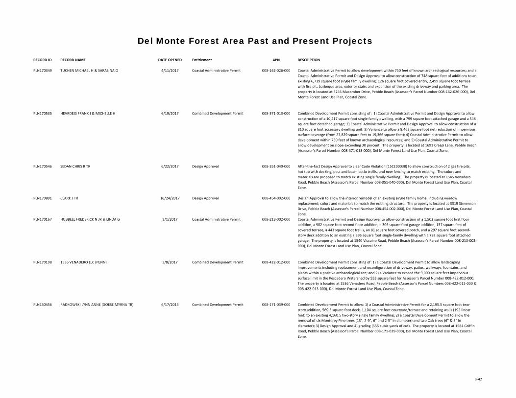
RECORD ID RECORD NAME DATE OPENED Entitlement APN DESCRIPTION
Del Monte Forest Area Past and Present Projects
PLN170349 TUCHEN MICHAEL H & SARASINA O 4/11/2017 Coastal Administrative Permit 008-162-026-000 Coastal Administrative Permit to allow development within 750 feet of known archaeological resources; and a Coastal Administrative Permit and Design Approval to allow construction of 748 square feet of additions to an existing 6,719 square foot single family dwelling, 126 square foot covered entry, 2,499 square foot terrace with fire pit, barbeque area, exterior stairs and expansion of the existing driveway and parking area. The property is located at 3255 Macomber Drive, Pebble Beach (Assessor's Parcel Number 008-162-026-000), Del Monte Forest Land Use Plan, Coastal Zone.
PLN170535 HEVRDEJS FRANK J & MICHELLE H 6/19/2017 Combined Development Permit 008-371-013-000 Combined Development Permit consisting of: 1) Coastal Administrative Permit and Design Approval to allow construction of a 10,417 square foot single family dwelling, with a 799 square foot attached garage and a 548 square foot detached garage; 2) Coastal Administrative Permit and Design Approval to allow construction of a 810 square foot accessory dwelling unit; 3) Variance to allow a 8,463 square foot net reduction of impervious surface coverage (from 27,829 square feet to 19,366 square feet); 4) Coastal Administrative Permit to allow development within 750 feet of known archaeological resources; and 5) Coastal Administrative Permit to allow development on slope exceeding 30 percent. The property is located at 1691 Crespi Lane, Pebble Beach (Assessor's Parcel Number 008-371-013-000), Del Monte Forest Land Use Plan, Coastal Zone.
PLN170546 SEDAN CHRIS R TR 6/22/2017 Design Approval 008-351-040-000 After-the-fact Design Approval to clear Code Violation (15CE00038) to allow construction of 2 gas fire pits, hot tub with decking, post and beam patio trellis, and new fencing to match existing. The colors and materials are proposed to match existing single family dwelling. The property is located at 1545 Venadero Road, Pebble Beach (Assessor's Parcel Number 008-351-040-000), Del Monte Forest Land Use Plan, Coastal Zone.
PLN170891 CLARK J TR 10/24/2017 Design Approval 008-454-002-000 Design Approval to allow the interior remodel of an existing single family home, including window replacement; colors and materials to match the existing structure. The property is located at 3319 Stevenson Drive, Pebble Beach (Assessor's Parcel Number 008-454-002-000), Del Monte Forest Land Use Plan, Coastal Zone.
PLN170167 HUBBELL FREDERICK N JR & LINDA G 3/1/2017 Coastal Administrative Permit 008-213-002-000 Coastal Administrative Permit and Design Approval to allow construction of a 1,502 square foot first floor addition, a 902 square foot second floor addition, a 306 square foot garage addition, 137 square feet of covered terrace, a 443 square foot trellis, an 81 square foot covered porch, and a 297 square foot second-story deck addition to an existing 2,395 square foot single-family dwelling with a 782 square foot attached garage. The property is located at 1540 Viscaino Road, Pebble Beach (Assessor's Parcel Number 008-213-002-000), Del Monte Forest Land Use Plan, Coastal Zone.
PLN170198 1536 VENADERO LLC (PENN) 3/8/2017 Combined Development Permit 008-422-012-000 Combined Development Permit consisting of: 1) a Coastal Development Permit to allow landscaping improvements including replacement and reconfiguration of driveway, patios, walkways, fountains, and plants within a positive archaeological site; and 2) a Variance to exceed the 9,000 square feet impervious surface limit in the Pescadero Watershed by 553 square feet for Assessor's Parcel Number 008-422-012-000. The property is located at 1536 Venadero Road, Pebble Beach (Assessor's Parcel Numbers 008-422-012-000 & 008-422-013-000), Del Monte Forest Land Use Plan, Coastal Zone.
PLN130456 RADKOWSKI LYNN ANNE (GOESE MYRNA TR) 6/17/2013 Combined Development Permit 008-171-039-000 Combined Development Permit to allow: 1) a Coastal Administrative Permit for a 2,195.5 square foot two-story addition, 569.5 square foot deck, 1,104 square foot courtyard/terrace and retaining walls (192 linear feet) to an existing 4,160.5 two-story single family dwelling; 2) a Coastal Development Permit to allow the removal of six Monterey Pine trees (13", 2-9", 6" and 2-5" in diameter) and two Oak trees (6" & 5" in diameter); 3) Design Approval and 4) grading (555 cubic yards of cut). The property is located at 1584 Griffin Road, Pebble Beach (Assessor's Parcel Number 008-171-039-000), Del Monte Forest Land Use Plan, Coastal Zone.
B-42

RECORD ID RECORD NAME DATE OPENED Entitlement APN DESCRIPTION
Del Monte Forest Area Past and Present Projects
PLN170753 GIESEN RICHARD A JR TR 9/6/2017 Coastal Administrative Permit 008-202-006-000 Coastal Administrative Permit and Design Approval for the demolition, remodel and additions to a single family dwelling consisting of: demolition of a 477 square foot attached carport, an 874 square foot deck, a 542 square foot covered entry, 588 square feet of patio and exterior stairs; 1,130 square foot first floor addition, a 890 square foot second floor addition, a 593 square foot basement addition, a 133 square foot covered entry, a new 867 square foot garage with a 560 square foot second story office and balcony, a 400 square foot covered loggia, covered terrace, two new fire pits, water feature, wood fence with stucco columns and gate at the driveway, retaining wall, enclosed utility area; and interior remodel. The project also includes 5,047 square feet of asphalt driveway to be replaced with permeable pavers. The property is located at 3175 Palmero Way, Pebble Beach (Assessor's Parcel Number 008-202-006-000), Del Monte Forest Land Use Plan, Coastal Zone.
PLN170076 HIRSCHFIELD SCOTT E & MOLLY 1/26/2017 Combined Development Permit 008-234-011-000 Combined Development Permit consisting of: 1) a Coastal Administrative Permit and Design Approval for partial demolition and rebuilding of an existing 3,126 square foot single family dwelling, including the demolition of 339 square feet, and the addition of 3,291 square feet, for a finished total of 6,078 square feet; and 2) a Coastal Development Permit for the removal of two Monterey Pine trees. The property is located at 1268 Cantera Court, Pebble Beach (Assessor's Parcel Number 008-234-011-000), Del Monte Forest Land Use Plan, Coastal Zone.
PLN100072 ANDERSON JAMES R & FARMER GAIL LEE TR 2/11/2010 Combined Development Permit 008-121-005-000 Combined Development Permit consisting of: 1) a Coastal Administrative Permit and Design Approval to allow the construction of a single story 2,653 square foot single family dwelling with an attached 640 square foot garage and grading (less than 100 cubic yards of cut and less than 100 cubic yards of fill); and 2) a Coastal Development Permit to allow the removal of 18 Monterey Pine trees consisting of: one 7-inch, two 8-inch, one 9-inch, one 10-inch, four 12-inch, four 18-inch, one 24-inch landmark, two 30-inch landmark, and two 36-inch landmark. Materials and colors to consist of light green stucco, white trim, color-blended slate roofing, color-blended stone veneer, and copper gutters and downspouts. The property is located at 4088 Sunset Lane, Pebble Beach (Assessors' Parcel Number 008-121-005-000), Del Monte Forest Land Use Plan, Coastal Zone.
PLN160608 BAILEY CAROLINE COLEMAN TR 9/16/2016 Combined Development Permit 008-461-010-000 Combined Development Permit consisting of: 1) Coastal Administrative Permit and Design Approval for 2,717 square feet of single story additions with an attached three-car garage; and 2) Coastal Development Permit to allow development within 100 feet of Environmentally Sensitive Habitat Area (Monterey Cypress habitat). The property is located at 3257 17 Mile Drive, Pebble Beach (Assessor's Parcel Number 008-461-010-000), Del Monte Forest Land Use Plan, Coastal Zone.
PLN150150 LUNDQUIST RICHARD C & MELANIE F TRS 2/19/2015 Permit Amendment 008-472-006-000 Amendment to a previously approved Combined Development Permit (PLN110114) consisting of: 1) a Coastal Administrative Permit and Design Approval to allow the construction of a detached 1,070 square foot four-car garage, driveway, replacement of an existing wood fence with a new stone wall and a new driveway entrance, restoration of existing paths and driveway to native Monterey Cypress habitat, and associated grading; 2) a Coastal Development Permit for the removal of one dead 7" Monterey Cypress tree; 3) a Coastal Development Permit for development within 100 feet of environmentally sensitive habitat; 4) a Coastal Development Permit for development within 750 feet of a known archaeological resource; and 5) a Coastal Development Permit for development on slopes exceeding than 30 percent. This Amendment would revise the Coastal Administrative Permit and Design Approval to allow the demolition of the 2,083 square foot single family dwelling with 740 square feet of deck area and a 249 square foot attached carport, and construction of a 8,886 square foot single family dwelling with 1,296 square feet of balcony area and a 1,106 square foot detached garage. The property is located at 3224 17 Mile Drive, Pebble Beach (Assessor's Parcel Number 008-472-006-000), Del Monte Forest Area Land Use Plan, Coastal Zone. Related to PLN110114.
B-43

RECORD ID RECORD NAME DATE OPENED Entitlement APN DESCRIPTION
Del Monte Forest Area Past and Present Projects
PLN130227 SCAFANI ROBERT & ROSEMARIE 3/27/2013 Combined Development Permit 008-234-037-000 Combined Development Permit consisting of: 1) Coastal Administrative Permit to allow construction of a 4,295 square foot single family dwelling, 1,482 square foot attached 3-car garage, shop/storage area and Design Approval; 2) Coastal Development Permit to allow development within 750 feet of a known archaeological resource; and 3) Waiver of Coastal Development Permit to allow the removal of 3 diseased/dead Monterey Pine trees. The property is located at 3183 Forest Lake Road, Pebble Beach (Assessor's Parcel Number: 008-234-037-000), Del Monte Forest Land Use Plan, Coastal Zone.
PLN170718 AT&T SERVICES INC 8/24/2017 Combined Development Permit 008-401-001-000 Combined Development Permit consisting of a: 1) Coastal Administrative Permit and Design Approval to allow an after-the-fact 725 square foot Accessory Dwelling Unit; 2) Coastal Development Permit to allow after-the-fact development within 750 feet of a known archaeological resource; and 3) Variance for exceeding 15-foot maximum height by 2 feet. The property is located at 1557 Cypress Road, Pebble Beach (Assessor's Parcel Number 008-401-001-000), Del Monte Forest Land Use Plan, Coastal Zone.
PLN170237 RHODES DANIEL J CO-TR ET AL 3/20/2017 Combined Development Permit 008-072-013-000 Combined Development Permit consisting of: 1) a Coastal Administrative Permit and Design Approval to allow the remodel of a one-story 1,433 square foot single family residence, a 1,082 square foot addition on the main level, a 264 square foot addition on the upper level, and a 989 square foot attached garage on the basement level, for a total of 3,768 square feet; and 2) a Coastal Development Permit for the removal of 4 Monterey Pine trees. The property is located at 4175 Sunset Lane, Pebble Beach (Assessor's Parcel Number 008-072-013-000), Del Monte Forest Land Use Plan, Coastal Zone.
PLN170570 TIRADO DON LOUIS & COLLINS JULIE DAWN 7/6/2017 Coastal Administrative Permit 008-031-027-000 Coastal Administrative Permit and Design Approval to allow the construction of a 4,210 square foot single family dwelling with a 875 square foot garage and the removal of 26 Monterey Pine trees (tree removal was analyzed under the previous EIR for the Del Monte Forest LCP Amendment). The property is located at 1443 Viscaino Road, Pebble Beach (Assessor's Parcel Number 008-031-027-000), Del Monte Forest Land Use Plan, Coastal Zone.
PLN170571 2020 INVESTMENT GROUP (TIRADO) 7/6/2017 Coastal Administrative Permit 008-031-026-000 Coastal Administrative Permit and Design Approval to allow the construction of a 5,228 square foot single family dwelling with a 946 square foot garage, and the removal of 24 Monterey Pine trees (tree removal was analyzed under the previous EIR for the Del Monte Forest LCP Amendment). The property is located at 1437 Viscano Road, Pebble Beach (Assessor's Parcel Number 008-031-026-000), Del Monte Forest Land Use Plan, Coastal Zone.
PLN170845 BALL DAVID M & SARAH E 10/6/2017 Coastal Administrative Permit 008-533-007-000 Coastal Administrative Permit and Design Approval to allow an 868 square foot addition to an existing 4,576 square foot single family dwelling. The property is located at 1230 Silver Court, Pebble Beach (Assessor's Parcel Number 008-533-007-000), Del Monte Forest Land Use Plan, Coastal Zone.
PLN170667 KILIC KEMAL SUHA 8/3/2017 Coastal Administrative Permit 008-061-007-000 Coastal Administrative Permit and Design Approval to allow construction of 709 square foot addition to an existing 1294 square foot single-family dwelling and addition of a 506 square foot attached garage. The property is located at 4119 Crest Road, Pebble Beach (Assessor's Parcel Number 008-061-007-000), Del Monte Forest Land Use Plan, Coastal Zone.
PLN170803 BARRETT FAMILY HOLDINGS LLC 9/21/2017 Coastal Development Permit 008-271-004-000 Combined Development Permit consisting of: 1) Coastal Development Permit and Design Approval to allow the construction of a 550 square foot laundry room (expanding existing utility room) within 750 feet of a known archaeological resource; and 2) Coastal Development Permit for development within 100 feet of environmentally sensitive habitat. The property is located at 3154 17 Mile Drive, Pebble Beach (Assessor's Parcel Number 008-271-004-000), Del Monte Forest Land Use Plan, Coastal Zone.
PLN150755 RAVEN SCOTT & RAVEN CHARLYSE 10/23/2015 Combined Development Permit 008-401-010-000 Combined Development Permit consisting of a 1) Coastal Administrative Permit and Design Approval to allow the construction of a 3,996 square foot single family dwelling; 2) Coastal Development Permit to allow development within 750 feet of an archaeological resource; 3) Variance to exceed lot coverage by 3.9% (totaling 18.9%) and FAR by 5.3% (totaling 22.8%). The property is located at 3213 Whitman Lane, Pebble Beach (Assessor's Parcel Number 008-401-010-000), Del Monte Forest Land Use Plan, Coastal Zone.
B-44

RECORD ID RECORD NAME DATE OPENED Entitlement APN DESCRIPTION
Del Monte Forest Area Past and Present Projects
PLN150615 DEL MONTE FOUNDATION INC (DEL MONTE FOREST CONSERVANCY)
8/20/2015 Coastal Administrative Permit 008-161-009-000 Coastal Administrative Permit and Design Approval to allow the construction of a series of check dams for restoration and drainage control on a man-made erosional gully. The property is located adjacent to 17 Mile Drive, between Del Ciervo Road and Carmel Way, Pebble Beach (Assessor's Parcel Number 008-161-009-000), Del Monte Forest Land Use Plan, Coastal Zone.
PLN170538 PEBBLE BEACH COMPANY 6/20/2017 Combined Development Permit 008-431-010-000 Combined Development Permit consisting of: 1) a Coastal Development Permit and Design Approval to allow the construction of 18-space surface parking lot, 150 linear feet of retaining wall and 94 linear feet of 3 foot high wooden fence; and 2) a Coastal Development Permit for removal of 10 trees (7 Coast Live Oak, 2 Monterey Pine & 1 Monterey Cypress). Grading of 695 cubic yards and fill of 8 cubic yards. The property is located at 1491 Cypress Drive, Pebble Beach (Assessor's Parcel Number 008-431-010-000), Del Monte Forest Land Use Plan, Coastal Zone.
PLN170213 BALISTIDAE CAPITAL LLC 3/10/2017 Coastal Administrative Permit 008-032-019-000 Coastal Administrative Permit and Design Approval to allow the construction of a 5,064 square foot two-story single family dwelling with an attached 1,013 square foot three-car garage and associated grading. The property is located at 29 Poppy Lane, Pebble Beach (Assessor's Parcel Number 008-032-019-000), Del Monte Forest Land Use Plan, Coastal Zone.
PLN180118 WOO WARREN C & SUDA CAROLYN M TRS 2/16/2018 Design Approval 008-261-004-000 Design Approval to allow construction of an 198 square foot addition and a 145 square foot balcony. Colors and materials to include natural wood siding (cedar) and stone veneer, bronze aluminum window frames, and glass railing. The property is located at 1152 Signal Hill Road, Pebble Beach (Assessor's Parcel Number 008-261-004-000), Del Monte Forest Land Use Plan, Coastal Zone.
PLN170574 WIGGANS THOMAS & WIGGANS KATHRYN TRS 7/7/2017 Coastal Administrative Permit 008-453-003-000 Coastal Administrative Permit and Design Approval to allow the construction of a 5,593 square foot two-story single-family dwelling, swimming pool, xx linear feet of wood fencing, and associated grading; and a Coastal Administrative Permit to allow development within 750 feet of known archaeological resources. The property is located at 3330 Stevenson Drive, Pebble Beach (Assessor's Parcel Number 008-453-003-000), Del Monte Forest Land Use Plan, Coastal Zone. Related to PLN160368.
PLN140353 MAESTRI LUCA & KATRINA TRS 5/15/2014 Combined Development Permit 008-491-024-000 Combined Development Permit consisting of: 1) Coastal Administrative Permit and Design Approval for the construction of a 10,776 square foot tri-level single family residence with a 802 square foot attached garage, 2) Coastal Administrative Permit and Design Approval to allow the construction of a 999 square foot attached Accessory Dwelling Unit, 3) Coastal Development Permit to allow the removal of two Monterey pine trees (one 8-inch and one 12-inch) and a clump of declining Monterey cypress trees (a 21-inch and 24-inch multi-trunk and a 17-inch, 17-inch, 24-inch, and 24-inch multi-trunk); 4) Coastal Development Permit to allow development within 100 feet of environmentally sensitive habitat, and 5) Coastal Development Permit to allow development within 750 feet of a positive archaeological site. The property is located at 3180 17 Mile Drive, Pebble Beach (Assessor's Parcel Number 008-491-024-000), Del Monte Forest Land Use Plan, Coastal Zone.
PLN160289 HANSEN JULIE K 4/20/2016 Mills Act Contract 008-371-002-000 Mills Act Historic Property Contract request for the Hansen/Alma Urmston House . The property is located at 3191 Del Ciervo Road, Pebble Beach (Assessor's Parcel Number 008-371-002-000), Del Monte Forest Land Use Plan, Coastal Zone.
PLN150239 1659 CRESPI LANE LLC 3/23/2015 Coastal Administrative Permit 008-371-017-000 Coastal Administrative Permit to allow the demolition of a 2,894 square foot residence and the construction of a new 4,355 square foot two-story residence with an attached 924 square foot three-car garage, 228 square foot entry porch, 168 square foot loggia, 728 square feet of terraces, and associated site improvements including a 2,148 cubic yards of grading (1,059 cut/1,089 fill); Tree Removal permit to allow the removal of one 27 inch Monterey Pine tree; and Design Approval. The property is located at 1659 Crespi Lane, Pebble Beach (Assessor's Parcel Number 008-371-017-000), Del Monte Forest Land Use Plan, Coastal Zone.
B-45


APPENDIX C
Biological Resources Background Information


6/21/2018 IPaC: Explore Location
https://ecos.fws.gov/ipac/location/DJMXCEE7HJCPLIT645GTRHKWNI/resources 1/18
IPaC resource listThis report is an automatically generated list of species and other resources such as critical habitat(collectively referred to as trust resources) under the U.S. Fish and Wildlife Service's (USFWS)jurisdiction that are known or expected to be on or near the project area referenced below. The listmay also include trust resources that occur outside of the project area, but that could potentially bedirectly or indirectly a�ected by activities in the project area. However, determining the likelihoodand extent of e�ects a project may have on trust resources typically requires gathering additionalsite-speci�c (e.g., vegetation/species surveys) and project-speci�c (e.g., magnitude and timing ofproposed activities) information.
Below is a summary of the project information you provided and contact information for the USFWSo�ce(s) with jurisdiction in the de�ned project area. Please read the introduction to each sectionthat follows (Endangered Species, Migratory Birds, USFWS Facilities, and NWI Wetlands) foradditional information applicable to the trust resources addressed in that section.
LocationMonterey County, California
Local o�ceVentura Fish And Wildlife O�ce
(805) 644-1766 (805) 644-3958
2493 Portola Road, Suite BVentura, CA 93003-7726
U.S. Fish & Wildlife ServiceIPaC

6/21/2018 IPaC: Explore Location
https://ecos.fws.gov/ipac/location/DJMXCEE7HJCPLIT645GTRHKWNI/resources 2/18
Endangered speciesThis resource list is for informational purposes only and does not constitute an analysis ofproject level impacts.
The primary information used to generate this list is the known or expected range of each species.Additional areas of in�uence (AOI) for species are also considered. An AOI includes areas outside ofthe species range if the species could be indirectly a�ected by activities in that area (e.g., placing adam upstream of a �sh population, even if that �sh does not occur at the dam site, may indirectlyimpact the species by reducing or eliminating water �ow downstream). Because species can move,and site conditions can change, the species on this list are not guaranteed to be found on or nearthe project area. To fully determine any potential e�ects to species, additional site-speci�c andproject-speci�c information is often required.
Section 7 of the Endangered Species Act requires Federal agencies to "request of the Secretaryinformation whether any species which is listed or proposed to be listed may be present in the areaof such proposed action" for any project that is conducted, permitted, funded, or licensed by anyFederal agency. A letter from the local o�ce and a species list which ful�lls this requirement canonly be obtained by requesting an o�cial species list from either the Regulatory Review section inIPaC (see directions below) or from the local �eld o�ce directly.
For project evaluations that require USFWS concurrence/review, please return to the IPaC websiteand request an o�cial species list by doing the following:
1. Draw the project location and click CONTINUE.2. Click DEFINE PROJECT.3. Log in (if directed to do so).4. Provide a name and description for your project.5. Click REQUEST SPECIES LIST.
Listed species and their critical habitats are managed by the Ecological Services Program of the U.S.Fish and Wildlife Service (USFWS) and the �sheries division of the National Oceanic and AtmosphericAdministration (NOAA Fisheries ).
Species and critical habitats under the sole responsibility of NOAA Fisheries are not shown on thislist. Please contact NOAA Fisheries for species under their jurisdiction.
1. Species listed under the Endangered Species Act are threatened or endangered; IPaC also showsspecies that are candidates, or proposed, for listing. See the listing status page for moreinformation.
2. NOAA Fisheries, also known as the National Marine Fisheries Service (NMFS), is an o�ce of theNational Oceanic and Atmospheric Administration within the Department of Commerce.
The following species are potentially a�ected by activities in this location:
Mammals
1
2
NAME STATUS

6/21/2018 IPaC: Explore Location
https://ecos.fws.gov/ipac/location/DJMXCEE7HJCPLIT645GTRHKWNI/resources 3/18
Birds
Amphibians
Southern Sea Otter Enhydra lutris nereisNo critical habitat has been designated for this species.https://ecos.fws.gov/ecp/species/8560
ThreatenedMarine mammal
NAME STATUS
California Condor Gymnogyps californianusThere is �nal critical habitat for this species. Your location is outsidethe critical habitat.https://ecos.fws.gov/ecp/species/8193
Endangered
California Least Tern Sterna antillarum browniNo critical habitat has been designated for this species.https://ecos.fws.gov/ecp/species/8104
Endangered
Least Bell's Vireo Vireo bellii pusillusThere is �nal critical habitat for this species. Your location is outsidethe critical habitat.https://ecos.fws.gov/ecp/species/5945
Endangered
Marbled Murrelet Brachyramphus marmoratusThere is �nal critical habitat for this species. Your location is outsidethe critical habitat.https://ecos.fws.gov/ecp/species/4467
Threatened
Southwestern Willow Flycatcher Empidonax traillii extimusThere is �nal critical habitat for this species. Your location is outsidethe critical habitat.https://ecos.fws.gov/ecp/species/6749
Endangered
Western Snowy Plover Charadrius alexandrinus nivosusThere is �nal critical habitat for this species. Your location is outsidethe critical habitat.https://ecos.fws.gov/ecp/species/8035
Threatened
NAME STATUS
California Red-legged Frog Rana draytoniiThere is �nal critical habitat for this species. Your location is outsidethe critical habitat.https://ecos.fws.gov/ecp/species/2891
Threatened

6/21/2018 IPaC: Explore Location
https://ecos.fws.gov/ipac/location/DJMXCEE7HJCPLIT645GTRHKWNI/resources 4/18
Fishes
Insects
Crustaceans
Flowering Plants
California Tiger Salamander Ambystoma californienseThere is �nal critical habitat for this species. Your location is outsidethe critical habitat.https://ecos.fws.gov/ecp/species/2076
Threatened
NAME STATUS
Tidewater Goby Eucyclogobius newberryiThere is �nal critical habitat for this species. Your location is outsidethe critical habitat.https://ecos.fws.gov/ecp/species/57
Endangered
NAME STATUS
Smith's Blue Butter�y Euphilotes enoptes smithiThere is proposed critical habitat for this species. The location of thecritical habitat is not available.https://ecos.fws.gov/ecp/species/4418
Endangered
NAME STATUS
Vernal Pool Fairy Shrimp Branchinecta lynchiThere is �nal critical habitat for this species. Your location is outsidethe critical habitat.https://ecos.fws.gov/ecp/species/498
Threatened
NAME STATUS
Beach Layia Layia carnosaNo critical habitat has been designated for this species.https://ecos.fws.gov/ecp/species/6728
Endangered
Clover Lupine Lupinus tidestromiiNo critical habitat has been designated for this species.https://ecos.fws.gov/ecp/species/4459
Endangered
Coastal Dunes Milk-vetch Astragalus tener var. titiNo critical habitat has been designated for this species.https://ecos.fws.gov/ecp/species/7675
Endangered

6/21/2018 IPaC: Explore Location
https://ecos.fws.gov/ipac/location/DJMXCEE7HJCPLIT645GTRHKWNI/resources 5/18
Conifers and Cycads
Critical habitatsPotential e�ects to critical habitat(s) in this location must be analyzed along with the endangeredspecies themselves.
THERE ARE NO CRITICAL HABITATS AT THIS LOCATION.
Hickman's Potentilla Potentilla hickmaniiNo critical habitat has been designated for this species.https://ecos.fws.gov/ecp/species/6343
Endangered
Marsh Sandwort Arenaria paludicolaNo critical habitat has been designated for this species.https://ecos.fws.gov/ecp/species/2229
Endangered
Menzies' Wall�ower Erysimum menziesiiNo critical habitat has been designated for this species.https://ecos.fws.gov/ecp/species/2935
Endangered
Monterey Clover Trifolium trichocalyxNo critical habitat has been designated for this species.https://ecos.fws.gov/ecp/species/4282
Endangered
Monterey Gilia Gilia tenui�ora ssp. arenariaNo critical habitat has been designated for this species.https://ecos.fws.gov/ecp/species/856
Endangered
Monterey Spine�ower Chorizanthe pungens var. pungensThere is �nal critical habitat for this species. Your location is outsidethe critical habitat.https://ecos.fws.gov/ecp/species/396
Threatened
Yadon's Piperia Piperia yadoniiThere is �nal critical habitat for this species. Your location is outsidethe critical habitat.https://ecos.fws.gov/ecp/species/4205
Endangered
NAME STATUS
Gowen Cypress Cupressus goveniana ssp. govenianaNo critical habitat has been designated for this species.https://ecos.fws.gov/ecp/species/8548
Threatened

6/21/2018 IPaC: Explore Location
https://ecos.fws.gov/ipac/location/DJMXCEE7HJCPLIT645GTRHKWNI/resources 6/18
Migratory birds
The birds listed below are birds of particular concern either because they occur on the USFWS Birdsof Conservation Concern (BCC) list or warrant special attention in your project location. To learnmore about the levels of concern for birds on your list and how this list is generated, see the FAQbelow. This is not a list of every bird you may �nd in this location, nor a guarantee that every bird onthis list will be found in your project area. To see exact locations of where birders and the generalpublic have sighted birds in and around your project area, visit the E-bird data mapping tool (Tip:enter your location, desired date range and a species on your list). For projects that occur o� theAtlantic Coast, additional maps and models detailing the relative occurrence and abundance of birdspecies on your list are available. Links to additional information about Atlantic Coast birds, andother important information about your migratory bird list, including how to properly interpret anduse your migratory bird report, can be found below.
For guidance on when to schedule activities or implement avoidance and minimization measures toreduce impacts to migratory birds on your list, click on the PROBABILITY OF PRESENCE SUMMARY atthe top of your list to see when these birds are most likely to be present and breeding in yourproject area.
Certain birds are protected under the Migratory Bird Treaty Act and the Bald and Golden EagleProtection Act .
Any person or organization who plans or conducts activities that may result in impacts to migratorybirds, eagles, and their habitats should follow appropriate regulations and consider implementingappropriate conservation measures, as described below.
1. The Migratory Birds Treaty Act of 1918.2. The Bald and Golden Eagle Protection Act of 1940.
Additional information can be found using the following links:
Birds of Conservation Concern http://www.fws.gov/birds/management/managed-species/ birds-of-conservation-concern.phpMeasures for avoiding and minimizing impacts to birdshttp://www.fws.gov/birds/management/project-assessment-tools-and-guidance/ conservation-measures.phpNationwide conservation measures for birdshttp://www.fws.gov/migratorybirds/pdf/management/nationwidestandardconservationmeasures.pdf
1
2
NAME BREEDING SEASON (IF ABREEDING SEASON IS INDICATEDFOR A BIRD ON YOUR LIST, THEBIRD MAY BREED IN YOURPROJECT AREA SOMETIME WITHINTHE TIMEFRAME SPECIFIED,WHICH IS A VERY LIBERALESTIMATE OF THE DATES INSIDEWHICH THE BIRD BREEDSACROSS ITS ENTIRE RANGE.

6/21/2018 IPaC: Explore Location
https://ecos.fws.gov/ipac/location/DJMXCEE7HJCPLIT645GTRHKWNI/resources 7/18
"BREEDS ELSEWHERE" INDICATESTHAT THE BIRD DOES NOT LIKELYBREED IN YOUR PROJECT AREA.)
Allen's Hummingbird Selasphorus sasinThis is a Bird of Conservation Concern (BCC) throughout its range inthe continental USA and Alaska.https://ecos.fws.gov/ecp/species/9637
Breeds Feb 1 to Jul 15
Ashy Storm-petrel Oceanodroma homochroaThis is a Bird of Conservation Concern (BCC) throughout its range inthe continental USA and Alaska.https://ecos.fws.gov/ecp/species/7237
Breeds May 1 to Jan 15
Bald Eagle Haliaeetus leucocephalusThis is not a Bird of Conservation Concern (BCC) in this area, butwarrants attention because of the Eagle Act or for potentialsusceptibilities in o�shore areas from certain types of developmentor activities.https://ecos.fws.gov/ecp/species/1626
Breeds Jan 1 to Aug 31
Black Oystercatcher Haematopus bachmaniThis is a Bird of Conservation Concern (BCC) throughout its range inthe continental USA and Alaska.https://ecos.fws.gov/ecp/species/9591
Breeds Apr 15 to Oct 31
Black Skimmer Rynchops nigerThis is a Bird of Conservation Concern (BCC) throughout its range inthe continental USA and Alaska.https://ecos.fws.gov/ecp/species/5234
Breeds May 20 to Sep 15
Black Swift Cypseloides nigerThis is a Bird of Conservation Concern (BCC) throughout its range inthe continental USA and Alaska.https://ecos.fws.gov/ecp/species/8878
Breeds Jun 15 to Sep 10
Black Turnstone Arenaria melanocephalaThis is a Bird of Conservation Concern (BCC) throughout its range inthe continental USA and Alaska.
Breeds elsewhere
Burrowing Owl Athene cuniculariaThis is a Bird of Conservation Concern (BCC) only in particular BirdConservation Regions (BCRs) in the continental USAhttps://ecos.fws.gov/ecp/species/9737
Breeds Mar 15 to Aug 31
California Thrasher Toxostoma redivivumThis is a Bird of Conservation Concern (BCC) throughout its range inthe continental USA and Alaska.
Breeds Jan 1 to Jul 31

6/21/2018 IPaC: Explore Location
https://ecos.fws.gov/ipac/location/DJMXCEE7HJCPLIT645GTRHKWNI/resources 8/18
Clark's Grebe Aechmophorus clarkiiThis is a Bird of Conservation Concern (BCC) throughout its range inthe continental USA and Alaska.
Breeds Jan 1 to Dec 31
Common Yellowthroat Geothlypis trichas sinuosaThis is a Bird of Conservation Concern (BCC) only in particular BirdConservation Regions (BCRs) in the continental USAhttps://ecos.fws.gov/ecp/species/2084
Breeds May 20 to Jul 31
Golden Eagle Aquila chrysaetosThis is not a Bird of Conservation Concern (BCC) in this area, butwarrants attention because of the Eagle Act or for potentialsusceptibilities in o�shore areas from certain types of developmentor activities.https://ecos.fws.gov/ecp/species/1680
Breeds Jan 1 to Aug 31
Lawrence's Gold�nch Carduelis lawrenceiThis is a Bird of Conservation Concern (BCC) throughout its range inthe continental USA and Alaska.https://ecos.fws.gov/ecp/species/9464
Breeds Mar 20 to Sep 20
Lewis's Woodpecker Melanerpes lewisThis is a Bird of Conservation Concern (BCC) throughout its range inthe continental USA and Alaska.https://ecos.fws.gov/ecp/species/9408
Breeds Apr 20 to Sep 30
Long-billed Curlew Numenius americanusThis is a Bird of Conservation Concern (BCC) throughout its range inthe continental USA and Alaska.https://ecos.fws.gov/ecp/species/5511
Breeds elsewhere
Marbled Godwit Limosa fedoaThis is a Bird of Conservation Concern (BCC) throughout its range inthe continental USA and Alaska.https://ecos.fws.gov/ecp/species/9481
Breeds elsewhere
Nuttall's Woodpecker Picoides nuttalliiThis is a Bird of Conservation Concern (BCC) only in particular BirdConservation Regions (BCRs) in the continental USAhttps://ecos.fws.gov/ecp/species/9410
Breeds Apr 1 to Jul 20
Oak Titmouse Baeolophus inornatusThis is a Bird of Conservation Concern (BCC) throughout its range inthe continental USA and Alaska.https://ecos.fws.gov/ecp/species/9656
Breeds Mar 15 to Jul 15

6/21/2018 IPaC: Explore Location
https://ecos.fws.gov/ipac/location/DJMXCEE7HJCPLIT645GTRHKWNI/resources 9/18
Probability of Presence SummaryThe graphs below provide our best understanding of when birds of concern are most likely to bepresent in your project area. This information can be used to tailor and schedule your projectactivities to avoid or minimize impacts to birds. Please make sure you read and understand the FAQ“Proper Interpretation and Use of Your Migratory Bird Report” before using or attempting tointerpret this report.
Probability of Presence ( )
Rufous Hummingbird selasphorus rufusThis is a Bird of Conservation Concern (BCC) throughout its range inthe continental USA and Alaska.https://ecos.fws.gov/ecp/species/8002
Breeds elsewhere
Short-billed Dowitcher Limnodromus griseusThis is a Bird of Conservation Concern (BCC) throughout its range inthe continental USA and Alaska.https://ecos.fws.gov/ecp/species/9480
Breeds elsewhere
Song Sparrow Melospiza melodiaThis is a Bird of Conservation Concern (BCC) only in particular BirdConservation Regions (BCRs) in the continental USA
Breeds Feb 20 to Sep 5
Spotted Towhee Pipilo maculatus clementaeThis is a Bird of Conservation Concern (BCC) only in particular BirdConservation Regions (BCRs) in the continental USAhttps://ecos.fws.gov/ecp/species/4243
Breeds Apr 15 to Jul 20
Tricolored Blackbird Agelaius tricolorThis is a Bird of Conservation Concern (BCC) throughout its range inthe continental USA and Alaska.https://ecos.fws.gov/ecp/species/3910
Breeds Mar 15 to Aug 10
Whimbrel Numenius phaeopusThis is a Bird of Conservation Concern (BCC) throughout its range inthe continental USA and Alaska.https://ecos.fws.gov/ecp/species/9483
Breeds elsewhere
Willet Tringa semipalmataThis is a Bird of Conservation Concern (BCC) throughout its range inthe continental USA and Alaska.
Breeds elsewhere
Wrentit Chamaea fasciataThis is a Bird of Conservation Concern (BCC) throughout its range inthe continental USA and Alaska.
Breeds Mar 15 to Aug 10

6/21/2018 IPaC: Explore Location
https://ecos.fws.gov/ipac/location/DJMXCEE7HJCPLIT645GTRHKWNI/resources 10/18
no data survey e�ort breeding season probability of presence
Each green bar represents the bird's relative probability of presence in the 10km grid cell(s) yourproject overlaps during a particular week of the year. (A year is represented as 12 4-week months.)A taller bar indicates a higher probability of species presence. The survey e�ort (see below) can beused to establish a level of con�dence in the presence score. One can have higher con�dence in thepresence score if the corresponding survey e�ort is also high.
How is the probability of presence score calculated? The calculation is done in three steps:
1. The probability of presence for each week is calculated as the number of survey events in theweek where the species was detected divided by the total number of survey events for thatweek. For example, if in week 12 there were 20 survey events and the Spotted Towhee wasfound in 5 of them, the probability of presence of the Spotted Towhee in week 12 is 0.25.
2. To properly present the pattern of presence across the year, the relative probability of presenceis calculated. This is the probability of presence divided by the maximum probability of presenceacross all weeks. For example, imagine the probability of presence in week 20 for the SpottedTowhee is 0.05, and that the probability of presence at week 12 (0.25) is the maximum of anyweek of the year. The relative probability of presence on week 12 is 0.25/0.25 = 1; at week 20 it is0.05/0.25 = 0.2.
3. The relative probability of presence calculated in the previous step undergoes a statisticalconversion so that all possible values fall between 0 and 10, inclusive. This is the probability ofpresence score.
To see a bar's probability of presence score, simply hover your mouse cursor over the bar.
Breeding Season ( )Yellow bars denote a very liberal estimate of the time-frame inside which the bird breeds across itsentire range. If there are no yellow bars shown for a bird, it does not breed in your project area.
Survey E�ort ( )Vertical black lines superimposed on probability of presence bars indicate the number of surveysperformed for that species in the 10km grid cell(s) your project area overlaps. The number ofsurveys is expressed as a range, for example, 33 to 64 surveys.
To see a bar's survey e�ort range, simply hover your mouse cursor over the bar.
No Data ( )A week is marked as having no data if there were no survey events for that week.
Survey TimeframeSurveys from only the last 10 years are used in order to ensure delivery of currently relevantinformation. The exception to this is areas o� the Atlantic coast, where bird returns are based on allyears of available data, since data in these areas is currently much more sparse.
SPECIES JAN FEB MAR APR MAY JUN JUL AUG SEP OCT NOV DEC
Allen'sHummingbirdBCC Rangewide(CON) (This is a Birdof ConservationConcern (BCC)throughout its rangein the continentalUSA and Alaska.)

6/21/2018 IPaC: Explore Location
https://ecos.fws.gov/ipac/location/DJMXCEE7HJCPLIT645GTRHKWNI/resources 11/18
Ashy Storm-petrelBCC Rangewide(CON) (This is a Birdof ConservationConcern (BCC)throughout its rangein the continentalUSA and Alaska.)
Bald EagleNon-BCC Vulnerable(This is not a Bird ofConservationConcern (BCC) in thisarea, but warrantsattention because ofthe Eagle Act or forpotentialsusceptibilities ino�shore areas fromcertain types ofdevelopment oractivities.)
BlackOystercatcherBCC Rangewide(CON) (This is a Birdof ConservationConcern (BCC)throughout its rangein the continentalUSA and Alaska.)
Black SkimmerBCC Rangewide(CON) (This is a Birdof ConservationConcern (BCC)throughout its rangein the continentalUSA and Alaska.)
Black SwiftBCC Rangewide(CON) (This is a Birdof ConservationConcern (BCC)throughout its rangein the continentalUSA and Alaska.)
Black TurnstoneBCC Rangewide(CON) (This is a Birdof ConservationConcern (BCC)throughout its rangein the continentalUSA and Alaska.)
Burrowing OwlBCC - BCR (This is aBird of ConservationConcern (BCC) only inparticular BirdConservation Regions(BCRs) in thecontinental USA)

6/21/2018 IPaC: Explore Location
https://ecos.fws.gov/ipac/location/DJMXCEE7HJCPLIT645GTRHKWNI/resources 12/18
California ThrasherBCC Rangewide(CON) (This is a Birdof ConservationConcern (BCC)throughout its rangein the continentalUSA and Alaska.)
Clark's GrebeBCC Rangewide(CON) (This is a Birdof ConservationConcern (BCC)throughout its rangein the continentalUSA and Alaska.)
CommonYellowthroatBCC - BCR (This is aBird of ConservationConcern (BCC) only inparticular BirdConservation Regions(BCRs) in thecontinental USA)
Golden EagleNon-BCC Vulnerable(This is not a Bird ofConservationConcern (BCC) in thisarea, but warrantsattention because ofthe Eagle Act or forpotentialsusceptibilities ino�shore areas fromcertain types ofdevelopment oractivities.)
SPECIES JAN FEB MAR APR MAY JUN JUL AUG SEP OCT NOV DEC
Lawrence'sGold�nchBCC Rangewide(CON) (This is a Birdof ConservationConcern (BCC)throughout its rangein the continentalUSA and Alaska.)
Lewis'sWoodpeckerBCC Rangewide(CON) (This is a Birdof ConservationConcern (BCC)throughout its rangein the continentalUSA and Alaska.)
Long-billed CurlewBCC Rangewide(CON) (This is a Birdof ConservationConcern (BCC)throughout its rangein the continentalUSA and Alaska.)

6/21/2018 IPaC: Explore Location
https://ecos.fws.gov/ipac/location/DJMXCEE7HJCPLIT645GTRHKWNI/resources 13/18
Marbled GodwitBCC Rangewide(CON) (This is a Birdof ConservationConcern (BCC)throughout its rangein the continentalUSA and Alaska.)
Nuttall'sWoodpeckerBCC - BCR (This is aBird of ConservationConcern (BCC) only inparticular BirdConservation Regions(BCRs) in thecontinental USA)
Oak TitmouseBCC Rangewide(CON) (This is a Birdof ConservationConcern (BCC)throughout its rangein the continentalUSA and Alaska.)
RufousHummingbirdBCC Rangewide(CON) (This is a Birdof ConservationConcern (BCC)throughout its rangein the continentalUSA and Alaska.)
Short-billedDowitcherBCC Rangewide(CON) (This is a Birdof ConservationConcern (BCC)throughout its rangein the continentalUSA and Alaska.)
Song SparrowBCC - BCR (This is aBird of ConservationConcern (BCC) only inparticular BirdConservation Regions(BCRs) in thecontinental USA)
Spotted TowheeBCC - BCR (This is aBird of ConservationConcern (BCC) only inparticular BirdConservation Regions(BCRs) in thecontinental USA)

6/21/2018 IPaC: Explore Location
https://ecos.fws.gov/ipac/location/DJMXCEE7HJCPLIT645GTRHKWNI/resources 14/18
TricoloredBlackbirdBCC Rangewide(CON) (This is a Birdof ConservationConcern (BCC)throughout its rangein the continentalUSA and Alaska.)
WhimbrelBCC Rangewide(CON) (This is a Birdof ConservationConcern (BCC)throughout its rangein the continentalUSA and Alaska.)
SPECIES JAN FEB MAR APR MAY JUN JUL AUG SEP OCT NOV DEC
WilletBCC Rangewide(CON) (This is a Birdof ConservationConcern (BCC)throughout its rangein the continentalUSA and Alaska.)
WrentitBCC Rangewide(CON) (This is a Birdof ConservationConcern (BCC)throughout its rangein the continentalUSA and Alaska.)
Tell me more about conservation measures I can implement to avoid or minimize impacts to migratory birds.
Nationwide Conservation Measures describes measures that can help avoid and minimize impacts to all birds atany location year round. Implementation of these measures is particularly important when birds are most likely tooccur in the project area. When birds may be breeding in the area, identifying the locations of any active nests andavoiding their destruction is a very helpful impact minimization measure. To see when birds are most likely tooccur and be breeding in your project area, view the Probability of Presence Summary. Additional measures and/orpermits may be advisable depending on the type of activity you are conducting and the type of infrastructure orbird species present on your project site.
What does IPaC use to generate the migratory birds potentially occurring in my speci�ed location?
The Migratory Bird Resource List is comprised of USFWS Birds of Conservation Concern (BCC) and other speciesthat may warrant special attention in your project location.
The migratory bird list generated for your project is derived from data provided by the Avian Knowledge Network(AKN). The AKN data is based on a growing collection of survey, banding, and citizen science datasets and isqueried and �ltered to return a list of those birds reported as occurring in the 10km grid cell(s) which your projectintersects, and that have been identi�ed as warranting special attention because they are a BCC species in thatarea, an eagle (Eagle Act requirements may apply), or a species that has a particular vulnerability to o�shoreactivities or development.
Again, the Migratory Bird Resource list includes only a subset of birds that may occur in your project area. It is notrepresentative of all birds that may occur in your project area. To get a list of all birds potentially present in yourproject area, please visit the E-bird Explore Data Tool.

6/21/2018 IPaC: Explore Location
https://ecos.fws.gov/ipac/location/DJMXCEE7HJCPLIT645GTRHKWNI/resources 15/18
What does IPaC use to generate the probability of presence graphs for the migratory birds potentiallyoccurring in my speci�ed location?
The probability of presence graphs associated with your migratory bird list are based on data provided by theAvian Knowledge Network (AKN). This data is derived from a growing collection of survey, banding, and citizenscience datasets .
Probability of presence data is continuously being updated as new and better information becomes available. Tolearn more about how the probability of presence graphs are produced and how to interpret them, go theProbability of Presence Summary and then click on the "Tell me about these graphs" link.
How do I know if a bird is breeding, wintering, migrating or present year-round in my project area?
To see what part of a particular bird's range your project area falls within (i.e. breeding, wintering, migrating oryear-round), you may refer to the following resources: The Cornell Lab of Ornithology All About Birds Bird Guide, or(if you are unsuccessful in locating the bird of interest there), the Cornell Lab of Ornithology Neotropical Birdsguide. If a bird on your migratory bird species list has a breeding season associated with it, if that bird does occurin your project area, there may be nests present at some point within the timeframe speci�ed. If "Breedselsewhere" is indicated, then the bird likely does not breed in your project area.
What are the levels of concern for migratory birds?
Migratory birds delivered through IPaC fall into the following distinct categories of concern:
1. "BCC Rangewide" birds are Birds of Conservation Concern (BCC) that are of concern throughout their rangeanywhere within the USA (including Hawaii, the Paci�c Islands, Puerto Rico, and the Virgin Islands);
2. "BCC - BCR" birds are BCCs that are of concern only in particular Bird Conservation Regions (BCRs) in thecontinental USA; and
3. "Non-BCC - Vulnerable" birds are not BCC species in your project area, but appear on your list either because ofthe Eagle Act requirements (for eagles) or (for non-eagles) potential susceptibilities in o�shore areas fromcertain types of development or activities (e.g. o�shore energy development or longline �shing).
Although it is important to try to avoid and minimize impacts to all birds, e�orts should be made, in particular, toavoid and minimize impacts to the birds on this list, especially eagles and BCC species of rangewide concern. Formore information on conservation measures you can implement to help avoid and minimize migratory birdimpacts and requirements for eagles, please see the FAQs for these topics.
Details about birds that are potentially a�ected by o�shore projects
For additional details about the relative occurrence and abundance of both individual bird species and groups ofbird species within your project area o� the Atlantic Coast, please visit the Northeast Ocean Data Portal. The Portalalso o�ers data and information about other taxa besides birds that may be helpful to you in your project review.Alternately, you may download the bird model results �les underlying the portal maps through the NOAA NCCOSIntegrative Statistical Modeling and Predictive Mapping of Marine Bird Distributions and Abundance on the AtlanticOuter Continental Shelf project webpage.
Bird tracking data can also provide additional details about occurrence and habitat use throughout the year,including migration. Models relying on survey data may not include this information. For additional information onmarine bird tracking data, see the Diving Bird Study and the nanotag studies or contact Caleb Spiegel or PamLoring.
What if I have eagles on my list?
If your project has the potential to disturb or kill eagles, you may need to obtain a permit to avoid violating theEagle Act should such impacts occur.

6/21/2018 IPaC: Explore Location
https://ecos.fws.gov/ipac/location/DJMXCEE7HJCPLIT645GTRHKWNI/resources 16/18
Proper Interpretation and Use of Your Migratory Bird Report
The migratory bird list generated is not a list of all birds in your project area, only a subset of birds of priorityconcern. To learn more about how your list is generated, and see options for identifying what other birds may bein your project area, please see the FAQ “What does IPaC use to generate the migratory birds potentially occurringin my speci�ed location”. Please be aware this report provides the “probability of presence” of birds within the 10km grid cell(s) that overlap your project; not your exact project footprint. On the graphs provided, please also lookcarefully at the survey e�ort (indicated by the black vertical bar) and for the existence of the “no data” indicator (ared horizontal bar). A high survey e�ort is the key component. If the survey e�ort is high, then the probability ofpresence score can be viewed as more dependable. In contrast, a low survey e�ort bar or no data bar means a lackof data and, therefore, a lack of certainty about presence of the species. This list is not perfect; it is simply a startingpoint for identifying what birds of concern have the potential to be in your project area, when they might be there,and if they might be breeding (which means nests might be present). The list helps you know what to look for tocon�rm presence, and helps guide you in knowing when to implement conservation measures to avoid orminimize potential impacts from your project activities, should presence be con�rmed. To learn more aboutconservation measures, visit the FAQ “Tell me about conservation measures I can implement to avoid or minimizeimpacts to migratory birds” at the bottom of your migratory bird trust resources page.

6/21/2018 IPaC: Explore Location
https://ecos.fws.gov/ipac/location/DJMXCEE7HJCPLIT645GTRHKWNI/resources 17/18
Marine mammalsMarine mammals are protected under the Marine Mammal Protection Act. Some are also protectedunder the Endangered Species Act and the Convention on International Trade in EndangeredSpecies of Wild Fauna and Flora .
The responsibilities for the protection, conservation, and management of marine mammals areshared by the U.S. Fish and Wildlife Service [responsible for otters, walruses, polar bears, manatees,and dugongs] and NOAA Fisheries [responsible for seals, sea lions, whales, dolphins, andporpoises]. Marine mammals under the responsibility of NOAA Fisheries are not shown on this list;for additional information on those species please visit the Marine Mammals page of the NOAAFisheries website.
The Marine Mammal Protection Act prohibits the take (to harass, hunt, capture, kill, or attempt toharass, hunt, capture or kill) of marine mammals and further coordination may be necessary forproject evaluation. Please contact the U.S. Fish and Wildlife Service Field O�ce shown.
1. The Endangered Species Act (ESA) of 1973.2. The Convention on International Trade in Endangered Species of Wild Fauna and Flora (CITES) is
a treaty to ensure that international trade in plants and animals does not threaten their survivalin the wild.
3. NOAA Fisheries, also known as the National Marine Fisheries Service (NMFS), is an o�ce of theNational Oceanic and Atmospheric Administration within the Department of Commerce.
The following marine mammals under the responsibility of the U.S. Fish and Wildlife Service arepotentially a�ected by activities in this location:
FacilitiesWildlife refuges and �sh hatcheries
REFUGE AND FISH HATCHERY INFORMATION IS NOT AVAILABLE AT THIS TIME
Wetlands in the National Wetlands InventoryImpacts to NWI wetlands and other aquatic habitats may be subject to regulation under Section 404of the Clean Water Act, or other State/Federal statutes.
1
2
3
NAME
Southern Sea Otter Enhydra lutris nereishttps://ecos.fws.gov/ecp/species/8560

6/21/2018 IPaC: Explore Location
https://ecos.fws.gov/ipac/location/DJMXCEE7HJCPLIT645GTRHKWNI/resources 18/18
For more information please contact the Regulatory Program of the local U.S. Army Corps ofEngineers District.
THERE ARE NO KNOWN WETLANDS AT THIS LOCATION.
Data limitations
The Service's objective of mapping wetlands and deepwater habitats is to produce reconnaissance levelinformation on the location, type and size of these resources. The maps are prepared from the analysis of highaltitude imagery. Wetlands are identi�ed based on vegetation, visible hydrology and geography. A margin of erroris inherent in the use of imagery; thus, detailed on-the-ground inspection of any particular site may result inrevision of the wetland boundaries or classi�cation established through image analysis.
The accuracy of image interpretation depends on the quality of the imagery, the experience of the image analysts,the amount and quality of the collateral data and the amount of ground truth veri�cation work conducted.Metadata should be consulted to determine the date of the source imagery used and any mapping problems.
Wetlands or other mapped features may have changed since the date of the imagery or �eld work. There may beoccasional di�erences in polygon boundaries or classi�cations between the information depicted on the map andthe actual conditions on site.
Data exclusions
Certain wetland habitats are excluded from the National mapping program because of the limitations of aerialimagery as the primary data source used to detect wetlands. These habitats include seagrasses or submergedaquatic vegetation that are found in the intertidal and subtidal zones of estuaries and nearshore coastal waters.Some deepwater reef communities (coral or tuber�cid worm reefs) have also been excluded from the inventory.These habitats, because of their depth, go undetected by aerial imagery.
Data precautions
Federal, state, and local regulatory agencies with jurisdiction over wetlands may de�ne and describe wetlands in adi�erent manner than that used in this inventory. There is no attempt, in either the design or products of thisinventory, to de�ne the limits of proprietary jurisdiction of any Federal, state, or local government or to establishthe geographical scope of the regulatory programs of government agencies. Persons intending to engage inactivities involving modi�cations within or adjacent to wetland areas should seek the advice of appropriate federal,state, or local agencies concerning speci�ed agency regulatory programs and proprietary jurisdictions that maya�ect such activities.

Signal Hill NOAA Species List
Quad Name Monterey
Quad Number 36121-E8
ESA Anadromous Fish
SONCC Coho ESU (T) -
CCC Coho ESU (E) -
CC Chinook Salmon ESU (T) -
CVSR Chinook Salmon ESU (T) -
SRWR Chinook Salmon ESU (E) -
NC Steelhead DPS (T) -
CCC Steelhead DPS (T) -
SCCC Steelhead DPS (T) - X
SC Steelhead DPS (E) -
CCV Steelhead DPS (T) -
Eulachon (T) -
sDPS Green Sturgeon (T) - X
ESA Anadromous Fish Critical Habitat
SONCC Coho Critical Habitat -
CCC Coho Critical Habitat -
CC Chinook Salmon Critical Habitat -
CVSR Chinook Salmon Critical Habitat -
SRWR Chinook Salmon Critical Habitat -
NC Steelhead Critical Habitat -
CCC Steelhead Critical Habitat -
SCCC Steelhead Critical Habitat - X
SC Steelhead Critical Habitat -
CCV Steelhead Critical Habitat -
Eulachon Critical Habitat -
sDPS Green Sturgeon Critical Habitat - X

ESA Marine Invertebrates
Range Black Abalone (E) - X
Range White Abalone (E) -
ESA Marine Invertebrates Critical Habitat
Black Abalone Critical Habitat - X
ESA Sea Turtles
East Pacific Green Sea Turtle (T) - X
Olive Ridley Sea Turtle (T/E) - X
Leatherback Sea Turtle (E) - X
North Pacific Loggerhead Sea Turtle (E) - X
ESA Whales
Blue Whale (E) - X
Fin Whale (E) - X
Humpback Whale (E) - X
Southern Resident Killer Whale (E) - X
North Pacific Right Whale (E) - X
Sei Whale (E) - X
Sperm Whale (E) - X
ESA Pinnipeds
Guadalupe Fur Seal (T) - X
Steller Sea Lion Critical Habitat -
Essential Fish Habitat
Coho EFH -
Chinook Salmon EFH -
Groundfish EFH - X
Coastal Pelagics EFH - X
Highly Migratory Species EFH - X

MMPA Species (See list at left)
ESA and MMPA Cetaceans/Pinnipeds See list at left and consult the NMFS Long Beach office 562-980-4000
MMPA Cetaceans - X
MMPA Pinnipeds - X
Quad Name Monterey OE N
Quad Number 36121-F8
ESA Anadromous Fish
SONCC Coho ESU (T) -
CCC Coho ESU (E) -
CC Chinook Salmon ESU (T) -
CVSR Chinook Salmon ESU (T) -
SRWR Chinook Salmon ESU (E) -
NC Steelhead DPS (T) -
CCC Steelhead DPS (T) -
SCCC Steelhead DPS (T) - X
SC Steelhead DPS (E) -
CCV Steelhead DPS (T) -
Eulachon (T) -
sDPS Green Sturgeon (T) - X
ESA Anadromous Fish Critical Habitat
SONCC Coho Critical Habitat -
CCC Coho Critical Habitat -
CC Chinook Salmon Critical Habitat -
CVSR Chinook Salmon Critical Habitat -
SRWR Chinook Salmon Critical Habitat -
NC Steelhead Critical Habitat -
CCC Steelhead Critical Habitat -
SCCC Steelhead Critical Habitat -
SC Steelhead Critical Habitat -

CCV Steelhead Critical Habitat -
Eulachon Critical Habitat -
sDPS Green Sturgeon Critical Habitat - X
ESA Marine Invertebrates
Range Black Abalone (E) - X
Range White Abalone (E) -
ESA Marine Invertebrates Critical Habitat
Black Abalone Critical Habitat - X
ESA Sea Turtles
East Pacific Green Sea Turtle (T) - X
Olive Ridley Sea Turtle (T/E) - X
Leatherback Sea Turtle (E) - X
North Pacific Loggerhead Sea Turtle (E) - X
ESA Whales
Blue Whale (E) - X
Fin Whale (E) - X
Humpback Whale (E) - X
Southern Resident Killer Whale (E) - X
North Pacific Right Whale (E) - X
Sei Whale (E) - X
Sperm Whale (E) - X
ESA Pinnipeds
Guadalupe Fur Seal (T) - X
Steller Sea Lion Critical Habitat -
Essential Fish Habitat
Coho EFH -
Chinook Salmon EFH -

Groundfish EFH - X
Coastal Pelagics EFH - X
Highly Migratory Species EFH - X
MMPA Species (See list at left)
ESA and MMPA Cetaceans/Pinnipeds See list at left and consult the NMFS Long Beach office 562-980-4000
MMPA Cetaceans - X
MMPA Pinnipeds - X
Quad Name Marina
Quad Number 36121-F7
ESA Anadromous Fish
SONCC Coho ESU (T) -
CCC Coho ESU (E) -
CC Chinook Salmon ESU (T) -
CVSR Chinook Salmon ESU (T) -
SRWR Chinook Salmon ESU (E) -
NC Steelhead DPS (T) -
CCC Steelhead DPS (T) -
SCCC Steelhead DPS (T) - X
SC Steelhead DPS (E) -
CCV Steelhead DPS (T) -
Eulachon (T) -
sDPS Green Sturgeon (T) - X
ESA Anadromous Fish Critical Habitat
SONCC Coho Critical Habitat -
CCC Coho Critical Habitat -
CC Chinook Salmon Critical Habitat -
CVSR Chinook Salmon Critical Habitat -
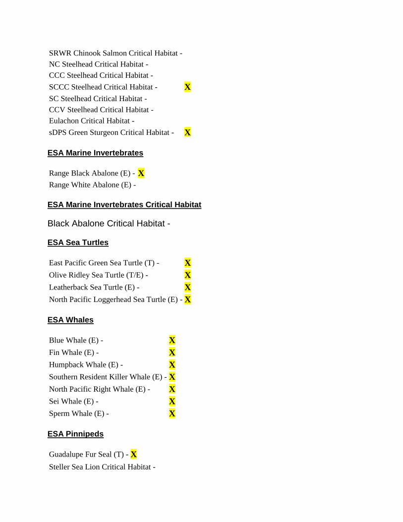
SRWR Chinook Salmon Critical Habitat -
NC Steelhead Critical Habitat -
CCC Steelhead Critical Habitat -
SCCC Steelhead Critical Habitat - X
SC Steelhead Critical Habitat -
CCV Steelhead Critical Habitat -
Eulachon Critical Habitat -
sDPS Green Sturgeon Critical Habitat - X
ESA Marine Invertebrates
Range Black Abalone (E) - X
Range White Abalone (E) -
ESA Marine Invertebrates Critical Habitat
Black Abalone Critical Habitat -
ESA Sea Turtles
East Pacific Green Sea Turtle (T) - X
Olive Ridley Sea Turtle (T/E) - X
Leatherback Sea Turtle (E) - X
North Pacific Loggerhead Sea Turtle (E) - X
ESA Whales
Blue Whale (E) - X
Fin Whale (E) - X
Humpback Whale (E) - X
Southern Resident Killer Whale (E) - X
North Pacific Right Whale (E) - X
Sei Whale (E) - X
Sperm Whale (E) - X
ESA Pinnipeds
Guadalupe Fur Seal (T) - X
Steller Sea Lion Critical Habitat -

Essential Fish Habitat
Coho EFH -
Chinook Salmon EFH -
Groundfish EFH - X
Coastal Pelagics EFH - X
Highly Migratory Species EFH - X
MMPA Species (See list at left)
ESA and MMPA Cetaceans/Pinnipeds See list at left and consult the NMFS Long Beach office 562-980-4000
MMPA Cetaceans - X
MMPA Pinnipeds - X
uad Name Seaside
Quad Number 36121-E7
ESA Anadromous Fish
SONCC Coho ESU (T) -
CCC Coho ESU (E) -
CC Chinook Salmon ESU (T) -
CVSR Chinook Salmon ESU (T) -
SRWR Chinook Salmon ESU (E) -
NC Steelhead DPS (T) -
CCC Steelhead DPS (T) -
SCCC Steelhead DPS (T) - X
SC Steelhead DPS (E) -
CCV Steelhead DPS (T) -
Eulachon (T) -
sDPS Green Sturgeon (T) - X
ESA Anadromous Fish Critical Habitat
SONCC Coho Critical Habitat -

CCC Coho Critical Habitat -
CC Chinook Salmon Critical Habitat -
CVSR Chinook Salmon Critical Habitat -
SRWR Chinook Salmon Critical Habitat -
NC Steelhead Critical Habitat -
CCC Steelhead Critical Habitat -
SCCC Steelhead Critical Habitat - X
SC Steelhead Critical Habitat -
CCV Steelhead Critical Habitat -
Eulachon Critical Habitat -
sDPS Green Sturgeon Critical Habitat - X
ESA Marine Invertebrates
Range Black Abalone (E) - X
Range White Abalone (E) -
ESA Marine Invertebrates Critical Habitat
Black Abalone Critical Habitat -
ESA Sea Turtles
East Pacific Green Sea Turtle (T) - X
Olive Ridley Sea Turtle (T/E) - X
Leatherback Sea Turtle (E) - X
North Pacific Loggerhead Sea Turtle (E) - X
ESA Whales
Blue Whale (E) - X
Fin Whale (E) - X
Humpback Whale (E) - X
Southern Resident Killer Whale (E) - X
North Pacific Right Whale (E) - X
Sei Whale (E) - X
Sperm Whale (E) - X
ESA Pinnipeds

Guadalupe Fur Seal (T) - X
Steller Sea Lion Critical Habitat -
Essential Fish Habitat
Coho EFH -
Chinook Salmon EFH -
Groundfish EFH - X
Coastal Pelagics EFH - X
Highly Migratory Species EFH - X
MMPA Species (See list at left)
ESA and MMPA Cetaceans/Pinnipeds See list at left and consult the NMFS Long Beach office 562-980-4000
MMPA Cetaceans - X
MMPA Pinnipeds - X
Quad Name Mount Carmel
Quad Number 36121-D7
ESA Anadromous Fish
SONCC Coho ESU (T) -
CCC Coho ESU (E) -
CC Chinook Salmon ESU (T) -
CVSR Chinook Salmon ESU (T) -
SRWR Chinook Salmon ESU (E) -
NC Steelhead DPS (T) -
CCC Steelhead DPS (T) -
SCCC Steelhead DPS (T) - X
SC Steelhead DPS (E) -
CCV Steelhead DPS (T) -
Eulachon (T) -
sDPS Green Sturgeon (T) -

ESA Anadromous Fish Critical Habitat
SONCC Coho Critical Habitat -
CCC Coho Critical Habitat -
CC Chinook Salmon Critical Habitat -
CVSR Chinook Salmon Critical Habitat -
SRWR Chinook Salmon Critical Habitat -
NC Steelhead Critical Habitat -
CCC Steelhead Critical Habitat -
SCCC Steelhead Critical Habitat - X
SC Steelhead Critical Habitat -
CCV Steelhead Critical Habitat -
Eulachon Critical Habitat -
sDPS Green Sturgeon Critical Habitat -
ESA Marine Invertebrates
Range Black Abalone (E) -
Range White Abalone (E) -
ESA Marine Invertebrates Critical Habitat
Black Abalone Critical Habitat -
ESA Sea Turtles
East Pacific Green Sea Turtle (T) -
Olive Ridley Sea Turtle (T/E) -
Leatherback Sea Turtle (E) -
North Pacific Loggerhead Sea Turtle (E) -
ESA Whales
Blue Whale (E) -
Fin Whale (E) -
Humpback Whale (E) -
Southern Resident Killer Whale (E) -
North Pacific Right Whale (E) -
Sei Whale (E) -
Sperm Whale (E) -

ESA Pinnipeds
Guadalupe Fur Seal (T) -
Steller Sea Lion Critical Habitat -
Essential Fish Habitat
Coho EFH -
Chinook Salmon EFH -
Groundfish EFH -
Coastal Pelagics EFH -
Highly Migratory Species EFH -
MMPA Species (See list at left)
ESA and MMPA Cetaceans/Pinnipeds See list at left and consult the NMFS Long Beach office 562-980-4000
MMPA Cetaceans -
MMPA Pinnipeds -
Quad Name Soberanes Point
Quad Number 36121-D8
ESA Anadromous Fish
SONCC Coho ESU (T) -
CCC Coho ESU (E) -
CC Chinook Salmon ESU (T) -
CVSR Chinook Salmon ESU (T) -
SRWR Chinook Salmon ESU (E) -
NC Steelhead DPS (T) -
CCC Steelhead DPS (T) -
SCCC Steelhead DPS (T) - X
SC Steelhead DPS (E) -
CCV Steelhead DPS (T) -
Eulachon (T) -

sDPS Green Sturgeon (T) - X
ESA Anadromous Fish Critical Habitat
SONCC Coho Critical Habitat -
CCC Coho Critical Habitat -
CC Chinook Salmon Critical Habitat -
CVSR Chinook Salmon Critical Habitat -
SRWR Chinook Salmon Critical Habitat -
NC Steelhead Critical Habitat -
CCC Steelhead Critical Habitat -
SCCC Steelhead Critical Habitat - X
SC Steelhead Critical Habitat -
CCV Steelhead Critical Habitat -
Eulachon Critical Habitat -
sDPS Green Sturgeon Critical Habitat -
ESA Marine Invertebrates
Range Black Abalone (E) - X
Range White Abalone (E) -
ESA Marine Invertebrates Critical Habitat
Black Abalone Critical Habitat - X
ESA Sea Turtles
East Pacific Green Sea Turtle (T) - X
Olive Ridley Sea Turtle (T/E) - X
Leatherback Sea Turtle (E) - X
North Pacific Loggerhead Sea Turtle (E) - X
ESA Whales
Blue Whale (E) - X
Fin Whale (E) - X
Humpback Whale (E) - X
Southern Resident Killer Whale (E) - X

North Pacific Right Whale (E) - X
Sei Whale (E) - X
Sperm Whale (E) - X
ESA Pinnipeds
Guadalupe Fur Seal (T) - X
Steller Sea Lion Critical Habitat -
Essential Fish Habitat
Coho EFH -
Chinook Salmon EFH -
Groundfish EFH - X
Coastal Pelagics EFH - X
Highly Migratory Species EFH - X
MMPA Species (See list at left)
ESA and MMPA Cetaceans/Pinnipeds See list at left and consult the NMFS Long Beach office 562-980-4000
MMPA Cetaceans - X
MMPA Pinnipeds - X

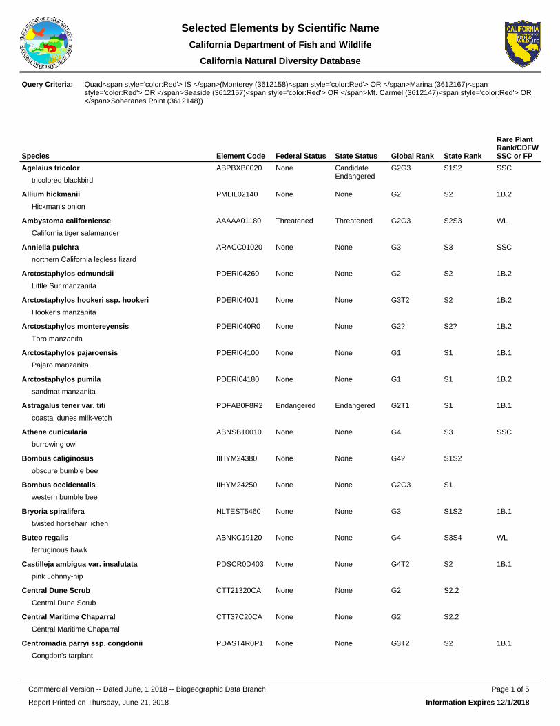
Species Element Code Federal Status State Status Global Rank State Rank
Rare Plant Rank/CDFW SSC or FP
Agelaius tricolor
tricolored blackbird
ABPBXB0020 None Candidate Endangered
G2G3 S1S2 SSC
Allium hickmanii
Hickman's onion
PMLIL02140 None None G2 S2 1B.2
Ambystoma californiense
California tiger salamander
AAAAA01180 Threatened Threatened G2G3 S2S3 WL
Anniella pulchra
northern California legless lizard
ARACC01020 None None G3 S3 SSC
Arctostaphylos edmundsii
Little Sur manzanita
PDERI04260 None None G2 S2 1B.2
Arctostaphylos hookeri ssp. hookeri
Hooker's manzanita
PDERI040J1 None None G3T2 S2 1B.2
Arctostaphylos montereyensis
Toro manzanita
PDERI040R0 None None G2? S2? 1B.2
Arctostaphylos pajaroensis
Pajaro manzanita
PDERI04100 None None G1 S1 1B.1
Arctostaphylos pumila
sandmat manzanita
PDERI04180 None None G1 S1 1B.2
Astragalus tener var. titi
coastal dunes milk-vetch
PDFAB0F8R2 Endangered Endangered G2T1 S1 1B.1
Athene cunicularia
burrowing owl
ABNSB10010 None None G4 S3 SSC
Bombus caliginosus
obscure bumble bee
IIHYM24380 None None G4? S1S2
Bombus occidentalis
western bumble bee
IIHYM24250 None None G2G3 S1
Bryoria spiralifera
twisted horsehair lichen
NLTEST5460 None None G3 S1S2 1B.1
Buteo regalis
ferruginous hawk
ABNKC19120 None None G4 S3S4 WL
Castilleja ambigua var. insalutata
pink Johnny-nip
PDSCR0D403 None None G4T2 S2 1B.1
Central Dune Scrub
Central Dune Scrub
CTT21320CA None None G2 S2.2
Central Maritime Chaparral
Central Maritime Chaparral
CTT37C20CA None None G2 S2.2
Centromadia parryi ssp. congdonii
Congdon's tarplant
PDAST4R0P1 None None G3T2 S2 1B.1
Quad<span style='color:Red'> IS </span>(Monterey (3612158)<span style='color:Red'> OR </span>Marina (3612167)<span style='color:Red'> OR </span>Seaside (3612157)<span style='color:Red'> OR </span>Mt. Carmel (3612147)<span style='color:Red'> OR </span>Soberanes Point (3612148))
Query Criteria:
Report Printed on Thursday, June 21, 2018
Page 1 of 5Commercial Version -- Dated June, 1 2018 -- Biogeographic Data Branch
Information Expires 12/1/2018
Selected Elements by Scientific NameCalifornia Department of Fish and Wildlife
California Natural Diversity Database

Species Element Code Federal Status State Status Global Rank State Rank
Rare Plant Rank/CDFW SSC or FP
Charadrius alexandrinus nivosus
western snowy plover
ABNNB03031 Threatened None G3T3 S2S3 SSC
Chorizanthe minutiflora
Fort Ord spineflower
PDPGN04100 None None G1 S1 1B.2
Chorizanthe pungens var. pungens
Monterey spineflower
PDPGN040M2 Threatened None G2T2 S2 1B.2
Clarkia jolonensis
Jolon clarkia
PDONA050L0 None None G2 S2 1B.2
Coelus globosus
globose dune beetle
IICOL4A010 None None G1G2 S1S2
Collinsia multicolor
San Francisco collinsia
PDSCR0H0B0 None None G2 S2 1B.2
Cordylanthus rigidus ssp. littoralis
seaside bird's-beak
PDSCR0J0P2 None Endangered G5T2 S2 1B.1
Corynorhinus townsendii
Townsend's big-eared bat
AMACC08010 None None G3G4 S2 SSC
Coturnicops noveboracensis
yellow rail
ABNME01010 None None G4 S1S2 SSC
Cypseloides niger
black swift
ABNUA01010 None None G4 S2 SSC
Danaus plexippus pop. 1
monarch - California overwintering population
IILEPP2012 None None G4T2T3 S2S3
Delphinium californicum ssp. interius
Hospital Canyon larkspur
PDRAN0B0A2 None None G3T3 S3 1B.2
Delphinium hutchinsoniae
Hutchinson's larkspur
PDRAN0B0V0 None None G2 S2 1B.2
Emys marmorata
western pond turtle
ARAAD02030 None None G3G4 S3 SSC
Eremophila alpestris actia
California horned lark
ABPAT02011 None None G5T4Q S4 WL
Ericameria fasciculata
Eastwood's goldenbush
PDAST3L080 None None G2 S2 1B.1
Eriogonum nortonii
Pinnacles buckwheat
PDPGN08470 None None G2 S2 1B.3
Erysimum ammophilum
sand-loving wallflower
PDBRA16010 None None G2 S2 1B.2
Erysimum menziesii
Menzies' wallflower
PDBRA160R0 Endangered Endangered G1 S1 1B.1
Eucyclogobius newberryi
tidewater goby
AFCQN04010 Endangered None G3 S3 SSC
Euphilotes enoptes smithi
Smith's blue butterfly
IILEPG2026 Endangered None G5T1T2 S1S2
Report Printed on Thursday, June 21, 2018
Page 2 of 5Commercial Version -- Dated June, 1 2018 -- Biogeographic Data Branch
Information Expires 12/1/2018
Selected Elements by Scientific NameCalifornia Department of Fish and Wildlife
California Natural Diversity Database

Species Element Code Federal Status State Status Global Rank State Rank
Rare Plant Rank/CDFW SSC or FP
Fritillaria liliacea
fragrant fritillary
PMLIL0V0C0 None None G2 S2 1B.2
Gilia tenuiflora ssp. arenaria
Monterey gilia
PDPLM041P2 Endangered Threatened G3G4T2 S2 1B.2
Hesperocyparis goveniana
Gowen cypress
PGCUP04031 Threatened None G1 S1 1B.2
Hesperocyparis macrocarpa
Monterey cypress
PGCUP04060 None None G1 S1 1B.2
Horkelia cuneata var. sericea
Kellogg's horkelia
PDROS0W043 None None G4T1? S1? 1B.1
Horkelia marinensis
Point Reyes horkelia
PDROS0W0B0 None None G2 S2 1B.2
Lasiurus cinereus
hoary bat
AMACC05030 None None G5 S4
Lasthenia conjugens
Contra Costa goldfields
PDAST5L040 Endangered None G1 S1 1B.1
Laterallus jamaicensis coturniculus
California black rail
ABNME03041 None Threatened G3G4T1 S1 FP
Layia carnosa
beach layia
PDAST5N010 Endangered Endangered G2 S2 1B.1
Linderiella occidentalis
California linderiella
ICBRA06010 None None G2G3 S2S3
Lupinus tidestromii
Tidestrom's lupine
PDFAB2B3Y0 Endangered Endangered G1 S1 1B.1
Malacothamnus palmeri var. involucratus
Carmel Valley bush-mallow
PDMAL0Q0B1 None None G3T2Q S2 1B.2
Malacothrix saxatilis var. arachnoidea
Carmel Valley malacothrix
PDAST660C2 None None G5T2 S2 1B.2
Microseris paludosa
marsh microseris
PDAST6E0D0 None None G2 S2 1B.2
Monardella sinuata ssp. nigrescens
northern curly-leaved monardella
PDLAM18162 None None G3T2 S2 1B.2
Monolopia gracilens
woodland woollythreads
PDAST6G010 None None G3 S3 1B.2
Monterey Cypress Forest
Monterey Cypress Forest
CTT83150CA None None G1 S1.2
Monterey Pine Forest
Monterey Pine Forest
CTT83130CA None None G1 S1.1
Monterey Pygmy Cypress Forest
Monterey Pygmy Cypress Forest
CTT83162CA None None G1 S1.1
Northern Bishop Pine Forest
Northern Bishop Pine Forest
CTT83121CA None None G2 S2.2
Report Printed on Thursday, June 21, 2018
Page 3 of 5Commercial Version -- Dated June, 1 2018 -- Biogeographic Data Branch
Information Expires 12/1/2018
Selected Elements by Scientific NameCalifornia Department of Fish and Wildlife
California Natural Diversity Database

Species Element Code Federal Status State Status Global Rank State Rank
Rare Plant Rank/CDFW SSC or FP
Northern Coastal Salt Marsh
Northern Coastal Salt Marsh
CTT52110CA None None G3 S3.2
Oceanodroma homochroa
ashy storm-petrel
ABNDC04030 None None G2 S2 SSC
Oncorhynchus mykiss irideus pop. 9
steelhead - south-central California coast DPS
AFCHA0209H Threatened None G5T2Q S2
Pelecanus occidentalis californicus
California brown pelican
ABNFC01021 Delisted Delisted G4T3T4 S3 FP
Phrynosoma blainvillii
coast horned lizard
ARACF12100 None None G3G4 S3S4 SSC
Pinus radiata
Monterey pine
PGPIN040V0 None None G1 S1 1B.1
Piperia yadonii
Yadon's rein orchid
PMORC1X070 Endangered None G1 S1 1B.1
Plagiobothrys uncinatus
hooked popcornflower
PDBOR0V170 None None G2 S2 1B.2
Potentilla hickmanii
Hickman's cinquefoil
PDROS1B0U0 Endangered Endangered G1 S1 1B.1
Ramalina thrausta
angel's hair lichen
NLLEC3S340 None None G5 S2? 2B.1
Rana draytonii
California red-legged frog
AAABH01022 Threatened None G2G3 S2S3 SSC
Reithrodontomys megalotis distichlis
Salinas harvest mouse
AMAFF02032 None None G5T1 S1
Riparia riparia
bank swallow
ABPAU08010 None Threatened G5 S2
Rosa pinetorum
pine rose
PDROS1J0W0 None None G2 S2 1B.2
Sidalcea malachroides
maple-leaved checkerbloom
PDMAL110E0 None None G3 S3 4.2
Stebbinsoseris decipiens
Santa Cruz microseris
PDAST6E050 None None G2 S2 1B.2
Taricha torosa
Coast Range newt
AAAAF02032 None None G4 S4 SSC
Taxidea taxus
American badger
AMAJF04010 None None G5 S3 SSC
Tortula californica
California screw moss
NBMUS7L090 None None G2G3 S2S3 1B.2
Trifolium buckwestiorum
Santa Cruz clover
PDFAB402W0 None None G2 S2 1B.1
Trifolium hydrophilum
saline clover
PDFAB400R5 None None G2 S2 1B.2
Report Printed on Thursday, June 21, 2018
Page 4 of 5Commercial Version -- Dated June, 1 2018 -- Biogeographic Data Branch
Information Expires 12/1/2018
Selected Elements by Scientific NameCalifornia Department of Fish and Wildlife
California Natural Diversity Database

Species Element Code Federal Status State Status Global Rank State Rank
Rare Plant Rank/CDFW SSC or FP
Trifolium polyodon
Pacific Grove clover
PDFAB402H0 None Rare G1 S1 1B.1
Trifolium trichocalyx
Monterey clover
PDFAB402J0 Endangered Endangered G1 S1 1B.1
Valley Needlegrass Grassland
Valley Needlegrass Grassland
CTT42110CA None None G3 S3.1
Record Count: 85
Report Printed on Thursday, June 21, 2018
Page 5 of 5Commercial Version -- Dated June, 1 2018 -- Biogeographic Data Branch
Information Expires 12/1/2018
Selected Elements by Scientific NameCalifornia Department of Fish and Wildlife
California Natural Diversity Database


6/21/2018 CNPS Inventory Results
http://www.rareplants.cnps.org/result.html?adv=t&quad=3612167:3612158:3612157:3612148:3612147 1/4
Inventory of Rare and Endangered PlantsPlant List73 matches found. Click on scientific name for details
Search Criteria
Found in Quads 3612167, 3612158, 3612157 3612148 and 3612147;
Modify Search Criteria Export to Excel Modify Columns Modify Sort Display Photos
Scientific Name Common Name Family Lifeform Blooming Period
CARarePlantRank
StateRank
GlobalRank
Agrostis lacuna-vernalis
vernal pool bentgrass Poaceae annual herb Apr-May 1B.1 S1 G1
Allium hickmanii Hickman's onion Alliaceae perennialbulbiferous herb Mar-May 1B.2 S2 G2
Arctostaphylosedmundsii
Little Surmanzanita Ericaceae perennial
evergreen shrub Nov-Apr(May) 1B.2 S2 G2
Arctostaphyloshookeri ssp. hookeri
Hooker'smanzanita Ericaceae perennial
evergreen shrub Jan-Jun 1B.2 S2 G3T2
Arctostaphylosmontereyensis Toro manzanita Ericaceae perennial
evergreen shrub Feb-Mar 1B.2 S2? G2?
Arctostaphylospajaroensis Pajaro manzanita Ericaceae perennial
evergreen shrub Dec-Mar 1B.1 S1 G1
Arctostaphylos pumila sandmatmanzanita Ericaceae perennial
evergreen shrub Feb-May 1B.2 S1 G1
Astragalus nuttallii var.nuttallii
ocean bluff milk-vetch Fabaceae perennial herb Jan-Nov 4.2 S4 G4T4
Astragalus tener var.titi
coastal dunesmilk-vetch Fabaceae annual herb Mar-May 1B.1 S1 G2T1
Bryoria spiralifera twisted horsehairlichen Parmeliaceae fruticose lichen
(epiphytic) 1B.1 S1S2 G3
Castilleja ambigua var.insalutata pink Johnny-nip Orobanchaceae annual herb
(hemiparasitic) May-Aug 1B.1 S2 G4T2
Castilleja latifolia Monterey Coastpaintbrush Orobanchaceae perennial herb
(hemiparasitic) Feb-Sep 4.3 S4 G4
Ceanothus gloriosusvar. gloriosus
Point Reyesceanothus Rhamnaceae perennial
evergreen shrub Mar-May 4.3 S4 G4T4
Ceanothus rigidus Montereyceanothus Rhamnaceae perennial
evergreen shrub Feb-Apr(Jun) 4.2 S4 G4
Centromadia parryissp. congdonii Congdon's tarplant Asteraceae annual herb May-Oct(Nov) 1B.1 S2 G3T2
Chorizanthe douglasii Douglas'spineflower Polygonaceae annual herb Apr-Jul 4.3 S4 G4
Chorizanthe pungensvar. pungens
Montereyspineflower Polygonaceae annual herb Apr-Jun(Jul-Aug) 1B.2 S2 G2T2

6/21/2018 CNPS Inventory Results
http://www.rareplants.cnps.org/result.html?adv=t&quad=3612167:3612158:3612157:3612148:3612147 2/4
Chorizanthe robustavar. robusta
robust spineflower Polygonaceae annual herb Apr-Sep 1B.1 S1 G2T1
Clarkia jolonensis Jolon clarkia Onagraceae annual herb Apr-Jun 1B.2 S2 G2
Clarkia lewisii Lewis' clarkia Onagraceae annual herb May-Jul 4.3 S4 G4
Collinsia multicolor San Franciscocollinsia Plantaginaceae annual herb (Feb)Mar-May 1B.2 S2 G2
Cordylanthus rigidusssp. littoralis
seaside bird's-beak Orobanchaceae annual herb
(hemiparasitic) Apr-Oct 1B.1 S2 G5T2
Corethrogyneleucophylla
branching beachaster Asteraceae perennial herb May,Jul,Aug,Sep,Oct,Dec 3.2 S3 G3Q
Cryptantha rattanii Rattan'scryptantha Boraginaceae annual herb Apr-Jul 4.3 S4 G4
Delphiniumcalifornicum ssp.interius
Hospital Canyonlarkspur Ranunculaceae perennial herb Apr-Jun 1B.2 S3 G3T3
Delphiniumhutchinsoniae
Hutchinson'slarkspur Ranunculaceae perennial herb Mar-Jun 1B.2 S2 G2
Delphiniumumbraculorum umbrella larkspur Ranunculaceae perennial herb Apr-Jun 1B.3 S3 G3
Ericameria fasciculata Eastwood'sgoldenbush Asteraceae perennial
evergreen shrub Jul-Oct 1B.1 S2 G2
Eriogonum elegans elegant wildbuckwheat Polygonaceae annual herb May-Nov 4.3 S3S4 G3G4
Eriogonum nortonii Pinnaclesbuckwheat Polygonaceae annual herb (Apr)May-Aug(Sep) 1B.3 S2 G2
Erysimumammophilum
sand-lovingwallflower Brassicaceae perennial herb Feb-Jun 1B.2 S2 G2
Erysimum menziesii Menzies’wallflower Brassicaceae perennial herb Mar-Sep 1B.1 S1 G1
Fritillaria liliacea fragrant fritillary Liliaceae perennialbulbiferous herb Feb-Apr 1B.2 S2 G2
Galium clementis Santa Luciabedstraw Rubiaceae perennial herb (Apr)May-Jul 1B.3 S3 G3
Gilia tenuiflora ssp.arenaria Monterey gilia Polemoniaceae annual herb Apr-Jun 1B.2 S2 G3G4T2
Grindelia hirsutula var.maritima
San Franciscogumplant Asteraceae perennial herb Jun-Sep 3.2 S1 G5T1Q
Hesperocyparisgoveniana Gowen cypress Cupressaceae perennial
evergreen tree 1B.2 S1 G1
Hesperocyparismacrocarpa Monterey cypress Cupressaceae perennial
evergreen tree 1B.2 S1 G1
Horkelia cuneata var.sericea Kellogg's horkelia Rosaceae perennial herb Apr-Sep 1B.1 S1? G4T1?
Horkelia marinensis Point Reyeshorkelia Rosaceae perennial herb May-Sep 1B.2 S2 G2
Iris longipetala coast iris Iridaceaeperennialrhizomatousherb
Mar-May 4.2 S3 G3
Lasthenia conjugens Contra Costagoldfields Asteraceae annual herb Mar-Jun 1B.1 S1 G1
Layia carnosa beach layia Asteraceae annual herb Mar-Jul 1B.1 S2 G2

6/21/2018 CNPS Inventory Results
http://www.rareplants.cnps.org/result.html?adv=t&quad=3612167:3612158:3612157:3612148:3612147 3/4
Leptosiphongrandiflorus
large-floweredleptosiphon
Polemoniaceae annual herb Apr-Aug 4.2 S3S4 G3G4
Lomatium parvifolium small-leavedlomatium Apiaceae perennial herb Jan-Jun 4.2 S4 G4
Lupinus tidestromii Tidestrom's lupine Fabaceaeperennialrhizomatousherb
Apr-Jun 1B.1 S1 G1
Malacothamnuspalmeri var.involucratus
Carmel Valleybush-mallow Malvaceae
perennialdeciduousshrub
Apr-Oct 1B.2 S2 G3T2Q
Malacothamnuspalmeri var. palmeri
Santa Lucia bush-mallow Malvaceae
perennialdeciduousshrub
May-Jul 1B.2 S2 G3T2Q
Malacothrix saxatilisvar. arachnoidea
Carmel Valleymalacothrix Asteraceae
perennialrhizomatousherb
(Mar)Jun-Dec 1B.2 S2 G5T2
Micropus amphibolus Mt. Diablocottonweed Asteraceae annual herb Mar-May 3.2 S3S4 G3G4
Microseris paludosa marsh microseris Asteraceae perennial herb Apr-Jun(Jul) 1B.2 S2 G2
Monardella antoninassp. antonina
San Antonio Hillsmonardella Lamiaceae
perennialrhizomatousherb
Jun-Aug 3 S1S3 G4T1T3Q
Monardella sinuatassp. nigrescens
northern curly-leaved monardella Lamiaceae annual herb (Apr)May-Jul(Aug-Sep) 1B.2 S2 G3T2
Monolopia gracilens woodlandwoolythreads Asteraceae annual herb (Feb)Mar-Jul 1B.2 S3 G3
Ophioglossumcalifornicum
California adder's-tongue Ophioglossaceae
perennialrhizomatousherb
(Dec)Jan-Jun 4.2 S4 G4
Perideridia gairdnerissp. gairdneri Gairdner's yampah Apiaceae perennial herb Jun-Oct 4.2 S3S4 G5T3T4
Phacelia ramosissimavar. austrolitoralis
south coastbranching phacelia Hydrophyllaceae perennial herb Mar-Aug 3.2 S3 G5?T3
Pinus radiata Monterey pine Pinaceae perennialevergreen tree 1B.1 S1 G1
Piperia michaelii Michael's reinorchid Orchidaceae perennial herb Apr-Aug 4.2 S3 G3
Piperia yadonii Yadon's reinorchid Orchidaceae perennial herb (Feb)May-Aug 1B.1 S1 G1
Plagiobothryschorisianus var.hickmanii
Hickman'spopcornflower Boraginaceae annual herb Apr-Jun 4.2 S3 G3T3Q
Plagiobothrysuncinatus
hookedpopcornflower Boraginaceae annual herb Apr-May 1B.2 S2 G2
Potentilla hickmanii Hickman'scinquefoil Rosaceae perennial herb Apr-Aug 1B.1 S1 G1
Ramalina thrausta angel's hair lichen Ramalinaceae fruticose lichen(epiphytic) 2B.1 S2? G5
Ranunculus lobbii Lobb's aquaticbuttercup Ranunculaceae annual herb
(aquatic) Feb-May 4.2 S3 G4
Rosa pinetorum pine rose Rosaceae perennial shrub May,Jul 1B.2 S2 G2
Sidalcea malachroides maple-leavedcheckerbloom Malvaceae perennial herb (Mar)Apr-Aug 4.2 S3 G3

6/21/2018 CNPS Inventory Results
http://www.rareplants.cnps.org/result.html?adv=t&quad=3612167:3612158:3612157:3612148:3612147 4/4
Search the InventorySimple SearchAdvanced SearchGlossary
InformationAbout the InventoryAbout the Rare Plant ProgramCNPS Home PageAbout CNPSJoin CNPS
ContributorsThe Calflora DatabaseThe California Lichen SocietyCalifornia Natural Diversity DatabaseThe Jepson Flora ProjectThe Consortium of California HerbariaCalPhotos
Questions and [email protected]
Stebbinsoserisdecipiens
Santa Cruzmicroseris
Asteraceae annual herb Apr-May 1B.2 S2 G2
Tortula californica California screw-moss Pottiaceae moss 1B.2 S2S3 G2G3
Trifoliumbuckwestiorum Santa Cruz clover Fabaceae annual herb Apr-Oct 1B.1 S2 G2
Trifolium hydrophilum saline clover Fabaceae annual herb Apr-Jun 1B.2 S2 G2
Trifolium polyodon Pacific Groveclover Fabaceae annual herb Apr-Jun(Jul) 1B.1 S1 G1
Trifolium trichocalyx Monterey clover Fabaceae annual herb Apr-Jun 1B.1 S1 G1
Suggested Citation
California Native Plant Society, Rare Plant Program. 2018. Inventory of Rare and Endangered Plants of California(online edition, v8-03 0.39). Website http://www.rareplants.cnps.org [accessed 21 June 2018].
© Copyright 2010-2018 California Native Plant Society. All rights reserved.

APPENDIX D
Historical Resources Background Information


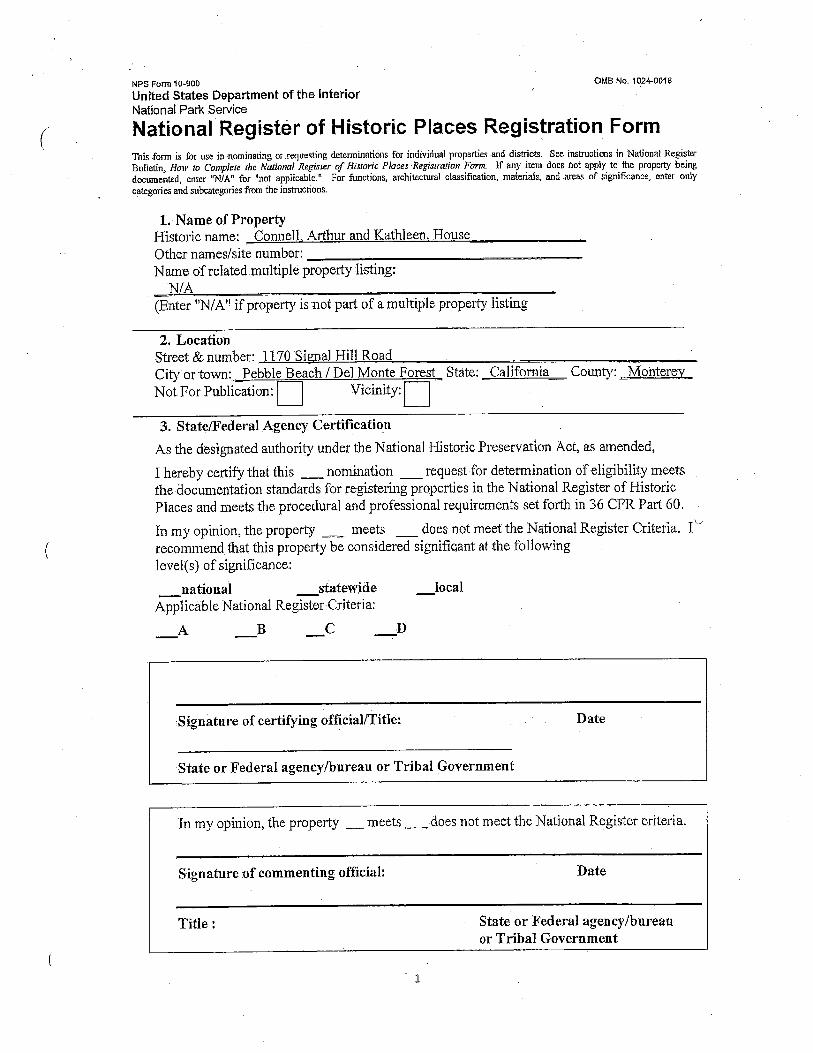


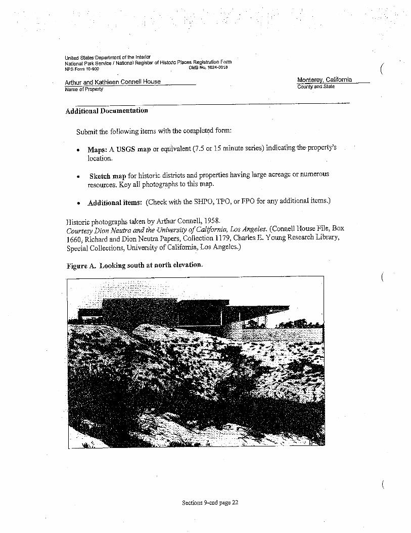


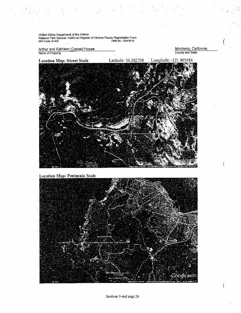


APPENDIX E
Geology and Soils Background Information


GEOTECHNICAL INVESTIGATION NEW RESIDENCE
1170 SIGNAL HILL ROAD PEBBLE BEACH, CALIFORNIA
for
Ms. Massy Mehdipour 1425 Dana Avenue
Palo Alto, CA 94301
by
Cleary Consultants, Inc. 900 N. San Antonio Road
Los Altos, California 94022
March2010
friedrichm
Typewritten Text
friedrichm
Typewritten Text
friedrichm
Typewritten Text

,;-WCLEARV CONSULTANTS, INC.
Geotechnical Engineers and Geologists
Ms. Massy Mehdipour 1425 Dana A venue Palo Alto, CA 94301
RE: GEOTECHNICAL INVESTIGATION NEW RESIDENCE 1170 SIGNAL HILL ROAD
J. Michael Cleary, CEG, GE Christophe A. Ciechanowski, GE Grant F. Foster, GE
March 31, 2010 Project No. 1301.1 Ser. 2880
PEBBLE BEACH, MONT~~y COUNTY, CALIFORNIA
Dear Ms. Mehdipour:
As authorized, we have performed a geotechnical investigation for your planned new home on the property at 1170 Signal Hill Road in Pebble Beach, Monterey County, California. The accompanying report presents the results of our field investigation, laboratory testing, and engineering analyses. The site and subsurface conditions are discussed and recommendations for the geotechnical engineering aspects of the project design are presented. The recommendations presented in this report are contingent upon our review of the grading and foundation plans and observation/testing of the earthwork and foundation installation phases of the construction.
Please refer to the text of the report for detailed recommendations. concerning our findings, please call.
Very truly yours,
Gran oster Geotechnical Engineer 2662
GF/JMC:cm Copies: Addressee (2)
Bill Bernstein AIA ( 4) Attn: William Bernstein Whitson Engineers (1) Attn: Ken Whitson
ichael Cleary _ Engineering Geologist 352 Geotechnical Engineer 222

TABLE OF CONTENTS Page No.
Letter of Transmittal
INTRODUCTION.................................................................................................... I
SCOPE...................................................................................................................... 2
METHOD OF INVESTIGATION.......................................................................... 4
GEOLOGY AND SEISMICITY ............................................................................. 4
SITE CONDITIONS................................................................................................ 5 A. Surface . ... .. .. ... ... . .. . .. .. . ... .. .. ... . . ..... .. ... .. . .. . .. .. .. ... .... ... .. . .. . ... .. . . ... . .. . . ... . .... .. ... . 5 B. Subsurface................................................................................................. 6 C. Groundwater.............................................................................................. 7
GEOLOGIC AND SEISMIC HAZARDS EVALUATION .................................. 7 A. Fault Offset Hazard.................................................................................... 7 B. Ground Shaking Hazards ........................................................................... 8
1. Strong Ground Shaking......................................................................... 8 2. Soil Liquefaction................................................................................... 8 3. Soil Densification......... .. . ...... .. . .. . .. .. . .......... .. .. .. ... ... . .. . .. . . .. .... . ... . ... .. .. ... .. 9 4. Other Seismic Hazards.......................................................................... IO
C. Flooding .... ... . .. .... ... .. ... . ... .. .. ............. .. ... ... .. .. .. . .. .... ... ... . ... ... . ... . .. . . ... . .. .... ... . I 0
CONCLUSIONS AND RECOMMENDATIONS................................................... 11 A. Earthwork.................................................................................................. 12
1. Clearing and Site Preparation............................................................... 12 2. Recompaction of Surface Soils.............................................................. 13 3. Slope Gradients..................................................................................... 13 4. Fill Placement and Compaction ............................................................. 14 5. Trench Backfill .. .. ... . . .. .. . .. . . . . .. . .. . .. ...... .. .. .. . .. ... .. .. ... . ... ... . ... . . .. ... . . ... .. .. ... .. 14 6. Surface Drainage................................................................................... 15 7. Construction Observation ... . ......... ... . .. .. .. .. . .. .. ......... ....... .... ... . .... ... ..... .. . 15
B. Structural Slab and Drilled Pier Foundation System.................................. 16 C. Seismic Design Parameters . .. . .. .... .. ......... ....... ..... .. .. ... .. .. ... .. .. .. .. .. .. .. ....... .. . . 18 D. Slabs-On-Grade.......................................................................................... 19 E. Retaining Walls .. . ... .. ... . ... ... .. . . . . .. . . .. ... .. . ... .. .. .. . .. .. .. . .. .. . . .. ..... ... . ... . .. . . . .. .. .. ... .. 19 F. Driveway Pavement Section....................................................................... 21 G. Soil Corrosivity .......................................................................................... 21
PLAN REVIEW AND CONSTRUCTION OBSERVATION................................ 22
LIST OF REFERENCES
CLEARY CONSULTANTS, INC.

TABLES
Table 1 - Correlation Between Resistivity and Corrosion Potential ................................ 22
DRAWINGS
Drawing No.
SITE VICINITY MAP .................................................................................................. 1
LOCAL GEOLOGIC MAP........................................................................................... 2
SITE PLAN..................................................................................................................... 3
SUBSURFACE PROFILE A-A'.................................................................................... 4
SUBSURFACE PROFILE B-B' AND C-C' ................................................................. 5
KEY TO EXPLORATORY BORING LOGS............................................................... 6
SUMMARY OF FIELD SAMPLING PROCEDURES ............................................... 7
LABORATORY TESTING PROCEDURES ............................................................... 8-9
LOGS OF EXPLORATORY BORINGS 1-7 ............................................................. 10-18
PLASTICITY CHART.................................................................................................. 19
CORROSIVITY TEST SUMMARY........................................................................... 20
GRADATION TEST DATA .......................................................................................... 21
APPENDIX A - New Residence, 1170 Signal Hill Road, Liquefaction and Dry Settlement Calculations, EB-5 and EB-7, Drilled February 19, 2010
CLEARY CONSULTANTS, INC.
INTRODUCTION
This report presents the results of our geotechnical investigation for the planned new residence
on the property at 1170 Signal Hill Road in the Pebble Beach area of Monterey County,
California. The general location of the site is shown on the Site Vicinity Map, Drawing I. The
purpose of this investigation was to explore the soil conditions in the planned new home area and
develop recommendations for the geotechnical engineering aspects of the project design.
As indicated on the preliminary architectural plans prepared by Bill Bernstein AIA, November
2009, a new two level home with a basement will be constructed in the area primarily downslope
of the existing home, which will be demolished. We understand that the new home will
encompass approximately 14,000 square feet and will have a lower floor (basement) Elevation of
87.0 feet on the south portion and a lower floor Elevation of98.5 feet on the north portion. A
garage is planned at Elevation 107.0 feet on the front, or east side, of the residence. Building
loads are expected to be typical of two story wood-frame residential construction.
Basement cuts will range up to about 17 feet in height, and new fills of up to about six feet in
height are planned.
New driveway and exterior walkways/patios are anticipated for the property, as well as low
landscaping walls.
1
CLEARY CONSULTANTS, INC.

SCOPE
As presented in our proposal agreement dated February 3, 2010, the scope of our services for this
investigation has included:
1. A site reconnaissance by our engineer and review of published and unpublished
geological information for this area.
2. Subsurface investigation consisting of seven (7) exploratory borings.
3. Laboratory testing of samples obtained from the borings.
4. Engineering analysis of the field and laboratory data.
5. Preparation of this geotechnical investigation report for use in the project design and
construction. The report includes findings and recommendations for the following:
a) Site soil conditions, geologic and seismic setting, and 2007 CBC criteria for
seismic design, including liquefaction and dry settlement analysis, and
mitigation measures, as required.
b) Groundwater table, as encountered in the borings.
c) Site preparation and grading.
d) New residence foundation type(s), minimum foundation dimensions, and
allowable soil engineering design criteria.
e) Estimated foundation settlements.
2
CLEARY CONSULTANTS, INC.

f) Lateral earth pressures and equivalent fluid pressures for basement walls,
landscape walls and recommendations for retaining wall backdrainage.
g) Driveway pavement section.
h) Support of concrete slabs-on-grade.
i) Surface drainage.
j) Any other unusual design or construction conditions encountered in the
investigation.
This report has been prepared for the specific use of Ms. Massy Mehdipour and her consultants
in accordance with generally accepted soil and foundation engineering principles and practices.
No other warranty, either expressed or implied, is made. In the event that any substantial
changes in the nature, design or location of the new residence are planned, the conclusions and
recommendations of this report shall not be considered valid unless such changes are reviewed
and the conclusions of this report modified or verified in writing. Any use or reliance of this
report or the information herein by a third party shall be at such party's sole risk.
It should also be recognized that the passage of time may result in significant changes in
technology, building code requirements, state of the practice, economic conditions, or site
variations which would render the report inaccurate. Accordingly, neither the owners, nor any
other party, should rely on the information or conclusions contained in this report after three
years from its date of issuance without the express written consent of Cleary Consultants, Inc.
3
CLEARY CONSULTANTS, INC.

METHOD OF INVESTIGATION
A site reconnaissance and the subsurface exploration were performed on February 19, 2010,
under the guidance of our engineer. Seven borings were drilled to a maximum depth of3 l .O feet
at the locations shown on Drawing 3, Site Plan, using a track mounted hollow-stem auger drill
rig. A key describing the soil classification system and soil consistency terms used in this report
is presented on Drawing 6 and the soil sampling procedures are described in Drawing 7. Logs of
the borings are presented on Drawings 10 through 18.
The borings were located in the field by pacing and interpolation of the features shown on the
Site Plan provided us. These locations should be considered accurate only to the degree implied
by the methods used. The elevations shown on the boring logs were taken from the topographic
plan provided us.
Samples of the soil materials from the borings were returned to our laboratory for classification
and testing. The results of moisture content, dry density, percent finer than No. 200 sieve,
gradation, free swell, corrosion and plasticity index determinations are shown on the boring logs.
Additional information on the plasticity index, corrosion, gradation testing is presented on
Drawings 19 through 21.
A list of references consulted during this investigation is included at the end of the text.
GEOLOGY AND SEISMICITY
The subject property is located in the Cypress Point area of Pebble Beach, approximately 600
feet inland of Fan Shell Beach and the Pacific Ocean (See Drawing I). This area is characterized
by shoreline bluffs and low cliffs which are generally capped by recent (Holocene age) dune sand
deposits, underlain by eroded granodiorite bedrock. The site is about I 00 feet above sea level.
4
CLEARY CONSULTANTS, INC.

Drawing 2, Local Geologic Map, shows the site vicinity, extending for a distance of about 2000
feet inland, to be underlain by dune sand deposits (Qd). These deposits (Dupre, 1990) are up to
25 meters thick, unconsolidated, and consist of well drained medium to coarse grained loose
sand with a poorly developed or absent organic soil horizon. The dune sand is subject to
"accelerated erosion ... in areas where vegetation (is) disturbed or removed".
Porphyritic granodiorite (Kgdp) is the underlying bedrock type in the Cypress Point area, forming
resistant coastal bluffs and rocky outcrops. The granodiorite (Clark et al, 1997) is "light gray to
moderately pink and medium grained with orthoclase phenocrysts ranging from three to ten
centimeter long." The granodiorite is variably weathered, ranging from highly decomposed ( d.g.
materials) to fresh to slightly weathered crystalline rock.
The major controlling active faults in this region are the San Andreas fault located 29.5 miles
northeast of the site, the San Gregorio-Palo Colorado fault which lies 3.5 miles offshore to the
southwest and the Monterey Bay-Tularcitos fault which lies approximately 5.0 miles northeast of
the site (Blake, 2000). In addition to the above active faults, the Cypress Point fault, considered
potentially active, is mapped (Clark et al, 1997) about 1000 feet southwest of the site as a
concealed trace beneath coastal terrace deposits (Qct). Therefore, as with the rest of the
Monterey Bay area, the property is in a region of high seismic activity.
SITE CONDITIONS
A. Surface
As indicated on the Site Plan, Drawing 3, the new home will be built on an irregular previously
graded and terraced site, which has an overall fall of about 20 feet from east to west across the
new building footprint. The upper portion of the site includes a two level residence which
5
CLEARY CONSULTANTS, INC.

appears to have been cut into the slope, with the lower level at Elevation 95 and the upper
portion approximately ten feet higher, (roughly at street grade). The backyard has been terraced
with a 50 to 75 foot wide gently sloping to flat area at Elevation 80 to 85, marking the
outer/downhill limits of the planned new home. Further west, the dune sand terrain falls away at
an overall gradient of approximately 25 percent toward 17 Mile Drive and the ocean.
Grasses, small shrubs and scattered trees were present on the property at the time of our
investigation, however the backyard and terraced areas below the existing structure were largely
un-vegetated dune sand. Several hard granodiorite bedrock outcrops are present on the parcel,
including one at the bedroom wing of the proposed home (see Drawing 3 for general location).
As measured in the field, the bedrock jointing strikes moderately to the northwest and dips
strongly southward.
B. Subsurface
The exploratory borings encountered approximately eight to 14 feet of predominantly loose,
medium to fine grained, slightly moist to dry cohesionless clean sand overlying one to five feet
of loose to medium dense silty to clayey sand, in turn overlying very dense weathered
granodiorite bedrock to 31.0 feet, the maximum depth explored. Refusal of the CME 55 auger
drill rig was encountered at depths of 13.0, 31.0, 13.5 and 18.5 feet in EB-I, EB-3, EB-4 and EB-
6.
The upper clean sand is non-plastic and non-expansive (plasticity index and free swells= zero)
while the underlying silty to clayey sand has a low to moderate expansion potential (plasticity
index = 17 percent and free swells of zero to 50 percent) based on the test data.
The attached boring logs and related information depict subsurface conditions only at the specific
locations shown on Drawing 3 and on the particular date designated on the logs. Soil conditions
6
CLEARY CONSULTANTS, INC.

at other locations may differ from conditions occurring at these locations. Also, the passage of
time may result in a change of conditions at the boring locations due to environmental changes.
Subsurface profiles A-A', B-B', and C-C' depicting interpreted subsurface conditions through
the building site are presented on Drawings 4 and 5.
C. Groundwater
Free water was encountered at depths of 9.5, 16 and I 0.5 feet in EB-1, EB-2 and EB-7 during
drilling; free water was not encountered in the remaining exploratory borings during the
investigation. The borings were only open for a period of a few hours, however, and this may
not have been a sufficiently long enough period to establish the stabilized water table conditions.
It should also be noted that fluctuations of localized perched groundwater can be expected to
occur due to such factors as variations in rainfall, temperature, runoff, irrigation, and other
factors not evident at the time our measurements were made and_ reported herein.
GEOLOGIC AND SEISMIC HAZARDS EVALUATION
A. Fault Offset Hazard
Based on the findings of this investigation, we conclude that there are no known active or
potentially active faults crossing the proposed building site. The site is also not within an
Earthquake Fault Zone as defined by the State of California Alquist-Priolo Earthquake Fault
Zoning Act. Therefore, the hazard resulting from surface fault rupture or fault offset at the site is
considered very low.
7
CLEARY CONSULTANTS, INC.

B. Ground Shaking Hazards
1. Strong Ground Shaking
Strong ground shaking is likely to occur during the lifetime of the planned new home as a
result of movement along one or more of the regional active faults discussed above. The
new home and other improvements will need to be designed and constructed in
accordance with current standards of earthquake-resistant construction.
Ground shaking during an earthquake could cause furnishings which are not rigidly
attached to undergo movement with respect to the building. Design measures that
minimize such potential movement and also minimize the adverse effects of such
movement where they cannot be prevented should be utilized.
2. Soil Liquefaction
Liquefaction is a phenomenon in which saturated, essentially cohesionless soils lose
strength during strong seismic shaking and may experience horizontal and vertical
movements. Soils that are generally most susceptible to liquefaction are clean, loose,
saturated, uniformly graded, fine-grained sands and silts that lie within roughly 50 feet of
the ground surface.
The site is shown to lie within a moderate to low susceptibility for liquefaction zone as
shown on the liquefaction susceptibility map for Monterey County (Dupre, 1990).
Our investigation found that the homesite is underlain by predominantly non-saturated
loose to medium dense clean sand and silty sand underlain by granodiorite bedrock.
Based on these conditions, we conclude that the likelihood of soil liquefaction during
strong ground shaking at the site is low; however, the silty sand layer encountered below
8
CLEARY CONSULTANTS, INC.

the observed groundwater table of 10.5 feet in EB-7 was conservatively analyzed for
liquefaction-induced settlement using the LiquefyPro computer program (Version 5.0).
Liquefy Pro evaluates liquefaction potential and calculates the settlement of saturated and
unsaturated deposits due to seismic loads using SPT blowcount, total unit weight, fines
content, peak horizontal acceleration and earthquake moment magnitude data. The
program is based on the most recent publications of the NCEER Workshop and SPI 17
hnplementation.
Based on the results of our analysis, the theoretical liquefaction-induced settlement is
approximately one-half inch at the site using the calculated peak ground acceleration
(Sos/2.5) for the site as specified in Item Number 23 ofCGS Note 48 and the Tokimatsu
and Seed calculation method with magnitude scaling correction. The results and
supporting data for the liquefaction analysis are included in Appendix A of this report.
3. Soil Densification
The recognized procedures for evaluation of seismically-induced settlement in dry sandy
soils (Tokimatsu and Seed, 1987; Pradel, 1998) are considered most applicable to non
cohesive loose clean sands with less than 5 percent fines (Day, 2002). The loose to
medium dense clean sand, silty sand and clayey sand layers encountered in EB-5 and EB-
7 were analyzed for seismically-induced settlement using the LiquefyPro computer
program.
The maximum calculated earthquake induced dry soil settlement for these layers is
approximately three and one-half inches using the calculated peak ground acceleration
(Sos/2.5) for the site as specified in Item Number 23 of CGS Note 48. As subsequently
recommended, the home will be supported on a structural slab with drilled caissons
extending into granodiorite bedrock. Based on the above, the likelihood that the new
9
CLEARY CONSULTANTS, INC.

home will experience distress as a result of earthquake-induced soil densification is very
low.
The results and supporting data for the dry settlement analysis are included in Appendix
A of this report.
4. Other Seismic Hazards
We have also considered the possibility of other seismically induced hazards at the site.
Because the sandy soils overlying the granodiorite are unsaturated, with the exception of
local perched water, soil lurching and lateral spreading are considered unlikely.
Ground cracking may be caused by any of the phenomena discussed above. Since there
is a low potential for liquefaction-induced settlement and lateral spreading of the soils
underlying the site, it is also considered unlikely that significant ground cracking will
occur at the site.
Based on the findings of our investigation and review of published geologic maps, the
site is not underlain by any known landslides.
C. Flooding
The site is outside of the runup zone resulting from a seismically generated tsunami as shown on
the Tsunami Inundation Map for Emergency Planning, State of California, County ofMonterey,
July I, 2009. This map shows the tsunami inundation limits to be roughly the route of 17 Mile
Drive in the vicinity of Signal Hill Road, approximately 400 feet west of the planned homesite.
10
CLEARY CONSULTANTS, INC.

CONCLUSIONS AND RECOMMENDATIONS
From a geotechnical engineering standpoint, we conclude that the property can be developed as
proposed provided the recommendations contained in this report are incorporated into the design
and construction of the project. The new home will be built in an area that is underlain by loose
dune sand of variable thickness and low bearing capacity, and these materials could experience
differential settlement beneath building foundations and slabs. Accordingly, we recommend that
a structural slab that is supported on drilled pier foundations obtaining skin friction support in the
granodiorite bedrock be used for the new home. In our opinion, the above foundation system
will provide a high degree of structural rigidity under the anticipated building and retaining wall
loads with minimal risk of settlement.
Heavy duty drilling equipment in good condition will be required to achieve the required
penetration into granodiorite bedrock, as discussed further in the report. Portions of the dune
sand may require the use of casing prior to installing steel reinforcement and placing concrete.
Any seepage encountered in the pier holes should be pumped out prior to concrete placement.
The southeast corner of the home, in the area of the two bedroom wings, is an area of resistant
granodiorite bedrock outcropping, and difficult excavation requiring the use of jackhammers or a
hoe ram may be required to achieve basement grade in this area. Consideration should be given
to relocating the basement slightly to the west to avoid the outcrop. Difficult excavation may
also be encountered in other portions of the basement (See Subsurface Profiles A-A' and B-B ')
in resistant granodiorite rock.
Although only intermittent water was encountered in the exploratory borings, indicating perched
water conditions, some surface water infiltration from the surrounding soils at basement level is
likely, particularly during peak winter storms. A drainage blanket should be installed beneath the
basement structural slab to collect and remove water which may seep into this area. The
11
CLEARY CONSULTANTS, INC.

retaining wall back drainage and basement foundation drain blanket should be drained to a sump
and removed with a sump pump system, or to gravity drainage if feasible.
Basement excavations for retaining walls along the uphill side of the home are anticipated to
range up to 17 feet in height. It is anticipated that temporary excavations can be made at a 2: 1
gradient provided they are protected ( winterized) prior to the wet season; however the final
design, stability and safety of temporary excavations should be the responsibility of the
contractor.
Site retaining walls i.e. those required for driveway and patio areas, that are three feet or less in
height can be supported on spread footing foundations after reworking of the underlying loose
soil.
Final cut and fill slopes should be no steeper than 3: 1 (horizontal to vertical) in dune sand
materials. Areas disturbed by grading should be planted prior to the initial winter to minimize
erosion and downcutting in the sand.
Detailed recommendations for use in design and construction of the project are presented in the
remainder of this report. These recommendations are contingent on our review of the earthwork
and foundation plans for the project and our observation of the earthwork and foundation
installation phases of construction.
A. Earthwork
1. Clearing and Site Preparation
Areas to be graded should be cleared of existing foundations, slabs, AC pavement, grass,
shrubs, trees not designated to remain, and other vegetation as well as any other
12
CLEARY CONSULTANTS, INC.

obstructions including root bulbs, stumps and debris. Holes resulting from the removal
of underground obstructions, including tree root bulbs that extend below the planned
finished grade, should be cleared of loose soil and backfilled with suitable material
compacted to the requirements given below for engineered fill.
After clearing, areas to receive fill should be stripped to a sufficient depth to remove the
surface vegetation, wood chips and organic laden topsoil. A stripping depth of two to
four inches is anticipated. Strippings should be removed from the property, or stockpiled
for later use in landscaped areas, if desired.
2. Recompaction of Surface Soils
After the areas to be graded have been cleared and required excavations have been made,
the surface soils within areas to be filled should be recompacted. This work should
consist of ripping the upper 12 inches, moisture conditioning the soils to optimum, and
compacting them to at least 95 percent relative compaction as determined by ASTM Test
Designation D1557. Compaction should be performed using heavy compaction
equipment such as a self propelled vibratory smooth-drum roller. Significant addition of
water will be required in the in the clean sands, which were dry to slightly moist at the
time of our investigation, to achieve the required compaction.
3. Slope Gradients
Permanent cut and fill slopes should be no steeper than 3:1 (horizontal to vertical). Cut
and fill slopes should be planted to minimize erosion and surface runoff should be
diverted away from the top of slopes and carried to a suitable drainage collection system.
Temporary slopes are anticipated to be reasonably stable at an inclination of 2: 1
(horizontal to vertical) provided they are winterized prior to the wet season. However,
13
CLEARY CONSULTANTS, INC.

the contractor should be solely responsible for designing and constructing stable
temporary excavations and should shore, slope or bench the excavations as required to
maintain their stability and comply with all applicable safety standards, including CAL
OSHA requirements.
4. Fill Placement and Compaction
On-site soils having an organic content ofless than three percent by volume can be used
as fill. Any imported fill required at the site should be predominantly granular with a
plasticity index of 6 or less and should not contain rocks or lumps greater than six inches
in greatest dimension with not more than 15 percent larger than 2.5 inches.
Engineered fill should be compacted to at least 95 percent relative compaction, as
determined by ASTM Test Designation D1557, including the upper 12 inches of
subgrade under new AC pavements. Fill material should be spread and compacted in
lifts not exceeding eight inches in uncompacted thickness. The moisture content of on
site soils utilized as fill should be adjusted to their optimum moisture content.
Compaction should be performed using heavy compaction equipment such as a self
propelled smooth drum vibratory roller.
In order to achieve satisfactory compaction in the subgrade and fill soils, it may be
necessary to adjust the soil moisture content at the time of construction. This may
require that water be added and thoroughly mixed into any soils which are too dry or that
scarification and aeration be performed in any soils which are too wet.
5. Trench Backfill
Utility trenches should be backfilled with engineered fill placed in lifts not exceeding
eight inches in uncompacted thickness, except thicker lifts may be used with the approval
14
CLEARY CONSULTANTS, INC.

of our representative provided satisfactory compaction is achieved. If on-site clean sand
soil is used, the material should be compacted to at least 90 percent relative compaction
by mechanical means only. hnported sand can also be used for backfilling trenches
provided it is also compacted to at least 90 percent relative compaction. In slab and
pavement areas, the upper three feet of trench backfill should be compacted to at least 95
percent relative compaction for on-site soils and imported sand.
Water jetting to achieve the required level of compaction should not be permitted.
6. Surface Drainage
Positive surface gradients should be provided away from the top of cutslopes and
fillslopes, or surface swales should be installed to divert water from the face of the slope.
Ponding of surface water should not be permitted on or adjacent to the building pad,
flatwork or new driveway areas.
Positive surface gradients of at least two percent on porous surfaces and one percent on
paved surfaces should be maintained away from the new home so that water does not
collect in the vicinity of the building foundations. Area drains should be used to promote
positive drainage in landscaped and paved areas around the new residence.
Water from roof downspouts should be collected in closed pipes and carried to suitable
discharge.
7. Construction Observation
The grading and foundation installation phases of the project should be observed and
tested by our representative for conformance with the project plans/specifications and our
recommendations. This work includes site preparation and grading, selection of
15
CLEARY CONSULTANTS, INC.

satisfactory fill materials, and placement and compaction of the subgrade, fill and
baserock materials. Sufficient notification prior to commencement of earthwork
operations is essential to make certain that the work will be properly observed and tested.
B. Structural Slab and Drilled Pier Foundation System
To provide uniform support and settlement performance, we recommend that the new home and
garage be supported on a structural slab underlain by drilled piers obtaining skin friction support
in the granodiorite bedrock.
The drilled pier foundations should consist of cast-in-place, straight shaft friction piers. The
drilled piers should extend through any fill material and the existing native loose sandy soils, and
at least six feet into the underlying granodiorite bedrock encountered in the borings at depths of
eight to 14 feet. Piers should be spaced no closer than about three diameters center to center with
maximum spacing to be determined by the structural engineer. The drilled piers should have a
minimum diameter of 24 inches.
The portion of the drilled piers in granodiorite bedrock materials can be designed on the basis of
750 psf skin friction with a 50 percent increase for wind and seismic conditions. Point bearing
resistance should generally be neglected, however any piers meeting refusal short of their design
depth should be evaluated by our representative for end bearing support ( suitability for end
bearing will require satisfactory clean out of the pier bottom). For resistance to lateral loads, a
uniform passive equivalent fluid pressure of 250 pcf in sand and 500 pcf in granodiorite, up to
4000 psf maximum, can be assumed to act over 1.5 times the projected area of the individual pier
shaft. The passive pressure can be assumed to start one foot below the bottom of the structural
slab.
16
CLEARY CONSULTANTS, INC.
Groundwater was encountered in several of the borings during our investigation, and any
accumulated water in the pier holes should be removed prior to concrete placement. It is
recommended that reinforcing steel and concrete be placed as soon as practical after drilling to
minimize drying of the sidewalls and caving. The contractor should be prepared to install steel
casing if caving of the pier holes is encountered.
The bottom of the pier excavations should be dry and relatively free ofloose soil or fall-in prior
to installing reinforcing steel and placing concrete. Since the actual lengths of the piers will
depend on the subsurface conditions encountered in the field, the excavation of piers should be
performed under the observation of our representative. Heavy duty drilling equipment in good
working condition should be used to drill the pier holes. Difficult drilling is anticipated in the
less weathered granodiorite portion of the drilled pier excavations.
Drilled piers can be eliminated under the structural slab where competent granodiorite bedrock is
encountered at final basement sub grade. It is recommended that additional exploratory borings
be performed during the foundation design phase to more precisely determine areas where this is
feasible. A vertical modulus of subgradereaction of275 pci, or alternatively 2000 psfallowable
bearing pressure, can be used for slab design in competent granodiorite.
Reinforcement of the drilled piers should be provided for their full length. Minimum pier
reinforcement should consist of four No. 5 bars tied in a cage. Additional reinforcement may be
required as determined by the structural engineer.
The structural slab should have a minimum thickness of 12 inches with 18 inches deep by 12
inches wide downtumed edges, as a minimum.
Post-construction settlements under the anticipated building loads are expected to be within
tolerable limits for the proposed construction.
17
CLEARY CONSULTANTS, INC.

Moisture vapor transmission can occur upward through the soil resulting in the collection of
moisture under slabs and pavements. In any areas where moisture transmission may be
detrimental, current industry practice for concrete slabs is to place a vapor retarder, such as a
minimum 15 mil thick membrane or an integrally bonded vapor barrier such as Florpruf, or
equivalent, on six inches of clean rock, such as ¾ inch crushed drain rock. While vapor barrier
systems are the standard of practice for the industry, Cleary Consultants, Inc. does not practice in
the field of moisture vapor transmission evaluation or mitigation, and we recommend that a
qualified consultant in this field be retained to evaluate any specific moisture vapor transmission
issues associated with the project.
To facilitate removal of transient infiltration beneath the basement slab, we recommend that the
basement excavation beneath the six inch drain rock section be sloped at least 0.5 percent to a
low point and drained either by gravity flow, if feasible, or by a sump pump, into a suitable
discharge facility. The sump pump, if required, should be installed on the outside of the home to
eliminate concern about the noise from the pump operation.
C. Seismic Design Parameters
Seismic design values for the project were determined using the USGS Earthquake Ground
Motion Parameter Java Application, and subsurface information obtained from the exploratory
borings was used for determining the site classification. Using the site Latitude (36.5817°N) and
Longitude (121.9657°W) and Site Classification C as input, the computer application provides
Seismic Hazard Curve information, Site Coefficients and Uniform Hazard Response Spectra for
both "short" (0.2 seconds) and "long period" (I-second) durations as detailed in the 2007 CBC.
Based on the results of our investigation, the tables provided in Section 1613 of the 2007 CBC,
and our analysis using the USGS Earthquake Ground Motion Parameter Java Application, the
following seismic design parameters can be used in lateral force analyses at this site:
18
CLEARY CONSULTANTS, INC.

Site Class C- Very Dense Soil and Soft Rock with Standard Penetration Test Values >50 blows/foot
Site Coefficient Fa= 1.0
Site Coefficient Fv = 1.3
Maximum Considered Earthquake Spectral Response (Short Period); SMs = (Fa )(Ss) = 1.658
Maximum Considered Earthquake Spectral Response (I-Second Period); SMI = (Fv )(S1) = 0.939
Design Spectral Response Acceleration (Short Period); Sos= 2/3 SMs = 1.105
Design Spectral Response Acceleration (I-Second Period); Sm= 2/3 SM1 = 0.626
Seismic Design Category- D
D. Slabs-on-Grade
Concrete slabs-on-grade are anticipated for new patio and walkway areas. We recommend that
following subgrade preparation as previously discussed, exterior concrete flatwork be supported
on at least six inches of Class 2 aggregate base. The aggregate base should be compacted to at
least 90 percent relative compaction.
E. Retaining Walls
All retaining walls required for the project must be designed to resist lateral earth pressures and
any additional lateral loads caused by surcharge loading. Attached retaining walls for the new
19
CLEARY CONSULTANTS, INC.

residence should be supported on the mat slab and drilled pier foundation system designed in
accordance with the recommendations provided in Section B. Foundations.
Detached walls three feet or less in height can be supported on spread footings bearing on at least
24 inches of recompacted soil. Spread footings should be a minimum of 1.5 feet wide and bear
at a minimum depth of 1.5 feet below the ground surface. Detached retaining wall spread
footings bearing on reworked sand can be designed using an allowable bearing pressure of 1500
psf. Lateral loads can be resisted by friction between the foundation bottoms and the supporting
subgrade. A friction coefficient of 0.30 is considered applicable. As an alternative, a passive
pressure equal to an equivalent fluid pressure of 250 pcf can be taken against the sides of
footings poured neat.
Unrestrained walls with either level or sloping backfills no steeper than 3:1 (horizontal to
vertical) can be designed to resist an equivalent fluid pressure of35 pcf and restrained walls can
be designed to resist an equivalent fluid pressure of35 pcfplus an additional uniform lateral
pressure of six H psf where H = height of backfill above wall foundation in feet. Where backfill
slope gradients exceed 3:1, an additional one and one-half pcf per degree of slope gradient
exceeding 18° should be added to the above active pressure distribution. Wherever walls will be
subjected to surcharge loads, they should be designed for an additional lateral pressure equal to
one-third or one-half the anticipated surcharge load depending on whether the wall is
unrestrained or restrained, respectively.
The preceding pressures assume that sufficient drainage is provided behind the walls to prevent
the build-up of hydrostatic pressures from surface or subsurface water infiltration. Adequate
drainage may be provided by means of a one foot wide vertical drain blanket placed behind the
wall. The drain should consist of¾-inch clean crushed gravel enclosed in a filter fabric, such as
Mirafi 140, and a four-inch diameter perforated Schedule 40 or SDR 35 pipe placed at the base
of the wall. The gravel should be capped with at least 18 inches of compacted native soil. The
perforated pipe should be tied into a closed pipe that discharges to a suitable discharge facility.
20
CLEARY CONSULTANTS, INC.

Backfill placed behind retaining walls should be non-expansive and compacted to at least 90
percent relative compaction using light weight compaction equipment. If heavy compaction
equipment is used, the walls must be appropriately braced to avoid overstressing or failure of the
wall.
F. Driveway Pavement Section
The minimum flexible pavement section for new driveways should consist of two and one-half
inches asphaltic concrete over six inches Class II aggregate base. The upper 12 inches of soil
subgrade and the Class II aggregate base should be compacted to at least 95 percent relative
compaction. Class II aggregate base should have an R-Value of at least 78 and conform to the
requirements of Section 26, State of California "CALTRANS" Standard Specifications, latest
edition.
The asphaltic concrete should conform to and be placed in accordance with the requirements of
Section 39 in the State of California "CAL TRANS" Standard Specifications.
G. Soil Corrosivity
Laboratory resistivity, pH, chloride and sulfate testing was performed on a soil sample obtained
from the upper five feet of the borings during our geotechnical investigation for this project. The
testing was performed by Cooper Testing Laboratory for the purpose of evaluating the soils'
corrosion potential for use in the design of underground utilities and embedded concrete on this
project.
In summary, the test results indicated a minimum resistivity of 16,497 Ohm-Cm, a PH of 6.7, a
chloride content of 4 ppm, and water soluble sulfate content of <5 ppm. Soils with chloride
21
CLEARY CONSULTANTS, INC.

contents of less than 500 ppm and sulfate contents of less than <5 ppm are considered to be of
"low" corrosivity. Additionally, based on the resistivity testing, the soils are considered to be
"progressively less corrosive."
Table 1 below shows the general correlation between resistivity and corrosion potential.
Table 1 - Correlation Between Resistivity and Corrosion Potential (c)
Soil Resistivity (Ohm-Cm) Soil Classification
Below 500 Very Corrosive
500 to 1,000 Corrosive
1,000 to 2,000 Moderately Corrosive
2,000 to 10,000 Mildly Corrosive
Above 10,000 Progressively Less Corrosive
( c) National Association of Corrosion Engineers.
This condition combined with the slightly acidic condition of the soils encountered at the site
could result in a reduced life span ofburied steel piping for this project. Thicker gauge pipelines
would have greater life spans. For example, the life spans for 18, 16 and 14 gauge steel culverts
with a soil resistivity of 16,500 Ohm-Cm and a pH of 6. 7 are estimated to be roughly 31, 40 and
50 years, respectively (California Division of Highways, 1993).
For the purposes of design of concrete in contact with the soil, there are no restrictions on types
of cementitious materials to be used based on the resistivity and sulfate testing.
PLAN REVIEW AND CONSTRUCTION OBSERVATION
We should be provided the opportunity to review the foundation and grading plans and the
specifications for the project when they are available. We should also be retained to provide soil
engineering observation and testing services during the grading and foundation installation
22
CLEARY CONSULTANTS, INC.

phases of the project. This will provide the opportunity for correlation of the soil conditions
found in our investigation with those actually encountered in the field, and thus permit any
necessary modifications in our recommendations resulting from changes in anticipated
conditions.
**********
23
CLEARY CONSULTANTS, INC.

LIST OF REFERENCES
Blake, Thomas, 2000, EQFAULT Program for Determination of Ground Acceleration Values for Earthquakes in California.
Blake, Thomas, 2000, New Fault-Model Files For EQFAULT, Modified from California Division of Mines aod Geology fault Database for 183 Late-Quaternary California Faults.
Bowen, O.E., 1965, Stratigraphy, Structure, and Oil Possibilities in Monterey and Salinas Quadrangles, California: Americao Association of Petroleum Geologist 40th Annual Meeting, Special Publication of the Pacific Section, pp. 48-67.
Bryaot, W.A., 1985, Faults in the Southern Monterey Bay Area, Monterey County, California: California Division of Mines and Geology, FER 167.
California Building Code, 2007.
Civiltech Software, Liquefy Pro Program, Version 5.0.
Clark, J.C., Dibblee, T.W., Green, H.G., Bowen, O.E., 1974, Preliminary Geologic Map of the Monterey aod Seaside 7.5 Minute Quadraogles, Monterey County, California with Emphasis on Active Faults: U.S. Geological Survey, Misc. Field Studies Map MF-577, scale 1:24,000.
Clark, J. C., Dupre, W.R., and Rosenberg, L.I., 1997, Geologic Map of the Monterey aod Seaside 7.5 Minute Quadraogles, Monterey County. USGS OFR 97-30.
Dearman, W.F., et al, 1978, Engineering Grading of Weathered Granite, Engineering Geology Volume 12 (1978) page 345-374, Elsevier Scientific Publishing Co., Amsterdam.
Dupre, William R., 1990, Maps Showing Geology and Liquefaction Susceptibility of Quaternary Deposits in the Monterey, Seaside, Spreckels, and Carmel Valley Quadrangles, Monterey County, California, USGS MF 2096.
Jennings, C.W., 1994, Fault Activity Map of California aod Adjacent Areas with Locations aod Ages of Recent Volcanic Eruptions, California Division of Mines aod Geology, Geologic Data Map No. 6.
State of California, July I, 2009, Tsunami Inundation Map for Emergency Planning, County of Monterey, Monterey Quadraogle.
U. S. Geological Survey, Monterey 7 ½' Quadraogle Map, Monterey County, California.
CLEARY CONSULTANTS, INC.

!is Ui
8 • s _______ 3
13
17
28 19
17 33
19
31
28
43
~l7
Ths Pinnacles@
12 (;) 19 14
12 (~°) 23 20
u
11
l1
23
19
.. ,.,_
BASE: U.S. Geological Survey, Monterey 7.5' Quadrangle, Pebble Beach, California SITE VICINITY MAP
II~ .CLEARY CONSULTANTS, INC.
Geotechnlcal Engineers and Geologists
NEW RESIDENCE 1170 Signal Hill Road
Pebble Beach, California
APPROVED BY SCALE PROJECT NO. DATE
JMC 1" = 2000' 1301.1 March 2010
t N
DRAWING NO.
1
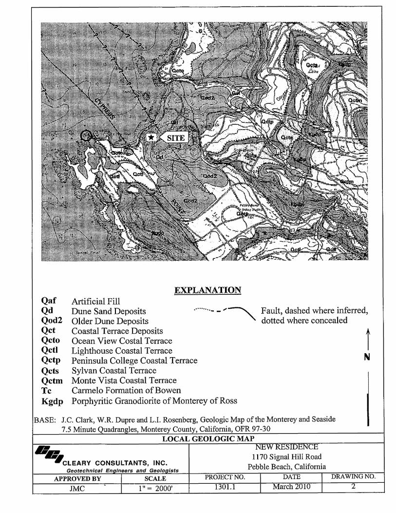
EXPLANATION Artificial Fill Qaf
Qd Qod2 Qct Qcto Qctl Qctp Qcts Qctm Tc Kgdp
Dune Sand Deposits ·········- - .... ~ Older Dune Deposits
Fault, dashed where inferred, dotted where concealed
BASE:
Coastal Terrace Deposits Ocean View Costal Terrace Lighthouse Coastal Terrace Peninsula College Coastal Terrace Sylvan Coastal Terrace Monte Vista Coastal Terrace Carmelo Formation of Bowen Porphyritic Granodiorite of Monterey of Ross
J.C. Clark, W.R. Dupre and L.I. Rosenberg, Geologic Map of the Monterey and Seaside 7.5 Minute Quadrangles, Monterey County, California, OFR 97-30
LOCAL GEOLOGIC MAP
II~ .CLEARY CONSULTANTS, INC.
NEW RESIDENCE 1170 Signal Hill Road
Pebble Beach, California Geotechnicaf En ineers and Geolo ists
i N
APPROVED BY SCALE PROJECT NO. DATE DRAWING NO.
JMC 111 = 2000' 1301.1 March 2010 2

LOT 36
51 High Granodiorite Outcrop
NOTE: Heavy lines show general limits of basement for new home. (Bernstein Architects, Basement
Floor Plan, November 2009)
EXPLANATION
EB-!$-Approximate Location of Exploratory Boring
Jml!• ss·c (R~· 530') (L= 108.54') (c= 11· 4.1· o,,")
ros
A A' t t Subsurface Profile
---.I§. Jointing Strike and Dip, Granodiorite
>< ;{ >< Granodiorite Outcrop (Kdgp)
(l_/)> Fill
BASE: Topographic Survey (September 2009) provided by Bernstein Architects ..... .CLEARY CONSULTANTS, INC.
Geotechnical Engineers and Geologists
APPROVED BY SCALE
JMC 1" = 401 ±
SITE PLAN NEW RESIDENCE
1170 Signal Hill Road Pebble Beach, California
PROJECT NO. DATE
1301.1 March 2010
I J\[
DRAWING NO.
3

A
120
NEWHOME(P)
100 EB.S (Pmjc:ctcd 30' \Vcsl)
-- --?-
' 10 8 SP
_ _._____._,_L_ow_er_Floor (P), Elevation 87' EB4
" 5012~
--- SM -1---------~----- - ---~ -- --
60
0
LEGEND
SP
SM
Kgdp
:g
_., __ _
20
50/3~
5011"'
Aug.:,r Rc.fnsal
40
SM -- ---- Sll/5"
50i0'" Kgdp
60 80
Clean Sand, Loose to Medium Dense (Dune Sand Deposit)
Silty to Clayey Sand, Loose to Medium Dense
Granodiorite Bedrock, Very Dense
Water Level as Encountered During Drilling
Kgdp
50ffl"
Auger Refusal
100 120 140 160
DISTANCE (FEET)
NOTE: 1) Assumed elevation datum per Topographic Survey of site (updated September, 2009)
2) Standard Penetration Resistance values shown on right side of exploratory borings
3) The indicated stratum lines are based on interpolation between widely spread borings and other data, and may not represent actual subsurface conditions.
I'.------ NEWHOME(P) ------41
L ~ .. ,~,, ....... ., ....... _.s_· __ 1 EB-7
SP
- - -?---- --?-SM
-?-
5 !II
" 12
A'
120
100
SP __ ,,_
----SM
Kgdp -- JUS"- - -·1-- 80
511/.S~ Kgdp
sow
180 200 220
--
240 260
60
280
SUBSURFACE PROFILE A-A' -.CLEARY CONSULTANTS, INC. Geotechnical Engineers and Geologists
APPROVED BY SCALE
JMC 111 =20'
NEW RESIDENCE 1170 Signal Hill Road
Pebble Beach, California PROJECT NO. DATE DRAWING NO.
1301.1 March 2010 4

-~ ~ ~ ~ -z 0 ~
~
~ ~ ~ ~
B
120
100
80
60
0
C
120
100
80 ----
60
0
20
--- 1---
20
.S0/5" Kgdp
5P/O"
40
i','EW HOME (P)
/!/ ,// - ,.--·_,,,.,.
.,/ -· 60
NEWHOME(P) ----41
Concrete ,v~lkway ~
EB-6 r -[
Lower Floor E1evation Proposed 87' Ju
' ' ---- - - - - 3519• 50/0"
-SP
S0/0" Kgdp
50/,U'"
. Auger RefilSol
40 60
80
--
EB-:1 (Proj;;:ct\:d 2 5 • Somh)
50/.5"
SDIJ" l0/1"
.Aug.:r Refusal
SP
100
DISTANCE (FEET)
EX!ST!NG HOME (to be removed)
Ex\sting Horne Elevation ± 96' - -- -- - ~ ___. ---
80 100
LEGEND DISTANCE (FEET) Sp Clean Sand, Loose to Medium Dense (Dune Sand Deposit) SM Silty Sand, Loose to Medium Dense
Kgdp
~ Granodiorite Bedrock, Very Dense Water Level as Encountered During Drilling
~ Driveway ~
-·?-- - _.,_
120 140
.,, i2 z ::;
-'!-_,_
--- Kgdp
120 140
s S SP 'I
JIB,2
SP
Kgdp 5S
160
- _.,_
160
--.,.,,..,----- "
180
C'
120
100
80
60
180
-. ~ ~ ~ ~ .._ z 0 ~
~ < > ~ ~ ~
B'
120
100
80
60
200
SUBSURFACE PROFILE B-B' AND C-C'
NOTE: 1) Assumed elevation datum per Topographic Survey of site (updated September, 2009) ·-.CLEARY CONSULTANTS, INC.
NEW RESIDENCE 1170 Signal Hill Road
Pebble Beach, California 2) Standard Penetration Resistance values shown on right side of exploratory borings 3) The indicated stratum lines are based on interpolation between widely spread borings and other
data, and may not represent actual subsurface conditions.
Geotechnical Engineers and Geologists
APPROVED BY SCALE
JMC l" = 201
PROJECT NO. DATE DRAWING NO.
1301.1 March2010 5

PRIMARY DIVISIONS GROUP
SECONDARY DIVISION SYMBOL
CLEAN GW Well graded gravels, gravel-sand mixtures, little or no fines
GRAVELS GRAVELS ..J (LESS THAN < GP Poorly graded gravels or gravel-sand mixtures, little or no fines rn - MORE THAN HALF 5% FINES) ~ =: 0 .... rilil 0
0 E-, N OF COARSE GRAVEL rn < d FRACTION IS WITH GM Silty gravels, gravel-sand-silt mixtures, non-plastic fines Q :; z ~ far;, z rilil LARGER THAN FINES z 0 < N GC Clayey gravels, gravel-sand-clay mixtures, plastic fines -.... far;, = 00 NO.4SIEVE ~ ..J E-, rilil
CLEAN < =: > SW Well graded sands, gravelly sands, little or no fines c., = la;l rilil SANDS SANDS ....
~ z I;!) 00
~ < ,:i:: (LESS THAN = < SP Poorly graded sands or gravelly sands, little or no fines < E-, ..J MORE THAN HALF 5%FINES) 0 rilil 00
u ~ - OF COARSE SANDS 0 FRACTION IS WITH
SM Silty sands, sand-silt mixtures, non-plastic fines :;
SMALLER THAN FINES SC Clayey sands, sand-clay mixtures, plastic fines NO.4SIEVE
ML Inorganic silts and very fine sands, rock flour, silty or clayey
rn ,::ii: rilil SILTS AND CLAYS fine sands or clayey silts with slight plasticity ~ far;, rilil N Inorganic clays oflow to medium plasticity, gravelly clays, 0 -.... ..J 00 CL 0 far;, ..J rilil LIQUID LIMIT IS sandy clays, silty clays, lean clays rn ..J < > Q < :; rilil LESS THAN 50%
OL ~ = en - Organic silts and organic silty clays of low plasticity 00 z z 00 0 .... < - 0 < = ..J M MH Inorganic silts, micaceous or diatomaceous fine sandy or silty ~ E-, < d SILTS AND CLAYS soils, elastic silts c., -rilil ,::ii: z ~ ,::ii: rilil z z 0 E-, < CH Inorganic clays of high plasticity, fat clays ... :; ~ = LIQUID LIMIT IS ~ E-, GREATER THAN 50%
OH Organic clays of medium to high plasticity, organic silts
IIlGIIl, Y ORGANIC SOILS Pt Peat and other highly organic soils
UNIFIED SOIL CLASSIFICATION SYSTEM {ASTM D-2487} U.S. STANDARD SERIES SIEVE CLEAR SQUARE SIEVE OPENINGS
200 40 10 4 3/4" 3" 12"
SILTS AND CLAYS I SAND GRAVEL I COBBLES I BOULDERS FINE MEDIUM COARSE FINE COARSE I
GRAIN SIZES
SANDS AND GRA.VELS BLOWS/FOOTi SILTS AND CLAYS STRENGTH * BLOWS/FOOT ~ VERY SOFT 0-1/4 0-2
VERY LOOSE 0-4 SOFT 1/4 -1/2 2-4
LOOSE 4-10 FIRM 1/2-1 4-8
MEDIUM DENSE 10-30 STIFF 1-2 8-16
DENSE 30-50 VERY STIFF 2-4 16 -32
VERY DENSE OVER50 HARD OVER4 OVER32
RELATIVE DENSITY CONSISTENCY
{- Number of blows of 140 pound hammer falling 30 inches to drive a 2 inch O.D. (1-3/8 inch J.D.) split barrel (ASTM D-1586).
* Unconfined compressive strength in tons/sq.ft. as determined by laboratory testing or approximated by the standard penetration test (ASTM D-1586), pocket penetrometer, torvane, or visual observation.
KEYTOEXPLORATORYBORINGLOGS ·~ NEW RESIDENCE 1170 Signal Hill Road
.CLEARY CONSULTANTS, INC. Pebble Beach, California Geotechnlcal Engineers and Geologists PROJECT NO. DATE DRAWING NO.
1301.1 March2010 6

FIELD SAMPLING PROCEDURES
The soils encountered in the borings were continuously logged in the field by our representative and described in accordance with the Unified Soil Classification System (ASTM D-2487).
Representative soil samples were obtained from the borings at selected depths appropriate to the soil investigation. All samples were returned to our laboratory for classification and testing.
In accordance with the ASTM D1586 procedure, the standard penetration resistance was obtained by dropping a 140 pound hammer through a 30-inch free fall. The 2-inch O.D. Standard split barrel sampler was driven 18 inches or to practical refusal and the number of blows were recorded for each 6-inch penetration interval. The blows per foot recorded on the boring logs represent the accumulated number of blows, or N-value, required to drive the penetration sampler the final 12 inches. In addition, 3.0 inch O.D. x 2.42 inch LD. drive samples were obtained using a Modified California Sampler and 140 pound hammer. Blow counts for the Modified California Sampler were converted to standard penetration resistance by multiplying by 0.6. The sample type is shown on the boring logs in accordance with the designation below.
6" x 2.42" Liner Modified California Sampler
Bag Sample Standard Split Barrel Sampler
Where obtained, the shear strength of the soil samples using either Torvane (TV) or Pocket Penetrometer (PP) devices is shown on the boring logs in the far right hand column.
SUMMARY OF FIELD SAMPLING PROCEDURES - NEW RESIDENCE ... 1170 Signal Hill Road
CLEARY CONSULTANTS, INC. Pebble Beach, California Geotechnlcal Engineers and Geologistst----:p::~:-:O:-:JE=-:C::T:-:N:-::-0----.--.---0-ALT.::.E=:.=.:.;:.::;::_D_RA_W_IN_G_N_O_. -I
1301.1 March 2010 7

LABORATORY TESTING PROCEDURES
The laboratory testing program was directed toward a quantitative and qualitative evaluation of the physical and mechanical properties of the soils underlying the site.
The natural water content was determined on 79 samples of the materials recovered from the borings in accordance with the ASTM D2216 Test Procedure. These water contents are recorded on the boring logs at the appropriate sample depths.
Dry density determinations were performed on 20 samples to measure the unit weight of the subsurface soils in accordance with the ASTM D2937 Test Procedure. The results of these tests are shown on the boring logs at the appropriate sample depths.
Two Atterberg Limits determinations were performed on representative samples of the subsurface soils in accordance with the ASTM D4318 Test Procedure to determine the range of water contents over which the materials exhibited plasticity. The Atterberg Limits are used to classify the soils in accordance with the Unified Soil Classification System and to evaluate the soil's expansion potential. The results of these tests are presented on the boring logs.
The percent soil fraction passing the #4 and #200 sieves were determined on 13 and 22 samples of the subsurface soils in accordance with the ASTM Dl 140 Test Procedure to aid in the classification of the soils. The results of these tests are shown on the boring logs at the appropriate sample depths.
Free swell tests were performed on six samples of the soil materials to evaluate the swelling potential of the soil. The free swell tests were performed by slowly pouring 10 ml of air dried soil passing the No. 40 sieve into a 100 ml graduated cylinder filled with approximately 90 ml of distilled water. The suspension was stirred repeatedly to ensure thorough wetting of the soil specimen. The graduated cylinder was then filled with distilled water to the 100 ml mark and allowed to settle until equilibrium was reached (approximately 24 hours). The free swell volume of the soil was then noted. The percent free swell was calculated by subtracting the initial soil volume from the free swell volume, dividing the difference by the initial volume, and multiplying the result by 100 percent. The results of these tests are presented on the boring logs.
Two unconfined compression tests were performed in accordance with the ASTM D2166 Test Procedure on undisturbed samples of the subsurface soils to evaluate the undrained shear strength of the materials. The unconfined tests were performed on samples having a diameter of 2.43 inches and a height-to-diameter ratio of at least two. Failure was taken at the peak normal stress or at five percent strain, whichever occurred first. The results of these tests are presented on the boring logs at the appropriate sample depths.
ORA WING NO. 8
CLEARY CONSULTANTS,' INC.
LABORATORY TESTING PROCEDURES CONTINUED
Corrosion testing was performed by Cooper Laboratory on a sample of the soil materials from EB-6 at a depth of one to five feet. Testing included resistivity, pB, chloride and sulfate testing performed in accordance with ASTM G57, ASTM G51, Caltrans 422(modified) and Caltrans 4 l 7(modified), respectively. The results of these tests are presented on Drawing 20 and are discussed in Section G. Soil Corrosivity.
Grain size distribution tests were performed on two samples of the sand materials in accordance with the ASTM D 422 Test Procedure to aid in the classification. The results of these tests are presented on Drawing 21.
DRAWING NO. 9
CLEARY CONSULTANTS, INC.

EQUIPMENT 8" Diameter Hollow Stem Auger* ELEVATION 105'± LOGGED BY DEPTH TO GROUNDWATER Not Det. DEPTH TO BEDROCK 9.5'± DATE DRILLED
DESCRIPTION AND CLASSIFICATION
DESCRIPTION AND REMARKS
Driveway: 2.5" AC Over 6" AB
SAND, dry, fine angular to subrounded sand, cohes10nless
@2.5': Finer than #4 = 100% Finer than #200 = 1 %
@5.0': dark gray, fine to coarse sand laminations, moist, upoer five feet caved as augers were removed from hole Finer than #4 = 100% Finer than #200 = 2 %
@7.0': slightly moist, limited cohesion
COLOR
Whitish Tan
CONSIST.
Loose SP
----· Medium Dense
DEPTH "' "' .J
(feet) ~ -,:
""
- -- 1 -- ------ -- 4 -~ - ------ -- 7 -~ - --~
8
5
9
16
0
0
1
2
1
1
--------------- ----------- 8=r SILTY SAND, wet, fine to medium grained sand, roots up to 3/4" diameter
@8.5': Finer than #40=0 100%% Fmer than #2 = 3 o
Brown Loose
@9.5': wet / Finer than #4 = 97% ..,,,, / Finer than #200 = 28 % / Free Swell= 20% / fiery __________________ / ense)
DECOMPOSED GRANODIORITE, slightly moist, highly Tan weathered tWho .. h
ltlS @l l . 0' : driller reported hard drilling Gray
@13.0': fresh, no weathering, drilling refusal
Bottom of Boring = 13.0'
* Drilled with a CME-55 Track Mounted Rig PP = Pocket Penetrometer
SM-SP -
- 9 -1 --- - -8
(SM) - 10 _ }C 50/5"
- -- 11-
-- 12-- -
12
21
17
13
- 13 -= 50/2" 1 - -- 14-- -- 15 -- -- 16 -- -- 17 -- -- 18 -- -- 19-- -
97
90
80
TD 2/19/2010
102 PP=l.0
116
___________________ __,...._ __ ____._ ______ ......_ 20 ------------------THE STRATIFICATION LINES REPRESENT THE APPROXIMATE BOUNDARY BETWEEN SOIL TYPES AND THE TRANSITION MAY BE GRADUAL
·-.CLEARY CONSULTANTS, INC. Geotechnica/ Engineers and Geologists
APPROVED BY I SCALE JMC I
LOG OF EXPLORATORY BORING NO. 1
PROJECT NO. 1301.1
NEW RESIDENCE 1170 Signal Hill Road
Pebble Beach, California DATE I DRAWING NO.
March 2010 I 10

EQUIPMENT 8" Diameter Hollow Stem Auger* ELEVATION 106'± LOGGED BY TD DEPTH TO GROUNDWATER 16.0'± DEPTH TO BEDROCK 12.0'± DATE DRILLED 2/19/2010
DESCRIPTION AND CLASSIFICATION'
DESCRIPTION AND REMARKS
Landscape Area
SAND;._ dry, fine to medium grained, angular to suurounded
---------------DECOMPOSED GRANODIORITE, moist to wet
@16.0': trace clay Finer than #200 = 16 %
Bottom of Boring = 16.5'
* Drilled with a CME-55 Track Mounted Rig ~ Water level as measured 0.25 hours after drilling
"' DEPTH "' ..J .. COLOR CONSIST. (feet) );
< rr.
Whitish Very Tan Loose
SP - -- 1 -- -- 2 -
- -- 3 -- -- 4 -- -- 5 -1-- -- 6 -- -- 7 -
- -- 8 -
- -- 9 -
- -- 10-- -- 11 -- -
- - ---- - -- -- 12 -Orange- SM-Gray SC - -
----·-----G~ayWhite
(Very Dense)
- 13 -- -- 14-
- -- 15 --~
- -- 16 - ✓
'\
- 17 -- -- 18 -- -i-- 19-
- -
;z
[ ~ >-0 !;.., ~ i:: i= .,
E-< ., Ill ;z ~ 0 ~
"' ~ I- ?i "' u ?i "'
~ < C !=. ~ ~ E- "' ..J ;z > E-
"' e 0 .,
"' .. u C
55 11
1-----------------------"-----'------'-----'-- 20 _._..__ _ _._ _ _._ _ _._ __ ---I THE STRATIFICATION LINES REPRESENT THE APPROXIMATE BOUNDARY BETWEEN SOIL TYPES AND THE TRANSITION MAY BE GRADUAL
·-.CLEARY CONSULTANTS, INC. Geotechnlcal Engineers and Geologists
APPROVED BY I SCALE JMC I
\.
LOG OF EXPLORATORY BORING NO. 2
PROJECT NO. 1301.1
NEW RESIDENCE 1170 Signal Hill Road
Pebble Beach, California DATE I DRAWINGNO.
March 2010 I 11

EQUIPMENT 8" Diameter Hollow Stem Auger* ELEVATION DEPTH TO GROUNDWATER Not Enc. DEPTH TO BEDROCK
DESCRIPTION AND CLASSIFICATION
DESCRIPTION AND REMARKS
Landscape Area
SAND, slightly moist to moist, fine to medium angular to sutirounded ~and, occasional 1/4" diameter rootlets, cohes10nless
@4.0': slight cohesion
COLOR CONSIST.
Whitish Very Tan Loose
i----· Loose
SP
101'± !LOGGED BY 10.5'± IDATE DRILLED
DEPTH ~
"' ..J
(feet) ii; < "'
- ---- 1 -- -- 2 - -- -- 3 -( - ----4 =1 -- 5 ---- -- 6 -( - ---- 7 -- -- 8 -- - -
2
2
2
7
2
1 95
1 91
1
2
--------------- ---~-----1--- 9 -
TD 2/19/2010
SAND, moist, fme to medium grained
@9.5': Finer than #4 = 100% Finer than #200 = 1 % Free Swell = 0 %
Dark Gray
Loose SP - -; - - - - - - - 10 - -
10
6
5
4
16
::o PP=0.25
; Very SC X 50/4" / Dense/ - --
-- - - - - - - -- - - - - - Dark (SM) CLAYEY SAND, very moist, fme to medium grained Brown / / - 11 -
sand, completely weathered granodiorite / _ _
/ --------------- / GRANODIORITE, slightly moist, highly weathered and
decomposed Tan
~itish Gray
(Very Dense)
- 12 -- -- 13 -- -- 14-- -
@15.0': little or no weathering, fresh rock - 15 -1&1:= 50/3" 3
* Drilled with a CME-55 Track Mounted Rig PP = Pocket Penetrometer
- -- 16-- -- 17-- -- 18 -- --19-- -____________________ __,_ ___ __._ ___ _._ _ _.__ 20 __.__..__ _ __._ _ __._ _ __._ __ _
THE STRATIFICATION LINES REPRESENT THE APPROXIMATE BOUNDARY BETWEEN SOIL TYPES AND THE TRANSITION MAY BE GRADUAL
·-.CLEARY CONSULTANTS, INC. Geotechnicaf Engineers and Geologists
APPROVED BY I SCALE JMC I
LOG OF EXPLORATORY BORING NO. 3
PROJECT NO. 1301.1
NEW RESIDENCE 1170 Signal Hill Road
Pebble Beach, California DATE I
March 2010 I DRAWING NO.
12

EQUIPMENT 8" Diameter Hollow Stem Auger* ELEVATION 101 '± LOGGED BY TD DEPTH TO GROUNDWATER Not Enc. DEPTH TO BEDROCK 10.5'± DATEDRILLED 2/19/2010
DESCRIPTION AND CLASSIFICATION
DESCRIPTION AND REMARKS COLOR CONSIST.
Tan GRANODIORITE, slightly moist, continued .... to ..
@20.5': highly weathered, iron staining, moist to wet Wh1ttsh Finer than #200 = 19 % Gray
@25.0': decomposed, friable granodiorite
@30.0': fresh granodiorite zones
@31.0': hard., slighfiitly weathered granodiorite, drillmg re sal
Bottom of Boring= 31.0'
* Drilled with a CME-55 Track Mounted Rig
Yellow Red
GrayWhite
(Very Dense)
Nery Dense)
0:
DEPTH :J .. (feet) ~ ..
i:l f t z rr. r g 0: ii:' t z < 3: "' "'
., 0 ~ ~ a! ;;; .J
"' s 0 0: u
17 41
11 - __ ...... - 22-
- -- 23-
- -- 24-
- --25-T _ -~ 50/5" 14
- 26-
- -- 27-
- -- 28-
- -- 29-
- -- 30 -1::c: 50/3"
- -- 31 -m= 50/1" 18
- -- 32-
- -- 33-
- -- 34-
- -- 35-
- -- 36-
- -- 37-
- -- 38-
- -- 39-
- --------------------~---~---~-- 40 _.___..__ _ _.__....,... ....... _..._ __ -I THE STRATIFICATION LINES REPRESENT THE APPROXIMATE BOUNDARY BETWEEN SOIL TYPES AND THE TRANSITION MAY BE GRADUAL
·-.CLEARY CONSULTANTS, INC. Geotechnfcaf Engineers and Geologists
APPROVED BY I SCALE JMC I
LOG OF EXPLORATORY BORING NO. 3
PROJECT NO. 1301.1
NEW RESIDENCE 1170 Signal Hill Road
Pebble Beach, California DATE I DRAWING NO.
March2010 1 13

EQUIPMENT 8" Diameter Hollow Stem Auger* ELEVATION 87'± LOGGED BY DEPTH TO GROUNDWATER Not Enc. DEPTH TO BEDROCK
DESCRIPTION AND CLASSIFICATION
DESCRIPTION AND REMARKS
Landscape Area
SAND.._slightly moist, fine to medium angular to suorounded sand
@2.5': Finer than #200 = 1 %
COLOR CONSIST.
Whitish Very Tan Loose
Loose
SP
8.0'± DATE DRILLED
DEPTH ffi ..J
(feet) ~ < "'
- --- 1 -
- -- 2 -
-
2 3
4
--------------- ---- ------- 5 5
17 SILTY SAND, very moist fine to medium grained sand, occasional weathered granodiorite gravels
@4.5': Finer than #4 = 94% Finer than #200 ~ 33 % Free Swell = 0 ,o
@6.0': possibly c_ompletely decomposed g_i;anod1onte 9 % Fmer than 11_4 = 7 o Finer than #200 = 34 % Free Swell = 0%
Dark Brown
--------------- ----GRANODIORITE, slightly moist, partially weathered
@8.0': driller reported hard drilling
@13 .5': drilling refusal
Bottom of Boring = 13.5'
* Drilled with a CME-55 Track Mounted Rig ** Unconfmed Compressive Strength
PP = Pocket Penetrometer
Whitish Gray
Loose SM ----· Medium Dense
---(Very Dense)
--(SM)
- ----4-- -- 5 -- -- 6 -~ - ---- 7 -- -- 8 -- - I - 9 -- -- 10-- -- 11-- -- 12-- -- 13 -- - )3:1::
- 14-- -- 15 -- -- 16-
- 17-- -- 18-- --19-- -
19
11
50/3"
50/1"
5
9
12
1
TD 2/19/2010
117 PP>4.5
126 *"'2.2ksf@ 2.2%strain
1-----------------------''------'----_.__..._ 20 __.._.._ _ _._ _______ _ THE STRATIFICATION LINES REPRESENT THE APPROXIMATE BOUNDARY BETWEEN SOIL TYPES AND THE TRANSITION MAY BE GRADUAL
·-.CLEARY CONSULTANTS, INC. Geotechnfcal Engineers and Geologists
APPROVED BY I SCALE JMC I
LOG OF EXPLORATORY BORING NO. 4
PROJECT NO. 1301.1
NEW RESIDENCE 1170 Signal Hill Road
Pebble Beach, California DATE I DRAWING NO.
March 2010 I 14

EQUIPMENT 8" Diameter Hollow Stem Auger* ELEVATION 84'± LOGGED BY DEPTH TO GROUNDWATER Not Det. DEPTH TO BEDROCK 10.0'± DATE DRILLED
DESCRIPTION AND CLASSIFICATION 0:
DEPTH c:l .., ~ DESCRIPTION AND REMARKS COLOR CONSIST. (feet) <(
"'
Landscape Fill Whitish Very SP Tan Loose - --
SANDlbslightly moist, fine to medium angular to - 1 -su rounded sand
L @1.5': Finer than #200 = 0% - -- 2 -- -
@3.0': no recovery - 3 -- - - -
- 4 -
L - -5 -----· -Loose - -- 6 -K - - -~
- 7 -
--------------- --- ------ -CLAYEY SAND, wet, fine to coarse angular to
subrounded sand
@9.5': free water
Dark Gray
Loose SC -s-- _,__
Liquid. Limit = 31 % Plasticity Index = 17 % - 9 -1 ~fil~f IRfil½ 1100 = 1~i\ - -Free Swell = 50 %
--------------- ---------- 10---GRANODIORITdE, slightly moist to moist, weathered and Yellowish (Very (SM)_ -~-
decompose , iron stammg to . . Dense) Wh1t1Sh Gray - 11-- -
- 12-- -- 13 -
c:l C u ~ z
<( "' .. ~ "' 0 ~ .., "' e, 0:
1
2
1
8
8
50/2"
t .. z c:l .. z 0 u
6 4
1
5
3
8
10
6
- -~ 50/5" 3
Bottom of Boring = 18.5' * E-55 Track Mounted Rig
- 14-- -- 15 -- -- 16-
- -- 17 -
- -- 18-
- 19-
- -
50/0"
TD 2/19/2010
fa' ~ u "' !:, ~
123 PP=3.25 118 **1.2ksf@
3.7%strain
** Unconfmed Compressive Strength PP = Pocket Penetrometer ____________________ __._ ___ __._ ___ ....._ _ _.__ 20 ---L-L..--_._ _ _._ _ _._ __ --1
THE STRATIFICATION LINES REPRESENT THE APPROXIMATE BOUNDARY BETWEEN SOIL TYPES AND THE TRANSITION MAY BE GRADUAL
·-.CLEARY CONSULTANTS, INC. Geotechnical Engineers and Geologists
APPROVED BY I SCALE JMC I
LOG OF EXPLORATORY BORING NO. 5
PROJECT NO. 1301.1
NEW RESIDENCE 1170 Signal Hill Road
Pebble Beach, California DATE I DRAWINGNO.
March 2010 I 15
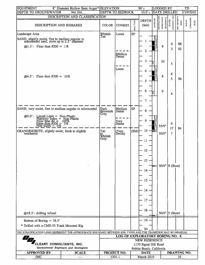
EQUIPMENT 8" Diameter Hollow Stem Auger* ELEV A TION 96'± LOGGED BY TD DEPTH TO GROUNDWATER Not Det. DEPTH TO BEDROCK 10.0'± DATE DRILLED 2/19/2010
DESCRIPTION AND CLASSIFICATION
DESCRIPTION AND REMARKS COLOR CONSIST.
Landscape Area Whitish Loose Tan
SANDibslightly moist, fine to medium angular to su rounded sand, roots up to 2.5" diameter
@1.5': Finer than #200 = 1%
----· Medium Dense
____ ,
Loose
@4.5': Finer than #200 = 10%
- ------------ ------- --- ---SAND, very moist, fme to medium angular to subrounded Dark Medium
Brownish Dense
@9.0': Liquid Limit= Non-Plastic Plasticity Index = Non-Plastic
Gray
"' DEPTH "' .J
~ (feet) < "'
SP - - --- 1 -- -- 2 - -- -- 3 -K - - ---- 4 -- -fa-- 5 - -- -- 6 -x - - >--
- 7 -
--- -SP -8-
- --
Finer than. 11200 %= 3 % Dense ____ Fre_eS-w_•eH_= O_o _____________ ., _____ - -
"' f' u ~ ;z
< ... ~ "' 0 .; .J
"' e. "'
8
10
8
9
35/9" Finer than #4 = 100% Very - 9 -1
GRANODIORITE, slightly moist, fresh to slightly Tan (Very (SM)- 10 -a:c: 5010 ,, weathered to Dense)
Whitish Gray
-- 11-fa-- -
- 12-- -...- 13 -
l ~ "' ~ C u
6
3
3
6
5
4
6
17
7
> ... .;
.:-;z
"' u C e:, > "' C
88
92
96
84
- -sc: 50/0" 9 (Shoe}
- 14-
- -- 15 -
- -- 16 -- -...- 17-- -...- 18 -
@18.5': drilling refusal __ 50/0" 5 (Shoe)
Bottom of Boring = 18.5' - 19-
* Drilled with a CME-55 Track Mounted Rig - -
.:-"' ~
______________________ ...._ __ ~ ___ .....__....._ 20 _.__.___~_ ........ ____ --I
THE STRATJFICA TION LINES REPRESENT THE APPROXIMATE BOUNDARY BETWEEN SOIL TYPES AND THE TRANSITION MAY BE GRADUAL
·-.CLEARY CONSULTANTS, INC. Geotechnical Engineers and Geologists
APPROVED BY I SCALE JMC I
LOG OF EXPLORATORY BORING NO. 6
PROJECT NO. 1301.1
NEW RESIDENCE 1170 Signal Hill Road
Pebble Beach, California DATE I DRAWING NO.
March 2010 I 16

EQUIPMENT 8" Diameter Hollow Stem Auger* ELEVATION DEPTH TO GROUNDWATER 10.5'± DEPTH TO BEDROCK
DESCRIPTION AND CLASSIFICATION
DESCRIPTION AND REMARKS
Landscape Area
SAND, slightly moist to moist, fine to medium angular to suBrounded sand, rootlets up to 0.25" diameter
@1.5': Finer than #200 = 0%
COLOR CONSIST.
Whitish Loose Tan
Medium Dense
Loose
SP
95'± ILOGGED BY TD 14.0'± IDATE DRILLED 2/19/2010
DEPTH i ,;l
(feet) ;; < "'
...._ --
...._ 1 -3 ...._ - 5
...._ 2 -3 87
,__ -...._
3 -x 10 5 ,__ --
...._ 4 -s ,__ - 9 @4.5': Finer than #200 = 0%
5 -4 101
----------------- ---SILTY SAND, wet to saturated, fine to medium grained
sand
@9.5': Finer than #200 = 2%
@10.5': free water
@11.0': Finer than #4 = 100% Fmer than #200 = 26%
Dark Gray
---- ...._
Medium Dense ,__ -
...._ 6 -( ,__ ---
- 7 -
- -- 8 -
- ---- 9 -
------ -Medium Dense
SM - 10- -
- -
- ---- 12-
- -- 13 -
12
13
-----______ ---- --- -----= 14 =ix 30/5" GRANQDIORITE, slightly moist, highly weathered, iron Gray Very (SM) I
stamed Dense - - ._
@l 9. 0' : fresh, little to no weathering Finer than #4 = 95 % Finer than #200 = 14 %
* Drilled with a CME-55 Track Mounted Rig ~ Water level as encountered during drilling
- 15 -
- -- 16-
- -- 17-
- -- 18 -
~ ---...._ 19 - X 5015"
---- ---
4
19
:sz =
12
14
11
6
92
1-----------------------'-----_._---~-....._ 20 _,__.__ _ _,__...,___...,_ __ -I THE STRATIFICATION LINES REPRESENT THE APPROXIMATE BOUNDARY BETWEEN SOIL TYPES AND THE TRANSITION MAY BE GRADUAL
·-.CLEARY CONSULTANTS, INC. Geotechnica/ Engineers and Geologists
APPROVED BY I SCALE JMC I
LOG OF EXPLORATORY BORING NO. 7
PROJECT NO. 1301.1
NEW RESIDENCE 1170 Signal Hill Road
Pebble Beach, California DATE I DRAWING NO.
March 2010 I 17

EQUIPMENT 8" Diameter Hollow Stem Auger* ELEVATION 95'± LOGGED BY TD DEPTH TO GROUNDWATER 10.5'± DEPTH TO BEDROCK 14.0"± DATE DRILLED 2/19/2010
DESCRIPTION AND CLASSIFICATION
DESCRIPTION AND REMARKS
GRANODIORITE, slightly moist, continued ....
@25 .0': weathered decomposed granodiorite, clayey zones
Bottom of Boring = 25 .5'
* Drilled with a CME-55 Track Mounted Rig
COLOR CONSIST.
Gray Very Dense
;z "' ~ ~ > "
0 ~ ~
I-
DEPTH "' i= " - .; ~ .J < ~ i != ~ ;z "- G:' ~ ; "' u ..
(feet) !!a C < "' Q .. !! < ., .., ~ !z > -., "' e 0 "' "' " .. u Q
(SM)_ -- 21-
- -- 22-
- -- 23 -
- -- 24-
- -- 25 -r.r
IXI 50/4" 11
- 26-
- -- 27-
- -- 28-
- -- 29-
- -- 30-
- -- 31-
- -- 32-
- -- 33 -
- -- 34-
- -- 35 -
- -- 36-
- -- 37 -
- -- 38 -
- -- 39-
- -1-----------------------''----'----...L..-....__ 40 __.._,.._ _ _,__ _ _.__..._ __ -I THE STRATIFICATION LINES REPRESENT THE APPROXIMATE BOUNDARY BETWEEN SOIL TYPES AND THE TRANSITION MAY BE GRADUAL
·-.CLEARY CONSULTANTS, INC. Geotechnica/ Engineers and Geologists
APPROVED BY I SCALE JMC I
LOG OF EXPLORATORY BORING NO. 7
PROJECT NO. 1301.1
NEW RESIDENCE 1170 Signal Hill Road
Pebble Beach, California DATE 1 DRAWING NO.
March 2010 I 18

60
/ ,J 50 y ,-..
CH + ~ ;) .._
>< 40 , r,:,:l
V Q CL z ... > 30 ~ V ... u MH ... ~ ~ {ll 20 or < ~ / ~ ~ / OH
10 7 r
CL.-t:z-1.L -//// //,#' MI.Or OL 4 / [!.__ ML I 0 0 10 20 30 40 50 60 70 80 90 100
LIQUID LIMIT(%)
NATURAL PASSING UNIFIED
KEY BORING SAMPLE WATER LIQUID PLASTICITY NO. LIQUIDITY SOIL
SYMBOL NO. DEPTH CONTENT LIMIT INDEX 200 SIEVE INDEX CLASSIFICATION
(feet) % % % % SYMBOL
£ 5 9.5 10 31 17 26 -0.2 SC*
[!] 6 9.0 6 --- -- 3 --- SP*
*Classified as coarse-grained soil since less than 50% passes #200 sieve
PLASTICITY CHART NEW RESIDENCE
II~ 1170 Signal Hill Road .CLEARY CONSULTANTS, INC. Pebble Beach, California
Geotechnical Engineers and Geologists PROJECT NO. DATE DRAWINGNO.
1301.1 March2010 19

. ---·-·-···-·-···-····· ····- ·-----····-- -·-····-
(g m)' II I • CIDPER i Corrosivity Test Summary
: MIM•• MNHWM+IM i
•'-- _/ I i ---··--·· --·--·--·- ....• -····- -·- ··-···-·····
CTL# 018-524 Date: 2/26/2010 Tested By: PJ Checked: PJ
Client: Cleary Consultants Project: 1170 Siji!nal Hill Rd. Pebble Beach, CA Proj. No: 1301.1 Remarks:
Sample Location or ID Resistivity@ 15.5 °C (Ohm-cm) Chloride Sulfate-(water soluble) pH ORP Sulfide Moisture Boring Sample, No. Depth, ft. As Rec. Minimum Saturated mg/kg mg/kg % (Redox) Qualitative % Soil Visual Description
Dry Wt. Dry Wt. Dry Wt. mv by Lead At Test ASTMG57 Cal643 ASTMG57 Cal 422-mod. Cal 417-moo. Cal 417-mod. ASTM G51 SM2580B Acetate Paper ASTM D2216
6 - 1-5 - - 16,497 4 <5 <0.0005 6.7 166 - 3.9 Light Brown SAND
,
DRAWING NO. 20

6.0 5.0 4.5 4.0 3.5 3.0 2.5 2.0 1.5 1.0 0.5 0.0 0.5 1.0 1.5 2.0 2.5 3.0 3.5 4.0 I I I I I I I I I I I I I I I I I I I I
U.S. Standard Sieve Opening Size I U.S. Standard Sieve Numbers I Hydrometer
4 3 2 1112 I \/2 ~8 A 8 10 16 20 30 40 5060 100 200 270
• A
100 I I ,:;::::r . - --B ,, I I I I II I
f:f. '-='>\ r-- -J:l
r,.. r,..
- D I'-~
~ 90
80
f-, ::c C,:) -C;;l 70 ~ ... = c=: C;;l z 60 -""' I"" z C;;l c;.) c=: C;;l
50 ~
40
30
20
I l,,;
10 ~
~ 0
&-_li~ nl 100 50 10 5 1 0.5 0.1 - 0.05 0.01 0.005
GRAIN SIZE IN MILLIMETERS
COBBLES GRAVEL SAND
SILT OR CLAY COARSE FINE COARSE MEDIUM I FINE
SYMBOL SAMPLE SOURCE CLASSIFICATION
& Boring 5 at 6' Light Brown Sand (SP)
B Boring 6 at 1' to 5' Light Brown Sand (SP)
GRADATION TEST DATA
"• NEW RESIDENCE
.CLEARY CONSULTANTS, INC. 1170 Signal Hill Road
Pebble Beach, California Geotechnical Engineers and Geologists
PROJECT NO. DATE DRAWING NO.
1301.1 March2010 21

APPENDIX A
New Residence, 1170 Signal Hill Road, Liquefaction and Dry Settlement Calculations, EB-5 and EB-7,
Drilled February 19, 2010
CLEARY CONSULTANTS, INC.

<{ rn ::J
e> "' l 0 rn .c u QJ
!:: ·;; i:3
e Q.
'm ::, er ::J
Liquefaction and Dry Settlement Analysis New Residence 1170 Signal Hill Road Pebble Beach,
Hole No.=EB-5
N-Value Unit Weight -pcf Fines %
(ft) 0 100 0 200 0 50 O ---~l-~l-~1-~l -~I -~, - l~~,-~1~ II I I II I I I I I II II I I I
5
-
-10
15
SPT or BPT test 20
25
30
35
·-.CLEARY CONSULTANTS, INC.
Magnitude=B.5 Acceleration=0.442g
Soil Description
Sand (SP)
· · · Clayey Sand (SC)
Granodiorite (SP)

<( en ::,
~
"' ~ en {i Q)
t: ·;; i:3
e Q._
,<!' Q) ::, 0-::;
(ft) 0
20
25
30
35
Liquefaction and Dry Settlement Analysis New Residence 1170 Signal Hill Road Pebble Beach,
Hole No.=EB-5
Soil Description Raw Unit Fines Shear Stress Ratio SPT Weight % 0
~~~------,--~~--------~ 1 90 0 f ii) Sand (SP) I I I I I I I I
Clayey Sand (SC)
Granodiorite (SP)
·-.CLEARY CONSU LTANTS, INC.
1 90 0
2 90 0
1 90 0
8 95 0
8 130 26
100 130 26
100 121 .5 26
100 121 .5 26
-
fs1=1
CRR - CSR fs1-Shaded Zone has Liquefaction Potential
Magnitude=B.5 Acceleration=0.442g
Factor of Safety 0 1 5
I I I I I I I I
Settlement O (in .)
S = 3.35 in .
10
Saturated Unsaturat. -

1170 siganl Hill Road EB5.cal
************************************************************************************ *******************
LIQUEFACTION ANALYSIS CALCULATION DETAILS
copyright by civilTech software www.civiltechsoftware.com
************************************************************************************
Input
Font: Courier New, Regular, size 8 is recommended for this report. Licensed to , 3/19/2010 4:22:23 PM
Input File Name: C:\Liquefy5\1170 Siganl Hill Road EB5.liq Title: New Residence 1170 signal Hill Road Pebble Beach, subtitle:
Data: surface Elev.= Hole NO.=EB-5 Depth of Hole=l8.50 ft water Table during Earthquake= 999.00 ft Water Table during In-Situ Testing= 999.00 ft Max. Acceleration=0.44 g Earthquake Magnitude=8.50 No-Liquefiable soils: Based on Analysis 1. SPT or BPT calculation. 2. Settlement Analysis Method: Tokimatsu, M-correction 3. Fines correction for Liquefaction: Idriss/seed 4. Fine correction for settlement: During Liquefaction* 5. Settlement calculation in: All zones* 6. Hammer Energy Ratio, 7. Borehole Diameter,
Ce = 1. 25 Cb= 1
CS= 1 8. sampling Method, 9. user request factor of safety (apply to CSR) ,
Plot one CSR curve (fsl=l) user= 1
10. Average two input data between two Depths: No * Recommended Options
In-situ Test Data: Depth SPT Gamma Fines ft pcf %
0.00 1.00 90.00 0.00 1.50 1.00 90.00 0.00 3.00 2.00 90.00 0.00 4. 50 1.00 90.00 0.00 6.00 8.00 95.00 0.00 9. 50 8.00 130.00 26.00 10.50 100.00 130.00 26.00 13.50 100.00 121. 50 26.00 18.00 100.00 121.50 26.00
output Results: calculation segment, dz=0.050 ft user defined Print Interval, dp=l.00 ft
Peak Ground Acceleration (PGA), a__max = 0.44g
CSR calculation: Page 1

1170 siganl Hill Road EB5.cal Depth gamma sigma gamma' sigma' rd mz a(z) CSR X
fsl =CSRfs ft pcf atm pcf atm g g
0.00 90.00 0.000 90.00 0.000 1.00 0.000 0.442 0.29 1.00 0.29
1.00 90.00 0.043 90.00 0.043 1.00 0.000 0.442 0.29 1.00 0.29
2.00 90.00 0.085 90.00 0.085 1.00 0.000 0.442 0.29 1.00 0.29
3.00 90.00 0.128 90.00 0.128 0.99 0.000 0.442 0.29 1.00 0.29
4.00 90.00 0.170 90.00 0.170 0.99 0.000 0.442 0.28 1.00 0.28
5.00 90.00 0.213 90.00 0.213 0.99 0.000 0.442 0.28 1.00 0.28
6.00 95.00 0.255 95.00 0.255 0.99 0.000 0.442 0.28 1.00 0.28
7.00 95.00 0.300 95.00 0.300 0.98 0.000 0.442 0.28 1.00 0.28
8.00 95.00 0.345 95.00 0.345 0.98 0.000 0.442 0.28 1.00 0.28
9.00 95.00 0.390 95.00 0. 390 0.98 0.000 0.442 0.28 1.00 0.28
10.00 130.00 0.443 130.00 0.443 0.98 0.000 0.442 0.28 1.00 0.28
11.00 130.00 0.504 130.00 0. 504 0.97 0.000 0.442 0.28 1.00 0.28
12.00 130.00 0.566 130.00 0. 566 0.97 0.000 0.442 0.28 1.00 0.28
13.00 130.00 0.627 130.00 0.627 0.97 0.000 0.442 0.28 1.00 0.28
14.00 121. 50 0.687 121. 50 0.687 0.97 0.000 0.442 0.28 1.00 0.28
15.00 121. 50 0.744 121. 50 0.744 0.97 0.000 0.442 0.28 1.00 0.28
16.00 121. 50 0.802 121. 50 0.802 0.96 0.000 0.442 0.28 1.00 0.28
17.00 121. 50 0.859 121. 50 0.859 0.96 0.000 0.442 0.28 1.00 0.28
18.00 121. 50 0.916 121. 50 0.916 0.96 0.000 0.442 0.28 1.00 0.28
CSR is based on water table at 999.00 during earthquake
CRR calculation from SPT or BPT data: Depth SPT cebs er sigma' en
(N1)60f CRR7.5 (N1)60 Fines d(N1)60
ft atm %
0.00 1.00 1. 25 0.75 0.000 1. 70 1. 59 0.00 0.00 1. 59 0.05
1.00 1.00 1.25 0.75 0.043 1. 70 1. 59 0.00 0.00 1. 59 0.05
2.00 1.00 1.25 0.75 0.085 1.70 1.59 0.00 0.00 1. 59 0.05
3.00 1.00 1.25 0.75 0.128 1. 70 1. 59 0.00 0.00 1. 59 Page 2

1170 siganl Hill Road EB5.cal 0.05
4.00 2.00 1. 25 0.75 0.170 1.70 3.19 0.00 0.00 3.19 0.06
5.00 1.00 1.25 0.75 0.213 1.70 1. 59 0.00 0.00 1. 59 0.05
6.00 8.00 1.25 0.75 0.255 1.70 12.75 0.00 0.00 12.75 0.14
7.00 8.00 1.25 0.75 0.300 1. 70 12.75 0.00 0.00 12.75 0.14
8.00 8.00 1. 25 0.75 0.345 1.70 12. 75 0.00 0.00 12.75 0.14
9.00 8.00 1.25 0.85 0.390 1. 60 13.61 0.00 0.00 13.61 0.15
10.00 8.00 1.25 0.85 0.443 1.50 12.77 26.00 5.95 18.72 0.20
11.00 100.00 1.25 0.85 0. 504 1.41 149.60 26.00 22.72 172. 32 2.00
12.00 100.00 1.25 0.85 0.566 1.33 141.24 26.00 21.70 162.94 2.00
13.00 100.00 1.25 0.85 0.627 1.26 134.15 26.00 20.83 154.98 2.00
14.00 100.00 1.25 0.85 0.687 1.21 128.21 26.00 20.10 148.32 2.00
15.00 100.00 1. 25 0.95 0.744 1.16 137 .66 26.00 21.26 158.92 2.00
16.00 100.00 1.25 0.95 0.802 1.12 132.64 26.00 20.65 153.28 2.00
17.00 100.00 1.25 0.95 0.859 1.08 128.13 26.00 20.09 148.22 2.00
18.00 100.00 1.25 0.95 0.916 1.04 124.05 26.00 19.59 143.64 2.00
CRR is based on water table at 999.00 during In-situ Testing
Factor of safety, - Earthquake Magnitude= 8.50: Depth sigc' CRR7.5 x Ksig =CRRV x MSF =CRRm
F.S.=CRRm/CSRfs CSRfs
ft atm
0.00 0.00 0.05 1.00 0.05 0.73 0.04 0.29 5.00 1.00 0.03 0.05 1.00 0.05 0.73 0.04 0.29 5.00 2.00 0.06 0.05 1.00 0.05 0.73 0.04 0.29 5 .00 3.00 0.08 0.05 1.00 0.05 0.73 0.04 0.29 5.00 4.00 0.11 0.06 1.00 0.06 0.73 0.04 0.28 5.00 5.00 0.14 0.05 1.00 0.05 0.73 0.04 0.28 5.00 6.00 0.17 0.14 1.00 0.14 0.73 0.10 0.28 5.00 7.00 0.20 0.14 1.00 0.14 0.73 0.10 0.28 5.00 8.00 0.22 0.14 1.00 0.14 0.73 0.10 0.28 5.00 9.00 0.25 0.15 1.00 0.15 0.73 0.11 0.28 5.00 10.00 0.29 0.20 1.00 0.20 0.73 0.15 0.28 5.00 11.00 0.33 2.00 1.00 2.00 0.73 1.45 0.28 5.00 12.00 0.37 2.00 1.00 2.00 0.73 1.45 0.28 5.00 13.00 0.41 2.00 1.00 2.00 0.73 1.45 0.28 5.00 14.00 0.45 2.00 1.00 2.00 0.73 1.45 0.28 5.00 15.00 0.48 2.00 1.00 2.00 0.73 1.45 0.28 5.00 16.00 o. 52 2.00 1.00 2.00 0.73 1.45 0.28 5.00 17.00 0. 56 2.00 1.00 2.00 0.73 1.45 0.28 5.00 18.00 0.60 2.00 1.00 2.00 0.73 1.45 0.28 5.00
* F.S.<1: Liquefaction Potential zone. (If above water table: F.S.=5) A No-liquefiable soils or above Water Table.
Page 3

1170 Siganl Hill Road EB5.cal (F.S. is limited to 5, CRR is limited to 2, CSR is limited to 2)
CPT convert to SPT for settlement Analysis: Fines correction for Settlement Analysis: Depth Ic qc/N60 qcl (N1)60 Fines d(N1)60 (N1)60s ft atm %
0.00 1. 59 0.00 0.00 1. 59 1.00 1. 59 0.00 0.00 1. 59 2.00 1. 59 0.00 0.00 1. 59 3.00 1. 59 0.00 0.00 1. 59 4.00 3.19 0.00 0.00 3.19 5.00 1. 59 0.00 0.00 1. 59 6.00 12.75 0.00 0.00 12.75 7.00 12.75 0.00 0.00 12.75 8.00 12.75 0.00 0.00 12.75 9.00 13.61 0.00 0.00 13.61 10.00 18.72 26.00 0.00 18.72 11.00 100.00 26.00 0.00 100.00 12.00 100.00 26.00 0.00 100.00 13.00 100.00 26.00 0.00 100.00 14.00 100.00 26.00 0.00 100.00 15.00 100.00 26.00 0.00 100.00 16.00 100.00 26.00 0.00 100.00 17.00 100.00 26.00 0.00 100.00 18.00 100.00 26.00 0.00 100.00
(N1)60s has been fines d(N1)60=0.
corrected in liquefaction analysis, therefore
dsp
in.
Fines=Noliq means the soils are not liquefiable.
settlement of Saturated sands: Settlement Analysis Method: Tokimatsu, M-correction Depth CSRsf / MSF* =CSRm F.S. Fines (N1)60s Dr ec s ft % % % in.
No settlement of saturated sands
Settlement of Saturated Sands=0.000 in. qcl and (N1)60 is after fines correction in liquefaction analysis dsz is per each se~ment, dz=0.05 ft dsp is per each print interval, dp=l.00 ft sis cumulated settlement at this depth
settlement of unsaturated sands:
dsz
in.
Depth sigma' sigc' (N1)60s CSRsf Gmax g*Ge/Gm g_eff ec7.5 Cec ec dsz dsp s
ft atm atm atm % % in. in.
18.45 0.94 0.0094 l.12E-4 0.000
18.00 0.92
in.
0.61 0.000 0.60
100.00 0.27
100.00 0.28 Page 4
1622.00 1.6E-4 0.0237 0.0075 1.25
1599.611.6E-4 0.0233 0.0074 1.25

0.0092
0.0089
0.0085
0.0082
0.0079
0.0075
0.0071
0.0078
0.0514
0.0809
0.0853
0.0771
0.0689
5.8467
1.5493
5.8467
0.4335
0.1548
0.0059
1170 siganl Hill Road EB5.cal 1. llE-4 0. 001 0.001 17.00 0.86 0. 56 100.00 0.28 1548. 69 1. 5E-4 l.07E-4 0.002 0.003 16.00 0.80 o. 52 100.00 0.28 1496.03 1. 5E-4 1.02E-4 0.002 0.005 15.00 0.74 0.48 100.00 0.28 1441. 46 1. 4E-4 9.84E-5 0.002 0.007 14.00 0.69 0.45 100.00 0.28 1384.74 1.4E-4 9.42E-5 0.002 0.009 13.00 0.63 0.41 100.00 0.28 1323.47 l.3E-4 8.99E-5 0.002 0.011 12.00 o. 57 0.37 100.00 0.28 1257.00 1.3E-4 8.53E-5 0.002 0.013 11.00 0.50 0.33 100.00 0.28 1186. 81 1. 2E-4 9.39E-5 0.002 0.015 10.00 0.44 0.29 18.72 0.28 636.64 2.0E-4 6.17E-4 0.007 0.022 9.00 0.39 0.25 13.61 0.28 537.08 2.0E-4 9.71E-4 0.016 0.038 8.00 0.34 0.22 12.75 0.28 494. 31 2.0E-4 1. 02E-3 0. 019 0.057 7.00 0.30 0.20 12.75 0.28 461.02 1.8E-4 9.25E-4 0.019 0.076 6.00 0.26 0.17 12.75 0.28 425.14 1. 7E-4 8.27E-4 0.017 0.094 5.00 0.21 0.14 1.59 0.28 194.19 3.lE-4 7. 02E-2 1. 403 1.497 4.00 0.17 0.11 3.19 0.28 218.78 2.2E-4 l.86E-2 1.005 2.502 3.00 0.13 0.08 1.59 0.29 150.42 2.4E-4 7.02E-2 0.237 2.739 2.00 0.09 0.06 1.59 0.29 122.82 2.0E-4 5.20E-3 0.530 3.269 1.00 0.04 0.03 1.59 0.29 86.85 1.4E-4 1.86E-3 0.055 3.324 0.00 0.00 0.00 1.59 0.29 1.33 2.2E-6 7.13E-5 0.024 3.348
Settlement of Unsaturated Sands=3.348 in. dsz is per each se~ment, dz=0.05 ft dsp is per each print interval, dp=l.00 ft sis cumulated settlement at this depth
0.0225
0.0216
0.0207
0.0199
0.0190
0.0180
0.0198
0.0384
0.0400
0.0388
0.0351
0.0314
1.0000
0.2650
1.0000
0.0741
0.0265
0.0010
Total Settlement of Saturated and Unsaturated sands=3.348 in. Differential Settlement=l.674 to 2.209 in.
0.0071 1.25
0.0068 1.25
0.0066 1.25
0.0063 1.25
0.0060 1.25
0.0057 1.25
0.0063 1.25
0.0412 1.25
0.0648 1.25
0.0682 1.25
0.0617 1. 25
0.0552 1.25
4.6774 1.25
1.2394 1.25
4.6774 1.25
0.3468 1.25
0.1239 1. 25
0.0048 1. 25
units: unit: qc, fs, Stress or Pressure= atm (1.0581tsf); unit Weight= pcf; Depth= ft; settlement= in.
1 atm 1 atm SPT BPT
f~ Rf gamma gamma' Fines
(atmosphere)= 1.0581 tsf(l tsf = 1 ton/ft2 = 2 kip/ft2) (atmosphere)= 101.325 kPa(l kPa = 1 kN/m2 = 0.001 Mpa)
Field data from Standard Penetration Test (SPT) Field data from Becker Penetration Test (BPT) Field data from cone Penetration Test (CPT) [atm Friction from CPT testing [atm (tsf)J Ratio of fs/qc (%) Total unit weight of soil Effective unit weight of soil Fines content [%]
Page 5
(tsf)J

D50 Dr sigma sigma' sigc" rd a_max. mz a_min. CRRV
CRR7.5 Ksig
CRRm MSF
CSR CSRfs
fsl fs2
F.S. F.S.=CRRm/CSRsf
cebs er en (N1)60 d(N1)60 (N1)60f cq qcl dqcl qclf qcln KC qclf Ic (N1)60s CSRm
calculation CSRm=CSRsf CSRfs
inputed fs MSF*
of Page c. MSF
ec dz dsz dp dsp Gmax g_eff g*Ge/Gm ec7.5 cec ec NoLiq
References:
1170 Siganl Hill Road EBS.cal Mean ~rain size Relative Density Total vertical stress [atm] Effective vertical stress [atm] Effective confining pressure [atm] Acceleration reduction coefficient by seed Peak Ground Acceleration (PGA) in ground surface Linear acceleration reduction coefficient x depth Minimum acceleration under linear reduction, mz CRR after overburden stress correction, CRRV=CRR7.5 * Ksig
cyclic resistance ratio (M=7.5) overburden stress correction factor for CRR7.5 After magnitude scaling correction CRRm=CRRv * MSF Magnitude scaling factor from M=7.5 to user input M cyclic stress ratio induced by earthquake CSRfs=CSR*fsl (Default fsl=l) First CSR curve in graphic defined in #9 of Advanced page 2nd CSR curve in graphic defined in #9 of Advanced page calculated factor of safety against liquefaction
Energy Ratio, Borehole Dia., and sampling Method corrections Rod Length corrections overburaen Pressure Correction SPT after corrections, (N1)60=SPT *Cr* en* cebs Fines correction of SPT (N1)60 after fines corrections, (Nl)60f=(N1)60 + d(N1)60 overburden stress correction factor CPT after overburden stress correction Fines correction of CPT CPT after Fines and overburden correction, qclf=qcl + dqcl CPT after normalization in Robertson's method Fine correction factor in Robertson's Method CPT after Fines correction in Robertson's Method soil type index in Suzuki's and Robertson's Methods (N1)60 after settlement fines corrections After magnitude scaling correction for settlement / MSF*
cyclic stress ratio induced by earthquake with user
Scaling factor from CSR, MSF*=MSF, based on Item 2
Magnitude scaling factor from M=7.5 to user input M Volumetric strain for saturated sands calculation segment, dz=0.050 ft settlement in each segment, dz user defined print interval settlement in each print interval, dp Shear Modulus at low strain gamma_eff, Effective shear Strain gamma_eff * G_eff/G_max, Strain-modulus ratio volumetric Strain for magnitude=7.5 Magnitude correction factor for any magnitude Volumetric strain for unsaturated sands, ec=Cec * ec7.5 No-Liquefy soils
1. NCEER workshop on Evaluation of Liquefaction Resistance of soils. Youd, T.L., and Idriss, I.M., eds., Technical Report NCEER 97-0022.
SP117. southern California Earthquake center. Recommended Procedures for Implementation of DMG Special Publication 117, Guidelines for
Analyzing and Mitigating Liquefaction in California. university of Page 6

1170 siganl Hill Road EBS.cal southern California. March 1999.
2. RECENT ADVANCES IN SOIL LIQUEFACTION ENGINEERING AND SEISMIC SITE RESPONSE EVALUATION, Paper No. SPL-2, PROCEEDINGS: Fourth
International conference on Recent Advances in Geotechnical Earthquake Engineering and soil Dynamics, san Diego, CA, March 2001.
3. RECENT ADVANCES IN SOIL LIQUEFACTION ENGINEERING: A UNIFIED AND CONSISTENT FRAMEWORK, Earthquake Engineering Research Center,
Report No. EERC 2003-06 by R.B Seed and etc. April 2003.
Note: Print Interval you selected does not show complete results. To get complete results, you should select 'Segment' in Print Interval (Item 12, Page C).
Page 7

E 0 u -5 ~ ·5
·i .,: V) :::,
!!! "' i V)
-5 ., 1--3 u
e n. .i!-., ::, O"
::::;
Liquefaction and Dry Settlement Analysis New Residence 1170 Signal Hill Road Pebble Beach,
Hole No.=EB-7 Water Depth=10.5 ft
N-Value Unit Weight -pct Fines %
Magnitude=B.5 Acceleration=0.442g
Soil Description (ft) O
0 100 0 200 0 50
I I I I I I I I I I I I I I I I I I I I I I I I I I I
::::::::::}{} Sand (SP)
-5
..
-::::-:.-::,:.·.
10 · · · Silty Sand (SM) ,- -
- Granodiorite (SP) 15
20
25 I
SPT or BPT test
30
35
·-.CLEARY CONSULTANTS, INC.

i'}j :::,
~
1 0 (f)
C 0 a, f-~ u
e a. z-a, ::, O' :.::;
Liquefaction and Dry Settlement Analysis New Residence 1170 Signal Hill Road Pebble Beach,
Hole No.=EB-7 Water Depth=10.5 ft
Soil Description Raw Unit Fines Shear Stress Ratio (ft)
0 SPT Weight % O
~~---,S,-a-nd--,---(=s=p),----------- - 5 89.5 0 I I
~l! 10
..
15 ~Iti\
JII! il~
25 .:·:.::.:-:-: ... :·:.:
Silty Sand (SM)
Granodiorite (SP)
5 89.5 0
10 91 0
9 105 0
12 105 0
13 109.52
14 103 26
72 103 14
11097.5 14
150 102 14
~
----L.....
fs1 =1
I I I I
CRR - CSR fs1-
I I
V
Magnitude=B.5 Acceleration=0.442g
Factor of Safety Settlement O (in.) 1 0 1 5
I II I I I II
I
I
S = 0.58 in.
Shaded Zone has Liquefaction Potential Saturated Unsaturat. -
30
35
·-.CLEARY CONSULTANTS, INC.

1170 Siganl Hill Road EB7.cal
************************************************************************************ *******************
LIQUEFACTION ANALYSIS CALCULATION DETAILS
copyright by civilTech software www.civiltechsoftware.com
************************************************************************************ *******************
Input
Font: courier New, Regular, size 8 is recommended for this report. Licensed to, 3/19/2010 4:14:45 PM
Input File Name: C:\LiquefyS\1170 Siganl Hill Road EB7.liq Title: New Residence 1170 signal Hill Road Pebble Beach, subtitle:
Data: surface Elev.= Hole NO.=EB-7 Depth of Hole=25.50 ft water Table during Earthquake= 10.50 ft Water Table during In-Situ Testing= 10.50 ft Max. Acceleration=0.44 g Earthquake Magnitude=8.50 No-Liquefiable soils: Based on Analysis 1. SPT or BPT Calculation. 2. Settlement Analysis Method: Tokimatsu, M-correction 3. Fines Correction for Liquefaction: Idriss/Seed 4. Fine correction for settlement: During Liquefaction* 5. settlement calculation in: All zones* 6. Hammer Energy Ratio, 7. Borehole Diameter, 8. sampling Method,
Ce = 1. 25 Cb= 1
Cs= 1 9. user request factor of safety (apply to CSR) ,
Plot one CSR curve (fsl=l) user= 1
10. Average two input data between two Depths: No * Recommended Options
In-situ Test Data: Depth SPT Gamma Fines ft pcf %
0.00 5 .00 89.50 0.00 1.50 5 .00 89. 50 0.00 3.00 10.00 91.00 0.00 4.50 9.00 105.00 0.00 6.00 12.00 105.00 0.00 9. 50 13.00 109. 50 2.00 11.00 14.00 103.00 26.00 14.00 72.00 103.00 14.00 19.00 110.00 97. 50 14.00 25.00 150.00 102.00 14.00
output Results: calculation segment, dz=0.050 ft user defined Print Interval, dp=l.00 ft
Peak Ground Acceleration (PGA), a_max = 0.44g
Page 1
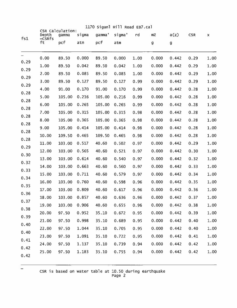
fsl
0.29
0.29
0.29
0.29
0.28
0.28
0.28
0.28
0.28
0.28
0.28
0.29
0.30
0.32
0.33
0.34
0.35
0.36
0.37
0.38
0.39
0.40
0.40
0.41
0.42
0.42
1170 siganl Hill Road EB7.cal CSR calculation: Depth =CSRfs
gamma sigma gamma' sigma' rd mz
ft pcf atm pcf atm g
0.00 89.50 0.000 89. 50 0.000 1.00 0.000
1.00 89. 50 0.042 89. so 0.042 1.00 0.000
2.00 89. 50 0.085 89. 50 0.085 1.00 0.000
3.00 89.50 0.127 89. 50 0.127 0.99 0.000
4.00 91.00 0.170 91.00 0.170 0.99 0.000
5.00 105 .00 0.216 105.00 0.216 0.99 0.000
6.00 105.00 0.265 105.00 0.265 0.99 0.000
7.00 105.00 0.315 105.00 0.315 0.98 0.000
8.00 105.00 0.365 105.00 0.365 0.98 0.000
9.00 105.00 0.414 105. 00 0.414 0.98 0.000
10.00 109.50 0.465 109. 50 0.465 0.98 0.000
11.00 103.00 0.517 40.60 0.502 0.97 0.000
12.00 103.00 0. 565 40.60 0.521 0.97 0.000
13.00 103 .00 0.614 40.60 0.540 0.97 0.000
14.00 103 .00 0.663 40.60 0.560 0.97 0.000
15.00 103.00 0.711 40.60 0.579 0.97 0.000
16.00 103.00 0.760 40.60 0.598 0.96 0.000
17.00 103.00 0.809 40.60 0.617 0.96 0.000
18.00 103.00 0.857 40.60 0.636 0.96 0.000
19.00 103.00 0.906 40.60 0.655 0.96 0.000
20.00 97.50 0.952 35.10 0.672 0.95 0.000
21.00 97.50 0.998 35.10 0.689 0.95 0.000
22.00 97. so 1.044 35.10 0.705 0.95 0.000
23.00 97 .50 1.091 35.10 0.722 0.95 0.000
24.00 97.50 1.137 35.10 0.739 0.94 0.000
25.00 97. 50 1.183 35.10 0.755 0.94 0.000
CSR is based on water table at 10.50 during earthquake Page 2
a(z) CSR X
g
0.442 0.29 1.00
0.442 0.29 1.00
0.442 0.29 1.00
0.442 0.29 1.00
0.442 0.28 1.00
0.442 0.28 1.00
0.442 0.28 1.00
0.442 0.28 1.00
0.442 0.28 1.00
0.442 0.28 1.00
0.442 0.28 1.00
0.442 0.29 1.00
0.442 0.30 1.00
0.442 0.32 1.00
0.442 0.33 1.00
0.442 0.34 1.00
0.442 0.35 1.00
0.442 0.36 1.00
0.442 0.37 1.00
0.442 0.38 1.00
0.442 0.39 1.00
0.442 0.40 1.00
0.442 0.40 1.00
0.442 0.41 1.00
0.442 0.42 1.00
0.442 0.42 1.00

1170 siganl Hill Road EB7.cal
CRR calculation from SPT or BPT data: Depth SPT cebs er sigma' en (N1)60 Fines d(N1)60
(N1)60f CRR7.5 ft atm %
0.00 5.00 1.25 0.75 0.000 1. 70 7.97 0.00 0.00 0.09
1.00 5.00 1.25 0.75 0.042 1. 70 7.97 0.00 0.00 0.09
2.00 5.00 1.25 0.75 0.085 1. 70 7.97 0.00 0.00 0.09
3.00 5.00 1. 25 0.75 0.127 1. 70 7.97 0.00 0.00 0.09
4.00 10.00 1. 25 0.75 0.170 1. 70 15.94 0.00 0.00 15.94 0.17
5.00 9.00 1. 25 0.75 0.216 1. 70 14.34 0.00 0.00 14.34 0.16
6.00 12.00 1. 25 0.75 0.265 1. 70 19.13 0.00 0.00 19.13 0.21
7.00 12.00 1. 25 0.75 0.315 1. 70 19.13 0.00 0.00 19.13 0.21
8.00 12.00 1. 25 0.75 o. 365 1. 66 18.63 0.00 0.00 18.63 0.20
9.00 12.00 1.25 0.85 0.414 1. 55 19.81 0.00 o.oo 19.81 0.21
10.00 13.00 1. 25 0.85 0.465 1.47 20.26 2.00 0.00 20.26 0.22
11.00 14.00 1. 25 0.85 o. 502 1.41 20.99 26.00 6.96 27.96 0.34
12.00 14.00 1. 25 0.85 o. 521 1.39 20.60 26.00 6.91 27.52 0.33
13.00 14.00 1.25 0.85 0.540 1.36 20.24 26.00 6.87 27.10 0.32
14.00 72.00 1.25 0.85 0.560 1.34 102.27 14.00 6.54 108.81 2.00
15.00 72.00 1.25 0.95 0. 579 1.31 112.39 14.00 6.97 119. 36 2.00
16.00 72.00 1.25 0.95 0.598 1.29 110. 57 14.00 6.89 117.46 2.00
17.00 72.00 1. 25 0.95 0.617 1.27 108.84 14.00 6.82 115.66 2.00
18.00 72.00 1.25 0.95 0.636 1.25 107.19 14.00 6.75 113.93 2.00
19.00 72.00 1. 25 0.95 0.655 1.24 105.61 14.00 6.68 112.29 2.00
20.00 110.00 1. 25 0.95 0.672 1.22 159.32 14.00 8.96 168.28 2.00
21.00 110.00 1.25 0.95 0.689 1.20 157.39 14.00 8.88 166.27 2.00
22.00 110.00 1.25 0.95 0.705 1.19 155.53 14.00 8.80 164.33 2.00
23.00 110.00 1.25 0.95 0.722 1.18 153.74 14.00 8.72 162.46 2.00
24.00 110.00 1.25 0.95 0.739 1.16 152.00 14.00 8.65 160.65 2.00
25.00 110.00 1.25 0.95 0.755 1.15 150.32 14.00 8.58 158.90 2.00
Page 3
7.97
7.97
7.97
7.97

CRR is 1170 siganl Hill Road EB7.cal
based on water table at 10.50 during In-Situ Testing
Factor of safety, - Earthquake Magnitude= 8.50: Depth sigc' CRR7.5 x Ksig =CRRv x MSF =CRRm CSRfs
F.S.=CRRm/CSRfs ft atm
0.00 0.00 0.09 1.00 0.09 0.73 0.06 0.29 5.00 1.00 0.03 0.09 1.00 0.09 0.73 0.06 0.29 5.00 2.00 0.05 0.09 1.00 0.09 0.73 0.06 0.29 5.00 3.00 0.08 0.09 1.00 0.09 0.73 0.06 0.29 5.00 4.00 0.11 0.17 1.00 0.17 0.73 0.12 0.28 5.00 5.00 0.14 0.16 1.00 0.16 0.73 0.11 0.28 5.00 6.00 0.17 0.21 1.00 0.21 0.73 0.15 0.28 5.00 7.00 0.20 0.21 1.00 0.21 0.73 0.15 0.28 5.00 8.00 0.24 0.20 1.00 0.20 0.73 0.15 0.28 5.00 9.00 0.27 0.21 1.00 0.21 0.73 0.16 0.28 5.00 10.00 0.30 0.22 1.00 0.22 0.73 0.16 0.28 5.00 11.00 0.33 0.34 1.00 0.34 0.73 0.25 0.29 0.86 * 12.00 0.34 0. 33 1.00 0.33 0.73 0.24 0.30 o. 79 1'
13.00 0.35 o. 32 1.00 0.32 0.73 0.23 0.32 0.74 * 14.00 0.36 2.00 1.00 2.00 0.73 1.45 0.33 4.41 15.00 0.38 2.00 1.00 2.00 0.73 1.45 0.34 4.26 16.00 0.39 2.00 1.00 2.00 0.73 1.45 0.35 4.13 17 .00 0.40 2.00 1.00 2.00 0.73 1.45 0.36 4.01 18.00 0.41 2.00 1.00 2.00 0.73 1.45 0.37 3.91 19.00 0.43 2.00 1.00 2.00 0.73 1.45 0.38 3.82 20.00 0.44 2.00 1.00 2.00 0.73 1.45 0.39 3.74 21.00 0.45 2.00 1.00 2.00 0.73 1.45 0.40 3.66 22.00 0.46 2.00 1.00 2.00 0.73 1.45 0.40 3.60 23.00 0.47 2.00 1.00 2.00 0.73 1.45 0.41 3.53 24.00 0.48 2.00 1.00 2.00 0.73 1.45 0.42 3.48 25.00 0.49 2.00 1.00 2.00 0.73 1.45 0.42 3.42
* F.S.<1: Liquefaction Potential zone. (If above water table: F.S.=5) A No-liquefiable soils or above water Table.
CSR is limited to 2) (F.S. is limited to 5, CRR is limited to 2,
CPT convert to SPT for settlement Analysis: Fines correction for settlement Analysis:
d (Nl) 60 (N 1) 60s Depth IC qc/N60 qcl (N1)60 Fines ft atm %
0.00 7.97 0.00 0.00 7.97 1.00 7.97 0.00 0.00 7.97 2.00 7.97 0.00 0.00 7.97 3.00 7.97 0.00 0.00 7.97 4.00 15.94 0.00 0.00 15.94 5.00 14.34 0.00 0.00 14.34 6.00 19.13 0.00 0.00 19.13 7.00 19.13 0.00 o.oo 19.13 8.00 18.63 0.00 0.00 18.63 9.00 19.81 0.00 0.00 19.81 10.00 20.26 2.00 0.00 20.26 11.00 27.96 26.00 o.oo 27.96 12.00 27.52 26.00 0.00 27.52 13.00 27.10 26.00 0.00 27.10 14.00 100.00 14.00 0.00 100.00 15.00 100.00 14.00 0.00 100.00 16.00 100.00 14.00 0.00 100.00 17.00 100.00 14.00 0.00 100.00 18.00 100.00 14.00 0.00 100.00
Page 4

19.00 20.00 21.00 22.00 23.00 24.00 25 .00
1170 Siganl Hill Road EB7.cal 100.00 14.00 0.00 100.00 14.00 0.00 100.00 14.00 0.00 100.00 14.00 0.00 100.00 14.00 0.00 100.00 14.00 0.00 100.00 14.00 0.00
100.00 100.00 100.00 100.00 100.00 100.00 100.00
(N1)60s has been fines corrected in liquefaction analysis, therefore d(N1)60=0.
dsp
Fines=NoLiq means the soils are not liquefiable.
settlement of saturated sands: Settlement Analysis Method: Tokimatsu, Depth CSRsf I MSF* =CSRm F.S. s ft
M-correction Fines (N1)60s Dr
% %
ec
% in. in.
O.OEO
O.OEO
O.OEO
O.OEO
O.OEO
O.OEO
O.OEO
O.OEO
O.OEO
O.OEO
O.OEO
O.OEO
O.OEO
6.2E-3
5.9E-3
5.3E-3
9.0E-3
25.45 0.43 0.73 0.59 3.40 14.00 100.00 100.00 0.000 0.000 0.000 25.00 0.42 0.73 0.58 3.42 14.00 100.00 100.00 0.000 0.000 0.000 24.00 0.42 0.73 0.58 3.48 14.00 100.00 100.00 0.000 0.000 0.000 23.00 0.41 0.73 0.57 3.53 14.00 100.00 100.00 0.000 0.000 0.000 22.00 0.40 0.73 0.56 3.60 14.00 100.00 100.00 0.000 0.000 0.000 21.00 0.40 0.73 0.55 3.66 14.00 100.00 100.00 0.000 0.000 0.000 20.00 o. 39 0.73 0.53 3.74 14.00 100.00 100.00 0.000 0.000 0.000 19.00 0. 38 0.73 0.52 3.82 14.00 100.00 100.00 0.000 0.000 0.000 18.00 o. 37 0.73 0.51 3.91 14.00 100.00 100.00 0.000 0.000 0.000 17.00 0. 36 0.73 0. 50 4.01 14.00 100.00 100.00 0.000 0.000 0.000 16.00 0. 35 0.73 0.48 4.13 14.00 100.00 100.00 0.000 0.000 0.000 15.00 0.34 0.73 0.47 4.26 14.00 100.00 100.00 0.000 0.000 0.000 14.00 0. 33 0.73 0.45 4.41 14.00 100.00 100.00 0.000 0.000 0.000 13.00 o. 32 0.73 0.44 0.74 26.00 27.10 83.86 1.031 0.126 0.126 12.00 0.30 0.73 0.42 0.79 26.00 27.52 84.71 0.984 0.121 0.247 11.00 0.29 0.73 0.40 0.86 26.00 27.96 85.62 0.876 0.112 0.358 10.50 0.28 0.73 0.39 0.55 2.00 19.71 70.02 1. 507 0.091 0.449
settlement of saturated sands=0.449 in. qcl and (N1)60 is after fines correction in liquefaction analysis dsz is per each se~ment, dz=0.05 ft dsp is per each print interval, dp=l.00 ft
Page 5
dsz
in.

1170 siganl Hill Road EB7.cal Sis cumulated settlement at this depth
Settlement of Unsaturated Sands: Depth sigma' sigc' (N1)60s CSRsf Gmax g*Ge/Gm g_eff ec7.S cec
ec dsz dsp s ft atm atm atm %
%
0.0489
0.0463
0.0444
0.0453
0.0392
0.0350
0.0560
0.0396
0.1010
0.0931
0.0549
0.0038
in. in. in.
10.45 0.49 0.32 19.77 0.28 680.53 S.86E-4 0.001 0.001 10.00 0.46 0.30 20.26 0.28 669. 53 5.56E-4 0.005 0.006 9.00 0.41 0.27 19.81 0.28 627.31 S.32E-4 0.011 0.017 8.00 0.36 0.24 18.63 0.28 576.64 5.43E-4 0.010 0.027 7.00 0.32 0.20 19.13 0.28 540.69 4.70E-4 0.010 0.037 6.00 0.27 0.17 19.13 0.28 496.29 4.20E-4 0.009 0.046 5.00 0.22 0.14 14.34 0.28 406.63 6.71E-4 0.013 0.059 4.00 0.17 0.11 15.94 0.28 373.61 4.75E-4 0.011 0.070 3.00 0.13 0.08 7.97 0.29 256.36 1. 21E-3 0. 010 0.080 2.00 0.08 0.05 7.97 0.29 209.32 1.12E-3 0.022 0.103 1.00 0.04 0.03 7.97 0.29 148.02 6.59E-4 0.018 0.121 0.00 0.00 0.00 7.97 0.29 2.28 4.62E-5 0.007 0.128
Settlement of Unsaturated sands=0.128 in. dsz is per each segment, dz=0.05 ft dsp is per each print interval, dp=l.00 ft sis cumulated settlement at this depth
2.0E-4 0.0391
1. 9E-4 0.0382
1. 9E-4 0.0356
1. 8E-4 0.0335
1. 6E-4 0.0300
1. 5E-4 0.0269
1. 5E-4 0.0296
1. 3E-4 0.0239
l.4E-4 0.0267
1. 2E-4 0.0246
8.2E-5 0.0145
1. 3E-6 0.0010
Total settlement of Saturated and unsaturated Sands=0.577 in. Differential settlement=0.289 to 0.381 in.
0.0391 1.25
0.0370 1.25
0.0355 1.25
0.0362 1.25
0.0313 1. 25
0.0280 1. 25
0.0448 1. 25
0.0317 1. 25
0.0808 1. 25
0.0745 1.25
0.0439 1.25
0.0031 1.25
units: unit: qc, fs, Stress or Pressure= atm (1.0581tsf); unit weight= pcf; Depth= ft; settlement= in.
1 atm 1 atm SPT BPT
i~ Rf gamma gamma' Fines D50 Dr sigma
(atmosphere)= 1.0581 tsf(l tsf = 1 ton/ft2 = 2 kip/ft2) (atmosphere)= 101.325 kPa(l kPa = 1 kN/m2 = 0.001 Mpa)
Field data from Standard Penetration Test (SPT) Field data from Becker Penetration Test (BPT) Field data from cone Penetration Test (CPT) [atm Friction from CPT testing [atm (tsf)] Ratio of fs/qc (%) Total unit weight of soil Effective unit weight of soil Fines content[%] Mean !;Jrain size Relative Density Total vertical stress [atm]
Page 6
(tsf)J

1170 siganl Hill Road EB7.cal sigma' Effective vertical stress [atm] sigC' Effective confining pressure [atm] rd Acceleration reduction coefficient by Seed a_max. Peak Ground Acceleration (PGA) in ground surface mz Linear acceleration reduction coefficient x depth a_min. Minimum acceleration under linear reduction, mz CRRv CRR after overburden stress correction, CRRV=CRR7.S * Ksig
CRR7.5 cyclic resistance ratio (M=7.5) Ksig overburden stress correction factor for CRR7.5
CRRm After magnitude scaling correction CRRm=CRRv * MSF MSF Magnitude scaling factor from M=7.5 to user input M
CSR cyclic stress ratio induced by earthquake CSRfs CSRfs=CSR*fsl (Default fsl=l)
fsl First CSR curve in graphic defined in #9 of Advanced page fs2 2nd CSR curve in graphic defined in #9 of Advanced page
F.S. calculated factor of safety against liquefaction F.S.=CRRm/CSRsf
cebs Energy Ratio, Borehole Dia., and sampling Method corrections er Rod Length corrections en overburaen Pressure correction (N1)60 SPT after corrections, (Nl)60=SPT *er* en* Cebs d(N1)60 Fines correction of SPT (N1)60f (N1)60 after fines corrections, (N1)60f=(N1)60 + d(N1)60 Cq overburden stress correction factor qcl CPT after overburden stress correction dqcl Fines correction of CPT qclf CPT after Fines and overburden correction, qclf=qcl + dqcl qcln CPT after normalization in Robertson's method Kc Fine correction factor in Robertson's Method qclf CPT after Fines correction in Robertson's Method Ic soil type index in Suzuki's and Robertson's Methods (N1)60s (N1)60 after settlement fines corrections CSRm After magnitude scaling correction for Settlement
calculation CSRm=CSRSf / MSF*
inputed fs CSRfs Cyclic stress ratio induced by earthquake with user
MSF* scaling factor from CSR, MSF*=MSF, based on Item 2 of Page c.
MSF Magnitude scaling factor from M=7.5 to user input M ec volumetric strain for saturated sands dz calculation segment, dz=0.050 ft dsz settlement in each segment, dz dp User defined print interval dsp Settlement in each print interval, dp Gmax shear Modulus at low strain g_eff gamma_eff, Effective shear Strain g*Ge/Gm gamma_eff * G_eff/G_max, Strain-modulus ratio ec?.5 volumetric Strain for magnitude=7.5 Cec Magnitude correction factor for any magnitude ec Volumetric strain for unsaturated sands, ec=Cec * ec?.5 NOLiq No-Liquefy Soils
References:
1. NCEER workshop on Evaluation of Liquefaction Resistance of soils. Youd, T.L., and Idriss, I.M., eds., Technical Report NCEER 97-0022.
SP117. southern California Earthquake center. Recommended Procedures for Implementation of DMG special Publication 117, Guidelines for
Analyzing and Mitigating Liquefaction in California. university of southern California. March 1999.
2. RECENT ADVANCES IN SOIL LIQUEFACTION ENGINEERING AND SEISMIC SITE RESPONSE EVALUATION, Paper No. SPL-2, PROCEEDINGS: Fourth
Page 7

1170 siganl Hill Road EB7.cal International conference on Recent Advances in Geotechnical Earthquake
Engineering and soil Dynamics, san Diego, CA, March 2001. 3. RECENT ADVANCES IN SOIL LIQUEFACTION ENGINEERING: A UNIFIED AND
CONSISTENT FRAMEWORK, Earthquake Engineering Research center, Report NO. EERC 2003-06 by R.B Seed and etc. April 2003.
Note: Print Interval you selected does not show complete results. To get complete results, you should select "segment' in Print Interval (Item 12, Page c).
Page 8

c~ .CLEARY CONSULTANTS, INC.
Geotechnical Engineers and Geologists
Ms. Massy Mehdipour 1425 Dana Avenue Palo Alto, CA 94301
RE: GEOLOGICAL ANALYSIS OF SITE ERODABILITY NEW RESIDENTIAL PROJECT 1170 SIGNAL HILL ROAD
J. Michael Cleary, CEG, GE Christophe A. Ciechanowski, GE Grant F. Foster, GE
June 22, 2011 Project No. 1301.1 Ser. 3300
PEBBLE BEACH, MONTEREY COUNTY, CALIFORNIA
Dear Ms. Mehdipour:
As requested by Monterey County Planning, December 8, 2010, we have prepared this analysis and review of the potential site erodability and mitigation measures for your new residential project at 1170 Signal Hill Road in Pebble Beach. Our geotechnical investigation report for this project was submitted March 31, 2010. Our analysis included review of the following drawings:
• Site Plan (A-1.0), Ground Floor/Basement Plan (A-3.0) and First Floor Plan (A-3.1) for Casa Pebble Beach, 1170 Signal Hill Road, Pebble Beach, California prepared by Bill Bernstein AIA and Legorretta and Legoretta Architects, dated June 3, 2011, May 23, 2011 and May 27, 2011.
• Grading and Drainage Plans, C0.2 and Cl.1, Single Family Residence and Driveway, 1170 Signal Hill Drive, Monterey County, Prepared by Whitson Engineers, June 20, 2011.
The grading and drainage plans indicate that the proposed development area within the designated "Limits of Developed/Disturbed Dune" will be cut down five feet maximum in the backyard, resulting in a berm at approximately Elevation 98 behind the home, and the front yard will be raised with up to about five feet of fill in the area of the garage driveway and front entry. The front portion of the home, excluding the garage, will be set into the slope, requiring cuts of up to about nine feet. Runoff from most of the front yard portion of the site will be directed to area drains connected to a storm drain tightline and carried to a new rip rap stilling basin for infiltration into the sandy soils in the southwest comer of the developed area. (Roof leaders on the south side of the home will be tied into this system). Runoff in the backyard will sheet flow to the contained level area (Elevation 94) located in the northwest portion of the backyard.
900 N. SAN ANTONIO ROAD • LOS ALTOS, CALIFORNIA 94022 • (650) 948-0574 • FAX (650) 948-7761 www.clearyconsultantsinc.com
friedrichm
Typewritten Text

Ms. Massy Mehdipour June 22, 2011 Page2
The runoff from the landscaped northerly one-third portion of the front yard will be directed around the north side of the home toward the contained low area in the northwest portion of the backyard.
We understand that the final location of the roof downspout leaders has not been determined at this time, however as discussed with Michael Baldi with Whitson Engineers, roof runoff will be tied into tightline disposal where practical or discharged into dry wells located at least three to five feet out from the residence.
The proposed cut and fill slopes within the area to be developed are shown at a 3: 1 (horizontal to vertical) gradient, and these slopes will be vegetated in accordance with the recommendations of the project biologist and landscape architect.
Based on the above, it is our opinion that the planned residential project at 1170 Signal Hill Road as currently designed will mitigate the potential for erosion at the site. This applies to the construction period as well since we understand construction activities will be confined to the limits of the undisturbed dune line specified for the development, and disturbed areas and temporary slopes will be winterized as recommended in the geotechnical report.
We have provided our services in accordance with generally accepted geotechnical engineering principles and practice. No other warranty is implied.
We appreciate the opportunity to have been of continued service to you on this project. If you have any questions regarding this letter, please call.
Very truly yours,
CLEARY CONSULTANTS, INC.
-;;,,r.ey.-=,,.,,ichael Cleary Engineering Geologist 352 Geotechnical Engineer 222
JMC:cm Copies: Addressee (1)
Bill Bernstein AJA (3) Attn: William Bernstein Whitson Engineers (1) Attn: Michael Baldi
CLEARY CONSULTANTS, INC.
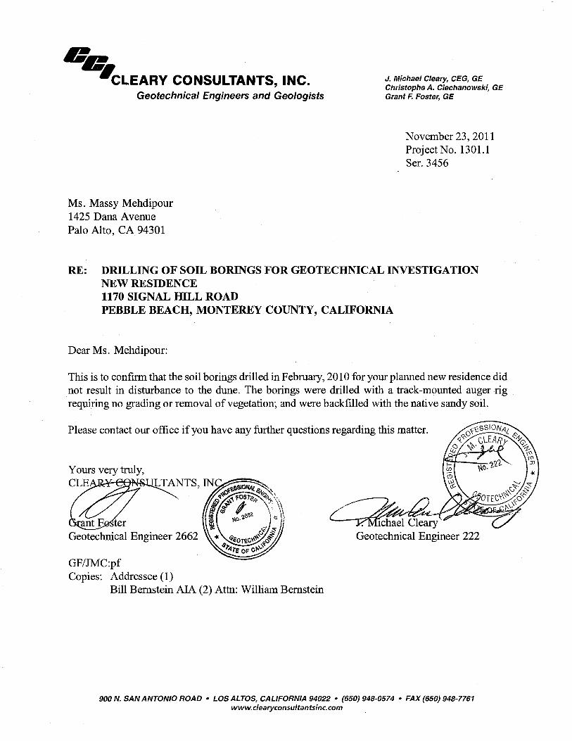
c~ WCLEARY CONSULTANTS, INC.
Geotechnical Engineers and Geologists
Ms. Massy Mehdipour 1425 Dana Avenue Palo Alto, CA 94301
J. Michael Cleary, CEG, GE Christophe A. Ciechanowski, GE Grant F. Foster, GE
November 23, 2011 Project No. 1301.1 Ser. 3456
RE: DRILLING OF SOIL BORINGS FOR GEOTECHNICAL INVESTIGATION NEW RESIDENCE 1170 SIGNAL IDLL ROAD PEBBLE BEACH, MONTEREY COUNTY, CALIFORNIA
Dear Ms. Mehdipour:
This is to confirm that the soil borings drilled in February, 2010 for your planned new residence did not result in disturbance to the dune. The borings were drilled with a track-mounted auger rig requiring no grading or removal of vegetation; and were backfilled with the native sandy soil.
Please contact our office if you have any further questions regarding this matter.
GF/JMC:pf Copies: Addressee (1)
Bill Bernstein AIA (2) Attn: William Bernstein
1chael Cleary Geotechnical Engineer 222
900 N. SAN ANTONIO ROAD • LOS ALTOS, CALIFORNIA 94022 • (650) 948-0574 • FAX (650) 948-7761 www.clearyconsultantsinc.com
friedrichm
Typewritten Text