DRAFT - Dartmouth Town Council
101
PRE-SUBMISSION CONSULTATION (REGULATION 14) JUNE 2021 DRAFT
-
Upload
khangminh22 -
Category
Documents
-
view
0 -
download
0
Transcript of DRAFT - Dartmouth Town Council

PRE-SUBMISSION CONSULTATION (REGULATION 14) JUNE 2021
DRAFT

All mapping in this document has been sourced from Parish Online. © Crown copyright and database right all rights reserved 100022628 2020©Contains Ordnance Survey data Crown Copyright and database right 2020
1
Foreword Dear Dartmouth Resident, The beauty and appeal of our town cannot be taken for granted. Despite the obvious benefits of having a plan agreed by residents that offers a roadmap for our future and carries legal weight, producing a Dartmouth Neighbourhood Plan (DNP) has been a challenging process. Many of the issues we are tackling now have been around and identified for up to 20 years in some cases. Over this time, there have been several studies to propose solutions to the particular issues facing our lovely town and its infrastructure. Dartmouth Town Council (DTC) agreed to resurrect the DNP in January 2019 and agreed its Terms of Reference. We have been assisted by their positive contribution and their approval of the current plan. The economic circumstances of Dartmouth residents varies considerably across the Parish. Although large parts of the plan area are the least deprived areas in England, Townstal falls within 30% of the most deprived areas particular with respect to lowest in income ,employment and health .There are signs that the deprivation scores for Townstal are rising but they remain a serious concern and the policies of this plan seek to address these inequalities. Our DNP should be sustainable and deliverable, cater for the needs of current generations and an ageing population but ensure that growth does not mean worse lives for future generations. It seeks to sustain the natural and historic qualities of the Parish and to conserve them for the future enjoyment of all. Our vision, contained within this plan, will help shape the future of the area in which we live and work through to at least 2034. In drawing up our plan, the policies and the process we have followed respect the Neighbourhood Planning (General) Regulations 2012. I am indebted to all members of the Steering Group and the Topic Groups for their diligence and hard work. We are grateful also for considerable help and input from the community at large and from a wide range of people and local organizations, via public surveys, our website and via consultations. The views and comments received form part of the evidence base that supports and shapes the plan. The policies of this plan focus on land use matters and views expressed most strongly by the community such as safeguarding our natural environment and setting within the South Devon Area of Outstanding Natural Beauty (AONB), protecting our historic environment, improving our year round economy on a sustainable basis, helping address long standing transport and parking issues, improving our community facilities, providing truly affordable homes for those who need them and addressing the inequalities across our Parish. We recognise the delicate balance that must exist between protecting our heritage and providing for the future needs of a well-rounded community. To this end, we propose a coordinated approach by all key stakeholders in finding workable solutions for the common good, either as policy proposals or as aspirations that need resolution. We now have a Plan which we believe is worthy of your attention and approval. This Plan has not been imposed on us by any other body. All local residents on the Electoral Roll can elect to decide whether or not to adopt this Neighbourhood Plan through a local referendum. It is submitted on behalf of DTC who have endorsed this version. We hope you will support us and help to secure a positive, vibrant and healthy future for our lovely town and its residents. Robert Brooke, Chair Neighbourhood Plan Steering Group
All mapping in this document has been sourced from Parish Online. © Crown copyright and database right all rights reserved 100022628 2020©Contains Ordnance Survey data Crown Copyright and database right 2020
2
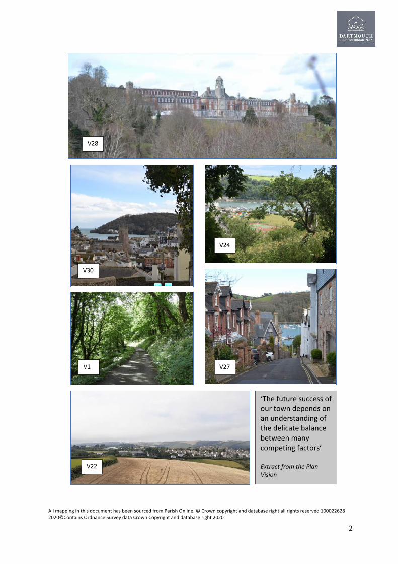
‘The future success of our town depends on an understanding of the delicate balance between many competing factors’ Extract from the Plan Vision
V28
V22
V1 V27
V30
V24

All mapping in this document has been sourced from Parish Online. © Crown copyright and database right all rights reserved 100022628 2020©Contains Ordnance Survey data Crown Copyright and database right 2020
3
Contents Page Number Foreword 1
Contents 3
List of Maps 4
1. Introduction and vision for Dartmouth Parish 5
2. Key themes, priorities and objectives 9
3. Why we need a Neighbourhood Plan? 12
4. How the Plan has been prepared 15
5. About the town and parish of Dartmouth 21
6. Proposed policies for the Plan 40
• Green Environment 40
• Economy and Jobs 56
• Sustainable Transport and Infrastructure 63
• Town Environment 68
• Housing and Homes 79
• Health and Wellbeing 88
7. A sustainable and deliverable plan 96
8. What happens next? 98
9. List of acronyms and glossary 99
10. Appendices and supporting evidence 100

All mapping in this document has been sourced from Parish Online. © Crown copyright and database right all rights reserved 100022628 2020©Contains Ordnance Survey data Crown Copyright and database right 2020
4
List of Maps 1. Neighbourhood Plan Area
2. Landscape Character Types
3. Extent of South Devon AONB
4. Dartmouth Conservation Area
5. South Devon Heritage Coast Policy Area
6. Undeveloped Coast Policy Area
7. The Green Matrix of Dartmouth
8. Local Green Spaces
9. Locally Important Views
10. Flood Risk Areas
11. Settlement Boundary
12. Primary and Secondary Shopping Areas
13. Existing and proposed pedestrian rights of way
14. Area safeguarded for Coach Parking
15. Non-Designated Heritage Assets
16. Civic Spaces
17. Area for Emergency and Community Services
18 Dartmouth Academy

All mapping in this document has been sourced from Parish Online. © Crown copyright and database right all rights reserved 100022628 2020©Contains Ordnance Survey data Crown Copyright and database right 2020
5
1. Introduction and a vision for Dartmouth Parish 1.1 Dartmouth is a beautiful coastal town situated at the mouth of the River Dart . It is rich in heritage, maritime history and much of the parish lies within the South Devon Area of Outstanding Natural Beauty (AONB) – one of Britain’s finest protected landscapes loved for its rugged cliffs, estuaries, inspiring coastal foot paths, coves, rolling hills and peaceful countryside. This community has been forged through links to the sea, stretching back to the Middle Ages. The town and parish has evolved, into the 21st Century with the local economy diversifying, most notably, into a major UK tourism destination motivated by the town’s heritage, vibrancy, idyllic coastal and river landscape.
1.2 The economic circumstances of Dartmouth residents varies considerably across the Parish. Although large parts of the plan area are the least deprived areas in England, Townstal falls within 30% of the most deprived areas (28% 2019, 24% 2015) and the Indices of Multiple Deprivation (IMD) scores lowest in income deprivation (19%) employment (15%) and health (19%).There are signs that the level of deprivation in Townstal is reducing but it remain a concern and the policies of this plan seek to address these inequalities.
1.3 The experience from the Covid Pandemic has exposed the town’s dependence on tourism as an economic driver, the shortage of affordable housing, notably for key workers and the need to be more economically sustainable long term, attracting and retaining more types of businesses and creating a more diverse economic structure.
1.4 This Plan has been prepared and led by Dartmouth residents. Feedback from local residents, landowners, statutory consultees has been sought and acted upon in the final version. The whole parish of Dartmouth was formally designated as a Neighbourhood Plan Area through an application made on 5th September 2014 under the Neighbourhood Planning Regulations 2012 (Part 2) and approved by South Hams District Council (SHDC) on 11th December 2014.

All mapping in this document has been sourced from Parish Online. © Crown copyright and database right all rights reserved 100022628 2020©Contains Ordnance Survey data Crown Copyright and database right 2020
6
1.5 The area covered by the Plan is Dartmouth parish and illustrated in Map1 . The Plan will run until 2034, in parallel with the adopted Plymouth and South West Devon Joint Local Plan (JLP) or the Development Plan. Once adopted the Plan will join the JLP as part of the Development Plan
1.6 A considerable body of evidence has been sourced and collated during the production of the Plan. The background data on which the Plan is based is included in the Appendices. 1.7 This document is the Pre- Submission (Regulation 14) Consultation version of the Plan. It requires two periods of public consultation and incorporating any resultant revisions. The final amended Plan will be sent to an independent Examiner to review , if it is considered sound subject to amendments it can go to a referendum. Those living within the designated Parish of Dartmouth and on the electoral role will then get the opportunity to vote for whether or not the Plan should be adopted. If successful at a local referendum the Plan will then form part of the Development Plan of the South Hams area (The Joint Local Plan). This statutory status as part of the Development Plan gives a Neighbourhood Development Plan far more weight than some other community planning documents, such as parish plans, community plans and village design statements. As a formal planning document it can be used in determining planning applications. 1.8 In due course (at Regulation 15) a Formal ‘Consultation Statement’ and ‘Basic Conditions Statement’ will be submitted to SHDC and thence to the Examiner alongside this Plan.
Map 1 Dartmouth Neighbourhood Plan Area

All mapping in this document has been sourced from Parish Online. © Crown copyright and database right all rights reserved 100022628 2020©Contains Ordnance Survey data Crown Copyright and database right 2020
7
1.9 SHDC will also carry out a Strategic Environmental Assessment (SEA) and Habitat Regulations Assessment (HRA) screening on the Pre-submission Plan.
1.10 A Vision for Dartmouth
1.10.1 During the Neighbourhood Planning Process the Steering Group drafted a vision for the Parish and Plan; this was posted on the Plan website and refined through a facilitated event. The following version was subsequently adopted.
Dartmouth towards 2034 – Planning our future With its exceptional setting between dramatic coastline and countryside in an area of outstanding natural beauty, it is no surprise that historic Dartmouth with its naval traditions is so loved by residents and visitors alike. The future success of our town depends on an understanding of the delicate balance between many competing factors. We identify these factors, and endeavour to sustain and nourish those elements that will enable Dartmouth to thrive for future generations. The beauty and appeal of our town cannot be taken for granted. With only limited space available, increasing demands for development must be balanced by the need to enhance our environment and protect our heritage. We wish to conserve our matrix of green spaces, vital for the wellbeing of wildlife and people, young and old alike. A healthy community is a cohesive one. We identify opportunities for housing, employment and recreation. These, combined with more efficient and sustainable transport, good communications, excellent schools, and health and social facilities that cater for all needs, will help all members of our community. And we will encourage biodiversity and effective protection against coastal erosion and flooding from climate change. New technological advancements will offer new and exciting opportunities to improve our lives; we intend to embrace them. Careful planning, done for the benefit of all, will enhance our town so that our healthy and vibrant community can continue to grow and flourish.

All mapping in this document has been sourced from Parish Online. © Crown copyright and database right all rights reserved 100022628 2020©Contains Ordnance Survey data Crown Copyright and database right 2020
8
1.11 Assumptions and constraints In developing this vision, some working assumptions must be stated.
• The historic town centre by the river is spatially constrained. Identifying suitable and deliverable areas for future development is part of the Neighbourhood Planning process.
• A majority of the NDP is contained within the South Devon AONB. All development must also be aligned to AONB policies for conserving and enhancing this exceptional landscape.
• The Dartmouth Conservation area, Heritage Coast and Undeveloped Coast should be significant considerations in the Plan.
• Any actions to develop the town’s built environment or manage the surrounding natural environment must meet the criteria of sustainability and protection of bio-diversity.
• The town’s resilience in the face of rising sea levels and the increased frequency of severe weather events must be addressed in the period covered by the NDP.
1.12 A key part of the plan process was to set up topic groups reporting to the Steering Group to address the interrelated social, economic and environmental issues to be covered by the plan;
• Our Economy • Infrastructure • Our Green Environment • The Town Environment
Each topic group’s work focused primarily on the use and development of land and the associated planning issues. The inter-relatedness of the topics made liaison between the topic groups essential. The work of the topic groups is summarised in topic papers that have informed the Plan and policies and included in Appendix B. 1.13 The Plan has been developed following extensive engagement with the community. Since 2015 the engagement process has identified issues, policy options and sought feedback on the emerging plan. Activities have included: • Public exhibitions and drop-in events • Press coverage • A dedicated website • Face-to-face sessions with local organisations • Questionnaires and community surveys distributed to all households and students • Coordination and update meetings with the Town Council

All mapping in this document has been sourced from Parish Online. © Crown copyright and database right all rights reserved 100022628 2020©Contains Ordnance Survey data Crown Copyright and database right 2020
9
2.0 Key themes, priorities and objectives 2.1 In this section we describe the themes that underpin the vision and policies of the plan. These have been taken directly from the responses to community surveys and developed by the steering group and its topic groups in consultation with the Town Council. 2.2 To summarise the issues facing the parish the following Strengths, Weaknesses, Opportunities and Threats (SWOT) assessment was developed at a workshop with the Steering Group and is regularly reviewed and updated through the production of the plan.
Strengths Weaknesses • 63% Parish within the AONB • Coastal location • Estuary • Surrounding countryside and natural environment • Locally distinctive and iconic views • Historic environment with many heritage assets • Distinctive urban and natural character • Locally distinctive vernacular architecture • Marine/naval heritage • Network of green spaces • Full statutory 3-16 yr. schooling provision in Parish • Active community all year round • High level of community led activities • Diverse cultural activity with many participants • Many festivals (food, music, heritage, culture) • Established and loyal tourism industry • Active sports clubs • High number of independent traders • Town has one principal centre although this is changing • The presence of the Naval College(BRNC) in the town
• Ageing population • 37% outside the AONB,(leaving it vulnerable to more
change) • Shortage of affordable housing • Holiday short term letting undermines long term rental
market and community life • No coordinated development /growth strategy • Poor traffic environment • Lack of economic/employment opportunities • No sixth form in the Parish • Lack of a clear settlement/ growth strategy • Poor connectivity with district and region, especially out
of hours • ‘End of the line’ • Lack of investment in infrastructure • No clear car parking strategy • Reliance on seasonal working • Low level of good year round employment • Footpath network in poor condition • Public realm requires improvement • Lack of bus shelters • Inappropriate design • High levels of light pollution • Planning and AONB policy not enforced
Opportunities Threats • Affordable Housing • Encourage more permanent residents • More local employment , business and job opportunities • Controls on second homes • Protect green spaces and link together • Improve biodiversity • Adapt to and mitigate against climate change • Community (not developer) led change • Improve cohesion across the community • Making better use of brownfield land • Improve transport infrastructure • Support for marine businesses and activity • Infrastructure and services for changes in work patterns
and home working • Remove barriers to business • Strengthen design quality • Reinforce the AONB design guidance • Better use of materials • More holistic ‘blue skies’ approach • Accelerate improvements and change
• Loss of Green Infrastructure • Loss of the Naval College • Loss of primary and a secondary education • Flooding • Development and developer led change • No space and opportunities for long term attractive
employment • Insufficient affordable housing • Insufficient training and career opportunities for young
people • Lack of support from key stakeholders to future change • Poor fit between national legislation and the town (e.g.
Permitted Development not always appropriate) • National economic challenges impacting long term on the
town.
All mapping in this document has been sourced from Parish Online. © Crown copyright and database right all rights reserved 100022628 2020©Contains Ordnance Survey data Crown Copyright and database right 2020
10
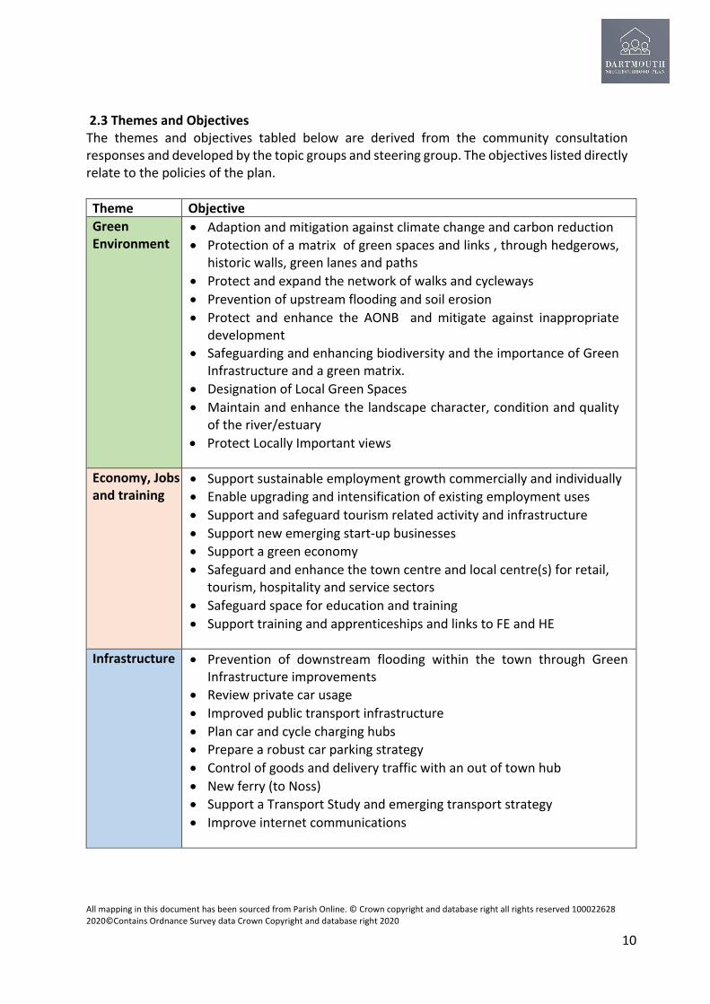
2.3 Themes and Objectives The themes and objectives tabled below are derived from the community consultation responses and developed by the topic groups and steering group. The objectives listed directly relate to the policies of the plan. Theme Objective Green Environment
• Adaption and mitigation against climate change and carbon reduction • Protection of a matrix of green spaces and links , through hedgerows,
historic walls, green lanes and paths • Protect and expand the network of walks and cycleways • Prevention of upstream flooding and soil erosion • Protect and enhance the AONB and mitigate against inappropriate
development • Safeguarding and enhancing biodiversity and the importance of Green
Infrastructure and a green matrix. • Designation of Local Green Spaces • Maintain and enhance the landscape character, condition and quality
of the river/estuary • Protect Locally Important views
Economy, Jobs and training
• Support sustainable employment growth commercially and individually • Enable upgrading and intensification of existing employment uses • Support and safeguard tourism related activity and infrastructure • Support new emerging start-up businesses • Support a green economy • Safeguard and enhance the town centre and local centre(s) for retail,
tourism, hospitality and service sectors • Safeguard space for education and training • Support training and apprenticeships and links to FE and HE
Infrastructure • Prevention of downstream flooding within the town through Green Infrastructure improvements
• Review private car usage • Improved public transport infrastructure • Plan car and cycle charging hubs • Prepare a robust car parking strategy • Control of goods and delivery traffic with an out of town hub • New ferry (to Noss) • Support a Transport Study and emerging transport strategy • Improve internet communications

All mapping in this document has been sourced from Parish Online. © Crown copyright and database right all rights reserved 100022628 2020©Contains Ordnance Survey data Crown Copyright and database right 2020
11
Built Environment
• Confirm a Settlement Boundary • Design quality and controlling inappropriate development • Design in sympathy with the historic environment, identifying and
celebrating positive precedents including materials and styles • Prevent inappropriate sub division of existing urban plots and gardens • Safeguarding heritage assets and listing local assets • Protection and enhancement of civic spaces, townscape and the
conservation area • Prioritising Brownfield development first • Promote more employment land
Housing • Less priority given to market housing • Prioritising affordable housing for local people and ways to deliver
this(e.g. exception sites) • Principal residence requirement controlling second homes • Additional homes for older people
Health and Wellbeing
• Potential to expand health facilities as population expands • Easy access to health facilities for the whole parish • Re-use of former NHS sites to include community uses • Safeguarding and improving community facilities • Improved social care facilities • Improved open space for active recreation • Improved access to the water for recreation

All mapping in this document has been sourced from Parish Online. © Crown copyright and database right all rights reserved 100022628 2020©Contains Ordnance Survey data Crown Copyright and database right 2020
12
3.0 Why we need a Neighbourhood Plan? What is a Neighbourhood Plan?
A Neighbourhood Plan (officially called a Neighbourhood Development Plan) is a way of helping local communities like Dartmouth guide and influence the future development and growth of the area in which they live and work. Generally proposals require the support of the owners of land affected.
3.1 A Neighbourhood Development Plan can....
• Develop a shared vision for our neighbourhood; • Choose where new homes, shops, businesses and other development should be built; • Identify and protect important local green spaces; • Influence what new buildings should look like; • Promote more development than is set out in the Joint Local Plan (or Development
Plan); • Enhance the historic environment with heritage assets not previously recorded
through their listing as Non-Designated Heritage Assets.
3.2 A Neighbourhood Development Plan cannot...
• Conflict with the strategic policies in the Joint Local Plan prepared by SHDC; • Be used to prevent development that is included in the Joint Local Plan; • Be prepared by a body other than a parish or town council or a neighbourhood forum.
Planning Context
3.3 Neighbourhood Plans are required to be in general conformity with the National Planning Policy Framework (NPPF) 2019 and the strategic policies of the Local Plan. The planning policies for the South Hams District are set out in the Joint Local Plan (JLP) for Plymouth and South West Devon .The JLP was adopted in March 2019.
3.4 The relevant sections of the adopted Supplementary Planning Document (SPD) to the JLP July 2020 are respected in the Plan. In addition the following previously adopted Development Plan which although they no longer have a planning status helped to inform this Plan;-
• South Hams Local Development Framework Core Strategy (2006) • South Hams Rural Areas Site Allocations Development Plan Document(DPD) 2011 • ‘Saved’ policies from the South Hams Local Plan (1996)
3.5 The Neighbourhood Plan must also be in conformity with EU legislation extending beyond the 2020 transition period until such time as new legislation is introduced to withdraw or amend such legislation by the UK Government. Locality advises that the EU requirements for strategic environmental assessment and habitat regulations (SEA and HRA) will continue to apply in the interim.
All mapping in this document has been sourced from Parish Online. © Crown copyright and database right all rights reserved 100022628 2020©Contains Ordnance Survey data Crown Copyright and database right 2020
13
3.6 The Countryside and Rights of Way Act 2000 makes specific reference (s85) that Town and Parish Councils as public bodies must have regard to the statutory purpose of an AONB to conserve and enhance natural beauty . This obligation can be reinforced through their Neighbourhood Plans. The NPPF provides specific guidance for those preparing Neighbourhood Plans that include AONBs. This includes;-
• the presence of AONBs can restrict development in order to help achieve sustainable development;
• ‘great weight’ should be given to conserving and enhancing their landscape, natural and scenic beauty;
• AONBs have the highest status of protection in relation to landscape and scenic beauty, equal to National Parks;
• the conservation of wildlife and cultural heritage is important in AONBs; • Major development in AONBs should be refused unless it meets specific special tests.
3.7 In 2020 a JLP Supplementary Planning Guidance document was adopted by South Hams, West Devon and Plymouth Councils . It gives guidance on implementation of policies in the JLP. It also comments on how implementation of the JLP can play a role in supporting Climate Emergency and Biodiversity Emergency and actions towards low carbon solutions and carbon neutrality.
3.8 The Thriving Towns and Villages (TTV) approach set out in the Development Plan (JLP) is focused on achieving sustainable development and rural sustainability for the Main Towns of which Dartmouth is one of four in the South Hams. Building self-sufficiency and resilience of the local employment market to meet local needs and attract new sectors and investment is seen as part of creating this strategic outcome, set out in Strategic Objective SO7, as is enhancing the links between the Main Towns and the surrounding countryside to support healthy communities. The highest levels of growth are targeted at the Main Towns, with a view to this enhancing their role as service centres as well as provide for their own growth. Specifically for Dartmouth the Development Plan sets out a spatial priority SP1 which is included below.

All mapping in this document has been sourced from Parish Online. © Crown copyright and database right all rights reserved 100022628 2020©Contains Ordnance Survey data Crown Copyright and database right 2020
14
JLP (2019) Spatial priorities (SP1) for development in Dartmouth The plan seeks to enhance the vibrancy and sustainability of Dartmouth. This will include:
1. Providing for mixed use development to help meet local housing need and increase employment opportunities to support the long term resilience of the town.
2. Maintaining and strengthening the town's traditional marine industry and recreational / leisure offer.
3. Recognising and enhancing the relationship with the surrounding AONB. 4. Conserving and enhancing the town's historic and maritime character. 5. Maintaining the existing retail offer, protecting the integrity of the town centre and
enhancing its character. 6. Identify the opportunities to invest in enhanced connections between Dartmouth
town centre and Townstal. 7. Identify opportunities to secure and enhance ferry links across the River Dart. 8. Ensuring appropriate infrastructure is delivered alongside new development. 9. Working with relevant authorities to look for appropriate solutions to manage traffic
flow in and around the town.
3.9 Separately, the JLP sets out its approach to economic development which is supportive of new and existing businesses and greater rural economic resilience. Policy DEV15 sets out where support for rural economy proposals would be relevant, including maintaining/expanding existing employment sites, supporting home working/business start-ups and improving internet connectivity.
3.10 SHDC does not have a current district-wide economic policy although a Corporate Plan with a section on the economy is expected later in 2021. Its most recent strategy publications relate to the Council’s own assets and their management or use. SHDC has in 2020 taken steps to create a business engagement framework which would provide a structured approach to communication between the Council and local businesses on economic development issues, support their effective representation within the Local Enterprise Partnership, Team Devon and facilitate the development of sector specific projects and support of economic strategies.

All mapping in this document has been sourced from Parish Online. © Crown copyright and database right all rights reserved 100022628 2020©Contains Ordnance Survey data Crown Copyright and database right 2020
15
4.0 How the plan was prepared
4.1 The idea to prepare a Neighbourhood Plan for Dartmouth was first put forward in 2014. With support from the community a steering group was formed, membership of the group has evolved, and the latest membership includes three representatives of the Town Council mostly dating from 2019. There have been a number of engagement events held to identify the issues, consider proposals and policies to be incorporated in the Plan. This Plan has only been possible with considerable volunteer support, with many local residents participating in meetings, steering groups and internet based discussions. Since 2020 a consultant was employed to help progress and finalise the Plan, and supplement this volunteer effort.
4.2 Plan timeline Date Key Activities September 2014 1st meeting of the NP working Group and was restricted to Councillors. October 2014 3rd meeting was the first at which the public were invited December 2014 Neighbourhood Plan Area Designated February 2015 Open meeting with the Dartmouth and Kingswear Society April 2016 Community Questionnaire issued to all households in the Parish July 2016 Questionnaire responses received and collated August 2016 to July 2017
There was no further meetings during this period during which time the questionnaires were being analysed
July 2017 Public meeting that reorganised the working group and re-focussed the process
August to November 2017
Themed Topic Group meetings held.
December 2017 to November 2018
Limited progress by the Topic Groups
November 2018 Dartmouth Town Council resolved not to pursue the plan July 2019 Dartmouth Town Council resolved to re-start the plan September 2019 New Steering Group and Topic Groups formed with support from the Town
Council ??? 2020 New plan website launched June-July 2020 Leaflets promoting the plan and inviting feedback issued August 2020 Consultant appointed to support the Steering Group October 2020 Steering Group briefed the Town Council on the progress of the plan and
findings of the Topic Groups October to November 2020
Topic Group Papers produced for each theme and form the basis of the Plan
December 2020 to February 2021
Business survey carried out
February 2021 First draft of plan presented to the NP Steering Group March 2021 First draft of plan issued to the Town Council and key stakeholders June 2021 Regulation 14 Pre-Submission Consultation Version of the Plan issued

All mapping in this document has been sourced from Parish Online. © Crown copyright and database right all rights reserved 100022628 2020©Contains Ordnance Survey data Crown Copyright and database right 2020
16
4.3 Summary of the community engagement responses and surveys 4.3.1 In 2016 a survey was delivered to all households in the Parish, it set out to establish which subjects people felt were important to be addressed in developing the Plan. 562 individual responses were received which is a high rate of return for this type of survey. 54% of the respondents were over the age of 65, 37% between 45 and 64 and 9% under 44, there were no responses from people under the age of 24. A full record and summary of the community responses is included in Appendix K1. 78% of the respondents were either ‘very satisfied’ or ‘satisfied’ with Dartmouth, 12% were ‘neutral’ and 10% were either ‘dissatisfied’ or ‘very dissatisfied’. The community were asked what they liked or disliked about Dartmouth (responses are summarised in the earlier SWOT analysis).They were also asked what topics the plan should consider, and advice requested on any specific action, initiative or change they would like included . Set out below is a summary of the main areas that attracted comment. In brackets alongside the description of the theme is the number of specific points raised related to that subject concerned. The numbers include both comments and suggestions all of which have been considered by the Steering Group and the topic groups.
Theme Issue raised by the community Parking (783)
Better parking Review restrictions More car parking Resident only parking scheme Employee parking scheme Improve park and ride and make more affordable Restrict/ control coach influx Area to replace Little Cotton Caravan Park Herringbone parking along the Embankment Comprehensive parking survey
Transport , traffic and Pedestrians (1247)
Better bus routes locally and to major towns and cities Less reliance on the car Community bus service (like Bob the Bus-Totnes) Better accessibility Pedestrianise parts of the town centre Reduce HGVs in town Speed control in Victoria Road Shared car and pedestrian access in town centre Better link between steam railway and national network Electric vehicles Use more technology to control, traffic, parking. A pavement along Victoria Road up to College Way More cycle friendly
Second Homes/Affordable Housing/ Development (507)
More affordable housing for local people Restrictions on second homes Better integration between Townstal and the historic town Restrictions on holiday lettings Better design quality on the river side

All mapping in this document has been sourced from Parish Online. © Crown copyright and database right all rights reserved 100022628 2020©Contains Ordnance Survey data Crown Copyright and database right 2020
17
Housing to rent, not to buy More social care and homes for older people
Economy, Employment and Tourism (1078)
Safeguard independent businesses Improve facilities for tourists and extend the season Business support for local people Affordable business premises Attract new businesses especially high tech. Better promotion of the town as a tourism destination Faster broadband and more internet based services BRNC play a more active role in the town Cruise ships help the economy
Shops , town centre and heritage (1046)
Diverse range of shops Raise the urban quality Keep the town’s individuality and character Better signage More convenience shopping Repair and re-cycling café More seats on the riverside, others say fewer in Bayards Cove The Tourist Information Centre is crucial for the town Better public spaces by the Boat Float and improve appearance Regenerate Castle Estate More places to perform music Upgrade the market Fewer art shops Limit development to 3 stories Move Travis Perkins and introduce affordable housing Control development in the conservation area
Healthcare, Hospital, Social Care ,Health and wellbeing (1240)
Dartmouth hospital Another doctor’s surgery Re-provide hospital services New health and wellbeing centre A and E needed More facilities in the leisure centre More night classes Better support for the school Expand ambulance service Keep open air pool More formal sports up by the swimming pool
Natural Environment Open spaces, and waterside.(910)
Conservation of green spaces More energy conservation and eco housing Develop and improve Coronation Park (underground car park) Do not build on Coronation Park No development in the AONB Move bowling green (to Coronation Park) Stop building on good farm land Less light pollution, turn off street lights earlier

All mapping in this document has been sourced from Parish Online. © Crown copyright and database right all rights reserved 100022628 2020©Contains Ordnance Survey data Crown Copyright and database right 2020
18
Protect the community Orchard Better facilities for boating/rowing Access to the water for all River and beach cleans
Education (397) Training support Education and training during low season Language school
Rubbish/Seagulls/dog mess etc (51)
Better recycling (continental style underground) Dog mess Clean up the town Seagulls Control anti-social behaviour
Miscellaneous (143)
Not a summer town only A town of two halves Close liaison between the BRNC and the town Free public toilets Consider all generations young and old Stop in-fighting Integrated joined up community leadership Criticisms of the District Council More transparency in project development More police presence in the evenings Why have a Neighbourhood Plan-do we want change? Review the MCTI recommendations Development of Jawbones Celebrate and acknowledge the number of voluntary groups Enhance the Undercliffe
4.3.2 The Neighbourhood Plan website has run a community feedback page since July 2020 This media which was promoted online and through leaflet distribution has identified a number of issues that informed the plan and is summarised in the following table:
Theme Comment Natural Environment
Address the risk of flooding in Lower Town Mitigate against air and water pollution Protect and maintain green spaces Support biodiversity Address climate change and reduce carbon Safeguard and improve Extensions to Public Rights of Way Countryside at risk Green Economy More local food production Promote Community and individual Renewable Energy

All mapping in this document has been sourced from Parish Online. © Crown copyright and database right all rights reserved 100022628 2020©Contains Ordnance Survey data Crown Copyright and database right 2020
19
Improve access to Sandquay Woods and other open spaces Nomination of Local Green Space including Coronation Park, Jawbones Beacon Park ,Warfleet Creek, Grass Amphitheatre (above Castle Cove) and Crosby Meadow Online petition of over 1600 people supporting Manor Gardens as Local Green Space.
Economy Support small and start-up businesses Support edge of town employment space See separate business survey below
Transport Infrastructure
Secure underground parking in the town Residents parking scheme (some objections) Electric/ smart vehicles/buses/taxis/ferries Electric charging points in car parks Park, Walk and Ride Improve access to the coast path and countryside Complete footpath to Stoke Fleming Sustainable, frequent transport link from Park and Ride to town\ More local re-cycling Low energy street lights/ control light pollution
Town Environment
Preservation of the Historic Environment Expand the museum Improve the shopping experience More pedestrian friendly and pedestrianisation More outside dining Town information service hub linking services of the Devon Visitor Centre (DVC) and library. Safeguard existing stone walls throughout the town Convert empty retail to housing Nomination of Local Heritage Assets including the DVC ,Newcomen Engine, Piscatorie Statue, Crowthers Hill, Helicopter Control Tower and Water Tower
Housing Affordable and Eco-friendly housing for local people Health and Wellbeing and Education
Training support Townstal community hall needs more support and funding
Other issues A sense of community Better cohesion between the top and bottom of town Comments on the Planning White Paper (2020) Natural burial ground/ pet cemetery
4.3.3 The Plan has sought to engage with the local businesses as well as resident communities. There were extensive consultations with the local community in 2016. The Plan has also been able to benefit from a number of other surveys and studies initiated by others including the Development Plan. Since 2020, the key focus has been on the needs of existing businesses. To identify the most current concerns and opportunities, between late 2020 and

All mapping in this document has been sourced from Parish Online. © Crown copyright and database right all rights reserved 100022628 2020©Contains Ordnance Survey data Crown Copyright and database right 2020
20
early 2021 the group invited local businesses to complete a comprehensive survey. The full responses are included in Appendix K2 with a summary below;
• There were 41 responses, 32% categorised themselves leisure related and 27% hospitality;
• 46% of businesses considered themselves to be tourism focussed; • 90% were local independent businesses; • 70% of staff employed live in Dartmouth; • Of those staff who commute 79% travel to work by car; • The lack of affordable housing has a major impact to many recruiting and retaining
staff; • The lack of car parking and broadband speed are other factors holding back
businesses; • Shortage of access to appropriate training is an issue to many; • Key factors affecting businesses locating in Dartmouth are the town’s special qualities,
access to a tourism economy and the lifestyle offered. 4.4 Diversity and Equality Care has been taken throughout the preparation of this plan and the consultation process to engage as many members of the community as possible; these include residents, second home owners, landowners, businesses, employees, and special interest groups. The Steering Group has endeavoured not to discriminate on grounds of race, gender, and disability or on any other grounds. All venues for events held were fully accessible. The consultation process has been adapted during the Covid pandemic relying predominantly on video conferencing however this has not compromised the measures to avoid discrimination.

All mapping in this document has been sourced from Parish Online. © Crown copyright and database right all rights reserved 100022628 2020©Contains Ordnance Survey data Crown Copyright and database right 2020
21
5. About the town and parish of Dartmouth– key facts, background, history and challenges for the future. 5.1 A Brief History of Dartmouth sourced from Dartmouth Conservation Area Appraisal (2013 South Hams District Council) and Wikipedia. 5.1.1 Dartmouth has a rich history as a port and commercial centre, and whilst attempts have been made to document the development of the town, there is limited referenced information available from which to draw an accurate picture of how this history influenced the physical growth of the town.1 The earliest settlement of what is now the town of Dartmouth was on the flatter land at the top of the hill at Townstal, about a mile west of the shore. It is thought that the Normans were the first to appreciate fully the fine natural harbour of Dartmouth, placed so conveniently opposite the Channel Islands and Normandy, and it seems likely that they brought over Frenchmen to build houses and port facilities. The names of the tenants in the earliest deeds of the town were French, not English. 5.1.2 During the Middle Ages to either side of the Creek, at the foot of the two spurs dropping from Townstal Hill to the river, two small fishing hamlets grew. The two hamlets were physically separated by a large inlet (known as the Mill Pool) running along the line of North Ford Road and South Ford Road. The northern hamlet was known as Hardness and the southern one Clifton. The first houses were built along the steep slopes above the high tide line. Development was restricted by the lack of suitable land and the difficulty of access down the steep routes to the water’s edge. At this time, water was the predominant mode of transport. The history of the physical growth of the town is reflected in the changes in the quay frontage .Changes began in the 13th C with the damming of the inlet between Hardness and Clifton-Dartmouth, thus harnessing the tide to run a mill. Over subsequent centuries, especially the 19th, large quantities of land were reclaimed from the river to build a port that was accessible from the land. Land reclamation continued into the 20th C, the quay gradually expanding and widening to meet the changing development requirements of the town and to prevent flooding. 5.1.3 Between the 12th and 14thC Dartmouth was a commercial and military port, linked with Henry I’s acquisition of the South West provinces of France and the wine trade. A fleet of more than 150 ships carrying around 13,000 troops departed from Warfleet Creek in May 1147, ready for the Second Crusade. Warfleet Creek proved its worth again in April 1190, when Richard the Lionheart sent his fleet of 30-40 warships from Dartmouth to join the Third Crusade. Due to its prominent position at the mouth of the River Dart, sea defences are a distinctive feature of the shore-line and are thought to date back to the late 15thC. The Town has seen many periods of growth; the Newfoundland fishing trade and the renewed growth of the cloth trade fuelled expansion from the late 16th to mid 17thC. Buildings such as the Butterwalk and those along the Quay, date from this time (most now with later frontages). The port was naturally of great significance during the Civil War. The Royalist forces captured
1 Historical Information has drawn largely from R Freeman, Dartmouth and its Neighbours, (London: Phillimore,) 1990.

All mapping in this document has been sourced from Parish Online. © Crown copyright and database right all rights reserved 100022628 2020©Contains Ordnance Survey data Crown Copyright and database right 2020
22
the town in 1643 and considerably strengthened the defences, but nevertheless the port finally capitulated to the Parliamentarians in 1646. 5.1.4 The building of the Embankment left a section of river isolated between Spithead and the New Ground, known as The Boatfloat, and is linked to the river by a bridge for small vessels under the road. The coming of steam ships led to Dartmouth being used as a bunkering port, with coal being brought in by ship or train. Coal lumpers were members of gangs, who competed to bunker the ships by racing to be first to a ship. This led to the men living as close as possible to the river, and their tenements became grossly overcrowded, with the families living in slum conditions, with up to 15 families in one house, one family to a room. The area to the north of Ridge Hill was a shallow and muddy bay ("Coombe Mud") with a narrow road running along the shore linking with the Higher Ferry. The mud was a dumping ground for vessels, including a submarine. The reclamation was completed in 1937 by the extension of the Embankment and the reclamation of the mud behind it, which became Coronation Park.
5.1.5 In the 1920s, aided by government grants, the council made a start on clearing the slums. This was aided by the decline in the use of coal as a fuel for ships. The slums were demolished, and the inhabitants were rehoused in new houses in the Britannia Avenue area, to the west of the old village or hamlet of Townstal. The process was interrupted by the second world war, but was resumed with the construction of prefabs and later more houses. Community facilities were minimal at first, but a central area was reserved for a church, which was used by the Baptists and opened in 1954, together with a speedway track. The latter was later used for housing, but a new community centre was opened nearby, together with a leisure centre, an outdoor swimming pool, and later an indoor pool, and supermarkets, light industrial units were also constructed. Between 1985 and 1990 the Embankment was widened by 6 metres and raised to prevent flooding at spring tides. A tidal lock gate was provided at the Boatfloat bridge, which could be closed at such times.
5.1.6 All the above historical developments left an impression on the town. The former settlement of Hardness was associated with the ship building industry, and wealth generated by the town’s merchants was often invested in buildings. Merchant houses survive today in several streets, including Duke Street, Anzac Street, and Fairfax Place. The Street layout and land reclamation projects were a product of the changing trading requirements of the port. Historically, access to the town was by sea, resulting in narrow streets, which were not designed for vehicles. Ease of access through the town relied upon the series of vertical paths that connect the layers of buildings vertically, in contrast to the horizontal streets that follow the contours. Freight from the hinterland was brought to the town by pack-horse, resulting in steeply stepped, narrow roads between houses that were tightly packed to use the small amount of building land available.
5.1.7 The influence of the military on Dartmouth is considerable. From the 16th C artillery fort at Bayard’s Cove Castle through to the Britannia Royal Naval College, the impact of the military can be seen in many places. To the south of the town (and outside the conservation area), the 14th C Dartmouth Castle was later refortified by Henry VIII, whilst the Gallants Bower earthworks above this were constructed by Royalists in 1645 during the English Civil War. Evidence for military remains from these periods may also be found in the town. As a harbour and embarkation point, as well as a defended settlement, the town has been used by the

All mapping in this document has been sourced from Parish Online. © Crown copyright and database right all rights reserved 100022628 2020©Contains Ordnance Survey data Crown Copyright and database right 2020
23
military for centuries. Dartmouth has been an important defended site and an important location for artillery. From the medieval period, through the Tudor, Civil War, Victorian and World War II periods, evidence of coastal artillery may still be found. The Embankments were built out with ramps during World War II, and together with the slipway at the Higher Ferry, enabled vehicles to board US landing ships prior to and during the D-Day campaign. Opposite Dartmouth, Kingswear has medieval castles at Gommerock (little now remains of this) and Kingswear Castle, as well as more modern military fortifications such as the Torpedo battery built in 1940.
5.1.8 The Royal National Lifeboat Institution (RNLI) opened a lifeboat station at the Sand Quay in 1878, but it was closed in 1896 during this time only one effective rescue was made. An inshore lifeboat station was opened in 2007 after being closed for 111 years operating a D class boat and in 2020 a larger B class was installed afloat off the Low Water Landings. The station is of strategic importance for the safety of recreational and commercial craft.
5.1.9 Paintings and photographic records show Dartmouth Quay to have been a busy place in the past. Today, the activity is still present in the form of tourists and yachts attracted by the sheltered location, the charm of the town and good sailing.
5.2 The green environment 5.2.1 This plan presents an opportunity at a pivotal moment, when we can collectively consider the importance of our green environment, assess the risks to it and decide what action to take to protect ourselves, the town and our environment. Clearly, a collaborative approach must be taken, locally, regionally, nationally and internationally. The climate is not restricted by parish boundaries; carbon emissions and pollution produced by one area affects another. Issues of climate change and diminished biodiversity are interlinked; it is in everyone’s interest to follow recommended strategies, led by science and environmental experts, in order to tackle both simultaneously.

All mapping in this document has been sourced from Parish Online. © Crown copyright and database right all rights reserved 100022628 2020©Contains Ordnance Survey data Crown Copyright and database right 2020
24
5.2.2 The landscape character of the Parish
Map 2 South Hams Landscape Character types (LCT) for the area2 The LCTs for the plan area are illustrated in greater detail in Map 2 included in the Appendix and evidence base.
Few towns can offer the returning resident or visitor more dramatic setting for a town as Dartmouth which has been moulded by the natural environment. Approaching from the sea the Undeveloped Coast within the South Devon Heritage coastline stretches westwards to Warren Point and cove, and the cliffs (South Hams Landscape Character Type 4H) and open coastal plateau landscape (LCT 1B) carry the South West Coastal Path, a national trail along a landscape designated as County Wildlife Sites (CWS) from Redlap in the west to the Dart estuary within the town. The agricultural land behind this protected fringe is a hot spot for the cirl bunting, an endangered species. Closer to the mouth of the Dart estuary Coastal Slopes and Combes (LCT 4D), covered in broadleaf woodland encircle the historic collection of castles protecting the harbour entrance. The heritage coast continues into the estuary (LCT 4A), past Gallants Bower, another CWS and to the parish boundary within Old Mill Creek, itself a CWS. The landscape is broken by River Valley Slopes and Combes (LCT 3G) entering the river Dart at Warfleet and Old Mill Creek. Once within the bight the vista broadens to include the townscape and the historic buildings of the Britannia Royal Naval College (BRNC). At this point the views enjoyed by the seafarers open to those approaching Dartmouth by the 3 ferries crossing the Dart from Kingswear. The charm of the Historic town (LCT 7) is augmented by the encircling woodland and agricultural land to the South and West and to the North by the open green spaces surrounding the BRNC, creating a natural amphitheatre within which the town nestles, a feature recognised as important in the Development Plan Supplementary Planning
2 Landscape Character Assessment for South Hams and West Devon Feb 2017- LUC

All mapping in this document has been sourced from Parish Online. © Crown copyright and database right all rights reserved 100022628 2020©Contains Ordnance Survey data Crown Copyright and database right 2020
25
Guidance (New Work in Conservation Areas – SPG notes 2001). Much of the present town lies on land reclaimed during the 16th to the 19th century, and at low water remnants of the original mud flats are evident at Bayards Cove, which would still be recognisable to the Pilgrim Fathers who left from here to settle in America 400 years ago, and along the North embankment and extensively within Old Mill Creek. 5.2.3 South Devon AONB All of the Parish land visible from the sea and river, including the Heritage Coast and land within the river Dart from the HW mark to the skyline, lies within the South Devon AONB (map 1). Indeed almost two thirds (63%) of the Parish lies within the South Devon AONB. The landscape character policies of the current South Devon AONB Management Plan (Appendix L2) clearly define the special qualities to be respected if development is considered in settlements like Dartmouth within the AONB including;-
• Maintaining and enhancing the levels of tranquility to further ensure this special quality is not further devalued, Policy Lan/P4;
• The importance of the existing skyline and need to protect this against the visual intrusion of insensitive buildings and infrastructure, Lan/P5;
• Protecting long uninterrupted views of the open undeveloped seascape, Lan/P6; • Help maintain the rural quality and character and the overall setting of the AONB
Lan/P7. 5.2.4 Locally Important Views There are a number of views across Dartmouth viewed from public land and routes that are considered by the community as locally important. The views to the settlements, River Dart, natural and historic features should be safeguarded and respected in all future development within the Plan area. The views identified help define the landscape character of the AONB as outlined in the latest AONB Management Plan (Policy Lan/P6) 5.2.5 Undeveloped Coast and Heritage Coast Development Plan(JLP) policy DEV 24 is the starting point for ensuring that development does not have a detrimental affect on the Undeveloped Coast and Heritage Coast designations in the Plan area. In their guidance 3 the Devon Landscape Policy Group set out a series of principles to help maintain the character of Devon’s Undeveloped Coast (DUC)- refer to Map ???. They stated that the DUC ‘should be treated as a designation and be defined on policy maps within Local, Neighbourhood and Marine Plans’, and that the DUC ‘should be regarded as a finite resource for the enjoyment of everyone now and in the future. Local, Neighbourhood and Marine Plans should therefore include strongly-worded planning policies that establish a presumption against development within or affecting Devon’s Undeveloped Coast unless it can be successfully demonstrated that it satisfies all of the following criteria;- • Maintain the intrinsic character of the landscapes affected: • Protect and enhance valued landscapes affected, giving great weight to conserving landscape and scenic beauty in National Parks, AONBs and Devon’s Heritage Coasts;
3 Devon Landscape Policy Group Guidance note 3 November 2013

All mapping in this document has been sourced from Parish Online. © Crown copyright and database right all rights reserved 100022628 2020©Contains Ordnance Survey data Crown Copyright and database right 2020
26
• Cannot be accommodated reasonably outside the undeveloped coast; and • Take opportunities available, where reasonable, for improving public access to and enjoyment of the coast.’
The coastline of the parish forms part of the South Devon Heritage Coast defined by Natural England (see Map 5).There is no statutory designation process for this. Natural England defines the national purpose of Heritage Coasts as including the conservation of their natural beauty, their marine flora and fauna and their heritage features. This plan sets out to retain the character of the undeveloped coast, protecting and enhancing its distinctive landscapes, particularly in areas defined as Heritage Coast.
5.2.6 Wildlife, Biodiversity and a Green Matrix The area covered by Dartmouth’s Neighbourhood Plan - next to the sea and along a large estuary with a backdrop of hills cut through by small coombes - ensures that it has a diverse flora and fauna. The mix of urban, rural, and maritime environments provides habitat for a range of resident species and its position on the south coast makes the area important for migratory species moving between mainland Europe and the British Isles and points further afield. The seven landscape character types and sub-types found in the plan area reflect its underlying geology. Different sorts of habitat occur within each type of landscape, creating a complex, green matrix in which plants and animals establish themselves, and through which they spread or move. The core areas of a matrix include such habitats as woodland and grassland, but also urban parks and gardens. Some may enjoy legal protection, and require
Map 3 Extent of the South Devon AONB designation within the Parish

All mapping in this document has been sourced from Parish Online. © Crown copyright and database right all rights reserved 100022628 2020©Contains Ordnance Survey data Crown Copyright and database right 2020
27
particular types of management. However, the routes through the matrix are also of principal concern and may not enjoy the same level of protection. They may be more or less permeable, either helping or hindering movement according to the particular capabilities of a species. The connectivity within a matrix may be structural (i.e. core areas of habitat physically linked, for example, by hedgerows, banks or streams, so that species can pass along them) or functional (i.e. permeable areas that species can pass through to get from one habitat to another, for example, open fields or urban gardens). This connectivity mitigates habitat fragmentation which is a contributory cause of loss in biodiversity. A description of the Dartmouth green matrix with core sites of high biodiversity value and their principal means of connection is contained in Appendix E1 and illustrated in Map 7. 5.2.7 Open Space As long ago as 2004 The Dartmouth Community Plan for the Market and Coastal Towns initiative (MCTi) 4 had as one of its objectives the protection and enhancement of the “natural environment of the area”. More recently the survey undertaken in 2016 confirmed the priority given to “Green spaces and Nature” by the Dartmouth community. This topic was the 4th highest in importance amongst the topics identified in the survey. Whilst Dartmouth has been considered to have an adequate network of open spaces which provide such cover there is a recognised deficiency in the provision of 2ha sites within 300m within Dartmouth (South Hams Green Infrastructure Framework 2015). In addition growing concerns regarding obesity in adults and children have added emphasis to this provision such that all present facilities merit protection and opportunities to enhance provision should be sought (South Hams District Council, Open Space, Sport and Recreation (OSSR) Study 2017). Whilst the Cotton development lies outside the Parish its road access, public transport and geographical location will cause the population residing there to look to Dartmouth for its recreational and sporting needs .An inventory of the existing open spaces network is included in Table 1 and shown in Map 2. 5.2.8 Climate Change Mitigation The environmental policies of this Plan support the principle of adopting nature-based solutions to address climate change. Safeguarding and restoring biodiversity, restoration of habitats, supporting local food production, flood risk reduction, promoting a green economy and reinforcing the green infrastructure network of the Parish will all provide essential benefits to local people. In July 2019, SHDC declared a Climate Change and Biodiversity Emergency, recognising that urgent action needs to be taken to reduce carbon emissions and protect ecosystems and wildlife. Many Dartmouth residents and businesses have good reason to be concerned about the effects of climate change, especially young people who will inherit this issue. From the start of the plan period there has been a sharp increase in the frequency and severity of extreme weather events over previous years; including gales, snow, prolonged heavy rainfall, and drought. Most people who live or work in the plan area have been affected by these accelerating climatic changes; by work days lost, reduction of tourist visits to the town, schools, shops and business closures, damage to garden structures, trees and roofs, road closures or diversions, damage to farm crops, or distressed livestock. The higher areas of the town including the residential area of Townstal, are exposed to more storms and gales
4 MCTI 2004 Dartmouth Final Report included as Appendix M1

All mapping in this document has been sourced from Parish Online. © Crown copyright and database right all rights reserved 100022628 2020©Contains Ordnance Survey data Crown Copyright and database right 2020
28
from all directions; these are increasing in strength and frequency and reaching 60-80 mph. The lower town is more sheltered from the dominant north/east and prevailing westerly winds, they are more likely to be at risk of flooding and soil erosion due to rising river level, heavy rainfall, from ‘urban runoff’ through streets and the runoff from farmland on the hills. One of Dartmouth’s three seaward coves, Compass Cove, is now closed due to a landslide. The River Dart’s tidal waters are encroaching on town’s embankment and adjacent properties. The river flooded 45 times between 2015-2020. By the end of the plan period, the river may already have risen significantly. DCC has set up various initiatives: Devon Climate Emergency Response Group, a Net-Zero Task Force which is deciding a realistic target for net zero emissions, using specialist knowledge to produce an evidence-led Devon Carbon Plan. Another initiative, the Climate Impacts Group is using its collective knowledge to create a Devon Adaptation Plan. This will consider how Devon and its citizens can adapt to living in a warmer world, aiming to “create a resilient, net-zero carbon Devon - where people and nature thrive.” It stresses: “Achieving this will require collaborative action from everyone across Devon”.
5.3 Economy, Jobs and training 5.3.1 Dartmouth is a key service centre for South Hams providing shopping, primary education, employment, medical and professional services. There are limited employment opportunities in the surrounding rural area and the large proportion of current employment opportunities are further afield in Torbay, Totnes and, even, Exeter and Plymouth. A small number of people commute to London. Whilst there are limited opportunities to commute by non-car modes, inevitably, the majority of people working away from Dartmouth will travel to work by car. A key objective of the Plan is to ensure that the town’s economy aims at being more sustainable. Central to this will be the creation of more high value, full time jobs which offer opportunities for local people which, in the longer term, will reduce a dependence on outward commuting. The plan will focus upon the need to increase opportunities and will encourage start-up and growing businesses in the interests of existing and emerging business owners, of the resident community and young people hoping to establish themselves in high skill, well paid, sustainable jobs. This plan does not support the loss of any existing employment opportunities and the buildings and sites associated with them. 5.3.2 A retail and leisure study by consultants PBA in 2017 prepared as evidence for the Development Plan and included as Appendix M2 emphasised the important market town role that Dartmouth plays for its wider hinterland. The principle that Dartmouth has a wider economic and social hinterland and that building upon existing tourism provision to enhance out of season attraction to the town has informed the policies of this plan. The PBA study also recognises that access to Dartmouth town centre is one of the main issues affecting the economic sustainability of the town, this is addressed in the transport and infrastructure section of this plan.

All mapping in this document has been sourced from Parish Online. © Crown copyright and database right all rights reserved 100022628 2020©Contains Ordnance Survey data Crown Copyright and database right 2020
29
Figure ?? SWOT Analysis of Dartmouth Town Centre ( Retail and Leisure Study) PBA Consultants February 2017
5.3.3 This plan supports the actions of the Interim Devon Carbon Plan5 and the Heart of the South West Local Enterprise Partnership (HotSWLEP), to put clean ,green and inclusive growth at the heart of the local economic strategy. This plan recognises the transformational change taking place in the global and local economies, in order to address climate change and the rise of new employment . The HotSWLEP runs the Devon Growth Hub, which supports start-ups of any low carbon businesses. The types of employment that contribute to the green economy identified which are also supported by this plan include;-
• High tech electronics • A marine cluster including specialist research with local universities • Climate and environmental science research linking to the Met Office in Exeter • Healthcare research • Clean and renewable energy installations and research
The UK Clean Growth Strategy suggests that the low-carbon sector has the potential to create up to 700,000 jobs across England by 2030;nearly half of these jobs will be in clean electricity generation and low-carbon heat manufacture and installation, a fifth will be in energy efficiency equipment installation, a further fifth in low-carbon services (finance, IT, legal) and the remainder in manufacturing low-emission vehicles and the associated infrastructure.
5 https://www.devonclimateemergency.org.uk/interimcarbonplan/
All mapping in this document has been sourced from Parish Online. © Crown copyright and database right all rights reserved 100022628 2020©Contains Ordnance Survey data Crown Copyright and database right 2020
30
5.3.4 The town does recognise that overdependence on tourism in the future may compromise its long term sustainability. This plan sets out to support opportunities to develop emerging markets with considerable potential for diversification of the economy, without compromising tourism. 5.3.5 The town has a wealth of activities throughout the year, most notably the Dartmouth Royal Regatta, which has been in existence since 1834 and became the Royal Regatta in 1856 and the Port of Dartmouth Royal Regatta in 1895, towards the end of the 20th century, new initiatives resulted in more annual events including food and music festivals. Most services and facilities, particularly, those meeting the needs of tourists are located in the lower town with two larger supermarkets, leisure centre and most industry located in Townsal, in the upper town. 5.3.6 Dartmouth has an ageing population which will present two key problems over the plan period. It will almost certainly generate increasing demand for services to meet the specific needs of that ageing population and it will, without significant interventions, not have an indigenous population fully able to meet existing and emerging needs going forward. 5.3.7 Drawing on the 2011 census, of the residents aged between 16 and 74 (of which there are 4192 in Dartmouth), 2907 residents (69 %) were available to work. Of these 34% were full time employees, 15% were part-time employees, 16 % were self- employed. 2.4 % of residents were unemployed which is similar to the district and 7.4 % across England. Covid will affect these statistics in the short / medium term. There may be permanent changes to the local, and indeed national labour market. The plan sets out to support existing employees in their current roles and to reposition people to take advantage of emerging opportunities. 5.3.8 69% of residents in Dartmouth (source 2011 census) are economically active (classified as aged between 16 and 74). Of those aged over 16, 29% of the population of the town has NVQ Level 4 or above, compared to 46% in South Hams and 34% in England. The number of people in Dartmouth with no formal qualifications at all stands at 21%. The 2011 Census highlights the significant role played by retail, accommodation services, construction and public services, likely principally defence. Whilst the health and social care element might have reduced as a result of NHS restructuring, it is probable that the broad percentages in the key areas have remained broadly constant. 5.3.9 In the context of this plan past and current statistics on working from home and travelling to working would be misleading as work patterns have been enforced during the Covid pandemic. It is expected that post Covid work practices will change with opportunities for more home working and the frequency and mode of travelling to work might also change.
5.4 Transport and Infrastructure 5.4.1 Dartmouth is a small town with significant visitor numbers but beset by difficulties in terms of general access getting to the Lower Town, and access within the Lower Town, especially the historic core next to the estuary. The main road access is from the A3122 which
All mapping in this document has been sourced from Parish Online. © Crown copyright and database right all rights reserved 100022628 2020©Contains Ordnance Survey data Crown Copyright and database right 2020
31
links into the A379 Totnes to Kingsbridge route. This provides for the majority of vehicles requiring access to Dartmouth from the national network. Freight and distribution vehicles either stay in the Upper Town where the main industrial and shopping facilities are located or they proceed on to the Lower Town, mainly along College Way. The latter is a good quality road, leading to the Embankment and, thence, to the Lower Town, and tightly built- up area of mixed shops, businesses and houses in mainly narrow streets. 5.4.2 Vehicle access is also provided from the two ferries crossing the Dart Estuary. The current Higher Ferry is guided by a cable system. It can accommodate larger vehicles, such as coaches, but not large lorries. It operates between the northern end of the Embankment, at the end of College Way, and the continuation of the A379, leading into the Torbay urban area. This route is used for students studying at Churston Grammar School and South Devon College as well transport to Torbay Hospital. In turn, this now provides an alternative access to the national road network –onto the A380 and A38. On leaving the Ferry vehicles either travel along the Embankment into Lower Town or drive up College Way to the Upper Town or onwards out of Dartmouth. The second ferry –the Lower Ferry –serves a more local purpose, linking Dartmouth with the village of Kingswear. This is a small ferry able to take 8-10 cars and smaller commercial vehicles. On arriving on the Dartmouth side, the vehicles are immediately in the close built-up area of the Lower Town. Queuing for access to the Ferry on the Dartmouth side is along the South Embankment, an occasional issue with high traffic volumes in the main holiday season. Passenger ferries also link the town to Kingswear as well as ones to Totnes and Dittisham/ Greenway Quay . A second passenger ferry service to Dartmouth is planned to be provided as part of the Noss Marina development with associated car parking. 5.4.3 Bus services are infrequent and as follows:
• A service to Totnes and beyond - an hourly and part 2 hourly weekday service of 8 buses operating between 6 am and 6.25 pm
• The coastal route from Dartmouth to Kingsbridge and then onto Plymouth –a broadly hourly weekday service between 5 am and 5.15 pm
• A local service between Lower Town and the residential areas of the Upper Town - –Townstal. This operates a weekday service on a half hourly basis from 7.30 am to 11.30 pm
In addition, there is a seasonal (April to October) service linking the Town Centre with the Park and Ride. It is a seasonal service operating between Easter and the end of October ( on a 20 minute frequency) with occasional out of season services for the Music, Food and Regatta Festivals. The weekday service runs from 8am to 7pm.South Hams District Council working in partnership with First Devon and Cornwall operates the bus service which comes into the car park to collect and drop off passengers. The service runs from the car park just outside Dartmouth on the A3122, where it joins with the A379 by the Lidl supermarket, to Dartmouth town centre. The rear part of the Park & Ride location is to be developed with a Health and Well-Being Centre. All bus services arrive and depart from the North Embankment adjoining the Boat Float in the Lower Town. The bus stops also serve as dropping off and picking up points for the numerous coaches which provide trips to include Dartmouth. These coaches mainly serve visitors staying in hotels in the Torbay area, but also from further afield.

All mapping in this document has been sourced from Parish Online. © Crown copyright and database right all rights reserved 100022628 2020©Contains Ordnance Survey data Crown Copyright and database right 2020
32
5.5 Marine transport and harbour activity 5.5.1 The river Dart provides a key transport link with other local towns and villages. It is a major source of employment based around servicing commercial activity such as construction and fishing, recreational boating, transport links and tourism. Those arriving in Dartmouth by water contribute a significant part of the income for the town as do those attracted by the opportunity to take part in water-based activities ranging from swimming through paddle boarding up to international yachting events. 5.5.2 The Dart Harbour and Navigation Authority (Dart Harbour) has a statutory responsibility for most activities in the river and works closely with various bodies representing the interests of users, statutory authorities, local authorities and Town Councils, the Duchy of Cornwall and individuals. It offers a range of services which benefit users of the river and the local economy ranging from the provision and maintenance of moorings to pilotage for larger vessels coming into and out of Dartmouth (e.g. cruise ships and super yachts) and suitable landing and embarkation facilities. It is in itself a significant employer in the town. This plan supports the objectives of the Dart Harbour Strategic Plan https://www.dartharbour.org/wp-content/uploads/2019/05/Strategic-Plan-Lo-Res-2016-2026.pdf Various initiatives are underway with the intention to enhance accessibility to the river. These include improving access for those with limited mobility arriving by boat and providing connectivity between Dartmouth and the new facilities being created at Noss Marina. Another initiative under the guidance of a charitable trust is the potential development of an improved public slipway to assist users to launch and retrieve small to medium sized vessels.
5.6 Town and historic environment 5.6.1 Dartmouth’s rich historic environment, its buildings, archaeological sites, landscapes and streetscapes, is exceptional in its quality and diversity. Making the most of our historic environment - protecting and enhancing it for everyone’s enjoyment, making it more accessible for the social, economic and health benefits this can bring - is therefore an important part of this Plan.

All mapping in this document has been sourced from Parish Online. © Crown copyright and database right all rights reserved 100022628 2020©Contains Ordnance Survey data Crown Copyright and database right 2020
33
The position of Dartmouth at the mouth of the river Dart is of such strategic military and commercial importance, and its sheltered natural harbour so perfect, that it developed into an important town from the Middle Ages on, despite being inaccessible to wheeled transport until the 19th century. While it addresses the water, Dartmouth is a town of intimate spaces, unexpected flights of steps or pathways and steep, narrow streets with architectural jewels like St Saviours Church or the houses of the Butterwalk set amongst them. As the medieval town grew, development tended to follow the contours of the steep valley sides giving much of the town a terraced form and affording dramatic views of the estuary from the streets and the houses built along them.
Source: SHDC Dartmouth Conservation Appraisal 2013
5.6.2 Dartmouth’s conservation area contains many heritage and non- heritage assets as well as a number of unique historical, green and urban spaces which require protection, enhancement and conservation. The Dartmouth Conservation Area appraisal 2013 study (Appendix L1) undertaken by SHDC set out to explain what makes the Dartmouth Conservation Area special, what needs to be conserved and what needs to be improved. This document is still very relevant and is the bedrock of the heritage and town environment policies of this plan .The town and historic environment policies of this plan builds on helps deliver the recommendations of the conservation area appraisal.
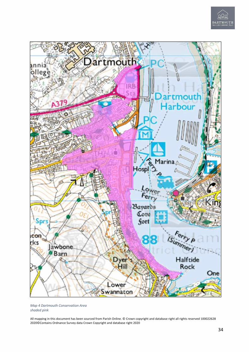
All mapping in this document has been sourced from Parish Online. © Crown copyright and database right all rights reserved 100022628 2020©Contains Ordnance Survey data Crown Copyright and database right 2020
34
Map 4 Dartmouth Conservation Area shaded pink

All mapping in this document has been sourced from Parish Online. © Crown copyright and database right all rights reserved 100022628 2020©Contains Ordnance Survey data Crown Copyright and database right 2020
35
5.6.3 It is important to achieve a high level of design quality that makes a positive contribution to the historic environment and the conservation areas of Dartmouth. The SHDC Supplementary Planning Document 2020 Appendix 5 outlines the design principles to be adopted in conservation areas and these are supported by the Dartmouth Neighbourhood Plan.
5.7 Housing
5.7.1 To thrive as a coastal market town in the future, as a place to live, work and visit, Dartmouth will require a diverse and balanced population and age structure. Any new housing must reflect, therefore, the needs of such a population. The plan area is constrained topographically, with very few sites within the lower town suitable for the delivery of new homes. As such, any sizeable growth to support the future needs of the town will continue to the south-west of the town centre. Although the Dartmouth population has remained relatively static (Dartmouth Population in 2001 census 5,504 - Dartmouth Population in 2011 census 5,605) as with many coastal communities Dartmouth has an ageing population with households becoming smaller and the number of families decreasing. the ONS produces mid-year population estimates for parishes throughout the country. The mid-2019 population estimate for Dartmouth parish is 5,427 indicating population decline of around 178 individuals since 2011. This level of population decline (3.2%) is broadly consistent with the lack of growth in the number of dwellings in residential use, along with the trends of under occupation, second homes and population ageing. The decline would be addressed by a growth in specialist housing for older people, single person households, couples without children and lone parents. There is, therefore, an increasing requirement for smaller houses, whether because of demographics, the requirement to downsize or issues of affordability.
5.7.2 The Housing Needs Assessment 2021 prepared for this Plan and included as Appendix N states that Dartmouth in particular and South Hams generally, is an expensive area with local people increasingly unable to afford local house prices. Local earnings have not kept pace with house prices in the South Hams area with the affordability ratio now standing at 11 (earnings to house price ratio) for both median and lower quartile earners. 5.8 Health and Wellbeing 5.8.1 In terms of healthcare provision the resident population quoted above increases to about 8,000 based on temporary visitor registrations with the sole GP practice located in Victoria Road. The additional registered numbers also come from surrounding parishes. After the closure of the Dartmouth Cottage Hospital on the South Embankment in 2016, the only remaining health facility is the Dartmouth Clinic, in the centre of town in Zion Place this accommodates limited health services. Two intermediate care beds are also commissioned from the Beacon Court care home. There are currently two pharmacies operating in the centre of town. 5.8.2 The Board of Torbay and South Devon NHS Foundation Trust has agreed to site a new Health and Wellbeing Centre at the top of town, at the site of the current overflow car park for the Park and Ride Service. Construction is planned to start in 2021. The new Health Centre will house the Dartmouth Medical Centre, which will relocate from the centre of town, the

All mapping in this document has been sourced from Parish Online. © Crown copyright and database right all rights reserved 100022628 2020©Contains Ordnance Survey data Crown Copyright and database right 2020
36
existing services provided from the Dartmouth Health and Wellbeing Centre in Zion Place, a retail pharmacy and rooms for the Dartmouth Caring charity, as well as a café. The nearest District General Hospital is Torbay Hospital. There is an existing ambulance station in Dartmouth and the Devon Air Ambulance is also able to land in Coronation Park 5.9 Education The main education provision for all school age pupils is through the Education South West (ESW)Trust, a multi-Academy Trust which runs the Dartmouth Academy an all-through school, providing for pupils from age range 3 to16 (nursery, primary and secondary), and located on the edge of the Upper Town. St John the Baptist Primary School is the other school in Dartmouth catering for pupils below secondary school age. The Academy (September 2020) has around 450 pupils on roll. Current buildings are designed for a roll of 650+ In September 2017, Dartmouth Academy received a full OFSTED inspection, and was graded as overall ‘good’. Partly as a result of this, secondary school numbers are starting to grow. At age 16+ school leavers from Dartmouth generally attend on one of South Devon College (for vocational and practical studies), or Kingsbridge Community College (to study A level or equivalent qualifications). Small numbers of students choose to travel to Totnes, Exeter or Churston for sixth form education. Sixth form provision in Dartmouth is not considered viable. About two-thirds of its pupils live locally (predominantly in Townstal). Two buses, paid for by the Academy transport students from Torbay. The school reports no particular problems with pupil transport at the present time. Good use is made of local leisure facilities, and there are strong links with BRNC for sports and outdoor activities. 5.10 Britannia Royal Naval College (BRNC) Beginning in 1863 the training hulks Britannia and Hindostan were moored on the river side of a hilly peninsula called Mount Boone, the majority of which was owned by the estate of Sir Walter Raleigh, who had received the property by Royal Grant from Queen Elizabeth I. The present buildings date from 1905, the architect was Sir George Aston Webb, whose previous commissions included Admiralty Arch and the East Front of Buckingham Palace. The foundation stone was laid by King Edward VII in March 1902 and the first cadets entered the College three years later. The bombing of the College in September 1942 forced a change in training policy and both staff and students were evacuated to Eaton Hall, Cheshire, until the end of the war. Bomb damage sustained to the quarterdeck in 1942 The Royal Naval College re-opened in September 1946 and although structurally it remained unchanged, the number and character of its courses was greatly expanded. By the mid-seventies the number of graduate entrants had significantly increased. The tradition by which the sons of our Monarchy attend BRNC goes back to the time of Queen Victoria. The late HRH Prince Phillip studied there and of the present Royal family, Prince Charles and the Duke of York were also cadets. The range of courses continued to expand; two important new groups of officers came with the arrival of the Special Duties Officers Pre-qualifying Course, St. George, in 1974 and the WRNS Officers' Training Course, Talbot in 1976. The training of female Naval Officers was integrated into that of their male counterparts in 1990 and the Special Duties Officers' Greenwich course moved to Dartmouth in 1996. The College's contribution to defence today and to the economic and social sustainability of Dartmouth is as relevant as ever.

All mapping in this document has been sourced from Parish Online. © Crown copyright and database right all rights reserved 100022628 2020©Contains Ordnance Survey data Crown Copyright and database right 2020
37
5.11 Dartmouth Green Partnerships Formerly known as Dartmouth in Bloom the Dartmouth Green Partnerships (DGP) is a registered charity (www.dartmouthgreenpartnerships.org.uk) and has been in existence since 1974. Over the years they have won many awards for horticultural excellence from the Royal Horticultural Society and South West in Bloom. The purposes of DGP are two-fold; firstly to promote horticulture and floriculture for the benefit of the public generally and in particular those who live in or visit Dartmouth by the provision of floral displays, shrubs and landscapes in places visible to the public and through the conservation of the environment and community involvement. In addition DGP sets out to advance the education of the public in ecological sustainability, conservation, recycling and biodiversity. Volunteers takes care of several sites in Dartmouth and with others are keen to preserve and enhance the town's green spaces as places for health and wellbeing as well as public enjoyment. 5.12 Dartmouth Together Dartmouth Together (https://www.dartmouthtogether.com) is a voluntary sector partnership established in 2018, with support from local government and the NHS, that aims to improve the health and wellbeing of those living in the community. Dartmouth Together is aiming to help existing community groups, such as sports, education and arts societies reach more people and increase membership. 5.13 TQ6 Community Partnership (TCP) TCP (https://www.c2connectingcommunities.co.uk/our-impact/tq6-community-partnership/ ) is a partnership set up in 2009 of local people and services who work together to address local issues and community concerns to improve life in Dartmouth, Townstal and the surrounding villages. TCP aim to create greater community cohesion through activities and creating opportunities for the community to do things for themselves. Dartmouth is a town of two halves with visible affluence and hidden poverty. An historic focus on the affluence of the town and the tourist economy has long taken priority over the real challenges and needs locally. Like many coastal communities, Dartmouth, particularly Townstal at the top of the hill, is suffering from the impact of austerity cut back to services, seasonal work and the increase of zero-hour contracts, reduction and automation of essential services, high levels of digital exclusion, rural isolation, infrequent and expensive public transport and its local hard-working population are underrepresented in local decision-making.
5.14 Dartmouth Rotary The group raises over £10,000 per annum and awards around 60% of this to local groups in need; including food banks, providing computers, and other school equipment and funding trips and helping schools with reading buddies. They also support other charities such as Community Chest. The remaining funds go to international charities including Shelterbox, Mercy Ships, End Polio Now and Disaster Relief. In normal times the group organises the Summer Fete, Beer festival and collections at Candlelit Dartmouth, at Christmas . 5.15 Friends of Dartmouth Community Orchard The group was founded in November 2014 now has 160 members it was set up to protect the Community Orchard and provide maintenance and improve facilities. The Friends have gained

All mapping in this document has been sourced from Parish Online. © Crown copyright and database right all rights reserved 100022628 2020©Contains Ordnance Survey data Crown Copyright and database right 2020
38
Community Asset status for the Orchard and have persuaded the Town Council to voluntarily register it for Village Green status. The Orchard now has improved all-weather paths, a shelter with a green roof ,with around 130 trees with many varieties of Devon apples. The group organise an annual summer picnic and apple pressing in the autumn. 5.16 Dartmouth Community Chest Dartmouth Community Chest (DCC) is a local charity that is completely run by volunteers. They collect used good quality furniture and white goods and redistribute it all to low income families and individuals. They rescue tons of perfectly good items every year from ending up in landfill. DCC runs a series of initiatives to help the community. They provide emergency food parcels and free hot lunches every Friday. Representatives from housing associations, CAB and other organisations attend these lunches regularly to provide help and advice. They are working to support local households who rely on minimum wage seasonal work as poor transport links limit the job options for many, in a town with the lowest level of car ownership in Devon. Their work has helped countless people in Dartmouth and attracted national recognition. 5.17 Dartmouth and Kingswear Society The Society is a charity whose members seek to preserve and enhance the area of Dartmouth and its surrounding villages, the River Dart and the neighbouring coastline and countryside. Much of this area is part of the South Devon Area of Outstanding Natural Beauty and includes a number of Conservation Areas. Objectives include the preservation, protection, development and improvement of features of historic or public interest as well as the natural beauty of the district together with the maintenance of a viable local economy, all in keeping with its character, design and history. The Society endeavours to promote high standards of planning and building and to prevent damage in the area. Where issues arise which need action or initiatives to meet these objectives the Society will respond accordingly. The Society also seeks to provide a range of enjoyable activities and events for members each year including occasional talks, receptions and visits to local places of interest and non-members are welcome to join in where possible. 5.18 The Old Dartmothian’s Association The Association was formed in 1923 at the Royal Regatta, it’s objects are: ‘For the renewal of old friendships and acquaintances of Dartmothians who revisit the scene of their youth and who would be likely to visit the town at the Annual Royal Regatta’; also, to keep in touch and with current events in the town; to advance the welfare of the home town; care of the old folk of Dartmouth and deceased members’ widows; maintain an interest in the educational welfare of the young and encourage Dartmouth sporting traditions. The Association makes regular donations to local charities, youth organisations and sporting clubs, disability clubs and hospitals. Members give their time in supporting St Petrox, St Saviours and St Clement churches when needed and other town assets such as the fountain, the shelter on Coronation Park and replacing the Middleton Arch. 5.19 Dartmouth Museum

All mapping in this document has been sourced from Parish Online. © Crown copyright and database right all rights reserved 100022628 2020©Contains Ordnance Survey data Crown Copyright and database right 2020
39
The town is well-served by a small but well-formed museum located in part of the iconic Butterwalk, a row of rich merchants’ houses dating from 1640. The main themes of the Museum are the people and town of Dartmouth, and its naval and maritime connections, supported by displays and archives. The Museum attracts around 10,000 visitors a year on foot and handles an increasing demand worldwide for genealogical and academic research enquiries. Exhibits are regularly updated including a model as part of the Mayflower 400 celebrations. The Museum survives in difficult commercial conditions, largely by being entirely staffed by volunteers. Further details can be found at https://www.dartmouthmuseum.org 5.20 Flavel Arts Centre The Arts Centre was opened in 2005, and now plays a vital role as a community hub, providing cinema and live theatre, meeting rooms, a branch of Devon Libraries, an exhibition space and a café, and is open 363 days a year. The centre is supported by a team of over 100 volunteers. It is the only venue to provide this range of facilities and activities in Dartmouth and the wider area.The Flavel has a varied programme of live events with performances by some well-known artists; the cinema has more than 400 screenings per year; 36 different groups meet regularly including pilates and yoga classes and the Flavel is home to the local U3A. The library has over 20,000 visits a year, and the café provides a regular meeting place for locals and visitors alike. 5.21 Dartmouth Caring Dartmouth Caring is a registered charity, established for over 30 years. In 2018 we were awarded the Queen’s Award for Voluntary Service in recognition of the work we have been doing, and continue to undertake. Our aims are simple, to support those in need. Each year we support over 750 people (10% of the local population) across Dartmouth and the surrounding villages. Much of our work is funded through local fundraising and small grants. We work from our base by the GP practice using staff and a team of over 120 volunteers to deliver our services. Our aim is to enable people to live happy and vibrant lives, connecting those who are isolated to others and improving health and well-being within our community. We provide a range of 20+ services. 5.22 The Food Bank This food bank, has been operating since 2012 is open every Wednesday morning 11 AM to 1 PM at Ivy Lane Dartmouth. We provide bags of ambient food to anyone in need and welcome referrals from local agencies. Food parcels are available at Dartmouth Caring and the Guildhall for collection when we are closed. We deliver to those who cannot collect in person. 5.23 The Flavel or Dartmouth pantry In Dartmouth there is often unseen food and fuel poverty, partly due to the seasonal nature of the jobs in the hospitality sector. To help address this need ,which has been even more marked through the 2020/21 covid pandemic. Flavel Church operates a pantry where fresh food, bread and other essentials can be obtained free of charge by whoever needs it. The project is supported by local businesses and charities in the town. The pantry is available Regularly during the week and whenever the Church’s Flavour Coffee Lounge is open. The lounge is open to people of all faiths and none, and it provides a safe haven where individuals and groups can meet; to chat; to knit; to relax; to meditate; or to pray.

All mapping in this document has been sourced from Parish Online. © Crown copyright and database right all rights reserved 100022628 2020©Contains Ordnance Survey data Crown Copyright and database right 2020
40
6. Proposed policies for the Plan area 6.1 Green Environment 6.1.1 Background The NPPF states that “Planning policies and decisions should contribute to and enhance the natural and local environment” by “protecting and enhancing valued landscapes”. This is supported in the JLP in DEV25 which confirms that nationally designated landscapes such as the South Devon AONB should be protected from inappropriate development and activity.
Map 5 South Devon Heritage Coast Policy Area (JLP Dev 24) shaded blue

All mapping in this document has been sourced from Parish Online. © Crown copyright and database right all rights reserved 100022628 2020©Contains Ordnance Survey data Crown Copyright and database right 2020
41
Map 6 Undeveloped Coast Policy Area (JLP Dev 24) shaded purple
Policy DNP GE 1 Impact on the South Devon Area of Outstanding Natural Beauty (AONB)
In addition to National and Development Plan policies and guidance controlling development in and within the setting of the South Devon AONB, Undeveloped Coast and Heritage Coast, development within the Parish must demonstrate, where appropriate due to the size and scale of the development the following;- a) how it maintains and enhances the intrinsic Landscape Character Areas and Types (LCT)
of the landscapes affected as set out in the latest Landscape Character Assessment for the South Hams;
b) why it cannot be accommodated reasonably outside the Heritage Coast and Undeveloped Coast designation;
c) How the natural assets and constraints of a development site have been assessed. Substantial harm to or loss of irreplaceable habitats such as ancient woodland and within historic boundary features, walls, hedges, banks and ditches should be wholly exceptional;
d) how opportunities for improving public access to and the enjoyment of the coast have been included.

All mapping in this document has been sourced from Parish Online. © Crown copyright and database right all rights reserved 100022628 2020©Contains Ordnance Survey data Crown Copyright and database right 2020
42
6.1.2 Safeguarding biodiversity and Green Matrix through the plan area Planning policy at all levels must aim at enhancing biodiversity, seek to protect the core areas of the green matrix, the network of routes that connect them, and the species present in them. The policy below seeks to at a local level ensure legal requirements are met, and that specific development plans prevent or mitigate the loss of biodiversity.
The Green Matrix links habitats and the wildlife they support. They provide a vital role in allowing all kinds and sizes of wildlife, from mammals to invertebrates, to move safely between home patches which otherwise would be isolated. They promote healthy and resilient biodiversity of plants and animals and help prevent genetic inbreeding and local extinctions. Typical components may be lanes, the banks of watercourses, unsprayed field margins, hedges and strips of woodland. Their essential feature is connectivity, with different types of corridor linking to provide larger and more valuable wildlife resource. Designation should alert Planning Authorities of the need to preserve this connectivity by avoiding development which will, for example, remove sections of hedgerows or clearance of
Map 7 The Green Matrix of Dartmouth Parish

All mapping in this document has been sourced from Parish Online. © Crown copyright and database right all rights reserved 100022628 2020©Contains Ordnance Survey data Crown Copyright and database right 2020
43
woodland. The protection of existing, and creation of new green corridors is a prime objective of the South Hams Infrastructure Framework 2015. Policy DNP GE 2 Safeguarding the biodiversity and Green Infrastructure throughout the Parish Where appropriate due to the size and scale development proposals should;- a) Include a Green Infrastructure plan to show how the development can improve greenspaces and corridors for people and nature, in the context of the parish and where possible connecting to the green matrix of the plan area and the broader green infrastructure of South Devon. The individual components of the green matrix illustrated in Map 7 should be protected and opportunities sought to improve accessibility and enhance and extend this matrix. b) Include a biodiversity action plan which includes details of how the development will achieve a net gain in biodiversity in compliance with national policy requirements. c) Retain on site natural features such as Devon banks, stone walls, hedgerows, protecting existing mature trees beyond those protected within a Tree Preservation Order. d) Where possible replace any alien and foreign species of trees considered invasive or harmful with indigenous species. e) Promote where reasonable opportunities for improving access to heritage assets and green space through new walking routes. 6.1.3 Community aspiration; to protect and create net gains in biodiversity This plan supports DTC to actively encourage local landowners to participate in DEFRA’s Higher Level Stewardship scheme (and its post-Brexit equivalent) to enhance biodiversity on agricultural land within the parish or otherwise to adopt practices that achieve the same aims. In addition the plan supports DTC drawing up management plans for the sites of wildlife interest that it owns; each plan to incorporate measures for protecting and enhancing biodiversity. Dartmouth based groups and individuals are encouraged to work with conservation bodies and contribute to monitoring schemes in order to develop a richer picture of the biodiversity within the parish.

All mapping in this document has been sourced from Parish Online. © Crown copyright and database right all rights reserved 100022628 2020©Contains Ordnance Survey data Crown Copyright and database right 2020
44
6.1.4 Local Green Space NPPF para 99 allows the designation of land as Local Green Space through Neighbourhood Plans, allowing communities to identify and protect green areas of particular importance to them. Para 100 establishes the criteria for such designation of a green space:
• In reasonably close proximity to the community it serves; • Demonstrably special to a local community and holds a particular local significance, for
example because of its beauty, historic significance, recreational value (including as a playing field), tranquillity or richness of its wildlife; and
• Local in character and is not an extensive tract of land.
Consultation with the local community regarding the audit of open spaces and nomination of those suitable for Local Green Space designation was undertaken at public meetings, notification of Landowners by ‘phone and email, meetings of the Green Environment Topic Group, through publicity on the website, through newsletters and the development of a team of “Local Champions.” Landowners were consulted for all of the nominated sites. The sites nominated for Local Green Space designation are shown in Map 8 and in Table 3 included in the appendices which summarises the evaluation of these sites.
Policy DNP GE 3 Local Green Spaces The following areas illustrated in Map 8 with supporting evidence of their special qualities included in Table 3 are designated as Local Green Spaces;- LGS1 Coronation Park LGS2 Royal Avenue Gardens LGS3 Community Greenhouse and adjacent gardens LGS4 Dartmouth Castle Wall LGS5 Castle Estate LGS6 Jawbones Allotments LGS7 Milton Lane Allotments LGS8 Longcross cemetery LGS9 Community Orchard LGS10 Warfleet Creek, Lime Kilns, Quay and Slip. LGS11 Sandquay wood LGS12 Norton Wood LGS13 Norton Field LGS14 Manor Gardens LGS15 Crosby Meadow LGS16 Jawbones Beacon Park LGS 17 Bowling Green LGS 18 Play area at the junction of Victoria Road and Vicarage Hill

All mapping in this document has been sourced from Parish Online. © Crown copyright and database right all rights reserved 100022628 2020©Contains Ordnance Survey data Crown Copyright and database right 2020
45
6.1.5 Allotments There are 0.7ha of allotments in Dartmouth, divided between 2 sites, this is adequate for the present population but is slightly below the target for Devon established by the English Allotments Survey in 1987 (0.15 ha/1000 population) and adopted in the JLP policy DEV5. One site Milton Lane is on flat ground and owned and operated by DTC, the other on the steep slope of Jawbones Hill, owned by the Dartmouth Trust and operated by the Jawbones Allotment Society. Both sites are judged to be adequate by the occupants with provision for storage and accessible water and are fully occupied with a waiting list for vacant plots. The Milton Lane site has car parking. It is important that both sites are retained for this purpose and that provision is monitored as the Cotton Farm development becomes populated. The need for further provision should be monitored in line with demand from increased waiting lists and the needs of new residents.
Map 8 Local Green Space designations lined in red, parish boundary in blue

All mapping in this document has been sourced from Parish Online. © Crown copyright and database right all rights reserved 100022628 2020©Contains Ordnance Survey data Crown Copyright and database right 2020
46
Policy DNP GE4 Allotments The plan supports the retention of allotments at Milton Lane and Jawbones. The importance of Milton Lane and Jawbones allotments as assets to the community, and local food production is recognised by their designation in this plan as Local Green Spaces. The re-purposing or encroachment on these existing sites will not be supported. Development that includes provision for community allotments will be supported. 6.1.5 The Dart Estuary Dartmouth has an intimate relationship with the river from which it takes its name. This relationship requires pro-active management through the Dart Harbour Authority, The South Devon AONB, District , Parish and Town Councils. The AONB Estuaries Management Plan for the Dart Estuary and the Dart Harbour Strategic Plan in force at the time should be material considerations in determining any future planning applications where it is relevant to the planning proposal. Policy DNP GE5 Maintaining the character and the environmental quality of the river The natural characteristics of the Dart estuary should be retained in any development along the waterside. For any future waterside development consideration should be given to respect the following criteria;- a) All existing wooded areas visible from the river, particularly those running to the water’s edge and/or where they start at the visible natural ridge line should be retained; b) Any adverse impact on the health and quality of the river from development must be mitigated against; this includes impact from noise, pollution, such as sewage and litter; c) There should be an overall positive impact on the wildlife designations along the river edge as indicated in the Green Matrix strategy (Map7) and the Wildlife Resource Map for the Plan Area (Appendix E2) Designations that must be safeguarded include; Special Areas of Conservation, County Wildlife Sites, Strategic Nature Areas and Other Sites of Wildlife Interest.

All mapping in this document has been sourced from Parish Online. © Crown copyright and database right all rights reserved 100022628 2020©Contains Ordnance Survey data Crown Copyright and database right 2020
47
6.1.6 Locally Important Views (LIV) There are many impressive, iconic, and locally distinctive views within the parish. Those selected after consultation with our community are listed in the following policy. The views support the setting of the town within the South Devon AONB and should inform future development. The LIVs are listed in Appendix F and their arc of view illustrated in Map 5,they fall into 3 categories:
• Natural and sequential approaches to Dartmouth; these represent green highways variously consisting of Devon banks, historic walls, and hedgerows with assorted shrubs and trees that are important for their visual qualities, imbue a sense of tranquillity and provide important habitats for biodiversity.
• Views from the town; to the sea and river, the network and matrix of green spaces, woodland and agricultural land which create the varied landscape and seascape character types and provide the setting for Dartmouth.
• Views into the new and old parts of the town emphasising the setting of the built environment.
Policy DNP GE 6 Locally Important Views
Development within the foreground or middle ground of the views shown in Map 9a and b , and Appendix F should not harm and should, where possible, contribute positively to the existing composition of natural and built elements. Development should not be overly intrusive, unsightly or prominent to the detriment of the view as a whole, or to the landmarks within the view.
V5 V8
V41 V15 V13
V11
Photographs of Locally Important Views; a full set and their justification are included in Appendix F

All mapping in this document has been sourced from Parish Online. © Crown copyright and database right all rights reserved 100022628 2020©Contains Ordnance Survey data Crown Copyright and database right 2020
48
Maps 9a and 9b Locally Important Views

All mapping in this document has been sourced from Parish Online. © Crown copyright and database right all rights reserved 100022628 2020©Contains Ordnance Survey data Crown Copyright and database right 2020
49
6.1.7 Mitigation against climate change and achieving net-zero carbon emissions Concerned individuals, families and businesses are already making choices to reduce their carbon footprints; for instance, buying electric vehicles, installing renewable energy heating systems and better insulation, choosing green energy tariffs, recycling, reducing car journeys. Sustainable tourism is becoming increasingly popular; for example, adopting measures like solar or electric powered ferries and tour boats, hydrogen-powered buses. (see Appendix G, section 2).In order to meet the Intergovernmental Panel on Climate Change target of reducing carbon emissions by 45% by 2030 and SHDC’s target of net-zero emissions by 2050, this plan supports the adoption a variety of measures. (see Appendix G, section 1b). Policy DNP GE7 Actions to mitigate against climate change and carbon reduction This Plan supports the objectives contained in the Devon Climate Change Strategy (September 2018) and the emerging Devon Carbon Plan. All new development should;- a) Assess and monitor the carbon footprint of the development its impact on and
community actions including local tourism, employment, transport, farming and its own operations to enable it to reduce carbon in the development and future operation.
b) Make the town and employment activities more innovative, environmentally friendly
and responsible, carbon neutral and sustainable. This applies to all businesses but in particular tourist accommodation, ferry companies, the marina, hospitality, and event sectors.
6.1.8 Trees and hedgerows perform a number of important roles in supporting biodiversity, providing attractive shade/shelter and generally improving health and amenity. Trees will also help the plan area adapt to the effects of Climate Change. New development should include the provision of suitable tree planting where appropriate.
Policy DNP GE 8 Promotion of tree planting;
All appropriate development where it is demonstrated that the proposals achieve an increase in biodiversity and carbon capture through additional tree and other planting and appropriate land management will be supported.
Development that damages or results in the loss of ancient trees or trees of good arboricultural and amenity value will not normally be permitted. Proposals should be designed to retain ancient trees or trees of arboricultural and amenity value. Proposals should be accompanied by evidence that establishes the health and longevity of any affected trees.
New tree planting must not conflict with and should complement wildflower rich grasslands.
Community based initiatives to plant trees and enhance biodiversity, wildlife habitats and corridors within the plan area will be supported where appropriate.

All mapping in this document has been sourced from Parish Online. © Crown copyright and database right all rights reserved 100022628 2020©Contains Ordnance Survey data Crown Copyright and database right 2020
50
6.1.9 This Plan supports JLP policy DEV35 (Renewable and low carbon energy). Through the consultation process the community have expressed interest in supporting more renewable energy generation in the parish. Not all technologies are appropriate for this sensitive landscape; there is potential for biomass, hydro-electric and small scale roof mounted solar. Solar farms or wind turbines are not considered suitable for the parish.
Policy DNP GE 9 , Encouraging renewable energy
If planning permission is required the development of small scale renewable energy generation where supported by the community will be encouraged, this includes;-
• Biomass; where material is sourced from the coppicing local woodland and hedgerows;
• Hydro power generation from local watercourses; • Technologies making use of the River Dart; • Small scale solar power when roof mounted on domestic, employment and
agricultural buildings; • Ground source and air source heat pumps; • Community heating and combined heat and power.
Wind turbines and large-scale ground mounted solar power are not considered appropriate methods of generation within the parish.
Where appropriate proposals should demonstrate that they will not affect the integrity of the Statutory and Non-Statutory wildlife sites within the parish and will have no detrimental impacts on South Devon AONB, and the SSSI’s within the parish. Where necessary proposals must be supported by protected species surveys and the identification of any necessary mitigation measures.
For the purposes of this policy small scale is defined as less than 50Kwp.

All mapping in this document has been sourced from Parish Online. © Crown copyright and database right all rights reserved 100022628 2020©Contains Ordnance Survey data Crown Copyright and database right 2020
51
6.1.10 Community aspiration; to mitigate against Climate change: The plan supports the introduction of carbon reduction measures within DTC and harbour operations: • Consider facilitating a salary sacrifice scheme for electric cars, getting an electric car
pool and changing the vehicle fleet to electric. (See Appendix G, section1c); • Install renewable energy systems in its buildings to reduce energy use and improve
efficiency; • Buy fewer consumables and reduce waste (e.g. plastics especially for single use). • Ensure that clear, visible signs are installed and maintained at ferry queues to prevent
idling vehicle engines, • Ensure that ferries do not idle when stationary, • Adopt a communications policy to encourage a local movement for behaviour change, • support a local awareness campaign to keep local residents, businesses and visitors up
to date with current recommendations and legislation issued by national and local government and environmental organisations (Appendix G, section 4).
Local businesses are encouraged to contribute to a ‘Green Recovery Plan’, putting sustainable initiatives at the heart of economic recovery from the Coronavirus Covid 19 pandemic. This plan encourages the adaption of existing businesses and the welcoming of new businesses to achieve this. For example, existing or new businesses could adapt to retrofitting domestic and marine powering systems with clean energy. (Appendix G, section 1a) 6.1.11 Light Pollution: new development that increases the level of artificial light is a factor that threatens the survival of protected and threatened local wildlife and adversely affects human health . South Devon AONB Management Plan Policy Lan P4(Tranquility) and LanP5 (Skylines and visual intrusion) seek to reduce the impact of external lighting and nighttime scenic intrusion. When outside lighting is used on private and public premises, including floodlighting, encouragement will be given to ensure that it is neighbourly in its use. All external lighting should be deflected downwards rather than outwards or upwards and should when possible be switched off after midnight; any movement-sensors should be regulated to reduce illumination periods to a minimum.

All mapping in this document has been sourced from Parish Online. © Crown copyright and database right all rights reserved 100022628 2020©Contains Ordnance Survey data Crown Copyright and database right 2020
52
Policy DNP GE 10 Prevention of light pollution; Development should not detract from the unlit environment of Dartmouth and surrounding countryside and should minimise their impact on the night sky. The use of a high proportion of glass in walls and roofs without consideration of the impact on the environment when internally lit will be discouraged. Security lighting, outside lighting, and floodlighting should be designed to minimize their impact on the night sky with lighting deflected downwards and switched off after midnight. 6.1.12 Flood Prevention Dartmouth is at risk of flooding by fluvial, tidal and wave action. The Environment Agency (EA) completed a tidal flood risk modelling update for Dartmouth in 2017. The study assessed the flood risk in Dartmouth for a range of events and has used the results to update the tidal procedures for Dartmouth. The model results show that there are areas of the town susceptible to regular flooding. These areas include the Lower Ferry Slipway, the North and South Embankment, Coronation Park, Bayard’s Cove and Dart Marina (Appendix G, Section 4A) This modelling helps the community better understand the risks helps DTC work with partners such as the EA, and SHDC to identify works that can be done to mitigate the impact of these risks. Policy DNP GE 11 Prevention of Flooding; Development proposals should, where necessary demonstrate that the impact on the existing foul and surface water system has been assessed and includes details of on-site mitigation if required. Any proposals in the proximity of the Environment Agency flood risk areas illustrated in map 10, and subsequent revisions to the Flood Map, and highlighted in their flood risk modeling should have due regard to historic flooding incidents and the reports of these prepared on behalf of Dartmouth Town Council, included as Appendix O. There should be no adverse impact on local streams, leats, flood channels and neighbouring properties. The design of any flood defences should be carried out in consultation with the community and appropriate to the historic and natural settings of the plan area. Materials used should be in accordance with the policies of this plan and the planning guidance of the South Devon AONB.

All mapping in this document has been sourced from Parish Online. © Crown copyright and database right all rights reserved 100022628 2020©Contains Ordnance Survey data Crown Copyright and database right 2020
53
Map 10 Flood Risk areas for Dartmouth Zone 2 light blue, Zone 3 dark blue
All mapping in this document has been sourced from Parish Online. © Crown copyright and database right all rights reserved 100022628 2020©Contains Ordnance Survey data Crown Copyright and database right 2020
54
6.1.13 Settlement Boundary and avoidance of coalescence Dartmouth is one settlement ,however at the western edge of the Parish the developed area is close to the Parish boundary and risks coalescence with adjacent settlements and hamlets. This plan considers that green infrastructure around the settlement is important to the open character of the town, maintaining a high environmental quality and achieving the green matrix referred to in Policy DNP GE2. To safeguard these features and prevent coalescence a settlement boundary and avoidance of coalescence policy is included in this Plan. The settlement boundary proposed restricts development in the open countryside, will be used to ensure that development proposals do not individually or cumulatively result in the coalescence and the loss of the separate identity of Dartmouth. The principles applied to determine a settlement boundary to inform the JLP (TTV Topic Paper June 2018) were used to help define the boundary. For proposed development sites located outside the settlement boundaries Plan Policy DNP H2 (Rural Exception Sites outside the settlement boundary), DNP EC6 (Employment Uses in the Countryside),the criteria of JLP Policies TTV 27 (Meeting local housing needs in rural areas) and TTV26 (Development in the Countryside) will also apply. Policy DNP GE12. Settlement Boundary and the avoidance of coalescence; A settlement boundary for Dartmouth is designated in this Plan and illustrated in Map 11. Development inside the settlement boundary is supported in principle subject to National Policy and Guidance and the Development Plan. Development proposals outside the settlement boundary will be treated as development in the open countryside. To protect the character and appearance of Dartmouth, development which erodes the visual separation of the settlement will not be permitted.

All mapping in this document has been sourced from Parish Online. © Crown copyright and database right all rights reserved 100022628 2020©Contains Ordnance Survey data Crown Copyright and database right 2020
55
Map 11 Settlement Boundary for Dartmouth lined in red, existing parish boundary lined blue . For a more detailed map refer to Appendix Map 11

All mapping in this document has been sourced from Parish Online. © Crown copyright and database right all rights reserved 100022628 2020©Contains Ordnance Survey data Crown Copyright and database right 2020
56
6.2 Economy, jobs and training 6.2.1 Background This plan acknowledges the key economic benefits provided by tourism , the Britannia Royal Naval College (BRNC) and related marine industries and seeks to support expansion and add value to these activities. The Plan also supports the careful expansion of the existing employment sites to maximise good job opportunities. The Plan promotes Dartmouth’s marine, digital, design and marketing industries, and to have the best broadband links to compensate for its relatively isolated geographic location. The economic strategy of this plan sets out to exploit the town’s key assets of river location, tourism activities and unique character to position Dartmouth as a unique and sustainable place to live, work, visit and learn in. 6.2.2 This Plan supports and expands on the employment policies of the adopted Development Plan including:- Dev 14: Maintaining a flexible mix of employment sites Dev 15: Supporting the Rural Economy; Dev 18: Protecting local shops and services Dev 19: Provision of local employment and skills 6.2.3 Bringing further vitality and greater viability to the town centre is supported by this plan together with diversifying the retail offer and adding value to the current retail activities. The plan must have regard not only to the daytime economy, but also to the nighttime economy, which are essential components in supporting the town centre and tourism industry and providing high quality jobs in hospitality and catering. 6.2.4 Tourism is and will remain a fundamental part of the local economy. However, increasing competition from elsewhere as well as the seasonal nature of tourism, means the plan must seek ways to enhance the value of its tourism offer throughout the year. The Dartmouth Visitor Centre provides a vital role in the town’s tourism infrastructure, delivering helpful and knowledgeable face to face representation of the town’s facilities and attractions. Tourism accommodation in Dartmouth comprises a mixture of family run hotels and guesthouses, self-catering accommodation including Airbnb’s and a limited number of exclusive residential seafront and harbour-side apartments near the Dart Marina and within Lower Town. Appropriate support needs to be given to these as long as they do not operate to the detriment to their local neighbours and the wider community. Additional tourism development would not only contribute to the economy but may also offer excellent opportunities to re-use and protect older buildings, improve the public realm and increase employment. Dartmouth’s tourism infrastructure should be enhanced to take into account modern visitor expectations and that the full potential of the town’s cultural, environmental and social assets is realised. This plan supports the re-use of redundant buildings which may lend themselves well to adaptation and modernisation for tourism uses. The conversion and change of use of former hotel premises to secondary residential uses has been a major concern to the area and is not supported.

All mapping in this document has been sourced from Parish Online. © Crown copyright and database right all rights reserved 100022628 2020©Contains Ordnance Survey data Crown Copyright and database right 2020
57
Policy DNP EC 1 Tourism related employment and retention of hotels The change of use or redevelopment of a hotel to non-hotel use will generally not be supported . Such a change will only be supported provided that;- a) The proposed use would be compatible with the existing building and its surroundings and setting within the Dartmouth Conservation Area and South Devon AONB; b) No loss of hotel accommodation in the Parish or detriment to local employment will result; c) Demand for the hotel accommodation no longer exists. Development may include;- d) Change of use to residential care or extra care which supports the Plan objectives to both provide employment and specialist affordable housing for the elderly. Where the loss of a hotel or tourism related site is justified as no longer viable the applicant must demonstrate through an independent assessment that the vacant unit has been actively marketed and offered at a reasonable sale price (comparable with valuations achieved elsewhere in the District) for a minimum period of 2 years. 6.2.5 Tourism is recognised in the HotSW LEP Strategic Economic Plan (SEP) 2014 to 2030 and the Development Plan as one of the highest economic drivers and core traditional sectors in the area. The SEP also recognises the challenge to extend the season and develop all year round tourism employment. The policy below sets out to encourage more innovation and diversification in the sector. Policy DNP EC 2 Promotion of innovative tourism businesses This plan supports development that includes new, innovative and sustainable tourism related uses. Activities include but are not limited to;- a) Green , low carbon and sustainable tourism b) River and water based leisure activity; c) The research and development of technologies that support the marine leisure
industry; d) Activities that link to the SW Coastal Path and cycle routes; e) Cycle and electric cycle hire supporting sustainable tourism and transport. The proposed uses should be compatible with their surroundings and setting within the town, river, countryside and conserve and enhance the South Devon AONB. 6.2.6 Some employment locations in Townstal and on the periphery of the NP area suffer from poor environment / access with mixed quality buildings and environment and awkward layout, which tend not to attract inward investment and potentially restrict development and

All mapping in this document has been sourced from Parish Online. © Crown copyright and database right all rights reserved 100022628 2020©Contains Ordnance Survey data Crown Copyright and database right 2020
58
expansion and can cause negative customer impressions that can restrict competitiveness. There is a need to encourage and enable upgrading, intensification and enhancement of existing employment sites with poor environments / access. The lack of adequate storage on existing sites has also been identified as an issue in the local business survey (see AppendixK2). 6.2.7 The Business Survey undertaken for this Plan (see Appendix K2) identified a wish to see additional rental premises or that current premises can be more readily adapted for modern office based activity. There may be opportunities for development of existing buildings to achieve this whilst maintaining and enhancing the heritage and townscape value of the area. Office development in high quality accommodation adjacent to the main road network is more likely to be sustainable, providing occupants with easy access to a range of services and to public transport links. Providing new employment opportunities in the Townstal area would help to sustain retail and service businesses located there and provide quality employment opportunities. Policy DNP EC3 Additional employment land and safeguarding of existing employment uses. a) Retention of existing employment sites is supported unless other suitable sites are found that are more compatible with the existing transport infrastructure and surrounding residential neighbourhoods. Changes of use resulting in the loss of employment land will generally not be supported. c) Upgrading, intensification and enhancement of existing employment sites with poor environments and access is supported. Provision of additional storage space on existing sites will be supported. d) In order to consider improvements on a comprehensive basis rather than piecemeal a Development Brief and masterplan for their regeneration should be prepared in consultation with the Town Council. A model brief is included in the Appendix P1 All development should respect and respond to the agreed brief. e) Where other suitable sites are identified and the loss of an existing employment related site is considered justified as no longer viable the applicant must demonstrate through an independent assessment that vacant units has been actively marketed and offered at a reasonable sale price (comparable with valuations achieved elsewhere in the District) for a minimum period of 2 years. 6.2.8 The existing business space in the town should be supported and retained in order to maintain and encourage Dartmouth’s local economy and ensure that people will have good opportunities for and access to high quality seasonal and permanent local employment. The loss of shops, restaurants and cafés to other uses particularly in the Primary Shopping Area for Dartmouth included in the JLP Supplementary Planning Document (2020) and the secondary area further South and illustrated in map 12 should be resisted due to their contribution to the local economy and community. Vacant space above shops in the town
All mapping in this document has been sourced from Parish Online. © Crown copyright and database right all rights reserved 100022628 2020©Contains Ordnance Survey data Crown Copyright and database right 2020
59
centre should be identified for commercial, business or residential use. The town has a relatively low vacancy rate shop premises in the town centre but not all property is of a size or quality to address some of the ‘community’ needs should someone wish to provide those services. A flexible approach should be adopted permitting appropriate properties to be subdivided to be converted into smaller retail units or start up units or small retail and exhibition space, if it can be shown that that is in line with market needs. Policy DNP EC4 Support for the primary and secondary shopping area of Dartmouth All development in the primary and secondary Shopping Areas illustrated in Map 12 should retain business and retail uses (User Class E) including restaurants and cafes. With the exception of those granted under Permitted Development other changes of use that compromises the primary and secondary shopping areas will not be supported . Subdivision of existing retail and business units will generally be supported. At upper levels of the Primary and Secondary Shopping Area this plan supports development of flats over shops in vacant or under-used accommodation. Adequate parking must be provided in accordance with Plan Policy DNP ST2. Ancillary uses will be permitted providing they do not undermine the shopping and historic characteristics of the Conservation Area and the Primary Shopping Area. The amenity of existing uses should not be compromised with new development through noise, smells and congestion on pavements. Where the loss of a retail or business related use is justified as no longer viable the applicant must demonstrate through an independent assessment that the vacant unit has been actively marketed and offered at a reasonable sale price (comparable with valuations achieved elsewhere in the District) for a minimum period of 2 years.

All mapping in this document has been sourced from Parish Online. © Crown copyright and database right all rights reserved 100022628 2020©Contains Ordnance Survey data Crown Copyright and database right 2020
60
Map 12 Primary shopping area for Dartmouth JLP SPD 2020 (Appendix 4)lined in red with the secondary area identified by the community lined in blue.

All mapping in this document has been sourced from Parish Online. © Crown copyright and database right all rights reserved 100022628 2020©Contains Ordnance Survey data Crown Copyright and database right 2020
61
6.2.9 This plan supports business start-ups, the effect of the Covid pandemic may increase the demand to set up new businesses or relocate either in premises or working from home. Start-up businesses will require access to workspace on flexible, ‘easy-in, easy-out’ terms. The analysis in Appendix K2 indicates that Dartmouth can attract a reasonably well-qualified workforce. It is therefore important for the viability of the town to ensure that employment land and vacant / potential underused premises are retained and used to meet local needs for a provision of a range of types and sizes, including start- ups and micro businesses. This will also encourage younger people of working age to remain in the area rather than seeking work in the surrounding area or further afield. Policy DNP EC 5 Business start-ups and mixed use employment including living over the shop, and live work. This plan supports the development of business start-up units within new and existing employment areas through the development of Brownfield sites and the upgrading of existing sites and the combination of employment and living accommodation, providing;- a) The development is in keeping with the scale of the surrounding residential area and
other businesses; b) The new use will not have any detrimental impact on local residential amenities; c) Significant amounts of traffic and a need for parking will not be generated that
cannot be adequately catered for by the existing infrastructure locally; d) The proposal will not have a harmful visual impact on the town or the adjacent open
countryside. 6.2.10 For new employment uses to be successful it is important to be able to demonstrate the existence of a viable jobs market to encourage people who have left the area for further education and training to return. The HotSW LEP Strategic Economic Plan (SEP) 2014 to 2030 makes clear that broadening the employment base to support the bedrock sectors and diversification into further ‘transformational’ sectors has the potential to bring in some higher value employment opportunities to the plan area. To further opportunities in existing and emerging employment sectors this plan supports developing training links with Higher Education (HE) e.g. University of Plymouth or Further Education (FE) providers e.g. South Devon College . 6.2.11 There is a move towards pursuance of artisan skills with many individuals seeking a more sustainable approach to their work and to work closer to and with their customers. Whilst it may not immediately create many jobs, it is in tune with the desire of many people to relocate from urban areas and establish a more sustainable lifestyle. There is a critical marine based area on Old Mill Creek comprising high value boat building and repairing businesses This plan supports the development of local and rural skills to maintain them for future generations and the existing heritage and traditional skill based enterprises, notably in the marine sector, to develop skill training programmes and work to secure local employment opportunities.

All mapping in this document has been sourced from Parish Online. © Crown copyright and database right all rights reserved 100022628 2020©Contains Ordnance Survey data Crown Copyright and database right 2020
62
Policy DNP EC 6 Employment uses in the countryside
The conversion of redundant agricultural buildings, their expansion or development of new buildings for small-scale employment uses will be acceptable in principle within the countryside provided that:
a) The scale of employment use is appropriate to the accessibility of the site by public transport, cycling and standard of local highways;
b) Proposals respect the character and qualities of the landscape and environment as outlined in Policy DNP GE1 and include effective mitigation measures to avoid adverse effects or minimise them to acceptable levels.
An existing building is considered redundant if it has remained vacant for a period exceeding two years. Evidence in the form of dated photographs will be required to confirm the period that the building has remained vacant.
6.2.11 The loss of traditional and rural construction skills is a concern to the community. The plan supports working with local and national bodies to make sure these valuable traditional skills are not lost. The hospitality, rural construction and marine industries are evolving employment sectors, with a range of exciting career opportunities. All future development within the parish in these sectors should work with further education colleges including but not limited to South Devon College and Plymouth City College to ensure the greatest opportunities are afforded to local people.
6.2.12 Community aspiration; support for training links that reinforce the existing skills base and emerging new types of employment.
Opportunities for the development of employment uses that promote hospitality, tourism, local traditional, marine and rural skills and safeguarding these for future generations will be encouraged.
The introduction of opportunities for new and emerging clean employment types that include but not limited to marine, technology, graphics, and digital, will also be encouraged.
Development proposals in the above sectors will be supported where they provide training facilities to improve the knowledge and skills of local people.
Development proposals that establish training links with the South West’s universities and further/higher education facilities will also be supported.

All mapping in this document has been sourced from Parish Online. © Crown copyright and database right all rights reserved 100022628 2020©Contains Ordnance Survey data Crown Copyright and database right 2020
63
6.3 Sustainable Transport and Infrastructure 6.3.1 Background Parking and public transport issues were within the top five issues raised in the community consultation survey of 2016 (see section 4.3). The key issues raised were:
• Localised “choke” points for vehicles, especially larger ones on the A3122. • Narrow streets within the historic core of the Town causing conflict between vehicles
and pedestrians. • Delivery and utility vehicles impeding free flow of traffic and many narrow streets. • Lack of parking spaces and garaging for a number of properties which affects the
availability of on street public parking spaces. • A view that there are insufficient parking spaces in the Town for visitors, residents,
local businesses and their employees. • The suitability and frequency of the seasonal Park and Ride service. • Insufficient sustainable transport links between Townstal and the Lower Town. • Access to the growing number of commercial and community facilities in the Upper
Town, from Lower Town. • The lack of a coordinated transport strategy for all those using the town, whether
travelling by car or public transport.
These issues not only affect residents throughout the town, but also businesses, residents in the local catchment villages who rely on Dartmouth for shopping and facilities, and visitors, both day visitors and those using holiday accommodation. There is a seasonal variation, given Dartmouth’s importance as a tourist and holiday destination. This plan sets out to help solve the current problems of congestion and parking in the Lower Town. It also supports sustainable transport links between the Upper Town, where the bulk of new development is to be located, and the Lower Town. 6.3.2 A Transport Study Transport challenges in the town are not new, in 2003 DCC commissioned transportation consultants, Parsons Brinckerhoff Ltd, to carry out a study. In the initial Issues report of June 2004 stated; “The major transport concerns within the town relate to parking and access and traffic calming and pedestrian areas. We would therefore recommend that potential schemes in these areas be considered as highest priority” The full report is included in Appendix Q. The recommendations remain relevant today and in the context of this plan. However, they need an update in the light of new policy directions on transportation issues, in particular on sustainability, carbon reduction and the use of electric vehicles. Whilst a number of the minor recommendations have been implemented the report was not taken forward comprehensively by DCC, SHDC or the Town Council. In

All mapping in this document has been sourced from Parish Online. © Crown copyright and database right all rights reserved 100022628 2020©Contains Ordnance Survey data Crown Copyright and database right 2020
64
parallel with the plan process an updated transport study will be commissioned. The following recommendations that have not been taken forward will be revisited;
• A Community Travel Plan to help communities take ownership of the issues. • Respect for the latest Devon Local Transport Plan. • Recommendations for parking respecting narrow streets and steep gradients with a
large proportion of parking in Dartmouth is on-street, with only one full-time dedicated car park in the town.
• Relieving congestion in the town centre particularly around St Saviour’s Church and the accident data reflects this.
• A joint parking strategy devised by the Town, District and County Councils. This should consider the current stock, the assessed need, the charging and permit policy for parking on and off street.
• A longer-term solution to Dartmouth’s parking problems including a new car, bus and coach parking .
• Controlling excessive vehicle speeds across the Parish and within the town consideration of 20mph zones and other, physical, traffic calming measures.
6.3.3 Community aspiration; a transportation study for Dartmouth It is an aspiration of the Plan that a sustainable solution be found early in the Plan period to manage and control traffic through the town and plan area. The Town Council will commission a Transport Study and work with the stakeholders listed below to achieve this. The Transportation study should update and refresh the recommendations 2004 Parsons Brinckerhoff Study, commissioned by Devon County Council. The brief for the study will be agreed in detail with Devon County Council, South Hams District Council and Dartmouth Town Council. In particular, the study will assess and propose measures in respect of the following- a) The adequacy of existing public parking throughout both the Lower and Upper Town. b) Sites for accommodating further car, coach and bus parking areas should they be
required. c) A set of parking management proposals to resolve the identified issues in the Lower
Town. d) Measures to improve regular bus services linking the Lower Town with the Upper
Town and with the Park and Ride, the proposed Health and Well Being Centre and adjoining commercial and residential proposed development.
e) Measures to ensure regular and emergency transport is available for the whole parish to healthcare facilities within the Parish and to Primary Care Facilities in Totnes and Torbay.
f) Enhancing the relationship between vehicle requirements and the historic and built environment in the Lower Town for the benefit of businesses, residents and visitors.
g) Pedestrianisation and traffic calming in the centre of the Town. h) Throughout, priority will be given to the introduction and provision of electric
powered means of transportation.

All mapping in this document has been sourced from Parish Online. © Crown copyright and database right all rights reserved 100022628 2020©Contains Ordnance Survey data Crown Copyright and database right 2020
65
The Study’s proposals and recommendations will be the subject of a robust engagement and consultation strategy with the community. 6.3.4 Footpaths and cycleways Public Rights of Way (PRoW), cycle paths and other routes that provide public access not only contribute to physical and mental health but encourage awareness of the natural environment and an appreciation of biodiversity, whilst offering a sustainable network of transport links within the community. The JLP policy SPT12 supports the protection of these routes and encourages their extension. In the JLP SPD para. 3.110 states “There are opportunities to work creatively with landowners to improve connectivity, particularly linking new development sites to existing recreational areas, green spaces, PRoW and other recreational trails. Opportunities to increase, or improve, PRoW alongside new development, will be actively pursued”. Strategy 11 within the MCTi report of 2004 sought “to make the natural environment more accessible” by proposing a number of additional footpaths. A list of existing PRoW, and “aspirational” extensions to existing routes which would enable circular walks or improve accessibility for existing routes are listed in Table 4 and are shown in Map 6. The definitions, rights and restrictions of the 4 categories of PROW and other types of public access routes can be found on https://www.devon.gov.uk/prow/what-are-public-rights-of-way . A detailed audit of the Public Rights of Way and other paths listed in Table 4 is given in Appendix D. Maintenance of PRoW by DCC should be informed by a process which allows the notification of defects by members of the public and walking groups, such as the Dart Area Landscape Access Group (DALAG), via the website of DTC. Policy DNP ST1: Footpaths and cycleways The existing PRoW and other access routes to the natural environment of Dartmouth should be protected and enhanced. All new development in the Plan area should link to a safe path network that connects the Parish, surrounding settlements, and the SW Coast Path where feasible. Where appropriate, opportunities to improve and extend the existing network will be sought as part of any development proposals. New and existing footpaths should: a) where appropriate and excluding the SW Coast Path promote their use as cycleways; b) in consultation with landowners introduce and help establish new routes which
include completing the footpath links between Stoke Fleming and Dartmouth on the A379 and linking safely Dartmouth Academy, Jawbones and Crowthers Hill. The route is illustrated on Map 13
c) have durable surfacing and effective drainage; d) be easy to navigate with discreet signage; e) be accessible to those with special needs where feasible; f) facilitate the use of electric bikes with charging points at location agreed with Devon
County Council; g) include improved footbridges and stiles where required.
No new footpath, bridleway or multi access route should have a detrimental impact on wildlife habitats as outlined in the Wildlife Resource Map (AppendixE2) and any future revision.
The existing footpath network is shown in Map 13

All mapping in this document has been sourced from Parish Online. © Crown copyright and database right all rights reserved 100022628 2020©Contains Ordnance Survey data Crown Copyright and database right 2020
66
Proposals for new footpaths, changes in existing PRoW, new surfaces and structures must follow due legal process and obtain consent of the landowners and the Highways Authority.
6.3.5 Car Parking and Coach Parking One of the most contentious aspects of land use in Dartmouth is parking facilities. It affects businesses, workers, residents and visitors alike because there is insufficient parking to satisfy all their needs. The problem is particularly severe in the Lower Town. Many properties have no off-street parking facilities. There is, also, little if any available land which might accommodate additional parking provision. These problems are accentuated by new development proposals on particular sites generating new vehicle movements and new/altered access arrangements, often affecting the historic core of the Lower Town. The presence of coach parking within the Parish is essential for bringing in visitors to the town and buses operating locally. The area identified off the A3122 and adjacent to the Park and Ride on Map 14 should be retained for this use. If the future Transport Study recommends amendments to the current arrangements for both the Park and Ride and Coach Parking this requirement will be reviewed in future versions of the Plan.
Policy DNP ST2: Car Parking and Coach Parking a) Existing public car parking should be managed to support the functional sustainability of the town and follow the recommendations of the DCC Transport Study (Appendix Q) and
Map 13 PRoW in the Parish lined in pink and green. Proposed extensions lined in pink dotted. Parish boundary lined in blue

All mapping in this document has been sourced from Parish Online. © Crown copyright and database right all rights reserved 100022628 2020©Contains Ordnance Survey data Crown Copyright and database right 2020
67
the emerging Transport Study. Where new development has impacts on public car parking these should be neutral or positive in terms of this requirement. b) No development will be supported that causes the loss of public car parking. Should the spaces be relocated there should be no reduction in their convenience to the town and local centres unless it can be demonstrated that the parking is no longer needed due to changes in vehicle use. c) All proposals which are likely to generate an increase in on-street car, trailer and boat parking will be resisted, unless designed as part of an overall parking strategy within a development. d) New residential development including sheltered housing must ensure there is no increase in on-street car parking. e) Where achievable the indicative on-site parking standards set out in the JLP SPD (2020)6 should be met; 1 bedroom 1 space plus 1 space per 3 dwellings for visitors; 2 bedrooms 2 spaces; 3 or more bedrooms 3 spaces. This standard can be provided off site if such provision would be of greater overall benefit to the functional sustainability of the town and the development in question, and that off-site provision can be guaranteed as permanently available to the development. f) Parking and charging facilities for electric vehicles, car club/pool vehicles and autonomous vehicles should take priority over petrol and diesel cars. Where new housing development can demonstrate a reduced need for parking due to the utilisation of car club/pool vehicles and autonomous vehicles this will be supported, provided that there are measures in place to support their use. g) Provision for cycle and motorcycle storage, parking and EV charging should be provided wherever appropriate. h) New car parking proposals which adversely affect the setting of a development and surrounding landscape features will be discouraged. i) The area shaded in Map 14 should be safeguarded for coach and bus parking . No other use will be supported unless other suitable locations for coach and bus parking can be found.
6 JLP SPD (2020) DEV 29.3 Table 30
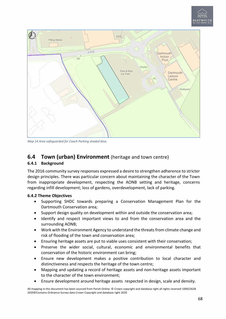
All mapping in this document has been sourced from Parish Online. © Crown copyright and database right all rights reserved 100022628 2020©Contains Ordnance Survey data Crown Copyright and database right 2020
68
6.4 Town (urban) Environment (heritage and town centre) 6.4.1 Background
The 2016 community survey responses expressed a desire to strengthen adherence to stricter design principles. There was particular concern about maintaining the character of the Town from inappropriate development, respecting the AONB setting and heritage, concerns regarding infill development; loss of gardens, overdevelopment, lack of parking.
6.4.2 Theme Objectives • Supporting SHDC towards preparing a Conservation Management Plan for the
Dartmouth Conservation area; • Support design quality on development within and outside the conservation area; • Identify and respect important views to and from the conservation area and the
surrounding AONB; • Work with the Environment Agency to understand the threats from climate change and
risk of flooding of the town and conservation area; • Ensuring heritage assets are put to viable uses consistent with their conservation; • Preserve the wider social, cultural, economic and environmental benefits that
conservation of the historic environment can bring; • Ensure new development makes a positive contribution to local character and
distinctiveness and respects the heritage of the town centre; • Mapping and updating a record of heritage assets and non-heritage assets important
to the character of the town environment; • Ensure development around heritage assets respected in design, scale and density.
Map 14 Area safeguarded for Coach Parking shaded blue.

All mapping in this document has been sourced from Parish Online. © Crown copyright and database right all rights reserved 100022628 2020©Contains Ordnance Survey data Crown Copyright and database right 2020
69
6.4.3 There may be opportunities for replacement dwellings and conversions and subdivision of plots within the town and settlement boundary . However this will only be supported if adequate parking can be provided as outlined in Policy DNP ST2. Any such development which is harmful to the character or appearance of the Dartmouth Conservation Area and the South Devon Area of Outstanding Natural Beauty will not be supported. Policy DNP TE1–Subdivision of existing plots . The subdivision of existing plots will only be supported where; a) There is no loss to the character or environmental quality of the surroundings including the Conservation Area and South Devon AONB;
b) The site is serviced by a suitable existing highway on one or more boundaries;
c) The proposed plot sizes and dwelling sizes are in keeping with other building plots and dwelling sizes in the surrounding area;
d) The amenity of adjoining properties is not compromised;
e) Adequate amenity space provision is made creating useable private garden space for both the existing and proposed dwellings;
f) The existing front building line, where appropriate, is maintained;
g) There is adequate space for off street parking as outlined in Policy DNP ST2.
h) The increase in hard surfaces and resultant surface water run-off is mitigated on-site and does not exacerbate flooding risks.
6.4.4 Past pressure for development and eroding design quality generally has had an adverse impact on the plan area and instilled a general lack of confidence of the proposals assessed through the planning system. Any new development in the plan area should be of the highest quality respecting national, local policy and guidelines including the National Design Guide (January 2021) JLP Policies Dev 20 to 22 and the JLP SPD 2020. All development should be commensurate with its sensitive natural and historic location. It should also contribute to the overall enhancement, improvement and resilience of the area. This applies to both new buildings and spaces and surface treatments. All new development and spaces must apply the Crime Prevention through Environmental Design (CPtED) attributes together with the practices and principles of Secured by Design7.
Policy DNP TE2: Design Quality throughout the Parish
Development proposals in Dartmouth Parish should demonstrate high quality design and will be supported where:
7 Secured by Design guidance including the key attributes of CPtED https://www.securedbydesign.com/guidance/design-guides

All mapping in this document has been sourced from Parish Online. © Crown copyright and database right all rights reserved 100022628 2020©Contains Ordnance Survey data Crown Copyright and database right 2020
70
a) The design is locally distinctive, reflecting the appearance and character of the area in which the development is to be located. Innovative contemporary design solutions will be supported providing they do not have a detrimental effect on the overall appearance and character of the area; b) The height, scale and density of development reflects the existing grain, height, density and pattern of development in the surrounding area. The design should be in keeping with the site and its setting and respect the scale, character and siting of existing and surrounding buildings. c) Strategically important , sensitive and prominent schemes of all scales should be considered at an independent, bespoke Design Review Panel, such an approach is outlined in JLP SPD 2020.8 This is of particular importance where proposals impact on the South Devon AONB , Conservation Area and heritage assets. d) The external materials used should be locally distinctive, natural and where possible sourced within South Devon; e) Building setbacks reflect adjoining buildings; f) They incorporate the principles of sustainable and low carbon design as defined by this Plan and Development Plan Policy Dev 32; g) It has regard to the requirements of CPtED and ‘Secured by Design’ to minimise the likelihood and fear of crime and acts of anti-social and unacceptable behaviour and community conflict in the built environment; h) It reduces the dependence on the private car by supporting and connecting directly, where achievable to other more sustainable modes such as walking, cycling and public transport; i) It retains and protects, wherever possible existing trees, verges, stone walls and hedges in situ. Any lost trees or hedges should be replaced elsewhere on site. Any wall affected should be reinstated; j) It does not exacerbate flooding risks; k) Existing footpaths or public rights of way must be retained, or acceptable diversions agreed. l) There is a safe means of access to the site, that does not result in the unacceptable loss of natural features, or the need to provide excessive widening of local roads. m) Adequate off street car parking is provided; n) The infrastructure needs of the development can be put in place prior to the commencement of the main development.
6.4.5 Heritage This plan supports a positive strategy for the conservation and enjoyment of the historic environment of the town centre and wider parish, including heritage assets most at risk through neglect, decay or other threats. Maintaining and enhancing these features in a progressive but sensitive way, so that it remains an attractive destination for residents and visitors alike, will be essential to the future prosperity of the Town. The community as a whole were invited to nominate buildings, structure and other features that they considered should be included on the list of local heritage assets whether designated or non-designated. Great weight shall be given to the conservation of both designated and non-designated heritage
8 JLP SPD 2020 paragraph 6.12

All mapping in this document has been sourced from Parish Online. © Crown copyright and database right all rights reserved 100022628 2020©Contains Ordnance Survey data Crown Copyright and database right 2020
71
assets identified in appendices J1 and J2 Special regard shall be given to the merit of preserving the asset and its setting and any features of special architectural or historic interest which it possesses. Policy DNP TE3 Safeguarding Designated and Non-Designated heritage assets and the conservation area of Dartmouth
All proposals in the Dartmouth conservation area and in the vicinity of Designated and Non-Designated Heritage Assets must comply fully with National planning policy and the Development Plan relating to the Historic Environment and;-
a) Respect and enhance the Dartmouth Conservation Area and make a positive contribution to the heritage assets and their setting. Have regard to the Dartmouth Conservation Area Appraisal January 2013 including the four extensions to the area. All proposals must give due regard to one of the ten character areas listed below within which the proposal sits. The prevalent traditional materials, finishes and typical building forms outlined in the appraisal should also be respected. b) Give due regard to the asset and demonstrate an awareness of the Devon Historic Coastal and Market Towns survey(DHCMTS) and the Historic Urban Character Areas (HUCA) for Dartmouth produced by Devon County Council and English Heritage which is included as Appendix J3. Due consideration should be given to the historic character of the area within which a proposal sits. c) Where relevant, include design features such as setbacks, stone or render walls and roof details that reflect the character and appearance of the surrounding buildings. For extensions, new doors, windows and roofing materials should be of a similar appearance to those used in the construction of the exterior of the original building. d) Proposals that directly or indirectly affect the significance of Designated Heritage Assets included in Appendix J2 and the following Non-Designated Heritage assets and described in Appendix J1 and illustrated in Map 15 should be judged according to the scale of any harm or loss and the significance of the asset to the parish. Heritage assets that should inform development include archaeological features and historic field boundaries. LHA1 Telephone Box, Victoria Road LHA2 Dartmouth Lower Ferry LHA3 Dartmouth Visitor Centre LHA4 Pony hoops, Crowthers Hill LHA5 Former Norton Heliport Control Tower LHA6 Water tower, Jawbones Hill LHA7 The Armada Memorial Beacon, Jawbones Hill LHA8 Crosby Meadow LHA9 Historic walls of Dartmouth in various locations LHA10 Coombe Recreation Ground, Coronation Park LHA11 Dartmouth Cottage Hospital

All mapping in this document has been sourced from Parish Online. © Crown copyright and database right all rights reserved 100022628 2020©Contains Ordnance Survey data Crown Copyright and database right 2020
72
LHA 1
LHA 9
LHA 11
LHA 10
LHA 8
LHA 7 LHA 6 LHA 5
LHA 4 LHA 3
LHA 2

All mapping in this document has been sourced from Parish Online. © Crown copyright and database right all rights reserved 100022628 2020©Contains Ordnance Survey data Crown Copyright and database right 2020
73
Map 15 Non-Designated or Local Heritage Assets

All mapping in this document has been sourced from Parish Online. © Crown copyright and database right all rights reserved 100022628 2020©Contains Ordnance Survey data Crown Copyright and database right 2020
74
Character Area
Location
1 Clarence Hill, Clarence Street, Undercliff, Broadstone and Newport Street 2 Foss Street, Flavel Street, Union Street, Duke Street, Flavel Place, Anzac
Street, Church Close, and Foss Slip 3 South Embankment, The Quay, Spithead, Hauley Road, Mansion House
Street, Oxford Street, Lower Street, Giles Court, and Bayards Cove, 4 Market Square, Market Street, Charles Street, Ivy Lane, Lake Street,
Victoria Place, and Victoria Road 5 Crowthers Hill, Smith Street, Higher Street, Fairfax Place, and Above Town 6 Newcomen Road and Southtown Extension 1 Ridge Hill, part of the Community Orchard and Mount Boone Lane Extension 2 Victoria Road and Southford Road Extension 3 Coronation Park Extension 4 The southern part of Southtown and Above Town and Warfleet Road Dartmouth Conservation Area Character Areas,-Source Dartmouth Conservation Area Appraisal January 2013 6.4.6 Civic Spaces, Public Realm and Townscape This plan sets out to respect, protect and enhance the civic spaces of the town, creating positive places which contribute to people’s quality of life, engender local pride and attract visitors. These spaces identified in the Conservation Area appraisal provide a setting for civic buildings, areas for public events, markets and busy thoroughfares. Civic areas identified in the plan are highlighted in yellow in Map 16. Civic spaces should encourage social Interaction and delivering health and wellbeing benefits. Civic spaces are important and the character and quality of them support the civic pride of the town .

All mapping in this document has been sourced from Parish Online. © Crown copyright and database right all rights reserved 100022628 2020©Contains Ordnance Survey data Crown Copyright and database right 2020
75
Map 16 Location of Civic Spaces marked in yellow

All mapping in this document has been sourced from Parish Online. © Crown copyright and database right all rights reserved 100022628 2020©Contains Ordnance Survey data Crown Copyright and database right 2020
76
Policy DNP TE 4 ; Respect, protection and enhancement of civic spaces The following spaces illustrated in map 16 and Appendix R1 are identified as civic spaces within Dartmouth;- CS1 Rue de Courseulles Sur Mer/ Coronation Park Riverside CS2 Flavel Place / The Quay CS3 Bottom of Brown’s Hill / Foss Street CS4 Foss Street CS5 Market Square CS6 Anzac Street CS7 St. Saviour’s Church (areas to the North, West and South sides) CS8 The Quay/Boatfloat CS9 Pillory Square (Higher Street/ Smith Street) CS10 South Embankment CS11 Bayards Cove/ Coles Court All development in the vicinity of these civic spaces should where appropriate;- a) Respect, protect and enhance the physical qualities of the space expressed in the Conservation Area appraisal 2013 and the Historic Urban Character areas of the Devon Historic Coastal and Market Towns Survey for Dartmouth 2016. b) Support community uses in the space, which can include but not limited to: • External seating areas; • Shared surfaces for vehicles and pedestrians; • Pedestrian priority; • Improved public realm including soft landscaping, street furniture, durable and
sustainable paving surfaces; • Public art. c) Facilitate greater economic activity in the spaces through external seating, events,
dining and temporary ‘pop up’ uses. d) Support active street frontages to attract social interaction and facilitate natural
surveillance and the prevention of crime. e) Facilitate clear, safe and legible public routes. f) Support pedestrianisation on a temporary or permanent basis as and when
appropriate. g) Facilitate litter and recycling facilities within the spaces.

All mapping in this document has been sourced from Parish Online. © Crown copyright and database right all rights reserved 100022628 2020©Contains Ordnance Survey data Crown Copyright and database right 2020
77
h) Any loss of car parking spaces within the civic spaces should be re-provided elsewhere within the town and respect the provisions of Policy DNP ST2.
The plan also supports the introduction of new civic spaces within new residential areas that should also respect the above qualities.
6.4.7 Brownfield Land A core principle of the NPPF is to “encourage the effective use of land by reusing land that has been previously developed (brownfield land), provided that it is not of high environmental value”. The plan area’s rich heritage, need for affordable housing, and employment space and the natural landscape constraints make the reuse of brownfield land an essential part of the delivery of new sites for development. While it is acknowledged that not all brownfield land is suitable for development, latest statistics from the Homes and Communities Agency indicate an estimated 61,920ha of brownfield land in England. Of this, 54% is derelict or vacant, while the remainder is in use but with potential for redevelopment. DCLG figures (2010) suggest that approximately 35,000ha is considered suitable for housing. The Campaign for Rural England Housing Foresight Report (2014) suggested that brownfield land has the capacity to support over 1.8 million new homes. However, despite the identified high housing capacity, the most recent government figures have shown a decline in the proportion of dwellings delivered on brownfield land.
Policy. DNP TE5 Brownfield first
This Plan promotes the redevelopment of previously developed land or ‘brownfield’-first strategy before greenfield sites. This approach will minimise encroachment on the countryside and AONB unless there is proven demand that cannot be met by the brownfield-first approach. The brownfield sites considered suitable for long term re-development as and when there is landowner support and they become available include existing builders merchants, former health facilities, post office, a carpark located within the urban area of Dartmouth. Within the lifetime of the Neighbourhood Plan such sites may become redundant or would benefit in the long term from intensification of existing employment sites and more effective use of land or change of use to C2 Residential Institutions C3 Housing or mixed use (C3 Housing and E Commercial, Business and Service.)
As stated in policy DNP EC3 changes of use resulting in the loss of employment land to the plan area will not be supported.
A schedule of sites considered suitable for intensification or re-development with a plan locating these are included as Appendix R2 and R3
The conversion of existing buildings are also subject to the other policies of this plan. Priority will be given to new uses that provide maximum community benefit and are appropriate for the site in terms of accessibility and minimum traffic generation.

All mapping in this document has been sourced from Parish Online. © Crown copyright and database right all rights reserved 100022628 2020©Contains Ordnance Survey data Crown Copyright and database right 2020
78
In order to consider development of brownfield and existing buildings is undertaken on a comprehensive basis a Development Brief should be prepared in advance of a planning application in consultation with the Town Council. A model brief is included in the Appendix P2 All development should respect and respond to the agreed brief.

All mapping in this document has been sourced from Parish Online. © Crown copyright and database right all rights reserved 100022628 2020©Contains Ordnance Survey data Crown Copyright and database right 2020
79
6.5 Housing and homes 6.5.1 Background There were two main housing concerns and re-occurring themes taken from the Dartmouth 2016 community survey:
• The need for more affordable housing for local people especially the young; • Restrictions on second homes and to introduce a Principal Residence requirement to
control the further development .
6.5.2 The problem of affordability in Dartmouth has been exacerbated by the increasing purchase of the existing housing stock for second homes and holiday lets especially in the lower town. Second homes have increased house prices beyond the means of local people, particularly the young, resulting in them moving to the further extents of Dartmouth or out of parish altogether. In 2020 50% of house sales were to purchasers for holiday lets or second homes (Source: Local Estate Agents). 6.5.3 In view of the challenges of affordability of homes for all ages in the plan area and those associated with an older population a Housing Needs Assessment (HNA) was commissioned in 2021 from consultants AECOM. The full HNA is included in Appendix N and a summary of the key recommendations included below. The recommendations of the HNA are reflected in the housing policies of this Plan. Housing Needs Assessment 2021 AECOM Consultants 1. Dartmouth’s current tenure mix exhibits a lower rate of home ownership than South Hams and England, correspondingly more social renting and similar amounts of private renting and shared ownership. There is an opportunity to lift rates of home ownership in Upper Town, including through affordable routes to ownership, and to address the undersupply of social rented accommodation in Lower Town. 2. The development at Cotton Farm is planned to deliver 89 affordable homes, of which 50% or 45 units will be for affordable rent. The other allocated site at Noss will provide a financial contribution in lieu of onsite provision, which may eventually be collected by Kingswear or Dartmouth. This quantity of expected delivery will go some way towards meeting the needs of Dartmouth households, although it leaves a shortfall of approximately 40 units – a conservative figure that does not take into account the tendency of local households in need to be ineligible or not apply, nor the mismatch between the need and supply of affordable rented homes by size. There is therefore a clear case to maximise the delivery of affordable rented housing in Dartmouth wherever possible, as part of Section 106 obligations on allocated sites and any potential community-led or exception schemes. The estimate of potential demand for affordable housing for sale is in the region of 25 homes per annum however there is no policy or legal obligation on the part either of the Local Authority or Neighbourhood Plan to meet such needs in full. 3. Between the 2001 and 2011 Censuses, Upper Town experienced a significant 134% increase in private renting. This trend, which exceeds the pattern nationwide, is often an indicator of the declining affordability of home ownership. While rates of private renting are not especially low in Dartmouth, high-quality and affordable private renting can perform an important function in the market for key workers, young households, and others. 4. Home values in Dartmouth have increased over the last ten years, with the result that the median home now costs around £55,000 more than in 2011. The current median house price is £335,000 for Dartmouth as a whole, the median is £185,000 in Upper Town and £430,000 in Lower Town.

All mapping in this document has been sourced from Parish Online. © Crown copyright and database right all rights reserved 100022628 2020©Contains Ordnance Survey data Crown Copyright and database right 2020
80
5. There is evidence of intense competition for rental properties in Dartmouth. The speed at which new lettings are taken up, being a signal of demand outstripping supply, is closely associated with price increases. However, it also presents a broader problem: even if rents were to be affordable, there may simply not be enough rented housing to meet local needs. 6. There is a relatively large group of households in Dartmouth who may be able to afford to rent privately but cannot afford home ownership. They are typically earning between around £21,000 per year (at which point entry-level rents become affordable) and £41,000 (at which point entry-level market sale homes become affordable – in Upper Town only). This ‘can rent, can’t buy’ cohort may benefit from the range of affordable home ownership products such as First Homes and shared ownership. These products would provide value to different segments of the local population, with shared ownership (25%) and rent to buy potentially allowing lower earning households to get a foot on the housing ladder, while First Homes – which should be delivered at the maximum possible discount level of 50% – provides better long-term support to those with slightly higher incomes. 7. For Dartmouth as a whole the demographic mix is imbalanced in favour of older households (when compared to the district and country). Therefore to attain greater balance between population age brackets, an intervention would be needed to favour the dwelling sizes preferred by younger people. these are homes with fewer bedrooms. As such, the recommended mix might be balanced out to promote more smaller properties (chiefly those with 2 bedrooms since 1 bedroom homes are well supplied already). To a degree, the balance could be achieved through greater circulation of Dartmouth households between Upper and Lower Town, rather than through new construction. While this is not a matter the Neighbourhood Plan can directly control, any efforts to dissolve the affordability barrier between the two areas or to provide diversity by directing larger homes to Upper Town and more affordable options to Lower Town, could be beneficial. 8. While it is certainly the case that many older households wish to under-occupy their homes in order to accommodate guests and possessions, and will have the financial capability to do so, there may also be an opportunity to improve Dartmouth’s offering to older households through new developments aimed at downsizers with well thought-out, adaptable and high-quality designs. The HNA suggests that focusing the provision and adaptation of age-friendly housing in Lower Town would best serve the local population and avoid moves away from existing social and support networks, it also states that there is also an opportunity to create more balanced communities by delivering such housing in Upper Town to encourage circulation of age groups between the two areas. 9. While the serious and worsening challenge of housing affordability can be combatted through the provision of subsidised tenures, the affordability of market housing can be generally improved by delivering smaller and/or denser housing types. 10. The potential need for specialist housing with some form of additional care for older people is estimated at a range of 98 to 126 specialist accommodation units during the Plan period. These estimates are based on the projected growth of the older population, thereby assuming that today’s older households are already well accommodated. The need for sheltered housing may be the focus of any additional provision in the area beyond the existing allocations. That said, this need is by definition driven by those with less severe support needs, which have the potential to be met though adaptations to the existing housing stock. Another avenue is to require standards of accessibility and adaptability in new development to be met at more ambitious levels than those mandated in the JLP. 6.5.4 There is evidence of housing need for the elderly, especially Extra Care Housing (ECH), this is provided in the Extra Care Housing Study commissioned by Devon County Council (2009) and refreshed in August 2015 (included in Appendix H1).

All mapping in this document has been sourced from Parish Online. © Crown copyright and database right all rights reserved 100022628 2020©Contains Ordnance Survey data Crown Copyright and database right 2020
81
6.5.5 This plan sets out to help redress the historic imbalance of housing provision locally. This is expressed and supported in Policy Dev 8 and paragraph 4.11 for Thriving Towns and Villages in the JLP SPD adopted July 2020.
6.5.6 This plan supports the provision of First Homes for young families .In the Government’s response to the 2020 consultation on First Homes, they said; ‘Yet we acknowledge that in some parts of the country where property prices are very high a 30% discount(for First Homes) may not be sufficient to make homes affordable LPAs will therefore be able to require a higher minimum discount of either 40% or 50% on First Homes built in their local area, provided they are able to evidence the need for and viability of homes at this higher discount rate through the local plan making process.’ 6.5.7 SHDC advise that they would be seeking, subject to viability a higher First Home discount in parts of the district where property prices are very high, such as Dartmouth, Salcombe, Newton & Noss . The District’s Affordable housing team support higher discounts be included in Neighbourhood Plans. 6.5.8 Planned housing development Taken together, Dartmouth(JLP TTV4) and Noss (JLP TTV5) provide 576 new homes, providing a varied mix of dwelling types, size and tenures. It is, therefore, not the intention of this plan to consider or support any additional sites other that the support for infill development and delivery of affordable homes through rural exception sites. Policy DNP H1 - Market Housing New market housing is supported in the Parish on infill sites within the settlement boundary. In addition, market housing forming part of an exception site as set out in Policy DNP H2 where it is required to cross subsidise the affordable housing scheme will be supported. All development should meet the following requirements;- a) The housing should respond to local housing needs in terms of type, size and tenure . b) Consideration should be given to provision of places for housing for the increasing number of older people in the parish in the form of market sale sheltered, specialist accommodation, extra care , or assisted living housing. By further consideration of older people this Plan also supports opportunities for existing residents to downsize and make more larger units available to the market. c) Higher standards of accessibility , adaptability and for wheelchair users should be considered beyond the JLP as evidence by the 2021 Housing Needs Assessment prepared for this Plan.

All mapping in this document has been sourced from Parish Online. © Crown copyright and database right all rights reserved 100022628 2020©Contains Ordnance Survey data Crown Copyright and database right 2020
82
6.5.9 Affordable Housing The need for affordable housing was a common theme expressed in the 2016 public survey. South Hams is generally an expensive area with a combination of high house process and low earnings. This plan will support the delivery of housing, which provides homes for local people, which is truly affordable whether for rent or purchase, delivered through existing allocated sites within the JLP and or Rural Exception sites. There is a particular necessity to provide suitable housing for young people to ensure key workers can live and work in Dartmouth to ensure the viability of the local economy. In 2021 141 households registered on Devon Home Choice who have a postal address of Dartmouth. 30 households are considered to have a high or medium need.
Source: SHDC Housing Specialist May 2021 South Hams District Council 6.5.10 There may well be more people than this in need of affordable housing in Dartmouth, not everyone is registered on the Council's housing waiting list. The principle affordable housing provision for Dartmouth would rely on the Cotton Farm development, out of the total of 450 dwellings this is total of 89 affordable houses and apartments. The provision of affordable housing is divided into two tenures: 50% Affordable Rent (max 80% of local market rents) 50% Intermediate (Discount market houses or shared ownership)The mix of dwellings will be:
6.5.11 The rate of delivery at Cotton (market and affordable housing) although this is subject to change is as follows:
Mix of affordable housing at Cotton Farmnos %
1 bed 13 152 bed 40 453 bed 27 304bed 9 10
Totals 89 100

All mapping in this document has been sourced from Parish Online. © Crown copyright and database right all rights reserved 100022628 2020©Contains Ordnance Survey data Crown Copyright and database right 2020
83
The first Phase of 116 dwellings will be front loaded with 30% affordable housing consisting of 1 and 2 bed apartments and 2 and 3 bed houses. 6.5.12 The affordable provision at Noss is by way of a Section 106 contribution, SHDC have confirmed that the monies may be allocated to Dartmouth or Kingswear as a contribution towards affordable housing and that this is the expectation of the Town Council. 6.5.13 At present there is an immediate shortfall of supply and mix of dwellings set against the households registered on Devon Home Choice. The provision of affordable housing at Cotton, which has been agreed with SHDC in terms of provision and mix will be over a number of years. Clearly, the pressure to provide more affordable housing in Dartmouth will not abate in the future. The Dartmouth Neighbourhood Plan would support Exception Sites and Community led projects to provide more affordable housing. Policy DNP H2- Exception Sites outside the settlement boundary The use of Exception Sites adjoining the settlement boundary to deliver affordable housing will be supported where they comply with National and Development Plan policy and the policies of this plan. A site will only be permitted if;- a) It meets a proven need for affordable housing for local people; b) The needs of the local community are addressed; c) Management of the scheme will ensure that the dwellings continue to meet such proven needs for initial and subsequent occupiers; d) The development should reflect the character and scale of the parish and be physically integrated with it in terms of design, scale and pedestrian access. e) Where the impact on the visual and landscape amenity of the area and the AONB is not adverse and the design is in compliance with the latest South Devon AONB Management Plan and AONB Planning Guidance. f) Cross subsidy through the provision of open market housing on the scheme will be allowed only where it ensures the delivery of the affordable housing and shall comprise the minimum number of open market dwellings necessary to ensure the delivery of affordable housing as part of the same development proposal, to be demonstrated by a viability appraisal of the full scheme.
Predicted rate of delivery (market and affordable housing ) at Cotton Farm
Year 2021 2022 2023 2024 2025-34
No of Dwellings 15 40 40 50 305 450Total

All mapping in this document has been sourced from Parish Online. © Crown copyright and database right all rights reserved 100022628 2020©Contains Ordnance Survey data Crown Copyright and database right 2020
84
Policy DNP H3 Affordable Housing; Proposals for affordable housing development within the settlement boundary or as exception sites will be supported where;- a) The number of affordable homes to be delivered is in line with the need as defined by Devon Homes Choice or the local affordable housing register in place at the time and where a need has been identified, this includes custom and self-build plots where feasible. b) Affordability is determined with consideration of the particular circumstances of Dartmouth, namely high average property prices and low salaries. c) The range and size of dwellings especially single bed units is in line with the need as defined by Devon Homes Choice or the local affordable housing register in place at the time. d) Housing for the increasing number of elderly in the parishes is provided in the form of sheltered, extra care or assisted living housing. Homes are proposed for rent or purchase. e) Discounted ‘First Homes’ for young families shall be provided in line with National policy. Discounts should be 50% on the new home price to ensure First Homes are affordable to local incomes. f) Homes should be occupied by people with a demonstrable local connection to the Parish which is defined within the SHDC Adopted Local Allocation Policy (2017).The early and urgent needs of key workers including teachers, healthcare workers, fire brigade and lifeboat crew should be considered exceptional circumstances under the provisions of the allocation policy. g) Affordable housing for sale is subject to a legal restriction to ensure the homes remain affordable and that the discount is maintained in perpetuity; h) The controls associated with development in or within the visual impact of the AONB as set out in local and National Planning Policy and Guidance are strictly followed; Such developments could include proposals for Community Led Housing. 6.5.14 Second Homes Dartmouth is a desirable holiday destination, as with many other coastal locations, there has been an increase in the purchase of the housing stock for second homes and holiday lets increasing house prices and displacing local people, especially the young. The survey of the local community carried out in 2016 raised concerns about the impact second homes on the balance and viability of home ownership, house prices and the effect on the community. Many

All mapping in this document has been sourced from Parish Online. © Crown copyright and database right all rights reserved 100022628 2020©Contains Ordnance Survey data Crown Copyright and database right 2020
85
of the responses of the survey asked for restrictions on second homes and to devise a Principal Residence Policy to control the further development of second homes. 6.5.15 A survey was carried out by the plan group of existing residential properties in the parish and a review of data held within the census, valuation records, electoral role and properties registered as businesses, this is included as Appendix H2 This survey indicates that in 2020 Dartmouth has a significantly higher number of second homes than in 2010. In 2011 it was 22.6% which was already above the 20% threshold commonly used as a benchmark figure in relation to the inclusion of a principal residence provision in a plan. At the end of November 2020, it stands at 37.8%. The survey also indicated that in Lower Town the number of second homes is far higher than the average and is in the region of 51.2% The river or sea views and level walks to tourist related facilities make the area particularly attractive for second home owners and holiday lettings. 6.5.16 The policy below will support the housing needs of local people and bring greater balance and mixture to the local housing market and create new opportunities for people to live and work here and strengthen the community and local economy. This policy applies to all new build development both allocated and windfall sites where open market housing is proposed within the plan area. 6.5.17 SHDC supports in principle the inclusion of a Principal Residence Requirement within Neighbourhood Plans where such a requirement is justified. In response to the question from the JLP Examination Inspectors whether ‘a restriction on the use of new dwellings as holiday homes was justified in the South Hams? ‘JLP Council’s response was as follows: 9
8.94 The number of homes not used as primary residence is particularly high in the South Hams part of the TTV. Both South Hams and West Devon received a substantial sum of money to deliver more affordable homes through the Community Housing Fund in recognition of this. Evidence also exists of in HO3, HO9, TP3, SHMA and CTB1 (council tax reports) and the Strategic Housing Market Assessment Part 1: The Housing Market Area and Updating the Objectively Assessed Need (HO13). 8.95 At this time it is considered that the appropriate mechanism to bring such a policy forward is a Neighbourhood Plan. It is through NO (sic) that the above District / Borough wide evidence can be reviewed, analysed and supplemented with a view to informing the need, justification and effectiveness of a restrictive policy. 8.96 To this end the Council (South Hams) resolution of 15 December 2016 stated that ‘this Council notes the ruling of the High Court (Case No: CO/2241/2016) in support of a housing policy known as ‘H2. Full Time Principal Residence Requirement’ as set out in St Ives Area Neighbourhood Development Plan and which provides that: ‘New second homes and holiday lets will not be permitted at any time …’ and ‘supports Town and Parish Councils within the South Hams District to adopt similar policies in their own Neighbourhood Development Plan’
9 9PSWDJLP Examination Hearing Statement Matter 8 Question 8.5(vi) https://www.plymouth.gov.uk/sites/default/files/JLPCouncilsResponseMatter8PolicyAreaStrategiesThrivingTownsVillages.pdf

All mapping in this document has been sourced from Parish Online. © Crown copyright and database right all rights reserved 100022628 2020©Contains Ordnance Survey data Crown Copyright and database right 2020
86
Policy DNP H4 - Principal Residence a) New open market housing, excluding replacement dwellings, will only be supported where there is a restriction to ensure its occupancy as a principal residence guaranteed through a planning condition or legal agreement. This policy is as a result of impact upon the local housing market of second or holiday homes. New unrestricted market homes will not be supported at any time. b) Principal residence is defined as one occupied as the residents’ sole or main residence, where the residents spend the majority of their time when not working away from home. The condition or obligation on new open market homes will require that they are occupied only as the primary (principal) residence of those persons entitled to occupy them. c) Occupiers of homes with a Principal Residence condition will be required to keep proof that they are meeting the obligation or condition, and will be obliged to provide this proof if and when SHDC requests this information. Proof of Principal Residence includes but is not limited to residents being registered on the local electoral register and being registered for and attending local services including healthcare, and schools. d) This policy applies to all new build development both allocated and windfall sites where open market housing is proposed within the Neighbourhood Plan Area. e) A replacement dwelling is defined as a single new build dwelling replacing an existing dwelling. of equivalent size and design as the original dwelling. f) Where a non-domestic property is converted to residential use through planning consent or by Permitted Development Rights such dwellings are considered new dwellings for the purposes of this policy. 6.5.18 Housing for Older People Dartmouth has an ageing population increasingly living alone. The 2011 census indicated 35% of the total Dartmouth parish population was over 60 years of age and this trend is rising. There is a growing demand for smaller dwellings for older people who wish to downsize or require to maintain their independence but with assisted living. This plan does not support the loss of any existing homes for older people and supports new assisted living schemes, residential care and nursing homes. The Cotton development is in negotiation to provide an assisted living scheme of approximately 55 apartments, this is welcome but may not address the full need for the plan period. Many older households wish to under-occupy their homes in order to accommodate guests and possessions, and will have the financial capability to do so. This Plan sets out to improve Dartmouth’s offering to older households through new developments aimed at downsizers with well thought-out, adaptable and high-quality designs. 6.5.19 The Dartmouth Housing Needs Assessment 2021 (HNA) included in Appendix N Supports the need for specialist housing with some form of additional care for older people which is estimated at a range of 98 to 126 specialist accommodation units of older people

All mapping in this document has been sourced from Parish Online. © Crown copyright and database right all rights reserved 100022628 2020©Contains Ordnance Survey data Crown Copyright and database right 2020
87
during the Plan period. The need for sheltered housing may be the focus of any additional provision in the area beyond the existing allocations. This need is by definition driven by those with less severe support needs, which also have the potential to be met though adaptations to the existing housing stock. 6.5.20 Another recommendation of the HNA is to require standards of accessibility and adaptability in new development to be met at more ambitious levels than those mandated in the JLP. Policy DEV9 requires that at least 20% of dwellings on schemes of 5 or more dwellings should meet national standards for accessibility and adaptability (Category M4(2)), and at least 2% of dwellings on schemes of 50 or more dwellings should meet national standard for wheelchair users (Category M4(3)). The evidence gathered in the HNA justifies seeking a higher target in Dartmouth where viable.
Policy DNP H5 Specialist Accommodation for Older People ,residential care nursing homes and loss of existing residential care.
a) Additional Specialist Residential care provision will be supported in the Plan area. This should be provided with reference The Dartmouth Housing Needs Assessment 2021 (HNA) by AECOM Consultants and included in Appendix H1 The provision may comprise;- • Extra Care • Sheltered Housing • Affordable Specialist Accommodation • Market Specialist Accommodation b) Loss of existing residential care and nursing homes for older people The change of use or redevelopment of a care home or nursing home will only be permitted providing that new facilities of a similar type are provided in the parish to replace the facilities being lost; or there is a proven absence of demand for the continuation of the use and the site has been marketed effectively for such use over a period of at least 24 months at an appropriate level. In circumstances where the loss of an existing care home or nursing home is considered to be acceptable, the site should be used for an alternative provision for the elderly, such as the provision of dwellings specifically designed for the elderly, and subject to an occupancy restriction to ensure that the dwellings are used for this purpose in perpetuity. c) New homes for older people All new development for older people should comply with all the other housing policies of this plan and should be on previously developed land or sites within the settlement boundary, within easy access to local centres and meet the other policies of the plan, including those relating to design quality. Any new development should ensure that the appearance and character of the town or surrounding countryside are not harmed. d) Design Standards for Specialist Accommodation for older people Where viable the access standards should exceed the provisions of JLP Policy DEV9 against national standards for accessibility and adaptability (Category M4(2)), and for wheelchair users (Category M4(3)).

All mapping in this document has been sourced from Parish Online. © Crown copyright and database right all rights reserved 100022628 2020©Contains Ordnance Survey data Crown Copyright and database right 2020
88
6.6 Health and Wellbeing 6.6.1 Background JLP Strategic Objective SO6 promotes: “school, health, and recreation facilities of a high quality in order to reinforce strong communities.” 6.6.2 Health Facilities Health facilities in the plan area will need to accommodate residents and visitors and the expected increase of population over the plan period including the new West Dart neighbourhood. By 2030 there is expected to be 37% more people aged over 75 compared to today, in the South Hams area, with resulting increased health and social care needs. While the new proposed Dartmouth Health and Well-being Centre proposal will make a major contribution to meeting these objectives, the loss of Dartmouth Hospital has been keenly felt by local residents. The new Health and Well-being Centre will move the centre of gravity of healthcare provision from the Lower Town to the Upper Town, nearer the expanding population base. This will leave no health care facilities in the Lower Town for the resident population, many of whom are elderly and less able. The new centre highlights the following objectives for this plan.
• Allow space for future expansion of the centre, in line with planned population growth, and increases in the age profile of the town.
• Ensure that good transport, parking and access is available, particularly improved public transport links, between the Lower Town and the new Centre.
• The reuse of the NHS sites to be vacated: the Hospital on the South Embankment and the Clinic at Zion Place. There is a presumption within community that new development and uses should incorporate and focus on the needs of key workers, new community uses, especially with a health and well-being emphasis.
• Take into account the covenants existing in the deeds on parts of the hospital site which stipulate “the land shall be held by the purchasers (TSDFT) as Trust Property for ever hereafter for the use and benefit of the Dartmouth and Kingswear Cottage Hospital” … and …” used for hospital purposes. These provisions were clearly intended to provide and protect benefits for the residents of Dartmouth and Kingswear.
• Establish that when the TSDFT is considering the future use of the hospital it should ensure that this reflects the spirit of the original intention of those who created the facility to benefit the community albeit that the use would not be that of an operational hospital. This could be best achieved by uses such as residential accommodation for key workers including nurses and other staff such as occupational therapists and for assisted housing. This would, in essence, provide a continuum of “hospital use”.
• The covenant was originally enforceable by the Dartmouth Town Council but the creation of the NHS and the transfer of property rights to SHDC when that body was formed need to be taken into account. It is understood that the Secretary of State responsible for the NHS is the authority which can enforce or vary the covenants on the hospital and needs to be approached to agree with variations necessary for the

All mapping in this document has been sourced from Parish Online. © Crown copyright and database right all rights reserved 100022628 2020©Contains Ordnance Survey data Crown Copyright and database right 2020
89
continuation of the protection of benefits for Dartmouth and Kingswear residents who remain the beneficiaries under the original covenants.
6.6.3 Community Aspiration; Healthcare for Dartmouth a) There should be adequate GP provision within the Parish including out of hours care, for an expanding population with minimal waiting times for patients and choice of seeing their own GP. Suitable and safe reception and waiting areas and links to in-house pharmacy. b) Easy access for the whole population to the wider multi-disciplinary health team is available ideally within the same building, including physiotherapy, pharmacy, mental health nurses and nurse prescribers. c) Adequate provision of NHS Dental Care for the whole population. d) Ensure adequate pharmacy services at both the new Health and Wellbeing Centre and in the Centre of town. e) Ensure adequate district nurse, health visitor, midwifery, occupational therapy and “hospital at home” provision for all who require these services, to enable home based care as far as possible, linked with both GP and hospital based clinicians. f) Ensure that health and social care are effectively coordinated for all patients and that third sector (voluntary) care is best embedded in the system. g) When access to urgent medical services is not available within an appropriate time frame, consideration should be given to expansion of services if feasible. Access to emergency medical services should be provided safely with a rapid and efficient ambulance service within accepted national time frame standards.

All mapping in this document has been sourced from Parish Online. © Crown copyright and database right all rights reserved 100022628 2020©Contains Ordnance Survey data Crown Copyright and database right 2020
90
Policy DNP HW 1 Re-use of former hospital and Zion Health Clinic site. This plan supports maintaining a portion of health and wellbeing facilities and obligations under the title deeds in the former hospital and health clinic once the facilities are re-provided in the new Health and Wellbeing Centre at the top of town.
The options for re-use or redevelopment of these sites should include in all or part appropriate health and social care facilities, as part of a package to meet the on-going identified health and wellbeing needs in the Town.
A development brief expanding on the above qualities is included in Appendix P3. All redevelopment proposals should respect this brief. This policy respects the provisions of a covenant on the original hospital, this is included in Appendix S 6.6.4 Community Facilities As stated in the green environment section the social and health benefits, both physical and mental, provided by open green spaces are supplemented in Dartmouth by a range of facilities for play, sports and leisure. Provision for such facilities is enshrined in para 96 of the NPPF. There will be increased demand and pressure on open space now that a large number of new homes is being built during the plan period at the Cotton Farm development, on the very margin of our Parish. The open space, sport and recreational (OSSR) provision for the parish is being updated as a result of this additional demand and reflected in this plan. NPPF para. 97 places emphasis on safeguarding existing provision of community facilities .These principles are supported within the JLP policies DEV3 and 4. 6.6.5 There is the wide range of community organisations in the Town. The plan group has engaged with the community groups, identified the facilities and venues they use and understand their importance to the Dartmouth community (see Dartmouth OSSR Appendix C1). The main objectives include;
• to support, preserve and sustain the wide range of community facilities in Dartmouth for the continued health and well- being of the community and visitors.
• Identify deficiencies in the existing community facilities within the plan area; • Support the opportunities for enhancing community facilities or creating new ones.
6.6.6 Whilst overall provision in Dartmouth is in line with recommended levels there are deficiencies in certain categories and improvements required in individual sites. An audit of these sites was undertaken, and the quality of provision assessed by conversations with users and through verbal and email correspondence with a number of stakeholders:
Dartmouth and District Sports Association Dartmouth RFC Dartmouth AFC

All mapping in this document has been sourced from Parish Online. © Crown copyright and database right all rights reserved 100022628 2020©Contains Ordnance Survey data Crown Copyright and database right 2020
91
Dartmouth Yacht Club and its canoe section Dartmouth Hockey Club Dartmouth Bowling Club Dartmouth Leisure Centre Dartmouth Amateur Athletic Club Dartmouth Amateur Rowing Club Dartmouth Gig Club Dartmouth Jubilee Tennis Club Dart Valley U3A
6.6.7 The inventory of Community facilities and their assessment is contained in Table 3 and shown in Map 20. The evidence gathered from these sources is available in Appendix C2. The concerns raised during consultation are summarised below. 6.6.8 Play Facilities (LAPs, LEAP, NEAP) Generally the present spread of LEAP facilities within the upper and lower town areas should be retained. The LEAP play area in Victory Road is derelict and in an unsuitable location for this purpose and should be permanently decommissioned . It is temporarily fenced off by agreement between SHDC and DTC but it is still accessible for antisocial activities. The resultant deficiency in LEAP provision should be rectified and the possibility of providing a LEAP within the lawn tennis area in Rock Park should be explored. The possibility of providing a LAP within an adjacent area of green space in Rock Park should be explored. 6.6.9 Sport and Leisure use at Norton Field. This large open area, 3.57ha, is the only facility of its kind in the Parish justifying its nomination for Local Green Space (see Table 2). It is on relatively flat ground, is conveniently located for Townstal with its younger population and adjacent to the West Dart development, and there is parking provision adjacent. Despite this it is underutilised because of its serious deficiencies. The Dartmouth Community Plan, MCTi 2004 recognised the importance of the Norton Field sports facility and listed a number of enhancements. These included provision for:
• A floodlit all weather hockey pitch • A floodlit grass pitch • A 200 m athletics practice track and athletics field sports facility • Skateboard and BMX biking facilities
Dartmouth and District Sports Association has undertaken its own assessment of the various bids for facilities on Norton Field. Their evidence in presented in Appendix C. Policy DEV 4 in the JLP places emphasis on the importance of playing pitches in the health and welfare of communities. It is understood that a Playing Pitch Strategy is presently under review by SHDC and it is hoped will produce its recommendations by Spring 2021. However, it is believed that the improvements at Norton Field are consistent with the aims and need identified by the SHDC OSSR report of 2017, prepared for the development of the JLP. Norton Field should receive the highest priority for major improvements as funds become available. The existing rugby pitch and the seasonal athletic provision for field and track events should be retained
All mapping in this document has been sourced from Parish Online. © Crown copyright and database right all rights reserved 100022628 2020©Contains Ordnance Survey data Crown Copyright and database right 2020
92
and enhanced. A sports centre should be provided with shower and changing facilities for 2 teams/genders and officials, secure storage and an area for social events. This may be on ground behind the Leisure Centre, presently occupied by a Skate park, which could be sited elsewhere with improved surveillance and more challenging facilities. 6.6.10 Coronation Park A single storey shelter and storage facility should be provided on Coronation Park as funds become available. Such a facility must be sensitively designed and located that does not conflict with the proposed designation of the park as a Local Green Space. It could be located in the SW corner adjacent to the retaining wall in an area near to the tennis courts. 6.6.11 Emergency and Community Services The existing ambulance and fire services support facilities located on College Way provide an essential service to the town. Accommodation for a local police presence has also been added to the site recently. Other uses on this site will not be supported. Policy DNP HW 2, Community Facilities
a) Development that results in the loss of community facilities and public spaces as outlined above in paragraphs 6.6.4-10 or that results in any harm to their character, setting, accessibility, appearance, general quality and amenity value will only be permitted if they are replaced by community facilities and/or public spaces of equal or higher quality, economic viability and value to the community or it can be demonstrated they are no longer needed.
b) New residential development will where practicable be expected to deliver new community facilities including Open Space, Sports and Recreation (OSSR) facilities on site. On smaller sites or where this is not practicable a planning obligation will be sought to mitigate the impact of new residents through new and improved provision in an appropriate location. For OSSR facilities this should be in accordance with the priorities and projects identified in the latest SHDC and DTC OSSR Plans and SHDC’s Playing Pitch Strategy. Facilities identified include new play facilities at Rock Park to replace those at Victory Road, improvements at Norton Field recreation ground and a shelter and storage at Coronation Park.
c) Proposals that involve the use of land in the countryside to facilitate and enhance informal recreational activities and access related to the enjoyment and interpretation of the countryside will be supported where they would not have an adverse effect on the AONB, countryside, historic environment, and other land uses in the vicinity. Any proposals that improve access to existing public rights of way will be supported.
d) Proposals that promote the public awareness and enjoyment of the historic and natural environment such as heritage and nature trails will be supported. Any future development should include the appropriate enhancement of adjacent heritage and nature trails.
e) Ancillary facilities to public spaces must, where practicable, be accommodated in existing buildings. New facilities should be in keeping with their surroundings and respect policy DNP TE2(Design Quality throughout the Parish).

All mapping in this document has been sourced from Parish Online. © Crown copyright and database right all rights reserved 100022628 2020©Contains Ordnance Survey data Crown Copyright and database right 2020
93
f) The area shaded in Map 17 is safeguarded solely for emergency and community services to serve the Parish. Other uses will not be supported.
6.6.12 Access to the river Residents and visitors require ready access to launch small motor boats, dinghies and an increasingly wide range of personal water craft; canoes, kayaks and stand up paddleboards (SUP). The volume of this sport has increased enormously in recent years www.dartharbour.org/news-and-notices/news/2020/09/18 . Provision of safe storage facilities for boats, and trailers has been provided by SHDC in recent years, and now provision falls to DTC. JLP DEV 3.2 confirms that “access to the water such as to the sea, estuaries and rivers/etc. for recreation, whether alongside, on, or in the water, is of key importance to the Plan Area.” At present in Dartmouth there is a slip adjacent to the Higher Ferry and an improved slipway is proposed for the North embankment which will provide much needed extra capacity. The launch slip at Warfleet Creek is associated with a storage rack facility, SUPs are being launched here with increasing frequency. The present launch and boat and trailer storage facilities in Warfleet and at the Higher Ferry are over capacity. 6.6.13 The main boat and trailer storage capacity is in the northern area of Coronation Park. Users have pointed out the dangerous issue of visibility when crossing the road from
Map 17 Area shaded pink safeguarded for emergency and community services on College Way

All mapping in this document has been sourced from Parish Online. © Crown copyright and database right all rights reserved 100022628 2020©Contains Ordnance Survey data Crown Copyright and database right 2020
94
Coronation Park to the slip adjacent to the Higher Ferry with vehicles crossing the queue for the ferry close to this point. This is exacerbated when pedestrians are transporting water craft and when the top of the slip is cluttered with large vehicles and trailers whilst their owners launch their vessels. This plan supports improved and safe access to the river especially at the Higher Ferry. The existing traffic system controlling alternating entry to the Higher ferry or the passage of cars in to the town should have a pedestrian phase added to allow boaters to cross the road in safety. Provision should also be made for short term parking of vehicles and trailers whilst water craft are launched and secured. Policy DNP HW3 Improved water access for recreational users. This plan supports new and improved access and infrastructure to the River Dart for recreational water craft users. Improvements should be focussed at North Embankment in the vicinity of the Higher Ferry and include the following: a) An improved slipway on the North Embankment. b) The present boat storage facilities on Coronation Park should be retained and
enhanced; c) Associated traffic improvements to facilitate the safe crossing of the A379 by craft and
users when launching and retrieving craft; d) Short term parking provision for craft and vehicles adjacent to the slipways. 6.6.14 Education The Key education issue for the Plan is to ensure that adequate land is available for future education provision. allowance must be made for a potential significant increase in school-age population through housing development at Cotton through JLP Policy TTV4.There should also be safe access to education facilities. Proposed land use for educational facilities should also benefit the town, such as parking, transportation, recreation and community use of facilities out of hours and term time. POLICY DNP HW4 Education Facilities a) Further development required by The Dartmouth Academy for education and sports
purposes during the period of the Plan shall be supported. b) Development that results in the loss of existing education facilities or causes any harm
to their function, character, setting, accessibility, appearance , general quality, and amenity value will only be permitted if they are replaced by education facilities of equal or higher quality, economic viability and value to the community or it can be demonstrated they are no longer needed.
c) The area illustrated in Map 18 encompassing the Dartmouth Academy and grounds is safeguarded solely for education and community related uses. Other uses will not be supported.

All mapping in this document has been sourced from Parish Online. © Crown copyright and database right all rights reserved 100022628 2020©Contains Ordnance Survey data Crown Copyright and database right 2020
95
Map 18 Dartmouth Academy , area safeguarded for education and community uses lined in red

All mapping in this document has been sourced from Parish Online. © Crown copyright and database right all rights reserved 100022628 2020©Contains Ordnance Survey data Crown Copyright and database right 2020
96
7. A sustainable and deliverable plan 7.1 Sustainable Development 7.1.1 One of the fundamental factors underlying this Plan is that it contributes to making Dartmouth and the plan area more sustainable. This Plan respects the Government’s approach to sustainable development as set out in the National Planning Policy Framework. A clear definition of sustainable development provided by Locality10 is; ‘Enabling growth to cater for the needs of current generations but ensuring that growth doesn’t mean worse lives for future generations’
7.1.2 Some of the features of this Plan that make Dartmouth more sustainable are:
• A high level of community engagement; • Mixed transport options encouraging use of public transport, walking and cycling; • More local employment opportunities; • Improved community facilities to promote health and wellbeing; • Promotion of high quality design; • New housing that responds to local needs and all ages; • Protection and enhancement of the AONB, wildlife areas and measures to support
biodiversity net gain; • Conserving historic buildings and environments; • Recognising the importance of landscape and open space, protection of historic
landscape features.
7.2 Delivery 7.2.1 The Dartmouth Neighbourhood Plan Steering Group was set up by Dartmouth Town Council to develop, champion and engage the community on the Neighbourhood Plan. In due course the Steering Group will transfer the responsibilities for delivering the Plan back to the Town Council who will take on the responsibility of co-ordinating, stimulating and supporting policies and community aspirations identified in the Plan. It is recommended that the success of the plan is reviewed annually with a major review every 5 years carried out in consultation with the community and Local Planning Authority. This is to ensure the Plan is still current and remains a positive planning tool to deliver sustainable growth in Dartmouth. 7.2.2 Some projects will simply be brought forward by private individuals and independent organisations wishing to invest in site(s) and policies. However, many aspects of the Plan will be driven by public and community investment. Funding bids may have to be prepared and submitted and resources allocated.
7.2.3 For the Plan to be successful the Town Council will need to take a strategic role as owners of the Plan and keeping the ‘whole picture’ across the plan area in focus. Some aspects
10 Locality Neighbourhood Plans Road Map Guide

All mapping in this document has been sourced from Parish Online. © Crown copyright and database right all rights reserved 100022628 2020©Contains Ordnance Survey data Crown Copyright and database right 2020
97
of the Plan will need to be explored in greater depth with a focussed group of participants that may have particular interests, covering each policy area;
• The natural environment • Business, town centre regeneration and the economy • Sustainable transport • The town and built environment • Affordable housing • Health, wellbeing and leisure
7.2.4 The above groups should be provided with simple reporting and governance/terms of reference in order to ensure proper co-ordination. It is recommended that a member of the Town Council might chair each group. In order to be effective, these groups will have the liberty to co-opt individuals such as representatives of key external agencies. It is very important that such inclusion within the governance, decision-making or delivery structures of these initiatives does not mean that community representation is relegated to a minority stake.
7.2.5 To further the sustainability and carbon reduction policies and community aspirations of the Plan the establishment of a local social enterprise is supported . This could be similar to the Plymouth Energy Community whereby local people benefit from low cost renewable energy, investors get a fair return and a community benefit fund is generated to be able to support projects reducing fuel poverty and carbon emissions. (Appendix G, section 3).
7.2.6 Delivery groups for housing and business will be critical to the success of the plan. In parallel with the neighbourhood planning process the community in discussion with the Town Council may wish to consider the merit of a Community Land Trust (CLT) for the plan area as one of the delivery mechanisms for parts of the Plan. A CLT is a not for profit body that develops and stewards affordable housing, employment space, and other community assets on behalf of a community. The concept balances the needs of individuals to access land and maintain security of tenure with a community’s need to maintain long term affordability, economic diversity and local access to essential services. CLTs are usually formed to deliver community-led housing, set up and run by members of a community to develop and manage these homes. However, they can also manage other assets important to the community, like employment spaces. There are now over 260 Community Land Trusts 11in England and Wales. The largest Community Land Trusts have over 1000 members each. Community Land Trusts have developed over 900 permanently affordable homes to date and are in the process of developing a further 16,000 homes.
11 Community Land Trust Network http://www.communitylandtrusts.org.uk

All mapping in this document has been sourced from Parish Online. © Crown copyright and database right all rights reserved 100022628 2020©Contains Ordnance Survey data Crown Copyright and database right 2020
98
8. What happens next?
8.1 This version of document is in draft; it has been prepared for the Pre-Submission Stage (Regulation 14) of the Neighbourhood Planning process.
8.2 This version of the plan will be available for review by the community and other key stakeholders. The minimum requirement for consultation includes;
• Publication of the plan that brings it to the attention of people who live, work and run businesses in the Parish;
• Opportunities to view and make comments on the plan; • Arrangements to make comments on the plan, which must be for a minimum period
of 6 weeks from the date it was first publicised; • Consultation with statutory consultation bodies whose interest may be affected by the
Plan, these include, South Hams District Council, The South Devon AONB Partnership, Devon County Council, the Environment Agency, Natural England and Historic England.
8.3 We shall also consult all neighbouring parishes, significant landowners and local community organisations, societies and trusts including the National Trust.
8.4 The plan and supporting evidence shall be published on the Dartmouth Neighbourhood Plan website page https://dartmouthplan.org and will be available for viewing at the Town Hall, Flavel Centre and Dartmouth Visitor Centre.

All mapping in this document has been sourced from Parish Online. © Crown copyright and database right all rights reserved 100022628 2020©Contains Ordnance Survey data Crown Copyright and database right 2020
99
9. List of acronyms and glossary
BRNC Britannia Royal Naval College CAB Citizens Advice Bureau CLT Community Land Trust CWS County Wildlife Sites CPtED Crime Prevention through Environmental Design DCC Devon County Council DGP Dartmouth Green Partnerships DHCMTS Devon Historic Coastal Market Town Survey DUC Devon’s Undeveloped Coast DTC Dartmouth Town Council DVC Dartmouth Visitor Centre EA the Environment Agency GI Green Infrastructure HE Highways England HotSW LEP Heart of the South West Local Economic Partnership HUCA Historic Urban Character Area IMD Indices of Multiple Deprivation JLP the Development Plan or Joint Local Plan for South Hams, Plymouth and West Devon Councils (2014 to 2034) LAP Local Area for Play LEP Local Enterprise Partnership LEAP Local Equipped area for Play LGS Local Green Space MCTI Market and Coastal Town Initiative NE Natural England NEAP Neighbourhood Equipped Area for Play NPG the Neighbourhood Plan Group for Dartmouth NPPF the National Planning Policy Framework ONS Office of National Statistics OS Ordnance Survey OSSR Open Spaces, Sports and Recreation Plan SAC Special Area of Conservation SEP Strategic Economic Plan SHDC South Hams District Council SPD Supplementary Planning Document SSSI Sites of Special Scientific Interest TTV Thriving Towns and Villages TSDFT Torbay and South Devon NHS Foundation Trust NP Neighbourhood Plan MW Megawatt UK United Kingdom SW South West

All mapping in this document has been sourced from Parish Online. © Crown copyright and database right all rights reserved 100022628 2020©Contains Ordnance Survey data Crown Copyright and database right 2020
100
10. Appendices and supporting evidence base
A1 Basic Condition Statement To follow A2 Consultation Statement To follow A3 Habitat Regulations and Strategic Environmental Assessment To follow B Topic Group Papers C Dartmouth OSSR and associated evidence D Footpath Evaluation E1 Green Matrix Sites E2 Wildlife Resource Map and Report DBRC 2020 F Locally Important Views G Climate Change Evidence H Housing evidence and census data H1 DCC Extra Care Housing Study Updated 2015 H2 Existing Residential Properties Survey 2020 J1 Non-Designated Heritage Assets J2 Designated Heritage Assets J3 Devon Historic Coastal and Market Towns Survey and Historic Urban Character Areas for Dartmouth
K1 Summary of 2016 Consultation Responses K2 Summary of 2021 Business Survey Responses L1 Dartmouth Conservation Area Appraisal L2 South Devon AONB Management Plan M1 Market and Coastal Town Final Report 2004 M2 Retail and Leisure Study 2017 PBA N Housing Needs Assessment 2021 AECOM O Historic Flooding Incident Report P Development Briefs Q Transport Study 2004 by Parsons Brinckerhoff for DCC R1 Civic Spaces R2 Brownfield Sites Schedule R3 Brownfield Sites Map S Dartmouth Hospital Covenant