Chairman Dr B Panda & Mr. C R Ray, President (Projects) with ...
Upload
khangminh22Category
view
6download
0
Dr. P. A. Khadke and Dr. P. B. Waghmare, International Journal of Research in Engineering, IT and Social
Sciences, ISSN 2250-0588, Impact Factor: 6.565, Volume 09 Issue 03, March 2019, Page 1-10
http://indusedu.org Page 1
This work is licensed under a Creative Commons Attribution 4.0 International License
Centrality and Hierarchic of Urban Centers
in Maharashtra State
Dr. P. A. Khadke1
and Dr. P. B. Waghmare2
1(Associate Professor and Research Guide, HOD of Geography, School Of Earth Sciences, Swami Ramanand
Teerth Marathwada University, Nanded, Maharashtra, India) 2(Post -Doctor Scholar, School Of Earth Sciences, Swami Ramanand Teerth Marathwada University, Nanded,
Maharashtra, India)
Abstract: The term centrality is based on concept of central place of Christaller. Centrality is a measure of the
functional capacity to serve the need of the peoples in surrounding area. The central place provides the
exchange of central goods and services for surrounding area. Central place is permanent settlement where
exchanges of services are provided. The determination of the central place is major problem in the worldwide.
Christallers methods are satisfactory for the measurement of centrality. The urban centers are different of each
other. The rank and hierarchy of urban centers is different. Hierarchy denotes the arrangement of urban centers
in a series of these populations and providing of goods and services to the outside of the city. Hierarchy has
denoted by using centrality index. Hierarchy will be arranged by descending or ascending orders. For
determine the hierarchy of urban centers are used population size, central function or centrality values and size
of their tributary areas are mostly used.
The calculation of Class I, II and III urban center of Maharashtra during 1991, 2001 and 2011. In the
state 162, 219 and 265 urban centers are in this class during the study periods. The total number of tertiary
worker in the urban centers and total number of tertiary worker of the Maharashtra has considered for the
calculation of centrality index. The centrality values and centrality ranks of each urban centre during 1991,
2001 and 2011. The Greater Mumbai having highest centrality index 24.89 is over 2489 times more than lowest
centrality index of Shendurjana (0.01). A centrality value of Mumbai is 4.2 times greater than the second rank
Pune city. First 10 urban center covers 64 percent centrality values and remain 254 cities are 36 percent. There
are Greater Mumbai is one of the largest regional centers in Maharashtra. The centrality and hierarchy index
of Greater Mumbai is 24.89 and 47.47 respectively.
Keywords: Centrality, Hierarchic, Urban Centers, Central Place, Settlement.
I. INTRODUCTION Centrality
The term centrality is based on concept of central place of Christaller. Centrality is a measure of the
functional capacity to serve the need of the peoples in surrounding area. The term ‘central place’ is synonym of
'service centre. The central place provides the exchange of central goods and services for surrounding area.
Central place is permanent settlement where exchanges of services are provided. The determination of the
central place is major problem in the worldwide. Christallers methods are satisfactory for the measurement of
centrality. Christaller has considered the number of telephone connection for the analysis of centrality in South
Germany. This methods also criticized by different scholars in worldwide. They are suggested the centrality of
center can be measure by using the goods and services of the region. Centrality can be expressed qualitatively or
quantitatively. The qualitatively centrality such as low and high centrality, and quantitatively is measured by
centrality values. Centrality of the place can be measured in several ways by taking into account a single or two
function or all important functions available for the urban center. Several geographers have measured the single
function centrality index.
The calculation of Class I, II and III urban center of Maharashtra during 1991, 2001 and 2011. In the
state 162, 219 and 265 urban centers are in this class during the study periods. The total number of tertiary
worker in the urban centers and total number of tertiary worker of the Maharashtra has considered for the
calculation of centrality index. The centrality values and centrality ranks of each urban centre during 1991, 2001
and 2011.
Hierarchy
The urban centers are different of each other. The rank and hierarchy of urban centers is different.
Hierarchy denotes the arrangement of urban centers in a series of these populations and providing of goods and
services to the outside of the city. Hierarchy has denoted by using centrality index. Hierarchy will be arranged
by descending or ascending orders. For determine the hierarchy of urban centers are used population size,
central function or centrality values and size of their tributary areas are mostly used. The calculation of
hierarchy depends on the centrality but the basic problem of the calculation of hierarchy index is that to

Dr. P. A. Khadke and Dr. P. B. Waghmare, International Journal of Research in Engineering, IT and Social
Sciences, ISSN 2250-0588, Impact Factor: 6.565, Volume 09 Issue 03, March 2019, Page 1-10
http://indusedu.org Page 2
This work is licensed under a Creative Commons Attribution 4.0 International License
determine the centrality. Various methods have been useing for the analysis of the hierarchy index of urban
centers in worldwide.
For the calculation of the functional hierarchy of the Class I, II and III urban center of Maharashtra.
Centrality values of urban centers have been multiplied by the percentage of tertiary workers and it divided by
total population of worker of same urban center. This total figure has reduced by the square root. This final
figure of square root is considered as hierarchy index of the given urban center.
Objectives
1) To study the centrality of urban centers in Maharashtra state.
2) To calculate the hierarchic of urban centers in Maharashtra state.
Study Area
The State of Maharashtra extends from 15˚ 45ꞌ to 20˚ 6' North Latitude and 70˚ 36' to 80˚ 54' East
Longitude with Geographical area 3, 07,713 Sq. Km. It is bounded by Arabian Sea in the west, the State of
Gujarat in the Northwest. Madhya Pradesh in the North, Chhattisgarh in the East, Andhra Pradesh in the
Southwest, Karnataka in the South and Goa in the Southwest. Maharashtra occupies the western and central part
of the country and has a long coastline stretching nearly 720 Km along the Arabian Sea. The state has 35
districts, Tahsils 355, census town are 279.
II. DATA BASE AND METHODOLOGY The present study is based on secondary data collected from census Reports of Government of India,
census handbook (1991, 2001 and 2011), Socio-economic review of Maharashtra statistical abstract. The period
from 1991 to 2011 is selected for the observation. The collected data has been processed and analysed by using
different quantitative and statistical technique. The tabulated data has been presented by graphs and Maps. To
measure the centrality and Hierarchy Index. The following formula used for the analysis of centrality index of
Maharashtra.
Centrality =
Where
T- Total number of tertiary worker of the urban center
P- Total number of tertiary worker of the study area
The following formula is applied for the calculation of hierarchy index of the urban center.
Hierarchy Index =
Where
C- Centrality values
T - Total number of tertiary worker of the urban center
W- Total number of worker of the study area
Fig. 1
Dr. P. A. Khadke and Dr. P. B. Waghmare, International Journal of Research in Engineering, IT and Social
Sciences, ISSN 2250-0588, Impact Factor: 6.565, Volume 09 Issue 03, March 2019, Page 1-10
http://indusedu.org Page 3
This work is licensed under a Creative Commons Attribution 4.0 International License
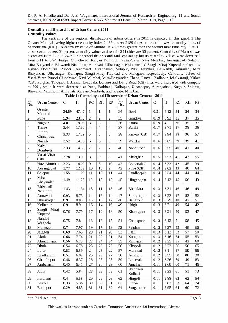
Centrality and Hierarchic of Urban Centers 2011
Centrality Values The centrality of the regional distribution of urban centers in 2011 is depicted in this graph 1 The
Greater Mumbai having highest centrality index 24.89 is over 2489 times more than lowest centrality index of
Shendurjana (0.01). A centrality value of Mumbai is 4.2 times greater than the second rank Pune city. First 10
urban center covers 64 percent centrality values and remain 254 cities are 36 percent. Centrality of Mumbai was
decreased from 32.3 to 24.89. Pune stood their second rank constantly but its centrality values were decreased
from 6.11 to 5.94. Pimpri Chinchwad, Kalyan Dombivli, Vasai-Virar, Navi Mumbai, Aurangabad, Solapur,
Mira-Bhayandar, Bhiwandi Nizampur, Amravati, Ulhasnagar, Kolhapur and Sangli Miraj Kupwad replaced by
Kalyan Dombivali, Pimpri Chinchwad, Aurangabad, Solapur, Navi Mumbai, Bhiwandi, Amravati, Mira
Bhayandar, Ulhasnagar, Kolhapur, Sangli-Miraj Kupwad and Malegaon respectively. Centrality values of
Vasai-Virar, Pimpri Chinchwad, Navi Mumbai, Mira-Bhayandar, Thane, Panvel, Badlapur, Ichalkaranji, Kirkee
(CB), Palghar, Talegaon Dabhade, Lonavala, Dahanu and Dehu Road (CB) cites were increased with compare
to 2001, while it were decreased at Pune, Parbhani, Kolhapur, Ulhasnagar, Aurangabad, Nagpur, Solapur,
Bhiwandi Nizampur, Amravati, Kalyan-Dombivli, and Greater Mumbai.
Table 1: Centrality and Hierarchic of Urban Centers - 2011
Sr.
No. Urban Center C H RC RH RP
Sr.
No. Urban Center C H RC RH RP
1 Greater
Mumbai 24.89 47.47 1 1 1 34 Beed 0.21 4.12 34 34 34
2 Pune 5.94 23.12 2 2 2 35 Gondiya 0.19 3.93 35 37 35
3 Nagpur 4.07 18.95 3 3 3 36 Satara 0.19 4 36 35 37
4 Thane 3.44 17.57 4 4 4 37 Barshi 0.17 3.71 37 38 36
5 Pimpri
Chinchwad 3.33 17.29 5 5 5 38 Kirkee (CB) 0.17 3.94 38 36 57
6 Nashik 2.52 14.75 6 6 6 39 Wardha 0.16 3.65 39 39 41
7 Kalyan-
Dombivli 2.33 14.53 7 7 7 40 Nandurbar 0.16 3.55 40 41 40
8 Vasai-Virar
City 2.28 13.9 8 9 8 41 Kharghar 0.15 3.53 41 42 55
9 Navi Mumbai 2.23 14.09 9 8 10 42 Osmanabad 0.14 3.33 42 45 39
10 Aurangabad 1.77 12.28 10 10 9 43 Pune (CB) 0.14 3.63 43 40 64
11 Solapur 1.55 11.09 11 13 11 44 Pandharpur 0.14 3.34 44 44 44
12 Mira-
Bhayandar 1.49 11.28 12 12 12 45 Hinganghat 0.14 3.13 45 56 43
13 Bhiwandi
Nizampur 1.43 11.34 13 11 13 46 Bhandara 0.13 3.31 46 46 49
14 Amravati 0.93 8.73 14 16 14 47 Shrirampur 0.13 3.23 47 52 52
15 Ulhasnagar 0.91 8.85 15 15 17 48 Ballarpur 0.13 3.29 48 47 51
16 Kolhapur 0.91 8.9 16 14 16 49 Udgir 0.13 3.2 49 54 42
17 Sangli Miraj
Kupwad 0.76 7.79 17 19 18 50 Khamgaon 0.13 3.21 50 53 47
18 Nanded
Waghala 0.75 7.8 18 18 15 51 Chalisgaon 0.13 3.12 51 58 45
19 Malegaon 0.7 7.97 19 17 19 52 Palghar 0.13 3.27 52 48 66
20 Jalgaon 0.69 7.63 20 21 20 53 Parli 0.13 3.13 53 57 50
21 Akola 0.68 7.74 21 20 21 54 Kamptee 0.13 3.16 54 55 53
22 Ahmadnagar 0.56 6.75 22 24 24 55 Ratnagiri 0.12 3.35 55 43 60
23 Dhule 0.54 6.78 23 23 23 56 Khopoli 0.12 3.23 56 50 65
24 Latur 0.53 6.59 24 25 22 57 Manmad 0.12 3.1 57 59 56
25 Ichalkaranji 0.51 6.82 25 22 27 58 Achalpur 0.12 2.55 58 80 38
26 Chandrapur 0.48 6.37 26 27 25 59 Lonavala 0.12 3.26 59 49 83
27 Ambarnath 0.45 6.41 27 26 29 60 Amalner 0.11 2.68 60 71 46
28 Jalna 0.42 5.84 28 28 28 61 Wadgaon
Kolhati 0.11 3.23 61 51 73
29 Parbhani 0.4 5.58 29 29 26 62 Hingoli 0.11 2.88 62 62 54
30 Panvel 0.33 5.36 30 30 31 63 Sinnar 0.1 2.82 63 64 74
31 Badlapur 0.29 4.85 31 31 32 64 Sangamner 0.1 2.95 64 60 72
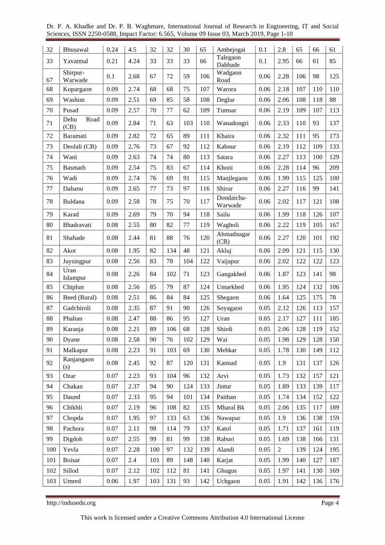
Dr. P. A. Khadke and Dr. P. B. Waghmare, International Journal of Research in Engineering, IT and Social
Sciences, ISSN 2250-0588, Impact Factor: 6.565, Volume 09 Issue 03, March 2019, Page 1-10
http://indusedu.org Page 4
This work is licensed under a Creative Commons Attribution 4.0 International License
32 Bhusawal 0.24 4.5 32 32 30 65 Ambejogai 0.1 2.8 65 66 61
33 Yavatmal 0.21 4.24 33 33 33 66 Talegaon
Dabhade 0.1 2.95 66 61 85
67
Shirpur-
Warwade 0.1 2.68 67 72 59 106
Wadgaon
Road 0.06 2.28 106 98 125
68 Kopargaon 0.09 2.74 68 68 75 107 Warora 0.06 2.18 107 110 110
69 Washim 0.09 2.51 69 85 58 108 Deglur 0.06 2.06 108 118 88
70 Pusad 0.09 2.57 70 77 62 109 Tumsar 0.06 2.19 109 107 113
71 Dehu Road
(CB) 0.09 2.84 71 63 103 110 Wanadongri 0.06 2.33 110 93 137
72 Baramati 0.09 2.82 72 65 89 111 Khaira 0.06 2.32 111 95 173
73 Deolali (CB) 0.09 2.76 73 67 92 112 Kabnur 0.06 2.19 112 109 133
74 Wani 0.09 2.63 74 74 80 113 Satara 0.06 2.27 113 100 129
75 Basmath 0.09 2.54 75 83 67 114 Khoni 0.06 2.28 114 96 209
76 Wadi 0.09 2.74 76 69 91 115 Manjlegaon 0.06 1.99 115 125 100
77 Dahanu 0.09 2.65 77 73 97 116 Shirur 0.06 2.27 116 99 141
78 Buldana 0.09 2.58 78 75 70 117 Dondaicha-
Warwade 0.06 2.02 117 121 108
79 Karad 0.09 2.69 79 70 94 118 Sailu 0.06 1.99 118 126 107
80 Bhadravati 0.08 2.55 80 82 77 119 Wagholi 0.06 2.22 119 105 167
81 Shahade 0.08 2.44 81 88 76 120 Ahmadnagar
(CB) 0.06 2.27 120 101 192
82 Akot 0.08 1.95 82 134 48 121 Akluj 0.06 2.09 121 115 130
83 Jaysingpur 0.08 2.56 83 78 104 122 Vaijapur 0.06 2.02 122 122 123
84 Uran
Islampur 0.08 2.26 84 102 71 123 Gangakhed 0.06 1.87 123 141 98
85 Chiplun 0.08 2.56 85 79 87 124 Umarkhed 0.06 1.95 124 132 106
86 Beed (Rural) 0.08 2.51 86 84 84 125 Shegaon 0.06 1.64 125 175 78
87 Gadchiroli 0.08 2.35 87 91 90 126 Soyagaon 0.05 2.12 126 113 157
88 Phaltan 0.08 2.47 88 86 95 127 Uran 0.05 2.17 127 111 185
89 Karanja 0.08 2.21 89 106 68 128 Shirdi 0.05 2.06 128 119 152
90 Dyane 0.08 2.58 90 76 102 129 Wai 0.05 1.98 129 128 150
91 Malkapur 0.08 2.23 91 103 69 130 Mehkar 0.05 1.78 130 149 112
92 Ranjangaon
(s) 0.08 2.45 92 87 120 131 Kannad 0.05 1.9 131 137 126
93 Ozar 0.07 2.23 93 104 96 132 Arvi 0.05 1.73 132 157 121
94 Chakan 0.07 2.37 94 90 124 133 Jintur 0.05 1.89 133 139 117
95 Daund 0.07 2.33 95 94 101 134 Paithan 0.05 1.74 134 152 122
96 Chikhli 0.07 2.19 96 108 82 135 Mharal Bk 0.05 2.06 135 117 189
97 Chopda 0.07 1.95 97 133 63 136 Nawapur 0.05 1.9 136 138 159
98 Pachora 0.07 2.11 98 114 79 137 Katol 0.05 1.71 137 161 119
99 Digdoh 0.07 2.55 99 81 99 138 Rahuri 0.05 1.69 138 166 131
100 Yevla 0.07 2.28 100 97 132 139 Alandi 0.05 2 139 124 195
101 Boisar 0.07 2.4 101 89 148 140 Karjat 0.05 1.99 140 127 187
102 Sillod 0.07 2.12 102 112 81 141 Ghugus 0.05 1.97 141 130 169
103 Umred 0.06 1.97 103 131 93 142 Uchgaon 0.05 1.91 142 136 176

Dr. P. A. Khadke and Dr. P. B. Waghmare, International Journal of Research in Engineering, IT and Social
Sciences, ISSN 2250-0588, Impact Factor: 6.565, Volume 09 Issue 03, March 2019, Page 1-10
http://indusedu.org Page 5
This work is licensed under a Creative Commons Attribution 4.0 International License
104 Vita 0.06 2.07 104 116 105 143 Malkapur 0.05 1.93 143 135 174
105 Pen 0.06 2.34 105 92 135 144 Karanje tarf
Satara 0.05 2.02 144 123 191
145 Akkalkot 0.05 1.78 145 148 128 184 Ambad 0.04 1.57 184 187 175
146 Digras 0.05 1.67 146 172 114 185 Lohara 0.04 1.72 185 160 236
147 Satana 0.05 1.71 147 162 136 186 Indapur 0.04 1.69 186 167 213
148 Ahmadpur 0.05 1.68 148 169 118 187 Varangaon 0.04 1.45 187 206 155
149 Pulgaon 0.05 1.8 149 145 164 188 Sawantwadi 0.04 1.74 188 155 228
150 Warud 0.05 1.48 150 202 111 189 Hudkeshwar
bk. 0.04 1.72 189 158 223
151 Mahad 0.05 2.02 151 120 200 190 Nandgaon 0.04 1.7 190 164 230
152 Sasvad 0.04 1.71 152 163 172 191 Walwadi 0.04 1.6 191 180 188
153 Georai 0.04 1.74 153 156 166 192 Pathri 0.04 1.35 192 217 143
154 Savner 0.04 1.74 154 154 170 193 Nilanga 0.04 1.39 193 211 147
155 Jamner 0.04 1.51 155 198 109 194 Risod 0.04 1.37 194 216 160
156 Nildoh 0.04 1.98 156 129 255 195 Roha
Ashtami 0.03 1.79 195 147 256
157 Murtijapur 0.04 1.58 157 184 127 196 Mahadula 0.03 1.64 196 173 248
158 Kagal 0.04 1.69 158 168 161 197 Bhokar 0.03 1.38 197 215 168
159 Tuljapur 0.04 1.7 159 165 163 198 Vadgaon
Kasba 0.03 1.51 198 199 212
160 Nandura 0.04 1.51 160 197 138 199 Karmala 0.03 1.68 199 171 233
161 Parola 0.04 1.59 161 181 218 200 Ramtek 0.03 1.58 200 186 242
162 Rajgurunagar
(Khed) 0.04 1.84 162 144 162 201 Kalamb 0.03 1.55 201 191 211
163 Jamkhed 0.04 1.58 163 185 225 202 Kinwat 0.03 1.46 202 205 196
164 Kon 0.04 1.88 164 140 158 203 Dharangaon 0.03 1.25 203 229 156
165 Sangole 0.04 1.54 165 192 186 204 Ghoti Bk. 0.03 1.5 204 200 220
166 Rajura 0.04 1.74 166 153 151 205 Kandhar 0.03 1.68 205 170 115
167 Brahmapuri 0.04 1.47 167 204 116 206 Balapur 0.03 1.18 206 236 219
168 Alibag 0.04 1.85 168 142 257 207 Yawal 0.03 1.26 207 227 144
169 Gadhinglaj 0.04 1.79 169 146 203 208 Pathardi 0.03 1.4 208 209 202
170 Pandharkaoda 0.04 1.61 170 179 178 209 Morshi 0.03 1.21 209 232 139
171 Kodoli 0.04 1.77 171 150 208 210 Karad
(Rural) 0.03 1.58 210 182 260
172 Purna 0.04 1.62 172 177 146 211 Pipri 0.03 1.55 211 188 229
173 Dharmabad 0.04 1.41 173 207 165 212 Chandur 0.03 1.39 212 213 205
174 Deulgaon
Raja 0.04 1.64 174 174 183 213
Kanhan
(Pipri) 0.03 1.53 213 194 234
175 Ausa 0.04 1.53 175 195 149 214 Manwath 0.03 1.28 214 223 171
176 Tasgaon 0.04 1.39 176 214 134 215 Ghulewadi 0.03 1.55 215 189 243
177 Umarga 0.04 1.55 177 190 154 216 Desaiganj 0.03 1.29 216 221 194
178 Anjangaon 0.04 1.16 178 241 86 217 Ashta 0.03 1.11 217 244 142
179 Partur 0.04 1.5 179 201 153 218 Sindi Turf
Hindnagar 0.03 1.58 218 183 254
180 Igatpuri 0.04 1.62 180 178 181 219 Vashind 0.03 1.63 219 176 259
181 Godoli 0.04 1.84 181 143 237 220 Umarsara 0.03 1.54 220 193 246

Dr. P. A. Khadke and Dr. P. B. Waghmare, International Journal of Research in Engineering, IT and Social
Sciences, ISSN 2250-0588, Impact Factor: 6.565, Volume 09 Issue 03, March 2019, Page 1-10
http://indusedu.org Page 6
This work is licensed under a Creative Commons Attribution 4.0 International License
182 Pachgaon 0.04 1.75 182 151 240 221 Mul 0.03 1.34 221 218 214
183 Junnar 0.04 1.72 183 159 216 222 Mukhed 0.03 1.33 222 219 199
223 Koregaon 0.03 1.4 223 208 222 244 Deolali
Pravara 0.03 0.95 244 256 180
224 Korochi 0.03 1.52 224 196 261 245 Kurundvad 0.03 1.25 245 228 239
225 Kaij 0.03 1.28 225 222 184 246 Kalamnuri 0.03 1.22 246 231 221
226 Erandol 0.03 1.18 226 234 179 247
Umri
Pragane
Balapur
0.03 1.27 247 226 263
227 Bhadgaon 0.03 1.07 227 250 140 248 Ner 0.02 1.04 248 251 190
228 Sakri 0.03 1.4 228 210 245 249 Talode 0.02 1.02 249 252 207
229 Shrigonda 0.03 1.08 229 249 177 250 Lonar 0.02 1.1 250 246 232
230 Chandvad 0.03 1.25 230 230 215 251 Darwha 0.02 1.09 251 248 210
231 Kurduvadi 0.03 1.47 231 203 238 252 Rahta
Pimplas 0.02 1.11 252 245 241
232 Mangrulpir 0.03 1.17 232 237 182 253 Dattapur
Dhamangaon 0.02 1.17 253 238 252
233 Hupari 0.03 1.09 233 247 193 254 Mhaswad 0.02 0.9 254 258 227
234 Faizpur 0.03 1.27 234 225 206 255 Savda 0.02 1.14 255 242 258
235 Waluj Bk. 0.03 1.39 235 212 264 256 Ghatanji 0.02 0.96 256 255 249
236 Loha 0.03 1.29 236 220 226 257 Mangalvedhe 0.02 0.98 257 254 244
237 Hadgaon 0.03 1.17 237 240 201 258 Pauni 0.02 0.87 258 259 235
238 Mudkhed 0.03 1.17 238 239 231 259 Dharur 0.02 0.93 259 257 262
239 Gangapur 0.03 1.12 239 243 198 260 Jalgaon
(Jamod) 0.02 0.78 260 261 197
240 Bhokardan 0.03 1.27 240 224 224 261 Telhara 0.02 0.82 261 260 253
241 Daryapur
Banosa 0.03 0.99 241 253 145 262 Narkhed 0.01 0.64 262 262 250
242 Raver 0.03 1.2 242 233 204 263 Patur 0.01 0.63 263 263 251
243 Tirora 0.03 1.18 243 235 217 264 Shendurjana 0.01 0.37 264 264 247
Source- Compiled by researcher based on Census of 2011 (C-Centrality, H- Hierarchy Index, RC- Rank by
Centrality, RH-Rank by Hierarchy, RP- Rank by Population)
Fig 1
Dr. P. A. Khadke and Dr. P. B. Waghmare, International Journal of Research in Engineering, IT and Social
Sciences, ISSN 2250-0588, Impact Factor: 6.565, Volume 09 Issue 03, March 2019, Page 1-10
http://indusedu.org Page 7
This work is licensed under a Creative Commons Attribution 4.0 International License
Hierarchy Classes
The hierarchy index of urban centers of Maharashtra has classified into following six classes (fig 2).
Table 2: Hierarchic Order of Towns - 2011
Classes Centers Town Name
1
Large
Regional
Center
Greater Mumbai (1)
2 Regional
Centre Pune, Nagpur, Thane, Pimpri Chinchwad (4)
3 Sub Regional
Centre
Nashik, Kalyan-Dombivli, Navi Mumbai, Vasai Virar City, Aurangabad, Bhiwandi
Nizampur, Mira-Bhayandar, Solapur, Kolhapur, Ulhasnagar, Amravati (11)
4 Large Market
Center
Malegaon, Nanded Waghala, Sangli Miraj Kupwad, Akola, Jalgaon, Ichalkaranji,
Dhule, Ahmadnagar, Latur, Ambarnath, Chandrapur, Jalna, Parbhani, Panvel, Badlapur,
Bhusawal, Yavatmal, Beed (18)
5 Medium
Market Center
Satara, Kirkee (CB), Gondiya, Barshi, Wardha, Pune (CB), Nandurbar, Kharghar,
Ratnagiri, Pandharpur, Osmanabad, Bhandara, Ballarpur, Palghar, Lonavala, Khopoli,
Wadgaon Kolhati, Shrirampur, Khamgaon, Udgir, Kamptee, Hinganghat, Parli,
Chalisgaon, Manmad, Sangamner, Talegaon Dabhade, Hingoli, Dehu Road (CB),
Sinnar, Baramati, Karad, Ambejogai, Deolali (CB), Kopargaon, Wadi, Amalner,
Dahanu, Wani, Shirpur-Warwade, Buldana, Dyane, Pusad, Jaysingpur, Chiplun, Beed
(Rural), Achalpur, Digdoh, Bhadravati, Basmath, Washim, Phaltan, Ranjangaon (s),
Shahade, Boisar, Chakan, Gadchiroli, Pen, Wanadongri, Daund, Khaira, Khoni, Yevla,
Wadgaon Road, Shirur, Satara, Malkapur, Ozar, Uran Islampur, Wagholi, Karanja,
Tumsar, Vita, Chikhli, Kabnur, Warora, Uran, Sillod, Soyagaon, Pachora, Akluj,
Mharal Bk, Deglur, Ahmadnagar (CB) (84)
6 Small Market
Center
Shirdi, Mahad, Dondaicha-Warwade, Vaijapur, Karanje tarf Satara, Wai, Alandi,
Manjlegaon, Sailu, Karjat, Nildoh, Ghugus, Umred, Malkapur, Akot, Chopda,
Umarkhed, Uchgaon, Kannad, Nawapur, Jintur, Kon, Gangakhed, Alibag, Godoli,
Rajgurunagar (Khed), Pulgaon, Gadhinglaj, Roha Ashtami, Akkalkot, Mehkar, Kodoli,
Pachgaon, Paithan, Rajura, Savner, Sawantwadi, Georai, Arvi, Hudkeshwar bk., Junnar,
Lohara, Katol, Satana, Sasvad, Nandgaon, Tuljapur, Rahuri, Indapur, Kagal, Ahmadpur,
Kandhar, Karmala, Digras, Mahadula, Shegaon, Vashind, Purna, Igatpuri,
Pandharkaoda, Walwadi, Parola, Karad (Rural), Sindi Turf Hindnagar, Murtijapur,
Jamkhed, Ramtek, Ambad, Pipri, Deulgaon Raja, Ghulewadi, Umarga, Kalamb,
Sangole, Umarsara, Kanhan (Pipri), Ausa, Korochi, Nandura, Jamner, Vadgaon Kasba,
Ghoti Bk., Partur, Warud, Kurduvadi, Brahmapuri, Kinwat, Varangaon, Dharmabad,
Sakri, Koregaon, Pathardi, Nilanga, Waluj Bk., Chandur, Tasgaon, Bhokar, Risod,
Pathri, Mul, Mukhed, Loha, Desaiganj, Kaij, Manwath, Faizpur, Umri Pragane,
Bhokardan, Balapur, Yawal, Kurundvad, Dharangaon, Chandvad, Kalamnuri, Morshi,
Raver, Erandol, Tirora, Balapur, Ashta, Mangrulpir, Dattapur, Dhamangaon, Mudkhed,
Hadgaon, Anjangaon, Savda, Gangapur, Rahta Pimplas, Lonar, Hupari, Darwha,
Shrigonda, Bhadgaon, Ner, Talode, Daryapur Banosa, Mangalvedhe, Ghatanji, Deolali
Pravara, Dharur, Mhaswad, Pauni, Telhara, Jalgaon (Jamod), Narkhed, Patur,
Shendurjana (146)
Source- Compiled by researcher
Large Regional Centers
There are Greater Mumbai is one of the largest regional centers in Maharashtra. The centrality and
hierarchy index of Greater Mumbai is 24.89 and 47.47 respectively. Greater Mumbai is constantly in this
category form 1991. The hierarchy index of the Mumbai city is declining from 54.47 to 47.47 due to the
development of other urban centers. Mumbai is state capital of Maharashtra. Greater Mumbai is the historical
place and recently economic capital of India. It is headquarter of western naval division and Reserve Bank of
India. Mumbai have universities, medical colleges, engineering, education and professional courses. It has
regional offices of state and central government as well as private institute and organization. Maximum
wholesale and retail trads concentrated in the city. It is the heart of the social, political and economic activities.
Most of the peoples, they are engaged in tertiary services. It has a concentration of cotton textile, IT, wholesale
and retail trades, share market, university and educational institute, IIT, large hospitals and headquarter of the
western and central railway.
Regional Centers
There are four regional centers in Maharashtra viz. Pune, Nagpur, Thane and Pimpri Chinchwad.
Hierarchy index of this center is 23.12 to 17.29. As comparde to the 2001 the hierarchy index of Pune and

Dr. P. A. Khadke and Dr. P. B. Waghmare, International Journal of Research in Engineering, IT and Social
Sciences, ISSN 2250-0588, Impact Factor: 6.565, Volume 09 Issue 03, March 2019, Page 1-10
http://indusedu.org Page 8
This work is licensed under a Creative Commons Attribution 4.0 International License
Nagpur were shows declined trend. Thane and Pimpri Chinchwad have newly added in this census year in this
category. Pune and Nagpur is the divisional head quarter and Thane is district headquarter and part of Mumbai
urban agglomeration. Pimpri Chinchwad is industrial place and part of Pune urban agglomeration. All the four
centers have Municipal Corporation. Pune and Nagpur have universities. Pune and Nagpur are historical places.
Some regional offices of governments and private organizations are located in both places. Pune is the cultural
and educational capital of Maharashtra while Nagpur is second capital of Maharashtra. Pune and Nagpur well
connected to road, railway and airport services with other area. The population of Maharashtra and outside of it
is depends on the regional centers.
Sub Regional Centre
There are eleven sub regional centers. In 1991 and 2001, there were 2 and 7 respectively. Out of this
Nashik, Aurangabad and Amravati are divisional and district head quarter, Solapur and Kolhapur is district head
quarter. The remaining Kalyan-Dombivli, Navi Mumbai, Vasai Virar, Bhiwandi Nizampur, Mira-Bhayandar
and Ulhasnagar having Municipal Corporation and this center are part of the Greater Mumbai urban
agglomeration. All centers have well connected with road and rail network with surrounding area. The hierarchy
index of these places is between 14.75 to 8.73. Amravati, Kolhapur, Mira-Bhayandar, Pimpri Chinchwad,
Solapur, Ulhasnagar and Vasai-Virar have newly introduced in this group due to the highest rate of
urbanization. The influences of these centers are not limited to the district boundary but there commanded area
is whole state. They also provided the services to the surrounding area. Nashik, Navi Mumbai, Aurangabad,
Solapur, Kolhapur and Amravati have universities, great colleges, technical institute, medical facilities and
largest market. The airport facilities are available at Kolhapur, Navi Mumbai, Aurangabad and Nashik.
Fig. 2 A, B and C

Dr. P. A. Khadke and Dr. P. B. Waghmare, International Journal of Research in Engineering, IT and Social
Sciences, ISSN 2250-0588, Impact Factor: 6.565, Volume 09 Issue 03, March 2019, Page 1-10
http://indusedu.org Page 9
This work is licensed under a Creative Commons Attribution 4.0 International License
Large Market Center
There are eighteen large market centers. The numbers of large market centers are continuously
decreased from 1991 to 2011. It was 26, 25 and 18 during 1991, 2001 and 2011 respectively. Amravati,
Bhusawal, Gondiya, Kolhapur, Mira Bhayandar, Nalasopara, Navghar-Manikpur, Solapur, Ulhasnagar and
Vasai changed have their position and included in the sub regional centre, while Badlapur, Bhusawal and Panvel
involved in this category. This group include twelve district headquarter viz. Nanded, Sangli, Akola, Jalgaon,
Dhule, Ahmadnagar, Latur, Chandrapur, Jalna, Parbhani, Yavatmal and Beed, two municipal corporation
Malegaon and Panvel, remaining four Ichalkaranji, Ambarnath, Badlapur, Bhusawal are municipal council and
tahsil places. These all centers have large colleges, technical institutions and well-equipped hospitals, market
centers, good daily newspaper. Nanded and Jalgaon cities have non-agriculture universities, whereas Akola and
Parbhani cities have agriculture universities. All centers have connected with the facility of railway
transportation.
Nanded have as aerodromes facility. Panvel, Ambarnath and Badlapur are part of the Greater Mumbai
urban agglomeration. All these centers are supported to the large population and provide greater urban services
to them. Bhusawal is railway junction and Ichalkaranji is Textile Park.
Medium Market Center
The fifth-order service centers are eighty four in number. Eleven of them (Satara, Gondiya, Wardha,
Ratnagiri, Nandurbar, Osmanabad, Bhandara, Hingoli, Buldana, Washim, Gadchiroli) are district headquarters,
fourty eight are (Barshi, Pandharpur, Ballarpur, Palghar, Shrirampur, Udgir, Kamptee, Parli, Sinnar, Karad,
Khamgaon, Hinganghat, Chalisgaon, Manmad, Sangamner, Baramati, Ambejogai, Wani, Kopargaon, Amalner,
Shirpur-Warwade, Dahanu, Dyane, Pusad, Chiplun, Achalpur, Digdoh, Bhadravati, Basmath, Shahade, Boisar,
Pen, Daund, Phaltan, Yevla, Shirur, Islampur, Vita, Uran, Karanja, Tumsar, Chikhli, Kabnur, Warora, Uran,
Sillod, Soyagaon Pachora, Deglur) tahsil headquarters. Ahmadnagar (CB), Kirkee (CB), Pune (CB), Dehu Road
(CB) and Deolali (CB) are military centers. The rest, viz Talegaon Dabhade, Kharghar, Lonavala, Khopoli,
Wadgaon Kolhati, Wadi, Jaysingpur, Beed (Rural), Ranjangaon (s), Chakan, Wanadongri, Khaira, Khoni, Ozar,
Wadgaon Road, Malkapur, Wagholi, Akluj and Mharal Bk have important market centers. Most of the urban
centers have developed for the industrial and market purpose. This group does not confirm of any specific class,
it is varied form Class I to Class V. This centers having college, educational institute, hospital facilities,
cinemas, post offices, bus services, banks, ATM and large and small market centers. Some centers have railway
stations.
The numbers of medium market centers are continuously increased from 1991 to 2011. It was 47, 62
and 84 in 1991, 2001 and 2011 respectively. Akot, Badlapur, Chopda, Manjlegaon and Shrirampur exit this
group, while Akluj, Beed (Rural), Boisar, Chakan, Deglur, Digdoh, Dyane, Gadchiroli, Gondiya, Kabnur,
Khaira, Kharghar, Khoni, Mharal Bk, Ozar, Pachora, Pen, Ranjangaon (s), Satara, Shirur, Sillod, Sinnar,
Soyagaon, Tumsar, Uran, Vita, Wadgaon Kolhati, Wadgaon Road, Wagholi and Wanadongri newly involve in
this category.
Small Market Center
There are 146 urban centers which have been put in this category which include 117 are tahsil
headquarter (Mahad, Dondaicha-Warwade, Vaijapur, Wai, Manjlegaon, Sailu, Karjat, Umred, Mul, Umarkhed,
Chopda, Gangakhed, Kannad, Nawapur, Jintur, Alibag, Mehkar, Rajgurunagar (Khed), Pulgaon, Gadhinglaj,
Roha Ashtami, Akkalkot, Paithan, Arvi, Rajura, Savner, Sawantwadi, Georai, Junnar, Akot, Lohara, Katol,
Satana, Sasvad, Rahuri, Nandgaon, Tuljapur, Indapur, Kagal, Kandhar, Karmala, Digras, Deulgaon Raja,
Shegaon, Igatpuri, Parola, Murtijapur, Ahmadpur, Ambad, Jamkhed, Ramtek, Umarga, Kalamb, Sangole,
Umarsara, Kanhan (Pipri), Ausa, Korochi, Nandura, Loha, Jamner, Vadgaon Kasba, Partur, Warud, Brahmapuri,
Kinwat, Varangaon, Pathardi, Dharmabad, Koregaon, Sakri, Nilanga, Chandur, Purna, Tasgaon, Bhokar, Risod,
Kaij, Umri Pragane, Mukhed, Desaiganj, Manwath, Yawal, Bhokardan, Balapur, Erandol, Pathri, Kurundvad,
Dharangaon, Chandvad, Morshi, Ner, Kalamnuri, Raver, Tirora, Savda, Balapur, Mangrulpir, Hadgaon,
Anjangaon, Dattapur Dhamangaon, Mudkhed, Lonar, Gangapur, Darwha, Shrigonda, Talode, Bhadgaon,
Daryapur Banosa, Narkhed, Pauni, Mangalvedhe, Ghatanji, Dharur, Patur, Telhara, Jalgaon (Jamod),
Shendurjana). Remaining Nine towns are with are Muncipal council (Alandi, Pandharkaoda, Kurduvadi,
Faizpur, Ashta, Rahta Pimplas, Deolali Pravara, Mhaswad), two with Nagar panchayat (Shirdi, Malkapur) and
eighteen give (Karanje tarf Satara, Karanje tarf Satara, Nildoh, Ghugus, Uchgaon, Kon, Godoli, Kodoli,
Pachgaon, Hudkeshwar bk., Mahadula, Vashind, Walwadi, Karad (Rural), Sindi Turf Hindnagar, Pipri,
Ghulewadi, Ghoti Bk., Waluj Bk., Hupari) village panchayat. The towns of this category have spread over the
whole state except hilly and dense forest area. The function of the most of the towns mainly depends on agro-
based sector. The facilities in some towns are colleges, hospitals and railways station, post offices. Most of the
village panchayat are associated with largest city. All centers of this category are important for the connecting
of rural and urban peoples have provides services to their tributary area.
The numbers of small market centers are continuously increased from 1991 to 2011. It was 84, 122
and 146 in 1991, 2001 and 2011 respectively. Chakan, Deglur, Dhyane, Digdoh, Gadchiroli, Ghkhivare,
Dr. P. A. Khadke and Dr. P. B. Waghmare, International Journal of Research in Engineering, IT and Social
Sciences, ISSN 2250-0588, Impact Factor: 6.565, Volume 09 Issue 03, March 2019, Page 1-10
http://indusedu.org Page 10
This work is licensed under a Creative Commons Attribution 4.0 International License
Kabnur, Khoni, Ozar, Pachora, Pen, Shirur, Sillod, Sinnar, Soyagaon, Tumsar, Uran,ita and Wadgaon Road
change their position from this category, while Akot, Alandi, Alibag, Bhadgaon, Bhokar, Bhokardan, Godoli,
Chandvad, Chopda, Dharur, Ghatanji, Ghulewadi, Hudkeshwar bk., Jamner, Kaij, Karad (Rural), Kodoli, Kon,
Koregaon, Korochi, Lohara, Mahadula, Malkapur, Manjlegaon, Mudkhed, Ner, Nildoh, Pachgaon, Pipri, Rahta
Pimplas, Rajgurunagar (Khed), Roha Ashtami, Sakri, Satana, Savda, Sindi Turf Hindnagar,Telhara, Umri
Pragane Balapur, Umarsara, Varangaon, Vashind, Waluj Bk and Walwadi were newly introduced.
CONCLUSIONS The calculation of Class I, II and III urban center of Maharashtra during 1991, 2001 and 2011. In the
state 162, 219 and 265 urban centers are in this class during the study periods. The total number of tertiary
worker in the urban centers and total number of tertiary worker of the Maharashtra has considered for the
calculation of centrality index. The centrality values and centrality ranks of each urban centre during 1991, 2001
and 2011.
The Greater Mumbai having highest centrality index 24.89 is over 2489 times more than lowest
centrality index of Shendurjana (0.01). A centrality value of Mumbai is 4.2 times greater than the second rank
Pune city. First 10 urban center covers 64 percent centrality values and remain 254 cities are 36 percent. There
are Greater Mumbai is one of the largest regional centers in Maharashtra.
The centrality and hierarchy index of Greater Mumbai is 24.89 and 47.47 respectively. There are four
regional centers in Maharashtra viz. Pune, Nagpur, Thane and Pimpri Chinchwad. Hierarchy index of this center
is 23.12 to 17.29. There are eleven sub regional centers. In 1991 and 2001, there were 2 and 7 respectively.
There are eighteen large market centers. The numbers of large market centers are continuously decreased from
1991 to 2011. It was 26, 25 and 18 during 1991, 2001 and 2011 respectively. Medium Market Center, the fifth-
order service centers are eighty four in number, Small Market Center there are 146 urban centers which have
been put in this category
Acknowledgement
I acknowledge with gratitude to Indian council of Social Sciences, New Delhi, for financial support.
REFERENCES [1] Abiodun, J. O. (1967): "Urban Hierarchy in a Developing Country” Economic Geography vol. 43, pp 347-367.
[2] Ambrase, J Longmans Green & Co. Ltd. London, pp. 89-102.
[3] Berry, B. J. L and Garrison W. L. (1958): “The Functional Bases of Central Place Hierarchy”, Economic Geography, Vol.34, pp-145-154.
[4] Brush, J. E. (1953): “The Hierarchy of Central Places in South Western Wisconsin; The Geographicals Review, pp. 380-402.
[5] Carol, H. (1960): The Hierarchy of Central Functions within the city”, Add. Association of American Geography Vol 50, pp 419-438.
[6] Carruther, W. I. (1957): “ Service Centers in Greater London”, Town Planning Review, p. 33
[7] Christaller W. (1933): “The Central Places of Southern Germany, Translated by C. Baskin Prentice Hall. 1966. [8] Datta and Bannarjee (1970): “Transportation Index in West Bengal, A Mean to Determine Central Place Hierarchy”, National
Geographical Journal, Vol. XVI, Parts 3 and 4.
[9] Deshmukh, P. W. (1979): “A Study of Central Places in Upper Krishna Valley”, unpublished Ph.D. thesis submitted to the Shivaji University, Kolhapur.
[10] Dickinson, R. E. (1937): “The Metropolitan Regions of the United States, Geographical Reviews, 24, pp-278-291.
[11] Diddee, J. (1978): “Central Places in upper Bhima Basin”, unpublished Ph.D. thesis, University of Poona. [12] Godlund S. (1966): “Bus Service in Sweden Land Studies in Geography Series”, p.17.
[13] Singh, O. P. (1969): “A Study of Central Places in UP”, Ph.D. Thesis, Banaras Hindu University Varanasi, pp. 101-109. [14] Sinha, V. N. P. (1976): “Chota Nagpur Plateau: A Study in Settlement Geography”, K. B. Publications, New Delhi,
[15] Smailes, A. E. (1944): “The Urban Hierarchy in England and Wales,; Geography - 29, pp-41-51.
[16] Tirtha, R. and Lall A. (1967):“Service centers in the Western Himalayas”, The Journal of Tropical Geography, Vo. 24, pp 58-68.
Copyright © 2022 FDOKUMEN