District Census Handbook, Uttara Kannada, Part XII-A, Series-11
407
CENSUS OF INDIA 1991 Series -11 KARNATAKA DISTRICT CENSUS HANDBOOK UTTARA KANNADA DISTRICT - PART XII-A VILLAGE ANI> TOWN DIRECTORY S08HA ,NAMBISAN Director of Census Operations, Karnataka
-
Upload
khangminh22 -
Category
Documents
-
view
0 -
download
0
Transcript of District Census Handbook, Uttara Kannada, Part XII-A, Series-11

CENSUS OF INDIA 1991
Series -11 KARNATAKA
DISTRICT CENSUS HANDBOOK UTTARA KANNADA DISTRICT
- PART XII-A VILLAGE ANI> TOWN DIRECTORY
S08HA ,NAMBISAN Director of Census Operations, Karnataka


FORE\VORD
PREFACE' ,
IMPORTANT STATISTICS
ANAL YTI( 'AL N( )TE \
Section-I • Villa~t! lJirt'ctory
Explanatllry Note
Alphahl:tic:tl List of Villagl:s
Village Directory SlaLl..:men!
Alphahe~ical List of Villages
Village Directory Stakml:nl
Alphah..:tical List of Villages
VillagL~ Directory Statement
Alphahdic;;1 List or Villages
Villi1ge Oin:ctnry Statement
Alphabetical List or Vilhlges
Village Directory St,;kment
Alphahdical List or Yillagt.:s
Villag~ Directory Statement
Alphabetical List of Villages
Village Din:cttlTY Statl.:mcn\
Alphahdical List of Villag..:s
Village Directory Slatement
Alphabetical List of Villages
Village OirL'l'tnry Statement
Alphabetical List uf Village!'>
\'illagc Din:ctury Statement
Alph;lbdical List Ill' Villages
Village Oirectmy Statement
CONTENTS
- Ankol<J, CO,Block
- Ankola CD,Block
- Bhatkal CD. Block
- Bhallal CO.Block
- Haliyal CO,Block
- Haliyal CO.Blnck
- Honavar CO.Blnck
- Honavar CO.Bllll:k
- Karwar CO.Blnck
- Karwar CO.Blllck
- Kumta CO.Block
- Kumta CO.Block
- Mundgod CD.Block
- Munlignu CD.Bluck
- Siddapur CO.Block
- Siddapur CD.Block
- Sirsi CO.Blllek
- Sirsi CO.Block
- Sura C.D.Blm:k
- Supa CD. Block
- Ycllapur C.O.Blm:k
- YdhlPur C.O.Block
(ii i)
Pagl: Nu.
\'-\'1
VII-\'lll
xv-xliv
I-tJ
13-15
16-31
35-J()
53-5(;
58-7:'>
79-i-H
82-105
109-1 LO
112-119
123~125
126-149
153-155
t56-1(i<) .
173-177
178-205
209-2] 4
2]6-251
255-25,1-;
260-177
28l-2K4
286-303

Appendix. I-IV
Ronli;fiJntly De\"dopmc.:nt Bloc).;wisc.: Ahstract of Educat i()nal,
Medical,and Othl.:r Amenitil.:s :' fo.<_: ; __ _
: I -:: (~ ~ ~ )- ... :_ ',_" ;
II' ~ \ \ ... i:Wd' Ulilis~tiOi Data in rc.:spct't of Non-Municipal Cl.:nsus Towns ".
"\.. ) , '
III :\, $;l,jst of 'villi, 's where no amc.:nitil.:s except Drinking Water arc available , '- -~.... ..._ __,,' ",.,., ">~ 7":ilw ,>
IV-A 't.m"tl - illages at'cording to the proportion of ScllI.:dulcd CaSIl.:s
to Total Population by Rangc.:s
IV-B List of Villages according to the prop()rtion of Schcduh.:d Tribl.:!-o
to Total P()plllation by Ranges
Section-II - Village Directory
Explanatory Note
Statement - Status and Growth History
Statement II - Physical Aspects and Location of Towns, JI)~N
Statement III - Municipal Fil\~lIlce, I()~N
Statement IV - Civic and Other Amenities, I()XI)
Statement IV-A - Civic and Other Amenities in Notitied Slullls, lllXI)
Statement V - fl.kdit·al, Educational. Recn:ational and Cultural Facilities, II)S')
Statement VI - Trade, Commerce, Industry and Banking
Appendix to Town Directory - Population of Towns and their ass\)ciah:d ()lltg_rowlhs
List of Scheduled Castes and Scheduled Trihes
Publication Plan
ILLUSTRATIONS
Map of Karnataka showing the Adminislrative Divisions
Map of Uttara Kannada Distri(~t
Map of Ankola Taluk
Map of Bhatkal Taluk
Map of Haliyal Taluk
Map of Honavar Taluk
Map of Karwar TaJuk
Map of KUnll<l T"luk
Map of Mundgod Talllk
Map of Siddapur Taluk
Map of Sirsi Taluk
Map of Supa Talllk
Map of YelJapur Taluk
(iv)
Pa~c No.
31)e,-JII
JI-l-J21
321)-33')
342-J·tJ
34·k\45
34(1-347
150-351
352-3.'i3
J5')-~' 1
IX
x
12
7S
122
152
172
2S0

FORE\VORD
Publication of the District Census Hil.l1ubooks (DCHs) was initiated after the 1951 Census and is
continuing since then with some innQvations/ modifications after each decennial Census. This is the most
valuable district level publication brought out by the CensLls Organisation on behalf of l'uch State GOVl./Union
Territory' administration. It illter-ulia provides data/information on some of the bask demographic and
socio-ecou(lmic characteristics and on the availability of certain important civic amenities/facilities in each
village and town of the respective distrkts. Thi~ publication has thus proved to be of immense utility to
the planners, administrators, aca!:kmicians and researchers.
The scope of lhc DCH was initially conlined. to certain important ccnsus tables on population,
economic and socio-cultural aspects as also the Primary Census Abstract (PCA) of c'll'h village and town
(ward-wise) of the district. The DCHs puhlished after the 1%1 Census contained a tkscriptive aecoullt
of the district, administrative statistics, census tables and Village and Town Directories including PCA.
Aft~r the 1971 Census, two parts of the District Census Handbooks (Part-A comprising Villagl: and Town
Directories and Part-B comprising Village and Town PCA) were released in all the Slales and Union
Territories. The third part, Part C of the District Census Handbooks comprising administratiw statistics
and district census tables, which was also to be bJ'Oughl out, <.:ould nnt hI: publislll:d in many St.lles/UTs
due to considerable delay in compilation of relevant material. In 11}Sl, sOl11e new features alongwith the
restructuring of the formats of Village and Town Directory were introduced in the DCt-ls. These were
published in two parts for each district after the 1981 Census. While Part-A comprised Village and Town
Directories, the PCA of villages and towns (ward-wise) including Scheduled Caste and Scheduled Tribe
PCA upto tehsil/town level were provided in ParI-B. To illustrate, all the amenities except electricity,
were brought togc.ther in the Village Directory and if an amenity was not available in the referent village,
the distance in broad ranges from the nearest place having such amenity was given. Information on some
new items such as adult literacy centres, primary health sub-centres and community health workers in the
village were provided so as to meet some of the requirements of the Revised Minimum Needs Programme.
Similarly, information on approach to the village was ~llso provided for the lirst time in the Village
Directory so as to give an idea abollt the number of inaccessible v~lIages in each districl. In case of
Town Directories also, keeping in view the requirements of the Minimum Needs Programme, a Stat~ll1ent
IV -A on slums was provided so as to enable the planners to dlalk out the programmes for providing
better civic and other amenities in the slums. In this Statement details on civic and other <Imenilies \wre
reported for the slums of Class I and Class II towns. Apart from this. one cblumn on the Scheduled
Castes and Scheduled Tribes population and another on adult literacy classes!centres were added in
Statements IV and V respectively_
The manner of presentation of the DCHs for the 19!)1 Census is by and large the same as followed
In 1981. However, the formal of PCA has becn rcstruclUrcd slightly in lhe W91 Census for the benelit
of data users. Nine-fold industrial classification of main workers has been givl!11 as against four-fold
industrial c1assilication presented in the 19~1 Census. In addition to this, the sex-wise population in the
0-6 age-group has also been included in PCA for the lirst time with a view to l!nabling data users to
compute more realistic literacy rates as all children below 7 years of age haw been tn:atcd as illiterate
at the time of the 1991 Census. It is expe(."ted that the above ml!ntioncd modilications will help tl1l.:
planners in chalking out more effective developmental programmes.
(v)

One of the most important innovations in the 1991 (\:nsus is thl: Co III III unity Devdopml:nt Block-kvd
presentation of data in the Village Directory .IJ1U PCA insteau of the trauitional TahsilffaJuk/PS level
presentation. It is expected that the presentation of Village Directory and PCA data at CD.Bloek level
will help the planners in formulation of micro-level Jevc!opm<.:ntal plans, as tlw C.D.Blod is the low<.:st
administrative unit for developmental planning.
In order to facilitate the task of administrators, planners und researchers intending to usc Village
Directory/PCA data, eith<.:r from the magnetic tapcs!lloppies or from the published records, both the
computer and manual codes for cach village have heen provideJ for the I()!)[ Census along with the
corresponding codes of 1 ~K 1.
This publication is a joint venture of the Stale Govt./UT administration and the Census Organisation.
The data have been collected and compiled under the direction of Ms. Sobha Nambisan, Director of
Census Operations, Karnataka on behalf of the State Gov!. administration whi<.:h has born<.: the cost of
printing. The task of planning, designing and coordination of the publication was initiated by Dr.K.P.lttaman,
former Deputy Registrar General (Social Studies) and Shri M.MDua, Joint Director. For the sake of
uniformity in presentation of information/data and for preparation of analytical note depicting the s,tIient
features emerging from a micro-level analysis of Census/noll-Census data, a model District Census Handbook
from each Slate and Union Territory was thoroughly scrutinised in the Social Studie; Division under the
guidance of Shri M.KJain, the present Deputy Registrar General (S.S.). This task was carried out by
Shri A.K.Singh, Deputy Director who was 41ssisteu by S/Shri V.KJain and Hariram, Investigaillfs ailt! staff.
Technical guidance in the preparation of the maps was initially provideu by Dr.B.K.Roy, former Deputy
Registrar General (Map) and later by Mrs. Minati Ghosh, the present Deputy Registrar General (Map).
I am thankful to all those who have contributed to this project.
l'\ew Delhi
June II, 1992.
(vi)
A.R.Nand ••
Regish·az· Geuet·al, India

PREFACE
In the foreword to the 1991 series of the District Census Handbooks, Sri A.R.Nanda, I.A.S., the
Registrar General and Census Commissioncr, India, has traced thl! his{<)fY of the District Ccnsus H;lI1dbooks.
He has also succinctly exphiincd the scope and covcmgc of the District Census Handbooks. These volumes
contain the salient data on the population for evcry village and town as revl!aled by the 1991 Census.
They also contain a wealth of information regarding these villages and towns which, although not parl
of the population census, throw some light on the circumstances in which people live and is therefore
relevant to the data on the population. This infornlation has also considerable importance in the context
of planned development.
The District Census Handbook is therefore divided into two parts: Part A contall1tng information
regarding each village and town (Village Directory and Town Directory) which is not census data and
part B which contains the uata on the population collected during the 11)9) Census - the Primary Census
. Abstract. The data published in Parl B was collected in February 1991 at the time of the popUlation
census. This data was then manually tabulated in the Regional Tabulation Offices set up for the purpose.
Subsequently, as a part of the countrywide project taken up in collaboration with the National Informatics
Centre, the Primary Census Abstract data was computerised. Thl! data for Part B of the District Census
Handbook was therefore available on tape for the entire country by November 1992. Since the Primary
Census Abstract data was available first on the computer, it was tkcided to publish the District Census
Handbooks in two separate volumes, with Part B appearing in print lirst.
The process of data collection for the Village Directory and the Town Directory (Part A) commenced
111 early 1990 and continued till the middle of 11)92. For operational convenience, the Village Directory
format was divided into two portions, one relating to the area and land usc particulars and the other
relating to the amenities available in each village. The relevant formats were mailed to the Deputy
Commissioners of Districts and Chief Secretaries of Zilla Parishads for obtaining the villagewise particulars.
Similarly the Town Directory formats were mailed to the Deputy Commissioners and Commissioners of
Corporations. The villagewise and town wise data furnished by these officers were then examineu
exhaustively for consistency in reporting and comparability with the information published in the 1<)81
District Census Handbooks. The villagewise information, thus linaliseu W.IS also computerised during 1992-<)3
at the National Informatics Centre, Bangalore as in the case of Primary Census Abstract.
The National Informatics Centre, Bangalore has undertaken to supply the camera ready copies for
the District Census Handbooks and this may enable us to bring out the District Census Handbooks fairly
early.
In the preparation of the District Census Handbooks the role of the Census Directorate is that of
data collector. For accomplishing this task we have had the ready co-operation of the staff of different
departments of the Slat9 Government. The cost of printing of the District Census Handbooks is borne
by the Government of Karnataka.
(vii)

I take this opportunity to ofr<.:r my grateful thanks to all the ofliccrs and oflicials who have heen
actively involved in the compilation of this volullle.
I am thankful to Shri A.Venkatcshan, the State Informatics Oflicer, National Informatics Centre,
Bangalorc for all the assistance he and his stafr members have rendered for computerisation of the data
and for preparation of the camera ready copy of the manllscripts of ~dl the Districts.
I am deeply grateful to Shri AR.NanJa, I.A.S., the Registrilr General, India for the benefit I have
derived by way of guidance and advice. I express my thanks to Shri M.KJain, the present Dl!puty
Registrar General (SS) as well as to Mrs. Minati Ghosh, Deputy Registrar General (Map).
Lastly, I am thankful to the Government of Karnataka for having readily agreed to bear the cost of
printing these District Census Handbook volumes and to the Director of Printing, Stationery and Publicalions .
for the keen interest he has evinced in bringing out these publications.
Il.mgnlol'e,
nale: l6·11·19')2
(viii)
Soblm Nmllbis:1II
Directul' or Census Operations, K:u·uataka.

,.0 "0 .,.0 .,.0
KARNATAKA ADMINISTRATIVE DMSIONS
1991
MO
74 ..... .,.~ 7S 77 ... .... _ Swwy ef ........ _ ... ...- ef _ s-w,.. __ .f .... nelW7ll __ ef .... ut_ ...... _ ... _ef _
_,. ... -,,_ ............ --
,7"
_O
,.'
IOUNDAAlES :-nATE •.•• __ DISTIller ••• __ _ TAUnt •••• ___ _
HIADQUAltTUS ,_ • 12° nATE •••• DISlJtICT. •• • TALUK. :. •• 0
~s
'T' f .. •
@ Go....-ef""~ • .,., •

o
IO..N)AIW, STAll[ .•.
DISTRICT.
TALIJK ... . .. "'-'-'-'--0
HEADCIIWITPS 0I5TO,". TAWIl .
NAnoNA&, HIGHWAY. ' ..
5TAT£ HI _
_ AlIT META'U;O AOoOD.
..."WO' LINE wmt STATIClII,_ GAUGE.
Rivet ,nDAL) WITH STREAM ..
YlLLAGE: H.wlt, 5000 __ NO ABOVE
POPI.UTIOII WITH _E
. .. -@-;-®-HHn
SH 42
. . I r.
:r.:.",y'~~V1wmt POPuLATION S4Z1E-CUSS ...• • ••
POSt ... .., TELEGFlAPtt OFFICe:.. '" •.. PTO
DEGflEE COLLEGE AND TECHNICo\L INSTITUTE.. _ CD
INSPECTION 8UNGALO'lf. TRAYfLlEAS' _GALQW, CIRCUIT HOUSE ..• .•. . ..
Ole 0 Block boundM) ot Utt .. , Kannad IS co-tftlrUnus .. ttl 1 __ boundary"
"=P1'0
18, rl, eH
8&Md upon SunlllY at It\dlli m,ap *It" lhe PC'''''SStOl''l of Ih~ Surveyor ~r.1 of India
1he terrItor •• ' .. .,I,rs of Indl. Cltend Info {n. , •• to .. dlll'lancc of twtl¥l naullc.l1 mtl" m. .. url'd fl"Om t"", aporopr· ... N5e lin •.
KARNATAKA
DISTRICT UTTAR KANNAD Km 5 0 10 It Km ...--' 'F ..
@_Gflfld;.C ... """ •• It ...

IMPORTANT STATISTICS
KARNATAKA UTIARA KANNADA
STATE DISTRICT
1. POPULATION
TOTAL PERSONS ...J. .. l.977,201 1,220,260
MALES 22,951,917 620,697
FEMALES 22,025,2S4 599,563
RURAL PERSONS 31.069,413 925,744
MALES 15,744,942 470,332
FEMALES 15,324,471 455,-112
URBAN PERSONS 13,907,7SS 294,516
MALES 7.20(),lJ75 150,365
FEMALES (dOO.S 13 144,151
2. DECENNIAL POPULATION GROWTH 21.12 B.X3 RATE 19S1 - 91
3. AREA (Sq. Kms) 1'>1,7') 1.0 10291.00
.. l, DENSITY OF POPULATION (per Sq.Km) 235 119
5. SEX RATIO (Number of females per lOOO males) %0 966
6. LITERACY RATE (excluding children in PERSONS 5().O4 66.73 the age group of 0 - 6)
MALES 67.26 76.39
FEMALES 4434 56.77
7. PERCENT AGE OF URBAN 30_l)2 24.14 POPULATION TO TOTAL POPULATION
8. PERCENTAGE TO TOTAL POPULATION
I. MAIN WORKERS PERSONS 3S.45 35.13
MALES 53.53 52.42
FEMALES 22.73 17.23
II. MARGINAL WORKERS PERSONS 3.54 3.65
MALES O.5() 11.93
FEMALES ().(>() 6.46
III. NON-WORKERS PERSONS 5S.!) I 61.22
MALES 45.1)1 46.65
FEMALES 70'() I 76.31
9. BREAK-UP OF MAIN WORKERS:
Percentage Among Main Workers
I. CULTIVATORS PERSONS 34.21 32.97
MALES 37.m 33.06
FEMALES 25.72 32.69
(ix)

II.·AGRICULTURAL LABOURERS PERSONS 2~.92 19.20
MALES 20.45 1·tl6
FEMALES .. N.()') 35.()7
III. LIVESTOCK, FORESTRY, FISHING, PERSONS 3.57 13.28 HUNTING AND PLANTATIONS,
MALES 3.~O 15.12 ORCHARDS AND ALLIED ACTIVITIES FEMALES 2.(N 7.S1
IV. MINING AND QUARRYING PERSONS (J.()7 1.21
MALES ll.7() 1.26
FEMALES llA7 I.O.t
V(a) HOUSEHOLD INDUSTRY PERSONS l.i{() 1.93
MALES 1.77 2.12
FEMALES 2.09 135
V(b) MANUFAC'TURING, PROCESSING, PERSONS ~xt 5.79 SERVICING AND REPAIRS IN
l\1ALES 1).22 6.9.t OTHER ·THAN HOUSEHOLD INDUSTRY FEMALES 7.0 I 2.17
VI. CONSTRUCTION PERSONS 2AS 3.22
MALES 3.17 3.lB
FEMALES 0.77 132
VII. TRADE AND COMMERCE PERSONS 7.()~ 1I.91
MALES IO.O} 9.711
FEMALES 2.().t 6A2
VIII. TRANSPORT, STORAGE AND PERSONS 2.63 2.92 COMMUNICATION
MALES :tS(J 3.65
FEMALES IUS U.5!)
IX. OTHER SERVICES PERSONS KS-l 10.57
MALES 1).57 HUG
FEMALES 7.07 I!.X-I
10. PERCENTAGE OF SCHEDULED PERSONS ](d~ 7.5-1 CASTES POPULATION TO TOTAL
MALES I ().::;() 7.51 POPULATION FEMALES l()AO 7.57
11. PERCENTAGE OF SCHEDULED PERSONS -i.2(J U.X3 TRIBES POPULATION TO TOTAL
MALES 4.2(, IUI-I POPULATION FEMALES -i.l(, IUB
12. NUMBER OF OCCUPIED RESIDENTIAL HOUSES ...... 7.%3,OS-l 217,OX6
13. NUMBER OF VILLAGES TOTAL 2(),1')3 1..\17
INHABITED 27,O6() 126-1
UN .. INHABITED 2,127 53
14. NUMBER OF TOWNS 30G 14
(x)

SI. Siald Dislri<1
No_
2
KARNATAKA
01 BAN GALORE
02 BAN GALORE RURAL
03 BELGAUM
04 BELLARY
05 BIDAR
06 BIJAPUR
07 CHIKMAGALUR
08 CHITRADURGA
09 DAKSHIN KANNAD
10 DHAR'.IAD
STATE AND DISTRICTS-
Total! Ar~a in Tot:,1 Total Lit~r:lt~s S..:h..:dubl S,h..:cillkd Total 1\1:lr)!inal Nnn
Work..:rs Work..:rs Rural! S'l.Kms.
Urhan
P"pllla- PopI'btion (ExdllJing C",I..:s
lion agio! group agl! group
Trih~s Main
Work..:rs
0-6 0 to 6)
3 4 6 7 11 10 II 12
T 191791.00 44977201 7477611 21013193 7369279 1915691 17292117 1594681 26090403 R 187520.80 31069413 5378741 12250620 5645186 1629496 12919726 1511858 16637829 U
T
R
U
T
R
U
T
R
U
T
R
U
T
R
U
T
R
U
T
R
U
T
R
U
T
R
U
T
R
U
4270.20 13907788 2098870 8762573 1724093 286195 4372391 82823 9452574
2190.00 4839162 693623 3161701 711775 1732.90 457.10
5815.00 5758.90
56.10
669909 4169253
1673194 1369908 303286
109203 584420
260977 213142 47835
317831 2843870
70B577
536439 172138
178494 533281
326599 286780 39819
13415,00 3583606 619475 1571044 406955 13118.00 2741820 491892 1045451 325338
53631 1635987 14569 39062
49305 44594
4711
261186 1374801
623043 523233 99810
22311 3180864 12860 9451
96513 93755
2758
395863 2785001
953638 752920 200718
83076 1340802 176924 2065880 65247 1083491 169081 1489248
297.00 841786 127583 525593 81617 17829 257311 7843 576632
9885.00 1890092 367604 693790 365154 166693 809989 621800 188189
43044 1037059 9479.30 405.70
5448.00 5370.70
77.30
1325692 564400
1255799 1010096 245703
273150 94454
255989 209042 46947
407453 286337
451061 315874 135187
281525 83629
260033 228197 31836
17069.00 2927990 556196 1307674 509862 16759.10 2239244 439383
309.90 688746 116813
7201.00 1017283 147192 7125.60
75.40
10852.00 10754.20
845422 171861
2180443 1591765
122866 24326
362537 270697
916365 421185 391309 88677
531164 195852 415210 115954
1008542 643282
175176 20676
432668 358069
129460 37233
104215 98442 5773
466611 404246 62365
40668 2376
34033 33150
883
663224 373835
755155 572700 182455
39535 1110288 108867 1708835 34068
5467
26534 24553
1981
318381 275326
918462 102131 1218651 191826 6736 490184
412276 357076 55200
843861 668696
45182 43768
1414
94617 90919
559825 444578 115247
1241965 832150
97.80 588678 91840 365260 74599 43055 175165 3698 409815
8441.00 2694264 379453 1756119 175548 106159 1112449 7967.60 473.40
13738.00 12999.50
738.50
1931670 762594
3503150 2279259 1223891
283299 96154
607530 410750 196780
i 192888 563231
1699031 978002 721029
140296 35252
410499 290616 119883
94285 11874
105099 84138 20961
816616 295833
1349942 975260 374682
50465 1531350 43924 6541
126121 113982 12139
1071130 460220
2027087 1190017 837070

STATE AND DISTRICTS
SI. Slald Dislrict
No.
Totall Ar~n in Tol:ll Tolal Lil~ral~s S.:h~dlll~d Sc h~dllbj Tolal Marginal Non
Work"rs Work"rs
2
11 GULBARGA
12 HAS£AN
13 KODAGU
14 KOLAR
15 MANDYA
16 MYSORE
17 RAICHUR
18 SHIMOGA
19 TUMKUR
20 UTTAR KANNAD
Rllrall S'I.Kllls.
Urhan
Popula- Popul:ltion tExcluding Ca"l~s
[ion ag~ group ag~ group
Trih'"
3
T
R
U
T
u
T
R
U
T
~ U
T
R
U
T
R
U
T
R
u
T
R
U
T
R
U
T
R
U
0-6 01(6)
4 5 6
.~------.---.-.
16224.00 2582169 528348 16035.20 1972366 413154
188.80 609803 115194
6814.00 1569684 238297 6735.30
78.70
4102.00
4073.20 28.80
8223.00 8109.80
1296962 272722
488455 410514
77941
2216889 1699906
199263 39034
71073
60019 11054
356091 277846
113.20 516983 78245
4961.00 1644374 241356 4901.80
59.20
11954.00
11739.90 214.10
1377570 266804
3165018 2224724 940294
203408
37948
487196 355125 132071
14017.00 2309887 473009 13816.30 1829765 384426
200.70 480122 88583
10553.00 1909663 295043 10395.30
157.70
10598.00
10523.50
1403421
506242
2305819
1923656
222752 72291
349229 294404
74.50 382163 54825
10291.00 1220260 187393 10124.70
166.30 925744 144920 294516 42473
7
791628 610641 106935 473306 502448 94924 318322 108193
756948 273379 575243 181705
285280 229585
55695
938777 613731
241053 32326
59009
51477 7532
570400 455560
325046 114840
675502 226626 518823
156679
1267148
673123 594025
190551
36075
597921
480387 117534
12011
16581 14868
1713
40312
38899 1413
153019 142496
10523
11936 9485 2451
102102 77696 24406
660453 397923 180272 439686 326337 163352 220767 71586
993542 337921 655002 338540
1065934
818448 247486
689278 484878 204400
279830
58091
408524
364376 44148
91990 67491 24499
16920
74106
64379
9727
167632 149641 17991
10168 9074 1094
Main
\\,<lrkas
10
1039922 876032
II 12
72269 1469978 69510 1026824
163890 2759 443154
589529 105108 508173 81356
220248
192275 27973
881514 736073 145441
635593 549610 85983
102671
2437
9888 9560 328
81070 78410 2660
96170
94181 1989
1183225 89054 894812 . - 83998 288413 5056
875047 686118 188929
258319 208679 49640
1254305 885423 368882
912611 733779 178832
1892739 1245914 646825
970995 823416 147579
55289 1283603
720984 569006
151978
916196 794734 121462
428663 345529 83134
53173 953176 2H6 330427
59868 1128811 57161
2707
1833"4 176777
6617
44494 42179
2315
777254
351557
1206229
952145 254084
747103 538036 209067
Note Please read the spellings of two districts viz., "Dakshin Kannad" and "Uttar Kannad"
as "Dakshina Kannada" and "Uttara Kannada" respectively, wherever they appear (both in the texts and maps).
(xi~;

ANALYTlCAL NOTE
Brief History of the Distl'id Census Handbook :-
The District Census Handbook series was, for
the lirst time, included in the {~ensus publication
pro~ramme at the 1951 census in order to satisfy
the growing demand for micro-level data by the
administrators, the planners and th~ other census
data users. The District Census Handbooks sought
to replace ,'Part IV - Taluk Tables' and 'Part V -
Village TabIes' of the earlier censuses and to pn:sent
the basic demographic and economic data in till.:
form of 'Primary Census Abstract' in respect of
each ami every village and town within the jurisdiction
of the district concerned. In addition, these volumes
wcre to contain a set of statistical tables based Oil
the ccnsus data in respe<.:l of thi.! district and its
constituent taluks and towns.
At the 196] census, the scope of the District
Census Handbook was greatly eniargl.:d by
incorporating in it - (i) a descriptivl! account of thl!
district, (ii) a set of non-cellsus tabks dealing with
the administrative statistics of the district I'm a
decade, (iii) taluk and town levd census tables on
economic and socio-cultural aspects and (iv) the
village and urban (census enumeration block levd)
Primary Census Abstract containing the ninefold
industrial classification of workers. In a somewhat
general way, information on the availability of certain
basie amenities in villages and towns, such as the
sources of drinking water and educational institutions,
wa5 also presented in these volumes. These general
guidelines were, by and large, followed in Karnataka
too. However, the scope of the District Censlls
Handbooks of 3 out of the then existing 19 districts,
namely Bangalore, Dharwar and MYSOfl!, was
confined to the publication of the village-wise and
urb'an (census enumeration block wise) Primary
Census Abstract only.
The 1971 census witnessed - an o\,l!rall
improvement in the mailer of compilation as well
as presentation of the data. A country-wide
uniformity in approach and a comprehensive coverage
arc the hall marks of this series of publications. In
1971, the District Census Handbook was split lip
into three portions - (i) Part A - consisting of land
usc data on villages and also the data on the nature
(xv)
and ext<.:nt of amcnitie~ and sen'ICCS availahle in
the villages and [owns of the district - presented in
the form of Village Directory and Town Directory
respectively, (ii) Pari B - consisting of the Primary
Ct.:nsus Abstract (including the ninl!-fnld indu"trial
classification of workers) fur th\.: district, thl! taluks,
the towns, the vill;lges and the census enumeration
blocks in case of towns; and (iii) Pari C - consisting
of an analytical note hasl!d on an analysis of the
cen~us data as well as the non-census data included
in the volume, a sci of tables depicting the
administrative statistics in minute dctail, a set of
statistical tables ba~ed on th<: censtls data in rL'~[)l:ct
of the lbtrict and the l'llll~titu<:llt taluks and tOWlIS
thereof besides a sci of tablc~ gellnated 011 the
ha"is of the villagewisl: cenSllS data in association
with the villagewi~e data on the availability of
amenitics. The main objective was to prl!sent il
comprl!hl!nsive and intelligible portrait of the district
and an overview of the dev<:iopmental pmgramml.:s
impkml!nlcd in the district during the preceding
dl!cade. Publication of the District Census
Handbooks was planned in sllch a way as to minimise
the delay inherent in the compilation of a voluminous
mass of data gathen:d from different sources.
Accordingly, 'Part A', comprising the Village
Directory and the Town Directory for the linalisation
of which there was no apparent need to wait till
the completion of the tabulation of the data gathered
at the cenSllS, was to be pllblished lirst and 'Pari
B', consisting of th<: VillagdUrban Primary Cl.:nsus
Abstract was to bl! r<:kascd next. A lower priority
was assigned to 'Part C' for th<: ohviou:-. r<:a:-.on that
besides aliministrativl! statistics it was to inclUlk a
set or socio - del11ogr:l[lhic and economic tabk~
generated on the basis of the data gathered at the
census and an analytical not<.' prl.:parcd thereof. In
Karnataka, however, 'Part A' and 'Part B' portions
of the District Census Handbooks were combined
together and published in a singk voluml! for each
district except Bangalorc. In the case of Bangalore
District, since it was fell that the site of such a
combined volume would bl! unwcildy, Part A and
Part B were published :-.eparatcly. A~ regards
'Pari C', compil:ition of data took more time than
anticipated and, in addition, there was an innrdin,ltl!
dday in executing the priming job at the State

Directorate of Printing. As a result, only a portion
of Part C (depicting some of the cenSllS I;(b!e~)
relating to Bangalore District was published
somewhat belatedly and the proposal to publish the
remaining portion of Part C for Bangalore District
as well as the entire portion llf Pari C for the othl:r
districts was finally abandoned.
Instead of witnessing an expansion as mIll\!
past two censuses the scope of the 1981 series of
the District Census Handbooks was curtailed to a
considerable extent in that it was conIincd to the
publication of Village Directory, Town Direclory
and the Village/Urban Primary Census Abstract.
Thus, at the initial stage itself there was no proposal
to compile and publish the administrative statistics
and the various socio-oemographic and economic
tables bascd on the ccnsus data, that is, the portion
which constituted 'Part C' of the 1971 series. But
for this change, the approach in 19S1 regarding
uniformity and comprchensivem:ss were very l1lu(h
the same as in 1971. In ordl:r to avoid delay in
publication, as in the pasl, the District Census
Handbook was proposed to be published in two
parts, namely, 'Part A' consisting of the Village
Directory and Town Directory and 'Part B' consisting
of the Village/Urban Primary Census Abstract
besides the Special Primary Ccn~us Abstracts at
talukitown level in respect of the Scheduled Castes
and Scheduled Tribes population of the district.
At the 1981 census, the contents of the Village
Directory and the Town Directory were slightly
enlarged and the formats were restructured. In lhl:
Village Directory all the amenities excepl power
supply were brought togl:lhcr under a broad heading
with the provision that 'in case an aml:nity is not
available in the referent village, the distance to the
nearest place where that particular amenity IS
available may be indicated in broad rangl:s'. A
new item 'approach to lhl: village was induded. in
the remarks column, a provision was made to repmt
the number of copies of newspapers in circulation
in the village as also the number of motor cars,
the number of motor cycles and the nUmbl:f of
tractors available in the village. Further, in ortil:r
to examine whdher there is any correlatilll1 between
the availability of amenities and the population sizl:
of a village, an additi()nal column was providl:d in
the Village Directory to indicute the population ,lI1d
(xvi)
nUlllhn of hOllSl:holds. The elln!cnts or Pari A
Wl:re furth..:r cnlargl:d by including two appendices,
namely, a list of villagl:s not having any allll:nilil:s
and a distribution of villagl:s al'(ording to tlll:
proporlions of Schl:duh:J Castes and S(;heduki.1
Tribes in the total population of the village. Th..:
Town Directory formats wen.: also modilied by the
addiliDn of a few itl:l11s ~uch as das& of town,
populalil)n, Schl:dukd Castl:s and Schl:dulcd Tribes
population, dl:cudal gmwth rate of populalion,
working WOI11l:n's hOSld, aUiJlllill:racy c1asses/centrl:s,
storagl: system rl:garding drinking wall:r supply etc.,
and also by providing for recording Ihl: informal ion
about lhe nean;st place (and distance) having
educational, medical and lire-lighting fa;;ilitil:s ill
C~tse such a facility is not available in th..: rdl:rent
town. As cOlllparl:d to 1971, while onl: statement
indicating rdigi\)n-wi~l: popublinl\ of th..: town wa~
droppl:d, 'Illothn statement to providl: informali\)1l
about th<: am..:nities av,tilable in 1111lilil:d slums in
Class I and Class II towns was added. As rl:garlis
the Primary Census Abstract of towns, the urban
block-wise presl:nlation of data was givl:n up and
details werl: pr(;sentl:d only upto lhl: kvd or Wards/Divisions. Howcver, information on thl:
numbn l)f persons hdonging to S(hl:dukd Castes
and Scheduled Tribes was furnishl:d for each census
l:numer,ttion block wilhin Ihl: town in the forlll of
an appendix and an annCXUl'l: thereto proviJl:d Ihe
tkscriplillll of thl: boulldari~s of each a: Dst[S
(;llUl11er,tlioll block. FUrlh.:r, insll:aJ of the nine-fold
classification of workers adopted at [he 1971 census,
on this occasion the classilieation was restricted to
4 categories. In Karnataka, in l<)gl also, b()lh Par~
A and Part B portions of thc District Census
Handbooks Wl:r..: published tllgether in a single
volume for eadl district. Howewr, because of certain
ll:chnical (mnpubions, all the infnrmatil)1) relating
tll Schedulul Castes and Sehl:dulcd Tribl:s was
excluded from the main formals :llld was prcsclltl:d
separately at th" end in the form of a Suppkml:nt
(separate l)()oklets Wl:r..: brought out ill the case of
Bidar and Mandya Dlstricls).
2. Scope or the 1991 Distl·kt CCIlSUS Handbooks:
As in l<)gl, in 11)91 too, lhl: District Cen!-.us
Handbooks arc proposl:d to be brought out in two
portions, namdy Pari A con~isling of thl: Villagl:
Directory and tlw Town Directory and Part B

consisting of thl: Villagc/U rhan wan.l-{visc Primary
Census Abstract in addition to the District Primary
Census Abstract and the Speci'll Primary Census
Abstract in respect of the Scheduled Castes and
Scheduled Tribes. Though. the scope of the 19()1
series of .thc District Ccnsus Handbooks has, by
and large, remained the same as III llJ81, a
few significant changes have been made 111
the Viilagc Din.:ctory format as well as the
Primary Census Abstract format. In Karnataka,
unlike at the previous censuses, on, this
occaSIon, the 'Part A' and 'Part B' pmtions
of tht: District Census Handbooks of each
district arc being bmught out in separate volumes.
The manner of prest:n!alion of data has also
um.krgonc a significant chang!.: in that the Village
Directory and the Primary Censlls Abstract data
arc presented according III the location or villagcs
and towns within the jurisdiction of a Community
Devclopmcnt Block rather than their location within
a taluk*. In other words, the traditional practice
of taluk-level presentation of d:lta has now bl:en
glVcnup 111 preference to the Community
Development Block lcvd presentation of data which
is considered as more meaningful in the present
day context. Since CD.Block is the lowest
administrative unit for developmental planning, the
choice of the CD. Block as the unit for data
presentation is expected to help the planners in
formulating micro-level developmental plans.
Anoth<.:r innovation at the 1 !JIJ] census IS the
arrangements made for the dissemination of the
data in collaboration with the National Informatics
Centre through its coulllry-wide computer network.
In the published volumes of the District Census
Handbooks, therefore, the computcr codes assigned
to thc villagcs in the 1991 census and the
corresponding codes in 1()Kl arl: prl:sented so as
to facilitate the data users who may prefer to usc
the data either from magnetic tapes or nopples.
(i) Villagc Dircctory :
The Village Directory format adopted for the
19<)1 series has 18 columns. When examined with
rderenee to the 1<)81 format it will bl: noticed that
two colulllns have now been left out - while one
of these eolUlllns refers to the 'staple food' the
othl:r refers to the 'remarks' under which, information
about the places or religious, historical or
archaeological interest in the village as also
information abuut the number of copies of
newspapers in circulation, the number of motor cars,
motor-bicycles and tractors available in villages was
published in 1981. As compared to 1981, there is
no change in the scope and coverage of the
information presented in the 18 columns of which
8 arc devoted for amenitil:s and (> <lre incant fur
indicating the arl:a of thl: village and the land use
pallern, The remaining four coiull1n~ arc meant
for indicating the loration cuele and name of the
village, total population and the number of
hou;,eholds enumerated in the village and the name
of the nearest town as also thl: distance to that
tmvn. The aspects cov.:red under the amenities arc:
educational, medical, sourCl:S of drinking water
supply, pustal and telegraph, weekly market, eommu
nication, nature of aprroach road and power supply.
Further, if a village did not have any educational
facility at all, inst!.:ad or merely reporting the fact
and stopping at that, an indication of the distanel:
(in ranges) that the villagers have to traverse to
reach a plac!.: with educational facilities (al the basic
k\'d) is report!.:d. The same procedure of reporting
is adopted regarding medical facilities, drinking waler
supply, postal and communication as well as weekly
market facilities. The distance rangcs adopted for
reporting arc the saml.: as in I<)S1, namely -5 km,
5 - 10 km and 10 + km. In an explanatory note,
whieh precedes the presentation of the Village
Directory Stateml:nts, details about the abbreviations
used under various columns are furni._hed.
* 111 Kama/aka, the "Talllk Panc!zayat Samiti" com:sponds to the COlllmunity Devc{opment Block, (lIId Jor
the sake oj lIlaintaining IIlliJol7llity with the all-India paltem. the 1('/'11I CD.Block has been IIsed throughollt
ill tile District Census Handbooks. The jurisdiction oj a Tall/k Pallcl!ayal Salllili is colermilllls will! [/Wl
oj tlu' corresponding Taluk bllt c_rdlldes the stalll/OIY ImVlls.
(xvii)

The main agency which has furnishe:d the:
villagewise information on amenities is thl.: Zilla
Parishad which in turn has collected the rdevant
particulars ,through its field formations, namdy the
Chief Executive Of(iCl.:fS (i.e., lhl.: Block Devc!opml.:l1t
Officers) of the various Ta/lik Pallchayal Sal1lilis.
These details were examined for consistl.:ncy as well
as with reference to the particulars reported in 1')t: (
and cases of deterioration or of abnormal
developments werl.: rekrn:d baek for rl.:vcrilication
and rectification. For in~tance, as comparl.:u tn llJS 1,
for several villages, Wells and Tanks diu nut lind
a mention as a source of drinking water supply.
When refcrred back, thc conccrned Chief Executive
Oflicers clarified that in most of thl.:se cases, the
drinking watcr wells of yester years have I.:ither
dried up or fallen into disuse on account of the
increasing number of bon,:wdls drilled in such village~
and also because of the implementation of the
National Rural Water Supply Scheme, the
Mini-Water Supply Scheme and Accelerated \Yater
Supply Scheme etc. So also regarding the availability
of pucca approach road facility several instancl.:s of
dl.:lerioration were noticed. Such cases too were
referred back so that the factual data may bt.: verificd
again and reported for publication. Information
about the number of educational institutions, nature
of government run medical institutions and postal,
phonocom and telcgraph facilities as furnished by
these officers have been cross-checked wit h the data
obtained from the concerned Departments as well
to cnsure a higher level of reliability.
In case of uninhabited villages, i.e., villages
which returned 'nil' popUlation at the 1')<)1 census
count, except the name and the total area no other
information is furnished. Inst<.:ad of putting a dash
under each column to indic<Jte this fact, the word
'uninhabited' is printed along the line.
In order to facilitate easy rcfe[l,:nce, an
alphabetical list of villages is given at the begining
in respect of each C.D.B1ock. This list indicates
the code numbers assigned to the villages for
purposes of census enumeration as wcll as the
computer codes assigned (at the stage of
computerisution) as also the corresponding codes
according to the 1981 census. At the end of the
Village Directory the following appendices arc given:
CD. BJock-wise abstract of aml:nities; list of villagl:s
not having any amenitics I.:xce:pt Dt inking Watl:r.
land lItili~ation d:lta ill n:~pcl't of non-municipal
towns and distribution of villagl'~ according, ill the
proportion of Schcdlllcd Castes population and
Scht:dlllcd Tribt:s population.
(ii) TowlI Dil'cdory :
As in fWn, in 1'1')1 too, there arc sl.:\'l.:n
slali.:menls which furnish information on thc following
aspects - growth history; phy~il'al aspcl"ls and
locatiot1al particulars: municipal lin:mct:; civic alld
other ;mll.:nitil.:s; civic :lllleniti,:o. available in I hI.:
notified slullls of Cbss I and Class Ii towns; Il1t'dic:d,
I.:ducatiollal, recreational and cultural faciliti'~s; and
trade, commerce, industry and banking. The "1.:oP(;
of the variolls clllun1l1 headings atioplcd in ),)S I has
remained unchanged III (')<)1. 1-I')\\::\'I.:r, II.
St;ttement-I, slight modiiications h:t\'e bCi.."ll nwdc to
acclllllodatl.: t hI.: 1')() I cen~u" dal a - an add it jonal
column i" pl'llvided fur inLiiclting thl.: ]lNI population
and thc growth ratl.: rcgi,tncd by tilL: town during
the decade 1 ():-; (-l)(. (n Statement -I all add;t ional
column has been provide:d for indicating thl.: namc
of the C.DJ3lllck within thl.: jurisdiction of which
the referent town is located. It may he incidcntally
mentilll1l.:d that, in Karnataka, the civic hodil.:;'
fUllctioning in thl.: Statutory Towns do not fall within
the administrative jurisdiction of thl.: CD.Blocks (i.I.:.,
Taluk Panchayat S;ullitis).
In the Town Directory stall.:l1lCnts, the towns
arc arranged in an alphabetical ordl'r of their Balll':,
and the aggrl.:g;ltl.: particlli:trs abollt urban
agglomerations if allY in 'hI.: district have alsl) 1)I.:(;n
furnished in the same ,Jrder. Where an llrl)'an
agglomeration includes two Of ,more indqx;ndcnt
towns, the names of these constitu,:nt t()WI1~ arc
shown in the corn:ct sequence as per th.; alphabetic:!1
arrangcl1ll.:nt of their names. But, thl.: details which
ought to have been furnished in th.; subsequent
columns have bCl.:n skipped with a view (0 avoiding
repetition. Instead, in1l11l:diatdy after the nall1t: \)f
the town, a cross rderellcl.: is given by printing thc
O1l:ssage "sec ..... urban ag,_u!llll1\:ration·'. The namt:
of the core town of tht: urban agglolllcration tou
appears a\ ils cmn:ct sl:l.jucnce wilh the kgl:m.l
printed thacaftcr and imI11ediatdy bdow th,tt, i.e.,
in the next linl.: tilt: sanK name with the suflix urban
agglollll.:ration appears again without bl.:aring any
(xviii)

saial numher. Against this name the cumulative
totals for the urban agglomeration as a statistical
unit arc presentcd wherevCf sueh a procedure is
relcvant and meaningful. This line is then followed
by those rdating to the constituent towns of the
urban agglomeratioll startin'~ with the name of the
core town and f()lIoweo by the others arr:lI1ged in an alphabetical order of tlKir names. This
proccdure, it· may be rcc.ilkd, i~ the samc as that
ad"pleu in 1971 as well as in 19S] and this enables
one to have a fairly good assessment of the data
relating 10 the smaller civic administrative units that
form part of the larger unit and also of the aggregate
data relating tn the larger unit itself. In case there
arc 'outgrowths' which arc not 'urban areas' in their
own right, the p:lfticulars relating to such areas arc
merged with the data relating to the concerned core
town. Such towns which have 'outgrowths' arc
markl:d out by an asterisk mark and for all purposes,
the term 'town' would cover thl: core town as wdl
as its outgrowths. In an appendix the names of
the revenue villages or arcas which have heen
identified as outgrowths and the populalilln thereof
arc indicated separately. In the case of vill~lges
certain paris of which arc rl:garded as outgrowths
while the other parts arc considered as 'rural', thl:
data relating to the outgrowths (i.c., the urban
componcnt) is included in the Town Directory
statements and the data pl:rtaining tll the rl:~t uf the portion retained in thi: rural frame appears in
the Village Dire<:tory. In Statements II, II I and VI
where it is not relevant to combine the data fur
the urban agglomeration as a whole, the legend 'sec
lhe constituent towns' is print..:d against the name
of the urban agglomeration instcad of allllwing the
entire line to rcm;lin blank.
The particulars furnished in Statement I which
dl:als with the growth history arc entirely hased on
thc current as well as the previolls censuses. As
such, this has been compiled in the Census
Directorate without seeking information from the
concerned civic bodies. The ddails presented in
the remaining statemcnls have been furnished mainly
by thc concerned civic authorities sllch as thl:
Municipal Commissioners, Chid Ofliccrs of lowns,
Secretaries of MandaI Panchayats, Administrative
Officers etc. Excepl for the information regarding
municipal Ii'nance, most of the il1form~lti()n OIl other
(xix)
apsccts had to he gathned by the CIVIC aut horit ies
from several ofiiees and in~tituti()ns located in the
town through corn:spondenl:l: and or by dl:J1uting
orlicials for lhe purpose. The particulars so
furnished were scrutinised In the lirst stage and
cases of abnormal variations as compared to thl:
situation in 19~O and abo inconsistencies were
rcfl:rred back to the reporting agency for
reverilicatiol1 and rectification so as to ensure that
the details now givl:n in the Town Directory represent
the factual position.
Thl: SCOpl: of the information presented under
various columns and thl: abbfl:\'iations used arl:
explained in a note which precedes the presentation
of the Town Directory statements.
(iii) Prilll:u'Y Cl'IlSIIS Abstract :
The Primary Census Abslract IS presented
village-wise in the case of 'rural' areas and town-wise
(upto ward or division kvel) in the case of urban
areas. The outgrowths of a town arc treated at
par with a ward or di\·isiull of the core town
irrespectivl: of lhe number of census enumeration
blocks into which it is constituted. Within the
district, the Community Developmcnt Blocks arc
arranged in the alphabdical order of their names
in Engli~h and covered one after the other in that
order. For each CD.Block, the total figures with
lhe rural-urban brl:ak-up is given tirst and this is
followed by the village-wisl: data and then by the
ward-wise data for the towns if any, within lhe
jurisdiction of the CD.Block. In the case of a village
of which only a portion has been incorporated in
a town or has been recognised as an outgrowth of
a town, tilt: details relating to only that pmtion
whieh is not so incorporall:d or so recognised but
has been retained in the rural frame is presented
under various columns. The names of villagl:s (ano
their respectiw areas) which arc fully included in
urban areas or haw been recognised as outgrowths
of towns for purpose:-. or thl: 1l)l)1 Cl:nsus (but arc
retained in the jurisdictiunal lists of the Survey and
Sellkment authorities) if any within the Imulldaries
of the CD.Block arc indicated in the flyleaf which
prl:ccdes the PCA statement for the CD.B1ock
After presellting lhe PCA data for all the villages
and towns covl:red by the CD. Blocks in the dislrict,

the PCA data relating to all the urban areas of the
district (i.e., stalutory as well as non-slalulllry towns)
are furnished. For this purpose, the towns/urhan
agglomerations arc arranged in an ascending order
of their location code numbers. And, for each town
the ward or division-wise details arc present eli here.
In Karnataka, as already mentiolled, the
jurisdiction of a CD.Block is coterminus with that
of the Taluk of the same name, but cxcludes thc
areas incorporated in statutory towns and cities. By
and large, a CD. Block corresponds to the rural
areas of the taluk. However, if therc arc any
non-municipal census towns and areas which havc
been identilicd as outgrowths of statutory towns
within the jurisdiction of the laluk, then such towns
and outgrowths arc also regardnl as lying within
the jurisdiction of the concerncd CD.Block. Thc
PCA particulars relating to sU('h units arc presel1tcd
under the concerned CD.Blocks against the ulhm
catcgory and are repeated again at the cnd under
the caption 'District Urban'.
In the case of an urban aggll)l1lerat illn, th(.;
aggregate ligures obtained by the addition of the
data relating 10 the consti(ucnt towns and outgrowths
thereof if any arc presented against its name.
Thereafter, the data for the constituent towns starting
from the core town including Ihl: location cod 1:, arc
presented in a continuous sequence. In case a town
has outgrowths (which are not towns in their own
right) in the first line the aggregatl:s relating to the
core town as wdl as its outgrowths arc giv(.;n and
this is then followed by the d(.;(ails relating to th(.;
core town and the outgrowths s(.;paratdy. Each
outgrowth is treated al par with a municipal ward
or division while presenting the ward-wise PCA for
towns.
3. 8rief note on Census concepts :
Census taking is a massive operation carricd
out in a short span of time with Ihe active
participation of a very large numbn of census
enumerators. The reference moment for the 11)') I
census count is the sunrise of March 1, 1 ()\) 1.
However, the enumeration of the population was
spread over a period of 10 days from 9-2-1 I)') I to
28-2-]991 followed by a revisional rollnd from
1-3-1991 to 5-3-1991 for updating the population
(xx)
c\lun( with rderence (0 the sunrise nil March l.
j<)') 1. Till': questionnaires canv;J.s;,ed by the
enumeralors, namely the H'.lllsehllid Schedule and
till': Individual Slip arc hrief ill th-:ir \"ll ding;, <,nd
the conceph used for purpo;,es of the I ')'JI Census
Operations and the manl1er in which the schedules
<lfe to be filled in have been cxpbined in .1 booklet
cntitlcd Instructions to Enumerators for filling up
the Household Scheduk and the Individual Slip.
Some of the important concepts and the relevant
cxpbnations arc indic;lted III the fulll)\ving
paragraphs.
(i) Urhan arr,IS :- The dclinition adupted ill l')(d
and adhen.:d to ill 1971 a., well :is in I')SI (though
with a slight mo<.\ificati\m regarding the c\assirlcallnn
of fishing and forestry) has been retained for the
1')')1 census al.,o. Accnrding to this definition the
urban arl:<ls include :
i) all placcs with a Municipality, Corpma!ion,
Cantonment l30ard or Notified Town Area
COIllmiUces, etc.
ii) all other places which ~ati~ry the folh)\ving
crilcria :
a) a minimum popUlation of 5,(lOO
b) at least 75 per cent of th(.; male WOl king
population engaged III n()!l-agricultural
pursuits and
c) a density of pO(lulation of at lcast ~()() per
squarl: kilomclre (](JOO per square mile)
d) all places which, though not satisl\ing the
above criteria, had pronounced urban
eharact crist ics.
(ii) lkban Agglolllt'ralion: This concept, which
n:pJaced thc concept of 'tllwn-group' in 1971, has
bcen retained for the 11)91 census. II has been
observed that very often railway colonies, university
campuses, port areas, military camps <tnd large
rcsidential colonies etc., COIllC up quite adjacent to,
but situated outside the statutory limits of cities and
towns. Such areas Illay not by themselves qualify
to he In:ated as (OWIlS. Rut if they furm a continuous
spread with the tOWI1 they arc outgrowths of the
town and deserve to be treated as urban. Such
towns together with their outgrowths have heen
treated as \1I1e urh.lll unit called "urban

ag,_!.!:lomeration". An urban agglnll1cratioll m;IY con;.!';!
of :
a) A city with contintlou~ outgrowth (tIll: part
of outgrowth b...:ing olll:,iLi(' :h-.; ~tatlitory
limits but f:dling within Ih,' hl'llildari\.'s t)f
th,: adjuining \'illage or vdLigl'S);
h) One town with similar Oltll'WWl.iJ:; ('r two or
more adjoining towns with their outgrowths
as in (a) ; or
c) A city ,~nd onc or nHlre adjoining tuwns with
their outgrowths all or which f(lrm a
continuous ;;prcaJ
Geographical cpnl!guily with the statutory limits
of the corc town IS tile main factor ill detel'lnining
whether or not a nearhy saldlitc town Of an
outgrowth is 10 Ix: inclulkd lJ] the urhan
agglomeration. This is purely a statistiC;11 concept
and for carrying out the actual cellSllS, the
administrative jurisdictions 1)[ the city or the towns
conccrned as well as of the outgrowths have been
kept quite intact. Th~ u:lta arc presented for th\:
urban agglomeration as a whole and also severally
for each of thc constitllent units.
(iii) Rural arcas - i.e., villages: An:as which arc
not c1assilied as 'urban' <.!ecoflling to the dclinilion
given ahove constitu~e the rural areas. The basic
unit for rural areas is the revenue village which has
delinite surveyed boundaries. In the case of
unsurveyed villages, the boundaries as determined
by the local usage have been adopted. The revcnue
village may consist of a single nucleated settlement
or comprise of several settlements or c1u!ltcrs of
houses located at several places within the territorial
limits of the village or the village may not be having
any human selllcmenls at all (i.e., it may be totally
uninhabited), The census village and the revenue
village arc identical in the maller of jurisdiction,
However, there arc a few exceptions to this gcneral
rule:
1) When the malll settlement of the village with
or without thc surrounding open lands is constituted into an urban area, the remaining
tracts of the revenue village arc together treated
as a separate unit for purposes of cenSllS I.e.,
(xxi)
the truncated portion ihclf is l'(lnSider..:d a,; an
indcpcndl'lll IC\'CI1Ue village.
2) Wh,:n (\\illying r(\rtillll~: Ilf ccrtain reVCnlll' vilh1:'es
art; IIICOrpl\rated ill[,) tilL' lilllih oi" urilan ;II'C"S
by ,I (;llvcrnmcnl N,'li!icatiol1 "ueh ;lI'l'~jS,
whdhl'l' j1(:pubkd (>1' 11l'1, arc excluch:d frnm
till.: n,;vcnu..: \'illagc cllllo:rned and the village
bllUi!',.bric, JI'C rcdclillcd 1',)1 census PUI pO:ie~.
3) Revenue villages which arc complL'll:ly
incorp()ralcd in the limits or urban areas or
cis,:, <lrc suhnli.:rg..:d comph:ldy lllldcr rcsen'oir
pwjects but an: "tili retained in the jurisdictional
lists of the Slln:ey :;ou Scllkmcnl <tulho(:tics
p,'nding a l'CSUIVCY and such o[her procedun:'i,
arc taken nole of a'i revenue villages but arc
omitted fur census purp()st:s i,e., the~(; a 1'\: not
treald ;tS ()~nsus villages. Similarly, entire
revenue \'illage~" which h,,\,(; been ilienliiil:d as
uutgrowths of urban areas for purposes of 11)1)1
census arc treal(;d not as een!lllS villages but as
urban areas. The names of ~l!ch villages, if any, ,
in :1 Taiuk/C.D.l3lock arc indicated in a l1y leaf.
4) If there arc forest areas that do not form part
of :lI1y l\f [he rc\enlle villages thcn slIeh an.'as
arc identified clearly and the sm;tllc!l1
:ldministr:Jlivc unit int,) which such forest :lfC;lS
arc uividcd (eg.Forest Beat) is reckoned as the
census village. A Forest Range may consist of
several such census villages. (In Karnatab this
phenomenon is nol iceabk only in Kollegal Taluk
of Mysore District).
(iv) Cellsus ElIlJlllel·atioli Rlock : The smallest lIni[
adllpLl:d for eenslIs taking is the Census Enumeration
Block. Generally, the towns and cities arc divided
into wards or divisions and, wherever such units
exist, their distinctive identities have been maintained.
Th\: geographical arl'a comprised in each such ward
or uivision or, the town in its entirety, is constituted
into several blocks in such a way that every bit of
lanu specilically stands included in one or the other
enumeration block and also that there is no
over-lapping of areas. In the urban areas, the
Censlis Enumcration Blocks an: constituted in stlch
a way that each such mock contains about 120
hOllseholds covcring a populat ion of almut (}O!)
persolls. Howcvcr, in view of the condition that

each block slanulJ hd\'; clear-cut houndaries ca~ily
recognisabk on thl: licld, bl(Kb which arc either
larger or smaller lhan lh..: norm h<l\"c also blTfi
constituted. In Ihc ca~t' of nOll' munu:ipal towns,
if the town bounJaries arc not specilically nOlified,
ihe juri:.dictiol1 of the cntire n;vcnue vilbge
wncerned is regarded a,; the jurisdiction of the
town as well. (n the ca~c tIl h)WI1'; which LIn: under
the administration of !\Iand:d P:lI1chayats, the
Panchayat jurisdidion need nl)t necessarily h.:
identical with tht: jUi'i:t1ictiun or the non-municipal
('cna!s \own,
In the (;,,5(; of \ill;'~> > • .;kpendil:g upon the
population data b;lsed on the Houselisling Operations
carrkd out uW'ing 1:)')0, each \"ilbgl.: has bl.:t..'n
constituted into ont.: (lr nw!"e numher or ('en~us
Enumeration Blocks. The 'Nmk-!o;ld norm fllr !h,:
rural areas is 150 h()u~dll)kb co\·ering. an ;lpprm,in1,I\e
population of 750 rersons. Howewr, 11 II 111 l'fOUS
Ccnsus Enumeration Blocks with hcluw-Illlrm
population have been constituted and a single
cnumerutor has quite ,)ften been entrusted with th,:
enumeration work ill 2 or mUle rOllliguolls bh)ck.~
so as to ensure that the aggreg.ah.: population is
quite close to the norm. Further, in cad] vilbge
care has been taken to l'nsure that no hit of land
belonging to lhal village is left oul of c()llsidcratilln
while constituting the Blocks. Each hamlet or i~lalld,
if any. found within the jurisdiction nf thl: village -
irrespective of ils population sile - has been
constituted into a separate Block in ordcr to maintain
its geographical identity. Further, even the villages
known to be uninhabited at the time of houseli;,ting
operations have been con~tituted into separate blocks.
In other words, a complete coverage or the territorial
jurisdiction of e<.leh and every village has hl'en
ensured.
(v) Location Code Number : Every State in the
Country. every District in the State, every Talllk or
Town in the District, every CD. Block (or its
equivalent) in the District, every village in the taluk
and every ward or division in the city or town and
every cnumenltion block in Ihe villagl: or lown is
assigned a number in a particular order for carrying
out the census enumeration. When th..:se numbers
arc written side by side in the same order, st;lrting
from the State and separated by an oblique mark,
th\.: idenlllY 01 allY p:irlicuia:' c<.:n~u~ <':1111l11eratioll
bi<lck el11, b..: ~ no""n qui\(: easily. The numher~
a:',:,li::ncd :!r<.: in Ar;lbic llull1Crab, cxeepl in the ~·;tse
or t\)\\I)\ in which '_'a~l i{OIl1.!I) numerals ha\e I)cen
adupted. hll' d~~igl1ing the hl(,;ltioll code nlllllbcr,
the State:, in lhe Country, thc Di,tricts in the Slate,
the Towns in ,he Di~lriCI and the Taluks/C.D.R1m:ks
in the Dhl[wt arc arranged in the alphabetical order
or their n.;PI:'. Thl: village, in a taluk arc organic.ed
IIIto fl'WIl'J: cirL'k:; 1'1' hobli:; for admillistraliv.:
purp()ses an'! I.:ach ,uch unit will have a headquarter
Wlvn or village. Th,' identity of such units is
main(aill(:d while assigning Ihe l,lCatiol1 code
numbcrs. Starling frolll I he circle of which the
Taluk lh:adljuarlt.:rs h;lpp<.:n~ In be til..: Circh:
hc:adLJll~1I"lerS as well, the \illages in its jurisdiclillll
afe sc:rially numhered by p'·,.lcccding ill a chKkwi~l"
dirl'l"tiuli Of 111 a SL'fpl"llllne manner ~tarting rnlll1
Ihe norlh-wc~1 curner. Arter ..:xh;llIsting all th..:
vilbgl.:s ill that ci. dc, the yillages lIf the adjacent
CIrcle arc assigned numbers in the same manner.
The numbering of \'illages run continuously for the
T;tiuk through the dilrcrl'ni Circks or Hobli\.
The entire set of the I()')I Cl'll~U, dala relating
tl) the village directllry and the \·illag:.:/urhan
\\";trd-wi~c PCA has becn computerised. Fur this
purpose a ,cparalc elide structure ha~ hcen
devclopl!d. The C(lI11 put e r c(J(k, :tssiglll'd tl) the
\"ilbg..:s in caci] Taluk Ill" C.D:BIU<.:k arc indicated
in the alph::hetical li.,t of villages along with the
t'()n e~p(lndi~lg location codc Ilumbers assigned for
l'nullleration purpo\es. So also rarticlilars ahout
the codes as~ignl'd to towns an: indicated in the
alph;thl'lical list Dr t(l\\n~ which' pre(:ede, the
pre'l'ntation of the peA statelllenh in res(I.:ct or th.: urh;1Il areas of the distril·1.
(\"i) Building : t\ building is generally a single
structure Oil the ground. SUllIctil11es it is made up
nf lIl(lr<.: th:11l olle component unit which <.Ire l1~l'd
or likely to be IIsed a!-. dwellings (residences) or
(.;stablishllll:nLS such as shops, husiness hOllSl:S, llflices,
factories, workshcds, schools, piaCI.:S of entertainment,
placl:s lIf worship, g(lllllWllS, Simes, t.:tc. It is ;tlsll
p\)ssiblc that buildings which have component llnits
Illay he used ror a c()lllhin~ttillll llr purpllses ,uch
as sl!0p-cl//ll-residl'IlCe, \''1 Irksh( lp-Clllll-residence,
oITice-Cliill-rl!sidl'llce, etl'.
(xxii)

(vii) Census House: A 'ccnsus how.,c' is :1 building
or part of a building having:t ~e/,~II.t(e Il';,ill ':l1Ir:1I1'_ ..
from the road or l'omI1lO(1 courtyard U! ~1:lir(asc"
ell'., uscd or recognisl.!d as i! ~l'paratc unit. It lIlay
bi,; occupied or vacant. It may hI.: u,~,:d fpr a
rcsidenlbl or n()n-n:~,idelll i.d purp"se or bUlh.
(\'iii) Housdwld : A 'hou<;!wld' IS ;\ t~r\)lIp (II
persons who commonly live togelher :lI1d l:lh~ th:::r
meals from a common kild1(:n unless the I.:xigencics
of work prevl.:nll.!d any of Ihem from doing so.
There may he a household or pl'l~llnS related by
bl(lod or a hou::-chokl ,)1' uIHl.:bt::J pU"'.lil~ ,)! ha\'ing
a mix of bOlh. Examplc~ of IHluseh~lkb ha\ill~
unrelated members an; boardill,,! h()U~l'S, 111l':o;"L~.
hoslels, residential hOlds, n;s("[;1.: 1101111.'5, ,jails,
ashramas etc. These an: called ·111~tillllj(.nal
Households'. There may he (lne member l]()lIseblllds,
2 member households or mulli-lllnnhCf hllllSl.!hulds.
For Cl.:nsus purposes, eat:h one of Ihes.: Iype!'. is
regarded as a 'household'. If a gmuj) or persons
who arc unrelated to each other lin; in a ct:n~lI~
house but do not have their meals fr()111 Ihe Cllmmon
kitchen, they would nol conslillllC an illstitutional
household. Eaeh such pcrSlln would he In:alnl as
a separale household. The importanl link in lintiillg
out whether there is a householJ or no! is a common
kitchen. Thl.!fe may be a hOllsehold which dl)l.:s not
have a house to live in and may lempmarily dwell
on Ihe roatbide pavcment, in hUl11c pipes, lelllplc",
l1Iilll/aps, plaiforms eIC., or move ahoLlt from pbe.:
tll place resling ullJerne~llh shade-bcMing trcc~,
p::vements and verandahs of puhlic Of pri\'ale
buildings. SUl'h houscholds, rd'.:rred to :15 'I {o1l5ek"s
Households' fllr census purposc~, were enulIlcrated
un the night of February 2~, I ')1) I.
ix) Criteria for enulllt"'atioll of a Jll'r~flll ill a
particular housf.'!wld :
1) All those who Il()rmally Slay and al e pre"cllt in
rhal housdlOld during the enlire pnioJ of
t:l1umeralilll1 i.e., from February l) to Fl.:bruary
28, 1991 (both days inclusive);
2) All those who arc known tl) be Ih)rmally residing
and had actually stayed during a part of the
enumeration period (February l) - 2.';, )1)1)1) bUI
arc not presenl at the time of Ihe enumeralor's
vi~it ;
J) Also Iho:,,: \,hl) ~In: kl1llWn [(\ he: l1orm:dly
n:"iding :lnd all 1101 pre~el1t ;It : he limc of Ihc
enumerator's \'i~jl hut an: exp,:ul.:d to relurn
bt:fllre FdJl'llary 2S, )l)(») ilnd
4) Vbil(lrs who an: f)fT~>cnl in th..: househ(lld
censllsl'd ;md arc away frolll the plan:(s) of
Illl:ir lbU,d r~'sj(k,,',e during 111(: (;:llirc
clHllllcrati(ln peri(\d~ F(lr Ihe pllrpo~e (If
enullleration ::-uch \'i~it,)I'" will b..: treated as
11(\(l11al re~idenls of Ihe h()u~ch()ld in which they
arc adually found during Ih..: enllJ1ler:lliol1 peri(lll
pn)\'iLied th..:y ha\'..: not been cnllllwrall'd
clsV\,hlTl.!.
(xi Utl.·!·;,iIC : A [)i..:r:'l)ll Will' ,:an both read and
wrile wilh 1II1der~tal1ding, ill any langu<lg:.: is'litn<lk'.
A pel~1l11 who cail llll'l';;iv read but eannol write,
i~ Hot ·litcraw'. It is nut nel'c!'>sary lilal a person
will) is lilerate slllHlld ha\'l' received any formal
.:ducltitln or should ha\'~' pa!'>"cd :lI1y minimul1l
educl! itlll:t1 sl'lIld.lrd. All children of Ihe agl.: of ()
year~ or Ic~s arc Irc,lled as illill'l'ate.
(xi) Workers alld NIJII-wOl'kers : For cen~llS purposes
'work' is defined as 'participalioJl iJl allY econumically
pmdut'live acti\·ity'. Such participation may be
physical Of mental in n:llure and would invuke nol
ollly :relu:t1 wmk bUI al~() dknive supervi"iol1 and
direction of work. It a\;..,) indudes unpaid \\mk ,>11
brill or in family eIllerprise. The reference period
fur ddl.'rlllinillg \,hdhcr a pl'fM'1l i" a \\orkel III a
llDI1-wmk..:r i" Ih" Y':,lf i.e .. the .\(,) days, jlfl.:eeding
the date of eIluJ11erdlion. The criterion i,,> lil)l~ral
and, ':\'CII a person who has parI ieipaled in thl.:
produCliull of g(\()c!~ and scr\'in~s· for a v'::ry brief
period is cntitlcd to be (':lk'gorised as a worker.
O,:pcllding upon rhe nature of hi~ or hcr alli\'ily
during thl' fL'krcl1(,c peri()d, L'wry pcr~()11 cllllmer:llcd
al Ihe l'en~lh is d:t:."iliLd ", I.'ilhcr a work.:r or a
Iloll-worker.
AI1l()llg ·worl.;er,,' lwwevcr I he rl~ are I Wl)
categories:
I\lain \V(JI'kers : Thosc who ha\'c worked for a
m:IJOf part of the ycar i.e., fur lin days or more
(6 l1wnlhs or ll1ore) dUling the rc:fcre!1ce pl'I';(.d
evcn tllllUgh this may he in broki:i1 spdl" and ill
different (\CCllP:ltioll~.
(xxiii)

· l\largillul Workers : Thos!.: whl) l1a\'1.: not wm"~d
for a major pan of the year lIJll!cr n;I...·H..:I~(': i.,:,.
those who have workl.:d for Ie"" than six 111,'111 h"
(i.c., for kss than IS3 days) during the entire
reference period.
In vicw of the past exr,:rWIlCc lhal \\,OIlH.:n ar<:
often classified as n\)~worKl.:rS b..:eau"e or non-n:pnrting of their work Of as tlwsc who h<m;
not worked for a major part of the year, special
efforts have been made at lhe 1(j91 el.:nsus for
eliciting accurate information by asking probing
qu.:sliol1s.
In respect of maIn w()rkl'r~ a" also I1lJrgina!
workers, further details on the sector (,f ":Clllltlll1)'
in which they worked, the actual natuf": of w()rk
done by them, their employment slat us (i.c.,
employer, employee, unpaid family w\Hkcr Ilf own
account single worker) ha\'l: bl.:e11 gathered ai. the
census.
Important terms such as cultivators; agricultural
labourers and hous.:hold indu"try arc expbill.:d
below.
a) Cultivators: For purposes of census, a pcrson is
working as a cultivator if hl' or ~hl' is engagc.:d
either as empl()yer, single worker or family wurka
in cullivation of land owned or held from GOVel'ilIl1l'l1t
or held from private persons ur ins! it llt ion~ for
payment in money, kind ~)r ~;han:. CullivaliuI1 includes
supervision or dir..:dion of cultivati()l1 as well. A
persoll who has given (lui his Of hl'l lami 10 anpihcr
perSOll or persons for cultivation fur money, kim]
or share of crop and who docs not even SlIpl'rvi<;l'
or direct the cultivation of land, will Ilot hl" I rClkd
as 'cultivator'. Silllilarly, a perS'lil wurkil1g in dl1()lher
person's land for wage's in c:t..,h lIr kind Ilr a
eombinal ion of both wil! not be I real( d J~: ' cultivalor'.
Cullivation invol\"(:s ploughing, ~()wil1g iind
harvesting_ For e..:rlain rl'ason;., !iw gr()\ving of
certain crops is nul cunsiLil.:red :l:-i cdtivatillrl and
a person engaged in gillwing uf ~lIch crops is not
regarded as a cultivator. A pef:· .• lll ..:an hI.: classified
as cultivator or nol, t)/l~)' 011 Ihe I)v.lis of the
crops grown. Th(; grov,'ing 01 th..: !"iluwil1g crops
is considered a~ ctlliivalion_
1. Ccreal ;md l\-tilkl CfI'PS : Paddy, wheat.
j" ,\,'ar, baj 1';1. m;.i_,c, L1t:'i, b;lr!CY. \.'le.
ruls!..',.; : Arhar. gLlll1. k\'~:tl'i, 1l11),'n;~, :n:I:-'lIr,
urd, elc.
3. Fibre crops : Raw l'oll(ln, jute, Illesta.
slwlwmp and kindrc.:d c.:rops.
4. Oil Seeds : SCS<lI1lUI11, ground-nut, rape
seed, mustard, linsl'l~d, sun!lower, easll)r,
etc.
5. Cash erup : Sugarcane
The gruwing of the following CfllpS is 110/
('(}J]l'idL'f'ct/ as cuhivali(lJ} :
1.
3.
-1.
5.
7.
x. ').
Piantaliull crop., : T L':l, coffee, rubber,
tubae..-\), pepper, cardal1]olll, etc.
Edihle Iluh (dliler (han grllundllul) : Walnut,
aill1(1ml, cl"hl'WllUl, etc
fruits : l3al1an:I;", apples. grapes, manglles,
oranges clc.
C()Clll111t
(Janj;]. cinl'iHlJ];J. opiull1 and medicinal pbnls,
Bl'lcl nuts (an'ca)
Flow\.:r"
Routs and lubeL., cbillies and spices
Il!. Olher crops !]t)! "j l""ilIL';dly included under
Cl!!ti,;dillll.
b) A~ricIlHul'~tI Labourtl' : A pe[~;l!n who \"lld;s in
another IKfS(;lI's hind fl'r wages in llh1l1CY, kind or
share is fl.:garded :I", 'in :rgrieull'lr.d bbllUl"er. He
or she has ill) 6sk in the n:it\Valiol1. Thl: agricultural
hi)uurer h,IS l)o righl Df L'<ts,_, or enn1ract Oli thL'
bnd Oil wh:..:11 11(: or ;,he I':ork.\:
c) 1I011Wlio!d Industry : H,lll:,dlt)ld Inulblry !~
dc!il;cd ;,s all indu"lrv Clllldl!ctcd by lh',; head uf
tht; hOll~ehnld hilll'';cli' I.lI hl'rsclf and llr by the
mcm\x;rs of the how;dillid at hnnlL: ur within the
village in fUf:J arcas anu only within the pr,:cinCls
of the h(lu~c w/ter..: the hliusdtuld /i,'es in I he case
of urban area\. Th..: hrf'L'f rwp"nioll or '.'vork:.:r~
in a h()\i"ch,)ld il1du~!ry wnuld l\ Wht or n.c:mhl'r~
uf \h..: hUllsdmld including th:.: h:':~ld, 'I'll..: illd1hlry

~hould no! be run on the scale of a r..:gistcred
iac;orv which wi,uld qualify to be registered ul1li;:r
:be lll,!i;tn Factories Act. Househu1d Illdu~lry ~hould
relate h) pmductilll1, processing, 'servicing, repairing
l)[ mJking and selling (but not lllen:ly ~clling) of
goods, The goods produced should not be
cxclusivdy for consumption by the household itsclf
but should be wholly or panly, for sak.
d) Otllt~r Workcrs : AU workers, i.e., those who
have hccn engaged in some economic activity during
the n:lcrcllcc period of List one year, who arc not
(:d!L;'\~.;.)rs Oi r-\~~(io..:ul!t!raI Labuun:rs or \v(..rkcrs ill
Household industry were categu:'ised as 'Other
\V;irkcrs' (O'W) a •. ihe timc of census enumeration
:lnd iunhcr details ahOUI the nalure of indll~try,
\!;H.k or ~crvice in which they were el11!:u;ed were
l'athelcd by the ellumcratl)rs. On the basis of this
,:'cscript'\,e in;'mmalinn, al the tahulati()n stage, eaeh
such worker h:l'> heen further categorised as
b\'!onging III on..: or the other of the following
imius(rial C}[cgorics based on Revised National
lndustrial C!assificaticll - 19~7.
iii Workers in livestock, forestry, fishing, hunting,
plantations, orchards and allied activities;
j ' , v Worhrs in mining and quarrying activities;
V(b) Workers in manufacturing, processing, servicing
and repairs which arc carried on as other
than household indus! ry;
VI Workers in construction;
VII Workers!!1 trJ.uc:: and cummerce;
Vll; \'Yorker;, 111 transport, storagc .lI1d COI11I1lU
nieati()n~, alld
P: \Vorkers in olh..:r servIces.
(:\;;) N,m-h'orkcrs : ;\ll those who have not at all
PMticipatcd in any economic activity during the
l.:icrcnce period of one year preceding the date of
enumeration ;Ire cbs';ifil'd ~.l" nun-workers.
Depending upon the manner 111 which such
lH'n-wnrkers eng:w,-:d themselves for most of the
~ ;:nc during the reference period of one year they
:uc: classified into one or the other of the foll()wing
·,:x caf,.:gonl:~ at I he lime (If cen"us CIl u merat ion
!;;" if. Huwever, the Primary Census Ah"tract
',r -':j),t;[j ii~ lhi~ V\lIUI1'C dot:s not furnish detail:;
(xxv)
according tu the catcgllries of nun-workers but
indicates the tot:d nLimber of n,m-workers by sex.
a) lIousl'hold dutil'S : This l'lwers all person~ who
arc engaged in unpaid home duties and \vlm du no
other work or have not done any work at all during
the last one year.
b) Studl'lIts : This will cover all full-time students
including children allending school.
c) Dl'Pl'lIdcllts : This category includes all dependents
such as infants, children Illlt allending school and
rcrman..:ntly disabled from work because of illness
or uld age. DepcndL:nl., will include even able
bodied persons who cannot be categorised in any
uther category of IHln-wurkcrs but arc dependent
Oil oth..:rs.
d) Rl'lin'u PlTSOIIS or Rl'lltil'I's : A person who
has retired fro111 service and is dlling nu other work
i.e., not employed again in SOIllC full time work or
not eng<lged in sume other work "uch as cultivation,
business, traLii.:, ell' .. ur a pcr\on who is a renti..:r
l)r li\'ing on agricultural or nun-agricultural royalty,
rent or dividend, or any olher per"on of indL:pendcnt
means for securing which he or she doe:, not have
tll wmk, will come under this categmy.
c) lkggars : This will wver beggars, vagrants or
cases such as persons \\'ith~llIt indication or source
of income and those with unspecified sources of
suhsi"tence who arc not engaged in any economically
productil'e work.
f) Illlllatl's or Institutiolls : This will cover convicls
in jails or inm:ltes of a pen.d, mental or eharitahle
imtitutioll L:\'en if :,uch person~ arc Clllllpdkd 10
do some work such a~ carpentry. carpet we:t\'ing,
vegetable growing, elc., in such institutions. But an
undertrial prisol1er enumerated ill a jail would be
recorded for the work hL: or she \vas doing before
he or she wa~ apprehended. Simibrly, a person
temporarily in a hllspital or similar institutions would
bc rL:corded for the kind of work he or she was
doing before he or she was admitted into the hospital
or inst it ution. 13 tit, fm a lung-term undertrial
prisoner or convict in a prison or 1'01' long-IeI'm
inmates or penal or charitahle or l11..:ntal institution~.
tliL: person's previom work \\('L1ld not be taken into
cllllsideration. A p'~r,,()n will be l'on~;idereJ as
'Long-term' inm:lle if he or she is in such an
instituti(>n for r, H1!)J1ths or more.
D

4. Brief History of the District*
Consequent on the publication of the Karnataka
State Government Order No.RDF 6 TNV 76 dated
31st Janury 1977, the name of this district was
changed in to Uttara Kannada. In the census
publications relating to the 1981 census, however,
the name of this district is spell as UllOJr Kannad
in conformity with the spelling standardised by the
Surveyor General, India. For more than a century
and a half this district was known by the name
North Kanara, or simply as Kanara, in the oflicial
records and the gazetteer compiled during the 18~O's.
The present change in name docs not signify any
material alteration in its name, for Ullara Kannada
is nothing but the Kannada translation of the term
North Kanara, the former anglicised name. It may
be recalled that it was thc Portuguese that fiN
bestowed the name Kanara (also spelt as Canura)
to this territory along with its southern counterpart.
The British who took possession of thcsc arcils after
the fall of Tipu Sultan in 1799 retained the name
for the newly formed district. The entire coastal
tract of the State, including Kasargod which is now
a part of Kerala State, formed part of the Madras
Presidency from 1817 to 1862. For a brief period
from 1800-1817 however this district stood bifurcated
from its southern counterpart. In 1862 the composite
Kanara district was not only bifurcated but the
northern half was transferred to the then Bombay
Presidency while the southern portion was rdaincd
in the Madras Presidency. Traditionally this coastal
area of the State consists of the deshas or countries
named Konkana, Haiga and Tuluva as one moves
down from north to south.
The district, compnsIng of u nurrow coastal
strip, a section of the Sahyadri mountain range and
an expansive tract of the table-land to its cast, has
a hoary past. The coastal area is supposed to have
been created, that is retrieved from the sea, by
Parashurama the sixth incarnation of Lord Vishnu.
This tract, it is believed, formed part of Ravana's
kingdom. According to tradition Ravana promised
his mother that he would fetch the very Atmalinga
of Lord Shiva from Kailasa and would instal it in
his home to enable her to ofkr worship daily. He
performed severe austerities and the appeased Shiva
granted his desire, of course with certain conoitions
which Ravana had to obsl.!rve bd"orl.! rl.!<lching his
home. The gravity of the catastroph(; which would
befall the world was soon visualised by the gods
and Lord Ganesha took upon himself the
responsibility of thwarting Ravana's intentions. In
disguise, Ganesha accosted the jubilant Ravani;! «t
the place where Gukarna now stands. As it was the
proper time for Ravana to offer his evening prayers
Ganesha offered his help to Ravana promising the
latter that he would hold the Atmalinga of Shiva
so that Ravana could offer his prayers. When Ravana
moved over to the sea ami Was busy in his prayers
{ianesha complaincd of the cn;r-incrc4Ising weight
of the Atmalinga and, as hau been already agreed
upon, shouted thri(;e for help and linally timppcd
the Almalinga on the ground ev(;n as the aghast
Ravana came running to him. The mischief had
been superhuman strl.!ngth nor his powerful prayers
could enahle Ravana to secure the possession of
the Atmalinga again. He kft the place greatly
dejected. The placl.! however had been rendered the
holi(;st of the holy having become the abode -of
Lord Shiva on earlh (Bhu Kailasa). The lshvara
lin":! here is now known a:.,- I\-t;!habaleshvara. D
Kumbakarna, the brother of Ravana is said to have
performed penance in the arca belonging to this
district. Yan, a place of pilgrimagc, is known as
Bhairava-kshetra and this is regardc__d as the site
where the demon Bhasmasura was linally vanquishctl.
Lord Shiva himself is said to have performed penance
at Kavala eave here to overcome the ill effects cast
on him by Shani (Saturn). Banavasi is assllci;ltcd
with the episode relating to the slaying of the demons
Mallhu and Kaitabha by Lord Krishna.
Black and red warl.! pottery of the mcgalithic
period discovered at Kantraji near Banavasi and the
mcsolithic tools found at several places between
Gokarna and Karwar provide enough evidence to
infer that certain parts of this district at !cast were
inhabited by human beings during the pre-historic
times. Excavations ncar Banavasi have brought to
light thc remnants of burnt brick structures,
* Source: Cellsus of bldia 1981 - Dis(rit"l CcnSllS Halll/hook. Ullara KallllW{U DiSlJ"ic(, BUllga{or('.
(xxvi)

underground drainage pipes and. several terracota
figurines besides silver and lc:Ju coins. M:Juryan
emperor Ashoka, it is stated in Mahavamsha, deputed
a Buddhist Missionary to Banavasi to propagate
Buddhism in this region. Places such as Honavar
have found a mention in the travelogues of ptolemy
the Greek geographer (150 AD.). Undoubtedly, the
district has an impressive historical past.
about 540 AD. when they were subdued by.
Pulikeshi-II of thl: Chalukyas of Badami, who
conquered Banavasi and handed over the
administration of Banavasi-mandala to the Alupas
of Mangalore. In about 753 AD. the Chalukyas
were overthrown by the Rashtrakutas and Rajaditya
was appointed as the gO\'ernor of Banavasi province.
The Rashtrakuta rule was followed by that of the
Chalukyas of Kalyan who have !cft behind them
numerous inscriptions in this district. During this
period Banavasi was an important scat of
administration and the headquarters of a governor.
Vikramaditya-VI was the governor of Banavasi
province for quile some lime. In facl he used lhis
posilion as a springhoard to ascend the throne at
Kalyan. The next important dynasty whieh held sway
over large parts of this district is that of the Yadavas
of Devagiri. During this period the Kadambas of
Hanagal who had virtually been recognised as the
successors of the Kadambas of Banavasi controlled
the eastern tracts while their counterparts on the
west namely the Goa Kadambas held sway over
Ankola and Karwar areas as these formed part of
Konkan 900. Another branch of thl! Kadambas,
known after Chandavara, administered the region
comprising Kumta and Honavar. The Hoysalas of
Dwarasamudra tried to establish their supremacy
ovcr this district during this period as can be made
out from the fact that in 1119 AD._ Vishnuvardhana
As may be inferred from the recently discovered
stone inscription installed in memory of Shiva Siri
Pulimavi this district was under the sway of the
Shatakarnis during the earliest period of the known
history. Gautamiputra Shatakarni is stated to have
restored the fortunes of this dynasty and he was
succeeded by Vasistiputra Shatakarni (130-159 AD.).
Coins of this period as well as that of a lillie later
pcriod when Chutus were ruling thcsc parts have
bcen discovered ncar Banavasi. During the second
and third centuries the Chutus, who werc rclated
to and· wcre the feudatories of the Shatakarnis, were
ruling from Banavasi. Four prkrit inscriptions and
the lead coins unearthed bear testimony to this fact.
The Madhukeshvara temple at Banavasi, it may be
mentioned in passing, has wifttin its precincts, the
famous inscribed Naga-stone set up by Shivaskanda
Nagashri. According to the Hiregutti and Arge
plates Bhojas ruled c~"ftain parts of the coastal area
as contemporaries of the Shatakarnis and Kekayas
were. their feudatories. Towards the close of the
third century the Pallavas of Kanchi established their
supremacy and retained power until they were driven
out from these parts by the legendary Mayura Varma
Kadamba. The founder of this dynasty is said to
be Trinctra or Trilochana and the family got the
name Kadamba on account of the Kadamba tree
ncar its residential house. Mayura Sharma, a brahmin
by birth, was the son of Bandhusena and the grand
son of Vishnu Sharma. As an youngman,
accompanied by his grandfather, he went to Kanchi,
the capital of the Pallavas for higher learning. The
events which took place during his sojourn at Kanchi
inspired him to take to arms and establish a kingdom.
According to Chandravalli inscription his sway
extended as far as Chitradurga. Kakustha Varma is
by far the greatest king of this dynasty. During the
long period of his rule starting from 420 A.D. the
kingdom reached the pinnadt: of its glory. The
sovereignty of the Kadambas came to an end in
,conqucred Hanagal and subdued thc Kadambas.
(xxvii)
However, shortly thereafter, Vikramaditya-VI sent
forth Achugi who recaptured Hanagal and ensured
the subjugation of the Kadamhas to the Chalukyan
throne. Once again in 1140--l1, Vishnuvardhana took
Banavasi. The light for supremacy between the
Hoysabs and the Chalukyas continued in this region
upto 1300 AD. With the fall of the Yadavas of
Devagiri on the one hand and of the Hoysalas on
the other, this district too came under the suzerainty
of thl: Delhi empire. Honavar rose into prominl:ncc
as the scat of a governor during this period and
continued to retain its importance for a couple of
hundred years.
This district too was greatly affected by the
emergence of the Bahmani kingdom, especially its
offshoot, the Bijapur Sultanate on the one hand and
the founding of the Vijayanagara empire on the
other. The· Portuguesl: too l:11tered [hl: SCl:ne,

especiilily on the coast, and excrted considerable
inHuence on the political amI administrative set up.
In 1347, Marapa of Vijayanagara invaded I3anavasi
and paid a visit to Gokarna the holy place of
pilgrimage. Thereafter, I3i1llavasi and the surrounding
country began to bl! administered from Chandragutli.
A little later Banavasi became the headquarlcrs and
was placed under the charge of M~ldhava Mantri,
who is said to have conquered north western parls
of this district from Goa Kadambas. In thl! initial
stages the Saluvas of Gerusoppa and Haduvalli
resisted the supremacy of Vijayanagara. Their
resistance could not last long and thl!Y too became
the feudatories of the Vijayanagara clilpire. For
about four centuries the Saluvas of Gerusoppa
exercised control over thc fertile tracts on either
side of the river Sharavati. Channabhairadevi of
the Haduvalli family was captured in 1mS A.D. by
Shivappa Nayaka of Kcladi. The other important
dynasties of local chiefs arc those of Bilgi and
Sonda. The Bilgi Odeyas had their capital at lirst
at Isur in Siddapur taluk and ruled the areas
comprised in the present day taluks of Sidd:lpur
and Sagar. Chante Odeya shifted the capital to
Bilgi which he fortified and then conquered Bi:dkani
and Kondli. Sonda Nayakas had their cilpital at
Sonda in Sirsi taluk and gained prominenci: during
the latter half of the Vijayanagara PFilld. Thesi:
Nayakas patronised Banavasi and its Madhuki:shvara
temple. With the decline of Vijayanagara pOWcf,
this district was gradually takcn OVi:r by the Nayakas
of Kcladi, who continued their cordial and fricndly
tics with the Portuguese. This policy helped the
growth of overseas trade and kept the economy of
the district in a flourishing state. The Portuguese
were permitted in about 1678 to establish factories
and Churches at Mirjan, Chandavar, Honavar and
BhatkaI. The English too made their pn:Si:nce felt
by establishing factories at Karw.lr and Bhatkal. A
mention may also be made of the Maratha incursions
and the fact that for a brief pcriod in 1675, Shivaji
occupied t~e territory from K<lrwar to Gangavali.
In 1763, the district was annexi:d to Mysor..: kingdom
by Haider Ali. After him, his son and successor
Tipu Sultan strengthencd the forts, <lnd n:t:.incd full
clmtrnl over the distric! lill he kil fig,hting. Ihe
British in 17')'). There;,fler the di.,lricl camc lil1d':1
the adl1lini,lrati\'c elll1tnd ()f tlil" British. In l.'-(()().()!
tlKri: wen: sOllle ;mti-BI il i"h riots which \\,'erc 'I1111l
put down. Agdin in IS.1()-.J I there wa" dn upri:-.ing
and this too was lJut:lled. The di:-.lriet ILlS secured
for ilself a creditable pbce ill thL' InxJol11 qrllgglc,
having been ill tht: forci"rlll1t of the Forest Salyagrah~l,
Salt Satyagraha and the n"-tax ("( lI11paign,
With the adwllt of the British, this di,[ricl
bi:came a part of the J"ladra:-' Presidency. F(lr !l1\)rc
than a decade this an:a along wilh Kundapur laluk
in the south hau a st:parate eolkctorate and from
1~17 to 1~()2 this fonm:u parl of thl' compmiH:
Canara district. Initially then: wcre seven Lduks
named after Kundapur, Honavar, Ankola, Bilgi,
Banavasi, Sonda and Supa. There Wt:, e however
several changes in the nrg_anisatiull of the di~lrict
into taluks. [n I S()2 t h.: Illln he III divi\ion oj I he
then compnsitc Canara di"lrict excluding Kund~lpllr
taluk was transfnrt:d to I3lJmh.,y Presidency. The
headquarters of the district was shifted I u Karwar
from Honavar. The district comprised of the ,,", laluks
of Ankola, Honavar, Karwar, KUlllta, H;t1ipl,
Siddapur, Sirsi and Yellapur besides the} sub-taluks
or Pethas named after Bhatbl, Mundgod and Supa.
In 1947 with thc dawn of indcpemkriCl: 1his dj,lricl
continued as a part of thl: Bombav Slall:. J 11 19..lS
Mundgod Petha Was elevated to thi: status uf a
taluk. With the reorganisation of thc Stales in I'.1S(),
Uttar Kannad distri<.,t Ix:came a part of the Karnatab
State. In 1%0, the suh-taluks of Bhatkal and, Supa
were upgraded and constituted into full-Iledged
taluks thus bringing the total number of taluks in
the district to the present tally of c1evi:n. Since then
there have not been any changes in the organisational
sct up of the district. For administrative cOllvl:nienci:
the cleven taluks are grouped into three revellue
sub-divisiuns as follows Karwar sub-division
(Karwar, Supa and Haliyal); KUlllta sub-division
(Kumta, Honavar, Bhatkal and Ankola); Sirsi
sub-division (Sirsi, Siddapur, Mundgod and
Yellapur). The district itself comes under the
jurisdiction of Belgaulll Division.
(xxviii)

lWara K ar,natb disiricl ... ",;lu;,I;:,1 !ll 1:1;':
",)rlh-weslern seclf'r ,)!" I],. \':11<: nmi i\ boUq,I,'d
by the Arabian sea on its wesL Covering an I:XransivL:
i)rc~ o~' 10,29l ~'/r,J~tr,-: ~.~.k~n1{'lr'~.; this di~t_rirt Jt':s
LClwecn' ,the 1alillitiina! par:,lk+ of 11 dCgH'" i5
minutes North an.J ~ 5 d(;grc(', "1 :ninlik~ [\;urlh in,o the longiludin;:J paralki~ OJ' 7 ~ ,ic:gn:c 03 r;linua:~
East aDd 75 de(~;cc OS m;",~l"s "'::;:',1., Frum l1u;;'; \ ~ • j' .
to south and frum C:I't to W'.~~~ 1:1(: l 1."t rIct Sr~lJ1S I
a di,,: mcc ;11' 33;; 1m. '.; ;\; 1()IJ !;-:' <sp:::"tiw:,. Th:
~;outhc;rn-!1lost p\)rt!ul\ of n:~' di".;r:,:1 i ... :J,lly 10 k "1
wiu( and thl~ di~~tr\'"_'~ ~~'d:~.(;-> ,,"!:r.r. )~'." :-11~ "t. :~. ~L,~
ca~t as one neve;, tamil. After \:(mSlllg the mid,iie
zone the ea~krn bound;'l), line ~ ;"rn~ w.: ,I :inu
procc..:ds in an ;rreguht:· m;\i,rcr tow;lf(l~ I hI.;
r;.xth-west. Tb(; wc~~crn hllund"ry lin,: (;n I h,..: ut ;;,_ r
hanJ follows th!,; (,'J,,; in d"c hlrll, by nllnh '.1, ~;,l
direction and aft~1 fcaching Ihl: m:d,/ollc turns caSI
and proceeds in a north by lh)rth-(,!stl:riy dircdil'1l
dc;,cribing an arc. Thus till: Jistrict is :"el,;n to I~':
of an irregular "h"pe. It :s htlundcu on t,",c I1{)rth'\\l:sl
by the Union Territory \:C GO:t, Dam;;n ano Diu;
on the north by Belgaum distrid: on I he nmth-ea~t
and cast (upper hall) by Dharwat! district; {in lhe
cast (lower half) ano SOlillH:as( hy Shimogil dislrie(
and on its southern tip hy i>lkshill:l Kannada district.
Topographically the district can hI.; di\'idcu inlo
three distinct zones: ihe coastal belt which is
nothing but a succession or estuarine pLtins COJlncctl'd
by narrow coa);tal strips; the CL:ntral bdt consisting
of the hills and valleys of the Sahyat1ri range and
the eastern table lanu. Broadly ~pcaking the district
can be categorisuJ as essentially JD upland, that is a hilly malnad. More than 75 per cent of the lands
of this district belongs to this category. Tit.:
importance of the low lands and the coast in the
economy of the district cannot however be
under-estimated, for it is these an:as which arc fairly
well Jevc)oped and arc also more densely populated.
The eastern belt consists of a narrow transition zone
of undulating lands and vast stretchL:s of plains as
one moves further eastwards. By and large the
district b hilly in terrain and is covered by thiek
\ .. cg~Llljon incl:)\Ln~ .. ,(;!11C .. J the n~r .. st rn;it:n;f;('~.'-!1~
r',lr ,:~.Is,
laluKs ,,1 An~t\b, Karw,lI, KumL!, Huc,;!'vaf and
I3hatkd hav(' L'T Sl "Cll.:ll':' of clCl.'tdl ~trip" ill ~i(k~
l:~r~l! ar~~al) r,? ;he iUd' ';~~J r;~\~nj.~, hilly {ra.:_:t~:: thl'
,~jc'ulr aJ ;ti1d \\·,~~::tvn: ht:lt~ 01 lht~ taluks (if ~~id(Ltp:'~f
ami Sir~i ,md ;';111(1':; thl~ cntile :-- tln't la'uk ('Oll~;S!
,Jf a llilly tct 1 ;,1" I.hl: :;:Itik~ of H,,:i,·,tl, l\11111dgld
Int.! Ydbpur h.:silks the C!,tC!i, :'on(, of ~idd;'r\!f
an,) S:r'; h:\',;c ",v.h~bli;:g ~::,i!E .;\s l'l:~ard~ the:
,iii, pc"hs, it I.JdY he III)lco !hal Dar,'.!1:w:glltlda (f)15
i~1. 1\,1:<L' i·_ :h: high"';1 nt:ak and \bl lhi~ i~.
h)r~lted ll: \j~I-.,.: l:1(qh ~it !hc :rilU\'~'iinn of lhl~
di~!lj('h ,;1' tlfUr:! Kan'l;,J:! ;.r.,,1 Bdgallfll anu !hl:
Unit>!) Territory d (;,),1. 1h,~ (\'11.'1' pfllmincnt pL'aks
arc : k'ilipdda t 7()1 11') in I-lona\'ar laluk,
BjH:d~!-"l\'l' (7(':) 11)) and (}t!i\:halli (54<) m) ill Sm,j
':alt;~ :tnd Ni:ihanigudda (--157 111) in Yellarur Ltluk
besit:;_:<; the sl11,.ll('r peak" 1)1' Shirvcgudda, H uk.tli,
;~1:tyina!!undi :~ 'hi 1\1 ollgudda. (J udehalli and
Kaltigudda ha\'p been rec,'gniseo amI tkwlnped a~
health resorts ill rcccnt years,
}~ali, Bt:uthi, Agh'lI1<l!->hIII i al1l1 Shar<lval hi arc
!h~ principal Wt:,t flowing rivers of the district. The
Kali river in !':tLt coltsi:,1;. of two streams which I1(\W
inlo I.:;tcn other ne;tr Supa. Pandri th~~ main stream,
:Jlso called UjiIi, ,;riginat(;s in the cxtremc r~()nh
and ilows .at lir~t in a sDuth-l.;asterly dircction anu
loses it" idt:ntity after it" conflllence with the other
stream called the Diggi holt: or the Kari (the Bl':Kk)
hok ("trcam) which too !lows eastwards at lirst,
The river thus f'lflllt:d continucs to llow in a stJuth
by soulh-wcsl directioll for a distance or aboul 50
km and then takes a sudden westward turn. At
this place, called the Lalguli Falb, the west !lowing
Thattihillia stream also joill~ the Kali and river llows
west by south-\Vl:st alld then directly westwarJs till
it falls int(l thl: Arabian sca ncar Karwar. Before
reaching the ~ea it is joincd by the Nuji stream
which itsdf has two tributaries named Kaneri halla
and Yaki halh . The ri\ LT is navigabk from Kadra
to Karwar for a di~!ance of about 30 km. Bcdlhi
or (iangavali is also formed uf two main streams -
* CenSllS oj India 1981 - District Censlis Halldbook. VilaI' /{lIl1nat! Dis/riel, B{/II~{//()re.
(xxix)

the Shalmali which originates ncur the Someshvara
temple south of Dharwad and the Bedthi which has
its origins ncar Hubli. These two streams join ncar
Kalghatgi and flow west and south-west for a total
distance of about % km. On its meandering way
to the Arabian sea the river dashes down the western
face of the ~ahyadri's in a cataract which has come
to be known as the Magod falls. Beyond Harigadde
the Sonda rivulet also flows into this river. At
Gundabala the river meets the tidal waters and,
from this place upto Gangavali a distance of 25 km
the river is navigable. Aghanashini, also known as
Tadri river, flows into the Arabian sea about 10
km south of Gangavali. This river too is composed
of two major streams besides Benehalla. Two of
these streams originate in Sirsi tal uk and flow
southwards at first. The other stream traverses almost
across the entire breadth of Siddapur taluk in a
west by north westerly direction and this is joined
ncar Harigar by one of the streams from Sirsi taluk.
A short distance. to the west from here, ncar Unchalli,
the river leaps down a precipitous rock and this
has come to be known as the Lushington Falls.
Further west, in ·the limits of Kumta taluk Benehalla
also flows into it and the river finally meets the
tidal waters at Uppinapatna, from where it becomes
navigable for a distance of about 25 km uptn Tadri.
From Mirjan, the river forms a lagoon parallel to
the coast for a distance of about 13 km. Ncar the
estuarine mouth there is' a narrow creek blocked
by a rocky reef. Sharavati, also known as Banaganga
rises at Ambutirtha ncar Kavaledurga in Shimoga
district. It flows in a north westerly direction and
receives Haridravati and Yenne hole. Ncar the
border of the district after covering a distance of
about 64 km, the river bends to the west and for
about 13' km forms the natural boundary between
Uttara Kannada and Shimoga. Ncar Kodakani the
place where the river touches the district borders,
it lcaps over a prccipice, about 260 metres in height,
into a deep cataract. The river divides itself into
four distinct cascades in this process and these arc
popularly known by the names Raja, Roarer, Lady
or Rani and Rocket. These falls present a
magnificent spectacle and have acquired world fame
as the Jog Falls or the Gerusoppa Falls. From this
deep pool the river resumes its westward journey
to the sea in a rough terrain for another 30 km
till it reaches Gerusoppa. Between Gerusoppa and
(xxx)
Honav;tr at the sea mouth ror a distance \)f about
27 kill t'1\; river is navig;lbk. AboUI 8 km easl of
the estuary the river wiul!ns into a 3 km broad
lagoon containing a few islands of which Mavinkurve
deserves mention.
Besides these major rivers there arc several
streams and rivulets which arc known after the
villages ncar which they traverse. Varada and Dharma
arc the two important cast-flowing rivers in the
south-eastern sector of the district. Varada has ilS
origin at Varadamula ncar Ikkeri in Sagar taluk and
flows past Banavasi for a short distance in this
district and finally joins the Tungabhadra at
Galaganath in Hayeri taluk. Dharma riv~r issues
forth as a small stream from a lank in Islur village
of Sirsi taluk.
Geologically, the rOl·k formations of this district
bdong to a most ancient period of earth's history
;lIld consist of archean compk:x - the oldest rock
of the earth's crust. The roek formation is
characterised by a system of ridgcs and a plateau
on the west descending rupidly into a narrow strip
of low lands covered hy alluvial rocks. The eastern
sector is hilly and consists of the Dharwars and the
peninsular gneisses. The Dharwars arc represented
by chloritic schists which arc younger to hornblcndic
types. Pegmalites and quartz veins also e arc k-nown
to occur in parts of the district. The archean
granites and gneissl:s arc c;lpped by laterite at
several places. The district, it may be broadly
observed, lies outside the gn.:at I10ws of lrap. {jl1ara
Kan"nada district is quite rich in mineral wealth.
Iron and manganese arc the major items while
limcstone, quartz, bauxite" silica, lime shells, sand
and clay arc (he other important minerals. The
iron ore occurs mainly in the western h,dl of the
district in the taluks of Ankola, Honavar and Yellapur
and a special mention Illay he mad!.: of the extensive
reserves in Apsarkoml area of Honavar taluk, Bisgod,
Kalche and Kadlagadde areas of Y ella pur taluk and
Kuntagani area of Ank!)la taluk. The iron contl:nl
of the ore available at these pl!lees is estimated to
vary between 58 per cent and 6S per cent. The
Manganese ore of this district is characterised by
a high manganese content coupled with low
phosphorus and low electro-magnetic clements. The
manganese bearing region is divided into three
divisions Supa, Yellapur and the

Sirsi-Kumta-Ankola. Limestone oecurs 111 I<lrge
quantities in the talliks of Supa, Yellapur and Kum~a.
W~ite clay is found at numerous plac..:s th~ most
important of which are: Castle Rock arca and
Kuntagani area of Supa taluk, Achave village of
Ankola, taluk, and Heravalla area of Kumta tal uk.
Bauxite is known to occur near Mundolli and Talgod
of Bhatkal taluk while copper is known to oecur
near Kaiga. Glass sand is found ncar Bcngre area
and ilme~ite, sand is found at numerous places all
along the sca~shore. A mention may be made of
granite and laterite which are very useful as building
material.
UUara Kan'nada district is very rich in forest
wealth and about 81 per cent of its total geographical
area stands classifi..:d as forests. The slopes of the
western ghats an? the lofty peaks as well arc clothed
with dense vegetation stimulated by heavy to very
heavy rainfall and the fertile soils. The teak wood
available in the forests of this district r4111ks amongst
the best in the world and is found highly useful in
the ship building industry. The forests of the district
can be categorised into the evergreen and the
semi-evergreen which are rich in soft wood and
packing-timber yielding trees; the moist deciduous
which are rich in teak, rose wood, honne and o(her
timber; the scrub jungle containing sandal wood
tre~s among other species of tree grmvth and lastly
the unwooded or sparsely wooded forests. There
arc raserved forests, plantations, protected forests
and village forests. This forest we.llth is being
exploited over the decades and has now been greatly
depleted. In spite of· this, in the mailer of forest
wealth, Ultara Kannada happens to be the richest
among the 19 districts of the State. The fauna of
the district is also rich and varied. A wild life
sanctuary covering an arca of 5729 square kilometres
was constituted in 1953 near Dandcli. The wild
animals found here include the tiger, chceta, bison,
elephant, sambar, barking deer etc. The district is
also noted for the marine and inland fishing activities
and the variegated nature of its. fish-wealth.
The western ghats which lie across the path of
the south west monsoons cause heavy to very heavy
rainfall over the coastal areas and moderate to heavy
rains in the hilly malnad tracts. The elevation varies
as one moves cast and north and as a result the
climate also varies as one moves westwards from
the eastern pi<lins through the hilly malnad and
reaches the coast lim;. All round the year the
humidities arc high especially in the western sector.
The year may be dividL!u into 4 seasons. The suml11L!r
season lasts from March to May and is marked by
the rising lI:mperature. May happens to be the
hottest month and at times the maximum temperature
reaches 38 degree celcius. The weuther during this
period may be regarded us oppressive due to the
moist heal. In the coastal areas however the cool
sea breL!ze provides some relief during the luller
half of the day and early evening hours. From June
to September, which murks the monsoon or the wet
season, the sky remains overcast and the day
temperatures move down to tolerable limits. During
this period there would be incessant rains in most
parIs of the district. This monotony is however
broken a f..:w brief dry spells w.hieh provide soml!
relief to the people. The months of October and
November mark the retreating monsoon and during
this period the day temperature registL!rs a slight
increase while the night temperature gradually moves
down. Sincc this period is free frolll inccssant rainf~llI
and the oppressive heat of the summer as well one
can regard these two months as the most plcas41nt
months of the year. Winter season sets in during
December and lasts till the end of February. During
this period the weathcr is dry with a clear bright
sky and an agrl!eably low temperature as well as
humidity. The district now has three melCrological
observatories and thesl! are located at Shirali,
Honavar and Karwar.
The district receives an aVl!rage rainfall of 274-1.7
mm per annum. Generally the rainfall ~s heavil!r in
the coastal belt than in the uplands towards the
east and the north. Hmvever the well..:st' areas arc
at the foot of thl! Sahyadris. The rainfall varies from
3854 mm in Bhat bl i.e. till! sout h-western coastal
zone, to 1155 111m at Mundgml ncar the north
eastern bOflkr. July is the month which records the
heaviest rainfall. The number of rainy days varies
between 114 in Bhatkal and '1:1.7 at Mundgod and
the overall averagc for th..: district is 103 days. In
the matter of r41infall Uttara K'lOnada is quite
fortunate and is blessed by the prescnce of the
(xxxi)

wcs(crn g.hats.. It d('··~ not swf,:r !film any l:tn~':
sell!.: vuriillitllls in tilc amount '11' rad,(;l:; It "I'll .'~;ir
,hut ar~ fnrmccJ in the Arah!:!!! sca .1llJ the
The topographical anJ thi: climatic fcatur~:s of
.he district arc quite :iuit;lbk fDr the :1rouuctiun \h
horticultural crops like ,lree:.! ;.m,l coconut. Tlil: soiL
:)f thc districL may b\.~ divided in;l\ Iw/) ck:tr cUl
.wnes bascd on hlpog.rarhy> Ih,; cna:,l.,1 alluvial ~(li;,
and lhe upghat laterilic and gn.ni:ic soik 1\Ij i:-"l:d
btcritcs and lrap" !rc found in (·.c ; .lluk~ of ~,\! ra_ Haliyal and Mcmdgod which C()n;:lln <,,:rt;lin pat.:h,:.
of blaek cotton soils as wl:ll. 1'hl.: lateritic soib an;
highly leached, reddish brown in colour. ~halll)w [n
medium in depth and hll1lY ill ('\~II~'L, Th':Sl ~'1il.
arc md with in the uluk" of Karw:lf, KLlI11ld,
}-loJj;Jvar, BhatbL Sirs! :Ind Siuu: .. pUf. Red loamy
soils ~Jn.; also foun;] to sOllle CX1Clil_ ill I);·.: i::luh
Ifl moi~.tun; f':I<.Jinir:g t.:iIP:lC:!). ~,uch soils eir.: !cilllHJ
Hl the lalch of ~ir:~i, Ycll~\rul, K',fW"{ and Ankol· ..
In th.: COGs!?! taluks ihu .... (!fC !IUr11t:rCl:~1 p,tlchc,.
of gazni bOll:; which ['ontain a saline ~oil Df ;ig~lt
(xxxii)
.yd!"vl or brl)W,ll."ll C,)iOl.lf Tll,:s·: I:.ilds arc f,pt qlli(l;
~.tJilab! .... f(,f CUll i\'a[i,;r. evep til'l'll!.:' I 11..: ranlll:r~ have
l)r .\ lJ;trliclilar vari':lj in ~uch itch!" also. As already
p,)inlLd ollt, [hI.! f(H \.'sl~, CO\('[ very vast u:Lr:nls of
hnds !I~\ ;1l1111):;[ ail Ih(.: !:dlJb. :t'l~l the net area sown
of view of ccollnmic weah 11, more than agricullllral
land it is the forest-clad iano th,tt ~l'CI11~ tll be own:
6. Adminbtratiw OiybllHb and ,J urbdicti..a;il
DiVlSi,HI. The distrin h:l:'; II talllh and .Iour fcvenue
~t!h-di\'i< illn. ! n 1 'Ii)] d,,~ district has 13 J7 \'illagcs
\iJl:lgl.:s :lIld IO\\'Il~: i." simwJl ill til.: slal"':II1I.'1l1 gIVL'1l
h,'h)\v. ThL' .'.i..tI:Jlll:nt also dl'pict~ Ch:lllgC" ill t!1\'
q:,u;lDl'r of \'i!l:H~G' bc'l\\·.:::n lCJ:-;! ilnd,ll)')L if any,
cach [allJk oJ thc di~lric; a" pn [he 1 1)'.If'CCmll\

or
Statement showing the number of villages/fowns in each tuluk of' the Vistl"ict, decadal vnriutiolls if'
any nnd reasolls thereof
SI.No. Taluk Total No. of Villages No. of Reasons for variation in the .\:0. of Vi llages between
according to the list Towns as 1981 and I'NI census
finalised for per 1991
census list
1991 Census 1981 Census
1 2
1. Ankola
2. Ilhatkal
3. Ilaliyal
4. 1I0navar
5. Karwar
6. Kumta
7. Mundgod
8. Siddapur
9. Sirsi
10. Supa
II. Ycllapur
Pariculars of villages
partly included ID the
3
!l6
61
133
93
57
119
94
201
223
123
127
which
Urban
4
86
&t
133
97
58
119
91
196
227
1-10
127
are
areas
fully
i.e"
5
1
1
3
1
3
1
-
-
1
-
1
()
-Bengre Mavalli and Shivalli villages arc bifurcated in 1')81 census whil'h were treated as 1 and II by the
revenue autllOfllies for administrative purp<Jses. But,
now these three villages are not bifurl'ated and treated
as single village. I knee the total number of villages reduced froIl) 64 to 61.
-Now, Honavar (Rural) village is fully included in Ilonavar
lown. Revenue villages Karki and Ilaldipur were bifurcated into Iwo and three parts respectively in 1981.
Now these are not bifurcated. So. they are omitted in the 1991 census list of villa<Tes.
IJinaga village of 1981 census bas now treated as a non-municipal census town. IIence it is omitted in the
1991 census list of vill<",es.
-Mundgod lown of 1981 census is now declassified. The fully incorporated villages in the limits of Mundgod town
viz. I.Mundgod 2.Kelaginkop and 3.Mdagin Kop arc now included in the village list of 19<) 1 census. lIence
there is an increase in the number of villag_es.
Kondli IIanajibail lIosur Guddekoppa and Balikoppa
villages were fully incorp<Jraled in Siddapur town in 1981 census. Now Siddapur lown is deClassified. Hence these
5 (five) villages are included in the list of vi lIages of 1<)')1 census.
Sirsi. l.andakanahalli, Kalkuni and J>uttanamanc
erstwhile revenue villages of 1981 census arc now treated
as urban bein" the out"rowth of Sirsi Town.
18 villages VII.. I.Adangaon 2.Adulli 3.Asangaon -l.Bhamarde 5.Iliroda 6.Dongarwuda 7.llatkal11ba
8..Jamagalli 9.Kunda (Supa) IO.Kunadali
II.Kukureklllwade 12.Maisoda 13.1'ata 14.1'hanskhand
15.Sulawadi 1(i.Supa 17.Titawali and 18.Virkhol of 1981 census are now subillcrgcd under Supa Dam. IIence omitted from the list of villages.
further Ramanagar a newly constituted village
comprising the arcas of three villages namely I.Shitawade 2.Adhali and 3.Akrali of Khanapur taluk of Belgaum
district is added during 1991 census. I Icnce the difference.
towns of the district are given In the
following statement.
(xxxiii)

Sl.:'\o.
I
I.
2.
3.
4.
5.
6.
Particulars of villages which arc fully or partly included in the Urban Areas of the District (Area in Hectares (UlO)
\:ame of Taluli. :\ame of Town :\ame of Village Total Rural L'rhan
with L.c. :\c>. Ge()graphical Component Component
,·\rca of the
Villa~c as per
Revenue n.:conh
2 3 4 5 0 7
Allk"la .. \nkol .. (T:v1C) Ankol" ~(,.n - ~('.74
Shed~cri 3'.15,13 - 3'.15.13
Bhatkal Bhatkal (TMC) Susgaui 50-1.62 - 504.62
41i. PUra\\iarga 143.30 126.'.18 16.32
47. Chouthani 83.93 82.02 1.91
Hali),al Haliyal (TMC) fIaliyal 33L7') - 331.79
I. Ciuttigeri ~3.72 273.41 70.31
2. Chatranal 262.02 245,7(' 1(,.2(,
3. Guddapur 155.85 71.02 84.83
4. Hollatti 645.36 5')').35 4(,.01
Dandcli (CMC)' I. Dandeli (Rural) 307.02 24.69 282.33
112. Kumharkop 336.03 67.71 268.32
In Amhewadi 1630.09 !36:;.Di 265.08
Ill. Kcrwad (,85.71 (,82.07 3.64
llO. Badanan 1524.('() 1510.84 13.76
Sirdoa
Amhikana~ar ("\yilT) 102. Amga 2282.67 2229.97 52.70
!O3, Jama~c 1407.1)6 1382.83 ')5.13
Honavar Honavar (TMC) Kasaha Iionavar n4.30 38.26' 886.04
Karwar Karwar (CMC) Kodiba~ In.oo - 172.00
Katinkone 122.25 - 122.25
Kone 27.68 - 27.68
I. Sunkeri 110.05 70.07 31).38
7. Baithkol 304.')8 18'.1.27 115.71
8. Baad 1112.31 233.Wl g78.33
9. ~andanagadde 142.45 62.87 71).58
Binaga (l\MCT) Binaga 780A2 - , , 786A2
Kadra Colony (,\MCT) ~. Kadra 38B5.4') 3865.25 20.24
KU01ta Kumta (T:vtC) Kumta 571.01 - 571.61
Chikkolli 23.42 - 23.42
Hale Herawalla 125.1i5 - 125,65
tlosa Herawatta 253.19 - 253.19
Ippadi 27.26 - 27.21i
Baggon 117.70 - 117.70
Vannalli 186.77 - 186.77
I. Chitragi 256.30 16').46 80.84
4. Kalhha~ 500.85 418.20 82.65
34. :vIanaki 651i.70 598.04 58.lio
(xxxiv)

SI.No. Name of Taluk Name of Town Name of Village Total Rural Urllan with L.c. No. Geographical Component Component
Area of the
Village as per
Revenue rcconJs
1 2 3 4 5 6 7
7. Sirsi Sirsi (fMC) L Sirsi (Kasaba) 10<,2.19 «1' 7(,3.21
35. Mundgesar 2M'.21 2-1IUO 17.81
34. Kalkuni 342.(,3 .
(iI' 23.13
-II. Ileepanhalli 299.86 242.90 5(,.<J6
-16. Manjavalli 518.97 4(,0.23 58.7-1
117. PVllana Mane 4WA6 <i_l' 7.85
Qui growths of Sil'si City
Sirsi (Rural) 10<,2.19 - 298.97
I'ullamane 460.46 - 452.61
Ladakanahalli 51>6.58 - 5M.58
Kalkuni 342.63 - 319.50
8. Supa Ganeshgvdi (NMCT) 1. Amhcli 2732.05 2705.34 26.71
19. Aveda 813.33 71(,.61 %.72
20. Badgund 1053.88 10-12.1-1 11.7-1
Dandcli (CMC)· 2-1. Vimmpali 2(,78.72 2(,S<J.50 19.22
9. Ycllapur Yellapvr (MI» Yellapur 1337.56 - 1337.56
Balagumane 476.-16 - 476,-l(,
Sahgere 2-19.13 - 24'J.13
Kondcmanc 121.35 - 121.35
Sahasralli 3(,2S.01 - J(,25.oJ
Ilillakarga(kle 650.30 - (60.30
* The jurisdiction of this town extends over the villages belonging to two laluks of Haliyal and Sura.
(xxxv)

7. Brief Analysis of Data
A. Village Directory
Villagewise information regarding the availability
of certain basic amenities within the village as also that on the manner of utilisation of the land in the
concerned village are furnished in the Village Directory. The items covered include the minimum needs such as the source of drinking water supply
and the educational, medical, public transport and communication as well as the weekly market facility.
If anyone or more of these basic amenities were
to be 'not available' within the village, then instead
of merely slating that fact, the distance (in ranges) to the nearest place having tbat particular facility
in which the village is lacking, is indicated. The other items covered in the Village Directory arc the nature of approach road to the village,
electrification and the proximity of the village to an urban area. Since the availability or otherwise of a
facility depends to a considerable extent on the population size of a village, information on population
and the number of households as per 1991 Census is also furnished in the Village Directory. Under
the land use pattern, besides indicating the total area of the village, the Village Directory gives a
breakup of this area by the broad categories of
Landuse such as forests, cultivated lands with irrigation facility (by sources of irrigation), cultivated
lands without irrigation facility, culturable waste and the barren and uncultivable lands including the lands
put to non-agricultural use. •
In essence, the Village Directory provides
micro-level data which will help the planners in
formulation of micro-level developmental plans, as
the CD. Block is the lowest administrative unit for
developmental planning. Regarding the basic
facilities, the villagewise data are consolidated for
each C.D.Block (i.c., Taluk Panchayut) and the
district thereof and are presented in Appendix-I to
the Village Directory. This would in a general way enable the reader to have a broad idea rcgarding
the level of development achieved by the district as
a whole and also by the different administrative units constituting the district (viz., the C.D.Blocks).
With the same end in view, six tables, which have been generated on the computer, on the basis of the villagewise information contained in the Village Directory format, are presented in Tables 1 to 6. Of these tables, while Tables 1, 2 and 6 provide data for each CD.Bloek and are indicative of the
levels of development, Table 3 deals with villages not having the facilities and classifies these villages
by distance ranges with reference to the nearest place having such a facility, Tables 4 and 5 deal in
a general way about the correlation between the proximity of a town and the availability of a facility
on the one hand and the population size of the village and availability of a facility on the other
hand.
B. Town Directory
Certain salient details pertaining to each town
within the district are presented in the Town
Directory Statements. The various aspects covered
in these simple statements include the growth history
of the town; its location with reference to centres
of administration and transport; income and
expenditure of the local body looking after the civic
administration of the town; nature and extent of
basic amenities existing in the town such as roads,,.
drainage and sewerage, toilet facilities, drinking water
supply, fire fighting services and electrification; nature
and extent of the avaibbility of medical, educational
and recreational facilities in the town and a broad
indication .about the trading, commercial and manufacturing activities within the town. In the case
of towns with a population of 50,000 and upwards,
particulars about the civic amcnitk--s ~x{stjng in the
notified slums, if any, in the town have also been
providcd.
Unlike villages, the nllmber of towns within a
district arc quite small. A mere inspection or the data presented in the Town Directory Statements
would provide the readcr with a broad idca about thc conditions prevailing in the towns of the di~>lri(·t
as also an insight inLo the inLer-town differences.
Population of a town is one of the most important
factors which is closely related to the extent of
availability of various amenities in the town. Tables 7 to 10 based on the data presented in the Town
Directory Statements indicate the percapita income and expenditure or the civic body governing the
town, the average number of beds available in
hospitals (per thousand population), the average
number of educational institutions (per 10,000
population) and the names of the most important commodities manufactured in the towns, exported
from the towns and imported to the towns. These tables are self-explanatory and do not need further elucidation.
(xxxvi)

TABLE-J 0 DISTRIBUTION OF VILLAGES ACCORDING TO THE AVAILABILITY OF DIFFERENT AMENITIES
Name of CoD.Block No. of No. (w,ith percentage) of villages having one or more of the inhabited following amenities vi llages
Educa o Medical Drinking Post and Market/ COIlIllUn i - Approach Power tion water Telegraph Hat cations by Pucca Supply
Road
2 3 4 5 6 7 8 9 10
ANKOLA 84 70 8 84 33 0 51 65 84 (83.33) (9.52) (100.00) (39.29) (0.00) (60.71) (77.38) (100.00)
BHA-KAL 60 37 5 60 17 1 21 34 59 (61.67) (8.33) (100.00) (28.33) ( 1.67) (35.00) (56.67) (98.33)
HALlYAL li2 73 7 112 27 3 63 55 109 (65.18) (6.25) (100.00) (24.11 ) (2.68) (56.25) (49.11) (97.32)
HONAVAR 92 84 29 92 46 1 92 90 76 (91.30) (31.52) (100.00) (50.00) ( 1.09) (100.00) (97.83) (82.61)
KARWAR 55 50 17 55 31 4 42 35 32 (90.91) (30.91) (100.00) (56.36) (7.27) (76.36) (63.64 ) (58.18)
KUMTA 113 95 23 113 45 0 92 68 86 (84.07) (20.35) (100.00) (39.82) (0.00) (81.42) (60.18) (76.11)
MUNDGOO 84 64 6 84 20 4 37 38 57 (76.19) (7.14) (100.00) (23.81) (4.76) (44.05) (45.24) (67.86)
SIDDAPUR 199 141 11 199 51 3 117 103 113 (70.85) (5.53) (100.00) (25.63) (1.511 (58.79) (51.76) (56.78)
SIRSI 222 182 22 222 72 2 135 90 164 (81.98) (9.91) (100.00) (32.43) (0.90) (60.81) (40.54) (73.87)
SUPA 116 76 9 116 23 1 33 40 32 (65.52) (7.76) (100.00) (19.83) (0.86) (28.45) (34.48) (27.59)
YELLAPUR 127 88 13 127 30 1 56 59 50 (69.29) (10.24) (100.00) (23.62) (0.79) (44.0~) (46.46) (39.37)
DISTRICT 1264 960 150 1264 395 20 739 677 862 (75.95) ( 11.87) ( 100.00) (31.25) (1. 58) (58.47) (53.56) (68.20)
(xxxvi i)

TABLE-2 - PROPORTION OF RURAL POPULATION SERVED BY DIFFERENT AMENITIES
Name of C.D.Block Total popu- Proportion of Rural Population served by the amenity of -lation of inhabited Educa- Medical Drinking Pos.t & Market! COlTllluni - Approach Power villages tion water Telegraph Hat cat ions by Pucca . Suppl y
Road
2 3 4 5 6 7 8 9 10
ANKOLA 77801 75585 14788 77801 57293 0 62778 70926 77801 (97.15) (19.01) (100.00) (73.64) (0.00) (80.69) (91.16) (100.00)
BHATKAL 97539 93924 31899 97539 76159 11842 77335 91305 97532 (96.29) (32.70) (100.00) (78.08) (12.14) (79.29) (93.61) (99.99)
HAUYAl 70294 66591 15673 70294 40931 4500 57246 50936 69951 (94.73) (22.30) (100.00) (58.23) (6.40) (81.44) (72.46) (99.51)
HONAVAR 129650 128703 90101 129650 112015 9221 129650 128940 126682 (99.27) (69.50) (100.00) (86.40) (7.11 ) (100.00) (99.45) (97.71)
KARWAR 79416 78867 42244 79416 67983 18011 73664 66875 60612 (99.31) (53.19) (100.00) (85.60) (22.68) (92.76) (84.21) (76.32)
KUMTA 107963 105863 56031 107963 85306 0 104144 95348 103051 (98.05) (51.90) (100.00) (79.01) (0.00) (96.46) (88.32) (95.45)
MUNDGOD 75046 73234 21341 75046 45374 16467 56641 59632 70740 (97.59) (28.44) (100.00) (60.46) (21.94) (75.48) (79.46) (94.26)
SIDDAPUR 91646 85422 8721 91646 46179 8798 70230 64431 73872 (93.21) (9.52) (100.00) (50.39) (9.60) (76.63) (70.30) (80.61)
SIRSI 102040 95088 20525 102040 49679 5757 78469 55207 88622 (93.19) (20.11 ) (100.00) (48.69) (5.64) (76.90) (54.10) (86.85)
SUPA 43447 40231 10379 43447 22682 386 25073 27869 26711 (92.60) (23.89) (100.00) (52.21) (0.89) (57.71) (64.14) (61.48) .
YEllAPUR 50902 47177 13052 50902 28757 3553 34095 ._ J?685 36776 (92.68) (25,64) (100.00) (56.49) (6.98) (66.98) (70.11) <72.25 )
DISTRICT 925744 890685 324754 925744 632358 78535 769325 747154 832350 (96.21) (35.08) (100.00) (68.31) (8.48) (83.10) (80.71) (89.91)

TABLE-3 - DISTRIBUTION OF VILLAGES NOT HAVING CERTAIN AMENITIES,.ARRANGED BY DISTANCE RANGES FROM
THE PLACES WHERE THESE ARE AVAILABLE
Village not having the , Number of vi llages where the ullIeni ty is not amenity of available and available at distance of
-5 Km_ 5-10 Km_ 10+ Km. Total
2 3 4 5
EDUCATION ?90 11 3 304
MEDICAL 623 353 138 1114
DRINKING WATER 0 0 0 0
POST & TELEGRAPH 729 125 15 869
MARKET/HAT 266 293 685 1244
COMMUNICATION 438 73 14 525
TABLE-4 - DISTRIBUTION OF VILLAGES ACCORDING TO THE DISTANCE FROM THE NEAREST TOWN AND AVAILABILITY OF DIFFERENT AMENITIES
Distance No. of No. (with percentage) of villages having the amenity of Range from inhabited the nearest villages Educa- Medical Drinking Post & Market/ Communi - Approach Power town (in in each tion water Telegraph Hat cations by Pucca Supply Kms_) range Road
2 3 4 5 6 7 8 9 10
o - 5 140 117 9 140 56 2 96 103 123 (83.57) (6.43) (100.00) (40.00) (1.43) (68.57) (73.57) (87.86)
6 - 15 403 301 68 403 143 '0 251 231 312 (74.69) (16.87) (100.00) (35.48) (2.48) (62.28) (57.32) (77.42)
16 - 50 673 507 69 673 187 8 364 316 401 (75.33) (10.25) (100.00) (27.79) (1.19) (54.09) (46.95) (59.58)
51 + 47 34 3 47 8 0 27 26 25 (72.34) (6.38) (100.00) (17.02) (0.00) (57.45) (55.32) (53.19)
ALL RANGES 1263 959 149 1263 394 20 738 676 861 <75.93) (11.80) (100.00) (31.20) (1.58) (58.43) (53.52) (68.17)
(X~ xix)

TABLE-5 - DISTRIBUTION OF VILLAGES ACCORDING TO POPULATION RANGE AND AMENITIES AVAILAI3LE
Population No. of Number (with percentage) of villages having the amenity of range inhabited
villages Educa- Medical Drinking Posts & Market! COITlnuni - Approch Power in each tion water Telegraph Hat cation by Pucca Supply range Road
2 3 4 5 6 7 8 9 10
- 499 780 481 20 780 87 2 328 288 403 (61.67) (2.56) (100.00) (11.15) (0.26) (42.05) (36.92) (51.67)
500 - 1999 394 389 78 394 221 6 324 300 370 (98_73) (19.80) (100.00) (56.09) ( 1.52) (82.23) (76.14) (93.91)
2000 - 4999 68 68 39 68 65 6 66 67 67 (100.00) (57.35 ) (100.00) (95.59) (8.82) (97.06) (98.53) (98.53)
5000 + 22 22 13 22 22 6 21 22 22 (100.00) (59.09) (100.00) (100.00) (27.27) (95.45) (100.00) (100.00)
ALL RANGES 1264 960 150 1264 395 20 739 677 862 (75.95) (11.87) (100.00) (31.25) (1.58) (58.47) (53.56) (68.20)
TABLE-6 - DISTRIBUTION OF VILLAGES ACCORDING TO LAND USE
Name of C.D.Block No.of inhabited Total area Percentage of Percentage of villages cultivable area irrigated area
to total area to total culti-vable area
2 3 4 5
AN KOLA 84 888.09 10.59 10.92
BHATKAL 60 342.90 16.23 22.80·
HALlYAL 112 706.87 27.07 13.88
HONAVAR 92 745.21 11.80 41.90
KARWAR 55 708.34 12.87 5.93
KUMTA 113 559.08 16.89 12.39
MUNDGOD 84 640.68 17.96 22.41
SIDDAPUR 199 858.48 17.38 0.58
SIRSI 222 1294.75 13.97 7.96
SUPA 116 1720.42 5.01 2.08
YELLAPUR 127 1235.85 6.69 25.87
DISTRICT 1264 9700.68 12.67 13.65
(xl)

TABLE-7 - PER CAPITA RECEIPT AND EXPENDITURE IN TOWNS
Class, Name and Civic Per Capita status of the Town
Receipt (Rs.) Expenditure (Rs.)
Total Receipt Receipt Total General Expendi· Publ ic Expendi· Other through from all expen- admini- ture on works ture on aspects taxes other diture stration publ ic public
sources heal th & institu-conve- tions niences
2 3 4 5 6 7 8 9 10
V Ambil<anagar (NMCT)
IV Ankola (TMC) 98.44 15.49 82.95 91.43 22.93 37.81 4.74 0.07 25.88
III Bhatkal (THC) 57.47 20.65 36.82 43.39 10.98 21.79 4.12 6.50
V Binaga (NHCT) 28.40 8.76 19.64 20.27 4.44 7.52 4.16 4.15
II Dandel i (CMC) 165.31 20.64 144.67 130.09 60.33 30.61 28.35 10.80
VI GaneshagOOi (NMCT)
IV Haliyal (THC) 94.79 25.93 68.86 83.92 18.89 39.87 6.64 18.52
IV Honavar 140.26 58.24 82.02 111.49 22.00 24.89 30.53 34.07
VI Kadra KPC Colony (NMCT)
II Karwar (CHC) 166.83 36.90 129.93 124.74 40.50 20.67 15.47 48.09
III Kurnta (TI'tC) 113.29 20.90 92.39 70.01 19.77 28.80 5.41 1.05- 14.98
VI Magod Colony (NMCT)
II Sirsi (TMC) 88.60 18.48 70.12 68.95 10.18 9.41 4.08 45.28
IV Yellapur (MP) 26.75 12.06 14.69 19.89 17.20 0.97 0.23 1.38 0.11·
All Towns 110.04 23.65 86.39 84.60 26.87 21.16 11.88 0.27 24.42
(xl i)

TABLE-8 - NUI'"lBER OF ISEDS IN MEDICAL INSTITUTIONS IN TOWNS
Class, Name and Civic status of the Town
V Ambikanagar (NMCT)
IV Ankola (TMC)
III Bhatkal (TMC)
V Binaga (NMCT)
II Oandeli (CMC)
VI Ganeshagudi (NMCT)
IV Haliyal (TMC)
IV Honavar
VI Kad~a KPC Colony (NMCT)
II Karwar (CMC)
III Kumta (TMC)
VI Magod Colony (NMCT)
II Sirsi (TMC)
IV Yellapur (MP)
All Towns
No. of Beds in medical institutions per 1000 populatIon
2
2.64
3.11
1.27
1.16
4.15
1.67
0.18
6.24
5.09
2.52
1.18
2.07
2.25
(xl i i)

TA!3LE-9 - SCHOOLS PER 10.000 POPULATION IN TOWNS
Class, Name and Civic No. per 10,000 populntion status of Town
Higher Secondary/ secondoryl junior Prirnnry Inter/PUC/Junior Miltriculiltion Secondnry/ College Middle
2 3 4 5
V Ambikanagar (NMCT) 1.65 1.65 3.30
IV Ankola (TMC) 0.74 1.48 6.66 10.36
I I I Shatks l (TMC) 0.32 0.95 3.49 4.13
V Sinaga (NMCT) 1.37 8.24 8.24
II Dandel i (CMC) 0.38 1.14 2.47 2.47
VI Ganeshagudi (NMCT) 2.97 2.97 2.97 5.93
IV Hal iyal (TMC) 0.55 1.11 4.44 5.55
IV Honavar 0.62 2.47 3.70 8.03
VI Kadra KPC Colony (NMCT) 3.90 7.80
II Karwar (CMC) 0.78 2.35 5.29 8.82
III Kumta (TMC) 0.38 1.91 5.35 7.64
VI Magod Colony (NMCT) 12.53 12.53
t I I Sirsi (TMC) 0.39 1. 18 2.16 2.16
IV YeL lapur (MP) 0.69 0.69 6.92 7.61
All Towns 0.51 1.49 4.00 5.53
(x l ii i)

TABLE-IO - MOST Jr\'IPORTANT COJ\HdODITY MANUFACTURED.
Class, Name and civic status of the Town
V Ambikanagar (NMCT)
IV Ankola (THC)
III Bhatkal (TMC)
V Binaga (NMCT)
II Dandel i (CMC)
VI Ganeshagudi (NMCT)
IV Hal iyal (TMC)
IV Honavar
VI Kadra KPC Colony (NMCT)
II Karwar (CMC)
III !Cumta (TMC)
VI Magod Colony (NMCT)
11 Sirsi (TMC)
IV Yellapur (MP)
EXPORTED AND (J\H>ORTED IN TOWNS
Most important comuodi ty
Manufactured Exported Imported
2 3 4
Electric Spare Parts
Tiles Tiles Foodgrains
Cut size of Timber Cut size of T illlber Foodgrains
Caustic Soda Caustic SodiJ Rock Phosphate
Paper Paper Bamboo
Foodgrains
Furniture Phowa Foodgrains
Coir Products Cashewnut Coir
Celllent
Si lver Ornmllents Granite Block Tiniber Logs
Cement Pipes Betelnut Foodgrains
Foodgrains
Footwenr Rice Timber
Bulbs Timber Petrol
(xl,,,}

SECTION .. I VILLAGE DIRECTORY


VILLAGE DIRECTORY
Explanatory Note
Village Directory, as the title signifies provides
cert'a,in basic particulars about each and every village
in the;; district. The Village DireCtory is
supplemented by four appendices. There are, in iall,
18 columns in the Village Directory format and of
these, the 'first two relate to the location code and
name of thc village while the ncxt two provide
information about the geographical area and
populatioq as per 1991 census. 'Of the remaining, 6 columns d¢al with the availability or olherwise of
the basic amenities such as educational, medical,
drinking water, postal, communication and marketing
facilities, in the referent village. Separate columns
have been provided to indicate the nalure of the
approach road to the village, whether the village
has been electrified and the proximity of the village
to an urban area. The manner in which the land
constituting the village is being utiliiied is indicated
under five columns with suitable headings. The
column headings and the scope of the data presented
under each column are explained below.
Column 1 : Location Code Number
The concept of location code number has already
been explained in the Analytical Note. The location
code number thus assigned to the village is entered
in this column. This number, in so far as it relates
to the village within the C.D.Block, runs serially
starting from 1 for every C.D.Block and the data
arc presented for villages arranged in an ascending
order of their location code numbers.
Column 2 : Name of' Village
The name of the village corresponding to the
location code numher given in cdlumn 1 is given
in this column. By and large the spellings adopted
at the previous i.e., 1981 C~nsus, have been retained.
However, changes in village names duly effected by
the concerned authorities with the sanction of the
Government have been taken into consideration
while finalising the spellings of village names for
1991 census purposes.
A little more explanation appears to be necessary
about the places which appear in the list of towns
as well as in the list of villages. This phenomenon
occurs particulafly in the case of Taluk and District
Headquarter towns which, as revenue entities are
geographically large villages. The inain village site
area including the peripheral developed areas would
have for long been incorporated into the 'urban
limits without any change whatsoever in Survey and
Settlement Records. In the original survey records
and also the Resurvey, the entire village inclusive
of all the lands that are incorporated into the urban
limits continues to be shown as a regular revenue.
village. In other words, the portion constituted into
a town is not taken out from the parent village and
formed into a separate and independent unit in the
jurisdictional lists (exception Dakshin Kannad
district). Every civic body, be it a municipal
. corporation or a town municipality or a notified
area or a sanitary board, defines its own jurisdiction
confining itself mostly to the built up area and the
fringe areas for enforcing municipal rules and
regulations. With the administrative and legal
sanction of the Government, which Issues a
notification in this behalf, the -civic body secures
statutory rights for administering the local area so
defined with effect from a specified date. The
incorporated areas may at times cut across village
boundaries and may comprise portions belonging to
the revenue jurisdiction of two or more villages. In
some instances entire revenue lands of a village or
of several villages lose their independent identity
and arc omiued in the list of villages of the taluk
(C.D.Block). But it is only in the case of villages
of which only certain portions are included in the
Lown, especially those that contribute their names
to the towns concerned, that this apparent duplication
of names occurs. In such cases, the jurisdiction of
the town is very clear and it covers only a portion
of the village which is tonstitutcd into an independent
entity as 'urhan' for census enumeration purposes.
The remaining area too is constituted as an
independent unit under the 'rural' category i.e., as
a village. In order to distinguish this unique situation,
the name of the village bears the suffix Rural within
brackets in the lists of villages finalised for census
purposes (perhaps the term non-municipal would be more appropriate). Division of the village into

u:ban amI rural components and the suffixing of
the names is a special procedure adopted for census
purposes only. That is to say, if one were to ask
the Officers of the Survey, Settlement and Land
Records whether in their lists there arc villages such
as say Bdlary (Rural), Belgaum (Rural), Bijapur
(Rura!), Chamarajnagar (Rural), Magadi (Rural),
Mandya (Rural), Mysore (Rural), Raichur (Rural)
etc., the answer would be a definite 'no' and then
they would say that there arc villages of the same
name but without the suffix Rur;li. Similarly, in
the village maps and other records pertaining to
the above named places, the lands that are
incorporated into urban areas arc also shown as
part and parcel of the concerned village.
Column 3 hectares)
Total area of the village (in
The .total geographical area of the village as
per revenue records is furnished 'in hectares upto
two decimal places. In Karnataka, the basic records
are still maintained in aeres antl guntas or acres
and cents, that is, in the units of measurement which
were adopted at the time of the first cadastral
survey. After the introduction of the decimal system
however the equivalents of these figures arc also
indicated in additillll to the already existing entries
in registers such a:-. Akarband and Records of Rights.
The area of each survey number or part thereof is
converted into hectares, ares and square metre.
Thus, if these converted ligures for each such small
unit are added together for the village, the resultant
total area would normally be either less or more
than the corresponding figures that one would derive
by the addition of figures in acres-guntas/acres and
('cuts and conversion of that total into hectares and
arcs. For purposes of presentation in this statement
the village level area antl land usc figures which
were furnished in aeres-guntas or acres-cents by the
Revenue Officers have been converted into hectares
and ares and these ligures may not therefore be
identical with the total area as may be found entered
in hectares and arcs in the records ()r some of the
villages. The marginal differences would be due to
the factors explainetl above. Further, in the case of
villages of which ccrlain portions arc incorporated
into an urban area the extent thus categorised as
urban has been deducteu from the total geographical
2
an;a of the revenue village and for this reason the
particulars presented here would not be in full
correspondence with the total area of that revenue
administ·rative unit as mentioned in the village
records. If area figures arc not available for any
village, the abbreviation 'N.A.' is entered in this
column and a note at the bottom of the page
explains the reason thercof.
Column 4 : Total Population and Number of Households
The total population of the village (inclusive of
Ihe hamlels jf any) according 10 1991 census and
the number of households therein 'are indicated one
below the. other, in this column. In the case of
villages with no inhabitants i.e., 'nil' population, the
word un-inhabited is written across the line.
Columns 5 to 10: Amenities available (if not available within the village, a d~sh (-) is shown in the column and next to it, in brackets, the distance in broad ranges, viz., ·5 km, 5·10 km and 10+ km of the nearest 1)lace where the facility is available is given)
As the main heading for these columns suggests,
if thc basic amenity covered under any of these
columns were to be not available within the village
limits (i.e., its entire geowaphidrarea) then, instead
of simply stating that fact, an attempt is made here
to indicate the rangc of the minimum distance (in
km) that one has· to cover to reach a place having
that specific facility. The abbreviation's made use of
in these columns arc explained below column by
column.
Column 5 : Education
All types of educational institutions functioning
in the village - irrespective of the levels of education
offered, the medium of education and the status of
the managing botly - arc considered under this
column. The abbreviations used to denote institutions
with different levels of education arc :
i) P : Primary or Elementary School : Schools
providing education from I standard and upwards
Up!D and inclusive of IV s1andard arc classified as
Primary Schools. This would also include junior
basic schools if any.

For-purposes of reporting, schools which provide
education not merely from I to IV but also for
, higher standards, called composite schools for easy
reference, arc split up into different Itvcls of
education and counted as independent units under
ca~4 such level.
ii) M: Middle or Junior S~condary School :
Schools· providing education from V standard and
upwards \upto and inclusive of VII standard arc
classified as middle schools. In Karnatab, as a
matter of fact, the term middle school is no longer
in vogue. Primary edUCation itself consists of seven
years of scbooling and the first four years duration
of this course is called Lower Primary and the next
3 year period is termed as Higher Primary. As
mentioned above for accounting purposes, a Higher
Primary School with I-VII standard is treated as
two units i.e., one Primary School and one Middle
School.
. iii) H : Matriculation or Secondary School :
Schools providing education from VIII standard and
upwards upto and inclusive of X standard arc
classified as High Schools. A composite school with
I-X standard is, treated as three separate units and
counted separately under the categories of Primary
Schools, Middle Schools and High Schools.
iv) PUC: Higher Secondary/Intermediate! Pre
University/Junior College: Schools and colleges that
provide education for the XI and XII standards or . , as is more common in Karnalaka, for the I and II
year of the Pre-University Course, fall under this
category. There are Higher Secondary Schools with
VIII standard and upwards covering the XII standard
and, on the other hand, there arc also degree
colleges which provide education for PUC I year
and PUC II year. These composite units are, as
explained earlier, split up into different levels for
reporting purposes.
v) C : College This would cover all
educational institutions that provide post-PUC level
education leading to University degree in any subject
or combination of subjects and also post-graduatl:
levels of education.
vi) I : Industrial School : Industrial Schools if
any 111 the village arc indicated by.the abbreviation
'I'.
. vii) Tr : Training School: All types of Institutions
that provide vocational and professional training arc
covered by this abbreviation.
viii) AC : Adult Literacy Class/Centre : This
abbreviation is recorded in this column only if adult
literacy classes were being conducted regularly in
the village during the reference year.
ix) 0 : Others : All other types of educational
institutions such as Sanskrit Pathasala, Urdu
Madarasa, Makhtab etc.. arc included in this
residuary category.
It is important to note that in this column
whenever the number of institutions of a particular
level or class exceeds one, only then the actual
number is also reported immediately after the
relevant abbreviation within brackets. That is to
say, the mere presence of an abbreviation without
any numcric~1 attribute signifies the existence of the
facility, in at Icast one institution for which that
abbreviation stands. The numerals indicate the
number of institutions or units of that level or type.
Such a procedure has not been adopted in respect
of Adult Literacy Class/Centre in view of
inconsistencies noticed in the data furnished.
If a village docs not have any educational
institution whatsoever then a dash· (-) is entered in
this column and thereafter, within brackets, the
range of the distance (in km) from the n:fcrent
village to the nearest place having at least a primary
school is indicated. The emphasis here is on the
most basic need i.e., the minimum level. In other
words, if the village has primary school, but not
middle school or high school then no further
information is furnished in respect of thc proximity
of a middle school or a high school or a college.
Similarly, for a villa6Yc with primary and middle
schools hut no high school or a college, no further
information is furnished in respect of the proximity
of places having high school and college level
facilities.

It may agaIn be recalled that the concept of a
viilage covers the entire revenue jurisdiction of that
unit and includes all the hamlets and clusters of
houses as well as isolated homesteads if any i.e.,
all human settlements as also all the non-residential
buildings . located within the limits of the village ... ,..~
concerne,d.
Column 6 : Medical :
The abbreviations used to denote the existence
of medical institutions of different types in the village
arc
H
MCW MH
CWC HC PHC
D FPC TB NH RP SMP CHW
o
Hospital Maternity and Child Welfare Centre Maternity Home Child Welfare Centre Health Centre Primary Health Centre/Primary Health
Unit Dispensary Family Planning Centre T.B.Clinic Nursing Home Registered Private Medical Practitioner Subsidised Medical Practitioner Community Health Worker
Others
If the number of institutions of a particular type
happens to be more than one, then that number is also indicated immediately after the relevant
abbreviation.
If medical facilities of any of the types mentioned
above are not available in the village then a dash
is entered in this column and thereafter, within
brackets, the range of the distance (in km) from
the referent village to the nearest place having a
medical institution which provides at least the
minimum level of medical facilities is indicate!l. I)
The status of a Primary Health Unit in Karnataka
is much lower than that of a Primary Health Centrc.
However for purposes of reporting under this column,
the abbreviation PHC has been made usc of in
respect of PHU as well. The abbreviation H which
stands for hospitals implies the availability of facilities
for the treatment of in-patients also. In several Primary Health Centres also such facilities do exist.
Likewise Maternity Homes also entertain in-patients but then these are confined only to maternity cases.
4
This apart, in all other cases except in private
nursing h0!11es. arrangements exist for the treatment
of out-patients only. In local pari.mce i~ certain
areas however even a dispensary is referred to as
a hospital and the clinic run by a private medical
practitioner as a dispensary and a private nursing
home as a hospital. This indiscriminate usage at
times leads to confusion.
All types of medical institutions, irrespective of
the system of medicine practiced therein, arc covered
under this column without any attempt to provide
a further break up by t~6 systems of medicine
practiced;
.About the Community Health Worker it may
i~identally be mentioned that it docs not refer to worke's in extension programmes like the Malaria
Surveillance Wc)rker, the Basic Health Worker, the
Auxiliary Nurse Midwife etc., but refers only to the
paramedical personnel who have been specially
trained for dispensing medicines for minor ailments
at the doorsteps of the patients.
Column 7 : Drinking Water
f()lIowi~g arc tnc abbreviations used to indicate
the different sources of drinking water that are
available in the village. These sources· of--drinking
water supply may be public '. property or may be
owned by private persons and institutions. If there
arc two or more sources of drinking water in a
village then all these sources are mentio.Qed one
after the other but separated by commas.
T Tap C Canal W Well L Lake Tk Tank S Spring
TW Tube Well N Nallah/Stream HP Hand Pump R River f Fountain
0 Others NA Information not available
A village is regarded as having 'tap water' facility
only if the village is provided with proper storage
facility and an arrangement for supply of water to
the consumers through a network of pipes. Most

of the villages where NRWS schemes have been
implemented fall under this category. On the other
han~, under the Mini Water Supply Scheme or
Accelerated Rural Water Supply Scheme etc., if
arrangements have been made in the village to pump
water from a primary source such as a borewell,
store that water in RCC or' masonary tanks erected
at one or' more centrally located phices and to
provide such storage tanks with a few taps for public
use, the source of water supply in the village has
been regarded' as 'Tube Well' and not as 'Tap'.
During the last decade, borcwells have been
drilled under ode scheme or the other in most of
lhe villages of Karnataka. As a result, open draw
wells which formerly constituted the main source of
drinking water in several of these villages have
ceased to enjoy such. a status. Such wells arc reported to have either dried up or the waler therein
has been rendered unfit for human consumption
due to contamination on account of negligence, as
well as disuse and stagnation of water. Thus, for
numerous villages 'hand pump' has now been
reported as the main source of drinking water.
If the village docs not have any sourCl: of
drinking water supply at all then, after a dash III
this column, the di~tance range that one has to
traverse to reach the nearest place with drinking
water facility is indicated.
Column 8 : Post and Telegraph
In this column, information on the availability
of postal, telegraph and telephon~ facilities in the
village is furnished using the following abbreviations.
PO Post Office
TO Telegraph Office PTO Phone
Post and Telegraph Office Telephone connection
Villages with Extra Departmental Post Offices
are regarded as having the post ?ffice facility.
Similarly, villages having phonocom facility (but not
having a regular Telegraph Office equipped with
Morse Code transmitters) arc regardcd ,1S having
Telegraph facilities.
Telephone connection need not necessarily
indicate the availability of a public call oflice in the
village, for even private telephone connections to
5
subscribers have been taken into consideration while
filling up this column. If a village has postal as well as tdephone facilitics then both these amcnities are
mentioned. Likewise if there is a PTO and telephone
connections, then both the abbreviations are entered
in this column. On the other hand if the village
is not having any of these facilities then a dash is
noted and next to it thl: distance to the nearest
place having the minimum facility of a post office is indicated in ranges.
Column 9 : Day or Days of the Market/Hat
The column refers to the weekly, or bi-weekly
markets i.e., the wcekly shandy, held in villages with
a view to cater to the needs of that village and
more so to the needs of thc inhabitants of several
surrounding villagcs. In local terminology such a
weekly markct is called Sun the and is quite popular
in Karnataka. In thc case of villages which host
such shandics the actual day on which the shandy
takes place is mentioned and in all other cases a
dash is entered and thereafter the distance to the
nearest place with a wcckly market is indicated in
ranges as spccilied in the column heading. The
place whcre such weekly market gathcrs may be
locatcd in the limits of an adjoining taluk or district.
The important maller for consideration hcre is the
geographical proximity. I n some -cases where 'the
nearcst town or a large sized village with a permanent
market would serve the nceds of the villagers, the
distance ranges refer to such places with permanent
markets only. In such eases obviously the nearest
place where a weekly market is held would be very
far away and will not be a maller of much significance.
For instance shandy is not being held in any of the
villages of Ramanagaram taluk of Bangalore Rural
District.
Column 10 : Communication
For purposes of this column, only the means
of public transport namely bus, railway and water
transport system if any are considered. If the village
is served by any mode of such public transport the
fact is indicated using the undermeutioned
abbreviations :
BS Bus Stop RS NW
Railway Station Navigable Waterway (including flver,
canal, back-water~, etc.)

If a bus stop. or a railway stalion IS localed
within the territorial jurisdiction of a village then
that village is considered as being served by that
facility even if that bus stop or railway station is
in a somewhat solitary place and is located at some
distance from the village-site. If more than one
type of communication facility is available, then all
the relevant abbreviations arc mentioned in this
column. If no such facility is availahle at all then
a dash is entered and thereafter the distance to the
nearest place with a communication facility is
indicated in ranges.
Column 11 : Approach to village
By approach to village is meant the type of
road that leads to the village and this would indicate
whether the village is accessible throughout the year
or only during the fair season. The abbreviations
used in this column arc
PR Pucca Road
KR Kachcha Road
NR Navigable River
NC Navigable Canal
NW : Navigable Waterway (other than river and
canal)
FP : Foot path/Bridle path
If a village has a fool path or bridle path lind
also bolh pucca road and kachcha mad then, on\)1
PR is recorded in this column as it would denote
a higher level of facility of the same type. Similarly
if the village has a bridle path, a foot path and a
Kachcha Road, then only KR is reported in this
column. While kachcha road refers only to the
unsurfaced mud road, the term pucca road covers
tar roads, cement roads, water bound mecadum
roads and metalled roads. But, if in addition to
either PR or KR the village has a waterway then
information on the availability of a water way is
also indicated.
Column 12 : Nearest town and distance
The name of the nearest town, that IS, any
urban area as defined for purposes of the 1991
Census, and the distance thereto from the village
are indicated in this column. The town mentioned
here need not be located within that vcry taluk or
the district or even the State for that maller. The
main point for consideration here is the geographical
proximity. The distance however is reckoned nol
as a 'crow Ilics' but by somc land route or waler
way. Further, when there is a cross country footpath
or a cart-track and a little more circuitous road
from the village or its proximity to the town then
the distance by road is reported here in preference
to the distance by foot path or cart-track. Similarly,
when there are natural hurdles like unbridged rivers
or streams the distance is furnished by the more
circuitous route that the villagers would usually
prefer. The information on distance is based on
local I:nquiry by th(; reporting agency and is very
approximate. If the town mentioned in this column
belongs to another State then the name of that
State is also indicated along with the name of the
town and the distance thl:reto.
Column 13 : Power Supply
If the village is electrified, that is, if power is
actually available, whatever may be the form of its
usc, then the village is regarded as enjoying this
amenity of power supply. If the supply, IS expressly
restricted for, say agricultural or any other specific
purpose then this point is clearly stated by using a
spl:ciiic abbreviation. On the other hand, if
electricity is being supplied for all purposes without
any reservations, then information on various
purposes IS not separately mention_ed. The
abbreviations used in this colUI11n are :
ED EAG
EO
: Ekct:icity (m dome~tic purpm',c only Electricity for agricultural purp()ses only
Electricity I'm other purposes like
industrial
EA Eleetricity for all purposes stated above
Clliumn 14 to 18 : Land Use (i.e. area under ditl'erelll types of land use in hectares upto two places (If decimal)
The land usc pattern adopted for the Village
Directory conforms to the classification of land use
as recommended by the Ministry of Agriculture,
Government of India. The Ministry of Agriculture
has recommended the maintenance of records on
land ll~e under the following five categories :
1. Forests
2. Lands not availabk for cultivation :
a) Lands put to non-agricultural uses
b) Barren and unculturable lands
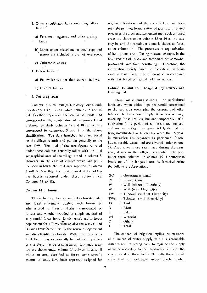
3. Other uncultivated lands excluding fallow
lands :'
a) Permanent pl!stures and other grazing
lands,
b) Lands under miscellaneous tree-crops and
groves not included in the net area sown,
c) Culturable wastes
4. Fallow lands :
a) Fallow lands-other than current fallows,
b) Current fallows
5. Net are,! sown
Column 14 of the Village Directory corresponds
to category 1 i.e. forest, while columns IS and 16
put together represent the cultivated lands and
correspond to the combination of categories 4 and
5 above. Similarly, columns 17 and IS respectively
correspond to categories 3 and 2 of the above
classification. The data furnished here arc based
on the village records and pertain generally to the
year 1989. The total of the area figures reported
under these columns generally tallies with the total
geographical area of 'the village noted in column 3.
However, in the case of villages which arc partly
included in towns the total area reported in column
3 will be less than the total arrived at by adding
the figures reported under these columns (i.e.
Columns 14 to 18).
Column 14: Forest
This includes all lands classified as forests under
any legal enactment dealing with forests or
administered as forests whether State-owned or
private and whether wooded or simply maintained
as potential forest land. Lands transferred to forest _ ..
department for afforestatio.n as also the class C and
o lands transferred thus by the revenue department
are also classified as forests. Within the forest area
itself there may occasionally be cultivated patches
or else there may be grazing lantls. But such areas
too are shown under column 14 only as forests. If
within an area classified as forest some specific
extents of lands havc been expressly assigned for
7
regular cultivation and the records have not been
set right pending f()rmali~ati()n of grants and related
processes of survcy and settlement then such cropped
areas are shown undef column 15 Of 16 as the case
may be and the remaindcr alone is shown as forest
under column 14. The processes of regularisation
of land grants anti effecting relevant changes in the
basic records of survcy and settlement are somewhat
protracted anti time consuming. Therefore, the
information· merely based on records is, in some
cases at least, likely to be different when compared.
with that based on actual field inspection. "
Column 15 and 16 : Irrigated (by source) and Un-irrigated
These two columns cover all the agricultural
I,ands and when added together would correspond
to the net area sown plus the current and othc
fallows, Thc lalter would imply all lands which we{
taken up for cultivation, but arc tcmporarily out 0
culrivation for a period of not less than one yea
and not more than five years. All lands that ar,
lying uncultivated as fallows for more than 5 year
in succession arc regarded as permanent fallow
i.e., eulturable waste, and are covered under columl
17. Area sown more than once during the sam
year, if any in the village, is counted only ono
under these columns. In column 15, a sourcewise
brt:ak up of the irrigated area is furnished using
the following abbreviations :
C;C
PC W
We TW
TWe
Tk
R
L
Wf o T
Government Canal
Private Canal
Well (without Electricity)
Well (with Electricity) Tubewell (without Electricity)
Tubewell (with Electricity) Tank
River
Lake
Waterfall Others
Total
The concept of irrigation implies thc existcnce
of a source of water supply within a reasonable
distance and an arrangement to regulate the supply
of watn according to the day-to-tlay needs of the
erops raised in these fields. Naturally therefore all
areas that arc cultivated under purely rainfed

conditiQns are treated as unirrigated. Though p:Jddy
is generally regarded as a wet crop, if it is raised
purely as a rainfed crop, as it very often is the
case in heavy to very heavy rainfall regions, such
areas are regarded as unirrigated for purposes of
this column and shown under column 16. Similarly,
about garden crops, the area is considered for
column 15 only if there is an cleihent of irrigation.
Sometimes it happens that the lands shown as dry
and rainfed in the settlement records are in actual
fact having irrigation facilities due to recent changes
such as sinking of wells, introduction of lift irrigation
or canal irrigation 'or commissioning of a project
etc .. In such a case the actual situation is taken
note of and despite its classification as rainfCd in
the records, the area concerned is treated as irrigated.
Though rare, the opposite situation (where a plot
of land originally shown as irrigated has ceased to
enjoy that facility and is now yielding purely rainfed
crops) is also met with and such a situation arises
due to reasons such as breaching of tanks, drying
up of irrigation wells and small tanks, defunct canal
system and so on. The reporting agency has generally
assessed the actual situation prevailing during the
reference year i.e., 1989, while furnishing the data
on irrigated lands. Regarding canal irrigation too
it is the actual irrigated area and not the command
area that has been reported here,
In column 16 the total extent of unirrigated
lands, that is, dry lands cultivated as rainfed fields
and the current fallow lands put together is reported.
As explained above, lands yielding rain led paddy
crop are considered as unirrigated.
Column 17 : Culturable Waste (including gauchar and groves)
This category includes all lands available for
cultivation whether not taken up for cultivation at
all or taken up for cultivation once but not cultivatcd
during the past five years or more in succession.
Sueh lands may be· either fallow or covered with
shrubs and jungles which are not put to any usc.
These may be assessed or unassessed and may be
in isolated blocks or within cultivated holdings.
Lands under thatching grass, bamboo bushes and
other groves which are not included under orchards
or forests arc also included under this category.
Further, this includes all grazing lands irrespective
of whether these arc permanent pastures and
meadows or not. In several instances, hi.nds that
were at one time reserved for use as gra-;ing fields
and pastures and declared as assessed or unassessed
wastes have, over a period of time, been brought
under cultivation either fully or in parts as a result
of gradual encroachments and also because of the
policy decisions of the Government regarding land
grants. THUS, though the particular plot of land
continues to be shown as a . pasture in the village
records the actual field situation would, reveal that
most of that land is actually under cultivation. In
all such cases, to the extent possible, the actual
field situation has been taken into consideration by
the reporting agency.
Column 18 : Area not available for cultivation
In this column, the total extent of land which
IS not available for cultivation in view of its being
barren and unculturahle as also that which is put
to non-agricultural uses IS reported. Mountains,
deserts, rocky hills, quarrics, ravines and the like
as well as the lands that c,mnot be brought under
cultivation except at a very high cost are included
in the category of barren and uncultiVaote lands.
The category of lands put to non-agricultural uses
covers all lands occupied by buildings, roads, railways,
parks and play grounds, area under watcr viz., rivers,
streams, canals, reservoirs, tanks, ponds 'el:c, and
land put to any other use which is apparently non-agricultural.
There arc four appendices to the Village
Directory. Appendix-l is based on the Village
Directory itself and presents abstract figures for the
CD.Blocks and the district in respect of various
amenities for which information is presented in the
Village Directory. At the end of the Village Directory
of each CD.Block, against "Total (Sum)", the total
number of various types llf educational and medical
institutions represented by various abbreviations
under columns 5 and (j respectively arc given. In
Appendix-f, besides incorporating this information,
the total number of villages in which these institutions
arc situated is also given for comparison. Further,
in respect of amenities viz., drinking water supply,

post and telegraph, communication and power suppl)
!or which the types of amenities available are
indicate4 by abbreviations under columns 7, 8, 10
and 13 respectively for each village but' totals are
not presented for the C.D.Block as a whole in the
Village Direttory, the total number of villages in the C.D.Block and, in the district as weU, having
the above mentioned amenities is also presented
under separate captions in Appendix-I.
Appendix-II presents the land utilisation data
in respect of non-municipal census towns. The
different types of land use for which information is
presented here is same as that in the Village
Directory. Owing to constraints in the compilation
of land use data, information in respect of towns
comprising portion/s of one or more villages could
not be procured and compiled. Thus information in
respect of non-municipal census towns (NMCTs)
which comprise of a whole revenue village only is
presented in this appendix wherever applicable.
9
Appendix-III gives the list of villages
which are lacking in all amenities covered
in the V~lage Directory except the drinking
water.'
Appendices-IV(A) and IV(B) are compiled from
the Primary Census Abstract. The proportion of
Scheduled Castes population to the total population
of the village, as per 1991 census, has been worked
out for each village in a C.D .Block and a list of
villages grouped into 6 ranges of percentage points
is given in Appendix-IV(A). Appendix-IV(B) is
similar to Appendix-IV(A) but deals with
the proportion of Scheduled Tribes to
the total population of the village concerned." '. However ID view of the vast difference in the
relative strengths of these two communities as
well as the pattern of distribution, the percentage
points included in the 6 ranges adopted for the
Scheduled Castes and the Scheduled Tribes are
slightly different.


ANKOLA C.D.BLOCK

':)
t:I ., )
~ .>
.::l ~ ~ ~
~ ...
~ Ii; .,.
~ 5 -4 ........ , 0 \ :c(
~ c(
N
j ~ ~ :)-\ ..J e ~ .. // . ~ c: => J \. 4(
Z l- N
< 5 f ~ ...J r---
'.f
( .. iC '0;-"f;_ .... '. 10... ) ---'---
0
L A K
, .. .,'-' • "'1, ': : ... ' : : 11111:' • II ... . ~Iii::® :~: ;; II l:i: • 1"'1 '" III 'I 1% • I I
11':u; I I L.I:_: 0 lJ
T
A...
=> II
E :. , I 1i • I
II ~~
li ~
I! 0'14 ~
'" " 5 ell
I -.. t -i-g-u
! o
I 1 8
.Ii Ii .. ~i I t oI-l! t'li l:: 15 -;; 'Ii;; c CI .2 0 --• II . ! .1 Il: 1--oj LS" i l!:§ f !!! J! ;i " l! .. c -.c: - 'li-D E '" I!! 0 I!':: !5 1'0 III l! ~ i ~; " """ ~E
11 -. • ! • .B .... i

· ALPHABETICAL LIST OF VILLAGES
TALUK: ANKOLA-OOIO C.D.BLOCK:ANKOLA-OOIO.
SL NAME OF THE VILLAGE 1991 CENSUS 1981 CENSUS ,
NO LOCATION COOE LOCATION COOE LOCATION COOE LOCATION COOE
(Manual) (C~ter" (Manual) ~Computer)
2 3 4 5 6
\.1 Achave 11120/1/38 11/20/0010/0038 9/19/1/38 09/19/00101.0038 2 Adigone 11/20/1/62 11/20/0010/0062 9/19/1/62 09/19/0010/0062 3 Adlur 11/20/1/18 11/20/0010/~018 9/19/1118 09/19/0010/0018 4 ,Agragone 11/20/1/60 11/20/0010/0060 9/19/1/60 09/19/0010/0060
5 I'gsur 11/20/1/17 11/20/0010/0017 9/19/1/17 09/19/0010/0017 6 Algeri 11/20/1/85 11/20/0010/0085 9/19/1/85 09/19/0010/0085 7 Anetle 11/20/1/46 11/20/0010/0046 9/19/1/46 09/19/0010/0046 8 Aversa 11/20/1168 11/20/0010/0068 9/19/1/68 09/19/0010/0068
9 Balale 11/20/1/22 11/20/0010/0022 9/19/1/22 09/19/0010/0022 10 BaleguLi 1;/20/1/83 11/20/0010/0083 9/19/1/83 09/19/0010/0083 11 Belambar 11/20/1/48 11/20/0010/0048 9/19/1/48 09/19/0010/0048 12 Belelceri 11/20/1167 11/20/0010/0067 9/19/1167 09/19/0010/0067 13 Belse 11/20/1/29 11/20/0010/0029 9/19/1/29 • , 09/19/0010/0029 14 Berde 11/20/1/81 11/20/0010/0081 9/19/1181 09/19/0010/0081 15 Bhasgod 11/20/1/47 11/20/0010/0047 9/19/1/47 09/19/0010/0047 16 Bhavikeri 11120/1/86 11120/0010/0086 9/19/1/86 09/19/0010/00'86 17 Bi lehoingi 11/20/1159 11120/0010/0059 9/19/1159 09/19/0010/0059 18 Bobruwada 11/20/1/50 11/20/0010/0050 9/19/1/50 09/19/0010/0050 19 BogribaiL 11/20/1/82 11/20/0010/0082 9/19/1/82 09/19/0010/0082 20 Bole. 11/20/1/19 11120/0010/0019 9/19/1/19 09/19/0010/0019 21 BrahllUr 11120/1/39 11/20/0010/0039 9/19/1/39 09/19/0010/0039-
22 Devigadde 11/20/1/24 11/20/0010/0024 9/19/1/24 09/19/0010/0024 23 Dongri 11/20/1/14 11/20/oo10/oo1{. 9/19/1114 09/19/0010/0014
24 Gule "/20/l/n ll/20/00l0/il072 9/19/1/n 091 19/001 %on 25 Goodabala 11/20/1/34 11/20/0010/0034 9/19/1/34 09/19/0010/0034
26 Hadav 11/2011/58 11120/0010/0058 9/19/1/58 09/19/0010/0058 27 Halvalli 11/20/1/15 11120/0010/0015 9/19/1/15 09/1910010/0015 28 Harwade 11/20/1/69 11120/0010/0069 9/19/1169 09/19/0010/0069 29 Hattikeri 11/20/1/80 11/20/0010/0080 9119/1180 09/19/0010/0080 30 Hebbul 11/20/117 11/20/0010/0007 9/19/1/7 09/19/001010007 31 Heggar 11/20/1/12 11/20/0010/0012 9/19/1112 09/19/0010/0012 32 Heggarmakkigadde 11/20/114 11/2010010/0004 9/19/114 09/19/0010/0004 33 Heggarnikotebavi 11/20/1178 11/2010010/0078 9/19/1178 09/19/0010/0078 34 Hegre 11/20/1161 11/20/0010/0061 9/19/1/61 09/19/0010/0061 35 Hichkad 11/20/1/57 11/20/0010/0057 9/19/1/57 09/1910010/0057 36 ItHlur t 1{20/1I35 tl/2a/OO10/0035 9/1911135 09{19/OO10/0035 37 HomebaiL 11/20/1164 11/20/0010/0064 9/1911/64 09119/0010/0064 38 Hosgadde "/20/'/1 11/20/0010/0001 911911/1 09/1910010/0001
39 Joog 11/20/1/25 11/20/0010/0025 9/19/1/25 09/19/0010/0025
13

ALPHABETICAL LIST OF VILLAGES
T ALUK: ANKOLA-OOIO C.D.BLOCK:ANKOLA~lO
SL NAME OF THE VILLAGE 1991 CENSUS 1981 CENSUS
NO
LOCATION CODE LOCATION CODE LOCATION CODE LOCATION CODE
(Manual) (C~ter) (Manual) (C~ter)
2 3 4 5 6
40 lCabgal 11/20/1/40 11/20/0010/0040 9/19/1/40 09/19/0010/0040 41 lCalleshwar 11/20/1/13 11/20/0010/0013 9/19/1/13 09/19/0010/0013 42 lCamge 11/20/1/26 11/20/0010/0026 9/19/1/26 09/19/0010/0026 43 lCanmani 11/20/1/16 11/20/0010/0016 9/19/1/16 09/19/0010/0016 44 lCanagi l 11/20/1/56 11/20/0010/0056 9/19/1/5~ 09/19/0010/0056 45 lCanchinnale 11120/1/3 11/20/0010/0003 9/19/1/3 09/19/0010/0003 46 lCarebail 11/20/1/43 11/20/0010/0043 9/19/1/43 09/19/0010/0043 47 lCattinhakkal 11/20/1/8 11/20/0010/0008 9/19/118 09/19/0010/0008 48 lCavalalli 11/20/1/6 f 1120/0010/0006 9/19/1/6 09/19/0010/0006 49 Kenkanishivapur 11/20/1/41 11/20/0010/0041 9/19/1/41 09/19/0010/0041 50 lCodlagadde 11/20/1/10 11/20/0010/0010 9/19/1/10 09/19/0010/0010 51 lCodsani 11/20/1/31 11120/0010/0031 ·9/19/1/31 09/19/0010/0031 52 lCogre 11/20/1/55 11/20/0010/0055 9/19/1/55 09/19/0010/0055 53 lCondige 11/20/1/74 11/20/0010/0074 9/19/1/74 09/19/0010/0074 54 Kuntgani 11/20/1/36 11120/0010/0036 9/19/1/36 09/19/0010/0036
55 Lakkegul i 11/20/1/73 11/20/0010/0073 9/19/1/73 09/19/0010/0073 56 Laxmeshwar 11/20/1/21 11/20/0010/0021 9/19/1/21 09/19/0010/0021
57 Mallani 11/20/1/76 11/20/0010/0076 9/19/1176 09/19/0010/0076 58 Manigaclcle 11/20/1/37 11/20/0010/0037 9/19./1/37 09/19/0010/0037' 59 Manjaguni 11/20/1/63 11/20/0010/0063 9/19/1/63 09/1910010/0063 60 Marugadde 11/20/115 11/20/0010/0005 9/19/1/5 • 09/19/0010/dIfs 61 Mogte 11/20/1145 11/20/0010/0045 9/19/1/45 09/19/0010/0045 62 Morall i 11/20/1/44 11120/0010/0044 9/19/1/44 09/19/0010/0044
63 Naclibag 11/20/1/49 11/20/0010/0049 9/19/1/49 09/19/0010/0049 64 Navagadde 11/20/1/2 11/20/0010/0002 9/19/1/2 09/19/0010/0002 65 Nellurkanchinbail 11/20/1/79 11/20/0010/0079 9/19/1/79 09/19/0010/0079
66 Poojgeri 11/20/1/52 11/20/0010/0052 9/19/1/52 09/19/0010/0052
67 Sagaclgeri 11/20/1/27 11/20/0010/0027 9/19/1/27 09/19/0010/0027 68 Sakalben 11/20/1/70 11/20/0010/0070 9/19/1/70 09/19/001010070 69 Shetgeri 11/20/1/54 11/20/0010/0054 9/19/1/54 09/19/0010/0054 70 Shevakar 11/20/1/11 11/20/0010/0011 9/19/1/11 09/19/0010/0011 71. Shevegul i 11/20/1In 11/20/0010/00n 9/19/1!77 09/19/0010/00n 72 Shikl i turL i 11/20/1/75 11/20/0010/0075 9/19/1!75 09/19/0010/0075 73 Shingannakki 11/20/1/65 11/20/0010/0065 9/1911/65 09/19/0010/0065 74 Shi rgunj i 11/20/1/33 11/20/0010/0033 9/19/1/33 09/19J0010/0033 75 Shirkuli 11/20/1/84 11/20/0010/0084 9/19/1/84 09/19/0010/0084 76 Shirur 11/20/1/28 11/2010010/0028 9/19/1/28 09/19/0010/0028 n SU'llcsal 11/20/1/9 11/20/0010/0009 9/19/1/9 09/19/0010/0009 78 Surve 11/20/1/53 11120/0010/0053 9/19/1/53 09/19/0010/0053
14

ALPHABETICAL LIST OF VILLAGES
TALUK: ANKOLA-OOIO
SL NAME OF THE VILLAGE NO
79 Takatger; 80 Talg&dde 81 Tenkankeri
82 Ulware
83 Vandige 84 Varilben 85 Vasarkudrige
86 Wadibogri
2
1991 CENSUS
lOCATlOH CODE LOCATION CODE (Manual) (C~ter)
3 4
11/2011/42 11120/9010/0042 11/20/1/30, 1112010010/0030 11/20/1/51 11/20/0010/0051
11/2011/23 11/2010010/0023
11/20/1/20 11/20/0010/0020 11/20/1/71 11/20/0010/0071 11/20/1/32 11120/001010032
11/20/1166 11/20/0010/0066
15
C. D. BLOCK: ANKOLA-OOlO
1981 CENSUS
LOCATION CODE LOCATIPN CODE (Manual) (C~ter)
5 6
9/19/1/42 09/19/0010/0042 9/19/1/30 09/19/001010030 9119/1/51 09/19/0010/0051
9/19/1/23 09/19/0010/0023
9/19/1/20 09/19/0010/0020 9/19/1/71 09/19/0010/0071 9/19/1/32 09/19/0010/0032
9/19/1/66 09/19/0010/0066

VILLAGE
AMENITIES Name of C.D.Block : ANKOLA; Code No. :0010
L.C. Name of Village Total area of Total Amenities available (if not available within the village, a dash (-) is shown in the
No. th" village Popu- column and next to it in bracl::ets, the distance in broad ranges viz. -S I::ms, S-IO kms, (In hectares) lalion and 10+ kms orlh.: neareo;! I!lace where the facililJ:: is available is glv"n!.
and Educa- Medical Drinking Post Day or Communication No.of tional Water and Days of [Bus Stop, HOIlSll- Tele- marketl Railway Station, holds graph hal ifany Waterway)
(1) m (3) (4) (5) (6) (7) (8) (9) PO)
HOsGADDE 216.61 601 P(2) -(0-5) W, HP -(0-5) -(0-5) BS
(131)
2 NAVAGADDE 1014.05 54 -(0-5) -(0-5) W -(0-5) -(5-10) -(0-5)
(10)
3 KANCHI NMALE 1473.00 -----------------.---.-- UN - INHABITED -------------------------
4 HEGGARMAKKlGADDE 1431.03 301 P -(5-10) II -(10+) -(10+) -(5-10)
(43)
5 MARUGADDE 167-1.32 129 P -(5-10) W -(5-10) - (10+) -(5-10)
(18)
6 KAVALALLJ 4178.94 246 P -(5-10) W, HP -(5-10) -(10+) BS
(49)
7 HEBBUL 1627.15 486 P -(10+) W, HP -(0-5) -(10+) BS
(85)
8 KATTINHAKKAL 2294.73 315 P(2) -(10+) W, HP -(0-5) -(10+) BS
(60)
9 SUNKSAL 2824.57 849 P(3), M -(5-10) II, HP PO -(10+) '8S (175)
10 KODLAGADDE 2565.71 848 P(3), M PHC, FPC W, HP PO -(10+) BS (179)
11 SHEVAKAR 2003.48 351 P(2) -(5-10) II -(O-~) -(10+) -(0-5) (57)
12 HEGGAR 1653.41 373 P -(0-5) W -(0-5) ·(10+) P-5)
(58)
13 KALLESHWAR 1309.60 211 P ;(5-10) \I PO -(10+) -(0-5) (36)
14 DONGRI 3253.61 606 p(2) -(5-10) \I, HP PO -(10+) BS (114)
16
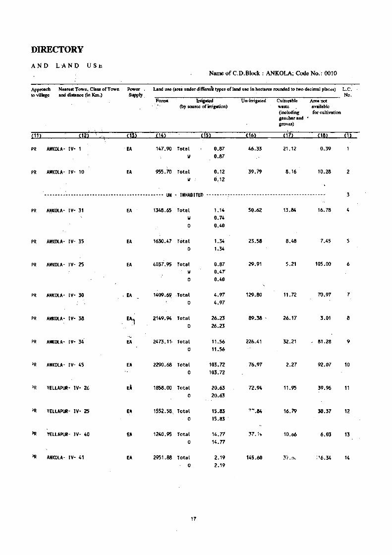
DIRECTORY
AND LAND US~
Name ofC.D.Block : ANKOLA; Code No~: 0010
Approach Nearest Town, Class of Town Power Land use (arel under ditTerenc types of land use in hectares rounded to two decimal plae.:s) L.C. to village and distance (in KIn.) Supply. No.
Forest In:i,aled Un-irrigated Culturable Area not (by source of irrigation) waste available
(including for cultivation gauchar and • groves)
<1'> cis) ,
(11) (12) ,'l (14) (16) (17) (18) (1) , PR ANKOlA· IY· 1 EA 147.90 Total 0.87 46.33 21.12 0.39
II 0.87
, PR ANKOLA· IY· 10 EA 955.10 Total 0.12 39.79 8.16 10.28 2
II O~ 12
......•..••......•......• -- ... ---- .. --------- UN . INHABITED -- ..•. --~-- .. ---------- •• --.-.-.- .. --- ..... -• 3
PR A~KOt.A- IY- 31 EA . 1348.65 Total 1.14 511.62 13.84 16.78 4 II 0.74 0 0.40
PR ANKOLA~ IY- 35 EA 1630.47 Total 1.34 23.58 8.48 7.45 5 0 1.34
PR ANKOLA- IY- 25 EA 4037.95 Total 0.87 29.91 5.21 105.00 6 II 0.47 0 0.40
PR ANKOLA- IY- 30 . EA 1409.69 . Total 4.97 129.80 11.72 70.97 7 0 4.97
PR ANICOLA- IV- 38 E~ 2149.94 Total 26.23 89.38 ' 26.17 3.01 8
0 26.23
." PR ANKOLA- IV- 34 EA 2473.11- Total 11.56 226.41 32.21 81.28 9
0 11.56
PR ANKOLA- IY- 45 EA 2290.68 Total 103.72 76.97 2.27 92.07 10 0 103.72
PR YELlAPUR' IY- 2l EA 1858.00 Total 20.63 72.94 11.95 39.96. 11 0 20.63
PR YELlAPUR· IY- 2S EA 1552.58 .. Total 15.83 7-.84 16.79 30.37 12 0 15.83 .
PR YEllAPUR· IV· 40 EA 1240.95 Total 14.n 37.1." 10.06 6.03 13 0 14.n
)R ANKOlA· IV· 41 EA 2951.88 Total 2.19 145.60 3i .:>, :'6.34 14 0 2.19
17

VILLAGE
AMENITIES Name of C.D.Block : ANKOLA; Code No. :0010
L.C. Name of Village N·~.
~1) (2)
15 HALVALLI
i6 KAMMAN I
17 AGSUR.
18 ADLUR
19 SOLE
20 VANDIGE
21 L~.)(MESHIIAR
22 BALr.LE
23 ULWARE
24 DEVIGADDE
Total area of the village (In~larel)
:$328.05
1485.71
1454.13 ,
Total Population: and No.of Households
(4)
AmenitiCiavai~ (if~ aVaillto wilbin the village. a dash (-) is shown in the eolumn and nc~ to it in brackCta. the distanee in broad nages viz.·-5 kms, 5-10 krnt •.
aod 10+ kma of the !le!re" place where the facility is ayailable is given). ' Eduea- Medical Drinking Pml Day or Communication
tional Water and Days of [Bu. Stop. Tele- market! Railway SlatWn. graph hat if any WatelWay)
(6) (7) (8) (9) (10)'
840 P, H -(5-10) II -(10+) BS (167)
126 P -(10+) II, HP - (0-5) -(10+) -(0-5)
(28)
1972 P(4), H, It RP T, W, liP PTO, -(10+) BS (374) Phone
1219.15 . 641 P, M . -(0-5) W, HP ~(0-5) -(10+) BS (120)
614.87 1082 P -CO-5) II, HP -(0-5) -(0-5>, BS (194)
I 189.68 2024 P, H, H -(0-5) T, II, HP PTO, .;"~ -f:5) -tS
(410) Phone
52.88 928 -(0-5) -(0-5) II. HP - (0-5) ,~ . -(0-5) -(0-5)
(178)
216.58 844 P(2) -(5-10) II, HP - (0-5) -(5-10) BS (172)
379.21 1002 P(3), M -(0-5) II, HP PO -(5-10) BS (174)
226.23 376 P -(0-5) II '(0~5) -(5-10) - (0-5) (57)
18
...

DIREC/TORY , "
AND LAND USE Name ofC.D:Block: ANKOLA; COde No.: 0010
Approach Neamt Town, Claa of Town Power Land UK (area under different type. of land 'UK in hectares rounded to two decimal places) L.C. 'to village and dialaDce (In Km.) Supply No.
FONIl Irrigated On-irrigated Cultunble Area not (by aource of irrigation) walle available
(including for cultivation gauchar and groves)
~11 l-, ,
' Ui! ~1~l ~14l ,t~l ~1~l ,'7! ~18l ~1l , \
PR YEl.LAfIUR- IY~, 40 EA 2942.04 Total ~3.25 176.58 46.74 109.44 15 W 0.10
,We 0.71 0 52.44
PR i YELLAPUR- IY- 48 EA 1448.12 Total 3.00 21.59 11.75 1.25 16 0 3.00
PR ANICOLA- IY- 15 EA 1024.89 Total 4.29 283.44 16.01 125.50 17 W 0.90
we 1.37 0 2;02
PR ANICOLA' IV- 13 EA 963.18 Total 2.75 148.82 15.52 88.88 18 W 1.52
lie 0.42 0 0.81
PR ANICOLA- IY- 1 EA 346.02 Total 2.69 169.59 67.79 28.78 19 W 1.78
We 0.51 0 0.40
PR ANICOLA- IY- 2 EA Total 3.83 131.40 20.78 33.67 20 W 3.53
lie 0.30
PR ANICOLA- IY- 2 EA Total 8.64 38.24 1.57 4.43 . 21 W 7.39
lie 1,.25
PR ANICOLA- IY- 15 EA 93.78 Total 3.82 68.61 25.07 25.30 22 W 3.36
lie 0.46
PR ANICOLA- IV- 10 EA 231.24 Total 18.29 65.12 32.68 31.88 23 II 17.60
We 0.18 0 0.51
KR ANQ)LA- IY- 19 EA 127.84 Total 1.46 56.54 36.53 3.86 24 II 1.34
We 0.12
19

VILLAGE
AMENITIES Name of C.D.Block : ANKOLA; Code No. :0010
L.C. Name of Village Total area of No. the villa,c
(In hectares)
(1) (2) (3)
25 . JOOO 214.42
26 KAMGE 189.13
27 SAGADGERI 270.67
28 5111RUR 894.72
29 BElSE 1394.43
30 TAlGAOO£ 1252.87
31 KOOSANI 550.17
32 VASAlKUDAlGE 1113.66
33 SHIRGUNJI nl.67
3040.95
35 H1LlUR 3388.78
Total Amenities available (if not lIVailable within the village, a daM (-) is shown in the Popu- column and next 10 it in brackets, the distance in broad ranges viz. -5 kms, ;-10 kms, 181ion and 10+ kms 2ftbe nearest I!!!£t where the facili~ is av!!i~ble is given}. .' .
Educa- Medical Drinking Post Da~ or Communication and , No.of lional House-holds
(4) (5)
568 P (88)
243 P (42)
405 P, It (68)
1451 P, H (270)
2636 P(6), M, II (504)
139 P, M
(125)
557 P, M
(99)
950 (179)
~5
(133)
P(3), '"
P(Z), M
826 P(Z), M
(152)
Water
(6) m -(0-5) 'II, liP
-CO·S) 'II, lIP
- (0--5) 'II, liP
lip, SMP T, 'II, HP
PHe, FPC T, II, HP
-(0-5) 'II, HP
-(0-5) II, HP
-(5-10) II, HP
-(0'5) 'II, HP
liP, SMP T, II, liP
2126 P(7), H, H PHe, FPC· T, II, liP
(431)
20
and Days of Telc- markctl graph hal ifany
(8) (9)
-(O-5) '(5-10)
-(0-5) ·(0-5) , .
PO -(5-10)
PO -(5-10)
PTO, -(5"10) Phone
-(0-5) -(5-10)
-(0-5) -(10+)
-(0-5) '(10+)
-(0-5) -(10+)
PO
PO, Phone
- (10+)
- (10+)
[Bus Slop, Railway Stalion, Waterway)
(10)
-(5-10)
• (5-10)
-(0-5 )
BS
BS
-(0-5)
BS
BS
BS
. 8S
BS

DIRECTORY
ANI? LAND USE Name ot C.V.Hlock : ANlIo.ULA; LOGe NO.: WLU
Approach Nearelll Town, Class o(Town Power. Land use (area under different types of land use in hectares rounded 10 two decimil places) L.C. to village and distance (in Knt.) Supply No.
Forest IrriB~led Un-irrisaled Culturable Area not (by source of irrigation) waSIC aviilable
(indudin; for cultivation gaucharand groves)
i"l \"~2 "}2 "!tl ~'51 ,,61 nn ,'81 "2 , \
KR ANKOlA.- IV- 14 EA 33_04 Total , 14.88 53.43 22.83 90.24 25
W 14.88
KR ANKOLA- IV- 14 EA , 121.19 Total 1.10 34.02 29.26 3.56 26
II 1.10
KR ANKOLA- IV- 9 EA 65.00 Total 17.38 36.15 9.94 142.20 27
W. 17.28 We 0.10
PR AHKOLA- IV- 9 fA 179.96 Total 14.45 129.24 13.31 557.76 28
'II 14_45
PR ANKOlA- IV- 6 EA 880_76 Total 7_07 301.09 156.97 48.54 29
W 5_15
We 0.10 0 1.82
PR AHKOLA- IV- 5 EA 1082.86 Total 15.56 110.41 36.98 7.06 30
W 14.16 We 0.18
0 1.22
PR AHKOlA- IV- 12 EA 420.74 Total 2.71 97.41 25.18 4.13 31
W 1.50 0 1.21
KR ANKOlA- IV- 15 fA 845.45 Total 4.SC; 200.66 19.03 43.93 32
II 2.89 We 0.49
0 1.21
ICR ANKOLA- IV- 18 EA 547.43 Total 4.13 130.58 62.53 27.00 33
W 1.610 We 0.47
0 2.02
PR ANKOLA- IV- 24 EA 2757.89 Total 6.6; 180.88 62.73 32.7.8 34
W 4.95 We 0.32 0 1.40
PR ANKOlA- IV- 32 EA 2476.35 Total 33.25 512.26 210.26 156.66 35 w 6.71
We 1.42 0 25.12
21

VILLAGE ,
AMENITIES Name of C.D.Block : ANKOLA; Code No. :0010
L.C. No.
Name of Village
(2)
36 KUNTGANI
37 MANIGADDE
38 ACHAYE
39 BRAHHUR
40 ICABGAL
41 ICENICANISHI YAPUR
42 TAICATGERI
43 KAREBAIL
44 MORALLI
45 MOGTA
46 ANGLE
Total area of the village (In hectares)
2356.82
1371.49
4616.n
2549.06
988.75
906.75
188.95
235.27
705.87
373.69
260.50
Total I'opulation and
No.of }fouseholds
(4)
824 <141>
89 (13)
Amenilills IVlIilable (if IlO( availablll willlin Ille village. a da"" (-) i. shown in the column and next 10 it in brackels, the dialanee in broad range. viz. -5 kms. 5-10 knis,
and 10+ kma of the neare. place wheN the facility ia !l\l!jlabW is given)' Educa- Medical Drinking Po.a . Day or Commullication
tional Water and Da13 of (Bul Stop. T Ille- market! Railway Station. graph hill if any Waterway I
(6) (8) (9) (10)
P, M -(10+) lol, HP -(0-5) 0(10+) -(0-5)
-(0-5) -(10+) 101 -(0-5) -(10+) -(0-5)
1409 P(2), M -(10+) 101, HP PO -(10+) BS (294)
479 P -(5-10) w - (0-5) "(10+) -(5-10) (87)
120 P -(5-10) W - (5-10) -(10+) -(5-10) (22)
328 P -(5-10) W, HP -(0-5) -(10+) :-(0-5) (55)
33 -(0-5) -(0-5) W -(0-5) -(10+) -(0-5) (7)
217 P -(0-5) W, HP -(0-5)· -(,10+) -(0-5) (46)
420 P -(0-5) 101, HP -(0-5) -( 10+) BS (79)
758 P, M -(0-5) W, HP PO -(10+) BS (148)
253 P -(5-10) W, HP PO -(10+) BS (45)
22

DnmCT~RY
--AN.D LAND USE Name ofC.D.1\IocJc : ANKOLA;· Code No.: 0010
ApproIeh Neal'CJt Town, Cia .. of Town Power Land us.:: (arc.!' under diffi:rcnt t~pea of 1,00 (lac in he~tares rounded to two de~imal pla~ea). L.C. to village and diatance (in Km.) Supply No.
Forest Irrigated Un-irrigated Culturablc Arca 001 (by source of irrigation) wallie available
(including for cUltivation gauchar and grovel)
.U1l "2! {132 "4! " . O~~ "~l {17l . ,'8l {1l
PR ANKOlA- 111- 52 EA 2129.,32 Total 21.95 135.29 37.54 32.n 36
W 0.1~
lie 0.70 0 21.15
kR ANKOLA- IV- 55 EA 1350.56 Total 2.33 14.78 3.20 0.62 37 0 2.33
PR "NICOLA- IV- 50 EA 3921.84 Total 69.54 273.72 285.48 66.19 38 W 0.10
We 0.30 0 69.14
KR ANICOLA' I V- 42 EA 2288.21 Total 14.41 63.64 139.71 43.(19 39 0 14.41
Kit ANKOlA- IV~ 42 EA 903.64 Total 3.52 18.85 39.48 23.26 40 0 3.52
Kit ANICOLA' IV- 24 EA n1.n Total 3.65 103.01 40.95 37.42 41 W 0.67
0 2.98
ICR "NICOlA- IV- 20 EA 128.53 Total 2.23 40.74 14.98 2.47 42 W 1.42 0 0.81
PR "NICOLA- IV- 25 EA 136;58 Total 6.·15 31.53 18.41 42.60 43 w 0.10 0 6.05
PR ANKOlA- IV- 26 EA 522.00 Total 6.60 68.14 37.70 71.43 44 W 2.04
We 0.36 0 4.20
PR ANKOlA- w- 26 EA 211.33 Total 6.48 84.64 16.45 54.79 45 w 2.05
We 0.10 0 4.33
PR ANKOlA- IV- 23 EA 118.97 Total 2.08 67.06 20.46 51.93 46 W 0.28
We 0.20 0 1.60
23

VJLLAGE
AME'NITIES Name of C.D.Block : ANKOLA; Code No. :0010
L.C. Name of Village TOIeI area of TOIeI Amenities available (if no! available within the village. a dash (-) is chown in thll No. the village Pcpu- column and nexl 10 it in brackets. t~ distance in broad range. viz. -5 kms. 5-10 kms,
(Jn~tares) lation and 10+ kms of the ncarest e1ace where the racilitx is available is !dven). and Educa- Medical Drinking Post Day or Communication No.of lional Water and DaYlor IBusSlop. House- Tele- market! Railway Station, h()lds graph hat ifany Waterway]
(1) (2) (3) (4) (5) (6) (7) (8) (9) (102 -
47 BHASGOD 49.24 294 P, M - (0-5) II, HP Phone - (0-5) BS
(78)
48 BElAMBAR 306.98 4212 P, M - (0-5) II, liP PO, -(5-10) BS (08) Phone
49 NAD I BAG 45.06 459 P - (0-5) II, HP - (0-5) -(0-5), -(0-5) (79)
50 BOBRUWADA 269.54 5016 P(3), M(2) -(0-5) T, W, liP- PTO, -(0-5~ - (0-5)
(854) Phone
51 TENKANKERI 120.07 1420 P, M -(0-5) II, HP PO -(0-5) - (0-5) (245)
52 POOJGERI 80.90 478 P - (0-5) 'II, HP • (0-5) -(O-Sf BS (89)
53 SURVE 170.12 319 p -(0-5) II, HP - (0-5) -(0-5) as (74)
54 SHETGERI 440.14 968 P, M, H - (0-5) II, NP PTO, -(0-5 ) as (219) Phone
55 ICOORE 44.33 311 P, M -(0-5) II, HP - (0-5) -(0-5) IS (63)
56 ONAGIL 128.01 605 -(0-5) -(0-5) W, HP • (0-5) - (0-5) 8S (132)
57 HleHlCAD 231.07 992 P(3), .. - (0-5) W, liP PO -(0-5) as (220)
24

DIRECTORY
AND. LAND USE Name of C.D.Block : ANKOLA; Code No.: 0010
Approach Nearest Town, Cia .. of Town Power Land use (are. under different types of land use in heelares roulllfed to two decimal places) I..C. lovin.,e and diane. (in Km.) Supply No.
Forest Irri,ated Un-irrigated Cvltunblo Ares nee (by soutee of irrigation) ... ute available
(including (or ~lIltivation
" gauchar.,ad , ,ronl)
• "l~i .
"'! ',~! ,,41 ,'5! ',~! ,-17! - ,'8l il! , - \
PR ANKOlA- IV" 2 EA Total 1.93 37.27 6.92 3.12 47
" 1.38 0 0.55
PR ANKOlA- IY- 5 EA 75.98 ToUI 1.43 210.55 6.78 12.24 48 II 1.13
We 0.3(1
PR ' ANKOLA- IY- 2 EA Total 3.74 26.12 15.20 49 -
" 3.66 We 0.08
PR ANKOlA- IV- 1 EA Total 39.82 172.44 57.28 50 II 38.40
We 1.42
KR ANK()LA- IY- 3 EA lotal 14.18, 91.25 11.23 3.41 51 II . 12.84
lie 1.34
PR ANKOlA- l.y- 1 EA Total 0.19 58.87 4.98' 16.86 52 II 0'.19
PR ANICOLA- IY- 2 EA 42.09 Total 2.41 92.20 24,13 9,29 53 II 1.96
'We 0.45
PR ANKOlA- IY- 2 EA 147.45 Total 3.77 212.40 62.61 13.91 54
" 2.54 lie 1.03
0 0.20
PR ANKOLA- IY- 2 EA 10.55 Total 0.31 22.10 4.65 6.72 55
" 0.20 lie 0.11
PR ANKOLA- IY- 5 EA 11.80 Total 3.06 47.58 24.38 41.19 56 lie 2.25
0 0.81
PR ANKOLA- IY- 5 EA 55.71 Total 18.89 77.39 7.50 71.58 57
" 18.28 We 0.61
25

Name ot C.D.Block : ANKOLA; Code No. :0010
Name of Village
.01 __ _
51 BILEIiOINGI
::-G AGRAGONE
61 HEGRE
62 ADIGONE
63 MANJAGUNI
64 HONNEBAIL
65 SHINGANMAKKI
66 IoIA1) I 8JGR I
67 EHEKERI
68 AVERSA
69 HARWADA
Total area of Total the village Popu(In hectares) lation
and No.of Households
(3)
246.98
63.79
275.34
47.70
282.14
297.98
710.60
48.28
23.28
296.11
472.55
612.13
(4)
727 (134)
256 (47)
905 (178)
651 ( 119)
641 (118)
1269 (227)
907 (134)
230 (45)
244 (41)
4169 (738)
4019 (785)
2775 (499)
VILLAGE
AMENITIES
Amenities available (if not available within the village, a dash (-) is shown in the column and next to it in brackets, the distance in broad I1mges'viz. -5 kms, 5-10 Imw,
and 10+ kDls oethe ne.rell place where the facility is available! is given). / Educa- Medical Drinking Post Day or Communication '
tional Water and Days of [Bus Stop. Tele- marketl Railway SlIltion. graph hat ifany Waterway]
(5) (6) ci> (8) (10)
P -(0-5) w, HP PO -(0-5) - (0-5)
P -(0-5) W, HP -(0-5) -(0-5) BS
P(2), H, H -(0-5) W, ',HP PO -(5-10) BS
P, H -(0-5) W, HP -(0-5) -(0-5) BS
P(3), H -(0-5) W, HP PO -(0-5) as
P(2), M -(5-10) W, HP PO -(5-10) as ~- ~
P(3) -(0-5) W, HP -(0-5) -(5"'10) BS
P -(0-5) W, HP -(0-5) -(0-5) as
P, M -(O-S) W, HP -(O-S) -(5-10) BS
P(4), M, H RP T, W, HP' PTO, -(5-10) BS Phone
P(3) , -(0-5) T, W, HP PTO, -(10+) BS
M(2), H, Phone . PUC
P(3), M(2) -(0'5) W, HP PO -(10+) BS
26

DIRECTORY ,
AND LAND USE Name o( C.D.Block : ANKOLA; Code No.: 00 10
Approach Nearest -town, Class of Town Power ,
Land use (area under different types ofland use in hectares rounded to two decimal'pla~~s) L.C. to village and distance {iii Km.} Supply No.
Forest Irrigated Un-irrigated Culturable Area not (by source of irrigation) waste availavle
(including for cuJlivation gauchar and
'. groves)
~112 ~122 ~132 ~ 142 . ~1~1 ~162 ~ 171 ~18~ ~1 )
KR AHKOLA- IV- 5 fA 2l.S2 Total 6.57 124.63 50.33 41. 93 58 II 6.57
PR ANKOLA- IY- 6 EA 9.10 Total 0.34 1.7 .89 1.50 34.96 59 W 0.34
PR ANKOLA- IY- 8 EA 52.27 Total 20,33 71.84 75.71 55.19 60 II 16.26
lie 3:56 0 0.51
PR ANKOLA- IY- 12 EA 4.40 Total 10.12 22.45 10.73 61 II 10.12
PR ANKOLA - I~ 11 fA 78.02 Total 4.52 95.23 67.45 36.92 62 II 3.26
We 0.25 0 1.01
PR "NICOLA- IY- 7 fA 35.68 Total 10.58 28.87 43.32 179.53 63 II 70.38
We 0.20
PR ANKOLA- IY- 6 EA 485.64 Total 2.24 144.48 68.40 9.84 64
W 2.24
PR ANKOLA- IY- 6 EA 10.39 TotaL 1.37 25.94 7.99 2.59 65 II 1.37
PR ANKOLA- IV- 5 EA 7.39 Total 0.47 13.05 1.3~ 1.05 66
\I 0.47
PR ANKOLA- IV- 8 fA 37.84 Total 32.83 147.96 49.40 28.08 67
\I 28.76 We 4.07
PR ANKOLA- IV- 10 EA 28.92 Total 122.95 136.26 . 13.36 171.06 68
II 109.80 We 13.15
PR ANKOLA- IV- 13 fA 285.48 Total 41. fa 236.07 19.78 30.36 69
\I 39.40 We 1.70
27

VILLAGE
AMENITIES Name of C.D.Block : ANKOLA; Code No. :0010
L.C. No.
ill
Name of ViUqc
(2)
70 SAKALBEN
71 VAAILBEN
72 GUlE
·73 lAKKEGULt
74 KONDI~
75 SH I KL IrUltl.I
. 76 MALLAIII .
11 SHeVEGULl
78 I!£GGAlNIK'ottlto\VI
79 II£LLUIlWICltiIMll
SO HArtin.1
81 IIlRO!
82 BoGlUUn
Totalarca of !he vi1llae (In_11m)
e])
1813.85
79S.y,
2458.06
844.95
2014.50
1162.82
2045.99
2640.55
2770.75
1048.64
187.46
1451.08
914.82
Total PopuIalioo and No.of Households
(4)
Amcniliots av.ilable (if not available within !he village, a dam (-) is rbown in !he colulIUI and _Xl 10 il in brackCla, !he distance in broad ra •• viz. -S kmI, S-IO kmI,
ami 10+ lima of !he neMOI!! pig where the faciljly is availeb!e is liven). -Educa- Medical DrinkillJ POll Diy or CommunicaliQn
liQnal Water and DIy. of (Bu. Slop, Tele- markell Railway SlIliQn, graph hal ifany Waterway)
(5) (6) (7) (8) (9) (10)
1353 P,'" H -(0-5) T, ~, HP -(0-5) -(10+) BS (270)
86 - (0-5) -(0-5) W -(0-5) -( 10+) -(0-5)
(9)
121 -(5-10) -(10+) W - (5-10) -(10+) -(5-10)
(15)
----.-----.-------~ ~'.- UN • INHABITED - - - -.- ---- --- --- -~-- - - - ---~
64 -(5-10) -\10+) W -(5-10) -(10+) -(5-10)
(7)
11 -'CO-5' -(0-5) W -(0-5) -(10+) -(0-5)
(2)
28 -(10+) - (10+) W -(10+) -(10+) -(10+)
(3) .;
59 -(10+) - (10+) w -(10+) -( 10+) -(10+) (7)
23 -( 10+) • (10+) w - (10+) -(10+) ~
-(10+) (4)
71 -(0-5) ·(0~5) w -(0-5) ~ (10+) -(5- 10) (14)
760 P PHC, FPC T, W, HP - (0-5) -(5-10) IS (136)
32 -(0-5) -(0-5) w -(0-5) - (10+) -(0-5) (8)
183 P, M -(0-5) W, HP -(0-5) -(0-5) BS (33)
28

DIRECTORY
AND LAND USE Name of c.D.sieck : ANKOLA; Code No.: 0010
Appro.ch . Nearc. Town. a ... of Town Power Land UIC (area under ditTcrclll type. of land UIC in hcctlrcll'OUlldccllO two clcc:ilMl placea) . L.C . toviJlago • nd di8tllK:e (in 1Cm.) Supply No.
Fore .. Irri,.ted Un-irripled Culturable Area not (by IOIIfCe of irri,.tion) WIlle available
. (includin, for eukivllioll ,.ueber.nd ,rovel)
ml "Z'~ U~l n~l U~l "61 ,'Zl n§l m PR ANKOLA· IY' 1
. \ EA 1454.35 Total 9.55 234.38 85.49 30.08 70
.W 0.10 We 0.30 0 9.15
PR ANlCOlA- IY- 13 EA 776.02 Total 1.89 10.39 5.28 2.33 71 0 1.89
KR AllKOlA· IY- 18 EA 2407.04 Total 1.57 12.89 36.43. 0.13 72
W 1.16 0 0.41
•••••••• -. _. - _ ••• _ ••• _ •• - ••••••••••••• ,-- •• -" UN • I NHAB IlED - •• - ••• - •• - - - - - - - • - - • - - • - - • - - - - •• - •• - • - - •• '. - • 73
KR AMKOLA- IY' 18 EA 2005.63 Total 0.18 5.51 1.79 .1.39 74 0 0.18
ICR ANKOlA- IY· 21 EA "62.82 75
KR ANICOLA- IY' 23 EA 2042.28 Total 0.03 3.10 0.45 0.13 76 W 0.03
ICR ANICOlA- IY- 23 fA 2631.61 Total 0.06 6.94 1.47 0.47 n W 0.06
ICR ANlCOlA- IY- 26 EA 2698.30 Total 0.05 19.96 36.n 15.67 78
W 0.05
PH ANKOlA- IY- 8 EA 869.65 Total 6.84 56.03 104.19 11.93 79 w 4.01 0 2.M
PR ANICOlA- IV- 11 EA 114.97 'Total 6.50 31.66 12.a' 21.52 80
W 5.48 We 1.02
PR ANKOlA- IY- 11 EA 1UO.07· Total 3.58 127.00 44.73 55.70 81 W, 0.34 0 1.24
PR AllKOlA' IY- 5 EA 686..49 Total i.59 126.81 14.99 24.94 82 w 0.02
We 0.56 0 1.01 ..
29

Name of C.D.Block : ANKOLA; Code No. :0010
L.C. No.
Name of :Village
(1) (2)
83 BALEGULI
84 SHIRKULI
85 ALGER I
86 BHAVIKERI
Total (Sum)
Total area of the village (In hectares)
(3)
180.42
288.84
433.08
494.27
91127.42
Total Population and No.of Households
(4)
345
(63 )
1531
(313)
1789
(358)
8005
(1445)
77BOl
(14430)
VILLAGE
AMENITIES
Amenities available (if not available within the village. a d3sh (-) is s~own in the column and next to it in brackets, the distance in broad ranges viz. -5 kms, 5-10 kms.
and 10+ kms of the nearest place where the facilirv is available is given). ' Educa- Medical Drinking Post Day or Communication
tional Water and Days of [Bus Stop. Tele- market! Railway Station. graph hat if any Waterway 1
(5) (6) (7) (8) ( 9) (10)
P - (0 - 5) w, HP PO - (0 - 5) as
P (3) , M - (0-5) W, HP PO - (0- 5) BS
P(2), M - (0-5) T, W, HP PO - (O-s) BS
P (4) , - (0-5) T, W, HP PTO, -'(0-5) BS
M(3), H (2) Phone
P (123), PHC(4),
M(44) , FPC(4) ,
H(ll) , RP(4),
PUC SMP(2)
30

DIRECTORY'
AND LAND USE Name ofC.D;Block: ANKOLA; Code No.: 0010
Approach Nearest Town. Class of Town Power Land use (area under different types of land use in hectares rounded to two decimal places) L.C. to village and distance (in Km.) Supply No.
Forest Irrigated . Un-irrigated Culturable Area not (by source of irrigation) waste available'
(including for cultivation gauchar and groves)
(11) \(12) (13 ) (14) (15) (16/ (17) (18) (1)
PR ANKOLA- IV- ';; EA 136.59, Total 0.02 28.34 10.60 4.87 83
W 0.02
\ f
PR ANKOLA- IV- 2, EA 34.64 Total 9.06 165.46 50.05 29.63 84
W 5.76
We 1. 68
0 1. 62
PR ANKOLA- IV- 3 EA 189.68 Total 41. 86 156.69 39.38 5.47 85
W 37.93
We 2.51
0 1.42
PR ANKOLA- IV- 5 EA Total 34.27 425.59 5.77 28.64 86
W 21. 97
We 12 .30
72900.35 Total 1027.19 8377.35 2845.34 3659.24
W 517.67
we 58.95
0 450.57
31


BBATKAL C.D.BLOCK

~
o
o G A \ ~
o , 5
-"._ • 'l I II I: ,: I 1 • I I .... : I I I . I ,'G: • I 1 I, ''5' ~1 i . ~I<i:® • 1><: . II I':: , I I I' ::> • 1 I 'jl l:lOC: I I ' ,t 0 I-J J L.J : .. :
: :
T R . r---- __ ~_

ALPHABETICAL LIST OF VILLAGES
T ALUK: BHA TKAL-0020 C. D. BLocK: BHATKAL-0020
---r--~L NAME OF THE VI~LAGE 1991 CENSUS 1981 CENSlJS NO
LOCATION CODE LOCA TI ON CODE LOCA TI ON CODE LOCATION CODE (Manual) (C~ter) (Manual) (C~ter)
-1 • 2 '. 3 4 5 6
1 Agga \ 11/20/2137 11/20/0020/0037 9/19/2/37 09/19/0020/0037 2 Antarvciih 11/20/2/8, 11/20/0020/0008 9/19/2/8 09/19/0020/0008 3-Arvakk' \ 11/20/2/18 q 1/20/0020/0018 9/19/2/18 09/19/0020/0018
4 Badaba! 11(20/2/36 11/20/0020/0036 9/19/2136 09/19/0020/0036 5 Ba(lur 11/20/2/57 11/20/0020/0057 9/19/2/58 09/19/0020/0058 6 Bastigalmfg~e (Hadhin) 11/20/2/28 11/20/Q020/0028 9/19/2/28 09/19/0020/0028 7 Bastigalmigte (Koppa ) 11/20/2/9 11/20/0020/0009 9/19/2/9 09/19/0020/0009 8 Behall i 11/20/2/54 11/20/0020,,0054 _" 9/19/2/54 09/19/0020/0054. 9 Belalkhanda 11/20/2/5 11/20/0020/0005 9/19/2/5 09/19/0020/0005
10 Belke 11/20/2/25 11/20/0020/0025 9/19/2/25 09/19/0020/0025 11 B,eln'i 11/20/2148 11/20/0020/0048 9/19/2/48 09/19/0020/0048 12 Benai1cloor , 11!20/Z/43 11/20/0020/0043 9/19/2/43 09/19/0020/0043 13 Bengre , \11/20/2/60 11/20/0029/0060 9/19/2/63 09/19/002070063 14 Beshe 11/20/2/40 11/20/0020/0040 9/19/2/40 09/19/0020/0040 15 Bi lurmane 11/20/2/51 11/20/0020/0051 9/19/2/51 09/19/0020/0051
16 Chavathani 11/20/2/47 11/20./0020/0047 9/19/2/47 09/19 /·00Z.()/004 7
17 Devastanmegre 11/20/2/16 11/20/0020/0016 9/19/2/16 09/19/0020/0016
18 Gol ibi lur 11/20/2/44 11/20/0020/0044 9/19/2i44 09/19/0020/0044 19.G6rte 11/20/2/26 11/20/0020/0026 9/19/2/26 09/19/0020/0026
20 tladhin 11/20/2/27 11/20/0020/0027 9/19/2/27 09/19/0020/0027 21 Hadil 11/20/2/50 11/20/0020/0050 9/19/2/50 09/19/0020/0050 22 Hadlur 11/20/2/41 11/20/0020/0041 9/19/2/41 09/19/0020/0041 23 Hadvall i 11/20/2/35 11/20/0020/0035 9/19/2/35 09-/19/0020/0035 24 Hallar; 11/20/2/20 11/20/0020/0020 9/19/2/20 09/19/0020/0020 25 Hallyani 11/20/2/13 11/20/0020/0013 9/19/2/13 09/19/0020/0013 26 Hasarvall; 11/20/2/12 11/20/0020/0012 9/19/2/12 09/19/0020/0012 27 Heble 11/20/2/3 11/20/0020/0003 9;19/2/3 09/19/0020/0003 28 Henjle 11/20/2/11 11/20/0020/0011 9/19/2/11 09/19/0020/0011 29 Herur 11/20/2/53 11/20/0020/0053 9/19/2/53 09/19/0020/0053 30 Hojji l 11/20/2/21 11/20/0020/0021 9/19/2121 09/19/0020/0021 31 Hudil 11/20/2/10 11/20/0020/0010 9/19/2/10 09/19/0020/0010
32 Jol i 11/20/2/2 11/20/0020/0002 9/19/2/2 09/19/0020/0002
33 Kaggundi 11/20/2/42 11/20/0020/0042 9/19/2/42 09/19/0020/0042 34 Kaildni 11/20/2/61 11/20/0020/0061 9/19/2/64 09/19/0020/0064 35 Karikal 11/20/2/31 11/20/0020/0031 9/19/2/31 09/19/0020/0031 36 Kekkod 11/20/2/22 11/20/0020/0022 9/19/2/22 09/19/0020/0022 37 Kerch i tta l 11/20/2/19 11/20/0020/0019 9/19/2/19 09/19/0020/0019
35

ALPHABETICAL LIST OF VILLAGES
TALUK: BHATKAL"()()20 c. D. BLOCK:BHATKAL"()()20
SL NAME OF THE VILLAGE 1991 CENSUS 1981 CENSUS
NO
LOCATION CODE lOCA lUlN COOE LOCAllON CODe LOCAl loR. cooe (Manual) (Computer) (Manual) (Computer)
2 3 4 5 6
38 lCitre 11/20/2/7 11/20/0020/0007 9/19/2/7 09/19/0020/0007 39 lConar 11/20/2152 11/20/0020/0052 9/19/2/52 09/19/0020/0052 40 lCoppa 11/20/2158 11/20/0020/0058 9/19/2/59 09/19/oo20/0~9
41 lCotkhanda 11/20/2/6 11120/0020/0006 9/19/2/6 09/19/0020/0006 42 lCulavadf 11/~0/2!39 1 1/20/oo2,ot0039 9/19/2/39 09/19/oo20/oo~9.
43 ICllltvani 11/20/2/38 11/20/0020/0038 9/19/2/38 09/19/0020/00138 44 lCurandur 11120/2117 11/20/0020/0017 9/19/2117 09/19/0020/0017
45 Marulcerf 11/20/2/34 11/20/0020/0034 9/19/2/34 09/19/0020/0034 46 Mavalli 11/20/2/56 11/20/oolb/OO56 9/19/2/56 09/19/0020/0056 41 Mavinlc.urve 11120/2/30 11/20/0020/0030 9/19/2130 09/19/0020/0030 48 Mudbhatkal 11120/2/55 11/20/0020/0055 9/19/2/55 09/19/0020/0055 49 Mugl f 11/20/2/23 11/20/0020/0023 9/19/2/23 09/19/0020/0023 50 Mllldalli 11/20/2/29 11/20/0020/0029 9/19/2/2'9 09/19100201.0029 51 Murtodi 11/20/2/14 11/20/0020/0014 9/19/2/14 0911910020/0014 52 Muttall i 11120/2/49 11/20/0020/0049 9/19/2/49 09/19/0020/0049'
53 1114 11/20/2/24 11/20/0020/0024 9/19/2/24 09/19/0020/0024
54 Purvarga 11120/2/46 11/20/0020/0046 9/19/2/46 09/19/0020/0046
55 Shlralf 11/20/2159 11/20/0020/0059 9/19/2/60 09/19/0020/0960.
56 Taggorgod 11120/2/1 11/20/0020/0001 9/19/2/1 09/19/0020/0001 57 Talan 11/20/2/13 11/20/0020/0033 9/19/2/33 09/1910020/0033
.58 Talgod 11/20/2/32 11/20/0020/0032 9/19/2132 09/19/0020/003~
59 Venlc.atapur 11/20/2/4 11/20/0020/0004 9119/214 09/19/0020/0004 60 Vonibagfl 11/20/2/15 11/20/0020/0015 911912115 09/19/00z01OO15
61 yelavadikavoor 11/20/2/45 11/20/0020/0045 9/19/2/45 09/19/0020/0045
36
BHATKAL C.D.BLOCK

Name of C.D.Block : BHATKAL; Code No. :0020
L.C. No.
(1)
2
Nam.: of Village
(2)
TAGGORGOO
JOLI
3 HEBlE
4 VENKATAPUR
5 8ELALIOIANDA
6 I(OTKHANDA
7 I(ITRE
8 ANTARVALLI
9 BASTIGALMIGTE (KOPPA )
10 HUOIL
11 HENJLE
12 HASARVALLI
TOIalare8 of Total Ih~ villag.: Popu(In h.:clafl:s) lali"l!
and No.of Hous.!hold$
(3)
46.29
547_27
716.69
446.79
320.01
419.45
603.32
206.86
177.86
961.74
400.78
631.69
(4)
367 (64)
5260 (754)
7166 (1072)
4105
(686)
965 (185)
903
(160)
522 (85)
54 (9)
7 (2)
181 (35)
151 (22)
148 (28)
VILLAGE.
AMENITIES
AlII.:nilies availahl.: (if not availahle wilhin th.: village. a dallh (-f is lIhown in tho: column and next 10 it in brack.:ls. (h.: dislanc.: in broad rang.:. viz. -5 klJ1 •. 5-10 kms.
and 10+ kms of Ih.: neaNsl plec.: where Ihe fadlity is ilvailahle is givenl. . Educa- Medical Drinking POll( . Day or Communication
tiona I Water and Days or [Bus Stop.
(5) (6) (7)
-(0-5) -(0-5) II, HP
P(2), M -(0-5) II, HP
P(5), M(3) -(5-10) II. HP
P(2), M -(0-5) II. HP
-(0-5) -(0-5) II, HP
P(Z), M RP II, HP
P -(0- 5) II, HP
-(0-5) -(5-10) W, HP
-(0-5) -(0-5) W
P -(5-10) W, HP
-(5-10) -(5-10) W, HP
-(0-5) -(5-10) W, HP
38
T.:le- mark~tl Railway Station. graph hat if any Waterwayl
(8)
-(0-5)
PO, Phone
PTO, Phone
-(0-5)
-(0-5)
-(0-5)
-(0-5)
-(0-5)
-(0-5)
-(5-10)
-(0-5)
-(0-5)
(9) (10)
-(0-5) -(0-5)
-(0,5) BS
-(5-10) BS
,- (0-5) BS
-(0-5) -(0-5)
,.:.(5-10) -(0-5)
-(0-5) BS
-(5-10) -(0-5)
-(5-10) -(0-5)
-(5-10) -(5-10)
-(5-10) -(0-5)
-(5-10) -(0-5)

DlRECTO~Y
AND LAND USE Name ofC.D.8Iock: BHATKAL; Code No.: 0020
Appt'l)ach N':8n:sl Town. Class of Town Pow.:r Land u"" (ar.:o ulld.:r din;;r.:nlly"". of land u"" in h.:.:lar.:s round.:d 10 two d.:.:imal plac.:s) L.C. tovillago: and distance (in Km.) Supply No.
F(lr.:sl Irrigaled U n.irrigal.:d Culturabl.: Area nol (by """r.:.: llt'irrigalion) was1~ availabb:
(induding lor cultivation gauchar and groves)
(11) , \ (12) (13) (14) (15) (16) (17) (18) (1)
PR BHATKAL - 111- 5 EA 28.14, Total 0.78 3.69 13.45 0.23 II 0.78
PR' BHATKAl- IIl-l5 EA 268.18 Total 35.71 88.14 135.62 19.62 2 II 29.14
lie 2.07 0 4.50
PR BHATKAl- Ill- 8 EA 282.48 Total 34.36 196.47 151.22 52.16 3 II 8.32
lie 3.65 0 22.39
PR BHATKAl- 111- 3 EA 206.20 Total 10.15 68.18 104.75 57.51 4 II 10.15
PR . BHATKAl~ Ill- 2 EA 249.22 Total 12.08 20.75 29.66 8.30 5
Tk 8.32 II 3.76
PR BHAlKAL- 111- 8 EA 273.69 Total 34.09 27.67 -75.33 8.67 6 II 4.06 0 30.03
PR BHATKAl- 1lI- 5 EA 515.75 Total 20.62 23.31 22.43 21.21 7 II 2.50 0 18. t2
KR BHATKAl- 111- 11 EA 183.25 Total 0.94 12.78 3.74 6.15 8 0 0.94
KR BHATKAl- 111- 12 164.63 Total 0.05 4.76 2.54 5.88 9 0 0.05
KR BHATKAL- 111- 25 EA 896.33 Total 10.55 19.12 8.39 27.35 10 0 10.55
KR BHATKAl- 111- 22 EA 374.84 Total 1.23 17.87 2.93 3.91 11 0 1.23
PR BHATKAl- 111- 21 EA 598.02 Total 2.89 21.51 2.44 6.83 12 0 2.89
39

VILLAGE
AMENITIES Name of C.D.Block : BHATKAL; Code No. :0020
L.C. Name of Villagll Tlllalar.:a uf Tlllal AlIlI:l\i.i~s .vailahl~ {if lIul availahl.: wilbilllb.: villag~. a dash (-) is sOOwn In lIw No. lho: villago: Popu· ~ohllnn and ~xtlu il in hrack~ts. tho: dililal1l:~ in broad ran8~s viz, -s kll1~. 5-10 kms.
(In h.:clar.:s) lalion and 10+ kms .,flh.: l1I:ar~iIIl!lacll wher!! the 18£ilil;): is availeblll is 'live!!), and E.du~a- Medical Drinking Post Day or Communicalion No,of tional Watllr and Days "I' IBusStop. HUII":- T!!I!!- marklltl Itailway Station. holds graph , hal if any Watlll'WayJ
m (2) (3) (4) 6> (6) <7> (8) (9) (10)
13 HALLYAHI 518.33 283 P -(5-10) W, HP - (0-5) . C5-10) as (50)
14 MURKOOI 119.60 25 -cO'5> -C5-10) w, HP - (0-5) -C5'10) , -(.0-5)
(3)
15 VONIBAGIL 76.84 102 '(0-5) -(5-10) w, HP -(0-5) -(5-10) - (0-5)
(13)
16 DEVASTANMEGRE 7.14 1 'CO-5) . (5-10) II, HP -(0'5) - (5-10) -(0-5)
(1)
17 KURAIIOUR 384.34 101 -(0-5 ) -(5-10) w, HP -(0-5) -(5-10) 8S (17)
18 ARVAKKI 4n.50 121 P -(5-10) W, HP -(0-5) -(0-5) -(0-5) (17)
19 KERCHITTAL 379.23 58 'CO-5) - (5- 10) II -(0-5) -C5-10) '(0-5) (7)
20 HALLARI 89.53 87 -1:0,5) - (5-10) W' -(0-5) -(5,10) -(5,10)
(12)
21 HOJJIL 254.n 113 -(0-5) - (5- 10) W -(0·5) "(5-10) -<'O~)
(19)
22 KEKKOO 200.n 131 -(0-5) -C5-'0) w -(5-10) -(5-10), - (5-10) (21)
23 MUGLI 90.78 .--.- ••••••••••••• - ••• -- UN - INHABITED •• ------.- •• -.----- ••• -.-
24 NUZ 829_09
25 BELKE 1492_21
26 GORTE 165_31
555 (83)
3735 (603)
1081 (172)
P
P(4), M
P, "
40
-(5-10) W
-(5-10) W, OTH
-(5-10) II·
- (0-5)
PO, Phone
PO, Phone
-(10+) - (0-5)
- (5-10) BS
- (5-10) -(0-5)

DIRECTORY
AND LAND USE Name of C. D. Block : aHATKAL; Code No.: 0020
----_. Approach Neare~t Town, Class of Town Power Land us.: (area under different types of land use in h.:ctares rounded to two decimal places) L.C. to village and distance (in Km.) Supply No.
Forest Irrigated Un-irrigated Culturable Area not (by source of irrigation) waste available
(including lor cultivation gauchar and groves)
< 11)·~'-"---( 12} (13) (14) ( ·15) (16) (17) (18) ( 1 )
PR BHATKAL- 1 JI- 19 EA 519.17 Total 10.55 31.37 6.59 10.65 13
0 10.55
PR RHATKAL - 111- 21 EA 111.01 Total 2.90 0.84 2.43 2.42 14 0 2.90
PR BHiHKAL - Ill· 26 EA 58.90 Total 4.45 7.52 3.47 2.50 15 II 0.40 0 4.05
KR BHATKAL- 111- 23 EA 5.14 Total 0.40 0.69 0.07 0.84 16 0 0.40
PR BHATKAL- 111- 21 EA 347.37 Total 1.78 23.55 4.54 7.10 17 0 1.78
KR BHATKAL- 111- 19 EA 437.68 Total 11.66 17.96 2.18 3.02 18 0 11.66
" KR BHATKAL- 111- 19 EA 367.04 Total 2.90 7.87 0.82 0.60 19
0 2.90
KR BHATKAL- 111- 16 EA 71.61 Total 3.64 9.42 3.61 1.25 20 0 3.64
KR BHATKAL- 111- 25 EA 229.00 Total 0.41 21.64 2.95 0.72 21 II 0.41
KR BHATKAL- 111- 27 EA 182.76 Total 2.50 14.30 0.98 0.23 22 0 2.50
----------------------------------------.---- UN - INHABITED --------------------------------------------- 23
KR BHATKAL- 111- 12 EA 735.85 Total 9.98 54.38 11.09 17.79 24 II 1.23 0 8.75
PR BHATKAL- III - 10 EA 1094.94 Total 53.14 206.73 110.11 27.29 25 Tk 15.40 II 30.44 0 7.30
PR BHATKAL- [11- 10 EA 61.76 Total 18.45 41.13 38.87 5.10 26 II 18.05
We 0.40
41

Name of C.D.Block : BHATKAL; Code No. :0020
L.C. No.
Name of Village
27 HADH1N
28 BASTIGALHIGTE (HADHIN)
29 HUNDALLI
30 MAVINKURVE
31 KARIK.AL
, 32__ TAL GOO
33 TAlAN
34 MARUKERI
35 HADVALLI
36 BADABAG
37 AGGA
38 KUNTVANI
Total area of the village (In hecla res)
(3)
391.91
63.20
442.92
25.11
45.87
186.24
471.95
76Z.71
671.05
442.28
229.56
301.45
Total Populalion and No.of Hous.:holds
(4 )
1403 (229)
60 (7)
4895 (730)
1328 (200)
377 (58)
1413 (220)
824 ( 140)
1136 (191 )
411 (63)
155 (28)
47 (9)
447 (59)
VILLAGE
AMENITIES
Amenities available (if not available within the Village. a dash (-) is shown in the column and next to it i'n brackets, the dislance in broad ranges viz. -5 kms. 5-10 kms.
and 10-1' km~ of the nearest place where the facility is available is given). Educa- M.:dical Drinking Pusl Day or CommunkaliOIl
tional Water and Days of [Bus Stop. T de- mar);.:!1 Railway Statim}. graph hat if any Waterway]
(5) (6) (7) .- (8) (9) (10)
P -(0-5) II -(0-5) -(0-5) -(0-5)
-(0-5) -(5-10) II - (0-5) -(5-10) -(0-5)
P(4), M(2) -(0-5) II, HP PTO, -(0-5) -(0-5) Phone
P, M -(0-5) II, HP PO, -(0-5) BS
Phone
P ·(0-5) II, HP -(0-5) - (0-5) -(0-5)
P(2) -(0-5) II -(0-5) -(0-5) -(0-5)
P -(0-5) W, HP -(0-5) -(0-5) - (0-5)
P(2), M, - (10+) W, HP, R PTO, -(10+) BS H, AC Phone
P, M -(5-10) W, HP PO, -(10'+) BS
Phone
-(0-5) - (10+) II, HP -(0-5) -(10+) -(0-5)
-(0-5) -(10+) II, HP -(0-5) . (10+) -(0-5)
P, M -(0-5) II, HP -(0-5) -(10+) BS
42

DIRECTORY
AND LAND USE Name ofC.D.Block: BHATKAL; Code No.: 0020
Approach Nearest Town, Class of Town Power Land us~ (area under different types of land use in hectares rounded to two decimal places) L.C. to village and distance (in Krn.) Supply No.
Forest Irrigated Un-irrigated Culturable Area not (by source of irrigation) waste available
(including for cultivation gauchar and groves)
(11) (12) (13) (14) ( 15) (16) (17) ( 18) (1)
PR BHATKAL- "I - 10 EA 227.35 Total 16.70 48.39 87.42 12.05 27 W 9.05 0 7.65
KR BHATKAL- 111- 10 EA 34.04 Total 2.50 6.38 17.78 2.50 28 W 2.50
PR BHA TKAL - III - 5 EA 176.42 Total 100.00 69.54 45.37 51.59 29 W 43.12
We 6.24 a 50.64
PR BHA TKAL' I II· 5 EA 5.43 Total 4.06 3.33 1.10 11.19 30 W 3.25
We 0.81
KR BHATKAL - I I 1- 5 EA 5.44 Total 4.17 12.70 22.62 0.94 31 W 4.17
KR SHA TKAL - I I I· 5 EA 86.70 Total 18.87 15.37 60.15 5.15 32 W 8.32 0 10.55
PR SHA TKAL - II I - 4 EA 316~7 Total 41.34 34.62 75.n 4.05 33 Tk 36.47 W 4.06 0 0.81
PR SHA TKAL - I I I- 12 EA 594.37 Total 45.96 56.75 56.58 9.05 34 Tk 2.84 W 43.12
PR BHATKAL- I I I· 18 EA 594.11 Total 20.29 36.85 14.27 5.53 35 0 20.29
KR BHATKAL- Ill- 25 EA 398.68 Total 2.07 25.63 3.99 11.91 36 0 2.07
KR BHATKAL- III- 25 EA 213.76 Total 0.40 5.24 4.55 5.61 37 a 0.40
PR SHATKAL- 111- 16 EA 230.55 Total 14.22 37.11 13.71 5.86 38 W 1.67 0 12.55
43

VILLAGE
AMENITIES Name of C.D.Block : BHATKAL; Code No. :0020
L.C. Name of Village TOIal area of Total . Amo:niti.:s available (if nOl available within the village. a dash (-) is shown in the No. the village Popu- column and next 10 it in bracr..:ts. the distance in broad range, vi4 . -5 r.ms, 5-10 r.ms,
(In hectares) lat'Ion and 10+ kms of the nearest (!Iace where the fadlity is available is given). and Eduea- Medical Drinking Post Day or Communication N<.l.of tional Water and Days of {Bus SlOP, House- Tek- market/ Railway Station, holds graph hal ifany Waterway]
(1) (2) (3) (4) (5) (6) m (8) (9) (1QL__
39 KULAVADI 352.52 177 -(0·5) -(5-10) II, HP -(o-S) -(10+) -(0-5)
(30)
40 BESHE 238.92 . 159 -(0-5) -(0-5) II, HP -(0-5) -(10+) -(0-5)
(21)
41 HADLUR 271.91 427 P -(0-5) W, HP -(0-5) -(5-10) - (0-5)
(58)
... ,...:. 42 KAGGUNDI 235.59 26 -(0-5) -(10+) II, HP - (;-10) -(10+) -(0-5)
(2)
43 BENANDOOR 259.51 214 P • (5-10) I II, HP -(5-10) -(10+) - (0- 5)
(38)
44 GOLIBILUR 110.59 401 -(0-5) -(5-10) W, HP -(0-5) -(5-10) -(0-5)
(58)
45 YELAVADI KAVOOR 297.50 1044 P -(0-5) W, HP PO -.<10/> BS
(167)
46 PURVARGA 126.99 1866 P(2) , -(0-5) 10/, HP -(0-5) -COoS} 8S (270) M(2), H
47 CHAVATHANJ 82.02
48 BELNI 109.34
49 MUTTAlLI 222.30
408 (64)
1783 (291 )
1066 (172)
P
P
P(2), M
44
-(0-5) II, HP -(0-5) -(0-5) - (0-5)
-(0-5) II, HP (0-5) -(0-5) - (0-5)
-(0-5) W, HP PTO, -(0-5) -(0-5) Phone

DIRECTORY
AND LAND USE N~Jnt; of C.D. Block: BHATKAL: Code No.: 0020 ..
• Approach Nearest Town, Class of Town Pow~r Land us~ (ar~a lInd~r dilT,~rent type. ()f land use in h.:clares rounded to two d,'cimal places) L.e. to village ~nd distance (in Km.) Supply r~o.
Fore,1 Irrigated Un-irrigaled C'ultunrble Area nol (hy "ou;'Cc of irrigation) waste available
(including for cultivalion g~uchar and grov~s)
111) (12) ( 13) (14) ( 15) - (16) (17) (18) (1)
KR BHATKAl- III· 24 Ell 323.44 TotaL 4.10 19.52 1.94 3.52 39 0 4.10
KR BHATKAl- Ill- 14 EA 215.90 Total 8_32 11.89 2.21 0.60 40 a 8.32
KR BHIITKAl- 111- 1a EA 223.46 Tctal 15.82 14.79 13.39 4.45 41 \I 2.50 a 13.32
KR BHATKAL- IV- 20 Ell 224.36 Total 0.40 7.77 2.50 0.56 42 II 0.40
KR BHATKAl- 111- 12 EA 228.67 Total 11.25 15.09 3.77 0.73 43 II 0.40 a 10.85
KR IlHATKAL- 111- 9 EA 57.59 Totol 16.90 16.66 14.76 4.68 44 II 3.24 0 13.66
PR BHATKAl- 111- 5 EA 116.95 Totul 29.31 62.31 79.17 9.76 45 II 6.18
We 0.81 0 22.32
PR BHATICAL- 111- 5 EA 56.61 Total 12.78 40.62 15.39 17.90 46 Tk 3.65
\I 8.30 lie 0.83
PR BHAT~l- 111- 2 EA 36.70 Total 10.95 a.5? 9.54 4.19 47 II 3.65
lie 0.40 0 6.90
PR BHATKAL- 111- 5 EA 4[,.07 Total 13.31 30.74 5.71 15.51 48 Tk O.!l3
1.1 11.66 0 0.82
PR BHATKAl' 111- 2 EA 95.41 Total 39.30 25.20 ,3.75 . 8.64 49 Tk 29.16
\I 7.30 0 2.84
45

VILLAGE
AMENITIES Name of C.D.Block : BHATKAL; Code No. ;0020
L.C. Name of Village Total acea of Total Ameniti~s available (if not availabk within the village, 8 dash (-) is shown in the No. the village Popu- column and next 10 it in bracl.:ets. the distance in broad ranges viz. -5 "ms, 5-JO "ms,
(In hectares) 181ioll and 10+ kms of the nearesl ~Iace where the facility is available is given). and Edllca- Medical Drinking Post Day or Communication
No.of ti(,nal Water and Days of [Bus Stop, House- Tek- marketl Railway Station, holds graph hat if any Waterway]
(1) (2) (3) (4) (5 ) (6) (7) (8) (9) PO) .
50 HADll 378.36 832 p -(10+) W, HP -(5-10) -(10+) -(5-10) (120)
51 BllURHANE 165.02 216 -(0-5) -(S-10) W, HP - (5 -10) -(10+) -(5-10) (35)
52 KONAR 369.74 769 P, It! PHC W, HP PO, -(10") SS (114 ) phone
53 HERUR 133.00 207 P, 1'1 -(10+) 1.1, HP -(O-s) -(10+) -(0- 5) (35)
54 BEHAlll 30.53 64 -(0-5) - (0-5) W, HP -(0-5) -(0-5) -(0-5) (9)
55 MUOBHATKAl 67.53 894 P -(O-S) W, HP -(O-S) -(0-5) BS
(154)
56 MAVAll! 1643.55 13197 p(11), PHC, FPC, II, HP PTO, -(0-5) BS (2056) 101(6), RP Phone
~(2), AC
57 BAILUR 892.71 5188 P(8), 1'1, PHC, FPC W, HP PTO, -(0-5) B5 (886) AC Phone
58 KOPPA 9700.67 271e PCB), 1'1, -(5-10) w, HP PO -(5-10) 5S (411) AC
59 SHIRALI 1315.54 11842 P(9) , PHC, FPC 1.1, HP PTO, SUrJ BS (2100) M(5) • H, Phone
PUC, AC

DIRECTORY
AND LAND US~
Nam~ of C. D. Block: BHATKAL; Code No.: 0020
Approach: Nearest Town, Class of Town Power Land u~ (ar~a under dil1i:renllypes of lund u~ 10 he~lares rounded 10 IWO decimal plac~s) L.C. 10 village and dislance (in Km.) Supply No.
Foresl Irrigaled Un-irrigated Cullurable An:a nOl (oy SlJurce of irrigation) wasle available
(including for cultivation gauchar and groves)
(11) (12) (13) ( 14) ( 15) (,16) (17) (18) (1)
KR BHATKAL- Ifl- .,15 EA 275.78 Total 31.67 26.10 42.46 2.35 50 W 5.01
0 26.66
KR BHATKAl- 111- 18 EA 136.19 Total 9.12 10.73 6.27 2.71 51 0 9.12
PR BHATKAL- III- 15 EA 266.25 Total 33.36 17.99 45.27 6.87 52 W 4.06 a 29.30
KR BHATKAL- Ill· 11 EA 107.78 Total 12.49 5.56 2.94 4.23 53 W 0.83 0 11.66
KR BHATKAL· III· 5 EA 14.67 Total 5.41 4.31 4.13 2.01 54 W 0.40 0 5.01
PR BHATKAL- III· 2 EA 29.51 Total 4.88 13.37 11.17 8.60 55 W 4.06
We 0.82
PR BHATKAl- 111- 16 EA 862.52 Total 86.05 362.95 243.75 88.28 56 W 49.60
We 12.22 0 24.23
PR BHATKAL- III· 21 EA 227.07 Total 39.72 576.61 3.68 45.63 57 W 36.88
We 2.84
PR BHATKAl- III' 18 EA 9090.02 Total 66.21 175.05 37.10 332.29 58 W 5.81 0 60.40
PR BHATKAL - 111- 6 EA 377.81 Total 129.37 545.94 26.44 235.98 59 W 52.88
We 17.91 0 58.58
47
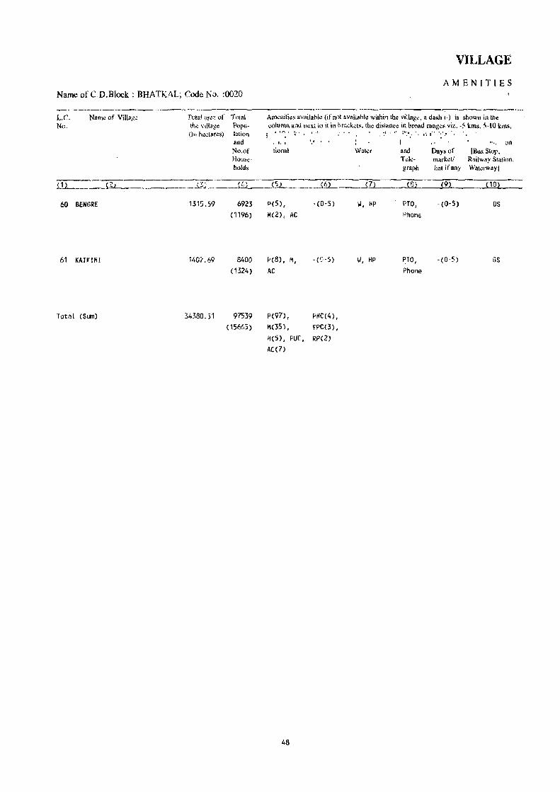
Name of CD.Block: BHATKAL; Code No. :0020
---------------LC. No.
Naml) of Villa)1~
60 BENGRE
61 KAH'IH!
Total (SLIl1)
Total ~r~·~ of Total lh~ VIU3g~ Popu(It, h~clares) lalion
and No.of Hous~
h()ld~
1315.59
34380.51
6923
(1196)
8400 (1324 )
97539
(15665)
VILLAGE
AMENITIES
Am~nilies available (ifnol available withi" the villag". a dash 1-) is shown illlne ';,llumn ami lI~xl to il in l:>r;;.;kets. the di~tance in broad ranges viz. -5 kms. ~-IO kms,
J ."'. k' , .1 ,.' :',:.,' 1',1-'···
tional
peS) ,
M(2), AC
PcB), M,
AC
P(97) ,
M(35l,
'.'
-(0-5)
PtlC(4) ,
fPC(3),
H(5), PUC, RP(Z) AC(l)
48
Waler
II, HP
II, HP
and T"k-graph
(8)
PTO, PhonE'
PTO, Phone
Days of nlarketl hal ifany
~9)
- (0- 5)
-(0·5)
an [Bus Slop.
Railway Stalion. Waterwayj
( 10) --
as
as

DIRECTORY
AND LAND USE Name of CD.Block : BHATKAL; COde No.: 0020
Approach Nearest Town, Class of Town Power Land use (area under difterent Iypes of land use in hectares rounded to two decimal places) L.e. to village and distance (in Km.) Supply No.
Forest Irrigated Un-irrigated Cullurable Area nol (by source of irrigation) waste available
(including for cultivation gauchar and groves)
( 112 ( 12~ {13l (14l {15l (16l (17l PSl Pl
PR BHATKAL- 111- S EA 454.66 Total 62.87 512.84 18.21 267.01 60 II 17.90
lie 16.64 0 28.33
PR BHATKAL- 111- 11 EA 683.83 Total 68.25 485.40 100.45 69.76 61 II 40.05
lie 8.75 0 19.45
25295.23 Total 1268.63 4297.55 1887.52 1559.02 Tk 96.67 II 489.61
We 74.39 0 607.96
49


HALIYAL C.D.BLOCK

BOUNDARY, DISTRICT.. .,. ••. ... ... ... .., '"
• , TALUM...... .. ... , ... '" ..... .
" VILLAGE WITH LOCAnON CalE NUMBER .. .
I£AOOUARTERS:TAWI ........... , ........ .
VILLAGES WITH POPUlATION SiZE: BELOW 200; 200-499;500H199; 1000-4999 .; ... ' '" ...
UNINIfABiTED VILLAGES WITli LOCATION CODE
URBAN AREA WITH LOeA TION CODE
STATE HIGHWAY ..... : ........
IMPORTANT METALLED ROAD. '"
UNMETALlED AND OTHER ROAOS
C:::IK':':J ®
o •••
C:::!.§l:::~ t/U/)/tiWft4
SH 93
KARNATAKA HALIYAL TALUK
UTTAR KANNAD DISTRICT Km 2 0 4 6 Km ... ,
1>' A
-9 It,
.",
()
o
-
C.D.Block bOundary (If Haliyol i. cO-llfminu. ~il" laluk boundary ncluding aU statutary towns.
RAILWAY LINE WITH STATION, METRE GAUGE
RIVER WITH STREAM... ... ... .. .
POST OFFICE I TELEGRAPH OFFICE ...
HIGHER SECONDARY SCHOOL. .. .
POLICE STATION.. . ..... ' .... .
HOSPITAL, PRIMARY HEALTH CENTRE, DISPENSARY, FAMILY PLANNING CENTRE ...
IMPORTANT VILLAGE MARKET I HAT (SHANDY), "'ANDIES ........................... "
/ii.' I I
::::::=-::-== PO/TO
S
PS
Based upon Sur'lC}' of India map WIth the prrmlssion of the Surveyor General of India. CD GOvcrrmcnt of India COPYrl9ht,19!J8

ALPHABETICAL LIST OF VILLAGES
T ALUK: HALlY AL-0030 C. D. BLOCK: HALlY AL-0030
SL NAME OF THE VILLAGE 1991 CENSUS 1981 CENSUS NO
LOCATION CODE LOCATION "CODE LOCATION CODE LOCATION CODE (Manual) (Computer) (Manual) (Computer)
2 3 4 5 6
1 Acidigera 11/20/3/99 11/20/0030/0099 9/19/3/123 09/19/0030/0123 \
2 Adkehosur 11/20/3/72 '1/20/0030/0072 9/19/3/71 09/19/0030/0071 3 Agasalkatta 11/20/3/81 11/20/0030/0081 9/19/3/99 09/19/0030/0099 4 Ajgaon 11/20/3/132 11/20/0030/0132- 9/19/3/97 09/19/0030/0097 5 Ajgarni 11/20/3/118 ,11/20/0030/0118 9/19/3/83 09/19/0030/0083 6 Ajminhal 11/20/3/66 11/20/0030/0066 9/19/3/68 09/19/0030/0068 7Aloll! 11/20/3/43 11/20/0030/0043 9/19/3/31 09/19/0030/0031 8 Alur 11/20/3/133 11/20/0030/0133 9/19/3/98 09/19/0030/0098 9 Anbewadi 11/20/3/113 11/20/0030/0113 9/19/3/78 09/19/0030/0078
10 Ambodga 11/20/3/12 11/20/0030/0012 9/19/3/7 09/19/0030/0007 11 Amga 11/20/3/102 11/20/0030/0102 9/19/3/132 09/19/0030/0132 12 Ammankop 11/20/3/53 11/20/0030/0053 9/19/3/37 09/19/0030/0037 13 Antralli 11/20/3/22 11/20/0030/0022 9/19/3/19 09/19/0030/0019 14 Arlwad 11/20/3/17 11/20/0030/0017 9/19/3/14 09/19/0030/0014 15 Arshingeri 11/20/3/64 11/20/0030/0064 9/19/3/64 09/19/0030/0064
16 Babli kop 11/20/3/128 11/20/0030/0128 9/19/3/95 09/19/0030/0095 17 Badakanshirda 11/20/3/110 11120/0030/0110 9/19/3/128 09/19/0030/0128 18 Badashirgur 11/20/3/89 11/20/0030/0089 9/19/3/120 09/19/0030/0120 19 Baloga 11/20/3/126 11/20/0030/0126 9/19/3/92 09j19/0030/0092
20 Balshettikop 11/20/3/88 11/20/0030/0088 9/19/3/116 09/19/0030/0116 21 Baswalli 11/20/3/32 11/20/0030/0032 9/19/3/49 09/19/0030/0049 22 Bedarshirgur 11/20/3/114 11/20/0030/0114 9/19/3/82 09/19/0030/0082 23 Belwatgi 11/20/3/37 11/20/0030/0037 9/19/3/45 09/19/0030/0045 24 Bhagwati 11/20/3/98 11/20/0030/0098 9/19/3/114 09/19/0030/0114 25 Bhanasgeri 11/20/3/45 11/20/0030/0045 9/19/3/34 09/19/0030/0034 26 Bhimanall i 11/20/3/97 11/20/0030/0097 9/19/3/113 09/19/0030/0113 27 Bidroll i 11/20/3/123 11/20/0030/0123 9/19/3/90 09/19/0030/0090 28 Bogur 11/20/3/69 11/20/0030/0069 9/19/3/76 09/19/0030/0076 29 Bomnall i 11/20/3/91 11/20/0030/0091 9/19/3/121 09/19/0030/0121 30 Bukkankop 11/20/3175 11/20/0030/0075 9/19/3/67 09/19/0030/0067 31 Buzruk Kanchanalli 11/20/3/50 11/20/0030/0050 9/19/3/35 09/19/0030/0035
32 Channapur 11/20/3/127 11/20/0030/0127 9/19/3/94 09/19/0030/0094 33 Chatranal 11/20/3/2 11/20/0030/0002 9/19/3/24 09/19/0030/0024 34 Chibbalgeri 11/20/3/41 11/20/0030/0041 9/19/3129 09/19/0030/0029 35 Chimmall i 11/20/3/87 11/20/0030/0087 9/19/3/1 17 09/19/0030/0117_ 36 Chinaginkop 11/20/3/34 11/20/0030/0034 9/19/3/54 09/19/0030/0054 37 Chotakanshirda 11/20/3/92 11/20/0030/0092 9/19/3/115 09/19/0030/0115
38 Dandel i (Rural~ 11/20/3/77 11/20/0030/0077 9/19/3/133 09/19/0030/0133 39 Dodkop 11/20/3/67 11/20/0030/0067 9/19/3/73 09/19/0030/0073 40 Dombera 11/20/3/131 11/20/0030/0131 9/19/3/96 09/19/0030/0096: 41 Dongrikop 11/20/3/27 11/20/0030/0027 9/19/3/42 09/19/0030/0042
53

ALPHABETICAL LIST OF VILLAGES
T ALUK: HALlY AL-0030 C. D. BLOCK: HALlY AL-0030
sl NAME OF THE VILLAGE 1991 CENSUS 1981 CENSUS NO
. t
LOCA TI ON CODE LOCATION COOE LOCATION COOE LOCATION COOE (Manual) (Compu.ter) (Manual) (Computer)
2 3 4 5 6
42 Dons" i rgur 11/20/3/90 11/20/0030/0090 9/19/3/126 09/19/0030/0126 43 Dusgi 11/20/3/20 11/20/0030/0020 9/19/3/17 09/19/0030/0017
44 Gadgera 11/20/3/84 11/20/0030/0084 9/19/3/107 09/19/0030/0107 45 Gardoll i 11/20/3/82 11/20/0030/0082 9/19/3/101 09/19/0030/0101 46 Ghadiyal 11/20/3/52 ·,1/20/0030/0052 9/19/3/41 09/19/0"030/0041 47 Gobral 11/20/3/117 11/20/0030/0117 9/19/3/81 09/19/0030/0081 48 Golehalli 11/20/~/47 11/20/0030/0047 9/19/3/27 09/19/0030/0027 49 Guddapur 11/20/3/3 11/20/0030/0003 9/19/3/23 09/19/0030/0023 50 Guledkop 11/20/3/29 11/20/0030/0029 9/19/3/44 09/19/0030/0044 51 Gundoll i 11/20/3/76 11/20/0030/0076 9/19/3/66 09/19/0030/0066 52 Gutti 11/20/3/104 11/20/0030/0104 9/19/3/127 09/19/0030/0127 53 Guttibai l 11/20/3/46 11/20/0030/0046 9/19/3/32 09/19/0030/0032 54 Guttigeri 11/20/3/1 11/20/0030/0001 9/19/3/1 09/19/0030/0001
55 Halsi 11/20/3/59 11/20/0030/0059 9/19/3/59 09/19/0030/0059 56 Harrpehalli 11/20/3/31 11/20/0030/0031 9/19/3/48 09/19/0030/0048 57 Handl i 11/20/3/119 11/20/0030/0',9 9/19/3/84 09/19/0030/0084 58 Haregali 11/20/3/116 11/20/0030/0116 9/19/3/80 09/19/0030/0080 59 Harnoda 11/20/3/109 11/20/0030/0109 9/19/3/118 09/19/0030/0118 60 Harwat l i 11/20/3/124 11/20/0030/0124 9/19/3/89 09/19/0030/0089 61 Havgi 11/20/3/6 11/20/0030/0006 9/19/3/3 09/19/0030/0003 62 Homnall i 11/20/3/18 11/20/0030/0018 9/19/3/15 '09/19/0030/0015 63 Hosakumbarkop 11/20/3/106 11/20/0030/0106 9/19/3/129 09/19/0030/0129 64 Hosut 11/20/3/73 11/20/0030/0073 9/19/3/70 09/19/0030/0070 65 Hullatti 11/20/3/4 11/20/0030/0004 9/19/3/25 09/19/0030/0025 66 Hunswad 11/20/3/10 11/20/0030/0010 9/19/3/11 09/19/0030/00-1. 1
67 Jamge 11/20/3/35 11/20/0030/0035 9/19/3/131 09/19/0030/0131 68 Janage 11/20/3/103 11/20/0030/0103 9/19/3/51 09/19/0030/0051 69 Jatge 11/20/3/33 11/20/0030/0033 9/19/3/53 09/19/0030/0053 70 Jatgehosur 11/20/3/71 11/20/0030/0071 9/19/3/72 09/19/0030/0072 71 Jawall i 11/20/3/130 11/20/0030/0130 9/19/3/88 09/19/0030/0088 72 Jogankop 11/20/3/49 11/20/0036/0049 9/19/3/38 09/19/0030/0038
73 Kalbhavi 11/20/3/107 11/20/0030/0107 9/19/3/125 09/19/0030/0125 74 Kalginnatti 11/20/3/80 11/20/0030/0080 9/19/3/102 09/19/0030/0102 75 Kalginkop 11/20/3/65 11/20/0030/0065 9/19/3/65 09/19/0030/0065 76 Kalsapur 11/20/3/8 11/20/0030/0008 9/19/3/4 09/19/0030/0004 n Kariyampal i 11/20/3/78- 11/20/0030/0078 9/19/3/105 09/19/0030/0105 78 Kartkatta 11/20/3/56 11/20/0030/0056 9/19/3/56 09/19/0030/0056 79 Karwad 11/20/3/111 11/20/0030/0111 9/19/3/104 09/19/0030/0104 80 Kawalwad 11/20/3/30 11/20/0030/0030 9/19/3/47 09/19/0030/0047 81 Kegdal 11/20/3/100 11/20/0030/0100 9/19/3/122 09/19/0030/0122 82 Kerwad 11/20/3/25 11/20/0030/0025 9/19/3/21 09/19/0030/0021
54

ALPHABETICAL LIST QF VILLAGES
T ALUK: HALlY AL-0030 C. D. BLOCK: HALlY AJ_-OO30
SL NAME o.F THE VILLAGE 1991 CENSUS 1981 CENSUS NO.
Lo.CATION COOE LOCA T I o.N COOE Lo.CATION COOE LOCATION COOE (Manual) (Computer) (Manual) (Computer)
2 3 4' 5 6
83 KeSr~ga 11/20./3/14 11/20./0.0.30./0.0.14 9/19/3/9 0.9/19/0.0.30./0.0.0.9 84 Kesrot l i 11/20./3/58 11/20./0.0.30./0.0.58 9/19/3/58 0.9/19/0.0.30./0.0.58 85 Khamdoll i 11/20./3/42 11/20./0.0.30./0.0.42 9/19/3/30. 0.9/19/0.0.30./0.0.30. 86 Khurd Kanchanahalli 11/20./3/38 11/20./0.0.30./0.0.38 9/19./3/46 0.9/19/0.0.30./0.046 87 Kulgi 11/20./3/10.5 . 11/20./0.0.30./0.10.5 9/19/3/130. 0.9/19/0.0.30./0.130.
88 Kl.IlIbarkOp 11/20./3/61 11/20./0.0.30./0.0.61 9/19/3/61 0.9/19/0.0.30./0.0.61 89 Kl.Illbarkop 11/20./3/112 11/20./0.0.30./0.112 9/19/3/77 0.9/19/0.0.30./0.0.77 90. Kurigadde 11/20./3/57 11/20./0.0.30/0.0.57 9/19/3/57 0.9/19/0.0.30./0.0.57 91 JCyatangera 11/20./3/83 11/20./0.0.30./0.0.83 9/19/3/10.0. 0.9/19/0.0.30./0.10.0.
92 Machapur 11/20./3/96 11/20./0.0.30./0.0.96 9/19/3/112 0.9/19/0.0.30./0.112 93 Hadnall i 11/20./3/19 11/20./0.0.30./0.0.19 9/19/3/16 0.9/19/00.30./0.0.16 94 Hagwad 11/20./3/24 11/20./0.0.30./0.0.24 9/19/3/22 0.9/19/0.0.30./0.0.22 95 Mainal 11/20./3/86 11/20./0.0.30./0.0.86 9/19/3/10.6 0.9/19/0.0.30./0.10.6 96 Malwad 11/20./3/11 11/20./0.0.30./0.0.11 9/19/3/10. 0.9/19/0.0.30./0.0.10. 97 Malwad 11/20./3/10.8 11/20./0.0.30./0.10.8 9/19/3/110. 0.9/19/0.0.30./0.110. 98 Malwadi 11/20./3/40. 11/20./0.0.30./0.0.40. 9/19/3/28 0.9/19/0.0.30./0.0.28 99 Malwadi. 11/20./3/94 11/20./0.0.30./0.0.94 9/19/3/119 0.9/19/0.0.30./0.119
10.0. Mangalwad 11/20./3/7 11/20./0.0.30./0.0.0.7 9/19/3/5 0.9/19/0.0.30./000.5 10.1 Mavinkop 11/20./3/68 11/20./0.0.30./0.0.68 9/19/3/74 0.9/19/0.0.30./0.0.74 10.2 Hodalgera 11/20./3/122 11/20./0.0.30./0.122 9/19/3/86 0.9/19/0.0.30./0.0.86 10.3 Hugadkop 11/20./3/39 11/20./0.0.30/0.0.39 9/19/3/52 0.9/19/0.0.30./0.0.52 10.4 Mundki 11/20./3/15 11/20./0.0.30/0.0.15 9/19/3/13 0.9/19/0.0.30./0.0.13 10.5 Hundwad 11/20./3/54 11/20./0.0.30./0.0.54 9/19/3/40. 0.9/19/0.0.30./0.0.40. 10.6 Hurkwad 11/20./3/26 11/20./0.0.30./0.026 9/19/3/26 0.9/19/0.0.30./0.0.26
'0.7 Muttalmuri 11/20./3/21 1"1/20/0.0.30./0.021 9/19/3/18 0.9/19/0.0.30./0.0.18
10.8 Nagshettikop 11/20./3/48 11/20/0.0.30./0.0.48 9/19/3/39 0.9/19/0.0.30./0.0.39 10.9 Nandigadde 11/20./3/36 11/20/0.0.30./0.0.36 9/19/3/50. 0.9/19/0.0.30./0.0.50. 110. Narnalli 11/2o./3i93 11/20/0.0.30./0.0.93 9/19/3/10.9 0.9/19/0.0.30./0.109 111 Nilwani 11/20./3/74 11/20./0.0.30./0.0.74 9/19/3/69 0.9/19/0.0.30./0.0.69 112 Niralgi 11/20./3/129 11/20./0.0.30./0.129 9/19/3/93 o.9/19/Do.3o./Do.93
113 Pala 11/f!o./3/9 11/20./0.0.30./0.0.0.9 . 9/19/3/6 0.9/19/0.0.30./0.0.0.6 114 Pur 11/20./3/63 11/Zo./Do.3D/o.o.63 9/19/3/63 0.9/19/0.0.30./0.0.63
115 Ramapur 11/20./3/121 11/20./0.0.30./0..121 9/19/3/85 0.9/19/0.0.30./0.0.85 116 Rayapattan 11/20./3/85 ;1/20./0.0.30./00.85. 9/19/3/10.8 0.9/19/0.0.30./0.10.8
117 Sanbrani 11/20./3/55 11/20./0.030./0.0.55 9/19/3/55 0.9/19/0.0.30./0.0.55 118 Satmani 11/20./3/120. 11/20/0.0.30./0.120. 9/19/3/87 0.9/19/0.0.30./0087 119 Satnall i 11/20./3/16 11/20./0.0.30./0.0.16 9/19/3/12 0.9/19/0.0.30./0012 120. Shingatgeri 11/20./3/.13 11/20./0.0.30./0.0.13 9/19/3/8 09/19/0030./0.0.0.8 121 Shivapur 11/2o./~/28 11/20./0.0.30/0.0.28 9/19/3/43 09/19/0.0.30./0.043 122 Siddapur .11/20./3/60. 11/20./0.0.30/0.060. 9/19/3/60. 0.9/19/0.0.30./0.0.60.
55

56

HALIYAL C.D.BLOCK

VILLAGE
AMENITIES Name of C.D.Block : HAllY AL; Code No. :0030
L.C. Name of Village T 0181 area of Total Amenities availabk (if not available wilhin the village. a dash (-) is shown in the No. the village Popu- column and n~)(t 10 it in brackels, the distance in broad ranges viz_ -5 kms, 5-10 kms.
(In hectares) lalion and 10+ kms of the ne~restl!lace where the facility is available is givenl. and Educa- Medical Drinking PI.'~1 Day or C..,mmunicalion No.of tional Water and Days of [Bus Stop, House- T.:le- market! Railway Station. holds grapb hat if any Waterway) ,
(1) (2) (3) (4) (5 ) (6) (7) (8) (9) ( 10)
GUTTIGERI 273.42 ------------------------ UN - INHABITED -------------------------
2 CHATRANAl 245.76 ------------------------ UN - INHA8ITED --- .---~----------------
3 GUODAPUR 71.02 ------------------------ UN INHA8ITED ............ _ .. -1- -"- -- -- .... -- .......... '
t 4 HUL,LATll 599.35 52 -(0-5) -(0-5) HP -(0-5) -(0-5) as
( 13)
5 T1MMAPUR 68.32 251 P - (.0-5) II, HP -(0-5) -(0-5) -(0-5)
(45)
6 HAVGI 314.51 1687 P, M - (0- 5) T, II, HP, PO, - (0-5) BS (313) OTH Phon~
• 7 MANGALIIAD 308.16 3539 P(2) , -(0-5) T, II, HP, PTO, -(0-5) as
(567) M(2) , OTH Phone
,8 KAlSAPUR 219.07 4 -(0-5) -(0-5) HP -(0-5) -(0-5) .-(0-5) \
(1 ) ,
9 PAlA 599.n 548 P -(5-;10) II, HP -«f--S-,- --. (5-10) -(0-5)
(83)
10 HUNSIIAD 524.02 1693 P, M -(5-10) T, II, HP PO -(5-':0) BS (260)
11 MALIIAD 1032.26 79 -(0-5) -(0-5) II, Hf -(.0-5) -(5-10) -(0-5) (13)
12 AMBOOGA 520.65 10 -(0-5) -(10+) TK, HP -(0-5) -(10+) -(0-5)
(3)
13 SHINGATGERI 461.45 48 , -(5-10) -(10+) II, HP -(5-10) -(10+) -(5-10) ( 16)
14 KESROOGA 2511.27 41 -(0-5) -(10+) II -(5-10) -(10+) -(5-10) (8)
15 MUNDKI 1259.69 19 -(0-5) -(0-5) II -(0-5) - (0-5) -(0-5) (5)
0 16 SATNALLI 166.18 984 P(2) - (0- 5) T, II, HP - (0- 5) -(0-5) BS
( 163)
58

DIRECTORY
AND LAND USE Name ,of C.D.Block : HAllY AL; Code No.: 0030
Approach Nearest Town, Class of TowlI Power Land use (area under different types of land use in hectares rounded to two decimal places) L.C,
to village and distance (in Km.) Supply No. , For.:sl Irrigat.:d Un·irrigaled Culturable Area nol
(by source of irrigation) waste availabl.: (including tor cultivation gauchar and grows)
( 11) '\- (12) (13) , ( 14) (15) (16) (17) (18) ( 1)
. -----"-.----.-- ...•.... --i ...... · ...... , ..... UN • INHABITED • ~_~ ••• , •••• - .- •••••••• """'" •••••••••••••••
i , I . INHABITED ••• - •••• - •• - ••••••••..••..•••••.••••.••••••. - 2 ·······1·-···············,······-············ UN
___ ~ .. ~.b ___________ ~· ___ .. __________________ UN • INHABITED ------------------.-------------------------- 3
PR HA:,IYAL' IV- 1 EA 185.45 T~tal 7.18 326.57 126.16 4
Tk 7.18
PR "AUYAl' IV· 2 EA 57.57 3.58 7.17 5
PR HAUYAL' IV' 2 EA Total 28.23 235.67 50.61 6
Tk 28.23
PR HAUYAL- IV' 5 EA Total 54.65 223.39 30.12 7
Tk 54.65
PR HAUYAl' IV.· 4 EA Total 44.07 155.78 4.47 14.75 8
Tk 44.07
KR HAUYAl' IV· 7 EA 237.01 Total 70.64 261.16 8.07 22.89 9
Tic 70.64
PR HALlYAL' IV' 7 EA Total 58.81 424.43 1.01 39.IT 10
II: 58.81
KR HAUYAl' IV· 9 EA 844.79 Total , 5.26 154.37 14.IT 13.07 11
Tk 5.26
KR HALlYAL' IV' 13 EA -520.65 12 I'
KR HALiYAL- IV· 13 EA 461.45 13
KR DANDELl· II· 10 EA 2511.27 14
KR ALNAVAR- IV' 4 835.07 Total 44.86 349.26 30.50 15
Tk 44.86
KR JtlNAVAR· IV- 5 EA Total 11.90 134.49 14.85 4.94 . 16
Tk 11.90
59

VILLAGE
AMENITIES Name of C.D.Block : HALlY AL; Code No. :0030
L.C. Name of Village Total area of Total Amenities available (if not available within tht village. a dash (-) is shown in the No. the village Popu- column and next to it in brackets, tho: distance in broad range. viz. -5 km", 5·10 kms,
(In hectares) lation and 10+ krns oflhe n'!arest J!lace where th~ facility is availahle is given). and Educa· Medical Drinking Post Day or Communication No.of tional Water and Days of [Bus Stop, House· Tek- markell Railway Station. holds graph hal ifany Wal.:rwayl
m {~2 m {42 {'52 {62 m {82 {92 ~102
17 ARUIAD 208.09 1787 P '(0,5) T, II, HP PO, '(0-5) as (280) Phone
18 HCJ4NAlLI 195.88 397 P '(0-5) II, HP ·(0-5) '(0-5) as
• (81)
19 MADNAlll 258.85 975 p ,(0·5) II, HP PO, -CO-S) as (189) Phone
,. 20 DUSGI 481.33 1164 P ,(0,5) T, 1.1, HP ·(0,5) '(0-5) BS
( 175)
21 MUTTALMURI 323.00 1079 P -(0' 5) II, HP PTO, -(0'5) as (187) Phone
22 ANTROLLI 28!t.15 235 P -(0'5) II, HP -(0'5) -(0-5) as (56)
23 TERGAON 914.46 4349 P(3) , PHC, FPC, T, 1.1, HP PTO, -(0'5) as (785) "(2), H RP Phone
24 MAGIIAD 911.29 355 P ·(5-10) II, HP '(5-10) -(5-10) ·(0'5) (63)
25 KERIIAD 769.38 980 P ·(0,5) II, HP - (0,5) ,(0,5) . (0'5) ( 156)
26 MURKIIAl) 624.28 2451 P(2), M, H PHe, FPC T, II, HP NO, FRI BS (413) Phone
27 DONGRI KOP 335.06 ••••• -. __ •••• - ••••• - •••• UN INHABITED -... -~----------- .. ---------
28 SHIVAPUR 1191. 19 555 P ,(5'10) II, HP . (5,10) -(5-10) -(5'10) (110)
29 GULEDKOP 766.92 104 '(0,5) -(5-10) II, HP -(5-10) '(5-10) ·(5-10) (19)
3D KAIiAlliAD 1319.78 2514 P(4), M ·(5'10) II, Hf' PO . (5-'1 0) BS
(427)
31 HAMPE"Alll 312.78 690 p ·(5-10) IJ, HP '(0-5) -(5,10) as (107)
60

DIRECTORV
AND :t:,AND USE Name of C,~.plock : HALIYAL; Code No.: 0030
Approach Nearest Town, Class ofTo"n Power Land ,~&, (area under different types of land IIS~ in hectar"-' round~d to two d.:cimal places) L.C', toviUage: and dislanc~ (ir.l\m.) Suppl) No.
For~sl Irrigated Un-irrigated Culturable . Area nol (by sout\;c of imgalion) waste available
(including for cultivation gauchar and grov~;;)
{112 l {122 (13) , {14 ~ {152 ( 162 (In !182 {12
!(R ALNAVAR- .JV~ 4 EA 24.26 Tqtal 6.68 140.62 15.97 20.56 17
\ Tk 6.68
KR ALNAVAIi! . IV- 3 fA fotal 17.30 i55.32 6.85 16.41 18
TI:: 17.30
PR ALNAVAR- IV- 4 fA 3.73, Total· 36.65 180.81 1. 71 35.95 ·19
Tic 36.65
p., K ALNAVAR- IV- 5 fA Total 39.52 254.67 66.37 120.77 20
Tk 39.52
PR ALNAVAR- IV- 5 EA· Total 15.58 271.32 1.62 34.48 21 Tk 15.58
I(R ALNAVAR- IV- 6 EA Total 17.30 2[.4.09 23.76 22 Tit. 17.30
PR HAllYAL- IV- 4 EA Total 133.87 694.87 20.47 65.25 23 Tic 133.87
l(R HAll YAl- IV- 6 EA 639.96 237.97 33.36 24
PR HALIYAL· IV- 3 EA 220.40 Total 13.85 495.39 17.63 22.11 25 Tk 13_8~
PR HALlYAL- IV- 9 EA 115.88 Total 89.59 375.31 43.50 26 Tk 89.59
------ •. --.---------------- .. ---.--.--------- UN INIlABlTED ___ ~_~~_v~_ .. ., __ ~ ___ ._w~_~_~ .. ~_ .. _~ __ ~_~ _______ 27
ICR HAll VAL- IV- 16 Ell 619.22 Total 29:'.79 201 .. 62 46.14 28.42 213 Tk :95~7Y
KR HAll VAl- IV- 20 EA 7'27.68 1~_n~ 1.19 29
Pi< HAUYAl- IV- 18 EA 451.'~6 Total 162.?e 59~.20 111.84 30 Tk 162.2e
PR IiALlYAL- IV- 23 EA 91.07 Total 12.14 197.32 12.25 31 Tk 12.14
61
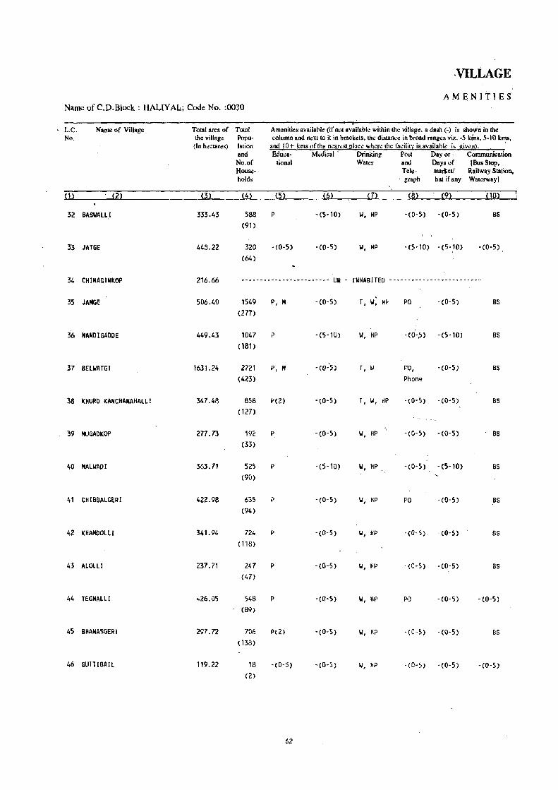
·VILLAGE
AMENITIES :
Name of C.D.Block : HALlY AL; Code No. :0030
L.e. Name of Village Total area of Total Amenilies availabl~ (if Rol available within th~ ~lIage. a dash (-) is shown in the No. the villag~ Popu- column and nexllo il in brackets, the distance in broad ranges viz. -5 kins, 5-10 kms,
(In hectares) lation and 10+ kms of the nearest Illace where the fa~ilit~ is available is given). . and Eduea- Medical' Drinking Post Payor· Communication No.of tional Water and Days of (Bus Stop, . Hous.:- Tele- marketl Railway Station, holds . graph hat ifany Waterway)
(1) (2) (3) (4) (5) (6) m (8) (9) (10)
32 BASUAUI 333.43 588 P -(S-l0) 101, HP -(0-51) -(0-5) BS
(91) , '.
33 JATGE 448.22 320 -(0-5) -(0-5) IJ, HP -(5-10) -(5-10) -(0-5) (64)
34 CHINAGINICOP 216.66 ------------------------ UN - INKABITED -------------------------
35 JAMGE 506.40 1549 P, M -(0-5) T, 1.1; HF- PO -(0-5) BS
(277)
36 NANDIGADDE 449.n 1047 p -(5-10) 1.1, HP -(0-,5) -(5-10) BS
(181 )
37 BELWATGI 1631.24 2721 P, M - (0:5) T, W PO, -(0-5) BS (423) Phone
38 KHURD KANCHANAHAlLl 347.48 858 P(2) -(0-5) T, W, HP -(0-5) -(0-5) 8S
( 127) f-
39 MUGADKOP 277.73 192 P -(0-5) 101, HP -(0-5) - (0-5) BS
(33)
40 MALWADI 363.71 525 P -(5-10) 101, Hi> -(0-5) . -(5-10) as (90)
41 CHIBBALGERI 422.98 635 t> -(0-5) 1.1, HP PO -(0-5) as (94)
42 KHAHOOLLI 341.94 724 P -(0-5) II, HP -(0-5) . -(O-S) ss (118)
43 ALOlLl 237.7i 247 P -(0-5) 101, HP ·(0-5) -(0-5) BS (47)
44 TEGNALLI .. 26.05 548 P -(0-5) W, HP PO -(0-5) -(0-5) (89)
45 BHANASGERI 297.72 706 P(2) -(0-5) 101, HP -(0'5) -(0-5) as (138)
46 GUTTIBAll 119.22 18 -(0-5) -(0-3) 1.1, HP -COoS> - (0-5) -CO-5) (2)
62

DIRECTORY
AND ,'LAND U.SE Name or C.D.Block : HALIYAL; Code No.: 0030
----",...__ -~--Approach Nearest Town, Class ofT~wn Pow~r Land us.: (area und~r different tYres of i~n<! us.: In hectares rounded to two decimal places) L.C. 10 village Hnd disllln<:e (in Km.) Supply No.
For..:tol Irrig~I·~d Un·irrigated Culturable Area not (by ""'HOC': of irrigation) waste 3yailabk
(including for CUhiY8hon gauchar and groves)
illL ~12l ( 13l ~14~ ~'5~ ~ 1')2 ~ 11 l (18) .ilL.
KR HIl.LIYAl' 'IV\, 23 EA 76.35 Total 53.42 175.53 28.13 32 Tk 5:U,2
KR HALlYAL- IV· 14 356.32 79.10 12.80 33 , ,
-......•. -..... : •..... -..................... - UN I IIIHABITED ---------------_.-.-----------------------_. 34
PR HAUYAl· IV· 15 EA 69.11 Total 42.71 361.83 32.75 35 Tk 42.71
PR HAUYAl' IV- 16 E~ 74.37 Total 55.85 299.23 19.98 36 TI< 55.85
, PR HAUYAl' IV· 14 EA 776.23 Total 161.88 522.59 121.00 49.54 ~7
Tk 161.88
FR HAUYAl' IV· 11 EA 84.10 Total 77.22 156.05 30.11 3B Tk 77.22
KR HJ.lIYAl' IV· 14 EA 173.97 Total 12.95 73. i5 17.66 39 Tk 12.95
PR HAUYAl' IV· 8 EA 196.80 Total 32.65 124.58 9.68 40 n. 32.65
PR HAUYAl' IV' 5 EA 185.84 Total 24.66 169.85 42.63 41 Tk 24.66
KR HAlIYAL' IV· 4 EA 88.33 Total 40.84 153.72 59.05 42 Tk 40.84
KR HALlYAL' IV· 3 EA Total 35.81 124.86 27.58 49.46 43 Tk 35.81
KR HALlYAL' IV· 3 EA 113.95 Total 12.19 209.58 11.46 78.87 44 Tk 12.19
PR IiAUYAL· IV' 3' EA 101.66 Total 19.32 133.25 16.86 26.63 45 Tk 19.32
KR HAUYAL' IV' 5 EA 88.51 Total 15.5.1 12.82 2.38 46 Tk 15.51
63

VILLAGE
AMENITIES Name of C:D.Block : HALIYi\L; Code No, :0030
--L,C, NSIrIll of V illag,"_ T~)t?.i .:Area nf Total Amemties availabfe'(ifnot available within the village. a dash (.) is shown in the _ No. the Ylil3~~ Popu- column and next 10 il in bn"k~ls. Ih~ distance in broad ranges, viz, -5 kms. 5-10 kms,
(Ir.hcctares) lalion and 10+ kms "flbe ncan:ri.l'iacl! when: the fadlil~ is availablll i~ given!, and EJUCf.- J\lh:di~ai DrinkiOj! POSI Day or Comrr.uni,~'ion No,of tiOllJll Waler and Days of [BlIsSrop. House- .. Tel.:- mar!.:etl Railway Slali"n, holds graph hat ifany Waterway)
.<: } ~Z;__~_-O ______ ~ ______ (4) ~~J._ __ ----i9,L"" (7) (8) (9) (10)
47 GOlEHALU 449.47 417 P(2) -(0-5) W, HP - (0,5) - (0- 5) -(0-5)
(63)
48 ~AGSHETTIKOP 254.01 610 P '(C-5 ) w, HP ~'O, - (0-5) J3S
(100) Phone
49 JOGANKOr' 341.07 673 ::>(2) -iC- 5) II, HP -(0-5) -(0-5) BS (104)
50 BUZRUK KANCHANAlLI 863.99 2876 P, M [) T, W, HP PTO, -(0-5) HS
(437) Phone
51 TATWANI 1032.29 1189 p -(0-5) W, HJ, HP PO -(0-5) BS (01)
52 GHADIYAL 1(':'5.37 221 -(0-5) -(5-10) W, fiP -(0-5) -(5-10) -(O-5i
(29)
53 AMMANKOP 221U1 1'.05 p -(0-5) II, HP PO -(0-5) 5S
(149)
54 !';~ND\.IAD 325.00 14C2 P, M -(0-:;) W, HP -(O-S) -(0-5) as (:228)
55 SAMBRANI 1362.27 994 P(2), M PHC, FPC, T, W, HP PC" liED BS (205) SMP Phone
56 KARlKATTA 441.04 763 P -(0-5) TK, HP -(0-5) - (0-"5) BS (136)
57 KURIGADDE 430.')[l 239 P -(5-10) II, HP -(0-5) -(5-10) BS (41 )
58 KESROLlI 564.92 782 P -(0-5) II, TK PO -(0-5) as (160)
59 HALSI 202.84 16 -(0-5) -(0-5) II - (0- 5) -(0-5) -(0-5) (3)
60 SIDDAPUR 257.39 30 -(0-5) -(5-10) II, Tit: -(0-5) -(5-10) -(0-5) (6)
61 KUMBARKOP 287.31 120 P -(0-5) II, HP -(0-5) -(5-10) -(0-5) (18)
64

DIRECTORY
AND LAND USE Name of C.D.Block : HALIYAL; Code No.: 0030
Approach Nearest Town, Class of Town Power La~ us.: (area under different typell of land us.: in hectares rounded to two decimal places) L.C. to village and c1islance (in Km.) Supply No.
Forest Irrigated U n-irrigated Culturable Area not
(by source of irrigation) waste available (including for cultivation gaucher and groves)
~ ,i~ ~13l P4~ 1'52 ~16l , 17l ,'8l ,12
Kit HALlYAl' IY' 7 EA 176.84 Total 41.28 187.75 29.11 14.49 47
Tic 41.28
PI? HAll VAL - IY' 7 EA Total 29.86 141.43 42.53 40.19 48
Tic 29.86
PR HAlIYAl' IY' 9 EA 6.58 241.95 40.47 ·52.07' 49
PR HAL HAL' IY' 3 EA 54.32 Total 65.16 482.00 14.06 248.45 50
Tic 65.16
PR HAllYAl - IY- 5 EA 443.41 Total 210.65 344.71 33.52 51
Tic 210.65
. lCR HALlYAl- IY- 12 EA 562.61 Total 24.28 372.83 38.96 26.69 52
Tic 24.28 ..;,.
KR HAlIYAl- IY- 10 EA 33.99 176.76 18.16 53
KR tlALlYAL- IV- 9 EA 35.33 Total 57.27 183.05 . 26.02 23.33 54 Tic 57.27 e.
PR HAUYAl· IY' 12 EA 1031.83 Total 39.66 210.44 80.34 55
Tk 39.66
PR HAUYAl- IY- 10 EA !27.92 Total 21.84 75.60 15.68 56 Tic 21.84
PR HALlYAl- IY- 6 EA 349.25 Total 36.63 85.19 9.91 57 Tic 36.63
PR HALIYAl- IY- 5 EA 280.12 Total 41.15 223.29 20.36 58 Tic 41.15
KR HAlIYAl· IY' 4 EA Total 48.80 131.50 22.54 59 Tic 48.80
KR HAUYAl· IY- 5 EA 200.79 38.04 18.56 60
PIl HAUYAl· IV- 10 EA 193.93 ,
15.13 Total 51.53 26.72 61 Tic 15,13
65

VILLAGE
AMENITIES Name of C.D.Block : HALlY AL; Code No. :0030
L.C. Name of Villaac TOIII area of TOIII AlllCnilies available (ifnol available within Ihe village, a dash (-) i, shown in the No. the village Popu- ,oJumn and nexl to it in bl'lll:ket8, Ihe di8lance in broad ranges viz. -5 kms, 5-10 kms.
(In hectares) lalion and 10+ kms of the nearest I!lace whet..: the facilitl: is available is given). and Educa- Medical Drinking Post Day or Communication
No.of tional Water and Days of (Bus Stop. Housc- Telc- marketl Railway Sialion. holds graph hat ifany Waterway)
<1> (2) <3> (4) (5) (6) (7) (8) (9) (10)
6Z nPPINGERI 161. 79 307 P -CO-5) W, liP -CO-5) -(0-5) BS (4S)-.
63 PUR _ 134.20 30 -(0-5) -(0-5) w -CO-5) -(5-10) -(0-5) (7)
.~
64 ARSII I NGER I llLS9 4 -(0-5) -(0-5) w -(0-5) -(5-10) -(0-5)
(1 )
65 KALGINKOP 685.82 1596 P ~(0-5) W, HP -(0-5) -(0-5) BS (223)
66 AJMJMIlAL 401.40 420 P -(0-5) W, liP -(0-5) -(0-5) -(0'5) (57)
67 DOOKOP 882.17 496 P(2) -(0-5) W, HP -(5-10) -(0-5) -(0-5) (74)
68 MAVIMKOP 495.51 -----------"------------ UN - INHABITED ---.---------------------
69 BOGUR 529.93 ------------------------ UN - INHABITED -------------------------
70 TATTlGERI 752.26 1073 P, M RP T, II, liP PO -(10+) BS (20S)
71 JATGEIIOSUR 359.n 100 -(0-5) -(5-10) W, liP -(5-10) -(5-10) -(0-5) (21)
n ADKEHOSUR 304.48 299 P -(5-10) W, liP -CS-10) -(5-10) -(0-5) (64)
73 HOSUR 411.53 . 375 P -(0-5) W, HP -(0-5) -(0-5) as (78)
74 MILIlANI 411.22 256 P -(0-5) II, HP -(0-5) -(0-5) BS (48)
75 BUKWKOP 119.52 379 P -(0-5) 101, liP -(0-5) -(0-5) BS (69)
76 WNDOLLI 304.79 1834 4) P, H, II RP T, lol, liP PTO, -(0-5) BS (312) Phone
n DAIIOELI (RURAL) 24.69 ------------------------ UN - INHABITED .------------.------.---~
66

DIRECTORY
AND LAND USE Name of C.D.Block : HALlY AL; Code No.: 0030
Approach Nearest Town, Class of Town Power Land us.: (area under different types of land Ulle in hectares rounded to two decimal places) L.C. to village and distance (in Km.) Supply No.
Forest Irrigated Un-irrigated Culturablc Are. not (by source of irrigation) . waste available
(includilll for cultivation gaucher and groves)
(11) (12), (13) (14) (15) (16) (17) (18) m
PR HALlYAL- IV- 12 fA 34.41 Total 16.19 94.26 16.93 62 Tic 16.19
KR HALlYAL- IV- 15 EA 54.59 Total 20.49 47.41 4.59 7.12 63 Tk 20.49
KR HAll VAL- IV- 16 58.67 Total 10.61 29.07 4.54 9.00 64 Tic 10.61
KR HAUYAL- IV' 17 EA 121.26 Total 56.09 449.69 20.24 38 •. 54 65 Tk 56.09
KI< HALIYAL- IV- 15 EA 71.67 Total 27.32 298.08 4_33 66 Tic 27.32
KR HALlYAL- IV- 15 EA 662.50 Total 18.21 160.92 40.54 67 Tic 18.21
------------------------------~-------------- UN - INHABITED --------------------------------------------- 68
-------------------------------------------~- UN - INHABITED --------------------------------------------- 69
KR HALlYAL- IV- 24 EA 559.29 Total 22.26 139.66 31.05 70 Tk 22,26
KR HALlYAL- IV- 14 EA 305.29 48.68 5.80 71
KR HALlYAl- IV- 14 fA 193.88 83.84 26.76 n
ICR HALI'fAL - IV- 13 EA 320.98 58.39 32.16 73
PR HALIYAL- IV- 13 EA 269.73 Total 16.19 108.20 17.10 74 Tic 16.19
ICR HALIYAL- IV- 14 EA 26.72 76.51 16.29 75
PR HALlYAl- IV- 15 EA 79.00 Total 45.33 136.6~ 22.77 21.00 76 Tk 45.33
·_------------------------------------7------ UN - INHABITED --------------------------------------------- 77
67

VILLAGE
AMENITIES Name of C.D.Block : HALlY AL; Code No. :0030
L..e. Name of Village Tool area of Total AlMnilies available (if nOl available within the village, a dash (-) is shown in tOO , No. the village Popu- eolumn and next to it in brackets, the distance in broad ranges viz. -5 Icms, 5-10 Icms,
(In hectares) lation a!!l! 10+ kms of the nearestl!lace wher.: the facilit): is available is given}. and Educa- Medical Drinking Post Day or Communication No.of tional Water and Dayso!" IBusStop, HouS<!- TeI.:- marketl Railway Station. holds graph hat if any Wat"lWny)
m (2) (3) (4) (5) (6) en (8) (9) (10)
78 KARI YAMPALI 527.43 1.00 -(0-5) -(0-5) II, liP -(0-5) -(0-5) -(0-5) (13)
79 TATGERA 544.75 212 -(0-5) -(0-5) II, HP -(0-5) -(O-S) -(0-5) • (49)
80 KALGINHATTI 267.08 ------------.-----.--.-- UN - INHABITED ---~------------.------~-
81 AGAsJlKATTA 476.59 220 - (0- 5) -(5-10) II. HP -(0-5) -(5·10) ns (39)
82 CARDOlL! 1098.86 531 P -(5-10) II. HP -(0-5) -(5-10) -{S-10) (108)
83 KYATANGERA 435.12 109 -(0'5) -(5-10) II, HP -(5-10) ·(5-10) -(0-5) (17)
84 GAOGERA 571.90 46 -(0·5) -(5-10) IJ, HP -(0-5) -(5-10) -(0-5)
(8)
85 RAYAPATTAN 1405.55 231 -(0·5) -(10+) IJ, HP - (S-lO) :-{S-10) -(5-10) (34)
86 MAINAL 430.05 148 ·(0-5) -(5-'0) HP, R ·(0-5) -(0-5) -(0-5) (22)
87 CHIMMALLI 416.14 .----.------------------ UN - INHABITED ----------~--~-----.-~~~-
88 BAlSHETTlKOP 756.52 ·250 p -(10.) IJ, HP -COoS) -(0-5) -(0-5) (33)
89 BADASHIRGUR 1291.05 99 -(0-5) -(0-5) W, HP -(0-5) -(0-5) RS (16)
90. DONSHIRGUR 168.52 ~ -CO-5) -(5-10) W, HP -(0-5) -(5-10) - (0- 5) (14)
91 B<»INALLI 1337.41 260 P -(10+) U. HP -(0-5) -(0-5) BS (57)
92 CHOTAKANSHIROA 688.53 145 -(0-5) -(10+) HP - (0-5) -(0-5) BS (26)
68

DIRECTORY
AND LAND USE Nam~ ofC.D.Block: HAUYAL; Code No.: 003
Approach Nearest Town, Class of Town Power Land use (area under ditTereDltypes of land use in hectares rounded 10 IWO decimal places) L.C. 10 village and distance (in Km.) Supply No.
Forest Irrigated U n·irrigated Culturable Area not (by souree of irrigation) waste availablt:
(including for cllhiv8tion gauchar and grovo:s}
(11) (12) (13) (14) (15) (16) (17) (18) (1)
ICR DANDElI' It· 5 EA 489.39 12.24 25.80 78
KR HAUYAl' IV· 9 EA 478.70 48.16 17.89 79
••••••••• ---- •• -.-- ••••• - ••••• - •• -- •••••••••• UN • INHABITED ~---------------------.---------------------- 80
KR HAUYAl' IV· 10 EA 398.22 Total 4.25 61.31 12.81 81 Tk 4.25
KR HAUYAl' IV· 11 EA 984.01 Total 1.62 99.50 13.73 82 Tk 1.62
KR . HAUYAl- IV' 9 EA 393.03 30.35 11.74 83
KR HAUYAL- IV' 10 EA 549.96 21.65 0.29 84
KR AMBIKANAGARA· v' '12 EA 1344.82 49.78 10.95 85
KR DANOELl- II· 5 EA 391.64 4.05 34.36 86
- •••••••••• --- ••••••••••• - ••• - •••• -.--.- •• - •• UN • INHABITED -.- •••••••••••••••••••••••••• - ••• - •••••••••• - 87
KR HAUYAl - IV' 25 EA 667.02 78.11 11.39 88
KR DANDELl' II- 10 EA 1256.66 26.71 7.68 89
KR AMBIKANAGARA- V' 8 EA 117.23 51.29 90
PR AMBlKANAGARA' V' B EA 1217'.66 90.66 29.09 91
KR HAlIYAl' IV· 20 EA 682.04 4.25 2.24: 92
69

VILLAGE
AMENITIES Name of C.D.Block : HALlY AL; Code No.O;()o30
L.C. No.
'til 93
94
95
96
97
98
99
100
101
102
103
104
105
106
107
108
109
Name of Village
'(2)
NARNALLI .
MALWADI
THAKKAR BASAPUR
MACHA PUR
8HlMANALLI
BHAGWATI
ADDIGERA
KEGDAL
VI NCHOLLI
AMGA
JANAGE
GUTlI
KULGI
HOSAKUMBARKOP
KAU1HAVI
MALWAO
HARNOOA
Total area-of the village (In hectares)
(3)
613.89
1345.38
~84.74
1728.03
854.55
1529.17
2562.46
727.49
1380.?7
227LS5
1342.23
979.91
1385_75.
774.71
437.91
558.90
1181.51
TOIaI Population and
No.of Households
Amenities available (if not available within the village, a dash (-) is shown in the column 'and next to it in brackets, the distance in broad ranges viz. -5 kms, 5-10 kms,
and 10+ kms of the nearest place where the facility is available is given). Educa- Medical' Drinking fOst' Day or Communication
tional Water and Days of [Bus Stop, 1 ele- market! Railway Station, graph hat if any Waterway)
(4) (5) (6) (7) (8) '(9) ·(10)
100 -(0-5) -(10+) \I, HP -(5-10) -(0-5) -(5- 10) (14)
----- •..... - .... -- .. --.- UN - INHABITED ~ ... ---------------------
-.- ••••• --.~- •••• -- ••• --. UN - . INHABITED -------------------------
••• - •• -.--- •• --.-.- ••••• UN • INHABITED -------------------------
160 ,(0,5) ,(0'5) w, HP -(0'5) -(0'5) -(0'5) (30)
1055 P, M -(10+) W! HP PTO, SUN BS
(251) Phone
140 ·(0,5) -(5,10) W, HP ,(0,5) '(5,10) '(0-5) (23)
395 P -(10+) W, HP PO . (0- 5) BS
(91)
35 -(0-5) '(10+) HP -(0,5) -(10+) -(0'5) (5)
.--------------.--- ••• -- UN - INHABITED -------------------------
- ••• -.-- •• --.-_ •••••••• - UN • INHABITED ----~--~-----------------
39 -(0-5) -(5-10) HP -(0-5) '(5,10) '(0-5) (7)
497 p ,(5,10) 101, HP PO '(5,10) BS (98)
..... - .. -_.- ... -- ....... UN: INHABITED ---_._--------_----------
55 '(O-S) -(5'10) HP '(0-5) -(5'10) -(0,5)
(8)
'--'-""""""""-" UN • INHABITED ---~--~~-~--_------.-----
81 ·(0-5) ,(5,10) Hi', R ,(0'5) '(5-10) -(5,10) ( 13)
70

DIRECTORY
AND LAND USE ;'.:"me of C.D.Block : HALlY AL; Code No.: 0030
Approach 10 village
Nearest Town, Class ofTl)wn and distance (m Km.)
Power Supply
Land usc (are.a under U .. ,.·!'elll 'vp<s of IlInd use in hecllIres rounded 10 two decimal places)
F~re:!-- ~~8ted-
L.e. No.
I(R
PR
PR
PR
PR
PR
PR
PR
KR
Un-intgated (by IOUrce of Irrigation)
(12) ..(15) 06)
HAUYAl- IV'" 25 EA 600.46 12.34
Culturable waste (including glluchafand groves)
(17)
Area IlOl available fOf cultivation
<HI)
1.09
(1)
93
-------.------------------------------ •• ----- U~ - I~HA~ITED --------------------------------------------- 94
-- ------ ------ .. ----- --- --- -------. -- ---- --. -. UN - INHABITED ---- --- - .---. -- --" ------- _' __ ---- --- -- - .. - --- 95
--------------------------------------------- UN INH_SITEO --------------- •• -----.--.---.-- •• ----- •• ---- 96
HALIYAL- IY- 30 EA 854.55 97
HAUYAl- IY- 19 EA 1454.16 41.68 33.33 98
AMBIKANAGARA- Y- 15 EA 2454.07 21.85 86.54 99
AMBIKANAGARA- Y- 12 EA 512.52 116.95 98.02 100 ,
AMBIKANAGARA- v- 10 Ell 1262.37 118.60 101
---.----------.--------------------.-.-----.- UN - INHABITED -- .. ----.-------------------------------.--.- 102
---------------------.--.---------.--.-.----- UN - INHABITED -------------------------.-----------------.- 103
AMBIKANAGARA- y. 10 EA 979.91. 104
AMBIKANAGARA- V' 6 EA 1385.75 105
---.---.--.------------.----.--- •• -------.--- UN - INHABITED ~-----------------~--.----------------------- 106
AMBIKANAGARA- y- 9 EA 424.74 13.17 107
- --- -- - -- - -- -- - -- -- -- - - -- - --. --- - --- ---- -- - -- UN - INHABITED - -- - - - - - - - - - - -- -- -- - -. -- --- ',-- - - - -- -- - - -. - -. - 108 '
DANDEll- 11- 9 EA 1081.98 36.83 62.70 109
71

VILLAGE
AMENITIES Name of C.D.Block : HALlY AL; Code No. :0030
L.C. No.
(1)
110
111
112
113
114
115
116
117
118
119
120
121
122
123
124
125
Name of Village
(2)
BAOAKANSHIRDA
KARWAD
KUMBARKOP
AMBEWADI
BEDARSHIRGUR
VITNAL
HARE GAll
GOBRAL
AJGARNI
MANDLI
SATMANI
RAMAPUR
MODALGERA
BIDROLLI
HARWAlLi
YEDOGA
TOI~1 al\la of the village (In hectares)
\3)
1510.84
682.07
67.72
1365.01
268.17
523.69
1066.97
995.76
1168.43
816.07
273.33
472.24
305.28
204.44
209.00
207.67
TOlal Popu· lation and No.of Households
(4)
1319 (266)
604 "21)
Amenities available (ifnol3vailable within the village, a dash (-) is shown in the column nnd next 10 it in brackets, the distance in broad ranges viz. -5 kms. 5-10 kms,
and !O+ kms of the neal\lst Illace whel\l the facility is available is given). Educa- Medical Drinking Post Day or Communication
tional Water and Days of [Bus Stop, Tele- marketl Railway Station, graph hat if any Waterway]
(5) ~6) (7) (8) (9) (10)
P(2) -(0-5) W, HP, R -(0-5) -(0-5) ·(0-5)
P(2) -(0,5) W, HP -(0-5) -(0,5) BS
.-.-------- .... --------- UN . INHABITED --_._-------.------------
775 P, M '(0-5) W,. HP PTO, - (0- 5) BS (150) Phone
227 P -(5-10) W, HP '(5-10) -(5-10) '(0-5) (47)
426 P, M -(5'10) W, HP '(0-5) -(0-5) BS (85)
121 -(0-5) -(5-10) W, HP -(5-10) '(5-10) RS (23)
115 -(0-5) -(5-10) W, HP -(0-5) , , (5-10) as (29)
••. --.--.- ... _.--- •.... - UN - INHABITED -------------~-----------
363 P -(5,10) W, HP '(5-10) -(5-W) -(0-5) (64)
419 P -(5'10) W, HP -(0-5) -(5-10) BS (73)
333 P -(5-10) W, HP -(0-5) -(10+) -(0-5) (54)
355 P -(5-10) W, HP -(0,5) -(5-10) -(0-5) (59)
740 P -(5-10) W, HP -(0-5) -(5-10) BS (108)
.--------.--------.----- UN - INHABITED -------------------------
2096 P(2), M PHC, FPC T, 101, HP PTO, -(0-5) -(0-5) (366' Phone
72

DIRECTORY
AND LAND USE Name of C.D.Block : HALlYAL; Code No.: 0030
Approach to village
Nearest Town. Class ofTuwn and distance (in Km.)
Power Supply
Land us.: (area under difl\:rent type, or land u>e in hectafe> roundeu to two decimal pla,cs) L.C. No.
FOfl.!:-ot Irrigah:d Un-irrigHh.:d Cuiturahk Area nol (by source or i'Tig.lion) wast\! available
(induding ttlr cultivation gath.:har and groves)
(13) (14) (15) ( 16) (17) ( 18) (1)
PR DANDELI - I I - 5 EA 1318.39 118.98 87.23 110
PR DANDELI - I I - 2 EA 512.52 51.80 121.39 111
--------------------------------------------- UN - INHABITED --------------------------------------------- 112
PR DANDELI - 11- 3 EA 1290.93 61.71 277.45 113
KR DANDELI - I I - 8 EA 246_80 21_37 114
PR DANDELI - I 1- 6 EA 498.52 10.22 14_95 115
KR DANDELI - I I - 8 EA 1043.90 14.97 8.10 116
PR DANDELI - I 1- 7 EA 966.22 14.97 14.57 117
------------------~-------------------------- UN - INHABITED -- -- -- -- .... -_ .... ---- - .. ----_ .. -_ .......... -- .. -------- .. 118
KR HAll YAL- IV- 10 EA 767.10 40.07 8.90 119
PR HALlYAL- IV- 10 EA 109.83 149.74 13.76 120
KR HALIYAL- IV- 10 EA 359.33 110.89 2.02 121
KR HALlYAL- IV- 7 EA 151.20 138.00 16.08 122
PR HALlYAL- IV- 7 EA 191.02 13.42 123
--------------------------------------------- UN - INHABITED --------------------------------------------- 124
PR HALIYAL - IV- 5 EA 190.61 7_75 9.31 125
73

Name of C.D.B1ock : HALlYAL; Code No. :0030
L.e. No.
(1)
126
127
Name of Village
m BALOGA
CHANNAPUR
Total ar"a of Total th~ village
(In h~dares)
(3)
150.70
94. l'
Population and No.()f'! Hous\!holds
(4)
6
(2)
'0 (3)
VILLAGE
AMENITIES
Alll~nili~s availahk (ifnOI availallk within th~ villa!!". a da>'Jl (-, " show I, in th~ I.:oilllnn and Olo!xl ill it in hra~kl.!ls. thl! dislan~·t..: In hroad ran_g1.!s vi~, -~ km!-. :,·10 lm~.
and 10+ kms uflh~ n~an:s{ pla(~ wh\!rl.! th\! nl .... i!il)' is !lvallahk i~ ,givo.!o). Edll~a- Medical Drinking Post Day or Comll1uni.;alion
tional Wata and Days "I' ISus Stop. Tek- mark.;tl Rllliway Station. graph hilt if any Wat~rwaYI
(5) (6) (7) (8) (9) (10)
-(0-5) - (0-5) HP -(0-5) -(0-5) BS
• (0-5) -(0-5) 1.1, HP -(0-5) -(0-5) -(0-5)
128 SABUKOP 72.11 ~ - -.......................................... UN INHABITED .. .. _ ........................ _ ..................
129 NIRALGI 301.42 672 p -(0-5) 1.1, HP • (0-5) - (0-5) BS (109)
130 JAWALLI 394.73 373 p -(5-10) 1.1, HP -(0-5) . (5 -1 0) as (65)
131 OOMBERA 282.62 144 -(0-5) -(10+) 1,1, HP -(0-"» - (5 '10) BS
(23)
132 AJGAON 462.36 216 -(0-5) -(5-10) 1.1, HP - (0-5) - (5 -1 O) BS
(39)
133 ALUR 2415.74 423 P -(5-10) 1.1, HP PO . (5-10) BS
(63)
Total (Sun) 83286.02 70294 p(90), PHC(4), D, (12127) M(19). FPC(4),
H(4 ) RP(3), SMP
74

DIRECTORY
AND LAND USE
Appmach to villag~
Nem~st Town. Class of Town and distance (in Kill.)
Pow~r
Supply
Name of C.D.Block : HALlYAL; Code No.: 0030
Llllld usc (area unda difl".:rent Iypes orland lise in hedares rounded 10 two decimal places) L.C. No.
Forest Irrigaled U n-irrigat..:d Cuiturablc Ar~a nllt (hy source of irrigation) waste availahle
(induding I'lr cultivation gaul,,;har and groves)
011 ____________ {.iIl-_-_~_::==_-~-.___'('__'_13"'_')'__ __ __'(>_!1::!.4'_) ____ --'-(-'-'15'-'-) _____ ("-'1~6L) ___ --'-( ~17'-'-) ___ _L( 1~8'L) __ ~(.!...1 )[__
PR HAL[ VAl- lv- ~ EA 136.38 14.32 126
HALlYAL- IV- 3 EA 89.84 4.27 127
- - _, - -- - - - - - . -- - - - - - -- - - _. --' - - -- -. - - -- -- - -- UN I NHAB I TED - -- -- - -- -- -- -- -- •. -- •• -- - . -. -- -- _ ••• -- - -- --.. 128
PR HALIYAL· IV' 5 EA 87.54 194.86 19.02 129
"'R HAllYAl- IV- 7 EA 146.65 214.09 33.99 130
~~~ HALIVAl' iV' 12 EA 156.21 114.27 12.14 131
?R HALlYAl· IV- 12 EA 327.28 Total 33.59 80.08 21.41 132
Tk 33.59
p~ DANDELI· I I - 7 EA 2258.81 120.60 36.33 133
47551.92 Total 2655.02 16477.38 651.45 3679.87
Tk 2655.02
75

HONAVAR C.D.BLOCK
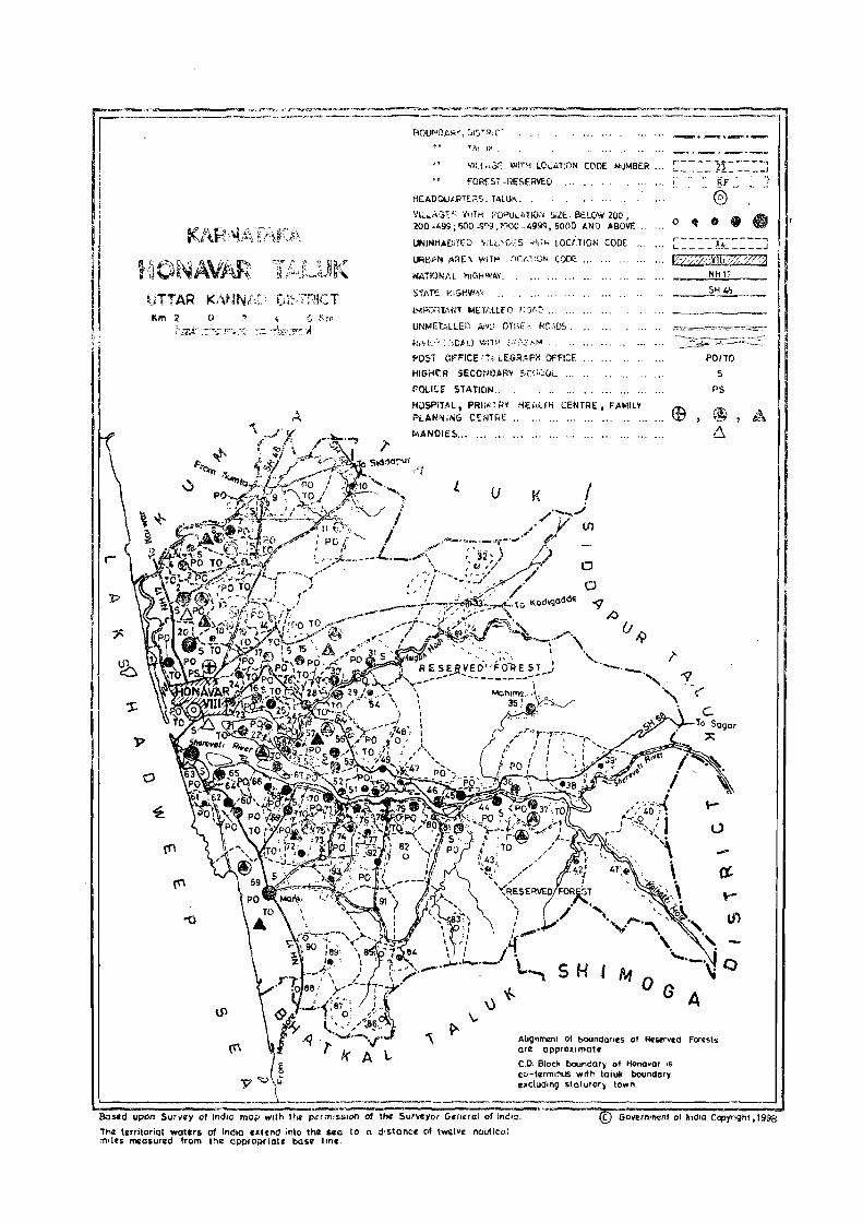
II I
UTTAR Km :;t 4 S ~~1
-f0.""':~
'fi\LU}t
Vltl'";:;~ ~!TH LC,,: .. U1N CODE NUMBER
FaRES. -RESERVED
HEAOQUt';:lT["S, TALUK.,
VI~""':;'::: V< iTk POPV,'\ TlO,j 51ZE, BELOW 20C , 200 -1,99; 500 -"''l~, 10ll0" 4999. 5000 AND ABOVE '.,
UNINHA[lJTfO ',ILL'0,',5 ,;'11'" LOci,llON CODE ,",
NATIONI'.L I1IGHWIlY.
$THE I'lIGHV>W,
IM>'';:''<1'''11 METt.LLH) r:,)f';> ...
UNMETALLEIJ r.:.~ on;,,:, !<C"DS,
f'OST (If!'"ICE ';Ie lEGRAPi-l OFFICE
HIGHf'R SECCNf)AR~ !"C'::')OL
POLlCf STATION
HJsPiUL, PRII\Il'~'lV HEi,ll" CENTRE, FAMILY PLANNiNG CiEi~mE" ..
MANOIE5 ........... , .00 '"
l. u
MO
\.
,.
0 ~
G A
~F
®
•
5
"5
Ahg"menl 01 boundaroes of ReStrved Forests are QPpro~imat.
E C,O, Block boundary 01 Honovor IS
~" e co-termtnUS with tatuk boundory
';
• •
~ __ L ________ ,_. _____ . _____ . ___ _:cludln9 $~ry town, _
~========~== ~~==~~~~~ Bastd upon Survey of IndIo mop wIth Hit permissIon of the 5urVCYOl General of IndIO. • © Govern"",nl of indIa Copynght,I9ita
The territoriol waters of India extend into the see to a distance of t~l.c nautical moln measured from the appropriate base Ilnc,

ALPHABETICAL LIST OF \/lLLAGES
TALUK: HONA V AR-0040
SL NAME OF THE VILLAGE
fiO
C. D. r~LOCK: HONAV AR-0040
1991 Cf:NSUS 1981 CENSUS
LOCAfiON eOGE ~OCATION CODE LOCATION CODE LOCATION CODE
!C6nputcr) (Manu,}l) (Computer)
---------------------- --- --------------------
1 A'dkar 2 Adkekul i
3 AduK<il
" Anllgod 5 Aps<lrakonda 6 Arol!i-Mundgod 7 Ashik€:ri
8 A. • .Jnsall i
9 Balemet
10 Ball<.ur 11 Begodi
12 Beranki 13 Berelli
14 Birangod
15 Chandavar
16 Chikkankod
17 Dobbod
i8 DU99Uf
19 Gudernakki
20 Gundabala 21 Gunvante
22 Hadg~ri
23 liadikal 24 Hatlinbill
2~ Haldipur
2
2(, Haneha l ,i KaDbi nhakka l
27 i1e<l9i'lr
28 Heral i
29 Herangadi
30 Her avatl
31 Hinnur
32 Hirebaj l
33 Hodkesh i rur 34 Hosad
35 Hosakul i
36 Hosgod 3"1 Hospattan
38 Hulegar
3
11/20/4/47
11/20/4/84
, ~/20/4/92
11/20/4/76
11/20/4/61
11/20/4.124
11/20/4/83
11/20/4/12
1'/20/4/82 11/20/4/70
11/20/4/40
11/20/4/(8
11/20/4/27
11/20/4/80
11/20/4/9
1;/20/4/29
11/20/4/93
1'/20/4/18
11/20/4/73
11/20/4/31
1~/20/4/60
11/20/4/(,1
11/20/4/91
11/20/4/28
1 ~ i2Cl/4/c.
11/2:0;4/39
11/20/4//1
11/20/4/87
11/20/4/46
1'1 i 20/4/54
11/20/4/77
1~/20/4/33
11/20/:'/11
11/20;4/51"
11/20/4/1 /
1~/20/4/32
11/20/4/65
11/20/4/31\
79
11120/0040/0047
11/20/1)040/0084
i 1 /20/u~]40iOOn
11/20/0040/0016
11/20/0040/0061
11/20/0040/0024
11/20/0040/0083
11/20/0040/0012
11/20/(040/0082
11/20/0040/0070
11/20/0040/0040
11/20/0040/0078
11/20/0040/0027
17/20/0040/.0080
11/20/0040/0009
11/20/0040/0029
11/20/0040/0093
11/20/0040/0018
11120/0040/0073
11/20/0040/0031
11/20/(1040/0060
11/20/0040/0041
11/21J/0040/0C91
11/20/0040/0028
11/20/0040/0002
11/20/0040/0039
11/20/0040/0071
;1/20/0040/0087
1 I /20/0(11,01004(0
11/2:),0U/.0/00:'4
11/20/0040i0077
11/<'0/0040/0033
11/,)0/0040/0011
11/20/0040/0058
11/20/0040/0017
11/20/00/,0/0032
11/20/00L,O/OG65
11/20/0040/0038
5
9/19/4/51
0/19/4/82
9/19/4/90
<;/19/4/7D
9/19/4/65
9/i'1/1./213
9/1'1/4/81
9/19/4/21
9/19/4/97
9{19/4/74
9119/4/44
9/19/4/7f
9/19/4/31 9/19/4/79
9/19/4/14
9/19/4/33
9/19/4/91
9!19/1,/19
9/19/4/92
9/19/4/35
'? Il'l /4/6 ...
9/1')/:"/45
''-"1/19/4/89
9/19/4/32
9/19/4/5
9/'19/4/43
~'i 19ft.! 75
9r'i/~/34
(//19/ l ,/50
9/19/i..../61
9/ i;~_/4/\;6
','/ :'1/1.6/37
y /1',',4/2,"
9/19/4/58
9/19/ L,/18
9/,//4/36
Y;' FfJ4/69
';'/1914/42
09/19/0040/0051
09/19/0040/0082
09/19/00,,+0/0090
09/19/0040;0076
09/19/0040/0065
09/19/0040/0028
OV/19/0040/0081
09/19/0040/0021
o~, 119/0040/0097
09;19/0040/0074
09/19/0040/0044
0<;'/19/0040/0077
()9/19/0040/0031 09/19/0040/0079
09/19/0040/0014
09/19/0040/0033
09j19/0040/0091
09/i9/0040/0019
09;19/0040/0092
09/19/0040/0035
09/'',I/0040ru064
09/1c;-,/0f140/0045
09/19/0040/0089
')9/19/0040/0032
09/19/0040/0005
09;;9/0040/0043
:~Yi1S' 10040/0075
C;'/iy/0040/001:l4
')Y/ ~9 /0040/0050
09/1 (.I / 004CJ /00""6
09/19/0040/0037
U'i/19/00"Oi0022
(;9/ 19/0040/0058
09/19/0040/0018
09/IG/0040/(J036
09/1-1 /OOt,O; 0069
09/19/0040/0042

ALPHABETICAL LIST OF VILLAGES
TALUK: HONAVAR-0040
SL NAME OF THE VILLAGE NO
39 Jalwal-Karki 40 Jalwall i 41 Jankadkal
42 Kadle 43 Kadnir 44 Kadtoka 45 Kakurve 46 Kankichitta 47 Karki 48 Kasarkod 49 Kekkar 50 Kelgin-Idgunjl 51 Kelgin-Mannige 52 Kelgin-Mudkani 53 Kelginoor 54 Kervalli 55 Khandodi 56 Kharwa 57 Kodani 58 Koodla 59 Kot 60 Kuchodi 61 Kudrige 62 Kulkod
63 Madgeri 64 Magod 65 Mahime 66 Malkod 67 Mallapur 68 Mandalkurve 69 MtmKi 70 Mavinkurve 71 Melin-Idgunji 72 Melin-Mannige 73 Mel ir.mudkani 74 Molkod 75 Mugwa 76 Mutta
2
77 Nagarabastikeri 78 Nagre 79 Navi 19one 80 Hi lkod
C. D. BLOCK: HONAVAR-0040
1991 CENSUS 1981 CENSUS
LOCATION CODE (Manual)
3
11/20/4/52 11/20/4/53 11/20/4/34
11/20/4/13 11/20/4/10 11/20/4/6 11/20/4/4
11/20/4/64 11/20/4/20 11/20/4/63 11/20/4/7 11/20/4/68 11/20/4/75 11/20/4/50 11/20/4/62 11/20/4/51 11/20/4/42 11/20/4/55 11/20/4/79 11/20/4/57 11/20/4/89 11/20/4/86 11/20/4/44 11/20/4/23
11/20/4/5 11/20/4/81 11/20/4/35 11/20/4/66 11/20/4/8 11/20/4/22 11/20/4/59 11/20/4/21 11/20/4/69 11/20/4/74 11/20/4/49 11/20/4/67 11/20/4/16 11/20/4/30
11/20/4/37 11/20/4/25
11/20/4/3 11/20/4/14
80
LOCATION CODE LOCATION CODE (Computer) (Manual)
4
11/20/0040/0052 11/20/0040/0053 11/20/0040/0034
11/20/0040/0013 11/20/0040/0010
11/20/0040/0006 11/20/0040/0004
11/20/0040/0064 11/20/0040/0020 11/20/0040/0063 11/20/0040/0007 11/20/0040/0068 11/20/0040/0075 11/20/0040/0050 11/20/0040/0062 11/20/0040/0051 11/20/0040/0042 11/20/0040/0055 11/20/0040/0079 11/20/0040/0057 11/20/0040/0089 11/20/0040/0086 11/20/0040/0044 11/20/0040/0023
11/20/0040/0005 11/20/0040/0081 11/20/0040/0035 11/20/0040/0066 11/20/0040/0008 11/20/0040/0022 11/20/0040/0059 11/20/0040/0021 11/20/0040/0069
11/20/0040/0074
11/20/0040/0049 11/20/0040/0067
11/20/0040/0016 11/20/0040/0030
11/20/0040/0037 11/20/0040/0025 11/20/0040/0003 11/20/0040/0014
5
9/19/4/55 9/19/4/56 9/19/4/38
9/19/4/20 9/19/4/15 9/19/4/11 9/19/4/9 9/19/4/68 9/19/4/3 9/19/4/67 9/19/4/12 9/19/4/73 9/19/4/94 9/19/4/53
9/19/4/66 9/19/4/54 9/19/4/46 9/19/4/60 9/19/4/78 9/19/4/59 9/19/4/87 9/19/4/83 9/19/4/48 9/19/4/27
9/19/4/10 9/19/4/80
9/19/4/39 9/19/4/70 9/19/4/13 9/19/4/26 9/19/4/63 9/19/4/25 9/19/4/72 9/19/4/95 9/19/4/52 9/19/4/71 9/19/4/17 9/19/4/34
9/19/4/41 9/19/4/29
9/19/4/8 9/19/4/23
LOCATION CODE (Computer)
6
09/19/0040/0055 09/19/0040/0056 09/19/0040/0038
09/19/0040/0020 09/19/0040/0015 09/19/0040/0011 09/19/0040/0009 09n9/0040/0068 09/19/0040/0003 09/19/0040/0067 09/19/0040/0012 09/19/0040/0073 09/19/0040/0094 09;19/0040/0053 09/19/0040/0066 09/19/0040/0054 09/19/0040/0046 09/19/0040/0060 09/19/0040/0078 09/19 L004()/0059
09/19/0040/0087 09/19/0040/0083 09/19/0040/0048 09/19/0040/0027
09/19/0040/0010 09/19/0040/0080
09/19/0040/0039 09/19/0040/0070 09/19/0040/0013 09/19/0040/0026 09/19/0040/0063 09/19/0040/0025 09/19/0040/0072
09/19/0040/0095
09/19/0040/0052 09/19/0040/0071 09/19/0040/0017 09/19/0040/0034
09/19/0040/0041 09/19/0040/0029
09/19/0040/0008 09/19/0040/0023

81

Name of C.D.Block : HONAV AR; Code No. :0040
L.C. No.
(1 )
Name of Village
(2)
PAVINKURVE
2 HALO I PUR
3 NAVILGONE
Total area of the village (In hectares)
(3)
183.32 .~ _::.
1443.06
572.28
Total Population and No.of Households
(4)
1031 (166)
9221 (1678)
2101 (368)
VILLA~ AMENITI~
Amenities available (if not available within the village, a dash (-) is shown in the: column and next to it in brackets, the distance in broad ranges viz. -5 kms, 5-10 .
and 10+ kms of the nearest lace where the facilit is available is iwn. Educa- Medical Drinking Post Day or Communic
tional Water and Days of [Bus Stop, ;
(5)
P(2) . .......
P( 12), M(3), H
(6)
-(0-5)
PHC, FPC
P(4), M(3) -(0-5),
(7)
II
101, HP
W, HP
Tele- market! Railway S~ .graph hat if any Waterway)
(8) (9)
PTO, -(5-10) Phone
PTO, IoIED Phone, _
PTO,
Phone
-(5-10) ':
(lad BS, Nil
8S
85
4 KAKURVE 34.65 ---------------.~------- UN • INHA81TED ----------------------.--
5 fllADGERI 80.79
6 KADTOKA 547.74'
7 KEKKAR, 309.83
8 fllALLAPUR 56.75
666 (106)
2698 (520)
1759
(318)
261 (58)
P
P(4),
M(2), H,
PUC
-(0-5)
PHC, FPC
P(2), M(2) RP
P, M, H RP
82
101, HP
101, HP
101, HP
101, HP
PO,
Phone
PTa,
Phone
PO"
Phone
PO, Phone
-(5-10) 85
-(10+) 85
-(5-10) 85
-(5-10) 55

DIRECTORY
AND LAND USE Name ofC.D.Block: HONAVAR; Code No.: 0040
APProach Nearest Town, Class of Town Power Land use (area under differenllyp~s of land use in hectar~s rounded 10 Iwo decimal places) L.C. 10 village and distance (in Km.) Supply No.
Forest Irrigated Un-irrigated Cultllrahl~ Area not (by source of irrigation) wast..: available
(including lor cultivation gauchar and j?roves)
[11) (12) (13) (14) (15) ( 16) (17) (18) (1)
PR HONAVAR- IV- 6 EA 0.40 Total 19.72 44.22 57.94 61.04 II 10.12
We 3.53 0 6.07
'R HONAVAR- IV- 10 EA 428.22 Total 213.32 454.36 176.49 170.67 2 Tk 19.42 II 30.35
We 74.87 0 88.68
'R HONAVAR- IV- 15 EA 198.90 Total 119.17 24.74 86.25 143.22 3 Tk 13.76 W 16.19
We 36.42 0 52.80
--------------------------------------------- UN - INHABITED ------------------------~-------------------- 4
'R HONAVAR- IV- 16 EA 17.53 Total 10.73 37.48 10.96 4.09 5. Tk 1.62
1/ 1.32 lie 4.05
0 3.74
'R HONAVAR- IV- 12 EA 196.68 Total 151.46 55.30 115.75 28.55 6 Tk 13.86 \I 14.16
lie 44.52 0 78.92
'R HONAVAR- IV- 8 EA 110.96 Total 66.78 21.71 /85.18 25.20 7 Tk 8.50 W 6.07
We 14.57 0 37.64
R HONAVAR- IV- 8 EA 23.56 Total 8.90 15.60 3.80 4.89 8 TIc 1.21 II 0.81
lie 1.62 0 5.26
83

Name of C.D.Block : RONA V AR; Code No. :0040
L.C. No.
(1)
Name of Village
9 CHANDAVAR
10 KADNIR
. -f 1 HODKESHIRUR
12 AUNSALLI
13 ICAOLE
14 NILKOO
15 SALt:OO
16 MUGWA
Total area of the village
(III hectares)
2134_16
1777.70
1898.48
218.31
822.11
688.04
3700.10
543.87
Total Population and No.of Households
(4)
2881 (488)
413 (74)
1560 (296)
259 (53)
1605 (293)
806 (149)
3745 (750)
2818 (551 )
VILLAGE
AMENITIES
Amenities available (if not available within the village, a dash (-) is shown in the column and next to it in brackets, the distance in broad ranges viz. -5 kIns, 5-10 )(ms,
and 10+ kms of the nearest place where the facility is available is given). Educa- Medical Drinking Post Day or Communication
tional Water and Days of [Bus Stop,
(5)
P(5), II
P
P, 14
P
j)(2'>, II
P, II
pm, 14(2), H,
PUC
P(2), M. H. PUC
84
(6) (7)
RP 1.1, HP
-(5-10) iI
-(5-10) W, OTiI
-(0,5) W, HP
RP W, HP
RP 1.1, HP
PIIC, FPC 101, HP
SMP W. HP
Tele- market! Railway Station, graph hat ifany Waterway]
(8)
PTa, Phone
-(0-5)
PO
(9)
-(10+)
-(5-10)
-(10+)
-(0-5) -(10+)
PTO, -(10+) Phone
po -(5-10)
PTO, Phone
PTO, Phone
'(5-10)
-(5-10)
( 10)
BS
BS
BS
BS
BS
as
BS
BS

DIRECTORY
AND LAND USE Name ofC.D.Block: HONAVAR; Code No.: 0040
Approach Nearest Town, Class of Town Pow~r Land us~ (ar~a und~r diff~rent Iyp.:s of land use in hectares rounded 10 two decimal places) L.C. to village and distance (in Km.) Supply No.
Forest Irrigated' Un-irrigated Culturable Area not (by source of irrigation) waste available
(including for cultivation gauchar and groves)
(11) (12) (13) ( 14) (15) ( 16) (17) ( 18) (1)
PR HOtIAVAR- lV- 13 EA 1691.55 TotaL 31.77 124.42 228.23 58.19 9 Tk 7.28 II 6.88
\Ie 8.19 0 9.42
KR HONAVAR- IV- 8 EA 1604.24 Total 3.85 55.74 93.02 20.85 10 II 1.62 0 2.23
PR HONAVAR- IV- 11 EA 1445.72 Total 25.90 182.98 203.77 40.11 11 Tk 7.28
\I 6.07 lie 3_24
0 9.31
PR HONAVAR- IV- 14 EA 141.48 Total 22.67 19.76 18.77 15.63 12 Tk 4.86 II 1.21
lie 6.88 0 9.72
PR HONAVAR- IV- 14 EA 494.30 Total 83.79 46.65 171.19 26.18 13
Tk 12.14 II 9.31
lie 26.31 0 36.03
PR HONAVAR- IV- 10 EA 528.73 Total 53.51 11.67 79.44 14.69 14 Tk 7.69 \I 5.26
We 24.28 0 16.28
PR HOHAVAR- IV- 8 EA 3044.88 Total 162.38 66.91 348.66 n.27 15 Tic 17-.40
\I 8.50 We 46.55 0 89.93
PR HOHAVAR- IV- 6 EA 161.91 Total 123.24 42.69 66.28 149.75 16 TIc 19.83 II 7.69
We 46.54 0 49.18
85

Name of C.D.Block : HONA V AR; Code No. :0040
L.C. No.
Name of Village
17 HOSAKULI
18 pUGGUR
19 VANDOOR
20 KARICI
21 MAVINKURVE
22 MANDALKURVE
23 KULKa>
24 AROLLI-MUNDGOD
Total area of the village (In hectares)
(3)
574.19
142.67
375.23
1149.18
657.54
22.46
134.82
185.15
Total Popu-lation and No.of House-holds
(4)
2767 (504)
297 (46)
925 (168)
5429 (1049)
3335 (61S)
288 (47)
917 ( 165)
730 (149)
VILLAGE
AMENITIES
Amenities available (if not available within the village, a dash (-) is shown in the column and next td it in brackets, the distance in broad ranges viz. -5 kms, 5-10 kms,
and 10+ kms of the nearest place where the facility is available is given). Educa- Medical Drinking Post Day or Communication
tional Water and Days of [Bus Stop,
(6)
P(4), H(2) -(0-5)
P
P, M
P(6),
M(3), H
P(4), H
P
P
P(2), M
86
c{0-5)
-(0-5)
RP
RP
-(O-S)
-(O'S)
- (S-10)
(7)
II, HP
II, HP
II, HP
II, HP
II, R
II, HP
II
Tele- market( Railway Station. graph hat if any Waterway)
(8)
PTO, Phone
(9)
-(5-10)
-(O-S) -(10+)
PTO, Phone
PTO, Phone
PTO, Phone
- (0-5)
-(0-5)
-(0-5)
-(0-5)
-(5,10)
-(5-10)
-(0-5)
-(0-5) -(0-5)
(10)
BS
BS
BS
BS
BS
Nil
BS
BS

DIRECTORY
AND LAND USE Name of C.D.Block : HONA V AR; Code No.: 0040
Approach Nearest Town. Class of Town Power Land use (area under different types of land use in hectares rounded to two decimal places) L.C, to viIlage and distance (in Km.) Supply No,
Forest Irrigated Un-irrigated Culturable Area not (by source of irrigation) waste available
(including for cultivation gauchar and groves)
(11 ~ (122 (132 ~141 (151 P62 ~ 171 , 181 ,11
PR HONAVAR- IV- 6 EA 272.24 Total 101.59 50.34 114.94 35.08 17 Tk 17.81 II 6.07
W~ 36.42 a 41.29
KR HONAVAR- IV- 11 EA 63.86 Total 13.86 4.35 51.92 8.68 18 Tk 2.02 II 2.83
lie 4.45 0 4.56
PR HONAVAR- IV- 5 EA 194.97 Total 44.93 17.04 97.41 20.88 19 Tk 4.86 II 4.05
lie 16.19 a 19.83
PR HONAVAR- IV- 5 EA 382.23 Total 95.98 283.91 211.52 175.54 20 Tk 7.69 II 17.00
We 30.50 a 40.79
PR HONAVAR- I V- 6 EA Total 73.36 199.10 0.72 384.36 21 W 11.64
We 24.28 a 37.44
PR HONAVAR- IY- a EA Total 7.45 5.50 9.51 22 W 0.87 a 6.58
PR HOHAVAR- IY- 3 EA '52.87 Total 19.24 12.05 22.10 28.56 23 Tk 2.43 II 1.62
We 6.07 a 9.12
PR HONAYAR - I V- 5 EA, 92.30 Total 19.22 9.27 42.74 21,62· 24 Tk 1.21 II 2.02
We 7.39 0 8.60
87

Name of C.D.Block : HONAVAR; Code No. :0040
L.C. No.
Name of Village
25 NAGRE
26 NIRWATTIKOOLA
27 8EROlLl
28 IWHIIIIAl
29 CH I KKANKOO
30 MUTTA
31 GUNDAaAlA
Total area of Total the village Popu-(In heclares) lalion
219.99
23.14
204.28
38351
273.60
244.12
937.86
and No.of Hous~
holds
(4)
1235
(216)
112 (19)
575 (114)
2156
(385)
1804 (340)
1065 (186)
1112 (210)
VILLAGE
AMENITIES
Amenilies available (if not available within the village, a dash (-) is shown in the column and next 10 it in brackets. Ihe distance in broad ranges viz. -5 kms, 5-10 kms,
and 10+ kms Oflhe nearesl place where the facility is available is giVen). Eduea- Medical Drinking Post Day or Conununiealion
tional Water and Days of (Bus Stop,
(5) (6) (7)
P(2), H -(0-5) W, HP
P, H -(0-5) W, HP
P, H -(0-5) W, HP
W, HP
P(4), H(2) RP W, HP
P, H, H RP II, HP
P, H, H RP 101, HP
88
Tele- market/ Railway Stalion, graph hat if any Waterway]
(8) (9)
PTO, -(0-5) Phone
-(0-5) -(5-10)
-(0-5) -(5-10)
PTO, Phone
PTO,
Phone
PO
PO
-(10+)
-(5-10)
-(10+)
-(10+)
(10)
as
8S
8'· "
as
BS, Nil
as, Nil
as

DIRE,CTO~Y
AND LAND USE Name of C. D. Block: HON A V AR; Cooe No.: 0040
Approach N.:arest Town. Class of Town Power - L.and use (area under ditl".!Nm types of land Ulk! in hectares rounded to two decimal places) L.C. 10 village and distance (in Km.) Supply No.
FONs! Irrigated Un-irrigated Culturable Area nol (by source of irrigation) \Vast~ available
(induding for cultivation gauchar and groves)
ill) . \ (12) (13) (14) (15) ( 16) (17) (18) (1)
PR HONAVAR- IV~' 5 EA 64.26 Total 49.79 13.89 49.09 42.96 25 Tk 10.13
10' 5.26 lie 20.24 0 14.16
PR HONAVAR- IV- 9 EA 12.90 Total 3.71 0.04 5.72 0.77 26 W 2.02
lie 0.81 0 0.88
PR HONAVAR- IV- 9 fA 85.75 Total 27.93 33.29 19.82 37.49 27 Tk 2.43 II 3.64
lie 12.14 0 9.72
PR HONAVAR- IV- 16 fA 129.89 Total 64.55 32.50 104.33 52.30 28 Tk 4.86 W 5.67
We 22.46 0 31.56
PR HONAYAR- IY- 10 EA 95.00 Total 73.09 60.58 26.80 1'8.13 29 Tk 4.86 W 6.07
'lIe 19.55 0 42.61
PR HONAYAR- IY· 18 EA 157.90 Total 36.43 24.68 14.75 10.36 30 TI: 5.27 W 6.07
We 14.17 0 10.92
PR HONAVAR- IY- 12 EA 806.25 Total 39.64 36.18 35.35 20.44 31
TI: 7.69 W 5.27
We 10.73 0 15.95
89

Name of c. O. Block : HONAV AR; Code No. :0040
L.C. No.
Name of Village
32 HOSGOO
33 IIIREBAIl
34 JANKADKAL
35 MAHIME
36 SARAlGI
37 NAGARABASTIKERI
38 HULEGAR
39 HANEHAlll KABBINHAKKAl
40 BEGOOI
Total an:a of Total the villag. Popu-(In h.~tar.s) latinn
856.41
2170.33
3374.11
8012.58
685.29
3726.97
565.39
535.81
401.08
and No.of Hous<holds
(4 )
214 (31)
560
(101)
731
(148)
1532 (278)
1285 (223)
3026 (537)
362 (81)
268 (58)
81 ( 16)
VILLAGE
AMENITIES
Am.nitiesavailahl. (ifn"t availahle within th. village .• dash (-) is shown in th.: «)Iumn and n.xt to it in hra.kets. t.he distanc. in hroad rang •• viz. -.~ kms. 5-10 km •.
and 10+ kms "flh. ncarest plac. wheN th. facility is availah" is givl!fll. Eduea- Medical Drinking Post D,y nr Communication
tional Wat.r and Days of IBus Slop.
(6) m
P -(5-10) 1.1, HP
P -(0-5) ii, HP
P -(5-10) 1.1, HP
P -(5-10) 1.1, R
P(3) 1.1, HP
P ( 5 ), M(2) PHe 1.1, HP
P -(0-5) 1.1, HP
P -(5-10) 1.1
-(0-5) -(5-10) 1.1
90
Tel.- marketl Railway Slation. graph hat if any Waterway]
(8) (9)
-(10+) -(10+)
- (5- 10) - (10+)
-(5 I) -(10+)
-10) -(10+)
po'
pro, Phone
- -(10+)
-(10+)
-(0-5) -(10+)
-(0-5) -(10+)
-(5-10) -(10+)
(10)
BS
BS
BS
BS
BS
BS
BS
BS
BS

DIRECTORY
AND LAND USE Name of C.D.Block : HONAVAR; Code No.: 0040
Approach Nearest Town. Class of Town Pow~r Land use (al\:a und~r dilTerentlypes oflaoo us~ in h.:~tar~s rounded 10 Iwo d~cimal place,,) L.C. to village and distance (in KIn.) Supply No.
Forest Irrigated Un-irrigated Culturahl.: Area not (hy sour~c of irrigation) waste avail:t_hk
(including lor cultivalion galh:har and groves)
~11~ , 12~ P3l P4l . ,'5~ ~16l ,' 7l ,'8l "l \
PR HONAVAR- [~- 35 807.18 Total 5.09 30.62 10.87 2.65 32 Tic 0.81
.., 1.75 _'
0 2.53
PR HONAVAR- [V- 28 2111.85 Total 20.95 7.23 21.59 8.71 33 Tic 2.43 .., 4.25 0 14.27
PR HONAVAR- [V- 25 EA 3177.44 Total 28.74 .26.59 66.57 74.77 34 Tic 2.03
'01 6.47 0 20.24
PR HONAVAR- IV- 35 EA m9.02 Total 17.87 113.91 101.14 40.64 35 Tk 4.46 II 5.27 0 8.14
PR HONAVAR- IV- 26 EA 509.42 Total 37.04 66.78 ,30.94 41.11 36 Tk 0.80
.., 0.81 lie 2.43
0 33.00
PR HONAVAR- IV- 35 EA 2987.83 Total 129.58 205.21 110.45 293.90 37 Tic 23.47
'" 14.16
We 12.18 0 79.77
PR HONAVAR- IV- 33 EA 516.45 Total 6.40 13.26 8.70 20.58 33 TI: 0.40
W 1. 76 0 4.24
PR HONAVAR- IV- 36 EA 487.84 2.07 45.88 0.02 39
PR HONAVAR- IV- 45 374.69 Total 5.27 9.14 9.35 2.63 40 Tk 0.81 0 4.46
91

Name ofC.D.Block: HONAVAR; Code No. :0040
L.C. No.
(1)
Name of Village
41 HAOGERI
42 KHANDOOI
43 SHIRKUR
44 KUDRIGE
45 UPPONI
46 HERANGADI
47 ADKAR
48 TUMBOLLI
Total aNa of Total the village Popu(In he~tares) IBtion
and No.of Households
3845.80
1825.18
1250.92
617.65
205.16
676.32
81.17
932.72
(4)
328
(63)
252 (34)
235
(43)
2911 (511)
1571
(275)
2907 (508)
248 (43)
77 ( 14)
VILLAGE
AMENITIES
Amenities available (if not available Within the' village. a'dash (-) is shown in the eolumn and next to it in braekets. the distance in broad ranges viz. ,5 J.:ms. 5-10 kms.
and 10+ kms "fthe n~ar"st place where the la8ility is available is given). Educa- Medical Drinking Post Day or Communication
tional Water and Days of [Bus Stop.
P
P
-(0-5)
P(4) •
M(2).
P(3)
(6)
-(5-10)
- (5-10)
-(5-10)
PHC. RP
-(0-5)
P(4). M(2) RP
p -(5-10)
-(0-5) -(0-5)
92
(7)
"'. R
"'. R
"'. HP
W, HP
W, HP
W, HP
W
Tde- market! Railway Statinn graph hat ifany Waterway I
~8) (9)
- (5- 10) -(10+)
- (5-10) - (10+)
-(5-10) -(10+)
PTO.
Phone
PO
PO
-(10+)
-(10+)
-(10+)
-(0-5) -(10+)
-(0-5) -(10+)
( 10)
BS
as
BS
BS
as
as
as
BS

DIjlECTORY
AND LAND USE Namll of C. D. Blm:k : HONA V AR; Codll No.: 0040
Ap~roach Nearesl Town. Class of Town Pow~r Land us~ (llrell under dift".:renl types llt'land usc in h~etar~s f()und~d 10 two decimal pla_es) L.C. to village and distance (in Km.) Supply No.
Foresl Irrigated Un-irrigaled Culturahle Area nol (hy souree of irrigation) wast.: available
(including tGr ,uiti¥alion gau_har and grows)
~ 11 ~ ~ 12~ ~13~ ~ 14) ~ 15 ~ (16) ( 17) ~181 ,1)
PR HONAVA~\ lV- 42 EA 3639:91 Total 18.82 69.32 11.67 106.08 41 Tk 0.81 \I 4.,~6
0 13.45
PR HONAVAR- (V- 37 1748.38 TotaL 11.23 22.99 2.51 40.07 42 \I 3.80 0 7.43
PR HONAVAR- lV- 29 EA 1170.49 TotaL 9.89 46.25 8.97 15.32 43 Tk 0.41
\I 2.03 lie 1.83
0 5.62
~R HONAVAR- lV- 24 EA 196.32 TeitaL 92.08 182.28 23.96 123.01 44 Tk 8.50 \I 6.07
\Ie 8.09 0 69.42
IR HONAVAR- lV- 22 EA 91.13 Total 50.94 14.31 4.95 43.83 45 Tk 0.40 \I 4.10
lie 6.37 0 40.07
PR HONAVAR- lV- 19 EA 433.66 TotaL 107.45 68.71 22.52 43.98 46 Tk 18.21
\I 6.07 lie 24.28
0 58.89
PR HONAVAR- I.V- 18 EA 46.96 TotaL 10.53 2.04 1.95 19.69 47 Tk 0.81
1/ 0.61 0 9.11
PR HONAVAR- IV- 22 909.15 Total 4.85 10.99 4.23 3.50 48 w 2.02 0 2.83
93

Name of C.D.Block : HONA V AR; Code No. :0040
L.C. No.
Nam~ of Village
m
49 MELlNMlOKANI
50 KELGIN'MUDKANI
51 KERVALLI
52 JALIiAL-KARKI
53 JALIIALLI
54 HERAVALI
55 KHARWA
56 PADUKUlI
TOlal area of Ih~ vilJag.: (In hectar.:s)
237.28
118.36
122.91
197.44
874.40
551.87
853.30
172.19
Total Population and No.of Hou",,hol,b
(4)
578 (119)
638
(115)
565
(108)
745
(129)
2303 (404)
302 (58)
4270 (741)
556
(99)
VILLAGE
AMENITIES
Am~niti~s availahl.: (if nol availahl.: within Ih~ viUag.:. a dash (-l' i. shown in Ih~ column and ""xl to it in I>rad:.:ls. Ib.: distan • .: in broad ran!!.:. viz. -5 lIDS. 5-10 lIDS.
and 10+ km. ofth~ lJ<:ar.:st place where the facility i~ available is given!. &luea- M~dical Drinking Post . Day or Communi<:ation
tional Wat~r and Days or IBus Stop.
(6)
P -(0-5)
p -(0-5)
P -(0-5)
P, M -(0-5)
P(S), M(3) RP
p
P(8),
M(3), H
P
94
-(0-5)
PHC, FPC
-(0-5)
(7)
II, HP
II, HP
II, HP
II, HP
II, HP
II
II, HP
II, HP
T de- marl, ell Railway Station. graph hat if any Waterway)
(8) (9)
-(0-5) -(10+)
PO -(10+)
-(0-5) -(10+)
-(0-5) -(10+)
PTO, Phone
- (10+)
-(0-5) -(10+)
PTO, -(10+)
Pllone
-(0-5) -(10+)
( 10)
as
as
as
as
as
BS
as
as

DIRECTORY
AND LAND USE Name ofC.D.Block: HONAVAR; Code No.: 0040
Appl'\)llch N~aresl Town. Class of Town POWl!f Land U~ (area uDlkr ditli:renllypes of land u~ in heclares rounded 10 Iwo dedmal places) L.C. 10 village and distance (in Km.) Supply No.
Foresl Irrigaled Un-irrigaled Cuhurable Area 001 (hy source of irrigation) wasll! availa"l"
(including for cultivation gauchar and groves)
(112 ~12~ ~13~ ~ 14~ ~15~ ~162 . ~ I 7~ ~18~ ~ 12 . \
PR HONAVAR- ni, 18 EA 138.15 Total 45.74 25.91 18.56 8.92 49
Tk 3.24
II 1.62
We 4.25
0 36.63
PR HONAVAR' IV- 18 EA 26.88 Total 37.62 5.58 8.96 39.32 50
II 0.81
lie 0.59
0 36.22
PR HONAVAR· IV- 20 EA 57.82 Total 14.97 18.72 13.94 17.46 51
Tk 3.24
II 2.02
We 2.02
0 7.69
PR HONAVAR· IV' 18 EA 86.28 Total 32.19 26.59 12.45 39.93 52
Tk 3.64
II 2.43
lie 3.24
0 22.88
PR HONAVAR' IV' 20 EA 562.43 Total 88.84 84.58 60.92 77.63 53
Tk 10.12
II 8.50
lie 16.29
0 53.93
PR HONAVAR· IV- 19 EA 493.28 Total 13.15 30.43 7.63 7.38 54
Tk 4.05
II 2.02
lie 2.83
0 4.25
PR HONAVAR· IV- 13 EA 476.27 Total 188.16 80.46 4.22 104.19 55
Tk 24.69
II 7.69
lie 46.66
0 109.12
PR HONAVAR- IV· 12 EA 72.02 Total 25.39 22.56 13.92 38.30 56
TIc 2.83
lie 8.60
0 13.96
95

Name of C.D.Block : HONAVAR; Coue No. :0040
L.C. No.
( 1)
Nam~ of Villag~
57 KOOOLA
58 HOSAD
59 MANKI
60 GUNVANTE
61 APSARAKONDA
62 KELGINOOR
63 KASARKOD
64 KANKICHITTA
TOlal area of Tolal Ihe village Popu-(In heclares) lalinn
63.12
135.36
3342.55
1016.28
81.91
489.65
391.23
5.52
"no No.of Houst.!holds
(4)
356 (63)
1304
(245)
14828 (2615)
2337 (401)
452 (80)
2263 (426)
6719 (1097)
82 (16)
VILLAGE
AMENITIES
Amenilies available (if nol available wilhin the village. a dash (-) is shown in Ihe column and nexllo it in "rackets. the distance in "rnad ranges vi~ .. -5 tms. 5-10 km •.
and 10+ killS of the nearest place where the facilitv is available is given). Educa- Medical Drinking Post Day or Communi,"alion
lional Waler and Days of IBus SlOp.
(5)
P
P, M, H
P( 1 5),
M(5), H
P(2), M
P
P(2)
P(7),
M(2), H
P
96
(6) (7)
-(0-5) T
PHC II, HP
PHC, FPC II, HP
RP II, HP
-(0-5 ) II, HP
RP W, HP
RP W, HP
-(0-5)
T .:Ic- markel! Railway Slation. graph hat if any Waterway I
(8) (9)
-(0-5) -(5-10)
PTO, Phone
PTO, Phone'
PTO, Phone
PO
PO, Phone
PO, Phone
-,'0+)
-(10+)
- (5- 10)
-(0-5)
- (5- 10)
-(0-5)
-(0-5) -(0-5)
(10)
BS
BS
BS
BS
BS
BS
BS
BS

DIRECTORY
AND LAND USE Name of C.D.Block : HONA V AR; Code No.: 0040
Approach Neal'l:lJl Town, Class of Town Pow.:r Land us.: (aNa und.:r dilT':NRllyp.:S of land us.: in h.:claNs rounded 10 IWO d.:cimal places) L.C. to viUage and dislanCe (in Km.) Supply No.
FONsI Irrigated Un-irrigated Culturable Area not (by ooun:e of irrigation) wast.: available
(including for cultivation gaucharand grol/es)
S11~ S1~1 ~1~~ ,14~ ~ 151 ~161 S171 S18l "1 \
PR HO!IAVAR- tV- 10 EA 27.64 Total 21.64 3.02 0.71 10.11 57 Tk 1l.40 W 2.99·
We 2.84 0 15.44
PR HONAVAR- IV- 15 EA 51.94 Total 20.14 34.49 28.79 58 Tk 2.43 W 1.62
IJe 4.05 0 12.04
PR HONAVAR- IY- 15 EA 2014.09 Total 118.58 764.15 246.30 199.43 59 Tk 5.26 \I 38.85
We 32.38 0 42.09
PR HONAYAR- IY- 8 EA 766.49 Total 62.55 82.14 50.23 54.87 60
Tk 7.69 W 9.31
We 12.26 0 33.29
PR HONAVAR- IY- 5 EA 42.91 Total 4.63 10.46 14.51 9.40 61 W 1.72 0 2.91
PR HONAYAR- IY- 6 EA 272.63 Total 59.61 97.32 17.49 42.60' 62
Tk 4.86 W 7.69
we 8.09 0 38.97
PR HONAVAR- IV- 2 EA 11B.99 Total 17.67 79.54 11.09 163.94 63
W 4.22 IJe 4.05
0 9.40
PR HONAYAR- IY- 3 Total 1.03 1.92 1.16 1.41 64 w O.Bl
0 0.22
97

Name of C.D.Block ; HONA VAR; Code No. ;0040
L.C. No.
(1)
NBm~ of Villag~
65 HOSPA TT AN
66 MALKOO
67 MOLKOO
68 KELGIN-IDGUNJI
69 MELIN·IDGUNJI
70 BALIc:UR
71 HEGGAR
72 TALGOO
Total aNa 0 f Ih~ viUag.: (In h.:"tares)
742.22
307.04
91.24
325.61
673.61
487.62
33.33
624.13
Total Populatio" and No.of Hou~
hold,.
(4)
2471 (389)
588
( 122)
1188 (234)
1480 (290)
1522 (272)
2860 (519)
217 (43)
991 (204)
VILLAGE
AMENITIES
AlIll!nilil!s availahl~ (if nol availahll! wilhin Ihl! vill.g •. ~ dash (-) is shown in !hI! ""Iumn and nl!xllo il in hrackl!15. Ih~ disum". in hroad rang~. viz. -5 kms. 5-10 kms.
i!U.~ l'l .. ;, ;,~: I,'~ :1:: :If.' .::~~ ~.: I, .: •• 1, I" .:! .... ,;;~.:...;..:.,.. !LI~'~. '. ~.-:. I·I.~ 1,,1 .. ,.1 '1..:..... 1',I11 .... 'c,; 1"' .. 1 I), ••• '1 C' 1'1 11m .,'1 on
lional Wal~r and Days of [Bus SlOp.
(5)
p. M
"
P, M
P(2), 101
P(3)
P(3), 101, H, PUC
(6)
-(0-5)
'(0-5)
-(0-5)
-(0-5)
RP
P(2), 101(2) PHC, FPC
p(2) -(0'5)
p. M '(0-5)
98
(71
II
II, HP
II, HP
II, HP
II
II
T d~· mark.t! Railway SllIlioll. graph hal if any Wal.:rway I
(8) (9)
PO -(0-5)
-(0-5) -(0~5)
PO
PO
PTO,
Phone
PTO, Phone
-(5-10)
-(10+)
-( 10+)
-(10+)
-(0'5) -(10+)
-(0-5) -(10+)
(10)
BS
BS
BS
BS
BS
BS, NW
BS, NW
BS
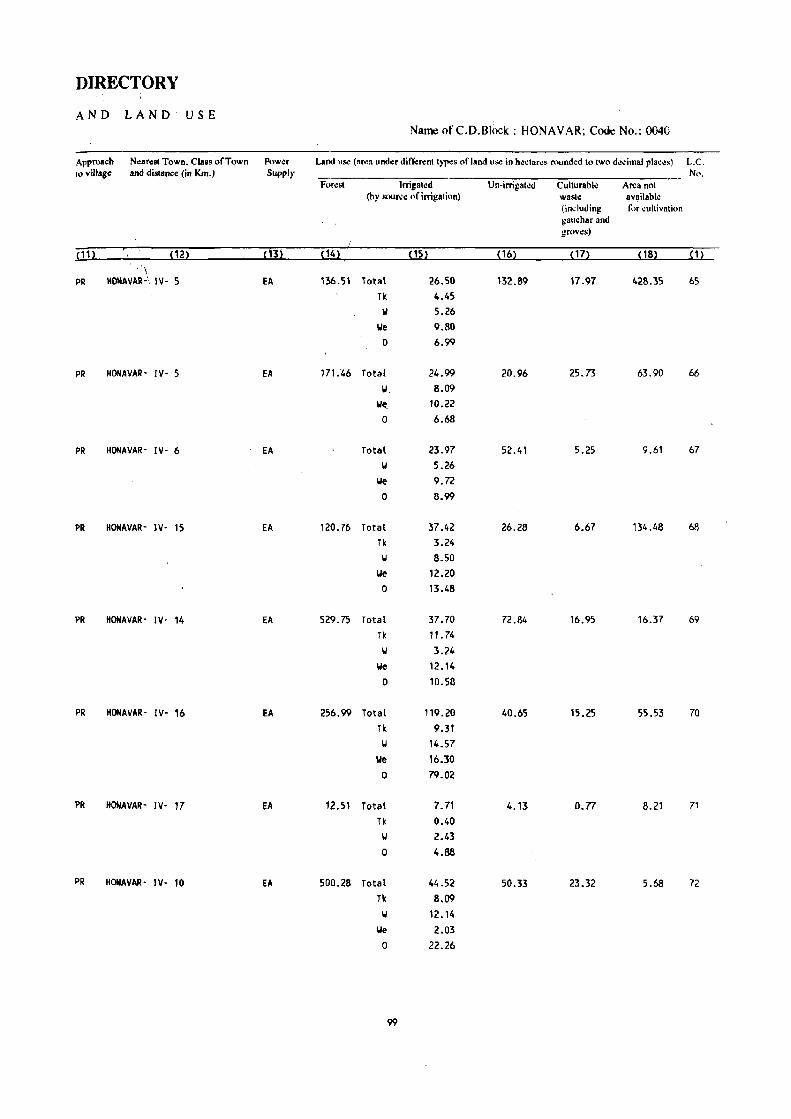
DIRECTORY
AND LAND USE Name of C.D.B1()Ck : HONAVAR; Code No.: 0040
Approach Nearest Town, Class of Town Pow¢r Land u"" (ar.,s under difl;:rent Iypes of land u"" in he~tares rounded 10 IWO decimal places) L.C, to village and distance (in Km,) Supply No,
Forest Irrigated Un-irrigated Cullurabl.: Area not (by souree of irrigation) waste available
(in.; luding I\)r cultivation gauchar and groves)
i11~ (12~ ,,32 (142 ~1S2 (162 (172 ~181 ~ 1l ,,\
PR IIOMAVAR-' IV- 5 Ell 136.51 lotal 26.50 132.89 17.97 428.35 65
Tk 4.45 W 5.26
We 9.80 0 6.99
PR HONAVAR- IV- 5 EA 171.'46 Total 24.99 20.96 25.73 63.90 66
W 8.09
~ 10.22 0 6.68
PR HONAVAR- IV- 6 EA Total 23.97 52.41 5.25 9.61 67 '01 5_26
We 9.72 0 8.99
PR HONAVAR- IV- 15 EA 120.76 Total 37.42 26.28 6.67 134.48 68
Tk 3.24 W 8.50
We 12.20 0 13.48
PR HONAVAR- IV- 14 EA 529.75 Total 37.70 72.84 16.95 16.37 69 Tk 11.74 II 3.24
We 12.14 0 10.58
PR HOMAVAR- IV- 16 EA 256.99 Total 119.20 40.65 15.25 55.53 70
Tk 9.31 II 14.57
We 16.30 0 79.02
PR HONAVAR- IV- 17 EA 12.51 Total 7.71 4.13 0.77 8.21 71
Tk 0.40 II 2.43 0 4.88
PR HONAVAR- IV- 10 EA 500.28 Total 44.52 50.33 23.32 5.68 72
Tk 8.09 II 12.14
We 2.03 0 22.26
99

VILLAGE·
AMENITIES
NameofC.D.Block: HONAVAR; Code No. :0040
L.C. No.
JIIame of Village
(2) : 73 ~EMAI(KI
74 MELIN-MANNIGE
75 KELGIN-MANNIGE
76 ANILGOO
77 HINNUR
78 BERAN!CJ
79 !CODANI
80 BIRANGOO
TOIII aNI of Ih~villag.:
(111 hecla"':.)
75.78
324.03
28.14
103.60
408.17
193.S'
466.55
321.96
TOI.I Populalion and
No.of Houacholds
(4)
133 (9)
661 (115)
Amellitic~ Ivailable (if not avail.ble wilhilllhe villaBe. a dallh (-) ia shown in the column and ncxt ttl it ill brackets. tbe distance ill broad ranges viz. -S I;ms. S-IO kms.
and 10+ kms ufthe "".NSI rl.c~ wh~N the lacUity i. avpilablc is giwn). Etluca- Medical Drinking PtlIII Day or Communication
tional Waler and D.y. of (BuR Slop. T .:1.:- mark.:tl tWlway Station, graph hat if any Waterwayl
(5) (6) (9) ~10)
P ·(0'5) w ,(0,5) -(10+) BS
P, M ·(0-5) w PO '(10+) BS
40 P ·(0-5) w -(0-5) -(10+) as (9)
981 p. M. H (171)
585 (98)
P
860 p. M (138)
1296 (220)
P(Z), M
357 P(2)
(65)
100
. (0,5)
·(5'10)
RP
RP
-(0-5)
w
w
w
w
-(0,5) -(10+)
-(0'5) -(10+)
PTO,
Phone
PO -(10+)
-COOS) '(10+)
as
as
BS
BS
as

DIRECTORY
AND LAND USE Name of C. D. Block : HONAVAR; Coue No.: 0040
Approach NeaNst Town. Cla~ of Town Powt:r Land us~ (aNa und~r din;'rcnllyl'o!s of land us.: in hcclar~s round.d 10 IWo decimal places) L.e. 10 village and distance (in Km.) Supply No.
Forest Irrigalcd Un-irrigalcd Cullurahl.: Area nUl (hy sour~.: of irrigation) was'~ available
(including t()r ~ultivation
gauehar and gruves)
~1 1 l ~121 ,13~ ~141 ~15l ~ 161 ,'7l pSl ~11 - 'i
PR HONAVAR- IV- 20 57.59 Total 6.98 5.92 4.57 0.72 73 Tk 0.40 II 2.48 0 4.10
PR HONAVAA- IV- 19: EA 245.87 Total 40.05 15.14 15.73 7.24 74 Tic 0.81 W 6.07
-We 12.33 0 20.84
PR HONAVAR- IV- 1S EA' 20.62 Total 3.65 1.58 1.06 1.23 75 TK 0.81 W 1.21 0 1.63
PR HONAVAR- IV- 20 EA 48.S5 Total 20.03 14.02 L45 19.25 76 0 20.03
PR HONAVAA- IV- 21 fA 344.05 Total 25.09 27.43 5.10 6.50 77
Tic 2.83 W 4.05
We 4.05 0 14.16-
PR HONAVAR- IV- 22 EA 107.49 Total 33.90 23.83 5.S1 22.S1 78 Tic 6.07 II 7.69
lie 4.15 0 15.99
PR HONAVAR- IV- 22 EA 317.42 Total 51.49 44.62 1.55 51.47 79 TIc 9.31 II 12.14
lie 10.12 0 19.92
PR HONAVAR- IV- 24 fA 255.72 Total 10.22 21.68 2.83 31.51 SO Tic 0.40 II 4.06
lie 2.02 0 3.74
101

Name of C.D.Block : HONA V AR; Code No. :0040
L.C. No.
(1)
N8!lhl of Village
81 MAGOO
82 BAlEMET
83 ASHIKERI
84 ADKEKUlI
85 SAMPOLlI
86 KUCHOOI
87 HERALI
88 SUlEBll
89 KOT
90 TUMBEBIL
91 HADIKAl
Tolal area of Ihe village (In hectares)
2994.24
698.35
695.28
1504.29
577.45
385.62
737.09
420.25
509.99
332.38
700.33
Total Population and
No.of HouSo!holds
(4)
1319 (262)
195 (33)
166 (31)
314 (66)
131 (24)
24 (5)
147
(22)
86
(13)
283 (52)
196 (36)
223 (48)
VILLAGE
AMENITIES
Amenities availahk (if nol available within Ihe village. a dash (-) is shown in the column and next 10 il in brackets. the distance in broad ranges viz. -.' kms. ~-IO kms.
and 10+ kms of the nearest place where Ihe facililv is available is givon). Educa- . Medical Drinking Posl Day or Communication
lional Water' and Days of [Bus SlOp. Tele- market/ Railway Slat ion. graph hal if any Wakrwayl
(6) m (8) (9) (10)
p. M. H -(0-5) II PO - (10+) BS
P ·(5-10) II '(5-10) '(10+) BS
-(0-5) -(5-10) II . (5-10) -(10+) BS
P -(5-10) II - (5-10) -(10+) BS
'(0-5) -(5-10) II '(0-5) -(10+) BS
-(0-5) -(0-5) II -(5-10) - (10+) BS
- (0-5) -(0-5) II -(5-10) -(10+) as
-(0-5) -(0-5) IJ . -(5-10) -(10+) as
p -(5-10) IJ -(5-10) -(10+) as
P -(5-10) II -(5-10) -(10+) BS
P -(0-5) II -(0-5) -(10+) BS
102

103

Name of C.D.Block : HONA VAR; Cod~ No. :0040
L.C. No.
(1)
Name of Village
92 ADUl(Al
93 1)081100
Total (SL.III)
Total aNa of Ih~ villag~
(In h':clan:s)
(3)
642.80
195.57
Total Popu· lalion and No.or Hot'''''holds
(4)
564 C 1()9)
315 (54)
74555.76 129650 (23424)
VILLAG£
AMENITIES
AlThlnili~s availahl~ (if not ,vailahk within Ihe village. a dash (-) is shown in the ~olumn and n.:xt III it in bl1l~k.:ls. the diSl.n.:.: in broad rang.:. viz. -5 kms. ~-lO kms.
and 10+ kIllS of the ncarelll place wh.:n: the ta~ililY is availahle is given). &luea- M.:dical Drinkin, PO$l Day or Communication
tiolllli Waler and Days of [Bus Slop.
(5)
P
P
P( 189),
14(68) ,
H( 16), PUC(4)
104
(6)
-(5-10)
-(5-10)
PHC(9) ,
fPC(6) •
RP(20) ,
SPlP
w
w
Tek- madell Railway SlaliOlJ. graph hat ifany Wah:rway)
(71 (8) (9) (10)
PO -(10+) 85
-(0-5) -(10+) liS

DIRECTORY
AND LAND USE
Approach to village
( 11)
Nearest Town. Class of Town and distance (in Km.)
(12)
PR HOHAVAR· IV· 22
PR HOHAVAR· IV· 22
Power Supply
(13)
EA
EA
Name of C. D.Block : HONAV AR; Code No.: 0040
Land us¢ (area und~r differenl Iyp~s of land us¢ in heclares rounded 10 two decimal placos) L.e. No.
Forest Irrigated Un-irrigated CulturabIc Area not (by source of irrigation) waste avail"ble
(including for cultl\ alin:l gauchar and groves)
(14) (15) (16) (17) (18) (1)
559.67 Total 27.80 44.96 3.56 6.81 92 Tk 0.40 \I 11.82 0 15.58
151. 73 Total 13.81 23.86 0.85 5.32 93
Tk 0.40 W 6.08 0 7.33
57420.01 Total 3682.51 5107.76 3808.64 4502.19 Tk 405.21
\oj 487.52 We 885.50 0 1904.28
105 CEN·14


KARWAR C.D.BLOCK

I! II II I ,I .1 q :! i .! ~
I
• ..
o
I I rj:": : 1,,.;':'
: • 1 ::"';
11 :~::~:@ . I ,:z.
I: l: : LJ: .. :

ALPHABETICAL LIST OF VILLAGES
T ALUK: KARW AR-0050 C. D', BLOCK: KARWAR-0050
SL NAME OF THE VILLAGE 1991 CENSUS 1981 CENSUS NO
LOCATION CODE LOCATION CODE LOCATION CODE LOCATION CODE (Manual) (Computer) (Manual) (Computer)
2 3 4 5 6
Amdall i 11/20/5/3 11/20/0050/0003 9/19/5/2 09/19/0050/0002 2 Angadi 11/20/5/15 11/20/0050/0015 9/19/5/13 09/19/0050/0013 '3 Arav 11/20/5/17 11/20/0050/0017 9/19/5/15 09/19/0050/0015
" Arga 11/20/5/6 11/20/0050/0006 9/19/5/5 09/19/0050/0005
5 Baad 11/20/5/8 11/20/0050/0008 9/19/5/7 09/19/0050/0007
6 Saithlcol 11/20/5/7 11/20/0050/0007 9/19/5/58 09/19/0050/0058
7 ~alemane 11/2015/35 11/20/0050/0035 9/19/5/33 09/19/0050/0033 8 Belur 11/20/5/52 11/20/0050/0052 9/19/5/50 09/19/0050/0050
9 Bergal 11/20/5/53 11/20/0050/0053 9/19/5/51 09/19/0050/0051
10 Bhaire 11/20/5/29 11/20/0050/0029 9/19/5/27 09/19/0050/0027 11 Bolsitta 11/20/5/25 11/20/0050/0025 9/19/5/23 09/19/0050/0023
12 Chendiye 11/20/5/5 11/20/0050/0005 9/19/5/4 09/19/0050/0004 13 Chitakula 11/20/5/13 1·1/20/0050/0013 9/19/5/11 09/19/0050/0011
14 Devakar 11/20/5/36 11/20/0050/0036 9/19/5/34 09/19/0050/0034
15 Devalmakki 11/20/5/48 11/20/0050/0048 9/19/5/46 09/19/0050/0046
• 16 GhadSai 11/20/5/24 11/20/0050/0024 9/19/5/22 09/lSi/0050/0022
17 Gopsitta 11/20/5/21 11/20/0050/0021 9/19/5/19 09/19/0050/0019 18 Gotegal i 11/20/5/33 11/20/0050/0033 9/19/5/31 09/19/0050/0031
19 Goyar. 11/20/5/30 11/20/0050/0030 9/19/5/28 09/19/0050/0028
20 Halgejoog 11/20/5/27 11/20/0050/0027 9/19/5/25 09/19/0050/0025
21 Hankon 11/20/5/22 11/20/0050/0022 9/19/5/20 09/19/0050/0020 '22 Haniconjoog 11/20/5/26 11/20/0050/0026 9/19/5/24 09/19/0050/0024 23 Hartuga 11/20/5/38 11/20/0050/0038 9/19/5/36 09/19/0050/0036 24 Hosal i 11/20/5/19 11/20/0050/0019 9/19/5/17 09/19/0050/0017
25 Hotegal i 11/20/5/23 11/20/0050/0023 9/19/5/21 09/19/0050/0021
26 Kadiye 11/20/5/43 11/20/0050/0043 9/19/5/41 09/19/0050/0041
27 Kadra 11/20/5/34 11/20/0050/0034 9/19/5/32 09;19/0050/0032 28 Kadwad 11/20/5/57 11/20/0050/0057 9/19/5/55 09/19/0050/0055 29 Kaiga 11/20/5/37 11/20/0050/0037 9/19/5/35 09;19/0050/0035 30 Kamargaon 11/20/5/31 11/20/0050/0031 9/19/5/29 09;19/0050/0029 31 Kanasgiri 11/20/5/12 11/20/0050/0012 9/19/5/10 09;19/0050/0010 32 Katar 11/20/5/44 11/20/0050/0044 9/19/5/42 09/19/0050/0042 33 Kerwadi 11/20/5/42 11/20/0050/0042 9/19/5/40 09;19/0050/0040 34 Kinnar 11/20/5/45 11/20/0050/0045 9/19/5/43 09/19/0050/0043 35 Kodar 11/20/5/4 11/20/0050/0004 9/19/5/3 09/19/0050/0003 36 Kolga 11/20/5/18 11/20/0050/0018 9/19/5/16 09/19/0050/0016 37 Kuchegar 11/20/5/39 11/20/0050/0039 9/19/5/37 09/19/0050/0037
109

ALPHABETICAL LIST OF VILLAGES
TALUK: KARWAR-0050 C. D. BLOCK: KARWAR-0050
SL NAME OF THE VILLAGE 1991 CENSUS 1981 CENSUS NO
LOCATION CODE LOCA TI ON CODE LOCATION CODE LOCA TI ON CODE (Manual) (Computer) (Manual) (Computer)
2 3 4 5 6
38 Lande 11/20/5/32 11/20/0050/0032 9/19/5/30 09/19/0050/0030
39 Madhewada 11/20/5/11 11/20/0050/0011 9/19/5/9 09/19/0050/0009 40 Maigini 11/20/5/20 11/20/0050/0020 9/19/5/18 09/19/0050/0018 41 Majal i 11/2Q/5/14 11/20/0050/0014 9/19/5/12 09/19/0050/0012 42 Makheri 11/2015/56 11/2010050/0056 9/19/5/54 09119/0050/0054 43 Mallapur 11/20/5/41 11/20/0050/0041 9/19/5/39 09/19/0050/0039 44 Mudgeri 11/20/5/16 11/20/005010016 9/19/5/14 09/19/0050/0014
45 Nagekove 11/20/5/51 11/20/0050/0051 9/19/5/49 09/19/0050/0049 46 Naiti'shvar 11/20/5/47 11/20/0050/0047 9/19/5/45 09/19/0050/0045 47 Nandanagadda 11/20/5/9 11/20/0050/0009 9/19/5/56 09/19/0050/0056 48 Nivl i 11/20/5/50 11/20/0050/0050 9/19/5/48 09/19/0050/0048
49 Savantwada 11/20i5/10 11/20/0050/0010 9/19/5/8 09/19/0050/0008 50 Shirve 11120/5/49 11/20/0050/0049 9/19/5/47 09/19/0050/0047
51 Shirwad 11/20/5/55 11/20/0050/0055 9/19/5/53 09/19/0050/0053 52 Siddar 11/20/5/54 11/20/0050/0054 9/19/5/52 09/19/0050/0052 53 Sunkeri 11/20/5/1 11/20/0050/0001 9/19/5/57 09/19/0050/0057
54 Todur 11/20/5/2 11/20/0050/0002 9/19/5/1 09119/0050/0001
55 Ulga 11/20/5/28 11/20/0050/0028 9/19/5/26 09/'9100~()/OO26
56 Virje 11/20/5/40 11/20/0050/0040 9/19/5/38 09/19/0050/0038
57 loIailwada 11/20/5/46 11/20/0050/0046 9/19/5/44 09/19/0050/0044
110

KARWAR C.D.BLOCK

VILLAGE
AMENITIES Name of C.D.Block; KARWAR; Code No. ;0050
L.C. • Name of Village Total area of Total Amenities available (if not available within the village, u dash (-) is shown in the No. the village Popu- column and next to it in brackets, the distance in broad ranges viz. -5 kms, 5-10 kms,
(In hecta~s)1 lation and 10+ kms of the neaNst(!lace where the facilit~ is available is given). and Edues- Medical Drinking Post Day or Communication
No.of tional Water and Days of [Bus Stop, House- Tek marketl Railway Station. holdS graph hat ifany Wat~rwayJ
(1) (2) (3) (4) (5) (6) (7) (8) (9) (10)
SUNICERI 70.67 ------------------------ UN - INHABiTED ~~.-.--------------------
2 TOOUR 1430.22 1258 P, H -(0-5) II, HP PO -(0-5) BS (237)
3 AMDALLI 2323.43 4335 P(6), PHC T, II, HP PTO, SUN BS .(849) M(3) , H Phone
4 KOOAR 971.36 1920 P(2) , H - (0-5) II, HP PO -(0-5) BS (359)
5 CHENDIYE 1438.66 4237 P(6), PHC, FPC T, II, HP PTO, SUN BS (849) M(5) , H Phone
6 ARGA 710.40 2637 P(4), -(0-5) II, HP PO SUN BS (543) M(3), H
7 BAITHKOL 189.27 58 -(0-5) -(0-5) T, II -(0-5) -(0-5) BS (7)
8 BAAD 233.98 35 -(0-5) - (0-5) II -(0-5) -(0-5) BS (7)
9 NANDANAGADDA 62.87 --------- --- --- -------_- UN - INHABITED --------------=----.-----
10 SAVANTIIADA 263.44 351 P, M RP II, HP -(0-5) -(10+) BS (91)
11 MADHEIIADA 424.76 1053 peS), H, H RP II, HP PTO, - (10+)'- 8S (265) Phone
12 ICANASGIRI 448. II 828 P -(0-5) 1/ PO -(5-10) BS
( 187)
13 CHITAKULA 988.39 9701 P( 10), PHC, T, II, HP PTO, - (0- 5) BS (2068) H(3), RP(5), SMP Phone
H(2), puc
14 MAJALI 1246.20 6802 P( 12), RP(5) II, HP PTO, SUN BS ( 1507) M(4) , H(3) Phone
15 ANGADI 27.51 470 P(2) , PHC, FPC T, II PTa, -(0-5) BS ( 125) M(2), Phone
112

DIRECTORY
AND LAND USE Name of C.D.Block : KARWAR; Code No.: 0050
Approacb Nearest Town, Class of Town Power Land use (area under different types of land use ill bcctares rounded to two decimal places) L.C. to village . and dialAnee (in Km.) Supply No.
Fo~st Irrigated U n·irrigated Culturable Area not (by IlOIJrell ofirrigation) waste available
(including for cultivation gluebarand groves)
(m (m (3) (14) (15) (16) (17) (18) (1)
•••••••••••••••••••••••••••••••••••••• ~ •••••• UN • INHABITED •••••••••••••••••••••••••••••••••••••••••••••
PR BINAGA' V' .10 EA 1163.59 total 2.02 224.54 23.27 16.80 2 GC 2.02
PR BINAGA· V' 10 EA 1648.75 Total 5.26 494.72 149.80 24.90 3 GC 5.26
PR BINAGA' V' 10 EA 787.98 Total 10.12 137.69 20.59 14.98 4 GC 10.12
PR BINAGA· V' 7 EA 916.75 Total 8.09 332.05 66.35 115.42 5 - GC 8.09
PR 81NAGA' V' 3 fA 520.59 Total 7.08 144.25 . 4.15 34.33 6 GC 7.08
PR KARWAR~ II· 5 EA 304.98 7
PR KARWAR· II' 15 EA ·,112 •. 3, 8
.••• --.--- •• --.----------.-- .••••. - ••.••••••• UN - INHABITED ~-------------------------------------------- 9
PR KARWAa· II· 15 EA 152.81 103.58 2.30 4.75 10
PR KARWAR' 11· 10 EA 128.33 Total 7.28 199.90 36.95 52.30 11 GC 7.28
PR KARWAR· 11·7 EA 74.24 Total 4.65 98.70 18.69 251.83 12 GC 4.65
PR KARWAR' 11- 5 EA 142.45 594.72 32.39 218.83 13
8'>
PR .·KARWAR· II· 12 EA 217.89 Total 6.88 591. 72 . ~.39 427.32 14 GC 6.88
JQj.\rl8 N: (~
PR KARWAR· I I· 10 fA 22.45 1.90 3.16 15
: : 113
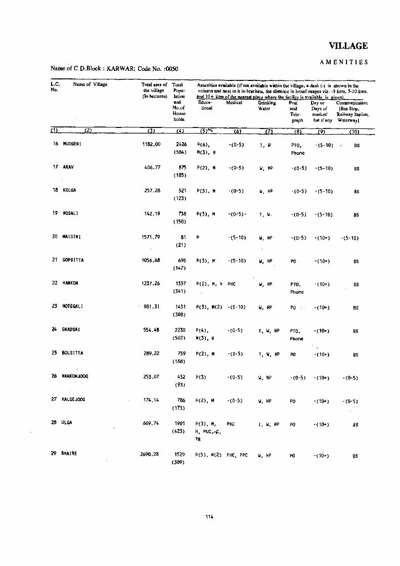
VILLAGE
Name of C.D.Block : KARWAR; Code No. :0050 AMENITIES
L.C. Name of Village Total area of Total Anwnili~8 available (if not available within th~ village. a dash (-j is shown in the No. the village Popu- column and neXllo it in brackets. the distsnce in broad ranges viz. -5kms. 5-10 kms.
(In hectares) lation and 10+ kms ofth~ n£are!! l!!ac~ wh2re the fa~ilil~ is availabl~ is givenl. and &iuca- Medical Drinking 'Post Day or Communicalion No.of lional Waler and Days of [Bus Slop, House- Tele- market/ Railway Station. holds graph hal ifany Waterway)
(1) (2) m (4) (5fi1- (6) m (8) (9) (10)
16 MUDGERI 1182.00 2426 p(6), -(0-5) T, II PTO, -(5-10) as (584) 101(3), H Phone
17 ARAY 406.77 875 P(2), II -(0-5) 101, HP -(0·5) -(5·10) as (185)
18 KOLGA 257.28 521 P(J), II -(0-5) 101, HP -(0-5) -(5·10) as (123)
19 HOSAL! 142.19 738 I>(J), II -{O~S) • T, W,. -(0-5) -(5-10) as (150)
20 MAIGINI 1571.79 81 I> -~5-10) 101, HP -(0-5) -(10+) -(5-10) (21)
21 GOPSITTA 1056.68 696 P(3), II ~(5-10) 101, HP PO -(10+) as (147)
22 HANKON 1237.26 1337 p(2), M, H PHC 101, HP PTO, -(10+) as (341) Phone
23 HOTEGALI 981.31 1431 P(3), N(2) -(5-10) 101, HP PO .-_(10+) as (308)
24 GHADSAI 554.48 2230 P(4), -(0-5) T, 101, HP PTO, - (10+) as (502) 101(3), H Phone
25 BOLSITTA 289.22 759 P(2), M -(0-5) T, 101, HP PO -(10+) as (168)
26 HANKOUOOG 253.07 432 P(3) -(0-5) 101, HP -(0-5) '(10+) - (0-5) (93)
27 HALGEJOOG 174.14 786 P(2), II -(0-5) 101, HP PO -(10+) -(0-5) (173)
28 ULGA 609.74 1901 P(3), M, PHC T, W, HP PO - (10+) as (423) H, PUC,,,,,
tR
29 BHAIRE 2690.28 1529 P(5) I M(2) PHC, FPC 101, HP PO -(10+) as (309)
114

DIRECTORY
AND LAND USE Name of C:D.Block :. KARWAR; Code No.: 0050
Approach Nearest Town, Class of Town Power Land use (area under diff\!rent typ.:s of land use in hectares rounded to two decimal places) L.C. to village and distance (in Km.) Supply No.
Forest Irrigated Un·irrigated Culturable Area not (by source of irrigation) waste available
(including for cultivation gauchar and groves)
~ 1'2 ~122 ~1~2 P42 ~152 ~16l ~17l ~182 ~12
KR KARWAR· II' 12 fA 538.99 Total 161.88 257.92 144.70 78.51 16 Tk 161.88
KR KARWAR' II" 10 fA 179.01 Total 65.00 95.33. 55.06 12.37 17 GC 65.00
PR KARWAR· II· 10 EA 81.15 Total 0.40 152.93 7.63 15.17 18 GC 0.40
PR KARWAR' [[. 1 0 EA 118.76 6.75 16.68 19
KR KAORA KPC PROJECT COLONY' 1533.29 9.39 16.59 12.52 20 VI' 18
PR KADRA KPC PROJECT COLONY' EA 830.71 Total 16.19 113.41 20.24 76.13 21 VI- 15 GC 16.19
PR KADRA KPC PROJECT COLONY' EA 794.89 Total 28.33 197.89 132.88 83.27 22 VI· 16 Tk 28.33
PR KARWAR' II· 14 fA 515.47 Total 2.02 305.90 36.23 121.69 23 GC 2.02
PR KAORA KPC PROJECT COLONY' EA 87.89 Total 0.40 328.82 14.55 122.82 24 VI- 11 GC 0.40
PR KADRA KPC PROJECT COLONY- ~A 106.24 76.08 9.40 97.50 25 VI- 17
KR KARWAR- 11- 37 EA 68.50 2.43 182.14 26
KR KARWAR· 11- 16 EA 125.53 3.05 45.56 27
PR KADRA KPC PROJECT COLONY' EA 236.85 Total 3.64 205.82 15.24 148.19 28 VI- 14 GC 3.64
PR KADRA KPC PROJECT COLONY· EA 2169.31 Total 44.52 288.13 112.07 76.25 ,29
VI- 12 GC 44.52
115

VILLAGE
AMENITIES Name of C.D.Block : KARWAR; Code No. :0050
L.C. Name of Villag. Total area of TOIaI Amenities available (ifnQl available within the villag\l, a dash (-) is shown in tho No. the village Popu- colltt11n and I1eXlto it in-bracketl. the dialance in broad ranges viz. -5 kma. 5-10 kma.
(In hectares) I_lion and !.a+ kms oflhll !!I1a~st I!!!co !:!lore Ibe f!!cililX i! avail_bl!! is llivl:!ll· and Educa- Medical Drinking Post Day or Communication No.of tional Water and Days of IBusStop. House- Tele- marketl Railway Slation, holds graph hat if_ny Waterway]
(1) (2) (3) (4) (5) (6) m (8) (9) (10)
30 GOYAR 2299.71 198 P -(5-10) II, HP -(5-10) -(10+) -(0-5) (33)
31 KAMARGAON 1615.98 130 -(0-5) -(5-10) II -(5-10) -00+) -(5-10) ( 18)
32 LANDE 2382.89 105 -(0-5) -(5-10) II -(5-10) -(10+) -(5-10) (25)
33 GOTEGALI ~.44 1343 P(2), H, H -(0-5) PO -(10+) as (284)
34 KADRA 3865.26 2880 P(Z), H, H H, ,PHC T, II PTO, -(10+) BS (697) Phone
35 BALEMME 3496.62 221 -(5-10) D II -(5-10) -(10+) -(0-5) (49)
36 DEYAKAR 1,067.65 832 P -(5-10) II PO -(10+) -(10+) (197)
37 KAIGA 1,055.88 1596 P(Z) RP T, II PO -(10+) BS (376)
38 HARTUGA 1848.11 1163 P -(S-10) II -(5-10) -<10+) BS (307)
39 KUCHEGAR 1787.41 145 P -(5-10) II -(5-10) -(10 ... ) -(0-5) (34)
40 YIRJE 2080.26 1747 P -(5-10) II, R -(10+) -(10+) -(0-5) (490)
41 MALLAPUR 1259.82 1491 P(4), M(2) -(5-10) II, R PO -(10+) BS (340)
42 KERWADI 497.55 n4 P, M. H, SMP II PO -(10+) BS (159) PUC
43 KADIYE 305.55 522 P, H -(0-5) II -(0-5) -(10+) -(0-5) '(107)
41, KATAR 364.60 711 P, M, H -(0-5) II -(0-5) -(10+) BS (1SO)
116

DIRECTORY
AND LAND USE Name ofC.D.Block : KARWAR; Code No.: 0050
Approach Neatest Town, Class of Town Pow.:r Land u~ (area under different typ.:s of rand use in heclaN' rounded to two decimal places) L.C. rovilllIge and dilllllncc (in Km.) Supply No.
Foro:. Irrigaled Vn·irrigated Culturable Aro:a not (by source of irrigation) waste available
(includiqg for cultivation gaucharand groves)
Pl1 " '122 ,'3~ , ,4 1 , ,51 ,,61 , ,71 ,,81 . "1
KR KADRA KPt PROJECT COLONY· 2171.30 Total 5.06 32.48 35.08 55.79 30 VI· 24 GC 5.06
KR KAORA KPC PROJECT COLONY' 1603.71 Total 3.04 5.05 4.08 0.10 31 VI' 28 GC 3.04
KR KADRA KPC PROJECT COLONY- EA 2341.61 Total 15.18 0.22 10.74 15.14 32 VI- 32 GC 15.18
PR KADRA KPC PROJECT COLONY, 3252.82 Total 25.20 195.27 16.55 159.60 33 VI· 10 GC 25.20
PR KADRA (PC PROJECT COLONY· EA 3348.13 Total 5.06 54.00 218.00 260.30 34 VI' GC 5.06
KR KADRA (PC PROJECT COlONY, 3271.n 23.68 7.09 194.08 35 VI· 12
PR KARWAR· II' 61 3678.51 171.08 12.00 206.06 36
PR KARWAR· II· 53 3779.14 127.98 148.76 37
PR KARWAR· II· 55 1633.86 Total 8.09 72.76 133.40 38 GC 8.09
KR KAR\IAR· II· 51 1593.04 Total 12.14 64.39 1.99 114.95 39
GC 12.14
leR KARWAR' II' 46 1784.33 Total 10.12 118.55 167.26 40 GC 10.12
FIR KARWAR· II· 42 919.68 Total 8.09 104.57 22.7.48 41 GC 8.09
kR KARWAR- II' 37 354.67 61.72 22.06 59.10 42
kR KARWAR· II' 35 160.32 Total 7.08 107.65 9.27 2;:'23 43 Tk 7.08
IeR KARWAR· II· 36 182.60 Total 9.11 153.84 '.18 17,87 44 Tk 9.11
117

VILLAGE
AMENITIES Name of C.D.Block : KARWAR; Code No. :0050
L.C. N~of Villag~ Total aNa of Total Am¢nities availabl¢ (if not availabl~ within th¢ village. a dash (-) is shown in the No. the village Popu- column and next to it in brackets, the distance in broad ranges viz. -5 kms, 5-10 kms,
(In hectares) lation a!!d 10+ kms of the neaNst Illace where the fadlitx is avail@ble is given). and Educa- Medi~al Drinking Post Day or Communication No.of tional Water and Days of [Bus Stop, Hou$¢- Tel.:- marketl Railway Station, holds graph hat if any Waterway]
(1) m (3) (4) (5) ·(6) (7) (8) (9) (10)
45 KINNAR 1109.32 3295 P(1l) , SMP IJ PTO, -(10+) BS
(715) M(4), H Phone
46 WAllWADA 491.62 1382 peS), M, H -(0-5) IJ PO -(10+) BS
(273)
47 NAIT I SHVAR 204.61 658 P, M -(0-5) W -(0-5) -(10+) BS (140)
48 DEVAlMAKKI 647.54 720 P, M PHC, FPC \I PO -(10+) BS
(157)
49 SHIRVE 2589.85 329 P -(5-10) IJ -(5-10) -(10+) BS
(61)
50 NIVll 160.91 181 P -(5-10) IJ -(5-10) -(10+) -(0-5)
(34)
51 NAGEKOVE 3954.03 372 p(2) -(0-5) -(5-10) -(10+) -(0~5)
(67)
52 BElUR 1360.23 466 P -(S-10) IJ -(0-5) -(10+) BS
(n)
53 BERGAL 451.51 441 P(2) -(0-5) IJ -(0-5) -(10+)· BS (82)
54 SIDDAR 1112.53 1042 P(4), PHC, FPC T, W PO -(10+) BS (241) M(2) , H,
PUC, I
55 SHIRWAD 1974.06 2131 p(3) I M(2) -(0-5) T, IJ PO '-(0-5) as (470)
56· MAKHERI 80.46 953 p(2), M -(0-5) T, IJ - (0-5) -(0-5) BS (258)
57 KADWAD 1018.63 4155 P(3), -(5-10) T, II PTO, -(5-10) BS (786) M(2) , H Phone
Total (SlJIl) 70967.51 79416 P(147), H, (1n78) M(63), PHC(10),
H(22) , D, FPC(5).
PUC(4) , C, RP(13),
I, TR SMP(3)
118

DIRECTORY
AND LAND USE Name of C.D.Block : KARWAR; Code No.: 0050
Approach Nearest Town. Class of Town Power Land use (area under different types of land use in hectares rounded to two decimal places) L.C. to village and distance (in Krn.) Supply No.
Forest Irrigated Un-irrigated Culturable Area not (by source of irrigation) wasle available
(including for cultivation gauchar and groves)
tll) P2~ P~l ~14l ~15l ,16l ,17) ~'82 (1}
PR KARIIAR- 11- 12 355.35 480.52 42.46 230.99 45
KR KARWAR- II' 24 168.36 Total 3.04 137.62 64.88 117.72 46 Tit: 3.04
KR KARIIAR- 11- 22 81.65 Total 5.06 71.02 16.59 30.29 47 GC 5.06
PR KARWAR- 11- 32 465.21 Total 3.04 94.09 50.53 34.67 48 GC 3.04
KR KARWAR- 11- 36 2408.20 Total 4.05 101.38 31. 71 44.51 49 GC 4.05
KR KARIIAR- 11- 40 123.97 Total 2.02 24.28 5.99 4.65 50 GC 2.02
KR KARWAR- 11- 38 3733.37 Total 9.11 96.12 29.33 86.10 51 GC 9.11
KR KARWAR- 11- 28 1130.59 Total 3.04 97.13 62.39 67.08 52 GC 3.04
PR KARWAR- 11- 32 301.00 Total 4.05 51.60 37.10 57.76 53 GC 4.05
PR KARWAR- 11- 23 EA 804.77 Total 24.28 163.36 42.14 77.98 54 GC 24.28
PR KARWAR- 11- 5 EA 1500.88 Total 0.81 285.77 101.65 84.95 55 GC 0.81
PR KARWAR- II - 4 EA 6.09 50.59 18.57 5.21 56
PR KARWAR- 11- 10 EA 354.33 Total 1.01 340.99 52.27 270.03 57 GC 1.01
54337·.34 Total 541.44 8576.44 1829.25 6563.77 Tit: 209.44 GC 332.00
119


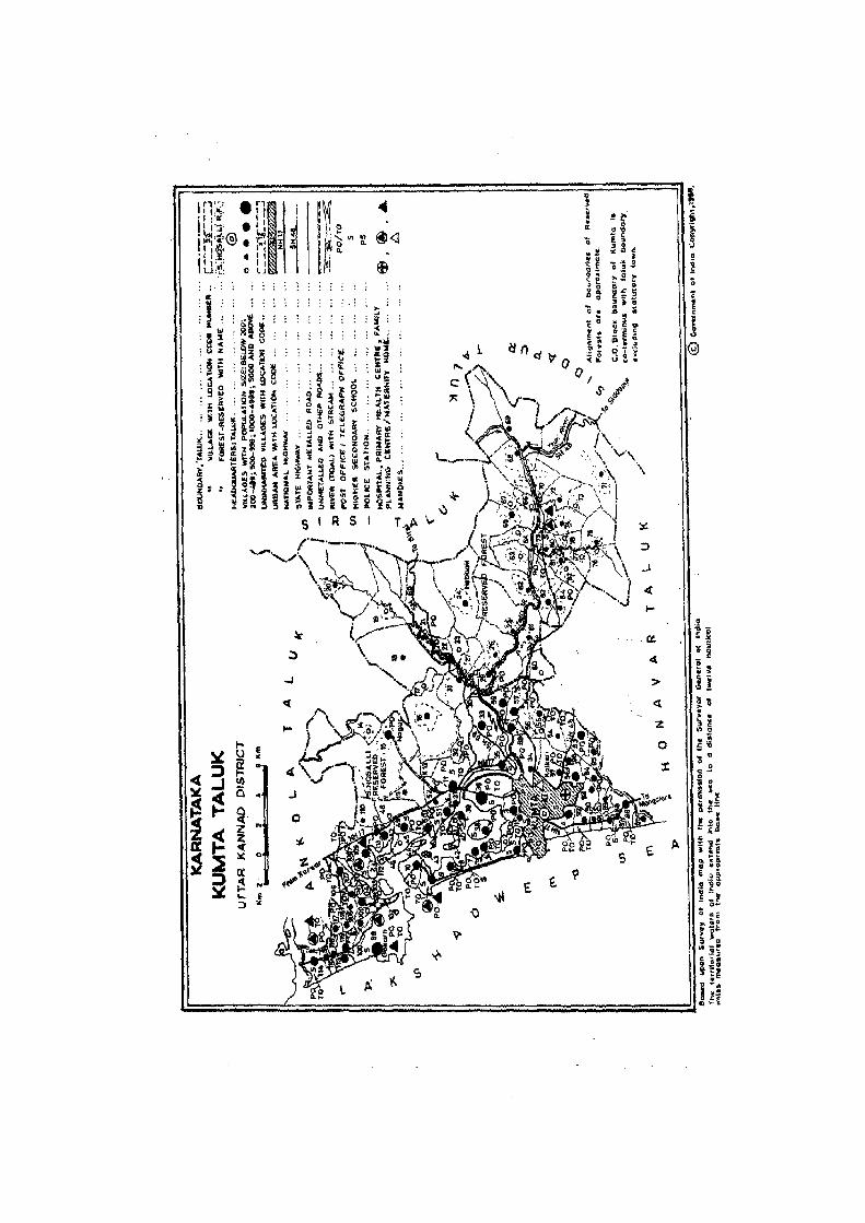
I"" • '11 ~ ~o .. II,", ,I,
'1,'0: II III'::;' .', ..
@i<l • '.... 1r., ~
~ii ~ ~ I~j.c'®' 1;;, :t:t
.! 1,,8, 1, Z
.~ ~ " 1:t • I,
fiI II,:,: 11 8 ;; LJ:~: Q LJ < Q , ~ ,,<> ":l' I
~
,:)
-I
c:(
~
l- E ~ U ..
if .. «:l t-
Il) :11(...1 (5 .. J
~~ ~,
~i! z .. 2: -c(
~~ lII: 0
a: ~ ~ N
l- E :::l '"

123

ALPHABETICAL LIST OF VILLAGES
T ALUK: KUMT A-0060 C.D.BLOCK:KUMTA~O
SL NAME OF THE VILLAGE 1991 CENSUS 1981 CENSUS
NO
LOCAl ION CODE LOCATION CODE LOCATION CODE LOCATION CODE
(Manual) (C~ter) (Manual) (C~ter)
2 3 4 5 6
40 HegcJe 11/20/6/36 11/20/0060/0036 9/19/6/73 09/19/9060/0073
41 Hegdehosa II i 11/20/6/80 11/20/0060/0080 9/19/6/108 09/19/0060/0108 42 Hegle 11/20/6/54 11/20/0060/0054 9/19/6/119 09/19/0060/0119 43 Hindbai l 11/20/6/78 11120/0060/0078 9/19/6/109 09119/0060/0109 44 Hiregutti 11/20/61109 11/20/0060/0109 9/19/6/27 09/19/0060/0027 45 Hittalmakki 11/20/6/106 11/20/0060/0106 9/19/6/23 09119/0b!,0/0023 46 Holanagadde 11/20/6/5 11j20/0060/0005 9119/6/1 09/19/0060/0001· 47 Holegadde 11/20/6/86 11/2010060/0086 9/19/6/80 09119/0060/00~
48 Honopere 11/20/6/76 11/20/0060/0076 9/19/6/111 09/19/0060/0111
49 Horbfiet 11/20/6/85 11/20/0060/0085 9/19/6/81 09/19/0060/0081
50 HO~ 11/20/6/60 11/20/0060/0060 9/19/6/117 09/19/0060/0117 51 HOIlIteri 11/20/6/117 11120/0060/0117 9/19/6117 09/19/0060/0017 52 ~ngeri 11/20/6/8 11120/0060/0008 9/19/6/4 09119/0060/0004
53 Klldekocti 11/20/6/91 11/20/0060/0091 9/19/6/85 09/19/0060/0085 5 .. Kadime 11/20/6/118 11/20/0060/0118 9/19/6/18 09/19/0060/0018 55 Kadkoct 11/20/6/14 11/20/0060/0014 9/19/6/49 09/19/0060/0049 56 Kegal 11/20/6/9 11/20/0060/0009 9/19/6/5 09/19/0060/0005 57 lCalbhag 11/20/6/4 11/20/0060/0004 9/19/6/10 09/19/0060/0010 58 Kalkerf 11/20/6/97 11/20/0060/0097 9/19/6/88 09/1910060/0088 59 ICallabbe 11/20/6/59 11/20/0060/0059 9/19/6/92 09/19/0060/0092 60 Kalve 11/20/6/65 11/20/0060/0065.' 9/19/6/97 09/19ioOMl0097 61 Kanakale 11/20/6/63 11/20/0060/0063 9/19/6/95 09/19/0060/0095 62 Kandvall i 11/20/6/61 11/20/0060/0061 9/19/6/93 09/19/0060/0093
63 Karkimakki 11/20/6/58 11/20/0060/0058 9/19/6/9.1 09/19/0060/0091 64 Kavaladi 11120/6/62 11/20/0060/0062 9/19/6/94 09/19/0060/0094 65 Kelagistale 11/20/6/46 11/20/0060/0046 9/19/6/42 09/19/0060/0042 66 Keppekurve 11/20/6/43 11/20/0060/0043 9/19/6/39 09/19/0060/0039 67 Koclambale 11/20/6/21 11/20/0060/0021 9/19/6/57 09/19/0060/0057 68 KOOkani 11/20/6/51 11/20/0060/0051 9/19/6/37 09/19/0060/0037 69 KolimanjgUl"li 11120/6/110 11/20/0060/0110 9/19/6126 09/19/0060/0026 70 Konall i 11/20/6/95 11/20/0060/0095 9119/6/77 09/1910060/00n 71 Kujall i 11120/6/53 11/20/0060/0053 9/19/6/74 09119/0060/0074 72 Kundguni 11/20/6/90 11/20/0060/0090 9/19/6/86 09/19/0060/0086 73 Kuri gadde 11/20/6/48 11120/0060/0048 911916/48 09119/0060/0048
74 Lukkeri 11/20/6/38 11120/0060/0038 9/19/6/72 09/1910060/0072
75 Madanger i 11/20/6/107 11120/0060/0107 9/19/6124 09119/0060/0024 76 Madkibai l 11/20/6/56 11/20/0060/0056 9/19/6/89 09/19/0060/0089 n Malwalli 11/20/6/25 11/20/0060/0025 9/19/6/61 09/19/0060/0061 78 Manaki (R) 11120/6/34 11/20/0060/0034 9/19/6/71 09119/006010071 79 Mani katta 11/20/6/2 11/20/006010002 9/19/6/7 09/19/0060/0007 80 Masurkurve 11/20/6/42 11/20/0060/0042 9/19/6/38 09/19/006010038 81 Math 11/20/6/88 11/20/0060/0088 9/19/6/83 09/19/006010083
124

ALPHABETICAL LIST OF VILLAGES
T ALUK: KUMT A-0060 C.D.BLOCK:KUMTA~O
SL NAME OF THE VILLAGE 1991 CENSUS 1981 CENSUS NO
LOCATION CODE LOCATION CODE LOCATION CODE LOCATION CODE (Manllal) (CoqlUter) (Manual) (CoqlUte_r)
1. 2 3 4 5 6 i
82 ~ini 11/20/6/71 11/20/0060/0071 9/19/6/104 09/19/0060/0104 83 Mtdlagaz8ni 11/20/6/112 11/20/0060/0112 911916/29 09/191006010029
84 Mi~jan. 11/20/6/11 11120/0060/00,,1 9119/6132 09/19/0060/0032 '~S Monba 11120/6/111 11120/0060/0111 9/19/6/28 09/19/0060/0028
86 'Muc4:ai 11/2016/66 11120/0060/0066 911916/99 09/19/0060/0099 87 Muc:ifla II i 11120/6/72 11120/0060/0072 9/19/6/102 09/19/0060/0102 88 Mugvekanvadi 11120/6/13 11/2010060/0013 911916/47 09/19/006010047 89 Muroor 11120/6/57 11/20/0060/0057
~, " 911916/90 09/19/0060/0090
90 Nadunasker i 11/20/6/114 11/20/0060/0114 911916/14 09/1910060/0014 91 Nagerbai I 11/20/6/101 11/20/0060/0101 9/19/6/21 09/19/0060/0021 92 Nagur 11/20/6/15 11/20/0060/0015 9/19/6/50 09/19/0060/0050 93 Naranapur 11/20/6/102 11/20/0060/0102 9/19/6/31 09/19/0060/0031 94 Hi Ikod 11/20/6/32 11/20/0060/0032 9/19/6/69 09/19/0060/0069 95 Norse 11/20/6/69 11/20/0060/0069 9/19/61101 09/19/0060/0101
96 Paduvani 11/2016/50 11120/0060/0050 9119/6/40 09/19/0060/0040 '97 Pattubele 11/20/6/41 11/20/0060/0041 9/19/6/36 09/19/0060/0036
98 Sandolli-Muttolli 11120/6/19 11/20/0060/0019 9/19/6/56 09/1910060/0056 99 Santegu4. i 11120/6/79 11/2010060/0079 9/19/6/107 09/19/0060/0107
100 Santgal 11/20/6/84 11/20/0060/0084 9/19/6/115 09/19/0060/0115 101 Santure 11/20/6/27 11/20/0060/0027 911916/66 09/1910060/0066 102 Savalkurve 11/20/6/44 11/20/0060/0044 9/19/6/41 09/19/0060/0041 103 Shirgunji 11/20/6/26 11/20/0060/0026 9/19/6/62 09/19/0060/0062 104 Soppinahosalli 11/20/6170 11/20/0060/0070 9/19/6/103 09/19/0060/0103
105 Talgod 11/20/6/93 11/20/0060/0093 9/19/6/78 09/1910060/0078 106 fami rhonda 11/20/6/40 11/20/0060/0040 9/19/6/35. 09/19/0060/0035 107 Tappalgutta 11/20/6/30 11/20/0060/0030 9/19/6/64 09/19/0060/0064 108 Toregazani 11/20/6/103 11/20/0060/0103 9/19/6/30 09/19/0060/0030 109' Torke 11/20/6/104 11/20/0060/0104 9/19/6/22 09/19/0060/0022
110 Ullurmath 11/20/6/75 11/20/0060/0075 9/19/6/110 09/19/0060/011~
111 Uppinapattan 11/20/6/29 11/20/0060/0029 9/19/6/63 09/19/0060/0063 112 Urkeri 11/20/6/94 11/20/0060/0094 9/19/6/79 09/19/0060/0079
113 Valgalli 11/20/6/96 11/20/0060/0096 9/19/6/75 09/19/0060/0075
114 Van 11/20/6/20 11/20/0060/0020 9119/6/55 09/19/0060/0055 115 Yattinabail 11120/6/52 11/20/0060/0052 9119/6/46 09/19/0060/0046 116 Yedtare 11120/6/17 11/20/0060/0017 9/19/6/53 09/19/0660/0053 117 Yelvalli 11/20/6/16 11/20/0060/0016 9/19/6/52 09/19/0060/0052 118 Yennemidi 11/20/6/108 11/20/0060/0108 9119/6/25 09/19/0060/0025 119 Yeshwantimule 11/20/6/12 11/20/0060/0012 9/19/6/51 09/19/0060/0051
125

Name ofC.D.Block : KUMTA; Code No. :0060
L.C. No,
(1)
2
3
4
5
Name of Village
CHITRAGI
HAN I KATTA
HALKAR
KALBKAG
HOLANAGADDE
6 GUDEANGADI
7 !lAAD
8 HUB8ANGERI
9 KAGAL
Total an:a of the villag~ (In hcctan:s)
(3)
169.46
190.70
199.35
418.20
450.69
164.27
219.10
131. 75
530.32
,
Total Population and No.of Households
(4)
811 (150)
90 (13)
1016. (177)
4388 (735)
3784 (678)
1477 (263)
1526 (274)
1752 (275)
4049 (635)
VILLAGE'
AMENITIES
Amenities available (if not available within th~ villag~. a dash (-) is shown in the column and n~xt to it in brackets. the distance in hroall ranges vi7 .. -5 kms. 5-1.0 kms.
and 10+ kms of the nc~rcst place where the l'a,ilily is availahk is given). Eduea- Medi~al Drinking Pus! Day llf C"mmunicalion
tional Wat~r and Days of IBus Slop:
(5) (6)
P(2), H, H RP
-(0-5)
P(2), M
P(4), M(2)
P(5) ,
M(2), H
P(2), M
P, M, H,
PUC
-(0-5)
- (0-5)
-(0-5)
-(0-5)
RP
NH, RP
P(3), M(3) RP
P(4), PHC, FPC
M(3), H(2)
126
T, 'II, HP
'II, HP
'II, HP
T, 'II, HP
'II, HP
'II, HP
'II, HP
T, W, HP
'II, HP
T de- marketl Railway Station. graph hat ifany Waterway!
,(8)
Phone
-(0-5)
PO, Phone
PTO, Phone
PTO, Phone
PlO, Phone
PlO,
Phone
PTO, Phone
PTO, Phone
(9) ( 10)
-(0-5) BS
- (0-5) -(0-5)
-(0-5) BS
- (0- 5) 8S
-(0-5) 8S
-(5-10) BS
-(5-10) 8S
-(5-10) BS
-(10+) BS, NW

DIRECTORY
AND LAND USE Name ofC.D.Block: KUMTA; Code No.: 0060
Approach N~arest Town. Class of Town Pow~r Land u~ (ar~a IInd~r diff~r~nt typ.:s of land us.: in h.:ctares round.:d to two d~cimal places) L.C. 10 village and distance (in Km.) Supply No.
Forest Irrigated Un-irrigated Culturable Area not (by SOIJre~ of irrigation) waste available
(including for cuftivation gauchar and groves)
~
111 ~ 1122 ~13~ p4r ( 15~ ( 162 (7) (182 ~12
PR KUMTA- Ii(J2 EA 42.45 Total 17.20 100.01 4.~ 92,39 Tic 8.90 W 1.82
We 6.48
KR KUMTA- II 1- 3 140.72 49.98 2
PR KUMTA- Ill- 3 88.90 Total 9.23 44.13 48.60 8.49 3 Tk 4.86 W 1.13
We 3.24
PR KUMTA- Ill- EA 55.75 317.74 12.46 114.90 4
PR KUMTA- Ill- 4 EA 107.87 Total 41.68 175.37 109.84 15.93 5 Tic 25.25 W 12.14
We 2.02 0 2.27
PR KUMTA- 111- 9 fA Total 26.52 83.29 35.53 18.93 6 Tk 12.14 W 7.69
We 2.03 0 4.66
PR KUMTA- 111- 10 EA Total 19.52 163.61 26.41 9.56 7 Tic 10.62 II 4.45
We 2.83 0 1.62
PR KUMTA- IlI- 10 fA Total 13.49 74.62 21.20 22.44 8 II 7.69
We 1.75 0 4.05
PR KUMTA- 111- 12 fA 128.51 Total 44.89 246.51 1.25 109.16 9 Tic 18.21 W 8.90
We 4.42 0 13.36
127

VILLAGE
AMENITiES Name of C.D.Block : KUMT A; Code No. :0060
L.C. No.
Name of Village
10 AGHANASHINI
11 MIRJAN
12 YESHWANTlMULE
13 MUGVEKANVADI
14 KADKOO
15 NAGUR
16 YELVALLI
17 YEDTARE
18 BELLANGI
19 SANDOLLI-MUTTOLLI
TOIaI an:a of the village (In hectares)
251.32
623_13
126.49
550.61
352_50
3426_02
1549.64
204.16 .
1996.85
• 1891.27
Total Population and No.of Households
Amenities available (if not available within the village. a daSh (-) is shown in tho: column and next to it in brackets. the distance in broad ran,.:' viz. -5 kms, 5-lO kms.
and 10+ kms of the neaNfI place where the facilit¥ is available is givl!n). Educe- Medical Drinking Post, Day or . COll)lJlunication
tional Water and Days of [Bus Stop.
(4)
3071 P(2), M (465)
2887 P(4),
(477) M(2), H
(6)
RP
RP
T ele- marketl Railway Station. graph hat if any Waterway)
(8) (9)
T, W, HP PTO, -(10+) Phone
W, HP PTO, -(10+) Phone
(10)
BS, NW
BS, Nil
------------------------ UN - INHABITED -------------------------
263 P (51)
63 (11 )
-(0-5)
1033 P(2) (168)
566 P, M (94)
43 -(0-5) (9)
404 pel)
(73)
173 P (37)
128
-(0-5) W, HP -(0-5.) -(10+) BS
-(5-10) W -(0-5)' -(10+) as
-(5-10)- W, HP PO -(5-10) -BS
-(0-5) W, HP -(0-5) -(10+) lis
-(0-5) W, HP -(0-5) -(10+) -(0-5)
-(O-5) W, HP -(0-5) -(10+) -(0-5 )
-(0-5) W, HP -(0-5) -(10+) -(0-5)

DIRECTORY
AND LAND USE Nam~ of C.D.Block: KUMTA: Code 1\i().: 0060
Approach Ncarest Town, Class of Town Pow~r Land US\! (~m!a und':f din~n.!nt typ..:!'1 of land U~ in ht::~lar..:!-. rnumkd to two (.i..'\.'ind plal.'o!~) L.e. to village and distance (in Km.) Supply j\b ._-------_
Forest Irrigated Un-irrigated euhur.hl_ Alr:~ not
(hy sOlln;c of irrigation) waM~ "va;!abk ( t.:!lI'ling ;' J~ .. lJ:tivalion gaul..!har and grov~s)
(112 (122 (132 (142 {152 {162 P72 (182 (12
PR KUMTA- 111.- 15 EA 90.22 Total 33.22 54.54 18.50 54.84 10 Tk 17.40 II 6.89
lie 8.93
PR KUMTA- 111- 12 EA 325.44 Total 26.96 95.69 34.26 14(1.78 11 II 10.52
lie 12.14 GC 4.30
--------------------------------------------- UN I ~HABITED ---- - --------- ------- -- -- ---------- -- - . --- " 12
KR KUMTA- 111- 19 EA 417.90 Total 13.56 49.95 8.80 60.40 13 101 1.42
We 6.07 0 6.07
KR KUMTA- 111- 24 314.57 Total 6.68 6.09 12.33 12.83 14 II 1.62
lie 4.86
0 0.20
KR KUMTA- 111- 24 EA 3119.65 Total 5.41 67.54 92.88 140.54 15 II 3.24
lJe 2_02
0 0.15
PR KUMTA- I I 1- 16 EA 1366.29 Total 5.82 74.80 9.91 92.82 16 II 1.62
lJe 4.20
KR KUMTA- I I 1- 19 184.33 Total 4_09 12.38 2.85 0.51 17 II 3_24
lie 0_82
0 0.03
KR KUMTA- 111- 18 1877.70 Total 8.99 32.96 51.86 25.34 1!J
1/ 4.05 I/e 3.64
0 1.30
KR KUMTA- I I 1- 18 EA 1824.01 Total 9.50 15.39 32.87 9.50 19 Tk 4_24
1/ 5.26
129

Name of CD. Block : KUMTA; Code No. :0060
L.C. Na.
Name or Yillag~
20 YAN
21 KOOAMBALE
22 HARITA
23 ANEGUNDJ
24 HEBBAll
25 MALIiAlll
26 SKIRGUNJI
27 SANTURE
28 BHANDIVAL
Total 8r~8 of the village (In heclllfCS)
2528.02
1473.19
200.56
250.55
1496.94
1016.34
692.81
244.74
116.26
Total Population and No.of H()use~
hulds
(4)
312 (59)
184 (32)
199
(42)
130 (27)
510 (77)
207 (36)
481 (62)
186
(35)
185 (41)
VILLAGE
AMENITIES
Amenities availahle (i(not available within the village, a dash (-) is shown in the column and next to it in hrackets. the distance in hroad ranges viz. -5 kms. 5-10 kms.
and 10+ km;; "fine nearesl place where Ihe r.,ilily is availahk is given). Educa- Medical Drinking Post Day ur Cummunicalioo
tiona I Waler an<! Days of rBus Slop. Tde- marketl Railway Stalion. graph hat ifany Walerwayl
(5) (6) (8) (9) (10)
p -(10+) IJ, HP -(0-5) -(10+) BS
p -(0-5) II, HP PO -(10+) BS
-(0-5) -(0,5) II, HP -(0-5) -(10+) BS
P -(0-5) II, HP -(0-5) -00+) BS
P -(5-10) II, HP -(0-5) -(10+) BS
P -(5-10) II, HP -(0-5) -(10+) -(0-5)
P -(0-5) II, HP -(5-10) - (10+) as
P - (O-5) HP -(0-5) -(10+) -(0-5)
P -(O-5) HP -(0-5) -(10+) as, Nil
130

DIRECTORY
AND LAND USE Name of C.D.Block : KUMTA; Coue: No.: 0060
Approach Nearesl Town. Class of Town Power Land us.: (area under difTcn:nllypes orland us.: in hcclarus rounded 10 I,,,, dc,imal pla.;es) L.C. 10 village and distance (in .Km.) Supply Nil.
Foresl Irrigated Un-irrigated Cllilllraole Ar\!a nnt (oy source of irrigation) wast\! availahlc
(induding {(,)f ...:ultivation gau.:har and grow.)
(11 ) (12) (13) (14) ( 15) (16) ( 17) ( 18) (1)
KR KUMTA- 111- 25 EA 2425.88 Total 21.68 13.90 60.97 5.59 20
1.1 9.54
l.Ie 12.14
KR KUMTA- 111- 22 EA 1373.62 Total 14.45 20.84 45.93 18.35 21
Tk 6.07
'W 2.31
lie 6.07
PR KUMTA- I I I - 21 EA 112.28 Total 33.78 14.26 27.66 12.58 22
Tk 17.40
1.1 5.05
lie 11.33
... PR KUMTA- II I - 20 230.90 Total 6.15 3.32 6.50 3.68 23
Tk 0.80
lie 4.05
0 1.30
/(R KUHTA- 111- 21 EA 1353.88 Total 9.17 49.02 65.51 19.36 24
Tk 5.12
0 4.05
KR KUNTA- 111- 22 956.79 Total 2.57 26.05 21.12 9.81 25
Tk 1.21
0 1.36
KR KUMTA- 111- 21 EA 548.83 Total 3.60 43.50 94.90 , .98 26
Tk 1.62
lie 0.36
0 1.62
KR KUHTA- 111- 14 EA 171.69 Total 12.82 16.66 23.48 20.09 27
Tk 4.72
lie 4.05
0 4.05
KR KUHTA- 111- 14 71.16 Total 18.29 9.80 6.75 10.26 28
Tk 6.15
II 4.05
0 8.09
131

Name of CD.Block : KUMTA; Code No. :0060
L.C. No.
Nnlll~ of Vi1l3g~
29 'JPPfNAPAfTAf.<
3(1 WPPAlGUnA
J1 All(OO
32 NILKOO
33 ANTRAVALll
34 MANf,KI (R)
35 01VGI
36 HEGOE
37 CHATRAIW?V~
38 LUKKERI
39 AIGAlKURVE
40 TANNIRHONDA
41 PATTUBElE
Total area of the village (In hectare;)
(3)
1)14.99
6.82
518.07
174.90
1256.76
598.04
582.87
1094.43
37.29
131. 09
94.64
46.01
23.99
Total Populati,m and
No.of Household,
(4 )
830
(lS0)
34
(5)
721 (160)
106 (23)
1402 (254)
783 ( 130)
2538 (413)
7695 (1340)
252 (39)
1934 (23"8)
633 ( 119)
13 (2)
14 (4)
VILLAGE
AMENITIES
Ameniti~s availaol.: (if not available within !h~ village. a dash (-) i, ~hown in the .:olumn and next to it in brackets. thc di,tanc" in broad ranges vi·z. -5 kms. 5-10 kms.
and 10+ kills of the nearest place where th" t~h;ility is availahk is giwnl. &lnca- Medical Drinking Post Day or COl11munication
(ional Wata and Days of IBus SlOp. Tck- markd/ Railway Station. graph hat if any Waterwayl
'. (5) (6) (7) (8) (9) (10)
P, M -(0-5) II, HP PO, -(10+} as Phone
" -(0-5) -(0-5) - (0-5) -(W+) BS
P, M -(0--5) II, HP - (0-5) - (10+) as ~ ..
p -(5-10) II, HP PO -00+) B5
P(4), N(2) RP T, II, HP PO, - (10+) BS Phone
P(2), M -(0-5) II, HP PO -(5-10) .6S
P(4), N, H RP 1, II, HP PO, - (0-5) BS Phone
P(B), RP II, HP PTa, -(0-5 ) IlS
M(4) , H Phone
P -(0-5) hi, HP -(10+) -(10+) BS, Nil
P(2), -(0-5) h', HP PO -(5-10) BS M(2), H
P, M -(0-5) - (0-5) - (10+) BS, Nil
I)
-(0-5) -(0-5) II -(0-5) - (10+) NW
-(0-5) -(0-5) l.I -(0-5) - <1 0+) Nil
132
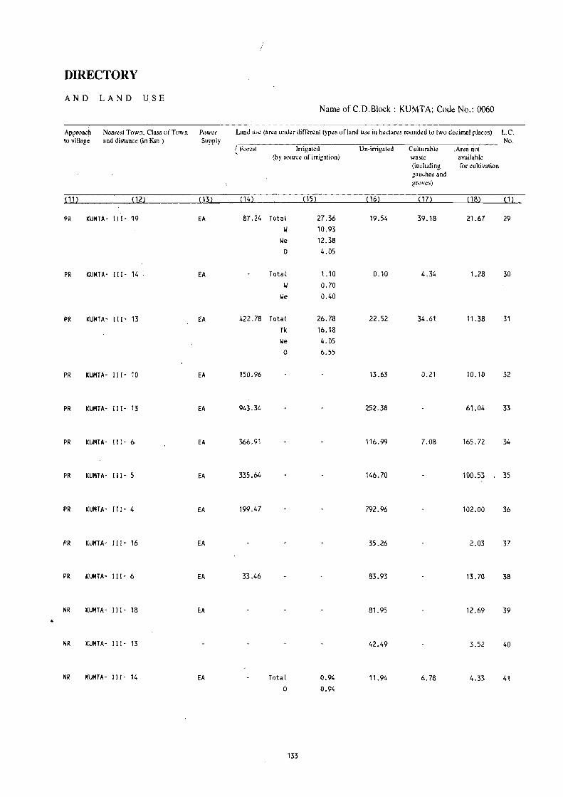
/
DIRECTORY
AND LAND USE Name ofC.D.Block: KUMTA; Coue No.: 0060
Approach N~ar~st Town, Class of Town Pow~r Land us~ (ar~a und~r differ~nt types of land us~ in h~ctares rounded to two d~cimal places) L.C. to village and distanc~ (in Km.) Supply No.
/ Fl)r\!sl Irrigatl!d Un-irrigated Cultllrahlc .Ar~a not , (by SOlln;~ of irrigation) availahli! waste
(induding {(,r cultivation gau~har and grovl!s)
Pl~ ~12~ ~ 13~ ~ 14) ~15) (6) lIn ( 18) ~ 1)
PR KUMTA- [11- '19 EA 87.24 Total 27.36 19.54 39.18 21.67 29 1.1 10.93
l.Ie 12.38 0 4.05
PR KUMTA- [11- 14 EA Total 1.10 0.10 4.34 1.28 30 1.1 0.70
lJe 0.40
PR KUMTA- [11- 13 EA 422.78 Total 26.78 22.52 34.61 11.38 31 Tk 16.18 l.Ie 4.05
0 6.55
PR KUMTA- 111- 10 EA 150.96 13.63 0.21 10.10 32
PR i(UMTA- Ill- 13 EA 943.34 252.38 61.04 33
PR KUMTA- 111- 6 EA 366.91 116.99 7.08 165.72 34
PR KUMTA- 111- 5 EA 335.64 146.70 100.53 35
PR KUMTA- 111- 4 EA 199.47 792.96 102.00 36
PR KUMTA- 111- 16 EA 35.26 2.03 37
PR KUMTA- 111- 6 EA 33.46 83.93 13.70 38
NR KUMTA- 111- 18 EA 81.95 12.69 39
NR KUMTA- 111- 13 42.49 3.52 40
NR It!UMTA - 111- 14 EA Total 0.94 11.94 6.78 4.33 41 0 0.94
133

VILLAGE
AMENITIES Name of C.D.Block : KUMTA; Code No. :0060
L.C. No.
Name of Village
42 MASURKURVE
43 KEPPEKURVE
44 SAVALKURVE
45 BARGIGAZANI
46 KELAGISTALA
47 BETKULI
48 KURIGADDE
49 BARGI
50 PADUVANI
51 KODKANI
52 YATTINABAI L
. 53 KUJALLI
54 HEGLE
55 ALVALLl
Total ar~a of Total Amenities availahle (if not availabk within tne village. a dash (-) .is shown in the column and next to it in brackets. the distance in broad rang~s viz. -5 kms. 5-10 kms.
and 10+ kms of the nearest place where the tilcility is availahk is given). ln~ villag~ Popu-(In he.:tares) lation
and Educa- M~di"al Drinking Post Day or Communication
(3)
190.83
115.36
56.84
175.86
61.22
484.70
446.37
302.47
328_23
252.81
410.77
500_12
257.22
244_80
No.of Houscno Ids
tional Water and· Days of (Bus Stop.
(4) (5) (6)
~--------.-------------- UN
............................................... .. UN
--_---_----------------- UN
124 P -(0-5)
(19)
------------------------ UN
1646 (261)
118 (24)
1715 (333)
1543 (256)
1917 (354)
372 (74)
1570 (278)
384 (52)
540 (98)
P(2), M(2) -(0-5)
-(0-5) -(0-5)
P(2) , M, H RP
P(2), M -(0-5)
P(2), M, H RP
P -(0-5)
P, M -(0-5)
P -(0-5)
P(2), M(2) -(0-5)
134
(7)
INHABITED
INHABITED
INHABITED
I.'
INHABITED
II, HP
II, HP
II, HP
II, HP
II, HP
1.', HP
1.', HP
II, HP
II, HP
Tek- mark~ll Railway Stalion. graph hal if any Walerway I
(8) (9) (10)
..................................................
..................................................
...................................................
- (0-5) -(10+) BS
..................................................
PO -(10+) BS
-(0-5) -(10+) BS
PTO, -(10+) BS Phone
-(0-5) -(10+) BS
PTO, -(10+) B5, Nil phone
PO -(10+)
PTO, - (5-10) Phone
-(0-5) -(5-10)
PTO, Phone
-(10+)
BS
B5
BS
BS

DIRECTORY .. AND LAND USE
Approach' to village
( 11)
N~an:st Town. Cla~s of Town and distance (in Km.)
(12)
Pow\!r Supply
(13)
NamtJ ofC.D.Block : KUMTA; CodtJ No.: 0060
Land U::;l! (ar~a um.kr din~rt;nl tyP\!S of land l1S\! in hr!~\ar~~ H)umkd to two dl!.;imal plal.::~s)
For~st [rrigat~d Un-irrigated C\llturahlc Area not (hy source of irrigatilln) wask available
(including for cultivation gau~har and grovl!s)
(14) (15) (16) ( 17) ( 18)
L.e. No.
( 1)
------------.-~----.--------------.---------- UN INHABITED ---.----------------------------------------- 42
KR
PR
PR
PR
KR
PR
PR
PR
KR
KR
----------.---------------------------------- UN [NHABITED -----------.--------------------------------- 43
------------------------.---.--.---.--------- UN • INHABITED --.----.--.-.- .. ---- .. -------.-.- ... -.---.--- 44
KUHTA- 1[1- 21 97.94 12.12 65.80 45
-.-.-_.----.-._---.----.--.-.--------.------- UN - INHABITED .----.-.----------------._---.--------------- 46
KUHfA- Ill- 18 EA 69.71
KUHTA· 111- 21 333.76
" )
K.UMTA- 111- 18 EA 101.33
KUMTA- III· 15 EA 95.00
KUMTA- 111- 15 EA 49.45 Total
II
lie
KUMTA- Ill· 15 EA 312.37
KUHTA- Ill· 6 EA 298.73 Total
\I
lie
0
KUHTA' III· 6 EA 207.36 Total
Tk
W
0
KUHTA- III· 13 fA 168.24 Total
Tk
W
0
135
2.34 1.22 1.12
36.66 8.33
16.19 12.14
16.50 2.02 4.36
10.12
12.62 4.04 4.53 4.05
213.06
58.84
134.55
121.94
129.19
40.68
150.73
32.23
27.60
4.78
0.84
0.84
0.11
68_80
8.15
12.14
4.88
197_15 47
52_93 48
65.75 49
110.58 50
3.03 51
49.57 52
1.86 53
1.13 54
31.46 55
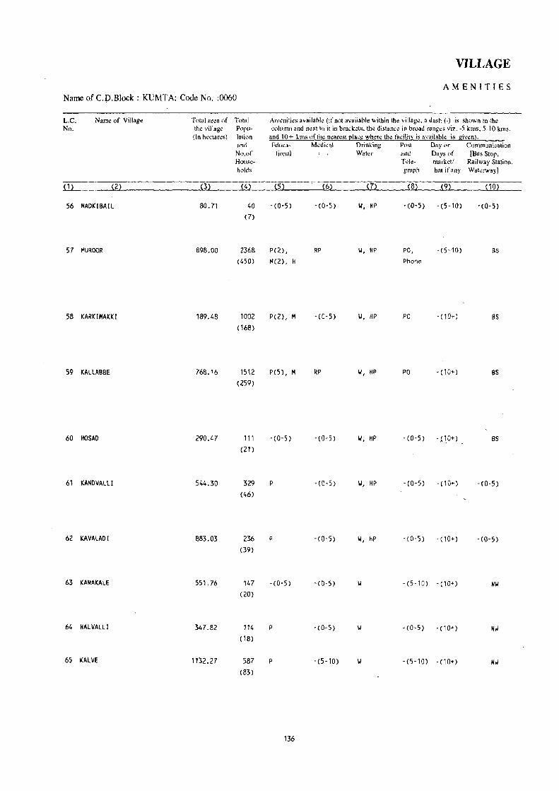
Name of C.p.Block : KUMT A; Code NQ. :0060
L.C. No.
Name of Village
56 MADKIBAIl
57 MUROOR
58 KARKIMAKKI
59 KALLABBE
60 HOSAD
61 KANDVAL 1I
62 KAVA LAO I
63 KANAKALE
64 HAL VALLI
65 KALVE
Total aNa of Total the village Popu-(In hectares) lation
(3)
80.71
898.00
189.48
768.16
290.47
544.30
883.03
551.76
347.82
1132.27
and No.of HOllseholds
(4)
40 (7)
2368 (450)
1002
( 168)
1512
(259)
111
(21)
329 (46)
236 (39)
147 (20)
114 (18)
587 (83)
VILLAGE
AMENITIES
Am,mitks available (if not available within th~ village. a dash (-) is shown in the ~olumn and next to it in brack~ts. the distana in broad ranges viz. -5 kms. 5-10 kms.
and 10+ kms of Ihe nearest place where the facilitv i, availahle is giwn). Edllca- Mellieal Drinking Post Day or Communication
tional Water and Days of [Bus Stop.
(5)
-(0-5)
P(2) ,
M(2), H
P(2), M
pes), M
-(0-5)
P
P
-(0-5)
P
P
136
(6)
- (0-5) II, HP
RP II, HP
- (0-5) II, HP
RP W, HP
-(0-5) II, HP
-(0-5) II, HP
-(0-5) W, HP
- (0-5) II
-(0-5) II
-(5-10) II
Tck- markdl Railway Station. graph hat ifnny Wakrway]
(8) (9) ( 10)
-(0-5) -(5-10) -(0-5)
PO, -(5-10) BS Phone
PO - (10+) BS
PO -(10+) BS
-(0-5) -pO+) as
-(0-5) -(10+) -(0-5)
-(D-S) -(10+) -(0-5)
-(5-10) - (10+) Nil
-(0-5) -(10+) Nil
-(5-10) -(10+) Nil

DIRECTORY
AND LAND USE Name of C.D.B1ock : KUMT A; Code No.: 0060
Appro~ch Nearest Town, Class of Town Pow~r Land us~ (ar~a under different types of land usc in hectares rounded to two decimal plac.:.) L.C. 10 village and distance (in Km.) Supply No.
Forest Irrigated Un-irrigated Cuiturable Area nnl (by source of irrigation) wasl~ available
(induding for ~ultjvati()n gauchar and groves)
~ 112 ~122 ~132 { 142 (152 (162 ~172 ~ 182 { 11
KR KUMTA- Ill' 8 EA 68.90 Total 0.13 7.25 0.76 3.67 56 Tk 0.08
\oJ 0.05
PR KUMTA- II 1- 10 EA 537.63 Total 90.71 71.19 30.48 167.99 57 Tk 50.24
\J 8.09 lie 12.14 0 20_24
PR KUMTA- 111- 15 EA 80.45 Total 14.75 39.45 1.72 53.11 58 \oJ 6.66
lie 6.07 0 2.02
PR KUMT A - I I I - 13 EA 445.00 Total 50.38 88.83 6.39 177.56 59
Tk 8.09 \oJ 12.34
lie 12.14 0 17.81
PR KUMTA- 111- 14 EA 243.45 Total 0.81 29.46 3.84 12.91 60 \oJ 0.40
I/e 0.41
KR KUMTA- 111- 19 416.45 Total 4.52 38.90 1.52 82.'11 61 II 0.48
lie 2.02 0 2.02
KR KUMTA- 111- 19 783.72 Total 0.82 28.73 47.68 22.08 62 1/ 0.41
lie 0.41
KR KUMTA- I I 1- 25 489.41 Total 0.20 29.34 3.75 29.06 63 \J 0.10 0 0.10
KR KUMTA- 111- 26 EA 295.76 Total 0.10 26.16 5.87 19.93 64 0 0.10
KR KUMTA- I I 1- 29 EA 950.77 Total 1.28 '11.76 17.'13 50.53 65 II 0.48
IJe 0.80
137 r- -f~'

Name of C.D.BIOck : KUMTA; Code No. :0060
L.e. Nu.
( 1)
Name of Village
66 MOOG I
67 CHIMMOLLl
68 BANGANE
69 NORSE
70 SOPPINAHOSALLI
71 MEDINI
72 HUDNAll I
73 ALGAR
"/4 B,\SCLL I
75 ULl 'JRMATH
76 HONOGERE
TOlal area of Tolal Ih~ village POpll-
(In hectares) lat;,m
(3)
144.14
642.35
808.24
2121.64
408.98
2678.28
882.42
101.55
607.55
610.53
908.43
and No.or HOl1~·
holds
(4)
51 (9)
141,
(20)
375 (65)
360 (96) ,
154 (36)
222 (29)
222 (32)
29 (5 )
429 (66)
222 (44)
70 ( 17)
VILLAGE
AMENITIES
, Amo!nilies available (if nol availanle within the villago!. a dash (.) is shown in Iho! column and next to it in hrackets. the distance in hroad ranges viz. -5 km •. 5-10 kms.
and 10+ kms of the nearest place who!re the facility is availahle is given). Edm:a- Medical Drinking Posl Day or Comrnunicalion
lional Water and Days or (Bus Stop. T de- marketl Railway Station. graph hal if any Waterway]
(5) (6) (7) (8) (9) (10)
-(0-5 ) -(5-10) 1.1 -(5-10) -(10+) Nil
-(0-5) -(5-10) 1.1 -(5-10) -(10+) Nil
p -(0-5) -(0-5) -(10+) Nil
P -(5-10) -(0-5) -(lOt) Nil
P -(0-5) II, HP -(0-5) -(10+) BS
p - (5-10) W -(5-10) - (lQ+J BS
p -(0-5) W, HP -(0-5) -(10+) -(0-5)
-(0-5) - (5- 10) W -(5-10) -(10+) -(5-10)
P, M -(0-5) II, HP - (0-5) -(10+) -(5-10)
P -(0-5) '.I, HP -(0-5) '(10+) -(5-10)
P -(0-5) II, HP - (0-5) -(10+) - (0-5)
138

DIRECTORY
AND LAND USE Name of C.D.Block : KUMTA; Code No.: 0060
Approach Nearest Town. Class of Town Power Land lise (area under different types of land usc in hectares rounded to two decimal places) L.C. to village and distance (in Km.) Supply No.
Forest Irrigated Un-irrigated Culturable Area not (by source of irrigation) was1~ available
(including for ,ultiv3lion gau,har and grovl.!s)
~11~ ~12~ ~ 13~ ~14) (15) ( 16) ~ 17~ ~ 18) (1)
KR KUHTA- 111- 26 114.93 Total 0.14 12.76 2.87 13.44 66
\I 0.07 We 0.07
KR KUMTA- Ill- 28 576.32 Total 0.24 36.36 6.29 23.14 67 W 0.14
We 0.10
KR KUMTA- Ill- 30 EA 724.19 Total O. II 60.74 2.43 20.77 68
w 0.06 We 0.05
KR KUMTA- III- 35 EA 2058.56 Total 0.08 34.24 4.49 24.27 69 .... \I 0.03
0 0.05
PR KUMTA- III- 26 323.73 Total 0.40 38.14 0.35 46.36 70
W 0.10 We 0.15
0 0.15
PR KUHTA- Ill- 32 2619.93 Total 1.78 35.92 3.77 16.88 71 W 0.57
We 1.21
KR KUNTA- 111- 26 798.54 Total 0.20 43.93 3.89 35.86 72 W 0.10 0 0.10
KR KUHTA' Ill· 30 95.03 5.11 0.83 0.58 73
KR KUMTA' 111- 25 EA 507.09 Total 0.99 59.81 11.56 28.10 74 0 0.99
KR KUMTA· III· 32 567.38 Total 0.51 25.12 5.17 12.35 75 W 0.40
We 0.11
KR KUHTA' III' 32 876.35 Total 0.51 16.36 4.84 10.37 76 0 0.51
139

Name ofC.D.Block; KUMTA; Code No. :0060
L.e. No.
Name of Village Total ar~a of Total th~ villag~ Popu-
(In h~,tar~s) lation and No.of Hou.~
holds
VILLAGE
AMENITIES
AII)¢niti~s availahl~ (if not available within th¢ villag~, a dash (-) is ;;hown in the column and n~xt to i( in bracl:~ts. Ih~ dislan,~ in broad ranges vi/.. -5 kms. 5-10 km •.
and 10+ kms of (he ncar~st Plac~ wh¢r~ (h~ facility is availahle is given). Eduea- M~djcal Drinking PMI Day or Communication
tiona I Wa(~r and Days of [Bus Stop. T d~- mark,,(/ Railway Station.
,_ _ graph hat if any Wat"rway)
~(1~) ______ ~(f~ ___________ ~(3~) ____ ~(~4L) __ ~(~5L) ______ ~(~6L) ____ ~C~7L) ____ ~(8~)~ __ ~C~9)L_ ____ ~(~'O~)L-__
n ABBOlLl 261.60
78 HINOi341l 122.16
79 S.~NTE(,Ul1 270.32
80 HEGDEHOSALLI 32.54
81 BASTlKERI 218.90
82 liARVALll 239.35
83 DIVALLI 816.68
84 SAliiTGAl 293.49
85 HORBHAG 119.98
108 ( 19)
110 (16)
444 (94)
129 (23)
299 (52)
101 (15 )
767
( 134)
401 aD)
679
(109)
p
P
P(2) , M(2), H
P
P
P
P, M
P
P(2), M
140
-(0-5) 101, HP -(0-5) -(10+) -(0-5)
-(0-5) 101, HP -(0-5) - (10+) - (0-5)
PHC, FPC 101, HP PTO, -(10+) BS Phone
-(0-5) 101, HP -(0-5) - (10+) -(0-5)
- (0-5) 101, HP -(0-5) -( 10+) BS
-(0-5) II, liP -(5-10) -(10+) -(5-10)
-(0'5) II, HP '(0-5) -(10+) BS
. (5-10) II, HP PO - (10+) BS
·(5'10) II, HP -(0-5) -(5-10) BS
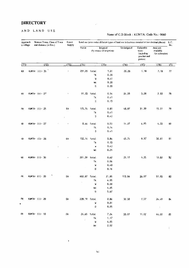
DIRECTORY
AND LAND USE Name of C.D.Block : KUMTA; Coot) No.: 0060
Approach 'N~aresl Town. Class of Town Pow~r L1nd usc (area under diff"r"nl Iyp'" of land usc in heclares rounded 10 Iwo decimal pia"".) L.C. to villag¢ and distanc¢ (in Km.) Supply No.
Forest Irrigaled U n·irrigaled Cullurable Area nOI (by SOU(1;\! of irrigation) wastr.! available
(induding for cultivalion gauchar and grovt.!!\)
~ 1 1) ~ 12) (13) (14) ( 15) (16) (17) (18) ~ 1)
KR KUMTA' III' 35 231.95 Total 1.01 20.28 1.18 7.18 77 Tk 0.20
1./ 0.41 I./e 0.20
0 0.20
KR KUMTA' III' 27 91.23 Total 0.54 24.28 3.28 2.83 78 Tk 0.41 a 0.13
PR KUMTA' III· 25 EA 173.74 Total 0.81 48.87 31.39 15.51 79 Tk 0.41
0 0.40
KR KUMTA' Ill' 27 8.44 Total 0.55 14.27 4.95 4.33 80 Tk 0.14
0 0.41
KR KUMTA' III· 26 EA 132.14 Total 0.84 45.74 9.37 30.81 81 Tk 0.23
1./ 0.40 I./e 0.21
KR KUMTA' III' 30 201.39 Total 0.62 25.17 1.35 10.82 lI2 Tk 0.06
1./ 0.40
0 0.16
PR KUMTA' III' 20 EA 602.87 Total 21.85 113.96 26.07 51.93 83 Tk 4.05 Y 8.08
I./e 4.05 0 5.67
PR KUMTA· Ill' 20 EA 228.19 Total 0.86 32.38 7.57 24.49 B4
• II 0.81 0 O.OS
KR KUMTA' III· 10 EA 24.65 Total 7.24 33.07 11.02 44.00 85 Tk 1.17 II 4.05
Ye 2.02
141

Name of C.D.Block : KUMTA; Code No. :0060
L.e. No.
Name of Village
(1) (2)
86 HOLEGADDE
87 OEVGIRI
88 MATH
89 HARNIR
90 KUNOGUNI
91 KADEKOOI
92 HANDIGONE
93 TALGOD
94 URKERI
TOlal area of Tolal Ihe village Popu-(In hectares) lation
392.07
53.12
94.77
121.21
27.52
154.89
241. 94
272.93
292.32
and No.of Households
(4)
1838 (357)
287 (60)
966
(182)
41.3 (72)
33 (6)
419 (65)
985 (202)
839 (149)
776 (156)
VILLAGE
AMENITIES
Amenities available (if not availahle within Ihe village. a dash (-) is shown in the column and next 10 il in hrackets. the distance in hroad ranges viz. -5 kms. 5-10 km •.
and 10+ kms of the lI~arest place where the lacility is available y. given). Educa- Medical Drinking Post Day or Communicalion
tional Water and Days of IBus SlOp.
(5 ) (6)
P, M RP 1.1, HP
P, M, H RP 1.1, HP
-(0-5) -(5-10) 1.1, HP
P, M -(5-10) 1-1, HP
-(0-5) -(0-5) II, HP
P -(0-5) 1.1, HP
P(2), M - (0- 5) 1.1, HP
-(0-5) 1.1, HP
P(2), M -(0-5) 1.1, HP
142
Tde- market! Railway Station. graph hat irany Waterway)
(8)
PTO,
Phone
Phone
(9)
-(5-10)
-(5-10)
-(5-10) -(10+)
-(5-10) -(10+)
-(0-5) -(5-10)
-(0-5) -(0-5)
PTO, Phone
-(0-5)
-(0-5) -(0-5)
PO -(0-5)
(10)
BS
BS
BS
-(0-5)
-(0-5)
, BS
BS
BS
BS

DIRECTORY
AND LAND -u SE NameofC.D.Block: KUMTA; Code No.: 0060
Approach Nearest Town, Class of Town Power Land use (urea und~r din;:rent types orland us~ in h~ctares rounded 10 two decimal places) L.e. to village and distance (in Km.) Supply No.
Forest Irrigated Un-irrigated Culturablc Area not (hy "<luree of irrigation) wastl! available
(including !<)r cultivation gaucharand groves)
(11) (12) (13) ( 14) (15) ( 16) (17) . (18) (1)
PR KUMTA- [I [- 7 EA 56.45 Total 36.16 82.69 60.15 156.62 86
II 7.69 lie 12.14 GC 16.33
PR KUMTA- [)[- 8 EA 12.35 Total 10.10 16.61 0.96 13.10 87 II 2.02
We 4.05 GC 4.03
PR KUMTA- [11- 6 EA 13.68 Total 7.54 48.90 5.24 '19.41 88
Tk 1.47 II 2;02
lie 4.05
PR KUMTA- [)[- 9 EA 46.56 Total 13.84 5.90 15.11 39.80 89 Tk 6.07 II 2.43
We 3.24 0 2.10
KR KUMTA- [[I' 9 EA 18.25 Total 3.77 2.23 3.27 90 II 2.02
We 1.75
PR KUMTA· I) [- 3 EA 57.76 Total 6.13 47.64 10.26 33.10 91 .
II 4.05 We 2.02 0 0.06
PR KUMTA- [[ [. 2 EA 68.54 Total 10.96 101,91 9.05 51.48 92
II 4.05 We 6.06
0 0.85
PR KUMTA· [11- 5 EA 195.81 Total 29.21 6.71 41.20 93 1/ 8.09
We 16.19 0 4.93
PR KUMTA- [)[- 5 EA 98.66 Total 94.40 19.52 79.74 94 Tk 16.19
II 20.24 I/e 33.69 0 24.28
143

Name ofC.D.Block: KUMTA; Code No. :0060
L.C. No.
(1)
Nam~ of Village
95 KONAlLl
96 VALGALLI
97 KALKERI
98 HAROOI
99 G()I(ARN
100 BIDRAGERI
101 NAGERBAIl
102 NARANAPUR
103 TOREGAZANI
104 TORKE
Total ar~a of Total th~ village POPII-
(In hectares) lation
(3)
222.60
247.31
536.61
105.12
1700.14
83.99
147.30
67.43
26.88
247.99
~nd
No.of HOllseholds
(4)
982 (161 )
1196
(212)
883 ( 140)
572
(90)
12253
(2275)
560 (94)
(, )
4
(1 )
171 (34)
1161 (229)
VILLAGE
AMENITIES
Amenities 3v.il.ble (ifllot availaok within the village. a dash (-) is shown in the column and nextlo il in brad:ets. the distana in broad ranges viz. -5 kms. 5-10 km •.
and 10+ kIns of the nearest place where the fadlity is availahk is given). Edllca- Medical Drinking Post Day or Communication
tional Water and Days of (Bus Stop.
(5 )
P(2), M
P(2), M
P
P
P(14),
M(4) ,
H(2), puc
P
-(0-5)
- (0-5)
P
P(2), M
144
, . Tde- market I Railway Station.
(6)
- (0-5)
-(0-5 )
-(O-S)
-(O-S)
MH, PHC,
FPC
-(0-5)
-(0-5)
-(0-5)
-(0-5)
RP
graph hat if any Watawayl
(8) (9) ( 10)
W, HP PO, -(5-10) BS
Phone
T, 104, HP PTO, -(0-5) BS
Phone
II, HP -(0-5) -(0-5) BS
II, HP -(0-5) -(10+) as
II, Til, HP PTO -(10+) BS, Nil
II, HP -(0-5) - (5-10) BS
II -(0-5) -(10+) BS
II, HP -(0-5) -(5-10) Bs
II -(0-5) -(0-5) BS
II, HP PTO, -(0-5) as Phone

DIRECTORY
AND LAND USE Name of C.D.Block : KUMTA; Code No.: 0060
Approach : Nearest Town. Clas. of Town Pow~r Land III'<! (a~a und~r diff~r~nt typ~~ of land us,: in h~ctar~s ro\lnd~d to two d~cimal plac~s) L.C. to village and distance (in Km.) Supply No.
For~st Irrigat~d Un-irrigated Culturaole Ar~a not (Oy sourc~ of irrigation) waste available
(including for cultivation ganchar and grows)
(11) (12) (13) ( 14) (15) (16) (17) (18) (1)
PR KUMTA- 111- '10· EA 91.92 Total 18.32 102.55 8.09 1.72 95 Tk 4.05 W 6.18
lie 8.09
PR KUMTA- 1lI- 5 EA 109.50 Total 42.24 54.96 40.61 96 Tic 4.05 II 9.86
lie 24.28 0 4.05
PR KUMTA- 111- 5 EA 366.32 Total 11.98 146.51 10.12 1.68 97 Tic 2.02 II 3.89
lie 4.05 0 2.02
PR KUMTA- [11- 4 EA 70.37 Total 4.11 29.20 1.21 0.23 98 Tic 0.88 W 2.02
lie 1.21
PR KUMTA~ 111- 38 EA 478.70 Total 54.23 398.41 124.79 644.01 99
Tic 4.05 II 20.24
lie 12.14 0 17.80
PR KUMTA- 111- 35 EA 21.08 Total 3.53 25.87 31.85 1.66 100 II 1.21
lie 2.32
PR KUMTA- III' 35 EA 0.39 146.91 101
PR KU"1TA- [11- 33 EA 67.43 102
KR KUMTA- 111- 35 EA 4.24 10.04 12.60 103
PR KUMTA- 111- 33 EA 57.54 75.89 1.93 112.63 104
145 19

VILLAGE
AMENITIES
Name of C.D.Block : KUMTA; Code No. :0060
L.C. Name of Village Total area of Total Am~niti~s availahl~ (ifnoi availahle within th~ village. a dash (-) is shown in the
No. the village Poru- column and n~xt to it in hrackets. the distance in broad ranges viz. -? kms .. 'i-10 kms.
(In hectares) lation 8nd 10+ kms ofth~ nearest (!Iace where the lilcilit~ is availab!~ is giwni· and Edui:a- Medical Drinking Post Day or Communication
No.of tional Water and Days Ill' [Bus Stop. Hous~- Tdc- markell Railway Station.
holds graph hat it' any Wat~rwayJ
~1) <2>, (3) (4) (5) (6) (7) (8) (9) ( 10)
105 GONEHALLI 127.51 265 P -(0-5) 1,/, HP -(5-10) -(5-10) BS
(55)
106 HI TT ALMAKK I 258.67 320 P -(0-5) 1,/, HP -(0-5) -(10+) [lS
(65)
107 MADANGERI 305_66 1373 P(2}. M RP 1,/. HP PT0 1 -(10+) BS (248) Phone
.. 108 YENNEMIDI 83_82 52 P -(0-5) 1,/, HP -(0-5) -(10") BS
(10)
109 HIREGUTTI 682.10 2588 P(3), M, H PHC, FPC T. 1,/, HP PTO, -(10+) BS
(500) phone
110 KOLIMANJGUNI 386.35 245 P -(0-5) 1,/. HP -(0-5) -( 10+) -(0-5)
(35)
111 MORBA 226.84 791 P(2). M - (0-5) 1,/, HP -(0-5) -(10+) BS
(151 )
112 MIDLAGAZANI 204.56 ~~----------~----------- UN INHABITED --.------------~~-~~---.-
113 BHAVIKOOlA 210.72
114 NADUMASKERI 380.94
115 HARUMASKERI 141. 22
116 BAHKIKOOlA 52.07
1794 (294)
2944 (508)
671 ( 130)
696
(129)
P(2). M
P(5) , M(3) ,
P, M, H
P, M, H
146
- (0-5) 1,/, HP
-(0-5) 1,/. HP
RP T, II, HP
PHC, FPC, T, II, HP
RP
-(0-5)
FTO, phone
phone
PTO, Phone
-(0-5)
- (0-5)
·(0-5)
-(0-5)
BS
as
BS
BS

DIRECTORY
AND LAND USE Name of C.D.Block : KUMTA; Code No.: 0060
Approach Nilarest Town. Class of Town Power Land use (a~ea under different types of land use in hectares rounded to two decimal places) L.C. tovilJage . ~nd distance (in Km.) Supply No.
Forest Irrigated Un-irrigated Cullurable Area not (lly source of irrigation) waste available
(induding !(lr wltivation gau~har and grov~s)
ill> (12) ( 13) (,.14) (15) ( 16) ( 17) ( 18) (1)
I'll KIJMTA- 111- 3D EA 42.76 Total 2.77 48.06 31.40 2.52 105 \I 1. 21
IJe 1.56
PR KUNTA· 111- 33 fA 65.28 36.08 24.14 133.17 106
PR KUM!A- IlI- 30 EA 87.66 67.26 63.32 87.42 107
PR KUKTA- II 1- 30 EA 12.44 13.77 57.61 108
-PR KUKlA- 111- 26 EA 149.45 180.27 292.72 59.66 109
KR KUKTA- III - 24 292.91 40.01 38.35 15.08 110.
PR KUKTA- 111- 20 EA 36.26 26.90 125.92 37.76 111
----_. __ ._---------------._--------------_--- UN - INHABITED --------------------------------------------- 112
PR KUMIA- 111- 40 EA Total 11.09 197.42 2.21 113 Tk 0.16 W 4.05
We 6.88
PR KUKTA- III - 42 EA Total 35.07 183.14 162.73 114 Tk 4.05 W 14.84
We 16.18
PR KUMTA- 111- 42 EA Total 10. (3 125.25 5.24 115 W 4.05
We 6.68
PR KUMTA- 111- 42 EA 1.82 Total 14.44 28.61 7.20 116 Tk 0.28 W 6.07
We 8.09
147

Name of C.D.Block : KUMTA; Code No. :0060
Le. No.
Name of Village
117 HOSKERI
118 KAOIHE
119 HANEHAlLi
Total (Sun)
Total area of Tntal th~ village Popu(In hecla res) 181ion
and No.of HOlls~
holds
(3)
133.53
169.17
236.51
56663.68
(4)
646
(115 )
795
( 143)
2008
(429)
107963
( 18982)
VILLAGE
AMENITIES
Amenities available (if nol available wilhin the village, a da..h (-) is shown in the column and next to it in brackets, the distance in Ilroad ranges viz. -5 kms. ;-10 kms.
and 10+ k!fls oflhe nearesl place where Ihe f"cililY is available is given). &luea- Medical Drinking Posl Day or Communication
lil'nal Water and Days of [Bus Stop.
(6)
P, H -(0-5)
P, H -(0-5)
P, H, H - ~j): 5)
P( 171), MH,
M( 72), PHC(S),
H(2l) , FPC(5),
PUC(2) NH, RP(19)
148
m W, HP
W, HP
W, HP
T~le- marketl Railway Station. graph hal if any Waterway)
(8)
-(0-5) -(5-10)
PT'O-,
phone
PO,
Phone
. (5'10)
-(S'lOi
BS
BS
BS

DIRECTORY
AND LAND USE
Approach Near~sl Town. Class of Tow" to village and distance (in Km.)
Pnwl.!r Sunp!y
~(1~1~) ________ ~(~12~) _______ ~lt
PR KlJIITA- 111- 43 EA
PR KUMTA- 111- 43 EA
PR KUMTA- 111- 41 EA
34.72
63.28
19.513
39'194.01
Namto of C.D.Block : KUMTA; Code No.: 0060
--_--_._--------_._-----------No.
Irri!!a!~d ('uhur.hle thy ~nur~l! of lrriga'ion) W3!';tt!
(including !!3u ... har and !!l'Ows)
Ares nnt svailahle tin ,'ullivalion
Total 8.11 73.37 13.61 3.12 '17 II 4 .. :'c
11,' 4.05
, otal 4.17 10.1.\9 6.13 118
II 2.03
lie 2.14
21:).1:3 2.22 0.88 119
Total 1170.05 8270.64 2239.79 5262.04 Tk 275.30
\J 310.25
We 360.61
0 199.23
GC 24.66
149


MUNDGOD C.D.BLOCK
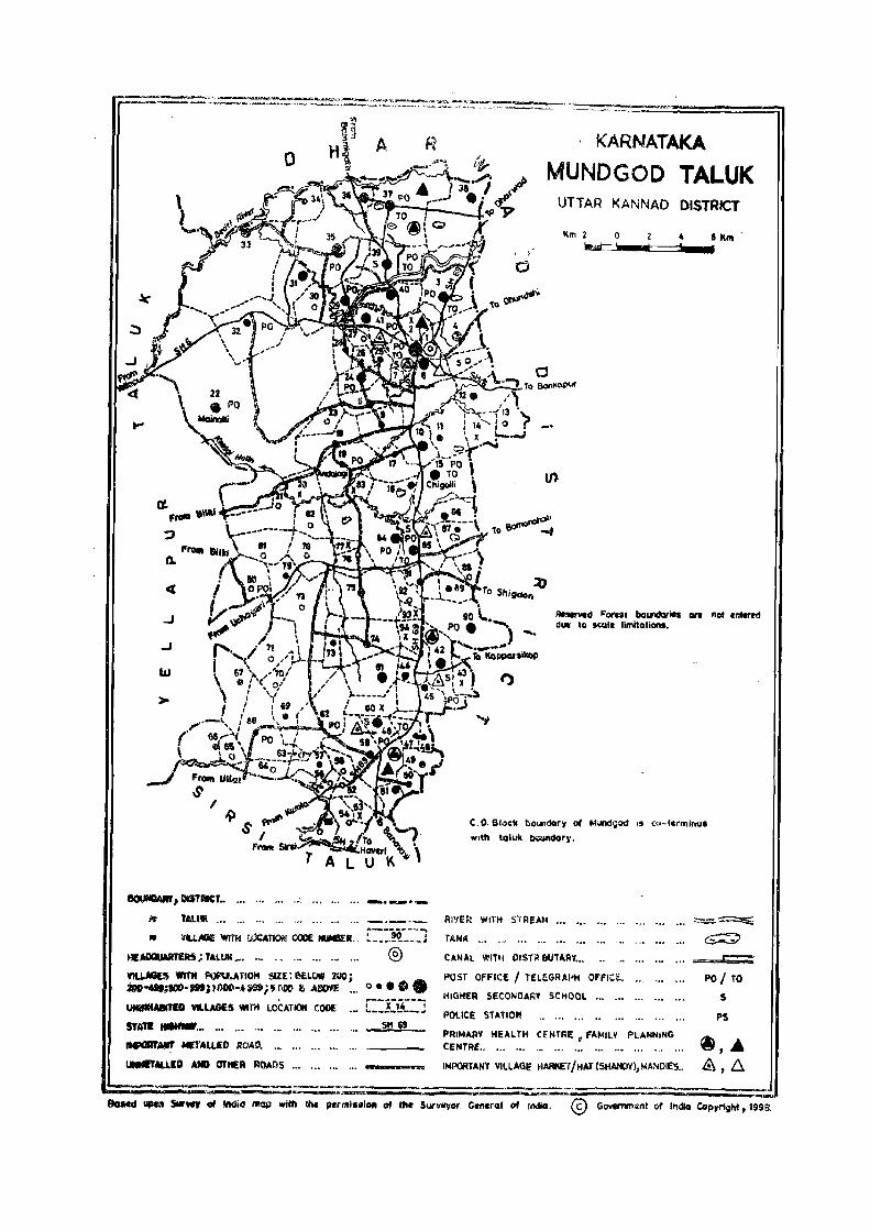
o
.J
.J
w
>
BOIJNDAIW, DISTRICT •• --.-.- . ._
TAl.UII ,"
, ;
o
t')
KARNATAKA
MUNDGOD TALUK UTTAR KANNAD DISTRICT
Km 2 0 4' Knt U::-::::liiI_t::===-....
RnrIcd Forul bot.n!aries en nOf ~ntered dill \0 scali limitations •
C. O. Stock bOlaldory 01 l'Iundgod ,s co-terminus
wIth taluk ~dory.
RI'!Efl WITH S'rRE .. H
" ,..------- .......
~fI.i,_ WIT« WCATIOI;! COOE IUlSER., !._~_!I! ___ ; TAN~
HlAIXIUART£R5; TALUI( ••• ._ ". ... ... ... ...
YlU.MES """ P\)f'U\.ATIOi'l SIZE: ElELW 200; 2oo ...... &5CO-_i'OOO-Ull$i'OOO I:. AllDVE
UMraIMITID VIlLAGES WI1'H LOCATION COIlE
STAll HIItIW'N .. , .••..• ,..,..,.ur "fAllEe ROAO.
. IM4ITAUID AND OTHER ROADS
0 ••••
'--X-ii. - --j ... __ .-_____ ..1
Stl69
•••••• _ •• a:,
CANAL WITH OISTR BUTARY ...
POST OFFICE / TELEGR"PH OFFltl-:.
IiIGHER SECONOAR' SCHOOL
POLICE STATION
PRIMARY HEALTH CENTRE, FAMILV PLANNING CENTRE" '" '" ._ ... ... '" ••• ... ... • ..
IMPORTANT VILLAGe MARKET/HAT (StlANOYl,MANOIES ..
9aMd UII03I Sur., fII IMiG map with th~ jNtl'lliuiOft of tI'l SU(VtlyOf General 01 Iodicl.
PO I TO
S
P$

ALPHABETICAL LIST OF VILLAGES
TALUK: MUNDGOD-0070 c. D. BLOCK: MUNDGOD"()()70
SL NAME OF THE VILLAGE 1991 CENSUS 1981 CENSUS
NO LOCATION CODE LOCATION CODe LOCATION COOE LOCATION COOE
(Manual) (C~ter) (Manual) (C~ter)
2 3 4 5 6
1 A8adi 11/20/7136 11/20/0070/0036 9/19/7/28 09/19/0070/0028 2 AjJihalli lU20/7111 11/20/0070/0011 9/1917/6 09/19/0070/0006
3 Alall i 11/20/7/87 11/20/0070/0087 9/19/7/83 09/19/0070/0083 4 Amatgar (F) 11/20/7172 11/20/0070/0072 9/1917171 09/1910070/0071
5 Anda~"i 11/2017118 11/20/0070/0018 9/19/7113 09/19/0070/0013
6 Atabail (F) 1112017170 11/20/0070/0070 9/19/7/65 09/19/0070/0065 7 Attangi 11/2.0/7/75 11/2.0/0070/0075 9/19/7/88 09/19/007010088
8 Bac:hanki 11/201713 11/2.0/0070/0003 9/1917/38 09/191007010038 9 Balehall i (F) 11/2017/30 11/20/0070/0030 9/1917/24 09/19/0070/0024
10 Balekoppa l1i20/7/64 11120/0070/0064 9/1917/57 09/191007010057 11 Bappa 19\1'ldi 11/2017/13 11/20/0070/0013 9/19/7/4 09/19/0070/0004
12 Bappalkatti 11120/7/14 11120/007010014 9/1917/5 09/1910070/0005 13 Basavankoppa 11/2011121 11/20/0070/0021 9/19/7/12 09/191007010012 14 Bedsgaon 11120/7/68 11/20/0070/0068 9/19/7/60 09/19/0070/0060 15 Bekkod 11/2017/57 11/20/0070/0057 9/19/7/52 09/19/0070/0052
16 Bhadrapura 11/20/7/44 11/20/0070/0044 9/19/7/68 09/19/0070/0068 17 Bokangudde 11/20/7/55 11/20/0070/0055 9/19/7/50 09/19/0070/0050
18 Bomnarshikoppa (F) ~11/20/7/60 11/20/0070/0060 9/19/7/63 09/19/0070/0063 19 BorangUdde 11120/7/93 11/20/0070/0093 9/1917/89 09/19/0070/0089
2.0 Byane II i t F) 11/20I7i~ 11/20/0070/0023 9/19/7/16 09/19/0070/0016
21 Chaltleri (F) 11/20/7/79 11/20/0070/0079 9/19/7/73 09/19/0070/0073
22 Chavadall i 11/20/7/24 11/20/0070/00Z4 9/19/7/18 09/19/0070/0018
23 Chigalli '11/2017/15 11/2.0/0070/0015 9/19/7/9 09/19/0070/0009
24 Chikharvall i (F) 11/2017/n 11/20/0070/00n 9/19/7/79 09/19/0070/0079 25 Chipatleri 11/20/7/80 11120/0070/0OS0 9/1917/72 09/19/0070/0072 26 Chitgeri 11/2017178 11/20/0070/0078 9/1917/74 09/19/0070/0074
2700ddaharvalli 11/2017/76 11/20/0070/0076 9/19/7/80 0.9/19/0070/0080
28 Ghanadaha tt i (F) 11/2017/81 11/20/0070/0081 9/19/7/75 09/19/0070/0075
29 Gotagudi 11/20/7/46 11/20/0070/0046 9/1917/43 09/19/0070/0043 30 Gunjavati 11/2017132 11/20/0070/0032 9/19/7/23 09/19/0070/0023
31 Halharvl 11/2017/63 11/20/0070/0063 9/19/7/56 09/19/0070/0056 32 Haragan&halli 11/20/7/50 11/20/0070/0050 9/19/7/46 09/19/007010046 33 Hirehatl i 11/20/7/16 11120/0070/0016 9/19/7/10 09/19/0070/0010 34 Hoskoppa 11/20/7/56 11/20/0070/0056 9/1917/53 09/19/0070/0053 35 Hostot 11/2017/65 11/20/0070/0065 9/19/7/59 09/19/0070/0059 36 Huclel koppa 11/20/7/94 11/20/0070/0094 9/1917/91 09/19/0070/0091 37 Hulihonda 11/20/7/34 11/20/0070/0034 9/19/7/27 09/19/0070/0027 38 Hullhonda (F) 11120/7/92 11/20/0070/0092 9/19/7/87 09/19/0070/0087 39 HI.WlgUI"Ida 11/20/7/37 11'120/0070/0037 9/1917/29 09/19/0070/0029
153 2.0

ALPHABETICAL' LIST OF. VlI.J:.fA(_;flS
T ALUK: MUNDGOD-0070 C. D. BLQCK: MUNDGOD-0070
SL NAME OF THE VILLAGE 1991 CENSUS 1981 CENSUS . L - ,
NO LOCATION CODE LOCATION cooe LOCATION COOl LOCATION CODE
(Manual) (Computer) (Manual) (computer)
2 3 4 5 6
40 Indoor 11/20/7/39 11120/00~0/0039 9/19/7/32 09/19/0070/0032 41 Ingalki 11/20/7/43 11/20/0070/0043 9/19/7/40 09/19/0070/0040
42. Jangeri 11/20/7/52 11/20/0070/0052 9/19/7/51 09/19/007.'010051 . ~~ .
43 Kalaganakoppa 11/20/7/7 11/20/0070/0007 9/19/7/0 09/19/0070/0000
44 Kalhall i 11/20/7/83 11/20/0070/0083 9/19/7/77 09/19/0070/00n
45 Kalkeri 11/20/7/19 11/20/0070/0019 %19/7/14 09/19/0070/0014
46 Kalkoppa 11/20/7/45 11/20/0070/0045 9/19/7/41 09/19/0070/0041
47 Kanchikoppa (F) 11/20/7/71 11/20/0070/0071 9/19/7/66 09/19/0070/0066
48 Kargoll i 11/20/7/28 11/20/0070/0028 9/19/7/21 09/19/0070/0021
49 Katur 11/20/7/85 11/20/0070/0085 9/19/7/81 09/19/0070/0081
50 Kavalkoppa 11/20/7/17 11/20/0070/9017 9/19/7/8 09/19/0070/0008
51 Kodambi (F) 11/20/7/61 11/20/0070/0061 9/19/7/67 09/19/0070/0067
52 Kolgi 11/20/7/49 11/.20/0070/0049 9/19/7/45 09/19/0070/0045
53 Kop-Gotgudi 11/20/7/47 11/20/0070/0047 9/19/7/42 09/19/0070/0042:
54 Kop-Indoor 11/2q/7/40 11/20/0070/0040 9/19/7/33 09/19/0070/0~3; 55 Kundargi 11n,0!7/5 11/20/0070/0005 9/19!7!2 09/19/0079/0002
56 Kurli 1.1/20/7/62 11/20/0070/0062 9/19/7/62 09/19/0070/0Q62
57 Kusur 11/20/7/29 11/20/0070/0029 9/19/7/34 09/19/0070/.0034
58 Kyadgikop 11/20/~/~4 11/2q/0070/0054 9/19/7/49 09/19/,9079/0049
59 Kysankeri 11/20/7/25 11/2O/Cl070/0025 9/19/7/20 c -()(ttl9!0070/0020
60 LakkolLi 11/20/7/9 11/20/0070/0009 9/19/7/15 09/19/0070/0015 "
61 Mainall i 11/20/7/22 11/20/0070/0022 9/19/7/22 09/19/0070/0022 . , ~
62 Malaganakoppa 11/20/7/6 11/20/0070/0006 9/19/7/0 09/19/0070/0000
63 Malavalli 1,1./2017/8 11/20/0070/0008 9/19/7/17 09/19/0070/0017
64 Malgi 11/20/7/48 11/20/0070/0048 9/19/7/44 09/19/0070/0044
65 Margadi .11/20/7/89 11/20/0070/0089 9/19/7/85 09/19/0070/00~5
66 Mavakoppa 11/20/7/88 11/20/0070/0088 9/19/7/84 09/19/0070/0084
67 Mudsal i .1.1/2017 /.~. 11/20/0070/0086 9/19/7/82 09/19/0070/0082
68 Mundagod 11/20/7/1 11/20/00~0;0001 9/19/7/0 09/19/0070/0000
69 Naginkeri 1.1/20/7/58 11/20/0070/0058 9/19/7/54 09/19/0070/0054
70 Nagnoor 11/20/7/84 11/20/0070/0084 9/19/7/78 09/19/0070/0078
71 Nandi katta 1_1/20/7/35 11/20/0070/0035 9/19/7/31 09/19/0070/0031
72 Nyasargi. 11/20/7/4 11/20/0070/0004 9/19/7/1 09/19/0070/0001
73 Oralg; 11/20/7/90 11/20/0070/0090 9/19/7/90 09/19/0070/0090
74 Pala 11/20/7/42 11/20/0070/0042 9/19/7/39 09/19/00701,0039
75 Pur 11/,20/7/2 '11/20/0070/0002 9/19/7/37 09/19/0070/0037 0
76 Ramapur 11/20/7/74 11/20/0070/0074 9/19/7/69 09/19/0070/0069
154

ALPHABETICAL LIST OF VILLAGES
T ALUK: MUNDGOD-0070 c. D. BLOCK: MUNDGOD-0070
SL NAME OF THE VILLAGE 1991 CENSUS 1981 CENSUS NO
LOCATION COOE LOCATION COOE LOCATION COOE LOCATION COOE (Manual) (Computer) (Manual) (Computer)
2 3 4 5 6
l7 Raynall i (F) 11/20/7/20 11/20/0070/0020 9/19/7/11 09/19/0070/0011
78 Salgaon 11/20/7/10 11/20/0070/0010 9/19/7/7 09/19/0070/0007 79 Sanavalli 11/20/7/12 11/20/0070/0012 9/19/7/3 09/19/0070/0003 80.Sanavalli (F) 11/20/7/67 11/20/0070/0067 9/19/7/64 09/19/0070/0064 81.Shinganahalli 11/20/7/91 11/20/0070/0091 9/19/7/86 09/19/0070/0086 82 Siddapur 11/20/7/59 11/20/0070/0059 9/19/7/55 09/19/0070/0055
83 Tamyankoppa 11/20/7/26 1]/20/0070/0026 9/19/7/19 09/19/0070/0019 84 Tattih~U i (F)-Katur 11/20/7/82 ·11/20/0070/0082 9/19/7/76 09/19/0070/0076 85 Tattihalli (Mundgod) 11/20/7/41 11/20/0070/0041 9/19/7/36 09/19/0070/0036 86 T eg i nkoppa 11/20/7/27 11/20/0070/0027 9/19/7/35 09/19/0070/0035 87 Tograll i 11/20/7/69 11/20/0070/0069 9/19/7/61 09/19/0070/0061
88 Ugginkeri 11/20/7/31 11/20/0070/003.1 9/19/7/25 09/19/0070/0025 89 Umachagi 11/20/7/66 11/20/0070/0066 9/19/7/58 09/19/0070/0058
90 Veerapur 11/20/7/51 11/20/0070/0051 9/19/7/47 09/19/0070/0047 91 Virapur (F) 11/20/7/73 11/20/0070/0073 9/19/7/70 09/19/007Q/0070
92 Wadagatta 11/20/7/38 11/20/0070/0038 9/19/7/30 09/19/0070/0030
93 Yemagalli 11/20/7/53 11/20/0070/0053 9/1?/7/48 09/19/0070/0048 94 Yerebai l 11/20/7/33 11/20/0070/0033 9/19/7/26 09/19/0070/0026
155
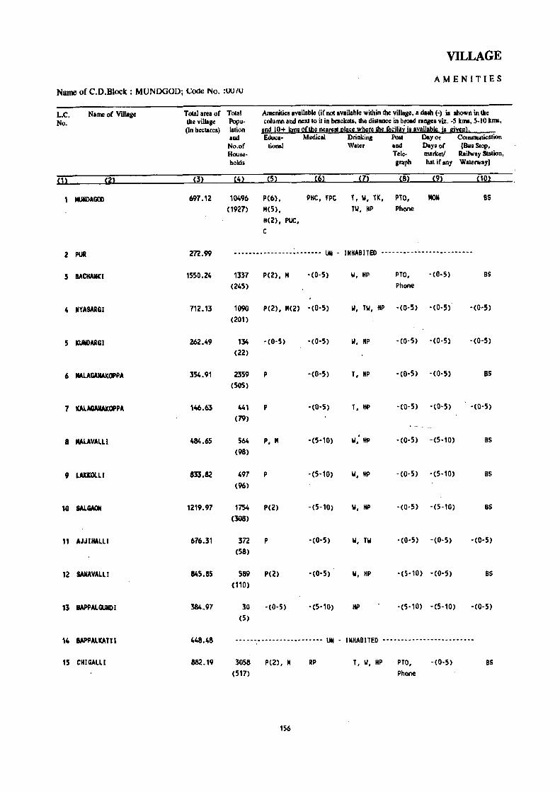
VILLAGE
AMENITIES
Name of C.D.Block : MUNOOOD; Code No. :UUfU
L.C. Name of Village Toeal area of Total Ameniliea available (if not available within the village, a dub (.) i. IIhowJl in the No. the village Popu- column and nexllo it in brackets. the distllllCe in broad raJlle& viz .• ,5 Icm& • .5-10 Icm&.
(In hectares) Iation all!! 12+ ~I!!!! 2(1112 ne!ll!!! I!I!lSIl wblll\ll!!e fasili!~ i! Ivgilabls iI gi~l!l· and Edu.:a· Medical Drinking POll Dey or Communiclltion No.of tional Water and Deysof (Bu. Stop, Hous.!- Tele- marketf Railway Station, holds graph hat if any Waterway)
01 <2> (3) (4) (5) (6) (7) (8) (9) (10)
MlJII)AGOO 697.12 10496 P(6), PMC, FPC T, W, TK, PTO, MOM 85 (1927) M(5), TW, HP Phone
H(2), PUC, e
2 PUR 2n.99 .....•..••.•.•.• : ••••••. UN . INHABITED •......•...•.......•...••
3 BACHANICI 1550.24 1337 P(2), M ·(0,5) 1,1, HP PTO, ,(0,5) BS
(245) Phone
4 NYASARGI 712.13 1090 P(Z), M(Z) ,(0'5) 1,1, TW, HP '(0·5) . (0,5) '(0,5)
(Z01)
5 KUllDARGI 262.49 134 ,(0,5) '(0'5) 1,1, HP '(0,5) '(0-5) ,(0-5)
(22)
6 MAlAGAllAKOPPA 354.91 2359 P ,(0,5) T, HP • (0-5) '(0,5) BS (505)
7 KALAGAIIAKOPPA 146.63 441 P '(0'5) T, HP ·CO-5) '(0,5) '(0,5)
(79)
8 IIAlAVALLI 484.65 564 P, M ·(5,10) ..,: HP · (0-5) ·(5-10) BS
(98)
9 LAUOlLl 833.82 497 P ,(5,10) W, HP · (0,5) '(5-10) BS (96)
10 SALGAON 1219.97 1754 P(2) ·(5,10) 1,1, HP '(0,5) '(5-10) BS (308)
11 AJJIHAlLl 676.31 3n p . (0'5) W, Til '(0·5) '(0,5) '(0-5) (58)
12 SANAVAlll 845.85 589 P(2) '(0,5) W, HP '(5010) • (0-5) BS (110)
13 IAPPAlGUIID I 384.97 30 ·(0,5) • (5,10) HP ,(5·10) ·(5-10) . (0-5) (5)
14 IAPPALKATTI 448.48 ......................... UN • IMHA8lTED .........................
15 CHIGAlLl 882.19 3058 P(2), M RP T, 1,1, HP PTO, '(0-5) BS (517) Phone
156

DIRECTORY
AND LAND .USE Name of C.D.Block : MUNDGOD; Code No.: 0070
AppIoach Nearest Town. elasa of Town Power Land use (area under different types of land use in hectares rounded to \Wo decimal places) L.e. \0 village and distance (in Km.) Supply No.
Forest Irrigated. Un-irrigated Culturable Area not (by source ofinigatioR) waste available
(including gauc~and
for cultivation
groves)
(1]) (12) (13) (14) (15) (16) (17) ( 18)- (1)
PR SHJGGAON· IY' 21 EA 161.26 Total 162.98 235.35 29.82 107.71 Tk 162.98
------------~---- .. ------- ... -.- ... -..... -.. - UN . INHABITED •..... -...... -- .... --- .....•... -.... -..... -.. 2
PR SHIGGAON' IY' 19 EA 1143.66 Total 84.54 256.47 14.70 50.87 3 Tk 84.54
IeR SHIGGAON' IY' 19 EA 539.36 Total 6.84 114.49 36.79 14.65 4 Tk 6.84
IeR SHIGGAON' IY- 19 228.75 Total 0.71 26.90 6.00 0.13 5
TIc 0.71
PR SHIGGAON' IY- 20 fA 194.03 Total 37.74 95.80 7.82 19.52 6 Tk 37.74
IeR SHIGGAON· IY· 21 EA n.53 Total 36.45 29.95 . 2.70 7 Tk 36.45
KR YElLAPUR· IY- 25 fA 238.n Total 30.70 113.26 82.83 19.09 8 Tk 30.70
KR YElLAPUR' IY· 20 475.12 Total 21.91 219.42 95.68 21.69 9 Tk 21.91
PR HANGAL' III' 23 EA 525.71 Total 157.78 365.48 59.88 111:12 10 Tk 157.78
KR HANGAL' 111' 22 EA 392.95 Total 54.34 205.63 5.39 18.00 " • Tk ~.34
KR SHIGGAON· IY· 19 EA 434.26 Total 8.72 345.31 25.40 32.16 12 Tk 8.72
,(R SHIGGAON- IY' 19 fA 326.16 Total 0.40 42.84 11.81 3.76 13 Tk 0.40
••••••••• -- ••• -- •• - •• -- •• --------------- •••• - UN - INHABITED .------.-----------.-----.------------------- 14
·R HANGAl· Ill· 20 fA 435.86 Total 76.78 298.50 21.15 49.90 15 Tk 76.78
157

VILLAGE:
Name of C.D.Block : MUNDYOD; 6xle No. :0070 AM E N IT I ES
L.C. Name of Village Total area of Total Ameniti<ls available. (ifR<ltlMiilable wilhlillheNillako"a dasI'l (-) is shown in the No. the village Popu- column and next to it in b!'Bckets. the ~e in broad' ranges viz. -5 kms. 5-10 kms,'
(In hectares) lation and 10+ kms ofth~ nea!!!!!l!lace where !be (a£llbI iuvailabis is give!ll. .. and Educa- M.:dlcal Drinking PoSt Day or Commurucallon No.of tional Water . and Days of [Bus Stop, Hou",,- Tele- marketl Rail"(ay Station. holds grapb hat ifany Waterway)
(1 ~ m (3) (4) (5) (6) .. (7) :.' . (8) (C}) ( 10)
16 HIREHALlI 765.6S 688 P(2), M(2) -(5-10) W, TW, 1tP -(0-5) -(0,5) BS (104).
17 KAVALKOPP, 510.55 433 P -(5-10) W, TW, HP -(0-5) -(5-10) BS (74)
18 ANDAlGI 857.37 475 P, M -(5-10) W, HP PO -(5-10) BS (92)
19 KALKERI 857.69 699 P -(5-10) W, HP -(0-5) -(5-10) BS (141 )
20 RAYNALLI (F) 330.65 ------------------------ UN - INHABITED -------------------------
21 BASAVANKOPPA 795.42 111 P -(10+) W, HP -(5-10) -(10+) -(5-10) (29)
22 MAINALLI 7962.73 2866 P(5), M(4) -(10+) W, HP PO -(10+) BS (516)
23 BYANALLI (F) 508.85 199 P -(5-10) HP - (P~5) -(5-10) -(0-5) (38)
24 CHAVADAlLl 378.90 1421 P(2), M -(0-5) W, HP PO -(0-5) BS (248)
25 KYSANKERI 195.72 324 P -(0-5) W, HP -(0-5) -(0-5) BS (62)
26 TAMYANKOPPI 175.98 611 P -(0-5) W, HP . -(0-5) -(0-5) -(0-5) (88)
27 TEGINKOPPA 170.82 26 . -(0-5) -(0-5) W, HP -(0-5) -(0- 5) -(0-5) (3)
28 KARGOLLI 287.77 487 .P -(5-10) W, HP -(0-5) -(5-10) BS (104)
29 KUSUR 483.87 1828 P -(0-5) w, TW, HP PO -(0-5) BS (352)
30 BALEHALLI (F) 625.76 125 -(0-5) -(5-10) w, HP -(0-5) -(5-10) -(0-5) (22)
158

: DIRECTORY
AND LAND USE Name of C:D.Block : MUNDGOD: Code No.: 0010
Ap_proach Nel!res~ Jown. Class of Town Power Land use (area under different types ofland use in hectares rounded to two decimal places) L.C.
to village " aDd distance (ill I\m.) Supply No. Forest Irrigated Un-irrigated Culturable Area not
(by source ofirrigation) waste available (including for cultivation gaucbar and groves)
. (m (12) (13) ~14) (15) ( 16) (17) (18) (1)
PR, HAN~AL- I I 1- 21 EA .469.41 Total 68.43 160.15 30.70 36.96 16
Tk 68.43
PR HANGA~- [11- 24 EA ,283.27 Total 45.38 134.33 5.27 42.30 17
Tk 45.38
KR YELLAPUR- IV' 24 EA 579.02 Total 24.34 171.39 ·68.52 14.10 18
Tk 24.34
KR YELLAPUR- IV' 29 " EA 625.18 Total 19.14 89.47 107.24 16.66 19
Tk 19.14
--.--.- ... "--.----.---------~------- ....... -- UN - IHHABITEO -- •••• - ••• ,-- --- -- - -- - - _. - --- ••• -- --- .'-.-- --- 20
kR YELLAPUR· IV' 22 EA 669.29 Total 17.27 32.54 69.52 6.80 21
n 17.27
PR YELLAPUR- IV- 16 EA 7522.01 Total 40:16 191.73 1n.05 31.78 22
. Tk .40.16
KR YELLAPUR~ iV- 24 508.85 23
KR YELLAPUR- IV- 30 EA 130.03 Total 36.56 80.48 111.34 20.49 24 ,. Tk 36.56
KR YELLAPUR- IV- 30 Total 16.37 69.61 92.30 17.44 25
Tk ' 16.37
KR YELLAPUR- IV- 29 EA 104.04 Total 2.43 39.41 26.34 3.76 26
Tk 2.43
KR YELLAPUR· IV- 25 124.99 Total 13.92 29:42 2.49 tT lk 13.92
KR YELLAPUR- IV- 28 EA 130.84 Total 14.58 56.91 70.39 15.05 28
Tk 14.58
PR SHIGGAON- IV- 24 EA 3,93.53 Total 10.92 51.47 3.71 24.24 29
Tk 10.92
KR YELLAPUR- IV- 20 596.41 Total 0.40 14.75 4.94 9.26 30
Tk 0.40
159

VILLAGE
AMENITIES Name or t...:.D.Block : MUNDGOD; Code No. :0070
L.C. Name of ViUage Total area of Total Amenilies availabl.: (if not available within the village. a dash (-) is shown in the No. the village Popu- column and ReXlIO il in brackell, the dillllnce in broad rangel viz. -5 kma. 5-10 kma,
(In he<:tarcs) lalion and 10+ kll!! oflhe Rea[S1it elalle wheN lIle ! • .;ilil~ ia available is given}. and Educe- Medical Drinking Post Day or Communication No.of lional Water and Day. of (Bus SlOP, Houl<:- - Te~- markell Railway Station, holds graph hal ifan), Waterway)
S1~ ,21 S31 S41 ~51 t61 t7l S81 ~91 "21
31 UGGINICERI 752.44 1105 P ~( 10+) II, HI> -(0-5) -(10+) -(0-5) (197)
32 GUNJAVATI 1351.31 578 P SMP II, liP PO -(10+) BS (106)
33 YEREBAIL 2758.57 742 P(2) - (10+) II -(5-10) -(10+) -(5-10)
(138)
34 HULl HONDA 689.10 267 P - (5- 10) II -(5'10) - (10+) -(0-5 ) (50)
35 NAND I KA1TA 2154.53 5092 P(4), M -(5-10) II, HP PO, -(10+) BS (881 ) Phone
36 AGAIH 495.88 1291 P - (0-5) W, HP -(0-5) -(10+) 8S (258)
37 HUNGUNDA 1865.45 2859 P(2), M PHC, FPC II, HP PTa, -(10+) BS (529) Phone
38 IlAOAGATTA 1303.98 1199 P(4) -(5-10) II -(5-10) -(5-10) 8S (224)
39 INDOOR 1094.98 4347 P, H, H -(5-10) T, II, HP PTa, -(5-10) BS (862) Phone
40 f(OP-INDOQR 725.74 1892 P -(0-5) T, II, HP - (0-5) -- -(0-5) BS (351 )
41 TATTIHALLI (MUNDGOD) 604.79 1565 P(4), M - -(0-5) T, 1.1, HP pO, -(0-5) - (0-5) (204) Phone
42 PALA 764.96 2784 P(2), PHC T, 1.1, HP PO MaN BS (458) M(2), H
43 INqALKI 276.91 ----------- ••• --.------- UN - INHABIlED -----------.-----.----.--
44 BHADRAPURA 396.14 717. P - (0-5) HP -(0-5) - (0-5) BS (145)
45 KALICOPPA 541.85 500 P -(0-5) II, HP -(0-5) -(0-5) -CO-s) (83)
160

DIRECTORY
AND LAND USE Namt: of C.D.BI(Kk : MUNDGOD; Code No.: 0070
Approach Nearest T'lwn. CIa," "frown Power ulIld .ise (ar.:a under din~r.:nt types of land u,e ,n he.;wrc, roun,"''' to two <lccimal places) L.C. lovillag" and distance (in Km,) SlIpply No,
FIlr':~1 lrrl!!at'o!d U n-irri~at':ll C'ulturahle Area n-,'-'--(hy sour1;1! of irrigah~ '0) wa~h! availahle
lin,,;luding for culti'ation ~au~har and !!nw\!~J
On (12) (13) \ ( 14) (15) ( 16) ( 17) (18) (I>
PR YELLAPUR- IV- 20 EA 557.21 Total 34.50 111.64 22.48 26.61 31
Tk 34.50
PR YElLAPUR- IV- 22 EA 1142.30' Total 28.59 67.61 89.25 23.56 32 Tk 28.59
KR YElLAPUR- IV· '27 EA 2518.72 Total 51.80 69.22 44.93 73.90 33
Tk 51.80
KR YEllAPUR- IV· 21 481.02 Tota( 18.21 154.'<;6 5.17 29.74 34
Tk 18.21
PR SHl'GGAON- IV- 24 t;A 1374.75 Total 136.56 573.24 13.53 56.45 35
Tk 136.56
PR SHIGGAOM- IV- 22 EA 104.30 Total 63.64 283.67 3.66 40.61 36
Tk 63.64
PR SHIGGAON- IY- 20 EA 989.78 Total 254.86 115.08 373.43 132.30 37
Tk 254.86
PR KUNDGOl- IV- 14 fA 960.98 Total 139.27 71.23 67.36 65.14 38'
n 139.27
PR SHIGGAON- IV- 22 EA .._ 347.27 Total 194.09 440.05 30.87 82.70 39
Tk 194.09
PR SHIGGAQN- IY- 20 EA 359.96 Total 190.02 110.15 6.88 58.73 40
Tk 190.02
PR SHIGGAON- [V- 24 fA 456.56 Total 9.98 70.71 45.45 22.09 41
Tk 9.98
PR HANGAL- 111· 12 EA 401.81 Total 2.02 29'.28 3.62 62.23 42 Tk 2.02
_____ * _____ a _________ • _______________________
U'I INHABITED ------ .. ------- .. --------------------~--------- 43
PR HANGAL- II I- n EA 218.68 156.4' 3.06 17.95 44
PR HANGAl- II 1- 17 EA 401.76 Total 5.46 118.12 5.14 11.37 45
Tk 5.46
161

VILLAGE
AMENITIES Name 'of C.D.Block : MUNDGOD: Code No.
L.C. Naill'; <If Villag.: Totsl area of Ttl"" AIll.:nili.: .. av#ilahl.: iif",~ availahle within Ih.: villac.:. a dam (-) j, .,hOWI1 in tbo: No. Ih.: village por tl • ':lIlumn uRtlnexllo il in hrad;.:I~. Ihe disilln.:e in h,.oad !',Bng.:' viz .. ) kills. S·IO kills.
(In 11':':18I\:S) lalion and 10+ kills "flh.: ncarcstl!la.:e where Ihe fa,ililv is aveilahl.: is giwn!, and Edu.:a· Medical Drinking PtlSt Day or COlllllluni.:atinn NIl,M lional Waler an,1 Days of [Bus SlOp. Hnu><!· Tele· marke" Railway Slat ion. hnlds graph hat if any WaterWay I
{12 [22 m [4~ {52 {62 (72 UU {92 [ 102
46 GOTAGUDI 256.40 231 P '(0-5) II, HP · (0-5) ·(0-5) · (0-5) (43)
47 KOP'GOTGUD I 257.95 468 P, M '(0,5) II, HP • (O·~) ·(0,5) ·(0,5)
(86)
48 MALGI 86/0.26 1566 P(4) , PHC, FPC II, HP PTO, THU BS
(308) 1'1(2), H Phone
49 KOlGI 306.82 366 p '(0'5) II, HP · (0, 5) ·(0,5) ·(0,5)
(78)
50 HARAGANAHAl LI 299.33 251 P '(0'5) II, HP · (0-5) ·(0,5) · (0'5) (54)
51 VEERAPUR 191.48 671 P '(0'5) II, HP - (0-5) ·,0,5) ·(0,5)
( 122)
52 JANGERI 322.02 100 -(0'5) '(0-5) II, HP ·(0-5) -(0-5) BS
(20)
53 YEMAGAlli 167.27 •••• __ •.•••••••.••••• _.- UN - INHABITED _ ............. _ .... "._._ ..
54 KYADGIKOP 568.44 173 P -(0-5) \.I, HP " · (0-5) -(0-5) '{D'5) (32)
55 BOKANGUODE 207.31 43 ,(0,5) '(0-5) II, HP · (0'5) ·(0,5) · (0'5) (9)
56 HOSKOPPA 316.70 131 -(0-5) '(0,5) \.I, HP -(0-5) -(0,5) 8S (27)
57 BEKKOD 438.96 335 P -(0-5) II, HP ·(0-5) -(0-5) ,(0,5)
(60)
58 NAGINKER[ 236.00 20 -(0-5) '(0-5) \.I, HP · (0-5) ·(0-5) BS
(3)
59 SIOOAPUR 677.44 682 p '(0-5) W, liP '(0-5) ·(0-5) BS
(140)
60 BOMMARSHIKOPPA (F) 433.11 -- •••••••• - •• _ ••••.• _- •• UN INHABITED ----- -- -. --- ---_- ---- .... _-
61 KODAMBI (F) 757.53 1346 P ,(0,5) II, HP ·(0'5) ·(0-5 ) ,(5,10) (242)
162
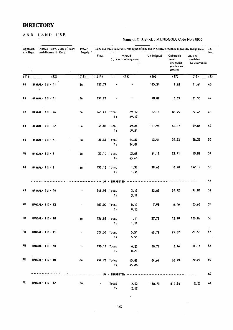
DIRECTORY
AND LAND USE Name: ofC.D.Block: MUNDGOD; Code No.: 0070
ArpmB,h N.:an:sl Town. Class ufTuwn Pow~r Land II"'! (ar~a IInd.:r dill;:r.:m Iyr.:s of land uoo: in h.:.:lar.:s ruund.:d 10 IWO d.:dmal rla.:.:s) L.C. h,vill_go: and distanc.: (in Km.) Supply No.
For~~1 Irrigalc,1 Un-irrilialCd Cuhurahlc An:a nOI (hy snur":l! of irrig8lit tn) wasl~ IIvailablc
(induding fur ~ullivali,)n gau..:har and grllv,:s)
(11~ (12) =,13) 'P4~ (15) P61 ( 17) ~18) (1)
PR IIANGAl- 111- 11 EA 127.79 115.34 1.63 11.64 46
PR HANGAL- 111- 11 EA '151.23 78.82 6.35 21.55 47
PR HAN GAL .:, III - 26 EA 548.41 Total 69.17 87.10 86.95 72.63 48
TIc 69.17
KR HANGAl- 111- 12 EA 33.02 Total 49.84 121.96 62.17 39.83 49
Tic 49.84
KR HANGAl- 111- 6 EA 83.35 Total 54.82 93.54 39.23 28.39 50
Tk 54.82
PR HANGAL- 111- 7 EA 30.14 Total 43.68 84.13 22.71 10.82 51 Tk 43.68
PR HANGAL' Ill' 9 EA 130.18 Total 1.36 39.63 8.70 142.15 52
Tic 1.36
-•... -.•.............. ---.------------------- UN - INHABITED --------------------------------- .. -~-.--.--- 53
KR HANGAL' III· 10 348.95 Total 3.12 82.82 39.72 93.83 54
Tic 3.12
KR HANGAL- III· 12 169.09 Total 0.10 7.98 6.46 23.68 55
Tic 0.10
PR HANGAL' III· 10 EA 136.83 Total 1.11 37.75 12.19 128.82 56
Tk 1.11
PR IIANGAL' 111- II 327.30 Total 5.51 63.72 21.87 20.56 57
Tk 5.51
PR HANGAL' 111- 10 198.17 Toul 0.20 20.74 2.76 14.13 58
Tic 0.20
PR HANGAL' I I I· 10 EA 454.73 Total 45.88 84.64 62.99 29.20 59
Tk 45.88
--.- ..... -- ........ -- .. -.------ ... -- •••••• -.. UN INHABITED --------------------------------------------- 60
PR IIANGAL' 111- 12 EA Total 2.02 138.70 614.56 2.25 61
Tk 2.02
163

VILLAGE
AMENITIES NamcofC.D.Block: MUNDGOD; Codt! No. :0070
L.e. N.m~ "I' Viilag~ Tolal ar-.!a of TOlal Am~"ili~. av.il.hl~ (if "ut avail.hl~ within Ih~ villap.:. 'I .•• H i. shown in Ih.: No. Ih" "illag" Popu- ,,,(umn and neXIIO il in orackets. the distan,,, in hmad ",n~". viz. -S killS. 'i-IO killS.
(In hectar".) laliun ""d 10+ killS ofth" n.:ar.:.! [!Ia~" wh.:r.: th" facility is 0\'8ilahl.: i. giwnl. and EJu..: .. ,- MCllieal Drinking ,Posl Day or (" .. )Jnll1uni~(llion No.of lional Wat~r and Day. of jBu. SlOp. H()uSI!- Td,,- mark~tl Rail",a) Station. hoI-I> graph hat if allY Wal~rwayl
(1) (2) (3) (4) (5) (6) (7) (8) (9) ( 10)
62 KURLI 1032.06 409 P -(0-5) W, HP PO - (0-5) BS (64)
63 HALHARVI 70.20 47 -(0-5) - (0-5) W, HP -(0-5) -(0-5) -(0-5) (8)
64 BALEKOPPA 320.27 195 P - (5-10) W, HP -(0'5) - (5-10) - (0-5)
(39)
6~ HOSTOT 228.83 88 -(0-5) - (5-10) W, HP -Cq-5) - (5-10), -(0-5) ,
(11)
66 UMACHAGI 586.73 406 P - (5-10) W, HP -(0-5) -(5-10) -(0-5) (69)
67 SANAVALLI (F) 714.00 307 P -(5-10) W, HP - (0-5) -(10+) -(0-5) (54)
68 BEOSGAON 1104.26 383 P - (5-10) II, HP PO -( 10+) BS (74)
69 TOGRALL I 1197.93 202 P - (5-10) II, HP -(0-51 - (5-10) BS (36)
70 ATABAll (F) 291.03 133 -(0-5) - (5-1 0) II, HP -(5-10) -(5-10) -(0-5) (32)
71 KANC~IKOPPA (F) 755.37 189 -(0-5) - (5-10) W, HP -(0-5) -(5-10) -(O-S) (45)
72 AMATGAR (F) 1283.80 27 -(0-5) - (0-5) HP -(0-5) - (0-5) -(0-5) (4)
73 VIRAPUR (F) 394.86 204 -(0-5) -(0-5) W, HP -(0-5) -(0-5) -(0-5) (33)
74 RAMAPUR 900.94 787 P -(5-10) W, HP - (5-10) -(5-10) -(0-5) (163)
75 ATTANGI 1328.03 519 P, M - (10+) W, HP -(5-10) - (0- 5) - (5-10) (88)
76 OOODAHARVALLI 384.86 75 ,(0,5) -( 10+) W, HP -(0-5) - (0-5) -(0-5) (14 )
164

'DIRECTORY
AND 'LAND USE Name of C.D.Block : MUNDGOD; COOe No.: 0070
: Approach Nearest Town. Clas~ () .. Town Powl.!r Land Il'e (area under dini:renll)'p~, of land U~ in heclares mumkd 10 IWo decimal places) L.e. ; 10 village and dislanCe (in ~m.) Supply No.
FO(,\!~l Irrigaled U n-irrigat\!d Cuhurahle Area nOI (hy Sllun.:.: of irrigation) wa~h.: available
(indudang I()r ~ultiv.alion
gml~har and grov\!s)
(11) (12) (13) (1~) (15) (6) ( 17) (18) (1)
ICR HANG~L- 1[1- 14 EA 900.55 Total 1.52 83.08 34.56 12.35 62 Tk 1.52
ICR HANGAL- I [ 1- 12 47,43 Total ·2.48 14.85 5.28 0.16 63 Tk 2.48
ICR HANGAL-: 111- 13 255.60 Total 7.12 40.03 11.31 6.21 64 Tk 7.12
ICR HANGAL- I I 1- 13 204.22 Total 5.16 14.76 2.11 2.58 65 Tk 5.16
KR HANGAL- 111- 18 EA 496.96 Total 7.44 66.82 7.61 7.90 66 Tk 7.44
ICR , HANGAL- I [ [- 18 EA 707.66 Total 2.53 3.23 0.58 67 Tk 2.53
ICR KANGAL' II [- 16 EA 981.85 Total 6.48 82.39 13.31 20.23 68
Tk 6.48
ICR HANGAL- I L[· 19 1121.72 Total 2.06 49.85 15.22 9.08 69 Tk 2.06
KR HANGAL - 111- 17 287.13 Total 0.83 2.06 1.01 70 Tk 0.83
KR . HANGAL- 111- 18 EA 755.37 71
KR HANGAL- 111- 1S 1282.02 1. 78 72
KR HANGAL- 111- 13 394.86 73
PR HANGAL, 111- 14 EA 770.77 114.63 3.50 12.04 .74
KR HANGAL- 111- 20 EA 1167.75 138.44 6.71 15.13 75
KR HANGAL- 111- 23 335.54 27.26 7.90 14.16 76
165
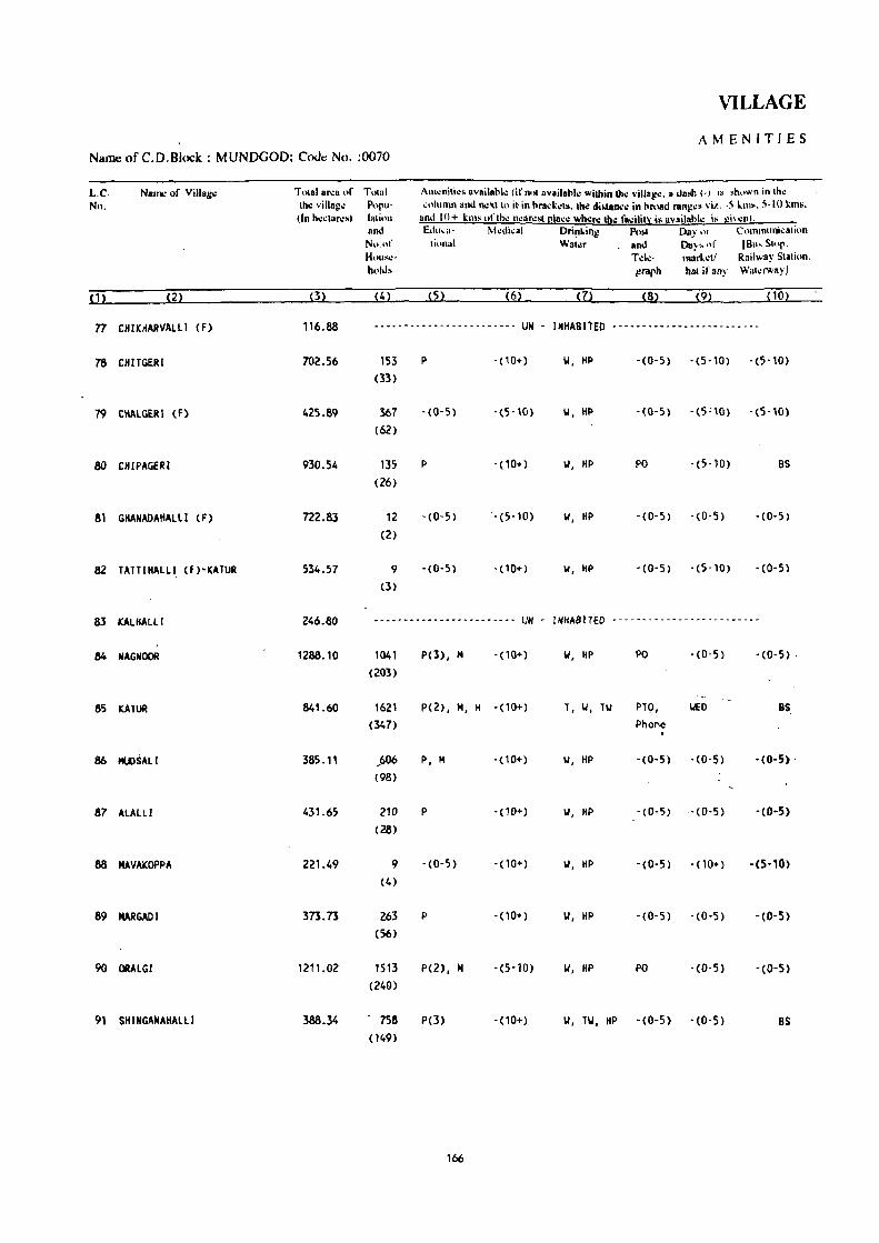
VILLAGE
AMENITIES Name ofC.D.Block: MUNDGOD; CcxiI:! No. :0070
L.C. Nn.
Nam.: of Village
77 CHIKHARVALLI (F)
78 CHITGERI
79 CKALGERI (F)
80 CHIPAGERI
81 GHANADAHALll (F)
82 TATTIHALLI (F)"KATUR
83 KALHALLl
84 NAGNOOR
85 KATUR
87 ALALLI
88 MAVAKOPPA
89 MARGADI
90 ORAlGI
91 SHINGANAHAlll
Tolal 0"'8 "f Tolal Ih.: villaj!e Popu-(In h':~lar.:s) hllitlll
and No.nf Hc.)lIS\!~
hold.
(4)
Am.:nili.:s availohl.: (if nlll availahl.., Wilhin Ihe villa!!.:. a dash (.) is .hnwn in Ihc .;nlunm and neXII" it in hrad.:':ls. lit<: distan.:e in broad ranj!e, vi!.. -~ lm •. S·IO kills.
and 10+ kill, "flh.: lI.:nrest !!Ia.:.: wher.: Ih.: fadlilY iSlIvailahl.: is giVen). Edu,;!· l\'k<l;';,,1 Drinl;ill!! Post Day nr Cnllllllunkaliun
lional WaleI' an.! DlI" nl' I Bu, Slnp. T de- In;;rkeli Railway Sial ion. j!raph hal if any Walerway I
(6) m (8) (9) (10)
116.88 ....... -... -...... -.- .. - UN - INHABliED •.....•. _ ........ _-._ ... -
702.56
425.89
930.54
722.83
534.57
246.80
1288.10
841.60
385.11
431.65
221.49
373.73
1211.02
388.34
153 (33)
367 (62)
135 (26)
12 (2)
9
(3)
P '(10+)
'(0-5) ,(5'10)
P '(10+)
,(0,5) ,(5'10)
• (0, 5) ·(10+)
II, HP -(0-5) ,(5,10) '(5-10)
II, HP '(0,5) '(5i'0) ,(5'10)
II, HP PO ,(5,10) 85
II, HP '(0-5) ,(0'5) ,(0,5)
w, HP -(0-5) ,(5'10) • (0,5)
.... --_ .. - .. __ ... __ .. - .. UN - I~HA8ITED .-.-------------------- ..
1041 (203)
1621 (347)
_606 (98)
210 (28)
9 (4)
263 (56)
1513 (240)
- 758
(149)
PCl), H - (10+)
P(2), 14, H ·(10+)
P, H ·(10+)
P • (10+)
- (0-5) '(10+)
P '(10+)
P(Z), M -(5-10)
P(3) '(10+)
166
W, liP
T, 1.1, Til
II, HP
II, HP
t.I, HP
t.I, HP
t.I, HP
PO
PT~,
Phone .
. (0-5)
IJED
,(0,5) -(0-5)
-(0'5) ·(0,5)
-(0-5) '(10+)
'(0-5) '(0-5)
PO -(0-5)
101, 1101, HP -(0-5) -(0'5)
-(0-5) .
85
'(0-5) .
'(0-5)
-(5-10)
- (0-5)
'(0-5)
BS

DIRECTORY
AND LAN D Namt: of C.D.Bhx:k : MUNDGOD; Codt: No.: 0070
Approach N\lar\!st To,,"n. Class ofTnwn P'l'wl!r Land ,,,c ("r~" uo.kr dill;:r"nIIYr~s of land lis.: in ti"cta~s ruund"d 10 two d~"imal plac~.) L.e. 10 viUag.: anU dislanc~ (in Kill.) Supply No.
Ft)r\!~t Irrigated Un-irrigat.:d Cllltllrabic A~a nol (Ily "Ollr<~ or irrigation) wast\! 8vailabl~
(including f(lr cultivation l,!8uchar and groves)
(11) (12) (13) (14) (15) (16) (17) ( 18) ( 1)
"
-- •• -- •• - •••••••• ------.---- •• --------------- UN INHABHED .... -_ .................. -_ ............... -- -_ ............ -- ...... _- -_ ...... _- 77
PR HANGAL- 111- 18 689.35 13.21 78
PR HANCAL- 111- 19 408.30 17.59 79
PR HANGAL- III· 20 921.55 3.30 5.69 80
KR YELlAPUR;' IV- 22 720.52 2.31 81
KR HANGAL- 111- 20 534.57 82
--.-0--.------------.-------·-----------·---- UN - INHABITED --------------------------------------------- 83
KR HANGAL- 111- 20 fA 1014.48 160.68 13.44 99.50 84
PR HANGAt- 111- 20 fA 533.85 200.62 63.73 43.40 85
I(R HANGAt- 111- 20 fA 205.23 142.21 14.43 23.24 86
KR HANGAt- I J J- 18 291.38 106.02 13.29 20.96 87
KR HANGAl' 111- 17 EA 181.31 32.90 3.76 3.52 88
KR HANGAl-. I il- lS 272.79 86.26 5.10 9.58 89
PR HANGAl' I I 1- 8 EA 772.55 Total 147.51 245.35 2.98 42.63 90 Tk 147.51
PR HANGAl- 111- 10 EA 220.52 Total 0.64 149.35 2.46 15.37 91 Tk 0.64
167

VILLAGE
AMENITIES
Name of C.D.B1ock : MUNDGOD; Code No. :0070
L.C. No.
Nam.: of Villag~
92 HULIHONOA (F)
93 BORANGUDDE
94 HUDELKOPPA
Total (SIJlI)
Total ar~a of Total th~ vil1ag~ Pol' 11-
(In h~ctar.s) lotinn
188.82
and Nn.of Hous~
hold.
(4)'
43 (6)
Am~niti~s avail"hk !ifnot nvailahl.: within the villa!!c. a da~ (~-) i~ ~hn\l,'n in lhl! I.:olumn ;tnd nl.!\t til il in hral.!kds. tht.: disl:m~c in hroad ran!!l!S viz. -5 km~. 5~IO kms.
and J(l+ kllls .. r the n~ar~st rlac~ \\'h~r~ the facility is avail.hl~ is given!. Edu,.- I'l'k,liLal Drinking P,,,t Day ur Cl1ll1l1luni.:atilln
ti",,,,! Wakr and Days (If (BI,s Stop. T ck- mark.:t! Railway Station. graph hat if any Waterwayl
(5) (6) (.8) (9) (10)
- (0- 5) . (10+) ·(0-5) ·(0-5) '(0-5)
138.03 .-.- •••• -.-.--- •••• -.-.- UN • INHABITED .-.-----.---.-.--- .• - ... -
310.50 --.-.- ..•. -.-.- ......... UN . INHABITED .................. - ... _ ..
66809.76 75046 (13745 )
P(101),
M(32l,
PHC(4), FPC(3),
H(6), PUC, RP. SMP
C
168

VIRECTORY
AND LAND USE
Approach 10 village
(11)
Nearest Town, Class of Town and dislance (in Km.)
(12~
KR HANGAL- II 1- 11
Power Supply
(13)
Name ofC.O.Block : MUNDGOD; Code No.: 0070
Land usc (area under dirtl:renl types of land usc in hectares rounded to two decimal places) L.C. No.
Forest Irrigated Un-irrigated Culturable Area not (by source of irrigation) waste available
(including for cultivation gauchar and gnlVcs)
(14) (15) ( 16) ( 17) (18) (1)
186.07 2.40 0.35 92
------------------.- .... - ... --- .... ----- ..... UN INHABITED ------ .... -.-----.-.----------------.-- ... --- 93
- - - - - - - - - -- - - - - - - - - - - - -- - - - - - - - - - - - - - - - - - - - - - UN - I NHAB !TED - - - - - - - - - - - - - - - - - - - - - - - - - - - - - - - - -- - - - - - - - - - - - 94
47026.48 Total 2579.37 8929.43 3096.81 2436.05 Tk 2579.37


SIDDAPUR _C.D.BLOCK

r;:::::============-_ .. __ .
~
KARNATAKA
SIDDAPUR TALUK UTTAR KANNAD DISTRICT Km 2 0 4
C;
r.q I.
Reser.cd Forest boundaries art not entEred Clue to scale limitations.
Co. Block boundary of Siddapur i. cO-lerminus with !aluk boundary.
6 Km
BOUNDARY, DISTRICT... ... ... ... '" '"
.. TAWK .................. .
.t CI)
s
VILLAGE WITH LOCATION CODE NUMBER... C:::]L=:j HEADOUARTERS :TALUK .. , ... ... ... ... @ VILLAGES WITH POPULATION SIZE: BEL(MI 200; 200-499; 500-999; 1000-4999;5000 AND ABOVE ...
UNINHABITED VIlLAGES WITH LOCATION CODE.
STATE HIGHWAY... .... ... ... ... . ..
IMPORTANT METALLED ROAD. ... .. .
UNMETALLED AND OTHER ROADS .. .
RIYER WITH STREAM. .. . ...
0 ••••
:::==.:Uf''==J SH93
\} I(
H I . M
POST OFFICE I TELEGRAPH OFFICE
HIGHER SECONDARf SCHOOL .... ..
POLICE STATION ............... .
PRIMARY HEALTH CENTRE, DISPENSARY, FAMILY PLANNING CENTRE .................. .
IMPORTANT YILLAGE MARKET' HAT (SHANDY), MANDIES ...... '" .......................... .
BaNd upon Survey of India map with the permission of the Surveyor General of India.
Co)
PO/TO S
PS
....
•. +, ... &.~

ALI>HAUETICAL LIST OF VILLAGES
TALUK: SIDDAPUR-0080 (_-. D. BLOCK: SIDDAPUR-0080
------.--_ .. __ . - -.~---.-------. -- .----~.---.-.
SL NAME OF THE VILLAGE
NO
,1991 CEtlSUS 1981 CENSUS
_------- ----- --~---------
LOCATION rODE (Manual)
LOCATION CODE LOCATION CODE LOCATION CODE
(Comput~n (Manual) (COII1pUter)
--~--..,---'------.--- . __ -. -~------ .. __ . __ .-.... --_.---_ .. _---_. --""-_._----
Adka~ll
2 Atgoo . \ 3 Ainbai l 4 Akkunj i 5 Alavalli 6 Algod 7 Analebai l 811r-ehalla 9 Arendur
10 AttillllJld 11 Avarguppa
1i Balekai 13 Balekoppa 14 Balekoppa 15 Balesar 16 Ba,lgod 17 Balgul i 18 Balikoppa 19 Ballatte 20 Bandisar 21 B,mnige 22 Bedkani 23 Begar 24 Bhandarkeri 25 Bhankul i 26 Bidarkan 27 Bidarmane 28 Bikkalse 29 Bi legod 30 Bilg;
31 Chandraghatgi 32 Chapparmane
33 Oanmav 34 Oevisar 35 Oodmane 36 Ougdikoppa
37 Gavingudde 38 Ghattikili 39 Gi jgini 40 Girgadde
2 3
11/20/8/128
11/20/8/43
11/20/8/180 11/20/8/12
1~/20/8_1'li9
11/20/8/18
11/20/8/17')
11/20/8/1";4
11/20/8/10 11/20/8/174
11/20/8/49
11/20/8/1';4
11/20/8/4
11/20/8/179
11/20/8/172
11/20/8/98
11/20/8/23
11/20/8/50
11/20/8/45
11/20/8/34
11/20/8/132
11/20/8117
11/20/8/96
11/20/8/162
11/20/8/21
11/20/8/25
11/20/8/176
11/20/8/5
11/20/8/83
11/20/8/114
11/20/8/120
11/20/8/107
11/20/8/79
11/20/8/1't2
11/20/8/89
11/20/8/8
11/20/8/158
11/20/8/138
11/20/8/92
11/20/8/143
4
11/20/0080/0128
11/20/0080/00'.3. 11/20/0080/0180
'11/20/0080;0012
11/20/0080;0'119
11/20/0080/0018
11/20/0080/0175
11/20/0080/0144
11/20/0080/0010
'1/20/0080/0174
li/20/0080/0(l49
11/20/0080/0154
11;20/0iJ~0/0004
~ 1/2010080/0119 11/20/0080/0172
11;20/0080/0098
11/20/0080/0023
11/20/0:)80/0050
11/20/0080/0045
11/20/0080/0034
11/20/0080/0132
11/20/0080/0017
11/20/0G80/0096
11/20/0080/0162
11/20/0030/0021
11/20/0080/0025
11/20/0080/0176
11/20/0080/0005 11/2010080/0083 11/20/0080/0114
11/20/0080/0120
11/20/0080/0107
11/20/0080/0079
11/20/0080/0142
11/20/0080/0089
11/20/0030/0008
11/20/0080/0158
11/Z0/G08':';:J138
11/20/0080/0J92
11/20/00&0/0143
173
5
9/19/8/123
9/19/8/30
9/19/8/177
9/19/8/24
9/19/8/91
9/19/8/17
9/19/8/183
9/19/8/126
9/19/8/28
9/19/8/159
9/19/8/1
9/19/8/169
9/19/8/21
9/19/8/144
9/19;!>,.'191
9/19/8/96 q/19/8/2
9/19/8/0
9/19/8/6
9/19/8/10
9/19/8/161
9/19/8/33
9/19/8/98
9/19/8/139
9/19/8/35
9/19/8/38
9/19/8/158
9/19/8/22
9/19/8/'i9
9/19/8/110
9/19/8/88
9/19/8/106
9/19/8/54
9/19/8/127
9/19/8/101
9/19/8/25
9/19/8/189
9/19/8/166
9/19/8/61
9/19/8i125
6
09/19/0080/0123
09/19/0080/0030
09/19/0080/0177
09/19/0080/0024
09/19/0080/0091
09/19/0080/0017
09/19/0080/0183
00/19/0080/0126
09/19/0080/0028
09/19/0080/0159
09/19/0080/0001
09/19/0080/0169
09/19/0080/0021
09/19/0080/0144
09/19/0080/0191
09/19/0080/0096
09/19/0080/0002
09/19/0080/0000
09/19/0080/0006
09/19/0080/0010
09/19/0080/0161
09/19/0080/0033
09/19/0080/0098
09/19/0080/0139
09/19/0080/0035
09/19/0080/0038
09/19/0080/0158
09/19/0080/0022
09/19/0080/0059
09/19/0080/0110
09/19/0080/0088
09/19/0080/0106
09/19/0080/0054
09/19/0080/0127
09/19/0080/0101
09/19/0080/0025
09/19/0080/0189
09/17/0080/0166
09/19/0080/0061
09/19/0080/0125

ALPHABETICAL LIST OF VILI .. AGES
T ALUK: SIDDAPUR-0080
Sl NAME OF THE VILUGE NO
2
C. D. BLOCK: SIDDAPUR-0080
---------'----- --_---------------1991 CENSUS 1981 CENSUS
LOCATION CODE (Manual)
3
LOCATION CODE LOCATION CODE LOCATION CODE (Computer) (Manual) (Computer)
4 5 6
---~-----------.---------------41 Godlabil 42 Golgod 43 Golikai 44 Gubbagod 45 Guddekop 46 Gunjagod
47 Hadr i mane 48 Halagadikoppa 49 Haldot 50 Halegouri 51 Halegubbi 52 Hatehalla 53 Halgeri 54 Halkani 55 Hallibail 56 Handiyanemath 57 Hangarkhand 58 Hanjibail 59 Harigar 60 Harlikoppa 61 Harshikatta 62 Harsh i mane
63 Hasargod 64 Hasvante 65 Havinbi l 66 Keggadde 67 Heggarni_ 68 Hegge 69 HeggekoP,Pa 70 Heg90dnane 71 Hegnur 72 Kejni 73 Hemagar 74 Hemtemane 75 Hinagar 76 Hirekai n Hirekai 78 Honnehadda 79 Honnekont> 80 Hoskoppa 81 Hosmanju 82 Hostota 83 Hosur 84 Hukl i
11/20/8/29 11/20/8/33 11/20/8/110 11/20/8/95 11/20/8/15 11/20/8/19
11/20/8/104 11/20/8/48 11/20/8/140 11/20/8/125 11/20/8/86 11/20/8/187 11/20/8/66 11/20/8/156 11/20/8/198 11/20/8/188 ',/20/8/,53-11/20/8/13 11/20/8/182 11/20/8/11 11/20/8/166 11/20/81167 11/20/8/126 11/20/8/60 _ 11/20/8/103 11/20/8/24 11/20/8/194 11/20/8/185 11/20/8/57 11/20/8/40 11/20/8/178 11/20/8/70 11/20/8/69 11/20/8/36 11/20/8/30 11/20/8/1 5 1 11/20/8/157
11/20/8/168 11/20/8/102 11/20/8/135 11/20/8/111 11/20/8/183 11/20/8/14 11/20/8/72
,'/20/0080/0029 11/20/0080/0033 ,'/20/0080/0110 11/20/0080/0095 11/20/0080/0015 11/20/0080/0019
',/20/0080/0'04 ,'/20/0080/0048 11/20/0080/0140 11/20/0080/0125 11/20/0080/0086 11/20/0080/0187 11/20/0080/0066 11/20/0080/0156 11/20/0080/0198 11/20/0080/0188 11/20/0080/0153 11/20/0080/0013 11/20/0080/0182 11/20/0080/0011 11/20/0080/0166 11/20/0080/0167 11/20/0080/0126 11/20/0080/0060 11/20/0080/0103 11/20/0080/0024 11/20/0080/0194 11/20/0080/0185 11/20/0080/0057 11/20/0080/0040 11/20/0080/0178 11/20/0080/0070 11/20/0080/0069 11/20/0080/0036 11/20/0080/0030 11/20/0080/0151 11/20/0080/0157 11/20/0080/0168 11/20/0080/0102 11/20/0080/0135 11/20/0080/0111 11/20/0080/0183 11/20/0080/0014 11/20/0080/0072
174
9/19/8/42 9/19/8/45 9/19/8/69
9/19/8/114 9/19/8/0 9/19/8/31
09/19/0080/0042 09/19/0080/0045 09/19/0080/0069 09/19/0080/0114 09/19/0080/0000 09/19/0080/0031
9/19/8/63 09/19/0080/0063 9/19/8/7 09/19/0080/0007 9/19/8/168 09/19/0080/0168 9/19/8/121 09/19/0080/0121 9/19/8/56 09/19/0080/0056 9/19/8/179 09/19/0080/0179 9/19/8/90 09/19/0080/0090 9/19/8/188 09/19/0080/0188 9/19/8/155 09/19/0080/0155 9/19/8/152 09/19/0080;0152 9/19/8/171 09/19/0080/0171 9/19/8/0 09/19/0080/0000 9/19/8/145 09/19/0080/0145 9/19/8/29 09/19/0080/0029
9/19/8/140 09/19/0Q89/~~~0
9/19/8/142 09/19/0080/0t42 9/19/8/160 09/19/0080/0160 9/19/8/76 09/19/0080/0076 9/19/8/64 09/19/0080/0064 9/19/8/3 • 09/'9/0080/00~3
9/19/8/178 09/19/0080/0178 9/19/8/153 09/19/0080/0153 9/19/8/82 09/19/0080/0082 9/19/8/13 09/19/0080/0013 9/19/8/176 09/19/0080/0176 9/19/8/47 09/19/0080/0047 9/19/8/86 09/19/0080/0086 9/19/8/4 09/19/0080/0004 9/19/8/43 09/19/0080/0043 9/19/8/135 09/19/0080/Ci135 9/19/8/190 09/19/0080/0190 9/19/8/141 09/19/0080/0141 9/19/8/62 09/19/0080/0062 9/19/8/185 09/19/0080/0185 9/19/8/71 09/19/0080/0071 9/19/8/147 09/19/0080/0147 9/19/8/0 09/19/0080/0000 9/19/8/50 09/19/0080/0050

175

ALPHABETICAL LIST OF VILLAGES
T ALUK: SIDDAPVR-0080 C. D. BLOCK: SIDDAPUR-0080
SL NAME OF THE VILLAGE 1991 CENSUS 1981 CENSUS NO
LOCATION CODE LOCATION CODE LOCATION CODE LOCATION CODE (Manual) (Computer) (Manual) (Computer)
2 3 4 5 6
128 Kudegod 11 nO/B/B5 11/20/0080/00B5 9/19/B/55 09/19/00BO/0055 129 Kulibid 11/20/8/68 11/20/0080/0068 9/19/8/85 09/1910080/0085 130 Kunaj i 11/20/8/38 11/20/0080/0038 9/19/8/8 09/19/0080/0008 131 Kuppagar 11/20/8/27 11/20/0080/0027 9/19/8/39 09119/0080/0039 132 Kurvante 11/20/8/112 11120/0080/0112 9119/8/70 09/19/0080/0070 133 Kyadgi 11/20/8/99 11/20/0080/0099 9/1918/109 09/1910080/0109
134 lakkabbekerj 11/20/8/97 11/20/0080/0097 9/19/8/97 09/19/0080/0097
135 Madankal 11/20/8/139 11/20/0080/0139 9/19/8/165 09/19/0080/0165 136 Maghegar 11/20/8/22 11/20/008010022 9/19/8/36 09/19/0080/0036 137 Malavajappi 11/20/8/53 11/20/0080;0053 9/19/8/83 09/19/0080;0083 138 Malavall i 11/20/8/56 11120/0080/0056 9/19/8/77 09119/008010077 139 Malavall i 11/20/8/59 11/20/0080/0059 9/19/8/79 09/19/0080/0079 140 Malemane 11/20/8/71 11/20/0080/0071 9/19/8/49 09/19/0080/0049 141 Malenalli 11/20/8/130 11/20/0080/0130 9/19/8/164 09/19/0080/0164 142 Malobalagar 11/20/8/155 11/20/0080/0155 9/19/8/187 09/19/0080/0187 143 Mand l i koppa ',/20/8/39 11/20/0080/0039 9/19/8/12 09/19/0080/0012 144 Manigar 11/20/8/200 11/20/0080/0200 9/19/8/157 09/19/0080/0157 145 Manikmane ,1/20/8/164 11/20/0080/0164 9/19/8/138 09/19/0080/0138 146 Manmane 11/20/8/58 11/20/0080/0058 1.1/19/8/78 09/19/0080/0078-147 Masalemarki 11/20/8/74 11/20/0080/0074 9/19/8/52 09/19/0080/0052 148 Mattigar 11/20/8/63 11/20/0080/0063 9/19/8/74 09/19/0080/0074 149 Mattihalli 11/20/8/159 11/20/0080/0159 9/19/8/172 09/19/0080/0172 150 Mavinkocl 11/20/8/100 11 /20/0080/0100 9/19/8/108 09/19/0080/0108 151 Mensi 11/20/8/67 11;2D/0080/0067 9/19/8/87 09119/0080/0087 152 Mudhalli '1/20/8/148 11/20/0080/0148 9/19/8/133 09/19/0080/0133 153 Mugdur 11/20/8/6 11/20/008010006 9/19/8/23 09/19/0080/0023 154 Mulgunda 11/20/8/197 11/20/0080/0197 9/19/8/181 09/19/008010181 155 Murur 11/20/8/177 11/20/0080/0177 9/19/8/194 09/19/0080/0194 156 Musvall i 11/20/8/55 11/20/0080/0055 9/19/8/80 09/19/0080/0080 157 Muthall i 11/20/8/165 11/20/0080/0165 9/19/8/174 09/19;0080/0174 158 Mutmurd 11/20/8/127 11/20/0080/0127 9/19/8/122 09/19/0080/0122 159 Muttige 11/20/8/20 11/20/0080/0020 9/19/8/32 09/19/0080/0032 160 Muttige 11/20/8/32 11/20/0080/0032 9/19/8/44 09/19/0080/0044
161 Nagarbhavi 11/20/8/65 11/20/0080/0065 9/19/8/12 09/19/0080/0072 162 Naigar 11/20/8/94 11/20/0080/0094 9/19/8/104 09/19/0080/0104 163 Naligar 11/20/8/31 "/20/0080/0031 9/19/8/41 09/19/0080/0041 164 Nandyane '1/20/8/193 ',/20/0080/0193 9/19/8/180 09/19/0080/0180 165 Nejjur 11/20/8/9 11/20/0080/0009 9/19/8/26 09/19/0080/0026 166 Nidgod 11/20/8/42 11/20/0080/0042 9119/8114 09/19/0080/0014 167 Nilkunda 11120/81192 11/20/0080/0192 9/19/81154 09/19/0080/0154 168 Nirgan 11/20/8{196 1112010080/0196 9119181182 09119/0080/0182 169 Nirgar 11/20/8/115 11/20/0080/0115 9119/8/b7 09/19/008010067
176

ALPHABETICAL LIST OF VILLAGES
TAI--UK: SIDDAPUR-0080
Sl NAME OF THE VILLAGE NO
170 Ni rgod
171 Ojagar
172 Paduvanbai l.
173 Sampagod 174 Sangol imane
175 Sarakul i 176 Sashigul i 177 Shamemanc 178 Shelur
179 Sh i gt~ha II i 180 Shiralgi 181 Shivalmane
182 Sovinkoppa 183 Surgikoppa 184 Suttalmane
185 Tagginbalgar 186 Talekerl 187 Tandagundi
2
188 Tarehalli-Kansur 189 Taresar
190 Targod
191 Tarkhanda
192 Tumargod 193 Tyagal i
194 Tyarashi
195 Umbalmane
196 Unchall i 197 Uppadaki 198 Uppingadde
199 IJadageri
200 Wajagod
201 Yelugor
C. D. BLOCK: SIDDAPUR-0080
1991 CENSUS 1981 CENSUS
LOCATION CODE (Manua! )
3
11/20/8/82
11/20/8/105
11/20/8/64
11/20/8/160 11/20/8/77
11/20/8/123
11/20/8/117 11/20/8/170 11/20/8/141 11/20/8/145 11/20/8/3 '11/20/8/186 11/20/8/106 11/20/8/149 11/20/8/73
11/20/8/129 11/20/8/80 11/20/8/189
11/20/8!'136 11/20/8/181
11/20/8/113
11/20/8/108
11/20/8/41 11/20/8/152
11/20/8/16
11/20/8/122
11/20/8/184 11/20/8/35 11/20/8/90
11/20/8/46
11/20/8/78
11/20/8/131
LOCATION CODE LOCATION CODE LOCATION CODE (Computer) (Manual) (Computer)
4
11/20/0080/0082
11/20/0080/0105
11/20/0080/0064
11/20/0080/0160 11/20/0080/0077
11/20/0080/0123
11/20/0080/0117 11/20/0080/0170 11/20/0080/0141 11/20/0080/0145 11/20/0080/0003 11/20/0080/0186 11/20/0080/0106 11;20/0080/0149 11/20/0080/0073
11/20/0080/0129 11/20/0080/0080 11/20/0080/0189
11/20/0080/0136 11/20/0080/0181
11/20/0080/0113
11/20/0080/0108
11/20/0080/0041
11/20/0080/0152 11/20/0080/0016
11/20/0080/0122 11/20/0080/0184 11/20/0080/0035
11/20/0080/0090
11/20/0080/0046
11/20/0080/0078
11/20/0080/0131
177
5
9/19/8/58
9/19/81105
9/19/8/73
9/19/8/136 9/19/8/95
9/19/8/119 9/19/8/111
9/19/8/175 9/19/8/129 9/19/8/128 9/19/8/20 9/19/8/148 9/19/8/65 9/19/8/132 9/19/8/51
9/19/8/124 9/19/8/53 9/19/8/151
9/19/8/163 9/19/8/195
9/19/8/112
9/19/8/66
9/19/8/15 9/19/8/170
9/19/8/34
9/19/8/117
9/19/8/146 9/19/8/9 9/19/8/60
9/19/8/16
9/19/8/93
9/19/81162
6
09/19/0080/0058
09/19/0080/0105
09/19/0080/0073
09/19/0080/0136 09/19/0080/0095
09/19/0080/0119
09/19/0080/0111 09/19/0080/0175 09/19/0080/0129 09/19/0080/0128 09/19/0080/0020 09/19/0080/0148 09/19/0080/0065 09/19/0080/0132 09/19/0080/0051
09/19/0080/0124 09/19/0080/0053 09/19/0080/0151
09/19/0080/0163 09/19/0080/0195
09/19/0080/0112
09/19/0080/0066
09/19/0080/0015 09/19/0080/0170
09/19/0080/0034
09/19/0080/0117
09/19/0080/0146 09/19/0080/0009 09/19/0080/0060
09/19/0080/0016
09/19/0080/0093
09/19/0080/0162

VILLAG.E
AMENITIES
Name of C.D.Block : SIDDAPUR; Code No. :0080
L.C. Nam¢ of Villag~ Total ar~a of Total Am~nities availahle (if not availahl.: within the villa!!". a dash H is shown in Ihl!
No. th~ villal!~ Popu. c"lumn and noxl 1<> it in hra"k~ls.lh.: dislan.:.: in hroad rang.:s viz. -5Ians. 5-1l) km •.
(In h.:.:lar.:s) Jalinn and 10+ km~ nflht: n~lm:M l!la\"'~ ",her~ Ih~ !:t..:i1itr is llvail,lhk i!l giV\!llt and Edll~a- MOlh",,1 Drinling Pl'fsl D~ly (')r Cl'fll1muni~alii\n
NO.llf tional Wakr ClUJ Days "f IBus Stop.
HOIIs.:- Td~- IIl1irk~t/ Railway Slalioll.
holds graph hal if allY Wal.:rwayl
(1) (2) (3) (4) (5) (6) (7) (8) (9) (10)
KONDL! 677.80 6663 P(3), - (0- 5) W, TW PO, WED as (1271) M(5), Phone
H(2), PUC,
C
2 KOLGJ 341. 15 266 P -(0-5) 1.1, HP -(0·5) -(0-5) - (0-5)
(38)
3 SHIRALGI 1209.47 1747 P(3), M -(5-10) T, W PO - (5-10) BS
(360)
4 BAlEKOPPA 573.58 127 - (0-5) - (5-10) T, W - (0-5) -(5-10) -(0-5)
(33)
5 BI](KALSE 122_16 160 P -(0-5) w, HP -(0-5) -(0-5) BS
(31)
6 MUGDUR 854.58 1063 P -(0-5) T, W -(0-5) -(8-5) BS
( 190)
7 KAVANCHUR 746.30 1355 P, H, H - (5- 10) T, w PTO, -(5-10) as (249) Phone
8 DUGDI KOPPA 368_35 267 - (0-5) -(5-10) 1.1 -(0-5) -(5-10) -(0-5)
(49)
9 NEJJUR 551.07 1028 P(3), H - (5-10) T, 1.1 PO -(5-10) BS
(198)
10 ARENDUR 592.62 701 P -(5-10) T, 1.1 -(0-5) -(5-10) -(0-5)
(124)
11 HARLIKOPPA 153.33 17 -(0-5) -(5-10) 1.1, HP -(0-5) - (5-10) BS
(4)
12 AKKUNJI 676.70 1051 P(2), M - (5-10) w, HP PO - (5-10) as (169)
13 HANJIBAIL 245_78 474 P, M -(0-5) -(0-5) -(0-5) BS
(81)
14 HOSUR 477.77 3024 P, M -(0-5) II, TW -(0-5) -(0-5) BS
(596)
178

DIRECTORY
AND LAND USE
Approach N~ar~.1 Town. Class "fTown to villal,!~ : and di,tan"~ (in KOl.)
( l' ) ( 12)
PR SIRSI- 11- 35
KR SIRSI- 11- 40
PI( SIRSI- ,,- 40
KR SIRS1- 11- 43
PR SIRS 1 - II - 41
PI( SIRS I - 1 I - 40
PR SAGAR - 111- 20
KR SAGAR - I II - 20
PR SAGAR- 111- 16
KR SIRSI- 11- 45
KR SIRSI- 11- 45
KR SAGAR - II I - 20
PR SAGAR- 111- 37
PR SIRSI- 111- 36
Powe:r Supply
(13)
EA
EA
fA
EA
EA
EA
EA
EA
EA
EA
EA
EA
Name:: of C.D.Block : SIDDAPUR; Coue No.: 0080
Land u.~ (ar~a und~r din~~l1Ilyp" of land u., in h"'lar~s rOlll1<kd IOIWO d~"imal pia",,) L.C. No.
Irril,!at~d Un-irrigatl!d Cuiturahl, Ar~a not (hy .oUfl;~ of irrigation) wasl~ availahl~
(including for witivalion gall.:har and grov~s)
( 14) (15) (16) ( 17) ( 18) ( 1)
294.55 270.43 112.82
252.48 85.92 0_05 2.70 2
733.94 Total 17.86 415.63 42.04 3
Til 17.86
458.46 99.21 3.24 12.67 4
57.28 54.74 10.14 5
590.46 240.79 23.33 6
425.87 262.12 26.84 31.47 7
216.40 116.92 31.49 3.54 8
169.53 333.84 16.57 31.13 9
400'\63 164.53 13.52 13.94 10
91.57 55.49 6.27 11
426.97 218.26 12.18 19.29 12
179.76 63.20 2.82 13
255.79 173.34 48.64 14
179

· VILLAGE
AMENITIES Nam~ of CD. Block : SIDDAPUR; Cod~ No. :0080
L.C. Name of Village Total an.!Cl nf Total Amenities availahle (if not availahlc within the villagc. a dash H is shown in the No. the village Popu- "olumn and next to it in hracket •. the di,tan,'c in hroad ranges viz. -5 kms. 5-10 kms.
(In h«tares) lalion and 10+ kms ofthl.! nl!ftn:st [!I(I~~ whl!n: th\! I~,~ilit}· is availahk is giv\!n. and Edu,'a- Medical Drinking Post Day or Communication No.or tiona I Wall!r and Days of IBus Stop. HOllsl!- Tde- martetl Railway Station. h"kb graph hat if any Watcrway!
( 1 ) (2) (3l (4) (5) (6) (7) - (8) (9) (10)
15 GUDDEKOP 68.38 ------------------------ UN INHABITED _- -~---------- -~----- ----
16 TYARASHI 686.69 1494 P, M -(0-5) T, II PO - (0-5) 5S
(267)
17 BEDKANI 643.15 1672 P(3), M, H - (5-10) T, II PTO, -(5-10) BS
(286) Phone
18 ALGDO 450.43 272 P '(5-10) II, HP -(0-5) -(5-10) -(0-5)
(45)
19 GUNJAGOD 772.04 1128 P(3) , M - (5-10) T, II PO -(5-10) -(0-5) (177)
20 MUTTIGE 504.91 420 P -(0-5) II, WP - (0- 5) -(5-10) BS (59)
21 BHANKULI 502.89 338 P -(0-5) II - (0-5) - (5-10) - (0-5)
(51)
22 MAGHEGAR 331.75 162 - (0-5) -(0-5) II, HP -(0-5) -(5-10) BS (27)
23 BALGULI 308.46 249 P, M -(0-5) II, HP -(0-5) - (0-5) -(0-5)
(41)
24 HEGGADDE 108.15 14 - (0-5) -(5-10) II, HP -(0-5) - (5-10) , - (0-5)
(3)
25 BIDARKAN 695.47 625 P(2) , M, H -(5-10) II, Til PTO, -(5-10) BS (113 ) Phone
26 KOOGIBAIL 259.06 356 P - (10+) IJ, HP -(0-5) -(5-10) -(0-5) (68)
27 KUPPAGAR 45.33 8 -(0-5) - (10+) IJ, HP -(0-5) -( 10+) -(0-5) (2)
28 KAVALKOPPA 606.52 496 P, M -(10+) II, TIJ -(0-5) -(5-10) BS (104 )
29 GODLABIL 470.02 447 P, M - (10+) IJ, HP PO . (10+) -(0-5) (90)
180

DIRECTORY
AND LAND USE Name of C.D.Blol.:k : SIDDAPUR; Coue No.: 0080
Approach N~ar~st Town. Cia" nfTown Pow~r Land Ul-i\! (:'r\!11 undl!r difl::r~nl (YP\!~ nl land use in he~tar~~ rnuJU.kd 14l two d\!~imal plal.;cs) L.C. to villag~ and distsn..:.: (in Kill.) Supply No,
---~-, ----. -_----Fl)J·..:~t Irrit!(lh:d U n-lrrigat~J Cullllrahk Ar~a nllt
(h~ :-.nllfo.,:1.! of irril_!(}lH)fl) waslc availahl~
(in~llIdill!! li>r cultivatioJ1 ~au(h(lr and gnwt.!.!o.)
( 11 ) (12) (13) ( 14) , (15) ( 16) (17) (18) ( 1)
------~-----------~--- . ---- ---- --- - -- - -- - - - -- UN INHABITED ._. " - - - - ------,- -- ------ - --- -- -- - - --- -- - - -- - - - 15
PR SIRSI- 11- 33 EA 441.13 220.43 25.13 16
PR SIRSI- I I - 36 EA 417.54 i72.01 7.94 45.66 17
PR SIRSI' II· 48 420.57 12.86 17.00 18
KR SIRSI' I I . 45 EA 676.71 88.48 6.85 19
PR SIRSI' II· 43 EA 376.12 117.84 10.95 20
PR SIRSI· II' 43 fA 405.06 94.87 2.96 21
KR SIRSI· II· 45 EA 272.21 55.84 0.29 3.41 22
KR SIRSI' II· 32 208.69 92.65 7.12 23
KR SIRSI' II· 32 80.73 26.71 0.71 24
PR SIRSI· II· 38 EA 529.56 154.94 10.97 25
KR SIRSI· II· 38 215.78 42.47 0.81 26
KR SIRSI' II· 45 EA 36.56 8.73 0.04 27
KR SIRSI· II· 37 EA 498.92 104.12 3.48 28
KR SIRSI· II· 38 367.68 83.78 0.51 18.05 29
181

VILLAGE
AMENITIES
Name: of CD. Block : SIDDAPUR: Code: No. :0080
l.C. Name of Villagc Tolal'll'I!a<If T<I\a( I\mcllilic. a~"il.hk (il""1 availahlc wilhin thc villagc. a dash (-) is ,h,.w.t in the
No, lhl! villagl! Pop"- colli"'" lIl1d neX( to;1 ill hrackcls. the distancc in hroad ran)!cs ViI, -S kms. 5-10 kms.
(In hectarc,) hl1iol1 lind IfI+ killS ofth~ ncare,;! [!Iacc whel\! the lil"ilit)' is 81'ailahk is giwnj. and Edllca- Mellical Drinking P,»t Day or C'lIlilltunical;oll
N,u,r li,mal Waler and Days PI' IBus SlOp.
Housc- Tdc- markdl Railway Slalion.
holds !!raph hllt if nny Walerwayl
ilL 2 (3) (4) (5) (6) (7) (8) (9) 110 )
:30 HINAGAR 58.48 66 P, M -(10+) II, HP -(0-5) -(10+) -(0-5)
(13)
:;1 NA~IGAR 183.49 98 -(0-5) - (10+) II, HP -(0-5) -(10+) -(0-5)
(21)
32 MUHIGE 524.25 380 P -(10+) II, HP -(0-5) -( 10+) BS
(59)
33 GOLGOO 436.37 338 P, M -(10+) II, HP PO, -(5-10) BS
(57) Phone
34 BANDISAR 197.81 52 -(0-5) -(0-5) II, HP - (0-5) -(0-5) -(0-5)
(9)
35 UPPADAKI 41.58 39 -(0-5) -(0-5) -(0-5) -(0-5) -(0-5)
(7)
36 HEMTEMANE 40.91 29 -(0-5) -(5-10) II, liP - (0-5) - (5-10) -(0-5)
(6)
37 KOLSIRSI 378.14 1539 P, M - (5-10) '.I, R PO, . (5-10) BS
(268) Phone
38 KUNAJI 362.96 353 P, M - (5-10) '.I, HP -(0-5) -(5-10) -(0-5)
(73)
39 MANDLIKOPPA 161.15 353 -(0-5) -(5-10) "', HP -(0-5) -(5-10) BS
(63)
40 HEGGOOMANE 350.53 275 P, M - (10+) II, HP - (0-5) -( 10+) BS
(56)
41 TUMARGOO 190.86 48 -(0-5) -(0-5) II -(0-5) -(0-5) -(0-5)
(10)
42 NIOGOO 741.64 511 P, M -(5-10) II, HP PO -(5-10) BS
( 100)
43 AIGOO 1314.16 650 P(2) , M -(5-10) W, Til -(0-5) -(5-10) BS
(121 )
44 KANGOO 708.87 1801 P, M -(5-10) T, W, HP PTa, - (5-10) BS
(353) Phone
182

DIRECTORY
AND LAND USE Name of C.D.Block : SIDDAPUR: Code No.: 0080
Approach' Nearesl Town. Cla~~ "rTown Power L1nd l,"~ ("I'~" und~r dirti:rcnl Iyp~s of land us.: in h':~lares rollnd~d 10 IWo d.:cimal places) L.C'. 10 village and dislan~.: (in Kill.) Supply No.
Ft}f.:~1 Irrigaled Un-irrigat\!d ClIlluruhl.: Area nol {hy M\\lP';~ nf irrigat\un) \\'a~h~ available
(in~luding ti'r cultivation gau~har and grtlVt!~)
<11> (12) ( 13) (14) ( 15) (16) ( 17) (18) (1)
KR SIRSI- 11- 3) 46.61 10.73 1.i4 30
I(R SIRSI- 11- 39 155.78 27.61 0.10 31
I(R SIRSI- 11- 39 EA 444.52 75.44 4.29 32
KR SIRSI- 11- 41 EA 402.57 28.31 5.49 33
1(1( SIRS! - 11- 40 160.50 34.66 0.05 2.60 34
I(R SIRSI- II- 44 33.72 7.35 0.51 35
KR SIRSI- 11- 43 EA 29.95 10.37 0.59 36
PR SIRSI- II- 28 fA 235.90 129.83 ·1.44 10.97 37
PR SIRSI- 11- 26 EA 209.45 134.29 7.10 12.12 38
PR SIRSI- 11- 24 89.63 66.95 1.42 3.15 39
KR SIRSI- 11- 28 EA 267.47 73.23 7.12 2.71 40
I(R SIRSI- 11- 24 171.34 17.66 1.86 41
PR SIRSI- 11- 22 627.53 101. 72 12.39 42
PR SIRSI- 11- 32 EA 1038.76 246.35 21.38 7.67 43
PR SIRSI- 11- 34 EA 424.43 Total 14.16 229.14 41.14 44 Tk 14.16
163

VILLAGE
AMENITIES Name of C.D.Block : SIDDAPUR; COOe No. :0080
L.C. Nam~ of Villal!~ Tolal area of Total Am~nili~, a\'ailahl~ (if nol availahl~ wilhin Ih~ vill"g~. a dash (-) is shown in Ih~ No. Ih~ villal!~ Poru, ",)Iumn and n~Xllo il in hra"k~ls. Ih~ dislan,,< in !>road rang~s vi/.. ·5 km,. 5-10 kms.
(In h~<lar~s) lation and 10+ km~ ol"thl! ll..::an:st ~Ia,\! wh\!r..: tho,.:: 1~1 .. :ilil\ i~ avai!aoll.! i~ giv~n~.
and &Iu,,,- I\kdi,al Drinkin~ Posl Day or Communkalion No.of lion"l \\'atcr ami Days of IBus SlOp. U~'U~o.!- Td~· mark~11 Railway Station. hold, t!raJlh hal if any Wal"rwayl
(1) (2) (3) (4) (5) (6) (7) (8) (9) (10)
45 BALLATTE 521_21 459 P, M -(0-5) II, HP -(0-5) -(0-5) BS
(86)
46 \.IADAGERI 24.37 25 - (0-5) - (5-10) 1.1, HP -(0-5)' -(5-10) -(0-5)
(4)
47 KASTUR 422.24 217 - (0-5) -(0-5) 1.1, HP -(0- 5) -(0-5) -(0-5)
(39)
48 HALAGADI KOPPA 118.50 182 P - (0-5) 1.1, HP -(0-5) - (0-5) BS (30)
49 AVARGUPPA 624.12 1197 P, fo1 - (0-5) 101, HP -(0-5) - (0-5) BS
(209)
50 BAlIKOPPA 381.95 2483 P(3) , M -(0-5) 1.1, TW PO, -(0-5) BS (505) Phone
51 KOOKANI 1904.65 826 P(2) , M -(5-10) II, HP PO, -( 10+) BS ( 162) Phone
52 KILAR 611.52 290 p - (10+) 1.1, HP -(0-5) - (10+) BS (59)
53 MALAVAJAPPI 478.57 456 P(2) -(0-5) 'J, Til -(0-5) -( 10+) -(0'5)
(93)
54 KORALKAI 1.42.14 504 P, M PHC, FPC 1.1, HP -(0-5) -',,0+) BS (99)
55 MUSVAlLI 463.02 445 P(2), M - (0-5) 1.1, HP -(0-5) -(5-10) BS
(91)
56 MALAVAlLI 559_27 385 P(2) - (0-5) '01, HI' -(0-5) - (5-10) -(0-5) (74)
57 HEGGEKOPPA 754.84 507 P -(0-5) 1.4, HP -(0-5) - (0-5) -(0-5)
(95)
58 MAN MANE 512.19 1178 P, M - (5-10) T, 1.1 PO -( 10+) BS (217)
59 MALAVAlLI 199.19 92 p - (0-5) w, HP - (0-5) -(5-10) BS (15 )
184

DIRECTORY
AND LAND USE Namt: of C. D.Block : SlDDAPUR; Coot: No.: 0080
Approach N~aresl Town. Class ofTllwn Power Land usc (area under differenllypcs of land usc in h~c.ar~' rnuJIlkd In Iwo d~cimaJ places) L.<
10 vill8il~ and distance (in Km.) Supply No Foresl Irrigated Un-irrigaled Culturahk Arca nol
(hy S(lurce of irrigalinn) wa~h! availahk (induding for ~lJltivatlt)n gaw.:har and
grov..:~)
(11) (12) (13) (14) ( 15) (16) (17) ( 18) ( 1 )
PR SIRSI- If- 34 337.82 174.58 8.81 45
KR SIRSI- 11- 36 EA 9.12 14.25 1.00 46
PR SIRSI- 11- 29 EA 305.37 112.40 4.47 47
PR SIRS[- 11- 26 47.99 67.31 1.09 2.11 48
PR SIRSI' 11- 30 EA 345.80 Total 9.81 237.99 7.85 22.67 49
Tk 9.81
PR SIRSI· 11- 36 EA 257.25 97.03 27.67 50
PR SIRSI- II' 18 EA 1537.37 203.12 5.52 158.64 51
PR SIRSI- 11- 40 EA 50S.S8 Total 10.05 83.32 0.20 9.37 52
GC 10.05 ....
KR SAGAR· 1 I 1- 26 EA 422.88 40.98 8.83 5.88 53
PR SAGAR- 111- 26 EA 326.23 102.50 7.30 6.11 54
PR SAGAR- 111- 23 EA 31S.65 125.04 2.47 16.86 55
PR SAGAR- 111- t8 EA 395.50 138.27 19.09 6.41 56
I:R SAGAR- II I - 25 EA 618.28 116.58 12.76 7_22 57
PR SAGAR- 111- 20 EA 236.74 252.89 7.74 14.82 58
I:R SAGAR- 111- 18 EA 133.25 53.24 6.93 5.77 59
185

VILLAGE
AMENITIES
Name of C.D.Block : SJDDAPUR; Code No. :0080
L.e. Narn.: of Villag.: TOIal an:a of TUfa) AIlI.:njli~s av"jlllhl.: (if nVIIlYlJjJal>l.: ",ilhin Ilk: villag.:. a dash (-) js . .now» jlllh~
No. the village POPII- ~"llImn and n~~l hI il in "ra~k~t •. the dislan~.: in broad ran!!.:.s vi7.. -5 kms. S-I 0 km~. (In h.:~lares) lalion and 10+ I:ms "flh.: n~"r~'t Cl",,, wher.: Ihe facilitv i~ available is giwn}.
and Edu~a- Medi.;al Drinking Posl Day or Communication
No.llf tional Wat.:r and Days of I Bus Slop,
Hous.:- Tdc- mark.:tl Railway Slation.
holds graph hal ifany Wat.:rway)
(1) (2) (3) (4) (5) (6) m (8) (9) (10)
60 HASVAIITE 539.96 973 P, 14, H, -(0-5) T, Ii -(0-5) -(SolO) 8S
(167) PUC
61 KALLUR 620.77 808 P '(0-5) II, R ·(0,5) -(5-10) BS (US)
>,_.
62 HUSUR 1314.27 1100 P, M -(5-10) T, Ii -(0-5) -(5-10) as (202)
63 MATT I GAR 188.96 82 -(0-5> · (0-5 > l II, HP - (0-5) -(0-5) -(O-S)
(11)
64 PAOUVAHBA 1 L 354.76 83 -(0-5> -(0-5) II, HP '(0-5) -(0-5) as (11)
65 NAGARBHAVI 244.93 93 p -(0-5) II, HP '(O-s) -(0'5) 6S
( 19)
66 HALGERI '·23.71' 788 pal 14 '(5-10) T, Ii PTO, - (s":-10) as (158) H, PUC Phone
67 MENSl 328.05 (75 p -(5'10) Ii, TIJ PO -(5-10) as (58)
68 ICULlBID 235.36 112 P, '" · (10+) w, tiP ·(0-5) '(10+) es (25 )
69 HEMAGAR 658.50 462 p • (0-5) II, HP (0·5) - (10+) BS
(75)
70 HEJNl 679.27 S7 -(0,5) -(10+) II, HP - (5-10) - (10+) BS (15)
71 MALEMANE 652.40 8 . (0' 5) -(5-10) II - (0-5) -(10+) BS (2)
72 HUICLI 90.16 156 ·(0·5> -(5-10) II, HP PO - (10+) -(0-5)
(28)
73 SUTTALMANE 511.47 226 P -(5-10) II, HP -(0-5) - (10+) - (0-5)
(40)
74 MASALEMARKI 39.47 22 - (0-5) -(5-10) W, tiP -(0-5) - (10+) -(0-5) (5)
186
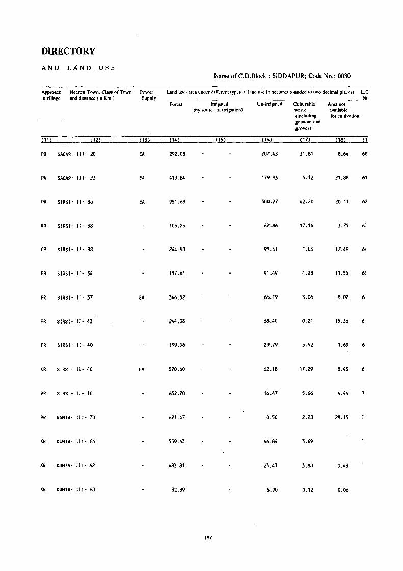
DIRECTORY
AND LAND USE Name of C.D.Block : SIDDAPUR; Code No.: 0080
Approach N':lIrest Town. Class of Town Prtwt:r Land us.: (area under dilr':Nnt types or land us.: in h.:,tares (ound.:d to two decimal places) L.C to village and djslanc~ (in Km.) Supply No
FONst Irrig ... :d Un-irrigated Culturable ANa not (by Sllurc.: of irrigation) wasl.: available
(in.:luding for cultivation gau.:har and grows)
!11l ~12l { 13l {141 {151 {16l {17l {ISl {I
PR SAGAR- 111- 20 EA 292.08 207_43 31.81 8_64 60
PI< SAGAR- 11 J - 23 fA 413.84 179.93 5.12 21.88 61
PI< SIRSI- 11- 35 EA 951.69 300.27 42.20 20.11 62
KR SIRSI- 11- 38 105.25 62.86 17.14 3.71 6~
PI? SIRSI - I1- 38 244.80 91.41 1.06 17.49 hi
PR SIRSI' 11- 34 137.61 91.49 4.28 11.55 6~
PR SIRSI· 11- 37 EA 346.52 66.19 3.06 8.02 6
PR S!RS!- 11- 43 244.08 68.40 0.21 15.36 6
PR SIRSI' II· 40 199.96 29.79 3.92 1.69 6
KR SIRS I' 11- 40 EA 570.60 62.18 17.29 8.43 6
PR SIRSI- 11- 18 652.70 16.47 5.66 4.44
PR KUMTA' 111- 70 621.47 0.50 2.28 28.15
KR KUMTA- III' 66 539.63 46.84 3.69
KR KUMTA· 111- 62 483.81 23.43 3.80 0.43
KR KUMTA- 111- 60 32.39 6.90 0.12 0.06
187

VILLAGE
AMENITIES Name of C.D.BI<x:k : SIDDAPUR; Code No. :0080
L.e. Nam~ or Villag~ TOlnl an.!'1 oj" TII..,i AIll"lIili.!,:1\ a""hl~ (ir not a\:liiahk withil1th~ \;II:lg~. a "",h (-) i •• hown in Ih~ No. Ih~ vill:.go PIlI'''- "'1~llIllm and I1I.!\t h\ it ill hr3d.~b._ lh\! di~lan~~ in hroad ral1!!l!to<o viI .. -5 KillS. 5-10 ",ns.
(In hodar~s) lali(1I1 and It) + km:-. ,'f the Ih:;)n:~t ~Ia~~ wh~I\~ thl.! tlh.:iliIV i~ ilvaihlhh: is giv..:nl· :111<1 EeILl,a- t\"l~di,,,1 Drinking Pn:-.t D .. IY (lr Cotntnuni~alion
Nll.Ut' ti(.\ll.ill W:II"r and Dily~ of [Su. Stop.
Unu:->I.!- Td~- IImrk~tl Railway Slat ion.
hl\ld ... graph hal il'any Waterway1
in (2) (3) (4) (5) (6) m (8) (9) (10)
75 KEREMANE 521.65 523 P, M -(5-10) II, HP, R -(0-5) - (10+) -(0-5)
(95)
76 KELGINMANE 407.11 340 P, M - (0-5) 1.1, HP -(0-5) -(10+) BS
(66)
77 SANGOLIMANE 62.46 60 -(0-5) -(0-5) 1.1, HP -(0-5) - (10+) BS
(9)
78 WAJAGOO 381.26 310 P(2) , M(2) - (5-10) T, \.I, HP -(0-5) -(10+) as
(57)
79 DANMAV 986.58 921 P(Z) , M -(0-5) II, HP -(0-5) -(10+) BS
( 168)
80 TALEKERI 798.80 133 -(0-5) ':"-5) 1.1, HP -(0-5) -(10+) -(0-5)
(31 )
81 KOOIGADDE 661.52 212 P .-(10+) II, HP -(0-5) -(10+) as
(47)
82 NIRGOO 613.84 26 -(0-5) . (10+) \oJ, HP -(0-5) :(to+f -(O-S)
(6)
83 BILEGOO 770.11 334 P -(0-5) \oJ, HP '(0-5) -(10+) BS
(49)
84 KAUNSLE 659.25 373 P -(10+) II, HP - (0-5) - (10+) BS
(67)
85 KUDEGOO 735.54 229 P -(5-10) II, HP -(0-5) -(10+) -(0-5)
(46)
86 HALEGUBBI 13.13 _ .. -_ .... --- --...... -_ .... - -_ .. UN I NHAB ITED ----.~-------------------
87 KIBALE 561.82 642 P(2) '(5-10) 1.1, HP -(0-5) - (10+) BS
(11?)
88 KALKA I 319.18 525 P - (5-10) ... -(0-5) -(10+) - (0-5)
(75)
89 DOOMANE 291.28 485 P, M, H - (5-10) 1.1, HP - (0-5) - (10+) BS
(97)
133

DIRECTORY
AND LAND USE Namt! of C. D. Block : SIDDAPUR; Code No.: 0080
Approach NUfest Town. Claj;S of Town pl)w~r land lis.! (ar~a IInd~r ,Iifli:wlllyl'~~ of land lis.: in heelares rounded 101Il0l0 decimal places) L.C. to village and discance (in Kin.) Supply No.
Fnr\!st Irri!!al~U U n-irrigatcd CIIllurable Area not (hy S(lur~~ of irri~ati()fI) wast.: available
(illduding for cultivation galh:har and I1nw.:s)
(11) (1V (13) (14) (15) (16) (17) (18) ( 1)
KR KUMTA- 111- 55 \ EA 434.98 81.14 0.08 5.45 75
PR IClJMTA- III- 56 321.14 66.91 19.06 76
KR KUMTA- III· 58 EA 54.85 6.92 0.69 n
PR KUMTA' 111- 58 303.66 68.57 7.38 1.65 78
PR KUMTA- Ill- 58 EA 838.94 122.61 22.48 2.55 79
KR KUMTA' 111- 59 763.80 25.66 8.60 0.74 80
KR KUMTA- 1I1- 54 623.18 33.28 5.06 81
KR KUMTA- II 1- 49 606.20 7.57 0.07 82
PR KUMTA- 111- 44 709.57 54.64 5.90 83
PR KlJMTA- 111- 52 EA 586.25 54.61 0.66 17.73 84
KR KUMTA· 11l- 53 686.27 37.53 9.71 2.03 85
---------.-.---.---------------.------------- UN INHABITED .-~------------~----------------------------- 86
PR KUMTA- 111- 52 EA 485.63 Total 2.43 65.76 4.10 3.90 87 Tk 2.43
PR . KUMTA- 111- 58 EA 259.34 55.02 3.94 0.88 88
~ KUMTA- 111- 48 EA 232.83 52.n~ 6.38 89
189

VILLAGE
AMENITIES
Name of C.D.Block : SIDDAPUR; Cod!! No. :0080
L" Name of Village Total ar~a of Total Amenities available (if not ayailable within the vill8l,!c. a dash (-) is shown in the
N the Yillag~ Popu- column and ncX110 it in brackets. the distance in !>road ranges viz. -~ kms. 5-10 kms.
(In h~~tarcs) 18tion ! .~_:~. ~ ,,: .• f ,!.,· 1,':I:~'~i 1':,,1,,' ~:.,.:. ;:.,' i'; "':~ ,i .. , .\~I,:· .. ~I:, :~ ':'I·\·.:r~: " and ! . -.1" , I":'III.~· I' II. \ I • " 1"" . I . I' ~')n
No.of" lional Waler and Days of [Bus Slnp.
Housc- Tde- marL:.:t! Railway Station.
holds graph hat ifany Watu\'iayl
ilL- (2) (3) (4) (5) <0- (7) (8) (9) {1QL___
9() UPI'H'GADDE 22.09 17 -(0-5) -(0-5) \I, HP -(0-5) - (10"') lis
(4)
91 ICAclc_r 37.06 22 -(0-5) -(5-10) "'. HP -(0-5) -(10") -(0;5)
(5 )
92 G1JGIIlI 734.66 241 -(0-5) - (10+) "'. HP - (0-5) -(10+) BS
(37)
93 ICADVADI 298.34 157 - (0-5) -(5-10) "'. HP -(0-5) - (10+) -(0-5)
(25 )
94 NAIGIIR 567.68 113 -(0-5) -(5-10) \I. HP, R -(0·5) -(5-10) -(0-5)
(17)
95 CUBRAGOIl 446.15 496 P(2). M -(0-5) "'. HP PO - (0-5) tiS
(96)
96 BEGAR 352.59 285 P -(5,10) "', HP -(0'5) -(10+) 8S
(54)
97 lAKlCABBEKERJ 15.17 19 - (O-S) - (0-5) 10 HI> -(0·5) - (10+) BS
(4)
98 BAlGOO 557.49 485 P(2), M -(0'5 ) 10, HP -(0-5) . (10+) BS '.
(83)
99 KVADGI 624.40 1200 P, M, H PHC, FPC 10, HP i'( - (10+) BS
(209)
100 MAVINKOO 433.51 260 '(0-5) -(0-5) 10, HP -(0-5) -(10+) BS
(49)
101 ILiMANE 429.96 207 p -(0-5) 10, HP - (0-5) -(10+) - (0-5)
(38)
102 HONNEKOM6 389.99 92 -(0-5) -(0-5) 10, HP -(0-5) '(10+) ·(0-5)
( 13)
103 HAVJNBIL 785_24 434 P, 'M -(5-10) "'. HP -(0-5) -( 10+) 8S (69)
104 HADR I MANE 58.19 85 p - (0,5) 1.1, HP - (0-5) - (10+) BS (12)
190
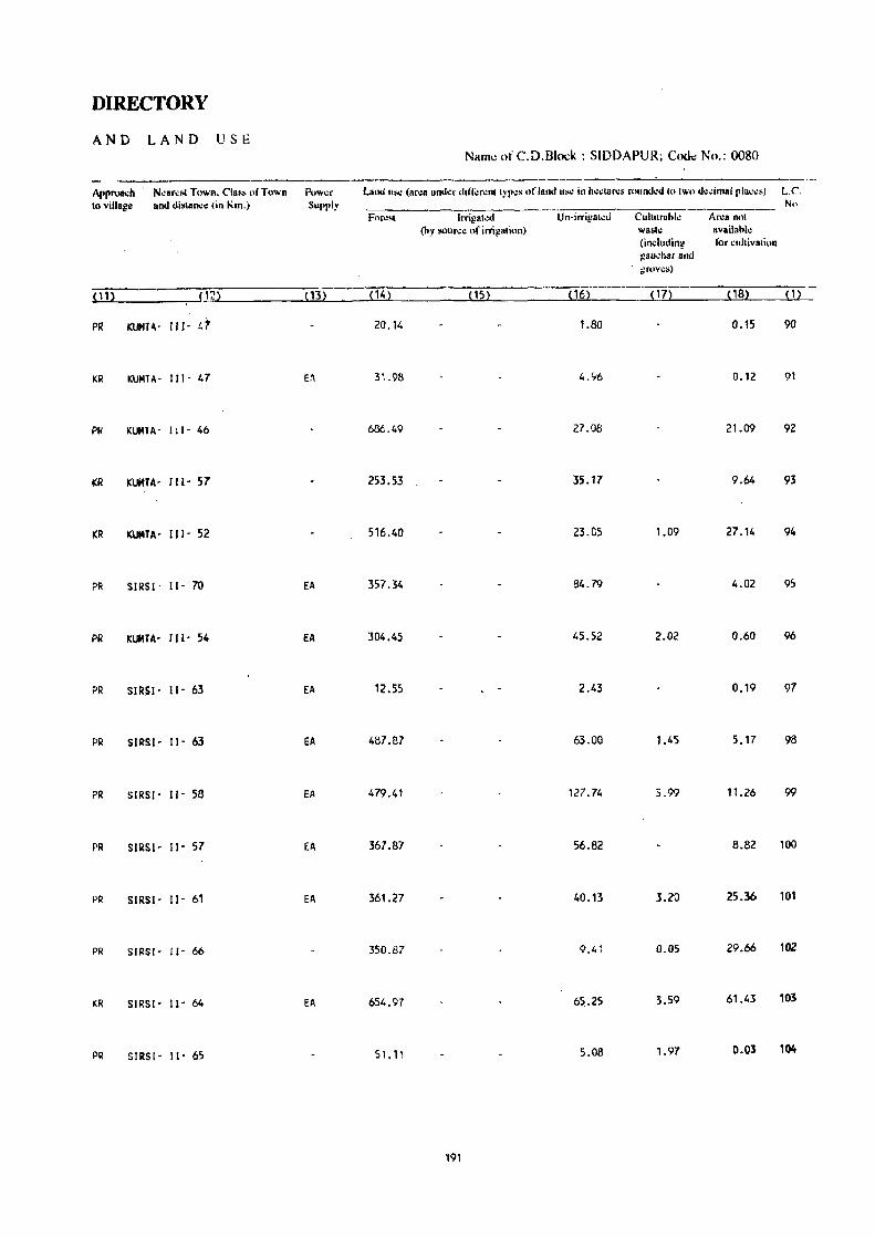
DIRECTORY
AND LAND USE Name of C.D.B1ock : SIDDAPURi Cod,;: No.: 0080
Approa.:b N~ar~!iI Town. Cia •• "frown Pow~r Lalkl u>«: (un:a un<kr din~r~nllyp"s of land 11>«: in h~,tan:s r""nd~d In Iwo d~dl11al pla~~.J L.e. to village and di!ilan.:c (in Km.) Supply No
Fl)r~sl Irrigllt.:d U n-irrigat.:u ClIltllrahlc Area nnt (hy SOlin:.: of irri)!81inn) wasl~ availahle
(indllding lor cultivation gUII,har and ~rovcs)
~11l ( 2) (13) ( 14) (15) (16) ( 17) ( 18) (1)
PR KUMT"- Ill- er 20.14 LBO 0.15 90
KR KUMTA- 111- 47 E:I 31.98 4.96 0.12 91
PI< KUMTA- i lI- 46 636.49 27.08 21.09 92
Kli KUltTA- III- 57 253.53 35.17 9.64 93
KR KUMTA- 111- 52 516.40 23.05 1.09 27.14 94
PI< SIRSI- 11- 70 EA 357.34 84.79 4.02 95
PR KUMTA- 111- 54 EA 304.45 45.52 2.02 0.60 96
PR SIRSI- 11- 63 EA 12.55 2.43 0.19 97
PR SIRSl- 11- 63 EA 487.87 63.00 1.45 5.17 98
PR SIRSI- 11- 58 EA 479.41 127.74 5.99 11.26 99
PR SIRS,- 11- 57 EA 367.87 56.82 8.82 100
PR SIRSI- 11- 61 EA 361.27 40.13 3.20 25.36 101
PR SIRSI- 11- 66 350.87 9.41 0.05 29.66 102
ICR SIRSI- 11-64 EA 654.97 65.25 3.59 61.43 103
PR SIRSI- 11- 65 51.11 5.08 1.97 0.03 104
191

VILLAGE
AMENITIES Name ()f C.D.Block : SIDDAPUR; Codt! No. :0080
L.C. Name of Village To".1 ar~D of TollIl AIl",niti.:. availahlc (if nlll 8vajlahl~ within Ih.: viIl811':. a dash (-) i~ shown in Ih.: No. Ih.: villul1c P"l'll- " .. lull," anolk:XI tu il in hrack~t •. Ihe di'lane~ in hroad r8ng~s viz. ·5 kills. 5·10 kms.
(I"hcd8NS) lalilHl "",I 10+ kills .. fth. Il."r •• t (!Ia..:. Wh':N Ih. lit..:ilil:,: is availahl.: is giwn). allli [,Illea- Melli,,,1 Drinking Pust Day ur ClImmunkal;nn No . .,f tional WIlI.r and Days III' IBus SIUp. Hnus..:- T~l.:- mark.:tl Railway SllItioll. hult" grdph hal if any Walerwayl
(1) m (3) (4) (5) (6) (7) (8) (9) ( 101
lOS OJAGAR 33.94 44 ·(0-5) -(0-5) 101. HP -(0-5) -(10+) as (9)
106 SOVINKOPPA 415.70 612 P(2) -(5-10) 101, HP PO -(10+) as (97)
107 CHAPPARMANE 459.13 714 p. M. H '(0-5) 101, HP PO -(10+) as (133)
108 TARKHANDA 508.67 885 p. M PHC, FPC W, HP -(0-5) -(10+) -(0·5) (126)
109 KATTEICAI 371.77 413 P -(0'5) 101, HP -(0-5) -(10+) BS (67)
',0 GOLIKAI 251.87 286 p -(0-5) W. HP -(0-5) -(10+) BS (5')
111 HOSMANJU 436.74 548 P -(0-5) W, HP -(0-5) -(10..) BS (91)
112 KURVAIITE 65.37 83 P '(0-5) W. HP -(0'5) -(10+) -(0:5) (11)
113 lARGOO 797.85 303 P(2) -(0'5) W, HP -(0-5) -(10+) -(0-5) (62)
114 BILGI 479.24 1416 P, M, H PHC W. HP PTO. -(10+) - BS (281) Phone
115 NIRGAR 258.72 428 P(2) -(0-5) W, HP - (0-5) -(10+) -(0-5) (69)
116 HUVINMANE 313.35 394 P, M -(O·S) II, HP -(0-5) -(10+) BS (80)
'17 SASHIGUll 287.40 314 P -(0-5) II, HP -(0-5) -(10+) BS (58)
',8 !TAG I 918.65 1423 P(3), -(0-5) T. W PO, -(0-5) BS (287) M(2), Ii Phone
119 ALAVALLI 700.55 753 P(3) • M - (5-10) II, HP -(0-5) -(10+) as (138)
192

DIRECTORY
AND LAND USE Name ofC.D.8Iock : SIDDAPUR; CoJe No.: 0080
Approach . N~ar~st Town. Class "r Town POWl.!f Land liS\! (ar..:a UnLll.!f difl~rl!nl !YP\!l\ of lantl \l~ in h..:dar..:!-o round..:d to 'wo d\!l.!imul pla(t!s) L.C". III vill8g~ and dislanc~ (in Km.) Supply No
For~'1 Irrigal~d Vn-irrigltt.:tI ClillUra"k Ar~a n(ll (hy sourc~ of irrigalion) wa!-oh! availahl~
(inclllliing for ...:uhivation gnu~har and grov\!sl
(11) (12) (13) ( 14) (15) (16) (17) ( IS) ( 1)
PR SIRSI- 11- 63 . 26.17 7.54 0.23 lOS
KR SIRSI- 11- 66 EA 321.78 84.14 2.47 7.31 106
PR SIRSI- II· 60 EA 366.00 87.21 2.86 3.06 107
KR SIRSI- 11- 56 EA 360.14 135.39 13.14 108
KR SIRSI- 11- 52 279.93 83.65 1.61 6.58 109
KR SIRSI - Il- 50 192.52 46.78 10.29 2.28 110
Kit SIRSI- 11- 47 EA 313.26 113.13 10.35 111
KR SIRSI- 11- 50 EA 46.60 17.86 0.91 112
KR SIRSI- 11- 56 728.37 58.36 4.08 7.04 113
PI! SIRSI- 11- 48 EA 288.94 146.30 6.58 37.42 114
KR SIRSI- 11- 55 EA 200.90 51.64' 6.18 115
PR SI,!SI- 11- 56 EA 216.82 90.43 6.10 116
PR SIRSI- 11- 56 EA 211.35 71.65 0.51 3.89 117
PR SIRSI- 11- 52 EA 763.21 127.35 6:43 21.66 118
KR SIRS1- 11- 55 EA 588.74 102.77 0.66 8.38 119
193

VILLAGE
AMENITIES Name of C.D.Block : SIDDAPUR: Codt: No. :0080
L.C. Nam~ of Villag~ Total ar~a of Tllt,,1 AlI1~niti~s avail"hl" (il' not avail:,ht~ within th" villag~. a da .. h (-) is shown in th~ No. th~ villag~ Popu~ ,olumn and n~xt to it in hrack.:!s. th~ distance in hroad ranges viz. -.~ kms. 5-10 kms.
(In h~clarcs) lalilln and 10+ kll" oflhc ncar~sl ~Iac~ whcr~ the Ii"ililv is availahk is given). and Edu..;a- Melli,al Drinking post Day or C()mmuni~ati()n
N".III' tional Water a All Days of IBus SlOp. Housl.!- Tele- mark~11 Railway SIal ion. holds grnph hat il'any Wat~rwayl
ell (2) (3) (4) (5) (6) (7) (8) (9) (10)
120 CHANDRAGHATGI 613.40 189 -(0-5) - (0-5) II, HP - (5- 10) - (10+) BS (38)
121 KUDAGUND 415.65 287 P -(5-10) II, HP - (5 -10) -(10+) BS (46)
122 UMBAlMANE 456.26 552 P(2), 14(2) - (0-5) II, HP -(0-5) -(10+) BS (83)
123 SARAKULI 460.08 471 P, 14, H - (0-5) II, HP PO, - (10+) - (0-5)
(73) p'hone
124 KEREGADDE 460.86 517 P(2) -(0-5) II, HP - (0-5) - (10+) -(0-5)
(83)
125 HAlEGOURI 26.22 22 -(0-5) - (0-5) II -(0-5) - (10+) -(0-5)
(3)
126 HASARGOO 661.75 802 P(2), 14 - (0-5) \.I, HP PO, - (10+) as (130) Phone
127 MUTMURO 117.20 106 P - (0-5) \.I, HP -(0-5) - (tEl+) -(0-5)
(18)
128 ADKALll 103.22 130 P, 14 - (O-S) \.I, HP -(0-5) -(5-10) -(0-5)
(21)
129 TAGGINBALGAR 67.33 68 -(0-5) -(0-5) \.I, HP -(0-5) - (5-10) - (0-5)
(11 )
130 MALENALLI 175.45 221 -(0-5) - (0-5) \.I, HP -(0-5) -(5-10) BS
(38)
131 YELUGAR 390.09 440 P -(0-5) II, HP - (0-5) -(10") BS
(70)
132 BANNIGE 211.90 245 p - (5-10) II, HP -(0-5) -(10+) BS (35)
133 KODSAR-HAlKANI 111.01 192 p -(0-5) II, HP -(0-5) -( 10+) BS (41)
'·34 KALKATTE HUNASEKOPPA 213.96 207 - (0-5) -(0-5) II, HP - (0-5) -(5-10) - (0-5)
(39)
194

DIRECTORY
AND LAND USE Namt: of C.D.Blo~;k : SIDDAPUR; Codt: No.: 0080
Approa.:h Nearest Town. Class of Town POWt.!f Land UM! (ar\!8 under ditl~l\:nt tyP\!S of land Uloi": in h~~ulr\!~ rt luml.:d to lWO d~..: ilnal pla..:t:s) L.C to village and distance (in Km.) Supply No.
Fllr\!~t lrrig"t~d Un·irrigated Culturahk Arca nllt (hy sour\,;\! of irrigatillO) waSh! availahk
(in~llIding t'llr ~ultivation galh.:har anJ grov~~)
(11) (12) (13) (14) (15) ( 16) (17) ( 18) (1)
KR SIRSI- II- 54 EA 569.72 38.64 2.79 2.25 120
KR SIRSI· II- 47 365 .. 97 38.17 6.15 5.36 121
PR SIRSI - II - 20 EA 378.65 68.37 0.54 8.70 122
PR S[RS[ - [[ - 25 EA 384.18 65.50 0.26 10.1.4 123
PR S[RSI - II· 25 EA 364.56 82.25 3.12 10.93 124
KR SIRS[ - II- 26 22.97 2.25 1.00 125
PR SIRSI- II- 22 EA 510.86 96.25 0.20 54.44 126
KR SIRSI· II- 24 EA 86.79 20.20 10.21 127
PR SIRS[ - II- 22 fA 79.79 21.77 1.66 128
KR S[RSI- 11- 24 EA 57.06 8.06 2.21 129
KR SIRS[- 1[- 9 EA 121.82 51.22 2.41 130
PR SIRSI- 11- 14 287.90 89.86 12.33 131
PR SIRSI- 11- 16 168.31 33.80 9.79 132
PR SIRSI- II- 14 89.40 19.32 2.29, 133
PR SIRSI- 1[- 5 EA 171.35 39.82 0.66 2.13 134
195

VILLAGE
AMENITIES Name of C.D.Block : SIDDAPUR; Code No, :0080
L.C. Nam~ of Village Total area of Total Amenities availatlle (ifn"t availatlle within the village. a dash (-) is shown in the No. lh~ vill.g~ P"pu, c"lumn and neXllo il in nraek.:ls. lhc dislan.:c in,tlroad rangcs VIZ, -S kms. S-IO killS.
<In heclares) lation and 10+ kms orlhe near~sll!lace where Ihe tacilit~ is availllhk is giwn). and Educa- Medical Drinking Post Day or CommunicatioJl No.of lionsl Waler and Day. of IBus SlOp. House- Tde- markell Railway Station. holds graph hat if any WalcrwayJ
~ll ~2l m ~4l ~5l ~6l m ~8l ~9l ~ 10 l
135 HOSKOPPA 68.42 87 -(0-5) -(0-5) W, HP, OTH -(0-5) -(10+) -(0-5)
(15 )
136 TAREHAlLI-ICANSUR 163_63 935 P(2), M, H PHC, FPC T, W PTO, THU BS
(189) Phone
137 KANGOO-KANSUR 175.75 254 - (0-5) - (0-5) W, HP PO -(5-10) BS
(47)
138 GHATTIKAI 178.48 171 - (0-5) -(0-5) W, HP -(0-5) - (10 ... ) -(0-5)
(32)
139 HAOANKAL 125.22 100 -(0-5 ) -(0-5) 101, HP -(0-5) • (10 ... ) BS
( 18)
140 HALOOT 158.02 95 - (0-5) - (0- 5) W, HP -(0-5) - (10+) BS
(18)
141 SHElUR 382.47 362 P, M - (0- 5) W, HP PO - (10+) -(0-5)
(61 )
142 OEVISAR 400_20 376 P, M - (0-5) W, TW .~O -(5-10) BS
(60)
143 GIRGAOOE 582_68 482 P - (0-5) W, HP ,(0,5) '(10+) - (0-5)
(B8)
144 ARE HALLA 391.65 280 P -(0-5) W, HP -(0-5) - (5-1 0) BS
(55 )
145 SHIGEHALLI 485.09 265 P, M -(0-5) W, HP, OTH -(0-5) -(10+) BS (48)
146 KOOGAODE 335.20 109 -(0-5) -(0-5) W, HP '(0'5) -(10+) BS
( 19)
147 ICALGADDE 407.09 468 P, M - (0- 5) II, HP -(0-5) -(10+) BS
(91)
148 MUDHALLI 254.63 169 p -(0-5) II, HP -(0-5) -(10+) -(0-5)
(23)
149 SURGIICOPPA 142.85 52 -(0-5) -(0-5) II, HP, OTH -(0-5) -(10+) -(0-5)
(10)
196

DIRECTORY
AND L.A NO USE Namt: of C.D.Block : SIDDAPUR; Coot: No.: 0080
Approach NeareSI Town. Class of Town Pow.:r , Land US" (ar"a und", din;',,,nl !YJ'''" of land U~ in h"dar.:' round"d 10 !wo de"imal places) L.C, \l~ villsg\! and distance (in Km.) Supply No,
For"s! Irrigallo!d Un-irrigal\!d Cullu,abl\! Area nol (hy sourc\! uf irrigation) wash! available
(induding for "ullivalion gau.:har and grows)
(11) (12) (l3) (14) (15) (16) (17) (18) m
PR SIR,SI- I 1- 12 29.19 18.50 0.02 20.71 135
PR SIRSI- 11- 10 EA 113.53 40.98 9.12 136
KR SIRSI- I I - 15 EA 143.11 28.08 4.56 137
KR SIRSI- 1[- 15 147.59 28.60 2.29 138
PR SIRSI- [I - 12 EA 110.95 8.96 3.85 1.46 139
PR SIRSI- 11- 12 EA 145.79 8.81 3.42 140
KR SIRSI- 11- 24 313.49 58.76 2.85 7.37 141
KR SIRSI- II- 23 313.17 73.86 5.59 7.58 142
KR SIRSI - I I - 23 fA 493.83 82.85 6.00 143
KR SIRS1- 11- 15 347.12 42.95 0.75 0.83 144
KR SIRSI- 11-13 406.31 64.06 3.86 10.86 145
KR SIRSI- 11- 20 5.45 237.05 89.84 2.86 146
KR SIRSI - 11- 20 EA 320.38 79.10 0.60 7.01 147
KR SIRSI - 11- 25 198.25 46.39 7.85 2.14 148
KR SIRSI - 11- 20 121.25 20.51 0.26 0.83 149
197

VILLAGE
AMENITIES Name of CD. Block : SIDDAPUR; Code No. :0080
L.C. Nam~ of Villag~ Total area of Total Am~niti~s availabk (if not availabk within th~ village. a dash (-) is shown in th~ No. the village P,,!,u- column and n~xtlO it in brackets. the distance in broad ranges viz. -5 kms. )-10 kms,
(In h~"'ares) I.tion and 10+ kms nfth\! nl.!ar~st [!Inc\! whl!n: thl! fa~ilit:t is availahle is givl!n}. and Educa- Medical Drinking Post Day or Communication No.of tional Wata and Days of IBus Stop. H\)lI$\!- Tdc- market! Railway Station, holds graph hat if any WaterWay I
(1) (2) (3) ( 4) (5) (6) (7) (8) (9) PO)
150 KALENALLI 62_03 68 -(0-5) -(0-5) II, HP - (0-5) -( 10+) BS ( 13)
151 HIREKAI 420_02 241 P -(0-5) II, HP -(0-5) - (10+) BS (51)
152 TYAGALl 446_20 591 P, M RP II, HP PO - (10+) BS ( 119)
153 HANGARKHAND 50.16 118 - (0-5) -(0-5) II, HP -(0-5) - (10+) -(0-5)
(22)
154 BALEKAI 254.14 110 -(0-5) -(0-5) II, HP -(0-5) - (10+) BS (23)
155 MALOBALAGAR 26.00 6 -(0-5) -(0-5) II, HP -(5-10) -(10+) -(0-5)
(2)
156 HALKANI 218.45 200 P -(0-5) II, HP -(0-5) -(10+) BS (30)
157 HIREKAI 125_29 85 -(0-5) -(0-5) W, HP - to-5}- -(10+) BS ( 14)
158 GAVINGUDDE 494.99 332 P -(0-5) W, HP -(0-5) -( 10+) - (0-5)
(50)
159 MATT I HALLI 878.39 443 P(2) -(0-5) II, HP -(0-5) -(10+) -(0-5)
(84)
160 SAMPAGOO 902.68 612 P(2) -(0-5) II, HP PO -(10+) BS ( 116)
161 KOOSAR 348.10 252 P(2) , M(2) -(0-5) II, HP PO, -(10+) - (0-5)
(44) Phone
162 BHANDARKERI 507.93 560 P, M -(0-5) II, HP - (0-5) - (10+) BS
(96)
163 HUT AGAR 46.97 72 P -(0-5) II, HP - (0-5) -(10+) -(0-5)
( 13)
164 MANIKMANE 35_17 20 -(0-5) -(0-5) II, HP -(0-5) -( 10+) BS (4)
198
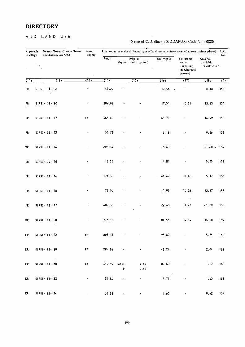
DIRECTORY
AND LAND USE Name of C.D.Block : SIDDAPUR; Code No.: 0080
Approach Nearest Towll. Class of Town Power Land use (area under difti:rent types of land us~ in h~"tarc, rounded to two decimal places) L.C. to village and distance (in Km.) Supply No.
Forest Irrigated Un-irri~ah:d Cuiturahle Area not (hy source of irrigation) waste availahle
(including for cultivation !!al1~h.ar and grovt:s)
( 11) (12) ( 13) (14) ( 15) (16) (17) ( 18) ( 1 )
PR SIRSl- 11- 26 44.29 17.56 0.18 150
PR SIRSl- 11- 20 389.02 17.51 0.24 13.25 151
PR SIRSI· 11- 17 EA 366.00 65.71 14.49 152
PR SIRSI- 11- 13 33.78 16.12 0.26 153
KR SIRSI- 11- 16 206.14 16.40 31.60 154
KR SIRSI- 11- 16 15.24 4.81 5.95 155
KR SIRSI- 11- 16 171.35 41.47 0.46 5.17 156
PR SIRSI- 11- 16 75.94 12.92 14.26 22.17 157
KR SIRSI- 11- 17 402.30 29.68 1.22 61.79 158
KR SIRSI- 11- 20 773.32 84.53 4.54 16.00 159
PR SIRSI- 11- 22 EA 803.13 93.80 5.75 160
KR SIRSI- 11- 28 EA 297.84 48.22 2.04 161
PR SIRS! - 11- 30 EA 419.19 Total 4.47 82.60 1.67 162 Tk 4.47
KR SIRSI- 11- 32 39.84 5.71 1.42 163
KR SIRSI- 11- 34 33.06 1.69 0.42 164
199

VILLAGE
AMENITIES Name of C.D.Block : SIDDAPUR; Code No. :0080
L.C. Name of Village Total 8r~8 of Total Amenities availahk (if not availahle within the village. a dash (-) is shown in the' No. the village POPll- .;"Iumn and next to it in hrackets. the distance in hroad ranges'viz. -5 kms. 5-10 kms.
(In hectares) l;:Ilion and 10+ klll~ ofth..: n":Hn:st phl'_:": Whl!f": Ih..: ra~ilit:r is availahle i~ giv\!n~.
and Edll.;a- Medical Drinking Post Day or C()mmuoicati(Hl No.n!' tional Water and Days of [Bus Stop. HOll!'1t.!- Tdc- market! Railway Station. holds gruph hat if any Waterway I
(1) (2) (3) (4) (5) (6) (7) (8) (9) (10)
165 MUTHALlI 665.45 931 P -(0-5) '.I, HP -(0-5) -(10+) -(0-5) (159)
166 HARSHIKATTA 119.95 637 P(3), M, H RP '.I, Til PO, - (10+) BS (127) Phone
167 HARSHIMANE 53.38 61 - (0-5) - (0·5) II, HP - (0-5) -(10+) BS (13)
168 HONNEHADDA 557.43 423 P -(0-5) '.I, HP - (0-5) -(10+) BS (73)
169 KARKISAVAl 409.01 532 P, M - (0-5) '.I, HP PO -(10+) -(0-5) (94)
170 SHAMEMANE 153.69 130 P -(0-5) '.I, HP - (0-5) - (10+) -(0-5) (20)
171 KARJAGI 640.62 636 p(3) -(5-10) '.I, HP PTa, - (10+) BS (112) Phone
172 BAlESAR 425.82 519 P, M -(0-5) '.I, HP PTa, - - -,<19+) BS (82) Phone
173 KIBBAlLl 280.89 430 P, M, H -(0-5) '.I, HP - (0-5) -(10+) BS (60)
174 ATTIMURO 264.64 241 P(2), M RP '.I, HP - (0-5) -(10+) -(0-5) (48)
175 ANALEBAIL 291.35 1200 P, M RP, SMP T, '.I PO, MON BS (213) Phone
176 BIDARMANE 185.01 123 - (0-5) - (0-5) 101, HP - (0-5) -(10+) -(0'5) (17)
177 MURUR 332_66 393 P - (0-5) \.I, HP - (0-5) - (10+) BS (54)
178 HEGNUR 356.61 450 P -(0-5) II, HP PO, -(10+) BS (72) Phone
179 BALEKOPPA 495.72 679 P(3), M -(0-5) T, '.I PO, -(10+) BS (108) Phone
200

DIRECTORY
AND LAND USE Name of {::.D.Block : SIDDAPUR; Code No.: 0080
Approach ~' Nearest Town, Class of Town Powa Land use (area under different types of land use in hectares rounded to two decimal places) L.C. to village and distance (in Km,) Supply No,
Forest Irrigated Un-irrigated Culturable Area not (by source of irrigation) waste available
(including for cultivation gauchar and groves)
~11) ~ 12) ~ 13) ~ 14) ~ 15) ~ 16) ~1n {181 { 1)
KR SIRSI - 11- 3a EA 532.96 131.17 1.32 165
PR S lfIS I - II - 34 EA 91.24 26.19 2.52 166
PR SIRSI- 11- 34 EA 45.46 6.62 1.30 167
PR SIRSI - II - 33 496.71 59.09 1.63 168
KR SIRS I - I I - 30 EA 318.48 88.81 1.72 169
KR SIRS I - I I - 24 EA 116.68 26.39 10.62 170
PR SIRSI- 11- 24 EA 526.35 95.86 0.61 17.80 171
PR SIRS I - I I - 25 EA 347.39 34.34 6.02 38.07 172
PR SIRSI- 11- 25 EA 231.44 45.50 3.95 173
PR SIRSI- 11- 22 180.40 Total 11.11 70.35 1.15 1.63 174
Tk 11.11
PR SIRS I - II - 23 EA 218.12 Total 9.87 55.12 8.24 175
Tk 9.87
KR SIRSI- 11- 19 152.15 32.10 0.13 0.63 176
KR SIRS I - I I - 26 EA 256.04 67.48 0.73 8.41 177
PR SIRSI- 11- 24 EA 273.02 72.21 11.38 178
PR SIRS I - II - 22 EA 372.73 95.50 27.49 179
201

VILLAGE
AMENITIES Name of C.D.Block : SlDDAPUR; Code No. :0080
L.C. Name of Village Total area of Total Am~niti<!s available (if not available within the village. a dash (-) is shown in the No. the village Popu- column and next to it in brackets. the distance in broad ranges vi1.. -5 kms, 5-10 kms.
(In hectares) iatioll ami 10+ km. of the nearestl!lace where the fa.:ility is availahle i~ given). and &lues- Medical Drinking Post Day or Communication No.or tional Water and Days of IBus Stop. House- Tck- market/ Railway Station. hold, gr'dph hat if any Waterway)
(1) (2) (3) (4) (5) (6) (7) (8) (9) (10)
180 AINBAll 100.01 115 P -(0-5) W, HP -(0-5) -( 10 .. ) -(0-5) (20)
181 TARESAR 573.70 452 P -(0-5) 1.1, HP -(0-5) -( 10+) BS
(68)
182 HAR I GAR 618.64 525 P - (0- 5) 1.1, HP -(0-5) - (10+) BS (82)
183 HOSTOTA 343.72 547 P, M -(0-5) 1.1, Til PO, - (10+) as (92) PhOi'le
184 UNCHALll 562.85 522 P, M -(5-10) Ii, TW PO -(10+) -(5-10) (99)
185 HEGGE 339.22 356 P, M -(5-10) 1.1, HP -(0-5) - (10+) -(0-5) (59)
186 SHIVALMANE 982.57 288 P, M -(0-5) 1.1, HP -(0-5) -(10+) - (5-10) (50)
187 HALE HAllA 149.49 169 - (0-5) -(0-5) II, liP -(D,S.> -(10+) . -(0-5)
(26)
188 HANDIYANEMATH 361.01 364 P, M -(0-5) W, HF' -(0-5) - (10+) -(0-5) (61)
189 TANDAGUNDI 22.39 77 -(0-5) - (0-5) W, liP -(0-5) -(10+) -(0-5) (16)
190 HUTAGAR 437.27 314 -(0-5) - (0-5) 101, HP -(0-5) - (10+) -(5-10) (47)
191 HUKll 1204.58 398 P -(0-5) 101, HP PO -(10+) - (5-10)
(66)
192 NIlKUNDA 636.20 197 P - (0-5) 101, HP PO -(10+) BS
(35)
193 NANDYANE 149.64 37 -(0-5) -(0-5 ) 101, HP . (0-5) -(0-5) -(0-5) (6)
194 HEGGARNI 265.95 551 P, M, H D W, Til PO, -(10+) -(0-5) (115) Phone
202 .)

DIRECTORY
AND LAND USE Name of C.D.Block : SIDDAPUR; Co<le No.: 0080
Approach Nearest Town. Class of Town Power Land u~e (area under ditli:rent type~ of land us.: in hectares r"umled to two de..:imal places) L.C. to village and distance (in Km.) Supply No.
Fore~t Irrigated Un-irrigated Culturable Area not (by source of irrigation) waste available
(including for cultivation gauchar and groves)
~11l ~ 12} ~131 ~ 141 ~151 ~ 16~ ~171 ~ 181 ~ 1}
KR SIRS!" 1]- 26 74.75 25.19 0.07 180
KR SIRSI" II" 34 EA 467.06 100.41 2.20 4.03 181
KR SIRSI" 11- 40 482.65 102.73 3.31 29.95 182
KR SIRSI" II' 37 EA 261.11 72.50 1.30 8.81 183
KR SIRSI- II" 35 495.65 47.17 0.75 19.28 184
KR SIRSI· 11- 40 268.64 65.17 2.68 2.73 185
KR SIRSI· II' 43 913.33 68.42 0.82 186
KR SIRSI· II· 30 122.52 25.24 1.73 187
PR SIRSI' II· 42 299.03 60.37 1.61 188
KR SIRSI" II· 35 11.72 9.77 0.90 189
I(R SIRSI' II" 44 381.97 53.47 1.83 190
I(R SIRS[' [I' 45 1142.97 60.75 0.86 191
PR SIRS[' II' 30 EA 580.62 54.74 0_84 192
KR SIRSI· [I' 34 139.60 9.21 0.83 193
PR SIRSI- ll· 30 EA 187.62 71.94 6.39 194
203

VILLAGE
AMENITIES Name of C.D.Block : SIDDAPUR; Code No. :0080
L.e. Name of Village Total area of Total Amenities availahle (if not availahle within the village. a dash (.) is shown in the No. the village Popu- column and next to it in brackets. the distance in broad ranges viz. -5 kms. 5·10 -km •.
(In hcctan:s) lation and 10+ kms of the nearest [!Iace where the fa.:ilit): is available is given). and Edwa- Medical Drinking Post Day or Communi~ation
No.of tional Water and Day, of [Bus Stop. House- Tck- marketl Railway Stati<>n. holds graph hal if any Watern-ay]
~11 ~2l ~3l ~4l ~5l ~6l m .J.!U ~91 ~10l
195 HULLUNDE 525.75 394 P, M - (5-10) W PO, - (10+) BS
(61) Phone
196 NIRGAN 603.23 393 P, M -(0-5) W, HP - (0-5) -(10+) -(0-5)
(62)
197 MULGUNDA 849.66 327 -(0-5) -(0-5) W, HP . (0-5) - (10+) -(0-5)
(63)
198 HALLI BAI L 2374.48 350 P(2), M(2) -(0-5) W, HP PO -(10+) -(10+)
(52)
199 KANCHIKAI 548.78 561 P(2) I M RP W, HP PO -(10+) BS
(79)
200 MANIGAR 449.32 385 P, M '(5-10) 1.1, HP PO -(10+) -(0-5 )
(62)
201 KELAGIN SARAKUlI 76.52 86 -(0-5) . (0-5) 1.1, HP -(0-5) '(10+) -(0-5)
(17)
Total (Sum) 85929.50 91646 P( 189) I PHC(5), D,
( 16550) M(87) I FPC(4) •
H( 17) I RP(5) I SMP
PUC(3) , C
204

DIRECTORY
AND LAND USE Name of C.D.Block : SIDDAPUR; Code No.: 0080
------ _._--_-_ .. Approach N~ar~sl Town. Class of Town Power Land lISc (~trea under dill;:rcnt typ,,' ,,( land us.; in hectarelo rounded to two decimal plac~s) L.C. 10 village and distance (in Km.l Suppiy -------------_._. No.
Forest lrngatCd Un irngal~d CultuITthlc Area not (hy s()url:~ of irrigation) wa~h! availabk
(induding for cultivation e!3uchar and gnlVt.!s)
,11 ~ P2~ ill~ , 14~ ~ 15: ( 161 p7~ ( 18) ( 1)
PR SIRSI' II' 32 EA 445.79 70.61 2.56 6.79 195
KR SIRSI' 11- 30 526.2l 72.B5 4.11 196
PR SIRSI' II' 30 788.23 57.28 4.15 197
KR SIRSI' 11- 30 EA 2303.41 68.93 2.14 198
PR SIRSI· II· 25 EA 472.00 74.95 1.83 199
KR SIRSI· II· 22 391.91 48.21 9.20 200
PR SIRSI· II· 28 51. 77 Total 7.41 9.81 7.53 201 Tit 7.41
68130.96 Total 87.17 14836.22 655.71 2137.93 Tit 77.12
GC 10.05
205


SIRSI C.D.BLOCK

l U
\ Sir~! OG
2. londGkorohaill OG
310 Koii..n; OG
117. PuttafVftQM OG
KARNATAKA
SIRSI TALUK UTTAR KANNAD DISTRICT
Mom 2 4 & Km .--=_-==-,:::iIII!mI
AreQ of some: .,il109ls Qrc found in "t.,o or more frogments.
C. 0, Blede boundary of Sirsi ir; co - i.rmlnus, with tulutc boundary eacluding ItQtutory town.
IIOIJIC)ARY, DISTRICT. .•
" TALUK ••• • ..
" VILUG/; WITM LOCATION CODE NUMBER
HEADOUARTERS : TALUk •.
VIU."GU wm. POPULATION' SIZE : BELOW 2vQ;
10er- '" ; $1)0 - .1111 ; 1000 - 4 9119 i 5 000 .. ABO'I£ .•.
UlIINHA811ED VlLLAGE WITH LOCATION COOE.,
URBAN AREA WiTII LOCATION CODE. . ..
r-----------f I 101 I ~---------~~ ..
@
r-----------, I X J7 j L ______ •. _. __ '"
STATE HIGHWAY.,
IMPORTANT METALLED ROA.
IJNMETALlEO AND OTHER ROADS,
Ri~ER W,TH STREAM
POST OFFICE I TELEGRAPH bFf'CE
~IGHER SECClNOJ.AY SCHOOL
POLICE STr.TION.
HOSPITAL, PRIMARY HE"LTH CENTRE, DISPENSARY,
FAMIL< PLANNING CENTRE"
tMPDRTANl VILLAGE MARI<El I HAT (SHAI'IDV), MANOIE5..
--~
PO I TO
S
PS
la •• d upon. Survey of "dio map with the permilsion of tM Suneyo, Gencral of 1ndl\l ® Govt'mmcnt of India COPYrlght,1998.

209

ALPHABETICAL LIST OF VILLAGES
TALUK: SIRSI-0090 c. D. BLOCK: SIRSI-0090
SL NAME OF THE VILLAGE 1991 CENSUS 1981 CENSUS NO
LOCATION CODE LOCATION CODE LOCATION COOE LOCATION CODE (Manual) (Computer) (Manual) (Computer)
2 3 4 5 6
44 Chickdugl i 11/20/9/159 11/20/0090/0159 9/19/9/51 09/19/0090/0051
45 Cl1ipgi 11/20/9/4 ''-_ 11/20/0090/0004 9/19/9/31 09/19/0090/0031
46 Danaganall i 11/20/9/209 11/20/0090/0209 9/19/9/99 09/19/0090/0099
47 Dasanagadde 11/20/9/116 11/20/0090/0116 9/19/9/186 09/19(0090/0186
48 Devanall i 11/20/9/82 11/20/0090/0082 9/19/9/150 09/19/0090/0150
49 Devanamane 11120/9/78 11/20/0090/0078 9/19/9/146 09/19/0090/0146
::.0 Devarakoppa 11/20/9/119 11/20/0090/0119 9/19/9/188 09}049/0090/0188
51 Devimane 11/20/9/71 11/20/0090/0071 9/19/9/138 ~9/19/0090/0138
52 Dhoranageri 11/20/9/148 11/20/0090/0148 9/19/9/220 09/19/0090/0220
53 Doddana II i 11/20/9/14 11/20/0090/0014 9119/9/41 09/1910090/0041
54 Gadgeri 11/20/9/167 11/20/0090/Q167 9/19/9/73 09/19/0090/0073
55 Gadihall i 11/20/9/21 11/20/W-l901021 9/19/9/4 09/19/0090/0004
56 Golikatta 11/20/9/171 11/20/0090i0171 9/19/9/58 09/19/0090/0058
57 Gol ikop 11/20/9/109 11/20/0090/0109 9/19/9/181 09/19/0090/0181
58 Gongatta 11/20/9/194 11/20/0090/0194 9/19/9/81 09/19/0090/0081
59 Gonsar 11/20/9/139 11/20/0090/0139 9/19/9/213 09/19/0090/0213
60 Gonur 11/20/9/188 11/20/0090/0188 9/19/9/79 09/19/0090/0079
61 GoudaL L i 11/20/9/6 11/20/0090/0006 9/19/9/33 09/19/0090/0033
62 Gudnapur 11/20/9/165 11/20/0090/0165 9/19/9/56 09/19/0090/0056
63 Gurvall i 11/20/9/145 11/20/0090/0145 9/19/9/212 09/19/0090/0212
64 Hadalgi 11/20/9/225 11/20/0090/0225 9/19/9/116 09/19/Cl09G/Q416
65 Hakkigadde 11/20/9/87 11/20/0090/0087 9/19/9/161 09/19/0090/0161
66 Halgadde 11/20/9/189 11120/0090/0189 9/19/9/78 09/19/0090/0078
67 Hallikoppa 11/20/9/207 11/20/0090/0207 9/19/9/97 09/19/0090/0097 68 Hallusargi 11/20/9/96 11/20/0090/0096 9/19/9/166 09/19/0090/0166 69 Halsinkoppa 11/20/91184 11/20/0090/0184 9/19/9/75 09/19/0090)09-75
70 Hancharta 11120/9/101 11/20/0090/0101 9/19/9/173 09/19/0090/0173 71 Hangar 11/20/9/60 11/20/0090/0060 9/19/9/128 09/19/0090/0128 72 Hanumant i 11/20/9151 11/20/0090/0051 9/19/9/170 09/19/0090/0170 73 Harehulekal 11/20/9/124 11/20/0090/0124 9/19/9/196 09/19/0090/0196
74 Hebball i 11/20/9/11 11/20/0090/0011 9/19/9/38 09/19/0090/0038
75 Hebbatti 11/20/9/218 11/20/0090/0218 9/19/9/109 09/19/0090/0109 76 Hebre 11/20/9/72 11/20/0090/{)072 9/19/9/139 09/19/0090/0139 77 Hedgimane 11/20/9/43 11/20/0090/0043 9/19/9/27 09/19/0090/0027
78 Heepana II i 11/20/9/41 11120/0090/0041 9/19/9/26 09/19/0090/0026 79 Heggar 11/20/9/90 11/20/0090/0090 9/19/9/159 09/19/0090/0159
80 Herepal 11/20/9/115 11/20/0090/0115 9/19/9/189 09/19/0090/0189 81 Honnundugudde 11/20/9/29 ()'1/20/0090/0029 9/19/9/13 09/19/0090/0013 82 Hostot 11/20/9/50 11/20/0090/0050 9119/9/164 09/19/0090/0164 83 Hostot 11/20/9/98 11/20/0090/0098 9119/9/171 09/19/0090/0171 84 Hosur 11/20/9/69 11120/0090/0069 9/19/9/136 09/19/0090/0136 85 Hudelkcp 11/20/9/203 11/20/0090/0203 9/19/9/90 09/19/0090/0090
210

ALPHABETICAL LIST OF VILLAGES
T ALUK: SIRSI-009O C. D. BLOCK: SIRSf-009C'
SL NAME OF THE VILLAGE 1991 CENSUS 1981 CENSUS NO
LOCATION CODE LOCATION CODE LOCATION CODE LOCATION CODE (Manual) (Computer) (Manual) (Computer)
2 3 4 5 6
U'Huladevanasar 11/20/9/7 11/20/0090/0007 9/19/9/34 09/19/0090/0034 87 Hulgol 11/20/9/105 11/20/0090/0105 9/19/9/180 09/19/0090/0180 88 HU{lsekoppa 11/20/9/94 11/20/0090/0094 9/19/9/158 09/19/0090/0158 89 Husri 11/20/9/17 11/20/0090/0017 9/19/9/44 09/19/0090/0044 90 Hutgar 11/20/9/1'18 11/20/0090/0118 9/19/9/191 09/19/0090/0191
91 Isloor 11/20/9/8 11/20/0090/0008 9/19/9/35 09/19/0090/0035 92 I tgul:i 11/20/9/120 11/20/0090/0120 9/19/9/193 09/19/0090/0193
93 Jaddigadde 11/20/9/83 11/20/0090/0083 9/19/9/151 09/19/0090/0151 94 Jaganal! i 11/20/9/25 11/20/0090/0025 9/19/9/12 09/19/0090/0012 95 Janmane 11/20/9/59 11/20/0090/0059 9/19/9/120 09/19/0090/0120 96 Janmane 11/20/9/95 11/20/0090/0095 9/19/9/169 09/19/0090/0169
97 Kabbe 11/20/9/183 11/20/0090/0183 9/19/9/71 09/19/0090/0071 98 Kadbal 11/20/9/130 11/20/0090/0130 9/19/9/199 09/19/0090/0199 99 Kadgod 11/20/9/227 11/20/0090/0227 9/19/9/118 09/19/0090/0118
100 Kageri 17 /20/9/20 11/20/0090/0020 9/19/9/6 09/19/0090/0006 101 Kakkalli 11/20/9/142 11/20/0090/0142 9/19/9/216 09/19/0090/0216 102 Kalangi . 11/20/9/214 11/20/0090/02"14 9/19/9/101 09/19/0090/0101 103 Kalgadde Kanchigadde 11/20/9/149 11/20/0090/0149 9/19/9/222 09/19/0090/0222 104 Kalgar 11/20/9/45 11/20/0090/0045 9/19/9/29 09/19/0090/0029 105 Kalgar 11/20/9/75 11/20/0090/0075 9/19/9/143 09/19/0090/0143 106 Kalgundikopp 11/20/9/168 11/20/0090/0168 9/19/9172 09/19/0090/0072 107 Kalkai 11/20/9/37 11/20/0090/0037 9/19/9/7 09/19/0090/0007 108 Kalkardi 11/20/9/223 11/20/0090/0223 9/19/9/114 09/19/0090/0114 109 Kalkoppa 11/20/9/161 11/20/0090/0161 9/19/9/52 09/19/0090/0052 110 Kallalli 11/20/9176 11/20/0090/0076 9/19/9/144 09/19/0090/0144
111 Kalli 11/20/9/175 11/20/0090/0175 9/19/9/63 09/19/0090/0063
112 Kalve 11/20/9/92 11/20/0090/0092 9/19/9/156 09/19/0090/0156 113 Kambigar 11/20/9/99 11/20/0090/0099 9/19/9/162 09/19/0090/0162 114 Kanagod 11/20/9/30 11/20/0090/0030 9/19/9/10 09/19/0090/0010 115 Kanakoppa 11/20/9/185 11/20/0090/0185 9/19/9/76 09/19/0090/0076 116 Kanalli 11/20/9/97 11/20/0090/0097 9/19/9/167 09/19/0090/0167 117 Kanamuski 11/20/9/143 11/20/0090/0143 9/19/9/218 09/19/0090/0218 118 Kandraji 11/20/9/190 11/20/0090/0190 9/19/9/80 09/19/0090/0080 119 Kantraji 11/20/9/163 11/20/0090/0163 9/19/9/54 09/19/0090/0054 120 Karjagimane 11/20/9/121 11/20/0090/0121 9/19/9/192 09/19/0090/0192 121 Karoor 11/20/9/26 11/20/0090/0026 9/19/9/16 09/19/0090/0016 122 Karsolli 11/20/9/36 11/20/0090/0036 9/19/9/20 09/19/0090/0020 123 Kelginkeri 11/20/9/80 11/20/0090/0080 9/19/9/147 09/19/0090/0147 124 Keliginaonikere 11/20/9/125 11/20/0090/0125 9/19/9(197 09/19/0090/0197 125 Kerekoppa 11/20/91182 11/20/0090/0182 9/19/9/70 09/19/0090/0070 126 Khurshi 11/20/9/66 11/20/0090/0066 9/19/9/141 09/19/0090/0141 127 Kirwatti 11/20/9/217 11/20/0090/0217 9/19/9/107 09/19/0090/0107
211

ALPHABETICAL LIST OF VILLAGES
T ALUK: SIRSI-0090 C. D. BLOCK: SIRSI-0090
SL NAME OF THE VlLLAGE 1991 CENSUS 1981 CENSUS
NO LOCATION CODE LOCAT ION CODE LOCATION CODE LOCATION CODE
(Manual) (computer) (Manual) (Computer)
2 3 4 5 6
128 Kodgibail 11/20/9/48 11120/0090/0048 9/19/9/165 09/19/0090/0165 129 Kodigar 11/20/9/102 11/20/0090/0102 9/19/9/174 09/19/0090/0174 130 Kodnagadde 11/20/9/151 11/20/0090/0151 9/19/9/223 09/19/0090/0223 131 KogOO 11/20/9/174 11/20/0090/0174 9/19/9/61 09/19/0090/0061 132 Koligar 11/20/9/134 11/20/0090/0134 9/19/9/204 09/19/0090/0204 133 Kondalgi 11/20/9/63 11/20/0090/0063 9/19/9/129 09/19/0090/0129 134 Koppa 11/20/9/123 11/20/0090/0123 9/19/9/62 09/19/0090/0062 135 Koppa 11/20/9/176 11/20/0090/0176 9/19/9/195 09/19/0090/0195
136 Kotekoppa 11/20/9/208 11/20/0090/0208 9/19/9/85 09/19/0090/0085 137 Kotgehall i 11/20/9/85 11/20/0090/0085 9/19/9/152 09/19/0090/0152 138 Kudragod 11/20/9/138 11/20/0090/0138 9/19/9/209 09/19/0090/0209 139 Kugtemane 11/20/9/65 11/20/0090/0065 9/19/9/133 09/19/0090/0133 140 Kulve 11/20/9/22 11/20/0090/0022 9/19/9/5 09/19/0090/0005 141 Kuppagadde 11120/9/211 11/20/0090/0211 9/19/9/104 09/19/0090/0104 142 Kuppal[ i 11/20/9/195 11/20/0090/0195 9/19/9/84 09/19/0090/0084 143 Kurlci 11/20/9/61 11/20/0090/0061 9/19/9/132 09/19/0090/0132 144 Kyadgikoppa 11/20/9/219 11/20/0090/0219 9/19/9/110 09/19/0090/0110
145 Madnakeri 11/20/9/187 11/20/0090/0187 9/19/9/77 09/19/0090/0077 146 Madrall i 11/20/9/226 11/20/0090/0226 9/19/9/117 09/19/0090/0117 147 Malalgaon 11/20/9/196 11/20/0090/0196 9/19/9/86 09/19/0090/0086 148 Malanji 11/20/9/220 11 /20/0090/0220 9/19/9/108 09/19/0090/0108 149 Malenalli 11/20/9/107 11/20/0090/0107 9/19/9/177 09tl9lOlWO/0177 150 Manadur 11/20/9/136 11/20/0090/0136 9/19/9/207 09/19/0090/0207 151 Manajwalli 11/20/9/46 11/20/0090/0046 9/19/9/30 09/19/0090/0030 152 Manjaguni 11/20/9/74 11/20/0090/0074 9/19/9/142 09/19/0090/0142 153 Margundi 11/20/9/221 11/20/0090/0221 9/19/9/112 09/19/0090/0112 154 Mashigadde 11/20/9/38 11/20/0090/0038 9/19/9/17 09/19/0090/0017 155 Mathadeval 11/20/9/103 11/20/0090/0103 9/19/9/175 09/19/0090/0175 156 Mattigar 11/20/9/58 11/20/0090/0058 9/19/9/121 09/19/0090/0121 157 Mattihalli 11/20/9/210 11/20/0090/0210 9/19/9/103 09/19/0090/0103 158 MeLinaonikeri 11/20/91127 11/20/0090/0127 9/19/9/201 09/19/0090/0201 159 Menshi 11120/9/146 11/20/0090/0146 9/19/9/2Z5 09/19/0090/0225 160 MOOur 11/20/9/128 11/20/0090/0128 9/19/9/200 09/19/0090/0200 161 Mogadde 11/20/9/152 11/20/0090/0152 9/19/9/224 09/19/0090/0224 162 Mudebail 11/20/9/204 11/20/0090/0204 9/19/9/94 09/19/0090/0094 163 Mudgar 1.1120/9/86 11/20/0090/0086 9/19/9/154 09119/0090/0154 164 MugiLkoppa 11/20/9/224 11 ;20/0090/0224 9/19/9/113 09/19/0090/0113 165 Mugwal L i 11/20/9/160 11/20/0090/0160 9/19/9/50 09/19/0090/0050 166 Mundganamane 11/20/9/79 11/20/0090/0079 9/19/9/148 09/19/0090/0148 167 Mundgehall i 11/20/9/172 11/20/0090/0172 9/19/9/59 09/19/0090/0059 168 Mundgesar 11/20/9/35 11/20/0090/0035 9/19/9/22 09/19/0090/0022 169 Muregar 11/20/9/135 11/20/0090/0135 9/19/9/211 09/19/0090/0211 170 Muslci 11/20/9/141 11/20/0090/0141 9/19/9/215 09/19/0090/0215
212

ALPHABETICAL LIST OF VILLAGES
T ALUK: SIRSI-0090 c. D. BLOCK: SIRSl-0090
SL NAME OF THE VILLAGE 1991 CENSUS 1981 CENSUS NO
LOCATION CODE LOCATION COOE lOCA TI ON COOE LOCATION COOE (Manua!) (Computer) (Hanua!) (Computer)
, 1 2 3 4 5 6
171 Naigar 11/20/9/131 11/20/0090/0131 9/19/9/208 09/19/0090/0208
172 Nakshe 11/20/9/155 11/20/0090/0155 9/19/9/203 09/19/0090/0203 "
173 Na,reba; l 11/20/9/3 11/20/0090/0003 9/19/9/42 09/19/0090/0042 174 Naroor 11/20/9/,158 11/20/0090/0158 9/19/9/49 09/19/0090/0049 175 NavaLgar 11/20/9/100 11/20/0090/0100 9/19/9/163 09/19/0090/0163
176 Nav~ngeri 11/20/9/170 11/20/0090/0170 9/19/9/57 09/19/0090/0057 177 Neellkani 11/20/9/137 11/20/0090/0137 9/19/9/210 09/19/0090/0210 178 Negg!J 11/20/9/57 11/20/0090/0057 9/19/9/122 09/19/0090/0122 179 NerLavaL L i 11/20/9/56 11/20/0090/0056 9/19/9/127 09/19/0090/0127 180 NurkaLakoppa 11/20/9/16 11/20/0090/0016 9/19/9/45 09/19/0090/0045
181 Onigadde 11/20/9/84 11/20/0090/0084 9/19/9/153 09/19/0090/0153
182 Padageri 11/20/9/32 11/20/0090/0032 9/19/9/8 09/19/0090/0008 183 Pura 11/20/9/13 11/20/0090/0013 9/19/9/39 09/19/0090/0039
184 Sadashivall i 11/20/9/111 11/20/0090/0111 9/19/9/185 09/19/0090/0185
185 Sahasralli 11/20/9/173 11/20/0090/0173 9/19/9/60 09/19/0090/0060 186 Salkani 11/20/9/132 11/20/0090/0132 9/19/9/206 09/19/0090/0206 187 Sampakhand 11/20/9/47 11/20/0090/0047 9/19/9/119 09/19/0090/0119
188 Sankadamane 11/20/9/42 11/20/0090/0042 9/19/9/25 09/19/0090/0025 189 Sannakeri 11/20/9/10 11/20/0090/0010 9/19/9/37 09/19/0090/0037 190 SannaL l j 11/20/9/93 11/20/0090/0093 9/19/9/157 09/19/0090/0157 191 SantoLLi 11/20/9/216 11/20/0090/0216 9/19/9/106 09/19/0Q90/0106 192 Sarguppa 11/20/9/81 11/20/0090/0081 9/19/9/149 09/19/0090/0149
193 ShigehaLLi 11/20/9/129 11/20/0090/0129 9/19/9/198 09/19/0090/0198
194 ShinganaL L i 11/20/9/126 11/20/0090/0126 9/19/9/202 09/19/0090/0202
195 Shirguni 11/20/9/140 11/20/0090/0140 9/19/9/214 09/19/0090/0214
196 Shivagaon 11/20/9/88 11/20/0090/0088 9/19/9/160 09/19/0090/0160
197 ShivaL L i 11/20/9/89 11/20/0090/0089 9/19/9/91 09/19/0090/0091
198 ShivaL L i 11/20/9/199 11/20/0090/0199 9/19/9/155 09/19/0090/0155
199 Sirsimakki 11/20/9/40 11/20/0090/0040 9/19/9/23 09/19/0090/0023
200 Somana II i 11/20/9/5 11/20/0090/0005 9/19/9/32 09/19/0090/0032 201 SomanaL l i 11/20/9/178 11 /20/0090/0178 9/19/9/66 09/19/0090/0066
202 Sonda 11/20/9/104 11/20/0090/0104 9/19/9/176 09/19/0090/0176 203 Songinamane 11/20/9/150 11/20/0090/0150 9/19/9/221 09/19/0090/0221
204 Sugavi 11/20/9/186 11/20/0090/0186 9/19/9/74 09/19/0090/0074'
205 Tatguni 11/20/9/54 11/20/0090/0054 9/19/9/125 09/19/0090/0125
206 Tattisar 11/20/9/133 11/20/0090/0133 9/19/9/205 09/19/0090/0205
207 Tepper 11/20/9/73 11/20/0090/0073 9/19/9/140 09/19/0090/0140 208 Terkanhal L i 11/20/9/19 11/20/0090/0019 9/19/9/3 09/19/0090/0003
209 Tigni 11/20/9/157 11/20/0090/0157 9/19/9/48 09/19/0090/0048 210 Tudguni 11/20/9/55 11/20/0090/0055 9/19/9/126 09/19/0090/0126
213

ALPHABETICAL LIST OF VILLAGES
T ALUK: SIRSI-0090 C. D. BLOCK: SIRSI-0090
SL NAME OF THE VILLAGE 1991 CENSUS 1981 CENSUS , , NO
LOCATION CODE LOCATION CODE LOCATION CODE LOCATION CODE (Manual) (COfll>Uter ) (Manual) (CClITpUter)
2 3 4 5 6
211 Ullal 11/20/9/201 11/20/0090/0201 9/19/9/93 09/19/0090/0093 212 Umblekoppa 11/20/9/179 11/20/0090/0179 9/19/9/64 09/19/0090/0064 213 Unmade 11/20/9/192 11/20/0090/0192 9/19/9/98 09/19/0090/0098 214 Unchall i 11/20/9/181 11/20/0090/0181 9/19/9/69 09/19/0090/0069 215 Uplekoppa 11/20/9/1n 11/20/0090/01n 9/19/9/65 09/19/0090/0065 216 Urtot 11120/9/52 11/20/0090/0052 9/19/9/123 09/19/0090/0123
217 Vaddinakoppa 11/20/9/169 11/20/0090/0·169 9/19/9/67 09/19/0090/0067 218 Vanall i 11/20/9/144 11/20/0090/0144 9/19/9/217 09/19/0090/0217
219 Waddal 11/20/9/215 11/20/0090/0215 9/19/9/105 09/19/0090/0105 220 Waclgeri 11/20/9/205 11/20/0090/0205 9/19/9/95 09/19/0090/0095
221 Yechadi 11/20/9/91 11/20/0090/0091 9/19/9/168 09/19/0090/0168 222 Yedall i 11/20/9/33 11/20/0090/0033 9/19/9/21 09/19/0090/0021 223 Yekkambi 11/20/9/197 11/20/0090/0197 9/19/9/87 09/19/0090/0087
214

SIRSI C.D.BLOCK

Name of ~.D.Block : SIRSI; Code No. :0090
L.C. No.
Name of Village
(1)
3 NAREBAIL
4 CHIPGI
5 SOMANALLI
6 GOUOALLI
7 HULADEVANASAR
8 ISLOOR
9 BOPPANALLI
10 SANNAICERI
11 HEBBAlll
12 ACHANALlI
13 PURA
14 DOODANALLI
15 BYGAODE
Total 81"1:a of the village (In heclan:s)
375.47
599.03
227.77
264.23
513.86
578.61
792.37
353.98
381.86
566.74
195.34
233.58
344.68
TOlal Population and
No.of Hous.:holds
(4)
296 (53)
878 ( 180)
95 e22}
435 (85)
439 (65)
626 ( 119)
423 (83)
349 (66)
297 (53)
395 (75)
115 (22)
255 (53)
251 (41)
VILLAGE
AMENITIES
Amenities availabl~ (if not available within the villagc. a dash (-) is shown in the column and next to it in brackets. the distance in broad rang~s viz. -5 kms. 5-1 () kms.
and 10+ kms of the nearest plac.: Where Ihe fa,ilily is availa"l.: is given). Educa- Medical Drinking POOl Day or Communkation
tional Wat~t and Days of [Bus Stop, T"Ie- marketl Railway Station. graph hat if any Waterway)
(5) (6) (8) (9) PO)
P, M '(5-10) T, TW -(0-5) -(5-10) BS
P(2) -(0-5) W, l\.1 PO, -(0-5) BS Phone
P -(5-10) W, TW -(0-5) -(5-10) -(0-5)
P -(5-10) 1.1, Tw -(0-5) -(0-5) BS
p -(5-10) W, TW -(0-5) -(5-10) BS
P, M -(5-10) W, TW
- (10+) W, TW
-(0-5) -(10+) W, TW
p -(0-5) W
p -(10+) T, W
P -(10+) W, TW
P, M - (10+) W, TW
p -(10+) W, TW
216
PTO, Phone
-(5-10)
PO -(10+)
-(O-s) -(10+)
-(0-5) - (10+)
-(0-5) -(10+)
-(0-5) -(10+)
PO -(10+)
-(0-5) -(10+)
BS
BS
-(0-5)
-(0-5)
BS
-(0-5)
as
BS

DIRECTORY
AND LAND USE Namt: of C.D.Block : SIRS!; emIt: No.: 0090
Approach N.:arest Town. Class of Town Power Land u~e (area under dill~rent types of land us~ in he~tare~ rounded to two de.:imal pla.:es) L.C. to village, and distance (in Km.) Supply No.
For~si Irrigat~d Un"irrigated Culturaok Area not (by Sollr,e of irrigation) wast.: available
(including t"r whiv3tion gau\.:har and grovl!s)
( 11) (12) (13) ( 14) (15) (16) (17) ( 18) ( 1)
KR SIRSI- ,,- B 252.02 71.14 47.03 5.28 3
PR SIRSI- 11- 3 EA 472.97 43.89 37.15 45.02 4
KR SIRSI- 11- 6 174.14 33.94 17.89 1.80 5
PR SIRSI- 11- 5 EA 161.09 Total 3.34 55.51 37.92 6.37 6
Tk 1.32 lie 2.02
KR SIRSI- II" 7 EA 406.70 Total 5.41 64.52 25.49 1'.74 7
Tk 5.01 lJe 0.40
PR SIRSI- II" 10 EA 264.52 Total 23.78 59.27 180.55 50.49 B
Tk 19.33 lie 4.45
PR SIRSI- II" 13 EA 696.46 Total 0.77 70.54 10.22 14.38 9
lie 0.77
KR S I RSI- II" 13 EA 210.69 Total 23.43 56.03 46.56 17.27 10
Tk 17.36 Twe 2.63
We 3.44
PR SIRSI" I)" 18 EA 289.84 Total 3.24 34.66 39.80 14.32 " Tk 3.24
KR SIRSI- 11- 13 429.54 Total 4.50 75.44 40.92 16.34 12
Tk 4.50
KR SIRSI- 11- 11 EA 149.32 Total 0.46 27.23 8.09 10.24 13
Tk 0.46
KR SIRS) - il- 11 146.74 Total 3.16 40.20 33.60 9.88 14
Tk 3.16
KR SIRS)- ) 1- 13 EA 249.13 Total 4.96 51.33 34.49 4.77 15 Tk 4.96
217

VILLAGE
AMENITIES r-;ame ofC.D.Block: SIRSI; Coue No. :0090
L.e, Name ,)f Villa!!~ N(},
Tolal ar~a of TOlal Am.:nili.:s availal>l.: (ifnnt availahk Wllhil1lh~ villa~~. a dash (-J " ,howl! in the thl.! villag~ PIlPU- column and n.:xllo it in hrack.:ls, the distan,," ill hl'(\ad rall!!e, ViI., -~ knl>. 5-10 kill', (In hcctarc's) lalion and 10+ kl!!K ofltk: n..:ar..:st ~Ia~\! wh..:r\! thl! t~l..:ilit~· I~ 1Ivailahll.! " giv..:n~.
and Educa- M.:dkal Dnnking Po,t Day ')1' Cmnmuni~ati(HI No,or tional Water and D"y~ or [Bus SlOp. Hnlls~- Telc- t1Hlrkl!t/ Railway Slalil.Hl. hnlds graph hal if any WakC\Yay[
.... C"-'1 )'-----~w---,-------i:!J.-----U.J..--_i:!.l..._ ___ .1.Q1:__ __ .J.LL.. __ ..lE_,!.....__...I2L..... __ ~!.:'.L. __ (3) (4) (5) (6) m (8) (9) ( 10)
16 NURKALAKOPFA 214.69
17 HUSRI 711.09
15 BACtlGAON 709.97
1;' TERKANHAlL: 665.58
20 KAGERI 513_56
21 GAD I HALLI 392.02
22 KUL'/E 460.11
23 BARUR 348.63
24 BISALAKOPPA 379.65
25 JAGMALLI 193.37
163 (35)
415 (75)
1183 (222)
834 (159)
438 (70)
200 (38)
490 (81 )
432 (79)
411 (76)
212 (37)
-.. (0-5 )
P
P
P(2) , M
P, M
P
P(2)
P, M, H
P, M
P, M
218
-(10+) II, Til -(0-5) - (i 0+) -(0-5)
- (0-5) II, Til PO '( 10+) BS
- (0-5) II, Til -(~5) -(0-5) BS
....
- (0-5) II, TI-I -CO-5 ) -(0-5) -CO-5)
- (0-5) II, TI-I -(0-5) -(0-5) BS
- (5-10) '1,1, Til -(0-5) - -(10+) BS
-(5-10) II, Til PO -(5,-10) -(0-5)
'(10+) II, Til PO -(10+) BS
-(5-10) II, TIl -(5-10) -(10+) -(5-10)
-(0-5) II, Til -(0-5) -(5-10) -(0-5)

DIRECTORY
AND LAND USE NlIm~ of C.D.B1o<.:k : SIRSI; Colle No.: 0090
----------Approaoh N"ar"st Town. Cia,. of Town POW\!f Land U~\! (ar\!t1 Und\!f djn~r~nl typ..:s (11' land u!-olo! in h..:..:wrt.:!-. foundr:d In two (.l\! .. :i n::! pl;_,,:,,:~) L.c. to village and distanc~ (in Km.) Supply -----_------------ N,)
Forest Irrigatl!d Un-irrigat..:o Cuiturahk Art::H nul
(hy ~()urcl.! of irrigation) wa~!\! availahh: (in~Juding for ..:uhi\':ltion
!!dlh.:har and gt'ovl.!~)
~ 112 (122 ( 132 ( 142 ( 15 2 ( 162 (171 (18) (12 "
KR SIRSI- 11- 11 138.73 Totat 1.42 47.15 23.96 3.43 16 Tk 1.42
KR SIRSI· 11- 8 455.35 Totat 5.40 124.60 98.78 26.96 17
Tk 5.40
KR SIRSI- lI- S EA 426.39 Total 7.33 99.43 136.15 40.67 18
Tk 7.33
KR SIRSI - 1]- 3 EA 447.56 Tota I 18.15 113.31 63.92 22.64 19
Tk 8.09 Tile 2.85 !.Ie 2.43
0 4.78
KR SIRSI- li- S EA 385.92 Total 18.93 46.17 55.44 7.10 20 Tile 3.23
!.Ie 8.30
0 7.40
KR SIRSl- 11- 6 EA 338.09 Total 9.43 23.56 17.02 7 92 21 -' Tile 2.43
!.Ie 4.05
0 2.95
KR SIRSI- I l- ID EA 363.02 Total 17.13 56.84 12.00 11. 12 22 Tile 7.28
!.Ie 6.07
0 3.78
PR SIRSI - I 1- 11 EA 233.84 Total 21.60 , 7.82 59.95 15.42 23 Tk 18.61
Tile 0.97 !.Ie 2.02
KR SIRSI- I I- II EA 275.89 Total 9.00 84.06 2.06 8.64 24 Tk 2.83 \.Ie 1.92
0 4.25
KR SIRSI- I l- ID EA 151. 59 Total 2.93 36.96 1.22 0.61 25 Tk 0.90 !.Ie 0.61
0 1.42
219

Name of C.D.Bl~ck : SIRS!; Code No. :0090
L.C. No.
Name of Village
(1) (2)
26 KAROOR
27 BALGAR
28 AJJIBAL
29 HONNUNDUGUDDE
30 KANA GOD
31 BETKOPPA
32 PADAGERI
33 YEDALLI
Total area of Total tho villag~ Popu~
(In hectares) lation
49.79
249.70
43.22
429.33
212.36
219.53
294.71
and No.of Housl.!holds
(4)
118 (22)
162 (27)
438 (64)
60 (11 )
624 (114)
362 (58)
348 (62)
467 (82)
VILLAGE
AMENITIES
Amenities available (if nl'll ~vailable within the village. a dash (~) is shown in the column and next to it in brackets. the distance in broad ranges viz. -5 kms. 5-10 kms.
and 10+ kms of th¢ nearest place when; the facility is available is given). Educa- Medical Drinking Post Day or Communication
tional Water and Days of [Bus Stop.
(5) (6)
-(0-5) -(0-5)
P(2), M -(5-10)
P, M RP
-(0-5) -(0-5)
P, M RP
P - (5-10)
. (0,5) - (5 -1 0)
P, M, H, -(0'5)
PUC
220
II, Til
II, Til
IJ, TIo/
II, TIo/
1,/, TI,/
W, TW
Tde- marketl Railway Station. graph hat if lIny Waterway I
(8) (9)
-(0-5) -(5-10)
-(0-5) -(5-10)
pro, -(5-10)
Phone
-(0-5) -(5-10)
PO,
Phone
- (5-10)
-(0-5) -(0-5)
(10)
- (0-5)
- (0-5)
BS
- (0-5)
BS
BS
W, TW -(0-5) -(5-10) BS
W, HI, HP PO SUN BS

DIRECTORY
AND LAND USE NamtofC.D.8Iock: SIRSI; COUt No.: 0090
Approach Nearest Town. Class of Town POW\!:' Land 1I~\! (al'l.!3 und~r diff~rl.!nt types of land us~ in he..:tal'l!~ rOllnd\!d lo cwo dl!~ilnal pla~\!s) L.C. to village and 4istance (in Km.) Supply No.
For~st Irrigated Un-irrigated Culturahk Area not (hy ~oun:1! of irrigation) waste availahk
(induding t()r ~ultivalion gaut..:har and grows)
i11) (12) (13) ( 14) (15) (16) (17) (18) ( 1)
KR SIRSI- 11- 10 EA 38.29 Total 3.38 5.89 1.73 0.50 26 Tk 2.13 lJe 0.40
a 0.85
KR SIRS!- 11- 8 EA 79.27 Total 2.43 26.99 4.15 27 Tk 0.20 lJe 0.81 a 1.42
PR SIRSI- 11- 8 EA 170.56 Total 6.17 38.98 21.04 12.95 28 Tk 5.26 lJe 0.40
0 0.51
KR SIRSI- II - 8 EA 36.39 Total 0.50 3.44 1.23 1.66 29
lJe 0.10
0 0.40
PR SIRSI- 11· B EA 332.88 Total 32.09 32.60 6.42 25.34 30 Tk 17.33
Twe 1.21 lJe 4.55
0 9.00
KR SIRS! - 11- 6 EA 156.99 Total 18.04 16.53 13.27 7.53 31
Tk 7.94 rwe 0.76
lJe 3.44 0 5.90
KR SIRSI- I! - 6 EA 178.92 Total 27.66 4.92 3.46 4.57 32 Tk 10.06
Twe 2.43 lJe 4.05
0 11.12
KR SIRSI- I I - 5 EA 242.24 Total 37.35 10.40 2.64 2.08 33 Tk 9.76
rwe 1.21
lJe 7.36
0 19.02
221

Name of C.D.Block : SIRSI; Code No. :0090
L.e. No.
( 1)
35
36
N8m~ of Village
( 2)
MUNDGESAR
KARSOLLI
Total area of TOla} Ih~ Yillage Poru-(In h~"lal\!s) Ialioll
(3)
248.40
187.03
and Nn."j' l-Inus~
htl"l,
(4 )
333 (51)
225
(32)
VILLAGE
AMENITIES
Aml.!nilJ~s avtlilahk or nol availahll: within th\! v;lJag\!. a ,111~h (~) b :-.hOWTl III thl! I..:lliumn and 111,::1 to it "1 hi"alwKcts. lh..: dislan~~ in. hnlad run_?c:-. "ii. -5 J.;.m~. 5-10 km~.
and 10+ kms ()j thl! nl!':ln;~t plnl.:c whl!r..: lh~ la~ilit\' i~ ilvai141hk I:. glvl!n).
Edll~a- ~1'>.!di...:al Drinking. P\\~\ Day nr Cmmmmi..:alinn lion,,1 Waler and Day' "I' [Bu, Stllp.
Rail'lal Slalin!]. Waterway!
Tde- markdi graph hat it' an)
(5 ) (6) (7) (8) (9) ( 10)
P, M ·(0'5) II, Til - (0-5) -(0-5) -(0-5)
p . (0-5) II, HP -(0-5) -(0-5) . (0-5)
37 KALKAl 13.09 - - - - - - - - - - - - - - - - - - - - -- - - UN 1 N HAS 1\ ED - - - - - - - - - • - - - - - - - - - - - - - -
38 MASH 1 GADDE 428.77
39 AMBL 1- HONDA 113.72
40 SIRSlMAKKI 383.78
41 HEEPANALLI 242.90
42 SANKAOAMANE 58.82
43 HEOGIMA~E 238.93
44 BILGALAMANE 42.12
669
(114)
144 (24)
630
(104)
512
(84)
73
(9)
225
(44)
70
(12)
p
- (0 5)
P, M
P, M
-(0-5)
-(0-5)
-(0-5)
222
-(0-5) II, T\.I - (0- 5) - (5-10) 8$
- (0-5) IJ, TIJ -(0·5) -(5-10) • (0-5)
- (0-5) IJ, Til -(0-5) -(0-5) as
- (0-5) '<I, T'<I PO -(0-5) as
- (0-5) II, Til -(0-5) -(0-5) BS
- (5-10) II, Til -(0-5) -(5-10) -(0-5)
- (5 -10) II, TIJ -(0-5) -(5-10) -(0-5)

DIRECTORY
AND LA ND USE NameofCD.Blod: SIRSI; Code No.: 0090
Approach N~an:.sl Town. Class of Town POWt:f Land u.s..: {<lr-:1.1 ulH.h:r din~r":nll)'r"-'~' o(land us..: in h~dllrl.!s roumkd (0 two dl..'I,,,:imal rla~cs) L.C. tu villagfo! and dislan~~ (in Kill.) Supply No.
Fl)r..:~L Irrigat~d U n-irrigal~d Cullurabk Ar~a nol (by sour\.~ of irrigation) wast..: availabk
(including tll[ ..:uhivatinn gauchar and grows)
( 11 ) (12) (13) (14) (15) (16) (17) (18) ( 1)
KR SIRSI- 11- 3 225.24 Total 7.88 7.27 3.76 22.06 35 Tk 7.88
KR SIRSI- lI- S EA 136.64 Total 28.86 3.86 16_37 1.30 36 Tk 27.53
0 1.33
.-----_--_--_--_------------_---------------_ UN INHABITED - --- - - - - - - - -- --- -- - - --- - - - --- ---- - - -- - - - ----- 37
KR SIRSI - II' 6 EA 294.66 Total 30.74 33.82 45.06 24.49 38 Tk 15.53 lie 2.94 0 12.27
KR SIRSl- II' 8 EA 96.50 Total 10.38 3.81 1.00 2.03 39 Tk 7.11
lie 0.80 0 2.47
PR SIRSI- I I- 5 EA 293.55 TotaL 17.05 70.05 3.13 40 Tk 12.95 lie 3.64
0 0.46
PR SIRSI - I I - 5 EA 216.39 TotaL 6.02 14.61 8.78 54.06 41 Tk 5.26 We 0.4Q
0 0.36
KR SIRSI- I 1- 5 EA 47.07 Total 4.65 6.28 0.82 42 Tk 4.25 lie 0.20 0 0.20
KR SIRSI- 11- 6 EA 195.78 TotaL 3.44 31.72 5.99 2.00 43 Tk 1.82 lie 1.42 0 0.20
KR SIRSI- 11- 6 EA 28.61 Total 3.84 7.48 0.91 1.28 44 Tk 3.24 We 0.40 0 0.20
223

Name of C.D.Block : SIRSI; Code No. :0090
L.C. No.
(1)
Name of Village
(2)
45 KALGAR
46 MANAJWALLI
47 SAMPAKHAND
48 KODGIBAIL
49 BOMMANALLI
50 KOSIOI
51 HANUMANTI
52 URTOT
53 BOPPANALLI
54 TATGUNI
55 TUDGUNI
56 NERLAVALLI
57 NEGGU
58 MATT IGAR
Total arca of Tolal th~ villag.: Popu(In he~tarcs) lalion
and No.of Hous..!
holds
(3)
345.76
460.22
482.92
721.94
164.21
483.83
231.98
416_60
263.31
376.34
511.35
354.87
699_94
842.90
(4)
320 (60)
487 (89)
347 (59)
558 (87)
156 (21)
600 (106)
551 (95)
483 (79)
401 (62)
321 (54)
547 (83)
231 (34)
650 (110)
997 (185 )
VILLAGE
AMENITIES
Am~nitics availaok (if not availall!.: within th~ viHagc. a dash (-) is shown in the column and next 10 il in hra~k~ls. Ih~ dislanc': in ncoad rang~s viz. -5 kms. 5-10 kms.
and 10+ kms oflh.: n~ar~st place where the lih;ilily is availahk is given). Educa- Medical Drinking P<)st Day or Communication
tional Wat<!r and Days of [Bus Stop. Td"- mark"t! Railway Station. graph hat if any Walerwayl
(5) (6) (7) (8) (9) ( 10)
P -(0-5) W, TW -(0-5) -(0-5) -(0-5)
P - (5-10) W, TW PO -(0-5) BS
P, M, H -(0-5) W, TW PO, -(10+) BS Phone
-(0-5) -(5-10) W, TW -(0-5) -(10+) -(0-5 )
P, M - (5·10) W, TW -(0-5 ) -(10+) -(0'5)
P, M -(5-10) W, HI -(0-5) -(10+) BS
P RP W, TW -(0-5) -(5-10) BS
P, M -(0-5) W, TW PO - (5-10) BS
P -(0-5) W, HP PO -(5-10) BS
P -(5-10) W, Til -(0-5) - (10+) BS
P(2), M(2) -(5-10) II, TW PO -(10+) BS
P -(0-5) II, TW -(0-5) -(10+) BS
P, M, H -(5-10) II, Til PTO, -(10+) BS
Phone
P(Z), M(2) -(5-10) II, Til, R, PO - (10+) BS
OTH
224

DIRECTORY
AND LAND USE
:',cp"."h 1{; village ,:
N,'arehl Town. Class of Town and (list~nce (in Km,)
S! RS 1- II" S
SIRS!- [1- 2
SIRSI- I I· 18
SI!;SI- 11- 14
SIRSI- 11- 13
SIRSI- 11- 21
, ,~ SIRSI- 1(-6
SlRSI- 11- 10
SIRS!- [1- 10
SIRSI- 11- 13
SIRS!- 11- 14
SIRSI- 11- 13
PR SIRS!- 11- 13
SIRSI- 11- 11
Pow..:r Supply
E.4
EA
EA
EA
EA
EA
EA
fA
EA
EA
EA
EA
EA
EA
Name ofC.D.Block : SIRSI: Code No.: 0090
L..,nd 1I~~ (.,r~a under din~renl Iypes "I' land lI~C in hectares rounded 10 IWO decimal pla..:es)
Irri)!al~d
(h) !otlllln':l! of irrig:llion)
265.58 Total 6.97 Tk 5.46 We 1.22 o 0.29
399.67 Total 18.82 Tk 14.57
We 4.05 o 0.20
414.20 Total 4.65 Tk 4.65
639.60 Total 8.62 Tk 8.62
136.61 Total Tk
344.32 Total Tk
141.11 Total
2.68 2.68
14.33 14.33
9.46 Tk 9.46
335.50 Total Tk
216.96 Total Tk
306.15 Total Tk
417.96 Total Tk
315.93 Total
6.54 6.54
3.30 3.30
6.15 6.15
5.88 5.88
2.58 Tk 2.58
587.54 Total 8.20 Tk 8.20
696.50 Total 11.53 Tk 11.53
225
Un-irrigal\!d
53.10
22.09
38.54
65.59
20.65
110.70
61.20
63.30
18.89
50.32
65.30
31.36
70.03
111.31
ClIhurahlc Area nOI wasle availahle (induding t()r "uhivalion 1!all.:har and grovl!s)
17.34 2.77
9.02 69.37
15.18 10.35
0.84 7.29
1.30 2.97
14.48
6.20 14.01
2.78 8.48
18.40 5.76
3.37 10.35
0.05 22.16
!i.OO
18.87 15.30
3.90 19.66
L.c. No,
45
46
47
48
49
50
51
52
53
54
55
56
57
58

VILLAGE
AMENITIES Name of C.D.Block : SIRSI: Code No. :0090
L.e. N8m~ of Villag~ Tlltsl ar~a llf Tlltsl Amenities avails"l.: (if not availa"l.: within th.: villag.:. a dash (-) is shown in th~ No. lh~ village Pop,,· ""lumn and n.:Xlln il in hra,kels. lh.: dislanc.: in hroad rang.:s viI .. -5 kms. 5-10 kms.
(In h.:ctares) lalion and 10+ klTIs oftr ,. ,t_ ,. ., " ". and Ed,h:a· M~, I' ~ " nn
No.of tilmal Watl.!f and Days of (Bus SlOp, Hnm.~- Tde· mark~t! Railway Statinn. hold> graph hat if any Wat.:rwayl
!1) (2) (3) (4) (5) (6) <7> (8) (9) (10)
59 JANMAME 493.81 828 P, M RP II, Til PO, - (10+) BS
(170) Phone
60 HANGAR 62.82 101 - (0,5) -(0-5) II, TW -(0-5) - (10+) -(0-5) (15)
61 KURKI 243.75 395 -(0-5) -(0-5) 1.1, TW -(0-5) -(10+) BS (55)
62 ADIIAlLl 344 _84 200 P, M -(0-5) W, Til - (0-5) -(10+) -(0-5)
(32)
63 KONDALGI 170.70 146 P -(0-5) II, Til -(0-5) -(10+) - (0-5) (22)
64 BALIIALLI 752.90 839 P(2) , M PHS W, HI PO -( 10+) BS (121 )
65 KUGTEMANE 185.01 104 P - (5-10) II, Til - (0-5) - (10+) -(0-5) (19)
66 KHURSHI 1404.60 415 P - (10+) W, Til PO - - -{to+) BS (75)
67 BADGI 633.74 318 P -(5-10) II, Til -(0-5) - (10+) -(0-5) (53)
68 BANDAL 989.14 323 P -(5-10) W, Til PO -(10+) BS (64)
69 HOSUR 739.01 83 P - (10+) II, Til -(0-5) - (10+) -(0-5) (17)
70 BUGADI 332.04 12 -(0-5) -(5-10) W, Til -(5-10) - (10+) - (5-10) (3)
71 DEVIMANE 1144.92 142 -(0-5) -(5-10) II, Til - (0-5) - (10+) BS (28)
72 HEBRE 5378.99 783 P, M -(5-10) II, Til PO - (10+) 8S (152)
226

DIRECTORY
AND LAND USE Name of C.D.Block : SIRSI; Code No.: 0090
Approach Near.:st Town. Class of Tllwn Pow~r Land,us.: (ar~a und~r dini!r~nllyp~s of land' us~ in h~dar~' rmllld~d 10 IWo d~dlllal pla~~s) L.c, 10 village and distance (in Km.) Supply No.
For,:sl Irrigal~d Un-irrigall!d Culturabl.: Ar.:a no! (by Sllllr~~ or irrigalion) wa~t\! 8vailahl.:
(induding for ~ullivation gallchar and grnv~s)
( 112 ~12) (132 ( 14) (15) (16) (172 ( 182 ( 1)
PR SIRSI- It- 16 EA 408.94 Total 7.01 63.59 3.89 10.38 59 Tk 7.01
PR SIRSI- II- 15 EA 51.19 Total 1. 74 8.37 0.74 0.78 60 Tk 1.74
PR SIRSI- I 1- 14' EA 177.48 Total 4.52 50.78 3.58 7.39 61 Tk 4.52
KR SIRSI- II- 19 265.18 Total 4.50 39.83 0.68 34.65 62 Tk 4.50
KR SIRSI- I I- 22 147.76 Total 2.59 16.23 1.89 2.23 63 Tk 2.59
PR SIRSI- II- 22 EA 602.93 Total 10.63 94.90 10.71 33.73 64
Tk 6.56 We 4.07
PR SIRSI- II- 24 164.31 Total 1.80 9.01 2.99 6.90 65
Tk 1.80
PR SIRSI- I I - 19 1259.23 68.80 15.90 60.67 66
PR S[RSI- [[ - 24 561.42 68.30 4.02 67
PR S[RSI- II- 26 891.57 56.68 13.95 26.94 68
PR SIRSI- [I- 30 716.10 15.39 4.76 2.76 69
KR SIRSI- 11- 24 332.04 70
PR SIRSI- II- 26 EA 1092.02 36.55 1.25 15.10 71
PR S[RSI- [[- 30 EA 5144.90 153.05 22.35 58.69 72
227

VILLAGE
AMENITIES
Name of C.D.Block : SIRSI; Code No. :0090
L.C. Name of Village Total arca of Tilt,,) AI11t.:nitil!:'-' a\'ailahk (if n01 availahlt.! wIthin th~ \·III~I~':, ,I dm.h (- ~ i~ ~.h(\wn in lhl.!
No. tho village Pop,,· ~\~llIl\ln and n\!\1 h~ it in hral,:L\!ls. lh..! diJo,lan..:~ in hrll:,d r.Hl~I!'~ \ il .~ km •. ,·111 ~11\"
(In he"tar~s) lalillo and 10+ bus \lfth~ n~:m:st I!1,a\'1!' \\h..:r.: thl! I:h:ilil\ I~ (i\ilil,lhf.; I: .... gi\'\.!ol· and Edl",a- Mcdi"d Drinkin)! PIl'. Oa) ~)f Communi~al,on
No.of ti"llal 'A-'(lt~r i.ln,l D;'I)' ~'I lilli, ShIp.
Hnu:-.I!- Td,,· mar~ct' R\1ilwa~ S'alilHl. hokb graph hii! it" itn) Walaw8yl
( 1) (2) (3) (4) (5) (6) 7 (8) (9) .J. 10)
73 TEPPAR 1293.12 384 p ·(0,5) II, Til -(0-') - (10 .. ) -(0-5)
(74)
74 HAN'JAGUHI 586.55 468 P, M RP, SMP W, HI PO - ( 10+ ) as ( 104)
75 KALGAR 216.77 68 p -(0-5) 1.1, Til -(0-5) · (10+) llc
( 13)
76 KALLALlI 1718.48 393 . (0·5) -(0-5) 1.1, HI -(0-5 ) · (10+) -W-5)
(73)
77 BENAGAON 1458.43 513 P -(5 ·10) II, TIJ - (5 -10) · (lD+) as (88)
78 DEVANAMANE 1018.27 103 -(0-5) '(0-5 ) II, Hi - (0-5 > -( 10+) BS
(19)
79 MUNDGANAMANE 2073.48 540 P, M RP II, Til PO -(10· ) BS
( 106)
80 KELGINKERI 1502_55 316 P -(0-5) 1.1, TW -(0-5) -(10") as (50)
81 SARGUPPA 2190.24 525 P - (5-10) II, Til - (0-5) - (10+) - (0· 5)
(82)
82 OEVANAlLI 1337.06 899 P, M -(5-10) IJ, TIJ PO -(10+) ..
BS
( 151)
83 JADD 1 GADDE 143.70 49 - (0-5) -(5' 10) 101, TIj . (t;. 10) ·(10+) - (5 10)
(10)
84 ONIGADDE 650.84 287 P -(5-10) 1.1, TIJ '(05) -(10+) BS
(42)
85 KOTGEHALLI 287.87 148 P -(O-S) II, TI.I '(0-5) · (lOt) . (0':')
(19)
86 MUD GAR 346.66 115 P - (5-10) II, TIJ -(0-5) -(10+) - (O'S)
(21)
228

DIRECTORY
AND LAND USE Name of C.D.Blo.j, : SIRSI; CoJe No.: 0090
Approach !"I.:ar~sl Town. Class "flown Pow.:r Land us~ (~rea under "ifferenllyp~, "nand usc in he,lare, rounded lolwo dc,illlal rla,.:s) Le. I,' village and disl:1ni:c (in Kill.) Supply
---~--~---------~---No.
For..:!\t IlTignl~d U n~ilTil:!ah:d Cullurahk Ar.:a 1101
(hy ~"llr~~ "'If irrigali(m) wa~h: availahl.: (.illduding Ii,r ,ultivalioo gau..:har and i!rnvl.!~)
( 11) (12) (13) '( 14) (15) (16) ( 17) (18) ( 1)
KR SIRSI- 11- 2'6 1146.87 80.92 17.28 48.05 73
PR SIRSI- II· 26 466.11 46.50 6.92 67.02 74
KR SIRSI- 11- 29 EA 194.19 14.78 0.13 7.67 75
I(R SIRSI- 11- 32 1618.40 Total 9.70 71.65 18.73 7b Tk 9.70
KR SIRSI- 11- 37 EA 1296.69 Total 9.81 103.60 33.37 14.96 77 Tk 9.81
PR SIRSI- I J - 42 986.54 Total 2.12 21,52 2.57 5.52 78
Tk 2.12
PR SIRSI- 11- 39 EA 1895.24 Total 13.80 109.51 27.64 27.29 79 Tk 13.80
PR SIRSI· 11- 42 1390.69 Tot:!l 11.06 66.88 17.86 16.06 80 Tk 11.06
KR S IRS[- [I, 32 EA 2034.32 fotal 4.37 98.72 9.68 43.15 8t
Tk 4.37
PR SIRSI' 11- 26 EA 1066.99 151.41 118.66 82
KR SIRS!' /I. 2S 120.09 11.40 11,37 0.84 83
KR SIRSI' 11- 19 EA 549.19 Total 10.42 72.92 0.42 17.89 84 Tk 6.19
Twe 4.23
KR SIRSI- II· 22 241.'07 39.,3 1.13 5.34 85
KR SIRS! - II' Zl 301.33 41.52 0.02 3.79 86
229

VILLAGE
AMENITIES
Name! of C. D.Block : SIRSI; Codt: No. :0090
L.C. Nattl~ of Villag~ T utal ar..:a of Totnl AIIl~lIiti..:~ a"':lilahk (if lIot availahle within th..: villag.:. a da~ (-) is ,h\>wn in th..:
No. th~ villal!~ P"pu- ,olUllln and n~xt to it in "rackets. the di,tance in hroad ranges viz. -,'i kms . .'i-I () km,_ (In he.:!ares) lation and 10+ krns orth..: nearest [!Iac.: wh~rc the lih:ilitv is availahl.: is giwn!.
ami Edu.:a- Medical Drinkillg Post Day or Communication
N".ol tional Wat~r and DIIYs uf IBus SIl>p.
H\'lI~~- Tde- mark..:" Railway Statiml.
h"lds graph hut if any Waterway!
(1) (2) (3) (4) (5) (6) (7) (8) (9) (10)
87 HAKKIGADDE 207.10 172 -(0-5) -(5-10) II, Til -(0-5) - (10+) BS
(31)
88 SHIVAGAON 586.29 836 P, M -(0-5) II, lIol PO -(10+) BS
(158)
89 SHIVAlLl 985.88 1413 p(3), PHC, FPC II, Til PO -(10+) BS
(219) M(3) , H(2)
90 tlEGGAR 301_07 118 P, M -(0- 5) II, Til -(0-5) -(10+) 85
(12)
,1 fECHADI ·553.54 524 P - (5-10) II, Til - (0-5) - (10+) BS
(96)
-i2 I(ALVE 609.11 435 P, M -(5-10) II. Til PO -(5-10) BS
(73)
93 5ANNALLI 436.19 350 P -(5-10) 101, Til -(0-5) .,{5-1Q) BS
(75 )
94 HUN5EKOPPA 464.82 552 P, M - (5-10) II, rll PO ·(5-10) BS
(89)
95 JANMANE 114.35 124 P SMP 101, Til Phone -(5-10) BS
(26)
96 HALLUSARGI 198.93 110 -(0-5) . (5-10) II, Tlol -(0-5) -(10+) -(0,5)
( 18)
97 KANALLI 296.72 256 P, M - (5,10) II, Til -(0-5) -(10+ ) -(0-5)
(39)
911 HOSTOT 235.79 218 P, M '(0-5) II, 1101 PO ·(10+) '(0'5)
(39)
99 KAMBIGAR 722.25 382 P '(5-10) II, Til - (5- 10) . (10+) -(0-5)
(64)
100 NAVALGAR 609_37 389 P, M - (5'10) II, Til PO -(10+) BS
(70)
230
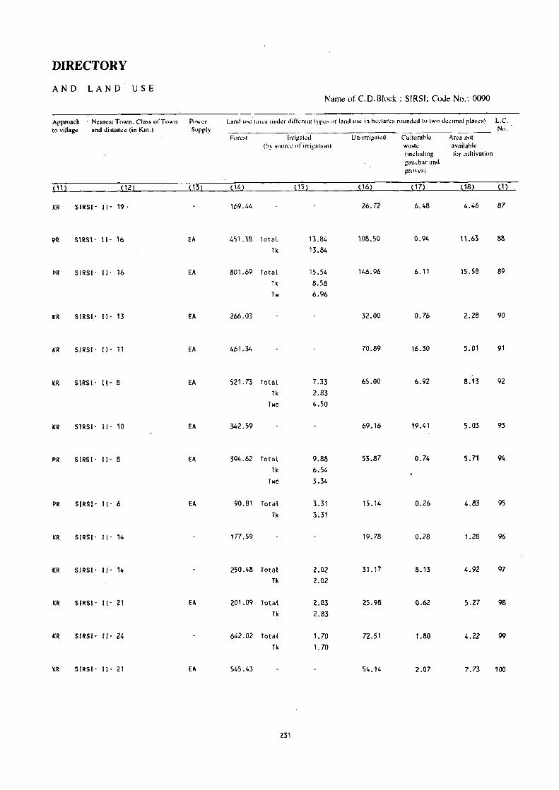
DIRECTORY
AND LAND USE Nam~ ofC.O.Block : SIRSI; Cou~ No.: 0090
Approach ' N~an:sl rown. CIa" ofrown Powl.!r Land U~' (;:lh:(1 uUlkr dift;:n:nll~r\!:-. nf l,and US!! in h\!\,:larl!1\ rounlkd to two dl!..:imal plaCl!8) L.C.
to vinag" and distancc (in Kin., Supply No. Fnrl.!!\1 IrriVHlcti U n- irri!!at~d Cullllrahl~ Area not
(h~ ~Olll\:": of irrig'lllOn) WitS"': available (induding li>r wllivation guu..;har and gn1\'\!s)
( 11) (12) ( 13) ( 14) (15) (16) (17) (18) ( 1)
KR SIRSI- II- 19 ' 169.44 26.72 6.48 4.46 87
PR SIRSI- II· 16 EA 451.38 Total 13.84 108.50 0.94 11.63 88
Tk 13.84
PR SIRSI' II· 16 EA 801.69 Total 15.54 146.96 6.11 15.58 89
Tk 8.58 Tw 6.96
I(R SIRS!.' II' 13 EA 266.03 32.00 0.76 2.28 90
KR SIRSI- II' 11 EA 461.34 70.89 16.30 5.01 91
I(R SIRSI' II' 8 EA 521.73 Total 7.33 65.00 6.92 8.13 92
Tk 2.83 TOle 4.50
KR SIRSI' II' 10 EA 342.59 69.16 19.41 5.03 93
PR SIRS!- ll· 8 EA 394.62 Total 9.88 53.87 0.74 5.71 94 Tk 6.54
Twe 3.34
PR SIRSI- II- 6 EA 90.81 Total 3.31 15.14 0.26 4.83 95 Tk 3.31
KR SIRS!- II- 14 177.59 19.78 0.28 1.28 96
KR SIRSI- II- 14 250.48 Total 2.02 31.17 8.13 4.92 97 Tk 2.02
KR SIRSI- II- 21 EA 201.09 Total 2.83 25.98 0.62 5.27 98 Tk 2.83
KR SlRSI- Il· 24 642.02 Total 1. 70 72.51 1.80 4.22 99
Tk 1. 70
I(R SIRSI- II' 21 EA 545.43 54.14 2.07 7.73 100
231

VILLAGE
AM ENITIES Name of C.D.Block : SIRSI; Coue No. :0090
.. ----.----------~~-... --.--- .-~~ .. --~.-----.. _----- --------.-... ~--L.c. Nam~ of Villago! Tn!.'ll ar~a 01 Total Anh.!l1icil.!!-< ~I\ ail.tbk (if 'HI( av,li;:lbic wiihin Ihe '" dl.a~\!, a d",h i-) i, sh" ... n in tho No th~ viil3gl.! P"ru - to.:olumn clilli n~\t h.) il in br~..:~~t~. thl.! t.h~t.m...:~ in hroad nlll}!\!~ vi!:.. -5 klll~. ~·I() k.nl~.
(In heclares) lalion an{.L'..!.!.±J~_j_!~~h;~,"~s~ r1.i!.~.\\ hl!r~..thl.! Ll_...:ihn 1!-. a\\\il~\hl\! i!oo giv\.tl). and Edl\ •. :a- ~.~.;ti!l.,d Drinking' PI'~I Day or C' l)lllln:;j~;:;~')11 No.of tiomd \\-'ah.:r and Days of 1 Bus SlOp. Hous~- Tdo- mnrk~11 Railway St:!linTt.
holds l!raph r.JI if any Walerwa)i
{ 1 ) (22 --._====~j]l-'-- (4) ._--_ ~5) --=--_ ~_{§J _____ . ....ill (8, (9) --1lQ.L~
101 HANCHART.~ 4413.1, 1211 .) , , i'l, ~ P~C, FPC T, W. TW PO, -(10+) BS (238) Phone
102 KODIGAR S24.75 187 p '(0-5) II, TW -(0-5) -(10+) -(0-5)
(37)
103 MAT~ADEVAL 974.67 876 P(2) -(0-5) II, TW PO -(10+) \3S
(146)
104 SI)NDA 1267.85 1052 P, M -(5-10) II, TI.I PO -(10+) BS
(177)
105 HULGOl 895.02 878 p. 14 -(0'5) II, n./ PO, -(10+) 8S (144 ) Phone
106 ARSAPUR 159.07 144 -(0-5) -(0-5) W, HI PO (10+) us (19)
107 MAlENALLl 269.17 293 P -(0-5) II, TI/ PO -(10+) 65
(42)
108 8ELALE 471.63 443 P -(0-5) W, Til -(O-!i) -(10+) BS .
(81)
109 GOllKOP 81.14 112 P -(o-S) W, TW -(0-5) -(10+) 6$
( 17)
110 BHAIRUHBE 326.18 678 P, M, H D W, TW PTO, -(10+) BS (99) Phone
111 SADASHIVALLI 1868.61 1750 P(S) , M -(5-10) II, Til - (0-5) -(5-10~ BS
(310)
112 BOMMANALLI 552.75 662 P -(0-5) W, TW PO - (5-1 0) BS
(110)
113 AGSAL 967.80 793 P, M '(0-5) 1.1, TW -(0-5) -(10+) BS (126)
114 ANDOLLl 379.07 219 p -(0-5) W, TW -(0-5) - (10 .. ) BS
(38)
232

DIRECTORY
AND LAND USE Name of C.D.Block : SIRSI; Code No.: 0090
Approa~h N~an:.t Town. Cia •• of Town Power Land U~ (.r~. und~r diffe~nttypcs of land u"" in hcctar~s 'rounded to two decimal pia_c.) L.C, to village and ~istance (in Km,) Supply No,
For~sl IlTigah:d Un-irrigah:d C\llturabl~ A~a nol (by sourc~ of irrigation) .W8loih: availabk
(including for cultivalion gau_hor and grows)
(11) (12) (13) (14) (15) ( 16) (17) (18) ( 1)
PR SIRSI- 11- 14 fA 297_39 Total 2.75 129.79 18.19 101 Tic 0.32 0 2.43
KR SIRSI- 11- 18 EA 463. ?9 Total 0.81 56.75 3.40 102 0 0.81
PR SIRSI- 11- 19 EA 779.00 Total 0.81 158.64 9.11 27.11 103 0 0.81
PR SIRSI- I I' 19 EA 969.08 Total 4.05 239.66 14.99 40.07 104 0 4.05
PR SIRSI' I I' 13 EA 665.75 200.89 13.38 15.00 105
e
PR SIRSI- II, 14 EA 120.48 36.91 1.68 106
PR SIRSI- II' 16 EA 218.20 49.45 1.52 107
PR SIRSI, 11- 16 EA 377.37 Total 2,02 87.26 3.36 1.62 108
0 2.02
PR SIRSI' 11- 14 EA 61.63 17.81 1.70 109
PR SIRSI' JI- 11 EA 240.68 78.44 7.06 110
PR SIRSI- 11- 6 EA 1525.60 Total 1.21 319.60 17.34 4.86 111
0 1.21
PR SIRSI' II' 10 EA 424.45 117.86 10.39 0.05 112
PR SIRSI· I I· 11 EA 765.51 Total 3.24 183.00 1.62 14.43 113 Tk 3.24
PR SIRSI· I I· 11 EA 319.03 53.63 6.04 0.37 114
233

Name of C.D.Block : SIRSI; Code No. :0090
L.e. No.
(1)
Nam.: of Village
115 HEREPAL
116 DASANAGADDE
118 IIUTGAR
"9 DEVARAKOPPA
120 ITGULl
121 KARJAGIMANE
122 BALEGAOOE
123 KOPPA
124 IIAREIIULEKAL
125 KElIGINAONIKERE
126 SHINGANALLI
127 MEllNAONIKERI
128 MODUR
129 SHIGEHALLI
130 KAOBAL
Total area of the village (In h~..:tarcs)
399.87
253.33
510.21
56.03
365.38
79.92
Total Populati,m and No,of HOllsl.!
holds
(4 )
334 (58)
160
(29)
1854 (378)
113
(21)
548 (92)
30
m
617.27. 585
484.53
655.94
583.49
338.13
485.92
121.10
774.06
575.76
(112 )
514 (100)
565 (113 )
463 (72)
295 (52)
471 (94)
60 (10)
477 (85)
602 (104)
VILLAGE
AMENITIES
Amenities available (if not available within the village. a dash (-) is shown in the ~olullln and next 10 il in bradels. -the 'dislance in hroad ranges Vii" -~ kills. S-IO kms.
P.. ..' • ~. ,; , • ,I, • • "j'l, '.-' " ,','
I, \1, ..
lionai
(5) (6)
p -(O-S)
P -(0-5)
P, M -(0-5)
P - (0-5)
P, M, H -(5-10)
-(0-5) -(5-10)
P RP
P -(O-S>
P -(0-5)
P -(0-5)
P -(0-5)
P, M -(5-10)
-(0·5) -(0-5)
P, M -(0-5)
P, M -(0-5)
234
., I ••• II
Waler
101, TW
1.1, 11.1
101, Til
IJ, HI
1.1, TW
IJ, HI
1.1, Til
IJ, TIJ
T, 1.1, TW
IJ, TW
1.1, TW
1.1, TW
1.1, TW
1.1, TW
II, Til
" . and Tckgraph
(8)
"' "
Days of markell hal if any
(9)
-(0-5) -(0-5)
PO -(0-5)
- (0-5) - (0-5)
-(0-5) -(0-5)
PO, -(~-10)
Phone'
-(0-5) -(5-10)
PO -(5-10)
-(0-5) -(5-10)
-(0-5) -(10+)
-(0-5) -(10")
-(0-5) -(10+)
PO, Phone
-(10+)
-(0-5) -(10+)
-(0-5) -(10+)
PO - (10+)
'" ,",. Ill}
la"s Stop. 'l:ailw.y Stalion_ Waterway)
(10)
-(0-5)
BS
: BS
-(0-5)
BS
-(.0-5)
BS
- (0- 5)
BS
as
BS
BS
-(0-5)
BS
BS

235

VILLAGE
AMENITIES
Name of C.D.Block : SIRSI; Code No. :0090
L.C. Name of Villag~ Total ar~a of Total AII1~nities availahl~ (if n(ll available within th~ villag~. a dash (-) is shown in th~
No. the villag.: Popu- coluilln and nc:xtl() it in brackets. the distance in nroad rang~s viz. -5 ~ms. 5- J 0 kms, (In h.:clar.:s) lation and 10+ kms of the nearest (!lace where the facility is available is given).
and &lll.:a- ".~\!dkal Drinking Post Day or Communication
No.of tional Water and Days of IBus Stop, House- Tde- market/ Railway Station.
holds graph hat ifany Waterway)
( 1 ) (2) (3) (4 ) (5 ) (6) (7) (8) (9) (10)
131 NAIGAR 1167.28 485 P(2) , M - (0-5) W, TW -(0-5) -(10+) - (0-5)
(76)
132 SAlKANI 182.33 296 P, 101, H PHC, FPC 1.1, Til PO, - (10+). as (58) Phone
133 TATTISAR 242.14 352 -(0-5) - (5-,10) W, TW -(0-5) - (10+) 8S
(71)
134 KOLIGAR 609.29 628 P(2), 101 -(0-5) 1.1, TI.I PTO, -(10+) BS
(104) Phone
135 MUREGAR 582.84 151 P -(0-5) 1.1, Til - (0-5) -(10+) -(0-5)
(21)
136 MANADUR 696.05 461 P, 101 -(0-5) 1.1, Til -(0-5) -(10+) -(0-5)
(82)
137 NEElKANI 285.40 67 -(0-5) - (5-10) II, Til PTO, -(10+) -(5-10)
(10) Phone
138 KUORAGOO 2295.58 352 p - (5-10) II, Til ·(5-10) -(10+) - (5-10)
(48)
139 GONSAR 1382.07 384 P '(0-5) II -(0-5) -( 10+) -(0-5)
(59)
140 SHIRGUNJ 1214.77 165 P - (5-10) W -(5-10) - (10+) BS
(25)
141 HUSKI 2345.09 387 p -(0-5) 1/ -(0-5) • (10+) -(0-5)
(72)
142 KAKKAlLl .558.78 206 P PHC II PO • (10+) BS (31)
143 KANAMUSKI 765.38 148 P -(0-5) -(0-5) -(10+) BS
(24)
144 VANALlI 492.01 377 P(2), 101, H SMP W, HJ PO, -(10+) as (67) phone
145 GURVAlLI 1100.15 489 P, 101 -(0-5) II • (0-5) -(10+) as (84)
236

DIRECTORY
AND LAND U,S E Nam~ ofC.D.Block: SIRSI; C(x1~ No.: 0090
Appro8~h Nearesl Town. Class of Town Pow~r Land us~ (ar~a unda din\:r~nllyp~s (~f1and uS\! in h~clares n>llnd~d 10 IWo d~~imal places) L.c, 10 village and dislan~e (in !(m·l Supply No.
For~sl lnigah:d Un-i.rigal~d Cllilurahle Area not (hy sour~..: of irrigation) Wash! availahlc
(induding 1(,. cultivalion gaueoar and grows)
( 11 ) (12} (13) ( 14) i . ( 15) ( 16) (17) (18) ( 1)
KR SIRSl- [1- 24 EA 1015.77 Total 0.81 126.27 14_32 10.11 131 lie 0_81
KR SIRSI- 11- 21 EA 134.13 -45.33 2.41 0.46 132
KR SIRS/- II- 18 EA 178.61 Total 0.81 57.47 5.25 133 TI< 0.81
PR SIRSI- 11- 16 EA 513.96 Total 1.62 74.69 19.02 134 Tk 1.62
KR 5IRSI- 11- 24 EA 503.94 Total 1.62 70.98 6.30 135 Tw t.62
KR 51-lSI - 11- 22 EA 551.93 Total 0.81 103.73 24.21 15.37 136 We 0.81
KR SIRSI· I I- 26 239.42 27.60 8.59 9.79 137
KR SIRSI- II- 29 2196.13 83.38 13.24 2.83 138
KR SIRSj- [1- 24 EA 1272.14 96.15 1.64 12.14 139
KR SIRSI- 11- 40 1166.34 38.05 2.29 8.09 140
KR 5IRSI- 11- 37 2245.28 93.69 0.81 5.31 141
KR 51R51- 11- 32 500.83 Total 1.62 52.00 1.91 2.42 142 Tk 1.62
KR SIR51- 11- 24 726.08 Total 2.83 29.49 2.52 4.46 143 TI< 2.83
KR SIRSI- 11- 32 421.90 Total 1.62 53.93 2.43 12.13 144· Tk 1.62
PR SIRSI- 11- 19 EA 960.36 Total 3.64 105.22 2.20 28.73 145 Tk 3.64
237

Name of C.D.Block : SIRSI; Code No. :0090
L.C. Name of Village Tolal area of No. the village
(In he,tares)
(12 (2) (3)
146 MENSHI 1154.60
147 BALEKAIMANE 947.61
148 DHORANAGERI 1132.15
149 KALGADDE KANCHIGADDE 1697.10
150 SONGINAMANE 2494.26
151 KOONAGADDE 1391.79
152 MOGAODE 1066.00
153 AUOHAL 1062.7S
154 BAKKAL 1124.80
155 NAKSHE 394.00
156 BANAVASI 740.27
157 TlGNI 779.83
158 NAROOR 796.13
Tolal Popu· lation and No.of House· holds
(4)
528 (92)
190 (34)
235 (34)
382 (77)
564
(84)
638 (128)
217 (30)
329 (56)
493
(85)
328
(51)
5290 (1005 )
1150
( 195)
950
(174)
VILLAGE
AMENITIES
Amc:nilks available (i1'nol available wilhin Ihe village. a dash'i-) is shown in Ihe column and n~xt 10 it in hra.:k~ls. the: di~tanc~ in broad ranges viz. -5 kms. 5-10 km ••
and 10+ kms oflhe neare.11!lace whe~ th~ racilit~ is availahle is given). Educa- Medical Drinking POSI : Day or COOln:runication
liollal Wat.:r and Days of [Bus Stop. Tclc- mark~tl Railway Station. graph hat if any Waterway)
(5) (6) (7) (8) (9) (10)
P(2) , M PHC II, Til PO -(10+) BS
- (0-5) ·(0-5) '(0-5) - (10+) -(0-5)
P, M, H - (0-5) \.I -(0-5) -( 10+) -(0-5)
P(2) -(0-5) \.I '(0-5) -(10+) ~(0-5)
P, M -(0-5) II, Til -(0-5) -( 10+) as
p(2) - (0-5) 1.1, Til PO -(10+) BS
P -(5-10) II, Til -(0-5) -(10+) -(5-10)
P - (5-10). 1.1, Til -(0-5)'- ~(i0+) -(0-5)
P, 14 -(0-5) II, Til PO, -(10+) BS
Phone
P -(0-5) \I, TY - (0, 5) -(10+) -(0-5)
P(4), PHC, FPC \I, TY PTO, SUN BS
14(3), H Phone
P(2), 14 -(0-5) II, TW -(0-5) -(0-5) - (0-5)
P -(0-5) II, Til PO - (0-5) BS
238

239

Name of C.D.Block : SIRSI; Code No. :0090
L.C. No.
(1)
Nam~ of Villag~
159 CHICKDUGLI
160 MUGIIALLl
161 KAlKOPPA
162 BHASI
163 KANTRAJI
164 AJJARNI
165 GUDNAPUR
166 BENGlE
167 GADGERI
168 KAlGUNDIKOPP
Total 8r08 of the village (In h~ctar~s)
(3)
135.29
380.54
108.41
809.97
569.74
413.65
740.03
930.09
328.38
171.23
Total Population and No,of HOllS~
holds
(4)
16
(6)
772
( 132)
282
(60)
1092
(187)
740
(133)
612
(lOB)
1015
(159)
1040
(187)
358
(56)
236
(31 )
VILLAGE
AMENITIES
Atn~niti~s availahlo (if not av.ilahl~ within th~ villago. a dash (-) is shown in th~ column and next to it in hra~kets. the distan"~ in hroad r~nges viL. -5 kills. S-IO kms.
and 10+ kms of the n~arcst plac~ where the facility is pvailahle is given). Edllca- Mellieal Drinking PI"t Day or COllltnunication .
tinnal Water a;,,1 Days of ISus Stop. Tcl~- markdl Railway Stalion., graph hal if ~ny Waterwayl
(5) (6) (7) (8) (9) (10)
• (0'5) '(0-5) II -(0-5) '(0-5) -(0-5)
P - (5·10) II, Til - (0- 5) -(5-10) -(5-10)
P -(0·5) II, Til -(0-5) - (0-5) -(0-5)
P, M - (5-10) II, Til PO - (0-5) - (0,5)
P '(0-5) II, Til -(0-5) ,(0,5) BS
P, M ·(0-5) II, Til -(0-5) ·(0-5) - (0-5)
P, M - (5-10) II, Til PO • .._ -(0-5) BS
P, M - (5-10) II, Til PO, -(5-10) BS
Phone
P -(0-5) II, T\J -(0-5) -(10+) • (0-5)
-(0-5) -(0-5) II, T\J -(0-5) -(10+) BS
240

DIRECTORY
AND LAND USE , Namtl of C.O.Block : SIRSI; Codtl No.: 0090
Approach! Nearest Town. Class of Town Powt!r Land ,,~~ (ar~a und~r difl;'r"nl Iyp'" of land "'"' in h",'lar,," rounded 10 IWo d"cimal plaas) L.c. 10 village! and distance (in Km.) Supply No.
F"r~sl If('iga(~d Un-irrigal~d Culturdbl~ Area not (by ~nurc" of irrigation) wastt! available
(induding for cullivalion gallchar and grov~s)
~ 112 \. ~122 ,132 P42 ~152 ~ 16) ~ 17) ~18) ~ 1 )
KR SIRSI- 'II ~ 32 'I
85.20 Total 4.05 36.61 4.89 4.54 159 Tk 1.22 0 2.83
KR SIRSI- 11- 3~ EA 242.55 76.29 9.65 52.05 160
KR SIRSI- 11- 2~ EA 59.34 41.04 8.03 161
KR SIRSI- II- 2i EA 398.37 Total 25.09 198.91 84.87 102.73 162 Tk 1.62
Twe 0.40 0 23.07
KR SIRSI- 11- 19 EA 30.61 Total 30.55 191.47 240.07 77.04 163 Tk 16.69
Twe 1.92 0 11.94
PR SIRSI- 11- 24 EA 32.39 Total 73.66 166.26 70.78 70.56 164 Tk 9.02
Twe 7.41 We 33.47 0 23.76
PR SIRSI- 11- 22 EA 362.90 Total 41.45 133.54 104.44 97.70 165 Tk 27.57
Twe 4.78. 0 9.10
PR SIRS!- II- 21 EA 635.78 Total 12.57 98.56 138.09 45.09 166 Tk 5.69 W 1.21
We 0.81 0 4.86
KR SIRSI- 11- 14 EA 180.62 Total 1.01 136.97 5.31 4.47 167 We 1.01
KR SIRSI- 11- 21 EA 112.87 52.99 0.34 5.03 168
241

Name of C.D.Block : SIRSI; Code No. :0090
L.C. No.
(1)
Name of Villag~
169 VADDINAKOPPA
170 NAVANGERI
171 GOLlKATTA
ll2 MUNDGEHALLI
173 SAHASRAlL I
174 KOGOO
175 KAlLi
176 KOPPA
177 UPLEKOPPA
178 SOMANAUI
179 UMBLEKOPPA
180 BJDRALLI
181 UNCHAlLI
182 KEREKOPPA
Total ar~a of Total th~ villag~ Poru-
(In h~clar~s) I~ti()n
e3}
288.74
402.53
185.78
290.28
284.62
130.10
449.08
388.32
448.31
271.35
365.40
399.01
289.57
420.74
and No.or Hnm'l!hohh
(4)
185 (35)
366 (71)
202 (47)
140 (28)
208 (31)
121 (20)
311 (50)
190 (32)
310 (55)
151 (30)
173 (37)
235 (44)
484 (84)
412 (78)
VILLAGE
AMENITIES
AIlI~lliti~s availahk (if nOI availah!.: wilhil1lh~ \'illag~. a dash (.j is ,hown il1lh~ column lind II<:XI It) il in hrad~cls. Ih~ distan"~ in hnlad fltng~' viI.. ·5 kills. )-10 killS.
and 10+ killS ofllie near.:Sl place where Ih .. l,,,:ilily is availahk is Givcn). Ed"ca- Medieal Drinking Post Day or Communication
tinnal Wal~r and Days or I Bus SlOp. T de· tnarkcli Railway Sialion graph hal if any Walerwayl
(5) (6) (7) (8) (9) (10)
p -(0-5) 101, Tlol -(0-5) -(5-10) - (0-5)
p -(5- 10) 101, Tlol -(0-5) -(5-10) B5
P -(5-10) II, Tlol -(0-5) -(5-10) B5
- (0-5) -(5-10) II, Til - (0-5) - (5-10) -(0-5)
p -(5-10) 101, Til PO -(5-10) -(0-5)
-(0-5) -(5-10) W, Tlol -(0-5) -(5-10) -(0-5)
p -(5-10) W, )"11 -(O:S) -(SolO) -(0-5)
p -(5-10) II, Til -(0-5) -(5-10) BS
P -(5-10) 101, TIJ -(0-5) -(5-10) -(0-5)
p -(5-10) 101, Til -(0-5) ;(5-10) -(0-5)
P -(5-10) 101, HI PO, -(5-10) - (0-5) Phone
P -(10+) II, Til -(0-5) -( 10+) BS
P, M -(5-10) II, Til PO -(5-10) BS
-(0-5) -(5-10) II, Til -(0-5) '(5-10) BS
242

DIRECTORY
AND LAND USE Naml! of C.D.Block : SIRSI; Code No.: 0090
Approach Nearest Town. Class orTuwn PnWl.!f Land USc (area under diffcrenllypcs nr land usc in heclares rounded In Iwo decimal places) LC. 10 village and distanc~ (in Km.) Supply No.
Fores! Irrigaled Un~irrigal\!d Cullurahk Area nnt (hy sotJr~~ of irrigalion) wa~h: availa1>k
(in.:luding tilr ..:ultivalinn gaul.'htif and !!J'OV\!s)
( 11) (12) (13) (14) (15) ( 16) ( 17) ( 18) ( 1)
KR SIRSI- I I ~\ 11 EA 206.31 Total 1.62 68.94 4_17 7.70 169 lie 1.62
PR SIRSI- II- '? EA 300.65 Total 5.75 50.32 33.87 11.94 170 Tk 1.21
Twe 0.61 lie 0.40 0 3.53
KR SIRSI- I I- 16 EA 137.73 23.19 18.27 6.59 t71
KR SIRSI- II- 19 226.28 37.18 18.81 8.01 172
KR SIRSI- II- 19 219.87 27.99 28.96 7.80 173
KR SIRSI- II- 16 88.23 19.44 i8.48 3.95 174
KR SIRSI- 11- 16 347.57 40.65 47.29 13.57 175
ICR SIRSI· lI- B ~89.00 49.56 41.86 7.90 176
ICR SIRSI- Il- 11 391.48 33.33 19.96 3.54 177
ICR SIRSI- II- 14 EA 188.30 28.67 50.34 4.04 170
KR SIRSI- 11- 11 EA 304.09 23.78 25.92 11.61 179
PR SIRSI- Il- 11 290.14 Total 0.81 88.71 7.20 12.15 180 Twe 0.81
PR SIRSI- 11- 8 EA 195.92 37.05 41.17 15.43 181
PR SIRSI - II- 6 EA 342.74 46.87 24.39 6.74 182
243

VILLAGE
AMENITIES Nam~ of C.D.Block : SIRSI; Cod~ No. :0090
L.C. Name of Villa1!~ Total ar~a or Total AJ1I~niti~~ availahle (if nol availahlc within Ih~ village. a da~h (-) is shown in th~ No. th~ villag~ POPlI- "'illmn and n~xt 10 il in hrack~ts. th~. di~tan"~ in hroad ranges vi7.~ -5 kms. 5-10 kms.
(In h~"lar~s) lacion and 10+ kms of lh. n~ar~st I!ia,,~ where lh. l"a<ilily is availahlc is giwnl. and Edlh:a- M~di.;al Drinking Post Day or COl1l1nu'ni"alion No.of liimal Wat~r and . Days of JBus Stop. HOllS\!"- Td.- mark~tl Railway Slation. hnlds graph hal if any Wal~rwaYI
(1) (2) (3) (4 ) (5) (6) (7) (8) (9) (10)
183 KABBE 345.61 389 P -(5-10) II, Til -(0-5) -(5-10) - (0-5)
(71)
184 HALSINKOPPA 94.30 154 P -(0-5) II, Til -(0-5) -do+) BS (30)
185 KANAKOPPA 158.96 158 P -(0-5) II, Til -(0-5) -(10+) - (0-5) (27)
186 SUGAVI 1003.09 697 P, M PHC, FPC, II, Til PTO, -(10+) BS ( 142) SMP Phone
187 MADNAKEIU 306.14 421 P - (0-5) II, Til -(0-5) - (10+) BS (73)
188 GONUR 870.98 708 P -(0-5) II, Til -(0-5) - (5- 10) BS (118)
189 HALGAODE 563.68 652 P, M RP II, Til -(0-5) -( 10+) as ( 137)
190 ICANDRAJI 665.68 390 p -(0-5) II, Til -(.0-5) -(fO+) BS (84)
191 BANICANAL 415.03 455 P, M -(5 -10) II, Til PO -(5-10) BS (82)
192 UMMADE 178.75 117 P -(10+) II, Til -(0-5) -(10· ) - (0-5) (20)
193 BILUR 517.17 439 P, M ,(5,10) II, Til -(0-5) -(5-10) .)~
(71)
194 GOHGATTA 262.14 193 ·(0-5) -(5-10) II, Til -(0-5) (5- 10) -(0-5) (32)
195 KUPPALLI 298.51 186 - (0-5) -(0-5) II, Til - (r J) '(0-5) -(0-5) (34)
196 MALALGAON 686.62 785 P, M -(0-5) II, T14 PO -(5-10) BS ( 134)
244

DIRECTORY'
AND LAN D ·USE Namt! ofC.D.Block: SIRSI; Code No.: 009P
Approach Near"st Town, Class of Town Pow~r Land u.< (aro" und.r din;'ront typO" of land us< in hoctaro" roundod to two d.cimal plae.s) L.C.
to village !and distance (in Km.) Supply No. Forest Irrigaled Vn·irrigal~d Ctillurabk Area not
(hy sou""e of irrigalion) wash! available (induding Illr cultivation gauchar and grov\!s)
(11) (12) (13) ( 14) ( 15) ( 16) (17) ( 18) (1)
KR SIRSI' II· HI EA 209.70 64.45 56.48 14.98 183
KR SIRSI' d· 13 EA 81.65 6.93 4.53 1.19 184
KR SIIRSI' II' 13 111.75 26.75 16.42 4.04 185
KR SIRSI- II· 16 EA 704.87 Total 4.05 223.38 52.47 18.32 • 186
Tk 2.03 lie 2.02
KR SIRSI- II· 13 EA '220.96 Total 1.62 76.39 0.10 7.07 187
Twe 1.62
PR SIRSI- II· 16 EA 572.89 Total 4.05 193.65 70.03 30.36 188
Tk 4.05
KR SIRSI· II· 19 EA 347.60 Total 6.07 175.36 20.98 13.67 189
\Ie 6.07
KR SIRSI'· II· 20 557.11 Total 4.05 93.91 10.61 190
Tk 4.05
KR SI'RSI- II· 22 EA 264.08 Total 7.00 72.93 61.64 9.38 191
Tk 6.27 \I 0.73
KR SIRSI· II· 21 EA 127.44 Total 2.53 20.31 22.40 6.07 192
rk 2.53
KR SIRSI- II' 16 EA 389.73 Total 2.02 92.27 20.60 12.55 193
TI< 2.02
KR SIRSI· II· 14 162.02 71.64 20.79 7.69 194
KR SIRSI· II· 16 EA 206.24 Total 2.83 71.99 9.36 8.09 195 Tk 2.83
PR SIRSI' II' 19 EA 417.57 Total 8.09 199.87 27.10 33.99 196
Tk 8.09
245

VILLAGE
AMENITIES
Name of C. D. Block : SIRSI; Code No. :0090
L.C. Name of Village Total area of Total Am~niti~, availahl~ (if Il,.t availahk withillth~ villag~. a dash (-) is shown in th~
No. Ih.: vi/lag~ Popu- column tllld nc:,~II<' il ill nra"k.:ls. Ih.: dislan~.: in hroad rllng~s vi~. -Skms . . ~-10 kms. (In h~clar~s) lation and 10+ kms "flh~ ncar~sll!la.:~ wh~r~ lh~ facililv is availahl~ is givenl·
and Educ.- M~di"al Drinking Post Day or COlUlUuni,ali(>n N,.,,,r tional Wal~r and', Days ,.f IBuiStop. HOLJ~I.!- Tdc. market! Railway Station. holds graph hat if any Waterway I
{1 ) (2) (3) (4) (5) (6) (7) (8) (9) (10)
197 YEKKAMBI 493.11 921 P, M RP II, Til PTO, -(10+) BS
(214) Phone
198 ADNAlLl 1222.09 620 p -(10+) II, Til - (0-5) - (5-10) BS
(104)
199 SHIVAlLl 1458.56 766 P, M -(10+) W, Til -(0-5) - (5-10) as (125)
200 ANGOOICOP 427.06 223 -(0-5) -(5-10) 101, TW -(0-5) - (10+) BS
(34)
201 ULlAl 634.87 347 P, M -(5-10) 101, Til -(0-5) -(5-10) BS
(64)
202 BISALICOPPA 460.43 578 P, M, H RP II, Til PO -(5-10) as (103)
203 HUOELICOP 174.19 268 p -(0-5) II, Til -(0-5) ':-( 10+) -(0-5)
(51)
204 MUDEBAIL 123.71 76 -(0-5) -(0-5) II, Til -(0-5) -(5-10) -(0-5)
( 15)
205 IIAOGERI 315_51 177 - (0-5) -(5-10) II, Til -(5-10) -(5-10) -(0-5)
(33)
206 BENAG[ 372.12 218 - (0- 5) -(0-5) II, Til - (0-5) -(5-10) -(0-5) (42)
207 HALLlICOPPA 161.73 187 P -(0-5) II, Til -(0-5) -(5-10) -(0-5)
(27)
208 ICOTEKOPPA 163.72 123 -COoS) - (10+) II. HI -(0-5) -(10+) -(0-5) ( 16)
209 OANAGANALLJ 654.74 919 P - (0-5) II, Til - CO-5) -(0-5) - (0-5) (150)
246

/ DIRECTORY
AND L~ND USE Name ofC.D.Block : SIRSI; Codl! No.: 0090
Approach N~an:st Town. Class of Town PUWt.!f ,Land u;..\! (ar~a und..:r din~n.:nt lyp..:s of land US\! in hc~tarf.!!-' r,ound..:d to two dc...:imai pla,c~) L.C. 10 Yillag~ and distanc~ (in Km.) Supply No.
F<lr~>t Irrigal1!d U n-lrrigt\(\!d Culturahk Ar~a not (hy ~oun;1! of irrigalion) wastl! availabl~
(including l(lr cultivali(ln gau.;har and grows)
(11) (12) (13) (14) (15) ( Ill) (17) (18) ( 1)
PR SIRSJ - 11- 16 EA 404.68 Total 4.86 66.98 7.28 9.31 197 \ Tk 4.05
\Ie 0.81 ~
PR SIRSI- 11- 19 EA 1092.92 90.65 31.64 6.88 198
KR SIRSI- 11- 21 EA 1294.89 89.63 61.90 12.14 199
KR SIRSI- 11- 22 EA 318.52 Total 6.07 31.24 59.90 " .33 200 Tk 4.05
lie 2.02
KR SIRSI- 11- 21 EA 487.62 Total 4.0~ . 54.57 72.85 15.78 201 Tk 2.03 lie 2.02
. PR SIRSI- 11- 16 EA ) 327.40 Total 4.05 50.47 56.66 21.85 202 Tk 2.03 lie 2.02
KR SIRSI- II- 14 EA 104.06 Total 3.44 28.33 30.27 8.09 203 Tk 3.44
PR SlRSI - II- 26 81.76 15.23 20.24 6.48 204
PR SIRSI- II- 24 188.94 Total 2.02 21.45 92.58 10.52 205 Tk 2.02
PR SIRSI- II- 21 EA 219.62 59.42 78.51 14.57 206
KR SIRSI- (I - 21 EA 98.74 42.19 8.25 12.55 207
• KR SIRSI- I 1- 22 107.65 Total 7.49 30.72 17.86 208 Tk 7.49
KR SIRSI- II- 24 EA 290.28 Total 27.27 207.78 129.41 209 Tk 25.65
Twe 1.62
247

Name of C.D.Block : SIRSI; Code No. :0090
L.C. No.
(1)
210
211
212
213
214
215
216
217
218
219
220
221
Name of Village
<2>
MATTIHALLl
KUPPAGAODE
BELLANAKERI
BADANAGOO
KALANGI
WADOAL
SANTOLLI
KIRIIATTI
HEBBATTI
KYADGIICOPPA
MALANJI
MARGUNOI
Total arca of Total the village Popu-(In hectares) lation
(3)
288.31
689.62
327.23
958.07
402.84
353.92
398.36
351.36
580.26
336.04
557.04
1419.31
and NO.of Hous~
holds
(4)
187 (34)
817 ( 155)
407 (72)
2661 (504)
•
608 (97)
510 (88)
539 (94)
3.62 (71)
920 ( 166)
149 (31)
576 (99)
1164 (219)
VILLAG
AMENITIE
Amenities availabk (if not availabk within the villagc. a dash (-) is· shown in the "olumn and next to it in,bra.:kcts. the distana in hroad rang.:s viz. -5 kms. 5-10 I;r
and 10+ kms ofth.: near~st place where the fa"ility is availahk is given). Edu"a- Mcdi,"l Drinking Post Day or, Communicati
tional Watcr and Days of [Bus Stop. Tde- markel! Railway Slali graph hal if any Waterway]
(5) (6) (7) (8) (9) ( 102
P - (10+) II, Til -(0-5 ) -(5-10) -(0-5)
P, M -(0-5) II, Til PO -(0-5) BS
P -(0-5) II, Til - (0-5) -(0-5) 85
P(2), M, H PHC, FPC, T, II, Til PO, -(0-5) BS
SMP Pnone
P - (0-5) II, Til - (0-5) -(0-5) BS
P, M -(0-5) II, Til -(0-5) -(0-5) 8S
P ~(0-5) II, Til - (O-.s) -(0-5) BS
, P -(0-5) II, Til -(0-5) -(0-5) BS
P(2) -(0-5) II, Til PO -(5-10) BS
-(0-5) -(0-5) II -(0-5) -(0-5) -(0-5)
P, M -(5-10) II, HI -(0-5) -(0-5) BS •
P, M -(0-5) II, Til -(0-5) -(5-10) BS
248

DIRECTORY
AND LAND USE Name: of C.D.Block : SIRSI; Code: No.: 0090
AP~roach NeaNsl Town. Class ofrown Pow\!r 'Land u'"' (ar~a und~r dini:r~nl lyp~s or land u'"' in h~"la()!s round~d 10 IWO d~dmal pla,~.) L.C. 10 illage and distance (in Km.) Supply No.
Fore!'l Irrigal~d Un-irrigaled Culturahlc Area nol (hy source of irrigalion) wash: availahk
(induding for ~lIhivation gauchar and groves)
(11) (12) (13) (14) (15) (16) ( 17) (18) ( 1)
I(R SIRSI,\II- 22 216.'S0 Total 1.82 43.75 15.79 10.45 210 Tk 1.82
PR SIRSI- 11- 30 EA 391.49 Total 13,69 215.20 1. 72 67.52 211 Tk 8.23 lie 2.02
0 3.44
PR SIRSI- 11- 29 EA 10B.7B Total 12.74 124.26 3.2B 7B.17 212 Tk 10.31 lie 2.43
PR SIRSI- 11- 29 EA 207.33 Total 39.32 441.78 5.71 263.93 213 Tk 30.42 lie 6.07
0 2.83
KR SIRSI- 11- 29 EA 87.77 Total 28.87 177.96 17.59 90.65 214 Tk 28.87
l::R SIRSI- 11- 29 EA 142.08 Total 4.45 106.54 71.20 29.65 215 Tk 4.45
KR SIRSI- 11- 32 166.41 Total 6.51 121.51 67.69 36.24 216 Tk 5.70 We O.Bl
KR SIRSI- II- 34 141.87 Total 4.18 102.26 58.34 44.71 217 Tk 4.18
PR SIRSI- 11- 34 EA 224.04 Total 17.15 181.13 110.68 47.26 218 Tk 17.15
KR SIRSI- 11- 32 280.12 44.82 3.00 8.10 219
KR SIRSI- 11- 34 EA 249.95 Total 6.07 231. 71 36.20 33.11 220 Tk 6.07
KR SIRSI- 11- 27 EA 828.25 Total 10.12 515.96 42.75 22.23 221 Tk 2.03 lie 8.09
249
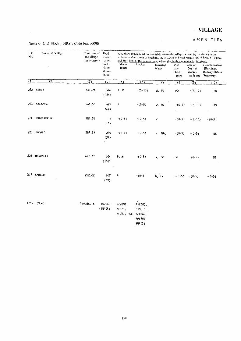
Name of CD. Block : SIRSl: Codt: No. :0090
L.C. No.
Nam. l,f Villag<
.w._ (2)
222 ANDGJ
223 KAlKARDI
224 MUGI LKQPPA
225 HADALGi
226 HAORAlLl
227 KADGOO
Total (Sum)
Tntal aroa of Total tho villag~ POPll-
(In h~Cl.ros) 1"lioll
(3)
617.26
561.56
184.38
387.51
422.31
272.82
129488_18
and N{),l)r HOllSI!
h,.ld,
(4)
962
(184)
427 (64 )
9
(3)
245 (39)
684 (110)
247
(39)
102040
(18105)
VILLAGE
AMENITIES
Amonilio, availahlo (if not availablo wilhin tho "illago. a dash (-) is showl! in [ho ~~)iumo and nt.:Xllo it in brack~t~. Ihe di:-.li:lo\,,'\.! in oroad mng\!s viz. -5 kms. 5-10 km~.
:-tnd J()+ kills oflh.: fll!ar\!~( rllt~~ Wh1.!f\! lh~ l~h;iliIV is availabl..: ;s giYt!fl}.
Edu~a- M~dic,,1 Drinlin;! 1'0,<1 Da,~ or Communi,atinn Ij"nal W"la and Days of (Bus S[op_
(5) (6)
P, M -(5'10)
p - (0'5)
-(0-5) -(0-5)
-(0-5) • (0,5)
P, .... - (0-5)
P -(0-5 )
P( 208), PHC(8), M(87), PHS, D,
H(15), PUC FPC(6),
RP(10),
SMP(S)
250
(7)
W, TW
II, TW
1.1, r ....
1.1, 11.1
1.1, 11.1
T do- marketl Railway SIal ion_ )!raph hal if any Wa[orwayl
(8) (9) (10)
PO -(S-10) B5
-(0-5 ) -(5-10) 85
- (0·5) - (5-10) "(0-5)
- (0,5) - (0-5) BS
PO -(0-5) BS
-(0-5) -(0-5) -(0-5)
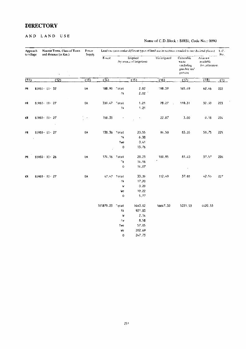
DIRECTORY
AND LAND USE Name of C.D.Block : SIRSI; Cod.: No.: 0090
Approach Near~st Town. Class of Town PI.)Vvl.!f Land liS": (ar..:a undl!r di.n~rl!nt typ..:s of land U~I! in hl!d::u\:!-- fnund..:d to two d..:.:irnal pia..:...::.) L.C. to village and distance (in Km.) Supply
. ----------- Nl' . F(m.!!-OI Irrig1lt~d Ull-irrigal\!d Cultllrahk Arl!a nol
(hy SOllr"':1! <lr irrigation) \\3!-oh: a'ail"hk (indmling for .:ultivntion !!;w~h:u' and gflWC'S)
( 11) ( 12) (13) (14) (15) (16) (17) ( 18) ( 1 )
PR SIRSI- II' 32 EA 188.90 Total 2.02 198.39 165.49 62.46 222
Tk 2.02
PR SIRSI- II· 27 EA 339.47 Total 1.21 78.27 110.31 32.30 223
Tk 1.21
KR SIRSI- II' 27 158.33 22.87 3.00 0.18 224
PR SIRSI - II· 27 EA 138.36 Total 20.55 94.50 83.35 50.75 225
Tk 6.38
Twe 0.41
0 13.76
PR SIRSI· 11- 26 EA 174.16 Total 28.23 100.95 81.40 37.57 226
Tk 14.16
0 14.07
KR SIRSI· II· 27 EA 1,7.1,7 Total 33.39 112.40 37.01 42.55 227
Tk 17.20
II 0.20
\.Ie 10.22
0 5.77
101879.23 T()tal 141,0.02 16647.30 5221.53 4420.53
Tk 921.83
\.I 2.14
Tw 8.58
Twe 57.05
IJe 202.69
0 21,7.73
251


SUPA C.D.BLOCK
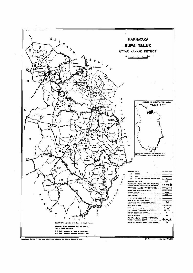
o
!
T A LUll _leNtI _aft
....... wcI t_H' HuM... ... I'IOt ....... td
..... t. M:'" -.nlltianl. c. It IIocIc .....,. ., s.,a .. eo-I.....-u. with .......... , ....... 1'''lIter, t ......
KARNATAKA
SUPA TALUK UTTAR KANNAD D$T~CT
<
"",2 1cIllll::::II_.t:=::II_.lKm
L CIIo'NGE II JURISDICTION ,.1"'" r-........ .... 0 .........
( '",-\ ~.
i I.-') )IIQP.,. ...... ...._, ,
~ y l, ("'
~) \ ( t , " ) .... , <
.~.
ecu.o&ItY, S'4rr
DIS"",,,
" T"'LU~.
" \!ll£G£ 'NITti LOCATION moE Nt.4BEFl.. C::Jl:::J ~RTER5:TALlII @
UNlNHABn'ED vtLlAGES WIlli lOCATION COOE ..
I.RBAN AREA W1TH LOCA~ CODE .~.
N.AOON"'L~
STATE HtG+MA'r
IMPORTANT M£TAL.L.ED AI),t.O-, ..
UNMETAlLEO AND OTtER QDS ..
RAl.w..y LIN[ WITH sr,t,nCIII,!rIt::TRE GAUGE
RIVEF! WITH STREA~ ..
TANK
POST OFfiCE / TELEGRAPH OFFICE .• ,
tI~ER SEtCt4a.MW Stt«tOl ..
POLICE STATION ..
PRIMARY HEALTH tEtiTRE, OISPENSMY,I fAMILY PLANNING CENTRE
~ ~
--l!!JL....-
... ~ C::;I PO/TO
S
PS
"PORTANT YlLlAGE MA_T/HAT CSIWID!'l •..

ALPHABETICAL LIST OF VILLAGES
TALUK: SUPA-OlOO
SL NAME OF THE VILLAGE
NO
Akheti 2 Amagaon 3 AmarCJe 4 Ambel i 5 Amboll i ,6 Amshet\ 7 Anmod 8 Anshi 9 Asu
10 Asull i 11 Atle 12 Aveda
2
13 Avedapapalawadi 14 Avurli
15 Badgund 10 Badpal i 17 BaJI1I1awadi 18 Bandoda . 19 Bapel i 20 Bazarkunang 21 Bhedasgadd: 22 Bidal i 23 Birkhal 24 Baregali 25 Bari
26 Chafer 27 Chandawadi 28 Chapakhand 29 Chapal i 30 Chapal i (A) 31 Chapal; (Kalsai) 32 Chinchkhand
33 Oeriye 34 Oevulli (Joida) 35 Oevulli (Tenai)
36 Oi99i 37 Oanshet 38 Ourg 39 Ourgi
40 Gangada
C. D. BLOCK:SUPA~IOO
1991 CENSUS 1981 CENSUS
LOCATION CODE (Manual)
3
11/20/10/89
11/20/10/33 11/20/10/28 11/20/10/1 11/20/10/79 11/20/10/9 11/20/10/88 11/20/10/78
11/20/.10/101 11/20/10/42
11/20/10/119 11/20/10/19
11/20/10/110 11/20/10/60
11/20/1 0/20 11/20/10/81 11/20/10/4
11/20/10/112 11/20/10/37
11/20/10/117 11/20/10/68 11/20/10/77
11/20/10/75 11/20/10/100 11/20/10/102
11/20/10/67 11/20/10/96
11/20/10/54
11/20/10/53 11/20/10/99
11/20/10/49 11/20/10/63
11/20/10/48
11/20/10/50
11/20/10/93 11/20/10/43 11/20/10/16 11/20/10/98
11/20/10/13
11/20/10/59
LOCATION CODE LOCATION CODE LOCATION CODE (Computer) (Manual) (Computer)
4
11/20/0100/0089 11/20/0100/0033 11/20/0100/0028
11/20/010010001 11/20/0100/0079 11/20/0100/0009 11/20/0100/0088 11/20/010Cl/0078
11/20/0100/0101
11/20/0100/0042
11 /20/0100/0119 11/20/0100/0019
11/20/0100/0110 11/20/0100/0060
11/20/0100/0020 11/20/0100/0081 11/20/0100/0004 11/20/0100/0112 11/20/0100/0037
11/20/0100/0117 11/20/0100/0068 11/20/0100/0077
11/20/0100/0075 11/20/0100/0100 11/20/0100/0102
11/20/0100/0067
11/20/0100/0096
11/20/0100/0054 11/20/0100/0053 11/20/0100/0099
11/20/0100/0049
11/20/0100/0063
11/20/0100/0048
11/20/0100/0050 11/20/0100/0093
11/20/0100/0043 11/20/0100/0016
11/20/0100/0098 11/20/0100/0013
11/20/0100/0059
255
5
9/19/10/106 9/19/10/37 9/19/10/32
9/19/10/1 9/19/10/96 9/19/10/11 9;19/10/105 9/19/10/95
9/19/10/118
9/19/10/47 9/19/10/137 9/19/10/21
9/19/10/128 9/19/10/77
9/19/10/23 9/19/10/98 9/19/10/5 9/19/107130 9/19/10/29 9/19/10/135 9/19/10/85 9/19/10/94
9/19/10/92 9/19/10/117 9/19/10/119
9/19/10/84
9/19/10/113 9/19/10/71
9/19/10/116 9/19/10/70
9/19/10/65 9/19/10/80
9/19/10/64
9/19/10/66
9/19/10/110 9/19/10/48
9/19/10/18 9/19/10/115 9/19;10/15
9/19/10/76
6
09/19/0100/0106 09/19/0100/0037 09/19/0100/0032
09/19/0100/0001 09/19/0100/0096 OW19/0100/0011 09/19/0100/0105 09/19/0100/0095 09/19/0100/0118
09/19/0100/0047 09/19/0100/0137 09/19/0100/0021
09/19/0100/0128 09/19/0100/0077
09/19/0100/0023 09/1910100/0098 09/19/0100/0005 09/19/0100/0130 09/19/0100/0029 09/19/0100/0135
09/19/0100/0085 09/19/0100/0094
09/19/0100/0092 09/19/0100/0117 09/19/0100/0119
09/19/0100/0084 09/19/0100/0113 09/19/0100/0071 09/19/0100/0116
09/19/0100/0070
09/19/0100/0065 09/19/0100/0080
09/19/0100/0064
09/19/0100/0066 09/19/0100/0110
09/19/0100/0048 09/19/0100/0018
09/19/0100/0115 09/19/0100/0015
09/19/01 00/0076

ALPHABETICAL LIST OF VILLAGES
TALUK: SUPA-OIOO
SL NAME OF THE VILLAGE NO
41 Gavegal i 42 Ghavane 43 Ghodshet 44 Gund
45 Hebbal 46 Hudsa
47 Ivol i
48 Jagalbet 49 Jalawali 50 Joida
51 Kalambuli 52 Kalamkhand 53 Kalsai 54 Kamare 55 Kararobal 56 Karanjoida 57 Kariyadi 58 Kasarle 59 Kasarwadi 60 Katel 61 Katel i 62 Kavale 63 Kevarle 64 Khodl i
2
65 Konda (HaliyaL> 66 Kondape 67 Konshet 68 Kothall i 69 Kudalg80n 70 K\.IIIbhel i 71 Kl..IIbral 72 Kunagini 73 Kundal 74 Kurandi 75 Kuveshi
76 Malambe 77 Mavalinge 78 Miraskumbheli
79 Nagari
c. D. BLOCK:SUPA~IOO
1991 CENSUS 1981 CENSUS
LOCATION CODE (Manual)
3
11/20/1 0/27 11/20/10/109
11/20/10/83 11/20/10/61
11/20/10/71 11/20/10/56
11/20/10/108
11/20/10/3
11/20/10/86 11/20/1 0/51
11/20/10/87 11/20/1 0/32 11/20/1 0182 11/20/10/106 11/20/10/120
11120/10/40 11/20/10/64 11/20/10/105
11/20/10/12 11/20/10/47 11/20/10/46
11/20/10/36 11/20/10/114 11/20/10/25
11/20/10/21 11/20/10/22 11/20/10/95
11/20/10/74 11/20/10/15 11/20/10/57
11/20/10/5
11/20/10/94
11/20/10/85 11/20/10/2
11/20/10/118
11/20/10/10 11/20/10/23
11/20/10/8
11/20/10/55
LOCATION CODE LOCATION CODE LOCATION CODE (Computer) (Manual) (Computer)
4
11/20/0100/0027 11/20/0100/0109
11/20/0100/0083 11/20/0100/0061
11/20/0100/0071
11/20/0100/0056
11/20/0100/0108
11/20/0100/0003 11/20/0100/0086 11/20/0100/0051
11/20/0100/0087 11/20/0100/0032 11/20/0100/0082 11/20/0100/0106 11/20/0100/0120 11/20/0100/0040 11/20/0100/0064
11/20/0100/0105 11/20/0100/0012
11/20/0100/0047 11/20/0100/0046
11/20/0100/0036 11/20/0100/0114 11/20/0100/0025
11/20/0100/0021 11/20/0100/0022 11/20/0100/0095
11/20/0100/0074 11/20/0100/0015
11/20/0100/0057 11/20/0100/0005
11/20/0100/0094
11/20/0100/0085 11/20/0100/0002
11/20/0100/0118
11i20/0100/0010
11/20/010010023
11/20/0100/0008
11/20/0100/0055
256
5
9/19/10/31 9/19/10/127
9/19/10/100 9/19/10/78
9/19/10/88 9/19/10/73
9/19/10/125
9/19/10/5 9/19/10/103 9/19/10/67
9/19/10/104 9/19/10/36 9/19/10/99 9/19/10/123 9/19/10/138 9/19/10/45 9/19/10/81
9/19/10/122 9/19/10/14 9/19/10/63
9/19/10/62 9/19/10/40
9/19/10/132 9/19/1 0/28
9/19/10/24 9/19/10/25 9/19/10/112
9/19110/91 9/19/10/17
9/19/10/74
9/19/10/7 9/19/10/111
9/19/10/102
9/19/10/4 9/19/10/136
9/19/10/12 9/19/10/26 9/19/10/10
9/19/10/72
6
09/19/0100/0031
09/19/0100/0127 09/19/0100/0100 09/19/0100/0078
09/19/0100/0088 09/19/0100/0073
09/19/0100/0125
09/19/0100/0005 09/19/0100/0103 09/19/0100/0067
"
09/19/010p/Ol04
09/19/0100/0036
09/19/0100/0099 09/19/0100/0123 09/19/0100/0138 09/19/0100/0045
09/19/0100/0081 09/19/0100/0122 09/19/ofoo/0014
09/19/0100/0063
09/19/0100/0062
09/19/0100/0040 09/19/0100/0132 09/19/0100/00"28
09/19/0100/0024 09/19/0100/0025 09/19/0100/0112
09/19/0100/0091 09/19/0100/0017
09/19/0100/0074
09/19/0100/0007 09/19/0100/0111
09/19/0100/0102 09/19/0100/0004
09/19i0100/0136
09/19/0100/0012 09/19/0100/0026
09119/0100/0010
09/19/0100/0072

ALPHABETICAL LIST OF VILLAGES
TALUK: SUPA-01OO C.D.BLOCK:SUPA-OIOO
SL NAME OF THE VIllAGE 1991 CENSUS 1981 CENSUS
NO
:":)CATION CODF. LOCATION CooE LOCATION CooE LOCATION CODE (Manual) (Computer) (Manual) (Computer)
-----~--- "-----~.---- _._------2 3 4 5 6
80 Nagoda 11/20/10/39 11/20/0100/0039 9/19/10/43 09/19/0100/0043 131 Nandigedde 11/20/10/62 11/20/0100/0062 9/19/10/79 09/19/0100/0079
82 ~letu"'ge 11/20/10/72 11/20/0100/0072 9/19/10/89 09/19/0100/0089
83 Nigundi 11/20/1 0/80 11/20/0100/0080 9/19/10/97 09/19/0100/0097 84 Ninnur 11/20/l0/111 11/20/0100/0111 9/19/10/129 09/19/0100/0129
85 Nujji 11/20/1 0/84 11/20/0100/0084 9/19/10/101 09/19/0100/0101
86 Palde 11/20/10/90 11/20/0100/0090 9/19/10/107 09/19/0100/0107
87 Panjel i 11/20/1 0/38 11/20/0100/0038 9/19/10/42 09/19/0100/0042 88 Payaswadi 11/20/10/97 11/20/0100/0097 9/19/10/114 09/19/0100/0114 80 Phansol i 11/20/10/31 11/20/0100/0031 9/19/10/35 09/19/0100/0035
90 Pisose 11/20/10/tI6 11/20/0100/0116 9/19/10/134 09/19/0100/0134
91 Prarlhani 11/20/10/26 11/20/0100/0026 9/19/10/30 09/19/0100/0030
n Pushel i 11/20/10/18 11/20/0100/0018 9/19/10/20 09/19/0100/0020
',13 Rarnanagar 11/20/10/123 11/20/0100/0123 9/19/10/0 09/19/0100/0000
94 Rangaruk 11/20/1 0/91 11/20/0100/0091 9/19/10/108 09/19/0100/0108
95 Samjoida 11/20/10/52 11/20/0100/0052 9/19/10/68 09/19/0100/0068
96 Sang awe 11 ;20/1 0/29 11/20/0100/0029 9/19/10/33 09/19/0100/0033
97 Sannamaga 11/20/tO/35 11/20/0100/0035 9/19/10/39 09/19/0100/0039
98 Sheval i 11;20/10/65 11/20/0100/0065 9/19/10/82 09/19/0100/0082
99 Sh i ndho II i 11/20/1 0/1 03 11/20/0100/0103 9/19/10/120 09/19/0100/0120
100 Shingargaon 11/20/1 0/14 11/20/0100/0014 9/19/10/16 09/19/0100/0016
101 Shiragure 11/20/10/113 11;20/0100/0113 9/19/10/131 09/19/0100/0131
102 Shiroli 11/20/1 0/34 11/20/0100/0034 9/19/10/38 09/19/0100/0038
103 Shivapur 11/20/10/70 11;20/0100/0070 9/19/10/87 09/19/0100/0087
104 Talasgeri 11/20/10/76 11/20/0100/0076 9/19/10/93 09/19/0100/0093
105 Teral i 11/20/10/41 11;20/0100/0041 9/19/10/16 09/19/0100/0016
106 Timbol i 11/20/10/6 11/20/0100/0006 9/19/10/8 09/19/0100/0008
107 Tinaikhand 11/20/10/58 11/20/0100/0058 9/19/10/75 09/19/0100/0075
108 Ulvi 11/20/10/73 11/20/0100/0073 9/19/10/90 09/19/0100/0090
109 Usoda 11/20/10/17 11/20/0100/0017 9/19/10/19 09/19/0100/0019
110 Vade 11/20/10/104 11/20/0100/0104 9/19/10/121 09/19/0100/0121
111 Vadkal 11/20/10/69 11/20/0100/0069 9/19/10/86 09/19/0100/0086
112 Vaijdgaon 11 ;20/1 0/11 11/20/0100/0011 9/19/10/13 09/19/0100/0013
113 Vaini 11 ;20/10/45 11/20/0100/0045 9/19/10/61 09/19/0100/0061
114 varande 11/20/10/44 11/20/0100/0044 9/19/10/60 09/19/0100/0060
115 Varlewadi 11120/10/92 11120/0100/0092 9/19/10/109 09/19/0100/0109
116 Vatle 11/20/10/121 11/20/0100/0121 ' 9/19/10/139 09/19/0100/0139
117 Veliefkumbeli 11/20/10/7 11/20/010.0/0007 9/19/10/9 09/19/0100/0009
118 Vi lwedabe 11/20/10/107 11/20/0100/0107 9/19/JO/124 09/19/0100/0124
257 CE"

ALPHABETICAL LIST OF VILLAGES
TALUK: SUPA-OlOO C. D. BLOCK: SUPA-OlOO
SL NAME OF THE VILLAGE 1991 CENSUS 1981 CENSUS NO
LOCATION CODE LOCATION CODE LOCATION CODE LOCATION CODE (Manual) (Computer) (Manual) (C~ter)
2 3 4 5 6
119 Viral 11/20/10/115 11/20/0100/0115 9/19/10/133 09/19/0100/0133 120 Viranpali 11/20/10/24 11120/0100/0024 9/19/10/27 09/19/0100/0027 121 Viranjol 11/20/10/122 11/20/0100/0122 9/19/10/140 09/19/0100/0140
,~.
122 Virnol i 11/20/10/30 11/20/0100/0030 9/19/10/34 09/19/0100/0034
123 YerllkJkh 11/20/10/66 11/20/0100/0066 9/19/10/83 09/19/0100/0083
258

SUPA C.D.BLOCK

VILLAGE
AMENITIES Name of C.D.Block : SUPA; Code No. :0100
L.e. Name of Village Total area of Total Am<!niti~s availahlo (if not availahl<! within Ih~ village. " dash (-) is shown in the No. the village Popu- column and n~xtto it in hra.:i.:ets. the distanc~ in broad ranges viz. -5 kms. 5 .. 10 kms.
([n hectares) lalinn and 10+ kms ofth~ n"3l'o,;Il!!llCo! wh~t" (he la~ility is avaiiatll~ is gi\~nl. and Educa- M"dkal Drinking PMI Dayur Communicalion No.of lional Wakr and Days of IBus SlOp. House- T~k- markd! Railway Stalion. holds graph hal if any Wal~rwaYJ
(1) (2) (3) (4) (5) (6) ~. (8) --(~--no,--
AMBELl 2705.34 134 - (0-5) -(0-5) 'oj - (0-5) -(0-5) as (25)
2 KURANDI 642.00 93 -(0-5) - (0-5) I,.j -(0-5) '(8-:') 0;'; ~ (22)
3 JAGALBET 432_07 1885 P(2), M, H 0 T, OW, HP PTO, -(10+) R'"
(409) Phone
4 BAMMAIIADI ' 370.67 78 -(0-5) - (10+) I,i , HP -(S-10) -(10+) - (5, lr!)
(17)
5 KUMBRAL 210.74 67 -(0·5) -(0-5) II, OTH -(0-5) - (10· ) - (0-,)
(8)
6 TIMQOLI 679_57 293 P(2) -(5-10) II, HP, OTH -(5-10) - (5-10) -(O-5)
(47)
., VELlEFKUHBELI 531.38 133 -(0-5) - (5-10) II, HP -(0-5) -(10+) -(0-5)
(23)
8 MIRASKUMBHElI 522.87 143 P - (5- 10) II -COoS) - no+) '(O-S)
(24)
9 AMSHET 750.20 386 P(2) -(5-10) ii, MP -(5-10) - (10') - (5·10) (68) ...
10 MAlAMBE 863.20 341 P(2) -(5-10) \J., HP -(5-10) ··no"'} -(5-10)
(54)
11 VAIJAGAON 575.38 253 P -( 10+) w, HP -(0-5) - (lOr) -(0·5) (44)
12 KASARWADI 219_93 38 -(0-5) - (5-10) w, HP -(0-5) -110+) -(0-,)
(8)
13 DURGI 240.38 104 -(0-5) - (0-5) II, HP -(0-5) - (10-r) - (0-5)
(15)
14 SHINGARGAON 1770.64 432 P, lot - (5-10) I.i HP PO - (10,-) - (0-5) , (85)
260

DIRECTORY
AND LAND USE Name of C.D.BlocK : SVPA; Code No.: 0100
Approach N~aNst Town, Class of Town Pow¢r Land ,us¢ (ar~8 ltnd"r din".:r¢nt Iyp~s or land U8<: in h¢ctar¢s mund¢d to two d.:cimal plac¢s) L.C. to villag~ and distance (in Km.) Supply ----.----------------- No.
F •. .lr..:si IrrigakJ Un-irrigated Culturabl" Ar\!3 nut (by S!)urc.: of irrigation) wast.: availabk
(induding for cliltivalion gaucbar and grov~s)
(11) (12) (13) (14) ( 15) (16) (17) (18) (1)
PR GANESHAGUD 1- VI- 6 EA 1892.65 481.23 55.44 302.73
KR GANESHAGUOI- VI- 6 615.41 16.07 10.52 2
PR GANESHAGUDI- VI- 10 EA 319.71 78.36 14.57 19.43 3
KR GANESHAGUDI- VI- 10 263.12 69.70 28.95 8.90 4
KR GANESHAGUDI- VI- 10 fA 184.03 16.90 8.90 0.91 5
KR GANESHAGUDI, VI- 1S 565.56 76.78 17.80 19.43 6
KR GANESHAGUDI- VI- 15 490.49 30.02 6.87 • 4.00 7
KR GANESHAGUDI- VI- 7 420.92 70.38 17.00 14.57 8
KR GANESHAGJDI- VI- 19 EA 613.08 100.29 27.52 9.31 9
KR GAr.ESHAGUD I' VI- 16 719.27 99.01 22.01 22.91 10
KR GANESHAGUDl- VI- 15 485.13 72.85 16.59 0.S1 11
KR GANESHAGUDI- VI' 13 172.04 32.52 8.90 'f>.47 12
KR GANESHAGUDI- VI, 8 171.98 Total 10.12 <'6.95 7.28 4.05 13
Tk 10.12
KR GANESHAGUDI· VI- 12 EA 1567,57 171. 10 5.67 26.30 14
261

VII:.LAGE
AMENIT[ES Name ofC.D.Block : SUPA; Code No. :0100 . L.C. Name of Village Total area of Total Am~nities available (if no! available within the village. a dash (-j is shown in the No. the village Poru- column and n~xt to it in brackets. the distance in broad ranges viz. -S kms, S-10 kms,
(In hectares) latkln and 10+ kms oflhe neareSll!lace where tho: flld1it:t i. avail.hle is given}. and &luca- Medical Drinking P<)st Day or Communication No.of tional Water and Days of IBusSlop. House- Tel.:- marketl Railway Station. holds graph hat ifany Waterway)
(1) (2) (3) (4) (5) (6) m (8) (9) (10)
15 KUOALGAON 1197.56 236 p - (10+) II, HP -(5-10) -(10+) -(5-10) (35)
16 DONSHET 766.12 12 -(0-5) - (10+) 101, HP -(0-5) -(10+) -(0-5) (2)
17 USOOA 815.83 451 P - (10+) 101, HP -(5-10) -(10+) -(5-10) (116)
18 PUSHEll 498.47 42 -(0-5) -(0-5) -(0-5) -(10+) -(0'5) (7)
19 AVEDA 716.60 325 P -(0-5) 101, HP -(0-5) -(10+) BS
(61)
20 BADGUND 1042.13 130 -(0-5) -(0-5) 101 -(0-5) -(10+) -(0-5) (24)
21 KONDA (H6LlYAL) 407.95 11 -(0-5) -(0-5) 101 -(0-5) -(10+) BS
(2)
22 KONDAPE 848.72 190 P -(0-5) 101, OTH -(0-5) -(10+) -(0-5) (42)
23 MAVAllNGE 606.70 435 P -(0-5) 101, HP -(0-5) -(0'5) BS (84)
24 VIRAMPALI 2659.50 891 P(3) -(0-5) 101, HP -(0-5) -(0-5) BS
(175)
25 KHODlI 1653.89 45 1', M -(10+) 101, HP -(0-5) -(10+) BS (11 )
26 PRADHANI 618.98 313 P, M -(5-10) II, HP PO -(5-10) BS (69)
27 GAVEGALI 2667.53 704 1'(3) -(10+) II, HP -(0·5) -(10+) -(0-5) (124)
28 A"'ARDE 267.34 58 - (0-5) -(10+) W, HP -(0-5) -(5-10) -(0-5) (15 )
262

DIRECTORY
AND LAND USE Name of C.D.Block : SUPA; Code No.: 0100
Approach Nea~ Town, Class of Town Power Land liS<! (aNa \inder ditTer.:nl Iypes of land us.: in hectares rounded 10 two decimal places) L.C, to village and distance (in Km.) Supply No.
Forest Irrigated Un-irrigated Culturable Area not (by source of irrigation) waste available
(including for cultivation gaucharand groves)
"'2 ,,22 ,,31 ,,42 PS2 P62 ,,72 , ,82 "2
KR GANESHAGUDI- VI- 14 1098.62 51.99 11.74 35.21 15
KR GANESHAGUDI- VI- 10 751.40 14.72 16
KR GANESHAGUOI- VI- 12 801.88 9.10 0.80 4.05 17
KR GANESHAGUOI- VI- 5 434.66 42.77 18.62 2.42 18
PR GANESHAGUOI- VI- 2 663.32 43.42 106.58 19
KR GANESHAGUOI- VI- 3: 950.61 32.03 71.23 20
PR GANESHAGUOI- VI- 5 380.22 21.26 6.47 21
KR GANESHAGUOJ- VI- 4 801.34 25.93 21.45 22
KR DANDELI- II - 3 574'.60 4.18 27.92 23
PR DANDElI- II- 2 EA 2499.44 Total 26.71 31.97 4.05 • 116.55 24 TI{ 26.71
PR GANESHAGUDI- VI' 15 EA' 1653.89 25
PR DANDELI- II - 8 EA 574.67 Total 7.28 4.05 12.55 20.43 26 TI{ 7.28
PR DANDELI- II- 13 EA 2373.54 179.06 79.32 35.61 27
PR DANDELI- II' 8 245.78 13.90 4.86 2.80 28
263

VILLAGE
AMENITIES Name of C.D.Block : SUPA; Code N(', :0100
L.C No
Neme of Village To,alar"a of Total the village Popu-(In hecl~res) lation
and No.of Households
Am~ni!i"s availabl" (if no; ,",,"ilohl< wIthin the village. a dash (-) is snown in the column and next to it in hrack"ts. the di"'ance in broad ranges viz. '5 kms, 5-10 kms,
and 10+ kms of Ih" n"8re~t place wh'!li! the facility is available is giVen). Edu.;a- Mcdh;al Drinking Post Day or C" .... m.mication
tional Water and Days of [Bus Stop. Tele- market/ Railway SI.'liI'Jn.
graph hat i[any Waterway)
.(1) _- (2) __ ' __ . __ :=--~31 __ (4) -m __ ,. ____ ~. __ ,_w_ (8) (9~ --- --(i_QL-=~
29 SM~GA''/E 1327.78 366 P -(5-10) 1.1. HP -(0-5) -(<;-10) -(0-5) (73)
30 VIRNOl1 1951.12 709 pal, M -(10+) 1.1, HP PO -(SoH)~ BS (153)
31 PHANSOLl 1217.30 459 P(2) - (10+) 1.1, HP -(0-5) -(5-10) BS (89)
32 KALAMKHAND 2057.29 -.--~---~---~----------~ UN INHABITED ---------.---~~----------
33 AMAGAON 1253.00 69 -(5-10) -(10+) II -(5-10) -(10+) -(5-10)
(' 7)
34 SHIROLI (186.22 138 p -(10+) II, OTH - (5-10) -(10+) -(0-5) (38)
35 SANPIAMAGA 1001.69 w· __________________ ~_r_
UN - INHABITED ---------_ .. _--------._-_.
36 "MALE 1250.37 --------------------.--- UN INHABITED -----------------~-------
37 BAPELI 433_93 257 p -(5-10) II -(5-10) :(10+) 8S (60)
38 PANJELI 1658.48 357 P(2) -(10+) II, HP -(0-5) - (10+) -(0 5) (61)
39 NAGOOA 819.70 312 P, M -(0-5) II, HP PO -no+) BS (55)
40 ICARANJOIOA 6618.36 664 peS) -(10+) II, HP PO - (10+) -(0-5)
(133)
41 TERAll 3421.68 441 p -(5-10) 1.1, HP - (5-10) -(10+) -(5-10) ( 103)
42 ASULll 6180.05 806 P -(10+) 1.1, OTH -(10+) -(10+) -(10+) ( 1(3)
43 OIGGI 1507.90 494 P ,-(10+) - (10+) - (10+) -(10+) (122)
44 VARANDE 405.98 69 -(0-5) -(5-10) HP -(5-10) -(10+) -(0-5) (12)
264

DIRECTORY
AND LAND USE Nallkl of C.D.Block : SUPA; Codtl No.: 0100
Approach> Nearest Town, Class of Town ,Power land u>«! (area Und¢T diIT¢~nt typ¢s of land u~ in hectares rounded to two decimal places) L.C. to village and distance (in Km.J 'Supply No.
Forest Irrigated Un-irrigattd Culturahle Area not (by source of irrigatiun) waste ;vailable
(including lilr cultivation gauchar and grnvcs)
(11) (12) (13) (14) ( 1,) ( 16) (17) (18) (1)
KR DAHDELI- Ih 10 1212.48 Total 17.81 22.62 54.23 20.64 29 Tk 17.81
PR AM8IKAtiAGARA- V- 7 fA 1832.14 Total 23.07 14.97 67.99 12.95 30 Tk 23.07
PR I AM8IKAHAGARA· V- 12 EA 1133.93 32.38 38.45 12.54 31
---.-------------------------------.-.------- UN - INHABITED ----------.----------.---.--------------.--.- 32
KR AMBlKAMAGARA- V- 10 1253.00 33
KR AMSIKANAGARA- V- 16 886.22
-----------------------------------.--------- UN - INHABITED --------------.----- .. -- ...... -.-.---- ....... 35
-~------------------- .... - ... -.----.--.-----. UN . INHABITED -- .... -- .. --- ... --- .. ---~- .... ------------------- .. -.. - 36
PR DANDElI- II- 15 375.15 42.18 4.86 11.74 37 ,.
KR GANESHAGUDI- VI- 18 EA 1378.11 164.62 32.38 83.37 38
PR GANESHAGUDI- VI- 26 fA 634.68 133.33 36.42 15.27 39
PR GANESHAGUDI- VI- 24 EA 6065.90 353.34 74.06 125.06 40
ICR GANESHAGUDI- VI' 32 3335.61 54.94 25.50 5.63 41
KR GANESHAGUDI- VI- 28 EA 5941.00 157.02 47.35 34.68 42
PR GANESHAGUDI- VI- 38 1364.60 115.78 6.48 21.04 43
KR GANESHAGUDI - VI- 12 298.74 78.51 28.73 44
265

VILLAGE
AMENITIES Name of C.D.Block ~ SUPA; Code No. :0100
Lc. Name of Villag~ TOlal ar~a of Tolal Amenities available (if nol availahle wiihin the villag~. a dash (-) is shown in Ih~ No. Ih~ villag~ Popu- cnlumn and next I" it in orack,:ls. Ih.: distan"~ in hroad ranges viz. -5 kms. 5-10 kms.
(In h~etares) lalion and 10+ kms ofth.: near.:st I!lac.: wh~r~ the fa"ilit~ is available is gi'venj. and Educa- Medical ,Drinking Post Day or Communicalion
No.of tiona) Wal.:r and D~), "f fBus Stop, House- Td.- nlsrkell Railway Slat ion. holds graph hal ifony Wat.:rway)
(1) (2) (3) (4) (5 ) (6) (7) (8) (9) (10)
45 VAINI 921.32 320 p -(0-5) II, HP -(0-5) -( 10+) -(0-5) (58)
46 KATEL! 1749.09 1107 P(3) , PHC, FPC T , W, HP PO -(10~) 8S (236) M(2) , H
47 KATEl 550.28 90 - (0-5) -(0-5) w, HP -(0-5) - (10+) -(0-5) (19)
48 OERIYE 817.06 129 P -(0-5) w, HP -(0-5) -(10+) BS (4)
49 CHAPOLl (KALSAI) 2685_30 687 P(4) -(0-5) w, HP -(0-5) - (10+) BS (90)
50 DEVUlLl (JOIDA) 250.39 33 -(0-5) -(0-5) -(0-5) -(10+) BS (8)
51 JOIDA 1968.12 2214 P(8), PHC, FPC, T, II, HP PTO, - (10+) BS (460) M(3), SMP Phone
52 SAMJOIDA 348.72 123 -(0-5) -(0-5) W, OTH -(0-5 ) - (10+) -liS (26)
53 CHAPALI 152.05 158 -(0-5) -(0-5) II, HP PO -(10+) -(0-5) (28)
54 CHAPAKHAND 256.85 65 -(5-10) -(5-10) W, HP - (0-5) -(10+) , -(0-5) (15)
55 NAGAR I 1140.99 202 -(0-5) - (0-5) HP, OTH -(0-5) -(10+) -(0-5) (37)
56 HUOSA 1710.47 349 P(2) - (0-5) II, HP PO -(10+) -(0-5) (74)
57 KUMBHELI 808.55 29 -(5-10) -(5-10) II, HP - (5-10) -(10+) -(5-10) (3)
58 TINAIKHAND 92.52 44 - (0-5) -(5-10) II -(5-10) - (10+) -(5-10) (4)
59 GANGOOA 2727.39 522 P(3) -(10+) W, HP - (10+) - (10+) -(0-5) (69)
266

DIRECTORY
AND LAND USE Narrle of CD.Block : SUPA; Code No.: 0100
Approach Nesrest TO)lln. Class of Town Po",.:r Land us.: (lIr.:a under din;'rent types of land u"" III hectares rounded to IWO decimal places) L.C, 10 village and dislance (in K~,) Supply No,
Forest Irrigated Un-im_galed Culiuraolc Area nol (by sourc..: of irrigation) waste available
(induding I(,r ,uliivalion gauchar and groves)
( 11) ( 12) (13) (14) (15) ( 16.2.-- (17) ( 18) (1)
KR GANESHAGUD!- VI- 8 EA 773.60 126.29 11.74 9.78 45
PR GANESHAGUD 1- \I 1- 30 EA 1545.55 124.24 24.27 55.03 46
KR GANESHAGUDI- VI- 30 502.90 34.03 3.64 9.71 47 ,
\ PR GANESHAGUDI- VI- 28 ~9.75 37.79 6.88 12.64 48
PR GANESHAGUDI- VI- 32 EA n6\" 2C\.33 264.27 27.52 49
\ PR GANESHAGUDI- VI- 27 217. '16 19.1 47 13.36 0.40 50
I \
I,
PR GANESHAGuDI- VI- 20 E,~ 148~1. 70 Total 18.21 314.~ 120.20 25.09 51 Tk 18.21
46.47\ PR GANESHAGUDI- VI- 18 EA 275 .94 ;21 .45 4.86 52
\ KR GANESilAGOO I - VI- 18 99.~ 58 33.86 15.78 2.83 53
KR GANESHAGUDI- VI- 17 229.4~~ 9.61 16.19 1.62 54
\
KR GANESHAGUDI- VI- 20 995.20 89.14 40.87 15.78 55
PR AMBIKANAGARA- V- 20 1572.47 82.15 43.30 12.55 56
KR AMBIKANAGARA- V- 26 779.86 18.98 4.45 5.26 57
KR GANESHAGUDI- VI- 28 59.48 18.'10 12.14 2.80 58
KR AMBIKANAGARA' V- 15 2327.63 • 'otal 3.24 235.86 16.55 44.11 59 Tk 3.24 1 ,
267

VILLAGE
AMENITIES Name of C.D.Block : SUPA; Code No. :0100
L.C. Name of Village TOlalal'l!a of Total Am~niti.:s availabl.: (if nqt availabl.: within th~ villag.:. a dash (-) is shown in the No. tho: villago: Popu- column and n.:xt to it in bnrd.:ts.1 the dista~.: in hroad ranges viz. -S kIDS. 5-10 krns.
(In h.:ctan:s) lalion and 10+ krns ofth$l!caN!!! (!Ia.:c,whcn: thc fa.ilit! i. availahle i. Givenl. and £duea- Medical Drinking Post Day or Communicati,'n No.of tional W.t.:r and Days of IBusStop. House- T.:I.:- marketl Railway Station. holds graph hat if any Wat.:rwayJ
(1) (2) (3) (4) (5) (6) I (7) (8) (9) (10)
60 AWRLI 1346.76 164 P • (0·5) " -(0-5) -(10+) -(0-5)
(39)
61 GUND 2869.Z1 282 P PHC It. HP -(0-5) '(10+) -(0-5)
(50)
62 NANDIGADDE 217.176 386 P, M RP 11" HP, OTH Phone TUE BS (100)
63 CHINCHICHAND 12;.00 50 '(0-5 ) -(0-5) II, HP -(0-5) '(10+) -(0-5)
( 10)
64 KARIYAOI 7j8.61 161 P -(0- ) W, HP - (0-5) - (10+) -(0-5)
(31)
65 SHEVAlI 26.02 218 -(0-5) -(0-5) W, HP - (0-5) -(10+) - (0-5)
(41)
66 YERMUICH 206.09 395 P(2), M ,(0·5) W, HP -(0-5) -(10+) BS (80)
67 CHAFER /1279.10 44 • (0-5) -(0::15) w, HP - (0-5) - (10+) - (0-5) (8)
68 BHEDASGADOE 244.58 47 -(0-5) - (')-10) 01H -(5-10) -(10+) -(5-10) (8)
69 VADKAl 988.70 73 -(0-5) oIe-0-5) 1, HP - (0-5) -(10+) " - (0-5) ( 13)
70 SHIVAPUR 388.93 136 P • (0-5) OTH - (0-5) -(10+) - (0-5) (29)
71 HEBBAl 1076.53 91 P '(5-10) W, OTH '(5-10) • (10+) -(5-10) (14)
72 NETURGE 556.47 43 -(0-5) · (0-5) W ·(0-5) -(10+) - (0-5) (9)
73 UlVI 949.16 534 P(2) M ,>HC T, HP PO -(10+) BS (95)
74 KOTHAlll 1056.75 84 -CP-5) '(0-5) W, TI( ·(0-5) 'Cl0+) -(0-5) (16)
268

DIRECTORY
AND LAND USE Name of C.D.Block : SUPA; Cod~ No.: 0100
Approach Nean:S! Town. Class of Town Pow~r Land 1I~ (ar.:a und~r din;:r.:nllyp~s of land u~ in h~~lar~s nlund~d 10 IWo d.:~imal pla~~s) L.C. 10 village and distance (in Km.) Supply No.
For.:S! lrrigal~d Un·irrigated Culturablc Ar~a nol (by sourc~ of irrigalion) wasl~ available
(induding for cullivalion gau~harand
gnw~s)
~1'l I ~ 12l ~132 ~ 142 ~ 152 ~162 ~ 172 P8l ~12
KR AMBIKANAGARA- V- 22 1253.40 Total 11.74 43.99 18.21 19.42 60 Tk 11.74
KR AMBIKANAGARA- V- 14 2753.05 Total 8.90 39.26 6.48 61.52 61 Til 8.90
PR AMBIKANAGARA- V-. 14 191.75 17.92 3.64 4.45 62
KR AMBIKANAGARA- V- 15 fA '10.62 15.75 '.63 63
KR AMBIKANAGARA- V- 16 671.26 54.40 5.67 7.28 64
"
KR AMBIKANAGARA- V- 17 1990.72 76.89 12.19 46.22 65
PR ~MBIKANAGARA- v- 20 2068.48 81.75 19.43 36.43 66
KR AMBIKANAGARA- v- 26 1259.21 9.36 4.86 5.67 67
KR AMBIKANAGARA- v- 23 229.60 10.12 3.24 1.62 68
KR AMBIKANAGARA- v- 27 966.91 12.08 0.40 9.31 69
KR AMBIKANAGARA- v- 29 345.67 40.82 2.04 0.40 70
KR AMBIKANAGARA- v- 33 1047.06 25.83 2.83 0.81 71
ICR AMBIICANAGARA- v- 36 527.85 13.25 1.21 14.16 72
PR AMBIKANAGARA- v- 32 EA 843.26 20.24 78.38 7.28 73
KR AMBIKANAGARA- v- 38 1001.30 37.17 15.78 2.50 74
269

VILLAGE
AMENITIES
Name of C.O.Block : SUPA; Code No. :0100
L.C. Nam~ of Villag.: Total ar~a of Total Am~t1iti~s availabl~ (ifllllt availa"l.: withill lh~ villag~. a dash (-) is shllwn in th~
No. the villag~ POl'll- ..:ohunn and n~xtt(1 it in bra~k~ts. th~ distan..:~ in hroad rang~s viz. -5 kms. 5-10 kms.
(In h~dar~s) latinn and 10+ kms [lfth~ n..:ar~st ~la..:~ wh~r~ th~ ti1<:ilit~ is availabl~ is given).
and Educa- M~dical Drinking posl Day or Communication
No.of tional Wal~r ~nd Days of (Bus 5101'. HOllS~- Td~- mark~tl Railway Station.
holds graph hat ifany Waterway]
(1) (2) (3) (4 ) (5) (6) (7) (8) (9) (10)
75 BIRKHOL 3440.45 1212 P -(10+) 101, OTH -(0-5) - (10+) -(0-5)
(344)
76 TALASGERI 710.30 6 -(0-5) -(0-5) 101 -(0-5) -(10+) BS
(2)
n BIDOLI 5097.63 234 P -(10+) 101, HP -(10+) • (10+) -(10+)
(51)
78 ANSHI 8584.78 615 P(Z), M SMP II, HP, OTH PO -(10+) BS
(124)
79 AMBOLLI 5139.27 795 p -(5-10) II, HP -(5-10) -(10+) BS
(114)
80 NIGUNOI 2729.16 195 P -(10+) II, HP -(5-10) - (10+) -(0-5)
(38)
81 BAD POL I 1961. 75 164 P -(10+) W, HP -(0-5) -(10+) -(0~5)
(30)
82 KALSAI 3062.15 766 P(3) -(5-10) 1,/, HP PO -(10+) BS
(102)
83 GHOOSHET 590.51 25/3 P -(0-5) II, HP -(0-5) - (10+) -(0-5)
(43)
84 NUJJI 6784.41 570 P(3) -(10+) 1.1, HP PO ~ (-1.0+) BS
(97)
85 KUNDAL 3955.62 317 p ,(5-10) 1.1, HP -.(5-10) -(10+) -(5-10)
(33)
86 JALAIIALI 4956.22 187 P -(10+) 1.1, HP -(10+) -(5-10) -(5-10)
(25)
87 KALAMBULI 2438.88 2781 peS) • PHe, FPC T. 1.1, HP pro, -(0-5) BS. RS
(711 ) M(2), H Phone
88 ANMOO 2129.21 575 P(2) PHC, 0 1.1, HP PO -(5-10) as (135)
89 AICHETI 1514.71 454 p. M -(0-5) 1.1, HP PO -(5-10) - (0-5) (79)
270

DIRECTORY
AND LAND USE Name of C.D.Block : SUPA; Code No.: 0100
Approach Near.:st Town. Class of To"'n Powt::r Land liS\! (aNa und~r din~!'..:nt tyP\!S of land 11~1! in h..:..:tUf\!S round~d to two J~t:imal plac\!~) L.e. 10 village and distance (in Km.) Supply Nil.
Forest Irrigated Un-irrigal.:d Culturable Area not (hy "oUr,c of irrigation) wat-i-\\.! availahk
(including Illr cultivation gauchar and groves)
(11) (12) (13) (14) (15) ( 16) (17) ( 18) ( 1) -KR YELLAPUR- IV- 40 EA 3244.56 155.00 17.00 23.89 75
PR AMBIKANAGARA- v- 46 683.96 15.78 10.12 0.42 76
• I(R AMBIKANAGARA- v- 40 4903.21 97.39 35.61 61.42 77
PR OANDELl- 11- SO 8283.88 149.20 77 .70 74.00 78
PR AMBIKANAGARA- y- 34 4808.03 237.75 57.06 36.43 79
KR AMB[KANAGARA- v- 45 2638.81 53.15 13.76 23.44 80
PR AMB[KANAGARA- Y- 51 1894.54 40.50 8.90 17.81 81
PR DANDELI- [1- 38 EA 2728.59 182.61 48.16 102.79 82
PR DANDELl- 11- 40 438.93 Total 4.05 105.44 29.54 12.55 83 Tk 4.05
PR DANOE 1I- 11- 44 EA 6484.63 166.22 62.33 71.23 84
KR DANOELI- 1[- 53 3827.72 66.78 31.57 29.55 85
KR DANDELl- 1[- 42 4771.71 97.94 67.15 19.42 86
PR LONDA- Y- 30 EA 2084.36 91.06 20.24 243.22 87
PR LaNDA- v- 25 EA 1976.05 85.98 48.16 19.02 88
KR LONDA- V- 26 1271.07 Total 22.26 74.46 60.30 86.62 S9 Tk 22.26
271

VILLAGE
AMENITIES Name of C.O.Block : SUPA; Code No. :0100
L.C. Na~ of Village T 0181 area tlf Total AJIl.:niti~~ nvoilahl.: (ifnnt available within the village. a dash (-) is shown in tho: No. the village Pupu- ~,)lumn and n.:xl to it in hrackcts. the distan.:.: in hruad rang~s viz. -5 kms. ,-10 k.m'.
(In heetal'l!s) loti,," and 10+ killS .. fthe n~are.t I!la.:e where the tadlit:l: is avail!h1e is !liven). and EJuca- M.:dical Drinking Post Day or Communication
(\10.01' tional Waler and Days of IBus Stop. Hous.:- Td.:- mark..:tl Railway Station. holds graph hat ifany Wat.:rway)
(1) <2l (3) (4) (5) (6) (7) (8) (9) (10)
90 PAlDE 1233.98 249 p -(o-S) W, HP -(5-10) -(10+) -(10+)
(42)
91 RANGARUK 1047.32 113 -(0-5) -(10 .. ) IJ, HP -(5-10) -(10+) -CO-5)
(16)
92 VARLEWAOI 1291.25 170 -(0-5) -(5-10) W, ~p -(5-10) - (10+) -(5-10)
(30)
93 DEWLLI (TENAI) 4461.03 ,,63 p(3) -(5-10) w PO -,5-10) as (236)
94 KUNAGINI 349.70 102 -(0-5) -(0-5) II, ~P -(0-5) - (0-5) -(0-5)
( 18)
95 KONSHET 804.81 455 P -(0-5) II, HP - (0- 5) -(0-5) -(0-5)
(82)
96 CHANDAIiAOI 1012.29 277 P -(5-10) II, OTH -(0-5) -(10+) -(0-5)
(56)
97 PAYASIoIADI 1262.73 356 p -(5-10) W, OlH -(0-5) - (10+) -(0-5)
(76)
98 DURG 960.33 130 -(0-5) -(5-10) W, OTH - (0-5) -(5-10) -(0-5)
(18)
99 CHAPOLI (A) 830.83 123 P -(5-10) 101 -(0-5) - (5-10) -(0-5) ( 19)
100 BOREGALI 336.64 167 P -(5-10) 101, HP -(0-5) -(10+) -(0-5)
(29)
101 ASU 530.80 793 P(2), M -(5-10) W, HP PO -(10+) BS (142)
102 BORI 681.24 67 P -(0-5) II, HP PO - (10+) as ( 15)
103 SHINDHOLLI 450.50 319 P -(0-5) W, HP -(0-5) - (10+) -CO-5) (53)
104 VADE 408.41 120 P -(5-10) 101, HP -(0-5) -(10+) -(0-5) (22)
272

DIRECTORY
AND LAND USE Name of C. D. Block: SUPA; Coue No.: 0100
Af'proa~h N~aresl Town. Class of Town Pow~r Land USc (area und~r din;;r~nl Iypes <If lanJ USc in h~dare, rounded 1<1 Iwo decimal rlac"" LC 10 villag~ and distanc~ (in Km.) Supply NlI.
For.:sl lrrigu\\!u Un-\fr\galo,!d Cullllrahi<! Ar..:a nnt (hy sOlin.:..: of irrigation) wa~h! a\'ail~lhk
(induding 1(lf .... UI!l\':l[illll
galh.:har and gnw\!~)
~ 112 P2l ~132 ~142 ~ 15) ~16) ~ln P81 ~ 1 L~~
KR LONDA- v- 27 1174.73 43.88 8.09 7.28 90
KR LONDA- V- 14 982.06 38.96 16.59 9.71 9',
KR LONDA- V· 13 1175.23 69.88 15.38 30.76 9~
PR LONDA- V- 13 EA 4051.47 242.42 144.48 22.66 93
KR LONDA- V- 16 268.68 Total 5.26 42.13 3.20 30.43 9" Tk 5.26
KR LONDA- V- 14 711.08 60.95 30.76 2.02 95
PR LONDA- V- 15 879.73 Total 16.19 56.48 5.67 54.22 96
Tk 16.19
PR LONDA- V- 15 1158.66 63.60 12.55 27.92 97
KR LONDA- V- 24 823.44 91.56 2.03 43.30 98
KR LONDA- V- 8 711.05 41.68 12.14 65.96 99
KR LONDA- v- 16 281.98 36.05 7.28 11.33 100
PR LONDA- V- 13 EA 346.39 106.41 0.40 77,60 1 '1 v,
PR LONDA- V- 12 EA 624.46 36.13 3.24 17.41 102
KR LONDA- V- 14 344.34 80.16 26.00 103
KR LONDA- V- 14 EA 347.74 42.46 2.83 15.38 104
273

VILLAGE
AMENITIES Name of CD.Block : SUPA; COOt; No. :0100
L.e. No.
---.
Nam'~ of Vil!ag~
.m __ --,{",,"2,L
105 KASARl.~
106 t(AMARE
107 VILWEDABE
108 ! VOLl
~OQ GHAVANE
110 AVEDAPOPALAWADI
111 NIN~UR
112 BANDODA
113 SH I RAGURE
114 KEVARLE
i15 VIRAL
116 PISOSE
117 BAZAR~UNANG
118 ICUVESHI
119 ATlE
120 KARAMBAl
Tntal ar~a of Tutal Ameniti~, ",ailahk (ifllnt availahk within thc village. a d.,h (-) is Sh,IWn in the column and ne,tto it in hra~kels. the distance in h .. ",,<1 range. viz. -~ km'. 5-10 ktn,.
and 10+ kms o"th~ n~III'c't rlacc wh~rc the lit,ilitv i, availahk IS given). the village P,'pll-(In hc~tarc» lation
(3)
552.47
1831.98
993.43
2175.61
255.27
993.40
412.14
539.82
563.47
534.70
550.40
336.39
2089.93
2027.84
1521.75
953.69
and No.tlf HOllM!'
holds
Edll~a- Ml!di~al Drinkinl-! Post Day ~)r Comlmtni..:ation tional Water and DaY' of (Bus Stop.
T ek- marKcti Railway Station. graph hat if any WJtocwayl
(4 ) (5) (6) (7) (8) (9) (10)
46 -(0-5) -(5-10) II -(0-5) -(10+) - (0-5)
(6)
268 p -(10+) II, HP - (0-5) . (10+) - (0,5)
(57)
231 p - (10+) -(5-10) - (10~) -(5-10)
(47)
174 p -(5-10) II - (5-10) - (5-10) -(5-10)
(38)
- ¥ .. - - - - .... - .... ~ .. - ........ ~ ........ UN INHABITED ---_------ .. -_-- .. _----_--_
75 -(0-5) -(5-10) II, OTH -(5-10) -(5-10) -(5-10) (22)
---- ... _ ..... _ .. --, ....................... UN INHABITED _------ .. -- .. -- ..... __ .. _-- .. --_
12 P -(10+) R -(10+) - (10+) -(10+) (3)
-(5-10) - (10+) OTH -(5-10) . (10+) -(10+) (1 )
-- - -- -- -- -- - -- . - - -- - -- -- UN I N HAS IT ED - - - -- .. -- - - -- --- - - -- -- - --
84 (11 )
25 (5)
370 (98)
260 (50)
-(5-10)
-(5-10)
P
P
-(5-10)
.( 10+)
-( 10+)
-( 10+)
II, OTH
OTH
II, HP
II, HP
-(5-10) -(5-10)
-(5-10) -(10+)
PTO, Phone
-( 10+,
- (10~)
-(5-10)
-(10+)
-(10+) -(5-10) -(5-10)
------------------------ UN INHABITED .---------------------.--
206
(37)
p - (0-5)
274
w -(0-5) -(5-10) - (0-5)

DIRECTORY
AND LAN D USE Name of CD.B1ock : SUPA; Code No.: OlOO
Approach to village
])Iearest Town. Class of Town and distance (in Km.)
Power SbPply
Land lI~c «(\r~a Und\!f din~~r\!nt lyP\!S orland US\! In hl,!~tarl.!~ rOllll(kd to two d~l.:imal phlC\!S) L.t No . . __ --
Forest lrrigatl!tl Un-irrigatcd Culturahle Area nnt (hy ~ourc\! ('If irri~atilH1) wast\! availah!c
(including ()f cullivation gau(har and grnv\!s)
.l 11) (12) (13) (14) (15) ( 16) (17) ( 18) ( 1)
KR LOHOA- v- 14 476.78 40.87 13.36 21.46 10)
KR LONDA- v- 18 1639.34 97.94 91.46 3.24 106
KR LONDA- V- 16 768.02 81.28 10.94 133.19 107
KR LONDA- V- 22 1987." 112.01 44.11 32.38 108
- - - - - - - - - - - - - - - - - - - - - - - • - - - - - - - • - . - .•• - - - - . - - UN INHABITED .• - .. -.--.-.- .•.••. -.-- ... - .. -.- .•.. ------.-- 109
KR LONDA- V- 21 932.84 27.52 27.92 5.12 110
--------------------------------------.------ UN - INHABITED -.------.--.-- .. -----.--.--.-- .. -----.--.---- 111
KR LONDA- V- 18 465.69 56.32 6.88 10.93 '12
KR LONDA- v- 20 563.47 113
.. _ --- - - _- - -- - .. -- .... - .... --_ .. - ----_ .. - _-- .... _ .. _- .. _ .. UN INHABITED __________ .. _______________________________ r __
114
KR LONDA- V- 22 503.04 32.38 11.33 3.65 115
KR lDNDA- V- 26 312.18 16.52 2.43 5.26 116
KR LONDA- V- 17 1972.82 72.19 31.57 13.35 117
KR LONDA- V- 27 1911.26 Total 4.05 79.66 15.78 17.09 118
Tk 4.05
-----------.-------------------------.--.---- UN INHABITED --------------- •• ---------------.------------ '19
KR LONDA- V- 16 933.14 9.22 5.67 5.66 120
275

Name of C.D.Block : SUPA; Codtl No. :0100
L.C. No.
Nam.: of ViJlag~
2
• 121 VATLE
122 V!RANJOl
123 RAMANAGAR
T,'I,,1 ar~a of Tolal th~ village P"I'Uo
(In heclar.s) lat;on
838.49
1557.93
1965.49
179075.42
and No.of HOLlsl.!
hold,
(4)
230 (44)
123 (23)
5465 (985)
43447 (8588)
VILLAGE
AMENITIES
A",oniti.s aV3ilahlo (if 0<,1 availahl.: within Ih. villag~. a dash (0) is ""own in.lhc ,'olumn and nexllo il in orad'cls. Ihe di~lancc in hnllld rang.:s viz. -~ kms. 5-10 kms.
and 10+ kms "flhc nearest place where the fadlilY is availaole is given). Educa- Medical Drinking Post Day Of Communication
tional Water and Days of (BtH'S",I'.
(5)
p
-(0-5)
P(4),
M(Z) ,
P(124J,
M(21) ,
(6)
-(5-10)
- (5-10)
-(0-5)
PHC(6l,
0(2) ,
H(S) FPC(3),
RP, SMP(2)
276
(7)
II, HP
II
T, II, HP
T de- market/ Railway Slat inn. graph hat if any Waterway (
(8) (9) (10)
'(0-5) -(5-10) ·(5,10)
-(5-10) -(10+)
PTO, Phone
. (10+)
-( 10-1-)
I3S

DIRECTORY
AND LAND USE
ApRro8ch to village
Noare"t Town. Class "fTown and distance (in Km.)
(11) (12)
KR UlIOA- v- 18
KR LONDA- V- 19
PR LONDA- v- 3
Pl1W\!f
Supply
(13)
EA
Namt: of C.D.8101.:k : SUPA; Coue No.: 0100
~and USI.! (an.:a under din~r~nl tyP\!S of land usc in hedan.;!oi rounded to two ol!cimal pla~cs) L.C. No.
For~st Irrigakd Un-irrigated Cuiturabk Area not (hy soun:~ of irrigation) waSI~ available
(induding tor cultivation gauchar and grnvl!s)
( 14) ( 15) (16) ( 17) (18) (1)
812.98 16.60 6.07 2.84 121
1537.98 11.05 6.07 2.83 122
98.75 396.20 1425.35 45.19 123
155523.10 Total 178.89 8445.98 4197.79 3850.84 Tk 178.89
277


YELLAPUR C.D.BLOCK

: !!
~ '8 0- f .., 5 u ~ ,. L ()
.S! S
0 " ~
~ c
"" \} E
i 0 ..
@
~ ::3 to-
~ j; ... ~ "
~ ...
4( ~ ~
~ ct Q 'I( <I(
Z :::» I 0:: A. <I(
,>
41( C lie: '" lit' 0
!K: ... It: 6- 'ii ;.
...I ~ £ 't
au ~ ;::, .- -0
>- /') i c &
I"~ , ,
:1' ~ -4 l;
.' , I' , +<J ..
I , 0 f
"-'@ ~
p"': . .. '" "'- III '" (t):~ 5
0 ... III
, , '" .. 4 ., , v
I L<p~ 0 Ea· = '0
~ .
i ,. . vi · ~ OJ ~ ...J .2
~ c
'" II> ~ i "
:: 0 '" .. . .. OJ l!~ !~ ;; ~
~ 0- ',.. ~
~ II>
li ~
a 0" 0 u 0 = /
OJ , z '5 0 ",. v
G OJ '" .. .!!! c = g a: " " (
~ OJ ... :::l 1 w
'" ;;: · . a =
~=. z , ":-
~ u 0 .. .. !C' .... i .. 0 u ~~ g ., ~
0 r .. . z .. C It :J: ..J :J: ....... · ~ ~ . "
0.
!?, .. a. 0 ... "'u '\\ " ... ~~ ~ H . A :J: ~g .. 0 It .. 0 ~ .
~~ E
i u a: !I! a: " ..... o· CO
~ .... 0 0 " 17l ~% " H " =>- .... '" b '" ~
,..,.. " E
'6
..: .... ~ ~ "' 00 ;g ~ f:: ~
...) ,.u .!:
~ '" ~ l! .... OJ
OJ 1.: ~'"
OJ ".., ~~ >_:; .. ... ~ ... " " c c
... => .. i .. a: .. ~ , e . '0 .... :l '" x' ~ .. .. Iii --- '" % :l ;. .0 .. .. IZ "'0 OJ % 0 ...) J>SJ Qj! E •
is .. ;; OJ i~ .. " l! III 0 ;::: ~f " ... ~ o.~ ,..
0 ,.. .
.. .. .. ~ ~ v () .. Q." .. " <II E ~ a: ~ ;;: :II · , .. -.. :::i IZ .... Iii ~-' i £Ci
, It .. " x z .... i ... ...... ~~
o.
I " ID- 0 '"
~ :: " .... % ~ ;! 0 II;
'" :! " "
'" '" : .. 0: .. a: II! !t [~ § Q; . . .. 0 c
" ~g ; 0 :l OJ :- .. , " . 0
.... 1/)% u'i ...
'" II; ... ... z l: '" ~ a:<> ,,- , .. :It ! 0 i 2 0" >N => '" :::> a: ... :z: ... <> .. ..
" ..

ALPHABETIOAL LIST OF VILLAGES r
TALUK:YELLAPUR-OlJO C. D. BLOCK: YELLAPUR-OIIO
SL NAME Of THE VILLAGE 1991 CENSUS 1981 CENSUS NO
LOCATION CroE LOCATION CroE LOCATION CroE LOCATION COOE (Manual) (Computer) (Manual) (Computer)
.f ,2 '. 3 4 5 6
" '
,1 AlldCi 11/20/11/53 ! 11/20/0110/0053 9/1'9/11/54 09/19/0110/0054
'2 ~lJaon 11{20/11/16 11/20/0110/0016 9/19/11/16 09/19/0110/0016
'J AnaL~ar 11/20/11/103 11/20/0110/0103 9/19/11/118 09/19/0110/0118
,4 Anftltt 11/20/11/50 11/20/0110/0050 9/19/11/38 09/19/0110/0038
& Arblfi t, 11/20/11/10 ' 11/20/0110/0010 9/19/11/10 09/19/0110/0010
\ (, B.ttnk~tte 11/20/11/27 1.1/20/0110/0027 9/19/11/28 09/19/0110/0028
'7 B.tchgOd 11/20/11'/60 11'/20/0110/0060 9/19/11/77 09/19/0110/0077
8 Btiflelcani 11/20/11/104 11/20/0110/0104 9/19/11/120 ·09/19/0110/0120
9 Stlgar 11/20/11/34 llfz{}fOll0/0034 9/19/11/31 09/19/0110/0031
10 "hkasal i 11/20/11/120 11/20/0110/0120 9/19/11/64 09/19/0110/0064
11 '.ragadde 11/20/11/41 11/20/0110/0041 9/19/11/43 09/19/0110/0043
12 '.rballi 11/20/11/26 11/20/0110/0026 9/19/11/30 09/19/0110/0030
13 'are 11/20/11/22 11/20/0110/0022 9/19/11/22 09/19/0110/0022
14 lelgeri 11/20/11/49 11/20/0110/0049 9/19/11/50 09/19/0110/0050
15 Belkhanda 11/20/11/109 11120/011 % 1 09 9/19/11/125 09/19/0110/0125
16 Bellambi 11/20/11/72 11/20/0110/0072 9/19/11/88 09/19/0110/0088
11'1 Benadgu I i 11/20/11/20 11/20/0110/0020 9/19/11/20 09/19/0110/0020
11 Bendigeri 11/20/11/121 11/20/0110/0121 9/19/11/66 09/19/0110/0066
l' Sharani 11/20/11/78 11/20/0110/0078 9/19/11/95 09/19/0J 10/0095
ao Bharatana II i 11/20/11/70 11/20/0110/0070 9/19/11/84 09/19/0110/0084
21 BhOOl'la II i 11120/11/122 11/20/0110/0122 9/19/11/67 09/19/0110/0067
, 22 Bidrall i . 11/20/11/91 11/20/0110/0091 9/19/11/106 09/19/0110/0106
23 Bigar 11/20/11/28 11/20/0110/0028 9/19/11/26' 09/19/0110/0026
24 Bijankop 11/20/11/74 11/20/0110/0074 9/19/11/89 09/19/0110/0089
25 Bi llci 11/20/11/125 11/20/0110/0125 9/19/11/68 09/19/0110/0068
26 Bisgocl 11/20/11/38 11/20/0110/0038 9/19/11/39 09/19/0110/0039
27 Chandgul i 11120/11/110 11/20/0110/0110 9/19/11/124 09/19/0110/0124
28 Chavatti 11/20/11/88 11/20/0110/0088 9/19/11/97 09/19/0110/0097
29 Chiklcotti 11/20/'1/127 11/20/0110/0127 9/19/11/55 09/19/0110/0055
30 Chilckunane 11/20/11/14 11/20/0110/0014 9/19/11/13 09/19/0110/0013
31 Chimnall i 11/20/11/32 11/20/0110/0032 9/19/11/27 09/19/0110/0027
32 Dabgul i 11/20/11/11 11/20/0110/0011 9/19/11/11 09/19/0110/0011
33 Dehall i 11/20/11/37 11120/0110/0037 9/19/11/37 09/19/0110/0037
34 Devargadde 11/20/11/100 11/20/0110/0100 9/19/11/114 09/19/0110/0114
35 Devarkallahalli 11/20/11/61 11/20/0110/0061 9/19/11/73 09/19/0110/0073
36 Dongar 11/20/11/4 11/20/0110/0004 9/19/11/2 09/19/0110/0002
37 Gadi jogadnane 11/20/11/123 11/20/0110/0123 9/19/11/65 09/19/0110/0065
38 Geral 11/20/11/40 11/20/0110/0040 9/19/11/41 09/19/0110/0041
39 Gharwas 11/20/11/5 11/20/0110/0005 9/19/11/4 09/19/0110/0004
40 Gopadnane 11/20/11/6 11/20/0110/0006 9/19/11/3 09/19/0110/0003
281

ALPHABETICAL LIST OF VILLAGES
TALUK: YELLAPUR-OIIO c. D. BLOCK: YELLAPUR-OIIO
SL NAME OF THE VILLAGE 1991 CENSUS 1981 CENSUS NO
LOCATION CODE LOCATION CODE LOCATION CODE LOCATION CDOE (Manual) (CoqJUter) (Manual) (Computer)
2 3 4 5 6
41 Gotgul i 11/20/11/44 11/20/0110/0044 9/19/11/45 09/19/0110/0045 42 Gullapur 11/20/11/13 11/20/0110/0013 9/19/11/14 09/19/0110/0014
43 Halgod 11120/11/59 11/20/0110/0059 9/19111/75 09/19/0110/0075 44 Halsinkop 11/20/11/63 11/20/0110/0063 9119/111104 09119/0110/0104 45 Hamsangadde 11/20/11/3 11/20/0110/0003 9/19/11/33 Q9/19/0110/0033 46 Harigadde 11/20/11/96 11/20/0110/0096 9119/11/109 1!l9/19/0110/0109 47 Hasalmane 1''1/20/11/71 11/20/0110/0071 9/19111/87 09/19/0110/0087 48 Hasangi 11/20/11/62 11/20/0110/0062 9/19/11/74 09/19/0110/0074 49 Hastakargadde 11/20/11/105 11/20/011'010105 9/19/11/121 09/19/0110/0121 50 Heggapur 11/20/11/115 11/20/0110/0115 9/19/11/63 ,09/19/0110/0063 51 He9gumbl i 11/20/11/98 11/20/0110/0098 9/19/11/115 09119/0110/0115 52 Henmadi 11/20/11/77 11/20/0110/0077 9/19/11/93 '09/19/0110/0093 53 Hiresar 11/20/11/85 11/20/0110/0085 9/19/11/107 09/19/0110/0107 54 Hiriyal 11/20/1 1 /35 11/20/0110/0035 9/19/11/34 09/19/0110/0034 55 Hitlalli 11120/11/90 11/20/0110/0090 9/19/11/99 ' 09/19/0110/0099 56 Hitlasar 11/20/11/58 11/20/0110/0058 9/19/11/76 09/19/0110/<J076 57 Holemadu 11/20/11/99 11/20/0110/0099 9/19/11/113 09/19/0110/0113 58 Honagadde 11/20/11/18 11120/0110/0018 9/19/11/18 09/19/0110/0018 59 Hosall i 11/20/11/119 11/20/0110/0119 9/19/11/(>1 09/19/0110/0061 60 Hulc.l i 11/20/11/43 11/20/0110/0043 9119/11/44 09/19/0110/0044 61 Hulgaon 11/20/11/102 11/20/0110/0102 9/19/11/117 09/19/0110/0117 62 Hullarmane 11/20/11/66 11/20/0110/0066 9/19/11/78 c - Q9jJ9/0110/0078 63 Hunsemane 11/20/11/64 11/20/0110/0064 9/19/11/103 09/19/0110/0103 64 Hutakmane 11/20/11/2 11/20/0110/0002 9/19/11/36 09/19/0110/0036 65 Huthkhand 11/20/11/112 11/20/0110/0112 9/19/11/127 09/19/0110/0127
66 Idgundi 11/20/11/7 11/20/0110/0007 9/19/11/5 091-19/0110/0005 67 Ilehall i 11 /20/11 /~9 11/20/0110/0089 9/19/11/98 09/19/0110/0098
68 Jaddigadde 11/20/11/65 11/20/0110/0065 9/19/11/82 09/19/0110/0082 69 Jakkoll i, 11/20/11/67 11/20/0110/0067 9/19/11/79 09/19/0110/0079 70 Jogaanane 11/20/11/8 11/20/0110/0008 9/19/11/6 09/19/0110/0006 71 Jogalepal 11/20/11/17 11/20/0110/0017 9/19/11/17 09/19/0110/0017
72 Kalche 11/20/11/24 11/20/0110/0024 9/19/11/24 09119/0110/0024 73 Kalsoor 11/20/11/114 11/20/0110/0114 9/19/11/58 09/19/0110/0058 74 Kall1'l i 11/20/11/52 11/20/0110/0052 9/19/11/52 09/19/0110/0052 75 Kanchanahalli 11/20/11/118 11/20/0110/0118 9/19/11/59 09/19/0110/0059 76 Kangod-Balehadd 11/20/11/87 11/20/0110/0087 9/19/11/96 09119/0110/0096 77 Kannadga l 11/20/1 1/48 11/20/0110/0048 9/19/11/49 09/19/0110/0049 78 Kannenahall i 11/20/11/83 11/20/0110/0083 9/19/11/101 09/19/0110/0101 79 Kannigeri 11/20/11/46 11/20/0110/0046 9/19/11/47 09/19/0110/0047 80 Kannor-Heggarni 11/20/11/79 11/20/0110/0079 9/19/11/92 09/19/0110/0092 81 Kanur 11/20/1 1/23 11 i20/01 10/0023 9/19/11/23 09/19/0110/0023
282

ALPHABETICAL LIST OF VILLAGES
TALUK: YELLAPUR~0110 c. D. BLOCK: YELLAPUR-OIIO
SL NAME OF THE VILLAGE 1991 CENSUS 1981 CENSUS NO
LOCATION CODE LOCATION CODE LOCATION CODE LOCATION CODE (Manual) (Computer) (Manual) (Computer)
2 3 4 5 6
82 Kattige 11/2°/'1/36 11/20/0110/0036 9/19/11/35 09/19/0110/0035 ~3 Kaweli ker i 11/20/1 1/107 11/20/0110/0107 9/19/11/123 09/19/0110/0123 84 Kelasbi 11/2.0/11112 11/20/0110/0012 9/19/11/12 09/19/0110/0012 85 Kerehosalli 11/20/11/126 11/20/0110/-0126. 9/19/11/56 09/19/0110/0056
86"Kirwatti . 11/20/11/117 1 1 /20/0110/011.7 9/19/11/60 09/19/0110/0060 87 kodall i
'. 11/20/11725 11/20/0110/0025 9/19/11/29 09/19/0110/0029
88 )Codlagac:Jde 11/20/11/ i5 11/20/0110/0015 9/19/11/15 09/19/0110/0015 89 Kol iI(.eri 11/20/11/47 11/20/0110/0047 9/19/11/48 09/19/0110/0048 90 Komadi 11/20/11/9 11/20/0110/0009 9/19/11/7 09/19/0110/0007 91 Kotemane 11/20;t1/81 11/20/0110/0081 9/19/1 1 /85 09/19/0110/0085 92 Kundargi 11/20/11/75 11/20/0110/0075 9/19/11/86 09/19/0110/0086 93 Kundur "/20/1 1 /93 11/20/0110/0093 9/19/11/111 09/19/0110/0111 94 Kusgul i 11/20/1 1 /92 11/20/0110/0092 9119/11/105 09/19/0110/0105
95 Lalgul i 11/20/11/45 11/20/0110/0045 9/19/11/46 09/19/0110/0046 96 Li ngadba it 11/20/11/33 11/20/0110/0033 9/19/11/32 09/19/0110/0032
97 Madnur 11/20/11/116 11/20/0110/0116 9/19/11/62 09/19/0110/0062 98 Magod 11/20/1 1 /97 11/20/0110/0097 9/19/11/112 09/19/01 10/Ul 12
99 Malalgaon 11/20/11/111 11/20/0110/0111 9/19/11/126 09/19/0110/0126
100 Malkop 11/20/11/54 11/20/0110/0054 9/19/11/53 09/19/0110/0053
101 Marahall i 11/20/11/21 11/20/0',0/002, 9/19/11/21 09/19/0110/0021
102 Mavinamane 11/20/11/19 11/20/0110/0019 9/19/11/19 09/19/0110/0019
103 Mudangi 11/20/11/57 11/20/0110/0057 9/19/11/72 09/19/0110/0072
104 Nagarkan 11/20/11/39 11/20/0110/0039 9/19/11/40 09/19/0110/0040 105 Nandoll i 11/20/11/108 11/20/0110/0108 9/19/1 1/119 09/19/0110/0119
106 Puratbhomnalli 11/20/11/124 11/20/0110/0124 9/19/11/69 09/19/0110/0069
107 Saa.,ekop 11/20/11/73 11/20/0110/0073 9/19/11/90 09/19/0110/0090
108 Sankadgundi 11/20/11/86 11/20/0110/0086 9/19/11/100 09/19/0110/0100
109 Savagac:Jde 11/20/11/42 11/20/0110/0042 9/19/11/42 09/19/0110/0042
110 Savane 11/20/11/68 11/20/0110/0068 9/19/11/81 09/19/0110/0081
111 Shigemaneummachagi 11/20/11/84 11/20/0110/0084 9/19/11/102 09/19/0110/0102
112 Shi gepal 11/20/11/106 11/20/0110/0106 9/19/11/122 09/19/0110/0122
113 Shimala 11/20/11/55 11/20/0110/0055 9/19/11/71 09/19/0110/0071 114 Shistamudi 11/20/11/51 11/20/0110/0051 9/19/11/51 09/19/0110/0051
115 Somanall i 11/20/11/113 11/20/0110/0113 9119/11/57 09/19/0110/0057
116 Sulgar 11/20/11/101 11/20/0110/0101 9/19/11/116 09/19/0110/0116
117 Tarehall i 11/20/11/80 11/20/0110/0080 9/19/11/94 09/19/0110/0094 118 Targar 11/20/11/29 11/20/0110/0029 9/19/11/25 09/19/0110/0025 119 Tatgar 11/20/11/1 11/20/0110/0001 9/19/11/1 09/19/0110/0001 120 Telangeri 11/20/11/31 11/20/0110/0031 9/19/11/8 09/19/0110/0008
283

ALPHABETICAL LIST OF VILLAGES
TALUK:YELLAPUR-OliO C. O. BLOCK: YELLAPUR-OIIO
Sl NAME OF THE VIllAGE 1991 CENSUS 1981 CENSUS
NO
LOCATION CODE LOCA HON CODE LOCATI ON CODE lOCATION CoPE (Manual) (C1:IIIIpUter) ( JII,Iw'Iua 1 ) (Cl.lIIf)Uter)
2 3 4 5 6
121 TolgO<:l 11/20/11/95 11/20/0110/0095 9/19/11/108 09/19/0110/0108 1~2 Totadkallalli 11/20/11/82 11/20/0110/0082 9119"1/83 09/19/0110/0053
123 Uchageri 11/20/11/69 11/20/0110/0069 9/19/11/80 09/19/0110/0080
124 Vajrall i 11/20/11/30 11120/0110/0030 9119111/9 09/1910110/0009 125 Vanakemane 11/20/11/76 11/20/0110;.0076 9/19/11/91 09/19;0110/0091 126 Vatgeri 11/20/11/56 11/20/0110/0056 9/19/11/70 09/19/0110/0070
127 Yedall i 11/20/11/94 11/20/0110/0094 9/19/11/110 09/19/0110/0110
284

YELLAPUR C.D.BLOCK

286

DIRECTORY
AND LAND U'S E Nanlt! of C.D.B1ock : YELLAPUR; Coot: No.: 0110
Approach NClltest Town, Class of Town Power Land u..: (an:a und~r dil'lcn:nttYI'':5 of land 110.: in h,,~tan:. mllnd.:d to two d,:.:imal ple.:".) L.C. 10 village and distance (in Km.) Supply Nil.
Fm~st Irrlg81.:d Un·irrigal.:d ClIlturabl.: Ar.:a nlll (by .0UI\:': ofirngalinn) wast.: availabl.:
(including lilf cultivalion gall"har and grovc:s)
'. Pl~ ~12~ ,,31 ,14l i ~15~ P61 ,'7l ,'8~ ',~
PR YELlAPUR- IV- 5 531.80 66.29 5.02
KR YElLAPUR- IV- 10 371.12 63.36 3.70 2
KR YElliAPUR- IV- 8 541.64 52.10 2.12 3.32 3
KR ,YElLAPUR- IY- 8 662.76 87.80 4.43 4
PR YELLAPUR- IY- 7 57.70 17.20 1.99 5
PR YEllAPUR- IY· 8 • 92.61 19.46 4.88 6
PR YEllAPUR- . IY- 9 EA . 385.55 88.27 5.93 7
PR YEllAPUR- 1Y- 7 150.67 20.60 1.06 8
PR YELLAPUR- IY- 12 312.48 22.88 0.71 ,9
PR YELLAPUR- IY- 20 EA 3173.21 164.83 4.71 10
PR YELLAPUR- IY- 16 172.46 20.15 4.84 11
KR NAGOO KPC PROJECT COLONY- 1817.89 82.97 75.44 12 VI- 3
PR YELlAPUR- IY- 23 EA 630.35 29.68 9.48 13
PR YELLAPUR- IY- 25 179.21 6.83 0.23 14
KR YELLAPUR- IY- 26 EA 366.49 61.31 6.92 15
287

VILLAGE
AMENITtES Name of C.D.Block : YELLAPUR; Code No. :0110
L.c. Nam.: of Village T OIal·ar.:a of Tulal Ant.:oili". avai'a"'.: (ifll<>I availa!>l.: wilhin Ihe village. a dash (-) il> shown in the No. Ihe village POIlU- column and ne"t 10 it in hra.:".:ts. the: distanee in hroad rang.:s.viz. -5 too. 5-10 kms.
(In h.:.:lares) lalion and 10+ kms orth.: near.:!;! Clac.: wh.:re th.: fadlil:\: is avail~hl" is Ilivenl. and Educa- MoIdkal Drinl:ing Posl Day or Communication No.or tional Wat.:r and Day5 of [Bus Slop. Hous.:- Tel.:- mark.:t! Railway Station. holds grapb hal ifany Walerway)
(1) (2) C3> (4) (5) (6) (7) (8) (9) (10)
16 AMBAGAON 908.58 183 P '(0-.5) 101, OTH -(0-5) -(0-5) ·(0-5) (34)
17 JOGAtEPAt 56.74 24 -(0-5) -(0-5) W, OTH - (0-5) -(10+) -(O-~)
(6)
18 HONAGAOOE 383.27 207 P, M -(0-5) W, OTH -(0-5) -(10+) -(0-5) (42)
19 MAVINAMANE 5915.98 1469 P(5), M(2) PHC 101, OTH PO -(10+) 85
(256)
20 BENAOGULI 381.51 130 P -(0-5) 101, OTH -(0-5); -(10+) -(0-5) (25)
21 MARAHAtLl 1456.96 166 P -(5-10) 101, OTH -(5-10) ~(10+) -(5-10) (23)
22 BARE 2937.83 735 P(3) -(5-10) W, R PO -(10+) BS (123)
23 KANUR 517.22 78 -(0-5) -(5-10) W, R -(0-5,)-0·,-(.10+) -(0-5> (18)
24 KALCHE 2504.56 1422 P(5) , PHC W, R .PO, -(10+) -.cO-S) (264) M(2), H Phone
25 KOOALLI , 305.18 305 P, M -(0-5) II, R -(O-S) -OfJi1i.) 8S (69)
'6 ~RBALLI 631.63 472 P(2), M -(5-10) 101, R PO -(10+) 8S \~ , ( 104)
27 BAG I NKATTE 260.98 163 P -(5-10) 101, R -(5-10) -(10+) -(5-10) (23)
28 BlGAR 251.84 221 P, M -(0-5) II, R -(0-5) -(10+) -(0-5) (36)
Z9 TARGAR . 273.84 187 -(0-5) -(0-5) W, R -(0-5) -(10+) -(0-5) (25)
30 VAJRALLI 620.76 558 P(2), M, H PHC, FPC II, TK, HP PTO, -(10+) BS ( 105) Phone
288

DIRECTORY
AND LAND USE Name of C.D.Block : YELLAPlJR; Code No.: 0110
, Approa<ih N~ar~sl Town. Class "fTown Powl!r Land U:-'I! (arl.!a um.kr din~n.!nl ')"'PI!S of land 1I~1! in h~~larl.!~ roundl!d tu twn dt.!\',:imal pla...:..::-o) L.C 10 villag~ and dislanc~ (in Km.) Supply No.
For~sl Irrigati!d Un-irrigatl!d Culturahle Arl!3 not (hy sour!"..'\! of irriJ;alilln) Wash! availa~k
(indudin~ for .:uitivalinn gaul!hur and grl)v~s)
( 11) (12) (13) ( 14) (15) (16) ( 17) (18) ( 1)
KR YELLAPUR- IV- 25 ED 879.50 Total 3.97 22.70 0.73 1.68 16 Tk 3.97
KR YELLAPUR- IV- 24 47.19 8.50 1.05 17
KR YELLAPUR- IV- 24 329.89 Total 22.04 25.36 0.08 5.90 18 Tk 22.04
PR YELLAPUR- IV- 38 EA 5530.89 360.81 24.28 19
KR YELLAPUR- IV- 41 336.89 27.08 17.54 20
KR YELLAPUR- IV- 48 1435.72 17.75 3.49 21
PR YELLAPUR- IV- 38 2775.39 130.70 31.74 22
KR YELLAPUR- IV- 30 488.10 12.11 17.01 23
KR YEllAPUR- IV- 28 EA 2165.89 243.76 0.90 94.01 24
KR YELlAPUR- IV- 31 193.20 . 74.07 0.12 37.79 25
KR YELLAPUR- IV- 36 EA 482.71 111.53 0.66 36.73 26
KR YELLAPUR- IV- 26 222.28 29.83 1.37 7.50 27
KR YELLAPUR· IV- 25 204.90 42.45 4.49 28
KR YELLAPUR- IV- 22 223.96 45.63 4.25 29
PR YEllAPUR- IV- 20 EA 548. IS 64.16 8.45 30
CEN - 31
289

VILLAGE
AMENITIES N:!me of c. O. Block : YELLAPUR; Code No. :0110
L.C. Name of ViHagt! T(ltal area of Total Amenities availaille (il"not availallk within the village. a dash (-) is shown in the No. lhl.! viJlag.: Popu- cOluInn and next to it in orackets. the distance in oroad rang"' viz. -S kms. 5-10 kms.
(In heclar"') lalidn and 10+ kms of the nearestl!lac" where the Il"ili(~ is availahle i, given), and Edu,a- M~dical Drinking Pust Day or Communkation
Nt' .• 'C tional Wat~r and Days "I" [Bus Stop. HOllSI.!- Tele· market! Railway Station. hold, graph hat ifany Waterway!
. m ill__ . (3) (4) (5) (6) (7) (8) (9) ( 10)
3'l TELANGERI 1193.16 716 P, M -(0-5) w, HP PTO, -(10+) BS (128) Phone
32 CHIMNALLl 895.05 293 P -(0-5) W, R (0-5) -(10+) BS (57)
33 LINGADBAIi. 550.91 124 -(0-5) -(5-10) II, liP -(0-5) -(5-10) -(0-5) (22)
34 BAlGAR 1307.43 601 P(2) , M -(10+) W, R PO -(10+) BS (93)
35 HIR!YAl 603.21 272 P -(0-5) W, HP -(0-5) . (10+) BS (51)
36 KATT IGE 2307.17 472 P, M - (5-10) W, HP - (5-10) - (10+) . BS (88)
37 DEHAlLI 1015.65 364 P, M PHC W, HP PO, -(10+) BS (74) Phone
38 BiSGOD 551.07 545 P(2) , M, H RP W, HP PO, -(10+) BS ( 112) Phone
i'"--
39 NAGMKAN 1486.55 128 P -(10+) W, KP -(0-5) - (10+) -(0-5) (25 )
40 GERAl 610.27 1144 p -(5-10) W, liP PO - (5-10) .- (0-5) (239)
41 BARAGADDE 270.27 118 P -(10+) W, HP - (0-5) -(10+) - (0-5) (20)
42 SAVAGADDE 495.61 253 P -(10+) 1.1, HP - (0-5) - (1 0+) BS (35)
43 HUKL! 339.03 112 P -(10+) W, HP -(0-5) -(10+) BS (22)
44 GOT GUll 430.85 43 -(0-5) - (10+) II, HP . (0-5) -(10+) -(0-5) (9)
45 LAlGULI 5049.30 413 P(2) -(10+) W -(0-5) - (10+) BS (89)
290

DIRECTORY
AND LAND USE Name of C.D.Block : YELLAPUR; Code No .. : 0110
Approach Nearest Town. Class of Town Power lAnd US\! {ar~a llnd\!f dirkr~nt typ..:s of land u~!o! in h\!..;lar~~ rnund.:d to lwn d~cima! place~) L.C. to village and distance (in Km.) Supply No.
FOI'l:st Irrigate'd Un-irrlgah!d Cuilurahlc Ar..:a not (hy s()un.:<: (,I' irri~wtion) wa:.-I\.! availahk
(in~:luding for cuitivathlI1 gau.:har rmd grov.:~)
(11) ~ 12') ~13! ~14) (15 ) ( 161 P71 (182 (11
PR YELLAPUR· IV· 15 EA 1022.60 138.13 32.43 31
PR YELlAPUR· IV· 15 813.43 65.37 16.25 32
KR YEllAPLiR~ IV' 8 493.36 42.19 15.36 33
PR YELlAPUR· IV' 22 EA 1108.30 142.50 56.63 34
KR 'YELlAPUR' IV' 18 EA 513.33 82.36 7.52 35
PR 'l'ELLAPUR' IV' 27 EA 2116.34 132.00 58.83 36
PR YELLAPUR· IV' 14 EA 924.54 78.03 13.08 37
PR YELlAPUR· IV· 10 EA 454.95 91.04 5.08 38
KR YELLAPUR· IV' 15 1440.00 21.09 25.46 39
KR YELlAPUR· IV' 9 521.27 84.82 0.81 3.37 40
KR YELLAPUR' IV, 13 236.35 31.13 2.79 41
PR YELlAPUR' IV· 11 393.36 94.36 0.40 7.49 42
KR YELLAPUR· IV' 14 307.11 30.94 0.98 43
KR YELlAPUR' IV· 14 423.81 7.00 0.04 44
KR YELLAPUR' IV' 15 4834.93 83.39 130.98 45
291

VILLAGE
AMENITIES
Name of C.D.Block : YELLAPUR; Code No. :0110
L.C. Name of ~illage Total afl!a of Total AIl1~nities availahle (ifnnt availabl~ wilhin th~ village. a dash (.) is shown in the
No. the village Popu· column and next to it in brackets. the distance in broad ranges viz. -5 kms. 5-10 kms.
(In hectares) lation aJl(1 10+ kms of the nearest [!Iace where Ihe lih:ilily is availahle is giwnl· and Edlh.:a- Medical Drinking Pll!'t Day <>r Commllni~ati(Hl
No.of tional Wall.!r and Days of (Bus Stop.
HOllS\!- Tele· market! Railway Station.
hl,"b graph hal ifany Wakrway1
( 1 ) (2) (3) (4) (5) "
(6) (7) (8) (9) (10)
46 KANNIGER I 1886.06 253 P -(10+) II, HP PO -(5-10) BS
(59)
47 KOLIKERI 1047.12 544 P - (5-10) II, HP - (0-5) - (5-10) BS
(97)
48 KANNADGAL 3558.15 1462 P(2) , M(2) -(5-10) II, HP PO -(5-10) BS
(275)
49 BELGER I 692.38 289 P -(0-5) II -(0-5) -(0-5) BS
(52)
50 ANGOD 2406.79 863 P(2), M -(0-5) II, HP PO, -(0-5) BS
( 145) Phone
51 SHISTAMUDI 593.23 246 P -(0-5) -(0-5) -(0-5) -(0-5)
(41)
52 KAMPLI 2315.02 2174 P(2), PHC, FPC, II, HP PTO, -(10+) BS
(436) M(Z) , fI, RP Phone
PUC
53 ALWAD 414.50 281 -(0-5) '(0-5) 1.1, HP -(0-5) -(10+) -(0-5)
(50)
54 MAlKOP 424.97 277 -(0-5) ·(0-5) II, HP -(0-5) -(10+) -(0-5)
(58)
55 SHIMALA 1393.57 413 P, M -(0-5) 1.1, HP PO, - (10+) -(0-5)
(70) Phone
56 YATGERI 893.46 57 -(0-5) '(10+) -(0-5) -(10+) -(0-5) ( 15)
57 MUDANGI 1179_14 75 - (0-5) -(10+) 1.1 - (5-10) -(10+) -(0-5) ( 15)
58 HITLASAR 239.88 205 -(0-5) -(0-5) '(0-5) -(10+) '(0-5) (32)
59 HALGOO 59.15 30 - (0-5) -(0-5) -(0-5) - (10+) '(0-5) (6)
292

DIRECTORY
AND LAND USE Name of C.O.Block : YELLAPUR; Code No.: OJ 10
Approach Nearest Town. Class nfTnwn pl)w~r Land U~12: (area umkr dit'f.:r\!nt lypl!~ nf land US!! in h..:,.;lan:::. roumh::d to two dl!~imal pla~es) L.C to villag~ and distanc,c (in Km.) Supply No.
For~~t lrri~ah!d U n-irrigatl!d Culttlrahk Ar~a not (by smm;\! of irrigaliun) wa~h! ayailahl~
(in(lliding for cultivati()n gau...:har and grov\!~)
(11) (12) ( 13) (14) ( 15) ( 16) ( 17) (18) ( 1)
PR YELLAPUR, IV' 15 EA 1829 .. 12 40.17 16.77 46
PR YELLAPUR' IV' 15 EA 980.13 62.73 4.26 47
PR YELLAPUR' IV· 9 EA 3218.87 311.49 27.79 48
PR YELLAPUR' IV' 4 635.25 54.25 2.88 49
PR YELLAPUR' IV' 5 EA 2142.65 234.99 0.20 28.95 50
KR YELLAPUR· IV· 3 EA 513.07 73.31 0.78 6.07 51
PR MAGOO KPC PROJECT COLONY' EA 2045.75 Total 149.89 42.49 16.91 59.98 52 VI' 14 Tk 149.89
KR YELLAPUR· IV' 20 EA 343.80 Total 46.65 19.99 1.90 2.16 53 Tk 46.65
KR MAGOD KPC PROJECT COLONY· EA 357.69 Total 29.45 26.00 3.37 8.46 S4 VI· 17 Tk 29.45
PR YELLAPUR' IV· 22 EA 1329.53 Total 48.66 8.50 0.40 6.48 55 Tk 48.66
KR YELLAPUR' IV' 29 888.78 Total 2.53 2.15 56 Tk 2.53
KR YELLAPUR· Ill· 30 1179.14 57
KR YELLAPUR· IV· 24 225.56 Total 10.91 1.63 1.21 0.57 58 Tk 10.91
KR YELLAPUR· IV· 23 46.36 Total 9.30 2.09 0.32 1.08 59 Tk 9.30
293

VILLAGE
AMENITIES
Name of C.D.Block : YELLAPUR; Code No. :0110
L.C. Name of Village Total ar.:a of Total AIl1"niti,," avail. 111" (if not availahk within the villa!!e, a dash (-) is shown in the No, the village Popu- c<)llNhn and next to it in hrackcts. the diswnce in hroad ranges viz. -S kms. 5-10 k01"
(In hectares) lation and 10+ k01s of the ncarc,t ['1.1CC where the beilit, is availahle is given), ami Eduea- Medi.:al Drinkin!! Post Pay Hr Communication
No.of tional W(lt~r and Days of [Bus Stop. HOLJ~\!- Telc- markdl Railway Station.
holds graph hal if any Waterway I
( 1) (2) (3) (4 ) (5) (6) m (8) (9) ( 10)
60 BAICHGOO 266.35 163 P -(5-10) II -(0-5) -(10+) -(0-5)
(29)
61 DEVARKALLAHALLI 135.31 65 -(0-5) - (0-5) II -(0-5) -(10+) -(0-5)
(11 )
62 HASANGI 855.56 906 P, M -(0-5) II, HP PTO, -(10+) -(0-5)
(165) Phone
63 HALSINKOP 232.30 135 P . (0-5) II - (0-5) -(10+) -(0-5)
(23)
64 HUNSEMANE 162.29 73 -(0-5) - (0-5) II -(0-5) -(10+) -(0-5)
( 13)
65 JADDIGADDE 195.75 101 P -(0-5) -(0-5) -(10+) -(0-5 )
(21)
66 HULLARMANE 135.40 41 -(0-5) - (0-5) II, HP -(0-5 ) -(10+) -(0-5)
(6)
67 JAKKOLLI 685.06 235 P -(5-10) II, HP -(5-10) -(10+) BS
(48)
68 SAVANE 439.83 122 p - (0-5) II -(0-5) - (10+) -(0-5)
(23)
69 UCHAGERI 1278.87 653 P, M -(5-10) II, HP -(0-5) -(5-10) BS
(131 )
70 BHARATANALLl 781.35 1006 P, M, H, -(0-5 ) II - (0-5) - (10+) BS
(213) AC
71 HASALMANE 121.86 22 -(0-5) -(0-5) II - (0-5) -( 10+) -(0-5)
(4)
72 BELLAMBI 615.89 199 p - (0-5) II -(0-5) -(10+) - (0-5)
(38)
73 SAMPEKOP 50.19 46 -(0'5) - (0- 5) II -(0-5) - (10+) - (0-5)
(8)
74 BI JANKOP 478.35 150 -(0,5) - (0-5) II -(0-5) -( 10+) '(0,5)
(26)
294

DIRECTORY
AND LAND USE Name of C. D.Block : YELLAPUR; Cooe No.: 0110
Approach Neares! Town, Class of Town Power Utnd Usc (arl.!a 1I1uJcr different lypc!«t. of land llS!.! in hectares. founded to two df!:cimal places) L.C. 10 villag~ ~nd distan~~ (in Km.) Supply No.
For~'t Irrigated Un-irrigated Culturahl~ Ar~a not (hy .!'i()ur~c of irrigilli(HI) wa~h: avail.bk
(in~luding 1l1f ~uhivation
gall~har and gnlVc~)
( 11) (12) {m ( 14) (IS) (16) (17) ( 18) ( 1)
KR YELLAPUR- IV- 26 228.77 Total 24.38 7.52 5.68 60 n 24.38
PR YELLAPUR- IV- 23 106.87 Total 19.82 4.17 3.92 0.53 61 n 19.82
PR MAGOO KPC PROJECT. COLONY- EA 693.78 Total 66.94 35.49 33.97 25.38 62 111- 15 H. 66.94
KR MAGOD KPC PROJECT COLONY- 196.85 Total 23.41 11.18 0.86 63 VI- 24 Tk 23.41
KR MAGOD KPC PROJECT COLONY- 136.92 Total 16.57 6.94 1.86 64 VI- 24 Tk 16.57
KR YELLAPUR- [11- 30 182;95 Total 10.60 0.92 1.28 65 Tk 10.60
KR YELLAPUR- 1V- 29 131.78 Total 3.20 0.40 0.02 66
Tk 3.20
KR YELLAPUR- IV- 35 662.32 Total 19.74 0.50 2.50 67 Tk 19.74
KR YELLAPUR- IV- 31 413.95 Total 12.07 6.07 7.74 68
Tk 12.07
PR YELLAPUR- IV- 29 EA 1241.65 Total 18.99 8.15 1.74 8.34 69 Tk 18.99
PR MAGOO KPC PROJECT COLONY- EA 686.82 Total 51.68 31.78 11.07 70 VI - 14 Tk 51.68
KR YELLAPUR- IV- 29 113.94 Total 4.48 3.39 0.05 71 Tk 4.48
KR YEllAPUR- IV- 32 587.40 Total 19.67 4.89 3.93 72 Tk 19.67
KR YELLAPUR- IV- 31 37.58 Total 10.72 1.33 0.56 73
GC 10.72
KR YELLAPUR- [11- 34 443.01 Total 29.13 5.07 1.14 74 Tk 29.13
295
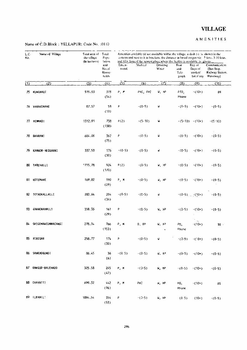
VILLAGE
AMENITIES Name of C.D.Block : YELLAPUR; Code No. :0110
L.C Name of Village Total ar~a of Towl Atlleniti~s a""ilank (ifllot availanl~ within th~ villag~. a da,h (-) is shown in th~' No. th~ villag~ P0l'u- "Ollltlll1 and next to it in bra"kets. the distanc~ in broad rang~s viz. -5 kill,. 5-10 kms.
(In hectares) laliol1 and IOi- kills Oflh\! n\.!an:sl [!Ia~~ whl.!p,,: thl.! fa-:ilitJ;' i~ availahk is gi\l\!n!. and Edll,a- Medical Drinking Po,t Day or Communi<ati,lII No.nf tiona I Water and Days of IBus Stop. HOllsl.!- Td~- market! Railway Stati,'n. holds graph hat if any Waterway I
(1) (2) (3) (4) (5) (6) (7) (8) (9) (10)
75 KUNDARGI 515.53 315 P, M P~C, FPC '.I, flP PTO, -( 10+) as (54) Phone
76 VANAKEMANE 87.52 58 P -(0-5) II - (0-5) -(10+) -(0-5) ( 10)
77 HEMMADI 1312.91 738 P(2) -(5-10) II - (5-10) - (10+) -(5 -10) (138)
78 BHARANI 604.06 362 P -(0-5) -(0-5) -(10+) -(0-5) (75)
79 KANNOR -HEGGARN I 337.53 176 - (0-5) -(0-5) II - (0-5) -(10+) -(0-5) (30)
80 TAREHALLI 1715.78 924 P(2) -(0-5) II, HP - (0-5) -(10+) - (0-5) ( 170)
81 KOTEMANE 169.82 190 P, M -(0-5) II, HP - (0-5) -(10+) -(0-5) (29)
82 TOTADKALLALLI 283.64 204 - (0-5) - (0-5) - (0-5), :(10+) - (0-5) (36)
83 KANNENAHALLI 358.35 161 P -(0-5) II, HP - (0-5) -(10+) -(0-5) (29)
84 SHIGEMAUEUMMACHAGI 278.34 766 P, M D, RP II, HP PO, -(10+) 8S
( 153) Phone
85 HIRESAR 258.77 174 p - (0-5) IJ - (0-5) -(10+) -(0-5) (30)
86 SANKADGUND I 86.45 36 -(0-5) - (0-5) II, HP - (0-5) -(10+) -(0-5) (6)
87 KANGOD-aAlEHADD 325.58 245 P, M - (0-5) II, HP - (0-5) -(10+) -(0-5) (47)
88 CHAVATTI 699_:>2 442 P, M PHC W, HP PO, -(10+) as (96) Phone
89 I LEHALLI 1894.54 354 P - (0-5) II, HP - (0-5) -(10+) -(0-5) (53)
296

DIRECTORY
AND LAND USE Namt! of C.D.Block : YELLAPUR; Codt! No.: 0110
Approach Nearest Town. Class of Town Pow~r Land u,~ (ar~a und~r din".:r~nl types orland usc in hectares mundcd to two decimal places) L.C. to village and distance (in Km.) Supply No.
FOf.:st Irrigated Un-irrigated Culturahle Ar.:a not (hy source of irrigation) waste available
(including lor cultivation gauchar and groves)
(11) (12) (13) ( 14) (15) (16) ( 17) (18) (1)
PR YELLAPUR· IV' 28 EA 445.23 Total 45.41 17.67 0.29 6.93 75
Tk 45.41
I(R YElLAPUR· IV' 30 77.41 lotal 8.41 1.33 0.37 76 Tk 8.41
I(R 'MAGOO KPC PROJECT COLONY· 1237.98 lotal 51.00 17.16 6.77 77 VI- 8 lk 51.00
PR MAGOO KPC PROJECT COLONY- 524.84 Total 47.00 28.05 4.17 78 VI- 8 Tk 47.00
KR MAGOO KPC PROJECT COLONY- 283.51 Total 39.73 13.74 0.55 79
VI- 6 Tk 39.73
PR NAGOO KPC PROJECT COLONY- EA 1556.23 Total 110.45 29.00 16.17 3.93 80 VI· 3 Tk 110.45
PR MAGOO KPC PROJECT COLONY- EA 147.88 Total 12.89 7.17 1.88 81 VI· 9 Tk 12.89
KR MAGOO KPC PROJECT COLONY- EA 223.85 Total 41.27 14.43 4.09 82 IV' 12 Tk 41.27
PR MAGOD KPC PROJECT COLONY- EA 291.30 Total 35.21 26.54 5.30 83 VI' 22 Tk 35.21
PR MAGOD KPC PROJECT COLONY- EA 215.92 Total 41.94 7.43 5.74 7.31 84 VI· 21 Tk 41.94
PR MAGOO KPC PROJECT COLONY- EA 192.72 Total 29.11 31.74 5.20 85 VI· 20 Tk 29.11
PR SIRSI· 11- 25 EA 71.33 Total 9.54 4.03 1.55 86 Tk 9.54
KR SIRSI· II· 23 EA 271.10 Total 35.79 12.95 5.74 87 Tk 35.79
PR SIRSI- 11- 22 EA 624.39 Total 44.11 17.83 3.37 9.62 88
Tk 44.11
PR SIRSI- II· 25 1797.77 Total 48.24 16.19 32.34 89 Tk 48.24
c!iN-3Z
297

VILLAGE
AMENITIES Name of C:D.Block : YELLAPUR; Code No. :0110
L.C. Name of Village Tolal area of Totlll AI1l~nili~s availabl.: (if nlll availallie within Ihe viJllIg~. II dash (-) is sh<lwn in the No. the village Popu- ",:o!uInn and nl!xt \0 it ill hrack..:ts. th~ dislan...:1.! in hr(.)ad rang~~ vil.. -.'\ kIn)!;,. 5 .. 10 ktns.
(In hectares) latinll and 10+ km, <If the nearest [!In"e where the fa"iliti' i~ availahle is given), and Educa- Medkal Drinking Post Day Ilr Commllllicalion No,of ti.'na] Wah:r and Days of IlJug Slop. Hnu~\!- Tde· market! Railway Station. hllld~ graph hat ifany Waterwayl
(I) (2) (3) (4) (5) (6) m (8) (9) (10)
90 HI TlAlll 1404.31 766 P, M 0 II, HP PO, -(10+) BS (148) Phone
91 BIDRAllI 355.22 170 P . (0-5) W, OTH . (0,5) ·(10+) 'CO-5) (35)
92 KUSGUll 291.27 364 P, M - (0-5) -(0-5) -(10+) as (60)
93 KUNOUR 209.42 136 P - (0-5) w - (0-5) . (10+) - (0-5)
(24)
94 YEDALLI 88.75 93 -(0-5) -(0-5) w - (0-5) -(10+) • (0- 5)
(14 )
95 TaL GOO 910.69 303 P, M -(0-5) - (0-5) -(10+) as (60)
96 HARIGADDE 716.49 217 - (0-5) -(5010) II -(5-10) -(10+) - (0-5)
(42)
97 MAGOD 2157.57 409 PO) -(0-5) II, HP PTO, -(10+) BS (73) Phone
98 HEGGUMBLI 1135.88 219 P(2), M RP PO, ·(10+) 8S
(39) Phone
99 HOLEMADU 85.81 88 - (0-5) -(10+) -(0-5) -(10+) - (0-5) (17)
100 OEVARGAODE 531.66 304 P -(10+) - (0-5) - (10+) BS (48)
101 SULGAR 216.65 137 P, M, AC -(0'5) - (0-5) - (10+) BS (21)
102 HULGAO~ 391.34 132 -(0'5) -(10+) II - (0-5) -(10+) - (0-5)
(22)
103 ANAL GAR 76.41 84 -(0-5) -(10+) - (0-5) - (10+) BS (14)
104 BALEKANI 411.90 186 P -(10+) II, HP -(0-5) . (10+) - (0-5) (32)
298

DIRECTORY
AND LAND USE
Namt: of C.D.Block : YELLAPUR; CoJt: No.: 0110
Approach Nearest Town.'Class of Town Pow~r Land use (aron under diffor~nt types of land IISC in heclar"s munded to two docimal plaeos) L.C to village and distance (in Km.) Supply No.
Fur~st Irrigated U n-irrigal..:d Culturahk Area nut (hy sOllr~~ of irrigation) wasI~ available
(including for cultivation gauchar and grL)v~s)
~ 1 1 ~ ~ 12~ P3l ~14~ ilSl ~ 16~ (17) (18) ( 1)
PR SIRSI- t 1- 29 EA 1290.83 Total 66.28 43.26 3.94 90 Tk 66.28
PR MACOD KPC PROJECT COLONY· 277 .62 Total 45.78 28.96 2.86 91 VI- 18 Tk 45.78
PR MAGOD kPC PROJECT COLONY' EA 219.18 Total 22.50 11.82 13.10 24.67 92 VI- 17 Tk 22.50
KR MAGOO KPC PROJECT COLONY' fA 160.28 Total 34.64 11.14 2.59 0.77 93 VI- 17 Tk 34.64
KR MAGOO KPC PROJECT COLONY' 58.92 Total 15.79 3.82 0.36 9.86 94 VI- 19 Tk 15.79
PR MAGOD KPC PROJECT COLONY' 800.64 Total 73.17 30.70 6.18 95 VI- 19 Tk 73.17
PR MAGOO KPC PROJECT COLONY- 662.06 Total 36.72 8.85 8.86 96 VI- 21 Tk 36.72
PR MAGao KPC PROJECT COLONY· EA 2011.87 89.18 121.60 97 VI- 1
PR MAGao KPC PROJECT COLONY· EA 1072.69 54.64 8.55 98 VI- 14
KR MAGao KPC PROJECT COLONY· 69.51 15.20 1.10 99 VI- 3
PR MAGao KPC PROJECT COLONY' 479.55 50.39 1.72 100 VI- 4
KR MAGao KPC PROJECT COLONY- 182.36 32.59 1. 70 101 VI- 12
KR MAGao KPC PROJECT COLONY- 360.19 30.46 0.69 102 VI- 13
KR MAGao KPC PROJECT COLONY' 62.74 13.36 0.31 103 VI- 11
KR MAGao KPC PROJECT COLONY' 351.97 58.47 1.46 104 VI- 10
299

VILLAGE
Name of C.D.Block : YELLAPUR; Code No. :0110 AMENITIES
L.C. Name of Village Total area of Total Ameniti~s availahl~ {ifnnt availahk within tho vill.go. a dash (-) is .hown in th~ No. the village Popu- ~llilimn and n~xt to it in bra"k~ts. th~ distance in broad ranges viz. -5 kms. 5-10 "lOS. (In hectares) lalion and 10+ kInS ofthl! n\!arl.!!:Ot ~lacl.! wh'O!r~ the I:l~ilitv i!-' availahk is givCfll'
and Edu"a- Modi"al Drinking Post Day or C()I1nnUnlcalion No.of lional Waler and Days of IBus SlOp. HO\H.c- Tde- mark",! Railway Station. holds graph hal if any Walaway!
~ 11 m ~31 ~41 ~51 ~6l m (8) (9) PO)
105 HASTAKARGADDE 144.94 62 -(0-5) -(5-10) II -(0-5) -(5-10) -(0-5) (9)
106 SHIGEPAL 28.54 42 -(0-5) -(5-10) II -(0-5) -(0-5) - (5-10) (6)
107 KAIIOIKERI 147.41 147 -(0-5) -(5-10) II -(0-5) '(5-10) BS (31)
108 NANDOlL! 475.62 459 P, M, AC RP II, TK PO, -(5-10) as (90) Phone
109 BElKHANDA 370.37 219 P - (5-10) II -(0'5) - (5-10) BS (36)
110 CHANDGUlI 3331.40 1179 p -(5-10) II PO . (5-10) BS (221)
III MAlAlGAON 784.61 138 P, M - (5-10) II, HP -(5-10) -(5-10) BS (26)
112 HUTHKHAND 2480.11 983 P(3), M - (5-10) 101, HP PO - (5-10) BS (176)
113 SOMANAllI 1508.21 288 P(2) -(5-10) II -(5-10) -(10+) - (5-10) (53)
114 KAlSOOR 1345.60 266 P -(10+) II, HP -(0-5) - (10+) -(0-5) (46)
115 HEGGAPUR 280.33 64 -(0-5) -(10+) 1.1, HP -(5-10) -(10+) -(0-5) (11 )
116 . MADNUR 7585.04 2946 P(10), M -(10+) II, HP PO -(10+) ElS (570)
117 K1RIIATTl 3324.47 3553 P(4), M, H PHC, FPC II, HP PTO, SUN BS (696) Phone
118 KANCHANAHAlll 7463.45 1564 P(3) -(0-5) II, HP - (0-5) -(10+) -(0-5) (256)
119 HOSAlLl 1387.34 1471 P(2) -(0-5) II, HP -(0-5) - (0-5) BS (266)
300

DIRECTORY
AND LA N D USE Nalllt: ofC.D.Block: YELLAPUR; Code No.: 0110
Approach Near~sl Town, Class of Town Powl!r Land us~ (ar~a IlJld~r difl~r~nt IYP~' of land u~ in h~ct"r~s rnuJld~d In two d~cilnal pia",",.) L.C. 10 villag~ and distance (in Ktn.) Supply --._<--- --------- No.
For~sl Jrrigal~d Un~irrjgah!d Clllturabl~ Ar~8- not
(hy [<O(_lUn;\! of irrigatinn) waSh: availabk (induding t(>r ~ultivalinn gau~har and gnw\!s)
(1 1) (12) (13) <14 ) < 15) (16) (17) (18) ( 1 )
KR YELLAPUR· IV' 8 131.17 12.69 1.08 105
ICR YELlAPUR~ IV' 6 23.94 4.0 0.17 106
PR YELlAPUR· IV· 6 EA 125.61 Total 17.57 2.06 1.74 0.43 107 Tk 17.57
PR MACOO KPC PROJECT COLONY· EA 402.77 65.44 7.41 108 VI' 8
KR MAGOO KPC PROJECT COLONY' 320.10 48.82 1.45 109 VI- 4
PR MACOD KPC PROJECT COLONY· EA 2998.01 Total 201. 03 102.69 24.00 5.67 110 VI· 6 Tk 201. 03
PR MACOO KPC PROJECT COLONY· 715.06 Total 25.31 28.22 15.34 0.68 111 VI· 8 Tk 25.31
PR YELLAPUR· IV· 7 EA 2049.78 Total 133.61 37.96 15.36 243.40 112 Tk 133.61
KR YElLAPUR' IV· 27 1443.91 Total 32.39 11.83 2.70 17.38 113 Tk 32.39
KR YELLAPUR· IV' 18 1283.06 31.55 30.99 Ill,
KR YELLAPUR- IV' 18 242.46 37.87 115
PR YELLAPUR- IV· 18 EA 7116.61 398.07 70.36 116
PR 'fELLAPUR' IV· 18 EA 3060.24 209.16 5;.0'7 117
KR YELLAPUR- IV· 20 EA 7160.87 182.10 120.48 118
PR YElLAPUR' IV· 23 fA 1319.53 28.76 20.62 18.43 119
301

VILLAGE
AMENITIES NalOeofC.D.Block: YELLAPUR; Code No. :0110
L.C. Nam~ of Villag~ To!.al art!8 of Total AllI~niti~" availahle (if not aV8ilahl~ within the village. a dash (-) is shown in the No. the village Popu- column and next to it in hrackets. the distan .. " in hruad ranges viz. -5 kms. 5-10 kms.
(In hectares) lotion and 10+ kttls oflhe nearest I!la,e where the ti"ilitr is availah!.: is giwn). and Ed"c.- Medic,,1 Drinking Post ' Day or COinmunication No.of tinnal Water and Days of IBus Stop. HOllsc- Telc· I'narket! Railway Station holds graph hat if any Waterway]
(1) (2) (3) (4) (5) (6) (7) (8) (9) (10)
120 BANKASALI 1468.47 11 - (0-5) -(10+) 1.1, HP -(0-5) -( 10+) - (0-5)
(2)
121 BENDIGERI 553.51 38 -(0-5) - (10+) - (5-10) -( 10+) - (0-5)
(9)
122 BHOMNALLi 319.37 81 - (0-5) - (10+) 1.1, HP - (5-10) - (10+) -(0-5)
(15 )
123 GAD I JOGADMANE 457.45 16 - (0-5) - (10+) - (5-10) -(10+) -(0-5)
(5)
124 PURATBHOMNALLI . 569.81 25 -(0-5) -(5-10) 1.1, HP -(0-5) -(10+) BS
(7)
125 BILKI 1517.95 281 P -(5-10) 1.1, HP - (0-5) -(10+) BS
(43)
126 KERE HOSALLI 664.48 217 P - (5-10) 1.1, HP -(5-10) -(10+) - (5- 10)
(44)
127 CHIKKOTTI 1030.55 324 P - (0-5) 1.1, HP -(0-5) -(10+) -(0-5) (61)
Tetal (Sum) 123585.18 50902 P( 129), PHC(8) ,
(9506) M(42) • 0(2),
H(7), PUC, FPC(4),
AC(3) RP(S)
302

DIRECTORY
AND LAND USE Name of C.D.Bh:k : YELLAPUR; Code No.: 0110
Approach " N~ar~sl Town. Class of Town P"w~r Land us~ '(arca umkr difl"rcnllyp~> "fland usc in hectar~> rounded to two decimal places) L,C, 10 village and distance (in Km.) Supply No,
Forest irrigal\!d Un~irrigat\:d Cuhurahlc Area not (hy SOllTce of ilTigation) wasl~ available
(including for cultivation gauchar and grovl.!s)
( 11) (12) (13) ( 14) (15) ( 16) (17) (18) (12
I(R YELLAPUR- IV- ?O 1418.64 13.30 36.53 120
KR YELLAPUR- IV- 30 514.78 Total 13.76 4.05 20.92 121 fL' 13.76
KR YELLAPUR- IV- 22 287.70 Total 12.55 4.35 5.76 9.01 122 Tk 12.55
KR YELlAPUR- IV- 29 446.85 10.60 123
Pil YELLAPUR- IV- 22 555.95 Total 2.67 11.19 124 fk 2.67
PR YEUAPUR- IV- 22 1448.59 Total 44.17 12.14 13.05 125 Tk 44.17
KR Y'ELLAPUR- IV- 27 586.55 Total 40.62 11.33 1.11 24.87 126 Tk 40.62
KR YELLAPUR- IV- 19 919.81 Total 66.51 8.09 9.79 26.35 127 Tk 66.51
113108.43 Total 2139.97 6132.97 ' 209.95 2058.94 Tk 2129.25 GC 10.72
303


APPENDICES

APPENDIX-I -
C'.D,BLOCK/TALUKWISE ABSTRACT OF EDLJC:\TIONAL,
Sl. Name of Taluk/C,D.Block EdUl;:at i ona l No.
Primary School Middle School Matriculationt Secondary School
Villages Institu- Villages Institu- Vi llages Institu-tions tions tions
2 3 4 5 6 7 8
ANKOlA 70 123 39 44 10 11
2 BHATKAl 37 97 21 35 4 5
3 HAUYAl 73 90 17 19 4 4
4 HONAVAR 84 189 44 68 16 16
5 KARWAR 50 147 36 63 19 22
6 KUMTA 95 171 51 72 19 21
7 HUNDGOD 64 101 21 32 5 6
8 SIDDAPUR 141 189 78 87 16 17
9 SIRSI 182 208 81 87 14 15
10 SUPA 76 124 16 21 5 5
11 YELLAPUR 88 129 38 42 7 7
DISTRICT 960 1568 442 570 119 129
306

·VILLAGE DIRECTORY
MEDICAL AND OTHER A~lE\ITILS
Educational (concld.)· Sl. No.
Higher Secondary/ College (Graduate Adult literacy Others Villages with PUC/Intermediate/ and above) Class/Centres no educational Junior College faci l iti es
vi llages Institu- Villag~s Institu- . vi llages Institu- Villages Institu-tions , tions tions tions
9 10 11 12 13 14 15 16 17
0 0 0 0 0 0 14
0 0 7 7 0 0 23 2
0 0 0 0 0 0 0 0 39 3
14 4 0 0 0 0 0 0 8 4 !
4 4 0 0 2 2 5 5
2 2 0 0 0 0 0 0 18 6
0 0 0 0 20 7
3 3 0 0 0 0 58 8
0 0 0 0 0 0 40 9
0 0 Q 0 0 0 0 0 40 10
0 0 3 3 0' 0 39 11
18 18 3 3 10 10 2 2 304
307

APPENDIX-I
C.D.BLOCK/TALUKWISE ABSTRACT OF EDUCATIONAL,
Sl. Name of Taluk/C.D.Block Medical No.
Dispensary Hospital Maternity & Child Primary Health Welfare Centre/ Centre/Primary Maternity Home/ Health Unit Chi ld WeI fare Centre
Vi llages Institu' Vi llages Institu- Villages Institu- Villages Institu-tions tions tions tions
2 18 19 20 21 22 23 24 25
ANKOLA 0 0 0 0 0 0 4 4
Z BHATKAL 0 0 0 0 0 0 4 4
3 HALIYAL 0 0 0 0 4 It
4 HONAVAR 0 0 0 0 a 0 9 9
5 KARWAR 0 0 10 10
6 KUMTA 0 0 0 0 5 5
7 MUNOGOO 0 0 0 0 0 0 4 4
8 SIODAPUR 0 0 0 0 5 5
9 SIRSI 0 0 0 0 8 8
10 SUPA 2 2 0 0 0 ·0 6 6
11 YELLAPUR 2 2 0 a a a 8 8
DISTRICT 8 8 67 67
308

VILLAGE DIRECTORY
i.1EDlCAL AND OTHER AMENITIES
Medi~al (concld.) 51. No.
Famity Planning Health Centre Community Health Others Vi llages Centre Yorkers with no
medical facilities
Vi llages lnsti tu' Vi II ages lnstitu- Villages Nunber Villages Institu-tions tions tions
\ 26 27 28 29 30 31 32 33 34
4 4 0 0 0 0 6 6 76
3 3 ·0 0 0 0 2 2 55 2
¥+ 4 0 0 0 0 4 4 105 3
6 6 0 0 0 0 21 21 63 4
5 5 0 0 0 0 8 16 38 5
5 5 0 0 0 0 20 20 90 6
3 3 0 0 0 0 2 2 78 7
4 4 0 0 0 0 6 6 188 8
6 6 0 0 15 15 200 9
3 3 0 0 0 0 3 3 107 10
4 4 0 0 0 0 5 5 114 11
47 47 0 0 92 100 1114
309

APPENDIX -I -
C.D.HLOCK/TAUJKWISE ABSTRACT OF EDUCATIONAL.
SI. Name of Taluk/ DriilkTng lJater-. -.------------------------No_ C.D.Block
Tap Well Tank Tube Well River Fountain Canal Others Mor:e than \ Vi llages wi th one source no drinking
water facility of any type
2 35 36 37 38 39 40 41 42 43 44
ANKOLA 13 84 0 0 0 0 0 63 63 0
2 BHATKAL 0 60 0 0 0 0 49 49 0
3 HALIYAl 16 101 4 3 a a 104 100 0
4 HONAVAR 91 0 0 4 0 0 50 54 0
5 KARWAR 16 55 0 a 2 0 0 22 34 0
6 KUMTA 10 111 0 0 0 0 96 94 0
7 MUNDGOO 9 78 8 0 0 0 78 76 0
8 SIDDAPUR 19 199 0 13 4 0 0 159 191 0
9 SIRSI 5 221 0 206 0 0 3 209 0
10 SUPA 7 107 0 0 0 77 76 4
11 YELLAPUR 0 127 3 0 10 0 0 59 7,1 0
DISTRICT 96 1234 9 229 26 0 0 760 1017 4
APPENDIX-II -
l.AND UTILISATION DATA IN RESPECT OF
51. Warne of Town and Taluk Land Use (i.e., area under diHerent types of land use No. (within brackets)
Total Area (Hcct3res 0.00) Forest Irrigated by source
2 3 4 5
1. Ambikanagar (Hal iyal) Data not available
2. Binaga (Karwar) Data not available
3. C,aneshgudi (Supa) Data not avai lable
4. Kadra KPC Project (Karwar) Data not available
5. Magod (Yellapur) Data not avai lable
310

VlLLAGE DIRECTORY
MEOICAL AND OTHER AMENITIES ,r
Post & Telegraph
PJO. P. T .0. P.O. & P.T.O.& Phone Bus Stpp Railway Navigable Phone Phone Station Water WHy
45 46 47 48 4':;---SO-----5-1 -
22
2
12
16
19
11
11
26
48
11
195
o
a '0 \
o
o
o
o
o
o
o
2 8
6 9
6 9
5, 25
o 12
7 23
2 7
16 9
14 9
o 5
10 9
68 125
VILLAGE DIRECTORY
51
o 21
o 61
o 91
o 42
3
o 37
o 117
135
33
o 56
6 727
NON-MUNICIPAL:. TOWNS (CENSUS TOWNS)
in hectares rounded upto two decimal places)
o
o
2
o
o
o
o
o
o
o
3
52
o
o
o
6
o
17
o
o
o
o
o
23
No. Available Not avai
lable
53
84
59
109
76
32
86
57
113
164
32
50
862
54
o
2
3 3
16 4
23 5
27 6
27 7
86 8
58 9
84 10
77 11
402
Name of Town and Taluk (within brackets)
Sl. No.
Un-irrigated Culturable waste (including gauchar- Area not available and groves) for cultivation
6 7 8 2
Data not available Ambikanagar (Haliyal) 1.
Data not available ijinaga (Karwar) 2.
Data not avai lable Ganeshgudi (Supa) 3.
Data not available Kadra KPC Project (Karwar) 4.
Data not available _Magod (Yellapur) 5.
311

APPENDIX-III - VILLAGE DIRECTORY
LIST OF VILLAGES WHERE NO AMENITIES EXCEPT DRINKING WATER ARE AVAILABLE
Name of TaLuk/C.D.BLock SL.No. Name of ViLLage L.C. No.
2 3 4
BHATKAL BAST! GALMI GTE (KOPPA ) 9
HALIYAL 1 MUNDKI 15 2 JATGE 33 3 ARSHINGERI 64
KARWAR KAMARGAOH 31
KUMTA 1 MAN I KATTA 2 2 YEDTARE 17 3 ALGAR 73
MUNDCOO 1 KUNDARGI 5 2 TEGINKOPPA 27 3 BALEHALL I (F) 30, 4 BOKANGUDDE $5 5 HALHARVI 63 6 HOSTOT 65 7 ATABAIL (F) 70 8 AHATGAR (F) 72 9 VIRAPUR (F) 73
10 DOODAHARVAlLI 76 11 CHALGERI (F) 79 12 GHANADAHALll (F) '81 13 TATTIHALll (F)-KATUR 82 14 HUll HONDA (F) 92
SIDDAPUR 1 DUGDIKOPPA 8 2 HEGGADDE 24 3 NAlIGAR 31 4 BANOISAR 34 5 UPPADAKI 35 6 TUMARGOO 41 7 MATTIGAR 63 8 MASALEMARKI 74 9 TAlEKERI 80
10 NIRGOO 82 11 KADVAOI' 9r 12 NAIGAR 94 13 HONNEt<OMB 102 14 HAlEGOIJRI 125 15 HOSKOPPA 135 16 GHATTIKAI 13'8 17 SURGIKOPPA 149, 18 HANGARKHAND 153 19 MAlOBALAGAR 155 20 BIDARMANE 176 21 HALE HAllA 187 22 TANDAGUNDI 189 23 HUTAGAR 190 24 NANDYANE 193 25 MULGUNDA 197 26 KELAGIN SARAKUll 201
SIRSI 1 NURKAlAKOPPA 16 2 BUGADI 70 3 KAllALLI 76 4 JADDIGADDE 83
312

APPENDIX-Ill - VILLAGE DIRECTORY
LIST OF VILLAGES WHERE NO AMENITIES EXCEPT DRINKING WATER ARE AVAILABLE
Name of Taluk/C.D.Block , SloNo. Name of Vi t lage. L.C. No.
2 3 4
SIRSl (Concld. ) 5 HAlLUSARGl 96 6 BAlEKAIMANE 147 7 CHICKDUGLl 159 8 MUNDGEHALlI 172 9 KOGOO 174
lD GONGATTA 1'94 ,". MUOEBAIl 204 '12 WADGERI 205 13 KOTEKOPPA 208 14 KYADGIKOPPA 219 15 MUGILKOPPA 224
SUPA 1 BAMMAIJADl 4 2 VELIEFKUMBELI 7 3 KASARWAOl 12 4 DURGl 13 5 DONSHET 16 6 PUSHElI 18 7 BADGUND 20-8 AMARDE 28 9 AMAGAON 33
10 VARANDE 44 11 KATEl 47 12 CHAPAKHAND 54 13 NAGAR I 55 14 KUMBHELI 57 15 TINAIKHANO 58 16 SHEVAlI 65 17 CHAFER 67 18 BHEDASGADDE 68_ 19 VADKAl 69 20 NETURGE 72 21 KOTHALLI 74 22 RANGARUK 91 23 VARLEIJADI 92 24 KUNAGINI 94 25 DURG 98 26 KASARlE 105 27 AVEDAPOPAlAIJADl 110 28 SHlRAGURE 113 29 VIRAL 115 30 PISOSE 116 31 VlRANJOl 122
YEllAPUR 1 JOGAlEPAl 17 2 KANUR 23 3 TARGAR 29 4 lINGADBAll 33 5 GOTGULI 44 6 VATGERl 56 7 MUDANGI 57 8 HITLASAR 58 9 HAL GOD 59
10 DEVARKALLAHALLI 61 11 HUNSEMANE 64 12 HUllARMANE 66 13 HASAlMANE 71
313

APPENDIX-IV(A) - VILLAGE DIRECTORY
LIST OF VILLAGES ACCORDING TO PROPORTION 'OF SCHEDULED CASTES TO TOTAL POPULATION BY RANGES
Range of L.C. Name of village L.C. Name df village L.C. Name of vi llage Scheduled No. No. No. Castes Population (Percentages)
. 1 2 3 4 5 6 7
C.O.BLOCK ANKOLA
o . 5 6 KAVALALLI 9 SUNKSAL 10 KOOLAGAOOE 13 KALLESHWAR 15 HALVALLI 17 AGSUR 18 AOLUR 21 LAXMESHIIAR 23 ULIIARE 28 SHIRUR 47 BHASGOO 50 BOBRUWAOA 51 TENKANKERI 61 HEGRE 62 AD I GONE 63 MANJAGUNI 64 HONNEBAIL 67 BELEKERI 69 HARIIADA 80 HATTIKERI 86 BHAVIKERI
6 . 10 1 HOSGADOE 7 HEBBUL 29 $ELSE 34 GUNDABALA 35 HILLUR 43 KAREBAIL 60 AGRAGONE 68 AVERSA 70 SAKALBEN
11 . 15 19 BOLE 22 BALALE 27 SAGADG~RI 32 VASARKUORIGE 38 ACHAVE 56 KANAGll 57 HICHKAO 84 SHIRKULI
16 - 20 36 KUNTGANI 45 MOGTA 54 SHETGERI 85 ALGERI
21 - 30 20 VANDIGE 53 SURVE
31 + 55 KOGRE 83 BALEGULI
C.D.BLOCK BHATKAL
o . 5 2 JOLI 5 BELALKHANDA 6 KOTKHANOA 7 KITRE 13 HALLYANI 27 HAOHIN
33 TALAN 34 MARUKERI 35 , HADVALL I 46 PURVARGA 49 MUTTALLI 50 . -HAOTl 52 KONAR 55 MUOBHATKAL 56 MAVALLl 58 KOPPA
6 . 10 4 VENKATAPUR 24 NUZ 57 BAILUR
11 . 15 12 HASARVALLI 60 BENGRE 61 KA'IKJNI
16 . 20 32 TALGOO 59 SHIRALI
21 - 30 3 HEBLE 29 MUNDALLI 30 MAVINKURVE
31 + 25 BELKE 26 GORTE 31 KARIKAL 48 BELNI
Note Excludes villages with no Scheduled Castes Population.
314

APPENDlX-I~(A) - VILLAGE D1RECTORY
LIST OF VILLAGES ACCORDING TO PROPORTION OF SCHEDULED 'CASTES TO 'fOTAL POPULATION BY R~NGES
, Range of L.C. ,Name of'vi llage L.C. Name of village L.C. Name of village ( Schedulted No. No. No.
Castes Population (Percentages)
1 2 3 4 5 6 7 1
C.tiiL,OCK HALlYAl
o '- 5 ' 4 HULLATTI 5 TIMMAPUR 7 MANGALWAD I , , 10 HUNSWAD 16 SATtlAlll 17 ARLWAD 20 DUSGI 21 MUTTALMURI 23 TERGAON 24 MAGWAo 30 KAWALWAD 32 BASWALLI 35 JAMGE 36 NAND I GAOOE 38 KHURD KANCHANAHALLI 39 MUGADKOP 40 MALWAOI 41 CH[BBAlGER[ 42 KHAMDOlLi 43 ALOLLI 44 TEGNALLI 47 GOLEHALLI 48 NAGSHETTIKOP 49 JOGANlCOP 51 TATWANI 55 SAMBRANI 61 KUMBARKOP 67 DOOKOP 74 NILWANI 82 GAROOLll
100 KEGoAL 110 BAoAlCAMSHIRDA 114 BEOARSHIRGUR 115 VITNAL' 117 GOBRAL. 123 BJDROLLJ 129 NIRALGI 130 JAWALLI 132 AJGAON 133 AlUR
6 10 13 SHINGATGERI 18 HOMNALLI 19 MADNALLI 28 SHIVAPUR 37 BElWATGI 50 8UZRUK KANCHANALLI 54 MUNoWAD 57 KURIGAoDE 58 KESROlLi 65 KALGINKoP 70 TATTIGERI 73 HOSUR 76 GUNoOLU\ 78 KAR IY AMPALI 79 TATGERA 81 AGASALKATTA 91 BOMNALLI 111 KARWAo
113 AMBEWAol 121 RAMAPUR 122 MOOALGERA
11 - 15 6 HAVGI 25 KERWAD 26 MURKWAD 31 HAMPEHALLI 45 ~HANASGERI 56 KARlKATTA 98 BHAGWATI 125 YEDOGA
16 - 20 22 ANTROlU 53 AHMANKOP 75 BUKKANKOP
21 - 30 104 GUTTI 105 KULGI
31 + 29 GULEDKOP 59 HAlSl 66 AJMlNHAl 126 BALOGA
C.o.BLOCK HONAVAR
0-5 5 HADGERI 9 CHANDAVAR 11 HOOKESH I RUR 12 AUNSALLI 14 NILKOO 15 SAlKOO 19 VANDOOR 21 HAVINKURVE 22 HANDAlKURVE 24 AROLL I-MUNDGOO 29 CHIKKANKOO 31 GUNDABALA 37 NAGARABASTIKERI 38 HULEGAR 39 HANEHALll KABBINHAKKAL 53 JALWALLI 55 KHARWA 61 APSARAKONDA 62 KElC;INOOR 63 KASARKOO 65 HOSPATTAN 68 KElGIN-IDGUNJI 69 MELIN-IDGUNJI 70 BAlKUR 72 TAlGOO 77 HINNUR 81 MAGOO 89 -KOT 92 ADUKAl
315

APPENDIX-IV(A) - VILLAGE DIRECTORY
LIST OF VILLAGES ACCORDING TO PROPORTION OF SCHEDULED CASTES TO TOTAL POPULATION BY RANGES
Range of L.C. Name of village L.C. Name of village L.C. Name of village Scheduled No. No. No. Castes Population (Percentages)
2 3 4 5 6 7
C.D.B,lOCK HONAVAR (Concld.)
6 - 10 2 HAlDIPUR 3 NAVllGONE 13 KADlE 16 MUGI,IA 17 HOSAKUlI 28 HAOINBAl 46 HERANGAOI 50 KELGIN-MUDKANI ~2 JAlIiAL-I(ARKI 74 HELIN-MANNIGE
11 - 15 6 KAOTOKA 7 KEKKAR 20 KARK.! 41 HADGERI 44 KUDRIGE 49 MELlNHUOKANl 59 HANKI 87 HERAll
16 - 20 NIL
21 - 30 93 DOSSDO
31 + 47 ADKAR
C.D.BLOCK KARIoIAR
o - 5 2 TOOUR 3 AMDALU 5 CHENDIYE 6 ARCA 10 SAV~NTIoIADA 11 MADHEIoIAOA
12 KANASGIRI 13 CHITAKUlA 14 MAJIILI 15 AHGADI 16 MUDGERI 17 ARAV 28 ULGA 29 BHAIRE 33 GOTEGALI -34 KADRA 37 KAIGA 40 VIRJE 41 MAllAPUR 42 KERIoIADI 44 KATAR 45 KINNAR 48 DEVAlMAKKI 51 NAGEKOVE 55 SHIRIoIAD 56 MAKHERI
6 - 10 18 KOlGA 22 HANKON 30 GOYAR 35 BAlEMANE 36 DEVAKAR 38 HAnU~A 46 IoIAlllolADA
11 - 15 57 KAOIolAO
16 - 20 NIL
21 30 NIL
31 + Nil
C.D.BLOCK KUMTA
0-5 1 CHITRAGI 4 KALSHAG 5 HOlANAGADDE 6 GUD£ANGADI 8 HUBBANGERI 9 KAGAL
10 AGHANASHINI 15 NAGUR 19 SANDOLLI-MUTTOLll 20 YAN 26 SHIRGUNJI 27 SANTURE 33 ANTRAVAlll 35 DIVGI 49 BARGI
316

APPENDIX-IV(A) - VILLAGE DIRECTORY
LIST OF VILLAGES ACCORDING TO PROPORTiON OF SCHEDULED CASTES TO lfOTAL POPULATION BY RANGES
Range of L.C. Name of vi! lage L.C. Name of village l.C. Name of village Scheduled No. No. No. Castes Population (Percentages)
,1 2 3 4 5 6 7
C.D.BLOCK KUMTA (.Col"lcld.)
0-5 51 KOOKANI . 52 Yf\TTINABAIL 55 ALVALLI (Concid.> 58 KARKIMAKKI 59 KAllABBE 61 KAHDVAlll
62 KAVA LAD 1 70 SOPP I NAHOSAlll 74 BASOLL! 79 SANTEGULl 81 BASTlKERI 83 o I VALLI 8f+ SANTGAL 93 TALGo{) 99 GOKARN
100. BIDRAGERI 113 BIIAVIKODlA 114 NADUMASKERI 115 HARUMASKERI 116 BANKIKODLA 117 HOSKERl 118 KAOIME
6 - 10 11 MIRJAN 16 '((LVALL! 22 HARlTA 53 KUJALLI 57 MUROOR 63 KANAKALE 71 MEDINl 86 HOLEGADDE 87 DEVGIRI 88 MATH 97 .KALKERI 107 MAD ANGER I
11 - 15 3 HALKAR 29 UPPINAPATTAN 31 ALKOO 32 NILKOO 36 HEGDE 48 KURIGADDE 91 KADEKOOI 95 KONALL!
16 - 20 7 BAAD 94 URKERI 96 VAlGALlI 109 HlREGUTTI 119 HANEHAlL!
21 - 30 89 HARNIR "1 MORBA
31 + 23 ANEGUNDI 69 NORSE 92 HANDIGONE 101 NAGERBAIL
C.D.BLOCK MtiNDGOO
0-5 "7 KALAGANAKOPPA 16 HIREHALlI 17 . KAVALKOPPA 18 ANDALGI 19 KALKERI 32 GUNJAVATl 33 YEREBAIL 37 HUNGUNDA 41 TATTI HALLI (MUNDGOO) 42 . PALA 45 KALKOPPA 54 KVADCIKOP 61 KODAMB! (F) 62 KURL! 66 UMACHAGI 78 CHIlGERI 79 CHALGERI (F) 80 CHIPAGERI 89 MARGADI 90 ORALGI
6 . 10 8 MALAVALLI 9 LAKKOLlI 12 SANAVALL! 15 CH I GALLI 21 BASAVANKOPPA 22 MAINALLl 24 CHAVADALLl 29 KUSUR 30 BALEHALLI (F) 31 UGGINKERI 34 HULIHONDA 52 JANGERI 56 HOSKOPPA 64 BALEKOPPA 68 BEDSGAON 85 KATUR 86 MUOSALI
11 - 15 13 BAPPALGUNDI 35 NAND I KATTA 3~ INDOOR 40 KOP-INDOOR 47 KOP-GOTGUDI 49 KOLGI 59 SIODAPUR
317

APPENDIX-IV(A) - VILLAGE DIRECTORY
LlST OF VILLAGES ACCORDING TO PROPORTION OF SCHEDULED CASTES TO TOTAL POPULATION BY RANGES
Range of l.C. Name of vi llage L.C. Name of village L.C. Name of village Scheduled No. No. No. Castes Population
. (Percentages)
2 3 4 6 7
C.D.BLOCK MUNDGOO (Concld. )
16 - 20 1 MUNOAGOO 3 BACH'ANKI 4 NYASARGI II AJJIHALLl 44 BHAORAPURA 50 HARAGANAHALLI 74 RAMAPUR 87 ALALLI 91 SHINGANAliALLI
21 . 30 6 MALAGANAKOPPA 10 SALGAON 25 KYSANKERI 28 KARGOLL! 48 MALGI 51 VEERAPUR i
31 + 5 KUNOARGI 26 TAMYANKOPPA 27 TEGINKOPPA 36 AGADI 38 WADAGATTA 58 NAGINKERI' 7S AHANGI 76 OOOOAHARVALLI 84 NAGNOOR !
C.D.BLOCK SIDOAPUR
0-5 13 HANJIBAIL 14 HOSUR 17 BEOKANI 21 BHANKULI 28 KAVALKOPPA 33 GOLGOD 39 MANOLIKOPPA 43 AIGOD 50 BALIKOPPA 53 MALAVAJAPPI 56 MALAVALLI 57 HEGGEKOPPA 60 HASVANTE 78 WAJAGOO 94 NAIGAR
105 OJ AGAR 106 SOVINKOPPA 108 TARKHANDI\ 109 KAnEKAI 111 HOSMANJU 115 NIRGAR 119 AlAVALL! 122 UMBALMANE 131 YELUGAR 134 KALKATTE HUNASEKOPPA 136 TAREHALLI-KANSUR 141 SHElUR 146 KOOGADDE 159 MATTIHALLI 160 SAMPAGOO 161 KOOSAR 163 HUT AGAR 170 SHAMEMANE 171 KARJAGI 179 BALEKOPPA 183 HOSTQTA 188 HANOIYANE14ATH 195 HULLUNDE 196 NIRGAN 199 it;ANCHlKAI 200 MANIGAR
6 - 10 1 KONOLl 3 SHIRALGI 6 MUGDUR 19 GUNJAGOO 25 BIDARKAN 42 NIOGOO 44 KANGOO 47 KASTUR 49 AVARGUPPA 55 MUSVALLI 62 HUSUR 76 KELGINMANE 79 DANMAV 80 TALEKERI B4 KAUNSlE 88 KALKA I 93 KADVADI 96 BEGAR 99 KYADGI 114 BllGI 118 !TAGI
120 CHANDRAGHATGI 126 HASARGOO 128 'ADKALLl 147 KALGADDE 148 MUOHALL! lSI HIREKAI 156 HALKANI 162 BHANDARKERI 165 MUlHALL! 166 HARSHIKATTA 168 HONNEHADDA 174 ATTIMURD 179 ANALEBAIL 178 HEGNUR 186 SHIVAlMANE 194 HEGGARNI
11 - IS 7 KAVANCHUR 16 TYARASHI 66 HALGERI 69 HEMAGAR 75 KEREMANE 81 KOOIGADDE 95 GUBBAGOD 121 KUDAGUND 133 KOOSAR-HALKANI
143 GIRGADDE 169 KARKISAVAl 173 KIBBAlll 192 NIUCUNDA
318

APPENDIX-IV(A)' - VILLAGE DIRECTORY
LIST OF VILLAGES ACCORDING TO PROPORTIOI\i OF SCHEDULED TO TOTAL POPULATION BY RANGES
CASTES
Range of Le. Name of village l.c. Name of vi (( 13ge L.C. Name of vi ((age Scheduled No. o No. No. Castes Population (Percentages)
-----2 3 4 5 6 7
C.D-.BLOCK SIDDAPUR (concld.)
16 - 20 29 GODLABIL 38 ' KUNAJI 45 BALLATTE 98 BALGOO 107 CHAPPARMANE 150 KALENALL!
158 GAVINGUDDE 172 BAlESAR 177 MURUR
21 - 30 9 NEJJUR 48 HALAGADIKOPPA 68 KULIBIO 89 DOOMANE 113 TARGOO 117 SASHIGULI
144 ARE HALLA 152 TYAGAlI
31 + 'I
40 HEGGOOMANE 41 :4 BALEKOPPA TUMARGOO 85 KUDEGOO 116 HuVlNMANE 184 UNCHALLJ
C.O.BLOCK SIRSI
o - 5 4 CHIPGI 6 GOUDALL! 9 BOPPANAlLI 11 HEBBALLI 14 DOODANALLI 16 NURKALAKOPPA 17 HUSRJ 19 TERKANHALLl 22 KULVE 27 BALGAR 30 KANA GOO 32 PAOAGERI 33 YEDAlLI 35 MUNOGESAR 40 SIRSIMAKKI 43 IfEOGIMANE 46 MANAJWALlI 47 SAMPAKHAND 48 KOOGIBAIL 53 BOPPANALLI 57 NEGGU 63 KONDALGI 64 BAlWAlLl 69 HOSUR 72 HEBRE 76 KALLALLI 77 BENAGAON
.79 MUNDGANAMANE 81 SARGUPPA 82 DEVANALLI 84 ONIGADDE 88 SHIVAGAON 92 KALVE 94 HUNSEKOPPA 95 JANMANE 97 KANALLI 98, HOSTOT 105 HULGOl 107 MALENALLI
"1 SAOASH IVALLI 112 BOMMANALLI '13 AGSAL 115 tlEREPAl 122 BALEGADDE 130 KADBAl 141 ' MUSK I 142 KAKKALLI 144 VANAlll 145 GURVALLI 150 SONGINAMANE 151 KOONAGADOE 153 AUDHAL 154 BAKKAL 160 MUGWALLI 165 GUDNAPUR 175 KALll 181 UNCHALLI 185 KANAKOPPA 190 KANDRAJI 193 BILUR 19"5- KUPPALLl 196 MALALGAON 197 YEKKAMBI 198 ADNAlLl 200 ANGODKOP 202 BISAlKOPPA 207 HALLIKOPPA 219 KYADGIKOPPA 220 MALANJI 221 MARGUNDI 226 MADRALLI 227 KADGOO
6 - 10 3 NAREBAIL 18 BACHGAON 20 KAGERI 21 GADIHALL1 23 BARUR' 24 BISALAKOPPA 38 MASH I GADDE 45 KALGAR 51 HANUMANTI 58 MATT I GAR 59 JANMANE 66 KHURSHI 67 BADGI 74 MANJAGUNI 89 SHIVALLI
104 SONOA 123 -KOPPA 124 HAREHULEKAL 125 KELIGINAONIKERE 127 MELlNAONIKERI 134 KOLIGAR 143 KANAMUSKI 146 MENSHI 147 BALEKAIMANE 171 GOLlK~TTA 173 SAHASRALLI 177 UPLEKOPPA 182 KEREKOPPA 184 HALSINKOPPA 187 MADNAKERI 199 SHIVALLI
319

APPENDIX-IV(A) - VILLAGE DIRECTORY
LIST OF VILLAGES ACCORDING TO PROPORTION OF SCHEDULED CASTES TO TOTAL POPULATION BY RANGES
Range of loC. Nerlle of vi II age L.C. Name of village L .C. Name-of village Scheduled lio. No. No. Castes population (percentages)
2 3 4 5 6 7
C.D.BLOCK SIRSI (Concld.)
11 - 15 10 SANNAKERI 56 NERLAVAlLl 96 HALLUSARGI 99 KAMBIGAR 101 HANCHAlnA 103 MATHADEVAL
110 BH?IRUMBE 116 DASANAGAODE 120 IT GUll 133 TATTI SAR 149 KALGADDE KANCHIGADDE 158 NAJlOOR 162 BHASI .. 188 GONUR 206 BENAG! 209 DA~AGANALLI 213 BADANAGOO
16 - 20 156 BANAVASI 161 KAlKOPPA 166 BE~GlE 189 HALGADDE 191 BANKANAL 205 WAOGERI
21 - 30 8 ISlOOR 12 ACHANAlLI 31 BETKOPPA 108 BElALE 118 HUT GAR 159 CHICKDUGLl . 163 KANTRAJI 179 UMBLEKOPPA 183 KABBE 186 SUGAVI 211 KUPPAGADDE 212 BELLANAKERI 214 KALANGI 222 ANDGI 223 KAlKARDI 225 HADALGI
31 + 157 llGNI 164 AJJARNI 167 GADGERI 203 HUDELKOP 215 IJADOAL 216 SANTOlll 217 I< I RIJA TT I 218 HEBBATTI
C.D.BLOCI< SUPA
o .- 5 26 PRADHANI 27 GAVEGALl 29 SANGAWE 31 PHANSOlI 37 BAPELI 38 PANJf, : 39 NAGODA 45 VAINI 46 KA1Hl 49 CHAPOLI (KALSAI) 53 CHAPALI S6 MUOSA_ 60 AVURLI 62 NAND1GADDE 73 UlVI 75 BIRKHOl 78 ANSHI 82 KALSAI 83 GHOOSHET 84 NUJJI 88 ANHOO 93 DEVULLI (TEloJAJ) 95 KONSHET 101 ASU
118 KUVESHI
6 - 10 3 JAGALBET 6 TIMBOLI 14 SHINGAAGAON 24 VIRAHPALI 30 VIRNOLI 42 ASULLI S2 SAMJOIDA 77 BIDOLI 106 . KAMARE
107. VillJEDABE 115 VIRAL 123 RAMANAGAR
11 - 15 17 USOOA 51 JOIDA 55 NAGAR I 59 GANGODA 89 AKHETI 97 PAYASIJADI
108 IVOLI
16 - 20 43 DIGGI 87 KALAMBULI 117 BAZARKUNANG
21 - 30 34 SHIROLI 41 TERAli
31 + 22 KONDAPE 23 MAVALlNGE
320

APPENDIX-IV(A) - VILLAGE DIRECTORY
l_.IST OF VILLAGES ACCORDING TO PROPORTION OF SCHEDULED CASTES TO TOTAL POPULATION BY RANGES
Range of L.C. Name of village L.C. Name of vi llage L.C. Name of vi llage Scheduled No. No. No. Castes Population ,( Percentages)
2 3 4 5 6 7
C.D.BLOCK YELLAPUR
o - S 1 TATGAR 10 ARBAIL 19 MAVINAMANE 26 BARBALLI 30 VAJRALLI 31 TELANGERI 37 DEHALLI 38 BISGOO 45 LALGULI 47 KOLIKERI 48 KANNADGAL 54 MALKOP 63 HALSINI(OP 69 UCHAGERI 75 KUNDARGI 78 BHARANI 80 TAREHALLI 88 CHAVATTI 89 I LEHALLI 95 TOLGOO 108 NANDOLLI
112 HUTHKHANO 116 MADNUR 126 KEREHOSALLl
{, - 10 7 IDGUNDI 13 GULLAPUR 24 KALCHE 53 AUIAD 62 HASANGI 67 JAKKOLLI 77 HEMMADI 90 HI TlALLI 110 CHANDGULI
117 KIRWATTI 119 HOSALLI
11 - 15 20 BENADGULI 40 GERAL 52 KAMPLI 70 BHARATANALLI 82 TOTADKALLALLI 92 KUSGULI
114 KALSOOR
16 - 20 84 SHIGEMANEUMMACHAGI 111 MALALGAON
21 - 30 87 KANGOO -BALE HADD 115 HEGGAPUR
31 + NIL
321

APPENDIX-IV(B) - VILLAGE DIRECTORY
LIST Of VILLAGES ACCORDING TO PROPORTION Of SCHEDULED TRIBES TO TOTAL POPULATION BY RANGES
Range of L.C. Name of vi llage L.C. Name of village L.C. Name of village Scheduled No. No. No. Tribes PopuLation (Percentages)
2 3 4 S 6 7
C.D.BLOCK ANKOLA
o - 5 17 AGSUR 18 ADlUR 29 BElSE 67 BELEKERI
6 - 15 NIL
16 2S NIL
26 35 NIL
36 50 NIL
51 + NIL
C.D.BLOCK BHATKAl
0-5 4 VENKATAPUR 17 KURANDUR 21 HOJJIL 29 MUNDALLl 39 KULAVADI 46 PURVARGA 49 MUTTALLl 56 MAVALLI 59 SHI RALI 60 BENGRE 61 KAIKINI
6 - 15 2 JOLI 3 HEBLE 5 BELALKHANDA 8 ANTARVALLl 18 ARVAKKI 25 BELKE
32 TALGOO 43 BENANDOOR 45 YELAVADI KAVOOR
16 - 25 12 HASARVALLI 44 GOLIBILUR 52 KONAR 53 HERUR
26 35 10 HUDIL 33 TALAN ~O HADIL
36 - 50 6 KOTKHANDA 19 KERCHITTAL 24 NUZ 35 HADVALLI 38 KUNTVANI 58 KOPPA
51 + 7 KITRE 13 HALLYANI 15 VONIBAGIL 34 MARUKERI 40 BE SHE 41 HADLUR 42 KAGGUNDI 51 BILURMANE
C.D.BLOCK HALlYAL
0-5 7 MANGALI.IAD 17 ARLI.IAD 23 TERGAON 26 MURKI.IAD 37 BE LI.IATGI 38 KHURD KANCHANAHALLI 44 TEGNALLI 51 TATWANI 53 AMMANKOP 70 TATTIGERI 72 ADKEHOSUR 76 GUNDOLLI 79 TATGERA 100 KEGDAL 105 KULGI
113 AMBEWADI
6 - 15 58 KESROLLI
Note : Excludes villages with no Scheduled Tribes Population.
322

APPENDIX-IV(B) - VILLAGE DIRECTORY
LIST OF VILLAGES ACCORDING TO PROPORTION OF SCHEDULED TRIBES TO TOTAL POPULATION BY RANGES
Range of L.C. Name of village L.C. Name of vi llage L.C. Name of vi llage Scheduled No. NO. No. Tribes Population (Percentages)
2 3 4 5 6 7
C.D.BLOCK HALlYAL (Concld. )
16 • 25 NIL
26 - ,35 NIL
36 - 50 NIL
51 + NIL
C.D.BLOCK HONAVAR
o - 5 17 HOSAKULI 38 HULEGAR 44 KUDRIGE 63 KASARKOO
6 . 1S NIL
16 - 25 NIL
26 - 35 NIL
36 - 50 NIL
51 + NIL
C.D.BLOCK : KARIIAR
0-5 13 CHlTAKULA 14 MAJALI 28 ULGA 34 KADRA 38 HARIUGA 40 VIRJE 56 MAKHERI
6 - 15 tHl
16 - 25 NIL
26 - 35 NIL
36 - 50 NIL
51 + NIL
C.D.BLOCK KUMTA
o - 5 79 SANTEGULl B8 MATH
6 - 15 NIL
323

APPENDIX-IV(8) - VILLAGE DIRECTORY
LIST OF VILLAGES ACCORDING TO PROPORTION OF SCHEDULED TRIBES TO TOTAL POPULATION BY RANGES
Range of L.C. Name of village L.C. Name of village L.C. Name of vi llage Scheduled No. No. No. Tribes Population (percentages)
2 3 4 5 6 7
C.D.SLOCK KUKTA (Conctd.)
16 - 25 NIL
26 - 35 NIL
36 - 50 NIL
51 + NIL
C.D.SLOCK MUNDGOO
0-5 1 MUNDAGOO 3 SACHANKI 6 MALAGANAKOPPA 10 SALGAON 12 SANAVALLI 15 CH IGALLI 16 HIREHALLI 19 KALKERI 21 BASAVANKOPPA 24 CHAVADALll 29 KUSUR 32 GUNJAVATl 36 AGADI 39 INDOOR 42 PALA 61 KOOAMBI (F) 74 RAMAPUR 90 ORALGI
6 - 15 NIL
16 - 25 NIL
26 - 35 13 BAPPALGUNDI
36 - 50 NIL
51 + NIL
C.D.BLOCK SIDDAPUR
0-5 1 KONOL! 44 KANGOD 50 BALI KOPPA 95 GUBSAGOO 106 SOVINKOPPA 114 BILGI
160 SAMPAGOO 194 HEGGARNI 196 NIRGAN
6 - 15 NIL
16 - 25 NIL
26 - 35 NIL
36 - 50 NIL
51 + NIL
324

APPENDIX-IV(B) - VILLAGE DIRECTOKY
LIST OF VILLAGES ACCORDING TO PROPORTION OF SCHEDULED TRiBES TO TOTAL POPULATION BY RANGES
Range of L.C. Name of village L.C. Name of vi llage L.C. Name of village Scheduled No. No. No. Tribes Population (Percentages)
2 3 4 5 6 7
C.D.BLOCK SIRSI
0-5 4 CHIPGI 18 BACHGAON 64 BALWALLI 118 HUT GAR 156 BANAVASI 189 HALGADDE 197 YEKKAMBI 213 BADANAGOD 226 MADRALLI
6 - 15 158 NAROOR 83 GONUR
16 - 25 NIL
26 35 161 KALKOPPA
36 50 NIL
51 <- NIL
C.D.BLOCK SUPA
0-5 3 JAGALBET 34 SH I ROll 43 DIGGI 62 NANDIGADDE 80 NIGUNDI 87 KALAMBULI 97 PAYASWADI 123 RAMANAGAR
6 15 22 KONDAPE 41 TERALI 52 SAMJOIDA
16 - 25 53 CHAPALI
26 35 17 USOOA
36 50 NIL
51 + NIL
C.D.BLOCK YELLAPUR
0-5 7 IDGUND 1 10 ARBAIL 24 KALCHE 38 BISGOO 52 KAMPLI 100 DEVARGADDE
117 KIRWATTI
6 15 NIL
16 25 NIL
26 35 NIL
36 . 50 NIL
51 + NIL
325


SECTION-II TOWN DIRECTORY


TOWN DIRECTORY
Explanatory Note
Town Directory eompri:-.es of SIX tabular
statements as applicable to all the towns and an
addition.al ~tatement regarding the slums applicable
only in n;~pect of towns with a popuh(tion of SO,OOO
and above. The six statements arc numbcred serially
from I t() VI and the additional statement hears
the number Iv A in view of the fact that it dl.:ais
with the same· type of information whieh i~ covercd
in Statement IV. The~e statements contain sl'veral
cofumns, each. with a brief heading and for
presL'ntation of thc data, abhn:viati()n~ have also
been made usc of in scn:ral cnlumn:-.. Thl.: title of
each statement, the ~cope of the information
furnishcd under eaeh column therein and Ihe
ahbreviations used, if any. an: indicaled below.
STATEMENT HISTORY
STATLIS ANI) GROWTII
ColullIn 2 : Ciliss. Nmlle and Chic Administration Status or Town
The class to which a town bel()ng~ is dl.:tcrmilll.:d
on the hasis of its poplilal i\Hl al Ihe I ( 1) I ccn~lI~
count and it i~ indicatcd in this col ullin in wman
nUllIerals. The classificalion criterion adopted now
is thl.: same a:-. that adllpted for analysi~ and
explanation al the earlier celbuse~. The Il)wn~ arc
divided into six d;I.' .. 'L'~
(:Ia~s Pllpulalioll Si/L' ( 'Ia~;, ~'Ilpulal ion SilL'
loo,om and abllVe IV 10.000 III (I).')')')
II 50'()()() to 1)').')1)1} V :'i,O()() to 1),1)<)9
III 20.00() to ·N.')I)I) VI Below :i,OOO
For purposes of this dassitiCltion. the lotal
populalion of the town inclusive of the population
of its outgrowth~ if any, i, taken into wnsidnation.
In the case of urban ag_ldollleration:-. whieh have two
or more lJrh,ln UlIl1pllnents (each of which mayor
Illay not be having ()utgrowth~) each such urban
component (indu~ive of its outgrow·ths) is regarded
as a separate Ullil alld the populatioll si/.e das~ is
dell'rmined accordingly. An asterisk Illark placed
at the top right position after the nallle of the lo\vn
illdicatL'~ that Ihis town has OIlC llr more llulgrowth~
and that lhe 1')1)1 cen~u), populatilln and such olher
daw presented againsl it includes the details relating
to the outgrowths as well.
The middle compom:nt of this column heading
refers to name of the town which docs not need
elucidation. Name of the town, as adopted in the
official records, is reported here.
The civic admini~tration status of the town as
on 1.1.1990 is indicated immediately after the naml.:
of the town, within brackets. The abbreviations used
for thi~ purpose arc as follows
Me (,M('
TMC
(,B NA(,
SB
MP NMCT
Municipal C. 'orporal i, In,
CilY Municipal (.\lllllCil,
Town M unil'ipal Council.
Canlonment Board.
NOlified Area (·llllll1lillcc.
Sanilary Board,
Mandai Panchavat.
Non-municipal Census Town.
'Nith a view 10 ensuring the tixity of houndaries
of various administrative units, Ihat is. III cnsurc·
Ihat the frame for n:nsus taking once finalised with
reference to a cut-oil dalc remain~ unchanged till
Ihe completion of the ccmus count, Ihe State
(iovcrnment h;ld heen reque~lLd during t ()~l) itself
nut III urder an~ jurisdiclional changes and not to
!liw clkcl to any changes in the civic administration
status either.
Column -' : Locatiun Cmll' :'\lumber
The location wde numhL'r <I'-.\igned to the town
for purposes of computerisatilln Ill' the 1')1)1 census
data is entered in this culumn.
Column .t : Name or Taluk
In Karnat<lka, the term taluk I~ very much in
vllgue Ih'Hlgh Ihe designation of the RL:venuc
Administratiw Officcr ha:-. fllr long becn changcd
from Amildar or Mamlatdar tn Tahsildar. Th.:
nallle (If the tal uk within Ihe jurisdiction (If which
the town i:-. located i:-. indicated in this column.
There arc a few in~lances wherein a particular town
slraddles pOrlion:-. belonging til two adjacent laluh.
I n such it case the town is considered to belong to
the Taluk that contain~ it major pl)rtion 01 the town.
In thc statcment, such caSe~ are dilTerencialed by
an indcx mark and it note at the hollom of the
page explains th<.: correct situation.
Column 5: Name of Community Uevelopment Block
The name of the Community Dcvclopnwnt Block
within the jurisdiction of which the referent town
is located is indicated in this column. This column
docs not apply tll statutory towns sincl.:, in Karnataka,
all such towns arc outside the jurisdiction of the
Community Development Blocks i.e., the (Taluk
Panchayat Sami(is).
Column 6: Area (Sq.Km)
The geographical area of the town is furnished
here in square kilomdres upto lwo places of lh;cimal.
The figures for the urban areas an.: either those
supplied hy the civic administration authorities of
the towns or compiled and supplied by the Director
of Survcy, Settlemcnt and LlIld Rec()rd~ or compikd
in the Census Directoriltl: 1lJ1 the b""i" of the
available records pcrtaining to thc ddimilation llf
urban units.
Column 7 : Number of Households (1991)
The LOtal number of housdll)lds, including those
consisting of institutional ,1111.1 housclc~s popul"ti()J1,
enumerated in the town at the 199 I ccnsu~ is
reproduced here from the Primary Census Abstract.
The purpose is to facilitate a beller comprehension
of the demographic situation, cSfK:cially wilh
reference to the popUlation data pr<.:sented in this
statement
Columns 8 to 17: Population and Grll\\1h R~lte
of the Town at ditlerent Censuses from 190) to 1991
The population ligUfcs for the town as rclurncd
at the decennial census from 190 I through Il)<) I arc
furnished under these columns in ordl:f to provide
an insight into the history of growth of the town.
If in any particular census year lh<.: rdercnt town
did not enjoy the urban stalus, that is, if that place
was reckoned as a village for that censu!>.. il!-.
population is not reported undcr th\.: column
conccrned and a dash mark is indicated insll:ad.
:no
In olher words, the populalion ligures arc ~Iven
here rllr the town only if il happencd to be an
llrh,lI) arc" al that particular censlIs ycar.
Thus, it glance i1t these c()luml1~ ITVl:ab whelher
thc rcfcrcnt town having been lirst dasi>ified a~
'urban' has maintained thai ~tatus cOlllinuolisly
through Ihc succccding eensuscs or whether there
havc hcen subsequent declassifications. From
column 9 onwards the decadal growth rates for the
town arc indicaled within brackets below the
population ligures in order 10 permit an <.:asicr grasp
of the tkcadal growth In:nds and to facilitate a
comparative analysis. PopUlation variations arc quitc
oi"lcn associated with ch,mgL:~ in the jurisdiction of
the urhan area and sudden spurts arc' sometimcs
due 10 incorporation of fast d\.:vdoping fringc ,Ill:as
10 the town or amalgamation of adjacent towm
within the core town during the inter c<.:nsal period.
Column l~ : Density (1991)
A town may havc om: or more outgrowths which
arc not towns in their own right. In ,slIch " case
Ihc densilY is workl.:d oul for Ihl.: town indu~ivc of
the arca and populatinn of !'Itlch olltgrowth(s).
Columns 19 to 21 : Sex Ratio 1971 to 1991
Sex ratio is expressed as the number of femal~s
for every thousand males <tnt! is based on tb,e scxwisc
distribution of thc population returned al the census.
For each town thcsc ligurcs arc fllrnish<.:d for the
l slln:essive censuses. This information would provide
an insight into thc changing pallcrn of sex r<ltil) III
urban areas.
STATEMENT II : PIIYSICAL ASPECTS ANI) LOCATION OF TOWNS, 19X9
ColulIlll 2 : Class alld Name III' Town
This column is the same as column 2 (If Statement
and docs not nced any cxplanation. Unlikc in
Statement I, here lhc ei\'ie administration status of
Ihe t(lwn is om ill cd.
Columns 3 to 5 : Physical ASl)Ccts
These columns dcal with the rainfall and
temperatllre data. It is common knowledge that
mctcorological obscrvalorics have nol been
cstahlished in each and every town, even though
mo~t of the towns do have rain-gaugcs and duc

arrangements have been made to record the rainfall
data all through the year. The Director qenertil of
Observatories has furnished data on rainfall,
maximum and minimum temperature in n:spect of
towns having observatories. These ligures, arc
averages based on the data for 10 years from 19RO
to 1989, and arc distinguished in the statement hy
placing an asterisk mark at the top light hand side
of the figure. Information on this aspect is available
only for a few towns.
In so for 'l,S the data on rainfall for column }
is concerned, ft)r most of the lowns the particulars
have been supplied by the local officers. The rainfaH
figures arc in millimdrcs and represent the annual
average based on the actual ligures relating to the
preceding ten years i.e., from 1980 to 1l)X1).
In case of non-availability of information, the
particulars relating to the nearest town an: reported
under these columns with the distinguishing notation
N being placed at the right hand side of the ligure.
Column 6 to 12: Name of and Ro .. d Dist .. nce from State H(,.. District Jll,., Sub-Divisionffaluk HlJ •• Nearest City with a popUlation 01' 100,1100 und more; Railway Stution; Bus Route; N.lvigable Rh'er or Canal (it' within 10 kms)
The column head!ngs arc self explanatory and
arc intended to indicate the location of variou~
centres of importance with reference to the rden:nt
town. If the referent town itself happens 10 be
mentioned in these columns the dislanl'c is recorded
as '0' (zero) and in all other eases the road distances
are given in kilometres. In column ~ the name of
the sub-division to which the taluk (in which the
town is located) belongs as well as the name of
the taluk to which the town belongs arc mentioned
along with road distanccs in the .,ame order one
below the other. In column I), the name of the
nearest eity with a popUlation or IOO,noO and more
according to 1991 censu~ and the road di~tance
thereto is mentioned in respect of each and every
town even if the referent town itself has a population
of 100,000 and more. It may be reiterated here
that the 'town' includes its outgrowths as well. For
example, the 1991 population of the area
incorporated in the municipal limits of Hassan is
90,S03. However III places have been recognised
331
as the outgrowths of Hassan. The aggregate
popUlation exceeds one lakh and this urban complex,
instead of Hassan CMC alone, is n,:ckoned as a
Class I town i.c, a city, for purposes of this column.
Though the aggn:gate population of an urban
agglomeration which consists of two or more
independent towns (with or withollt outgrowths)
exceeds one lakh mark it does not automatically
confer the status of a city to any of the constituent
towns. Of course, if any of Ihese constituent towns
(including its outgrowths) has a population of 100,000
or more then, in its own right, the place will enjoy
the status or a city. The K(;F urban agglomeration
IS composed of three separate units VIZ.,
Rohertsonpet, Kolar Gold Fields and BEML Nagar.
The population of these three towns (inclusive of
Outgrowths) aC('ording to 1()()1 census is 6H,230,
72.4?\5. and 1(1,1131 n:spectively. Obviously. none of
the three constituent units qualilies to be reckoned
as a city for purposes of this column.
The.: proximity by road alone is taken into
consideration for lilling up thi~ column and as such
cities belonging to adjacent States also lind an
occasional mention in this column.
Column I() refers to the nearest railway station
and distance thereto by mad. In a few cases, though
the name of the railway station is the same as that
of the rderent town, the.: distance indicated is other
than zero because of the fact that the station is
actually located beyond the jurisdiction of the referent
town.
In case the referent town is enjoying bus route
facility (i.e. mad transpnrt) the name of the town
is mentioned in column 11 and the distance is
recorded as zero. Names of bus routes passing
through or originating from the town arc not
indicated here. If there is a navigable river or a
navigahle canal at a distance of 10 kilometres or
less fmm the rderent town then the name of the
river or the canal is indicated in column 12. To
differentiate between a river and a canal the
abbreviations (R) and (C) arc made usc of and the
di~tance from the town to the navigable waterway
is mentioned thereafter. It may incidentally be stated
that in Karnataka there arc very few navigable rivers
and practically no navigahle canals.

STATEMENT III 19KK-KI.}
1\1lJNICIPAL FINANCE.
As the title denl)h;~. thi~ st,tlemenl deab with
the actual income and expenditure of the l'ivic hody
administering the town. An allempt has been made
to present comparable data in the ea~e (If
non-municipal towns like Panchayats and areas under
the administration of puhlic ~ector undertakings and
the like. The data relate to the linall(ial year
NHS-cS'J and have bet.:n furnished hy the conct.:fl1ed
local authorities on the hasis of the relevant records
relating to JI)~~HN. It may also he staled h\.:re that
no probing enquiries have been made and the
particulars a~ reported by the civic bodies have
been presented here.
Culumn 2 : Class and Name of Town
This is sam\.: as column 2 of Statement II and
as such docs not require any explanation.
Column 3: Civic Administration Status (in 1991)
As explained under column 2 of Statement I,
th\.: civic administration status of the to\ .... n as on
1.1.1)() is indicated in this column using same sd of
abbreviations.
Columns 4 to to : Receipts (in Rs.'OO)
Thc actual rcceipt realised by the CIVIC hody
under various heads of income as well as the total
for the year 19RH·R<J arc indicated in hundred~ in
these columns. The npening balance fur the year
is not taken into account under any or the.,e column!.
including that for the 'tolar.
Columns 11 to 17 : Expenditure (in Rs.'IlO)
The actual expenditure ineurn;d during the year
198R·H9 is furnished here in hundreds. The various
heads of accounts arc grouped into (> broad categories
for each of which a separate column is provided.
Public safety covers the expenses ineurn;d for road
lighting, destruction of rabid and stray dogs. besides
that on fire lighting service. Similarly, 'Public
Institutions' covers not merely the contributions made
by the civic body to educational. medical and cultural
institutions in the town but also the expenditure
incurred for the maintenance of educational and
such other institutions if any functioning under its
direct control.
132
As in Ihe case of rcceipt. ill I hc case of
expenditurc ab(l the c1o~ing halal1u: .It the end of
the year is III It considered. Therdon.:. in almost
all th(._' ca~t:s Ihe <tnllluni ~h(l\\'11 untkr "(olal receipt"
may 110[ [idly wit h the amount SllllW,n under "total
cxpel1ditun:" .
STATEMENT IV AMENITIES, 19M!)
CIVIC ANI) OTHER
Column 2 : Class and Name of Town
This is same <t." column ~ of Statements II and
III and does not need further explanation.
Column 3 : Civic Administratiull St<ltu~
Explanation furni .... hed l'arlier for wlullllJ ::' Ill'
Statement I and clliullln -' lit StatLlllent III h()ld~
good for this ~talcment abo.
ColuJlln ~ : Population
The total population of the town (indusive of
the Ilutgwwths if any) according to I'Nl eLnsus i~ ~ • c
mentioned here with a view to facilitat<.: a comparative
analysis of lhe data.
Column 5 : Scheduled Cw,it's and SdJeduled Tribes POl'lIlatillll
The aggregate poplilatilln III' the Scheduled
Castes and the Scheduled Trihe~ -according to the
1991 Census is indicated in this column.
Column 6 : Road LellJ.:th (in kilometrfS)
(;enerally in a town il i~ the I:i\'ic ~'lIthority that
I~ r<,:~p()l1~ihlc for tht: c()n~truclit)n and l11aintcnancc
of road~. Th\.: term 'road' as used here inc\uoes
streels abo and while thl' unsurfaced mud and gravel
road~ arc categorised as Kaehcha roads, the surfaced
roads arc classified as PlIeea roads. District roads
and highways under the control of the Puolic Works
Department alsll pass through in the case of most
of the towns and cities. The roads situated within
thL jurisdiction of the town and under the
maintenance and control of the State PWD. Central
PWD. Zilla Parishad or any other agency such as
the Karnataka Power Corporation, a public sector
und!.:rtaking, Factory Management, !.:tc.. have also
bet:1l taken into consid<.;rat ion while computing the
total road length. This total road length is shown
under thl' Iwo eategmi\.:~ of KR (Kacheha Road)

and PR (Pucca Road) a~ ddined ahove .. In order
to have an idea ahout tht' total lenit h of mad>. in
the town therefore. these two figure~ ale to be
added together. As it has not been po~sibk to
:ascertain the full details by type of road and agency
responsible for maintenance. the combined road
length alone i!> furnished. The road length i\ givl:n
in kilometre>. and fractionlo. arc rounded oil to next
integer.
Column 7 : System of Sewerage
Generally sewerage ~ystem implies lhe network
~)f mains and branchl:s of underground conduit;, for
the conveyance of se\,;eragl' to the linal point of
disposal. Sewers that carry only household and
indu;,trial wastcs arc called separate Sl'WLTS whilc
those Ihat carry siorm water from roof;,. ;,trecls and
olher surfaces arc known as ~torm waler drains and
those carrying both sewage and ;,torm water are
called combined sewers. In towns provided with
such systems of underground sewerage abo there
would in addition be it surface drainage sysll'ln to
covcr the an.;a;, nol scrved by sewerage system and
also to drain out l'x(x:ss rain watcr from all over
the town.
However, 111 towns lhat are not provided with
a sewerage system - and sueh towns are far nwn.;
numl:rous in the Siale - there would generally he
opl:n drainage ~ystcm. Where ewn this ~y>.tem is
not prevalent the houscholdcrs would h;lve made
their own arrangemcnb such as soak pits and
cesspools. In this column therefore information is
presented not only on sewerage system, hut also on
thl: drainagl: systcm. Like scwerage system. the
drainage system is also of different typcs depcnding
upon the construction matcrial and also thc shape
of the drains. Thl: two most important tYpl:S of
sewerage/drainage system prevailing in the town are
reported under Ihis column in the order of their
importance. The following abbreviations are used
S
OSD
BSD
SD
CD
Pt
o
Sewers
Open Surface Drains
Box Surface Drains
Sylk Pallern Drains
Cl:SSpooJ method
Pit System
Others
333
The box surface drain~ arc also open drains
hUI arc huilt of >.i/.e stone masonary and arc also
called Pueca gutters. The sylk pattern drains too
arc open surface drains only. The open surface
drain~ ca!e!!ory thu~ l'(lver~ the Kitcheh.. drain~
invulving mere earlh-work and also the drains
constructed from nut uf ohlung granite slabs 1If, out
of pre-lahric;lted cement conerdc blocks which need
only joining and cCl1Ient pointing after being placed
in position.
Columns 8, I) and to: Number of L.utrines
Information on tutal number uf latrines (i.e.
lavatories) of difkrent type~ as furnished by the
concerned civic allthnritie~ i~ reportl:d under these
3 colulllm. Both private and public lalrines arl:
c()vcred hne and the pari iculars in these columns
and in column II arc closely intcrlinkl:d. The
water-horne latrines include all types of !lush-out
latrines while service latrines rder to only those
that arc being ~erviced by manual scavengers either
everyday or twice or thrice a week.
Column II : Method of ()jsposul of Night soil
The phrase disposal of night soil is generally
presumed to refer 10 the manner in which the
garbage is linally disposed uf by the civic body, i.l:.,
~ale hy public auction, used as manure etc. Howl.:ver,
thc main purposc of Ihis column is to provide
information on thc method by which the night soil
is removed from the latrines, thai is, the primary
disposal of the human waslc. A lillie c1ahoralilln
on this aspect therefore appears to hc necessary.
There are thrce systems of disposal of human
waste, namely, (i) underground sewerage. (ii) s<tnitary
waler Ilush latrinl:s with individual disposal systl:ms
likc :-eptie tank, leaching cesspool and collecting
well, and (iii) dry type of latrines with manual
scavenging.
The system of underground sewl:rage provides
for the strel:t sewl:rage with which arc connected
the sanitary latrines constructed in the houses having
water dosets and littl:d with Ilushing cisterns (or
hand Ilushing). Through this sewer the faeceaJ
mailer i~ transported without the nced for seavl:nging.
This system gl:nerally exi~ts in cilies and large towns

besides industrial townships built and controlled hy
publi<l sector undertakings and large companies and
the like. Where the strcet sewer docs not exist
these sanitary waler l1ush latrines arc connected to
a local seplic lank with a subsoil dispersion system
or it leaching pit. Where the liquid Wasll:s frolll
the waler closet could be disposed off locally in a
leaching pit, a seplic tank with a soil di~pcrsi(\n
system is constructed. This dispersinn rcqllirc~ an
optimum travel through the pores of the soil which
render the harmful liquid bacterially inn\){:lIous by
the slow process of filteration through the soil
traversed. Where the soil is impermeabk, collecting
wells are constructed and the sanitary water !lush
latrines arc connccted to slIch wells. These wells
are cleared at periodic intervals by a suilable device.
The dry type latrines arc of servicc Iype from where
the human excreta has to be removed by scavengers
who move from house to house, in most cases
carrying the night soil as head loads on their head,
or shoulders or in baskets with handles or in whed
barrows. This waste is then collected in bullock
carts or trucks and transported to dumping grounds
at the outskirts of the lown.
It may be mentioned in passing that in Karnataka·
the practice of carrying night soil by head loads
has been discontinued with effect from lS.K11J73
consequent on the issuance of a Government Order
in this behalf. However in a few cities and towns
once the civic body cease to provide the services
of scavengers for lifting the night soil from Ihe
latrines, the affected hnuseholders themselves entered
into private oral agreements with the scavengers
and have ensured the continuance of the scavenging
services till dall:. As a result, even at present, dry
type service latrines arc existing in a few towns and
the practice of carrying night soil as head loads
etc., is very much in existence. In some of the
towns, withdrawal of the services of the scavengers
by lhe civic bodies has resulted in the practice of
erecting latrines in such a way thaI the night ~oil
is directly flushed into the open drains (in which
the pigs freely roam about) instead of erecting
sanitary hand flush latrines with septic tanks.
If more than one system is prevailing in the
town, the two most important types arc indicated
334
one aftef the othef. The ahbreviations used in this
column arc the following
S Seweragl.:
HL Head Loads ST Septic Tanks
Pt Pit System WB Wheel Barrows
B Ba~kd" (with handles) () Olhcr~
In case the town has latrines of other types
that arc neither of the ~anitary type nor of the
service type, this column docs not apply at all and
therefore a dash is entered.
Columns 12 and 13: Protected Water Supply Source &lnd Cup_lcity of Stor.lge Systems
The sources of water supply
arc indicated by using the
abbreviat ions :
T Tap
TK Tank Water W Well TW Tuhe Well/Hand Pump
in the town
following fOllf
Supply through the taps implies a primary source
of water supply such a~ a river, or a stream, or a
bore well, or a clirb well, or a tank or a reservoir
etc., which i!:i of course not l11entionc(1 inlhis column.
II may be incidentally stated thaI lhc lerm protected
is lIsed in a very liheral sen~e, and no atlempt has
been mude to gather data on thl! methods of
lilterat ion and water purificatory treat~ent if any
resorted to by the agency supplying water through
pipes in the towns. The normal practice in most
of the towns is to pump raw water into the storage
tank or reservoir. Ireat il with bleaching powder
and then distribute Ihat \vater for consumption
thr()lIgh pipcs.
If there arc more than 2 sources of water supply
III lhe town Ihe first two which arc regarded as
most important arc mentioned in that order separated
by a comma. In column n, the 'systems of water
storage arc considered and the two that arc mos.
important in the referent town arc indicated in that
order and afler each entry, the storage capacity is
also mentioned in litres within brackets. The
abbreviations used in thi~ column arc :

OHT
SR GLSR JG
BWP PT!
Overhead Tank SC'rvice Reservoir Gr~und Level Service Reservoir River I nfilteration Gallery
Borewell Pumping System
Pressure Tank
The term capacity has its usual meaning, namely,
the capacity to store or contain. It may further he
clarified that the storage capacity does nOllll.:cessitfily
indicate the quantity of water supplied daily to the
inhabitants M ~,he town. rn some of the (owns due
to the inadequacy of water supply at the primarv
source for most part of the year the normal utilisal j. Hi
of the storage capacity would be of the (If(.kr of
50 to 60 per ceni only. On the contrary there arc
towns where waler i~ pumped inlo lhe slmage ~y!'>l\;m
and also distributed for cnnsumption twice every
day almost throughout the year and there arc a few
towns where the inlets and outlets of the storage
system's would both be functioning simultaneously
for most part of the day making il soml.!what difficult
to calculate thl.! quantity of water supplil:d everyday
under such a system.
Column 14 : Fire .'ighting Sen ice
If lire lighting service is availabk III the town
this fact is indicated by the word 'yes' reCllflkd in
this column. In all ()Iher cases the naml_· of the
nearest place if in the same distri(;t or thl.! naml.!
of the nearest district if in the same Stale or other
State where such services an: available is indicated
along with the road distance in kilnmetres between
the referent town and the place with fire-lighting
service.
Columns 15 to 19 : Electrilication (Number of cOllnections) - Domestic. Industriul. Commercial. Road Lighting (points) and Others
In columns 15 to 11) information about the
number of electrical connections (installations) for
different categories of consumers ill the town is
furnished. The dc1initions of the terms used in the
column headings are as follows
(i) Domestic: Connections to residential houses,
bungalows, clubs, hostels and hospitals run on
non-commercial lines, charitable, I.!ducational and
religious institutions are all included in the doml.!stic
335
category, A.E.H. i.e,. All Electric Home connections
arl.! also categorised as domestic.
(ii) Commercial : This category includes all
connections for the supply of electricity to
commercial establishments such as wholesale and
retail shops, oflices ami business houses, hotels,
restaurants, tea stalls, photographic studios, X-ray
installations, advertisements and exterior illumination,
railway station, bus station and the like.
(iii) Industrial: Power supply connection!'> to
II1<iustrial establishments are covered under this
l "Iumn. This would include connections to small
establishments such as powerlool11s, nour mills,
roasting, grinding, wet grinding, repair workshops
using power operated tools and the like as well,
(iv) Road Lighting: The total number of stn:et
lights heing maintained in the town is mentioned
herc,
(v) Others
other than those
this heading.
Conlleetiom to all categories i.I.! ..
cited ahovl:. are covered under
This would include temporary
connections, connections 10 pllll1p~et~. water works
and such other installations.
STATEMENT IV-A CIVIC ANI> OTHER AMENITIES IN NOTIFIED SLlIMS. 19M9
This staleml.!nt which may hI.! regarded as an
appl.!ndix to Staleml.!nt IV is conlincd to towns with
a population of 50,000 and more i.e., class I and
class II towns. Information as furnished by the
concerned civic bqdy (or the Slum Clearance Board)
on slums thal arc officially recognised as slums
(I:ven if those are not notified in some cases) is
presenled under l-t columns itpart from (;olumn I
which rclate~ to serial numher and column 2 which
rclatl.!s to name and class of town.
Column 3 : Name III' Slum
The nal11l:~ of slum~. if any. 111 the town are
given in ~eparate lines.
Column 4 : Area of Slum
The geographical arca of each slum is given III
square kilometres uplo threc places of decimal.

Column 5 : Population of Slum (approxinmtt.')
The approximate population of the notified slum
(as in ]989) as furnished by the concerned CIVIl'
authorities is reported in this column.
Column 6 : Paved Roads (in Km.)
The lotal length of paved roads. if any, in thl!
slum is reported here in kilometres (upto 2 decimal
places).
Column 7 to 12 : System of Sewerage. Number of Latrines and Method of disposal of Night soil
These column headings which arc the same as
those appearing in statement I V above have already
been explained. The information is furnished here
for each slum separatdy. The main heading 'latrines'
is sub-divided into those that an; privalely owned
and those that arc for common usc of the community
i.e., public latrines.
Column 13 : Number of Tap Points/Public Hydrants installed for Supply of Protected Water
The total number of puhlie taps or hydrants if
any 111 the slum is menlioned here. (Handpumps
if any arc also regarded as equivalent to puhli<.:
taps).
Column 14 to 16 connections)
Electrification (Number of
Total number of electrical <.:onnections III e;t<.:h
slum provided for purposes of domestic usc, road
lighting and other than these two is rep\lrlcd
separately under these three columns. The meaning
of the terms used in the <.:olumn heading has already
been explainl:d. The information furnishl:d umkr
these columns is very approximate.
STATEMENT V : MEDICAL. EDUCATIONAL, RECREATIONAL AND CllLTlIRAL FACILITIES, 19M9
Column 2 : Class and Name of Town
This column is same a~ colullln ::' or Slatclllent
IV and therefore calls for no further l:xpianati'1I1.
Column 3 : PopUlation
The total population of the town accurding tll
the 1991 Census is noted in this column.
Columns 4 and 5: Medical Facilities: Hospitals/ilispensaries/T.R.Clinics/ flcalth Centres/Nursing Homes etc., and Number of Reds in Medical Institutions noted in Column 4
The s<.:ope of these c()lumn~ is confin~d to only
such of Ihe facilities that arc ollqed by institutions
run by or aided by government/semi-government or
local bodil!~ and charitabk instiiulions or social
service agencies like the missionaries. In other
words, data on the medical facilities provided in
the lown by private doctors i.e., registered medical
praeti<.:tioners either individually or in eSlablishments
when: they work 111 groups, arc cxdudcd from the
purview of these columns.
Thc ahbn:viations uscd Il1 column -+ arc
H Hospital
D Dispcns;lry
He Primary Health Centre/Health Centre/
Primary Health Unit/Primary Hcallh Sub
Centre etc.
FPC Family Planning Cenlre
TB T.B.Clini<.:
NH Nursing HonK
() Other~
If there arc two or more numher of institutions'
of the ~ame type. Ihen the number of in~litutiol1s
is a(:.,o indicaled within bra<.:kets inlmcdffitcly after
the rele\ant abbreviation.
Maternity homes, matnnity and child welfare
centre';. Icpro~y dinics, chc~t dinics ,1Ild venereal
disca~c~ clinic etc, if any. an: all indudt:d under
the.: category of 'Others'. But cven when a Family
Pl:tnning Cenlre is all ached to a hospilal or it
Primary Health l\:nlrc il is trcaled as <tn indepl:ndt:nt
unit and i~ counted ~ep;lralcly.
If the town ha~ hmpitals and dispensaries
providing racilitie~ under different systems or
m(:dicine~ su<.:h as allopalhic. ayunnli<.:, unani and
hOl1locopalhic, lhcll lhi~ detail too has heen induded
lIsing abbre\'i;l(ion~ "uch a~ 'Ay' for Ayurvedie. 'U'
fur LJnani :lnd 'HO(11' Ill! H()mol'opathic w"tel11.
IThe allopathic institulion~ do 1101 have any additional
abbreviation. In pre~cl1ling Ihc information under
column -+ for H or D, lir:-,l lhc lolal number of all
instillltiolls under dilkrcl1t ~y~lcl11s is given within
braekeb aftcr 'H' m ·D. as the t<l~(; may be and
thereafter the lIumber or in~tit utions under each

system IS given. For instance,. H( 1) (I) repn:~ents
one allopathic hospital, whereas H(12) ([),'1I-1. Ay-I.
Hom-I) indicates availability of 12 hospitab. of
which, 9 arc Allopathic, I Unani, I Ayurvcdic and
1 Homoeopathy.]
If medical facility is not available in the town,
then the name of the nearest place where it is
available is mentioned here along with the distance
to that place in kilometres.
The ntimner of beds with which the medical
institutions, noted in column 4. an,; equipped is
indicated in column 5.
Column 6 to 15
These columns provide informati(ln regarding
the educational facilities available in the town.
Columns 6 to I} : Arts/Science/COllll1lel'ce Colleges (of Degree Level and Above); Medical Colleges; Engineering Colleges; Polytechnics
Particulars of colleges in the (own providing
gcneral education facilities at degree level arc
indicated 111 column (I USll1g the following
abbreviations :
A
S
AS
C
AC
ASC
L
U
o
Arts only
Science only
Arts am.! Science only
Commerce only
Arts and Commerce only,
Combined for all three categories
Arts, Science and Commerce,
Law
U nivcrsit y
Others.
If the number of colleges of any particular
category is more than one. then that number i~ also
given within brackets against the abbreviation
concerned. It may incidentally be mentioned hen:
(hat the educational institutions with a vocational
and professional content such as Pharmacy College.
B.Ed. College, Agricultural College etc., arc not
cowred under this category but arc shown included
in the category of "Others" in column I!l.
337
• In column!'. 7, S and I) the number of medical
college~. the numher of engineering colleges and
the numher of polytechnic institutions arc indicated.
In case of medical cnllege~. the numbcr of institutions,
if any, under different systems of medicine is
separately given against abbreviations representing
different systems of medicine. The abbreviations
used arc A : Allopathy; Ay : Ayurvedic; U : Unani;
Hom : Homoeopathy and () : Others.
In case the town docs not have any of the
collcge~ referred to III these 4 columns i.e., if the
entry were to be a dash in any of these columns
then the name of the nearest place with the facility
along with the distance then:to is mentioned. If sueh
a place is oUbide the district then the name and
the distance tll that place and if such a place is
outside the State itself then the name of that State
is mentioned in these columns. The same procedure
i~ adopted n:garding the llther columns dealing with
educational facilities.
Column III : Recognised Shorthand. Typewriting and Other Vocational Training Institutions
The term recognised would mean recognition
by ~ome statutory authmity like the Educational
Department, Commerce Department. Labour
Department etc .. of Ihe (;overnment or
Semi-(;(\\'ernnh:nt autolH HlHlll!'. hodies llr public
~ector projects. The Teacher\ Training College, the
Nur~ing College. the Pharmacy College. the College
imparting education in Physical Education. Applied
Art/Painting College, M u~ic/Daneing Schools and
the like arc abo !>hown undcr thi~ column against
the category of 'Others'.
SH Shorthand
Type Typewriting
Sh. Type Shorthand and Typewriting
o Others
If the number of in~titutions of any particular
type is lllore than one. thl:n that number is also
indicated within hrackt:ls along with the ahbreviation
concerned.

Columns 11 to 14 : Higher Secondllry/lnlermediate/PUC (Pre-University Collegel Junior College/Secondary, Matriculation. Junior Secondary and Middle Schools and Primary Schools
Information about the number of schools of
different types functioning in the town is furnished
under these columns. All schools irrespective of
the medium of education and the type of
administering agency i.e., all those run by or aided
by Government or local bodies, as well as the
unaided institutions run by private management arc
considered here for reporting. If there are composite
institutions such as a college providing education at
degree level and also at Pre-University level then
such institutions are split up into degree colleges
and PUC colleges (i.e., junior college) and sqmrately
counted as if they arc independent units. Likewise.
a composite Junior College which has facilities for
providing education say from I to XII stanuard (i.e ..
from Primary I standard upto PUC) would be
regarded as representing one Junior College, one
High school, one Middle School and one Primary
School and each of these units would be counted
and reported under the relevant column as if each
unit was an independent institution in its own rig,hl.
Similarly, a school with I to X standard would get
counted under Primary, Middle and High School
categories and a Composite School with I to VII
standard would be considered under the Primary
School as also the Middle School category.
In Karnataka the term middle sch()ol IS no
longer in vogue as the primary education consists
of 7 years of schooling leading to secondary level.
However, the first four classes (I to IV standard)
arc called lower primary classes and the next three
arc regarded as higher primary classes. There arc
schools with only I to IV stanuards called LPS anu
also those with V to VII only (formerly middle
schools) known as HPS and there is no difficulty
in counting such institutions as separate primary
and middle schools. But there arc composite schools
called Higher Primary Schools having 1- VII standards
and such schools have now been split up into one
Primary School and olle Miudle School for purpmes
of reporting under these columns {If the Town
Directory. This melhod of accounting is thnefore
different from a simple.; counting of fichoob JI1 the
town.
Column 15 : AduU Literacy Classes/Centres and Others (Specify)
If adult literacy classes arc bl!ing run at re~ular
centres in the town, the numher of such (:eJltre~ is
indicated in this column oy the side 01 Ihe
abbn.:viation AC. Gurukula, Madarasa (Arahil'
School) and such other quasi rcligi()u~ cum
educational inslilutions if any in the town arc also
reporled in Ihis column undl.!r Ihl.! calc!!ory of
'Others'.
Column 16 : Number of' Working Women's I-Iostels with Number III' Sents
Thou~h t here arc hostcl~ meant 1m sl Utknb in
almost all the towns, very fl:w have ho~tcl<, mo.:ant
I'm working woml.!ll. In this column Ihe numho.:r 01
only such hostel!-. Ihat arc exdusivcly meant for
working women only arc reported along with Ihe
informalion on the numher of scats i.e., its ~trength.
Columns 17 to 19: Recreational and Cultural Facilities, Stadhl, Cill~nm, Auditoria/Ilrama/CmllIlIlJllify Halls
Column 17 rclHle~ III the number of ~tHdia. if
any, in the town. ()ruinary play g.r.Oll!1~S which one
usually comes across in town~ and cities arc excluded
from the purview of this column. The term stadium
is used in its strict sense to refer to those constructed
at considerahle CIlSts anu arc under rr.._opcr upkeep.
In colulllll II{ the total number of permanent
cinema thea[re~ ill the [own is intlicllled. Tnuring
talkie~ i.e., cinema tents of purdy temporary nature,
arc not taken into account for this column. If there
arc any <Iuditoria, drama halls and community halls
in the town lhe total number of such units is
reported in column 19.
Column 20 : Public Lilmlri~s including Reading Rooms
The numher of rublic lihraries anu reading
rooms arc separately furnished by the side of
abbreviation PL for Puhlie Library and RR for
Reading Room. Such facilities offcred by
educalional and private institutions including thnse
thaI arc clll11ll1ercialised (called circulating lihraries

In local parlance) arc not covered for reporting
under this column.
STATEMENT VI TRADE. COMMERCE. INDUSTRY AND BANKING, 1989
Column 2 : Class and Name of Town
This' column is the same as column 2 or the
preceding statement and therefore calls for no further
explanat ion.
Column 3 to 8: Names or Three Most Important Commodities Imported and Names of" Three Most Important Commodities Exported
For purposes of these columns, commodities for
which the town serves only as a transit centre by
importing for thl: specific purpose of exporting the
commodities without any processing arc not
considered either as imports or as exports.
Agricultural and such other allied produce may be
regularly brought into the town from the neighhouring
villages and sold to commission agents and
wholesalers at the regulated market for further
export to areas outside the town. In such cases
the produce that is brought into the town is not
considered as import. On the other hand, if these
items arc mainly consumed within the town - either
as consumption goods or as raw materials hy any
manufacturing industry - then the commodities under
reference would be regarded as imports. Thus, the
commodities imported arc either locally consumed
in the same form or else processed further and
thereafter either consumed locally or exported to
other centres. This restriction apart. there is no
limitation concerning the naturc and quantity of the
commodities that may be consilh.:red for reporting
under these columns. Importance in a town is
restricted basically to the few or several commodities
that qualify for consideration either as imports or
as exports. By and large the commodities reported
under exports would coincide with the commodities
reported as manufactured in the town because of
the specific exclusion of transit goods. As a result,
the image that some of the towns have built up
over decades as traditional exporters Ilf certain
goods docs not get reflected under these columns.
In these columns the importance of a commodity
is reported in very general terms and decided upon
in terms of the estimated volume of commodities
139
transacted and IS supposed to be based on local
enquiries made by the civic authorities concerned
Columns 9 to 11 : Names of Three Most Important Commodities Manufactu~d
The order of importance is determined broadly
by taking into consideration the volume of the total
output of the commodities or the scale of operation
and for these columns too it is .the civic authority
th.lt has furnished the information after local
enquiries. All types of manufacturing and processing
irrespective of the sector 10 which they belong are
considered and of these the three that arc most
important arc reported.
Column 12 : Number (II' Ranks
Information on this item has been supplied by
the civic authorities after local enquiries and relates
to the year 11)1N. If a bank has two or more
branches then each ~uch branch is regarded as a
separate Bank fDr computing the number of banks
in the town.
Column 13 Societies
Number of Agricultur.t1 Credit
The total number of agricultural co-operative
credit societies functioning in the town, irrespective
of the type to which they belong (i.e., primary
service, multipurpose, agricultural produce marketing
ete.,) is reported under this column. In quite a
large number of towns agriculture is an important
means of livelihood for a number of persons and
agriculturists of urhan areas too have for long been
influenced by the co-operative movement.
Column 14 : Number 01" Non-Agriculturell C~dit Societies
Consumcr co-operative societies which extend
credit facilities to the members, and all other credit
co-operative societies that cannot be c1assilied as
agricultural arc considered for this column. Several
groups of people belonging to specific categories
might have formed co-operative societies to cultivate
the habit of thrift and to make use of the benefit
arising out of the encouragement given to the
co-operative movement. All such co-operative
societies arc covered under this column. The
information as furnished by the civic bodics after
local enquiries has been merely reported here,


TOWN DIRECTORY STATEl\1ENTS

TO\VN STATEM ENT-I - STATUS
Slo C t '.55, N::tn<! and C 1\11 ( location Name of Taluk ~ame of Area No. of house- Population and No. Administration Status Code No. Community ( in holds includ-
of Town DevelOJ:Vllent Sq. ins houseless 1901 1911 Block kms.) households
(in 1991 Census)
._----. 2 3 4 S 6 7 8 9
~-~~------.
Ii" AI<iG i I(l),tJ;,CAk:A (NM: f ) 1000GO HALlTAL HALIYAL 0.78 B?ro
2 IV ANKOLA (TMC) 101000 AN KOLA 7.42 2560
3 Ii! BflMKAl (fMC) 102000 BIlATKAl 5.23 4067 6964 1141 (2.54)
4 V BINAGA (NMCT) 103000 KARWAR KARWAR 1.86 1545
5 II DANDElI (CMe) 104000 HAll YAL 8.52 10624
6 VI GANESHAGUDI (NMCT) 105000 SUPA SUPA 1.35 810
7 IV HAll YAL (TMC) 106000 HAll YAL 5.49 3391 3282 5505 (67.73)
8 IV HONAVAR (TMC) 107000 HONAVAR 8.86 3052 6929 7191 (3.78)
9 VI KADRA KPC PROJECT 108000 KARI.IAR KARWAR 0020 623 COLONY (NMCr)
10 II KARWAR (eHC) 109000 KARWAR 14.35 10637 9648 18159 - c-a8~22)
11 III KUMTA (TMC) 110000 KUMTA 15.34 4585 6711 6609 (-1.52)
12 VI MAGOD KPC PROJECT 111000 YELLAPUR YELLAPUR 0.65 156 COLONY (NMCT)
13 II SIRSI (TMe) See Under Sirs; Urban Agglomeration
SIRSI URBAN 113000 25.67 9810 6125 6372 AGGLOMERATION (4.03)
SIRS!. (TMC)· 113000 25.67 9810 6125 6372 (4.03)
14 IV YELLAPUR (MP) 112000 YELlAPUR YELlAPUR 64.60 2814
• Includes Outgrowths.
342

DIRECTORY AND GROWTH HISTORY
growth rate of the town at the Censuses of
1921 1931 1941 1951 1961 1971
10 11 12 13 14 15
6982 8686 10718 12167 15070 18732 (-2.23) (24.41) (23.39) (13.52) (23.86) (24.30)
7989 25425 (218.25)
4835 5436 6448 8184 10343 12163 (-12.17) (12.43) (18.62) (26.92) (26.38) (17.60)
6837 7654 8939 9714 10453 12444 (-4.92) (11.95) (16.79) (8.67) (7.61 ) ( 19.05)
12861 14147 15812 . 19764 23906 27770 (-29.18) (10.00) (11.77) (24.99) (20.96) (16.16)
10650 10919 12466 14890 16223 19112 (61.14) (2.53) (14.17) (19.44) (8.95) (17.81 )
See Under Sirsi Urban
6268 7109 10451 13226 21250 28576 ('1.63) (13.42) (47.01) (26.55 ) (60.67) (34.48)
6268 7109 10451 13226 21250 28576 ( -1.63) (13.42) (47.01) (26.55) (60.67) (34.48)
6275
343
1981 1991
16 17
7734 6064 ( -21.59)
12153 13509 (11.16)
25665 31478 (37.01) (22.65)
7281
47625 52701 (87.32) (10.66)
.. 922 3371 (-31.S1)
15655 18005 (28.71 ) (15.01)
15124 16192 (21.54) (7.06)
2563
47210 51022 (70.00) (8.07)
23385 26181 (22.36) (11.96)
798
Agglomeration
38907 50895 (36.15) (30.81)
38907 50895 (36.15) (30.81)
11792 14456 (87.92) (22.59)
Density (1991
Sex Ratio
Ce~~) 1~1 1~1 1991
18 19 20 21
7774 802 945
1821 1027 997
6019 1181 1094 1028
926 928
6186 859 903 956
2497 734 935
3280 941 945 948
1828 1003 982 982
12815 910
3556 950 901 930
1707 982 994 971
1228 470
1983 920 941 949
1983 920 941 949
224 91)0 912 966
Sl. No.
2
3
4
5
6
7
8
9
10
11
12
13
14

STATEMENT-II PHYSICAL ASPECTS
Sl. Class and Name of Town Physical Aspects Name of and No.
Rainfall Temperature State Head Quarters District Head Quarters (i n 1lI1l.) (in Centigrade)
Maximum Minimum
2 3 4 5 6 7
V AMSIKANAGARA 1270.87 37.8 19.7 Bangalore-500 Karwar-128
2 IV ANKOLA 3528.4 35.5N 18.8N Bangalore-46S Karwar-34
3 III SHATKAL 3862.94 34.5N 20.6N Bangalore-428 Karwar-126
4 V BINAGA 3234.7 35.5N 18.8N Bangalore-519 Karwar-S
5 II DANDElI 1376.9 37.8N 19.7N Bangalore-481 Karwar-136
6 VI GANESHAGUDI 2428.1 37.8N 19.7N Bangalore-480 Karwar-lOS
7 IV HALIYAL 1149.09 37.8N 19.7N Bimgalorc-470 Karwar-155
8 tV HONAVAR 3263.52 33.7N 19.6 BDngalore-450 Karwar-95
9 VI KADRA KPC PROJECT 3174.20N 35.5N 18.8N Bangalore-570 Karwar-38 COLONY
10 II KARWAR 3174.20 35.5 18.8 Bangalore-540 i(arwar-O
11 III KUMTA 3278.43 37.8N 19.6N Bangalore-448 itarwar-72
12 VI MAGOO KPC PROJECT 2362.01N 35.5N 18.8N Bangalore-437 Karwar-112 COLONY
13 II SIRSI Set; Under Sirs; Urban AgglomeratIon
SIRSI URBAN AGGLOMERATION See Constituent Uni t
SIRSl 2469.51 32.5 18.4 Bangalore-415 Karwar-120
14 IV YELLAPUR 2362.01N 32.5N 18.4N Bangalorc'425 Karwar-96
344

AND LOCATION OF TOWNS. 1989
road distance (in Kms.) from
Sub-Division/Taluk Head Quarters
8
Karwar-128 Haliyal-40
Kumta-40 Ankola-O
Kumta-S8 Bhatkal-O
Karwar"S Karwar-5
Karwar-136 Hal iyal-24
Karwar~ 105 Supa-23
Karwar-155 Hal iyal-O
Kumta-20 Honavar-O
Karwar-38 Karwar-38
Karwr-O Karwar-O
Kumta-O Kumta-O
Sirsi-67 Yellapur-17
Nearest City with population of one
lakh and more
9
Hubli-Dharwad-96
Hubli-Dharwad-140
Mangalore-144
Hubli-Dharwad-162
Hubli-Dharwad-80
Hubli-Dharwad-85
Hubli-Dharwad-34
Hubli-Dharad-186
Hubli-Dharwad-198
Hubli-Dharwad-157
Hubli-Dharwad-154
Hubli-Dharwad-77
Raillolay Station Bus Route
10 11
Dandel i -23 Ambikanagara-D
Hubli-14Q Ankola-Q
Talaguppa-88 Bhatkal-O
Madagaon (Goa)-72 Binaga-O
Dandel i-O Dandeli-O
Lond,)- 25 Ganeshagudi -0
Alnavar-12 Hal iyal-O
Talaguppa-66 Honnavar-O
Madagaon (Goa)-70 Kadra'O
Madagaon (Goa)-75 Karwar-O
Hubli-154 Kumta-Q
Hubli-77 Magod-O
See Under Sirsi Urban Agglomeration
Si rsi-O Si rsi-O
Si rsi -48 Yellapur-O
See Constituent Unit
Hubli-Dharwad-103 Talaguppa-54
Hublj-Dharwad-66 Hubl i -66
345
Sirsi-Q
Yellapur-O
Navigable Riverl Canal (if loIithin
10 Kms.)
12
Gangol i River-8
Kal i River-7
Sl. No.
2
3
4
5
6
7
Sharavati River-O 8
9
Kal i River-Q 10
Aghanashini-8 11
12
13
14
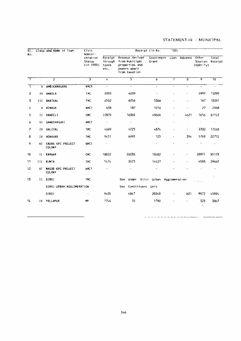
ST ATEM ENT -III - MUNICIPAL
Sl. Class and Name of To~n Civic Recei pt (in Rs. '00) No. Admini -
stration Receipt Revenue derived Government Loan Advance Other Total Status through from Municipal Grant Sources Recei pt (in 1990) taxes properties and (Speci fy)
etc. po~ers apart from taxation
2 3 4 5 6 7 8 9 10
V AMBIKANAGARA NMCT
2 IV ANKOLA TMC 2093 4209 6997 13299
3 III BHATKAL TMC 6502 6056 5366 167 18091
4 V BINAGA NMCT 638 187 1216 27 2068
5 II DANDELI CMC 10879 16360 49606 4621 5656 87122
6 VI GANESHAGUDI NMCT
7 IV HAll YAL TMC 4669 4225 4874 3300 17068
8 IV HONAVAR TMC 9431 6993 125 394 5769 22712
9 VI KADRA KPC PROJECT ,.MCT COLONY
10 II KARIIAR CMC 18832 26838 10482 28971 85123
11 III KUMTA TMC 5474 3173 14427 6588 29662
12 VI MAGOD KPC PROJECT NMCT COLONY
13 II SIRSI TMC See Under Sirsi Urban AgglomeratIon
SIRSI URBAN AGGLOMERATION See Constituent Uni t
SIRSI 9405 4847 20249 621 9972 45094
14 IV YELLAPUR MP 1744 10 1790 323 3867
346

FINAl':CE. 1988-89
Expenditure (in Rs. '00) 51. No.
General Admini- Publ ic Safety Public Health Public Works Publ ic Others Total stration and Conve- Institutions (Spec i fy) Expenditure
niences
11 12 13 14 15 16 17
3097 994 5108 641 10 3496 13346 2
3458 817 6859 1297 2046 14477 3
323 230 548 303 302 1706 4
31793 1282 16135 14940 5694 69844 5
'6
3402 437 7179 1196 3335 15549 7
3563 1750 4031 4944 5516 19804 8
9
20666 4292 10547 7894 24539 67938 10
5177 2428 7541 1417 275 3921 20759 11
12
See Under Sirsi Urban Agglomeration 13
See Constituent Unit
5183 3439 4788 2077 23045 38532
2486 1199 141 33 200 16 4075 14
347
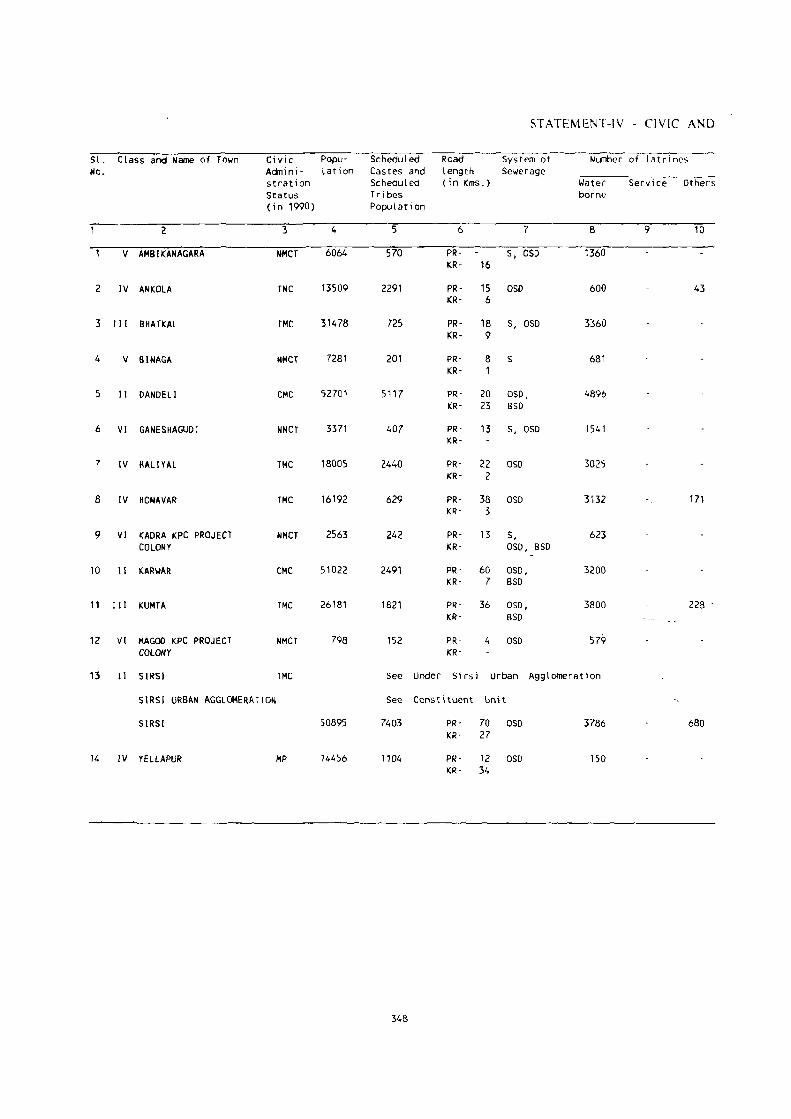
STATEMENT-IV - CIVIC AND
51. Class and Name of Town Civic Popu- Scheduled Road System at Number of latrines No. Admini - lation Castes and length Sewerage
stration Scheduled (i n Kms.) Wilter Service Others Status Tr i bes borne (in 1990) Populat i on
2 3 4 5 6 7 8 9 10
V AMBIKANAGARA NMCT 6064 570 PR- S. OSD 1360 KR- 16
2 IV ANKOLA TMC 13509 2291 PR- 15 OSD 600 43 KR· 6
3 III BHATKAL TMC 31478 725 PR- 18 S, OSD 3360 KR- 9
4 V BINAGA NMCT 7281 201 PR- 8 S 681 KR- 1
5 II DANDELI CMC 52701 5117 PR- 20 OSD, 4896 KR- 23 BSD
6 VI GANESHAGUDI NMCT 3371 407 PR- 13 S, OSD 1541 KR-
7 IV HAll YAl TMC 18005 2440 PR- 22 050 3025 KR- 2
8 IV HONAVAR TMC 16192 629 PR- 38 050 3H2 171 KR- 3
9 VI KADRA KPC PROJECT NMCT 2563 242 PR- 13 5, 623 COLONY KR- 050, BSD
10 II KARI.IAR CMe 51022 2491 PR- 60 OSD, 3200 KR- 7 BSO
11 III KUMTA TMC 26181 1821 PR- 36 OSD, 3800 228 . KR- BSO
12 VI MAGOO KPC PROJECT NMCT 798 152 PR- 4 OSD 579 COLONY KR-
13 II SIRSl TMC See Under Si rs i Urban Agglomeration
SIRSl URBAN AGGLOMERATION See Constituent Unit
SIRSI 50895 7403 PR- 70 050 3786 680 KR- 27
14 IV YElLAPUR MP 14456 1104 PR- 12 050 150 KR- 34
348

OTHER AMENITIES, 1989
Method of , Protected ~ater Supply Fir e F -i gh t i ng Electrification (Number of connections) Sl. Disposal Service ' No. of night Source of System of storage Domestic Industr1al COlTl1lercial Road Others soi I supply with capacity in lighting
litres(in brackets) (points)
11 12 13 14 ' ' ,) 16'--'- 17 18 ;.;
S OHT (270000) YES 1565 10 80 760 GlSR (1260000)
ST ,SR (562500) Sirsi -60 3563 82 242 575 75 2
S,ST SR ( 1318340) foandell-123 4190 130 900 710 243 3
ST OHT (130000) 51 rsi -115 600 2 50 450 4 PI (130000)
ST SR (1135000) YES '580'5 183 820 138'5 27 '5
S,ST- OHT (485780) Dandel i -23 1200 12 21 384 6
ST T OHT (375000 ) Dandeli-23 2221 105 477 545 47 7 SR (620000)
ST OHT (900000) Sirsi -85 2849 103 632 877 8
S,S1 GLSR (10000) Si rsi -112 623 36 250 9
ST T SR (900000) Dandeli-1D8 6488 241 1150 2000 143 10
ST T SR (900000) Sirsi-65 885 130 70 1219 329 ' 11
S1 1w S1rsi-67 579 55 12
See Under Sirsi Urban Agglomeration 13
See Cons tit uent Uni t
S1 1 SR (2025000) YES 5540 238 1809 1745 33
ST OHT (90800) Sirsi -48 2385 94 431 328 33 14 SR (227000)
349
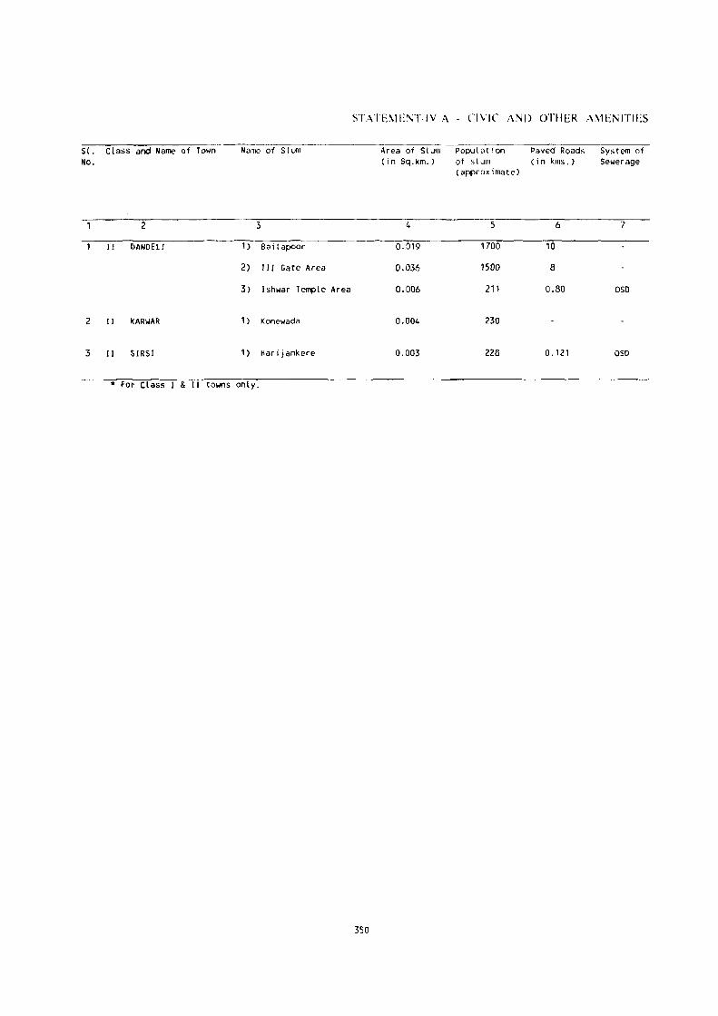
SI. Class and Name of rown No.
2
Jl ()ANDELJ
2 II I(ARIJAR
3 II SIRSI
Name of Slum
3
1 ) Bai lapeor
2) III Gate Area
3) Ishwar Temple Area
1 ) Konewada
1 ) Harijankere
* Fot Class I & II towns only.
STATEl\IE\T-IV A - CIVIC ANI) OTHER AMENITIES
350
Area of Slum (in Sq.km.)
4
0,019
0.036
0.006
0.004
0.003
Populutlon of slum (approximate)
5
1700
1500
211
230
228
Paved Roads (i n kms,)
6
10
8
0.80
0.121
System of Sewerage
l
OSD
OSD

IN NOTIFIED SLUMS. 198(P
Number of latrines
Private Community
Yater Service Others Borne
8 9 10
2 2
3 3
2 2
11
Method of dISposal of night sOIL
12
No.of tap points/ publ ic hydrants installed for supply of protected water
13
351
Electrification (NO. of connections)
Domestic
14
20
18
15
54
Road Lighting Others (Points)
15 16
26
23
23
2
SI. No.
2
3

Sl. Class and Name No. of Town
2
V AMSIKANAGARA
2 IV ANKOLA
3 III BHATI(AL
4 V BINAGA
5 II DANDELI
6 VI GANESHAGUDI
Popu' Medical Facilities l at i on -;-:---..,...,-:---;:-_
Hospitals Beds in Dispen' Medical saries/TS Insti· Clinics tutions etc. noted
3 4
6064 11(1) (1), FPC
13509 H (1) (1), HC, FPC
31478 H(l) (1), FPC, TS, 0
7281 D(1) (1)
52701 H(2} (2), FPC
3371 H(1) (1),
fPC
in Col.4
5
16
42
40
61
14
7 IV HALIYAL 18005 H(l) (1), 30 FPC
8 IV HONAVAR 16192 H(l) (1), 30 FPC
9 VI KADRA KPC 2563 H(l) (1), 16 PROJECT COLONY FPC
10 11 KARWAR 51022 H(2)(l,Ay-l),260 FPC, TB
11 III KUMTA
12 VI MAGOD KPC PROJECT COLONY
26181 H(l) (1), FPC, 0
798 Yellapur' 17
Arts/ Sc i ence/ C 0IlIlle r C e Colleges
STATEMENT-V MEDICAL. H)L'CATION.AL.
Medical Coli egcs
Educational Facilities
Eng i neer i ng Colleges
Polytechnic
(of degree level & abol/c)
Recognised Shorthand Typewriting Vocational Training Institutions
6 7 8 9 10
Dandel j-23 HubliDharwad-96
Hubl j- Dandeli-23 Dandeli-23 Dharwad'96
ASC
ASC
Karwar-5
Hubli- Bhatkal·90 Karwar-34 Dharwad·140
Manipal-l05 Muradeshwar-15
Hubl i - Hubl i-Karwar -5 Dharwad-160 Dhar-wad-160
Type, Other
Type(3)
Karwar-S
ASC Hubli- Hubl,· Dharwad-80
Hublj· Sh.Type(2) Dharwad-80 Dharwad-80
Dandel i -23 Hubl i -Dharwad-1l5
HubliDharwad-85
Hubli- Dandeli-23 Dharwad·85
AC
ASC
Alga-24
C, AS, AC'
AS
Hubl i - Hubl) - Hubl i-Type, Dharwad-55 Dharwad-55 Dharwad-55 Other
Manipnl-l1S Bhatkal-38 Kumta-20 Type(3), Other(3)
Hubl j- Hubl i- Karwar-38 Karwilr-38 Dharwad-198 Dharwad-198
Hubl i - BhatKill 126 Dharwad-157
Hubll- Bhatkal-B5 Dharwad-154
Sh. Type(3), Type(3} , Other
Sh. Typ(S), ype(4) Other(2)
Yellapur-17 Hubli- Hubl i- Hubl i- Yellapur-13
13 II SIRSI Dharwad-77
See Under Sirsi Urban Agglomeration Dh3rwad-?7 Dharwad·77
SIRSI URBAN AGGLOMERATION See ConstItuent Unit
SIRSI
14 IV YELLAPUR
50895 H(l) (1), D(1) (Ay-l),
FPC
14456 H( 1} (1),
FPC
60 C, AS, L
30 AC
352
Hubl i' Dharwad-l03
Hubl iDhilrwad-66
Hubl iDharwao-l03
Hubli- Sirsi-48 Dhilrwad-66
Sh. (2), Sh _ Type(4) Type(4) Other
Type(2)
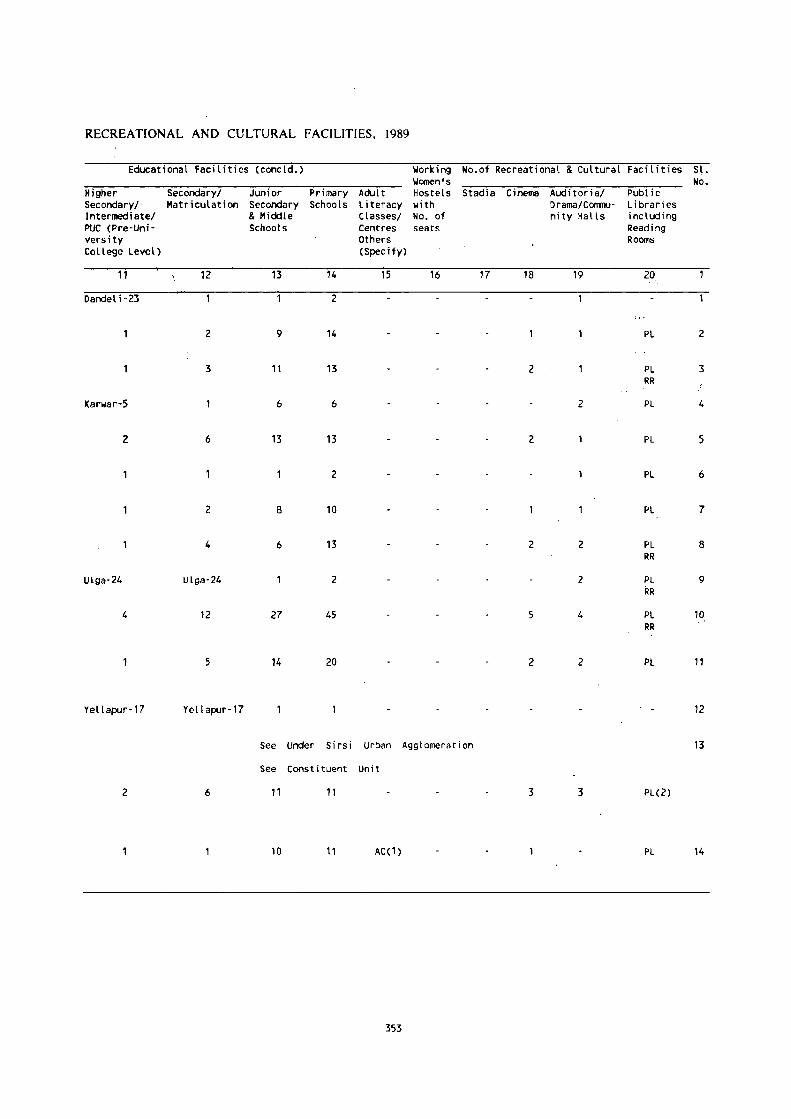
RECREATIONAL AND CULTURAL FACILITIES, 1989
Educational Facilities (concld.) Working No.of Recreational & Cultural Facit i ties Sl. Women's No.
Higher Secondaryl Junior Primary Adul t Hostels Stadia Cinema Auditorial Public Secondary/' Matriculation Secondary Schools Literacy with Drama/COIlIllU- Libraries I ntermedi atel & Middle Classesl No. of nity Halls including PUC (Pre-Uni- Schools Centres seats Reading versity Others Rooms College Level) (Specify)
11 12 13 14 15 16 17 18 19 20
Dandel i "23 2
2 9 14 PL 2
3 11 13 2 PL 3 RR
Karwar-S 6 6 2 PL 4
2 6 13 13 2 PL 5
2 PL 6
2 8 10 PL 7
4 6 13 2 2 PL 8 RR
ULga·24 Ulga-24 2 2 PL 9 RR
4 12 27 45 5 4 PL 10 RR
5 14 20 2 2 Pl 11
Yellapur·17 Yellapur-17 12
See Under Sirsi Urban Agglamerat i on 13
See Canst i went Unit
2 6 11 11 3 3 PL(2)
10 11 AC(1) PL 14
353

St. Ctass and Name of No. Town
2
V AMBIKANAGARA
2 IV ANKOLA
3 III BHATKAL
4 V BINAGA
5 I I DANDELI
6 VI GANESHAGUDI
7 IV HALlYAL
8 IV HONAVAR
Names of three most important commodities imported
1st 2nd 3rd
3 4 5
Electrlc S~re Foodgrains Edible Oil Parts
foodgrains
Foodgrains
Rockel Phosphate
Banboo
Groceries
Foodgrains
Coir
Clay Medicines
Edible Oils Building Materials
Amyl Alchohol
Timber
Tobacco
Coconut 8. Betalnut
Groceries
Manganese Ore
Hardwares
Raw Cashew
9 VI KADRA KPC Cement Iron PROJECT COLONY
10 II KARIIAR Timber Logs
11 III KUMTA Foodgrains
12 VI MAGOD KPC Foodgrains PROJECT COLONY
Rock Phosphate
o i anmon i LIIl
Phosphate
Pan Leaves Stationery
Clothes Cement
STATEMENT-VI - TRADE, COMMERCE.
Names of three most important commodities exported
1 St
6
Ti Ie!;
Cut Sizes of Tirrber
Caustic Soda Flakes
2nd
7
fish
Fish
Phosphoric Acid
3rd
8
Cut Sizes of Timber
Arecanut
Sodium Tripoly Phosphate
Paper Plywood Viner Iron Ore
Phowa (Beaten Timber Rice)
Cashewnut coconut Oi I
Granite Blocks Aluminium Powder
Betalnut Fish
Furni ture
Coi r Products
Phosphor i c Ac i d
Cashewnut'
13 11 SIRSI See Under Sirsi Urban Agglomeration
SIRSI URBAN AGGLOMERATION See Constituent Unit
SIRSI Timber Paddy Leather
14 IV YELLAPUR Petrol Rice Kerosene
354
Rice Footwear
Timber Cardamom
Phowa (Beaten Rice)
Arecanut

INDUSTRY AND BANKING, 1989
Names of three most important commodities manufactured No.ot Banks No.of Agricultural Credit Societies
1st 2nd 3rd
--9--- 10 11 12 13
Ti les .Fish Products 7
Cut Sizes of candles pappad 8 rintx:r
Caustic Soda Sq:jium Phosphoric Acid 2 Tr,ipol yphosphate
Paper Plywood Viners Iron Ore 9
2
Furniture Pottery Phowa 8 2 (Beaten Rice)
Coir Products Cashewnut Coconut Oi l 11
5i lver Steel Yooden Furniture 15 4 Ornaments Fabrication
Cement Pipes Sandalwood 9 3 Articles
See Under Sirsi Urban Agglomeration
See Constituent Unit
Footwear Agarbathi Wooden 13 7 Furni ture
Bulbs Candles Coconut 0; l 7
355
No.ot Non-Agri- Sl. cultural Credit No. Socities
14
4 2
10 3
3 4
2 5
6
4 7
7 8
9
25 10
23 11
12
13
30
14

APPENDIX
POPULATION OF TOWNS AND THEIR ASSOCIATED OUTGROWTHS
Location Code ~o.
~ame of the Town
2
SIRSI URBAN AGGLOMERATIO~
113001 51 R51
113002
113003
113004
113005
Population of the core town
3
4174
356
Name of Outgrowth
4
Sirs;
Landakanahalli
Kalkani
Puttanmane
Population of Outgrowth
5
3699
1.561
1322
2566

LIST OF SCHEDULED' CASTES AND SCHEDULED TRIBES
List of Scheduled Castcs and Scheduled Trihes as pcr the Scheduled Casll:~ and Scheduled Tribes orders
(Amendment) Act, 1976, (No. 108 of 197(, dated the 18th Septemoer, 197(,) adopted for the 1(1)1 O~n~us.
SCHEDULED CASTES
1. Adi Andhra
2. Adi DraviJa
3. Adi Karnataka
4. Adiya (in Cnorg District)
5. Agc~
6. Ajila
7. Anamuk
8. Aray Mala
9. Arunthillhiyar
to. ArWil Mala
11. Baira
12. Bakad
13. BanI (in Bdgaum, Bijapur. Dharwar and Nnrth Kanara districts)
14. Bakuda
15. Balagai
16. Bandi
17. Banjara, Lambani
18, Bathada
19. Beda .I angam, Budga Jangam
20. Bellara
21. Bhangi, Mehtar, Olgana, Rukhi. Malbna. Halalkhor. Lalbegi, Balmiki, Koral'. Zadmalli
22. Bhamhi, Bhambhi, Asadaru, Asodi, Chamadia, Chamar, Chambhar, Chamgar. Hilralayya, Harali, Khalpa. Machigar. Moehigar. Madar. Madig, Mochi, Muchi, Tdegll Mochi, Kamati Mochi, Ranigar, Rohidas, Rohi!. Samgar
23. Bhovi
24. Bindla
25. Byagara
26. Chakkiliyan
27. Chalavadi. Chalvadi, Channayya
28. Chandala
29. Chenna Dasar, Holaya Dasar
30. Dakkal, Dokkalwar
31. Dakkaliga
32. Dhm, Kakkayya, Kankayya
33. Dom, Dombara, Paidi, Pano
34. Ellamalwar. Ycllammalawandlll
35. Ganli Chon;~
357
36. Garoda, Garo
37. Godda
3K (iosangi
~W. Halleer
40. Halsar, Haslar, Hulasvar, Halasvar
41. Handi .Iogis
42. Hasla
43. Holar, Valhar
44. Hnlaya, Holer, HoiL;ya
45. Holeya Dasari
4<, . .Iaggali
-17 . .IaOlhuvulll
4:-\. Kildaiyan
-N, Kalladi
50. Kcplllaris
51. KI)lu(lulvandlll
52. K\)m,a
53. Koraeha
54. Kor(lmll
55. KOlcgar. Melri
5h. KlIdlimban
57. Kuravan
5~. Lingadcr
51). 1\'lachala
(JO. l'vladari
(11. Madiga
(12. Mahar. Tarat Dhegu Mcgu
(l~'. Mahyavanshi. Dhcd, Vankar, Maru Vankar
64. Maila
(15. Mala
(1(,1. Mala Das<lri
67. Mala Hannai
(k"l. Mala .Iangam
m. Mala Masti
70. Malll Sale. Netkllni
71. Mala Sanyasi
12. Mang. Matang, Minimadig
73. Mang Garudi, Mang Garodi
74. Manne
75. Maslhi

7(). MaviJan
77. Mcghval. Mcnghvar
78- Moger
79. Mukri
80. MunJala
81. Nadia. HaJi
82 Nalkadaya
830 Nalakcyava
84. NayaJi
85. Pale
8(}, Pallan
87. Pamoada
88. P:mchama
8'). Pai1niandi
90. Paraiyan, Paraya
91. Paravan
n. Rancyar
93. Samagara
94. Samban
l)5. Sapari
96. Sillckyathas
In. Sindhollu, Chindollu
98. Sudugadu Siddha
99. Thoti
100. Tirgar, Tirbanda
101. Valluvan
SCHEDULED TRIRES
1. Adiyan
2. Barda
3. Bavaeha, Bameha
4. Bhil, Bhil (iarasia, Dholi Bhil, Dungri Bhil, Dungri Garasia, Mcwasi Bhil, Rawal Bhil, Tadvi Bhil, Bhagalia, Bhilala, Pawra, Vastlva, Vasilvc
5. Chenchu, Chcnchwar
6. Chodhara
7. Dubla, Talavia, Halpali
8. Gamit, Gamta, Gavil, . Mavchi, Padvi, Valvi
9. Gond, Naikpod, Rajgond
10. Gowdalu
11. Hakkipikki
12. Hasalaru
U. I rlliar
II Iruliga
15 .. kllu KlIruh;1
Ill. Kadu Kurllila
17. Kammara (in SOUl h Kan<lra Districl and Kollcgal Taluk of Myson: District)
1K Kaniyan, Kanyan (m Kollcgal Taluk of Mysorc District)
II). Kalhodi. Kalkari. Ohm Kathodi. Ohm Kalkari. Son Kalhmli. Son Kalkari
20. Kallunayakan
21. Kokna. Knkni. Kukna
22. Koli Dhm, Tokn: Koli, Kolcha, Kolgha
23. Kond.. Kapll!-.
2-l. Knraga
25. Kola
2(1. Koya, Bhin~ Koya, Rajkoya
27. KlIdiya, Mdaklldi
2X. Kuruha (in l'1)(lr!! District)
21). KUrtJlll.llh
30. l\l"ha Mala"ar
31. ;Vlalaikud;
32. Mabsar
3.). Malaydandi
34. Malerll
3:1. Maratha (in C(l(lrg Distri~t)
3(1. Marati (in South Kananl Dislrict)
:'7. M~da
. :'K Naikda, Navaka, Cholivala Navaka, Kapadia N:tyaka. Mota NaY'lk~, Nana Nayaka -.
:'1). Palliyan
-l0. Paniyan
·lI. Pardhi, Advichinchcr, Pham,c Pardhi
42. Patdia
·n. Rathaw.t
-l-l. Sholaga
-l5. Soligarll
46. Toda
47. Varli
4K Vitolia, Kotw,llia, Barodia
49. Ycrava

PUBLICATION PLAN
The 1991 Census tahles will be puhlished in .n separate ~eries of volul11e~ for All - India and for
each State and Union Territory. The puhlieation series is a~, follows:
,Series No. 10, Jammu & Kashmir 23. Tamil Nadu 11, Karnataka 24. Tripura
1. INDIA 12, Kerala 25. Uttar Pradesh
States 13, Madhya Pradesh 26. West Bengal 14, Maharashtra
\ Union Territories 2. Andhra Pradesh 15. Manipur
3. ArUhachal Pradesh 16, Meghalaya 27. Andaman & Nicobar Islands 4. Assam 1"1 Mizoram 28. Chandigarh 5. Bihar 18, Nagaland 29. Dadra & Nagar Haveli 6. Goa, 19, Orissa
30. Daman & Diu 7. Gujarat 20, Punjab 31. Delhi 8. Haryana 21, Rajasthan 32, Lakshadweep 9. Himachal Pradesh 22, Sikkim 33. Pondicherry
In each of these snies (for all - Indi,1 and each Stale/Union Territory) the different series of tables
(A Series - General Pl)pUlalion Tables, B - Series - General Eeonllmie Tables, ':lc.,) will be bfllUght out
as different Parts. Apart from these, District Census Handbooks will he published for each district in
the country. These will contain the PCA data for the district. the village and h)wn primary censu~ abstract
and the village and town directorie~. The laller comprise compilations of statistics. external tll census
relating to the villages and towns, which in conjunction wilh census data will be very u~eful lo data users.
For all. - India and for each Stall: and Linion Territory, the n;n~u~ tablilatil)ll~ and reports \vill he
published according to the following plan:
ParI No. and suhject c\wered
Part I - Administration R..:pmt
(for office use nnly)
Part If - General Population Tables
Part III - General Economic Tables
Suh-part No. if any, and the topics covered
Part I-A - Admini~tration Rep\)fl Enumeralilln
Part I-B - Administralion Rcp<lrl Tahublillll
Part II-A - General Population Tahb, - A-SlTies
Part Il-B - Primary Census Ah"tract
Part III-A - B-Series tabIes of first stag!: which will be
brought out on IlY!' sample in respect of major St<ltcs
and on full count in respect of ~maller Stutes ,lOd Union
T crritl))"ie~.
Part 111-8 - B-Scrie~ lablc~ uf "l~cond \tage which will be
hrought ntll 011 full UHIlll. The datil rdating H H I. OW,
Marginal Worker~ and NUll-worker" seeking./availabk for
work will bl; entered 011 full CllUnL ha~is.
359

Part IV - Social and Cultural Tabh.;s
Par! V - Migration Tables
Part VI - Fertility Tables
Part VII Tables on House::. and
Household Amenities
Part VlII - Special Tabks on Scheduled
Casles and Scheduled Tribes
Part IX - Town Directory, Survey Report
on Towns and Village~
Part IV -A - C-Series tables oj' lir~t stage c(lverll1g age
sex and marital statu~. cl)lllp()~iti(ln (If p\lpulation. singk
year age retllrn~. educational lc,'ds, school allendance and
bilingualism.
Part IV -B - C-Serie~ tablc~ covering mother tongue, rcliginn
of population and hOllsehold composition.
Part V·A - D-Series tahles \If lirst slage covering lables
based on 11)1;;" sample in respect of major States and on
full count in respect of smaller States and Union Territories.
Part V -B - D-Series tables of second stage covering
occupational dassilication of migrant workers. These
tables arc based on full count.
F-Series tahks of first stage which will hc brought (lut
on (W';, sample in n;speet of majllr States ill1d 011 full
count in re~pect of smalkr Stale::. ,IIlJ Union Territmie~.
II - Series tahles c\)"ering census houses and the uses to
which these arc put, construction malerial or wall. fOol'
and nOM of Ihe censu~ how .. es occupied by households,
lenun: status of the house occupied and number of living
rooms, household size, housing facilitie::.. like drinking water,
electricity and toilet available to households and the fuel
med by the household for cooking. These tables will also
COVt;T tables on Scheduled Castes lind Scheduled Tribes.
This volume will contain analytical notes also,
This part will contain SC and ST series of table~ lor
Scheduled Caslcs and Scheduk:d Tribes n:spectivc!y. Thc
data relating to SchcJulcd Casles ami Scheduled Trines
will he entered on full count hasi~ in the third stage and
SC/ST tables will be pwC\;ssed \)n the CDl1lplll\;r on full
count. These will (.;owr popUlation of cach' Scheduled
CaslC/Trihc, industrial categories of main and marginal
workers, nnn-workcrs seekingjmailahlc ror wmk ami those
who never worked before. edUC,lIional leveL school
allentiance. agl'. sex and marital stal u~. c\)mpo~itil)n of
Scheduled ('a,tes and Scheduled Tribes. In addition to
!he~e. the fertility tables relating 10 SC/ST arc also covered.
These tahle~ als\l cover 1'01' Scheduled Tribes. their
composition by religion, mother longue and hilingualism.
Part IX - A - Town Directory
Part IX B - Survey Report on selected Towns
Part I X C Survey Report on sekctcd Villag.cs
3()()

ParL X
Part XI - Census Atlas
Part XII - District Census Handbook
Ethnographit' notes and spe('iul studies on S<.:heduled Castes and Schcduled Tribe~
Union and State/Union Territory Census ,Atlases
Part XII - A - Village and Town Directory
Part XII - B - Village and Town wise Primary Census
Abstract
The following special papers are also planned and will be published as and when they arc ready as
1991 Census papers :
'(a) Special studies taken up by the Directors of Census Operations
(b) Specfal Areas Surveys
(c) Spedal Tables for Standard Urban Areas
(d) Language Survey Reports
(e) Post Enumeration Check Report
(f) Age Tables
(g) Life Tables
(h) Reports on estimates of inter-ccnsal birth and death rales lISlI1g ]')g 1-1991 life l<tbks and age data
(i) Development of ViLal Statistics In India
Besides these special papers, some monographs based on 1991 Census data on subjects of topical
interest to be prepared by scholars will be brought out as 1991 Census monographs.
It is also proposed to carry out some special studies of 1')91 O.:nslls data in collaboration with other
organisations and the results of such studies will be published as occasional papers of the IIJJl Census,
It is also proposed to disseminate census tabulations and the basic data in machine readable forms
such as magnetic lapes, diskettes, floppies, etc.
The District Census Handbooks will be available for sale at the Government Central Press, Bangalore
and the other publications at the Office of the Director of Ct:nsus Operations, Karnataka, Bangalore and
the Manager of Publications, Civil Lines, New Delhi - 6.
361