Electronic structure of diluted magnetic semiconductors Ga 1− x Mn x N and Ga 1− x Cr x N
Upload
khangminh22Category
view
0download
0
CENSUS OF INDIA 1971
SERIES 28
GOA, DAMAN AND DIU
DISTRICT CENSUS HANDBOOK PART X-A AND X-B
Town and Village Directory
and
Village and Town-wise
Primary Census Abstract
Goa District
Daman District
Diu District
8. K. Gandhe
of the fudw.n Elconomic Service, Director of Census O]JeraUons,
Goa, Daman and Diu and Dadra and Nagar Haveli

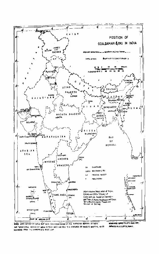
POSITION OF
GOA, DAMAN & DIU IN INDIA, 1971
,I
..
SEA
U.CCAD1VE
.... Ni. '. :
UVw,'rri ' AI41HOIVI,",:lARDS
• I (,"DIAl
MltlICOYISLA~D
• jANA~ '(P,
'"
POSITION OF
(jOA,DAMAN ~OlU IN INDIA
CHANOIGARIi
BAY
OF BENG'Al
G.O~D GOA,DAMAN~ DIU
H.P HIMACHAL PRAD£SK
PONOltHEA~Y
Adminlstrati!'e Headq~arters rI Punjab, Haryana and Union Territory of Chandilath are located at Ch$.nd!garh lind !hose of Assam, Merh.llaya af'ld Uruon 'ltrtltorWsofArunachaIPTad!shend Mizorall'l at Shillo/lf.
, I ~~'
I
~, i , !
'-'UP UPON SURVEY O~ INDIA 'UP WITt( 1H[ P,£UIsstOK Of t~E !IJAV£,(OR I£MERAI. OF INDIA.
, ... flUIICRIAl WATERS 0' [NDJ' UTEND Illfa 'NE lEA TO A DistANCE OF lwILV' ~TIC"'L NILES
tUASUIilC ,.O~ fHE A fI~O"'''IATt SASE ~["'
1IIlTIIIOI.RIlS _moUl". "I.RCHIIPI,
I'IINJIED II D.t.O..Qff~tti',"""'JI

1971 CENSUS PUBUCATIONS OF GOA. DAMAN AND DIU
(All the Census Publications of this Union Territory will bear Series No. 28)
Central Government Publications
Part I ...
Cen81I.'1 General Report
Part n ... Census Tables on Population
Part III
Establishments Report and Tables. Part IV
H0U8ing Report and TablelJ
Part VI·E
Part vr·c
Part VIII
Administration Report (For Official use only)
Part IX
Ce= Atla8 Miscellaneous:
1) Part I-A
2) Part I-B
3) Part I-C (Subsidiary Tables)
... 4} Part II-A - General Population Tables (A Series)
Part H-B-Economic Tables (B Series) 5) I Part II -C - Social and Coltural Tables
I Part IT-D-Migration Tables
Part III - Report and Tables af the «E» Series
Part IV-A - Housing Report and Housing Subsidiary Tables
Part IV-B - Housing Tables
7) Special Survey Report on Panaji Urban Agglomeration
... 8) Survey Report on village Pale, Taluka Satari, District Goa
.,. g} Part VIII·A -Administratioo Report-Enumeration (Not for sale)
10) 'Parj: VIII·B -Adminisltration Report-Tabulation. (Not 10r sale)
... 11) Census Atlas of Goa, Daman and Diu
12) A Portrait of Population (Popular version of the Census Report)
13) A Special Survey of Fairs and Festivals of Goa District
Publications of ~he Government of Goa, Daman and Diu
Part X ...
District Crm.sUll Handbook
NOTB:-
Part (A) :
1) Part (B) :
2) part (C) :
Town and Village Directory of the Districts of Goa, Daman and Diu.
Village and Town-wise Primary Census Abstract of the Districts of Goa, Daman and Diu.
Analytical Report and Administration Statements and District Census Tables of the Districts of Goa, Daman and Diu.
iI) Pam V (Speeilll Tables and Etlmographlic Nmes Dn Seheduled lcasti:!s rum1 Scheduled Tribes) ls om puhllished for Goa, Daman and Diu as a separate publication.
ti) Part VI-A (Town DIrectory) is not publ'shed as a separate !'LI)}~catoon for Goa, Daman 'and Diu. Th~ data are included In the Di.trict Census Hand1xJok of Goa, Daman and Diu, Part A.
~) 'Part VII (Special ReJl'OI't on G""duat~!S and TechnJcal PersooneO is a publlc"tlion of the Oftice of the Registrar Gen~aJ. Indiia, New Delhi on an all-lOOia basis.

CONTENTS
PREFACE
FIGURES AT A GLANCE
Part-A - Town and Village Directory
Inlroductory Note to Part A of the District Census Handbook ."
I Background - II Brief History of Census In Goa - ill Urban Areas - IV Urban Agglomeration - V Standard Urban Area - .. VI Town Directory, its contents and brief analysis of data - VII Village Directory, its contents and brief analysis of
data.
Town Directory and its Appendices;
Statement I _.- Status, GrowtJ1, History and Functional category of Towns ...
Statement II·· Physical Aspects and Location of Towns, 1969 ..
Statement III - Munlcipal Finance, 1968-69
Statement IV - Civic and Other Amenities, 1969
Statement V --- Medical, Educational, Recreational and Cultural facilities in
Pages
i-ii
iii
1-18
20-21
22-23
24
25
Towns, 1969 26-29
Statement VI· - Trade, Commerce, Industry and Banking, 1969
Statement VII - Population by Religion and Scheduled Caste/Scheduled Tribe, 1971
Appendix I --- Location of the Towns in the Union Territory of Goa, Daman and Diu
Appendix II -- Towns of Goa, Daman and Diu arranged a~ per popula.tion size and the serial number of towns in Town Directory statements
Appendix III - Towns of Goal Daman and Diu arranged districtwise and within it in the order of population size
Village Directory of the Districts of Goa. Daman and Diu:
GOA DISTRICT:
Tiswadi Taluka Bardez Taluka Pernem Taluka Blcbolim Taluka Satari Taluka .. , Panda Taluka .. ' Sanguem Taluka ~anacQna Taluka
Quepem Taluka
Salcete Taluka
Mormugao Taluka
DAMAN DISTRICT:
Daman Taluka
DIU DISTRICT;
·Dlu Taluka
30-31
32-33
34
34
35
38-41
42-47 48-5] 52-55
5~-63
64-67 68-73 74_75
76-79
80-85
86-R7
88-91
92-93

Appendix IV - Talukawtse Abstract of Educational, Medical and other Amenities
AppendLx V(a) - Scheduled Caste classified by literates and illiterates '"
Appendix V(b) - Scheduled Tribe classified by literates and illiterates
Appendix VI - Distribution of population by sex, religion and Rural(Urban category in Goa, Daman and Diu in 1960 and 1971 Censuses
Part-B - Village and Townwise Primary Cen..";us Abstract
Introductory Note to Part 'B' of the District Census Handbook·- 1971 Oensus
I Background - II Primary Census Abstract - III Worker categories definedIV Non-Worker categories defined.
Primary Census Abstract of Villages and Towns of Goa, Daman and Diu Districts. Union Territory Primary Census Abstract
Tiswadi Taluka:
Alphabetical list of villages and towns
Primary Census Abstract
Bardez Taluka:
Alphabetical list of villages and towns "
Primary Census Abstract
Pernem Taluka:
Alphabetical list of villages and towns
Primary Ccnsus Abstract
Bicholim Taluka:
Alphabetical list of villages and towns
Primary Census Abstract
Satari Taluka:
Alpbabetical list of villages and towns
Primary Census Abstract
Panda Taluka:
Alphabetical list of villages and towns
Primary Census Abstract
Sanguem Taluka:
Alpbabetical list of villages and lowns .. ,
Primary Census Abstract
Canacona Taluka:
Alphabetical list of villages and towns
Primary Census Abstract
Quepern Taluka:
Alphabetical list of villages and towns
Primary Census Abstract
Salcete Talulm:
Alphabetical list of villages and towns
Primary Census Abstract
Mormugao Taluka:
Alphabetical list of villages and towns
Primary Census Abstract
Pages
94-9[;
96-109
110-123
124
127 -131
134-141
143
144-151
153
154-159
161
162-160
167
168-171
173
174-179
181
182-185·
187
188-193..
19i>
196-1911 .
201
202-205·
207
208-215,
217
218-223.

Daman Taluka:
AlphabeticaJ li::;t of villages and towns
Primary Census Abstract
Diu Taluka:
Alphabetical list of village" and towns
Primary Census Abstract
Appendix VII(a) ._ Limits of the lInd Phase Enumerator's Block of 1971 Census of Goa, Daman and Diu (Rural) in terms of 1971 Census House numbers
Appendix VII(b) - Limits of the Hnd Phase Enumerator's Block of 1971 Census of Goa, Daman and Diu (Urban) in terms of 1971 Census House numbers
India
Goa District:
Goa District
Tiswadi Taluka
Bardez Taluka
Pernem Tal uka
Bicholim Taluka
Satari Taluka
Ponda Taluka
Sanguem Taluka
Canacona Taluka
Quepem Taluka
Salcete Taluka
Mormugao Taluka
Damau District
Diu District
MAPS
Frontispiece
Facing Page
Pages
225
226-231
233
234-237
238-262
263-279,
143
153
161
167
173
181
187
195
201
207
21T
233


PREFACE
The District Census Handbook which was first intrcduced under the 1951 Census has by new assumed a place of singular importance. Though compiled by the Census Department, it is' actually a State Government publication brought out for every district of the State/Union Territory. The 1951 -and 1961 Series of District Census Handbcoks have become so popular among the general public, researchers, demographers', 'administrators, etc. that ,they have come to stay as a regular feature of every census. While continuing the publication under tihe present census, efforts have been made to enlarge its scope and enrich ills contents in s€veral ways. As a matter of fad, the 1961 mstrict Census Handbook included net only the Census data but also some important non-census data of the distriot. This, however, rEsulted in a ,considerable delay in i,ts, publication. To avoid any such contingency it has been .decided to bring out the District Census Handbook ,this time in three parts, viz:
Part A: Town and Village Directory.
Part B: Village and Town-wise Primary Census Abstract.
Part C: Analytical Report and Admin'istrative Statements and District Census Tables.
The present Handbook of Goa, Daman and Diu districts is the first of its kind to present the Census data (in a pattern uniform to that of the rest of the country. As a rule, three .separate District Census Handbooks should have been brought out, but since tlhe size 'of the three districts, and in particular that of Daman and Diu districts, is so small that a s€!parate volume for each of them is oC!tlSlidered unnecessary. Again, this volume presents data in parts A and B only. It is proposed ,to bring out Part C nor all tlhe three districts together in a separate volume at a later date, ~nce the collection, ccmpilation and scrutiny of the statistical data from d:fferent agencies as required in PaIlt C is likely to take a considerable time. It is not desirable to hold up publication of Par,ts A and B Hli then.
In part A of the volume, information regarding the status d each town, its location, physical aspects, municipal finance, civic and other amenities!, trade and commerce, industry, banking etc. is providEd. Then follows the Village Directory which presents with the help of abbreviffitlOns information on certain basic and essential amenitieS' €;x~sting in the village such as educational institutions, public health centres & medical dispensaries, supply of drinking water, electr:city, transpcrt and communications, weekly markets, etc. Thus the Town and the Village Directories together with the Taluka map shculd provide a complete index and statistical guide to each town and village in a Taluka. It may be noted that the village boundaries shown im the Taluka-maps are provisional, subject to mcdification on completion of the Cadastral Survey~' cf the Territory. The Taluka-maps do not show the location code numbers of villagef: which have been included in the Urban Agglomerations Or other urban towns.
Part B is the vital part of the Handbook presenting some very impcrtant data collected under ItJhe Census. It gives village-wise. and town-wise particulars of area, households, population, Scheduled Castes and SchedulEd Tribes literacy and a broad categcrisation of the workers .. To facilitate. refe'renee., informaticn in this Primary Census Abstract is supplemented by an alphabetical list of villages in each taluka.

li
The information presented in the Town and the Village Directories had to be coile(lted from a variety of rources. The Primary Census Abstract is baSEd on the manual sorting of census slips done in the Regional Tabulation Office specially set up here for a period of eight months. The maps have been drawn in my office.
This Handbook is the product C!f hard toil and labcur of several persons in my office. In particular I wish to place on record my gra tdul appreciation for the strenuous work put in by the followi1ng members of my staff in ,the preparation of this volume.
1. Shri N. Y. Gore, Asstt. Directcr of Census Operations,
2. Shri D. P. Naik, Aiss.tt. Director of Census Operations, (Tabulrution).
3. Shri S. P. Desai, Tabulation office!!'.
4. Shri D. V. Nagappanavar, Statistical Assistant.
5. Shr1 M. G. Bandodkar, Investigator, (Cartography).
My thanks are due to ShM Pfres D'Costa, Manager, Government Printing Press, Panaji for the personal attention he paid to the printing of this book.
Shri K. D. Ballal, I.A.S" Deputy Registrar General, (Census) and Dr. B. K. Roy Burman, Deputy Registrar ('Social Studies) provided guidance in this work whkh is gratefully ack" nowledged.
Lastly, I must confess that but for the very keen interest shown by Shri A. Chandra Sekhar, I.A.S., Registrar General, India, in our wcrk and the encouragement received from him from time to time, this volume could not have beeal brought out so early. If any degree of competence and efficiency has gone into this pubHcation, it is solely due to his invaluable guidance. R€lsponsibility for the deficienci:es of this Handbook is however my own.
S, K. GANDHE
Panaji, Director of Census Operations
July 3, 1972. Goa, Daman & Diu and Dadra & Nagar Haveli

ill
FIGURES AT A GLANCE
Goa, Daman Goa Daman Diu and Diu District District District
POPULATION TOTAL PERSONS 857,711 795.120 38.739 23.912 MALES 43J.214 401.36" UI,U70 10.782 FEMAI,ES 426,557 393.758 19.669 13.130
RURAL PERSONS 630.997 591.817 21.422 17.698 MALES 310.909 292.318 10.397 8.19~ FE~lALES 320,1I~~ 299.559 11.025 9.504
URBAN PERSONS 226.77! 203.213 17,317 6,214 MALES 120.305 109,M4 8,673 2.588 FEUALES 106.469 94,199 8,614 3.626
DE(JENNIAL POPULATION GROWTH RATE 1960-71 i 36.8~ ·-;.-M.i7 - 7:1.02 r 67.15 AREA IN KM2 381:1.01) 3701.00 n.oo 40.00 DENSITY m- POPULATION PER KM' 225 215 538 598 SEX RATIO (NUMBER OF FEMALES PER 1,000
MALES) 989 9RI IO~I 1218 LITERACY RATE PERSONS 14,75 4n.ll 39,88 SUI
MALES 5!.31 54.ti5 51.86 45.91 FElIIALES 35,09 35.79 28.26 24.42
PERCENTAGE OF URBAN POPULATION TO TOTAL POPULATION 26.H 25.56 44.70 25.99
PERCENTAGE OF WORKERS TO TOTAL POPULA-TION (MAIN ACTIVITY ONLY) PERSONS 31.67 32,00 2~,65 23.75
MALES 47.i6 47.9~ ~6.S4 40.62 FEMALES 15.40 15.71 12.99 9.89
BREAK·UP OF WORKERS:
PERCENTAGE TO TOTAL WORKERS:
(i) CULTIVATORS PERSONS 23,97 23.78 31.01 18.12 ~fALES 22.H 21.75 32.25 18.40 FEMALES 29.71 30.10 26.69 J7·29
(Ii) AGRICULTURAL LABOURERS PERSONS 15.01 15.05 16.61 9.81 MALES 10.33 10,{Z lQ.69 5.69 FEMALES 29.66 ~9.46 37.57 23.71
(iii) OTHER IVORKERS PERSONS 61.U2 61.17 5232 72,07 MAI,ES 67.53 67.83 57.06 75.89 FE~lALES (0.6:! (0.-11 S5.i4 59.20
PERCENTAGE OF SCHEDULED CASTE POPULA-TION TO TOTAL POPUI,ATION PERSONS I,H:1 1.79 3.65 3.80
MALES 1.93 1.8:1 2.78 U8 FEMALES 1.92 I.;; M9 3.48
PERCENTAGE OF SCHEDULED TRIBE POPULA-TION TO TOTAL POPULAFTION PERSOllS 0.89 0.06 18.50 0.21
MALES 0.89 0.06 18.64 0.27 FEMALES 0.90 0.05 18.35 0.16
YUMBER OF OCCUPIED RESIDENTIAl, HOUSES 153.473 142,191 6,374 4.908
NUMBER OF VILLAGES TOTAL 439 408 26
INHABITED (09 383 21
lJNINHABlTED
INCLUDED IN URBAN AREA 22 17
NUMBER OF URBAN AREA!! 13 11


PART A OF THE DISTRICT
CENSUS HANDBOOK OF GOA,
DAMAN AND DIU DICTRICTS


INTRODUCTORY NOTE TO PART 'A' OF THE DISTRICT CENSUS HANDBOOK
1-BACKGROUNl!
1.1 In the history of Indian Census the District Census Handbook was for the first time published in 1951. The Primary Census Abstract presenting the basic Census data for each village/ward of Town of every District enhanced very considerably the utility of this publication so much so that this district-level publication has now become an indispensable part of the plan of Census publications in the country. The District Census Handbook of 1961 Census included, besides the Primary Census Abstract, some of the important Census tables down to the taluka level. As a matter of fact, the 1961 District Census Handbook included not only the Census .data but some important non-census data of the district also, like land utilization, cropping pattern etc. Unfortunately this extra innovation resulted in a considerable delay in publication of the District Census Handbooks of 1961 Census in some of the States, thus restricting the utility of the publication. Drawing upon such experiences, it has now been decided that the District Census Handbook under the 1971 Census should be brought out in three parts, namely:
Part A: - Town and Village Directory
Part B: - Village and Town-wise Primary Census Abstract.
Part C: - Analytical Report and Administration Statements and District Census Tables.
1.2 This volume presents data on Parts A and B. Part C is proposed to be brought out at a later date.
As a general rule, a sepamte Disltriot Census Handbook is brought out for each district. In the care of this Territory, however, the size Oof all tbe three districts, and particularly that of Daman and Diu distri<lts, is so small that a separate publication for them is considered unnecessary. It has, therefore, been decided to bring out one publication which will cover Part A ('l1mvn/Village Directory) and Part B (Primary Census Abstract) of all the three districts of Goa, Daman and Diu. Part C in respect Gf all the three districts will again be published in one volume.
1.1> The area now comprising the Union Territory of Goa, Daman and Diu was' under the Portuguese Rule upto 19-12-1961 when it was liberated and formed into the Union Territory Qf Goa, Daman and Diu.
II -BRIEF mSTORY OF CENSUS IN GOA
2.1 Taking a hislotical retrospc0tive of Census in Goa it is revealed that the first (ver organised CenEus in this Territory was taken in 1830, but no publication abeut the same ,is now avai'lable. However, t'able No. E2 appended to the Census Volume of 1881 givE~ the pc puiation of Goa, Daman and Diu as 406 56:) in 18[0.
~,Z A se.cond attempt to hold Census appears to have been made in 1878. HOWE'VET, in -this CaE€ also
no data are available except for Table No. 141 appeadng in the Census Volume of 1881, II'hieh indiCi1,tes the pCJlulation of Goa, Daman and Diu as 4:2,88:, in 1878.
2.;:; The third attempt to take a ],opuJaticl\ Census was made in 1880 but that also s!eems to have been left incomplete. A fresh CensllS was sub:iequenUy ordered and hEld 011 17lh February 1881. From then onwards, regular Ccnsases appear to have been held in the Terr'llory. The populatioll Censuses were held by thr, erstWhile regime in the years 1887, 1900, 1910, 1921, 1\);.1, 190;0 and 1950. The 1960 Census of Goa, Daman and Diu was conductEd by the former Pcortuguese administration, but the tabulation of data collecled therein was done in the Office of the Registrar General, Indill, N~w Delhi, on the lines of the ,tabulation plan adopt'ed fer the reEt C'f the COun try.
2.'\ The reference datES of the various Censuses of Goa, Daman and mu and that of India are given below for the sake of comparison.
TABLE 1\0. 1
,rSta.tement shm\'ing thf'- various Ct'n~us referf'ncr daM in Goa, Daman an(l Diu and in India"
Census Yoor Eefctel1re in Goa, Rpfl~I'pnce date Daman Diu in TndH\
.1
1881 17th February 18.81 17th February 18S) 1887 ~lst AU6'1lf1t 1887 1891 26th February 1891 1900/1901 Night of 30th Novem~ 1,\ March .1901
ber - list Decem~ ber, 1900
1910/1911 Night of 30th"315t Dr- 10th March 1911 cember, 1910
1921 ~ight of 18th-19lh 18th ),~8.rch 1921 March. J9;)1
1931 26th February 1931 26th February 1001 1940/19'111 15th Decemil.r 1940 1st March }9~1 1950N9'jj Nignt of 14,\h-15th De- Ist March 1951
cember ,1950 196011961 Night 'of ·14th·15th De- Ist March 1961
cemhe'l'" 111.60
2.5 It may be interesting to note that so far a;s Goa Daman and Diu is concerned, the practice of pre~entation of census data for the lowest administrative unit has been ,in vogue almost from its very inception. It may, however, be added that the cen.sus daJta was not presented 'Separately for each and every village (knOlWn a;s Aldeia in Portuguese) but for a «Freguesia» which may be equal to a part of an «Aldei'a», or an «Alde'ia», or a group of "Aldeias". A "'Freguesia" was the admiruistmtive jurisdiction of a «Regedor» who, in turn, wa;s the lowest level administraltive functionary. Thus <the 1961 Census prese!lits data for 245 Freguesias. The Government of Goa. Daman and Diu, has, however, notified (in February 1971) the list of • Revenue» villages, and hence the 1971 Ooosus data are presented separaltely for each Rev€'llue village.
2.6 The following table shows the variety of Census data that is available for the earlier Censuses of Goa, Daman and Diu i. e. from 1881 to 1950.
TABLE No.2
"Statement shoWing the ""rions Census data available for eacli «Fregnesia.. in the past Census Reports ot
Goa, Daman and Diu, 1881 to 1951}"
1881
I) General Populationr of the freguesiQ by:
a) Sex
b) Age Group (Less than 12 & 12 and above). c) Marital Status d) Place of birth (oontinents) e) Literacy f) Religion g) Occupation
II) De Jure Populatioo of tlle fregu€sia by:
a) Sex, age, marital status, place of birth, education and religion.
b) Occupation
ill) No. of hoU'Seholdrs, peV.90ns temporarily absent, in transit and de facto population.
1887*
Population enumerated of the freguesia by: a) Sex
. b) Age-Group (Less than 12 & 12 and above) c) Mari'tal Status d) Literacy e) Religion f) Occupation
2
g) Distribution of popUlation by religion and age.
h) 'Religion, literacy and sex. i) Occupation and Religion j) Single year age, religioo, Marital status and
sex. 1900
a) Population (Residents, absen1ll and in transit).
b) De facto population by
i) Sex 'and age - LesSI thanl 12 & 12 and abo'Ve .
iii) Sex and single year age upto go yeara and above 90 years.
iii) Sex IlIld marital status
iv) Sex, education and age-groups.
v) Sex Il!nd Relig1ioo vi) Sex and main physical and mental defeets vii) OccupatiOill. viii) National~ty, Marital sibaJtug and age. ix) Nationality, Place of birth and Sex. x) Nationality, Religion and Literacy.
1910
a) Population (Residents, absents and in tranmt) by sex, ood tota:! de facto population.
h) De facto population by:
i) Sex and age ~ Less Wan 21 and 21+ ii) Sex 'and \!lingle yea,r age upto 90 yeal'& and
901+ ilii) Sex and marital status. iv) Literates by age and sex and lidlite~ates by
sex only. v) Sex and religion vi) Sex 'am. Main Physical and mental defeotS'. vii) Occupa,ti()JJ.
vili) De bato popul'ation by religion, Utel'acy 'and sex.
ix) Nationality, Marital status and Age. x) Na:tiOJllality, Place of birth and sex. xi) Nationa.lilty, religion and educatioo ..
a) Freguesia wise Number of households and Population (residents, absenlts and in transit) by sex and total de facto population
b) De f~cto populatiOlli by:
i) Sex amid age - Less thanl 21 & 21 + ii) Sex and single year age upto 90 years and
90+
iii) Sex and marital smtus. Age groups, (below 10 years: 10 to 15; 16 to 20; 21 to 30; 31 to 50; above 50 aIld age not stwued), marital status and the relationshilp (If the partners !lit tire time of marriage.
iv) Uteratoo hy age-groups' and sex and illi-terates by sex only.
v) Sex a;rud religion. vi) Sex and malin physical & mental defeets. vii) Oocupation. viii) Sex, religion and literacy. !lx) Nationality and marital status, and age-
-group. xl Nationality, place of birth and sex. xi) NatiODiality, religion ailld Uteracy.
c) Distribution of families by family size.
1931
a) Population (Residents, absents and in transit)
b) De facto population by: i) Sex and age-group-Less than 21 and 21 + ii) Sex allid S1ingle year age upto 90 and 90+
:iii) Sex and marital status. iv) Sex, Utcrrucy and age-group. v) Sex and religion.
vi) Sex and MaJin physical defects. vii) Occup3!tion. vim 'Religion, Literacy allid sex.
ix) NwlJionali'ty, marital status and age-group. x) NatiOOllality, place of birhll and sex. xi) NatiODiality, religion and literacy.
c) Distribution of families by family size.
19W
I) De f!!Jota populatillon by:
i) Sex and Age-Group-Less rthan 21 and 21 + ii) Sex and Marital Status iii) Literacy, Age.,Group and sex. ivl Race and sex. v) Religioo., Literacy and sex. vi) Nrutionality, Place of birth and sex. vii) Nationality, religion and literacy.
viii) Economdic 'classification of de facto population.
II) Distribution of famili€s by family size.
1950
In VOL. I
1. Distribution of buildings. (or structures) according to their use - (Table 1)
3
2. Dwtrjbtlbi~n of occupants (dwellers) accordill'Jg to the number of rooms of the houses occupied by them - (Table 4)
3. Distribution of famili<es by family size. (Table 5)
4. DistrilYution of institutional households a{)cording to their type alld number of pe!'llOns living Itherein, by sex. (Table 6)
5. Urban and Rural population by sex. (Table 9)
6. Distribution of occupied houses, ami households (Table 10)
7. Distl'i!bution of populaJtion of 10 years and above who know Portuguese 3.llld who do not know Portuguese. (Table 15).
In VOL. II
1. Population by sex and age-groups. (Table 2)
2. Present population by sex and religion (Table 4)
3. Usually residents, present and ~bsent populaJbion (the latter classified acoording to the places of residence) (Table 7).
*The Uibles mentioned here Ull8 available for the follOWing 7 the then ooits only, viz Pernem (incomplate), SlUlguem, POIlda. Sanquellm, Quep'em, Canacona and distl'ict 01 Ange<liva.
2.7 As said earlier, the Tabulation plan for 1961 Census was the same as adopted for the rest of tne country, though the field work was done by the ersltwhi,le PC!t'tuguese administration. For the 1971 Census, of course, the all India pattern of Census taking was adopted from lihe very 'beginning, the date of reference for the entire country being 1st April, 1971. The present publication thus presents the census data for the first time on a pattern uniform to thait of the rest cf the country.
III - URBAN AREAS
3.1 For purposes of 1971 Census, the following defj,nition of a town was adopted:
"To qualify for recognition as a town or wb'an area, a place should have:
(a) a Municipal Co,rporation or a Munici'pal:ity or a Town Committee or a Notified Area Committee or a Cantonment Board;
OR
(bl .i,l a minimum population of 5,000,
ii) a density Q[ nm less than 400 per sq. km. (1000 pill' sq. mile),

iii) three-fouI'ths of the occupations of the male wc~'king population sihould be outside agriculture, and
iv) the place should have according to the Director cf Census Operations of tho State a few pronouncecl urban characteristics and amenities".
3.2 So far as Goa, Daman and Diu is concerned, the condLtion laid dcwn in (a) above has been followed, It has not been possible t(ll follow the other criwria in respect of non-municipal places for a variety of reasons. In the first place, the final neU· ficat:on regarding 'revenue' villages was issued by the Government of Goa, Daman and Diu as late as in February, 1971, by which time it was too late to apply the population test to the villages and revise the whole pattern of location code numbers, etc. Secondly. exact areas of the newly notified revenue villages were not available and hence the test cf density could not be applied. Then again the occupational distribution of populaticn was also not available and hence the test mentioned in (b) (iii) abeve could also not be appli~d. In view of these limitations, it was decided to adopt only the first te£t; fOlcunatElly the Government of Goa, Daman and Diu has also adopted an identical basis for identifying the areas as urban towns.
There are in all 13 towns in Goa Daman and Diu as follows: - '
TABLE No.3
"List of TOWfifoi in Goa., Daman and Diu!!-
81. No. Di~tri('.t Taluka TQ\T,lt\
1. Goa Tiswacli Panaji
Bardez Mapusa
Bernem PerneID
Bicholirn Blcbolim
Sata~i Vaipoi
Ponda Ponda
Sa.nguem Sa.nguem
Canacoua Chau!'i
Quepem Quep€m
Sal""te Margao
Mormugao Mormugao
2. Daman Daman Daman
3. Diu Diu Iliu
. IV - URBAN AGGLOMERATION
4.1 The town directory covers 13 towns etE which 11 are in Goa District and one €ach in Daman and Diu Districts. No new town has been added to the list of towns of 1961 Census and
4
similarly no town of 1961 Census has been declassified into a village in 1971. Howeve!r, with the formation of Munidpal Councils for the first time in this territory in 1970, some of the areas which were hitherto considered part of urban towns have been excluded from the new jurisdiction of the Municipal Councils, In some cases these excluded areas have not been included in any other Village Panchayats. For example, a part of t,he former Pernem town has been excluded from the Municipal Council area of that town. Such excluded part is tre"at€d as Pernem (rural) for the purpcses of 1971 Census.
4.2 At the time of 1961 Census, the urhan data was presented in terms of individual towns and cities and also in terms of «clusters» of population called as «Town groups». This was done with a view to identify 'functionally linked urban areas, urban spills beyond the administrative boundaries and metropolitan conurbations. In actual practice, however, the State Census Offices adopted varying definitions, procedures and criteria of delimitation of the town groups. In fact, ,the. concept of town-group was not adopted folI' Goa, Daman and Diu. In other words, a uniformity of approach was not maintained. Aga'in, the constituent units' of a town-group were not confined to a ccntiguous area or terI'itory. In actual reporting, only towns falling within a radius of 2 to 4 (and sometimes 5) miles of the periphery of the principal central town were included, but the interstitial rural areas were omitted. Thus the town group did not bring out a s<patially contiguous territory of urban and rural settlemen,ts. Filrtheir, the town·group concept did not effectively tackle the problems involved in urban statistical reporting viz., the problem of municipal jurisdiction versus spillover growth and the accreticn of population by anne%ation. In the case1 of Goa, Daman and Diu, however, there were no tOI'l71 groups as such for the 1001 Census.
4.3 Because of all these limitations, the concept of «town group" of 1961 Census was given up in the 1971 Census and a new concept cf «Urban Agglomemtion» was introduced.
4.4 An «Urban Agglomeration» is made of the main town and the adjoining areas of out growths which should be treated as urban spread, the populat.ion covered by such spr£ads being cate' gorised as urban. Each such agglomeration may be made up, of more thlm one statutory towns, a;djoining cantonment, and also oth€ll' adjoining urban growths such as a Railway Colony 01' a University Campus. Similarly, other outgrcwths which did not qualify to be trated as individual towns in their own right are also to be attached to the urban unit to which they are adjacent. In other words, the urban agglomeration is a continuous spread comprising of a town and its ad-

joining outgrowths or two or more physically contiguous towns together with continuous well recognised outgrowths, if any, of such towns.
4.5 There are in this Territory two urban agglomerations, viz. Panaji Urban Agglomeration and Margao Urban Agglomeration. The constituent units of these two urban agglomerations are:-
P8dlAji Urban Agglomeration
i) Panaji Municipal Area
ii) Calapor
iii) Murda
iv) Panelim
v) Chimbel
vi) Cujira
vii) Morambi-o-Grande (Merces)
viii) Morambi-o-Pequeno (Merce~)
ix) Taleigao
(Note: - While the places shown at (ii) to (ix) above are now notified as revenue villages, all of them except '11ail\ligoo tot1lled part of tme Poooajli ,tK>W'Il in 19t)1 Census. Tbey form almost 0 continuous outgrwoth to the Panoii Municipal Area).
Margao Urban Agglomeration
i) Margao Municipal Area
ii) Aquem
Iii) Navelim
(Note: - Aquem and Navelim are now declared as revenue vil1ages, but actually they form a continuous outgrowth of the Margao Municipal Area).
V - STANDARD URBAN AREA
5.1 The concept of Standard Urban Area which is related to the programme of town planning is different from that of Urban Agglomeration. The Standard Urban Area may be defined as the projected 'growth area of a city or town over the next two decades, i. e. as it would be in 1991, taking into account not only the towns and villages which will get merged into it but also the intervening areas which are potentially urban. Such a tract will include all extra-municipal urban growths such as the suburbs (industrial and residential), railway colonies, civil lines and cantonments and also such of the villages which are
likely to be urbanised by 1991. A Standard Urban Area will thus be an area whJch wi'll extend beyond the main city or town and would contain all likely developments over the next 20 years, i. e. upto 1991. The Standard Urban Area is identified by the administrative units that it encompasses, namely, city, town, village, etc. The boundaries of the Standard Urban Area arc the administrative boundaries of the peripheral units.
5.2 In case of Goa, Daman and Diu, the demarcation of the Standard Urban Area was done by the Department of Town and Country Planning Organisation, Ministry of Hea!lth, Family Planning, Works, Housing and Urban Development, New Delhi, in consultation with the Senior Town Planner of the Government of Goa, Daman and Diu.
5.3 Two areas have been declared as Standard Urban Areas for this territory, viz., (i) Panaji Standard Urban Area and (ii) Mormugao Standard Urban Area.
VI - TOWN DIRECTORY, ITS CONTENTS AND A BRIEF ANALYSIS OF DATA
6.1 The seven statements included in the Town Directory are expected to give a fairly good idea about the socia-economic status of each town. Brief details of the contents of each of the seven statements and an analysis thereof are attempted below:-
(1) 'STATEMENT l:-Status, Growth history and Functional Category of Towns.
6.2 This statement contains 15 columns and gives information on such items as name of each town, its location code number in 1971-Census, name of taluka in which it is located, the civic administrative status in 1970, the population of the town, etc. The last two oolumns give fun(:tional categocy of the town as per 1960 and 1971 Census.
6.3 In column 5 of this statement, the abbreviation 'M' stands for Municipality. There is no urban area in the Union Territory of Goa, Daman and Diu which can be called a city i. e. having a population of more than 100,000 as per 1971 Census. Similarly, no non-municipal area has been considered as a town under Ithe 1971 Census.
6.4 Though this Union Territory did have towns (urban areas) even in 1900, the population of indhidual towns is not available for the earlier

censuses. The growth in the number of towns since 1900 is given below:-
TABLE No.4
"Progre .. in number of TOWJa IUld lJieir Dam .. "
CemlUs Number Year or Towill
1900
1910
1921
1931
1940
1950
1960 13
1971 13
Panaji. Daman,
Panait Daman.
Names of TQwt1s
Panaji, Daman, Diu, VCJ.8co-da-Gama.
Panaji, Daman, Diu, Vasco-da-Gama.
Panaji, Daman, Diu, Vasco-da-Gama, Marga.o and ,IJap"sa,
Panaji, Daman, Diu, Vasco-da-Gama, Margao, Mapusa and P01u!a.
Panaji, Mapusa, P~r'l~em, Bicholim Valpoi, Ponda, Sanguem, ahauri, Quepem, MargaD, Vasco-aa-Gama. Daman and Diu.
Panaji, Mapusa, Pernem, Bicholim, Valpo1, Ponda, Sanguem, Chauri, Quepem, Margao, Mormugao. Daman and Diu,
(Notes: -1. The places whIch Were treated as towns for the first time in the relevant Census Year have been shown ,in ,ltBll;cs ,In Ille "oo"e statement.
2. As pel' recent nolit'ieation of the Government of Goa. Daman and Diu, Vasco-da-Gama i. included in thp town of Mormugao).
6_5 The last two columns of statement I of the Town Dirc~tory show the functional category of towns as per 1030 and 1971 C€JnsUSfS. This< is an important piece of information in as much as it indicates whether the town is an agricultural town or industrial town etc., which is useful not only to the administrator but also to the social scientists.
6.6 The working popUlation of any town was divided into nine industrial ca;tegories a.~ under in 1961: -
Descr'l,tion of Working Popul.ti·on llndustr1ali Co!tego!,)
As Cultivator
M Agricultural Labourer II
De!Criptlon of working population Indu~al category'
In Mining, Quarrying, Livestock, ill Forestry, Fishing, Hunting &
Pla.ntations, Orchards & Allied actllvi,ties
In Household Industry
In Manufacturing other than HoWle.bold lnduostry
In Construction
In Trade & Commerce
In Transport, Storage and Communications
In Other Services
N
V
VI
VII
vm
IX
(Note: - In 1971 Census, the Dumber of categories of worl>erj ,is ten. The category ill ~f 1961 Census waa !!pilt up into two categol'ies as follows: a) Livestock, Forestry, F'lllhinl:'. Hunting & Plantatio1ll!, Orchlards & Otiler ~ Acti~jbies, and (b) Mining and QuarcyTlng. In 'wn OealsUB the category ('a) ahove was classified as III and (,b) ",bove as IV. The Co.beliiory of household IndID>try has wen (la'>ignated as V(a) and that of <Ma.nufactul'mg other tbo.Il Household Industry» as V(b)')
6.7 For the purposes of functional classification of towns, 'the nine catego~ies of workersl shown above have been combined ar.d regrouped into five aa follOWS:
TABLE No.
Functional dao::sificat1on of Town.s
ttl Primary ActiYIt.ie8
lil) Industry
ilil Tra<le aw:I OonunmlO
Iv) Transport
IndUstrial categories of workers inclUded
I, II aru! ill
l!V, V IIl.Ild VI
VII
vm
6.8 The rabios of workers under each af these five classes of economic activity to its total WQTkern were calculated for each tOWIll~ and its, ftmctional character was determiIr.ied on ~oot basis. If I'tOrkeTS' under one of the occupations formed 40% or more of the total workers, then dlat town WlII!
treated as a mon().>functional town e. g. rindustrial town or service town.

6.9 If the percentage of workers was less than 40% Ithe next prooorn!inam occupation wws taken into account so that the total of the two will be 60% and above. Such a town was designated as a bifunctional town e. g. industrial-cum-service or oommercial-cum -servi ceo If the total WlUl still leBS than 60% then the third prooominant occupation
7
was taken into accouDJt and such a town WlUl
designated as a multifunctional town e. g. industrial-cum1seNice-cum-commercial. On the basis of these criteria we' get the following classification of the 13 towns of Goa, Daman and Diu aJS per 1971 Census: -
TABLE No.6
((Functional categories of Towns in 1971 Census"
(Based on 1911 Census data)
Functional category
1. Primary 2. BerWx:e 3. Traru!potit 4. 1'rlanary ActivlitJes-c:um-Sel'1'ice 5. lSmWce-cum-IndllStry 6. S"""i(l(HlUm-Trade & Oommeme-cum-lrudusliry 7. Sef\Oice-cum-Industry-cum-Primary AJcti'i1itles
No. of Towns
1 2 1 3 1 3 2
Name of Tl)wn
Biohl>lim Panaji, Valpoi Mormugao Pernem, Sanguern, Chauri Diu Map"",a, Panda, Margao Quepem, Daman.
Remark
Mono-fuootional Mono-functional Mono-ful>Ctronai £li-functionall Bi-functi(J!lail Multi-functional Multi-functi(lIl~l
The functional categorization of the Towns of 1971 Cmsus based on the data of 1961 Census of each Town is given below for comparison.
lunctional categorization of Towns of Goa, Daman llJId Diu as per 1961 Census data
Functional category
1. PJlimary ActlVlities
2. Se!'Vloe 3. ISI..rv:ioo-cum-fuimary ActliVitles 4. NimaJry ActJlVliltliss-c:um-Traide & Ocmunercial. 5. ISlervlce.cum-lindllsliry-cum-oammercial
6. Service-cum-Primary Activity-cum-commercial 7. 'l'rllillSpol'l-CUIll-semce-oum -Indusliry 8. Primary-curn-service-cum-Industry
No. of Towns
i 2 ll. 1 1 1 1
Name of Town
IFiemem, BicholJtrn, VlIlpoi, Srungoom, Qt>epem.
Omauri Bamajl, POOlda. -Daman Mapusa Margoo Marmugao Diu
Remark
Mono-functlonal
Mono-fllUctlonal Bi·functionail Bi-functionaJI Multi-functiooa.l Mul"i·functional Multi·functional Multi-functlonal
----------------------------------(2) STATEMENT ll:-Physical Aspects and
Location of Towns, 1969,
6.10 This statement conrtcins 14 columns and furnishes information on such items as the altitude, rainfall, tempett'ature, etc. It also gives. data on the lccation aspects of each town in terms of na.mes and distances of the nearest city with 100,000 population, State Headquarter, District Heaxlquarter, Sub-divisional Headquarter, Railway Station, Bus route, Navigable river/canal and SEa-port,
6.11 Since the Union TellTitory of Goa, Daman and Diu is a coastal area the altitude of all the towns of the Union Te:rritory is less than 62 metres from the sea-level. Diu with an altitude of 6 metres and Mormugao with an altitude of 62 Metres are at the two ends of the range. All
the towns of Goa district receive SUbstantial rainfall during the monsoons, there being no town where the average rainfall is less than 2500 m. m. per year. Chauri, Sanguem, Ponda and Valpoi towns receJve wry heavy rainfall, their annual average being more than 3500 m. m.
6.12 Again, as the towns are very near the sea-coast, the maximum temperature seidom exceeds 34"C, and the minimum recedes below 18'C.
6.13 There is no town in Goa, Daman and Diu with a population of more than 100,000. Belgaum in Mysore State is the nearest city for the Goa District while Surat and Rajkot of Gujarat State are the nearest ci ties for Daman and Diu Districts, respectively. Tholgaum has close commercial links with the district of Goa.

6.14 Of the 13 towns of Goa, Daman and Diu, only Margao and Mormugao are connected by rail. All the towns except Sanguem, Valpoi, Daman and Diu have a nearby navigable river. The two pvincipal rivers of Goa, i. eo Mandovi and Zuari, play an important role in the economy of this Temtory by serving as internal waterways for transport of goods IUl well as personneL
6.15 It is again Sanguem, Valpoi, Daman and Diu towns which do not have a recognised sea-p()rt within a radius otf 00 kms.
6.16 Of all the towns of Goa, Daman and Diu, the town of Mormugao (which includes V3$)O-<la-GaIDa also) is expanding at a much faster rate. The decennial population growth of this town between 1960-1971 was 106.96%. This appears to be the cumulaJtive effect of the devel()pmental activities that are taking place in and ar()und the port tawn. A large number of labourers is reported to have come here from far off places like Uttar Pradesh and Rerala to work at this sea-port during the last one decade.
(3) STATEMENT 1II:- Municipal Finance 1968-69.
6.17 This statement gives data on receipt and expenditure of each municipal town for the year 1008-69. Break-up of reoeipt and expenditure used in the table is as follows: - .
lWceipts i) Rec€upt ,through taxes iil Revenue derived from municipal properties
and powers apart from taxation.
8
iii) Government grant iv) Loall£ v) Advances
vi) Other sources
Expenditure
i) General administration ]i) Public saMy iii) Public health and cGalveniences iv) Public work v) Public JnSitiltution
vi) Others.
6.18 All the towns of Goa, Daman and Diu are Municipal towns and the first ever Municipal Elec,tions were held in the month of October, 1970. The elected bodies took .charge of the adminilS, tratli~n won thereafter. Since the new bodi<es lire working wi,th the new set up, the capacity of each Municipal Council to add to its revenues by way of Taxes etc. ,is rather limited. Hence the Municipal Councils have to depend to a great elclent upon G()Vermil'ent grant. The following table shows the per capita receipt and expenditure of various Mu, nicipal Councils which are grouped in population size.
6.19 There does not appear to be any uniform trend in the per capita income or ellpenditure ef the Municipal Councils. It is rather strange that the per capita income of smaller townsl (i. e. Class VI) should be so high.
TABLE No.7
Per Capita Reccipts and Expenditure for Municipal Council, 1968-69 """"rding to population size group
Per Capita
~ Receipt Expenditure
~ Expdt. Class G1 To'W"ll on
"0 Publi('. Expdt. Receipt ReceiDt Health on Expdt. ~ Total through from aJl Total and Public on . Receipt 1'axes (ltMl' ExpdL Con- Insti- other etc, sourCes venien- tUtiOll aspects
ces (Rs.) (Rs.) (RS.) m,.) (Rs.) (Rs.) (Rs.)
CLASS I 100,000 & above
CLASS II 50,000·99,999 77.17 605 71.12
CLASS m 51.65 8.58 0.00 43.07
20,000·49,999 59.47 3·34 ' 56.13 40.32 4.18 0.06 36.08 CLASS IV
10,000·19,999 16.74 7.95 8.79 7.40 3.30 0.42 3.68 CLASS V
5,000·9,999 43.80 7.24 36.56 CLASS VI
42.85 5.68 0.27 36.90
Below 5,000 131.70 2.69 129.01 114.45 5.83 0.44 ios.1s Note: ~ (1) panaji Urban Agglo~eratiQn ~alls ~n Class II towns. Howe,'er, for columns 3 to 9, only the Fanaji M'unicip&
area ha..'! been taken 'lito comnderabon, (2) Fa,' working out the per-ca.pit8. Receipt and ExpeJ1ditur~, the population of the refJpective Municipal CounCil alonl
is taken intu consideration.

(4) STATEMENT JV.-Civic and other amenities 1969.
6.20 This statement has 13 columns and contains information in respect of road length, system of sewerage, protected water supply, fire fighting services, electrifiea lion, ctc.
6. 21 The following abbreviatiolll> have bcen Ulicd in statement No. IV.
Column Numpor and item
3·Road Length
4·System of sewe-rage/drainage
5·Method of dispo-sal of night soil
6· I\rotected Water supply-source
Abbteyia.tions
PR KR
OSD
S
ST
HL
T W
Description
Pucea Road Kachha Road
Opoo Surfa.ce Dra;lnage Sewerage
Septic Tank Latrine Head ·Ioad
Tap water Well water
6.22 All the towns except Chauri and Quepem have protected water supply through water taps.
6. 23 Fire'fightng servicee are available in case of three toWns only viz. Mapu.sa, Mormugao and PanajL
6.24 All the towns are electrified and majority of the connections, are for domestic purposes.
(5) STATEMENT V. - Medical, educational, recreational and cultural facilities in towns, 1969.
6.25 This. table, as. its heading indicates, furnishes data on medical, educational, recreational and cultural facilitie& available in the town. The medical facilities are presentend with the following details:-
(a) i) DispeltSaries
ii) Family Planning Centre
iii) Hospital
iv) Health Centre
v) Maternity & Child Welfare Centre
vi) Nursing Home
vii) T.B. Clinic
(b) Number of -beds in medical institutions noted in (a) above.
6.26 The educational facilities are given in a cOltSiderable detail beginning from the primary
9:'
ullto the college level of education, with such break-up as engineering. medical, etc.
6.27 The Recreational & Cultural facilities covered in the statement are in respect of (a) stadia (b) Cinemas, (c) Auditoria/Drama halls and (d) Public libraries including reading rooms.
Football is the most popular game of this territory and the existing stadia are by and large used for holding a large number of football matches played every year. In fact the stadium at Vasco has earned a reputation of being one of the popular venues for football tournaments in the country.
A special feature of Goan population is its unusual interest in dramas, so much so that many of the cinema halls are very often used for holding drama performances. It would be interesting to know that in a capital town like Panaji, one of the cinema halls is almost constantly used for holding drama performances. During the winter season a large number of drama companies of Bomhay visit this Territory regularly, and it seems Goa has come to be known as a place of high profits for drama performances. Move is already afoot to construct an ultra-modern, well· -equipped Drama Theatre in Panaji town.
It will be noted from Statement V that two of the towns of Goa districts, viz. Sanguem and Valpoi, are not having any cinema theatre.
6.28 The following abbreviations have been used in Statement V.
Column Number and item
1
3 - Medical facilities·Hospitals, DIspensaries, etc.
5 - Educational fadUties-Arts, Science Commerce Colleges.
9 - Educational fa. e il it i es-Recognised
Shorthand typewriting & other vocational training institu.tions.
13 - other Educational Institutions.
17 - Public Libraries.
Abbreviat:on Description
D Dispensary. FC Family Planning
Centre. H Hospital.
HC Health Centre. MCW Matel'Ili.ty 'and OhIild
Welfare CEmitJre. NH Nuroing Home.
TBC T. B. Clinic. o Others
AS Arts & Science. C Commerce.
Sh. Typ. Shorthand & Typing Institute.
Typ. T Y pin g Institute. only.
O. Others.
BEd. Bachelor of Educa-tion college.
Phy. Pharmacy college.
PL Public Libraries.
6.29 There is no hospital located at Pernem and Quepem Towns of Goa District. However, the Government hospital at Tuem village which is on the border of Pernem Town can be considered as hospital for Pernem. The towns of Chauri, Panaji, Margao and Daman are comparatively better served as far as medical services are concerned. This will be evident from the following table which shows the number of beds per 1000 popUlation for each town of Goa, Daman and Diu.
TABLE NO.8
"Town-wi •• number of beds per 1000 population 1971"
Town
Bicholim Chauri Mapusa. Margao Mormugao Panaj,l Ponda Sangucm Valpol Daman Diu
Number ot beds per 1000
popula.tion
5 22 8
12 i2
18 e 4 4
11 4
6.30 Since there is a Medical College and Hospital at Panaji, the largest number of beds is at Panaji (1070) followed by Margao (565).
6.31 Educational faciMies are concellitrated at Panaj,i, Margao, Mapusa and Daman, whicl! are the only town'S of tthis Territory having facilities of college education. The ooly Medical College, Engineering College, Pharmacy College and PolybechWe are located at Panaji.
6.32 TIre number (If higher secondary, mfiddle and primary schools per 1000 population is indicated in the fullowmg I\.abll'l.
TABLE No.9
"Nwnber of Educational Institution per 1000 Populatioa
in Urban Area"
NUmber per 1.000 population
Town Higb Middle Primary Schools Schools School.
2 3 4
Panajl 0.24 0.05 o.s7 Mapusa 0.5\) 0.20 ,Pemtem 1.02 0.34 BichoMm 0.35 0.58 Valjl(ll 1.03 O.~4 0.34 IPonda 0.26 0.::16 0.111 Sanguem 0.40 1.20 Cbn1ll1i 1.50 2.25 Quepem 0.68 OM
Margao MOl"'lUgao Darn:an Diu
0.27 0.16 0.11 0.32
0.04
0.06
0.47 0.11 0.29 0.&4
6.33 The above tabl'6 indicates that Chauri1ltown Is well served so far as educational facilities are concEa'ned. Another conclusion arrived at f!lem the above table is that the smaller towns have relatiL
vely better educational facilities than the bigger ones. This .is clearly brought out by the following table:
TABLE No. 10
"PopUlation size-wise number of Educationel InstitUtioDB per 1000 Population"
~unlber of educational institutes
Populatioll per 1()1)1) popula.tion
size of 'Towns High :Middle Primary Schools Schools Schools
Less than 5,000 0.99 0.10 o.!i9
5,000 to 9)B99 0.33 (1.07 0.80
10,000 and above 0.25 0.03 0.18
6.34 The number of high schools and middle schools per 1000 population 'is more in case of towns with populatio!ll less than 5000 than those with popula;tion 5000+. Similarly, the number of middle schools and primary schools 'is mOTe in case of towns ;vith population 5000 to 9999 than in case of town with population 10000 and above.
(6) S TAT E MEN T VI: - Trade, Commerce, Industry and Banking, 1969.
6.35 This stat€'lllent gives for each town names of three most impoltant commodities imported into and exported from the town, It also furnish€!! information on the three most important commodities manufactured ,in the town. The number of banks, agricultural and non-agricultural credit societies existing in the town are also indiC3Jted in this statement.
6.36 While determining the three most important cOlllJllodities impo,r:ted into and exported fTom the town, it was expected that the selection of them will be done on the basis of value of the' commodities. However, the Municipal Councils of Goa, Daman anld Du did not have any octroi tax in 1969 and as such the data given in Cols. 3 to 8 of Statement VI had to be based on the general knowledge of the officials of the Municipal Councils.
6.37 When we earlier discussed the functrl.onal category of towns as per 1971 Census data, it was seen that in Goa, Daman and Diu, there is no town where industry is a dominant factor. Fish-canning, manufaoture of soap, country liquor, salt pans, etc. are sOme of the important ,industries located in the towns of Goa, Daman and Diu.
6.38 All the towns of Goa, Daman and Diu are served by banks. The highest number of banking officES is in Panaji Urban Agglomeration (14). In the towns of Quepem, Sangu~m and Valpdi, there is only ooe bank office each.
6.39 The Agricultural Credit Societies are located in Margao and Panaji Urban Agglomerations, and also in Ponda and Valpoi towns. In no other town do we get agricultural cred~t societies.
6.40 The non-agricultural credit societies are located in all towns and Urban Agglomerations of Goa, Daman and Diu.
(7) STATEMENT Vll:-Population by ReH:gion and Scheduled Castej /ISchedukd T rib e, 1971.
6.41 This statement gives population figures on religion in respect of urban areas of this territory. The data has been shown separately by sex for each town and the two agglomerations along with their constituent units. The population is classified into six major religious groups viz. Hindus, Chris· tians, Muslims, Budhists, Jains and Sikhs. Persons from other religious sects and persuations and perSOOliS !raving no religiaru 'bJave been grouped together and shown separately.
6.42 From statement VII, it will be seen that over 60% of the urban population is that of Hindus, 30% of Christians and over 9% of Muslims. All the other religions together form an insignificant proportion of less than 1%. Comparing the 1971 Census data with that of 1960, it is observed that the percentage of Christian: population in urban areas has gone down from 35% to 30% while that of Hindus and Muslims has gone up by 2 per cent each. This appears to be mainly due to influx of outside elements, i. e. migrants from other parts of the country.
6.43 Out of total Scheduled Caste population of ~ 16,514 as many as 5,705 (or 34.5%) reside in urban areas. The four big towns viz. Panaji Urban Agglomeration, Margao Urban Agglomeration, Mormugao, and M:apasa account for ·76.04% of the total Scheduled Caste urban popUlation. There is a very meagre Scheduled Tribe population in Goa district. However, the Scheduled Tribe population is predominant in Daman District, and
11
the town of Daman alone accounts for 83.55% of the total Scheduled Tribe urban population of this territory.
VII - VILLAGE DIRECTORY, ITS CONTENTS AND A BRIEF ANALYSIS OF DATA
7.1 The Village Directory is expected to be helpful in a better understanding 0'[ the. Censu:; data tabulated village-wise. It pfeEents information regarding some basic amenitieE' available like transport, communication, educational and medical facilities, weekly market day etc. The data are presented for each village separately.
7.2 A list of revenue villages, was, obtained from the Director of Land Survey, Panaji, in January, 1970. Subsequently, however, the Govt. of Goa, Daman & Diu published the final list of revenue villages in February 1971 vide its Notification No. RDjLND/213/69-71/II dated 15-2-71 which was found to be sHghUy different from the one supplied by the Land Survey Department. According to the list of the Land Survey Department there are in all 446 villages and towns in the Territory while according to the final notification dated 15th !February, 1971 there are 462 villages and towns. Since the final list of 462 villageE! was published much too late, it was not possible to adopt the same for the Census purposes, ina~much as the system of location codes, formation of blocks etc., was already finaliJsed on the basis of the former list supplied by the Land Survey Department. It is obvious that some of the revenue villages of the final list are already included in some other Census villages based on the former list. as is indicated in the following table.
TABLE No. 11
"Truuk.-wis_ N am.. of Revenue ViIl&ges included in Census ViJl&ges"
Taluka Census Names 01 Revenue V~nages
included. in th~ C~nsus ViHage VillfLg~ flhown in Col. a
z
Bard_z Sernla 1. Penh. de Franca (Socorro) 2. Sal_vador do Mundo Pileme 3. Marra Neml 4. Rela Magos
Ponda Queula 5. Durbhat
Quepem SlrVlIi ·6. Deao
Balcet. RaJia 7. Rachol Curtorim 8. Sao J os. de Areal
Mormugao SaI!lco&l. 9. Sao Jacinto Island 10. Sao Jorge Wano

7.3 It may be noted that there are in all 409 intlabited 'Cenws' villages. and 13 towns in the Territory as per 1971 Census.
7.4 As per the Notification dated 15-2-71 of the Government of Goa, Daman and Diu, there are in all 449 'Revenue' villages and 13 towns having municipalities. The difference between the number of revenue villages (449) and Census villages (409) is accounted for in the following table.
1. Total number of Census villages (excluding uninhabited villages)
2. Number of 'Revenue villages' which are included in other villages for census purposes (shown in the foregoing paragraph)
3. Number of uninhabited revenue villages
4. Number of revenue villages included in Urban agglomerations or other urban towns.
Total
409
10
8
22
449
The Taluka-wise names of the uninhabited villa~es are shQWll below:
TABLE No. 12
"Taluka·wise Uninhabited Villages"
Taluka Name o( uninha.bited villages
ttari 1. Zarani 2. pendral 3. Ansolem
~nguem 1. Moissal 2. Boma 3. OXel 4. Dongurli 5. Sigonem
Details of the 22 revenue villages included in rban agglomeration/towns are given hereunder:
TABLE No. 13
"Name of Revenpe "i)Jages includ{'!(l in Urban Area"
No. of revenue tia.mes of Urban Area villages included Names at vi[lages
in Urban' Areas 2
Panaji Urban 8 Agglorperation
1. Panelim 2. Chimbel 3. Cujira 4. Murda 5. Morambi-<rGran
de (Merees) 6. Morambl-o-Pe
queno (Meree.) 7. Calapor 8., 'taleiga.o
la.
2. Margao Urban Agglomeration
1. Aguem 2. Navelim
3. Mapus. 2 1. Corlim 2. CUDchellm
4. Bicholim 2 1. Lamgaon 2. Bordem
5. Valpoi 1. Massordem
6. Quepem 1. Cusmane
7. Mcnnugao 1. Vadem
8. Daman 5 I. JUlIlprim 2. Daman-Camp 3. Moti-Daman 4. Khariwadi 5. Ka;thiiria
Total 22
7.5 Mention may be made here of the Government of India's directive to the State/Union Territory Governments to avoid making any changes in administrative jurisdictions of Districts, talukas, villagE<S, etc. during the Census Year. Since the final list of revenue villages was notified as late as middle of February, 1971, i.e. just on the eve of Census taking, it was not possible to revise the earlier list received from the Land Survey Department and already adopted for the Census.
7.6 The Village Directory contains 18 columns and provides the following information for each village:
a) Amenities available in the village Le.
i) Educational - Col. No. 4
til Medical -Col. No.5
iii) Power supply -Col. No.6
iv) Drinking water supply -Col. No.7
v) Communications -Col. No.8
vi) Post & Telegraph facilities -Col. No.9
b) Staple food -Col. No. 10
c) Land use (Le. area under different types of land use - Col. Nos. 11 in hectares) to 15
d) Nearest Town and its distance - Col. No. 16
e) Weekly market, if any - Col. No. 17
fl Places of religioull or histori-calor archaelogical impor-tance, if any - Col. No. 18

7.7 The following abbreviations have been used in the Village Directory:-
Column Number and item
3 Area of Village
4 Educational Arne· nities
5 Medical Amenities
6 Power Supply
7 Drinking Water
8 Communications
9 Post & Telegraph
Abbrevi",tion
N.A.
A.S.
Mid.S. Pr.S. Sec.S.
o.
D. F.C.
H. H.C.
M.C.W.
N.H. T.B.C. O.
E.
F. R. T. TK T.W. W.
C. KR. P.R. R. T.
P.O. T.O. P.T.D.
Description
Not Available
Arts and Science Col· lege.
Middle School Primary School Secondary School in·
cluding High School.
o the r educational facilities.
Dispensary F a III il Y Planning
Centre Hospital Health Centre (In·
cluding Primary Health Centre).
Maternity and Child W-elfare Centre.
Nursing Home T. B. Clinic Other Me<lical facio
lities.
Electrified
Fountain River Water Tap Water Tank Water Tube Wen Water Well Water.
Navigable Canal Kutch. Road Pucca Road Navigable River Rail
Post Office Telegraph Office Post and Telegraph
Office
7.8 At the end of the Village Directory of each taluka, a taluka abstract is also presented.
7.9 Since all the villages of Goa, Daman and Diu have not been cadastrally surveyed S'O far, the viUagewise area figures are available only in res· pect of five talukas, viz., Bardez, Pernem and Bicholim of Goa Distt. and Daman and Diu Taluka of Daman and Diu Distt. respectively.
7.10 It may be said that educational facilities are available for almost all the villages of the Union Territory either within the village itself or very near it. The follOwing table shows the distribution of villages according to its distance from the nearest town and the number of villages having various educational facilities i. e. Primary, Middle, High Schools, Colleges and Others.
13 TABLE No. 14
"Distribution of \111ages according to their distance from
tho nearest rown, and the number of villages ha.ving educational facilities by yarious levels"
~~~ .... ~,!I:: illCll!:
~~~ !!(ll~
~5!
0-5
6·10
11·15
16·25
26·50
Total
0·5
6-10
Total
0·5
6-10
11·15
16·25
26·50
Total
,..!..-,
~~ 0-:; ," 0"
~::; -. '. b~' b-2
82
118
114
62
7
383
15
21
Number of Villages baving
~o s~o 0_
~ S ·0 ~g .coO 0
"" "''' .~§-5 '3 " t&2 ~rIi 0 ~~oo u ID
Goa District
71 21 10
98 27 32 1
100 33 26 2
49 14
1
322 96 77
Daman District
13
18
Diu District
7.H It will be observed from the above table that disttanre 'Of the village from the nearest town does not make much difference in rega;rd to the avaJilabililty of educational facilities so far as pri" mary educrution iis coooerned. In fact tt is reported :to be the policy of thJe StaJte Government to op€lll a Primary School lin every village, where the total number of pupils is at least 20. Of the 383 villages of Goa District 322 villages (or 84% ) have a:t least II Primary School. This percentage is alBo high in case of Daman (86%) and Diu (80%) DiSltl1ict.
7.12 In case of Goa Diswict there are 7 villages which lie at II distance of '26 to 50 kms. from the nearest town and here we find that only 4 viII-ages (or 57%) have at least a primary sohool.
7.13 There is no village in Daman. Dilltrict which is beyond a radius of 10 kIllS. from the I:'€'arest tOWlli. In ca;;e of Diu District only one village (Simoor) is at a distance of 26 km. from Diu, but this village is! imabited fQl' only a part of the year.
7.14 OnJy one "mage in 'the whole of Goa, Da!IlMl & Diu has a college and that is v:i1lage Nuvem in Saleete taluk:a. However, this village is locaIted just on the periPhery of Marga:o rown.
7.15 Location of secondary schtools, or high SlChools appears to be dete:rminied by the population of the village and/or QIf the lleig'hbouring villages and oot necessarily by lits distance from ~e nearest town. In fact the maliiimum number of seoondary sohools of Goa DiFltrict is found i:ru villages whiclJ: lie between 6 to 15 kms. from the nearest town. The low number of secondary schools in villages WithLDi a radius of 5 k=. from the nearest town may ·be because of the pull of the t{)vtll, where, by and large, greater edlLcational facilities are available.
7.16 The followinlg table Sihows the distributioll of educati'ollial ~acilities among the villages of different population sizes:-
TABLE No. 15
Distribution of vil1ages according to size of population and Educational facilities available
No. o! villages having
';b~~ t'~ ~'O ~'O .0 s.2 '00 "'0
Size of population oo~~ '0.<: '-" 8Z]~ ~t73 ~t7.l §&
Ul
Goa District
Less fuam I)()() 131 79
5()() W 999 76 70 12
1000 W 1499 38 36 11
1000 to 1999 41 41 13 11
2000 IUlId Ilbove 97 96 54 57
To1lail 383 322 96 77
Daman District
Less tllam 500
5()() to 999
1000 to' 14119
1000 to 1900
2000 and Ilbove
Total 21 18
Diu District
Leos than 5()()
500 W 999
1000 to 1499
]1)00 to 1999
20()() and "bove
Total
14
7.17 It is seen tha.! as the population sLze increases, there is a ocn-esponding increase in the educational facilities available in the villages. We Lind that there are, even now, 61 villages in Goa District, 3 villages in Daman Disltrict and 1 village in Diu District where them is no primary school.
7.18 In case of Diu District there is ()[lly one village i.e. Simoor which doe'S not have a primary school. However, this village is inhabited for only a part of the year (generally frOm Nl)vember to May when the fishing sea£()n is en), which accounts for 'the absence of a primary school there.
7.19 The distribution of medkal facilities per 100 sq. kms. of area of each taluka is given in the followiing table.
TABLE No. 16
":-'umber of Medical Institutions (all kinds) per 100 sq. km.
area~ Taluka-wise, Gcm,Daman and Diu'"
Total" No. of Rural No. of Med.~cal
Union TerritIJry I area (in Mcd~al Institu-IDistrict/TaJuka ~Q. km.)' Inatitll- tions (a.ll
tions kinds) pel' 100 sq. kms.
4
Goa, Daman and Diu 3675.8 173 4.71
Goa. District 31;79.4 164 4.(i8
Tlswadi Talulm 79.1 23 29.08 Bardez Taluka 253.4 28 11.05 Pemem Taluka Q~9.5 8 3.34 lB.itholim Taluka 198.8 12 6.04 Sata.ri Talulffi 4n9 ~ 1.20 Pond. Taluka 27.7.9 21 7.56 Sanguem Taluka 881.2 11 1;25
Canaoona 'TIaluka 345.6 12 3.47 Quepero Taluka 346.1 6 1.73 Salcet,e Taluka 253.5 27 10 .. 65 MQl1lllugao TaJuka 66.6 10 l'5.Q1
Daman District 6£.4 10.54 Daman Taluka &6.4 10.54
Diu District 30.0 2 6.67 Diu TaJuka 30.0 2 6.67
~1) Ir~~tG:;alth;eto~~ t~:b;::s~~~! ~r t~:e~i~~ittedfr~~ fKe s~~l are~ of the District ~ furnished by the Surveyor General India, New Delhi. The urban area is pro~risional.
2) The rural area of each Taluka of Goa District is worked out by 8ubstracting the area of the Town Agglomeration or the Town as the ca..o.:e may be from the total area of the Taluka as furnished by the Directol'ate of Land SurveY, Government of Goa, Daman and Diu. The urban a.red, and the total area of the Taluka are provi~ional f'Jince the Cadastral Survey of the TalukaH of Goa, Daman and Diu is in progress.
3) II!- c!7se of Dam~n and D;u Talukus', the total at'€a of the Dlstrlct as furnished by tbe, Surveyor General India New Delhi is taken as the total area of Daman and Diu T'alukas respectively, since both .the Di$tricts contain one Taluka. each.
4) T~e sum of the rural areas 'of all Tal'ukas of Goa District Wll1 not be equal to the total rural area of GOa District because the former represent «land use» area and are derived .from the figure~ supplied by the Directorate of Land Survey, Gov~ ernrnent of Goa, Daman and Diu, Panaji.
7 .20 No village in Goa Distriot with population less than 1600 has a hospital. All the rural hospitals of Goa District are located in villages having a population of 1500 or more.
721 In caslc of Daman and Diu distri(Jts, there ill no hospital in any of the villages of the two districes. But since the distance from the vIllages to the District Headquarters is withiin an easy reach of all, the absmce cf a h(}spital in a village of Daman and Diu districts may not bt> fellt.
7.22 The smaller talukas like Daman and Diu ,seem to be better dff in respect of medica'l insltitutions than some of the bgger ones (in area) like Sanguem, Satari, Quepem and Canacona of Goa District. The talukas of Tislwadi, Bardez and Salcete of Goa District are much better off in compariisio!1 to other ~alukas of the same distri.ct, These talukas have on an average 15, 11 and 10 medical institutions respectively pe:r 100 km'. ar€a.
7:23 The distribution of electrified villages, with reference to !the distanCE! from the nearest town is given in the following table.
T AlBLE No. 17
"Distribution of l'illages as per distance from the nearest to,,",,'1l and the number of electrified villages in each
'distance-group', Goa, Daman and Diu))
Distance from the nearest tOWl] (in kms.)
Tutal no. of irlhabited vlllages
Goa District
~-5 82
6-10 118
11-16 114
16-,2'5 62
26-50 7
Total 383
Daman District
0·'5 15
6-10
rotal 21.
Diu District
0-5
6·10
11-1.1
16·25
26-50
rotal
)l"umber of villages with ('1 ectric power
supply
3
43
41
33
124
15
6
21
15
7.24 The villages of Daman and Diu districts are 'Once agacin at a ,comparatively advantageous pos,j,tion than the villagEl3 of Goa 'District S'O far as the number of electrified villages is concerned. Of the total 383 villages of Goa district as many as 124 (32.37'/c J villages are electrified. All the villages of Daman di'illtrict are already electrified, while 80% villages 'Of Diu district have been connected with electricity. The 'Only village left une loctrified in Diu District is village Simbar which is inhabited 'Only for a part of the year.
7.25 The following table shows the population living in electrified villages for 'each taluka 'Of the district of Goa, Daman and Diu. Only Ruml population is taken into aCCDunt in this table.
TABLE No. 18
., Rural Population and Population of village, electrified
(1971) for each talul,a of (loa, Daman ami Diu··
LTnion Territory / District/Talukel
Goa, Daman and Diu
Goa District
'lJif!wa<li t~luka
Eardez taJlul<a
Pemem taluka.
Bicholim lJai!uka
Satan taluka
Ponda .taluka
Sanguem taiuka
Canacona talnk.
Quepem ""Iuk.
Salcete taluka
Moomugao taluka
Daman District
Daman taluka
Diu District
Diu truluka
Total 'rotal Ko. of Rural ~ledl':-
PopulatIOn fled nllag!:'...,
G30,99T
5!l1,877
46,551
104,102
49;9T6
49,839
29,5[13
76,002
39,582
28,151
38,62'2
WT,OS3
21,44~
149
124
16
1£
14
13
,17
31
Population
residing POVllla- m ('lrelionre- trWed sl{ling rillagei'
LU .Eo::lec-h'lfied perc".n
yillages tage of
381,1&7
343,061
2:9,910
5i2,588
29,189
30,4.04
3;169
60,917
2,157
8,005
24,149
89,680
11,913
iotal rural
population
6Ml
57.00
64.26
50.52
58.41
G1.00
110.71
79.18
5.45
31.92
62.53
83.15
55:55
21,422
21,422
21 01,42:2 100.00
21 21;42'2 100.00
.6,704 94.38 17,698
17,698 4 .6,704 94.38

7.26 The 'lalukas of Sanguem and Satan of GQa District have very meagre peroonroages of populatOO livillllg in villages which are electrified.
7.27 The talukas of Tiswadi (64.25%), Bicholim (61.00%), Ponda (79.18%), Salll€lte (83.75%) and Mormugao (~5.55%) of Goa diwict have Mgher percentages of population living in electrified villages.
7.28 So far as means of communication are concerned, the elJJbi'l'e 'al"OO of Goa, Damm 'and Diu compares much bet~er to other parts of the country. MOISt of ~e villages of this tenritory are withinl an easy reach of all-weather roads. It is only in the three talukas of Sanguem, Quepem and Satari, wh!ich are located on 'the eastern side and are wrtersected by hill·ranges, ith8Jt some vil· lages are situated away from foodsi. 'J1he follow· 'ing table Ishows the distribution of villages by their distance from the n~arest town and the number of villiges, connected by different channels' of commuruicatiloos.
TABLE No. 19
"Number of viUages classified by their distanee fr(lm tbe
nearest town and the number of village in each 'distance
group' connected by different c.hannels of communica.tionfi'
11 • Nuruber of villages connectl;ld by
~~- -§~ ." " '" '" ~:] o~ '" " ~'d>- '" . " ~~
g:;::: g ci'~ 0 0 c" ,
~~ ~ ~ ~i:J:: ~ ~ p;~ ~ Z'" • • 5 ~ ~'''' -;;.~ ~ 0-" ,H.
~~ ] .. ~ ~ ~~ ~~; 0 t:" C;'" ,
i"\ .. ll< ;,: ;,: ~. P< ;,:
Goa District
0-5 82 35 27 15
6-10 118 31 52 15
l1-15 114 38 44 19
16-25 62 10 42
26-50 7 - 1 -
16
Daman District
0-5 15 15
6·10 6 -
Total 21 21
Diu District
0-5 2 -
6-10 1 -
11-15 1 -
16·25
26-50
Tota.! 4
7.29 All the villages of Daman District and 4 out of 5 villages of Diu ·Dililtrict are served by Pucca Roads. In case of Goa district, 114 villageo (or 29.77% of Ithe villa;ges of Goa Distrtict) are connecteJd by pucca roads. There are 8 villages in Goa district which are connected by pucca road and rail, and 3 villages by rail and Kutcha road. All these facts taken together, it may be said that 169 viJUages of Goa, Daman and Diu Districts are lconnected >by pucca motorable oollJds or ra'll or illJI'and walterways.
7.30 Sources of Drinkmg water supply: - As in the case of rural areas of other States, in Goa, Daman and Diu also the main and dominant source of drinking water supply is the well. Of the 409 villages in Goa, Daman and Diu as many as 277 villages (or 67.73%) 'have their supply of drinking water from the wells only. The next source in importance is the river (42 villages,). In respect of 76 villages, there is more than one source of water supply.
The following table shows the taluka-wise distribution of villages of Goa, Daman and Diu as per
Total 383 114 170 57 19 12 source of drinking water supply.

Union Territory/ District/ /Taluka No. of
inhabited Tap water villages only
Goa, Daman and Diu 409
Goa Distriot 383
l'iswad'l Taluka 30
Barde. Taluka 39
Pernem Taluka 27
Bicholim Taluka 28 Satan Taluka 77 Ponda Taluka 30 Sanguem Taluka 47
Canacona TaJuka 9
Quepem Taluka 39
Salcete Taluka 45 Mormugao Taluka 12
Daman District 21
Daman TaJuka 21
Diu District
Diu Taluka
Though it w seen from the above table that tapped-water is being provided to only one village, in aetnal as many as 20 villages, of Goa, Daman and Diu, receive tapped-water though supplement-ed by other sources of water-supply and hence included under Col. 8 of the above table.
7.31 There are in all 106 post offices· for 383 villages of Goa District and 6 in Daman and 4 in Diu districts. The number of post offices per 100 sq. kms. area of each taluka is given in the follo"\\ing table.
TABLE No. 20
"Nwnbe1' of Post Offie"" per 100 sq. km. area of the taluk •• of Goa, Daman and Diu"
Rural No. of No. of Post Unio-n Territory! AMa. in Post Offices District/Taluka (km2)" Offices per 100
sq. kIn. ,
Goa, Daman and Diu 3675.8 116 3.16
Goa District 3579.4 106 2.96
T.i.wadi Taluka 711.1 10 12.64
Bardez Taluka 253.4 22 8.68
Pernem TBIluka 239.5 2.92
Bicholim Taluka 198.8 1 3.52
Sa.tam Ta.Juka 497.9 0.60
17
Wen only
Source of Dn:nking water supply
River only
Tank only
More thaJl Spring one source only of water
supply
Total
277 42 11 76 40
253 42 11 75 383
14 16 30
27 12 39 23 27
25 28
36 28 11 77 25 5 30
12 10 16 47 7
32 39
45 45 12
21 21
21 21
3
Por>d Taluka 277.9 10 3.60
Sanguem 'faluk. 881.2 11 1.25
Canaoona Taluka 345.6 6 1.74
Qllepem Taluka 346.1 1.16 Salcot. Taluka 253.5 22 8.68
Mormugao Taluka 66.'6 6.01
Daman District 66.4 9.04
Daman Taluka 66il 9.04
Diu District 30.0 13.33
Diu TBiluka 30.0 13.33
(~See 110te below Table No. 1~ Qf the Introductory Note to Part A).
. The .taluka of Satari, Sanguem, Quepem, Pernem, Blchohm and Canac?na are rather inadequately llerved by postal faclh tws. The main reason appears to be the larger geographical areas of these talukas and a high percentage of areas under forest. As in case of other amenities, the talukas, of Daman and Diu are having better postal facilitie£, too.
. There are in all 31 villages, in Goa, Daman and DIU where a telegraph office is situated. All these

31 villages are located in Goa District only. The distribution of these 31 villages by different talukas is given below:
U nlon Territory /DIstrict/Taluka
Goa, Daman and Diu
Goa District
Tiswadi
Bardez
Pernem
Bicholim
Satari
Panda
Sanguem
Canacona
Quepem
Salcete
Mormugao
No. of villages having a telegrapb office
31
31
7
7
2
1
2
1
9
2
We thus find that most of the telegraph offices are located in Balede (9), Ti.swadi (7) and Bardez (7) talukas. There is no village in Pernem, Satari, Canacona Talukas and in Districts of Daman and Diu where a telegraph office is 10caA:ed.
7.32 The staple food of the people of Goa, Daman and Diu is rice & fiosh. This is but natural since all the three districts are coastal districts providing a rich crop of marine fish all the year round, while paddy is by far the single largest crop of the area. In case of Mormugao taluka, of Goa district, however, where there has occured an influx of 'a large popula~ion from the north India to work in the harbour at Mormugao, wheat is
l~
also consumed to a considerable extent and hence wheat can be considered as the staple food of the Port-labour.
7.33 Columns 11 to 15 of the village directory are meant for the data on land utilization, i. e.
i) Forest Area
ilJ Irrigated area
iii) Un-irrigated are(l.
iv) Cultivable waste
vJ Area not available for cultivation.
7.34 However, these columns are Jeft blank in respect of all villages of Goa, Daman and Diu. In the absence of Cadastral Survey of the area, there is no system of primary reporting of landUS2 pattern statistics. It is, therefore, not possible to give any reliable data on land utilization for the villages of this territory.
7.35 Column 16 of the village directory gives the name of the nearest town from the village and its distance in kms. This column is expected to give an idea of the proximity of a town and its likely impact on the village life-social, economical, political, etc.
7.36 Column 17 of the village directory shows whether 'a weekly market ('bazar, hat, e1Jc.) is held in a village and if so on which day(s) of the week. There are very few weE;kly markets in Goa, Daman and Diu. However some of the village markets like that of Sanquelim of Bicholim taluka, Cuncolim of Salcete taluka, Sanvordem of Sanguem taluka, etc. are famous markets. of this territory.
7.37 The last column i. e. column No. 18 gives in short the places of religious Dr historical importance in the village. This information gives some idea of the cultural, historial and social life of the people who live in the village. This information has been collected from the Charge Superintendents and cannot be claimed to be comprehensive and thorough. Nevertheless, it may be of some use to the one interested in the study of social and religious history of this territory.

TOWN DIRECTORY OF
THE TOWNS OF
GOA DISTRICT
DAMAN DISTRICT
DIU DISTRICT

TOWN
State
Status, Growth History and
Ci\ic Population of the
Locatioi1 Admlnis· 51. No. Name of Town Name 01 Taluka trat-:on Code No, status
in 1970 19()J 19\0 1921
GOA
1. Bicholim * I/IV Bicholim M 2. ChaJ1JIli' lIVIlI Canacona M 3. Mapusa l/Il Bardez M
4. Marga.o Urban Aggillmeraitioo SaJoo("
·il Aqlmm 1/10/42 Salcot. Ii) ·lIffirg'lI) :MullliiClipal Council 1/X S'''''''te M
.~il Navellitm '1/10/44 Salcete 5. MormugaKl 1/Xl Mormugoo M
6. Pan.ji Urlban Agglomeration TiswaUi
1) Calapor 1/1/36 Tiswadi ii) Ohimbei 1/1}17 Tiswadi iii) (lujira 1/1/31 Tiswadi tv) Morambi-o-Grande
(,Meree.) 1/1/33 Tiswadi v) Morambi-o-Pequeno
I Merces) l~I/35 'I1lswadi vii Murd. 1/1m '11Olwadi
¥ii) Panaj-i Municipw! aouDCiI 1/1 'l1iswlWii M
y.jii) panel!m 1/1/116 'l1iswad! ix) Taleigao 1}1/37 'l1iSWadi
1. Perllem * I/III Pernem M
8. Ponda I/VI Ponda M
9. Quepem' l!IX Quepem ),!
10. Sanguem * IjVII Sanguem M
11. Va:ipoi * IjV SaJta" M
DA.'IlAN
I. Daman 2/I Daman M
DIU
L DIu 3II Diu 'M
'These town~ were treated a.') towns for the lil'st time in 1960 Census. M.""Municipalily.
Name of Town
Panaji ""d iDaman Diu Margao and Mapusa Mormugao (Vasc,o-da-Gama)

DIRECTORY
JI)enlt I
Functional Category of TowDi
tOwn at the Censuses of
1931 1940 195G 191i1J 1971
10 11 12 13
!lISTRICT
3,969 8,550 450 1,335
14,545 8,198 20,001
27,668 26,933 48,593
3,855 3,366 1,443 17,175 15,364 41,655
6,638 8,203 5,495 4,887 6,483 44,065
37,613 43,540 59,258
5,258 6,143 6,663 2,118 2,852 3,847
776
3,762 } 3,987 1,188
1,254 3,048
22,320 24,518 34,953
610 820 672 3,545 5,220 6,857
1,994 2,930
2,374 3,279 7,658
1,14~ 2,925
2,440 5,006
8,542 2,922
DISTRICT
13,265 9,lV7 17,317
DISTRICT
5,215 4,138 6,214
earlier ceMuses although .they welle In existence as towns:-
Census Yea.r for which population is not available
1900, 1910, 19211, 1931 IlIIld 1940 19'.!l, .10011 and ~00l 1940 19121, 19311 and 11140
21
Functiunal Category
Sl. No. A~ per 196(l Census A.;, pel' 1971 Censll>;
11 If,
PI'lmary ,AolJiViities. Primary Activities. 1 &ervk<e, Primary-Cum-Servl~c~, 2 Ser,;ice-ClIllI-Industry-C u m- Industry-Cum-Trade 3
Trade & Commerce. & Commeroo-Oum--Service.
Service-Qum-Pl'Imary AoN· Service-Cum-Tmde & .. Wjes·CUm-Trade & Com- Oommerce-Cum-In-merce. dustry.
Ser;iice-otllll-P_Jiry Acti' ServicewCum-Tl'ade & vitJies-Curn-Trade & Com- Commerce-Cum-In-meI'De. dustry.
TranspoI1t·Cum-Se",ice-Oum- Transp(lrt, -h>dWltry.
&e,woe-Cum<p,.;mary-Activtl. fServl~ce.
1IIes.
'ServllQe-Cum-lPrlmary-AoIIi~- ISetViioo. tilles.
Pl1ma;ry AoIJMltrtes. iPvimary A~lJivlll.los--'Cum-,S'erv.cc.
Pllimary Aotiv,ibies-Qum-Ser· S,,",,1"o-Oum -Indoustry. 'V1tCle. Cum-Trade & Com-
merCe. P"imary AolllvMi",_ Serl"loe-Oum -Indus-
try'Cum·primary A:dtii~t;es.
Primary Aolli"ilies. P,rli rna ry-Aotivities- 10 -Cum-Service.
Primary Aoti~""' SorWce. 11
Pl1imary AdtJivltt.i.eS-Cum- lPr<imary Actlivdro!es· -Tmd. & Oommerce, ·Cum-Indiugtry-Cum.
-Servlice.
Ser,;lOe-Oum·lnduStry-own -~Primary Activities.
Indu,,1ry-Oum·Service,

22
TOWN
State
Physical Aspects and Loca
Physical a.sp('~ts
SI. NQ Name (}f Town Annual Tf'DlPerature Nearest city
Altitude rainfall (in. Cf\ntigradeJ with pODniatiDl) Stale
(in metres) (in m.m.) --_-_---- ----_ of 1 lakh or mor.; H. Q. 'Maximum Minimum ,
GOA
1. Bi<iholittn 20 3S89.8 31.4 23.7 BtllgaJUm 'PaIl"ji (200) (~O)
2. Chaul'( 20 3933.9 34.3 18.3 Belgaum Ranaji (:184) (70)
3. MapWla 44 2819.3 31.4 .13.7 BtllgOJum 'PaDJajJ ,(172) 11:2)
~. Margao U"Dan AgglOOleratlon 20 2874.7 34.3 18.3 BOlga.um Panaji (148) (33)
'i) Aquem' fi) Margao MUlMipal Council 20 2874.7 34.3 18.3 iMg,"um 'Pa:naji
(148) (33) ,i,,) Navelittn'
5. MOlmugao 62 2611.7 34.3 18.3 Belgaum 'Pamji ('175) (29)
6. Panaji Urban Agglomeratw 58 2569.2 31.4 23.7 B<llgarum Panaji ('161) (0)
i) Calapor' iii) Chdmbiil'
iii) Cuji~a'
.iV) Moraml:lHl-Grande IMerces)' v) Morarobt·o-Pcqueno (Merce..'l)* vi) Murda'
viii) Ranaji Muniotpal Oounahl 58 2569.2 31.4 23,7 B<llgarum Panaji '11M) (0)
V\~i) iPan<Jlim' ix) Tal"lgao *
7. Fel'l:lillll 25 3081.0 31.4 23.7 BOlgaum 'Ramji (148) ('29)
8. Panda 20 3557.3 31.4 23.7 BelgMlm Planaji (i132) ('29)
9. QUapeln 50 3451'9 34.3 IS.3 BEilgarum Ba.wji (1W5) (48)
10. Sang'llem 46 3825,2 34.3 18.3 B<llgMlUl Pa.wjrl. '1177) (60)
11. Valpoi 50 3714.5 31.4 23.7 Belganm 'F'a.n.aji (1'55) (54)
DAMAN
1. Daman 12 2062.7 32.0 20.0 Sura¢ I1anaji (lOS) (14:8)
DIV
1. Illu 706.4 30.8 22.4 Illajklot BaD'aji (270) (1,542)
Note. - I) *These are the outgrowths of the Town.
2) 'R' in Colu!nll Number 13 stands for "River",

23
DIRECTORY
ment II
tion of Towns, 1969
1I."ame and Road Di~tallce (Kms.) from
District Sub-Divisional n. Q./Taluka g. Q. Railway Station Bu~ Route Sea port Sf. No. Ii. Q.
10 11 12 1~ 14
DISTRICT
IPaJl:8.jl Banaji/BicholUm Marg8JO I1icl>ollm Mand'OVi (R.) IMlarrrnugao (30) (30) (0) (63) (O) (6) (63)
Panaji Marga<>/Cltauri Margao Chruurt Talprurra (R) Bhaikol (70) (38) (0) .(3'6) 1(0) (2) (37)
'Banaji iI1aJlJaji/Mapusa MaTg~O 'M&PIl'" Ohapora (IR.) !MormUg8lO (ll2) (12) (0) (45) (0) (~) (44)
Panaji Margoo/Margao Marga •. oMargtlJO Sal(R) iMormug8lO (33) (0) (0) (0) (0) (2) (28)
'l'anaji MiargaoJ'Margao Marga!) Margao Sial(R) IMJormugoo (35) (0) ,(0) (0) (0) (,2) (28)
Ban'jIi Margao/Mormugao V!IS(l{)-<]."Gruma iMormugao Zual1i (R) M!ormugoo {29) (27) (0) (0) (0) (0) (0)
iI'IlMjIi BrunajijlPana;Ji MlargtlJO ,panaji Mandovli (R) ,M!ormugoo (0) (0) (0) (33) (0) (0) (33)
funaji l1aniaji~PanajJi Margao Panaji Man<l<>Vll (R) iMJormugtlJO (0) (0) (0) 1(133) (0) (0) (33)
Pana.ll 'Panaji/pernem Mftrgao Perll€ltn Tet<e1oo1 (R) (29) (29) (0) (62) (0) (3)
'Pomjli Margoo;lPbnm Marga<> Bondn Zururi (R.) iMJOl1IIlUg&O (29) (J6) (0) (1m) (0) (6) ('40)
funaji MJargaro/Qwpem SaJW'OOOeO:n Quepem Zuarl (R.) MJO!'lllugao (48) (,15) (0) ('7) (0) (9) (46)
Paoojl l\I.rg'aofSanguem San'VlOr<iem Sangu€!l1l 10 (60) (129) (0) (7) (0)
Panaji Panaji/V",lpai Odl~ Valpdi 11 (51) (54) (0) (30) (0)
DISTRICT
'Druma.n Daman Va,Ji Daman Damangrunga(R). Daman (0) (0) (12) «0) (0) (0)
DISTRICT
Illll !JIiu Dailwad Diu !JIiu (0) (0) (26) «0) (0)

24
TOWN DIRECTORY
Statement III
Municipal Finance 1968-69
Receipt (Rs. '()()) Expenditure (Rs. '00)
'ro"
'" ~~~B . " " ~ ~." 5 ~ 0. 0 'Oro . o. ~~&E '8 '" 08 "
, SLNo. Name of Town £2 ~ 5 ~~ ~L' 0'" ;§~
o5~ ~ " 5· '0 ..... '0 E~ ;j ~ 0 ~ ~~ra §€ d~
go,.::: ~ S f~ til ~~ ,00 ~" . 0 > Q'" g 00
B~ ~§w~ ~0 ..1 " " ;; ." :>'[[l ~~~ ~~ p.,t; ,," ~~ m"" 0 <I ~ 0 <J's "" e ~ ~~ <l " ~8 01 &f2~ 0 [-; <I p: .t:8.~
10 11 12 13 14 15 1G
GOA DISTRICT
1. Bidhollm 189, 43 1658 457 2347 467 278 573 321 56 1695
2. iOhaW"li 68 938 2502 3517 401 10 2994 108 3517
3. Mapum 423 2435 6939 2036 .. 10435 22268 1378 1366 6476 3348 12,576
4. Marg3JO U.ban Agglom"""tilon
,) AqUIlm'
,1) Marga!> Municlpal OOlmd. 1179 775 5175 .. 10G15 17744 4035 2097 4738 1670 12,540
'ill) iNa"oIlm •
5. Miormuga. 1934 6636 3197 6210 4888 22865 1450 31 961 8860 57 6152 17,511
6. Pllllaji u.ban tAgglomoraJlJion
[) Calapor*
;1) GlJimOOl'
mill) OUjim*
iv) Morambi~lO-Grande * (Merces).
v) Morambi~o-Pequeno '" (Mere"s).
vi) iMul1la'
.oil) Panaji MllIllcipau Couru<li!l 2116 2230 15832 178 6619 26975 2260 24 2998 9684 3086 18,054
V1m!i) lPamjLim'
dx) Taleigao'
7. PernlllIl 65 164 1509 .. 1400 3138 658 295 2038 15 100 3106
8. Ponda 243 339 2189 2226 4997 720 155 1847 13 972 .3707
9. Quepem 122 190 1270 1582 463 181 49 96 33 822
a(). SaJD:g!Uffil 86fi 131 2004 3000 660 91 3418 436 460fi
11. Valpoi 76 15 1541 3450 5082 412 19 236 3252 25 185 4129
DAMAN DISTRICT 1. Daman 1377 491 458 574 2900 433 571 159 73 46 12R2
DIU DISTRICT 1. [lin 690 46 710 224 1670 327 741 58 616 174y
'These are the outgrowths of Towns.

25
TOWN DIRECTOUY Statement IV
Civic and cthn ameni1ie .. , 1969
System r'J~t'dl'"flcatillll {-""o oi !Conne.::tlOlIS) 01 Method
~:J.II'.e ur Town length ::::ewer- of di~-'::;1. No. Ruad pusal of
(m Ifm.) age'; night drain- s(lij OtlKtS age
IIJ 11 12 1:-:;
Goa District
1. Bicholim F.n.12.61 O.S.D. S.1'. l' 160 ~li 23 177 lGO 10 KR.I1.D)
2. Chauri P.R.IO.8) O.S.D. 33 40 Sfj "
3. M,lPU':iU P.R.(2.7) O.S. L. S.1'. T 600 Y('!ii 1,167 6U 714 4;-3 K.R.(1.0)
4. Margao Urban Agglomerabion
i'l Aquem" ii) Margao Mu· P.I1.(27.3) O.S.D. S.1'. T 1,HO 2,321 130 1,533 813
nicipal Coun- KR.12.1) cdl
iii) "avelim"
5, Mormugao P.R.lll.9) O,~.l.' S.1'. T 2,000 Yes 1,008 jC G67 400 KR.l1.51
6, Pana)i Urban Agglomeration
i) Calapor , Ii) Chimbel;"
iii) Cujira ~:
ivl MOl'ambi-o-·Gmnde (Merces) *
v) Morambi-o-Pequeno (Merees) ,
vi) Murda ,',
vii) Panajd Muni- P.R.(47.4) S S. T. T 9,000 Y<..::i 3,476 122 l,5.4 1,201 18 cjpal CouncH KR.17.1)
vih) Panel'im * ix) TaleJigao *
7. Pernem P.R.13.3) O.S.D. S. 1'. 'I' 150 J25 62 Jf\8 KR.(5.Q)
S. Ponda P.R.(3.9) O.S.D. S. T. T 1,300 500 ,0 :~SO 2R6 K.R.(1.2)
9. Quepem P.R,(O.S) O.S.D. 103 75 206 K.R.(2'3)
Ie. Sanguem P.R.(4.7) O.S.D. T ~OO 152 oj 133 K.R,(0.7)
11. Valpoi Total-6.3 a,S.D. S. T. T 150
Daman District
,. Daman '1'otal-17.60, S. D. S. T. T 197 1,802 50 303 4"<
Din District
l. Diu P.R.(10A) O.S.D. H, L. W 100 969 23 154 421 KR.(6.9)
., Th"~!'iC Ufr the Olltgro>,\ ths of the Tmvns.

TOWN
State
Hedical, Educational, Recreational
Medical Facilities Edll('ationai
Sl. No, Nami'! of T!)wn Hospitals/Dispensa- Beds iu Art,~.' ries/T. B Clinks! MedicH.l Science ~Ilt\ Medical Engineering Poly-lI1ealth Centres! Institutions Commen:€ Colleges Collf'ges tech]llC,8 /Nursing Homes notE:'Q in College,~ Col. :No.3
G08 I, Bicholim li(ll) 30
HC(l) 16
2. Chauri H(II) 23 'D(2)
MOW!(l)
3. Mapu.a TBC(l) 15 AS(l) HIO(1) 150
4. Margao Vrban AgglomE'rat'ion '1ft!) 250 AS(l) HG(2¥ D(15)
TEe(l) 180 FO(2) 20 NH(8) 135
I) Aquem '* F1C('1) 20 iI) Margao MUD'icipal CouncH li(l) 250 AS(l)
HC(!l) D(!5)
TBC(l) 180 FC(l) NH(8) 135
iii) NaveMm * He(l) , 5. Mormugao H«2) 90
D(2) He(2) F1C(1)
6. Panaji Urban Agglomeration HI(~) 895 AS(l) HO(3) C(1)
D(!!) TBC(ll) 55 Nl!(8) 120
MOW(l) FO(S)
0(1) ,i) Calapor' HC([)
FC(l) MeW(l)
li) Cllimbel' FO(l) 0(1)
iii) Cujira' Iv) Morambli-o-Grande {Meree's)'" v} Moraruhi..!o-Pequeno * (Mer-
ces)
vi) Murda;'
vii) Pa:naji Municipal Oouncil H(,3) 895 AS(l) D(l) CO)
He(l) TBC(!l) 55
Nl!(8) 120 FC(11)

DIRECTORY
ment V
and Cultural Facilities in Towns, 1969
Faeilities
Recognised Shorthand,
Typewriting &, other Voca-tional training
In."Vtutes
District
Sh. Typ.(I)
Typ.(I)
Sh. Typ.(3)
Sh. Typ.(7)
Sh.TyP.(6)
Typ.(I)
Sh. Typ.(3)
Sh. Typ.(3)
Sh. Typ.(I)
,Sh. Typ. (2)
Higher Secondary or Secondary
Schools
10
11
13
11
11
Jr, Secondary (Middle
Schools
11
Primary SchOOls
12
23
12
34
1 19
27
Others
Il
B.Ed.(,I) Phy.(I) C<l11ege
Stadia
(Figures Indicate no. of units)
Recreational & Cultural facilities
Cinemas
15
Auditorial Drama Ralls
16
Public Librarie.'l inrluding reading rooms
17
PL(l)
PL(2)
PL(2)
PL(2)
PL(2)
PL(I)
PL(7)
PL(7)

28
TOWN
State Medical, Educational, Recreational
SI. Nu, Nsme Gt Town
vtii} Panelim * ;x) Talelgao *
7. Pernem
8. Ponda
9. Qucpem
10. Sanguem
11. VaJpoi
1. Daman
1fedlca\ Filcilitief;
HO(1) MeWI,l)
DIl)
HO(l) NH(l)
Fle(l)
H(I)
HO(l)
H(2) HOIl) Dill)
Bedo; in MNl:.taL
Institutions note(~ il'.
CoL ~o 3
20
20
12
185
Arts,' Science and
COlllmCl"('f' Colle);;"",.::
ASIl)
Engin~cr:jl;;; College;;
1. Diu HOI,l) [)(l)
25
Note: - 1) * These are the outgro~"ihs of the towns
2) The figure within brackets in column numb>r 3 indi%tes the number of medil'al in~titutiom.
3) The figure wilhin llrackcts in coLumn numiJer 17 ;f1dicate:-; tIle monbe!' of Lihrarif'~ and Rending room;:;.
Educational
POlyt<X"hnics
Daman
Diu,

DffiEal'ORY Concld.
ment V
and Cultnral Facilities in Towns, 1969
P'acillties
Recognised Shorthand,
Typewriting & other voca~ ticmal training
Institutes
Higher Secondary or Secondary
Schools
10
Jr. Secondary jMicldle
Schools
11
Primary Schools
29
Others Stndir.
13
(Figures indicate no. of units)
Recreationa.l & Cultural facilities
Cinemas
15
Public Llbrari~
Auditorial including Drama Hall.~ readlng
rooms
16 1'1

30
TOWN
State
Trade, Commerce, Indus
Names of three mo~t important commodities Imported Names of thr~
51. No. Name of Town -----1st 2nd 3rd lsi
GOA 1. BLcllOlim Veg€itable Cloth Gram, Tur PuI- Cashewnut
..... 2. Cltaw[ Wheat Cotton 'l'elltiles Sugar Coconut
3. Mapuso. Rice Wheat Sug.,. COCODut
4. Ma'rgaD Urban AggLomeration Wheat Sugar Kerosene Cashewnut
i) Aquem.·
ii) Margao Municipal COllncil Wheat Sugar Kerosene Cashewnut
j~l) lNaVleJjlirrn *
5. MiOImUgao Wheat Jow.,. BajIi loon Oro
6. Pan.j! U~ba.n Agglomerat1K:m Cereals and Pul- Cornbustibles & Drugs and Me- Frozen Fiah
"". Lubricants dlcmes !) Cal'pm:'
Ii) C)]imOOl'
tlIiIi) CuJLna. *
iv) Morambi-o-Grande (Mere")'
V) Morambi-o-Pequeno (Merees)'
vi) Murda'
"li) Pamaji MunicirPal OGurot! Cereals and Pul- Combustibles & Drugs and Me- Frozen Fish
""S Lubricants di<Jines "i,~) n:1anclim'
ix) 'l.'aJ~igao'
7. Perruem Rice Wheat Sugar Coconut
B. Fwda Rke Wheat Sugar Arecanut
9. Querpem Rkc Wheat Sugar OIIOake
10. S3IIl!g,UiOffi Rice Wheat Sug"" Cocormt
11. Valpoi Rice Wheat Sugar Cashewnllt
DAMAN
1. Daman Wri.t Watches Lighters Fishing Net and Fish :Maws Nylon Yarn
DIU
1. Diu Bajra Wheat Ri"" Salt
*"Thesc are the outgrowth!'l of Towns.

DIRECTORY
ment VI
try and Banking. 1969
most im1')ortant commodities Names of three most important commodities No,of No. of Exported Manufactured
No.o! Agricui- non-Agri-
tural cultural Remarks Sl. No. Banks credit credit 2n~ 3rd 1" 2n~ 3r~ sodetles societies
10 11 12 13 14 15
DISTRICT
Mangoes Pineapple Retreated Soap Brass Artileles Tyre
Fish Oil,Ca;sh'ew- Bakery 1'1'0- Sodawater Ag'l'Iicullurai 1m-nut dums pliments
Cashewnult Coconut Oil Soap Tiles Pottery
Eetelnuts Canned Food Soap Fi\lh cann- Country Liquor 11 20 Ing
iBetelnuts Canned Food Soap FL,h cann- Goonlry Liquor 11 18 ing
Manganese Bluedust Bakory Pro- Ice lBarges 18 duct
Soft Dr'inks Country Li- Country Li- Soft DrinkB Frozen Fish 14 48 quor qUOT
Soft DI4lnkB Country Li- Country LI- Soflt DrlnkB F'rOZe!Il Fish 11 43 quor quor
M'ecanut Dry Fish Coconut IcefrWt Bakery ProdWltB Oil
Coconut Cashewnut llhuber Drugs BakerY Produots
om Cashewnut
Meeanut Cashewnut Cashew Fe- Jaggery Country Liquor 10 nny
Country 1Jl- 11 quo.
DISTRICT
Copra OIil IJiquor Flavouring es-sences 'Rnd Per-fume Com-pounds
DISTRICT
Fish ,Salt
3~
TOWN
State
Popnl&tion by Religion nnd Scbe
Rell
SLNo. NalUfJ of Town Buddhist Cljr1stian Ilindu Jain
Male Female Male Femalo Male Female Yale Female 7 . 10
GttaJ Daman &- Diu (urban areas) 161 12 33,449 33,991 74;574 62,869 244 ,
208
Goa Districts (urban areas) 161 12 32,806 32,826 66,M9 53 .. W8 140 94
L Bichdl!lm 375 420 3,546 3,416
2. Chauri 130 156 519 494
3. Mapusa 3,174 :3,044 6,751 6,190
4. 'M.rgao Urban AgglomcraJIOOl 9,182 10,594 13,488 10.465 40 26
ti) Aquem' 454 567 194 150
'ii) 'MargalO Mun'lcipaJ OJunOlil 7,123 8.151 11,9<4 9,966 39 26
iii) Navelim * 1,605 1,876 ~1,330 349
5. MOl'lllUgao 147 5,978 4,714 16,968 10,763 41 28
6. Panaji UvlJan Aggllommitlon 10,653 10,994 18,508 15,935 48 30
\) Calapor' 1,890 1,910 1,394- 1,382 11
ii) Cblmb€il' 256 280 1,676 1.pOl
iii) Cujir.' 323 317 71 62
iv) Morambi·o·Grande (Mereesl' 310 342 286 241
v) Morambi·o·Pequeno (Mer--ces) * 480 <46 181 144
>"1) Murda' 642 579 868 925
v11) Panaji Muniolpal Ooundl 5,458 5,800 11,551 9,367 37 22
Vlili) Paneliim' 9 12 340 258
ix) Taler~ao * \,285 1,308 2,141 ],955
7. Remem 101 104 1.300 1,398
8. 'Panda 741 649 2,790 2,472
9. Quepem 765 957 487 437
10. Sanguem 1,035 10,44 1,152 1,105
11. Valpoi 172 150 840 733
Dam.n Dl.trict (urban Al'<l4 / 1.004 1,048 6,077 5,847 60 89
1. Daman 1.004 1,043 6,077 5,847 . 60 69
Diu r listriet (urban Melt) 139 122 2,l48 3,114 44 45
1. Diu 139 122 2,148 3,114 44 45
"These a-re the out~rnth~ of Town!;,

DIRECTORY
ment vn duled Cllllte/Scheduled Tribe, 1971
gion
Muslim Sikh Other Religion and
Rellgian Not Stated Scheduled Casta Scheduled Tribe Persuations 81. No,
Male Female Male Female Male. Female Mala Female Male Female Male Female
11 12 13 14 15 16 17 18 1~ 20 21 22
11,109 9,512 sn 157 us 10 808 90 2,999 2,706 951 879
9,412 7,628 SSG 1<14 55 17 285 70 2,657 2,868 147 114
372 341 24 56 97 U5
20 16
451 377 3 483 436 10
2,527 2,083 126 13 17 15 611 556 23 17
34 43 19 19
2,357 1,953 28 12 13 577 531 19 14
136 87 97 75 4
2,886 2,033 142 51 46 224 38 659 579 57 30
1,655 1,303 42 21 11 30 14 497 457 53 56
34 26 106 83
21 13 6
6
18 11
18 15 15 17
1,456 1,143 39 20 II 24 11 223 208 52 55
27 26
89 75 123 123
14 11 95 100
524 458 55 49
130 149 26 21
345 323 23 18 10
488 534 43 30 11
1,440 1,599 11 13 58 53 23 20 94 82 785 744
1,440 1,599 11 13 58 53 23 20 94 82 785 744
256 345 248 256 19 21
257 345 248 256 19 21
34
APPENDIX
Locatlon of the T.W1ls In the Union Territory of Goa, Daman and Diu
Geographical co'()rdinates of the towns
Town Taluka District - ----- ---LoniITudeEast Latitude North (Greenwich)
5 '
Pana:)! 'l1iewa<li Goa 15"-2W-45" 73°-49' -30"
Mapusa Bardo. Goa 15°-35'-310" 73'-48'-45"
Pernem Pernern Goa 15"-43'-00" 73"-48'.!()O"
Bicl10lim Bichollm Goa 15"-35'-15" 73'-56' -45"
Valpoi Sartari Goa 15°-31' -45" 74"-()8'~15"
Panda Panda Goa 15"·':!4'-00" 74"-00'-30"
ISanguem Sanguem Goa 15"-13'-45" 7,4'-09' .15"
Chauri Canaoona Goa 15"-00'-300" 7'4"-02'-45"
Quepem QU<lpem Goa 15"-12'-45" 74",04'-15"
Margao Salcet. Goa 15"-16'-30" 73"-57'-300"
Mormugao Mormugao Goa 15"-23' -45" 73"-48' -45"
Daman Daman Daman 20"'U'-30" 72"-50' -00"
D~u Di1.l Diu '20°-42'-45" 70"-59' -15"
Source: -- Directorate of Land Survey, GOn~mIDP)Jt 111 GOd, Dl1.lllaH ;u:d Dill Panaji
APPENDIX II
Towns of Goa, Daman and Diu arranged a.~ per population filize and the serial number of the Towns in Town Directory Statements
1-'opulation Size
Cla.'lS 11
(50,000 - 99,900)
Class lIT
1.20,000 - 49,999)
Class V
('5.000 - 9,999)
Class VI
(Lem; than 5,000)
Class IV
(10,000 -19,1199)
Class V
(5,000 - 9,999)
Town
GOA DISTRICT
Panaji UrbAn Agglomerrut,on,
Margao Urhan Agglomeration. Mormugao. Mapu.a,
B-Icholim. Ponda. Sanguem.
Pernem. Quepem, Valpoi. Chauri.
DAMAN DISTRICT
Daman,
Dill DISTRICT
Diu,
Seria.l number of the town in thE Town Director}' StatementB
's
6
4 5 3
1 8
10
7 9
11 2
D~strict
GOA
DAMAN
DIU
35
APPENDIX m Towns of Goa, Daman and Diu ananged district-wise and witllin it In the order of population size
Taluka Size class ot Town Name of Town Population, 1971
Tiswadil IT Pan.ji Urban Agglomerrutioo. 59,258
Salcete m Margao Urban Agglomeration. 418,593
MQiI'mugao m Mormugao. 44,065
Barde. iIII Mapusa. 20,001
Bicholim V Biehollm. 8,550
Ponda V Ponda. 7,658
Sanguem V Sanguem. Ii,ooS
Pernem VI Pern:em. 2,930
Quepem VI Quepem. 2,925
Satal'i VI Valpoi. 2,922
Canacona VI Ch.wri. 1,335
Daman IV Daman. 17,317
Dliu V Diu, 6,214


VILLAGE DIRECTORY OF
THE DISTRICTS OF GOA,
DAMAN AND DIU

88
Village
Arnenitl .. o.nd
District, Goa
Amenities available within the village. . '" 8 'rotal a.1'f'J),
" Name of the Vlllage of tb.e viUr.ge 0 (in hecwos) Power Drinking Communi. post &
~ Educationa-l Medical Supply 'Water cations 'telegraph 0 ~
j. Chora<> iN.A. 1'r. S. (6) RO.(I) W PR P.T.O. Mmd. S. (2) MCW(l) R KR Sec. S. (2) F R
2, Ambarim N.A. W KR
g. CalraiIn N.A. W KR
4. Capao N.A. Pr. S. (1) W KR R
O. ~Iavelim iN.A. W KR R
6. Gollim N.A. Pro S. ,(3) E.C.(I) W cPR P.T.O. Mid. S. (1) F.C.(.I) m Sec. S. 1'1) MCW(I) R
1. },{altLT iN.A. 'Pr. S. (1) H.C.(I) W KiR F.C.(l) R
8. Maloa N.A. Pr. S. (1) W K:R R
~. Jua N.A. Pr. S. (5) H.C.(l) III W,C 'I'll P.T.O. Mid. S. (4) D. (2) :KR See.S. «(2) 0
10. Cumlli&rjua N.A. !Pr. S. (5) Mid. S. (2)
MOW(l) III w,e Iffi P.O.
Sec. S. (1) 11. Gandaullim N.A. III W,R 'PR
KR 12. Ella N.A. Pr. S. (1) III T IPR P.ToO.
W 1m TK R
13. iOorlim iN.A. l'r. S. (2) III w ll'R P.O. R KiR
14. Oarambollm iN.A. Pro S. (~) H.C.(J) III W PRo Mid. S. (2) N.R(l) TK K:R
MOW(l) R 15. Baingwilllim iN. A.. III W PR
TK K:R !It
16. 'l'anelm *
11. Ohimbel'
18. Ta.IauJIhn N.A. W K:R R C
IS. Go,lim·Muulo N.A. Pr. S. (,1) W K:R R C
20. Azossinl N.A. Pro S. (1) III W ffi I:([R
21. Gaooim N.A. Pr. S·. (1) W KR R
F :12. Mamdu;r N.A. 'Pr. S. (5) H.C.(l) III w IPIR
MCW(l) KR 23. Neura.;o,Pi!q1l_ iN.A. Pro S. (il) W m
KIR 24. N eura-<>..Qra.nxIe N.A. IP.r. S. (2) III W PR P.T.O.
Mid. S. (1) 1m Sec. S. (1)
25. MElOOUTim N.A. Pro S. (3) 10. (1) W IPR P.O. MM. ·S. (.1) KiR S..,. S. (1)

39
Directory
]and use Tiswadi Talnka
Land use " use ID '0 0 lJ
Stapl~ Foou Cl1Jtlv~ble
0
FOf(':-:t lrrigatfoQ UniTT;~;':.lted waste ~ ~
11) 1J. 1:! -<~ 14 15 16 17 lR
Thice N.A. N.A. N.A. N.A. N.A. Panaj; {15)
~Ice N.A. N.A. N.A. N.A. N.A. Panaj,i (161
Rice N.A. N.A. N.A. N.A. K.A. Panaji (lJ5)
Rice N.A. N.A. N.A. N.A. N.A. Panaji (16)
RAte N.A. N.A. N.A. N.A. N.A. 'Panaj; (14)
Rlice N.A. N.A. N.A. N.A. N.A. Pa.naji (14)
Rlice N.A. N.A. N.A. N.A. N.A. iPanaji 115)
Rice N.A. N.A. N.A. N.A. N.A. P,anaJ! (15)
R!ice N.A. N.A. N.A. N.A. N.A. P&najlj Fort of Sambhajl 120)
Rice N.A. N.A. N.A. N.A. N.A. Panaji 10 120)
R!<e N.A. N.A. N.A. N.A. N.A. 'Pooaj,j JJ (12)
Ric€ N.A. N.A. N.A. N.A. N.A. IParuaji Basilica of Bom Jesus, Se 12 (10) Cathedral and Church of
S. Francis de Assis. Rile. N.A. N.A. N.A. N.A. N.A. ,Pa.naj:i 18
(13)
Rice N.A. N.A. N.A. N.A. N.A. 'PMaji 14 (.16)
Ri.c8 N.A. N.A. RA. N.A. N.A. Panaji st. 'Peter'. Churoo 15 (6)
16
17
Rice N.A. N.A. N.A. N.A. N.A. Pana}; 18 (10)
RIce N.A. N.A. N.A. N.A. N.A. Planaji 19 (liZ)
Rice N.A. N.A. N.A. N.A. N.A. Ranajr 20 (~5)
RJice N.A. N.A. N. A. N.A. :-I.A. Bana)! :!1 1]31
Rlice N.A. N.A. N.A. N.A. N.A. I>anaji 22 ,161
RIce N.A. N.A. N.A. N.A. N.A. Panajl 23 (15)
Elice N.A. N.A. N.A. N.A. N.A. l>anaji 24 (15)
Ric. N.A. N.A. N.A. N.A. N.A. Panaji 25 (161

40
Village
Amenities and
District: Goa
Amenilies a"ailable within the villagf'
NaJHe of Ult' ViUagr
26. Cloa-Vielh:a
27. Baibim
28. Slvillao
29. Curoa
30. Bamlrolim
31. Oujdra *
32. Muroa*
33. Morambi-o-Grande (Merces)'"
34. Renovadi
35. Morambi-o-Pequeno iMerces)>l!
36. Cal.por'
s:7. TallligTaO ,
3'8. Durgav'ado
Total area {If the village (in h('ctare,,)
N.A.
N.A.
N.A.
N.A.
N.A.
N.A.
N,A.
'These villages are included in Panaji Urban Agglomeration.
Euucational
P,r. S. (2) Mid. 8. (1) Sec. S. (,3\
Pr. S. (2) Mid. S. (1) Pr. S. (2)
Pa'. 'So (2) Mid. S'. (1\
Pa'. S. (2)
Medical
H.C.(l) F.C.(l) D.(l)
H.C.(l)
D. (11) MOW(l)
POW€f Drinking Communi-Supply water catlon~
E W lIm TK KR R 'R F W K!R
E W PR R !Iffi
R E W KR
R f' F
E T PR W 'l1K TW
E ffi
E w
Post & Telegraph
P.T.O.
P.T.O.
Note: - Figures given in brackets under eolumn numbf'rs 4 amI 5 indicate the numbpT of educational and medical institutions rf'spectively.
Taluka
Tiswadi
No. 01 No. oi
w 1\ifedical 1: ~ j .? Facilitie: ~ ~
B :; ;; ~ ~
~
Primary School!) 22 51 D:spensary
Middle Schools 10 16 Hos.pital
Higher Secondary 11 othEl's 10 18 Schools

DirectQry (concld.)
land use
J~and w,;e (i, e. area under different types of land use in hectares rounded to the n~arest unit)
Staple Food Cultivable Ar",a not
Forest lITigated Unirrlgated waste amilall!cfor cultivation
10 11 12 13 a 15
RJioe N.A, N,A, RA, N,A, N,A,
RJice N.A, N.A, N,A, N.A. N.A,
R!ice N.A. N.A. N.A. N.A. N.A,
Rlice N.A. N,A. N.A. N.A. N.A.
Rice N.A, N,A. N.A. N.A. N.A,
Rice M.A. N.A. N,A, N.A. N.A,
'Riice N,A, N.A, N,A, N.A. N.A.
Abstract Ialnk.
No. of viltagf'f' Drinking water No 01: villages
having
Communications ~o ot villages
havin~
Elootrifued
Not el.ctrified
16
14
Tap
Well
Others
10 11
- Pucca road
14 Kutcha road
16 Pucc. and Kutcha road
12
others 1-1
41
Day or Days of
Nearest tawn the market! and distance hat. if any,
(in Kmf;;.) held in the village
16 11
Panajn em)
!'a:naii ([,1)
Panaji (8)
Pan'j' (S)
Panaji I 6 ~t
Panaji (3)
Fanaji (4)
Post and Telegraph Nfl, 01 villages
having
IB
Post Offic,," 10
Telegraph Of nice.
Tiswadi Taluka
. '" 0
Remarks including any place Q
of religious or historical, ,~ archaeological interest 1l 0 H
18
26
27
28
29
30
31
32
33
34
.15
36
37
38

Village
Amenities and
DIstrict: Goa
. Amenities available within the village "g Q
Totc.~a.rea
" Name of the Village of the village
~ (in hectares) power Drinking Communi- Post & Educa.tional ~edl~a.~ Supply water tllotions Tele&:ra.ph
0 ..l
1. Camurlim 760.2 Pro S. (4) W PR. P.O. Mid. S. (1) R KR
". 2. Colvale 1001.7 Pro S. (3) W I'll. P.O.
Mid. S. (1) R :PR. Sec. S. (1)
Revora 768.1 Pr. S. (4) D. (1) W KR Sec. S. (1) R
'. Nadora 484.5 PT. S. (2) Vi KP. R
Pll'lU. 970.8 Pl'. S. (4) H.C. (1) E Vy· f:n. P.O. Mid. S. (1) 'm: Sec. S. (I)
o. AsSDnora 3865 Pro S. (1) E T PR P.O. Mid. S. (1) W
7. Sircaim 37U Pro S. (1) W PR 'KR
8. TiV'llll 1934.0 Pro S. (3) F.C. (1) E T PR P.T.O. Mid. S. (1) W KR Sec. So (1)
O. MOira 38$.3 Pro S. (2) 0.(2) E W FR P.O. Mid. S. (1) K.R. Sec. S. (1) R
10. NachinoJ. 252.0 Pro S. (1) W PR KR R
11. Aldona 803.9 Pro S. (3) H.C.(l) E W PR P.T.O. Mid. IS. (5) KR Sec. S. (2) R
12 Olaulim 147.3 W K.R.
13. POIlll>urpa 1918 Pr. S. (3) H.C. II) W PR P.O. Mill. S. (3) F.C. (1) R K.R. Sec. S. (1 I O. (1) C R
14. 1)c"",aim 2687 Pro S. 12) W RR P.O.
1.5. Punol. 69.4 W RR
16. Paliem 135.7 Pro S. (1) W I\P
11. Serula 27896 PI'. S. (6) H.C.(.!) E W PR P.O. }!id. S. (1) K1-\
R IS. Pilei'll. llM.6 Pro S. (3) W hR P.O.
W. Nan!l 674.1 Pr. S. (5) F C. (2) E W PR P.T.O. Mid S. (31 1<:R Sec. S. (1)
20. Candollm 528.9 PI'. S. (2) ~. (1) E W PR P.T.C. Mid. S. (11 H.C.(I) !{R Sec. S. (1) D. (1)
21. Calangute 1107.3 PI'. S. (3) O. (~)
E W PR P.T.O. 'Mid. S. (2) RR Sec. S. (2)
za. SaligQ.() 598.2 Pr. S. 11) EI.C. (1) E W PR P.T.O. Sec. S. (2) TW KR
III 23. SlUlgolda 339.4 PI'S. fl) W PR Po.
KR

·s Directory
I!LIld use Barde. Taluk.
Land use (L e. area under different types of lanel use in hectares rounded to the nearest unit) Day or o1i
Days of 0
Nearest town the market! Remarks including any place u
Staple F(lod and dist!.mce hat, it any, of religious or historical, " CUltivable Area n()t 1m Kms.) held in the archaeological interest :§ Forest lrrigated Unirr~gated waste available for village •
cultl'"ation g ,.:i
10 11 12 13 14 1.5 16 17 18
Rice & Fillh N.A. N.A. N.A. N.A. N.A. Mapus. 1) St, Rita Church. (8) 2) SImi Devprabhu Mandir.
Rice & Fish N,A. N.A. N.A. N.A. N.A. Mapusa Fort situated on ColvaJe. (8)
Rice & Fish N.A, N.A. N.A. N.A. N.A. Mapusa (ll)
Rice & Fish N.A. N.A, N.A. RA. N.A. :\fapusa (11)
R1cD&Fish N.A. N.A. N.A. N,A. N.A. :Mapu::la (N)
Rioe & Fish N,A. N.A. N.A. RA. N.A, BichoUm Tuesday (3)
Rice & Fish N.A. N.A, N.A. N.A. N.A. Mapusa (10)
Rice & F;"h N,A. N.A, N.A. N.A. N,A. Mapusa Sunday Church of Perpetual So-(9) corro do Deus.
Rice & Fish N,A. N.A. N.A. RA. RA. Mapusa 1) Shri Ram Temple. (2.5) 2) Roman CMholic Church.
Rice & Fish N.A. N.A. N.A. !'I.A. N.A. M,pusa Roman Caltholic Church at 10 (8.5) BorvonV'ado.
Rice & ,'ish N.A, N,A. N.A, N,A. N.A. Mapusa S~turday St. Thomas Church. 11 (7.5)
Rice & F;sh N.A. N,A. N.A. N,A, N.A. Mapus. 12 (~)
Rice & Fish N.A. N.A, N.A. N.A. N.A. Mapus. 13 (9)
Rica & F1J;h N.A. N.A, N.A. N.A, N.A, Mapusa 14 (2.5)
Rice & Fish N.A. N.A. N.A. N.A. N.A. Mapusa 15 (2.5)
Rice & Fish N.A. N.A. N.A. 'N.A. N.A. M.pus. 16 (2.5)
Rica & Fish N.A. N.A. N.A. N.A. N.A. Panaji 17 (7)
RiO<1 & FIsh N,A. N.A, N.A. N.A. N.A. Mapu.::i& 18 (10)
IUce & Fish N.A. N.A, N,A, N,A, N.A Panaji 19 114)
Rice & Fish N,A. N.A. N.A N.A. N.A, Panaji Aguada Fort, 20 (n)
Ric, & Fish N.A. N,A, N,A. !'I.A. N.A. Mapusa Sruturday 21 (7)
Riee&Fillh N.A. N.A, N,A. N.A, N.A, Mapu .. 22 (6)
Rice & Fi!h N A, N.A. N . .A., N.A. N,A, Mapl1 .. 32 (4)
44
Village
Amenities and
Distriet: Goa
.1J Amenities available within the village
8 Tota.l area. .§ Name of the Village of the village
(in hectares) Power Drinking Cornmuni- Post & ~ Educational Mi'dl('a! Supply water cationf't Telegraph 0 H
6 '
24, Guirim 402,5 Pr, S. (2) E W PR P,O, Mid, S, (1) KR Sec. S, (1)
25, Ea."!;or. 322,2 Pro IS. (2) E W PR Mid. S. (2) ¥R Sec. S, (1) R
26, Parra 503.7 Pr, S. (1) E W PR P.O.
27. Nagoa 153.9 Pr.S, 11) W PR KR
28. Alrpora 420.4 Pr, S, i2I . 0. (1) W PR Sec, S. ('1) KR
2,9. Anjun. 1113,5 Pro S. (6) H.C. (1) W pR P.O. Miid. S. (,2) 0, (3) F KR Sec. S, (1) R
30. VerI. 354,2 Pro S. (1) E w KR Mid. S. (1)
31. Canca 81.1 Pr. S. (1) E W %R
32. COrUm This Vihllage is In
33. Assagao 1052,9 Pr, S. (5) H.C. ('1) W pR P,O. Mid. S. (2) F KR
R
34. Marna 328.8 Pr, S, (11 H.C.(l) W K:R
35. O"el 281.2 Pr, IS. (2) H.C.(l) W K:R P.O, Mid. S, (1) O. (1) 0. (I)
36. S'io}iim 1119,7 Pro S. (6) Sec. S (3)
iI. (1) w R P.T.O.
37. Cunchelim This '.'illage Is in
38. Maitern 88.'5 Pro S (1) W PR T
39. Oorjuern 488.3 Pr, S. (3) W KR Sec 5, (1) R
40, Ponolem 92,3 W PH
4l. calvim 135,2 Pro S. (1) W KR R
Notf': - Figures given in brackets under column numbers 4 flnd 5 InOlr:ale (h& num11er of educatiOJ1M and medical institutions respectively.

45
Directory (concld.)
land us.
Barde. TaJuk.
Land UKe 0. e. area under different types of land . u~e in hectare~ rounded to the Ileflt'est unit) Day or 'g
DaYfl of 0 Nearest town thn marl.et, Remarks including any plan'
" RtapJe Food and diKtance hat, if any, of religious or historicaL Cultivable Area Dl)t (in Kms.) held In thf' flrrhftE'ologjral interest ~ Forest Irrigate fi. Unirri:gated wast{1 available tor villag\' g cultivatioll
" 10 11 12 13 1l 15 16 11 18
Rioo & Fish N.A. N.A. N.A. N.A. N.A. M"pusa 24 (3)
Rice & Fish N.A. N.A. N.A. N.A. N.A. Mapu~a 25 (2)
Rice & Fish N.A. N.A. N.A. N.A. N.A. Mapu~a 26 (3.5)
Rice & Fish N.A. N.A. N.A. N.A. N.A. Mapu~8 27 (5)
Rice & Fish N.A. N.A. N.A. N.A. N.A. MapusD. 28 (5)
Ric. & Fish N.A. N.A. N.A. N.A. N.A. Mapusa Sunday 1 J Chapo,a Fort. 29 ('10) 21 Wag.dora Beach
Rlioo & Fish N.A. N.A. N.A. N.A. N.A. Mapu,," 30 (2.5)
Rloo & Fish N.A. N.A. N.A. N.A. N.A. Mapusa 31 (.1)
eluded in Map"", Town 32
Rice & Fish N.A. N.A. N.A. N.A. N.A. MapU"sa 33 15.4)
Rlce& Fish N.A. N.A. N.A. X.A. N.A. Mapu~a 34 (8)
Rlce & Fish N.A. N.A. N.A. N.A. N.A. Mal'll"' 35 (14)
i{ic .• & Fish N.A. N.A. N.A. N.A. N.A. Mapusa 36 (10)
eluded in Mapusa Town 37
Rioo&Fish N.A. N.A. N.A. N.A. N.A. Bichohm 38 (3)
Rice & Fish N.A. :"f.A. N.A. N.A. N.A. Maptis. 39 (8)
Rice & Fish N.A. N.A. N.A. N.A. N.A. Mapm:fl. 40 (10)
Ri"., & Flsh N.A. N.A. N.A. N.A. N.A.. ilfuPIlll" 41 (9)
46
Educa.tiOnal Facilitie:o:
Primary Schools
Middle Schools
lfigher Secondary Schools
Othero
36
18
17
Talukll
Bartlez
No. uf
90 Di:spcnsary
30 Hospital
21 others 13 21

47
Abstract
Taluka
Drinking water Communicat1ons Post and Telegrapb No. of village!' No, ol villages No. 01 villages No. 0;' villages
having having having
10 11 12 13 14
Electrified 15 Tap Pllcca road Post Offic", 22
Not electri- 24 Well 27 Kutcha road 12 Telegraph fied Off,ces
others 12 PUcca and 11 Kutcha road
OUters 12

Village
Amenities and
District: Goa
, Amenitif;s available within the village ~
0 U
Total Area
" )jame of the Village ot the village
I (in hectares) Educational Medical Power Drinking Communi- Post " supply water ~ations Telegraph
1. Poroscodem 163.2 Pr.S. (1) E W PR KR
2. Casnem 126.0 Pr.S. (1) E W KR
3. Amberem ~96.2 E W,C PR KR
4. Ugu"m 3~9.1 Pr.S. (1) E W PR KR
5. Tambox'em 144.3 Pr.S. (1) E W PR Sec. S. (1) KR
6. Torxem 964.3 Pr.S. (3) E W PR KR
7. Mopa 874.5 Pr.S. (1) E W,C KR
8. Chandel 603.6 Pr.S. (2) W KR
9. Alorna 2153.4 Pro S. (5) W KR Mid. S. (3)
10. Ibrampur 628.3 Pro S. (I) E W KR Mid.S. (I)
11. Carnsarvornf'l'l'1. 1116.0 Pr.S. (3) W KR Mid. S. (1)
12. Varcond~ 1!126.9 Pr.S. (3) W,C KR Sec. S. (1)
Ill. Ozorim 716.1 Pro S. (2) W KR Mid.S. (1)
H. Dargalim 1969.9 Pr,S. (9) H.C,(I) W PR P.O. KR
15. Virnora 387.8 Pr.S. (1) H.C.(l) W KR
16. Tuem 1202.0 Pro S, (3) H.C.(l) E W KR Mid.S. (1)
17. Parcem 1013.5 Pro S. (3) E W KR Mid.S. (1) PR
18. Aagarvadu 221.1 Pr.S, (1) N.H,([) W PR P.O. Mld.S. (1) KR
19. Chopdem 172.6 Pro S. (1) W PR
10. Morgim 855.,1 Pr.S. (7) H.C,(l) E W KR P,O. Mid.S, (3) Sec. S. (1)
21. :.raudrem 1889.4 Pr.S. (6) Mid.S. (1)
H.C.(l) E W PR P.O.
Sec. S, (1) 22. Arambol 919.4 Pr, S. (5) H,C,(I) W KR P,O.
Mid,S. (1) TK Sec. S. (1)
23. Pa:liem 924,2 Pr.S, (3) W PR P.O.
24. Querim 236.0 Pro S. (2) W PR Mid, s, (1)
20. Tiracol 157.7 Pr,S. (1) W KR
26 Corgao 2138.2 Pr, S. (~) E W PR P,O. Mid. S. (1) KR Sec. S. ('2)
27. Pernem (Rural) N.A. Pr, S. (8) MCW(l) E W PR KR
Note: - Figures given in brackets under column numbers 4 and 5 indicate the number of educational and medical institutions respectively.

49
Dil'OOtory
land use
l'ernem TaJuka
, Land lI.:;e U. 1:'. ~ul:'a untler tlifferelll type~ of 1 and Day OJ'
~
nsE' in hectares roundelt to the ueare:::t unit) ~earest tfJWtJ Days of 8 ·<I.lld d\:.;tan('~ the ~arket ( H.t'm<irk:< ~Il('hJding any placE'
Staple Food (in Km.! hat, 1~ any, 0' rt:'ligiou~ 01' historical, ~ Cultivflbl .. Area not hf'ld In thr arl']lat'o-!ogir~11 intere~L FOI'f'f'.t Ir'l'igared TJIlir'ri,l!;a(PII wast(' availaulc for YiIlag., g
rultivation ..1
1U 11 1:': 13 V; Ii', 16 17 l'
Rice N.A, R A, .'l,A, N,A, N,A, Pemem L (4)
Rke N,A, RA, N.A, N,A, N,A, Pernem 2, 15)
Rice N,A, RA, N.A, N,A, N,A, Pern€m 3, (6)
Rice N.A RA, .'l.A, N,A N,A, Pernem 4, (8)
Rice N.A, N.A, N.A, N,A, N,A, Pernem 5, (9)
Rice N,A, N,A. N.A. N,A, N,A, Pernem 6, (H)
Rice N.A. N,A, N,A, N,A, N,A, Pernem 7, (15)
Rice N.A. N.A, N.A, N, A, N,A, Pernem 8. (18)
Rice N,A, RA, N,A, N,A, N.A, Mapusa 9. (25)
Rice N.A, N.A, RA, R A, N.A, Mapusa 10, (26)
Rice N,A, RA. ;f, A, RA. N.A. Pemem lL (16)
Rice N,A, N,A, N.A. RA, XA, Pernem 12, (l3)
Rice .'l,A, N,A, ;f,A. N,A, N,A, Pernem 13, (15)
Rice RA, XA, N,A, N,A, N.A, Pernem Shantadurga Temple 14. (8)
Ri"" N,A, N,A, RA, N.A. R A. Pernem 1.'. (,8)
Rice N,A, N,A. N,A, NA, N.A, Pernem 16, (7)
Rice N,A, N,A, N,A, RA. RA, Pernem Bagwati Temple 17. (S)
Rice N,A, N.A, N,A. N,A, N.A, Perncm Dcv·i Santel'i Temple 18. (112)
Rice N,A, :-l. A, N.A. N. A, RA. Pernem Shri ~ithal Temple 19, (8)
Rice RA, N,A, N.A, N.A, N,A, M'apusa 20, (11)
Rice N,A, N,A, N.A. N,A, N.A, Pernem 21. 113)
Rie. N,A, N,A, N,A, N.A. N. A, Pernem 22, ( 13)
Rice N,A, N,A, N,A, N.A, N,A, Pernem 23, (16)
Rice N,A. N,A, N,A, N,A. N,A, Pcrnem 24, (20)
Rice N.A. N,A. N. A, N.A. RA, Pernem 25. ,25,5)
Rioe N,A N,A, N.A. N.A, N,A, Pemem 26. (9)
Rice N.A. N.A. N.A. N,A, N.A. Pel'nem 27. (1)

EducationuJ j<'acilities
Primary Schools
Middle S<hools
Higher Secondary SchoolB
50
Xo. of
26
12
Medical Fa-cilitie~
83 i.>ispensary
16 Hospital
Others
Taluka.
Pel'JW)l'
~o. of
8

Abstract
TaJuka
No. of villagp)<
H Tap
Drinking wahn No. oj ·villagel'<
having
IV
Communicat~om; No. ot -villagef:l
havin(!
11 12
Puce. roaa
51
Post and Telegraph No. ot vil1a~f>s
having
13 14
Poot WfiDe.
Nat electrified 13 Well 23 Kufuha road
Telegraph 13 ON;c •• Nil
Others Pucca an d Kutchs road

52
Village
Amenities and
District: Goa
, Amenities available within the villagl: ~
8 Total :1l'ea § ~am~ of thf' Villa);!' of the village
~ (in hecta.res) Pow!:!1' Drlllking Communi- Post &
Educational I1fedical ,sllPUly water ('ation.~ Telegraph
~
L Lamgao Included in the Munldlpa.t
2. S!.igao 37~.!l Pr. S.(l) W ,KIt Mid.S. (1)
3. Mulgao 758.2 Pr.SI(3) F. C. (I, E W PR P.O. Miid. S. (1) Sec .. S. (1)
4. Adwalpale 63&;; Pr.tS.(I) E W l\lR Mid. S. (1)
;;. IJatambarcem 3652.() p,.. S. (4) H:e.(l) W PR P.O. MIirl . .s.(~)
6. Durnacem 347.5 Pr.S. (2) W KIt
7. Mencurem 392.7 Pro S.(l) W KIt Mid. S. (II
8. Salem 104>1.1 Pr.S.(I) F.e. (,I) E W KIt Mid.S. (2)
9. Bordem Included in Ithe Municipal
10. Sarvona 785.4 Pr.S. (2) E W PR
11. Carapur 862.0 fu"S!(3) W PH
12. Cas8abe-de~Sail1quelim 41.2 P'.!S.(l) Re. (I, E W&T PR P.T.O. Mid. S. ('1) D.(2) Sec.S. (1)
1.3. Arvalem 705.0 Pr.S.(~) E W KIt
14. Maulmgu<>m·,south 402.0 W Eft
iii. Cudnem 973,8 Pro S.(l) E W PR. Mid.S. (.1)
16. Velguem 322.4 Pr.S.(l) E W PR P.O. M'ld.S. (1) Sec. S. (1)
11. Pale 1297.7 Pr.S. (4) E. e. (1) E W&T PR. P.T.O. Mid. S. (2) D. (3) Sec. S. (1)
1'8. (X)tombi 265.4 Pr S.(l) W KiR
19. Surla 162915 Pr.S.(3) E W KIt P.O. Mid.S. (1)
20. Navelim 103S.0 Pr.B(3) W PR.
a1. Anwne OOM Pro S, (2) !i.e. (I) w lffi Sec. ,So (1)
22. Viirdi 30S.8 Pr.S.(I) W PR Mid.S. (1)
20. Pi1lgao 766.4 Pr.S. (3) E W PR Mid. S. (:1)
24. Naroa 71M Pr.S. (1) E W lffi Mid. S. (1)
25. Aturli 61.8 Pr.S. (I) W lffi
26. VainguiIli.rn 68.5 Pro S. (I) W KR

53
Directory
land_
Bicholim Taluka
Land use (1. e. area under different types of land
~ use in hectares rounded to the nearest unit) DaY' or
Days of 0 Nearest tOWD the market! Remarks including any place 0
Staple Food and distance hat, it allY, of religions or historicaL ~ Cultivable Area not (in Kms.) held in the archaeological interest .2
Forest Irrigated Unirrigated waste available for village ] cultivation
10 11 12 13 14 15 16 17 18
Town of Bicholim
Rice N.A. N.A. N.A. N.A.. N.A. Bicholim (6)
Lairsi Tempi •.
R'lc. N.A. N.A. N.A. N.A. N.A. BichoJdm (4)
R\Ctl N.A. N.A. N.A. N.A.. N.A. Bicholim (10)
Rice N.A. N.A. N.A. N.A. N.A. BichoJim (12)
Rice N.A. N.A. N.A. N.A. N.A. Blchollm 6 (23)
Rice N.A. N.A. N.A. N.A. N.A. Bicholirn (25)
Rice N.A. N.A. N.A. N.A. N.A. BlchoJ.im (16)
Town of BlicOOllm
Rice N.A. N.A. N.A. N.A.. N.A. Bicholim 10 (2)
Rice N.A. N.A. N.A. N.A.. N.A. Blcholim 11 (4)
Rice N.A. N.A. N.A. N.A. N.A. Bicholim Monday Datta-Mandir Temple. 12 (7)
Rice N.A. N.A. N.A. N.A. N.A. Bilcho}iim Rudreshwara Temple. 13 (9) Caves of Pandavas & Kou-
ravas. Rice N.A. N.A. N.A. N.A. N.A. Bicholim 14
(7) Rice N.A. N.A. N.A. N.A. N.A. Bichol!m 15
(11) Rice N.A. N.A. N.A. N.A. N.A. Ponds 16
(18)
R'lce N.A. N.A. N.A. N.A. N.A. Ponda (15)
Sunday 17
Rice N.A. N.A. N.A. N.A. N.A. ff'ooda 19
Rice (18)
N.A. N.A. N.A. N.A. N.A. Bicho~im 19
R\ce (16)
N.A. N.A. N.A. N.A. N.A. Bicholim 20
Rice (13) N.A. N.A. N.A. N.A. N.A. Bioholim 21
Rice N.A. (16)
N.A. N.A. N.A. N.A. BichoJim 22 Rice N.A.
(11) N.A. N.A. N.A. N.A. Bicholim 23
Rice N.A. (5)
N.A. N.A. N.A. N.A. BichoHm Saptakoteshwar Temple. 24 Rice N.A. N.A.
(5) N.A. N.A. N.A. Bicholim 25
Rlc6 N.A. N.A. (7)
M.A. N.A. N.A. Bioholim 26 (5)
District: Goa
Name of the Vi1lage
27. Macm
28, Curchireln *
2,9, MauJinguem-North'
30. Dna'
Totalltl'ea of thl:' vilihge (in hectares)
21)49.7
N.A.
N.A.
N.A.
Educa.tional
Pro S. (6) MIld. S. (3)
Pr.S. (2)
Pro S. (1) Mid. S. (1)
Pr.S. (1)
Village
Amenities and
Amenities available within the village,
Medical POWer Drinking Communi· Post & Supply water cations Telegra.ph
M.C.W.(l) E W.&T KR P.O.
W KR
W KR
W KR
"These villages are transferred to Bicholim Taluka 1ram Satari T,l,luka at Goa District 'Vide GMt. of Goa, Daman and Diu Notification
Note: - Figures given in l)rackets under column numbers 4 <111d5 indicate the number of educational and llJediCll.l imtitutions respectively
EQucational }1'acilities
Ptimary Schools
Middle Schools
Higher Seoondary SchooJ.s
No.ot
27 53
is 21
Medir;al Facilitief;
DlIpensary
Hospital
others
Talukll
Dich.lim
No.ot

Directory (condd.)
land DOe
Land UJ5e (i. e, area. under different types of land use in hectares rounded to the nearest unit)
.staple Food Cultivable Al'ea not
Forest Irrigated Unirl'lgatcd wast" available for cultivatioll
10 11 12 13 14 15
Rice N.A, N,A, N.A. NA N,A,
RiC<l N.A, N.A, N,A, N,A, N.A,
Rice N,A, N.A, N,A, N,A, N,A,
Rice N,A. N.A. N.A, N.A, N.A,
00, RD/LND!213/69·71·1I dated 1512(1971
AlIltract
Taluka
Drinking water Communicatlons No, 01 vil1a.gl'J~ No. of villages No. of villages
having havin~
10 11 12
Elootnilied 13 Tap Puce. road 11
Not electrl· 15 Wen 25 Kutch. road 17 ffi.ed
Others Pucea road & Kuteha road
~earest town and distance
(in Knu;,)
16
Bichollm (5)
BichoI.im (5)
Blcholim (4)
Bichollim (4)
Day or Day~ of
the market! hat. it aIlY, held in th ..
villag!'
17
Post and Telegrapb No. ot villages
having
13 Ii
Post Offic""
Telegraph Offices
Blebolim Taluka
Rcmat'ks including any place of religious or historical,
ftr('haeolog-iral interest
18
27
28
2~
30

56
Village
Amenities .... d
District: Goa
. Amenities avaUab1e withl11 the village
'" .3 Total area a Name of the Village of the village
§ (in hectares) PDwer Drinking Communi~ Post & Educational Medical SUpply wa.ter cations Telegraph
..l
6
1. Mauz.! N.A. Pr.S. (1) W,R ~R
2. BUimpal N.A. Pro S, (1) R RR
3. Onda N.A. Pr.S. (12) E W PR P.O. Mid.S. (1)
4. Saleli N.A. Pro S. (1) w 1m
5. Dabem IN.A. Pro S. (1) W 1m
6. Compordem IN.A. Pro S. (1) W 'l(R
7. ZOrmen iN.A. Pro S, (1) R KR
8. Querim IN.A. Pr.S. (~) RC.(l) W PI!. Mid.S. (1)
9. Morlem IN.A. Pr.S. (~) W PR
10. PQriem N.A. Pro S. (3) MCW(l) W PR P.O. Mid.S. (1)
11. Podoeem N.A. Pro S. (2) W KR
12. Curchirem '"
13. Maulinguem·
U. Ona<
15. Ravona N.A. Pro S. (1) W KR
16. Gonteli N.A. Pro S. (2) W KR
17. Siroli IN.A. Pro S. (1) W KR
18. Anjunem iN.A. Pr.S. (1) R lffi
19. Gululem N.A. Pro S, (1) W KR
20. Pale N.A. Pro g, (1) W KR
21. Ponsuli N.A. Pr.S, (1) TK KR
22. Quelaudem N.A. Pro S. (1) W RR
23. Choraundem N.A. Pro S. (1) W KR
24. I vrem -Buzruco N.A. Pro S. (I) W PR
25. I vrem -Curdo N.A. Pr.S. (1) R KR
26. Golauli N.A. Pro S. (I) R KR
27. Surla N.A. Pro S. (1) R '1m 28. Satrem N.A. R KR
29. Rivem N.A. R KR
30. DongurU N.A. Pro S. (1) H.C.(l) R PI!. Mid.S. (I) W

61
Directory
land WI.
S&tari r.luka
Land use (i. e. a.rea under different tYPes of land use in hectares rounded to the nearest unitJ Day or .
" Days ot 0
Nearest town the marketl Remarks including allY pJace t.>
Staple Food and distance hat, if any, of religious or historical. 0
Forest Cultivable AJ'{la not (KmB.) beld in tha archaeological interest .~
Irrigated Unlrrigated waste available for village ~ cultivation 3
10 11 12 13 11 I. 16 17 18
Rtcc & N.A. N.A. N.A. N.A. N.A. Valpoi Millet (3.5)
FilLce & N.A. N.A. N.A. N.A. N.A. Valpol ·Mille< (10)
flIlce & N.A. N.A. N.A. N.A.. N.A. Valpoi Millot (12)
flIlc~ & N.A. N.A. N.A. N.A.. N.A. Valplli MilltJt (12)
flIlce & N.A. N.A. N.A. N.A. N.A. Valpoi Millet (5)
Filice & N.A N.A. N.A. NA N.A. Valpoi Millet (4.5)
RlDee & N.A. N.A. N.A. N.A. N.A. Valpoi Mllllieit (7)
Riiec & K.A N.A. N.A. N.A. N.A. Blc:ho~im
MlDlet (15)
Rilee & N.A. N.A. N.A N.A. N.A. Bichollm ,MiIllliet (8)
Rlice & N.A. N.A. N.A. N.A. N.A. Blehollm 10
'Millet (9)
RIlee & N.A. N.A. N.A. N.A N.A. Bichollm 11
MlHet (9) 12
18
14
RlilCe & N.A. N.A. N.A. N.A. N.A. llIichol!m 15 Millet (10)
Rllce & N.A. N.A. N.A. N.A. N.A. Bicholim 16 Mlliliet (15)
Ri~e & N.A. N.A. N.A. N.A. N.A. BichoUm 17 :Mlillot (115)
Rlice & N.A. N.A. N.A. N."'" N.A. Valpai 18 Millet (28)
Rlke& N.A. N.A. N.A.. N."'" N.A. Valpe< 19 Millet (20)
RID", & N.A. N.A. N.A. N.A. N.A. Valpoi 20 ~!IDet 18.5)
flIlcc & N.A. N.A. N.A. N.A. N.A. BichoJiim 21 Millet (20)
Rilee & N.A. N.A. N.A. N.A, N.A. Valpoi 22 Mill.t (19)
Rlilce & N,A. N.A. N.A. N.A. N.A. Valpai 23 Millet (14)
RiJco& N.A. N,A. N.A. N.A. N.A. Valpoi U :Mi!l\<lt (15)
Rile" & N.A. N.A. N.A. N.A, N.A. Valpoi 25 Mmet
(15)
Rilee & N.A. N.A. N.A. N,A. N.A. Valpol 26 ,Millet (16)
Riice & N.A, N.A. N.A. N.A. N.A. Valpol 27 Millet
(16)
Rlilce & N,A. N.A. N.A. N,A. N,A. Valpol 28 ]/,.iillet (19)
Rii~ & N,A. N.A. N.A. N.A.. N.A, Valpoi 29 ~E·,t
(12.7)
RJ'c" & N.A. N.A. N.A, N,A.. N.A. Valpoi 30
MlJiet (10)

·58
VUlage
Amenities and
Di.trlct: Goa
0 Amenities available within the village
" 0
" Total $rea
" Name ot the Village ot the village 0
" On hectares) Powet Drinking Communi· Post & . Educational Medical Supply water cations Telegraph 0 0 .<
31. Sigonem N.A. R KR
32. Codal N.A. Pro S. (I) W,R PR
33. Derodem N.A. R KR
34. Vaingulnlm N.A. R KR
35. Nanorem N.A. Pro S. (I) R PR
36. Maloti N.A. W KR
37. Xelopo-Buzruco !II.A. W KR
38. Nanell N.A. Pro S. (I) R KR
39. Carambolim-Brama N.A. Pro S. (I) W,R KR
40 Ustem N.A. Pro S. (1) W KR
41. Zarani UniIrlIa
42. Codvol N.A. R KR
43. Pendral Uninha
44. Caranzol N.A. Pc. S.lll W KR
45. Sonal !II.A. Pro S. (1) W KR R
46. Davern N.A. Pro S. (1) W KR
47. Bombedem N.A. R KR
48. Ambedem N.A. Pro S. (11 W KR Mid. S. (1)
49. Nagargao N.A. MCW(I) W,R KR
50. Edorem N.A. Pr. S. (1) R KR
01. Saloren> N.A. R KR
02. Veluz N.A. Pr. S. (2) E W,R PR
53. Cudcem N.A. Pro S. (1) R KR
54. Sanvordern N.A. Pr.S. (1) W,R KR Mid.S.(I)
05. Carambolim-Buzruco N.A. Pro S. (1) R KR
56. Velguem N.A. Pro S. (1) R KR Mid S. (2)
57. Codqui N.A. Pro S.(I) W,R KR Mil1.S.(I)
58. Xelopo-Curdo N.A. Pr.S.(I) W KR
59. Siranguli N.A. W KR
60. Sirsodem N.A. W KR

Directory (cootd.)
land WI.
Sata.ri Taluka
Land use (i. e. area under different types of land ~ use in hectares rounded to the nearest unit) Day or
Da.ys ot 0 0
Nearest town the marketl Remarks including any place
" Staple Food and distance hat, if any, ot religious or historica.l.
i Cultivable Area not (in KnIll.) held in th~ archaeological interest Forest Irrigated Unirrlgated waste available tor v1llage
cultivation ~
10 11 12 13 14 !Ii 16 17 18
RUee & N.A. N.A. N.A. N.A. N.A. Valpo! 31 Millet (17)
&00 & N.A. N.A. N.A. N.A. N.A. Valpoi 32 M!illet (13)
Riioo & N.A. N.A. N.A. N.A. N.A. Valpo! 33
Milillt (14.5) Riioe & N.A. N.A. N.A. N.A. N.A. Valpo! 3.
M'ilIet (15) Rllee & N.A. N.A. N.A. N.A. N.A. Valpo! 35 ~mlel (12.5)
Rioee & N.A. N.A. N.A. N.A. N.A. Valpoi 36 M!lll:eI (8)
Rfuce & N.A. N.A. N.A. N.A N.A. Valpoi 37 liIillllt (9)
ruee & N.A. N.A. N.A. N.A. N.A. Valpo! 88
MillEt (8.50) ROOe & N.A. N.A. N.A. N.A. N.A. Valpo! 39
MillEt (7)
Rloe & N.A. N.A. N.A. N.A. N.A. Valpoi 40
M!iJllliot (11)
bll .• .d 41
llIie' & N.A. N.A. N.A. N.A. N.A. Valpo! 42
Milllet (18)
blted 43
RIi'Ce & Valpo! 44 MiMe! N.A. N.A. N.A. N.A. N.A. (14)
ruee & Valpo! 45 M:tJllt N.A. N.A. N.A. N.A. N.A. (6)
Rlre & Valpo! 46 MillIE'lt N.A. N.A. N.A. N.A. N.A. (6.2)
Rlice& Valpo! 47 MJilhlet M.A. N.A. N.A. N.A. N.A. (4.50)
RIice & Valpo! 48 M!i<lIlEll: ".A. N.A. N.A. N.A. N.A. ('6)
RIice & Valpo! 49 M!iJ!lKj[ N.A. N.A. N.A. N.A. N.A. (6)
Rlice & Valpoi 50 MliIl<it ". A. N.A. N.A. N.A. N.A. (7)
Rliee & Valpoi 51 MfuJ.Ille~ N.A. N.A. N.A. N.A. N.A. (6.5)
Rice & Valpoi 52 Mill<!it N.A. N.A. N.A. N.A. N.A. (1.7)
Rliee& Valpo! 53 MIiOIlet N.A. N.A. N.A. N.A. N.A. (4)
RIioe & Valpoi 54 Mlillelt N.A. ::-r.A. N.A. N.A. N.A. (5)
Rice & Valpoi 55 MliU"'1: N.A. N.A. N.A. N.A. N.A. (9)
Rice & Valpo! 56 'Mill,! :-i.A. N.A. N.A. N.A. N.A. (6)
Rice & Valpo! 57 MiJJ:rt N.A. N.A. N.A. N.A. N.A. (3)
Rice & Valpoi 58
MIll<!! N.A. N.A. N.A. N.A. N.A. (10)
Rice & Valpoi 59
.M'iIl,( N.A. N.A. N.A. N.A . N.A. (9.5) Rice & Valpoi 60
Mil!.! ~.A. 1\. A. N.A. N.A. N.A. (11)

60
Village
Amenities and
District: Goa
~ Amenities available within the village
0
'" Total area
" Name of the Village of the village
~ (in hectares) Power Drinking Communi- Post &
Educational Medical Supply water cations Telegra.ph
61. Assodem N.A. R KR
62. Govanem N.A. Pr.S. (1) W KR
63. Malpona N.A. Pro S. (1) TK KR
64. Ambell IN.A. R KR
65. Melauli N.A. Pro S(5) W PR
66. Conquirem N.A. Pr.B. (1) R KR
67. Gule!! IN.A. Pr. S. (1) H.O. (1) W KR Mid. S. (1)
68. DamodMl N.A. Pr. S. (1) R KR
69. Colorem N.A. Pr. S. (1) W,R KR
70. Padeli N,A. Pr. S. (1) R KR Mid.S. (1)
71. Birondem N,A. Pr. S. (1) W lffi P,O.
72, SanV'orcem N.A. Pr.K(ll W KR
13. Vantem N.A, Pr.S.(2) W PR
74. Advoi N.A. Pr. S. (1) W PR Mid.S. (1) ,
T5. Ansolem UninM
76. Nanus N.A Pr.S.(21 W PR 'f
71. Massordem This Village is included in the
78. Ponocem N.A. Pro S. (1) R KR
79. Vagut>iem N.A. R KR
80. Coddem N.A. Pr.S. (1) Vi KR
81. Sonus-VonvDliem N.A. Pr. S. (21 W PR
82. Pdssurlem N.A. Pr.S:(S) MOW(I) E W PR Mid. S. (I)
83. CumarClonda N.A. Pro S. (11 W KR
84. Naguem N.A. R PR
'" These villages ha,,'e been transferred to Bkt:,·Ji"-1 Tnluka, Goa Di:'itrict, vide Gon'roment of Goa, Daman and Diu Notification No. Note: - Figures i'lven in brackets under C0111I111' numb€l'8 4 and fi Indicate the number of educational and medical institutloN respectively.

61 Directory (concld.)
land use
Sat&rl Taluka
La.nd use 0. e. area under different types of land use in hectares r()Unded to the nearest unit) Day or 0
" Days ot 0 Nearest tOWIl the market! Remarks including any placr U
Staple Food and distance hat, it any, ot religious or historical, c Cultivable Area llC)t (in Kms.) held in tha archaeological interest ~ Forest Irrigated Unirrlgatcd waste available for village
'8 cultivation 0 ~
III 11 12 13 14 15 16 17 18
RiCe .& N.A. N.A. N.A. N.A. N.A. Valpoo 61 Millet (12)
Rice " N.A. N.A. N.A. N.A. N.A. Valpoo 62
Millet (11.5)
RIce &: N.A. N.A. N.A. N.A. N.A. Valpai 63 MliDlt (13)
Rlice .& N.A. N.A. N.A. N.A. N.A. Valpoi 64 Mme't (9)
Ellice .& N.A. N.A. N.A. N.A. N.A. Valpo; 65 MilIot (10)
RIIoo .& N.A N.A. N.A. N.A. N.A. Valpoo 66 MlIIeit (10)
RIlee &: N.A. N.A. N.A. N.A. N.A. Valpoo 67 MlllM (8.5)
Rlioe &: N.A. N.A. N.A. N.A. N.A. Valpoi 68 Mlill£t (8)
R/iCe.& N.A. N.A. N.A. N.A. N.A. Valp,; 69 Milltt (6.5)
JUlie &: N.A. N.A. N.A. N.A. N.A. VaIp"i 70 Ml1l1ot (7.5)
1U:ce & N.A. N.A. N.A. N.A. N.A. ValpOO 71 MIilIett ('6)
RItce & N.A. N.A. N.A. N.A. N.A. Valpoi 72 M'illelt. (5)
ru:ce .& N.A.. N.A. N.A. N.A. N.A. Valp,; 73 MllM (10)
ru:ce .& N.A. N.A. N.A. N.A. N.A. Valpoi 74 !MIilli:;t (6)
illite<! 75
Rtco .& N.A. N.A. N.A. N.A. N.A. Valpoi Fol'l: at Nanua. 76 HiIIett (1)
Municipal Town of Valpoi 77
Rtoe &: N.A. N.A. N.A. N.A. N.A. Valpoi 78 MlilIett (11)
ru:ce .& N.A. N,A. N.A. N.A. N.A. Valp,; 79 MUM (10)
Rtoe .& N.A. N.A. N.A. N.A.. N.A. Valp,; 80 MIllet (7.5)
Rtoe .& N.A. N.A N.A. N.A. N.A. Valpoi 81 iMWet (14)
moo .& N.A. N.A. N.A. N.A. N.A. Valpoi 82 Millet (I!Z)
RiIce .& N.A. N.A. N.A. N.A. N.A. Valpoi S3 MIilIet (8)
Riiice &: N.A. N.A. N.A. N.A. N.A. Valpoi 84 MIillm ('4)
RDILND/213/69·71/I1 dated 15/2/1971.

Educational Faoilities
Prlmary School.
MIddle Schools
Higher Secondary Schools
No. of
60
12
Medical Facilities
77 Dispensary
13 Hospital
Others
Nuka.
Salari
No.ot

Abstract
TaJuka
Electrified
Not electri- 7<l ~ied
Drinking \~ater ;_..fo. of .. 'illages
having
10
Tap
Well 36
Gthm 41
Comrnunieat;ollS No. of village:'!
haying
11 12
;JllCC('t road l6
Kutcha road 61
Pucca and Kutch. road
63
Post and Telegraph No. at v1llage:i
having
13
Post Offic('.<.;
TcJeglCph OffiC'f';,

Qti
Villsge
Ameniti .. "",I
Di!o!trict: 60a
Amenities available within the village <
" 8 'Total area :-.Tamt of the- Villagt' of tile village
(in hectares) Power i)!'H!kmg Communi· Post &: ~ Educa.tional :Medical fiup/lh" water clliiolL". T(-'legrapll , ,
1. Bandora. 1205.7 Pr.,S. (6) P.H.C. (1) E W PR P.O. Mid.S. (1) T KR ,
". Marcaim 1045.9 PI'. S. (7) H.C. (1) E W PR Sec. S. (1) F.C. (1) KR
3. VeNnga 215.8 Pr.S. (2) E W PR KR
4. Prior 1.%2.6 Pr.S. (7) p.H.C.(1) E W PR P.T.O. Sec.S. (2) O. (1) T KR
5. cunco1iem 516.2 Pr.S. (1) W KR T
6. Cundaim 733.0 Pr.S. (4) H.C.(I) E W PR Sec.S. (1) N.n.(l) KR
,. Borna 386.0 Pr.S. (1) E W PR
8. Adcolna 313.6 Pr. S. (1) W PH
!;I, Tivtl'em zrv.7 Pr. S. (1) P.H.C. (1) W PH F.C. (1)
10. Orgao 849.8 PI'. S. (4) [J.(l) W PH P.O. Mid.S. (1) p.n.c. (1) KR
11. Candola 478.1 Pr.S. (5) W PR KR
12. Bctqu'j N.A. PI'S. (4) W KR
13. Volvoi 1092 Pr.S.(2) H.C.(I) E W KR
14. lSavoi-Verem N.A. Pr. S. (5) Sec. S. (2')
P.RC. (1) E W KR P.O.
15. Vagurbeln 236.1 Pr.S. (1) W KR
16. Quetim N.A. PI'. S. (4) E W KR
I'i, Curti 737.4 PI'. S:(3) E W PH KR
18. Candepal lUO.7 Pr. S. (4) P.H.C. (I) E W PH P.O. Mid.S. (1) F.C. (1) KR
19. Usgao N.A. Pr.S. (8) p.n.c. (I) E W PR P.O. Sec.S. (2) F.e.(,l) KR
20. Gangem N.A. Pr.S.(l) W KR R
21. Codal' N.A. Pr.S. (1) W KR
22. IBetora N.A. Pr. S. (2) W KR
2;J, N1ranc8.1 N.A. Pl'. S. ('41 W KR
2~. Conxem N.A. Pr. S, (1) W KR

65 Directory
land use
Ponda Taluka
Land use (i. e. area unOf!f different types of land use in hectares rounded to the nearest unit) Day or .
Days of 'g Nearest town the market! U
Staple Food and distallce hat, if any,
! Cultivable _\rea not (in KrnH.) held IU the Forest Irrigated Up.lrr~gated waste available for yillllge
cultimtlOn
.3 10 11 12 13 14 15 16 17 18
Rlice N,A, N,A, N,A, NA. N,A, Poncla Nagueshi Mahalokximi Tern-(5) pIe and Nayamandir Ram-
nath Temple,
iRlice N,A, N,A, N,A, N,A, N,A, Pon:da Navadurgs Devalaya, (9)
Riice N,A, N,A, N,A, NA, N,A, Ponda (5,2)
R'ice N.A. N,A, N,A, N.A, N,A, Poncla Monday Shri Mangueshi Temple, (9) Shri Mahalsa Temple,
Rice N.A, N,A. N,A, N.A, N.A. !PonM (11.5)
Rice N,A. N,A, N,A, N,A, N,A, Poncla (9)
Rice N,A. N,A, N,A, N,A, N.A, Poncla (14)
Rlice N,A, N,A, N,A, N,A, N,A, Ponda (15,5)
fllce N,A, N,A. N,A, N,A, N,A, if'onda Shantadurga Temple, (IS)
Rice N,A, N,A, N,A, N,A, N,A, Ponda 10 (18)
RIce N,A, N,A, N,A, N,A, N,A, Pond. Ganapali Temple, 11 (18)
RIce N.A, N,A, N,A, N,A, N,A, Pon:da Mundovira Temple. 12 (25)
RIce N,A, N,A, N,A, NA, N,A, Pond. Shri Gajallath Laxlmi 13 (14) Temple,
Rice N,A, N,A, N,A, N,A, N.A, Ponda Shri Anantha Temple, 14 (10)
Rice NA, N,A, N,A. N,A, N.A, Ponda Shantadurga Temple. 15 (15)
Rice N,A, N,A, N,A. N,A. N,A, Pond. Shl'i Vijayadurga Temple, 16 (9)
Ricp N,A. N,A, N,A, N,A. N,A, Ponda 17 (4)
Rice N,A, N,.!\, N,A, N,A, N,A. Ponda 18 (6)
Rice N,A, N.A, N,A, N,A. N,A, Ponda :0 (15)
Rice N,A, N,A, N,A, N,A, N,A. Ponda 20 (20)
F.dce N,A, N,A, N,A, N A, N,A, Pond. :)1 (10)
Ric, N,A. N,A, N,A, N,A. N,A, Ponda 22 (6)
Rice N.A. N,A. N,A, N,A, N,A, Ponda 23 (13,5)
Rico N,A, N,A, N,A, N,A, N,A, Pond. U (15)
District: Goa
Name of the Vitlag.,.
25 Ponchava;dt
26. SiNda
27. Bo~:rn
28. Vacti
2\). Telaulim
30. Queula
Totll.l area. of the "mage (in hectarel3)
1530.0
N.A.
14'!3.6
147.7
246.3
1025.9
EllucationaJ
Pr.S. (7) s,ec. S. (2)
Pro S. (19) Mid.S. (1) Sec,'S. (12)
Pr.S. (6) }tid. S. (1)
Pr.S. (1)
PT. S. (2) Sec, S. (1)
Pro S. (3) Mid.S. (2)
Amcniti()>; available within the yillage
Medical
P.H.C. (1)
P.H.C. (1'
H.C.(l)
H.C.(l)
Pawn' Drinking 8up~ly water
W
E W
E "IV
E W
E W
E W T
Village
Amenities and
Communi- Post & cations TE'legraph
PR P.O. KR
PR P.O. KR
PR P.O. KIl
PR
KR
PP. P.O. KR
NQta; - Figures given in brackets under c-olWn!1 llUmbers .:1: antI 5 indic::.-:.e the number of educatio)1r>l and medical institut;oDS respecU .. eJ,.-.
Edltcatinnal F<lcilities
PrJ.ruary Schools
l1iddle ScIl:ools
Higher Secondary Schools .
;;_,
:§ :;
30
NO.ot
, '0 0
~ To
119
13
Taluka
Ponda
No. of
Medical ~ ,
~ F'acllitit::i 0 ~
~ ~ E
Dispensary
Hoop:!al
Olhers 14 20

67 Dirootory (concld.J
land us.
Ponda Talnk •
Land use (L e. area under different types of land . use in hectares rounded to the nearest unit) Day or "g
Nearp~t tOV;'Il Days of " and di"tll.i1CC the ~arkctl Remarks induding any place g Staple Food of religious or historical. Area not (in Kms.) ~€i~ Ifna~he archaeologil'ai interest ~
Cultivable g Forest Irrigated Unirrigated waste available for village cultivation ..1
16 11 12 13 11 15 16 17 18
Rice N.A. N.A. N.A. N.A.. N.A. Ponda Kalnath Tern pIe, Vetal Tern- 25 (19) pIe, Lakximi Temple.
Rice N.A. N.A. N.A. N.A. N.A.. Ponda Tuesda.y (12)
Camav..xi Temple. 26
Rice N.A. N.A. N.A. N.A. N.A. Panda 27 (5.5)
Ric<:: N.A- N.A. N.A. N.A. N.A. Ponda 28 (5)
Rice N.A- N.A. N.A. N.A. N.A. Panda 2~~ (5)
Rice N.A. N.A. N.A. N.A. N.A. Pontla (2.5)
Shantadurga Temple. 30
Abstrnct
Talnka
Drinking water Communlcat'ons Post and Telegraph No. ot fillages No. 01 villages No. ot villages No. 01 villages
ha.Ying hll.vin1, hnvmg
10 11 12 1: H
Electriiied 17 Tap Pucca. road Post Offic", 10
Not el'OO.tri· 13 Well 25 Kutch. road 1~ Tclegraph fled Office.
Clthel'8 Pucca and 14 Kutch. road
68
Village
Amenities ami
District: Goa
. Amenities available within the village
" 0 t) Total area
" Name 01 the Village of the village .ll (in hectares) Powe'r Drinking Communi- Post & ~ Educa.tional Medical SUpply water cations Telegraph
3
1, Mugull IN,A, Pr.S. (1) R KR
2. CosH N.A. Mid.S, (1) W KR P.T.O. O. (1) R PR
3, Dudal iN. A. Pro S, (1) W KR PR
1. Calom iN,A, Pr, S, (3) RC, (1) w Jill P,Q. Mid,S. (1) R PR O. (1) T
o. Santon. IN.A. W KR
6. Coranginim iN. A, F KR
7, Comproi iN. A. F KR
8, SanvordeJIl N,A, Pr,S, (1) E W T Mid,S, (1) PR
KR 9. Antl)rtem N,A. F IKR
10. Rumbrem N.A. W KR
ll. Moissal UninhaWted
12. Bandoli RA. Pr,S, ('1) W PR
13. Cormonem N.A. Mid,S. (1) Pr.S. (1) R PR
14, Camarconda. N.A. Pr,S, (1) W PR
15, Uodli N.A" Pr,S.('5) RC, (1) W PR P,Q Sec. g, (.1) R
15. Pi}jem :'l,A. Pr, S. (2) R PR W
17, Darbandor. N.A. Pr.S. (7) TK
RC. (1) W PR P.G TK R
18. Aglot:e N,A, Pr, S, (4) W KR R
19, Surla N,A, Pr, S, (4) TK R Jill
W TK
20. Sancordem N.A, Pr.S, (4) MCW(1) W PR P.O. Sec. S. (1) TK KR
R 2,l, Molcm N.A. Pr.S. (1) W KR P.O,
PR 22. Sangod N.A. Pro S. (1) W KR
TK
23. Sigao N,A Pro S. (2) R W KR R
C 2l. Colem iNA. Pr.S. (4) H. (1) W 1m P,T.Q, Mid,S. (1) H,C.(I) R PR See. S. (1) F. C. (1) C

69
Dirootor:;
land nsf'
~anguem Taluk.
Land use (L e. area under difierl::'nt types of land . use in hectares rounded to the nearest unit) Dayv, Days of E Neltr8st town the marl;;ctj V Stall!'" Foorl and di>;tance hflt, i~
§ Cllltiv'tble Area. not {in Krns.) held lD Furest Irrigated Unirr!gated waste flxailahle 101' villagf' ;; cultivaU(Jl1
~ 10 11 12 13 14 15 16 17 "
~----
Rice N.A. !'I.A. N.A. N.A. N.A. Sanguem (3)
Rice and l':.A. N.A. N.A. N.A. N.A. Sanguem Sunrlay Nachin\:rn (15) Rice and N.A. N.A. N.A. N.A. K.A. Sanguem Sunday Nach.1.urim (13) R,ce and N.A. N.A. N.A. N.A. N.A. Sanguem Sunday Nadrinllm (13)
Rice :'I.A. N.A. N.A. N.A. N.A Sanguem (22)
Rice N.A. N.A. N.A. N.A. N.A. Sanguem (8)
Rice N.A. N.A. N.A. N.A. N.A. Sanguem (7)
Rice N.A. N.A. N.A. N.A. N.A. Sanguem Snnday (7)
Rice N.A. N.A. N.A. N.A. N.A. Sanguem (10)
Rice N.A. N.A. N.A. N.A. N.A. Sanguem 10 (15)
Area 11
Rice N.A. N.A. N.A. N.A. N.A. Sanguem 12 (13) Rice N.A. N.A. N.A. N.A. N.A Sanguem 13 (16) Rice N.A. N.A. N.A. N.A. N.A. Sanguem Somnath Templ€ 14 (17)
50mnath Temple Rlice N.A, N.A. N.A. N.A. N.A. Ponda 15
(15) Rice and N,A. N.A. N.A. N.A. N.A. Ponda 1& Nachlllim (9)
Rice and N.A. N.A. N.A. N.A. N.A. Ponda 17 Nachinim (15)
Rlic(: and N.A. N.A. N.A. N.A. N.A. Ponda 18 Nachin1irn (23)
Rice and N.A. N.A. N.A. N.A. K.A. Ponde. J9 Nachillirn (23)
Ri"" and N.A. N.A. N.A. N.A. N.A. Ponda 20 Nadlii>im (23)
R:iee N.A. N.A. N.A. N.A. N.A. Ponda 21 (28) R:iee N.A. N.A. N.A. N.A. N.A. Pondo Z2 (12)
R:iee N.A. N.A. N.A. N.A. N.A. Sanguem 23 (23)
Rice N.A. N.A. N.A. N.A. N.A. Sanguem 24 (26)

70
Village
Amenities and
District: Goa
~ Amenities available within the village
c 0
Tot:J,~ area § NaUlt' of the Village of the village :;:; fin hectare,') Power Drinking Comrnuni- Post & B Educational M.edical SUP1Jy water c<:J,tions 1'ell;!gnl.ph 0
..1
25. Caranzol N.A. R KR PR T
26. SonauJi N.A. R KR PR T
27. Boma UninhalJ)ted 28. Oxel Uninhab.ted 2.1], Dongurli UnlnhaWted 30. Maulinguem N.A. Pr.~. II) W KR
PR 31. Paliem N.A. R KR
32. Uguem N.A. Pr. S. /2) W KR n PR
33. Tudou N.A. F KR
34. Potrem N.A. R IKR
35. Ball RA. Pr.'. (1) fl C. 0) F KR P.O W PR
36. Cumb." N.A. Pr.S. III R PR
37. Vi'Yiena N.A. Pr. S. (1) F KR
38. Dongor N.A. R KR
39. Naiqu1llirr. N.A. R KR
40. Po",eem N.A. Pr. S. (ll W KR
41. ~lgonem C::~jl~i3_b~l\'d
42. NBtorE N.A Pr.S. l2) H.C.(I) W PR P.O. Mid.S. (1) C
t3. Verlem N.A. Sec.S. (1) Pr.S. (1)
TK W KR
14. Nundem N.A. Pr.S. (1) F KR
45. VicllUndrem N.A. Pr. S. (1) F KR
46. Curpem N.A. Pro S. (11 W KR
47. Rtvona N.A. Pr.S. (4) H.C.(I) F PR P.O. Mad.S. (3) D. (1) w
TK R
48. CDlomba ~.A. Pr. S. (6) w I'R F KR R
W. Curd! N.A. Pr. S. (4) W PR P.O. Sec. S. (11 KR
W. 'Salauli ~.A. Pr. S. III F KR
51. Xe1pem N.A. F 'PR KR 52. Ootarli N.A. Pro S. il) F PR 'VP,
Note: - Figure,<:. ~ivell in br:;u:ol\etll unMr column number~ 4 and 5 indicate tbe number 01 ei!ucaUonaJ and medical inf'ltitut\ODS respectively,

71
Dirootory (concld.)
laMI use
Sanguem TalUka
Land use 0. e. area under different types of land use in hectares rounded to the nearest Unit' Day Qr .
'" Days of 0 Nearest town the market.' He1llarkli 11lcluJing ally ~lac(- 0
S·.AJ,:tle iI~O(ld and ulstaIll:e hat, if allY, (.If rl'ligious or historical,
t Cultivable Area not (tnKmsJ held iII till" archaeological 'nterest
F(Jr('~t irrigated l:nirrigate<l Wlll:\ttl availa.bt~ for village cUltivation
1U 11 12 13 14 1.1 16 17 "
Rice :)i.A. N.A. N.A. N.A. N.A Sanguem 25 (21)
Rice N.A. N.A N.A. N.A. K.A. Sanguem DudhBagar Falls 26 (Sl)
AI~a 27 ~a 28 Area 29
Rice and N.A. N.A. N.A. N.A. . N.A. Sanguem Sunday 30 N.achi:n!!Jtl. (7) Wedn<sday
Rice N.A. N.A. N.A. N.A. N.A. Sanguem 31 (~)
Rice N.A. N.A. N.A. N.A. N.A. Sanguem 32 (2)
RIce N.A. N.A. N.A. N.A. N.A. Sanguem 3a (9)
Rice N.A. N.A. N.A. N.A. N.A. Sanguem 34 (8)
Rice N.A. N.A. N.A. N.A. N.A. Sanguem (12)
Mahadev. Temple 35
Rice N.A. N.A. N.A. N.A. N.A. lSanguem 36 (18)
Rice N.A. N.A. N.A. N.A. N.A. Sanguem 37 (18)
Rice N.A. N.A. N.A. N.A. N.A. rSanguem 38 (18)
Rice N.A. N.A. N.A. N.A. N.A. Sanguem 39 (15)
Rice N.A. N.A. N.A. N.A. N.A. Sanguem 40 (15)
~a 41 Rice N.A. N.A. N.A, N.A. N.A. ISanguem Temples (2) and tank Bud· 42
('2~) budia.ch Tali
Rice N.A. N.A. N.A. N.A. N.A. ISanguem 43 (45)
Rice N.A. N.A. N.A. N.A. N.A. Sang-uem 4{ (30)
Rice N.A. N.A. N.A. N.A. N.A. Sanguem 45 (20)
Rice N.A. N.A. N.A. N.A. N.A. Sanguem 46 (15)
Rice N.A. N.A. N.A. N.A. N.A. Quepem Sunday Bimbloohwar 47 (11) Temple
Rice N.A. N.A. N.A. N.A. N.A. Quepem Sunday 48 (11)
Rice -X. A. N.A N.A. 1\.11.. N.A. Sanguem 49 (12)
Rice N.A. N.A. N.A. N.A. N.A. Sanguem 50
Rice N.A. N.A. N.A. N.A. (7)
N.A. Sanguem 51
Rice N.A .• N.A. N.A. N.A. (5)
N.A. Sanguem 52 (3)

72
Flduca.tional Facilities
Primary Schools
Middl~ Schools
Higher Sec~ndary SchooL,
Others
No,ot
33 71
Medical Facilities
D1spensary
Hosp'ital
others
Taluka
Saaguem
No.ot

Abstract
Ta.luka
Drinking v.rater Communlcat;om~ Post and Telegraph No. ot village::: No. {II villages NL). of vitlage8 No. ot viIlage~
havm~ having having
10 11 13 13 14
Electrified Tap Puce. road Post Offices 11
N<lt ,electri- 46 Well 12 Kutcha road 22 Telegraph :!led Offices
others 35 Puce. and 1:2 Kutcha road
Others

74
Village
Amenities and
District: Goa
. Amenities availabl€ within the village ~ 0 \) Total area
" Name of the Village of the village .~ (in hecla,,,) :Power Drit1l~ing Communi~ POlIti< ~ Educational Medical Supply ~'ater catiollS Telegraph 0 0 H
1. Cola N.A. Pr. S,(8) H.C.(I) W 1m P.O.
Z. Agooda N.A. Pro S.(4) H.C.(I) W PR P.O. Mid. 8,(1) Sec. S.(I)
3. INilgorcem·Pa],(l]Olll N.A. Pr.8.(6) D.(l) E W PR P.O. Mi<I.8.(2) F Sec. S.(l)
4. Oa.na~<lIla N.A. Pr.8,(7) 1'; W PR Mid. 8.(2)
3. Gaodongrem N.A. Pr. S. (5) H.C.(l) W PR P.O. Sec. 8.(1)
6. Cotigao N.A. Pr. S.(3) W KR
7. udlliem N.A. Pr.9.(12) H.C.(I) W PIt P.O. MJd.8.(4) F.C. (1) Sec. 8.(2) M.C.W.(l)
D.(Zl :8. NlngumUn N.A. Pr.S.(7) F.C.(2) W Pit P.O.
Mid.S.(5) M.C.W(a) Sec. S.(I)
9. Angediva N.A. F Boat
Note: - Figures giv~n in lrrMk~ts under column nllmb0rs 4 and 5 indicatf' the numl)~r of eduM.tional and medical instltut;()DR respectively.
Educational "Facilities
PI'Imary Schools
Middle Schools
HigheT Secondary Schoolll
~o. of
52
14
Medical Facilities
Disperul1l.ry
Hospital
Others
Taluka
Canacona
No, of

Directory
land USIl
Land use (i. e. area under different types of land use III h~tares rounded to the neare"t Ulllt)
BtapJe Food
Forest
10 11
RiC!) N.A.
Ri<le N.A.
Rio. N.A.
RiOie ". A.
Rice N.A,
Rice N.A.
Rloe N.A.
Rice N.A.
Rice N.A.
Abstnwt Talnka
No. of villages
Eketrified
Not eledtri· fied
Irrlgated Unirrlgated
12 13
N.A. N.A.
N.A. N.A.
N.A:---. N.A.
N.A. N.A.
N.A. N.A.
RA. N.A,
KA. N.A.
N.A. N.A.
N.A. N.A.
Drinking ~ater No. ot vitlllges
having
10
Tap
Wen
others
Cultivable Area not wasta a.vailable COJ
cultlvuLL{JIl
11 15
N.A. N.A.
N.A. N.A.
N.A. N.A.
N.A. N.A.
N.A. N.A.
N.A. N.A.
N.A. N.A.
N.A. N.A.
N.A. N.A.
Communicat:ons No. Ot villages:
having
11 12
Pucea road
Kutcha road
Pucca and -Kuteha road
Others
15
bay or
Nearest town Days of
the marketl and dlstllflce hat. if allY.
(in Kms.) held in the village
16 17
Chaurfi (15)
Chaurfi (9)
Chaurn (0)
Chaul1i (3)
Chaulii (10)
Chau,,; (1.2)
Chnum (17)
Cb::luri (10)
Karwar (8)
Post and Telegraph No. of villages
having
13 14
Post Of >Lees
Telegraph Offices
Canacona Talnka
. '" (3
Remarks including any place § of religious or hl~torir.aJ,
archaeological interest :g ~ ..:I
18
Laximii N~rayllJJ. Temple Oallo·d,-Ram (Kholgad)
Fort Church Lakhaneshwar Temple
s.bri Mallikarjun Temple at Oanacona
St. Xa\1er Chur<:fu Sh!1i Ml>lhlkarjun Temple
of Gaodongrem ShliL MaJlikarjun Temple of
Avem Church of Our Lady
of Rosary Shri Damodar Temple
Shr; Keshav Dev Temple Shri Nlrankar Dev Temple
St. Sebastian' s Church Shri Sansthan Partgal
Shr! Parshuram Dev Tom!,le Sh~j Vetad Dev Temple Shrl Durgadevi Temple
Shri Laxmi Narayan T!llllple Church of St. Anthony

76
Village
Amenities a.nd
District: Goa
. Amenities available within the village:
'" 0 0 Total area § Name of the Village of the villtige
~ (ill hectares) Power Drinking Communi~ Post &
EducatIonal Medical Supply water cations Telegraph
H
1. Amana N.A. Pr.S. (2) E VI !ill
2. Xeldem N.A. Pr.:S. ('2) E W PR
3. ChafiJ'i N.A, W !ill
4. AV'edem N.A. Pro S, (1) E W PR Mid. S. (1) Sec. S. (1)
5. Cotombi N.A. Pr. S. (2) E w PR
6. Assolda N.A, Pr.S. (1) W Fa Mlid. S. (1)
7. Xic-Xelvona N.A. W KR
8. Xelvona N.A. Pr.'S. (,2) VI l{R,
'9. Odar N.A. Pr.S. (1) W KR
10. Curchorem N.A. Pr. S. (6) D. (3) E T PR P.T.O. Sec. S. (3) W T
11. Cacora N.A. Pr.S. (8) H.(l) E T P.O. O. (1) W pa
12. Sin'ol N.A. Pr. S, (2) H.C.(I) E W PR Mid.S. (1)
13. Nagvem N.& Pr.S. (1) W PR
H. Molcamem N.A. Pro S. (6) W pa 15. Zanodem N.& Pr. S. (1) W FR
16. Undorna N.A. Pr.S. (1) W PR
17. MtOlcopona N.A. Pr. S. (1) W PH
18, Cavorem N.& Pr.S. (1) W KR
19. BendordeJ1ll N.& Pr.S. (1) R KE
20. Cordem N.& Pr.S. (1) R KE
21. Malna N.A. Pro S. (1) W KE
22. Pirl. N.A. Pr.S. (1) W Kft
23, Sulcorna N.A. W KR
24. Mangol N.& W KR
25. Cazur N.& W KR
26. Coria N.A. W KR
27. Ql1isconda N.A, H KR
28. Gocoldem N.& Pr.S. (1) R KR
29. lBarcem N.A. Pr. S. (1) W KR
30. Pad! N.A. W KR

Tj'
Directory
Jand use Quepem Taluka
Land use (L e, are(l. under different type<; of land . u.se in hectares rounded to the nearest Ullit) Day or '" Days of
0
Remarks includillg au}' place <:.>
Nearest town the market!
t Staple Food and distance hat, if any. (II' religious or historical.
Culti'iable Area not (in Kms.) held in the a~haeologjcal mtere.'lt Forest Irrisated lJnlrrjgated WiI.:4'6. availabl€ for village
cUltivation
1G 11 )2 " 14 15 1. 17 18
,Rice N.A. N.A. N.A. N.A. N.A. Quepem (0.5)
Rlice t\.A. N.A. N.A. N.A. N.A. Quepelll 2 (3)
Rice N.A. N.A N.A. N.A. N.A. Quepen"l (1)
Rice N.I\. N.A. N.A. N.A. N.A. Quepem (3)
Rrl.c-e N.A. N.A. N.A. N.A. N.A. Quepem (4)
rue. N.A. N.A. N.A. N.A. N.A. QuepeJ]] (91
RIi<:€ N.A. N.A. N.A. N.A. N.A. Quepenl (9)
Rl<!e N.A. N.A. N.A. N.A. N.A. Quepem
Rtl.ce N.A. N.A. N.A. N.A. (9)
N.A. Quepelll 9
Rlice N.A. N.A. N.A. N.A. N.A. (9)
Quepem Swday _Temple 10 (71 Wednesday
Ra.ee N.A. N.A N.A. N.A. N.A. Quepem Maruti Temple 11 (7) Mahadev Temple
Rice N.A. N.A. N.A. N.A. N.A. Quepem 12 (0.5)
Rice N.A. N.A. N.A. N.A. N.A. Sanguem 13 (2)
Rice N.A. N.A. N.A N.A. N.A. Sanguem 14 (5)
Rice N.A. N.A. N.A, N.A, N.A. Sanguem 15 (5)
Rice N.A N.A. N.A. N.A. N.A. Sanguem 16 (5)
Rice . N.A. N.A. N.A. N.A. N.A. Sa.uguem 17 (5)
Rice N.A. N.A. N.A. N.A. N.A. Quepem 18 (IZ)
R!c< N.A. N.1\.. N.A. N.A. N.A. Mwrgao 19 (30)
Rlee N.A. N.1\.. N.A. N.A. N.A. Margao 20 (32)
Rice N.A. N.A. N.A. N.A. N.A. Quepem 21 (12)
Riice N.A. N.A. N.A. N.A. N.A. Quepem 22 (12)
R.i:ce N.A. N.A. N.A. N.A. N.A. Quepem 23 (12)
Riice N.A. N.A. N.A. N.A. N.A. Quepem 24 (12)
RIice N.A. N.A. N.A. N.A. N.A. Quepem 25 (12)
1lIic< N,A. N.A. N.A. N.A. N.A. Quepem 26 (12)
RiC< N.A. N.A. N.A. N.A. N.A. Margao 27 (42)
Riice N.A. N.A. N.A. N.A. N.A. Margao 28 (10)
Rice N.A. N.A. N.A. N.A. N.A. Margan 2~ (35)
Rice N.A. N.A. N.A. N.A. N.A. Margao 30 (28)

District: Goa
31. Queden,
n Morpila
33. NaquerlD1
:H. Quitol
35. Fatorpa
36, Tildi
37, Bali
38, Adnern
38. AmbauHm
40, Cusmane
Total area of the vlUagc (m hectares)
N,A,
N.A,
N.':".
N.A.
N,A.
N.A.
N.A,
N.A.
N.A,
Educational
Pr. S. (1)
Pr.S, (2)
Pr.S. ('2)
Pr.,S, ('2) Mid.S. (1) P".S. (4)
Mid,S. (1)
Pro S. (3) Mid. S. (1) Pr.S. (2)
Pr.S. ('2)
ViUage
Amenities and
Amenities available within the village
Medical Power Drinking Communi- Post & SU!JjJl~' watN t'Rtions Telegraph
R KR
W KR
W PR
W PR P.C.
E W PR
W PR
Re.(ll E W PR P.O.
W PR
W PR
It ~Ls ,_included
:VQle: -1<~lgure~ ~i\"ell in brackets under column numbers 4 and 5 indicate the number of educational and medical institut;ons respectively
gdllcll.lional tracilitles
Primary Schools
M!ddl~ SclrooIs
HIgher Secondary Schools
Others
No.ot
30 62
4
Mecneal Fncilitjp,
Dispensary
Hospital
Others
Taluka
Quepem
No. of
Directory (contd.)
land use
Land use 0. e. area under different typc~ of laIlli use in hectares rounded to the Il<:!arest unit)
Staple Food
Forest
10 11
Il:lce N.A.
Hlioe N.A.
ruee N.A.
Riice N.A.
Rice N.A.
Rice N.A.
llI!ce N.A.
Rlice N.A.
R'ice N.A.
ill Urban area
Abstract
Taluka
No. of villa.ge~
Electrified
Not ereetri- 3D moo
Irrigated Ulllrr~g-ated
13 13
N.A. N.A.
N.A N.A.
N.A. N.A.
N.A. N.A.
N.A. N.A.
N.A. N.A.
N.A. N.A.
N.A. N.A.
N.A. N.A.
Drinking water No. of village::.
hat'ing
10
Tap
Cultivable Area not waste available tor
cultivation
14 15
N.A. N.A.
N.A. N.A.
N.A. N.A.
N.A. N.A.
N.A. N.A.
N.A. N.A.
N.A. N.A.
N.A. N.A.
N.A. N.A.
Communirat~ons No. ot villages
having
11 12
Pucca road 18
Well 32 Kutcha road 20
Others Pucca and Kutcha road
Othe"
79
Day or Day" of
Nearest town the marl,el! antI rti~tance hat. if any.
(inKms.) held in thf village
16 17
Marga.<! (28)
Quepem (18)
Quepcm (22)
Quepem (30)
Quepem (13)
Margao (15)
Marg~o (15)
Margao (15)
Quepem (1)
Post and Telegraph No. 01 villages
havlnA'
13
Foot Of1'ic""
Telegraph Offices
H
Quepem 'Nuka
~ ()
Remarks including any place of re!J.!ilous or histoncal. c
ar('haf'ologiral ~ntercst .£
~ ..1
1&
31
Shri Shantadurgadevi Temple 32
Shrl Bhumipurush Devaslhan 33
Silli Beta] Devasthan 34
35
36
Sht<i Shantadurga Devasthan 37
38
39
40

80
V~
Amud.tiea aDd
District: Goa
. Amenities available within the village
'" 8 Total nre3
~ Name of tne vmt\g~ at the villa.ge Dr;nking Comtnun'~ Post&; (in hedqres) POWer
Educational Medical Supply water cations Telegraph g ;.1
1. SmJOOafliIn iN. A. Pr.S.(I) E W PR
2. ,V&nelim N,A. E W PR
3. Colva N.A. l'T. S. (1) D. (1) E W PR P.T.O. ~S·.(ll)
~. 'Seraullm N.A. l'T.8.(1) H.e.(l) E W PR P.O.
5. GaWldaullim N.A. W PH
6. DUl1Colim oN,A, W PH
7. ~talbatlm oN,A. Pr.s.(a) D. (1) w PH P,O. Sec. S.(l}
8. Nuvem N.A. Pr.S(5) 0.(1) E W PR P.O. 8,.,.8.(1) A.S.(l)
9. CaJruta N.A. Pr.IS. (1) 0.(1) W PH P.O. Sec. 8.(1)
10. Gansua N.A. Pr.S. (1) W Pa
11. MaJorda N.A. Pr.S. (1) 0.(1) w T S,.,.8.(1) PR
12. Utorda N.A. Pr. S. (3) 0.(1) W PR P.O. Sec. 8.(2) T
13. Nagoo N.A. Pr. S. (1) H,(l) E W PR
14. Verna N.A. Pr. S.(3) S"'.8.(1)
H,(!1) E W PR P.T.O.
15. JJow(lulJm N.A, Pr.8,(3) Sec. S. (1)
H.C. (1) E W PR P.T.O.
16. Oamurlim N.A. Pr.S. (1) 0.(1) E W PH
17. Raia N.A. PI'. S. (;5-) Seo.8.(2.)
D.(1) E W PR P.O.
18. 0Uirtt0I1im N.A. Pr.S.(a) Sec. 8.(2)
H.C. (1) E T.B.e.(l)
W PH P.T.O.
19- 'Maca;i!!Im N.A. Pr.S.(I) E W PR
20. Guirddlim N.A. Pr.S. (2) 0.(1) W PR S"'. S.(l) T
21. Chandor U7.8 Pr.EoI('l) W PR T
22. Cavorim 490.2 Pr.S.I(~) W PR P.O.
23. 'Pal'Ofd& N.A. Pro S. (1) E W PR
24. iMulem N.A. Pr.S.12) E W PR

-&1 Directory
land use
Sal",,!e Taluka
Land use (i. e. area under different types of land .;; use in hectares rounded to the nearest unit) Day or
Days of 0
N asrest town the m2.rketl Remarks including any pl!1ce (0
Staple Food and distance hat, it any, of religiOils or historical, " Cultivable Area not (in Km8.) held in the archaeological interest .S Forest .Trrlgated Unirr!gated wasta available for village <;;
0 cultivation 0 H
10 11 12 13 14 15 16 17 18
Rll:e&FlSh N.A N.A. N.A. N.A. N.A. Margao (5)
iRIlce & li'ilIh N.A N.A. N,A. N.A. N.A. Margao (3)
RIlce & li'l!ib N.A N.A, N,A, N.A. N.A. MRrga;) (6)
Bli'£e&li'il!h N.A N.A. N.A. N,A, N,A, 'Marga{l (4)
RliIce&Fisll N.A N.A. NA, N.A. N.A. Marg:aD (l5)
~&Fi\Sll N,A N,A. N.A. N.A. N.A. Marga<> (5)
Rice & F1ish N.A N.A. N.A, N.A. N,A. Marga<> (lO)
Rice&F1i1sUl N,A N.A. N.A. N,A. NA. M~rg'ao (4)
RliIce&li'il!h N.A rS.A, N.A. N.A, N.A. Margao (7)
RliIce&li'ISh N.A N.A. N.A. N.A. N.A. Margao 10 (10)
RIiicIe& F1i9h N.A N.A. N.A. N.A. N,A. Margoo 11 (8)
RliIce&FlSh N.A K.A. N.A. N,A. N,A, Mar!!,,,,, 12 (10)
iRIlce&Fislt N.A N.A. N.A. N.A. N.A. Marga<> 13 (12)
iRIlce&Flsh N,A N.A. N,A, N,A. N.A. MaTgalJ J4 (10)
iRIlce & F1i9h N.A N.A. N.A. N.A. :-1.,1,. MItrglao J5 (12)
Rloo & Fi\Sll N.A N.A, N.A. N.A. N.A. Marga<> 16 (8)
RliIce&Fi\SIl N.A N,A. N.A. N.A. N.A. Marga<> 17 (7)
RliIce&Flslt N.A N.A. N,A. N.A. N.A. Margao 18 (9)
RIice & li'il!h N.A N.A. N,A. N.A. N.A. Marga'O 19 (14)
RIice& E1illh N.A N.A. N.A. N.A. N.A. :Margao &Jnday Ruins of Hindu Temple. 20 (114)
RliIce&E1illh N,A N.A. N.A. N.A. N,A. Margao Sunday Nandi at Cota. 21 (14)
Rlce&li'iSh N.A N.A, N.A. N.A, N.A. Marga<> S<umlay 22 '(14)
RIloo&FiIfu N.A N.A. N.A. N.A. N.A. Quepem QMndran",fu Temple. n (3)
Rite & Flab N.A N.A. N,A. N.A. N.A. Quepem 24 (6)
Village
Amenitl"" and
District: Goa
~ Amenities available within the village
8 Tote.! area • Name 01 the ViHage 01 the village 0 Drinking
~ (in hectares) Power Communi- Post &
Educational Medical Supply water cations Telegraph 0 ..:l
25. Sarzora N.A. Pro S. (3) E W PR
U. 'lJalvoMa 752.1 Pr.'S.(l) W PH
27. Varoda 188.4 Pr. S.II} E W PH
28. CUD'oo]im N.A. Pro S,(9)' H,C,CI} E W PH P.T.O. Mid. S. (2) D.(l) Sec. S. (5)
29. Vellm 816.9 Pr. S. (3) N.H.(l) E W PR P.T.O, Mid. S. III S:ee.8.(2)
3{). AmIJe11m 389.0 E W PI{ P,T.O,
31. AssoIna 347,8 Pro S, (I) H.C.(l) E W PR P.T,O, Sec. S.(l)
32. cavelOSildm N.A. Pro S. (3) D·Il) W PI{ P,O,
33, Oblnoblinim N,A. Pr.S. (2) H.C.Il) E 'W PR P.O. Sec. S,(l)
34. Deussua N,A. PI'. S, (1) E 'W PH Sec. S. (1)
.5, cal'lllOlta N.A. Pr, S. (I) H. C. (1) W PR P.O. Mid,S. (I)
36, Var", N,A, Pr.S.(3) H,C. (1) E W PR P.O. Sec. S.(l)
37. Orlim N.A. Pr.S, (1) H;(~) E W PI{ P.O. Sec, S.ll)
38, Slt')im N.A. Pr,S, (1) D,(l) E W PR
39. 'DramalMlr N.A, Pro S,(l) E W PR
10. DJcarpaJe N.A. Pr,S.{l) E W PR
~1, Davat<liln N.A, Pro S,(l) D,11} E W PR P.O.
42, Aquem:~
43, 'l'~ISiUlim N.A. Pr, S, (2) E W KR
44. Navelim'
45, Ben.uanm N.A. Pro S.('4) D. (11 E W PR P,T,O .. Sec. S.(l)
~ .. Ad8Witn N,A, W KR
47, (Jam. N,A. Pr. S. (1) E W KR
• Tbese villages ha.ve been included in Marga(l Vrban Agglomeration.
Note: - Figuref:. giwm In hr~kMR lInder C'Olumn numbflr:-; ·1 and 5 md.ir-atf' th~ numhpr of l'lotlcfltlOnai and medical instituHons respectively

Direetory (concld,)
land use
Salcete Taluka
Land use (i. e. area under different types of land ~ use in hectares rounded to the nell fest unit) Day or
Days of 0
NearesttQwn the mILrketl Remarks including any place 0
Staple Food and distance hat, if any. ot religious or historical, " Cultivable Area not (in Kms.} held in the archaeological Intere>;t .f: Forest Irrigated Unirrigated waste available for village g
cultiva.tion 3 10 11 12 13 14 !Ii 16 17 18
Rke & Fish N.A N.A. N.A. NA. N.A. Marga~ (11)
25
Rice & Fish N.A N.A. N.A. N.A. N.A. Margalo Two ancient Hindu Temples. 26 (13)
Rice & FiOO N.A N.A. N.A. N.A. N.A. Margao 21 (12)
Rice & Fish ;'l.A N.A. N.A. N.A. N.A. Mar~ Sunday Church of Our Lady of Health. 28 (r5) Tuooday Jaimait Islamia. Mosque,
Rite&Fi\l!I N.A N.A. N.A. N.A. N.A. Marga<O 29 (14)
Rice & Fish N.A N.A. N.A. N.A. N.A. Mar~ 80 (J2)
Rke & lNsh N.A N.A. N.A. N.A. N.A. Margao Sunilay Ruins of ancient Fort. 3! (11)
Ril:e&F~sh N.A N.A. N.A. N.A. N.A. MQI'g'ao (13)
32
Rice&F1ish NA N.A. N.A. N.A. N.A. Mar~ (9)
33
Rice & F11sh N.A N.A. N.A. NA N.A. Mar~ 34 (10)
Ril:e & F1lSh N.A N.A. N.A. N.A. N.A. Margla<O (.12)
35
Rke & F1j\l!J N.A N.A. N.A. N.A. N.A. Marga<O (9)
36
Rice & Fish N.A N.A. N.A. N.A. N.A. MlLrgao 37 (10)
Ril:e & Fish N.A N.A. N.A. N.A. N.A. Margao 38 (7)
Rke&Fish N.A N.A. N.A. N.A. N.A. 'M!a.r~ SB (5)
Rice & F1iSh 1'.A N.A. N.A. N.A. N.A. MargGJo 40 (0)
Rice&F1Jl!Ih N.A N.A. N.A. N.A. N.A. Mar~ 41 (3)
42
Ril:e & lNsh N.A N.A. N.A. N.A. ~.A. Milrgao 43 (5)
44
Rice & Fish N.A N.A. N.A. N.A. N.A. Margao 45 (4)
Rilce& FISh N.A N.A. N.A. N.A. N.A. M'a.rg1ao 46 (5)
'Rlce & F1ish N.A N,A. N.A. N.A. N.A. Mia.r~ 47 (5)

&l:
Taluka
Salcete
No.ot NO.ot
Educational ~ Medical ~
S ~ 0
Fac1lities 8 Facilities " . . li ~ ~ ~ " ~
Ptlimary Schools 40 81 Dispensary 14 14
Middle Schools Hos[,ital
Higher Secondary 19 27 Others 10 Schools
Others

Abstract
Taloka
No. o-t villages
EleCltriliied 31
Not "I:e<ltrl- 14 fied
Drinking water No. ot villages
having
10
Tap
Well 45
Communications No. of villages
havin~
II 12
Pucca road 38
Kutcha road
Pucca and Kutcha road
Others
85
POSt and Telegraph No. ot villages
ha.ving
18 H
Post Of~i.cel!l 2l
Telegraph Offices

District: Goa
Name ai the Village
1. Vadem
2. CbJcalim
3. Dabolim
4. Sancoale
5. Cortallm
6. Quelossim
7. CueJim
8. Arossim
9. C8JlIlaulim
10. Vels""
11. Pale
12 Issorcim
13. CJjjcolna
Total area of the village (in hectares)
N.A.
N.A.
N.A.
N.A.
N.A.
N.A.
N,A.
N.A.
N.A.
N.A.
N.A.
N,A.
86
J£ducational
Pr.S. (1)
Pr.S. (2)
Pr.S. (3) Mid. S. (1) Sec. S. (1) Pro S. (2) Sec. S,(,l)
Pro S. (2)
Pr,S.(2)
Pro S. (2) Sec. S.(,l)
Pr.S. (2)
Pr.S. (1)
Pr. S. (1)
Village
Amenities and
Amenities available within the village
Medical
H.(l,
H.C.(I)
H.C.(l) 0.(2)
H.C.(i) F,e.(l)
0.(1) 0.(2)
Powe~ Drinking Cornmuni~ Supply water cation~
Post & Telegraph
It is !included
T PR P.O. w KR F R
T W PR P.T,O, T KR
R T
E W PR F KR
R E W PR P.T,O.
T KR R
E W PR F R W KR
W PR KR
W PR P,O. KR T
W PR KR
W PR KR
W KR
W KR
'Note: - Fi!!ures gil'en in brfLck""t,<I! under oolumn numbers 4 and 5 indicate the number of educational and medical instituti.ons respectively
Edllclttional Facilities
Primary Schools
Middl~ Schools
Higher Seoondary Schools
No. of
10 18
Medical _FIacllities
Dispensary
Hospital
Othera
Taluka
Mormngao
No.ot

Directory
IlIIld ose
Vmd mole (i. c. area under different types of land use in hectare:; rounded to the nearest unit)
Staple Food Cultivab10 Aiea not
Porl':-:t Trrigated Unirr'gated waste avail~ble for ('ultll'ation
10 11 12 13 H Hi
in Urban area
Rice N.A N.A. N.A. N.A. N.A.
Rice ~.A N.A. N.A. N.A. N.A.
Rice N.A. N.A. N.A. N.A. N.A.
Rice N.A N.A. N.A. N.A N.A.
Rlice N.A N.A. N.A. N.A. N.A.
Rice N.A N.A. N.A. N.A. N.A.
Rice N.A N.A. N.A. N.A. N.A.
Rice N.A KA. N.A. N.A. N.A.
Rice N.A N.A. N.A. N.A. N.A.
Rice N.A N.A. N.A. N.A N.A.
Rice N.A N.A. N.A. N.A. N.A.
Rliee N.A N.A. N.A. N.A. N.A.
Abstract
Wfaluka
Drink1ng water Communicat!ons No. ot vi1lage,~ No. 01 villages No. of ')illage~
having llaving
10 11 12 _-------
EieotriJ'ied Tap Pucca road
Not eJeotri- Well Kutcha road fie<!
Others Pucca and Kutcha road
OtherS
87
Nearest town and Oistanc('
On Km~.)
16
\1:Drmugao (4)
Mormugao (6)
Mormugao (10)
Mmmugao (12)
Mormugao (14)
Mormugao (15)
Mormugao (15)
Mormugao (14)
Mormugao (13)
Mormugao (12)
Mormugao (10)
Mormugao (10)
Day or Day", of
the market! hat, it any, held in tnl'
villag{'
17
Post and Telegraph No. of village~
haring
14
p[}st Offices
Telegraph Offices
l\Iormugao Taluka
Remark;:; including any Il\arp of l'(;ligious or historicul ar('hileolo~ical 'ntere:;t
18
Aerodrome
10
11
12
13

88
Village
Amenities and
District: Daman
. Amel1it:es available within the village
'" 0 ()
Total area
] Name of the Village of the village (in hectares) Power Drinking Communi~ Post &
~ Educational Medical Supply water cations 'Telegraph 0 H
1. Marwad 297.9 Pr.S. (1) E W PR P.O.
2. Devka 138.2 Pro S. (2) E W PR
3. Kadaiya 225.7 Pro S. (1) D.(I) E W PR
4. Bhitnpore 426.5 Pro S. (I) D.(l) E W PR P.O. 0.(1)
5. Janivankad 2e0.4 Pro S. (2) E W PR
6. DUnetha .>67.4 Pro S. (G) D.(l) E W PR Sec. S. (1)
O. (11
7. Varkund 261.6 PI. S. (1) E w PR P.O.
8. Rmganwada r38.8 Pro S. (1) E W PR
9. Dabhe! 606.1 Pro S. (1) P.H.C.(l) E W PR P.O. O. (1)
10. Kachigam 641.4 Pr. S. (1) F.C.(I) E W PR O. (1)
11. Zari 1)4.0 Pr. S. (1) E W PR
12. Thana Pardi 68.8 Pr.S. (1) E W PR
13. Magarwada 6<1.1 Pro S. (3) F'.C.(I) E W PR P.O. 0.(1)
14. Nail" Pardi 29.9 Pro S. (I) E W PR
15. Deva Pardi 32.3 E W PR
16. Pariari 115.4 Pr.S. (1) E W PR
17. Jampore 115.8 Pr.S. (1) E W PR O. (I)
18. Dholar SI.6 E W PR
19. Bhamati 5.2.2 Pr. S. (11 E VV PR
20. Palhit 27.2 E "IV PR
21. Daman Wada (Damao-de-Cilna) 72.01 PT. S:\l! D.(I) E Vii PR P.O;
22. Jumprin
23. Daman-Camp (Campo dos Remedios
24. Moti Daman (Damao Praca) 25. Khariwadi Included ,in the Muni
26. Kathiria
Note: - Figurf's given in brar.ket>l under column nUmhl'rs 4 and!) indicate lhe number of educational and mf'rlical ini<titllt;On'Ol reRpectively.

89 Directory
land use
Daman Taluka
Land use (i. e. area under different types of land use in hectares rounded to the nearest unit) Day or Remarks including any place ~
Days of archaeological 'nterest 0 Nearest town the marketl of religious Dr historical, '" Staple Food and distance hat, if any, §
Cultivable Area not (Kms.) held in the
~ FOrest Irrigated Unirrigated waste available for village cultivation ,'l
10 11 12 13 14 1& 16 17 81
Rrice N.A. N.A. N.A. N.A. N.A. Daman Aerodrome (3)
Rilce N.A. N.A. N.A. N.A. N.A. Daman (5)
R!ice N.A. N.A. N.A. N.A. N.A. Daman (7)
'Ellice N.A. N.A. N.A. N.A. N.A. Daman (5)
Rice N.A. N.A. N.A. N.A. N.A. Udwada (4)
iRice N.A. N.A. N.A. N.A. N.A. Daman (3)
Rdce N.A. N.A. N.A. N.A. N.A. Daman (3)
:Rice N.A. N.A. N.A. N.A. N.A. Daman (5)
Rice N.A. N.A. N.A. N.A. N.A. Vapi Somnath Mahadev Temple. (4)
~ioe N.A. N.A. N.A. N.A. N.A. Vapi 10 (2)
iRlice N.A. N.A. N.A. N.A. N.A. Daman 11 (7)
Rice N.A. N.A. N.A. N.A. N.A. Daman 12 ('5)
Riice N.A. N.A. N.A. N.A. N.A. Daman 13 (4)
Rice N.A. N.A. N.A. N.A. N.A. Daman 14 (4)
Rice N.A. N.A. N.A. N.A. N.A. Daman 15 (4)
Rice N.A. N.A. N.A. N.A. N.A. Daman 16 (6)
Rioe N.A. N.A. N.A. N.A. N.A. Daman 17 (Il)
Rice N.A. N.A. N.A. N.A. N.A. Daman 18 (3)
Rice N.A. N.A. N.A. N.A. N.A. Daman 19 (2)
Rice N.A. N.A. N.A. N.A. N.A. Daman Sunday 20 (2)
Rice N.A. N.A. N.A. N.A. N.A. Daman 21 (2)
22 23
cipal Town of Daman 24 25 26

90
Educational Facilities
Pl1!mary Schools
Middle SchllOls
Higher Seoondary SchOOl!s
Others
No. of
18 .24
MedIcal Facilities
PiBpensary
Hospital
Taluka
No. of
I

Abstract
TalUka
No, of villagef'
Electrlfied 21
Not ele<tri- - -fIi<d
DrinkIng water No. ot village~
having
10
Tap
CommunicaUons Nt), ot villagel'l
having
11 12
91
Post and 'telegraph No. ot villageii'
having
13
Puoca road 21 Post Offices
Well 21 Kutcha road __ Telegraph
Puceo and Kutcha road
Offices

92
Village
Amenities and
District: Din
.Amenities available within the village
Total area Name of the Village of the village
(in hectares) Power Drinking Communj. Post &: Educational Medical Supply water cations Telegra.p}1
L Fudam 1,014 Pr. S. (3) E W IPR P.O.
2. Bhucharwada J,817 Pt. S.13) E W iPR P.O·
B. Vanakbara 40'2 Pr.S.12) D. (,1) E T,W IPR P.O.
4. Ghoghla 207 Pr.S·12) D. (1) }j] T PR P.O.
5. 61mbor lit W l>R
Note: _. Figures given in brackets under column numbers 4 and 5 indicate the number of educa.tional and medical institUtions respectifely.
E1'.lucational F'a~ilitles
Primary Schools
Middle Schools
Higher Secandary Schoo!i
No. 01
10
Medica! Fa{'.i\iti~~
Dispensary
Hospital
Others
Taluka
Diu
No.ot

Directory
land u,",
Staple Food
10
Bajrl Rice Flsh
Bajri Rice Fish
Bajri Rice Fe,h
Bajri Rico FiIlh
Bajri Ric:e Fish
Abstract
Taluka
Land use (L e. area under different types of land use in hectares rounded to the nearest unn)
93
Day or
------------------~~drdi~~On~~ th~~:rk~t/ (in Kms.) ~:~ li;l~e
Forest Irrigated Unirrigated
11 12 11
N.A N.A. N.A.
N.A N.A. N.A.
N.A N.A. N.A.
N.A N.A. N.A.
N.A N.A. N.A.
Cultivable waste
14
N.A.
N.A.
N.A.
N.A.
N.A.
Area not available for cultJvll.tion
15
N.A.
N.A.
N.A.
N.A.
N.A.
village
16 17
Diu (3)
Diu (8)
Diu (l<3)
Diu UU
Diu (30)
No. or villages Drinki.ng- water No. or village::;
havJIIg'
Communicat:ons No. or villages
having
Post and TelcgraDh No. OJ: villages
havi.ng
10 11 12 12 14
ElectrifIed Tap Pucca road Post Offices
Not electri- Well Kutch. road Telegraph fied Offices
Others Pucca and Kutch. road
Diu Taluka
R€marks including any place of religious or historical.
archaeological interest
18

APPEN
Taluk .... wlse Abstrad of Educational,
Nature of
Educational Medi
Primary School Middle School Hr. ~~~~?ary College others Dispensary
~ ~ .~'~ M
" ."J ~
.. .s " ~ wO ~o ~ .. > 0 '" . 81, No, Union Territory}DistrictJTaluka ~. 00 ~ 1~ ~~ . ,,~
~.2: ~~ if) 0.02 ~ ~o .,
'£ ~. ~ ~ ~~ ~M
.~ " ." > aJ5 !,c MD
~~ *3~ _.
§ ~8 >c "
. ;::;~ '0 ~ ~~ A . :>. :a ~c)j D .~g~ s> s ~:a "
00
0 3 p. ~ '", ~.
~ ~ ;:~ °t '0 tl~ o§ 0",
~~~ <:.., t~
>0 t,g $.~ .. '0 ~~ ~ ~o " " :s~ '0 ~~ ~" ,,> v 0," . 0" " ~~c E~ " ,"'"' ,0" t 0," S" , Z S" S .5 1i S'" .0 t<S ~.~ . ;j.:;: S .s~
,. 0" 0 .00 a o· 8 ,Q z. "-
zoo Z Z 2 , Z~ ~ " .c " ~iil
, Z Z 0 Z Z Zs 7 10 11 12 13 14 15
Goa, Daman and Diu 409 344 791 96 137 78 10'1 10 10 35 ·13
1. Goa District 383 322 757 96 137 77 103 29 37
1. Tiswadi 30 22 51 10 16 11
2, Bardez 39 36 90 18 30 17 22
3. Pernem 27 26 83 12 16
4. Bicholim 28 27 53 16 21
5. Satari 77 60 77 12 13
6, Ponda 30 30 119 13
7. Sanguem 47 33 71
8. Canacona 52 14
9. Quepem 39 00 62
10, Salcete 45 41 81 19 21 14 14
11. Marmagoa 12 10 18
2, Daman District 21 18 24
1. Daman Truuka 21 18 24
3, Diu District 10
1. Diu Taluka 10

95
DIX IV
MOOIcaI and Other Amooitleo
Amenity
",\ No. of villages
Drinking water Comnnmicfltions Postal and Telegraph
where power Hospital Others supply is No. or villaeges No. ot villages baving Post Office Teler~raph
having Office
. " ~
~ ~
~ .§ • 5 , " "' ;~
~] ~ .. 0 > ~
~ g ~w M_
~ ..c5 ~ .~ "'" .!i " d ~ ~:a ~ ~S§ .0 " d E.~ ~'8 .! • " ~ -5
~~ >. iIi ~ j 0
~ . ~O
~~~ ~ ~ " ~ " ~~ 0
~~ Co ~ .:.:i.e: 'S .. . ~ . ~ :J ~O ..... <:
'0 ] <I E< § ~ .. >~ c~
"M J..ro~ 0 ." 0 ~;; 0 ~e ,0 ". . ~.~.S 0 " ~ • co 0" ,,~
" ~ t4 " 8~ , 0
S~ .0 Z ~~ .0 S
11 .0 S i,.:; " ". S "' S .of; 0
Z Z" " " S 0 § i< Z P- o
" Z Z 16 17 IS 19 20 21 22 23 24 2.\ 20 ?:1 28 29 30 31. 32
K9 122 149 260 277 131 1~9 171 57 42 U6 U6 31 31
8S 119 124 259 253 130 114 170 57 42 106 106 31 31
10 18 16 14 14 16 14 10 10
13 21 15 24 27 12 12 11 12 22 22
14 13 23 13
13 15 25 II 17
6 74 36 41 16 61
14 20 17 13 25 12 14 10 10
46 12 35 22 12 II l1
9 30 32 18 20
10 31 14 45 38 22 22 10
11
21 21 21
21 21 21
4

96
APPENDIX V (a)
SCHEDULED CASTES CLASSIFIED BY LITERATES AND ILLITERATES
Population lUlterate LitE'rate and educated Total per':lons
Union TenitorYiDio,trict/Talukal Rural Town/Town Agglomeration Urban
P(,:f~ons Males Fema.les PersOll" Males Females rersons Males Remales
10 11
AU CASTES
Goa, Daman and Diu TOTAL 16511 8313 8201 12197 5t21 6776 4317 2892 1425 URBAN 108'19 5314 5495 8215 3617 4658 253~ 1697 837 URBAN 5705 2999 2706 3922 1804 2118 1783 1195 588
Goa District Total 14193 7332 6861 10840 4954 5886 3353 2378 975 Rural 9168 4675 4493 7327 3316 4011 1841 1359 482 Urban 5025 2657 2368 3513 1638 1875 1512 1019 493
Tiswadii Taluka Total 1222 631 591 766 326 440 456 305 151 Rural 268 134 134 196 80 116 72 54 18 Urban 954 497 457 570 246 324 384 251 133
Panaji Urban Agglomeration Urban 954 497 457 570 246 324 384 251 133
Bardez Taluka Totai 3065 1564 1501 2115 925 1190 950 639 311 Rural 2146 1081 1065 1536 663 873 6JO 418 192 Urban 919 483 436 579 262 317 340 221 119
Mapu,. (M) Urban 919 483 436 579 262 317 340 221 119
P.rnem Taluka Total 2216 1116 1100 1978 920 1058 238 196 42 Rural 2021 1021 1000 1811 845 96<) 210 176 34 Urban 195 95 100 167 75 92 28 20 8
Pernem (M) Urban 195 95 100 167 75 ~2 28 20
Bicholim Taluka Total 1461 736 725 1202 541 661 259 195 64 Rural 1249 639 610 1048 480 568 201 159 42 Urban 212 97 115 154 61 93 58 36 22
Bicholim (M) Urb3J!l 212 97 115 154 61 93 58 36 22
Satani Taluk. Total 799 417 382 706 338 368 93 79 14 Rural 726 374 352 661 315 346 65 59 6 Urb3J!l 73 43 30 45 23 22 28 20 8
Valpoi 1M) Urb3J!l 73 43 30 45 23 22 28 20
Pooda Talluka Total 841 416 425 586 228 358 255 188 67 Rural 737 361 376 524 2u3 321 213 158 55 Urban 104 55 49 62 25 37 42 30 12
Ponda 1M) Urban 104 55 49 62 25 37 42 30 12
8anguem Taluka Total 780 437- 343 620 335 285 160 102 58 Rural 739 414 325 593 321 272 146 93 53 Urban 41 23 18 27 14 13 14 9 5
S'anguem (MJ Urban 41 23 18 27 14 13 14
Can aeons. Taluka Total 179 97 82 127 59 68 52 38 14 Rural 164 89 75 120 57 63 44 32 12 Urb3J!l 15 8 7 7 2 5 8 6 2
Chauri (M) Urban 15

97
APPENDIX V (a)
SCHED1;LED CASTES CLASSIFIED BY LITER,\TES AND IUITERATES c-Contd.
Population IWtrrtltc LitHnte and Nlucated Tota! per;-;uIl':;
Union TCtrltory,'LJistl'ictITaluka' Rqr<ll TOwn/Town AggloI:1E'ration IJr}:n11
Perl'ODfi Mal~s FE'male~ P('r"un~, MaJe,; Felnflles Pel'S,)fI:, MllE:'s Fetl1o\l"s
lD 11
ALL CAS'tE8 - concld.
Quer>cm Taluka Total 360 187 173 247 no 137 113 77 36 Rural 313 161 152 216 93 123 97 68 Z9 Urban 47 26 21 31 17 14 16 9 7
Quepem (M) Urban 47 2& 21 31 17 14 16
Salcete Taluka Total 1917 1012 905 1299 584 71(> 618 428 190 Rural 690 341 349 522 211 311 168 130 38 Urban 1227 671 556 777 373 404 450 298 152 Margao Urban
Agglomeration Urban 1227 671 556 777 373 404 450 298 152
Monnugao Taluka Total 1353 719 534 1194 588 606 159 131 28 Rural 115 60 55 100 48 52 15 12 3 Urban 1238 659 579 1094 540 554 144 119 25
MOl'lllugao (M) Urban 1238 65!) 579 1094 540 554 144 119 ?5
Daman District Total 1413 ~30 883 746 234 512 667 296 371 Rural 1237 436 801 661 199 462 576 237 339 Urban 176 94 82 85 35 50 91 59 32
Daman Taluk. Total 1413 530 883 746 234 512 667 296 371 Rural 1237 436 801 661 199 462 576 237 339 Urban 176 94 82 85 35 50 91 59 32 Daman (M) Urban 176 94 82 85 35 50 9] 59 R2
Diu Dlstrnct Total 908 451 457 611 233 378 297 218 ,9 Rural 404 203 201 287 102 185 117 101 16 Urban 504 248 256 324 131 193 180 117 63
Diu Taluka Total 908 451 457 611 233 378 297 218 79 Rural 404 203 201 287 102 185 117 101 16 Urb.., 504 248 256 324 131 193 180 1I7 63 Diu 1M) Urba:n 504 248 256 324 131 193 180 117 63
M = Municipa.lity

98
APPENDIX V (al
SCHEDULED CASTES CLASSIFIED BY LITERATES AND ILLITERATES -Oolltd.
Union Territory/District/Talukal Town/Town Agglomeration
Goa, Daman and Diu
Goa District
'Diswadi Taluka
Panaji Urban Agglomeration
Bardez Taluk&
Mapusa (M)
Pernem Taluka
Pernem (M)
Bichol!m Taluka
Bicholim (M)
Sata!1i Taluka
Valpoi (M)
Ponda Tailuka
Panda (M)
Sanguem Ta!uka
Sanguem (M)
Canacona Taluka
CMurl (M)
Total Rural Urban
TOTAL RURAL URBAN
T<JI:al Rural UrblliIJ.
Total Rural Urban
Urban
Tots! Rurs! Urban
Urban
Tots! Rural UrblliIJ.
Urban
Tots! Rural UrblID
Urban
Total Rurs! Urban
Urban
Total Rural UDban
Urban
Tots! Rural U"Mn
UI1ban
Total Rural UI1bam
Urban
population Illiterate
Person!' Yales Females Persons Vales
BHANGI
89U 450 440 589 222 363 178 185 259 90 527 272 255 330 182
92 54 38 55 27 6 3 3 6 3
86 51 35 49 2~
49 21 22 20
49 21 22 20
49 27 22 20
13 10 11
13 10 11
13 10 11
Literate a.nd. educated per:;on~
Fe.rnales Persons Males Female~
10 11
'67 301 228 73 169 104 88 16 198. 197 140 57
28 37 27 10 3
25 31 27 10
14 29 21 8
14 29 21
14 29 21 8

99
APPENDIX V (a)
SCHEDULED CASTES CLASSIFIED BY LITERATES AND ILLITERATES -Contd.
Population Illiterate l~iterate and educated Total perllor:s
Union Territory IDlstrict{Taluka./ Rural Town/Town .Agglomeration Orban Persons Malel Females Pp.rnons Males Females Pers.Jns Mal€;; FemaleI'!
10 U
BHANGI - coneld.
Quepem Taluka 'I1otal Rural U"OIliIl
Quepem (M) UrblliIl
Salcete 'l'a.iuka 'I1otal 24 12 12 20 10 10 Rural 3 1 2 3 1 2 UtblliIl 21 11 10 11 9 8
Margao Urban Agglomeration Ulfuoo 21 11 10 17
Mormugao Taluka Total Rural Urban
Mormugao (M) U,boo
Daman District Total 51 24 21 28 10 18 23 14 & Rural Ut.boo 51 24 27 28 10 18 23 14 ~
Daman Taluka Total 51 U 27 28 10 18 23 14 & Rural Ulfuam. 51 24 27 28 10 18 23 14
Daman (M) Ulfuoo 51 24 27 28 10 18 23 H It
Diu Di.!IttIi«lt 'I1otal 747 372 315 506 185 321 241 187 54 Rural 357 175 182 253 81 166 104 88 16 Ulfuau 390 197 193 253 98 155 137 99 38
Diu Ta!luka 'I1otal 747 372 375 506 185 321 241 181 54 Rural 357 175 182 253 87 166 104 88 16 Ulfuau 390 197 193 253 98 1M 137 99 38
Diu (M) Urball 390 197 193 253 98 155 131 99 38
II = Municipality

100
APPENDIX V (a)
SCHEDULED CASTES CLASSIFIED BY LITEBATES AND ILLITERATES -Contd,
Population IJEterate Literate and educated Total 'pcr~:on~
Union Territory/District/TaluKa/ Rural Town/Town Agglomeration Urban Person8 Males Females Per8<.lns Males Females Persons Males Females
7 , 10 11
CHAMBHAR
Goa, Daman and Diu TOTAL 491<1, 2559 2365 3023 1356 1667 1901 1203 698 RURAL 2605 1320 1285 1693 727 966 912 593 319 URBAN 2319 1239 1080 1330 629 701 989 610 379
Goa District Total 4922 2558 2364 3023 1356 161\7 1899 1202 697 Rural 2605 1320 1285 1693 727 966 912 593 319 U"ban 2317 1238 1079 1330 629 701 987 609 378
Thswalli Taluka Total 645 342 303 369 166 703 276 176 100 Rural 111 59 52 66 27 39 45 32 13 Urban 534 283 251 303 139 164 231 144 87
Panajl Urban Agglomeration Urban 534 283 251 303 139 164 231 144 87
Bardez Taluka Total 1701 873 828 1018 445 573 683 428 205 Rural 1109 557 552 673 281 392 i36 276 160 U"ban 592 316 276 345 164 181 247 152 ' 95
Mapusa (M) Urban 592 316 276 345 164 181 247 152 95
Pernem Taluka Total 199 94 105 146 56 90 53 38 15 Rural 180 85 95 132 50 82 '18 35 13 Urban 19 9 10 14 6 8 5 3 2
Pernem (M) Urban 19 10 14
Blchollm Taluka Total 289 153 136 181 87 94 108 66 42 Rural 223 122 101 150 72 78 73 50 23 Urban 66 31 35 31 15 16 35 16 19
Bicholim (MI Urban 66 31 35 31 15 16 35 16 19
Satani Taluka Tutal 123 6i 59 88 40 48 35 24 11 Rural 78 38 40 66 29 37 12 9 3 Urban 45 26 19 22 11 11 23 15 8
ValpOi (M) Urban 45 26 19 22 11 11 23 15
Ponda Taluka Total 327 160 167 190 70 120 137 90 47 Rural 232 112 120 136 51 85 96 61 35 Urban 95 48 47 54 19 35 41 29 12
Ponda (M) Urban 95 48 47 54 19 35 41 29 12
Sanguem Taluka Total 238 139 99 162 89 73 76 50 26 Rural 209 122 87 145 80 65 64 42 22 Urban 29 17 12 17 9 8 12 8 4
Sanguem (M) Urban 29 17 12 17 12
Canacona Taluka Total 104 58 46 70 37 33 34 21 13 Rural 89 50 39 63 35 28 26 15 11 Urban 15 8 7 7 2 5 8 6 2
Chauti (loI) Urban 15

101
APPENDIX V (a)
SCHEDULED CASTES CLASSIFIED BY LITERATES AND ILLITERATES -Oontd.
Population ilJlterate Literate and educated Total !Jergons
Union Territory/DistrictfTaluka! RUI'al Town/TowIl Agglom~ration 8r1Jan Persons Malf.S Females PersoIl:'; :'fales Females Persons :Males Femalr.s
10 11
CHAMBHAR - concld.
Quepem Talnka Total 107 48 59 69 29 40 38 19 19 Rural 67 27 40 43 15 28 24 12 12 Urban 40 21 19 2. 14 12 14 7 7
Quepem (M) Urban 40 21 19 26 14 12 14
Salcete Taluka Total 997 508 489 595 261 334 402 247 155 Rural 288 139 149 204 80 124 84 59 25 Urban 709 369 340 391 181 210 318 188 130
Margao Urban Agglomer"tlon UrbMl 709 369 340 391 181 210 318 188 130
Mormugao Taluka Total 192 119 73 135 76 59 57 43 14 Rural 19 9 10 15 7 8 4 2 2 Urban 178 110 63 120 69 51 53 41 12
Mormug'aO (M) Urban 173 110 63 120 69 51 53 41 12
DamaJn District Total Rural Urban
DamaJn Taluka Total Rural UrbaJn
Daman (M) Urb8Jll
Diu Distillct Total Rural Urboo
Diu Ta'luka Total Rural Urban
Dlu(M) Urb8Jll
M "" Municipality

102
APPENDIX V (a)
SCHEDULED CASTES CLASSIFIED BY LITERATES AND ILLITERATES -C'ontd,
Population IlI~terat(l Litemtfl and educated
Unicp. Temtory/District/Taluka/ Towl per~oIli,
Rural Town/Town Agglomeration Urban Felnal€':J Females Persons Mal('s Persolls Malc;s Pet'sollS Males Femal('':;
10 11
MAHAR
Goa, Daman and Diu TOTAL 7856 4032 3824 6725 3109 3616 1131 923 208 RURAL 6311 3226 3085 54l-! 2491 2923 897 735 162 URBAN 1545 806 739 1311 618 693 2301 188 46
Goa District Total 7856 4032 382, 6725 3109 3616 1131 923 208 Rural 6311 3226 3085 5414 2491 2923 897 735 162 Urban 1545 806 739 1311 618 693 234 188 46
'DIswa<l1 Taluka Total 197 107 90 159 76 83 38 31 Rural 110 57 53 89 40 49 21 17 Urban ~7 50 37 70 36 34 17 14
Panaji Urban Agglomeration" Urban 87 50 37 70 36 34 17 14
Bardez Taluka Total 1247 624 623 1010 435 575 237 189 48 Rural 988 494 494 819 357 462 169 137 32 Urban 259 130 129 191 78 113 6S 52 16
Mapusa (M) Urban 259 130 129 191 78 113 68 52 16
Pernem Taluka Total 2017 1022 995 1832 864 968 185 158 27 Rural 1841 936 905 1679 795 884 162 HI 21 Urban 176 86 90 153 69 84 23 17 6
Pernem (M) Urban 176 86 90 153 69 84 23 17
Bicholim Taluka Total 1159 576 583 1013 451 562 146 125 21 Rural 1023 515 508 896 407 489 127 108 19 Urban 136 61 75 111 44 73 19 17 2
Bichollm (M) Urban 136 61 75 117 44 73 19 17
SataIil Taluks Total 668 347 321 611 '293 318 57 54 3 Rural 642 332 310 589 282 307 53 50 3 Urba.n 26 15 11 22 11 11 4 4
Valpoi (M) Urban 26 15 11 22 11 11
Bonda Talluka Total 466 234 232 351 139 212 115 95 20 Rural 457 227 230 343 133 210 114 94 20 Urban 9 7 2 8 6 2 1 1
Ponda (M) Urban
Sanguem Taluk. Total 476 264 212 401 221 180 75 43 32 Rurnl 464 258 206 391 216 175 73 42 31 . Urban 12 6 6 10 5 5 2 1 1
Sanguem (M) Urban 12 10
Canacona Talnka Total 64 36 28 49 22 27 15 14 Rural 64 36 28 49 22 27 15 14 Urban
Chaurl (Id) Urban

103
APPENDIX V (a)
SCHEDFLED CASTES CLASSIFIED BY LITERATES AND ILLITERATES -Contd.
PoplJation Illitf:rato Literate and cducr,tcd Total !'t!(';';OI,'l
Union TerrltOl'y,'DlstrictiTalukal RUlal Town:1'o,vII Ag~lomeratl()]1 L1rban :\f"lp::! P€rf;Or..S Males FemalE':1 ?cn~(J1l3 Males Fenlaif'll Pf'fSOll:" 1<'f'male.~
10 11
MAHAR - coneld.
·Quep,m Taluka Total 252 139 113 177 81 96 75 58 17 Rural 245 134 111 172 78 94 73 56 17 Urban 5 2 5 3 2 2 2
Quepem (M) Urban
Salcete Taluka Total 616 311 305 485 207 278 131 104 27 Rural 382 187 195 302 120 182 80 67 13 Urban 234 124 110 183
Murgao Urban 87 96 51 37 14
AgglomeraJion Urban 234 124 110 183 87 96 51 37 14
Mormuga'o Taluka Total 694 372 322 637 320 317 57 52 Rvral 95 50 45 85 41 44 10 ~ Urban 599 322 217 552 279 273 47 43
Mormugao (M) Urban 599 322 277 552 279 273 47 43
Daman Diistrict Total Rural Urban
Daman Taluka Total Rural Urban
Daman (M) Urban
Diu District Total Rural Urban
Diu Taluk. Total Rural Urban
Diu (M) Urban
).1 = Municipallty

104
APPENDIX V (a)
SCHEDULED CASTES CLASSIFIED BY LITERATES MoW ILLITE~ATES -Oont<l.
PopulaLion IlLiterate Literate and educated
Union TeJ'rJtol'y/District/Talulmi p~r;-:otls
Town/Town Agglomeration Ptm:,olls Males Females PCrSO!l~ Malf'S Females PeTsfJnR Mah·-! Females
10 11
~IAHYAVAXSHI
Goa,! Daman and Diu TOTAL 1561 604 951 833 284 569 70S 320 388 RURAL 1301 473 828 707 218 489 594 253 339 URBAK 260 131 129 146 66 80 114 6; 49
Goa District Total 11 20 21 31 12 19 10 Rural 17 9 8 12 4 8 Urban 24 11 13 19 8 11
Tlswacli Taluka Total Rural Urban
Panaji Urban Agglomeration Urban
Bardez Taluk. Total Rural Urban
Mapus" (M) Urban
pernem Taluka Tolal Rural Urban
Pernem (M) Urban
Bicllohlm Taluka Total Rural Urban
Bicholim (M) Urban
Salar,! Talukn Total Rural Urban
Valpoi (M) Urban
Ponda Talluka Total Rural Urban
Ponda (M) Urban
Sanguem Taluka Total 17 9 8 12 8 Rural 17 9 8 12 8 Urban
Sanguem (M) Urban
Canacona Taluka Total Rural Urban
Chauri (M) Urban

105
APPENDIX V (a)
SCHEDULED CASTES CLASSIFIED BY UTERATES AND ILLITERATES --Conta.
Population IlI:terat6 l.iterate and educa.ted
Union Territory/Distrlct/Ta.luka/ Toml p!~r~ons
Rmal Town/Town Agglomeration Urb::m Per'lons Male. Female$ Persons Males Females Fersons Males Female:
10 II
MAHYAVANSm - concId.
Quepem Taluka Total Rural Urban
Quep= (M) Urban
Sal""tc 'I1.luka Total Rural Urban
Margao Urban Agglomerllltion Urban
MormugaQ Taluka Total 11 11 Rural Urban 11 11
Monnug'ao (M) Urban 11 11
Damau District Total 1361 506 855 717 224 493 644 282 362 Rural 1237 436 801 661 199 462 576 237 339 Urban 124 10 54 56 25 31 68 45 23
Daman Taluka Total 1361 506 855 717 224 493 644 282 362 Rural 1231 436 801 661 199 462 516 231 339 Urban 124 70 54 56 25 3] 68 45 23
Daman (M) Urban 124 10 54 56 25 31 68 45 23
Diu DiSl:mct Total 159 18 81 105 48 57 54 30 24 Rural 47 28 19 34 15 19 13 13 Urban 112 50 62 71 33 38 41 17 24
Diu T8Jluka Total 159 78 81 105 48 57 64 30 24 Rural 41 28 19 34 15 19 13 13 Urban 112 50 62 11 33 38 41 17 24
Diu (M) Urban 112 50 62 71 sa 38 H 11 ~4
'M ;;:: Munieipalit7

106 APPENDIX V (a)
SCHEDULED CASTES CLASSIFlED BY LITERATES &"11 ILLITERATES -Oontd.
Population llhentfl Litera.te and educated Union Territory/District/TalululJ Total per.~O!lil
Umal Town/Town Ag-glomcration Urban Persong Malefl Females Pers(>Yl8 Male;; Femal(:.'! Person;;> Maiers Females
10 11
MANG
Goa, Daman and Diu TOTAL 326 152 174 289 122 167 ~7 30 RURAL 32 15 17 30 13 17 2 2 URBAN 294 137 157 259 109 150 35 28
Goa District Total 325 152 173 288 122 166 37 30 Rural 32 15 17 30 13 17 2 2 Urban 293 137 156 258 109 \49 35 28
Tisw.di Taluk. Tot.l Rural Urban
Panaji Urban Agglomeration Urban
Bardez Taluk. Total 32 Rural
15 17 24 16
Urban 32 15 17 24 16
Mapu,. (M) Urban 32 15 17 24 16
Pernem Taluka Total Rural Urban
Pernem (M) Urban
Blchollm Taluka Total 10 Rural Urban 10
Bichollm (M) Urban 10
S·.tam Taluka Total Rural Urban
Valpoi (M) Urban
Ponda Talluka Total 20 10 10 19 10 Rural 20 10 10 19 10 Urban
Panda (M) Urban
Sanguem Taluka Total 12 7 11 Rural 12 7 11 'froan
Sanguem (M) Urban
Can.cona Taluk. Total Rural Urban
Chauri (M) Urban

107
APPENDIX V (al
SCHEDULED CASTES CLASSIFIED BY LITERATES AND ILLITERATES -Oontd.
Popul&tion IWteratl:'l Literate and educat(;d Total per£or..:j
Union Territory/Dislrict/Ta!ukal Rural Town/Town tlgglomeraUoJ1 L"rban Males Pen.ons Females PeJ'sl)n~ Male" Females PC1SOTJ:; Males FemaleI'
10 11
MANG -concld.
Quepem TaIukR Total Rural Urban
Quepem (M) Urban
Salcet. Taluka Total 157 79 78 147 71 76 10 Rural Urban 157 79 78 147 71 76 10 2
Margao Urban Agglomeration Urban 157 79 78 147 71 16 10
Mormugao Taluk. Total 93 37 56 81 28 53 12 3 Rural Urban 93 37 56 81 28 53 12 3
Mormug'ao (M) Urban 93 37 56 81 28 53 12 3
Daman Distrldt Total . Rural Urban
Daman Taluka Total Rural Urban
Daman (M) Urban
Diu Distliiet Total Rural Urban
Diu Taluka Total Rural Urban
Diu (M) Urban
M ~ Municipality

lOS APPENDIX V (al
SCHEDULED CASTES CLASSIFIED BY LITERATES AND ILUTERATES --Contd.
Population IWterate Libn-ate and educated Total Ilersons
Union Territory/Dlstrict/Tal'lkal Rural Town/Town Agglomeration Vrb!\D I'€r~cns Males Females JJersons Males F'emales Persons Kales Females
10 11
OTHERS
Goa, Daman and Din TOTAL 957 516 441 718 328 890 239 188 51 RURAL 197 102 95 172 78 94 25 24 1 URBAN 160 414 346 546 250 296 214 164 50
Goa District Total 951 51~ 441 718 328 3g0 231l 188 51 Rural 197 102 95 172 78 94 25 24 1 Urban 760 414 346 546 250 296 214 164 50
Tlswadii Taluka Total 323 151 172 216 78 138 107 73 34 Rural 47 18 29 41 13 28 6 5 1 Urban 276 133 143 175 65 110 101 68 33
Panaj! Urban Agglomeration Urban 276 133 143 17D ~D 110 10\ 68 33
Bardez Ta!uka Total 72 42 30 52 29 23 20 13 Rural 49 30 19 44 25 19 5 5 Urban 23 12 11 8 4 4 15 8
Mapus .. (M) Urba.n 23 12 11 15
Pernem Taluka Total Rural Urban
Pernem (M) Urban
Bicholim Taluka Total 3 Rural 3 Urban
Bichollm (M) Urban
SatlWi Taluka Total Rural Urtlan
Valpoi (M) Urban
Ponda Taluka Total 28 12 16 26 10 16 2 Rural 28 12 16 28 10 16 2 Urban
Ponda (M) Urban
Sanguem Tatuka Total 36 19 17 " SS 16 17 S 3 Rural 36 19 17. 33 16 17 3 3 Urban
Sanguem (M) Urban
Canacona Taluka Total 11 8 3 Rural 11 8 3 Urban
Chaud (M) Urban

109
APPENDIX V (a)
SCHEDULED CASTES cr,ASSTFIED BY LITERATES ANTl ILLITERATES - Coneld.
Pupulation IlI1terait) Literate atl!} educated fotal ))~r'f..f)n.~
Union T(mil.ory:DistrictiTalul~al Rural 'T'OWtJ!'1'own Agglomeration L:rban
I J eraons Maje~ Female!': P~'r""oll,; Malt~ Females Persons Jilale5 Femalr~
10 11
OTHERS coneld.
Quepem Taluka Total !lural Urban
Quepem (M) Urban
Salccte Thluka Total 117 99 18 46 32 14 71 67 Rural 17 14 3 13 10 3 4 4 Urban 100 85 15 33 22 11 67 63
Margao Urban AggJomeration Urban ]00 85 l.j 33 22 11 67 63
Mormugao Taluka Total 361 184 171 330 159 171 31 25 Rural 1 I 1 1 Urban 360 183 177 330 159 171 30 24
Mormug<ao (M) Urban 360 183 177 330 159 171 30 24
Daman District Total Rural Urban
Daman Taluka Total Urban Rural
Daman (M) Urban
Diu DistdGt Total Rural Urban
Diu Talu1<a Total Rural Urban
Diu (M) Urban
)[ = Municipality

110
APPENDIX V (b)
SCHEDULED TRIBES nASSIFJED BY LITERATES AND ILLITERATES -Gontd.
IJopulation illiterate Literate and educated
Union Territory/DistrictlTalukal Total persons Rural TO"'n!To'wn Agglomer:).[ioll Urban I'ersons MClJe.'l F'cmales Icrson:> M>l.les Femdles Persons Males "F'emales
10 11
AU TRIIlES
Goa, Daman and Diu TOTAL 7654 3836 3818 6680 30j6 362·1 974 780 194 RURAL 5824 2885 2939 5153 Z3H 2812 671 544 1~7 URBAN 1830 951 879 1527 715 812 303 236 67
Goa Dilltrict Total 439 252 187 339 m 167 100 80 20 Rural 178 105 73 155 84 71 23 ~1 2 Urban 261 147 114 184 88 96 77 59 18
Tiswacli Taluka Total 114 56 58 85 35 50 29 21 Rural 5 3 2 4 2 2 1 1 Urban 109 53 56 81 33 48 28 20
Panaji Urban Agglomeration Urban 109 53 56 81 33 48 28 20
Bardez Taluka Total 40 23 17 25 12 13 15 11 Rural 22 13 9 12 4 8 10 9 Urban 18 10 8 13 8 5 2
Mapusa (M) Urban 18 10 13
Pernem Taluka Total Rural Urban
Pernem (M) Urban
Bicholim Taluka Total 14 14 Rural H 14 Urban
Bicholim (M) Urban
Salam Taluka Total Rural Urban
Valpdi (M) Urban
Ponda Taluk. Total Rural Urban
Ponda (M) Urban
Sanguem Taluka Total eo 39 21 51 30 21 9 Rural 57 37 20 48 28 20 9 Urban 3 2 1 3 2 1
Sanguem (M) Urban
Canacona Taluka Total Rural Urban
Chauri (M) Urban

111
APPENDIX V (t)
SCHEDULED TBmES CLASSIFIED BY LITERATES AND ILLITERATES -Contd.
Population Illiterate Literate and educated Total perSOTIfl
Union Terrltory/District/Taluka Rural Town/Town Agglomeration Urban Persons Males Females Persons Males Females Persons Males Females
10 11
ALL TRIBES - concld.
Quep€m Taluka Total Rural Urban
QueP€ffi (M) Urban
Sal""te Taluka Total 64 37 27 52 27 25 12 10 Rural 24 14 10 21 12 9 3 2 Urban 40 23 17 31 15 16 9 8
Margao Urban AgglomeraJtjon Urban 40 23 17 31 15 16 9
Mormugao Taluka Total 138 86 52 103 57 46 35 29 Rural 51 29 22 51 29 22 Urban 87 57 30 52 28 24 35 29
Monnugao (M) Urban 87 57 30 52 28 24 35 29
Daman Distrldt Total 7165 3555 3610 6306 2867 3439 859 688 171 Rural 5636 2770 2866 4991 2250 2741 645 520 125 Urban 1529 785 744 1315 617 698 214 168 46
Daman Taluka Total 7165 3555 3610 6306 2867 3439 859 688 171 Rural 5636 2770 2866 4991 2250 2741 645 520 125 Urban 1529 785 7<14 1315 617 698 214 168 46
Daman (M) Urban 1529 785 744 1315 617 698 214 168 46
Diu Distili"t Total 50 29 21 35 17 18 15 12 Rural 10 10 7 7 3 3 Urban 40 19 21 28 10 18 12 . 9
Diu 1'aluk'. Total 50 29 21 35 17 18 15 12 Rural 10 10 7 7 3 3 Urban 40 19 21 28 10 18 12 9
Diu (M) Urban 40 19 21 28 10 18 12
M = Municipality
112
APPENDIX V (b)
SCHEDULED TRIBES CLil.SSIFIED BY LITERATES AND ILLITERATES -Contd.
Uni[m Territory/DistrictjTalllka Town/Town Agglomeration
Goa, Drunan and Diu
Go. Distriot
Tiswadi Taluka
Panaji Urban Agglomeration
Bardez Taluka
Mapus. (M)
Pernem Taluka
Pernem (M)
Bicholiln T.IUka
Bicholim (M)
Satam TalulUl
V.lpOi (M)
Proda 1'aIlulUl
Ponda (M)
Sanguem Taluka
9anguem (M)
Canacona Taiuka
Chaut1 (M)
Total Rural Urban
TOTAL RURAL URBAN
Total Rural Urban
Total aural Urban
Urban
Total Rural Urban
Urban
Total Rural Urban
Urban
Total Rural Urban
Urban
Total Rural Urban
Urban
Total Rural Urban
Urban
Total Rural Urban
Urban
Total Rural Urban
Urban
PopulatioI\
Peri:lons Male,., Females Persons
DHODIA
916 t79 487 752 74~ 382 361 621 173 97 76 181
11 10
11 10
11 10
11 10
11 10
Ilhterate
Males
SU 282 61
Literate and educated pers()n5
Ft;males Persons Males l~'ema.les
4()9 339 70
6
164 122
42
10 1!
188 100
36
28 22 6

113
APPENDIX V (b)
SCHEDULED TRIBES CLASSIFIED BY LITERATES AND ILLITERATES -Contd.
Population JIliterate Literate and t>ducated
Union Territory/Districtj'l'aluka Total per~O!lS
Rural Town/Town Agglomeration Urban
Per~ons Males Females Persons Male>l Females Persons Males Females
10 11
DHODIA - coneld.
Quepem Taluka Total Rural Urban
Quepem (M) Urban
Salcete ThIuka Total Rural Urban
Margao Urban AgglomerBJtion Urban
Mormugao Taluka Total Rural Urban
Mormug'ao (M) Urban
Damao Distr<i<1t Total 903 472 431 741 338 403 162 134 28 Rural 741 380 361 620 281 339 121 99 22 Urbao 162 92 70 121 57 64 41 35 6
Daman Taluka Total 903 472 431 741 338 403 162 134 28 Rural 741 380 361 620 281 339 121 99 22 Urban 162 92 70 121 57 64 41 35 6
Drumao (M) Urban 162 92 70 121 57 64 41 35
Diu Distr<ic( Total Rural Urban
Diu TaJlukia Total Rural Urban
Dlu (M) Urban
1\01 = Municipality

114
APPENDIX V (b)
SCHEDULED TBlBES CLASSIFIED BY LITERATES AND ILLITERATES -Oontd.
Union Territory/DislrictjTaJuka Town/Town Ag~lomeratton
Goa, Daman and Diu
Goa District
'1'iswruti Taluka
Panoj! Urban Agglomeration
Bardez Taluka
Mapusa (M)
Pernem Taluk.
Pernem (M)
Bicholim Taluka
Bicholim (M)
Satll.I1i Taluk.
Valpoi (M)
Ponda T&luka
Ponda (M)
Banguem Taluka
Sa.nguem (M)
Can.cona Taluka
Chauri (M)
Total Rural Urban
TOTAL RURAL URBAN
Total Rural Urban
Total Rural Urban
.urban
Tot.1 Rural Urban
Urban
Total Rural Urban
Urban
Total Rural Urb~
Urban
Total Rural Urban
Urban
Total Rural Urban
Urban
'1'otal Rural Urban
Urban
Total Rural Urban
Urban
Population Illiterfl-te Literate and educated persons
Persons Males Females Pt"rsonJ'; Males Females Persons Males Females
10 11
DUBlA
5719 uno 2909 5072 2301 2711 647 509 U8 4U~ 2169 2274 3961 1785 2176 482 384 98
1276 641 635 1111 516 595 165 125 40
12 5 7 12 7 3 2 1 3 1 9 3 6 9 6

115
APPENDIX V (bl
SCHEDULED TRlliES CLASSIFIED BY LITERATES AND lLLlTERATES -Oontd.
Population llliteraiu Literate and educated Total persons
Union Terr!iory/DistrlctjTaluk& Rural Town/To~"n Agglomeration Urban Persons Males Females Persons Females Persons Males Femal~ Males
10 U
DUBLA - concld,
Quepem Taluka Total Rural Urban
Quepem (M) Urban
Salcete Taluka Total Rural Urban
Margao Urban AgglomeraJti<>n Urban
Monnugao Taluka Total Rural Urban
Monnugao (M) Urban
Daman District Total 5707 2805 2002 50S0 2296 2764 647 509 138 Rural 4440 2167 2273 3958 1783 2175 482 384 98 Urban 1267 638 629 1102 513 589 165 125 40
Daman Taluka Total 5707 2805 2902 5OSo' 2296 2764 647 509 138 Rural 4440 2167 2273 3958 1783 2175 482 384 98 Urban 1267 638 629 1102 513 589 165 125 40
Daman (M) Urban 1267 638 629 1102 513 589 165 125 40
Diu D'istIlict Total Rural Urban
Diu Tarlulm Total Rural Urban
Diu (M) Urban
M = Municipality

116
APPENDIX V (b)
SCHEDULED TRIBES CLASSIFIED BY LITERATES AND ILLITERATES -OQntd.
Population Illiterate Literate and educa.ted Union TerrItory IDistrictfTaluka
Total persons RUral
'l'own/Town Agglomerati(}D Urban Females Persons Persons Males Males Females Peraons Males Femalel!
10 11
NAlKDA
GOa, Daman IIJld Diu TOTAL 446 258 188 352 18~ 168 94 74 20 RURAL 211 126 85 185 102 8S 26 24 2 URBAN 235 132 103 167 82 85 68 50 18
Goa Distrkt Total 354 202 152 267 185 132 87 67 20 Rural 155 92 68 132 71 61 23 21 2 Urban 199 110 89 135 64 71 64 46 18
'l1il!wadll Taluka Total 92 48 44 64 28 3. 28 20 Rural 4 3 1 3 2 1 1 1 Ullban 88 45 43 61 26 35 27 19
Urb"" 88 Panojl Urban Agglomeration
45 43 61 26 85 27 19
Bardez Taluka Total 40 23 17 25 12 13 15 11 Rural 22 13 9 12 4 8 10 9 Urban 18 10 8 13 8 5 5 2
Mapusa (Xl U~ban 18 10 13
Pernem Taluks Total Rural Urban
Pernem (M) Urban
Bicholiim Taluka Tot.l" 11 6 11 Rural 11 6 11 Urban
Sicholim (M) Urban
S'atari Taluk. Total Rural Urban
Valpdi (M) Urban
Pond. Taluka Total 3 3 Rural 1 1 Urban 2 2
Ponda (M) Urban
Sanguem Taluka Total 57 31 20 48 28 20 Rural 54 35 19 45 26 19 Urban 3 2 1 3 2 1
Sanguem (M) Urban
Canacona Taluko Total Rural Urb""
Chaurl (M) Urban

117
APPENDIX V (b)
SCHEDULED TRIBES CLASSIFIED BY LITERATES AND ILLITERATES --Clontd.
Population Illiterate Literate and educated
Union Terr!tory /Distri~tJTaluka Total persons Rural
TowniTown Agglomeration Urban Persons Male::> Females Persons Males Females Persons Males Females
10 11
N AIKDA - coneld.
Quepem Taluka Total Rural Urban
Quejl<llll (M) Urban
Salcetc Taluka Total 57 31 26 18 24 24 9 Rural 22 12 1~ 19 10 9 3 Urban 35 19 16 29 14 15 6
Margao Urban Agglomeraltlon Urban 35 19 16 29 14 15
Mormugao TalUka Total 88 53 35 62 33 29 26 20 Rural 37 21 16 37 21 16 Urban 51 32 19 25 12 13 26 20
Mormugao (M) Urban 51 32 19 25 12 13 26 20
Daman Dlstrtdt Total 92 56 36 85 49 36 Rural 56 34 22 53 31 22 Urban 36 22 14 32 18 14
Daman Taluka Total 92 56 36 85 49 36 Rural 56 34 22 53 31 22 Urban 36 22 14 32 18 14
Daman (M) Urban 36 22 14 32 18 14
Dlu Di,;hiict Total Rural Urban
Diu Taluka Total RUral Urban
Diu (M) Urban
M =0 Municipality

118
APPENDIX V (b)
SCHEDULED TRIBES CLASSIFIED BY LITERATES AND ILLITERATES --{lontd.
Union Territory/DistrictjTaluka Town/Town Agglomeration
Goa, Daman and Diu
Goa District
'l'iswacli'l'aluka
Panaji Urban Agglomeration
Bardez Taluka
Mapusa (M)
Pernem Taluka
Pernem (M)
Bicbolim Taluka
Bicholim (M)
SataJ'i Taluka
Valpai (M)
P<mda Talluka
Ponda (M)
Sanguem Taluka
Sanguem (M)
Conacona Taluka
Chaur! (M)
Total Rural Urban
TOTAL RURAL URIBAN
Total Rural Urban
Total Rural Urban
Urban
Total Rural Urban
Urban
Total Rural Urban
Urban
T<>tal Rumi Ur9an
Urban
Total Rural Urban
Urban
Total Rural Urban
Urban
Total Rural Urban
Urban
Total Rural Urban
Urban
Population
Persons Males Females Persons
SIDm
50 28 22 36 8 3 3
47 25 22 33
8 2 6
Illiterate
Males
17 3
14
Literate and educated pCrS()DS
Females Persons Males Females
10 11
19 14 11
19 14 11

119
APPENDIX V (b)
SCHEDULED TRmES CLASSIFIED BY LITERATES AND ILLITERATES Contd.
Population Illiterate Litemte and educated Total persons Union Terr;lory/DistrictjTaluka Rural Town/Town Agglomeration Urban
Males Males Females Persons ::.I",h:s ]J~ema.les Persons Females remon;;
lU 11
SIDD! - concld.
Quepem Taluk. Total RUral Urban
Quepem (M) Urban
Saleot. Taluka Total Rural Urban
Margao Urban Agglomeration Urban
Mormugao Taluka 'l'o'tal 2 RUral Urban
Mormugiao (M) Urban
Daman Distri(Jt T~tal Rural Urban
Daman Taluka Total Rural Urban
Daman (M) Urban
Diu DiStI1ict Total 41 20 21 29 11 18 12 Rural 1 1 1 1 Urban 40 19 21 28 10 18 12
Diu Thluka l10tal 41 20 21 29 11 18 12 Rural 1 1 1 1 Urban 40 19 21 28 10 18 12 9
Diu (M) Urban 40 19 21 28 10 18 12 9
14 - MunicipalltJ

120
APPENDIX V (b)
SCHEDULED TRIBES CLASSIFIED BY LITERATES AND ILLITERATES . -Gontd.
Union Tcrr'tory/District/Taluka Town/Town Agglomeration
Goa, Daman and Diu
Goa District
Tlswadii Taluka
Panaji Urban Agglomeration
Bardez Taluka
Mapus. (M)
Pernem 'l'.luka
Pernem (M)
Bichollm Taluk.
Bicholim (M)
Sat!l1li Taluka
Valpdi (M)
Ponda Ta!luka
Ponda (M)
Sanguem Taluka
Sanguem (M)
Canacona Taluka
Cbaurl (M)
Total Rural l"rlJfm
TOTAL RURAL URBAN
Total Rural Urban
Total Rural Urban
Urban
Total Rural Urban
Urban
Total Rural Urban
UrQan
Total Rural Urban
Urban
Total Rural Urban
Urban
Total Rural Urban
Urban
Total Rural Urban
Urban
Total Rural Urban
Urban
Persons
491 423 68
21 17
4
3 3
Population Illiterate Literate and educated persons
Males Females Persons Males Females Persom 1\hlcs Ff'males-
10 11
VARLI
2H 250 ·IH 199 245 47 42 205 218 382 169· 213 U 36
36 32 62 30 32 6
12 19 10 9 9 17 9 8 3 1 1

121
APPENDIX V (b)
SCHEDULED TRIBES CLASSIFIED BY LITERATES AND ILLITERATE~ -Gontd,
Union Terdory, DislrictjTaluka Town/Town Agglomeration
Quepem Taluko
Quepenl (MJ
Salcete Taluka
Margao Urban Agglomeration
Mormugao Taluka
Mormugao (M)
Damall DistI"iCl
Daman Taluka
Daman (M)
Diu Dlistrnct
Diu Talluka
Diu (M)
M == Municipalit1
Tottil Rural Vrhan
T("~.ll
Rural Urban
Urban
Total Rural Urbrul
Urban
Total Rural Urban
Urban
Total Rural Urban
Total Rural Urban
Urban
Total Rural Urban
Total Rural Urban
Urban
Population
PersonR Males Female::: Persoll~
VARLI - concld.
18 11 IS 14 , H 4 3 2
463 2:1:1 241 420 399 189 210 360 64 33 31 60
463 222 241 420 399 189 210 360 64 33 31 60
64 33 31 60
7 5 7 5
Illiterate
184 236 155 205 29 31
184 236 155 205 29 31
29 31
Literate dod educated persons
1IJ 11
43 38 39 34
4
43 38 39 34
4 4

122
APPENDIX V (b)
SCHEDULED TBWES CLASSIFIED BY UTE&ATES AND ILLITERATES -Contd.
Union Terr!tory/DistrictjTaluka Town/Town Agglomeration
Goa, Daman and Diu
Goa DlIltrlct
Tiswadi Taluka
Panaji Urban Agglomeration
Bardez Taluka
Mapus. (M)
Pernem Taluka
Pernem [M)
Bicho1im Taluka
BichoUm (M)
Satalil Talnk.
Valpoi (M)
Ponda T8Jluka
Ponda (M)
Sanguem Taluka
Sanguem (M)
Canacona Taluka
Chauri (M)
Total Rural Urban.
TOTAL RURAL URBAN
Total Rural Urban
Total Rural Urban
Urban
Total Rural Urban
Urban
Total Rural Urban
Urban
Total Rural Urban
Urban
Total Rural Urban
Urban
Total Rural Urban
Urban
Total Rural Urban
Urban
Total Rural Urban
Urban
ropulatiun Illiterate Literate and educated persons
Ptrsons MaleR Females Persons Males Females Persons Males Femall*;
10 11
OTHERS
32 20 12 24 12 12 1 1 1 1
31 20 11 23 12 11
32 20 12 U 12 12 1 1 1 1
31 20 11 23 12 11

1:23
APPENDIX V (b)
SCHEDULED TRIBES CLASSIFIED BY LITERATES AND ILLITERATES -Coneld.
Union Terr!tory/DistrictjTaluka Town/Town Agglomeration
Quepem Taluka
Quepem (M)
Sal""t. 'fuluka
Margao Urban AgglomeraJtion
Monnuga{} Taluka
Mormugl8O (M)
Daman DistI1ict
Daman Taluka
Daman (M)
Diu DiSltliot
Diu Taluloa
Diu (M)
M = Municipality
Total Rura! Urban
Total Rural Urban
Urban
Total Rural Urban
Urban
Total Rural Urban
Urban
Total Rural Urban
Total Rural Urban
Urban
Total Rural Urban
Total Rural Urban
Urban
Illiterato Literate and educated persons
Population
Person!1 Males Females Persons Males Femnles Persons Males Females
10 11
OTHERS - conoId.
26 17 21 12
26 17 21 12
26 17 21 12

124
APPENDIX VI
Distribution 01 population by sex, religion and Rural/II rban category in Goa, Daman and Diu in 1960 and 1911 census
Total populati-on Rural population Urban populatiun
Religion Year
Persons Males Female!-! Persons MalflA Females Pel'S011S MaJf>>': FemaJef:
10 11
:rotal Porulation 1960 626,667 302,534 324,133 5~6,OO3 252MO 273,563 100,664 50,094 50,570 1971 857,171 431,211 426,557 630,997 310,909 320,088 226,774 120,305 Wrl,469
Buddhists 1960 189 169 20 161 152 28 17 11 1971 260 211 49 S7 50 37 173 161 12
CIlrIBtians 1960 227,202 102,077 125,125 192,011 85,110 106,901 35)191 16,967 18,224 1971 272,509 127,241 145,268 205,069 93,792 111,277 67,440 33,449 33,991
Hindll~ 1960 384,378 192,'U\1 191,647 326,418 163,338 163,080 57,960 29,393 28,567 1971 550,482 284,966 265,516 413,539 210,392 203,147 136,943 74,574 62,369
Muslhm. 1960 14,600 7,40' 7,196 7,310 3,784 3,526 7,290 3,620 3,670 1971 32,250 17,210 15,040 11,569 6,101 5,468 20,681 11,109 9,li72
Jalns 1960 68 38 30 20 11 9 48 27 21 1971 51\6 304 202 104 60 44 452 244 208
Sikh, 1960 1971 885 692 193 381 345 36 504 347 157
Other Religions and Per- 1960 213 104 109 77 41 36 136 63 13 suations 1971 269 168 101 86 55 31 183 113 10
Religion not stated 1960 17 11 6 6 4 2 11 7 4 1971 560 122 138 162 114 48 398 308 90

PART B OF THE DISTRICT
CENSUS HANDBOOK OF GOA,
DAMAN AND DIU DISTRICTS
ViHage and Urbill) block-wi,e Prim,,'Y Coosus Ab,tract


127
INTRODUCTORY NOTE TO PART 'B' OF THE DISTRICT CENSUS HANDBOOK - 1971 CENSUS
I - BACKGROUND
1.1 The importance of a District CenSlls Handbook lies in the fact that it provides the basic census data separately for each viliage and town of a District. Normally:bhe admirristrator, social scientist, pollti\Jian or even the layman Us linterested in knowing data regarding occupied residential houses, households, population with its break-up by sex and literacy, ~onomic participation (extent of workers and non-workers), etc. for each village and town. This Part 'B' of the District Census Handbcok preS€lllts these data for all villages and towns of the three districts of Goa, Daman and Diu. In case of towns" the data are also pl'~sented separately for each ward, and each Enumerator's I3lock of 1971 Census.
1.2 In the Primary Census Abstract, the villages are presente,d taluka-wise and within a taluka, in order of the Location Code Numbers which were assigned to the villages and to,wns of the District for organizing the 1971 Census. The taluka map, which precedes the Primary Census Abstract of each taluka, shows location of all villages/towns of th'e ·taluka with symbolic popula tion size marks. An alphabetical list of villages and towns showing the locatiCJlll Code number and total population is given at the beginning of the Primary Census Abstract of each taluka. The name of the' town is printed in capital letters with its location code number in Roman figures. It is expscted that the alphabetical list will be useful lin locating quickly any village in the Prima.ry Census Abstract, while the map will be a helpful gUide in locating the situation of the village/town within the Taluka.
1.3 There H:re two urban agglomerations viz. Panaji Urban Agglomeration and Margao Urban Agglomeration iT, thisl territory. The Primary Census Absitract has, therefore, 'been presented for each U~ban Agglomera.~ion and also for each constituent unit of the Ul1ban Agglomel'ation.
II - PRIMARY CENSUS ABSTRACT
2.1 The Primary Census Abstract has in all 38 columns contents of which are discussed in brief hereunde.r:
2.2 Col. 1: - This shows the location code number of each village/town of the district.
2.3 Col. 2: - This gives the name of village/ town as approved by the Government of Goa, Daman and Diu and published in its gazette dated 18th February, 1971.
2.4 Gol. 3: - The area of the village/town is shown in Hectares/Km' wherever it is available. Since the entire area of Goa, Daman and Diu has not been cadastrally surveyed so far, area figures are not available for villages of all the talukas.
2.5 Gol. 4 and Gol. 5: - For each village, ward, Enumerator's Block and town, the total number of occupied residenNal houses has been given in Col. No.4, and numbe:r of households in Col. No.5.
2.6 A "Census House" is a building or part of a building haVing a sepante main emrance from the read, common court yard or staircase, etc., used or recognised as a separate unit. It may be inhabited or vacant. It may be used for r€Sidential or non-residential purposes or for bo,th. The entry in col. No.4 relates to the occupied residential census houses.
2.7 A household is a group of persons who commonly live together and would take their meals from a common kitchen unless exigencies of work prevented any of them from doing so. It may be made up of related or unre'iated persons. A cook or a S€irvant living in the house of his emp,loyer and taking his food there is to be considered as a member of the master's household. On the other hand, a son or a daughter ef the head of the household living separetely is not to be treated as a member of the household.
2.8 Gals. 6, 7 and 8: - These three COlW. give the total population, total males and total females respectively for the concerned village, ward, Enumerator's Block or town of the taluka. The population enum€ll'ated is as at the Sunrise of 1st April, 1971. The enumeration period of 197,1 Census was from ,10th March 1971 to 31s~ March 1971. During a revisional round of 3 days (from 1st to 3rd April 1971) the enumerator had to pay a second visit to each and every household to bring the population uptodate as at sunrise of 1st April 1971. Thus, though the' changes in ,the total population of a block after the first visit of the enumerator (i. e. between 10/3/1971 and 31/3/1971) have been made with a view to uptodating the population data by including new births and excluding deaths occurring before the SIlnrise af 1st April 1971 no changes in r€lspect of other characteristics of the population recorded in the first visit have been made. In other words the data collected on demographic, social and economic questions relate to a point of time somewhere between the period from 10th March 1971 to 31st March 1971, and not necessarily as on 1st April 1971 which was the reference date for the count of population under ,the 19'71 Census.

128
2.9 Ools. 9,10 and 11, 12: - These ·0015. present populaJtion of the scheduled castes and seheduled tribe'S and its sex-wise distribution. These data are pI'€S€llted for the first time in respect of Goa, Daman and Diu. These classzs of people are declared by the President's orders issued under Articles 341 and 342 of the Constitution of India as Scheduled Castes or Scheduled Tribes. Under Article 45 of the Constitution, the state has to prOOlote, with special care, the educational and economic interests of the weaker sections of the people and in particular of rthe scheduled castes and scheduled tribes.
2.10 In the case of Goa, Daman and Diu, the following castes have been declared as Scheduled Castes.
CaMe Synonym
1) Bhangi Hadi 2) Chambhar 3) Mahar 4) Mahyavanshi Vankar 5) Mang
2.11 Likewise the following tribes have been declared as Sch€Jduled Tribes:-
T~jbe Synonym
1) Dhodia 2) Dubla Halpati
Talavia 3) Naikda Nayaka 4) Siddi 5) Varli
2.12 It may be mentioned here that scheduled castes are to be found only among Hindus and Sikhs, while scheduled tribes can be found in any religion.
Ools. 13 and 14: - These cols. show the figures for literate and educated per.sons.
2.13 A "literate" person is one who can both read and write with understanding in any language. A person who can merely read but cannot write is not a IiteJrate. Persons having higher education are also included under the term "literate".
2.14 Ools. 15 and 16: - In the 1001 Celnsus the population was divided into workers and nonworkers with emphasis on work and not on income or economic dependence. The same practice was adopted under the 1971 Census also, but with a revision in the definition of the term "worker". The concept of a "worker" adopted in the 1961 Census was mainly criticised as being too loose and permitting undue inflation of the population of workers by including such persons as housewives,
students etc. whose participation in work was generally marginal. After a deep consideration and with expert advice in this respect, the following procedure was adopted under the 1971 Census of India to decide whether a person was "worker" or not.
2.15 Every peirson was asked what his. main activity was, .that is, how he engaged himself mostly. For the purpose of this question, all persons would have divid€ld themselves into two broad ~breams of ma'in activity, namely, (1) worker, and (2) non-worker, accmding as the type of main activity that the person returned himself as engaged in mostly.
2.16 'Wc:rker' defined: a 'worker' is a perwn whose main activity is partiaipation in any eeonomically productive work by his physical or mental activity. Wc'rk involves not only actual work but effective supervision and direction 'OIf work.
2.17 For the purpose of determining the working s.tatus of a p~rson the reference period was one week prior to the date cd' <enumeration in respect tf regular work in trade, profession, service or business. If 'a person had pantioipated in any such regula:r work on anyone of the days during this reference period and this had been returned as bis main activity, the person was catego~ised accordingly. A person who normally works but had been absent from wcrk dUlling this reference period on account of illness or travel, holiday, temporary breakdcwn, strike, etc., was alS\) considered as engaged in regular work in which he would 'have otherwise been employed but faT his tempcrary absence. Persons under ·training such as apprentices with or without stipends or wages were considered as economically aative and recorded as working. A perwn who had merely been OIffered work but had not actually joined it, was not treated as engaged in work.
2.18 Oo/s. 17 to 36: - These cols, show the classificwtion of wolt'kers by sex and by nine dndustrial categodes, (with a funther subc~assification of category V into (a) and (h)) as follows:-
I - Cultivator. II - Agricultural Labourer.
III - Livestock, Forestry, Fishing, Hunting and Plantooons, Orchards and allied activiJti~s.
IV - Mining and Quarrying. V(a) -ManufacturilJlg, Processing, Servieing
and Repairs - Houseihold Industry. V{b) - Ma:nufactUI1ing, Processing, Servicing
and Repairs - Other Ithan Household Industry.
VI - COl!lstruCi1:ion. vn - Trade and Commerce.

VIII - Transport, Storage and Commun;catiollS.
IX - Other Services.
ill - WORKER - CATEGORIES DEFINED
3.1 The above categories of workers are briefly defined below:-
Category I includes roth the owner cu1tirvators as well as tenant cultivators. Along with the workers pel'sonally doing work on land are 'also included persons who are engaged lin superrvision or direction of cultivation.
3.2 Definition of a cultivator: For purposes of the Census, a cultivator is one who is engaged in cuiJtivation by oneself or by supervisiGn or direction in one's capacity as, owner, or lessee of land held from Government, or as tenant lof land held from pr,irvate person(s) or dnstitution(s) for consideration of payment illl cash, kiind, or share.
3.3 Cultivaltion involvesl ploughing, sowing, harvesting and productton of cereals and millets such as wheat, paddy, jowar, bajra, ragi, etc. and pulses, raw jute and kindred fibre crops, cotton etc., and other crops such (lS' sugar-cane, groundnut, tapioca, etc. but does not include fruit growing, rvegetable-growing or keeping orchards or groves or working in plantatiens 'like tea, coffee, rubber, cinohona and other medicinal plantations.
8.4 A person who merely owns land but 'has given out land to another person or persons f(JIr cultivaltion for money, kind or ,share of crop and who does nCit even supervise or direct cultivation of land, is net considered ,to be working as cultivator. Similarly, a peI'Eon working in ano.ther person's land for wages, in caish, kind or share is also not considered as cultiv[iJtor.
3.5 Caltegory II includes all other persllns working on land rus labourers on wages without holding any right in the land, and can be considered as agrkultural labourers.
3.6 Definition of an Agricultural Labourer: A person who WDll'ks in another person's, land DC!!'
wages in money, !cind or share is ,considered as agricultural labourer. He has no risk in the cultirvation but merely workS' in andther person's land for wages. 'lihe labourer could have nG right of lease or contract on land on which he works.
3.7 Category III includes workers in Livestock, Forestry, F1ishing, Hunting and Plant8itions, Orchards and allied activities.
3.8 Category IV includes wOll'kers in mining and quarrying.
129 3.9 Category V (a) includes persons engaged in
any household industry involving manu~acturing, processing, serrvicing and l'epairs.
3.10 This category includes tha;t main activity which involves some production, processing, servicing or repair of anticles of gocds such as, say, handloom weaving, dyeing, carpentry, 'bidi' rolling, pottery manufacture, bicycle repairing, tailoring etc. provided it is ,treated asl a Huusehold Industry.
3.11 Defini,tion of a Reusehold Industry: A household industry is defined as an industry conducted by the Head of the household himslelf/herself andl jor mainly by the members of the household at home or within the village in rural area:s and only within tlhe premises erf the hous€' where the household liveS' in urban areas. The industry should ndt be run on the 'scale of a registered factory.
3.12 The main criterion of a Household Industry is the participation of one or mere members of a nous,ehold. ThilS criterion should apply to urban areas, too. Even if the industry is not actually located ait home in rural areas there is greater pcssibility of the members of the household participating even if it is located anywhere witihin the village limits. In the urban areas where organised industry itakes greater prominence, the Hcusehold Industry should be confined to the precincts cf the house wheI'e'the participants live. In urban areas even 'if the members of the household by themselves run an indusltry but at a place away from the precincts of their home it will not be considered a househcJd industry. It should be located within the precinets of the house where the members live.
3.13 A Household Indmltry should relate to production, procesSiing. servicing, repairing or making and selling (but not merely selling) of gx:ods,.
It does not include prcfessionSl such as a pleader or doctor or barber, musician, dancer, waterman, «dhobh, astrologer, etc., ICI' merely trade or busin€ss, even if Isuch professions, trade cr services are run at home by members of household.
3.14 Category V (b) includes personsl engaged in indusltries involving manufacturing, pl1ccessing, servicing and repairs but which are not falling withdn the category of a household industry.
3.15 Thi,s, category includES all types of production, processing, ,servicing or repairing of gocods, but does not include prcduction or processing wruich may be classified as household ,illldUIStry.
3.16 Calte.gory VI includes wcrkers engaged in construll\ion and maintenance of buildings, roads, railways, bridges, telegraph and telephone lines, watsnvays, reservoirs, etc.

;\.17 Ca,tegory VII includes workers engaged in any capaoity in wholesale or. retail trading actio vity and commercial ·transactlOns· relatmg t~1 1m· ports and exports. real estate and properties, sto· cks and sharz,s, insurance., money·lending, bank· ing etc.
3.18 Category VIII includes workers er.gaged in transport activities by air, rail, road or water, and also in services incidental to transport slich as packing, carting, loading, unloading, etc. Workers engaged in storage, warehousmg and commulllca· tiQn services such as Posts, Telegraph, Telephones, Wireless, Signalling, Ir.:formation and Broadcasting are also included in this category.
3.19 Category IX includes (i) Public utHity ser· vices like electricity or gas or w!ilter supply, sani· tary services, Oi) Central, State, or Municipal employees, (iii) Professional services, (iv) Trade or labour associations, Recrea.tion services, etc. and other workers not i1JIcluded in Categories I to Vlll above.
3.20 The above categories of workers shown in the Primary Census Abstraot conform to the in· dustry divisions of National Industrial Classifica· tion as indicated below:-
II ICurltJiJvJator
II Agrioultura,l Labour ..
NatlOnal lndnstrlal ClassifitatiofJ-Tlldu~try
Division No. 2
000 to 000 and 007 Partly
-do-
m Livestock Forestry, F.ishing. Div. 0 (excluding 000 Hunbing & I1lantations, orohards to 006, and 007 & allied acvivities. Partly).
rv Min:iillg & Quarrying
V( .. ) Manuiaoturing, IProcessing, .2·and 3 SOl"V'loing and R<1Palrs - House· OOld fudustry.
V (Ib) iManuiaJcturlng, !ProcesSing, 2 and S Sel"l'lclng and Rcpa;irs- other tihan !lousehoLd Inoostry.
VIOonstructiion Div.5
VII Trade & Commeroe Div. 6 and 8
vnI Transport, Sitorage and DiN. 1 Oomm'llnk~ti'Olls,
IX Other SerVices Diy. 4 and 9 and X
3.21 eals. 37 and 38: - These columns show the population of non-workers and include the following category of person.s:-
i) Household duties
Ii) Students
iii) Retired Persons or Rentiers
iv) Dependell:ts
130 v) Beggars etc.
vi) Inmates of certain Instttutions like jail, mental hospitals ek
vii) Other non-workers.
IV - NON-WORKER CATEGORIES DEFINED
4.1 The definition of each of the above category of non-workers is given below:-
4.2 Household Duties: This. covers all those persons basically engaged in unpaid home duties doing no other work, or even if such a per~o~ may also be participating in some ot~er work, It IS ~t to the same extent as a whole-time worker and if the person has returned his or her main activity as attending to household duties. If a person whose main activity is attending to household duties is also engaged in some other economic activity such as helping .in fami'ly cultivation or preparing ,cowdung cakes at odd times for sale etc., that economic activity will be oovered 8iS secondary work. On the other hand, a womalJl who works primarily as a factory worker or a plantation ll))bourer or an agricultural labourer or in some office or shop etc., and also attends to household duties, obvioosly her main activity will be the economic activity in which she is mostly engaged in and should not be categorised under this category. .
4.3 Student: Thi'S refers .to those whose main activity is returned as a student. This will cover all full-time students or children attending any school, college or any other educational inlltitu· tions. Even if such persons participated in. some work but not to the same extent as a full time work, by merely helping casually as an unpaid family worker in family cultivation, household indUstry, trade or business, they should be treated primari'lyas students, if toot is their main activity.
4.4 Retired Person or a Rentier: A person who has rebred from service and is doing no other work i. €. not employed again in some full·time work or does not enlgage himself in some other work as cultivation, in business, trade, etc., or a personl who is a refitier or 'living on agricultural or non· agricultural royalty, rent or dividend, or any other persoll of independent mean~ for securing whic:J., he does not have to work, will come under this category.
4.5 Dependent: This category will include all dependents such as infants or children not attending school or a person permanently disabled from work because of illness or old age. If a girl or an

did woman attends to household duties she should be categO'l'ised under household duties for her main activity rather than treated as a dependent.
4.6 Dependents will include all non-workers even ,if able-bodied who have no other activity coming under any of the categories of non-workers and who are not seeking any work either.
4.7 Beggars, etc.: This will cover beggars, vagrants or such cases as independent women with· out indication of source of income and those of unspecified sources of subs;istenlCe and who are not engaged in any economica:Jly productive work.
4.8 Institutions: This will cover convicts in jails or inmates, of a penal, mental or charitable institution even if such persons are compelled to do some work such as cal"pentry, carpet weaving,
131
vegetable growing, etc., in such institutions. An under-trial prisoner .in a jail should not, however, be brought under this category but has to be indicated according to the main activity he was engaged in before he was apprehended.
4.9 Other Non-Workers: This will inc1ude all non-workers who may not come under any of the six categories given above but are s;eeking work. A boy or girl who has completed education or has stopped studying and is seeking work, will come under this category. If a person is merely spending his time at home as a dependent and is not doing any work and is not seeking any work will come under 'Depenident' rather than under other nonworkers. A person irrespective of age, whether educated or not, if he repo~ts that he is not engaged in 'any other activity but is ,seeking work will come under rthis category.

PRIMARY CENSUS ABSTRACT
OF VILLAGES AND TOWNS OF
GOA, DAMAN AND DIU DISTRICTS
Note: - The following abbreviations have beeIr used in the Primary Census Abstract.
P=PerS01lls
M = Males
F=F€IIlIales
N. A. = Not Availwble
- = The information is nil.
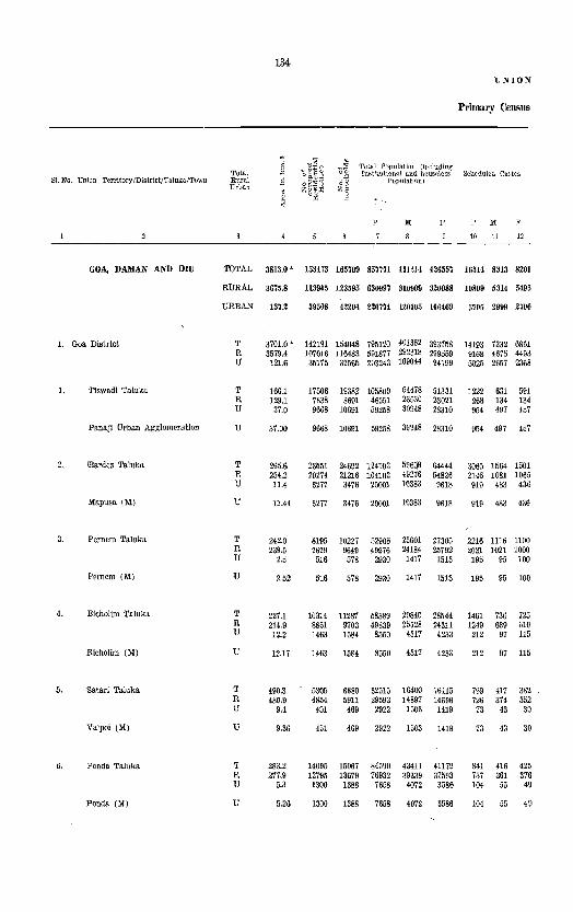
134-UNION
Primary Census
] .-~~~ ~~ Total Population (including Total
:'~~§ 00 Iwtlotution-e.l and houseless Scheduled Castes
S1. No, Union Territory IDistrictjTaluka/TOwn Rural .~ " Population) 0& Urban • zg~~ Z, 0
~ ~
P M F r M F
10 11 12
GOA, DAMAN AND DIU TOTAL 3813.0 .,. 153173 165799 857771 131214 426557 1651{ 8313 8201
RURAL 3675.8 113965 123595 630997 310909 320088 10809 5314 5495
URBAN 137.2 39508 42204 2267a 120305 106469 5705 2999 2706
1. Goa District T 3701.0 ' 142191 154048 795120 401362 393758 14193 7332 6861 R 3579.4 107016 116483 591877 292318 299559 9168 4675 4493 U 121.6 35175 37565 203243 109044 94199 5025 2657 2368
1. Tiswadi Taluka T 166.1 17506 19382 105809 54478 51331 1222 631 591 R 129.1 7838 8691 46551 23530 23021 268 134 134 U 37.0 9668 10691 59258 30948 28310 954 497 457
Panoji Urban Agglomeration U 37.00 9668 10691 59258 30948 28310 954 497 457
2. !Barde. Taluka T 265.6 23551 24692 124103 596$ 64444 3065 1564 1501 R 254.2 20274 21216 104102 49216 54826 2146 1081 1065 U 11.4 3277 3476 20001 10383 9618 919 483 436
Mapusa (M) U 11.44 3277 3476 20001 10383 9618 919 483 436
3. Pernem Taluka T 242.0 8195 10227 ll290B 25601 27305 2216 1116 1100 R 239.5 7679 9649 49976 24184 25792 2021 ]021 1000 U 2.5 516 578 2930 1417 1513 195 95 100
Pernem (M) U 2.52 516 578 2930 1417 1513 195 95 100
4. Bicholim Taluka T 227.1 10314 11287 58389 29845 28544 1461 736 725 R 214.9 &851 9703 49839 25528 24311 1249 639 610 U 12.2 1463 1584 8550 4317 4233 212 97 115
Bicholim (M) U 12.17 1463 1584 8550 4317 4233 212 97 115
5. Satari Taluka T 490.3 5305 6380 32515 16400 16115 799 417 382 R 480.9 4854 5911 29593 14897 14696 726 374 352 U 9.4 451 469 2922 1503 1419 73 43 30
Valpoi (M) U 9.36 451 469 2922 1503 1419 73 43 30
6. Ponda Taluka T 283.2 14095 15067 84590 43411 41179 841 416 425 R 277.9 12795 13679 76932 39339 37593 737 361 376 U 5.3 1300 1388 7658 4072 3586 104 50 49
Ponda (M) U 5.26 1300 1388 76ii8 4072 3586 104 55 49

TERBITORY
Abstract
l3ehedul.d Trllres
p
, 13
Io!
1l
F
16
Literate and Edu<:a.ted PeI'SOllB
p
16
Io!
11
F
18
135
Total Work.,. (I - IX)
p
19
M
20
F
21
P
22
WORKERS
Cultivators
M
23
F
2-1
II
Agricultural Labourers
P
25
M
26
F
Z1
7654 3836 3818 888864 234178 149686 271641 205936 65705 65110 45536 19524 40768 21280 19488
5824 2885 2939 256135 156710 99425 198175 144606 53569 62725 44032 18693 86754 19040 17714
1880
439 178 261
114 5
109
109
40 22 18
18
14 14
5 1 4
951 879 127729 77468 50261 78466 61330 12186 2385 1554 831 4014 2240 1774
252 105 147
56 3
58
53
23 13 10
10
2
2
187 360260 219339 140921 254475 192624 61851 73 244855 148959 95896 187141 136362 50779
114 115405 70380 45025 67334 56262 11072
58 56167 33803 2 21422 13323
56 34745 20480
56 34745 20480
17 69302 9 56679 8 12623
39240 31940 7300
22364 8099
14265
14265
30062 24739 5323
34368 26534 14935 11272 19433 15262
19433 15262
33570 24293 26359 20001 5211 4292
7834 3663 4171
4171
9277 8358 919
12623 7300 5323 5211 4292 919
20366 13658 18981 12802 1385 856
1385
24909 20279 4630
856
16541 13761 2780
4630 2780
8543 5876 6794 4849 1749 1027
1749 1027
35488 22659 30926 19904 4562 2755
6708 16768 11944 4824 6179 15924 11304 4620 029 844 640 204
529 644 640
8368 18928 14740 6518 16161 12634 1850 2767 2106
1850 2767
2667 10755 1945 10022 722 733
722 733
2106
8126 7478 648
648
12829 11022 1807
26899 20869 24793 19042 2106 1827
204
4188 3527 661
661
2629 2544
85
85
6030 5751 279
4562 2755 1807 2106 1827 279
60519 41899 58334 40498 2185 1401
5319 4518 801
801
8050 7835 215
215
3525 3039 486
486
4651 4512 139
139
18620 38296 17836 34470
784 3826
1794 1479 315
315
3399 3323
76
76
4523 2865 1658
1658
4378 4105 278
273
8619 8396
223
5836 2783 2273
223
5289 4997 292
292
4855 4804
51
51
6887 6823
64
5710 2686 2195 126 97 78
126
4256 4056 199
199
3681 3639
42
42
5381 5324
57
57
97
1034 941 93
93
1174 1165
9
9
1506 1499
7
78
2570 2373 197
191
2845 2809
36
36
5499 5406
93
93
20076 18220 17915 16555 2161 1665
2559 1628
931
931
1958 1815
143
143
1052 1024
28
28
1336 1241
95
95
1642 1822
20
20
3010 2955
55
55
1964 1237
727
727
2420 2290 130
130
1221 1171
50
50
1234 1132 102
102
1003 987 16
16
2489 2451
38
38
8l. No.
6

136 UNION
Primltry Census
WOR
III IV V
Total Manufacturing, Processing,
Sr. No. Union Territory/DistrictjTaluka/Town Br~~ Livestock, Forestry, Servi,cing and Repairs
Fishing, Hunting and Mining and (a) (b)
Plantation, Orchards QllllM'ylng Household Industry Other than House-and allied activities hold Industry
p M F P M F P M F P M F
28 29 3Q 31 32 33 31 35 36 rI 38 39
GOA, DAMAN AND DIU TOTAL 13~03 12035 1368 16439 12814 3625 10673 12955 2718 16551 15438 1113
RURAL 10878 9622 1256 14998 11675 3323 13181 10848 2333 8588 7854 734
URBAN 2525 2413 1I2 1441 1I39 302 2492 2101 385 7963 7584 379
1. Goa District T 10496 9247 1249 16237 12634 3603 14724 12257 2467 15988 14913 1075 R 9355 8187 U68 14815 11512 3303 12726 10577 2149 8350 7628 722 U 1141 1060 81 1422 1122 300 1998 1680 318 7638 7285 353
1. Tiswadi Taluka T 1003 913 90 389 318 71 1183 1053 130 2670 2570 100 R 651 576 75 161 157 4 689 619 70 663 625 38 U 352 337 15 228 161 67 494 434 60 2007 1945 62
Panaji Urban Agglomeration U 352 337 15 228 161 67 494 434 60 2007 1945 62
2. IBardez Taluka T 1531 1397 134 1264 1223 41 2672; 2181 491 2567 2493 74 R 1484 1357 127 1127 1089 38 2267 1830 437 1805 1755 50 U 47 40 7 137 134 3 405 351 54 762 7?8 24
Mapusa (M) U 47 40 137 134 405 351 54 762 738 24
3. Pernem TaJuka T 386 336 20 161 152 1406 947 459 323 298 25 R 380 360 20 155 146 137~ 929 450 281 256 2li U 6 6 6 6 27 18 9 42 42
Pernem (M) U 27 18 42 42
4. Bichollm Taluka T 669 632 37 4386 3649 737 1047 778 269 1344 1050 294 R 608 575 33 3667 3099 568 875 663 212 1005 774 231 U 61 57 4 719 550 169 172 115 57 339 276 63
Bicholim (M) U 61 57 719 550 169 172 115 57 339 276 83
5. Saiari Taluka T 540 . 467 73 712 578 134 302 229 73 134 118 -16, R 521 450 71 708 576 132 263 193 70 86 77 9 U 19 17 2 4 2 2 39 36 3 48 41 7
Valpoi (M) U 19 17 39 36 48 41
6. Ponda Taluka T 1959 1667 292 758 662 96 1491 1189 302 1263 1166 97 R 1931 1641 290 716 621 95 1430 1132 298 841 789 52 U 28 26 2 42 41 1 61 57 4 422 377 45
Ponda (M) U 28 26 42 41 61 57 422 377 45

.131 TERRITORY
A.bstract - contd.
KERS
VI vn Vlll IX x
S1. No Construction Trade and Commerce Transport, Storage and
Communications Othet Services Non-Worker.::
P
(0
M
41
F
42
P
43
M
44
F
Ii
P
46
M
47
F
43
r 49
M
50
F
51
P
52
M
53
F
54
12352 10726 1626 26114 21936 4178 24185 22389 1796 41046 30777 11)269 086130 225278 360852
7494 6497
4858 4229
11338 7126 4212
1961 583
1378
1378
1175 002 273
273
1579 1494
85
85
215 187
28
28
89 68 21
21
792 695 97
97
9926 ~254 3672
1660 473
1187
1187
1128 881 247
247
1574 1489
85
85
200 173
27
27
82 61 21
21
622 530 92
92
997 12005 9183 2822 11751 10586 1165 19801 15269 4532 432822 166303 266519
629 HI09 12153 1356 12434 11803
1412 24676 872 11593 540 13083
301 110 191
191
47 21 26
26
15 14 1
170 165
5
4212 801
3411
3411
4122 2742 1380
1380
559 478
81
81
1357 963 394
394
339 213 126
126
2067 1633 434
434
20873 3803 22964 ·21468 8886 2707 11048 10051
11987 1096 11916 11417
3589 579
3010
3010
3196 1~97 12)9
1299
437 367
70
10
1161 818 343
343
310 190 120
120
1819 1404
415
415
623 222 401
401
926 845
81
81
122 111
11
11
196 145
51
51
29 23 6
248 229 19
19
2051 832
1219
1219
2454 2111 343
343
319 272
47
47
720 585 135
135
196 131 65
65
2214 2022 192
192
1980 814
1166
1166
2350 2028
322
322
305 258 47
47
669 535 134
134
185 120
65
65
1988 1798 190
190
631 212~5 15508 5737 153308 58975 9U3S
1496 39237 29331 997 19324 14854 499 19913 14477
71 18 5&
53
104 83 21
21
14 14
51 50 1
11 11
226 2.14
2
11007 3172 7885
7885
5357 3981 1376
1376
1143 894 249
249
1331 901 430
430
743 419 324
324
3969 3;l96 673
673
8367 2762 5605
5605
3716 2837 879
879
977 765 212
212
1010 700 310
310
634 350 284
284
3365 2848
517
517
9906 540645 208738 331907 1 4470 404736 155956 248780 5436 135909 52782 83127
2690 410
2280
2280
1641 1144
497
497
166 129
37
37
321 201 120
71441 31616 39825
39825
90533 75743 14790
14790
36138 34052 2086
2086
39161 33678 5783
27944 12258 15686
15686
35366 29275
6091
6091
13657 12b80
777
43197 1 19358 24139
24139
55167 46168
8699
8699
22481 21172 1309
777 1309
15105 24356 12;94 20784
2211 3572
120 5783 2211 3572
109 21760 69 19571 40 2189
40
604 448 156
2189
57691 52139 5552
8274 13486 7419 12152 855 1334
855 1334
22542 20297
2245
35149 31842 3307
156 5552 2245 3307

138
UNION
Primary Census
8 .. ~ O]~~ Total Population (including
SI. No. Unlon TelTitoryjDistrict/Taluka/Town Total " o~~~
0.11 Inst!tutionai a.nd houseless SCheduled Castes Rural .s o~ Population) Urban . Zg'~~ Zo
0 E p; " <:
p III F P III F
10 11 12
7. 'Sanguem Taluka T 886.6 8769 9388 44588 23338 21250 780 437 343 R 881.2 7866 8463 39582 20800 18777 739 414 325 U 5.4 903 925 5006 2533 2473 41 23 18
Sanguem (M) U 5.40 903 925 5006 2533 24,73 41 23 18
8. Canacona Taluka T 347.4 5349 5564 29486 14696 14790 179 97 82 R 345.6 5089 5282 28151 14027 14124 164 89 75 U 1.8 260 282 1335 669 666 15 8 7
Cbauri (M) U 1.77 260 282 1335 669 666 15 8
9. Quepem Taluka T 347.3 7566 7893 41547 21130 20417 360 187 173 R 346.1 7018 7327 38622 19748 18874 313 161 152 U 1.2 548 566 2925 1382 1543 47 26 21
Quepem (M) U 1.18 548 566 2925 1382 1543 47 26 21
'10. Salcete Taluka T 277.2 29250 31820 155676 75186 80490 1917 1012 905 R 253.5 21124 22713 107083 49798 57285 690 341 349 U 23.7 8126 8607 48593 2:;,388 23205 1227 671 556
Margao Urban Agglomeration U 23.72 8126 8607 48593 25388 23205 1227 671 556
11. Mormugao Taluka T 78.3 12291 12848 65511 37618 27893 1353 719 63~ R 36.6 3628 3849 21446 11186 10260 115 60 55 U 11.7 8663 8999 44065 26432 17633 1238 659 579
Mormugao (M) U 11.66 8663 8999 44065 26432 17633 1238 659 579
2. Daman District T 72.0' 6374 6825 38739 19070 19669 1413 530 883 R 66.4 3569 3718 21422 10397 11025 1237 436 801 U 5.6 2805 3107 17317 8673 8644 176 94 82
1. Daman Taluka T 72.0 6374 6825 38739 19070 19669 1413 530 883 R 66.4 3569 3718 21422 10397 11025 1237 436 801 U 5.6 2805 3107 17317 8673 8644 176 94 82
Daman (M) U 5.60 2805 3107 17317 8673 8644 176 94 82
3. Diu District T 40.0 ' 4908 4~26 23912 10782 13130 908 451 457 R 30.0. 3380 3394 17698 8194 9504 404 203 201 U 10.0 1528 1532 6214 2588 3626 504 248 -256
1. Diu Taluka T 40.0 4908 4926 23912 10782 13130 908 451 457 R 30.0 3380 3394 17698 8194 9504 404 203 201 U 10.0 1528 1532 6214 2588 3626 504 248 256
Diu (M) U 10.01 1528 1532 6214 2588 3626 504 248 256

139 'TERRITORY
_Abstract - contli.
WORKERS
II
Scheduled Tribes Literate and Educated PersonS Total Workers (! - IX) SI.No.
Cultivators Agricultural Labourers
p M F P M F P M F P M F P M F
13 14 15 16 17 18 19 20 21 22 28 24 25 26 rfl
60 39 21 13782 9328 4414 17514 12758 4756 4448 3521 927 2129 1144 985 57 37 20 11403 7887 3516 16174 11698 4476 43,,8 3445 893 1894 1006 888 3 2 1 2379 1441 938 1340 1060 280 110 76 34 235 138 97
2379 1441 938 1310 1060 280 110 76 34 235 138 97
10022 6128 3894 9112 7198 1914 4132 3397 755 892 497 395 9212 5B67 354fl 1;747 6876 1871 4070 3316 754 889 497 392 810 461 349 355 322 43 82 81 1 3 3
810 461 349 365 322 43 82 81 3 3
14964 8982 5982 13613 10434 3!,;"9 5249 3870 1379 ~3(i9 1464 905 13510 8191 5319 1"926 9883 3043 5150 3829 1321 2309 1419 890 1454 791 663 687 551 136 99 41 58 60 45 15
1.454 791 663 687 551 136 99 41 5S 60 45 15
64 37 27 75780 42136 33644 469~5 33094 13901 7108 3427 3681 91>47 4508 5039 10 24 14 10 47759 25597 22162 00993 20147 10846 6887 3290 3597 8389 3818 4571 40 23 17 28021 16539 11482 16002 12947 3055 221 137 84 1158 690 468
40 23 17 28021 16539 11482 16002 12947 3055 221 137 84 l15S 690 468
138 86 52 30937 20988 9949 25953 22634 3319 543 355 188 1271 706 565 11 51 29 22 7890 0)38 28 2 8107 6027 2080 516 338 178 1236 690 546 87 57 30 23017 15950 7097 17846 16607 1239 27 17 10 35 16 19
87 57 30 23047 15950 7097 17846 16607 1239 27 17 10 35 16 19
7165 355li 3610 15448 9889 5559 11487 8932 2555 3562 2880 682 1915 955 960 5636 2770 2866 6564 4460 2104 6702 4879 1823 3426 2764 662 1746 879 867 1529 785 744 8884 5429 3455 <785 4053 737. 136 116 20 169 76 93
7165 3555 3610 15448 9889 5559 11487 8932 2555 3562 2880 682 1915 955 960 5636 2770 2866 6564 4460 2104 6702 4879 1823 3426 2764 662 1746 879 867 1529 785 744 8884 5429 3455 4785 4053 732 136 116 20 169 76 93
1529 785 744 8884 5429 3455 4785 4053 732 136 116 20 169 76 93
50 29 21 8156 4950 3206 5679 4380 1299 1029 807 222 557 249 308 10 10 4716 3291 1425 4332 3365 967 965 770 195 538 246 292 40 19 21 3440 1659 1781 1347 1015 332 64 37 27 19 3 16
50 29 21 8156 4950 3206 5679 4380 1299 1029 807 222 557 249 308 10 10 4716 3291 1425 4332 3365 967 965 770 195 538 246 292 40 19 3440 1659 1781 1347 1015 332 64 37 27 19 3 16
40 19 21 3440 1659 1781 1347 1015 332 6<1 37 27 19 16

140
UNION
Primary Census
WOR
III IV V
Total Manufacturing, Processing,
SI. No Union Territory/Distrlct/TalukafT{)W1l Jrb~~ Livestock, Forestry, Servicing and Repairs
Mining and Fish'ng, Hunting and QUarrying (al (bl Plantation, Orchards and allied activities
Household Industry Other than llouse-~Old Industry
p M F P M F P M F P M F
28 29 30 31 32 33 34 35 36 37 88 89
7. Sanguem Taluka T. 856 636 220 6357 4252 2105 593 537 56 340 317 23 R 804 586 218 6220 4166 2054 553 502 51 232 212 20 U 52 30 2 137 86 51 40 35 5 108 105 3
Sanguem (M) U 52 50 137 86 51 40 35 108 105
8. Canacona Taluka T 1218 )095 153 65 65 002 777 125 93 81 12 R 1242 1090 152 63 63 882 750 122 11 65 6 U 6 1 2 20 17 3 22 16 6
Chauri (M) U 20 17 3 22 16
9. Quepem Taluka T 269 232 37 1092 806 286 732 659 73 838 752 86· R 256 229 37 1079 793 286 709 639 70 722 645 77 U 3 3 13 13 23 20 3 116 107 9
Quepem (M) U 13 13 23 20 3 116 107 9>
10. Saleete Taluka T 1338 1196 142 643 587 56 3749 3320 429 3939 3744 191; R 1135 1021 114 570 519 51 3162 2836 326 1841 1750 91 U 203 175 28 73 68 5 587 4~4 103 2098 1994 104
Margao Urban Agglomeration U 203 175 28 13 68 5 587 484 ,103 2098 1994 104
11. Mormugao Taluka T 697 646 51 410 342 68 647 587 60 2177 2324 153 R 333 302 31 349 283 66 517 4Tt 46 803 680 123 U 364 344 20 61 59 2 130 113 17 1674 1644 30
Mormugao (M! U 364 344 20 61 59 130 113 17 1674 164. 3!)
2. Daman District T 1708 1595 113 55 41 14 523 427 96 478 460 18 R 3{5 259 86 54 40 14 193 145 48 211 201 10 U 1333 1336 27 1 1 330 282 48 267 259 8
1. Duman Taluka T 1708 1595 113 55 41 14 523 427 U6 ·478 460 18 R 345 2G9 86 54 40 14 193 145 48 211 201 10 U 1363 1336 27 1 1 330 282 48 267 259 8
Daman (MJ U 15&3 1336 27 330 282 48 267 259
3. Diu District T 1199 1193 147 139 426 271 155 85 65 20 R 1178 1176 129 123 262 126 136 27 25 2 U 21 17 18 16 1M 145 19 58 40 18
1. Diu Taluka T 1199 1193 147 139 420 271 155 85 65 20 R 117f, 1176 129 123 262 126 136 27 25 2 U 21 17 18 16 164 145 19 58· 40 18
Diu (Ml U 2 17 18 16 164 145 19 58 40 18 1
Note: - >I< These represent «geogra.phical area:. figures sllPvlied by the Sun'eyor General India. Thp urban area figures are provil'3io-nal
{If the district. TIle total Df the area figure:.: of the taluka.<:. of Go" District will not tally with the Goa Di:::trict figUrf:s because the former
11 =-= MunicipalIty

TERRITORY
Abstract - concld.
KER8
Vi
Construction
I'
4()
157 114
43
43
253 241 12
12
141 124 17
17
1582 538
1044
1044
3394 2180 1214
1214
660 215 445
600 215 445
445
354 153 201
354 153 201
201
M
41
123 84 39
39
187 175
12
12
132 116 16
16
1374 517 857
857
2844 1755 1089
1089
523 144 379
523 144 379
379
277 99
178
277 99
178
178
F
42
34 30 4
66 66
208 21
187
187
550 425 125
125
137 71 66
137 71 66
66
77 54 23
77 54 23
23
VII
Trade and Commerce
P
43
740 574 166
166
473 422
51
51
914 811 103
103
6439 2409 4030
4030
3454 547
2907
2907
920 159 761
920 159 761
761
518 253 265
518 253 260
265
M
44
663 515 148
148
F
45
77 59 18
18
264 209 218 204
46 5
46
795 701 94
94
5634 1839 3795
3795
3005 358
2647
2647
671 139 532
671 139 532
532
392 158 234
392 158 234
234
119 110
9
805 570 235
235
449 189 260
260
249 20
229
249 20
229
229
126 95 31
126 95 31
31
141
VIII
Transport, Storage and Communications
p
~
912 769 143
143
326 304 22
22
878 802
76
76
3700 2311 1389
1389
9194 909
8285
8285
470 91
379
470 91
379
379
751 612 139
751 612 139
139
M
41
798 655 143
143
281 260 21
21
791 716
75
75
3433 2176 1257
1257
8688 691
7997
7997
436 90
346
436 90
346
346
485 44.5
40
485 445 40
40
F
48
114 114
45 44 1
87 86 1
267 135 132
132
506 218 288
288
34 1
33
34 1
33
33
266 167 99
266 167
99
99
P
49
982 676 306
306
708 563 145
145
1131 954 177
177
8950 3751 5199
5199
3866 717
3149
3149
1196 262 934
1196 262 934
934
613 215 398
613 215 398
398
IX X
Other ServkeR Non-Worke-rs 81. No.
M
50
767 527 240
240
554 432 122
122
933 796 137
137
5871 2381 3490
3490
3137 456
2681
2681
944 218 726
944 218 726
726
502 197 305
502 197 305
305
F
51
215 149 66
P
52
27074 23408 3666
M
53
10580 9107 1473
16494 14301 2193
66 3666 1473 2193
154 20374 131 19404 23 970
23
198 158
40
40
3079 1370 1709
1709
729 261 468
.68
252 44
208
252 44
208
208
111 18 93
111 18 93
93
970
27934 25696
2238
2238
108681 76090 32591
32591
39558 13339 26219
26219
27252 14720 12532
27252 14720 12532
12532
18233 13366 4867
18233 13366 4867
4867
7498 12876 7151 12253 347 623
347
10696 9865 831
831
42092 29651 12441
12441
14984 5159 9825
9825
10138 5518 4620
10138 5518 4620
4620
6402 4829 1573
6402 4829 1573
1573
623
17238 15831 1407
1407
66589 10 46439 20150
20150
24574 11 8180
16394
16394
17114 9202 7912
17114 9202 7912
7912
11831 8537 3294
11831 8537 3294
3294
since the SUfl;"e-Y work is not fully finalised. Area figures for rural areas are deriyed by substracting the urba.n area from the tQtnl are& represent dand use" area and are derL\'ed from the fir:;ures supplied by the Director of La.nd Surv~y, Govt. of Goa, Daman and Diu, Panaji.


Goa District

GOA DISTRICT t At 'MilES
KILOMETRES, ~ 0 "I
v
.,
INOEX
OISTR ICT HEADQUARTERS •.
TAHSIl,iTAWKA HEADQUARTERS .. ,
STATE BO\INDARY,.
12
~
TAHSll/TAlUKA BOUNDARY, ......... _. _. _
NATIONAL HIGHWAYS.. ... .. ....... --
STATE HIGH WAYS ....
METAllEOfUNMETA1<ED ROADS. ," , .. -" ..
RiVERS ANO STREAMS ... , ........ .,_ --
TOWNS................... •
VillAGES WITH5000..... •
POPULATION AND OVI::R
MARKETS .......... ..
POST", TELEGRAPH OmCES •.••.•. , PI
REST HOUSEfTRAVEllE~SBUNG.OI.OW... "
METRE GAUGE PAllWAYS ........... ...::....
I 16
P.
I , ,
~
THE lERRnORI/.\,. WATEftS OF INDIA EXTEND INtO T~~ SEA TO;' " MEASURED FRO'" THE APPROPRlATE USE LIKt
Ip' ZP'-l ~:~~~F tHE l:~£:~~N 1:~':~UAN~~AI1[D ::::5 fiSWAOI 1111 I Ie I
BARDfZ as I Jt I
PERNO. ]1,2 G 17 1
IIlcHOLtM 111 t 2& 1
SAl,6,~1 4U J 11 I -6~1 PONOA lU.l JO
S,I,LC,[TE
MORIH/GAO
Toal
]47·J
l17.1
71.J
nOLO
" " ~l
R;lAARUFlIiI.lft:5,5E1 THEr-OOlHDIE I€LOWTH[UNION )'
)' IUFlIIORY .... I.:ARYAH5uS dSTUtT. .
~--------~----~
J
\
/
r'
" .).. f i ~,\ .
A'NACONA~ ~,( ~ ;; : "Eo "" ~ •• : .. ~.:~! '- .~.
',;-;:,:'
(IJ

Tiswadi Taluka

TA~SH/Tl,LIJK'eCU~C),lIy ................... " ., •• , _ .... ..
TAIISHJrALuKAMrJ,OOL''''Alfll~ •• ·.·''.,,,,' ••••• , •••• @ VllLACE BOU)lClfltrtw)l~ LO(.AT\ON.(:ootlfJl"let~5 ...... _.!o._
NAltONALloIlv~l'I'''¥''·".·.·,····· ••• ··,··.·.,,,
~lAf£ IIIGH""~.i'S ••••••••• :. $ " ••••• '., •••••••• -..S.I:L_..
M[IALl'OIlOjlOS ••••••••• , ••••••• , ••.•• ~ ••••• __
UNME TALlr~ ROil",> ••••••• , • " •••••••••• '.,. ";~::==
1I1Y[IISP.NOSIR£AM'S ••••••••.••••••••• , •••• , •• =:--_ $YM90LICI::CPF'['S[NTAfIOrvorvIHAtpE'iINTH£ ••••• I, ••.•.•••• FOLLOWINI;. WfGQt:.[<; ~ ~o ~" ,"\:g .,,'!~g
POsrorrrcn /rrLEC;IIA1'H OFTICE S •• '" , './ ~ .•• , ••• ' ,. ~~/;;' ~9' ·on ... bo"
P'CLIcrS1AT'DN ••••••• ; •• : .... ~ •. ; ••••• ~~ •• , ••• ,. PS
POLlc£our POST ,', ... " ••• , ......... ) ..... ' .... ,' ,', !::.,
IIUTHOUSE/·!I;.l'rll£II'I;8D"Go\~OW.;" ... ".- •. _ •.• ,.
URBAN .tJt[.s~ •• •· .... ,., ••. ·: •. · •• -, .. ~··· .. • .• , •• ;.,~ ~
MORMUGAO
TALU~A
,,' 50' ,,'
"
GOA DISTRICT
TI SWADI TALU KA
,6
I J I '" "

Taluka: TilsWadi
Ambarim
Azossim
Baingulnim
Bambolim
Batim
Calapor
Capao
Caraim
Carambollm
Chimbel
Chorao
CorUm
Cujira
Cumbarjua
Curca
Durgavado
Ella
Gancim
Gandaulim
Goalim-Moula
Goa-Velha
Goltim
Jna
Malar
Mandur
Mercurlm
Morambl-o-Grande (MereeB)
Morambl-o-Pequeno (Mereeo)
Murda
Naroa
143
ALPHABETICAL LIST OF VILLAGES AND TOWNS
Location Code NQ. 1/:1
Location Code No.
20
15
30
27
36
14
17
13
31
10
29
38
12
21
11
19
26
22
25
33
35
32
population in 1911 Ce1lSus
119
785
110
2,796
1,247
Included in Panaji Urban Agglomera-ration.
186
238
3,639
Included io Panaji Urban Agglomera-tion.
4,102
1,964
Included in Panaji Urban Agglomera-Hon.
3,566
1,609
609
533
160
207
501
3,828
1,707
3,843
1,399
3,209
4,592
Included in Panaj! Urban Agglomera-tion.
Included io Panaji Urban Agglomera-tion.
InCluded io Panaji Urban Agglomera-tion.
405
Taluka: Tiswadi
Name
NaveUm
N eurawo-Grande
Neura-o-Pequeno
PANAJI URBAN AG-GLOMERATlON
PaneUm
Renovadi
Sirldao
Talaulim
Taleigao
Total
•
Location Code No. 1/1
Location Code No
24
23
16
34
28
18
37
PO}:lulation in Ifl71 Census
1,004
940
513
59,258
Included in Panaji Urban Agglomera-Hon.
136
2,136
468
Included in Panaji Urban Agglomera-tion.
105,809
.Vote. -- The constituent units of the Panaji Urban Agglomera-tion ar~ given below aiongwith their 1971 Census Papulation.
LocatioIi Population in 1971 Name Code Ko Censu~
Calapor 36 6,663
ChimbeJ 17 3,847
Cujira 3.1 716
Moramb1-0-Grande 33 1,188 (Meree,)
Morambi-O-Pequeno ':15 1,254 (Merees)
Murda 32 3,048
Panajl Municipal Council 34,953
Panellm 16 672 Talelgao 37 6,857
Tota.I 59,258

144
Primary CeD81JS District Goa Code No. 1
m ." , " . . $E " a ~~ , "E Z .~'G Total Populat}on . NaIlle of villagel ~ Literate and
'" tQwn/ward/urbau .3 3 (including insUtu- Scheduled Scheduled
Bducated Total 0 ~~ tional & lIouselefl~ Castes Tribes
<:J enumerator's ~~ population) Persons workers
blade ~, (I-IX)
] ~~ "e Cultivators 'tB 0
~ '0 5 z
" ~~ 0
p l( F I( F M F '" " I;[ F :u: " 10 11 12 13 I. I, 16 17 I!
Tiswadi TaJUka
TOTAL 166.1 Km' 11506 19382 105809 54478 .1881 631 591 56 58 ~3803 22364 241534 78St 3525 179t • @
RURAL 129.1 Km' 7838 8691 46551 23530 23021 13t 134 13323 8099 11272 8663 3039 Ii79
URBAN 37.0Km' 9668 10691 59258 S0948 28310 497 457 53 56 20480 14265 15262 un 486 315
RUBAI,
1 Chorao N.A. 717 779 4102 1947 2155 19 14 1017 807 864 325 461 198 2 Ambarim N.A. 29 29 119 60 59· 27 25 33 18 9 .3 3 Caraim N. A. 59 62 238 99 139 67 61 44 43 28 34 4 Capao N.A. 55 55 186 88 98 56 49 29 20 5 17 5 Navelim N.A. 224 236 1004 477 527 237 212 182 161 59 63
6 Goltim N. A. 366 383 1707 803 904 11 497 457 333 129 73 26 7 MaJar iN. A. 306 319 1399 637 762 4 397 331 276 138 143 87 8 Naroa iN. A. 68 80 405 199 206 98 91 85 22 21 3 9 Jua N. A. 734 825 3843 1586 2257 3 10QZ 1183 536 265 74 158
10 Cumbarjua iN. A. 585 594 3566 1858 1708 19 ~o 1223 640 853 211 239 144
11 Gandaulim N. A. 49 49 207 94 113 58 51 33 6 7 3 12 Ella N.A. 82 90 533 204 329 3 1 138 211 128 62 18 1 13 Corlim N. A, 367 424 1964 1039 925 12 17 425 259 594 197 43 23 H Caramtoum N. A 502 576 3639 1823 1816 8 14 806 330 845 460 521 325 15 Bamguinlm N. A. 19 22 110 54 56 30 29 26 7
16 Panelilll Inelt>ded !in tbe Urban 17 Chimbel Included ·in It.Ile Urban 18 Talaulim N. A. 76 90 468 224 244 99 48 96 10 58 2 19 Goalim-Moula N. A, 70 88 501 261 240 148 80 121 2 62 20 Azossim N.A 147 153 785 390 395 170 97 167 46 83
21 Gancim N.A- 24 26 160 81 79 42 20 29 8 22 Mandul' N.A. 613 677 3209 1525 1684 979 615 744 247 337 13& 23 Neura-o.-Pequeno N.A. 85 93 513 265 248 127 65 120 27 82 13 24 N eura-o-Grande N. A. 165 180 940 448 492 309 208 223 94 89 41' 25 Merclll'im N. A. 660 767 4592 2280 2312 10 1103 765 997 365 246 84
26 Goa-Velha N.A. 610 664 3828 1963, 1865 20 14 1034 562 817 204 118 21 27 Balim N.A. 236 270 1247 589 658 1 3 238 190 261 62 111 '27,
28 Siridao N.A. 351 399 2136 1134 1002 4 5 450 180 506 189 18 29 Curca N. A. 250 326 1609 810 199 6 4 402 215 363 141 86 21 30 Bambolim N.A. 267 303 2796 2213 583 6 1 1882 198 1818 160 35 28
31 Cujira Includod litn tile Urban
32 Murda Lncludod !in <\he Urban
33 Morambi~o~
Grande (Merees) Included 'in the Urban
34 Rehovadl N. A. 21 27 136 67 69 26 15 29 23 35 Moramb[ -0-Pe-
queno (Merees) Included in the Urban

145
Abstract Taluka Tiswadi Code No. 1/1
WORKERS " ~ " II III IV V VI VII VIlr IX X E " Manufacturing, Z
Livestock, Processing, Servicing < Fore"try, and Repairs '" Fishing Transport, c D
Agricultural Hunting & Mining (a) (b) Cons- 'l'rade & Stornge & Other NOll-labourers Plantations, and tructior: Commerce Communi- services -Woriwrs §
Orchards Quarry- Household Other than cations ~ & Allied ing Industry Household g activities Industry
'"' M F M F M F M F M F M F M F M F M F M F
19 20 21 22 23 24 25 26 27 28 29 30 31 32 33 34 35 36 37 3&
2559 1964 913 90 818 71 1053 130 2570 100 1660 301 8589 623 1980 71 8867 2690 27944 43497
1628 1257 576 75 157 619 70 625 38 473 110 579 222 814 18 2762 410 12258 19858
931 727 337 15 161 67 iS4 60 1945 62 1187 191 3010 401 1166 53 5605 2280 15686 2039
AREA
107 95 12 17 53 12 53 41 99 22 1083 1830 4 6 2 3 1 6 1 27 41 2 5 2 4 3 3 5, 96 5 2 10 2 1 1 3 3 ,9 78
49 n 11 14 7 10 13 21 13 295 366
49 n 5 2 36 19 12 57 4 19 61 22 470 775 6 27 27 3 1 13 19 1 23 2 19 27 18 361 624 7 18 12 7 1 10 6 2 16 6 5 114 184 8 30 17 78 22 36 58 19 11 42 18 96 92 44 1050 1992 9 84 33 58 1 58 43 56 7 74 5 159 75 19 1005 1497 10
2 1 6 1 1 5 5 1 61 107 11 3 1 4 28 2 2 10 1 59 57 76 267 12
133 54 3 16 47 16 242 65 30 24 54 26 445 728 13 151 106 1 15 27 S 12 16 40 61 16 978 1356 a
1 1 2 14 1 2 3 3 3 28 49 15
Agglomeration of Panaji 16 Agglomeration of Panaji 17
8 2 4 1 8 4 8 128 234 18 26 2 2 8 4 8 140 238 19 21 22 6 6 33 14 223 349 20
7 7 1 16 1 4 1 52 71 21 92 74 12 8 55 26 34 92 82 28 781 1437 22 7 12 1 1 4 1 13 11 1 145 221 23
20 24 5 1 2 5 17 3 14 1 27 41 18 225 398 24 278 194 57 12 12 97 70 7 52 ~O 93 85 25 1283 1947 25
92 95 112 142 11 52 6 61 34 64 168 n 1146 1661 26 35 20 17 30 6 8 3 7 45 10 328 596 27
184 74 158 36 36 33 1 14 65 23 37 7 628 813 28 95 97 24 9 12 11 19 16 25 81 3 447 658 29 84 88 1 17 123 40 22 1 3 1533 3 395 423 30
Agglomerabion of Panaji 31 Agglomerabion of Banaji 32
Agglomeration of Panaji 33 14 23 13 38 46 34
Agglomeration of Panaji 35

146
Dhttrict Goa Code NO.1 Primary Census
<D"
" .. ~ _;j~
~~
• "'" Z .~~ '1'otal Popul~lXln ~
Naml:' -of village/ Literate and '" town/wart! urb,,1n .'" (incluiling m!'!titll.- ScheDuled Sr.hp.nuled Total 0 enumerator's ", tiona] & lIousele!3S Cal'!tcs Tribes Educated r;
blocl;; ~~ ~ popuLation) Persons workers
§ (I·IX)
~ 6~ a Cultivators
2 C
3 ~, 15 z ~~
P M F M F ~f F M F 1>1 F ,r F
ID 11 12 13 14 15 16 17 18
36 Calapor Included jJl the Urban 37 Talelgao Included jJl the Urban 38 Durgavado iN.A. 95 105 609 312 297 186 105 120 21 13
URBAN
P.anaji Ur:ban AgglomeraJtlon 37·00 9668 10691 59258 30948 28310 497 457 53 56 20480 14265 15262 4171 486 315
pan"ji Municlpal COunoil 7.56 5638 6178 34953 18577 16376 223 208 52 55 13392 9478 9712 2480 66 39
Wa"d No.1 N. A. 475 520 2792 1566 1226 38 48 12 14 1153 777 972 286
EB No. 1 N. A. 125 138 776 438 338 367 23) 258 70 FB No. 2 N. A. 113 124 666 369 297 285 234 217 73 EBNo. 3 N. A. 127 127 757 410 347 34 40 277 170 258 99 Ett No. 4 N.A. 110 131 593 3,9 244 224 142 229 44
Ward No.2 N. A. 269 310 11\97 893 804 670 467 427 76
ES No. N. A. 97 106 562 304 258 211 146 145 27 EB No. N. A. R7 99 557 281 276 236 187 135 32 EB No. N.A. 85 105 578 308 270 223 134 147 17
Ward iND. 3 iN. A. 259 301 1625 769 856 544 484 331 121 24 IT
EB No. 8 N.A. 106 124 560 264 296 197 172 123 40 2 EB No. 9 N. A. 90 99 590 287 303 197 111 120 35 7 4 EB No. 10 iN. A. 63 78 475 218 257 150 141 88 46 15 13
Ward No.4 iN. A. 358 400 2365 1210 1155 10 13 931 795 588 189
EB No. 11 N.A. 84 88 551 277 274 239 206 124 37 EB No. 12 N. A. 87 96 W6 318 288 250 197 154 26 EB N,. 13 N.A. 119 129 814 414 400 277 251 202 68 EB Nc. 14 N. A. 68 87 394 201 193 165 141 108 58
Ward No.5 N. A. 329 358 2200 1077 1123 42 31 18 12 876 767 454 181
EB No. 15 iN. A. 61 69 442 171 271 13 6 134 225 66 66 EB No. 16 N.A. 84 90 589 316 273' 6 6 2 268 183 110 29 EB No. 17 N. A. 108 113 607 296 311 10 9 1 234 179 140 68 EB No. 18 N.A. 76 86 562 294 268 13 10 15 240 180 138 18
Ward No.6 iN. A. 350 382 2057 1086 971 10 909 694 495 80
.BBNo.19 N.A. 87 107 650 343 307 297 228 135 13
EE No. 20 iN.A. 105 115 703 377 326 3 312 241 160 38
EB No. 21 N. A. 158 160 704 366 338 5 30U 225 200 29

147
Abstract - contd. Taluka Tiswadi Code No. 1/1
WORKERS " . .0
II III IV V VI VII VITI IX X S
Manufa('tu:r~,ng, ~ Lh'f'stori{, Processine-. Servicing , Forestry, and Repairs 'g Fi~hing Mining Transport. 0 Agricultural Hunting & and (a) (b) emu;- Trade & Storage & other Non-
la.bourer>! Plantations. Quarry- tructior! Commerce Communi- services ·Worlters .§ Orchards ing Household OUler than ('_.ations & Allied Industry HOlAsehold ~ activiti-cs Industry
...1 M F :If F M F M F M F " F M F M F M F M F
19 20 21 ~2 23 24 25 26 27 28 2!1 3D 31 32 33 34 35 36 37 38
Agglornera~·ion of Panaj[ 36 Agglomeration of Panaji 37
1 4 27 10 12 13 38 192 276 38
AREA
931 727 337 15 161 67 434 60 1945 62 1187 1m 3010 401 1166 53 5605 2280 15686 24139
138 28 241 10 183 21 1155 42 892 176 . 2388 271 673 45 3966 1850 8865 13896
81 101 24 300 35 57 6' 421 219 594 940 Ward No.
23 5 119 10 11 99 59 180 268 EB No. 21 1 110 II 8 83 58 142 224 EB No. 22 27 9 47 12 1 159 76 152 248 EBNo. 15 68 15 24 2 37 80 26 120 200 EB No.
21 13 116 24 78 18 50 116 51 466 728 Ward No. 2
14 33 6 30 10 21 34 11 159 231 EB No. 3 13 20 4 32 14 47 31 146 244 EBNo. 4 63 14 16 15 35 9 161 253 EBNo.
29 48 14 45 16 46 112 79 438 735 Ward No. 3
3 2 22 18 7 15 58 31 141 256 EBNo. 8 26 3 15 12 9 17 30 16 167 268 EBNo. 9
4 11 15 14 24 32 130 211 EB No. 10
II 98 48 15 136 18 46 241 147 622 966 Ward No. 4
21 7 25 11 56 31 153 237 EB No. 11 31 3 39 14 60 24 164 262 EB No. 12 30 34 15 40 19 73 48 212 332 EB No. 13 )6 4 32 2 52 44 93 135 EB No. 14
12 70 26 99 37 205 160 623 942 Ward No. 5
2 8 1 15 1 9 29 58 105 205 EB No. 15 4 10 11 16 1 10 59 28 206 244 EB No. 16 6 11 6 34 6 6 74 59 156 243 EB No. 17
41 8 34 1 12 43 15 156 250 EB No. 18
11 72 28 95 29 258 75 591 891 \yard No.6
6 22 4 33 12 57 11 208 294 EB No. 19 5 39 18 47 13 38 36 217 288 EB No. 20
II 6 15 4 163 28 166 309 EB No. 21

148
District Goa Code No.1 l'riDIary CeIl80S
"
j ~~ ~" ~
"" '0 Z
Name of "mage/ E,~ 'il Total Popula.bon . . ~ Literate a.nd
" town/ward urban ~; ill (including institu- Sc.h~duled Schedultd Educated Total
0 enumerator's 0 tional & I10uscless Castts Tribes 0 '" " popul!l.tion) Persons: .,:orkers
I bloc~
~~ 1l (I-IX)
~o " Cultivators
0" " ~ f6 ~
<~ 0
P M F M F M F II! F M F II! F
10 11 12 13 14 15 16 11 Ii
Ward No.7 iN. A.. 526 567 3291 1757 1534 36 29 1080 691 832 167
EB No. 22 iN.A. 134 140 688 343 345 18 20 217 172 170 48 EB No. 23 iN. A.. 122 127 766 401 365 117 55 197 71 EB No. 24 iN. A.. 87 95 538 299 239 2 230 146 154 22 EB No. 25 iN,A.. 94 107 688 383 305 10 265 158 157 20 EB No. 26 iN. A. 89 98 611 331 280 6 251 160 154 6
Ward No.8 iN. A.. 481 500 2797 1561 1236 33 27 13 10 1076 678 794 238
EB No. 27 iN. A. 124 136 670 ' 336 334 28 27 287 231 154 84 EB No. 28 N.A, 65 66 638 342 296 190 161 96 49 EB No. 29 N.A. 150 150 685 465 220 1 269 46 282 48 EB No. 30 iN,A. 60 65 352 202 100 2 168 98 161 34 EB No. 31 N. A. 82 83 452 216 236 10 162 142 101 23
Ward No.9 N. A. 351 403 2137 1168 969 947 611 594 126
EB No. 32 N.A. 97 131 617 344 273 269 191 179 50 EB No. 33 N.A. 80 82 436 234 202 200 148 103 16 EB No. 34 N.A. 73 85 510 274 236 215 117 152 21 EB No- 35 N. A. 101 105 574 316 258 263 155 160 39
Ward No. 10 N.A. 430 456 2264 1215 1049 936 639 694 130
EB Nd. 36 N.A. 56 60 345 187 158 154 122 lI7 33 EB No. 37 N.A. 122 135 668 352 316 281 221 190 57 EB No, 38 N. A. 120 127 580 309 271 234 118 178 17 EB No. 39 N.A. 132 134 671 367 304 267 178 209 23
Ward No. 11 N. A. 376 405 2246 1219 1027 24 24 962 646 654 139
EB No. 40 N. A. 119 123 751 409 342 355 249 233 57 EB No. 41 N. A. 155 171 899 499 400 354 217 276 58 EB No. 42 N. A. 102 111 596 311 285 24 24 253 180 145 24
Ward No .• 12 N. A. 226 279 1704 972 732 695 454 595 111
EB No. 43 N.A.. 63 82 526 335 191 233 132 236 44 EBNo. H N.A. 89 108 686 356 330 268 176 174 29 EB No. 45 N.A. 74 89 492 28t 211 194 146 185 38
Ward No •. 13 N.A. 222 235 1743 896 847 593 481 503 276
EB No. 46 N.A. 35 38 361 220 141 158 86 167 39 EB No. 47 N.A. 92 99 596 317 279 196 140 167 71 EB No. 48 N.A. 95 98 786 359 427 239 255 169 166

149 Abstract - contd.
Taluka Tiswadi Code No. 1/1
WORKERS · · ~ II III IV V VI VII VII! IX l( E " Manuiactuf!Dg, Z Livestock, Processing, Servicing · Forestry, and Repairs ~ Fisnillg Mining Transport, 15 Agl'icullura.l HUllting & and (a) (b) Cons- Trade & Storage & Othel' Non-labourers Planta.tions, Quarry- truction Commerce Communi- services -Workt'rs " Orchards jog Household. Other than cations 0
& Allied Industry lIousehold ~ acUvlt!es Industry 0
l( F M " II{ F M F M F II! F M F M F ~
III F M F
19 20 .21 22 23 .24 ~ 26 27 28 29 lID 31 S2 33 34 35 36 37 38
12 31 122 97 122 92 348 139 925 1367 Ward No. 7
13 11 17 20 13 92 39 173 297 EE No. 22 7 15 26 29 6 114 67 204 294 EE No. 23 2 48 18 29 23 30 13 145 217 EE No. 24 7 28 11 25 14 65 16 226 285 EB No. 25 ·2 20 25 19 36 47 4 177 274 EE No. 26
39 130 36 132 17 23 465 176 767 998 Ward No. S
13 2 42 10 86 71 182 250 EB No. 27 13 6 1 26 4 55 39 246 247 EB No. 28
7 117 33 11 1 10 136 14 183 172 EE No.' 29 1 10 2 41 1 108 32 41 116 EB No. 30 5 12 80 20 115 213 EB No. 31
80 18 233 33 217 112 574 843 Ward No. 9
18 74 10 65 47 165 223 EB No. 32 13 33 9 45 12 131 186 EB No. 33 29 58 10 45 20 122 215 EE No. 3{ 20 68 4 62 33 156 219 EB No. 35
101 65 16 251 12 32 232 94 521 919 Ward No. 10
12 8 64 2 2 29 31 70 125 EB No. 36 22 18 70 8 6 70 40 162 259 IDB No. 37 41 12 43 12 /0 12 131 254 EB No. 38 26 27 74 12 63 11 158 281 EB No. 39
22 13 61 54 264 14 63 175 111 585 888 Ward No. 11
3 1 12 6 131 9 70 51 176 285 EB Nc. 40 19 10 19 34 86 48 60 43 223 342 EB No. 41
2 30 11 47 6 45 17 166 ,SI BB No. 42
32 65 21 302 12 25 149 93 377 621 Ward No. 12
20 165 6 37 34 99 1<7 EB No. {3 27 30 53 6 49 27 182 301 illB 1'0. 44 5 15 84 13 63 32 96 173 EB No. 45-
32 85 35 153 21 12 213 217 393 511 Ward No. 13
7 64 13 95 25 53 102 EB No. 46 3 16 30 17 43 7 63 46 150 208 EB No. 47 1 9 55 18 46 1 55 146 190 261 EB No. 4&
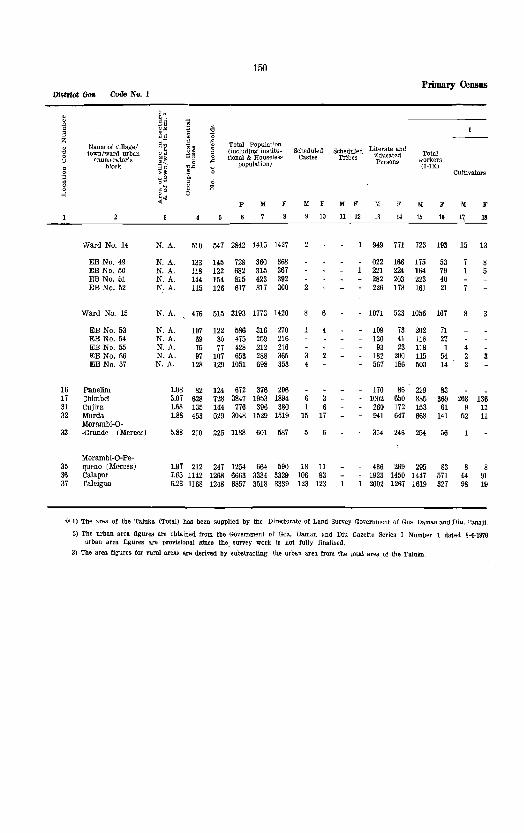
150
Primary CeUSD8 District Goa Code No.1
· llie-l · ~~ .. .0
" U-
S 11" ~ ~ " z ~i ~~ ~ Total Populat'on · Name of village/ , . ~ (including institu- Scheduled Scheduled Literate and
" town/ward urban .. F.duca.t~d Total 0 ,,~ ,,0 0 tional & Housele8~ Castes Tribes workers () <7numerator'g
~~ g -" population) Persons
c blocl" '£" (I·IX) 0 ~~ '0 Cultivators
~ 0: E. , 0 '0 g Z
>-1 ~~ 0
P M F M F M F M F M F M F
10 11 12 13 14 1.5 16 q 18
Ward No. 14 N. A. 510 547 2842 1415 1427 949 771 723 193 15 13
EB No. 49 N. A. 133 145 728 360 368 022 166 175 53 EB No. 50 N. A. 118 122 682 315 367 221 224 164 79 EB No. 51 N. A. 144 154 815 423 392 282 203 223 40 EB No. 52 N. A. 115 126 617 317 300 226 178 161 21
Ward No. 15 N. A. 476 515 3193 1773 1420 1071 523 1056 167
EB No. 53 N. A. 107 122 586 316 270 109 73 202 71 EB No. 54 N. A. 69 80 475 259 216 120 41 118 27 EB No. 55 N. A. 75 77 428 212 216 93 23 118 1 I']B No. 56 N. A. 97 107 653 288 36.5 182 200 115 54 EB No. 57 N. A. 128 129 1051 698 353 567 186 503 14
16 Panelim 1.08 82 124 672 376 296 170 86 229 83 17 ::himbel 3.07 628 728 3847 1953 1894 6 3 1002 650 885 369 208 136 31 Cuj'ira 1.68 135 144 776 396 380 1 6 260 172 153 61 9 11 32 Mum. 1.88 453 529 3048 1529 1519 15 17 941 647 668 141 52 11
Morambi-O-33 ·Grande (Merees) 5.88 210 225 1188 601 587 354 246 254 56
Morambi-O-Pe-35 queno (Me"ces) 1.97 212 247 1254 664 590 18 11 436 269 295 83 8 8 36 Cala[>Or 7.65 1142 1268 6663 3334 3329 106 83 1923 1450 1447 571 44 91 37 raleigao 6.23 1168 1248 6857 3518 3339 123 123 2002 1267 1619 327 98 19
'ill 1) The area of the Taluka (Total) has been supplied by the Directorate of Land Survey Government of Goa, Darnall and Diu, Panaji,
2) The urban area figures are obtained from the Government of Goa. Daman and Diu Gazette Series I Number I dated 8-4-1970 urban area figures are provisional since the survey work is not fully finalised,
3) The area figures for rural areas are derived by aUbstracting the urban area from the total area of the Taluka

151
All8tract - concld. Taluka Tiswadi Code No. 1/1
WORKERS . ~
II III IV V VI VII VIII IX X S
Manufacturing. Proc€:'ls- i Livestock, ing, Servicing and . Forestry, ~
fishing, Repairs
Transport. 0 t)
Wicultural Hunting & Mining and (a) (b) Trade & Storage & Other NOD-labourers Plantations, Quarrying Construct.ion Commerce Communi- servic(ffi -Workers " Orehards Industry Other than ('_ations ~
& Allled Household Household ~ activitiel Industr)'
" J,[ F M F M F M F M F M F M F )( F M F I{ ;'
1~ 20 21 22 23 24 25 26 27 28 29 3D 31 32 33 34 35 35 37 38
10 15 17 108 121 20 121 17 58 263 122 692 1234 Ward No. H
3 30 22 18 28 58 32 185 315 EB No. 49 12 13 29 42 6 63 <9 151 288 EB No. 50
45 « 40 11 71 26 200 352 EB No.5] 20 26 21 13 71 15 156 279 EB No. 52
114 11 120 14 62 60 14 57 54 70 16 551 55 717 1253 Ward No. 15
55 13 42 14 20 35 34 15 35 IH 199 EB No. 53 23 29 8 1 12 3 54 141 189 EBNo. M 80 4 6 1 3 17 94 215 EB No. 55 11 11 12 6 18 11 11 38 33 173 311 EB No. 56
21 2~ 12 12 5 19 407 8 195 339 EB No. 57
16 10 1 117 61 1 51 9 12 3 15 7 9 147 213 16 123 150 14 18 3 46 95 40 63 14 67 211 58 1068 1525 17
12 26 4 32 11 15 1 20 50 22 243 319 31 52 60 12 57 110 34 92 19 75 184 43 861 1378 32
38 34 60 15 26 20 82 10 347 531 33
13 17 2 20 13 51 13 39 10 24 122 34 369 507 35 233 303 10 43 9 198 85 191 31 140 494 125 1887 2758 36 306 99 51 74 5 193 83 14 184 51 132 489 129 1899 3012 37
.As the Cadastral Suney of the Union TerritQl'J' is in progress, the area figures of the TaJuka a.re to be considered provisIonal.
and also from the Directorate of Land S'LU"Vey. Pana.ji respect of 8 villa.ges whkh are included in Panaji Urban Aggomeration. The


Bardez Taluka

3,
, 3
"
l.~51l/1."LUI(A HEADOuAR1E~~ ., •.• '
"A,IONA,lNIGKWAVS _"
SIAT£ flIGH,j¥A'~ '< •••••• , ••• , , ••••
~nALL[D ROADS .•••.•.
UIfI!IE'AUEDRQADS , .•
ItIV£~S AHP STREAMS .....
S'RII8OLlc REPAESe:N'ATIONOfvILlAGESI N 1I1E
rcJllOWlIIG CAT[GORIES
POSI OF~ICfS/IHt~II'APII OFFicEs.
POlltES1,UIQH
f'OLICEOU1~5T
11m ~01)SE/TIIA~ELLER's aUIriGAlOW
@
" ..... ~:: ",:' 'i',~ '0.:0 !:.~o Z'Q 499 U~ 'W~ ~b~,t
PO/P1
, ..• " ......... PS 0,
........ ItH
iJRIlAN ... "EA5 ......... "........ • •••• ~
H05P1TAL5,PRIMARYIIEAlTHt:ENTREs..DlSPENSARIES ••• , ••• $ tHILO AND "'A'ERNIiV WELhAECEK1RES
~ , i>
GOA DISTRICT
8ARDEZ TALUKA
? .>
"-.... ::E
-'
0
" "

Taluka: Barde.
Namt
Aldona
Anjuna
A"Pora
A_gao
Asson'ora
Bastor.
C8langute
Ca.Jv'im·
Camurllm
canca
candollm
Colvalo
Corjuem
Oorl'im
Cuuchelim
Guinim
MAPUSA
Marna.
Moira
Mo;tem
Naclrino!a
Nadora
Nagna
N<!il'U!
Olaulim
Oxel
PaHem
153
ALPHABETICAL LIST OF VILLAGES AND TOWNS
Location Code No.
11
2V
28
33
25
21
U
31
20
39
32
37
24
1I
34
38
10
27
19
12
35
16
Location Code No. 1/2 Ta!uka: Bardez Location Code No. 1/2
Population in 19'/1 Censu::;
7,25.
5.894
2.078
2,689
2,167
2,297
7,600
521
2,307
1,198
4,463
2,951
467
Included in Muni· cipal Town of Ma· pusa.
Included in Muni' cipal Town of Ma' pusa.
3,705
20,001
753
2,655
69~
918
1,170
907
6,093
492
2,291
m
Nanl'
Parra
PHerne
Plirna
Pom'burpa
Ponolem
Punola
Revora
SallgalO
Sangolda
Serula
Sioilln
Sirca.im
Tivlln
Ucassailm
Verla
Total
Location Code No.
26
18
13
40
15
22
23
17
36
H
30
Population lJl 1971 Cemms
2,368
2.028
1,721
3,009
119
206
1,758
4,033
1,621
9,599
7,382
969
4,761
1,120
1,372
124,103
Note: - The following Diaces which have been declared as Revenuf> villages by the Government of Goa, Darnall and Diu vide Notification No. RD/LND/213/69-71/It dated 15-2-1971 are not independent Census villages. Th~y are :merged in the villages ehown against each 1'01' 1971 Cenr;U8
Census village in which it is merged
Name of Revenue village Location Code No Name
Marra 18 Pllen1e
Reis Magos 19 Noru!
Penha-de-France Salvador do Mundo 17 Se,u!

154
District Goa Cooe NO.1 Primary Census
. .. " " . . $" ~ g" " ~" Z
Name Qf village! ,S~ Total PoPUla.tioOll . ~ Literate and " town/ward urban ~~ (inr-!uding institu· Scheduled Scheduled
Educated Total 0 enumerator's
.¥f tional & Houseless Castes Tribes workers () ,;;, population) Persons
" block
~~ (I-IX)
§ Cultivators o~ ~
~ g e ~'O 6 ~ .::'" p ]I[ F 1{ F M " 1{ " l\{ F M F
10 11 12 13 14 15 16. 17 18
Bardez Taluka
TOTAL 265.6 Km' 23551 2469~ 12U03 59659 64444 1564 1501 23 17 39240 30062 24293 9277 4651 3399
RURAL 254.2 Km220274 21216 104102 49276 54826 1081 1065 13 9 31940 2!1739 tOOOl 8358 !l512 S3:13
URBAN lUKm2 3277 3476 20001 10383 9618 483 486 10 8 7300 5323 4292 919 IS9 76
(RURAL
Camurlim 760.2 448 480 2307 1125 1182 17 5 10 696 444 511 127 118 32 Colvale 1001.7 618 629 2951 1457 1494 14 8 921 618 593 129 73 27 Revora 768.1 302 303 1758 886 872 50 57 603 327 382 37 168 10 Nadora 484.5 149 230 1170 535 635 354 227 179 99 99 61 Piirna 970.8 307 310 1721 813 908 18 16 470 245 365 149 206 84
6 Assonora 386.5 401 421 2167 1054 1113 11 10 672 467 fb2 145 90 40 7 Sircallm 377.1 187 189 969 471 ~8 303 223 203 67 30 36 8 Tivim 1934.0 953 1000 4761 2130 2631 102 99 - 1225 1075 857 477 230 26. 9 Moira 386.3 613 638 2655 1178 1471 8 10 129 681 486 365 123 169
10 Nachinola 252.0 206 206 918 416 502 6 6 265 230 174 79 66 48
11 Aldona 803.9 1550 1553 7255 3227 4028 192 196 lIi03 1720 1180 646 254 26~ 12 Olaulim 147.3 118 121 492 211 281 110 93 82 91 35 61 13 Pomburpa 491.8 551 611 3009 1426 1583 12 16 927 706 587 222 119 84, 14 Ucassairu 263.1 251 255 1120 507 613 16 13 343 317 198 46 69 9 15 Punola 69.4 53 53 206 92 114 6 4 52 45 27 29 10
16 Paliern 135.7 88 88 473 232 241 143 87 108 51 51 1 17 Serula 2189.6 1808 1910 9599 4721 4818 211 211 - 3004 2241 2116 887 338 347 18 Pilerne 1164.6 401 433 2028 949 1019 ~ 11 617 519 408 229 191 128 19 Nerul 614.1 946 961\ 6093 30:11 30il6 31 3" - 2112 1549 1384 216 241 41 20 Candolilll 628.9 920 938 4463 2018 2H5 ~2 44 1236 1040 151 374 154 82
21 Cabngute 1107.3 1464 1484 7600 3625 3975 53 38 - 2212 1755 H2o 075 237 155 22 Sall1gao 598.2 832 842 4033 1791> 2237 14 20 1253 1223 732 389 157 176 23 Sangolda 339.4 364 380 1621 771 844 16 22 481 384 251 86 10 n 24 Gudrim 402.5 613 628 3705 2071 1634 9 11 - 1565 776 655 383 153 203 25 Bastora 322.2 455 460 2291 1073 1224 12 10 809 783 405 81 80 30
26 Parra 503.7 526 544 2368 1112 1256 27 25 718 642 422 190 87 95 27 Nagol! 153.9 224 228 907 414 493 2 6 299 251 164 112 74 74 28 Arpom 420.4 440 .55 2078 1018 1060 4 5 683 469 391 140 93 64 29 Anjuna 1113.5 1006 1257 5894 2725 3169 24 28 1822 1389 1054 430 189 205 30 Verla 354.2 303 313 1372 643 729 55 55 369 291 260 171 48 71
31 Canca 81.1 213 232 1198 601 597 12 19 431 295 265 42 34 7 32 Corlim N. A. Included in the Municlpa:J 33 Assagao 1052.9 552 580 2689 1315 1374 49 35 869 609 530 286 92 57 34 Mama 328.8 192 192 753 320 433 228 25£J. 124 69 23 43 35 Oxel 281.2 429 438 2291 1117 1114 743 486 515 151 122 17
36 Si-olim 1119.7 1389 1420 7382 3395 3987 H 33 - 2343 1968 1379 438 230 93 37 Cunchelim 197.3 Included in the Municlpal 38 Mottern 88.5 117 135 692 330 362 11 16 158 74 156 117 81 6& 39 Corjuem 488.3 108 108 467 212 250 128 101 91 17 32 37 40 Ponolem 92.3 25 26 119 51 68 15 16 24 12 15 12

155 Abstract
WORKERS
n III IV v VI
Livestock, c~s~~~~ac:~rc1~gP!~d Forestry, Repairs
Agricultural n~~fl~:' & Mining and --'("')-~-C:(b"-)-labourers Plantations, Quarrying Construction
'" 19
Orchards Household Other than & Allied Industry Household activities Industry
'" M"1IFMFMFM
20 21 22 23 24 25 26 27 28 29 .' 30
VII
Trade & Commerce
M F
81 32
Talnka Barde. Code No. l/~
VIII
Transport. Storage & Communi~
cations
IX
other services
11 F M F
36 33 34 35
Non-Workers
11
37
F
36
. 15 "
---------------------------------------
143 180 ~o
AREAS)
25 27 89 ~o 36 46 22 8 32 10 27 1 42 35 16
53 65 e 17
85 119 80 151 33 22
5 4
19 11 2
197 231 26 11 26 1 52 59 79 23 6 2 5 16
23 47 180 265 86
26 61 4 72 30 110 37 51 110
110 158 304 96 89 5 18 23 2 92 119 2 49 12 1
23 50 5 18
60 52 14 820 111 111 6 69 1
8 11 Town of Mapu ••
37 59 67 32 16 2 33 25 145
105 117 51 Town of M.pusa
6 31 14 31 6.
7 134
57 65 18 1 7
136 - 105
162 15 1
11 74
2 2 4
55
2 22 6
54 15 9
17
13 18 2 18
10 27 6
10 10 13 17 21
31 13
15 6
60
23 16 1
S5l 54 738 24 247 26 1299 81 322 21 879 497 6091 869il
31 41 20 24 33
10 35 1 7 2 65
70 14
33 48 15 2 4
2 48 2 7
35 47 3 35
16
107 23 118 8
41 84 24 13 5 1
11 125 26
140 86
2 40 296 11 29 18 113 18 39
150 21 79 68 11 39 16 1 27 29 4 62 31 3 80
28 4 41 5 7 4
38 7 37 110 51 112
24 3 30
19 41
52 24 67 14 4 11 18 51 39
- 308 36 114
11 13 3
3 60 10
2 3
63 26 4
38 10 10 9
11 53 11 27 16
39 68 37 39 25
38 10 8
85 46
31
29 '1 17
41
35 56 74 57 42 96 12 1 33 12 7 14 11 10
43 17 68 40 7
104 4
54 19
4
2 209
28 189
66
8 28 1 16
12 62 6 20 1 11
28 118 1 3
51 10 2 12
1
4 66 339 5 29
31 200 76 56
202 221 94 82 16 59
9 2 20 64 11 61 30 2 37
48 1 44 11 1 17 47 2 34 91 17 146 18 3 33
51 29
56 58 39 9 2 6
28 30 56
155 77 150
8 6
46 4 614 1055 67 14 864 1365 52 6 504 835 23 10 356 536 26 8 448 759
52 8
56 66 15
144 8
56 21 1
4 21 436
49 283 176
192 140
42 - 126
66
19 562 968 4 268 431
38 1273 2154 35 692 1112 7 242 423
78 2047 3382 8 129 184
19 839 1361 23 309 567 3 60 85
2 124 190 131 2605 3991 16 5j] 850 77 1653 2840 86 1261 2071
97 2200 3300 80 1064 1848 16 526 758 4.4 1416 1251 28 668 1143
1 2 3 4 5
6 1 i 9
10
11 12 13 H 15
16 17 18 19 20
21 22 23 24 25
97 32 690 1066 26 28 12 250 381 27 53 11 621 920 28
111 42 1671 2734 29 33 22 383 558 30
47
60 13 51
12 336 555 31 32
35 785 1138 33 3 196 36·1 34
11 602 1023 35
165 101 2016 3fiJ9 36 37
10 174 2~5 38 11 121 178 39
1 275640

District Goa Code No. 1
41
Name or village/ town/ward urban
enumerator's block
Calvlm
Mapusa. (Municipality)
Ward No.1
EB No.1 EB No.2 EB No.3
Ward No.2
EB No.4 EB No.5 EB No.6
Ward No.3
EB No.7 EB No.8
Ward No.4
EB No.9 EB. No. 10 EB No. 11
Ward No.5
EB No. 12 EB No. 1S EB No. 14
Ward No.6
EB No. 15 EB No. 16
Ward No.7
EB No. 17 EB No. 18
Ward No.8
EB No. 19 EB No. 20
135.2
156
Total Population (including institutional & HouseleslJ
population)
P 111 F
152 155 521 196 325
Scheduled Castes
111 F
Scheduled Literate and Tribes Educated
Persons
111 F 111 F
10 11 12 13 14
Primary Census
Total workers (I-IX)
M F
15 16
Cultivato1'l'l
),{ F
17 18
93 102 63 83 30 83
(URBAN
11.44 3277 3476 20001 10383 9618 483 436 10 8 7300 5323 4292 919 139 76
N.A.
N.A. N.A. N.A.
N.A.
N.A. N.A. N.A.
N.A.
N.A. N.A.
N.A.
N.A. N.A. N.A.
N.A.
N.A. N.A. N.A.
N.A.
N.A. N.A.
N.A.
N.A. N.A.
N.A.
N.A. N.A.
328 346 1654 792 862 17 11
111 III 563 11<1 121 565 103 114 526
264 299 267 298 261 265
1 4 6
283 291 1459 740 719 46 40
110 110 601 96 98 501 77 83 357
300 301 259 242 181 176
23 8
15
21 6
13
288 293 1904 1145 759 59 69 10
154 154 1260 844 416 20 24 134 139 644 301 343 39 45 10
286 304 1589 740 849 25 34
77 80 598 124 138 636
85 86 355
263 335 324 312 153 202
16 5 4
19 5
10
247 262 1727 942 785 104 88
113 124 656 62 66 616 72 72 455
332 324 34 416 200 27 194 261 43
28 22 38
250 257 1401 725 676 102 84
141 148 756 380 376 56 57 109 109 645 345 300 46 27
189 227 H15 681 734 46 38
91 121 688 361 327 98 106 727 320 407 46 38
237 244 1489 771 718
139 139 819 438 381 98 105 670 333 337
424 321 329 108 34 16
143 115 118 171 134 101 110 72 110
30 22 56
502 378 321 65
204 153 143 166 122 104 132 103 74
30 21 14
4 19 11
861 326 308 61 34 20
665 159 186 24 23 11 196 167 122 37 11 9
468 !I6 271 101
180 210 89 32 219 151 136 38 69 55 46 31
608 481 329 129
215 177 134 287 127 105 106 177 90
63 25 41
455 344 312 72
256 204 159 45 210 140 153 27
504 433 290 82
274 199 158 13 230 234 132 69
608 491 336 35
344 260 213 23 264 231 123 12

157
Abstract - contd.
II
Agricultural labourers
M
19
11
F
2()
AREAS)
WORKERS
III IV VI
Livestock, c~s~~~!a~~~~'~1~t;~d Forestry, Repairs
H~i~r/:r & Mlning and-----,(a--:)--'----::-:--Flantahon:!5, Quarrying (b) Cunstruction Orchards Household Other than & 'Allied Industry Household activitws Indu~try
MFMFMFMFM
21222324 25 26 ~ 28 29
12
F
30
VII
Tra.de & Commerce
" 31
F
32
Taluka Bardez Code No. 11~
VIlI
Transport, Storage & Communi~
cations
IX
Other ~crvices
1\1 F M F
33 34 35 36
x
Non-Workers
M
37
F
3S
133 242 41
143 130 40 134 351 54 738 24 247 26 1299 81 322 21 879 497 6091 8699
31 24
18 10 11 11 2 3
32
17 15
17
6 8 3
24 45
1 6 7 19
16 20
18
7 11
11
13
14
22
12 10
10
10
35 14 33
15 10 19 5 1 12
15 3 2
31
9 20 2
14
32
7 20 5
60
23 24 13
53
29 (; 2<1
33
21 10 2
23 16 66
5 16 25 18 8
25
10 15
31
28 3
12
33
70
46 24
58
13 45
28 16
44 15 46
3 27 14 13 27 13 6
35
25 10
27
8 13 6
74
43 22 9
41
19 22
47
19 27 1
51 13 35 12 463 754Ward No.
14 14 146 269 EB No. 1 8 13 166 276 EB No. 2
29 13 8 151 209 EB No. 3
24
5 9
10
18
12 6
30
11 18
1
98
54 20 24
25 419
15 157 5 155 5 107
654 Ward No.
271 EB No. 4 221 EB No. 5 162 EB No. 6
63 21 837 698 Ward No.
43 7 658 392 EB No. 20 14 179 306 EB No.
57 37 469 748 Ward No. 4
15 36 6
21 174 13 188 3 107
303 EB No. 9 274 EB No. 10 171 EB No. 11
86 14 15 113 93 613 656 Ward No. 5
20
15 5
34 33 19
70
29 41
92
67 25
- 171
109 62
6 1 7
25
16 9
18
16
11 5
49 34 30
39 198 23 311 31 104
261 EB No. 12 175 EB No. 13 220 EB No. 14
69 48 413 604 Ward No. 6
34 29 221 331 EB No. 15 35 19 192 2i3 EB No. 16
61 76 391 652 Ward No. 7
22 13 203 314 EB No. 17 39 63,188 338 EB No. 18
59 28 4% 683 Ward No. 8
39 19 225 358 EB No. 19 20 9 210 325 EB No. 20

158
District Goa Code No.1 Primary Census
, ~N. , Eo .. .0 " i ~~ g "0
" ..c.s '0 Z
~~ ~ , Name of village/ ,S'E Total Populat!on Literate and
~ town/ward urban '. ~~ ; (including iJlstitu- Scheduled Scheduled Educated Total
enumeratoI"'~ ~~ tional & HOllJ,leless Castes Tribes Q <5 ~
popuistion) Persons worker~ block 11" 'C (I-IX) § "> ~ = ~o a Cultivators
g o~ g Z .'0 8 H ~~ P M F )( F M F )I[ F M F )I[ F
10 11 ~ 1!1 14 l.I I. 17 IS
Ward NO.9 N.A. 216 227 1441 753 688 61 56 555 424 362 43
EE No. 21 N.A. 137 147 903 481 422 35 26 338 244 235 27 EE No. 22 N.A. 79 80 fl38 272 266 26 30 217 180 127 16
Ward No. 10 !'I.A. 217 252 1410 754 656 584 430 374 50
EE No. 23 N.A. 95 127 667 366 301 256 179 188 30 EE No. 24 N.A. 122 125 743 388 355 328 251 186 20
Ward No. 11 N.A. 231 239 1446 769 677 581 381 344 53 14
EE No. 25 N.A. 125 125 753 393 360 297 201 170 35 12 4 IDE No. 26 N.A. 106 114 693 376 317 284 180 174 18 2 3
Ward No. 12 N.A. 241 261 1077 824 753 589 475 361 60 11 4
IDE No. 27 N.A. 68 81 519 282 237 212 159 137 16 EE No. 28 N.A. 94 100 608 330 278 219 182 148 22 4 EE No. 29 N.A. 79 80 450 212 238 :168 134 76 22
Ward No. 13 N.A. 264 273 1489 747 742 14 14 550 423 355 60 16
EE No. 30 N.A. 108 115 673 358 315 2 271 196 188 20 EE No. 31 N.A. 87 89 410 188 222 12 116 103 82 36 HI EE No. 32 N.A. 69 69 406 201 205 163 124 85 4
1) The area. of the Taluka. (Total) has been supplied by the Directorate of Land Survey Government of Goa, Daman and Diu, Paanji. 2) The urban area figures are those published in Government of Goa, Daman and Diu Gazette Series I Number 1 dated 84-1970. The
3) The area figures for rural areas are derived by substra.ctlng the urban area from the total area of the taluka.
4) As the ares. figure~ are provisional, the sum of the area of all vil19.ge~ of the Taluka will not be equ31 to the total rural area If
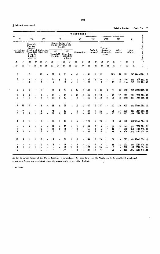
159 ADSmtCt - concla.
Taluka Bard .. Code No. 1/2
WORKERS " ~ " II III IV V VI VII VII! IX X §
Manufa.ctur!ng, Pro· Z Livesiock. cessfng Servicing and. 0 Forestry, Repairs 'g
fishing, Transport, (J Agricultural Hunting & Mining and (a) (b) Trade & Storage & Other NOD-labourers Plantations, Quarrying Con~trud~{}ll Commerce Communi- seITicf'S -Worker1< §
Orchards Household Other than r.ations
] & Allied Industry Household activities Industry
M .' M F M F M F M F lIi[ F M F M F M F M F
19 20 21 22 23 2< 25 26 27 ,B 29 3() 31 32 33 34 3.1 36 37 38
11 27 6 30 10 141 19 109 34 391 645 Ward No. 9
20 16 5 79 15 82 18 246 395 EB No. 21 7 14 5 62 4 27 16 145 250 EB No. 22
31 76 37 140 25 51 32 380 606 Ward No. 10
18 46 32 54 12 22 17 178 271 EB No. 23 13 30 5 86 13 29 15 202 335 EB No. 2j
13 44 59 16 107 37 53 29 425 624 Ward No. 11
12 23 20 59 14 28 17 223 325 EB No. 25 1 21 39 48 23 25 12 202 299 EB No. 26
37 85 15 - 126 5 19 55 43 463 693 Ward No. 12
14 30 49 1 9 25 13 145 221 EB No. 27 1 17 44 57 2 5 12 11 182 256 EB No. 28
.2 6 11 20 2 5 18 19 136 216 EB No. 29
10 71 15 158 13 25 56 19 392 682 Ward No. 13
29 9 111 5 19 14 170 295 ED No. SO 19 4 27 15 8 4 106 186 ED No. 31 23 2 20 5 29 1 116 201 EB No. 32
As the Cadastral Survey of the Union Territory 1S in prom-ess, the area figul"E'.S of tbe Taluka are to b(' cGnsidereil provisional.
urban area figure!!: are provisional since the I:!urvey work is not fully finalised.
the taluka.


Pemem Taluka

"
lA~'.ill/lAI.J,N .... 9:lU"O"~~ ..
IAHSIljl'AlUK.'.HEADQUAIlIEIl'S·,
VlllAG£ Bo!,mOARI£S WJTIlLOCA.HOlltODEHl,IiIIBrR ....
"'110NAl HIGHW),VS ""
STAU HI~'IOo~S"-"'"
METALLED ROADS'" ..•.
IJICMHAl.lll) ROA.DS " ••
MIVEIl'S AND ;!REANS
"
@ _.2.1 ••
sYMBOt.ICR[PRE5:EN1AT\ONQfV\UAG£<;U,IH£ .................. .
'OI.LOwtIf; CATEGORIEs +~ ;:: ',f!. ':~ !~!: POHOFI'ICES/TI;LEGRAPH OFFlcrs ••
POLlC£OU1POo;l........... .. ..
RESfHrlJ'iE/'RAVE(~iRSQUNl>AlaW ""'"
URBAN AR[A'$ •• ,
\(ISP:U,LS,PR!Wo.FI~ HEALTH C~NlIIESJDlSPEHSAAIEIi
CHILO ANIl' NATE"RHITY wnFAREC£~tRU
"
flO/PT
'Pe
'"
50
GOA DISTRICT
PERNEM TALUKA
50' 7.'

Taluka: Pernem
Aagarvado
Alorna
Amberem
Aramhol
Cansarvornem
Casnem
Chandel
Chopdem
Corgao
Dargal1m
Ibrampur
Mandrem
Mopa
Morg1m
Ozorim
161
ALPHABETICAL LIST OF VILLAGES AND TOWNS
Location Code No. 1/3
Locatioll Code No.
18
11
19
26
14
10
21
20
13
Population in 1!17l Census
3M
21284
213
3,561
1.169
454
633
513
4,924
3,798
870
6,078
685
5,378
1,328
Taluka: Pernem
Nam.
Paliem
Parcem
PERNEM
Pernem (Rural)
Poroscodem
Querim
Tamboxem
Tiracol
Torxem
Tuem
Uguem
Varcond •.
Virnora
Total
Location Code No. 1/3
Location Code No.
23
17
III
27
24
25
16
12
15
Population in lfi71 Census
1.945
3,352
2,930
2,335
434
2,346
497
166
1,574
1,545
851
1,333
856
52,906

162
District Goa Cod. No. 1 Primary Census
6 7 8 ~
10
11 12 13 14 15
16 17 18 19 20
21 22 23 24 25 26 27
Name of village/ town/ward urban
enumerator's block
Pernem Taluka
TOTAL
RURAL
URlEAN
Poroscodem Casnem ,A.mberem Ugueoo Tamboxem
rorxem I<[opa Chandel Alorna Ibrampur
Cansarvornem Varconda Ozorloo Dargalioo Virnora
Tuern Parcem Aagarvado Chopdem Morgim
Mandrem Arambo! Paliem Querirn Tiracol Corgao Pernern
Pernem Town (Municipality)
Ward NO.1
EB No.1
Ward NO.2
EB No.2
Ward No.3
EB No.3
Total Populat;(In (including institutiono.l & House!cst>
Scheduled Castes
Scheduled Literale and Tribes ~~~~~~d
Total workers (I-IX) population)
p M F M F M F
10 11 12
M
13
F
14
M F
15 16
Cultivators
M F
17 18
242.0 Km' 8195 1022752906 2560127805 lU6 1100 - - 18658 6708 11944 4824 5836 2783
239.SKm2 7679 964949976 2418425792 1021 1000 - 12802 6179 11304 4620 5710 2686
2.5 Km2 516 578 2930 1417 1513 95 100 -
163.2 126.0 191).2 399.1 144.3
964.3 874.5 602.6
2153.4 628.3
1116.0 1126.9
716.1 1969.9
387.8
1202.0 1013.5
221.1 172.6 855.5
1889.4 919.4 924.2 236.0 157.7
2138.2 N.A.
55 59 20
117 77
213 86
111 364 130
222 222 188 589 133
293 424 137 87
869
922 558 260 379 47
763 324
72 434 85 454 39 213
163 851 88 497
288 1574 135 685 134 633 434 2284 173 870
265 1169 250 1333 253 1328 709 3798 175 856
348 1545 589 3352 189 854
98 513 1089 5378
243 191 211 243 106 107 372 479 239 258
768 806 330 355 286 347
1064 1220 416 454
575 594 633 700 603 725
1855 1943 381 475
734 811 1699 1653
372 482 262 251
2520 2858
1183 6078 2986 3092 689 3561 17&8 1803 364 1~45 9,8 967 461 2346 1101 1245 47 166 75 91
9p 4924 2478 2446 418 2335 1139 1196
50 33
20 51
65 30 16 79 44
9 32 24 80 38
19 69
27
38 -45
17 54
59 '29 14 -86 36
7 -31 35 66 38 -
26 -66 1 -
26
55 65 55 54 43 35 66 45 -
109 122 -7 5
2.52 516 578 2930 1417 1513 95 100
N.A.
N.A.
N.A.
N.A.
N.A.
N.A.
53
53
69
69
47
47
62 357 171 186 86 90 -
62 357 171 186 86 90
74 358 180 178 4 -
74 358 180 178
50 223 122 101
50 223 122 101
856 529 640 204 126 97
(RUR.AL
105 83 47
189 128
364 123
99 438 181
271 228 292
1082 225
349 919 222 129
1435
49 38 15
104 83
182 69 49
240 85
112 153 152 553 154
168 365 137
75 739
114 107
53 133 112
374 153 118 519 227
336 2[18 2[16 860 157
335 811 151 112 10~7
1723 706 1414 ~5S 432 862 6U6 245 '172 582 323 500
40 37 31 1413 612 122<
571 277 528
69 17 52
157 63
170 44 47
296 164
76 127 234 261 146
317 329
23 11
382
63 69 43 82 53
243 124
58 358 145
169 175 181 467 63
209 435 76 19
25S
310 748 150 417 126 240 195 100 10 1
554 634 290 282
48 3
47 131
24
117 21 21
219 107
60 115 178 173 100
159 156 10 1
119
193 12 96 83 4
280 209
(URBAN
856 529 640 204 126 97
63 43 80 29 14 2
63 43 80 29 14
86 44 82 16 10
86 44 82 16 10
94 42 76
94 42 76

163
Abstract Taluka Perncm Code No. 1)3
WORKERS
" ~ II III IV V VI VII VIII IX X " " Manufactur:ng. Z
Live~tock, Processing, Servteing 0 Forestry, and Repairs ~ Fishing Mining Transport, u Agricultural }funting & and (a) (b) Cons- Trade & Storage & Other Non-labourers Plantations. Quarry- truction Commerce Communi- services -Worker~ §
Orchards ing Household Other than cations
~ & Allied Industry Household activmes Industry
M F M F M F M F M >' M F M F M F M F M F
I" 20 21 22 23 ;l4 26 36 27 28 2' 30 31 32 BS 34 35 36 37 38
1052 1221 366 20 152 94' 459 298 25 15'4 431 122 305 H 917 166 13657 22481
t024 1171 3611 20 146 9:19 450 256 25 1481l 367 III 258 14 765 129 12880 21172
%8 50 18 42 85 70 11 47 212 37 7':7 1809
AREAS)
9 8 13 9 6 129 122 1 16 10 11 7 1 104 226 2
5 2 6 2 53 55 3 21 19 8 8 239 322 4 31 32 7 12 127 195 5
37 25 10 11 38 18 1 11 5 15 6 394 636 6 16 17 5 4 3 1 2 2 2 177 311 7 13 6 12 9 4 1 3 11 3 168 300 8 73 55 23 25 17 4 9 3 20 3 545 924 9 29 32 22 5 7 7 6 10 6 189 290 10
17 12 27 3 4 S 6 2 103 239 518 11 17 6 3 6 11 6 5 4 7 1 29 375 573 12 15 31 1 9 14 21 6 5 8 2 15 2 347 491 13 53 60 13 11 28 11 17 114 27 25 105 10 995 1682 14 16 9 5 6 9 23 5 7 8 9 29 13 224 329 15
34 139 3 9 24 15 6 14 7 6 23 3 399 <l94 16 32 138 10 2 30 24 13 - 196 20 23 50 10 888 1324 17 21 7 3 1 16 4 4 6 5 19 I 221 459 18 48 6 4 3 9 4 1 4 19 2 3 150 240 19
133 143 125 27 177 62 36 159 64 27 46 64 12 1433 2476 20
82 69 10 5 148 24 84 10 233 27 1 23 54 12 1372 2782 21 26 21 47 9 - 119 59 22 - 121 30 42 26 39 6 896 16;3 22 45 22 1 3 26 8 8 93 17 17 22 506 ~41 23 38 28 29 I 67 64 8 192 20 12 19 26 601 1050 24
2 1 17 6 2 2 6 44 81 25 179 230 " 21 70 30 11 195 32 16 61 14 1254 1892 26
23 41 3 6 37 30 8 91 26 16 30 5 611 906 27
AREAS)
28 50 18 42 85 70 11 47 212 37 777 1309
36 11 91 157 Ward No.
36 11 91 157 EB No.
13 17 28 98 162 Ward No.2
13 17 28 98 162 EB No.2
56 16 92Ward No.3
56 46 92 EB No.3

164
Primary Census District Goa coo. No.1
, m. . ~E . .0
§ g~ '" ,,~
~ Z Name of viUagei E", Total POlJuJet!on .
town/ward urban .~ t 15
(including institu- Scheduled SCheduled Literate and Total " ~ Educated
8 enumerator'fi ~~ " Honal & Houseles!'l Caste..~ Tribes
Persons workers 0 population)
" block "'''' '0
(I-IX) 0 H 1 Cultivators
~ o~ 6 ~ .'0 z ..1 ~~ p M F M F M F M F M F 1( F
10 11 12 13 14 15 16 17 18
Ward No.4 N.A. 49 50 301 141 160 103 76 60
EB No.4 N.A. 49 50 301 141 160 103 76 60
Ward No.5 N.A. 66 74 373 168 205 118 76 78 53 17 3fi
EB No.5 N.A. 66 74 373 168 205 118 76 78 53 17 3fi
Ward No.6 N.A. 54 64 3fi8 162 196 95 73 7Z 47 33 40
EB No.6 N.A. 54 64 3fi8 162 196 95 73 72 47 33 40
Ward No.7 N.A. 26 S3 179 81 98 39 20 36 10 12
EB No.7 N.A. 26 33 179 81 98 39 20 36 10 12
Ward No.8 N.A. 34 37 201 93 108 52 26 40 10 16
EB No.8 N.A. 34 37 201 93 108 52 26 iO 10 16
Ward No.9 N.A. 56 63 273 141 132 103 68 48 10 11
EB No.9 N.A. 56 63 273 141 132 lOS 53 48 10 11
Ward No. 10 N.A. 62 11 307 158 149 103 66 68 16
EB No. 10 N.A. 62 11 307 158 149 103 66 68 16
1) The aree. (If the Taluka (Total) haa been supplied by the Dit'ectorate ot Land Survey Government of Goa, Daman and Diu,
2) The: urban area figures are those published In Government of Goa, Daman and Diu Gazette, Series I, Number 1 dated 8-1-1970.
3} The area figures for rural areas are derived by substracling the urban area from the total area of the taluka. 4) As the area figures are provisional, the Bum of the area of all villages of the TaJuke. will not be equal. t() the total rural are8.

165
Abstra.et - Concld. Taluka Pernelll Code No. 1/3
WORKERS " .1;
1I III IV V VI VII VIII IX X E 0
Manufar.turmg, Z Livestock, Processing, Servicing , Forestry, and Repairs " Transport, 0 Fishing
" Agricultural Hunting & Mining (a) (b) Cons- Trade & Storage & Other Non-labourers Plantations. and tructiOJ Commerce Communi- ~ervicel'i -Workers ~ Orchards 'Quarry- Household Other than ('8.tions
& Allied ing Industry Household ~ activities Indugtry ~
M ," M F M F M F M F M F M F M F M F " F
19 20 21 22 23 24 25 26 'J7 28 2~ 3(1 31 32 33 3; 35 36 37 38
15 19 81 156 Ward No.
15 19 81 156 EB No.
17 12 10 17 90 152 Ward No.
17 12 10 17 90 152 EB No.5
13 10 90 149 Ward No.
13 10 90 149 EB No.
15 45 88 Ward NO.7
15 45 88 EB No.
15 53 98 Ward No.8
2, 15 53 98 FiB No.8
12 93 122 Ward No, 9
12 93 122 EB NO.9
17 31 90 133 Ward No. 10
17 31 90 133 EB No. 10
Panaji. As the Cadastral Survey of the Union Territory is in pro gress, th€ area fjgures of the Taluk8. arc to be considered provisional.
The urban area figures an' pro"isiona! 8ince the survey work i~ not tully finali.!l!ed.
of the taluka.

Bicholim Taluka
, I
I·f
,I
l""'s-(~Al\J(AElCUijOU~-., @
::~L~T::~:~~:::e:~('~'r:o~ cc« ~e£RS ....... ~ .. ~Q •.
.... ..l..!L SlATE HIIjIIWAVS .»""
"'~I"'.L~II ~O"OS·
~tI."E1Ii.~\.EO ~~j!,OS'" •
~I~~RS "NO iIPE,lMS •
''IMaOdCRlPR.5£lHA1IJN (I, '1IllAG£",~ IkE ..
fr: ~:~:~: 1'051 OrFIt£i! I£LE~~"PH ~fICB , .•. ",."." .. ,., !>ofpl
~~II~~I::'~SI , .. :",,~:, ::.: ::.':~:~~:':::".~':~':' ",...:: RESt HtlU'~/IR"'YhLEIf's ~V~G4j,O~ ." .. " ...... , .. , .... R fl
lIIa'N AREA~ "." •••••• " ........... [1 ~rl./.,.s.~RI"~RYIl~AllH WjJl!$.OI5f'ErSA~~ ... "".,. ® CHIlO ANO ""'HMI'IIl'j W'W~E t(II!lIU
"
~ GOA OISTRICT
81CHOUM TALUKA I
II Ii Ii
l'

Taluka: Bicholim
Name
Adwalpale
Arnone
Arvalem
Aturli
BICHOLIM
Burdem
Carapur
Casabe de Sanquelim
Cotombi
Cudnem
Curchirem '"
Dumacern
Lamgao
Latamhal'cem
Maem
Maulinguem South
Maulinguem North.
,167
ALPHABETICAL LIST OF VILLAGES AND TOWNS
Loeation Code No
21
13
25
IV
11
12
18
15
28
27
14
29
Location Code No, 1/4
Population in 1971 Cen~us
994
2,370
1,023
684
8,550
Included in Municipal Town of B!cholim,
3,157
3,166
650
1,928
1,131
187
Included in Municipal Towo of Bicholim.
3,981
4.977
422
869
Taluka. Bicholirn
Xame
MeneUl'pm
Mulga\)
Naroa
Navelim
Ona *
Pale
Piligao
Salem
Sarvona
Sirigao
Surla
Vainguinim
Vclguem
Virdi
Total
~ These vi1l~ge~
Location Code No. 1/4
Location Code No
24
20
30
17
23
10
19
26
16
22
PU!luluUon m Hill C .. mus
978
1,993
1,594
1,633
354
5,124
1,993
1,692
900
1,428
3,442
607
1.578
984
58.389
have been transferred from Satat'i Taluka to Bicholim Talulw vide Government of Goa, Daman :-mil Diu Kotlfication No. RD/LND/:.!13!69-71/II dated 15-2-1971.

District Goa Code No. 1
6 7 8 9
10
Name ()f village/ town/ward urban
enumerator's block
Bicholim Taluka
TOTAL
RURAL
URBAN
Lamgao Sirigao Mulgao Adwalpale Latambarcem
Pumacem Mcncurem Salem Bordem Sarvon~,
11 Carapul 12 Casabe-de-San-
quelim 13 Arvalcm 14 Maullnguem
South 15 Cudnem
16 17 18 19 20
21 22 23 24 25
26 27 28 29 30
Velguem Pale Cotombi Surl., Navelim
Arnone Virdi Piligao Naroi;', Aturli
Vainguinim :Macm Curchirem Maulinguem
North On"
Bicholim Town (Municipality)
Ward. No.1
EB No.1 EB No.2
168
Total Populat!on (including institutional & Houseless
population,
p M F
Scheduled Castes
M F
Scheduled Literate and Tribes Educated
Persons
M F
Primary Census
Total workers (I-IX)
M F
Cultiva.tors
·11 F
10 11 12
M
13
F
14 15 16 17
227.1 Km210S1H1287 58389 29845 285U 736 725
214.9 Km2 8851 970349839 25528 24311 639 610
12.2 Km2 1463 15M 8550 4817 4238 97 115
221.1 370.9 758.2 636.5
3652.0
347.5 392.7
1044.1 851.1 785.4
862.0 41.2
705.0 402.0
973.8
322.4 1297.7 265.4
1629.5 1038.0
608.1 308.8 766.4 715.6 67.8
68.5 2049.7 N.A. N.A.
N.A.
12,,7
N.A.
N.A. N.A.
234 262 1428 761 667 331 376 1993 979 1014 60 73 198 202 994 486 508 29 42 784 797 3981 2036 1945 116 99
25 28 187 85 101 159 179 978 433 545 308 365 1692 802 890
1M 164 900 466 434
1 18 19 3f; 36
482 572 3157 1610 1547 32 41 532 588 3166 1545 1621 15 10
198 200 1023 537 486 21 16 67 70 422 219 203
312 345 1928 956 972 29 33
310 328 1578 863 715 1091 1161 5124 2930 2194 119 141 650 340 310 610 662 3442 1786 1656 256 300 1633 817 816
340 423 2370 1172 1198 131 180 984 449 535 326 376 1993 989 1004 267 292 1594 795 799 130 133 684 330 354
11n 110 607 303 304 918 986 4977 2630 2347 210 210 1131 586 545 168 178 869 444 425
75 75 354 17S 176
14 13 68 52 8 6
16 15
U 35 4 2
25 18 17 15
3 3 14 10
4 9 63 62
1463 1584 8550 4317 4233 97 115
207 219 1013 479 534
143 141 656 313 343 64 15 357 166 191
15541 836814740 4188 4255 lOSt
13761 65181268<1 3527 4056 941
2780 1850 2106 661 199 93
(RURAL
Included in the Municipal 516 220 345 18 138 3 575 266 446 178 164 80 257 96 213 68 51 16 823 339 1041 407 373 104
3523423361 282 157 191 74 145 62 366 186 339 71 209 52
Included in the MuniCipal 281 113 224 34 109 3
964: ~64 788 198 184 19 1109 904 671 126 17 1
167 57 267 81 57 12 145918995
531 257 450 106 201 24
436 183 465 119 54 26 1611 704 1111 246 108 5
180 67 171 64 33 14 917 414 854 128 278 17 335 104 376 220 161 ~
768 367 574 131 266 237 144 195 33 103 443 190 474 189 223 448 230 429 175 236 208 84 181 121
61 ~
80 84
181 75 142 14 71 3 1574 687 1308 485 432 152 134 . 33 310 112 148 5_ 162 31 235 196 108 109
76 32 97 42 25
(URBAN
2780 1850 2106 661 199 93
265 179 260 158 50 36
143 103 177 94 23 2 122 76 83 64 27 34

169 Abstract
Hich.1im Taluka Cod. No. lJi
II
Agricultura1 labouNlrs
M
19 20
WORKERS
!II IV v VI
Livestock, Ma~~~~e~~~~~~:~~ess. Forestry, Repairs
H~l~rf~:' & Mining and ---:-(.-=-)----:(7Cb):--Plantationfl, Quarrying Construction Orchards Industl")' Other than & Allied Household Household activWes Industry
VI!
Trade &; Commercfl
VIII
Transport, Storage &: Communi·
cations
IX
Other services
x
Non·Workers
MFMFMFMFM F M F MFM F M F
21 22 23 24 2/i 26 ZI 28 29 30 81 ,32 33 34 35 3. 37 28 ------------------------------------1336 1234 632 87 8649 787 778 269 1050 2M 200 15 1161 196 669 51 1010 32115105 US56
~~m.~~~mm~mHmlli_~_~~~
95 102 57
AREAS)
Town of Bichol!m ' 7
22 31 9 83 31 19
,272 210 75
2 15 1 19 6 11
Town 01 Blcholim 3S 24 15
28 27 56 11 4 15
17 10 ,2 1
17 11
5 8 25 26 2 83 224
37 42 68 40 122 2
72 28 8 16 16 1 37 48 17 92 75 6 46
8 5 175 250 71 107 106 18
1 23 61
50 41
ARE A S)
95 102 57
4 550 169 115 57 276 63 27
127104130 2 9226352540 4 27 4 10 13 5 1 88 16 64 34 40 13 18
20
1 10 29
6 18
133 32 50 22 « 58 62 167 3 67 8 46 38 4
- 117 21 11 11 8 23 6 4 10
- 138 24 21 15 37
218 60 14 2 57 8 951 179 81 108 46 6
6 241 12 1 1
266 46 54 2 19 1 113 61 14 2 6 17
25 2 .'1 5 61 5 13 3 3
32 3 294 21 21 12
~5 13 22 9 3 3
22 12 6 14 4 3 3 2
2 12 47 139 9
29 32
4 4
21
2 25
10
1 34
550 169 115 67 276 63 27
343
3 16 2
41
7 11
73 192
11 25
26
~3 99 9
44 17
60 8
44 16 2
4 37 2 8
12
51 134
14 19 3
34
30
11 68 16 60
15 37 13
12
1 310 1211 2211 3572
20 3 416 649 45 7 533 836 12 2 273 440 42 LO 989 1538
2 13 25
10
H 98 242 471 463 819
242 400
90 20 822 1349 92 56 8U H95
17
270 405 130 194
506 866
12 27 1 14 6 398 596 19 1219 1948 1 169 246 3 932 1528 9 HI 596
12 56 13 54 4 ~
10 46 38 1 10 13
12 1
12 1
20
20 4
28 9 1
5 27
54 4
26 40 3
7 52 5 4
16 598 1067 1 254 502 5 515 815 8 366 624
149 354
- 161 290 8 1322 1862 - 276 433
209 229
81 134
51 134 310 120 2211 3572
4 5
6 7 8 9
10
11 12
13 14
15
16 17 18 19 20
21 22 23 24 25
26 27 28 29
30
. ~
<3
17 32 13 98 71 11 31 21 10 219 376 Ward No.1
14 11 18 2
93 71 5 11
21 10
IS
8 5
3 S
9 12
6 136 249 EB No.1 4 83 127 EB No.2

District Goa Code No. 1
. E , z
Name of village/ town/ward urban
p.numerator's block
Ward No. Z
EBNo. S EBNo.~
Ward No.3
EB No.5 EB No.6
Ward No.'
EB No.7
Ward No.5
EB No.8
Ward No.6
EB No.9
Ward No.7
EB No. 10 EB No. 11
Ward No.8
EB No. 12
Ward No.9
EB No. 13
Ward No. 10
EB. No. 14 EB No. 1~
N.A.
N.A. N.A.
N.A.
N.A. N.A.
N.A.
N.A.
N.A.
N.A.
N.A.
N.A.
N.A.
N.A. N.A.
N.A.
N.A.
N.A.
N.A.
N.A.
N.A. N.A.
170
Total Population (including institutional & Houseless
population)
p M F
Scheduled Castes
M F
Scheduled Literate and Tribes EducateQ
Persons
M F M F
Primary Census
Total workers (!-IX)
M F
Cultivators
M F 10' 11,12 13 14 15 16 11 Ii
163 179 900 443 457
87 93 438 200 238 76 86 462 243 219
134 161 919 492 427 14
64 76 437 239 198 70 85 482 253 229
160 164 932 461 471 68 81
160 164 932 461 471 68 81
116 118 705 378 327
116 118 705 378 327
150 155 877 426 .51
150 155 877 426 451
176 188 1112 546 566 13
92 96. 553 271 282 8< 92 559 275 284
75 91 538 282 256
75 91 538 282 256
110 1~5 683 333 3;0
110 125 »J 333 350
172 18< 871 477 394
83 89 448 244 204 89 95 428 233 190
- 283 149 212 109 30 32
- 121 - 162
69 93 48 21 18 801196191'
177 259 252 34 19
- 192 127 117 12 9 185 132 135 22 10
254 201 242 90 17
254 201 242 90 17
- 224 134 163 46
224 134 163 46
269 162 207 50 18
269; 162 207 50 18
360 276 254 74 26 10
186 180 122 21 11 - 174 96 132 53 15
237 192 132 14
237 192 132 14
228 164 152 37
228 164 152 87
- 283 134 232 49 29
- 155 73 116 17 28 - 128 61 116 32 1
1) The area of the Taluka (Total) has been supplied by the Directorate of Land Survey Government of Goa. Daman and Diu,c
2) 'l'he urban area figures are those published in Government of Goa, Daman and Diu Gazette, Series I, Number 1 da.ted 8-!l-1'!m1.
3\ The area Egures for rural areas are derived by substracting the urban area. from the total area !)f the. taluka.
4) As the area figureOl are provisional, the sum of the area. Df all vi11ages of the' Taluka will not be equal to the total rural area

171
Abstract - concld. BiOO.lim Taluka Code No. III
WORKERS . ,;,
II III IV V VI VII VIII D( l( ~ to
Livestock, Manufactur~.ng, Pro~
oil ccssing Sen'ir.ing and Forestry, Repairs 0 fishing, 'transport, '0
Agricultural lIunting & Mining and (a) (b) Trade & StoI"'d,ge & Other Non-S labollrers Plantations, Quarrying Construction Commercl'! Communi- services -Workers
Orchards Household Other than cations ~ & AIli,a Industry Household ~ a.ctiviUe~ Industry ..:I
II F M F M F M F ]I[ F 11 ," M F M F " F M F
19 20 21 22 23 24 25 26 'XI 28 29 30 31 32 33 34 35 36 37 3&
17 28 14 31 20 29 14 26 15 36 12 231 348 Ward No.
" 17 10 11 3 16 7 3 10 2 107 190 EB No. 11 4 20 17 13 19 12 26 10 121 158 EB No. I
31 2 40 77 19 48 16 240 393 Ward No.
2 14 1 26 25 11 27 6 122 186 EB No. 5 2 17 3 14 52 8 21 10 118 207 EB No. 6
63 1Ii 33 27 19 50 .8 23 219 381 Ward No.
63 15 33 27 19 50 48 23 219 381 EB No.
43 31 31 28 27 22 10 215 281 Ward No.
43 31 31 28 27 22 10 215 281 EB No.
12 83 22 41 26 15 16 219 401 Ward No.
12 83 22 41 26 15 16 219 401 EB No.
16 87 28 21 29 19 38 25 292 492 Ward No. 7
41 11 19 19 3 11 10 149 261 I!lB No. 10 46 17 2 10 16 27 15 143 231 EB No. 11
13 23 25 49 16 1I 150 242 Ward No. S
13 23 25 49 16 11 150 212 EB No. 12
39 10 18 21 19 36 12 181 313 Ward No 9
39 10 18 21 19 36 12 181 313 EB No. 13
36 69 26 13 12 18 42 245 345 Ward No. 10
19 19 6 12 15 128 187 EB No. 14 17 50 20 6 27 117 158 EBNo. 15
PanaJj. As the Cadastral Survey of the Union Territory is in PIO gress, the :irea figures at the Taluka are to be conside~d prodsioml.
The urban area figures are provisional since t~e ~l'vey work is not tully finalised.
(If the taluka,


Satari Taluka

,.'
'A';'SlIlrALU(ABOIJIoIOlIRl
TAH5II/'.M.u~AH£.lDQUART'IIS
~lllAGESouMDARlnYlIT~l(lC"'lIOH CODE M1.MIEIIS.
NAtiONAL HIGHWAYS'
STATE HIGHWAYS:
1oIE",t..U£OiOAOS'
UHM[fAll£D ROADS
Rly[RSANOS1RtAhlS
SYMBOLIC R£P~ESfNTATIONOFV!LLAGE5 Iii TfIf·
FOlLOWING CATEroRIES
P05rOtAC£s/TE:EGIl"~OFFIC£S
POlICESlArtOH •.
f'OlICEOUJPosr
.1E5THou~alT1IMELL[1!'s9uNO,UO'll
UN1I'IHAflrT[OV1LLAS[!i·
UIlBAHU~A'.i •.
I«)9'HAl'1pj1l"'AR'I' HEAt!tlCEliTFlES,OISPEN'iAII;[£S
CHILO AHO MAT£r1NITrWilFAREC(N!mS
" j:
o (
5'
@ _.72 __
••••• ;;:: ~;,O 5;:' '~O. &~,~O 2'0 ,,~~ ,ug .. ~n ""a,' PO/PT
"'P5
"
10
10'
GOA DISTRICT
SATARI TALUKA
FlI'IlOJrlGSLL;_ ,
«;r-t ,~
s o
\,. ....... i
"
J>
20
173
ALPHABETICAL LIST OF VILLAGES AND TOWNS
TaJuka: Satam Location Code No. 1/5 Taluka: Satart Location Code No. 1/5
Location Population in 1971 Name LocatlOn Population in 1971 Nama Code No. Census Code No. Census
Advoi 74 472 Nagargao 49 421
Naguem 84 51 Ambedem 48 122
Naneli 38 102 Ambel! 64 59 Nanorem 35 165 Anjunem 18 192 Nanus 76 644 Ansolem 75 Uninhabited and. 3 932 Assodem 61 77 ana 14 Birondem 71 292 Padeltt 70 403 Bomhedern 47 26 Pale 20 518 Buimpaj 2 184 Pendr,,1 43 Uninhabited Oatambolim-Brama 39 175 PLssurlem 82 1,593 Carambolim· Buzruco 55 230 Podocem 11 304 Caranzol 44 405 PODocem 78 276 Choraundem 23 336 Ponsuli 21 181 Oodal 32 124 Porricm 10 2,464 Codiem 80 54 Quelaudem 22 216 Codql1i 57 703 Querim 1,116 Codvo! 42 35 Ravona 15 398 Compordem 6 366 Rl.ivem 29 138 Conquirem 66 226 Saleli 526 Cotorem 69 427 Sanvorcem 72 203 Cudcem 53 323 Sanvordem 54 513 CUl'l:hirem 12 Satorem 51 133 Cumarconda 83 243 Satrem 28 37 Dabom 289 Sigonem 31 16 Damodem 68 367 Sliranguli 59 45 Davern 46 514 Srroli 17 405 Derodem 33 53 Slrsodem 60 106 Dongurli 30 1,072 Sonal 45 218 Edorem 50 172 Sonutl~ Vonvoliem 81 994 Golauli 26 166 Surla 27 349 Gonteli 16 676 Ustem 40 146 Govanem 62 191 Vagul1iem 79 159 Gulell 67 305 Vainguinim 34 10 Gululem 19 464 VALPOl V 2,922 Ivrem~Buzruco 24 363 Vantem 73 896 I vr~m ~Curdo ,5 148 Velguem 56 791 Malol! 36 90 Veluz 52 664 Malpona 63 92 Xelopo.BuZlUCO 37 171 Massordem 77 Included in the MUni· XeIopo~Curdo 58 141
clpal Town of Val· Zarani 41 Uninhabited poi. Maulinguem·~otth 13 Zormen 310
Mauzi 1 607 Total 32,515 Melauli 65 970 * Thf'S[ \'illagr.s have been tran~ferred to BichDlim Taluka
1.108 Vide Government of Goa, Daman and Diu Notification No. RD/ Mortem iI~:.--m/m:J/G9-71/n dated 15/3171.

174
DlJtrict Goa Code No.1 Primary, Census
~
" 0" . ~S " .
Ii i:~ " " "" '0 Z .S~ ~ Total Populat1on . Name of village/ . Literate and
towIl/ward/urban " . 5 (including institu- Scheduled Scheduled -g l:," ~ Educated Total t) enumerator's ~~ "
tional & HOllileless Castes Tribes workers ~_g population) Per~ons
" block
~~ '0 (I-IX)
! "0.8 .~ Cultivator~
" ,; ~o 8 z
0 ~~ p ];I F ];I F 111 F M F M F M p'
10 11 12 13 14 15 16 17 16
Satari Taluko
TOTAL 4OO.3Km;l 5305 6380 32515 16~00 16115 417 382 5876 2667 8126 2629 3681 111~
RURAL ~80.9 Km;l ~M 5911 29593 14897 14696 374 352 4849 1945 7478 21\4~ 3639 116i
URBAN 9.4Km' 451 469 2922 1503 1419 43 30 1027 722 648 85 42
(RUBAL
1 Mauzi N.A. 105 118 607 325 282 65 165 17 117 2 2 Bu:imp.l N.A. 33 33 184 97 87 25 52 15 32 10 3 Onda N.A. 203 210 932 492 440 4 ,3 158 50 241 22 100 9 ~ Saleli N.A. 93 99 526 254 272 1 75 13 125 66 88 44 5 Dab-em N.A. 37 56 289 140 149 10 112 3 80 67 54
6 Compordem N.A. 61 89 366 181 185 14 50 10 95 69 ,')6 45 7 Zormen N.A. 41 76 370 168 202 42 9 90 81 58 13 8 Querim N.A. 162 210 1116 566 550 23 22 210 139 256 65 137 34 9 MDrlem N.A. 175 229 1108 527 581 20 25 13G 57 253 117 186 54
10 Poriem N.A. 479 537 2464 1250 1214 6 9 397 182 594 136 145 11
11 Podocem N.A, 60 63 304 154 150 50 25 61 4 36 I 12 Curchirem N.A. This Village has been trans 13 Maulinguem North N.A. This Village has been trans J4 Ona N.A. This Village has been trans 15 Ravona N.A. 67 92 398 201 194 37 8 103 42 S8 37
16 Gontoli N.A. 98 135 616 331 345 114 as 145 75 83 47 17 SiroU N.A. 62 86 405 193 212 39 3 80 44 58 34 18 Anjunem N.A. 32 36 192 102 90 26 1 51 35 25 n 19 Gululem N.A. 73 91 464 236 228 24 18 65 18 132 97 101 74 20 Pale N.A. 89 103 018 259 259 1 55 12 126 82 97 57
21 Ponsuli N.A. 25 38 181 89 92 26 8 49 31 37 25 22 Quelaudem N.A. 30 40 216 100 116 25 8 48 52 36 33 23 Choraundem N.A. 51 72 336 172 164 56 9 89 7 24 Ivrem-Buzruco N.A. 56 69 363 181 182 62 19 112 81 25 Ivrem-Curdo N.A. 27 30 148 66 82 17 15 33 16
26 Golauli N.A. 26 34 166 88 78 29 15 43 21 21 Suria N.A. 44 61 349 172 171 29 11 8~ 52 28 Satrem N.A. 6 6 31 23 14 2 15 10 10 29 Rivem iN.A. 21 26 138 67 71 14 3 31 17 SO Dongurli N.A. 153 216 1072 534 538 84 85 213 104 285 29 130
31 Sigonem N.A. 15 17 76 33 43 1 17 16 8 7 32 Codal N.A. 29 38 124 66 58 12 53 31 24 17 33 Derodem N.A. 14 14 53 27 26 19 14 18 13 34 Vainguinim N.A. 1 1 10 4 6 3 4 3 4 35 _ Nanorem N.A. 34 34 165 79 86 27 11 46 32 24 18

175
Abstract Taluka Satari Code No. 1/5
WORKERS ~ ,Q
.II III IV V VI VII VIII IX X e , Manufacturing. Z
Livestock, Processing, Servicing . Forestry, and Repair~ " FiShing Mining Transport, 0
" Agricultural Hunting & and (a) (b) Cons- Trade & Storage & Othel' NOD-:' labourers Plantations. QUarry· tructlon Commerce Communi- services -Workers " 0
Orchards ing Household Other than cations
~ & Allied Industry Household activiti.es Industry
..l M F M F M F M F M F M F M F M F M F M F
19 3) .:u ~ 23 24,·, 25 . 26 'Z7 23 29 30 31 32 33 34 35 36 37 ii8
1842 1008 m 73 578 134 229 73 U8 16 82 310 29 185 11 634 109 82.74 13486
1822 987 450 71 765 132 193 70 77 61 190 23 120 11 351> 69 7419 12152
20 16 17 86 41 21 120 65 284 40 855 1334
AREAS)
27 1 8 2 160 2M 1 2 11 8 45 72
13 6 1 55 11 26 19 251' 418 17 21 11 1 3 1 3 129 206 19 56 1 1 5 60 82
9 13 11 9 86 116 6 20 68 2 10 78 121 7 64 20 5 3 10 1 10 6 37 310 48li 8 36 59 2 1 6 9 2 1 2 7 2 2 274 464 9
217 59 43 13 43 21 11 17 21 25 32 30 23 656 1078 10
21 3 87 146 11 ferred to Bicholim Taluka 12 ferred to Bichollm Taluka 13 ferred to Bich9lim Taluka 14
7 3 1 101 152 15
22 27 22 186 270 16. 16 10 3 113. 168 17 13 10 10 3 51 55 18 9 13 9 3 104 131 19
25 25 1 133 177 20
6 40 61 21 5 10 52 64 22
70 83 164 23 24 69 180 24 17 33 77 25
17 2 1 45 78 26 23 5 2 90 177 27
5 8 4 28 10 1 3 36 71 29 80 13 20 13 26 249 509 30
8 9 16 27 31 3 6 6 13 27 32
1 8 12 33 1 2 34
11 11 33 54 35

116
Primary Censns D1striet Goa Code No. 1 .
~ 0" " . i '" s. .a 9 ~" ~ , .t:,~ " Z '" 1 -1!
Name of viUagel E", ";;jill "rotal Population Literate and
town/ward urba.n o~ ~~ (including inBt1tu- Scheduled SoheduJed Total 0 enumerator's l~ tional & HouselesB castes Tribes Educated D 0 " workers
block population) Persons = ~~ 'g" ., (I-IX) 0 '"
Cultivators
~ "0 3 , g fo g ~ 0
'::'" p l.! F III F 1>'1 F 14 F M F M F
10 11 12 12 14 15 16 17 18
36 Maloll N.A. 11 15 90 50 40 9 1 22 9 16
37 Xelopo-Buzruco N.A. 30 37 171 89 82 21 8 43 2 25
38 Nanel1 N.A. 21 22 102 53 49 13 8 24 21 19 18
39 Carambollm- N.A. 24 33 175 78 97 41 35 31 4 16 -Brarno
40 Ustem N.A. 28 30 146 75 71 24 40 11 14
41 Zaranl N.A:, Uninhabited
42 Codvol N.A.· 35 18 17 11 8 3 43 Fendral N.A. Uninhabited 44 Caranzol :M.A. 62 80 405 196 209 33 7 112 79 87 45
45 sonal N.A. 32 37 218 110 108 31 21 56 37 41 10
46 Davern N.A. 87 104 514 254 260 5 99 52 129 12 35
47 Bombedem N.A. 4 4 26 14 12 11 9 6
43 Ambedem N.A. 13 22 122 66 56 44 22 28 4
49 Nagargao N.A. 61 80 421 195 226 77 38 100 34 36
50 Edorem N.A- 17 20 172 88 84 40 24 39 1 15
51 S.torem N.A. 18 19 133 62 71 24 10 32 4 15
52 Veluz N.A. 100 123 664 333 331 4 116 47 156 14 93 1
53 CUdeem N.A. 63 65 323 165 158 31 4 94 30 40 2
54 Sanvordem N.A. 89 110 513 263 250 19 23 74 i12 140 9 45
55 Ca.rambolim- N.A. 37 39 230 119 111 18 2 79 62 58 24 Buzruco
56 Velguem N.A. 129 143 791 401 390 102 28 206 71 114 4S
57 Codqu! N.A. 109 138 703 336 367 66 62 134 64 178 74 38
58 Xelopo-CUrdo N.A. 28 30 HI 69 72 17 3 30 2 22
59 S!ranguU N.A. 7 7 45 22 23 5 13 7 11 7 60 Slrsodem N.A. 14 15 106 50 56 10 27 14 25 14
61 Assodem N.A. 11 13 77 33 44 6 1 18 10 13
62 Govanem N.A. 28 47 191 111 80 42 15 64 4 1
63 Malpona N.A. 18 20 92 49 43 27 7 . 26 3 8
64 Ambell N.A. n 12 59 31 28 10 4 19 1 7
65 Melaul1 N.A. 136 186 970 495 475 193 68 252 82 186 65
66 Conqulrem N.A. 38 43 226 103 123 27 4 61 44 39 30
67 Gulell N.A. 39 62 305 149 156 82 39 81 22 48 10
68 Darnodem N.A. 75 76 367 183 184 39 8 87 34 63 22
69 Cotorem N.A. 76 86 427 224 203 32 24 57 23 107 11 37
70 Fadel1 N.A. 56 77 403 205 198 57 23 99 77 51 36
71 Blrondem N.A. 41 61 292 145 147 61 22 72 49 52 36
72 Sanvorcem !'I.A. 27 46 203 111 92 37 12 55 43 49 39
73 Vantem !'I.A. 140 177 896 468 428 - 118 20 235 26 102 1 .
74 Advol N.A. 53 89 472 239 233 102 44 112 3 43
75 Ansolem N.A. Uninhabited
76 Nanus N.A. 81 94 644 315 329 - 231 165 103 36 1
77 Massordem N.A. Included in 78 ponocem N.A. 29 46 276 153 123 58 19 75 29 13 5
79 Vagurlem N.A. 29 32 159 82 77 17 13 16 9 36 21 10 7
30 Codiem N.A. 9 9 54 27 27 15 10 10 6 5 Ii
81 Sonus·Vonvoliem !'I.A. 197 205 994 510 484 1 - 188 87 267 93 56 13 8~ Fissurlem N.A. 316 337 1593 824 769 21 26 296 151 454 193 64 71 83 CUmareond. N.A. 44 47 243 125 118 15 5 54 28 29 18 84 Naguem N.A. 10 10 51 29 22 2 15

177
Abstract - Contd. Taluka Satan Code No. 1/5
WORKERS ~ p
IT III IV V VI VII VIII IX X E , Manufacturing, Pro- Z
Livestock, ~s8ing Servicing and . Forestry, Repairs '" fishing, Transport, 0
0 Agricultural Hunting &; Mining and (a) (b) Trade & StGrage & Othel" Non-labourers Planta.tions, Quarrying Construction Commerce Communi- services -Workers " Orchards Household Other thaD cations .£
& Allied Industry Household .. activities Industry' 8
..1 M F M F M F M F M F M F M F M F 11! F M F
19 20 21 22 23 24 25 26 'Xi 28 29 30 31 32 33 34 35 36 37 38
1 28 31 36 16 2 46 80 37 G 3 29 28 38 7 4 47 93 39
24 35 60 40
Area 41 2 12 42
Area 43 7 33 13 1 84 130 44
11 22 3 5 54 71 4.
60 21 2 125 248 46 1 ~ 8 12 47 6 12 38 56 48
32 31 15 95 192 49 9 1 14 49 83 50
11 4 5 1 30 67 51 13 9 1 2 20 14 177 317 52 50 28 1 2 1 71 128 53 74 1 3 2 5 3 123 241 54 15 35 5 40 49 55
69 25 12 1 2 4 195 319 56 10 65 8 6 33 5 9 158 293 57 1 1 7 39 70 58
1 9 16 59 1 23 42 60
1 1 3 15 34 61 1 16 41 2 47 76 6.1 2 2 5 1 1 23 40 63 3 1 9 12 27 64
36 26 6 243 393 65
19 14 2 42 79 66 23 11 1 5 68 134 67 9 12 2 1 5 96 150 68
29 5 17 11 3 117 192 69 35 39 3 2 2 2 4 106 121 70
5 9 73 98 71 2 4 1 56 49 72
.59 19 30 2 21 1 3 13 233 402 73 37 2 9 15 2 2 127 230 74
Area 75
88 1 2 18 212 826 76 Valpol Town 77 28 23 10 16 78 94 78 16 13 3 5 46 56 79
1 1 1 1 17 21 80
21 6 17 - 14. 64 5 12 5 7 243 391 81 160 56 10 161 48 23 11 19 1 12 3 370 576 82
3 4 6 13 4 1 2 71 90 83 15 14 22 84
District o..a C<lde No.1
Name of village! town/ward urban
enumerator's blOck
Valpoi Town (Municipality)
Ward No.1
EB No.1
Ward No.2
EB No.2
Ward No.3
EB No.3
Ward No.4
EB No.4
Ward No.5
EB No.5
Ward No.6
EB No.6
Ward No.7
EB No, 7
Ward No, 8
EB No.8
Ward No, 9
EB No.9
Ward No. 10
EB No. 10
9.36
N.A.
N.A,
N.A.
N.A.
N.A.
N.A.
N,A.
N .• L
N.A.
N.A,
N.A.
N.A.
N.A:
N.A.
N.A.
N.A.
N.A.
N.A.
'178
Total Population (including institutional & HOl.lseless
population)
p 14 F
Scheduled Castes
14 F
Scheduled Literate and Tribes Edu~ated
Pel'SOoDS
14 F
I'rimary Census
Total w(lrkers (l-IX)
14 F
Cl1ith'ators
14 F
10 11 12
14
13
F
14 15 16 17 18
451 469 2922 1503 1419 43 30
34 34 200 100 100
34 34 200 100 100
41 41 292 148 144
41 41 292 148 144
71 14 395 242 153
7i 74 395 242 153
21 22 350 182 188 26 22
21 22 350 182 188 26 22
34 38 221 105 116
34 38 221 105 116
41 46 243 111 132
41 46 U3 111 132
69 72 364 177 181
69 72 364 117 187
45 48 261 147 114
45 48 261 147 114
41 42 272 126 146
41 42 272 126 146
51 52 324 165 159
51 52 324 1G5 159
(UKBAN
1027 122 648 85 42
83 66 50
83 66 50
91 81 48
91 87 48
197 83 161
197 83 161
5
121 82 15 12
121 82 75 12
54 16 35 14 12
5416351412
562252159
56 22 62 15
130 114 59
130 114 59
93 74 67
93 74 67
84 95 37
84 95 37
112 83 64
H2 83 64'
1) The area ot the Talttka (Total) has been supplied by;the Dire<:torate of Land Survey Government of Goa, Daman & Diu, Panaji. As
2) Thu urban area figures are those published in Government of Goa, Daman and Diu Gazette Series I Number 1 dated 8·4~1970. Tbe
3) The area figures tor rural an'ilS are derived by subst~ting the urban area trom the total area of the taluka
179
A.bstract - ConcId. Taluka Satari Code No. 1/.
WORKERS
~ II III IV V VI VII VIII IX X S ,
Manufacturing, Pro- Z Livestock, cessing Servicing and . Forestry, Repairs " fishing, Transport, 0
0 Agricultural Hunting & Mining and (0) (b) Trade & Storage & Other Non-labourers Pla.ntations, Quarrying Construction Conunerce Communi- services -Workers • Orchards Household Other than cations .~
& Allied Industry Household ~ activities Industry 0 ..l
101 F 101 F M F 101 F 14 F 14 F 14 F M F 14 F 14 F
19 20 21 22 23 24 2fi 26 27 28 29 30 31 32 33 34 35 3Q 37 38
AREAS)
20 16 17 36 41 21 120 65 284 40 855 1334
26 50 95Ward No.1
26 50 95 EE No.1
18 100 139Ward No.2
18 100 139 EE No.2
17 122 81 145 Ward No.3
17 122 81 145 EE No.3
11 23 14 13 107 156 Ward No.4
11 23 14 13 107 156 EB No.4
13 70 102 Ward NO.5
13 7Q 102 EE No. 5
9 20 59 117 Ward No.6
20 59 117 EE No.6
29 118 180 Ward No. 7
29 118 180 EE No.7
23 23 80 110 Ward No. 8
23 23 80 110 EE No.8
14 89 HOWard No.9
14 89 110 EB No.9
14 23 101 150 Ward No. 10
14 23 101 150 EE No. 10
the Cadastral Survey of the Uhion Territory is in progress, the area figul'es ot the Taluka aft to be considered provisional.
urban area figures are provisional since the surveY work is not fully finalised.


Ponda Taluka

INOEl(
1)nSl~frAW1l:_NDARY "
TA~LITAWI{AHEIoDCII...,nE"S· @ YILLAGE 10000'fiIOAfHU WITH (OCAnONCODE ItJMSERS" .. _.~!L.
NATIQNAlHJGHWAU
STA1' HIGHWA1S·····
MfrALlEDAtWl5·· ,"
UNWlULLEDIIOAOS .'
RrvUs AND 5TIIEAMS ".
.•...... _1!1__
.. ..... .__
,,'
IW4IOLlt R£PRCSENfAlIOH OF YILLAGES 1M tHE.. ...•••••
RlUCWjNG eArrOOlllES ~.: .: 1:.0 '~ .. a!~(1 .10 +fIl '19 4"~ AI><>.c
POITOFFJCES/tE"lEGlW'fl OFFteS·· . '" "01",
::::;~Sl . ::::: ...... '" .................................... : .~.~: : ~ aOlt1OUIf/TRAvELLERS QlNGALOW •••••.•......••• -.... AN
UH,AM AREAS, . f2J """AlS,Pl!tIM,t.RWtEAlTH tENlRES,OISP.EliSAfilES .••• -,. (!l tMIUlA.N1)MATIERMlltWUFARECII!:HTIiES
.! "
GOA DISTRICT
PONDA TALUKA
,,'
181
ALPHABETICAL LIST OF VILLAGES AND TOWNS
Taluka: Ponda Location Code No. 1/6 Taluka: Ponda Location Code No. 1/6
Nama Location Population in 1971 Nama LOcation Population in 1971 Code No-. Census Code No. Census
Adeoln. 1,084 Ponehavadi 25 3,256
Bandora 5,991 PONDA VI 7,658
Betor. 22 1,522 Prlol 5,159
Betqul 12 1,403 Querim 16 2,755
Boma 1,262 Queul. 30 5,697
Borim 27 4,994 Savoi~ Verem 14 2,727
Candepar 18 2,697 Sirod. 26 9,322
Candola 11 1,881 Telaullm 29 1,426
Coda. 21 448 Tivrem 9 712
Conxem 24 158 Usgao 19 4,664
Cuneollem 1,229 Vadl 28 453
Cundaim 2,902 Vagurbem 15 536
CurU 17 2,484 VeUng. 1,397
347 Volvo! 13 1,763
Gangem 20 Total 84,590
Mareaim 5,224 Note: _ The village Durbhat has been declared as reven~EI
Niranca1 23 1,079 village by the Government of Goa, Daman and DIU vide notification No, RD/LND/213/69-71/II dated 15th February, 1971 but it is not an independent Census
2,360 vUlage. It is merged in the Queula. (Location CodEI
Orgao 10 No, 30) village for Census purpose.

182
Primary Census District Goa Code No.1
I e" .. i~ ~ ~
"" :l "0 Z Name of villagel E~ Ulll'J' i Total Population :l town/ward urban ~~
.. ~ (including institu- Scheduled Scheduled Literate and Total
0 ~. 0 tional & Houseless Castes Tribes Educated Emumerator's " " workers
" block _g,
~_g population) Persons (r-rX)
Q ~~ .. CulUvatora 0
'" :;! ~S g ~ g fa >-l ~~
0
P M F M F M F M F M F M F
10 11 12 13 14 16 16 17 18
1:>onda. Taluka.
TOTAL 283.2 Km2 14095 15067 84590 43411 41179 416 425 S 22659 12829 00369 6030 5881 1506
RURAL 277.9Km'12795 18679'76932 89339 37598 861 376 1 19904 11022 19042 5751 M24 1499
URBAN 5.BKm2 1800 1888 7658 4072 8586 55 49 2755 1807 1827 279 57
CR URAL
1 Bandora 1205.7 960 1053 5991 3091 2900 65 57 - 1636 910 1471 299 405 22 Z Marcaim 1045.9 890 911 5224 2637 2587 20 19 - 1310 776 1297 619 452 184 3 Vetinga 215.8 227 249 1397 691 706 7 7 376 208 339 112 142 48 4 ' Priol 1362.6 860 888 5159 2597 2562. 12 11 . 1262 981 1231 433 254 112 5 Cuncoliem 516.2 196 211 1229 600 6Z9 327 138 279 28 14
6 Cund.Im 733.0 448 540 2902 1453 1449 16 15 764 418 667 318 370 183 7 Barna 386.0 214 220 1262 615 647 268 99 342 59 267 19 8 Adcolna 313.6 177 191 1084 548. 536 16 23 258 1Z9 271 127 110 69 9 TivreIll 210.7 III 123 712 347 365 6 12 185 81 167 128 100 47
10' Orga~ 849.8 393 426 2360 1160 1200 6 10 737 497 536 150 142 39
11 Candola 478.1 291 350 1881 959 922 444 184 475 228 203 82 12 Betqul N.A. 213 239 1403 708 695 357 128 333 103 186 38 13 Volvoi 109.2 284 327 1763 884 879 512 338 387 102 91 27 14 Savol-Verem N.A. 427 442 2727 1'109 1318 12 7 750 383 663 136 88 3 15 Vagurbem 236.1 98 100 536 269 267 14 19 169 70 142 15 92 7
16 Querirn N.A. 477 4~7 2755 1380 1375 23 19 665 318 623 170 67 17 17 ' cUrti 737.4 '11,;4· 155 2484 1996 488' 2 3 - 1655 89 1727 42 75 13 18 Ca,ndepar 111Q.7 481 489 2697 1430 1267 9 8 571 355 740 223 26 12 19 Usgao N.A. 833 849 4664 2345 2319 16 21 1045 703 1032 165 155 15 20 Gangem N.A. 49 57 347 175 172 7 12 104 68 75 7 ' 36 4
21 Codar N.A. 80 82 448 223 225 110 48 109 71 60 24 22 Betora N.A. 276 276 1522 754 768 64 62 373 109 133 4 23 Nirancal N.A. 201 208 1079 550 529 189 78 283 85 150 19 24 Conxem N.A. 31 31 158 76 82 42 29 35 25 20 14 25 Ponchavadi 1530.0 614 621 3256 1643 1613 16 22 687 421 731 216 273 23
26 Siroda N.A- 1713 1796 9322 4482 4840 56 60 2283 1443 1908 1055 736 332 27 Borim 1443.6 876 962 4994 2540 2454 14 13 1408 868 1146 304 270 98-28 Vadi 147.7 87 87 453 219 234 123 60 95 51 47 25 29 Telaulim 246.3 256 259 1426 716 710 3 3 439 231 345 177 68 7 30 Queul. 1025.9 878 980 5697 ·2842 2855 33 29 1104 909 1220 194 292 12
(URBAN
PONDA TOWN 52.6 1300 1388 7658 4072 3586 55 49 2755 1807 1827 279 57 (Municipality)
Ward No. 1 N.A- 273 274 1315 735 580 460 213 386 27 27
EB No. 1 N.A. 156 157 726 385 341 202 100 197 21 26 EB No. Z N.A. 117 117 589 350 239 4 258 113 189 6 1

Abstract - Contd.
II
Agricultural labourers
III IV
Livestock, Forestry, fishing,
Hunting & Mining and Plantations, Quarrying Orchards & Allied activities
183
WORKERS
V
Manufactul",ng, Pro· c~ssing Ser,.icing and
Repairs
(a) (b)
Household Other than Industry Household
Industry
VI
Construction
VI!
Trade & Commerce
Vlll
Transport, Storage & Communi-
catiUlIS
Taluka Ponda Code No. 1/6
IX
Other services
x
Non-Wor!;:ers
1l F Mli'MFMF1:£F)1.F M I~' MFM F M F
19 2Q 21 22 " 24 25 26 27 28 29 80 31 32 33 _34 __ 35 __ 3_6 __ '_7 __ 38:_ ___ _
3010 2489 1667 292 062 96 1189 302 1166 97 622 J70 1819 2,18 1U88 226 33611 604 22542 35149
2955 2451 1641 290 621 95 1132 298 789 52 330 165 H04 229 1198 224 2848 H8 20297 31842
55 38 26 41
!I.~EAS)
197 114 86 25 43 415 367 82 6 16 54411911 7
220 125 197 47 16 52 22 173 3 1
65 70 20 17 34 1 47 28 19 27 71 22 43 11
1 12
110 131 6 38 43 35 37 12 15 11 22 28 14 92 36 239 50 30
52 12 81
IlJO
57 332 2
17 77 53 18
8
29 45 5 92 40 23 96 66 3 9 9 4
10
25 11 6 1 1
18 15 7 12 155 14
1 4
57 377 45 92
137 11 73 19 16 2 70 20 8
64 18 22 48 2
41 26 20 4 8
23 10 16 7 5 6
32 5 32
9 1 28 9 26 12 37 4 9 2
23 23 33 95 1
18 9 1
9 14 3 9
15 1
22 '11 7 3 5 1
3 24 30 65
3 13 5
154 3 3
13 1
14
32 5
173 8 6
23
192 134 1 57 38 46 44 14
453 580 46 12 59 133 121 82 7 58
21 24 82101217
140 53 122 35 36
AREAS)
55 38 26 41
154 31 73 58 12 171 4 11
60 53 12 87 32 49
22 25 1 4
10
57 377 45 92
11
1 10
91 17 26
75 16 7 16 1 19
32
415 19 190 .517 156 2245 3307
106 24 50 18 18 2
216 75 13
138 20 14] 119 2 69 18 40 31 166
2 13
40 1620 2601 23 1340 1968 7 352 594
47 1366 2129 3 321 601
55 19 47 40 12 21 18 6
1311261 8 6 12 5
1,115 6219 94 25
786 1131 273 588 277 409 180 237 624 1050
7 8 9
10
18
81 1
14
23 9
49 45 2
3; 6
36 86
9
4 13 4
32
33 4
99 59 15
34 67
185 203
5
38 10 46 59 8
17 34 8 1514
57 84 39 57
6
4 45 12 10 2 11
1 44 28
115 21 108 4 142 116 9 131 19 102
1 10 5423026
166 10 279 39
10 9 8
2[)
1
16 4
20 16 1
484 694 375 [)92 497 777 746 1182 127 252
757 1205 269 446 690 1044
1313 2154 100 165
1 114 154 24 381 659
267 444 41 57
912 1397
51 2574 3785 27 1394 2150 2 124 183
11 371 533 39 1622 2661
11 12 13 14 15
16 17 18 19 20
21 22 23 24 25
26 27 28 29 30
415 19 190 517 156 2245 3307
58
19 39
45
17 28
114
40 74
349 553 Ward No.1
188 320 EB No.1 161 233 EB No.2

184
District Goa Code No. 1 Primary Glnsus
m ~ ~"'. .
~~ S " J::.S Z . Name ot village! .~~ ~
Total Population Literate and
'" town/ward urban (including insUtu- Scheduled Scheduled Total 0 enumerator's "i< ~ tional & Houseless Castes Tribes Educated workerl:i Q ."l, ~] population) Persons
" block
~~ (I-IX)
] 'il. Cultivators
§ ~~ B ~ 00 0 ..1 ~~
P M F M F M F M F M Ii' l! F
10 11 I2 13 14 15 16 17 18
Ward No. N.A. 155 165 1030 545 485 3 327 228 237 40
EB No. N.A. 84 86 560 290 270 19v 158 117 23 EB No. N.A. 71 79 470 255 215 128 70 120 17
Ward No. N.A. 131 147 840 4,2 388 342 249 194- 44
EB No. 5 N.A. 91 102 576 315 261 240 173 137 31 EB No. 6 N.A. 40 45 264 137 127 102 76 57 13
Ward No. N.A. 86 102 666 347 319 270 196 142
EB No. N.A. 86 102 666 347 319 270 196 142
Ward No. N.A. 88 91 553 292 261 210 149 121 20
EB No. N.A. 88 91 553 292 261 210 149 121 20
Ward No. N.A. 83 84 482 254 228 15 11 205 168 125 23
EB No. N.A. 83 84 482 254 228 15 11 205 168 125 23
Ward No. 7 N.A. 142 153 651 354 297 19 25 212 113 170 16
EB No. 10 N.A. 143 153 651 354 297 19 25 212 113 170 16
Ward No. N.A. 92 92 577 300 277 187 126 114 26
EB No. 11 N.A. 92 92 577 300 277 187 126 114 26
Ward No. N.A. 131 132 777 392 _ 385 277 190 178 54 11
EB No. 12 N,A. 131 132 777 392 385 277 190 178 54 11 3
Ward No. 10 N.A. 118 148 767 401 366 265 175 160 24
EB No. 13 N.A. 118 148 767 401 366 265 175 160 24
1) The arl'!!l of thE' Taluka (Tutal) has been supplied by the Dlrectorate of Land Survey Government of Goa, Daman & Diu, Panaji. As 2) ThE' urban area figures are those published in Government of Goa, Daman and Diu Gazette Series I Number 1 dated 8-4-1970, The :n The area f!~ures for rural area.s are derived ])y sUi':'ltra('ting tIle urban H.refl from the lutal area. of the taluka, 4) As the area fi.gure5 are provi~ionaL the sum of the area of all villages of the Talnka. will not be equal to the total rural area

185
Abstract - Concld. Taluka Ponda Cod. No. 1/1l
WORKERS · · '" II III IV V VI VII VIII IX X E • Manufactur'ng, Z
J_.ivestock, Processing, Servicing · Forestry, and RepaIrs 'g Fishing Transport.
" Agricultural Hunting & Mining (a) (b) Cons· Trade & Storag~ & Other NOll-labourers Plantations, and tructiOl Commerce Communi- services -Workers 1:
Orchards Quarry- Household Other than rations
~ & Allied ing Industry Household activities rndustry
..1
" F 1>1 F M F 1>1 F M F " ~. M F 1>1 F M F M F
1~ 20 21 22 23 24 25 26 27 28 29 30 31 32 33 34 35 XS 37 38
10 73 13 . 46 22 53 17 308 445 Ward No.2
40 32 12 20 11 173 247 EE No. 3 33 14 10 33 6 135 198 EE No.4
10 47 76 10 41 26 258 344 Ward No.3
33 55 27 21 178 230 EB NO.5 14 21 14 5 80 114 EE No. 6
14 60 22 22 205 314 Ward No. 4
14 60 22 22 205 314 EE No.7
28 29 38 12 171 241 Ward No. 5
28 29 38 12 171 241 EE No.8
16 42 49 19 129 205 Ward No.6
16 42 49 19 129 205 EE No.9
39 13 11 14 82 13 184 281 Ward No.7
39 13 11 14 82 13 184 281 EE No. 10
27 23 32 22 186 251 Ward NO.8
27 .23 32 22 186 251 EE No. 11
26 26 18 38 24 44 22 214 331 Ward NO.9
26 26 18 38 24 44 22 214 331 EE No. 12
24 13 32 32 42 17 241 342 Ward No. 10
24 13 32 32 42 17 241 342 EE No.13
the Cadastral Survey ot the Union Territory iii ~n progress, the area figures of the Taluka aTe to be c[)n~i{lf'red provi~jonal
urban area figure-s an~ provisional sinr(' the ~urvey work is not fully fjnalised.
of the talukB.


Sanguem Taluka

L
t.H~nr~~HDj,rn,
r'~~Itft~~fAU~Rl~ ...
VilLAa, "e~~~j,~J~~ .. IIUWC.lt(tl (Oll< tI1JIIIII(RS
fIlItt~fI<''''~'t!
$,*1~ ","WOo" . "(l>.LU:~~~1
U!iW;UIl.€~~~
~~r~~AellElrvtL\~I;(S .
Nlrr:.rrrW;I"L~c.t"ttS
f""rceunSI 1It~ HW5EJ rR.~mU!; 9~IfItI;OW
; ::r :~ ~~: t: , ' .. '
ulltAti ~~W·· Eia} R.Ul1lll'~"'f)J!EGAUGf· ... ~
JIlVIJ4L5.1'S111tAAY l\U.!.tH W/rRl',lltSmWitES. @ ,,*UI4H~ 114f£~Nt'" "nhoIit CCHliIE1
GOA DISTRICT
SANGUEM TAlUKA

187
ALPHABETICAL LIST OF VILLAGES AND TOWN~
Taluka: Sanguem Location Code No. 1/7 Taluk.a: Sunguem Location Code No. 1/7
Lo~rttion .Population in 1971 Loration Ptlpuiatioll in J!m NamA Code No Census Nam(' (~od(1 No. C('mH1~
Aglot. 18 1.616 Naiquinim 39 196
Antoriem 521 Nctorli !2 1,298
Bandoli 12 374 Nundem 44 666
Bati ~5 978 Oxel 28 Uninhabited
Barna 27 Uninhabited Patiem 31 43
Calem 1,474 Pillem 16 733
Camarconda 14 549 Porteem 40 316
oCaranzol 25 46 Polrem 34 156
codli 15 2,547 Rivona 47 2,934
Colem 24 1,8tl Rurnbrem 10 77
Colomba 48 1,836 Salauli 50 455
Comproi 559 Sancordern 20 2,508
Coranginim Sangod 22 806
Cormonem 13 539 SANGUEM VII 5,006
Costi 990 Santana 737
Colarli 52 524 Sanvordem 2,157
Cllmbari 36 97 Sigaa 23 2,172
Curdi 49 1.701 Sigonem 41 U ninbabited
Curpem 46 916 Sonauli 26 lOS
Darbandora 17 1,728 Surla 19 571
Dongor 38 52 Tudou 33 338
Dongurli 29 Uninhabited Uguem 32 1,090
Dudal 239 Verlem 43 933
Maulinguem 30 135 Vichundrem 45 501
Moissal 11 Uninhabited Villena 37 389
Molem 21 642 Xelpem 51 121
MuguU 396 Total 44,588

188
Primary Census Dist.rict Goa Code No.1 . . " , M.
;; i~ ;f._
E '" " "" -0 Z
N arne of village/ .8; ] Total Population . · Literate allu ~~ · " (including institu- Scheduled Scheduled 'C town/ward urban · Educated Total c "
0 tionaJ & Houseless Castes 'friIJes () enllmeritlor's ~~ 0 " population) Persons. worker~
~ bloek
~~ il" '0 (I-IX)
.~ Cultivators oZ 0
~ ~b 6 z ~~ p )[ F II F M l!' M F M F M F
10 11 12 13 14 15 16 17 18
Sanguem Taluka
TOTAL 88G.6Km' 8769 9388 H5SS 23338 21250 437 31.1 :19 21 932H 4454 12758 47;)6 3521 Y27
RURAL 881.2 Km' 7866 8463 39582 20805 18777 414 325 37 20 7887 3516 II.U8 4476 3445 893
URBAN 5.4Km' 903 925 500G 2533 247:l 23 18 lUI 938 1060 280 76 34
(RURAL
Mugul; N.A. II 77 396 190 206 80 22 107 I 90 Cost; N.A. 240 258 990 561 4~9 16 11 15 228 79 339 140 29 It Dudal N.A. 36 37 239 138 101 22 12 12 26 6
4 Calem N.A. 309 324 1474 736 708 16 19 293 133 360 179 104 43C 5 santona N.A. 134 192 737 1)82 355 25 28 - 138 32 223 101 19 1
6 Coranginim N.A. 3 3 U 5 4 2 7 Comproi ~.A. 101 101 559 280 279 168 70 121 39 2 8 Sanvordem N.A. 378 445 2157 1157 1000 54 47 4 769 430 588 181 26 19 9 Antoriern N.A. 84 84 5n 270 251 168 95 114 42 20 15
10 Rurnbrcm N.A. 24 24 77 51 26 25 5 34
11 Moissal N.A. Uninhabited 12 Bandoll N.A. 71 71 374 195 179 74 21 104 63 54 4& 13 Cormonem N.A. 109 120 539 278 261 85 22 136. 68 68 32 14 Camarconda N.A. 104 104 549 273 276 79 18 144 18 105 6 Hi Codll N.A. 474 536 2547 1298 1249 54 37 524 292 702 136 245 9
16 Piliem N.A. 138 138 733 436 297 - 272 37 265 19 62 1 17 Darbandora N.A. 338 342 1728 8£9 829 - 269 104 480 216 297 166 18 Aglote N.A. 270 285 1616 800 816 322 172 376 100 ·131 5 19 Surla N.A. 116 116 571 270 301 112 54 141 38 61 1 20 SancoIidem N.A. 606 628 2508 1435 1073 58 48 540 209 915 342 33 1
21 Molem N.A. 136 139 642 361 281 2 4 125 23 213 27 94 {;
22 Sangod N.A. 168 191 806 459 347 12 9 154 44 300 62 64 23 Siga" N.A. 446 481 2172 1184 988 18 15 3 370 135 774 402 128 70 24 Colem N.A. 353 387 1811 977 834 4 5 5 466 342 492 106 51 H 25 Caranzol N.A. 18 18 46 27 19 3 2 17 2 20 2
26 Sonauli N.A. 32 32 106 63 43 16 27 39 6 12 5 27 Boma N.A. Uninhabited 28 Oxel N.A. Uninhabited 29 Dongurli N.A. Uninhabited 30 Maulinguem N.A. 22 22 135 67 68 10 33 13 7 1
31 Patiem N.A. 7 7 43 30 13 7 1 10 5 2 3 32 Uguem N.A. 220 224 1090 54] 549 7 177 72 278 175 68 19 33 Tudou N.A. 74 74 338 184 154 25 19 28 4 118 62 13 10 34 Potrem N.A. 32 33 156 79 77 7 1 56 40 21 11 35 Bati N.A. 178 185 978 50T 471 13 10 - 129 89 344 251 73 53

189 Abstl'lWt
Taluka Sanguem coo. No, 1/7
WORKERS ~
" n III IV V VI VII VIiI IX X S
" Manufacturing, Z Livestock, Processing, Servicing . Forestry. " and Repairs 0 Filming Mining Transport,
" Agricultural HUnting & nnd (a) (b) Cons- Trade & Storage & Other Non-labourers Plantations, Quarry- tru~Uon Coromel'Ctl Communi- services -Workers
Orchards ing Household Other than cations & Allied Industry liouse-hold ar.tivitics Industry
M F M F M F M F M F M F M F M F M F' M F
19 20 21 22 23 24 25 26 27 28 29 30 31 32 33 34 35 36 37 38
1144 985 636 220 4252 2105 537 56 317 23 123 34 663 77 798 114 767 215 10580 16494
1006 888 586 218 4166 2054 502 51 212 20 84 30 515 59 655 114 527 149 9107 14301
IS8 97 50 66 51 35 105 39 148 18 US 240 66 1473 2193
AREAS)
9 2 1 3 1 83 205 13 8 17 243 113 3 15 5 11 222 289 6 1 17 40 21 1 1 1 66 75
44 65 22 69 43 11 16 4 25 3 44 21 376 559 10 6 171 86 1 5 3 3 4 3 159 254
2 3 4 8 51 35 2 26 2 6 7 3 21 3 159 240 7 12 9 18 130 72 41 57 11 107 12 125 20 61 30 569 819 8 1 1 12 9 9 27 7 16 8 15 7 4 156 2()9 9
2 30 1 17 26 10
Area 11 16 14 19 5 5 1 2 91 116 12 9 14 2 32 3 1 17 13 3 142 193 13
15 9 14 1 3 5 129 258 14 92 21 40 - 191 92 46 28 15 38 12 596 1113 15
6 4 6 157 7 5 6 \ ~4 7 171 278 16
33 29 35 47 5 13 16 1'6 18 419 613 17 58 4[) 9 106 47 29 12 9 13 424 716 18 56 34 1 10 3 4 3 2 4 129 263 19 40 29 9 109 303 9 19 33 30 33 520 731 20
42 2() 1 8 9 1 27 8 21 148 254 21 5 2 52 159 05 5 3 6 2 4 159 285 22
66 83 12 507 239 5 3 11 24 2 16 410 586 23 101 52 7 50 7 27 25 4 60 93 10 74 II 485 728 24
2 2 1 17 7 17 26
26 24 37 26 Area 27 Area 28 Area 29
12 11 34 55 30
5 2 1 20 8 31 26 19 63 97 24 30 66 263 374 32 2 2 2 89 48 3 66 92 33
3 4 29 25 1 23 37 34 20 13 162 130 1 11 56 35 10 163 220 35

190
Primary ()ensWl District Goa Code No.1
m 0"
" .. 0 !is . .c S ~" ~
" "" (;
Z Name of village/ .S~ ~ Total Populat~{ln . town/ward urban .; g (including institu- Scheduled Scheduled Literate and Total "0 Educated
8 enumerator's ~~
" tional & Houseless Castes Tribes
Persons workers block ~~ population) (I-IX)
§ ~~ ~ '0 Cultivators
~ -0.8 il ~ ~
0 fa :5 ~ ~o>!
P M F M F M F M F M F M F
.' 1 10 11 13 13 14 15 16 17 18
36 Cumbari N.A. 18 20 97 51 46 9 1 24 5 19 37 Viliena N.A. 70 73 389 199 190 92 20 115 38 79 38 Dongor N.A. 4 10 52 25 27 2 15 14 4 39 Naiquinim N.A. 47 47 196 114 82 33 3 71 20 51 40 Porteem N.A. 65 67 316 158 158 29 13 108 62 64 29
41 Sigonem N.A~ Uninhabited 42 Netorll N.A. 281 292 1298 681 617 15 292 153 378 166 142 19 43 Verlem N.A. 176 215 " 933 513 420 3 91 13 356 229 60 10 44 Nundern N.A. 107 155 666 354 312 57 15 217' 62 120 45 Vlchundrem N.A. 103 103 501 260 241 66 24 143 51 58
46 Curpem N.A. 232 236 916 488 428 10 8 144 48 292 121 100 13 47 RivQna 'N.A. 571 578 2934 1440 1494 5 7 655 445 713 189 271 31 48 Cololllba N.A. S04 382 1836 952 884 8 6 320 82 552 174 226 3I 49 Curd! N.A. 355 364 1701 866 835 22 16 284 137 487 283 233 115 50 Salauli N.A. 99 101 455 246 209 10 2 54 7 161 89 32 13
51 Xelpem N.A. 26 26 121 59 62 4 4 37 23 27 15 52 Cotar" N.k 116 116 524 266 21\8 70 : 17 ]29 90 74 58
(URBAN
Sanguem Town 5.40 903 925 5006 2533 2473 23 18 1 1441 938 1060 280 76 34 (Munlcipallty)
Wanl No.1 N.A. 102 l07 541 290 251 13 10 118 57 144 56
EB No.1 N.A. 102 107 541 290 251 13 10 118 57 144 56
Ward No.2 N.A. 96 101 579 307 272 199 114 100 16
EB No.2 N.A. 96 101 579 307 272 199 114 100 16
Ward No.3 N.A. 61 64 476 242 234 197 143 111 18
EE No.3 N.A. 61 64 476 242 234 197 143 111 18
WarQ No.4 N.A. 71 73 428 208 220 154 120 77 13 2·
EB No.4 N.A. 71 73 428 208 220 154 120 77 13
Wal'<! No.5 N.A. 63 67 402 210 192 150 111 93
EB No.5 N.A. 63 67 402 210 192 150 111 93
Ward No.6 N.A. 98 98 526 268 258 165 III 117 34
EB No.6 N.A. 98 98 526 268 258 165 111 117 34

191
Abstract _:__ Contd. Talnka Sanguem Code No. 1/7
WORKERS · · " 1I III TV V VI VII VIII IX X S
" Manufacturing, Pro- Z Livestock! cessing Servicing and · Forestry, Re])airs '0
fishing, Transport, 0 t)
Agricultural Hunting & Mining and (.) (b) Trade & Storage & Other Non-labourers Plantati()ns, Quarrying Construction Commerce Communi- services -Workers " 0 Orchards Household Other than cations
~ & Allied Industry Household activities Industry .3
l! F M F M F M F M F M F M F M F M F M F
19 2() 21 22 23 24 25 26 2:7 2$ 29 30 81 82 83 84 35 36 37 38
1 1 27 41 36 20 18 11 4 1 84 152 37
11 11 10 13 38 11 20 1 2 43 62 89 1 11 20 15 12 50 96 40
Area 41 10 69 27 20 73 50 22 9 25 303 451 42
3 7 1 - 289 210 1 1 157 191 43 3 8 89 54 1 1 1 187 250 44 1 19 42 17 12 14 3 117 190 45
24 19 22 4 116 83 17 1 8 2 1 2 1 196 307 46 39 51 31 3 154 41 27 4 10 2 Ii 57 48 13 65 30 727 1305 47 25 13 12 1 227 128 23 1 13 15 10 1 400 710 48 ti5 93 59 19 45 39 45 2 1 14 2 31 9 379 552 49 1 13 9 17 50 4 1 31 16 1 1 85 120 50
3 3 22 39 51 16 24 24 137 168 52
A'BEAS)
138 97 50 86 51 85. 0 105 39 148 18 143 - 240 66 1473 2193
41 28 2 5 1(> 2 12 10 48 15 146 195 Ward No. 1
41 28 15 12 10 48 15 146 195 EB No.1
12 10 14 7 4 57 207 206 Ward No. 2
12 10 14 37 207 256 EB No.2
13 37 15 20 15 131 216 Ward No.3
13 81 15 20 15 131 216 EB No.3
31 24 10 131 207 Ward No. 4
31 24 10 131 207 EB No.4
10 2 19 23 25 2 117 190 Ward No. 5
10 2 19 23 25 2 117 190 EB No.5
11 17 23 21 4 18 26 15 151 224 Ward No.6
11 17 23 21 4, 18 26 15 151 224 EB No.6

192
District Goa Cooe No.1 Primary Census
" f" 0
~~ .0 .@ S • .eo '0 Z
Name -of village! .S~ . 1 Total PopulaEon Literate and .@ town/ward urban ~~ . (including institu- Scheduled Scheduled Educated Total
0 ~j 0 tiona! & Houseless Castes Tribes enumerator's .c Persons workers Q
block n population) (I·IX) • .. ~ .~ Cultivators
"0 2 0 g ~t: e z ..l 0
<0>1 P II[ F M F II[ F l\! F M F 14 F
10 11 12 13 14 15 16 17 18
Ward No.7 N.A. 97 97 564 276 288 155 118 100 41 12 17
EB No. 7 N.A. 97 97 564 276 288 155 118 100 41 12 17
Ward No. 8 N.A. 122 125 567 279 288 125 65 124 52 29 12
EB NO.8 N.A. 122 125 567 279 288 125 65 124 52 29 12
Ward No.9 N.A. lOS lOS 475 2S7 238 60 25 104 43
EB No.9 N.A. lOS lOS 475 237 2S8 60 25 104 43
Ward No. 10 N.A. 90 90 448 216 232 118 74 90 21
EB No. 10 N.A. 90 90 448 216 232 118 74 90 21
1) The a.rea of the Taluka (Total) has been supplied by the Directorate of Land Survey Government of Goa, taman & Diu, Panaji. All
2) The urban area figures are those published in Government of Goa. Daman and Diu Gazette, Series I, Number 1 dated 8-4-1970.
3) The area f!gures for rural areas are derived by substracting the urban area from the total area of the taluka.

1~3
Abstract - Coneld. Taluka Sanguem Code No. 1/7
WORKERS
II III IV V VI VII VIII IX X
Livestock, Manufacturing, Pro-cessing Servicing and Forestry, Repairs
fishing, Mining Transport, Agricultural Hunting & ana (a) (b) Trade & Storage & Other Non-labourers PlantatioDB, Quarry- Construction Commerce Communi- services -Workers
Orchards ing Household Other than cations & Allied Industry Household activities Industry
M F M F M F M F M F M F M F M F M F M F
19 20 21 22 23 24 25 26 27 28 29 30 31 32 33 34 35 36 37 38
16 18 17 116 247 Ward No.
16 18 17 116 241 EB No.
28 31 16 15 155 236Ward No.
28 31 16 15 155 236 EB No. 8
49 26 11 12 10 13 133 J95Ward No. 9
49 26 11 12 10 13 133 195 EB No. 9
'- 34 126 227Ward No. 10
8 34 126 221 ElB No. 10
the Cadastral Survey of the Union Territory fs 1n progress, the 1lfea figures of the Taluka. are to be considered provisional.
The urban area figures are provisional since the :!:urvey work is not fully finalised.


Canacona Taluka

'NDV(
lAM$Il/TAWI(.l~ItY ....•.
TAHSl/T1WK,t,HEADQUARlfR$' VU.lGE8QI.NlARtES WllHLOCATiCN COOE HIJIo!8ERS
,U:TlOi'lAJ,. HIGItWA~S
I'AYE HI~HWAtS·· METALLED RDADS'~' .
UlQlEJALLEO !IIlADS"
RIVERS AtfJSTREAlltS
5rMBCIwe RtPfI'ESENIAllON OF VILLAGES IN THE
I'OLLOWINC. CArEGORI:5
FOiTOFFtaS/ TELEGRAPH OfFICES
POLItESTotIlOH I'OliCEOU,POSI.
RUtHOUSi/tRAVe:u.~ BUNGALOW
IIfBAN ""'US.
IIOSPITAL5,PRIMARY HE.uTij CEHTR£S)DlS~EHSAfI!ES
CHILO AND MATERNITY W[LFAH CiNfRES
"
@ ---]--
,J..!!_
...... = 1~~''i..ao5.0"O.O ~50 It" O~!I '"9 ,o.ao1'(
PO/PT
" " . RH
f!'iJ '" e
GOA DISTRICT
CANACONA TALUKA
'""""l~ 1<10111
i 1 110m
i ! lkll.OfotlTtu
.. '

195
ALPHABETICAL LIST OF VILLAGES AND TOWNS
Taluka: Canacona
Name
Agonda
Angediva
Canacona
CHAURl
Cola
Cotigao
Gaodongrem
Lollell1
Nagorcem-Palolem
Polnguinill1
Total
Location Code No. 1/8
Location Code No.
4
VIII
PopuIatlC)]l in 1971 Census
2,473
11
2,322
1,335
3,256
1,862
2,851
4,278
6,663
4,435
29,486
District Goa Code No. 1
. " 8 c G P . ~ ..<
6 7 8 9
Name af village/ town/ward urban
enumerator's block
Canaoona Taluka
RURAL
RURAL
URIBAN
Cola Agonda Nagorcem-Palo·
lem Canac{ma Gaadongrem
Cotigao Loliem Poinguinlm Angedlva
Chauri Town (Mnnicipallty)
Ward No.1
EB No.1
Ward No.2
EB No.2
Ward No.3
EB No.3
Ward No.4
EB No.4
Ward No.5'
EB No.5
Ward No.6
EB No.6
196
Total Population (including institutional & Hom~eless
population)
p F
Scheduled Castes
I\! F
Scheduled Literate and Tribes ~~~:~d
I\! F F
Primltry Census
Total workers (I·IX)
]I( F
Cultivators
II! F
10 11 12 13 14 15 16 17 18
34704 5349 5564 29486 14696 14790 97 82'
S45,6 5989 5282 28151 1402: 14124 89 75
N,A, N,A. N,A,
N,A. N.A.
N.A. N.A. N.A. N,A.
1.77
N,A.
N.A,
iN,A.
N.A,
N.A.
N.A,
N,A.
N,A,
N.A.
N.A.
iN. A.
N. A.
260 282 1385 669 666
540 576 3256 1616 1580 1 480 485 2473 1186 1287 4
1196 1223 6663 3335 3328 13
372 396 2322 1193 1129 16 14 392 422 2851 1455 1396 22 21
330 891
'886 2
337 1862 966 896 13 939 4278 2067 2211 13 902 4435 2138 2297 11
2 11 11
260 282 1335 669 666
28
28
24
24
24
24
21
21
26
26
26
26
29 148 16 72
29 148 16 72
25 140 69 71
25 140 69 71
25 104 46 58
25 104 46 58
22 122 60 62
22 122 60 62
27 152 80 72
27 152 80 72
29 146 67 79
29 146 67 79
- 6128 8894 7198 1914 3397 755
5667 3545 6876 1871 8816 754
461 849 322 43 81
449 184 853 497 326 485
- 1675 1074 1528
403 245 554 324 108 881
(RURAL
208 421 79 31 128 6
349 420 15
81 349 25 298 674 194
173 74 - 1104 790 - 1081 744
11
644 243 938 397 982 264 11
512 164 438 125 374 B6
(URBAN
461 349 322 43 81
44 25 38
44 25 38
57 52 33
57 52 33
30 36 26
30 36 26
46 38 29
46 38 29
53 31 40
53 31 40
49 48 2!
49 48 24
10
10
12
12
19
19
20
20

i9't Abstract
'lalaka Canacona Code No. 1/8
WORKERS . ~
'" II III IV V VI VI1 VIII IX X a ~
Manufacturing, Process-Z
Livestock. lng, Servicing and .§ Forestry. RepairS 0 fishing, TrllIl&Port. 0
Agricultural HUnting & Mining and (a) (b) Trade & , Storage & Other Non-labourers Plantations, QUaITying Construction Commerce Communi- services -Workers " 0
Orchards Household Other than cations :::: & Allied Industrr Household
11 activities Industry ..l
M l!' M F M F M F M F M F M F M F M F M F
19 20 21 22 23 24 25 26 27 28 29 30 31 32 33 34 35 36 31 38
~97 395 1095 153 65 m 125 81 12 187 66 26. 209 281 15 554 154 7498 12876
497 392 1090 152 63 760 122 65 175 66 218 204 260 44 432 131 7151 12253
17 16 12 46 21 122 23 347 623
AREAS)
71 65 186 22 3 65 1 31 14 8 34 l1 33 17 823 1372 15 5 114 9 115 3 IS 13 1 23 1 31 4 19 11 701 1256 72 41 384 12 - 310 18 29 20 4 72 143 68 18 141 37 1807 2919
59 14 24 3 26 13 8 12 33 2 36 18 639 1048 19 9 77 39 29 58 38 6 4 13 7 574 1098
51 49 53 26 17 2 4 7 2 322 653 6 79 123 105 43 15 104 70 10 22 49 6 40 76 23 1129 1814 1
131 80 141 14 23 94 17 5 18 37 47 50 103 16 1156 2033 8 1 4 9
AREAS)
17 16 12 46 21 122 23 341 623
10 1 3S 66 Ward No. 1
10 38 66 EB No.1
9 36 10 Ward No.2
36 10 EB No.2
20 57 Ward No.3
1 20 51 EB No.3
31 59 Ward No.4
31 59 EB No.4
11 40 11 Ward No.5
l1 40 71 EB No.5
11 6 43 73 Ward No.6
1l 6 43 73 EB No.6

198 Primary CeDSUS
District Goa Code No.1
~ f~. .. to s. ~ s ~ .. i 0 "'" '0
Z s~ " ~ Total Populatlon ~
Name of village/ ';jrn Scheduled Scheduled Literate and
town/ward/urban .. ~~ 0 (including 1n.stitu- Educated Total 8 l~
. tional & Houseless Castes Tribes workers enumerator's 'i,g '" population) PcrsOll8
" block
'S~ '0 (I-1X)
0 'S. Cultivatol'B
~ 15.s il ci 0 .'8 z ~ ~o1J
0
P M F M F M F M F M F M F
10 11 12 13 14 '. 16 '17 18
Ward No.7 N.A. 17 21 96 48 48 4 34 21 19
EB No.7 N.A. 17 21 96 48 48 34 21 19
Ward No.8 N.A. 29 31 115 55 60 31 24 21
EB No.8 N,A. 29 31 115 55 60 31 24 21
Ward No.9 N.A. 33 35 149 72 77 2 55 42 36
EB No.9 N.A. 33 35 149 72 77 55 42 36
Wa:rtl No. 10 N.A. 32 38 163 96 67 62 32 56
EB No. 10 N.A. 32 38 163 96 67 2 62 32 56
1) The arell of the Taluka (Total) has been supplied by the Directorate .of Land Survey Government of Goa, Daman & Diu, Panaji. As
2) 'l'he urban area figures are thOSe published in Government of Goa, Daman and Diu Gazette, Series I, Number 1 dated 8-4-1970,
B) The area figures for rural areas are derived by substracting the urban area from the total area of the taIuka.

Abstract - concld.
WORKERS
II III IV V VI
Livestock. Manufacturing, Pro-cessing Servicing and F'oreHtry. Repair~
fishing-, Mining Agricultural Hunting & and (a) (h) IRhourers Plantations, Quarry- Construction
Orchards in" Hou.'3ehold other than & Allied Industry Household a('ti"We~ Industry
F MPMFMFMFll.
:0 31 38 23 24 25 26 27 28 29
VII
Trade & CommeTCfl
M
31
16
16
F
32
Taluka (Jana.cona coo. No. 1/8
VIII
Transport. Storage & Communi-
rations
12
12
22
22
26
26
IX
Othl:'r .~frvice~
F
36
. ~
X 0
" ;>;
0
KOIl--Workers
f M
37
29 42 Ward No.7
29 42 EB No.
34 53 Ward No.
34 [13 EB No.
36 74 Ward Nu.
36 74 Ell No.
40 58 Wm'd No. 10
40 58 EB No. 10
the Cuda~tnf Survey of ti1f' Univh Territory is in progress, the area ligures of the Taluka ar!' to he rOIL.'lldrred pl'ovi:'lioflnl
Thl' llrban U1'f'<\ figure~ aTe ]1Tovi:;;ionai since the ,1ll'Vey work is not fully finalised


Quepem Taluka

,
I~DE;
rAHSllw:tAtVi<A~r ••• , •• ", •• , .••• " ........ 1 .............. ,_._._
lAl'lIlE/1AWAAflUDQl.WllIlIS··· ................ , . • .•• •••. il '4iUA\IE eooNDNllU WITH'lOCATlON coot 11I,IIiI9ERS •••••••• ,.:..19._ N ... notU.L HIGHW,lI.Y~' ....... " •••.•.• ,. ' ..... , ,
STATE HIGHWAVS"" •••••••••••.. " •.••• ..iH.._
NE1 .. ~L£Q fiOADS"" •.. ' .•••••.• " '
UHNETAllEO ROADS'"
al'KltS "HD STRU,IoiIS ....•••• , ., '':'-_
!iYMItllUCRiP!ltSEI\U,!I~ (IF VlllAGESIH TH':: .• ", • ,... • • • • L .. , UQ &00 '000 ~oC'
rOll OWING CATtooFIIEs ~ ,,~g .:: .. ~~~~ ;;Z,<
POlICESlA1IQIiI .. . ··· .... ·····I'o/n
... PQUCE QUI I'O$T ................................... ::
RES' HOOSE/TRAWEHER's 8"'IiOAlOW·· ." I'IH
O"IAIII .. ltfu..................... . m UllW4n Willi GAU&E'" ",,.It' WMf'llJ.~"PR\IUR'tIt!:"lHctNTftn,DI"[HSA.ltj(B .. " .. (!J tltlO .fMC !U,fE'MlTY ~l'AA£ mn.s
'" ~ c.
" "'. ..
C'
.. _."
.. e-
0
"
A T "
"
GOA DISTRICT
QUEPEM TALUKA
fUAtDN(!S,J.-.r
ICMII 0
I:
III
;)
'"
" li)
K
"

Taluka: Qucpcm
.:.l'amu
Adnem
Ambaulim
Amona
A.':Isolda
Avedem
Ball
Burc.em
Bendordem
Cacora
CaV'orem
Cazur
Chaifi
Cordem
Corla
Cotombi
Curchorem
Cusmane
Frutorpa
Gocoldem
Maina
Nanga!
Molcarnem
Molcopona
201
ALPHABETICAL LIST OF VILLAGES AND TOWNS
f.Jocatioli Code No.
38
39
37
29
19
11
18
25
20
26
10
40
35
28
21
24
17
Location Code No. 1/9
P{JpuJation 1Il l!Jll Cen8U~
789
1,722
750
1,028
1,366
1,762
1,051
325
5,431
526
222
29
728
57
857
6,460
Included in Quepem Town
2,005
261
278
171
1,064
261
Taluka: Quepel1l
:-Varne L(J(.'atlOU Code No
Location Code No. 1/9
Population m 11:171 Cen"l1s
-------~.--------.--
Morpild
Nagvem
Naquel'im
Odar
Padi
Pirla
Quedem
QUEPEM
Quisconda
Quito]
Sirvoi
Sulcorna
Tiloi
UndDrna
Xeldem
Xelvona
Zanodem
Total
32
13
33
30
22
31
IX
27
12
23
36
16
15
766
282
1,682
430
156
294
215
2,925
210
363
3,367
190
29
147
2,151
872
16
309
41,547
Note: - The villt'Lge Deao has been declared as R0venue village by the Govt, of Goa, Daman & Diu vide its notification No RD/LND/213/'19-71/JI dated 15-2-71. But It ii$ not an . independent Census village. It is merged in th~ Sirmi Village (Lo('ution ('ode -:Vo. 12) for C(:'Jl~US purpOf!c.

202
Primary Census District Goa Code No.1
ro ." ~ " . 3 '" ~, , ~~
~ , ~,
z ~~ Total Popu]at'ou . Name -of village!
~~ Literate and
'" town/ward urban ~~ (including institu- Scheduled Scheduled Educated Total
8 enumerator'!; tional & Houseless Castes TribeR workers hloC'k
j, e;" populatio-:1) Pf>fSOns II·IX) , ~~ Cultivators
§ "dE '" 0 g ~o § z
~ '.;j C
... f" M F M F }! F M }' M F M F
10 11 12 13 14 ]f"\ 16 17 18
QueiJt'm Talul{a
TOTAL 347.3Km' 7:166 18~:1 H547 ~1l30 20·117 l8i 173 8982 .982 IOHI 3179 38ill 13i9
RURAL 3~.lKm' 1018 7327 38622 19i48 18Kit 161 152 8191 ,l:H9 9883 31143 3829 1321
URBAN 1.2Km~ MR 566 2925 1382 1543 26 2l 791 663 ;);')1 136 41 58
(RURAl,
Amona N. A. 141 141 750 365 3H5 232 J80 155 50 36 20 Xeldem N.A. 447 447 2151 1097 105, 411 296 557 273 265 150
Chaifl N. A. 7 7 29 12 17 5 4 3 Avedem N. A. 275 283 1366 640 726 8 339 260 284 56 58 17
cotombi N. A. 176 177 857 402 455 26 23 194 139 181 45 80 30
6 A,.olda N. A. 194 196 1028 490 518 201 127 :H2 60 88 43
7 Xic-Xelvona N.A. 4 4 16 7 9 3 1 3 2 1
8 Xelvona N. A. 153 162 872 419 453 2/\5 186 153 64 39 26
9 Odar N.A. 75 7.' 430 215 215 134 70 94 22 18 6
10 CurchOIem N. A. 1119 1269 6460 3475 2985 15 10 2425 1679 156. 224 51 10
11 Cacora N. A. 972 1002 5431 2805 2626 53 50 1557 1115 1429 303 416 87
12 Sirvoi N. A. 6R0 688 3167 1614 1723 5 10 4!J2 276 809 510 174 185
13 Nagvem i'" A 55 56 282 141 141 43 19 '83 31 55 8
14 Molcarnem 'l. A 235 236 10ij4 538 526 l6G 68 273 146 94 33
15 Zanodem ~. A. flO 50 309 172 137 59 18 75 28 32 3
16 Undorna C-;. A. 29 29 147 67 80 16 2 30 27
17 Molcopona ~. A. 53 53 261 133 128 16 4 71 32
18 Cavorem N. A 80 105 528 278 248 72 12 154 42 111 27
19 Bendordem ·N. A. 41 44 325 168 157 52 5 64 59
20 Cordem N. A. 115 122 728 398 330 19 189 21 182 21
21 MaiDa N. A. 43 54 278 150 128 66 43 97 16 55
22 Pirla N. A. 37 5il 294 149 145 59 20 91 21 64
23 Sulcorna N. A. 43 43 190 114 76 26 4 76 24 27
24 Mangal N. A. 26 27 171 93 7S 7 3 55 41
2Ii Cazur N. A. 33 33 222 118 104 f> 62 43
26 Carla N. A. JO 10 57 28 29 17
27 QUisconda N.A. 3U 30 210 ]20 90 2 79 41
28 Gocoldem N.A. 29 29 261 147 114 19 85 83
29 BaI'cem N.A. 126 134 105J 564 487 36 13 381 174 363 147
30 Padi 1'1. A. 24 24 156 82 74 4 63 58
31 Quedem .N. A. 34 34 2J5 119 95 21 64 1 60
32 MorpHa N. A. 107 no 766 111 3')~ 60 6 2~O 172 208 171
33 Naquerim 1'1. A. 336 346 1682 831\ 8~7 219 197 432 157 78 8
34 ':;!ui\ol N. A. 68 68 363 197 166 39 20 103 71 69 59
35 Fatorpa N. A. 352 361 2005 1006 999 239 161 531 232 249 81
36 THoi N. A. 4 4 29 16 13 3 11 8
37 BaH N. A. 329 332 1762 886 876 15 1~ 433 271 479 34 92 1
38 Adnem N. A. 149 149 789 390 399 4 4 III 57 195 11 147 Z
39 Ambaulim N. A. 337 338 1722 854 868 4 2 113 57 ~57 249 325 177
40 CusmaDe N. A. Included in the MunicIpal

203
Abstract 'faluka Quepem Code No. 1/11
WORKERS " 0
'" II III IV V VI VII VIII IX X S , Manufacturing, Z
Livestock, Processing, Servicing , l.<~orestry, and Repairs
Tran~por'l, -g
Fishing Mining (J Agricultural Hunting & and (a) (b) Cons· Trade & Storage & Other Non-labourers Plantatiom, Quarry- truction Commerce Communi- servicp~ -Workers
Orchards ing Household Olher than cations & Allied Industry Household activlt~es Industry
M F M F M F M F M F M F M F M F M F M F
19 20 21 22 23 24 25 26 27 28 2!l 30 31 32 33 31 H5 36 37 38
1464 !J05 232 37 806 286 659 73 752 86 132 795 119 791 87 933 198 Hl69S 17238
1419 890 229 37 793 286 639 70 645 77 116 701 110 716 86 796 1:'58 9865 15831
.t5 15 13 20 3 107 16 91 75 137 4(1 831 1407
AREAS)
23 23 28 14 21 20 210 335 89 110 1\1 99 20 27 25 540 181
2 1 9 17 H3 19 17 24 23 19 39 HI 356 610 10 14 36 6 8 20 6 221 4,0
39 17 51 12 27~ 4n G 2 1 4 7 1 6 3 21 31 6 I 4 47 6 7 se6 38~ S
2 11 5 13 1 2 5 4 27 6 7 121 193 9 1\1 n 19 188 40 143 193 30 38 392 25 282 30 207 51 1911 2761 10
108 63 24 4 110 28 80 46 160 ~8 26 129 10 121 255 25 1376 2323 11 231 218 63 20 73 41 61 8 60 2 16 31 7 51 49 19 885 1213 12 15 22 1 5 1 2 1 58 110 13 30 55 103 53 24 1 2 4 3 265 380 14 24 25 2 9 2 97 109 15
2 31 78 16 36 62 128 17 15 11 124 206 18 5 104 157 19 1 209 309 20
8 3 14 6 53 112 21 5 7 16 11 58 124 22
29 21 3 2 38 52 2, 14 38 78 24 19 56 102 25
17 11 29 26 38 41 90 27
62 114 28 10 25 181 313 29
19 74 30
2 2 55 95 31 1 9 1 194 180 32
28 25 45 102 32 74 13 15 56 58 26 19 403 690 33 17 12 4 10 1 94 95 34
169 127 51 4 15 25 10 475 7€7 35
13 36 237 26 5 17 10 26 27 04 407 842 31
25 4 3 5 1 6 J 7 195 388 38 17 31 11. 56 31 20 8 7 1 10 391 519 39
Town of Quepl:'m ·10

Dilttrict Goa Code ,,'0. I
Name of village! town/ward Urban
enumerator's block
Quepem Town (Municipality)
Ward NO.1
EB No.1
Ward No.2
EB No.2
Ward No.3
EB No.
Ward No.4
EB No.4
Ward No.
EE No.
Ward No.6
EB No.6
Ward No.7
EB NO.7
Ward NO.8
EB No.8
WaIll No.9
EB No.9
Ward No. 10
EB No. 10
us
iN. A.
'N;. A.
N. A.
N.A.
N. A.
N. A.
:N. A.
N. A.
N.A.
N.A.
N.A.
N.A.
N.A.
N.A.
N.A.
N.A.
N.A.
N.A.
N.A.
N.A.
,; Z
204
Total Population (including instituM tionj,ll & Bouseless
population)
p F
Scheduled Castes
M F
Scheduled Literate and Tribes Fp~~~~~esd
M F M
Primary CensuS
Total workers II-IX)
M F
Cultivat()rs
M F
10 11 12 13
F
14 15 16 17 IS
;48 566 2925 1382 1543 26 21
59 61 288 144 144
59 61 288 144 144
47 48 261 138 123
47 48 261 138 123
64 64 236 116 120
64 64 236 116 120
63 65 307 134 173
63 65 307 134 173
68 76 355 170 185
68 76 355 17u 185
40 43 295 154 141
40 43 295 154 141
55 05 34J IG6 185
55 55 341 1;,6 185
21 23 240 113 127
21 23 240 113 127
69 69 296 126 170
69 69 296 126 170
62 62' 306 131 175
62 62 306 131 175
(lJRBAK
791 663 551 136 41 58
87 61 54 10
87 61 54 10
80 38 57
80 38 57
47 37 49
47 37 49
,,2 47 53
116 99 80 20
116 99 80 20
106 76 67
106 76 67
117 131 58 14
117 131 58 14
51 54 45 29 16 18
51 54 45 29 16 1 g
63 53 43 33
63 53 43 33
72 67 45
72 67 45
~o
30
1) The area of the Taluka (Total) has been supplied by the Directorate of Land Survey Government of Goa, Daman and Diu, Panaji.
2) The urban area figures are thOSI'; published in Gc.vf'rnment of Goa, Daman and Diu Gazette Series I. Number I dated 8-4M1970.
3) The area figures for rural areas are derived by substra("ting tlv' I1rban area from the total area of the Taluka
205 Abstract - Coneld.
'_f',duka Quepelll Code No. 1·9
II III
Livestock. ~~ortstry.
fishing. Agricultural Hunting &; labour~rs Piantttiinllf':.
0rc/):u<iCl
II
I~
F
20
&: Allied :ll'tiyltlr"
WORKERS
JV V VI \'IT \"111 IX
---M~a,,~ufa-ct-ur'~ng~P~ro-.--------------
('~>;I.illg' St'rYicilll! atlri
~illing and
Qllsrl\ill~
}T Y )"I
Rf'pairR
:\1 F
1''111~tn1('t!on
l\,[
3)
M F XII
-------.. _----_. F
%
l\onWorlf"'fs
F
38
.S
75 137 JO 831 1407
14 90 134 Ward No.
14 90 134 EB No.
10 1~ 81 121 Ward No.
10 12 81 121 EE No.
15 61 114 Ward No.
15 (;1 114 EE No.
81 If)5 Ward No.
81 165 EB No.
26 90 165 Ward No.
25 90 165 EB No.
24 87 135 Ward No.
24 87 135 EB No.
J2 14 12 98 171 \VR.l'O :\0
12 14 12 98 171 I']B Ko.
)5 08 gg \Vard No.
15 68 fiB 1':E Ko.
11 11 R1 137 INaI'd :0.'0
11 11 83 137 EB No.
7
S
11 86 167 Ward No. 10
11 86 167 }lJB No. 10
As the Cadastral Survey cd the tTnion Terl'ilory 1:"0 in progl'eslS. the area figures of the Taluk~ IU€ tu lIE' ('on:'1idf'n'd prOYiRional Thf' url)an (!rpl> fignrf'~ :m:, pr(J'i"i~iollC\1 ,:inr(' th€ SlIl,{-y \Vork i:-: not fllll~ finallSed.


Salcete Taluka

50'
11IJI[I
'''H51t/TAWKABOUHDARV ....... " ..................... __ ."":
'''HSI4;AU)I(AHEA'tlQUARTEJlS ........ '' ........... , ......... @ Vn~AGE'OUNDARIE'5 WITH lOCAflQN CiJDf HuKlER'S •• , •••••.. _ .4.' __
HA1IO~lH'GllWAYS··'···· .. ····"." .. ••• •••• ,,···"' .• ,., .. ~ __
STAlE HIGHWAV'S •• l .................................... "._ ....lJ:I.._
M£7AlUt'R~O'" ................. , •.. , ..... '''''' ••.• __
UPf~tTAlUD AOAOS· .................................. :0:"'::
RIIllMt.NO STRE ... MIJ .... , ................ .
'5yI4lDlJtR[mSf~"'fOHOF VILLAGES IN THE ........ "... • • • • • losS 2'0 ~" '000 ~O,,~
FOLlOWIHGc.t.TEGOIU(S "'"' t. \0 t. ""d "-,~ ... 9 ~,' #9~ ~b,,<
PO~OfFltESJTELEGAAPHOFF!tE'5 •• I>............ PO/pr PCI.fC£STl.lIDN·'"·.· ........ ,, ....... .
I"Ot.fCEOU1POST .. ,,, ................................... pp
RU1Housr/rIlAVEllE"R's8aNGALOW ....... ·t." ........... Ri'!
JJlIIANAR£A5 •••• , ....... ~ .••••• ,........ . ~
IAI1WlyS HilRE GAUGE ••••••• I " ••••••••••••• ~
HOSPIlALS. PRIMARY HEALTH CE"NMES.ll!SPENWIE'S' • . • @ clllLO AND ~A1ERNlrY WElFARE CENTRES
0.
" ".
GOA DISTRICT
SALCETE TALUKA
"

Taluka: Salcete
Adsulim
Ambelim
Aquem
Assolna
BenauIim
Name
Betalbatim
Calata
Camurlim
Cana
Carmona
Cavelossim
Cavorim
Chandar
Chinchinim
Colva
CuncoIim
Curlorim
Davorlim
Deussua
Dicarpale
Dramapur
Duncolim
Gaundaulim
Gonsu.
GuJl'dolim
Loutulim
Macasana
Majorda
MARGAO URBAN AG· GLOMERATION
Mulem
Nago.
Navelim
iNuvenl.
Orlim
207
ALPHABETICAL LIST OF VILLAGES AND TOWNS
Location Code No. 1/10
Location Population in 1971 Code No Ccnsu.:l
46 59
30 2,344
42 Included ~n Margao
31
45
16
47
35
32
22
21
33
28
18
41
34
40
39
5
10
20
15
19
11
x
24
13
44
Urban Agglomeration.
3,354
7,390
2,403
1,321
801
355
2,539
1,512
1,593
500
4,766
1,901
10,796
10,319
1,699
1,187
900
1,152
377
312
180
2,044
4,677
1,746
2,046
48,593
1,054
1,829
Included ,m Margao Urban Agglomera· tion.
5,151
1,542
Taluka: Salcete
Name
Parada
Rruia
Sarzora
Seraulim
Sernabrutim
Sirlim
TalauHm
Talvorda
Utorda
Vanellm
Varca
Varod.
Ve),]m
Verna
Total
Location Code No. 1/10
Location Code XQ
23
17
25
38
43
26
12
36
27
29
14
population in 1971 Census
964
6,268
1,676
739
1,064
724
1,510
749
1,727
829
3,110
790
5,052
4,032
155,676
Note: 1) The constituent units ot the Margao I:rtan Agglomeration are as follows along w'-th their 1971 Census Population.
Name
Aquem
Margao Municipal Council
Navelim
Total
Location Code No.
42
X
44
Population
1,443
41,655
5,495
48,593
2) The following pJaces which have been declared as Revenue village3 by the Go'V't. or Goa, Daman and Diu \'ide its Notification No. RD/LND/213/69-71/II dated Hi-2-71 are not independent ceM"US villages. They are mt'rgcd in the villages against each for census purpose.
),Tame ot Revenue village
Rachol
Sao Jose de Areal
Census village in which it is merged
Location Code No. Na.me
17 Raia
18 Curtorim
208
l'rirnary Census District Goa Code No.1
. t~, ~ J, sa .
a ~ .. " " 0 ~" 0
~ z .~; " Total Popu!at;on . Name of village/ ~~ Literate and town/ward urban " 5 (inelurling lI\stilu- Scheduled Scheduled " .. Edlicaled Total
0 enumerator's ~::; , '"
tiona1 & IIouspless Castes Tribes Persons workers
" block ~~ 0 population)
" '2'" '0 II-IX) 0 0. Cultivators
li ~o 0" @ 0
8 ~o Z >l 0
"~ ~ P M F M F M F 11 F 11 F 1.1 F
10 11 12 13 14 15 16 17 18
Salr"te Taluka
TCTAL 277.2 Km2 292503132015567675186 80490 1012 905 37 27 ,12136 33644 3309,113901 3427 3681
RURAL 253.5 Km2 211242271310711834979857285 341 349 14 1025501 22162 20H7 10846 3290 3397
URillAN 23,1 Km' ,8126 8607 48593 25388 23205 671 556 2:1 17165391148212947 SOSO 187 84
(RURAL
Sernabatim N.A. 191 219 1061 497 567 5 224 192 203 74 10 13 Vanelim N,A, 156 178 829 386 443 3 236 213 152 82 8 'Colva N,A. 344 376 1901 934 967 9 - 490 418 352 119 21 19 ~eraul1m N.A. 142 155 739 358 381 162 120 129 94 22 47 Gaundaulim N.A. 57 58 312 157 155 76 57 68 6
6 Duncolim N,A, 76 78 377 182 195 84 84 65 6 20 1 7 Betalbatim N,A. 432 506 2403 1163 1240 3 3 - 661 588 452 115 25 11 8 Nuvem N,A. 853 901 5151 23~8 27{)3 13 12 1091 967 ~'97 474 169 89 9 Cal",t. N,A. 194 225 1321 618 703 4 2 - 383 375 283 60 10 9
10 Gonsua N,A. 33 40 180 83 97 53 49 27 7 3
11 Majol'd. N,A, 393. 409 2046 960 1086 9 15 612 493 369 228 39 8S 12 Utorda N,A, 334 38! 1727 816 ~1l 3 2 510 437 3il 207 45 103 13 Nago. N.A, 3'~ 353 1829 842 987 3 7 406 361 419 288 77 111 14 Verna N,A, 800 826 4032 19;,7 2075 18 11 - 769 516 930 635 135 72 15 Loutulim N,A, 907 976 4677 2235 2442 2 4 - 1004 841 997 320 213 39
16 Camurlim N,A. 185 UJ2 801 354 447 4 - 190 In8 105 18 10 6 17 Ra'. N,A. 1072 1360 62' 8 3049 3219 12 10 - 1546 1176 1133 426 86 42 18 Cmtorim N.A. 206S 2171 10319 4958 5361 31 35 2051) 1488 2177 1361 600 394 19 Macasana N,A, 407 412 17,6 792 951 3 4 447 SGl 260 193 71 99 20 Guirdolim N,A. 454 461 2044 963 1081 2 3 M5 430 367 220 166 137
21 Chandor 247,8 93 97 ;00 216 284 131 J58 71 8 1 22 Cavol'lm 490,2 265 267 1593 726 867 314 344 272 20. 105 135 23 Parada N,A. 190 192 964 462 502 2Ji 169 200 00 93 20 24 Mulem N,A. 180 185 1054 520 531 11 - 174 60 267 176 191 153 25 Sarzora N,A, 399 436 1676 693 980 11 329 336 2611 469 72 317
26 Talvorda 7521 I3!i 139 749 3n 376 6 5 - 133 48 191 162 148 105 27 Varoda IBM 143 176 790 337 453 3 2 - 234 224 80 8 H 28 Cltncolim N,A. 2007 2180 lO7P6 4982 581 ! 60 58 3189 2724 1922 459 212 71 29 Vellm 816.9 1094 1223 5052 22'6 2S;'6 13 16 1245 SOl 861 62-1 57 137 30 Ambelim 389,0 611 621 2344 100S 1336 10 12 482 484 395 288 25 73
31 Assolna 147,8 684 752 3354 1473 1881 20 24 951 914 5"8 252 24 76 32 Cavelossim N,A, 333 341 1512 690 822 371 3"4 295 142 15 30 33 Chinchinilll N,A. 1063 1088 4766 2052 27H - 1096 1570 735 613 82 220 34 Deussua N,A, 239 203 l1S7 499 688 2~3 275 143 ,115 14 70 35 Carmona N,A. 536 .581 2539 1109 1430 - 652 714 389 265 24 104
36 Varca N,A. 660 660 3110 1364 1746 5 - 747 849 426 177 38 38 37 Ol"Jim N,A, 319 327 1542 702 840 15 14 362 402 300 2.11 56 106 38 Si~l:im )\l,A, 169 201 724 302 422 183 197 72 29 3 6 39 n"arnanur N.A. 278 294 1152 486 666 - 26] 260 192 271 79 203 40 Dicarpale N.A, 180 190 900 429 471 79 18 252 252

209
Abstract Taluks Salcete Code No. 1/1t
II III
Livestock, Forestry,
fish lng, Agricultural Hunting & labourers Pla.ntations,
Orchard:> & Allied activit:es
IV
::Mining a"d
Quarrying
WORKERS
v Manufactul' ng, Pro
cessing S~n'icing and R('pairs
(a) (bJ
Household Other than Industry Hou~l'hold
Induslry
VI
Construct~on
VI! VIII
Transport. Trade & Storage &
Commerce COTnrll11'li-cations
IX
Other serVices
Non-Workers
M F ~fFMFMFMFM F M F MFM F
36
1[
37
F
__ 1:9 __ -=W~_:21~_2=2 __ ~2~3~2=4 __ ~~~~2~6 __ ~27~ __ 28 ____ 29 ____ 3Q __ ~3~1 __ ~3_2 ___ 3~3 34 35 38
3813 4571 1021 114 519 51 23~6 326 1750 91 517 21 1839 57(1 2176 135 2381 1370 29651 46439
690 168 li5 28 68
AREAS)
4 17 75 19 24 10 18 17 69 10 39 2 10 12
1 1 84 65 50
274 283 11 14 17 14 6 5 2
38 79 20 35 51 20 63 no 5
381 459 5 275 157 25
23 6 309 229 563 718
39 85 27 40
35 3 32 60 13 7 12 19 41 73
4 54 34 6
210 238 305 322 116 59
24 21 2 1
10
29 83 53
25 49 46 19 70 56
214 325 6 19 21 3 76 128 9
55 79 50 27 71 12
8 1 28 56
165 212
7 53 13
3 2
16 4
1 4
36 13
13 3
51 15 14
32 03 8
14
3 6 9 2 1
5 2
54 7 5
16 4
17 3
11
12 1 4 7
13
484 10.1 1994 104 8.17 187 3795 235 1257 132 3490 170912141 20150
37 36 41 13 24
26 21 15 29 5
22 6 76 3 64
100 14 137 79 3 31 3 1
78 6 63 87 6 39 64 12 52
141 27 72 39 3 166
8 R2
194 17 8
1 21 8 80
57 122 16 22
10 2 2 21 2 21 16 1 11 14 2 8 49 49 9
6 6
330 146
51
20 4
10
93 19 14
- 162 13 23 - 109 12 10
62 5 44 10 1 11 37 6 26
58 4 50 46 11 11 6 12
14 7 6 7
1 9
19 14 2
1 8 2 10 4 23 8 9
32 32
2 1
14
6 65 50 6 2
4 2
62 7
18
14 10 14
10
4 15 4 4 2
11 4
20 28 13 8 12 10
70 26 16 13 1 16
5 4 7
4 5 44 13 57 45 4 93 29 37 2 4
34 8 43 23 12 43 27 ]3 29 44 12 55 76 8 51
21 ]09 146
21 27
3 16 19
6 13
2 2
280 64 28
1 9 22 171 20 162 1 43 1 52
10 37 9 4
38
8 5
6 386 59 65 73 44
76 34 96 20 3 28 73 115 13 49 48 89
45 17 56 33 6 49 9 2 19
14 1 ]5 39 33 12
12 14 2~4 493 34 41 234 361 82 50 582 848 16 3 229 287 5289149
1 4 2 39 8 113 2 42 1
33 36 28 73
106
7 49 175 2 266
37 48
4 117 189 20 711 1125 70 1401 2279 27 335 643 1 56 90
39 591 853 30 475 704 25 42:1 699 55 1027 1440 79 1238 2122
2 249 429 59 1~16 2793
147 2781 3 \195 8 032 ~61
39 596 861
4 1 145 276 30 13 454 663 26 1 262 472 24 253 308 33 27 433 514
4 17
266 - 108
25 41
182 214 2 257 445
108 "060 5355 45 1355 2212 34 613 1048
86 76 905 1629 24 25 395 680
108 56 1317 2101 21 12 356 573 59 20 720 1165
48 33 938 1569 50 32 402 609 14 13 230 393 24 9 294 395
6 2 177 219
6 7 8 9
10
11 12 13 14 1~
16 17 18 19 20
21 22 23 24 25
26 27 28 29 30
31 32 33 34 35
36 37 38 39 4()

210
District Goa Code No.1 Primary Census
~ ~n
.0 Es . E ~..I:: '" 0 "'.S '0 Z
.~'"d i Total Populatlon . Name of village/ Literate and '" town/ward urban .~ " (including institu- Scheduled SclJeduled Total 0 enumerator's ,,~ 0 tional & Homeless Castes Tribes Educated
workers 0
~~ " population) Persons • block ~ '0 (I·IX) 0 Cultivators ~ ,:;;.8 § ~ 8 .0 >l ~<l
0
P ~! F M F M F M F M F M F
10 11 12 13 14 15 IG 17 18
41 Davorlim N.A. 336 347 1699 861 838 12 10 319 148 418 176 83 47 42 Aquem 192.0 Included in 43 Talaulim N.A. 269 294 1510 709 801 403 371 276 223 80 168 44 Navellm 482.4 Included in 45 Benaulim N.A. 1427 1498 7390 3696 3694 42 34 - 1745 1289 1667 685 131 206
46 AdsuTIm N.A. 14 14 59 34 25 16 7 11 9 7 47 Cana N.A. 60 61 355 157 198 83 92 58 40 25
(URBAN Margao Urban
Agglomeration 23.72 8126 8607 48593 25388 23205 671 556 23 171653911482 12947 3055 137 84
Margao Municipal Council 16.98 6807 7234 41655 21531 20124 577 531 19 141390910212 10707 2512 102 40
Wand No.1 N.A. 403 433 2356 1170 1186 78 61 577 476 499 72 12
EB No.1 N.A. 107 III 696 370 326 51 34 - 184 145 157 19 EB No.2 N.A. 103 105 658 329 329 24 19 139 94 146 14 EB No.3 N.A. 90 98 499 229 270 120 108 105 6 EB No.4 N.A. 103 119 50a 242 251 - 134 129 91 33
Ward No.2 N.A. 548 666 3430 1756 1674 10 701 448 953 246 11
EB No.5 N.A. 149 252 1262 702 560 - 260 129 439 144 EB No.6 N.A. 98 102 561 279 282 - 136 96 138 15 EB No.7 N.A. 131 133 706 364 342 122 90 178 26 EB No.8 N. A. 87 87 473 210 263 31 10 111 45 EB No.9 N. A. 83 92 428 201 227 152 123 87 16
Ward No.3 N.A. 582 596 3063 1590 1473 20 15 - 784 460 833 351
EB No. 10 N.A. 80 83 511 269 242 129 55 133 43 EB No. 11 N. A. 103 111 596 321 0.75 244 152 144 41 EB No. 12 N.A. 96 97 485 242 243 64 40 125 80 EB No. 13 N. A. 99 99 552 276 276 3 37 14 146 109 EB No. 14 N. A. 121 121 500 ~1l4 236 10 - 183 117 168 49 EB No. 15 N. A. 83 85 419 218 201 7 127 82 117 29
Ward No.4 N.A. 572 590 3223 1646 1577 17 12 1179 915 776 152 23
EB No. 16 N.A. 79 84 430 223 207 181 155 110 25 EB No. 17 N.A. 120 122 696 337 359 - 249 234 153 35 EB No. 18 N.A. 120 130 684 362 322 265 197 160 18 2 EB No. 19 N.A. 130 130 724 363 361 14 - 263 194 174 36 '2 EB No. 20 N.A. 123 124 689 361 328 3 - 221 135 179 38
Ward No.5 N.A. 387 405 2231 1131 1100 41 34 - 852 598 536 lOG
EB No. 21 N.A. 130 141 704 354 350 2 4 - 257 186 160 33 EB No. 22 N.A. 116 122 744 379 365 13 8 - 300 226 191 31 EB No. 23 N.A. 141 142 783 398 385 26 22 295 186 185 41

Abstract - contd.
II
Agricultural labourers
III
Livestock, For~stry,
Fisning Hunting & Plantations, Or{'hards & Allied activit!es
IV
Mining and
Quarrying
211
WORKERS
V
Manuflictur'ng. Processing, Servicing
an,1 Repairs
(a) (b)
Household Other than Industry Housphold
Industry
VI
Cons· truction
VII
Trade & Commerce
VIII
Transport, Storage & Communi-
cations
Taluka Sal ... te Code No. 1/10
IX
Other ger>'ices
x
Non-Workers
M
19
F
20
MFMFMFMFM
21 22 23 24 25 26 27 28 29
F M
3{) 31
F
32
M F M F J[
33 34 35 36 87
F
3B
94.90135 Margao Urban Agglomeration
34314 1 Margao Urban Agglomeration
64 190 272 7 18
AREAS)
13 53
36 22
459 28 283
3 17
1 12
57
63 28 15 42 10 443 662
28 19 45 17 433 578
173 132 14 136 III 2029 3009
23 16 99 158
41 42 43 H 45
46 47
690 468 175 28 68 5 484 103 1994 .104 857 187 3795 235 1257 132 3490 170912441 20150
486 221 154 28 61
30 15
7 9
14 3 11
248 81 51
65 24
103 56
34 10 15 22
42 1 2
46 45 15
3 13
16 14
15
18 12
11
2 3
400 71 1764 97 808 180 3609 202 1142 105 2181 1594 10824 17582
77
51 12 1
13
154 12 12
26 56 38 34
92 11 50
22 21 26 23
13 21
11
67 20 671 1114 Ward No. 1
34 18 11
4.
213 317 EB No. 183 315 ED No. 124 264 ED No. 151 228 EB No.
55 12 131 60 15 167 17 141 56 80 44 803 1428 Ward No.
15
22 1
12
10
16
2~
12 5 8
10 40 31 11 18 31
36 4
16 4
12 126 13 10 1
17
14 119 1 3 1 9
10
132 14 172 109 108 96
37 12 20
16 23 7 6
53 27
4 4 1
133 108 18 1 12
154 14 OS
16 15 22 1 13 40 1 11 51 12 6 25 11
108
18 37 53
36
10 21 5
13 46 10 2
27 10
6 21
290 28 91
48 1 10 42 6 13 .7 3 12 57 1 19 76 17 37
203
59 68 76
53
12 Z2 19
44 28 13 13
11 13 1 13
18 263 2 141 9 186 2 99
13 114
416 ED No. 5 267 EB No. 6 316 ED No. 7 218 EB No. 8 211 EB No. 9
1 250 1.9 757 1122 Ward No. 3
53 38 87 4
44 21
42 1:l6 17 177 79 117
100 21 96 10 101
199 EB No. 10 234 ED No. 11 163 ED No. 13 167 EB No. 13 187 EB No. 14 172 EB No. 15
131 94 870 1425Ward No. 4
18 24 113 182 ED No. 16 54 24 184 324 ED No. 17 24 12 202 304 ED No. 18 18 19 189 325 EB No. 19 17 15 182 290 EB No. 20
80
33 28 19
79 595
24 194 27 188 28 213
995Ward No. 5
317 ED No. 21 334 ED No. 22 344 EB No. 23

212
District Goa Code No.1 Primary Census
j ~" E§
.1J ~-
" "'5 '0 Z {l
Name of village/ ;,,,, Total Populat\on ~ town/ward urban " ~ (illcludiJlg in~htu- Scheduled Scheduled Literate and
Total .. Educated 0 enumerator's "''" Z tiollal & HOJsl}less Castes Tribes worken; () s? population) Persons g block ~ ~
(I-lX) ,. 'J> Cultivators
~ ~o 0 o~ g 8 "0 Z
>l ~~ 0
P M F 1\1 F 1\1 F 1\1 F 1\1 F M F
10 i1 12 13 1-1 15 16 17 18
Ward NO.6 N.A. 578 588 3056 1620 1436 1097 722 742 93
EB No. 24 N.A. 11Q 111 530 258 272 183 164 108 27 EB No. 25 N.A. 107 107 6S[) 353 282 208 149 176 19 EB No. 26 N.A. 121 124 645 367 278 248 119 177 14 EB No. 27 N.A. 98 100 fi73 2S3 290 183 168 95 15 EB No. 28 N.A. 142 146 673 359 314 225 122 186 18
Ward No.7 N.A. 475 485 2673 1409 1264 21 21 918 661 661 76 9
EB No. 29 N.A. 97 101 490 257 233 7 6 128 92 122 8 2 EB No. 30 N.A. 98 101 584 296 288 4 11 206 163 135 40 3 EE No. 31 N.A. 94 96 525 286 239 10 4 198 141 142 12 EB No, 32 N,A. 88 89 465 239 226 152 107 106 5 EB No. 33 N.A. 98 98 609 331 278 234 158 156 11 2
Ward No.8 N,A, 460 474 2852 1528 1324 98 91 13 12 966 580 732 109
EB No. 34 N,A, 152 153 845 443 402 46 51 13 12 278 169 Z03 36 EB No. 35 N,A. 110 113 704 379 32fi 26 22 217 106 184 30 EB No, 36 N.A. 94 97 602 335 267 3 3 211 129 169 22 EB No. 37 N.A. 104 III 701 371 330 23 15 260 176 176 21
Watld No, 9 N.A. 392 411 2293 1162 1131 20 20 870 742 556 133
EB No. 38 N, A. 90 107 596 ~97 299 231 2?0 153 47 1 EB No, 39 N.A, 82 83 546 296 250 4 4 244 173 155 27 E13 No, 40 N,A. 117 118 605 291 308 14 13 183 ]56 117 41 EB No. 41 N.A, 103 103 5>6 272 274 2 3 212 193 131 18
Ward No. 10 N.A. 328 379 2294 1145 1149 14 949 828 571 217
EB No, 42 N. A. 68 91 fi13 314 299 266 232 148 49 EB No. 43 N. A. 63 84 584 289 295 237 189 155 E9 EB No. 44 N, A. 96 96 512 263 249 207 179 131 45 EB No. 45 N, A. 101 108 585 279 306 239 228 137 64
Ward No. 11 N.A, 342 375 2580 1222 1358 42 49 856 874 526 227
EB No. 46 N. A. 69 71 524 218 306 149 214 91 36 EE No. 47 N. A. 88 88 525 229 296 17 20 1&3 221 117 48 EB No. 48 N, A. 53 61 327 1'3 184 22 27 103 127 69 53 2 EB No, 49 N, A. 67 83 [,07 290 ,217 232 142 113 29 1 EB No. 50 N. A. 65 72 697 342 355 189 170 136 61 6
Ward No. 12 N.A. 387 401 2525 1254 1271 13 16 697 496 609 206
EB No. 51 iN. A. 109 111 611 320 29[ 10 206 155 160 38 FB No. 52 N, A. 46 49 567 274 293 187 173 131 36 EE No. 53 N. A. 103 112 644 304 340 160 104 141 115 EB No. 54 iN. A. 129 129 703 356 347 144 64 177 17

213
Abstnwt - Contd. Taluk. Saleetll COIle No. 1/10
"YORKERS ~
II III JV V VI VII Vll1 IX X ~ , Manufactur"ng, Pro-
Z Lh'estoc[l;, cessing Servlring and . Forestry, '0
fishing, Rl'pfljrs Tramport,
0 MinIng " Agricultural Hunting & and (al (bl Trane & Storage & Othel' Non~
" labourers Plantatjons, Quarry- Construct~on COllUllerce Commlni- serVlces -Workers 0 Orchards ing ROlL'whuld Othrr than cations
~ & Allied Industry HousphuJd actlvU;es Industry 0
H M F M F M F ~l F M F M F M F 1>1 F M F >l }'
19 20 21 22 23 24 25 26 27 28 " 30 31 32 33 34 35 36 37 38
10 26 150 68 278 20 116 86 41 878 1343 Ward No. 6
S. 5 30 15 16 16 150 245 EB No. 24 25 14 76 18 27 4 177 263 EB No. 25 16 27 62 46 1~ 6 190 264 EB No. 26 18 7 41 13 10 7 188 275 EEND.27 57 15 69 24 Hi 8 173 296 EE No. 2S
17 67 115 26 267 15 79 68 34 748 1188 Ward No.7
13 13 10 42 27 4 135 225 EB No. 29 1 25 24 00 10 14 17 161 248 EBND.30
7 25 70 14 16 3 144 227 EB No. 31 30 25 19 21 5 133 221 EE No. 32
22 26 80 9 8 5 175 267 EE ND. 33
11 42 126 29 298 13 128 94 78 796 1215 Ward No.8
13 31 14 80 43 19 22 240 366 EB No. 34 44 6 73 41 18 24 195 295 EE No. 35
9 24 80 12 30 19 166 245 EB No.SS 20 27 65 .32 27 13 195 309 EENo.37
JO - J24 13 205 52 139 119 606 998 Ward No.9
29 78 16 18 42 144 252 EBNo.38 27 54 13 49 26 141 223 EBNo.39 41 37 17 13 35 180 267 En No. 40 27 36 6 59 16 141 256 EB No. !1
17 90 15 273 11 33 128 194 574 932 Ward No. 10
~6 67 9 30 41 166 250 ER No. 42 21 70 12 39 56 134 23€ BP.No.43 21 72 8 23 39 )32 "04 BP. No. 44 22 64 4 36 58 142 242 EBNo.45
14 101 12 186 15 38 150 197 696 1131 Ward No. 11
24 33 23 34 127 270 EB No. 46 25 49 36 41 112 248 EB No.47 8 27 24 50 74 131 ER No. 48
25 38 9 34 22 177 188 ERNo.49 19 39 17 33 50 206 294 EBNo.50
72 19 95 69 105 60 175 168 645 J 065 Ward No. 12
30 10 41 35 30 26 160 253 FRNo.51 30 15 39 9 25 31 143 257 ERNo.52 13 6 ]0 5 98 102 163 225 ER No. 53
71 22 33 15 11 22 9 119 330 EBNo.54

214
District Goa. Code No.1 Primary Census
. . rl
,
~ ~~ ~
" "" ] z .f~ . ~ Total Popu]at;on
Literate and -g ." (Including institu- Scheduled Scheduled Total Name of village! ~! 0 tional & HOLlseless Castes Tribes Educated
workers tJ " Persons
" town/ward urban "'. 'oJ
population) (I·IX) 0 enumerator's >. Cultivators
~ block ~o 0 0"
0 .~ Z ~
.0 ~~
P M F M F M ,F M F M ]<' M F
10 11 " 13 14 15 16 '17 18
Ward No. 13 iN. A. 404 422 2567 1307 1260 22 26 946 699 596 97
EB No. 55 iN. A. 90 9[i 561 295 2fl9 218 111 140 28 EB No. 56 N. A. III 120 723 373 350 3 3 228 139 161 13 EB No. 57 N.A. 109 112 669 338 331 14 11 2h9 239 160 33 EB No. 58 iN. A. 94 95 611 301 310 5 ' 12 231 180 135 23
Ward No. 14 N. A. 422 445 2876 1539 1337 98 97 1036 788 912 175
EB No. 59 N. A. 112 122 646 339 307 81 81 - 151 108 170 49 EB No. 60 N, A. 95 99 872 483 389 12 12 - 348 292 357 56 EB No. 61 N. A. 122 128 799 439 360 4 4 322 204 244 28 EB No. 62 N.A. 93 96 559 278 281 1 215 184 141 42
Ward No. 15 N. A. 527 564 3636 2052 1584 90 65 - 1481 925 1205 283
EB No. 63 N, A. 107 112 658 346 312 22 22 272 209 183 37 ER No. 64 N, A. 91 115 640 334 306 2 5 - 236 197 193 63 EB No. 65 N. A. 68 69 4"0 195 205 30 7 91 94 110 32 EB No. 66 N. A. 77 81 544 2'3 261 27 20 - 239 199 139 38 EB No. 67 N. A. 27 27 293 175 118 5 9 109 64 26 19 EB No. 68 N.A. 157 160 1101 719 382 4 2 - 534 162 554 94
outgrowths
42 Aquem 1.92 325 336 1443 683 730 19 19 - 323 162 335 216
44 Navellm 4.82 994 1037 5495 3174 2321 75 2307 1108 1905 297 27 43
1) The area. of the Taluka (Total) has been supplied by the Directorate of Land survey Government of Goa, Daman and Diu,
2) The urban area rf.feTS to the area of Margao Municipal Council and also Ole affa of 2 villages which go to make Margao Series I No.1 dated 8-4-1970. This area Is provis'onal. The area of 2 VJllagBs which are included in Margao Urban Agglomeration
3' The area fgures for rural areas are derived by substracting the urban area from the total area of the taluka.

215
Abstract - concld. Taluk. Sal",,!. Code No. 1/10
WORKERS " .
II III IV V VI VII VIn IX X E " Manufacturing Z
Livestock, ProcessLlg, Servicing ~ Forestry, and Repairs
FishLlg Mining Transport. 0 Agricultural Hunting & and (a) (b) Cons- Trade & Stomge & Other Non~ labourers Plantations, Quarry- truction Commerce COI!IIllIl!li- scrV1CCS -Workers " 0 Orchards ing Household other than cations
~ & Allied Industry Household activit~es Industry ~
~ M Ii' M F M F M F M F M F M F M F M F M Ii'
19 2Q 21 22 23 24 25 26 27 28 29 30 31 32 33 34 35 .16 37 38
103 10 24 274 91 81 65 711 1163 Ward No. 13
28 5 54 15 34 15 155 241 EE No. 55 28 13 65 31 21 10 212 337 EE No. 56 27 4 92 18 15 21 178 298 EE No. 57 20 2 63 27 11 19 166 287 EB No. 58
83 35 568 32 77 124 125 627 1162 Ward No. 14
16 11 62 6 33 45 32 169 258 EB No. 59 21 15 - 274 16 16 27 40 126 333 EB No. 60 26 3 - 177 3 11 19 23 195 332 EB No. 61 20 6 55 7 17 33 30 137 239 EB No. 62
53 54 98 181 38 295 17 37 528 167 8H 1301 Ward No. 15
38 5 112 8 19 32 163 275 EE No. 63 18 77 22 58 10 27 34 141 243 EB No. 64
26 15 8 28 7 H 3 31 9 85 173 EB No. 65 20 4 78 4 30 35 H4 223 EB No. 66 3 2 3 5 13 18 H9 99 EB No. 67
27 39 11 65 30 7 ~08 39 165 288 EB No. 68
93 125 35 25 37 15 49 17 32 13 64 27 348 544 42
111 122 21 5 49 193 34 5 137 16 83 14 1245 88 1269 2024 44
PanaJi. As the C:ldastral Survey of the Union Territory is in PI ogress. the 3.rf'a figures of the Taluka are to be eonsidered proviflionaL
'Urban Agglomeration. The area of Margao Munieipal Council is .has been obtained from the DIrectorate of Land Survey, Panaji.
as per area published in Government of Goa, Daman and Diu Gazette


Mormugao Taluka

l-'1HSII/TAWKAeou~O"RY .... , •.
rAH;Il/T.o,lUKAHEAOOUll'!Tf~... @ vrLtAG£SOUNOARIE'iI'lITHlcc .. lliJNCOOf NU"'SHIS .•••...• _ P.-
HATIONA'HIGHW"VS ••
STATEI-IlGKWIlYS ..................... , •••.• , •• ". _'_"_
M£TALlFORO&OS .......................... __
UHME1AllEO Ril.605 "'" •••••• """ ., •••• ", 0
RIVfRSANO STlIEII.MS •• , •••• '" ••••.•. ,' "'" :::..-_
SYM9011tR£PRESENV,TlOHO, VILLAGE, IN 1101[, ........ (1\1 2~O 5!'" I!" O!" l'ou.OWING CATEGORIES ~:~ ... ~ ;,,, ~~~Jo ~'f pt15fOPFICESf!£L£GRA?4-IO>FlCE5............ PO/PI
PCUtE'31ATION··· ••••• • ........... .
P(lLIC[oorPDSY··
IIf'irHOUSf!TAAVELl(R'saUNGAlOW'
U~QlN AREAS ..... , .,.
RAllWA~$lo!nRE GAUG(, •••.•••• , •••••••••••• ,. _.y_
HOSPlTAL5,f'RU'IARfHEAlTHCENTREZ,DISPEHSIoRIES"" ffi I;l!110 AHD MATERNITY I\£lf"AR£ C(N1R[C;
",
GOA DISTRICT
MORMUGAO TALUKA

.Mormugao Taluka
Name
Arossim
Cansaulilll
Chicalim
Chl{;olna
Cortalim
Cue"lim
Dabulim
bsol'cim
Pale
Quelossim
MORMUGAO
217
ALPHABETICAL LIST OF VILLAGES AND TOWNS
Location Code Nv. 1;11
Loca.tion Code No.
12
11
Xl
Population in 1971 Census
1,460
1,,00
2,358
]'iO
5,]99
1,169
418
:ns
1,126
1,755
·14.065
Mormugao Taluka
Name
Sancoale
Vadem
Velsao
T()tal
Location Code No. 1,'11
Location Code No
10
Population in 1971 Cf'm-:l]R
4,959
Included in MJnicipaJ Town of Monnugao
909
6.'),511
Note: The following places which ha\'e been declared as Revenue ,,"mage by the Govt. of Goa, Daman and Diu vide its notificatioll No. RD/LNDI213/69-71/IT dated j5-2-72 are not independent Census villages. They arf' Im~rged in the "'mage'> shown ag~um:l each tor census purpose.
Census village "in which it is merged
Name of Revenue village Locatioll Code Nil
Sao JMinto Island Sancoale
Sao Jorg~ Island Chi-calim

218
Primary Census Di!;trict Goa (Jode No. I
" ~~. .1i ~E
~ S ~ .. " "'" Z
.~~ {i Total Population < Name of village; .
~ Literate and . (includIng institu- Scheduled Scheduled Total 'g town/ward urban ~ Educated flnumerator's ~~ .@ tlonal & Housele8s Castes Tribes workers " ].8 population) Persons
§ blOCK ~~ "Q (I.IX)
Cultivato-rs ~ ~£ J 0;
.3 ~o z <~ P M I<' M F M F M F " F M F
10 11 l' 13 14 15 16 17 18
I\lormugao Talnka
TOTAL 78.3 Km' 12291 12848 65511 37618 27893 719 634 86 52 20988 9949 22634 3319 35;) lRX
RURAL 66.6Km' 8628 3849 21416 11186 10260 60 55 29 22 5038 2852 6027 2080 33K 178
URIBAN \11.7 Km'l 8663 8999 44065 26432 17633 659 579 57 30 15950 7097 16607 1239 I. 10
(RURAL
1 Vadem iN.A. Included in the Muni 2 ChicaUm N.A. 412 439 2358 1255 1103 26 25 588 303 708 165 10 1 3 Dabolim N.A. 98 107 418 219 199 3 3 116 63 130 8 14
Sancoale N.A. 628 680 4959 2896 2063 17 13 1191 488 1934 554 98 13 Cortalim N.A. 898 975 5199 2616 2583 1184 709 1332 568 88 103
6 Quelosslm N.A. 303 311 1755 884 871 318 79 443 176 18 17 7 Cuelim iN.A. 234 234 1169 569 600 185 111 265 149 7 4 8 Arossim N.A. 286 295 1460 702 758 372 308 242 67 12 13 9 Cansaulim RA. 310 329 1705 820 885 505 417 378 90 6
10 Vel~;ao N.A. 182 195 909 417 492 : 269 231 183 98 9
11 Pale N.A. 207 209 1126 600 526 238 114 314 179 7 12 Issorcim N.A. 37 39 218 121 97 49 23 60 14 12 13 Chicoln. N.A. 33 36 170 87 83 23 6 38 12 2
( URBAN
Mormugao Town 11.66 8663 8999 44065 26432 17633 659 579 57 30 15950 7097 16607 1239 17 10 (Municipality)
Ward No.1 N.A. 432 441 n50 1306 1044 27 22 643 324 666 92
EB No.1 N.A. 163 163 761 455 306 14 10 246 100 273 48 EB No.2 N.A. 102 102 594 335 259 10 4 166 78 162 10 EB No.3 N.A. 95 103 585 306 :m 3 6 173 113 145 6 EB No.4 N.A. 72 73 410 210 200 2 58 33 86 28
Ward No.2 N.A. 534 563 2857 1568 1289 27 23 975 909 807 70
EB No.5 N.A. 101 103 602 ,312 290 198 156 140 5 EB No.6 N.A. 106 108 506 296 :no 2 2 190 106 139 4 EB No.7 N.A. 128 144 706 394 312 3 1 251 140 233 26 EB No.8 N.A. 199 208 1043 566 477 22 20 336 207 295 35
Ward No.3 N.A. 510 516 2707 1444 1263 900 613 691 37
EB No.9 N.A. 78 78 331 187 144 151 79 104 5 EB No. 10 N.A. 77 78 388 214 174 142 79 114 4 EB No. 11 N.A. 125 130 700 378 322 255 130 184 11 EBNo.12 N.A. 100 100 557 307 250 199 130 130 4 EB No. 13 N.A. 130 130 731 358 373 243 195 159 13

Abstract
II 1II
Livestock, :rorestr)",
fishing, Agricultural Hunting & labourers Plantations,
Orchards & Allied flctil'itles
IV
Mining an~
Quarrying
219
WORKERS
v Manufacturing, Processing Servicing and
Repairs
(a) (b)
Household Other than Industry Household
Jndustry
VI
Construction
VII
Trade & Commerce
llormugao Taluka Code No. 1/11
vllJ
Transport, Storage & Communications
IX
Other sef\'icf's
Non-Workers
M F P M M }' 11 MFMI"MF'MF
21 22 23 24 25 26 '.!7 28 30 31
F
32 19 20 29:33 31 :l;)
F
38 ---------------------------------
106 565 6i6 51 342 68 ;)87 60 2324 1.3 2844 1i56 3005 a9 8688 :\1>6 3137 729 14984 245n
690 546 302 31 283 66 474 43 680 123 1755 125 358 189 691 218 456 261 5159 8181l
16 19 344 20 59
AREAS)
clpal Town of Mormugao ~4 15 23 U 24 4 2 1
115 62 11 65 32 203 203 94 14 94 5
50 45 24 144 126 17
50 38 15 17 6 15 17 19 14
17 20 81 6 4 2 4
.\]UlAS)
60 27
13 26 3
16 19 344 20 59
86
30 16 13 27
31
28 3
10
17
4 13
11
10
118 17 1614 30 1089 125 2647 260 7997 288 2681 46R 9825 16~91
75 5 190 13 1 8 41 1 53 95 11 260
14 39 38 46 23
54 15 25 37 17
69 12 3 8 14
13 4
5 91 24 2 25
17 1353 379 92 133 21
10 12 6
41 38
45 1
80 4
73 94
29 55 20
8 67 57 193
122 78 547 938 20 89 191
20 58 22 962 1509 25 78 37 1284 2015
14 no 78 19 2 441 095 8 12 304 451
37 15 460 691 63 54 442 795
8 15 5 41
55 14 73 15 30 22 29 3IJ 234 394
46 74 77 14 286 347 3 8 6 61 83
3 2 49 71
7 8 9
10
11 12 13
113 17 1644 30 1089 125 2647 260 7997 288 2681 468 9825 16394
10
165
51 39 63 12
104
96 3 3 2
20~ 12 91
33 48 39 88
166
19 36 27 32 52
1 10
1 3
61 26
46
5 3
27 1
10
76 61 153
20 35 IZ 9
31 3 1
26
49 43 42 19
104 ];I 207
30 16 22 36
151
32 11 50 22 36
39 34 37 97
10 218
34 42 48 59 35
66 20 640 952 Ward No.
24 10 182 21 5 173 7 4 161
14 1 124
258 EB No. 249 EB No. 273 EB No. 172 EB No.
135 19 76] 1219 Ward .'lo.
35 37 34 29
172 285 157 206 161 286 271 442
EB No. EB No. EB "0. EB )[0.
86 17 753 1226 Ward No.
14 83 20 2 100 20 2 194 14 3 177 18 10 199
139 EB No. 9 170 EB No. 10 311 EB No. 11 246 EB No. 12 360 EB No. 13

District Goa Oode No.1
. " o U
g
~
Name of vilIagej town/ward urban
f'numel'ator's hlocl\
Ward N"o. 4.
EBNo.14 EBNo.15 EBNo.16 EBNo.17 EB No. 18 EBNo.19
Ward NO.5
EB No. 20 EB No. 21 EENa.7,2 EB No. 2.1
Warn NO.6
EBNo.24 EB No. 25 EB No. 26 EBNo.27
Ward NO.7
EBNo.28 EB No. 29 EB No. 30 EBNo.31 RBNo.32
Ward No.8
EBNo.33 EBNo.34 EB No. 35 EBNo.36 EBNo.37
Ward No.9
EBNo.38 EB No. 39 EBNo.40 EB No. 41
Ward No. 10
EBNo.42 EE No. 43 EBNo.44 EBNo.45 EE No. 46 EBNo.47
N.A.
N.A. N.A. N.A. N.A. N.A. ?!I.A.
N.A.
N.A. N.A. N.A. N.A.
N.A.
N.A. N.A. N.A. N.A.
N.A.
N.A. N.A. N.A. N.A. N.A.
N.A.
N.A. N.A. N.A. N.A. N.A.
N.A.
N.A. N.A. N.A. N.A.
N.A.
N.A. N.A. N.A. N.A. N.A. N.A.
o z
220
Total Populat)(Jfl (including institutional & Houseless
population)
p 2\[
Scheduled Castes
F M F
&heduled Llterate and Tribes F..ducated
Person.<;;
::'II F I'll F
Primary Census
Total workers (I.IX)
}I F
Cultivators
10 11 12 13 14 15 I, 17 1S
115 In 117 117 lU6 ]]2 117 1l~ 142 143 159 163
614 364 250 541 311 230 690 4C:i ~8'i ,')70 32S ~.j2
69+ 077 317 736 413 323 ]S 19
412 422 2135 11811 949 160 131 j '5
61 62 59 59
18' ]91 108 110
36Ll l{j" 34[, 198 n89 ~J7U 732 426
177 147 319 :lOG
70 b5
430 461 1971 1221 750 17 19
127 131 129 135 101 121
73 74
686 430 256 487 311 176 506 306 200 292 174 118
2 13 2
1 16 2
692 715 3219 1997 1222 189 181
125 125 188 196 154 154 117 122 108 118
568 360 784 504 605 3~8
642 348 620 407
208 25 47 280 121 96 227 5 8 294 31 30 213 7
660 704 3060 1720 1340 76 74
182 207 102 109 105 105 129 140 142 143
711 393 564 323 575 333 602 340 608 331
318 241 242 262 277
512 526 2462 1355 1107
175 178 98 99
1ll 111 128 138
701 388 313 552 293 259 557 299 258 652 375 277
719 743 3448 1972 1476
J21 124 124 124 139 139 145 147
53 53 137 156
578 305 273 563 304 259 689 384 305 629 339 290 241 152 89 748 488 260
34 2
11 29
33
12 28
HI
16
16
- HRl 834 1233 120
87 230 112 lIB 12f) 214 130 181 225 209 1M 220
6 4
18 18 50 24
465 216 714 134
1:)7 80 10~
92 7& 12 dJ:
(,6 88
:!4()
284 59 60
G3~ :;'UJ 801 49
209 115 190
·118
78 299 55 218 99 185 57 99
23 7
17 2
893 329 1380 127
136 51 176 29 155 45 204 114 222 90
265 377 270 187 281
3 48 39 27 10
859 429 1027 141
116 195 208 164 176
48 119 104
60 98
223 189 180 213 222
43 13 21 30 34
836 523 730 59
173 117 224 215 132 150 231 182 157 211 92 199
26 9
11 13
1271 695 1150 68
200 108 158 193 100 147 248 148 219 253 158 201 117 54 102 260 127 323
7 6
27 23 4 1

221
\.bstract - Contd. Monnugao Taluka Code No. 1/11
WORKERS " 0 p
II III IV V VI VII VITI IX X = a f-';
Livestock, 'Mallufactur'ng,
" ProcessLlg. Servicing Forestry, and Repairs '8 Fishhg Tran~port, () Agricultural Hunting & ::Mining (a) (b) Cons- Trade & Slnra)2;e & Other Non-labourers Plantations, and tructioI: Commerce Communi- services -Workers
Orchards Quarry- HousC'hold Other than cations & Allied ing Industry Household 0 activit:es Industry 0
~
Ill. " M F Ill. F M F M F M F M F M " M " M F'
19 20 21 22 23 24 25 26 27 28 29 30 31 32 33 34 35 36 37 38
155 127 231 13 432 263 78 933 1529 Ward No.4
27 11 36 J06 48 134 244 EB No. 14 27 16 36 76 21 1 132 226 EB No, 15 29 8 26 125 21 9 lR9 269 E8 No, 16 21 13 39 50 46 9 147 224 EB No. 17 21 51 36 28 70 42 168 267 EB No. 18 30 28 58 47 57 16 193 299 EB No. 19
48 92 38 81 384 56 101 35 472 815 Ward No.5
12 2 20 42 17 5 96 169 EB No. 20 8 16 29 23 9 6 110 140 EB No. 21 9 13 14 13 195 41 15 4 124 260 EB No. 22
19 61 24 19 - 124 15 60 20 142 246 EB No. 23
16 11 62 39 16 163 437 69 21 420 701 WarN] No. 6
29 29 10 50 J58 26 131 233 EB No. 24 14 1 1 27 146 17 93 169 EB No. 25 11 9 5 29 - J08 20 121 183 EB No. 26 8 57 25 6 75 116 EB No. 27
26 86 65 187 14 917 73 93 33 617 1095 Ward No. 7
6 5 35 201 18 2 95 205 EB No. 28 2 23 29 33 269 34 21 7 127 232 EB No. 29 3 16 17 31 185 26 16 7 J08 188 EB No. 30
21 23 8 43 77 10 14 13 161 267 EB No. 31 18 6 45 185 3 24 4 126 203 EB No. 32
105 10 103 63 14 156 34 438 40 150 42 693 1199 Ward No. 8
1 9 21 12 51 69 2 6~ 22 170 275 EB No. 33 2 6 1 32 125 6 23 6 134 228 EB No. 34
26 4 31 20 15 13 67 1 17 4 153 221 EB No. 31> 44 18 H 29 10 92 11 15 6 127 232 EB 1'0.36 33 39 7 29 5 85 20 26 4 109 243 EB No. 37
14 101 31 214 16 237 11 126 28 625 1048 Ward No.9
H 7 56 89 11 53 10 164 287 EB No. 38 29 6 52 41 16 4 143 250 EB No. 39 21 10 71 28 27 5 142 247 EB N· •. 40 37 8 35 79 30 9 176 264 EB No. 41
13 11 135 54 - 186 12 666 12 82 43 822 1408 Ward No.IU
15 7 26 98 8 1 147 266 EB No. 42 12 4 [7 107 7 2 157 253 EB No. 43 30 10 44 106 13 21 165 278 EB !\:o. 44 40 12 24 99 21 17 ]38 267 B;B No. 45
9 1 39 40 11 2 50 85 EB No. 46 29 20 36 216 22 165 259 EB :'i'o. 47

222
District Goa Code No.1 Primary Census
m >"
" " ~ 2,
~~
= "" Z Name of villagel .~; Total Pop1l1at~on
> town/ward urban ~i (induding in~titu- Scheduled Scheduled Literate and Total '8 enumerator's .. ~ tional & Houseless Castes Trlbes Educated workers t.J block ~~ ~ popuilltio:l) Persons (I-IX)
" . Cultivators 0 .~ § ~o
~ o~
~o (5 ..1 ~<!
P M F M F M F M F M F M F 10 11 I~ 13 14 15 16 17 18
Ward No. 11 N.A. 515 532 2644 1501 1143 - 902 400 802 32
EB No. 48 N.A. 101 105 497 289 208 157 63 139 4 EB No. 49 N.A. 174 178 820 471 349 - 296 133 258 7 EB No. 50 N.A. 101 102 660 367 293 214 97 192 10 EB No. 51 N.A. 139 147 667 314 293 - 235 107 213 11
Ward No. 12 N.A. 624 639 3999 2948 1051 13 5 2265 424 2380 75
EB No. 52 N.A. 179 181 865 579 286 - 409 118 411 25 EENo.53 N.A. 160 163 564 336 228 199 113 206 5 EB No. 54 N.A. 129 132 510 296 214 189 71 177 15 EBNo.55 N.A. 156 163 2060 1737 323 13 1468 122 1586 30
Ward No. 13 N.A. 787 821 3116 1852 1264 76 64 - 1026 435 1161 63
EB No. 56 N.A. 175 188 697 428 269 62 51 134 31 311 25 EBNo.57 N.A. 118 122 527 321 206 195 78 208 2 EB No. 58 N.A. 178 186 705 414 291 272 129 250 11 EBNo.59 N.A. 117 117 090 357 233 14 13 207 82 209 6 EBNo.60 N.A. 199 208 597 332 265 218 115 183 19
Ward No. 14 N.A. 477 486 2756 1735 1021 1086 578 1186 113
EBNo.61 N.A. 151 155 1096 725 371 3.60 167 534 40 EENo.62 N.A. 189 193 964 615 349 - 452 242 422 26 EB No. 63 N.A. 137 138 696 395 301 274 169 230 47
Ward No. 15 N.A. 603 653 3496 2431 1065 37 22 - 1626 399 1879 59
EB No. 64 N.A. 108 108 517 321 196 2 164 103 214 3 EB No. 65 N.A. 140 14·l 612 409 203 9 219 61 306 15 EB No. 66 N.A. 155 156 694 435 2G9 20 224 86 320 33 ERNo.67 N.A. 92 93 425 241 184 2 72 25 117 1 EE No. 68 N.A. 1u8 153 1248 1025 223 4 947 124 922 7
1) The are:> of the Taluka (Total) ha.s been supplied by the lJlreclorate of Land Survey Government of Goa, Daman and Diu, Panaji. Ai
2) The urban area figures are those published in Government of Coa, Daman and Diu Gazette Series I Number 1 dated 8-4-1970. The
3) The area figures for rural areas are derived by substracting the urban area from the total area of the Taluka.

223
Abstract - c<mcld. ~Iormug.o Taluka Code No. 1/11
WORKERS , '" II III IV V VI VII VIII IX X E ,
l.'£anufactur'ng, Pro· 7-Li~estock, cessing Servicing and , Forestry, Repairs 'C
fishing, Transport. 0 Mining (.)
Agricultural HUIIlmg & and (.) (b) Trade & Storage & Other NOll-labourers Plantations, Quarry- Construction Commerce Communi- !"ervices -Workers §
Orchards ing Household Other than cations .~ & AJlled Industry Household
acti"it;,es Industry ~
M b' M F M F M F M F M F M F M F M F M I·'
19 2() 21 22 23 24 25 26 27 28 2g 30 31 32 33 34 35 36 31 38
10 65 30 92 509 95 12 699 1111 WaJ'dNo. 11
14 3 15 92 15 150 204 EB No. 48 24 8 18 184 24 213 342 EB No. 49 21 7 21 118 21 175 283 EB No. 50 6 12 38 115 35 161 282 EB No. 51
12 33 117 125 1928 34 164 24 568 976 Ward No. 12
11 100 65 - 112 123 10 168 261 EB No. 52 10 4 18 159 12 5 130 223 EB No. 53
3 3 14 144 4 9 6 119 199 EB No. 54 9 10 28 1513 23 20 3 151 293 EE No. 55
71 44 161 774 28 103 25 691 1201 Ward No. 13
3 10 16 272 19 9 1 117 244 EB No. 56 10 13 23 141 21 1 113 204 EB No. 57 24 11 46 135 32 6 164 280 EB No. 58 8 3 35 138 20 3 148 227 EB No. 59
26 7 41 88 21 14 149 246 EB No. 60
114 113 21 584 31 186 174 50 549 908 Ward No. 14
48 56 301 13 98 27 12 191 331 ElB No. 61 33 21 18. 8 57 120 12 193 323 EB No. 62 33 36 99 10 31 21 26 165 254 ElB No. 63
42 11 132 73 136 31 511 974 21 552 1006 Ward No. 15
2 35 6 20 1 138 12 107 193 EB '!'lo. 64 11 28 17 27 8 199 16 103 188 EB '!'lo. 65 19 49 24 71 22 129 26 115 226 EB No. 66 10 17 24 14 43 9 124 183 ElB No. 67
3 2 4 2 911 103 216 EB No. 68
the Cadastral Survey ot the Union Territory is !rl progress, the area figures of the Taluka are to be considered provisional.
urban area figures arc provisional since the survey work is not fully finalised.


Daman District

"I
,;
'21--
DAMAN DISTRICT DISTRICT BOUNDARV • ;,
DISTRICT HEAOQUA1HEIB, . @ VILLAGE BI)'JNOARIES WITH lQCAHON COOE MIft<IB[F!S. ' •••. ~ )1.~ METALLED ROADS •••
RIV[RSAND STREAMS.
SYMBOLIC REPREsENTATION Of V:UAG"E::IN THE.
FOLLOWING CATEGORlt~
f'(ISTOFfICESfTELEGRAPHOmCES.
POUCESlA,110H ,.
POLlC£OUTPQST
RESTHOUSEjTRAV[LLEI!'S!UINGALOW.
lJRI3A~ AREAS"
HOSPITAL S, PRIMARy H:fAl1~ CENTRES .DISPEN5O\Rl~S .
CHILD AND MATERNITY WELfARE CENTRES
«
" ..... lU5 2S0 sag IOOiJ !lQOQ
t;; At09 ~~ 4~1' ~~I~
PO(PT
p,
pp
'"
s
_ . ./ ....... _..1';"\ ..... . '-)
<: I
.,;
" .r" l'
'- , r
"";. ._) \" '.
,0
,Ii
24
'2

:225
ALPHABETICAL LIST OF VILLAGES AND TOWNS
Daman Taluka Location Code No, 2/1 Daman Taluka Location Code No, 2/1
Name Location Population in 1971 Name I~ocation Population in 1S71 Code No. Census Code Ku Census
Bhamati 19 291 Kadalya 1,122
Bhimpore 1,483 Kathiria 26 Included in the Muni-cipal Town of
Dahhel 1,619 Daman.
DAMAN 17,317 Khal'liwadi 25 Included in the M uni-
cipal Town of Daman.
Daman Camp 23 Included in the Muni-(Campo dos Remedios) cipal Town of Magarw.da 13 3,235
Daman.
Marwad 1,686 Daman warla. 21 973
(Damao-dr-Gimn) Mali Daman (Damao 24 Included in the :J1uni-
Praca) cipal Town of pev. Pardi 15 141 Daman.
D€vka 896 Naila Pardi 14 356
Dholat' 18 706 palhit 20 163
Dunctha 2,137 Pariari 16 001
Jampore 17 399 ~inganwada 311
Janivankad 940 Thana Pard'j 12 446
Varkllnd 1,770 Jumprim 22 InCluded in the Muni-
cipal Town of Zari 11 388 Daman.
Total 3S,700 Kachigam 10 1,459

226
Primary Census District Daman Code N •. 2
, ~ .. v S6 .0 a ~ .. " "" z ~~ Total Population . Name of village! . Literate and " town/ward urban a~
. (including institu- Scheduled Scheduled Total 0 enumerator's 5 tional & HouseJess Castes Tribes Educated
workers U .ok population) Persons
" bloclc
~~ aI" (I·IX)
~ 'a Cultivators
g j3 " 0
~~ g Z
~ 0
p ,r F M F M F M F M F M F
10 11 12 IS 14 15 16 17 18
Daman Taluka
TOTAL 72.0Km2@' 6374 683538739 19070 19669 530 883 3555 3610 9889 5559 8932 2555 2880 682
RURAL 66.4Km2 3569 37182142210397 11025 436 801 2770 2866 4460 2104 4879 1823 2764 662
URBAN 5.6Km2 2865 3117 17317 8673 8644 94 82 785 744 54'19 3455 4053 732 116 20
{RURAL
Marwad 297.9 288 291 1686 829 857 35 55 177 178 323 229 426 150 244 25 Devka 138.2 130 140 896 438 458 12 19 118 135 194 69 185 54 50 1 Kadaiya 293.7 168 172 1122 546 576 27 32 116 116 250 139 229 35 108 3 Bhimpore 426.6 237 249 1483 731 752 33 57 257 250 329 166 379 122 230 47 Janivankad 280.4 133 141 940 475 465 26 43 32 23 257 133 231 29 203 Ib
6 Dunetha 56U 348 381 2137 1088 ]049 49 65 292 279 ·j95 223 512 150 191 17 7 Varkund 264.6 368 392 1770 798 972 71 126 39 37 440 208 313 145 117 22 S Ringanwarla 138.8 52 54 311 161 150 14 32 33 32 80 45 64 63 45 46 9 Dabhel 606.1 252 256 1619 795 824 12 29 60 50 327 118 409 141 267 J.ll
10 Kachigam 641.4 242 242 1459 711 748 18 47 266 278 262 114 361 234 194 75
11 Zari 94,0 56 63 388 200 188 ZOO 188 69 16 98 33 63 12 12 ThaM·Pardl 68.8 81 81 446 194 252 38 87 82 84 87 66 91 29 73 19 13 Magarwada 63L1 530 544 3235 1596 1639 19 30 406 416 fiT3 177 737 226 532 7] 14 Naila-Pardi 29.9 67 67 356 160 196 155 194 30 9 74 50 53 32 15 Deva-Pardl 32.3 25 25 141 67 14 60 64 18 3 36 19 21 11
16 Pariari 115.5 154 161 901 422 479 41 93 216 235 144 69 210 84 110 29 17 Jampore 115.8 76 79 399 193 206 72 86 83 27 85 60 27 9 18 Dha!ar 81.6 114 117 706 354 352 25 27 181 68 167 4 122 1 19 Bhamat; 52.3 54 55 291 123 168 32 60 86 97 40 31 53 58 36 44 20 Palhit 27.2 32 32 163 70 93 2 13 23 35 31 12 34 50 30 46
21 Damanwada 72.0 162 176 973 446 527 55 62 247 182 185 84 48 23 22 Jumprim I 23 Daman-Camp
(Campo dos Re-medios)
24 Moti Daman (Da-, Included in the MUDi man Praca)
25 Khariwadl 26 Kathiria
{URBAN
Daman ·Town 5.60 2805 311717317 8673 8644 94 82 785 744 5429 3455 4053 732 116 20 (Municipality)
Ward No.1 N.A. 243 258 1281 672 609 20 23 45 41 468 241 360 56
EB No.1 N.A. 137 140 714 363 351 45 41 268 104 190 36 EB No.2 N.A. 106 118 567 309 258 20 23 200 137 170 20

Abstract
II
Agricultural labourers
M
19
955
879
76
1<'
20
960
867
93
AREAS)
129 114 52 52 32 24 82 60 .8 11
47 61 19 25 9 \7
77 29 114 134
21 20 10 10
139 149 16 18 6 8
63 55 21 37 9 2 7 13
4
17 24
227
WORKERS
III IV V VI
Livestock, Manufacturing I Process-
ing, Servicing and Forestry, Repairs fishing, Mining:
Hunting & and (a) (b) .Plantations, Quarn'- Construct!on
Orchards ing Household Other than & Anted Industry Household actiVlties Industry
:MFMFJIolFMF11
21 22 23 24 25 26 27 28 2f.1
F
30
1595 113 H 14 427 96 ,160 18 523 137
259 86 10 14 145 18 201 10 144 11
1336 27 - 282 48 259 379 66
12 16 42 14 52 6 16 4, 11 1 I
22 18 21 43 21 37 58 16 40 19 37 11 21 30 42
2 1 - 15 J2 6
14 8 7 1
I 2 1
II 10 11 4 4
13 9 7 12
2
28 27 24
cipal town of Daman
AREAS)
76 93 1336 27 - 282 48 259 379 66
87 27 56 13
50 13 20 37 14 36
VII
Trade & Commerce
M
31
671
139
532
15 10 4 4 1
30 20
13
1 12
15
532
85
51 34
F
32
249
20
229
2 14
229
TaJuka Daman Code No. 2/1
VIII IX
Transport, Storage & Olhel' COlYlUluni- c;('rviccs
('ations
M F M
33 34 :15
F
'"
~
X ! ~ ,
NOIl-8
-Worker:;!
t ~
37 38
~36 3l 944 252 10138 17114
90 218 H 5518 9202
346 33 726 ~08 1620 7912
1 4 403 707 11 5 253 404
:3 13 317 541 3 20 352 630 3 13 244 436
:28 35 576 899 22 11 485 827 6 97 87 B
11 386 680 9 13 350 514 10
102 155 11 103 223 12
20 859 1413 13 1 86 146 14 1 31 55 15
212 395 16 108 146 17 187 348 18 70 110 19 36 43 20
35 261 443 21 22 2:,
24
25 2\\
346 33 726 208 4620 7912
18 82 39 312 f)5:~ War'D. No.
9 43 25 173 315 EB No. 9 39 14 139 238 EB No.

District Daman Code No. 2
Name of village! town/ward/urban
enumerator's block
Ward No.2
EB No.3 EB No.4
Ward No.3
EB No.5 EB No.6
Ward No.4
EB No.7 EB No. 8
Ward No.5
EB No.9 EB. No. 10 EB No. 11
Ward NO.6
EB No. 12 EB No. 13
Ward No.7
EB No. 14 EB NQ. 15
Ward No.8
EB No. 16 EB No. 17
Ward No.9
EE No. 18 EB No. 19
Ward No. 10
EB No. 20 EB No. 21
N.A.
N.A. N.A.
N.A.
N.A. N.A.
N.A.
N.A. N.A.
N.A.
N.A. N.A. N.A.
N.A.
N.A. N.A.
N.A.
N.A. N.A.
N.A.
N.A. N.A.
N.A.
N.A. N.A.
l~.A.
N.A. N.A.
o %
228
Total Popul<iI.'oJl (including in~titutional & Houseless
poputat:on f
l' F
205 213 1207 592 615
104 109 634 310 324 101 104 573 282 291
208 222 1170 M6 624
99 106 561 263 298 109 116 609 283 326
179 198 1126 507 619
83 93 523 239 281 96 105 6U3 268 335
240 311 1599 793 806
77 107 556 273 283 95 105 553 268 285 68 99 490 252 238
206 232 1385 686 699
112 127 749 382 367 94 105 636 304 332
245 286 1317 660 657
146 168 716 360 356 99 118 601 300 301
224 236 1336 696 640
96 99 594 303 291 128 137 U2 393 349
193 214 1337 713 624
93 108 718 356 362 100 106 619 357 262
241 264 1395 707 688
98 117 643 321 322 143 147 752 386 366
Scheduled Caste.~
.[ F
Scheduled Llterate and Tribes Educated
Persons
M F F
Primary Census.
T(}tal workers (I-IX)
Cultivators
11 F
10 11 12 13 14 15 16 17 18
60 M 429 238 291 40
36 39 212 146 160 21 24 15 217 92 131 19
10 17 397 315 247 37
10 15 191 ) 35 131 15 2 206 180 116 22
350 419 176 70
180 151 100 15 170 268 76 55
93 81 495 368 342 93 18
45 36 159 132 96 15 31 30 161 i 110 134 66 16 17 15 175 126 112 12 2
49 38 414 151 288 22
22 20 214 74 163 13 27 18 200 77 125 9
82 94 455 342 290 U
32 41 260 199 173 41 50 53 195 143 117 31
34 40 407 263 333 168
10 10 153 102 )41 50 24 30 254 161 192 118
55 48 445 229 374 24
35 41 197 101 173.. 6 20 7 248 128 201 18
85 81 375 239 365 33
45 39 142 70 170 13 40 42 233 169 195 20

Abstract - Contd.
II rrr
LiV(lstock. Forestry,
Fisning Agricultural Hunting & tabourers Plllntt.ltions,
Orchards & Allied activitIes
IV
Mining and
Quarry· jng
WORKERS
v Manufactur'ng.
Processi;lg, Servicing /in,i Rf'pairs
(a) (b)
lIousehold Other than Industry Hous('hold
Industry
VI
Construction
M
19
F
2{)
MFMFMFMFM
21 22 23 24 25 26 27 28 29
F
30
17 54
17 54
12
12
22
8 13 1
192
128 64
18
2 16
200 12
112 2 88 10
190
137 53
69
57 12
24
10 14
25 13 26
13 1 18 12 12 8
11
12
12
14
18
18
28
14 14
42
14 20 8
18
6 12
14
10
28
21 7
53
25 28
17
16 1
78
14 8
56
32
30 2
23
3 20
14
17
9 5 3
VI!
Trade & Commerce
M
31
F
3'
VIII
'l"rans-port. Storage & Commu'11-
cations
Taluka Daman
IX
Other serriccs
Code ~o. 2/1
X
Non-Workers
M F M F M F
38 33 34 ~5 36 37
56 16 40 56 21 301 575 Ward No. 2
21 9 23 35 7 17
41
23 18
45
27 18
32
7 24 1
23
1 21 1
69
33 36
29
16 13
28
9 19
13 44
15 29
23 9 150 303 EB No. 3 33 12 151 272 EB No. 4
28 23 299 587 Ward No. 3
19 13 132 283 EB No. 5 9 10 11\7 304 EB No. 6
24
17 7
109
44 21 4!
25
13 12
331 549 Ward No.
139 269 EB No. 7 192 280 EB No. 8
26 451
177 15 134
7 140
713 Ward No. 5
268 EB No. 9 219 EB No. 10 226 EB No. 11
398 617 Ward No. 6
2' 9 354 EB No. 12 179 323 EB No. 13
26 34 19 142 36 370 585 Ward No. 7
19 7
40 126
6 39 34 87
48 12
14 1 34 11
9 94 28 187 315 EB No. 14 25 19 48 8 183 270 EB No. 15
S 6
31 19 363 472 Ward No. 8
11 7 162 241 EB No. 16 20 1l 201 231 EB No. 17
98
6 9~
339 600 Ward No. 9
183 356 EB No. 18 156 244 EB No. 19
158 11 30 32 10 64 17 47 11 342 655 Ward No. 10
119 39 11
4 26
7 25
28 36
4 13
8 39
151 309 EB No. 20 191 346 EB No. 21

230
PriJna,ry (Jensu8 District Daman (Jode Na. 2
. .. ~
.. .. !is ~ 8 g~ ~
~ "" .~~ ~ o;j Total Populat'on Name of village/ '~ III Literate and • town/ward urban ~~ .. ~ (including iostitU- Scheduled Scheduled Total '" '"~ Educated
8 enumerator's ] tional & Houselcss Castes Tribes workers block .'!~ 'g.i! populatio:!) Persons
(HX) ::~ '0 " >~ Cultivators c ·a
~ ~.8 , ~ ~o ~
..l 0 .\:<l p ~! F M F M F M j;' M F M F
10 11 12 I. 14 15 16 17 18
Ward No. 11 N.A. 214 220 1436 719 717 107 92 412 217 342 23 16
EB No. 22 N.A. 118 120 770 384 386 87 79 193 113 186 5 16 EB No. 23 N.A. 96 100 666 335 331 20 13 219 104 156 18
Ward No. 12 N.A. 190 232 1437 124 713 99 90 371 169 349 24
EB No. U N.A. 68 80 498 257 241 60 62 101 42 120 7 I EB No. 25 N.A. 62 78 472 243 229 26 18 138 59 111 11 4 EB No. 26 N.A. 60 74 467 224 243 13 10 126 68 112 6 3
Ward No. 13 N.A. 217 231 1291 658 633 63 56 65 68 411 264 296 70 50
EB No. 27 N.A. 113 121 678 350 328 28 30 8 5 260 177 138 20 15 EB No. 28 N.A. 10' llO 613 308 305 35 26 57 63 151 87 158 50 35
@ 1) Daman District has only one Taluka of the same llame, Hen::e the total arf'S of tbe di!$lrict as furnished by the Surveyor General, 2) The urban area. figures are those published in Governmi~nt of Goa. Daman £lnd biu Gazette. Ser~cs I, Number 1 dated 8-4-1970. c' The area figures for rural areas are derived by substracting the urban area from the total area of the ta.luka.
4) The area of the villages is proviEional and the sum of the arel:l> of the ",mages will not agree with the total rural area of the

231
Abstract - Concld. Taluka Daman Code No. 2/1
WORKERS " 0
II III IV V Vi VII VIII IX X S Mnnufadl1r'ng, ~
Livestuck, ProccsSi.lg, Servicing , Fore;-;tl',Y, and Repairs '" Fishi ,g Transport, 0
0 Agricultural Hunting & Mining (0) (b) Cons- Tr8de & Storage & Other Non-labourers Pla.ntation::!, "nd tructiOI. Commerce Communi- services -WorJ,ers .2 Orchards Qnarry- Housrhold Other than cations
&; Allied ing Industry Household ~ acth'it;cs IJHlustr), j
M F }I F M F M F M F M F M F M ]' M F M F
19 20 21 :J2 23 24 25 26 27 28 29 30 31 32 33 34 35 36 37 38
31 225 11 30 12 10 377 69. Ward No. 11
31 92 18 198 381 EB No. 22 133 12 12 179 313 EB No. 23
306 13 U 315 689 Ward No. 12
106 137 234 EB No. 24 97 126 218 EB No. 25
103 112 237 EB No. 26
14 27 20 23 30 12 50 36 68 11 362 563 Ward No. 13
2 2 6 6 10 35 21 42 212 308 EB No. 27 12 25 14 17 20 12 15 15 26 150 255 EB No. 28
India., has been taken as the total area Df the taluka. 'The urban area figures are provisional since the survey work is OQt fully finalised.
Tall.lka and District.


Diu District

rNDE~
DlSTllIcr BOUNO"RY •••. @ OIsrRICr HEAt)QUARTERS ' ••• ' ••••• , •••.
'lvILLAGE BOUNDARIES Will-! LOCATION COD£ NUMBERS' ' • , .' .. - ~--METALlED IWAOS ••• ' , , , ' • ' , • , ' , ' , , ••• ' , •• , " --
RIVERS' ANO STRtAMS •• ' •• ' • ' •• , • , •• , •• , , • , • ~_
Slt4BQUC REPRESENTATION OF IJllLAGE'i IN HIE, , , ~.$& :50 s~o I!" ,"'0 FOLLOWING CATEGORIES ~t,; 4~ ;;9 "~;!iI .::~'" POSIOFflCES/TELECRAPHOrflCn
l
, , "" '.', ""'" PqPT
POL1CESfATlON • '" •• , ••••.•••• ,. ". • • • • PS
POUC£OUl POST .••••.•••.•.••.• , , .••• " •• • .. PP
R~'HllUSE/TRAYELLER'I)BtJNG.AlOW·"· .•.•••••• , .. RH
IJRBAN AREAS •••••• , • , •••••••• ' ••••••• p • , ,. ~
HOSPITALS, PRIMARY HEALTH CENTRES, OISPENSARIE5 ••••••
CHilO AND MATERNITY WELFARE CENTRES.
A
R B
NOTE- DIU DfS1R1Cl H .... S OHLYONET .... LUKAOF HIE SAME NAME
®
r s T
DIU DISTRICT
FUI'O'.'trf=y* ___ -b- d'"E! I(MS 0 "r ~LOMEtR[6
s DIU DISTRiCT SIM91lR VILLAGE

233
ALPHABETICAL LIST OF VILLAGES AND TOWNS
Diu Taluka
Naron
Bhucharvada
DIU
Fudam
GhDghla
Simbor
Vanakbara
Total
Location Gode No. Wl
Location Code No.
:Population in j 9'71 Cem:us
4,098
6,214
306
7,329
994
4,971
23·,!ll2

234
Primary Census District Diu Code No, 3
. ;ll'"
Q ~~ ~
E . , '"" Z ~~ Total Population , Literate and
~ .q) ~ (including institu- Scheduled Scheduled Educated Totn.l
~o.me of nllagel 1~ tional & lIouseless Castes Tribes workers population) Pernons
town/ward urban ~~ il n-IX)
0 (>numerator'f\ Q Cultivators biorit ~o
0 o· , #. Q
~b 8 0 0 ~<Il
P 111 F 111 F M F ;\[ F M ,. M F
10 11 12 13 14 15 16 11 18
J}lu Talukll
TOTAL lO,OKm2(a' 4908 4926 23912 10782 l3IBO 451 457 29 21 4950 3206 4380 1299 Oi ~2'!
RURAL 30,ORm2 3380 3394 17698 8194 9504 203 201 10 3291 1425 3365 967 770 195
URIBAN 10,OKm' 1528 1532 6214 2588 3626 248 256 19 21 1659 1781 1015 332 :i7 27
(RURAL
Fudam 1014 53 53 306 160 146 71 40 48 36 16 7 Bucharvada 1817 797 797 4098 1974 2124 86 95 - 398 73 1014 412 484 94 Vanakbara 402 933 936 4971 2318 2653 44 43 - 625 141 1053 151 268 92 Ghoghla 207 1423 1434 7329 3211 ,1118 62 60 2024 1169 937 218 Simbor 91 174 174 994 531 463 11 3 173 2 313 150
(FRBAN
Diu Town 10,01 1528 1532 6214 2588 3626 248 256 19 21 1659 1781 1015 332 37 ~7
(Municipality)
Wal'd No, 1 N,A, 154 154 730 310 420 192 180 125 34
EB No, 1 N,A, 154 154 730 310 420 192 180 125 34
Ward No, N,A, 157 158 747 355 392 254 257 1.17 10
EB No, 2 N,A. 157 158 747 355 392 254 257 157 10
Ward No, N,A, 173 175 729 351 378 209 198 156 44 18
EB No, N,A, 173 175 729 351 378 209 198 156 44 18
Ward No, N,A, 168 168 748 331 417 244 247 130 16
EB No, N,A, 168 168 748 331 417 244 247 130 16
Ward No, N,A, 169 170 604 203 401 - 136 189 75 35
EB No, N,A, 169 170 604 203 401 - 136 189 75 35
Ward No, N,A, 158 158 513 193 320 - 124 210 64
EB No, N,A. 158 158 513 193 320 124 210 64

235
Abstrad Taluka Diu Cod, .\0. 3/1
WORKF.RS
~
11 II! IV V VI VII VIII IX X §
::\1allufacturlTl~ Z
Li;-c~tork. Processing, Servicing ~ Forestry, amj ilepairs
Fishing Mining Tlanspol't, Co Agricultural Hunting & and (n) (b) Cons- Trade & i-)Lorage & NOll-
labourers PlanlatlOns. Quarry- trnctioll Commerce Commulll- ·Worli:f'l's Orchards ing How-;cho!(! Other than cations & Allied IndUstry Household a.r.tivities Industry
l\{ F M F }[ F M " M F }! F ~l F M F " F M ,. 19 20 21 22 23 24 25 26 27 28 28 30 31 32 33 34 ... ) 36 37 38
249 30H 1193 139 271 155 6.) 20 277 77 ::;92 It6 485 266 :i02 III 6402 11831
2(6 292 1176 123 126 136 25 99 :j! 158 95 415 167 W7 18 4829 81>37
16 17 16 145 19 10 18 178 23 234 31 40 99 300 93 157:1 3294
AREAS)
3 21 20 1 4 Z 2 - 112 110 238 246 5 100 12 4 14 88 38 11 25 15 47 960 1712
25 588 46 2 1 3 8 49 15 44 49 1255 2502 356 67 130 10 4 8 80 52 321 15 94 2274 3900 227 18 2 63 148 5 218 313
AREAS)
16 17 16 2 145 19 40 18 178 23 234 31 40 99 305 93 1573 3294
22 44 14 15 ~2 185 386 Ward No.
22 44 14 15 22 185 386 EE No.
38 52 47 198 382 Ward No. 2
38 52 47 198 382 EE No.2
15 25 89 16 195 334 Ward NO.3
15 25 89 16 195 334 EB No.3
22 43 1)3 16 201 401 Ward :.ro.
22 43 53 16 201 401 EB No.
12 18 29 ~2 128 366 Ward No.
12 18 29 22 128 366 EB No.
23 15 1 129 316 Ward No.6
23 15 129 316 EE NO.6

236
District DIu Code No. 3 Primary CeDSlL'I-
" ~Cl " . . ~,
" E i.:<: " ':::,e z . Name t)f villag"ei ::~
~ Total 1-'opulat'on
Literate and " town/ward urban 0. (including institu- ,scheduled ;:lcheduled
F:flUCJtte(j Total 0 tiona} & Hou~ele~" Castes Tribes CJ enumerator's ~~
<5 Persons workf>r"
.§ hlock ~'2 t.c popull"tioll) (I-IX)
.~ ~ .~
Cultivators
~ '0 3
~ ~O 1': ~~ p M F 11 F M F 11 >' M F M F
10 11 12 13 14 15 16 17 18
Ward No. N.A. 148 148 659 2<0 419 76 95 136 168 88 22
EE No. N.A. 148 148 659 240 419 76 95 136 168 88 22
Ward No. N.A. 84 84 393 186 207 148 n3 98 63 58 15
EE No. N.A. 84 84 393 186 207 148 133 98 63 58 15
Ward No. N,A. 143 143 451 156 295 23 27 104 118 49 74
EE No. N,A. 143 143 451 156 295 23 27 104 118 4.9 74
Ward No. 10 N.A. 174 174 640 263 377 162 151 113 78 13 3
EE No. 10 N.A. 174 174 640 263 377 162 151 113 78 13
@ 1) Diu Distl'j('t h!l;;t only one Taluka of the same naml!, Hence the total area. of the district a~ furnished by the Surveyor General. 2) '1'he urban arefl figures are those pubJisbed in Government of Goa, Daman and Diu Gazette, Se.ries I, Number 1 dated 8·4·1970. ~) The area flgures for rural arpa,; au:: derived by J5ut:,~tracting the urban area from the total area of the Taluka . 1-) 'fhc' area of the villages is proV'i.~i(lnal and the Bum of the .lrea of tbp villages wi]] not agree with the total rural area. ot thtl

237
Abstract Taluka Diu Code No, 3/1
WORKERS ~ .0
Il III IV V VI VII VITI IX X S , :Manufactur'ng, pro- Z
Livestock. cessing Sf'rv,icing and . Forestry, '" fishmg, Rf'llalrS
Tr/l_n~f1Mt, 0 Mining (.)
Agricultural Hunting & and (a, (b) Trade & Storage & Other Non-labourers Plantations, Quarry- Construcl!on Commerce ComIlill_l- services -Workers 3 Orchards iug Household Other than cations
& Allied Industry HOllfWho!d g activit:es Induf.3try 3
M F \1 ~ M F 1>1 F M F M F 11[ F 11 F M F M F
19 20 21 22 23 24 25 26 27 28 29 30 31 32 :l3 34 35 36 37 33
11 22 14 29 16 152 397 Ward No, 7
11 22 14 29 16 152 397 EB No, 7
37 128 192 Ward No, 8
37 128 192 EB No.8
16 32 38 107 221 Ward No. 9
16 32 38 107 221 EBNo.9
11 11 14 53 52 150 299 Ward No, .10
11 11 14 53 52 150 299 EBNo.lO
India, has been taken as the total area of the Taluka. The urban area figures are provisional since the suryey work is not fully finalised,
Taluka and District.

238
APPENDIX VII (al
IDUTS OF TIlE liND PHASE ENUMERATOR'S BLOCKS OF 1971 CEKSUS OF GOA, DAlIIAN & Dn; (RCNAL)
IN T}]RMS O~' 1971 CEYSUS HOUSE NUMBERS
Em.lm(\- Enume-Loca- ratar s
Limits uf the block LOr.a- ralol'S Limits of the blocl~
tiun Blocl\ tion BlocH; 10 t~rttlS ai 1971 Village Code ~os jn terms or IJll V!Ilage Cude _"as Census Hume Numbers
No. (IlnQ Censu~ Home K'umbe:rs No. (lInd pho.se) phase)
GOA DISTRICT Cumbarjua 1/1/10 25 C33-1 to C3'3-88 C34-1 to C34"3,1
Tiswadi Taluka 26 C31-&2 to C34-114
Chorao 1/1/1 Cl-1 to CI-121(2) C35-1 to C3ii-43 (;~-1 to C2-2~(2) 27 C35-44 to C-35_121 C2-30 to C2-104 C38.1 to 036-24 C3-1 to C3-62
28 C36-25 to C36-82 C3-63 to C3-136 C37 -1 to C37 -51 C4-1(1) to C4-126(3)
2~ C37,52 to C37-140 4 C4-127 (1) to C4-142
C5-1 to C5-14 Gandaulim 1/1/11 30 C32-1 to C32-70 C5-77 to C5-102(2)
Ella 1/1/12 31 C51-22 to C1>1-88' C6-1 to C6-140 C7-1 to C7-12(2) C51-111 to C51-193'
C7-13 to C7-54(2) Corlim 1/1/13 32 C38-1 to C38-133 C8-1 to CS-77 C39"1 to C39-16 C9-1 to C9-12(2) ~3 O~9-17(1) to C39-163 C9-13(1) to 09-153 34 C39-164 to C39-220
Ambarim 1/1/2 C7-55 to C7-91 C51-89(1) to 0&1-110"
Caraim 1/1/3 C5-15 to C5·76 Carambolim 1/1/14 35 C40-1 to C40.183
Capao 1/1/4 C21-1 to C21-68 36 C40-184 to C40-190
C'l-l to C41-101
Navelirn 1/1/5 10 CI0-1 to ClO-13~ 37 C41-102 to C41-162 Cll-1(1) to Cl1-42 C42-1 to C42-49
It Cl1-43 to Cl1-131 '38 C~2-50 to (j42-120 C43,l to C43-68
Goltim 1/1/6 12 Cl}2.1 to C12-145 39 C43-69 to C43-98 C13-1 to CI3"36(2) C44-1 to C44-100
13 C13-37 to C13-107 llainguinim 1/1/15 40 C51-10(1) to C~1-21' C14-1(1) to C14-89 C51-194 to 051-208' C15-1(1) to C15-22
14 C15-23 to C15-00 Pan.elim 1/1/16 41 Included in Panaji Uf-
C16_1 to C16-22 ban Agglomeration.
Chimbel 1/1/17 42 to 47 -do-Malar 1/1/7 15 C17-1 to C17-85
C85-1(1) to C85·55 C18- .I to CI8-114 Talaulim 1/1/18 48 C85-105 to C85-163
16 C1S-115(1) to 018-134 C19-1 to 019-112(2) lGoalim -Mauia 1/1/19 49 C78-1 to C78-25
C20-22, C20-90 C78-76 to C78-95(2)
to C20-1OO 085-56 to C85-104
Narna 1/1/8 17 C20-1 to C-20-21 Azossim 1/1/20 50 C4'5-1 to C45-69
C-20-23 to C20-89(2) C46-1 to C46-60
51 C46-61 to C46-84 Jua 1/1/9 18 C23-1 to C23-125 , Ganeiro 1/1/21 52 C78'26 to C78-40
19 C24-.1 to C24-116 C78-64 to C78-75
20 C25-1 to C25-92 Mandur 1/1/22 53 047-1 to C47-131 C27-1 to C27,134 54 C47-132 to C47-150
21 C26-1 to C26-12'6 C48-1 to C48-75 C28-1 to C28.137 C49-1 to C49-35(3)
22 029-1 to C29-155(2) 55 C49-36(l} to 049-70 C50-1 to C50-54
23 030-1 to 030-69 56 C50-55 to C50-136 C22-1(1) to C22-133 C51-1 to C51-66
24 C3.1.1 to C31-101 57 C51-67(1) to C51-160

239
APPENDIX VII (a)
tWITS OF THE lIND PHASE ENUMERATOR'S BLOCKS OF 1971 CENSt:S O~' GOA, DAMAN '" DIt: (RURAL)
IN TERMS OF 1971 CENSUS HOUSE NUMBERS - Contd.
Enume- Enume-Loca- rator's
Lilllib uf the block Loca- rator'.~
Limits of the hlock Uon Block tiot\ Block V'llage Code Nos in terms ot 1971 Yr!lage Codu Nos in tPrlll;'! or 1971
No. lIInd Cemm:o. tIou"e Numh!'!';, ~(J. (lInd Cem:\l~ Hou~.' Numh('r:-
pha~f'J phase)
GOA DISTRICT Batim 1/1/27 74 C18-41 to C78-63(2) C79-1 to C79-53
Tiswadi Talllka - concld. C80·1 to C80-85
.N-eura-o-Pequeno 1/1/23 58 C54-1 to C54-90 7j- C80-86 to C80-129 C81-l to C81-86
Neura-o-Grande 1/1/24 59 C52-1 to C52-75 Siri<iao 1/1/28 76 C73-1 to C73-94 CB3-1 to C5S-41 C74-1 to C74-15
60 C53-42 to C53-108(31 77 C74-16 to C74-82
Mercurim 1/1/25 61 C55·1 to C55-89 C75-1 to C75-57
C56-1 to C56-37 C76-1 to C76-9
62 C56-38 to C56-58 78 C76-10 to C76-96(6)
C57-1 to C57-55 Cn-1 to C77-20
C5S-1 to C58-78 79 C77-21 to C77-68(Z)
&.1 C58-79 (1 I to C58-97 Curea 1/1/29 80 C83-1 to 83-104 C59-1 to C59-l03(2) C60-1(1) to C60-11 81 C83-105(1) to C83-1~2
64 CSO-12(1) to C60-5S(2) C8H to C84-80(2)
CSi-1(1) to C61-70(21 82 C84-81 to C84-H4
65 C61-71(1) to CSl-134 Bambolim 1/1/30 83 C82-1(1) to C82-122 C62-1(1) to C02-71(3)
84 C82-l23 to C82-182 66 C62-72 to C62-96
C63-1(1) to Co3-S5 Cujira 1/1/31 85,86 Included in PanBji Ur-
C64-1 to C64-32 ban Agglomeration.
S7 C64-33 to C64-117 MurdR 1/1/32 87-91 -do--
'Goa-Velha 1/1/26 68 C65-1 to C65-68 Morambi-o- 1/1/33 92,93 -do .. -
C66-! to C66-34 -Grande
69 C66-35(1) to C66-l02 Renovadri 1/1/34 94 C43-85 to C43-1l2·' C67-1(1) to C67-55 Morambi ... o- 1/l/35 95,96 Included in Panaji Dr-
10 C67-56 to C67-S8 -Pequeno ban Agglomeration. C68-l to C08-93 Calapor 1/1/36 97-106 -do-C69-1 to C69-45
71 C69-46 to C69-1l4 'faleigao 1/1/37107-116 -do-C70-1 to C70-114 Durgavado 1/1/38 117 C97-100l1j to C97-l01
72 C70-n5 to C70-l35 C96-40 to C96-82
Cn-l to C71-12l C95-5(1) to C95-9(21 C72-1 (1) to C72-29 C95-12, C95-14
C94-39 to C94-84 7\'l C72-30 to C72-95 and C94-86
,.. Formerly these houses ,\'erl' in Panaji Town,

240
APPENDIX VII (a)
LIMITS OF TIlE lIND PHASE ENUMEIIATOR'S BLOCKS 0.' 1971 CENSUS OF GOA, DAMAN & DIIJ (RURAL~
IN TERMS OF 1971 CENSUS HOUSE NUMBERS-C<>ntd.
Enume- EnunJe-Loca- rator'~
Limit" of the block Loca- ratar's
Limits of th" block tlOO Block tion Block Village Code Kos in terms ot 19"71 V;Jhtge Code Nos in terms oi 1971 No. (IJnd Census IIomH-: NUIIlber~ No. (lInd Census HaUfe Numbers
pha~eJ Jlha.~e)
GOA DISTRICT Tivim - - co-ntd. 1/2/8 26 C30-93 to C30-118 C31-1 to C31-116
Bard,z Taluka C32-1 to C32-37
CamurIim 1/2/1 C1-1 to Cl-121 27 C32-38 to C32-13i C2-1 to C2-73 C33-1 to C33-119
C3i-l to C34-14(3) C2-74 to C2-111 28 C34-15 to C34-176 C3-1 to C3-93 C35-1 to C35-123 C4-1 to C4-5 C36-1(1) to C36-6(2)
C4-6 to C4-95 29 C36-7 to C36-77 C5-1 to C5-54 Moira 1/2/9 30 C37-1 to 037-97
i C5-55 to C5-106(3) C38-1 to C38-118(2) 31 C38-l19 to C38-130
Colvale 1/2/2 C6-1 to C6-177(2) C39-1(1) to C39-146
C6-178(1) to C6-220 32 C39-147 to C39-159 C7-1 to C7-90 C40-1 to 040-159
C7-91 to C7-153 33 C41-1 to C41-110 C8-1 to C8-130(2)
NachinoIa 1/2/10 34 C42-1 to C42-102 C9-1 to C9-43 C43-1 to C43-73
C9-44 to C9-112(2) 35 C43-74 to C43-137 C10-1 to C10-151
Revora 1/2/3 Cl1-1 to Cl1-134 AldoD" 1/2/11 36 C44-1 to C44-172
C12-1(1) to C12-15(3) C45-1 to C45-35
10 C12-16(1) to C12-121 37 C45-36 to C45-86
C46-1 to C46-96 11 C13-1 to C13-67 (2) C47-1 to C47-22(2)
Nadora 1/2/4 C14-1(1) to C14-137 38 C47-23(1) to 047-
12 81(2) C15-1 to C15-37 C48-1 to C48·143 (2)
13 C15-38 to C15-95 39 C48·144 to C48-229
Pima 1/2/5 14 C16-1 to C16-118 C49-1(1) to C49-67(3)·
C16-119 to C16-182 40 C49-68 to C49-188
15 C50-1 to C50-49 CI7'1(1) to C17-92
C17-93 to C17-148 41 C50-50 to C50-154
16 C01-1 to C51-75(2)
Assonora 1/2/6 17 C19-1 (1) to C19-142 42 C04-1 to C54-48
18 C20-1 to C20-149 43 C54-49 (1) to C54-124 C21-1 to C21-25 C55-1 to C55-125
19 C21·26 to C21-121 H C56-1 to C56-126 C22-1 to C22-122
45 C58-1 to C58-93 20 C22-123 to C22-162 C59-1 to C59-85
Sircaim 1/2/7 21 C23-1 to C23-135 46 C59-86 to C59-122 C24-1(1) to C24-21 C60-1 to C60-72
22 C24-22 to C24-91 47 C60-73 to 060-135
Tiv:im 1/2/8 23 C25-1 to C25-129 Olaulim 1/2/12 48 C61'1(1) \0 C61-129' C26-1 to C26-109(2)
24 C27-1 to C27-104 Pomburpa 1/2/13 49 C62-1 to C62-119
C28-1 to C28-80 50 C62-120 to C62-203-C29-1 to C29-45(2) C63-1 to C63-63
25 C29-46 to C29-95 51 063-64 to C63-236 C30-1(1) to C30-92 C64-1(1) to C64-8

241
APPENDIX VII (al
LIMITS OF THE lIND PHASE ENUMERATOR'S BLOCKS OF 1971 CENSUS OF GOA, DAMAN & DIU (RURAL)
IN TER~IS OF 1971 CENSUS HOUSE Nt:MBERS - Gontd.
Enume~ Enume~ Laca- ralor S
Limits of the block Loca- rator's Limits of the block tion Block Hon Bloel~ Village _llue hos m terms oi 1~71 Village Code hos in terms ur 1:-l71
No. (IIIIQ Census House Numbers Ko. (Ilnd Census HOllse Numbers phase) phase)
GOA DISTRICT Nerul 1/2/19 74 C92-1 to C92-93
llardoz TaJuka - contd. C93-1 to C93-60
75 C93-61 to C93-230 Pomburpa-Contd. 1/2/13 52 C64-9 to C64-78 C94-1 to C94-28
C65-1 to C65-1S3 76 C94-29 to C94-160 53 C65-134 to C65-163 77 C94-161 to C94-182
C95-1 to C95-136 Ucassaim 1/2/14 54 C06-1 to C66-95(5) C96-1 to C96-23
C67-1 to C67-1OS C96-24 to C96-112 78
55 C68-1 to C6S-104 C97-1 to C97-72
Punola 1/2/15 56 C69-! to C69-62 79 C97-93 to C97-126 C98-1 to C98-127
Paliem 1/2/16 57 C70-! to C70-70 80 C99-1 to C99-121 C100-1 to C100-6
Serula 1/2/17 58 C71-1(1) to C7l- 81 ClOO-7 to C100-86 130(2) C101-1(1) to C101-
C72-1 to C72-87 17(2) 59 C73-1 (1) to C73-139
C74-1 to C74-20(2) 82 C101-18 to C101-100
60 C74-21 to C74-74 Candolim 1/2/20 83 C107-1(1) to C107-l84 C75-1 to C75-72 ClO8-1 to ClOS-63 (2) C76-1 to C76-30 84 C108-64 to CI08-221
61 C76-31 to C76-76 C109-1 to Cl09-59 C77-1 to C77-110 85 C109-60 to CI0H17
62 C78-1 to C78-104 CI10-1(1) to C110-125 C79-1 to C79-82 C111-1 to Cl11-9
63 C80-1 to C80-138 86 C111-10(1) to C111-140
64 C81-1 to C81-118(3) C112-1 to C112-84 C82-1 to CS2-70(2)
87 C112-85 to C112-194 65 C82-71 to C82 -86 Cll3-1 to C1l3
CS3-1 to C83-9S -110(2) C84-1 to CS4-30 C114-1 to C114-33
66 C84-31 to C84-97 88 C114-34 to Cl14-180 C85-1 to C85-72 C115-1 to C115-77
67 C85-73 to C85-92 89 C115-78 to C115-137 C86-1 to C86-117 CS7-1 to C87-75 Calaugute 1/2/21 90 C116-1 to C116-1S5
68 C87-76 to CS7-95 C117-l to C117-42 C88-1 to CS8-140(2) 91 C117-43 to C117-164 C89-1 to CB9-17 CllS-1 to C118-7S(4)
69 C89-1S to CS9-97 92 C118-79 to C118-C90-1 to C90-65 -157(2)
70 C90-66 to C90-112 C119-1 to C119-72(5) C91-1 to C91-52 C120-1 to C120-89
93 C120-90 to C120-155 Pilerne 1/2/18 71 C102-1 to CI02-89 C121-1 to C121-102(2)
C103-1 to C103-70 94 C121-103 to C121-126 C104-1(1) to C104-43 C122-1 to C122-145
72 CI04-44 to C104-150 95 C122-146 to C122-190 CI05-1 to C105-63 C123-1 to C123-91(2)
73 CI05-64 to C105-115 96 C123-92 to C123-109 C106-1 to C106-91 C124-1 to C124-132

242
APPENDIX VII (al
LDIITS OF THE lIND PHASE ENU~IERATOR'S BLOCKS OF 1971 CENSUS OF GOA, DAMAN & DIU (RURAL)
IN TERMS OF 1971 CENSUS HOUSE NUMBERS - a,mtd.
Enume· Enume· l,oea- ralor's
Limits of the block Loca- rator's
Limit~ of the block tion mocll; Hon Bloclt Village Coda No, m terms ot 1871 Vlllage Code Nos in terms of 1971
!'fo. (lInd Census House NwulJers No. (Ilnd Census Hous~ Numhcrs phase) phru:;e)
GOA DISTRICT Parra - contd. 1/2/26 120 C149·41 (1) to C149·
Bardez Talul," - contd. ·152
C150·1 to C150·133
Calangute-contd. 1/2/21 97 C124·133 to C124·169 121 C150·134 to C150·141 C125·1 to C125·95 C151·1 to C151·161 C126·1 to C126·66 C152.1 to C152·56
98 C126-67 to C126-178 122 C152-57 to C152-116(2) C127-1 to C127-78
99 C127-79 to C127-109 Nagoa 1/2/27 123 C153-1 to C153-86
C128-1 to C128-148 C154-1 to C154-63
100 C128-149 to C128-194 124 Cl54-64 to C154-130 C155-1 to C155-42
Saligaa 1/2/22 101 C129-1 to C129-110 Arpor. C130·1 to C130-73 1/2/28 125 C156-1 to C156-113
102 C157-1 to C157-50
C130-74 to C130-176 C131-1 to C131-82 126 C157-51(1) .to C157-59
C158-1 to C158-166 103 131-83 to C131-138 C159-1 to C159-25
C132-1 to C132-89 C133-1 to C133-32 127 C159-26 to C159-74
104 C133-33(1) to C133-C160-1 to C160-150(2)
-105 Anjuna 1/2/29 128 C161-1 to C161-126 C134-1 to C134-75 C162-1 to C162-155
105 C134-76(1) to C134 C163-1 to C163-11 -113 120, C163-12 to C163-164
C135-1 to C135-153 C164-1 to C164-39 106 C136-1 to C136-136 130 C164-40 to C164-152
Sangold. 1/2/23 107 Cl37-1 to C137-133 C165-1(1) to C165-77
C138-1 to C138-48(3) 131 C165-78 to CI65-149
108 C138-49 to C138-127 C166-1 to C166-169
C139-1 to C1S9-64 C167-1(1) to C167-6
109 C139-65 to C139-132 C167-7 to C167-244
144(2) lS3 C168-1 to C168-H2
Guirim 1/2/24 110 C140-1 to C140-120 134 CI6S-US to C168-1S5 C169-1 to C169-169
111 C140-121 to C140-140 C141-1 to C141-109 135 C169-170 to C169-188
C170-1 to C170-142 112 C141-110 to C141-l43 C171-1 to C171-16
C142-1 to C142-95 (2) 136 CI71-17 to CI71-156
113 CI42-96 to CI42-119 C143-1 to C143-100 Verla 1/2/30 137 C172-1( 1) to C172-118
114 C143-101 to C143-184 C17S-1 to C173-93
Bastora 1/2/25 115 C144-1 to CI44-68 138 Cl73-94 to CI73-148 C145-1 to C145-85 C174-1 to C174-117(3)
116 C145-86 to CH5- Canca 1/2/31 139 C175-1 to CI75-107 132(5) C146-1 to C146-65 C176-1 to C176-12
117 C146-66 to CI46-85 140 C176-13 (1) to C176-97
C147-1(1) to C147-100 Corlim 1/2/32 141 Included in Mapusa
118 C147-101 to C147-144 Town.
Parra 1/2/26 119 C148-1 to C148-170 Assagao 1/2/33 142 C177-1 to C177-126 C149-1(1) to C149-40 C178-1 to C178-127

243
APPENDIX VB (a.)
LUUTS OF TilE IDiD PHASE EXUMERATOR'S BLOCKS OF 1971 CENS(;S OF GOA, DAMAN & DIU (R(;RAL)
IN TERMS OF 1971 CENS(;S HOUSE :>lUMBERS - Oontd.
lCnume- Brmme-Loca- rutor's Loca- ralor's tiuIl lllock Limits of the block tiun Blor."k Limits of thfl blo('k
Vmage t_;ud\:l -:'\os in terms of 1011 V;ll<:ge Code Nos in terms of inn No. (TIna Censu~ HOllse Nurnbf'r:; No. (IInd Ccr,:,,[ls Honse Numbers
phase) phase)
GOA DISTRICT Siolim - contd. 1/2/36 154 C184-1 to CI84-160(2)
Rardez Taluka - coneld. 155 C184-161 to C184-l73 C185-l(1) to C185-l73
Assagao - contd. 1/2/33 143 C178-l28 to C178-166 ClS6-1 to CISS-2l(3) C179-l to C179-108 156 C186-22 to C186-2l3 C180-l to CISO-16
144 C180-17 to C180-H6 157 C186-214 to C186-241
ClSI-l (0 ClSl-7 C187-1 to C187-l48
145 ClSl-S to ClSl-lS5 158 CI87-149 (0 C187-19l
C188-l to C188-l04
Marna 1/2/34 146 C19l·1 to C191-196 159 C188-105 to C18S-lSS
147 C191-197 to C191-254 C189-l(1) to ClS9-56/1
Oxel 1/2/35 148 C192-1 to C192·l25 160 C189-57 to C189-l71 149 C192-126 to C192-166 C190-1 to C190-28
C193-l to Cl93-77 161 C190-29 to ClSO-SS 150 C193-78 to C193-94 Cunchellm 1/2/37 162 Included in Mapusa C194-l to C194-144(3)
Town. 151 C194-l45(1) to C194-
167 Moitem 1/2/38 163 C18-1 to C18-137
Siolim 1/2/36 152 C182-l(1) to C182· Corjucm 1/2/39 164 C57-1 to C57-113 178(7)
Ponolem C183-1 to C183-25 1/2/40 165 C53-1 to C53-29
153 C183-2S to C183-245 (3) Calvim 1/2/41 166 C52-1 to C52-172(2)

244
APPENDIX vn (al
LDIITS OF THE lIND PHASE ENUMERATOR'S BLOCKS OF 1971 CENSUS OF GOA, DAMAN II! DIU (RURAL)
IN TER~IS OF 1971 CENSUS HOUSE NUlIBERS - Contd.
Enume- Enume-Lo('ll.- rater's
Limits of thfl block Loca.- rat~r's tion Block Hon Blocl .. Limits Df the block
Village Cod~ Nos in trrms of 1971 Y~l1age Coda No' in terms or 1971 No. (IInd Census House Numbers No. (ITnd Census House Numbers
phase) phase)
GOA DISTRICT Dargalim - cantil. 1/3/14 27 030-67 to 030-84(2)
Pernem Taluh:a 031-1(1) to CSl-91(4)
28 032-1 to 032-7S(4) Poroscodem 1/3/1 C1-1 to Cl-41 C33-1 to C33-31
Cl-S1 to Cl-119(2) 29 033-32(1) to Casnem 1/3/2 C2-1(1) to 02-59(2) C33-65(2)
Amberem 1/3/3 Cl-42 to 01-80 Virnora 1/3/15 30 C34-1(1) to 03H1 C35-1 to C35-87
Uguem 1/3/4 C6-1 to 06-146(3) 31 035-88 to 035-152(2) 5 C6-147 to C6-176
Tuem 1/3/16 32 036-1 to 036-178 'Tamboxem 1/3/5 07-1 to 07-80(2)
33 037-1 to C37-107
Torxem 1/3/6 08-1 to OS-123 03S-1(1) to 038-82(4)
8 09-1 to C9-181 34 C38-83 to CS8-155
9 09-182(1) to 09-261 C4-160(1)* to C4-160(2)'
Mopa 1/3/7 10 010-1 to 010-80/2
C10-81/1 to 0-10-99 Parcem 1/3/17 35 039-1'(1) to 039-109(2)
11 040-1 to 040-28(2)
Ohande! 1/3/8 12 C11-1(1) to 011-86 36 040-29 to 040-136 012-1 to 012-18 041-1(1) to 041-26
Alorna 1/3/9 13 019-1(1) to 019-75 37 041-27 to 041-129 020-1 to 020-44(2) 042-1 to 042-28
14 020-45 to 020-98 38 042-29 to 042-102(5) C21-1 to 021-53 043-1(1) to 043-25 022-1 to 022-36 39 043-26 to 043-147(6)
15 022-37 to 022-100 1/3/18 40 C44-1 to C44-168 023-1 to 023-62 Aagarwado
1/3/10 16 024-1(1) to C24-120 41 044-169 to 044-210
Ibrampur 025-1 Ohopdem 1/3/19 42 045-1 to C45-113
17 025-2(1) to 035-32 Morgim 1/3/20 43 046-1 to 046-150
Cansarvornem 1/3/11 18 C14-1 to C14-56 44 046-151(1) to 046-160 C14-1 to 014-30
047-1 to 047-109,(4) 015-1 to 015-39 048-1 to 048-33
19 015-40 to 015-137 45 048-34(11 to
Varconda 1/3/12 20 03-1(1) to 03-175 048-138(2)
21 C3-176(1) to CS-l77 049-1(1) to 049-14(2)
04-1 to 04-64 46 049-15 to 049-127 05-1 to 05-68 050-1(1) to 050-42(3)
Ozorim 1/3/13 22 016-1 to 016-35 47 050-43 to 050-151 017-1 to 0-17-126(2) 051-1 to 051-10(2)
48 C51-11(1) to 051-149 23 0-17-127(1) to
49 C51-150 to 051-162 017-135 052-1 to 052-172 C18-1 to 018-78 053-1 to 053-13 Dargalim 1/3/14 24 0-26-1 to 026-115 50 053-14(1) to 053-116
C27-1 to C27-65(3) 51 053-117(1) to 053-164
25 027-66(1) to C27-90 028-1 to 028-118 Mandrem 1/3/21 52 054-1 to C54-88
26 C29-1 to 0-29-137 055-1 to 055-41
CSO-1 to 030-66 53 056-1 to 056-158
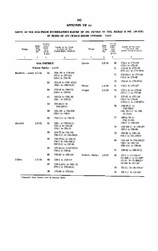
24& APPENDIX VB (a)
LIMITS OF THE lIND PHASE ENUMERATOR'S BLOCKS OF 1911 CENSUS OF GOA, DAMAN & DIU (RURAL)
IN TERMS OF 1971 CENSUS HOUSE NUMBERS - Contd.
Enume- EIIume-Loca~ rator's
Limits of the block Loca- rator's
Limits of the block tion Block tion Block Village Code Nos in tenus ot 19'71 V':llage Code :;.Tos in terms or 1971
No. (!Ind Census House Numbers No. (lInd Cemms House Numbers phase) phase)
GOA DISTRICT Querim 1/3/24 69 C71-1 to C71-116 C72-1 to C72-42
Pemem TaJuka - concld. 70 C72-43 to C72-146
Mandrem -- contd. 1/3/21 54 C56-159 to C56-184 C73-1(1) to C73-31(2)
C57-1 to C57-141 71 C73-32(1) to C73-124
C58-1 to C58-28 CU-1 to C74-40
55 C58-29 to C58-157(3) 72 C74-41 to C74-87(2)
059-1 to C59-18(3) Tlracol 1/3/25 73 C75-1 to C75-107
56 C59-19 to C59-175 Corgao 1/3/26 74 C76-1(1) to C76-59 C60-1 to C60-33 077-1(1) to C77-66
57 C60-34 to C60-181 75 C77-67 to C77-128 C61-1 to C61-21 C78-1 to C78-65
58 C61-22(1) to C79-1(1) to C79-29(3)
061-149(3) 76 C79-30 (1) to C79-120(2)
59 C61-150 to C61-316 C80, 81-1(1) to C80, C62-1 to C62-6 81-75(2)
60 C62-7(1) to C62-76 77 C80,81-76 to C80,81-138
Arambol 1/3/22 61 C63-1 to C63-12(3) C82-1 to C82-154 C63-14 to C63-86 78 C82-155(1) to C82-237 C64-1 to C64-78 C83-1 to C83-94
62 C64-79 to C64-143 79 C83-95 to C83-122 065-1(1) to C65-69(3) C84-1 to C84-103 (2)
63 C65-70(1) to C65-72 80 C66-1 to C66-108(2) C84-104 to C84-109(2)
C67-1(1) to C67-23 C85-1 to C85-116 C86-1(1) to C86-48
64 067-24(1) to C67-97(2) C68-1 to C68-41 81 C86-49 to C86-67(2)
65 C68-42 to C68-138 Pernem (Rural) 1/3/27 82 C1-1 to Cl-114(3)'
Paliem 1/3/23 66 C69-1 to C69-117 Cl-136(1) to C1·149' Cl-191 to Cl-206(2):'
67 069-118(1) to C69-179 C2-126 to 02-135'
C70-1 to C70-68(2) 83 C5-1.(1) to C5-170(2)'
68 C70-69 to C70-184 84 C6-1(1) to C6-149'
'" Formerly these houses were in Pernem Town

246
APPENDIX vn (a)
LIMITS OF THE UND PHASE ENUMERATOR'S BLOCKS OF 1911 CENSUS Ot' GOA, DAMAN " DIU (RURAL)
IN TERMS OF 1971 CENSUS HOUSE NUMBERS- Contd.
Enume- Euum'e-Loca- tator's
Limits of the bloch. Loca- rator's
Limlts of the block tion Block tion Block Village Coda No:> in terms ot 1971 Vill8.i:' Code- Nos in tE'rms of 1971
No. (IIna Census Hou~e Numbe~ No. (lind Census House Numbers phase) phase)
GOA DISTRICT car'pur (Cont.) 114/11 . 28 C28-61 to C28-129 C29-1 to C29-38
Bieholim TaJuka 29 C29-39 to C29-96
LaIngao 1/4/2 Included in Bicholim Town Cassabe de 1/4/12 30 C30-1 to C30-101
C6-1 to C6-110 Sanquellm
Sirigao 1/4/2 31 C30-102 to C30-228
C6-111 to C6-137 C31-1 to C31-40
C7-1 to C7-68 32 C31-41(1) to C31-
C7-69(1) to C7-121 134(2) C32-1 to C32-25
Mulgao 1(4(3 C8-1 to C8-91 33 C32-26 to C32-48
C9-1 to C9-113(2) C33-1 to C33-83 C33-151 to C33-153(2)
C9-114 to C9-140 C34-1 to C34-11(2) OlO-l to CI0-113(2)
34 C34-12 to C34-56
Adwalpale 1/4/4 Cll-l to Cl1-127 CI2-1(1) to C12-45 Arvalem 1/4/13 35 C35-1 to C35-71
C12-46 to C12-126 C36-1 to C36-77
36 037-1 to C37-70 Latambarcem 1/4/1\ 10 C13-1 to C13-120
C14-1 to C14-25 Maulinguern 1/4/14 37 C33-84 to C33-150(3)
11 C14-26 to C14-75 South C15-1 to Cll\-89
12 CI5-90(1) to CI5-157 Cudnem 1/4/15 38 C38-1 to C38-132
C16-1 to C16-85 C39-1(1) to C39-18(21
13 C16-86 to C16-181 39 C39-19(1) to C39-96
C17-1 to CI7-76(2) C40-1(1) to C40-25
14 CI7-77(I) to CI7-111 40 C40-26 to C40-116
C18-1 to C18-100 1/4/16 41 C41-1 to C41-70 Velguem
15 CI8-101(1) to C18- C42-1 to C42-77(4) -171(3)
42 C42-78(1) to C42-116 Dumacem 1/4/6 16 C19-1 to C1I1-44 C43-1 to C43-122
Mencurem 1/4/7 17 C20-1 to C20-117 Pale 1/4/17 43 C44-1 to C44-131 C21-1 to C21-15 C45-1 to C45-57
18 C21-16(1) to C21-67 44 C45-58 to C45-114
Salem 1/4/8 19 C22-1 to C22-49 C46-1 to C46-104
C23-1 to C23-84 45 C46-105 to C46-115
20 C23-85 to C23-130(2) C47-1 to C47-117
C24-1 to C24-82 C48-1 to C48-98
21 C24-83 to C24-146(21 46 C48-99 to C48-132 C49-1 to C49-119
Bordem 1/4/9 22 Included in Bicholim 47 C49-120 to C49-286 Town C50-1 to C50-60
SaTVona 1/4/10 23 C25-1 to C25-113(2) 48 C50-61 to C50-183 24 C25-114 to C25-164 C51-1 to C51-13
Car"pur 1/4/11 25 C26-1(1) to C26-101 49 C51-14 to C51-60
26 C26-102 to C26-186 C52-1 to C52-64
C27-1 to C27-53 50 C52-65 to C52-70
27 C27 -54 to C27 -114 C53-1 to C53-118(2)
C28-1 to C28-60 51 C53-119 to C53-137
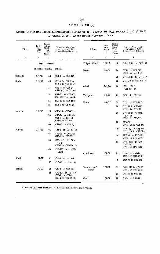
247
APPENDIX VII (a)
LIMITS OF THE UND PHASE ENUMERATOR'S BLOCKS OF 1971 CENSUS OF GOA, DAlIIAN & DIU (RURAL)
IN TERlIlS OF 1971 CENSUS HOVSE NUlIIBERS - COlltd.
VHlage
Cotombi
Suria
Nawlint
Arnone
Virdi
Piligao
Loca~ tion Codo No.
Enume~ rator s Block
Nos (IInd
phase)
Limits of the block in terms 01 1911
Census House Numbers
GOA DISTRICT
Bicholim Taulka - cancId.
1/4/18
1/4/19
1/4/20
1/4/21
1/4/22
1;4/23
52 C54·1 to C54·129
53 C55· 1 to C55· 115 C56·1 to C56·18(2)
54 C56·19 to C56·74 C57·1(1) to C57·65
55
56
C57·66 to C57·152 C58·1(1) to C58·28
C58·29 to C58·132
57 C59·1 to C59·133
58 C60·1 to C60·93(2)
59 C60·94 to C60·134 C61-1 to C61·74 C62·1 to C62·44
60 C62·45 to C62·90
61 C64·1 to C64·92(4)
62 C64·93 to C64·1H C65·1 to C65·82
63 C65·83(1) to C65· 84(2)
C66·1 to C66·106(2)
64 C66·107(I) to C66· 148(2)
65 C63· 1 to C63· 1 00
66 C63·101 to C63·143
67 C67·1 to C67·113
68 C67·114 to C67·137 C68· 1 to C68·95 C69·1 to C69·16(2)
V;ll~ge
P1ligao (Cont.) 1/4/23
Naroa 1/4/24
AturU
Vainguinirn
Maem
Curchircm*
Mauline-uem* North
Ona*
1/4/26
1/4/27
1/4/28
1/4/29
1/4/30
• These villages were transfered to Bicholim Taluka from Satari Taluka.
:hlnumeratar's Block
;-"n" (TIml
llhsse)
Limits of the block in t<::rms ot ID71
Census Hou:-;e Numbers
69 C69·17(1) to C69·126
70 C70·1 to C70·113 C71·1 to C71·9(2)
71 C71·10(1) to C71-118
i2 C71·119 to C71·158(2)
73 C78·44(1) to
74
75
76
C78·125(3)
C72·1 to C72·101
C73·1 to C73·8H5)
C73·85 to C73·119 C74· 1 to C74-81
77 C74·R2(1) to C74. 119(2)
C75·1 to C75·77
78 C75·78 C76·1 (1) to C76·104
79 C76·105 to C76·161 C77-1(1) to C77·53(4)
80 C77 ·54 to C77· 136 C78·1 to C78·15(3)
81 C78·16(1) to C78·
82
83
84
85
86
43(2) C79·1 to C79·69(2)
C36·1 to C36·81 C37·1 to C37·76(2)
C37·77 to C37·159
C34·1(1) to C34·61 C35·1 to C35·82(2)
C35·83 to C35· 110
C33-1 to C33·91

248
APPENDIX VII (a)
LIMITS OF THE lIND PHASE ENmIERATOR'S BLOCKS OF 1971 CENSUS OF GOA, DAMAN '" DIU (RURAL)
IN TERMS OF 1971 CENS1;S HOUSE NmlBERS
Enume- Enume-Loca- l""dtor's Limits of the block l,oca- rat~r's lion Block tion Block Ll.inits ot the block
Village Codo No' in terms of 1971 V!llagB Code Nos In terms ot 1971 No. (IInd Census House Numbers ~o. mnd Census House Numbers
phase) phase)
GOA DISTRICT Ivrem-Euzruco 1/5/24 32 C3-1 to C3-68
Satari Taluka I vrem -Curda 1/5/25 33 C3-69 to C3-98
Mauzi 1/5/1 C3-1 to C3-123' GolauU 115/26 34 C3-99 to C3-128
BuimpaJ 1/5/2 C23-80 to C23-111 SurIa 1/5/27 35 C7-1 to C7-65
Onda 1/5/3 C24-1(1) to C24-153 Satrem 1/5/28 36 C5-104 to C5-110
C24-154 to C24-166(2) Rivem 1/5/29 37 C6-187 (1) to C6-199' C25-131(1) to C25-162
C23-1 to C23-79(2) Dongurli 1/5/30 38 C6-1(1) to C6-119(2)'
Saleli 1/5/4 39 C6-120 to C6-186'
Dabem 1/5/5 C3-124 to C3-179' Sigonem 1(5/31 40 C22-40 to C22-53
Compordem 1/5/6 C5-120 to C5-195' Codal 1/5/32 41 C6-1 to C6-41(2)
Zormem 1/5/7 C3-180 to C3-242' Derodem 1/5/33 43 C5-81 to C5-101
Querlm 1/5/8 C39-1 to C39-148 VainguinilTI 1/5/34 43 C5-102 to C5-103
10 C39-149 to C39-215 C40-1(1) to C40-50 Nanorem 1/5/35 44 C5-27 to C5-80
Morlem 1/5/9 11 C26-1 to C26-132 Maloli 1,'5/36 45 C5-1 to C5-26 C27-1 to C27-20(3)
Xelopo-Buzruco 1/5/37 46 C6-42 to C6-90 12 C27-21 to C27-122
Naneli 1/5/38 47 C5-94(1) to C5-119' Poriem 1/5/10 13 C29-1 to C29-118
C30-1 to CSO-8(S) Carambolim-lBrama 1/5/39 18 C7-147 \1) to C7-189'
14 C30-9 to C30-110 C31-1 to C31-4~, 1 Ustem 1/5/40 49 CH3 to C4-89
15 CSl-43(1) to C31-83 Zarani 1/5/41 50 Uninhabited C32-1 to C32-71
16 CS2-72(1) to C32-128/1 Codvol 1/5/42 51 C8-82 to C8-85
Pendral 1/5/43 52 Uninhabited Podocem 1/5/11 17 C28-1 to C28-61
Curchirem 1/5/12 18 This vlllage is trans- Caranzol 1/5/44 5S C8-1 to C8-81
fered to Bicholim Sonal Taiuka.
1/5/45 54 C4-1 to C4-52
19 -do-Davem 1/5/46 55 C8-1 to C8-131(2)'
Maulinguem 1/5/13 20 --do-lBombedem 1/5/47 56 C7-1 to C7-9'
21 ---<lo- Ambedem 1/5/48 57 C7 -10 to C7 -50'
Ona 1/5/14 22 -do- Nagargao 1/5/49 58 C7-51 to C7-146'
Ravona 1/5/15 23 C42-1 to C42-116 Edorem 1/5/50 59 C7-190 to C7-217'
Ganteli 1/5/16 24 C41-1(1) to C41-128 satorem 1/5/51 60 C1-218 to C7-246'
Siroli 1/5/17 25 C38-1(1) to C38-116 Veiuz 1/5/52 61 Cl-171 to Cl-174'
Anjunem 1/5/18 26 C1-105 to Cl-149 C2-205(1) to C2-318 (3)'
Gull,liem 1/5/19 27 C1-1 to C1-104 Cudcem 1/5/53 62 C8-132 to C8-218.'
Pale 1/5/20 28 C5-1 to C5-93' Sanvordem 1/5/54 63 C9-1 to C9-100
Ponsul! 1/5/21 29 C2-35 to C2-63 Carambolim-
Quelaudem 1/5/22 30 CZ-l to C2-34 Buzruco 1/5/55 64 CI0-1(1) to C10-50
<:horaundem 1/5/23 31 C2-64(1) to C2-116 Vclguem 1/5/56 65 C4-173 to C4-318'

249
APPENDIX VII (a)
LIMITS OF THE lIND l'HASE ENUMERATOR'S BLOCKS OF 1971 CENSUS OF GOA, DAMAN III DIU (RUBAL)
L.V TERMS OF 1971 CENSUS HOUSE NUMBERS-Contd.
Enume~ l!:nume· Loca~ rator's Limits ot the block
Loca· ratar's Limits of the block tion Block tion Blo!').;
V!llage Code Nos in term~ 01 1~71 V!lJage Codtl Nos In tern IS of 1971
No. (lInd Census House Numbers No. (IInd Census House Numbers phase) phase)
Satari Taluka - concld. Sanvorcem 1/5/72 82 C9·214 to C9-276'
Codqul 1/5/57 66 C4-1 to C4-172' Vantem 1/5/73 83 C15-1 to C15-98 C1H(1) to C14-67(2)
Xelopo-Curdo 1/5/58 67 C12-115 to C12-158 84 C14-6S(I) to C14-94
Siranguli 1/5/59 68 ClO-51 to CIO-66 Advoi 1/5/74 85 C9-1 to C9-117*
Sirsodem 1/5/60 69 C10-67 to C10-93 Ansolem 1/5/75 86 Uninhabited.
Assodem 1/5/61 70 CIO-94 to CIO-ll4 Nanus 1/5/76 87 C2·89(1) to C2-204'
Govanem 1/5/62 71 Cll-l to Cll-45(3) MaBsordem 1/5/77 88 Included in Valpoi
Malpona 1/5/63 72 Cll-46 to Cll-S1 Town.
Ambeli 1/5/64 73 Cll-82 to Cll-101 Ponocem 1/5/78 89 C22-1 to C22-39
Melauli 1/5/65 74 C1S-1 to C1B-llS Vaguriem 1/5/79 90 C22-54 to C22-83
C19-1 to C19-72 Codiem 1/5/80 91 C22-84 to C22-100 75 C19·73 to C19-1M
Sonus-Vonvoliem 1/5/81 92 C25-1(1) to C25-96(2) Conquirem 1/5/66 76 CI7-60(1) to C17-104
93 C25-97(1) to GuieH 1/5/67 77 C17-1 to CI7-59(2) C25-130(6)
Damodem 1/5/68 78 C16-1 to C16-73 Pissurlem 1/5/82 94 C20-1 to C20-85
Cotorem 1/5/69 79 C12-1 to C12-114 95 C21-1 to C21-129(2)
Padeli 1/5/70 80 C13-68 to C13-161 Cumarconda 1/5/83 96 C9-ll8 to C9-195'
Birondem 1/5/71 81 Cl3-1 to C13-67(2) Naguem 1/5/84 97 C9-196 to C9-213'
~ F'ormerly these houses were in Val poi Town.

250
APPENDIX VII (a)
LIMlTS OF THE lIND PHASE E:SUlIIERATOR'S BLOCKS OF 1971 CENSUS OF GOA, DAlIlAN & DIU (RURAL)
IN TEIt'IS OF 1971 CENSUS HOUSE NUMBERS-Gontd.
Rnume- Enume-Loca- r::ttor':;
Limits of the block Loca- ralOr's
Limits of the block tion Blor:k tlOn Block Village Code No~. in terms at 1971 Villa.ge Code Nos. in terms of 1B71
No, (IInd Censu..<; House Numbers No. (lind Census Hou:;c Numbers phase) phase'
GOA DISTRICT Cundaim 1/6/6 28 C30-l to C30-112 C31-46 to C3l-80
Ponda Taluka 29 C31-l to C3l-45
Bandora 1/6/1 C1-1 to Cl-l64 C3l-81 to C31-lM C2-1 to C2-l4 C32-195 to C32-218(2)
C2-15 to C2-l32 30 C32-l to C32-l94 C3-1 to C3-l0(3) 31 C33-1 to C33-171 C3-11(1) to C3-142 Barna 1/6/7 32 C34-1 to C34-67 C4.1 to C4-128 C35-58 to C35-SS
C5-1 to C5-169 33 C35-l to C35-57 C6-68 to C6-9B C35-S9 to C35-10S
C36-l to C36-38 C6-1 to CS-67 C6-97 to C6-l78 Adcolna 1/6/8 34 C37-1 to C37-85 C7-lS3 to C7-H8 35 C3S-l to C38-76 C7-l to C7-132 Tivrem 1/6/9 36 C39-1 to C39-l06 CS-163 to CS-190 Orgao 1/6/10 37 C40-l to C40-75 CS-l to C8-162 38 C41-l to C4l-l32
Marca.lm 1/6/2 C9-l to C9-99 39 C42-l to C42-95 ClO-58 to ClO-125 C43-l to C43-51
10 C10-1- to C10-57 40 C43-52 to C43-155 ClO-126 to C10-l58 Candola 1/6/11 41 C44-1 to C44-193 Cll-l to Cll-30(2)
11 Cll-3l to Cll-130 42 C45-l to C45-l37
12 C12-1 to C12-l89 43 C46-1 to C46-140
13 C13-1 to C13-l35 Betqui 1/6/12 44 C47-l to C47-68
14 CB-l to CH-119 C4S-1 to C48-72(2)
15 C15-1 to C15-132 45 C49-1 to C49-116
16 C16-1 to C16-141 Volvoi 1/6/13 46 CoO-l to C50-106
17 C17-1 to C17-121(3) 47 C50-l07 to C50-216
Velinga 1/6/3 C18-1 to C-lS-lO 48 C5l-1 to C51-l53
18 C18-11 to CIS-ISO Savo!-Verem 1/6//14 49 CS2-1 to C52-80 C53-1 to C53-53
Priol 1/6/4 19 C19-l to C19-120 C53-93 to C53-102
20 C20-1 to C20-164 50 C53-54 to C53-92
21 C21-1 to C21-177 C53-103 to C53-130(6) C54-l to C54-79
22 C22-1 to C22-l36 51 C55-1 to C55-114 C23-18 to C23-73 52 C56-1 to C5G-S9
23 C23-1 to 023-17 Vagurbem 1/6/15 53 C57-1 to C57-94 C23-74 to C23-10S
C24-l to C24-95 Querim 1/6/16 54 C58-l to C5S-50 C25-l02 to C25-132 C5S-61 to C58-62
24 C25-1 to 025-101 C59-1 to C59-70
C25-133 to C25-l64 C59-75, 78, 79, 80
C26·33 to C26-63 55 C5S-51 to C58-60 C58-63 to C5S-178
25 C26-l to C26-32 C59-71 to C59-74 C26-64 to C26-117 56
C27-1 to C27-73 C59-76 to C59-77 C59-S1 to C59-lS0
Cuncoliem 1/6/5 26 C28-1 to C28-131 C60-116 to C60-170
27 C29-1 to C29-126 57 C60-1 to C60-115(2)
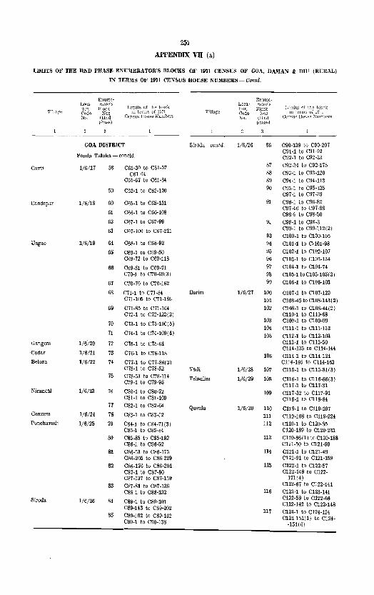
251
APPENDIX VB (a.)
UlIIITS OF THE lIlm PHASE ENnlERATOR'S BLOCKS OF 1971 CENSUS OF GOA, DAMAN & DIU (RURAL)
J:\f TER~IS OF 1971 CENSUS HOUSE NUMBERS - Contd,
Enumt- F:nume-Laca- rator's
Limits of the block l~oca- ratur",s
tion Block tion Block V'11ag'f'. ('odo Nos ill t"nllis of 1::17\ V;l!age Code ~os
No. (IInd Cen.~uo; IIollsf! N'umbcrs rio. (IJnq phase) phasf~)
-----GOA DISTRICT Siroda--contd. 1/6/26 86 C90-139 to C90-207
C91-l to C9!-92 Ponda TaJuka - concld, C92-! to C92-3S
Curt! 1/6/17 58 C61-30 to C61-57 87 C92-34 to C92-175
CBl-64 88 C93-l to C93-120 C6l-67 to C6l-84 89 C94-! to C94-U3
59 C62-1 to C62-l00 90 C90-l to C95-135 C97 -1 to C97 -39
Candepar 1/6/18 60 C65-1 to C65-l3l 91 C96-l to C96-82 C97-40 to C97-S8
61 C66-1 to C66-l08 C98-9 to C9S-50 62 C67-1 to C67-99 9. C9S-l to C98-S
63 C67-100 to C67-2ll C99-1 to C99-112(2) 93 ClOO-l to CI00-l05
Usgao 1/6}19 64 C6S-1 to C68-92 94 CI01-1 to C-lOl-9B
65 C69-1 to C69-50 95 C102-l to Cl02-107 CS9-72 to CS9-llS 96 Cl03-l to Cl03-l34
66 C69-51 to C69-71 97 Cl04-l to CI04-74 C70-! to C70-69(3) 98 CI05-l to Cl05-105(3)
67 C70-70 to C70-l62 99 Cl06-l to ClO6-l03
68 Cn-l to C71-84 Borim 1(6/27 100 Cl07-l to Cl07-l29 C7l-l05 to C71-l86 101 ClOS-45 to CI0S-143(2)
69 Cn-85 to C71-l04 102 CI08-1 to CI08-44(2J C72-! to C72-123(2J CllO-l to CllO-68
70 C73-1 to C73-l00(S) 103 ClO9-l to ClO9-99 104 Cll1-1 to Clll-132
n C74-1 to C74-l09(4) 105 Cll2-1 to Cll2-103 Gangem 1/6/20 72 C75-! to C7S-64 C1l3-1 to C1l3-50
C1l4-l35 to C114-H4 ·Codar 1/6/21 73 C76-1 to C76-ll8 106 C1l4-l to C114-134 Betora 1/6/22 74 C77-l to C77-86(2) C1l4-H5 to Cll4-l63
C78-I to C7S-52 Vadi 1/6/28 107 C1l5-1 to CllS-8l(3) 75 C78-53 to C78-1l4 Telaulim 1/6/29 108 C1l6-1 to CllB-88( 3)
C79-1 to C79-95 C1l7-1 to C1l7-3l
NirancaJ 1/6/23 76 C80-l to CBO-72 109 C117 -32 to C1l7 -91 C8l-I to C81-l09 C1l8-l to C118-84
77 C82-1 to CS2-64 Queula l/6/30 110 C119-1 to C119-l07 Conxem 1/6/24 78 C83-l to CS3-52 III C1l9-l0B to Cll9-224 Ponchavadi 1/6/25 79 C84-l to C84-71(3) 112 C120-1 to C120-85
C85-l to CS5-84 C120-l89 to C120-231
80 CS5-85 to C85-l92 113 C120-S6(1) to C120-l88 C86-1 to CS6-52 C12l-50 to C12l-90
81 C86-53 to CS6-l75 114 C12l-1 to C121-49 C86-205 to C86-229 C12l-9l to C121-l59
82 C86-l76 to C86-204 115 C122-1 to C122-57 C87-l to C87-80 C122-149 to C122-C87-137 to C87-159 171(4)
83 C87-Bl to C87-l36 C122-67 to C122-l41
C8S-1 to C88-132 116 C123-l to C123-Hl
Siroda 1/6/26 84 C89-1 to C89-l0l C122-58 to C122-66 C122-142 to C122-148
CS9-143 to C89-202 117 Cl24-l to C124-l24
85 C89-l02 to CS9-142 C124-15l(1) to C124-C90-l to C90-l38 -151(6)

2152
APPENDIX VII (al
LIMITS OF THE liND PHASE ENUMERATOR'S BLOCKS OF 1971 CENSUS OF GOA, DAlIlAN & DIU (RURAL)
IN TERMS OF 1971 CEYSUS HOUSE NmIBERS - Gontd.
Enume- Enume~ Loca- T:J.tor's
Limits of the block Loca- rator's Limits of the block tion Block 1 Hon Block Village Code :\'os in terms of lD71 Vmage Code Nml III t~rHlS o~ IfJ71
No. (IInd Census House Numbers No. (IInd Census House Numbers phase) phusc)
GOA DISTRICT Darbandora 1/7/17 27 C8-27 to CS-l11 C9-1 to C9-1l9(4)
Sanguem Taluka 28 C9-70 to C9-223
Muguli 1/7/1 Cl-106 to Cl-164(3),* CI0-1 to CI0-21
C2-1(1) to C2·16·' 29 CIO-22 to CI0-S3 C2-118(1) to C2-120'
Aglote 1/7/1S 30 C12-l54 to CI2-216(2) CosU 1/7/2 C29-1 to C29-73 C13-3S to C13-90
C30-1 to CSO-lS(20) C15-1 to C15-24(2) CSl-83 to C31-92(2) 31 C15-25 to C15-161(3) C31-93(1) to C31-143 32 C15-162 to CI5-196(2)
Dudal 1/7/3 C31-2S(I) to C31-82 Surla 1/7/19 33 CI2-34(1) to C12-l53
Calem 1/7/4 C32-1 to C32-107 Sancordem 1/7/20 34 C12-1 to CI2-33(2) C33-1 to C33·30(2) C13-1 to C13-37
C33-31 to C33-92 C13·91 II) to C13-
C34-1(1) to C34-97 92(2) C14-1 to CI4-28(4)
C34-98 to C34-153 (3) 35 C14·29(1) to C-14-103
,Santana 1/7/5 C3-143 to C3-236 C14-l04(1) to C14-1l3 C16-l to C16-26(12)
9 C3-237 to C3-278 36 C16-27(1) to C16-
Coranginim 117/6 10 Cl-2(1), Cl-2(2) 135(3) and CI-3 37 : C16-l36(1) to C16-
Compro! 1/7/7 11 Cl-l to C1-105' 203(2)
38 C16-204 to C16-231 Sanvordem 1/7/8 12 C2-1 to C2·l53
Malern 1/7/21 39 C22-l to C22-155 13 C2-154 to C2-201(2)
Cl-l to Cl-37(4) Sangod 1/7/22 40 C27-1 to C27-1l3
14 Cl-38 to Cl-140 C28-1 to C28-1l5
15 C1-H1 to Cl-195(2) 41 C28·66(1) to C28·146
Antoriem 1/7/9 16 C3·1 to C3-113 Sigao 1/7;23 42 C23-l0(1) to C23-29(2)
Rumbrem 1/7/10 17 C3-1l4 to C3-142 C24-1 to C24-3
Uninhabited 43 C24-4 to C24-82
Moissal 1/7/11 18 C25-l to C25-8
Bandoli 1/7/12 19 C5-1 to C5-78 44 C25-9 to C25-80
Cormonem 1/7/13 20 C5-79(1) to C5-177 C26-1 to C26-106
45 C26-l07 to C26-189 Camarconda 1/7/14 21 C7-1 to C7-61
C7-67 to C7-104 Colem 1/7/24 46 CIS-l to C18-75(2) C19-l to C19-47
Codll 1/7/15 22 C5-l78 to C5-235 C4-1 to C4-125 47 C19·48(1) to C19-89
C20-1 to C20-80 23 C4-126 to C4-212
C6-1 to C6-36(2) 48 C20-8l to C20-94(2} C21-1 to C21-128
24 C6-37 to C6-83/1 C23-1 to C23-9 C6-84 to C6-158(2)
25 C6-159 to C6-2l7 Caranzol 1/7 /25 49 C17-1 to C17·4(11)
C7 -62 to C7 -66 Sonauli 1/7/26 50 CI7-5(1) to C17·25
Piliem 1/7/16 26 Cll-1 to Cll-120 Cl1-12l to Cl1-182
Boma 1/7/27 51 Uninhabited
C8-1 to C8-26 OXel 1/7/28 52 Uninhabited

253 APPENDIX VII (a)
LIMITS OF THE lIND PHASE ENl1IIERATOR'S BLOCKS OF 1971 CENSUS OF GOA, DAMAN & Diu (RURAL)
IN TERMS OF 1971 CENSUS HonSE NUMBERS-Contd.
Enume· Enume~
Loca· rator's Limits of the block
Loca- rator's Limits of the block Hon Block tion Bloclt
V~nagl:' Code Nos in terms ot IG71 Vmage Code No~ in terms uf 1971 :{o. (IInd Census House ]'{umber,g No. (TInct CeJ:Stl~1 House Numbers
phase) phase)
Sanguem Taluka - coneld. Nundem 1/7/44 72 C39-1 to C39-IOO(3)
Dongurli l/7/29 .53 Uninhabited Vichundr~m 1/7/45 73 C42-1 to C42-123
Curpem 1/7/46 74 C45-1 to C45-156 Maulinguem 1/7/30 54 CSl-l to C31-27 75 C45-157 to C45-254
Patiem 1/7/31 55 C37-12 to C37-20 C47-1 to C47-78
Rlvona 1/7/47 76 C48-119 to C48-312 Uguem 1/7/32 56 CS-I(l) to C3-163' C49-1 (1) to C49-6
57 CS-164 to C3-169' n C49-7 to C49-166 C3-l to C3-21' C50-1(1) to C50-33 C4-16(1) to C4-jO'
78 C50-34 to C50-HZ C4-44 to C4-77' C51-I to C51-38(2)
Tudou 1/7/33 58 CS7-1 to C37-11 79 C51-39 to C51-100 C37-21(1) to CS7-62 C52-1 to C52-83
Patrern 1,'7/34 59 CS7 -63 to C37 -97 80 C52-84 to C52-124
Bat! 1/7/35 60 Ca6-1 to C36-125 C52-267 to C52-278
Colomba 1/7/48 81 C53-1 to C53-224(3) 61 CS6-126(1) to C36- 82 C5S-225 to C53-320
195 C52-125 (1) to C52--
Cumbari 1/7/36 62 C35-1 to C35-30(2) 266(3)
Villena 1/7/37 63 Ca5-31(1) to C35-83 C4S-1 to C48-11S
129(5) Curd! 1/7/49 84 C46-1 to C46-125(3)
Dongor 1/7/38 64 e35-l30 to C35-136 C44-l to C44-77(3)
85 C44-7S to C44-235 Naiquimm 1/7/39 65 C35-137 to C35-20l CiS-1(1) to C4S-
Porteem 1/7/40 66 C46-126 to C46-205(2) 61(2)
86 C43-62(l) to C43-Sigonem 1/7/41 67 Uninhabited 167(4)
Netorli 1/7/42 68 C41-1 to C41-120(2) SalauU 1/7/50 S7 C4-78(1) to C4-133' C40-1 to C40-72/2
69 C40-73 to C40-l7S Xelpem 1/7/51 88 C5-l to C5-35(3)'
Verlem 1/7/43 70 C3S-1 to C38-123(2) Cotarli 1/7/52 89 C5-S6 to C5-8~*
C5-90 to C5-l53(3)' 71 C3S-l24 to CSS-13S C5-lSl to C5-220'
* Formerly these houses were in Sanguem TO·Wll.

254
APPENDIX VII (a)
LIltIlTS OF THE fiND PHASE ENUMERATOR'S BLOCKS OF 1971 CENSUS OF GOA, DAMAN & DIU (RURAL)
IN TERMS OF 1971 CENSUS HOUSE NUMBERS - Oantll.
Ennroe- Enumr:· Loca~ rator's
Limits of Ule block Loca- tator's
Limits of the block Hon Blor.k tion Block Village Code Nos. in terms or 1971 Village Code Nog, HI term:;; of 1971
No. HInd Census House Numbers No. (lInt! Census House Numbers llhase) J)ha."~)
GOA DISTRICT Gaodongrem 1/8/5 23 C20·l to C20·l51
24 C20·l58 to C20·281 Canacona Taluka C21·1 to C2l·72
Cola 1/8/1 Cl-l to Cl-176 25 C21·73 to C21-206 C22·l to C22·39
Cl·l77 to Cl·l85 26 C22·40 to C22·l80 C2·1 to C2·157
C3-1 to C3·185 Cotigao 1/8/6 21 C22·l8l to C22·l85 C4·1 to C4·l65 C23-1 to C23-l95
C5·1 to C5·l80 28 C23·l96 to C23·257 C24-1 to C24·99
Agonda 1/8;2 a)·l to C6·94 C30·l to C30·23
C1·l to C7·15 C31·48 to C31·92
C7-76 to C7·219 29 C33·l8 to C33·l39
CS-l to C8·33 Lollem 1/8/7 30 C34-1 to C34-237
C8·34 to C8·134 31 C34-238 to C34·278(2), C9.} to C9-53
CBB·1 to C36·159 C9·54 to C9·l96
32 C3S-lS0 to C36·192
Nagorcem·Palo· 1/8/3 10 Cl(}'l to ClO·176 CS7·1 to C37-212
Iem C3S-1 to C38-l5(2)
11 ClO-l77 to Cl(}'20l 33 C3S·l6 to C38·258 Cll·1 to Cll·166 S4 C38·259 to C38-324
12 Cll·170 \0 Cll·3l7 ,C39-1 to C39-232 C12·l to C12·l9 35 C35·1 to C35·202
13 C12-20 to C12·213
14 C12-214 to C12- Poinguinim 1/8/8 36 C25-1 to C25-l69
224(3) 37 C26-l to C26·105 CU· 1 to C14·152 C27 -1 to C27 -68
15 C14·153 to C14·275 38 en·69 to C27-170
16 C14·276 to C14·405 C28·l to C28-S7
C15·1 to C15-26 39 C29·1 to C29·165
17 C15·34 to C15-2l3 C30·24 to C30-48
18 C15·2l4 to C15-3BO 40 C30-49 to C30-l91 C31·l to C31·47
Canacona 1/8/4 19 C16·l to C16-1l3 41 C3l-93 to C3l·l66
20 Cn·l to C17·l73(lO) C32·1 to C32-108
21 C17-l74 to C17-205 42 C32·109 to C32·191
C18·l to C18·126 C33·1 to C3S-l7
22 C19·l to C19-124 Angedlva 1/8/9 43 C40·1 to C40· 7

255
APPENDIX vn [aJ
LmITS OF THE liND PHASE ENUMERATOR'S BLOCKS OF 1971 CENSUS OF GOA, DAMAN'" DIU (RURAL)
IN TERMS OF 1971 CENSUS HOUSE NUMBERS ~ .. C'Q!1td.
EnunIe~ l!:nume-Loca- rator'''\
Limils of Loca- ratur'o;
Villag-e tion Block ill t!:'t'm,. VilhH;;t·
tioll Block Limit" of the blocli;:
Code No:>. Codt: 1\0,<:: 1ll t,,)'ms of urn No (IInd C~lllSU~ HonFt' No (rIlJil (\~nr;lls Hon.~t-' Number!'
vhasf') pha.~E:-J
GOA DISTRICT CaCQra 1/9!l1 27 C17-1 to C17-104
Quepem Taluka 28 CI7-105(1) to C17-148(2)
Amona 1/9/1 Cl-1 to Cl-68 C18-1 to C18-96 C2-1 to C2-11 C2-65 to C2-S4 29 CI8-97(1) to C1S-180
C19-1 to C19-24 C2-85 to C2-122
30 C19-25 to C19-99
Xeldem 1;9/2 C3-1 to C3-128(2) C20-1 to C20-26
C3-129 to C3-139(3) 31 C20-27 to C20-140 CI-l(l) to C4-102(2)
32 C20-141 to C20-153 C5-1 to C5-149 C21-1 to C21-103
C5-150 to C5-177 33 C22-1 to C22-109 C23-1(1) to C23-35
-Chaifl 1/9/3 C6-1 (1) to C6-11 34 C23-36 to C23-114
Avedem 1/9/4 C7-1(1) to C7-140 Silvoi 1(9/12 35 C29·80, C29-82 C8-1 to C8-54
C29·84 to C29-88 C8 .. 55 to C8-167 (21 C29-110 to C29-112 C9-1 to C9-107 C29·121 to C29-139
C29-145 to C29-166
Cotombl 1/9/5 10 C10-1(1) to CI0-40 C30-1 to C30-102 Cll-l to CI1-21 36 C30-103 to C30-125
11 Cll-22(11 to C11-123 C31-1 to C31-101
37 C33-1 to C33-17 Assolda 1/9/6 12 C12-1(11 to C12- C33-28 to C33-
97(2) 107(4)
13 C13·1 to C13-88 C34-1 to C34-33
38 C34-34 to C34-122 Xic .. Xelvona 1/9/7 14 C14-113 to CI4-116 C35-1 to C35-43
Xelvona 1;9/8 15 C15-1 to CI5-96(2) 39 C35-44 to C35-94
C36·1 to C36-85
16 C15-97 to C15-134 Nagvem 1/9/13 40 C24-1 to C24-71
Odar 1/9/9 17 C16-1 to C16-69 Molcarnem C16-71 to C16-84 1/9/14 41 C24·72 to C24-103 C25-1 to C25-23
CUrchorem 1/9/10 18 C1-1(1) to CI-102(4) C27-1 to C27-86
19 CI-103 to CI-143 42 C28-1 to C28-28
C2-1(1) to C2-59(6) C28-2~rl) to C28-86
20 02·60 to C2-148 Zanodem 1/9/15 43 C25-24(1) to C25-95 C3-1 to C3-9(2)
Undorna 1/9/11) 44 C26-75 to C26-118 21 C3-10 to C3-96
22 C3-97 to C3·206 Moleopona 1/9/17 45 C26-1 to C26-74(3)
23 C4-1 to C4-77 Cavorem 1/9/18 46 C37-1 to C37-95(2)
24 C4-78(1) to C4-114 Bendordem 1/9/19 47 C54·1 to C54-58 C5-1 to C5-125
25 C6-1 to C6-82(4) Cordem 1/9/20 48 CM-59 to CM-144
C5·126 to C5-198 C43-1(I) to C43·51
26 C6-83 to C6-123 Matna 1/9(21 49 C40-1 to C40-47

2616
APPENDIX VII (a)
LIMITS OF THE lIND PHASE ENUMERATOR'S BLOCKS O~' 1971 CENSUS OF GQA, DAMAN " DIU (RUBAL~ IN TERMS OF 19'11 CENSUS HOUSE NUMBERS-Oontd.
Enume- Enume-Loca- rator's
Limits of the block Loca- rator's
Limits of the block hon Block Hon Block Village Code Nos. in terms of 1971 Villag~ Codl" Nos. in terms 01 1971 No (IInd Census HOUf~~ Number~ Ko. (lInd Census HOllsl;' Numbers
pha.'le) phase)
GOA DISTRICT Quitol 1/9/34 65 C53-1 to C53-79
Quepem 'faluka - concld. Fatorpa 1/9/35 66 C44-1(1) to C44-106
Piria 1/9/22 50 C3S-1 to C5B-64 C45-1(1) to C45-59(2r
67 C46-1(1) to C46-7!f(2)' Sulcorna 1/9/23 51 C39-1 to C39-57 C4S-1 to C48-57
Mangal 1/9/24 52 C39-101 to C-39-129 68 C48-68 to C48-169' C49-1 to C49-82
Cazur 1/9/25 53 C39-58 to C39-1OO Ttloi 1/9/36 Coo-HI to C55-146(2). 69
Coria 1/9/26 54 CS9-130 to CS9-l42 Bali 1;9/37 70 C55-1 to C55-l18(2)
Quisconda 1(9/27 55 C41-32 to CU-63 (3) 71 C50-119 to C55-140
Gocoldem 1/9(28 56 C41-1 to C41-31 C56-l(1) to C56-45 (2). Co7-l to C57-47(2)
Bareem 1(9/29 57 C42-1 to C42-90 72 C5H8(1) to
58 C42-91 to C42-l31 C57-130(2)
Adn.m 1/9/38 73 C58-1 to C58-62 Padi 1/9/30 59 C43-52 to Ci3-76 C59-1 to C59-92
Qued.m 119m 60 C43-93(1) to C4S-l06 74 C59-93 to C59-147 C43-77 to C43-92
Arnbaulim 1/9/39 75 C60-1 to C6Q-81
Morpila 1/9/32 61 C47-1 to C47-113 C6~-1 to C61-30
76 C61-36 to C61-90 Naquerim 119/33 62 C50-1 to C50-67 C62-1(1) to C62-81
C5l-l to C51·126 77 CB3·1 to C63·56
63 C52·1 to C52·140 Cusmane 1/9/40 78 Included in Quepem
64 C52·HI to C52·185 Town

257
APPENDIX VII (a)
LBIITS OF THE usn PIlASE ENUMERATOR'S BLOCKS OF 1971 CENSUS OF GOA, DAMAN & DIU (RURAL) IN TERMS OF 1971 CENSUS HOUSE NUMBERS-Contd.
1iJnurue-Enume-Lor.a~ rator's
Limits of the block Loca- rator's Lim.its of the block J' 'k tian B1De~ Village Code NOB. t~""'1f\ oi 1 71 Village Coue NOil. in terms of 1971
No. (Ilnd Census House Numberll N,. (lInd Cell811S House Numbers p",""",!;!, pha~e)
GOA DISTRICT Utorda 1/10/12 30 C21-1 to C21-148(2) Salcote TaJuka 31 C2H49 to 021-225
Sernabatim 1/10/1 C7-1(1) to 07-146 32 022-1 to 022-150
C7-147 to 07-211 Nagoa 1/10/13 33 023·1 to 023-147
VaneIim 1/10/2 08-.1 to 08-150 34 023,148 to C23-219
4 C8-151 tu 08-186 024-1 to C24-81
Colva 1/10/3 09-1 to 09-1&2 35 C24-~2 to 024-141
C9-ISS to 09·237 Verna 1/10/14 36 025"1(1) to 025-127(2) 010-.1 to 0-10.50
37 025·128 to 025·217 010·51 to CI0·117 026-1 to 026·73 CI0·178 to 010-234(2)
38 C26·74 10 026·2,18 Seraulim 1/10/4 011-1 to C11-44 39 C27-1 to C27-150
011-46 to C11·67 Cll-124(1) to 011.147 40 C28-1(1) to C28"124 Cl1-149 to 011-150(2) C29.1 to C29-50 Cll-l77 to C).1·228 41 C29-51 to C29-197
C11-22'9 to 011-252 Loutulim, 1/10/15 42 C30-1 to C3(H~5
Gaundaulim 1/10/5 10 ClO-U8 to 010-117 43 C30·136 to C30-254
Duncolim 1110/6 11 011-45 44 C30-25i\ to 0,0-338 C11-68 to CI1-123 OSH bo C31-S1 0114151 to C11-176 C1.1-148 45 031-32 t,o 031-161
032-1(,1) to 032·51 lletalbatim 1/10/7 12 012·1 to 012-138(4)
46 C32-5'2 to 032-,186 13 CI2-130 to 012-279
47 032-187 to 032·3%(2) C13.1 to 013·13
14 013-14to C13-162(5) 48 C32-367 to 032-390 033-1(1) to 033-111
15 013.163 to C13-22'3(3) 49 CSe·142 to C33-189 013-224 to C13-243
Nuvem 1/10/8 16 014-1 to 014,131(2) Camurlim 1/10/16 50 CSH to C34-209 17 C14-132 to C14-'250 51 C34-2110 to C34-2'66 18 C14-251 to 014-283
C15-1 to 015,100 RaJa 1/10/17 52 035-1 to 035,146
19 C15-101 to 015-2'20(2) 53 035-147 to 035-253
20 C15-221 to Cl5-®40 036-1 to C36-39
21 01~1 to Cl6-1SO 54 036-40 to 036-160
22 C16-161 to C16·258 55 036-161 to 036-270(2)
23 017-1 tD C17·141 56 C37-1 to 037-138(2)
57 037·13'9 ,to 037-255 Calata 1/10/9 24 Cl8"1 to 018-155 0&8-1 to 038-22
25 018-156 to 018·302(3) 58 038'23 to 038<197
Gonsua 1/10/10 26 Ci3-244 to 013·282 (2) 59 C38-198 to 038-262 039-1 to 039-158
Majorda 1/10/ll 27 C19"1 to C19·U7 60 040-1 to 040·123
28 019-148 to 019-274(2) 61 C40-124 to C10-223 C20-1 10 C20-38
29 C20-:Ml to C20-188 62 C4()'224 to C40-284

258
APPENDIX VII (a)
LIMITS OF THE lIND PHASE ENUMERATOR'S BLOCKS OF 1971 CENSUS OF GOA, DAJ\IAN '" DIU (RURAL)
IN TElUlS OF 1971 CENSUS HOUSE NUMBERS ~ Oontd.
Enume~ Enume-Loca- ratar's
LImits of the block Loca- mtor's
Limit8 of the block tion Block tion Block Vil1age : Code Nos. in terms of 1971 Village Colle Nos. in terms of H111
No. (Ilnd Census House Numbers No. (lInd Ccnsu~ House Numbers phnse) pha"e)
GOA DISTRICT Talvorda 1)10)26 &6 C11-1 to C11-132'
Salcete Taluka ~ contd. Varoda 1/10/27 ~7 C12-1 to CI2-138'
Curtorim 1/10/18 63 C41-1 to C~I-155 98 C12-139 to C12-167' 64 C42-1 to C42-147
65 C42-gg to C42-254 Cuncolim 1/10/28 99 Cl-1 to Cl-168
66 C42-255 to C42-319 100 C2-1 to C2-157
C43-1 to C43-g'9 C3-1 to C3·16
67 C43-100 to C43-265 101 C3-17 to C3-157 C4-1 to C4-29(2)
68 C44-1 to C44-162 102 C4-30 to C4-159
69 C44-163 to C44-275 103 C4-160 to C4-295
70 C45,1 to C45-185 104 C5-1 to C5·126
71 C45-186 to C45-300 105 C5-127 to C5-260
C46-1 to C46-36 C6-1 to C6-14(3) 72 C46-37 to C46-160
106 C6-15 to C6-156 73 C46·1&1 to C46-227 107 C6-157 to C6-228 C83-1 to C83-40
C7-1 to C7-89 74 C83-41 to 083-216
108 C7-90 to C7-229 75 C83-217 to 0&1-287
109 C7-230 to C7-268 C84;1 to C84-111 C8-1 to C8-221
76 C84-112 to C84-209 110 C9-1 to C9-92
C~5-1 to C85-52
77 C85·53 to C85-210 111 C9-93 to C9-218
CI0-l to CI0-28 78 C85-211 to C85-256
112 CI0-29 to CI0-155
Macasana 1/10/19 "9 C47-1 to C47-128 113 CI0-156(1) to CI0-193
80 C48-1 to C48-134 C13-1 to C13-99
81 C48"135 to C48-2,66 114 C13-100 to C13-196
Guirdolim 1/10/20 82 C4'9-1 to 'C49-1'64 Velim 1/10/29 115 C58-1 to C58-148(3)
83 C49-165 to C48-243 116 C58-149 to C58-227 C50-1 to C50-95 C59-1 to C59-56
84 C50-96 to C50-272 117 C59-57 to C59-204 C60·1 to C60-32
Chandor 1/10/21 85 C53-1, to C53-141 118 C60-33 to C60-202 C61-1 to C61-36
Cavor1m 1/10/22 86 C51-1 to C51-156 119 C61-37 to C61-262
87 C51-157 to C51-191 C52-1 to C52-122 120 C61-263 to C61-299
88 C52-123 to C52-187 C62·1 to C62-149
121 C62-150 to C62-290 Paroda 1/10/23 89 C54-1 to C54-183
C54-1M to C54-229 122 C62-291· to C62-327
90
Mulem 1)10/24 91 C55-1 to C55~135 Ambelim 1/10/30 123 C56-1 to C56-235
92 C55-136 to C55-210 124 C56-236 to C56-376
Sarzora 1/10)25 93 C81-1 to C81-164 C57-1 to C57-22
94 C82-1 to C82-156 125 C57-23 to C57-154
:)5 C82-157 to C82-277(2) 126 C57-155 to C57-240

259
APPENDIX VB (aJ
LHIITS OF TilE lIND PHASE ENV~IERATOR'S BLOCKS OF 1971 CENsrs OF GOA, DMIAN & DIU (RURAL)
IN TER)IS OF 1971 CENSUS HOUSE NUMBERS-Conld.
Enume, Elnume-Loca- lllock Limits o( tile biock
Loca- rator's tlUn ratur's lion Rlock Limit.., u[ the block
Village Code Nos. III terms oi Hi71 Village Code No::;. m ot 1~71
No. (IInd Census House Numbers No. (TTnd Ccn~u~ ~umhe~
pha~e) phase)
GOA DISTRICT Sirlim 1/10/38 157 CS7-1 to C87-157
Salcete Taluka - concld. 158 C87-158 to C87·191
Assolna 1/10/31 127 C65-1 to Co5-153 Dramapur 1/10/39 159 C86-1 to C86-187
128 C65-1M to C65-193 160 C86-1SS to CS6·309
C66-1 to C66-120 Dicarpale 1/10/40 161 CI00-l to CI00-136 129 C66-121 to C66-257 162 CIOO-137 to CIOO-169
C67-1 to C67-32
130 C67-33 to C67-1G2 Davorlim 1/10/41 163 CIOI-! to C!01-121
CB8-1 to C6S·ll3 164 CIOI-122 to CI01-239
131 C68·ll4 to C68-246 165 CIOI-240 to CIOI-294
Cavelossfm 1/10/32 132 C63-1 to C63-157'(I) Aquem 1/10/42 166
133 CBS-15S to C63-252 Included in Margao
C64-1 to C64·89 167 Urban Agglornera-
168 tion
134 C64-90 to C64-147 Talaulim 1/10/43 169 C88-1 to CSS-149
Chinchinim 1/10/33 135 C77-1 to C77-169
136 C77-170 to C77-292 170 C8S-150 to C83-292
C78-1 to C7S-43 171 C88-293 to C8S-319
137 C78-44 to C7S-218 Navelim 1/10/44 172 138 C79-1 to C79-82 173
C78-219 to C78-283 174 Included in Murgao
139 C79-83 to C79·226 Urba.n Agglomcra-
140 C79-227 to C79-303 175 tion
CSO-l to C80-60 176
141 C80-61 to C80-182 177
142 C80-183 to CSO-288 Benaulim 1/10/45 178 CI-l to CI-150
Deussua 1/10/3~ 143 C76-1 to C76-167 179 CI-151 to CI-279 144 C76-168 to C76-282 180 CI-280 to Cl·313
Carmona 1/10/35 145 C69-1 to C69-151 C2-1 to C2-109
146 C69-152 to C69-282 181 C2-110 to C2-240
C70-1 to C70-67 182 C2-241 to C2-298
147 C70-68 to C70-244 C3-1 to C3-93
148 C70-245 to C70-347 183 C3-94 to C3-201 C4·1 to C4-23
Varea 1/10/36 149 C71-1 to C71-136 184 C4-24 to C4-190 150 C71-1a7 to C71-251 185 C5-1 to C5-139 151 C72-1 to C72-181 186 C5-140 to C5-287 152 C72-182 to C72-220 187 C5-288 to C5-370
C73-1 to C73-111(2) C6-S1 to C6-84 153 C73-112 to C73-244 CG-87 to C6-155
Orlim 1110/37 154 C74-1 to C74-142 188 C6-156 to C6-275
C75-1 to C75-4(2) Adsulim 1110/46 189 CG-l to C6-14 155 C75-5 to C75-149
eana 1/10/47 190 C6-15 to C6-80 156 C75-150 to C75-191(3) C6-85 to C6-86
'" .B~ormerly these hOUf>es were III Cuncolim Vilhge.

260
APPENDIX VII (al
LIMITS OF THE lIND PHASE ENUMERATOR'S BLOCKS Q}' 1971 CENSUS OF GOA, DAMAN &> DIU (RURAL)
IN TERlIIS OF 1971 CENSUS HOUSE NUMBERS - C~ntd,
Enume- Enume-Loca- rotor's
Limits of the block Loca- rator's
Limits of the block tion Block Hall Block Village Code Nos, in terms of 1971 Village Code Nos. in terms of 1971
No, (rInd Census House Numbers No. (LInd Cen.sus House Numbers phase) phase)
GOA DISTRICT Quelossim 1/11/6 IS C9-1 to C9-118
Monnugao Taluka 19 C9-119 to C9-202
Vadem 1/11/1 CIO-! to C10-32
Included ill Mormugao Town 20 C10-33 to C10-196
Chicalim 1/11/2 C1-1 to C1-109 CueUm 1/11/7
C1-110 to Cl-179 21 C13-1 to C13-165
C37-100 to C37-129 22 C13-166 to C13-232
C20-1 to C20-37 Arossim 1/11/8 23 C16-1 to C16-132(2) C20-71 to C20-175 C38-222 to C38-226
24 C16-133 to C16-179 Dabolirn 1/11/3 C1-1S0 to Cl-260 C17-1(1) to C17-88
Sancoale 1/11/4 C3-1 to C3-71 25 C17-89 to C17-111
C11-1 to C11-107(2) Cansaulim 1/ll/9 26 C14-1 to C14-114 C11-108 to CI1-231
27 C14-115 to C14-148 C12-1 to C12-111 C15-1 to C15-136
10 C12-112 to C12-173 28 C15-137 to C15-188
'Cortalirn 1/11/5 11 CH to C4-183 Velsao 1/11/10 29 C18-1 to C18-167
12 C7-1 to C7-168
13 C6-1 to C6-70 30 C18-168 to C18-224
C5-266 to C5-323 Pale 1/11/11 31 C19-1 to C19-152
14 C8-1 to C8-173
15 C5-1 to C5-140 32 C19-153 to C19-253
16 C5-141 to C5-265 Issorcim 1/11/12 33 C19-254 to C19-312
17 C4-1S4 to C4-328 CS-174 to C8-183 Chicolna 1/11/13 34 C20-38(1) to C20-70

~
APPENDIX VII (al
LIMITS OF THE lIND PHASE ENUMERATOR'S BLOCKS OF 1971 CENSUS OF GOA, DAMAN 61 DIU (RURAL)
IN TERMS OF 19'11 CENSUS HOUSE l\"UMBERS- Oontd.
EmUlle- Enume-Looa- rator's
Limits of UlP block Loca- rator's
Limits of the block tion Block tion Block Village Code Nos. in terms ot 1971 Village Codl" Nos. in terms of 1971
No. (Ilnd Census House Numbern No. (IInd Census House Numben phase) phase)
DAMAN DlsTRICT 21 C15-82 to C15-182 C15-184 to C15-189
Daman TalUka Zari 2/1/11 22 C16-1 to C16-52
Marwad 2/1/1 Cl-1 to Cl-94 Thana Pardi Cl-116 to Cl-139
2/1/12 23 C16/A-1 to C16/A-~
2 Cl-95 to Cl-115 Magarwada 2/1/13 2f C17-1 to C17-94(3)
C2-1 to C2-93(2) 25 C17-95 to C17-127 C18-1 to C18-6
Devka 2/1/2 C3-1 to C3-69(2) C18-10 to C1S-14 C3-7S to C3-130 C18-19 to C1S-21
C3-70 to C3-77 & C3-ClS-26, C1S-35 (1 \ to
77/1 C1S-88
03-131 to (:3-157 26 C18-7 to C18-9 C1S-15(1) to C18-
Kadaiya 2/1/3 C4-103 to C4-134 lS(2\ C4-138 to C4-175 C18-22 to ClS-2514)
C4-1 to 04-102 C18-27 to C18-34 C1S-S9 to C18-138
04-135 to C4-137 C19-61 (1) to C19-81 Shtmpore 2/1/4 C5-6 to C5-75, C5-75/1 C19-S3 (1) to C19-93
C5-139 to C5-171(3) 27 C19-1(1) to C19-60,
C5-1 to C5-5 C19-82 C5-76 to C5-138 C19-94 to C19-102 C5-172 to C5-184 C20-1 to 020-9(3)
Janivankad 21115 C6-1 to C6-29(2) 28 C20-10 to 020-89(3)
10 C6-30 to C6-93 Naila Pardi 2/1/14 29 C21-1 to C21-49
Dunethu 211/6 11 C7-1 to 07-36 Deva Pardi 2/1/15 30 C21/A-111) to C21/A-C7 -50 to C7 -96 22 07-11311) to C7-118
Pariari 2/1/16 31 C22-38 to C22-131 C7-118/1 to C7-11S/2Q
12 C7-37 to C7-49 32 C22-1 to C22-37
C7 -97 to C7 -112 Jampore CS-l to CS-60(3\
2/1/17 33 C22A-lI1\ to C22A-55
CS-141 to CS-166 Dholar 2/1/1S 34 C23-110 C23·100 13 eS-61 to CS-140, CS-
167 Bhamati 2/1/19 35 C24-1(ll to C24-,9
Varkund 2/1/7 14 C9-1 to C9-117 Palhit 2/1/20 36 C24A-l to C24A-27 C10-111) to C10-141 CIO-14S to C10-160 Daman Wada 211/21 37 C25-61 to C25-65
15 CI0-142 to ClO-147(2) C25-75 to C25-84
CI0-161 to CI0-235 C25-139 to 025-161
Cll-1 to C11-S2 3S C25-1 to C25-60
16 C12-1 to C12-40 C25-66(1) to C25-74
Ringanwada 2/1/8 C25-85 to 025-138(3)
Dabhel 2/1/9 17 C13-1 to C13-47 2/1/22 CI3-91, C13-92(1-2) Jumprim
18 CI3-48(1) to C13-90 Daman Camp 2/1/23
C13-93 to C13-98 (Campo dos Reme-
C14-53 (1) to C14-83 dios) Included in Daman
19 C14-1 to C14-52(3) Moti Daman 2/1/24 Town
C14-84 to C14-115 (Daman Praca)
2/1/10 20 Cl,-I(l) to C15-81 Khariwadi 2/1/25
Kachlgam C15-183 Kathiria 2/1/26

002
APPENDIX VII (al
UMITS m' THE lIND PHASE ENUMERATOR'S BLOCKS m' 1971 CENSUS OF GOA, DAMAN " DIU (RURAL)
IN TERMS OF 1971 CENSUS HOUSE NUMBERS - C.",clC:.
Enume, Bnurne-Loca- ratar's
Limits of the block Loca- ratar's
Limits of the lllock tiall Block tian Block Village Code Nos. in terms ot 1971 Villagt' Code Nos. in terms of 1\171
No. (lInd Census House ~urnb€r.~ No (lInd Censt1.<: HOUFf' :-Jumllcr" phase) phase)
DIU DISTRICT Vanakbara (Cont.) 3/1;3 15 C32·l to C32·97 Ca3·l(I) to C33·128
Diu Taluka 16 C34-1 to C34·99
Fudam 3/1/1 C2-1 to C2-122 C35-1(1) to C35-55 (3)
C35·55 (1) /1 Bucharvada 3/1/2 CS-l(l) to C8·205 17 C36·1 to C36·U3
C9-1(1) to C9-94 IS C37-1 to C37·S1 ClO·l to CIO-1l8 C38·1 to C38· 79 Cll-I to Cll·43,
Cll·43/1 Ghoghla 3/1/4 19 C39·l to C39·l05 C12·l(1) to C12·l08 20 C40-l to C40-l28 C1S-l to C13·269 21 C41-1 to C41-l44 C14-I(l) to C14·86 22 C42·l to C42·97
C14·87/l C43-l to C43-l28 C15·l to C15·95
C16-l to C16·l09 23 C44-l to C44-96
C17-1 to C17·53 C45·l to C45-l0S
C18·1 to CIS·I09 24 C46·1 (1) to C46·92
C19-1 to C19·40 C47·l to CH·n
3/1/3 C20-l to C20·l50 25 C48·l to C48·95
Vanakbata C49-1 to C49-9O 10 C21·l to C2l-l3l 26 C50-l(1) to C50-73(2) 11 C22-l to C22·47 C51·l(1) to C5l·84(4)
C23-l to C23·119 27 C52.l to C52-l20(2) 12 C24-1 to C24·116 C53·l to C53·92(2)
C25-l to C25·53 28 C54·l(1) to C54·77 C26-l to C26·39
13 C27 -1 to C27 ·58 29 C55·l to C55-94 C2S-l to C28-l23 30 C56-l(1)to C56-54 C29-1 to C29-5l C57-1(1) to C57-9l
14 C30-1 to C30-92 C31-l to C31-130 Simbor 3/1/5 31 GS8-l to C58-176

263 APPENDIX VB (b)
UMITS OF THE lIND PHASE ENUMERATOR'S BLOCKS OF 1971 CENSUS OF GOA, DJUIAN & DIU (URBAN)
IN TER~18 OF 1971 CENSUS HOUSE NUMBERS
Enume- Enume-nt..tor's
Limit~ of the block rator'g
Limits of the blvck Town Ward Block Town Ward B,ock No. Nos. In 1prm<: of lH71 No. t\vs. III lerltls Ul 1.;71
(lInd Ceni\us Home J\umbers (Ilnd Census House J:'.Iumbers phase) pha:seJ
GOA DISTRICT A) Panaji Munici- 22 C6-H7 to C6-196
Tiswadi TaJuka pdl Council C6-"~6 to C6-~~7 -contd. C6-~~9 to Cti-~,W
Panaji Urban Ag- C12-1 to C12-75 Co-242 to Co-Zo9 _glomeration. Co-2'16
A) Panaji Munici- C7-125 to C7-132 pal Council.
C12-76 to C12-90 23 C7-133 to C7-217
C13-22 to C13-133 24 C16-51 to CI6-71 C29-1 to C29-57 C17-1 to C17-22 C-43-1 to C43-14 C17 -30 to C17 -36 C13-134 to C13-156 Cll -45 to cn -50
4 C43-15 to C43-41 25 C17-57 C43-54 to C43-75 C17 -60 to C17 -69 C43-193 to C43-195 CIS-l to CIS-35 C46-S3 ClS-84 to ClS-89 C47-1 to C47-35 26 C25-90 to C25-100 C4S-1 to C48-50 C25-106 to C25-152 C48-108 to C48-116 C48-175 to C48-178 27 CH-7 C49-1 to C49-50 CH-15 to C14-22 COO-90 to C50-102 C14-31 to C14-38 C50-129 to C50-150 C14-45 to C14-60
7 C50-151 to C50-221 C18-90 to C18-105
8 C48-51 to C48-107 C22-1 to C22-43
C48-117 to C48-161 28 C23-1 to C23-4 C48-162 to C48-174 C23-10 C49-51 to C49-138 C26-1 to C26-17
C50-59 to C50-60 C26-29 to C26-38
10 29 C26-38/1 to C26-56 C50-63 to C50-89 C50-103 to C50-128 30 C26-57 to C26-96
11 C15-1 to C15-34 31 C27-29 to C27-48 Cl6-1 to C16-38
12 C15-35 to C15-82 9 32 C21-1 to C21-44 C2'/-1 to C27-22
13 ClS-S3 to C15-157 33 C28-1 to C28-52
14 C13-1 to C13-21 34 C28-53 to C28-72 C1S-157 to ClS-163
35 C28-73 to C28-94 C15-158 to C15-182 C27-49 to C27-59
15 C14-1 to C14-6 C14-8 to C14-14 10 36 Cl1-19 to Cl1-47 C14-23 to C14-30
31 C20-25 to C20-96 C14-39 to C14-44 C14-61 to C14-68 38 C26-97 to C26-12i
16 C23-5 to C23-9 39 C26-125 to C26-146 C23-11 to C23-56 C27-23 to C27-28
17 C23-57 to C23-103 11 40 C8-101/1(3-5) C26-18 to C26-28
C8-102 to C8-109 18 C24-36 to C24-76 ClO-1 to CIO-31 19 C16-39 to C16-50 C20-1 to C20-24
C24-1 to C24-35 41 C19-1 to C19-50 C25-1 to C25-14
20 C25-15 to C25-80 42 C18-36 to C18-83
21 C25-81 to C25-89 12 43 C8-101/1(1-2) C25-101 to C25-105 CB-110 to C8-124 C25-153 to C25-159 C10-32 to C10-99

2M
APPENDIX vn (b)
LIMITS OF THE lIND PHASE ENUMERATOR'S BLOCKS OF 1971 CENSUS OF GOA, DAMAN 8/; DIU (URBAN)
IN TER~IS OF 1971 CENSUS HOUSE NUMBERS-Contd,
J<..inume- Ellurne-r~t(\r ~
Llmits of the lJJock rator'B
.Limitt> of th~ blO\'.k fown Ward Block Town Ward Block
No. 1"-11". m terms of 1[f(l No. No.~· m term:.; of 1!J71
tTl lid C{'n~u~ Home l'\Ulllhpr~ (Uno (Jensus House .;.Jumher~
phao;e) pha~e)
GOA DISTRICT C) ChimbrJ -cont. 1/1/17 ~6 C88-136(1) to C88-182 C89-1 to C89-63
Tiswadi Taluka ~ contd. ~7 C89-64( 1) to C89-90
A) Panaji Munici- 12 44 C9-1 to C9-36/1 P) Cujir. 1/1/31 85 C31-67 to C31-129
pal Council 45 C9-37 to 09-57(1-3)
C31-139 to C31-142
-contd. C31-281 to C31-283 C10-101 to CI0-118 C32-1 to C32-H(S) Cl1-8 to Cl1-18 C33-60 to C33-62 Cl1-48 to Cll-51 C33-78 to C33-97
13 46 CI0-100 C40-41 (1 to 4)
Cl()'-119 to CIO-166 86 C40-46 to C40-67(2) C5-1 to C5-13 C40-70
47 C9-57(4-5) to C9-120 E) Murda 1/1/32 87 C29-58( 1) to C29-91(2) (1-15) C30-1 to C30-46
C7-1 to C7-33 88 C30-47 to C30-91 C7·218 to C7-220
C30-93 to C30-124 13 48 Cl1-2 to Cl1-7 C31-tel) to C31-12
C8-1 to C8-101/1 89 C31-1S(I) to CSI-66 (6-9) C31-1S0 to C31-138
14 49 C4-24 C31-143 to C31-177
C4-33 to C4-35 90 C31-178 to C31-280 C4-94 to C4-103 C31-284 to C31-289 C4-163 to C4-165
91 C4-177 to C4-263 038-17(1) to C38-19(3)
50 C5-14 to C5-95 C38-26(1) to C38-32(3) C39-1
51 C5-107 to C5-129 C44-1(1) to C44-18(2) C5-132 to C5-146 C44-27 to CH-31 C6-1 to C6-4 C45-37(1) to C45-40(3) C6-l06 to C6-108 C45-59( 1) to C45-72(2) C7-34 to C7-124 C45-76, C45-78
02 C6-57 to C6-95 F) Moromblm-o- 1/1/33 92 C43-42 to C43-52 C6-115 to C6-146 Grande (Mer- C43-76 to C43-84
15 53 Cl-1 to Cl-7 ces) C43-151 to C43-192
CI-12 to CI-14 C43-196 to 043-217
Cl-38 to CI-102/17 044-127 to C44-146(2) C44-157(1) to C44-161
M C2-1 to C2-63 93 C45-93 to C45-100
05 C2-117 to C2-138 C45-41 to C45-58 C2-64 to C2-116/3 C45-73 to C45-75
56 C3-1 to C3-70 C45-77
C3-94 to C3-95 C45-79 to C45-87 C46-1 to C46-82
57 C3-96 to C3-140 G) Morombi-o-Pe-l/l!35 95 C4-104 to C4-162 C30-92(l-5 )
04-166 to C4-176 queno (Merces) C43-113 to C43-l50
C44-19 10 e44-26(3) out Growths 1/1/16 41 C50-1 to C50-58 C44-32 to C44-96 B) Panelim C50-61 to C50-62 96 C44-97 to C44-126(2)
C51-1(1) to C51-9 C51-209 to C51-216(18)
C44-14 7 (1). to C44-156 C44-162(1) to C44-188
C) Chlmbel 1/1/17 42 C86-1 to C86-92 C45-1 to C45-36 C45-88 to C45-92
43 C86-93 to C86-155 C87-1 to C87-25(2) !{) Calapor 1/1/36 97 C33-1 to C33-59
C33-63 to C33-77 44 C87-26 to C87-84 C33-98 to C33-162
C88-1 to C88-42 98 C33-163 to C33-211
45 C88-43(1) to C88-135 C34-1 to C34-72(2)

265
APPENDIX vn (bl
LIMITS OF THE lIND PHASE ENU~IERATOR'S BLOCKS OF 1971 CENSUS OF GOA, DAMAlll & DIU (n~BAN)
IN TERMS m' 1971 CENSUS HOUSE NUMBERS-CQntd.
Enume- Enume-rlltor's rator's
Limits of the block Town Ward :Block Limits u( thl;' block Town Ward Block. No. Nos. in term!'; vi lc'r I No. Nos. J11 lerW:-l or 1:..71
(ITnd Cehsus HOI1>1e Numbcr~ (Hnd Censu::1 House Numbers phase) phase)
GOA DISTRICT I) Talegao--cont. 1/1/37 110 C95·l5 to C90-8O C94-l to C94-38
Ti.wadi TaJuka - concld. C94-85
B) Calapor--cont. 1/1/36 99 C34-73 to C34·l53 C94-87 to C94-l09
Ca5-l to C35-43(2) 111 C93-l to C93-4l
100 C35 -44 to C35-US C93-42 to C93-78(2)
C36-1 to C36-l5 C93-79 to C93-l09 C9~-1 to C92-Z8(3)
101 C36-l6 to C36-lU(Z) 112 C9l-46 to C9l-50(2) 102 C37-2(1) to C37-46(5) C92-52 to C92-l02
C3S-l(1) to C3S-l6 C9l-l to C91-45 C38-20 to C38-25 113 C9l-46 to C9l-550(2) C3S-33(1) to C3S-
45(2) C90-l to C90-95
C39-2 to C39-l3 114 CI-8 to Cl-l!'
103 C39-l4 to C39-70(2) Cl-15 to Cl-37
C40-l(1) to C40-40(2) C2-116/6 to C2-116!7
C40-42 (1) to C40-45 C3-76 to C3-93 C4-l to C4-23
104 C40-68(1) to C40-69 C4-25 to C4-32 C40-71 to C40-l20 C4-36 to C4-93 C41-l(l) to C41-35(2) C5-96 to C5-99(3J
105 C41-36(1) to C41-148 115 C5-l00 to C5-l06
106 C42-l to C42-90 C5-l30 to C5-l3l C6-5 (1) to C6-56
I) Talegao 1/1/37 107 C99-l to C99-66 (5) C6-96(1) to C6-l05
C98-1(1) to C98-33 116 C6-109(1) to C6-114 (6)
108 C98-34 (1) to C98-86 C6-l97(1) to C6-225
Cn-l(l) to C97-69(2) C6-228 C6-238 to C6-241
109 C97-70 to C97-99(3) C6-270 to C6-275 C97-102 to C97-130 C6-277 to C6-279 C96-1 to C06-S9 C17-23 to C17-29 C95-l to C95-4 C17-37 to Cl7-44 C95-10, C90-U(1-3) C17 -51 to C17 -56 C95-13(1-2) C17-58, C17-59
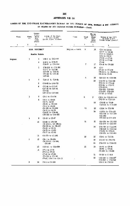
266 APPENDIX VII (b)
LIMITS OF TilE lIND PHASE ENOIERATOR'S BLOCKS OF 19'11 CENSUS OF GOA, DAHAN .. DIU (URBAN)
IN TERMS OF 1971 CENSUS HOUSE NUMBER8_()o.td.
Enume- Enume_ rator's
Lunits of the bh)('.k rator's Limits of tile block TOWIl Ward Block Town Ward Block "c. Nos. in terms o~ 1971 No. Nos. in terms of U171
{lInd Census U()U8€ ~l1mberM (lInd Census House ;:-';umber~ pha::>e) phase)
GOA U1STRWT Mapu~a - contd. 16 '05-1 to C5·10 C5·71 to C5·83
Barde. Taluk. C8·1 to C8,1'2/1 C9·1 to C9·12
C15-1 to C15-142 C7-20 to C7-24 Mapusa C7-38 to C7-60
2 C16-1 to C16-56 C7-55 C16-81 to C16-152 17 C8-96 to C8-208
C15-153 to C16-221 18 C7-7 C17-1 to C17-20 C7 -68 to C7 -109 C17-28 to C17-31 C8-~2.(I) to C8-92(4) C17 -33 to '017-35 C8-13 to C8-50 C17-42,
19 012-111 to 012-194 014-12 to C14-81
20 C]3.-70 to CI3-.100 C14·82 to C14-172 CI3-14 to '013-32
012-62 to 012-75 C17-2Il to 017-27 '012-61(5) '017-36 to C17-41 '012-208, C12-231 '011-32 C12-237, 012-239 017-43 to '017-102 '07-25 to '07-37
7 C1-1 to CI-178 9 21 C12-1 to 012-6111-4) 8 C2-1 to C2-3,1 012-76 to CI2.110
C2-71, C2-76 22 Cm-3,3 to 13-69 C2-94 to C2-119 Cl3-101 to C13-LI0 C3-1 to C3-12 C4-163 to C4-2(}2 10 23 Cll,,1 to Cll-58 C5-71 to C5-76
24 Cl1-59 [0 C11,135 '016-57 to C16-80 011-142 to C1'1-149 016-222 to C16-223 Cl1-183
C3-13 to 03-67 ml-249 to 011-253
10 C3.aB to C3-135 11 25 011-254 to '011-315 C6-105(1), '06·105(3) '011-150 to Cl1-182 C6,105(4) ,to C6-107 26 CLl-184 to Cl1-248 '02-32 to C2-70 0111-136 to C11-Hl C2-72 to C2-75 010-35 to 010-41 '02-77 to C2-93 CID-I04 to 010-~11
11 01-179 to Cl-281 12 27 010-1 to CI0-34
12 C6-1 to C6-104 28 010-42 to CI0-103 C6-105(2), C6-108,
29 C10-112 to 010-:113 C6-109
13 CI3-111 to C13-<180 13 30 '08-5.1 to C8-9I1 08-93 to '08-95
14 C7-1 to C7-6 '08-209 to C8-300 C7 -8 to C7 -<19 C7-61 to C7-65 31 '09-13 to C9,192 C7-110 to '07-141
32 '012-195 to 012.2,07 C7-67, '014-1 to C14-11 C12-208 to 012-248
15 04-1 to C4-162 C13-1 to C13-13

267
APPENDIX VII (b)
LIMITS OF THE IlliD PHASE ENUME&ATO&'S BLOCKS OF 1971 CEJI;SIJS OF GOA, DAMAX /I; DIU (U&BAN)
11\ TERMS OF 1971 (:EKSUS HOUSE NUMBERS-Oontd.
'Town
Ennrnr- EnUllW-
rator's Llmit::1 of the bloclt. ratar s
Lill,jt.' u: Warrl Block Town Ward Block
No Nos. in term~ of Hl71 No. No, III terms
IlInd Cpn,"llf' IIUl11-'e J'\uUJlwrs (lInd ("t'II"U8 Huu"t'
pha~e) phafle)
GOA DISTRICT Pernf'm - contd. C4·65 to C4-84 C4-107 to C4-122
Pemem Taluka C4-133 to C4-159
Pernem C3-1 to C3-32 C4-85 to C4-98 C3-134 to C3-162 C4_1 to C4-10 C3-164 C4-40 to C4-64
C3-33 to C3-78 C2-155
C3-113 to C3_133 7 Cl-11"5 to Cl_124 C3-163 C1_160 to CH6n C3-1'86 CI-177 to 01-190 C3-187
CI-125 to Cl·135 C3-79 to C3-112 CI-150 to CI-159 C3-165 to C3-185 CI_166 to CI-176 C3-188 to 03-~97 04-11 02-34 to C2-55 04-12 C2-79 to 02-92 04-17 02-104 to 02-125
C2.159 04-13 to 04.16 04-~ to C4-39 10 10 02-1 to C2-33 C4-99 to C4-.107(2) 02-511 to 02-78 04-123 to 04-132 C2-93 to 02_103 02-1501 to 02-154 02,-13'6 to 02-150 02-1511 to 02-.158 C2-160 to 02--163

268
APPENDIX VII (b)
LUlITS OF THE IIND PHASE ENmIERATOR'S BLOCI,g OF 1971 CEl'\SUS OF GOA, DAMAN'" DIU (URBAN)
IN TER)IS OF 1971 CENSUS HOUSE NUMIlERS--Contd.
F.numE'~ Enumc·
Town rntor's
Limits of the block fillor's
Limit~ of thf! block Ward Block Town Ward Block No. Nos. m terms of 1871 1\U, No", III tf'nn,,, of 1971
(JTnd Census House Numbers (IInd Ct'llStt.'i House ~umbers phas~) ph(l.~c)
GOA DISTRICT Bicholim - contd. C3-l69 to C3-177
Bjcbolim TaJuka C3-197 to C3-274
C2-94 to C2-l09 CI-l to Cl-l08 C2-208 to C2-22l Bicholim
C2-33 to C2-62 C2-110 to C2-174 C3-104 to C3-140 C3-53 to C3-69 C3-178 to C3-196
C2·63 to C2-1l2 10 CS-I to CS-73
4 C3-1 to C3-52 11 C3-74 to C3-l03
5 Cl·92 to CI·150 C3-l41 to C3-l68
CI-15l to Cl-190 12 C2-35 to C2-93 Cl-196 to C1-l98 C2-247 to C2·268 C2-1 to C2-32 C2-298 to C2·301
C4-1 to C4-77 13 C2-1 to C2·34 Cl-191 to C1-l95 Cl-28 to Cl-82 Cl-199 to Cl-224 Cl-225 to Cl-U7 Cl-8S to Cl·9l
10 14 C5-l to C5-95 C2-222 to C2-246 C2·269 to C2-297 15 C5-96 to C5-l52 C2-175 to C2-207 Cl-l to Cl-27

269
APPENDIX VII (b)
LIMITS OF THE lIND PHASE ENUMERATOR'S BLOCKS OF 1971 CENSLS OF GOA, DAMAN & DIU (URBAN)
IN TERMS OF 1971 CENSUS HOUSE XVMBERS - C'ontd.
Enunw- gflurn"-rntor'::; Limits of the IJlo(':{
raror'f! Limits o( thf' block Towll Ward Biock Town Ward Blork
No. N'n>l. in terms of J'm No. ~o':. m ternis of 1971
(llnd Cf'n~ll? Hou:-~(' N 11m bc~ (Ilnd C't'n"u~ Hou,q(, K11l11lwrs
phase) phasr)
GOA DISTRICT Valpoi --- contd Cl-68 10 Cl-74 Cl-80
Satari Talnka C2-l to C2-38
Valpoi Cl-188 to CI-207 C2-39 to C2-88 Cl-247 CI-249 to Cl-256
Cl-I to CI-46 CI-208 to CI-210 Cl-354 to CI-368 CI-218 to Cl-221 Cl-234 to Cl-246
CI-301 to CI-309 CI-248 CI-257 to CI-267
CI-3t3 to CI-319 CI-345 to CI-3S3
Cl-47 CI-112 to CI-170 CI-211 to CI-217 CI-175 Lo CI-187 CI-268 to CI-272 CI-222 to CI-233 CI-289 to CI-300 CI-9S C!-310 to Cl·312
CI·48 to CI-67 Cl·328 to C!·33S
Cl-75 (0 Cl·79 CI-Sl 10 CI-89 10 10 Cl-273 to Cl-288 CI-90 to CI-97 Cl·320 to CI·327 CI·99 to Cl·lll Cl·336 to Cl·344
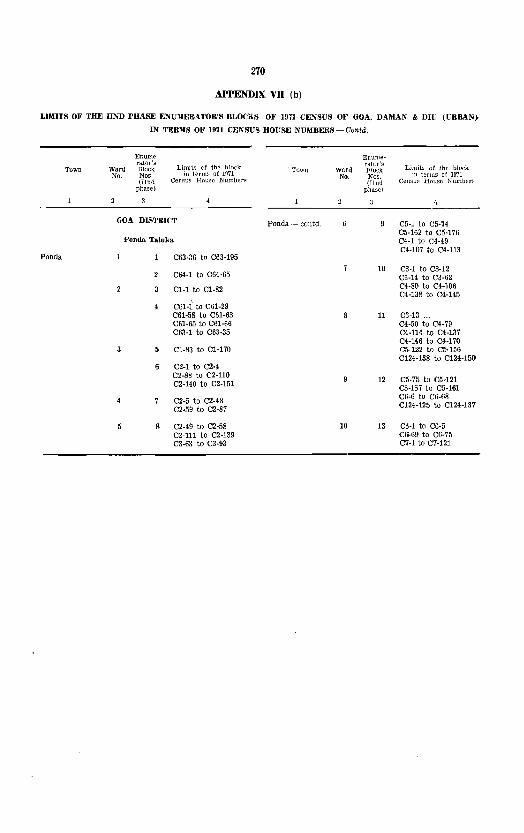
270
APPENDIX VII (b)
LIMITS OF THE mID PHASE ENUMERATOR'S BLOCKS 01' 1971 CEXSUS OF GOA, DAMAN'" DIU (CRBAN}
IN TEmlS OF 1971 CENSUS HOUSE NUMBERS - Gonld.
Enume~ EIlUIlIe· rator'"
Limits of thf' blC)ck rator's Limit::; of the- block TOWIl Ward Block Town ward R!oc1\
No. Nos. in terms of 1971 No. Nos. III terms ot ]971 (llnd CemlU>'1 House Numben:: (IInd Census House Numbers
phase) phase)
GOA DISTRICT Ponda·_ eaDtd. C5-1 Lo C5-74 C5-162 to C5·176
Ponda Taluka, C4·1 to C4·49 C4·107 to C4·113
Ponda C63·36 to C63·195
10 C3·1 to C3-12 C64·1 to C64·65 C3·14 to C3·62
Cl·1 to C1·82 C4·80 to C4-l06 C4-138 to C4-145
C61-1 to C61-29 C61-58 to C61-63 11 C3·13 ... C61-65 to C61·66 C4·50 to C4-79 C63·1 to C63·35 C4·114 to C4·137
C4·146 to C4·170 C1·83 to Cl·170 C5-122 to C5·156
C124·138 to C124·150 C2·1 to C2·4 C2·88 to C2·110
12 C5·75 to C5·121 C2·140 to C2·151 C5-157 to C5·161
C2·5 to C2·48 C6·6 to C6-68
C2·59 to C2-87 C124·125 to C124·137
8 C2·49 to C2·58 10 13 C6·1 to C6·5 C2·111 to C2·139 CI>-69 to C6· 75 C3·63 to C3·93 C7·1 to C7·121

271
APPENDIX VII (b)
LIMITS OF THE lIND PHASE ENUMERATOR'S BLOCKS OF 1971 CENSUS OF GOA, DAMAN &: DIE (URBAN)
IIIi TERMS OF 1971 CENSUS HOUSE NUMBERS -- Oontd.
Enunll'~ 1<;llume-
Town ratar':;
Limils of tht-' block rator's Limits ot the block WaI"Q Block TO\\1\ 'Vard BJock
No Nos Jfl terms of 1971 Ko. No~. In tf'rm? of 1!J71 (TInd CPI1<;11S HOUl'l' Numhf>r:-. (Jlmi Ccn:'1m: Home .'\Jumbf'r.~
pha);{l) pba!'c)
GOA DISTRICT Sanguem contd. C7-64 to C7-70 C7-1 to C7-50
Sanguem Talnk. C7-58 C7-77 to C7-87
.sanguem C2-91 to C2-117 C7-51 to C7-57 C4-1 to C4-15 C7-59 to C7-63 C4-41 to C4-43 CI0-185 C8·48 to C8·53 ClO-I91 to CI0-235 C9-1
CIO·16 to e10·21 C9·3 to C9-27 C9·72 to C9·85 C10·106 to CI0·184
C9·87 CI0·186 to CI0·190
C9-94 to C9·95 CI0·236
C9-2 2 C8·1 to C8·17 ClO·l to CI0·15
CS-27 CI0·22 to CI0-105 C8-32 to C8·47 C9·28 to C9·71 C5·86 to C5·89 C9·86 C5-154 to C5-180 C9-88 to C9·93 C6·1 to C6·89
C6-128 to C6-136 C8-18 to C8·26
C6-137 to C6·214 C8-28 to C8-31 C7·71 to C7·76 C6·90 to C6·127 C7 -88 to C7 ·124 10 10 C2·17 to C2·90

272
APPENDIX VII (bl
UMITS OF THE IIi\"D PHASE ENIJMF:IIATOR'S BLO(JK~ OF 1971 CENSUS 01' GOA, DAMAN & DII: (URBANI
IN TERMS OF 1971 CEl'ISUS HOtiSE NIJMIlERS ~ _ O'(mtd.
Enum,'-
TOWII Ward of tlw bl~k 1'0\\11 "\VDrd oj' thE' IJlock No of HI7l Kro oJ' 1971
l\Yllml)l'r~ Numl1f'~
Canacona - contu. Cl-l to Cl-13 GOA DISTRICT Cl-46 tu Cl-48
Cl-54 to CI-60 Cana('ona Taluka Cl-l19
Cancona Cll-167 to ell-lo9 Cl-14 to Cl-16 ClS-l to Clo-28 Cl-24 to Cl-45
Cl-49 C13-29 to C13-52 CI-17 to Cl-23
015-27 to C15-33
C13-53 to 013-91 01-62 to Cl-85 01-97 to Cl-98
C13-92 to ClS-111 10 10 Cl-50 to Cl-53 Cl-61 Cl-86 to Cl-96
5 C13-112 to C13-146 Cl-99 to Cl-118

273
APPENDIX vn (b)
LIMITS OF THE liND PHASE ENUMERATOR'S BLOCKS OF 1971 CENSUS OF GOA, DAMA~ & DIU (liRBAS)
IN TERMS OF 1971 CENSUS HOUSE NUMBERS -- Contd.
TOV,II
Quepem
Enumerator's
Ward Block No. Nos
(IInd phase)
Limits of the rJlock in terms or 1!l71
Cemiu8 House Numbers
GOA DISTRICT
Quepem Taluka
ca·l to Ca·12 C29·1 to C29·59(2)
C29·60 to C29· 79 C29·81, C29·83 C29·89(l) to C29·109 C29·113 to C29·120(2) C29·l40 to C29·
144(2)
C32·1 to C32·26 C32·80 to C32·l23
C32·27 to C32·79 C33·IS to C33·27
C2·1 to C2·11(U) C2·12 to C2·29(U) CI·l to CHO, CI·42 Cl·116 to Cl·134
Town
Quepem - contd.
Enumerator's
Ward Block :No. I\os.
(lInd pha£'e)
Limits of the bior:k In term,o; of 1!171
CE'nsus House Numbers
C1·43(1) to CI·68(2)
CI·41 CI·135 to CI·114 CI·151 to CI·160
CI·S9(l) to CI·102
Cl-103 to CH04 CI·107(1) to CI·I08 CI·145(1) to CI·150 CI·161 to CI·172
C2·30 to C2·59(U)
Cl·I05 to CI·lOO CI·109 to CI·1l5 Cl·173 to CI·l87
C2·60 to C2·146 (U)
10 10 C2·12 to C2·64
C2·123 to C2-142

274
APPENDIX VB (b)
LIlInTS OF THE lIND PHASE ENUMERATOR'S BLOCKS OF 1971 CENSUS OF GOA, DAMAN 6< DIU (URBAN)
IN TERMS OF 1971 CENSUS HOUSE NU~IBERS-Gontd.
Bnume- Enume-rator's
Limits of the lJlock ratar's
Limits of the block Town Ward Blurk Town Ward Block No. Nos. in tel'm~ of 1971 No. ~os, in thrms of 1971
(IInd Cpnsus House )l"umpers (lInd Census House Numbers phase) phase)
A) Margao Muni- 29 C91-l to C9l-64 GOA DISTRICT pal Council
CBl-65 to CBl-it5 -contd. 30 Salcete Talulm
31 C9l-116 to C9l-l64 Margao Urban Cl-8l to C1-82 32 C91-165 to C91-214
Agglomeration CI-S5 to Cl-11S C25-1 to C25-100 33 C94-52 to C94-89
C9i-lOO to C94-123(1) A) Margao Muni- C25-l0l to C25-240
8 34 C94-l to C94-51 pal Council C26-1 to C26-93 C94-90 to C94-99
4 C26-94 to C26-196 C94-l65 to C94-l6S
5 C22-25 to C22-l46 S5 C94-123(2) to C94-l36 C95-l to C95-99
2 C22-l47 to C22-2l3 36 C95-l00 to C95-195 C22-244 to C22-275 37 C95-l96 to C95-284 C23-l to C2S-118
C23-119 to C23-215 38 CI-I to Cl-17 C2-l to C2-40
C24-l to C24-81 C2-55 to C2-56, C2-62
10 C20-l to C20-78 39 CS-2S to CS-42
11 C20-79 to C20-155 CS-99 to C3-li3 C4-l to Ci-30
12 C21-1 to C21-116 40 Ci-31 to Ci-lOO 13 C21-U7 to C2l-22l 41 C4-l0l to C4-132 14 C22-l to C22-24 C5-98 to C5-l06
C22-214 to C22-243 10 42 CI-18 to CI-SO 15 C24-82 to C24-lM CI-S3 to Cl-8!
43 C2-4l to C2-54 16 C96-1 to C96-25 C2-57 to C2-61
C96-39 C2-63 to C2-115 C96-44 to C96-55 44 C3-l to C3-22
17 C98-1 to C98-57 C3-43 to C3-98
18 C98-58 to C98-l22 45 C9-145 to C9-148 CIO-4
19 C99-l to C99-72 Cl1-l to Cl1-91
20 C99-73 to C99-120 11 46 C12-l to C12-48 C99-219 to C99-35l 47 C13-1 to C13-86
48 C14-1 to C14-54 21 C96-26 to C96-38 49 C15-1 to C15-35
C96-40 to C96-43 C15-40 to C15-45 C97-U8 to C97-122 C15-88 to C15-l04 C99-121 to C99-178
50 C16-1 to C16-42 22 C96-56 to C96-126 C17-1 to C17-10
C97-2I to C97-29 C17-41 to C17-47 C97-3l to C97-36(3) 12 51 C15-36 to C15-39
23 C97-56 to C97-116 C15-i6 to C15-87
C97-l24 to C97-168 C16-43 to C16-61
52 C16-62 to C16-148 24 C89-I to C89-87 53 CIS-19 to CIS-35
25 C93-118 to C93-177 C18-48 to C1S-52 C18-S6 to ClS-90
26 C93-l78 to C93-242 C18-92
27 C9S-243 to C93-S30 C18-102 to C18-107 C19-l to C19-62
28 C93-331 to C93-4H 54 C19-63 to CI9-l10 C94-l37 to C94-164 C20-174 to C20-221

275 APPF;NDIX vn (b)
LIMITS m' THE lIND PRASE ENUMERATOR'S BLOCKS O~' 1971 CENSUS OF GOA, DAMAN &; DIU (URBAN)
IN TERl\IS OF 1971 CENSUS IIOUSE NU~IBERS - Contd.
Enum",-rator's Limits of the block Town Warcl Block To·wn
XO. ~OS. Hi terms oi 1971
(llJld Ccn.."us HO\J:-f' ~umbcr::::
phase)
GOA DISTRICT A) :Margan Muni- 15 65 C10-1 to C10-3
pal Council C10-5 to ClO-54 Salcete Taluka - concld, --contd.
66 C10-55 to C10-117 A) M8.rgao Mum- 13 55 C7-1 to C7-58
67 CI7-11 to C17-40 pal Council -·-contd 56 C7 -59 to C7 -122
68 C18-1 to C18-18 57 C7-123 to C7-188 C18-36 to C18-47
C18-53 to C18-85 58 C8-1 to C8-16 C18-91
C97-1 to C97-20 C18-93 to C18-101 C97-30 C19-111 to C19-124 C97-36(4) to C97-55 C20-156 to C20-173 C97-117 C97-123
Out growths 14 59 C5-1 to C5-97
B) Aquem 1/10/42 166 C97-169 to 097-305 60 C5-107 to C5-149
C6-10 to C6-16 167 C98-123 to C98-232 C6-19 to C6-109
168 C99-179 to C99-?18 61 C6-110 to C6-254
62 CS-17 to C8-18 CJ Navelim 1/10/44 172 C89-88 to C89-227 C8-26 to C8-29
173 C89-228 to C89-31O C9-86 to C9-144 C9-149 to C9-152 C90-1 to C90-51
15 63 C6-1 to C6-9 174 C90-52 to C90-225
C6-17 to C6-18 175 C90-225 to C90-305 C8-19 to C8-25 C92-1 to C92-82 C8-30 to C8-67 C9-1 to C9-40 176 C92-83 to C92-237
64 C9-41 to C9-85 177 C93-1 to C93-117

276
APPENDIX VO (bl
LIMITS OF THE lIND PHASE ENUMER.ATOR'S BLOCKS OF 1971 CE~SUS OF GOA, DAMAN & DIU (URBAN}
IN TEMiS OF 1971 CENSUS HOUSE NUMBERS - G01lld.
'1'O\.lll
Mormugao
Enume· rator's
Ward Block No. 1\0",
(IInd phase)
Limits of the block in terms of 1~1
Census House Number:;
GOA DISTRICT
Mormugao Taluka
C33-1 to C33-72(2)
C33-73 to C33-114(10) C35-1 to C35-39
C35-40 to C35-83 C35-85 C37:1 to C37-28 C37-32 to C37-36
C33-S1/1 to C33-81/5 C33-S3/1 to C33-83/
58(3)
C35-84(1-2) C35-86 to C35-107 C36-97 to C36-109 C37-29 to C37-31 C37-37 to C37-72
C37-73 to C37-99 C38·1 to C38-21
C38-22 to C38-107
C38·108 to C38-213 C38-218 to C38-221 C38-227 to C38-245
C20-74 to C20--81 (4) C21-1 to C21·39
10 C21-40 (1) to C21-79
11 C23·65 to C23-139(2)
12 C24-1 to C24-80(3)
13 C35-108(1) to C35-110 C36-1 to C36·96
14 C20-44 to C20-73 C22-1 to C22·22
15 C22-23 to C22-77
16 C23-1 to C23-64(4)
17 C25-1 to C25-50 (3) C26-1 to C26-27
18 C27-1 to C27-60
19 C27-259 to C27-306 C27-327 to C27-369
20 C16·1 to C16-16 C16-55 to C16-65(2)
21 016-77 to C16-108
Town
Enumeralor's
Ward BJork; :-fa Nos.
(lInd phase)
Monnugao (contd.) I:) 22
23
24
25
26
21
28
29
30
31
32
33
34
35
36
37
38
39
40
41
10 42
43
44
45
46
47
Limits of 0-,(, hlock in terms of 1971
(eusu" House Xuml:Jers
C27-61 to C27-196
C27-197 to C27 -258 C27-370 to C27-439
C14-1 to C14-71
C14-72 to C14-146(2}
C14-147 to C14-152 C15-1 to C15-34 C16-66 to C16-76(3)
C27 -S07 to C27 -326
Cl1-112 to Cl1-192
C12-31 to C12-129(2)
C12-130 to C12-193(30)
C13-36 to C13·63 C18-1 to C18-38
C15-35 to C15-85 (4)
OJ-1 to Cll-111
C13-9 to C13-35(7) C13-64 to C13-89(6)
C13-90 to C13-160
C13-161 to C13-226
C13-227 to C13-291
C17-1 to C17-78
C17-79 to C17-128
C17-129 to C17-149 C17-183 to C17-199 C18-39 to C18-83
C19-9 to C19-34 C20-1 to C20-43
C5-86 to C5-93 C5-111 to C5-176
C6-1 to C6-16 C7·1 to C7-25
C9-1 to C9-101
ClO-1 to CI0-49
C12-1 to C12-30 C13-1 to C13-8 C16-17 to C16-25
C16-26 to Cl6-54 Cl7-150 tJ C17·182 C19-1 to C19-8 C19-35 to C19-48

ZT7
APPENDIX vn (b)
LI~IJTS OF THE lIND PHASE ENU~IERATOR'S BLOCKS OF 1971 CENSUS OF GOA, DAMAN &; DUl ({'.
IN TERMS OF 197L CENSUS HOUSE NInIBERS - Oontrl.
Enume-rator'~
Limit;:: or thf' block Town Ward Block No. .Kos- in terms of 1971
(lInd Cemms 11ml",,,, ~\lmb{'l'~
pllai;l;:')
Mormugao Taluk. - contd.
Mormugao (contd.) 11 48 Cl-l to CI-40(2) C2-138 to C2-150 C2-170 to C2-114
49 C2-179 to C2-202 C3-185 to C3-231
50 C3-232 to C3-326
51 C3-327 to CHl7
12 52 C1-41 to CI-169
53 Cl-170 to CI-182 C2-1 to C2-47
54 C2-48 to C2-93
55 C2-94 to C2-137 C2-151 to C2-169 C2-175 to C2-178
13 56 C3-1 to C3-118
57 C3-119 to C-3-184
58 C4-l to C-4-84
Flilm~t'rator'3
Town Ward rut or':· :-;[0 ;\0"
Mormugao (contd.) 13
H
15
illnd J);l:I~e )
59
60
61
62
63
64
65
66
67
C4-85 to C4-l30 C5-1 to C5-40
C5-41 to C5-85 C5-94 to C5-110
C29-1 to C29-75 C30-1 to CSO-H9
C30-150 to C30-236 C31-1 to C31-29
C31-30 to C31-44 C32-1 to C32-8 C32-61 to C32-70 C32-99 to C32-103 C32-124 to C32-162
C3l-45 to C31-97
C3l-98 to C3l-lS3
C31-l54 to C3l-176 C32-9 to C32-60
C32-71 to C32-98 C32-104 to C32 .. 123

278
APPENDIX VB (b)
LIMITS OF THE lIND PHASE ENUMERATOR'S BLOCKS OF 1971 CENSUS OF GOA, DAMAN &I DIU (URBAN)
IN 1'ER~IS OF 1971 CENSUS HOUSE NUMBERS - Donld.
I<Jnume· EIlume-rator's
Limits of the block rator':l Limits of the block Town Ward Block TOWll Ward Block
No. Nos. in terms of 1971 No Nos. m terms of 1971
(IInd Census Hous€' Numbers (lInd Cf'nsus Homw Numbers
phas~J phase)
GOA DISTRICT 15 C16-93 to C16-96 C16-125 to C16-l31
Daman TaIuka C14-14 to C14-27
Daman C7-44 to C7-86(2) C14-82 to C14-104(2) C15-41 to CIS-98
C9-1(1) to C9-23 CS-I(l) to CS-3 16 CS-151 to CS-l77 CS-11 to C8-78 C6-lSl to C6-212 CS-136 (1) to CS-1S5 C7-137(1) to C7-1S1 CS-165(1) to CS- C7-1M(I) to C7-159
IS0(2) C7-1S0 to C7-185
CS-4(1) to CS-IO C7-l9B to C7-211(2)
CS-79 to CS-97 (3) 17 C7-1I, to C7 -133 C8-127 to C8-l35(2) C7-152 to C7-lM CS-156 to C8-l64 C7-1S0 to C7-l79 CS-lSl to C8-233 C7-1S6 to C7-197
CS-9S to C8-126 C7-2l2 to C7-220(2)
C9-112 to C9-l33(3) C9-24(1) to C9-11l
ClO-l to ClO-43 C9-l52 to CD-156(4)
ClO-197 to Cl0-204 C6-l(1) to C6-25 18
C9-l34 to C9-l5l(3) C6-58 to C6-l26 CID-56 to CIO-97 ClO-1l3 to ClO- 19 C6-26 to C6-57
196(2) C6-l27 to C6-l50 C6-il7S to C6-lS0
ClO-44 to CIO-55 C7-1 to C7-43(2) ClO-9S to CID-1l2 C7-S7 to C7-114(4) Cll-l to CIl-86 C7-l34 to C7-l36
Cll-S7 to Cl1-224 10 20 C3-52 to CS-56
C12-l to C12-87 C3-63 to C3-145
C12-8S to C12-209 21 C3-1(1) to C3-l9(12) C3-H6 to C3-175
C16-l 0 C16-79 C4-l (0 C4-25
10 CIS-SO to C16-92 C4-49 to C4-112(2)
C16-l32(1) to Cl6-177 C15-l62(1) to C15- 11 22 C2-l to C2-76
207 C2-145 to C2-170
11 C15-30 to ClS-3l 23 C2-77 to C2-l44 C15-35 to C15-40 C3-20 to C3-51 C15-99 to C15-lS1 C3-57 to C3-62
12 C13-92 to C13-13S 12 24 Cl-1(1) to CI-70 C13-137 to C13-160 Cl-SO C14-I(I) to C14-
13(3) 25 Cl-71 to Cl-79 CH-28 to CU-3S CI-SI to C1-130 C14-39
26 CI-131 to CI-19a 13 C14-36(1) to CU-3S
C14-40(1) to C14- 13 27 C4-26 to C4·iS SI(2) C4-113 to C4-I79
C15-l to C15-29 C5-25 to C5-SS C15-32 to CIS-34
14 C13-I to C13-9I 28 C5-1 to C5-24 C13-l61 to C13-l92 C5-69(1) to C5-CI6-97(1) to C16-l24 146(2)

J'Ie APPENDIX vn (b)
LIMITS OF THE DND PRASE ENUMERATOR'S BLOCKS OF 1971 CENSUS OF GOA, DAMAN & Dll; (URBAN)
IN TERMS OF 1971 CENSUS HOUSE NUMBERS - Concld.
Town
Diu
Ward No.
Enume~ rator'3 Block Nos. (lInd
phase)
Limits ot the black in terma of 1971
Census House Numbers
Town
GOA DlSTBlCT Diu I contd.)
Diu Taiuka
C3-20(1) to C3·l21 C6·1(l) to C6-4 C6·9 to C6-95 C7 -58 to C7 -82 C7·86(1) to C7·89(IO) C12·430(1) to C12-53 ClS·1 to C13·34
Cl-13 to C3-19 C5-50 to C5-92 C6-6(1) to C6-8(2) C7-1(1) to C7-67 C7-SS to C7-85 CB-l to CS-41 C8-63 to C8-74 CB-79 to C8-96 C12-1 to C12-3 C12-10 to CIZ-42( 6 j C12-54 to CI2·65 C13-35 to C13-40 CIS-66 to ClS-71 CIS-73 to ClS-74(Z)
Cl-l to CI-S8 C2-1(1) to C2-73(4) C3-1(1) to C3-12 Cl-122 to CH30 C4-1 to C4-5(2) C4-91 to C4-96(2) C5-l(1) to C5-4 C5-32(1) to C5·49 C5-93 to C5-l05
C4-60 to C4·90 C5-5 to C5-3~(2) C8·42 (I) to C8-62 C8·75 to CS-76(S) C9-1 to C9-S2 C9-ll0(1) to
C9-120(2) CIO-l to ClO·S CIO·96 to CIO·IOZ
* Formerl~' thest' hOUSlt8 were in Rural Area,
Wa.rd No.
10
Enume· rator's Block Nos. (lInd
phase)
Limlls of the )Jlock in terms of ]')71
Censu.s House Numbers
CS-77(1) to C8-7S C9-IOS to C9·109 C12·4 to C12-9 C13-41(1) to C13·65 CI3-72, CI3·75(1) to
CIS-126 C14-1(1) to CH·IO Cl4·13 to Cll-120(2) CI5-27(1) to C15-50
C9-83(1) to C9·I02 CIO-ll to CIO-95 Cll-3S to Cll-45(2) C14-11 C15-1 to C15·26 CI5·Sl to CID' 75
C4-6 to C4-59 CIO-9, CIO-lO, Cll·I(I)
to Cll·32 Cll·46 to Cll·90 C17-17 to C17-l39(2) C17'I73 to C17-lS0
CIS-I to ClS-77 C17-1 to e17-IS CI7-140 to C17-l72
C5-43 to Co-61' C5-M to C5·102' C6-1 to CS-S!' CS-85 to C6-122' C7-37 to C7-48' C7-M to C7·122' C7·l25'
10 Cl·l(l) to Cl-l24' CS-l to C3-114' C4-1 to C4-102' C5-l to C5-42' CS-62 to CS·55' C5-102(2) to C5-117' CS-82 to C6-84' C6-l23(1) to C6-12S* C7-l to C7·36' C7 ·49 to C7 -53' C7-l23. C7-124*


ERRATA
Table No. Page Particulars Col. No. Fol' Read No.
Figures at " lit PERCENTAGE TO TOTAL Glance WORKERS,
(i) CULTIVATORS
MALES 18.40 18.42
FEMALES 17.29 17.09
16 14 Tiswadi Taluka 2 79.1 129.1 16 14 Tiswadi Taluka 4 2~.08 17.82 16 14 Bardez TalUKa 2 253.4 254.2 16 14 Bardez Taluka 4 11.05 11.01 16 14 Bicholim Taluka 2 198.8 214.9 16 14 Bicholim Taluka 4 6.04 5.58 16 14 Satari Taluka 2 497.9 480.9 16 J4 Satari Taluka 4 1.20 1.25 16 14 Note at the bottom 'I ' 1
from the total area of the ... from the total pro-District ... visional area of the
District" 15 Para 7.22, 8th line 15,11 It 10 ... " «".18, 11 & 11>
20 17 Tiswadi Taluka 2 79.1 129.1 20 17 Tiswadi Taluka 4 12.64 7.75 20 17 Bardez Taluka 2 253.4 254.2 20 17 Bardez Taluka 4 8.68 865 20 17 Bicholim Taluka 2 198.8 214.9 20 17 Bicholim Taluka 4 3.52 3.26 20 17 Satari Taluka 2 497.9 480.9 20 17 Satari Taluka 4 0.60 0.62
TOWN DIRECTORY
Statement ill 24 Diu 16 1749 1746 Statement IV 33 Diu District 11 256 257
(Urban Area) Village Direc~ 48 Village No, 27 PR PR tory Pernem KR Taluka Union Territory 140 Note at the bottom ·These represent ·These represent "pro-
P.C.A. «geographical visional geographical area» figures. area" figures
PRIMARY CENSUS ABSTRACT
Tiswadi Taluka 144 Village No.2 18
Tiswadi Taluka 150 EB No. 49 13 022 220 Bieholim Taluka 170 EB No. 13 6 Print not clear 683 Saturi Talukn 175 RURAL 23 765 576
Quepem Taluka 203 Village No.5 38 Print not clear 410
AFPENDIX- VII (a)
Pernem Taluka 244 Cansarvornem 4 CU·l to CU·56 Cl3·1 to C13·56
Bicholim Taluka 246 Lamgao 2 1/U2 1/4/1
APPENDIX VII (b)
Tiswadi Taluka 265 Town 1 B) Calapor~cont. H) Calapor~eont. Tiswadl Taluka 265 Enumerator's 4 C91·46 to C91· C92·29 to C92·51(2)
Block No. 112 ·50(2\ Tiswadi Taluka 265 Enumerator's C91-46 to C91· C91·46 to C91·50(2)
Block No. 113 .550(2) Canacona 272 To\Vl1 name Canacona Chaurl Taluka
Copyright © 2022 FDOKUMEN