Creating Grasslands: Social Institutions and Environmental Change in Mkambati Area, South Africa
Upload
independentCategory
view
1download
0
Acta Botanica Hungarica 50(Suppl.), pp. 107–148, 2008DOI: 10.1556/ABot.50.2008.Suppl.6
DISTRIBUTION OF THE (SEMI-)NATURAL HABITATSIN HUNGARY II. WOODLANDS AND SHRUBLANDS
J. BÖLÖNI, ZS. MOLNÁR, M. BIRÓ and F. HORVÁTH
Institute of Ecology and Botany, Hungarian Academy of SciencesH-2163 Vácrátót, Alkotmány u. 2–4, Hungary; E-mail: [email protected]
(Received 3 November, 2008; Accepted 5 November, 2008)
Actual distribution maps of vegetation types are important data sources of basic and ap-plied research, respectively. Though there were several attempts to map the actual vegeta-tion of Hungary, the MÉTA program was the first to map all the (semi-)natural habitattypes on the whole territory of Hungary. The paper discusses the woodland and shrublandhabitats. 41 habitats are presented and discussed. The paper provides additional data onthe area and distribution of the habitats mainly at the physical geographical macroregionscale.
Key words: distribution maps, forest vegetation, habitat type, Hungary, shrub vegetation
INTRODUCTION
Distribution maps are important data sources of basic and applied re-search, respectively. In the past potential vegetation maps were preparedmainly (e.g. Zólyomi 1989), but for landscape ecological studies of large areasand also for nature conservation, maps of the actual vegetation and habitatsare necessary. During the last twenty years there were several attempts to mapthe actual vegetation of Hungary. The IBOA program aimed to collect the ex-isting data and knowledge of the Hungarian botanists (only ca 10% of thecountry was covered, Molnár et al. 2001a), the CÉT program reinterpreted theCORINE land cover database (Büttner et al. 2002) into a habitat-based database(only ca 60% of Hungary was done, Molnár et al. 2001b). Actual habitat distri-bution maps were prepared also for the Natura 2000 program (Horváth et al.2001, 2003, Molnár et al. 2007a). Parallel with this, the actual distribution maps
0236–6495/$ 20.00 © 2008 Akadémiai Kiadó, Budapest

of protected plant species were prepared (Farkas 1999), as well as the maps ofthe Hungarian tree and shrub species (Bartha and Mátyás 1995). For vegeta-tion types only descriptive distribution data were still available (e.g. Fekete etal. 1997, Borhidi and Sánta 1999). Due primarily to the labour intensive fieldwork, actual large area vegetation maps or actual distribution maps of vegeta-tion types are also rare in other parts of Europe (e.g. Schaminée et al.1995–1999, Chytrý et al. 2001, the Spanish and Czech data have not been pub-lished yet, see Loidi 1999, Guth and Kučera 2005).
In this paper we present the distribution of the Hungarian vegetationtypes, based on the data of the MÉTA database (Molnár et al. 2007b, Horváth etal. 2008). Since we did not have the capacity to map all the ca 400 plant commu-nities of Hungary, the MÉTA mapping is based on broader habitat types (seethe so-called Á-NÉR habitat classification that has 86 types for Hungary,Bölöni et al. 2003, 2007, see also the Appendix of this volume). This paper dis-cusses the woodland and shrub habitats, the previous one tells about the tree-less vegetation (Molnár et al. 2008a).
MATERIAL AND METHODS
We investigated the geographical distribution and extension (total area)of the most important semi-natural and natural habitats (see Bölöni et al. 2003,2007, and Appendix). The background of the presented maps and data is theMÉTA database version November, 2007. SQL queries were done by habitatsand by MÉTA quadrates (Horváth et al. 2008) that contain the estimated area ofa certain habitat for each quadrate, estimated on the basis of MÉTA raw data.We supervised all data of habitats and quadrates gained in this way, and if itwas necessary, the data were modified or completed. Supervision includedthe deletion of the evidently false data and the completion of the missing val-ues by estimation. Missing values could have originated from the not suitablysurveyed quadrates and from the not yet surveyed (processed) quadrates (ca8%). In these cases the presence and the area of the habitat were estimated onthe basis of previous knowledge and databases. Three symbols were used:small dots indicate small amount of vegetation (0.1–17 ha), medium dots meanmedium amount of vegetation (17.1–140 ha) and large dots mean largeamount of vegetation (more than 140 ha) in the quadrate of approximately3,500 ha. Because of the supervision of the database and the necessary estima-tions, the certainty of data were given in a two-grade scale; certain and uncer-tain occurrence (later is marked with “+” on the maps).
The calculated areas were totalised in hectares (total area of Hungary is9.3 million ha). Data given in this paper are the best approximate estimations
108 BÖLÖNI, J., MOLNÁR, ZS., BIRÓ, M. and HORVÁTH, F.
Acta Bot. Hung. 50, 2008

that can be derived from the MÉTA database. In accordance with the method-ology of MÉTA (Molnár et al. 2007b), the data of habitat areas are reduced tohorizontal projection. In case of diverse terrain, the values gained in this waycan significantly alter from the real ones (with 5–10%). In case of habitats thatoccur mainly in mountains or on steep sites (e.g. beech woodlands: “K5”,closed thermophilous downy oak woodlands: “L1”, downy oak scrub wood-lands: “M1”) this discrepancy can be significant; the extensions were probablyunderestimated. Regional and national sums were usually rounded to twonumbers; hence the total area expressed for the country can be slightly differ-ent than the sum of the regional values. It should be noted that the values dif-fer anyway from the real ones due to the scale of the survey. We do not knowthe degree of the discrepancy but it is estimated to be max. 5–10%.
The gained patterns were illustrated on distribution maps. The distribu-tion and the area of each habitat are briefly described in the paper also, includ-ing the code, the name and the short description of the habitat, total area of thehabitat, area in each geographical macroregion, characteristics of the geo-graphical distribution, main site and land historical factors of the occurrences,and in certain cases the uncertainties of habitat interpretation for the evalua-tion of the map. We used the inventory of geographical microregions of Hun-gary (Marosi and Somogyi 1990) for the evaluation of the distributions at land-scape scale, since the vegetation-based landscape regions (Molnár et al. 2008a)were not yet available at the time of the preparation of this paper. However, atthe macro-region scale, the two landscape classifications differ only in an irrel-evant measure (Molnár et al. 2008a). For the geographical names used in thediscussions of distribution maps see the maps Molnár et al. (2008b).
We cannot refer to the previously known occurrences of each vegetationtype in our paper, since then we should refer to nearly all former papers con-cerning any occurrence of each vegetation type. At the same time, we shouldemphasise that this paper should be cited especially regarding national andmacroregion scale distributions, while in case of local distribution, local his-torical and site data the other, more relevant papers should be referred.
Nomenclature follows Horváth et al. (1995) (synonyms in Simon (2000)are in brackets).
RESULTS AND DISCUSSIONS
Shrublands
J1a – Willow mire shrubs (Fig. 1). Developed in endorheic areas (areaslacking surface drainage) and in old oxbow lakes dominated by shrubs (gener-
DISTRIBUTION OF THE (SEMI-)NATURAL HABITATS IN HUNGARY II 109
Acta Bot. Hung. 50, 2008

ally Salix cinerea), growing on soils with different peat content. In case of suit-able water conditions they have good regeneration potential. With the de-crease of grazing and coppicing, this habitat can even extend its area, mainly atthe expense of tussock sedge communities. It is surprisingly evenly dispersedin the country, though its actual area is approx. 1,700 ha in Hungary. It is mostfrequent in Tiszai-Alföld (650 ha, in Nyírség and Szatmár–Beregi-sík and atthe River Sajó), also common in Dunai-Alföld (480 ha), especially in Turján-vidék, in Őrjeg and in Dráva-sík. Willow mire shrubs are sporadic in Kisalföld(140 ha), in the Dunántúli-dombság (180 ha, mainly in Belső-Somogy), inNyugat-Dunántúl (105 ha), and infrequent in the Dunántúli-középhegység (50ha) and in the Északi-középhegység (80 ha).
J3 – Riverine willow shrubs (Fig. 2). High growing shrub habitats on riverbars and riverbanks, occasionally on the fringes of oxbow lakes. The shrubsare usually Salix species (S. purpurea, S. triandra, S. viminalis, S. fragilis, S. alba).Since this pioneer habitat develops specifically in riverbanks, it is connected tothe greater rivers. Its total actual area is 1,400 ha. Riverine willow scrub is themost widespread along the River Duna (approx. 720 ha), and in Tiszai-Alföld(530 ha), but it is missing from certain segments of the River Tisza, because ofthe steep bank, the lack of river bars and partly because of incomplete map-ping (inaccessibility of the stands). It is also sporadic in the valley of the riversKörös. Additionally it occurs along the River Rába (approx. 80 ha), in theÉszaki-középhegység (44 ha) mainly along the River Hernád. It is uncommon
110 BÖLÖNI, J., MOLNÁR, ZS., BIRÓ, M. and HORVÁTH, F.
Acta Bot. Hung. 50, 2008
Fig. 1. Distribution map of the habitat “J1a” in Hungary

in the Dunántúli-dombság (14 ha), and is missing from the Dunántúli-közép-hegység. The development of the habitat is determined by abiotic conditions;besides the river sedimentation its distribution is influenced by the actions ofriver bank protection and water damming.
M6 – Continental deciduous steppe thickets (Fig. 3). Small thicket patchesin grasslands, or fringe habitats at the edge of xerotherm forests, usually ondeep soils. Height of vegetation around 1 m, closure is 50% at least. Dominantspecies are Amygdalus nana (= Prunus tenella), Cerasus (= Prunus) fruticosa andRosa species (R. gallica, R. pimpinellifolia). Total cover of these species reach20%. Only 225 occurrences are known of this rare habitat. It can be found in theeastern part of the country, at foothills and in Alföld. It is most frequent in theÉszaki-középhegység (around 150 occurrences; Zempléni-hegység, Cserehát,Bükk, Mátra, Cserhát, Börzsöny, edges of the Gödöllői-dombvidék). The ap-proximately 50 stands of Alföld are mainly in Mezőföld and in Békés–Csaná-di-hát, but sporadically steppe thickets can be found everywhere (e.g. Duna–Ti-sza köze, Berettyó- and Körös-vidék, Nagykunság). There are sporadic occur-rences in the eastern part of the Dunántúli-középhegység (Budai-hegység,Gerecse, Vértes, Velencei-hegység, Keleti-Bakony) and at the eastern edge ofDél-Dunántúl (Tolnai-hegyhát, Baranyai-dombság).
M7 – Continental deciduous rocky thickets (Fig. 4). Low growing (0.3–2 m)edaphic thickets, developed on solid bedrock, with 50% minimal closure.Rocky thickets are submontane habitats connected to rock outcrops and to
DISTRIBUTION OF THE (SEMI-)NATURAL HABITATS IN HUNGARY II 111
Acta Bot. Hung. 50, 2008
Fig. 2. Distribution map of the habitat “J3” in Hungary

rocky, shallow soils. Rare shrub species growing on rocks (Spiraea media, Coto-neaster species, Amelanchier ovalis) constitute this rare habitat that occurs al-ways in small stands. Only 160 occurrences are known in Hungary. It can befound in the eastern part of the country, in submontane regions, most fre-quently in the Északi-középhegység (135 occurrences, Börzsöny, Cserhát, Mát-ra, Bükk, Zempléni-hegység). Further occurrences are in Mecsek, and in theeastern part of the Dunántúli-középhegység (Visegrádi-hegység, Pilis, Gere-cse, Vértes, Velencei-hegység, Keleti-Bakony), with decreasing numbers to-wards the west.
M8 – Thermophilous woodland fringes (Fig. 5). A complex habitat; acommunity of the fringes of dry and semi-dry forests and thickets, and theconnecting steppes. Xerofrequent and mesofrequent herbs are equally typical.The concentrated presence of the so-called forest steppe species, e.g. Geraniumsanguineum, Iris variegata, Dictamnus albus, Trifolium species) is also character-istic. The maximal closure of the shrubs remains under 60%. Thermophilouswoodland fringes usually develop as real fringes, but occasionally can alsoform larger patches independent from the forest. According to our recent esti-mation its total area is around 350 ha in Hungary. As a (forest-)thicket-steppemosaic the estimation of its exact area is difficult. Moreover, its interpretationis not uniform; hence there might be some further occurrences. Occurringmostly in the central and eastern part of the country, it is the most frequent inthe eastern part of Dunántúli-középhegység (mainly Keleti-Bakony, Vértes,
112 BÖLÖNI, J., MOLNÁR, ZS., BIRÓ, M. and HORVÁTH, F.
Acta Bot. Hung. 50, 2008
Fig. 3. Distribution map of the habitat “M6” in Hungary

Budai-hegység, Pilis) and in the Északi-középhegység (mostly Cserhát, Mátra,Bükk, Heves–Borsodi-dombság, Zempléni-hegység). It can be found in theeastern part of Dél-Dunántúl, at the edges of Alföld, and sporadically and insimplified variants also in the inner part of Alföld (e.g. Duna–Tisza köze, Nagy-kunság, Körös-vidék). Connected to dry and warm climate, the habitat is al-most missing from the humid, western part of the country. Presumably histor-ical causes, the cutting of dry forests explain the absence of the habitat from themajority of Alföld.
P2a – Mesic shrub vegetation (Fig. 6). A group of generally secondaryshrub habitats of wet or mesic areas (except riverine willow scrubs and willowmire woodlands). They develop usually on wet meadows, or by the systematiccoppicing or clear-cutting of mesic forests. According to the criteria of the hab-itat, the closure of the shrub vegetation is 50% at least, and within this, the ratioof trees should remain under 50%. The total area of the habitat is 16,000 ha inHungary. Its distribution is almost uniform, except the Alföld, where it ismissing from large areas. Even so, it occurs with the largest extension onAlföld (5,000 ha), as well as in Dél-Dunántúl (3,500 ha) and in the Északi-középhegység (3,000 ha). It can be found with smaller amount in Nyugat-Du-nántúl (2,100 ha), in the Dunántúli-középhegység (1,200 ha) and in Kisalföld(1,100 ha). Only the very dry or intensively ploughed regions are not suitablefor this habitat.
DISTRIBUTION OF THE (SEMI-)NATURAL HABITATS IN HUNGARY II 113
Acta Bot. Hung. 50, 2008
Fig. 4. Distribution map of the habitat “M7” in Hungary

P2b – Dry shrub vegetation with Crataegus monogyna, Prunus spinosa andJuniperus communis (Fig. 7). Mostly secondary shrublands or shrubland-grass-land mosaics of dry and warm areas, dominated by Crataegus monogyna and/or Prunus spinosa, more infrequently by Juniperus communis. The closure of theshrub vegetation reaches 50%, and within this, the ratio of trees is under 50%.The total area of the habitat is almost 40,000 ha in Hungary. It occurs with thegreatest extension (23,000 ha) in the hilly lower parts and on the foothills of theÉszaki-középhegység. The habitat is also frequent in the Dunántúli-közép-hegység (5,000 ha), and in Dél-Dunántúl (6,000 ha, mainly in its southeasternpart). Also many occurrences are known from Alföld (4,000 ha), from Nyu-gat-Dunántúl (1,000 ha) and from Kisalföld (400 ha). This dry shrub vegetationis connected to land use changes; it develops especially on those man-made(semi-)dry grasslands that were formerly grazed and/or mowed, and theiruse was later abandoned.
Woodlands
J1b – Birch mire woodlands (Fig. 8). Mire woodlands dominated by scat-tered birch trees (closure 40–80%). The typically small stands occur in closeddrainage basins and old oxbow lakes with stagnant water. Soil water is high(reaching the surface), the soil is peat, or peaty with ongoing peat formation.
114 BÖLÖNI, J., MOLNÁR, ZS., BIRÓ, M. and HORVÁTH, F.
Acta Bot. Hung. 50, 2008
Fig. 5. Distribution map of the habitat “M8” in Hungary

DISTRIBUTION OF THE (SEMI-)NATURAL HABITATS IN HUNGARY II 115
Acta Bot. Hung. 50, 2008
Fig. 7. Distribution map of the habitat “P2b” in Hungary
Fig. 6. Distribution map of the habitat “P2a” in Hungary

Mire and marsh species are usual, sedges are dominant in the herb layer, andthe moss cover is significant. One of the rarest habitat in Hungary (21 ha). Thestands can be found in the Északi-középhegység (Mátra: Sirok, Putnoki-dombság: Kelemér) and in Szatmár–Beregi-sík, as well as in the southern partof Nyírség. Besides the drying of former mires the rarity of the habitat can es-pecially be explained by the natural rareness of suitable sites.
J2 – Alder and ash swamp woodlands (Fig. 9). Forest dominated by Alnusglutinosa or partly by Fraxinus angustifolia subsp. pannonica on peat or peatysoils. This habitat is rich in mire species (e.g. Thelypteris, Carex elata) and is usu-ally waterlogged also in summer. Their water is constantly stagnant, or mov-ing slightly only in rainier periods (marsh forests). Dried out and dryingstands with changed water supply also belong to this habitat type. In contrastto riverine ash-alder woodlands they are poor in species of oak-hornbeam andbeech forests. The most frequent swamp forest type of Hungary; its actual areais around 3,600 ha. More than its half can be found in the Dunántúli-dombság(1,450 ha), but large stands occur also in Dunai-Alföld (950 ha), especially inDráva-sík and in Turjánvidék. It covers 600 ha in Kisalföld, mainly in Hanság.In Tiszai-Alföld (300 ha) it is common only in Nyírség and in Szatmár–Beregi-sík. It is sporadic in the Északi-középhegység (180 ha), in Nyugat-Dunántúl(165 ha), rare in the Dunántúli-középhegység (7 ha). It is independent from themacroclimate; its distribution refers mostly to the water conditions. Many
116 BÖLÖNI, J., MOLNÁR, ZS., BIRÓ, M. and HORVÁTH, F.
Acta Bot. Hung. 50, 2008
Fig. 8. Distribution map of the habitat “J1b” in Hungary

stands are alder plantations on the places of sedge communities. The classifi-cation of these transitional stands is uncertain.
J4 – Riverine willow-poplar woodlands (Fig. 10). Growing on the lowerparts of floodplains, these hygrophilous, Salix and Populus dominated forestspresently still get regular flooding. Their total actual area is approx. 21,000 ha.The habitat is frequent along the River Tisza (9,000 ha), also along the RiverDuna (6,000 ha). It regularly follows the rivers Rába (900 ha), Dráva and Mura(2,000 ha), as well as Sajó and Hernád (700 ha), furthermore it occurs along therivers Zala, Zagyva, Ipoly, Bodrog, Kraszna and Fekete-Körös. It is especiallyrare or missing along the rivers Sió, Sebes-Körös and Berettyó. A part of itsstands still shows natural dynamics (mostly along the rivers Duna and Dráva).On other places the natural regeneration of riverine willow-poplar woodlandsis almost halted, and the place of willows and poplars are gradually replacedby invasive species (e.g. along the River Tisza). The occurrences are more un-certain further from the greater rivers, since the willow and poplar woodlandswithout regular flooding belong to another habitat type (“RB”). By approach-ing the mountains the community gradually changes to riverine ash-alderwoodlands (“J5”), which can have a willow consociation.
J5 – Riverine ash-alder woodlands (Fig. 11). Mesic-hygrophilous forests,developed in stream valleys and basins of submontane and colline regions. Al-nus glutinosa is usually the dominant species of the tree layer (if not, it is almost
DISTRIBUTION OF THE (SEMI-)NATURAL HABITATS IN HUNGARY II 117
Acta Bot. Hung. 50, 2008
Fig. 9. Distribution map of the habitat “J2” in Hungary

always present). The shrub and the herb layers contain mesic deciduous forestand riverine forest elements alike, and the geophyte vegetation is oftenwell-developed. The minimal width of the habitat should be two tree lines onboth part of the stream. Thinner belts belong to this habitat only if the herblayer significantly differs from the surroundings, presumably mesic forest, orthe line of alders remained in a deforested landscape. The total area of the hab-itat is 16,000 ha in Hungary. Its real homeland is the hilly region of the south-western part of Dunántúl; its area is more than 8,500 ha on Dél-Dunántúl, andmore than 4,500 ha on Nyugat-Dunántúl. In the submontane areas it usuallyforms only thin belts along the streams. It can be found in all parts of theÉszaki-középhegység (1,700 ha), moreover it occurs in the Gödöllői-domb-vidék, more sporadically in the Dunántúli-középhegység (1,000 ha), and it ismore frequent just in Bakony (but missing in Velencei-hegység and Budai-hegység). Riverine ash-alder woodland is a typical habitat of the floodplains ofcolline-submontane streams, connected mainly to the high groundwater, butthe occurrences correspond also with the amount of precipitation. Hence, it oc-curs only at the edges of Alföld and Kisalföld (50 and 140 ha), and is missing intheir dry inner parts.
J6 – Riverine oak-elm-ash woodlands (Fig. 12). High growing forests oc-curring on the higher parts of actual or former floodplains in the lowlands,wide valleys of colline regions, and at foothills. Beside Quercus robur, Fraxinus
118 BÖLÖNI, J., MOLNÁR, ZS., BIRÓ, M. and HORVÁTH, F.
Acta Bot. Hung. 50, 2008
Fig. 10. Distribution map of the habitat “J4” in Hungary

angustifolia subsp. pannonica (or F. excelsior) several mesic and riverine forestspecies constitute the tree layer. The shrub layer is generally well developed,the herb layer is dominated by species of mesic deciduous and riverine forests.The actual area of the habitat is 16,500 ha in Hungary. It is the most frequent inDunai-Alföld (9,500 ha), in Közép- and Alsó-Duna-völgy and in Dráva-sík.There are also significant stands in Kisalföld (1,250 ha), in Szigetköz and alongthe River Répce, as well as in Tiszai-Alföld (approx. 4,000–4,500 ha), mostly inSzatmár–Beregi-sík, and with smaller amount in the southern part of Nyírségand along the River Fekete-Körös. It is sporadic in the Dunántúli-dombság(600 ha, mainly along the River Dráva) and in Nyugat-Dunántúl (920 ha, espe-cially along the River Rába), infrequent in the Dunántúli- (18 ha) and Északi-középhegység (16 ha).
K1a – Lowland pedunculate oak-hornbeam woodlands (Fig. 13). Shadowedand mesic forests of lowlands and hilly regions, with Quercus robur and Car-pinus betulus dominance in the tree layer. The herb layer is composed of gen-eral and mesic forest species, and usually the geophyte vegetation is well de-veloped in early spring. These forests actually cover approx. 35,000 ha in Hun-gary. The centre of the distribution is in the western part of Dunántúl. With thegreatest extension the habitat can be found in the western part of Dél-Dunán-túl (Belső-Somogy, 14,000 ha), and connected to this area, in Dráva-sík (6,000ha). It occurs with greater amount in Nyugat-Dunántúl (9,000 ha, especiallyaround the River Dráva), connected with the occurrences in the southern part
DISTRIBUTION OF THE (SEMI-)NATURAL HABITATS IN HUNGARY II 119
Acta Bot. Hung. 50, 2008
Fig. 11. Distribution map of the habitat “J5” in Hungary

of Kisalföld. Lowland oak-hornbeam woodlands can also be found in theDunántúli-középhegység mainly in its northwestern part, at the edge ofKisalföld (2,000 ha), whereas it occurs only sporadically in the inner part of themountains (e.g. Bakony, Vértes, Velencei-hegység, and at the margin of Ge-recse). Apart from Dráva-sík, it can be found only at the edges of Alföld, withthe greatest number in Szatmár–Beregi-sík (1,500 ha). The habitat barely cov-ers 250 ha in the Északi-középhegyég. It occurs on incoherent sedimentaryrocks (especially on sand and clay), mainly on the humid parts of lowlandsand hilly regions. On lowlands, it appears typically in high floodplains,whereas in river and stream valleys in the hilly regions of Hungary. In the lat-ter case the habitat occurs together and often forms mosaic with sessileoak-hornbeam woodlands (“K2”), accordingly their separation is not alwaysstraightforward.
K2 – Sessile oak-hornbeam woodlands (Fig. 14). Montane and colline, me-sic, mixed forests usually on deep soils, dominated by Quercus petraea, Carpi-nus betulus and/or Fagus sylvatica. In the tree layer Tilia species may appearwith high, Acer species and Fraxinus excelsior with lower proportion. The forestis characteristically shadowed, but sunny patches are usual also (their ratio ishighly variable). The shrub layer is usually not dense. Most common species ofthe herb layer are the general and the mesic forest species. This habitat has thelargest area (almost 175,000 ha) in Hungary. Common in all submontane andcolline regions, but it is missing from the lowlands. With largest extension
120 BÖLÖNI, J., MOLNÁR, ZS., BIRÓ, M. and HORVÁTH, F.
Acta Bot. Hung. 50, 2008
Fig. 12. Distribution map of the habitat “J6” in Hungary

(80,000 and 40,000 ha) it occurs in the Északi-középhegység and in the centralpart of Dél-Dunántúl (it is practically missing from Belső-Somogy, where it isreplaced by lowland oak-hornbeam forest). It can be found with relativelysmaller area in Nyugat-Dunántúl (27,000 ha), and in the Dunántúli-közép-hegység (25,000 ha). Oak-hornbeam woodland is connected to cool-humid cli-mate suitable for mesic forests. It occurs in all type of (but mainly on solid)bedrock. In hilly regions it can rather be found on loess or loess-like sediments.It is missing on sand, but occurs on clay, where it forms mosaic with lowlandoak-hornbeam woodlands (“K1a”). The separate documentation of the twohornbeam dominated woodland types is often not easy. Furthermore, due tothe frequent selection against hornbeam, it is often problematic to differentiateit from turkey oak-sessile oak woodlands (“L2a”).
K5 – Beech woodlands (Fig. 15). High growing (in mature state 20–35 mhigh), closed (canopy closure: 80–100%), mesic forests, with beech mono-dominance (more than 60%), and with species of mesic forests in the herblayer. They cover 110,000 ha altogether in the country. The habitat occurs withthe greatest extension in the Északi-középhegység (45,000 ha, frequent in themountains of Bükk, Mátra, Börzsöny and Zempléni-hegység, rather sporadicin Cserhát, and missing from Cserehát and from the Gödöllői-dombvidék). Itcovers also large areas in the Dunántúli-középhegység (30,000 ha, mainly inBakony, also frequent in the Pilis and in the Visegrádi-hegység and in thenorthwestern part of Vértes, missing from the Velencei-hegység), in Nyugat-
DISTRIBUTION OF THE (SEMI-)NATURAL HABITATS IN HUNGARY II 121
Acta Bot. Hung. 50, 2008
Fig. 13. Distribution map of the habitat “K1a” in Hungary

Dunántúl (22,000 ha, Soproni- and Kőszegi-hegység, Kemeneshát, Őrség,Vendvidék and Zalai-dombság), and in certain parts of Dél-Dunántúl (12,500ha, with larger extension in Zselic and Mecsek, and sporadically in Külső- andBelső-Somogy). Nowadays it is actually absent from Alföld (only very smallstands occur in Dráva-sík). Beech woodlands are connected to cool and humidclimate. In regions with less favourable environment (too dry) for beechand/or under strong human impact the habitat is gradually reducing (e.g.Cserhát, Külső- and Belső-Somogy, northern foothills of the Dunántúli-közép-hegység). It is easy to recognise and interpret this habitat; only those standscan cause problems that consist of less beech and more associate tree species(hornbeam, ash) and create transitions to other mesic forests (“K2”, “K1a”,etc.). Where these transitional stands cover larger areas mixed with stands ofbeech dominance, the estimation of the habitat extension can be uncertain (es-pecially in the southern and western part of Dunántúl).
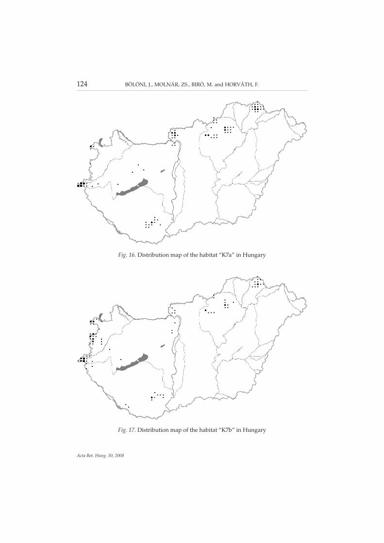
K7a – Acidofrequent beech woodlands (Fig. 16). Low or medium highgrowing, closed forests growing in the beech zone, on extremely acid, mainlyshallow soils. The tree layer is dominated by beech, the shrub layer is absent,the herb layer is composed of acidofrequent forest species (Luzula luzuloides,Deschampsia (= Avenella) flexuosa, Vaccinium myrtillus, etc.), and the moss layeris occasionally significant. It is a rare habitat; the total area is less than 1,300 ha.It occurs with the greatest amount in Őrség and Vendvidék (800 ha). There aresome extended occurrences in the higher regions of the Északi-középhegység
122 BÖLÖNI, J., MOLNÁR, ZS., BIRÓ, M. and HORVÁTH, F.
Acta Bot. Hung. 50, 2008
Fig. 14. Distribution map of the habitat “K2” in Hungary

(350 ha, Börzsöny, Mátra, Bükk, Zempléni-hegység). Sporadic in Mecsek (30ha), in the Soproni- and Kőszegi-hegység (altogether 50 ha). Only small standscan be found in the Dunántúli-középhegység (Bakony, Visegrádi-hegység).
K7b – Acidofrequent oak-hornbeam woodlands (Fig. 17). Submontaneand colline, medium high growing, frequently secondary forests, developedon acid bedrock and on eroded forest soils. They can be characterised with aclosed canopy layer, with the lack of shrub layer, and with the dominance ofQuercus petraea, Carpinus betulus and/or Fagus sylvatica in the tree layer. Theherb layer is composed of acidofrequent species (Luzula luzuloides, Deschamp-sia (= Avenella) flexuosa, Vaccinium myrtillus, etc.), and by species of mesic de-ciduous forests in smaller amount. It is a rare habitat type; the total area isaround 1,300 ha. Most of the Hungarian occurrences (more than 1,000 ha) arein Nyugat-Dunántúl (mainly Soproni-hegység, Kőszegi-hegység and its vicin-ity, Őrség, Vendvidék). There are smaller stands in the higher regions of theÉszaki-középhegység (150 ha, Börzsöny, Mátra, Bükk, Zempléni-hegység, He-ves–Borsodi-dombság) and in Mecsek (40 ha). It is very rare in the Dunán-túli-középhegység (Bakony, Budai-hegység, Visegrádi-hegység). Former for-est use (grazing, coppicing, litter gathering) played an important role in itsevolution. Considering that the stands can be found on soils of secondary acid-ification, a few decades of protection can lessen or cease the acid character ofthe herb layer, and with this, that of the whole forest.
DISTRIBUTION OF THE (SEMI-)NATURAL HABITATS IN HUNGARY II 123
Acta Bot. Hung. 50, 2008
Fig. 15. Distribution map of the habitat “K5” in Hungary
124 BÖLÖNI, J., MOLNÁR, ZS., BIRÓ, M. and HORVÁTH, F.
Acta Bot. Hung. 50, 2008
Fig. 17. Distribution map of the habitat “K7b” in Hungary
Fig. 16. Distribution map of the habitat “K7a” in Hungary

L1 – Closed thermophilous downy oak woodlands (Fig. 18). Low or me-dium high growing, closed, submontane and colline oak forests with denseshrub layer and with well-developed herb layer. The soil is generally shallowand/or rocky, the most dominant species of the canopy layer is the downy oak(Quercus pubescens s. l.). A high shrub layer (Cornus mas, Crataegus monogyna)or a second canopy layer made up of young trees (Fraxinus ornus, Acer campest-re) is common. Mass species of the herb layer are grasses and sedges. Thermo-philous and light-demanding species are typical, and many of them are alsodrought tolerant. Total area of the habitat is more than 21,000 ha. It is commonin the Dunántúli-középhegység (almost 16,000 ha), frequent in the Északi-kö-zéphegység (4,000 ha, infrequent in Cserehát and in the Zempléni-hegység),and has a significant area in the eastern part of Dél-Dunántúl (1,000 ha, Külső-Somogy, Tolnai-hegyhát, Mecsek, Villányi-hegység). There are only isolatedpatches in Nyugat-Dunántúl (Fertőmelléki-dombsor, Kőszegi-hegység, Ság-hegy). Distribution of the thermophilous oak woodlands can be explained bythe dry mesoclimate and by the shallow, mostly rocky soils. Furthermore, thesub-Mediterranean climate has a significant effect; it becomes graduallyweaker towards the northeast, resulting in the gradual disappearance of downyoak forests. The identification of the habitat is generally simple; only the sepa-ration from closed steppe oak woodlands (“L2x”) can be problematic. Conse-quently, the classification of those stands can be partly uncertain which occuron the loess of foothills and hilly regions (where the two habitats are connected
DISTRIBUTION OF THE (SEMI-)NATURAL HABITATS IN HUNGARY II 125
Acta Bot. Hung. 50, 2008
Fig. 18. Distribution map of the habitat “L1” in Hungary

or mixed, e.g. Cserhát, Gödöllői-dombvidék, Velencei-hegység, Külső-Somogy,Tolnai-hegyhát).
L2a – Turkey oak-sessile oak woodlands (Fig. 19). This habitat type is agroup of forests occurring in submontane and colline region with variablemixture ratio of Quercus cerris and Q. petraea. In the tree layer shadowing trees(mainly Fagus sylvatica and Carpinus betulus) are absent or very rare. Light-de-manding and drought tolerant, forest specialist species are always present inthe herb layer. Nor mesic forest species neither disturbance tolerant speciescan monodominate, whilst grasses and sedges are common. The total area ofthe habitat is almost 120,000 ha in Hungary. It can be found in the Északi-kö-zéphegység with the larger extension (more than 80,000 ha), and it covers alsolarge areas in the Dunántúli-középhegység (approx. 23,000 ha). It occurs inDél-Dunántúl (8,000 ha, Külső-Somogy, Tolnai-hegyhát, Mecsek) and in cer-tain regions of Nyugat-Dunántúl (4,000 ha, especially around Sopron andSzombathely). Climatically strongly determined habitat; it is absent equallyfrom regions suitable for mesic forests and for forest steppes (namely too highor too low precipitation). Turkey oak-sessile oak woodland is often a hardlyidentifiable habitat; there are different transitional stages between this habitatand the dry and mesic oak forests (“L1”, “L2b”, “L2x”, “K2”, “LY4”). In sev-eral cases, mainly if the herb layer is missing, it is also difficult to separate fromthe uncharacteristic hardwood forests and plantations (“RC”). All these iden-tification problems escalate in more humid climate (e.g. Bakonyalja, Pannon-
126 BÖLÖNI, J., MOLNÁR, ZS., BIRÓ, M. and HORVÁTH, F.
Acta Bot. Hung. 50, 2008
Fig. 19. Distribution map of the habitat “L2a” in Hungary
halmi-dombság, along the River Répce, Kemeneshát, Külső-Somogy, Tolnai-hegyhát, Baranyai-dombság).
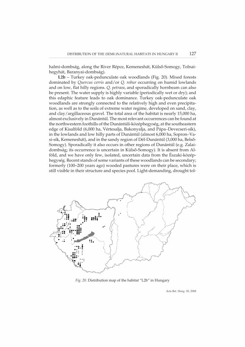
L2b – Turkey oak-pedunculate oak woodlands (Fig. 20). Mixed forestsdominated by Quercus cerris and/or Q. robur occurring on humid lowlandsand on low, flat hilly regions. Q. petraea, and sporadically hornbeam can alsobe present. The water supply is highly variable (periodically wet or dry); andthis edaphic feature leads to oak dominance. Turkey oak-pedunculate oakwoodlands are strongly connected to the relatively high and even precipita-tion, as well as to the soils of extreme water regime, developed on sand, clay,and clay/argillaceous gravel. The total area of the habitat is nearly 15,000 ha,almost exclusively in Dunántúl. The most relevant occurrences can be found atthe northwestern foothills of the Dunántúli-középhegység, at the southeasternedge of Kisalföld (6,000 ha, Vértesalja, Bakonyalja, and Pápa–Devecseri-sík),in the lowlands and low hilly parts of Dunántúl (almost 6,000 ha, Sopron–Va-si-sík, Kemeneshát), and in the sandy region of Dél-Dunántúl (3,000 ha, Belső-Somogy). Sporadically it also occurs in other regions of Dunántúl (e.g. Zalai-dombság; its occurrence is uncertain in Külső-Somogy). It is absent from Al-föld, and we have only few, isolated, uncertain data from the Északi-közép-hegység. Recent stands of some variants of these woodlands can be secondary;formerly (100–200 years ago) wooded pastures were on their place, which isstill visible in their structure and species pool. Light-demanding, drought tol-
DISTRIBUTION OF THE (SEMI-)NATURAL HABITATS IN HUNGARY II 127
Acta Bot. Hung. 50, 2008
Fig. 20. Distribution map of the habitat “L2b” in Hungary

erant forest specialist species are also present in the herb layer, but with asmaller amount.
L2x – Closed and mixed steppe oak woodlands on foothills (Fig. 21). De-veloped in dry climate and mainly on loess or on other similar sediments,these forests usually grow on the foothills of the oak woodland zone, or at theedge of Alföld. This is a mixed oak forest of Quercus pubescens, Q. robur, Q. cer-ris and/or Q. petraea, but usually at least two other species are present, such as:Fraxinus excelsior, F. angustifolia subsp. pannonica and/or F. ornus, Acer campest-re, A. tataricum, Tilia cordata, T. platyphyllos. The shrub layer is high and dense,often with a second layer of infilled young trees. Species of mesic, dry and/orlight forests compose the herb layer, moreover, species of dry grasslands canalso occur. According to its attributes, this habitat type is situated between theloess steppe oak woodlands (“M2”), the turkey oak woodlands (“L2a”), the oak-hornbeam woodlands (“K1a”) and/or the closed thermophilous oak wood-lands (“L1”). The total area of the habitat is less than 4,500 ha. Its stands re-mained mainly in the border zone of Alföld and the foothills of the mountains.It is completely absent from certain regions, while aggregating in other places;resulting in the concentration of occurrences. These centres are Cserehát withthe foothills of Zempléni-hegység, the southern edge of Bükk, the southernpart of Cserhát with the Gödöllői-dombvidék, the northern part of Mezőföldwith the Velencei-hegység and Vértes, Gerecse with the connecting foothills ofthe Budai-hegység, the western and southwestern part of Mezőföld with the
128 BÖLÖNI, J., MOLNÁR, ZS., BIRÓ, M. and HORVÁTH, F.
Acta Bot. Hung. 50, 2008
Fig. 21. Distribution map of the habitat “L2x” in Hungary

edges of Keleti-Bakony and Balaton-felvidék, Tolnai-hegyhát and its vicinity,and the Baranyai-dombság. The stands mostly form small islands also withinthese regions; they do not cover larger blocks nowadays (some exceptions areVelencei-hegység, Tolnai-hegyhát, Kerecsendi-erdő at the foothills of Bükk). Itpenetrates most pregnantly into Alföld in Mezőföld and at the edges of theGödöllői-dombvidék. The foothill stands and that of the closed thermophilousoak woodlands (“L1”) are hardly distinguishable.
L4a – Closed acidofrequent oak woodlands (Fig. 22). Low or mediumhigh growing, closed forests, developed on extremely acid soils. Submontanehabitat type, connected to acid bedrock (andesite, rhyolite, granite, acid sand-stones, shales) and to shallow, dry soils, occurring mainly on south slopes. Thedominant tree species is Quercus petraea, the shrub layer is missing, the herblayer is characterised by acidofrequent forest species (Luzula luzuloides, De-schampsia (= Avenella) flexuosa, Vaccinium myrtillus, etc.), the moss layer can besignificant. The total area of the habitat is 2,300 ha in Hungary. The greaterpart of the occurrences is in the higher regions of the Északi-középhegyég(Zempléni-hegység, Bükk, Mátra, Heves–Borsodi-dombság, Börzsöny). Thereare some sporadic occurrences in the Dunántúli-középhegység (300 ha, espe-cially in the Visegrádi-hegység, Budai-hegység, Velencei-hegység, and inBalaton-felvidék). It can be found at the western edge of Nyugat-Dunántúl(100 ha, Soproni-hegység, Kőszegi-hegység, Őrség, Vendvidék) and in Dél-Dunántúl, in Mecsek (200 ha). Though it is usually easy to recognise this habi-
DISTRIBUTION OF THE (SEMI-)NATURAL HABITATS IN HUNGARY II 129
Acta Bot. Hung. 50, 2008
Fig. 22. Distribution map of the habitat “L4a” in Hungary

tat, there are barely identifiable transitional stands towards turkey oak wood-lands (“L2a”, “L2b”).
L4b – Open acidofrequent oak woodlands (Fig. 23). These low growingforests occur mainly in the submontane oak zone, on extremely acid bedrockand on eroded, shallow, mainly rocky lithosoils. The stands are opened (themaximal closure is 60–70%), which gives a shrub woodland character for thehabitat. Quercus petraea is the dominant tree species, the herb layer is com-posed of species of acidofrequent deciduous forests, and of oak woodlands,those of certain rock grasslands and rock forests, and species of the dry, acido-frequent grasslands. The cover of the cryptogams (mosses, lichens) on the for-est floor can be high, and rock outcrops are typical. This rare habitat occurs al-ways in small patches. Its total area is less than 200 ha. It is the most frequent inthe Északi-középhegység (130 ha, Börzsöny, Mátra, Bükk, Heves–Borsodi-domb-ság, Zempléni-hegység). It occurs with smaller amount in the Dunántúli-kö-zéphegység (30 ha, Budai-hegység, Velencei-hegység, Balaton-felvidék, Ba-kony) and in Dél-Dunántúl (30 ha, Mecsek).
L5 – Closed lowland steppe oak woodlands (Fig. 24). Mesic and semi-dryforests (closed sand steppe oak woodlands, closed salt steppe oak woodlands,dried-out riverine oak-elm-ash forests) dominated by Quercus robur, infre-quently by Fraxinus angustifolia subsp. pannonica or Tilia spp.. Sand or clayish-loamy sediments (sometimes salty in deeper soil layers) are the typical bed-
130 BÖLÖNI, J., MOLNÁR, ZS., BIRÓ, M. and HORVÁTH, F.
Acta Bot. Hung. 50, 2008
Fig. 23. Distribution map of the habitat “L4b” in Hungary

rocks of the habitat in the not flooded, drier, inner parts of Alföld. These wood-lands partly originate from riverine oak-elm-ash forests (or from other closedlowland wet forests), but have already lost their riverine character. This ismanifested especially in the herb layer; the real riverine forest species are un-common or missing, and are replaced by forest generalists. In the more charac-teristic stands mesic and dry forest elements are both present. Closed lowlandsteppe oak woodlands infrequently occur also at foothills (on sand). Sincesome oak plantations with low naturalness were classified to this habitat, thetotal actual area of the habitat and its distribution pattern is uncertain. It coversapprox. 6,000 ha, a further 2,900 ha have uncertain classification. Majority ofthe stands can be found in Tiszai-Alföld (approx. 4,900 ha, and approx. 1,900ha with uncertain status). Sporadic in Dunai-Alföld (approx. 1,200 ha), whereclosed sand steppe oak woodlands and a few stands of ash-elm-oak-likewoodlands surrounding fen woodlands belong to this habitat. It is rare in Kis-alföld (75 ha) and there are some uncertain occurrences at the foothills of theÉszaki-középhegység (approx. 60 ha). It is absent from the hilly parts ofDunántúl.
LY1 – Forests of ravines (mesic rocky forests rich in Acer pseudoplatanus)(Fig. 25). Forests of ravines are submontane, rocky habitats with rock streams,connected to cool, humid climate, occur generally on limestone in Hungary,on steep slopes of rock debris (or in the bottom of the valleys), with leaking
DISTRIBUTION OF THE (SEMI-)NATURAL HABITATS IN HUNGARY II 131
Acta Bot. Hung. 50, 2008
Fig. 24. Distribution map of the habitat “L5” in Hungary

water and rock outcrops. Fraxinus excelsior, Acer platanoides, A. pseudoplatanusare the most characteristic tree species of this high growing (20–30 m) forest.Fagus sylvatica, Ulmus and Tilia species are frequent associate species. This isan infrequent habitat; its total area is less than 500 ha in the country. It reachesthe largest extension in the Északi-középhegység (approx. 350 ha), especiallyin Bükk and Mátra, but sporadically in Börzsöny, around Medves, in the He-ves–Borsodi-dombság and in Aggteleki-karszt. Among the mountains of theDunántúli-középhegység it can be found with larger amount only in Bakony(approx. 50 ha), while it is sporadic at other places (Pilis, Visegrádi-hegység) orhas uncertain occurrence (Vértes, Keszthelyi-hegység). There are a few standsin Mecsek (60 ha). A variant of the habitat developed in the steep loess valleyscan be found in Zalai-dombság and in Őrség. Separation from other habitats ofrocky soils (“LY2”, “LY3”) can be occasionally uncertain.
LY2 – Mixed forests of slopes and screes (Fig. 26). These mesic or semi-drysubmontane habitats develop on steep, detrital, rocky slopes and screes, oc-curring on calcareous and siliceous bedrock alike, but preferring the formerone. Tilia species are prevalent, mixed with Fraxinus and Acer species, some-times with Fagus sylvatica and/or Quercus petraea. Nitrophytes are typical inthe herb layer. The total area of the habitat is around 1,700 ha. It is a rare butwidespread habitat in the Északi- and in the Dunántúli-középhegység (1,000and 500 ha, absent: Cserehát, Putnoki-dombság, Heves–Borsodi-dombság,Velencei-hegység). It also occurs in the mountains of Dél-Dunántúl (200 ha,
132 BÖLÖNI, J., MOLNÁR, ZS., BIRÓ, M. and HORVÁTH, F.
Acta Bot. Hung. 50, 2008
Fig. 25. Distribution map of the habitat “LY1” in Hungary

Mecsek, Villányi-hegység). Occasionally its differentiation from ravine wood-lands (“LY1”) or from mixed relic oak woodlands (“LY4”) can be difficult.
LY3 – Limestone beech forests (Fig. 27). They grow on the rocky, stonyand/or detrital, often steep dolomite and limestone areas of the Északi- andDunántúli-középhegység. Fagus sylvatica, or infrequently Tilia species and Acerpseudoplatanus dominate these forests. The joint mixture ratio of these trees is50% at least. Presence of Sorbus species and the almost total absence of Fraxinusexcelsior is characteristic. Limestone beech forests can be a completely closedforest, as well as mosaics of forest and grassland patches. The herb layer oftenholds relic species connected to cliffs and stony ground (e.g. Sesleria species,Carex alba, Calamagrostis varia, Valeriana tripteris, Moehringia muscosa, Phyteumaorbiculare). Nitrophyte and disturbance tolerant species are almost missing.The total area of the habitat is around 550 ha in Hungary. In the Dunántú-li-középhegység this habitat type is connected to dolomite bedrock, where dueto the variable terrain, beech and downy oak woodlands can be found next toeach other. Hence limestone beech forests are the most frequent in Bakony andVértes, additionally it occurs in the Keszthelyi-hegység, in the Budai-hegységand in Pilis. This habitat is connected to limestone and dolomite in the Észa-ki-középhegység (350 ha), the occurrences are basically limited to Bükk moun-tains. There are scattered and uncertain other data from Dunántúl (Kőszegi-hegység, Balaton-felvidék, Mecsek) and from other places of the Északi-kö-zéphegység (Naszály, Cserhát, Aggteleki-karszt, Mátra). The recognition of
DISTRIBUTION OF THE (SEMI-)NATURAL HABITATS IN HUNGARY II 133
Acta Bot. Hung. 50, 2008
Fig. 26. Distribution map of the habitat “LY2” in Hungary

the habitat type is quite easy, only the stands with species poor herb layer cancause problems. However, its extension is presumably overestimated in Bükk.
LY4 – Mixed relic oak forests on rocks (Fig. 28). Group of mixed oak for-ests that occur on rocky, stony and/or detrital ridges, on hilltops, on convexterrain forms, in areas around the hilltops, or more infrequently on slopes in theDunántúli- and Északi-középhegység. Fraxinus excelsior, Tilia and Acer spe-cies, Quercus petraea and/or Q. pubescens are the most characteristic tree spe-cies of this habitat type. The dominant species of the frequently high shrublayer is Cornus mas, whilst Cotoneaster species, Spiraea media can also be preva-lent in other stands. The herb layer is usually dense, and diverse in species.The presence of nitrophytes and spring geophytes characterise certain types ofthe habitat (Tilio-Fraxinetum). In other types, species of dry grasslands andlight-demanding forests dominate the herb layer, where species of rocky for-ests also occur. The total area of the habitat type is more than 2,300 ha in Hun-gary. It is widespread in the Dunántúli-középhegység (1,200 ha, rare in theKeszthelyi-hegység, in Balaton-felvidék and in the Velencei-hegység). Its ex-tension is a bit smaller in the Északi-középhegység (1,000 ha, absent from:Cserehát, Putnoki-dombság, infrequent: Heves–Borsodi-dombság, vicinity ofMedves, Cserhát). Occurs in Dél-Dunántúl (100 ha, Mecsek, Villányi-hegység)and sporadically in Nyugat-Dunántúl (Kőszegi-hegység). Mixed relic oakwoodlands are submontane habitats that were formerly under strong humaninfluence, and recently show transitional character from different aspect. Hence,
134 BÖLÖNI, J., MOLNÁR, ZS., BIRÓ, M. and HORVÁTH, F.
Acta Bot. Hung. 50, 2008
Fig. 27. Distribution map of the habitat “LY3” in Hungary
its separation can be difficult from other rocky forests (“LY2”, “LY3”) andmixed forests (“K2”).
M1 – Downy oak scrub woodlands (Fig. 29). Colline-submontane mosaichabitats of low growing or dwarf forests and dry grasslands. Quercus pubescensis the most prevalent species of the tree layer in forest patches. The shrub layeris generally well developed and not sharply separated from the tree layer. Thishabitat occurs exclusively with dry and rocky grasslands. Minimal proportionof the tree clusters in the mosaic is 33%. Its total area is around 2,200 ha in thecountry. It is common in the Dunántúli-középhegység (800 ha, uncertain: Ve-lencei-hegység), and can be found in most parts of the Északi-középhegység(1,200 ha, missing: Cserehát, Putnoki-dombság). Also occurs in the mountainsof Dél-Dunántúl (200 ha, Mecsek, Villányi-hegység), and sporadically at theeastern edges of Nyugat-Dunántúl (Ság-hegy). Connected to warm climateand to shallow, stony soil, occurring mainly on southern slopes, downy oakscrub woodlands are perfectly adapted to summer droughts. As it is a forest-grassland mosaic habitat, the estimation of the extension is uncertain, depend-ing mainly on the decision that how much grassland is included.
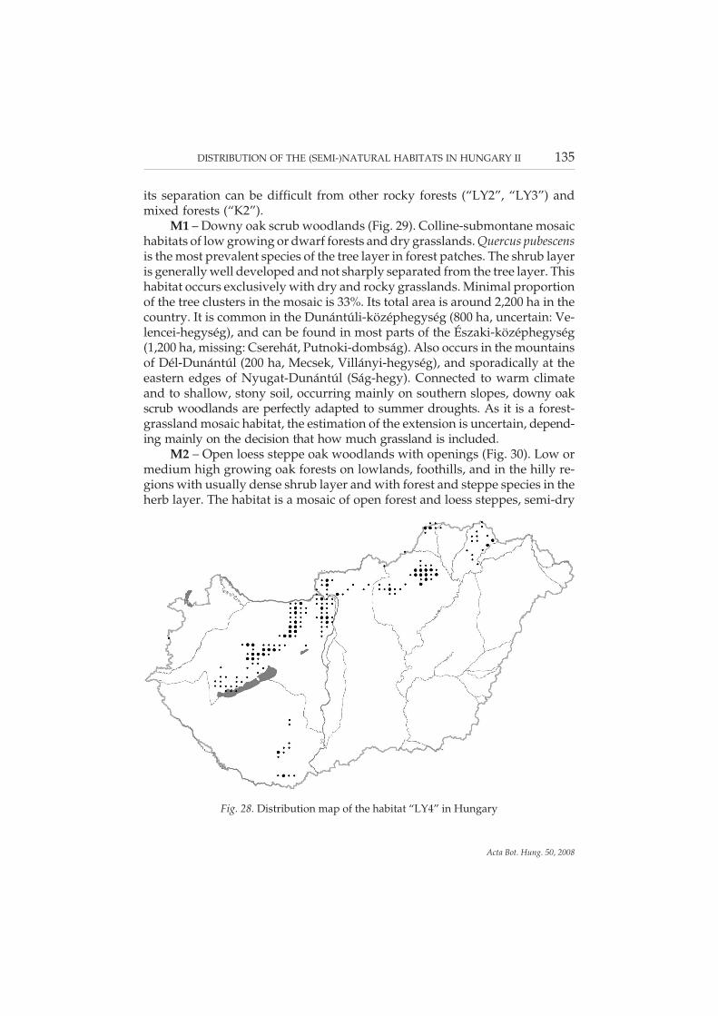
M2 – Open loess steppe oak woodlands with openings (Fig. 30). Low ormedium high growing oak forests on lowlands, foothills, and in the hilly re-gions with usually dense shrub layer and with forest and steppe species in theherb layer. The habitat is a mosaic of open forest and loess steppes, semi-dry
DISTRIBUTION OF THE (SEMI-)NATURAL HABITATS IN HUNGARY II 135
Acta Bot. Hung. 50, 2008
Fig. 28. Distribution map of the habitat “LY4” in Hungary

grasslands, steppe thickets and/or scrub vegetation of Prunus spinosa and Cra-taegus monogyna. An infrequent habitat with small extension; 100, partly un-certain occurrences are known, covering less than 100 ha altogether. It occurssporadically at the edge of Alföld, as well as in the Baranyai-dombság, in theVelencei-hegység, in the Gödöllői-dombvidék, at the southern part of Cserhát,at the foothills of Mátra and Bükk, at the southern part of Cserehát and inTokaj-hegyalja. Connected to the forest steppe climate and to the soils devel-oped on loess or loess-like sediments, formerly it covered presumably largerareas, but currently almost exclusively tree groups and woodland fringes rep-resent the habitat.
M3 – Open salt steppe oak woodlands with openings (Fig. 31). Open Quer-cus robur woodlands that are lower than 15 m and form mosaics with tall herbmeadow steppes, halophytic communities, loess steppes and reed beds. Forestelements are mixed with steppe and halophyte species. Characteristic species:Quercus robur, Acer tataricum, Pulmonaria mollis, Doronicum hungaricum, Melicaaltissima, and Peucedanum officinale, Aster punctatus, A. linosyris, Artemisia ponti-ca on the fringes. The habitat occurs exclusively in Tiszai-Alföld in Hungary,within this only in the phytogeographical Tiszántúl (Crisicum). Its actual areain the country is 130 ha. It occurs around Újszentmargita, Ohat and Kisújszál-lás, along the rivers Zagyva and Tarna, at the River Berettyó and at the westernedges of Kis-Sárrét, as well as along the River Fekete-Körös. All the closedstands should be categorised to closed lowland steppe oak woodlands (“L5”);
136 BÖLÖNI, J., MOLNÁR, ZS., BIRÓ, M. and HORVÁTH, F.
Acta Bot. Hung. 50, 2008
Fig. 29. Distribution map of the habitat “M1” in Hungary

DISTRIBUTION OF THE (SEMI-)NATURAL HABITATS IN HUNGARY II 137
Acta Bot. Hung. 50, 2008
Fig. 30. Distribution map of the habitat “M2” in Hungary
Fig. 31. Distribution map of the habitat “M3” in Hungary

hence the estimation of its extension is only approximate. Oak plantations onsalty soils possessing completely uncharacteristic species pool were deletedfrom the map (e.g. from Borsodi-Mezőség, Körös-vidék and from the vicinityof the River Maros). Not the infrequency of suitable sites (bordering zone offloodplains and loess ridges with adequately high level of ground water), butthe historical forest use is the background cause of the rarity of open saltsteppe oak woodlands. The intensive forest use for thousands of years abol-ished the stands; consequently they could have survived only among specificconditions.
M4 – Open sand steppe oak woodlands with openings (Fig. 32). Quercusrobur dominated steppe forests of lowland sand regions, appearing in smallertree groups or in greater stands. They usually form mosaic with dry grass-lands. The density of the shrub layer is varying; generally high and closed,while at other sites it forms mosaics with open grasslands. Festuca rupicola andPoa angustifolia are common species of the herb layer. A characteristically low-land habitat, its actual area in the country is only approx. 300 ha; probably oneof the most endangered habitats of Hungary. The estimation of its real exten-sion is difficult; only the open sand oak woodlands belong to this group, theclosed stands with different species pool and physiognomy should be categor-ised to closed lowland steppe oak woodlands (“L5”). Its area was estimated tobe approx. 100 ha in Nyírség, and 190 ha in Duna–Tisza köze. As a conse-quence of systematic planting of Robinia pseudo-acacia in the 20th century, it
138 BÖLÖNI, J., MOLNÁR, ZS., BIRÓ, M. and HORVÁTH, F.
Acta Bot. Hung. 50, 2008
Fig. 32. Distribution map of the habitat “M4” in Hungary

disappeared from huge areas in both regions. It can be found at the foothills ofVértes and around Győr (approx. 15 ha), as well as in the Gödöllői-dombvidék.It is missing from the Dunántúli-dombság, from Nyugat-Dunántúl and from theÉszaki-középhegység, since there are no dry sand regions in these landscapes.There are some planted oak tree groups and open oak forests in the southernpart of Duna–Tisza köze that can possibly be considered as the uncharacteris-tic variant of the habitat. These were, however, deleted from the map.
M5 – Poplar-juniper steppe woodlands (Fig. 33). Shrublands or forestsdominated by Juniperus communis and/or by Populus alba and P. canescens inthe sand regions of Alföld. This species poor, open habitat is typically poor inforest species and forms a mosaic with open sand steppes. Minimal closure ofthe tree layer is 20%. It occurs characteristically in the Duna–Tisza köze, the to-tal actual area is around 3,000 ha in Hungary. It is completely missing fromTiszai-Alföld, Nyugat-Dunántúl, from the Dunántúli-dombság and the Dunán-túli- and Északi-középhegység, and there are only fragmented stands in Kis-alföld (approx. 10 ha). Presumably it is extinct from Mezőföld. Poplar-junipersteppe woodlands are widespread in the Duna–Tisza köze, most of the standscan be found in its southern part. Because of the smaller grain size of the sandand the rarity of sand dune regions, the habitat is rare on the eastern gentle“slope” of the Duna–Tisza köze; these stands are partly planted native poplarwoodlands with spontaneous openings.
DISTRIBUTION OF THE (SEMI-)NATURAL HABITATS IN HUNGARY II 139
Acta Bot. Hung. 50, 2008
Fig. 33. Distribution map of the habitat “M5” in Hungary
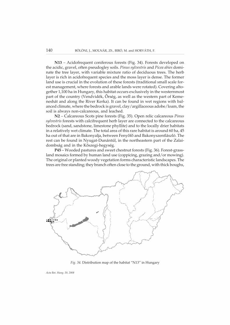
N13 – Acidofrequent coniferous forests (Fig. 34). Forests developed onthe acidic, gravel, often pseudogley soils. Pinus sylvestris and Picea abies domi-nate the tree layer, with variable mixture ratio of deciduous trees. The herblayer is rich in acidofrequent species and the moss layer is dense. The formerland use is crucial in the evolution of these forests (traditional small scale for-est management, where forests and arable lands were rotated). Covering alto-gether 1,100 ha in Hungary, this habitat occurs exclusively in the westernmostpart of the country (Vendvidék, Őrség, as well as the western part of Keme-neshát and along the River Kerka). It can be found in wet regions with bal-anced climate, where the bedrock is gravel, clay/argillaceous adobe/loam, thesoil is always non-calcareous, and leached.
N2 – Calcareous Scots pine forests (Fig. 35). Open relic calcareous Pinussylvestris forests with calcifrequent herb layer are connected to the calcareousbedrock (sand, sandstone, limestone phyllite) and to the locally drier habitatsin a relatively wet climate. The total area of this rare habitat is around 60 ha, 45ha out of that are in Bakonyalja, between Fenyőfő and Bakonyszentlászló. Therest can be found in Nyugat-Dunántúl, in the northeastern part of the Zalai-dombság and in the Kőszegi-hegység.
P45 – Wooded pastures and sweet chestnut forests (Fig. 36). Forest-grass-land mosaics formed by human land use (coppicing, grazing and/or mowing).The original or planted woody vegetation forms characteristic landscapes. Thetrees are free standing; they branch often close to the ground, with thick boughs,
140 BÖLÖNI, J., MOLNÁR, ZS., BIRÓ, M. and HORVÁTH, F.
Acta Bot. Hung. 50, 2008
Fig. 34. Distribution map of the habitat “N13” in Hungary

their crowns and the diameter of the trunks are huge. The trees, at least partly,are old, with a minimum of 30–40 cm diameter, but sometimes the thickness ofthe trunk can reach 1 m. The total area of the habitat is almost 5,500 ha. It can befound with the greatest extension (2,500 ha) in Dél-Dunántúl and in the con-necting regions, especially in Belső-Somogy, in Zselic, and in the vicinity ofMecsek (1,700 ha), as well as in the Zalai-dombság (500 ha) and in Dráva-sík(300 ha). Beyond these occurrences it is sporadic in Nyugat-Dunántúl (further250 ha). It covers larger areas again in the northeastern part of Alföld (approx.400 ha), and in the Dunántúli-középhegység (1,300 ha), especially in its west-ern part (Balaton-felvidék, Bakony, Vértes). It is sporadic also in Kisalföld,mainly in the southern part (250 ha) and is also not common in the Északi-kö-zéphegység (500 ha, Börzsöny, Cserhát, Mátra, Bükk, Heves–Borsodi-domb-ság, Cserehát, Zempléni-hegység). Human influence plays significant role inthe development of wooded pastures and sweet chestnut woodlands. In thepast, these habitats were common and widespread, but as a consequence ofabandonment of the traditional use, their extension is sharply decreasing.
P7 – Extensive orchards with ancient cultivars (often invaded by shrubsand trees) (Fig. 37). The age, species and cultivar compositions of the standsare highly variable. Due to the traditional, extensive cultivation, they are man-aged without artificial irrigation, soil management and chemical control. Thenatural shrub layer between the scattered trees is usually sporadic or infre-
DISTRIBUTION OF THE (SEMI-)NATURAL HABITATS IN HUNGARY II 141
Acta Bot. Hung. 50, 2008
Fig. 35. Distribution map of the habitat “N2” in Hungary

quently missing, but after the abandonment of the orchard often dense shrublayer develops. Extensive mowing and grazing maintains the semi-naturalherb layer that can became scarce in the abandoned stands. The total area ofthe habitat is 3,000 ha in Hungary. It remained in the largest extension (1,300ha) in Nyugat-Dunántúl, especially in its southern part (Zalai-dombság, Ke-meneshát, Őrség, Vendvidék). Relatively many (1,000 ha) ancient orchards arein the Északi-középhegység (mainly Börzsöny, Cserhát, Mátra, Bükk and itsvicinity, Putnoki-dombság, Aggteleki-karszt, Cserehát, Tokaj-hegyalja). Thecentre of the occurrences is the vicinity of Zselic and Mecsek in Dél-Dunántúl(300 ha), and Tisza valley in Alföld (250 ha). It is rare in the Dunántúli-közép-hegység (150 ha), and practically missing from Kisalföld.
RA – Scattered native trees or narrow tree lines (Fig. 38). Groups of scat-tered native trees (willows, oaks, etc., occasionally fruit trees, walnut, Populusnigra var. italica) on grasslands and in marshes; or narrow tree lines and forestbelts (1–2 tree width). The tree group should have at least 5 tree individuals,with a minimum diameter of 25 cm at breast height. The total area of the habi-tat is 6,500 ha in the country, with sporadic, but almost even distribution. Itcovers the largest area in Alföld (more than 3,000 ha). More than 1,000 ha canbe found in the Északi-középhegység, almost 1,000 ha in Dél-Dunántúl, andalmost 600 ha in Kisalföld. It is the most infrequent in Nyugat-Dunántúl and inthe Dunántúli-középhegység (approx. 350–350 ha).
142 BÖLÖNI, J., MOLNÁR, ZS., BIRÓ, M. and HORVÁTH, F.
Acta Bot. Hung. 50, 2008
Fig. 36. Distribution map of the habitat “P45” in Hungary

DISTRIBUTION OF THE (SEMI-)NATURAL HABITATS IN HUNGARY II 143
Acta Bot. Hung. 50, 2008
Fig. 38. Distribution map of the habitat “RA” in Hungary
Fig. 37. Distribution map of the habitat “P7” in Hungary

RB – Uncharacteristic (often pioneer) softwood forests and plantations(Fig. 39). Softwood forests of native trees that mainly have poor herb layer andcannot be classified to another natural habitat type (from “J” to “N”). Planta-tions and spontaneous forest stands equally belong to this habitat type. Mostoften Salix and Populus species, Alnus glutinosa and Betula pendula consist thesewoodlands, furthermore Pinus sylvestris at the western edge of the country.Minimal closure of the woodland is 33%, and maximal proportion of hard-woods is 50%. The total area of the habitat is 45,000 ha, occurring almostevenly in the country. It covers the largest area in Alföld (almost 20,000 ha) andin Dél-Dunántúl (11,000 ha). Its extension is smaller in Nyugat-Dunántúl(5,000 ha) and in Kisalföld (6,000 ha), the most infrequent in the Dunántúli-and in the Északi-középhegység (2,400 and 1,600 ha). Basically it is a man-made habitat, occurring with the largest area on those lowlands, where thelevel of the groundwater is high (valleys of the rivers Duna, Tisza, Dráva andRába, and Belső-Somogy). Most infrequent in colline-submontane regions withclosed forest cover (e.g. Zalai-dombság, Bakony, Vértes, Visegrádi-hegység, Bör-zsöny, Mátra, Bükk, Putnoki-dombság, Aggteleki-karszt, Zempléni-hegység).
RC – Uncharacteristic hardwood forests and plantations (Fig. 40). Forestsdominated generally by only one native hardwood tree species. They havepoor herb layer and their classification to another natural habitat type (from“J” to “N”) is problematic. Plantations on arable fields, on grasslands, and on
144 BÖLÖNI, J., MOLNÁR, ZS., BIRÓ, M. and HORVÁTH, F.
Acta Bot. Hung. 50, 2008
Fig. 39. Distribution map of the habitat “RB” in Hungary

DISTRIBUTION OF THE (SEMI-)NATURAL HABITATS IN HUNGARY II 145
Acta Bot. Hung. 50, 2008
Fig. 40. Distribution map of the habitat “RC” in Hungary
Fig. 41. Distribution map of the habitat “RD” in Hungary

the place of former (semi-)natural forests consist generally this group, but in-frequently spontaneous woodlands or forests of uncertain origin in grasslandsand in old-fields also belong to this habitat type. Most frequent dominatingtree species are Quercus cerris and Q. robur, Fraxinus excelsior and F. angustifoliasubsp. pannonica. The total area of the habitat is more than 80,000 ha. It occurswith the largest extension in Alföld (30,000 ha) and in the Dunántúli-kö-zéphegység (17,500 ha). It covers smaller area in Dél-Dunántúl (12,500 ha) andin Nyugat-Dunántúl (8,500 ha). It can be found with the smallest amount in theÉszaki-középhegység (6,500 ha) and in Kisalföld (5,000 ha).
RD – Uncharacteristic forests and plantations mixed with non-native treespecies (Fig. 41). Planted or spontaneous forests with 50–75% mixture ratio ofnon-native trees. The habitat is generally widespread in the country, but moststands are not even semi-natural (except especially the stands of Nyugat-Du-nántúl and Északi-középhegység). There are a lot of false “RD” data of Robiniastands in the database. At the same time there are semi-natural stands errone-ously mapped as this habitat type in Nyugat-Dunántúl with a lot of forest spe-cies in the herb layer and with high mixture ratio of Picea abies and Pinus syl-vestris in the tree layer.
*
Acknowledgements – We would like to express our gratitude to the 199 MÉTA mappers,to all the colleagues who participated in the design and development of the database andthe distribution maps (especially Krisztina Oláh and Katalin Bagi) as well as to the review-ers of the distributions maps (Norbert Bauer, István Bagi, László Bodonczi, ZoltánBotta-Dukát, András Horváth, Magdolna Juhász, Gergely Király, Attila Lengyel, AttilaMesterházy, Csaba Molnár, József Nagy and Csaba Szigetvári). The text was translated byRéka Aszalós. We would also like to thank the Széchenyi Plan and the Jedlik Ányos Pro-gram for supporting projects of “Survey and comparative analysis of Hungary’s natural bo-tanical heritage, 2002–2005” (NKFP 3B/0050) and “Interaction of natural and man-madeecosystems: landscape ecological studies of biodiversity and ecosystem functions in theGreat Hungarian Plain, 2005–2008” (NKFP 6–0013/2005).
REFERENCES
Bartha, D. and Mátyás, Cs. (1995): Erdei fa- és cserjefajok előfordulása Magyarországon. (Distri-bution of forest trees and shrubs in Hungary). – EFE, Sopron, 224 pp.
Borhidi, A. and Sánta, A. (eds) (1999): Vöröskönyv Magyarország növénytársulásairól 1–2. (Redbook of plant associations in Hungary). – TermészetBÚVÁR Alapítvány Kiadó, Buda-pest, 362 pp., 404 pp.
Bölöni, J., Kun, A. and Molnár, Zs. (2003): Élőhely-ismereti útmutató. (Habitat guide). – MTAÖBKI, Vácrátót. (mscr.)
Bölöni, J., Molnár, Zs., Illyés, E. and Kun, A. (2007): A new habitat classification and manualfor standardized habitat mapping. – Ann. di Bot., n. ser. 7: 55–76.
146 BÖLÖNI, J., MOLNÁR, ZS., BIRÓ, M. and HORVÁTH, F.
Acta Bot. Hung. 50, 2008
Büttner, G., Feranec, J. and Jaffrain, G. (2002): Corine land cover update 2000. Technical guide-lines. – Technical Report 89, European Environment Agency, Copenhagen, 56 pp.
Chytrý, M., Kučera, T. and Kočí, M. (eds) (2001): Katalog biotopů České republiky. (Habitat cat-alogue of the Czech Republic). – Agentura ochrany přírody a krajiny ČR, Praha, 304pp.
Farkas, S. (ed.) (1999): Magyarország védett növényei. (Protected plants in Hungary). –Mezőgazda Kiadó, Budapest, 414 pp.
Fekete, G., Molnár, Zs. and Horváth, F. (1997): Nemzeti Biodiverzitás-monitorozó Rendszer II. Amagyarországi élőhelyek leírása, határozója és a Nemzeti Élőhely-osztályozási Rendszer.(Guide and description of the Hungarian habitats. The national habitat classificationsystem). – Magyar Természettudományi Múzeum, Budapest, 374 pp.
Guth, J. and Kučera, T. (2005): Natura 2000 habitat mapping in the Czech Republic: methodsand general results. – Ekológia (Bratislava) 24(Suppl. 1): 39–51.
Horváth, F., Molnár, Zs. and Bölöni, J. (eds) (2001): Fajok és élőhelyek országos értékelése. (Eval-uation of species and habitats of Hungary). – Preparation for Implementing the Habi-tat Directive in Hungary. Phare HU9807–01–02–02 Final Report, Vol II., MTA ÖBKI,Vácrátót.
Horváth, F., Kovács-Láng, E., Báldi, A., Gergely, E. and Demeter, A. (2003): Európai jelentő-ségű természeti területeink felmérése és értékelése. (Survey and evaluation of areas of Euro-pean interest in Hungary). – MTA ÖBKI, Vácrátót.
Horváth, F., Dobolyi, K., Moschhauser, T., Lőkös, L., Karas, L. and Szerdahelyi, T. (1995):Flóra adatbázis 1.2. Taxonlista és attribútum-állomány. (Flora database 1.2. Taxon list andattributes database). – MTA ÖBKI, Vácrátót.
Horváth, F., Molnár, Zs., Bölöni, J., Pataki, Zs., Polgár, L., Révész, A., Oláh, K., Krasser, D.and Illyés, E. (2008): Fact sheet of the MÉTA database 1.2. – Acta Bot. Hung. 50(Suppl.):11–34.
Loidi, J. (1999): Preserving biodiversity in the European Union: the Habitats Directive andits application in Spain. – Plant Biosystems 133: 99–106.
Marosi, S. and Somogyi, S. (eds) (1990): Magyarország kistájainak katasztere I–II. (Inventory ofthe physical geographical microregions of Hungary I–II). – MTA FöldrajztudományiKutató Intézet, Budapest.
Molnár, Cs., Biró, M., Bölöni, J., Molnár, Zs. and Horváth, F. (2007a): Szakmai alapadatok azEurópai Közösség Élőhelyi Irányelvének Függelékes élőhelyeinek Ország-jelentéséhez azirányelv 17. cikke alapján (Natura 2000 élőhelyek Magyarországon). (Scientific backgroundinformation for the country report on Annex habitats of the Habitats Directives). – Re-port, MTA ÖBKI, Vácrátót.
Molnár, Cs., Molnár, Zs., Barina, Z., Bauer, N., Biró, M., Bodonczi, L., Csathó, A. I., Csiky, J.,Deák, J. Á., Fekete, G., Harmos, K., Horváth, A., Isépy, I., Juhász, M., Kállayné Sze-rényi, J., Király, G., Magos, G., Máté, A., Mesterházy, A., Molnár, A., Nagy, J., Óvári,M., Purger, D., Schmidt, D., Sramkó, G., Szénási, V., Szmorad, F., Szollát, Gy., Tóth, T.,Vidra, T. and Virók, V. (2008a): Vegetation-based landscape regions of Hungary. –Acta Bot. Hung. 50(Suppl.): 47–58.
Molnár, Zs., Horváth, F. and Révész, A. (2001a): IBOA-atlasz 1.0: Előtanulmány Magyarországtermészetes növényzeti örökségének élőhelyi adatbázisához és térképéhez. (IBOA Atlas 1.0:Preliminary study for the habitat database and habitat map of the natural botanicalheritage of Hungary). – MTA ÖBKI, Vácrátót. (mscr.)
Molnár, Zs., Biró, M., Bölöni, J. and Horváth, F. (2008b): Distribution of the (semi-)naturalhabitats in Hungary I. Marshes and grasslands. – Acta Bot. Hung. 50(Suppl.): 59–105.
DISTRIBUTION OF THE (SEMI-)NATURAL HABITATS IN HUNGARY II 147
Acta Bot. Hung. 50, 2008

Molnár, Zs., Büttner, Gy., Taracsák, G., Révész, A. and Horváth, F. (2001b): CORINE élő-hely-térképezés (CÉT). (CORINE habitat mapping, CÉT), 1 : 50,000. GIS database. –MTA ÖBKI, FÖMI, Vácrátót, Budapest.
Molnár, Zs., Bartha, S., Seregélyes, T., Illyés, E., Tímár, G., Horváth, F., Révész, A., Kun, A.,Botta-Dukát, Z., Bölöni, J., Biró, M., Bodonczi, L., Deák, J. Á., Fogarasi, P., Horváth, A.,Isépy, I., Karas, L., Kecskés, F., Molnár, Cs., Ortmann-né Ajkai, A. and Rév, Sz. (2007b):A grid-based, satellite-image supported, multi-attributed vegetation mapping method(MÉTA). – Folia Geobotanica 42: 225–247.
Schaminée, J. H. J. et al. (1995–1999): De Vegetatie van Nederland 1–5. (The vegetation of theNetherlands 1–5). – Opulus Press, Uppsala, Leiden.
Simon, T. (2000): A magyarországi edényes flóra határozója: harasztok–virágos növények. (Identi-fication guide to the Hungarian flora). – Nemzeti Tankönyvkiadó, Budapest, 976 pp.
Zólyomi, B. (1989): Magyarország természetes növénytakarója. (Map of the potential naturalvegetation of Hungary). – In: Pécsi, M. (ed.): Nemzeti Atlasz. Kartográfiai Vállalat,Budapest, p. 89.
148 BÖLÖNI, J., MOLNÁR, ZS., BIRÓ, M. and HORVÁTH, F.
Acta Bot. Hung. 50, 2008
Copyright © 2022 FDOKUMEN