Disaster Management
232
(i) SUBJECT CODE : GE8071 Disaster Management PUBLICATIONS TECHNICAL An Up-Thrust for Knowledge ® SINCE 1993 ® B.E. M.Tech (Mechanical - PLM) Assistant Professor, JSPM's Imperial College of Engineering & Research, Pune. Shaikh Ubaid Anna University Strictly as per Revised Syllabus of Choice Based Credit System (CBCS) Semester - VII (CSE / IT / EEE / ECE / Mech) (Professional Elective - III) Semester - V (Civil) (Professional Elective - I)
-
Upload
khangminh22 -
Category
Documents
-
view
1 -
download
0
Transcript of Disaster Management

(i)
SUBJECT CODE : GE8071
Disaster Management
PUBLICATIONSTECHNICAL
An Up-Thrust for Knowledge
®
SINCE 1993
®
B.E. M.Tech (Mechanical - PLM)
Assistant Professor,
JSPM's Imperial College of Engineering & Research,
Pune.
Shaikh Ubaid
Anna University
Strictly as per Revised Syllabus of
Choice Based Credit System (CBCS)
Semester - VII (CSE / IT / EEE / ECE / Mech) (Professional Elective - III)
Semester - V (Civil) (Professional Elective - I)

(ii)
AU 17
9788194662846 [1]
I S B N 9 7 8 - 8 1 - 9 4 6 6 2 8 - 4 - 6
9 7 8 8 1 9 4 6 6 2 8 4 6
Semester - VII (CSE / IT / EEE / ECE / Mech) (Professional Elective - III)
Subject Code : GE8071
Disaster Management
� Copyright with Author
All publishing rights reserved with . No part of this book
should be reproduced in any form, Electronic, Mechanical, Photocopy or any information storage and
retrieval system without prior permission in writing, from Technical Publications, Pune.
(printed and ebook version) Technical Publications
Printer :Yogiraj Printers & Binders
Sr.No. 10/1A,
Ghule Industrial Estate, Nanded Village Road,
Tal. - Haveli, Dist. - Pune - 411041.
Published by :
Amit Residency, Office No.1, 412, Shaniwar Peth,
Pune - 411030, M.S. INDIA, Ph.: +91-020-24495496/97
Email : [email protected] Website : www.technicalpublications.org
®
SINCE 1993
PUBLICATIONSTECHNICAL
An Up-Thrust for Knowledge
®
Semester - V (Civil ) (Professional Elective - I)

(iii)
preface The importance of Disaster Management is well known in various engineering fields.
Overwhelming response to my books on various subjects inspired me to write this book. The book is structured to cover the key aspects of the subject Disaster Management.
The book uses plain, lucid language to explain fundamentals of this subject. The book provides logical method of explaining various complicated concepts and stepwise methods to explain the important topics. Each chapter is well supported with necessary illustrations, practical examples and solved problems. All the chapters in the book are arranged in a proper sequence that permits each topic to build upon earlier studies. All care has been taken to make students comfortable in understanding the basic concepts of the subject.
Multiple Choice Questions with Answers are given as per subject requirement and will be useful for examination.
The book not only covers the entire scope of the subject but explains the philosophy of the subject. This makes the understanding of this subject more clear and makes it more interesting. The book will be very useful not only to the students but also to the subject teachers. The students have to omit nothing and possibly have to cover nothing more.
I wish to express my profound thanks to all those who helped in making this book a reality. Much needed moral support and encouragement is provided on numerous occasions by my whole family. I wish to thank the Publisher and the entire team of Technical Publications who have taken immense pain to get this book in time with quality printing.
Any suggestion for the improvement of the book will be acknowledged and well appreciated.
Author
Shaikh Ubaid
Dedicated to God.

(iv)
Syllabus Disaster Management – GE8071
UNIT I INTRODUCTION TO DISASTERS
Definition : Disaster, Hazard, Vulnerability, Resilience, Risks - Disasters : Types of disasters - Earthquake, Landslide, Flood, Drought, Fire etc - Classification, Causes, Impacts including social, economic, political, environmental, health, psychosocial, etc.- Differential impacts- in terms of caste, class, gender, age, location, disability - Global trends in disasters : urban disasters, pandemics, complex emergencies, Climate change - Dos and Don‘ts during various types of Disasters. (Chapter - 1)
UNIT II APPROACHES TO DISASTER RISK REDUCTION (DRR)
Disaster cycle - Phases, Culture of safety, prevention, mitigation and preparedness community based DRR, Structural - nonstructural measures, Roles and responsibilities of- community, Panchayati Raj Institutions/Urban Local Bodies (PRIs/ULBs), States, Centre, and other stake-holders - Institutional Processes and Framework at State and Central Level- State Disaster Management Authority (SDMA) - Early Warning System - Advisories from Appropriate Agencies. (Chapter - 2)
UNIT III INTER-RELATIONSHIP BETWEEN DISASTERS AND DEVELOPMENT
Factors affecting Vulnerabilities, differential impacts, impact of Development projects such as dams, embankments, changes in Land-use etc.- Climate Change Adaptation - IPCC Scenario and Scenarios in the context of India - Relevance of indigenous knowledge, appropriate technology and local resources. (Chapter - 3)
UNIT IV DISASTER RISK MANAGEMENT IN INDIA
Hazard and Vulnerability profile of India, Components of Disaster Relief : Water, Food, Sanitation, Shelter, Health, Waste Management, Institutional arrangements - Mitigation, Response and Preparedness, Disaster Management Act and Policy - Other related policies, plans, programmes and legislation - Role of GIS and Information Technology Components in Preparedness, Risk Assessment, Response and Recovery Phases of Disaster - Disaster Damage Assessment. (Chapter - 4)
UNIT V DISASTER MANAGEMENT : APPLICATIONS AND CASE STUDIES AND FIELD WORKS
Landslide Hazard Zonation : Case Studies, Earthquake Vulnerability Assessment of Buildings and Infrastructure : Case Studies, Drought Assessment : Case Studies, Coastal Flooding : Storm Surge Assessment, Floods : Fluvial and Pluvial Flooding : Case Studies; Forest Fire : Case Studies, Man Made disasters : Case Studies, Space Based Inputs for Disaster Mitigation and Management and field works related to disaster management. (Chapter - 5)

(v)
Table of Contents Unit - I
Chapter - 1 Introduction to Disasters (1 - 1) to (1 - 72)
1.1 Definitions of Disaster, Vulnerability and Resilience ........................................ 1 - 2
1.1.1 Disaster Management ......................................................................................... 1 - 4
1.1.2 Types of Disaster Management ........................................................................... 1 - 5
1.1.3 Key Phases of Disaster Management .................................................................. 1 - 7
1.2 Disasters : Types of Disasters ............................................................................ 1 - 9
1.2.1 Natural Disasters ............................................................................................... 1 - 10
1.2.2 Human - Made Disasters ................................................................................... 1 - 10
1.3 Natural and Manmade Disasters ..................................................................... 1 - 15
1.3.1 Natural Disasters ............................................................................................... 1 - 15
1.3.2 Man - Made Disasters ....................................................................................... 1 - 27
1.4 Frequency and Forewarning Levels of Different Hazards ............................... 1 - 29
1.5 Characteristics and Damage Potential of Natural Hazards ............................. 1 - 33
1.6 Hazard Identification and Assessment ............................................................ 1 - 34
1.7 Dimensions of Vulnerability Factors ............................................................... 1 - 40
1.8 Social Vulnerability .......................................................................................... 1 - 42
1.9 Different Models of Social Vulnerability ......................................................... 1 - 44
1.10 Economic Vulnerability.................................................................................. 1 - 45
1.11 Vulnerability Assessment .............................................................................. 1 - 49
1.11.1 Vulnerability and Disaster Risks - Vulnerabilities to Earthquake and Flood Hazard ................................................................................................... 1 - 50
1.12 Disaster Impacts on Differential Groups ....................................................... 1 - 52
1.13 Global Trends in Disasters ............................................................................. 1 - 58
1.14 Urban Disaster ............................................................................................... 1 - 59
1.15 Pandemic ....................................................................................................... 1 - 60
1.16 Complex Emergencies ................................................................................... 1 - 61

(vi)
1.17 Climate Change ............................................................................................. 1 - 62
1.18 Dos and Don‘ts during Various Types of Disasters ........................................ 1 - 63
1.18.1 Floods .............................................................................................................. 1 - 63
1.18.2 Earthquake ...................................................................................................... 1 - 64
1.18.3 Landslides ........................................................................................................ 1 - 67
1.18.4 Fire ................................................................................................................... 1 - 68
1.18.5 Droughts .......................................................................................................... 1 - 68
1.18.6 Epidemics ........................................................................................................ 1 - 69
1.18.7 Cold Wave ....................................................................................................... 1 - 69
1.18.8 Forest Fire ........................................................................................................ 1 - 70
Two Marks Questions with Answers [Part - A] ...................................................... 1 - 70
Long Answered Questions [Part - B] ...................................................................... 1 - 71
Multiple Choice Questions with Answers .............................................................. 1 - 71
Unit - II
Chapter - 2 Approaches to Disaster Risk Reduction (DRR) (2 - 1) to (2 - 42)
2.1 Concept of Risk .................................................................................................. 2 - 2
2.1.1 Disaster Risk ........................................................................................................ 2 - 2
2.1.2 Disaster Risk Reduction ...................................................................................... 2 - 2
2.1.3 Disaster Risk Management .................................................................................. 2 - 4
2.1.4 Information Management in Disaster Risk Reduction ........................................ 2 - 5
2.1.5 Levels of Disasters ............................................................................................... 2 - 5
2.1.6 Concept of Operations ........................................................................................ 2 - 7
2.1.7 Disaster Phenomenon and Events ..................................................................... 2 - 8
2.2 Concepts of Risk Management and Crisis Management .................................. 2 - 8
2.2.1 Types of Crisis .................................................................................................... 2 - 10
2.2.2 Definitions and Terminology ............................................................................. 2 - 12
2.3 Disaster Management Cycle - Phases ............................................................. 2 - 14
2.3.1 Disaster Response ............................................................................................. 2 - 17

(vii)
2.4 Culture of Safety .............................................................................................. 2 - 18
2.4.1 Three Aspects of Safety Culture ....................................................................... 2 - 20
2.5 Prevention, Mitigation and Preparedness Community Based DRR ................ 2 - 22
2.6 Structural and Nonstructural Measures .......................................................... 2 - 25
2.7 Roles and Responsibilities of Community ....................................................... 2 - 25
2.7.1 Concept of Community ..................................................................................... 2 - 25
2.7.2 Disaster Vulnerability in CBDM ......................................................................... 2 - 26
2.7.3 Community Needs ............................................................................................. 2 - 27
2.7.4 Community Participation .................................................................................. 2 - 28
2.8 Panchayati Raj Institutions/Urban Local Bodies (PRIs/ULBs) .......................... 2 - 30
2.9 States, Centre and other Stake-Holders - Institutional Processes and Framework at State and Central Level - State Disaster Management Authority(SDMA) . 2 - 32
2.10 Early Warning System ................................................................................... 2 - 35
Two Marks Questions with Answers [Part - A] ...................................................... 2 - 40
Long Answered Questions [Part - B] ...................................................................... 2 - 40
Multiple Choice Questions with Answers .............................................................. 2 - 41
Unit - III
Chapter - 3 Inter-Relationship between Disasters and Development (3 - 1) to (3 - 24)
3.1 Introduction ....................................................................................................... 3 - 2
3.1.1 Effects on Current Development ......................................................................... 3 - 3
3.1.2 Effects on Long-Term Development .................................................................... 3 - 4
3.2 Vulnerability ...................................................................................................... 3 - 5
3.2.1 Physical / Material Conditions ............................................................................. 3 - 5
3.2.2 Motivational / Attitudinal Conditions ................................................................. 3 - 6
3.2.3 Factors Contributing to Vulnerability .................................................................. 3 - 6
3.3 Vulnerability Reduction ..................................................................................... 3 - 7
3.4 Differential Impacts ......................................................................................... 3 - 11

(viii)
3.5 Impact of Development Projects such as Dams, Embankments, Changes in Land-use etc. ................................................................................................... 3 - 12
3.6 Climate Change Adaptation ............................................................................ 3 - 13
3.7 IPCC and it’s Scenarios in the Context of India ............................................... 3 - 15
3.7.1 IPCC ................................................................................................................... 3 - 15
3.7.2 Objectives .......................................................................................................... 3 - 15
3.7.3 IPCC Scenario in the Context of India ................................................................ 3 - 16
3.7.4 Effects of Climate Change on Weather ............................................................. 3 - 16
3.7.5 Extreme Weather Events : Cyclones, Floods and Droughts .............................. 3 - 17
3.7.6 Agriculture, Forests and Trade .......................................................................... 3 - 17
3.7.7 Health ................................................................................................................ 3 - 18
3.7.8 Adaptation ......................................................................................................... 3 - 18
3.7.9 The Asia Perspective.......................................................................................... 3 - 19
3.8 Relevance of Indigenous Knowledge, Appropriate Technology and Local Resources ......................................................................................................... 3 - 19
3.8.1 Climate Change and Food Security .................................................................... 3 - 20
3.8.2 Rural Development............................................................................................ 3 - 21
3.8.3 Urban Risk Reduction ........................................................................................ 3 - 21
3.8.4 Gender and Inclusion ....................................................................................... 3 – 22
Two Marks Questions with Answers [Part - A] ...................................................... 3 - 22
Long Answered Questions [Part - B] ...................................................................... 3 - 23
Multiple Choice Questions with Answers .............................................................. 3 - 23
Unit - IV
Chapter - 4 Disaster Risk Management in India (4 - 1) to (4 - 38)
4.1 Hazard and Vulnerability Profile of India .......................................................... 4 - 2
4.1.1 Hydrological and Climate Related Hazards ......................................................... 4 - 2
4.1.2 Geological Disasters ............................................................................................ 4 - 5
4.1.3 Industrial, Chemical and Nuclear Disasters ......................................................... 4 - 6
4.2 Components of Disaster Relief .......................................................................... 4 - 6
4.2.1 Water ................................................................................................................... 4 - 6

(ix)
4.2.2 Food ..................................................................................................................... 4 - 8
4.2.3 Sanitation and Hygiene ..................................................................................... 4 - 10
4.2.4 Shelters .............................................................................................................. 4 - 14
4.2.5 Health ................................................................................................................ 4 - 16
4.2.6 Waste Management .......................................................................................... 4 - 17
4.2.7 Institutional Arrangements ............................................................................... 4 - 18
4.3 Mitigation, Response and Preparedness ........................................................ 4 - 19
4.4 Disaster Management Act and Policy ............................................................. 4 - 21
4.5 Other Related Policies, Plans, Programmes and Legislation ........................... 4 - 23
4.6 Role of GIS and Information Technology Components in Preparedness, Risk
Assessment, Response and Recovery Phases of Disaster ............................... 4 - 25
4.6.1 Awareness and Preparedness ........................................................................... 4 - 26
4.6.2 Risk Assessment ................................................................................................ 4 - 27
4.6.3 Planning and Mitigation .................................................................................... 4 - 28
4.6.4 Response and Recovery .................................................................................... 4 - 28
4.7 Disaster Damage Assessment ......................................................................... 4 - 29
4.7.1 Essential Features of Damage Assessment ....................................................... 4 - 30
4.7.2 Rapid Damage Assessment ............................................................................... 4 - 33
4.7.3 Detailed Damage Assessment ........................................................................... 4 - 34
4.7.4 Assessing Loss and Damage to Human Life ....................................................... 4 - 34
4.8 Mitigation Measures for Home ....................................................................... 4 - 36
Two Marks Questions with Answers [Part - A] ...................................................... 4 - 37
Long Answered Questions [Part - B] ...................................................................... 4 - 37
Multiple Choice Questions with Answers .............................................................. 4 - 38
Unit - V
Chapter - 5 Disaster Management : Applications and Case Studies and Field Works (5 - 1) to (5 - 40)
5.1 Landslide Hazard Zonation : Case Studies ......................................................... 5 - 2
5.1.1 Uses of Landslide Hazard Zonation ..................................................................... 5 - 2

(x)
5.1.2 Mapping Scale for Landslide Hazard Analysis ..................................................... 5 - 3
5.1.3 Case Study : Landslide Hazard Zonation in Darjeeling Himalayas ....................... 5 - 4
5.1.4 Geological Setup .................................................................................................. 5 - 4
5.2 Earthquake Vulnerability Assessment of Buildings and Infrastructure : Case Studies ................................................................................................................ 5 - 5
5.2.1 Earthquake Preparedness and Coping Strategies ............................................... 5 - 5
5.2.2 Earthquake Measurement .................................................................................. 5 - 6
5.2.3 Epicenter and Earthquake Prediction ................................................................. 5 - 9
5.2.4 Case Study : Earthquake Vulnerability Assessment of Buildings in Uttarkashi Township of Uttarakhand using RADIUS ............................................................. 5 - 9
5.3 Drought Assessment : Case Studies ................................................................ 5 - 11
5.3.1 Estimation of Crop Water Requirement ............................................................ 5 - 11
5.3.2 Drought Studies using Remote Sensing and GIS - Case Study ........................... 5 - 12
5.4 Coastal Flooding : Storm Surge Assessment ................................................... 5 - 12
5.4.1 Fluvial Floods (River Floods) .............................................................................. 5 - 14
5.4.2 Pluvial Floods (Flash Floods and Surface Water) ............................................... 5 - 14
5.4.3 Coastal Flood (Storm Surge) .............................................................................. 5 - 15
5.4.4 Assessing Fluvial Flood Risk in Urban Environments : A Case Study ................. 5 - 15
5.4.5 Urban Pluvial Flooding : A Qualitative Case Study of Cause, Effect and Nonstructural Mitigation .................................................................................. 5 - 16
5.5 Forest Fire : Case Studies ................................................................................ 5 - 20
5.5.1 Forest Fire .......................................................................................................... 5 - 20
5.5.2 Causes of Forest Fire ......................................................................................... 5 - 20
5.5.3 Wildland Fire Behaviour Case Studies and Fuel Models for Landscape-Scale Fire Modeling ........................................................................................................... 5 - 21
5.6 Man Made Disasters : Case Studies ................................................................ 5 - 22
5.6.1 Bhopal Gas Tragedy ........................................................................................... 5 - 22
5.6.2 Chernobyl Disaster ............................................................................................ 5 - 25
5.7 Space Based Inputs for Disaster Mitigation and Management and Field Works Related to Disaster Management .................................................................... 5 - 28
5.8 Role of Media in Disaster Management .......................................................... 5 - 32
5.8.1 Importance and Role of Media .......................................................................... 5 - 34

(xi)
5.8.2 Role of Social Media in Disaster Management ................................................. 5 - 37
Two Marks Questions with Answers [Part - A] ...................................................... 5 - 38
Long Answered Questions [Part - B] ...................................................................... 5 - 38
Multiple Choice Questions with Answers .............................................................. 5 - 39
Solved Model Question Paper (M - 1) to (M - 2)

(xii)
Notes

(1 - 1)
UNIT - I
1 Introduction to Disasters
Syllabus Definition : Disaster, Hazard, Vulnerability, Resilience, Risks - Disasters : Types of disasters - Earthquake, Landslide, Flood, Drought, Fire etc - Classification, Causes, Impacts including social, economic, political, environmental, health, psychosocial, etc.- Differential impacts- in terms of caste, class, gender, age, location, disability - Global trends in disasters : urban disasters, pandemics, complex emergencies, Climate change - Dos and Don‘ts during various types of Disasters.
Contents 1.1 Definitions of Disaster, Vulnerability and Resilience
1.2 Disasters : Types of Disasters
1.3 Natural and Manmade Disasters
1.4 Frequency and Forewarning Levels of Different Hazards
1.5 Characteristics and Damage Potential of Natural Hazards
1.6 Hazard Identification and Assessment
1.7 Dimensions of Vulnerability Factors
1.8 Social Vulnerability
1.9 Different Models of Social Vulnerability
1.10 Economic Vulnerability
1.11 Vulnerability Assessment
1.12 Disaster Impacts on Differential Groups
1.13 Global Trends in Disasters
1.14 Urban Disaster
1.15 Pandemic
1.16 Complex Emergencies
1.17 Climate Change
1.18 Dos and Don‘ts during Various Types of Disasters
Two Marks Questions with Answers [Part - A]
Long Answered Questions [Part - B]
Multiple Choice Questons with Answers

Disaster Management 1 - 2 Introduction to Disasters
TECHNICAL PUBLICATIONS® - An up thrust for knowledge
1.1 Definitions of Disaster, Vulnerability and Resilience
A disaster is a sudden, calamitous event that seriously disrupts the functioning of a community or society and causes human, material, and economic or environmental losses that exceed the community’s or society’s ability to cope using its own resources. Though often caused by nature, disasters can have human origins.
(Vulnerability + Hazard) / Capacity = Disaster
The combination of hazards, vulnerability and inability to reduce the potential negative consequences of risk results in disaster.
As per the Oxford dictionary a disaster is “a sudden accident or a natural catastrophe that causes great damage or loss of life”.
A Disaster is an event or series of events, which gives rise to casualties and damage or loss of properties, infrastructure, environment, essential services or means of livelihood on such a scale which is beyond the normal capacity of the affected community to cope with.
Disaster is also sometimes described as a “catastrophic situation in which the normal pattern of life or ecosystem has been disrupted and extra-ordinary emergency interventions are required to save and preserve lives and or the environment”.
The United Nations defines disaster as “the occurrence of sudden or major misfortune which disrupts the basic fabric and normal functioning of the society or community”.
A disaster is an event of nature or man-made that leads to sudden disruption of normal life of a society, causing damage to life and property to such an extent that normal social and economic values available are inadequate to restore normalcy after a disaster.
Disaster may be defined as a “catastrophic situation in which the normal patterns of life have been disrupted and extraordinary emergency interventions are required to save and preserve human lives and the environment”.
A disaster is a sudden, calamitous event that seriously disrupts the functioning of a community or society and causes human, material, and economic or environmental losses that exceed the community’s or society’s ability to cope using its own resources.

Disaster Management 1 - 3 Introduction to Disasters
TECHNICAL PUBLICATIONS® - An up thrust for knowledge
Disaster resilience is the ability of individuals, communities, organizations and states to adapt to and recover from hazards, shocks or stresses without compromising long-term prospects for development.
In disaster management, risk is defined as the interaction between likelihoods of hazards and consequences of hazards. It can be said that,
Risk = Likelihoods of Hazards Hazard’s Consequences.
Difference between hazards and vulnerability
Sr. No. Hazards Vulnerability
1. A hazard can be defined as a dangerous phenomenon, substance, human activity or condition that may cause loss of life, injury or other health impacts, property damage, loss of livelihoods and services, social and economic disruption, or environmental damage.
Vulnerability refers to the characteristics and circumstances of a community, system or asset that make it susceptible to the damaging effects of a hazard.
2. The hazards of concern to disaster risk reduction are of natural origin and related environmental and technological hazards and risks.
There are many aspects of vulnerability, arising from various physical, social, economic, and environmental factors.
3. Such hazards arise from a variety of geological, meteorological, hydrological, oceanic, biological, and technological sources, sometimes acting in combination.
Examples may include poor design and construction of buildings, inadequate protection of assets, lack of public information and awareness, limited official recognition of risks and preparedness measures, and disregard for wise environmental management.
4. Hazards are described quantitatively by the likely frequency of occurrence of different intensities for different areas, as determined from historical data or scientific analysis.
Vulnerability varies significantly within a community and over time.
Disaster Management 1 - 4 Introduction to Disasters
TECHNICAL PUBLICATIONS® - An up thrust for knowledge
Definition : Internally Displaced Persons Persons or groups of persons who have been forced or obliged to flee or to leave their homes or places of habitual residence.
In particular as a result of or in order to avoid the effects of armed conflict, situations of generalized violence, violations of human rights, or natural or human made disasters, and who have not crossed an internationally recognized State border.
Definition : Refugees A person who is owing to a well-founded fear of being persecuted for reasons of race, religion, nationality, membership of a particular social group, or political opinion, is outside the country of his nationality, and is unable to or owing to such fear, is unwilling to avail himself of the protection of that country.
Definition : Climate Migrants Persons who abandon their place of origin as a result of climate change effects : Floods, pests, climate cycle disorder, global warming as well as the implementation of the capitalist economic model that deforests, degrades, and uncontrollably extracts non-renewable resources and encourages monoculture.
1.1.1 Disaster Management
Disaster Management : As per Disaster Management Act, 2005, “disaster management” means a continuous and integrated process of planning, organizing, coordinating and implementing measures which are necessary or expedient for : i. Prevention of danger or threat of any disaster; ii. Mitigation or reduction of risk of any disaster or its severity or
consequences; iii. Capacity-building; iv. Preparedness to deal with any disaster; v. Prompt response to any threatening disaster situation or disaster; vi. Assessing the severity or magnitude of effects of any disaster; evacuation,
rescue and relief; vii. Rehabilitation and reconstruction; Disaster Management can be defined as
the organization and management of resources and responsibilities for dealing with all humanitarian aspects of emergencies, in particular preparedness, response and recovery in order to lessen the impact of disasters.
Disaster Management 1 - 5 Introduction to Disasters
TECHNICAL PUBLICATIONS® - An up thrust for knowledge
The main aim of disaster management is to lessen the impacts of disaster. Disaster management is the ‘continuous process of planning and its implementation to reduce the impact of disaster’.
Goals of Disaster Management :
1) Reduce, or avoid, losses from hazards;
2) Assure prompt assistance to victims;
3) Achieve rapid and effective recovery.
1.1.2 Types of Disaster Management
The disaster management process can be divided into two stages :
a) Crisis Management and
b) Risk Management.
a) Crisis Management :
Crisis is an abnormal situation in which, decisions has to be taken at short period of time (Ibrahim et al. 2003).
Crisis can be divided into two types :
(a) Community crisis which is generated by natural and technical agents, disaster and conflicts (civil war, riots and civil disturbance) and
(b) Non-community crisis, such as transport accident which does not impact the entire community.
Crisis management involves an accurate and timely diagnosis of the criticality of the problem and dynamics of events. This requires knowledge, skills, courageous leadership, high level of risk taking ability, and vigilance. Successful crisis management requires motivation, sense of urgency of the matter, commitment, and creative thinking with long-term strategic vision.
b) Risk Management :
In disaster management, risk is defined as the interaction between likelihoods of hazards and consequences of hazards. It can be said that Risk=Likelihoods of Hazards*Hazard’s Consequences.
‘Likelihood’ is defined as the probability and frequency of hazards and ‘consequence’ is understood as the impacts of hazards.
According to Coppola, risk can be reduced by reducing likelihood of the hazards and for consequences of hazard.

Disaster Management 1 - 6 Introduction to Disasters
TECHNICAL PUBLICATIONS® - An up thrust for knowledge
Hence, Risk (R) = Hazards (H) * Vulnerability (V)/Coping Capacity (C). Risk Management involves ‘systematic management of administrative decisions, organization, operational skills and responsibilities to apply policies, strategies, and practices for disaster risk reduction’.
Disaster management includes administrative decisions and operational activities that involve,
Prevention
Mitigation
Preparedness
Response
Recovery
Rehabilitation.
Disaster management involves all levels of government. Nongovernmental and community based organizations play a vital role in the process. Modern disaster management goes beyond post-disaster assistance. It now includes pre-disaster planning and preparedness activities, organizational planning, training, information management, public relations and many other fields. Crisis management is important, but is only a part of the responsibility of a disaster manager.
The new paradigm is the Total Risk Management (TRM) which takes a holistic approach to risk reduction. Disaster Management Cycle The traditional approach to disaster management has been to regard it as a number of phased sequences of action or a continuum. These can be represented as a disaster management cycle. The basic disaster management cycle consists of six main activities.
Fig. 1.1.1 Disaster management cycle

Disaster Management 1 - 7 Introduction to Disasters
TECHNICAL PUBLICATIONS® - An up thrust for knowledge
1.1.3 Key Phases of Disaster Management
There are three key phases of activity within disaster management :
1. Pre - Disaster : Before a disaster to reduce the potential for human, material or environmental losses caused by hazards and to ensure that these losses are minimized when the disaster actually strikes.
2. During Disaster : It is to ensure that the needs and provisions of victims are met to alleviate and minimize suffering.
3. Post Disaster : After a disaster to achieve rapid and durable recovery which does not reproduce the original vulnerable conditions.
Traditionally people think of disaster management only in term of the emergency relief period and post disaster rehabilitation. Instead of allocated funds before an event to ensure prevention and preparedness.
A successful disaster management planning must encompass the situation that occurs before, during and after disasters.
1. Pre - Disaster Phase
Prevention and Mitigation -
Reducing the risk of disasters involves activities, which either reduce or modify the scale and intensity of the threat faced or by improving the conditions of elements at risk.
Although the term, prevention is often used to embrace the wide diversity of measures to protect persons and property its use is not recommended since it is misleading in its implicit suggestion that natural disasters are preventable.
The use of the term reduction to describe protective or preventive actions that lessen the scale of impact is therefore preferred.
Mitigation embraces all measures taken to reduce both the effects of the hazard itself and the vulnerable conditions to it in order to reduce the scale of a future disaster. In addition to these physical measures, mitigation should also be aimed at reducing the physical, economic and social vulnerability to threats and the underlying causes for this vulnerability.
Therefore, mitigation may incorporate addressing issues such as land ownership, tenancy rights, wealth distribution, implementation of earthquake resistant building codes, etc.

Disaster Management 1 - 8 Introduction to Disasters
TECHNICAL PUBLICATIONS® - An up thrust for knowledge
Preparedness
The process embraces measures that enable governments, communities and individuals to respond rapidly to disaster situations to cope with them effectively.
Preparedness includes for example, the formulation of viable emergency plans, the development of warning systems, the maintenance of inventories, public awareness and education and the training of personnel.
It may also embrace search and rescue measures as well as evacuation plans for areas that may be at risk from a recurring disaster.
All preparedness planning needs to be supported by appropriate rules and regulations with clear allocation of responsibilities and budgetary provision.
Early Warning
This is the process of monitoring the situation in communities or areas known to be vulnerable to slow onset hazards, and passing the knowledge of the pending hazard to people in harm’s way.
To be effective, warnings must be related to mass education and training of the population who know what actions they must take when warned.
The Disaster Impact
This refers to the “real-time event of a hazard occurring and affecting elements at risk.
The duration of the event will depend on the type of threat; ground shaking may only occur in a matter of seconds during an earthquake while flooding may take place over a longer sustained period.
2. During Disaster Phase
Response
This refers to the first stage response to any calamity, which include for examples such as setting up control rooms, putting the contingency plan in action, issue warning, action for evacuation, taking people to safer areas, rendering medical aid to the needy etc., simultaneously rendering relief to the homeless, food, drinking water, clothing etc. to the needy, restoration of communication, disbursement of assistance in cash or kind.

Disaster Management 1 - 9 Introduction to Disasters
TECHNICAL PUBLICATIONS® - An up thrust for knowledge
The emergency relief activities undertaken during and immediately following a disaster, which includes immediate relief, rescue, and the damage, needs assessment and debris clearance.
3. The Post - Disaster Phase
Recovery
Recovery is used to describe the activities that encompass the three overlapping phases of emergency relief, rehabilitation and reconstruction.
Rehabilitation
Rehabilitation includes the provision of temporary public utilities and housing as interim measures to assist long-term recovery.
Reconstruction
Reconstruction attempts to return communities to improved pre-disaster functioning. It includes such as the replacement of buildings; infrastructure and lifeline facilities so that long-term development prospects are enhanced rather than reproducing the same conditions, which made an area or population vulnerable in the first place.
Development
In an evolving economy, the development process is an ongoing activity. Long-term prevention/disaster reduction measures for examples like construction of embankments against flooding, irrigation facilities as drought proofing measures, increasing plant cover to reduce the occurrences of landslides, land use planning, construction of houses capable of withstanding the onslaught of heavy rain/wind speed and shocks of earthquakes are some of the activities that can be taken up as part of the development plan.
1.2 Disasters : Types of Disasters
A disaster is a serious disruption occurring over a short or long period of time that causes widespread human, material, economic or environmental loss which exceeds the ability of the affected community or society to cope using its own resources.
Disasters are routinely divided into natural or human-made, although complex disasters, where there is no single root cause, are more common in developing countries.

Disaster Management 1 - 10 Introduction to Disasters
TECHNICAL PUBLICATIONS® - An up thrust for knowledge
A specific disaster may spawn a secondary disaster that increases the impact. A classic example is an earthquake that causes a tsunami, resulting in coastal flooding. Some manufactured disasters have been ascribed to nature.
Some researchers also differentiate between recurring events, such as seasonal flooding, and those considered unpredictable.
1.2.1 Natural Disasters
A natural disaster is a natural process or phenomenon that may cause loss of life, injury or other health impacts, property damage, loss of livelihoods and services, social and economic disruption, or environmental damage.
Various phenomena like earthquakes, landslides, volcanic eruptions, floods, hurricanes, tornadoes, blizzards, tsunamis, and cyclones are all natural disasters that kill thousands of people and destroy billions of dollars of habitat and property each year.
However, the rapid growth of the world's population and its increased concentration often in hazardous environments has escalated both the frequency and severity of disasters.
With the tropical climate and unstable landforms, coupled with deforestation, unplanned growth proliferation, non-engineered constructions make the disaster-prone areas more vulnerable.
Developing countries suffer more or less chronically from natural disasters due to ineffective communication combined with insufficient budgetary allocation for disaster prevention and management.
Recent Natural Disasters in India are,
2019-20 locust infestation.
2020 Uttarakhand forest fires.
Cyclone Amphan
Cyclone Nisarga.
1.2.2 Human - Made Disasters
Human-instigated disasters are the consequence of technological or human hazards. Examples include stampedes, fires, transport accidents, industrial accidents, oil spills, terrorist attacks, nuclear explosions/nuclear radiation. War and deliberate attacks may also be put in this category.

Disaster Management 1 - 11 Introduction to Disasters
TECHNICAL PUBLICATIONS® - An up thrust for knowledge
Other types of induced disasters include the more cosmic scenarios of catastrophic global warming, nuclear war, and bioterrorism.
One opinion argues that disasters can be seen as human-made, due to human failure to introduce appropriate emergency management measures.
Recent Human man disaster in India include,
Visakhapatnam gas leak
Assam gas and oil leak
Gujarat chemical plant explosion
A) Natural Disasters
Sr. No. Examples Profile First Response
1. Avalanche The sudden, drastic flow of snow down a slope, occurring when either natural triggers, such as loading from new snow or rain, or artificial triggers, such as explosives or backcountry skiers, overload the snowpack.
Shut off utilities; Evacuate building if necessary; Determine impact on the equipment and facilities and any disruption.
2. Blizzard A severe snowstorm characterized by very strong winds and low temperatures.
Power off all equipment; listen to blizzard advisories; Evacuate area, if unsafe; Assess damage.
3. Earthquake The shaking of the earth's crust, caused by underground volcanic forces of breaking and shifting rock beneath the earth's surface.
Shut off utilities; Evacuate building if necessary; determine impact on the equipment and facilities and any disruption.
4. Fire (wild) Fires that originate in uninhabited areas and which pose the risk to spread to inhabited areas.
Attempt to suppress fire in early stages; Evacuate personnel on alarm, as necessary; Notify fire department; Shut off utilities; Monitor weather advisories.

Disaster Management 1 - 12 Introduction to Disasters
TECHNICAL PUBLICATIONS® - An up thrust for knowledge
5. Floods Flash flooding : Small creeks, gullies, dry streambeds, ravines, culverts or even low-lying areas flood quickly.
Monitor flood advisories; Determine flood potential to facilities; Pre-stage emergency power generating equipment; Assess damage.
6. Freezing rain Rain occurring when outside surface temperature is below freezing.
Monitor weather advisories; arrange for snow and ice removal.
7. Heat wave A prolonged period of excessively hot weather relative to the usual weather pattern of an area and relative to normal temperatures for the season.
Listen to weather advisories; power-off all servers after a graceful shutdown if there is imminent potential of power failure; shut down main electric circuit usually located in the basement or the first floor.
8. Hurricane Heavy rains and high winds. Power off all equipment; listen to hurricane advisories; evacuate area, if flooding is possible; check gas, water and electrical lines for damage; do not use telephones, in the event of severe lightning; Assess damage.
9. Land slide Geological phenomenon which includes a range of ground movement, such as rock falls, deep failure of slopes and shallow debris flows.
Shut off utilities; evacuate building if necessary; determine impact on the equipment and facilities and any disruption.
10. Lighting strike An electrical discharge caused by lightning, typically during thunderstorms.
Power off all equipment; listen to hurricane advisories; evacuate area, if flooding is possible; Check gas, water and electrical lines for damage; do not use telephones, in the event

Disaster Management 1 - 13 Introduction to Disasters
TECHNICAL PUBLICATIONS® - An up thrust for knowledge
of severe lightning ; assess damage.
11. Limnic eruption
The sudden eruption of carbon dioxide from deep lake water.
Shut off utilities; evacuate building if necessary; Determine impact on the equipment and facilities and any disruption.
12. Tornado Violent rotating columns of air which descent from severe thunderstorm cloud systems.
Monitor tornado advisories; power off equipment; shut off utilities (power and gas); Assess damage once storm passes.
13. Tsunami A series of water waves caused by the displacement of a large volume of a body of water, typically an ocean or a large lake, usually caused by earthquakes, volcanic eruptions, underwater explosions, landslides, glacier calvings, meteorite impacts and other disturbances above or below water.
Power off all equipment; listen to tsunami advisories; evacuate area, if flooding is possible; check gas, water and electrical lines for damage; Assess damage.
14. Volcanic eruption
The release of hot magma, volcanic ash and/or gases from a volcano.
Shut off utilities; evacuate building if necessary; determine impact on the equipment and facilities and any disruption.
B) Human Made Disasters
Sr. No. Example Profile First response
1. Bioterrorism The intentional release or dissemination of biological agents as a means of coercion
Get information immediately from public health officials via the news media as to the right course of action; if you think you have been exposed, quickly remove your clothing and wash off your skin; put on a HEPA to help prevent inhalation of the agent

Disaster Management 1 - 14 Introduction to Disasters
TECHNICAL PUBLICATIONS® - An up thrust for knowledge
2. Civil unrest A disturbance caused by a group of people that may include sit-ins and other forms of obstructions, riots, sabotage and other forms of crime, and which is intended to be a demonstration to the public and the government, but can escalate into general chaos.
Contact local police or law enforcement.
3. Fire Even with strict building fire codes, people still perish needlessly in fires.
Attempt to suppress fire in early stages; evacuate personnel on alarm, as necessary; notify fire department; Shut off utilities; monitor weather advisories
4. Hazardous material spills
The escape of solids, liquids or gases that can harm people, other living organisms, property or the environment, from their intended controlled environment such as a container.
Leave the area and call the local fire department for help. If anyone was affected by the spill, call the your local emergency medical services line
5. Nuclear and radiation accidents
An event involving significant release of radioactivity to the environment or a reactor core meltdown and which leads to major undesirable consequences to people, the environment, or the facility
Recognize that a CBRN incident has or may occur. Gather, assess and disseminate all available information to first responders. Establish an overview of the affected area. Provide and obtain regular updates to and from first responders.
6. Power failure Caused by summer or winter storms, lightning or construction equipment digging in the wrong location
Wait 5-10 minutes; power off all servers after a graceful shutdown; do not use telephones, in the event of severe lightning; shut down main electric circuit usually located in the basement or the first floor.

Disaster Management 1 - 15 Introduction to Disasters
TECHNICAL PUBLICATIONS® - An up thrust for knowledge
1.3 Natural and Manmade Disasters
1.3.1 Natural Disasters
Some of the common natural disasters, their impact on environment, and their prevention, control and mitigation are discussed below :
When disasters occur due to natural forces they are called natural disasters, over which man has hardly any control.
Some common natural disasters are earthquakes, landslides floods, droughts, cyclones, etc. Tsunamis, volcanic eruptions and wildfires are also included under natural disasters. These disasters cause enormous loss to life and property.
A) Earthquakes :
An earthquake is the shaking of the earth’s surface caused by rapid movement of the earth’s crust or outer layer.
Ever since it came into existence 4.6 billion years ago, the earth has been a dynamic, evolving system.
The position of the different continents and oceans that we see today, has changed a number of times in the earth’s history.
The earth is primarily composed of three layers :
1. The outer crust,
2. The middle mantle, and
3. The inner core.
The Earth’s outer layer or crust is made up of a number of zig-saw pieces like structures that interlock into one another.
These pieces are called tectonic plates. These plates are in continuous motion over the mantle, which is known as tectonic movements. These tectonic processes are also responsible for the mountain building processes.
The plates that are moving past over one another are slowed by friction along their boundaries.

Disaster Management 1 - 16 Introduction to Disasters
TECHNICAL PUBLICATIONS® - An up thrust for knowledge
Fig. 1.3.1 Elements of earthquake
Due to this, the rocks are under strain. When the stress on the rocks exceeds certain limits, the rocks rupture and form a fault along which the rocks are displaced during tectonic movements.
This sudden rupture of the rocks releases energy in the form of earthquake waves.
Grades Effects
2.5 Generally not felt, but recorded on seismograph
3.5 Felt by many people
4.5 Some local damage may occur
6 A destructive earthquake
7 A major earthquake
8 and above Massive earthquake
Table 1.3.1 Richter scale
Thus earthquake is a form of energy, which is transmitted to the surface of the earth in the form of waves called seismic waves.
The study of earthquakes and the waves they create is called seismology (from the Greek Seismos, “to shake”).
Scientists who study earthquakes are called seismologists. The instrument that records the seismic waves is called seismograph.

Disaster Management 1 - 17 Introduction to Disasters
TECHNICAL PUBLICATIONS® - An up thrust for knowledge
The exact spot under the earth surface at which an earthquake originates is called the focus or hypocenter.
The point on the earth surface above the focus is called the epicenter. The Richter scale is used to measure the intensity of earthquakes.
The intensity is measured on a scale of 0 to 8 and above.
Impact of Earthquake on the Environment
The destruction, an earthquake causes, depends on its magnitude and duration or the amount of shaking that occurs.
In the last 500 years, earthquakes around the world have killed several million people. Earthquake is one of the most catastrophic natural disasters.
Massive loss of life and property occurs due to collapse of buildings. Besides, roads, bridges, canals, electric poles, etc. are severely damaged.
Certain regions of the earth are more prone to earthquakes. These are places located in the unstable regions of the earth crust, which are
subjected to tectonic activities. Countries like Japan, parts of Southeast Asia, Turkey, Iran, Mexico, etc. are
affected by severe earthquakes. In India, the entire Himalayan region, parts of the Gangetic Plain, Kutch and Andaman and Nicobar islands are in the earthquake hazard zone.
The major impacts of earthquakes are as follows : Dates Details
Oct, 2005 Jammu & Kashmir, intensity 7.4, about 40000 people died.
26th Jan, 2001 Gujrat, intensity 7.9, about 20000 people died.
29th March, 1999 Chamoli, Uttaranchal, intensity 6.8, about 1000 people died.
22nd May, 1997 Jabalpur and Mandala, M.P. about 50 people died.
30th Sep, 1993 Latur and Osmanabad, Maharashtra, about 10000 people died.
20th Oct, 1991 Uttarkashi, Uttaranchal, intensity 6.6, about 1000 people died.
Table 1.3.2 Brief list of recent Indian earthquakes
Shaking of the ground and surface rupture
This is the main cause of destruction in which buildings, bridges, roads, canals and other structures are damaged.

Disaster Management 1 - 18 Introduction to Disasters
TECHNICAL PUBLICATIONS® - An up thrust for knowledge
Liquefaction :
Earthquakes make sands and silts to transform from a solid to liquid state. This also results in building collapse.
Landslides :
Earthquakes of high intensity often trigger many landslides in the hilly regions.
Fires :
It is a major hazard associated with earthquakes. The shakings of the ground and building damage often break the gas pipes and electric lines that cause fires.
Changes in the land elevation :
The surface topography of a region and groundwater conditions are altered after an earthquake.
Tsunami :
It is a Japanese term meaning ‘harbour waves’. Tsunamis are massive sea waves that are mainly caused due to earthquakes in the ocean floor or possibly due to an undersea landslide or volcanic eruption.
When the ocean floor is tilted or offset during an earthquake a set of waves is created similar to the concentric waves generated by an object dropped into the water.
These waves are massive in size and gain height as they approach the seashore. Tsunamis up to the height of 30 m are recorded.
Tsunamis are the most catastrophic among natural disasters as they affect a very wide geographical area.
The tsunami of 26 December, 2004 killed around three lakh people and affected parts of Indonesia, Andaman and Nicobar Islands in India, Sri Lanka and even Somalia.
Prevention and mitigation of earthquake and hazard reduction programs
Despite the advances made by modem science, the exact time and place where an earthquake may strike cannot be predicted.
Hence, the occurrence of an earthquake cannot be prevented. However, there are certain regions that are earthquakes prone and so the administration must work before hand to minimize the damages due to occurrence of earthquakes in such areas.

Disaster Management 1 - 19 Introduction to Disasters
TECHNICAL PUBLICATIONS® - An up thrust for knowledge
The control and mitigation measures in earthquake prone regions include hazard reduction programmes, development of critical facilities and proper land use planning.
Hazard reduction programs :
These include the following :
i. Earthquake education and evacuation plans.
ii. Use of proper construction material that is not injurious even if the structures collapse.
iii. Construction of quake resistant buildings having proper structural design.
Development of critical facilities :
These include the following :
i. Establishment of earthquake regulatory agencies for fast relief.
ii. Establishment of specific health care units for treating earthquake injuries proper land use planning.
iii. Mapping of faults and weak zones in earthquake prone areas.
iv. Buildings such as schools, hospitals, offices, etc. should be in areas away from active faults.
B) Floods :
Floods refer to the ‘inundation of large parts of land which otherwise remain dry by water for some duration of time’.
Floods are one of the most common natural disasters occurring in many parts of the world every year.
Floods occur due to heavy rainfall within a short duration of time in a particular region which causes the rivers and streams to overflow.
Since most of the precipitation occurs within span of two to three months during the rainy season, most floods occur during that time.
The floods in the mountainous regions due to cloudbursts or damming of streams are referred to as flash-floods. In flash-floods, the water drains away quickly but only after causing extensive damage.
The plain areas of a region which are drained by a number of rivers, are the places most affected by floods.
In India, states like Assam, Bihar and parts of Gangetic Uttar Pradesh are quite prone to floods during the rainy season.

Disaster Management 1 - 20 Introduction to Disasters
TECHNICAL PUBLICATIONS® - An up thrust for knowledge
The Ganga and Brahmaputra rivers and their tributaries are most susceptible to floods. However, heavy rains cause occasional floods in parts of Gujarat, Maharashtra, Karnataka and Tamil Nadu.
Flooding, in India, is a major problem and some part or the other is affected by the fury of floods usually during the months from July to September.
Floods cause untold miseries to the affected regions in the form of huge losses of life and property. There is great damage to agriculture and livestock.
Flood affected areas face acute shortages of food and drinking water. Besides, floods cause a number of water borne diseases such as diarrhea, gastroenteritis, jaundice, malaria, etc.
Impact on the Environment :
Though the lives lost in floods may not be as high as in case of earthquakes or cyclones, the damage to the environment is immense.
The problem is further aggravated if the floods last for a longer duration of time.
Floods not only damage property and endanger if lives of humans and animals, but have other effects as well, such as :
1. Floods cause the spread of many epidemic diseases.
2. Rapid runoff causes soil erosion.
3. Wildlife habitat and forests are often destroyed.
4. Manmade structures like buildings, bridges, roads, sewer lines, power lines, etc. are damaged.
5. Floods cause widespread damage to the standing crops and degrade the agricultural land.
6. Flood affected areas are faced with acute shortage of food and drinking water.
Prevention, Control and Mitigation :
Though floods are a natural hazard, it is sometimes intensified due to undesirable human activities.
The measures that can be taken to control the extent of flood damage include land use planning, building of physical barriers, preventing human encroachment and use of technology for relief.
Land Use Planning :
Proper land use planning in flood prone areas includes :

Disaster Management 1 - 21 Introduction to Disasters
TECHNICAL PUBLICATIONS® - An up thrust for knowledge
1. Demarcation of the flood-prone areas that are first inundated during floods.
2. Construction work and concentration of human population should be avoided in the floodplains.
3. Afforestation on the upper reaches of the river (catchment areas) to control soil erosion and excessive runoff.
Building of Physical Barriers :
Flood can be prevented by building certain structures, such as :
1. Embankments along the banks of rivers in densely populated areas.
2. Building of reservoirs to collect excess water during floods.
3. The construction of channels that divert floodwater.
Preventing Human Encroachment :
Human encroachment should be avoided in the following areas :
1. Floodplains and catchment areas.
2. This would control deforestation and soil erosion which would prevent excessive runoff.
Use of technology for relief :
Advanced technology can be used in the following ways :
1. Advanced communication techniques for flood forecasting and warning.
2. Fast evacuation of people.
3. To provide relief in temporary shelters.
4. Immediate supply of medicines, drinking water, food and clothes.
5. Epidemic diseases must be controlled through spraying, vaccination, etc.
C) Drought
Drought is a condition of abnormally dry weather within a geographic region. Drought refers to the lack or insufficiency of rain for an extended period of time in a specific region.
During droughts, rainfall is less than normal causing a water imbalance and resultant water shortage.
It occurs when the rate of evaporation and transpiration exceeds precipitation for a considerable period.

Disaster Management 1 - 22 Introduction to Disasters
TECHNICAL PUBLICATIONS® - An up thrust for knowledge
Drought should not be confused with dry climate, as in the Sahara or Thar Desert. It is marked by an unusual scarcity of water and food for the humans as well as animals.
Certain regions of the world, such as parts of Central Africa, are characterized by low amount of rainfall resulting in perennial drought-like conditions.
Some part of India is often affected by drought even during the rainy season. As India is primarily an agricultural country, droughts cause untold miseries to the common people.
Many Indian farmers are still totally dependent on rainfall for irrigation and because of abnormally dry spells there is extensive crop damage.
The main drought prone areas of the country are parts of Rajasthan, Maharashtra, Karnataka, Orissa, Tamil Nadu and Chhattisgarh. However, sometimes drought-like conditions also prevail in the Gangetic Plain also.
Impact on the Environment :
The severity of the drought is gauged by the degree of moisture deficiency, its duration, and the size of the area affected.
If the drought is brief, it is known as a dry spell or partial drought.
Drought causes serious environmental imbalances, which are summarized below :
1. Water-supply reservoirs become empty, wells dry up and there is acute water shortage.
2. Groundwater level is also depleted because of less recharge.
3. Soil degradation and erosion occurs. Soil cracks because of shrinkage during desiccation.
4. There is extensive crop damage.
5. People become impoverished and there are diseases due to malnutrition.
6. Widespread damage to flora and fauna air including domestic animals.
Prevention, Control and Mitigation :
Rains are caused by a number of natural factors like air currents, wind direction, etc. Thus, droughts are a natural phenomenon, beyond human control and prevention.
Though, global warming may have changed the pattern of rainfall in the recent times. In modem times, by the use of satellites, we can predict the weather pattern over a particular area.

Disaster Management 1 - 23 Introduction to Disasters
TECHNICAL PUBLICATIONS® - An up thrust for knowledge
Drought-like conditions can be overcome by better water harvesting techniques. Certain precautions can be taken in drought prone areas, which relate to management of water resources, proper agricultural techniques and relief by different agencies.
Management of water resources :
These include the following :
1. Conservation of water through rainwater harvesting, building check dams, bunds, etc.
2. Construction of reservoirs to hold emergency water supplies.
Proper Agricultural Techniques :
These include the following :
1. Increased use of drought resistant crops.
2. Proper irrigation techniques, such as drip and trickle irrigation that minimize the use of water.
3. Over-cropping and overgrazing should be avoided.
Relief measures :
Immediate relief to the drought-affected people should be provided in the form of :
1. Employment generation programmes, like ‘food for work’ in the drought affected areas.
2. To provide fodder for domestic animals.
D) Cyclones
Cyclone is an area of low atmospheric pressure surrounded by a wind system blowing in anti-clockwise direction, formed in the northern hemisphere.
In common terms, cyclone can be described as a giant circular storm system. In a cyclone, the wind speed must be more than 119 km/hr.
Cyclones generate in the seas and oceans and move with a very high speed towards the land.
Cyclones form when moisture evaporates from the warm oceans during the hot season. The air rises, condenses and gathers momentum as it moves over the ocean. Due to the extreme low pressure in the centre, more and more air rushes inwards and it grows to a considerable size and intensity.
It strikes the land with a devastating force and gradually withers off on land when they are cut from their source of ocean moisture.

Disaster Management 1 - 24 Introduction to Disasters
TECHNICAL PUBLICATIONS® - An up thrust for knowledge
Cyclones are named variously depending on their source of origin. They are called hurricanes in the Atlantic, typhoons in the Pacific, cyclones in the Indian Ocean and willy-willies aroimd Australia.
Impact on the Environment :
Cyclones are quite common in the Bay of Bengal and often cause much damage in Bangladesh and coastal areas of West Bengal, Orissa, Andhra Pradesh and Tamil Nadu.
Bangladesh has been devastated by cyclones a number of times. In November 1970, a severe cyclone caused a 6 m rise in sea-level and the consequent flooding killed approximately three lakh people.
Another cyclone in 1971 killed more than one lakh people.
The cyclone that hit Orissa in 1999, is the worst recorded natural disaster in India. Even an advanced country like America recorded more than 10,000 deaths and huge financial losses when New Orleans was hit by a hurricane named Katrina, during August 2005.
Cyclones cause devastation when they hit the landmass in the form of very strong winds, heavy rains and storm tides.
1. The coastal low lying areas are most affected.
2. The affected areas are inundated both with rainfall and the surge of seawater.
3. Devastation is also increased due to the accompanying high velocity winds.
4. Widespread damage in the form of uprooted trees, blown-off roof tops, standing crops, injuries and death to humans and animals.
5. Many shipwrecks occur during cyclonic storms.
6. The affected areas are impoverished and are followed by spread of epidemic and diseases.
Prevention, Control and Mitigation :
The occurrence of cyclones is a natural phenomenon, over which humans have no control, hence it cannot be prevented.
However, some scientists have speculated that rise in global warming may cause an increased occurrences of cyclones.
The devastating effects of cyclones can only be controlled and mitigated through some effective policies such as use of advanced technology, hazard reduction initiatives and relief measures.

Disaster Management 1 - 25 Introduction to Disasters
TECHNICAL PUBLICATIONS® - An up thrust for knowledge
Use of Advanced Technology :
1. Satellites can easily forecast the origin of cyclones in advance.
2. Satellite images can track the movement and intensity of cyclones.
3. Installation of early warning systems in the coastal areas.
Hazard Reduction Initiatives :
1. Increasing public awareness regarding cyclones.
2. Increasing the public response to cyclone warnings through training.
3. Development of underground shelter belts in the cyclone prone areas.
Relief Measures :
1. Rushing relief to the affected areas in the form of medicines, food, clothes, etc.
2. Checking the spread of epidemic water borne diseases as cyclones are generally accompanied by flooding.
E) Landslides :
Landslides refer to a rapid down-slope movement of rocks or soil mass under the force of gravity.
It is also known as slope failure and mass wasting. Landslides may be typed as mudflow where there is down-slope movement of soil and debris flow, which is the down-slope movement of coarse material and rocks.
Landslides may occur when water from rain and melting snow, seeps through the earth on a sloppy surface and encounters a layer of loose, unstable material such as clay.
Landslides mostly occur on unstable hillsides by the action of rain or snow that seep through the soils and rocks.
This results in the sliding of earth and rock masses down the hill slopes. These are further triggered due to deforestation and human encroachment on unstable slopes. All the hilly regions of our country are prone to landslides.
The important factors responsible for landslide occurrence are as follows :
1. Stability of slopes
2. The type of earth and rock material
3. The type of vegetation
4. The role of ground water conditions and precipitation
5. Presence of streams, etc.

Disaster Management 1 - 26 Introduction to Disasters
TECHNICAL PUBLICATIONS® - An up thrust for knowledge
F) Avalanche :
It is a type of landslide involving a large mass of snow, ice and rock debris that slides and fall rapidly down a mountainside.
Avalanches are initiated when a mass of snow and ice begins to rapidly move downhill because of the overload caused due to a large volume of new snowfall.
This result in internal changes of the snow pack, producing zones of weakness along which fissure occurs.
Impact on the Environment :
Landslides, though local in nature, occur quite often in many parts of the world. Landslides occur in the hilly regions; the Himalayan region in India is particularly prone to landslides.
Every year landslides occur, especially during the monsoon season and cause much damage to life and property.
For example, Malpa landslide in 1999 in the Kumaon hills, took the lives of many pilgrims who were going to Mansarovar in Tibet.
The impact on the environment is manifested in the form of :
1. Uprooted trees and degraded soil
2. Buried building and settlements
3. Damage to crops and plantation
4. Frequent roadblocks in the hilly areas
5. Injuries and death to humans and animals.
Prevention, Control and Mitigation :
Though landslides are a natural phenomenon and may occur without human interference, in certain cases human activities like deforestation, mining, etc. can also induce landslides.
Landslides can be controlled, to some extent, by adopting initiatives, such as providing slope support and minimizing human encroachment.
Providing Slope Support :
1. By building retaining walls made of concrete, gabions (stone filled wire blocks) and wooden and steel beams, etc.
2. By providing drainage control measures so that water may not infiltrate into the slope.

Disaster Management 1 - 27 Introduction to Disasters
TECHNICAL PUBLICATIONS® - An up thrust for knowledge
Minimizing Human Encroachment :
1. Mining activities should be monitored in the hilly, unstable regions.
2. Plantation of trees should be undertaken on the unstable hilly slopes.
3. By preventing human encroachment in the form of buildings, roads, agriculture, grazing, etc. on unstable slopes.
1.3.2 Man-Made Disasters
When the disasters are due to carelessness of human or mishandling of dangerous equipment’s they are called man-made disasters.
Common examples of these disasters are train accidents, aero plane crashes, collapse of buildings, bridges, mines, tunnels, etc.
Man-made disasters are the result of carelessness or human errors during technological and industrial use.
The disasters are in the form of accidents, which occur all of a sudden and take a huge toll on life and property. Mostly such disasters cause injuries, diseases and casualties where they occur.
Man-made disasters are mainly of two types :
A) Local disasters :
These are small-scale disasters such as train accidents, plane crashes and shipwrecks.
B) Industrial and technological disasters :
These are much larger in scale and are the result of technology failures or industrial accidents. Such disasters affect both local population and may even cover a much larger area. Industrial disasters result due to accidental leakage of water or air pollutants. Many of the chemicals are extremely toxic and carcinogenic which affect the human population in an adverse way. Some people die instantly while others are crippled for whole life in the form of blindness, paralysis and many other chronic diseases.
Impact on the environment :
Leakage of toxic chemicals from the industries and accidents in the nuclear reactors has short-term and long-term effects on the environment and human health. Short-term effects on human health relate to casualties and diseases like blindness, cancer, paralysis, heart trouble, gastric and respiratory abnormalities. Long-term effects include genetic imbalances in humans and its impact on the future generations. Soil and water sources also remain polluted for long durations of time.

Disaster Management 1 - 28 Introduction to Disasters
TECHNICAL PUBLICATIONS® - An up thrust for knowledge
Prevention, control and mitigation :
Man-made disasters can be minimized to a large extent by adopting the following measures :
1. Proper training of personnel working in the hazardous industries.
2. Proper maintenance and care of safety measures.
3. Removing human encroachments around hazardous industries.
4. Making the people aware about the first-aid methods in case of accidents.
5. Applying wet cloth over the mouth and nose in case of gas leakages minimizes the health hazards.
6. Remaining indoors in case of radioactive accidents.
7. Providing the people with proper medical care, in some cases throughout their life.
8. Providing adequate compensation to the affected people by way of money and employment.
Bhopal Gas Tragedy (BGT)
The most serious industrial disaster occurred on December 3, 1984 at Bhopal, India, which is known as the Bhopal Gas Tragedy (BGT).
The Bhopal gas tragedy occurred due to leakage of methyl isocyanide (MIC) gas from the factory of Union Carbide of India Ltd. MIC gas is used as an ingredient in pesticides.
It leaked from the factory and formed the deadly cloud over Bhopal. People living in slums in the vicinity of the factory were the most affected and more than 5000 people were killed, half of them due to direct exposure and other half due to after affects.
MIC is a colorless gas which causes severe irritation, violent coughing, swelling of the lungs, bleeding and death due to direct inhalation. It also caused loss of eye-sight in more than 1000 people.
More than 50,000 people were affected with respiratory, eye, gastric, neurological and gynecological problems.
Another technological disaster is due to the potential damages of nuclear fallout. An example is the Chernobyl Nuclear Disaster.

Disaster Management 1 - 29 Introduction to Disasters
TECHNICAL PUBLICATIONS® - An up thrust for knowledge
Chernobyl Nuclear Disaster
This nuclear disaster occurred at the Chernobyl Nuclear Power Plant, which was one of the largest power plants in the Ukrainian Republic of erstwhile USSR, on April 26, 1986.
It is the worst nuclear disaster recorded in a nuclear power plant. This nuclear power plant had four reactors of 1000 megawatt each for electricity generation.
A sudden power surge resulted in two explosions, which destroyed the reactor core and blasted a large hole in the roof of the reactor building.
The Radioactive debris moved up through that hole to heights of 1 km. Approximately 100 to 150 million curies of radiation (radioactive isotopes of iodine and calcium) escaped into the atmosphere.
To reduce emissions, the rescue team bombarded the reactor with 5,000 metric tonnes of shielding material consisting of lead, boron, sand and clay. Soviet officials placed the toll of human lives to 31.
However, according to western estimates, 2000 people were killed. Large areas of the Ukrainian, Byelorussia Republics of the USSR and even parts of Poland, Denmark and Sweden were contaminated.
Around 200,000 people had to be evacuated and resettled.
The after affects lasted for many years and a rise in the incidence of thyroid and blood cancer has been observed in a wide group of people.
Other effects on the human health included skin diseases, hair loss, nausea, anemia, respiratory and reproductive diseases.
1.4 Frequency and Forewarning Levels of Different Hazards
Through history disasters have destroyed lives and livelihoods, killing people and damaging homes and businesses.
Disasters in the past 35 years have taken an estimated 2.5 million lives and cost more than US$1.5 billion, mainly in developing countries.
Disasters result from natural and biological hazards (floods or infectious diseases, for example) as well as complex sociopolitical emergencies and industrial hazards (droughts or radioactive leaks).
The extent of the damage caused by a hazard is related not just to its severity, but also to the capacity of people living in disaster-prone areas to prepare for and resist it.
Disaster Management 1 - 30 Introduction to Disasters
TECHNICAL PUBLICATIONS® - An up thrust for knowledge
Efforts to reduce disaster risk have therefore focused, in part, on developing early warning systems to provide timely and effective information that enables people and communities to respond when a disaster hits.
Early warning systems are combinations of tools and processes embedded within institutional structures, coordinated by international and sometimes national agencies.
Whether they focus on one particular hazard or many, these systems are composed of four elements : Knowledge of the risk, a technical monitoring and warning service, dissemination of meaningful warnings to at-risk people, and public awareness and preparedness to act. Warning services lie at the core of these systems, and how well they operate depends on having a sound scientific basis for predicting and forecasting, and the capability to run reliably 24 hours a day.
Scientific and technological advances have driven marked improvements in the quality, timeliness and lead time of hazard warnings, and in the operation of integrated observation networks.
But advances in technology alone are not enough - and in some cases they can even create obstacles to the capacity of vulnerable populations to respond.
A) Forecasting and modelling technology
Several countries have early warning systems based on seasonal-to-interannual climate forecasts.
These systems are based on using monitoring data, including temperature and rainfall values, and state-of-the art climate models.
Climatologists analyse the observations and model-based predictions to predict climate anomalies one or two seasons ahead.
Remote sensing and Geographic Information Systems (GIS) applications
Remote sensing and GIS applications have significantly advanced famine early warning systems.
The Regional Centre for Mapping of Resources for Development (RCMRD) has been using remote sensing-based regional early warning systems for food security to supplement national initiatives in eastern African countries.
RCMRD predicts harvests half way through the growing season to give advance warning on food security before the end of the season.

Disaster Management 1 - 31 Introduction to Disasters
TECHNICAL PUBLICATIONS® - An up thrust for knowledge
In addition, flood monitoring is now regularly informed by remote sensing that obtains information on soil types, water resources, settlements, cropped areas and forests.
B) Satellite communication technology
Improvements in satellite communication have helped decrease the lag time between data collection and warning.
For example, the Pacific Tsunami Warning System works by a recorder on the seabed relaying data on anomalies to a buoy on the surface.
This data is then transmitted via satellite to ground stations every 15 seconds.
C) Mobile phone technology
With the global spread of mobile phones and networks, this technology is now increasingly used to communicate warnings and coordinate preparation activities particularly SMS alerts for disseminating mass messages.
For example, upon detection of p-waves that precede earthquake shaking, Japanese agencies send out SMS alerts to all registered mobile phones in the country.
However, some obstacles can arise with this technology, phone pylons can be damaged or networks can be overburdened during hazards, for example.
D) ICTs for crowdsourcing
The use of 'crowdsourced' data is gaining traction with increasing Internet connectivity and use of Information and Communication Technologies (ICTs) such as mobile phones.
Crowdsourcing was used extensively in the response to the 2010 Haiti earthquake, allowing local people, mapping experts and other stakeholders to communicate what they saw and heard on the ground, and to produce information that could be used by humanitarian workers.
This was particularly useful in locating survivors who needed assistance, but it is increasingly recognized that crowdsourcing could also help with pre-disaster activities, specifically risk identification and early warning.
E) Crisis mapping
Through initiatives such as Ushahidi and Google Crisis Response, crisis mapping utilises crowdsourcing as well as satellite imagery, participatory maps and statistical models to power more informed and effective early warning.

Disaster Management 1 - 32 Introduction to Disasters
TECHNICAL PUBLICATIONS® - An up thrust for knowledge
It can provide real-time information on an upcoming crisis in times of uncertainty and confusion.
The vast amount of data that can be produced from such systems can be analysed through networks of stakeholders (such as Crisis Mappers).
F) Early warning systems
Early warning systems are increasingly considered to be an integral component of disaster preparedness and involve a broad spectrum of actors.
But early warning systems do not exist in every part of the world. A quarter of the countries assessed in the 2011 Global Assessment Report for Disaster Risk Reduction reported that communities did not receive any timely warnings for impending hazards.
And while some early warning systems are better than others, existing ones are still in need of improvement.
Early warning can save lives.
Several countries have significantly reduced deaths by developing effective early warning systems.
Cuba's Tropical Cyclone Early Warning System is credited with reducing deaths dramatically for weather related hazards such as tropical cyclones, storm surges and related flooding: five successive flooding events left only seven dead.
Another example is Bangladesh, which now has a 48-hour early warning system in place that allows people to evacuate to safe shelters hours before cyclones make landfall, reducing deaths.
In 1970, 300,000 died as a result of Cyclone Bhola, compared to 3,000 in 2007 during Cyclone Sidr, which authorities were able to track as it grew in strength but cannot prevent all damage.
While a certain amount can be done at the local level to protect lives and livelihoods once a warning has been received, there is little that can be done to protect infrastructure in a sudden disaster, financial losses from destruction of buildings and interruption of services still occur.
However, in slower onset disasters that can be pre-empted days or months in advance, early warning systems can provide enough time for risk reduction measures to be put in place, such as retrofitting buildings and constructing barriers.

Disaster Management 1 - 33 Introduction to Disasters
TECHNICAL PUBLICATIONS® - An up thrust for knowledge
1.5 Characteristics and Damage Potential of Natural Hazards
Characteristics of hazards are as follows,
Physical characteristics
Spatial distribution globally
Spatial extent of hazard event
Predictability
Frequency
Magnitude
Duration
Speed of onset
Effects.
Physical Characteristics
Definition : Physical characteristics refers to a descriptive account of what the hazard involves. Remember that this is a description of the hazard, not the hazard event - so earthquakes refers to the shaking of the ground, but the extent to which the ground shakes, and the reasons for it, depends on the specific hazard event.
A) Earthquakes : Physical characteristics
The video below describes several features of the shaking of the Earth's crust that is an earthquake. Note especially the meanings of the following terms : Focus; seismic; P, S, Love and Rayleigh waves; and the conditions under which an earthquake is more severe.
B) Tropical cyclones : Physical characteristics
There are some key features of tropical cyclones regardless of where they are found in the world :
- Wind speeds of over 118 kmph
- A central 'eye' with low wind speeds, relatively cloudless
- Rainbands radiating out from the centre
- Clockwise spinning in the southern hemisphere, anti-clockwise spinning in the northern hemisphere
- Formed in equatorial regions with high ocean temperatures (26 °C)
C) Droughts : Physical characteristics
It's important not to confuse drought with aridity, which is a permanant state of dryness. Depending on the context, drought can have different meanings. This is

Disaster Management 1 - 34 Introduction to Disasters
TECHNICAL PUBLICATIONS® - An up thrust for knowledge
because some areas do not rely on rainfall for their water supply, but snowmelt, groundwater or floods. Therefore, drought can be split into the following categories.
1. Meteorological drought : Is specific to different regions. For example, 20 inches (51 centimeters) of rainfall in a year is normal in West Texas, but the same amount would be less than half the yearly average in Virginia.
2. Agricultural drought : Accounts for the water needs of crops during different growing stages. For instance, not enough moisture at planting may hinder germination, leading to low plant populations and a reduction in yield.
3. Hydrological drought : Refers to persistently low water volumes in streams, rivers and reservoirs. Human activities, such as drawdown of reservoirs, can worsen hydrological droughts. Hydrological drought is often linked with meteorological droughts.
4. Socioeconomic drought : Occurs when the demand for water exceeds the supply. Examples of this kind of drought include too much irrigation or when low river flow forces hydroelectric power plant operators to reduce energy production.
D) Nuclear accidents
The physical characteristics of nuclear accidents can be categorised by the nature of the escape of radiation.
This is always through the release of radioactive materials, not 'radiation' itself. These can be liquid or atmospheric gas.
In many cases, the release of the radioactive material is a deliberate choice as it is necessary to prevent the overheating of the nuclear reactor core which would then potentially cause an explosion, releasing a much greater amount of nuclear material into the atmosphere.
1.6 Hazard Identification and Assessment
A hazard assessment can be a checklist, or simply an investigation of the working area. Hazard assessments should be done daily, even if the work area is the same.
The purpose of completing hazard assessments daily is to avoid becoming complacent, or simply not noticing the environment around you.
Hazard assessments allow the workers to assess the work area each day, and determine which safety measures to put in place according to the current risk. Daily assessments allow workers to view safety measures as situational, and change the measures as the environment and hazards change.

Disaster Management 1 - 35 Introduction to Disasters
TECHNICAL PUBLICATIONS® - An up thrust for knowledge
They are also known as Field Level Hazard Assessments (FLHA), or, simply, risk assessments.
One of the "root causes" of workplace injuries, illnesses, and incidents is the failure to identify or recognize hazards that are present, or that could have been anticipated. A critical element of any effective safety and health program is a proactive, ongoing process to identify and assess such hazards.
To identify and assess hazards, employers and workers :
Collect and review information about the hazards present or likely to be present in the workplace.
Conduct initial and periodic workplace inspections of the workplace to identify new or recurring hazards.
Investigate injuries, illnesses, incidents, and close calls/near misses to determine the underlying hazards, their causes, and safety and health program shortcomings.
Group similar incidents and identify trends in injuries, illnesses, and hazards reported.
Consider hazards associated with emergency or non-routine situations.
Determine the severity and likelihood of incidents that could result for each hazard identified, and use this information to prioritize corrective actions.
Some hazards, such as housekeeping and tripping hazards, can and should be fixed as they are found. Fixing hazards on the spot emphasizes the importance of safety and health and takes advantage of a safety leadership opportunity
A) Action item 1 : Collect existing information about workplace hazards
Information on workplace hazards may already be available to employers and workers, from both internal and external sources.
How to accomplish it
Collect, organize, and review information with workers to determine what types of hazards may be present and which workers may be exposed or potentially exposed. Information available in the workplace may include :
Equipment and machinery operating manuals.
Safety Data Sheets (SDS) provided by chemical manufacturers.
Self-inspection reports and inspection reports from insurance carriers, government agencies, and consultants.

Disaster Management 1 - 36 Introduction to Disasters
TECHNICAL PUBLICATIONS® - An up thrust for knowledge
Records of previous injuries and illnesses, such as OSHA 300 and 301 logs and reports of incident investigations.
Workers' compensation records and reports.
Patterns of frequently-occurring injuries and illnesses.
Exposure monitoring results, industrial hygiene assessments, and medical records (appropriately redacted to ensure patient/worker privacy).
Existing safety and health programs (lockout/tagout, confined spaces, process safety management, personal protective equipment, etc.).
Input from workers, including surveys or minutes from safety and health committee meetings.
Results of job hazard analyses, also known as job safety analyses.
Information about hazards may be available from outside sources, such as :
OSHA, National Institute for Occupational Safety and Health (NIOSH), and Centers for Disease Control and Prevention (CDC) websites, publications, and alerts.
Trade associations.
Labor unions, state and local occupational safety and health committees/coalitions ("COSH groups"), and worker advocacy groups.
Safety and health consultants.
B) Action item 2 : Inspect the workplace for safety hazards
Hazards can be introduced over time as workstations and processes change, equipment or tools become worn, maintenance is neglected, or housekeeping practices decline. Setting aside time to regularly inspect the workplace for hazards can help identify shortcomings so that they can be addressed before an incident occurs.
How to accomplish it
Conduct regular inspections of all operations, equipment, work areas and facilities. Have workers participate on the inspection team and talk to them about hazards that they see or report.
Be sure to document inspections so you can later verify that hazardous conditions are corrected. Take photos or video of problem areas to facilitate later discussion and brainstorming about how to control them, and for use as learning aids.
Include all areas and activities in these inspections, such as storage and warehousing, facility and equipment maintenance, purchasing and office

Disaster Management 1 - 37 Introduction to Disasters
TECHNICAL PUBLICATIONS® - An up thrust for knowledge
functions, and the activities of on-site contractors, subcontractors, and temporary employees.
Regularly inspect both plant vehicles (e.g., forklifts, powered industrial trucks) and transportation vehicles (e.g., cars, trucks).
Use checklists that highlight things to look for. Typical hazards fall into several major categories, such as those listed below; each workplace will have its own list :
1. General housekeeping
2. Slip, trip, and fall hazards
3. Electrical hazards
4. Equipment operation
5. Equipment maintenance
6. Fire protection
7. Work organization and process flow (including staffing and scheduling)
8. Work practices
9. Workplace violence
10. Ergonomic problems
11. Lack of emergency procedures.
Before changing operations, workstations, or workflow; making major organizational changes; or introducing new equipment, materials, or processes, seek the input of workers and evaluate the planned changes for potential hazards and related risks.
C) Action item 3 : Identify health hazards
Identifying workers' exposure to health hazards is typically more complex than identifying physical safety hazards.
For example, gases and vapors may be invisible, often have no odor, and may not have an immediately noticeable harmful health effect.
Health hazards include chemical hazards (solvents, adhesives, paints, toxic dusts, etc.), physical hazards (noise, radiation, heat, etc.), biological hazards (infectious diseases), and ergonomic risk factors (heavy lifting, repetitive motions, vibration).
Reviewing workers' medical records (appropriately redacted to ensure patient/worker privacy) can be useful in identifying health hazards associated with workplace exposures.

Disaster Management 1 - 38 Introduction to Disasters
TECHNICAL PUBLICATIONS® - An up thrust for knowledge
How to accomplish it
Identify chemical hazards - Review SDS and product labels to identify chemicals in your workplace that have low exposure limits, are highly volatile, or are used in large quantities or in unventilated spaces. Identify activities that may result in skin exposure to chemicals.
Identify physical hazards - Identify any exposures to excessive noise (areas where you must raise your voice to be heard by others), elevated heat (indoor and outdoor), or sources of radiation (radioactive materials, X-rays, or radiofrequency radiation).
Identify biological hazards - Determine whether workers may be exposed to sources of infectious diseases, molds, toxic or poisonous plants, or animal materials (fur or scat) capable of causing allergic reactions or occupational asthma.
Identify ergonomic risk factors - Examine work activities that require heavy lifting, work above shoulder height, repetitive motions, or tasks with significant vibration.
Conduct quantitative exposure assessments - When possible, using air sampling or direct reading instruments.
Review medical records - To identify cases of musculoskeletal injuries, skin irritation or dermatitis, hearing loss, or lung disease that may be related to workplace exposures.
D) Action item 4 : Conduct incident investigations
Workplace incidents - including injuries, illnesses, close calls/near misses, and reports of other concerns - provide a clear indication of where hazards exist. By thoroughly investigating incidents and reports, you will identify hazards that are likely to cause future harm. The purpose of an investigation must always be to identify the root causes (and there is often more than one) of the incident or concern, in order to prevent future occurrences.
How to accomplish it
Develop a clear plan and procedure for conducting incident investigations, so that an investigation can begin immediately when an incident occurs. The plan should cover items such as :
o Who will be involved
o Lines of communication
o Materials, equipment, and supplies needed
o Reporting forms and templates.

Disaster Management 1 - 39 Introduction to Disasters
TECHNICAL PUBLICATIONS® - An up thrust for knowledge
Train investigative teams on incident investigation techniques, emphasizing objectivity and open-mindedness throughout the investigation process.
Conduct investigations with a trained team that includes representatives of both management and workers.
Investigate close calls/near misses.
Identify and analyze root causes to address underlying program shortcomings that allowed the incidents to happen.
Communicate the results of the investigation to managers, supervisors, and workers to prevent recurrence.
E) Action item 5 : Identify hazards associated with emergency and non-routine situations
Emergencies present hazards that need to be recognized and understood. Non-routine or infrequent tasks, including maintenance and startup/shutdown activities, also present potential hazards.
Plans and procedures need to be developed for responding appropriately and safely to hazards associated with foreseeable emergency scenarios and non-routine situations.
How to accomplish it
Identify foreseeable emergency scenarios and non-routine tasks, taking into account the types of material and equipment in use and the location within the facility. Scenarios such as the following may be foreseeable :
Fires and explosions
Chemical releases
Hazardous material spills
Startups after planned or unplanned equipment shutdowns
Non-routine tasks, such as infrequently performed maintenance activities
Structural collapse
Disease outbreaks
Weather emergencies and natural disasters
Medical emergencies
Workplace violence.

Disaster Management 1 - 40 Introduction to Disasters
TECHNICAL PUBLICATIONS® - An up thrust for knowledge
F) Action item 6 : Characterize the nature of identified hazards, identify interim control measures, and prioritize the hazards for control
The next step is to assess and understand the hazards identified and the types of incidents that could result from worker exposure to those hazards.
This information can be used to develop interim controls and to prioritize hazards for permanent control.
How to accomplish it
Evaluate each hazard by considering the severity of potential outcomes, the likelihood that an event or exposure will occur, and the number of workers who might be exposed.
Use interim control measures to protect workers until more permanent solutions can be implemented.
Prioritize the hazards so that those presenting the greatest risk are addressed first.
1.7 Dimensions of Vulnerability Factors
Factors that have inhibited the response to disasters in the past include,
o Lack of a national-level plan policy, o Absence of an institutional framework at the center / state / district level, o Poor intersectoral coordination, o Lack of an early warning system, o Slow response from the relief agencies, o Lack of trained / dedicated search and rescue teams, and o Poor community empowerment.
Vulnerability in this context can be defined as the diminished capacity of an individual or group to anticipate, cope with, resist and recover from the impact of a natural or man-made hazard.
The concept is relative and dynamic. Vulnerability is most often associated with poverty, but it can also arise when people are isolated, insecure and defenseless in the face of risk, shock or stress.
People differ in their exposure to risk as a result of their social group, gender, ethnic or other identity, age and other factors.
Vulnerability may also vary in its forms : Poverty, for example, may mean that housing is unable to withstand an earthquake or a hurricane, or lack of preparedness may result in a slower response to a disaster, leading to greater loss of life or prolonged suffering.

Disaster Management 1 - 41 Introduction to Disasters
TECHNICAL PUBLICATIONS® - An up thrust for knowledge
The reverse side of the coin is capacity, which can be described as the resources available to individuals, households and communities to cope with a threat or to resist the impact of a hazard.
Such resources can be physical or material, but they can also be found in the way a community is organized or in the skills or attributes of individuals and/or organizations in the community.
To determine people’s vulnerability, two questions need to be asked :
1. To what threat or hazard are they vulnerable ?
2. What makes them vulnerable to that threat or hazard ?
Counteracting vulnerability requires
1. Reducing the impact of the hazard itself where possible through mitigation, prediction and warning, preparedness;
2. Building capacities to withstand and cope with hazards;
There are three dimensions of vulnerability : Exposure, sensitivity, and adaptive capacity.
Exposure is the degree to which people and the things they value could be affected or “touched” by coastal hazards; sensitivity is the degree to which they could be harmed by that exposure; and adaptive capacity is the degree to which they could mitigate the potential for harm by taking action to reduce exposure or sensitivity.
The expression “things they value” not only refers to economic value and wealth, but also to places and to cultural, spiritual, and personal values.
In addition, this expression refers to critical physical infrastructure such as police, emergency, and health services buildings, communication and transportation networks, public utilities, and schools and daycare centers.
It also refers to social infrastructure such as extended families, neighborhood watch groups, fraternal organizations, and more.
The expression even refers to such social factors as economic growth rates and economic vitality.
People value some places and things for intrinsic reasons and some because they need them to function successfully in our society.
Some people and the things they value can be highly vulnerable to low-impact coastal hazards because of high sensitivity or low adaptive capacity, while others can have little vulnerability to even high-impact coastal hazards because of insensitivity or high adaptive capacity.

Disaster Management 1 - 42 Introduction to Disasters
TECHNICAL PUBLICATIONS® - An up thrust for knowledge
Coastal hazards result in highly variable impact patterns because of these variations in vulnerability in time and space.
Some groups of people are inherently more vulnerable to coastal hazards than others. The very old or very young, the sick, and the physically or mentally challenged are often vulnerable.
Disadvantaged groups, such as minorities, the poorly educated or non-native speakers, are usually more vulnerable than the majority, better-educated, native language-speaking population.
Women who typically spend more time and effort on care-giving to parents, children, and the sick than men do are generally more vulnerable because that care-giving exposes them more to coastal hazards.
The most vulnerable groups often combine these categories. Examples include the poor who in many societies are also more likely to be old,
minority, non-native speaking, and/or female. Another example is the single-mother household. Already particularly vulnerable
because a single parent is responsible for both caregiving and providing the family income, this vulnerability is often compounded by poverty or minority status, which can make it more difficult to access social services.
The concept of resilience is important to understanding the adaptive capacity dimension of vulnerability to coastal hazards.
Resilience refers to the ability of a human system (such as a municipal water system and the community that supports it) to withstand contemporary shocks and to anticipate and plan for future shocks.
Resilient systems have the ability to learn from past experiences and to use that knowledge when confronting problems.
Systems with high adaptive capacity are therefore resilient and able to reconfigure themselves to deal with coastal hazards.
Systems with low adaptive capacity are much less resilient and much more vulnerable to coastal hazards.
1.8 Social Vulnerability
In its broadest sense, social vulnerability is one dimension of vulnerability to multiple stressors and shocks, including abuse, social exclusion and natural hazards.
Social vulnerability refers to the inability of people, organizations, and societies to withstand adverse impacts from multiple stressors to which they are exposed.

Disaster Management 1 - 43 Introduction to Disasters
TECHNICAL PUBLICATIONS® - An up thrust for knowledge
These impacts are due in part to characteristics inherent in social interactions, institutions, and systems of cultural values.
Because it is most apparent when calamity occurs, many studies of social vulnerability are found in risk management literature.
The concept of social vulnerability emerged most recently within the discourse on natural hazards and disasters. To date no one definition has been agreed upon.
Similarly, multiple theories of social vulnerability exist. Most work conducted so far focuses on empirical observation and conceptual models.
Thus, current social vulnerability research is a middle range theory and represents an attempt to understand the social conditions that transform a natural hazard (e.g. flood, earthquake, mass movements etc.) into a social disaster. The concept emphasizes two central themes :
Both the causes and the phenomenon of disasters are defined by social processes and structures.
Thus it is not only a geo - or biophysical hazard, but rather the social context that is taken into account to understand “natural” disasters (Hewitt 1983).
Although different groups of a society may share a similar exposure to a natural hazard, the hazard has varying consequences for these groups, since they have diverging capacities and abilities to handle the impact of a hazard.
Taking a structuralist view, Hewitt (1997, p143) defines vulnerability as being :
o Essentially about the human ecology of endangerment...and is embedded in the social geography of settlements and lands uses, and the space of distribution of influence in communities and political organisation.
o This is in contrast to the more socially focused view of Blaikie et al. (1994, p9) who define vulnerability as the :
Set of characteristics of a group or individual in terms of their capacity to anticipate, cope with, resist and recover from the impact of a natural hazard. It involves a combination of factors that determine the degree to which someone's life and livelihood is at risk by a discrete and identifiable event in nature or society.

Disaster Management 1 - 44 Introduction to Disasters
TECHNICAL PUBLICATIONS® - An up thrust for knowledge
1.9 Different Models of Social Vulnerability
A) Risk-Hazard (RH) Model Initial RH models sought to understand the impact of a hazard as a function of
exposure to the hazardous event and the sensitivity of the entity exposed (Turner et al., 2003).
Applications of this model in environmental and climate impact assessments generally emphasised exposure and sensitivity to perturbations and stressors (Kates, 1985; Burton et al., 1978) and worked from the hazard to the impacts (Turner et al., 2003).
However, several inadequacies became apparent. Principally, it does not treat the ways in which the systems in question amplify or attenuate the impacts of the hazard (Martine & Guzman, 2002).
Neither does the model address the distinction among exposed subsystems and components that lead to significant variations in the consequences of the hazards, or the role of political economy in shaping differential exposure and consequences (Blaikie et al., 1994, Hewitt, 1997). This led to the development of the PAR model.
Fig. 1.9.1 RH model
B) Pressure and Release Model
Fig. 1.9.2 PAR model

Disaster Management 1 - 45 Introduction to Disasters
TECHNICAL PUBLICATIONS® - An up thrust for knowledge
The PAR model understands a disaster as the intersection between socio-economic pressure and physical exposure.
Risk is explicitly defined as a function of the perturbation, stressor, or stress and the vulnerability of the exposed unit (Blaikie et al, 1994).
In this way, it directs attention to the conditions that make exposure unsafe, leading to vulnerability and to the causes creating these conditions. Used primarily to address social groups facing disaster events, the model emphasises distinctions in vulnerability by different exposure units such as social class and ethnicity.
The model distinguishes between three components on the social side : Root causes, dynamic pressures and unsafe conditions, and one component on the natural side, the natural hazards itself.
Principal root causes include “economic, demographic and political processes”, which affect the allocation and distribution of resources between different groups of people.
Dynamic pressures translate economic and political processes in local circumstances (e.g. migration patterns).
Unsafe conditions are the specific forms in which vulnerability is expressed in time and space, such as those induced by the physical environment, local economy or social relations.
1.10 Economic Vulnerability
Household level earthquakes affect the full range of social classes - from royalties to the homeless.
Apparently, earthquake treats everyone equally. However, some are more equal than others.
Actually, the poor and socially disadvantaged groups of the society are the most vulnerable to, and affected by, earthquakes and other natural hazards, reflecting their social, cultural, economic and political environment.
Usually, communities in seismic countries are subject to a multitude of natural hazards and environmental problems.
The natural hazards themselves are the source of transient hardship and distress, and a factor contributing to persistent poverty.
Disasters exacerbate poverty by inflicting physical damage, loss of income-generating opportunities, and the resulting indebtedness.

Disaster Management 1 - 46 Introduction to Disasters
TECHNICAL PUBLICATIONS® - An up thrust for knowledge
Thus at the household level, poverty is the single most important factor determining vulnerability to natural hazards including earthquake. The poor are the vulnerable. The vulnerability is reflective of,
1. The location of housing (poor and marginal lands)
2. Poor quality building (non-engineered, using poor quality materials)
3. Primary types of occupation, level of access to capital (low)
4. Degree (low) of concentration of assets (Benson, 2001)
Fig. 1.10.1
Political Vulnerability
Just as disaster vulnerability is mediated by a country’s political system, disasters can have major effects on political stability and political legitimacy.
Politicization occurs when disasters as events in the political landscape are taken over by actors for political causes.
A three-phase analytical model for disaster politicization in authoritarian contexts is inductively derived from the empirical evidence of the 12 May 2008 Wenchuan earthquake in China.
This model theorizes the parallel development in the political discourse of consensus-based and contentious political mobilization surrounding a disaster.

Disaster Management 1 - 47 Introduction to Disasters
TECHNICAL PUBLICATIONS® - An up thrust for knowledge
On the one hand, disasters can be framed as a consensus crisis to increase the political capacity and legitimacy of those in power.
In opposition, they can also be framed to support contentious social claims.
The disaster becomes a political issue, and the victims are no longer individual and passive disaster victims, but whole social groups advancing grievances and claims towards those in power.
This process can have particularly important implications in a non-democratic political context.
Disasters are intervening factors exogenous to the political system, and their effects can escape the control of those in power.
Disasters can become unforeseen yet powerful factors in an otherwise limited space for political contestation.
Ideally, governments should be aware of natural disaster risks in their specific region and set policy or regulatory measures in place to deal with them, before they occur.
Progressive and wealthy governments usually do a risk assessment and then act accordingly.
Poorer government may be aware of risks, but have little financial resources to put preparatory measures in place before something bad happens.
Irresponsible or unprepared governments tend to go into react mode once a disaster hits and people usually suffer or die needlessly as the response is often slow or inadequate.
In some countries where the government has not acted proactively or done a poor job during a disaster, they may be voted out (in democratic countries at least) or in poorer countries political unrest may follow.
Psychological Impacts
Natural disasters can be overwhelming and potentially traumatic life experiences. People directly impacted by natural disasters, such as Hurricane Harvey, may endure serious injuries or near death experiences; they may witness devastation among their friends, family, neighbors, and greater communities; and they may experience the irreparable loss of possessions and property. For those directly impacted, the immediate aftermath of a disaster can be disorienting, marked with displacement, shock, and a strong need to restore order. The weeks and months following a disaster may be consumed with various tasks related to restoration to

Disaster Management 1 - 48 Introduction to Disasters
TECHNICAL PUBLICATIONS® - An up thrust for knowledge
a “new normal,” sometimes in new homes and with new possessions. Thus, for some people, the full impact of a disaster and its impact on their mental health may not be obvious for weeks or months after the disaster occurs.
Depending on the type and extent of loss, individuals directly impacted by natural disasters may be feeling a strong sense of grief, panic, loss, fear, and sadness. Difficulties sleeping, anger, irritability, and guilt may also surface. Some who were not severely impacted may feel “survivor’s guilt”, overwhelmed by “why them, and not me?” thoughts. However, the majority of individuals who survive natural disasters will ultimately recover without major mental health disturbances, even if they endured spikes in symptoms during or immediately following the disaster.
Maintaining a connection to others in the aftermath of disaster can be healing for individuals and the community. Avoiding isolation and increasing social support is an important factor in building resilience. In addition, although it may be difficult or may evoke feelings of guilt in some, taking time for self-care, such as regular eating, sleep, and exercise, can be key to promoting health and well-being through challenging times. In moments of acute stress or anxiety, deep breathing exercises, journaling, walks, and conversations with supportive others can make a significant difference.
Fortunately, individuals and communities generally display tremendous resilience in the aftermath of traumatic events such as natural disasters and most people are able to bounce back after a period of time. However, it is important to note that a relative minority of individuals may suffer longer-term psychological disturbances, lasting beyond the first month or so following a disaster. Since potentially traumatic life events, such as disasters, can be severe life stressors, people may develop a range of psychological disturbances in their aftermath. Posttraumatic Stress Disorder (PTSD), depression, anxiety disorders, or substance use are common conditions associated with extreme life stress and/or trauma. Effective and efficient treatments for each of these conditions are available from providers in the UH community.
People, who experience several of the following symptoms, lasting for one month or more, may benefit from counseling or additional mental health support.
Nightmares or other intrusive (unwanted) memories of the disaster
Extreme distress at reminders of the disaster or when recalling upsetting circumstances

Disaster Management 1 - 49 Introduction to Disasters
TECHNICAL PUBLICATIONS® - An up thrust for knowledge
Avoidance of conversations, news, or memories of the disaster
Changes in the way they think or feel about themselves, others, or the world
Sleep disturbance (trouble falling or staying asleep, waking up too early)
Irritability
Strong startle reactions
Panic attacks
Increased and intense worry
Increased fear and anxiety, including agitation or physiological symptoms (e.g., shortness of breath, muscle tension)
Depressed mood
Loss of interest in activities or people
Sudden decreases in self-esteem
Sudden changes in appetite (increase or decrease)
Increased use of substances, including alcohol.
1.11 Vulnerability Assessment
A vulnerability assessment is the process of identifying, quantifying, and prioritizing (or ranking) the vulnerabilities in a system.
Examples of systems for which vulnerability assessments are performed include, but are not limited to, information technology systems, energy supply systems, water supply systems, transportation systems, and communication systems. Such assessments may be conducted on behalf of a range of different organizations, from small businesses up to large regional infrastructures.
Vulnerability from the perspective of disaster management means assessing the threats from potential hazards to the population and to infrastructure.
It may be conducted in the political, social, economic or environmental fields.
Vulnerability assessment has many things in common with risk assessment.
Assessments are typically performed according to the following steps :
1. Cataloging assets and capabilities (resources) in a system.
2. Assigning quantifiable value (or at least rank order) and importance to those resources.
3. Identifying the vulnerabilities or potential threats to each resource.

Disaster Management 1 - 50 Introduction to Disasters
TECHNICAL PUBLICATIONS® - An up thrust for knowledge
4. Mitigating or eliminating the most serious vulnerabilities for the most valuable resources.
1.11.1 Vulnerability and Disaster Risks - Vulnerabilities to Earthquake and
Flood Hazard
A) Earthquake Vulnerability
Earthquake Vulnerability Within minutes of shaking, the earthquake reveals the vulnerabilities of buildings, households, communities, and of a country.
The consequences expose flaws in governance, planning, siting of physical structure, design, construction, and use of the built environment in country with seismic hazard.
It reveals the influence of prevailing culture and way of life, on the capacity of the community to be preparedness for an earthquake hazard.
The scale of physical damage and social disruption inflicted upon a community or a nation by an earthquake event is the measure of how vulnerable the community or the nation is.
Vulnerability is a set of prevailing or consequential conditions, which adversely affect an individual, a household or a community's ability to mitigate, prepare for or respond to the earthquake hazard.
Vulnerability can also be defined as the degree of loss to a given element at risk, or set of such elements, resulting from an earthquake of a given magnitude or intensity, which is usually expressed on a scale from 0 (no damage) to 10 (total loss).
Earthquake vulnerability is thus a function of the potential losses from earthquakes (death and injury to people, damage and other physical structures) and the level of preparedness (the extent to which a society has been able to translate mitigation measures into practice).
It reflects the unattended weakness in the built environment of a community and the constraints in the society that affects ability (or inability) to absorb losses after an earthquake and to recover from the damage.
Vulnerability condition precedes the earthquake event and contributes to its severity, impedes emergency response, and usually continues long after the earthquake has struck.
Distinguishing characteristics of a community that is earthquake-resistant

Disaster Management 1 - 51 Introduction to Disasters
TECHNICAL PUBLICATIONS® - An up thrust for knowledge
The extent of investments in public policies to protect people, property, and community resources through the adoption and implementation of mitigation, preparedness, emergency response, and recovery and reconstruction measures and regulations, and
The attitudinal extent of policymakers and stakeholders who seek to add a value of at least one dollar for every dollar invested in mitigation.
Antonyms of the phrase “earthquake vulnerability” are “earthquake-resistance” in case of the built environment, and “earthquake resilience” in case of social vulnerabilities.
B) Flood Vulnerability
Housing density and condition are also an influential factor influencing flood vulnerability.
Homeless people are more vulnerable to flood, as they have no shelter. A recent study conducted by CUS in Dhaka report shows that nearly 60 percent of the slums in Dhaka have poor or no drainage.
This is a cause for frequent flooding. The poor quality of housing and overcrowding are also responsible to make the situation worse during flood.
The longer period of flood and the higher velocity of floodwater accelerate damage to properties and lives.
Sometimes duration of flooding is more important than depth. Flood height, duration, and some inter-community variables such as availability of public hospital and electricity are used for assessing vulnerability.
However, warning can also reduce both the tangible and the intangible damage caused by floods.
The availability of response and warnings can also influence vulnerability.
Advance notice of floods could help them reduce loses. Sheltering place is another factor to influence flood vulnerability.
One more significant and recent study proved that poor road networks, long distances between home and shelters, low capacity of shelters, intensify the vulnerability of people.
As a result, those people or communities are more vulnerable who live far away from the flood shelter.

Disaster Management 1 - 52 Introduction to Disasters
TECHNICAL PUBLICATIONS® - An up thrust for knowledge
1.12 Disaster Impacts on Differential Groups
Disasters have different impacts on diverse population groups. When the forces of nature exceed a person’s ability to avoid or survive those forces, disasters become more devastating
Disasters tend to impact more ruthlessly on those already disadvantaged, for example, Hurricane Katrina stroke hardest on those who were unable to evacuate from the city.
Consequently, injury, morbidity, and mortality were disproportionately endured by African American communities, renters, unemployed persons, and the poor.
Low-income population
Several qualitative studies have explained the linkages between poverty and disasters regards to certain type of disaster in a particular community.
Poor people are more exposed to natural disasters and extreme weather events than the non-poor.
The poor are physically vulnerable because they tend to live in hazardous areas, such as gullies or coastal areas that are predisposed to disaster; and economically vulnerable because disasters devastate their households’ natural, physical, and social assets.
They are more likely to experience stress, anxiety, isolation, disruption, displacement, depression, and feelings of powerlessness.
As the poor being the most affected, there is a strong correlation between disaster and poverty due to the exposure to physical and economic vulnerability.
They face greater restrictions in physical abilities, have fewer social contacts, experience more trepidation about area hazards, and possess inadequate resources for preparedness and response actions.
In the United States, socioeconomic status is a significant predictor in disaster, because the poor people are more likely to identify hazards as precarious events, less likely to prepare for hazards or buy insurance, less likely to respond to warnings, more likely to die and suffer injuries, proportionately greater material losses; have more psychological distress, and face more complications during the stages of response, recovery, and reconstruction.
Poor people face double jeopardy during disaster, as they already victims of poverty and further victimized in disasters.

Disaster Management 1 - 53 Introduction to Disasters
TECHNICAL PUBLICATIONS® - An up thrust for knowledge
However, classism makes the middle class distance themselves from the poor and they view the poor, working poor, and welfare recipients in the most negative light, because people on welfare are perceived as dishonest, uninterested in education, and dependent.
Morbidity and mortality are rampant among the poorer and disadvantaged segments of the society and they are always more vulnerable to various types of disasters.
Research on the impacts of hurricanes, tropical storms, and tornadoes suggest that the poor communities suffer disproportionately in human fatalities and injuries.
Female population
In terms of both impacts and capabilities to reduce vulnerability, gender is repeatedly an unseen dimension in disaster scholarship despite general recognition within social sciences that there exists a gendered dimension to the responses to any social event.
In recent years several studies has focused on how men and women are affected and respond differently during disasters.
If gender were regarded as a “natural” fact, questions concerning the stability and resilience of the gender order following a disaster would not arise; however, once one concedes that gender is a social construction, one must look to social factors to explain its importance.
Disaster fatalities are seldom gender neutral and survival rates of women are much lower than men in many disasters.
Based on sample of 141 countries over the period from 1981 to 2002, found that natural disasters lower the life expectancy of women more than that of men which means on average natural disasters and their succeeding impacts kill more women than men or kill women at an earlier age than men.
The impact of disasters on the gender gap in life expectancy is negatively associated with the socio-economic status of women.
Female mortality rate is higher in disasters not because women are physically weaker, but because of male-dominated social structure, underpinned by cultural traditions.
The expectation that a woman will look after the elderly and having numerous children hold her back from saving her own life without considering other household members.

Disaster Management 1 - 54 Introduction to Disasters
TECHNICAL PUBLICATIONS® - An up thrust for knowledge
As a result, socially constructed gender-specific vulnerability of females assembled into everyday socioeconomic forms lead to comparatively higher female disaster mortality rates relative to men.
Women are amongst the most vulnerable population groups because they are generally poorer than men, have less access to and control of resources, and many cultures and jurisprudence might have restricted their means to become independent and take up the position of power.
Poverty leaves people more vulnerable to disaster that amplifies by the ideologies about gender
Poor women can hardly afford quality housing located on raised ground, adequate storage of food which are crucial for self-protection.
A poor woman might die or be injured in a disaster because not only she lives in a flimsy shack on marginal and unstable land, but also, in all likelihood, they might consume inadequate diet and work irregularly for little pay.
Unless poverty is abridged, the increase in disasters and extreme weather events linked with climate change is likely to affect women more than men, because being female is strongly linked to being poor.
Female-headed households are more likely to have inadequate preparation for a disaster and may need more and dissimilar assistance after a disaster.
In female-headed households, the ability of women to create safe conditions in the face of impending floods or hurricanes is reduced due to poverty that affect people’s ability to provide adequate self-protection.
Female headed households are underprivileged, not because of unfairness against them in disaster damage or relief, but because of gendered division of labor.
Women, particularly poor and minority women, experience a disproportionate costs associated with disasters.
Children
A number of studies focused on vulnerability of children in disaster situation because of their physiological, psychosocial, and cognitive differences compared with adults.
Children’s immature ability to understand and process the instantaneous and longstanding effects of emergencies, including their own injuries and exposure to troublesome events, traumatized or injured parents, loss of beloved ones,

Disaster Management 1 - 55 Introduction to Disasters
TECHNICAL PUBLICATIONS® - An up thrust for knowledge
interruption of daily routines, and frightening images in the media, make them amongst the most vulnerable members of affected communities.
Children have unique needs and disasters disrupt their basic needs including access to food, water, accommodation, and principal caregivers.
Becker-Blease and colleagues studied a representative sample of 2,030 American children aged 2 to 17 and found that disaster exposure was associated with some forms of victimization and adversity.
Victimization was associated with depression among 2 to 9 year-old disaster survivors, and with depression and aggression among 10 to 17 year-old survivors.
Poverty, parenting capacity, social support and many other stressful environmental factors may lead to maltreatment and victimization of children.
Children are particularly predisposed to the messages and images seen on television.
Children are not only at risk of losing their lives, but also more vulnerable because many of them lose their guardians.
Moreover, it is difficult to separate the influence of age, gender, and class, consequently the impact of disaster is more acute for girls.
Children with disabilities and special health care needs stance a special challenge in post disaster response, because general populations are not adequately prepared for major disaster events, with members of vulnerable populations even less prepared at personal and family level.
Mental health problems among the children exposed to Hurricane Katrina were common and widespread.
Younger age groups are more likely to be diagnosed with adjustment disorder after a disaster, and those who had lost relatives, friends or neighbors, as well as whose residence were heavily damaged, were tended to be diagnosed mental disorders.
Most commonly observed traumatic reactions in school-aged children include certain fears, separation problems, sleep difficulties, reenactment of the trauma in play, regression, physical complaints, irritability, survival guilt, deterioration in academic performance, anxiety of recurrence of the trauma, and trauma-related guilt.

Disaster Management 1 - 56 Introduction to Disasters
TECHNICAL PUBLICATIONS® - An up thrust for knowledge
Elderly people
In general, there is consensus in the social science hazards literature that age and vulnerability to disasters are interconnected.
It is evident from the changing global demographics that in future years the proportion of elderly people will increase exponentially who might be exposed to disasters.
The larger the fraction of elderly in a community, the more vulnerable it is and the extended time it will take for the community to entirely recover from a disaster.
Elderly people are accepted as among the most vulnerable people in disasters, because they tend to be less mobile and more easily trapped, confined, and injured than younger adults.
Impaired physical mobility, diminished sensory awareness, preexisting health conditions and social and economic restraints increase the vulnerability of frail elderly people during disasters.
During time of calamities psychological stress, social adversities, and higher mortality rates are experienced by the elderly people in the United States.
Their vulnerability is higher because of physical constraints and declining cognitive abilities that amplify their powerlessness or unwillingness to comply with mandatory evacuation orders.
Elderly populations are less resilient to acute trauma and capacity to cope with the long-term consequences of disaster, including relocation, underprivileged accommodations, crowded conditions and diminished admittance to health facilities.
The ailments of elderly persons, including but not limited to, heart disease, cancer, stroke, arthritis, poor vision and hearing, depression, and dementia. Elderly persons have difficulty obtaining necessary assistance due to physical and mental impairments, which worsened by limited income, fewer economic resources, inability to read or speak English, inadequate supports from friends and family members, and anxiety of traveling to the source of assistance.
It was revealed in the study on elderly persons that the association between income inequality and depression was greater among those with more physical sicknesses.

Disaster Management 1 - 57 Introduction to Disasters
TECHNICAL PUBLICATIONS® - An up thrust for knowledge
When elderly persons adversely affected or evacuated by disasters and become victims of tornadoes, earthquakes, floods and hurricanes, certain characteristics of elderly victims, such as loss of a sense of belonging and personal disorientation, loss of familiar persons and things, are results in problems of spatial disorientation.
In conjunction with being elderly, having family members or friends utterly injured, having lost essential belongings, having felt culpability concerning one's death or injury, and having not utilized mental health amenities are independent risk factors for general psychological distress.
Along with different health and socio-economic factors, age affecting elderly people’s ability to prepare for, respond to, and recover from a disaster and place them at greater risk.
Although the health and functional status of elderly people is improving in many countries, the reality is that there is a subpopulation among elderly people who represent some of the most vulnerable people.
Further distresses in any natural disaster that intensify risk factors for elders include power outages that disturb life-support equipment (e.g., oxygen generator, wheelchair) and elevators (making emergency evacuation very challenging or even impossible); lack of social support and language and cultural barriers (e.g., lower reading aptitude, speaking difficulty); and commotion of entitlement program assistance, upon which many elders are completely dependent.
In many disasters the morbidity of elderly people is much higher due to their physical inability and dependence on family members.
Despite representing only 12 to 15 percent of the population affected by Hurricane Katrina, elderly people comprised 75 % of the deaths.
Elderly persons or others with limited means were more reluctant to evacuate in the wake of Hurricane Katrina.
Moreover, the US heat wave of 1979 killed several thousand elderly people who were, however, not just old, but poor.
People with disabilities
People with disabilities, including deaf, blind, mentally retarded, those with restricted mobility are more vulnerable in a disaster situation.
The problem of disability has two faces; first, disabled people need special attention when disaster warnings and evacuation orders are given, because they

Disaster Management 1 - 58 Introduction to Disasters
TECHNICAL PUBLICATIONS® - An up thrust for knowledge
may not hear or understand. Second, many disasters cause injuries that lead to long-term disability.
The financial burden of caring for the disabled is carried by families and local communities.
The vulnerability of children with disabilities to disasters are multifarious because their families’ social context may be linked to social, structural, and financial deprivations.
A random population survey 2-6 months after Hurricane Ike struck Galveston Bay on September 13, 2008 and found associations of injuries with distress and disability. The results suggest that the potential efficacy of evacuation incentives with regard to the deterrence of disaster-related injury and disability.
During Hurricane Katrina, many New Orleanians’ mobility was limited by their family member’s disability.
Without appropriate interventions, people with disabilities may be expected to show elevated poverty rates, longer exposure to hazards, and higher vulnerability in the context of traumatic loss or separation from caregivers.
Caste Scheduled caste people are inhabited at low land areas. Housing condition of these people are precarious and risk During flood they have no space to take shelter, neither the higher caste people
allow them to take temporary shelter in their paka houses. Sheer poverty and disaster make them worse. Lack of information about a possible occurrence of disaster make threat to their
lives and livelihood. Scheduled Tribe people inhabited at the foot of the hills and mountain and flash
flood wash them away.
1.13 Global Trends in Disasters
Fig. 1.13.1 Disasters related to human development levels

Disaster Management 1 - 59 Introduction to Disasters
TECHNICAL PUBLICATIONS® - An up thrust for knowledge
Overall, global trends show that the numbers of reported disasters and people affected re rising, but the number of people killed by disasters is falling.
1.14 Urban Disaster
Disasters cause serious disruption of the functioning of a community or a society that exceeds their capacity to cope using their own resources.
They are the result of the interaction of hazards and vulnerable conditions, therefore the product of the social, political, and economic environments that shape the distribution of risk, the ways it affects different population groups, as well as their capacity to anticipate, prepare, and respond.
When disasters affect cities or urban areas, they are referred to as urban disasters.
During much of the twentieth century the study of disasters was dominated by views that placed the blame of disasters on nature or geophysical extremes. It was logical; therefore, that research and practice focused on controlling nature, using ever more sophisticated structural measures and a technical fix approach.
Urban areas have often expanded into hazard-prone locations, with increasing populations and assets exposed to hazards and difficulties in addressing risk factors.
It is widely acknowledged that risk is becoming highly urbanized. In 2014, 54 percent of the world’s population was living in urban areas and this proportion is expected to increase to 66 percent by 2050.
Most of the urban population and most of the largest cities are now in low and middle income countries, and projections suggest that most population growth will be in urban areas within these countries.
As urban centers and cities concentrate people, infrastructure, buildings, and economic activities, most losses and damage concentrate in urban areas.
Approximately 60 percent of the area to be urbanized toward 2030 has yet to be built, and this will happen mostly in countries with a low capacity to ensure sustainable urban development with low risk, so urban risks are expected to rise unless radical measures are incorporated.
Global climate change is shifting hazard levels and increasing disaster risk impacts.

Disaster Management 1 - 60 Introduction to Disasters
TECHNICAL PUBLICATIONS® - An up thrust for knowledge
Climate-related risks, vulnerabilities, and impacts are increasing in urban areas of all sizes and economic conditions around the globe. It is now impossible to separate disaster risk reduction from actions on climate change adaptation.
Recent efforts to combine the theory and practice of climate change adaptation and disaster risk management will probably contribute to enhance city resilience.
Cities and urban areas concentrate both opportunities and challenges. Cities are (or can be) centers of development, innovation, and economic growth, and they concentrate population, economic activities, and much of the built environment.
Economy of scale can allow for better provision of good quality housing, infrastructure, emergency response services, education, health, and so on, allowing cities to become safe places if all these are in place and work for all.
1.15 Pandemic
A pandemic is an epidemic of disease that has spread across a large region, for instance multiple continents or worldwide, affecting a substantial number of people.
A widespread endemic disease with a stable number of infected people is not a pandemic.
Widespread endemic diseases with a stable number of infected people such as recurrences of seasonal influenza are generally excluded as they occur simultaneously in large regions of the globe rather than being spread worldwide.
Throughout history, there have been a number of pandemics of diseases such as smallpox and tuberculosis.
The most fatal pandemic recorded in human history was the Black Death (also known as The Plague), which killed an estimated 75-200 million people in the 14th century.
Other notable pandemics include the 1918 influenza pandemic (Spanish flu) and the 2009 influenza pandemic (H1N1).
Current pandemics include HIV/AIDS and the 2019-20 Coronavirus Pandemic.
A pandemic is an epidemic occurring on a scale that crosses international boundaries, usually affecting people on a worldwide scale.
A disease or condition is not a pandemic merely because it is widespread or kills many people; it must also be infectious. For instance, cancer is responsible for many deaths but is not considered a pandemic because the disease is neither infectious nor contagious.

Disaster Management 1 - 61 Introduction to Disasters
TECHNICAL PUBLICATIONS® - An up thrust for knowledge
The World Health Organization (WHO) previously applied a six-stage classification to describe the process by which a novel influenza virus moves from the first few infections in humans through to a pandemic.
It starts when mostly animals are infected with a virus and a few cases where animals infect people, then moves to the stage where the virus begins to be transmitted directly between people and ends with the stage when infections in humans from the virus have spread worldwide.
Coronavirus COVID-19
The coronavirus COVID-19 pandemic is the defining global health crisis of our time and the greatest challenge we have faced since World War Two.
Since its emergence in Asia late last year, the virus has spread to every continent except Antarctica.
But the pandemic is much more than a health crisis, it's also an unprecedent socio-economic crisis. Stressing every one of the countries it touches, it has the potential to create devastating social, economic and political effects that will leave deep and longstanding scars.
UNDP is the technical lead in the UN’s socio-economic recovery, alongside the health response, led by WHO, and the Global Humanitarian Response Plan, and working under the leadership of the UN Resident Coordinators.
Every day, people are losing jobs and income, with no way of knowing when normality will return. Small island nations, heavily dependent on tourism, have empty hotels and deserted beaches.
The international labour organization estimates that 195 million jobs could be lost.
The World Bank projects a US$110 billion decline in remittances this year, which could mean 800 million people will not be able to meet their basic needs.
1.16 Complex Emergencies
Complex emergencies are situations of disrupted livelihoods and threats to life produced by warfare, civil disturbance and large-scale movements of people, in which any emergency response has to be conducted in a difficult political and security environment.
Complex emergencies combine internal conflict with large-scale displacements of people, mass famine or food shortage, and fragile or failing economic, political, and social institutions.
Often, complex emergencies are also exacerbated by natural disasters.

Disaster Management 1 - 62 Introduction to Disasters
TECHNICAL PUBLICATIONS® - An up thrust for knowledge
WHO's response to complex emergencies is coordinated by the department of Health Action in Crisis.
A complex emergency is an emergency situation where government services have broken down. These situations don’t have to be caused by conflict, but conflict is often a part of the problem.
Emergencies are challenging by nature, but become especially complicated when there’s no (or very little) government structure.
That means NGOs [Non-Governmental Organizations] are missing their most important partner, and people often can’t access the help they need to recover. Over the last few decades, emergencies have generally become more complex and longer-lasting.
The longer an emergency lasts, the more complex it can become. If it’s a conflict, new factions often emerge, or foreign governments might enter the fray.
The more variables that are involved, the more unpredictable a situation becomes and the harder it is to resolve.
The levels of need can also increase, as people use up all their pre-emergency resources, infrastructure breaks down, and markets can’t properly function.
1.17 Climate Change
Climate change is the defining issue of our time and we are at a defining moment.
From shifting weather patterns that threaten food production, to rising sea levels that increase the risk of catastrophic flooding, the impacts of climate change are global in scope and unprecedented in scale.
Without drastic action today, adapting to these impacts in the future will be more difficult and costly.
Greenhouse gases occur naturally and are essential to the survival of humans and millions of other living things, by keeping some of the sun’s warmth from reflecting back into space and making Earth livable. But after more than a century and a half of industrialization, deforestation, and large scale agriculture, quantities of greenhouse gases in the atmosphere have risen to record levels not seen in three million years. As populations, economies and standards of living grow, so does the cumulative level of greenhouse gas (GHGs) emissions.
There are some basic well-established scientific links :
1. The concentration of GHGs in the earth’s atmosphere is directly linked to the average global temperature on Earth;

Disaster Management 1 - 63 Introduction to Disasters
TECHNICAL PUBLICATIONS® - An up thrust for knowledge
2. The concentration has been rising steadily, and mean global temperatures along with it, since the time of the industrial revolution;
3. The most abundant GHG, accounting for about two-thirds of GHGs, carbon dioxide (CO2), is largely the product of burning fossil fuels.
1.18 Dos and Don‘ts during Various Types of Disasters
1.18.1 Floods
A) Before floods
To prepare for a flood, you should :
Avoid building in flood prone areas unless you elevate and reinforce your home.
Elevate the furnace, water heater, and electric panel if susceptible to flooding.
Install "Check Valves" in sewer traps to prevent floodwater from backing up into the drains of your home.
Contact community officials to find out if they are planning to construct barriers (levees, beams and floodwalls) to stop floodwater from entering the homes in your area.
Seal the walls in your basement with waterproofing compounds to avoid seepage
B) When flood is likely to hit
Ignore rumours, Stay calm, don't panic
Stay available - Keep your mobile phones charged for emergency communication; use SMS
Be alert - Listen to radio, watch TV, read newspapers for weather updates
Don't ignore animals - Keep cattle/animals untied to ensure their safety
Survival is key - Prepare an emergency kit with essential items for safety and survival
Save your valuables - Keep your documents and valuables in water-proof bags.
C) During floods
Don't take risk - Don't enter flood waters. In case you need to, wear suitable footwear
Watch your step - Stay away from sewerage lines, gutters, drains, culverts, etc.

Disaster Management 1 - 64 Introduction to Disasters
TECHNICAL PUBLICATIONS® - An up thrust for knowledge
Don't get electrocuted - Stay away from electric poles and fallen power lines to avoid electrocution
Remain healthy - Eat freshly cooked or dry food. Keep your food covered
Evade Illness - Drink boiled/chlorinated water
Ensure cleanliness - Use disinfectants to keep your surroundings clean.
D) After floods
Protect children - Do not allow children to play in or near flood waters. Don't use any damaged electrical goods, get them checked
Watch your step - Watch out for broken electric poles and wires, sharp objects and debris
See what you eat - Do not eat food that has been in flood waters
Mosquitoes can kill - Use mosquito nets to prevent malaria
Use clean water - Don't use the toilet or tap water.
E) If you need to evacuate
Raise furniture, appliances on beds and tables
Put sandbags in the toilet bowl and cover all drain holes to prevent sewage back flow
Turn off power and gas connection
Move to a higher ground/ safe shelter
Take the emergency kit, first aid box and valuables with you
Do not enter deep, unknown waters; use a stick to check water depth
Come back home only when officials ask you to do so.
1.18.2 Earthquake
A) What to do before an earthquake
Repair deep plaster cracks in ceilings and foundations. Get expert advice if there are signs of structural defects.
Anchor overhead lighting fixtures to the ceiling.
Follow BIS codes relevant to your area for building standards
Fasten shelves securely to walls.
Place large or heavy objects on lower shelves.
Store breakable items such as bottled foods, glass, and china in low, closed cabinets with latches.

Disaster Management 1 - 65 Introduction to Disasters
TECHNICAL PUBLICATIONS® - An up thrust for knowledge
Hang heavy items such as pictures and mirrors away from beds, settees, and anywhere that people sit.
Brace overhead light and fan fixtures.
Repair defective electrical wiring and leaky gas connections. These are potential fire risks.
Secure water heaters, LPG cylinders etc., by strapping them to the walls or bolting to the floor.
Store weed killers, pesticides, and flammable products securely in closed cabinets with latches and on bottom shelves.
Identify safe places indoors and outdoors.
o Under strong dining table, bed
o Against an inside wall
o Away from where glass could shatter around windows, mirrors, pictures, or where heavy bookcases or other heavy furniture could fall over
o In the open, away from buildings, trees, telephone and electrical lines, flyovers and bridges
Know emergency telephone numbers (such as those of doctors, hospitals, the police, etc)
Educate yourself and family members
B) Have a disaster emergency kit ready
Battery operated torch with extra batteries
Battery operated radio
First aid kit and manual
Emergency food (dry items) and water (packed and sealed)
Candles and matches in a waterproof container
Knife
Chlorine tablets or powdered water purifiers
Can opener.
Essential medicines
Cash and credit cards
Thick ropes and cords
Sturdy shoes.

Disaster Management 1 - 66 Introduction to Disasters
TECHNICAL PUBLICATIONS® - An up thrust for knowledge
C) Develop an emergency communication plan
In case family members are separated from one another during an earthquake (a real possibility during the day when adults are at work and children are at school), develop a plan for reuniting after the disaster.
Ask an out-of-state relative or friend to serve as the 'family contact' after the disaster; it is often easier to call long distance. Make sure everyone in the family knows the name, address, and phone number of the contact person.
Help your community get ready
Publish a special section in your local newspaper with emergency information on earthquakes. Localize the information by printing the phone numbers of local emergency services offices and hospitals.
Conduct week-long series on locating hazards in the home.
Work with local emergency services and officials to prepare special reports for people with mobility impairment on what to do during an earthquake.
Provide tips on conducting earthquake drills in the home.
Interview representatives of the gas, electric, and water companies about shutting off utilities.
Work together in your community to apply your knowledge to building codes, retrofitting programmes, hazard hunts, and neighborhood and family emergency plans.
D) What to do during an earthquake
Stay as safe as possible during an earthquake. Be aware that some earthquakes are actually foreshocks and a larger earthquake might occur.
Minimize your movements to a few steps that reach a nearby safe place and stay indoors until the shaking has stopped and you are sure exiting is safe.
If indoors
DROP to the ground; take COVER by getting under a sturdy table or other piece of furniture; and HOLD ON until the shaking stops. If there is no a table or desk near you, cover your face and head with your arms and crouch in an inside corner of the building.
Protect yourself by staying under the lintel of an inner door, in the corner of a room, under a table or even under a bed.
Stay away from glass, windows, outside doors and walls, and anything that could fall, (such as lighting fixtures or furniture).

Disaster Management 1 - 67 Introduction to Disasters
TECHNICAL PUBLICATIONS® - An up thrust for knowledge
Stay in bed if you are there when the earthquake strikes. Hold on and protect your head with a pillow, unless you are under a heavy light fixture that could fall. In that case, move to the nearest safe place.
Use a doorway for shelter only if it is in close proximity to you and if you know it is a strongly supported, load bearing doorway.
Stay inside until the shaking stops and it is safe to go outside. Research has shown that most injuries occur when people inside buildings attempt to move to a different location inside the building or try to leave.
Be aware that the electricity may go out or the sprinkler systems or fire alarm may turn on.
If outdoors
Do not move from where you are. However, move away from buildings, trees, streetlights, and utility wires.
If you are in open space, stay there until the shaking stops. The greatest danger exists directly outside buildings; at exits; and alongside exterior walls. Most earthquake-related casualties result from collapsing walls, flying glass, and falling objects.
If in a moving vehicle
Stop as quickly as safety permits and stay in the vehicle. Avoid stopping near or under buildings, trees, overpasses, and utility wires.
Proceed cautiously once the earthquake has stopped. Avoid roads, bridges, or ramps that might have been damaged by the earthquake.
If trapped under debris
Do not light a match.
Do not move about or kick up dust.
Cover your mouth with a handkerchief or clothing.
Tap on a pipe or wall so rescuers can locate you. Use a whistle if one is available. Shout only as a last resort.
Shouting can cause you to inhale dangerous amounts of dust.
1.18.3 Landslides
Avoid building houses near steep slopes, close to mountain edges, near drainage ways or along natural erosion valleys.

Disaster Management 1 - 68 Introduction to Disasters
TECHNICAL PUBLICATIONS® - An up thrust for knowledge
Avoid going to places affected by debris flow. In mud flow areas, build channels to direct the flow around buildings.
Stay alert and awake. Many deaths from landslides occur while people are sleeping.
Listen for unusual sounds that might indicate moving debris, such as trees cracking or boulders knocking together.
Move away from the landslide path or debris flow as quickly as possible. Avoid river valleys and low-lying areas. Any person near a stream or channel be
alert for any sudden increase or decrease in water flow and notice whether the water changes from clear to muddy.
Go to designated public shelter if you have been told to evacuate. Stay away from the slide area as there may be danger of additional slides. Check the injured and trapped persons near the slide, without entering the direct
slide area.
1.18.4 Fire
In case of fire, dial emergency number in your area/town.
Learn at least two escape routes and ensure they are free from obstacles.
Remain calm, unplug all electrical appliances.
Keep bucket of water and blankets ready.
If clothes catch fire; stop, drop and roll.
In case of uncontrolled fore, wrap the victim in a blanket till the fire ceases/stops.
Don’t burn crackers in crowded, congested places, narrow lanes or inside the house.
Don’t cover crackers with tin containers or glass bottles for extra sound effect.
Avoid wearing long loose clothes during fire, as they increase the risk of catching fire.
Don’t remove burnt clothes unless it comes off easily.
Don’t apply adhesive dressing on the burnt area.
Don’t throw lighted cigarette butts.
1.18.5 Droughts
Never pour water down the drain, use it water your indoor plants or garden.
Repair dripping taps by replacing washers.
Check all plumbing for leaking and get them repaired.

Disaster Management 1 - 69 Introduction to Disasters
TECHNICAL PUBLICATIONS® - An up thrust for knowledge
Choose appliances that are more energy and water efficient.
Develop and use cop contingency plan to meet drought situation.
Plant drought-tolerant grasses, shrubs and trees.
Install irrigation devices which are most water efficient for each use, such as micro and drip irrigation.
Consider implementing rainwater harvesting wherever it is suitable.
Avoid flushing the toilet unnecessarily.
Avoid letting the water run while brushing, washing or bathing.
1.18.6 Epidemics
Store at least two week supply of water and food.
Periodically check availablity of regular prescription medicines.
Have non-prescription medicines and other health supplies in hand including pain relievers, stomach remedies, cough & cold medicines, fluids with electrolytes and vitamins.
Volunteer with local groups to prepare and assist during emergency response.
Keep your surroundings clean and do not let the water be stagnant.
Avoid close contact with people who are sick. When sick, keep distance from others to protect them from getting sick.
If possible, stay at home; keep away from work, school, etc. when you are sick. This will help prevent others from getting infected.
Cover mouth and nose with a tissue while coughing or sneezing. Washing hands often to help protect from harmful germs.
Avoid touching eyes, nose or mouth. Germs often spread when a person touches something that is contaminated with germs and then touches his or her sensitive body parts.
1.18.7 Cold Wave
Stay indoors; minimize travel. Keep the Emergency Kit ready along with snow shovels, wood for fireplace and
adequate clothing.. Listen to local Radio Station for weather updates. Keep dry. Change wet clothing frequently to prevent loss of body heat. Watch for symptoms of frostbite like numbness, white or pale appearance on
fingers, toes, ear lobes and the tip of the nose.

Disaster Management 1 - 70 Introduction to Disasters
TECHNICAL PUBLICATIONS® - An up thrust for knowledge
Protect yourself from frostbite and hypothermia by wearing warm, loose fitting, lightweight clothing in layers.
Maintain proper ventilation when using kerosene heaters or coal oven to avoid toxic fumes.
Go to a designated public shelter, if your home loses power or heat during extreme cold.
1.18.8 Forest Fire
Try to maintain FOREST BLOCKS to prevent day litter from forests during summer season.
Try to put the fire out by digging a circle around it by water, if not possible to call a Fire Brigade.
Move farm animals and movable goods to safer places. During fire, listed regularly to radio for advance information and obey the
instructions cum advice. Teach the causes and harm of fire to general masses and make them aware about
forest fire safety. Do not be scared when a sudden fire occurs in the forest, be calm and encourage
others and community overcome the problem patiently. Do not throw smoldering cigarette butts or bidi in the forests. Do not leave the burning wood sticks in or near the forests. Do not enter the forest during the fire. Discourage community to use slash and burn methods.
Two Marks Questions with Answers
Part - A
Q.1 Define disaster. (Refer section 1.1)
Q.2 Enlist key phases of disaster management. (Refer section 1.1.3)
Q.3 List any two recent earthquake table. (Refer table 1.3.2)
Q.4 State the meaning of urban disaster. (Refer section 1.14)
Q.5 Define the term pandemic. (Refer section 1.15)

Disaster Management 1 - 71 Introduction to Disasters
TECHNICAL PUBLICATIONS® - An up thrust for knowledge
Long Answered Questions
Part - B
Q.1 Differentiate between hazards and vulnerability. (Refer section 1.1)
Q.2 Explain the types of disaster management in detail. (Refer section 1.1.2)
Q.3 Explain the key phases of disaster management in detail. (Refer section 1.1.3)
Q.4 Explain in detail types of disaster. (Refer section 1.2)
Q.5 Explain the impact of floods on the environment and it’s prevention and control.
(Refer section 1.3)
Q.6 Explain characteristics and damage potential of natural hazards.
(Refer section 1.5)
Q.7 Explain in detail hazard identification and assessment. (Refer section 1.6)
Q.8 Explain dimensions of vulnerability factors. (Refer section 1.7)
Q.9 Explain in detail models of social vulnerability. (Refer section 1.8)
Q.10 Explain economical and political vulnerability. (Refer section 1.9)
Q.11 Explain pandemic and covid19 in detail. (Refer section 1.15)
Q.12 Explain complex emergencies in detail. (Refer section 1.16)
Multiple Choice Questions
Q.1 (Vulnerability + Hazard)/capacity - (________)
a Risk b Pandemic
c Disaster d None of above
Q.2 ___________ crisis is generated by natural and technical agent, disasters and
conflicts.
a Community b Non-community
c Natural d None of above
Q.3 _________ is defined as the probability and frequency of hazards.
a Impacts b Likelihood
c Risk d None of above
Q.4 _________ is the shaking of earth’s surface caused by rapid movement of earth’s
crust or outer layer.
a Tsunami b Land slide
c Earthquake d None of above

Disaster Management 1 - 72 Introduction to Disasters
TECHNICAL PUBLICATIONS® - An up thrust for knowledge
Q.5 Covid-19 is described as _______.
a epidemic b pandemic
c disaster d none of above
Answer Keys for Multiple Choice Questions
Q.1 c Q.2 a Q.3 b
Q.4 c Q.5 b

(2 - 1)
UNIT - II
2 Approaches to Disaster Risk Reduction (DRR)
Syllabus Disaster cycle - Phases, Culture of safety, prevention, mitigation and preparedness community based DRR, Structural - nonstructural measures, Roles and responsibilities of- community, Panchayati Raj Institutions/Urban Local Bodies (PRIs/ULBs), States, Centre, and other stake-holders - Institutional Processes and Framework at State and Central Level - State Disaster Management Authority (SDMA) - Early Warning System - Advisories from Appropriate Agencies.
Contents 2.1 Concept of Risk
2.2 Concepts of Risk Management and Crisis Management
2.3 Disaster Management Cycle - Phases
2.4 Culture of Safety
2.5 Prevention, Mitigation and Preparedness Community Based DRR
2.6 Structural and Nonstructural Measures
2.7 Roles and Responsibilities of Community
2.8 Panchayati Raj Institutions/Urban Local Bodies (PRIs/ULBs)
2.9 States, Centre and other Stake-Holders - Institutional Processess and Framework at State and Central Level - State Disaster Management Authority (SDMA)
2.10 Early Warning System
Two Marks Questons with Answers [Part - A]
Long Answered Questions [Part - B]
Muliple Choice Questions with Answers

Disaster Management 2 - 2 Approaches to Disaster Risk Reduction (DRR)
TECHNICAL PUBLICATIONS® - An up thrust for knowledge
2.1 Concept of Risk
When a hazard event (such as a drought, flood, cyclone, earthquake or tsunami -among others) occurs, triggering a loss of life and damage to infrastructure, it highlights the reality that society and its assets are vulnerable to such events. When discussing disaster risk management, a disaster can highlight the following in a community :
The geographical area where the community is settled is exposed to such a hazard;
The society (including individuals) and its infrastructure, assets and other processes - as well as services which may have experienced damage or destruction - are vulnerable.
2.1.1 Disaster Risk
This is defined as “the potential loss of life, injury, or destroyed or damaged assets which could occur to a system, society or a community in a specific period of time, determined probabilistically as a function of hazard, exposure, and capacity”.
In the technical sense, it is defined through the combination of three terms: hazard, exposure and vulnerability.
For example, when a settlement is established on the shores of a river, hydrologists can identify and characterize flood hazard by carrying out a hydraulic analysis.
A hazard is characterized by its "location, intensity or magnitude, frequency and probability”. In some countries, such hazard areas outline the geographic extent of floods that have a 100 year period of possible return.
Any people, assets, infrastructure, and ecosystems located inside the area are all exposed to potential damage from floods.
The degree of potential damage is then characterized by the area's vulnerability.
For example, this can be defined by the physical structure of a building, as well as by the social and economic characteristics of a system.
Additionally, hazard vulnerability can be characterized by the capacities of a society to cope with a hazard.
2.1.2 Disaster Risk Reduction
This is aimed at preventing new and reducing existing disaster risk and managing residual risk, all of which contribute to strengthening resilience and therefore to the achievement of “sustainable development".

Disaster Management 2 - 3 Approaches to Disaster Risk Reduction (DRR)
TECHNICAL PUBLICATIONS® - An up thrust for knowledge
The definition further annotates that “disaster risk reduction is the policy objective of disaster risk management, and its goals and objectives are defined in disaster risk reduction strategies and plans".
Disaster risk reduction strategies and policies define goals and objectives across different timescales, with concrete targets, indicators and time frames.
Disaster Risk Reduction Strategies in India
India has become UN's greatest match-winner here at the 2017 Global Platform for Disaster Risk Reduction being the first country to have come up with a national plan and a local strategy for Disaster Risk Reduction (DRR) and having made significant progress in its commitment to bring down disaster losses and on the climate change.
India is leading a global intervention on bringing down disaster losses which is pushing more than 26 million people into abject poverty every year hit by natural calamities.
At the global platform, countries need to show their progress made on the Sendai declaration which binds all signatory UN nations to bring down disaster related deaths and implement the roadmap agreed upon by 2030.
India is the only country which has drawn a comprehensive national plan on its roadmap to fully achieve the Sendai framework by 2030 and a short term goal by 2020.
India is the largest democracy which has braced the Sendai framework for disaster risk reduction and the first country to have drawn a national and local strategy with a short term goal achievement target set for 2020.
While 87 countries have responded to their commitment for implementing the Sendai framework, India is the only one to have come up with a national plan.
The global platform for DRR has taken place five times since the Indian Ocean tsunami which left more than 250,000 dead.
Sendai Framework for Disaster Risk Reduction
The NDMP is consistent with the approaches promoted globally by the United Nations, in particular the Sendai Framework for Disaster Risk Reduction 2015-2030 (hereafter “Sendai Framework”) adopted at the Third UN World Conference in Sendai, Japan, on March 18, 2015 (UNISDR 2015a) as the successor instrument to the Hyogo Framework for Action 2005-2015.

Disaster Management 2 - 4 Approaches to Disaster Risk Reduction (DRR)
TECHNICAL PUBLICATIONS® - An up thrust for knowledge
It is a non-binding agreement, which the signatory nations, including India, will attempt to comply with on a voluntary basis.
However, India will make all efforts to contribute to the realization of the global targets by improving the entire disaster management cycle in India by following the recommendations in the Sendai Framework and by adopting globally accepted best practices.
The Sendai Framework was the first international agreement adopted within the context of the post- 2015 development agenda.
Two other major international agreements followed it in the same year: the Sustainable Development Goals 2015 - 2030 in September, and the UNCOP21 Climate Change agreement to combat human-induced climate change in December. DRR is a common theme in these three global agreements.
The Paris Agreement on global climate change points to the importance of averting, minimizing, and addressing loss and damage associated with the adverse effects of climate change, including extreme weather events and slow onset events, and the role of sustainable development in reducing the risk of loss and damage.
These three agreements recognize the desired outcomes in DRR as a product of complex and interconnected social and economic processes, which overlap across the agendas of the three agreements.
Intrinsic to sustainable national disaster management plan development is DRR and the building of resilience to disasters.
Further, effective disaster risk management contributes to sustainable development.
2.1.3 Disaster Risk Management
This is the application of disaster risk reduction policies and strategies, to prevent new disaster risks, reduce existing disaster risks, and manage residual risks, contributing to the strengthening of resilience and reduction of losses.
Disaster risk management actions can be categorized into; prospective disaster risk management, corrective disaster risk management and compensatory disaster risk management (also referred to as residual risk management).
Disaster Management 2 - 5 Approaches to Disaster Risk Reduction (DRR)
TECHNICAL PUBLICATIONS® - An up thrust for knowledge
2.1.4 Information Management in Disaster Risk Reduction
In recent years, researchers and experts have been developing methods to conduct the assessment of hazards, vulnerability, and coping capacities; as well as techniques to combine such assessments in order to present them in risk map format.
Such maps are essential in developing strategies to reduce the level of existing risks, and as a way to avoid a generation of new risks due to underlying social and economic risk drivers.
As stated in the Hyogo Framework for Action, "the starting point for reducing disaster risk and for promoting a culture of disaster resilience lies in the knowledge of the hazards and the physical, social, economic and environmental vulnerabilities to disasters that most societies face, and of the ways in which hazards and vulnerabilities are changing in the short and long term, followed by action taken on the basis of that knowledge."
2.1.5 Levels of Disasters
Every so often, I like to review a system that has been proposed to classify disasters and potential responses.
While nearly everyone involved in Disaster Recovery (DR) planning has some idea of the types of disasters that could strike, few have concrete ideas on how to apply those concepts to DR planning itself.
Later columns will deal with these levels and how to address them in more detail. For now, this is my proposal for a more formal classification plan for disasters, based loosely on a British military classification system for threat levels in battle situations.
Level 1 - Threat of disaster without evidence
Essentially, this level encompasses everything that doesn't do damage to your data-systems, and also doesn't offer any proof of attack, but could be a publicity or regulatory nightmare.
Common examples are posted boasts about incursions into your network on blogs and Web forums, or claims that proprietary data was compromised even though no evidence is offered.
The major issue with these kinds of disasters is that you can't prove or disprove them in many cases.

Disaster Management 2 - 6 Approaches to Disaster Risk Reduction (DRR)
TECHNICAL PUBLICATIONS® - An up thrust for knowledge
Even if you have advanced security measures in place, employee collusion can easily overcome those measures without showing any weakness in the digital security itself.
Since this level of threat doesn't have any evidence associated with it, dealing with the bad publicity can be just as devastating to your organization as data loss.
Level 2 - Actual attack without data loss
Once an attacker has breached your security digitally, and has evidence of his or her attack, your IT staff will need to be able to show what happened and how.
In these cases, there is clear proof of the attack, but not of the extent of the attack.
How far did they get into your network, what did they see, what did they take? Just because they didn't destroy anything, doesn't mean you can call this anything but a disaster.
Level 3 - Minor data/system loss
Entering the level that most people consider disasters, this is where data systems and data itself are lost to natural causes, attacks, or system failures. Level 3 deals mostly with smaller-scale issues : The loss of non-critical systems, or a single critical system that can be restored quickly. The key difference between this level and those that follow is that here we see disasters that have a high priority, but not a high urgency. Your recovery time objective is probably at least one business day, giving you time to react and correct.
Level 4 - Major data/system loss
At this level, larger-scale disasters strike. Here is where multiple critical systems fail at the same time, possibly due to power loss or fire/flood in the data center. While you can correct for these issues, it will require an immediate response from your staff, moving quickly to get business-critical systems back up and running. Systems that have a recovery time objective of less than one business day fall into this category when they fail.
Level 5 - Total loss
The highest level in the system, this classification is only invoked in cases where there is a massive disruption in services due to disaster. Hurricanes, large-scale floods and fires, and building loss are usually found here, with a twin disaster of loss of data systems and the physical plant to recover to. Due to considerations such as loss of space, loss of life, and psychological impact, recovery is an exceptionally difficult-though necessary - task.
Disaster Management 2 - 7 Approaches to Disaster Risk Reduction (DRR)
TECHNICAL PUBLICATIONS® - An up thrust for knowledge
2.1.6 Concept of Operations
The concept of operations provides response agencies with a guide to the way a hazard incident may be approached.
In this regard, a three-levelled system of response is used depending on the severity of the emergency. These three levels are :
A Level 1 emergency is a localized incident. Such incidents are within the capacity of the local government authorities and other first responder agencies within a Municipality, or the Tobago Emergency Management Agency in the case of Tobago.
The first responder agencies may include the Trinidad and Tobago Police Service (TTPS), the Trinidad and Tobago Fire Service (TTFS) and the Health Services, as necessary. At Level 1, the Emergency Operations Centre of the Municipal Corporation or Tobago will be activated as needed to coordinate the Regional, Borough or City response.
At Level 2, the emergency or disaster event usually affects two or more municipal regions/Tobago, or while confined to one municipality, may be of a very serious nature (that is, have the potential for significant loss of life or damage to property, environment or economy). In such instances, the response can be dealt with using municipal and national resources.
If it is perceived that a Level 1 incident has the potential to escalate to a Level 2 event, the ODPM’s National Emergency Operations Centre (NEOC) would be notified and become partially activated.
This activation would facilitate the closer monitoring of events and initiate preparation for response should the Level 1 response become overwhelmed. (The NEOC is explained in the next section.) At Level 2, greater resources would be required for damage assessment, search and rescue, security/ crowd control, relief supply distribution, etc., depending on the type of incident.
The Trinidad and Tobago Defence Force (TTDF) usually becomes involved at this level.
At Level 3, should the national resources become overwhelmed, the President will declare a national emergency.
In such a scenario, the ODPM, through the Ministries of National Security, Foreign Affairs and Finance, will coordinate the acquisition of regional and international aid assistance.
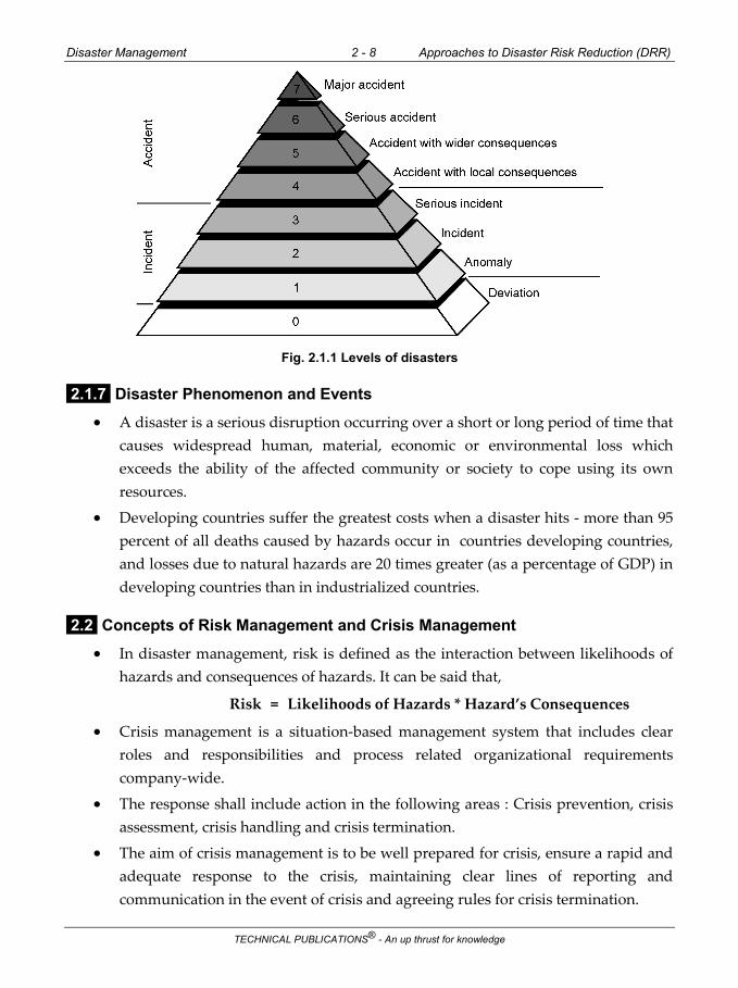
Disaster Management 2 - 8 Approaches to Disaster Risk Reduction (DRR)
TECHNICAL PUBLICATIONS® - An up thrust for knowledge
Fig. 2.1.1 Levels of disasters
2.1.7 Disaster Phenomenon and Events
A disaster is a serious disruption occurring over a short or long period of time that causes widespread human, material, economic or environmental loss which exceeds the ability of the affected community or society to cope using its own resources.
Developing countries suffer the greatest costs when a disaster hits - more than 95 percent of all deaths caused by hazards occur in countries developing countries, and losses due to natural hazards are 20 times greater (as a percentage of GDP) in developing countries than in industrialized countries.
2.2 Concepts of Risk Management and Crisis Management
In disaster management, risk is defined as the interaction between likelihoods of hazards and consequences of hazards. It can be said that,
Risk = Likelihoods of Hazards * Hazard’s Consequences
Crisis management is a situation-based management system that includes clear roles and responsibilities and process related organizational requirements company-wide.
The response shall include action in the following areas : Crisis prevention, crisis assessment, crisis handling and crisis termination.
The aim of crisis management is to be well prepared for crisis, ensure a rapid and adequate response to the crisis, maintaining clear lines of reporting and communication in the event of crisis and agreeing rules for crisis termination.

Disaster Management 2 - 9 Approaches to Disaster Risk Reduction (DRR)
TECHNICAL PUBLICATIONS® - An up thrust for knowledge
The techniques of crisis management include a number of consequent steps from the understanding of the influence of the crisis on the corporation to preventing, alleviating, and overcoming the different types of crisis.
Crisis management consists of different aspects including :
Methods used to respond to both the reality and perception of crisis.
Establishing metrics to define what scenarios constitute a crisis and should consequently trigger the necessary response mechanisms.
Communication that occurs within the response phase of emergency-management scenarios.
Crisis-management methods of a business or an organization are called a crisis-management plan.
A crises mindset requires the ability to think of the worst-case scenario while simultaneously suggesting numerous solutions.
Trial and error is an accepted discipline, as the first line of defense might not work. It is necessary to maintain a list of contingency plans and to be always on alert.
Organizations and individuals should always be prepared with a rapid response plan to emergencies which would require analysis, drills and exercises.
The credibility and reputation of organizations is heavily influenced by the perception of their responses during crisis situations.
The organization and communication involved in responding to a crisis in a timely fashion makes for a challenge in businesses.
There must be open and consistent communication throughout the hierarchy to contribute to a successful crisis-communication process.
The related terms emergency management and business continuity management focus respectively on the prompt but short lived "first aid" type of response (e.g. putting the fire out) and the longer-term recovery and restoration phases (e.g. moving operations to another site).
Crisis is also a facet of risk management, although it is probably untrue to say that crisis management represents a failure of risk management, since it will never be possible to totally mitigate the chances of catastrophes' occurring.
During the crisis management process, it is important to identify types of crises in that different crises necessitate the use of different crisis management strategies. Potential crises are enormous, but crises can be clustered.

Disaster Management 2 - 10 Approaches to Disaster Risk Reduction (DRR)
TECHNICAL PUBLICATIONS® - An up thrust for knowledge
2.2.1 Types of Crisis
Lerbinger categorized eight types of crises,
1. Natural disaster 2. Technological crisis
3. Confrontation 4. Malevolence
5. Organizational misdeeds 6. Workplace violence
7. Rumours 8. Terrorist attacks/man-made disasters.
A) Natural Disaster
Natural disaster related crises, typically natural disasters, are such environmental phenomena as earthquakes, volcanic eruptions, tornadoes and hurricanes, floods, landslides, tsunamis, storms, and droughts that threaten life, property, and the environment itself.
Example : 2004 Indian Ocean earthquake (Tsunami)
B) Technological Crisis
Technological crises are caused by human application of science and technology. Technological accidents inevitably occur when technology becomes complex and coupled and something goes wrong in the system as a whole (Technological breakdowns).
Some technological crises occur when human error causes disruptions (Human breakdowns).
People tend to assign blame for a technological disaster because technology is subject to human manipulation whereas they do not hold anyone responsible for natural disaster.
When an accident creates significant environmental damage, the crisis is categorized as mega damage.
Samples include software failures, industrial accidents, and oil spills.
Examples : Chernobyl disaster, Exxon Valdez oil spill, Heartbleed security bug.
C) Confrontation Crisis
Confrontation crisis occur when discontented individuals and/or groups fight businesses, government, and various interest groups to win acceptance of their demands and expectations.

Disaster Management 2 - 11 Approaches to Disaster Risk Reduction (DRR)
TECHNICAL PUBLICATIONS® - An up thrust for knowledge
The common type of confrontation crisis is boycotts, and other types are picketing, sit-ins, ultimatums to those in authority, blockade or occupation of buildings, and resisting or disobeying police.
Example : Rainbow/PUSH’s (People United to Serve Humanity) boycott of Nike
D) Crisis of Malevolence
An organization faces a crisis of malevolence when opponents or miscreant individuals use criminal means or other extreme tactics for the purpose of expressing hostility or anger toward, or seeking gain from, a company, country, or economic system, perhaps with the aim of destabilizing or destroying it.
Sample crisis include product tampering, kidnapping, malicious rumors, terrorism, cybercrime and espionage.
Example : 1982 Chicago Tylenol murders.
E) Crisis of Organizational Misdeeds
Crises occur when management takes actions it knows will harm or place stakeholders at risk for harm without adequate precautions.
Lerbinger specified three different types of crises of organizational misdeeds : crises of skewed management values, crises of deception, and crises of management misconduct.
F) Crises of Skewed Management Values
Crises of skewed management values are caused when managers favor short-term economic gain and neglect broader social values and stakeholders other than investors.
This state of lopsided values is rooted in the classical business creed that focuses on the interests of stockholders and tends to disregard the interests of its other stakeholders such as customers, employees, and the community.
It has three stages-precise - acute - chronic and conflict resolution.
G) Crisis of Deception
Crisis of deception occur when management conceals or misrepresents information about itself and its products in its dealing with consumers and others.
Example : Dow Corning’s silicone-gel breast implant
Crisis of management misconduct
Some crises are caused not only by skewed values and deception but deliberate amorality and illegality.

Disaster Management 2 - 12 Approaches to Disaster Risk Reduction (DRR)
TECHNICAL PUBLICATIONS® - An up thrust for knowledge
H) Workplace Violence
Crises occur when an employee or former employee commits violence against other employees on organizational grounds.
I) Rumors
False information about an organization or its products creates crises hurting the organization's reputation.
Sample is linking the organization to radical groups or stories that their products are contaminated.
Example : Procter & Gamble logo myth.
J) Risk Management
When a hazard event (such as a drought, flood, cyclone, earthquake or tsunami - among others) occurs, triggering a loss of life and damage to infrastructure, it highlights the reality that society and its assets are vulnerable to such events. When discussing disaster risk management, a disaster can highlight the following in a community :
The geographical area where the community is settled is exposed to such a hazard;
The society (including individuals) and its infrastructure, assets and other processes - as well as services which may have experienced damage or destruction - are vulnerable.
2.2.2 Definitions and Terminology
A) Hazard
Hazard is defined as “a process, phenomenon or human activity that may cause loss of life, injury or other health impacts, property damage, social and economic disruption or environmental degradation”.
Hazards may be single, sequential or combined in their origin and effects. Each hazard is characterized by its "location, intensity or magnitude, frequency, and probability".
B) Exposure
Exposure is defined as “the situation of people, infrastructure, housing, production capacities and other tangible human assets located in hazard-prone areas”.

Disaster Management 2 - 13 Approaches to Disaster Risk Reduction (DRR)
TECHNICAL PUBLICATIONS® - An up thrust for knowledge
As stated in the UNIDRR glossary, “measures of exposure can include the number of people or types of assets in an area.
These can be combined with the specific vulnerability and capacity of the exposed elements to any particular hazard to estimate the quantitative risks associated with that hazard in the area of interest”.
C) Vulnerability
Vulnerability is defined as “the conditions determined by physical, social, economic and environmental factors or processes which increase the susceptibility of an individual, a community, assets or systems to the impacts of hazards”.
Examples include, but are not limited to; poor design and construction of buildings, inadequate protection of assets, lack of public information and awareness, high levels of poverty and education, limited official recognition of risks and preparedness measures, disregard for wise environmental management or weak institutions, and governance (e.g. including corruption etc.).
D) Disaster Risk Reduction
Disaster risk reduction "is aimed at preventing new and reducing existing disaster risk and managing residual risk, all of which contribute to strengthening resilience and therefore to the achievement of sustainable development".
The UNDRR definition further annotates that “disaster risk reduction is the policy objective of disaster risk management, and its goals and objectives are defined in disaster risk reduction strategies and plans".
Disaster risk reduction strategies and policies define goals and objectives across different timescales, with concrete targets, indicators and time frames.
E) Disaster Risk Management
Disaster risk management is the application of disaster risk reduction policies and strategies, to prevent new disaster risks, reduce existing disaster risks, and manage residual risks, contributing to the strengthening of resilience and reduction of losses.
Disaster risk management actions can be categorized into; prospective disaster risk management, corrective disaster risk management and compensatory disaster risk management.

Disaster Management 2 - 14 Approaches to Disaster Risk Reduction (DRR)
TECHNICAL PUBLICATIONS® - An up thrust for knowledge
2.3 Disaster Management Cycle - Phases
1. Prevention : Activities aimed at trying to prevent future disasters occurring, such
as building dykes or a dam to control flooding.
2. Mitigation : Activities aimed at trying to mitigate the impact of a disaster if
prevention is not possible, such as building schools to be more earthquake
resistant.
3. Preparedness : Activities aimed at trying to prepare communities for a disaster,
such as emergency drills or pre-stocking relief items in logistic hubs.
4. Disaster : An event that causes significant damage to people, property and
infrastructure.
5. Response : Activities aimed at understanding needs and responding to them,
including rapid assessments, provision of food and non-food items, provision of
water, sanitation and hygiene services, and health and shelter interventions.
In the immediate hours and days after a disaster, when search-and-rescue
activities are critical, it is most often local actors who are first to respond.
Information is often patchy and confused; there can be significant damage to
infrastructure, and large movements of people.
6. Recovery : Activities aimed at trying to return communities to normal life, such as
livelihoods development or formal education.
Recovery activities can start when the disaster has stabilized, and the affected
population has access to food and water and some form of transitional shelter.
This stage is sometimes divided into two : early recovery and medium-term
recovery.
7. Reconstruction : Activities aimed at rebuilding infrastructure and housing. This
can often take years and many activities may also blend back into mitigation, such
as retrofitting schools to make them more earthquake resistant.
Disaster risk management includes sum total of all activities, programs and measures which can be taken up before, during and after a disaster with the purpose to avoid a disaster, reduce its impact or recover from its losses.

Disaster Management 2 - 15 Approaches to Disaster Risk Reduction (DRR)
TECHNICAL PUBLICATIONS® - An up thrust for knowledge
The three key stages of activities that are taken up within disaster risk management are as follows :
1. Before a Disaster (Pre-disaster)
Pre-disaster activities those which are taken to reduce human and property
losses caused by a potential hazard.
For example, carrying out awareness campaigns, strengthening the existing
weak structures, preparation of the disaster management plans at household
and community level, etc.
Such risk reduction measures taken under this stage are termed as mitigation
and preparedness activities.
2. During a Disaster (Disaster Occurrence)
These include initiatiaves taken to ensure that the needs and provisions of
victims are met and suffering is minimized.
Activities taken under this stage are called emergency response activities.
3. After a Disaster (Post-Disaster)
There are initiatives taken in response to a disaster with a purpose to achieve
early recovery and rehabilitation of affected communities, immediately after a
disaster strikes.
These are called as response and recovery activities.
The Disaster Risk Management Cycle Diagram (DRMC) highlights the range
of initiatives which normally occur during both the Emergency response and
Recovery stages of a disaster.
Some of these cut across both stages (such things as coordination and the
provision of ongoing assistance); whilst other activities are unique to each
stage (e.g. Early warning and evacuation during emergency response; and
reconstruction and economic and social recovery as part of recovery).

Disaster Management 2 - 16 Approaches to Disaster Risk Reduction (DRR)
TECHNICAL PUBLICATIONS® - An up thrust for knowledge
Fig. 2.3.1 Disaster management cycle
It is an ongoing process by which governments, civil (and military) society plan for and reduce the impact of disasters, react during and immediately following a disaster, and take steps to recover after a disaster has occurred.
There are variations to the cycle but the most common version is the four phases of disaster cycle :
Mitigation involves implementing measures for preventing future threat of disaster and/or minimizing their damaging effects of unavoidable threat.
It requires hazard risk analysis and the application of strategies to reduce the likelihood that hazards will become disasters, such as flood-proofing homes or having flood/fire insurance, following safety standards of building materials and appliances.
This phase (and the whole cycle disaster management cycle), includes the shaping of public policies and plans that either modify the causes of disasters or mitigate their effects on people, property, and infrastructure.
Mitigation refers to measures that reduce the chance of an emergency happening, or reduce the damaging effects of unavoidable emergencies.

Disaster Management 2 - 17 Approaches to Disaster Risk Reduction (DRR)
TECHNICAL PUBLICATIONS® - An up thrust for knowledge
This is achieved through risk analysis, which results in information that provides a foundation for typical mitigation measures include establishing building codes, zoning requirements, and constructing barriers such as levees.
Effective mitigation efforts can break the cycle of disaster damage, reconstruction, and repeated damage.
It creates safer communities by reducing loss of life and property damage.
For example, the rigorous building standards adopted by 20,000 communities across the country are saving the nation more than $1.1 billion a year in prevented flood damages.
It allows individuals to minimize post-flood disaster disruptions and recover more rapidly.
For example, homes built to NFIP standards incur less damage from floods.
And when floods do cause damages, flood insurance protects the homeowner’s investment, and lessens the financial impact on individuals, communities, and society as a whole.
For example, a recent study by the Multi-hazard Mitigation Council shows that each dollar spent on mitigation saves society an average of four dollars.
2.3.1 Disaster Response
Disaster response work includes any actions taken in the midst of or immediately following an emergency, including efforts to save lives and to prevent further property damage.
Ideally, disaster response involves putting already established disaster preparedness plans into motion. It’s what the public typically thinks of when imagining a disaster : Flashing lights, evacuation, search and rescue and sheltering victims.
Healthcare and psychosocial intervention response starts here. The focus in the response phase is on meeting the basic needs of the victims until sustainable community has been achieved.
This phase may still continue even when recovery phase can already be started.
A well-rehearsed emergency plan developed as part of the preparedness phase enables efficient coordination of resources.
Response actions carried out immediately before, during, and after a hazard impact are aimed at saving lives, reducing economic losses, and alleviating suffering.

Disaster Management 2 - 18 Approaches to Disaster Risk Reduction (DRR)
TECHNICAL PUBLICATIONS® - An up thrust for knowledge
The response phase includes the mobilization of the necessary emergency services and first responders in the disaster area.
This is likely to include a first wave of core emergency services, such as firefighters, police and ambulance crews. Response actions may include activating the Emergency Operations Center (EOC), evacuating threatened populations, opening shelters and providing mass care, emergency rescue and medical care, firefighting, and urban search and rescue.
Response begins when an emergency event is imminent or immediately after an event occurs.
Response encompasses the activities that address the short-term, direct effects of an incident.
Response also includes the execution of the Emergency Operations Plan and of incident mitigation activities designed to limit the loss of life, personal injury, property damage, and unfavorable outcomes.
As indicated by the situation, response activities include :
Applying intelligence and other information to lessen the effects or consequences of an incident.
Increasing security operations.
Continuing investigations into the nature and source of the threat.
Ongoing public health and agricultural surveillance and testing processes, immunizations, isolation, or quarantine.
Specific law enforcement operations aimed at preempting, interdicting, or disrupting illegal activity, and apprehending actual perpetrators and bringing them to justice.
Restoring critical infrastructure (e.g., utilities).
Ensuring continuity of critical services (e.g., law enforcement, public works).
2.4 Culture of Safety
Major accidents are frequently traced to failures in the safety management system, and investigations sometimes reveal that safety management systems bear little relation to what goes on at the workplace.
Safety management systems virtually exist in theory and not in practice.

Disaster Management 2 - 19 Approaches to Disaster Risk Reduction (DRR)
TECHNICAL PUBLICATIONS® - An up thrust for knowledge
For a number of years, safety professionals, regulators and others have argued that safety is not simply a matter of compliance with externally imposed regulations.
The organizations need to manage safety proactively in the same way as the organization to manage their production activities.
Hence, a cultural approach to enhancing the safety of organizations is now receiving attention.
The cultural approach to safety means that safety cannot be assured simply by introducing a safety management system alone.
The cultural approach to safety is something to bring safety management to life. This means that the right organizational culture is necessary to make safety systems work.
When talking about organizational culture, organizational behaviour and, hence, some relevant organizational factors will come into play.
Organizational Citizenship Behaviour indicates that such behaviour is critical for organizational effectiveness, but little theoretical work details how it might contribute to enhance organizational functioning of safety.
It is suggested that citizenship behaviours enhance the functioning of the organization by contributing to the development of safety climate; collective mindfulness and risk awareness for the creation of organizational behaviour of safety.
Organizational Citizenship Behaviours (OCB) can be defined that employee behaviours that go beyond role requirements, that are not directly or explicitly recognized by the formal reward system, and that facilitate organizational functioning
Citizenship behaviours typically stem from positive job attitudes, task characteristics, and leadership behaviours.
Thus prior research indicates that individuals are most likely to go beyond their formal job requirements when they are satisfied with their jobs or committed to their organizations, when they are given intrinsically satisfying tasks to complete, and /or when they have supportive or inspirational leaders.
In 1991 Graham proposed a conceptualization of organizational citizenship grounded in political philosophy and modern political theory.
Disaster Management 2 - 20 Approaches to Disaster Risk Reduction (DRR)
TECHNICAL PUBLICATIONS® - An up thrust for knowledge
There are three forms of organizational citizenship.
Obedience describes employees’ willingness to accept and abide by the organization’s rules, regulations, and procedures.
Loyalty describes the willingness of employees to subordinate their personal interests for the benefit of the organization and to promote and defend the organization.
Finally, Participation describes the willingness of employees to be actively involved in all aspects of organizational life.
Social participation actually takes three forms. Social participation describes employees’ active involvement in company affairs (e.g., keeping up with organizational issues or attending non-mandatory meetings) and participation in social activities within the organization.
Advocacy participation describes the willingness of employees to be controversial in order to improver the organization by making suggestions, innovating, and encouraging other employees to speak up.
Functional participation describes employee contributions that exceed required work standards (e.g., volunteering to take on extra assignments, working late to finish important projects, or pursuing additional training and staying abreast of new developments).
2.4.1 Three Aspects of Safety Culture
The model consists of : psychological aspects, behavioural aspects and situational aspects of the safety culture.
The behavioural aspect is concerned with “what people do” within the organization which includes the safety-related activities, actions and behaviours exhibited by employees.
Situational aspects describe, “what the organization has for its policies, operating procedures, management systems, control systems, communication flows and workflow systems”.
The psychological aspects can be described as how employees see and feel their organization in the aspect of safety. This aspect is concerned with individual and group values, attitudes and perception.

Disaster Management 2 - 21 Approaches to Disaster Risk Reduction (DRR)
TECHNICAL PUBLICATIONS® - An up thrust for knowledge
Safety climate
Psychological climate has been defined as referring to individuals cognitively based descriptions of situational characteristics.
Psychological climate as an experiential-based, multidimensional, and enduring perceptual phenomenon which is widely shared by the members of a given organizational unit.
Psychological climate, is the intervening psychological process whereby the individual translates the interaction between the perceived organizational attributes and individual characteristics into a set of expectancies, attitudes and behaviours.
Risk management
The second element in Cooper’s model is on situation aspects.
The situation aspects described by Cooper as “what the organization has” in respects of policies, procedures, regulation and the management.
Apart from the documents and procedures that a highly reliable organization should have collective mindfulness of danger.
The collective mindfulness is a characteristic of the organization where employees will organize themselves in such a way that they are better able to notice the unexpected in the making and halt its development.
They also advocate that mindfulness organizations should have a commitment to resilience by which organizations are not disabled by errors or crises.
Risk awareness
Cooper defines behaviour aspects are concerned with “what people do” within the organization, which includes the safety related activities, action and behaviours exhibited by employees.
The rationale for encourage risk awareness among employees is that it is impossible to devising a set of safety rules to cover every situations.
The rules are essential but it can never be complete bring us to something of an impasse and he continues that one way to move beyond this impasse is to abandon the idea where a set of rules can ever be determined once and for all and to recognize that a regime of rules is necessarily a dynamic one which needs to be managed.

Disaster Management 2 - 22 Approaches to Disaster Risk Reduction (DRR)
TECHNICAL PUBLICATIONS® - An up thrust for knowledge
Organizational Commitment
The definition of organizational commitment is that it is the worker’s attitudes about the entire work organization.
The concept of organizational commitment has been taken to imply worker attitudes and the concept of Organizational Citizenship Behaviours (OCB) refers to commitment-related behaviors.
Organizational commitment views it as composed of three dimensions :
o Affective commitment, which is the employee’s emotional attachment to the organization;
o Continuance commitment, which refers to commitment to continue with the organization because there are costs associating with leaving; and
o Normative commitment, which is like a sense of duty or obligation to stay with the company.
Fig. 2.4.1 Model of the organizational culture of safety
2.5 Prevention, Mitigation and Preparedness Community Based DRR
Communities are the first responders in case of a disaster.
Therefore, Community-Based Disaster Risk Reduction (CBDRR) should be the core of any risk reduction approach.
Disaster risk reduction focuses more on reducing underlying risk, encouraging preventive action before a disaster.
Disaster risk management, in contrast, focuses on broader aspects of disaster issues, from prevention and mitigation to relief, response, and recovery.
Community-Based Disaster Risk Management (CBDRM) is an approach that reduces vulnerabilities and strengthens people’s capacity to cope with hazards, which seeks to : 1) Reduce vulnerabilities and increase capacities of vulnerable groups and
communities to cope with, prevent, or minimize loss and damage to life, property, and the environment,
2) Minimize human suffering, and 3) Hasten recovery.

Disaster Management 2 - 23 Approaches to Disaster Risk Reduction (DRR)
TECHNICAL PUBLICATIONS® - An up thrust for knowledge
Based on past disasters, it has been found that communities become actively involved in search and rescue, relief, and post-disaster recovery.
To enhance community participation before a disaster strikes, it is important to focus on risk reduction issues, and therefore CBDRR has become increasingly emphasized.
CBDRR emerged as a result of a shift from reactive emergency management to disaster risk reduction.
It focuses more on pre-disaster interventions such as prevention, mitigation, and preparedness-related activities.
For instance, prevention measures aim to avoid the occurrence of disasters, which may not be possible in the case of natural disasters, but the intensity and frequency of disasters could be reduced through poverty alleviation and asset redistribution plans and the provision of basic services such as education and health care.
Mitigation measures reduce and limit the impact of natural hazards on elements of risk such as population, infrastructure, and properties through structural measures such as bridges, protective dikes, embankments, and safety building design and nonstructural measures like community risk assessment, community risk reduction planning, public awareness, food security programs, group saving, cooperatives, strengthening community disaster management organizations and advocacy on disasters and development issues, legislation, and land use zoning, among others.
The disaster mitigation is intrinsic to sustainable development.
Preparedness measures are developed in anticipation of future disasters so that effective and appropriate actions are taken during emergencies, including public awareness, evacuation, and emergency management, search and rescue, immediate repair, restoration of critical facilities and utilities, capacity assessment, non-food relief assistance, and evacuation center management.
The key elements and features of CBDRR or CBDM explain the core of community-based approaches for disaster risk reduction and movement.
People’s participation is important : Community members are the main actors, involved not only in the process but its content.
They share the benefit or gain through improved disaster risk reduction and development.

Disaster Management 2 - 24 Approaches to Disaster Risk Reduction (DRR)
TECHNICAL PUBLICATIONS® - An up thrust for knowledge
Ultimately, this will lead to safer conditions, security of livelihood, and sustainable development.
Priorities are set for the most vulnerable groups, families, and people in the community : Participation from all sectors is required for disaster risk reduction, but priority is given to the most vulnerable groups, in urban areas the poor or informal settlers, in rural areas farmers, and indigenous people.
The most vulnerable also include the elderly, the differently abled, children, and women.
Risk reduction measures are community-specific : Measures provided for risk reduction are mainly community-specific, which are identified after an analysis of the community’s disaster risk (hazards, vulnerabilities, and capacities and perceptions of disaster risk).
Existing capacities and coping mechanism are recognized : The strength of CBDRR lies in the existing capacities and coping mechanism of the community members.
They often lack material assets but rely heavily on their traditional wisdom, local knowledge and resources, social organizations, shared values, cooperative coping mechanisms, close family ties, and perseverance and resourcefulness.
Disaster risk reduction is linked with development : The aim of CBDRR is to reduce people’s vulnerabilities by strengthening the capacities of individuals, families, and communities.
It addresses vulnerabilities and the core factors behind it, such as poverty, social inequalities, and environmental resource depletion and degradation.
Ultimately, the idea is to develop a people-centered development as well as equitable and sustainable development. The goal is to build a resilient community.
Outsiders have supporting and facilitating roles : In CBDRR, Non Governmental Organizations (NGOs) support community members, whereas the government role is integral to the institutionalization of the CBDRR process. Partnerships with less vulnerable groups and other communities are forged in the interest of disaster risk reduction.
Community-based approaches can be defined as “an umbrella term for approaches to programming which involve beneficiaries in their identification, design, or management. It also refers to a set of approaches, applied within community-level projects or as part of national programs”.

Disaster Management 2 - 25 Approaches to Disaster Risk Reduction (DRR)
TECHNICAL PUBLICATIONS® - An up thrust for knowledge
The degree of community participation varies along a spectrum from consultation with communities to devolution of resources, decision-making, and implementation at the community level.
In the field of development planning, defined eight levels of community participation to demonstrate the quality of participation to aspire to and work for.
These involve “the redistribution of power that enables the have-not citizens, presently excluded from the political and economic processes, to be deliberately included in the future”.
2.6 Structural and Nonstructural Measures
Structural measures :
Any physical construction to reduce or avoid possible impacts of hazards, or application of engineering techniques to achieve hazard-resistance and resilience in structures or systems;
Non-structural measures :
Any measure not involving physical construction that uses knowledge, practice or agreement to reduce risks and impacts, in particular through policies and laws, public awareness raising, training and education.
Common structural measures for disaster risk reduction include dams, flood levies, ocean wave barriers, earthquake-resistant construction, and evacuation shelters.
Common non-structural measures include building codes, land use planning laws and their enforcement, research and assessment, information resources, and public awareness programmes.
In civil and structural engineering, the term “structural” is used in a more restricted sense to mean just the load-bearing structure, with other parts such as wall cladding and interior fittings being termed non-structural.
2.7 Roles and Responsibilities of Community
2.7.1 Concept of Community
Originally the word ‘community’ was used to refer to the common people. It is said that ‘the quality of having something in common’ to ‘a sense of common identity and characteristics’ underlie a community.

Disaster Management 2 - 26 Approaches to Disaster Risk Reduction (DRR)
TECHNICAL PUBLICATIONS® - An up thrust for knowledge
According to Allen, ‘community’ is a common group of people who live within the territorial or administrative boundary of village or town. The identity of a community depends on social events and institution.
In disaster management community has been defined as a group of individuals and households living at the same location and having the same exposure to hazard, and share the same objectives and goals towards disaster risk reduction.
Blaikie et al. say that ‘community’ is not homogenous. Hence it is suggested that the community and potential disaster risks must be understood through community structure (social, political, economic, historical), ethnicity (culture, belief structure, social relationship, social networks, socio-economic dynamics), and ‘community decision making processes’. Response of members of community also varies as per their ethnicity, gender, educational level, and socio-economic status.
2.7.2 Disaster Vulnerability in CBDM
Though poor people tend to be most vulnerable to disasters, vulnerability is not because of poverty only.
Vulnerability is the characteristics of a person or a group in terms of their capacities to anticipate, to resist and to recover from the impact of disasters.
It can be understood in terms of the economic status, social discrimination, and individual vulnerability. ‘Being vulnerable’ is ‘being prone to suffer’.
The daily life of a large number of Asians is not different from the living conditions of those hit by disaster because they hardly have any freedom of choice regarding where and how to live.
However, all households in a community or all communities are not equally vulnerable during flood studied the cyclone and reconstruction in Andhra Pradesh.
He found that though the economic value of loss of a poor family is less than a rich family, the impact of the loss is different.
The impacts of disaster depend on capacity and adaptability with the extreme event.
The study on coastal region of West Bengal showed that if saline water pollutes agricultural land, only farmers suffer because salt water intrusion into field destroys their main livelihood.

Disaster Management 2 - 27 Approaches to Disaster Risk Reduction (DRR)
TECHNICAL PUBLICATIONS® - An up thrust for knowledge
But the studies on floods in Bangladesh have shown that Bangladeshi farmers look for floods every three to four years, the flood water carries huge amount of silt which increases soil fertility.
It is also found that most of the vulnerable people do not receive early warning before the disaster. As a result, higher numbers of people suffer from destruction and loss.
Few researchers argue that evacuation orders do not help among vulnerable communities, because they are highly attached to their material and economic resources.
The study on floods in Texas, USA showed that physical loss and destruction is quite higher among the Afro-Americans than American.
It is because of geographical location, low access of political power, and less economic strength.
2.7.3 Community Needs
The disaster impact reduction depends on individual or family needs which are directly influenced by coping strategies and social structures. So, the needs vary with time.
The needs of Andhra Pradesh Cyclone affected people were not met, even many years after the disaster.
Bolin and Stanford studied the accessibility of post-earthquake relief and recovery at Fillamore and Piru.
They found that though government had spent billions of dollars, the needs of the community were not met.
The needs remained unmet because of inadequacy of materials, as well as socio-economic and political vulnerability.
It was also found that the needs of socio-economic and politically vulnerable community were not effectively assessed and addressed by government agencies.
In this case factors affecting the vulnerability of the affected people include immigration issues, dependency on daily wage, job uncertainty, language, race, and ethnicity.
Bolin and Stanford also pointed out those existing needs of vulnerable community increase due to the impacts of hazard.

Disaster Management 2 - 28 Approaches to Disaster Risk Reduction (DRR)
TECHNICAL PUBLICATIONS® - An up thrust for knowledge
If the existing and increased needs are not met by them and the agencies then, it would increase community’s vulnerability and would create trouble in everyday life.
The unmet needs are not only because of social vulnerability, but it is also a result of noncooperation and lack of coordination among different layers of resource supply agencies.
2.7.4 Community Participation
In the late 20th century, it was realized that top-down disaster management efforts are insufficient to reduce the impact and do not touch the bottom level communities.
The government’s developmental programmes remained insensitive and ineffective in satisfying community needs.
It was also found that the lack of involvement of communities in government planning created an attitude of dependency on the government.
Unless there is direct involvement of community in government decision making process, the existing resources, the local needs, and the local knowledge to reduce the impact of disaster cannot be understood.
The bottom-up, community based approach has given opportunities to the community to participate and share their efforts for reducing the impact of disaster.
The communities at the grass-roots level suffer during every disaster and they respond to it based on their experience and knowledge before any outside help.
The survival strategies of local community members are combination of knowledge and real world experience.
Recently, in this regard, local ways of flood risk management of coastal Asia, traditional drought management mechanism in Sub-Saharan Africa, traditional paddy and aquaculture in Bangladesh and many others activities have been highlighted by the researchers.
They indicate that disaster impacts can also be reduced by relying on local knowledge of disaster management. The traditional knowledge is developed in every local context to deal with the phenomenon of disasters, but it is very difficult to generalize this for a wider context.
Technocratic solutions for disaster management are often put forth by non-local experts who reject local perception and knowledge towards disaster management.

Disaster Management 2 - 29 Approaches to Disaster Risk Reduction (DRR)
TECHNICAL PUBLICATIONS® - An up thrust for knowledge
As a result, local community members find very less space for participating in disaster management.
Researchers working on disaster management in South-East Asian countries found that traditional mechanisms to reduce the disaster impact is becoming insufficient to deal with the situations and they suggest following a structural as well as non- structural approach for dealing with it.
According to Tigg, community participation is the active involvement of the people in decision making about the implementation process, programs, and projects which affects them.
Researchers have found that dominant decision making processes dominated by dominant sections do not give space to socio-economically deprived section.
Blaikie et al. also argued that communities at the grass-roots level are unable to share their challenges with the government. So, participatory mechanism could be a way of sharing their knowledge and related to disaster management challenges.
Arnstein defined community participation as ‘the redistribution of power that enables the have-not citizens, presently excluded from political and economic processes to be deliberately included in the future’.
Arnstein developed eight levels of community involvement in formal decision making (see Table 2.7.1). These levels can be explained in details as below :
Levels of non-participation : This level consists of the two bottom rungs of the ladder : 1) Manipulation and 2) Therapy.
The objective of this is not to enable people to participate in planning and decision making, but to enable power holders to ‘educate’ the participants.
Levels of tokenism : This level consist of three rungs : 3) Informing, 4) Consultation, and 5) Placation.
The rungs 3 and 4 (informing and consultation) allow ‘have-not’ to be hear but not to speak. ‘Placation’ is a higher level of tokenism, where ground rules allow ‘have not’ to advice in decision making. But power holders have right to decide, whether the advice should be accepted or not.

Disaster Management 2 - 30 Approaches to Disaster Risk Reduction (DRR)
TECHNICAL PUBLICATIONS® - An up thrust for knowledge
Level of citizen power : These citizens have power to participate in decision making. This level consist of (6) Partnership, (7) Delegated Power, and (8) Citizen Control.
Levels Rungs
Level 1 : Levels of Non-participation i. Manipulation
ii. Therapy
Level 2 : Levels of Tokenism i. Informing
ii. Consultation
iii. Placation
Level 3 : Level of Citizen Power i. Partnership
ii. Delegated Power
iii. Citizen Control
Table 2.7.1 Ladder of citizen`s participation
2.8 Panchayati Raj Institutions/Urban Local Bodies (PRIs/ULBs)
As Local Government in Disaster Management In India, after the 73rd Constitution Amendment Act, the Panchayati Raj Institutions (PRIs) have become an opportunity and instrument for people from the grassroots level to directly join in the decentralized decision making processes.
PRIs provide a platform to discuss local developmental problems and community needs, and PRIs are also able to mobilize people and resources to meet the needs of the community.
Prasad studied ‘community approach to flood management’ with support from World Meteorological Organization (WMO) in Assam, West Bengal, and Bihar.
He found that ‘Gram Panchayats’ are known as community based organization.
According to him West Bengal has the longest experience of functioning of three tiers Panchayati Raj Institutions and the structure has been working for flood disaster management.
He also found that few gram panchayats had good communication with local officers, doctors, and NGOs for disaster management.
Rai studied the efforts of drought affected Karunga Gram Panchayat of Okha Mandal Taluka in Gujarat.

Disaster Management 2 - 31 Approaches to Disaster Risk Reduction (DRR)
TECHNICAL PUBLICATIONS® - An up thrust for knowledge
They found that PRIs and community had successfully taken efforts to supply drinking water during drought.
The collaboration and coordination among the Gram Panchayat, Tata Chemical Company and villagers for supplying drinking water effectively met the basic needs during drought.
An important workshop was organized by Basin-South Asia, in 2005 where Gram-Panchayat members from different parts of India discussed the importance and responsibilities of PRIs in Disaster Management.
The main focus of the workshop was on post-disaster reconstruction and rehabilitation.
The representatives from Bihar, Maharashtra, and Kerala shared their experience in different dimensions of disasters management at the panchayat level.
The most important finding of this workshop was the importance given to capacity building of communities and implementing community based disaster mitigation measure.
According to Basin-South Asia, PRIs are located at the best place to motivate people to get involved in disaster mitigation process.
It was also recognized that people’s participation and involvement in Gram Sansad Sabha help to identify the vulnerable community and potential disaster and its preparedness.
Though PRIs are working for local level developmental planning, many time voices of villagers have not been recognized.
As a result, the disaster management efforts of PRIs are transformed into mere partisan political activities.
Though Gram Sansad Sabha and PRIs are often politicized, the Gram Panchayat member who belongs to the village has reciprocity with the villagers.
There is an argument that the Gram Panchayat member, from a socially deprived community may not have enough voice in the Gram Panchayat.
But, during Gram Sansad Sabha, the members of community share their needs and problems with PRIs.
As Gram Panchayat member belongs to the village, the existing reciprocity between Gram Panchayat member and the community may lead to PRI decision’s that are favourable to the community.

Disaster Management 2 - 32 Approaches to Disaster Risk Reduction (DRR)
TECHNICAL PUBLICATIONS® - An up thrust for knowledge
Many researchers also argue that vulnerable people in the community do not participate in Gram Sansad Sabha.
But, if there is a hazard, then everybody is a victim and they share their problems with Gram Panchayat member and PRIs.
2.9 States, Centre and other Stake-Holders - Institutional Processess
and Framework at State and Central Level -
State Disaster Management Authority(SDMA)
A) Indian Constitution and Natural Disasters
Indian Constitution, the Magna Carta of Fundamental Rights for Indians guarantees protection of life and security with the purpose of ensuring a welfare State.
Not only the laws and regulations framed by the Central and State Governments have to be in conformity with the Constitutional provisions, but also the authorities have a duty under the Constitution to safeguard and protect the Fundamental Rights.
The scope and applicability of these Fundamental Rights and the validity of the laws passed by the legislatures and the executive actions of the government are often the subject matter of various decisions by the Supreme Court of India.
B) The Environment Protection Act, 1986
After the Bhopal Gas Leak Tragedy, the Indian Parliament enacted the Environment (Protection) Act (EPA), 1986 for the purpose of safeguarding and protecting the environment from unregulated industrial or other activities. Under the EPA, the central Government is entrusted with responsibility to take all the measures for protecting and improving the quality of the environment and preventing controlling and abating environmental pollution.
It prohibits persons carrying on any industry, operation or process from discharging or emitting any environmental pollutants in excess of prescribed standards.
The EPA imposes obligations on persons handling any hazardous substance to follow prescribed procedure and comply with prescribed safeguards.

Disaster Management 2 - 33 Approaches to Disaster Risk Reduction (DRR)
TECHNICAL PUBLICATIONS® - An up thrust for knowledge
C) Environment Impact Assessment Statement
In the year 1994, a notification was issued by the Central Government under Section 3 of EPA making it mandatory on the part of all new industrial units and those with intent to modernize or expand to submit an Environment Impact Assessment (EIA) Statement for the purpose of obtaining clearance from the Central Government for setting up industrial projects.
D) The ‘Manufacture, Storage and Impact of Hazardous Chemical Rules’, 1989
In the Year 1989, the Central Government framed the “Manufacture, Storage and Import of Hazardous Chemical Rules‟, 1987 under the EPA.
The principal objective of the rules is the prevention of major accidents arising from industrial activity, the limitation of the effects of such accidents both on humans and the environment, and the harmonization of the various control measures and the agencies to prevent and limit major accidents.
E) The Coastal Regulation Zone (CRZ) Notification, 1991.
In the year 1991, with a view to protect the fragile ecosystem of the coastal areas in India from unregulated developmental activities, the Government of India issued Coastal Regulation Zone (CRZ) Notification under the EPA to control the developmental activities within 500 meters of High Tide Line (HTL).
F) The Public Liability Insurance Act, 1991
The parliament also enacted the “Public Liability Insurance Act, 1991‟ to provide for public liability insurance for the purpose of providing immediate relief to the persons affected by accidents occurring while handling hazardous substances.
The Act imposes on the person, who has control over handling any hazardous substance, the liability to give the relief specified in the Act to all the victims of any accident, which occurs while handling such substance.
G) The National Environment Appellate Authority Act, 1997
This Act has been enacted to provide for the establishment of a National Environment Appellate Authority to hear appeals with respect to restriction of areas in which any industries, operations or process or class of industries, shall not be carried out subject to certain safeguards under the EPA.

Disaster Management 2 - 34 Approaches to Disaster Risk Reduction (DRR)
TECHNICAL PUBLICATIONS® - An up thrust for knowledge
H) The Natural Disaster Management Act, 2005
The Disaster Management Act, 2005 seeking for an effective management authorities have been constituted at the National, State and at the District level.
The National Disaster Management Authority (National Authority), which is to be chaired by the Prime Minister of India is entrusted with the responsibilities for laying down the policies on disaster management, and approve plans at the national level for disaster management.
I) National Disaster Management Authority (NDMA)
The NDMA, as the apex body for disaster management, is headed by the Prime Minister and has the responsibility for laying down policies, plans and guidelines for DM and coordinating their enforcement and implementation for ensuring timely and effective response to disasters.
The guidelines will assist the Central ministries, Departments and States to formulate their respective DM plans.
J) National Executive Committee (NEC)
The NEC comprises the Union Home Secretary as Chairperson, and the Secretaries to the Government of India, in the Ministries/Departments of Agriculture, Atomic Energy, defense, Drinking Water Supply, Environment and Forests, Finance (Expenditure), Health, Power, Rural Development, Science & Technology, Space, Telecommunication, Urban Development, Water Resources and the Chief of the Integrated Defence Staff of the Chiefs of Staff Committee members. Secretaries in the Ministry of External Affairs, Earth Sciences, Human Resource Development, Mines, Shipping, Road Transport & Highways, and the Secretary, NDMA will be special invitees to the meetings of the NEC.
K) State Disaster Management Authority (SDMA)
At the State level, the SDMA, headed by the Chief Minister, will lay down policies and plans for DM in the State.
It will, inter alia approve the State Plan in accordance with the guidelines laid down by the NDMA, coordinate the implementation of the State Plan, recommended provision of funds for mitigation and preparedness measures and review the developmental plans of the different Departments of the State to ensure the integration of prevention, preparedness and mitigation measures.

Disaster Management 2 - 35 Approaches to Disaster Risk Reduction (DRR)
TECHNICAL PUBLICATIONS® - An up thrust for knowledge
L) District Disaster Management Authority (DDMA)
The DDMA will be headed by the District Collector, Deputy Commissioner or District Magistrate as the case may be, with the elected representative of the local authority as the Co-Chairperson.
The DDMA will act as the planning, coordinating and implementing body for DM at the District level and take all necessary measures for the purposes of DM in accordance with the guidelines laid down by the NDMA and SDMA.
2.10 Early Warning System
Early Warning
The term 'early warning' is used in many fields to describe the provision of information on an emerging dangerous circumstances where that information canenable action in advance to reduce the risks involved.
Early warning systems exist for natural geophysical and biological hazards, complex socio-political emergencies, industrial hazards, personal health risks and many other related hazards.
An Early Warning System (EWS) can be defined as a set of capacities needed to generate and disseminate timely and meaningful warning information of the possible extreme events or disasters (e.g. floods, drought, fire, earthquake and tsunamis) that threatens people‘s lives.
The purpose of this information is to enable individuals, communities and organizations threatened to prepare and act appropriately and in sufficient time to reduce the possibility of harm, loss or risk.
Elements of Early Warning
Early warning is the integration of four main elements,
Risk Knowledge : Risk assessment provides essential information to set priorities for mitigation and prevention strategies and designing early warning systems.
Monitoring and Predicting : Systems with monitoring and predicting capabilities provide timely estimates of the potential risk faced by communities, economies and the environment.
Disseminating Information : Communication systems are needed for delivering warning messages to the potentially affected locations to alert local and regional governmental agencies. The messages need to be reliable, synthetic and simple to be understood by authorities and public.

Disaster Management 2 - 36 Approaches to Disaster Risk Reduction (DRR)
TECHNICAL PUBLICATIONS® - An up thrust for knowledge
Response : Coordination, good governance and appropriate action plans are a key point in effective early warning. Likewise, public awareness and education are critical aspects of disaster mitigation.
The purpose of early warning systems is to detect, forecast, and when necessary, issue alerts related to impending hazard events.
In order to fulfill a risk reduction function, however, early warning needs to be supported by information about the actual and potential risks that a hazard poses, as well as the measures people can take to prepare for and mitigate its adverse impacts. Early warning information needs to be communicated in people friendly manner in such a way that facilitates decision-making and timely action of response organizations and vulnerable groups. Early warning information comes from different meteorological offices (for weather related disasters-flood, cyclone etc.); Ministries of Health (for example, disease outbreaks) and Agriculture (for example, crop forecasts); local and indigenous sources; media sources and increasingly from Internet early warning services.
Need of Early Warning System
Early Warning for disaster reduction is a legitimate matter of public policy at the highest national levels for two main reasons :
The first one, clearly, is public safety, and the protection of human lives.
The second is the protection of the nation‘s resource base and productive assets (infrastructure and private property or investments) to ensure long term development and economic growth. Conversely, by reducing the impact of disasters, a government avoids the financial and political- burden of massive rehabilitation costs.
Investing in early warning and other measures of disaster reduction is neither simple nor inexpensive, but the benefits of doing so, and the costs of failing to, are considerable. For instance : - In terms of reducing economic losses, early warning and disaster
preparedness ‘pay for themselves‘ many times over the life of the warning system.
- The reduction of environmental losses can, if properly managed and publicized, have both long-term benefits to the economy, and short-term benefits for the administration in-charge.
- A country can strengthen its stature and influence in international relations by a good handling of ‘externalities‘, or indirect effects, on neighboring nations.

Disaster Management 2 - 37 Approaches to Disaster Risk Reduction (DRR)
TECHNICAL PUBLICATIONS® - An up thrust for knowledge
From a public policy viewpoint, early warning, disaster preparedness and prevention must be part of a single, well integrated process.
Communication of Early Warning Information
An effective early warning system needs an effective communication system. Early warning communication systems are made of two main components :
Communication infrastructure hardware that must be reliable and robust, especially during the natural disasters; and
Appropriate and effective interactions among the main actors of the early warning process such as the scientific community, stakeholders, decision makers, the public, and the media.
Many communication tools are currently available for warning dissemination such as Short Message Service (SMS) (cellular phone text messaging), email, radio, TV, and web service. Information and Communication Technology (ICT) is a key element in early warning.
ICT plays an important role in disaster communication and dissemination of information to organizations in charge of responding to warnings and to the public during and after a disaster. Redundancy of communication systems is essential for disaster management, while emergency power supplies and back-up systems are critical in order to avoid the collapse of communication systems after disasters occur.
Community Based Early Warning System
Early warning systems have limitations in terms of saving lives if they are not combined with ‘people-centered’ networks. To be effective, early warning systems must be understandable, trusted by and relevant to the communities that they serve.
Warnings will have little value unless they reach the people most at risk, who need to be trained to respond appropriately to an approaching hazard.
Community-Based Early Warning Systems (CBEWS) are anchored in the communities and managed by the communities.
It is based on a "people-centered" approach that empowers individuals and communities threatened by hazards to act in sufficient time and in an appropriate manner in a bid to reduce the possibility of personal injury, loss of life, damage to property, environment and loss of livelihood.

Disaster Management 2 - 38 Approaches to Disaster Risk Reduction (DRR)
TECHNICAL PUBLICATIONS® - An up thrust for knowledge
It provides communities, practitioners and organizations involved in disaster risk management with advance information of risks that can be readily translated into prevention, preparedness and response actions.
CBEWS helps to reduce economic losses by allowing people to better protect their assets and livelihood. Essential features of community-based early warning systems are : - All community members especially the vulnerable groups should be involved
at all stages of the CBEWS from designing to operating the systems, receiving the warning messages and responding to the warning.
- Measures taken should be based on the needs of everyone in the community including the most vulnerable segments of the community.
The community members will own the process and system.
CBEWS measures will enhance the capacity of the community members to deal with their situation.
Meaningful participation in the decision-making process of EWS.
Early Warning Systems and Policy
For early warning systems to be effective, it is essential that they be integrated into policies for disaster mitigation. Good governance priorities include protecting the public from disasters through the implementation of disaster risk reduction policies.
It is clear that natural phenomena cannot be prevented, but their human, socio-economic and environmental impacts can and should be minimized through appropriate measures, including risk and vulnerability reduction strategies, early warning, and appropriate action plans. Most often, these problems are given attention during or immediately after a disaster. Disaster risk reduction measures require long term plans and early warning should be seen as a strategy to effectively reduce the growing vulnerability of communities and assets.
The information provided by early warning systems enables authorities and institutions at various levels to immediately and effectively respond to a disaster.
It is crucial that local government, local institutions, and communities be involved in the entire policy making process, so they are fully aware and prepared to respond with short and long-term action plans.

Disaster Management 2 - 39 Approaches to Disaster Risk Reduction (DRR)
TECHNICAL PUBLICATIONS® - An up thrust for knowledge
Key Elements for Successful Implementation of Early Warning
Understand the most likely threats, likelihood of disasters and their potential consequences
Although natural disasters are not precisely predictable, they are most often generally foreseeable. In other words, there are many areas where the occurrence of floods is likely; one does not necessarily know exactly when, but one knows they will occur sooner or later. Many natural hazards can be foreseen, or anticipated, from past experience, the analysis of current patterns of land use, or population distribution.
Establish proper priorities.
Fire
The Government of India in 1956, formed a “Standing Fire Advisory Committee” under the Ministry of Home Affairs.
The mandate of the committee was to examine the technical problems Institutional Framework relating to Fire Services and to advise the Government of India for speedy development and upgradation of Fire Services all over the country.
This committee had representation from each State Fire Services, as well as the representation from Ministry of Home, Defence, Transport, Communication and Bureau of Indian Standards.
This Committee was renamed as “Standing Fire Advisory Council” (SFAC) during the year 1980.
Epidemics
The Ministry of Health and Family Welfare is instrumental and responsible for implementation of various programmes on a national scale in the areas of prevention and control of major communicable diseases and promotion of traditional and indigenous systems of medicines.
This ministry also assists states in preventing and controlling the spread of seasonal disease outbreaks and epidemics through technical assistance.
It is actively involved in disease diagnosis during epidemics and outbreaks, operational research, manpower development, advisory role and other multifarious activities towards prevention and control of a cascade of epidemic prone disease of larger public health importance in collaboration with National

Disaster Management 2 - 40 Approaches to Disaster Risk Reduction (DRR)
TECHNICAL PUBLICATIONS® - An up thrust for knowledge
Institute of Communicable Disease (NICD) and external organisations and institutes.
Forecasting and Warning of Cyclones
India Meteorological Department is the nodal agency in the country to monitor and predict the cyclonic disturbances and issue the warning and advisory bulletins. IMD, New Delhi also acts as a Regional Specialized Meteorological Centre (RSMC) for providing tropical cyclone advisories to the World Preparedness and Response Meteorological Organization (WMO)/ Economic and Social Cooperation for Asia and the Pacific (ESCAP) Panel members countries viz Bangladesh, Myanmar, Thailand, Sri Lanka, Maldives, Pakistan and Oman.
IMD, New Delhi also works as a Tropical Cyclone Advisory Centre (TCAC) for international civil aviation as per the requirement of International Civil Aviation Organization (ICAO).
Two Marks Questions with Answers
Part - A
Q.1 Define in short concept of risk. (Refer section 2.1)
Q.2 Explain the term community in short. (Refer section 2.7.1)
Q.3 Write down the needs of community. (Refer section 2.7.3)
Q.4 Write in short about Indian constitution and natural disasters.
(Refer section 2.9/A)
Q.5 What is environment protection act. (Refer section 2.9/B)
Q.6 What is Public Liability Insurance Act, 1991. (Refer section 2.9/F)
Long Answered Questions
Part - B
Q.1 Explain early warning system in detail. (Refer section 2.10)
Q.2 Explain disaster risk reduction in detail. (Refer section 2.1.2)
Q.3 Explain in detail the levels of disasters. (Refer section 2.1.5)
Q.4 Explain the concept of risk management and crisis management.
(Refer section 2.2)
Q.5 State and explain types of crisis in detail. (Refer section 2.2.1)

Disaster Management 2 - 41 Approaches to Disaster Risk Reduction (DRR)
TECHNICAL PUBLICATIONS® - An up thrust for knowledge
Q.6 Define the following terms with respect to disaster management.
a) Hazard b) Exposure
c) Vulnerability d) Disaster risk reduction (Refer section 2.2.2)
Q.7 Explain the phases of disaster management cycle. (Refer section 2.3)
Q.8 Explain the three aspects of safety culture. (Refer section 2.4.1)
Multiple Choice Questions
Q.1 _______ is defined as the potential loss of life, injury or damaged assets.
a Disaster Management b Disaster Risk
c Vulnerability d None of these
Q.2 How many levels are of disaster ?
a Three b Two
c Five d Six
Q.3 Following crisis are caused by human applications of science and technology :
a Confrontation crisis b Technological crisis
c Natural d None of these
Q.4 There are how many forms of organisational citizenship.
a Four b Three
c One d None of these
Q.5 Which measures are used to avoid or reduce possible impacts of hazards ?
a Non-structural b Structural
c Both a and b d None of these
Answer Keys for Multiple Choice Questions
Q.1 b Q.2 c Q.3 b
Q.4 b Q.5 b

Disaster Management 2 - 42 Approaches to Disaster Risk Reduction (DRR)
TECHNICAL PUBLICATIONS® - An up thrust for knowledge
Notes

(3 - 1)
UNIT - III
3 Inter-Relationship between Disasters and Development
Syllabus Factors affecting Vulnerabilities, differential impacts, impact of Development projects such as dams, embankments, changes in Land-use etc.- Climate Change Adaptation- IPCC Scenario and Scenarios in the context of India - Relevance of indigenous knowledge, appropriate technology and local resources.
.
Contents 3.1 Introduction
3.2 Vulnerability
3.3 Vulnerability Reduction
3.4 Differential Impacts
3.5 Impact of Development Projects such as Dams, Embankments, Changes in Land-use etc
3.6 Climate Change Adaptation
3.7 IPCC and it’s Scenarios in the Context of India
3.8 Relevance of Indigenous Knowledge, Appropriate Technology and Local Resources
Two Marks Questions with Answers [Part - A]
Long Answered Questions [Part - B]
Multiple Choice Questions with Answers

Disaster Management 3 - 2 Inter-Relationship between Disasters and Development
TECHNICAL PUBLICATIONS® - An up thrust for knowledge
3.1 Introduction
Disaster refers to an emergency caused by natural hazards or human-induced actions that results in a significant change in circumstances over a relatively short time period.
Typical examples are death, displacement, disease, and loss of crops.
Others may include damage to physical infrastructure, depletion of natural and social capitals, institutional weakening and a general disruption of economic and social activity.
World statistic indicate present and future trends of increasing impacts from natural and human made hazards on life and livelihoods.
During the past four decades, hazards events such as earthquakes, drought, floods, storms, fires and volcanic eruptions have caused major loss of human life and livelihoods; destruction of economic and social infrastructure and significant environmental damage.
Natural disasters such as earthquakes, floods and hurricanes can wipe out years of urban development by destroying infrastructure and housing and by injury or killing thousands of people.
The 2011 tsunami in Japan is an example of a disaster characterized by an immense loss of lives and property.
Disasters can have national and international ramifications.
Most Governments come under heavy pressure when disaster strikes.
This applies to developed and developing nations.
Disaster prone countries like Philippines and Bangladesh are stretched to their limit when disasters strike.
Even a country like USA found it difficult to cope when Katrina struck its eastern coast.
USA was compelled to accept aid from nations around the world during the days following the land fall of Katrina.
Disasters can affect a nation's stability and its standing and image before the international community.
The population expects a lot from their respective Governments at times of disasters.

Disaster Management 3 - 3 Inter-Relationship between Disasters and Development
TECHNICAL PUBLICATIONS® - An up thrust for knowledge
Any bungling by the government will result in political backlash from the population.
This was evident subsequent to the major earthquake that struck Nepal in April 2015.
Post-disaster, the tolerance level of the population was put to ultimate test.
The public were highly uncomfortable, dispirited and doubtful about their political leadership.
Such situations will result in national and international effects and damage the nation's prestige.
They can also have major repercussion on both current and long term developmental agendas.
The effects of disasters on the development arena are discussed in the following sections.
3.1.1 Effects on Current Development
In any nation disasters can have very serious effects on their current developmental plans.
The disaster may stall the contemporary progress and development, and it may take quite some time before the economy is put to track.
These effects will be evident in both revenue earning and infrastructure areas.
Some such effects include the flowing :
A. Loss of crops :
Standing crops could be seriously damaged. In some instances crops that have been developed over a period of time could be destroyed.
For instance, when the tsunami struck the Indian coasts it destroyed large tracts of coconut plantations in Southern parts of Kerala and Tamil Nadu.
B. Loss of livestock :
Loss of livestock due to natural disasters or through outbreak of animal disease could devastate valuable national resources and spell doom to the farmers, especially small and marginal.
For instance large number of poultry was lost due to avian flu or was culled to prevent its spread in India in 2013 and 2014.
This led to large scale losses to livestock farmers.

Disaster Management 3 - 4 Inter-Relationship between Disasters and Development
TECHNICAL PUBLICATIONS® - An up thrust for knowledge
C. Degradation of land :
Land inundated by a cyclonic storm surge or tsunami could be subjected to salinisation.
This could have severe adverse consequences to the food security of the communities.
Example of this disaster includes the farm lands in West Bengal that were inundated by saline water when the cyclone Ayila struck; and the fields of Kerala and Tamil Nadu when the tsunami struck its coastal areas.
Droughts could also result in degradation of soil, making the fields severely affected and making it unsuitable to grow crops. These disasters could have immediate effect on the domestic and export markets.
D. Infrastructure loss :
Loss of infrastructure due to disasters could cripple the society.
Some such losses include : a) Loss of roads and bridges : Such losses would curb transportation and also
delay on going construction and other programs. b) Loss of buildings and facilities : Losses to buildings, machinery, etc. can
hamper developmental activities. and the conduct of business, commerce and other social security schemes.
c) Damage to harbours, wharfs and landing yards : Such damages will hit the maritime transport capability drastically restricting transportation and commercial activities.
d) Loss to airport and aircrafts : These losses will also create serious constraints as in the case of maritime loss.
In addition to affecting coconut oil output, the destruction also resulted in destruction of the source of production - the coconut trees. This could also include loss to agricultural implements, equipment, facilities and so on.
3.1.2 Effects on Long-Term Development
Disasters can have a cascading effect on ongoing programmes and could adversely affect the long-term interests of the society.
A disaster could lead to material and economic losses.
Such losses could cause delays in upstream projects and programs.
Another effect is the loss of viability of the disaster affected income generating schemes.

Disaster Management 3 - 5 Inter-Relationship between Disasters and Development
TECHNICAL PUBLICATIONS® - An up thrust for knowledge
For instance, a disaster stricken coconut plantation could require near to a decade to be replaced.
By this time the commercial viability of the plantation would have been lost due to change in demand, tastes or even loss of customers to other competitors.
There is also the danger of long-term unsuitability of land areas.
There could be the cost of relocating of the communities involved.
Another major long-term effect includes deprivation of vital resources, which could affect developmental process.
3.2 Vulnerability
Vulnerability is a community’s or an individual's susceptibility to flood hazards; its proneness to be impacted adversely by flooding and is represented by the inability or incapacity of a community or a group to anticipate, cope with, resist and/or recover from its impacts.
Vulnerability conditions can be divided into three major groups as follows :
3.2.1 Physical / Material Conditions
Initial well-being, strength and resilience (high mortality rates, malnutrition, disease)
Financial resource and asset base (poverty conditions, marginal income, lacking savings or risk sharing mechanisms such as insurance, access to loans)
Weak infrastructure, such as buildings, sanitation, electricity supply, roads and transportation
Occupation in a risky area (insecure/ risk-prone sources of livelihood)
Degradation of the environment and inability to protect it.
Constitutional/organizational conditions
Lack of leadership, initiative, or organizational structure.
Lack of or limited access to political power and representation.
Lack of or poorly resourced national and local institutions.
Unequal participation in community affairs.
Inadequate skills and educational background.
Weak or non-existent social support networks.
Limited access to outside world.

Disaster Management 3 - 6 Inter-Relationship between Disasters and Development
TECHNICAL PUBLICATIONS® - An up thrust for knowledge
3.2.2 Motivational / Attitudinal Conditions
Lack of awareness of development issues, rights and obligations.
Certain beliefs and customs and fatalistic attitudes.
Heavy dependence on external support.
3.2.3 Factors Contributing to Vulnerability
Poverty :
The widening gap between rich and poor, rural and urban incomes and hence the disparity in living standards can be witnessed in the flood plains of developing countries.
For small landowners with marginal, degraded land, frequent flooding can decrease the returns from cultivating the land, thus reducing food security.
The rural poor who depend on incomes from farming or other agricultural activities, with no reserves to help them get back on their feet after a disturbance or pay for basic needs, are often obliged to migrate to the cities and are driven into debt.
Newcomers to an urban setting, not being able to afford safe locations in the city, are obliged to settle in makeshift dwellings in informal settlements on marginal lands near the river or other drainages where they are extremely vulnerable to flooding.
Livelihoods :
The principal livelihoods of communities living in rural flood plains are mainly farming and fishing. However, recurring floods threaten their stability of the their livelihoods owing to the loss of farm products or limited access to the markets for their products in the absence of adequate transport infrastructure.
The landless poor, working as hired labourers, particularly during long flood seasons, have trouble finding jobs to meet their basic needs.
Cultural beliefs :
Some cultural beliefs and fatalistic attitudes contribute to a community’s vulnerability.
In some societies, natural disasters are considered to be acts of God and taken as if there is nothing human beings could do to prevent hazards from turning into disasters.
Lack of faith in the social system and lack of confidence in the ability to manage flood risks manifests itself in resistance to any such change.

Disaster Management 3 - 7 Inter-Relationship between Disasters and Development
TECHNICAL PUBLICATIONS® - An up thrust for knowledge
Equity :
Unequal distribution of resources and access to human rights can lead to conflicts and discontent, and in turn, the deterioration of social systems.
For example, individuals who are denied the right to freedom of association and access to information may be precluded from discussing issues related to flood preparedness and mitigation planning, receiving essential fundamental services and taking preventive measures to protect themselves from flood hazards.
In areas where flood diversion works are in place it may so happen that flood water are redirected into areas where poorer sections of the society with less political influence settle.
Gender :
In societies where the decision-making power resides solely with the men of the family, ignoring the wisdom and experience of women and denying or limiting them the adequate access to knowledge and capacity development schemes, which otherwise may be available to men, can deny the society the use of such human resources and contribute to women’s vulnerability in terms of personal security, health and well-being, economic security and livelihoods.
Weaker social groups :
In a society made up of various social groups, the needs of each group differ. Children, women, elderly and disabled people have unique group features that may add to their vulnerabilities in particular situations, such as during evacuation, sheltering, relief distribution and the rehabilitation process.
3.3 Vulnerability Reduction
A community’s vulnerability is determined by prevailing material, organizational and attitudinal conditions. The effectiveness of the measures to reduce vulnerabilities can be ensured by properly assessing vulnerability and identifying the underlying factors contributing to it. The aim of vulnerability reduction is to enhance flood resilience, which is the capacity of an individual or a community to cope with and recover from the adverse conditions of floods. The following tables list a number of strategies for :
1. Reducing material vulnerability
2. Reducing organizational vulnerability
3. Reducing attitudinal vulnerability.

Disaster Management 3 - 8 Inter-Relationship between Disasters and Development
TECHNICAL PUBLICATIONS® - An up thrust for knowledge
Reducing Material Vulnerability
Vulnerability Conditions Cause Strategy
Initial well-being. Malnutrition, lack of clean water and sanitation, exposure to waterborne diseases, lack of medical facilities and knowledge of how to protect oneself, no food stock saving.
Raising awareness of flood-related health issues such as the importance of clean water and sanitation and how to achieve it, distribution of water purifiers, pills and food, setting up of emergency health units in floodprone areas.
Weak infrastructure. Unsafe, filmsy houses, lack of flood-proofing knowledge.
Non-compliance with building codes or lack of building codes.
Lack of sanitation. Lack of lifelines (electricity,
water, roads). Lack of means of
transportation.
Granting government subsidized building of safer houses for the poor, creating awareness of affordable flood-proofing practices.
Enforcing building codes. Improving of infrastructures. Promoting transportation
Facilities.
Occupation in a risky area (insecure / risk- prone source of livelihoods).
Lack of skills, poverty. Lack of access and control
over means of production. Lack of market access.
Providing skill improvement training, market access and other means of fighting poverty.
Degration of the environment.
Illegal logging and fishing, improper garbage disposal.
Regulating logging and fishing practices and installing waste treatment systems through incentives and trade-offs, water quality monitoring, raising public awareness of environmental conservation and management (why and how).

Disaster Management 3 - 9 Inter-Relationship between Disasters and Development
TECHNICAL PUBLICATIONS® - An up thrust for knowledge
Reducing Organizational Vulnerability
Vulnerability Conditions Cause Strategy
Lack of leadership, initiative, organizational structures.
Lack of capacity development and institutional set-ups.
Training courses for community leaders. Organizational set-ups with clear assignment of responsibilities.
Lack of or limited access to political power and representation.
Lack of legal frameworks and national government support, totalitarian. regimes, fear of failure, lack of initiative.
Training of community leaders in community organizing, skill improvement training to reduce poverty.
Lack of or poorly resourced national and local institutions.
Lack of support from national government, lack of or poor human, financial and material resources.
Strengthening local institutions through training, seeking external help for more effective technology transfer and financial support, seeking government and international support, establishing support networks for information and knowledge sharing.
Unequal participation in community affairs.
Unequal opportunities for women and ethnic minorities.
Lack of organizing skills, lack of information on local hazards and associated risks, no support from national government to enhance participation.
Sensitizing the government to set public participation policy in disaster management and planning, awareness raising at the community level.
Establishing legal and institutional frameworks, compelling development
activities to seek community participation, advocating adoption of the public participatory process at the national level.
Inadequate skills and educational background.
Lack of capacity-building resources.
Training for community supported by local and national government.

Disaster Management 3 - 10 Inter-Relationship between Disasters and Development
TECHNICAL PUBLICATIONS® - An up thrust for knowledge
Weak or non-existent social support networks.
Lack of support from the government after disasters, lack of social institutions such as NGOs, lack of unity and cooperation.
Application of social welfare system, third-party involvement (RBOs and NGOs), participatory risk and need assessments at community level.
Reducing Attitudinal Vulnerability
Vulnerability Conditions Cause Strategy Lack of wareness, certain
beliefs and customs and fatalistic attitudes.
Remote location with no communication facilities, lack of education.
Raising awareness of disaster mitigation and preparedness, participatory risks and needs assessments at community level, improving basic infrastructures such as communication and transportation facilities.
Heavy dependence on external support.
Lack of confidence of overcome the situation and external support for independence; only ad hoc support for disaster.
Devastating impacts of disasters in which community members lose everything, poorly planned relief activities, indolence, lack of skills to obtain alternate livelihood, extreme poverty.
Microcredit schemes, skill improvement training.
Appropriate exit strategies for relief operations.

Disaster Management 3 - 11 Inter-Relationship between Disasters and Development
TECHNICAL PUBLICATIONS® - An up thrust for knowledge
3.4 Differential Impacts
Fig. 3.4.1 : Differential impact of disasters
Relief is usually extended to male heads of the household, without looking at the household, and the differential impact of disasters on members depends on their gender, social status, age and access to resources.
For instances, the allotment of sites for the construction of houses after a disaster is invariably in the names of husbands and sons, which does not consider the specific vulnerability of single, deserted, widowed or old women.
House building grants allotted in the Indira Awas Yojna were self-help house models‘ which needed the family members to construct them once they were allotted the grants.
Women headed houses had difficulties as they did not know how to construct concrete houses, and some did not have male members to help.
Construction work also took up the time that they may have been able to use to earn their living as daily wage labourers.
Health is another important issue to look at when assessing disasters.
The literature looks at how disasters have affected the reproductive health of women, and why they have not been provided with special assistance such as health care facilities, particularly if they were in an advanced stage of pregnancy, or nursing infants.
Physical constraints due to conditions of pregnancy, delivery, nursing, and social and economic handicaps also contribute to the increased vulnerability of women during disasters.
Disaster Management 3 - 12 Inter-Relationship between Disasters and Development
TECHNICAL PUBLICATIONS® - An up thrust for knowledge
There are cases of miscarriage and premature births, and others where women carried their pregnancies under conditions of severe deprivation.
Premature babies and inadequate breast milk indicate the levels of stress and malnutrition that some mothers face. Women were giving birth in unsanitary conditions without medical assistance, some in the open air in the rain.
3.5 Impact of Development Projects such as Dams, Embankments, Changes
in Land-use etc.
While preparing the water resources projects, it is important to make clear what the environmental impacts of the project may be when it is executed. The environmental impacts of the dams or embankments have been written down below in numerical order.
These are ;
1. As a result of dam construction and holding of sediments in reservoirs, sediment feeding of downstream channel or shore beaches is prevented. Corrosions may occur. As the transfer of sediments is avoided by this way, the egg lying zone of the fishes living in the stream ecosystem is restricted, too.
2. Archaeological and historical places in company with geological and topographical places that are rare with their exceptional beauties disappear after lying under the reservoir.
3. Reproduction of migrating fishes is hindered by the floods that harm the egg beds. Or the egg gravel beds can be destructed while the excavation and coating works in the stream beds.
4. Temperature of water, salt and oxygen distribution may change vertically as a consequence of reservoir formation. This may cause the generation of new living species.
5. Normal passing ways of territorial animals are hindered since the dam works as a barrier. Meantime the upstream fish movement aiming ovulation and feeding is prevented and thus fish population decreases significantly.
6. The fishes can be damaged while passing through the floodgates, turbines and pumps of the high bodied dams.
7. There will be serious changes in the water quality as a result of drainage water returning from irrigation that was done based on the irrigation projects. In other words, overtransfer of food and the increase in salt density can raise water lichens and may change water living species.

Disaster Management 3 - 13 Inter-Relationship between Disasters and Development
TECHNICAL PUBLICATIONS® - An up thrust for knowledge
8. The species may change parallel to the erosion caused by the human activities or the permanent increase in the water turbidity as an outcome of the dam construction.
9. Discharge of toxic matters (pesticides, toxic metals etc.) and their condensation in food chain may affect sensitive animals immediately; all living organisms may expire when the stream becomes unable to recover itself.
10. The water regime may change as a result of destruction of nature, unexpected floods may occur and consequently vegetation and natural structures in the riverbanks can be damaged.
11. Some increase in earthquakes may occur because of filling of big dam reservoirs.
12. Rise in evaporation losses may be expected as a result of the increase in the water surface area.
13. Microclimatic and even some regional climate changes may be observed related to the changes in air moisture percentage, air temperature, air movements in big scale and the changes in the region topography caused by the stagnant, big scaled mass of water.
14. Water-soil-nutrient relations, which come into existence downstream related to the floods occuring from time to time in a long period of time, change. Depending on this fact, compulsary changes come into existence in the agricultural habits of the people living in this region and also in the flora and fauna.
15. Dams may cause increases in water sourced illnesses like typhus, typhoid fever, malaria and cholera.
16. Dams affect the social, cultural and economical structure of the region considerably. Especially forcing people, whose settlement areas and lands remain under water to migrate, affect their psychology negatively.
3.6 Climate Change Adaptation
The Earth’s climate is changing. Some of this change is due to natural variations that have been taking place for millions of years, but increasingly, human activities that release heat-trapping gases into the atmosphere are warming the planet by contributing to the “greenhouse effect.”
The Intergovernmental Panel on Climate Change concludes that the best estimate for global average surface air warming over the current century ranges from 1.8 °C to 4.0 °C.
This rate of temperature change is without precedent in at least the last 10 000 years. Consequently, historical climate no longer provides an accurate gauge for future climate conditions.

Disaster Management 3 - 14 Inter-Relationship between Disasters and Development
TECHNICAL PUBLICATIONS® - An up thrust for knowledge
Even after introducing significant measures to reduce greenhouse gas (GHG) emissions, some additional degree of climate change is unavoidable and will have significant economic, social and environmental impacts on communities.
Climate change adaptation refers to actions that reduce the negative impact of climate change, while taking advantage of potential new opportunities. It involves adjusting policies and actions because of observed or expected changes in climate.
Adaptation can be reactive, occurring in response to climate impacts, or anticipatory, occurring before impacts of climate change are observed. In most circumstances, anticipatory adaptations will result in lower long-term costs and be more effective than reactive adaptations.
There are two main policy responses to climate change : mitigation and adaptation.
Mitigation addresses the root causes, by reducing greenhouse gas emissions, while adaptation seeks to lower the risks posed by the consequences of climatic changes.
Both approaches will be necessary, because even if emissions are dramatically decreased in the next decade, adaptation will still be needed to deal with the global changes that have already been set in motion.
Humans have been adapting to their environments throughout history by developing practices, cultures and livelihoods suited to local.
However, climate change raises the possibility that existing societies will experience climatic shifts (in temperature, storm frequency, flooding and other factors) that previous experience has not prepared them for.
Adaptation measures may be planned in advance or put in place spontaneously in response to a local pressure.
They include large-scale infrastructure changes - such as building defences to protect against sea-level rise or improving the quality of road surfaces to withstand hotter temperatures - as well behavioral shifts such as individuals using less water, farmers planting different crops and more households and businesses buying flood insurance.
The IPCC describes vulnerability to climate change as being determined by three factors : exposure to hazards (such as reduced rainfall), sensitivity to those hazards (such as an economy dominated by rain-fed agriculture), and the capacity to adapt to those hazards (for example, whether farmers have the money or skills to grow more drought-resistant crops).

Disaster Management 3 - 15 Inter-Relationship between Disasters and Development
TECHNICAL PUBLICATIONS® - An up thrust for knowledge
Adaptation measures can help reduce vulnerability - for example by lowering sensitivity or building adaptive capacity - as well as allowing populations to benefit from opportunities of climatic changes, such as growing new crops in areas that were previously unsuitable.
Low-income countries tend to be more vulnerable to climate risks and some adaptation measures - such as increasing access to education and health facilities - will overlap with existing development programmes.
But adaptation goes beyond just development to include measures to address additional risks specifically caused by climate change, such as raising the height of sea barricades.
3.7 IPCC and it’s Scenarios in the Context of India
3.7.1 IPCC
The Intergovernmental Panel on Climate Change (IPCC) was established in 1988 by the World Meteorological Organization (WMO) and the United Nations Environment Programme (UNEP) to assess climate change based on the latest science.
Through the IPCC, thousands of experts from around the world synthesize the most recent developments in climate science, adaptation, vulnerability, and mitigation every five to seven years.
Governments request these reports through the intergovernmental process and the content is deliberately policy-relevant, but steers clear of any policy-prescriptive statements. Government representatives work with experts to produce the "summary for policymakers" (SPM) that highlights the most critical developments in language accesible to the world's political leaders. Scholars, academics and students can dig into the chapters and supplementary materials for a thorough and deeper understanding of the evidence.
3.7.2 Objectives
The Intergovernmental Panel on Climate Change (IPCC) is an intergovernmental body of the United Nations that is dedicated to providing the world with objective, scientific information relevant to understanding the scientific basis of the risk of human-induced climate change, its natural, political, and economic impacts and risks, and possible response options.

Disaster Management 3 - 16 Inter-Relationship between Disasters and Development
TECHNICAL PUBLICATIONS® - An up thrust for knowledge
The IPCC produces reports that contribute to the work of the United Nations Framework Convention on Climate Change (UNFCCC), the main international treaty on climate change.
The objective of the UNFCCC is to "stabilize greenhouse gas concentrations in the atmosphere at a level that would prevent dangerous anthropogenic (human-induced) interference with the climate system".
Within IPCC the National Greenhouse Gas Inventory Program develops methodologies to estimate emissions of greenhouse gases.
This has been undertaken since 1991 by the IPCC WGI in close collaboration with the organisation for economic co-operation and development and the international energy agency.
The objectives of the national greenhouse gas inventory program are :
1. To develop and refine an internationally agreed methodology and software for the calculation and reporting of national greenhouse gas emissions and removals.
2. To encourage the widespread use of this methodology by countries participating in the IPCC and by signatories of the UNFCCC.
3.7.3 IPCC Scenario in the Context of India
The Special Report on Emissions Scenarios (SRES) is a report by the Intergovernmental Panel on Climate Change (IPCC) that was published in 2000.
The greenhouse gas emissions scenarios described in the Report have been used to make projections of possible future climate change.
The IPCC synthesis report, released on November 1, outlines the effects of climate change on all regions of the world. Given below are the implications of climate change specifically for India and Asia, with observations from the synthesis report and the draft IPCC Assessment Report.
3.7.4 Effects of Climate Change on Weather
The largest chunk of the IPCC synthesis report focuses on the changes in weather patterns and projections related to extreme weather events. These changes are expected to have a cascading effect on the health of the economy as well as that of the people.
Net annual temperatures in India in 2030s, with respect to 1970s, will increase from 1.7 - 2.2 °C. Extreme temperatures are expected to increase by 1 - 4 °C, with maximum increase in coastal regions.

Disaster Management 3 - 17 Inter-Relationship between Disasters and Development
TECHNICAL PUBLICATIONS® - An up thrust for knowledge
The number of monsoon break days has increased while the number of monsoon depressions has declined.
Mean and extreme precipitation during the Indian summer monsoon is expected to increase.
The Himalayan region will see maximum increase in precipitation, while the north-eastern region will experience the minimum increase.
An increase in extreme rainfall events occurred at the expense of weaker rainfall events over the central Indian region and in many other areas.
3.7.5 Extreme Weather Events : Cyclones, Floods and Droughts
Projections indicate that the frequency of cyclones is likely to decrease in 2030s, with increase in cyclonic intensity.
People living in districts along the eastern coast of India are expected to be especially vulnerable to the impact of extreme weather events because of poor infrastructure and demographic development.
Floods and droughts are likely to increase in India since there will be a decline in seasonal rainfall, coupled with increase in extreme precipitation during monsoon.
For example, the Mahanadi river basin in India will see an increased possibility of floods in September while an increased possibility of water scarcity in April.
Delhi is one of the world’s five most populated cities that are located in areas with high risk of floods.
3.7.6 Agriculture, Forests and Trade
Climate change will especially affect the livelihoods of people. Agriculture, the mainstay of the Indian economy, will see dramatic changes in yields, affecting people’s right to food security.
In India, the estimated countrywide agricultural loss in 2030 is over $7 billion. It will severely affect the income of 10 per cent of the population.
Monsoon sorghum grain yield is projected to decline by 2 - 14 per cent by 2020, with worsening yields by 2050 and 2080.
Wheat yields in the Indo-Gangetic plains are expected to experience a 51 per cent reduction in the most high-yielding areas due to heat stress. This region currently produces 14 to 15 per cent of the world’s wheat and feeds around 200 million people of the region.

Disaster Management 3 - 18 Inter-Relationship between Disasters and Development
TECHNICAL PUBLICATIONS® - An up thrust for knowledge
With current temperatures approaching critical levels in North India in October, South India in April and August and in East India from March to June, rice development will accelerate and reduce the time required for growth.
A third of forest areas in India are projected to change by 2100, with deciduous forests changing into evergreen ones due to increased precipitation. Human pressures are, however, expected to slow these changes.
With India’s GDP growth, transport emissions are growing much faster than the value of trade, leading to a further increase in greenhouse gas emissions.
3.7.7 Health
Pollution-induced changes in air and water quality, as well as changing weather patterns, are expected to have wide-reaching effects on the health of Indians, according to the report.
In addition to flood deaths, contamination of urban flood waters will increase the risk of water-borne diseases.
Mental disorders and post traumatic stress syndrome have also been seen in extreme weather events and disaster-prone areas.
High temperatures are associated with mortality rates in India and heat waves will especially affect outdoor workers. Air pollution in combination with increased temperatures will also affect the health of people.
Studies have found correlation between the prevalence of vector-borne diseases like malaria and rainfall in India.
3.7.8 Adaptation
Based on extensive research, the report recommends mitigation measures to conserve agriculture, water supply and air quality.
Agricultural losses could be reduced by 80 per cent if cost-effective climate resilience measures are implemented.
Reservoirs will partly address the problem of water scarcity. Water management in the Indus, Ganga, Brahmaputra and Meghna river basins would benefit from integrated coordination among Bangladesh, India, Nepal and Pakistan.
Efforts to decarbonise electricity production in India is projected to decrease mortality due to reduced PM5 and PM2.5 particulates.
Policies to increase public transportation, promote walking and cycling, and reduce private cars will increase air quality and decrease the health burden, particularly in urban environments.

Disaster Management 3 - 19 Inter-Relationship between Disasters and Development
TECHNICAL PUBLICATIONS® - An up thrust for knowledge
The report notes that abandoning the use of biomass fuel or coal for indoor cooking will lead to an improvement in respiratory and cardiac health among women and children in India.
3.7.9 The Asia Perspective
The continent of Asia is expected to bear one of the largest burdens of climate change. The IPCC report states that people settled across different topographies and regions will become vulnerable to its effects.
People living in low-lying coastal zones and flood plains are most at risk from climate change impacts. Half of Asia's urban population lives in these areas.
More than 90 per cent of the world’s population that is exposed to tropical cyclones lives in Asia. Rising sea levels will compound the effect of such storms for people living in low-lying coastal areas.
Rainfall-induced landslides will threaten settlements on unstable slopes and in landslide prone-areas in some parts of Asia.
Changing precipitation patterns are likely to affect crop production and consequently, affect 81 per cent of Asia’s rural population that depends on agriculture for livelihood.
Vulnerable groups in urban areas will be more susceptible to the ill-effects of frequent and intense heat waves. Warmer weather may lead to cholera epidemics in coastal Bangladesh, schistosomiasis in inland lakes in China, and diarrheal outbreaks in rural children. Vector-borne diseases are likely to spread to newer environments.
According to the synthesis report, adaptation is being facilitated in some areas of Asia through mainstreaming climate adaptation action into development planning, early warning systems, integrated water resources management, agroforestry, and coastal reforestation of mangroves.
3.8 Relevance of Indigenous Knowledge, Appropriate Technology and Local
Resources
Indigenous Knowledge (Indigenous Knowledge) is the basis of community coping practices that have helped vibrant communities survive natural calamities over centuries.
The Asia Pacific region is particularly rich in such bodies of knowledge. Ancient civilizations, a multi-hazard context, frequent disasters, diverse geo-
cultural communities, an large populations dependent on scarce resources have all led to the evolution of very low cost ways of life that include indigenous knowledge and disaster risk reduction (Disaster Risk Reduction) in a very strong yet inconspicuous way.

Disaster Management 3 - 20 Inter-Relationship between Disasters and Development
TECHNICAL PUBLICATIONS® - An up thrust for knowledge
While such local practices are based on sound principles of interaction between humans and nature, the policy context for disaster management in most countries in the region has evolved from the governance domain.
Most countries have tended to work with relief codes and with an approach of being prepared for delivering calamity relief.
The emergency response system based disaster management models adopted from the west have generally overshadowed the disaster risk reduction aspect of disaster management, and particularly indigenous knowledge within disaster risk reduction.
Indigenous knowledge can be difficult to define and identify, since in many cases it emerges more as a way of life rather than a set of specific initiatives or tools.
Having said that, there are a large number of individual practices that can be highlighted as specific disaster reduction mechanisms.
These practices, however, need to be viewed with caution when seen without their larger contexts.
The approach to integration of indigenous knowledge in disaster risk reduction thus needs to be based on universally applicable principles illustrated with locally contextual practices.
The policy level initiatives on indigenous knowledge for disaster risk reduction thus fall into the seemingly ambiguous area between the abstract concepts of indigenous knowledge and the relatively new and yet emerging paradigms of disaster risk reduction.
3.8.1 Climate Change and Food Security
The argument for contextualization assumes further critical proportions in the light of recent trends in the area of climate change induced disasters.
The rapid pace of change in the climatic context over the past few decades has outpaced the ability of local coping systems to adapt through a process of testing and changing in a practice continuum.
Further, communities are faced with a new starting point from which to cope, where some of the existing indigenous practices are no longer viable.
The implications of finding the right balance between technology and local practices assume greater importance in this regard.
Technology can help reduce vulnerabilities to accelerated changing conditions while indigenous knowledge can support seamless integration of these practices into the local context.

Disaster Management 3 - 21 Inter-Relationship between Disasters and Development
TECHNICAL PUBLICATIONS® - An up thrust for knowledge
In addition, communities that have developed local practices to cope with certain conditions over time, such as drought or flood, can provide lessons and strategies for other communities newly facing these conditions.
Food security issues are being answered in various situations through a combination of new and more resilient crop varieties and cropping systems.
The element of indigenous knowledge, though recognized, needs to be incorporated more significantly in the process.
3.8.2 Rural Development
Indigenous knowledge, through its very definition, finds its natural home in rural societies that have evolved over centuries and through generations.
The implications of rural development initiatives, and of migration from rural to urban areas, are very direct and potentially detrimental to the survival and continued adaptation and application of indigenous systems.
Rural development thus forms a very crucial area for appropriately designed systems of integrating the traditional with the modern.
The rural development field has very wide and diverse applications, ranging from farming and livestock rearing to local resource management, education, health and social securities.
As a developmental approach to disaster management, disaster risk reduction offers virtually all subsets of physical, social and economic development for indigenous knowledge integration of indigenous knowledge.
Participation in governance, an ongoing theme for global good governance work, forms a very viable base for such work, since participation and indigenous knowledge are both rooted in local perceptions, understanding and appropriate application.
3.8.3 Urban Risk Reduction
In contrast to the rural context, the urban environment may be alien for indigenous knowledge.
The very pronounced basis of economic gains that drives the urban engines and pulls migrant populations to work and live in cities denies the space for rural ways of life.
At the same time, within urban areas and urban communities there are subsets that retain, or have the potential to retain, and deploy adapted indigenous systems in their new settings.

Disaster Management 3 - 22 Inter-Relationship between Disasters and Development
TECHNICAL PUBLICATIONS® - An up thrust for knowledge
This is of importance since more than half of the Asia-Pacific people will live in cities soon, and a majority of these people will live in sub-standard conditions in fast growing but ill serviced urban centres at high risk of urban disasters.
3.8.4 Gender and Inclusion
At the humanitarianism and rights level, social inclusion is an issue that deserves special attention when working with indigenous knowledge and disaster reduction.
Caution needs to be maintained regarding the fact that indigenous systems often come with their own baggage of social practices that can, and sometimes have been, interpreted as discriminatory.
It must also be noted that some knowledge is held by specific groups or members of a community, restricted to one gender, or to certain religious and spiritual leaders, midwives, or healers.
In this case, women often hold unique knowledge unknown by others in the community, and therefore must be included in decision making related to disaster reduction due to the added value of their insight and knowledge.
The subject of gender and disaster has attracted attention in recent years, primarily from the approach of addressing the gender divide and fulfilling the special needs of women in emergency situations.
The strength of women’s groups in disaster risk reduction has begun to be realized, and work on women’s self-help groups has gained ground.
The link of indigenous knowledge with gender based work in specific, and social inclusion work on a general level, however still requires significant attention from the point of research, identification of opportunities, and development of applicable models.
Two Marks Questions with Answers
Part - A
Q.1 Define the term vulnerability. (Refer section 3.2)
Q.2 Enlist any two motivational/attitudinal conditions. (Refer section 3.2.2)
Q.3 Write down the effects of disaster on long-term development.
(Refer section 3.1.2)
Q.4 Write down the objectives of IPCC. (Refer section 3.7.2)
Q.5 What is urban risk reduction. (Refer section 3.8.3)

Disaster Management 3 - 23 Inter-Relationship between Disasters and Development
TECHNICAL PUBLICATIONS® - An up thrust for knowledge
Long Answered Questions
Part - B
Q.1 Explain the effects of disaster on current development in detail.
(Refer section 3.1.1)
Q.2 Explain in details the factors contributing to vulnerability. (Refer section 3.2.3)
Q.3 Explain in detail the differential impact of disaster. (Refer section 3.4)
Q.4 Explain the impact of development projects on environment. (Refer section 3.5)
Q.5 Explain climate change adaptation. (Refer section 3.6)
Q.6 Explain in detail, the relevance of indigenous knowledge in disaster management.
(Refer section 3.8)
Multiple Choice Questions
Q.1 Land inundated by a cyclonic storm surge or Tsunami could be subjected to
________.
a earthquake b salinisation
c decay d none of these
Q.2 __________ is a community’s or an individual’s susceptibility to flood hazards.
a Vulnerability b Hazard
c Risk d None of these
Q.3 The principle livelihoods of communities living in _________ flood plains are
mainly farming and finishing.
a urban b rural
c semi-urban d none of these
Q.4 The special report on Emission Scenareos (SRES) is a report by the __________.
a UNSL b UNICEF
c IPCC d None of these
Answer Keys for Multiple Choice Questions
Q.1 b Q.2 a
Q.3 b Q.4 c

Disaster Management 3 - 24 Inter-Relationship between Disasters and Development
TECHNICAL PUBLICATIONS® - An up thrust for knowledge
Notes

(4 - 1)
UNIT - IV
4 Disaster Risk Management in India
Syllabus Hazard and Vulnerability profile of India, Components of Disaster Relief : Water, Food, Sanitation, Shelter, Health, Waste Management, Institutional arrangements - Mitigation, Response and Preparedness, Disaster Management Act and Policy - Other related policies, plans, programmes and legislation - Role of GIS and Information Technology Components in Preparedness, Risk Assessment, Response and Recovery Phases of Disaster - Disaster Damage Assessment.
Contents 4.1 Hazard and Vulnerability Profile of India
4.2 Components of Disaster Relief
4.3 Mitigation, Response and Preparedness
4.4 Disaster Management Act and Policy
4.5 Other Related Policies, Plans, Programmes and Legislation
4.6 Role of GIS and Information Technology Components in Preparedness,
Risk Assessment, Response and Recovery Phases of Disaster
4.7 Disaster Damage Assessment
4.8 Mitigation Measures for Home
Two Marks Questions with Answers [Part - A]
Long Answred Questions [Part - B]
Multiple Choice Questions with Answers

Disaster Management 4 - 2 Disaster Risk Management in India
TECHNICAL PUBLICATIONS® - An up thrust for knowledge
4.1 Hazard and Vulnerability Profile of India
Indian sub-continent has unique geo-climatic and socio-political conditions that make it vulnerable to both the natural as well as manmade disasters. Around 6% of the population of India is impacted annually by the exposures to disasters. They Key natural disasters in India include floods, droughts, cyclones, earthquakes, landslides and avalanches that have resulted in loss of lives and livelihoods.
According to a Planning Commission report, the key vulnerabilities of India include the following :
Coastal States, particularly in the East Coast and Gujarat on west coast, are vulnerable to cyclones.
4 crore hectare land mass is vulnerable to floods and river erosion.
68 per cent of net sown area is vulnerable to drought.
55 per cent of total area is in Seismic Zones III-V and vulnerable to earthquakes of moderate to high density.
Sub-Himalayan/ Western Ghat are vulnerable to landslides.
Vulnerability to disasters or emergencies of Chemical, Biological Radiological and Nuclear (CBRN) origin has increased on account of socioeconomic development. The changing climate also exasperates the vulnerabilities. The occurrence of heat waves, cold waves, floods, droughts, intense cyclones and flash floods is getting increased due to climate change and global warming.
Further, Disaster vulnerability is function of poverty and poverty is inextricably linked to disaster vulnerability. Poverty compels the people to compromise in matters of shelters and dwellings and more and more people live at unsafe places. Moreover, the low cost material used in making the dwellings makes them more unsafe to live.
They have been discussed below :
4.1.1 Hydrological and Climate Related Hazards
A) Floods
Floods can be caused by heavy rainfall, inadequate capacity of rivers to carry the high flood discharge, inadequate drainage to carry away the rainwater quickly to streams/ rivers. ice jams or landslides blocking streams, typhoons and cyclones etc.

Disaster Management 4 - 3 Disaster Risk Management in India
TECHNICAL PUBLICATIONS® - An up thrust for knowledge
Further, flash floods occur because of high rate of water flow particularly in areas with less permeability of soil.
Over 40 million hectare of landmass in India is prone to floods.
Nearly 75 % of the total annual rainfall is concentrated over a short south-west monsoon season of three to four months from June to September.
As a result there is a very heavy discharge from the rivers during this period causing widespread floods.
Flood problem is chronic in at least 10 states. From October to December each year, a very large area of South India, including Tamil Nadu, the coastal regions of Andhra Pradesh and the union territory of Puducherry, receives up to 30 percent of its annual rainfall from the northeast monsoon (or winter monsoon).
These have caused devesatiing floods in Chennai in 2015. Most devastating floods in recent times have been the 2013 Assam floods, 2013 Uttarakhand Floods, 2012 Brahamputra Floods etc.
B) Cyclones
India has a very long coastline which is exposed to tropical cyclones arising in the Bay of Bengal and Arabian Sea.
Indian Ocean is one of the six major cyclone-prone regions in the world.
In India cyclones occur usually in April-May, and also between October and December.
The Eastern coastline is more prone to cyclones as about 80 percent of total cyclones generated in the region hit there.
The worst hitting cyclones have been the Andhra Pradesh cyclone of November 1977 and the super cyclone of Odisha in the year 1999.
The impact of the cyclones is mainly confined to the coastal districts, the maximum destruction being within 100 km. from the centre of the cyclones and on either side of the storm track.
The principal dangers from a cyclone include the gales and strong winds; torrential rain and high tidal waves (storm surges).
Most casualties are caused by coastal inundation by tidal waves and storm surges.
C) Heat waves, Cold waves and fog
Heat waves refer to the extreme positive departure from the maximum temperature in summers.

Disaster Management 4 - 4 Disaster Risk Management in India
TECHNICAL PUBLICATIONS® - An up thrust for knowledge
The fatalities caused by heat waves have increased in recent decades.
The problem of heat wave is compounded by a decrease in Diurnal Temperature Range (DTR).
In urban areas, the heat wave is increasing gaining notoriety for more and more fatalities.
Cold waves occur mainly due to the extreme low temperature coupled with incursion of dry cold winds from north-west.
Most affected areas of country due to the cold waves include the western and north-western regions and also Bihar, UP directly affected by the western disturbances.
D) Thunderstorm, Hailstorm, Dust Storm etc
India’s central, north-eastern, north-western and northern parts are generally affected by these.
The southern coastal areas are less prone to thunderstorms, hailstorms and dust storms.
The hailstorms are more frequent in Assam, Uttarakhand and some parts of Maharashtra.
Dust storms are common in Rajasthan, MP and Haryana. Tornadoes are rare in India.
E) Droughts
Drought refers to the situation of less moisture in the soil (which makes the land unproductive) and scarcity of water for drinking, irrigation, industrial uses and other purposes, usually caused by deficient/less than average rainfall over a long period of time.
Some states of India feature the perennial drought such as Rajasthan, Odisha, Gujarat, Madhya Pradesh etc.
Sixteen percent of the country’s total area is drought-prone and approximately 50 million people are affected annually by droughts. In India about 68 percent of net sown area in the country is drought-prone.
Most of the drought-prone areas identified by the Government of India lie in arid, semi-arid and sub-humid areas of the country.
In the arid and semi-arid zones, very severe droughts occur once in every eight to nine years.

Disaster Management 4 - 5 Disaster Risk Management in India
TECHNICAL PUBLICATIONS® - An up thrust for knowledge
4.1.2 Geological Disasters
A) Earthquakes
Earthquake is almost impossible to be predicted, so it is the most destructive of all natural disasters.
It is almost impossible to make arrangements and preparations against damages and collapses of buildings and other man-made structures hit by an earthquake.
More than half of India’s total area is vulnerable to seismic activity of varying intensities.
The most vulnerable regions are located in the Himalayan, Sub-Himalayan belt and Andaman & Nicobar Islands.
The Himalayan ranges are among world’s youngest fold mountains so the subterranean Himalayans are geologically very active.
The Himalayan frontal arc, flanked by the Arakan Yoma fold belt in the east and the Chaman fault in the west make one of the seismically active regions in the world.
B) Tsunami
Tsunami refers to the displacement of a large volume of a body of water such as Ocean.
Most Tsunamis are seismically generated, result of abrupt deformation of sea floor resulting vertical displacement of the overlying water.
The Tsunami waves are small in amplitude and long wavelength (often hundred of kilometers long).
The east and west coasts of India and the island regions are likely to be affected by Tsunamis generated mainly by subduction zone related earthquakes from the two potential source regions, viz. the Andaman-Nicobar-Sumatra Island Arc and the Makran subduction zone north of Arabian Sea.
C) Landslides
Landslides are common in India in Himalayan region as well as Western Ghats. The Himalayan ranges are among the youngest fold mountains of world.
They comprise a series of seven curvilinear parallel folds running along a grand arc of around 3400 kilometers.
The landslides in this region are probably more frequent than any other areas in the world.
The Western Ghats, particularly Nilgiri hills also are notorious for frequent landslides.

Disaster Management 4 - 6 Disaster Risk Management in India
TECHNICAL PUBLICATIONS® - An up thrust for knowledge
4.1.3 Industrial, Chemical and Nuclear Disasters
The industrial and chemical disasters can occur due to accident, negligence or incompetence.
They may result in huge loss to lives and property.
The Hazardous industries and the workers in these industries are particularly vulnerable to chemical and industrial disasters.
The most significant chemical accidents in recorded history was the 1984 Bhopal Gas disaster, in which more than 3,000 people were killed after a highly toxic vapour, (methyl isocyanate), was released at a Union Carbide pesticides factory.
4.2 Components of Disaster Relief
Disaster relief means first aid provided for alleviating the suffering of domestic disaster victims.
Hence it aims to meet the immediate needs of the victims of a disastrous event.
Usually, it includes humanitarian services and transportation, food, clothing, medicine, beds and bedding, temporary shelter and housing, medical materiel, medical and technical personnel, and repairs to essential services.
From earlier times, disaster relief is considered a local responsibility of the federal government to provide assistance, when local and state relief capacities are exhausted.
4.2.1 Water
Global access to safe water, adequate sanitation, and proper hygiene education can reduce illness and death from disease, leading to improved health, poverty reduction, and socio-economic development. However, many countries are challenged to provide these basic necessities to their populations, leaving people at risk for water, sanitation, and hygiene (WASH)-related diseases.
Community water systems and water safety plans
A couple pumps water out of a community well Human health and well-being are strongly affected by the environment in which we live - the air we breathe, the water we drink, and the food and nutrients we eat. Community water systems and water safety plans are important ways to ensure the health of the community.

Disaster Management 4 - 7 Disaster Risk Management in India
TECHNICAL PUBLICATIONS® - An up thrust for knowledge
In many places, communities lack the capacity to effectively adapt their current systems for water, sanitation, and hygiene to the community’s changing needs (population growth, changes in water quality).
According to the World Health Organization, the objectives of a water safety plan are to ensure safe drinking water through good water supply practices, which include :
o Preventing contamination of source waters;
o Treating the water to reduce or remove contamination that could be present to the extent necessary to meet the water quality targets; and
o Preventing re-contamination during storage, distribution, and handling of drinking water.
Prepare an emergency water supply
Store at least 1 gallon of water per day for each person and each pet. Consider storing more water than this for hot climates, for pregnant women, and for people who are sick.
Store at least a 3-day supply of water for each person and each pet. Try to store a 2-week supply if possible.
Observe the expiration date for store-bought water; replace other stored water every 6 months.
Store a bottle of unscented liquid household chlorine bleach to disinfect your water and to use for general cleaning and sanitizing. Try to store bleach in an area where the average temperature stays around 70°F (21°C). Because the amount of active chlorine in bleach decreases over time due to normal decay, consider replacing the bottle each year.
• Note : Alcohol dehydrate the body, which increases the need for drinking water.
Water Containers (Cleaning and Storage)
Unopened commercially bottled water is the safest and most reliable emergency water supply.
Use of food-grade water storage containers, such as those found at surplus or camping supply stores, is recommended if you prepare stored water yourself.
Before filling with safe water, use these steps to clean and sanitize storage containers :

Disaster Management 4 - 8 Disaster Risk Management in India
TECHNICAL PUBLICATIONS® - An up thrust for knowledge
Wash the storage container with dishwashing soap and water and rinse completely with clean water.
Sanitize the container by adding a solution made by mixing 1 teaspoon of unscented liquid household chlorine bleach in one quart of water.
Cover the container and shake it well so that the sanitizing bleach solution touches all inside surfaces of the container.
Wait at least 30 seconds and then pour the sanitizing solution out of the container.
Let the empty sanitized container air-dry before use OR rinse the empty container with clean, safe water that already is available.
Avoid using the following containers to store safe water:
Containers that cannot be sealed tightly
Containers that can break, such as glass bottles
Containers that have ever held toxic solid or liquid chemicals, such as bleach or pesticides
Plastic or cardboard bottles, jugs, and containers used for milk or fruit juices
For proper water storage :
Label container as “drinking water” and include storage date.
Replace stored water that is not commercially bottled every six months.
Keep stored water in a place with a fairly constant cool temperature.
Do not store water containers in direct sunlight.
Do not store water containers in areas where toxic substances such as gasoline or pesticides are present.
4.2.2 Food
Prepare an emergency food supply
A disaster can easily disrupt the food supply at any time, so plan to have at least a 3-day supply of food on hand.
Keep foods that :
Have a long storage life.
Require little or no cooking, water, or refrigeration, in case utilities are disrupted.
Meet the needs of babies or other family members who are on special diets.
Meet pets’ needs.

Disaster Management 4 - 9 Disaster Risk Management in India
TECHNICAL PUBLICATIONS® - An up thrust for knowledge
Are not very salty or spicy, as these foods increase the need for drinking water, which may be in short supply.
How to store emergency food
When storing food, it is not necessary to buy dehydrated or other types of emergency food.
Check the expiration dates on canned foods and dry mixes. Home-canned food usually needs to be thrown out after a year.
Use and replace food before its expiration date.
Certain storage conditions can enhance the shelf life of canned or dried foods. The ideal location is a cool, dry, dark place. The best temperature is 40 ° to 70 °F.
Store foods away from ranges or refrigerator exhausts. Heat causes many foods to spoil more quickly.
Store food away from petroleum products, such as gasoline, oil, paints, and solvents. Some food products absorb their smell.
Protect food from rodents and insects. Items stored in boxes or in paper cartons will keep longer if they are heavily wrapped or stored in waterproof, airtight containers.
Preparing food
Preparing food after a disaster or emergency may be difficult due to damage to your home and loss of electricity, gas, and water. Having the following items available will help you to prepare meals safely :
Cooking utensils
Knives, forks, and spoons
Paper plates, cups, and towels
A manual can- and bottle-opener
Heavy-duty aluminum foil
Propane gas or charcoal grill; camp stove
Fuel for cooking, such as charcoal. (CAUTION : Only use charcoal grills or camp stoves outside of your home to avoid smoke inhalation and carbon monoxide poisoning.)
Clean and sanitize food-contact surfaces in a four-step process :
Wash with soap and hot, clean water.
Disaster Management 4 - 10 Disaster Risk Management in India
TECHNICAL PUBLICATIONS® - An up thrust for knowledge
Rinse with clean water.
Sanitize by immersing for 1 minute in a solution of 1 cup (8 oz/240 mL) of unscented household chlorine bleach in 5 gallons of clean water.
Allow to air dry.
4.2.3 Sanitation and Hygiene
Sanitation and hygiene are critical to health, survival, and development. Many countries are challenged in providing adequate sanitation for their entire populations, leaving people at risk for water, sanitation, and hygiene (WASH)-related diseases.
Throughout the world, an estimated 2.4 billion people lack basic sanitation (more than 32 % of the world’s population).
Basic sanitation is described as having access to facilities for the safe disposal of human waste (feces and urine), as well as having the ability to maintain hygienic conditions, through services such as garbage collection, industrial/hazardous waste management, and wastewater treatment and disposal.
The need for latrines and toilets
Proper sanitation facilities (for example, toilets and latrines) promote health because they allow people to dispose of their waste appropriately.
Throughout the developing world, many people do not have access to suitable sanitation facilities, resulting in improper waste disposal.
Absence of basic sanitation facilities can
Result in an unhealthy environment contaminated by human waste. Without proper sanitation facilities, waste from infected individuals can contaminate a community’s land and water, increasing the risk of infection for other individuals.
Proper waste disposal can slow the infection cycle of many disease-causing agents
Contribute to the spread of many diseases/conditions that can cause widespread illness and death. Without proper sanitation facilities, people often have no choice but to live in and drink water from an environment contaminated with waste from infected individuals, thereby putting themselves at risk for future infection.
Inadequate waste disposal drives the infection cycle of many agents that can be spread through contaminated soil, food, water, and insects such as flies.

Disaster Management 4 - 11 Disaster Risk Management in India
TECHNICAL PUBLICATIONS® - An up thrust for knowledge
Personal hygiene and handwashing after a disaster or emergency
Handwashing under faucet
On this page
Disaster kit
Handwashing
When to wash hands
Bathing
Dental hygiene
Wound care
Good basic personal hygiene and handwashing are critical to help prevent the spread of illness and disease. Clean, safe running water is essential for proper hygiene and handwashing.
Hygiene is especially important in an emergency such as a flood, hurricane, or earthquake, but finding clean, safe running water can sometimes be difficult. The following information will help to ensure good hygiene and handwashing in the event of an emergency.
Disaster supplies kit (Hygiene supplies)
Before an emergency, make sure you have created a disaster supplies kit.
Handwashing
Keeping hands clean during an emergency helps prevent the spread of germs. If your tap water is not safe to use, wash your hands with soap and water that has been boiled or disinfected. Follow these steps to make sure you wash your hands properly :
Wet your hands with clean, running water (warm or cold) and apply soap.
Rub your hands together to make a lather and scrub them well; be sure to scrub the backs of your hands, between your fingers, and under your nails.
Continue rubbing your hands for at least 20 seconds. Need a timer ? Hum the “Happy Birthday” song from beginning to end twice.
Rinse your hands well under running water.
Dry your hands using a clean towel or air dry them.
A temporary hand washing station pdf icon[PDF-38 kB]external icon can be created by using a large water jug that contains clean water (for example, boiled or disinfected).

Disaster Management 4 - 12 Disaster Risk Management in India
TECHNICAL PUBLICATIONS® - An up thrust for knowledge
Washing hands with soap and water is the best way to reduce the number of germs on them. If soap and water are not available, use an alcohol-based hand sanitizer that contains at least 60 % alcohol. Alcohol-based hand sanitizers can quickly reduce the number of germs on hands in some situations, but sanitizers do not eliminate all types of germs.
Hand sanitizers are not effective when hands are visibly dirty.
When to wash hands
Wash hands with soap and clean, running water (if available) :
Before, during, and after preparing food
Before eating food
After using the toilet
After changing diapers or cleaning up a child who has used the toilet
Before and after caring for someone who is sick
After blowing your nose, coughing, or sneezing
After touching an animal or animal waste
After touching garbage
Before and after treating a cut or wound
Other hand hygiene resources
Food and water safety and hand hygiene resources
Handwashing : Clean hands save lives
Safe and healthy diapering for emergency settings
Do not use contaminated water to wash dishes, brush your teeth, wash and prepare food, or make ice.
Bathing
Bathing or showering after a water-related emergency should only be done with clean, safe water. Sometimes water that is not safe to drink can be used for bathing, but be careful not to swallow any water or get it in your eyes.
If you have a drinking water well, listen to your local health authorities for advice on using your well water for showering and bathing. If extensive flooding has occurred or you suspect that your well may be contaminated, contact your local, state, or tribal health department for specific advice on well testing and disinfection.

Disaster Management 4 - 13 Disaster Risk Management in India
TECHNICAL PUBLICATIONS® - An up thrust for knowledge
Dental hygiene
Brushing your teeth after a water-related emergency should only be done with clean, safe water. Listen to local authorities to find out if tap water is safe to use.
Visit the safe drinking water for personal use page for more information about making your water safe for brushing your teeth.
You may visit CDC’s Oral Health Web site for complete dental hygiene information.
Wound care
Keeping wounds clean and covered is crucial during an emergency. Open wounds and rashes exposed to flood waters can become infected. To protect yourself and your family :
Avoid contact with flood waters if you have an open wound.
Cover clean, open wounds with a waterproof bandage to reduce chance of infection.
Keep open wounds as clean as possible by washing well with soap and clean water.
If a wound develops redness, swelling, or oozing, seek immediate medical care.
Vibrios are naturally occurring bacteria that live in certain coastal waters. They can cause a skin infection when an open wound is exposed to salt water or a mix of salt and fresh water, which can occur during floods.
The risk for injury during and after a hurricane and other natural disasters is high. Prompt first aid can help heal small wounds and prevent infection. Wash your hands with soap and water before and after providing first aid for a wound to help prevent infection. Use an alcohol-based hand sanitizer that contains at least 60 % if soap and water are not available. Tetanus, other bacterial infections, and fungal infections are potential health threats for persons who have open wounds.
Seek medical attention as soon as possible if :
There is a foreign object (soil, wood, metal, or other objects) embedded in the wound;
The wound is at special risk of infection (such as a dog bite or a puncture by a dirty object);
An old wound shows signs of becoming infected (increased pain and soreness, swelling, redness, draining, or you develop a fever).

Disaster Management 4 - 14 Disaster Risk Management in India
TECHNICAL PUBLICATIONS® - An up thrust for knowledge
Septic and onsite wastewater systems
A well-maintained and constructed septic system will better withstand the stresses of heavy rains or flooding. Regular inspection is necessary to ensure proper functioning.
During heavy rains and floods, the ground can become saturated, preventing proper operation of the system. For example, a septic tank can collapse or float out of position. Signs that a septic system is not working properly include the following :
Sinks drain slowly
Toilets drain slowly
Floor drains overflow
Sewage becomes visible outside the home
4.2.4 Shelters
Individual family shelter should always be preferred to communal accommodation as it provides the necessary privacy, psychological comfort, and emotional safety.
It also provides safety and security for people and possessions and helps to preserve or rebuild family unity.
Emergency shelter needs are best met by using the same locally available, sustainably sourced materials and construction methods as would be normally used by the refugees themselves or the local hosting population.
Only if adequate quantities cannot be quickly obtained locally should emergency shelter material be brought into the country.
The simplest structures, and labour-intensive building methods, are preferable.
Materials should be environmentally friendly and obtained in a sustainable manner.
Plastic sheeting has become the most important shelter component in many humanitarian response operations often in combination with rigid materials, as they offer flexibility and can be used in a variety of ways in both urban and rural settings.

Disaster Management 4 - 15 Disaster Risk Management in India
TECHNICAL PUBLICATIONS® - An up thrust for knowledge
Regardless of the type of emergency shelter used the following principles
generally apply :
o Shelters must provide protection from the elements, space to live and store
belongings, privacy and emotional security.
o Blankets, mats, and tarpaulin must be provided as needed.
o Refugee shelter should be culturally and socially appropriate and familiar
where possible. Suitable local materials are best, if available.
o Shelter must be adequate regardless of seasonal weather patterns, if not it
should be adapted accordingly.
o Wherever possible, persons of concern should be empowered to build their
own shelter, with the necessary organizational and material support.
This will help to ensure that the shelter will meet their particular needs, promote a sense of ownership and self-reliance, and reduces costs and construction time considerably
Each type of emergency shelter has advantages and disadvantages depending on the context in which it is used. Consider the following points when deciding on the emergency shelter or combination of shelter types to be used in any given response :
Shelter solution Pros Cons
Family tents Traditional relief tent; lightweight; proven design; good headroom; can be winterised; large production capacities.
Inflexible; may be unstable in high winds or heavy snow, difficult to heat. Where tents are used for long durations, provisions for repair materials should be considered.
Plastic sheeting Most important shelter component in many relief operations; UV-resistant; heavy duty; lightweight, flexible; large production capacities.
Collecting wood for shelters' support frames or stick skeletons can considerably harm the environment if collected from surrounding forests. It is therefore important to always consider sustainable sources of framing material which is sufficient to support plastic.

Disaster Management 4 - 16 Disaster Risk Management in India
TECHNICAL PUBLICATIONS® - An up thrust for knowledge
Materials and tools for construction (shelter kits)
Suitable local materials are best, if available, and must be suitable for variance in the seasons, culturally and socially appropriate and familiar.
Required time and training
Prefabricated shelter and containers
Permanent or semi-permanent structures; long lasting.
High unit cost; long shipping time; long production time; transport challenges; assembly challenges; inflexibility; disregard cultural and social norms.
Rental subsidies Greater sense of independence; greater integration in a community; influx of income to host community.
Difficult to monitor that shelter meets standards; competitive market may result in exploitation and abuse; inflation and speculation may occur; upgrades or repairs may be needed.
4.2.5 Health
Management of medical supply
Disasters can also cause disruptions to the health care infrastructure.
Hospitals and health centers may suffer structural damage, or health personnel may be among the casualties, limiting the ability to provide health services to disaster victims.
Emergency health kits that contain essential medical supplies and drugs are often provided to victims as part of the immediate response to disasters.
These kits are designed to meet the primary health care needs of people without access to medical facilities.
Each kit covers the needs of about 10,000 persons for three months
The twelve essential drugs in the basic kit include anti-inflammatories, an antacid, a disinfectant, oral dehydration salts, an antimalarial, a basic antibiotic (effective against the most common bacteria), and an ointment for eye infections.

Disaster Management 4 - 17 Disaster Risk Management in India
TECHNICAL PUBLICATIONS® - An up thrust for knowledge
Assessment of immediate health needs
Natural disasters do not usually result in infectious disease outbreaks. However, certain circumstances can increase the chance for disease transmission.
Immediately after a disaster, most increases in disease incidence are caused by fecal contamination of water and food supplies.
This contamination usually results in intestinal disease. Outbreaks of communicable diseases are directly associated with population density and displacement.
If disaster victims live in overcrowded conditions or are forced to leave their homes, the risk of a disease outbreak increases.
Disposal of dead
In many emergency situations, especially in the immediate aftermath of a natural disaster such as an earthquake or cyclone, there may be many dead bodies that require appropriate disposal.
Despite many myths and rumours to the contrary, exposure to dead human bodies is not in itself a serious health hazard except in specific cases. For this reason, bodies should as far as possible be handled and buried or cremated by the families of the dead people, in ways which are as close as possible to their normal cultural and religious practices. Mass cremation or mass burial should be avoided if possible.
4.2.6 Waste Management
Depending on their nature and severity, disasters can create large volumes of
debris and waste.
The waste can overwhelm existing solid waste management facilities and impact
on other emergency response and recovery activities.
If poorly managed, the waste can have significant environmental and public
health impacts and can affect the overall recovery process.
Sewer systems and wastewater management
A sewer system pipe opening, along with the dirty water coming out of it.
Community wastewater management and adequate sewer systems play
important roles in sanitation and disease prevention.

Disaster Management 4 - 18 Disaster Risk Management in India
TECHNICAL PUBLICATIONS® - An up thrust for knowledge
Wastewater can contaminate the local environment and drinking water supply,
thereby increasing the risk of disease transmission.
Therefore, to improve health, it is vital to develop a system to manage community
wastewater and sewage.
In many countries, proper wastewater management is not practiced due to lack of
resources, infrastructure, available technology, and space.
4.2.7 Institutional Arrangements
National level
In the event of a disaster of a severe nature, National Crisis Management
Committee under Cabinet Crisis Management Committee under Cabinet
Secretary gives policy directions and guidelines to the Secretary gives policy
directions and guidelines to the Crisis Management Group where national/
international efforts are required. international efforts are required.
Crisis Management Group in MHA reviews the situation in Inter situation in
Inter-Ministerial meeting to coordinate Ministerial meeting to coordinate various
emergency support functions for the affected various emergency support
functions for the affected States. States.
Union Cabinet may set up a Cabinet Committee/Task Force/GoM for effective
coordination of relief for effective coordination of relief measures in the wake
of calamities of severe nature.
State level
A State level Crisis Management Committee under the Chairmanship of Chief
Secretary is responsible for formulating policies and guidelines for management
of natural disasters in the States.
This committee comprises of concerned functionaries in various State
Departments and representatives of Central Organizations located in the State.
State Relief Commissioner is the Nodal Officer for coordinating the activities for
relief operations in the event of natural disasters.

Disaster Management 4 - 19 Disaster Risk Management in India
TECHNICAL PUBLICATIONS® - An up thrust for knowledge
District level
District level is the focal point in a disaster situation from which disaster
management related activities are coordinated and implemented.
A district level committee exists under the District Collector / Deputy
Commissioner.
District Collector is the key functionary for directing, supervising and monitoring
all disaster management operations.
Role of Central and State Governments
Central and State Governments are jointly responsible for undertaking mitigation, preparedness, response, relief and rehabilitation preparedness, response, relief and rehabilitation measures.
Central Government supplements the efforts of State Government by providing financial and logistic support in case of a major calamity.
Involvement of local bodies, NGOs, Self help Involvement of local bodies, Self help groups etc in relief and response.
4.3 Mitigation, Response and Preparedness
Mitigation : Activities aimed at trying to mitigate the impact of a disaster if prevention is not possible, such as building schools to be more earthquake resistant.
Response : Activities aimed at understanding needs and responding to them, including rapid assessments, provision of food and non-food items, provision of water, sanitation and hygiene services, and health and shelter interventions.
In the immediate hours and days after a disaster, when search-and-rescue activities are critical, it is most often local actors who are first to respond. Information is often patchy and confused; there can be significant damage to infrastructure, and large movements of people.
Preparedness : Activities aimed at trying to prepare communities for a disaster, such as emergency drills or pre-stocking relief items in logistic hubs.
This involves measures designed for lessening the likely effects of emergencies.
Disaster Management 4 - 20 Disaster Risk Management in India
TECHNICAL PUBLICATIONS® - An up thrust for knowledge
Includes appropriate land-use planning, flood mitigation works, improved building codes improving structural qualities of schools, houses and such other buildings so that medical causalities can be minimized.
Ensuring the safety of health facilities and public health services including water supply and sewerage system to reduce the cost of rehabilitation and reconstruction.
Mitigation compliments the disaster preparedness and disaster response activities.
Preparedness efforts include plans or preparations made in advance of an emergency that help individuals and communities get ready to either respond or to recover. It aims to achieve a satisfactory level of readiness to respond to any emergency situation through programs that strengthen the technical and managerial capacity of governments, organizations, and communities.
These measures can be described as logistical readiness to deal with disasters and can be enhanced by having response mechanisms and procedures, rehearsals, developing long-term and short-term strategies, public education and building early warning systems.
The preparations may include the stocking of reserve food and water, the gathering and screening of willing community volunteers, or citizens education & evacuation plan, holding disaster drills, and installing smoke detectors, mutual aid agreements, development of hospital disaster plans, emergency medical service plans, etc.
Preparedness activities increase a community’s ability to respond when a disaster occurs. The National Incident Management System (NIMS) defines preparedness as "a continuous cycle of planning, organizing, training, equipping, exercising, evaluating, and taking corrective action in an effort to ensure effective coordination during incident response."
This preparedness cycle is one element of a broader National Preparedness System to prevent, respond to, recover from, and mitigate against natural disasters, acts of terrorism, and other man-made disasters.
Typical preparedness measures include developing mutual aid agreements and memorandums of understanding, training for both response personnel and concerned citizens, conducting disaster exercises to reinforce training and test capabilities, and presenting all-hazards education campaigns.

Disaster Management 4 - 21 Disaster Risk Management in India
TECHNICAL PUBLICATIONS® - An up thrust for knowledge
Unlike mitigation activities, which are aimed at preventing a disaster from occurring, personal preparedness focuses on preparing equipment and procedures for use when a disaster occurs, i.e. planning.
Preparedness measures can take many forms including the construction of shelters, installation of warning devices, creation of back-up life-line services (e.g. power, water, sewage), and rehearsing evacuation plans.
Two simple measures can help prepare the individual for sitting out the event or evacuating, as necessary. For evacuation, a disaster supplies kit may be prepared and for sheltering purposes a stockpile of supplies may be created. These kits may include food, medicine, flashlights, candles and money.
4.4 Disaster Management Act and Policy
Definitions - In this Act, unless the context otherwise requires -
"Affected area" means an area or part of the country affected by a disaster;
"Capacity-building" includes -
Identification of existing resources and resources to be acquired or created;
Acquiring or creating resources identified under sub-clause (i);
Organization and training of personnel and coordination of such training for effective management of disasters;
"Central Government" means the Ministry or Department of the Government of India having administrative control of disaster management;
"Disaster" means a catastrophe, mishap, calamity or grave occurrence in any area, arising from natural or manmade causes, or by accident or negligence which results in substantial loss of life or human suffering or damage to, and destruction of, property, or damage to, or degradation of, environment, and is of such a nature or magnitude as to be beyond the coping capacity of the community of the affected area;
"Disaster management" means a continuous and integrated process of planning, organising, coordinating and implementing measures which are necessary or expedient for -
Prevention of danger or threat of any disaster;
Mitigation or reduction of risk of any disaster or its severity or consequences;
Capacity-building;
Preparedness to deal with any disaster;
Prompt response to any threatening disaster situation or disaster;

Disaster Management 4 - 22 Disaster Risk Management in India
TECHNICAL PUBLICATIONS® - An up thrust for knowledge
Assessing the severity or magnitude of effects of any disaster;
Evacuation, rescue and relief;
Rehabilitation and reconstruction;
"District Authority" means the District Disaster Management Authority constituted under sub-section (1) of section 25;
"District Plan" means the plan for disaster management for the district prepared under section 31;
"Local authority" includes panchayati raj institutions, municipalities, a district board, cantonment board, town planning authority or Zila Parishad or any other body or authority, by whatever name called, for the time being invested by law, for rendering essential services or, with the control and management of civic services, within a specified local area;
"Mitigation" means measures aimed at reducing the risk, impact or effects of a disaster or threatening disaster situation;
"National Authority" means the National Disaster Management Authority established under sub-section (1) of section 3;
"National Executive Committee" means the Executive Committee of the National Authority constituted under sub-section (1) of section 8;
"National Plan" means the plan for disaster management for the whole of the country prepared under section 11;
"Preparedness" means the state of readiness to deal with a threatening disaster situation or disaster and the effects thereof;
"Prescribed" means prescribed by rules made under this Act;
"Reconstruction" means construction or restoration of any property after a disaster;
"Resources" includes manpower, services, materials and provisions;
"State Authority" means the State Disaster Management Authority established under sub-section (1) of section 14 and includes the Disaster Management Authority for the Union territory constituted under that section;
"State Executive Committee" means the Executive Committee of a State Authority constituted under sub-section (1) of section 20;
"State Government" means the Department of Government of the State having administrative control of disaster management and includes Administrator of the Union territory appointed by the President under article 239 of the Constitution;

Disaster Management 4 - 23 Disaster Risk Management in India
TECHNICAL PUBLICATIONS® - An up thrust for knowledge
"State Plan" means the plan for disaster management for the whole of the State prepared under section 23.
India : National policy on Disaster Management 2009
This policy aims at :
i) Promoting a culture of prevention, preparedness and resilience at all levels through knowledge, innovation and education;
ii) Encouraging mitigation measures based on technology, traditional wisdom and environmental sustainability;
iii) Mainstreaming disaster management into the developmental planning process;
iv) Establishing institutional and technolegal frameworks to create an enabling regulatory environment and a compliance regime;
v) Ensuring efficient mechanism for identification, assessment and monitoring of disaster risks;
vi) Developing contemporary forecasting and early warning systems backed by responsive and fail-safe communication with information technology support;
vii) Ensuring efficient response and relief with a caring approach towards the needs of the vulnerable sections of the society;
viii) Undertaking reconstruction as an opportunity to build disaster resilient structures and habitat for ensuring safer living; and
ix) Promoting a productive and proactive partnership with the media for disaster management.
This policy of 2009 replaces the policy of 2005.
4.5 Other Related Policies, Plans, Programmes and Legislation
A) Indian Constitution and Natural Disaster
Indian Constitution, the Magna Carta of Fundamental Rights for Indians guarantees protection of life and security with the purpose of ensuring a welfare State.
Not only the laws and regulations framed by the Central and State Governments have to be in conformity with the Constitutional provisions, but also the authorities have a duty under the Constitution to safeguard and protect the Fundamental Rights.

Disaster Management 4 - 24 Disaster Risk Management in India
TECHNICAL PUBLICATIONS® - An up thrust for knowledge
The scope and applicability of these Fundamental Rights and the validity of the laws passed by the legislatures and the executive actions of the government are often the subject matter of various decisions by the Supreme Court of India.
B) The Environment Protection Act, 1986
After the Bhopal Gas Leak Tragedy, the Indian Parliament enacted the Environment (Protection) Act (EPA), 1986 for the purpose of safeguarding and protecting the environment from unregulated industrial or other activities. Under the EPA, the central Government is entrusted with responsibility to take all the measures for protecting and improving the quality of the environment and preventing controlling and abating environmental pollution.
It prohibits persons carrying on any industry, operation or process from discharging or emitting any environmental pollutants in excess of prescribed standards.
The EPA imposes obligations on persons handling any hazardous substance to follow prescribed procedure and comply with prescribed safeguards.
C) Environment Impact Assessment Statement
In the year 1994, a notification was issued by the Central Government under Section 3 of EPA making it mandatory on the part of all new industrial units and those with intent to modernize or expand to submit an Environment Impact Assessment (EIA) Statement for the purpose of obtaining clearance from the Central Government for setting up industrial projects.
D) The ‘Manufacture, Storage and Impact of Hazardous Chemical Rules’, 1989
In the Year 1989, the Central Government framed the „Manufacture, Storage and Import of Hazardous Chemical Rules‟, 1987 under the EPA.
The principal objective of the rules is the prevention of major accidents arising from industrial activity, the limitation of the effects of such accidents both on humans and the environment, and the harmonization of the various control measures and the agencies to prevent and limit major accidents.
E) The Coastal Regulation Zone (CRZ) Notification, 1991.
In the year 1991, with a view to protect the fragile ecosystem of the coastal areas in India from unregulated developmental activities, the Government of India issued Coastal Regulation Zone (CRZ) Notification under the EPA to control the developmental activities within 500 meters of High Tide Line (HTL).

Disaster Management 4 - 25 Disaster Risk Management in India
TECHNICAL PUBLICATIONS® - An up thrust for knowledge
F) The Public Liability Insurance Act, 1991
The parliament also enacted the “Public Liability Insurance Act, 1991‟ to provide for public liability insurance for the purpose of providing immediate relief to the persons affected by accidents occurring while handling hazardous substances.
The Act imposes on the person, who has control over handling any hazardous substance, the liability to give the relief specified in the Act to all the victims of any accident, which occurs while handling such substance.
G) The National Environment Appellate Authority Act, 1997
This Act has been enacted to provide for the establishment of a National Environment Appellate Authority to hear appeals with respect to restriction of areas in which any industries, operations or process or class of industries, shall not be carried out subject to certain safeguards under the EPA.
4.6 Role of GIS and Information Technology Components in Preparedness,
Risk Assessment, Response and Recovery Phases of Disaster
Disasters are spatial in nature as they strike at a specific location and influence a particular area.
Location intelligence plays a critical role in disaster management. GIS coupled with remote sensing provides a basic framework that helps in all the stages of disaster management starting from preparedness, to response and recovery.
Through advanced wireless technologies and web-based GIS applications, disaster management by governments and other agencies is being revolutionized and is enhancing the coordination of response efforts as well as planning for disaster risk reduction.
GIS decision support systems for disaster have been applied in several parts of the world for effective management.
For assessing disaster risks, one needs an understanding of key disaster event characteristics such as location of impact (for example, earthquake epicenter, cyclone landfall), physical characteristics (magnitude in case of earthquakes, central pressure in case of cyclones), local conditions like land use and type and height of structures.
These characteristics require an understanding of the geography of the impacted area in order to model the hazard intensity and severity and to understand the impact on buildings, infrastructure and population, and at the same time respond to the disaster for evacuation and rehabilitation works.

Disaster Management 4 - 26 Disaster Risk Management in India
TECHNICAL PUBLICATIONS® - An up thrust for knowledge
Use of GIS and remote sensing, helps conduct all these tasks in a planned an efficient manner.
Earlier, when the concept of GIS did not exist, response decisions during disasters were taken mostly on the basis of prior experience and intuition rather than any live information.
But today, live data on many parameters such as topography, geographic features, population, infrastructure, demographics can be crucial to the response and recovery activities.
GIS has the power to integrate data from various sources into a common platform and make it readily accessible to various stakeholders for disaster management. It enables dissemination of critical information in a timely manner in cases of emergencies.
Further, the visualization of this data helps in analyzing a situation and taking quick decisions. In advanced countries of the world, GIS has been successfully utilized to address all phases of disaster management-preparedness, mitigation, response, and recovery.
It is very helpful to lay a foundation of GIS as all these stages are interconnected. The output of one stage serves as input to the next stage.
4.6.1 Awareness and Preparedness
Some critical questions that arise during awareness and preparedness for disaster management are :
What is the population of the area,
Location of buildings and infrastructure,
Social and structural characteristics of the area,
Population at risk, evacuation time and technique,
Location of the safe structures that could be used as shelters and others ?
GIS and remote sensing techniques can be used to build database of critical facilities such as hospitals, ambulances, fire stations, police stations, schools and other places which can be helpful for planning purposes.
Disaster maps can be prepared to show the risk zones as well as disaster impact zones. From a mitigation point of view, hazard maps can be created for various natural and manmade hazards such as floods, earthquakes, cyclones, forest fires etc., that help in understanding the risk of a location and planning accordingly for the same.

Disaster Management 4 - 27 Disaster Risk Management in India
TECHNICAL PUBLICATIONS® - An up thrust for knowledge
For e.g., in areas with high earthquake vulnerability, retrofitting of structures and enforcing strict building codes is a must. The governments and local agencies can preplan and improve preparedness by mapping evacuation routes, shelter planning, debris removal planning, stocking enough supplies, conducting mock drills etc.
4.6.2 Risk Assessment
A fundamental principal of risk assessment is that risk due to natural catastrophes such as earthquakes, hurricanes and flood, is location dependent, and that it can be assessed within an acceptable range of uncertainty if reliable historical and location specific data is available.
Risk assessment of natural catastrophes has two components-hazard and vulnerability. The hazard is a measure of the physical intensity of the peril (earthquake, wind, surge, etc.) at a particular location and the associated probabilities of these intensities. Hazard is location dependent.
For example a location which is surrounded by seismic faults and has a weak surface geology has a higher hazard potential than a location for away from faults and with strong surface geology.
Similarly, hurricane, hazard at a location near the coast and with a flat, bare terrain is far higher than at a location which is inland and has a rugged terrain.
Vulnerability is a measure of the damage that the peril can cause to the built environment (house, buildings, infrastructure and utilities) at that location.
Manmade structure respond to different perils in different ways, depending on the design of their structural systems and methods of constructions.
Flood and cyclones play havoc with irrigation processes in the coastal areas of Andhra Pradesh. On the other hand, the Rayalseema and Telenagana regions with semiarid to arid climatic conditions are frequently affected by droughts.
The worst affected are the rural people who are not adequately warned about the impending disasters.
Now, the Andhra Pradesh State Remote Sensing Applications Centre (APSRC) has developed a remote sensing application to overcome some of the problems that the state faces.

Disaster Management 4 - 28 Disaster Risk Management in India
TECHNICAL PUBLICATIONS® - An up thrust for knowledge
4.6.3 Planning and Mitigation
Earlier, the role of governments during natural calamities was limited to rescue, relief and rehabilitation. With changing times, mitigation and main streaming of disaster risk reduction has become a crucial activity requiring government intervention.
GIS is enabling development of decision support systems capable of assessing risk from natural disasters and helping governments in mitigation and planning.
RMSI has developed an innovative ‘Decision support system for disaster risk reduction’ that utilizes the outcomes of multi-hazard risk assessment for activities performed for mitigation, preparedness, response and recovery.
This framework has been successfully implemented in several nations of the world and has proven to be an impactful tool for mainstreaming disaster risk reduction. Mathematical modeling and GIS analytics form the backbone of this framework.
4.6.4 Response and Recovery
Responding to a disaster adequately requires critical information like the location where the disaster has occurred, intensity and severity of the event in various disaster zones, areas of maximum damage, location of impacted population and the kind of resources needed to evacuate the trapped population.
GIS and remote sensing techniques coupled with technologies like satellite imagery, aerial photography using aircraft or drones can help find answers to many such questions.
Soon after a disaster strikes, use of remote sensing technologies (such as aerial photographs or satellite images) can be used to map the affected locations and compare the data to historical information to assess the overall damage.
While remote sensing aids in map preparation, GIS can be used for storage of digitized maps, their visualization and analysis.
There is a greater need for liaisoning of the public and private sector. GIS organizations such as RMSI are equipped to turn around such tasks at a faster rate, provided high resolution satellite imagery is made available by the government bodies or private companies. Further, this is supported by on ground sample damage assessment surveys conducted by experts. RMSI experts have participated multiple times in such post disaster surveys, including the Gujarat

Disaster Management 4 - 29 Disaster Risk Management in India
TECHNICAL PUBLICATIONS® - An up thrust for knowledge
earthquake, Mumbai floods in 2005, Surat floods in 2006 and Krishna river floods in 2008.
Damage assessment helps in estimating the number of households damaged and families displaced along with casualties and injured in short term, as well as the damaged infrastructure.
It also helps in re-establishing communication so that it performs better in future or laying foundation for an emergency communication network that could activates immediately in the aftermath of a disaster.
At the same time, estimates of economic impacts and social impacts can be traced as the information would help in identifying the most affected families, particularly widows, single parent children, orphans, differently-abled persons and senior citizens.
Furthermore, GIS platforms have proven to be very useful in connecting dislocated families. Open applications with abilities to upload the photographs of missing family members and tagging the location of other family members have been applied for several disasters worldwide.
GIS technology is increasingly being used in spatial decision support systems. In the past few years, GIS emerged as a powerful risk assessment tool and is being put to use to assess risk to property and life stemming from natural hazards such as earthquakes, hurricanes, cyclones and floods. Manipulation, analysis, and graphic presentation of the risk and hazard data can be done within a GIS system, and because these data have associated location information which is also stored within the GIS, their spatial interrelationships can be determined and used in computer based risk assessment models. This assessment can be used by insurance companies to help them make decisions on their insurance policy rates, by land developers to make decisions on the feasibility of project sites, and by government planners for better disaster preparedness.
4.7 Disaster Damage Assessment
Damage assessment is an important tool for retrospective and prospective analysis of disasters to assimilate the extent of impact of a disaster. This forms the basis for future disaster preparedness and preventive planning. It is essential in determining : what happened, what the effects were, which areas were hardest hit, what situations must be given priority and what types of assistance are needed, for example, Local, State, or Union ? Emergency response can be more effective, equipment and personnel can be

Disaster Management 4 - 30 Disaster Risk Management in India
TECHNICAL PUBLICATIONS® - An up thrust for knowledge
better used, and help can be provided quicker if a thorough damage assessment is performed beforehand. The basic objectives of damage assessment could be summarised as follows :
To make a rapid assessment of areas affected to know the extent of impact for purpose of immediate rescue and relief operations;
To prepare estimates for the amount of relief to be provided and the mode of relief, be it food, clothing, medicines, shelter or other essential commodities;
o To make a detailed assessment regarding requirements for long-term relief and rehabilitation planning; and
o To identify focus areas for the purpose of ‘retrofitting’ actions in similar future situations.
Damage assessment is therefore a prerequisite for effective disaster response effort. For effective decisions, officials responsible for organising post-disaster relief operations should be properly informed of the damage/possible damage should the event repeat itself some-time in the future, so that they can know the needs, current, as well as prospective, in precise terms.
They must have appropriate and timely information about : what happened, what needs to be done, and what resources are available ? Their decisions can save lives; minimise injury, damage and loss; prevent any further escalation; prevent secondary hazards and inform people who need to know. Well-organised response will also help in building confidence and enhancing the credibility of the administration.
Relief operations are essentially about the management of information and resources, which is based on assessments and reports carried out from time to time. Information is needed at all levels of administration but the nature of the information required varies from one level to another. Good assessment and reporting require forethought; hence, the assessment and reporting system should be established during the preparedness planning stage.
4.7.1 Essential Features of Damage Assessment
A) Flow of information
There is a clearly defined sequence to managing information:
Converting raw data to useful information;
Information input;

Disaster Management 4 - 31 Disaster Risk Management in India
TECHNICAL PUBLICATIONS® - An up thrust for knowledge
Sorting (grading, collating, discarding what is unreliable);
Evaluation;
Decision making;
Information output (dissemination); and
Action
For example, specific objectives for damage assessment in the aftermath of cyclones and droughts would include :
Identification of the extent of damage or loss
Identification of the types of assistance needed
Identification of crops that can be grown as an interim substitute
Determination of the amount of seeds, fertilizer and tools needed, the resources available in the area, and the amount of supplies required from outside the affected area.
Identification of local institutions that could carry out the program and their capabilities.
Identification of the level of farming skills in the affected community
Determination of technical assistance requirements
Determination of the receptivity of local institutions and the public to proposed agricultural rehabilitation activities.
Data would be required regarding :
Identification of the predominant food and cash crops, cropping patterns, and normal production levels.
Likely losses, such as; if whole or part of a crop is likely to be damaged, if any portion could be salvaged by timely mitigation, the quantum of insurance that would suffice, keeping in view, estimated losses.
Identification of land problems to identify the extent of erosion, landslide zones, flood-prone areas, and areas where desertification could occur.
Also note agricultural land forms such as terraces or contour farming (or lack thereof).
Identification of water supply problems as certain disasters create special problems in water supply, for example, salt water flooding in cyclones can pollute local water wells and leave irrigation water salty; droughts dry up aquifers; wave action can destroy irrigation channels and desert windstorms can erode or fill shallow irrigation channels in arid zones.

Disaster Management 4 - 32 Disaster Risk Management in India
TECHNICAL PUBLICATIONS® - An up thrust for knowledge
Determination of supply needs meaning, a determination should be made whether additional seeds, tools, fertilizers, etc., or alternative seeds could be planted immediately.
For example, replacing traditional varieties of rice with a fast-growing variety may be possible in some cases, yet this might require introduction of needed fertilizers.
Determination of local farming practices since it is important to identify the social, cultural and traditional aspects of farming, especially in the low-income and subsistence farming sectors. The time needed to plant certain crops, the normal growing season, and information about seasonal availability or constraints to certain types of crops is vital.
It is also important to identify traditional responses to the disaster such as crop diversification, growing alternative varieties or alternative crops, altering cropping patterns, growing “famine foods,” or building food reserves.
Determine the status of drought animals to check total losses and determine whether the losses will delay rehabilitation. Check to see if animals need emergency feeding, and determine whether farmers would have to sell them off.
Institutional preparedness, studying ministries/departments engaged in disaster management, whether, disaster plan, contingency funding, official maps are in place, etc.
B) Utility of damage assessment
The information would enable :
Quantified assessment of losses that would accrue to farmers and the likely impact on food supply in the market.
Planning interim assistance like insurance needs of identified vulnerable segments, which are mainly, small-scale farmers, repairing irrigation systems, contouring, farmland repair etc. that would help further mitigation efforts.
Alternate supportive projects; also possibly for how long; leading to articulation of long-term strategy for generating sustainable livelihoods and therefore achieving risk reduction in the area.
C) Levels of assessment
Damage assessment is required at two basic levels of intervention. Firstly, it is required for emergency relief measures in which quick assessment of damage is the basis for the amount of relief material and food stocks that reach the disaster area. This type of

Disaster Management 4 - 33 Disaster Risk Management in India
TECHNICAL PUBLICATIONS® - An up thrust for knowledge
an assessment is called Rapid Damage Assessment. At the second level would be, a detailed technical analysis of damage for long-term restoration and rehabilitation works.
From a long-term perspective, damage assessment scrutinises the mechanisms of failure that took place during the disaster. It is called Detailed Damage Assessment.
These studies are very useful for all prevention and mitigation efforts for disasters in the future.
4.7.2 Rapid Damage Assessment
The official agency for reporting estimates of disaster damages is usually the Revenue and Relief Department of the state government, as they are also the authority for distributing relief to affected persons. As usual, there is a hierarchy of officials who report from the lowest level of Villages/Panchayats through Blocks/Revenue Circles, Tehsils/ Talukas, and Sub-divisions and finally to the districts and then to the state headquarters.
However, relief agencies including NGOs also have their own damage assessment systems and teams to carry out the assessments. The basic items covered in rapid assessment are :
Name of the place.
The relevant disasters.
Date and time of disaster strike.
Area affected.
Total number of villages or neighbourhoods affected.
Total population.
Population affected in terms of number of people and households.
Details of local bodies (panchayats or wards/municipalities) affected.
In case of floods, area still under water.
In case of an earthquake or cyclone, buildings damaged.
Infrastructure affected (transportation, power, social infrastructure).
Estimated number of deaths and injuries.
Estimated loss of property.
Closest sources of emergency aid.

Disaster Management 4 - 34 Disaster Risk Management in India
TECHNICAL PUBLICATIONS® - An up thrust for knowledge
4.7.3 Detailed Damage Assessment
Detailed damage assessment goes further than the rapid assessment, and it includes the following additional information regarding disaster damage :
Verified number of human lives lost and number of injuries.
Livestock lost
a) Number.
b) Estimated value.
Details of damage to crops in hectares and estimated loss of produce in quintals
a) Hectares completely damaged.
b) Hectares partially damaged.
c) Hectares likely to be replanted or re-sown.
d) Extent affected in percentage.
e) Crops lost in quintals.
f) Estimated value of crops lost in rupees.
Houses damaged or destroyed
a) Number.
b) Estimated value.
Loss to public works and utilities including local bodies property
a) Name of the work and utility.
b) Nature of damage.
c) Estimated value of damage.
d) Estimated cost to restore work or/and utility.
4.7.4 Assessing Loss and Damage to Human Life
Safety of human life is one of the prime objective of any humanitarian action. The life of any human being is invaluable for the family, friends and for the larger community and social groups.
Risk to human life during natural disasters varies depending on factors such as gender, age, social status, etc.
The inequalities, poverty and other social imbalances contribute to this risk.
The disaster may not cause deaths but injury or disability and stress and trauma to the affected persons.

Disaster Management 4 - 35 Disaster Risk Management in India
TECHNICAL PUBLICATIONS® - An up thrust for knowledge
This has grave ramifications on the lives of the affected, their relatives and friends. Besides such impact, the loss of human lives may affect other aspects of the lives of the survivors that may be necessary for dignified living such as ability of the families to earn and the loss of care and protection providers.
This loss due to the natural disasters is most overwhelming and brings focused attention to the region.
The loss of human life shapes the humanitarian response, as this is the greatest loss that any affected region has to bear.
The loss of human life, therefore, is the most critical part of any damage assessment.
The first information regarding this loss is to determine the baseline data related to the number of families residing in the affected area, where the damage assessment is being undertaken.
The loss and damage to human life can be understood by its varying extent such as i) Deaths, ii) Permanent disabilities, iii) Major injuries, iv) Minor injuries and v) Missing.
Details of minor injury, major injury and permanent disability are essential to formulate immediate care and support system; as well as to plan long-term support and follow-up mechanisms.
In cases of death or injury, information like death certificate by police or authorities, injury certificate by hospital or the government doctor is needed for government support or compensation.
Similarly, in case of missing people, it is important to understand if legalities like police complaint have been registered or not, which may be essential for the affected families to access government assistance.
It is also important to know whether they have received government assistance or compensation to cope with the distress.
Data should be segregated gender wise, age wise or occupation wise to develop deeper understanding.

Disaster Management 4 - 36 Disaster Risk Management in India
TECHNICAL PUBLICATIONS® - An up thrust for knowledge
Details of occupation also provide a hint of economic status of families. Similarly, details of family members of the affected person are essential; as it enables us to determine the number of earning members and dependents within the family.
It might be possible that a person, who has died or has become permanently disabled, was the only earning member of the family.
4.8 Mitigation Measures for Home
One of the most effective means of protection is to take steps to make your home and your household safe from the potential effects of disaster like floods, tornadoes, hurricanes and earthquakes. This is called mitigation. Ideally, mitigation measures are implemented before disaster strikes since they can help protect your household as well as your property. However, even after a disaster strikes, actions can be taken to avoid or reduce the impact of the next disaster.
1. If your home was damaged during the disaster, consider implementing mitigation measures while you repair your home.
2. Be sure that all upgrade construction projects comply with local building codes that pertain to seismic, flood, fire and wind hazards. Make sure your contractors follow the codes, including periodic building inspections of the construction.
3. If you live in a flood-prone area, consider purchasing flood insurance to reduce your risk to floods. Buying flood insurance to cover the value of a building and its contents will not only provide greater peace of mind, but will also speed recovery if a flood occurs.
4. If you live in an area prone to high winds, make sure your roof is firmly secured to the main frame of the residence. Consider building a wind “Safe Room or Shelter” in your home to protect your household.
There are several additional steps you can take to reduce wind damages and losses, including the following :
Secure light fixtures and other items that could fall or shake loose in such events.
Move heavy or breakable objects to low shelves.
Anchor water heaters and bolt them to wall studs.
Purchase storm shutters for exterior windows and doors to protect your home against high winds.
5. If you live in an area likely to have an earthquake, consider using straps or other restraints to secure cabinets, bookshelves, large appliances, (especially water heater and furnace), and light fixtures to prevent damage and injury.

Disaster Management 4 - 37 Disaster Risk Management in India
TECHNICAL PUBLICATIONS® - An up thrust for knowledge
6. Determine ways to prevent other types of hazards in your home, such as installing a fire sprinkler system.
7. Obtain information specific to your area and home. Ask local emergency management, fire and police departments, zoning and building offices, the American Red Cross, hardware dealers, home inspectors, structural engineers and architects.
8. Ask your local government, a hardware dealer or a private home inspector for technical advice on these and other mitigation measures.
Two Marks Questions with Answers
Part - A
Q.1 Write down the key vulnerabilities of India. (Refer section 4.1)
Q.2 Explain in short industrial, chemical and natural disasters.(Refer section 4.1.3)
Q.3 Define the term “Disaster relief”. (Refer section 4.2)
Q.4 Enlist personal hygiene and handwashing after a disaster or emergency.
(Refer section 4.2.3)
Q.5 How dead bodies are disposed. (Refer section 4.2.5)
Long Answered Questions
Part - B
Q.1 Explain hazard and vulnerability profile of India. (Refer section 4.1)
Q.2 Explain in detail, hydrological and climate related hazards. (Refer section 4.1.1)
Q.3 Explain in detail, Geological disaster with its types. (Refer section 4.1.2)
Q.4 Explain in detail the components of disaster relief. (Refer section 4.2)
Q.5 Explain in detail, sanitization and hygiene. (Refer section 4.2.3)
Q.6 Explain in detail, waste management. (Refer section 4.2.6)
Q.7 Explain in detail, industrial arrangements. (Refer section 4.2.7)
Q.8 Explain in detail, mitigation, response and preparedness. (Refer section 4.3)
Q.9 Explain in detail, disaster management Act and Policy. (Refer section 4.4)
Q.10 Explain in detail, disaster damage assesment. (Refer section 4.7)
Q.11 Explain in assesment of loss and damage to human life. (Refer section 4.7.4)
Q.12 Explain in detail, mitigation measures for home. (Refer section 4.8)

Disaster Management 4 - 38 Disaster Risk Management in India
TECHNICAL PUBLICATIONS® - An up thrust for knowledge
Multiple Choice Questions
Q.1 _______ can be caused by heavy rainfall, inadequate capacity of rivers to carry the
high discharge, inadequate drainage to carry away the rainwater quickly to rivers.
a Floods b cyclone
c Tsunami d None of these
Q 2 ______ refers to the displacement of large volume of a body of water such as
ocean.
a Landslide b Floods
c Tsunami d None of these
Q.3 For the purpose of safeguarding and protecting the environment from unregulated
industrial activities, which act is enacted ?
a EPA Act 1986 b Industrial Safety Act
c CMVR 1986 d None of these
Q.4 A disaster can easily disrupt the food supply at anytime, so how many days food
supply should be available on hand ?
a 3 days b 4 days
c 6 days d None of these
Answer Keys for Multiple Choice Questions
Q.1 a Q.2 c Q.3 a
Q.4 a
(5 - 1)
UNIT - V
5 Disater Management : Applications and Case Studies and Field Works
Syllabus Landslide Hazard Zonation : Case Studies, Earthquake Vulnerability Assessment of Buildings and Infrastructure : Case Studies, Drought Assessment : Case Studies, Coastal Flooding : Storm Surge Assessment, Floods : Fluvial and Pluvial Flooding : Case Studies; Forest Fire : Case Studies, Man Made disasters : Case Studies, Space Based Inputs for Disaster Mitigation and Management and field works related to disaster management..
Contents 5.1 Landslide Hazard Zonation : Case Studies
5.2 Earthquake Vulnerability Assessment of Buildings and Infrastructure : Case Studies
5.3 Drought Assessment : Case Studies
5.4 Coastal Flooding : Storm Surge Assessment
5.5 Forest Fire : Case Studies
5.6 Man Made Disasters : Case Studies
5.7 Space Based Inputs for Disaster Mitigation and Management and Field
Works Related to Disaster Management
5.8 Role of Media in Disaster Management
Two Marks Questions with Answers [Part - A]
Long Answered Questions [Part - B]
Multiple Choice Questions with Answers

Disaster Management : Applications Disaster Management 5 - 2 and Case Studies and Field Works
TECHNICAL PUBLICATIONS® - An up thrust for knowledge
5.1 Landslide Hazard Zonation : Case Studies
Landslide hazard is commonly shown on maps, which display the spatial distribution of hazard classes (Landslide Hazard Zonation). Landslide hazard zonation refers to “the division of the land in homogeneous areas or domains and their ranking according to degrees of actual / potential hazard caused by mass movement” (Varnes 1984).
Landslide failures have caused untold number of causalities and huge economic losses. In many countries, economic losses due to landslides are great and apparently are growing as development expands into unstable hillside areas under the pressure of expanding populations. Inspite of improvements in recognition, prediction, and mitigation measures, worldwide landslide activity is increasing. The factors causing this expected augmented activity are :
Increased urbanization and development in landslide prone areas.
Continued deforestation of landslide prone areas, and
Increased regional precipitation caused by changing climate patterns.
At least 90 % of landslide losses can be avoidable if the problem is recognized before the development or deforestation begins. Hence, there is a dire need for identification of existing and potential unstable slopes. In this chapter more emphasis has been given to review the past studies on LHZ mapping by various approaches using Remote Sensing and GIS.
5.1.1 Uses of Landslide Hazard Zonation
The LHZ maps have multi uses, some of which are listed below.
The LHZ maps identify and delineate unstable hazard-prone areas, so that environmental regeneration programmes can be initiated adopting suitable mitigation measures.
These maps help planners to choose favorable locations for sitting development schemes such as townships, dams, roads and other developments.
General purpose master plans and landuse plans.
Discouraging new development in hazard prone areas.
Choice of optimum activity pattern based on risk zones.
Quick decision making in rescue and relief operations.
Even if the hazardous areas cannot be avoided altogether, their recognition in the initial stages of planning may help to adopt suitable precautionary measures. Clearly

Disaster Management : Applications Disaster Management 5 - 3 and Case Studies and Field Works
TECHNICAL PUBLICATIONS® - An up thrust for knowledge
such maps have a large number of users, including several government departments and private agencies as well as NGO’s involved in any type of development, construction of disaster management work.
5.1.2 Mapping Scale for Landslide Hazard Analysis
The amount and type of data has to be stored in a GIS for landslide management depends very much on the level of application, or the scale of the project management.
Natural hazards information should be included routinely in development planning and investment project preparation. Development and investment projects should include a cost / benefit analysis of investing in hazard mitigation measures, and weigh them against the losses that are likely to occur if these measures are not taken.
Selecting the working scale for a slope instability analysis is determined by the purpose for which it is executed. The following scales of analysis, which were presented in the International Association of Engineering Geologist’s monograph on engineering geology, can also be distinguished in landslide hazard zonation.
National Scale (<1:1000,000)
Regional and Synoptic Scale (1:100,000 - 1:1000,000)
Medium Scale (1:25,000 - 1:50,000)
Large Scale (1:5,000 - 1:15,000)
Site investigation Scale (>1:2,000)
The national hazard zonation mapping scale is intended to give a general inventory of problem areas for an entire country that can be used to inform national policy makers and the general public. The level of detail will be low.
The regional mapping scale is mean for planners in the early phases of regional development projects or for engineers evaluating possible constraints due to instability in the development of large engineering projects and regional development plans.
Medium scale hazard maps can be used for the determination of hazard zones in areas affected by large engineering structures, roads and urbanization.
The level of application is typically that of a municipality. The use of GIS at this level is intended for planners to formulate projects at feasibility levels. At this level, the hazard maps are produced mainly for authority dealing with detailed planning of infrastructural, housing, or industrial projects, or with evaluation of risk.

Disaster Management : Applications Disaster Management 5 - 4 and Case Studies and Field Works
TECHNICAL PUBLICATIONS® - An up thrust for knowledge
At site investigation scale, the hazard maps are made to plan and design of engineering structures (buildings, bridges, roads etc), and in detailed engineering measures to mitigate natural hazards (retaining walls, check dams etc.)
5.1.3 Case Study : Landslide Hazard Zonation in Darjeeling Himalayas
Landslides pose serious threat to human settlements, transportation, natural resources management and tourism in the Himalayan Region in India.
Darjeeling Himalayas in West Bengal province are no exception, where every year during the monsoon period (between June and September), loss of human lives and colossal damage to properties take place due to slope instability.
Darjeeling region witnessed devastating landslides in July 2003 resulting in the death of tens of people and complete disruption of communication network during the heavy rainfall.
Geological Survey of India (GSI) has initiated on priority basis an integrated multidisciplinary programme on Landslide Hazard Zonation (LHZ) mapping of the entire Darjeeling region following the tragedy, to demarcate various zones based on their susceptibility to failure and suggest mitigative measures for minimizing the losses caused by the landslides.
5.1.4 Geological Setup
The Darjeeling area in West Bengal, India is bound by Nepal Himalayas in the west, Sikkim Himalayas in the north, Bhutan Himalayas in the east and by the alluvial plains in the south.
One of the most important factors contributing to the landsliding in study area is its complex geomorphological, geological and seismo-tectonic setup.
The hill ranges of Darjeeling area are highly rugged, structurally-controlled and are constantly under the highly dynamic and active denudational (erosional) processes. Major Himalayan tectonic elements namely Main Boundary Thrust (MBT) and Main Central Thrust (MCT) traverse the southern parts of the area.
The MCT separates the Proterozoic high grade rocks of Chutang Formation (present in the north) from the lower grade schists of Gorubathan Formation and Palaeozic Gondwana sediments.
These rock formations are tectonically separated from the Siwalik sediments (Plio-Pleistocene age) by the MBT (Geological Map of India 1998).

Disaster Management : Applications Disaster Management 5 - 5 and Case Studies and Field Works
TECHNICAL PUBLICATIONS® - An up thrust for knowledge
Several earthquakes ranging in magnitudes between 4.0 and 6.0 were reported in the recent past (Seismotectonic Atlas of India and its environs 2000).
5.2 Earthquake Vulnerability Assessment of Buildings and Infrastructure :
Case Studies
5.2.1 Earthquake Preparedness and Coping Strategies
This primer will help you in preparing yourself before and during the disaster caused by earthquakes, and how to cope with such a disaster.
An earthquake is the sudden motion, trembling or shaking of the ground due to the rapid release of energy.
Most earthquakes are due to movement of large slabs of rock called tectonic plates. When the plates slide or move against each other, the plates may be bent or stretched.
The bending or stretching stores energy. Sooner or later, the plates break and shift. When the break happens, the stored energy is released in the form of waves, which we feel as earthquake.
Fig. 5.2.1
The waves spread out from the focus or source of an earthquake in all directions. As the waves travel away from the focus, they grow gradually weaker. So, the ground generally shakes less far away from the focus.
Most earthquakes occur along the boundaries of the tectonic plates. If you live close to a plate boundary, you will experience more earthquakes than if you lived far from the boundary. For example, many countries around the Pacific Ocean are often rocked by earthquakes because they are located near the boundary of the Pacific plate.

Disaster Management : Applications Disaster Management 5 - 6 and Case Studies and Field Works
TECHNICAL PUBLICATIONS® - An up thrust for knowledge
Earthquakes occur every day. But most are too weak to be felt by humans. More than a million earthquakes occur harmlessly every year. In comparison, damaging earthquakes occur less frequently. The table below shows the frequency of earthquakes worldwide.
5.2.2 Earthquake Measurement
Every time there is an earthquake, we always hear or read the words intensity and magnitude in the radio, on television, and in newspapers. Both terms describe the strength of an earthquake.
Intensity is based on the effects a person experiences during an earthquake, and on the damage caused by the earthquake.
Magnitude depends on the energy produced by an earthquake. Below is the scale used in measuring the intensity of earthquakes in the Philippines.
The intensity scale uses Roman numerals to avoid confusing it with the magnitude scale, which uses Hindu-Arabic numerals.
Intensity I. Scarcely perceptible
People under favorable circumstances can feel it.
Delicately balanced objects are disturbed slightly.
Still water in containers move back and forth (oscillates) slightly.
Intensity III. Weak
Felt by many people indoors, especially in upper floors of buildings. Vibration is felt like the passing of a light truck. Some people feel dizzy and
nauseated. Hanging objects swing moderately. Still water in containers oscillates moderately.
Intensity IV. Moderately strong
Felt generally by people indoors and some people outdoors.
Light sleepers are awakened. Vibration is felt like the passing of a heavy truck.
Hanging objects swing considerably. Dinner plates, glasses, windows and doors rattle. Floors and walls of wood-framed building creak. Parked cars may rock slightly.
Water in containers oscillates strongly.
Rumbling sound may sometimes be heard.

Disaster Management : Applications Disaster Management 5 - 7 and Case Studies and Field Works
TECHNICAL PUBLICATIONS® - An up thrust for knowledge
Intensity V. strong
Generally felt by most people indoors and outdoors. Many sleeping people are awakened. Some are frightened; some run outdoors. Strong shaking and rocking are felt throughout the building.
Hanging objects swing violently. Dining utensils clatter and clink; some are broken. Small, light and unstable objects may fall or overturn.
Liquids spill from filled open containers. Standing vehicles rock noticeably.
Shaking of leaves and twigs of trees is noticeable.
Intensity VI. Very strong
Many people are frightened; many run outdoors. Some people lose their balance. Motorists feel like driving with flat tires.
Heavy objects and furniture move or may be shifted. Small church bells may ring. Wall plaster may crack. Very old or poorly-built houses and man-made structures are slightly damaged though well built structures are not affected.
Few rocks fall and boulders roll in hilly and mountainous areas. Trees are noticeably shaken.
Intensity VII. Destructive
Most people are frightened and run outdoors. People find it difficult to stand in upper floors.
Heavy objects and furniture overturn or topple. Big church bells may ring. Old or poorly built structures suffer considerable damage. Some well-built structures are slightly damaged. Some cracks may appear on dikes, fish ponds, road surface, or concrete hollow block walls.
Limited liquefaction, lateral spreading and landslides are observed, Trees are shaken strongly. (Liquefaction is a process by which loose saturated sand loses strength during an earthquake and behaves like liquid.)
Intensity VIII. Very destructive
People panic. People find it difficult to stand even outdoors.
Many well-built buildings are considerably damaged. Concrete dikes and foundations of bridges are destroyed by ground settling or toppling. Railway tracks are bent or broken.

Disaster Management : Applications Disaster Management 5 - 8 and Case Studies and Field Works
TECHNICAL PUBLICATIONS® - An up thrust for knowledge
Tombstones may be displaced, twisted or overturned. Utility posts, towers and monuments may tilt or topple. Water and sewer pipes may be bent, twisted or broken.
Liquefaction and lateral spreading cause man-made structures to sink, tilt or topple. Numerous landslides and rock falls occur in mountainous and hilly areas. Boulders are thrown out from their positions particularly near the epicenter. Fissures and fault rupture may be observed, trees are violently shaken. Water splashes or slops over dikes or banks of rivers.
Intensity IX. Devastating
People are forcibly thrown to the ground. Many cry and shake with fear.
Most buildings are totally damaged. Bridges and elevated concrete structures are toppled or destroyed.
Numerous utility posts, towers and monuments are tilted, toppled or broken. Water and sewer pipes are bent, twisted or broken.
Landslides and liquefaction with lateral spreading and sand boils are widespread. The ground is distorted. Trees are shaken very violently with some toppled or broken. Boulders are commonly thrown out. River water splashes violently or slops over dikes and banks.
Intensity X. Completely devastating
Practically all man-made structures are destroyed.
Massive landslides and liquefaction, large-scale subsidence and uplifting of land forms and many ground fissures are observed. Changes in river courses and destructive seiches in large lakes occur. Many trees are toppled, broken or uprooted.
To determine the strength and location of earthquakes, scientists use a recording instrument known as a seismograph.
A seismograph is equipped with sensors called seismometers that can detect ground motions caused by seismic waves. Some seismometers are capable of detecting ground motion as small as 1 billionth of a meter, or about 40 billionth of an inch. A seismograph produces wavy lines that reflect the size of seismic waves passing beneath it. The record of the wave, called a seismogram, is imprinted on paper, film, or recording tape or is stored and displayed by computers.
The magnitude of an earthquake is expressed using the Richter scale. It was developed in 1935 by United States seismologist Charles F. Richter. The

Disaster Management : Applications Disaster Management 5 - 9 and Case Studies and Field Works
TECHNICAL PUBLICATIONS® - An up thrust for knowledge
magnitude is a measure of the energy released in an earthquake. It is determined by studying the height of waves recorded in seismograms.
Every increase of one number in magnitude means the energy released is 32 times greater. For example, an earthquake of magnitude 7.0 releases 32 times as much energy as an earthquake measuring 6.0. To give you an idea of the magnitude scale, a quake greater than 7.0 may destroy many buildings.
5.2.3 Epicenter and Earthquake Prediction
Scientists locate the epicenter by noting how long it takes for the seismic waves to arrive at different seismograph stations. From the arrival time, seismologists can calculate how far the source of the earthquake is from each station.
A circle is drawn around each station using the calculated distance as the radius. Given three stations, the minimum number needed, there will be three circles. The intersection of the three circles is the epicenter of the earthquake.
Earthquakes happen suddenly. Scientists have no way of knowing exactly when or where the next one will hit. But scientists can make fairly accurate long-term predictions of where earthquakes will occur. They know, for example, that about 80 percent of the world's major earthquakes take place along a belt encircling the Pacific Ocean. This belt is called the Ring of Fire because it has many volcanoes, earthquakes, and other geologic activity.
Scientists are working to make accurate forecasts on when earthquakes will strike. Geologists closely monitor certain fault zones where quakes are expected. Along these fault zones, they can sometimes detect small quakes, the tilting of rock, and other events that might signal a large earthquake is about to occur.
5.2.4 Case Study : Earthquake Vulnerability Assessment of Buildings in
Uttarkashi Township of Uttarakhand using RADIUS
Uttarkashi Township is the district headquarters of Uttarkashi district, and is one of the most vulnerable towns in Uttarakhand when it comes to various natural disasters.
The natural calamity in the form of floods and landslides were the most recent events that struck the town.
Also, the town is seismically vulnerable too with the calamity of 1991 earthquake in the region.

Disaster Management : Applications Disaster Management 5 - 10 and Case Studies and Field Works
TECHNICAL PUBLICATIONS® - An up thrust for knowledge
The present study tries to put things on perspective about the seismic vulnerability of buildings in the region, estimating the damage if an earthquake of seismic intensity and magnitude of as in 1991 struck the town again.
The study area is the municipality town administratively divided into nine wards. The Ward No. 3 of Gyansu and Ward No. 5 of Gangori making the western and eastern boundary respectively.
There is also a good settlement on the southern bank of the river, but the municipality only covers the northern bank of the river with the area of 2.51 sq.kms. The town has crescent shape with a considerable amount of longitudinal variation.
Thus the average length of town is manifold of the average breadth. The perimeter of the town is 15.86 km, mostly covering the lengths along the River Bhagirathi in the south and southeastern extremities, while the Varunavat Parvat marks its northern boundary.
The town is located in the longitudinal valley of river Bhagirathi, the south and southeastern boundaries are marked by the Bhagirathi, while a small area in the north-eastern flank of town is drained by Asi Ganga, a tributary of Bhagirathi. According to 2012-13 survey of Municipal Corporation, Uttarkashi, the town has 3184 buildings in total.
There was significant damage to many buildings in the past earthquake of 1991.
The number of buildings has grown since then, but so is the craft in the building. Now, most of the buildings are reinforced concrete frame building with brick infill construction and are taking over the stone masonry construction that is more prevalent at the time.
The scenario taken has the same occurrence time as the original earthquake on 2:53 am in the morning.
The present study analyses and calculate the damages to a prospective earthquake of same magnitude and intensity as that of Uttarkashi strikes it again.
The damages well exceed from the previous damages that the town experienced in 1991 due to the unplanned extension of town now and a significant increase in population.

Disaster Management : Applications Disaster Management 5 - 11 and Case Studies and Field Works
TECHNICAL PUBLICATIONS® - An up thrust for knowledge
5.3 Drought Assessment : Case Studies
Drought is fundamentally the resultant of an extended period of reduced precipitation.
It is viewed through its impacts such as soil moisture, streamflow, crop yields, etc.
As such, the question of predictability of drought must extend to those quantities as well. Nevertheless, in developing an understanding of drought and its predictability, it is useful to first consider the physical mechanisms that cause precipitation deficits and how they vary by time scale.
Availability of varied definitions of drought reflects the complexity of the natural disaster cum hydrologic extreme.
Studies were conducted on drought assessments using different techniques (conventional such as estimation of relevant hydrologic parameters and advanced such as Remote Sensing technique, GIS software, etc.) in varied domains of dry land agriculture, rural / urban contexts, etc.
5.3.1 Estimation of Crop Water Requirement
Information on crop water requirements is imperative in the planning and operation of soil and water management strategies.
Water used by the crops is predominantly lost by transpiration (T) but there are also evaporative (E) losses from the soil and plant surfaces.
The amount of water used by plants together with water losses through evaporation is called evapotranspiration (ET).
Other potential areas of water loss are due to many meteorological factors such as humidity, wind speed, temperature etc.
Estimating evapotranspiration in a locality is a difficult task because it involves equipments which are considered to be quite costly.
A lot of research has been undertaken to estimate a kind of reference ET from meteorological data and convert this to the actual ET.
There are various methods to calculate ET such as directly using lysimeters, indirect methods of meteorological factors and pan evaporation data.
A study sponsored by the United Nations indicates that irrigated agriculture will need to provide 70 % of the world’s increased food requirements in future indicates that food production levels needed in 2025 could require upto 2,000 cubic kilometers of additional water for irrigation.

Disaster Management : Applications Disaster Management 5 - 12 and Case Studies and Field Works
TECHNICAL PUBLICATIONS® - An up thrust for knowledge
Water management and crop yields can be improved by means of increased use of reliable methods for estimating crop evapotranspiration (ET).
More than a score of methods have been proposed and used over the past 50 years.
Selection of the preferred method should be based on the time step required, site aridity, equipment costs and operation and maintenance requirements, quality of the weather data available and the required simplicity of computations.
5.3.2 Drought Studies using Remote Sensing and GIS - Case Study
National Remote Sensing Agency of India has assessed the drought based on the analysis of vegetation index map and the greenness map as well as vegetation index statistics for bimonthly periods for each taluka.
The satellite based drought assessment and monitoring methodology was developed based on the relationship obtained between previous years
Normalized Difference Vegetation Index (NDVI) profiles with the corresponding agricultural performance available at district level and their relative difference in the current year.
The National Agricultural Drought Assessment and Monitoring System (NADAMS) in a view of the whole country coverage, envisages the use of data from NOAA satellites with 1.1 km resolution, for generation of weekly composited Normalized Difference Vegetation Index (NDVI) maps of country.
The NDVI is a transformation of reflected radiation in the visible and near infrared bands of NOAA AVHRR and is a function of green leaf and biomass.
The various approaches presented above have not tried to quantify the water deficiency during an agricultural drought, which is relevant from the water resources engineering point of view.
It is tried to quantity the water deficiency during an agricultural drought and the method considers the soil moisture in the form of an Antecedent Precipitation Index (API).
5.4 Coastal Flooding : Storm Surge Assessment
Floods can be caused by unusually high tides, or storm surges. Land in estuarine areas (enclosed coastal body of brackish water) can be at particular risk of flooding as high river flows, marine tides and storm surge effects can act either alone or in combination to produce high water levels.

Disaster Management : Applications Disaster Management 5 - 13 and Case Studies and Field Works
TECHNICAL PUBLICATIONS® - An up thrust for knowledge
Storm surges are episodes of high sea level caused by strong winds, often increased further by unusually low air pressure.
Storm surges usually affect in the fall and winter seasons, when strong low pressure systems pass by offshore.
During a storm surge, periods of strong winds drive water towards the shoreline, significantly increasing the sea level.
If the wind is blowing towards an estuary, the surge effect can be boosted even more, as the water is funnelled into the estuary area.
The longer strong onshore winds persist, the greater the surge effect.
Low air pressure literally sucks the sea surface upward, and this effect can be significant with intense low pressure systems.
The worst surge impacts are caused when a surge due to wind and low pressure coincides with an unusually high tide.
Sea levels can be raised over a metre above normal tide predictions. The impact of a storm surge may be offset if there is coastal sea ice present, although if the ice breaks up, it can add to the damaging effect of flooding and wave action.
Storm surges can also be caused by tropical storms systems (hurricanes). The combination of high winds, heavy wave action and flooding during a storm
surge can cause extensive damage to affected areas.
A flood is an overflow of a large amount of water beyond its normal limits, especially over what is normally dry land.

Disaster Management : Applications Disaster Management 5 - 14 and Case Studies and Field Works
TECHNICAL PUBLICATIONS® - An up thrust for knowledge
5.4.1 Fluvial Floods (River Floods)
A fluvial, or river flood, occurs when the water level in a river, lake or stream rises and overflows onto the surrounding banks, shores and neighboring land. The water level rise could be due to excessive rain or snowmelt.
The damage from a river flood can be widespread as the overflow affects smaller rivers downstream, which can cause dams and dikes to break and swamp nearby areas.
To determine the probability of river flooding, models consider past precipitation, forecasted precipitation, current river levels, and well as soil and terrain conditions.
The severity of a river flood is determined by the duration and intensity (volume) of rainfall in the catchment area of the river.
Other factors include soil water saturation due to previous rainfall, and the terrain surrounding the river system.
In flatter areas, floodwater tends to rise more slowly and be shallower, and it often remains for days.
In hilly or mountainous areas, floods can occur within minutes after a heavy rain, drain very quickly, and cause damage due to debris flow.
To determine the probability of river flooding, models consider past precipitation, forecasted precipitation, current river levels, and well as soil and terrain conditions.
5.4.2 Pluvial Floods (Flash Floods and Surface Water)
A pluvial flood occurs when an extreme rainfall event creates a flood independent of an overflowing water body.
A common misconception about flood is that you must be located near a body of water to be at risk.
Yet pluvial flooding can happen in any location, urban or rural; even in areas with no water bodies in the vicinity. There are two common types of pluvial flooding:
Surface water floods occur when an urban drainage system is overwhelmed and water flows out into streets and nearby structures.
It occurs gradually, which provides people time to move to safe locations, and the level of water is usually shallow (rarely more than 1 meter deep). It creates no immediate threat to lives but may cause significant economic damage.

Disaster Management : Applications Disaster Management 5 - 15 and Case Studies and Field Works
TECHNICAL PUBLICATIONS® - An up thrust for knowledge
Flash floods are characterized by an intense, high velocity torrent of water triggered by torrential rain falling within a short amount of time within the vicinity or on nearby elevated terrain.
They can also occur via sudden release of water from an upstream levee or a dam.
Flash floods are very dangerous and destructive not only because of the force of the water, but also the hurtling debris that is often swept up in the flow.
5.4.3 Coastal Flood (Storm Surge)
Coastal flooding is the inundation of land areas along the coast by seawater. Common causes of coastal flooding are intense windstorm events occurring at the same time as high tide (storm surge) and tsunamis.
Storm surge is created when high winds from a windstorm force water onshore, this is the leading cause of coastal flooding and often the greatest threat associated with a windstorm.
The effects increase depending on the tide - windstorms that occur during high tide result in devastating storm surge floods.
In this type of flood, water overwhelms low-lying land and often causes devastating loss of life and property.
The severity of a coastal flood is determined by several other factors, including the strength, size, speed, and direction of the windstorm.
The onshore and offshore topography also plays an important role. To determine the probability and magnitude of a storm surge, coastal flood models consider this information in addition to data from historical storms that have affected the area.
5.4.4 Assessing Fluvial Flood Risk in Urban Environments : A Case Study
Nowadays, floods are among the most impactful calamities regarding costs. Looking at the natural hazards damage data collected in the International Disaster Database (EM-DAT), it is observable a significant increase over the past four decades of both frequency of floods and associated costs.
Similarly, dramatic trends are also found by analyzing other types of flood losses, such as the number of people affected by floods, homeless, injured or killed.
To deal with the above-mentioned rise of flood risk, more and more efforts are being made to promote integrated flood risk management.

Disaster Management : Applications Disaster Management 5 - 16 and Case Studies and Field Works
TECHNICAL PUBLICATIONS® - An up thrust for knowledge
The main goals of this research are the estimation of flood damages using the KULTU Risk methodology and the comparing of the projected costs with the observed one.
The case study is the 2002 flood in Eilenburg, a town in Germany.
According to KULTU Risk methodology, two major classes of data are considered to evaluate flood risk damage : hydraulic data as regards Hazard and economic information to assess Exposure and Vulnerability.
This study shows the possibility to extend the lesson learned with the Eilenburg case study in other similar contexts.
The economic impact of floods has grown significantly over the past four decades.
In particular, looking at the natural hazards damage data provided by the International Disaster Database one can see a significant increase in terms of frequency of floods and related costs.
Furthermore, similar trends could be also appreciated by analyzing other types of flood losses, such as the number of people affected by floods, homeless, injured or killed.
5.4.5 Urban Pluvial Flooding : A Qualitative Case Study of Cause, Effect and
Nonstructural Mitigation
Historically, flood risk management in the United Kingdom has mainly concentrated on river and coastal flooding, yet flooding from surface water runoff is a risk to urban areas.
A comprehensive study of the causes, the impact and the consequences as well as the management of serious pluvial flooding in Heywood, Greater Manchester, in 2004 and 2006 revealed that the victims of the floods were unprepared, ill-informed and confused as to responsibilities before, during and after the event.
Householders had to rely on their insurers for loss mitigation, but the response of the insurance industry was varied and inconsistent, and there were difficulties in building in resilience after the event.
In 2006, only one property was on the Office of the Water Regulator DG 5 Register on the basis of previous flooding.
Thus the area falls between the responsibilities of the Local Authority (LA), the environment agency and the water utility.
The people affected do not know whom to turn to for assistance.
Disaster Management : Applications Disaster Management 5 - 17 and Case Studies and Field Works
TECHNICAL PUBLICATIONS® - An up thrust for knowledge
A way forward may be through the establishment of an overriding agency to provide a coherent voice and strategic guidance, supported by dedicated flooding experts within LA planning departments, the adaptation of buildings for flood resilience and through changes within the insurance industry.
Kerala Floods - Case Study
Kerala recently witnessed one of the worst floods in its history. Twelve out of 14 districts were affected.
More than 450 human lives were lost and resulted in destruction valued at more than ` 25,000 crore.
Be prepared for possible mega-disaster
Often, disasters come without clear notice or warning, and hence we need to be prepared to launch a large response involving multiple stakeholders at different levels all the time.
Failure to do this will only escalate the human casualties, suffering and damage to property.
Learn ways to manage water
A large part of India is prone to hydrological disasters on account of drought, floods and cyclones.
At various levels, need to learn to manage scarcity as well as excess water. Growing urbanisation and effects of climate change are forcing us to do this with
greater urgency. Need to take a careful look at integrated dam management, proper contour and
precipitation inundation maps, formulate effective land management laws and ensure their enforcement.
Use of better technology, ensuring political will at different levels and institution alising resolve to enforce rules and regulations is the need of the hour.
Disaster management instruments
The centre and different state governments have formulated acts, plans, protocols and other instruments for effective disaster management in the country.
The 2005 Disaster Management Act enacted by Parliament, 2016 National Disaster Management Plan from National Disaster Management Authority (NDMA), various Guidelines from NDMA, state government acts and notifications are some of them. There should be a concerted effort to put these guidelines and plans into action.)

Disaster Management : Applications Disaster Management 5 - 18 and Case Studies and Field Works
TECHNICAL PUBLICATIONS® - An up thrust for knowledge
Better forecast and effective synergy
Weather forecasting needs to become more effective.
To achieve this, not only the science of forecasting but also its dissemination and follow-on actions after the forecast need to be improved. Agencies such as India Meteorology Department (IMD), Central Water Commission (CWC) and Indian National Centre for Ocean Information Services (INCOIS) should have pre-notified national and state-level agency liaison protocols for appropriate information and warning.
Plan for critical infrastructure
Significant public resources are invested to set up critical infrastructure such as airports, railway stations and others.
They need to have appropriate disaster management plans to ensure they are well protected from disasters.
It is sad to see some critical infrastructure facilities like airports which were critical to mounting a response were shut as they were impacted.
For example, airports in Chennai, Vishakhapatnam and now Cochin were closed due to recent disasters. It will be interesting to learn what lessons they learned and whether adequate plans will in place to ensure their safety in the future and strengthened ability to respond in future.
Ensure better coordination
This is one area where there is always scope for improvement.
Worldwide, different governments are dealing with this issue with great attention.
A situation where multiple stakeholders come together suddenly needs to be coordinated well to make response effective, and this is easier said than done.
NDMA issued an Incident Response System (IRS) guidelines in 2010, to strengthen disaster response management and planned event management (such as Kumbh Mela).
Based on these guidelines, some state governments have notified IRS in their states but many are yet to act on this.
There is also a need to strengthen IRS training and its implementation during disaster response.

Disaster Management : Applications Disaster Management 5 - 19 and Case Studies and Field Works
TECHNICAL PUBLICATIONS® - An up thrust for knowledge
Establishing a Unified Command consisting of multiple responding agencies is one of the strategies discussed in IRS.
This is pertinent in large disasters as multiple agencies such as Military, National Disaster Response Force (NDRF), Fire Services, Police, Coast Guard and others come together for search and rescue operations. Unified Command involving these agencies will help in common planning and clear demarcation of geographies for effective rescue and response action.
Promote support to NGOs
It is once again demonstrated that the NGOs can move in quickly and support relief efforts in a meaningful manner.
Due to their flexibility, NGOs are able to address the specific needs of the survivors.
NGOs need resources to undertake their efforts and the government should help NGOs and promote their efforts to enable them to raise resources.
One way the government can support NGOs is by creating a level playing field by provisioning tax exemptions to the donors on par with the tax exemptions available for the Prime Minister’s Relief Fund and Chief Minister’s Relief Fund.
In absence of a level playing field, NGOs will find it difficult to raise resources.
Strengthen local capacities
The fishing community of Kerala moved quickly and participated in rescue operations shoulder to shoulder with the national rescue agencies.
This very well demonstrates the importance of local capacities to deal with disasters.
There should be clearly articulated efforts to strengthen community capacities to cope with disasters.
Suitable system and operational procedures should also be in place to extend government support to local community efforts during disasters.
The fishermen of Kerala could achieve what they have, due to the support government extended to them.

Disaster Management : Applications Disaster Management 5 - 20 and Case Studies and Field Works
TECHNICAL PUBLICATIONS® - An up thrust for knowledge
5.5 Forest Fire : Case Studies
5.5.1 Forest Fire
The most common hazard in forests is forests fire.
Forests fires are as old as the forests themselves.
They pose a threat not only to the forest wealth but also to the entire regime to fauna and flora seriously disturbing the bio-diversity and the ecology and environment of a region.
During summer, when there is no rain for months, the forests become littered with dry senescent leaves and twinges, which could burst into flames ignited by the slightest spark.
The Himalayan forests, particularly, Garhwal Himalayas have been burning regularly during the last few summers, with colossal loss of vegetation cover of that region.
Forest fire causes imbalances in nature and endangers biodiversity by reducing faunal and floral wealth.
Traditional methods of fire prevention are not proving effective and it is now essential to raise public awareness on the matter, particularly among those people who live close to or in forested areas.
5.5.2 Causes of Forest Fire
Forest fires are caused by natural causes as well as man-made causes
Natural causes - Many forest fires start from natural causes such as lightning which set trees on fire. However, rain extinguishes such fires without causing much damage. High atmospheric temperatures and dryness (low humidity) offer favorable circumstance for a fire to start.
Man-made causes - Fire is caused when a source of fire like naked flame, cigarette or bidi, electric spark or any source of ignition comes into contact with inflammable material.
Traditionally Indian forests have been affected by fires. Themenace has been aggravated with rising human and cattle population and the consequent increase in demand for forest products by individuals and communities. Causes of forest fires can be divided into two broad categories : environmental (which are beyond control) and human related (which are controllable).

Disaster Management : Applications Disaster Management 5 - 21 and Case Studies and Field Works
TECHNICAL PUBLICATIONS® - An up thrust for knowledge
Environmental causes are largely related to climatic conditions such as temperature, wind speed and direction, level of moisture in soil and atmosphere and duration of dry spells.
Other natural causes are the friction of bamboos swaying due to high wind velocity and rolling stones that result in sparks setting off fires in highly inflammable leaf litter on the forest floor.
Human related causes result from human activity as well as methods of forest management. These can be intentional or unintentional, for example :
5.5.3 Wildland Fire Behaviour Case Studies and Fuel Models for
Landscape-Scale Fire Modeling
This work presents the extension of a physical model for the spreading of surface fire at landscape scale. In previous work, the model was validated at laboratory scale for fire spreading across litters.
The model was then modified to consider the structure of actual vegetation and was included in the wildland fire calculation system Forefire that allows converting the two-dimensional model of fire spread to three dimensions, taking into account spatial information.
Two wildland fire behavior case studies were elaborated and used as a basis to test the simulator.
Both fires were reconstructed, paying attention to the vegetation mapping, fire history, and meteorological data.
The local calibration of the simulator required the development of appropriate fuel models for shrubland vegetation (maquis) for use with the model of fire spread.
This study showed the capabilities of the simulator during the typical drought season characterizing the Mediterranean climate when most wildfires occur.
In this paper, two wildland fire behaviour case studies were reconstructed to test the performances of a physical model of fire spread coupled with Forefire simulator.
Fuel models were developed to consider typical shrubland vegetation for these Mediterranean areas.
Disaster Management : Applications Disaster Management 5 - 22 and Case Studies and Field Works
TECHNICAL PUBLICATIONS® - An up thrust for knowledge
The asynchronous front tracking method used to propagate the fire front allowed simulating both case studies with a computational time significantly lower than real time (about 30 s simulation for 4 hours of spreading).
Such simulation times opens the way for new practices in wildfire simulation, where many fighting scenarios can be tested in a short amount of time and many virtual fires can be started from a large number of possible ignition points.
Simulated results were in good agreements with observation for the fire perimeter and the rates of spread in both case studies.
The sensitivity of the model to wind field and fuel models was studied. It was shown that custom fuel models improve the coherency of the simulation. These fuel models are characterized by a higher live to dead fuel ratio, in comparison with the standard fuel model FM4 of Anderson.
Local wind field data increase the performance of the simulation by depicting the local increase in rate of spread. However, two case studies are not sufficient to validate the simulator.
Information derived from databases of actual fires that occurred in Mediterranean areas will be used to provide an extensive calibration and validation of the simulator.
Enhancements of the simulation system are planned in order to model the cooling effect of the wind during counterflow fires and to take into account the effects of the relative humidity on the fire dynamics during the night.
5.6 Man Made Disasters : Case Studies
These are mostly caused due to certain human activities. The disasters themselves could be unintentional, but, are caused due to some intentional activity. Most of these are due to certain accidents - which could have been prevented - if adequate precautionary measures were put in place : Nuclear leaks, chemical leaks, terrorist attack, structural destroy etc.
Actions taken depend in part on perceptions of risk of those exposed.
Effective emergency management depends on thorough incorporation of emergency plans at all levels of government and non-government involvement.
5.6.1 Bhopal Gas Tragedy
The Bhopal disaster, also referred to as the Bhopal gas tragedy, was a gas leak incident in India, considered one of the world’s worst industrial disasters.
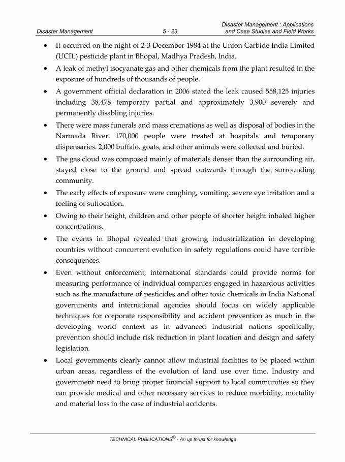
Disaster Management : Applications Disaster Management 5 - 23 and Case Studies and Field Works
TECHNICAL PUBLICATIONS® - An up thrust for knowledge
It occurred on the night of 2-3 December 1984 at the Union Carbide India Limited (UCIL) pesticide plant in Bhopal, Madhya Pradesh, India.
A leak of methyl isocyanate gas and other chemicals from the plant resulted in the exposure of hundreds of thousands of people.
A government official declaration in 2006 stated the leak caused 558,125 injuries including 38,478 temporary partial and approximately 3,900 severely and permanently disabling injuries.
There were mass funerals and mass cremations as well as disposal of bodies in the Narmada River. 170,000 people were treated at hospitals and temporary dispensaries. 2,000 buffalo, goats, and other animals were collected and buried.
The gas cloud was composed mainly of materials denser than the surrounding air, stayed close to the ground and spread outwards through the surrounding community.
The early effects of exposure were coughing, vomiting, severe eye irritation and a feeling of suffocation.
Owing to their height, children and other people of shorter height inhaled higher concentrations.
The events in Bhopal revealed that growing industrialization in developing countries without concurrent evolution in safety regulations could have terrible consequences.
Even without enforcement, international standards could provide norms for measuring performance of individual companies engaged in hazardous activities such as the manufacture of pesticides and other toxic chemicals in India National governments and international agencies should focus on widely applicable techniques for corporate responsibility and accident prevention as much in the developing world context as in advanced industrial nations specifically, prevention should include risk reduction in plant location and design and safety legislation.
Local governments clearly cannot allow industrial facilities to be placed within urban areas, regardless of the evolution of land use over time. Industry and government need to bring proper financial support to local communities so they can provide medical and other necessary services to reduce morbidity, mortality and material loss in the case of industrial accidents.

Disaster Management : Applications Disaster Management 5 - 24 and Case Studies and Field Works
TECHNICAL PUBLICATIONS® - An up thrust for knowledge
The Bhopal disaster could have changed the nature of the chemical industry and caused a reexamination of the necessity to produce such potentially harmful products in the first place.
Safety procedures were minimal and neither the American owners nor the local management seemed to regard them as necessary. When the disaster struck there was no disaster plan that could be set into action.
We need to introduce a system of laws which will make them liable for higher standards of safety.
Multinationals operating in India, must agree as a condition of doing business that they will submit to the jurisdiction of the Indian courts both civil and criminal.
They must agree to be responsible for the acts of their subsidiaries and not disown them like rats leaving a sinking ship
Prevention is better than cures. Lesson learned from this manmade disaster is to understand the nature of disaster before it occurs and implement better disaster management system in place.
When series of accidents occurred frequently in Bhopal plan, if prevented on time properly by Union Carbide India Limited they could avoided this nightmare.
The dead may not have been so unlucky after all. The end came horribly, but at least the nightmare was brief.
Mitigations of Such Disaster in Future
The lessons we learn from this unfortunate accident have had a significant impact on process safety and how we should be educated and trained to prevent future accidents :
Safety culture : No safety measures that can prevent an accident if there is not a safety culture that governs the behaviour of management and employees. In Bhopal this basic pillar was not present or was weak.
Safety management : In 1984 safety management systems were not widely established, although there were recommendations and procedures such as PSM (Process Safety Management) from DuPont or the Center for Chemical Process Safety (CCPS) from the American Institute of Chemical Engineers. There were two major accidents in 1984 (Bhopal and the explosions of PEMEX in Mexico), which created the need for an organized and systematic approach.

Disaster Management : Applications Disaster Management 5 - 25 and Case Studies and Field Works
TECHNICAL PUBLICATIONS® - An up thrust for knowledge
Intrinsically safe design : The application of the principles of intrinsically safe design are those that offer the best results. In Bhopal the main cause of the disaster was unnecessary storage of large quantities of MIC, which ultimately was what caused the mass poisoning.
Knowledge transfer based on learning from accidents. The Bhopal accident still provides valuable lessons after 30 years. Concepts such as “zero accidents” or “total inherent safety” arose as a result of accidents in 1984 as well as what was coined by Professor Trevor Kletz, one of the fathers of modern chemical safety: “Why should we publish accident reports?”.
5.6.2 Chernobyl Disaster
The Chernobyl disaster was caused by a nuclear accident that occurred on Saturday 26 April 1986, at the No. 4 reactor in the Chernobyl Nuclear Power Plant, near the city of Pripyat in the north of the Ukrainian SSR.
It is considered the worst nuclear disaster in history and was caused by one of only two nuclear energy accidents rated at seven, the maximum severity, on the International Nuclear Event Scale, the other being the 2011 Fukushima Daiichi nuclear disaster in Japan.
The accident started during a safety test on an RBMK-type nuclear reactor, which was commonly used throughout the Soviet Union.
The test was a simulation of an electrical power outage to aid the development of a safety procedure for maintaining reactor cooling water circulation until the back-up electrical generators could provide power.
This gap was about one minute and had been identified as a potential safety problem that could cause the nuclear reactor core to overheat.
It was hoped to prove that the residual rotational energy in a turbine generator could provide enough power to cover the gap.
Three such tests had been conducted since 1982, but they had failed to provide a solution.
On this fourth attempt, an unexpected 10-hour delay meant that an unprepared operating shift was on duty.
During the planned decrease of reactor power in preparation for the electrical test, the power unexpectedly dropped to a near-zero level.

Disaster Management : Applications Disaster Management 5 - 26 and Case Studies and Field Works
TECHNICAL PUBLICATIONS® - An up thrust for knowledge
The operators were able to only partially restore the specified test power, which put the reactor in a potentially unstable condition.
This risk was not made evident in the operating instructions, so the operators proceeded with the electrical test.
Upon test completion, the operators triggered a reactor shutdown, but a combination of unstable conditions and reactor design flaws caused an uncontrolled nuclear chain reaction instead.
A large amount of energy was suddenly released, vaporising superheated cooling water and rupturing the reactor core in a highly destructive steam explosion.
This was immediately followed by an open-air reactor core fire that released considerable airborne radioactive contamination for about nine days that precipitated onto parts of the USSR and western Europe, before being finally contained on 4 May 1986.
The fire gradually released about the same amount of contamination as the initial explosion.
As a result of rising ambient radiation levels off-site, a 10-kilometre (6.2 mi) radius exclusion zone was created 36 hours after the accident.
About 49,000 people were evacuated from the area, primarily from Pripyat.
The exclusion zone was later increased to 30 kilometres (19 mi) radius when a further 68,000 people were evacuated from the wider area.
The reactor explosion killed two of the reactor operating staff.
In the emergency response that followed, 134 station staff and firemen were hospitalized with acute radiation syndrome due to absorbing high doses of ionizing radiation.
Of these 134 people, 28 died in the days to months afterward and approximately 14 suspected radiation-induced cancer deaths followed within the next 10 years.
Among the wider population, an excess of 15 childhood thyroid cancer deaths were documented as of 2011.
The United Nations Scientific Committee on the Effects of Atomic Radiation (UNSCEAR) has, at multiple times, reviewed all the published research on the incident and found that at present, fewer than 100 documented deaths are likely to be attributable to increased exposure to radiation.

Disaster Management : Applications Disaster Management 5 - 27 and Case Studies and Field Works
TECHNICAL PUBLICATIONS® - An up thrust for knowledge
Determining the total eventual number of exposure related deaths is uncertain based on the linear no-threshold model, a contested statistical model, which has also been used in estimates of low level radon and air pollution exposure.
Model predictions with the greatest confidence values of the eventual total death toll in the decades ahead from Chernobyl releases vary, from 4,000 fatalities when solely assessing the three most contaminated former Soviet states, to about 9,000 to 16,000 fatalities when assessing the total continent of Europe.
To reduce the spread of radioactive contamination from the wreckage and protect it from weathering, the protective Chernobyl Nuclear Power Plant sarcophagus was built by December 1986.
It also provided radiological protection for the crews of the undamaged reactors at the site, which continued operating.
Due to the continued deterioration of the sarcophagus, it was further enclosed in 2017 by the Chernobyl New Safe Confinement, a larger enclosure that allows the removal of both the sarcophagus and the reactor debris, while containing the radioactive hazard. Nuclear clean-up is scheduled for completion in 2065.
The Chernobyl disaster is considered the worst nuclear power plant accident in history, both in terms of cost and casualties.
The initial emergency response, together with later decontamination of the environment, ultimately involved more than 500,000 personnel and cost an estimated 18 billion Soviet rubles-roughly US$68 billion in 2019, adjusted for inflation.
The accident resulted in safety upgrades on all remaining Soviet-designed RBMK reactors, of which 10 continue to be operational as of 2019.
Mitigations of Such Disaster in Future
Tell the truth - After the Chernobyl disaster, the authorities failed to alert the public to the danger for three days, putting thousands of lives at risk.
Today, there is still a need for total transparency when it comes to nuclear accidents.
Evacuate - Soviet authorities were initially in denial over the extent of the crisis and failed to move people living close to the reactor to safety in the hours and days after the incident.
If they had acted sooner, countless lives would have been saved.

Disaster Management : Applications Disaster Management 5 - 28 and Case Studies and Field Works
TECHNICAL PUBLICATIONS® - An up thrust for knowledge
Closely monitor radiation levels in food - A report from the UN's scientific committee on the effects of atomic radiation found that a rise in thyroid cancer was the only substantial medical legacy of Chernobyl in the general population.
The cancers came about because Soviet authorities allowed children to continue to drink heavily contaminated milk.
As a result, many children received high doses of radiation to the thyroid.
Comply with safety rules - International reports have blamed the poor design of the Soviet RBMK (High Power Channel-type Reactor), a lack of safety culture at the plant and errors by operators for the Chernobyl disaster.
The accident illustrates the importance of complying with basic safety principles for nuclear power plants.
Plan ahead - Experts have suggested that the Chernobyl accident demonstrated the need to establish and support a high-level national emergency response system in case of man-made accidents.
5.7 Space Based Inputs for Disaster Mitigation and Management and Field
Works Related to Disaster Management
India is prone to many natural disasters like floods, landslides, cyclones, forest fires, earthquakes, drought, etc. Satellites provide synoptic observations of the natural disasters at regular intervals that helps in better planning and management of disasters. In order to better understand the risks due to such disasters, it is necessary to integrate satellite and field based observations and to work towards risk reduction principles. Satellite communication and navigation systems also play an important role in disaster management with improved technological options.
Disaster Management Support (DMS) Programme, comprehensively addresses various aspects of natural disasters in the country, using space based inputs. ISRO disseminates relevant information in interactive geo-spatial domain through various geoportals like Bhuvan, National Database for Emergency Management and MOSDAC for the administrators to better understand the impact and for improved decision support.
ISRO provides the satellite based near real time information support to Central Ministries / Departments and State Ministries / Departments, prior during and after major natural disasters. In addition, ISRO also provides capacity building in use of Space technology inputs in Disaster Management Support.

Disaster Management : Applications Disaster Management 5 - 29 and Case Studies and Field Works
TECHNICAL PUBLICATIONS® - An up thrust for knowledge
ISRO is actively involved with various other countries with regard to disaster management, through international frameworks, such as, International Charter ‘Space & Major Disasters’, Sentinel Asia, UNESCAP and so on.
A) Cyclones
Preparedness
With large coast line, India is susceptible for cyclones. It is important to understand the impacts of cyclone, with respect to its earlier footprints, low lying areas, etc, wherein satellite images provide such inputs. Using historical satellite data and Digital surface models, these inputs are derived.
Early warning
ISRO uses geo-stationary and low earth orbit satellites for providing experimental inputs on cyclogenesis, cyclone track, cyclone intensity. INSAT series of satellites with frequent imaging provide the cyclone parameters for near real time analysis.
Response
Near real time information on inundation due to cyclones is derived, using optical and microwave SAR data and the information is provided to the concerned departments. During 2018, ISRO provided information on inundation to Odisha, Andhra Pradesh States during TITLI, PHETHAI, etc.
B) Floods
Preparedness
Based on integration of historic satellite datasets acquired during major floods in different States, flood hazard map layers were prepared for Assam, Bihar, Odisha, Andhra Pradesh, Uttar Pradesh, West Bengal and Entire Country.
Early Warning
Using hydrological modelling of satellite and ground based hydro-meteorological inputs and digital elevation models, experimental spatial flood early warning systems are established for selected river reaches like Andhra Pradesh (Godavari), Odisha (Mahanadi) and Assam (Brahmaputra).

Disaster Management : Applications Disaster Management 5 - 30 and Case Studies and Field Works
TECHNICAL PUBLICATIONS® - An up thrust for knowledge
Response
Near real time information on flood inundation is derived on an operational basis using optical and microwave SAR data and the information is provided to the concerned departments of Kerala, Assam, Bihar, Uttar Pradesh, Odisha and Andhra Pradesh States.
C) Landslides
Preparedness
Landslides cause huge damages, particularly along pilgrim routes. ISRO prepared Landslide Hazard Zonation maps for pilgrim routes in Himachal Pradesh, Uttarakhand and Meghalaya.In addition, ISRO is also preparing seasonal landslide inventory on regular basis.These satellite based inputs are very useful for preparedness.
Early Warning
Experimental Landslide Early Warning System for Rainfall Triggered Landslides is carried out for the following routes namely Rishikesh-Badrinath, Rishikesh-Uttarkashi-Gaumukh,Chamoli-Okhimath Rudraprayag-Kedarnath and Pithoragarh-Malpa in Uttarakhand during specific seasons.
Response
Near real time information on landslides is derived regularly during major landslide events in the country and disseminated through Bhuvan geoportal. Areal extent of landslide is also estimated using satellite data and DSMs. In addition, in case of river blockade due to landslide, necessary inputs are provided to Govt. from time to time.
Landslides Hazard Zones
Landslide hazard zonation maps were prepared for selected pilgrim routes in the country. These zones are delineated based on geological, topological and anthropogenic factors. These factors include lithology, soil, slope, drainage, lineament, landuse, etc. At present these maps are available for pilgrim routes in Himachal Pradesh, Uttarakhand, Meghalaya in addition, event-based and seasonal landslide inventory is also carried out. The information on landslide inventory and hazard zones help the decision makers for better planning in these areas.

Disaster Management : Applications Disaster Management 5 - 31 and Case Studies and Field Works
TECHNICAL PUBLICATIONS® - An up thrust for knowledge
Landslides - Karnataka
Landslides occurred in Kodagu, Karnataka due to heavy rainfall in August, 2018. These events resulted in many damages to existing infrastructure in Dakshina Kannada and Kodagu districts. Over 900 landslides were identified in various taluks of Kodagu, Dakshina Kannada and other districts of Karnataka using synoptic satellite data coverages. These were made available to GSI, Karnataka State Disaster Monitoring Centre and others.
D) Forest fires
Preparedness
ISRO prepares Forest Fire Regime maps using historical forest fires observed from satellite data. These maps help in identifying critical areas where forest fires are prevalent and the average duration of forest fires. These details help the decision makers.

Disaster Management : Applications Disaster Management 5 - 32 and Case Studies and Field Works
TECHNICAL PUBLICATIONS® - An up thrust for knowledge
Early warning
Many attempts are made to use multi-criteria approach in GIS environment to provide early warning and vulnerability maps. More research in such area further continued on experimental basis.
Response
ISRO regularly prepares Forest Fire alert maps using satellite data and provides to FSI and other State Forest Departments. This near real time data dissemination through Bhuvan Geoportal and SMS alerts help forest department for taking quick action. During 2018, burnt area assessment was done for Uttarakhand, Jammu & Kashmir and Tamilnadu.
5.8 Role of Media in Disaster Management
The media forges a direct link between the public and emergency organizations and plays a very important role in disseminating vital information to the public before, during and after disasters.
The media assists in the management of disasters by educating the public about disasters; warning of hazards; gathering and transmitting information about affected areas; alerting government officials, relief organizations and the public to specific needs; and facilitating discussions about disaster preparedness and response for continuous improvement.
To help the media fulfil these roles, direct and effective working relationships between the media and disaster management organizations should be established and maintained Experience shows that regular interactions with the media before a disaster strikes, aids the effective flow of information and lays the groundwork for effective working relationships in the aftermath of a disaster.
Media and Emergency Response
In managing disaster - the necessity of "right information at right time" has not changed for centuries.
People need warnings ahead of the disaster and then, in its aftermath, data on -casualties, damage, the supplies and skills that are needed, the best ways to bring in these resources, the help that is available and is being provided, and so on.
There are many examples where - public education and the rapid, widespread dissemination of early warnings saved thousands of lives.

Disaster Management : Applications Disaster Management 5 - 33 and Case Studies and Field Works
TECHNICAL PUBLICATIONS® - An up thrust for knowledge
In November 1970, for example, a tropical cyclone, combined with a high tide, struck southeastern Bangladesh, leaving more than 300,000 people dead and 1.3 million homeless.
In May 1985, a comparable cyclone and storm surge hit the same area. "This time - there was better local dissemination of disaster warnings and the people were better prepared to respond to them.
The loss of life, although still high, was 10,000 or about 3 percent of that in 1970.
When a devastating cyclone struck the same area of Bangladesh in May 1994, fewer than 1,000 people died. 1977 cyclone in Andra Pradesh, India killed 10,000 people, while a similar storm in the same area 13 years later killed only 910.
The dramatic difference -was due to the fact that a new early-warning system connected with radio stations to alert people in low-lying areas, was put into place.
On the other side, there are many examples where absence of an alert and warning system resulted into huge number of casualties and extensive damage of property. Bhopal gas leak, 1999 super cyclone in Orissa and 2004 Indian Ocean tsunami are few of the recent example in India where "timely alert" could have saved millions of lives and enormous property.
Media is usually defined as impersonal means of communication by which written, visual or auditory or sometimes a combination of such messages are transmitted directly to the audiences". In simpler terms, the word media denotes the means of communication with large number of people spread over communities, cities or countries through written or printed word or sound and voice or visual images or a combination ofthese.
By the definition itself, we understand that media is all organised means of reaching large number of people, quickly, timely effectively and efficiently. There are two main characteristics of media.
It can reach millions of people in short time; even instantaneously.
Audio media transcends the limits of illiteracy and the visual media can be effective in a multilingual society as well.
It is cost effective and generally user-friendly.
Generally, media provide one way communication I.e. to the receivmg people.

Disaster Management : Applications Disaster Management 5 - 34 and Case Studies and Field Works
TECHNICAL PUBLICATIONS® - An up thrust for knowledge
Television, radio, newspaper, magazines, audio and video as well as movies are examples of media. These are very useful in the multilingual traditional and largely illiterate society in India.
Types of media : Media may be of various kind; but in disaster management, following types of media are important :
Print media - Print media (newspapers etc.) have made tremendous progress in India since 1780, when the first Indian newspaper 'The Bengal Gazette' appeared.
After Independence, the mass media assumed great significance. As per official-records, more than 25000 different newspapers, magazines and bulletins are being published from various states in the country in various languages.
Broadcast media - They comprise radio and television. Messages are transmitted by these media through satellite and received by viewers and listeners at distant places of the country very quickly. Radio and T.V. reach more number of people than print media. In disaster warning and creating awareness, broadcast media are most effective especially a large multilingual country like India with low level of literacy. Broadcast media are sometimes termed as Electronic Media although the latter term would include audio video cassettes.
Display media - This comprises the following :
Hoardings or Billboards or illuminated signs which can be displayed at busy public places like bus stands; railway stations, parks, etc.
Wall paintings and posters on common places including railway stations, airports providing specific awareness.
Small panels on lamp posts or inside or outside buses, railway compartments, taxis etc.
Banners
Window displays
Sky balloons in trade fairs
Small handbi lis, leaflets.
Exhibitions and Fairs where special pavilions may be arranged to deal with the theme of disaster management.
5.8.1 Importance and Role of Media
Media has a very important role in disaster management. In this context, it performs major functions mentioned below :

Disaster Management : Applications Disaster Management 5 - 35 and Case Studies and Field Works
TECHNICAL PUBLICATIONS® - An up thrust for knowledge
Surveillance of the environment, which means collection and distribution of information concerning events in the climate/environment. A number of climatic information is potentially related to the natural disasters, which can be communicated regularly and more frequently at the time of disaster.
The best example is cyclone, Media can play a very important role in dissemination of information .such as formation of depression on the sea, its movement towards the coast, areas likely to be affected, etc.
Disaster Awareness Education to the masses can be given by media. Today we have about 50 % illiterate people in India but most of them do have access to radio or television.
Long term preparedness and mitigation strategies can be explained effectively to the masses through various media.
Media help in policy formulation by conducting public debate or survey or polls.
The media have a strong impact on the perception of and response to disasters. Thus role of media in a disaster is multipurpose and can be broadly classified in three categories :
a) Informative
b) Suggestive
c) Analytical
A) Informative role
Media can play informative role in all the three situations :
j) Pre-disaster
ii) At the time of disaster; and
iii) Post-disaster
In Pre-disaster situation, knowledge of disaster vulnerability of the community is very important. In monsoon season, rainfall predictions, water level in different rivers, water flow rate, possible breach of embankment etc. are the pieces of information extremely useful for the people living in the highly vulnerable areas.
Media can highlight some of the important mitigation measures, which community should take up in the vulnerable zones of a natural disaster. Similarly, some of the success stories of water-shed management in drought mitigation, can be useful in other drought affected areas of the country.

Disaster Management : Applications Disaster Management 5 - 36 and Case Studies and Field Works
TECHNICAL PUBLICATIONS® - An up thrust for knowledge
Himalayan region is highly vulnerable to a number of natural disasters (viz. Earthquake, Landslides, Flash Floods, Avalanches etc.), A concept of Environmental protection, ecological balance and sustainable development in this region will certainly help in disaster reduction in the region. Awareness in this regard can be generated by media only through informative reporting.
At the time of disaster, accurate information should be the first aim of a journalist. It needs cooperation between local officials and media. Most of the time the local officials are unable or unwilling to give information, because of sensitivity or security reasons or the news is still unconfirmed. In such cases journalist should depend on reliable sources/agencies working in relief/or unbiased local community so that right information may reach the people and other national and international agencies. However, the media has to ensure balanced reporting so as to avoid unnecessary panic and rumours.
In post-disaster situation, informative role of the media is to provide correct information about the continuing impacts of the disaster and the actual needs of the affected people so that the rehabilitation and reconstruction programmes can be tailored accordingly. The media helps to keep a check on various agencies which undertake rehabilitation programmes.
B) Suggestive role
In a disaster situation, there could be many mitigation measures available. Sometimes it is difficult to find out the most suitable option for the specific disaster. For example, Flood is a very common natural disaster. There are many states which are prone to this disaster like Assam. U.P. Bihar, and West Bengal. .In this context, media has a significant role in providing suitable suggestions for political attention and public understanding for most acceptable options.
Similarly, media has a role in checking activities which might aggravate the adverse impacts of disasters. In the process of rehabilitation and reconstruction, media can be used to muster expert opinion and solutions, e.g,'-
Models of houses uitable building material suitable topography for building new houses
Do's and Don't in the construction work.
Similar suggestions can be provided in the retrofitting of weaker structures and houses in the earthquake vulnerable areas.

Disaster Management : Applications Disaster Management 5 - 37 and Case Studies and Field Works
TECHNICAL PUBLICATIONS® - An up thrust for knowledge
C) Analytical role
The most critical role of media is analytical. This approach can be applied in analysis of
Disaster preparedness
Disaster mitigation
Disaster relief
Disaster rehabilitation
Disaster management
Role of various agencies
There are preparedness plans for each disaster, After the disaster, the effectiveness of plan and lessons learnt from the disaster should be analysed in a constructive way.
It will certainly improve the plan for future use. Similarly, if there are different mitigation approaches used by Government and non-Governmental Organisations, the media can highlight both and strive to evolve a balance of approach.
This type of success stories can be replicated in other parts of the country in similar situations.
The analytical role of media is specialy helpful in rehabilitation and. reconstruction-work after landslide or earthquake disaster.
The Latur earthquake rehabilitation of more than 50 villages is a good example of this kind. The media can give views of various role players about the success or failure of their programme so that it can be a lesson for the authorities and the mistakes committed once are not repeated in similar circumstances.
5.8.2 Role of Social Media in Disaster Management
Social media, as a boon to internet users has emerged as the first choice of communication among the youth world over.
It is being used phenomenally by the youth these days for connecting with each other in terms of data sharing, collaborating, exchanging views, and so on.
In fact, social media has time and again proved its utility during emergency situation.

Disaster Management : Applications Disaster Management 5 - 38 and Case Studies and Field Works
TECHNICAL PUBLICATIONS® - An up thrust for knowledge
Be it Nepal earthquake 2015, Cyclone in Odisha 2013 or Floods in Queensland in 2011, social media has played a vital role in informing and bringing the world together on one platform in dealing with disasters.
Though, social media fast is becoming one of the widely used mode of communication, it is important enough that the scope and limitations of social media are explored and understood.
Social media provides platform for dissemination of disaster information such as observing situations in remote areas, public tracking from ground zero, for collaborative developments such as collecting donations, providing a platform for people with similar ideologies to unite, and so on.
While there are positive sides of social media, there is no denying from the fact that it has its own drawbacks like spreading rumours, promoting ill-fated acts such as terrorism and cyber-crime like “ransomware”.
Regardless of the fact that social media is indirectly a breach of privacy, it is gaining reputation world over for its usefulness.
In short, this mode of communication is here to stay and grow with time and with paradigm shift of use of media from one way communication to two way message dissemination, it equally becomes important that disaster managers include social media in their scheme of things as well.
Two Marks Questions with Answers
Part - A
Q.1 What is landslide hazard ? Define. (Refer section 5.1)
Q.2 What are the uses of landslide hazard zonation. (Refer section 5.1.1)
Q.3 What are fluvial floods. (Refer section 5.4.1)
Q.4 What are pluvial floods. (Refer section 5.4.2)
Q.5 What are castal Floods. (Refer section 5.4.3)
Long Answered Questions
Part - B
Q.1 Explain mapping scale for landslide hazard analysis. (Refer section 5.1.2)
Q.2 Explain in detail earthquake prepardness and coping strategies.
(Refer section 5.2.1)

Disaster Management : Applications Disaster Management 5 - 39 and Case Studies and Field Works
TECHNICAL PUBLICATIONS® - An up thrust for knowledge
Q.3 Explain the measurement process of earthquake in detail. (Refer section 5.2.2)
Q.4 Explain draught assesment case studies. (Refer section 5.3)
Q.5 Explain any one case study related to forest five. (Refer section 5.5)
Q.6 Explain the chernobyl disaster in detail. (Refer section 5.6.2)
Q.7 Explain the role of media in disaster management. (Refer section 5.8)
Q.8 Explain Bhopal gas tragedy. (Refer section 5.6.1)
Multiple Choice Questions
Q.1 The _______ hazard zonation mapping scale in intended to give a general
inventory of problem areas for entire country.
a national b local
c regional d None of these
Q.2 Scientist locates the _____ by noting how long it takes for the siesmic waves to
arrive at different siesmograph stations.
a point b epicenter
c centre d none of these
Q.3 ______ is fundamentally the resultant of an extended period of reduced
precipitation.
a Flood b Drought
c Landslide d None of these
Q.4 The most common hazard in forest is forest _____.
a fire b flood
c landslide d none of these
Answer Keys for Multiple Choice Questions
Q.1 a Q.2 b
Q.3 b Q.4 a

Disaster Management : Applications Disaster Management 5 - 40 and Case Studies and Field Works
TECHNICAL PUBLICATIONS® - An up thrust for knowledge
Notes

Time : Three Hours] [Maximum Marks : 100
Answer ALL Questions
PART A - (10 2 = 20 Marks)
Q.1 Define disaster. (Refer Two Marks Q.1 of Chapter - 1)
Q.2 Enlist key phases of disaster management. (Refer Two Marks Q.2 of Chapter - 1)
Q.3 Write down the needs of community. (Refer Two Marks Q.3 of Chapter - 2)
Q.4 What is environment protection act. (Refer Two Marks Q.5 of Chapter - 2)
Q.5 Enlist any two motivational/attitudinal conditions.
(Refer Two Marks Q.2 of Chapter - 3)
Q.6 Write down the objectives of IPCC. (Refer Two Marks Q.4 of Chapter - 3)
Q.7 Write down the key vulnerabilities of India. (Refer Two Marks Q.1 of Chapter - 4)
Q.8 Enlist personal hygiene and handwashing after a disaster or emergency.
(Refer Two Marks Q.4 of Chapter - 4)
Q.9 What is landslide hazard ? Define. (Refer Two Marks Q.1 of Chapter - 5)
Q.10 What are Fluvial floods. (Refer Two Marks Q.2 of Chapter - 5)
PART B - (5 13 = 65 Marks)
Q.11 a) i) Explain the types of disaster management in detail. (Refer section 1.1.2) [8]
ii) Differentiate between hazards and vulnerability. (Refer section 1.1) [5]
OR
b) i) Explain the key phases of disaster management in detail. (Refer section 1.1.3) [8] ii) Explain in detail types of disaster. (Refer section 1.2) [5]
Q.12 a) i) Explain early warning system in detail. (Refer section 2.10) [8]
ii) Explain the phases of disaster management cycle. (Refer section 2.3) [5]
OR
b) i) Explain the concept of risk management and crisis management.
(Refer section 2.2). [8]
SOLVED MODEL QUESTION PAPER (As Per New Syllabus)
Disaster Management Semester - V (Civil) (Professional Elective - I)
Semester – VII (CSE / IT / EEE / ECE / Mech) (Professional Elective - III)
(M - 1)

Disaster Management M - 2 Solved Model Question Paper
TECHNICAL PUBLICATIONS® - An up thrust for knowledge
ii) Define the following terms with respect to disaster management.
a) Hazard b) Exposure c) Vulnerability d) Disaster risk reduction (Refer section 2.2.2) [5]
Q.13 a) i) Explain in details the factors contributing to vulnerability. (Refer section 3.2.3) [8]
ii) Explain in detail the differential impact of disaster. (Refer section 3.4) [5]
OR
b) i) Explain in detail, the relevance of indigenous knowledge in disaster management.
(Refer section 3.8) [8]
ii) Explain climate change adaptation. (Refer section 3.6) [5]
Q.14 a) i) Explain hazard and vulnerability profile of India. (Refer section 4.1) [8]
ii) Explain in detail, hydrological and climate related hazards. (Refer section 4.1.1) [5]
OR
b) i) Explain in detail the components of disaster relief. (Refer section 4.2) [8]
ii) Explain in detail, sanitization and hygiene. (Refer section 4.2.3) [5]
Q.15 a) i) Explain the measurement process of earthquake in details. (Refer section 5.2.2) [8]
ii) Explain in detail earthquake prepardness and coping strategies.
(Refer section 5.2.1) [5]
OR
b) i) Explain draught assessment case studies. (Refer section 5.3) [8] ii) Explain mapping scale for landslide hazard analysis. (Refer section 5.1.2) [5]
PART C - (1 15 = 15 Marks)
Q.16 a) i) Explain any one case study related to forest five. (Refer section 5.5) [10]
ii) Explain in detail, waste management. (Refer section 4.2.6) [5]
OR
b) i) Explain in detail, Geological disaster with its types. (Refer section 4.1.2) [10]
ii) Explain the impact of development projects on environment. (Refer section 3.5) [5]