
Development of sustainable urban green areas in Egyptian new cities: The case of El-Sadat City
14
Landscape and Urban Planning 101 (2011) 157–170 Contents lists available at ScienceDirect Landscape and Urban Planning journal homepage: www.elsevier.com/locate/landurbplan Development of sustainable urban green areas in Egyptian new cities: The case of El-Sadat City Ayman Hassaan Ahmed Mahmoud a,b,∗ , Marwa Adel El-Sayed c a Department of Architecture Engineering, Faculty of Engineering, Cairo University, Giza 12211, Egypt b Department of Architecture Engineering, The British University in Egypt (BUE), El-Sherouk City, Egypt c Department of Architecture, Modern Academy, Cairo, Egypt article info Article history: Received 22 September 2010 Received in revised form 4 February 2011 Accepted 5 February 2011 Available online 17 March 2011 Keywords: Land suitability analysis (LSA) Eco-City Landscape planning Sustainable green areas Geographic Information Systems (GIS) El-Sadat City Egypt abstract Sustainable urban development is essential to enhance the quality of life of the citizens and to decrease the impact of cities upon resources outside the urban context. Redeveloping and planning green spaces and urban structure become the fundamentals of the sustainable urban planning of a city. An effective urban planning using recent technology is required to contribute to the physical and social development of the cities through promoting the land value and the local economy. This paper aims to develop a method to maintain ecological balance and organization of the urban green areas, using Geographic Information Systems (GIS) techniques that assist in effective planning of green areas. Land suitability analysis and ecological threshold methods based on GIS techniques are applied on one of the Egyptian new cities in a desert environment (i.e., El-Sadat City). Results revealed that the green ways could be developed to play a more significant role in bringing nature into the city. This paper suggests a method of green network planning that would help in enhancing the connectivity and reduce fragmentation though integrated greenway system. Finally, an ecological base for building an eco-city of El-Sadat City in the future is proposed. © 2011 Elsevier B.V. All rights reserved. 1. Introduction Recent surveys have shown that good quality of Egyptian life has declined in several cities, as city planning does not necessarily contribute to the citizen needs (Khalifa, 2010; World Bank, 2008). One of the possible reasons is the decline of urban areas and the limited amount of green areas (Imam, 2006). Urban green areas are outdoor spaces with a significant amount of vegetation (Ong, 2003). They exist as semi-natural areas (Jim and Chen, 2003). The planning of green spaces is of significance to sustainable urban development (Teal et al., 1998). Urban planners should adopt proper locations for the urban green spaces and to evaluate these selections in order to optimize the benefits of urban green spaces within the built area (Gobster and Westphal, 2004; Imam, 2006; Tan, 2006; Uy and Nakagoshi, 2008). It has been widely believed that urban green spaces are important components of urban ecosystems, and pro- vide several environmental and social services that contribute to ∗ Corresponding author at: Department of Architecture Engineering, Faculty of Engineering, Cairo University, Giza 12211, Egypt. Tel.: +20 10 6670260; fax: +20 2 26875889. E-mail addresses: [email protected], [email protected] (A.H.A. Mahmoud), [email protected] (M.A. El-Sayed). the quality of life in cities (McHarg, 1995; Turner, 2006; Tyrvainen et al., 2007). People are eager to access these green spaces for recre- ation and to experience nature (Li et al., 2005; Lynn and Brown, 2003). In addition, several studies reported that the social implica- tions of lifestyles and attitudes to nature and sustainability will lead to higher demands for urban green space (Li et al., 2005; Thompson, 2002). During the last three decades, the Egyptian government estab- lished 22 new cities. Most of these cities were established in desert environments (NUCA, 2010). One of the fundamental aims of the planning of these new cities pays significant attention to a balanced environment to allow Egyptian citizens to enjoy their lives and for the new generations to live in a healthy city (Khalifa, 2010; World Bank, 2008). The selection of urban green areas is primarily based on expert’s knowledge and strongly influenced by the existing City Master Plans (Imam, 2006). There is no formal method for the site selection process (Fahmi and Sutton, 2008). Very few studies inves- tigated the process of landscape planning of green areas in existing of new cities in Egypt on empirical basis (Imam, 2006). This research investigates a method of selecting urban green areas to maintain ecological balance in new cities in Egyptian desert environments through integrating land suitability analysis (LSA) and the ecolog- ical factor threshold methods based on Geographic Information Systems (GIS). 0169-2046/$ – see front matter © 2011 Elsevier B.V. All rights reserved. doi:10.1016/j.landurbplan.2011.02.008
-
Upload
independent -
Category
Documents
-
view
0 -
download
0
Transcript of Development of sustainable urban green areas in Egyptian new cities: The case of El-Sadat City
DT
Aa
b
c
a
ARRAA
KLELSGEE
1
hcOloTo(ftaNsv
Ef
(
0d
Landscape and Urban Planning 101 (2011) 157–170
Contents lists available at ScienceDirect
Landscape and Urban Planning
journa l homepage: www.e lsev ier .com/ locate / landurbplan
evelopment of sustainable urban green areas in Egyptian new cities:he case of El-Sadat City
yman Hassaan Ahmed Mahmouda,b,∗, Marwa Adel El-Sayedc
Department of Architecture Engineering, Faculty of Engineering, Cairo University, Giza 12211, EgyptDepartment of Architecture Engineering, The British University in Egypt (BUE), El-Sherouk City, EgyptDepartment of Architecture, Modern Academy, Cairo, Egypt
r t i c l e i n f o
rticle history:eceived 22 September 2010eceived in revised form 4 February 2011ccepted 5 February 2011vailable online 17 March 2011
eywords:
a b s t r a c t
Sustainable urban development is essential to enhance the quality of life of the citizens and to decreasethe impact of cities upon resources outside the urban context. Redeveloping and planning green spacesand urban structure become the fundamentals of the sustainable urban planning of a city. An effectiveurban planning using recent technology is required to contribute to the physical and social developmentof the cities through promoting the land value and the local economy. This paper aims to develop a methodto maintain ecological balance and organization of the urban green areas, using Geographic InformationSystems (GIS) techniques that assist in effective planning of green areas. Land suitability analysis and
and suitability analysis (LSA)co-Cityandscape planningustainable green areaseographic Information Systems (GIS)l-Sadat Citygypt
ecological threshold methods based on GIS techniques are applied on one of the Egyptian new cities in adesert environment (i.e., El-Sadat City). Results revealed that the green ways could be developed to playa more significant role in bringing nature into the city. This paper suggests a method of green networkplanning that would help in enhancing the connectivity and reduce fragmentation though integratedgreenway system. Finally, an ecological base for building an eco-city of El-Sadat City in the future isproposed.
. Introduction
Recent surveys have shown that good quality of Egyptian lifeas declined in several cities, as city planning does not necessarilyontribute to the citizen needs (Khalifa, 2010; World Bank, 2008).ne of the possible reasons is the decline of urban areas and the
imited amount of green areas (Imam, 2006). Urban green areas areutdoor spaces with a significant amount of vegetation (Ong, 2003).hey exist as semi-natural areas (Jim and Chen, 2003). The planningf green spaces is of significance to sustainable urban developmentTeal et al., 1998). Urban planners should adopt proper locationsor the urban green spaces and to evaluate these selections in ordero optimize the benefits of urban green spaces within the built
rea (Gobster and Westphal, 2004; Imam, 2006; Tan, 2006; Uy andakagoshi, 2008). It has been widely believed that urban greenpaces are important components of urban ecosystems, and pro-ide several environmental and social services that contribute to
∗ Corresponding author at: Department of Architecture Engineering, Faculty ofngineering, Cairo University, Giza 12211, Egypt. Tel.: +20 10 6670260;ax: +20 2 26875889.
E-mail addresses: [email protected], [email protected]. Mahmoud), [email protected] (M.A. El-Sayed).
169-2046/$ – see front matter © 2011 Elsevier B.V. All rights reserved.oi:10.1016/j.landurbplan.2011.02.008
© 2011 Elsevier B.V. All rights reserved.
the quality of life in cities (McHarg, 1995; Turner, 2006; Tyrvainenet al., 2007). People are eager to access these green spaces for recre-ation and to experience nature (Li et al., 2005; Lynn and Brown,2003). In addition, several studies reported that the social implica-tions of lifestyles and attitudes to nature and sustainability will leadto higher demands for urban green space (Li et al., 2005; Thompson,2002).
During the last three decades, the Egyptian government estab-lished 22 new cities. Most of these cities were established in desertenvironments (NUCA, 2010). One of the fundamental aims of theplanning of these new cities pays significant attention to a balancedenvironment to allow Egyptian citizens to enjoy their lives and forthe new generations to live in a healthy city (Khalifa, 2010; WorldBank, 2008). The selection of urban green areas is primarily basedon expert’s knowledge and strongly influenced by the existing CityMaster Plans (Imam, 2006). There is no formal method for the siteselection process (Fahmi and Sutton, 2008). Very few studies inves-tigated the process of landscape planning of green areas in existingof new cities in Egypt on empirical basis (Imam, 2006). This research
investigates a method of selecting urban green areas to maintainecological balance in new cities in Egyptian desert environmentsthrough integrating land suitability analysis (LSA) and the ecolog-ical factor threshold methods based on Geographic InformationSystems (GIS).
1 ape an
2
a(fhlicu“dBflt(aaG
2
tsne2areyssfeiuKsitBttfaumeic(teathoettbms
58 A.H.A. Mahmoud, M.A. El-Sayed / Landsc
. Background
The expansion of cultivation and settlements even in unsuit-ble land has increasingly grown in most parts of the third worldBizuwerk et al., 2006). This expansion clearly demonstrates theact that the growth of agriculture, urban environments and otheruman activities have exerted pressure on the extents of grazing
ands and forests (Santosh et al., 2008). Therefore, it is important todentify suitable land for various uses in optimum utilization whileausing minimum impact to the environment. GIS has been widelysed for analyzing the service area of urban green areas by simplebuffering”, which involves drawing lines around parks at a givenistance (e.g., Phua and Minora, 2004; Store and Kangas, 2001).izuwerk et al. (2006) attempted to distinguish suitable areas forora and fauna, vegetation and forest by embodying different spa-ial information using GIS techniques. The results of Bizuwerk et al.2006) study show that GIS furnishes a great advantage of spatialnd quantitative multi-layer analysis of data. Depending on thevailable spatial data, the accuracy and reliability of the result usingIS application could be enhanced.
.1. Land suitability analysis
According to Collins et al. (2001), a range of methods of spa-ial analysis are usually used in land-use plans and site selectiontudies. Their study reported recent examination of advanced tech-ologies. Land suitability analysis is one of the strongest and mostffective spatial analysis applications in planning (Malczewshi,004; Shearer and Xiang, 2009). It aims at identifying the mostppropriate spatial pattern for future land uses according to specifyequirements, preferences, or predictors of some activity (Collinst al., 2001; Malczewshi, 2004). The GIS-based land suitability anal-sis has been implemented in a wide variety of situations, includinguitability of land for agricultural activities (Kalogirou, 2002), land-cape evaluation and planning (Miller et al., 1998), locating oforest uses (Store, 2009) and site selection for local parks (Zuccat al., 2008). Over the last three decades, GIS-based land suitabil-ty techniques have increasingly become essential components ofrban, regional and environmental planning activities (Brail andlosterman, 2001; Collins et al., 2001; Malczewshi, 2004). Recently,everal research on land suitability analysis has been conductedn the Third World city planning. Pervee et al. (2005) indicatedhat land suitability analysis – in the case of crop production inangladesh – is a prerequisite to achieve optimum utilization ofhe available land resources for sustainable agricultural produc-ion. Their study intended to determine physical land suitabilityor rice crop using a multi-criteria evaluation (MCE) based on GISpproach and to compare present land use versus potential landse. In order to integrate MCE with GIS it is essential to provideore flexible and more accurate decisions to the decision mak-
rs in order to evaluate the effective factors. The results providednformation at a local level that could be used by farmers to selectropping patterns and suitability. Additionally, Uy and Nakagoshi2008) studied urban green ways in Hanoi, Vietnam. They reportedhat urban green spaces, as a particularly significant part of urbancosystems, provide various environmental and social services thatctively add to the quality of life in cities. Their study concludedhat Hanoi green structure plan at regional, city and neighbor-ood scales should necessarily incorporate three “green wedges”,ne “green belt”, various parks and supplementary green ways tostablish a green network that is ecologically more effective than
he sum of the individual green spaces. This green structure andhe integrated data approaches used will form a strong base foruilding a garden city or an eco-city in the future. However, theirethod was applied in a warm and humid environment. Issues,uch as supply and demand equilibrium of the water resource,
d Urban Planning 101 (2011) 157–170
are significant factors in the hot and arid environment similar toEgypt.
Integrating land suitability analysis in urban greenery was fur-ther investigated by Zucca et al. (2008). They investigated a siteselection process for setting up a local park. It was reinforced by avalue-focused approach and spatial multi-criteria evaluation meth-ods. A first set of spatial criteria was used to design a number ofpotential sites. Later, a new set of spatial and non-spatial criteriawas employed. The criteria included the social functions and thefinancial costs, together with the degree of suitability for the park toevaluate the possible sites and to recommend the most acceptableone. The entire process was assisted by a software tool that sup-ports Spatial Multi Criteria Evaluation (SMCE). The application ofthis tool, integrated with a constant feedback by the public admin-istration, has provided an effective method to solve the complicateddecision making on land-use and urban planning. Giordano andRiedel (2008) used SMCE method in a GIS environment for demar-cation of river greenways in Sao Paulo, Brazil. They elaborated asuitability map for the allocation of the greenway and identifyingareas for leisure activities, and ecologically important areas.
2.2. Landscape ecology concepts for green structure planning
Landscape ecology is the study of interactions among landscapeelements. It deals with the effects of the spatial configuration of“mosaics” on a wide variety of ecological phenomena (Forman andGodron, 1986). It has provided a foundation for planning land-scapes in general and green networks in particular (Aspinall andPearson, 2000; McHarg, 1995; Mortberg et al., 2007). Landscapeecology principles enable us to achieve an integral understandingof the development of landscapes, since it deals with their structure,functioning and changes occurring in them. This insight is con-sidered as a framework that assists to distinguish key ecosystemsfor maintaining biodiversity in landscape (Pirnat, 2000). Ecologi-cal suitability analysis of land use is a comprehensive applicationof ecology, earth science, system science, environmental scienceand computer science to analyze land development and utilizationsuitability for seeking the best pattern and planning of land use (Jieet al., 2010). The ecological principles used in planning land use andlandscape planning are lot size, number and location; edge param-eters (i.e., the boundary with edge structure and shape); corridorsand connectivity and network mosaics (Hersperger, 2006).
Previous studies have indicated how green space planningestablished on ecological principles can be implemented. Formanand Godron (1986) suggested the model of patch, corridor andmatrix. The patches are relatively homogeneous non-linear areaswhile the corridor and the matrix are a continuous link betweenpatches that construct a prominent connectivity network of greenareas. Wu and Hobbs (2002) supported Forman and Godron’s pro-posal and added that a network of patches and corridors can provideconnectivity of natural elements and aid to preserve the linkagebetween different ecosystems. The patches, the corridors and thematrix are considered basic components of any landscape, and statethat landscape ecology deals with the effects of the spatial con-figuration of mosaics on a wide variety of ecological phenomena(Li et al., 2005). These mosaics are clusters of local ecosystemsrepeated in uniform forms over a “kilometer-wide area” (Forman,1995; Swetnam et al., 1998). Flores et al. (1998) studied the greenspace system for New York City region. They indicated that eco-logical content, context, dynamics, heterogeneity and hierarchies
are ecological principles for the development of green spaces.Landscape-ecology conceptions and applied metrics are useful inaddressing the spatial dimension of sustainable planning, and theyprovided a theoretical basis for landscape and urban planning (Frey,2000; Jim and Chen, 2003).
ape an
tcrgogtMtwwn(aaTai
ufaus(ogYrrwor(s
cilaigdvsaFicabr
iawirtntlosh
A.H.A. Mahmoud, M.A. El-Sayed / Landsc
Pirnat (2000) suggested a model for patch and corridor connec-ivity using GIS. His study suggested that new corridors of treesan be established along a motorway to connect the fragmentedemains of the ecological infrastructure. The proposed network ofreen patches and corridors would represent a higher connectivityf natural vegetation. Jim and Chen (2003) applied comprehensivereen space planning to compact Nanjing city, China. They reportedhat theories of landscape ecology (Forman and Godron, 1986;
cHarg, 1995) provide fundamental strategies for green space sys-em design. Their study comprised a network of green ways, greenedges and green extensions, which linked isolated green patchesithin and outside the city at three scales: metropolis, city andeighborhood scales. Ong (2003) proposed the “green plot ratio”GPR) as an ecological indicator. It refers to the single-side leafrea per unit ground area. He suggested this indicator as a suit-ble measure for the greening of architecture and urban planning.his indicator can be applied as an urban tool, for master planning,s well as an architectural design tool, for individual buildings, yett has not been applied on regional and city planning scales.
Li et al. (2005) developed an ecological concept planning ofrban greening in Beijing, China. They proposed three spatial scalesor “green space” planning, including: regional scale (i.e., the entirerea of the province); the city scale (i.e., the urban area with its sub-rbs and the surrounding peri-urban zone) and the neighborhoodcale (i.e., typical areas within the urban area). Additionally, Li et al.2005) showed that according to the principles of landscape ecol-gy, green wedges and green corridors may comprise a suitablereen network system in planning urban greening. Additionally,okohari and Amati (2005) proposed that urban parks need to beegarded as core areas in the city, that an outer green belt is to sur-ound the city; and that green corridors along rivers and streetsill connect the cores and the outer areas. Thus, an organization
f urban green spaces based on landscape-ecology principles, inespect to using linear (e.g., green ways) and non-linear elementse.g., parks), encompasses the connectivity and networking of greenpaces in urban areas better than considering them separately.
Accordingly, ecological values of a green network are signifi-antly more important than those of the sum of the green spacesndividually, and the result of green structure planning based onandscape-ecology principles (i.e., connectivity, corridors, patchrrangement, network mosaics) is a connected green network,ncluding green wedges, green belts, green ways, green cores andreen extensions. These are more likely to resist uncontrolled urbanevelopment than individual green spaces and enhance biodi-ersity. Moreover, applying landscape-ecology principles to greentructure planning also conforms to two patterns: nature in citynd city in nature patterns (Bryant, 2006; Miller et al., 1998).rischenbruder and Pellegrino (2006) in their study of eight Brazil-an cities reported that the green network can create a meaningfulontribution to more livable cities by bringing together planningnd ecology. They associate people with nature and bridge the gapetween human needs and natural processes in rapidly urbanizingegions in the developing world.
A “green wedge” (Forman and Godron, 1986; Li et al., 2005)s primarily composed of parks, gardens, farmlands and – wherepplicable – rivers and wetlands. Green wedges and green corridorsould create an integrated ecological network through connect-
ng the urban centre, forest parks, mountains and the surroundingegional spaces’ (Li et al., 2005). Jim and Chen (2003) have shownhat limiting or preventing the development activities inside andear “green wedges” are essential. Green wedges are more efficient
han traditional “greenbelts”. Greenbelts are narrow strips of park-and more or less encircling part of a built-up metropolitan arear large urban area (Kuhn, 2003). Taylor et al. (1995) have pre-ented the influence of greenbelts near urban areas, in cases whichave been ineffective in controlling urban growth outside of thed Urban Planning 101 (2011) 157–170 159
greenbelt. Additionally, Li et al. (2005) reported the limitations ofgreenbelt planning in their study of greenscape planning of Beijing,China.
2.3. The ecological factor threshold method
The basic amount of green space required in planning can beobtained by the principles of ecological balance (Jim and Chen,2003; Li et al., 2005). According to Zhang et al. (2007), there arethree methods for controlling the amount of green space, namelythe recreation space ration method, the ecological factor platmethod, and the ecological element threshold method. The recre-ation space ration method pursues the function of recreation andcame from the former Soviet Union. It did not take the limit of landresources into account in most developing countries. The ecolog-ical factor plat method is widely employed in landscape planningor landscape ecological planning in western developed countries.By contrast, the ecological factor plat method is applicable merelyfor the environment areas of biodiversity where habitats are lessdisturbed by human activities. This is not the case in all developingcountries. Egypt belongs to hot and arid climatic zone, hence, theecological element threshold method is, in practice, one of the bestmethods to control the quantity of green space.
The ecological factor threshold method quantifies how muchgreen area is needed for a city in terms of maintaining ecolog-ical balance. The method is adapted from Zhang et al. (2007)who applied it for planning urban green space systems based onanalyzing the key ecological elements. The method includes thepopulation carrying capacity, carbon–oxygen balance and the sup-ply demand equilibrium of the water resources.
As reported by Zhang et al. (2007), the population carryingcapacity is the maximum number of people, which food and energyproduced by ecosystems can support based on stated productionconditions, land productiveness, standard of living, and so forth.The total population can be forecasted using Zhang et al. (2007)model:
Gn = G0 × (1 + N + M)n (1)
where Gn is the population at the end of the period of growth beingcalculated; G0 is the initial population, N is the natural growth rateof the population of the city, M is the influx of people from outside,and n is the planning period in years.
The carbon–oxygen balance relates to the total of carbon emis-sion by human as well as natural activities, and to absorbingcarbon dioxide and releasing oxygen in photosynthesis of greenplants (Jo, 2002; McHale et al., 2007). In green space planning, thecarbon–oxygen balance is established on a constant adjustmentof green plants of green spaces and various kinds of oxygen con-suming activities (McHale et al., 2007). Achieving balance has apotential impact on regional sustainable development. Researchon the relationship and the distributing characteristics in carbondioxide and oxygen consumption and supply will contribute tothe cycle of oxygen production and oxygen consumption in theatmosphere close to the ground through systematically plannedgreen space ecosystems. The oxygen consumption is mainly forthe burning of fuel and natural gas, respiration and oxygen con-sumption of biological materials such as excrement decomposition.The total amount of oxygen produced per year by various kinds ofgreen land at a town is equal to annual average oxygen amount of273 tons/ha × equivalent area of woodland (tons/year) according toZhang et al. (2007).
Water resources are an essential factor for all creatures toexist and develop. Thus, the supply–demand equilibrium of waterresources, which presents to an equilibrium of demands (domes-tic and industrial agricultural consumptions) and supplies (rainfall,groundwater, etc.) is important for sustainable development of
1 ape an
h(frw
Q
wftw(
W
wwb
b(aaiftemat
o
aytp
3
3
ndammtawcum(wdiDttmmr9
60 A.H.A. Mahmoud, M.A. El-Sayed / Landsc
uman in general and vegetation or green spaces in particularDurga Rao, 2005). Water resources of cities are divided into sur-ace water and groundwater resources. The supply of groundwateresources mainly comes from rainfall infiltration, lateral ground-ater movement and returning well irrigation water.
groundwater = Qrf + Qlwm + Qrwiw (2)
here Qgroundwater is the total ground water supply; Qrf is the supplyrom rainfall infiltration; Qlwm is the supply from lateral groundwa-er movement and Qrwiw is the supply from returning well irrigationater. The model for the calculation of domestic water demand is
Zhang et al., 2007):
1 = R1 × P0 × t (3)
here Wl is domestic water consumption (m3), R1 is the per capitaater consumption (m3), P0 population at present, t is the period
eing calculated.The ecological threshold method has been utilized in a num-
er of studies of urban green space planning. Uy and Nakagoshi2008) applied the ecological threshold method in land suitabilitynalysis of urban green space planning in Hanoi, Vietnam. Kangnd Xu (2010) introduced the urban ecological carrying capacity tomprove the comprehensive understanding of urban structure andunctions, which reflects the capability in urban supportive sys-em to respond the pressure induced by human activities. Verbeeckt al. (2010) examined the extent and location of impervious ele-ents in urban domestic gardens in 5 collective housing projects
nd its change in Belgium. However, their research was limited tohe neighborhood scale.
The aim of the present study is to develop a sustainable networkf urban green areas of El-Sadat City as an Egyptian new desert city.
Important qualities of the green areas network planning methodimed at in this study are the application of the land suitability anal-sis modeling using GIS-based data processing and spatial analysis,he ecological factor threshold method and the landscape-ecologyrinciples in planning comprehensive green structure.
. Method
.1. Study area
El-Sadat City is considered as one of the first generation of theew desert cities in Egypt. It has been established upon a presi-ential decree in 1978. It is located between latitude lines 30◦21′Nnd 30◦25′N, and longitude lines 30◦27′E and 30◦35′E (Fig. 1). Theaximum altitude is 52 m and the minimum altitude is 25 m aboveean sea level. The city is 60 km north-west Cairo and is well linked
o a regional network of roads connecting Cairo and Alexandriand the provinces of Delta. The total area of the city is 500 km2
hile the residential area is 73 km2. The future extension of theity is 201 km2. The Egyptian government invested 256 million $ inrban development of the city during the last 3 decades. The invest-ent in urban greenery and landscape was only 2.3% of this budget
NUCA, 2010). El-Sadat City master plan is featured by a proposedide green belt surrounding the city with an area of 0.14 km2 thatepends on the up-to-date methods of irrigation (Fig. 2). El-Sadat
s characterized by hot and arid climate. It belongs to the Cairo andelta bioclimatic zone (Mahmoud, 2011). The operative tempera-
ure varies from 37 ◦C to 46 ◦C as the maximum and 13 ◦C to 21 ◦C as
he minimum during summer months while in winter months theaximum operative temperature varies from 25 ◦C to 28 ◦C, andinimum temperature varies from 6 ◦C to 9 ◦C. The humidity level
anges from 32 to 84%. The summer global radiation ranges from40 to 1050 W/m2, while it ranges from 550 to 750 W/m2 in winter.
d Urban Planning 101 (2011) 157–170
3.2. Procedures
Based on the theory of ecological suitability analysis introducedin Section 2.2, ArcGIS 9 is taken as a tool to process spatial infor-mation. Fig. 3 illustrates the technical procedure of the GIS-basedecological routine of the land suitability analysis of urban greenareas in El-Sadat City. This method is adapted from Jie et al. (2010),Uy and Nakagoshi (2008) and Zucca et al. (2008).
3.2.1. Data collection and preparationIn the data collection and preparation stage, firstly, The World
Geodetic System (WGS) 1984 Universal Transverse Mercator (UTM)zone 36 N (Spatial Reference, 2010) co-ordinate system was set tothe case study. The projection of the digitized maps was done byallocating area of interest co-ordinates on a projected UTM mapwith the presence of Egypt map UTM layers in the background. Sec-ondly, the area of interest GIS layer was exported to a CAD file. Theraster map files were digitized with reference to the area of interestin the CAD file following layer naming convention. According to theexisting situation of El-Sadat City and the related available infor-mation, land use, elevation, slope, water systems, soil properties,air pollution and vegetation cover are selected as factors for landsuitability analysis.
3.2.2. Selection and classification of evaluation indexThe evaluation indices are selected based on the systematic,
applicable, and both qualitative and quantitative principles. Thedata included a number of raster maps corresponding to variousenvironmental functions required for spatial analysis. The elevationfactor is extracted from 1:250,000 topographic maps, and then thedigital elevation model (DEM) is built. The slope factor is obtainedusing 3D Analyst module of ArcGIS 9.
The overlay analysis is a result of a combination of differenttypes of maps. These maps are divided according to their typesin GIS into six datasets, each dataset consist of a number of layers,and each layer represents a raster map. Table 1 illustrates the datalayers used in this study.
Existing land use status is a significant input because it states thehuman impact, and influences the feasibility of developing urbangreen spaces. The land use status is obtained from the standardsatellite imagery of Northern Egypt (DigitalGlobe, 2010). Vege-tation coverage was extracted from the satellite image. Amongthe environmental functions of urban green spaces, hydro geo-logical map is selected because of its importance and availabilityof data concerning the lithology of the soil, amount and type ofwater in the soil. The building material map, the soil map andthe “metallic” and “non-metallic” map were selected because oftheir significance concerning the presence of building and metallicmaterials within the soil. The “metallic” and “non-metallic” mapprovides information about the presences of raw material in thesoil that can be used for mining and industrial uses. The locationsthat contain such raw materials are more suitable for mining andindustrial use than green areas (EGSMA, 2008). Survey and cli-mate maps are used because of their implications on existing andfuture vegetation cover. The survey maps were obtained from theEgyptian Survey Authority (ESA, 2010), while the climate mapswere obtained from the Central Laboratory for Agricultural Climate(CLAC, 2008).
3.2.3. Determination of factor weightsWeighting is one of the fundamental steps in suitability analysis,
as it particularly impacts the output, and is complex by interactingof factors with each other. Due to the complex, interrelated andmutual relationships between the various evaluation indices, theimportance of each index to land suitability analysis is different.Therefore, the synthetic ecological suitability is not just the sum
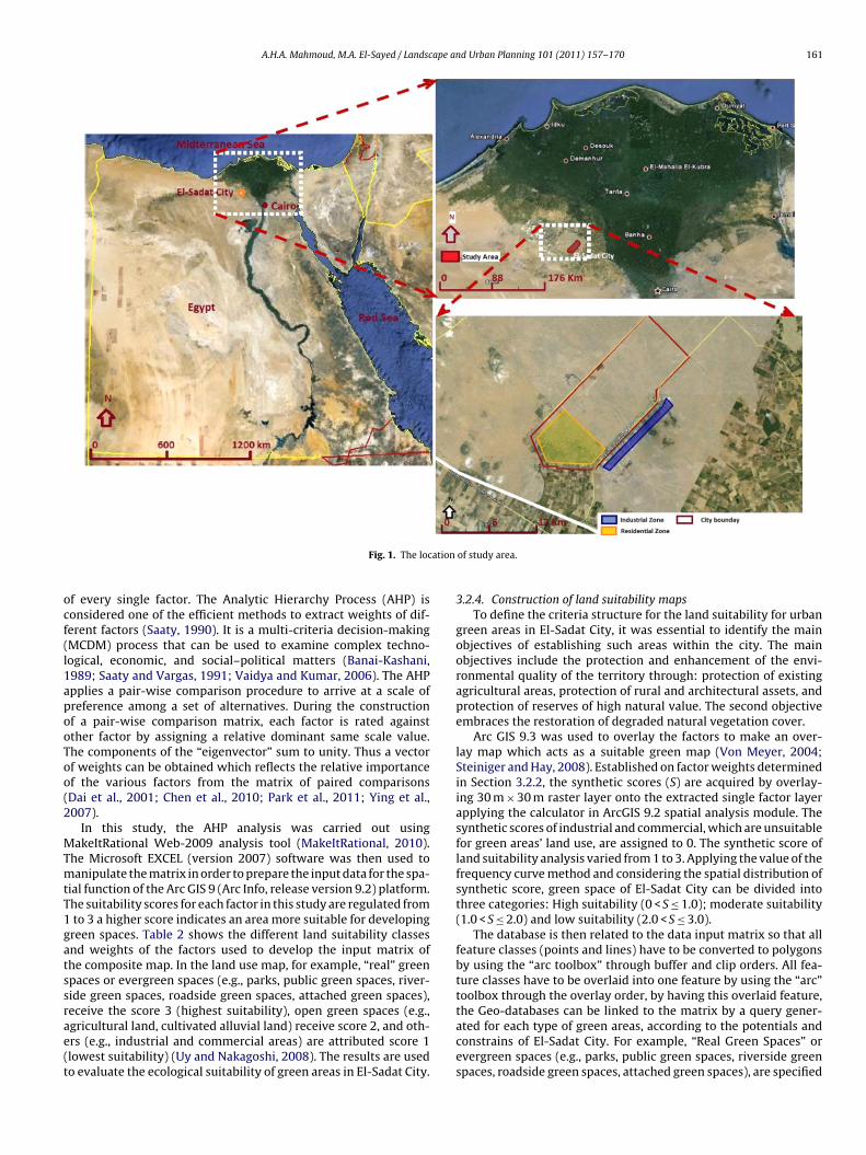
A.H.A. Mahmoud, M.A. El-Sayed / Landscape and Urban Planning 101 (2011) 157–170 161
ation
ocf(l1apooToo(2
MTmtT1gatssrae(t
Fig. 1. The loc
f every single factor. The Analytic Hierarchy Process (AHP) isonsidered one of the efficient methods to extract weights of dif-erent factors (Saaty, 1990). It is a multi-criteria decision-makingMCDM) process that can be used to examine complex techno-ogical, economic, and social–political matters (Banai-Kashani,989; Saaty and Vargas, 1991; Vaidya and Kumar, 2006). The AHPpplies a pair-wise comparison procedure to arrive at a scale ofreference among a set of alternatives. During the constructionf a pair-wise comparison matrix, each factor is rated againstther factor by assigning a relative dominant same scale value.he components of the “eigenvector” sum to unity. Thus a vectorf weights can be obtained which reflects the relative importancef the various factors from the matrix of paired comparisonsDai et al., 2001; Chen et al., 2010; Park et al., 2011; Ying et al.,007).
In this study, the AHP analysis was carried out usingakeItRational Web-2009 analysis tool (MakeItRational, 2010).
he Microsoft EXCEL (version 2007) software was then used toanipulate the matrix in order to prepare the input data for the spa-
ial function of the Arc GIS 9 (Arc Info, release version 9.2) platform.he suitability scores for each factor in this study are regulated fromto 3 a higher score indicates an area more suitable for developingreen spaces. Table 2 shows the different land suitability classesnd weights of the factors used to develop the input matrix ofhe composite map. In the land use map, for example, “real” greenpaces or evergreen spaces (e.g., parks, public green spaces, river-ide green spaces, roadside green spaces, attached green spaces),
eceive the score 3 (highest suitability), open green spaces (e.g.,gricultural land, cultivated alluvial land) receive score 2, and oth-rs (e.g., industrial and commercial areas) are attributed score 1lowest suitability) (Uy and Nakagoshi, 2008). The results are usedo evaluate the ecological suitability of green areas in El-Sadat City.of study area.
3.2.4. Construction of land suitability mapsTo define the criteria structure for the land suitability for urban
green areas in El-Sadat City, it was essential to identify the mainobjectives of establishing such areas within the city. The mainobjectives include the protection and enhancement of the envi-ronmental quality of the territory through: protection of existingagricultural areas, protection of rural and architectural assets, andprotection of reserves of high natural value. The second objectiveembraces the restoration of degraded natural vegetation cover.
Arc GIS 9.3 was used to overlay the factors to make an over-lay map which acts as a suitable green map (Von Meyer, 2004;Steiniger and Hay, 2008). Established on factor weights determinedin Section 3.2.2, the synthetic scores (S) are acquired by overlay-ing 30 m × 30 m raster layer onto the extracted single factor layerapplying the calculator in ArcGIS 9.2 spatial analysis module. Thesynthetic scores of industrial and commercial, which are unsuitablefor green areas’ land use, are assigned to 0. The synthetic score ofland suitability analysis varied from 1 to 3. Applying the value of thefrequency curve method and considering the spatial distribution ofsynthetic score, green space of El-Sadat City can be divided intothree categories: High suitability (0 < S ≤ 1.0); moderate suitability(1.0 < S ≤ 2.0) and low suitability (2.0 < S ≤ 3.0).
The database is then related to the data input matrix so that allfeature classes (points and lines) have to be converted to polygonsby using the “arc toolbox” through buffer and clip orders. All fea-ture classes have to be overlaid into one feature by using the “arc”toolbox through the overlay order, by having this overlaid feature,
the Geo-databases can be linked to the matrix by a query gener-ated for each type of green areas, according to the potentials andconstrains of El-Sadat City. For example, “Real Green Spaces” orevergreen spaces (e.g., parks, public green spaces, riverside greenspaces, roadside green spaces, attached green spaces), are specified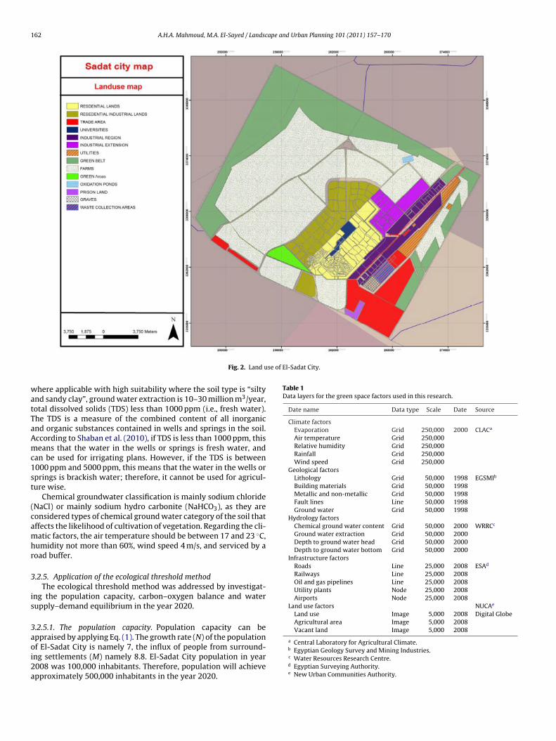
162 A.H.A. Mahmoud, M.A. El-Sayed / Landscape and Urban Planning 101 (2011) 157–170
se of El-Sadat City.
watTaAmc1st
(camhr
3
is
3aoi2a
Table 1Data layers for the green space factors used in this research.
Date name Data type Scale Date Source
Climate factorsEvaporation Grid 250,000 2000 CLACa
Air temperature Grid 250,000Relative humidity Grid 250,000Rainfall Grid 250,000Wind speed Grid 250,000
Geological factorsLithology Grid 50,000 1998 EGSMIb
Building materials Grid 50,000 1998Metallic and non-metallic Grid 50,000 1998Fault lines Line 50,000 1998Ground water Grid 50,000 1998
Hydrology factorsChemical ground water content Grid 50,000 2000 WRRCc
Ground water extraction Grid 50,000 2000Depth to ground water head Grid 50,000 2000Depth to ground water bottom Grid 50,000 2000
Infrastructure factorsRoads Line 25,000 2008 ESAd
Railways Line 25,000 2008Oil and gas pipelines Line 25,000 2008Utility plants Node 25,000 2008Airports Node 25,000 2008
Land use factors NUCAe
Land use Image 5,000 2008 Digital GlobeAgricultural area Image 5,000 2008Vacant land Image 5,000 2008
a Central Laboratory for Agricultural Climate.
Fig. 2. Land u
here applicable with high suitability where the soil type is “siltynd sandy clay”, ground water extraction is 10–30 million m3/year,otal dissolved solids (TDS) less than 1000 ppm (i.e., fresh water).he TDS is a measure of the combined content of all inorganicnd organic substances contained in wells and springs in the soil.ccording to Shaban et al. (2010), if TDS is less than 1000 ppm, thiseans that the water in the wells or springs is fresh water, and
an be used for irrigating plans. However, if the TDS is between000 ppm and 5000 ppm, this means that the water in the wells orprings is brackish water; therefore, it cannot be used for agricul-ure wise.
Chemical groundwater classification is mainly sodium chlorideNaCl) or mainly sodium hydro carbonite (NaHCO3), as they areonsidered types of chemical ground water category of the soil thatffects the likelihood of cultivation of vegetation. Regarding the cli-atic factors, the air temperature should be between 17 and 23 ◦C,
umidity not more than 60%, wind speed 4 m/s, and serviced by aoad buffer.
.2.5. Application of the ecological threshold methodThe ecological threshold method was addressed by investigat-
ng the population capacity, carbon–oxygen balance and waterupply–demand equilibrium in the year 2020.
.2.5.1. The population capacity. Population capacity can beppraised by applying Eq. (1). The growth rate (N) of the population
f El-Sadat City is namely 7, the influx of people from surround-ng settlements (M) namely 8.8. El-Sadat City population in year008 was 100,000 inhabitants. Therefore, population will achievepproximately 500,000 inhabitants in the year 2020.b Egyptian Geology Survey and Mining Industries.c Water Resources Research Centre.d Egyptian Surveying Authority.e New Urban Communities Authority.

A.H.A. Mahmoud, M.A. El-Sayed / Landscape and Urban Planning 101 (2011) 157–170 163
Fig. 3. Technical routine of the method of constructing the green structure of El-Sadat City.
Table 2Classification of the factors governing land suitability of green areas used for GIS input.
Factor High suitability Moderate suitability Low suitability Weight
TopographyElevation <50 m 50–100 m >100m 0.0969Slope <5◦ 5–15◦ >15◦ 0.1180
Vegetation coverage Agricultural land Natural vegetation Industrial and commercial uses
SoilMetallic content No metals Sodium sulfate Sodium chloride 0.0024Thickness of surface layer >20 m 5–20 m <1 m 0.0132Ground water consumption >20 million m3/year 1–20 million m3/year <1 million m3/year 0.3863Quality TDS < 1000 ppm TDS = 1000–5000 ppm TDS > 5000 ppm 0.2561Chemical content NaCl, NaHCO3 MgHCO3 CaHCO3 0.2674
ClimateTemperature 17–20 ◦C 21–29 ◦C >29 ◦C 0.1095Relative Humidity 40–50% 50–70% >70% 0.1095Annual Rainfall >19 mm 6–19 mm <6 mm 0.0860Wind speed >4 m/s 4–6 m/s >6 m/s 0.1002Direction North and North West East and West South and South West 0.0245Cloud cover 0.5 octane 0.5–1 octane >1 octane 0.0825
Geology Major fault lines No fault lines No fault lines 0.1725
UtilitiesRoads First degree road Second degree road None 0.0435Railways Double gauge Single gauge None 0.1027High voltage lines Exist Exist No line 0.0242
Building materials No building materials No building materials Sand, gravel, basalt 0.0023Land use status Open space, road buffer Residential spaces Industrial and commercial uses 0.3324
164 A.H.A. Mahmoud, M.A. El-Sayed / Landscape and Urban Planning 101 (2011) 157–170
p for
3DicsOaccdpt
3cp2ctEd
4
4
ssaflaa
Fig. 4. The land suitability ma
.2.5.2. The carbon–oxygen balance. According to the Humanevelopment Report 2007/2008, the per capita carbon diox-
de emission in Egypt is 0.9 tons yearly (equally: 0.6 tons of O2onsumption) (Watkins, 2008). Therefore, the total oxygen con-umption by the urban population will reach around 300,000 tons.n the other hand, the total carbon dioxide emission will reachround 450,000 tons, with an assumption that there would be nohange of this index until year 2020. The carbon–oxygen balance isalculated based on an estimate of Zhang et al. (2007) of the carbonioxide consumption of large areas of trees (e.g., woodlands andublic parks). The assumption is that the annual O2 production ofrees is equivalent to 70 tons per hectare.
.2.5.3. The water supply–demand equilibrium. The per capita wateronsumption of domestic water at El-Sadat City was 0.061 m3
er day in 2008, and the total domestic water consumption was,226,000 m3. With the improvement of living standards, the perapita water consumption could be increased, and it is forecasthat it will be 0.065 in 2010 and 0.075 m3 per day in year 2020.mploying the water demand model in Eq. (3), the estimated annualemand for water will be 32,800,000 m3.
. Results
.1. Construction of a green map based on LSA
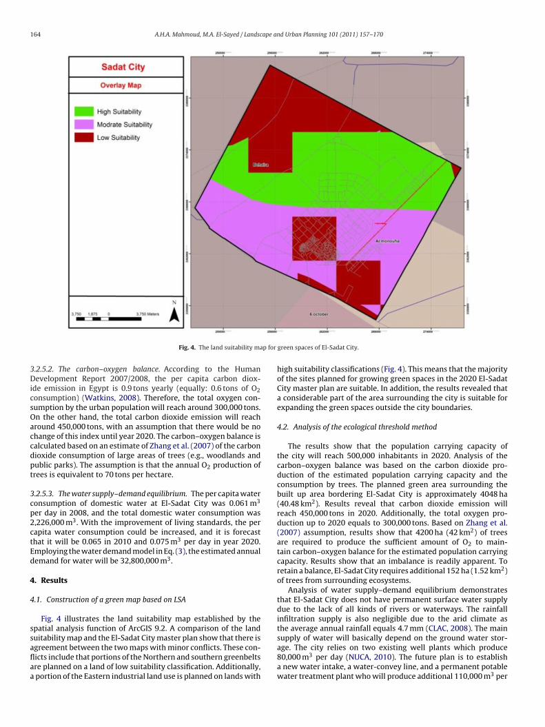
Fig. 4 illustrates the land suitability map established by thepatial analysis function of ArcGIS 9.2. A comparison of the land
uitability map and the El-Sadat City master plan show that there isgreement between the two maps with minor conflicts. These con-icts include that portions of the Northern and southern greenbeltsre planned on a land of low suitability classification. Additionally,portion of the Eastern industrial land use is planned on lands withgreen spaces of El-Sadat City.
high suitability classifications (Fig. 4). This means that the majorityof the sites planned for growing green spaces in the 2020 El-SadatCity master plan are suitable. In addition, the results revealed thata considerable part of the area surrounding the city is suitable forexpanding the green spaces outside the city boundaries.
4.2. Analysis of the ecological threshold method
The results show that the population carrying capacity ofthe city will reach 500,000 inhabitants in 2020. Analysis of thecarbon–oxygen balance was based on the carbon dioxide pro-duction of the estimated population carrying capacity and theconsumption by trees. The planned green area surrounding thebuilt up area bordering El-Sadat City is approximately 4048 ha(40.48 km2). Results reveal that carbon dioxide emission willreach 450,000 tons in 2020. Additionally, the total oxygen pro-duction up to 2020 equals to 300,000 tons. Based on Zhang et al.(2007) assumption, results show that 4200 ha (42 km2) of treesare required to produce the sufficient amount of O2 to main-tain carbon–oxygen balance for the estimated population carryingcapacity. Results show that an imbalance is readily apparent. Toretain a balance, El-Sadat City requires additional 152 ha (1.52 km2)of trees from surrounding ecosystems.
Analysis of water supply–demand equilibrium demonstratesthat El-Sadat City does not have permanent surface water supplydue to the lack of all kinds of rivers or waterways. The rainfallinfiltration supply is also negligible due to the arid climate asthe average annual rainfall equals 4.7 mm (CLAC, 2008). The main
supply of water will basically depend on the ground water stor-age. The city relies on two existing well plants which produce80,000 m3 per day (NUCA, 2010). The future plan is to establisha new water intake, a water-convey line, and a permanent potablewater treatment plant who will produce additional 110,000 m3 per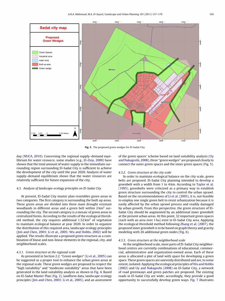
A.H.A. Mahmoud, M.A. El-Sayed / Landscape and Urban Planning 101 (2011) 157–170 165
een w
dlsrtsr
4
tTwrcott(abn
4
bt“gop
Fig. 5. The proposed gr
ay (NUCA, 2010). Concerning the regional supply–demand equi-ibrium for water resource, some studies (e.g., El-Ziny, 2000) havehown that the total amount of water supply in the immediate sur-ounding region surrounding El-Sadat City is sufficient to achievehe development of the city until the year 2020. Analysis of waterupply–demand equilibrium shows that the water resources areelatively sufficient for future expansion of the city.
.3. Analysis of landscape-ecology principles on El-Sadat City
At present, El-Sadat City master plan resembles green areas inwo categories. The first category is surrounding the built up areas.hese green areas are divided into three main drought resistantoodlands in different areas and a green belt within 2 km2 sur-
ounding the city. The second category is a mosaic of green areas inentralized forms. According to the results of the ecological thresh-ld method, the city requires additional 1.52 km2 of vegetationo maintain ecological balance at year 2020. In order to organizehe distribution of this required area, landscape ecology principlesJim and Chen, 2003; Li et al., 2005; Wu and Hobbs, 2002) will bepplied. The results illustrate a proposed green structure as a com-ination of linear and non-linear elements in the regional, city, andeighborhood scales.
.3.1. Green structure at the regional scaleAs presented in Section 2.2, “Green wedges” (Li et al., 2005) can
e suggested as a proper tool to enhance the urban green areas at
he regional scale. These green wedges are proposed to respect thehigh suitability” and “moderate suitability” areas that have beenenerated in the land suitability analysis as shown in Fig. 4. Basedn El-Sadat Master Plan (Fig. 2), landform data, landscape ecologyrinciples (Jim and Chen, 2003; Li et al., 2005), and an assessmentedges for El-Sadat City.
of the green spaces’ scheme based on land suitability analysis (Uyand Nakagoshi, 2008), three “green wedges” are proposed closely toconnect the outer green spaces and the inner green spaces (Fig. 5).
4.3.2. Green structure at the city scaleIn order to maintain ecological balance on the city scale, green
belts are proposed. El-Sadat City planning intended to develop agreenbelt with a width from 1 to 4 km. According to Taylor et al.(1995), greenbelts were criticized as a primary way to establishgreen structure surrounding the city to control the urban sprawl.Based on the recommendations of Li et al. (2005), it is, not feasibleto employ one single green belt to resist urbanization because it iseasily affected by the urban sprawl process and readily damagedby urban growth. From this perspective, the green structure of El-Sadat City should be augmented by an additional inner greenbeltat the present urban areas. At this point, 32 important green spaces(each with an area over 1 ha) exist in El-Sadat City area. Applyingthe ecological threshold method following Zhang et al. (2007), theproposed inner greenbelt is to be based on graph theory and gravitymodeling with 26 additional green nodes (Fig. 6).
4.3.3. Green structure at the neighborhood scaleAt the neighborhood scale, most parts of El-Sadat City neighbor-
hood centres are currently combinations of educational, commer-cial, administrative and organization-owned areas. Each of theseareas is allocated a plot of land with space for developing a greenspace. These green spaces are unevenly distributed and are, to some
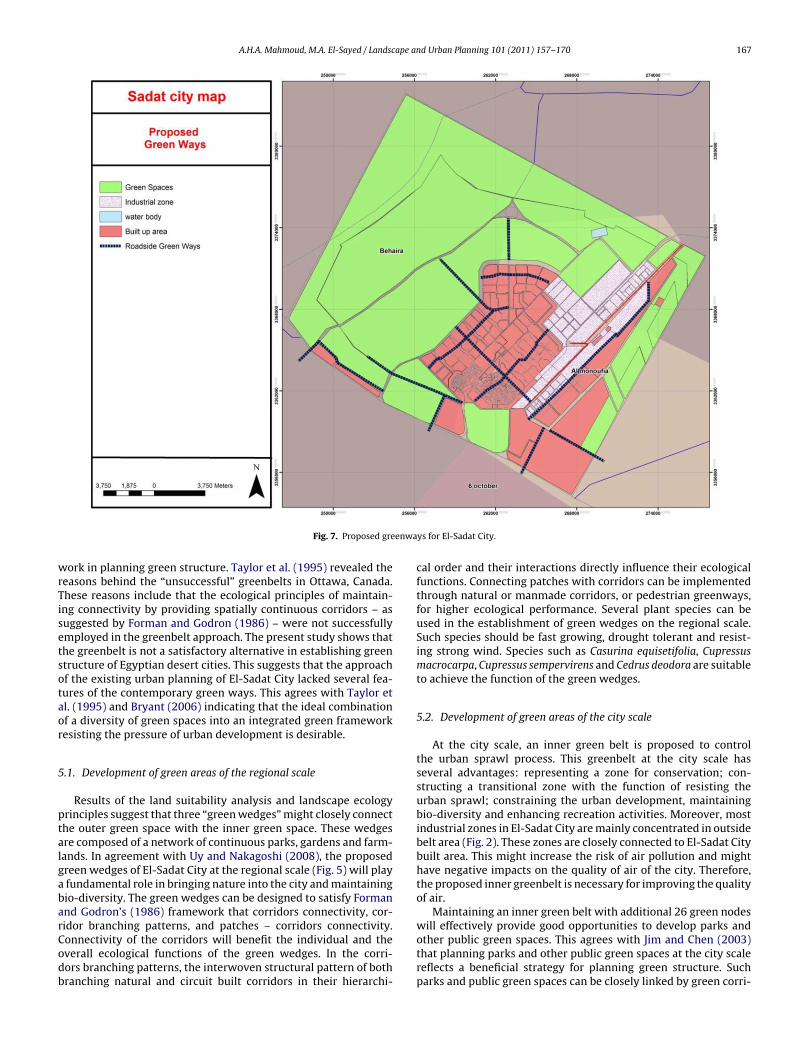
extent, isolated. Applying the ecological principles of Wu and Hobbs(2002) and Uy and Nakagoshi (2008) on El-Sadat City, a networkof road greenways and green patches are proposed. The existingroads in El-Sadat City are wide; accordingly, they provide a goodopportunity to successfully develop green ways. Fig. 7 illustrates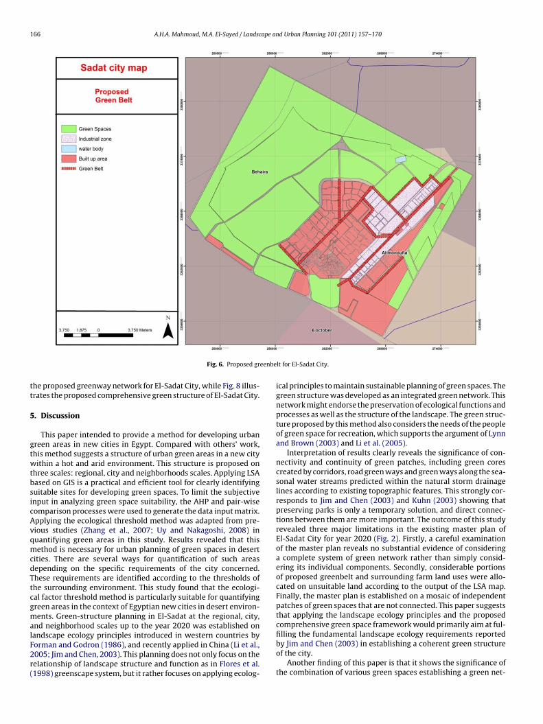
166 A.H.A. Mahmoud, M.A. El-Sayed / Landscape and Urban Planning 101 (2011) 157–170
eenbe
tt
5
gtwtbsicAvqmcdTtcgmalF2r(
Fig. 6. Proposed gr
he proposed greenway network for El-Sadat City, while Fig. 8 illus-rates the proposed comprehensive green structure of El-Sadat City.
. Discussion
This paper intended to provide a method for developing urbanreen areas in new cities in Egypt. Compared with others’ work,his method suggests a structure of urban green areas in a new cityithin a hot and arid environment. This structure is proposed on
hree scales: regional, city and neighborhoods scales. Applying LSAased on GIS is a practical and efficient tool for clearly identifyinguitable sites for developing green spaces. To limit the subjectivenput in analyzing green space suitability, the AHP and pair-wiseomparison processes were used to generate the data input matrix.pplying the ecological threshold method was adapted from pre-ious studies (Zhang et al., 2007; Uy and Nakagoshi, 2008) inuantifying green areas in this study. Results revealed that thisethod is necessary for urban planning of green spaces in desert
ities. There are several ways for quantification of such areasepending on the specific requirements of the city concerned.hese requirements are identified according to the thresholds ofhe surrounding environment. This study found that the ecologi-al factor threshold method is particularly suitable for quantifyingreen areas in the context of Egyptian new cities in desert environ-ents. Green-structure planning in El-Sadat at the regional, city,
nd neighborhood scales up to the year 2020 was established on
andscape ecology principles introduced in western countries byorman and Godron (1986), and recently applied in China (Li et al.,005; Jim and Chen, 2003). This planning does not only focus on theelationship of landscape structure and function as in Flores et al.1998) greenscape system, but it rather focuses on applying ecolog-lt for El-Sadat City.
ical principles to maintain sustainable planning of green spaces. Thegreen structure was developed as an integrated green network. Thisnetwork might endorse the preservation of ecological functions andprocesses as well as the structure of the landscape. The green struc-ture proposed by this method also considers the needs of the peopleof green space for recreation, which supports the argument of Lynnand Brown (2003) and Li et al. (2005).
Interpretation of results clearly reveals the significance of con-nectivity and continuity of green patches, including green corescreated by corridors, road green ways and green ways along the sea-sonal water streams predicted within the natural storm drainagelines according to existing topographic features. This strongly cor-responds to Jim and Chen (2003) and Kuhn (2003) showing thatpreserving parks is only a temporary solution, and direct connec-tions between them are more important. The outcome of this studyrevealed three major limitations in the existing master plan ofEl-Sadat City for year 2020 (Fig. 2). Firstly, a careful examinationof the master plan reveals no substantial evidence of consideringa complete system of green network rather than simply consid-ering its individual components. Secondly, considerable portionsof proposed greenbelt and surrounding farm land uses were allo-cated on unsuitable land according to the output of the LSA map.Finally, the master plan is established on a mosaic of independentpatches of green spaces that are not connected. This paper suggeststhat applying the landscape ecology principles and the proposedcomprehensive green space framework would primarily aim at ful-
filling the fundamental landscape ecology requirements reportedby Jim and Chen (2003) in establishing a coherent green structureof the city.Another finding of this paper is that it shows the significance ofthe combination of various green spaces establishing a green net-
A.H.A. Mahmoud, M.A. El-Sayed / Landscape and Urban Planning 101 (2011) 157–170 167
enwa
wrTisetsotaor
5
ptalgabarCodb
Fig. 7. Proposed gre
ork in planning green structure. Taylor et al. (1995) revealed theeasons behind the “unsuccessful” greenbelts in Ottawa, Canada.hese reasons include that the ecological principles of maintain-ng connectivity by providing spatially continuous corridors – asuggested by Forman and Godron (1986) – were not successfullymployed in the greenbelt approach. The present study shows thathe greenbelt is not a satisfactory alternative in establishing greentructure of Egyptian desert cities. This suggests that the approachf the existing urban planning of El-Sadat City lacked several fea-ures of the contemporary green ways. This agrees with Taylor etl. (1995) and Bryant (2006) indicating that the ideal combinationf a diversity of green spaces into an integrated green frameworkesisting the pressure of urban development is desirable.
.1. Development of green areas of the regional scale
Results of the land suitability analysis and landscape ecologyrinciples suggest that three “green wedges” might closely connecthe outer green space with the inner green space. These wedgesre composed of a network of continuous parks, gardens and farm-ands. In agreement with Uy and Nakagoshi (2008), the proposedreen wedges of El-Sadat City at the regional scale (Fig. 5) will playfundamental role in bringing nature into the city and maintainingio-diversity. The green wedges can be designed to satisfy Formannd Godron’s (1986) framework that corridors connectivity, cor-
idor branching patterns, and patches – corridors connectivity.onnectivity of the corridors will benefit the individual and theverall ecological functions of the green wedges. In the corri-ors branching patterns, the interwoven structural pattern of bothranching natural and circuit built corridors in their hierarchi-ys for El-Sadat City.
cal order and their interactions directly influence their ecologicalfunctions. Connecting patches with corridors can be implementedthrough natural or manmade corridors, or pedestrian greenways,for higher ecological performance. Several plant species can beused in the establishment of green wedges on the regional scale.Such species should be fast growing, drought tolerant and resist-ing strong wind. Species such as Casurina equisetifolia, Cupressusmacrocarpa, Cupressus sempervirens and Cedrus deodora are suitableto achieve the function of the green wedges.
5.2. Development of green areas of the city scale
At the city scale, an inner green belt is proposed to controlthe urban sprawl process. This greenbelt at the city scale hasseveral advantages: representing a zone for conservation; con-structing a transitional zone with the function of resisting theurban sprawl; constraining the urban development, maintainingbio-diversity and enhancing recreation activities. Moreover, mostindustrial zones in El-Sadat City are mainly concentrated in outsidebelt area (Fig. 2). These zones are closely connected to El-Sadat Citybuilt area. This might increase the risk of air pollution and mighthave negative impacts on the quality of air of the city. Therefore,the proposed inner greenbelt is necessary for improving the qualityof air.
Maintaining an inner green belt with additional 26 green nodes
will effectively provide good opportunities to develop parks andother public green spaces. This agrees with Jim and Chen (2003)that planning parks and other public green spaces at the city scalereflects a beneficial strategy for planning green structure. Suchparks and public green spaces can be closely linked by green corri-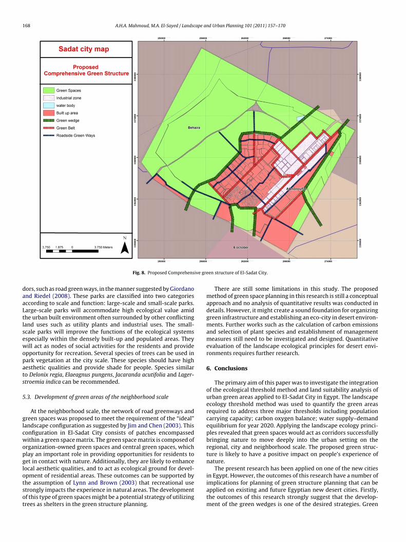
168 A.H.A. Mahmoud, M.A. El-Sayed / Landscape and Urban Planning 101 (2011) 157–170
ive gre
daaLtlsewopats
5
glcwopglotsot
Fig. 8. Proposed Comprehens
ors, such as road green ways, in the manner suggested by Giordanond Riedel (2008). These parks are classified into two categoriesccording to scale and function: large-scale and small-scale parks.arge-scale parks will accommodate high ecological value amidhe urban built environment often surrounded by other conflictingand uses such as utility plants and industrial uses. The small-cale parks will improve the functions of the ecological systemsspecially within the densely built-up and populated areas. Theyill act as nodes of social activities for the residents and provide
pportunity for recreation. Several species of trees can be used inark vegetation at the city scale. These species should have highesthetic qualities and provide shade for people. Species similaro Delonix regia, Elaeagnus pungens, Jacaranda acutifolia and Lager-troemia indica can be recommended.
.3. Development of green areas of the neighborhood scale
At the neighborhood scale, the network of road greenways andreen spaces was proposed to meet the requirement of the “ideal”andscape configuration as suggested by Jim and Chen (2003). Thisonfiguration in El-Sadat City consists of patches encompassedithin a green space matrix. The green space matrix is composed of
rganization-owned green spaces and central green spaces, whichlay an important role in providing opportunities for residents toet in contact with nature. Additionally, they are likely to enhanceocal aesthetic qualities, and to act as ecological ground for devel-
pment of residential areas. These outcomes can be supported byhe assumption of Lynn and Brown (2003) that recreational usetrongly impacts the experience in natural areas. The developmentf this type of green spaces might be a potential strategy of utilizingrees as shelters in the green structure planning.en structure of El-Sadat City.
There are still some limitations in this study. The proposedmethod of green space planning in this research is still a conceptualapproach and no analysis of quantitative results was conducted indetails. However, it might create a sound foundation for organizinggreen infrastructure and establishing an eco-city in desert environ-ments. Further works such as the calculation of carbon emissionsand selection of plant species and establishment of managementmeasures still need to be investigated and designed. Quantitativeevaluation of the landscape ecological principles for desert envi-ronments requires further research.
6. Conclusions
The primary aim of this paper was to investigate the integrationof the ecological threshold method and land suitability analysis ofurban green areas applied to El-Sadat City in Egypt. The landscapeecology threshold method was used to quantify the green areasrequired to address three major thresholds including populationcarrying capacity; carbon oxygen balance; water supply–demandequilibrium for year 2020. Applying the landscape ecology princi-ples revealed that green spaces would act as corridors successfullybringing nature to move deeply into the urban setting on theregional, city and neighborhood scale. The proposed green struc-ture is likely to have a positive impact on people’s experience ofnature.
The present research has been applied on one of the new cities
in Egypt. However, the outcomes of this research have a number ofimplications for planning of green structure planning that can beapplied on existing and future Egyptian new desert cities. Firstly,the outcomes of this research strongly suggest that the develop-ment of the green wedges is one of the desired strategies. Green
ape an
wsmgcbpclcntecT
R
A
B
B
B
B
C
C
C
D
D
D
EE
E
F
F
FF
F
F
G
G
H
I
J
J
J
A.H.A. Mahmoud, M.A. El-Sayed / Landsc
edges are established through linking the open space with theurrounding natural landscape. Secondly, the sustainable develop-ent and augmentation of other green spaces such as the road
reen ways, the green cores and the green ways that link greenores in the inner greenbelt might largely depend on the landudget and the requirement of urban development. Thirdly, theroposed green network might help green areas to improve theonnectivity and reduce fragmentation and isolation through theinked and integrated greenway system. Additionally, the networkan act as a catalyst to protect existing green spaces and generateew ones. Finally, this proposed network might very well main-ain a better quality of life of residents when they are provided annhanced contact with nature. Very few papers about Egyptian newities green space planning have been published internationally.his study contributes to fulfill this gap.
eferences
spinall, R., Pearson, D., 2000. Integrated geographical assessment of environmen-tal condition in water catchments: linking landscape ecology, environmentalmodelling and GIS. J. Environ. Manage. 59, 299–319.
anai-Kashani, R., 1989. A new method for site suitability analysis: the AnalyticHierarchy Process. J. Environ. Manage. 13, 685–693.
izuwerk, A., Peden, D., Taddese, G., Getahun, Y., 2006. GIS Application for Analysis ofLand Suitability and Determination of Grazing Pressure in Upland of the AwashRiver Basin, Ethiopia. International Livestock Research Institute.
rail, R.K., Klosterman, R.E., 2001. Planning Support Systems. ESRI Press, Redlands,CA.
ryant, M.M., 2006. Urban landscape conservation and the role of ecological green-ways at local and metropolitan scales. Landscape Urban Plan. 76, 23–44.
entral Laboratory for Agricultural Research, 2008. Weather maps of Egypt,Retrieved on April 11, 2010, from http://www.clac.edu.eg/english/weather.htm.
hen, Y., Yu, J., Khan, S., 2010. Spatial sensitivity analysis of multi-criteria weightsin GIS-based land suitability evaluation. Environ. Model. Softw. 25, 1582–1591.
ollins, M., Steiner, F.R., Rushman, M.J., 2001. Land uses suitability analysis in UnitedStates. Historical development and promising technological achievement. Env-iron. Manage. 18, 611–621.
ai, F.C., Lee, C.F., Zgang, X.H., 2001. GIS-based geo-environmental evaluation forurban land-use planning: a case study. Eng. Geol. 61, 257–271.
igitalGlobe, 2010. Standard Satellite Imagery, Retrieved on March 12, 2009, fromhttp://www.digitalglobe.com.
urga Rao, K.H.V., 2005. Multi-criteria spatial decision analysis for forecasting urbanwater requirements: a case study of Dehradun city, India. Landscape Urban Plan.71, 163–174.
gyptian Geological Survey and Mining Industries, 2008. Geological maps of Egypt.gyptian Survey Authority, 2010. Topographic Digital Maps, Retrieved on January
16, 2010, from http://www.esa.gov.eg/English/ESAwebsite.aspx.l-Ziny, S., 2000. Water as an Essential Factor for Sustainable Development. Unpub-
lished Ph.D. Thesis. Cairo University, Cairo, Egypt.ahmi, W., Sutton, K., 2008. Greater Cairo’s housing crisis: contested spaces from
inner city areas to new communities. Cities 25, 277–297.lores, A., Pickett, S.T.A., Zipperer, W.C., Pouyat, R.V., Pirani, R., 1998. Adopting a
modern ecological view of the metropolitan landscape: the case of a greenspacesystem for the New York City region. Landscape Urban Plan. 39, 295–308.
orman, R.T.T., Godron, M., 1986. Landscape Ecology. Wiley, New York, NY.orman, T.T., 1995. Land Mosaics: The Ecology of Landscapes and Regions. Cambridge
University Press, Cambridge, UK.rey, H.W., 2000. Not green belts but green wedges: the precarious relationship
between city and country. Urban Des. Int. 5, 13–25.rischenbruder, M.T., Pellegrino, P., 2006. Using greenways to reclaim nature in
Brazilian cities. Landscape Urban Plan. 76, 67–78.iordano, L.C., Riedel, P.S., 2008. Multi-criteria spatial decision analysis for demarca-
tion of greenway: a case study of the city of Rio Claro, Sao Paulo, Brazil. LandscapeUrban Plan. 84, 301–311.
obster, P.H., Westphal, L.M., 2004. The human dimension of urban greenways:planning for recreation and related experience. Landscape Urban Plan. 68,147–165.
ersperger, A.M., 2006. Spatial adjacencies and interactions: neighborhood mosaicsfor landscape ecological planning. Landscape Urban Plan. 77, 227–239.
mam, K.Z., 2006. Role of urban greenway systems in planning residential commu-nities: a case study from Egypt. Landscape Urban Plan. 76, 192–209.
ie, L., Jing, Y., Wang, Y., Shu-xia, Y., 2010. Environmental impact assessment of landuse planning in Wuhan City based on ecological suitability analysis. Procedia
Environ. Sci. 2, 185–191.im, C.Y., Chen, S.S., 2003. Comprehensive greenspace planning based on landscapeecology principles in compact Nanjing city, China. Landscape Urban Plan. 65,95–116.
o, H.K., 2002. Impacts of urban green space on offsetting carbon emissions for middleKorean. J. Environ. Manage. 64, 115–126.
d Urban Planning 101 (2011) 157–170 169
Kuhn, M., 2003. Greenbelt and green heart: separating and integrating landscapesin European city regions. Landscape Urban Plan. 64, 19–27.
Kalogirou, S., 2002. Expert systems and GIS: an application of land suitability eval-uation. Comput. Environ. Urban Syst. 26, 89–112.
Kang, P., Xu, L., 2010. The urban ecological regulation based on ecological carryingcapacity. Procedia Environ. Sci. 2, 1692–1700.
Khalifa, M., 2010. Redefining slums in Egypt: unplanned versus unsafe areas. HabitatInt., 1–10, doi:10.1016/j.habitatint.2010.03.004.
Li, F., Wang, R., Paulussen, J., Lui, X., 2005. Comprehensive concept planning of urbangreening based on ecological principles: a case study in Beijing, China. LandscapeUrban Plan. 72, 325–336.
Lynn, N.A., Brown, R.D., 2003. Effects of recreational use impacts on hiking experi-ences in natural areas. Landscape Urban Plan. 64, 77–87.
Mahmoud, A.H.A., 2011. An analysis of bioclimatic zones and implications for designof outdoor environments in Egypt. Build. Environ. 46, 605–620.
MakeItRations, 2010. Decision Making Solutions, Retrieved on April 22, 2010, fromURL: http://www.makeitrational.com/.
Malczewshi, J., 2004. GIS-based land-use suitability analysis: a critical overview.Prog. Plan. 62, 3–65.
McHale, M.R., Mc Pherson, E.G., Burke, I.C., 2007. The potential of urban tree plantingsto be cost effective in carbon credit markets. Urban Forest. Urban Green. 6, 49–60.
McHarg, I., 1995. Design with Nature. Wiley, New York, NY.Miller, W., Collins, M.G., Steiner, F.R., Cook, E., 1998. An approach for greenway
suitability analysis. Landscape Urban Plan. 42, 91–105.Mortberg, U.M., Balfors, B., Knol, W.C., 2007. Landscape ecological assessment: a
tool for integrating biodiversity issues in strategic environmental assessmentand planning. J. Environ. Manage. 82, 457–470.
New Urban Communities Authority (NUCA), 2010. New Cities of Egypt, Retrievedon May 20, 2010, from http://www.urban-comm.gov.eg/english/index.asp.
Ong, B.L., 2003. Green plot ratio: an ecological measure for architecture and urbanplanning. Landscape Urban Plan. 63, 197–211.
Park, S., Jeon, S., Kim, S., Choi, C., 2011. Prediction and comparison of urban growthby land suitability index mapping using GIS and RS in South Korea. LandscapeUrban Plan. 99, 104–114.
Pervee, F., Nagasawa, R., Uddin1, I., Delowar, H.K., 2005. Crop-Land Suitability Anal-ysis using a Multicriteria Evaluation & GIS Approach. United Graduate School ofAgricultural Sciences, Tottori University, Tottori, Japan.
Phua, M., Minora, M., 2004. A GIS-based multi-criteria decision making approach toforest conservation planning at a landscape scale: a case study in Kinabalu Area,Sabah, Malaysia. Landscape Urban Plan. 71, 207–222.
Pirnat, J., 2000. Conservation and management of forest patches and corridors insuburban landscapes. Landscape Urban Plan. 52, 135–143.
Saaty, T.L., 1990. How to make a decision: the Analytic Hierarchy Process. Eur. J.Oper. Res. 48, 9–26.
Saaty, T.L., Vargas, L.G., 1991. Prediction, Projection, and Forecasting: Applications ofthe Analytic Hierarchy Process in Economics, Finance, Politics Games and Sports.Kluwer Academic Publishers, Boston, p. 251.
Santosh, K., Prajapati, B.D., Tripathi, B.D., 2008. Anticipated performance index ofsome tree species considered for green belt development in and around an urbanarea: a case study of Varanasi city, India. J. Environ. Manage. 88, 1343–1349.
Shaban, M., Urban, B., El Saadi, A., Faisal, M., 2010. Detection and mapping of waterpollution variation in the Nile Delta using multivariate clustering and GIS tech-niques. J. Environ. Manage. 91, 1785–1793.
Shearer, K.S., Xiang, W., 2009. Representing multiple voices in landscape planning:a land suitability assessment study for a park land-banking program in Concord,North Carolina, USA. Landscape Urban Plan. 93, 111–122.
Spatial Reference, 2010. EPSG Projection 32636 – WGS 84/UTM zone 36N. Retrievedon May 23, 2010, from http://spatialreference.org/ref/epsg/32636/.
Steiniger, S., Hay, G.J., 2008. Free and open source geographic information tools forlandscape ecology. Ecol. Inform. 4, 183–195.
Store, R., Kangas, J., 2001. Integrating spatial multi-criteria evaluation and expertknowledge for GIS-based habitat suitability modeling. Landscape Urban Plan.55, 79–93.
Store, R., 2009. Sustainable locating of different forest uses. Land Use Policy 26,610–618.
Swetnam, R.D., Ragou, P., Firbank, L.G., Hinsley, S.A., Bellamy, P.E., 1998. Applyingecological models to altered landscape scenario-testing with GIS. LandscapeUrban Plan. 41, 3–18.
Tan, K.W., 2006. A greenway network for Singapore. Landscape Urban Plan. 76,45–66.
Taylor, J., Paine, C., FitzGibbon, J., 1995. From greenbelt to greenways: four Canadiancase studies. Landscape Urban Plan. 33, 47–64.
Teal, M., Huang, C.S., Rodiek, J., 1998. Open space planning for Travis Country, Austin,Texas: a collaborative design. Landscape Urban Plan. 42, 259–268.
Thompson, C.W., 2002. Urban open space in the 21st century. Landscape Urban Plan.60, 59–72.
Turner, T., 2006. Greenway planning in Britain: recent work and future plans. Land-scape Urban Plan. 76, 240–251.
Tyrvainen, L., Makinen, K., Schipperijn, J., 2007. Tools for mapping social val-ues of urban woodlands and other green areas. Landscape Urban Plan. 79,
5–19.Uy, P.D., Nakagoshi, N., 2008. Application of land suitability analysis and landscapeecology to urban green space planning in Hanoi. Urban Forest. Urban Green. 7,25–40.
Vaidya, O.S., Kumar, S., 2006. Analytic Hierarchy Process: an overview of applica-tions. Eur. J. Oper. Res. 169, 1–29.

1 ape an
V
V
W
W
W
70 A.H.A. Mahmoud, M.A. El-Sayed / Landsc
erbeeck, K., Orshoven, J., Hermy, M., 2010. Measuring extent, location and changeof imperviousness in urban domestic gardens in collective housing projects.Landscape Urban Plan., doi:10.1016/j.landurbplan.2010.09.007.
on Meyer, N., 2004. GIS and Land Records: The Parcel Data Model. Esri Press, NewYork, NY.
atkins, K., 2008. Human Development Report 2007/2008. United Nations Devel-
opment Program. Retrieved on June 21, 2010, from http://hdr.undp.org/en/reports/global/hdr2007-2008/.orld Bank, 2008. Egypt: Urban Sector Update Vol. 1 of 2. World Bank, Washington,D.C.
u, J.G., Hobbs, R., 2002. Key issues and research priorities in landscape ecology: anindiosyncratic synthesis. Landscape Ecol. 17, 355–365.
d Urban Planning 101 (2011) 157–170
Ying, X., Zeng, G.M., Chen, G.Q., Tang, L., Wang, K.L., Huang, D.Y., 2007. CombiningAHP with GIS in synthetic evaluation of eco-environment quality: a case studyof Hunan Province, China. Ecol. Model. 209, 97–109.
Yokohari, M., Amati, M., 2005. Nature in the city, city in the nature: case studies ofthe restoration of urban nature in Tokyo, Japan and Toronto, Canada. LandscapeEcol. Eng. 1, 53–59.
Zhang, L., Liu, Q., Hall, N.W., Fu, Z., 2007. An environmental accounting frameworkapplied to green space ecosystem planning for small towns in China as a casestudy. Ecol. Econ. 60, 533–542.
Zucca, A., Sharifib, A.M., Fabbria, A.G., 2008. Application of spatial multi-criteria anal-ysis to site selection for a local park: a case study in the Bergamo Province, Italy.J. Environ. Manage. 88, 752–769.