development control plan 2011 - City of Parramatta
677
PARRAMATTA DEVELOPMENT CONTROL PLAN 2011 City of Parramatta Council
-
Upload
khangminh22 -
Category
Documents
-
view
2 -
download
0
Transcript of development control plan 2011 - City of Parramatta

PARRAMATTADEVELOPMENT CONTROL PLAN
2011
City of Parramatta Council


Parramatta Development Control Plan 2011
CONTENTSPART 1 1 - 1INTRODUCTION
PART 2 2 - 1SITE PLANNING
PART 3 3 - 1DEVELOPMENT PRINCIPLES
PART 4 4 - 1SPECIAL PRECINCTS
4.1 Town and Neighbourhood Centres
4.2 Special Character Areas
4.3 Strategic Precincts
4.4 Heritage Conservation Areas
PART 5 5 - 1OTHER PROVISIONS
GLOSSARY
APPENDIXESA1 Section 79C - Environmental Planning and Assessment Act 1979
A2 Views and Vistas
A3 Vegetation Communities and Remnant Trees
A4 Neighbourhood Character Areas
A5 Notification Procedures
A6 Heritage Information: Terms, Responsibilities and Procedures
A7 Water Sensitive Urban Design Strategy Guide
A8 Waste Management Plans
A9 Guide to Plans of Management for Boarding House Developments
A10 Acoustic Privacy - Child Care Centres
A11 Aboriginal Sensitivity

Parramatta Development Control Plan 2011
LIST OF AMENDMENTSAmendment Number Sections Affected Description of Ammendment Date Approved
by Council Date in Force
1 Section 1.3 Deletion of Rosehill Masterplan as a Deemed DCP
7 November 2012
Section 4.3.2.1 Introduction of controls for ‘Block 2’ bound by Hope, Weston andArthur Streets and James Ruse Drive, Rosehill
2 Section 4.3.2.2 Introduction of controls for land at 2 - 12 River Road West,Parramatta
8 May 2013
3 Section 4.3.3.1 Introduction of controls for land at 158 - 164 Hawkesbury Road andPart 2A Darcy Road, Westmead
25 September2013
4 Section 4.3.3 Introduction of controls for Parramatta City Centre
2 April2014
Section 4.1.5 Amendment of controls for Epping Town Centre
Section 4.4.1 Amendment of controls for Epping Heritage Conservation Areas
Various Housekeeping Amendment No.15 Section 4.3.5 Ermington, Naval Stores Precinct October
20146 Section 4.3.3.7 57, 63 and 83 Church Street and
44 Early Street, ParramattaNovember 2014
7 Section 4.3.3.7 (b) Amendment of Controls for Parramatta Square
July 2015
8 Section 4.3.2 Deletion of controls relating to Key Block 5: Parramatta Workers Club
August 2015
Section 5.4 Amendment of Preservation of Trees and Vegetation Controls
9 Section 4.3.3.7 (b) Amendment of Controls for Parramatta Square relating to overshadowing
December 2015
10 Section 4.3.4.2 Introduction of Special Area: 24-26 Railway Parade, Westmead
4 March 2016
11 Section 4.3.3.5 Introduction of Controls for the leasing of existing surplus carparking spaces
13 April 2016
12 Section 4.3.3.7 (e) 8 – 12 Victoria Road and 2A Villiers Street, Parramatta
22 February 2016
22 July 2016
13 Various Housekeeping Amendment No. 2 10 April 2017 17 May 2017
14 Section 4.3 Introduction of new strategic precinct – Parramatta North Urban Transformation Precinct
10 July 2017 10 Aug 2017

PART 1INTRODUCTION

PART
1
TOC - 2 Parramatta Development Control Plan 2011
CONTENTS1.1 Legislative Background 1-3
1.2 Name of this Development Control Plan 1-3
1.3 Where this Development Control Plan Applies 1-3
1.4 Relationship to other Plans and Policies 1-4
1.5 Purpose of this Development Control Plan 1-5
1.6 Aims of this Development Control Plan 1-5
1.7 Structure of this Development Control Plan 1-5
1.8 Terms used in this Development Control Plan 1-6

PART
1
Parramatta Development Control Plan 2011 1 - 3
INTRODUCTION Legislative Background
1.1 Legislative BackgroundDivision 6 of Part 3 of the Environmental Planning and Assessment Act 1979 (EP&A Act) commenced on 30 September 2005. This Division introduced new requirements for Development Control Plans (DCPs).
As a result of these changes to the EP&A Act, Council has consolidated all of its DCPs that apply to the Parramatta local government area into one plan.
On commencement of this consolidated plan, all previous DCPs will cease to have any effect on the land to which this plan applies.
1.2 Name of this Development Control PlanThis plan is known as Parramatta Development Control Plan (DCP) 2011.
The DCP was adopted by Council on 22 November 2010 with further changes adopted on 28 March 2011 and came into effect on 12 October 2011.
1.3 Where this Development Control Plan AppliesThis plan applies to all land within the Parramatta Local Government Area and the following deemed development control plans;
� Eastwood Brickworks Final Masterplan, adopted by City of Parramatta Council
� North Parramatta Mixed Use Zone Masterplan, adopted by the Director General of the Department of Planning
The location of these deemed development control plans is shown on the following map.

PART
1
1 - 4 Parramatta Development Control Plan 2011
INTRODUCTION Relationship to other Plans and Policies
Figure 1.3.1 Land to which this Development Control Plan Applies
1.4 Relationship to other Plans and Policies This DCP is to be read in conjunction with the Parramatta LEP 2011. If there is any inconsistency between this DCP and the Parramatta LEP 2011, the LEP will prevail.
The following are repealed to the extent to which they apply to land covered by this DCP:
� Parramatta Child Care Centres DCP 2007

PART
1
Parramatta Development Control Plan 2011 1 - 5
INTRODUCTION Purpose of this Development Control Plan
� Parramatta DCP 2005
� Parramatta Notification DCP 2004
� Parramatta Heritage DCP 2001
� Harris Park DCP 2002
� DCP for Places of Public Worship 2010
� DCP for Sex Services and Restricted Premises 2010
� Parramatta City Council Tree Preservation Order
� Parramatta City Centre DCP 2007
1.5 Purpose of this Development Control Plan The purpose of this DCP is to supplement the Parramatta LEP 2011 and provide more detailed provisions to guide development.
Under Section 79C of the Environmental Planning and Assessment Act 1979, Council is required to take into consideration the relevant provisions of this DCP when determining an application for development. However, compliance with the provisions of this DCP does not guarantee that development consent will be granted.
Section 79C of the Environmental Planning and Assessment Act 1979 contains other matters that must be considered in determining a development application.
NOTE: Appendix 1 contains an extract of Section 79C.
1.6 Aims of this Development Control Plan The aims of this DCP are to:
� Ensure that development contributes to the quality of the natural and built environments
� Encourage development that contributes to the quality of the public domain
� Ensure that development is economically, environmentally and socially sustainable
� Ensure future development has consideration for the needs of all members of the community
� Ensure development positively responds to the qualities of the site and its context
� Ensure development positively responds to the character of the surrounding area
� Ensure development positively responds to the qualities of the site and its context
� Ensure development positively responds to the character of the surrounding area
1.7 Structure of this Development Control Plan
Part 1 - Introduction
Explains what the DCP is and where it applies.
Part 2 - Context and Site Planning
Assists applicants to determine the pre-development opportunities and constraints of a site prior to commencing design of a proposal.
Part 3 - Development Principles
Assists applicants to identify a three dimensional building envelope that forms the basis of the design and which is further refined by applying the General Development Principles.

PART
1
1 - 6 Parramatta Development Control Plan 2011
INTRODUCTION Terms used in this Development Control Plan
Part 4 - Special Precincts
Contains additional design requirements for certain places that require special consideration.
Development in these places is to be designed with regard to the provisions of Parts 2 and 3, and with emphasis on the additional design requirements of this Part.
Part 5 - Other Provisions
Outlines provisions for certain types of development, such as boarding houses, child care centres and signage.
Glossary
Contains the definition of words for the purpose of this DCP.
Appendices
Contains useful information that is referred to in the DCP.
1.8 Terms used in this Development Control Plan In this DCP, terms have the meaning ascribed in the Environmental Planning and Assessment Act 1979 and the Parramatta LEP 2011. Certain terms used in this DCP are defined in the glossary.
Any reference in a Part of this Consolidated Plan to “this DCP” or “this Plan” is a reference to the Part of this Consolidated Plan where the reference is contained.

PART 2SITE PLANNING

PART
2
TOC - 2 Parramatta Development Control Plan 2011
CONTENTS2.1 Design in Context in Parramatta City 2-1
2.2 Requirements for Submitting a Development Application 2-4
2.3 Site Analysis 2-4
2.4 Site Considerations 2-5
2.4.1 Views and Vistas 2-5
2.4.2 Water Management 2-62.4.2.1 Flooding 2-62.4.2.2 Protection of Waterways 2-122.4.2.3 Protection of Groundwater 2-13
2.4.3 Soil Management 2-132.4.3.1 Sedimentation 2-132.4.3.2 Acid Sulfate Soils 2-152.4.3.3 Salinity 2-16
2.4.4 Land Contamination 2-16
2.4.5 Air Quality 2-18
2.4.6 Development on Sloping Land 2-18
2.4.7 Biodiversity 2-192.4.7.1 General 2-192.4.7.2 Development on land abutting the E2 Environmental Protection zone and W1
Natural Waterways zone 2-20
2.4.8 Public Domain 2-20

PART
2
2.1
Parramatta Development Control Plan 2011 2 - 1
DESiGN iN CoNTExT iN PARRAmATTA CiTy
2.1 Design in Context in Parramatta CityIn the context of Sydney, Parramatta City is located at the head of Sydney Harbour at the edge of the Cumberland Basin. On either side of the Parramatta River, the City’s topography is generally characterised by hills and valleys to the north, and the Cumberland Plain to the south. The City’s centre is located between the hills and the Plain, and along the banks of the Parramatta River. The River’s tributaries and adjacent open space corridors extend as fingers through the City.
A number of hard physical elements traverse the City including the Western Railway, the M4 Motorway and regional main roads such as Woodville Road, Pennant Hills Road, Parramatta Road and Windsor Road. Large pockets of institutional and industrial land uses also differentiate the City including the Westmead Medical Precinct, the University of Western Sydney and the Camellia-Rydalmere Industrial Precinct. Parramatta Park, Rosehill Racecourse, and the Parramatta Speedway are recreational uses that cover substantial areas of the City. Commercial centres such as Carlingford, Epping and Granville, as well as a mix of smaller neighbourhood centres, also contribute to Parramatta’s diverse urban fabric.
These elements have a significant impact on the form and function of localities. Designing in context, recognising these broader spatial dynamics of the City, and refining an urban design framework consistent with the objectives of the planning framework, will ensure the future physical form of Parramatta kindles a sustainable, energetic and healthy community.
When designing a development for a site it is essential to respond to the local and broader urban context by identifying the area’s defining elements. The design should be informed by this.
In order to understand this context, a site analysis (at an appropriate scale) should be undertaken as a first step in preparing for a development. This should identify the opportunities and constraints of the site and create a platform from which to develop a design. A site analysis demonstrates that the proposed development is the best possible solution and makes the best contribution to its surroundings.
The site analysis should include:
� The urban structure including property boundaries, street network and public spaces
� The land uses
� Topography and landscape
� Transport routes and stops
� Main building typologies
� Open space and waterways
� Heritage and archaeology
� Key views and vistas
� Building envelope, including footprint, height, setbacks and through links required in the Parramatta LEP 2011 and this DCP.
These elements should be considered in relation to the site and its area, but also relative to the existing planning framework and controls. Many areas in the City are in transition. It is important to recognise that places and communities evolve over time and anticipation of spatial change needs to be balanced with existing themes, forms and patterns which have helped establish the character of the locality.

PART
2
2.1
2 - 2 Parramatta Development Control Plan 2011
DESiGN iN CoNTExT iN PARRAmATTA CiTy
Figure 2.1.1 Context analysis
Figure 2.1.2 Built form and height analysis

PART
2
2.1
Parramatta Development Control Plan 2011 2 - 3
DESiGN iN CoNTExT iN PARRAmATTA CiTy
Figure 2.1.3 Topography, street trees, parks, landscape and private space analysis
Figure 2.1.4 Relative building massing
Figure 2.1.5 Contextual building design

PART
2
2.2
2 - 4 Parramatta Development Control Plan 2011
REquiREmENTS FoR SuBmiTTiNG A DEvELoPmENT APPLiCATioN
2.2 Requirements for Submitting a Development ApplicationFor advice on the information required to be submitted with a development application, please contact Council’s Development Services Unit.
Appendix 2 contains information on Council’s procedures for Notification of Development Applications.
2.3 Site Analysis All development applications should submit a site analysis, except development applications for the purposes of:
� Change of use
� Minor alterations and additions, and
� Swimming pools.
The degree of detail required will vary according to the nature, type and scale of the development and its surroundings. The level of detail required should be clarified with Council’s development assessment officers. For detached dwellings, a site analysis that includes information about neighbouring lots will generally suffice. Larger scale developments will need to include the broader context.
A site analysis assessment should document the key opportunities and constraints of a site and its surroundings and show how these, in conjunction with the provisions of this DCP have determined the final proposal for the site. This assessment may include plans, sketches, photographs and supporting written information. A site analysis should include the following information:
Identifying Information:
� orientation
� scale and north point
� date
Property Details:
� site dimensions, property boundaries and site area
� easements for drainage, services and rights of carriageway
Landform and Vegetation:
� spot levels and contours
� differences in ground levels on site as well as between the site and adjoining properties
� existing vegetation on/or affecting the site, location, height, canopy cover and species types
� important views - from the site and from adjoining land
� identification of any contaminated soils on the site and extent of any known landfill
� landscape features - cliffs, rock outcrops, embankments, retaining walls and foreshores
� soil type and depth
� flood liable land, existing means of stormwater drainage, existing stormwater detention systems,
� flow paths, drainage easements and watercourses and channels etc
� sun and shade characteristics
� prevailing winds

PART
2
2.4
Parramatta Development Control Plan 2011 2 - 5
SiTE CoNSiDERATioNS views and vistas
Access:
� vehicle and pedestrian access to and from the site
� public roads, laneways and pathways
� on corner sites, the provision of a splay corner if required by Council
� driveways, parking areas, loading bays on the site and within the vicinity of the site
� existing cycle facilities within the area
� public transport services
Existing Development:
� existing buildings - on the site and on adjoining land. Show location, distance from the boundary, height and current use. Include elevations showing adjacent buildings
� existing neighbourhood character, including the pattern of development, built form, building
� materials and colours, fencing and garden styles
� direction and distances to local shops, schools, public transport, parks, community facilities and local activity centres
� overshadowing of and by adjoining buildings
� fences and walls location, height and materials
� swimming pools and slipways
� privacy - adjoining private open spaces, doors and windows
� street frontage features - poles, trees, kerbs, footpaths, crossings and street furniture
� noise, odour and light spillage sources (e.g. main roads, railway lines, sports fields, air conditioning units, pool pumps and industrial areas)
� heritage and/or archaeological features (indigenous and non-indigenous) on site and in the vicinity of the site include landscapes, buildings, conservation areas and special character areas
� existing advertising signs
Assessment of Proposed Development:
It is imperative that a site analysis include likely impacts of the proposed development and the measures proposed to mitigate these impacts. It should also show where the site has been unable to incorporate the opportunities and constraints of the site and the requirements of the DCP. Written and graphical explanations should be provided, for any site analysis, ultimately showing the suitability of the site for the proposed use.
2.4 Site Considerations
2.4.1 views and vistas
The topographical setting of Parramatta, located in a river basin and bounded by hills to the north and west, means that there are significant views and vistas which contribute to the sense of place for Parramatta. Preservation and, where possible, enhancement of public views to landmark and landscape features allows people to interpret and appreciate the special character of Parramatta.
View sharing between properties is also important to balance access to private views from properties.

PART
2
2.4
2 - 6 Parramatta Development Control Plan 2011
SiTE CoNSiDERATioNS Water management
Objectives
O.1 To preserve and enhance district and local views which reinforce and protect the City’s urban form and enhance legibility.
O.2 To encourage view sharing through complementary siting of buildings, responsive design and well-positioned landscaping.
O.3 To ensure highly visible sites are designed in scale with the City’s setting and encourage visual integration and connectivity between places.
Design Principles
P.1 Development is to preserve views of significant topographical features such as ridges and natural corridors, the urban skyline, landmark buildings, sites of historical significance and areas of high visibility, particularly those identified in Appendix A2 Views and Vistas. Refer also to Section 4.4.3 Harris Park and Views and View Corridors in Parramatta City Centre in Section 4.3.3.4 Views and View Corridors.
P.2 Buildings should reinforce the landform of the City and be designed to preserve and strengthen areas of high visibility. In some locations, this may be achieved through uniform heights and street walls as a means of delineating the public view corridor.
P.3 Landscaping of streets and parks is to reinforce public view corridors.
P.4 Building design, location and landscaping is to encourage view sharing between properties.
P.5 Views to and from the public domain are to be protected.
NOTE: For certain developments, 3 dimensional computer simulations or photo montages from selected locations may be required to demonstrate how the proposal affects the setting and views and vistas.
2.4.2 Water management
2.4.2.1 Flooding
Flooding is a significant issue that affects existing and future development in the Parramatta Local Government Area (LGA). This Section establishes Council’s approach to floodplain planning and the general flood prone land requirements relating to development control for the whole LGA. The development of Council’s approach to flooding has regard to and complies with the New South Wales Government’s Floodplain Development Manual (FDM 2005).
The criteria for determining applications for proposals potentially affected by flooding are structured to recognise that different controls are applicable to different land uses and levels of potential flood inundation and hazard. As a first step in the development consent process, proponents are strongly advised to consult with Council officers, particularly for proposals located in the medium and high flood risk categories.
Objectives
O.1 To ensure the proponents of development and the community in general are aware of the potential flood hazard and consequent risk and liability associated with the use and development of flood liable land.
O.2 To manage flood liable land in an economically, environmentally and socially sustainable manner.
O.3 To ensure that developments with high sensitivity to flood risk (eg. critical public utilities) are sited and designed to provide reliable access and minimise risk from flooding.

PART
2
2.4
Parramatta Development Control Plan 2011 2 - 7
SiTE CoNSiDERATioNS Water management
O.4 To allow development with a lower sensitivity to the flood hazard to be located within the floodplain, subject to appropriate design and siting controls and provided that the potential consequences that could still arise from flooding remain acceptable.
O.5 To prevent any intensification of the development and use of High Flood Risk Precinct or floodways, and wherever appropriate and feasible, allow for their conversion to natural waterway corridors.
O.6 To ensure that the proposed development does not expose existing development to increased risks associated with flooding.
O.7 To ensure building design and location address flood hazard and do not result in adverse flood impact and unreasonable impacts upon the amenity or ecology of an area.
O.8 To minimise the risk to life by ensuring the provision of appropriate access from areas affected by flooding up to extreme events.
O.9 To minimise the damage to property, including motor vehicles, arising from flooding.
O.10 To incorporate the principles of Ecologically Sustainable Development (ESD).
Design Principles
P.1 New development should not result in any increased risk to human life.
P.2 The additional economic and social costs which may arise from damage to property from flooding should not be greater than that which can reasonably be managed by the property owner, property occupants and general community.
P.3 New development should only be permitted where effective warning time and reliable access is available for the evacuation of an area potentially affected by floods to an area free of risk from flooding. Evacuation should be consistent with any relevant flood evacuation strategy where in existence.
P.4 Development should not adversely increase the potential flood affectation on other development or properties, either individually or in combination with similar developments that are likely to occur within the same catchment.
P.5 New developments must make allowances for motor vehicles to be relocated to an area with substantially less risk from flooding, within an effective warning time.
P.6 New developments must provide an evacuation plan detailing procedures that would be in place for an emergency (such as warning systems, signage or evacuation drills).
P.7 Flood mitigation measures associated with new developments should not result in significant impacts upon the amenity of an area by way of unacceptable overshadowing of adjoining properties, privacy impacts (eg. by unsympathetic house raising) or by being incompatible with the streetscape or character of the locality (including heritage).
P.8 Proposals for raising structures must provide a report from a suitably qualified engineer demonstrating that the raised structure will not be at risk of failure from the forces of floodwaters.
P.9 Development is to be compatible with any relevant Floodplain Risk Management Plan, Flood Studies, or Sub-Catchment Management Plan.
P.10 Development must not divert flood waters, nor interfere with floodwater storage or the natural function of waterways.
P.11 Filling of land up to 1:100 Average Recurrence Interval (ARI) (or flood storage area if determined) is not permitted. Filling of and above 1:100 ARI up to the Probable Maximum Flood (PMF) (or in flood fringe) must not adversely impact upon flood behaviour.
P.12 New development must consider the impact of flooding resulting from local overland flooding whether it is a result of Local Drainage or Major Drainage.

PART
2
2.4
2 - 8 Parramatta Development Control Plan 2011
SiTE CoNSiDERATioNS Water management
P.13 Where hydraulic flood modelling is required, flow hazard categories should be identified and adequately addressed in the design of the development.
P.14 Council strongly discourages basement car parks on properties within the floodplain. Where site conditions require a basement car park on a property within the floodplain, development applications must provide a detailed hydraulic flood study and design demonstrating that the proposed basement car park has been protected from all flooding up to and including the PMF event. An adequate emergency response and evacuation plan must also be provided where basement car parks are proposed in the floodplain.
Design Controls
All proposals are to have regard to the planning matrix at Table 2.4.2.1.2. The procedure to determine which design standards apply to proposed development involves:
Step 1: identify the land use category of the development from Table 2.4.2.1.1;
Step 2: determine which flood risk category applies to the land (refer to Catchment Management Unit of Council for the Flood Risk Precincts and relevant flood risk mapping); and
Step 3: apply the objectives and design principles as outlined in this section and then the design standards in the planning matrix at Table 2.4.2.1.1 as applicable to the floodplain and land use category.
NOTE: An evacuation plan is not enough to negate compliance with all building regulations.
Additional guidelines relating to flood risk management and flood prone land are contained in Council’s Local Floodplain Risk Management Policy.
Table 2.4.2.1.1 Land Use Category Definitions
NOTE: Refer to the Parramatta LEP 2011 for definitions of each land use.
Land Use Categories Identified Land Uses
Sensitive Uses and Facilities
Community facilities or Public administration buildings which may provide an important contribution to the notification and evacuation of the community during flood events; Child care centres; Hospitals; Residential care facilities; Seniors housing; Educational establishments.
Critical Utilities and Uses
Hazardous industries; Hazardous storage establishments; Offensive industries; Offensive storage establishments; Liquid fuel depots; Public utility undertakings which may cause pollution of waterways during flooding, are essential to evacuation during periods of flood or if affected during flood events would unreasonably affect the ability of the community to return to normal activities afte flood events; Telecommunication facilities; Waste management facilities.
Subdivisions Subdivision of land which involves the creation of additional allotments.
Filling The net importation of fill material onto a site, except where:
i. final surface levels are raised by no more than 100mm over no more than 50% of the site; or
ii. filling is no more than 800mm thick beneath a concrete building slab only.
Compensatory earthworks, involving cut and fill, is not considered to be filling provided that:
i. there is no net importation of fill material onto the site; and
ii. there is no net loss of flood storage at all flood levels.

PART
2
2.4
Parramatta Development Control Plan 2011 2 - 9
SiTE CoNSiDERATioNS Water management
Land Use Categories Identified Land Uses
Residential Backpackers accommodation; Bed and breakfast establishments; Boarding houses; Community facilities (other than sensitive uses and facilities); Dual occupancies; Dwelling houses; Group homes; Health consulting rooms; Home based child care; Home businesses; Hostels; Multi dwelling housing; Neighbourhood shops; Residential flat buildings; Serviced apartments; Public utility undertakings (other than critical utilities).
Commercial or Industrial
Bulky goods premises; Business Premises; Car parks; Depots; Entertainment facilities; Food and drink premises; Freight transport facilities; Funeral chapels; Funeral homes; Function centres; Hardware and building supplies; Heavy industries; Hotel accommodation; Industries; Landscape and garden supplies; Light industries; Materials recycling or recovery centres; Medical centres; Mixed use development; Office premises; Passenger transport facilities; Places of public worship; Public administration buildings (other than an essential community facility); Pubs; Recreation facilities (indoor); Registered clubs; Restricted premises; Retail Premises; Service stations; Sex services premises; Shop top housing; Tourist and visitor accommodation; Vehicle body repair workshops; Vehicle repair stations; Vehicle showrooms; Veterinary hospitals; Warehouse or distribution centres.
Tourist Related Development
Advertising structures; Kiosks; Markets; Information and education facilities; Signage.
Open Space or Non-urban Uses
Animal boarding and training establishments; Boat launching ramps; Boat repair facilities; Boat sheds; Environmental facilities; Helipad; Jetty; Recreation areas and minor ancillary structures (e.g. Toilet blocks or kiosks); Recreation facilities (outdoor).
Concessional Development
Concessional development is any development or redevelopment that would normally not be permitted under this Plan, but may be permitted as a concession provided it:
i. is kept clear of any floodway; and
ii. involves an acceptably small (see below for limits) addition or alteration to an existing development that will not cause a significant increase in potential flood losses, risks or have an adverse impact on adjoining properties; or
iii. redevelopment for the purposes of substantially reducing the extent of flood affectation to the existing building; provided that such redevelopments incorporate to the fullest extent practical, design features and measures to substantially reduce the existing potential for flood losses and personal risks, and avoid any adverse impacts on adjoining properties – especially obstruction or diversion of floodwaters and loss of flood storage.
In the case of residential development, The maximum size of a concessional development is:
iv. a once-only addition or alteration to an existing dwelling of no more than 10% or 30m2 (whichever is the lesser) of the habitable floor area which existed at the date of commencement of this Policy or Plan; or
v. the construction of an outbuilding with a maximum floor area of 20m2.
In the case of other development categories, the maximum size of a concessional development is a once- only addition to existing premises of no more than 10% of the floor area which existed at the date of commencement of this Policy or Plan.

PART
2
2.4
2 - 10 Parramatta Development Control Plan 2011
SiTE CoNSiDERATioNS Water management
Table 2.4.2.1.2 Flood Plain Matrix Planning and Development Controls
Floo
d R
isk
Prec
inct
s (F
RP’
s)Planning Consideration
Floo
r Lev
el
Build
ing
Com
pone
nts
Stru
ctur
al
Soun
dnes
s
Floo
d Aff
ecta
tion
Car
Par
king
&
Driv
eway
Acc
ess
Evac
uatio
n
Man
agem
ent
& D
esig
n
Hig
h Fl
ood
Ris
k
Concessional Development 4, 5 1 1 1 1, 5 3, 4, 6 2, 3, 4Open Space & Non-Urban 1, 5 1 1 1 2, 4, 6, 7 1, 4 2, 3, 4Tourist Related Development X X X X X X XCommercial & Industrial X X X X X X XResidential* X X X X X X XFilling X X X X X X XSubdivision X X X X X X XCritical Uses & Facilities X X X X X X XSensitive Uses & Facilities X X X X X X X
Med
ium
Flo
od R
isk
Concessional Development 4, 5 1 1 1 1, 5 3, 6 2, 3, 4
Open Space & Non-Urban 1, 5 1 1 2 2, 4, 6, 7 1, 4 2, 3, 4Tourist Related Development 2, 5 1 1 1 1, 3, 5, 6, 7 3, 4, 6 2, 3, 4Commercial & Industrial 2, 5 1 1 1 1, 3, 5, 6, 7 3, 4, 6 2, 3, 4Residential* 2, 5 1 1 1 1, 3, 5, 6, 7 3, 4, 6 2, 3, 4
Filling X X X X X X XSubdivision 1 5, 3, 4 1Critical Uses & Facilities X X X X X X XSensitive Uses & Facilities X X X X X X X
Low
Flo
od R
isk
Concessional DevelopmentOpen Space & Non-Urban 2, 4, 6, 7Tourist Related Development 2, 5 2 1, 3, 5, 6 4Commercial & Industrial 2, 5 2 1, 3, 5, 6 4Residential* 2, 5 2 1, 3, 5, 6 3, 4Filling 1Subdivision 2 5 1Critical Uses & Facilities 3 2 2 2 1, 3, 5, 6 2, 4, 6 2, 3, 4Sensitive Uses & Facilities X X X X X X X
*for redevelopment of existing dwellings refer also to ‘Concessional Development Provisions”Legend
Not Relevant X Unsuitable Land Use
i. Freeboard equals an additional height of 500mm.
ii. The Parramatta LEP 2011 identifies development permissible with consent in various zones. Notwithstanding, constraints specific to individual sites may preclude Council granting consent for certain forms of development on all or part of a site. The above matrix identifies where flood risks are likely to determine where certain development types will be considered “unsuitable” due to flood related risks.
iii. Filling of the site, where acceptable to Council, may change the FRP considered to determine the controls applied in the circumstances of individual applications.
iv. Any fencing that forms part of a proposed development is subject to the relevant Flood Effects and Structural Soundness planning considerations of the applicable land use category.
v. Development within the floodplain may be subject to Clause 6.7 Foreshore Building Line in the Parramatta LEP 2011.

PART
2
2.4
Parramatta Development Control Plan 2011 2 - 11
SiTE CoNSiDERATioNS Water management
Table 2.4.2.1.3 Development Controls
Floor Level1 All floor levels to be equal to or greater than the 20 year Average Recurrence Interval (ARI) flood level plus
freeboard.
2 Habitable floor levels to be equal to or greater than the 100 year ARI flood level plus freeboard.
3 All floor levels to be equal to or greater than the Probable Maximum Flood (PMF) level plus freeboard.
4 Floor levels to be equal to or greater than the 100 year ARI flood level plus freeboard. Where this is not practical due to compatibility with the height of adjacent buildings, or compatibility with the floor level of existing buildings, or the need for access for persons with disabilities, a lower floor level may be considered. In these circumstances, the floor level is to be as high as practical, and, when undertaking alternations or additions, no lower than the existing floor level.
5 A restriction is to be placed on the title of the land, pursuant to S.88B of the Conveyancing Act, where the lowest habitable floor area is elevated more than 1.5m above finished ground level, confirming that the subfloor space is not to be enclosed.
Building Components & Method1 All structures to have flood compatible building components below the 100 year ARI flood level plus freeboard.
2 All structures to have flood compatible building components below the PMF.
Structural Soundness1 An engineers report is required to certify that the structure can withstand the forces of floodwater, debris and
buoyancy up to and including a 100 year ARI flood level plus freeboard.
2 An engineers report is required to certify that the structure can withstand the forces of floodwater, debris and buoyancy up to and including a PMF level.
Flood Affectation1 An engineers report is required to certify that the development will not increase flood affectation eleswhere,
having regard to: (i) loss of flood storage; (ii) changes in flood levels, flows and velocities caused by alterations to flood flows; and (iii) the cumulate impact of multiple potential developments in the vicinity.
2 The impact of the development on flooding elsewhere to be considered having regard to the three factors listed in consideration 1 above.
Car Parking and Driveway Access1 The minimum surface level of open spaces or carports shall be as high as practical, but no lower than 0.1m
below the 100 year ARI flood level. In the case of garages, the minimum surface level shall be as high as practical, but no lower than the 100 year ARI flood level.
2 The minimum surface level of open parking spaces or carports shall be as high as practical, but no lower than 0.3m above the 20 year ARI flood level.
3 Garages capable of accommodating more than 3 motor vehicles on land zones for urban purposes, or enclosed car parking, must be protected from inundation by floods equal to or greater than the 100 year ARI flood. Ramp levels to be no lower than 0.5m above the 100 year ARI flood level.
4 The driveway providing access between the road and parking spaces shall be as high as practical and generally rising in the egress direction.
5 The level of the driveway providing access between the road and parking spaces shall be no lower than 0.2m below the 100 year ARI flood level.
6 Enclosed car parking and car parking areas accommodating more than 3 vehicles, with a floor below the 100 year ARI flood level, shall have adequate warning systems, signage, exits and evacuation routes.
7 Restraints or vehicle barriers to be provided to prevent floating vehicles leaving a site during a 100 year ARI flood.
Evacuation1 Reliable access for pedestrians required during a 20 year ARI peak flood.
2 Reliable access for pedestrians and vehicles required to a publicly accessible location during the PMF peak flood.

PART
2
2.4
2 - 12 Parramatta Development Control Plan 2011
SiTE CoNSiDERATioNS Water management
3 Reliable access for pedestrians and vehicles is required from the site to an area of refuge above the PMF level, either on site (eg. second storey) or off site.
4 Applicant is to demonstrate the development is consistent with any relevant flood evacuation strategy or similar plan.
5 Applicant is to demonstrate that evacuation in accordance with the requirements of this DCP is available for the potential development resulting from the subdivision.
6 Adequate flood warning is available to allow safe and orderly evacuation without increased reliance upon SES or other authorised emergency services personnel.
Management and Design1 Applicant is to demonstrate that potential development as a consequence of a subdivision proposal can be
undertaken in accordance with this the relevant FRMS and FRMP
2 Site Emergency Response Flood plan required where the site is affected by the 100 year ARI flood level, (except for single dwelling-houses).
3 Applicant is to demonstrate that area is available to store goods above the 100 year flood level plus freeboard.
4 No storage of materials below the 100 year ARI flood level.
Further Information
Flood Risk Management Plan, Flood Studies, Sub-Catchment Management Plans and Local Floodplain Risk Management Policy available from the City of Parramatta Council.
NSW Government’s Floodplain Development Manual 2005 – www.dnr.nsw.gov.au/floodplains/manual.shtml
City of Parramatta Council’s Local Floodplain Risk Management Policy, 2006.
2.4.2.2 Protection of Waterways
Objective
O.1 To ensure development contributes to the protection and rehabilitation of waterways in order to improve waterway health and to develop and maintain ecologically sustainable waterways.
Design Principles
P.1 Development is to make provision for buffer areas for the preservation and maintenance of floodway, riparian corridors and habitat protection. Refer to Clause 6.7 Foreshore Building Line and Clause 6.5 Water Protection in the Parramatta LEP 2011.
P.2 Development on land subject to Clause 6.5 Water Protection in the Parramatta LEP 2011 or that abuts a waterway is to be landscaped with local indigenous species, to protect bushland and wildlife corridors and soften the nterface between the natural landscape and the urban environment. Riparian vegetation also plays an important role in stabilising bed and banks and attenuating flood flows.
P.3 The piping, enclosing or artificial channelling of natural watercourses and drainage channels is not permitted. Consideration is to be given to re-opening piped or lined drainage systems wherever feasible.
P.4 Development is to ensure that natural channel design principles are incorporated in any works on or in waterways. Refer to Figure 2.8.
P.5 Ongoing maintenance costs are to be considered in the design of any waterway protection features.
Further Information
Brisbane City Council 2000, Natural Channel Design Guidelines

PART
2
2.4
Parramatta Development Control Plan 2011 2 - 13
SiTE CoNSiDERATioNS Soil management
Figure 2.4.2.2.1 Elements of the Natural Drainage SystemSources: Stormwater outlets in parks and waterways (Brisbane City Council, 2001)
2.4.2.3 Protection of Groundwater
Objective
O.1 To protect groundwater quality, flows and drainage patterns during demolition, construction and ongoing operation phases of a development.
Design Principles
P.1 Operating practices and technology including dewatering shall not contaminate groundwater or adversely impact on adjoining properties and infrastructure.
P.2 Groundwater is to be recharged where possible while still protecting and/or enhancing groundwater quality.
P.3 Protection measures for groundwater are to be proportional to the risk the development poses. Where the potential risk to groundwater is high, a separate Groundwater Impact and Management Report will be required.
NOTE: The potential risk to groundwater is high when construction involving excavation is below the water table and is within alluvial areas and sandstone environments.
2.4.3 Soil management
2.4.3.1 Sedimentation
Objectives
O.1 To ensure through effective site controls during and after demolition and construction, that development does not contribute to sedimentation of waterways and drainage systems, or cause wind blown soil loss.
O.2 To ensure that development does not result in environmental damage of waterways and bushland in the City.
Principles
P.1 Development is to be designed and constructed to integrate with the natural topography of the site so as to minimise the need for cut and fill.

PART
2
2.4
2 - 14 Parramatta Development Control Plan 2011
SiTE CoNSiDERATioNS Soil management
P.2 Soil loss from development is to be minimised through effective site management practices that reduce the impact of sedimentation on downstream waterways and drainage systems and that minimise wind blown soil loss.
P.3 Development is to minimise site disturbance, including impact on vegetation and significant trees.
P.4 Development that is likely to result in erosion and sedimentation is to be accompanied by details of the proposed method of on-site erosion and sediment control. Such details are to follow the guidelines in the NSW Landcom (2004) Managing Urban Stormwater: Soils and Construction and Council’s Design and Development Guidelines.
Figure 2.4.3.1.1 Stabilised Site AccessSource: Soils and Construction: Managing Urban Stormwater, Landcom, March 2004.
Figure 2.4.3.1.2 Sedimentation fencingSources: Soils and Construction: Managing Urban Stormwater, Landcom, March 2004

PART
2
2.4
Parramatta Development Control Plan 2011 2 - 15
SiTE CoNSiDERATioNS Soil management
Figure 2.4.3.1.3 Section - Sedimentation fencingSources: Soils and Construction: Managing Urban Stormwater, Landcom, March 2004
Figure 2.4.3.1.4 Plan - Sedimentation fencingSources: Soils and Construction: Managing Urban Stormwater, Landcom, March 2004
2.4.3.2 Acid Sulfate Soils
Objective
O.1 To ensure the environmental value and ecological health of waterways are protected from the release of acid water from exposed acid sulfate soils.
Design Principle
P.1 Development is to ensure that sites with potential to contain acid sulfate soils are managed in a manner consistent with the provisions contained in the Parramatta LEP 2011.

PART
2
2.4
2 - 16 Parramatta Development Control Plan 2011
SiTE CoNSiDERATioNS Land Contamination
2.4.3.3 Salinity
Objectives
O.1 To ensure that soil or groundwater salinity does not impact on the structural integrity of a development.
O.2 To control the impact of the development on prevailing and potential soil or groundwater salinity in the City.
Design Principles
P.1 Construction techniques are to be employed that prevent structural damage to the development as a result of salinity. Where the potential risk of salinity is identified by using the Salinity Study Map for Western Sydney 2006, further investigations in accordance with the Western Sydney Salinity Code of Practice 2003 are to be undertaken.
P.2 Protection measures to mitigate the impact of the development on soil salinity are to be employed.
Further Information
Sydney Metropolitan Catchment Management Authority 2006, Salinity Study Map for Western Sydney
Western Sydney Regional Organisation of Councils 2003, Western Sydney Salinity Code of Practice
2.4.4 Land Contamination
‘Contaminated land’ has the same meaning as in the Environmental Planning and Assessment Act 1979. The term is defined as follows:
Contaminated land means land in, on or under which any substance is present at a concentration above the concentration at which the substance is normally present in, on or under (respectively) land in the same locality, being a presence that presents a risk of harm to human health or any other aspect of the environment.
Land contamination is most often the result of past uses. It can occur as a result of poor environmental management and waste disposal practices or accidental spills in industrial or commercial activities. The poor planning and management of contaminated land can present a risk to public health and the environment.
Development proposals for land that is or has previously been used for a purpose which is likely to have contaminated the site must address the requirements of State Environmental Planning Policy (SEPP) No. 55 - Remediation of Land. References are made to this SEPP in the following provisions and should be referred to for further information and clarification.
Objectives
O.1 Ensure that changes of land use will not increase the risk to public health or the environment.
O.2 Ensure that any redevelopment of land for sensitive uses considers the potential contamination of the land.
O.3 Avoid inappropriate restrictions on land that could otherwise be remediated.
O.4 Consider the likelihood of land contamination as early as possible in the planning process.
O.5 Link decisions about the development of land with the information available about contamination.

PART
2
2.4
Parramatta Development Control Plan 2011 2 - 17
SiTE CoNSiDERATioNS Land Contamination
Design Principles
Development applications
P.1 Prior to the submission of a development application an assessment is to be made by the applicant under Clause 7 of SEPP No. 55 as to whether the subject land is contaminated.
Note: The following guidelines prepared by NSW Environmental Protection Authority, where relevant, must be used in preparing preliminary assessments and all levels of contaminated site reports:
� Contaminated Sites: Sampling Design Guidelines, 1995b
� Contaminated Sites: Guidelines for Consultants Reporting on Contaminated Sites, 1997a
� Contaminated Sites: Guidelines for Assessing Service Station Sites, 1994
� Contaminated Sites: Guidelines for the NSW Site Auditor Scheme, 1998
P.2 Council under Clause 7 (1) of SEPP No. 55 must not consent to development unless it has considered whether land is contaminated, and if the land is contaminated is suitable for the proposed purpose or is satisfied that the land will be appropriately remediated. Where land is proposed to be subject to remediation, adequate documentation is to be submitted to Council supporting the categorisation.
Development consent for remediation work
P.3 Development consent is required for remediation work in sensitive areas (Category 1 remediation works) under Clause 8 (2) of SEPP No. 55.
P.4 Development consent is not required for other remediation work (Category 2 remediation work) under Clause 8 (2) of SEPP No. 55. However, under Section 16 of the SEPP, notice is required to be given of the proposed work to Council before commencement of works.
Activities that may cause Contamination
Some activities that are likely to cause land contamination are shown in Table 2.8 - for further information, refer to the Managing Land Contamination Planning Guidelines, Department of Urban Affairs and Planning and EPA, 1998.
Table 2.4.4.1 Some Activities that may cause Contamination
Some Activities that may cause Contamination
� acid/alkali plant and formulation � agricultural/horticultural activities � airports � asbestos production and disposal � chemicals manufacture and formulation � defence works � drum re-conditioning works � dry cleaning establishments � electrical manufacturing (transformers) � electroplating and heat treatment premises � engine works � explosives industry � gas works � iron and steel works
� metal treatment � mining and extractive industries � oil production and storage � paint formulation and manufacture � pesticide manufacture and formulation � power stations � railway yards � scrap yards � service stations � sheep and cattle dips � smelting and refining � tanning and associated trades � waste storage and treatment � wood preservation

PART
2
2.4
2 - 18 Parramatta Development Control Plan 2011
SiTE CoNSiDERATioNS Air quality
Source: ANZECC and NHMRC 1992, The Australian and New Zealand Guidelines for the Assessment and Management of Contaminated Sites.
NOTE: It is not sufficient to rely solely on the contents of this Table to determine whether a site is likely to be contaminated or not. The Table is a guide only. A conclusive status can only be determined after a review of the site history and, if necessary, sampling.
Further Information
Contaminated Land Management Act 1997
Contaminated Land Management Regulation 2008
Department of Planning website: www.planning.nsw.gov.au
Managing Land Contamination: Planning Guidelines, 1998, Department of Urban Affairs and Planning and Environment Protection Authority.
2.4.5 Air quality
Objective
O.1 To protect air quality and enhance environmental amenity.
Design Principles
P.1 Development that is likely to result in the emission of atmospheric pollutants, including odours, is to include operating practices and technology to ensure that the development does not contribute to increased air pollution.
P.2 Effective site controls during and after demolition and construction are to ensure that development does not contribute to increased air pollution.
NOTE: Discharges from premises of any matter, whether solid, liquid or gaseous is required to conform to the Protection of the Environment Operations Act and its Regulations, or a pollution control approval issued by the NSW Office of Environment and Heritage for Scheduled Premises.
2.4.6 Development on Sloping Land
Objectives
O.1 To protect and minimise disturbance to natural landforms.
O.2 To encourage buildings that are designed to respond sensitively to natural topography.
Design Principle
P.1 Buildings are to be sited and designed to take into account the slope of the land to:
� minimise the visual bulk of the development, particularly when viewed from down slope
� minimise the need for cut and fill by designs which minimise the building footprint and allow the building mass to step down the slope
� minimise the impact of development on the privacy of adjoining land.

PART
2
2.4
Parramatta Development Control Plan 2011 2 - 19
SiTE CoNSiDERATioNS Biodiversity
Figure 2.4.6.1 Development on sloping land
2.4.7 Biodiversity
The Parramatta LGA currently contains 412ha of bushland including several examples of endangered ecological communities and vulnerable or endangered flora and fauna species under the Threatened Species Conservation Act 1995. There are also significant specimens of indigenous, native and cultural trees present in the public domain and on private property that contribute to Parramatta’s biodiversity.
Parramatta is a City that values, protects and conserves its locally occurring native plants, animals and other living things, the environment they live in and the way they interact, so that biodiversity is sustained and enhanced.
Objectives
O.1 To minimise the impact of development on the City’s biodiversity by:
� minimising the removal of indigenous vegetation and naturally occurring soils;
� conserving existing significant indigenous and native trees; and
� encouraging planting of indigenous and native plants and trees on private property.
O.2 Retention and protection of areas of existing biodiversity value, particularly key vegetation links and fauna corridors.
2.4.7.1 General
Design Principles
P.1 Development is to be sited and designed to minimise the impact on indigenous flora and fauna, including canopy trees and understorey vegetation, and on remnant native ground cover species.
P.2 Preference is to be given to the planting of species indigenous to the vegetation community of the local area. Refer to Appendix 3 Vegetation Communities and Remnant Trees for listing of appropriate species.
P.3 Development is to be sited and designed to minimise the impact on cultural trees and plantings and consideration is to be given to further planting of cultural trees and landscaping where appropriate.

PART
2
2.4
2 - 20 Parramatta Development Control Plan 2011
SiTE CoNSiDERATioNS Public Domain
P.4 Council will require the submission of a Statement of Flora/Fauna Impact (SFFI) for all development in or adjacent to bushland with respect to the impact on biodiversity. Development in or adjacent to bushland is to have regard to the impact on biodiversity.
P.5 Where a SFFI identifies species, populations or ecological communities listed under Schedules 1 and 2 of the Threatened Species Conservation Act 1995, Section 5A of the Environmental Planning and Assessment Act 1979 applies, and an “Assessment of Significance” must be prepared and submitted to Council in addition to the SFFI.
P.6 Preference is to be given to landscaping elements that provide/promote faunal habitat, eg. natural rock, dry walling and frog ponds.
P.7 Pruning or removal of trees must be in accordance with Section 5.4 Preservation of Trees or Vegetation of this DCP.
P.8 Consideration must be given to the impacts of climate change on flora and fauna species and their habitat.
P.9 Consideration must be given to the impacts of lighting on flora and fauna species and their habitat.
2.4.7.2 Development on land abutting the E2 Environmental Protection zone and W1 Natural Waterways zone
Design Principle
P.1 Development on land abutting land within the E2 Environmental Protection zone and W1 Natural Waterways zone must take into consideration all of the following:
� the need to retain any bushland on the land;
� the effect of the proposed development on bushland, including the erosion of soils, the siltation of streams and waterways and the spread of weeds and exotic plants within the bushland, overshadowing, overland flows and stormwater runoff, and the removal or degradation of existing vegetation;
� the requirement for provision of a buffer zone on the abutting land to protect the bushland area;
� the protection of endangered ecological communities and recovery plans prepared and approved under the Threatened Species Conservation Act 1995; and
� any other matters which are relevant to the protection and preservation of the bushland area.
Further Information
Environmental Planning and Assessment Act 1979 (Section 5A)
Environment Protection and Biodiversity Conservation Act 1999 (Cth.)
Parramatta Planting Strategy, City of Parramatta Council, 2002
Parramatta Biodiversity Plan Review, City of Parramatta Council, 2008
State Environmental Planning Policy No. 19 - Bushland in Urban Areas
State Environmental Planning Policy No. 44 - Koala Habitat Protection
Threatened Species Conservation Act 1995
2.4.8 Public Domain
The public domain comprises the publically accessible streets, parks and squares, the structures that relate to those spaces and the infrastructure that supports and serves them. Parramatta’s public domain includes the railway corridors, streetscapes, public car parks, parks

PART
2
2.4
Parramatta Development Control Plan 2011 2 - 21
SiTE CoNSiDERATioNS Public Domain
and reserves and natural waterways. The public domain incorporates elements such as fences, bridges, trees, footpaths, street furniture and artworks. Development of private property should have regard and make a positive contribution to the interface with the public domain.
Objectives
O.1 To enhance the quality of the public domain.
O.2 To ensure the public domain is attractive, safe, interesting, comfortable, readily understood and easily accessed.
O.3 To ensure that development adjacent to public domain elements such as waterways, streets, parks, bushland reserves and other public open spaces, complements the landscape character, public use and enjoyment of that land.
Design Principles
P.1 Development is to be designed to address elements of the public domain, including the building interface between private and public domains, circulation patterns and accessways, gateways, nodes, edges, landscape features, heritage items, ground floor activity and built form definition to the street.
P.2 Public access to the public domain is to be maximised.
P.3 Buildings are to be located to provide an outlook to the public domain, without appearing to privatise that space.
P.4 Development is to provide passive surveillance to the public domain. Continuous lengths of blank walls and fences at the public domain interface are to be avoided.
P.5 Where appropriate, ground floor areas abutting public space should be occupied by uses that create active building fronts with pedestrian flow, and contribute to the life of the streets and other public spaces.
P.6 Development is to be designed in accordance with Council’s current public domain guidelines.
P.7 New development is encouraged to provide public domain improvements. Applicants should consult with Council to determine the appropriate public domain treatment suitable for the site and surrounds. This may include street tree planting, street paving, street furniture and public artwork.
NOTE: In certain areas, public domain improvements are required by Council. Please contact Council for more information.

THIS PAGE HAS BEEN INTENTIONALLY LEFT BLANK

PART 3DEVELOPMENT PRINCIPLES

PART
3
TOC - 2 Parramatta Development Control Plan 2011
CONTENTS3.1 Preliminary Building Envelope 3-4
3.1.1 Height 3-5
3.1.2 Height Transition 3-5
3.1.3 Preliminary Building Envelope Tables 3-6
3.2 Building Elements 3-21
3.2.1 Building Form and Massing 3-21
3.2.2 Building Facades and Articulation 3-22
3.2.3 Roof Design 3-24
3.2.4 Energy Efficient Design 3-25
3.2.5 Streetscape 3-26
3.2.6 Fences 3-32
3.3 Environmental Amenity 3-34
3.3.1 Landscaping 3-34
3.3.2 Private and Communal Open Space 3-37
3.3.3 Visual and Acoustic Privacy 3-40
3.3.4 Acoustic Amenity 3-43
3.3.5 Solar Access and Cross Ventilation 3-45
3.3.6 Water Sensitive Urban Design 3-493.3.6.1 Stormwater Drainage 3-493.3.6.2 Water Efficiency 3-543.3.6.3 Grey Water 3-55
3.3.7 Waste Management 3-56
3.4 Social Amenity 3-58
3.4.1 Culture and Public Art 3-58
3.4.2 Access for People with Disabilities 3-59
3.4.3 Amenities in Buildings Available to the Public 3-60
3.4.4 Safety and Security 3-60
3.4.5 Housing Diversity and Choice 3-63
3.5 Heritage 3-65
3.5.1 General 3-65
3.5.2 Archaeology 3-70

PART
3
Parramatta Development Control Plan 2011 TOC - 3
3.5.3 Aboriginal Cultural Heritage 3-72
3.6 Movement and Circulation 3-73
3.6.1 Sustainable Transport 3-73
3.6.2 Parking and Vehicular Access 3-74
3.6.3 Accessibility and Connectivity 3-80
3.7 Residential Subdivision 3-82
3.7.1 General 3-82
3.7.2 Site Consolidation and Development on Isolated Sites 3-83

PART
3
3.1
3 - 4 Parramatta Development Control Plan 2011
PRELimiNARy BuiLDiNG ENvELoPE
3.1 Preliminary Building Envelope An allotment of land may be required to have a minimum site area or minimum frontage for a particular development either under the Parramatta LEP 2011 or this DCP. Development proposals must include a site analysis as outlined in Part 2 of this DCP to identify key opportunities and constraints for the development of the site. A preliminary building envelope is then identified, this being the three dimensional space that limits the extent of a building on the allotment. The building envelope may be defined by height and front, rear and side boundary setbacks.
The controls that define the preliminary building envelope for different types of development are set out in the Preliminary Building Envelope Tables in this section of the DCP. Once the preliminary building envelope has been determined, refinement of the envelope is necessary to ‘mould’ the development to best meet the planning objectives and design principles of this DCP.
The total area defined by the building envelope is generally greater than the resultant building form.
� The building envelope includes articulation zones for blade walls, shading devices and the like. These features may not project outside the building envelope.
� The building envelope excludes dormer windows, balconies, bay windows, awnings, lightweight pergolas, chimneys, gutters and eaves. These elements may project outside the building envelope, subject to assessment of other development principles.
* as defined in the Glossary
Figure 3.1.1 Preliminary building envelope
The preliminary building envelope is further refined by applying the relevant building, environmental, social and transport principles for development. These controls will modify the preliminary building envelope to give a form and shape to a new building.
The development principles are to be applied in all areas to which this DCP applies except where it is clear that the principle is not relevant to a particular type of development. The sequence in which the principles appear in the DCP does not represent any particular order of priority or importance.
Each principle has a set of objectives and a set of design principles which are to be considered for all development types. Where applicable, design controls for specific types of development are also included.
The objectives state the desired outcome, while the design principles and controls show ways in which that outcome may be achieved. It is expected that the design principles will inform the ‘best practice’ design for a development.

PART
3
3.1
Parramatta Development Control Plan 2011 3 - 5
PRELimiNARy BuiLDiNG ENvELoPE Height
Applications will be considered on merit with reference to achievement of the objectives, design principles and design controls. Development that varies design principles and/or controls must satisfy the objectives of the particular general principle and balance the design outcome with the objectives of other general principles. The variation must be justified as part of the development application submission.
3.1.1 Height
The building height provisions in the Parramatta LEP 2011 indicate the maximum building height expressed in metres. This DCP specifies height limits measured both in storeys and metres. The number of storeys, as well as the height limit in metres, is not to be exceeded. This is included as a means of encouraging interesting and varied roof forms, as opposed to encouraging developments which maximise the number of storeys within the height limit and utilises a flat roof.
This DCP may specify instances where, for reasons of consistency of character, streetscape or heritage considerations, pitched roof forms will be encouraged.
Additionally, certain places have special characteristics, such as heritage significance, view corridors, amenity considerations and the like, which require particular design outcomes as outlined in Part 4 of this DCP. In this context, there are circumstances where site conditions require consideration of a lower height than that expressed in the LEP and are considered to be ‘exceptions’. These exceptions are noted in the tables in this section and also in Part 4 – Special Precincts.
3.1.2 Height Transition
Where there is a common boundary between areas where a different height limit is specified, the top storey on the land with the higher height limit is to be stepped back to fit within a plane projected at a 45 degree angle from the floor below the topmost floor as show in Figure 3.2.
Figure 3.1.2.1 Transition in height

PART
3
3.1
3 - 6 Parramatta Development Control Plan 2011
PRELimiNARy BuiLDiNG ENvELoPE Preliminary Building Envelope Tables
3.1.3 Preliminary Building Envelope Tables
Table 3.1.3.1 Dwelling houses
NOTE 1: Area specific provisions for these development types are contained in Part 4 of this DCP.
NOTE 2: Setbacks are to be measured from their respective wall elevation.
NOTE 3: Refer to Glossary for the definition of storey.
Dwelling Housesminimum allotment size
not applicable
height
� maximum height is shown on the Parramatta LEP 2011 Height of Buildings Map – 9 metres; max 2 storeys
� on battleaxe allotments the maximum permissible height is 1 storey / 4.5 m, with attic rooms permitted
floor space ratio as shown on the Parramatta LEP 2011 Floor Space Ratio Mapminimum site frontage
minimum 15m
front setback
� primary street frontage: 5-9 m, consistent with the prevailing setback along the street
� secondary street frontage (corner allotments): 3 m � small lot (< 550m2): consistent with prevailing street setback and not less than 3 m
side setbacks minimum 900mm
rear setback � generally: minimum 30% site length (refer to Figure 3.3) � small lot (< 550 m2): minimum 6m or consistent with the prevailing rear setback
deep soil zone � minimum 30%, including at least 50% at the rear of the site and 15% at the front of the site
� dimensions not less than 4 m x 4 m
landscaped area � minimum 40% (including deep soil zone)

PART
3
3.1
Parramatta Development Control Plan 2011 3 - 7
PRELimiNARy BuiLDiNG ENvELoPE Preliminary Building Envelope Tables
Figure 3.1.3.2 Corner site rear setback for dwelling houses

PART
3
3.1
3 - 8 Parramatta Development Control Plan 2011
PRELimiNARy BuiLDiNG ENvELoPE Preliminary Building Envelope Tables
Table 3.1.3.3 Dual occupancies
NOTE 1: Area specific provisions for these development types are contained in Part 4 of this DCP.
NOTE 2: Setbacks are to be measured from their respective wall elevation.
NOTE 3: Refer to Glossary for the definition of storey.
Dual Occupanciesminimum allotment size
Not Applicable
height
� maximum height is shown on the Parramatta LEP 2011 Height of Buildings Map – 9 metres; max 2 storeys;
� where a property fronts a rear lane; contains a heritage item or is within a heritage conservation area, the maximum height is 1 storey / 4.5 m, with attic rooms permitted
� on battleaxe allotments, the maximum height is 1 storey / 4.5 m, with attic rooms permitted
floor space ratio as shown on the Parramatta LEP 2011 Floor Space Ratio Mapminimum site frontage
� minimum 15 m � minimum 12 m for sites with two street frontages
front setback
� primary street frontage: 5-9 m, consistent with the prevailing setback along the street
� secondary street frontage (corner allotments): 3m � rear lane: 3-5 m
side setbacks minimum 1.5 metres
rear setbackminimum 30% site length except on corner sites and on land containing a heritage item or within a heritage conservation area, where the rear setback is to be at least 15% of the site length
deep soil zone � minimum 30%, including at least 50% at the rear of the site and 15% at the front of the site
� dimensions not less than 4 m x 4 m
landscaped area � minimum 40% (including deep soil zone)

PART
3
3.1
Parramatta Development Control Plan 2011 3 - 9
PRELimiNARy BuiLDiNG ENvELoPE Preliminary Building Envelope Tables
Table 3.1.3.4 Secondary dwellings
NOTE 1: Area specific provisions for these development types are contained in Part 4 of this DCP.
NOTE 2: Setbacks are to be measured from their respective wall elevation.
NOTE 3: Refer to Glossary for the definition of storey.
Secondary Dwellings
minimum allotment size
� 450m2 � not more than one secondary dwelling is permitted on a single allotment of land
height � maximum 8.5 metres � a lesser height may be required in Heritage Conservation Areas or on a heritage item
floor space ratiothe secondary dwelling and principal dwelling together are not to exceed the maximum floor space ratio as shown on the Parramatta LEP 2011 Floor Space Ratio Map
minimum site frontage
Not Applicable
front setback
� not forward of the main building frontage unless integrated into the design of the principal dwelling and setback in accordance with provisions for dwelling houses
� secondary street frontage (corner allotments): 3 m � rear lane: minimum 1.5 metres
side setbacks � minimum 900 mm for 1 storey � minimum 2 metres for 2 storeys
rear setback � minimum 3 metres for 1 storey � minimum 6 metres for 2 storeys
deep soil zone establishment of a secondary dwelling must not reduce deep soil zone for the property to less than the minimum required for a dwelling house
landscaped area Not Applicable

PART
3
3.1
3 - 10 Parramatta Development Control Plan 2011
PRELimiNARy BuiLDiNG ENvELoPE Preliminary Building Envelope Tables
Table 3.1.3.5 Outbuildings
NOTE 1: Area specific provisions for these development types are contained in Part 4 of this DCP.
NOTE 2: Setbacks are to be measured from their respective wall elevation.
NOTE 3: Refer to Glossary for the definition of storey.
NOTE 4: Refer to Glossary for definition of ‘Landscaped Area’
Outbuildingsminimum allotment size
Not Applicable
height maximum height of 1 storey / 4.5m
floor space ratio all buildings together must not exceed the maximum floor space ratio as shown on the Parramatta LEP 2011 Floor Space Ratio Map
minimum site frontage
Not Applicable
front setback not forward of the main building frontageside setbacks minimum 900 mmrear setback minimum 3 metresdeep soil zone Not Applicablelandscaped area Not Applicable

PART
3
3.1
Parramatta Development Control Plan 2011 3 - 11
PRELimiNARy BuiLDiNG ENvELoPE Preliminary Building Envelope Tables
Table 3.1.3.6 Multi Dwelling Housing
NOTE 1: The provisions in this table do not apply to multi dwelling housing and residential flat buildings in the B4 Mixed Use zone.
NOTE 2: Area specific provisions are contained in Part 4 of this DCP.
NOTE 3: Setbacks are to be measured from their respective wall elevation.
NOTE 4: Refer to Glossary for the definition of storey.
NOTE 5: The provisions in this table do not apply to the Parramatta City Centre identified in Section 4.3.3 of this DCP.
NOTE 6: Refer to Glossary for definition of ‘Landscaped Area’
Multi Dwelling Housing
height
maximum height is shown on the Parramatta LEP 2011 Height of Buildings Map – 11 metres; maximum 2 storeys within a building envelope determined by projecting a plane at 45° from the ceiling level of the uppermost storey, except where the maximum permissible height is 1 storey / 8m (with attic rooms permitted), within a building envelope determined by projecting a plane at 45° from the ceiling level of the uppermost storey. This applies to: � rows or other arrangements of townhouses that are situated to the rear of properties (e.g. a second row of townhouses not fronting the street), or
� a row of townhouses that predominantly faces the side boundary rather than the street, for that part of the building that is not within the first 20m of building length.
(NOTE: the exceptions do not apply if the row of townhouses has frontage to a road, lane, public reserve or land zoned R4 High Density Residential. In such cases, 2 storeys and a maximum building height of 11m may be permitted.)
floor space ratio as shown on the Parramatta LEP 2011 Floor Space Ratio Mapminimum site frontage
minimum 24m, including for each street frontage on a corner site
front setback
� primary frontage: 5 - 7 metres and consistent with the prevailing setback along the street secondary street / lane: 3 - 5m
� basement carparks are not to extend beyond the building envelope into the front setback
side setbacks
minimum 3m, except where dwellings primarily address side boundaries, where the side setbacks must be a minimum of 4.5m. On corner allotments, to measure the side boundary setback, the side boundaries are taken to be those without street frontage.
rear setback minimum 15% of length of site
deep soil zone
30% (minimum dimensions 4m x 4m) of which: � at least 50% is to be located at the rear of the site, � at least 15% is to be located at the front of the site, and � at least 10% must be communal landscaped open space (refer to Section 3.3.2 Private and Communal Open Space)
landscaped area � minimum 40% (including deep soil zone)

PART
3
3.1
3 - 12 Parramatta Development Control Plan 2011
PRELimiNARy BuiLDiNG ENvELoPE Preliminary Building Envelope Tables
Table 3.1.3.7 Residential flat buildings
NOTE 1: The provisions in this table do not apply to multi dwelling housing and residential flat buildings in the B4 Mixed Use zone.
NOTE 2: Area specific provisions are contained in Part 4 of this DCP.
NOTE 3: Setbacks are to be measured from their respective wall elevation.
NOTE 4: Refer to Glossary for the definition of storey.
NOTE 5: The provisions in this table do not apply to the Parramatta City Centre identified in Section 4.3.3 of this DCP.
NOTE 6: Refer to Glossary for definition of ‘Landscaped Area’
Residential Flat Buildings
height
refer to the Parramatta LEP 2011 Height of Buildings Map and transition requirements at Section 3.1.2Height is to correspond in metres and storeys as follows:
metres storeys
11 314 417 520 6
floor space ratio as shown on the Parramatta LEP 2011 Floor Space Ratio Mapminimum site frontage
24 metres, except 18 metres for sites with two street / lane frontages
front setback � primary frontage: 5 – 9 metres � secondary street / lane frontage: 3 – 5 metres
side setbacks
Side setback should be provided to ensure compliance with Section 3F ‘Visual Privacy’ of the ADG which details the building separations required between residential flat buildings.¹
¹ Where a site adjoining the subject site does not contain an apartment building at the time the development application is being assessed, the separation required will be that specified for habitable rooms and balconies in Section 3F of the ADG. Example: If a 5-8 storey building has balconies fronting a side boundary then the separation between it and a Residential flat building must be 9m and so the setback from the boundary is 4.5m so both sites share the 9m building separation equally (i.e. 4.5m each)
rear setback minimum 15% of length of site
deep soil zone minimum 30% of which at least 50% is to be located at rear of siteminimum dimensions 4m x 4m
landscaped area minimum 40% (including deep soil zone)
PART
3
3.1
Parramatta Development Control Plan 2011 3 - 13
PRELimiNARy BuiLDiNG ENvELoPE Preliminary Building Envelope Tables
Table 3.1.3.8 Business Zone - B1
NOTE 1: The provisions in this table relating to the B4 Mixed Use Zone apply to all the land uses permitted in this zone.
NOTE 2: The provisions in this table relating to shop top housing apply to all zones (except for the B4 Mixed Use Zone) where this development type is permitted.
NOTE 3: Area specific provisions are contained in Part 4 of this DCP.
NOTE 4: Setbacks are to be measured from their respective wall elevation.
NOTE 5: The provisions in this table do not apply to the Parramatta City Centre identified in Section 4.3.3 of this DCP
NOTE 6: Refer to Glossary for definition of ‘Landscaped Area’
General B1 Zone
height refer to the Parramatta LEP 2011 Height of Buildings Map and transition requirements at 3.1.2
floor space ratio refer to Parramatta LEP 2011 Floor Space Ratio Mapminimum site frontage
18 metres where more than 10 metres in height
front setback Nil. A greater setback may be required to align with the predominant street setback.
side setbacks dependent upon amenity impact/s on adjoining development.*
rear setback 15% of site length where boundary adjoins a residential development or a residential zone; and otherwise on merit.*
deep soil zone rear setback area is to be a deep soil landscaped area for the following: � For lots greater than 400sqm in the B1 Zone, 50% of the rear setback is to be a deep soil landscape area zone or 30sqm across the entire site, whichever is greater.
� For lots less than or equal to 400sqm in a B1 Zone, 50% of the rear setback is to be a deep soil landscape area zone
� if residential development in the B4 Zone is proposed at ground level � if site adjoins residential development or a residential zone, and is business zoned land
landscaped area
* Where development proposes a residential use (if permitted in the zone) or adjoins a residential use and is more than 2 storeys in height, building separation is to be provided as per the Apartment Design Guide published by NSW Department of Planning and Environment.

PART
3
3.1
3 - 14 Parramatta Development Control Plan 2011
PRELimiNARy BuiLDiNG ENvELoPE Preliminary Building Envelope Tables
Table 3.1.3.9 Business Zone - B2
NOTE 1: The provisions in this table relating to the B4 Mixed Use Zone apply to all the land uses permitted in this zone.
NOTE 2: The provisions in this table relating to shop top housing apply to all zones (except for the B4 Mixed Use Zone) where this development type is permitted.
NOTE 3: Area specific provisions are contained in Part 4 of this DCP.
NOTE 4: Setbacks are to be measured from their respective wall elevation.
NOTE 5: The provisions in this table do not apply to the Parramatta City Centre identified in Section 4.3.3 of this DCP
NOTE 6: Refer to Glossary for definition of ‘Landscaped Area’
General B2 Zone
height refer to the Parramatta LEP 2011 Height of Buildings Map and transition requirements at 3.1.2
floor space ratio refer to Parramatta LEP 2011 Floor Space Ratio Mapminimum site frontage 18 metres where more than 10 metres in height
front setback Nil. A greater setback may be required to align with the predominant street setback.
side setbacks dependent upon amenity impact/s on adjoining development.*
rear setback 15% of site length where boundary adjoins a residential development or a residential zone; and otherwise on merit.*
deep soil zone rear setback area is to be a deep soil landscaped area for the following: � in the B4 Zone if residential development is proposed at ground level � for all business zones, if site adjoins residential development or a residential zone, or otherwise on merit.
landscaped area
* Where development proposes a residential use (if permitted in the zone) or adjoins a residential use and is more than 2 storeys in height, building separation is to be provided as per the Apartment Design Guide published by NSW Department of Planning and Environment.

PART
3
3.1
Parramatta Development Control Plan 2011 3 - 15
PRELimiNARy BuiLDiNG ENvELoPE Preliminary Building Envelope Tables
Table 3.1.3.10 Business Zone - B3
NOTE 1: The provisions in this table relating to the B4 Mixed Use Zone apply to all the land uses permitted in this zone.
NOTE 2: The provisions in this table relating to shop top housing apply to all zones (except for the B4 Mixed Use Zone) where this development type is permitted.
NOTE 3: Area specific provisions are contained in Part 4 of this DCP.
NOTE 4: Setbacks are to be measured from their respective wall elevation.
NOTE 5: The provisions in this table do not apply to the Parramatta City Centre identified in Section 4.3.3 of this DCP
NOTE 6: Refer to Glossary for definition of ‘Landscaped Area’
General B3 Zone
height refer to the Parramatta LEP 2011 Height of Buildings Map and transition requirements at 3.1.2
floor space ratio refer to Parramatta LEP 2011 Floor Space Ratio Mapminimum site frontage 18 metres where more than 10 metres in height
front setback � 3 metres except where specified in Part 4 of the DCP. � a lesser setback may be permitted if consistent with predominant street setback.
side setbacks dependent upon amenity impact/s on adjoining development.*
rear setback 15% of site length where boundary adjoins a residential development or a residential zone; and otherwise on merit.*
deep soil zone rear setback area is to be a deep soil landscaped area for the following: � in the B4 Zone if residential development is proposed at ground level � for all business zones, if site adjoins residential development or a residential zone, or otherwise on merit.
landscaped area
* Where development proposes a residential use (if permitted in the zone) or adjoins a residential use and is more than 2 storeys in height, building separation is to be provided as per the Apartment Design Guide published by NSW Department of Planning and Environment.

PART
3
3.1
3 - 16 Parramatta Development Control Plan 2011
PRELimiNARy BuiLDiNG ENvELoPE Preliminary Building Envelope Tables
Table 3.1.3.11 Business Zone - B4
NOTE 1: The provisions in this table relating to the B4 Mixed Use Zone apply to all the land uses permitted in this zone.
NOTE 2: The provisions in this table relating to shop top housing apply to all zones (except for the B4 Mixed Use Zone) where this development type is permitted.
NOTE 3: Area specific provisions are contained in Part 4 of this DCP.
NOTE 4: Setbacks are to be measured from their respective wall elevation.
NOTE 5: The provisions in this table do not apply to the Parramatta City Centre identified in Section 4.3.3 of this DCP
NOTE 6: Refer to Glossary for definition of ‘Landscaped Area’
General B4 Zone
height refer to the Parramatta LEP 2011 Height of Buildings Map and transition requirements at 3.1.2
floor space ratio refer to Parramatta LEP 2011 Floor Space Ratio Mapminimum site frontage 18 metres where more than 10 metres in height
front setback � 3 metres except where specified in Part 4 of the DCP. � a lesser setback may be permitted if consistent with predominant street setback.
side setbacks dependent upon amenity impact/s on adjoining development.*
rear setback15% of site length for residential component; and/or where boundary adjoins a residential development or a residential zone; and otherwise on merit.*
deep soil zone rear setback area is to be a deep soil landscaped area for the following: � in the B4 Zone if residential development is proposed at ground level � for all business zones, if site adjoins residential development or a residential zone, or otherwise on merit.
landscaped area
* Where development proposes a residential use (if permitted in the zone) or adjoins a residential use and is more than 2 storeys in height, building separation is to be provided as per the Apartment Design Guide published by NSW Department of Planning and Environment.

PART
3
3.1
Parramatta Development Control Plan 2011 3 - 17
PRELimiNARy BuiLDiNG ENvELoPE Preliminary Building Envelope Tables
Table 3.1.3.12 Business Zone - B6
NOTE 1: The provisions in this table relating to the B4 Mixed Use Zone apply to all the land uses permitted in this zone.
NOTE 2: The provisions in this table relating to shop top housing apply to all zones (except for the B4 Mixed Use Zone) where this development type is permitted.
NOTE 3: Area specific provisions are contained in Part 4 of this DCP.
NOTE 4: Setbacks are to be measured from their respective wall elevation.
NOTE 5: The provisions in this table do not apply to the Parramatta City Centre identified in Section 4.3.3 of this DCP
NOTE 6: Refer to Glossary for definition of ‘Landscaped Area’
General B6 Zone
height refer to the Parramatta LEP 2011 Height of Buildings Map and transition requirements at 3.1.2
floor space ratio refer to Parramatta LEP 2011 Floor Space Ratio Mapminimum site frontage 18 metres where more than 10 metres in height
front setback Nil. A greater setback may be required to align with the predominant street setback.
side setbacks dependent upon amenity impact/s on adjoining development.*
rear setback 15% of site length where boundary adjoins a residential development or a residential zone; and otherwise on merit.*
deep soil zone rear setback area is to be a deep soil landscaped area for the following: � in the B4 Zone if residential development is proposed at ground level � for all business zones, if site adjoins residential development or a residential zone, or otherwise on merit.
landscaped area
* Where development proposes a residential use (if permitted in the zone) or adjoins a residential use and is more than 2 storeys in height, building separation is to be provided as per the Apartment Design Guide published by NSW Department of Planning and Environment.
PART
3
3.1
3 - 18 Parramatta Development Control Plan 2011
PRELimiNARy BuiLDiNG ENvELoPE Preliminary Building Envelope Tables
Table 3.1.3.13 Shop Top Housing
NOTE 1: The provisions in this table relating to the B4 Mixed Use Zone apply to all the land uses permitted in this zone.
NOTE 2: The provisions in this table relating to shop top housing apply to all zones (except for the B4 Mixed Use Zone) where this development type is permitted.
NOTE 3: Area specific provisions are contained in Part 4 of this DCP.
NOTE 4: Setbacks are to be measured from their respective wall elevation.
NOTE 5: The provisions in this table do not apply to the Parramatta City Centre identified in Section 4.3.3 of this DCP
NOTE 6: Refer to Glossary for definition of ‘Landscaped Area’
Shop top housing
height refer to the Parramatta LEP 2011 Height of Buildings Map and transition requirements at 3.1.2
floor space ratio refer to Parramatta LEP 2011 Floor Space Ratio Mapminimum site frontage 18 metres where more than 10 metres in height
front setback � ground level setback to be consistent with predominant street setback. � residential component to be setback an additional 2 metres beyond the ground level setback.
side setbacks dependent upon amenity impact/s on adjoining development.*
rear setback15% of site length for residential component; and/or where boundary adjoins a residential development or a residential zone; and otherwise on merit.*
deep soil zone rear setback area is to be a deep soil landscaped area for the following: � in the B4 Zone if residential development is proposed at ground level � for all business zones, if site adjoins residential development or a residential zone, or otherwise on merit.
landscaped area
* Where development proposes a residential use (if permitted in the zone) or adjoins a residential use and is more than 2 storeys in height, building separation is to be provided as per the Apartment Design Guide published by NSW Department of Planning and Environment.

PART
3
3.1
Parramatta Development Control Plan 2011 3 - 19
PRELimiNARy BuiLDiNG ENvELoPE Preliminary Building Envelope Tables
Table 3.1.3.14 Business Zone - B5
NOTE 1: The provisions in this table relating to the B4 Mixed Use Zone apply to all the land uses permitted in this zone.
NOTE 2: The provisions in this table relating to shop top housing apply to all zones (except for the B4 Mixed Use Zone) where this development type is permitted.
NOTE 3: Area specific provisions are contained in Part 4 of this DCP.
NOTE 4: Setbacks are to be measured from their respective wall elevation.
NOTE 5: The provisions in this table do not apply to the Parramatta City Centre identified in Section 4.3.3 of this DCP
NOTE 6: Refer to Glossary for definition of ‘Landscaped Area’
General B5 Zone
height refer to the Parramatta LEP 2011 Height of Buildings Map and transition requirements at 3.1.2
floor space ratio refer to Parramatta LEP 2011 Floor Space Ratio Mapminimum site frontage
refer to Section 4.3.1.1 of this DCPfront setbackside setbacksrear setbackdeep soil zonelandscaped area
* Where development proposes a residential use (if permitted in the zone) or adjoins a residential use and is more than 2 storeys in height, building separation is to be provided as per the Apartment Design Guide published by NSW Department of Planning and Environment.

PART
3
3.1
3 - 20 Parramatta Development Control Plan 2011
PRELimiNARy BuiLDiNG ENvELoPE Preliminary Building Envelope Tables
Table 3.1.3.15 Industrial Zones
NOTE 1: Area specific provisions are contained in Part 4 of this DCP.
NOTE 2: Refer to Glossary for definition of ‘Landscaped Area’
Industrial Zones
height refer to the Parramatta LEP 2011 Height of Buildings Mapfloor space ratio refer to the Parramatta LEP 2011 Floor Space Ratio Map
front setback correspond to existing predominant building line in street where there is a defined built edge – a continuous setback to the street is desirable
rear setback dependent on impact on amenity of adjoining development
side setbacks nil where there will be no impact on streetscape or amenity of adjoining development
landscaped area
� 10% � landscaping with a minimum width of 2.5m is to be provided surrounding car parking and outdoor storage areas
� where sites have dual street exposure, landscaping is to be provided on both frontages

PART
3
3.2
Parramatta Development Control Plan 2011 3 - 21
BuiLDiNG ELEmENTS Building Form and massing
3.2 Building Elements
3.2.1 Building Form and massing
The form and massing of individual buildings, including height, bulk and scale, is a critical element in defining character and creating unity within a streetscape. To ensure successful integration of new development within existing neighbourhoods and centres in Parramatta, it is important to have sympathetic relationships between the form and massing of buildings and for development to be compatible with site conditions.
Objectives
O.1 To ensure buildings are compatible in form relative to the spatial characteristics of the local area.
O.2 To ensure building mass and form reinforces, complements and enhances the visual character of the street.
O.3 To ensure the distribution of building height and mass preserves and enhances neighbourhood amenity, site characteristics and environmental constraints.
O.4 To ensure that where changes in building scale, mass and/or height is proposed, it occurs in a manner that is sensitive to amenity issues of surrounding or nearby development.
O.5 To ensure development that achieves the maximum floor space ratio permitted on any site does not inhibit any other Objective, Performance Criteria, Design Principle or Design Controls contained within this DCP.
Design Principles
P.1 Buildings are to be of a height that responds to the topography and the shape of the site.
P.2 The proportion and massing of buildings is to relate favourably to the form, proportions and massing of existing and proposed buildings patterns in the street.
P.3 Building height and mass should not result in unreasonable loss of amenity to adjacent properties, open space or the public domain.
P.4 The form and massing of buildings is to provide a transition between adjoining land use zones and building types.
P.5 Building form and massing is to support individual and communal entries.
P.6 For all mixed use developments, potential management arrangements, including ownership/lease patterns are to be considered at the design stage to ensure proper functioning of various components of the building.

PART
3
3.2
3 - 22 Parramatta Development Control Plan 2011
BuiLDiNG ELEmENTS Building Facades and Articulation
Figure 3.2.1.1 Building form and massing
Design Controls
Secondary Dwellings
C.1 Secondary dwellings that are attached to the principal dwelling are to be integrated with the design, colour and materials of the principal dwelling.
C.2 Secondary dwellings are to be of a construction that is durable and robust and meets the standards specified under the Building Code of Australia. In particular, where the secondary dwelling is proposed as the conversion of an existing structure, applicants should seek expert technical advice to ensure compliance with the relevant standards.
C.3 The appearance of a secondary dwelling is not to detract from the visual amenity of the development on the site and surrounding locality.
NOTE: Refer to Appendix 4 - Neighbourhood Character Areas for details of the patterns, form, proportions, materials and detailing of housing styles that characterise different areas. These are to be used to assist in developing contemporary design of new housing development that fits sympathetically with existing local context.
3.2.2 Building Facades and Articulation
Facade treatment and the design detail and construction contribute significantly to the way a building ‘reads’ from the street and to the character and continuity of the streetscape. The composition and detailing of the building facade also has an impact on the apparent bulk and scale of a building.
It is important when considering the design of new development that the predominant patterns, compositions and articulation of facades reinforces the character and continuity of the streetscape. This does not mean replicating the appearance of buildings. Contemporary design solutions based on sound design principles, which reinforce and make reference to the underlying elements that create the character of the area are encouraged.

PART
3
3.2
Parramatta Development Control Plan 2011 3 - 23
BuiLDiNG ELEmENTS Building Facades and Articulation
Objectives
O.1 To ensure the appearance of buildings complement and enhance neighbourhood and streetscape character.
O.2 To encourage contemporary designs which integrate with the appearance of the streetscape.
O.3 To provide attractive building facades which establish identity and contribute to the streetscape.
Design Principles
P.1 Building design and architectural style is to interpret and respond to the positive character of the locality, including the dominant patterns, textures and compositions of buildings
P.2 Design consideration is to be given to the underlying building elements that contribute to the character of the area. Such things include roof shape, pitch and overhangs; entry porches, verandas, balconies and terraces; materials, finishes, fixtures, patterns, fenestrations, colours and detailing; the location and proportion of windows and doors. The descriptions of housing character types in Appendix 4 – Neighbourhood Character Areas for different areas of the local government area are to be interpreted in the design of residential development to protect and enhance neighbourhood amenity and character.
P.3 Building facades should be modulated in plan and elevation and articulated to reduce the appearance of building bulk and to express the elements of the building’s architecture.
P.4 The facades of buildings should be designed with a balance of horizontal and vertical elements.
P.5 Alterations and additions are to be compatible with design elements of the existing building.
P.6 Building frontages and entries are to provide a sense of address and visual interest from the street.
P.7 Where security grilles/screens, ventilation louvres and carpark entry doors are used, they are to be integrated in facade designs. Solid security shutters are not encouraged.
P.8 New buildings and facades should not result in glare that causes discomfort or threatens safety of pedestrians or motorists. A Reflectivity Report that analyses the effects of potential glare from the proposed new development on pedestrian and motorists may be required.
P.9 New business and industrial buildings shall be designed so that entry points and client service areas are easily identified from the street and are clearly linked to car parking areas and pedestrian paths.
Design Controls
Balconies and Eaves
C.1 Balconies and eaves are not to project more than 800mm beyond the building envelope. Juliet balconies and bay windows are not to project more than 600mm outside the building envelope.
Residential Flat Buildings
C.2 Multiple stair/lift cores should be provided to encourage multiple street entries to buildings containing multiple dwellings.

PART
3
3.2
3 - 24 Parramatta Development Control Plan 2011
BuiLDiNG ELEmENTS Roof Design
Dwelling Houses, Dual Occupancies and Multi Dwelling Housing
C.3 Where dwellings do not face the street, they are to have recognisable entries and a sense of address as they would if they faced the street.
C.4 A mix of building materials and/or colours should be used to reduce the appearance of bulk and to integrate the building within the materials and colour palettes of the local area.
C.5 Large areas of blank, minimally or poorly articulated walls are not acceptable. Measures to avoid this may include windows, awnings, sun shading devices, pergolas, or a recognisable increased setback to the upper storey.
Refer to Appendix 4 - Neighbourhood Character Areas for details of the patterns, form, proportions, materials and detailing of housing styles that characterise different areas. These are to be used to assist in developing contemporary design of new housing development that fits sympathetically with existing local context.
3.2.3 Roof Design
Objectives
O.1 To encourage roof forms that provide continuity and consistent character in the streetscape.
O.2 To encourage roof designs that integrate with the building composition and form.
Design Principles
P.1 Attention should be given to the roof as an important architectural element in the street which can provide continuity and character.
P.2 Roof form should minimise the appearance of bulk and scale of a building.
P.3 Roof forms are to respond to the neighbouring roofs, in particular in scale and pitch.
P.4 The visual intrusiveness of service elements, such as service plants, lift over-runs and the like, is to be minimised by integrating them into the design of the roof.
Figure 3.2.3.1 Sympathetic and complementary roof designs

PART
3
3.2
Parramatta Development Control Plan 2011 3 - 25
BuiLDiNG ELEmENTS Energy Efficient Design
Figure 3.2.3.2 Roof envelope and pitch
Design Controls
Multi Dwelling Housing
C.1 Roof forms are to be contained within a building envelope determined by projecting a plane at 45° from the ceiling level of the uppermost storey (applying to all elevations of the building), to a maximum height of 11m for two storey buildings and 8m for single storey buildings. Within this envelope, a range of roof forms can be used to respond to the building type and orientation.
Buildings with Attics
C.2 The design of buildings with attics is to minimise roof bulk.
C.3 Attics are to be no greater than 25 square metres in floor area.
C.4 Roofs containing attics are not to exceed 32 degrees pitch.
C.5 Attics are to be designed to fit within the building envelope (with the exception of dormer windows) and are not to increase the bulk and height of the roof.
C.6 Dormer windows may be included in attics, provided they are no higher than the height of the main roof of the building, no greater than 1.5 metres in width and are not to incorporate or access a balcony.
C.7 Attics are to be cross ventilated.
C.8 Attic windows are not to allow overlooking of adjacent dwellings or their private open spaces.
NOTE: Attic has the same meaning as in the Parramatta LEP 2011.
NOTE: Refer to Appendix 4 – Neighbourhood Character Areas for details of the patterns, form, proportions, materials and detailing of housing styles that characterise different areas. These are to be used to assist in developing contemporary design of new housing development that fits sympathetically with existing local context.
3.2.4 Energy Efficient Design
Objectives
O.1 To promote sustainable development which uses energy efficiently and minimises nonrenewable energy usage in the construction and use of buildings.
O.2 To ensure that development contributes positively to an overall reduction in energy consumption and greenhouse gas emissions.

PART
3
3.2
3 - 26 Parramatta Development Control Plan 2011
BuiLDiNG ELEmENTS Streetscape
O.3 To reduce energy bills and the whole of life cost of energy services.
Design Principles
Residential
P.1 Where applicable, development is to demonstrate compliance with the design principles embodied in the Building Sustainability Index (BASIX). All commitments listed on a BASIX certificate must be marked on all relevant plans and specifications.
P.2 The principles and properties of thermal mass, glazing, insulation and solar energy are to be recognised and incorporated into the design of residential development not subject to BASIX.
Non-residential Development
P.3 Improve the control of mechanical space heating and cooling by designing heating/cooling systems to target only those spaces which require heating or cooling, not the whole building.
P.4 Improve the efficiency of hot water systems by:
� encouraging the use of solar powered hot water systems. Solar and heat pump systems must be eligible for at least 24 Renewable Energy Certificates (RECs) and domestic type gas systems must have a minimum 3.5 star energy efficiency rating;
� insulating hot water systems; and
� installing water saving devices, such as flow regulators, 3 stars Water Efficiency Labelling and Standards Scheme (WELS Scheme) rated shower heads, dual flush toilets and tap aerators.
P.5 Reduce reliance on artificial lighting and design lighting systems to target only those spaces which require lighting at any particular ‘off-peak’ time, not the whole building. Incorporate a timing system to automatically control the use of lighting throughout the building.
P.6 All non-residential development Class 5-9 will need to comply with the Building Code of Australia energy efficiency provisions.
P.7 An Energy Efficiency Report from a suitably qualified consultant that demonstrates a commitment to achieve no less than 4 stars under the Australian Building Greenhouse Rating Scheme or equivalent must be provided for all commercial and industrial development with a construction cost of over $5 million.
Further Information
BASIX website: www.basix.nsw.gov.au
BASIX Design Guidelines, including Thermal Insulation and Active Heating and Cooling Systems
3.2.5 Streetscape
Streetscape represents the inter-relationship between buildings, landscape and open spaces in the street scene. The quality of the streetscape impacts on local amenity and identity. Development should recognise predominant streetscape qualities, such as building form, scale, materials and colours in order to contribute to the character of the local area.

PART
3
3.2
Parramatta Development Control Plan 2011 3 - 27
BuiLDiNG ELEmENTS Streetscape
Figure 3.2.5.1 Streetscape continuity, rhythm and spacing
Objectives
O.1 To ensure new development responds to, reinforces and sensitively relates to the spatial characteristics of the existing urban environment.
O.2 To increase the legibility of streetscapes and urban spaces so that the inter-relationship between development, landscape and open space is visually coherent and harmonious.
O.3 To maximise opportunities for buildings to define the public domain.
O.4 To encourage attractive street frontages and improve pedestrian amenity.
Design Principles
P.1 Development is to respond and sensitively relate to the broader urban context including topography, block patterns and subdivision, street alignments, landscape, views and vistas and the patterns of development within the area.
Figure 3.2.5.2 Building frontage setbacks - rectilinear streets

PART
3
3.2
3 - 28 Parramatta Development Control Plan 2011
BuiLDiNG ELEmENTS Streetscape
Figure 3.2.5.3 Building frontage setbacks - curvilinear street
P.2 Building design and landscaping are to be in harmony with the form, mass and proportions of the streetscape.
Figure 3.2.5.4 Transitional building between land use zones
P.3 New buildings are to recognise and enhance the patterns and elements of facades within the street. Designs are to provide visual cohesion, continuity and distinction, and in particular, have regard to the horizontal and vertical proportions of building elements which create the visual scene.
P.4 Building setbacks from the street boundary are to be consistent with prevailing setbacks of adjoining and nearby buildings.

PART
3
3.2
Parramatta Development Control Plan 2011 3 - 29
BuiLDiNG ELEmENTS Streetscape
Figure 3.2.5.5 Corner building articulation
Figure 3.2.5.6 Plan view - corner articulation
P.5 Buildings on corner sites are to be articulated to address each street frontage and are to define prominent corners.
P.6 Development adjoining land use zone boundaries should provide a transition in form, considering elements such as height, scale, appearance, materials and setbacks.
P.7 Buildings on corner sites are to be articulated to address each street frontage and are to define prominent corners.
P.8 Buildings are to be constructed of suitably robust and durable materials which contribute to the overall quality of the streetscape.

PART
3
3.2
3 - 30 Parramatta Development Control Plan 2011
BuiLDiNG ELEmENTS Streetscape
Figure 3.2.5.7 Garage setback behind building lines
P.9 Vehicular access points are to be minimised and should not break the continuity of the streetscape. Landscaping should be used to minimise the visual intrusion of vehicular access points.
P.10 Garages and parking structures are not to dominate the building facade and front setback.
P.11 Where existing site conditions do not allow for a carport behind the building line/to the rear of the property, a concession may be granted provided the carport integrates with the dwelling and existing street character
P.12 Where development adjoins an existing or desired pedestrian or vehicle laneway, development should provide an address to the laneway and provide opportunities to activate the space to improve pedestrian amenity and safety. This could be achieved as follows:
For residential development:
� Create pedestrian entries from private property directly onto the laneway.
� Encourage fencing which is partially transparent to encourage surveillance of the laneway.
� Provide for landscaping to the laneway.
For business and retail development:
� Encourage active uses at the ground (laneway) level.
� Provide for landscaping to the laneway.
P.13 To create interaction with the laneway, development is encouraged to be located within 3m of the laneway edge.
P.14 Locate satellite dish and telecommunication antennae, air conditioning units, ventilation stacks and any ancillary structures;
� Away from the street frontage,
� Integrated into the roof design and in a position where such facilities will not become a skyline feature at the top of any building,
� Adequately set back from the perimeter wall or roof edge of buildings, and

PART
3
3.2
Parramatta Development Control Plan 2011 3 - 31
BuiLDiNG ELEmENTS Streetscape
� Using a master antenna for residential apartment buildings.
Design Controls
Dwelling Houses
C.1 Garages are to be a maximum of 6.3m wide or 50% of the width of the street elevation whichever is the lesser.
C.2 At grade garages and carports are to be located a minimum of 300mm behind the front wall of the building, or recessed behind the second storey front wall.
C.3 Carports and garages associated with dwelling houses should be located at the rear of the property where this is the prevailing pattern of development in the street and the garage does not compromise other controls such as soft soil requirements.
C.4 Where there is no rear lane and no capacity to access to rear yard by car from a street, a carport can be developed in front of the building line but only where an acceptable setback is provided, and where the design of the carport acceptable integrates with the design of the existing dwelling (such as matching roof pitch, materials), and responds to the existing street character of the area. No flat roof carport structures will be permitted.
Multi Dwelling Housing
C.5 Multi dwelling housing is to be designed to integrate with the built and natural elements defining the streetscape, including the street layout and building pattern and the landscape elements contributing to the streetscape, including street trees and front gardens.
C.6 In all areas the maximum length of building frontage along the street is 20m.
C.7 The minimum separation between buildings along the street is 3m. Where this space is proposed to be used as part of the outdoor area associated with a dwelling, fencing and landscaping is to be designed to address any privacy needs for that space and also to address the amenity of the streetscape presentation of the development.
C.8 Dwellings are not to be positioned over driveways to basement carparks where this results in an unacceptable impact on the visual amenity and continuity of the streetscape.
Figure 3.2.5.8 Maximum building frontage
NOTE: Refer to Appendix 4 - Neighbourhood Character Areas for details of the patterns, form, proportions, materials and detailing of housing styles that characterise different areas. These are to be used to assist in developing contemporary design of new housing development that fits sympathetically with existing local context.

PART
3
3.2
3 - 32 Parramatta Development Control Plan 2011
BuiLDiNG ELEmENTS Fences
Mail Boxes for Multi Dwelling Housing and Residential Flat Buildings
C.9 Mail boxes are to be:
� visually integrated with the development and have regard to the amenity of the streetscape. Design and location details are to be provided with the development application;
� located for convenient access by residents and deliverers on main pathways; and
� in compliance with Australia Post requirements for positioning and dimensions.
B1 Neighbourhood Centre, B2 Local Centre and B4 Mixed Use zones; shop-top housing; and mixed use buildings
C.10 In the B1 Neighbourhood Centre and B2 Local Centre zones, and mixed use development in the B4 Mixed Use zone, the ground floor frontage is to provide for active non-residential uses with at-grade pedestrian access.
C.11 Ground floor retail and business shopfronts are to involve minimal use of solid walls, with frontages divided into discrete sections to maintain a fine grain, human-scale appearance.
C.12 Where buildings align to the front boundary, continuous awnings are to be provided, with new awnings the same height as, or the average of, the two adjacent awnings. Council may omit this requirement where an awning would otherwise effect street trees, heritage items or similar.
NOTE: Refer to Part 4 of the DCP for required awning locations.
C.13 Where development adjoins a laneway or through block connection, ground level uses should be designed to provide a direct interface to that space.
C.14 Development proposing outdoor dining is to comply with Council’s Outdoor Dining Policy.
3.2.6 Fences
In the majoritiy of residential areas fences make a significant contribution to the streetscape and the building’s address. Fences also impact upon the views between private areas and the public domain. It is important they are designed to promote high quality streetscapes, good passive surveillance and provide sufficient privacy for residences’ front yards and outdoor areas.
Objectives
O.1 To ensure fences complement and conserve the visual character of the street and neighbourhood.
O.2 To define the boundaries/edges between public and private land and between areas of different function.
O.3 To contribute positively to the public domain.
Design Principles
P.1 Front fences and landscaping should allow people in their homes to view street activity.
P.2 New fences and walls are to be constructed of robust and durable materials which reduce the possibility of graffiti. The materials should be compatible with the associated building and adjoining fences.
P.3 Fences are to respond to the architectural character of the street and/or area and the buildings that they front, with streetscape character maintained on all street frontages.

PART
3
3.2
Parramatta Development Control Plan 2011 3 - 33
BuiLDiNG ELEmENTS Fences
P.4 Front fences should not be erected where the streetscape is characterised by an absence of front fences. Landscaping should be used to create good street address and privacy.
P.5 Use of continuous lengths of blank walls at street level is to be avoided.
P.6 Suitable planting should be used to soften the edges of fences at the interface of the public domain.
P.7 Sheet metal fencing is not to be used at the street frontage or forward of the building line or in locations that have an interface with the public domain.
P.8 Fencing should respond to the topography of a site.
Figure 3.2.6.1 Combined fencing and landscape design
P.9 Fences should not be constructed in floodways. Where this is unavoidable fences are to be constructed of flood compatible and open type materials that will not restrict the flow of flood waters and be resistant to blockage.
P.10 Front fences are to be a maximum height of 1.2m.
P.11 Where noise attenuation or protection of amenity requires a higher fence, front fences may be permitted to a maximum height of 1.8m and must be setback a minimum of 1m from the boundary to allow landscape screening to be provided. Landscape species chosen should be designed to screen the fence without impeding pedestrian movements along the roadway. Front fences and landscape screening must not compromise vehicular movement sightlines.
NOTE: Refer to Appendix 4 - Neighbourhood Character Areas for details of the fencing characteristics associated with housing styles that characterise different areas. This is to be used to assist in the design of front fencing that fits sympathetically with housing styles and streetscapes in local context.
NOTE: Additional requirements for fences are also contained in Section 3.5 Heritage and Part 4 where certain areas or items have historical significance and special character.

PART
3
3.3
3 - 34 Parramatta Development Control Plan 2011
ENviRoNmENTAL AmENiTy Landscaping
3.3 Environmental Amenity
3.3.1 Landscaping
Objectives
O.1 To conserve significant natural features of the site and contribute to effective management of biodiversity.
O.2 To retain and provide for mature vegetation, particularly large and medium sized trees.
O.3 To provide continuous vegetation corridors.
O.4 To encourage the planting of indigenous, native and low water consumption plants and trees.
O.5 To enhance the existing streetscape and promote a scale and density of planting that softens the visual impact of buildings.
O.6 To provide privacy and amenity.
O.7 To promote energy efficiency by enhancing both solar access and shade.
O.8 To provide for the infiltration of water to the water table, minimise run-off and assist with stormwater management.
O.9 To ensure developments make an equitable contribution to the landscape setting of the locality.
Design Principles
P.1 Landscape area (has the same meaning as in Parramatta LEP 2011) and is defined as a part of a site used for growing plants, grasses and trees, but does not include any building, structure or hard paved area.
P.2 Natural features on the site, such as trees, rock outcrops, cliffs, ledges, indigenous species and vegetation communities should be retained and incorporated into the design of development.
P.3 Indigenous species, especially low water consumption plants, should be used in preference to exotic species, reflecting the vegetation communities of the locality - refer to Appendix 3.
P.4 Landscaping abutting the E2 Environmental Conservation Zone under Parramatta LEP 2011 is to be landscaped with local indigenous species to protect bushland and wildlife corridors and soften the interface between the natural landscape and the urban environment.

PART
3
3.3
Parramatta Development Control Plan 2011 3 - 35
ENviRoNmENTAL AmENiTy Landscaping
Figure 3.3.1.1 Landscaping designed to integrate new development with existing streetscape character
P.5 Landscaping is to be designed to integrate new development with the existing landscape character of the street and be sensitive to site attributes, existing landscape features, streetscape view and vistas.
P.6 Landscaped open space can be measured based on the following:
� impervious surfaces such as driveways, paved areas, roofed areas, car parking and storm water structures, decks and the like, and any area with a width or length of less than 2 metres are excluded.
� the water surface of swimming pools is included
� landscaping is to be at ground level
� the minimum soil depth of land that can be included as landscaped open space is 1 metre.
Refer to Section 3.3.2 for private open space landscaping minumums
P.7 Landscaping is to enhance the visual setting and accentuate the design qualities of the built form. Landscaping solutions are to be used to create a screening effect for visually obtrusive land uses or building elements.
P.8 Trees should be planted at the front and rear of properties to encourage tree canopy to soften the built environment and to encourage the continuity of the landscape pattern.
P.9 Landscaping is to be designed so as to minimise overlooking between properties.
P.10 Landscaping should provide shade in summer without reducing solar access in winter.
P.11 The amount of hard surface area is to be minimised to reduce run-off. Run-off should be reduced by directing the overland flow from rainwater to permeable surfaces such as garden beds.
P.12 Landscaped areas should be designed to require minimal maintenance by using robust landscape elements and using hardy plants with low fertilizer requirements.
P.13 A deep soil zone is required for residential development in accordance with Section 3.1.3 and the design controls below. Buildings, basement carparks, swimming pools, tennis courts, patios and decks, and impervious surfaces such as paved areas, driveways, carparking and roofed areas are NOT included as part of the deep soil zone.
P.14 Deep soil zones should adjoin the deep soil zones of neighbouring properties where practicable so as to provide for a contiguous area of deep soil and vegetation.

PART
3
3.3
3 - 36 Parramatta Development Control Plan 2011
ENviRoNmENTAL AmENiTy Landscaping
P.15 A landscape plan, prepared by a suitably qualified person, is to be submitted for development that, in Council’s opinion, will significantly alter the landscape character. In all cases, a landscape plan will be required to accompany applications for:
� Dual occupancy development
� Multi dwelling housing
� Residential flat buildings
� Development abutting the RE1 Public Recreation zone, E2 Environmental Conservation zone or W1 Natural Waterways zone in the Parramatta LEP 2011
� Business, retail and office development
� Industrial development
� Child care centres
Figure 3.3.1.2 Contiguous deep soil zones and landscaping between properties

PART
3
3.3
Parramatta Development Control Plan 2011 3 - 37
ENviRoNmENTAL AmENiTy Private and Communal open Space
Figure 3.3.1.3 Landscaping and deep soil zones as combined feature of site design
Design Control
Basement Carparking
C.1 Where basement carparking extends beyond the building envelope, a minimum soil depth of 1.0m is to be provided, measured from the top of the slab and will not be calculated as part of the deep soil zone.
Further Information
BASIX Design Guidelines: Low Water Use Landscape City of Parramatta Council
BASIX website: www.basix.nsw.gov.au
Parramatta Planting Strategy, City of Parramatta Council, 2002
Parramatta Biodiversity Plan, City of Parramatta Council, 2003
Tree Preservation Order, City of Parramatta Council, 1996
3.3.2 Private and Communal open Space
Objectives
O.1 To ensure that private open space is designed to provide residents with quality usable private outdoor living areas for recreational and outdoor activities.
O.2 To ensure that private open space is designed for privacy, solar access, and is well integrated with living areas.
O.3 To provide low maintenance communal open space areas for residents that facilitate opportunities for recreational and social activities, passive amenity, landscaping and deep soil planting.

PART
3
3.3
3 - 38 Parramatta Development Control Plan 2011
ENviRoNmENTAL AmENiTy Private and Communal open Space
Figure 3.3.2.1 Deep Soil Communal Open Space Zones
Design Principles
P.1 Private open space is to be:
� provided for all dwellings, (with the exception of secondary dwellings, which are able to share the private open space of the principal dwelling);
� directly accessible from the living area of the dwelling and capable of serving as an extension of the dwelling for relaxation, entertainment and recreation;
� designed to ensure privacy of the occupants of adjacent buildings and within the proposed development;
� located so as to maximise solar access; and
� designed to focus on the quality of the space in terms of its outlook, orientation, relationship to the dwelling, size and shape and its enclosure and landscape treatment.
P.2 The purpose of communal landscaped open space is to provide a deep soil area outside of private courtyards that is planted with trees and landscaping that will mature and contribute to the amenity of the site and locality. In developments with more than one group of attached dwellings, the deep soil communal open space is to be provided between the buildings.
Communal open space:
� is to be located where it is highly visible and directly accessible to the maximum number of dwellings;
� is to be designed with an integral role in the site and include uses such as circulation, BBQ or play areas or passive amenity;
� is to be integrated with the deep soil zone to provide a landscaped setting with opportunities for large and medium size tree planting; and
� should be located adjacent to surrounding public open spaces such as reserves and public through site links where appropriate.

PART
3
3.3
Parramatta Development Control Plan 2011 3 - 39
ENviRoNmENTAL AmENiTy Private and Communal open Space
Design Controls
NOTE: Private open space within the street setback is not included in the minimum private open space area calculation.
Dwelling Houses on large lots (>550m2) and Dual Occupancies
C.1 A minimum of 100m2 of private open space is to be provided at ground level, with minimum dimensions of 6m.
Dwelling Houses on small lots (<550m2)
C.2 A minimum of 80m2 of private open space is to be provided at ground level, with minimum dimensions of 4m.
Secondary Dwellings
C.3 A secondary dwelling is not to reduce the minimum area required for private open space for the principal dwelling.
Multi Dwelling Housing
C.4 A minimum of 40m2 contiguous area of private open space is to be provided at ground level, with minimum dimensions of 4m, except for internal courtyards where the minimum dimensions are 3m. Internal courtyards will count towards a maximum of 50% of the private open space for a dwelling.
C.5 Balconies are to have minimum dimensions of 2.5m.
C.6 Communal open space is to be landscaped to provide privacy screening between buildings within and around the site and between private and communal areas on site.
Residential Flat Buildings and residential component of Mixed Use Developments
C.7 A minimum of 10m2 of private open space per dwelling is to be provided with minimum dimensions of 2.5m.
C.8 A minimum of 10m2 of communal open space per dwelling is to be provided.
C.9 Communal open space may be provided on the roof top where it will not adversely impact on visual and acoustic privacy, and safety and security elements.
Development in the Industrial Zones
C.10 An area of communal open space is to be provided for staff recreation, appropriate to the needs of the particular premises and integrated with adjacent open space or natural areas.
Swimming Pools
C.11 Ancillary development comprising a swimming pool for private use must be located on a lot:
� behind the setback area from a primary road, or
� in the rear yard.
C.12 The swimming pool water line must have a setback of at least 1m from a side or rear boundary.
C.13 Decking around a swimming pool must not be more than 600mm above ground level (existing).

PART
3
3.3
3 - 40 Parramatta Development Control Plan 2011
ENviRoNmENTAL AmENiTy visual and Acoustic Privacy
C.14 Coping around a swimming pool must not be more than:
� 1.4m above ground level (existing), or
� 300mm wide if the coping is more than 600mm above ground level (existing).
C.15 Water from a swimming pool must be discharged in accordance with an approval under the Local Government Act 1993 if the lot is not connected to a sewer main.
C.16 A child-resistant barrier must be constructed or installed in accordance with the requirements of the Swimming Pools Act 1992.
3.3.3 visual and Acoustic Privacy
Objectives
O.1 To ensure that development does not cause unreasonable overlooking of habitable rooms and principal private open spaces of dwellings.
O.2 To ensure that visual privacy is provided both within a development and between a development and its neighbours.
O.3 To ensure that the siting and design of development minimises the impacts of noise transmission between properties.
Figure 3.3.3.1 Offset windows
Design Principles
P.1 Development should be located, oriented and designed to maximise visual and acoustic privacy between buildings.
P.2 The internal layout of buildings is to be designed to minimise overlooking of living areas, private open spaces and adjoining school yards.
P.3 Building elements such as balconies and decks are to be designed to minimise overlooking of living areas, private open spaces of adjoining dwellings and adjoining school yards.

PART
3
3.3
Parramatta Development Control Plan 2011 3 - 41
ENviRoNmENTAL AmENiTy visual and Acoustic Privacy
P.4 The windows of dwellings are to be located so they do not provide direct and close views into the windows of other dwellings, particularly those of living areas.
P.5 The windows of dwellings are to be located and designed so as to reduce the transmission of noise.
Figure 3.3.3.2 Vertical separation
P.6 Building design elements should be used to increase visual and acoustic privacy such as recessed balconies and/or vertical fins between adjacent balconies, oblique windows, fencing, vegetation and louvres and pergolas which limit overlooking of lower dwellings, private open space and adjoining school yards.
P.7 The internal layout of buildings is to be designed so as to reduce the effects of noise transmission. For example, dwellings with common party walls should locate noise generating rooms such as living rooms adjacent the noise generating rooms of other dwellings.
P.8 Appropriate building materials should be used to provide acoustic privacy.
P.9 Consideration is to be given to the relationship between residential and non-residential components of mixed use development with regard to noise attenuation and privacy.
P.10 The ground floor level (finished) of any building should not exceed 500mm.
Design Controls
Residential flat buildings, multi dwelling housing, the residential component of mixed use development, dwelling houses, and dual occupancies
C.1 Rear Balconies are not permitted on dual occupancy development at upper floor levels
C.2 Balconies should face the street or another element of the public domain, such as a park.
C.3 For Dwelling Houses, rear balconies are only permitted where they are indented into the building form and a setback of 12 metres is provided to the rear boundary/adjoining backyard.

PART
3
3.3
3 - 42 Parramatta Development Control Plan 2011
ENviRoNmENTAL AmENiTy visual and Acoustic Privacy
C.4 Building separation is to provide generous courtyard spaces for optimum visual and acoustic privacy, communal open space and significant landscaping.
C.5 Landscaping should be used along boundaries to obscure sight lines for optimum visual privacy.
Figure 3.3.3.3 Building separation
Multi Dwelling Housing
C.6 Minimum of 12m separation is required between buildings within the development site where habitable rooms face habitable rooms. Minimum of 9m separation is required between buildings within the development site where habitable rooms

PART
3
3.3
Parramatta Development Control Plan 2011 3 - 43
ENviRoNmENTAL AmENiTy Acoustic Amenity
face non-habitable rooms or blank walls. Minimum of 3m separation is required between buildings within the development site where non-habitable rooms/blank walls face other non-habitable rooms/ blank walls.
C.7 Where the 3m building separation between buildings along the street is used as part of a dwelling’s outdoor space, the associated dwelling may have openings facing that space.
C.8 Attics which are located in two storey buildings may be permitted only in dwellings which face the street or which directly face another element of the public domain such as a park.
C.9 Attic windows are not to allow overlooking of adjacent dwellings or their private open spaces. An outlook to the street should be provided from attic windows where appropriate.
Figure 3.3.3.4 Attic windows designed to enhance privacy
Residential Flat Buildings
C.10 The minimum separation between habitable rooms/balconies is 12m.
C.11 For loft dwellings facing rear lanes, the minimum separation between habitable rooms/balconies is 8m.
C.12 The minimum separation between habitable rooms/balconies is 12m up to and including the third storey and 18m above the third storey.
3.3.4 Acoustic Amenity
Objectives
O.1 To ensure that the siting and design of buildings minimises noise impacts from abutting busy roads, rail corridors and other noise-generating land uses.
O.2 To ensure that commercial or industrial development does not unreasonably diminish the amenity of nearby residential uses from noise intrusion.
Design Principles
P.1 Where dwellings are proposed within proximity to noise-generating land uses such as major roads and rail corridors, entries, halls, storage rooms, bathrooms and laundries should be located on the noise affected side of each dwelling and should be able to be sealed off by doors from living areas and bedrooms where practicable.

PART
3
3.3
3 - 44 Parramatta Development Control Plan 2011
ENviRoNmENTAL AmENiTy Acoustic Amenity
P.2 Where dwellings are proposed within proximity to noise-generating land uses, appropriate materials with acoustic properties should be incorporated such as solid core doors with seal vents and insulation and suitably treated glazing.
P.3 Non-residential development is not to adversely affect the amenity of adjacent residential development as a result of noise, odour, hours of operation and/or service deliveries.
P.4 Council may require a report by an acoustic consultant to be submitted with development applications for noise generating developments or for residential developments on sites adjacent to noise generating sources such as busy roads and rail corridors.
P.5 The provisions of the State Environmental Planning Policy (Infrastructure) 2007 and Development near Rail Corridors and Busy Roads Interim Guideline must be taken into consideration, to minimise impacts of busy roads and railway corridors on residential and other sensitive development such as schools, child care centres, places of public worship and health services facilities.
Design Control
Residential Development
C.1 Internal habitable rooms of dwellings affected by high levels of external noise are to be designed to achieve internal noise levels of no greater than 50dBA.
NOTE: A busy road is defined as carrying an annual average daily traffic volume of more than 40,000 vehicles (based on the traffic volume data available on the Road and Traffic Authority’s website).
Further Information
Building Code of Australia
NSW Industrial Noise Policy, Environmental Protection Authority
Environmental Criteria for Road Traffic Noise, Environmental Protection Authority NSW
Development near Rail Corridors and Busy Roads - Interim Guildeline, Department of Planning 2008
Reducing Traffic Noise - a Guide for Home Owners, Designers and Builders, Roads and Maritime Services
Interim Guidelines for Councils: Consideration of Rail Noise and Vibration in the Planning Process, Rail Infrastructure Corporation (RIC) and State Rail Authority (SRA)
Relevant Australian Standards, including:
� AS 3671 Road Traffic Noise Intrusion
� AS 1055 Parts 1, 2 and 3 - 1997 Acoustics - Description and Measurement of Environmental Noise
� AS 2107 - 1987 Acoustics - Recommended design sound levels and reverberation times for building interiors
RIC and SRA Interim Guidelines for Applicants: Consideration of Rail Noise and Vibration in the Planning Process
RIC website - www.ric.nsw.gov.au
State Environmental Planning Policy (Infrastructure) 2007

PART
3
3.3
Parramatta Development Control Plan 2011 3 - 45
ENviRoNmENTAL AmENiTy Solar Access and Cross ventilation
3.3.5 Solar Access and Cross ventilation
Objectives
O.1 To provide thermal comfort for occupants.
O.2 To ensure that development does not unreasonably diminish sunlight to neighbouring properties and within the development site.
O.3 To ensure that sunlight access is provided to private open space and habitable rooms to improve amenity and energy efficiency.
O.4 To ensure sufficient volumes of fresh air circulate through buildings to create a comfortable indoor environment and to optimize cross ventilation.
O.5 To ensure that sunlight access is provided to public open space.
Design Principles
P.1 Development is to be designed and sited to minimise the extent of shadows that it casts on:
� private and communal open space within the development;
� private and communal open space of adjoining dwellings;
� public open space such as bushland reserves and parkland;
� solar collectors of adjoining development; and
� habitable rooms within the development and in adjoining developments.
P.2 Detached single and two storey, dual occupancy and townhouse dwellings within the development site and adjoining properties are to receive a minimum of 3 hours sunlight in the primary living area, and in at least 50% of the private open space between 9am and 3pm on 21 June. Where existing development currently receives less sunlight than this requirement, this should not be unreasonably reduced. For units within residential flat buildings refer to controls contained within Part 4 or the Apartment Design Guidelines (ADG). In order to demonstrate that this can be achieved, shadow diagrams may be required with the development application.
P.3 Living areas of dwellings such as kitchens and family rooms should be located on the northern side of dwellings and service areas such as laundries and bathrooms to the south or west.
P.4 Building setbacks may need to be increased to maximise solar access and to minimise overshadowing from adjoining buildings. Building heights may also need to be stepped to maximise solar access.
P.5 In habitable rooms, head and sill heights of windows should be sufficient to allow sun penetration into rooms.
P.6 Landscaping should provide shade in summer without reducing solar access in winter.
P.7 Buildings should have narrow cross sections, providing dual aspect for dwellings to allow for cross ventilation.
P.8 Buildings should be orientated to benefit from prevailing breezes.
P.9 All rooms should contain an external window to provide direct light and ventilation. Exceptions may be considered for non-habitable rooms where this cannot be achieved practicably and mechanical ventilation can be provided.
P.10 Natural cross ventilation should be achieved by locating window openings in opposing walls and in line with each other.

PART
3
3.3
3 - 46 Parramatta Development Control Plan 2011
ENviRoNmENTAL AmENiTy Solar Access and Cross ventilation
P.11 Buildings should be designed to facilitate convective currents through the following measures:
� by locating small windows on the windward side and larger windows on the leeward side thereby utilising air pressure to draw air through the dwelling;
� buildings can be designed to draw cool air in at lower levels and allow warm air to escape at higher levels, for example maisonette and two-storey dwellings.
P.12 Building elements such as operable louvres and screens, pergolas, blinds etc should be used to modify environmental conditions where required, such as maximizing solar access in winter and sun shading in summer.
NOTE: The extent of shadows is to take into account the range of factors that impact on solar access, including the slope of the land, aspect, existing and proposed vegetation and the height and position of existing buildings and structures, including fences.
Design Controls
Attics
C.1 Attics are to be cross-ventilated.
Dwelling Houses and Dual Occupancies
C.2 The minimum floor to ceiling height is 2.7m on the ground floor and 2.4m on the first floor.
C.3 The maximum floor to ceiling height is 3.0m.
C.4 Existing floor to ceiling heights may be continued for alterations and additions to existing dwellings.
Multi Dwelling Housing
C.5 The maximum building depth is 14m where dwellings do not include an internal courtyard and 18m where dwellings contain an internal courtyard.
C.6 The minimum floor to ceiling height is 2.7m (excluding attics).
C.7 The minimum dwelling width is 5m (measured between the external walls).
Figure 3.3.5.1 Solar access to adjoining properties and principle private open space

PART
3
3.3
Parramatta Development Control Plan 2011 3 - 47
ENviRoNmENTAL AmENiTy Solar Access and Cross ventilation
Figure 3.3.5.2 Design to enhance solar access
Figure 3.3.5.3 Attic design to enhance cross ventilation
78 Apartment Design Guide
04 I
Bui
ldin
g
7.8m
5.8m 2m
2.2m 2m
4.2m
Sun angle@ 9 am
mid winter
sun altitude ratio 2.9:1
Sun angle@ 12 noon mid winter
sun altitude ratio 1.55:1
2.7m
2.7m
Summer 79o (Sydney)
Winter 33o
(Sydney)
4A Solar and daylight access
Solar and daylight access are important for apartment buildings,reducingtherelianceonartificiallightingandheating,improvingenergyefficiencyandresidentialamenity through pleasant conditions to live and work.
Solar access is the ability of a building to receive direct sunlight without the obstruction from other buildings or impediments, not including trees. Sunlight is direct beam
north
east
Afternoonsun
Morningsun
west
6 hours
3 hours <2 hours <2
hou
rs
3 ho
urs
very good
goodgood
OK OK2020
radiation from the sun. Daylight consists of sunlight and diffuse light from the sky. Daylight changes with the time of day, season and weather conditions.
Access to sunlight for habitable rooms and private open space is measured at mid winter (21 June) as this is when the sun is lowest in the sky, representing the 'worst case' scenario for solar access.
Figure 4A.1 The hours of sunlight that can be expected in mid winter are directly related to the orientation of the facade.This diagram shows the optimal orientation for habitable rooms and balconies Note: An additional design and assessment tool is provided at Appendix 5 to assist in confirming the level of sunlight access to apartments
Figure 4A.2 Shading devices on balconies should shade summer sun and allow winter sun access to living areas
2.7m
Figure 3.3.5.4 Shading Devices on balconies should shade summer sun and allow winter sun access to living areasSoure: Apartment Design Guide, NSW Department of Planning and Environment
Residential Flat Buildings
C.8 The minimum floor to ceiling height is 2.7m.
C.9 80% of dwellings are to be naturally cross ventilated.
C.10 Single aspect dwellings are limited in depth to 8m from a window.
C.11 The maximum building depth is 18m.

PART
3
3.3
3 - 48 Parramatta Development Control Plan 2011
ENviRoNmENTAL AmENiTy Solar Access and Cross ventilation
82 Apartment Design Guide
04 I
Bui
ldin
g
4B Natural ventilation
Naturalventilationisthemovementofsufficientvolumesof fresh air through an apartment to create a comfortable indoor environment. Sustainable design practice incorporates natural ventilation by responding to the local climate and reduces the need for mechanical ventilation and air conditioning. To achieve adequate natural ventilation, apartment design must address the orientation ofthebuilding,theconfigurationofapartmentsandtheexternal building envelope.
Natural cross ventilation is achieved by apartments having more than one aspect with direct exposure to the prevailing winds,orwindowslocatedinsignificantlydifferentpressure regions, rather than relying on purely wind driven air. Apartment layout and building depth have a close relationship with the ability of an apartment to be naturally ventilated. Generally as the building gets deeper, effective airflowreduces.
Figure 4B.1 Prevailing winds vary for different locations and depend on local conditions. For coastal areas in NSW, cooling sea breezes in summer tend to come
from a north-easterly direction Figure 3.3.5.5 Cross ventilation of apartmentsSource: Apartment Design Guide, Department of Planning & Environment
85A
partm
ent D
esig
n G
uide
04 I Building
85A
partm
ent D
esig
n G
uide
Figu
re 4
B.8
Thefloorplanabovedemonstratesoneapproachforhow
five
of a
tota
l of e
ight
apa
rtmen
ts a
chie
ve n
atur
al c
ross
ven
tilat
ion
Obj
ectiv
e 4B
-3Th
e nu
mbe
r of a
partm
ents
with
nat
ural
cro
ss v
entil
atio
n is
m
axim
ised
to c
reat
e a
com
forta
ble
indo
or e
nviro
nmen
t for
re
side
nts
Des
ign
crite
ria
1.At
leas
t 60%
of a
partm
ents
are
nat
ural
ly c
ross
ventilatedinthefirstninestoreysofthebuilding.
Apar
tmen
ts a
t ten
sto
reys
or g
reat
er a
re d
eem
ed
to b
e cr
oss
vent
ilate
d on
ly if
any
enc
losu
re o
f the
ba
lcon
ies
at th
ese
leve
ls a
llow
s ad
equa
te n
atur
al
vent
ilatio
n an
d ca
nnot
be
fully
enc
lose
d
2.O
vera
ll de
pth
of a
cro
ss-o
ver o
r cro
ss-th
roug
h ap
artm
ent d
oes
not e
xcee
d 18
m, m
easu
red
glas
s lin
e to
gla
ss li
ne
Des
ign
guid
ance
The
build
ing
shou
ld in
clud
e du
al a
spec
t apa
rtmen
ts,
cros
s th
roug
h ap
artm
ents
and
cor
ner a
partm
ents
and
lim
it ap
artm
ent d
epth
s
In c
ross
-thro
ugh
apar
tmen
ts e
xter
nal w
indo
w a
nd d
oor
open
ing
size
s/ar
eas
on o
ne s
ide
of a
n ap
artm
ent (
inle
t sid
e)
are
appr
oxim
atel
y eq
ual t
o th
e ex
tern
al w
indo
w a
nd d
oor
open
ing
size
s/ar
eas
on th
e ot
her s
ide
of th
e ap
artm
ent
(outletside)(seefigure4B.4)
Apar
tmen
ts a
re d
esig
ned
to m
inim
ise
the
num
ber o
f corners,doorsandroom
sthatmightobstructairflow
Apar
tmen
t dep
ths,
com
bine
d w
ith a
ppro
pria
te c
eilin
g heights,maximisecrossventilationandairflow
Figure 3.3.5.6 Cross ventilation of multi-unit buildingsSource: Apartment Design Guide, Department of Planning & Environment
Mixed Use Development
C.12 The minimum floor to ceiling height is 3.3m for non-residential uses on the ground floor and 2.7m above ground floor. The floor to ceiling height may however, be reduced for attics, mezzanines and the like.
C.13 In the B4 Mixed Use zone, building layouts are to be flexible to allow variable tenancies or uses on the ground floor for mixed use developments and residential flat buildings. Minimum floor to ceiling heights on the ground floor should be 3.3 metres to encourage flexibility.

PART
3
3.3
Parramatta Development Control Plan 2011 3 - 49
ENviRoNmENTAL AmENiTy Water Sensitive urban Design
Development in B1 Neighbourhood Centre and B2 Local Centre zones (other than mixed use development)
C.14 The minimum floor to ceiling height is 3.3m on the ground floor and 2.7m above ground floor. The floor to ceiling height may however, be reduced for attics, mezzanines and the like.
Further Information
BASIX website: www.basix.nsw.gov.au
BASIX Design Guidelines, including Thermal Comfort
NSW Department of Planning and Environment Apartment Design Guide
Sustainable Energy Development Authority (SEDA)
3.3.6 Water Sensitive urban Design
In the Parramatta Local Government Area, all developments will be required to implement the principles of Water Sensitive Urban Design (WSUD). WSUD is an approach that aims to minimise the impacts of development upon the water cycle and achieve more sustainable forms of urban development. It aims to integrate stormwater management systems into the landscape in a manner that provides multiple benefits including stormwater retention and detention and water efficiency, whilst addressing the pre-development considerations of flooding, waterways and groundwater protection, habitat creation and improving visual amenity.
3.3.6.1 Stormwater Drainage
Objectives
O.1 To minimise the quantity of stormwater run-off including changes in flow rate and duration by disconnecting impervious areas.
O.2 To protect and enhance existing natural or constructed drainage networks including channel bed and banks by controlling the magnitude and duration of erosive flows.
O.3 To ensure that downstream flora and fauna are protected from stormwater impacts during and post construction.
O.4 To minimise surcharge from the existing drainage systems.
O.5 To minimise and control nuisance flooding and to provide for the safe passage of less frequent floods.
O.6 To ensure that on-site stormwater management measures are operated and maintained in accordance with design specifications.
Design Principles
P.1 WSUD principles are to be integrated into the development through the design of stormwater drainage, on-site detention and landscaping and in the orientation of the development rather than relying on ‘end of pipe’ treatment devices prior to discharge.
P.2 Operating practices and technology are to be employed to prevent contamination of stormwater.
P.3 Development is to be sited and built to minimise disturbance of the natural drainage system.
P.4 Impervious surfaces are to be minimised and soft landscaping used to promote infiltration and reduce stormwater run-off.
P.5 WSUD elements should be located and configured to maximise the impervious area that is treated.

PART
3
3.3
3 - 50 Parramatta Development Control Plan 2011
ENviRoNmENTAL AmENiTy Water Sensitive urban Design
P.6 Adequate provision is to be made for the control and disposal of stormwater run-off from the site to ensure that it has no adverse impact on Council’s stormwater drainage systems, the development itself, or adjoining properties. Stormwater drainage design criteria are to be in accordance with Council’s Stormwater Disposal Policy and current Design and Development Guidelines.
P.7 On-site detention (OSD) will be required as outlined in the Upper Parramatta River Catchment Trust On-Site Detention Handbook, subject to compliance with Council’s Stormwater Disposal Policy and current Design and Development Guidelines.
P.8 Stormwater, including overland flows entering and discharging from the site, must be managed. The site drainage network must provide the capacity to safely convey stormwater run-off resulting from design storm events listed in Council’s Design and Development Guidelines.
P.9 Council will generally not permit the construction of stormwater drainage lines through public reserves.
P.10 The design and location of stormwater drainage structures, such as detention and rainwater tanks, is to be in accordance with Council’s Stormwater Disposal Policy and current Design and Development Guidelines.
P.11 Run-off entering directly to waterways or bushland is to be treated to reduce erosion and sedimentation, nutrient and seed dispersal.
P.12 The discharge of polluted waters from the site is not permitted. Discharges from premises of any matter, whether solid, liquid or gaseous is required to conform to the Protection of the Environment Operations Act and its Regulations, or a pollution control approval issued by the NSW Office of Environment and Heritage for Scheduled Premises.
P.13 For developments required to prepare a WSUD strategy as identified in Table 3.3.6.1.3, those developments must achieve pollution reduction targets identified in Table 3.3.6.1.1 and prepare a WSUD Strategy as outlined in Appendix 7.
P.14 All development must consider the WSUD measures listed in Tables 3.3.6.1.2 in order to achieve water quality and quantity targets.
P.15 Pollution load reduction as defined in Table 3.3.6.1.1 is to be determined preferably through the Model for Urban Stormwater Improvement Conceptualisation (MUSIC), using suitable modelling parameters for Parramatta / Western Sydney. Pollution load reduction may also be determined by an equivalent, widely accepted model or methodology.
Table 3.3.6.1.1 Stormwater Treatment Targets for Development
Pollutant Performance Target reduction loads1
Gross Pollutants 90% reduction in the post development mean annual load of total gross pollutant load (greater than 5mm)
Total Suspended Solids 85% reduction in the post development mean annual load of Total Suspended Solids (TSS)
Total Phosphorus 60% reduction in the post development mean annual load of Total Phosphorus (TP)
Total Nitrogen 45% reduction in the post development mean annual load of Total Nitrogen (TN)

PART
3
3.3
Parramatta Development Control Plan 2011 3 - 51
ENviRoNmENTAL AmENiTy Water Sensitive urban Design
Pollutant Performance Target reduction loads1
Hydrocarbons, motor oils, oil and grease
No visible oils for flows up to 50% of the one-year ARI peak flow specific for service stations, depots, vehicle body repair workshops, vehicle repair stations, vehicle sales or hire premises, car parks associated with retail premises, places of public worship, tourist and visitor accommodation, registered clubs and pubs
NOTE: Reductions in loads are relative to the pollution generation from the same development without treatment.
Table 3.3.6.1.2 Scale of WSUD Application in Urban Catchments Source: UPRCT WSUD Technical Guidelines for Western Sydney
WSUD Measure Allotment Scale Subdivision Scale
Vegetated Swales Not Applicable Yes
Vegetated Filter Strips Yes Yes
Sand Filters Yes Yes
Bioretention Systems � Off-line (planting beds) � On-line (conveyance)
YesYes
YesYes
Permeable Pavements Yes Yes
Infiltration Trenches Yes Yes
Infiltration Basins Not Applicable Yes
Rainwater Tanks Yes Not Applicable
Landscape Developments Yes Yes
Gross Pollutant Traps and Fillers
Yes Yes
Other technologies (independently varied for performance) will be considered.
Design Controls
The type of WSUD information required to support a Development Application varies for different scales of development. The design controls required by this DCP are based on the fact that additional impervious areas resulting from new development or alteration / addition to existing development cause increased stormwater runoff which impacts on hydrology, water quality and waterway stability. The impact of site imperviousness is also influenced by the degree of connectivity to the stormwater drainage systemm.
C.1 Development must comply with Table 3.3.6.1.3.
C.2 Where a Site Stormwater Management Plan (SSMP) incorporating water sensitive urban design measures is required, it must:
� identify the potential impacts associated with stormwater run-off for a proposed development and provide a range of appropriate measures for water quantity, water quality and water efficiency and re-use; and

PART
3
3.3
3 - 52 Parramatta Development Control Plan 2011
ENviRoNmENTAL AmENiTy Water Sensitive urban Design
� be developed in accordance with Council’s Stormwater Disposal Policy and current Design and Development Guidelines; and
� achieve pollution reduction targets identified in Table 3.3.6.1.1 and consider measures as identified in Table 3.3.6.1.2; and
� utilise the MUSIC modelling tool (or equivalent) to determine pollution load reduction as defined in Table 3.3.6.1.1; and
� address the requirements of Appendix 7 – Water Sensitive Urban Design Strategy Guide; and
� be prepared by a suitably qualified professional.
Procedural Steps:
Step 1 – Identify the development type by using Table 3.3.6.1.3.
Step 2 – Determine what Water Efficiency and Stormwater Treatment Targets are required for the development type (refer to BASIX and WELS Scheme references and Table 3.30) utilising the MUSIC model or equivalent model approved by council to justify the selection and sizing of measures to meet Council targets for your development type.
Step 3 – Submit the completed requirements (in accordance with Appendix 7) with your Development Application for assessment.
Table 3.3.6.1.3 Stormwater Drainage Requirements
Land Use Development Type
Water Efficiency Stormwater Treatment
BASIX WELS Scheme
SSMP incorporating WSUD Strategy
Residential Minor alterations and additions <$50k – no requirements
Not Required (NR)
NR NR
Residential Alterations and additions <$50k with new roof area greater than or equal to 50 square metres
NR Required Rainwater tank connected to roof area. Minimum 2000 litres in volume.
Residential Major alterations and additions >$50k
Required NR NR
Residential New single dwellings, dual occupancies and residential developments up to 4 dwellings including secondary and multi dwelling housing, residential flat buildings and mixed use development
Required NR NR

PART
3
3.3
Parramatta Development Control Plan 2011 3 - 53
ENviRoNmENTAL AmENiTy Water Sensitive urban Design
Land Use Development Type
Water Efficiency Stormwater Treatment
BASIX WELS Scheme
SSMP incorporating WSUD Strategy
Residential Residential development on lots of 750-1499m², and consisting of 5 or more dwellings including multi dwelling house, residential flat buildings and mixed use development (excluding dual occupancy)
Required NR Not required (Council will grant consideration to alternate options where they demonstrate that the objectives under Storm Water Drainage are being achieved. For e.g. rain gardens, additional deep soil areas.)
Residential Residential development on lots of 1500m² or more, consisting of 5 or more dwellings including multi dwelling housing, residential flat buildings and mixed use development (excluding dual occupancy)
Required NR Required ( WSUD measures listed in Table 3.31 must be considered for this type of development)
Commercial & Industrial
All new development NR Required Required
Commercial & Industrial
Alteration and additions where the increase in the roofed and /or impervious area* is equal to or greater than 150m²
NR Required Required
Subdivision Residential subdivision up to and including 4 lots
NR NR NR
Subdivision (where new road or carriageway works are involved)
Residential (5 or more lots) or commercial and industrial subdivision
NR NR Required
Other development not listed above
>$50k whereby additional impervious* and roofed area is greater than 150 square metres
NR Required Required
NOTE:
* Additional impervious area includes building footprint (including roof area), vehicle access ways and parking spaces.

PART
3
3.3
3 - 54 Parramatta Development Control Plan 2011
ENviRoNmENTAL AmENiTy Water Sensitive urban Design
Further Information
Engineers Australia 2005, Australian Runoff Quality
eWater Corporative Research Centre 2009, MUSIC Modelling Guidelines for New South Wales
Facility for Advancing Water Biofiltration 2008, Guideline Specifications for Soil Media in Bioretention Systems
City of Parramatta Council, Stormwater Disposal Policy
South East Queensland Healthy Waterways Partnership 2010, Water by Design Guidelines and Resources - http://waterbydesign.com.au/guidelines/
Water Sensitive Planning Guide - www.wsud.org
Water Sensitive Urban Design Engineering Procedure: Stormwater, Melbourne Water.
Water Sensitive Urban Design Technical Guidelines for Western Sydney (UPRCT, 2004) - www.wsud.org/tech
3.3.6.2 Water Efficiency
Objectives
O.1 To reduce consumption of potable water.
O.2 To harvest rainwater and urban stormwater turnoff for use.
O.3 To reduce waste water discharge.
O.4 To capture, treat and reuse wastewater where appropriate.
Design Principle
P.1 Development is to incorporate relevant measures to facilitate water conservation such as:
� landscaping with plant species that require minimal water
� using water efficient taps, dual flush toilets, shower roses of flow restricting devices
� providing water efficient appliances such as washing machines and dishwashers
� minimising the volume of stormwater draining from the development site and facilitating water re-use through the use of rainwater tanks, on-site detention and re-use of onsite grey water/black water or externally treated/recycled water (dual reticulation where applicable).
Design Controls
Residential Development
C.1 Where applicable, development is to demonstrate compliance with the design principles embodied in the Building Sustainability Index (BASIX). All commitments listed on a BASIX certificate must be marked on all relevant plans and specifications.
C.2 Residential development not subject to BASIX is to incorporate water efficiency measures including 3 star Water Efficiency Labelling and Standards Scheme (WELS Scheme) plumbing fixtures.
Non-residential Development
C.3 All of the following water saving measures are to be incorporated into new non-residential developments. Alterations and additions (of existing building footprint) where the increase in the roofed and/or impervious area is less than 150 metres squared require compliance with (i) and (ii) below. Alterations and additions (of

PART
3
3.3
Parramatta Development Control Plan 2011 3 - 55
ENviRoNmENTAL AmENiTy Water Sensitive urban Design
existing building footprint) where the increase in the roofed and/or impervious area is equal to or greater than 150 metres squared require compliance with (i) and (ii) below and are encouraged to incorporate the remaining five water efficiency requirements in the alterations and additions to the existing building.
i. Plumbing fixtures are to meet minimum Water Efficiency Labelling and Standards (WELS) Scheme Standards including 3 star rated showerheads, 4 star rated toilet cisterns, 5 star rated urinals and 6 star rated water tap outlets.
ii. Appliances (dishwashers, clothes washers etc) are to be 3 stars (WELS Scheme) or better rated with respect to water use efficiency. Demonstrate, if necessary, how these requirements will be achieved for replacement appliances, appliances not installed at construction, or bought in by occupants following construction.
iii. Rainwater tanks or other alternative water sources are to be installed to meet 80% of toilet and laundry demands.
iv. Connection to recycled water (serviced by dual reticulation) for permitted non-potable uses such as toilet flushing, laundry, irrigation, car washing, fire fighting, industrial processes and cooling towers.
v. Incorporate passive cooling methods that rely on improved natural ventilation to supplement or preclude mechanical cooling, cooling towers are to be connected to a conductivity meter to ensure optimum circulation; include a water meter connected to a building energy and water metering system to monitor water usage; and to employ alternative water sources where practical.
vi. Water use within open spaces to be minimised by improved soils, passive irrigation and integration of vegetated stormwater treatment system into open spaces.
vii. Irrigation, water features and other open space features are to be supplied from alternative sources (e.g. rainwater, greywater, or wastewater) to meet 80% of demand.
Further Information
BASIX Design Guideline: A-Rated Water Fittings and Appliances
BASIX website: www.basix.nsw.gov.au
State Environmental Planning Policy (Building Sustainability Index: BASIX) 2004
Water Sensitive Planning Guide: www.wsud.org
WELS Scheme: www.waterrating.gov.au
3.3.6.3 Grey Water
Grey water is the wastewater from your washing machine, laundry tub, kitchen sink, dishwasher, shower, bath and hand basins. It does not include wastewater from the toilet, urinal or bidet which is known as blackwater. Greywater can be used around the home or business as an alternative to using drinking water. There are three ways that greywater can be reused - manual bucketing, greywater diversion devices, and greywater treatment systems as per Table 3.3.6.3.1.

PART
3
3.3
3 - 56 Parramatta Development Control Plan 2011
ENviRoNmENTAL AmENiTy Waste management
Table 3.3.6.3.1 Greywater reuse methods and required approvals
Methods Council Approval Product Licenses Required Permitted End-Uses
Manual Bucketing No* None Above ground irrigationToilet bowl flushing
Greywater Diversion No** WaterMark License1 Sub-surface irrigation
Greywater Treatment Yes NSW Health accreditedAbove ground irrigationToilet flushingWashing machine
NOTES:
*Council approval is not required for manual bucketing if greywater is used in accordance with the ‘NSW Guideline for Sewered Residential Premises (Single Household) Greywater Reuse’, available at www.waterforlife.nsw.gov.au.
**Council approval is not required for greywater diversion devices if the conditions of Section 75A of the Local Government (General) Regulation 2005 are met.1 Greywater diversion devices with this WaterMark have been licensed to Australian Standards (ATS5200:460).
3.3.7 Waste management
City of Parramatta Council considers the management of waste to be of high importance for the protection and enhancement of both the natural and built environments within not only the Local Government area but on a state, national and global level. Waste is increasingly being treated as a valuable resource due to the potential to reuse, recycle and recover products derived from various waste streams.
Objectives
O.1 To reduce the quantity of waste and encourage the recycling of waste generated by demolition and the construction of new developments.
O.2 To encourage building design that will minimise waste generation over the lifetime of the building.
O.3 To ensure that the disposal of waste generated by a building’s occupants over its lifetime is managed appropriately, efficiently and provides for maximum recovery, recycle or reuse.
O.4 To ensure that waste storage facilities are located appropriately and do not impact negatively on the streetscape.
O.5 To ensure that waste can be effectively collected and managed.
O.6 To assist in achieving Federal and State Government waste minimisation and resource recovery (landfill diversion) targets.
O.7 To minimise the overall environmental impacts of waste, in line with the principles of Ecologically Sustainable Development (ESD).

PART
3
3.3
Parramatta Development Control Plan 2011 3 - 57
ENviRoNmENTAL AmENiTy Waste management
Waste Management Guidelines for new Development Applications 2016’
Detailed provisions on waste management are contained in the ‘Waste Management Guidelines for new Development Applications 2016’ contained at Appendix 8. The guidelines document provides information of the waste management requirements for new Development Applications lodged with City of Parramatta Council. The requirements set out in this guide are based on the objectives contained in Council’s Development Control Plan 2011 (DCP 2011) and current best practice waste management recommendations.
These provisions apply to proposals requiring Development Consent or a Complying Development Certificate, and will include demolition, construction (including earthworks), alteration/addition and/or change of use of buildings for all types of developments in City of Parramatta Council. This section should also be used as a guide for activities which are classified as exempt development or development which falls under Part 5 ‘Environmental Assessment’ of the Environmental Planning and Assessment Act 1979.
Applicants are also required to prepare a Waste Management Plan addressing the above objectives in accordance with the requirements detailed in City of Parramatta Council’s Waste Management Plan template 2016 and Waste Management Guidelines for new Development Applications 2016. Both of these documents are contained at Appendix 8 and can be downloaded from Council’s website: www.cityofparramatta.nsw.gov.au/build/planningandforms. Should this template not be used then the applicant must ensure that all of the required information in Council’s Waste Management Guidelines for new Development Applications 2016 outlined is provided.
NOTES:
Please refer to the NSW Office of Environment and Heritage, Model Waste Not Development Control Plan Chapter 2008 for waste and recycling generation rates. For multi-unit development applications, please refer to the NSW Office of Environment and Heritage ‘Better Practice Guide for Waste Management in Multi-unit Dwellings’ for guidance on waste facility design and management. Both of these documents can be viewed or downloaded from www.environment.nsw.gov.au/resources/warr/
Further Information:
Business Recycling website, www.businessrecycling.com.au
NSW Office of Environment and Heritage website, www.environment.nsw.gov.au
NSW Department of Environment and Climate Change, Better Practice Guide for Waste Management in Multi-unit Dwellings 2008
NSW Office of Environment and Heritage, Model Waste Not Development Control Plan Chapter 2008
NSW Environment Protection Authority, NSW Waste Avoidance and Resource Recovery Strategy 2014-2021

PART
3
3.4
3 - 58 Parramatta Development Control Plan 2011
SoCiAL AmENiTy Culture and Public Art
3.4 Social Amenity
3.4.1 Culture and Public Art
Parramatta is committed to strengthening the city as an urban place by reinvigorating its identity through means that encourage reinterpretation of history and reflect contemporary culture.
Parramatta has a diverse community of cultural, linguistic and religious groups. Many sites have cultural significance relating to links with a particular social or cultural sub-group in the community or a link with the settlement and indigenous history of Parramatta. There is an opportunity to reflect these cultural links in the character and design of major development, including the provision of public art and interpretation to enrich the quality of the urban environment of Parramatta.
Parramatta’s heritage assets and public art have a visible presence in the city. The development of historical interpretation and contemporary public art has created a distinctive urban environment that signifies and articulates the history of the area while reflecting the culture of the contemporary community, particularly within Parramatta’s major local centres. Recent capital upgrades of the public domain in these centres has seen the inclusion of a number site specific artworks.
Objectives
O.1 To recognise and build on cultural identity and diversity in the design of development by creating ‘places’ through the integration of art and interpretive material into the fabric of the city in ways to reflect, respond and give meaning to the city’s unique environment, history and culturally diverse society.
O.2 To promote development that is unique to the City and that reflects links to social or cultural sub-groups in the community or links with the settlement and indigenous history of Parramatta and to reflect and engage with community aspirations, create discussion, interest and awareness, and foster relationships between people and place.
O.3 To promote the inclusion and integration of site specific public artworks within developments which are accessible to the public, make a positive contribution to the urban environment and add to the cultural of the City. This will include identifying sites for public artworks that are both large and pedestrian scaled.
O.4 To facilitate and encourage artists to work in multidisciplinary teams in the development of projects that shape and redesign the City’s built environment and public domain.
Design Principles
P.1 All new development having a capital value of more than $5,000,000 in the following major local centres and zoned as indicated in the Parramatta LEP 2011 is required to provide and implement an Arts Plan as part of the overall development. The plan is to include the provision of high quality artworks within the development in publicly accessible locations, near main entrances and street frontages and in lobbies.
� Epping - B2 Local Centre
� Ermington - B2 Local Centre
� Granville - B2 Local Centre and B4 Mixed Use
� Guildford - B2 Local Centre
� Harris Park - B1 Neighbourhood Centre
� Westmead - B4 Mixed Use
� Parramatta City Centre - All Zones

PART
3
3.4
Parramatta Development Control Plan 2011 3 - 59
SoCiAL AmENiTy Access for People with Disabilities
P.2 In addition, development on sites over 5,000m2 in area is required to provide and implement an Arts Plan as part of the overall development. The plan is to include the provision of high quality artworks within the development in a publicly accessible or visible location.
P.3 Arts and Cultural Plans are to be prepared having regard to links between the development site and any particular social or cultural sub-groups in the community, the settlement and indigenous history of Parramatta, or other culturally significant elements. Development on such land should be designed in a manner that considers and reflects those links. Historical and cultural elements, including buildings and archaeological features are to be interpreted and integrated with artworks.
Further Information
City of Parramatta Council, Art and The Public Domain - Outline of Arts Plan Process
3.4.2 Access for People with Disabilities
People who design, build, own, manage, lease, operate, regulate and use premises have responsibilities and rights under the Disability Discrimination Act, 1992 (DDA). The DDA is a Commonwealth Act which seeks to eliminate bias against people with disabilities and protect their rights. The DDA states that failure to provide equal access is unlawful, unless to do so would impose an unjustifiable hardship.
Objectives
O.1 To ensure that all people within the City are able to:
� participate in community life; and
� access all public spaces and premises and utilise all goods, services and facilities provided in these spaces and premises.
O.2 To ensure that applicants are aware that they have obligations under the Disability Discrimination Act, 1992.
Design Principle
P.1 The siting, design and construction of premises available to the public are to ensure an appropriate level of accessibility, so that all people can enter and use these premises. Access is to meet the requirements of the Disability Discrimination Act, 1992 (DDA), the relevant Australian Standards and the Building Code of Australia (BCA).
NOTE: Compliance with the BCA, the Australian Standards and this DCP does not mean that a development will be compliant with the DDA and provide protection against a complaint under the DDA.
Further Information
Advisory Notes on Access to Premises (Human Rights and Equal Opportunity Commission 1998)
Building Code of Australia
Disability Discrimination Act 1992
Human Rights and Equal Opportunity Commission web site, www.hreoc.gov.au
Relevant Australian Standards, eg:
� AS 1428.1 to AS 1428.4 - Design for Access and Mobility
� AS 2890.6 (2009) - Parking Facilities Off Street Parking for People with Disabilities
� AS 2890.5 (1993) - On-street parking

PART
3
3.4
3 - 60 Parramatta Development Control Plan 2011
SoCiAL AmENiTy Amenities in Buildings Available to the Public
� AS 1735.12 (1999) - Lifts for persons with Disabilities
� AS 4299 - Adaptable Housing
� AS 4586 (2002) - Slip resistance classification of new pedestrian surface materials
� AS 4663 (2002) - Slip resistance measurement of existing pedestrian surfaces.
Further Information
Standards Australia website, www.standards.com.au
Transport Standards (Human Rights and Equal Opportunity Commission 2002)
3.4.3 Amenities in Buildings Available to the Public
Objective
O.1 To encourage a high standard of women’s facilities, and amenities for parents in both women’s and men’s toilets in buildings available to the public.
Design Principle
P.1 The number of women facilities and amenities for parents in women’s and men’s toilets are encouraged to be of a higher rate and standard than that prescribed in the Building Code of Australia.
3.4.4 Safety and Security
The design of buildings and places has an impact on perceptions of safety and security as well as actual opportunities to commit crime. Design for safety works by enabling casual surveillance, reinforcing territory, controlling access and managing space.
The application of the principles outlined in the NSW Police Service’s ‘Crime Prevention Through Environmental Design’ (CPTED), promotes physical conditions that deter opportunities for criminal behaviour and aims to make our communities safer places.
Objectives
O.1 To reduce crime risk and minimise opportunities for crime.
O.2 To increase and contribute to the safety and perception of safety in public and semi-public spaces.
O.3 To encourage the consideration and application of crime prevention principles when designing and siting buildings and spaces.
O.4 To encourage dwelling layouts that facilitate safety and encourage interaction and recognition between residents.
Design Principles
P.1 Development is to be designed to incorporate and/or enhance opportunities for effective natural surveillance by providing clear sight lines between public and private places, installation of effective lighting, and the appropriate landscaping of public areas.
P.2 Development should be designed to minimise opportunities for crime through suitable access control. Physical or symbolic barriers should be used to attract, channel and/or restrict the movement of people. Landscaping and/or physical elements may be used to direct people to destinations, identify where people can and cannot go and restrict access to high crime risk areas such as carparks.

PART
3
3.4
Parramatta Development Control Plan 2011 3 - 61
SoCiAL AmENiTy Safety and Security
P.3 Development is to incorporate design elements that contribute to a sense of community ownership of public spaces. Encouraging people to gather in public spaces through appropriate design techniques, helps to nurture a sense of responsibility for a place’s use and condition.
P.4 Definition and transition of boundaries between public and private spaces is encouraged as a method of territorial reinforcement. Methods other than gates, fences and enclosures are encouraged. The installatoin of solid security shutters will not be supported.
P.5 The incorporation of crime prevention measures in the design of new buildings and spaces is not to detract from the quality of the streetscape. Subtle design techniques should be applied to blend into façades and places.
P.6 New development is to be designed to reduce the attractiveness of crime by minimising, removing or concealing crime opportunities. The design of development should increase the possibility of detection, challenge and apprehension of persons engaged in crime.
P.7 A site management plan and formal crime risk assessment (Safer by Design Evaluation) involving the NSW Police Service may be required for large developments, which in Council’s opinion, would create a crime risk.
P.8 Public pedestrian areas within developments as well as communal accessways within multiunit developments are to provide non-slip pavement surfaces.
P.9 The design of buildings adjoining laneways and through block connections should be designed to activate these spaces at ground level and provide casual surveillance from ground and upper levels.
P.10 Lighting of laneway spaces is encouraged.
Figure 3.4.4.1 Design for natural surveillanceSource: AMCORD

PART
3
3.4
3 - 62 Parramatta Development Control Plan 2011
SoCiAL AmENiTy Safety and Security
Design Controls
Residential flat buildings and Mixed use development
C.1 Buildings should contain multiple stair/ lift cores which limit the number of dwellings with access from the circulation core.
C.2 Individual dwellings should be designed to overlook communal areas such as play areas, and gardens.
C.3 Site and building layout of developments should minimise the need for pedestrian pathways segregated from streets. Where such pathways are provided, casual surveillance should be encouraged, they should be well lit at night and be clear of potential hiding or entrapment spots.
C.4 Frontages of development should face other frontages rather than their backs or sides.
C.5 Where developments have a car park or laneway for access to a car park, building layouts should provide some windows, lighting or secondary access doors that address the car park.
C.6 Access from car parks to dwellings should be direct and safe for residents day and night.
C.7 Entrances to upper level residential apartments are to be separated from commercial / ground floor entrances to provide security and identifiable addresses.
Residential - single dwellings and dual occupancies
C.8 Dwellings should be oriented toward the street with entrances clearly visible both day and night.
C.9 Increase the level of casual surveillance of the street by positioning habitable rooms at the front of dwellings.
C.10 Avoid features, such as long blank walls which restrict opportunities for casual surveillance of street and dwellings.
C.11 Principal entries to dwellings should not be provided off rear lanes except where:
� the lane is well lit;
� there is some natural surveillance of the lane from adjoining dwellings;
� the lane provides access to other dwellings;
� the lane is not regularly used by service vehicles
C.12 Roller shutters are not encouraged on window and door openings that have frontage to the street or are adjacent to public open space.
C.13 Security grilles, where used, should complement the architectural features and materials of the dwelling.
Business premises and Office premises
C.14 The site and building layout should ensure that entrances and activities are easily identifiable by prospective users.
C.15 Buildings and spaces should be designed to clearly delineate between public and private space to provide a clear sense of ownership and discourage illegitimate use.

PART
3
3.4
Parramatta Development Control Plan 2011 3 - 63
SoCiAL AmENiTy Housing Diversity and Choice
C.16 Where developments have a car park or laneway for access to a car park, building layouts should provide some windows, lighting or secondary access doors that address the car park.
C.17 Public facilities such as toilets and parents rooms should be designed and placed to maximise opportunities for casual surveillance.
C.18 Services, such as Automatic Teller Machines (ATMs) and public telephones, should be places in highly visible locations and be accessible and well lit at night.
C.19 The use of security devices, such as roller shutters or grilles on shopfronts, should not compromise natural surveillance of streets and public places. Solid roller shutters will not be permitted as security devices on shop fronts (windows and doors).
C.20 Open grille security devices may be used on shop fronts if such devices are necessary but should be unobtrusive and sympathetic to the character of the building and the streetscape. Laminated security glass at ground floor level, if necessary, to restrict opportunities for window breakage and break and enter. Other types of shutters such as lattice grills will only be permitted as a security measure if it can be demonstrated that there is a security risk. Where this is the case, the shutter box should be located behind the existing fascia and not protrude onto the street, or be fixed internal to the façade.
C.21 For large scale retail and commercial development with a GFA of over 5,000m2, provide a ‘safety by design’ assessment in accordance with the CPTED principles from a qualified consultant.
Further Information
NSW Police Service 2001, Safer by Design
NSW Department of Urban Affairs and Planning 1979, Crime Prevention and the Assessment of Development Applications, Guidelines under Section 79C of the Environmental Planning and Assessment Act, 1979.
3.4.5 Housing Diversity and Choice
In order to provide equitable access to new housing, there is a need to provide a range of housing options in Parramatta because of changing lifestyle needs such as:
� the range of household types (single, couple, family, extended family etc),
� particular housing needs for certain groups within the community such as older people or people with a disability, and
� different income groups.
Objectives
O.1 To ensure a range of housing options are available in terms of dwelling type and size, to maximise housing choice to meet the needs of diverse household types.
O.2 To maintain equitable access to new housing by cultural and socio-economic groups and to minimise the social impacts of gentrification of existing housing areas.
O.3 To promote the design of buildings that are adaptable and flexible in design to suit the changing lifecycle housing needs of residents over time.
Design Principles
P.1 The following mix is to be used as a guide for residential flat buildings, the residential component of mixed use developments:
� 3 bedroom 10% - 20%

PART
3
3.4
3 - 64 Parramatta Development Control Plan 2011
SoCiAL AmENiTy Housing Diversity and Choice
� 2 bedroom 60% - 75%
� 1 bedroom 10% - 20%
This mix may be refined having regard to:
� the location of the development in relation to public transport, public facilities, employment areas, schools, universities and retail centres;
� population trends; and,
� whether the development is for the purpose of public housing or the applicant is a community housing or non-profit organisation.
Developments containing less than 10 dwellings may vary this mix providing a range of dwelling sizes are represented.
P.2 Adaptable housing complying with AS 4299 is to be provided in multi-dwelling housing, residential flat buildings, and the residential component of mixed use developments in accordance with the following:
Table 3.4.5.1 Adaptable Dwelling Requirement
Total no. of dwellings in development No. of adaptable dwellings requiredLess than 10 110-20 2more than 20 10%
Additionally, all ground floor dwellings in buildings with no lift and all dwellings in buildings with lift access must be ‘visitable’ by people with a disability. This means that there must be a continuous accessible path of travel (AS 1428.1:2001) from the street and any visitor parking to and through the entrance door of affected dwellings.

PART
3
3.5
Parramatta Development Control Plan 2011 3 - 65
HERiTAGE General
3.5 Heritage
3.5.1 General
This section of the Plan contains the general principles and controls that apply to development on and in the vicinity of heritage items and heritage conservation areas identified in the Parramatta LEP 2011. They include controls and guidelines for maintenance, alterations and additions, new development and archaeological issues. This section must be read in conjunction with other relevant controls of this Plan, particularly Part 4.
Each development proposal will have its own unique considerations, and the issues to be considered will vary depending on where the property is located and whether the proposal is for renovations and extensions to an existing building, a new building within a conservation area or development adjacent to a heritage item.
Further outline of the terms, responsibilities and procedures associated with heritage applications in the Parramatta LGA is provided in Appendix 6.
Objectives
O.1 Appropriate management of heritage in the Parramatta LGA.
O.2 Retention and reinforcement of the attributes that contribute to the heritage significance of items, areas and their settings.
O.3 Maintenance and improvement to residential amenity and open space areas.
O.4 Development that is compatible with the significance and character of the area.
Design Principles
Scale
The scale and bulk of any new work is the most important issue to get right. In the case of infill work in a conservation area, the scale of the new building needs to be similar to those surrounding it. In the case of renovations and extensions, the new work should not overwhelm the original building, and would almost certainly need to be no larger in size than the original building.
Siting
In the case of infill work in a conservation area, the new building needs to have a similar orientation on the block and similar setbacks as those around. In the case of renovations and extensions, new work is best located to the rear or possibly the side of the building in order to minimise changes to the appearance of the building from the street.
Architectural Form
The basic architectural form of any new work needs to respect that which exists. Issues to consider include the pitch and form of the roof, and the size, proportion and location of windows and doors.
Architectural Detailing
Applicants need to be aware of the particular era and architectural style of the building or buildings, and make sure that any proposed changes respect this. For example it is not appropriate to mix Victorian features with say California Bungalow and overuse of historical architectural details on new work should be avoided.
Materials and Finishes
New materials need not always match the existing exactly but need to be compatible, with consideration being given to the colour, texture, and type of materials and finishes.

PART
3
3.5
3 - 66 Parramatta Development Control Plan 2011
HERiTAGE General
Use
The best use for a building is usually the one for which it was built. Where this is not possible, a use which requires minimal alterations will be more compatible.
Original Fabric
It is important to minimise alterations to the original fabric. Where possible, it is preferable to repair rather than replace individual elements such as windows and doors.
The Aging Process
The ‘patina’ of age on a building adds much to its character and significance. A worn step, for example, demonstrates the many years of feet crossing a threshold. Such features add to the uniqueness and character of the place and should be retained.
Cutilage
The majority of built heritage items in Parramatta are listed with their curtilage contained within the lot boundary containing the item. In some cases there is a reduced curtilage where the significance of the item and its interpretation is not dependant on having a large curtilage extending to the lot boundary. In such cases it is necessary to identify a curtilage that enables the heritage significance of the item to be retained. It is also possible that there will be an expanded curtilage for some items where the curtilage is greater than the property boundary. An expanded curtilage may be required to protect the landscape setting or visual catchment of an item. For example, the significance of some properties includes a visual link between the property itself and a river or topographical feature.
Siting
An infill building adjacent to a heritage item should not precisely imitate its neighbour but use recognisable tools such as massing, scale, setback and orientation, details and materials, roof forms and coursing lines to complement adjacent heritage items.
Design Controls
Landform / Natural characteristics
C.1 Maintain the natural landform and character of the area: avoid any cut and fill to land when constructing new buildings and landscaping grounds.
Subdivision Pattern
C.2 Maintain the historical pattern of subdivision.
C.3 Where development is proposed that adjoins a heritage item identified in the Parramatta LEP 2011, the building height and setbacks must have regard to and respect the value of that heritage item and its setting.
Existing Buildings
C.4 Retain all buildings and structures that explain the history of the area and contribute to its significance.
C.5 Avoid re-roofing the main body of the building except to match the original materials or except where re-roofed in corrugated iron.
Alterations and Additions
C.6 Before any changes are made to a building, consideration should be given to whether making it bigger will ruin its appearance. Additions to small buildings can easily overwhelm them and use up garden space. Garden space is needed for

PART
3
3.5
Parramatta Development Control Plan 2011 3 - 67
HERiTAGE General
private outdoor living areas. It also keeps the old pattern of development and the setting for each house.
C.7 Any alterations and additions must be consistent with the scale, shape and materials of the existing building so as not to detract from the visual importance of existing historic buildings in the area or the area’s visual consistency and amenity. Materials should be the same as the existing house, or otherwise lighter weight materials such as painted timber, fibro, iron or imitation timber cladding.
C.8 Modest additions work best. They can be as wings or pavilions to the existing building.
C.9 All additions must be at the rear of the property, NOT at the front. Additions should be attached to the original part of the building by way of linked pavilions or skillions at the back of the house.
C.10 Unless otherwise specified in Part 4 of this DCP, additions should not be higher than the ridgeline of the existing building and the existing roof form over the main body of the building should be retained.
New Buildings
C.11 New buildings will need to respect and acknowledge the existing historic townscape of Parramatta so that new and old can benefit from each other.
C.12 Applicants need to concentrate on getting the height, siting, shape and materials right so that new buildings will blend with old areas without imitation of period details, including consideration of:
� the height of the new building compared to those nearby – the new building should be no higher than the majority of the buildings in its vicinity
� the setback of the new building from the street and from its side and rear boundaries and as compared to its neighbours on either side
� whether the building has a similar shape – in a street of hipped or gable roof, in a street of commercial buildings, a parapet roof might help the new building fit better with its neighbours
� whether the building materials of the new building complement those nearby - most houses in Parramatta are of brick or weatherboard so bagged and painted brick walls might not be suitable for new buildings nearby.
C.13 In some areas the pattern of development is an important part of the history and heritage significance of the place. New development which would destroy that pattern of development is unlikely to be approved, even if it is low and not visible from the street.
C.14 In those areas where the pattern of development is not part of the heritage significance of the place, new buildings at the rear of old buildings might be approved if they can be designed and sited successfully so as not to disrupt the streetscape, affect the setting of the heritage item or destroy the amenity of the area.
C.15 The important matters to get right are:
� repeat the same size of driveways and pattern of openings
� avoid large paved areas
� keep new buildings low so they can be screened by the existing building, supplemented by existing or new trees
� plant adjacent to driveways to help screen views between buildings

PART
3
3.5
3 - 68 Parramatta Development Control Plan 2011
HERiTAGE General
� maximise distance between old and new buildings
� site new building so as to minimise reducing sunlight and views enjoyed by neighbours
� avoid new large buildings that cannot be screened and which would overwhelm old buildings and detract from their setting.
C.16 Buildings with wall heights below 9m can be screened by trees and this helps new and old blend better together.
C.17 New buildings need to conform to existing subdivision patterns.
C.18 Buildings which cut across lots or cover a large amalgamated lot will be at odds with the regular pattern of development in old areas and will be very obvious from the street. They are most likely to be refused by Council.
C.19 A new building near an important heritage item, such as a church or hall (which might also be a local landmark) needs to be carefully designed. It must not try to copy the heritage item or compete with it for attention. It is best if the new building fits in with the character of the surrounding neighbourhood, leaving the heritage item to stand alone.
C.20 A new building in a street of old buildings needs to follow the same front and side setbacks as the old buildings. It should be of a similar scale and shape, and be built of materials which fit in with those already in the street.
C.21 Large areas of glass windows or glazed walls are not appropriate in heritage conservation areas.
Garages, carports and other ancillary buildings
Unless otherwise stated in Part 4 of this DCP, all new carports, garages and other ancillary buildings (such as sheds) should complement heritage listed buildings and conservation areas by complying with the following controls:
C.22 All new ancillary buildings including garages and carports must be detached from the main building and located in the rear yard so as not to disturb the streetscape or compete with the appearance of the house. Where it is not possible to locate the building at the rear of the property, they should be located at the side of the house, but set back at least 1m from the front wall of the house (not the verandah) so they do not become a feature in the streetscape. Where there is no room to build a garage or carport behind or beside the house, a simple paved standing area at the front is better than a carport or garage.
C.23 Carports and garages should be designed as simple, useful structures to shelter the car. It is important to reduce the scale of the roof so that the garage does not compete with the house. Decorative detail should be avoided.
C.24 Ancillary buildings including driveways and carports should be designed as secondary utility buildings with no unnecessary architectural details such as period decorative features.
C.25 Ancillary buildings should be constructed of lightweight materials such as timber or metal.
Driveways
C.26 Driveways should be constructed of a non-obtrusive material such as concrete, bitumen, gravel, or common or dark bricks.
C.27 Two wheel tracks with planting (e.g. lawn) in between are preferable to a full-width driveway.

PART
3
3.5
Parramatta Development Control Plan 2011 3 - 69
HERiTAGE General
C.28 Driveways are to be no greater than the width needed for a single vehicle and any necessary turning space.
Fences
C.29 Keep all existing fences that are contemporary with the building and which contribute to an understanding of the history of the development of the area:
� An early fence should be repaired and kept if possible.
� If the fence is beyond repair, it should be reproduced in its original form with new materials.
C.30 For front boundaries where there is no existing front fence or the existing fence is not contemporary with the house, a new low fence should be constructed:
� materials used should be similar to those of the building or those for which there is historical evidence
� fences on nearby similar buildings or old neighbourhood photographs will indicate how an early fence would have looked; the right period style of fence to suit the age, materials and social standing of house may also be chosen by seeking help from books in the local library, or from Council’s Heritage Advisor.
NOTE: Some parts of the Blaxcell Estate Heritage Conservation Area should remain fenceless. See Section 4.4.5.1 for details.
C.31 Keep street amenity by continued use of low front fences which allow each garden to be viewed from the street. Fences greater than 1.2 metres in height should be avoided.
C.32 Encourage retention and use of timber paling fences to side and back boundaries and replacement, where necessary, with fences of similar height and materials. Side and back boundary fences of modern metal clad fencing systems are to be avoided as they are not appropriate to heritage items or areas.
C.33 Fence openings for cars must not exceed 3 metres in width and not more than a single opening may be present per allotment.
Maintenance (General)
C.34 Regular maintenance of heritage buildings is essential for their conservation and protection. Buildings should be kept structurally sound, habitable and weather proofed.
Maintenance (Roof)
Roofs protect buildings from the weather. They must be kept waterproof and in good repair. The shape and the cladding of the roof are an important part of its appearance.
C.35 The original shape of the roof should not be changed.
C.36 The original roof cladding of a building (slate, tiles or corrugated iron) should not be changed if it is in good repair.
C.37 If it is necessary to replace the whole roof and the original cladding material is too expensive, a new roof cladding of corrugated iron can be used.
C.38 Any necessary repairs should be matched with the original cladding - tiles with tiles, iron with iron, slate with slate. If an old roof is of an expensive material, such as slate or flat tiles, repairs should be made so that the original materials are put on the visible parts of the roof and corrugated iron used where the roof cannot be seen from the street.

PART
3
3.5
3 - 70 Parramatta Development Control Plan 2011
HERiTAGE Archaeology
C.39 If a chimney leaks, the flashings should be mended. The chimney should not be removed as it is part of the charm of a house and helps maintain its resale value.
C.40 Gutters should be kept clear of leaves and rubbish and in good repair as they keep dry. Some older houses need specially shaped gutters as these are important to their appearance.
Maintenance (Walls)
C.41 Timber walls are best maintained with regular painting. Council’s Heritage Advisor will be able to help in choosing a colour scheme for a house appropriate to its age. There are also some books about heritage colour schemes in the Parramatta Library.
C.42 Unpainted brick or stone should not be painted. Painting devalues a property because it cannot easily be removed and, once painted, walls will need to be painted regularly.
C.43 Sandblasting to remove paint from brick or stone is extremely dangerous for old buildings: it removes both paint and the outer skin of the brick, exposing it to weathering and changing its appearance. Only careful chemical treatment should be used to remove paint. This can be expensive and it is sometimes preferable to keep painting the walls.
Maintenance (Doors and Windows)
C.44 Original doors and windows should be kept. They are valuable and an important part of the particular appearance of a house or shop. Painting is the best way to maintain and protect doors and windows and will save money in the long run.
C.45 If the original doors or windows have been lost, they can be replaced with the correct size and type for the age and style of the house or shop. Old houses or shops nearby with all their original features will help to determine the appropriate size and type of doors or windows.
Further Information and Resources
Design in context: Guidelines for Infill Development in the Historic Environment; NSW Heritage Office/Royal Australian Institute of Architects NSW Chapter 2005.
Heritage Curtilages (Heritage Manual supplementary volume), Heritage Office, Department of Urban Affairs and Planning, 1996.
The NSW Heritage Manual, produced by the NSW Heritage Office, sets out in detail the procedures that should be followed in assessing and managing heritage. In particular, the publication ‘Statements of Heritage Impact’ issued by the Heritage Office of NSW needs to be referred to when preparing a Heritage Impact Statement.
3.5.2 Archaeology
Parramatta has rich archaeological resources, which provide the opportunity to gather information about the past that is not available from other sources. This Section clarifies how these archaeological resources are to be managed.
The most important thing to remember about archaeology is that notwithstanding any requirements that might be set out by Council, there are “catch-all” legal obligations set out in State legislation in the form of the Heritage Act 1977. In this regard you should check with Council whether the site has been identified as having any archaeological significance. A “relic” is defined as any object, or deposit relating to settlement of NSW, not being an Aboriginal settlement, which is more than fifty years old. There is also an obligation under the Heritage Act to stop work and contact the Heritage Office if relics are unexpectedly disturbed or uncovered.

PART
3
3.5
Parramatta Development Control Plan 2011 3 - 71
HERiTAGE Archaeology
Certain procedures then need to be followed which are set out in the Parramatta LEP 2011 and the Heritage Act 1977, including possible requirement for approval of an excavation permit before any other development proceeds.
Whilst the requirements of the Heritage Act are therefore very broad ranging, it needs to be remembered that there are no obligations on an owner or builder to do anything prior to commencing work unless the site has been identified as containing underground relics, or being likely to. In this regard, the owner of a heritage listed building, you should check with Council whether the site has been nominated as having any archaeological significance. This will apply to relatively few sites. Certain procedures then need to be followed which are set out in the Parramatta LEP 2011 and also in the NSW Heritage Act 1977. A Council officer will provide further guidance in these situations.
Special circumstances apply in the areas covered by the detail in the Parramatta Historical Archaeological Landscape Management Study (PHALMS). The study also sets out a detailed policy for managing those resources. A copy is held by Council’s Development Services Unit on computer and in hard copy for consultation.
For all Development Applications for sites included in the PHALMS area, which involve excavation, Council requires that applicants refer in their Statement of Environmental Effects to the Recommended Management of the site as set out in the Parramatta Historical Archaeological Landscape Management Study. If action is recommended regarding known or potential archaeological resources on the site, applicants shall follow the procedures set out in the Study.
Objective
O.1 To provide appropriate conservation and management of the archaeological resources to the Parramatta LGA.
Design Principles
P.1 In the case of any development where excavation is proposed, the Applicant must refer in their Statement of Environmental Effects (SEE) to the Parramatta Historical Archaeological Landscape Management Study (PHALMS).
P.2 The SEE must refer to the management recommendations set out in the PHALMS in relation to the subject site, and must show how the applicant intends to comply with those recommendations. If PHALMS recommends further assessment and/or documentation, then such information shall be included in the SEE.
P.3 If necessary, the applicant shall, prior to any excavation work commencing, make an application to the NSW Heritage Office for an application permit under the terms of the Heritage Act 1977. The applicant shall allow sufficient time and resources for the determination of the application and for completion of the archaeological programme required.
P.4 At all times when excavation is being carried out, the applicant (or any persons acting for the applicant) should aware of any excavation permit requirements including the need for monitoring, stopping work and reporting any relics found to the NSW Heritage Office.
Further Information
The NSW Heritage Manual, produced by the NSW Heritage Office, sets out in detail the procedures that should be followed in assessing and managing heritage. In particular, the publication “Statements of Heritage Impact’ issued by the Heritage Office of NSW needs to be referred to when preparing a Heritage Impact Statement.
The Parramatta Historical Archaeological Landscape Management Study will need to be referred to in some cases. Details are provided later in this plan.

PART
3
3.5
3 - 72 Parramatta Development Control Plan 2011
HERiTAGE Aboriginal Cultural Heritage
3.5.3 Aboriginal Cultural Heritage
Aboriginal heritage includes places and items that are important to the local Aboriginal community or to Aboriginal people of NSW. These are places or objects that people have a connection to, both physically and spiritually and can include natural features such as creeks or mountains, ceremonial or story places or areas of more contemporary cultural significance such as Aboriginal missions or post contact sites. City of Parramatta Council has a database of known Aboriginal archaeological and historic/cultural sites and information about the location of land that could contain Aboriginal sites.
Aboriginal heritage is protected in Parramatta under the Parramatta LEP 2011. Planning controls of these LEPs require the Council to consider the impact of development on known or potential Aboriginal archaeological sites or sites of cultural or historical significance to Aboriginal people. When development applications are lodged for such sites, the Council must also consider an Aboriginal Heritage Assessment along with advice from the National Parks and Wildlife Service and local Aboriginal communities.
Objective
O.1 To ensure that appropriate consideration is given to the impact of development on known or potential Aboriginal archaeological sites or sites of cultural or historical significance to Aboriginal people in the Parramatta LGA.
Design Principles
P.1 Before lodging a development application for development that may have an impact on known or potential Aboriginal sites, Council’s information on known Aboriginal sites and potential heritage sensitivity should be consulted. Refer to Appendix 11 for the Aboriginal Sensitivity map.
P.2 For properties identified with No Sensitivity, no Aboriginal Heritage Assessment is required.
P.3 For properties identified with Low Sensitivity no Aboriginal Heritage Assessment is required unless land is within 100m of a creek or river foreshore and contains uncleared bushland, sandstone outcrops or exposed sandstone platforms.
P.4 For properties identified as Medium Sensitivity or High Sensitivity an Aboriginal Heritage Assessment is required.
P.5 For properties within 50m of a known Aboriginal site the National Parks and Wildlife Service Site Register should be consulted to determine whether the Aboriginal site is located on the property. If the known Aboriginal site is located on the property, the development becomes Integrated Development.
P.6 Properties within an area of Aboriginal social/historical association will require an Aboriginal Heritage Assessment that investigates the impact of a development proposal in relation to the social/historical association.
Further Information
Council’s Information Booklet, Protection of Aboriginal Heritage in Parramatta, June 2004

PART
3
3.6
Parramatta Development Control Plan 2011 3 - 73
movEmENT AND CiRCuLATioN Sustainable Transport
3.6 Movement and Circulation
3.6.1 Sustainable Transport
City of Parramatta Council has set a strategic goal of increasing sustainable transport in the local area and for the journey to work. Sustainable transport includes walking, cycling, the use of public transport and car sharing initiatives. Sustainable transport aims to reduce car trips and hence decrease congestion, save time and money and reduce the environmental impact of transport. The Parramatta LGA is well connected by train, bus, road and cycle networks. New developments can provide opportunities to support and encourage the use of sustainable transport by providing car share parking, developing travel plans, providing bicycle parking and end of trip facilities and other initiatives.
Carshare
Car sharing is a self service car rental scheme for short periods of time, typically on an hourly basis. Car sharing is particularly useful in discouraging personal car ownership and use while still offering the benefits of a car for occasional essential car trips. Car sharing works best in locations where there is a good level of walking, cycling and public transport provision.
Objective
O.1 To support the reduction of car trips and encourage the use of sustainable transport.
Design Controls
C.1 1 carshare parking space is to be provided for any residential development containing more than 50 residential units and is within a 800m radial catchment of a railway station or 400m radial catchment of a bus stop with a service frequency of an average of 15 minutes or less during the morning peak (7 am - 9 am) in either direction.
C.2 1 carshare parking space is to be provided for any business development with a floor space of 5,000 square metres or above and is within a 800m radial catchment of a railway station or 400m radial catchment of a bus stop with a service frequency of an average of 15 minutes or less during the morning peak (7 am - 9 am) in either direction.
C.3 Carshare parking spaces must be publicly accessible at all times, adequately lit and sign posted and located off street.
C.4 1 carshare space can be provided in lieu of 3 car parking spaces.
C.5 Carshare spaces must comply with the design principles and standards in Section 3.6.2 of this DCP.
C.6 Written evidence must be provided with the development application demonstrating that offers of a car space to carshare providers have been made together with the outcome of the offers or a letter of commitment to the service.
Travel Plan
A Travel Plan is a package of measures designed to reduce car trips and encourage the use of sustainable transport. Where a Travel Plan is required as a condition of development, it must be submitted to the Consent Authority prior to the release of the Occupation Certificate. If the future occupant(s) is known then the Travel Plan must be prepared in co-operation with them. The condition of consent remains for the life of the development.

PART
3
3.6
3 - 74 Parramatta Development Control Plan 2011
movEmENT AND CiRCuLATioN Parking and vehicular Access
Objective
O.1 To reduce car trips and encourage the use of sustainable transport.
Design Principles
P.1 Development proposals that meet the following criteria must prepare a Travel Plan:
� 5000 sqm of gross floor space or 50 employees; and
� within a 800m radial catchment of a railway station or 400m radial catchment of a bus stop with a service frequency of an average of 15 minutes or less during the morning peak hour (7 am - 9 am) in either direction.
P.2 A Travel Plan must include:
� Targets – This typically includes the reduction of single occupant car trips to the site for the journey to work and the reduction of business travel particularly single occupant car trips.
� Travel data – An initial estimate of the number of trips to the site by mode is required. Travel Plans require an annual travel survey to estimate the change in travel behaviour to and from the site and a review of the measures.
� Measures – a list of specific tools or actions to achieve the target.
NOTE: A copy of the Travel Plan must be available to Council on request.
Further Information
City of Parramatta Council’s website: www.cityofparramatta.nsw.gov.au
Travel Smart website: www.travelsmart.gov.au
3.6.2 Parking and vehicular Access
Objectives
O.1 To ensure that the location and design of driveways, parking spaces and other areas used for the movement of motor vehicles are efficient, safe, convenient and are integrated into the design of the development to minimise their visual impact.
O.2 To ensure that adequate off-street parking is provided to serve the needs of development.
Design Principles
P.1 Vehicle access points and parking areas are to be:
� easily accessible and recognisable to motorists
� undisruptive to pedestrian flow and safety
� located to minimise traffic hazards and the potential for vehicles to queue on public roads
� located to minimise the loss of on street car parking, and to minimise the number of access points.
P.2 Car parking and service/delivery areas are to be located so that they do not visually dominate either the development or the public domain surrounding the development.
P.3 Parking and service/delivery areas and vehicular access points are to be located to minimise conflict between pedestrians and vehicles and to minimise impact on residential amenity.
P.4 Development on arterial roads is to seek access via a secondary street where possible.

PART
3
3.6
Parramatta Development Control Plan 2011 3 - 75
movEmENT AND CiRCuLATioN Parking and vehicular Access
P.5 Where properties have access to a rear lane or secondary street frontage (including desired lanes) parking and servicing access should be provided from the secondary street/lane.
P.6 On site parking is to be provided at a rate sufficient for residents, employees, visitors and service vehicles as relevant to the development.
P.7 Car parking spaces are to be designed to ensure ease of access, egress and manoeuvring on-site. The standards of AS 2890 are to be complied with.
P.8 Driveways are to be designed to avoid a long and straight appearance by using landscaping and variations in alignment.
P.9 Car parking areas and vehicle accessways are to be landscaped to integrate sympathetically with the development and the landscape character of the locality. Large car parking areas are to be broken up using landscaping. The design and layout of carparking areas must provide for suitable and safe pedestrian movements, including separate pedestrian access to buildings which are clearly defined and easily negotiated.
Figure 3.6.2.1 Integrate landscaping for car parking areas
P.10 The area between property boundaries and driveways, access ways and parking spaces is to be of sufficient width to enable landscaping and screen planting.
P.11 Car parking at ground level is not to encroach within building setbacks.
P.12 Reasonable provision is to be made for the parking needs of people with disabilities.
P.13 Basement car parking is to be:
� adequately ventilated
� designed for safe and convenient pedestrian movement and to include separate pedestrian access points to the building that are clearly defined and easily negotiated
� predominantly located within the building footprint located predominantly below existing ground level. Where slope conditions mean that this is unachievable, the basement projection of the floor level of the storey immediately above is less than 1m above ground level (existing).
P.14 Basement car parks and manoeuvring must comply with AS 2890.
P.15 Vehicular ramps for all development types are to be designed with sufficient width for safe and efficient ingress and egress.

PART
3
3.6
3 - 76 Parramatta Development Control Plan 2011
movEmENT AND CiRCuLATioN Parking and vehicular Access
Figure 3.6.2.2 Maximum basement projection on sloping sites
P.16 Car parking areas within multi dwelling developments and residential flat buildings must be designed to minimise headlight glare onto the windows of dwellings within the site or neighbouring properties.
P.17 Visitor parking is to be marked or signposted to enable easy recognition.
P.18 The design and layout of carparking areas must provide for suitable and safe pedestrian movements, including separate pedestrian access to buildings which are clearly defined and easily negotiated
P.19 Car parking is not to be used as storage space.
P.20 Development must provide safe vehicle access and adequate sight distances. Development on arterial roads or development that is not a dwelling house must make provision for vehicles to leave the site in a forward direction.
NOTE: Refer to Section 3.3.7 Waste Management should a private waste collection vehicle be required to enter the property.
Design Controls
Bicycle Parking
C.1 Residential flat buildings, business premises, office premises, retail and industrial developments are required to provide adequate, safe and secure bicycle parking.
C.2 The rate for business premises, office premises, retail and industrial development is 1 bicycle space per 200 sqm of floor space.
C.3 The rate for residential flat buildings is 1 bicycle space per 2 dwellings.
C.4 The rate for boarding houses is 1 bicycle space per 5 boarding rooms.
C.5 Bicycle parking is to be provided in the form of Class 2 compounds, as specified in AS 2890.3 – Bicycle Parking Facilities. These facilities may be located in storage areas if good access is provided.
C.6 All bicycle parking should be located in a safe and secure location that is under cover and convenient for users.
C.7 Trip end facilities including showers and lockers must be provided to adequately service the number of bicycle parking spaces required in business premises, office premises, retail and industrial development.

PART
3
3.6
Parramatta Development Control Plan 2011 3 - 77
movEmENT AND CiRCuLATioN Parking and vehicular Access
C.8 Bicycle parking in the public domain must be located as close as possible to the main entrance of the building at ground level.
Each on site car parking space must have the following dimensions:
C.9 Enclosed garage: 3.0 metres width x 5.4 metres length
C.10 Disabled parking space must be in accordance with AS 2890.6 - 2009 Parking Facilities Off Street Parking for People with Disabilities
C.11 Clearance above the general parking surface must be in accordance with AS 2890
C.12 Unenclosed parking spaces must be in accordance with AS 2890
Car Parking for People with a Disability
C.13 The number of accessible carparking spaces to be provided as prescribed in Table D3.5 of the Building Code of Australia.
Dwelling Houses and Dual Occupancies
C.14 Garages should be a maximum of 6.3 metres wide, or 50% of the width of the street elevation of the building, whichever is the lesser.
C.15 At grade garages and carports are to be located a minimum of 300mm behind the front building line, or recessed behind the second storey front wall.
C.16 Carports and garages should be located at the rear of the property where this is the prevailing pattern of development in the street.
C.17 Where slope conditions require a basement, in such cases the area of the basement should not significantly exceed the area required to meet the carparking requirements for the development. Additional basement area to that required to satisfy parking requirements may be included as floorspace area when calculating floorspace ratio.
Multi Dwelling Housing
C.18 For townhouses and villas, a maximum of one kerb crossing, being a minimum of 3.5 metres is permissible per two dwellings, or alternately two crossings every 18 metres.
C.19 For attached dwellings, all car parking is to be located at the rear of the site and accessed from a rear lane.
Residential flat buildings or the residential component of Mixed Use Development (not within 400 metres walking distance of a transitway bus stop with a service frequency of an average of 10 minutes or less during the morning peak hour (7 am - 9 am) in either direction, or of a railway station)
C.20 Carparking spaces are to be located in a basement, although at grade car parking is permitted from the lane on sites with frontage to a main street and a lane.
Residential flat buildings, Multi-dwelling housing or the residential component of Mixed Use Development (within 400 metres walking distance of a transitway bus stop with a service frequency of an average of 10 minutes or less during the morning peak hour (7 am - 9 am) in either direction, or of a railway station)
C.21 Carparking spaces are to be located in a basement.

PART
3
3.6
3 - 78 Parramatta Development Control Plan 2011
movEmENT AND CiRCuLATioN Parking and vehicular Access
Storage Area for multi-dwelling housing development
C.22 All carparks for multi-dwelling residential developments are to provide a secure storage space with a minimum size of 10 cubic metres per dwelling.
Mixed Use Development
C.23 Vehicular access is not to be provided along the boundary adjacent to residential uses.
C.24 Loading/manoeuvring areas are to be located within buildings or screened from adjacent residential uses.
C.25 Residential and non-residential car parking spaces are to be physically separated.
Industrial
C.26 Loading docks are to be designed to allow heavy vehicles to enter and leave the site in a forward direction, without interfering with visitor and employee parking.
C.27 A traffic management plan is to be prepared detailing all transport options for the development, including type of transport used, size of trucks and frequency.
C.28 Adequate and suitable on-site receiving areas and parking for trucks and large vehicles are to be provided, and any queuing or off-site parking of such vehicles is to be kept to a minimum.
C.29 Kerbs, gutters, footpaths, walkways and driveways are to be constructed to resist damage by large vehicles or frequent use.
Business and Retail Premises
C.30 Business and retail premises may include any on-street unrestricted or time restricted parking on the frontage of the site in the parking calculations if supported by a traffic and parking survey. This excludes loading requirements for vehicle sales or hire premises.
Provisions on Splay Corners
C.31 Development on corner sites may be required to accommodate a splay corner to facilitate improved traffic conditions. This matter should be identified at the initial design stage in consultation with Council’s development assessment officers.
Car Parking Rates
C.32 The required number of car parking spaces are provided in Table A and Table B below. Note: These tables do not apply to the Parramatta City Centre, which has Access and Parking Provisions in Section 4.3.3.5 of this DCP.
C.33 All numbers are to be rounded up when calculating the parking requirements in Table 3.6.2.1 and Table 3.6.2.2.
C.34 If a particular land use is not addressed in Table 3.6.2.1, where appropriate one of the following shall be conducted:
� Car parking rates calculated based on the Roads and Maritime Services for Traffic Generating Development, or
� A traffic and parking survey considering a similar land use in a similar location.
C.35 If a particular land use is not addressed in Table 3.6.2.2, the provisions in Table 3.6.2.1 apply.

PART
3
3.6
Parramatta Development Control Plan 2011 3 - 79
movEmENT AND CiRCuLATioN Parking and vehicular Access
Table 3.6.2.3 Minimum car parking rates
Type of building Minimum number of parking spaces required
Dwelling houses and Dual occupancies
1 space for dwellings less than or equal to 125m2
2 spaces for dwellings equal to or greater than or 125 m2
Secondary dwellings No additional parking is required for a secondary dwelling
Residential flat buildings, Multidwelling housing or the residential component of Mixed Use development (not within 400 metres walking distance of a transitway bus stop with a service frequency of an average of 10 minutes or less during the morning peak hour (7am-9am) in either direction, or of a railway station).
0.6 spaces per studio apartment1 space per 1 bedroom unit1.25 spaces per 2 bedroom unit1.5 spaces per 3 bedroom unit2 spaces per 4 bedroom unitPlus 0.25 space per dwelling for visitor parkingA car wash bay which may also be a visitor space
Residential flat buildings, Multidwelling housing or the residential component of Mixed Use development (within 400 metres walking distance of a transitway bus stop with a service frequency of an average of 10 minutes or less during the morning peak hour (7am-9am) in either direction, or of a railway station).
1 space per 1 or 2 bedroom unit1.2 spaces per 3 bedroom unit2 spaces per 4 bedroom unitPlus 0.25 space per dwelling for visitor parkingA car wash bay which may also be a visitor space
Business premises and Office premises
1 space per 50 m2 of gross floor area plus 1 loading bay per 400 m2 of gross floor area
Industrial 1 space per 70 m2 of gross floor area plus 1 loading bay per 800 m2 of gross floor area
Retail premises
For restaurants:
The first 100 m2 of floor space
Additional floor space over the first 100 m2
1 space per 30 m2 of gross floor area
1 loading bay per 400 m2 of gross floor area
1 space per 30 m2 of gross floor areaAvailable on-street parking cannot be included in the calculation (Section 3.6.2 C.30 ‘Business and Retail Premises’ does not apply to the first 100 m2 of floor space)
Whichever is greater - 15 spaces per 100 m2 or 1 space per 3 seats
Child care centres 1 space for every 4 children in attendances
Places of public worship Refer to Section 5.3

PART
3
3.6
3 - 80 Parramatta Development Control Plan 2011
movEmENT AND CiRCuLATioN Accessibility and Connectivity
Type of building Minimum number of parking spaces required
Boarding houses 1 space per 10 boarding rooms; plus1 space per resident manager / caretaker (where applicable); 1 space for any vehicle operated by the facility; plus 1 motorcycle space per 5 boarding rooms
NOTE: Car parking spaces provided for use in connection with the use of function areas in hotels are to be available only to patrons while using the function facilities and must not be used for public car parking.
Table 3.6.2.4 Car parking rates for the Granville and Harris Park Town Centres
Type of building Minimum number of parking spaces required
Business premises and Retail premises
Minimum of 1 space per 60 square metres ofGFA and a maximum of 1 space per 30 squaremetres of GFA. Where there is a combination of land uses, a maximum of 40% of resident visitor parking can be used in the calculations for retail parking provided that these areas are shared
Office premises Minimum of 1 space per 70 square metres of GFA and maximum of 1 space per 50 square metres of GFA
NOTE: The controls in Table 3.6.2.2 apply to the Granville Town Centre as mapped in Figure 4.1.6.0 of this DCP. The controls in Table 3.6.2.2 apply to the Harris Park Town Centre where zoned B1 Neighbourhood Centre on Kendall, Ada, Wigram, Marion and Crown Streets and Station Street East, Harris Park.
Further Information
Advisory Notes on Access to Premises (Human Rights and Equal Opportunity Commission 1998).
AS 2890 - Off Street parking, Commercial Vehicle Facilities, Bicycle Parking Facilities, On-street parking
Building Code of Australia.
Disability Discrimination Act 1992
Roads and Maritime Services, Guide to Traffic Generating Development
Standards Australia website, www.standards.org.au
Transport Standards (Human Rights and Equal Opportunity Commission 2002)
WSROC 1998 Access for People with Mobility Disabilities Manual of Best Practice
3.6.3 Accessibility and Connectivity
In some areas of Parramatta topography and/or the street pattern limit the ability of pedestrians to walk to neighbourhood facilities, raising the dependence on cars, lowering opportunities for social interaction and reducing the safety and vitality of the public realm. New development, particularly on large sites, can provide opportunities for the creation of new pedestrian links through sites to improve the accessibility and connectivity within neighbourhoods.

PART
3
3.6
Parramatta Development Control Plan 2011 3 - 81
movEmENT AND CiRCuLATioN Accessibility and Connectivity
Objectives
O.1 To improve pedestrian access and connectivity between housing, open space networks, community facilities, public transport, local activity centres and schools.
O.2 To encourage pedestrian through-site links that are designed to promote safety and amenity.
Design Principles
P.1 Pedestrian links should be provided where possible through development sites to improve connectivity between housing, open space networks, community facilities, public transport, local activity centres and schools.
P.2 Through-site links should be arranged on the site to enable casual surveillance from buildings on the site and from the street or public domain.
P.3 Through-site links should be integrated with the circulation system of the site so that they perform a role for circulation within as well as through the site.
P.4 Through-site links are to be landscaped and appropriate lighting levels provided and maintained.
P.5 Public, communal and private areas are to be clearly delineated within the site.
P.6 Pedestrian and cycle links should be provided on sites adjacent to waterways to improve accessibility to these natural systems.
P.7 Existing through-site pedestrian links are to be retained by all types of development, except where alternative access can be provided at Council’s satisfaction.
Design Control
C.1 Pedestrian through-site links are to have a minimum width of 3 metres and are to be constructed to an appropriate standard, using materials and finishes acceptable to Council.

PART
3
3.7
3 - 82 Parramatta Development Control Plan 2011
RESiDENTiAL SuBDiviSioN General
3.7 Residential Subdivision
3.7.1 General
Objectives
O.1 To ensure that subdivision of land for residential development has regard to site opportunities and constraints.
O.2 To ensure that subdivision respects the predominant subdivision pattern of the locality.
O.3 To ensure that allotments of sufficient size are created to facilitate development that meets the requirements of this plan.
Design Principles
P.1 Subdivision is to be designed to:
� Take account of topography and slope and minimise the need for cut and fill associated with dwelling and driveway construction,
� Protect natural and cultural/heritage features,
� Retain significant trees and vegetation communities,
� Have regard to views to and from the site.
P.2 Subject to minimum lot size requirements, subdivision is to reflect and reinforce the established subdivision pattern of the locality.
P.3 Subdivision of large sites should allow for a range of lot sizes to suit a mix of housing types and sizes.
P.4 Lots are to be oriented to maximise solar access for future dwellings.
P.5 Lot size and dimensions are to provide for:
� A suitable building platform
� Outdoor open space and service space
� Landscaped area
� Vehicular access that connects to a public road
� On-site parking
P.6 Where appropriate, subdivisions are to provide connections for public access, both vehicular and pedestrian within and beyond the site and are to facilitate open space linkages.
P.7 Adequate provision is to be made within new lots for infrastructure services.
P.8 Subdivision of land in close proximity to areas likely to be affected by bushfire is to be carried out in accordance with the Planning for Bushfire Protection, NSW Rural Fire Services and Department of Infrastructure, Planning and Natural Resources, 2001.
P.9 Access corridors are to:
� Provide safe and practical vehicular access to a formed public road
� Allow vehicles to leave the driveway in a forward direction
� Make provision for vehicles to pass where necessary
� Include appropriate landscaping to maintain the amenity of the area
� Be accessible for service providers and emergency services

PART
3
3.7
Parramatta Development Control Plan 2011 3 - 83
RESiDENTiAL SuBDiviSioN Site Consolidation and Development on isolated Sites
Design Controls
Dwelling Houses
C.1 Lots with direct road frontage require: A minimum site area of 550m2 and a minimum frontage of 15m where it is proposed to erect a dwelling house on the allotment.
C.2 Battleaxe lots require: A minimum site area of 670m2 (not including the access corridor) and a minimum access corridor width of 3.2m where it is proposed to erect a dwelling house.
NOTE: Multiple subdivision of battleaxe lots is strongly discouraged.
Dual Occupancy
C.3 A minimum site area of 600m2 and a minimum frontage of 15m (or 12m for 2 street or street/lane frontages) is required where it is proposed to erect a dual occupancy on the allotment.
C.4 For the subdivision of dual occupancies, equal or similar proportions in site area are to be provided for each dual occupancy lot and a minimum frontage of 7.5m provided for each dwelling resulting from the subdivision of the dual occupancy.
Secondary Dwellings
C.5 No form of subdivision of a secondary dwelling from the principal dwelling is permitted.
3.7.2 Site Consolidation and Development on isolated Sites
Objectives
O.1 To encourage site consolidation of allotments for multi-unit housing and residential flat developments in order to promote the efficient use of land and to avoid the creation of isolated sites.
O.2 To encourage the development of existing isolated sites in a manner that responds to the site’s context and characteristics and that maintains a satisfactory level of amenity.
Design Principles
P.1 Development for the purpose of residential flat buildings, multi dwelling housing in the form of town houses, villas or the like is not to result in the creation of an isolated site that could not be developed in compliance with the relevant planning controls, including the Parramatta LEP 2011 and this DCP.
Council will require appropriate documentary evidence to demonstrate that a genuine and reasonable attempt has been made to purchase an isolated site based on a fair market value. At least one recent independent valuation is to be submitted as part of that evidence and is to account for reasonable expenses likely to be incurred by the owner of the isolated site in the sale of the property.
P.2 Where amalgamation of the isolated site is not feasible, applicants will be required to demonstrate that an orderly and economic use and development of the separate sites can be achieved.

PART
3
3.7
3 - 84 Parramatta Development Control Plan 2011
RESiDENTiAL SuBDiviSioN Site Consolidation and Development on isolated Sites
Applicants will be required to detail an envelope for the isolated site, indicating height, setbacks, resultant site coverage (building and basement), sufficient to understand the relationship between the application and the isolated site. The likely impacts the developments will have on each other, such as solar access, visual and acoustic privacy and the impact of development of the isolated site on the streetscape must also be addressed.
P.3 The development of existing isolated sites is not to detract from the character of the streetscape and is to achieve a satisfactory level of amenity including solar access, visual and acoustic privacy. Development of existing isolated sites may not achieve the maximum potential, particularly height and floor space ratio, and will be assessed on merit.
P.4 Where adjacent sites are developing concurrently, site planning options for development as an amalgamated site are to be explored.

PART 4SPECIAL PRECINCTS

PART
4
TOC - 2 Parramatta Development Control Plan 2011
CONTENTS4.1 Town and Neighbourhood Centres
4.2 Special Character Areas
4.3 Strategic Precincts
4.4 Heritage Conservation Areas

PART
4
Parramatta Development Control Plan 2011 4 - 3
PART 4 | SPECIAL PRECINCTS
4 IntroductionThis part of the DCP contains specific design requirements for certain precincts of the City including the Parramatta City Centre, town and neighbourhood centres, special character areas, strategic precincts and heritage conservation areas. The controls guide future development in a manner that enables development potential to be realised whilst continuing to reinforce the special attributes and qualities of the precinct.
NOTE: Development must comply with the objectives, principles and controls in Part 4 and any relevant objectives, principles and controls in Parts 2 and 3 of this DCP. Where there is any inconsistency Part 4 will prevail.
Objectives
O.1 To ensure development in the Special Precincts is compatible with the particular character and significance of each Special Precinct.
O.2 To reinforce the special attributes and qualities of the built form of each Special Precinct.
Controls
C.1 The consent authority, in considering a development application for land in a Special Precinct must have regard to the objectives and controls for the Special Precinct.

THIS PAGE HAS BEEN INTENTIONALLY LEFT BLANK

SECTION X[DESCRIPTION]
SECTION 4.1TOWN AND NEIGHBOURHOOD CENTRES

PART
4
4.1
TOC - 2 Parramatta Development Control Plan 2011
CONTENTS4.1 Town and Neighbourhood Centres 4.1-3
4.1.1 Carlingford Precinct 4.1-5
4.1.2 Collet Park Precinct (North Parramatta) 4.1-10
4.1.3 Dundas Precinct 4.1-12
4.1.4 (East) Rydalmere Precinct 4.1-15
4.1.5 Epping Town Centre 4.1-18
4.1.6 Granville Town Centre 4.1-36
4.1.7 Guildford Precinct 4.1-44
4.1.8 Merrylands Precinct 4.1-48
4.1.9 Morton Street Precinct 4.1-51
4.1.10 South Granville Precinct 4.1-62
4.1.11 Telopea Precinct 4.1-65

PART
4
4.1
Parramatta Development Control Plan 2011 4.1 - 3
4.1 Town and Neighbourhood Centres
What is a Town or Neighbourhood Centre?
Town and neighbourhood centres are areas identified as being suitable for more concentrated residential, retail and business growth. These centres were identified by Council’s Residential Development Strategy, as they are best served by and are generally in close proximity to public transport, public open spaces, schools, shops, and other community and commercial services.
These centres will provide for an increased mix of housing types and densities and will also seek to improve the vibrancy and viability of business and retail developments serving the surrounding community.
Objectives
General
O.1 To ensure that new development within the business zones provides active ground level uses, creating vibrant local centres.
O.2 To ensure that new development provides an interface to adjoining public spaces, including roads, laneways, pedestrian connections and parks.
O.3 To encourage the provision of new pedestrian and vehicular connections within town and neighbourhood centres.
O.4 To provide high quality retail, commercial and residential development within town and neighbourhood centres.
O.5 To encourage the revitalisation of the public domain in town and neighbourhood centres.
O.6 To encourage opportunities for additional public open spaces in town and neighbourhood centres.
New Laneway and Pedestrian Link Objectives
O.7 To improve the existing vehicular and pedestrian network.
O.8 To improve legibility and permeability of centres.
O.9 To provide better servicing for residential and commercial uses.
O.10 To reduce conflict between pedestrian and vehicular movements.
O.11 To reinforce the role of the street hierarchy.
Setback Objectives
O.12 To reinforce the street edge and role of centres.
O.13 To activate ground level retail spaces and encourage pedestrian activity.
O.14 To provide for continuous awnings and weather protection in and around centres.
O.15 To provide an address to important elements of centres such as railway stations and public open spaces.
O.16 To ensure that new development encourages activation of laneways.

PART
4
4.1
4.1 - 4 Parramatta Development Control Plan 2011
ToWN AND NEiGHBouRHooD CENTRES
Design Principle
P.1 New pedestrian connections and laneways should be provided in accordance with the Figures shown in Section 4.1 Town and Neighbourhood Centres. Where a development provides for dedication of land to Council for the purposes of providing public access and the construction of the accessway, Council may consider increasing the maximum floor space ratio. As a guide, the maximum floor space ratio may be increased by the equivalent area represented by 50% of the land area to be dedicated to Council for the public access. The site area may include the area of land to be dedicated to Council for the purpose of the floor space ratio calculation. The proposed variation to floor space is to be addressed under Clause 4.6 ‘Exception to development standards’ in the Parramatta LEP 2011.

PART
4
4.1
Parramatta Development Control Plan 2011 4.1 - 5
ToWN AND NEiGHBouRHooD CENTRES Carlingford Precinct
4.1.1 Carlingford Precinct
Desired Future Character
New development will be concentrated along Pennant Hills Road and Adderton Road, with connections to Carlingford and Telopea Train Stations via existing pedestrian networks. A mix of residential, retail and business uses will occur in the precinct encouraging a mix of housing types including residential flat buildings, multi dwelling housing and shop top housing.
Renewed business and mixed use development opportunities will be provided opposite Carlingford Train Station, and at the intersection of Marsden and Pennant Hills Roads, improving the ‘local centre’ at the western end of the precinct. Redevelopment of the Carlingford Village site will provide an improved pedestrian retail interface along Pennant Hills Road and Keeler Street while encouraging residential development away from major roads. Development of this site is to provide an appropriate interface to adjoining heritage items, educational establishment and low density housing to the east.
Building heights will generally respond to topography and existing development. New taller buildings will be located along the ridgelines of Pennant Hills Road and Adderton Road to reinforce natural topography, to optimise views, access to sunlight and breezes and to maximise efficiency of existing pedestrian networks. New development will be required to have regard to existing built and natural heritage items, and to consider noise impacts from Pennant Hills Road, Marsden Road and the railway line.
Figure 4.1.1.1 Carlingford Precinct Map

PART
4
4.1
4.1 - 6 Parramatta Development Control Plan 2011
ToWN AND NEiGHBouRHooD CENTRES Carlingford Precinct
Objectives
In addition to general objectives listed in Section 4.1 of this DCP, specific objectives of this precinct are identified below.
O.1 That new development at the intersection of Pennant Hills and Marsden Roads recognises this location as an important gateway and responds to its hilltop location.
O.2 To ensure that new development responds well to the topography of land.
O.3 To ensure that new development is sympathetic to existing built and natural heritage items.
Design Principles
Pedestrian Connections and Laneways
P.1 New pedestrian connections and laneways should be provided in accordance with Figure 4.1.1.1. Where a development provides for public access connections, a variation to Council’s floor space ratio control can be sought in accordance with Principle 1 in Section 4.1 of this DCP.
P.2 The existing laneway to the rear of the B1 Neighbourhood Centre zone is to be formalised to maintain the vehicular access and servicing needs of development.
P.3 A new vehicular lane or right of carriageway is to be provided to the rear of properties fronting Pennant Hills Road and Adderton Road as shown on Figure 4.1.1.1.This laneway is to provide for vehicular access to these sites.
P.4 Vehicular lanes, including any right of ways are to have a minimum width of 6 metres.
P.5 Existing pedestrian connections are to be retained and enhanced.
Design Controls
NOTE: Development must comply with the controls set out below and any relevant controls in Parts 2 and 3 of this DCP. Where there is any inconsistency Part 4 will prevail.
Setbacks
C.1 Building setbacks are to be in accordance with Figure 4.1.1.1 and Figure 4.1.1.3, and any additional controls set out below:
a. The nil setback shown along Pennant Hills Road and Keeler Street applies to the first 3 storeys of development. Additional storeys shall be setback a minimum of 3 metres from the boundary as shown in Figure 4.1.1.2.
Balconies may encroach the upper level setback area as shown on Figure 4.1.1.3 as follows:
• An unroofed terrace area permitted to the 4th storey. Balustrade can extend from building line of storey below.
• Balconies may extend 1 metre into the setback area for the upper 2 storeys.
b. The 2 metre setback shown along Pennant Hills Road, between Keeler Street and Marsden Road, applies to the first 3 storeys of development. Additional storeys shall be setback a minimum of 5 metres from the boundary as shown in Figure 4.1.1.4.
Balconies may encroach the upper level setback area as shown on Figure 4.1.1.4 as follows:
• An unroofed terrace area permitted to the 4th storey. Balustrade can extend from building line of storey below.

PART
4
4.1
Parramatta Development Control Plan 2011 4.1 - 7
ToWN AND NEiGHBouRHooD CENTRES Carlingford Precinct
• Balconies may extend 1 metre into the setback area for the upper 2 storeys.
C.2 Where a nil front setback is shown on Figure 4.1.1.1 in the B1 Neighbourhood Centre Zone, development should have a nil side setback where it will not have a detrimental impact upon adjoining development, to achieve a continuous street edge.
C.3 Building setbacks to existing and desired laneways should be designed to promote activation of the laneway while still allowing for the servicing needs of development.
Minimum Site Frontage
C.4 Development for the purpose of residential flat buildings or multi dwelling housing in the R4 High Density Residential Zone on land fronting Pennant Hills Road and Adderton Road, as shown in Figure 4.1.1.1 is to have a minimum site frontage of 40 metres.
C.5 Redevelopment of the existing service station site on the corner of Pennant Hills Road and Adderton Road, for the purpose of a residential flat building or multi dwelling housing is to be redeveloped as one site and may require the amalgamation of the 2 existing land parcels.
Figure 4.1.1.2 Carlingford Precinct Setbacks and Lanes

PART
4
4.1
4.1 - 8 Parramatta Development Control Plan 2011
ToWN AND NEiGHBouRHooD CENTRES Carlingford Precinct
Figure 4.1.1.3 Upper Level Setbacks and balcony locations
Redevelopment of Carlingford Village Shopping Centre Site – Bound by Marsden Road, Pennant Hills Road and Keeler Street
� The 2 metre front setback area to Pennant Hills Road is to be suitably treated to form an extension of the adjoining footway. Landscaping may also be provide in this area.
� New development should provide suitable corner treatments at the intersection of Marsden and Pennant Hills Roads and Keeler Street and Pennant Hills Road.
� New development shall provide an active and continuous pedestrian frontage along Pennant Hills Road with active ground level uses accessible from the roadway.
� A dense landscape setback shall be provided to Marsden Road to create a landscape corridor linking to existing vegetation on the adjoining property to the east and the existing parklands on the southern side of Marsden Road.
� New development must provide an appropriate height transition to adjoining residential development in Keeler Street.

PART
4
4.1
Parramatta Development Control Plan 2011 4.1 - 9
ToWN AND NEiGHBouRHooD CENTRES Carlingford Precinct
Figure 4.1.1.4 Ground Level Setbacks
Figure 4.1.1.5 Upper Level Setbacks and Balconies

PART
4
4.1
4.1 - 10 Parramatta Development Control Plan 2011
ToWN AND NEiGHBouRHooD CENTRES Collet Park Precinct (North Parramatta)
4.1.2 Collet Park Precinct (North Parramatta)
Desired Future Character
The Collett Park Precinct will have increased opportunities for new housing focused around retail shops, community facilities, local primary school, university and public open space. New residential development will be in the form of residential flat building, multi dwelling housing and shop top housing. Some higher buildings will be located along Victoria Road and Pennant Street. Building heights will be predominantly low in scale, responding to existing development.
Better pedestrian connections will be created by requiring new links, and pedestrian safety will be enhanced by designing buildings that have natural surveillance of pathways, laneways, parks, open space corridors or other elements of the public domain.
Street trees and the surrounding open space network contribute significantly to the character of the neighbourhood, including the row of large trees on the western side of Webb Street opposite the school. This character will be reinforced and enhanced in new developments with landscaped settings.
Figure 4.1.2.1 Collet Park Precinct (North Parramatta) Map
Objectives
In addition to general objectives listed in Section 4.1 of this DCP, specific objectives of this precinct are identified below.
O.1 To provide for high and medium density housing development that responds to existing development.
O.2 To provide improved pedestrian links throughout the precinct, particularly to and from the primary school, university and public open spaces.

PART
4
4.1
Parramatta Development Control Plan 2011 4.1 - 11
ToWN AND NEiGHBouRHooD CENTRES Collet Park Precinct (North Parramatta)
Design Principles
Pedestrian Connections and Laneways
P.1 New pedestrian connections and laneways should be provided in accordance with Figure 4.1.2.1. Where a development provides for desired public access connections, a variation to Council’s floor space ratio control can be sought in accordance with Principle 1 in Section 4.1 of this DCP.
P.2 New pedestrian links are to improve through block connections and permeability of the precinct. Particularly better connectivity is to be provided to the existing university, primary school and public open spaces.
P.3 New pedestrian links are to have a minimum width of 3 metres, being consistent in width for its full length.
P.4 Existing pedestrian connections are to be retained and enhanced.
Figure 4.1.2.2 Pedestrian Links

PART
4
4.1
4.1 - 12 Parramatta Development Control Plan 2011
ToWN AND NEiGHBouRHooD CENTRES Dundas Precinct
4.1.3 Dundas Precinct
Desired Future Character
Residential density in the Dundas Precinct will be concentrated close to the existing shops, train station and school. A mix of housing, including residential flat buildings, multi dwelling housing and detached housing will occur within the precinct.
Opportunities for redevelopment of the existing shops will provide better orientation and address to the adjoining park (Winjoy Reserve), providing improved safety and surveillance. Development will also maintain an address to Station Street as the primary frontage.
Figure 4.1.3.1 Dundas Precinct Map
Objectives
In addition to general objectives listed in Section 4.1 of this DCP, specific objectives of this precinct are identified below.
O.1 To ensure that new development provides a strong interface to existing parks, the railway station and surrounding streets.
O.2 To ensure that new development adjacent to Winjoy Reserve provides opportunities to activate the public open space.
Design Principles
Pedestrian Connections and Laneways
P.1 New pedestrian connections and laneways should be provided in accordance with Figure 4.1.3.1. Where a development provides for desired public access connections, a variation to Council’s floor space ratio control can be sought in accordance with Principle 1 in Section 4.1 of this DCP.
P.2 A new shared vehicular and pedestrian laneway adjoining Winjoy Reserve should be provided over the B1 Neighbourhood Centre zone to ensure a formal relationship between the public open space and the adjoining retail shops. New development addressing the laneway will activate the park edge.

PART
4
4.1
Parramatta Development Control Plan 2011 4.1 - 13
ToWN AND NEiGHBouRHooD CENTRES Dundas Precinct
P.3 The shared vehicular and pedestrian lane fronting Winjoy Reserve is to have a minimum width of 4 metres to allow for one-way vehicular movements and shared pedestrian access.
P.4 New pedestrian links are to improve through block connections and permeability and are to have a minimum width of 3 metres, being consistent in width for its full length.
P.5 Existing pedestrian connections are to be retained and enhanced.
Design Controls
NOTE: Development must comply with the controls set out below and any relevant controls in Parts 2 and 3 of this DCP. Where there is any inconsistency Part 4 will prevail.
Setbacks
C.1 Building setbacks are to be in accordance with Figure 4.1.3.2 and any additional controls set out below:
a. The nil setback in the B1 Neighbourhood Centre Zone applies to the first 3 storeys of development. Additional storeys shall be setback a minimum of 3 metres from the front boundary as shown in Figure 4.1.3.3.
Balconies may encroach the upper level setback area as shown on Figure 4.1.3.3 as follows:
• An unroofed terrace area permitted to the 4th storey. Balustrade can extend from building line of storey below.
• Balconies may extend 1 metre into the setback area for the uppermost storey.
b. The setback shown on the western side of the B1 Neighbourhood Centre Zone is to the desired laneway rather than the park edge.
C.2 Where a nil front setback is shown in figure 4.1.3.2 in the B1 Neighbourhood Centre zone, development should have a nil side setback where it will not have a detrimental impact upon adjoining developemnt to achieve a continuous street edge.

PART
4
4.1
4.1 - 14 Parramatta Development Control Plan 2011
ToWN AND NEiGHBouRHooD CENTRES Dundas Precinct
Figure 4.1.3.2 Setbacks, pedestrian links and laneways
Figure 4.1.3.3 Upper Level Building Setbacks

PART
4
4.1
Parramatta Development Control Plan 2011 4.1 - 15
ToWN AND NEiGHBouRHooD CENTRES (East) Rydalmere Precinct
4.1.4 (East) Rydalmere Precinct
Desired Future Character
A mix of residential, retail and business development will occur in the precinct encouraging a mix of housing types including residential flat buildings, multi dwelling housing and shop top housing. Retail and business uses will be concentrated around the intersection of Pine Street and Park Road, and on the south eastern corner of Victoria and Park Roads. New residential development will be concentrated in close proximity to existing transport services on Victoria and Park Roads and Rydalmere Ferry Wharf.
New development will be required to have regard to sensitive environmental areas and heritage items, and to consider noise impacts from Victoria Road and adjacent industrial development. Development is to provide casual surveillance to existing public open spaces including public reserves and pedestrian laneways. Where sites directly adjoin existing creek corridors new development should retain and/or enhance the indigenous vegetation corridor.
Figure 4.1.4.1 (East) Rydalmere Precinct Map
Objectives
In addition to general objectives listed in Section 4.1 of this DCP, specific objectives of this precinct are identified below.
O.1 To ensure that redevelopment south of Victoria Road will occur on regular shaped development sites.
O.2 To encourage retail and business activity at the intersection of Park Road and Pine Street.
O.3 To ensure that new residential development is suitably treated to reduce noise impacts associated with Victoria Road and surrounding industrial uses.

PART
4
4.1
4.1 - 16 Parramatta Development Control Plan 2011
ToWN AND NEiGHBouRHooD CENTRES (East) Rydalmere Precinct
O.4 To ensure that new development adjacent to existing creeks and waterways retains and enhances the indigenous vegetation corridor.
Design Principles
Pedestrian Connections and Laneways
P.1 New pedestrian connections and laneways should be provided in accordance with Figure 4.1.4.1. Where a development provides for public access connections, a variation to Council’s floor space ratio control can be sought in accordance with Principle 1 in Section 4.1 of this DCP.
P.2 New pedestrian links are to improve through block connections and access to existing public open spaces, and are to have a minimum width of 3 metres being consistent in width for its full length.
P.3 Existing pedestrian connections should be retained and enhanced.
Design Controls
NOTE: Development must comply with the controls set out below and any relevant controls in Parts 2 and 3 of this DCP. Where there is any inconsistency Part 4 will prevail.
Setbacks
C.1 Building setbacks are to be in accordance with Figure 4.1.4.2 and any additional controls set out below:
C.2 Development in the B1 Neighbourhood Centre zone should have a nil side setback where it will not have a detrimental impact upon adjoining development, to achieve a continuous street edge.
C.3 Development at the intersection of Park and Victoria Roads is to provide splay corners to the satisfaction of Council/RMS.
Land Amalgamation
C.4 Land amalgamation is to result in regular shaped development sites throughout the precinct, particularly within the R4 High Density Residential south of Victoria Road. Examples of preferred amalgamation patterns are shown in Figure 4.1.4.3.

PART
4
4.1
Parramatta Development Control Plan 2011 4.1 - 17
ToWN AND NEiGHBouRHooD CENTRES (East) Rydalmere Precinct
Figure 4.1.4.2 Building Setbacks and Pedestrian Links
Figure 4.1.4.3 Preferred amalgamation patterns

PART
4
4.1
4.1 - 18 Parramatta Development Control Plan 2011
ToWN AND NEiGHBouRHooD CENTRES Epping Town Centre
4.1.5 Epping Town Centre
Desired Future Character
Epping Town Centre is focused around Epping Railway Station and will be characterised by a compact and vibrant Centre Core immediately adjacent to the station, surrounded by lower density development adjacent the core. The lower density area recognises the heritage significance and character of the area, in particular the heritage items and heritage conservation areas.
The Centre Core will accommodate higher density commercial, retail and residential development in the form of high quality, tall slim-line towers within the areas fronting Rawson Street and Beecroft Road (between Bridge Street and Carlingford Road). The heights and densities of existing low rise residential flat buildings surrounding Boronia Park will be remain unchanged and will provide a buffer between new high density development in the Centre Core and existing low density development at the periphery.
New development within the Centre Core will contribute to public domain improvements, new laneway connections and active ground level uses (particularly along Rawson Street, Beecroft Road and new laneways) that provide high levels of pedestrian amenity and reinforce the role of these streets as a vibrant retail/commercial area. The number of vehicular access points along Rawson Street will be minimised to maximise pedestrian safety and to ensure the fine grain pattern of ground floor uses can be continued along the length of street with minimal interruption.
Building tower elements will be suitably setback from all street alignments so that they do not visually dominate the street, allow a pedestrian scale to be maintained at street level and reduce overshadowing impacts on the public domain.
Improved pedestrian connections are desired throughout the centre, and between the western and eastern side of the railway line. An above ground pedestrian link connecting new development in Beecroft Road directly into the Epping Railway Station is encouraged. New through site vehicular connections between Rawson Street car park and Carlingford Road are encouraged to alleviate vehicular movements at the existing Rawson Street/Carlingford Road intersection.
New development is to be designed and sited in a manner that protects the amenity of occupants on adjoining properties and where relevant provides a sympathetic response to heritage items and conservation areas. New development is also required to protect the amenity of future building occupants by appropriately considering noise and vibration impacts from Beecroft and Carlingford Roads and the railway line. High rise development must not result in wind tunnelling impacting upon both the public domain and new and existing development.
Where properties adjoin Boronia Park, new development will address and casually survey the Park, whilst also minimising overshadowing impacts. The future use of the Council owned car park in Rawson Street will be subject to future master planning and endorsement by City of Parramatta Council.

PART
4
4.1
Parramatta Development Control Plan 2011 4.1 - 19
ToWN AND NEiGHBouRHooD CENTRES Epping Town Centre
CARLINGFORD RD
KEN
T ST
BRIDGE ST
VICT
ORIA
ST
RAW
SON
ST
BEEC
ROFT
RD
HIGH
ST
GLENFERN RD
BORONIA AVE
Epping Town Centre
Epping Town Centre Core
Figure 4.1.5.1 Epping Town Centre Precinct Map
Objectives
In addition to the general objectives listed in Section 4.1 of this DCP, the specific objectives of this precinct are identified below:
O.1 To ensure that new development provides a strong interface to Epping Railway Station and improves connections between the railway station and the eastern and western sides of the centre.
O.2 To provide high quality built form and to ensure that new buildings provide articulation, modulation and attractive composition of building elements.
O.3 To ensure that new development maintains and enhances the character and function of Rawson Street and Beecroft Road as a retail/commercial street by continuing the fine grain pattern of ground floor uses.
O.4 To ensure that new development responds well to heritage items and conservation areas.
O.5 To ensure new development is suitably treated to reduce noise and vibration impacts from Beecroft Road and Railway Line.
Investigation Areas
As shown in Figure 4.1.5.2 Council will investigate future options for the use of the Council owned car park site in Rawson Street to determine the most appropriate future use of the site. This would be subject to a further Masterplan exercise and endorsement by City of Parramatta Council.
A ‘kiss and ride’ zone enabling commuters to be set down/picked up in Rawson Street near pedestrian lane link to railway station to be considered in future redevelopment of Council’s car park site. Alternatively, this may be able to be achieved on the eastern side of Rawson Street,

PART
4
4.1
4.1 - 20 Parramatta Development Control Plan 2011
ToWN AND NEiGHBouRHooD CENTRES Epping Town Centre
in consideration of the amalgamation of existing laneways between Beecroft Road and Rawson Street into redevelopment sites.
BORONIA PARK
CARLINGFORD RDKE
NT
ST
BRIDGE ST
VICT
ORIA
ST
RAW
SON
ST
BEEC
ROFT
RD
HIGH
ST
GLENFERN RD
BORONIA AVE
Future Investigation Area
Figure 4.1.5.2 Future Investigation Site
Design Principles
NOTE: Development must comply with the controls set out below and any relevant controls in Parts 2 and 3 of this DCP. Where there is any inconsistency Part 4 will prevail.
Pedestrian Connections & Laneways
P.1 New and existing pedestrian connections, roads and laneways should be enhanced and provided in accordance with Figure 4.1.5.3.
P.2 New road connections, cycle ways and laneways should be provided to improve through block connections, extend existing connections and improve the interface to Epping Railway Station.
P.3 New vehicular laneways are to have a minimum width as shown in Figure 4.1.5.4.
P.4 New pedestrian connections are to have a minimum width of 6 metres and are to be consistent in width for their full length. Where pedestrian connections are proposed to be shared with vehicles, these are have a minimum width of 6.4 metres.
P.5 Pedestrian through site links are to:
a. Have active ground floor frontages and encourage outdoor dining opportunities;
b. Be legible and direct throughways for pedestrians, clear of obstructions (including columns, stairs and escalators);
c. Provide public access 24 hours, 7 days per week;
d. Be open to the air above and at each end however, Council may consider an ‘arcade style’ walkway where this replaces an existing arcade;

PART
4
4.1
Parramatta Development Control Plan 2011 4.1 - 21
ToWN AND NEiGHBouRHooD CENTRES Epping Town Centre
e. Have signage at the street entries indicating public accessibility and the street to which the through site link connects.
P.6 Laneways and through-site links should be dedicated to Council.
P.7 Where an existing pedestrian link provides access between Beecroft Road and Rawson Street, any re-development of such land is to incorporate a 24-hour pedestrian link between these streets.
BORONIA PARK
CARLINGFORD RD
KEN
T ST
BRIDGE ST
VICT
ORIA
ST
RAW
SON
ST
BEEC
ROFT
RD
HIGH
ST
GLENFERN RD
BORONIA AVE
New shared service lane see figure 4.1.5.3
Existing pedestrian lane to be retained and upgraded
New pedestrian lane
New pedestrian link from railway concourse
Figure 4.1.5.3 Pedestrian Connections and Laneways
CARLINGFORD RD
RAWSON
ST
13m
10m
10mxm
xm
Figure 4.1.5.4 New vehicular laneway

PART
4
4.1
4.1 - 22 Parramatta Development Control Plan 2011
ToWN AND NEiGHBouRHooD CENTRES Epping Town Centre
Landscaping & Public Domain
P.8 The Town Centre Core is to complement the existing landscaped character of the surrounding area. To achieve this, podium planting, particularly along the street edge of a podium, is to be provided as part of development on sites identified at Figure 4.1.5.5.
P.9 Where podium planting is required, the planting is to be provided as illustrated at Figure 4.1.5.6, with the appropriate soil depth and width as illustrated at Figure 4.1.5.7.
P.10 Existing street trees are to be protected and maintained. New developments are to provide new street trees along the street frontage in line with Council’s specifications as detailed on a Public Domain Plan.
P.11 A Public Domain Plan is to be provided for all new developments, detailing upgrades to the surrounding public domain network, including foot paving, street tree planting, street furniture and the like. Details shall be in keeping with Council’s Public Domain Guidelines and finishes/street trees specified should be in line with Council’s preferred palette for Epping Town Centre.
Paving at ground level within private land adjoining the public domain shall be consistent with the treatment provided within the public domain and should appear as an extension of the public domain.
BORONIA PARK
CARLINGFORD RD
KEN
T ST
BRIDGE ST
VICT
ORIA
ST
RAW
SON
ST
BEEC
ROFT
RD
HIGH
ST
GLENFERN RD
BORONIA AVE
Planting required on podium
Figure 4.1.5.5 Planting required on podium

PART
4
4.1
Parramatta Development Control Plan 2011 4.1 - 23
ToWN AND NEiGHBouRHooD CENTRES Epping Town Centre
Topsoil min 450mmdeep for shrubs onterraces with depth
greater than 5m
Topsoil min 250mmdeep for grasses and
small shrubs onsmall terraces
6m
Figure 4.1.5.6 Podium planting provision
min 900mm
Topsoil min 450mm for shrubs
150mm subsoil
min 450mm
Topsoil min 250mm for grasses and small shrubs150mm subsoil
Figure 4.1.5.7 Soil depth and width

PART
4
4.1
4.1 - 24 Parramatta Development Control Plan 2011
ToWN AND NEiGHBouRHooD CENTRES Epping Town Centre
Design Controls
NOTE: Development must comply with the controls set out below and any relevant controls in Parts 2 and 3 of this DCP. Where there is any inconsistency Part 4 will prevail.
Building Height
C.1 The height of buildings in storeys should not exceed that corresponding the maximum LEP height in metres under Table 4.1.5.8.
Table 4.1.5.8 Maximum storey height
Zone (Epping Town Centre) Height in metres under LEP Maximum number of storeys
R4 High Density Residential 11 3
B2 Local Centre 18 5
48 15
72 22
Building Setbacks
Front setbacks
C.2 Podium and tower building setbacks are to be in accordance with Figure 4.1.5.9 and indicative sections provided at Figure 4.1.5.10, Figure 4.1.5.11 and Figure 4.1.5.12, and any additional controls set out below.
C.3 Where identified on Figure 4.1.5.9 and Figure 4.1.5.10, the 2 metre ground level setback area along Rawson Street should be treated as an extension to the Rawson Street footpath to enhance pedestrian amenity and improve opportunities for outdoor dining and an active, lively street. The gradients, finished levels and treatment of this setback area are to match the adjoining footway and detailed on the Public Domain Plan. Access should be made available 24 hours per day, 7 days per week.
C.4 Podiums are to be a maximum of 2 -3 storeys in height. Podiums of 3-4 storeys may be considered along Beecroft Road where the proposed use is to be non-residential.
C.5 Where the building alignment is setback from the street alignment, balconies or architectural elements may project up to 600mm into front building setbacks, provided the cumulative width of all balconies at that particular level totals no more than 50% of the horizontal width of the building façade.
C.6 Podium setbacks to new and existing laneways and road extensions are shown in Figure 4.1.5.9 and Figure 4.1.5.10. Podium setbacks can be aligned to the laneway except where accommodating outdoor dining opportunities or where building separation requirements of the Apartment Design Guide seeks increased setbacks.
Note: The building setbacks to existing and desired laneways must ensure that the minimum widths specified in P3 and P4 are achieved. Further separation may be required for appropriate building separation between residential uses.
Side setbacks
C.7 For the commercial/retail component of development within the B2 Local Centre Zone, a zero side setback is permissible for a building height of up to three

PART
4
4.1
Parramatta Development Control Plan 2011 4.1 - 25
ToWN AND NEiGHBouRHooD CENTRES Epping Town Centre
storeys. That component of the development above three storeys is to be setback a minimum of 6 metres from the side boundary.
C.8 In all circumstances residential components of a development must comply with the minimum building separation distances prescribed under the Apartment Design Guide.
Rear setbacks
C.9 Development should be setback a minimum of 6 metres from the rear boundary. Within the B2 Local Centre Zone, a zero rear setback may be considered for a maximum height of 3 storeys where a non-residential use adjoins another non-residential use.
C.10 In all circumstances, residential components of a development must comply with the minimum building separation distances prescribed under the Apartment Design Guide.
BORONIA PARK
CARLINGFORD RD
KEN
T ST
BRIDGE ST
VICT
ORIA
ST
RAW
SON
ST
BEEC
ROFT
RD
HIGH
ST
GLENFERN RD
BORONIA AVE
0m podium setback see figures 4.1.5.8 & 4.1.5.9
2m podium setback see figure 4.1.5.8
6m tower setbacksee figure 4.1.5.8
8m tower setbacksee figure 4.1.5.8
Zone interface setback see figure 4.1.5.11
Podium and tower setbacksto be determined through site investigation
Figure 4.1.5.9 Setbacks
Building bulk and depth
C.11 Building floor plates above the podium are not to exceed the following:
a. For residential development, 700m² of gross floor area and 900m² inclusive of balconies, external walls, internal voids etc; or
b. For commercial development, 1,200m² of gross floor area.
C.12 Floor plates are to be limited to a maximum dimension of 40 metres.

PART
4
4.1
4.1 - 26 Parramatta Development Control Plan 2011
ToWN AND NEiGHBouRHooD CENTRES Epping Town Centre
8m
2m2m
8m 6m
LOT
BOU
NDA
RY
LOT
BOU
NDA
RY
LOT
BOU
NDA
RY
2-3
stor
eypo
dium
2-3
stor
eypo
dium
3-4
stor
eypo
dium
RawsonStreet
BeecroftRoad
Figure 4.1.5.10 Setbacks to Rawson Street and Beecroft Road
13m
LOT
BOU
NDA
RY
6m
2-3
stor
eypo
dium
New Lane
Figure 4.1.5.11 Setbacks to New Lane connecting Carlingford Road and Rawson Street

PART
4
4.1
Parramatta Development Control Plan 2011 4.1 - 27
ToWN AND NEiGHBouRHooD CENTRES Epping Town Centre
min 24m
min 6m
NewLane
commercial
commercial
commercial
commercial
commercial
commercial
Figure 4.1.5.12 Setbacks to New Lane connecting Rawson Street to Beecroft Road
Minimum site area, frontage and amalgamation
C.13 Site amalgamation is encouraged to realise the development potential envisaged. For development exceeding six storeys in height, development sites must have a minimum area of 2,000m² with a minimum street frontage of 40 metres.
C.14 Site amalgamation patterns are to ensure through block amalgamation, particularly between Beecroft Road and Rawson Street.
C.15 Isolation of small sites may result in poor built form outcomes. The applicant needs to demonstrate how small lots (less than 2,000m²) will not be isolated by new development. Refer to Section 3.7.2 of this DCP – Site Consolidation and Development on Isolated Sites.
Development along Beecroft Road
C.16 Development to Beecroft Road should incorporate up to four levels of retail and/or commercial floor space fronting Beecroft Road, to ensure the provision of employment space within the Town Centre and act as a noise buffer between the Railway Line, Beecroft Road and residential development to the west.
C.17 Development along Beecroft Road and directly opposite Epping Railway Station is to consider the opportunity for a direct overpass connection between the development site and Epping Railway Station.
C.18 The existing pedestrian bridge over Beecroft Road to the Railway Station is to be maintained, and allow pedestrians to access from Rawson Street through to the Railway Station.

PART
4
4.1
4.1 - 28 Parramatta Development Control Plan 2011
ToWN AND NEiGHBouRHooD CENTRES Epping Town Centre
Building Height Transition
C.19 Development on sites that share a boundary with the R2 Low Density Residential Zone are to be a maximum height of 3 storeys within 15 metres of the shared boundary as shown in Figure 4.1.5.13.
C.20 In all other cases, where adjoining sites have different height limits, the height transition requirements detailed in Section 3.1.2 – Height Transition of this DCP are to be adhered to.
LOT
BOU
NDA
RY
min 9m
min 15m
3 st
orey
s m
ax
Figure 4.1.5.13 Zone interface controls
Building Design
C.21 Design of new buildings are to consider adjoining buildings, heritage buildings or buildings included within a Heritage Conservation Area in the in terms of
a. appropriate alignment and street frontage heights;
b. setbacks above street frontage heights;
c. appropriate materials and finishes selection;
d. façade proportions include horizontal or vertical emphasis;
e. side and rear setbacks.
C.22 Balconies and terraces should be provided, particularly where buildings overlook public spaces and on low rise parts of a building. Gardens on the top of setback areas of buildings are encouraged.
C.23 Façades are to be articulated so that they address the street and add visual interest;
C.24 External walls are to be constructed of high quality and durable materials and finishes with ‘self-cleaning’ attributes such as face brickwork, rendered brickwork, stone, concrete and glass. Materials and finishes with high maintenance costs, and those susceptible to degradation or corrosion are to be avoided. The use of lightness and colour of materials is to be used to minimise the impacts of massing and respect lower traditional scale.
C.25 Opaque and blank walls for ground floor uses in the Town Centre Core are to be limited to a maximum of 30% of the street frontage.
C.26 Buildings are to be designed to create streetscapes that are characterised by:
a. clearly defined edges and corners;

PART
4
4.1
Parramatta Development Control Plan 2011 4.1 - 29
ToWN AND NEiGHBouRHooD CENTRES Epping Town Centre
b. architectural treatments that are interesting and that relate to the design and human scale of existing buildings.
c. tall, slender buildings with massing and design that allows for light, separation and views between buildings.
C.27 Special emphasis is to be given to the design of corner buildings, including consideration of how the building addresses its neighbouring buildings, dual frontages and its turning of the corner, and incorporation of distinctive features.
Design Quality
C.28 New buildings within the Town Centre Core are to provide for high quality urban design outcomes. Development Applications for all new buildings within the Town Centre Core are to referred to the Design Excellence Advisory Panel for review.
C.29 A Design Competition process is encouraged for all developments greater than 45metres in height.
Active street frontages and address
C.30 Active frontages are required as identified at Figure 4.1.5.12. Active frontages are those which have a direct street entry to retail, commercial, or (to minimal extent) residential lobbies.
C.31 Active frontages uses are to include one or a combination of the following at street level:
a. entrances to retail;
b. shop fronts;
c. glazed entries to commercial and residential lobbies occupying less than 50% of the street frontage to a maximum 6 metres of frontage. Glazing is to be clear and not tinted;
d. active office uses such as reception, if visible from the street;
e. public building if accompanied by an entry;
f. café or restaurant if accompanied by an entry to the street;
g. other non-residential uses such as business premises.
C.32 Active frontage controls:
a. Active frontages are to be at the same general level as the footpath and be accessible directly from the street.
b. Where active frontages are not required, non-residential uses at the ground floor should provide clear glazing to the street wherever possible.
c. cafés and restaurants should consider providing openable shop fronts.
d. Retail, café and restaurant tenancies along streets to which active frontages are required are to have a width of 6-12 metres
C.33 The following street address controls apply to ‘street address’ frontages identified at Figure 4.1.5.12.
a. Residential developments are to provide a clear street address and direct pedestrian access off the primary street front, to allow for residents to overlook surrounding streets.
b. On large development sites with multiple street frontages, entrances should be provided to each frontage if possible.

PART
4
4.1
4.1 - 30 Parramatta Development Control Plan 2011
ToWN AND NEiGHBouRHooD CENTRES Epping Town Centre
c. Provide direct ‘front door’ access from ground floor residential units.
C.34 Outdoor dining is encouraged within the Town Centre core, particularly along Rawson Street, as identified at Figure 4.1.5.14. Refer to the City of Parramatta Council’s Outdoor Dining policy for more information relating to outdoor dining.
C.35 Continuous awnings are to be provided where active frontages are required by Figure 4.1.5.12. Where active frontages are not required, awnings to street level commercial and retail developments are encouraged for weather protection and pedestrian amenity. New awnings should have the same height, or the average of, the two adjacent awnings.
Vehicle access
C.36 Driveways should be:
a. Provided from lanes and secondary streets rather than the primary street, wherever practical.
b. Located taking into account any services within the road reserve, such as power poles, drainage inlet pits and existing street trees.
c. Located a minimum of 10 metres from the perpendicular of any intersection of any two roads.
d. Designed so that vehicles can enter and leave in a forward direction without the need to make more than a three point turn.
e. Separated and clearly distinguished from pedestrian access.
f. Located at least 1.5 metres from the side boundary with any public domain area, street, lanes or parks, with the setback to be landscaped.
BORONIA PARK
CARLINGFORD RD
KEN
T ST
BRIDGE ST
VICT
ORIA
ST
RAW
SON
ST
BEEC
ROFT
RD
HIGH
ST
GLENFERN RD
BORONIA AVE
∗
∗
∗
Active frontage and continuous awnings required
Outdoor dining encouraged
Street address
Vehicular entries
Figure 4.1.5.14 Active frontages, street address, outdoor dining and vehicluar entries

PART
4
4.1
Parramatta Development Control Plan 2011 4.1 - 31
ToWN AND NEiGHBouRHooD CENTRES Epping Town Centre
C.37 Shared basements are encouraged to minimise the number of vehicular crossings.
C.38 A maximum 3 vehicular access points should be provided off the eastern side of Rawson Street. Preferred vehicular access points are identified at Figure 4.1.5.12. Opportunities for amalgamated or shared vehicular entry points are also encouraged along the western side of Rawson Street.
C.39 No new vehicular access points into a development site are permitted off Beecroft or Carlingford Roads. Any vehicular access required within Rawson Street should take into consideration the potential for shared basement access with adjoining sites.
C.40 Any site on the western side of Rawson Street, that has two street frontages, is not to be accessed off Rawson Street.
C.41 Vehicular crossing widths are to comply with AS2890.1.
C.42 Doors to vehicle access points are to be non-solid roller shutters or tilting doors fitted behind the building façade and to be of materials that integrate with the design of the building and contribute to a positive public domain.
Mixed use developments
C.43 The ground floor of buildings within the B2 Local Centre Zone are to have a minimum floor to ceiling height of 3.6 metres. All retail and commercial floors above the ground floor are to have a minimum floor to ceiling height of 3.3 metres. The minimum floor to ceiling height for residential floors above the ground floor is 2.7 metres.
C.44 Commercial service areas in mixed use developments, including loading docks and waste areas, are to be separated from residential access, service areas and primary outlook and must not be visible from the public domain.
C.45 Within mixed use developments, residential entries and vertical circulation are to be clearly demarcated and separated from commercial entries and circulation. Residential entries should be clearly visible and directly accessible from the street or public domain.
C.46 Provide security access controls to all entrances into private areas, residential lobbies, car parks and internal courtyards and open space.
Deep soil zones
C.47 Deep soil zones shall be provided in accordance with Section 3 of this DCP.
C.48 Locate basement car parking predominately under the building footprint to maximise opportunities for deep soil areas.
C.49 For non-residential and mixed use developments, areas with soil depths of up to 1.2 metres should be provided in atria, courtyards and boundary setbacks.
Environmental management
C.50 Wind mitigation:
a. A Wind Effects Report is to be submitted with a development application for all buildings greater than 32 metres in height.
b. For buildings over 50 metres in height, results of a wind tunnel test are to be included in the development application documentation.

PART
4
4.1
4.1 - 32 Parramatta Development Control Plan 2011
ToWN AND NEiGHBouRHooD CENTRES Epping Town Centre
Safety and security
C.51 The design and use of buildings is to promote active uses fronting public streets and places.
C.52 Landscaping is to reinforce the public realm without secluding areas where surveillance is limited.
C.53 The vehicle and pedestrian movement network is to be clearly delineated, including location of car parking near building entries, to minimise opportunities for conflict.
C.54 Entrances to buildings should be well lit, clear and well defined.
Car Parking
C.55 Car parking is to be provided below ground in basements within the B2 Local Centre and R4 High Density Residential Zones.
C.56 Car parking for non-residential, multi-unit residential and mixed use developments is to be provided to the rates set out at Table 4.1.5.15. For other forms of development refer to the applicable rates are in Section 3.6.2 - Parking & Vehicular Access of this DCP.
C.57 In mixed use developments, residential parking should be secure and separated from parking allocated to the retail/commercial components of the development.
Table 4.1.5.14 Parking Rates
Type Rate
Residential
Studios, 1, 2 and 3+ bedroom apartments Maximum Car Parking Rate per bedroom
Studio 0.5 spaces
1 0.75 spaces
2 1 spaces
3 or more 1.5 spaces
Car parking can be averaged across the residential component of the development.
Residential visitors A minimum of 1 space per 10 dwellings
Accessible parking spaces Medium and high residential density residential development(including component within mixed use development) – a minimum of 1 space for every adaptable/accessible unit, appropriately designed for use by people with disabilities. Each space must be allocated specifically to the adaptable/accessible unit. Accessible parking is to be designed in accordance with the requirements of relevant Australian Standards.
Car share spaces A minimum of 1 space is to be allocated to car share fordevelopments with 50 or more dwellings. If agreement with a car share provider is not obtained then the car share space is to be used for additional visitor parking until such time as a car share provider agreement is obtained.

PART
4
4.1
Parramatta Development Control Plan 2011 4.1 - 33
ToWN AND NEiGHBouRHooD CENTRES Epping Town Centre
Type Rate
Motorcycle parking Buildings with less than 25 car parking spaces – A minimum of one motor cycle space is to be provided as separate parking for a motor cycle.Buildings with more than 25 car parking spaces - An area equal to a minimum of one motor cycle space is to be provided as separate parking for motor cycles for every 25 onsite car parking spaces provided, or part thereof.Each motorcycle parking space is to be designated and located so that parked motorcycles are not vulnerable to being struck by a manoeuvring vehicle.
Bicycle parking Medium and high density residential (including component within mixed use development) – a) Provide secure bicycle parking for residents at a minimum rate of 1 space per dwelling. b) Provide secure bicycle parking for visitors at a minimum rate of 1 space per 10 dwellings. Secure bicycle spaces for residents can be provided individually (per dwelling) or collectively for the use of all residents within a designated area.Visitor bicycle parking should be provided close to the streetentrance of a residential or mixed use development in accordance with Safer by Design principles and be appropriately designated. Council’s consent will be required where visitor bicycle spaces are proposed on Council’s footpath.Bicycle parking and access should ensure that potential conflict with vehicles are minimised. Bicycle parking should be designed in accordance with AS 2890.3 Parking Facilities – Bicycle Parking Facilities.
Storage Areas within Car Parking Areas
In medium/high density residential developments, each residential dwelling must have at least 10m3 of storage space provided. This can be provided within the car parking area only where it can be demonstrated that the storage area does not impede area allocated for car parking.Where storage space is provided adjacent to car parking areas or within designated car parking spaces, it shall not impede or reduce the area allocated for car parking requirements as set out in the AS 2890 Parking Facilities series, including parking for bicycles and motor cycles.
Retail and commercial
Retail (including cafés, restaurants and the like)
Minimum of 1 space per 60m² of gross floor area, maximum of 1 space per 30m² of gross floor area
Commercial (including medial and professional consulting)
Minimum of 1 space per 70m² of gross floor area, maximum of 1 space per 50m² of gross floor area
Accessible parking spaces Commercial – Minimum of 1-2% of all spaces to be provided as readily accessible spaces, appropriately designed for use by people with disabilities.Accessible parking is to be designed in accordance with the requirements of relevant Australian standards.

PART
4
4.1
4.1 - 34 Parramatta Development Control Plan 2011
ToWN AND NEiGHBouRHooD CENTRES Epping Town Centre
Type Rate
Motorcycle parking Buildings with less than 25 car parking spaces – A minimum of one motor cycle space is to be provided as separate parking for a motor cycle. Buildings with more than 25 car parking spaces - An area equal to a minimum of one motor cycle space is to be provided as separate parking for motor cycles for every 25 onsite car parking spaces provided, or part thereof. Each motorcycle parking space is to be designated and located so that parked motorcycles are not vulnerable to being struck by a manoeuvring vehicle.
Bicycle retail/commercial parking
Bicycle parking for tenants and visitors is required at a minimum rate of 1 bicycle space per 200m² commercial/retail gross floor area or part thereof.Secure bicycle spaces for tenants can be provided individually (per tenancy) or collectively for the use of all tenants within a designatedarea.Visitor bicycle parking should be provided close to the streetentrance of a commercial or mixed use development in accordance with Safer by Design principles and be appropriately designated. Council’s consent will be required where visitor bicycle spaces are proposed on Council’s footpath.Bicycle parking and access should ensure that potential conflict with vehicles are minimised. Bicycle parking should be designed in accordance with AS 2890.3 Parking Facilities – Bicycle Parking Facilities.
Storage Areas within Car Parking Areas
Where storage space is provided adjacent to car parking areas or within designated car parking spaces, it shall not impede or reduce the area allocated for car parking requirements as set out in the AS 2890 Parking Facilities series, including parking for bicycles and motor cycles.

PART
4
4.1
Parramatta Development Control Plan 2011 4.1 - 35
ToWN AND NEiGHBouRHooD CENTRES Epping Town Centre
Type Rate
The number of car parking spaces currently provided on site in connection with the existing use shall not be reduced as a result of any new development.Applications that depart from the on-site parking rate specified in Table 4.1.5.15 above must be accompanied by a Car Parking Demand Assessment demonstrating the justification for anydeparture from parking rates and addressing at minimum the following matters: a) Any relevant parking policy.b) The availability of alternative car parking in the locality of the land, including: � efficiencies gained from the consolidation of shared car parking spaces on the same site, � public car parks intended to serve the land, � extent of existing on-street parking in non residential zones, � extent of existing on-street parking in residential zones, � the practicality of providing car parking on the site, particularly for constrained development sites,
� any car parking deficiency associated with the existing use of the site, � local traffic management in the locality of the site, � the impact of fewer car parking spaces on local amenity, including pedestrian amenity and the amenity of nearby residential areas,
� the need to create safe, functional and attractive parking areas, � access to or provision of alternative transport modes to and from the land, and. � the character of the surrounding area and whether reducing the car parking provision would result in a quality/positive urban design outcome.
Before granting approval to depart from on-site parking rates specified in Table 4.1.5.15, Council will consider the Car Parking Demand Assessment and any other relevant planning consideration.

PART
4
4.1
4.1 - 36 Parramatta Development Control Plan 2011
ToWN AND NEiGHBouRHooD CENTRES Granville Town Centre
4.1.6 Granville Town Centre
Desired Future Character
The Granville town centre precinct will continue to be a vibrant place with a variety of activities within and surrounding the centre. This will be achieved through a mix of uses, building heights and densities to support the role and function of Granville. Throughout the precinct new development is to retain and enhance the heritage character of the precinct. Specific characteristics for parts of the town centre are detailed below.
Parramatta Road Corridor: Parramatta Road is to accommodate non-residential development including business and office uses, light industries and specialised ‘retail’ developments that require large floor plates. New development is to be set back from the roadway to improve pedestrian amenity.
Mixed use development: to be located between the railway line and Cowper Street with increased height limits and floor space ratios permitted on larger sites. The amalgamation of lots will be required to achieve the maximum building heights and floor space ratios prescribed in the Parramatta LEP 2011. Where the required site amalgamation does not occur, reduced building heights and floor space ratios apply (refer to the Parramatta LEP 2011). The prescribed maximum floor space ratios may not be wholly achievable on all sites due to urban design considerations or site configuration. Residential development will be located away from Parramatta Road to minimise adverse amenity impacts. The interface between development along Parramatta Road and residential development to the rear will be carefully designed to ensure that privacy and visual amenity are managed and protected.
Retail Centre: New development in the main retail precincts north and south of the railway line will be consistent with the scale and fine grain form of existing development. Active ground level frontages are to be provided, with at grade pedestrian access. The existing street pattern, including rear lanes, will be retained to reflect the main streets’ historical context. Shop top housing is encouraged and will be set back from the street alignment in order to respect pedestrian scale of the existing streetscape.
Residential zone: New residential development in Enid and Diamond Avenues facing Granville Memorial Park and pool will provide a residential edge to frame the public open space. New development is to maintain the heritage character and narrow subdivision pattern in the heritage conservation areas, and areas south of William Street and west of Duck Creek.

PART
4
4.1
Parramatta Development Control Plan 2011 4.1 - 37
ToWN AND NEiGHBouRHooD CENTRES Granville Town Centre
Figure 4.1.6.1 Granville Town Centre Precinct Map
Objectives
In addition to general objectives listed in Section 4.1 of this DCP, specific objectives of this precinct are identified below.
O.1 To ensure that new development provides a strong interface to Granville Railway Station, Parramatta Road, South Street and Good Street.
O.2 To ensure that new development maintains the character and function of South Street as a main retail/commercial street by continuing the fine grain pattern of retail and commercial uses.
O.3 To ensure that new development responds well to existing heritage items.
O.4 To ensure new development within the mixed use area provides active ground floor uses toincrease the safety, use and interest of the area.
O.5 To ensure new buildings within the mixed use area provide articulation and an attractive composition of building elements.
Investigation Areas
a. As shown in Figure 4.1.6.3 Council will investigate the potential for redevelopment of the bus interchange and car park to provide for a mix of community, residential and commercial uses.

PART
4
4.1
4.1 - 38 Parramatta Development Control Plan 2011
ToWN AND NEiGHBouRHooD CENTRES Granville Town Centre
b. Council will investigate the block bound by Railway Parade, Mary, Carlton and Jamieson Streets as shown in Figure 4.1.6.1. Development in this location will need to respect the significance of the existing heritage items and heritage conservation areas in relation to scale, character, form, siting, material, colour and detailing. In addition, the proportion and massing of buildings is to relate favourably to that of existing building patterns in the street.
Design Principles
Pedestrian Connections and Laneways
P.1 New pedestrian connections, roads and laneways should be provided in accordance with Figure 4.1.6.3. Where a development provides for public access connections, a variation to Council’s floor space ratio control can be sought in accordance with Principle 1 in Section 4.1 of this DCP.
P.2 New road connections and laneways should be provided to improve through block connections, remove dead end streets, extend existing connections, improve serviceability of retail development and improve the interface to the railway line.
P.3 Properties facing South Street are to form an extension of existing laneways to the rear to provide for vehicular access and servicing needs of development in the B2 Local Centre zone. The laneways will need to be located over or abutting the B2 Local Centre Zone.
P.4 New street links are to match the width of the existing public road that it forms and extension of. New laneways are to have a minimum width of 6 metres.
P.5 New pedestrian links are to improve through block connections and provide better links to and from Granville Railway Station.
P.6 New pedestrian connections are to have a minimum width of 3 metres and are to be consistent in width for their full length.
Design Controls
NOTE: Development must comply with the controls set out below and any relevant controls in Parts 2 and 3 of this DCP. Where there is any inconsistency Part 4 will prevail.
Setbacks
C.1 Front building setbacks are to be in accordance with Figure 4.1.6.3 and any additional controls set out below:
a. For development along Parramatta Road, setbacks shown in Figure 4.1.6.3 apply to the first 4 storeys (15 metres) of development. An additional 3 metre upper level setback applies to any portion of development above 4 storeys (15 metres) in height.
b. For development along Good Street, setbacks shown in Figure 4.1.6.3 apply to the first 3 storeys of development. Remaining storeys are to be set back an additional 3 metres. Balconies are not to encroach the upper level setback area.
c. For development in the B2 Local Centre zone, south of the railway line, setbacks shown in Figure 4.1.6.3 apply to the first 3 storeys of development. Remaining storeys are to be setback an additional 3 metres. Balconies are not to encroach the upper level set back area.
d. For development in the B4 Mixed Use zone, south of the railway line, setbacks shown in Figure 4.1.6.3 apply to the first 2 storeys of development. Remaining storeys are to be set back an additional 3 metres. Balconies are not to encroach the upper level setback area.

PART
4
4.1
Parramatta Development Control Plan 2011 4.1 - 39
ToWN AND NEiGHBouRHooD CENTRES Granville Town Centre
e. For development in the B4 Mixed Use Zone with frontage to Mary, Jamieson and Carlton Streets, the front setback to be between 5 and 9 metres.
f. For development in the R4 High Density Housing Zone, south of the railway line, setbacks shown in Figure 4.1.6.3 apply to the first 4 storeys of development. Remainingstoreys are to be set back an additional 3 metres. Balconies may encroach the upper level setback (levels 5 and 6 only) for a maximum depth of 1 metre.
g. For development in the B4 Mixed Use zone between Parramatta Road and the railway line, setbacks shown in Figure 4.1.6.3 apply to the first 4 storeys (15 metres) of development. An additional 3 metre upper level setback applies to any portion of development above 4 storeys (15 metres) in height.
C.2 Side and rear building setbacks are to be in accordance with Figure 4.1.6.3 and the below controls:
Rear Setbacks
a. B2 Local Centre Zone A zero rear setback is allowable for development in the B2 Local Centre Zone.
b. B4 Mixed Use Zone A minimum rear setback of 9 metres is required for development up to 25 metres in height. A minimum rear setback of 12 metres is required for development above 25 metres.
c. B6 Enterprise Corridor Zone A minimum rear setback of 4 metres is required.
Side Setbacks
a. B2 Local Centre Zone A zero side setback is allowable for development up to 4 storeys (15 metres) in height, except where the development addresses a lane.
b. B4 Mixed Use Zone A zero side setback is allowable for development up to 4 storeys (15 metres) in height, except where the development addresses a lane.
c. For any portion of development above 4 storeys (15 metres) in height, a minimum side setback of 9 metres is required for habitable rooms and a minimum side setback of 6.5 metres is required for non-habitable rooms.
d. B6 Enterprise Corridor Zone A zero side setback is allowable for development up to 6 storeys (21 metres) in height.
Side Setbacks (Addressing Lanes)
e. Where lanes are indicated in Fig 4.1.6.3 (see Front Setbacks above), half of the width of the lane is to be provided by each adjoining property. For passive surveillance and a high quality public domain, continuous full length blank walls are discouraged to lanes. Streetscape setbacks to lanes are shown in Figure 4.1.6.4. For visual and acoustic privacy the following additional setbacks are required.
6 Metre Wide Lanes
f. Development up to 4 storeys (12 metres) in height are to be setback a minimum of 1.5 metres from the lane where there are non-habitable rooms and setback a minimum 3 metres where there are habitable rooms.

PART
4
4.1
4.1 - 40 Parramatta Development Control Plan 2011
ToWN AND NEiGHBouRHooD CENTRES Granville Town Centre
g. For the portion of development above 4 storeys (15 metres) but less than 25 metres, a minimum 3.5 metre setback to the lane is required for non-habitable rooms and a minimum 6 metre setback to the lane is required for habitable rooms.
3 Metre Wide Lanes
h. For privacy of buildings up to 4 storeys a minimum 3 metre setback to the lane is required for non-habitable rooms and a minimum 4.5 metre setback to the lane is required for habitable rooms.
i. For the portion of development above 4 storeys (15 metres) but less than 25 metres, a minimum 5 metre setback to the boundary is required for non-habitable rooms and a minimum 7.5 metre setback for habitable rooms.
C.3 To achieve a continuous street edge development in the B2 Local Centre zone should have a nil side setback where it will not have a detrimental impact upon adjoining development.
C.4 Building setbacks to existing and desired laneways should be designed to activate the laneway while still allowing for the servicing needs of development.
C.5 Where development proposes of adjoins residential development greater than 2 storeys in height, building separation requirements prescribed by the Apartment Design Guide published by the NSW Department of Planning and Environment should be achieved.
C.6 The building separation distances between buildings on the same site are not to be less than those required between buildings on adjoining sites.
Site Frontage
C.7 The minimum site frontage for development in B4 Mixed Use zone or B6 Enterprise Corridor zone on land between Parramatta Road and the railway line is to be in accordance with the following table:
Table 4.1.6.2 Minimum site frontage
Site Area < 950m2 950m2 - 2100m2 > 2100m2 - 3200m2 > 3200m2Minimum frontage (m) 24 30 45 60
Land Amalgamation
C.8 The preferred pattern of land amalgamation is to be side by side to maximise lineal street frontage and to encourage east west built form for good solar access, as shown in Figure 4.1.6.5.
Landscaping and Deep Soil
C.9 In the B6 Enterprise Corridor zone along Parramatta Road, a minimum of 20% of the site is to be a deep soil zone.
C.10 In the B4 Mixed Use zone between Parramatta Road and railway line, a minimum of 30% of the site is to be a deep soil zone, and not less than 40% of the site is to be landscaped.
C.11 The required deep soil areas are to be predominantly located at the rear of the site to provide a landscape corridor and visual screening between buildings.

PART
4
4.1
Parramatta Development Control Plan 2011 4.1 - 41
ToWN AND NEiGHBouRHooD CENTRES Granville Town Centre
C.12 Where a front building setback is required as shown in Figure 4.1.6.3 (with the exception of Parramatta Road), the front setback area is to be landscaped. Provision of street trees is required in this area.
C.13 For development fronting Parramatta Road, the setback area is to form an extension of the footway. Landscape planting including street trees is encouraged.
Development between Parramatta Road and Railway Line
C.14 Residential and commercial apartments are to be designed to enable casual surveillance of public spaces.
C.15 For development greater than 15 metres in height, buildings with large floor plates, must be expressed as separate building elements.
C.16 For development greater than 15 metres in height the horizontal dimension of any building façade must not exceed 35 metres.
C.17 For development greater than 15 metres in height the maximum floor plate area of a nonresidential buildings is 480m², with a maximum depth of 25 metres.
C.18 For commercial buildings, the maximum building depth is 25 metres.
C.19 Use light wells and courtyards to improve internal building amenity and cross ventilation.
C.20 The roof forms of all buildings are to add interest to the skyline.
Figure 4.1.6.3 Building Setbacks, Pedestrian Links and Laneways

PART
4
4.1
4.1 - 42 Parramatta Development Control Plan 2011
ToWN AND NEiGHBouRHooD CENTRES Granville Town Centre
Figure 4.1.6.4 Lane and Street Sections

PART
4
4.1
Parramatta Development Control Plan 2011 4.1 - 43
ToWN AND NEiGHBouRHooD CENTRES Granville Town Centre
Figure 4.1.6.5 Preferred Street Frontage condition

PART
4
4.1
4.1 - 44 Parramatta Development Control Plan 2011
ToWN AND NEiGHBouRHooD CENTRES Guildford Precinct
4.1.7 Guildford Precinct
Desired Future Character
New development is to retain and enhance the character and function of Guildford Road as a ‘main street’ with active ground level uses. New development will be designed to respect and preserve the significance and contribution of heritage to the character and identity of the precinct. The design intent is to retain the human scale of development along Guildford Road and to retain the existing street pattern as a reflection of the main street’s historical context.
New residential development in the form of residential flat buildings and multi dwelling housing will be located on the areas surrounding the town centre and the railway station. New development adjoining Railway Terrace should provide a strong interface to the roadway and nearby station reinforcing its role as a pedestrian and vehicular link between the railway station, the main street and nearby public open spaces. Development along Railway Terrace opposite the railway station is to provide an address to the station and development is to be designed to cater for retail and business uses at ground level.
Figure 4.1.7.1 Guildford Precinct Map
Objectives
In addition to general objectives listed in Section 4.1 of this DCP, specific objectives of this precinct are identified below.
O.1 To ensure that new development provides a strong interface to Guildford Road and Railway Terrace.
O.2 To ensure that new development maintains the character and function of Guildford Road as a main retail/business street by continuing the fine grain pattern of retail and business uses.

PART
4
4.1
Parramatta Development Control Plan 2011 4.1 - 45
ToWN AND NEiGHBouRHooD CENTRES Guildford Precinct
O.3 To ensure that new development responds well to existing heritage items.
Investigation Areas
a. Opportunities for a new area of open space area is to be investigated in proximity to the higher density housing in the precinct, to the south of Guildford Road. This area will provide a small local park to increase outdoor recreation opportunities for the local community.
b. Council will investigate the potential for redevelopment of land shown on Figure 4.1.7.2 to make this a more active area with improved amenity, safety and accessibility whilst maintaining and enhancing the existing community activity associated with the library and community centre. Any redevelopment of this area should also provide improved and increased public open space in the form of a public square or similar.
Design Principles
Pedestrian Connections and Laneways
P.1 New pedestrian connections and laneways should be provided in accordance with Figure 4.1.7.2. Where a development provides for public access connections, a variation to Council’s floor space ratio control can be sought in accordance with Principle 1 in Section 4.1 of this DCP.
P.2 New shared pedestrian and vehicular laneway links provided to properties facing Guildford Road are to form an extension of existing laneways and are to provide for vehicular access and servicing needs of development in the B2 Local Centre zone. The laneway will need to be located over or abutting the B2 Local Centre Zone.
P.3 Shared vehicular and pedestrian lanes are to have a minimum width of 6 metres.
P.4 New pedestrian links are to improve through block connections and provide links from the main street into existing car parking areas.
P.5 New pedestrian connections are to have a minimum width of 3 metres, being consistent in width for its full length.
Design Controls
NOTE: Development must comply with the controls set out below and any relevant controls in Parts 2 and 3 of this DCP. Where there is any inconsistency Part 4 will prevail.
Setbacks
C.1 Building setbacks are to be in accordance with Figure 4.1.7.2 and any additional controls set out below:
a. The nil setback shown along Railway Terrace applies to the first 3 storeys of development. Where taller buildings are permitted, additional storeys shall be setback a minimum of 3 metres from the front boundary as shown in Figure 4.1.7.2.
Balconies may encroach the upper level setback area as shown on Figure 4.1.7.3 as follows:
• An unroofed terrace area permitted to the 4th storey. Balustrade can extend from building line of storey below.
• Balconies may extend 1 metre into the setback area for the uppermost storey.
C.2 Where a nil front setback is shown on Figure 4.1.7.2 development should have a nil side setback where it will not have a detrimental impact upon adjoining development, to achieve a continuous street edge.

PART
4
4.1
4.1 - 46 Parramatta Development Control Plan 2011
ToWN AND NEiGHBouRHooD CENTRES Guildford Precinct
C.3 Building setbacks to existing and desired laneways should be designed to promote activation of the laneway while still allowing for the servicing needs of development.
Ground Level Land Uses
C.4 Where a nil setback is shown on Figure 4.1.7.2 along Railway Terrace, development with non-residential ground level uses is desired to encourage an active street frontage.
Figure 4.1.7.2 Setbacks, Pedestrian links and laneways

PART
4
4.1
Parramatta Development Control Plan 2011 4.1 - 47
ToWN AND NEiGHBouRHooD CENTRES Guildford Precinct
Figure 4.1.7.3 Upper Level building setbacks

PART
4
4.1
4.1 - 48 Parramatta Development Control Plan 2011
ToWN AND NEiGHBouRHooD CENTRES merrylands Precinct
4.1.8 merrylands Precinct
Desired Future Character
New development is to provide an address to Merrylands Railway Station, Railway Terrace and Merrylands Road. New residential development in the form of residential flat buildings and multi dwelling housing will be located in the areas surrounding the local retail centre and the railway station, generally north of Albion Avenue. The highest densities will be located along Railway Terrace transitioning downward to the east. Low density housing will be retained south of Albion Avenue.
The role of the existing local shopping strip in Merrylands Road is to be retained with opportunities for additional retail and business uses to be extended along Railway Terrace. This additional retail area will increase services for the local community and will improve the pedestrian connection to existing and proposed high density development north of Mombri Street.
Figure 4.1.8.1 Merrylands Precinct Map
Objectives
In addition to general objectives listed in Section 4.1 of this DCP, specific objectives of this precinct are identified below.
O.1 To ensure that new development provides a strong interface to Railway Terrace and Merrylands Road.
O.2 To ensure that new development at the intersection of Railway Terrace and Merrylands Road is well defined and reflects the gateway to Merrylands Railway Station.
Design Principles
Pedestrian Connections and Laneways
P.1 New pedestrian connections and laneways should be provided in accordance with Figure 4.1.8.1. Where a development provides for public access connections, a variation to Council’s floor space ratio control can be sought in accordance with Principle 1 in Section 4.1 of this DCP.

PART
4
4.1
Parramatta Development Control Plan 2011 4.1 - 49
ToWN AND NEiGHBouRHooD CENTRES merrylands Precinct
P.2 New shared pedestrian and vehicular laneway links to the rear of properties within the B4 Mixed Use Zone and are to provide for vehicular access and servicing needs of development. The laneway will need to be located over or abutting the B4 Mixed Use Zone.
P.3 Shared vehicular and pedestrian lanes are to have a minimum width of 6 metres.
P.4 New pedestrian links are to improve through block connections and are to have a minimum width of 3 metre, being consistent in width for its full length.
Design Controls
NOTE: Development must comply with the controls set out below and any relevant controls in Parts 2 and 3 of this DCP. Where there is any inconsistency Part 4 will prevail.
Setbacks
C.1 Front building setbacks are to be in accordance with Figure 4.1.8.3 and any additional controls set out below:
a. The 2 metre setback shown along Railway Terrace, between Merrylands Road and Smythe Street, applies to the first 3 storeys of development. Additional storeys shall be setback a minimum of 5 metres from the front boundary as shown in Figure 4.1.8.3.
Balconies may encroach the upper level setback area as shown on Figure 4.1.8.3 as follows:
• An unroofed terrace area permitted to the 4th storey. Balustrade can extend from building line of storey below.
• Balconies may extend 1 metre into the setback area for the upper 2 storeys.
Figure 4.1.8.2 Building Setbacks

PART
4
4.1
4.1 - 50 Parramatta Development Control Plan 2011
ToWN AND NEiGHBouRHooD CENTRES merrylands Precinct
Figure 4.1.8.3 Building Setbacks Section
C.2 The 2 metre front setback area to Railway Terrace, between Merrylands Road and Smythe Street, is to be suitably treated to form an extension of the adjoining footway. This area may also be used for outdoor dining, landscaping and the like.
C.3 Where it will not have a detrimental impact upon adjoining development, a nil side setback should be provided for development in the B1 Neighbourhood Centre Zone and B4 Mixed Use Zone (between Merrylands Road and Smythe Street) to provide a continuous street edge.
C.4 Sites which have frontage to Railway Terrace should provide address to Railway Terrace as the primary frontage.
C.5 Building setbacks to existing and desired laneways should be designed to promote activation of the laneway while still allowing for the servicing needs of development.
Ground Level Land Uses
C.6 For new development along Railway Terrace between Merrylands Road and Smythe Street ground floor uses are to be active and non-residential with at-grade pedestrian access.

PART
4
4.1
Parramatta Development Control Plan 2011 4.1 - 51
ToWN AND NEiGHBouRHooD CENTRES morton Street Precinct
4.1.9 morton Street Precinct
Desired Future Character
The Morton Street Precinct is located adjacent to the Parramatta CBD with the capacity to accommodate more residential growth and supporting infrastructure. It will undergo managed growth and change in its urban form with anticipation of a mix of housing types with mixed use community activity centred on Morton Street.
New pedestrian and vehicular links will create better connections within the precinct and access to the Parramatta River. The river foreshore will provide a strong recreational and communal focus for the precinct and beyond. It will include an important riverside pedestrian and bike link between the Parramatta CBD and the University of Western Sydney. In the short term, the precinct’s larger sites will undergo change. This renewal will set the design and quality benchmark for other development within the precinct.
The built form will include some taller building elements along north / south orientated sites to reduce visual bulk, encourage more modulation, reduce overshadowing and encourage dual aspect apartments for enhanced access to sunlight and breezes. The building form for east / west sites will be lower in height to optimise solar access to private and public open space and allow view corridors from the south. Taller, slender “statement” buildings will be located along the foreshore to enable a strong visual relationship between the precinct and the CBD, mark the entry to Parramatta and provide a punctuated built edge to the river.
New pedestrian and vehicular links will create better connections between the site and the Parramatta River foreshore. The river foreshore will provide a strong recreational and communal focus. It will include an important riverside pedestrian and cycleway to facilitate the link between the Parramatta CBD and the University of Western Sydney.
The development of the precinct will allow for a greater emphasis and recognition of the riverside location and the opportunity for enhancing the foreshore and public domain with development that is both well-designed and strongly related to the river. The connection of the north and south banks of the river with a pedestrian bridge will be explored to provide better linked communities across the river.
Redevelopment will preserve views and vistas, particularly views of historical significance and other important views as described in Section 2.4.1
Figure 4.1.9.1 Morton Street Precinct Map

PART
4
4.1
4.1 - 52 Parramatta Development Control Plan 2011
ToWN AND NEiGHBouRHooD CENTRES morton Street Precinct
Objectives
In addition to general objectives listed in Section 4.1 of this DCP, specific objectives of this precinct are identified below.
O.1 To ensure that new development:
a. Provides buildings with articulation and an attractive composition of building elements.
b. Results in minimal overshadowing of adjoining development, particularly windows of living areas, solar collectors and outdoor recreation areas.
c. Provides building separation that supports private amenity.
d. Provides active ground floor uses along Morton Street to increase the safety, use and interest of the street.
e. Provides open space areas by way of an internal common area courtyard and / or private open space being an extension of the main living areas of individual apartments.
O.2 To encourage perimeter block development with a strong relationship between buildings and the streetscape, and providing a central common open space for the benefit of residents.
O.3 To ensure development fronting the public domain and foreshore provides a visual and physical connection to this area to improve surveillance and safety.
Design Controls
In addition to the following controls, development must comply with the relevant development standards set out in Parramatta LEP 2011, and any relevant controls set out in Parts 2 and 3 of this DCP. Where there is any inconsistency between Parts 2, 3 and 4 of this DCP, the controls within Part 4 will prevail where they apply to this precinct.
The Morton Street Precinct is split into three areas, as follows:
� Area 1 - Riverfront
� Area 2 - Morton Street – West
� Area 3 - Morton Street – East
� Area 4 - No. 2 Morton Street
Figure 4.1.9.2 Morton Street Areas

PART
4
4.1
Parramatta Development Control Plan 2011 4.1 - 53
ToWN AND NEiGHBouRHooD CENTRES morton Street Precinct
Areas 1 and 4 are to be developed as large single parcels, without further subdivision prior to their development, to ensure that development occurs in an integrated manner, resulting in perimeter style arrangement of buildings, defining the streets, facilitating the provision of communal open space and pedestrian connections.
Areas 2 and 3 shall also adopt a perimeter style of development but building typologies are likely to be more diverse with land along Thomas Street responding more closely to the suburban environment to the north and north-west towards Victoria Road. The areas are shown in Figure 4.1.9.2.
Indicative Building Envelopes
C.1 Development in Area 1 - Riverfront must be in accordance with the indicative building envelopes as shown in Figure 4.1.9.3.
C.2 Development in Areas 2 and 3 - Morton Street East and West must explore and assess the context of the site in relation to the indicative building envelopes, as shown in Figure 4.1.9.3. However, alternative design solutions to that of the indicative building envelopes may be acceptable in Areas 2 and 3 if it can be shown that the design will:
a. achieve a positive and cohesive relationship with other buildings;
b. achieve optimum solar access and overshadowing does not affect functional open space, or habitable rooms of adjoining development; and
c. respond to the principles embedded in the desired future character statement for Morton Street.
C.3 Development in Area 4 must be in accordance with the indicative building envelopes as shown in Figure 4.1.9.3. Development must provide an appropriate design response to the management of environmental and flood characteristics of the site.
Building Height
C.4 In Area 4, the Parramatta Local Environmental Plan 2011 sets a maximum height limit of 40 metres (equal to 12 Storeys). However, the built form principles for the development will not result in 40 metre buildings being dispersed across the entire site. The site has the potential to be developed for mixed use and high-density development with the height of buildings ranging from 6-8 storeys with two tower elements of 10 and 12 storeys to achieve the desired future character.
Building Form
C.5 The built form controls correlate with the indicative building envelopes shown in Figure 4.1.9.3. The design of buildings must comply with the relevant standards for each building type.
C.6 Building typologies have been specified to ensure that new buildings are consistent with the orientation of streets. This will achieve a more orderly pattern of development that is distinguishable, reflects the level of density while maximising solar access and minimising overshadowing impacts to all forms of open space.
C.7 The different typologies respond to different street conditions, for example new development along Macarthur Street responds to its location as a gateway by encouraging strongly defined vertical elements with no upper level setbacks to mimic the prominence of buildings within the CBD whereas in Morton Street, buildings are set back to encourage active street frontages.
C.8 Buildings should be designed to create streetscapes that are characterised by:

PART
4
4.1
4.1 - 54 Parramatta Development Control Plan 2011
ToWN AND NEiGHBouRHooD CENTRES morton Street Precinct
a. Clearly defined edges and corners, and
b. architectural treatments that are interesting and relate to the design and human scale of existing buildings.
C.9 Development is to establish a scale in the immediate vicinity of heritage items that does not overwhelm the item, and is sensitive to its curtilage and historic setting, and makes a transition to higher development in the precinct.
C.10 Opportunities for views to the City, northern escarpment and across the river are to be realised in the design of new buildings.
C.11 Buildings fronting the off-road pedestrian network are to be designed to provide for casual surveillance.
C.12 Building circulation cores are to be glazed with entrances / windows recessed into the structural form.
C.13 Balconies are to be a combination of projected and enclosed forms.
C.14 Buildings fronting the proposed public open space area along the riverfront are to be modulated to create interest as viewed from the river and foreshores.
Type F In accordance with Parramatta LEP 2011
Figure 4.1.9.3 Indicative Building Envelopes
Building Form Type A
Description
This building typology is formed with the view of creating activate street frontages with emphasis on setbacks that facilitate pedestrian interaction. The placement and design of buildings should ensure that there is a high degree of integration between buildings and the street through the use of substantial areas of door, window and display space at ground and possibly upper levels. Roof designs are to incorporate flat and mono-pitch roof lines with over-sailing eave lines and curved noses.

PART
4
4.1
Parramatta Development Control Plan 2011 4.1 - 55
ToWN AND NEiGHBouRHooD CENTRES morton Street Precinct
Table 4.1.9.4 Controls for Form Type A
Control Building Form Type AStreet Setbacks 3 metres from the property boundary, which is
to be dedicated to Council for the purposes of the construction of a footpath.
Street Frontage Height � 9 metres for a 4-storey building � 14 metres for a 6-storey building � 20 metres for a 8-storey building
Upper Level Setbacks The two uppermost storeys of the building are to be setback 4 metres
Depth of Building Maximum of 18 metresSite Frontage Minimum 24 metres in Areas 2 and 3
Figure 4.1.9.5 Building Type A in Morton Street
Building Form Type B
Description
These building typologies are to have very strong vertical elements divided into units of equal proportion. There should be a variety of projected and recessed balconies. A small setback to the street is required to enable incorporation of small landscaped courtyards and to ensure a suburban character, with ind ividual entries to dwellings. Gabled roofs are encouraged, with the potential for dormer windows and attic rooms. This will blend new development with the adjoining residential area.
Table 4.1.9.6 Controls for Form Type B
Control Building Form Type BStreet Setbacks Minimum 4 metres and maximum of 6 metres
from property boundaryStreet Frontage Height Frontage height is to be 11 metres for a 3
storey building and 14 metres for a 4 storey building
Depth of Building Minimum of 16 metres and maximum 18 metres

PART
4
4.1
4.1 - 56 Parramatta Development Control Plan 2011
ToWN AND NEiGHBouRHooD CENTRES morton Street Precinct
Control Building Form Type BSite Frontage Minimum 24 metres in Areas 2 and 3
Figure 4.1.9.7 Building Type A and B building as viewed from Broughton Street
Building Form Type C
Description
This building typology is to encourage a street edge pattern, a variety of roof forms to provide visual interest to the skyline and rear setbacks to preserve privacy. These buildings need to ensure the privacy and safety of ground floor units by stepping up the ground floor from the level of the footpath, including balustrades and establishing window sill heights to minimise site lines into apartments.
Table 4.1.9.8 Controls for Form Type C
Control Building Form Type CStreet Setbacks 3 metres from the property boundary.
Street Frontage Height � 11 metres for a 3-storey building � 14 metres for a 4-storey building
Rear Level Setbacks The upper storey of the building is to be set back 4 metres
Upper Level Setbacks The two uppermost storeys of the building are to be setback 4 metres
Depth of Building Maximum of 18 metresSite Frontage Minimum 24 metres in Area 2
Building Form Type D
Description
The key element in this building typology is emphasis on the treatment of corners. Corner elements should portray a street theme and be unique in design. Each element should be tailored with prominent entrances and windows as well as an opportunity for the integration of public art (particularly for land located within Areas 1 and 4). These spaces should act as core elements and rely on building materials that are contemporary and different from other elements within the overall building facade.

PART
4
4.1
Parramatta Development Control Plan 2011 4.1 - 57
ToWN AND NEiGHBouRHooD CENTRES morton Street Precinct
Table 4.1.9.9 Controls for Form Type D
Control Building Form Type DStreet Setbacks 3 metres from the property boundary.
Street Frontage Height maximum of 20 metres for an 8-storey building and 14 metres for a 6-storey building
Upper Level Setbacks The second and third storey of the building is to be set back 4 metres
Depth of Building minimum 16 metres to a maximum of 18 metres
Site Frontage Minimum 24 metres within Area 2
Type E – Tower Elements
Description
Towers should be architecturally integrated with the perimeter block architecture at the base, differentiated by a change in plane, material and/or fenestration. While setbacks are appropriate to create a building base vertical expression of the tower is encouraged. Towers should be designed to provide an interesting silhouette, profile and volumetric form on the skyline through variation of building material, building shape, plane and setbacks.
Table 4.1.9.10 Controls for Form Type E
Control Building Form Type EStreet Setbacks 4 metres from the property boundary
Street Frontage Height � 28 metres for a ten storey building � 34 metres for a twelve storey building
Upper Level Setbacks Upper two storeys to be setback 4 metres on all sides
Depth of Building Minimum 16 metres to a maximum 18 metres

PART
4
4.1
4.1 - 58 Parramatta Development Control Plan 2011
ToWN AND NEiGHBouRHooD CENTRES morton Street Precinct
Figure 4.1.9.11 Type E tower element building as viewed from MortonStreet looking north
Figure 4.1.9.12 Cross Section of development that has an interface with the riverfront. Note the emphasis on creating an interesting roof from that can contribute to the visual interest of the building
Urban Design (Area 4 only)
C.15 Buildings should be designed to create streetscapes that are characterised by:
a. clearly defined edges and corners, and
b. architectural treatments that are interesting and relate to the design and human scale of existing buildings.

PART
4
4.1
Parramatta Development Control Plan 2011 4.1 - 59
ToWN AND NEiGHBouRHooD CENTRES morton Street Precinct
C.16 Opportunities for views to the City, northern escarpment and across the river are to be realised in the design of new buildings.
C.17 Buildings fronting the off-road pedestrian network are to be designed to provide for casual surveillance.
C.18 Building circulation cores are to be glazed with entrances / windows recessed into the structural form.
C.19 Buildings fronting the proposed public open space area along the riverfront are to be modulated to create interest as viewed from the river and foreshores.
C.20 Where development is proposed that requires the management of flood impacts, the following urban design considerations apply:
a. Where a building is raised, the design of the building is to facilitate an address and connection to the foreshore.
b. Mixed Use development is encouraged at the western end of the river foreshore interface and design techniques are to facilitate connectivity and an outlook between the river foreshore and the development. Consideration should include the use of outdoor terraces, stairs and boardwalks as a means of creating connectivity and surveillance.
Development within the B4 Mixed Use Zone (Area 4 only)
C.21 Entrances to buildings are to be clearly defined and well lit.
C.22 Active frontages are required at the ground level within the Mixed Use zone.
C.23 Buildings are to be designed to have flexible ground floor uses to accommodate a diversity of living arrangements and potential future commercial uses.
C.24 Development should provide secure access to the residential component of mixed use development, separate from access to any commercial development, such that there is a clear sense of building address for residents and their visitors.
C.25 For mixed use development, special consideration must be given to noise attenuation measures, privacy issues, parking and vehicular access arrangements including the location and design of vehicular access points to be integrated into the building design and to reduce pedestrian and vehicular conflict.
C.26 Vehicular crossings are to be minimised to reduce disruption of pedestrian flow and safety.
Landscaping and Deep Soil
C.27 Street trees are to be provided on all new streets to Council’s specifications.
C.28 Landscaping is to increase safety and security, and the perception of safety and security, with clear sight lines and minimal opportunities for concealment.
C.29 Landscaping is to retain mature stands of trees (eg. large eucalypts on the Council site) where these contribute to area character and a canopied skyline.
C.30 New development is required to provide a landscaped quality to front gardens and setbacks. Landscaping should reinforce the public realm without secluding and hiding areas where surveillance is limited.
a. In the B4 Mixed Use zone, the rear setback is to be a deep soil landscaped zone.
b. No car parking areas will be permitted in areas designated as landscaped areas.
c. In the B4 Mixed Use zone not less than 40% of the site is to be landscaped.

PART
4
4.1
4.1 - 60 Parramatta Development Control Plan 2011
ToWN AND NEiGHBouRHooD CENTRES morton Street Precinct
NOTE: Landscaped area in the B4 Mixed Use zone may include roof gardens with dimensions greater than 2m x 4m.
C.31 For land within Area 1, perimeter-style development is to define the streets and facilitate the provision of largely communal open space. This communal open space should enhance the quality of the built environment by providing opportunities for landscaping in a parkland setting as well as provide a visual and active focus for the new residential community created through this the development. All communal open space areas are to accommodate appropriate facilities such as picnic and barbecue areas, children’s play areas and grassed areas for passive recreational use. Consideration should be given to the provision of a community building with recreational facilities such as a swimming pool, gymnasium and functional space to allow for resident meetings.
C.32 Where balconies are enclosed, consideration should be given to installing planting beds within the building for the purposes of deep soil planting. These planting beds will not becounted as landscape area.
Traffic, Access and Parking
C.33 All car parking to be provided at basement level.
C.34 Pedestrian and vehicle conflict are to be minimised with limited vehicle crossings to the public domain.
C.35 Provide new vehicular links within the precinct as shown in Figure 4.1.9.13.
C.36 The width of the road reserve of Morton Street south of Broughton Street is to be increased to be consistent with its width north of Broughton Street.
C.37 Create a foreshore street / loop road to provide new development on the foreshore with a sense of address, to ensure new buildings are focused on the river and to increase the safety of the area.
Figure 4.1.9.13 Pedestrian and vehicle connections
Public Domain
C.38 A sequence of foreshore open spaces of different size, shape and character is to be provided to contribute to a rich and varied promenade experience that draws people along the waterfront.

PART
4
4.1
Parramatta Development Control Plan 2011 4.1 - 61
ToWN AND NEiGHBouRHooD CENTRES morton Street Precinct
C.39 The promenade is to be enhanced with generous pedestrian and cycle ways, an integrated suite of urban elements (lighting, seating, signage), and planting.
C.40 Two major open spaces are to be provided: a park area; and a more structured area incorporating active recreation including for children and young people.
C.41 A new foreshore park / plaza area is to be provided focused at the termination of Morton Street and linked to the foreshore promenade.
C.42 Large Australian native signature trees are to be planted along the foreshore, to make a transition to urban scale buildings of 4-5 storeys.
C.43 Pedestrian connections between the public open spaces on the northern and southern banks of the river are to be considered.
C.44 Consideration is to be given to ways in which to improve visual / physical connections to the foreshore. This approach would need to be explored in partnership with the relevant State authorities.
C.45 A new link between the University of Western Sydney and the existing foreshore multi purpose path is to be created.
C.46 Establish Morton Street as a major north-south street, terminating in an attractive, interesting and inviting public space at the river foreshore.
C.47 New pedestrian and road connections are shown in Figure 4.1.9.13.
C.48 The following specifications apply to road reserves within the precinct:
a. Morton Street
• Road reserve: 20 metres (widened from 16 metres south of Broughton Street).
• Carriageway 14 metres. Verge between 3, with grassed edge to street, 3 metre wide footpath.
b. Extension to New Zealand Street
• Road reserve: 17 metres
• Carriageway: 12 metres
• Verge: 1 metre with grass edge to street and 1.5 metre footpath
c. Proposed Foreshore Road
• Road reserve: 15 metres
• Carriageway 10 metres
• Verge: 3 metre footpath and 2 metre grass verge with street trees on north side.
• Footpaths to be extended to 4 metres where Type E buildings (Tower elements) are proposed.
NOTE: All new road extensions as described in Figure 4.1.9.13 are to be constructed to public road standard and dedicated to Council.

PART
4
4.1
4.1 - 62 Parramatta Development Control Plan 2011
ToWN AND NEiGHBouRHooD CENTRES South Granville Precinct
4.1.10 South Granville Precinct
Desired Future Character
The South Granville Precinct will be centred around Delwood shops. There will be opportunities for expansion of retail and business uses along Blaxcell Street with shop top housing above. A mix of residential housing in the form of residential flat buildings, multi dwelling housing and shop top housing will be provided close to bus services, recreation areas, shops and other services.
Future development of the centre will provide an improved interface to the existing laneway behind the Delwood Street shops while maintaining pedestrian and vehicular access. Pedestrian safety will be enhanced by designing buildings that have passive surveillance of laneways, pedestrian links, public open spaces and other elements of the public domain.
The heritage character of the Delwood shops will be preserved and new development will be designed to respect and preserve the significance and contribution of heritage to the character and identity of the precinct. Public and private housing will blend in character and will have a transition in scale from higher density to lower density housing areas.
Figure 4.1.10.1 South Granville Precinct Map
Objectives
In addition to general objectives listed in Section 4.1 of this DCP, specific objectives of this precinct are identified below.
O.1 To ensure that new development provides an interface to existing parks, laneways and streets.

PART
4
4.1
Parramatta Development Control Plan 2011 4.1 - 63
ToWN AND NEiGHBouRHooD CENTRES South Granville Precinct
O.2 To ensure that new development provides a strong interface to Blaxcell and Delwood Streets.
O.3 To ensure that new development responds well to existing heritage items.
Design Principles
Pedestrian Connections and Laneways
P.1 New pedestrian connections should be provided in accordance with Figure 4.1.10.2. Where a development provides for public access connections, a variation to Council’s floor space ratio control can be sought in accordance with Principle 1 in Section 4.1 of this DCP.
P.2 New pedestrian links are to improve through block connections and permeability of the centre and increase connections to the retail centre and to existing public open spaces surrounding the centre. A new pedestrian laneway is to be provided to William Lamb Park (opposite Delwood Street shops) to encourage an interface between the park and development to the north.
P.3 New pedestrian links are to have a minimum width of 3 metres, being consistent in width for its full length.
Design Controls
NOTE: Development must comply with the controls set out below and any relevant controls in Parts 2 and 3 of this DCP. Where there is any inconsistency Part 4 will prevail.
Setbacks
C.1 Building setbacks are to be in accordance with Figure 4.1.10.2 and any additional controls set out below:
a. The nil setback shown to any street on Figure 4.1.10.2 applies to the first 2 storeys of development. Additional storeys must be setback a minimum of 3 metres from the front boundary.
b. Where a nil front setback is shown on Figure 4.1.10.2 development should have a nil side setback where it will not have a detrimental impact upon adjoining development, to achieve a continuous street edge.
c. Building setbacks to existing laneways should be designed to promote activation of the laneway while still allowing for the servicing needs of development.
d. Where the B1 Neighbourhood Centre zone adjoins a residential zone side and rear setbacks must be suitably treated to protect and enhance the amenity of residential development.
e. Sites which have frontage to Blaxcell and Delwood Streets should provide address to these streets as the primary frontage.

PART
4
4.1
4.1 - 64 Parramatta Development Control Plan 2011
ToWN AND NEiGHBouRHooD CENTRES South Granville Precinct
Figure 4.1.10.2 Building setbacks, laneways and pedestrian links
Development adjoining William Lamb Park (opposite Delwood shops)
C.2 Development adjoining William Lamb Park is to provide a direct interface to the park. Redevelopment of the site is to address the key principles below:
a. Development must be oriented toward the park as well as adjoining streets with entrances, windows and balconies facing the street and park, ensuring passive surveillance of the park.
b. Development is to emphasise the south eastern and south western corners of the site that adjoin the park through appropriate building articulation and corner treatment.
c. The 3 metre setback area to the park is to be utilised to interface with the park. It is desired that this space be utilised as private open space with pedestrian gates opening directly onto the park.
d. Fencing between the site and the park is to be a maximum height of 1.2 metres and is to be designed to encourage passive surveillance.

PART
4
4.1
Parramatta Development Control Plan 2011 4.1 - 65
ToWN AND NEiGHBouRHooD CENTRES Telopea Precinct
4.1.11 Telopea Precinct
Residential development in the Telopea Precinct will be in the form of residential flat buildings, multi dwelling housing and shop top housing and will occur on the south-eastern side of the Telopea Railway Station. Public and private housing will blend in character and will have a transition in scale with the highest densities located adjacent to the railway station and Sturt Street and transitioning downward toward the surrounding lower density residential areas. Buildings will be designed to respect the topography of the land. Stands of mature trees that contribute to the quality of the landscape will be protected where possible or replaced in the redevelopment of sites.
The existing retail centre in Evans Road will continue to cater for the daily needs of the local population, with opportunities for additional retail and business uses to be extended along the southern side of Evans Road within the B4 Mixed Use zone. The existing laneway behind the Evans Road retail shops will continue to provide service access to the retail centre and will also become a more active area with buildings addressing this space, encouraging increased pedestrian activity. Existing retail shops along Adderton Road will be retained and extended with opportunities for shop top housing development.
New pedestrian connections will link the main activity spaces in the precinct, including the retail centre, library and community centre, and public open spaces with surrounding residential development. These pedestrian links will improve through block connections, formalise the public and private domain, be well lit, and provide clear sightlines along them. Pedestrian safety will be enhanced by designing buildings that provide casual surveillance of the public domain.
New vehicular connections will increase the legibility and connectivity of the area and encourage housing development to be oriented to create a street edge. Development near the railway station is to provide an address to the station to activate the area and ensure passive surveillance of the space. New laneways adjacent to the railway line will formalise the relationship between residential development and the station.
Figure 4.1.11.1 Telopea Precinct Map

PART
4
4.1
4.1 - 66 Parramatta Development Control Plan 2011
ToWN AND NEiGHBouRHooD CENTRES Telopea Precinct
Objectives
In addition to general objectives listed in Section 4.1 of this DCP, specific objectives of this precinct are identified below.
O.1 To ensure that that the redevelopment of land for public housing integrates with surrounding development and provides improved pedestrian and vehicular connections and opportunities for additional open space.
O.2 To ensure that new development responds well to the topography of land.
O.3 To ensure that new development provides a strong interface to Telopea Railway Station, Sturt Street, Shortland Street and Evans Road.
Investigation Areas (Master Plan Area)
The focus area for the redevelopment of existing public housing in the Telopea Precinct is shown in Figure 4.1.11.1 as the ‘Masterplan Area’. This area will be subject to a detailed masterplan, to be approved by Council or the Department of Planning. Once approved, the masterplan will be incorporated into this DCP. The masterplan will be consistent with: the desired future character statement for the Telopea precinct outlined above; the figures included in this section; and the principles outlined below. Future development will be required to be consistent with the approved masterplan.
The key principles to be addressed in the preparation of the masterplan include:
a. integration of the layout of buildings, pedestrian and vehicular connections within the masterplan area, and within the precinct.
b. provision of pedestrian and vehicular connections, as shown in Figure 4.1.11.2.
c. desired building setbacks as shown in Figure 4.1.11.2.
d. new buildings to provide an interface to Telopea Railway Station.
e. design of buildings adjoining through block connections and laneways is to ensure that overlooking of this space occurs to promote safety.
f. buildings are to be designed to create streetscapes that are characterised by:
� clearly defined edges and corners,
� architectural treatments that are interesting, relate well to pedestrian activity at ground floor level and lessen the visual impact of height through articulation and building setbacks to top floors,
� special emphasis given to the design of corner buildings, including consideration of how the building addresses its neighbouring buildings, dual frontages and its turning of the corner, and
� incorporation of distinctive features in corner buildings.
g. identification of likely parcels for redevelopment within the focus area.
h. determination of floor space ratios.
i. clearly defined areas of public and private open space.
j. clear sightlines for pedestrian connections.
k. orientation of buildings to the street to provide a greater sense of address.
l. mix of heights for the focus area (N.B - maximum building heights are shown on the LEP height map).
m. minimum frontage requirements for development in the mixed use zone.

PART
4
4.1
Parramatta Development Control Plan 2011 4.1 - 67
ToWN AND NEiGHBouRHooD CENTRES Telopea Precinct
Design Principles
Pedestrian Connections and Laneways
P.1 New pedestrian connections, roads and laneways should be provided in accordance with Figure 4.1.11.2 Where a development provides for public access connections, a variation to Council’s floor space ratio control can be sought in accordance with Principle 1 in Section 4.1 of this DCP.
P.2 New street links are desirable linking Marshall Road and Mason Street and extending Eyles Street to the existing lane behind the retail shops, providing improved vehicular connections and encouraging residential development to create a street edge. The width of these street links is to match the existing public road.
P.3 New shared vehicular and pedestrian lanes are to be provided from Field Place to Shortland Street, from Winter Street to Sturt Street; and from Burke Street to Sturt Street to improve the legibility of the precinct, to encourage development to provide an interface to Telopea Railway Station and to encourage residential development to create a street edge. Shared vehicular and pedestrian lanes are to have a minimum width of 6 metres.
P.4 New pedestrian links are to be provided to improve connectivity between the railway station and the retail centre, and to clearly define the public and private domain.
P.5 New pedestrian connections are to have a minimum width of 3 metres, being consistent in width for its full length.
Design Controls
NOTE: Development must comply with the controls set out below and any relevant controls in Parts 2 and 3 of this DCP. Where there is any inconsistency Part 4 will prevail.
Setbacks
C.1 Building setbacks are to be in accordance with Figure 4.1.11.2 and any additional controls set out below:
a. The nil setback shown along Adderton Road applies to the first 3 storeys of development. Additional storeys shall be setback a minimum of 3 metres from the front boundary as shown in Figure 4.1.11.3.
Balconies may encroach the upper level setback area as shown on Figure 4.1.11.3 as follows:
• An unroofed terrace area permitted to the 4th storey. Balustrade can extend from building line of storey below.
• Balconies may extend 1 metre into the setback area for the uppermost storey.
C.2 Where a nil front setback is shown on Figure 4.1.11.2 development should have a nil side setback where it will not have a detrimental impact upon adjoining development, to achieve a continuous street edge.
C.3 Building setbacks to existing and desired laneways should be designed to promote activation of the laneway while still allowing for the servicing needs of development.

PART
4
4.1
4.1 - 68 Parramatta Development Control Plan 2011
ToWN AND NEiGHBouRHooD CENTRES Telopea Precinct
Figure 4.1.11.2 Building Setbacks, Laneways and pedestrian links
Ground Level Land Uses
C.4 Where a nil setback is shown on Figure 4.1.11.2 along Adderton Road in the R4 High Density Residential Zone, development with non-residential ground level uses (such as shop top housing) is desired to encourage an active street frontage, extending from the adjoining B1 Neighbourhood Centre Zone.
Figure 4.1.11.3 Upper Level Building setbacks

SECTION 4.2SPECIAL CHARACTER AREAS

PART
4
4.2
TOC - 2 Parramatta Development Control Plan 2011
CONTENTS4.2 Special Character Areas 4.2-3
4.2.1 Ermington 4.2-44.2.1.1 Hillside Estate 4.2-4
4.2.2 North Parramatta 4.2-74.2.2.1 All Saints Cemetery 4.2-74.2.2.2 Area bounded by Brickfield, Belmore, Buller and Albert Streets 4.2-124.2.2.3 Jeffery Avenue 4.2-134.2.2.4 Sutherland Road 4.2-14
4.2.3 Northmead 4.2-174.2.3.1 Sylvia Gardens 4.2-174.2.3.2 Thomas and Lombard Streets 4.2-18
4.2.4 Winston Hills 4.2-20

PART
4
4.2
Parramatta Development Control Plan 2011 4.2 - 3
4.2 Special Character Areas
What is a Special Character Area?
Special Character Areas are well defined precincts that have been identified as having a special character and level of residential amenity that should be preserved. They were generally built over a relatively short period of time and have retained a consistency of design, materials and scale. Special Character Areas can be attributed to built form and also to subdivision pattern.
General Objectives
O.1 Development within each Special Character Area is to be compatible with the identified character and is to reinforce the special attributes and qualities of the area.
O.2 Development should seek to maintain the level of residential amenity currently enjoyed and positively contribute to the distinctive characteristics of each area.

PART
4
4.2
4.2 - 4 Parramatta Development Control Plan 2011
SPECiAL CHARACTER AREAS Ermington
4.2.1 Ermington
4.2.1.1 Hillside Estate
Statement of Significance
This land was acquired by the firm of John Bridge Ltd who engaged land surveyors Lockie, Gannon, Worley and Campbell to design this subdivision, with its distinctive curvilinear layout. The Housing Commission acquired the estate in 1945. The estate with a variety of double-fronted and triple-fronted single storey brick houses with hipped or gabled roofs. The majority of houses have light tan or brown mottled bricks. Some houses have common bricks or mottled cream bricks, some of which have been painted or rendered. Some houses have been divided into two single person units for older people with minor changes to insert a second front door with a protective brick screen, while maintaining the architectural character of the building.
The allotments originally had low arris rail fences painted white. Most properties have no front fences while a few properties have low, open metal fences. The open space and pathway/drainage system has been grassed but remains open with few plantings.
Figure 4.2.1.1.1 Hillside Estate, Ermington
Distinctive Characteristics
The natural slope of the land (to the south and east) and the absence of major changes, give the area a distinctive character. Other characteristics include;
� straight and curvilinear pattern of roads, named after Australian explorers
� combined open space and drainage and walkway system
� siting and design of houses, with a variety of high quality face bricks - mostly mottled in tan and brown, with a few cream mottled bricks, painted brick work or rendered brick work
� wide setbacks from side boundaries with space for trees and driveways to rear garages
� open front gardens, without front fences, which merge with the wide grass verges
� mature trees and shrubs from the early decades of development

PART
4
4.2
Parramatta Development Control Plan 2011 4.2 - 5
SPECiAL CHARACTER AREAS Ermington
� views from the street and houses to the south and east
Objectives
O.1 To keep the character of this area and its houses, especially when viewed from the streets.
O.2 To keep the character of the houses including their open front gardens, the practice of siting carports at the rear or side of houses, with garages at the rear, is encouraged.
O.3 To facilitate improvements and additions that are consistent with the architectural character of the and the character of the area.
O.4 Maintain and improve residential amenity.
O.5 Maintain and improve open space areas.
Design Controls
Landform/Natural Characteristics
C.1 Maintain the shape of the natural landform and avoid high retaining walls and changes of land produced by cut and fill.
Subdivision Pattern
C.2 Maintain the existing subdivision pattern of roads, allotments, open space drainage and access and avoid amalgamation of allotments and subdivision across the allotment.
Existing Buildings
C.3 Maintain existing buildings and their architectural character that individually or together contribute to an understanding of the history and character of the area and the original character of the front of the house.
C.4 The painting, rendering or re-skinning of brick work is to be avoided.
C.5 Extra rooms above the main body of the house which require alteration of the existing roof space are to be avoided unless rooms within the existing roof space can be created where they are ventilated by flat in plane skylights as opposed to new dormer windows.
Additions to Existing Dwellings
C.6 Maintain the visual importance of the original houses by retaining existing face bricks and avoiding textured bricks in light colours.
C.7 Additions at the front or side of houses which reduce the setback from front and side boundaries are to be avoided.
C.8 Additions at the rear of an existing house which include rooms in the roof may be considered provided they do not change the architectural character of the house as viewed from the street.
C.9 Additions higher than the ridgeline of the existing house by more than 1m are to be avoided.
Garages and Carports
C.10 Maintain uncluttered space between building line and front boundary as an important part of street character.
C.11 Keep garages and carports as secondary utilitarian buildings.

PART
4
4.2
4.2 - 6 Parramatta Development Control Plan 2011
SPECiAL CHARACTER AREAS Ermington
C.12 Maintain the established pattern of one opening per allotment for single car access.
C.13 Carports can be constructed at the side or rear of the house, but no further forward than the adjoining wall of the house.
C.14 Driveways of concrete or other hard surfacing in excess of 2.6m in width are to be avoided. Wheel tracks with central grass/planting are preferred to fully paved driveway space are preferred.
C.15 Garages which compete with scale and architecture of the house are to be avoided.
Fences
C.16 Retain the open character of front gardens, without front fences and only consider reinstatement of low timber rail fences, which were original to some lots.
C.17 Timber paling fences to side and rear boundaries are preferred.
C.18 High privacy fences and metal cladding fences at side and rear boundaries are to be avoided.
C.19 Fences may be considered in Kissing Point Road provided they allow views into gardens and are made of materials such as timber and wire mesh that are suitable as a frame for plants.
Street Trees
C.20 Maintain existing street trees and consider additional street trees where there is no street tree planting.

PART
4
4.2
Parramatta Development Control Plan 2011 4.2 - 7
SPECiAL CHARACTER AREAS North Parramatta
4.2.2 North Parramatta
4.2.2.1 All Saints Cemetery
Statement of Significance
This subdivision, with its characteristic late nineteenth century subdivision pattern of narrow lots and back lanes for night soil disposal, is remarkably different from all other subdivisions in the area. This subdivision is almost completely intact and contains most of its original houses, built gradually from the later part of the nineteenth century to the 1930s.
Later twentieth century development around the cemetery has continued the low scale residential character of the earlier Short Street development, although with wider allotments and greater garden space between houses. The result today is a remarkably intact single storey residential enclosure of an early Parramatta burial ground which, with the landscape of the cemetery itself, provides a very special rural/residential precinct near the heart of a large city.
Figure 4.2.2.1.1 All Saints Cemetary, North Parramatta
Distinctive Characteristics
� gently sloping land, falling from a small but prominent knoll in the north-east corner down to the creeks beyond the southern and western boundaries of the precinct
� the quiet residential character of the precinct is provided by its enclosure/framing by individual, low-scale residential buildings and their gardens and trees, and its border on three sides by residential roads
� buildings address the cemetery and provide a sense of enclosure
� low-scale development around the perimeter of the cemetery: a consistency in the character of the buildings, particularly in their single storey scale and limited range of building materials
� the nineteenth century subdivision and development pattern along Short and Buller Streets, which strengthens the character of the precinct
� the landscape of the cemetery itself is rural in character, most of it an open area with mown grasses, remnant native vegetation and little evidence of deliberate plantings except around parts of the perimeter

PART
4
4.2
4.2 - 8 Parramatta Development Control Plan 2011
SPECiAL CHARACTER AREAS North Parramatta
� the historic relationship between the cemetery, its church (All Saints) and rectory (Endrim, 54 Sorrell Street) remain, and can be observed, particularly from the north-east corner of cemetery
� remnant sandstone walls and gateway stands along the Fennell Street alignment and an almost continuous sandstone kerb and gutter down Short Street are able to be observed
Objectives
O.1 Retention and reinforcement of all attributes that contribute to the heritage significance of the cemetery and its setting.
O.2 A transition zone between the higher density development on land west of Brickfield Street and the open space of the cemetery through dense but low-scale residential development, similar in character to the early development in Short Street.
O.3 Maintenance of the rural village character and quiet residential amenity of the precinct.
O.4 Retention of the existing consistency in the scale and building materials in the precinct.
O.5 Maintenance of the special character of this area and the marked difference between it and the adjoining higher density zones.
Design Controls
Subdivision Pattern
C.1 Maintain all the evidence of the nineteenth century subdivision and development pattern along Short Street and Buller Streets.
C.2 Maintain the subdivision and development pattern for the three houses adjoining the cemetery fronting Albert Street, and the space and mature tree plantings this allows between buildings and the cemetery.
C.3 Amalgamation of allotments facing Short, Buller or Albert Streets, or construction across allotment boundaries on these streets is to be avoided, so as to retain the existing subdivision pattern.
C.4 Maintain the subdivision and development pattern for the houses facing Fennell Street and the space this allows for mature tree planting and landscaping.
C.5 Encourage resubdivision and amalgamation along Brickfield Street to provide new development having the appearance of separate houses, such as town houses, facing the cemetery.
C.6 Subdivision of No 16 Short Street is permitted, in order to provide one allotment only beside the house at No 18.
C.7 Resubdivision of allotments fronting Brickfield Street is permitted, but only where the subdivision runs parallel to the east/west boundary line.
Existing Buildings and Structures
C.8 Keep all buildings and other structures that individually and together contribute to an understanding of the history and character of this precinct.
C.9 Keep all stone kerbs and gutters in Short Street.
C.10 Retain all metal and concrete fences on the northern boundary of the cemetery.
C.11 Avoid adding vehicle crossings over sandstone kerb and gutter in Short Street; allow rear lane access only.
C.12 Buildings to primary street frontage should face directly towards the cemetery.

PART
4
4.2
Parramatta Development Control Plan 2011 4.2 - 9
SPECiAL CHARACTER AREAS North Parramatta
Garages
C.13 Ensure new garaging and carparking do not intrude upon the existing character of the precinct, in particular by maintaining uncluttered space between building line and front fence as an important part of the character of the precinct.
C.14 Maintain the fence line of Short and Buller Streets unaffected by driveway openings.
C.15 Driveways are not to continue over the footpath space.
C.16 Avoid establishing new driveways, garages or carports with access to Short Street or Buller Street; lane access only is to be used.
C.17 Avoid basement communal car parking that opens directly onto the street.
C.18 Garages and carports are to be located at least 1 metre behind the front wall of a residential building and sited in an unobtrusive manner.
C.19 Driveways should be made of concrete, bitumen, gravel, dark bricks or other unobtrusive materials and should not continue over the footpath space; wheel tracks with a central grass/planting strip are preferred to fully paved driveway space.
Fences
C.20 Maintain the character of the area, where houses face and enclose the cemetery over low fences.
C.21 Maintain existing street amenity and safety by the continued use of light weight front fences which allow each garden to be viewed from the street, and allow each house to view the street and cemetery.
C.22 Keep rear boundary fence at Nos 41, 43 and 45 Albert Street.
C.23 Consider using square topped picket fences painted in light colours, eventually for all properties facing the cemetery, to reinforce a cohesive sense of enclosure.
C.24 Fence openings in excess of 3m width are to be avoided.
Short and Buller Streets
C.25 Maintain visual importance of existing historic buildings and other structures.
C.26 Keep the consistency of siting, scale, shape and materials in new work and in extensions to existing buildings so that it does not detract from historic buildings in the precinct, or from the street’s visual cohesiveness and amenity.
C.27 For extensions to existing buildings,
i. use linked pavilions under separate roof, or skillion extensions to back of house
ii. use same material as the existing house, or lighter weight materials, such as painted timber, fibro, iron or imitation timber cladding
iii. avoid additions to the front or side of house and extra rooms above the existing main
iv. body of house requiring alteration of existing roof shape
v. windows or skylights facing Short Street are not desirable
C.28 For new buildings facing these streets:
i. keep front setbacks to match those of adjoining early houses, free of structures or paving

PART
4
4.2
4.2 - 10 Parramatta Development Control Plan 2011
SPECiAL CHARACTER AREAS North Parramatta
ii. restrict building height to a single storey to match the scale of existing historic buildings
iii. establish roofs with a form and pitch similar to neighbouring buildings; rooms in the roof may be considered, but with no windows (such as dormer windows) facing Short or Buller Streets
iv. use consistent building materials - face or common bricks or painted timber, with tile or corrugated iron roofs. Back rooms may be built in lighter weight materials, such as fibro, imitation timber cladding or corrugated iron
v. encourage reinstatement of sandstone kerbs and gutters where lost to vehicular driveways - car access to be provided from rear lane
vi. new buildings should not be constructed side boundary to side boundary
vii. avoid use of plastered or painted brickwork, or hearted, speckled, multicoloured or textured bricks in light colours
viii. imitation slate or obtrusively coloured roof cladding is not desirable
ix. attached dual occupancy should be avoided, except where it can be accommodated as a modest addition at the rear of the house and within garden space requirements
C.29 For dual occupancy facing rear lane at 13A, 25 and 29 Buller Street:
i. detached dual occupancy to be built facing the rear lane, but only where it strictly complies with:
• minimum 3m total side boundary setbacks, either divided along both sides of the new
• building or along one side boundary only. The side setback area, if 3m or more and fully landscaped, can be included in the garden space calculations
• new building to be setback 1m from existing lane alignment. Except for driveway areathe setback area is to be fully landscaped
• garaging for one car only
• 3m maximum width for driveway access to rear lane
• maximum wall height for new building of 5.7m
• roof pitch similar to neighbouring buildings
• building materials of either unpainted or unplastered face bricks or commons, or of
• painted timber or other light weight materials, such as imitation timber cladding and fibro
• light weight roofing materials, such as corrugated iron or colourbond
Brickfield Street
C.30 New buildings are to reinforce low scale, village-like enclosure of cemetery.
C.31 Development is to be townhouse or similar development that is of a scale similar to existing development around the cemetery, which appears like separate houses and reflects pattern and shape of houses in Short Street.
C.32 The street edge should remain largely unencumbered with driveway access points.

PART
4
4.2
Parramatta Development Control Plan 2011 4.2 - 11
SPECiAL CHARACTER AREAS North Parramatta
C.33 Minimum front setback of 2m, but only where development strictly complies with the requirements of this plan; any other form of development will require a 12m setback.
C.34 Construction to side boundaries is allowed, providing that sufficient light and air can be obtained through front and back walls
C.35 Garages and carports must be established at the rear of the property with access from side streets and should not be visible from the street (Amalgamation might be necessary to achieve this. Where redevelopment of allotments without access to side streets is prohibited by earlier development of adjoining allotments, car access from Brickfield Street can be allowed but only where it is obtained using an existing street crossing).
C.36 3m maximum width for car access driveway.
C.37 Re-establish sharp profile kerb and gutters to replace driveways where possible.
C.38 Walls should be of unpainted face bricks or commons, tiled or corrugated iron roofs.
C.39 Buildings should address Brickfield Street.
C.40 Balconies should not protrude beyond the wall of a building, except in the case of verandahs, which are permitted at ground level.
C.41 Light-painted or plastered walls or hearted, speckled, multicoloured or textured bricks in light colours are not appropriate.
C.42 Imitation slate or obtrusively coloured roofing materials are not appropriate.
New buildings facing Fennell Street
C.43 Development is to reinforce low scale, village-like enclosure of cemetery.
C.44 Development should be consistent with the prevailing scale of existing development around the cemetery, but should maintain the character of freestanding buildings on individual lots of land, separated from each other and from the street by side and front garden space.
C.45 6m minimum front setback, to be landscaped with trees, garden and lawn.
C.46 Combined side setbacks for each allotment to be no less than 5m, which, apart from access drive, is to be landscaped with trees, garden and lawn.
C.47 Maximum 3m width for driveway and vehicular entrance.
C.48 Buildings are to address Fennell Street.
C.49 Garaging must be a single car garage and must not be visible from the street.
New buildings facing Albert Street
C.50 Retain the space between and behind buildings so that the existing character of trees and open gardens on the crest of hill can be maintained as the northern backdrop to cemetery.
C.51 Maintain the existing character of development, of freestanding houses on individual allotments separated by garden space and landscaping.
C.52 6m minimum front setback; area to be landscaped with trees, garden and lawn.
C.53 Combined side setbacks for each allotment to be no less than 8m, which, apart from access drive, is to be landscaped with trees, garden and lawn.
C.54 Maximum 3m width for driveway and entrance.
C.55 Maximum two driveways per existing allotment.

PART
4
4.2
4.2 - 12 Parramatta Development Control Plan 2011
SPECiAL CHARACTER AREAS North Parramatta
C.56 Sufficient space in the back garden to allow for the growth and maintenance of large mature trees.
C.57 Buildings must address Albert Street.
C.58 Garaging must a single car garage and must not be visible from the street.
C.59 Side and front setbacks must not contain structures or paving, other than a single-width driveway.
4.2.2.2 Area bounded by Brickfield, Belmore, Buller and Albert Streets
Distinctive Characteristics
The area bounded by Brickfield, Belmore, Buller and Albert Streets, North Parramatta should reflect the sensitivity of this area due to the impact of residential flat development and the close proximity to Doyle Ground. Nearby lower density residential areas, the style and character of primarily traditional housing, including heritage items, in the general locality strengthen the character of the area.
Figure 4.2.2.2.1 Area bounded by Brickfield, Belmore, Buller and Albert Streets, North Parramatta
Objectives
O.1 A consistent building line in order to provide an appropriate and attractive built edge to the street.
O.2 Housing form that incorporates themes from the traditional housing style of the locality, (ie. closely spaced cottages, semi-detached houses and terraces), particularly when viewed from Doyle Ground.
Design Controls
C.1 The front setback is to be a maximum of 5m and a minimum of 3m consistent with the prevailing setbacks in the immediate locality.
C.2 Development should have the appearance of terrace-style housing in order to reflect the character of the traditional housing in the vicinity.

PART
4
4.2
Parramatta Development Control Plan 2011 4.2 - 13
SPECiAL CHARACTER AREAS North Parramatta
C.3 In Buller Street, opposite Doyle Ground, the terrace form of housing should provide a sense of address of the dwellings to the street and to Doyle Ground, particularly on the ground floor. In this area it is also desirable that car parking be situated at the rear of the site and accessed via a 4m wide rear lane.
4.2.2.3 Jeffery Avenue
Statement of Significance
This land is one of the first areas in the vicinity of Parramatta to be totally designed and constructed by the Housing Commission, which resumed the land on 25 July 1947. It was surveyed in 1948 and the subdivision was drawn up by Parramatta surveyor H.C. de Low for the Housing Commission. The road layout is curvilinear in the manner typical of the post-war era. The streets are named after Parramatta aldermen and mayors.
The area was developed with detached dwellings, mostly in brick with some fibro-cement with brick bases. It has a high standard of amenity, and with good management, will become more special as time goes by. The present residents stand to gain most from this special care.
Figure 4.2.2.3.1 Jeffery Avenue, North Parramatta
Distinctive Characteristics
� curvilinear road layout typical of the 1940s and 50s
� consistency in the scale, siting and design of houses with only minor obvious changes
� detached houses - two or three bays wide, with a projecting bay, often including the porch with wrought iron railing
� houses in brown, mottled brick or fibro-cement with brick base; low hipped roofs in terracotta or cement tiles, some with gabled ends clad in white painted weatherboards
� double hung sash windows with timber frames
� grassed front gardens merging with verge, some front boundaries defined by planting and a few low brick walls
� wire or paling fences separating the front and rear gardens
� narrow grassed verge without footpaths
� street tree planting of bottle brushes, in recent decades

PART
4
4.2
4.2 - 14 Parramatta Development Control Plan 2011
SPECiAL CHARACTER AREAS North Parramatta
� mature trees in gardens and streets
Design Controls
Development consistent with the existing character of the area
C.1 Additions at the rear of houses designed to have minimum impact on the façade and roof of the house, using similar materials, such as bricks matching original bricks.
C.2 Additions that protect the views and amenity of neighbouring properties.
C.3 Garages or carports in rear gardens.
C.4 Carports beside the house at least 3m back from the front wall.
C.5 Wire fences no higher than 1m.
Development not consistent with the existing character of the area
C.6 Painting, rendering or re-skinning of brick houses or the brick base of houses.
C.7 Painting, rendering or demolition of brick fences.
C.8 Front fences other than low walls marking the boundary.
4.2.2.4 Sutherland Road
Statement of Significance
This area was auctioned as the Parramatta Heights Estate on 2 May 1925, by real estate agents, Peach Brothers. Construction of housing commenced in the 1930’s. In May 1939 the area was covered by a residential district proclamation that required the external walls of houses to be of brick construction.
This is a high quality residential area at the edge of the nineteenth century development of Parramatta. Its value as a residential area, and an important part of the history of Parramatta, will become more obvious as time goes by and development of this period becomes more widely appreciated.

PART
4
4.2
Parramatta Development Control Plan 2011 4.2 - 15
SPECiAL CHARACTER AREAS North Parramatta
Figure 4.2.2.4.1 Sutherland Road, North Parramatta
Distinctive Characteristics
� undulating terrain
� streets and some houses with views and glimpses of Parramatta to the south
� includes a small park enclosed by houses, with laneway access from Pennant Hills Road and Sutherland Road
� houses date from the late 1920s to the 1950s; mostly single storey brick, with Marseilles-tiled roofs including some distinctive skillion-roofed houses; a few original two-storey houses
� consistency in the siting, scale, and character of houses
� face brick
� roads have grass verges, without footpaths, but with continuous street tree planting forming an avenue
� low brick fences
� gardens with open lawns and feature planting including mature trees and views
� several large eucalypts in front and rear gardens add interest to the street scene
Design Controls
Development consistent with the existing character of the area
C.1 Additions in brick matching the house, designed to minimise impacts on the original character of the house, and to protect the views and amenity of neighbouring properties.
C.2 Rear garden placement of garages and carports.
C.3 High fences only in Pennant Hills Road, behind the original fences.
C.4 Recladding of roofs in similar materials.

PART
4
4.2
4.2 - 16 Parramatta Development Control Plan 2011
SPECiAL CHARACTER AREAS North Parramatta
C.5 Additions should be designed to retain the original façade and to minimise impacts on it.
C.6 Impacts on the amenity and views of adjoining properties should be minimised.
Development not consistent with the existing character of the area
C.7 Major changes to the façade that alter its architectural character.
C.8 Garage or carport beside the house and which block driveway space to back garden.
C.9 Recladding, painting or rendering of exterior walls of brick houses and brick fences.
C.10 Demolition of low brick fences.
C.11 Fences higher than 1m.
C.12 Buildings other than garages or other utility buildings within 6m of the rear of properties adjoining the park.

PART
4
4.2
Parramatta Development Control Plan 2011 4.2 - 17
SPECiAL CHARACTER AREAS Northmead
4.2.3 Northmead
4.2.3.1 Sylvia Gardens
Statement of Significance
This area was once part of the Oakes Estate. It was quarried by the Moxham family under lease from before 1887 and was known as the Whitehaven Quarry. W. D. Moxham’s deceased estate passed to his trustees in October 1935 and the Whitehaven Quarry was subdivided and offered for sale privately by the Sylvia Gardens Estate Ltd in June and December 1937. The width of allotments was subsequently increased, without altering the road layout, in keeping with the prevailing standards of the 1940s.
The importance of the area lies in its high quality private subdivision that incorporated the latest design principles to create an attractive residential area. With two exceptions, the buildings are modest cottages, typical of the era of post-war shortages in building materials.
Figure 4.2.3.1.1 Sylvia Gardens, Northmead
Distinctive Characteristics
� designed around the quarry, evidence of which survives in the rock faces of the internal reserve
� setting, around quarry with views to bushland reserve beyond
� similarity in the age of houses - 1940s along Windsor road, mostly 1950s - 60s in other streets
� uniformity of scale, size and materials of houses - single storey, tiled roofs, walls of brick, fibro or timber, some of which is a recladding of the original fibro house
� wider gap on one side of each house to allow rear garden car access to garage in back garden
� low fences, which give views of each garden
Objective
O.1 Ensuring that development is consistent with the existing character of the area. The main elements of that character are the modest scale and character of the houses, and the associated parkland.

PART
4
4.2
4.2 - 18 Parramatta Development Control Plan 2011
SPECiAL CHARACTER AREAS Northmead
Design Controls
Development consistent with the existing character of the area
C.1 Second storey additions, designed to protect neighbours’ amenity and to fit in with the design of the original house.
C.2 Additions in lighter weight materials than those of the house are preferred.
C.3 Rear garden placement of garages and carports.
C.4 Recladding of fibro houses in similar light weight materials is preferred. However, bagged or rendered brick cladding using colours to blend with existing housing is also acceptable.
Development not consistent with the existing character of the area
C.5 Garage or carport to the front or side of house or blocking driveway space to back garden.
C.6 Roof cladding other than terracotta tiles.
C.7 Fences higher than 1.2m.
4.2.3.2 Thomas and Lombard Streets
Statement of Significance
This area contains a reasonably intact group of detached cottages and houses from the early twentieth century, illustrating the development history of the locality and creating a residential precinct with a distinctive character. Timber cottages were erected from about 1912 onwards in Lombard Street, and most of the houses in this street date from prior to 1920. There are some houses of a slightly later era, and some modern development. All of the older houses are of timber and/or fibro construction.
The houses in Thomas Street are on land which was originally owned by the Moxham family, and subdivided in 1915. A few cottages were erected in the years immediately following subdivision, but most of the houses in the street were built in a surge of development that occurred in the mid 1920’s. Older houses in Thomas Street are mostly of timber and/or fibro construction but also of brick. There is also some modern development.
Figure 4.2.3.2.1 Thomas and Lombard Streets, Northmead
Distinctive Characteristics
� land rises from Old Windsor Road and then falls gently towards Kleins Road

PART
4
4.2
Parramatta Development Control Plan 2011 4.2 - 19
SPECiAL CHARACTER AREAS Northmead
� all older houses are single storey, detached dwellings, with similar setbacks, giving a generally consistent character and rhythm to the streetscape
� most older houses are asymmetrical, gable-fronted with hipped roofs. All older houses have a verandah of some sort, with differing design and detailing
� timber and/or fibro construction is typical, with some houses of ‘face’ brick construction in Thomas Street
� timber double hung sash windows on earlier houses, timber casements on some later houses, awnings over windows common on earlier houses
� car accommodation generally at rear of property
� low, open fencing, and a predominance of soft landscaping in front gardens
� more fences of timber paling construction than any other type
Objective
O.1 Ensuring that development is consistent with the existing character of the area. The main elements of that character are the consistency of scale, siting and design of most of the older houses, and the existing landscaping features, including fencing.
Design Controls
Development consistent with the existing character of the area
C.1 Additions and/or dual occupancy development at the rear of older houses, as long as there is minimum impact on the character of the existing house and the streetscape.
C.2 Single storey only is preferred. Additional accommodation may be provided at a second level, provided that it is substantially or entirely contained within the roof space. In any case, the roof line of any new addition should be no higher than the ridge height of the existing house.
C.3 Lightweight construction (e.g. timber, fibro-cement) should be used for additions, except for brick houses, where brick may be used.
C.4 Garages or carports in rear gardens.
C.5 Open carports beside the house, preferably at least 2 m back from the front wall.
C.6 Replacement of roofs with historically appropriate materials; generally corrugated steel, possibly tiles depending on era of house.
C.7 Low, open fencing, no higher than 900mm. A preference for timber paling construction, but other materials and designs such as link-mesh, timber ‘post-and-rail’, or brick may be considered where it is appropriate in relation to a particular house.
Development not consistent with the existing character of the area
C.8 Demolition of older houses, other than in exceptional circumstances.
C.9 Recladding of timber / fibro houses in anything other than similar materials and profiles.
C.10 Painting, rendering or re-skinning of brick houses.
C.11 Any fence higher than 900mm.
C.12 Landscaping in front yards which results in a predominance of paved surfaces over soft landscaping.

PART
4
4.2
4.2 - 20 Parramatta Development Control Plan 2011
SPECiAL CHARACTER AREAS Winston Hills
4.2.4 Winston Hills
Statement of Significance
This large development was the most important subdivision of its time. The land was acquired by Hooker-Rex and developed as the Model Farm Estate; a complete neighbourhood development. It was one of the last releases of land zoned as Green Belt, providing one of the last greenfields development areas. A number of the original farmhouses remain, incorporated in the subdivision plan. It was opened in 1965 as Winston Hills. The subdivision plan is characterised by curvilinear street designs, gully parklands, wider and less deep allotments than traditional subdivision patterns. House construction is ‘wide-fronted’ with low, horizontal lines. This appearance is created by a number of factors including the siting of houses across the allotments, garages integrated with the house, simple low-pitched roofs with ridges parallel to the street, overhanging eaves or verandahs, and window and door detailing. Most homes are of brick construction with tiled roofs. There is a mixture of single, split level and two-storey homes, and wall finishes include face brick, painted brick and cement rendering. There are additions on some houses, in both brick and lightweight construction.
Figure 4.2.4.1 Winston Hills

PART
4
4.2
Parramatta Development Control Plan 2011 4.2 - 21
SPECiAL CHARACTER AREAS Winston Hills
Design Controls
Additions to existing dwelling houses
C.1 Additions must be designed to protect the amenity of neighbours and generally compliment the architectural character of the original dwelling house.
C.2 Second storey additions to existing single storey dwelling houses should be positioned to the rear of the existing house where a consistent single storey scale is a predominant streetscape element.
New dwelling houses
C.3 New dwelling houses must be compatible with existing houses in the streetscape so that they do not dominate or stand out in marked contrast to existing dwellings.
C.4 Setbacks must be consistent with neighbouring buildings.
C.5 Dwelling houses should be ‘wide-fronted’ across the site. Overly complex roof forms should be avoided.
Development not consistent with the existing character of the area:
C.6 additions to the front of houses
C.7 front fences
C.8 loss of open character to front yards
C.9 second storey additions that are not designed in a manner that minimises the visual impact on the predominant streetscape scale

THIS PAGE HAS BEEN INTENTIONALLY LEFT BLANK

SECTION 4.3STRATEGIC PRECINCTS

PART
4
4.3
TOC - 2 Parramatta Development Control Plan 2011
CONTENTS4.3 Strategic Precincts 4.3-3
4.3.1 Camellia and Rydalmere 4.3-44.3.1.1 Special Areas 4.3-10
4.3.2 Harris Park 4.3-134.3.2.1 Special Areas 4.3-204.3.2.2 River Road West Precinct 4.3-30
4.3.3 Parramatta City Centre 4.3-434.3.3.1 Building Form 4.3-444.3.3.2 mixed use Buildings 4.3-634.3.3.3 Public Domain and Pedestrian Amenity 4.3-644.3.3.4 views and view Corridors 4.3-734.3.3.5 Access and Parking 4.3-764.3.3.6 Environmental management 4.3-864.3.3.7 City Centre Special Areas 4.3-894.3.3.8 Design Excellence 4.3-127
4.3.4 Westmead 4.3-1284.3.4.1 158-164 Hawkesbury Road and part of 2A Darcy Road, Westmead 4.3-1304.3.4.2 24-26 Railway Parade, Westmead 4.3-146
4.3.5 Ermington Naval Stores Precinct - Waterfront and Silverwater Road 4.3-153
4.3.6 Parramatta North Urban Transformation Precinct 4.3-1584.3.6.1 Heritage 4.3-1824.3.6.2 Development and Design 4.3-193

PART
4
4.3
Parramatta Development Control Plan 2011 4.3 - 3
4.3 Strategic Precincts
What is a Strategic Precinct?
Strategic Precincts are distinct areas supporting the Parramatta CBD and identified as having particular social, natural and built qualities or a particular function that should be preserved. Each of the precincts has distinct but complementary functions.
General Objectives
O.1 Development within each Strategic Precinct is to complement and reinforce the special attributes and qualities of the area.
O.2 Development is to be integrated with public transport.
O.3 Development is to conserve and enhance identified views, heritage items and the natural environment.

PART
4
4.3
4.3 - 4 Parramatta Development Control Plan 2011
STRATEGiC PRECiNCTS Camellia and Rydalmere
4.3.1 Camellia and Rydalmere
Desired Future Character
Camellia is a significant industrial hub, containing heavy industries such as the Shell Oil Refinery. It also contains sporting and convention sites at Rosehill Gardens and the Parramatta Raceway. The use of land for these purposes is expected to continue, as major destinations for visitors, tourists and the wider business community.
Rydalmere is defined by its wide range of complementary uses and functions that support the Parramatta central business district. Rydalmere is particularly notable because of the steadily expanding university campus (University of Western Sydney) and the adjoining light industrial uses.
Future development opportunities that mutually support the employment, industrial, educational and research functions of this precinct will be encouraged.
New industrial developments will need to comply with stringent environmental controls, and operate sustainably. Council will favour new industrial developments that improve water quality, the environment around the Parramatta River and the foreshore. A concerted effort will be made to create pedestrian links along the Parramatta foreshore.
The Parramatta River corridor will be enhanced as the major natural asset of the area, characterised by a healthy river and foreshore that provides public access opportunities while protecting vegetated riparian areas with appropriate setbacks. Sections 2.4.2 and 2.4.8 of this DCP are important controls for protecting and managing the river and the public domain. Properties adjoining the foreshore will address the aquatic gateway to Parramatta, with buildings displaying a high level of urban design quality and the less visually attractive elements of industrial development being screened by appropriate landscaping.
Figure 4.3.1.1 Camellia and Rydalmere Strategic Precincts

PART
4
4.3
Parramatta Development Control Plan 2011 4.3 - 5
STRATEGiC PRECiNCTS Camellia and Rydalmere
Overall Precinct Objectives
O.1 Protect and support one of Sydney’s significant industrial and educational hubs.
O.2 Create a vibrant, attractive and mutually supportive industrial, educational and research precinct.
O.3 Maintain and improve existing access to major public transport links outside the area.
O.4 Encourage industrial development that is innovative and incorporates into its business best practice environmental management.
O.5 Require development along the foreshore to be of a scale and character that is in keeping with its foreshore location, protection and enhancement of the unique visual and ecological qualities of the waterways and foreshore.
O.6 Improve the access and circulation for local traffic flows accessing the employment areas while protecting the level of service of James Ruse Drive and Victoria Road.
O.7 Improve public access along the foreshore to create a regional pedestrian and open space network.
O.8 Conserve and enhance identified views and encourage the conservation and adaptive reuseof heritage items within the Camellia and Rydalmere Precincts and wider community use andaccess of these assets.
O.9 Maximise opportunities for new development to support tourism as well as the racing industry.
O.10 Require industry to operate using best practice environmental management techniques.
O.11 Minimise energy and resource use and reduce impact to off-site air quality or disturbance by noise, odour, dust, water, soil and contamination.
Planning Controls
Height of buildings
Objectives
O.1 That buildings and structures adjoining the Parramatta River contribute to the attractive appearance of the foreshore and do not dominate the skyline in views along the Parramatta River.
O.2 Buildings should make a positive contribution to the streetscape and the skyline.
O.3 To create a strong and unified character along the major gateways into Parramatta.
O.4 That buildings that not significantly overshadow the public domain, vegetated riparian areas, environmental protection areas or adjoining properties.
O.5 Conserve heritage sites, their settings, identified views and their visual interconnections.
Design Principles
P.1 Development must not have an adverse impact on significant or historic views from or of heritage sites along the Parramatta River when seen from river and nearby historic sites.
P.2 Any development within the Rydalmere Precinct and on land shown on the Camellia Design Control Map as “Area of Height Sensitivity” must demonstrate through survey and photo montages, that the height of the proposed development does not have a significant adverse impact on identified views to the Female Orphan School (University of Western Sydney Rydalmere Campus) and its emergent trees, the Parramatta River Corridor and Pennant Hills open space ridge line. The relevant identified views for the Camellia and Rydalmere precincts are provided in Appendix 2.

PART
4
4.3
4.3 - 6 Parramatta Development Control Plan 2011
STRATEGiC PRECiNCTS Camellia and Rydalmere
Landscaping
Objectives
O.1 Enhance the appearance of these precincts and the setting of heritage items or areas, particularly from the waterway, major thoroughfares, and any other public places.
O.2 Protect and enhance the riparian ecosystem along the Parramatta River and its tributaries.
O.3 Improve environmental performance, particularly in terms of water management, pollution control, the natural environment, biodiversity, energy efficiency and transport management.
O.4 Provide for recreational use of the foreshore and establishment of paths for walking and cycling where these will not diminish natural values.
Design Principles
P.1 Development must improve the foreshore landscape so that locally native vegetation andnatural geomorphology are preserved, restored and extended and in accordance with any Government-adopted catchment strategies.
P.2 Any fencing is to be set back from the property boundary and screened in front by locally native and local provenance trees and shrubs.
P.3 Except where identified as culturally significant heritage landscape, the proposed landscaping is to be consist of plants that are local to the area, especially for the foreshore of the Parramatta River and tributaries, and of local provenance, and are to be planted in an appropriate vegetation sequence.
P.4 Open storage areas, material handling areas and car parking are to be located away from any boundaries that border on public areas, particularly the foreshore of the Parramatta River and its tributaries, and major transport routes.
P.5 Vegetated buffers are to be provided around areas of open storage or material handling, to soften the visual impacts and reduce dust and stormwater runoff.
P.6 Redevelopment of land adjacent to waterways must make provision for landscaped corridors that enhance the natural values of the foreshore ecosystem.
P.7 The landscape set backs along major streets and riparian vegetation along the rivers and creeks are to be in accordance with the Camellia and Rydalmere Precinct Design Control Map, with the exception of any riparian vegetation area along the Parramatta River for the University of Western Sydney site, which may be varied provided there is a Conservation Management Plan for the site and the redevelopment achieves all the outcomes specified for the University Special Area.
P.8 A landscape management plan and strategy is to be developed to ensure continuity and attractiveness of landscaping.

PART
4
4.3
Parramatta Development Control Plan 2011 4.3 - 7
STRATEGiC PRECiNCTS Camellia and Rydalmere
Figure 4.3.1.2 Camellia and Rydalmere Design Control Map
Travel Plans and Travel Information Guides
Objective
O.1 Increase opportunities to use public transport, to cycle or walk to work.
Design Controls
C.1 Development that contains 5000sqm of gross floor space or 50 or more employees must prepare a Travel Plan.
A Travel Plan is a package of measures designed to reduce car trips and encourage the use of sustainable transport. Where a Travel Plan is required as a condition of development, it must be submitted to the Consent Authority prior to the release of the Occupation Certificate. If the future occupant(s) is known then the Travel Plan must be prepared in co-operation with them. The condition of consent remains for the life of the development.
C.2 A Travel Plan must include:
a. Targets: This typically includes the reduction of single occupant car trips to the site for the journey to work and the reduction of business travel particularly single occupant car trips.
b. Travel data: An initial estimate of the number of trips to the site by mode is required. Travel Plans require an annual survey to estimate the travel behaviour to and from the site and a review of the measures.
c. Measures: a list of specific tools or actions to achieve the target.

PART
4
4.3
4.3 - 8 Parramatta Development Control Plan 2011
STRATEGiC PRECiNCTS Camellia and Rydalmere
NOTE: A copy of the Travel Plan must be available to Council on request.
C.3 All other developments may be required to prepare a traveller information guide that provides detailed information about all public transport services, pedestrian paths, cycle ways and ferry timetables in the area that would be used to actively encourage employees to use public transport to and from the Camellia and Rydalmere Precincts.
Building Design
Objectives
O.1 To provide opportunities for casual surveillance of the streetscape and public domain.
O.2 To improve architectural interest by minimising the bulk of buildings and to encourage articulation and modulation of development.
O.3 Development that respects, conserves and responds to identified views and the existing heritage character of the precinct.
Design Principles
P.1 Development is to contribute to improved amenity, safety and appearance of the public domain through landscaping, building setbacks, attractive and clearly defined entrances to sites and buildings, and clear and attractive signage.
P.2 Major facade and entries of buildings are to address major public places, including roads, parks and waterways.
P.3 Development is to have regard to adjoining building works and transition of height, massing and scale.
P.4 Building setbacks, design, materials, glazing and colours are to minimise the visual impact of the development, particularly if the development is visible from roads and the Parramatta River.
P.5 Buildings on sites adjacent to the Parramatta River and its tributaries are to be set back in accordance with any foreshore building line.
P.6 Building bulk created by large unbroken expanses of wall is to be reduced by articulation and modulation, particularly where facing a public place such as a street, a park or the Parramatta River.
P.7 Buildings are not to overshadow environmental protection areas or riparian vegetation areas.
P.8 Lighting is not to have adverse impact on the natural habitats.
P.9 Open storage areas, material handling areas and car parking are to be located away from any boundaries that border on public areas, particularly the foreshore of the Parramatta River and its tributaries, and major transport routes.
P.10 Building roofs and lift overrun structures are to be dark and have matt colours so as to be recessive.
Eco-Industrial Development
Objectives
O.1 Promote and achieve the principles of eco-industrial development in the Camellia Precinct.
O.2 Capitalise on the potential that exists in the Camellia Precinct for eco-industrial development.

PART
4
4.3
Parramatta Development Control Plan 2011 4.3 - 9
STRATEGiC PRECiNCTS Camellia and Rydalmere
O.3 Identify all opportunities to move from a traditional industrial system to a cyclical system whereby the energy, by-products or waste produced by a local industry are reused by another local industry.
Design Control
C.1 Identify the bio-products and/or waste produced by the proposal that can be reused by another local industry. Refer to Section 3.3.7 Waste Management.

PART
4
4.3
4.3 - 10 Parramatta Development Control Plan 2011
STRATEGiC PRECiNCTS Camellia and Rydalmere
4.3.1.1 Special Areas
Figure 4.3.1.1.1 Special Areas
The James Ruse Drive Corridor Special Area
Character Statement
James Ruse Drive will be an attractive gateway thoroughfare to Parramatta supporting institutional uses, accommodation for visitors and business-related uses. The road will continue to be a significant regional transport artery. The corridor will be defined by well-designed buildings situated behind a significant landscaped frontage where possible, access to sites will be via adjoining local roads. View corridors will be retained to significant heritage buildings and the surrounding ridge lines.
Design Principles
P.1 Development must contribute to a strong, unified and visually attractive character for James Ruse Drive, enhancing its role as an important gateway to Parramatta.
P.2 Best available construction materials, design techniques, finishes and interior layouts should be used to minimise the potential environmental impacts arising from James Ruse Drive and the rail line.
P.3 Development has vehicular access via local roads and not directly off James Ruse Drive.
P.4 Management of the traffic impacts of development on James Ruse Drive.

PART
4
4.3
Parramatta Development Control Plan 2011 4.3 - 11
STRATEGiC PRECiNCTS Camellia and Rydalmere
P.5 Integration of development with public transport.
P.6 Land within proximity of the proposed Sydney West metro station is to be developed with consideration of the following:
� The impact of the development on the delivery of the Sydney West Metro Link;
� The impact of the proposed Sydney West Metro link on the development;
� The integration and interface between the development and any proposed station;
� The provisions of any relevant planning and development principles produced by Sydney Metro or its equivalent; and
� The potential for land use to respond to the Sydney West Metro link in the future (e.g. maintain large development parcels without further subdivision in the short term).
P.7 New development along this corridor needs to be carefully planned and based on the following design principles:
� improve interaction with surrounding streets and parks for improved passive surveillance and improved urban form;
� create permeable spaces that foster pedestrian movement throughout the site for workers and people visiting the site;
� where permitted, retail areas should address, and be directly accessible from surrounding public uses, streets or the foreshore;
� modulate buildings to improve views into the site from the river and James Ruse Drive; and
� underground car parking should be encouraged to create a better street address, allow more trees to act as shade and improve amenity and to create a linear form to be more easily crossed by pedestrians.
P.8 Any development undertaken for Rosehill Racecourse, will require the preparation of a detailed structure plan prepared by the proponent. Emphasis of the Structure Plan should be on meeting key tourism objectives, improving the physical appearance of development along James Ruse Drive, and to demonstrate positive measures to manage traffic issues and encourage public transport use.
The Victoria Road Special Area
Character Statement
Victoria Road will continue to be a significant gateway to Parramatta. The amenity and appearance of the area will be enhanced by high quality buildings, landscaping and public domain improvements. The high exposure offered by the location will strengthen the employment area. The area will focus on innovative and emerging technologies for production. The road will cater for access by public transport and significant freight and private transport movements.
Design Principles
P.1 Buildings must have high quality finishes where visible from the street and a high quality frontage with landscaping.
P.2 Signage has a high standard and provides clear information as to the use of the land, the street address and clearly marked entrance and exit ways and is of a scale and nature sympathetic to the building form.
P.3 Where a property adjoins a natural waterway, the land is revegetated with locally native flora where possible and any area adjacent to the foreshore is maintained so as to limit run-off and such areas are considered for outdoor recreation or lunch areas.

PART
4
4.3
4.3 - 12 Parramatta Development Control Plan 2011
STRATEGiC PRECiNCTS Camellia and Rydalmere
P.4 The landscape setbacks shown on the Design Control Map in this Section are to be met.
The University Special Area
Character Statement
The University, comprising an area of historical significance set by the Parramatta River, will continue to be developed as a key centre of learning for Western Sydney. Heritage buildings and their settings will be preserved and adaptively reused as modern educational facilities. New development will ensure that glimpses of the heritage buildings from Victoria Road and James Ruse Drive will be maintained. Where appropriate, public pedestrian access and cycleway linkages along the river and between hinterland and the river, and recreation opportunities, will be pursued and implemented while protecting the riparian vegetation with appropriate set backs along the Parramatta River. Opportunities for improving access to water based transport will be pursued. The bushland east of the railway line will be retained. The Parramatta River and Vineyard Creek foreshores will be enhanced with vegetation locally native to the area through bush regeneration, except where exotic species have been identified for retention through a conservation management plan, while conserving significant and historic views from and to heritage items situated along the Parramatta River.
Design Principles
P.1 Development must conserve and enhance items of heritage significance consistent with a Conservation Management Plan for the area.
P.2 Development must respect, conserve and respond to key views identified in that Plan.
P.3 Development must protect and enhance cultural plantings and native bushland and other natural features along the foreshore.
P.4 Development must provide for public access along the foreshore.
P.5 The scale and character of the development must recognise and complement the unique visual qualities of the site.
P.6 Development should integrate with the public transport network and facilitate access for pedestrians and cyclists to the site and, where appropriate, through the site.
P.7 The siting and design of the development must minimise adverse effects from adjoining land uses, including noise from James Ruse Drive.
P.8 Development must enhance the key approach routes to Parramatta, being James Ruse Drive, Victoria Road, the rail line and Parramatta River.

PART
4
4.3
Parramatta Development Control Plan 2011 4.3 - 13
STRATEGiC PRECiNCTS Harris Park
4.3.2 Harris Park
Desired Future Character
Harris Park is bounded by the Parramatta River to the north, James Ruse Drive to the east, A’Beckett’s Creek, the M4 motorway to the south, and the railway line to the west. It lies immediately to the east of the commercial centre of Parramatta, with the northern and western parts of the suburb within easy walking distance of the CBD.
Harris Park contains some of the most important parts of Parramatta’s heritage. It has an extensive collection of nineteenth and early twentieth century houses, shops, public buildings and landscapes. Of particular note are Australia’s first land grant and oldest European building, Elizabeth Farm House, as well as two other important colonial houses, Experiment Farm and Hambledon Cottage.
The preservation and enhancement of Harris Park’s historic fabric is essential. The area also has an important strategic role in providing residential development because of its location on the fringe of the Parramatta CBD. All new development will need to be at a scale that is consistent with the existing character of the streets, not impede view corridors to major landscapes and the escarpment north of the Parramatta River, and provide opportunities to connect with the foreshore. Future development along James Ruse Drive will need to have a strong, unified, and visually attractive presence to reflect its status as a “gateway” to the Parramatta CBD.
AL
FR
ED
ST
HA
RR
IS S
T
JAM
ES
RU
SE
DR
GEORGE ST
GO
OD
ST
WIG
RA
M S
T
WESTON ST
ALICE ST
HASSALL STPARKES ST
OAK ST
WESTERN MW
Y
VIRGINIA ST
ELEANOR ST
PROSPECT ST
ALLEN ST
PA
TH
AR
TH
UR
ST
CH
AR
LE
S S
T
ST
AT
ION
ST
E
BOWDEN ST
RIVER RD W
DUKE ST
UNWIN ST
MACQUARIE ST
AL
BIO
N S
T
RUSE ST
HOPE ST
PRINCE ST
PHILLIP ST
CROWN ST
CO
WP
ER
ST
UNA ST
MARION ST
RITCHIE ST
ST
AT
ION
ST
MA
CA
RT
HU
R S
T
BRISBANE ST
WE
ST
ER
N M
WY
ON
RA
MP
SH
OR
T S
T
ADA ST
TRAMWAY AV
NOLLER PDE
GRAND AV
KENDALL ST
THOMAS ST
AR
GU
S L
A
BROUGHTON ST
GR
EG
OR
Y P
L
KE
MP
ST
JOR
DO
N S
T
GRAND AVE N
LITTLE ST
A BECKETT ST
NEW ZEALAND ST
PU
RC
HA
SE
ST
CAMBRIDGE ST
DA
LLE
Y S
T
HASSALL ST
PA
TH
PA
TH
AR
TH
UR
ST
WESTERN MWY
PA
TH
Figure 4.3.2.1 Harris Park Precinct

PART
4
4.3
4.3 - 14 Parramatta Development Control Plan 2011
STRATEGiC PRECiNCTS Harris Park
Objectives
O.1 Conserve the heritage character of the locality and preserve those areas and sites that present as important cultural/tourist attractions.
O.2 Retain the character and amenity of the area.
O.3 Protect and enhance of the unique visual qualities of the Parramatta River with foreshore development that is of a scale and character in keeping with its location. Maximised public access to, and use of, foreshore land.
O.4 New development in Harris Park should be compatible with the scale of existing development and represents high quality urban design.
O.5 Protect and enhance the local and regional biodiversity, maximising the extent and integrity of aquatic and natural land areas, particularly the Parramatta River and Clay Cliff Creek corridors.
O.6 Roof designs are to be compatible with existing roofs in the area in terms of their pitch, form and design detail.
O.7 Development fronting James Ruse Drive is unified, has a strong presence to the street and facilitates pedestrian connectivity.
O.8 New residential development has front and side setbacks similar to the majority of existing buildings with that street.
O.9 Control the extent of building footprints where there is no floor space ratio.
O.10 Protect and maintain the specific attributes and qualities of each of the Special Areas.
Design Principles
Height of Buildings
P.1 Existing view corridors shown in Appendix 2 are to be protected, maintained or reinstated in the planning and design of the development.
P.2 Align buildings to maximise and frame view corridors between buildings.
P.3 The maximum height of buildings or structures on land south of Clay Cliff Creek between Parkes Street and Alfred Street, as shown on the Design Control Map, shall only be achieved where it can be demonstrated that the building or structure will not dominate the topographical features of the River landscape.
P.4 Regardless of any other control, height of buildings must enable compliance with all controls about views and vistas.
Building Design
P.5 The main entries of buildings are to address the street, and multi-unit residential buildings are to maximise the number of entrances to the street.
P.6 Any facade of a building which is clearly visible from a major public place such as a street, a park or the river shall be designed to address that place.
P.7 Buildings are to be designed with regard to the features of adjoining buildings and works with transitions of height, massing and scale where appropriate.
P.8 New buildings shall sit parallel to the street.
P.9 Building bulk created by large unbroken expanses of wall is to be reduced by articulation and modulation, particularly where facing a public place such as a street, a park, or the river.

PART
4
4.3
Parramatta Development Control Plan 2011 4.3 - 15
STRATEGiC PRECiNCTS Harris Park
P.10 All new dwelling houses and new multi unit housing shall have roofs which are similar to those in the vicinity in terms of their pitch and form, with recognition being given to the predominance of roofs in many areas which are pitched between 25 and 45 degrees.
P.11 For new buildings or extensions to existing buildings which include an attic, the roof in which the attic is contained must be pitched from the top of the external wall at a maximum of 45 degrees.
P.12 Where windows and skylights are used to allow ventilation and natural light into an attic, these must be flat and sit parallel to the roof where they are located on the front and side elevations of the building. Consent may be granted for dormer windows and the like where located to the rear of the building only.
P.13 Where attics are created within an existing roof shape, the shape of the roof must not be altered, except in accordance with the paragraph above.
P.14 Door and window openings are to enhance the architectural character of the building.
P.15 Some of the following articulation elements are to be provided in residential buildings: expressed entries, bay windows, glazed balcony enclosures, balconies, terraces, verandahs, pergola loggias, decks, porches.
P.16 Existing lot structure is to influence building articulation: development on amalgamated sites is to respond to the existing or prevalent lot structure.
P.17 Despite any other provision of this DCP, no part of any building may be constructed to intrude onto the area identified as the “no build area” on the Design Control Map.
Landscaping
P.18 The consent authority must not consent to development on land shown on the Design Control Map which will result in a landscaped area of less than 45% of the site area, or 30% of the site area, whichever minimum is shown for the land.
P.19 Where there is no minimum requirement shown on the Design Control Map, a minimum landscaped area of 30% will apply. This requirement may be negotiable in some cases. Nevertheless, the applicant is expected to take all reasonable steps in the circumstances to maximise the landscaped area.
P.20 For all development directly facing James Ruse Drive, a 5 metre wide landscaped buffer is to be provided.
P.21 At least 50% of the landscaped area shall be in one continuous area located at the rear of the property.
P.22 At least 50% of the ‘landscaped area’ shall be capable of deep soil planting; that is, soil that is at least 2 metres deep and capable of sustaining large trees.
P.23 Areas less than 1.5 metres wide in any direction shall not be counted towards ‘landscaped area’.
P.24 The most preferred species for use within the James Ruse Drive landscaped buffer zone are as follows:
� Angophora costata (Sydney Red Gum)
� Angophora floribunda (Rough Barked Apple)
� Syncarpia glomulifera (Turpentine)
P.25 Landscaping facing Parramatta River or Clay Cliff Creek shall be compatible with the riverine ecosystem.

PART
4
4.3
4.3 - 16 Parramatta Development Control Plan 2011
STRATEGiC PRECiNCTS Harris Park
ALF
RE
D S
T
GO
OD
ST
JAM
ES
RU
SE
DR
HA
RR
IS S
T
WESTERN MWY
WIG
RA
M S
T
WESTON ST
ALICE ST
PARKES ST
HASSALL ST
AR
TH
UR
ST
OAK ST
VIRGINIA ST
GRAY ST
ELEANOR ST
PROSPECT ST
GEORGE ST
ALLEN ST
KE
MP
ST
PAT
HUNWIN ST
STAT
ION
ST
E
CH
AR
LES
ST
RAILWAY PDE
DUKE ST
BOWDEN ST
RIVER RD WMACQUARIE ST
ALB
ION
ST
RUSE ST
PRINCE ST
HOPE ST
ALB
ER
T S
T
PARRAMATTA RD
WE
ST
ER
N M
WY
ON
RA
MP
CROWN ST
CO
WP
ER
ST
UNA ST
MARION ST
RITCHIE ST
STA
TIO
N S
T
BRISBANE ST
SH
OR
T S
T
BO
LD S
T ON
SLO
W S
T
ADA ST
TRAMWAY AV
NOLLER PDE
BRIDGE ST
MARTHA ST
VICTORIA ST
MA
CA
RTH
UR
ST
KENDALL ST
SM
ITH
ST
AR
GU
S L
A
RO
WE
LL S
T
TH
E A
VE
NU
E
GR
EG
OR
Y P
L
BA
RR
AC
K L
A
PEACE LA
GRAND AV
JOR
DO
N S
T
WE
NTW
OR
TH
ST
LITTLE ST
A BECKETT ST
PU
RC
HA
SE
ST
NE
W Z
EA
LAN
D S
TPHILLIP ST
PAR
KE
R S
T
GRAND AVE N
HAMILTON ST
CAMBRIDGE ST
WATSON ST
ABECKETT ST
DA
LLE
Y S
T
AR
TH
UR
ST
WESTERN MW
Y
COWPER ST
MARION ST
PATH
GE
OR
GE
ST
PAT
H
PAT
H
PAT
H
HASSALL ST
PAT
H
Design Control
James Ruse Drive 5m Landscape Buffer
Clay Cliff Creek Approximate Original Route
No Build Area
Minimum Landscape Area 30%
Minimum Landscape Area 45%
Design Control Map
Figure 4.3.2.2 Landscape treatment to Clay Cliff Creek
Transport and Accessibility
P.26 Except in low-density residential zones, underground car parking is preferred in most cases because it reduces site coverage and ensures that car parking access and garage requirements do not dominate the street.
P.27 Generally, driveways should be designed to avoid a straight long gun-barrel appearance by using appropriate landscaping and variations in alignment, however, in some cases (notably the Experiment Farm and Elizabeth Farm conservation areas), long straight driveways are part of the historical pattern of development and are encouraged. In such cases, separate wheel tracks are preferred.

PART
4
4.3
Parramatta Development Control Plan 2011 4.3 - 17
STRATEGiC PRECiNCTS Harris Park
P.28 Vehicular access is not permitted on land fronting James Ruse Drive unless there is no other alternative.
P.29 Space allocated for vehicular entrances is to be minimised, with those entrances provided, if possible, from laneways.
P.30 The width and surface area of driveways and other hard surfaces associated with the movement and parking of vehicles shall be minimised.
P.31 Garages and other structures designed to accommodate vehicles in the R2 Low Density zone shall not be dominant in their scale and siting and shall be located behind the building line.
P.32 The visual impact of car parking is to be minimised. Outside the R2 Low Density residential zones, this shall be achieved by the use of underground carparking, and by screening above-ground parking from the street by locating the parking behind other active uses on street, park or river frontages.
P.33 The retention (and widening where possible) of existing laneways and public accessways is to be encouraged.
View Corridors
The Harris Park Precinct is located on the southern side of the Parramatta River valley. Although development has obscured some key views, the topographical setting is still apparent today from many vantage points. In particular, there are significant views from places such as Elizabeth Farm, north to the Parramatta River and the hills beyond. Conversely, there are views from the north side of the river looking south where significant sites such as Elizabeth Farm can still be identified. These views and vistas contribute significantly to the sense of place for the Harris Park Precinct and for Parramatta in general.
P.34 Significant views must be protected from development. Consent must not be granted to development on land identified as being within a historic view corridor unless it has take into account the impact that the development may have on any such historic corridor.
P.35 The height and bulk of proposed development shall be modified as necessary in order to ensure that significant views are protected.
NOTE: Refer to Appendix 2 for the key views and vistas that must be protected in Harris Park.
Multi Dwelling Housing and Residential Flat Buildings
General
P.36 Minimum width of the allotment shall be 18 metres in any direction.
P.37 Front setbacks should be compatible with neighbouring buildings or, where new development predominates or is likely to predominate, shall be between 5 and 9 metres for all forms except attached dwellings, in which case front setbacks shall be between 1.5 and 3.0 metres.
P.38 Unless otherwise stated, side setbacks shall be at least 1.5m., greater where there is a need to increase solar access, although carports and garages may have a nil setback provided no adverse amenity impacts result.
P.39 Driveway width shall be a minimum of 3.5 metres.
Two rows of dwellings
P.40 A second row of dwellings is only permissible where the overall depth of the allotment is a minimum of 56 metres.

PART
4
4.3
4.3 - 18 Parramatta Development Control Plan 2011
STRATEGiC PRECiNCTS Harris Park
P.41 The minimum separation between rows of buildings shall be 12 metres. The second row of buildings shall be set back a minimum of 3 metres from any ‘car zone’; that is, any area used to accommodate cars or the movement of cars.
East-west orientation, mid-block
P.42 Side setbacks shall be a minimum of 6 metres, with vehicular access on the southern side.
Two street frontages (this includes allotments with a lane to the rear)
P.43 Buildings must address both frontages, whether they be a street or a lane.
P.44 Setback from rear lanes and/ or secondary streets shall be a minimum of 3 metres.
P.45 The wall height of any development facing rear lanes shall be no higher than 5.5 metres, measured above the kerb height of the lane.
Attached dwellings
P.46 Attached dwellings are only permitted where:
� occurring as ‘infill’ development adjacent to other existing terraces; or
� indicated as a preferred form of development in the ‘key block’ section of this Harris Park section.
P.47 Shall not be greater than 15 metres in depth without open ‘internal’ courtyard.
P.48 Windows to streets shall be vertically proportioned.
P.49 All parking must be accommodated to the rear of the site and/or underground unless specific provision is made in the street.
Commercial Development
P.50 Land uses on the ground floor are to be non-residential, with any residential development to be located on floors above ground level.
P.51 Where a residential component is included above ground level, an appropriate level of amenity and safety must be assured for the residents.
P.52 Buildings on the street frontage are to provide pedestrian amenity in the form of active street frontages, building entrances and awnings.
P.53 Shop entries are to be recessed from the public footpath by at least 1 metre.
P.54 Colours and materials should reinforce the existing character of nearby buildings and achieve a unity of building background above awning level.
P.55 Limited rooftop structures may be incorporated in the design of buildings providing they do not detract from the streetscape or the enjoyment of residents in nearby premises.
P.56 Signs for individual non-residential land-uses are restricted to 1 top-hamper sign, 1 underawning sign and 1 wall sign.
P.57 Space for signs should be incorporated in building design.
P.58 Awnings and verandahs are encouraged to define the edge of the footpath and reduce the apparent visual bulk of the building.
P.59 The background colour on awning fascias should be consistent providing a visual unificationof the street.
P.60 Sun blinds should be designed to minimise interference to pedestrians and vehicles and complement the colour and signage scheme of the building.

PART
4
4.3
Parramatta Development Control Plan 2011 4.3 - 19
STRATEGiC PRECiNCTS Harris Park
P.61 Vehicle access and service areas should be located away from prime pedestrian areas, preferably with access from side and rear streets.

PART
4
4.3
4.3 - 20 Parramatta Development Control Plan 2011
STRATEGiC PRECiNCTS Harris Park
4.3.2.1 Special Areas
The Harris Park Precinct contains several Special Areas as shown on the Harris Park Precinct Special Areas Map. The primary purpose of this section of the DCP is preserve the overall integrity of the Special Areas, by ensuring all development protects, maintains and improves the particular character and significance of each area.
Figure 4.3.2.1.1 Harris Park Precinct Special Areas Map
Controls
Area of National Significance
C.1 Before granting consent for development within the Area of National Significance, the consent authority must be satisfied that:

PART
4
4.3
Parramatta Development Control Plan 2011 4.3 - 21
STRATEGiC PRECiNCTS Harris Park
a. the scale, form, siting, materials and use of new development will not adversely affect the heritage significance of the Area of National Significance,
b. the existing allotment and development pattern, and the natural landform of the Area of National Significance will be maintained,
c. the original course of Clay Cliff Creek (as shown on the Harris Park Precinct Design Control Map) will be re-established or, if that is not reasonably practicable, permanent evidence of its original course will be provided by way of signs or other interpretative aids, and
d. that development does not impact upon or adversely affect the existing views into and out of the sites of Elizabeth Farm House, Experiment Farm Cottage and Hambledon Cottage, the Female Orphan School (University of Western Sydney Rydalmere Campus), the Parramatta River corridor and the Pennant Hills open space ridge line.
Harris Park River Area
C.2 Before granting consent for development within the Harris Park River Special Area, the consent authority must consider:
a. whether all reasonable opportunities to re-establish foreshore public land are taken up,
b. whether the development retains and enhances open space links along the Parramatta River foreshore,
c. whether the development retains and enhances open space links between Elizabeth Farm House, Experiment Farm Cottage, Hambledon Cottage and the Parramatta River foreshore, and facilitates or enhances the views and public access between the historic places in the Harris Park Precinct,
d. whether buildings adjacent to the River address the River with high quality facades and entrances,
e. whether the scale of buildings along the River will not dominate the topographical features of the River landscape,
f. whether the proposal maintains and re-establishes building setbacks along the River, and
g. whether the development improves foreshore landscaping and makes apparent the settings of the important historic places and views along the river, such as the Queens Wharf.
NOTE: See also Section 4.3.2.2 relating to land at 2-12 River Road West, Parramatta.
Football Estate
Statement of Significance
This area demonstrates an early 20th century (1907-30s) residential re-subdivision of part of John and Elizabeth MacArthur’s land grant, one of the most important agricultural enterprises in the colony, which at its greatest extent covered 1000 acres. It demonstrates subdivision and speculation of modest workers’ housing to serve the growing industrial area of Granville. It retains a consistency of narrow lots and small scale, simple form timber cottages built close together. The use of timber was typical of many parts of Sydney, but is now rare.
C.3 Before granting consent for development within the Football Estate Special Area, the consent authority must be satisfied that the existing character and heritage significance of the area is retained, including consideration of the following:

PART
4
4.3
4.3 - 22 Parramatta Development Control Plan 2011
STRATEGiC PRECiNCTS Harris Park
a. the scale, form, siting, materials and use of new development,
b. the existing allotment and development pattern, and the natural landform of the area, and
c. whether any new buildings in the R3 Medium Density Residential zone are stepped down with the slope of the site.
Key Development Blocks
Key Blocks are identified on the Key Block Location Plan. These are areas where redevelopment is likely to occur, but where some guidance is required in order to achieve the best outcome. The objective is to ensure an ordered, integrated and sustainable approach to development Development on land within a Key Block is to be developed in accordance with the visions, strategies and detailed issue requirements specified in this clause.
194
Part
4: Sp
ecial
Pre
cincts
4Pa
rram
atta
Dev
elop
men
t Con
trol
Pla
n 20
11
2
3
6
4
8
7
8
ALF
RED
ST
GO
OD
ST
J AM
ES R
USE
DR
WESTON ST
ALICE ST
HASSALL ST
GEORGE ST
VI R GINIA ST
OAK ST
ELEANOR ST
PROSPECT ST
PATHA
RTH
UR
ST
RIVER RD
WESTER
HO PE ST
UN
WIN
ST
RITCHIE ST
SHO
RT
ST
RUSE ST
RAM
P
PARKES ST
TRAMWAY AV
NOLLER
PDE
C ROWN ST
GRE
GO
RY P
L
ALLEN ST
JORD
ON
ST
M
A BECKETT ST
PURC
HA
SE S
T
BRISBANE ST
BOWDEN ST
GRAND AV
GRAND AV
WESTERN MWY
PATH
ART
HU
R ST
HA
A BECKE TT ST
Key Block Location Plan
Y ON
W
ESTERN M
W
1
Figure 4.3.2.1.2 Harris Park Key Blocks

PART
4
4.3
Parramatta Development Control Plan 2011 4.3 - 23
STRATEGiC PRECiNCTS Harris Park
Key Block One: Wyeth Site
This is a large and important site currently in a state of flux after having been used for many years for light industrial purposes. It is zoned IN1 General Industrial under the Parramatta LEP 2011. It sits directly behind Hambledon Cottage and is within close proximity Experiment Farm and Elizabeth Farm.
Vision:
This site has the potential to be a ‘linchpin’ site in terms of appreciating the colonial history of the area. In the event of any redevelopment of this site, opportunities should be taken up to improve links between the three key historic sites of Hambledon Cottage, Experiment Farm and Elizabeth Farm House, and provide improved interpretation of Clay Cliff Creek. Any redevelopment of the site for purposes other than light industrial (such as residential development) would require site rezoning. A decision about rezoning would be critically dependent on an appropriate design response to the identified flooding constraints and would also have to be preceded by a close examination of the general suitability of the land for the proposed purposes. Some important issues that would influence future development of the site are outlined below.
Issues:
� Flooding - Clay Cliff Creek (now in the form of an open concrete channel) runs through the site and Council’s current information indicates that most of the site is within the 1 in 100 year flood zone.
� Vehicular Traffic - Access to this site can only be from Gregory Place, which in turn is only accessible from Hassall Street. Hassall Street is an RTA road, and it needs to be shown that traffic can come and go from the site without having an adverse impact on the efficient functioning of Hassall Street.
� Heritage - Hambledon Cottage sits immediately to the north of the site and there would be concerns about the scale of new development and its proximity to Hambledon.
� Views - There are identified views between Elizabeth Farm and Hambledon Cottage, and from Experiment Farm and nearby sites to the north.
� Harris Park Cultural Landscape Master Plan - An interpretive walk has recently been completed as part of the implementation of this plan. New development on the Wyeth site has the potential to have both a positive and negative impact on the experience of people taking this walk.
� Amenity - Development should not adversely impact on the amenity of the residential areas to the south.
Key Block Two: Block bounded by Arthur Street, Weston Street, Hope Street and James Ruse Drive
Desired Future Character:
The block will be redeveloped for two distinct forms of land use and development as detailed below:
Mixed use development
Land fronting James Ruse Drive will be redeveloped for high rise mixed use development and predominantly for apartments. Development will be designed to form an attractive urban edge to a major arterial road. A maximum level of amenity for future residents will be provided by responding to urban context and acoustic, solar access and natural ventilation constraints and opportunities.

PART
4
4.3
4.3 - 24 Parramatta Development Control Plan 2011
STRATEGiC PRECiNCTS Harris Park
High density residential development
The balance of the block fronting Hope, Arthur and Weston Streets will be redeveloped with high quality apartments generally to a height of four storeys and parallel with the street alignment. The scale and form of such housing will result in consistent, attractive streetscapes. Development will provide an appropriate setting for Elizabeth Farm House and will preserve views to and from it. Generous setbacks and landscaping for apartments along Arthur Street will assist in reinforcing the Elizabeth Farm House setting.
Objectives:
Specific objectives of this block are outlined below:
O.1 To ensure that new development provides for:
a. generous front setbacks with deep soil planting to the Arthur Street frontage to reinforce Elizabeth Farm House’s landscape setting and assist in creating a landscape buffer to the higher buildings;
b. retention of the heritage view from Elizabeth Farm House across the north east corner of the subject block;
c. a minimum number of new driveways providing access to basement parking on Arthur Street, and to ensure that new driveways are not visible from Alice Street to preserve the Elizabeth Farm House setting;
d. recessing of the fourth floor of apartments facing Arthur Street to reduce the scale of these buildings; and
e. a maximum building length of 35 m for apartments in Arthur Street to enhance the landscape character.
Design Controls:
In addition to the following controls, development must comply with the relevant development standards set out in Parramatta LEP 2011, and any relevant controls set out in parts 2 and 3 of this DCP. Where there is any inconsistency between parts 2, 3 and 4 of this DCP, the controls within Part 4 will prevail where they apply to this block. Furthermore, the controls in 4.3.2.1 will prevail over any inconsistency with other parts of 4.3.2.
Building Form
C.1 Maximum building height for sites fronting Arthur Street to be in accordance with the following controls:
� 4.5m minimum setback of the fourth storey on the street frontage
� 3 storey maximum building height for 103 Arthur Street
C.2 To ensure simple forms that are well related to topography, building ground levels are to be stepped with the site. The number of steps is to be minimised.
Setbacks
C.3 7m minimum front setback to Arthur Street
C.4 5-7m minimum front setback along Weston and Hope Streets for corner sites with Arthur Street
C.5 6m minimum side setback for sites on Arthur Street, but a lesser setback will be considered if adequate levels of acoustic and visual privacy can be achieved.
Building Length
C.6 35m maximum building length, with a 4m minimum break, for sites on Arthur Street

PART
4
4.3
Parramatta Development Control Plan 2011 4.3 - 25
STRATEGiC PRECiNCTS Harris Park
Site Frontage
C.7 24m minimum
Landscaping
C.8 Deep soil landscaping is to be provided in the front setback along Arthur Street to ensure that there is adequate landscaping sympathetic to Elizabeth Farm.
Key Block Three: Block bounded by Oak Street, Hope Street, James Ruse Drive and Arthur Street
The context of this block is different on all four sides. James Ruse Drive to the east is a major arterial road, whilst Arthur Street to the west is a relatively quiet suburban street. Elizabeth Farm Reserve sits directly across Arthur Street to the west. The north side of Oak Street has been developed for commercial purposes, while Hope Street to the south retains a residential character. Much of the existing housing stock in this block is nondescript and there are quite a few stables, particularly along Oak Street.
Vision:
This block has some potential as a gateway site to the Precinct. While the block presently includes a number of stables, these are no longer considered to be a feasible long-term use within the Harris Park Precinct. This would indicate that redevelopment should be encouraged. A possible long-term vision might be for:
� Oak Street to be developed with a mix of business and residential development, providing a gateway to the Precinct;
� high quality medium-density residential development along Hope Street, creating a consistent streetscape with development on the southern side of the street;
� the buffer zone to the west continuing to provide an appropriate setting for Elizabeth Farm House; and
� more intense development and a wider range of uses along James Ruse Drive.
Issues:
Flooding
� Within this block special consideration is to be given to the design and management of any redevelopment proposal to reduce the flood risk and potential damage to property and persons. Measures may involve the provision of a flood plan for individual sites to minimise the likelihood of flood damage, including providing for the movement of goods above the flood level within the likely flood warning time; the storage of certain goods above the design flood level; and the prevention of pollution of the floodplain during floods.
Height
� Height controls are in place under the Parramatta LEP 2011 which are designed to protect the view from near Elizabeth Farm House to the north-east. These apply over the northern half of the block.
Key Block Four: Rosehill Bowling Club
This is a large flat block currently used as a bowling club and is zoned RE2 Private Recreation under the Parramatta LEP 2011. It is a prominent site located at a major entry point to the centre of Parramatta. If redeveloped, it would be subject to some constraints, as it is flood-affected, subject to height controls, and has limited vehicle access.

PART
4
4.3
4.3 - 26 Parramatta Development Control Plan 2011
STRATEGiC PRECiNCTS Harris Park
Vision:
This site could continue to be used for the purposes for which it is currently zoned. If redevelopment for other purposes was considered, rezoning would be required. Any rezoning proposal would be critically dependent on an appropriate design response to the identified flooding constraints and would also have to be preceded by a close examination of the general suitability of the land for the proposed purposes. Height controls and identified views would need to be addressed. In any case, development on the site should attempt to create a strong entry statement to Hassall Street, preferably in a coordinated approach with the site on the other side of Hassall Street to the south.
Key Block Five
Note: Section 4.3.2 was amended in August 2015 under DCP amendment 8 to delete controls relating to Key Block Five: Parramatta Workers Club.
Key Blocks Six to Eight
Key Blocks Six to Eight are identified in this DCP as areas where redevelopment is likely, and where some guidance is required in order to achieve the best outcome.
Design Controls
C.1 All development on land within Key Blocks Six to Eight is expected to be in accordance with the preferred pattern of development and identified controls shown on the following diagrams.

PART
4
4.3
Parramatta Development Control Plan 2011 4.3 - 27
STRATEGiC PRECiNCTS Harris Park
Figure 4.3.2.1.3 Key Block 6

PART
4
4.3
4.3 - 28 Parramatta Development Control Plan 2011
STRATEGiC PRECiNCTS Harris Park
Figure 4.3.2.1.4 Key Block 7

PART
4
4.3
Parramatta Development Control Plan 2011 4.3 - 29
STRATEGiC PRECiNCTS Harris Park
Figure 4.3.2.1.5 Key Block 8

PART
4
4.3
4.3 - 30 Parramatta Development Control Plan 2011
STRATEGiC PRECiNCTS Harris Park
4.3.2.2 River Road West Precinct
Desired Future Character
The River Road West Precinct applies to 2-12 River Road West, Parramatta which is located at the eastern gateway to the Parramatta CBD. On the southern foreshore of the Parramatta River, the site provides the opportunity for urban renewal of residential and mixed use buildings to be redeveloped addressing both the foreshore and street frontages and revitalising this section of the Parramatta River foreshore. Future redevelopment will ensure that the site responds to its riverside location through substantial improvements to the foreshore and public domain and well designed buildings.
The provision of a foreshore open space corridor within this precinct will open up a fundamental linkage along the Parramatta River between the Parramatta CBD to the west and the University of Western Sydney and Rosehill Racecourse to the east. This will facilitate the connection for both pedestrians and cyclists between the CBD and the eastern gateway to the city.
Buildings will be located on the site to enable through-site linkages and public spaces between River Road West and the river foreshore to improve permeability between the road network and the foreshore. The orientation and layout of future development will activate pedestrian edges to the foreshore, street frontages and through site links, as well as maximising opportunities for passive surveillance.
Building separation will be designed to create visual linkages between the northern and southern sides of the foreshore, and between items of historical significance. Building height will be stepped from west to east to ensure that the built form is responsive to its existing and potential future context. Tower elements of varying height will provide for visual interest and are to be designed to reduce the visual bulk of development. Building articulation and modulation will ensure that buildings suitably address both the street frontages and the Parramatta River.
The design of buildings will ensure that solar access is achieved within the development to enable a suitable level of amenity to be achieved for future occupants. The design will incorporate opportunities for natural ventilation to contribute to the environmental efficiency of the development.
Figure 4.3.2.2.1 River Road West Precinct

PART
4
4.3
Parramatta Development Control Plan 2011 4.3 - 31
STRATEGiC PRECiNCTS Harris Park
Objectives
In addition to general objectives listed in Section 4.3.2 of this DCP, specific objectives for this precinct are identified below.
O.1 To ensure that new development:
a. provides a well designed interface that relates strongly to the river foreshore and responds well to existing land use types and built form on surrounding sites.
b. provides appropriate noise amelioration for residential uses to protect against existing noise generating industrial uses in the surrounding precinct and nearby James Ruse Drive and any future non-residential uses on and off the site.
c. provides well articulated/modulated buildings and an attractive composition of building elements that results in high quality design outcomes.
d. results in minimal overshadowing within the site, surrounding properties and public open spaces, to ensure that adequate levels of amenity are achieved.
e. provides building separation that supports amenity and privacy, while also responding appropriately to important historic view corridors, and linkages across the Parramatta River.
f. that provides active ground floor uses along street frontages, through site links and the river frontage to create an active pedestrian edge as well as maximising opportunities for passive surveillance.
g. provides opportunity for new commercial and or retail uses.
h. provides open spaces that are publicly accessible and provide opportunities for passive and active recreation.
O.2 To provide new public open space adjacent to the Parramatta River foreshore, and new pedestrian and cycling connections between the river foreshore and the local road network.
O.3 Ensure that new development provides a suitable interface to any future pedestrian bridge over Parramatta River where that bridge adjoins Alfred Street.
Figure 4.3.2.2.2 Land to be dedicated

PART
4
4.3
4.3 - 32 Parramatta Development Control Plan 2011
STRATEGiC PRECiNCTS Harris Park
Voluntary Planning Agreements
Voluntary Planning Agreements (VPA) were made in respect of the planning proposal that sought rezoning, amended height, FSR and foreshore building line of the land at 2-12 River Road West, Parramatta. The VPAs provide for the dedication of foreshore land and through site links, provision of public domain works including landscaping, shared paths, public art/interpretive signage, lighting, seating, and the like along those spaces to be dedicated, along with monetary contributions toward other public domain improvements. Figure 4.3.2.2.2 denotes the area of the land to be dedicated and improved by the VPAs. Any future redevelopment of the land must be consistent with the requirements of the VPA.
The voluntary planning agreements are to be registered to the title of the land. Where all relevant parties agree, the VPAs may be modified subject to appropriate process which may include public exhibition of an amended VPA/s.
S94 or S94A Development Contributions are payable on any future development application and are not to be reduced or excluded on the grounds of the VPA/s made in respect of the rezoning of the land.
NOTE: In calculating FSR for the site, the area to be dedicated along the foreshore is NOT to be included in the site area. However, the 6m through site links between River Road West and the Foreshore are to be included in the site area.
Design Principles
Pedestrian Connections and Laneways
P.1 New pedestrian connections are to be provided in accordance with Figure 4.3.2.2.3 and the Voluntary Planning Agreements prepared for the site.
P.2 New pedestrian connections are to be provided along the Parramatta River foreshore, and between the buildings, linking the foreshore and River Road West. All connections shall be suitably designed to integrate with adjoining road and pedestrian networks, including potential future pedestrian bridge over Parramatta River at Alfred Street.
P.3 Pedestrian links must be dedicated to Council in accordance with the VPA and are to be clearly delineated as public space and not privatised within the development.
P.4 New development is to be designed and sited to appropriately integrate with and address pedestrian links ensuring activation and casual surveillance. Solid fencing is not to be provided adjacent to the pedestrian links.
P.5 New pedestrian links are to include constructed shared paths with a minimum width of 3 metres, being consistent in width for its full length.
P.6 It is desirable that future building envelopes enable an extension of Arthur Street, as a view corridor, extending to Parramatta River.
Design Controls
NOTE: Development must comply with the controls set out below and any relevant controls in Parts 2, 3, 4 and 5 of this DCP. Where there is any inconsistency between Parts 2, 3, 4 and 5 of the DCP, the controls within this Part will prevail where they apply to 2-12 River Road West. Furthermore, the controls in Section 4.3.2.2 will prevail over any inconsistency with Section 4.3.2 of this DCPConsolidated Development Sites.

PART
4
4.3
Parramatta Development Control Plan 2011 4.3 - 33
STRATEGiC PRECiNCTS Harris Park
Consolidated Development Sites
C.1 2-12 River Road West comprises a maximum of two development sites, the first being Nos. 2- 8 River Road West and the second being Nos. 10-12 River Road West as shown in Figure 4.3.2.2.2. Development applications for individual buildings on either of the development sites will not be considered in the absence of a concept proposal for the redevelopment of the development site as a whole in accordance with Section 83B of the Environmental Planning & Assessment Act 1979.
C.2 Building design, form, material finishes and colours need to present as a contiguous development across the two development sites. Design excellence and building diversity are to be achieved across the entire precinct.
NOTE: Where approval is required for works to the foreshore and through site links as required by the VPAs, it is recommended that consent be sought as part of the future development applications for building works on the site.
Land Use Mix
C.3 Ground level uses shall be predominantly non-residential and where appropriate shall create active frontages to the river foreshore, through site links and road frontages as shown in Figure 4.3.2.2.3.
C.4 Council may consider permitting residential development at ground level where it will not reduce desired pedestrian activation; where site specific constraints, including flood affectation, can be overcome; and where residents will be provided with suitable amenity and privacy.
C.5 Suitability of land uses at ground level need to have regard to the sensitivity to flooding impacts and ability to meet the requirements of Council’s Flood Plain Risk Management Plan, Parramatta LEP 2011 and Part 2 of this DCP.
C.6 Where large non-residential uses floor plates are proposed, information is to be provided at the development application stage detailing the types of uses likely to occupy the spaces, the demand for such facilities in the locality and justification for volume of non-residential floor space sought.

PART
4
4.3
4.3 - 34 Parramatta Development Control Plan 2011
STRATEGiC PRECiNCTS Harris Park
Figure 4.3.2.2.3 Pedestrian Links and Laneways
Building Form
Objectives
In addition to general objectives listed in this DCP, specific objectives for this site in relation to built form are detailed below.
O.1 To ensure design excellence and to provide for redevelopment that addresses the desired future character of the precinct.
O.2 To ensure that new buildings reflect and recognise the existing and proposed road and pedestrian networks.
O.3 To ensure that new development responds well to the topography of the land, the context of surrounding development and the visual setting of the site as a gateway approach to the Parramatta CBD along the River.
O.4 To ensure that new development provides for new connections and views to Parramatta River, including a desired extension of Arthur Street as a view corridor to Parramatta River.
O.5 To ensure that new development will respond appropriately to historic view corridors 5 and 6 as shown in Appendix 2.
General Principles
P.1 The designs of buildings are to address both the river foreshore and all road frontages and pedestrian networks.
P.2 To ensure that buildings are articulated using an appropriate mix of design elements to provide visual interest and high quality building design.
P.3 New buildings should provide active spaces at the ground floor level as detailed in Figure 4.3.2.2.3. This should include retail and commercial spaces, as well as building entrances to the residential parts of each building.
P.4 The ground floor of each building shall have flexible floor plates to accommodate a diversity of uses and respond to changing market conditions over time.
P.5 The buildings should ensure that their presentation to the street has:

PART
4
4.3
Parramatta Development Control Plan 2011 4.3 - 35
STRATEGiC PRECiNCTS Harris Park
a. clearly defined edges and corners, and
b. architectural treatments that are interesting and relate to the design and human scale of built form.
NOTE: Regarding Historic View Corridors: It is noted that in developing the building envelopes shown in Figures 4.3.2.2.4, 4.3.2.2.5 and 4.3.2.2.6. It was recognised that not all view corridors shown in Appendix 2 will be retained as a result of future redevelopment of the site. Any significant change to the building envelopes proposed will need to have regard to views 5 and 6 shown at Appendix 2.
Building Envelopes
P.6 Future built form should provide a high quality design solution and correlate with the indicative building envelopes shown at Figures 4.3.2.2.4 (or Figure 4.3.2.2.5 where relevant) and 4.1.10.4.
NOTE: Figure 4.3.2.2.5 provides an alternate solution to Figure 4.3.2.2.4, for 10-12 River Road West, enabling a desired extension of Arthur Street as a view corridor toward Parramatta River.
NOTE: The building envelopes are indicative only and will be subject to further analysis and design responses relating to flooding, overshadowing, urban design and the like.
P.7 With the exception of Building D, building envelopes (for the tower element) should not exceed 24 metres, including balcony zone. The uppermost level building envelope shall not exceed 15 metres, including balcony zone.
P.8 For Building D the building envelope (tower element) should not exceed 27 metres, with a preferred maximum building depth of 24 metres including balcony zone. The uppermost level building envelope shall not exceed 18 metres, including balcony zone.
P.9 For the alternate solution for Buildings D, E & F, the building envelopes and setbacks should be as dimensioned in Figure 4.3.2.2.5.
P.10 All balconies are to meet the minimum dimensions required in Part 3 of this DCP.
P.11 Council may consider allowing greater building depths where this will not unnecessarily add to the bulk of the building and where a high quality building design, massing and articulation is achieved, particularly when viewed from the building ends.
P.12 Ground level podium floor plates are to be designed having regard to:
a. flood affectation, including the need to allow for overland flow paths between and around buildings;
b. commercial/retail floor space demand in this locality and the types of uses likely to occupy the spaces;
c. the built form objectives and principles outlined above.
P.13 Large ground level floor plates/podiums will not be permitted where those areas will largely be used to provide for building service areas and/or car parking unless an appropriate design solution demonstrates that the objectives and principles outlined for the land are achieved to a high level of design excellence.
P.14 Where hatched areas are shown in Figure 4.3.2.2.4 it is desirable that these areas be used as a courtyard/ landscaped area (and may be above basement but otherwise unenclosed). Council may permit the area east Buildings D and E to be used as service area where it can adequately screened and/or landscaped particularly when viewed from proposed units above and/or the public domain.

PART
4
4.3
4.3 - 36 Parramatta Development Control Plan 2011
STRATEGiC PRECiNCTS Harris Park
Figure 4.3.2.2.4 Building Envelopes
Figure 4.3.2.2.5 Building Envelopes
Building Height
P.15 Maximum building heights shall be in accordance with Figure 4.3.2.2.4 (or 4.3.2.2.5 where relevant) to respond to the context of surrounding buildings and to provide visual interest with tower elements of variable heights.

PART
4
4.3
Parramatta Development Control Plan 2011 4.3 - 37
STRATEGiC PRECiNCTS Harris Park
P.16 Height of new buildings are to ensure positive and cohesive relationships with other buildings both on the site and off the site and are to respond to the desired scale and character of the local area.
P.17 Building height shall respond appropriately to the historic view corridors 5 and 6 detailed in Appendix 2 of this DCP (see Note regarding historic view corridors).
P.18 Storey heights shown in Figures 4.3.2.2.4 and 4.3.2.2.5 should generally not exceed the maximum height shown in metres below:
Table 4.3.2.2.1 Storeys and height in metres
Number of storeys Maximum height in metres (m)
1 6
2 9
8 28
9 31
10 34
11 37
12 40
Building Setbacks
P.19 Building setbacks are to be in accordance with Figures 4.3.2.2.4 (or 4.3.2.2.5 where relevant) and 4.3.2.2.7.
Figure 4.3.2.2.7 Building Setbacks
Building Separation
P.20 Minimum separation between buildings should be in accordance with Figure 4.3.2.2.4 (or 4.3.2.2.5 where relevant).

PART
4
4.3
4.3 - 38 Parramatta Development Control Plan 2011
STRATEGiC PRECiNCTS Harris Park
P.21 Separation between each of the buildings should enable a strong visual connection between River Road West and the river foreshore and provide new sight lines to the River.
P.22 Adequate building separation should be provided between buildings to respond appropriately to Historic View Corridors 5 and 6 as referred to in Appendix 2 of this DCP (see Note regarding historic view corridors).
P.23 Areas between buildings should allow for pedestrians to comfortably move between the buildings, and promote the principles of passive surveillance. These areas should provide a sense of public, as opposed to private space.
P.24 Where appropriate areas provided between buildings should be used to provide for overland flow in flood events. However, any such overland flow path must not conflict with emergency evacuation paths.
Residential Development
P.25 Where applicable, new residential development is to be designed to meet the requirementsof State Environmental Planning Policy (SEPP) No. 65 – Design Quality of Residential Flat Development and the Residential Flat Design Code.
P.26 Development should provide secure access to the residential component of each building, separate from access to any commercial development, such that there is a clear sense of building address for residents and their visitors.
Solar Access, Ventilation & Acoustic Amelioration
P.27 Buildings are to be designed to ensure that solar access and cross ventilation requirements detailed in SEPP 65 and Section 3 of this DCP are achieved for residential development both on and off the site. Solar access must also be reasonably provided/retained within the existing and future public domain areas and on adjoining non-residential sites.
P.28 The design of buildings must take account of the need for adequate acoustic amelioration measures for new development, particularly where buildings have an interface with industrial development or other non residential uses either on or off the site. Consideration must also be given to the acoustic impacts of James Ruse Drive when designing new developments.
P.29 Where non-residential uses are proposed on the site, consideration must be given to ensure appropriate amelioration measures are considered with regard to noise, odours and the like to reduce conflict with residential development.
Flooding
P.30 In order to minimise impacts associated with flood inundation, the buildings are to accommodate the 20 year and 100 year flood levels. New development should also consider the PMF event.
P.31 Any future redevelopment of the site is to meet the flooding controls contained within Parramatta LEP 2011, Section 2 of this DCP and the Lower Parramatta River Floodplain Risk Management Plan (and any other relevant legislation and/or guidelines).
P.32 In determining the flood affectation of the site, consideration must be given to the impacts of climate change and sea level rise on the Lower Parramatta River Catchment and Clay Cliff Creek, including any changes to the 100 year flood level.
P.33 Before final building envelopes are approved an Engineers Report is to be provided to accompany a development application for new structures certifying that:
a. any structure can withstand the forces of floodwater, debris and buoyancy up to and including a probable maximum flood (PMF) level.

PART
4
4.3
Parramatta Development Control Plan 2011 4.3 - 39
STRATEGiC PRECiNCTS Harris Park
b. Development will not increase flood affectation elsewhere having regard to:
� loss of flood storage;
� changes in flood levels and velocities caused by alterations to the flood conveyance;
� the cumulative impact of multiple potential developments in the same catchment.
P.34 The above sub-clause (b) includes the undertaking of appropriately detailed hydraulic modelling of the passage of Clay Cliff Creek catchment runoff/floodwaters through the site where issues including confirmation of the magnitude of those spill flows from the Clay Cliff Creek channel and associated blockage issues have been considered. The modelling is to include consideration of 100 year and PMF event modelling with and without concurrent Parramatta River flooding. Due to the complexity of those flood regimes the modelling shall be undertaken with either 2 Dimensional or quasi 2 Dimensional modelling software.
P.35 Where basement parking is proposed, this shall be designed to prevent the 100 year flood waters from entering basement levels. The basement walls and entry/exits in any future development should eliminate the risk of entry of flood waters up to and including the 100 year flood event. It is desirable that the PMF event also be considered, and where possible the basement be designed to eliminate the entry of flood waters in the PMF event.
P.36 A Site Specific Flood Evacuation Response Plan is to accompany any future development application. This plan is to be compliant with any relevant flood evacuation strategy and is to consider the full range of potential flood events. Consideration must also be given to the range of land uses on the site, including any non residential uses at ground level. Particular emphasis must also be given to the appropriate emergency evacuation of the basement including and up to the PMF flood event.
P.37 Emergency Service Authorities are to be consulted in the preparation of any Site Specific Flood Evacuation Response Plan for the site.
P.38 The flowpath along the bank of the river, between the Parramatta River itself and the proposed buildings is to remain clear of any obstructions which could impede the flow of flood waters.
P.39 Building facades shall be designed so as not to obstruct flood flows in extreme flood events.
P.40 Access and egress points to all buildings are to be positioned away from overland flow paths and above 100 year flood level plus freeboard.
P.41 Adequate signage is to be installed that identifies the flood risks between the buildings and the Parramatta River and Clay Cliff Creek.
P.42 Landscaping is to be designed to slope and/or direct flows towards Parramatta River and any increase in planting densities between the buildings and the river is to be certified as to not having adverse impact on the passage of the 100 year flood associated with both the Parramatta River and Clay Cliff Creek regimes. It is expected that such certification will be based on interrogation of the results of specific flood modelling.
P.43 Any fencing or property security should be “flood friendly” allowing flood waters to easily pass through.
Landscaping and Deep Soil
P.44 Landscaping and deep soil planting shall be provided in accordance with Part 3 of this DCP.

PART
4
4.3
4.3 - 40 Parramatta Development Control Plan 2011
STRATEGiC PRECiNCTS Harris Park
P.45 Street trees are to be provided to all frontages of the development to the Council’s specifications. Appropriate landscaping, including trees, shall be provided adjacent to the foreshore and along through site links. Endemic species shall be utilised throughout the site include the riparian corridor and foreshore area.
P.46 Proposed landscape design is to be compatible with the Voluntary Planning Agreements made for the land.
P.47 Roof gardens may be permitted. These should however provide adequate visual and acoustic privacy to other buildings within the development and on adjoining sites and are not to increase the height or bulk of buildings.
Traffic, Access, Parking & Services
P.48 All car parking is to be provided at basement level to ensure that the visual appearance of car parking structures does not dominate the street frontage.
P.49 In the event that basement car parking cannot be provided on the grounds of flood affectation, any at grade or above ground parking area must be adequately screened by way of public art, or other forms of architectural treatment to Council’s satisfaction.
P.50 Pedestrian and vehicle conflict are to be minimised with limited vehicle crossings to the public domain. Crossings are to be generally in accordance with Figure 4.3.2.2.3 or as otherwise agreed by Council, and also having regard to flood affectation and the logical staging of development.
P.51 Vehicle crossings must not provide conflict with pedestrian through site links or any pedestrian crossing.
P.52 Vehicle crossings are to be provided where appropriate to enable emergency and/or maintenance vehicle access to the foreshore/through site links.
P.53 The width and surface area of driveways and other hard surfaces associated with the movement and parking of vehicles shall be minimised, but shall be adequate to enable 2 vehicles likely to be associated with the land uses proposed to pass.
P.54 Provision of loading bays or service vehicle areas, building service/plant areas, and building services (such as substation) must be adequately screened from any public domain areas, including the street, through site links and the river foreshore.
P.55 The kerb and gutter adjacent the boundary of Nos. 8, 10 and 12 River Road West is to be realigned as indicated in Figure 4.3.2.2.3. The remaining verge is to be appropriately landscaped to complement the development site. This matter should be further investigated in consultation Council’s Traffic Engineer at the development application stage.
Public Domain
P.56 Foreshore open space, through site links and public domain works are to be provided in accordance with the Voluntary Planning Agreements for the land.
P.57 Public domain areas to be dedicated to Council in accordance with the Voluntary Planning Agreements are to be integrated with the design of future redevelopment of the land. These areas shall be appropriately activated at ground level and are to be clearly distinguishable as public areas.
P.58 Fencing within the public domain area is not desired. However, where fencing is required, it is to be transparent and must not exceed 1 metre in height and must not reduce passive surveillance of the adjoining public domain.
P.59 The foreshore area and through site links shall incorporate a range of treatments including grassed areas, planting, paving, seating areas, public art and interpretive heritage signage.

PART
4
4.3
Parramatta Development Control Plan 2011 4.3 - 41
STRATEGiC PRECiNCTS Harris Park
P.60 New development is to ensure that public open spaces can be casually surveyed from new buildings on the site.
P.61 New shared paths along the foreshore and through site links shall provide an attractive river foreshore area increasing connections along the Parramatta River and throughout the local road network. All shared paths shall be adequately connected to the existing road/pedestrian network.
P.62 Works to the foreshore shall contribute to a rich and varied promenade experience, which draws people to, and along, the waterfront.
P.63 Buildings shall be designed to maximise solar access to pubic domain areas.
P.64 Water Sensitive Urban Design principles shall be implemented within the public domain areas.
Heritage & Archaeology
P.65 The design of the proposed buildings are to ensure that the historic view corridors 5 and 6 identified at Appendix 2 of this DCP are responded to appropriately. This is to be achieved through careful consideration of building siting, separation height, bulk and scale. (see Note regarding historic view corridors).
P.66 Future redevelopment must ensure that all reasonable opportunities to re-establish public foreshore connections are provided.
P.67 Due to the possibility of remnants of the former gas works site and wharf being present, a monitoring program or test excavations may be required. An appropriate strategy is to be provided as part of any future development application.
P.68 A heritage interpretation strategy is to be implemented within the 2-12 River Road West Precinct. This is to identify historical associations of this precinct and ‘tell a story’ about the significance of this site within the Harris Park and broader Parramatta context. The setting of Queens Wharf, site of a former gasworks, and early association as part of the Macarthur land grant should be considered as part of this interpretation strategy.
P.69 Due to the possibility of the site containing part of the Parramatta sand body, an appropriate exploratory test excavation strategy is to be devised in conjunction with any future development application to determine whether any such remains are evident within the precinct. Archaeological testing is to be undertaken in accordance with the Code of Practice for Archaeological investigation of Aboriginal Objects in Australia. Appropriate consultation should also be undertaken in accordance with the Aboriginal community.
Flora & Fauna
P.70 Prior to the redevelopment of the site a terrestrial and aquatic flora and fauna investigation is to be undertaken and is to accompany any future development application. This investigation should be extended to include environmental assessments of bat and migratory bird habitat in the adjoining river corridor, including documentation of impacts and recommend appropriate mitigation measures.
P.71 Consultation should be undertaken with NSW Office of Environment and Heritage with regard to migratory bird and bat habitat and flight paths prior to undertaking environmental assessments.
P.72 Future redevelopment should provide for a rehabilitation and restoration strategy for flora and fauna, particularly along the river foreshore. Such a strategy should be provided at the development application stage and is to address (but is not limited to) the following matters:
a. Commitments provided for in the voluntary planning agreements;
b. Weed removal and control of noxious weeds;

PART
4
4.3
4.3 - 42 Parramatta Development Control Plan 2011
STRATEGiC PRECiNCTS Harris Park
c. Bank stabilisation to halt bank erosion and undermining of existing mangroves;
d. Conservation and protection of mangroves, mature Swamp Oak and other endemic riverine species, having particular regard for their ability to stabilise the river bank;
e. Re-establishment the elements of Swamp Sclerophyll Forest along the bank; and
f. On-going management and protection of the riparian corridor.
P.73 Lighting in any future development to be designed to minimise light spill into the ecologically sensitive river riparian corridor to prevent disturbance of bat and migratory bird foraging and roosting habitat.
P.74 Provision of construction noise limits and time restrictions to reduce noise emissions into the ecologically sensitive river riparian corridor to prevent disturbance of bat and migratory bird foraging and roosting habitat.
Contamination & Acid Sulfate Soil
P.75 Future redevelopment of the site is to meet the requirements of Parramatta LEP 2011, Parramatta DCP 2011, State Environmental Planning Policy No. 55 (Remediation of Land) and any other relevant legislation and guidelines.

PART
4
4.3
Parramatta Development Control Plan 2011 4.3 - 43
STRATEGiC PRECiNCTS Parramatta City Centre
4.3.3 Parramatta City Centre
The provisions of this section of the DCP apply to development in the Parramatta City Centre, as shown in Figure 4.3.3.1 and will prevail where there is any inconsistency with other sections of this DCP.
The broad objectives for the Parramatta City Centre are:
� To support the primacy of the centre as an employment node with a strong commercial core occupied by high order quality commercial buildings.
� To support the commercial core with surrounding mixed use development that reinforces and complements the centre’s core employment role.
� To ensure high quality design of buildings and public areas.
� To activate the Parramatta River edge and the relationship of the river to the city.
� To provide for the conservation and interpretation of Parramatta’s heritage.
� To improve the natural environment.
Figure 4.3.3.1 Map of Parramatta City Centre

PART
4
4.3
4.3 - 44 Parramatta Development Control Plan 2011
STRATEGiC PRECiNCTS Parramatta City Centre
4.3.3.1 Building Form
The provisions in this section are intended to encourage high quality design for new buildings and the city centre. New development should contribute to an attractive public domain and produce a desirable setting for its intended uses.
Objectives
The following general objectives apply to this section:
O.1 To establish appropriate scale, dimensions, form and separation of buildings;
O.2 Achieve active street frontages with good physical and visual connections between buildings and the street;
O.3 Define the public street so that it provides spaces that are legible, safe, comfortable, functional and attractive;
O.4 Ensure building depth, bulk and separation allows for view sharing and protects amenity, daylight penetration and privacy between adjoining developments:
O.5 Achieve an articulation and finish of building exteriors that contributes to a high quality and sustainable urban environment;
O.6 Protect and provide visual connections to the Parramatta River and parkland.
Minimum building street frontage
Objectives
O.1 To ensure that visually, buildings have an appropriate overall horizontal proportion compared to their vertical proportions
O.2 To ensure that vehicular access is reasonably spaced and separated along roads and lanes
O.3 To provide appropriate dimensions for the design of car parking levels.
Controls
C.1 Development parcels are required to have at least one street frontage of 20m or more on land zoned B3 Commercial Core, B4 Mixed Use or B5 Business Development.
C.2 Exceptions to the minimum building street frontage will be considered:
� if Council is satisfied that due to the physical constraints of the site or adjoining sites it is not possible for the building to be erected with at least one street frontage of 20m or more, and
� the development meets the objectives of this clause.
Building to street alignment and street setbacks
Street setbacks and building alignments establish the front building line and reinforce the spatial definition of streets. In all areas of the city centre consistent building lines within streets and blocks are desirable and generally buildings should be built to the street alignment to enhance pedestrian amenity and activity at street level. Setbacks should also respond to public spaces, the river foreshore, enhance heritage settings and may also provide for landscape areas and growing areas for street trees.
Objectives
O.1 To provide street edges which reinforce, improve or support the hierarchy and character of specific city streets and lanes.

PART
4
4.3
Parramatta Development Control Plan 2011 4.3 - 45
STRATEGiC PRECiNCTS Parramatta City Centre
O.2 To ensure there are consistent street frontages with buildings having common alignments.
O.3 To present appropriate design responses to nearby development that complement the streetscape.
O.4 To create a clear transition between public and private space.
O.5 To assist in achieving visual privacy to apartments from the street.
O.6 To allow for street landscape character, where appropriate.
Controls
C.1 Comply with the street building alignment and front setbacks specified in Figures 4.3.3.1.1 and 4.3.3.1.2
C.2 Building alignments and setbacks should also respond to important elements of the nearby context including public spaces and heritage buildings, monuments and landscape elements, in order to complement the streetscape. In some places, this may require greater building setbacks than those specified in Figure 4.3.3.1.1.
C.3 Where the building alignment is set back from the street alignment, balconies are to be generally within the building envelope and may project up to 600mm into front building setbacks.
C.4 Minor projections into front building lines and setbacks for sun shading devices, entry awnings and cornices are permissible. (See also Building Exteriors).

PART
4
4.3
4.3 - 46 Parramatta Development Control Plan 2011
STRATEGiC PRECiNCTS Parramatta City Centre
0m setback
3m setback
6m setback Built edge to setback distance specified.
Maintain existing setback
George Street setback condition applies as per Figure 4.3.3.7
Refer to Section 4.3.3.7b Parramatta Square
Proposed public domain
Figure 4.3.3.1.1 Building Alignment and Front Setbacks (to streets, public domain and watercourses)

PART
4
4.3
Parramatta Development Control Plan 2011 4.3 - 47
STRATEGiC PRECiNCTS Parramatta City Centre
Street and River Frontage Heights and Upper Level Setbacks
Street frontage heights refer to the height of the building that is built to the street alignment and therefore directly addresses the public street, lane or the river. The street section figures contained in this part of the DCP specify the required street and river frontage heights and the required upper level setbacks above.
The street frontage height is the vertical distance measured at the centre of the street frontage from the average of the street levels at each end of the frontage to the parapet level of the frontage. The parapet level is the horizontal plane in which at least two thirds of the length of the top of the façade is situated.
Objectives
O.1 To strengthen the urban form of the city centre with consistent street wall heights.
O.2 To achieve comfortable street and riverfront environments for pedestrians in terms of daylight, scale, sense of enclosure and wind mitigation as well as a healthy environment for street trees.
O.3 To enhance the distinctive character of streets within Parramatta city centre.
O.4 To reinterpret the historic 200 foot (60m) wide alignment of George Street of the original Georgian town plan for Parramatta.
Controls
C.1 Buildings must comply with the relevant street and river frontage heights and upper level setbacks as shown on Figures 4.3.3.1.3 - 4.3.3.1.11. Podium heights must not exceed both the number of storeys and the height in metres.
C.2 The street frontage height that applies to a shared lane is the same as that of the closest street frontage height the lane connects to. In instances where the lane connects to two or more streets, the higher street frontage height applies (to a maximum of 26 metres).
C.3 In George Street, the upper level building setback at the street frontage is required to be 20 metres to interpret the historic alignment of this street. The podium is to have a street frontage height of 4 storeys/14 metres on a nil setback to George Street or alternatively a publicly accessible forecourt is to be provided for the full extent of the 20 metres building setback. Refer to Figure 4.3.3.1.7.
C.4 Corner sites may be built with no upper level setback to the secondary street edge for the first 45 metres within the same site/ amalgamation (except for corners with Church Street between Macquarie Street and the river). This helps to articulate corners, generate feasible floor plates as well as allow corner towers to engage directly with the street and footpath. Refer to figure 4.3.3.1.11.
C.5 The following take precedence in determining the primary and secondary street frontages:
� Church Street (between Macquarie Street and the river))
� George Street
� Streets running E-W
� Streets running N-S

PART
4
4.3
4.3 - 48 Parramatta Development Control Plan 2011
STRATEGiC PRECiNCTS Parramatta City Centre
River foreshore setback - min 25m or lot boundary / alignment indicated
Public Domain
Open Space
Figure 4.3.3.1.2 River Foreshore Setbacks

PART
4
4.3
Parramatta Development Control Plan 2011 4.3 - 49
STRATEGiC PRECiNCTS Parramatta City Centre
3 storey/12m Church Street frontage as per Fig 4.3.3.1.4
4 storey/14m City Centre (North) frontage as per Fig 4.3.3.1.5
4 storeys/14m City Centre (South) frontage as per Fig 4.3.3.1.6
4 storeys/14m River Foreshore frontage as per Fig 4.3.3.1.8
4 storeys/14m George Street frontage as per Fig 4.3.3.1.7
8 storeys/26m City Centre frontage as per Fig 4.3.3.1.9
Min 8 storeys/26m Charles Street frontage as per Fig 4.3.3.1.10
Building frontage to context and Council’s urban design advice
Lanes frontage as indicated in Fig 4.3.3.3.12.(c)
Refer to Section 4.3.3.7B Parramatta Square
Proposed public domain
Figure 4.3.3.1.3 Street / River Frontage Heights

PART
4
4.3
4.3 - 50 Parramatta Development Control Plan 2011
STRATEGiC PRECiNCTS Parramatta City Centre
Figure 4.3.3.1.4 Street Frontage Heights and Upper Level SetbacksChurch Street
Figure 4.3.3.1.5 Street Frontage Heights and Upper Level SetbacksCity Centre (North)

PART
4
4.3
Parramatta Development Control Plan 2011 4.3 - 51
STRATEGiC PRECiNCTS Parramatta City Centre
Figure 4.3.3.1.6 Street Frontage Heights and Upper Level SetbacksCity Centre (South)
Figure 4.3.3.1.7 Street Frontage Heights and Upper Level SetbacksGeorge Street

PART
4
4.3
4.3 - 52 Parramatta Development Control Plan 2011
STRATEGiC PRECiNCTS Parramatta City Centre
Figure 4.3.3.1.8 River Frontage Heights and Upper Level Setbacks River Foreshore

PART
4
4.3
Parramatta Development Control Plan 2011 4.3 - 53
STRATEGiC PRECiNCTS Parramatta City Centre
Figure 4.3.3.1.9 Street Frontage Heights and Upper Level Setbacks 26m City Centre
Figure 4.3.3.1.10 Street Frontage Heights and Upper Level Setbacks Charles Street

PART
4
4.3
4.3 - 54 Parramatta Development Control Plan 2011
STRATEGiC PRECiNCTS Parramatta City Centre
Figure 4.3.3.1.11 Indicative Corner Condition with different Street Frontage Heights
Building Depth and Bulk
Controlling building depth and bulk allows for good internal amenity, access to natural light and ventilation and mitigates potential adverse effects that tall and bulky buildings may have on the public domain.
Building depth is typically related to building use and the need for access to light and ventilation to building interiors and the comfort and amenity required for inhabitants. Generally, commercial buildings have larger rooms and can be deeper than residential buildings. Mixed use buildings have larger commercial floor plates combined with smaller residential floor plates. The controls in this section respond to these variables.
Objectives
O.1 To promote the design and development of sustainable buildings.
O.2 To achieve living and working environments with good internal amenity and minimise the need for artificial heating, cooling and lighting.
O.3 To provide viable and useable commercial floor space.
O.4 To achieve usable and pleasant streets and public domain at ground level by controlling the size of upper level of buildings.
O.5 To achieve a city skyline sympathetic to the topography and context.
O.6 To allow for view sharing and view corridors.
O.7 To reduce the apparent bulk and scale of buildings by breaking up expanses of building wall with modulation of form.
Controls
C.1 On land zoned B3 Commercial Core, the horizontal dimensions of any building facade above street frontage height must not exceed 45 metres.
C.2 All points on an office floor should be no more than 12m from a source of daylight (e.g. window, atria, or light wells).

PART
4
4.3
Parramatta Development Control Plan 2011 4.3 - 55
STRATEGiC PRECiNCTS Parramatta City Centre
C.3 On land not zoned B3 Commercial Core, the preferred maximum floor plate area of residential or serviced apartment buildings is 1,000 square metres above a street frontage height of 26 metres. The floor plate area is to be measured to include balconies, external wall thicknesses, internal voids and atria.
Building separation
Objectives
O.1 To ensure an appropriate level of amenity for building occupants in terms of daylight, outlook, view sharing, ventilation, wind mitigation, and privacy.
O.2 To achieve usable and pleasant streets, lanes, parks and public spaces in terms of wind mitigation, daylight and solar access.
Controls
C.1 The minimum building setbacks from the side and rear property boundaries are illustrated in Figure 4.3.3.1.12.
C.2 Where permissible, side and rear boundaries are to be built to zero metres at lower levels of buildings.
C.3 Where a rear setback/ courtyard is proposed at ground level, a minimum dimension of 6 metres must be provided. Ground level setbacks must have daylight and amenity. Deep soil zones/ podium landscape should be co-located to the rear to create pockets of landscape/ mature trees within the block.
C.4 Notwithstanding the controls in this section, for residential development additional setbacks may be necessary to satisfy building separation, solar access and amenity requirements of SEPP 65.
C.5 Notwithstanding side setback controls, the podium should be built to the side boundaries (0 metres setback) where fronting the street.
C.6 If the specified setback distances cannot be achieved when an existing building is being refurbished or converted to another use, appropriate visual privacy levels are to be achieved through other means.
C.7 The building separation distances between buildings on the same site are not to be less than those required between buildings on adjoining sites, unless it can be demonstrated that reducing the separation distances provides adequate privacy and solar access to the buildings concerned.

PART
4
4.3
4.3 - 56 Parramatta Development Control Plan 2011
STRATEGiC PRECiNCTS Parramatta City Centre
Figure 4.3.3.1.12 Side Setback
Figure 4.3.3.1.13 Rear Setback

PART
4
4.3
Parramatta Development Control Plan 2011 4.3 - 57
STRATEGiC PRECiNCTS Parramatta City Centre
Figure 4.3.3.1.14 Setback to shared lanes
Building Form and Wind Mitigation
Objectives
O.1 To ensure that building form enables the achievement of nominated wind standards to maintain safe and comfortable conditions in the city centre streets and lanes.
Controls
C.1 To ensure public safety and comfort the following maximum wind criteria are to be met by new buildings:
� 10 metres/second in retail streets
� 13 metres/second along major pedestrian streets, parks and public places
� 16 metres/second in all other streets
C.2 Site design for tall buildings (towers) should:
� Set tower buildings back from lower structures built at the street frontage.
� Protect pedestrians from strong wind downdrafts at the base of the tower.
� Ensure that tower buildings are well spaced from each other to allow breezes to penetrate city centre.
� Consider the shape, location and height of buildings to satisfy wind criteria for public safety and comfort at ground level.
� Ensure useability of open terraces and balconies.
C.3 Wind Effects Report is to be submitted with the DA for all buildings greater than 32m in height.
C.4 For buildings over 50m in height, results of a wind tunnel test are to be included in the report.
Building Exteriors
Parramatta’s cityscape and public domain is defined by its buildings, streets and public places. The maintenance and improvement of the public domain is dependent on a high quality

PART
4
4.3
4.3 - 58 Parramatta Development Control Plan 2011
STRATEGiC PRECiNCTS Parramatta City Centre
approach to the design of new development including the articulation and finish of building exteriors.
Objectives
To ensure that buildings in Parramatta city centre;
O.1 contribute positively to the streetscape and public domain by means of high quality architecture and selection of appropriate materials and finishes,
O.2 provide richness of detail and architectural interest especially at visually prominent parts of buildings such as lower levels and roof tops,
O.3 present appropriate design responses to nearby development that complement the streetscape,
O.4 clearly define the adjoining streets, street corners and public spaces and avoid ambiguous external spaces with poor pedestrian amenity and security,
O.5 maintain a pedestrian scale in the articulation and detailing of the lower levels of the building,
O.6 contribute to a visually interesting skyline.
O.7 restrict the reflection of sunlight from buildings to surrounding areas and buildings.
Controls
C.1 Adjoining buildings (particularly heritage buildings) are to be considered in the design of new buildings in terms of:
� datum of main façade and roof elements,
� appropriate materials and finishes selection,
� facade proportions including horizontal or vertical emphasis.
C.2 Balconies and terraces should be provided, particularly where buildings overlook parks and on low rise parts of buildings. Gardens on the top of setback areas of buildings are encouraged.
C.3 Articulate façades so that they address the street and add visual interest.
C.4 External walls should be clad with high quality and durable materials and finishes.
C.5 Finishes with high maintenance costs, those susceptible to degradation or corrosion that result in unacceptable amenity impacts, such as reflective glass, are to be avoided.
C.6 To assist articulation and visual interest, avoid large expanses of any single material.
C.7 Limit opaque or blank walls for ground floor uses to 30% of the building street frontage.
C.8 Maximise glazing for ground floor retail uses, but break glazing into sections to avoid large expanses of glass.
C.9 A materials sample board and schedule is required to be submitted with applications for development over $1 million or for that part of any development built to the street edge.
C.10 Minor projections up to 450mm from building walls in accordance with those permitted by the Building Code of Australia may extend into the public space providing it does not fall within the definition of gross floor area and there is a public benefit, such as;
� expressed cornice lines that assist in enhancing the streetscape

PART
4
4.3
Parramatta Development Control Plan 2011 4.3 - 59
STRATEGiC PRECiNCTS Parramatta City Centre
� projections such as entry canopies that add visual interest and amenity.
C.11 The design of roof plant rooms and lift overruns is to be integrated into the overall architecture of the building.
C.12 New buildings and facades should not result in glare that causes discomfort or threatens safety of pedestrians or drivers.
C.13 Subject to the extent and nature of glazing and reflective materials used, a Reflectivity Report that analyses potential solar glare from the proposed development on pedestrians or motorists may be required.
Sun Access to Public Spaces
Good solar access is a key contributor to the amenity of public spaces, particularly during winter. Protecting solar access to the key public spaces of Parramatta Square, the Lancer Barracks site and Jubilee Park is achieved through the definition of sun access planes that ensure development does not overshadow these spaces.
Objectives
O.1 To allow sunlight access to new and existing significant public spaces in the city centre.
O.2 To provide for an appropriate transition in building heights from key public spaces.
O.3 To provide well scaled enclosure to the significant public spaces.
Controls
C.1 All new buildings and additions or alterations to existing buildings are to comply with the following sun access plane control established for the Lancer Barracks site and Jubilee Park, irrespective of the existing height of nearby buildings.
C.2 A building should not be permitted above the sun access plane unless that part of the building is a minor architectural roof feature (refer to Figures 4.3.3.1.13 to 4.3.3.1.15).
NOTE: Refer to section 4.3.3.7b) Parramatta Square for the required sun access controls for this site.

PART
4
4.3
4.3 - 60 Parramatta Development Control Plan 2011
STRATEGiC PRECiNCTS Parramatta City Centre
The sun access plane is generated from sun access to Lancer Barracks on June 22 between 12 noon and 2pm, measured at 7 metres above surveyed ground level at points P1, P2 and P3 (P1 = 12.9m AHD; P2 = 13.7 AHD). Building heights are indicative only.
Figure 4.3.3.1.15 Sun Access Plane Diagram - Lancer Barracks.

PART
4
4.3
Parramatta Development Control Plan 2011 4.3 - 61
STRATEGiC PRECiNCTS Parramatta City Centre
The sun access plane is generated from sun access to Jubille Park on June 22 between 12 noon and 2pm, measured at 20 metres above surveyed gound level at points P1, P2 and P3 (P1 = 9.2m AHD; P2 = 9.9 AHD; P3 = 12.5m). Building heights are indicative only
Figure 4.3.3.1.16 Sun Access Plane Diagram - Jubilee Park

PART
4
4.3
4.3 - 62 Parramatta Development Control Plan 2011
STRATEGiC PRECiNCTS Parramatta City Centre
126m
Jubilee ParkLancer Barracks
12 noon sun access plane
2pm sun access plane
12 noon sun access plane
2pm sun access plane
126m
Figure 4.3.3.1.17 Aerial View of Sun Access Planes on Jubliee Park and Lancer Barracks

PART
4
4.3
Parramatta Development Control Plan 2011 4.3 - 63
STRATEGiC PRECiNCTS Parramatta City Centre
4.3.3.2 mixed use Buildings
City centre buildings provide for a variety of uses and activities that reinforce the character and function of the city centre and create activity and lively streets. In mixed use buildings, different uses are contained within the same building and are best located to a pattern and layout suitable to the mix of uses.
Objectives
O.1 To create active and lively streets with enhanced public safety by increasing activity in the public domain.
O.2 To minimise potential conflicts and achieve compatibility between different uses.
O.3 To ensure that the design of mixed-use buildings addresses residential amenity and supports commercial and retail uses.
O.4 To create legible and safe access and circulation in mixed use buildings.
O.5 To ensure that buildings address the public domain and the street.
Controls
C.1 Retail and business activity should be provided at ground level to support street activation and residential uses, requiring privacy and noise mitigation, should be located above street level.
C.2 Ground floor of all mixed-use buildings are to have a minimum floor to ceiling height of 3.6m in order to provide for flexibility of future use. Above ground level, minimum floor to ceiling heights are to be a minimum of 2.7 metres.
C.3 Separate commercial service requirements, such as loading docks, from residential access, servicing needs and primary outlook. Service entries are to be provided from the rear where possible.
C.4 Locate clearly demarcated residential entries directly from the public street.
C.5 Clearly separate and distinguish commercial and residential entries and vertical circulation.
C.6 Provide security access controls to all entrances into private areas, including car parks and internal courtyards.
C.7 Front buildings onto major streets with active uses.
C.8 Avoid the use of blank building walls at the ground level at street or lane frontages.
C.9 Facilities for servicing the building, sub-stations, waste collection and the like are to be integrated as part of the building design to minimise the impact on active street frontages.

PART
4
4.3
4.3 - 64 Parramatta Development Control Plan 2011
STRATEGiC PRECiNCTS Parramatta City Centre
4.3.3.3 Public Domain and Pedestrian Amenity
The public domain includes the publicly accessible shared spaces of the city centre, including streets, lanes, squares and parks (see Figure 4.3.3.3.1). The public domain is also affected by the private domain - the design quality of adjoining buildings, overshadowing, the design and location of building entrances, setbacks and signage.
The pedestrian network is a key aspect of the public domain. The pedestrian amenity provisions in this section are intended to achieve a high quality of urban design, pedestrian comfort and safety in the public spaces of the city centre. Parramatta’s streets, lanes, arcades and through site links should form an integrated and legible pedestrian network providing choice of routes at ground level for pedestrians. The design of individual developments will be required to contribute to and integrate with this network.
Council has adopted a set of Public Domain Guidelines which are available on Council’s web site. These guidelines need to be referred to for new developments in the city centre and require the preparation for approval of an Alignments Plan and a Public Domain Plan.
Council has a Street Tree Plan, available on Council’s web site, which should be consulted when preparing a public domain plan. Species selection for city centre developments should be appropriate for proposed building heights and city centre micro climates to mitigate the urban heat island effect.
Site Links and Lanes
Site links provide access connections between the long sides of street blocks for pedestrian and vehicular access at street level. These links provide an important function in the form of lanes, shared zones, arcades and pedestrian ways.
Objectives
O.1 To improve access in the city centre by providing new lanes and site links and enhancing existing links as redevelopment occurs.
O.2 To contribute to the legibility of the pedestrian network.
O.3 To ensure that site links have active frontages.
O.4 To provide for pedestrian amenity and safety.
O.5 To encourage removal of vehicular entries from primary street frontages.
O.6 To retain and further develop lanes and small spaces as useful and interesting pedestrian connections as well as for service access.
O.7 To implement Council’s City Centre Lanes Policy. (Available on Council’s web site).
Controls
C.1 Through site links, arcades, shared ways and laneways are to be provided as shown in Figure 4.3.3.3.2.
C.2 The design and finish of new site links is to be provided in accordance with Council’s Public Domain Guidelines.
C.3 Site links for pedestrians and shared pedestrian and vehicular lanes are to:
� have a minimum of 40% of active ground floor frontage;
� be legible and direct throughways;
� provide public access at all business trading times when the link is through a development and at all times for lanes.
C.4 Pedestrian site links are to have a minimum width of 3 metres non-leasable space clear of allobstructions (including columns, stairs and escalators);

PART
4
4.3
Parramatta Development Control Plan 2011 4.3 - 65
STRATEGiC PRECiNCTS Parramatta City Centre
C.5 Internal arcades will not be approved in preference to activation of an existing or required lane or site link.
C.6 Building address to lanes and site links shall create visual interest such as landscaping, awnings, paved finishes and good lighting.
C.7 Shared lanes and vehicular lanes are to have a minimum width of 6m clear of all obstructions.
C.8 To provide interest in these spaces, public art installations are encouraged in lanes.

PART
4
4.3
4.3 - 66 Parramatta Development Control Plan 2011
STRATEGiC PRECiNCTS Parramatta City Centre
Existing links
Proposed links
Public Domain
Open Space
Proposed Public Domain
Figure 4.3.3.3.1 Public Domain Plan

PART
4
4.3
Parramatta Development Control Plan 2011 4.3 - 67
STRATEGiC PRECiNCTS Parramatta City Centre
Active Frontages
Active frontages provide a visual connection between the public domain and the interiors of buildings. This can be achieved by the design and level of building entries from streets, lanes and other public spaces, window displays, façade modulation and glazing and location of uses such as shops, cafes, restaurants, reception areas and customer service counters at visible frontages to the public domain.
Active frontage uses are defined as one, or a combination of the following at street level, or at the river frontage:
� Entrance to retail;
� Shop front;
� Glazed entries to lobbies;
� Café or restaurant if accompanied by an entry from the street;
� Active office uses, such as reception, if visible from the street;
� Public building if accompanied by an entry.
Objectives
O.1 To promote pedestrian activity and safety in the public domain.
O.2 To maximise active street and lane fronts in the city centre.
O.3 To maximise active frontages to the river foreshore.
O.4 To define areas where active frontages are required.
Controls
Active Frontages for non-residential development
C.1 Active frontages are required throughout the city centre on primary street frontages for a minimum of 50% of each building front; and on secondary street frontages and lanes for a minimum of 40% of each building front.
C.2 Active ground floor uses are to be at the same level as the footpath and be accessible directly from the street. (Refer to Council’s Public Domain Guidelines and the requirement for an Alignments Plan).
C.3 Provide multiple entrances for large developments including an entrance on each street frontage.
C.4 Security grilles detract from an active street front, but where they are essential, must be fitted only internally within the shopfront and set back from the line of enclosure. Such grilles are to be fully retractable and at least 50% transparent in their closed state.
C.5 Extend active frontages above ground floor level with uses and building design, which provide transparency, and visual contact with the public domain.
C.6 Opportunities for active frontages to parks, public squares and the river foreshore are to be maximised.
Active frontages with street address for residential development
C.7 Street address for residential development is to include entries, lobbies and habitable rooms with clear glazing to the street not more than 1.2m above street level and excluding car parking areas.

PART
4
4.3
4.3 - 68 Parramatta Development Control Plan 2011
STRATEGiC PRECiNCTS Parramatta City Centre
C.8 Residential developments are to provide a clear street address and direct pedestrian access off the primary street front and allow for apartments to overlook all surrounding streets andlanes.
C.9 Provide multiple entrances for large developments including an entrance on each street frontage.
C.10 Provide direct ‘front door’ access from ground floor residential units.
C.11 Residential buildings are to provide not less than 65% of the lot width as street address.
Pedestrian Overpasses and underpasses
Parramatta’s climate does not warrant pedestrian isolation from the street and any conflicts between pedestrians and vehicles are to be resolved at the street level.
Pedestrian overpasses are discouraged as they create access issues for the mobility impaired, degrade streetscape quality and block views and vistas along streets. New pedestrian underpasses will only be considered where they would directly connect to major transport nodes such as railway stations and substantially improve pedestrian safety and access.
Objectives
O.1 To promote ease of access for pedestrians in streets and public places.
O.2 To promote ‘safer by design’ and crime prevention principles.
O.3 To encourage pedestrian circulation at street level.
O.4 To protect views and vistas along streets.
Controls
C.1 New overpasses over streets will generally not be approved. In exceptional circumstances, new overpasses over service lanes may be considered by the consent authority subject to assessment of impacts on safety and crime prevention, streetscape amenity and activation of the public domain. In such circumstances, overpasses are to be fully glazed, not greater than 6 metres wide or more than one level high.
C.2 Underpasses may be considered by the consent authority for direct connection under adjacent streets to railway stations;
� where they would substantially improve pedestrian safety and accessibility, and
� where they incorporate active uses, particularly at entry and exit points.
C.3 Access to underpasses should be provided directly from a public footpath at the street alignment (rather than reducing the space of the footpath). This will ensure public access at all times and enhance the use and activities of the public domain.
C.4 All underpasses are to have a minimum width of 5 metres clear of all fixed obstructions and a minimum ceiling height of 4 metres.
Awnings
Awnings increase the useability and amenity of public footpaths by protecting pedestrians from sun and rain. They encourage pedestrian activity along streets and in conjunction with active edges such as retail frontages, support and enhance the vitality of the local area. Awnings, like building entries, provide a public presence and interface within the public domain and contribute to the identity of a development.

PART
4
4.3
Parramatta Development Control Plan 2011 4.3 - 69
STRATEGiC PRECiNCTS Parramatta City Centre
Objectives
O.1 To increase pedestrian amenity in areas of high pedestrian volume by providing protection from wet weather and sunlight with awnings.
Controls
C.1 Continuous street frontage awnings are to be provided for all new developments as indicated in Figure 4.3.3.3.3.
C.2 New awnings must align with adjacent existing awnings and complement building facades.
C.3 Wrap awnings around corners where a building is sited on a street corner.
C.4 For streets, awning dimensions should generally be:
� Minimum soffit height of 3.3 metres.
� Low profile, with slim vertical fascias or eaves (generally not to exceed 300mm height)
� Setback a minimum of 600mm from the face of the kerb.
� Minimum of 3.0 metres deep unless street trees are required.
C.5 Where street trees are required the entire length of the awning is to be set back from the kerb by 1.2 metres. Cut outs for trees and light poles in awnings are not acceptable.
C.6 For lanes:
� Well designed awnings and entrance canopies that provide additional shelter at entrances, define particular spaces in lanes and relate in scale to individual ground floor uses addressing the lane are encouraged.
� Awnings and entrance canopies must be cantilevered; no posts are allowed to maintain sight lines and a 1.8m clear path of travel along the building edge.
� The style of awning recommended is the retractable folding arm type.

PART
4
4.3
4.3 - 70 Parramatta Development Control Plan 2011
STRATEGiC PRECiNCTS Parramatta City Centre
Existing pedestrian lane
New pedestrian lane
Existing shared/service lane
New shared service lane
Existing arcade/through site link
New arcade/through site link
Refer to Section 4.3.3.7b Parramatta Square
Figure 4.3.3.3.2 Existing and Desired Links

PART
4
4.3
Parramatta Development Control Plan 2011 4.3 - 71
STRATEGiC PRECiNCTS Parramatta City Centre
Continuous awnings required
Refer to Section 4.3.3.7b Parramatta Square
Figure 4.3.3.3.3 Awnings

PART
4
4.3
4.3 - 72 Parramatta Development Control Plan 2011
STRATEGiC PRECiNCTS Parramatta City Centre
Courtyards and Squares
Objectives
O.1 To expand and enhance the public domain.
O.2 To reinforce the historic and commercial importance of George Street.
Controls
C.1 Integrate forecourts, squares and courtyards with through block links where appropriate.
C.2 Design forecourts, squares and courtyards to visually and physically extend the public domain.
C.3 Forecourts, squares and courtyards should be delightful outdoor rooms, and must be well considered with regard to aspect and height to width, and depth to width proportions.
C.4 It is preferred that courtyards and squares are the same level as the street to facilitate access and integration with the public domain.
C.5 Basement carparks should be contained predominantly within building footprints and allow for deep soil beneath forecourts and courtyards for large canopy tree planting.
Forecourts
C.6 Retain forecourts of heritage items which interpret the historic alignment of George Street, including Perth House, Brislington, the Roxy Cinema and the Parramatta Park Tudor Gate House.
Squares
C.7 Squares are permitted within the historic alignment of George Street as forecourts to public buildings or commercial towers.
C.8 Squares are to be spatially defined with at least three substantially or fully built edges, will not exceed a depth to width ratio of 3:1, and will be not less than 12m wide.

PART
4
4.3
Parramatta Development Control Plan 2011 4.3 - 73
STRATEGiC PRECiNCTS Parramatta City Centre
4.3.3.4 views and view Corridors
Views contribute to wayfinding and the character and amenity of a city, enhancing the sense of place and identity. The physical setting of the Parramatta city centre between Parramatta Park and adjacent Parramatta River provides for special views of this natural setting and significant heritage elements.
It is important that views within the city and into and out of the city are maintained from as many points as possible. In the redevelopment of some sites consideration should be given to opening up new significant views. Views are regarded as significant when they terminate at places of architectural, landscape, or cultural significance. This may include views of major parks or publicly significant objects or heritage buildings.
The silhouettes of many buildings are significant and contribute to the identity of the commercial core of the city and its skyline. The massing and arrangement of the skyline and existing building silhouettes should be carefully considered and proposed development should be carefully designed so that its appearance complements the city skyline.
Objectives
O.1 To maintain and enhance views from the city centre to significant heritage or natural features.
O.2 To enhance views along city streets.
O.3 To protect silhouettes of the tops of major buildings or structures as seen against the sky.
Controls
C.1 Views shown in Figure 4.3.3.4 are to be protected in the planning and design of development.
C.2 Align buildings to maximise and frame view corridors between buildings.
C.3 Carefully consider tree selection to provide views along streets and keep under storey planting low where possible.
C.4 Site analysis must address views with the planning and design of building forms taking into account existing topography, vegetation and surrounding development.

PART
4
4.3
4.3 - 74 Parramatta Development Control Plan 2011
STRATEGiC PRECiNCTS Parramatta City Centre
Figure 4.3.3.4.1 Historic Views
Table 4.3.3.4.1 Historic Views
View Description Significance
1 Old Government House view northeast to the river,Old King’s School building and site of former Governmentfarm.
Key historic view demonstrating the relationshipbetween the Governor, early Government farm andmajor school institution. Setting of both heritage items.
2 Views east to St John’s along Hunter Street, available back to Parramatta Regional Park.
Hunter Street framed view to St John’s church.
3 Views to St Johns church and square from north.
Historic main street approach to city centre and St John’s historic church and other heritage items in view.
4 Views west, from eastern side of square, mall, Civic Place and Town Hall.
Backdrop/setting of church. Views to church and spires.
5 Views north and south along Church Street, including view of ANZ Dome and heritage buildings, St John’sChurch spires to the south and St Peter’s church.
Historic main street and approach to city. A number ofheritage buildings
6 Approach to Parramatta south along Church Street from Fennell Street, sequential views.
Historic main street and approach. Relatively consistent scale and setback of streetscape.

PART
4
4.3
Parramatta Development Control Plan 2011 4.3 - 75
STRATEGiC PRECiNCTS Parramatta City Centre
View Description Significance
7 Views along George Street to Parramatta Park gatehouse and trees.
Key historic street approach to the park. City edge ofpark, framing views to gatehouse, trees and OldGovernment House (not now visible), views of streetscape, heritage items.
8 View from Marys Hill across Parramatta’s City Centreto distant hills
Key historic viewing point from the highest part of theParramatta Park with best views of the city in the river valley, glimpses to hills behind the city between buildings.
9 View from The Crescent to the distant hills Key historic viewing point from the ridge of The Crescent
Key historic viewing point from the ridge of The Crescent to glimpses of distant hills between buildings.
Figure 4.3.3.4.3 Historic Views

PART
4
4.3
4.3 - 76 Parramatta Development Control Plan 2011
STRATEGiC PRECiNCTS Parramatta City Centre
4.3.3.5 Access and Parking
Vehicle Footpath Crossings
The design and location of vehicle access to developments should minimise both conflicts between pedestrians and vehicles on footpaths, particularly along pedestrian priority places and visual intrusion and disruption of streetscape continuity.
Objectives
O.1 To make vehicle access to buildings more compatible with pedestrian movements and the public domain
O.2 To ensure vehicle entry points are integrated into building design and contribute to high quality architecture and streetscapes.
Controls
Location of Vehicle Access
C.1 No additional vehicle entry points will be permitted into the parking or service areas of development along those streets identified as significant pedestrian circulation routes in Figure 4.3.3.5.1.
C.2 In all other areas, one vehicle access point only (including the access for service vehicles and parking for non-residential uses within mixed use developments) will be generally permitted.
C.3 Where practicable, vehicle access is to be from lanes and minor streets rather than primary street fronts or streets with major pedestrian activity.
C.4 Where practicable, adjoining buildings are to share or amalgamate vehicle access points. Internal on-site signal equipment is to be used to allow shared access. Where appropriate, new buildings should provide vehicle access points so that they are capable of shared access at a later date.
C.5 Vehicle access may not be required or may be denied to some heritage buildings.
Design of Vehicle Access
C.6 Vehicle access ramps parallel to the street frontage will not be permitted.
C.7 Doors to vehicle access points are to be fitted behind the building façade and to be of materials that integrate with the design of the building and contribute to a positive public domain.
C.8 Vehicle entries are to have high quality finishes to walls and ceilings as well as high standard detailing. No service ducts or pipes are to be visible from the street.
Porte Cocheres
C.9 Porte cocheres disrupt pedestrian movement and do not contribute to active street frontage. They may only be permitted in exceptional circumstances for hotels and major tourist venues subject to high quality urban design, streetscape, heritage and pedestrian amenity considerations.
C.10 If justified, porte cocheres should preferably be internal to the building with one combined vehicle entry and exit point, or one entry and one exit point on two different street fronts of the development.
C.11 In exceptional circumstances for buildings with one street frontage only, an indented porte cochere with separate entry and exit points across the footpath may be permitted, as long as:

PART
4
4.3
Parramatta Development Control Plan 2011 4.3 - 77
STRATEGiC PRECiNCTS Parramatta City Centre
� it is constructed entirely at the footpath level,
� provides active street frontage uses in addition to any hotel entry or lobby at its perimeter,
� is of high quality design and finish, and
� provides for safe and clear pedestrian movement along the street.

PART
4
4.3
4.3 - 78 Parramatta Development Control Plan 2011
STRATEGiC PRECiNCTS Parramatta City Centre
Additional vehicle entries not permitted
Refer to Section 4.3.3.7b Parramatta Square
Figure 4.3.3.5.1 Restrictions on Vehicle Entries

PART
4
4.3
Parramatta Development Control Plan 2011 4.3 - 79
STRATEGiC PRECiNCTS Parramatta City Centre
Pedestrian Access and Mobility
Objectives
O.1 To ensure that all people who live, work, or visit the city are able to access and use all spaces, services and facilities through the creation of a barrier free environment in all public spaces, premises and associated spaces.
O.2 To provide a safe and easy access to buildings to enable better use and enjoyment by people regardless of age and physical condition, whilst also contributing to the vitality and vibrancy of the public domain.
Controls
C.1 Main building entry points should be clearly visible from primary street frontages and enhanced as appropriate with awnings, building signage or high quality architectural features that improve clarity of building address and contribute to visitor and occupant amenity.
C.2 Access to public areas of buildings and dwellings should be direct and without unnecessary barriers. Avoid obstructions, which cause difficulties including:
� uneven and slippery surfaces;
� steep stairs and ramps;
� narrow doorways, paths and corridors;
� devices such as door handles which require two hands to operate.
C.3 The design of facilities (including car parking requirements) for disabled persons must comply with the relevant Australian Standard (AS 1428.1 and AS1438.2, or as amended) and the Disability Discrimination Act 1992 (as amended).
C.4 The development must provide at least one main pedestrian entrance with convenient barrier free access in all developments to at least the ground floor.
C.5 The development must provide continuous paths of travel from all public roads and spaces as well as unimpeded internal access.
C.6 Pedestrian access ways, entry paths and lobbies must use durable materials commensurate with the standard of the adjoining public domain (street) with appropriate slip resistant materials, tactile surfaces and contrasting colours.
Vehicular Driveways and Manoeuvring Areas
Objectives
O.1 To minimise the impact of vehicle access points and driveway crossovers on streetscape amenity, pedestrian safety and the quality of the public domain by;
� designing vehicle access to required safety and traffic management standards,
� integrating vehicle access with site planning, streetscape requirements, traffic patterns and
� minimising potential conflict with pedestrians.
O.2 To minimise the size and quantity of vehicle and service crossings to retain streetscape continuity and reinforce a high quality public domain.
Controls
C.1 Driveways should be:

PART
4
4.3
4.3 - 80 Parramatta Development Control Plan 2011
STRATEGiC PRECiNCTS Parramatta City Centre
� Provided from lanes and secondary streets rather than the primary street, wherever practical.
� Located taking into account any services within the road reserve, such as power poles, drainage inlet pits and existing or proposed street trees.
� Located a minimum of 10 metres from the perpendicular of any intersection of any two roads.
� If adjacent to a residential development, setback a minimum of 1.5m from the relevant side property boundary.
C.2 Vehicle access is to be designed to;
� Minimise the visual impact on the street, site layout and the building façade design, and
� If located off a primary street frontage, integrated into the building design.
C.3 All vehicles must be able to enter and leave the site in a forward direction without the need to make more than a three point turn.
C.4 Separate and clearly differentiate pedestrian and vehicle access.
C.5 Locate vehicle access a minimum of 3 metres from pedestrian entrances.
C.6 Minimise the size and quantity and visual intrusion of vehicle access points.
C.7 Vehicular access may not ramp along boundary alignments edging the public domain, streets, lanes parks, water frontages and the like.
C.8 Design of driveway crossings must be in accordance with Council’s standard Vehicle Entrance Designs, with any works within the footpath and road reserve subject to a Section 138 Roads Act approval.
C.9 Driveway widths must comply with the relevant Australian Standards.
C.10 Car space dimensions must comply with the relevant Australian Standards.
C.11 Driveway grades, vehicular ramp width/ grades and passing bays and sight distance for driveways must be in accordance with the relevant Australian Standard, (AS 2890.1).
C.12 Vehicular ramps less then 20 metres long within developments and parking stations must have a maximum grade of 1 in 5 (20%). Ramp widths must be in accordance with AS 2890.
C.13 Access ways to underground parking should not be located adjacent to doors of the habitable rooms of any residential development.
C.14 For residential development, use semi-pervious materials for all uncovered parts of driveways/spaces to provide for some stormwater infiltration.
C.15 Vehicular access, egress and manoeuvring is to be provided in accordance with the NSW Fire Brigades Code of Practice – Building Construction – NSWFB Vehicle Requirements.
C.16 Generally, provision must be made for NSW Fire Brigade vehicles to enter and leave the site in a forward direction where:
� NSW Fire Brigade cannot park their vehicles within the road reserve due to the distance of hydrants from the building or restricted vehicular access to hydrants; or
� The site has an access driveway longer than 15m.

PART
4
4.3
Parramatta Development Control Plan 2011 4.3 - 81
STRATEGiC PRECiNCTS Parramatta City Centre
On-site Parking
On-site parking includes underground (basement), surface (at-grade) and above ground parking, including parking stations. Underground and semi-underground parking minimises the visual impact of car parks and is an efficient use of the site.
Above ground parking may be appropriate for some sites, especially for sites constrained because of flood levels or archaeological conditions. However, above ground car parking will only be accepted if it is of a high design quality and meets the design controls specified in this section.
Car parking rates for the Parramatta City Centre are contained in Clause 22C of Parramatta City Centre LEP 2007. These rates are maximums rates and are not to be exceeded.
Car Parking Rates
Objectives
O.1 To facilitate an appropriate level of on-site parking provision in the city centre to cater for a mix of development types.
O.2 To minimise the visual impact of on-site parking.
O.3 To provide adequate space for parking and manoeuvring of vehicles (including service vehicles and bicycles).
O.4 To recognise the complementary use and benefit of public transport and non-motorised modes of transport such as bicycles and walking.
Controls
C.1 Where car parking is provided in basements, and semi-basements, development which will involve excavation shall incorporate the recommended site management procedures set out in the Parramatta Historical Archaeological Landscape Management Study.
C.2 Consolidate basement car parking areas under building footprints to maximise the area available for deep soil planting beneath forecourts and courtyards.
C.3 Maximise the efficiency of car park design with predominantly orthogonal geometry and related to circulation and car space sizes.
C.4 Design parking structures which minimise reliance on artificial lighting and car exhaust ventilation.
C.5 Provide 1-2% readily accessible parking spaces, designed and appropriately signed for use by people with disabilities.
C.6 Provide separate parking for motorcycles for an area equal to 1 car parking space, as a minimum, for every 50 car parking spaces provided, or part thereof. Motor cycle parking does not contribute to the number of parking spaces for the purpose of complying with the maximum number of parking spaces permitted.
C.7 On-site parking must meet the relevant Australian Standard (AS 2890.1 2004 – Parking facilities, or as amended).
C.8 Provide marked pedestrian pathways to car parking areas with clear lines of sight and safe lighting especially at night.
Bicycle Parking
C.9 Make provision for secure bicycle parking in all public car parks and every building with onsite parking, in compliance with section 3.6.2 of this DCP.

PART
4
4.3
4.3 - 82 Parramatta Development Control Plan 2011
STRATEGiC PRECiNCTS Parramatta City Centre
C.10 Bicycle parking in public car parks will achieve safe, easy and convenient access from the building to public streets.
C.11 For commercial and retail development providing employment for 20 persons or more,provide adequate change and shower facilities for cyclists. Facilities should be conveniently located close to bike storage areas.
Parking for residential flat buildings
C.12 On-site parking is to be accommodated underground, or otherwise integrated into the design of the building.
C.13 Stack parking of up to 2 cars is permitted where spaces are attached to the same strata title or lease arrangement comprising a single dwelling unit.
Parking for commercial developments and mixed use developments
C.14 The impact of any at-grade car parking must be minimised by:
� locating parking on the side or rear of the lot away from the street frontage;
� provision of fencing or landscaping to screen the view of cars from adjacent streets and buildings;
� allowing for safe and direct access to building entry points;
C.15 Natural ventilation should be provided to underground parking areas where possible, with ventilation grilles and structures;
� integrated into the overall façade and landscape design of the development,
� not located on the primary street façade, and
� oriented away from windows of habitable rooms and private open spaces areas.
Above Ground Car Parking
Objectives
O.1 To provide car parking in an efficient and cost effective manner.
O.2 Ensure the manner in which the car parking is provided maintains and improves the amenity, aesthetic quality and liveability of the public domain.
O.3 Provide car parking in a manner that would make a reduction in the amount and rate of car parking provision possible as the city economy strengthens and alternative modes of transport are developed to serve the city.
O.4 Design car parking to be energy efficient, well lit, safe and attractive.
Controls
C.1 The preferred location of car parking in the Parramatta City Centre is in basements. Above ground car parking may be appropriate for some sites, especially where there are constraints such as flood levels and/or archaeological conditions. Above ground car parking will only be permitted where the car parking:
� is of high quality design and will not have an adverse impact on the visual and acoustic amenity of neighbouring buildings and public domain.
� is located behind other active uses including residential, retail and office when the frontage is to a primary street or public domain as indicated on Figure 4.3.3.5.2. Where activation of above ground levels is required the active use is to wrap around the corner of the building for a minimum of 15m. Refer to Figure 4.3.3.5.3.

PART
4
4.3
Parramatta Development Control Plan 2011 4.3 - 83
STRATEGiC PRECiNCTS Parramatta City Centre
� is screened from the public domain, including all streets and lanes through the use of screening devices, architectural elements and landscaping that is integrated into the design of the building. Cars are not to be visible from the public domain. Car parking luminaires are not to be visible from the public domain. Refer to Figure 4.3.3.5.3.
� has an access that will not have an unacceptable impact on streetscape or the public domain in accordance with Figure 4.3.3.5.1.
� does not extend higher than the frontage and podium heights permitted on adjoining streets and in the case of different heights the lesser of the two.
� is fully enclosed by a suitably designed wall or screen at ground level (on the frontages not required to be sleeved with active uses), with the exception of air supply vents, which should be a minimum of 2.3m above the ground at their lowest point, and designed to ensure the interior of the car park is not visible from the adjoining public domain.
� allows for the creation of mid-block connections and laneways as indicated on Figure 4.3.3.3.2.
� is set back from the rear boundary of lots by a minimum of 6 metres to allow for natural ‘make up air supply’ to ensure efficient low energy operation.
� new access points to all parking (above and below ground) are to be limited in accordance Figure 4.3.3.5.1. New access points will be permitted from existing lanes or new lanes, which may be created as part of the development.
� if located on a roof top, is not open to the sky or visible from other buildings.
� has a minimum floor to ceiling height, clear of obstruction, of 2.7 metres above ground level and 3.3m on ground level.
C.2 Car parking areas:
� are to be well lit
� are to avoid hidden and enclosed areas to allow for casual surveillance where practicable
� where hidden and enclosed areas such as staircases and lift lobbies cannot be avoided,
� are to include mirrors or similar devices to aid surveillance
� are to be well ventilated and
� are to provide natural rather than mechanical ventilation where practicable.
C.3 To facilitate adaptation of car parking to other uses in the long term, consideration will be given to car parking remaining as part of the common property and not part of, or attached to, individual strata units.
Leasing of existing surplus commercial car parking spaces
Objectives
O.1 To facilitate the efficient use of under-occupied car parking spaces within existing commercial buildings in the city centre.
O.2 To appropriately regulate and manage the use of city centre parking spaces in a manner that responds to the changing demand for car parking over time.
O.3 To encourage greater use of under-utilised car parking so as to increase the availability of short term parking in other locations in the city centre.

PART
4
4.3
4.3 - 84 Parramatta Development Control Plan 2011
STRATEGiC PRECiNCTS Parramatta City Centre
Controls
Parking spaces within an existing commercial building or commercial component of a mixed use building (but not residential parking) may, subject to development consent, be leased as parking spaces to persons or businesses who do not occupy that building, as provided in clause 7.3 of Parramatta LEP 2011.
NOTE: Commercial buildings may include activities such as retail premises, business premises, office premises, restaurants and cafes.
The following criteria must be satisfied:
C.1 The number of surplus spaces in the building must be specified, justified and shown on a site plan submitted with the development application. The number of surplus spaces represents the number of spaces above the maximum number required for the floorspace in the building based on the current car parking rates.
C.2 There is demand for take up of this car parking by other commercial enterprises within the city centre.
C.3 The car parking layout and circulation routes, both pedestrian and vehicular are safe and suitable.
C.4 To promote the orderly and efficient use of surplus parking, spaces will only be permitted to be leased for long term parking (a minimum continuous period of one month).
Any consent granted under this section will apply for 2 years from the time the consent is issued. After that period, a new development application will be required.
Height to LEP
Podium frontage height and upper level setback to DCP
Sleeve with habitable space
Active frontage
Height to LEP
Podium frontage height and upper level setback to DCP
Ventilation and screening
Active frontage
NOTE: 12m is the maximum desirable depth for residential including a circulation corridor. Commercial uses may be greater than 12m deep.
General habitable space
Sleeved habitable space
Car park
Above ground car parking
Ventilation and screening
LaneActive frontage
Primary Street
Primary StreetVentilation and screening
Above ground car parking may extend to face of building on secondary street with ventilation and screening
LaneActive frontage
Primary Street
Secondary Street
Active use should wrap around corner
Figure 4.3.3.5.2 Frontage Treatments for Above Ground Car parking

PART
4
4.3
Parramatta Development Control Plan 2011 4.3 - 85
STRATEGiC PRECiNCTS Parramatta City Centre
Streets are to have above ground level carparking fully sleeved with active uses
Streets and lanes are to have active frontages at ground level with screened carparking above ground level
A mix of screening and active uses which are not reliant on a street address for commercial viability appropriate to context
A mix of terracing and steps to screen above ground carparking with some active uses
Refer to Section 4.3.3.7b Parramatta Square
Figure 4.3.3.5.3 Above Ground Carparking Frontage Treatments

PART
4
4.3
4.3 - 86 Parramatta Development Control Plan 2011
STRATEGiC PRECiNCTS Parramatta City Centre
4.3.3.6 Environmental management
Landscape Design
Objectives
O.1 To ensure landscaping is integrated into the design of development.
O.2 To encourage well designed landscaping that ameliorates heat bank effects in the city centre.
Controls
C.1 Commercial and retail developments are to incorporate planting in accessible outdoor spaces such as courtyards, forecourts, terraces and roofs.
C.2 A landscape concept plan must be provided for all landscaped areas. The plan must outline how landscaped areas are to be maintained for the life of the development.
C.3 Street trees are to be provided in the footpath in accordance with Council’s Street Tree Plan.
C.4 Landscaping of city buildings should consider the use of ‘green walls’ in appropriate locations.
C.5 Basement car parks should be contained predominantly within building footprints to allow for deep soil beneath forecourts and courtyards for canopy tree planting.
Planting on structures
C.6 Constraints on the location of car parking structures due to water table conditions may mean that landscaping might need to be provided over parking structures, on roof tops or on walls. The following controls apply in these conditions.
Objectives
O.1 To contribute to the landscape quality and amenity of buildings.
O.2 To encourage the establishment and healthy growth of landscaping in urban areas.
Controls
C.1 Design for optimum conditions for plant growth by:
� providing soil depth, soil volume and soil area appropriate to the size of the plants to be established,
� providing appropriate soil conditions including irrigation (where possible using recycled water) and suitable drainage.
C.2 Design planters to support the appropriate soil depth and plant selection by:
� ensuring planter proportions accommodate the largest volume of soil possible and soil depths to ensure tree growth, and
� providing square or rectangular planting areas rather than narrow linear areas.
C.3 Provide sufficient soil depth and area to allow for plant establishment and growth. The following minimum standards are recommended:

PART
4
4.3
Parramatta Development Control Plan 2011 4.3 - 87
STRATEGiC PRECiNCTS Parramatta City Centre
Table 4.3.3.6.1 Minimum soil depth for plant establishment
Plant type Min soil depth Min soil volume
Large trees (over 8m high) 1.3m 150 cu m
Medium trees (2m to 8m high) 1.0m 35 cu m
Small trees (up to 2m high) 800 mm 9 cu m
Shrubs and ground cover 500 m n/a
Green roofs
A green roof or living roof is a roof of a building that is partially or completely covered with vegetation and a growing medium, planted over a waterproofing membrane. Container gardens on roofs, where plants are maintained in pots, are not considered to be green roofs.
Objectives
O.1 To promote the use of green roofs to assist with reduction of energy use, improve stormwater management, enhance environmental biodiversity and reduce urban heat island effects.
Controls
C.1 Buildings are encouraged to include a green roof component on the roof space.
Energy and Water Efficient Design
In addition to the objectives and principles in section 3.2.4 Energy Efficient Design the following principles also apply to the city centre.
O.2 Residential developments with 4 or more floors should be built with energy and water saving technologies equivalent to a 5 Green Star Office Design.
O.3 Non- residential developments should be designed to meet a minimum rating of 5 Green Star Office Design
O.4 Any building refurbishment with a value greater than $500,000 should result in a refurbished building with an estimate minimum 3.5 NABERS star rating.
Recycled Water
New developments should be connected to a source of recycled or reuse water wherever possible. Recycled/reuse water means treating and using water, such as sewage, stormwater, industrial wastewater or greywater, for non-drinking purposes such as for industry, toilets, cooling towers and irrigation of gardens, lawns, parks and crops.
Objectives
O.1 To increase the resilience of the City to interruptions in supply and during droughts by providing an alternative water supply to City buildings.
O.2 To defer the need to invest in new potable water supply infrastructure to supply future demand in the City.
O.3 To support the recycled water targets of the State Government’s ‘Metropolitan Water Plan’.

PART
4
4.3
4.3 - 88 Parramatta Development Control Plan 2011
STRATEGiC PRECiNCTS Parramatta City Centre
Controls
C.1 Dual reticulation (dual pipe) systems should be installed in new commercial, industrial and mixed use buildings, with the dual reticulation system being of sufficient size to supply all non-potable water uses of the building.
C.2 Use of building or precinct level water harvesting/treatment systems to reduce or eliminate non-potable water demand is encouraged.

PART
4
4.3
Parramatta Development Control Plan 2011 4.3 - 89
STRATEGiC PRECiNCTS Parramatta City Centre
4.3.3.7 City Centre Special Areas
This section includes objectives and controls for special areas in the city centre as identified in Figure 4.3.3.7.1 which are significant to Parramatta’s urban structure. These supplementary controls reinforce the desired qualities and patterns of built form for these areas.
River Foreshore Refer to Section 4.3.3.7a
Parramatta Square Refer to Section 4.3.3.7b
Park Edge Refer to Section 4.3.3.7c
57,63 & 83 Church Street and 44 Early Street Refer to Section 4.3.3.7d
8-12 Victoria Road & 2A Villiers Street refer to Section 4.3.3.7e
Figure 4.3.3.7.1 City Centre Special Areas

PART
4
4.3
4.3 - 90 Parramatta Development Control Plan 2011
STRATEGiC PRECiNCTS Parramatta City Centre
(a) River Foreshore
The river foreshore is an important corridor of open space contributing to the recreational potential of the city centre and region. The river foreshore plays a major role in the function and form of the city, offering opportunities for walking, cycling, social gatherings and events. The river foreshore will be the subject of continued measures to activate the river’s edge, extend pedestrian and cycle connections along the foreshore to Parramatta Park and the University, and improve connectivity with the city centre. Buildings will be required to sensitively address the river edge with high quality facades and finishes and will be encouraged to incorporate uses such as cafes, restaurants and residential apartments that take advantage of the river setting.
Objectives
O.1 To further enhance the Parramatta River foreshore as a natural asset for the city.
O.2 To reinforce and activate the river foreshore.
O.3 To enhance views to the river foreshore.
O.4 To improve connections to and along the river foreshore.
O.5 To enhance safety and amenity along the riverfront.
O.6 To support the river foreshore as a focal point for public activities and events.
Controls
C.1 Design ground floor levels to provide activation to the river foreshore whilst meeting the required flood levels.
C.2 To enhance safety and amenity along the riverfront.
� incorporate passive surveillance of the river front from development.
� maximise active uses along the river front, particularly on the south bank, with cafes, restaurants and the like.
� provide multi-use or flexible use facilities, to activate the river front.
� maximise pedestrian access and connectivity along the river edge.
C.3 Integrate public squares or courtyards, terraces and steps within the design ofdevelopment along the river foreshore to provide a system of connected open space and public domain.

PART
4
4.3
Parramatta Development Control Plan 2011 4.3 - 91
STRATEGiC PRECiNCTS Parramatta City Centre
(b) Parramatta Square
Desired Future Character
Parramatta Square refers to the land generally bounded by Macquarie Street, Smith Street, Darcy Street and Church Street Mall in the Parramatta City Centre.
Parramatta Square, formerly Civic Place, is at the heart of the Parramatta City Centre located adjacent to the Parramatta Transport Interchange. Its redevelopment will strengthen Parramatta as Sydney’s Central City, and as a centre for business, tourism, entertainment, culture and heritage.
The development of Parramatta Square is vital to showcasing design excellence and environmental sustainability excellence for the city and region as well as achieving the targets for future employment growth by providing direct opportunities and generating flow on effects. The eastern part of Parramatta Square will contain employment in premium office space. The remainder of Parramatta Square will accomodate a mix of commercial, residential, retail, cultural and entertainment uses, that are compatible with the city centre location and contribute to enlivening the city centre at all times.
Building on the renewed transport interchange, Parramatta Square will provide an easily accessible civic focus for the city. The built form of Parramatta Square will be defined by a row of the tallest buildings in Parramatta immediately north of the railway station, and a large central public open space. The space will be enclosed by a series of buildings fronting Macquarie and Smith Streets. All of the buildings will demonstrate design excellence, commensurate with their important civic location.
Parramatta Square will be a public gathering place. The public open space at the centre of Parramatta Square will form the pre-eminent ceremonial centre of Parramatta, the site for both significant formal civic events and recurrent cultural and community celebrations and festivals.
Local residents will grow accustomed to attending a variety of gatherings in Parramatta Square. The design of the public open space will reflect the nature of its use and be of high quality.
Given this character, vehicle movements will be restricted and pedestrian and cycle movement will dominate.
Land and Development covered by this Plan
This part of the DCP applies to all the land in Parramatta Square bounded by Macquarie, Smith, Darcy and Church Streets, Parramatta as shown in Figure 4.3.3.7.2.
Relationship to other Planning Documents
This part of the DCP is to be read in conjunction with other parts of this DCP and the Parramatta City Centre Local Environmental Plan (LEP) 2007. If there is any inconsistency between this part of the DCP and other parts of the Parramatta City Centre DCP 2007, this part of the DCP will prevail.

PART
4
4.3
4.3 - 92 Parramatta Development Control Plan 2011
STRATEGiC PRECiNCTS Parramatta City Centre
Figure 4.3.3.7.2 Land to which this part of the DCP applies

PART
4
4.3
Parramatta Development Control Plan 2011 4.3 - 93
STRATEGiC PRECiNCTS Parramatta City Centre
Objectives
Site Objectives
This part of the DCP documents the objectives that will determine the future form of development of the subject site. The objectives establish the key parameters that will ensure that future development on the site contributes to achieving the overall desired future character.
O.1 Reinforce the City’s street grid pattern and ensure that Parramatta Square is integrated with Parramatta’s urban structure.
O.2 Retain a civic focus on the site.
O.3 Establish a legible hierarchy and location of public domain spaces that complement Parramatta’s existing and proposed public space network.
O.4 Define vehicular access to support the public space and provide access to and address points to buildings.
O.5 Locate major and direct pedestrian routes to the Parramatta Transport Interchange.
O.6 Reinforce and improve existing and proposed north-south pedestrian links.
O.7 Ensure new development maximises its potential to integrate precinct and individual building technology and infrastructure to help reduce its demand for resources such as energy and water, and demonstrate excellence in environmental sustainability.
O.8 Provide a well-balanced mix of uses that promote a sense of community and support the communities Parramatta serves, especially at ground level.
O.9 Activate the ground floor public domain and civic areas to create a vibrant precinct, which is activated day and night.
O.10 Establish social uses such as markets, cafes, restaurants, and bars and allow them to spill out into the public squares, streets, arcades and laneways.
O.11 Ensure residential uses provide a high level of amenity.
O.12 Allow opportunities for innovative planning and urban design.
O.13 Ensure that the central and western part of Parramatta Square is not dominated by any one use. A mix of uses including retail, commercial, residential, community, civic, cultural and entertainment is sought as a means of enlivening the precinct.
O.14 Provide appropriate solutions for:
� An optimal pattern of buildings and open spaces
� Public domain interfaces, and
� An integrated approach to access, parking and servicing.
Site Objectives
The site offers a unique opportunity to create a series of new public open spaces that can form a focus for Parramatta.
Objectives
O.1 Provide a range of robust and flexible public spaces that will cater for a variety of public celebrations, events and functions.
O.2 Ensure a high level of pedestrian amenity and safety through the inclusion of weather protection (e.g. awnings, colonnades) lighting and safety by design principles.
O.3 Protect public safety through locating diverse, active uses on main pedestrian routes.
O.4 Allow for buildings to overlook public spaces to improve surveillance and safety.

PART
4
4.3
4.3 - 94 Parramatta Development Control Plan 2011
STRATEGiC PRECiNCTS Parramatta City Centre
O.5 Ensure ongoing active uses in public open space such as markets, entertainment and events and outdoor dining.
O.6 To recognise the scale of St John’s Cathedral including the ridge and spire elements.
O.7 To ensure that successively designed buildings present visually integrated elevations to Parramatta Square and work collectively to frame and form a coherent and legible ‘urban room’.
Controls
C.1 Provide a total of 6,000sqm of public open space across the site (excluding Church Street Mall from calcultaion). At least 3,000sqm with a minimum width of 40m is to form one contiguous area in the centre of the site, as shown on Figures 4.3.3.7.3 and 4.3.3.7.4. Encroachments up to 6.5 metres into the 40 metre minimum width zone may be considered where justified by an agreed design excellence rationale.
C.2 Building Elevations facing Main Square, Station Square and Eastern Square (as described in Figure 4.3.3.7.4) should relate to one another to maintain a consistent approach to the public domain. Critical issues that will be taken into account when considering proposals are:
� That setbacks at ground and higher levels are complimentary to create a view corridor through the square that encloses the view to St John’s Cathedral.
� That horizontal design elements of existing buildings fronting onto the square are brought across and incorporated into the façade treatments of new buildings to unify the buildings on the square. In particular, horizontal design elements at a height at or close to 18 metres above the square should be transitioned from site to help define the ‘urban room’.
C.3 Overshadowing is to be minimised within the area outlined in red in Figure 4.3.3.7.3. Individual buildings shall be designed so that no single point of the area outlined in red is in shadow for a period greater than 45 minutes between 12pm-2pm mid-winter.
C.4 The public open space is to be formed by a progression of spaces or squares crossing the site from east to west, each with their own character, as shown in Figure 4.3.3.7.4 The squares are to comply with the Parramatta Public Domain Guidelines and are to have:
� Quality paving and urban elements
� Public art that is appropriate to the site, and
� Maximise soft landscaping while providing
� Sufficiently sized hard paved event spaces
C.5 In addition to streets and lanes, to enhance public circulation a number of pedestrian through site links as shown on Figures 4.3.3.7.3 and 4.3.3.7.4 are to be created which respond to the existing and proposed system of lanes and mid-block pedestrian connections.
The through site links are to comply with Section 6.3 City Centre Lanes of the Parramatta Public Domain Guidelines and to have:
� A minimum width of 6m and clear sightlines
� Minimum double storey height for 80% of the arcade
� Natural light where possible
C.6 Colonnades may be appropriate to provide shade and shelter.
Where colonnades are proposed they must:

PART
4
4.3
Parramatta Development Control Plan 2011 4.3 - 95
STRATEGiC PRECiNCTS Parramatta City Centre
� Be continuous for the entire public domain frontage
� Have a minimum width of 4.5m between columns at ground level
� A minimum height of 4.5m to underside of soffit.
C.7 Any proposals for public domain on top of a structure are to be visible, clearly marked andaccessible from at least two points.
Building Form
The development provisions on building form in this section of the DCP are intended to encourage high quality design for new buildings, balancing the character of Parramatta with innovation and creativity. The resulting built form and character of new development should contribute to an attractive public domain in central Parramatta and produce a desirable setting for its intended uses.
Objectives
O.1 Establish high quality architectural and urban design for public spaces and buildings.
O.2 Design buildings with high level of environmental performance to encourage comfort and full occupation.
O.3 Incorporate noise attenuation features in buildings to minimise the effects of noise generated by activities in adjacent open space and the nearby railway line.
O.4 Design buildings and open space to minimise wind generation and effects through building form, articulation, screening, galleries and the like.
Controls
C.1 The pattern of buildings on the site is to create a central public open space generally at existing ground level with a direct connection to the adjacent transport interchange as shown in Figures 4.3.3.7.3 and 4.3.3.7.4.
C.2 New buildings are to have street frontages predominantly built to the street and public domain alignment.
C.3 Provide for additional footpath width at the corner of Macquarie and Smith Streets to accommodate pedestrian intensity in this location.
C.4 Development on land fronting Macquarie Street must recognise the heights of the heritage buildings and reflect the predominant datums (5-6 storey podiums and 2-3 storey heritage buildings) within this part of the street, through a recessed podium, colonnade, strong shadow lines or similar.
C.5 Commercial towers on land fronting Macquarie Street may be built to the street frontage to limit overshadowing to the public space to the south.
C.6 Residential towers on land fronting Macquarie Street require a podium and setback to the tower for amenity reasons.
C.7 Overshadowing is to be minimised within the area outlined in red in Figure 4.3.3.7.3. Individual buildings shall be designed so that no single point of the area outlined in red is in shadow for a period greater than 45 minutes between 12pm-2pm mid-winter.
C.8 All development is to implement:
� Heritage conservation principles
� Sustainable development principles particularly in regards to energy and water minimisation, waste minimisation and adapting to the impacts of climate change
� Safety by design principles, and

PART
4
4.3
4.3 - 96 Parramatta Development Control Plan 2011
STRATEGiC PRECiNCTS Parramatta City Centre
� Equal access to all facilities as required by legislation
‘Alignment’ is measured from the outer most face of the building.
Figure 4.3.3.7.3 Public Space Set Out

PART
4
4.3
Parramatta Development Control Plan 2011 4.3 - 97
STRATEGiC PRECiNCTS Parramatta City Centre
Figure 4.3.3.7.4 Public Space Principles

PART
4
4.3
4.3 - 98 Parramatta Development Control Plan 2011
STRATEGiC PRECiNCTS Parramatta City Centre
Legend (Figure 4.3.3.7.4)
1. Main Square:
� Main Civic Space
� Minimum 3,000 sqm with minimum dimension 40m with consistent edge alignment
� Ceremonial public area designed to be the symbolic centre of Parramatta
� Accommodate a rich program of events
� Limited vehicle access
2. Leigh Place:
� Main northern entrance to Parramatta Square from the River Link and Macquarie Street
� Accommodate vehicle and service access
3. Eastern Square:
� Provides address to Smith Street, 169 Macquarie Street and the Sydney Water building
� Must integrate with raised forecourt of Sydney Water
4. Pedestrian Lanes:
� Activated lanes between the railway station, Station Square and Macquarie Street
� Direct connection to station concourse
� No vehicles
5. Station Square
� The hub where the railway station meets the square; a front door to Parramatta City
� An activated space that facilitates easy pedestrian access, orientation and seamless choice of desired routes and destinations
� No vehicles
6. Church Street Mall and Centenary Square
� Retain as Parramatta’s most enduring public space, including landscaping and heritage buildings and monuments
� Ensure access for potential future light rail along Church Street
Sustainability
The redevelopment of an area as large as Parramatta Square creates an opportunity to consider the precinct as a whole and prepare precinct-wide sustainability initiatives. These could include the provision of building services and precinct infrastructure that supports energy efficiency, water management and waste minimisation; helping to adapt to climate change.
Objectives
O.1 Incorporate building services and precinct infrastructure that reduces the demand for energy and water resources.
O.2 Implement the principles of Water Sensitive Urban Design on an individual building and precinct scale.
O.3 Minimise the use of natural resources through resource recovery and waste avoidance measures.
O.4 Ensure that buildings are designed to inhibit wind funnelling and that the major public spaces are screened from winter winds and open to cooling summer breezes.

PART
4
4.3
Parramatta Development Control Plan 2011 4.3 - 99
STRATEGiC PRECiNCTS Parramatta City Centre
O.5 Provide structures such as colonnades and awnings to give shelter to pedestrians and opportunities for sitting out in the sun in winter and in the shade in summer.
O.6 Minimise reliance on mechanical ventilation and reliance on artificial lighting by implementing passive design measures.
O.7 Use landscape design to modify summer and winter climatic conditions and improve amenity for people using the open space.
O.8 Maximise energy efficiency in building design, orientation and siting.
Controls
C.1 Building design and construction should achieve a minimum 5 star Green Star Design and as Built rating, respectively.
C.2 Building operation should achieve a minimum 4.5 star base building and tenancy NABERS Energy rating, where applicable.
C.3 Residential flat buildings should achieve a minimum 5 star NatHERS energy rating for each apartment.
C.4 New developments should connect to precinct recycled water infrastructure (where available), e.g. dual water reticulation systems should be installed to enable any future supply of non-potable water to be easily used within the building.
C.5 Non-potable water uses include toilet and urinal flushing, clothes washing, irrigation, cooling tower make-up water, and wash down facilities. All non-potable water use should be met through connection to the recycled water distributed from the relevant Authority.
C.6 Where a recycled water supply is not available, new developments shall implement appropriate future proofing measures to support connection should a recycled water supply become available.
C.7 New developments should connect to precinct energy infrastructure (where available), including:
� The provision of heating energy to the mechanical air conditioning systems through connection to the heating hot water distributed from a Central Thermal Plant
� The provision of hot water for the production of domestic hot water through connection to the heating hot water distributed from a Central Thermal Plant.
C.8 New developments should optimise building services design for connection to precinct energy infrastructure (where feasible) to facilitate efficient and economic operation, and maximise environmental benefits of the precinct energy services.
Access, Parking and Servicing
A street network appropriate for purpose is critical for a functioning city centre. Giving frontage to buildings need to be balanced with creating a public domain that prioritises pedestrian movement.
Objectives
O.1 Ensure that new development in Parramatta Square addresses the street.
O.2 Provide for limited vehicular access into the centre of the site.
O.3 To support the reduction of car trips and encourage the use of sustainable transport
O.4 Ensure that Parramatta Square functions as the northern gateway to the Parramatta Railway Station and Bus Interchange.

PART
4
4.3
4.3 - 100 Parramatta Development Control Plan 2011
STRATEGiC PRECiNCTS Parramatta City Centre
Controls
C.1 New streets, lanes, public spaces and vehicles access points to buildings in Parramatta Square are to be consistent with the pedestrian and vehicle access principles in Figure 4.3.3.7.5 and the public spaces principles shown on Figure 4.3.3.7.3.
C.2 Allow for a possible shared access and servicing zone along the length of the Parramatta Station entrance frontage along Darcy Street.
C.3 Consideration should be given for the provision of electric vehicle charging stations on the site.
C.4 Provide adequate public access and sunlight along Darcy Street.
C.5 Commuter bicycle parking (short and long term) is to be provided on the site.
C.6 Individual developments will be required to provide car-share parking spaces that are available for use by the public and car share members.
C.7 Written evidence must be provided with the development application demonstrating that offers of a car space to car-share providers have been made together with the outcome of the offers or a letter of commitment to the service.
C.8 Ensure that the following on-street parking uses are accommodated: pick up/set down for rail passengers; taxis; rail replacement buses; the loop bus; buses for special events at Rosehill Racecourse and UWS; coaches for any hotel or tourist facility in the precinct; maintenance of the precinct and rail assets; and short stay parking for loading, library use, and couriers.
C.9 Detailed public domain designs should include shared pedestrian and cycle access.
C.10 Development Applications are to be informed by a precinct-wide traffic management study.

PART
4
4.3
Parramatta Development Control Plan 2011 4.3 - 101
STRATEGiC PRECiNCTS Parramatta City Centre
Figure 4.3.3.7.5 Pedestrian and Vehicle Access Principles

PART
4
4.3
4.3 - 102 Parramatta Development Control Plan 2011
STRATEGiC PRECiNCTS Parramatta City Centre
Heritage
The site includes a number of heritage items identified in the LEP. The LEP also sets out the controls for both works to heritage items and development in the vicinity of heritage items.
Objectives
O.1 Conserve the heritage significance of the site by retaining key heritage buildings and settings.
O.2 Protect and enhance the views to and from heritage buildings, such as St John’s Church, the Town Hall and Leigh Memorial Church in the design of spaces and buildings.
O.3 Interpret Parramatta’s indigenous and cultural heritage in the design of buildings, public spaces and public art in Parramatta Square.
O.4 Interpret the location of the original marketplace, the convict drain and the site’s archaeology.
O.5 Conserve and where appropriate, adaptively re-use archaeological resources in public interpretation to enrich public spaces.
O.6 Develop an interpretation program that derives from the special qualities and associations of the site for the people of Parramatta and the region.
O.7 Ensure future development of the site enhances the heritage qualities of the site.
Public Art
Public art will contribute a strong sense of “place” - the identity and interpretation of Parramatta Square itself - with artwork/s situated in the open spaces, walkways and built into the fabric and form of architecture and landscape.
The ‘Parramatta Square Public Art Masterplan’ provides a curatorial framework that guides Developers in the direction and implementation of a site specific public art program for Parramatta Square.
Objectives
O.1 Present a curated approach to public art programming that benefits the public realm.
O.2 Enhance public places with distinctive character in which art is an integral part of the built environment.
O.3 Ensure the culture, aspirations and history of Parramatta is reflected in the art and architecture and landscape.
Controls
C.1 Public art is to be provided in accordance with the Parramatta Square Public Art Masterplan.
C.2 Public art in Parramatta Square is to comply with Parramatta Council’s Public Art Policy presenting work that has a strong relationship to its historical, social, architectural, environmental, contemporary and geographical context.
C.3 Planning for public art is required for all projects as part of the Development Approval process to enable the early integration of art with the detailed fabric and form of architectural, urban place and landscape designs.
Utilities
The location of utilities and services can have an adverse effect on the public domain where theirplacement is ill-considered. Utilities such as substations have a significant presence if poorly placed.Service access points can also dominate important streetscapes. The location

PART
4
4.3
Parramatta Development Control Plan 2011 4.3 - 103
STRATEGiC PRECiNCTS Parramatta City Centre
and design of such items needs detailed attention particularly where they are about the public domain.
Objectives
O.1 Ensure that the service access points to buildings are concealed as far as possible on major pedestrian routes.
O.2 Locate substations within development rather than the public domain.
O.3 Where utilities are visible from the public domain, ensure their appearance and design is of the highest quality.
Controls
C.1 New development is to amalgamate and/or share utilities between buildings to minimise visual, environmental and access impacts.
C.2 Service access points and substations are to be minimised along major pedestrian route and adjacent to public open space. Where necessary, their design is to be incorporated into the overall building.
C.3 Proposed buildings should be designed so as to maximise opportunities for the application of current and future technologies, in terms of the provision of technological infrastructure, and the application of building integrated management systems.

PART
4
4.3
4.3 - 104 Parramatta Development Control Plan 2011
STRATEGiC PRECiNCTS Parramatta City Centre
(c) Park Edge
The Park Edge Special Area is located at the western edge of the Parramatta city centre adjacent to and including part of Parramatta Park (see figure 4.3.3.7.6). Buildings within this area form a backdrop to Parramatta’s Old Government House and Domain (OGHD).
OGHD is one of eleven sites in a group forming the Australian Convict Sites on the UNESCO World Heritage List. OGHD is also on the National Heritage List.
The Park Edge (Highly Sensitive) Area has been identified in the study Development in Parramatta City and the Impact on Old Government House and Domain’s World and National Heritage Listed Values, Planisphere 2012, (available on Council’s web site) as an area where development is likely to have a significant impact on the world and national heritage values of OGHD, unless it is designed to mitigate potential impact to below a significant impact threshold.
In this study, the key determinants of whether development will have a significant impact on the world and national heritage values of OGHD are the view sheds of the highly significant views from and of OGHD, the proximity of the development to OGHD and topography. The layering of these three elements makes development within the Park Edge Special Area likely to have a significant impact.
Under the Commonwealth Environment Protection and Biodiversity Conservation (EPBC) Act, 1999, development that is likely to have a significant impact on the world and national heritage values of OGHD must be referred to the Australian Government Department of Sustainability, Environment, Water, Populations and Community for approval from the Australian Government Environment Minister.
As this requirement has led to uncertainty and additional assessment processes, Council has worked with the Commonwealth and State Governments to enter into a Conservation Agreement. This agreement is made under the EPBC Act and removes the need for Commonwealth referrals of developments within the Park Edge (Highly Sensitive) Area under the EPBC Act, as long as the proposed development complies with the specified planning controls in the agreement. Compliance with these specified planning controls will mitigate significant impacts of development on the values of OGHD under its world and national heritage listing.
The planning controls include the applicable maximum building height and floor space ratio controls under the City Centre LEP 2007. They also include the DCP controls outlined in this section of the DCP. When these controls are complied with, development applications will not need to be referred to the Commonwealth Government for approval under the EPBC Act.

PART
4
4.3
Parramatta Development Control Plan 2011 4.3 - 105
STRATEGiC PRECiNCTS Parramatta City Centre
Figure 4.3.3.7.6 Park Edge Highly Sensitive Area

PART
4
4.3
4.3 - 106 Parramatta Development Control Plan 2011
STRATEGiC PRECiNCTS Parramatta City Centre
Park Edge Special Area Built Form Controls
The Park Edge Special Area is divided into four areas, with specific controls relating to each sub area.
Area A1– Parramatta Leagues Club Site
a. At least 80% of the building height must be contained below the level of the surrounding established tree canopy of Parramatta Park when viewed from any of the key viewing locations from OGHD shown in Figure 4.3.3.7.7. Any building element must be oriented so as to minimise the visual impact from these viewing locations.
b. External building materials must be muted in colour with matt finishes to minimise contrast with the park surrounds and be complementary to its setting.
c. Signage on the upper level of buildings must not face the Domain of Parramatta Park.
Area A2 – Parramatta Stadium Site, Parramatta Pool and Car Park
a. At least 80% of the building height (other than lighting towers for Parramatta Stadium) must be contained below the established tree canopy of Parramatta Park when viewed from any of the key viewing locations from OGHD shown in Figure 4.3.3.7.7. Buildings must be oriented so as to minimise the visual impact from these viewing locations.
b. External building materials must be muted in colour with matt finishes to minimise contrast with the park surrounds and be complimentary to its setting.
c. Signage on the upper level of buildings must not face the Domain of Parramatta Park.
Area B
a. The street frontage height for podiums, setbacks to the street, side and rear boundaries must comply with figures 4.3.3.7.8, 4.3.3.7.9 and 4.3.3.7.10.
b. Upper level building setbacks must contribute to spaces between buildings and an openness in the city skyline, with upper level setbacks of:
i. 8 metres at the river foreshore as shown in figure 4.3.3.7.11: and
ii. 6 metres at the street frontage as shown in figure 4.3.3.7.12; except for George Street (see clause c).
c. Upper level building setback to George Street of 20 metres must comply with figure 4.3.3.7.13, to frame the vista along this street, reinforcing the historic Georgian town plan and the relationship between George Street and OGHD.
d. Upper level side and rear building setbacks must comply with figure 4.3.3.7.10 to contribute to spaces between buildings and an openness in the city skyline.
e. Where reasonably practicable, having regard to the orientation of the particular development parcel, buildings must be oriented with their narrow end not exceeding 30 metres in width facing the Domain.
f. External building materials must reduce visibility against the sky, for example, use of light colours or reflective surfaces.
g. Signage on the upper level of buildings must not face the Domain of Parramatta Park.
Minor departures exceeding the above built form controls (by up to 5%) for Area B will only be permitted where the consent authority is satisfied that the visual impact of the proposed development will not visually dominate OGHD as a result of any such variation when the proposed development is viewed from any of the key viewing locations from OGHD shown in Figure 4.3.3.7.7.

PART
4
4.3
Parramatta Development Control Plan 2011 4.3 - 107
STRATEGiC PRECiNCTS Parramatta City Centre
Area B Building Height and Floor Space Ratio controls
The Parramatta City Centre LEP 2007 specifies the applicable maximum building height and floor space ratio controls for Area B within the Park Edge Special Area. Bonus height and floor space ratio provisions under the LEP apply when the development exhibits design excellence as judged under an architectural design competition.
When a design competition is carried out for development within the Park Edge Special Area, the brief for the design competition will specify that consideration must be given to the protection of the world and national heritage values of OGHD from significant impacts when the proposed development is viewed from any of the key viewing locations shown in Figure 4.3.3.7.7 and that the requirements of this section of the DCP are complied with.
In Area B, minor variations to building height such as for architectural roof features, or minor variations in floor space ratio of up to 5%, will only be permitted where the consent authority is satisfied that the visual impact of the proposed development will not visually dominate OGHD as a result of any such variation when the proposed development is viewed from any of the key viewing locations from OGHD shown in Figure 4.3.3.7.7.
Area C – Lot 362 DP 752058, No. 2 Macquarie Street Parramatta (RSL Site)
a. Built form is to provide minimum setbacks to Parramatta Park as indicated in Figure 4.3.3.7.14. The setbacks are to provide a transition from built form to the soft landscaping in Parramatta Park and are to be predominantly landscaped.
b. Buildings are to be sited to enable the retention and protection of the heritage fence at the O’Connell Street and Macquarie Street frontages. The siting and spacing of buildings across the site shall also respect the important relationship of the RSL site to the landscape setting of Parramatta Park, including the park entrance from Macquarie Street and the gatehouse at this entrance.
c. The maximum building height is 10 metres.
d. External building materials must be muted in colour with matt finishes to minimise contrast with the park surrounds and be complimentary to its setting.
e. Signage on the upper level of buildings must not face the Domain of Parramatta Park.
Protection of important views to and from Old Government House and Domain
Within the Park Edge Special Area, development must not be carried out that obstructs the sight lines between Old Government House and the Old Kings School site and the spire of St Patrick’s Cathedral.
Note: Parramatta Park is also listed on the NSW State Heritage Register and as an item of State Heritage significance under the Parramatta City Centre LEP 2007. These listings mean that the provisions of the Heritage Act, 1977 and the heritage clauses of Parramatta City Centre LEP 2007 must be complied with for development on or within the vicinity of OGHD. These considerations do not impact on the referral requirements of the EPBC Act.

PART
4
4.3
4.3 - 108 Parramatta Development Control Plan 2011
STRATEGiC PRECiNCTS Parramatta City Centre
Figure 4.3.3.7.7 OGHD Viewing Locations

PART
4
4.3
Parramatta Development Control Plan 2011 4.3 - 109
STRATEGiC PRECiNCTS Parramatta City Centre
Figure 4.3.3.7.8 Building Alignment and front Setbacks (to streets, public domain and water courses)

PART
4
4.3
4.3 - 110 Parramatta Development Control Plan 2011
STRATEGiC PRECiNCTS Parramatta City Centre
Figure 4.3.3.7.9 Street/River Frontage Heights (Podiums)

PART
4
4.3
Parramatta Development Control Plan 2011 4.3 - 111
STRATEGiC PRECiNCTS Parramatta City Centre
Figure 4.3.3.7.10 Side and Rear Setbacks
Figure 4.3.3.7.11 River Foreshore

PART
4
4.3
4.3 - 112 Parramatta Development Control Plan 2011
STRATEGiC PRECiNCTS Parramatta City Centre
Figure 4.3.3.7.12 4 storeys/14 metre street frontage height
Figure 4.3.3.7.13 George Street

PART
4
4.3
Parramatta Development Control Plan 2011 4.3 - 113
STRATEGiC PRECiNCTS Parramatta City Centre
Figure 4.3.3.7.14 2 Macquarie Street, Parramatta - Setback to Parramatta Park

PART
4
4.3
4.3 - 114 Parramatta Development Control Plan 2011
STRATEGiC PRECiNCTS Parramatta City Centre
(d) Nos 57, 63 and 83 Church Street and 44 Early Street, Parramatta
279
Part
4: Sp
ecial
Pre
cincts
4
Parra
mat
ta D
evel
opm
ent C
ontro
l Pla
n 20
11
d) Nos 57, 63 and 83 Church Street and 44 Early Street, Parramatta
Figure 4.3.3.7.15– Area covered by this development control plan amendment Figure 4.3.3.7.15 Area covered by this development control plan amendment
Land and Development covered by this plan
This part of the DCP applies to Nos 57, 63 and 87 Church Street and 44 Early Street, Parramatta and known as “Gateway South”. The site comprises 3 parcels of land fronting Church Street and the Great Western Highway, Early Street and Lansdowne Streets, as shown in Figure 4.3.3.7.15.
Relationship to other Planning Documents
This part of the DCP is to be read in conjunction with other parts of this DCP and the Parramatta City Centre Local Environment Plan (LEP) 2007.
If there is any inconsistency between this part of the DCP and other parts of the Parramatta City Centre DCP 2007, this part of the DCP will prevail. This DCP establishes objectives and controls to be interpreted during preparation and assessment of development applications and supports the objectives of the LEP.

PART
4
4.3
Parramatta Development Control Plan 2011 4.3 - 115
STRATEGiC PRECiNCTS Parramatta City Centre
Desired Future Character
The redevelopment of the site into a mixed use precinct will enable the revitalisation of Church Street, and will reinforce the character of Parramatta City Centre as a destination for, employment, retail and high density living.
Gateway South will introduce high density residential dwellings and a mix of commercial and retail space that will transform the character of the place to an exciting pedestrian friendly urban precinct.
The location of the site within walking distance of Parramatta Transport Interchange, Parramatta City Centre and Harris Park Station, will reduce car dependence, and promote the use of sustainable public transport, walking and cycling, for residents and businesses.
The mix of uses will provide new jobs to increase activity in the City Centre. The redevelopment will provide a range of apartment dwellings in high-density building forms, meeting the needs of different household types.
A revitalised public domain is a key component of the redevelopment. A series of pedestrian walkways connecting the 3 parcels of land will activate the street level, and provide an internal access network.
Gateway South will be a catalyst for future development in Auto Alley aimed at reflecting the increasing prominence of Parramatta as a major metropolitan residential and employment centre.
Site Objectives
Objectives
O.1 To create an urban environment that provides a mix of uses including high density residential, commercial, retail and community facilities.
O.2 To ensure built form articulation and an attractive composition of building elements with a strong relationship between buildings and streetscape.
O.3 To provide appropriate public domain elements, including internal pedestrian walkways, footpaths, open space for the benefit of the existing and future community.
O.4 To ensure building height is distributed across the site having regard for orientation, overshadowing and views and vistas suitable for this gateway to Parramatta.
O.5 To provide opportunity for future car showroom functions on the ground level.
O.6 To provide local amenities for existing and new residents with a variety of activities, services and functions to attract people and places for them to meet and stay.
O.7 To provide an appropriate level of active ground floor uses to increase safety, pedestrian activity and use of public domain areas.
O.8 To provide a visual and physical connection throughout the site for a high level of surveillance and safety.
O.9 To accommodate generated traffic, and to mitigate traffic effects.
O.10 To include stormwater management measures which appropriately address the level of flood affectation on the site and immediate surrounds.
Public Domain
The site offers an opportunity to enhance the public domain through improvements to streets, lanes, plazas and urban parks.
Objectives
O.1 To create an environment that is comfortable for pedestrians.

PART
4
4.3
4.3 - 116 Parramatta Development Control Plan 2011
STRATEGiC PRECiNCTS Parramatta City Centre
O.2 To ensure a high level of pedestrian amenity, safety and security through the inclusion of weather protection, lighting and safety by design principles.
O.3 To ensure pedestrian walkway areas are formed from a sequence of spaces and plazas running north-south, connecting all 3 parcels of land.
O.4 To facilitate and establish social uses of public plaza space and walkways such as cafes, restaurants, bars, markets, with public seating areas.
O.5 To ensure that where utilities are visible from the public domain, that their appearance and design is of the highest quality.
O.6 To provide for effective linkages and interfaces between public space and private land and provide a high quality physical setting and surrounds for buildings.
Controls
C.1 New pedestrian walkways, park and plazas shall be provided in accordance with Figure 4.3.3.7.16 and should be no less than minimum size indicated below:
Table 4.3.3.7.1 Minimum Park Sizes
Public Domain Minimum Size in Sqm (m2)Northern Plaza/Pedestrian Walkway 1,600Central Praza 1,350Urban Park 1,790
C.2 Public street frontages are to comply with the Parramatta Public Domain Guidelines and are to have:
a. Appropriate paving and urban elements;
b. Public Art suitable for the site; and
c. Appropriate spaces for outdoor trading and outdoor dining.
C.3 Pedestrian walkways are to comply with the City Centre Lanes of the Parramatta Public Domain Guidelines and the objectives of the Parramatta Laneways Strategy.
C.4 Pedestrian walkways are to be generally 15m wide, with a 4m zone clear of obstructions to movement to allow for sufficient space for outdoor trading and dining.
C.5 Awnings and colonnades are to be provided along building frontages along public domain to provide shade and shelter.
C.6 Where colonnades are provided, they must:
a. Be continuous for the entire public domain frontage or link with awnings;
b. Have a minimum width of 4.5m between columns; and
c. A minimum height of 4.5m to the underside of soffit.
C.7 The Southern site is to be provided as an Urban Park in accordance with 4.3.3.7.16. The design of this park will balance public access and amenity with safety with water management objectives.
C.8 To allow for future road widening along an appropriate length of Church Street and the Great Western highway, and to provide a cycle / pedestrian path along the Church Street frontages, as shown on Figure 4.3.3.7.16.

PART
4
4.3
Parramatta Development Control Plan 2011 4.3 - 117
STRATEGiC PRECiNCTS Parramatta City Centre
282
Part
4: Sp
ecial
Pre
cincts
4
Parra
mat
ta D
evel
opm
ent C
ontro
l Pla
n 20
11
C.6 Where colonnades are provided, they must: a. Be continuous for the entire public domain frontage or link with awnings; b. Have a minimum width of 4.5m between columns; and c. A minimum height of 4.5m to the underside of soffit.
C.7 The Southern site is to be provided as an Urban Park in accordance with 4.3.3.7.16. The design of this park will balance public access and amenity with safety with water management objectives.
C.8 To allow for future road widening along an appropriate length of Church Street and the Great Western highway, and to provide a cycle / pedestrian along the Church Street frontages, as shown on Figure 4.3.3.7.16.
Figure 4.3.3.7.16 Public DomainFigure 4.3.3.7.17 Public Domain
Building Form
The development provisions on building form in this section of the DCP are intended to encourage high quality design for new buildings. The resulting built form and character of development should contribute to an attractive public domain and produce a desirable setting for its intended uses.
Objectives
O.1 To establish high quality architectural and urban design for buildings.
O.2 To locate high density housing with good access to retail, employment, transport and high quality public domain and open space.
O.3 To provide for a variety of retail experiences by way of new format automotive retail, specialty shops and supermarket.
O.4 To provide appropriate articulation of building form that is responsive to street address, microclimate and pedestrian- orientated environment.

PART
4
4.3
4.3 - 118 Parramatta Development Control Plan 2011
STRATEGiC PRECiNCTS Parramatta City Centre
O.5 To ensure that new development minimises and mitigates adverse overshadowing and privacy impact on adjoining public domain and land uses.
O.6 To ensure the setback of residential towers is at an appropriate distance from heavily used streets of Church Street and the Great Western Highway.
O.7 To create active streets and plazas by locating fine grain shop fronts at the ground floor with all fronts and entrances at street level.
Controls
C.1 Building Envelopes
a. Future built form should be consistent with the building envelopes shown at Figure 4.3.3.7.17 and Figure 4.3.3.7.18
b. New buildings along Church Street should not exceed the maximum building depth of 22m, shown on Figure 4.3.3.7.17 and Figure 4.3.3.7.18.
c. Residential towers should not exceed the maximum building internal floor plate requirement, shown on Figure 4.3.3.7.17.
C.2 Building Height
Building heights shall be in accordance with Figure 4.3.3.7.17 and Figure 4.3.3.7.18 to respond to the context, to provide visual interest and to minimise and mitigate adverse overshadowing and privacy impact to adjoining public domain and land use.
C.3 Building Setbacks
a. Building setbacks are to be in accordance with Figure 4.3.3.7.17 and Figure 4.3.3.7.18.
b. Provide 6m building setback in key locations along the western boundaries of the site as shown on Figure 4.3.3.7.17 and Figure 4.3.3.7.18.
c. Where a zero allotment setback is provided a merit assessment will be undertaken with consideration given to the amenity impact on adjacent properties. Consideration should be given to the provision of articulation and high quality architectural treatment and materials to avoid bland, imposing expanses of wall to neighbouring properties.
C.4 Building Separation
Minimum separation between buildings should be in accordance with Figure 4.3.3.7.17 and Figure 4.3.3.7.18.
C.5 Frontage, activities and entries
a. Continuous active frontages are to be in accordance with Figure 4.3.3.7.17 This should include retail and commercial spaces.
b. Access to residential use and commercial use above ground level should be provided directly from plaza or pedestrian walkway.
c. Large format retail with floor space exceeding 2,000m2 shall be provided at a basement level and accessed directly from a plaza or a pedestrian walkway.
C.6 Basement floor space for Site 1
Of the total commercial floorspace component for Site 1, 6,000 sqm must be located at a basement level for retail purposes only. The 6,000 sqm of floorspace cannot be relocated above the basement level if the retail component is not to proceed.

PART
4
4.3
Parramatta Development Control Plan 2011 4.3 - 119
STRATEGiC PRECiNCTS Parramatta City Centre
284
Part
4: Sp
ecial
Pre
cincts
4
Parra
mat
ta D
evel
opm
ent C
ontro
l Pla
n 20
11
C.6 Frontage, activities and entries
i) Continuous active frontages are to be in accordance with Figure 4.3.3.7.17 This should include retail and commercial spaces.
ii) Access to residential use and commercial use above ground level should be provided directly from plaza or pedestrian walkway.
iii) Large format retail with floor space exceeding 2,000m2 shall be provided at a basement level and accessed directly from a plaza or a pedestrian walkway.
C.7 Basement floor space for Site 1
Of the total commercial floorspace component for Site 1, 6,000 sqm must be located at a basement level for retail purposes only. The 6,000 sqm of floorspace cannot be relocated above the basement level if the retail component is not to proceed.
Figure 4.3.3.7.17 Building Form Control PlanFigure 4.3.3.7.18 Building Form Control Plan

PART
4
4.3
4.3 - 120 Parramatta Development Control Plan 2011
STRATEGiC PRECiNCTS Parramatta City Centre
285
Part
4: Sp
ecial
Pre
cincts
4
Parra
mat
ta D
evel
opm
ent C
ontro
l Pla
n 20
11
Sustainability, Microclimate & Water
Objectives
Gateway South should integrate appropriate sustainability initiatives into individual buildings and the public domain, to address microclimate, energy and water use.
Figure 4.3.3.7.18 Building Form Control Section (Northern Side)
O.1 To use landscape design to respond to summer and winter climatic conditions and improve amenity for people using the open space.
O.2 To ensure the buildings are designed to minimise detrimental wind generation within public and private open spaces.
O.3 To implement the principles of water sensitive urban design into the design of the public domain.
O.4 To minimise reliance on mechanical ventilation through applying good climate design principles to building and public domain design.
Controls
C.1 Provide appropriate water management infrastructure in the design of the public domain and urban park, to minimise water use.
C.2 Incorporate appropriate built form structures / shade structures to create appropriate microclimate in public domain areas, to ameliorate the temperature extremes of summer and winter.
C.3 To design dwellings to maximise access to sunlight.
Figure 4.3.3.7.19 Building Form Control Section (Northern Side)
Sustainability, Microclimate & Water
Objectives
Gateway South should integrate appropriate sustainability initiatives into individual buildings and the public domain, to address microclimate, energy and water use.
O.1 To use landscape design to respond to summer and winter climatic conditions and improve amenity for people using the open space.
O.2 To ensure the buildings are designed to minimise detrimental wind generation within public and private open spaces.
O.3 To implement the principles of water sensitive urban design into the design of the public domain.
O.4 To minimise reliance on mechanical ventilation through applying good climate design principles to building and public domain design.
Controls
C.1 Provide appropriate water management infrastructure in the design of the public domain and urban park, to minimise water use.
C.2 Incorporate appropriate built form structures / shade structures to create appropriate microclimate in public domain areas, to ameliorate the temperature extremes of summer and winter.
C.3 To design dwellings to maximise access to sunlight.
C.4 Residential building designs are encouraged to meet a Green Star – Multi-Unit Residential design rating.
C.5 Commercial building designs are encouraged to meet Green Star design rating.

PART
4
4.3
Parramatta Development Control Plan 2011 4.3 - 121
STRATEGiC PRECiNCTS Parramatta City Centre
Access, Parking and Servicing
Provide access for vehicles to the site balanced with pedestrian amenity, access and safety.
Objectives
O.1 To provide for safe and easy access for all pedestrians, cyclists, vehicles to buildings and public domain.
O.2 To locate vehicle access points into buildings to minimise pedestrian and cycle conflicts.
O.3 To ensure that service vehicle access points are concealed as far as possible on major pedestrian routes.
O.4 To provide all parking underground for residents and visitors to ensure an active, vibrant and car-free public domain.
O.5 To implement appropriate traffic management measures on Early and Lansdowne Streets.
O.6 To encourage an improved level of pedestrian connectivity of the site to the City centre.
Controls
C.1 Footpaths, cycle links, pedestrian walkways, plazas and vehicle access points to buildings are to be consistent with the pedestrian and vehicle access principles as shown on Figure 4.3.3.7.19.
C.2 Service vehicle access points and utilities are to be minimised along pedestrian routes and adjacent public open space. Where necessary, utilities are to be incorporated into building design.
C.3 Locate public bicycle racks on ground level, on the street and within the pedestrian walkways linking to key destinations within the development and the cycle network.
C.4 Locate traffic management measures and pedestrian crossings on Early and Lansdowne Streets to enable the continuation of the pedestrian walkway and priority access for pedestrians.
C.5 The development of the northernmost site should not preclude future pedestrian connection across (over or under) Church Street or Great Western Highway.
C.6 Provide for the future road widening of Church Street.

PART
4
4.3
4.3 - 122 Parramatta Development Control Plan 2011
STRATEGiC PRECiNCTS Parramatta City Centre
287
Part
4: Sp
ecial
Pre
cincts
4
Parra
mat
ta D
evel
opm
ent C
ontro
l Pla
n 20
11
Figure 4.3.3.7.19 Access and Servicing
Figure 4.3.3.7.20 Access and Servicing

PART
4
4.3
Parramatta Development Control Plan 2011 4.3 - 123
STRATEGiC PRECiNCTS Parramatta City Centre
(e) 8 – 12 victoria Road and 2A villiers Street, Parramatta
Figure 4.3.3.7.21 Land Affected by this section of the DCP
Desired Future Character
The site at 8–12 Victoria Road and 2A Villiers Street, Parramatta is on the northern edge of the Parramatta CBD, which is transitioning from low scale in the north west to high density mixed use development in the east and south. The context of the site includes a number of important heritage items – Prince Alfred Park to the south, Our Lady of Mercy College to the west and St Patrick’s Cathedral diagonally opposite to the south west. The proximity of the site to the Parramatta River and CBD core supports an intensity of development while respecting the important heritage setting.
Future built form will be designed to achieve a harmonious relationship with neighbouring heritage buildings as well as to provide appropriate heights and setbacks to street frontages. Low building forms will occupy land fronting Victoria Road and a slim tower will be located in the north western corner of the site. As a result, the visual scale of development will be reduced on Victoria Road, providing a suitable frame and backdrop for Prince Alfred Park and minimising overshadowing of this park. Building articulation and modulation of the Victoria Road facade will ensure that the building suitably addresses the road and Prince Alfred Park.
Active uses will be located on the ground floor of buildings fronting Victoria Road and Villiers Street to increase the vibrancy of the site and locality.

PART
4
4.3
4.3 - 124 Parramatta Development Control Plan 2011
STRATEGiC PRECiNCTS Parramatta City Centre
The property boundary on Villiers Street will incorporate a setback to allow under width road lanes in Villiers Street to be widened. A setback will be provided on the eastern boundary to allow the formation of a through site link between Victoria Road and Ross Street.
Development must comply with the objectives and controls set out below and any other relevant objectives and controls of this DCP.
Site Objectives
O.1 To provide for development that supports the growth of a vibrant precinct on the northern edge of the Parramatta CBD.
O.2 To encourage high quality built form outcomes and achieve design excellence.
O.3 To minimise any adverse impacts on the amenity of adjoining heritage uses and in particular Prince Alfred Park.
O.4 To improve pedestrian connectivity between Victoria Road and Ross Street.
O.5 To provide for the establishment of non-residential uses on the Victoria Road and Villiers Street ground floor frontages of the site.
O.6 To provide for improved traffic flows on Villiers Street.
Building Form and Massing
Objectives
O.1 To respond sensitively to the scale, proportions and form of the nearby heritage items at Prince Alfred Park, St Patrick’s Cathedral and Our Lady of Mercy College.
O.2 To limit overshadowing impacts on Prince Alfred Park.
O.3 To ensure that the Victoria Road facade is of a civic scale with strong vertical articulation and fine grain.
O.4 To ensure that the Victoria Road frontage provides good pedestrian amenity by incorporating elements such as an open colonnade or continuous footpath awnings.
O.5 To ensure that the built form at the Villiers Street corner complements the form and materials of St Patrick’s Cathedral.
Controls
Maximum building heights
C.1 The distribution of building height across the site is to be in accordance with Figure 4.3.3.7.21.
Street frontage heights
C.2 Maximum street wall height of 14m facing Victoria Road and Villiers Street with a setback of 4m to the upper levels as shown in Figure 4.3.3.7.21.
Building setbacks
C.3 Minimum 3m on the eastern boundary to allow for the establishment of a through site link between Victoria Road and Ross Street, as shown in Figure 4.3.3.7.21.
Building design.
C.4 Buildings are to be designed with regard to nearby heritage items and to ensure sensitive consideration of colour, materials and building articulation.

PART
4
4.3
Parramatta Development Control Plan 2011 4.3 - 125
STRATEGiC PRECiNCTS Parramatta City Centre
Traffic and Transport
Site Objectives
O.1 To minimise pedestrian and vehicle conflict by limiting vehicle crossings in the public domain.
O.2 To provide space to widen Villiers Street to accommodate increased traffic and pedestrian volumes as a result of additional development on the site.
Controls
C.1 All vehicular access must only be provided along Villiers Street and be located as far as possible from Victoria Road.
C.2 A minimum 1m boundary setback is to be provided on Villiers Street, as shown in Figure 4.3.3.7.21.
Figure 4.3.3.7.22 Built Form Design Controls – Heights and Setbacks

PART
4
4.3
4.3 - 126 Parramatta Development Control Plan 2011
STRATEGiC PRECiNCTS Parramatta City Centre
Figure 4.3.3.7.23 North - South Section of Site Building Envelope
Figure 4.3.3.7.24 Indicative Built Form

PART
4
4.3
Parramatta Development Control Plan 2011 4.3 - 127
STRATEGiC PRECiNCTS Parramatta City Centre
4.3.3.8 Design Excellence
Architectural Design Competitions
Good building design contributes to the overall architectural quality of the city and provides buildings appropriate to their context. In some circumstances, this contribution may be as an iconic or landmark building, but more typically it is as a well- mannered building that fits sensitively into the streetscape and public domain.
Objectives
O.1 To improve the design quality of city buildings for development applications where the provisions of Parramatta City Centre LEP 2007 require that proposed development is to be designed as a result of a design competition.
Provisions
1. In determining a development application, Clause 22B of Parramatta City Centre LEP 2007 requires the consent authority to consider whether the proposed development exhibits design excellence.
2. In accordance with Clause 22B of Parramatta City Centre LEP 2007 the consent authority is to consider whether the design of the building is the result of an architectural competition that facilitates design excellence.
3. The architectural design competition will be held in accordance with the Architectural Design Competition Procedures issued by the Director General of the Department of Planning & Infrastructure.
4. An architectural competition can be undertaken at either the development planning stage or the development application stage.
Architectural Design Competitions Process
In preparing a development application for a site, subject to these provisions and in order to satisfy competitive process requirements, an applicant is to use a formal design competition to generate design alternatives for a development site.
The purpose of a design competition is to generate high quality solutions which address the constraints and opportunities of a site and achieve design excellence.
In recognition of the rigour involved in undertaking a successful design competition that achieves design excellence, the applicant may be eligible for a development bonus.

PART
4
4.3
4.3 - 128 Parramatta Development Control Plan 2011
STRATEGiC PRECiNCTS Westmead
4.3.4 Westmead
Desired Future Character
The Westmead Strategic Precinct has a primary function of a regionally significant health and education hub. Westmead will continue to have a strong residential component to support this primary function. Opportunities for residential, retail, business, hospital, education and community facility development will be integrated with public transport facilities to improve public transport accessibility and to provide a more permeable pedestrian and bicycle network.
Figure 4.3.4.1 Westmead Precinct
Objectives
O.1 To ensure new developments protect the amenity of existing residents.
O.2 To facilitate physical and business research links to other precincts, especially the Parramatta City Centre, Camellia and Rydalmere Precincts.
O.3 To improve direct and efficient access to and through the precinct.
O.4 To provide opportunities for a range of housing types.
O.5 To develop a mixed use centre of retail, residential, business and community services at the transport node serving the precinct.
O.6 To preserve and improve significant open space areas within the precinct.
O.7 To maximise pedestrian links and connectivity along the creek/river corridor, throughout significant open space areas and the precinct as a whole.
O.8 Protect and enhance the local and regional biodiversity, and maximise the extent and integrity of aquatic and natural land areas, in particular, the Parramatta River and Toongabbie Creek corridors.

PART
4
4.3
Parramatta Development Control Plan 2011 4.3 - 129
STRATEGiC PRECiNCTS Westmead
Design Principles
P.1 New development is to address and activate public domain areas including open spaces, streets, pedestrian links, laneways and public spaces.
P.2 All new buildings and additions to existing buildings should not significantly impact upon sun access and accessibility of open space areas.
P.3 Land within proximity of the proposed Sydney West metro station is to be developed with consideration of the following:
� The impact of the development on the delivery of the Sydney West Metro Link;
� The impact of the proposed Sydney West Metro link on the development;
� The integration and interface between the development and any proposed station;
� The provisions of any relevant planning and development principles produced by Sydney Metro or its equivalent; and
� The potential for land use to respond to the Sydney West Metro link in the future (e.g. maintain large development parcels without further subdivision in the short term).

PART
4
4.3
4.3 - 130 Parramatta Development Control Plan 2011
STRATEGiC PRECiNCTS Westmead
4.3.4.1 158-164 Hawkesbury Road and part of 2A Darcy Road, Westmead
Desired Future Character
The site known as the University of Western Sydney (UWS) Westmead, comprises 158-164 Hawkesbury Road and part of 2A Darcy Road, Westmead. It is a four-hectare site located immediately north-west of Westmead Railway Station and within the Westmead Precinct, two kilometres west of the Parramatta CBD.
The future mixed use character of the site will complement the medical and research facilities of the precinct. The land uses anticipated for the site include retail; commercial (i.e. medical support services, specialist rooms; medical professional associations etc); residential (i.e. serviced apartments, seniors living, key workers accommodation and residential flat buildings); open space and civic functions (i.e. plaza); and community facilities such as child care centres.
Future built form will be designed to appropriately respond to the existing siting, scale, form and character of buildings of heritage significance, as well as provide appropriate heights and setbacks to street frontages to improve the quality of the public realm within the site.
Height will be distributed across the site having regard for orientation, overshadowing, the scale of retained heritage buildings and views/vistas to Parramatta Park to the east. Built form fronting Hawkesbury and Darcy Roads will locate active uses on the ground floor to increase the vibrancy of the Westmead Precinct as a whole.
The built form will include taller, slender “statement” buildings located along the railway line to enable a strong visual relationship between the precinct and the CBD. Taller buildings are to be located within the south western corner of the site and should reduce visual bulk, provide architectural modulation, reduce overshadowing and encourage dual aspect apartments for enhanced access to sunlight and breeze.
The building form to the north and east will be lower in height to optimise solar access to private and public open space and would allow view corridors to the heritage buildings.
The strategic location of this site in relation to Westmead Station and adjacent to the T-Way lends itself to the creation of a transit oriented development which allows for greater intensity of uses to optimise the advantage of available transport infrastructure and minimise the reliance on vehicles.
NOTE: Development must comply with the objectives, principles and controls set out below and any relevant objectives, principles and controls in Parts 2, 3 and 5 of this DCP.
Figure 4.3.4.1.1 158-164 Hawkesbury Road and part of 2A Darcy Road, Westmead

PART
4
4.3
Parramatta Development Control Plan 2011 4.3 - 131
STRATEGiC PRECiNCTS Westmead
Objectives
In addition to general objectives listed in Section 4.3.4 of this DCP, specific objectives for this special area are identified below.
O.1 The delivery of mixed use development that supports and meets the needs of the Westmead Precinct.
O.2 To ensure the built from features articulation and an attractive composition of building elements with a strong relationship between buildings and the streetscape.
O.3 To ensure the future built form is responsive to the existing siting, scale, form and character of heritage items.
O.4 To provide appropriate provision of and high quality public domain elements, including internal streets, footpaths, open space and public square for the benefit of the existing and future community.
O.5 To ensure building height is distributed across the site having regard for orientation, overshadowing, heritage buildings and views/vistas.
O.6 To provide active ground floor uses along Hawkesbury Road and Darcy Road to increase the safety, use and interest of the street.
O.7 To provide a visual and physical connection throughout the site for a high level of surveillance and safety.
O.8 To accommodate generated traffic and the mitigation of traffic effects, and the promotion of public transport to the site.
Subdivision
Objectives
O.1 To ensure subdivision of the site reflects the road and public domain layout and is sensitive to the location of heritage buildings.
Design Principles
P.1 Any subdivision of the site should ensure that the following occurs:
� Subdivision should reflect the road and public domain layout in Figure 4.3.4.1.2.
� All heritage buildings are located within a single allotment (and single ownership), where possible. If heritage buildings are located on separate allotments then measures should be put in place to ensure that the former relationships between them are interpreted.
� Subdivision boundaries should not extend across the footprint of heritage buildings or separate significant plantings and landscape features.
� Subdivision boundaries should be located to retain as much as possible of the immediate setting of each of the heritage buildings in the same allotment as the building.
Building Form & Massing
Objectives
O.1 To ensure that buildings are compatible with the desired future character of the area in terms of building bulk and scale as demonstrated in Figure 4.3.4.1.2 and 4.3.4.1.3.
O.2 To ensure that new buildings reflect and recognise the exiting and proposed street and infrastructure pattern.
O.3 To ensure that new development responds well to the topography of the land.

PART
4
4.3
4.3 - 132 Parramatta Development Control Plan 2011
STRATEGiC PRECiNCTS Westmead
O.4 To ensure that new development is sympathetic to heritage items and surrounding properties.
O.5 To ensure that development does not unreasonably diminish sunlight to neighbouring properties and within the development site.
Design Principles
Building Height
P.1 High quality urban built form should be provided for all buildings.
P.2 Variable building heights should be developed to ensure positive and cohesive relationships with other buildings both on the site and off the site.
P.3 Building heights should provide a transition in built form and land use intensity within the site.
P.4 Sunlight access should be provided to key areas of the public domain and further overshadowing of parks and community places are avoided or limited.
P.5 Development is to be designed and sited to minimise the extent of shadows that it casts on adjoining properties.
P.6 Development must have regard to the potential views/vistas from and to Parramatta Park.
Floor Space Ratio
P.7 There should be a suitable mix and balance between residential and non-residential uses.
P.8 The intensity of activity from the site is to be limited to the location where its impact is minimised.
Design
P.9 Buildings should be designed to create streetscapes that are characterised by:
� clearly defined edges and corners, and
� architectural treatments that are interesting and relate to the design and human scale of existing buildings.
P.10 Development is to establish an appropriate scale and transition to heritage buildings that does not visually overwhelm them.
P.11 Activated frontages must be located at ground level, especially along the footpaths of infrastructure and open spaces.
P.12 Built form should define and contain the street corridors, street corners and open spaces on the site. Consider appropriate proportion (building heights), in particular towards Hawkesbury and Darcy Roads.
P.13 Appropriate solar access must be provided to other buildings and/or public open space within the site.
P.14 The slope across the site should be utilised to reduce potential bulky built form, thereby minimising its visual impact on streetscapes and surrounding public domain.
P.15 A strong visual address must be provided to Hawkesbury Road and Westmead Station.
P.16 Any buildings fronting the railway line are to provide adequate amenity with regard to noise and vibration.
P.17 A continuous street edge and articulated facades must be maintained throughout the site.
NOTE: Any Development Applications for residential flat buildings on the site shall respond to the requirements of the State Environmental Planning Policy 65 – Design Quality of Residential Flat Development.

PART
4
4.3
Parramatta Development Control Plan 2011 4.3 - 133
STRATEGiC PRECiNCTS Westmead
Design Controls
Building Heights
C.1 The maximum height of development for the site is established by the Parramatta Local Environmental Plan 2011.
C.2 The site sections in Figure 4.3.4.1.8 to 4.3.4.1.9 demonstrate the maximum permitted tower and podium heights of each building.
C.3 Specific building height controls are provided as follows:
� For buildings within Precinct 2, street wall height fronting Hawkesbury Road will be limited to a maximum height of 14-16m (4 storeys) and street wall height fronting Darcy Road will be limited to a range of between 16m (4 storeys) at Hawkesbury Road rising to 27m (7-8 storeys);
� For buildings within Precinct 3, street wall height fronting Darcy Road will be limited to a maximum of 29m (8-9 storeys).
Floor Space Ratio
C.4 The maximum floor space ratio of development including the minimum non-residential floor space for the site is established by the Parramatta Local Environmental Plan 2011.

PART
4
4.3
4.3 - 134 Parramatta Development Control Plan 2011
STRATEGiC PRECiNCTS Westmead
Figure 4.3.4.1.2 Built Form Controls
Public Domain and Indicative Layout
Objectives
O.1 To provide an open space network and site layout that enhances the existing and future built form.
O.2 To provide an open space network that facilities pedestrian access/circulation and which creates a sequence of spaces across the site.
O.3 To create opportunity for the enlivening of existing commercial streets, to create a safe environment, whilst minimising impacts on residential and pedestrian amenity.

PART
4
4.3
Parramatta Development Control Plan 2011 4.3 - 135
STRATEGiC PRECiNCTS Westmead
Design Principles
Open Space
P.1 The public domain as indicated in Figure 4.3.4.1.2 is to be incorporated into future development and subdivision of the site, including the open space, pedestrian linkages, internal private roads and footpaths.
P.2 The orientation of the public domain should provide good solar access and views and vistas internally and externally of the site.
P.3 A range of outdoor spaces shall be provided. Larger and smaller spaces and wider footpaths should be provided to enable a range of activities.
P.4 All street furniture, landscaping works, utilities and equipment shall contribute to the community’s enjoyment of the public domain, but not impede pedestrian movement and safety nor visual quality.
P.5 Pedestrian surfaces shall be designed to be safe for all users, clearly identified and constructed from materials that provide consistency and continuity of streetscape.
P.6 There shall be an increase in native vegetation in the public domain spaces provided.
P.7 Level changes shall be avoided and cluttering of street furniture minimised to allow easy and unhindered access.
P.8 All open space shall reflect the principles of ‘Safer by Design’ by minimising dead ends, high walls, dense planting and ensuring casual surveillance of public domain from both residential and non-residential uses.
P.9 Landscaping should ensure safety and security, and the perception of safety and security, with clear sight lines and minimal opportunities for concealment.
P.10 Street trees should be provided on all new streets to Council’s specifications.
P.11 Landscaping should retain mature stands of trees (e.g. large figs and tallowwoods) where these contribute to area character and a canopied skyline.
P.12 The town square shall have a strong street address and presence on Hawkesbury Road. This includes prominent entrance locations, pedestrian access and visual connectivity.

PART
4
4.3
4.3 - 136 Parramatta Development Control Plan 2011
STRATEGiC PRECiNCTS Westmead
Figure 4.3.4.1.3 Indicative Concept Plan
Design Controls
Open Space
C.1 The portion of the public domain as indicated in Figure 4.3.4.1.4 must be provided at the time of the first Development Application (DA) for a building. That DA must detail by submission and subsequent conditions of consent the timing, phasing, extent (streets, trees, footpaths, street furniture etc) and management of that public domain.
C.2 The provision of public domain shall satisfy the provision of CPTED and be provided generally in accordance with Figure 4.3.4.1.2.
C.3 Landscaped areas shall constitute a minimum of 40% (including deep soil) of the site area.
C.4 Deep soil landscape area shall constitute a minimum of 30% of the site area.
C.5 No car parking will be permitted in areas designated as landscaped areas.
C.6 Landscaped area may include roof gardens.

PART
4
4.3
Parramatta Development Control Plan 2011 4.3 - 137
STRATEGiC PRECiNCTS Westmead
Figure 4.3.4.1.4 Public Domain Works to be provided at the time of the first Development Application
Heritage
Objectives
O.1 To ensure appropriate management of the heritage significance of the site.
O.2 To retain and reinforce the buildings of heritage significance and their settings indicated in Figure 4.3.4.1.5.
O.3 To ensure development is compatible with the heritage significance and character of the site.
Design Principles
General
P.1 New development must:
� Be based on a detailed understanding of the heritage significance of the site and its key built and landscape elements, in particular the setbacks and curtilage of buildings of heritage significance;
� Incorporate meaningful interpretation of the heritage significance of the place;
� Include appropriate recording of changes to the site and to its significant built and landscape elements; and
� New development must also include an assessment of the potential impacts (both positive and adverse) on the heritage significance of the site and its key built and landscape elements.

PART
4
4.3
4.3 - 138 Parramatta Development Control Plan 2011
STRATEGiC PRECiNCTS Westmead
Adaptive Re-Use
P.2 Sensitive adaptive re-use of the heritage buildings is encouraged.
� New uses should be compatible with the heritage significance of the place and be undertaken in accordance with best-practice guidelines including New Uses for Heritage Places: guidelines for the adaptation of historic buildings and sites, prepared by the Heritage Council of NSW and RAIA (now Australian Institute of Architects) in 2008.
� The original / early external form and architectural detailing must be retained and enhanced. Any intrusive elements or additions should be removed.
� Original / early internal spaces and features should be retained, conserved and meaningfully incorporated into their adaptive re-use, wherever possible.
� Changes should meet legislated protection , access and safety requirements should be subservient to the primary architectural features of the buildings .
� New additions should be:
a. located consistent with the original design principles for each building-they should generally be located to the rear and not adversely impact views of the principal elevations;
b. subservient in terms of scale, bulk and massing-they should not visually dominate the existing building or adjacent significant buildings;
c. designed to allow an ongoing appreciation of the heritage buildings as separate structures within a cultural landscape and continue to allow an understanding of their former functional and visual relationships;
d. of contemporary architectural character, detailing and materials and should not be imitations of the existing building; and
e. of an architectural quality (detailing , design and materiality) that is either equal to or greater than that of the existing building:
http://pcc-adm-app9.pcc.nsw.gov.au/Geocortex/Essentials/REST/TempFiles/A4%20Landscape.jpg?guid=63ca885b-b83a-45e4-bf42-d726e3bca6bd&contentType=image%2Fjpeg[24/09/2013 1:58:08 PM]
Figure 4.3.4.1.5 Aerial View Demonstrating the Curtilage of the Buildings of Heritage Significance

PART
4
4.3
Parramatta Development Control Plan 2011 4.3 - 139
STRATEGiC PRECiNCTS Westmead
New Buildings
P.3 New buildings should be consistent with best-practice guidelines including Design in Context; guidelines for infill development in the historic environment, prepared by the NSW Heritage Office (now Heritage Branch, Office of Environment and Heritage) and RAIA (now Australian Institute of Architects) in 2005.
NOTE: The guidelines identify a number of design criteria for successful infill design that should be taken into consideration when constructing new buildings on the site. They are- character, scale, form, siting, materials and colour and detailing. Consistency with the guidelines is of particular importance when considering infill development within the vicinity of the heritage buildings on the site (i.e. within the identified heritage curtilage) or within their immediate vicinity.
Traffic & Transport
Objectives
O.1 To encourage commuting by public transport in order to reduce the number of motor vehicles travelling through and to the site, and to improve overall environmental quality and pedestrian amenity.
O.2 To encourage the use of bicycles as an environmentally beneficial form of transport and an alternative to the use of private motor vehicles.
O.3 To encourage non-car trips by providing a maximum provision of car parking associated with each use.
Design Principles
P.1 The development of the site must demonstrate a mode split of 35% public transport to 65% private transport.
P.2 Buildings should be designed with car parking at the basement level.
P.3 The site development must provide secure bicycle parking and links to the existing cycle network.
P.4 Pedestrian and vehicle conflict should be minimised with limited vehicle crossings in the public domain.
P.5 New vehicular links within the site should be provided generally as shown in Figure 4.3.4.1.2.
P.6 Encourage and where possible improve pedestrian links as shown in Figures 4.3.4.1.7.
P.7 A Travel Plan must be provided and include:
� Targets - This typically includes the reduction of single occupant car trips to the site for the journey to work and the reduction of business travel particularly single occupant car trips.
� Travel data - An initial estimate of the number of trips to the site by mode is required. Travel Plans require an annual travel survey to estimate the change in travel behaviour to and from the site and a review of the measures.
� Measures - a list of specific tools or actions to achieve the target.
Design Controls
Car Parking
C.1 Car parking provided in connection with a use must not result in exceeding the maximum as identified in Table 4.3.4.1.6.
C.2 A detailed traffic model and analysis must be provided.

PART
4
4.3
4.3 - 140 Parramatta Development Control Plan 2011
STRATEGiC PRECiNCTS Westmead
Table 4.3.4.1.1 Car parking requirements
Proposed use of building Maximum number of parking spaces
Child care centres A maximum of 1 parking space to be provided for every 4 child care places
Commercial A maximum of 1 parking space to be provided for every 100m2 of gross floor area
Health consulting rooms
A maximum of 1 parking space to be provided for every 300m2 of gross floor area
Hostels and nursing homes
A maximum of 1 parking space to be provided for every 10 beds plus 1 parking space to be provided for every 2 employees plus 1 parking space to be provided that is suitable for an ambulance
Hotel accommodation A maximum of 1 parking space to be provided for every 5hotel units plus 1 parking space to be provided for every 3employees
Residential flat buildings: studio apartments
A maximum of 0.6 spaces to be provided for every apartment
Residential flat buildings: 1, 2 and 3 bedrooms
A maximum of 1 parking space to be provided for everydwelling plus 1 parking space to be provided for every 5dwellings for visitors
Restaurants A maximum of 1 parking space to be provided for every 10m2 of gross floor area or 1 parking space to be provided for every 4-seats (whichever is the lesser)
Seniors housing A maximum of 1 parking space to be provided for every 10dwellings plus 1 parking space to be provided for every 10dwellings for visitors
Shops/retail A maximum of 1 parking space to be provided for every 30m2 of gross floor area
Bicycle Parking
C.3 Bicycle parking must be provided in accordance with Part 3.6.2 of this DCP.
Streets
C.4 Streets are required to satisfy the requirements of the Australian Standards with respect to the width and form of streets and footpaths.
Alternative Means of Transport
C.5 Pedestrian links and facilities for non-car modes of transport must be provided.

PART
4
4.3
Parramatta Development Control Plan 2011 4.3 - 141
STRATEGiC PRECiNCTS Westmead
Figure 4.3.4.1.7 Establish pedestrian desire lines

PART
4
4.3
4.3 - 142 Parramatta Development Control Plan 2011
STRATEGiC PRECiNCTS Westmead
Figure 4.3.4.1.8 Indicative Site Sections
Figure 4.3.4.1.9 Indicative Site Sections
Figure 4.3.4.1.10 Indicative Site Sections

PART
4
4.3
Parramatta Development Control Plan 2011 4.3 - 143
STRATEGiC PRECiNCTS Westmead
Figure 4.3.4.1.11 Indicative Site Sections
Figure 4.3.4.1.12 Indicative Site Sections

PART
4
4.3
4.3 - 144 Parramatta Development Control Plan 2011
STRATEGiC PRECiNCTS Westmead
Figure 4.3.4.1.13 Indicative Site Sections
Figure 4.3.4.1.14 Indicative Site Sections

PART
4
4.3
Parramatta Development Control Plan 2011 4.3 - 145
STRATEGiC PRECiNCTS Westmead
Figure 4.3.4.1.15 Indicative Site Sections

PART
4
4.3
4.3 - 146 Parramatta Development Control Plan 2011
STRATEGiC PRECiNCTS Westmead
4.3.4.2 24-26 Railway Parade, Westmead
Introduction
This site-specific Development Control Plan (DCP) applies to land at 24-26 Railway Parade, Westmead. The DCP details the desired future character for the site as part of the greater Westmead precinct. It provides site-specific objectives and design controls to achieve development that is consistent with the desired future character. The design controls are further illustrated in Figures 4.3.4.2.2, 4.3.4.2.3, 4.3.4.2.5 and 4.3.4.2.6. Figure 4.3.4.2.4 provides an indicative Master Plan for the site.
Figure 4.3.4.2.1 The site
Desired Future Character
The site is known as 24-26 Railway Parade, Westmead. The site has an area of 2,512m2 with a frontage of 42 metres to Railway Parade and 53 metres to Ashley Lane. The site is immediately north of Westmead Railway Station and within the Westmead Town Centre. The location of the site supports the greater intensity of uses to optimise the available transport services in order the minimise dependence on private vehicles.
The mixed use character of development is to complement the Town Centre. The proposed mix of land uses includes shops, a tavern, commercial offices and medical suites in the podium with short term accommodation and residential uses in the tower.
The building form is to be stepped in plan and elevation to reduce bulk and scale, provide architectural modulation, and to minimum overshadowing. A 3-4 level podium setback from the street frontages to allow widening of the footpath to improve the quality of the public domain surrounding the site. The tower up to a height of 15 storeys is to be set further back to respect the existing development character whilst also recognising the need for increased height.

PART
4
4.3
Parramatta Development Control Plan 2011 4.3 - 147
STRATEGiC PRECiNCTS Westmead
The tower will mark the Darcy Road termination, and complement the gateway to Westmead Precinct with development of a similar scale on the UWS site to the west.
A double storey high pedestrian link will provide public pedestrian access from the Railway Station via Railway Parade through to a landscaped courtyard open space and allows for a potential future link to Hawkesbury Road and beyond to Westmead Hospital. Active uses are to be provided to the edges of the pedestrian link and public open space, the street edge to Railway Parade and at the corner of Railway Parade and Ashley Lane. Active uses are to include shops, building entries and commercial uses.
Development must comply with the objectives and controls set out below and any other relevant objectives and controls of this DCP.
Objectives
Site Objectives
All development is to be consistent with the following site objectives:
O.1 To respond to the role of Westmead as a Specialised Centre under the Metropolitan Strategy for Sydney 2036;
O.2 To provide a mix of uses that support the role of Westmead Town Centre and Westmead Hospital Precinct;
O.3 To strengthen the built form relationship with the western edge of the Parramatta CBD;
O.4 To revitalise the Westmead Town Centre;
O.5 To recognise the southern gateway and transport hub of Westmead through built form emphasis;
O.6 To encourage high quality built form outcomes and achieve design excellence;
O.7 To activate the block edges to Railway Parade with appropriate uses;
O.8 To integrate new built form with recent new development in the subject block;
O.9 To minimise any adverse impacts on the amenity of adjoining uses in particular residential apartments; and
O.10 To achieve a safe and vibrant station precinct and public domain.
Building Form and Massing
O.11 To achieve a sense of transition in use and form to the residential neighbourhoods to the east and north;
O.12 To maintain the landscape vistas from Old Government House and its heritage significance;
O.13 To respond sensitively to the scale, proportions and form of the heritage Old Boys Home on Hawkesbury Road through the streetscape response of any new development;
O.14 High quality urban built form should be provided for all buildings;
O.15 Variable building heights should be developed to ensure positive and cohesive relationships with surrounding built form; and
O.16 Development is to be designed and sited to minimise the extent of shadows that it casts on surrounding properties.
O.17 Development is to minimise areas of blank walls. Where unavoidable, blank walls are to be treated with high quality materials and articulated to create visual interest.

PART
4
4.3
4.3 - 148 Parramatta Development Control Plan 2011
STRATEGiC PRECiNCTS Westmead
Design Controls
Maximum building heights
C.1 Maximum height of 15 storeys at the corner of Railway Parade and Ashley Lane;
C.2 Maximum height of 10 storey to the rear of the site along Ashley Lane; and
C.3 Maximum height of 4 storeys to south west of the site on Railway Parade.
Figure 4.3.4.2.2 Built form design controls - Storeys
4
312
Part
4: Sp
ecial
Pre
cincts
Parra
mat
ta D
evel
opm
ent C
ontro
l Pla
n 20
11
Figure 4.3.4.2.2 Built form design controls - Storeys
4
312
Part
4: Sp
ecial
Pre
cincts
Parra
mat
ta D
evel
opm
ent C
ontro
l Pla
n 20
11Figure 4.3.4.2.2 Built form design controls - Storeys
Street frontage heights
C.4 Maximum 3 storey height facing Ashley Lane; and
C.5 Maximum 4 storey height facing Railway Parade with transition to 3 storeys in 1/3 of the facade length towards the laneway (east).
Building setbacks
C.6 Minimum 3m setback to Railway Parade to widen the existing footpaths; and
C.7 Minimum 3m setback to Ashley Lane to allow for a wider footpath along the laneway.
Building setbacks above maximum street frontage heights
C.8 Minimum 6m to Ashley Lane; and

PART
4
4.3
Parramatta Development Control Plan 2011 4.3 - 149
STRATEGiC PRECiNCTS Westmead
C.9 Minimum 6m to Railway Parade.
Public Domain and Landscaping
Objectives
O.1 To encourage street level pedestrian movement networks and recognise the existing desire lines between the station and hospital uses; and
O.2 To improve the landscape character and quality of the public domain of Westmead in particular Railway Parade and Hawkesbury Road.
Design Controls
The subject site will provide a publicly accessible open space with:
C.1 AC1 A minimum area of 350m2 with minimum dimensions in accordance with Figure 4.3.4.2.3 of the DCP;
C.2 Solar access of minimum 2 hours between the hours of 10 am and 3 pm on June 22nd to at least 50% of the public open space area; and
C.3 A double storey through-site pedestrian link with a minimum width of 6 metres.
The open space is to be:
C.4 Activated on all edges with the proposed development (minimum 90% of active edges minimum); and
C.5 A high quality urban space including landscaping, art works and areas for dining and passive recreation.
The pedestrian link will be:
C.6 Activated on all edges within the proposed development (minimum 90% to be active edges);
C.7 Maximum depth of building covering the link is to be 12 metres; and
C.8 The link is to have a glazed roof to optimize solar access as illustrated in Figures 4.3.4.2.2, 4.3.4.2.3, 4.3.4.2.4 and 4.3.4.2.6.

PART
4
4.3
4.3 - 150 Parramatta Development Control Plan 2011
STRATEGiC PRECiNCTS Westmead
Figure 4.3.4.2.3 Built form design controls – Setback and building depths
Figure 4.3.4.2.4 Indicative Master Plan
4
313
Part
4: Sp
ecial
Pre
cincts
Parra
mat
ta D
evel
opm
ent C
ontro
l Pla
n 20
11
Figure 4.3.4.2.3 Built form design controls – Setback and building depthsFigure 4.3.4.2.3 Built form design controls – Setback and building depths
Figure 4.3.4.2.4 Indicative Master Plan
4
313
Part
4: Sp
ecial
Pre
cincts
Parra
mat
ta D
evel
opm
ent C
ontro
l Pla
n 20
11
Figure 4.3.4.2.3 Built form design controls – Setback and building depths
Figure 4.3.4.2.4 Indicative Master Plan
4
313
Part
4: Sp
ecial
Pre
cincts
Parra
mat
ta D
evel
opm
ent C
ontro
l Pla
n 20
11
Figure 4.3.4.2.4 Indicative Master Plan

PART
4
4.3
Parramatta Development Control Plan 2011 4.3 - 151
STRATEGiC PRECiNCTS Westmead
Figure 4.3.4.2.5 North-South Section of Site Building Envelope
Figure 4.3.4.2.6 East-West Section of Site Building Envelope
4
314
Part
4: Sp
ecial
Pre
cincts
Parra
mat
ta D
evel
opm
ent C
ontro
l Pla
n 20
11
Figure 4.3.4.2.5 North-South Section of Site Building EnvelopeFigure 4.3.4.2.5 North-South Section of Site Building Envelope
Figure 4.3.4.2.6 East-West Section of Site Building Envelope
4
314
Part
4: Sp
ecial
Pre
cincts
Parra
mat
ta D
evel
opm
ent C
ontro
l Pla
n 20
11
Figure 4.3.4.2.6 East-West Section of Site Building Envelope

PART
4
4.3
4.3 - 152 Parramatta Development Control Plan 2011
STRATEGiC PRECiNCTS Westmead
Traffic and Transport
Objectives
O.1 Buildings should be designed with car parking at the basement level;
O.2 Pedestrian and vehicle conflict should be minimised with limited vehicle crossings in the public domain; and
O.3 Buildings should be designed using high-quality materials for sections of vehicle access ways visible from the public domain.
Design controls
C.1 All vehicle access is to be from Ashley Lane;
C.2 Vehicle and service access widths are to be minimised and incorporated into the building form;
C.3 High quality design and materials are to be used for the security shutters into the car park and loading areas;
C.4 Any on grade or above ground car parking and service areas are to be sleeved with other uses such as commercial and residential and is not to be visible to the public domain;
C.5 Where possible car parking and garbage is to be located in basements;
C.6 Services and service access points are to be minimised on the street frontages;
C.7 A detailed traffic model and assessment must be provided with a Development Application;
C.8 Bicycle parking must be provided in accordance with Part 3.6.2 of this DCP; and
C.9 Car parking is to be provided in accordance with the maximum rates in Table 4.3.4.2.7.
Table 4.3.4.2.1 Maximum Parking Rates
Use Parking RateRetail 1 space per 30m2 GFAMedical Suites 1 space per 300m2 GFATavern 1 space per 100m2 GFAHotel 1 space for every 5 hotel units plus 1 space for
every 3 employees
Residential 1 space per dwelling plus 1 space for every 5 dwellings for visitors

PART
4
4.3
Parramatta Development Control Plan 2011 4.3 - 153
STRATEGiC PRECiNCTS Ermington Naval Stores Precinct - Waterfront and Silverwater Road
4.3.5 Ermington Naval Stores Precinct - Waterfront and Silverwater Road
Desired Future Character
The Ermington Naval Stores Precinct applies to the waterfront lots known as Lots 301 to 305, and the lot adjacent to Silverwater Road known as Lot 306.
The precinct is located on the northern side of the Parramatta River and lies at a junction between a low density residential neighbourhood to the north, industrial uses to the west, Silverwater Correctional Complex to the south across the River, the generous George Kendall Riverside Park to the east, and the recreational facilities of Sydney Olympic Park to the south-east.
The Commonwealth purchased the site in 1943 and used it for the purposes of storage by the US Army during World War II. At the end of the war and from 1947 the site continued to be used for storage purposes by the Royal Australian Navy until it was no longer required by the Commonwealth in 1990.
The precinct provides the opportunity for urban renewal with new residential and mixed use buildings to be developed addressing the foreshore, internal streets and Silverwater Road which will revitalise this section of the Parramatta River foreshore. Future redevelopment will ensure that the site responds to its riverside location through substantial improvements to the foreshore and public domain and well-designed buildings.
The activation of the lots adjacent to the foreshore open space corridor within this precinct will introduce an integrated relationship which will improve functionality and enjoyment of the foreshore area by residents.
The location of buildings within the lots will frame views between the lots to the foreshore. Basement levels between buildings on Lots 301 to 302 and Lots 303 to 304 will be designed to ensure that visual connections between the buildings to the foreshore are maintained. The orientation and layout of future development will activate pedestrian edges to the foreshore, and street frontages, as well as maximising opportunities for passive surveillance.
Building height will be stepped down from north to south with all buildings adjacent to the foreshore having a 4 storey scale, with a fifth floor setback from the foreshore, to ensure that the built form is responsive to the amenity of the foreshore and its existing and potential future context. Building articulation and modulation will ensure that buildings suitably address both the street frontages and the Parramatta River.
Buildings on Lot 306, other than adjacent to the foreshore, are to respond to both the Silverwater Road context to the west and the lower scale context to the east, with 8 storeys presenting to Silverwater Road to provide a suitable buffer from visual and acoustic impacts of Silverwater Road, and a 5 storey height facing to the lower scale housing to the east.
The design of buildings will ensure that solar access is achieved within the development to enable a suitable level of amenity to be achieved for future occupants. The design will incorporate opportunities for natural ventilation to contribute to the environmental efficiency of the development.

PART
4
4.3
4.3 - 154 Parramatta Development Control Plan 2011
STRATEGiC PRECiNCTS Ermington Naval Stores Precinct - Waterfront and Silverwater Road
315
Part
4: Sp
ecial
Pre
cincts
4Pa
rram
atta
Dev
elop
men
t Con
trol P
lan
2011
4.3.5 Ermington Naval Stores Precinct - Waterfront and Silverwater Road
Figure 4.3.5.1 Site Plan
Desired Future Character
The Ermington Naval Stores Precinct applies to the waterfront lots known as Lots 301 to 305, and the lot adjacent to Silverwater Road known as Lot 306.
The precinct is located on the northern side of the Parramatta River and lies at a junction between a low density residential neighbourhood to the north, industrial uses to the west, Silverwater Correctional Complex to the south across the River, the generous George Kendall Riverside Park to the east, and the recreational facilities of Sydney Olympic Park to the south-east.
The Commonwealth purchased the site in 1943 and used it for the purposes of storage by the US Army during World War II. At the end of the war and from 1947 the site continued to be used for storage purposes by the Royal Australian Navy until it was no longer required by the Commonwealth in 1990.
The precinct provides the opportunity for urban renewal with new residential and mixed use buildings to be developed addressing the foreshore, internal streets and Silverwater Road which will revitalise this section of the Parramatta River foreshore. Future redevelopment will ensure that the site responds to its riverside location through substantial improvements to the foreshore and public domain and well-de-signed buildings.
The activation of the lots adjacent to the foreshore open space corridor within this precinct will introduce an integrated relationship which will improve functionality and enjoyment of the foreshore area by residents.
The location of buildings within the lots will frame views between the lots to the foreshore. Basement levels between buildings on Lots 301 to 302 and Lots 303 to 304 will be designed to ensure that visual connections between the buildings to the foreshore are maintained. The orientation and layout of future development will activate pedestrian edges to the foreshore, and street frontages, as well as maximising opportunities for passive surveillance.
Figure 4.3.5.1 Site Plan
Objectives
In addition to general objectives listed in Section 4.3 of this DCP, specific objectives for this precinct are identified below.
O.1 To ensure that new development:
a. provides a well-designed interface that relates strongly to the river foreshore.
b. provides appropriate noise amelioration for residential uses to protect against existing noise generating industrial uses to the west and the adjacent Silverwater Road.
c. provides well-articulated/modulated buildings and an attractive composition of building elements that results in high quality design outcomes.
d. provides buildings with appropriate levels of amenity while also responding appropriately to important view corridors.
e. is capable of providing the necessary quantum of vistor parking for Lots 301 to 306 within the collective basement levels of the development, rather than on street, as a result of allowing basement levels between Lots 301 to 302 and Lots 303 to 304.
f. promotes a scale and density of planting that softens the visual impact of buildings.
Design Principles
P.1 Development must comply with the principles set out in Parts 2, 3, 4 and 5 of this DCP.
Design Controls
NOTE: Development must comply with the controls set out below and any relevant controls in Parts 2, 3, 4 and 5 of this DCP. Where there is any inconsistency between Parts 2, 3, 4 and 5 of the DCP, the controls within this Part will prevail where they apply to the Ermington Naval Stores Precinct.
Building Heights
C.1 Future built form must provide high quality design solution and comply with the building height controls shown in Figures 4.3.5.1 to 4.3.5.5.

PART
4
4.3
Parramatta Development Control Plan 2011 4.3 - 155
STRATEGiC PRECiNCTS Ermington Naval Stores Precinct - Waterfront and Silverwater Road
C.2 Height of new buildings is to ensure positive and cohesive relationships with other buildings both on the site and off the site and are to respond to the desired scale and character of the local area.
Building Setbacks
C.3 The setback of the fifth storey from the southern boundary must be 10 metres for Lots 301 to 305 and 9.5 metres for Lot 306 as shown in Figures 4.3.5.1 to 4.3.5.5.
C.4 The set back of the storeys above the fifth storey for Lot 306 must be 10 metres from the eastern face of the buildings adjacent to River Road as shown in Figure 4.3.5.5.
317
Part
4: Sp
ecial
Pre
cincts
4
Parra
mat
ta D
evel
opm
ent C
ontro
l Pla
n 20
11
Building Setbacks
C.3 The setback of the fifth storey from the southern boundary must be 10 metres for Lots 301 to305 and 9.5 metres for Lot 306 as shown in Figures 4.3.5.1 to 4.3.5.5.
C.4 The set back of the storeys above the fifth storey for Lot 306 must be 10 metres from the eastern faceof the buildings adjacent to River Road as shown in Figure 4.3.5.5.
Landscaped Area and Deep Soil
C.5 The objectives and design principles relating to the landscaped area and deep soil provisions of Part 3 of the Parramatta Development Control Plan 2011 apply to the Ermington Naval Stores Precinct - Waterfrontand Silverwater Road. The following design controls however apply to this Precinct:
(a) Communal open space area (which comprises hard and soft landscaping) must be provided equivalentto 25% of the total site area.
(b) A minimum 25% of the communal open space area is to be deep soil zone (deep soil is defined as soilhaving a minimum depth of 600mm).
(c) A minimum soil depth of 600mm-1000mm is to be provided to a minimum of 50% of the pockets parksbetween Lots 301 to 302 and also 303 to 304
Car Parking
C.6 Council may support basement car parking under the pocket parks between Lots 301 to 302 and Lots 303 to 304 subject to Council’s satisfaction of the following matters: ongoing operation; traffic and access; legal
and property arrangements; flood mitigation; and landscaping and deep soil provision.
C.7 The minimum visitor car parking requirements of Part 3 of the Parramatta Development Control Plan 2011 do not apply to the Ermington Naval Stores Precinct - Waterfront and Silverwater Road.
C.8 Notwithstanding (7) above, where basement levels extend under the pockets parks between Lots 301 to 302 and 303 to 304, visitor parking should be provided for all lots within the Ermington Naval Stores Precinct - Waterfrontand Silverwater Road at a minimum rate of 0.25 visitor spaces per dwelling.
Figure 4.3.5.2 Setback of building height for Lots 301-302
Figure 4.3.5.2 Setback of building height for Lots 301-302
318
Part
4: Sp
ecial
Pre
cincts
4
Parra
mat
ta D
evel
opm
ent C
ontro
l Pla
n 20
11
Figure 4.3.5.3 Setback of building height for Lots 303-304
Figure 4.3.5.4 Setback of building height for Lots 305-306
Figure 4.3.5.3 Setback of building height for Lots 303-304

PART
4
4.3
4.3 - 156 Parramatta Development Control Plan 2011
STRATEGiC PRECiNCTS Ermington Naval Stores Precinct - Waterfront and Silverwater Road
318
Part
4: Sp
ecial
Pre
cincts
4
Parra
mat
ta D
evel
opm
ent C
ontro
l Pla
n 20
11
Figure 4.3.5.3 Setback of building height for Lots 303-304
Figure 4.3.5.4 Setback of building height for Lots 305-306Figure 4.3.5.4 Setback of building height for Lots 305-306
319
Part
4: Sp
ecial
Pre
cincts
4
Parra
mat
ta D
evel
opm
ent C
ontro
l Pla
n 20
11
Figure 4.3.5.5 Setback of building height for Lot 306
Figure 4.3.1 Figure 4.3.5.4Setback of building height for Lot 306

PART
4
4.3
Parramatta Development Control Plan 2011 4.3 - 157
STRATEGiC PRECiNCTS Ermington Naval Stores Precinct - Waterfront and Silverwater Road
Landscaped Area and Deep Soil
C.5 The objectives and design principles relating to the landscaped area and deep soil provisions of Part 3 of the Parramatta Development Control Plan 2011 apply to the Ermington Naval Stores Precinct - Waterfront and Silverwater Road. The following design controls however apply to this Precinct:
a. Communal open space area (which comprises hard and soft landscaping) must be provided equivalent to 25% of the total site area.
b. A minimum 25% of the communal open space area is to be deep soil zone (deep soil is defined as soil having a minimum depth of 600mm).
c. A minimum soil depth of 600mm-1000mm is to be provided to a minimum of 50% of the pockets parks between Lots 301 to 302 and also 303 to 304.
Car Parking
C.6 Council may support basement car parking under the pocket parks between Lots 301 to 302 and Lots 303 to 304 subject to Council’s satisfaction of the following matters: ongoing operation; traffic and access; legal and property arrangements; flood mitigation; and landscaping and deep soil provision.
C.7 The minimum visitor car parking requirements of Part 3 of the Parramatta Development Control Plan 2011 do not apply to the Ermington Naval Stores Precinct - Waterfront and Silverwater Road.
C.8 Notwithstanding (7) above, where basement levels extend under the pockets parks between Lots 301 to 302 and 303 to 304, visitor parking should be provided for all lots within the Ermington Naval Stores Precinct - Waterfront and Silverwater Road at a minimum rate of 0.25 visitor spaces per dwelling.

PART
4
4.3
4.3 - 158 Parramatta Development Control Plan 2011
STRATEGiC PRECiNCTS Parramatta North urban Transformation Precinct
4.3.6 Parramatta North urban Transformation Precinct
Desired Future Character
The Parramatta North Urban Transformation (PNUT) will be realised as a mixed use renewal precinct located adjacent to the Parramatta CBD within a unique heritage, landscaped and river setting.
The precinct has a long history of Aboriginal, early colonial and later government institutional uses. This legacy will be preserved and interpreted through the conservation and adaptation of heritage buildings (and other structures), the retention and interpretation of significant archaeology, the retention and enhancement of the key landscape characteristics of the site, including significant trees and implementation of interpretive opportunities.
The precinct will facilitate the long term preservation and interpretation of the Historic Core, which contains the key built and landscape elements of the sites that previously included the Parramatta Female Factory, Lunatic Asylum, Roman Catholic Orphanage, Parramatta Industrial School for Girls, Norma Parker Centre and Kamballa. The Historic Core will contain non-residential uses that will facilitate public access and interpretation of its significant heritage.
The precinct will accommodate a network of connected public open spaces, including the central oval, local parks to the north and south, and along the Parramatta River foreshore. The open space will incorporate heritage buildings and structures, mature landscapes, and preserve significant ecological values along the riparian corridor. Extensive landscaping will provide a high quality and high amenity setting for the precinct.
The vitality of the precinct will be supported by the Parramatta Light Rail, which will provide connections to the employment, educational, recreation and health precincts within the Greater Parramatta area. New road, pedestrian and cycling networks will support regional and local transport connections.
New buildings will occur in a variety of forms, and will generally scale down in height from east to west across the precinct. New development will respond to significant views, vistas, cultural landscapes, plantings and historical (non-Aboriginal) archaeology and will be suitably integrated with the retained heritage buildings and their settings.
New development will be suitably set back, both at ground level and or tower form so that they do not visually dominate the street, allow a pedestrian scale to be maintained at street level, be sympathetic to existing built form and respond to adjacent heritage buildings.
The eastern edge of the precinct will contain the core of the precinct, a vibrant neighbourhood centre around the Factory Street extension. The centre will offer opportunities for a range of retail, commercial and residential uses that will serve the new and existing local communities. Development within the centre will deliver a high quality public domain, pedestrian through site links, street trees and wide footpaths. The centre will have active ground floor uses that provide high levels of pedestrian amenity and reinforce the role of these streets as a vibrant and attractive retail/commercial centre.

PART
4
4.3
Parramatta Development Control Plan 2011 4.3 - 159
STRATEGiC PRECiNCTS Parramatta North urban Transformation Precinct
Figure 4.3.6.1 Land to which this DCP applies - Parramatta North Urban Transformation Precinct
NOTE: Development must comply with the controls set out below and any relevant controls in Parts 2 and 3 of this DCP. Where there is any inconsistency the PNUT Special Precinct Provisions of this Part will prevail.
Objectives
O.1 To provide for the conservation and interpretation of the rich heritage values of the Parramatta North Historic Sites.
O.2 To recognise the unique quality and character of the site as the context and a reference for the architectural character of new buildings, structures and public spaces.

PART
4
4.3
4.3 - 160 Parramatta Development Control Plan 2011
STRATEGiC PRECiNCTS Parramatta North urban Transformation Precinct
O.3 To provide a high quality landscaped residential and commercial precinct in a well-connected location close to the Parramatta CBD.
O.4 To ensure the design of new buildings and public spaces is of a high quality and integrates with the unique heritage, landscape and cultural qualities of the site.
O.5 To ensure that development respects the greater Parramatta Park area and World Heritage listed Old Government House and Domain precinct.
O.6 To facilitate visual and physical access to the Parramatta River and opportunities for future connections across the river.
O.7 Provide new development, mainly in the form of residential apartments, that respects the existing heritage buildings and landscapes.
O.8 To facilitate improved active transport links to the surrounding area.
O.9 To facilitate high quality public transport connectivity with Westmead and Parramatta CBD.
O.10 To ensure all development comply with the principles, policies and guidelines contained in the Parramatta North Historic Sites Conservation Management Plan (PNHS CMP).
Principles
P.1 Conserve and activate buildings of cultural significance through appropriate new uses.
P.2 Interpret the diverse aspects of Aboriginal and European history and occupation of the site and river foreshore.
P.3 Locate new development to facilitate the retention of significant archaeology and include interpretation of significant past uses such as the Female Factory, the Mill Races, Marsden’s Mill and Mrs. Betts’ House and any other elements of state significant archaeology as confirmed through archaeological test excavation.
P.4 Retain and enhance the key landscape characteristics of the site, consistent with the PNUT Canopy Replenishment Strategy.
P.5 Scale, siting and location of development to respect key heritage views and vistas.
P.6 That new development respects existing heritage buildings and structures through adherence to relevant development design controls contained in this Section of the DCP.
Design Quality
Excellence in design is a requirement for development in the PNUT to ensure new development respects the heritage qualities and contributes positively to the neighbourhood, streetscape and public domain within and surrounding the PNUT.
Design Objectives
O.1 Development will deliver high quality built forms that contributes positively to the streetscape and public domain and respects the heritage significance of the site.
O.2 New buildings will demonstrate design excellence and consideration of their location and context.
O.3 New buildings will integrate positively with the surrounding streetscape, public domain and existing buildings, in particular the Parramatta North Historic Sites (PNHS).
O.4 The architectural design and detailing of new development must respect the existing context to provide integration with the surrounding urban fabric.
O.5 Architectural diversity and interest in the PNUT is encouraged. To achieve this objective, buildings in adjacent development lots are not to be the same or overly similar in design.
PART
4
4.3
Parramatta Development Control Plan 2011 4.3 - 161
STRATEGiC PRECiNCTS Parramatta North urban Transformation Precinct
Design Principles
P.1 New buildings and adapted heritage buildings within the PNUT are to provide for high quality urban design and architectural outcomes. Development applications for new buildings within the PNUT are to comply with the relevant Design Excellence provisions of the City of Parramatta planning controls and processes.
P.2 In accordance with Parramatta Local Environmental Plan 2011, development consent for some developments may not be granted unless an architectural design competition is carried out (refer to Clause 6.12 Design Excellence, Parramatta Local Environmental Plan 2011). As part of the competition process for developments within PNUT, at least one member of the Design Jury must have relevant heritage architectural expertise.
P.3 Development will be considered by the Design Excellence Advisory Panel (DEAP) for review as part of the design development and approval process. The DEAP is to be consulted in the Pre-Development Application phase, in the Development Application assessment phase and again during construction to ensure comments and guidance have been appropriately incorporated or addressed in the finished development. In considering development applications for PNUT, at least one member of the DEAP must have relevant heritage architectural expertise.
Design Control
C.1 Significant development proposed for Individual Development Lots is to be accompanied by the submission of a 3D electronic model in accordance with Council’s standard requirements for assessment and communication purposes.
Subdivision
The Indicative Layout Plan (ILP) (Figure 4.3.6.2) has been prepared to inform the masterplanning, structure and development lot subdivision of the site. The ILP has been prepared in response to the heritage significance and history of the site and existing circulation networks.
Objectives
O.1 To ensure subdivision of the site is sympathetic to the existing street and public domain layout and is sensitive to the location of heritage buildings, their curtilages and landscape settings.
O.2 To provide a subdivision with a legible and logical public domain (of streets and open spaces) and future development site layout that responds to and respects the built and landscape heritage of the site.
O.3 To provide a range of development lots of suitable sizes and dimensions to support high quality residential and mixed use development.
O.4 To facilitate the timely delivery of the street network, open space areas and supporting infrastructure.
O.5 To enable the protection and management of existing heritage buildings and proposed new buildings within development lots.
O.6 To not prejudice affect the future development of sites adjacent to the PNUT.
O.7 To provide opportunities for connections with surrounding land.
Principles
P.1 To ensure that development lots facilitate the conservation and interpretation of the Parramatta North Historic Sites as places of exceptional heritage significance.

PART
4
4.3
4.3 - 162 Parramatta Development Control Plan 2011
STRATEGiC PRECiNCTS Parramatta North urban Transformation Precinct
P.2 Subdivision of the site is consistent with the intent of the Indicative Layout Plan shown in Figure 4.3.6.2 and the objectives and principles contained in this development control plan.
P.3 Provide development lots that facilitate a new local retail centre at Factory Street and Fleet Street.
P.4 Provide development lots that allow for new development to be sensitively located adjacent to existing heritage buildings and landscapes.
P.5 Allow for the provision of efficient and effective public transport options for the site.
Controls
C.1 Subdivision is to create contiguous lots known as the ‘Historic Core’ of the site, shown as areas F6, F7 and F8 on Figure 4.3.6.2. The ‘Historic Core’ is to contain the key built and landscape elements of the sites that previously included the Parramatta Female Factory, Lunatic Asylum, Roman Catholic Orphanage, Parramatta Industrial School for Girls, Norma Parker Centre and Kamballa or as identified in the PNHS CMP.
C.2 The subdivision of the ‘Historic Core’ area is subject to an assessment of the historic and existing site boundaries, and any impacts on heritage significance and future ownership or management regimes.
C.3 Subdivision is to create a legible public domain of streets, and public open spaces that respects and responds to the heritage attributes of the PNUT.
C.4 Development applications for subdivision are to be in accordance with the Street Types and Connections at Figure 4.3.6.4.
C.5 Proposals for further subdivision of the developments lots shown in the Indicative Layout Plan at Figure 4.3.6.2 must be subject to an assessment of heritage impact including analysis of any changed management regimes for buildings, landscaping or archaeological relics that may be impacted or as identified in the PNHS CMP.
C.6 Any proposals for subdivision adjoining or in proximity to the Parramatta Light Rail Corridor must be referred to Transport for NSW to ensure the subdivision facilitates the construction and operation of the Parramatta Light Rail.
C.7 The significance and character of any heritage item must not be adversely affected through subdivision.
C.8 Any subdivision involving heritage items or contributory buildings should not compromise the setting or curtilage of buildings/items on or adjoining the site.

PART
4
4.3
Parramatta Development Control Plan 2011 4.3 - 163
STRATEGiC PRECiNCTS Parramatta North urban Transformation Precinct
Figure 4.3.6.2 Parramatta North Urban Transformation Precinct Indicative Layout Plan

PART
4
4.3
4.3 - 164 Parramatta Development Control Plan 2011
STRATEGiC PRECiNCTS Parramatta North urban Transformation Precinct
Public Domain and Open Space
Objectives
O.1 Creation of an open space network within the site that provides for high quality amenity.
O.2 Creation of an open space network that retains, conserves and interprets the heritage of the site, including historic elements within the public domain and open space.
O.3 Creation of an open space network that accommodates a range of active and passive recreational uses.
O.4 To provide open space linkages to the Parramatta River foreshore, with consideration of the sensitive ecological values of the area.
O.5 Ensure that new buildings are designed, located and orientated to help activate and define open spaces.
O.6 Maximise public access to the open space network, and provide an integrated pedestrian and cycle network.
O.7 Develop sustainable stormwater and ecological management systems.
O.8 Enhance and expand connections of existing vegetation communities to the river foreshore.
O.9 Enhance the existing mature landscape qualities of the site.
Design Principles
P.1 Provide a linear open space on the bank of the Parramatta River that contributes to local amenity and regional connectivity.
P.2 Provide an open space network that links to wider regional open spaces.
P.3 Provide a hierarchy of open spaces that offer active and passive recreation.
P.4 Make public open space areas accessible to the community.
P.5 Ensure that the new uses for retained heritage buildings situated in the public domain enhance their relationship with the public domain.
P.6 Provide appropriate and activated interfaces between new and existing buildings, public open spaces, and the planned light rail route. These interfaces are to reflect sound urban design principles, and activate the spaces appropriately to provide safety.
P.7 New services infrastructure must be located underground to avoid visual impacts on significant cultural landscapes, in particular the curtilage and wider setting of significant buildings and structures, open space areas, cultural plantings and views.
P.8 Boundaries must be clearly articulated between public and private open space areas around and within development lots in a manner that respects and enhances the landscape qualities of the Parramatta North Historic Sites (PNHS).

PART
4
4.3
Parramatta Development Control Plan 2011 4.3 - 165
STRATEGiC PRECiNCTS Parramatta North urban Transformation Precinct
Design Controls
C.1 Development applications for subdivision are to be in accordance with the Open Space Plan at Figure 4.3.6.3 Open Space Provision.
C.2 New and retained buildings adjacent to the public plaza on the extension to Factory Street are to allow pedestrian access and actively address the plaza.
C.3 New and retained buildings adjacent to the planned light rail route are to positively address this space with building and development elements that allow pedestrian access and movement. Future development is to include consideration of opportunities to facilitate pedestrian and cyclist usage of this linear space as an east-west shared path.
C.4 Development is to comply with the principles and guidelines contained in the PNUT Public Domain Plan.
C.5 The significant elements, including archaeological resource and fabric, within the public domain and open space will be conserved in accordance with the Parramatta North Historic Sites Consolidated Conservation Management Plan. Interpretation of the history and heritage significance of the PNHS will be undertaken in accordance with the PNHS Heritage Interpretation Strategy and will adopt ‘best practice’ methods to deliver key themes and messages.
C.6 Any significant works along the riparian corridor shall be accompanied by a Vegetation Management Plan prepared by a qualified ecologist.

PART
4
4.3
4.3 - 166 Parramatta Development Control Plan 2011
STRATEGiC PRECiNCTS Parramatta North urban Transformation Precinct
Figure 4.3.6.3 Open Space Provision

PART
4
4.3
Parramatta Development Control Plan 2011 4.3 - 167
STRATEGiC PRECiNCTS Parramatta North urban Transformation Precinct
Site Access, Circulation and Connectivity
Design Objectives
O.1 To encourage walking and cycling within and through the site by providing safe and legible pedestrian, cycle and shared paths.
O.2 To provide for safe, clear and legible pedestrian, cycle and vehicular movements within the site and connecting to surrounding areas.
O.3 To provide for opportunities for future integration with adjoining land and connections to regional open space and cycle networks.
O.4 To provide regional pedestrian and cycleway connections on the site to facilitate east-west and north-south movements.
O.5 To accommodate potential public transport access through the PNUT.
O.6 To provide new connections through development lots to respond to heritage buildings and landscapes, improve through block connections and better links to regional connections.
Design Principles
P.1 Create new site vehicular and pedestrian access points at Factory Street and Dunlop Street.
P.2 Enhance east-west and north-south connectivity and permeability which prioritise pedestrians and cyclists.
P.3 Establish a clear site circulation loop based on the existing street pattern centred on the existing oval.
P.4 Incorporate a cycleway system within and through the site that connects with the broader Parramatta cycle network.
P.5 Provide a network that can be expanded into surrounding lands.
P.6 Pedestrian and cycle paths will be provided to best practice design, but may require the provision of narrower paths where constrained by topography, heritage or ecological considerations.
P.7 Opportunities for future provision of pathways along the riparian corridor between Lots F4 and F9 should be explored in the future subject to ecological and heritage considerations.
P.8 Opportunities for future provision of a north-south extension of the Parramatta River cycleway adjacent to Lots F7 and F8, and future river crossings to Parramatta Park (to the west) should be explored subject to recognised heritage and ecological constraints.
Design Controls
C.1 Development applications are for pedestrian and cycle connections are consistent with Figures 4.3.6.4 to 4.3.6.14.
C.2 Future paths are to facilitate a network of shared (pedestrian and cyclists) use paths whilst minimising the extent of new paved surfaces.
C.3 Paving treatments are to be consistent with the PNUT Public Domain Plan.

PART
4
4.3
4.3 - 168 Parramatta Development Control Plan 2011
STRATEGiC PRECiNCTS Parramatta North urban Transformation Precinct
Figure 4.3.6.4 Street Network

PART
4
4.3
Parramatta Development Control Plan 2011 4.3 - 169
STRATEGiC PRECiNCTS Parramatta North urban Transformation Precinct
Figure 4.3.6.5 Indicative Pedestrian and Cycle Network

PART
4
4.3
4.3 - 170 Parramatta Development Control Plan 2011
STRATEGiC PRECiNCTS Parramatta North urban Transformation Precinct
Street Network
Design Objectives
O.1 To provide a street network that responds to the heritage constraints of the site as well as the existing street network and development pattern.
O.2 To restrict car parking in order to minimise traffic congestion and visual impacts and encourage transport use by means other than private vehicles.
O.3 To maximise the legibility of the street layout by establishing a clear hierarchy of streets, and protecting heritage places and structures.
O.4 To provide significant street tree planting to achieve shady streets for pedestrians.
O.5 To provide a street network which responds to the Parramatta Light Rail Network.
Design Principles
P.1 Detailed design and implementation of new streets are to have regard to the site’s heritage values and constraints.
P.2 Significant road alignments are to have regard to the Parramatta North Historic Sites Consolidated Conservation Management Plan.
P.3 Retention, repair and reuse of significant sandstone kerbing is to be consistent with the requirements of the Parramatta North Historic Sites Consolidated Conservation Management Plan and the PNUT Public Domain Plan.
Design Controls
C.1 Development applications for street network are to be in accordance with the Street Types at Figure 4.3.6.4. Any proposed variations must demonstrate that:
� The proposed changes meet the Objectives for this section.
� Appropriate connections are provided within the site and opportunities for connections are provided to surrounding areas.
C.2 New and upgraded streets are to be consistent with the indicative street sections at Figures 4.3.6.6 to 4.3.6.14 and the Public Domain Plan.
C.3 New and upgraded streets are as per Austroads Pavement Design Guide, subject to an assessment of any site specific design requirements or constraints.

PART
4
4.3
Parramatta Development Control Plan 2011 4.3 - 171
STRATEGiC PRECiNCTS Parramatta North urban Transformation Precinct
Figure 4.3.6.6 Typical street section 1 – Factory Street

PART
4
4.3
4.3 - 172 Parramatta Development Control Plan 2011
STRATEGiC PRECiNCTS Parramatta North urban Transformation Precinct
Figure 4.3.6.7 Typical street section 2 – Greenup Drive

PART
4
4.3
Parramatta Development Control Plan 2011 4.3 - 173
STRATEGiC PRECiNCTS Parramatta North urban Transformation Precinct
Figure 4.3.6.8 Typical street section 3 – Dunlop Street

PART
4
4.3
4.3 - 174 Parramatta Development Control Plan 2011
STRATEGiC PRECiNCTS Parramatta North urban Transformation Precinct
Figure 4.3.6.9 Typical street section 4 – River Road

PART
4
4.3
Parramatta Development Control Plan 2011 4.3 - 175
STRATEGiC PRECiNCTS Parramatta North urban Transformation Precinct
Figure 4.3.6.10 Typical street section 5 – Warrinya Avenue

PART
4
4.3
4.3 - 176 Parramatta Development Control Plan 2011
STRATEGiC PRECiNCTS Parramatta North urban Transformation Precinct
Figure 4.3.6.11 Typical street section 6 – East Circuit (east)

PART
4
4.3
Parramatta Development Control Plan 2011 4.3 - 177
STRATEGiC PRECiNCTS Parramatta North urban Transformation Precinct
Figure 4.3.6.12 Typical street section 7 – East Circuit (west)

PART
4
4.3
4.3 - 178 Parramatta Development Control Plan 2011
STRATEGiC PRECiNCTS Parramatta North urban Transformation Precinct
Figure 4.3.6.13 Typical street section 8 – East Circuit (north)

PART
4
4.3
Parramatta Development Control Plan 2011 4.3 - 179
STRATEGiC PRECiNCTS Parramatta North urban Transformation Precinct
Figure 4.3.6.14 Typical shared street section 9
Allocation of Gross Floor Area
The maximum floor space ratio controls for the site are provided in the Parramatta Local Environmental Plan 2011. Identifying a maximum gross floor area, rather than a maximum floor space ratio, to some of the development lots may be considered where early subdivision and delivery of roads and open space (to be dedicated to Council) reduces the overall site area of the majority of development lots. In that instance, a gross floor area will be calculated by multiplying the gross site area of a development lot (that is, the lot inclusive of roads and open space to be dedicated to Council) by the maximum floor space ratio in the Parramatta Local Environmental Plan 2011.
Objectives
O.1 To regulate the density of development identifying a maximum gross floor area for twelve development lots (E3; F1; F2; F3; F4; F5; F6, F7 and F8; F9; G1; and G2) consistent with the maximum floor space ratio in the Parramatta Local Environmental Plan 2011.
O.2 To allow for the early delivery of public open space and street network.

PART
4
4.3
4.3 - 180 Parramatta Development Control Plan 2011
STRATEGiC PRECiNCTS Parramatta North urban Transformation Precinct
Principle
P.1 The gross floor area permitted for any development lots is a maximum which may not be achievable when all planning and assessment considerations are taken into account such as heritage curtilage, retention of significant trees, significant archaeology, street and upper level setbacks and Apartment Design Guide considerations.
Controls
C.1 That maximum gross floor area for any development lot is not to exceed the gross floor area resulting from the floor space ratio controls in the Parramatta Local Environmental Plan 2011 or as otherwise nominated in a Notice of Development Consent granted by a relevant consent authority.
C.2 The maximum gross floor area for each lot shall include all buildings accommodated on a development lot, including retained heritage buildings and structures.
C.3 The maximum gross floor area for each development lot shall only be allocated within that development lot. Should a maximum gross floor area not be able to be achieved for a development lot, that amount of floor area cannot be transferred to any other development lot.
C.4 Development applications must submit supporting plans that demonstrate the gross floor area outcome on the development lot is consistent with Parramatta Local Envionmental Plan 2011 or as otherwise nominated in a Notice of Development Consent granted by a relevant consent authority.
Biodiversity
The PNUT contains species that are listed as vulnerable under the NSW Threatened Species Conservation Act 1995 (TSC Act) and the Commonwealth Environment Protection and Biodiversity Conservation Act 1999 (EPBC Act). These may include:
� Grey Headed Flying Foxes (GHFF)
� Eastern Freetail Bat
� Eastern Bent Wing Bat
� River-Flat Eucalypt Forest (remnant and regrowth)
� Habitat for other threatened species that may occur on the site.
Objectives
O.1 To have consideration for and maintain the biodiversity of the PNUT.
O.2 To minimise habitat disturbance and avoid disturbance of the GHFF camp.
O.3 To enhance the ecological values of the riparian corridor and the River-Flat Eucalypt Forest.
O.4 To avoid adverse impacts upon threatened and vulnerable species and significant ecological communities.
Principles
P.1 To retain, conserve and enhance the ecological values of the riparian corridor (in areas not identified as having significant cultural plantings or lawn areas) by:
� Revegetating with local provenance species consistent with the River-Flat Eucalypt Forest Ecological Community; and
� Implementing best practice bush regeneration techniques to regenerate native vegetation species and control weeds.

PART
4
4.3
Parramatta Development Control Plan 2011 4.3 - 181
STRATEGiC PRECiNCTS Parramatta North urban Transformation Precinct
P.2 Retain the GHFF camp by:
� Minimising habitat disturbance;
� Minimising disturbance of the flying-foxes, particularly during fly-in (dawn) and fly-out (dusk), during heat stress events and during the sensitive period in the life cycle (approximately September to January);
� Restricting public access to the core camp area using physical barriers such as the existing heritage wall, and signage;
� Minimising the risk of future conflict by designing suitable reuse of nearby buildings compatible with their close proximity to the flying-fox camp; and
� Educating the community about the risks and benefits of flying-foxes
Controls
C.1 Development of the PNUT must submit appropriate assessment documentation to demonstrate consideration of the ecological values of the PNHS site.
C.2 Development shall demonstrate it has regard to the PNUT Riparian Corridor Strategy (ELA 2016) and PNUT Canopy Replenishment Strategy.

PART
4
4.3
4.3 - 182 Parramatta Development Control Plan 2011
STRATEGiC PRECiNCTS Parramatta North urban Transformation Precinct
4.3.6.1 Heritage
The Parramatta North Urban Transformation (PNUT) incorporates a substantial part of the Parramatta North Historic Sites (PNHS)—namely the Cumberland Hospital (East Campus) site and Norma Parker Centre/Kamballa site. These sites are listed on the Parramatta Local Environmental Plan 2011 and the State Heritage Register (as identified on Figure 4.3.6.15) because of their exceptional heritage significance to the people of Parramatta and New South Wales.
The Female Factory/Lunatic Asylum Precinct of the Cumberland Hospital (East Campus) site and all of the Norma Parker Centre/Kamballa site are also included in the nomination of the ‘Former Female Factory Precinct, Parramatta’ to be included in the National Heritage List administered under the Commonwealth Environment Protection and Biodiversity Conservation Act 1999. The PNUT is located adjacent to the World Heritage Listed Old Government House and Domain precinct. Therefore, any development proposals for the PNUT will require statutory consent from the City of Parramatta Council and the NSW Government. Referral may also be required to the Commonwealth Government.
The Parramatta North Historic Sites Consolidated Conservation Management Plan (the PNHS CMP) has been prepared to assist current and future owners, managers and other site users with the ongoing management of the heritage values of the PNHS. The PNHS CMP has been endorsed by the Heritage Council of NSW and all development for the PNUT will be required to comply with its principles, polices and guidelines.
The PNHS CMP comprises three (3) parts that should be read in conjunction with each other:
� Part A – Overview Report provides an overview history and significance of the PNHS and establishes the over-arching principles, policies and guidelines that apply across all three sites. It also provides analysis of Aboriginal archaeology and cultural heritage values, historical (non-Aboriginal) archaeology and the broader cultural landscape of the PNHS.
� Part B – Significance Assessments comprises three separate reports providing historical analysis and assessment of the heritage significance for the Cumberland Hospital (East Campus) site, Parramatta Gaol site and Norma Parker Centre/Kamballa site.
� Part C – Lot Specific Guidelines includes a detailed heritage assessment of the components within each management lot and/or precinct and provides specific conservation and development guidelines for those components.
The Part C guidelines for each Development Lot will be required to be prepared and endorsed by the Heritage Council of NSW prior to lodgement of the relevant development application.
Development within each Development Lot is to be consistent with the principles, policies and guidelines contained within the Parramatta North Historic Sites Consolidated Conservation Management Plan (PNHS CMP). It is noted that the PNHS CMP does not apply to Lots A3 and H1-H5.

PART
4
4.3
Parramatta Development Control Plan 2011 4.3 - 183
STRATEGiC PRECiNCTS Parramatta North urban Transformation Precinct
Figure 4.3.6.15 State Heritage Register Listing Boundaries

PART
4
4.3
4.3 - 184 Parramatta Development Control Plan 2011
STRATEGiC PRECiNCTS Parramatta North urban Transformation Precinct
Aboriginal Archaeology and Cultural Heritage
The PNUT is of high significance to the Aboriginal community and has the potential to contain significant evidence of Aboriginal occupation. The PNUT area is a place of potential significance relating to the long association of Aboriginal people with the Parramatta region, and is of contemporary significance due to the incarceration of Aboriginal people at the Roman Catholic Orphan School, Girls Industrial School, Norma Parker Centre/Kamballa and the adjacent Parramatta Gaol.
Objectives
O.1 To ensure adequate protection and best-practice management of Aboriginal archaeology and cultural heritage within the PNUT.
Controls
C.1 Development within the PNUT is to be undertaken consistent with the requirements of the Parramatta North Historic Sites Consolidated Conservation Management Plan (PNHS CMP). An Aboriginal Heritage Assessment and Aboriginal Heritage Impact Permit (AHIP) may be required.
C.2 Future development applications are to incorporate interpretation of Aboriginal history, significance and occupation of the PNUT consistent with the requirements of the PNHS Heritage Interpretation Strategy.
C.3 State significant archaeology shall be confirmed through archaeological test excavation and be managed in accordance with the PNHS CMP.
Cultural Landscapes
The PNUT contains significant cultural landscapes that include significant building layouts, spaces, built landscape elements and plantings.
Objectives
O.1 To protect and appropriately manage the significant European cultural landscapes within the PNUT including layouts, spaces and hard landscaping elements.
O.2 To retain and conserve significant trees, and minimise the number of trees removed to facilitate new development. Removal of trees is subject to due consideration of development alternatives and mitigation strategies consistent with the PNHS CMP and the PNUT Canopy Replenishment Strategy.
O.3 To retain and conserve the character of the significant cultural landscapes consistent with the PNHS CMP.
O.4 To protect significant views to and from the PNUT and significant views within the site consistent with the PNHS CMP.
O.5 To protect views identified as important for the adjacent Old Government House and Domain precinct as defined in the Development in Parramatta City and the Impact on Old Government House and Domain’s World and National Heritage Listed Values, Planisphere 2012 Report – views 4, 10, 11 and 16.
Controls
C.1 New developments are to identify and respond to an appropriate setting (curtilage) of existing heritage buildings as identified in Section 4.3.6.2 of the DCP, and as documented in PNHS CMP.

PART
4
4.3
Parramatta Development Control Plan 2011 4.3 - 185
STRATEGiC PRECiNCTS Parramatta North urban Transformation Precinct
C.2 New developments that contain significant trees are to submit an arboricultural impact assessment and tree protection plan that identifies the current condition, potential impacts, mitigation strategies and short and long term management requirements for the trees. The assessment is to be prepared in accordance with current best-practice and any vegetation management requirements of Part 5.4 – Preservation of Trees or Vegetation of the DCP.
C.3 Significant tree plantings identified for retention are to be managed consistent with best-practice maintenance requirements and the staged replacement of the trees and the PNUT Canopy Replenishment Strategy.
C.4 Future development is to minimise impacts on and conserve the sandstone walls and kerbs on both sides of Fleet Street. Any removed elements are to be salvaged and securely stored for potential reuse in maintenance and repair of the walls.
C.5 Any new development must allow interpretation of the heritage significance of the site, consistent with the requirements of the PNHS Heritage Interpretation Strategy.
C.6 Existing sandstone kerbs impacted by public domain or future lot development must be salvaged for re-use on site.
C.7 Sandstone kerbing must be used (or re-used) to repair or reconstruct:
� the sandstone kerbs along Greenup Drive and River Road;
� the sandstone kerbs within the roadways of the Hospital for the Insane Precinct (F1 and F2);
� in the vicinity of the Recreation Hall/Chapel (E3); and
� retained sections along Eastern Circuit.
C.8 Sandstone kerbing must be considered for use/re-use:
� to assist with the re-instatement of Dunlop Street and/or Factory Street; and
� repair or re-construct existing sandstone kerbs on Fleet Street.
C.9 Where the salvaged sandstone is unsuitable for re-use as sandstone kerbing, opportunities to incorporate the stone into the public domain landscape (such as seating, path/garden edging) and/or site interpretation must be explored.
C.10 Existing or salvaged sandstone kerbing shall be used within the Historic Core (Lots F6, F7 and F8) where appropriate.
Built Heritage
The PNHS incorporates a number of built heritage elements of cultural heritage significance. The PNHS CMP provides the assessed levels of heritage significance of buildings and structures as either exceptional, high, moderate or little significance or that are intrusive (refer Figure 4.3.6.17). The PNHS CMP also provides guidance for the conservation of these buildings and structures.
Objectives
O.1 To protect the heritage significance of the PNHS within the PNUT.
O.2 To conserve the significant buildings and structures within the PNUT that demonstrate the significant heritage values of the PNHS and adapt them for appropriate new uses.
O.3 To ensure that new development responds to the retained heritage buildings and structures within and in the immediate vicinity of the PNHS consistent with the Parramatta North Historic Sites Consolidated Conservation Management Plan (PNHS CMP).

PART
4
4.3
4.3 - 186 Parramatta Development Control Plan 2011
STRATEGiC PRECiNCTS Parramatta North urban Transformation Precinct
Principles
P.1 The assessment of the conservation of buildings and structures is to be consistent with their assessed levels of heritage significance (refer Figure 4.3.6.16) and guidelines as described in Policy 20 of Part A of the PNHS CMP and Inventory Sheets contained in Part B of the PNHS CMP.
P.2 Sensitive adaptive re-use of heritage buildings is encouraged. New uses must be compatible with the heritage significance of the place and be undertaken in accordance with the PNHS CMP and best-practice guidelines including New Uses for Heritage Places: guidelines for the adaption of historic buildings and sites, prepared by the Heritage Council of NSW and RAIA (now Australian Institute of Architects) in 2008.
P.3 New buildings must be consistent with best-practice guidelines including Design in Context: Guidelines for infill development in the historic environment, prepared by the NSW Heritage Office (now Heritage Division, Office of Environment and Heritage) and RAIA (now Australian Institute of Architects) in 2005.
Controls
C.1 Proposed works to heritage buildings and structures within the PNUT and new development in the vicinity of heritage buildings is to be consistent with the requirements of the PNHS CMP.
C.2 A Heritage Impact Statement is to be prepared by a suitably qualified heritage expert as part of any development application within the PNUT.
The Heritage Impact Statement is to be prepared consistent with the current best-practice and is to address:
� The heritage significance of the building or structure and its contribution to the heritage significance of the PNHS area.
� The options that were considered when arriving at a preferred development and the reasons for choosing the preferred option.
� The impact of the proposed development on the heritage significance of the building or structure, other buildings within the vicinity and the significance of the broader PNHS.
� The compatibility of the development with the policies and guidelines contained within the PNHS CMP.
� Landscape heritage assessment which includes impact of development on the immediate and whole of historic landscape character, including important views.
C.3 As required by the PNHS CMP, where the development application proposes the full or substantial demolition of a building, approval is required under Section 57(2) or Section 60 of the Heritage Act 1977 and under the provisions of the Parramatta Local Environmental Plan 2011.
C.4 Where the development application proposes the full or substantial demolition of a building, a Heritage Impact Statement must address Policy 20 and 49 of the PNHS Conservation Management Plan – Part A Overview Report and demonstrate that:
� there is no prudent or feasible alternative;
� demolition would result in no or minimal impacts, including cumulative impacts, on the heritage significance of the place or the wider PNHS; and
� demolition would be of overall benefit to the heritage significance of the place and the wider PNHS.

PART
4
4.3
Parramatta Development Control Plan 2011 4.3 - 187
STRATEGiC PRECiNCTS Parramatta North urban Transformation Precinct
The development application is to include a report from a suitably qualified structural engineer if the demolition is proposed on the basis of poor structural condition.
Building and structures approved for demolition should be archivally recorded prior to any works.
A survey of all the building and structures proposed for demolition should be undertaken to identify any building materials that have potential for re-use in the repair of significant buildings or structures and / or that may be of interpretative value and should be considered for incorporation into the upgrading of the open space areas.
C.5 Future development applications are to incorporate interpretation of the history and heritage significance of significant buildings and structures consistent with the requirements of the PNHS Heritage Interpretation Strategy.

PART
4
4.3
4.3 - 188 Parramatta Development Control Plan 2011
STRATEGiC PRECiNCTS Parramatta North urban Transformation Precinct
Figure 4.3.6.16Built Heritage Significance (Source: PNHS CMP)

PART
4
4.3
Parramatta Development Control Plan 2011 4.3 - 189
STRATEGiC PRECiNCTS Parramatta North urban Transformation Precinct
Historical (non-Aboriginal) Archaeology
There is a substantial and significant archaeological resource within the PNUT. Archaeological investigations and assessment will be required to guide development in some areas and inform the management of specific elements of archaeology.
The Parramatta North Historic Sites Consolidated Conservation Management Plan (PNHS CMP) has been prepared to guide development so that it avoids, minimises or mitigates impacts on significant archaeology. The PNHS CMP provides general archaeology management recommendations as well as more specific requirements for each of the development lots within the PNUT.
It is recommended that archaeology of State and potentially National heritage significance is identified, acknowledged, managed and retained in situ, however any impacts or removal of objects will be subject to a merit-based assessment, taking into consideration the archaeological significance and intactness.
Objectives
O.1 To ensure adequate protection and appropriate management of the significant archaeological resource within the PNUT.
O.2 To ensure that archaeology of local, state and potential National significance is retained in situ, wherever possible, and be interpreted within new development.
Design Controls
C.1 Excavation within the PNUT area is to be consistent with the requirements of the PNHS CMP. Further archaeological investigation and assessment may be required to inform future development on the PNUT.
C.2 Prior to the commencement of any works involving excavation, any required applications for approval to undertake the works under the Heritage Act 1977 are to be submitted to the Heritage Division, Office of Environment and Heritage.
C.3 New developments must allow interpretation of relevant significant archaeological resources of the PNUT. The interpretation must be consistent with the requirements of the PNUT Heritage Interpretation Strategy.
Key Views, Landmarks and Axes
The PNUT as a site of historic significance includes many landmarks, view corridors, vistas and planning axes that must be considered in the renewal. These views and vistas include views within the PNUT, views from the PNUT and views to the PNUT, particularly from Parramatta Park.
Objectives
O.1 To ensure significant views and vistas to, from and within the PNUT are protected and enhanced.
O.2 To ensure new development has regard to the views and vistas relating to the location, siting and design of new development.
Design Principles
P.1 Development within the PNUT is to protect and enhance the views, vistas and view axes identified in Figure 4.3.6.17 to 4.3.6.2.19.
P.2 New services infrastructure must be located underground to avoid visual impacts on significant cultural landscape, in particular the curtilage and wider setting of significant buildings and structures, open space areas, cultural plantings and views.

PART
4
4.3
4.3 - 190 Parramatta Development Control Plan 2011
STRATEGiC PRECiNCTS Parramatta North urban Transformation Precinct
P.3 Development must respect and protect the important views from the World Heritage listed Old Government House and Domain Precinct as defined in the Development in Parramatta City of the Impact on Old Government House and Domain’s, Planisphere 2012.
Figure 4.3.6.17Key Views, Landmarks and View Axes (Source: PNHS CMP)

PART
4
4.3
Parramatta Development Control Plan 2011 4.3 - 191
STRATEGiC PRECiNCTS Parramatta North urban Transformation Precinct
Figure 4.3.6.18Key Views, Landmarks and View Axes (Source: PNHS CMP)

PART
4
4.3
4.3 - 192 Parramatta Development Control Plan 2011
STRATEGiC PRECiNCTS Parramatta North urban Transformation Precinct
Figure 4.3.6.19 Key Views, Landmarks and View Axes (Source: PNHS CMP)

PART
4
4.3
Parramatta Development Control Plan 2011 4.3 - 193
STRATEGiC PRECiNCTS Parramatta North urban Transformation Precinct
4.3.6.2 Development and Design
This section provides general development and design controls for future developments. The development and design controls relate to site landscaped area, building separation, building articulation, building location and floor plate sizes. These general controls are to be read in conjunction with the Development Lot Controls – Individual section of this DCP. The PNUT development lots are identified in Figure 4.3.6.22. Design guidelines for each of the development lots are provided at Figures 4.3.6.23 to Figure 4.3.6.42.
Where there is any inconsistency, the individual development lot controls will prevail over these general development and design controls.
NOTE: Development must comply with the controls set out below and any relevant controls in Parts 2 and 3 of the Parramatta DCP 2011. Where there is any inconsistency Part 4 will prevail.
Built Form and Massing
Design Objectives
O.1 To ensure that high levels of residential amenity are achieved.
O.2 To provide for appropriate separation of buildings to provide opportunities for solar access, natural ventilation, privacy control and provision of outlooks.
O.3 To ensure new buildings respond to and respect the existing heritage buildings, structures and landscapes.
O.4 To ensure development floor plate sizes and building footprints are not excessive.
O.5 To provide adequate opportunities for landscaping.
Design Controls
C.1 Each development lot identified at Figure 4.3.6.22 and where it may be possible, is to include landscaping to complement the landscaping provided in the public domain.
C.2 Development lots that include residential accommodation, must provide deep soil landscape on all front, side and rear boundary setbacks as shown in the Individual Development Lot Figures.
C.3 New buildings should not be longer than 45 metres in length.
C.4 Where buildings can not demonstrate a maximum of 45 metres in length, building facades must be articulated ‘breaks’ in the building form.
C.5 The maximum floorplates for tower buildings of more than 12 storeys is 850 square metres (gross building area).
Relationship between New Development & Existing Built Form
Design Principles
P.1 The design, orientation and arrangement of built form and landscape elements is to capture river views, respect key axes, relationships to open spaces and enhance the setting of the cultural heritage.
P.2 The design of new buildings must respect the scale, design and materials of the culturally significant buildings and structures within the PNHS sites. The siting of new buildings must recognise the heritage significance and values of the sites and must not intrude on important views and vistas across the site.

PART
4
4.3
4.3 - 194 Parramatta Development Control Plan 2011
STRATEGiC PRECiNCTS Parramatta North urban Transformation Precinct
P.3 The overall form and design of any new buildings must have regard to the palette of materials that already exist on-site. Architectural forms must be simple and direct, and new buildings must be of a high quality contemporary design.
P.4 There should be a considered relationship between the existing environment (built and landscape) and new development through the appropriate use of materials, colour, built form and urban character.
Figure 4.3.6.20Relationship with heritage buildings
Design Controls
C.1 New buildings adjacent to retained heritage buildings and structures should not encroach into the heritage curtilage. Note that this relationship could be across subdivision and allotment boundaries. New buildings should include an alignment of street wall heights, increased upper level setbacks and façade articulation to minimise potential visual impacts, as demonstrated at Figure 4.3.6.20.
C.2 The detailed design and articulation of facades must reflect the character of the site as comprising of a series of discrete buildings within a landscape setting.
C.3 Where gable or hipped roofs are proposed, the angle of the pitch must be compatible with the adjacent heritage building.
C.4 All new service elements such as aerials, vent pipes, hot water services, solar collectors or heating panels, plant equipment, air-conditioning units, telecommunications and satellite equipment and the like located on the building must be fully integrated in the design of the building and concealed from public view.

PART
4
4.3
Parramatta Development Control Plan 2011 4.3 - 195
STRATEGiC PRECiNCTS Parramatta North urban Transformation Precinct
C.5 Any new addition to heritage buildings are appropriate only where they facilitate the use of the building. New additions to retained heritage buildings and structures may be permissible within the heritage curtilage should be designed to minimise adverse impacts on their heritage significance, with careful consideration to siting, form, scale, height and materials.
Important Corners
Design Principles
P.1 Important corners require distinctive architectural treatment and must be articulated and expressed volumetrically, addressing both streets and façades. This can be created through emphasis, articulation, splayed treatments, use of materials/colour, height and/or other means.
Existing and New Vegetation
Design Principles
P.1 Significant trees and landscape elements must be retained and incorporated in new development.
P.2 New landscaping is to be consistent with the Parramatta North Historic Sites Consolidated Conservation Management Plan (PNHS CMP) and PNUT Canopy Replenishment Strategy.
P.3 Developments are to consider and reflect the site’s historic planting regimes and species in the layout and specification of future landscape designs.
P.4 Landscapes nearest the light rail corridor should minimise understorey planting in order to maximise sight lines for pedestrians crossing the corridor and clearly delineating safe spaces from the light rail hazard zone.
Design Controls
C.1 Development applications must be accompanied by a Landscape Plan which details vegetation and trees to be removed, retained and new plantings. An indicative plant schedule nominating species, number and size should be included.
C.2 Removal of trees may be allowed subject to a merit based assessment of development alternatives and opportunities to replace significant trees with identical or comparable species to enhance the landscape character consistent with the PNHS CMP and the PNUT Canopy Replenishment Strategy.
C.3 New developments must retain and conserve significant trees, and minimise the number of trees removed to facilitate new development. Removal of trees is allowed subject to due consideration of development alternatives and mitigation strategies.
C.4 Significant tree plantings identified for retention are to be managed in accordance with best-practice maintenance requirements and the staged replacement of the trees and the PNUT Canopy Replenishment Strategy.

PART
4
4.3
4.3 - 196 Parramatta Development Control Plan 2011
STRATEGiC PRECiNCTS Parramatta North urban Transformation Precinct
Important Interface with Public Open Space
Design Principles
P.1 Where buildings have an important relationship with public open space, ensure they address the public open spaces to achieve good passive surveillance, high quality presentation, active open spaces and maximise visual connections. Direct pedestrian and visual connections between buildings (including retained heritage buildings) and open space areas are to be encouraged.
P.2 Where private open space is located adjacent to public open space or the public domain, appropriate edge treatments are to be provided to maintain a clear hierarchy of spatial separation, whilst also achieving design integration.
P.3 Where private open space forms part of the curtilage and landscape setting of a heritage building, any landscape treatment, such as planting, structures or fencing must be designed and located to respect the significance of the building a minimise heritage and visual impacts in accordance with the PNHS CMP.
P.4 Development shall respect and contribute to the open landscape and park-like character of the precinct
P.5 Walls and fences must contribute to visual amenity and provide safety / security to residents. The design of these elements must positively contribute to the public domain and be in keeping with the historic character of retained building and the landscape.
P.6 Fencing and boundary delineation must be integrated with the building and landscape design through the use of compatible materials and detailing.
Design Controls
C.1 Development must demonstrate a careful selection of appropriate materials for boundary treatments. Brick, sandstone, rendered masonry low walling, transparent or semi-transparent fencing with soft landscape elements is preferrable. No replica fence types, sheet metal or wire fencing shall be used. Landscaping is encouraged where there are changes in level.
C.2 Raised walls or terraces to streets should be softened by the use of planters.
C.3 Fencing around heritage buildings should not obstruct or detract from the principal views of the building.
C.4 Interface between public open space and Parramatta Light Rail Corridor to be designed in consultation with Council and Transport for NSW to ensure safety, accessibility and visual amenity.
Street Walls and Podiums
Design Principle
P.1 Street walls of new developments are to present a human scale urban edge to the public domain and ensure consistent scale across separate development lots.
Design Controls
C.1 Where towers are required to be setback from podiums, they must be differentiated by a change of material and/or architectural wall expression.
C.2 The maximum podium height is 6 storeys. Above the podium a minimum 3 metre setback is required as shown in Figure 4.3.6.21.

PART
4
4.3
Parramatta Development Control Plan 2011 4.3 - 197
STRATEGiC PRECiNCTS Parramatta North urban Transformation Precinct
C.3 Where the proposed building interfaces with a heritage building or existing urban development, a lower street wall height is required (refer to Figure 4.3.6.20 –Relationship to Heritage Building).
Setbacks
Design Controls
C.1 Setbacks between new developments and to heritage buildings must be sympathetically treated and be free of and not compromised through provision of services and structures, such as substations, air conditioning units and hydrants.
C.2 Building and tower setbacks are not to be overhung by significant built form and be consistent with the design principles and controls set out in each of the Individual Development Lot controls.
C.3 A minimum street level building alignment setback of 3 metres is required for buildings with a residential ground floor use as shown in Figure 4.3.6.21, unless otherwise specified on the Development Lot Control – Individual section of this DCP.
C.4 A 0 metre lot street building alignment setback is permissible for buildings with a commercial, retail or main street frontage, unless otherwise specified on the Development Lot Control – Individual section of this DCP.
C.5 Ground floor apartments must have individual access from the public domain or through site links. New ground floor apartments to be elevated above street level (maximum 900mm) to allow for privacy, transition and basement parking partial ventilation, where setback from street.
C.6 Podium and tower levels must provide a mix of private courtyards, communal landscaped open space and resident amenities.
Figure 4.3.6.21Typical Street wall heights and tower setbacks

PART
4
4.3
4.3 - 198 Parramatta Development Control Plan 2011
STRATEGiC PRECiNCTS Parramatta North urban Transformation Precinct
Through site links
Design Principles
P.1 Through site links are to provide pedestrian permeability through large sites as shown at Figure 4.3.6.5.
P.2 Through site links must be generously sized, have direct connections, and include allowance for significant landscaping.
P.3 Through site links are to incorporate active ground floor uses such as residential building entries, community and/or retail uses.
P.4 Through site links are to be at natural ground level and be fully open to the sky with no building elements above.
P.5 Through site links are to be accessible to the public at all times.
P.6 The required through site links have been identified where necessary in the detailed Development Lot Controls in this DCP.
P.7 Through site links to be dedicated to the City of Parramatta Council are not to be located over a basement.
P.8 Additional through site links can be provided through detailed design development if required.
External Materials
Design Principles
P.1 The site requires a limited materials and colour palette to achieve a cohesive built form related to the retained historic built legacy, which includes an established tradition of building in sandstone and red brick.
P.2 Materials must be selected that contribute to the building’s sustainability performance, thermal comfort for internal users and the public domain and durability.
P.3 For ground plane or podium levels opposite or adjacent to heritage buildings, materials must be selected to consider the visual characteristics and significance of the heritage buildings. Reference must be made to the PNHS CMP.
Design Controls
C.1 A sample board showing colours and finishes must be submitted as part of any development application.
C.2 The colour of external facades of the ground plane or podium levels is to be predominantly sandstone and/or mid-to-darker red / earth tones. Lighter sandstone / beige / grey on rendered or painted lightweight areas may be used to articulate the façade. Accent colours may be used on incidental or detailed elements such as sunshades, blade walls, shutters etc.
C.3 Highly coloured, reflective or white facades are not appropriate materials and must not be approved.
C.4 Precast concrete is not to be used as the primary façade material unless there is acceptable articulation, surface treatment, and integration with other architectural elements.

PART
4
4.3
Parramatta Development Control Plan 2011 4.3 - 199
STRATEGiC PRECiNCTS Parramatta North urban Transformation Precinct
Street Addresses
Design Principles
P.1 All new buildings and reused heritage buildings must demonstrate clear and logical public street addresses. Development must provide simple and clear public entries to all buildings for pedestrians.
P.2 Careful consideration is to be given to the proposed location of letter boxes, entry signage and garbage collection points to ensure clear and logical locations whilst minimising the adverse visual impact on the public domain and any adjacent heritage buildings or structures.
Design Control
C.1 Garbage collection points must be located, wherever achievable, in basement carparks.
Traffic and Transport
Objectives
O.1 To encourage walking, cycling and public transport use in order to reduce the number of motor vehicles travelling through and to the site and to create a high quality pedestrian environment.
O.2 To encourage the use of the public transport and bicycles as an environmentally sensitive alternative to the use of private motor vehicles.
Preferred lot and parking access
Design Principles
P.1 Vehicular and pedestrian access points shown on the Individual Lot Figures 4.3.6.23 to 4.3.6.42 are preferred. Alternative locations related to detailed design proposals will be considered on traffic and urban design grounds.
Potential at-grade and above-ground parking
Design Principles
P.1 Where for heritage reasons, basement car parking is not provided, at-grade parking may be permitted subject to an assessment of visual impact.
Car Parking and Bicycle Parking
Design Principles
P.1 Future development proposals must aim to maximise the use of sustainable and active transport by residents and visitors.
Design Controls
C.1 Future developments are to minimise car parking provision and demonstrate the inclusion of transport alternatives or strategies to discourage private motor vehicle use.
C.2 If development includes a car parking space in connection with a residential dwelling, the development must provide no more than the number of car parking spaces specified in Table 4.3.6.2.1 below.

PART
4
4.3
4.3 - 200 Parramatta Development Control Plan 2011
STRATEGiC PRECiNCTS Parramatta North urban Transformation Precinct
Table 4.3.6.2.1 Residential car parking requirements
Dwelling type Number of parking spaces
1 Bed/ Studio 0.6 spaces
2 Bed 0.9 spaces
3+Bed 1.4 spaces
Visitor spaces 1 space per 5 dwellings
C.3 Development must provide a minimum number of bicycle parking spaces specified in Table 4.3.6.2.2 below.
Table 4.3.6.2.2 Bicycle Parking
Development Type Bicycle Spaces
Residential 1 per 1 dwelling
Residential – Visitor 1 space per 10 dwellings
Commercial 1 per 200m2 GFA
Retail 1 per 200m2 GFA
C.4 A minimum of 1 space is to be allocated to car share for developments with 50 or more dwellings. If agreement with a car share provider is not obtained then the car share space is to be used for additional visitor parking until such time as a car share provider agreement is obtained.
C.5 Driveways and access must demonstrate compliance with AS2890.1:2004 and AS2890.2:2002.
Basement Car Parking
Design Principles
P.1 Basement parking must be limited to the footprint of buildings to maximise opportunites for deep soil planting within the public domain, forecourts and courtyards for canopy tree planting.
P.2 Basement car parking under heritage buildings must be avoided.
Design Controls
C.1 Basement car parking is to be contained wholly within the building footprint.
C.2 Vehicular access points must be located away from heritage buildings and features, prominent corners and public open spaces.
C.3 Proposed share zones and speed limits are to be consistent with the guidelines and provisions of the NSW Roads and Maritime Services requirements, subject to site-specific design requirements and heritage considerations.
Other car parking and bicycle provisions are contained in Part 3 of this DCP.

PART
4
4.3
Parramatta Development Control Plan 2011 4.3 - 201
STRATEGiC PRECiNCTS Parramatta North urban Transformation Precinct
Development Lot Controls – Individual
This section sets out the objectives, principles and design controls for all individual development lots including setbacks, maximum height, important corners, relationship to heritage buildings and open space, tree retentions, cross-site links and preferred vehicle and pedestrian access locations.
Development within each Development Lot is to be consistent with the principles, policies and guidelines contained within the Parramatta North Historic Sites Consolidated Conservation Management Plan (PNHS CMP) including the Part C Lot-Specific Guidelines. It is noted that the PNHS CMP does not apply to Lots A3, H1-H5.
Figure 4.3.6.22 Development Lot identification plan

PART
4
4.3
4.3 - 202 Parramatta Development Control Plan 2011
STRATEGiC PRECiNCTS Parramatta North urban Transformation Precinct
Lot A1
Design Objectives
O.1 Development is to integrate with existing adjoining urban development.
O.2 Development is to respond to views to the historic walls of Parramatta Gaol.
Design Principles
P.1 The built form must positively address the O’Connell / Board Streets corner and step down in scale towards the Parramatta Gaol site. There is potential to activate the ground floor with non-residential uses particularly at the corner location (refer Figure 4.3.6.23).
P.2 New buildings must provide building setbacks which respond to existing building setbacks and provide adequate transition to existing built forms.
P.3 Any taller built form must be located in the north western corner (corner of Board Street and O’Connell Street) to minimise potential impacts on surrounding development.
P.4 Basement parking may extend beyond the building footprint subject to an assessment of the landscape impacts and demonstration that areas available for deep soil planting are maximised wherever possible.
Design Controls
C.1 Development must demonstrate compliance with the built form controls indicated on Figure 4.3.6.23.
C.2 New buildings to provide a maximum 6 storey street wall height where fronting Board Street and O’Connell Street.
C.3 New buildings to provide a minimum 3 metre building setback to Board Street and O’Connell Street.

PART
4
4.3
Parramatta Development Control Plan 2011 4.3 - 203
STRATEGiC PRECiNCTS Parramatta North urban Transformation Precinct
Figure 4.3.6.23 Development Lot A1

PART
4
4.3
4.3 - 204 Parramatta Development Control Plan 2011
STRATEGiC PRECiNCTS Parramatta North urban Transformation Precinct
Lot A2
Design Objectives
O.1 The former Governor’s and Deputy Governor’s Residences (Buildings P30 and P32) and their landscape setting must be conserved and adapted consistent with the Parramatta North Historic Sites Consolidated Conservation Management Plan (PNHS CMP).
O.2 Development is to integrate positively with the former Governor’s and Deputy Governor’s Residences (Buildings P30 and P32) and their landscape setting consistent with the PNHS CMP.
Design Principles
P.1 The former Governor’s and Deputy Governor’s Residences (Buildings P30 and P32) and their landscape setting must be conserved and adapted as an integral part of the development of Lot A2 consistent with the PNHS CMP.
P.2 New development must be consistent with the requirements of the PNHS CMP and best practice guidelines including Design in Context 2005, to respect the heritage buildings, to provide a considered transition and connection to the existing buildings, and be sympathetic in scale, form and the use of materials.
P.3 New development on Lot A2 must be of an architectural design and character that respects the former Governor’s Residence and Deputy Governor’s Residence when viewed from O’Connell Street and allows them to continue to be read as discrete buildings.
P.4 New development on Lot A2 must be located to the rear of the heritage buildings and address the open space between the two buildings.
P.5 The built form of the new development must step down in height between the two heritage buildings to the central open space area.
P.6 The main pedestrian access to the new building must be through the central front courtyard space.
Design Controls
C.1 Development must demonstrate compliance with the built form controls indicated on Figure 4.3.6.24.
C.2 New development is to provide a minimum 6 metre side boundary setback and demonstrate that the proposed built form satisfactorily addresses the scale of adjacent development.
C.3 New development is to provide a minimum building setback of 6 metres from Buildings P30 and P32.
C.4 New development located between Buildings P30 and P32 must respond in height and proportion to these significant heritage buildings.
C.5 No structures shall be located in the area of open landscape in front of buildings P30 and P32.
C.6 Driveway access to the on site car parking must utilise the existing driveway access. Opportunities to minimise the driveway widths shall be considered.
C.7 Basement car parking must not adversely impact significant vegetation, and any at grade car parking must be located to the rear of Buildings P30 and P32 as shown in Figure 4.3.6.24.

PART
4
4.3
Parramatta Development Control Plan 2011 4.3 - 205
STRATEGiC PRECiNCTS Parramatta North urban Transformation Precinct
Figure 4.3.6.24 Development Lot A2

PART
4
4.3
4.3 - 206 Parramatta Development Control Plan 2011
STRATEGiC PRECiNCTS Parramatta North urban Transformation Precinct
Lot A3
Design Objectives
O.1 Development is to integrate with the form and scale of surrounding development.
O.2 Development is to transition to the adjoining urban development.
Design Principles
P.1 New development must provide building setbacks which respond to the adjacent existing built form.
P.2 New development must provide a landscaped front setback to enhance the amenity of the New Street streetscape.
Design Controls
C.1 Development must demonstrate compliance with the built form controls indicated on Figure 4.3.6.25.
C.2 A 6 metre building setback is required to New Street to reinforce existing building setbacks in the street.

PART
4
4.3
Parramatta Development Control Plan 2011 4.3 - 207
STRATEGiC PRECiNCTS Parramatta North urban Transformation Precinct
Figure 4.3.6.25Development Lot A3

PART
4
4.3
4.3 - 208 Parramatta Development Control Plan 2011
STRATEGiC PRECiNCTS Parramatta North urban Transformation Precinct
Lot E3
Design Objectives
O.1 The Recreation Hall (Building C75) and its landscape setting must be conserved and adapted consistent with the Parramatta North Historic Sites Consolidated Conservation Management Plan (PNHS CMP).
O.2 Development must respect the setting and curtilage of the significant Recreation Hall (Building C75) consistent with the PNHS CMP.
O.3 Development must not compromise the community access and future use of the Recreation Hall.
Design Principles
P.1 New development must respect the heritage significance and landscape setting of the Recreation Hall and Parramatta Gaol walls consistent with the PNHS CMP.
P.2 New development must provide building setbacks which respond to the context and provide adequate transition to existing built form.
P.3 New development within E3 must be of an architectural design and character that respects the Recreation Hall (Building C75) and its curtilage and Parramatta Gaol.
P.4 The built form of the new development must respond to the heights of the adjacent to the Recreation Hall (Building C75) and Parramatta Gaol.
P.5 New development must respond sympathetically to and interpret the archaeological remains (if any) of the Mill Race including any additional significant archaeological remains in this allotment.
P.6 New development must make provision to utilise the future vehicular access routes which may service the potential development of lands to the north and west of the development lot.
Design Controls
C.1 Development must demonstrate compliance with the built form controls indicated on Figure 4.3.6.26.
C.2 Building height is to reduce to the southern and eastern elevation to respond to the relationship with the Recreation Hall and Parramatta Gaol.
C.3 The permanent address and long term road access for new development is be provided through future public road access to the site from the north.
C.4 If development occurs prior to the delivery of future public roads on land to the north, temporary road access arrangements will be required to be provided on the existing driveway access west of the Recreation Hall. Temporary road access should not adversely impact on existing heritage structures or buildings.
C.5 Development shall retain significant trees on the site as identified in Figure 4.3.6.26.
C.6 New development to provide a minimum setback of 15 metres from the northern elevation of the Recreation Hall (Building C75)
C.7 New structures must not be located in the area between Eastern Circuit (north) and Recreation Hall (Building C75).

PART
4
4.3
Parramatta Development Control Plan 2011 4.3 - 209
STRATEGiC PRECiNCTS Parramatta North urban Transformation Precinct
Figure 4.3.6.26 Development Lot E3

PART
4
4.3
4.3 - 210 Parramatta Development Control Plan 2011
STRATEGiC PRECiNCTS Parramatta North urban Transformation Precinct
Lot F1
Design Objectives
O.1 Jacaranda House (Building C57) and its landscape setting must be conserved and adapted consistent with the Parramatta North Historic Sites Consolidated Conservation Management Plan (PNHS CMP).
O.2 Development must be undertaken consistent with the PNHS CMP requirements for Jacaranda House (Building C57).
O.3 Development is to accommodate public access from Eastern Circuit West to the Riparian Corridor.
O.4 Development is to enhance the visual, pedestrian and landscape interface with the Riparian Corridor.
Design Principles
P.1 Jacaranda House (Building C57) and its landscaped setting must be conserved and adapted as an integral part of the development of Lot F1.
P.2 New development must respect the heritage significance and landscape setting of Jacaranda House (Building 57).
P.3 New development within F1 must be of an architectural design and character that respects the heritage significance and landscape setting of Jacaranda House (Building C57).
P.4 New development must be located to the northern and western boundaries with any taller built form located on the north eastern corner to minimise overshadowing Jacaranda House and the landscaped forecourt.
P.5 New development must provide building setbacks which respond to the context and provide adequate transition to existing built form.
P.6 New development must respond to its prominent location on the Parramatta River foreshore and maximise the provision of pedestrian links between Lot F1 and the river corridor.
P.7 New development must provide generous landscaped courtyards within the setback zone abutting the river corridor with direct pedestrian access to O/S1.
P.8 New development must respond sympathetically to the archaeological remains (if any) of Marsden’s Mill, including any additional significant archaeological remains in this allotment.
P.9 New development in F1 must be designed to minimise impact on the significant view from Governor Phillip’s landing place at the confluence of Darling Mills Creek, Toongabbie Creek and the Parramatta River.
P.10 New development in F1 must be designed to allow for retention of the avenue of trees.
Design Controls
C.1 Development must demonstrate compliance with the built form controls indicated on Figure 4.3.6.28.
C.2 New development shall provide a minimum 12 metre setback from the western building edge of Building C57. This setback shall be kept clear and not be compromised through the provision of services and structures.
C.3 New development shall provide a minimum of 6 metres setback to the shared access way on the southern boundary.

PART
4
4.3
Parramatta Development Control Plan 2011 4.3 - 211
STRATEGiC PRECiNCTS Parramatta North urban Transformation Precinct
C.4 A minimum 3 metre landscaped setback is to be provided to the Riparian Corridor as shown on Figure 4.3.6.27 and 4.3.6.28.
C.5 The built form of the new development must step down in height in response to Jacaranda House (Building C57).
C.6 The design for new buildings in F1 must include clear and legible pedestrian and servicing access.
Figure 4.3.6.27Typical Riverside Section

PART
4
4.3
4.3 - 212 Parramatta Development Control Plan 2011
STRATEGiC PRECiNCTS Parramatta North urban Transformation Precinct
Figure 4.3.6.28 Development Lot F1

PART
4
4.3
Parramatta Development Control Plan 2011 4.3 - 213
STRATEGiC PRECiNCTS Parramatta North urban Transformation Precinct
Lot F2
Design Objectives
O.1 The former Male and Female Admissions Wards and the former Administration Block (Buildings C52, C53 and C55) and their landscape settings must be conserved and adapted consistent with the Parramatta North Historic Sites Consolidated Conservation Management Plan (PNHS CMP).
O.2 Development is to be undertaken consistent with the PNHS CMP requirements for the former Male and Female Admissions Wards and the former Administration Block (Buildings C52, C53 and C55)
O.3 New development must retain the visual connections and respect the views, context and relationships between the heritage buildings (Buildings C52, C53 and C55) the river and associated riparian corridor, and the PNUT.
Figure 4.3.6.29Typical Riverside Section
Design Principles
P.1 The former Male and Female Admissions Wards and the former Administration Block (Buildings C52, C53 and C55) and their landscape settings must be conserved and adapted as an integral part of the development of Lot F2, consistent with the PNHS CMP.
P.2 New development must be consistent with the requirements of the PNHS CMP and best practice guidelines including Design in Context 2005, to respect the heritage buildings, to provide a considered transition and connection to the existing buildings, and be sympathetic in scale, form and the use of materials.
P.3 New development must be consistent with the requirements of the PNHS CMP, be designed as ‘pavilions’ to respect the heritage buildings and be sympathetic in scale, form and the use of materials.

PART
4
4.3
4.3 - 214 Parramatta Development Control Plan 2011
STRATEGiC PRECiNCTS Parramatta North urban Transformation Precinct
P.4 New buildings must be sited to address the adjacent public open space and pedestrian through-site links.
P.5 New development must provide generous landscaped ground level courtyards opening onto the Riverside corridor.
P.6 The design for new buildings in F2 must include clear and legible pedestrian and servicing access from adjacent streets.
Design Controls
C.1 Development must demonstrate compliance with the built form controls indicated on Figure 4.3.6.31.
C.2 New development is to provide a minimum building setback of 6 metres from Buildings C52 and C55.
C.3 A minimum 3 metre landscaped setback to the Riparian Corridor is to be provided, and a recessed 2 metre setback is to be provided to the ground floor glazing line as shown in Figure 4.3.6.29.
C.4 The width of the new pavilion style buildings must not exceed the dimensions shown in Figure 4.3.6.30.
C.5 New development must allow two pedestrian through-site links as indicated on Figure 4.3.6.30.
C.6 No new structures are permitted in the courtyard areas to the west of C52, C53 and C55.
C.7 The preferred parking/service access is to be designed in consultation with Transport for NSW to ensure the safe and efficient operation of the Parramatta Light Rail.

PART
4
4.3
Parramatta Development Control Plan 2011 4.3 - 215
STRATEGiC PRECiNCTS Parramatta North urban Transformation Precinct
Figure 4.3.6.30Development Lot F2

PART
4
4.3
4.3 - 216 Parramatta Development Control Plan 2011
STRATEGiC PRECiNCTS Parramatta North urban Transformation Precinct
Lot F3
Design Objectives
O.1 The former Female Asylum Kitchen Block and shelter shed and the former Male Asylum Hospital and Kitchen (Buildings C59, C59a, C63 and C65) and their landscape settings must be conserved and adapted consistent with the Parramatta North Historic Sites Consolidated Conservation Management Plan (PNHS CMP).
O.2 Development must be consistent with the PNHS CMP requirements for former Female Asylum Kitchen Block and shelter shed and the former Male Asylum Hospital and Kitchen (Buildings C59, C59a, C63 and C65) and their landscape settings.
O.3 Development must address the open space to the east and the street (Eastern Circuit West) to the west.
O.4 Development must accommodate east west through site pedestrian links to connect Open Space 3, Lot F2 and the Riparian Corridor.
Design Principles
P.1 The former Female Asylum Kitchen Block and shelter shed and the former Male Asylum Hospital and Kitchen (Buildings C59, C59a, C63 and C65) and their landscape settings must be conserved and adapted as an integral part of the development of Lot F3.
P.2 New development within F3 must be of an architectural design and character that respects the heritage significance and landscape setting of the heritage buildings (Buildings C59, C59a, C63 and C65).
P.3 New development must provide building setbacks which respond to the context and provide adequate transition to existing built form.
P.4 The built form of the new development should step down in height adjacent to the heritage buildings (Buildings C59, C59a, C63 and C65).
P.5 Any taller built form should be located in the eastern portion of the lot to minimise solar access impacts to the public domain.
P.6 New development must provide an articulated edge and an activated and pedestrianised relationship between the eastern edge of Lot F3 and adjoining open space and Cricket Pavilion (Building C66) consistent with Figure 4.3.6.31.
P.7 Development must include visual connections to the open space on the western edge of Lot F3.

PART
4
4.3
Parramatta Development Control Plan 2011 4.3 - 217
STRATEGiC PRECiNCTS Parramatta North urban Transformation Precinct
Figure 4.3.6.31Lot F3 and Open Space 3 Section
Design Controls
C.1 Development must demonstrate compliance with the built form controls indicated on Figure 4.3.6.32.
C.2 Vehicular access must be provided from Eastern Circuit West.
C.3 New development must provide a minimum 22 metre setback from the Cricket Pavilion (C66) located within the open space to the east.
C.4 New development shall provide a minimum setback of 12 metres from heritage buildings C59 and C65.
C.5 New development shall provide a minimum setback of 6 metres from heritage building C63.
C.6 Building setbacks between the southern elevation of C63 and new development must be provided to retain the significant trees on site.
C.7 A minimum 3 metre landscaped building setback from the Lot boundary, with a recessed 2 metre setback to the glass line must be provided at ground floor along the eastern edge of the development facing the open space and Cricket Pavilion (C66) as shown on Figure 4.3.6.31 and 4.3.6.32.
C.8 Interface between new development and the Parramatta Light Rail Corridor is to be designed in consultation with Council and Transport for NSW to ensure safety for pedestrians, accessibility and visual amenity.

PART
4
4.3
4.3 - 218 Parramatta Development Control Plan 2011
STRATEGiC PRECiNCTS Parramatta North urban Transformation Precinct
Figure 4.3.6.32Development Lot F3

PART
4
4.3
Parramatta Development Control Plan 2011 4.3 - 219
STRATEGiC PRECiNCTS Parramatta North urban Transformation Precinct
Lot F4
Design Objectives
O.1 Development is to integrate and enhance the interface with the Riparian Corridor.
O.2 Development is to address Bridge Street and Warrinya Avenue.
O.3 Development is to retain and incorporate significant vegetation.
Design Principles
P.1 The large stand of mature figs and other plantings are to be retained and incorporated within communal open space. Views to the figs from within new development is encouraged.
P.2 New development must maximise views towards the riparian corridor public open space.
P.3 The tallest buildings must define Warrinya Avenue and be setback in part to retain identified trees to be retained.
P.4 New development must provide generous landscaped ground level courtyards opening onto the Riverside corridor to maximise this interface.
P.5 New buildings must step down in height to the Riparian Corridor.
P.6 New development must respond sympathetically to the archaeological remains (if any) of Charles Smith’s Farm, including any additional significant archaeological remains in this allotment.
Design Controls
C.1 Development must demonstrate compliance with the built form controls indicated on Figure 4.3.6.33.
C.2 Buildings are to be setback 3 metres from the river corridor boundary and be consistent with Figure 4.3.6.33.
C.3 Buildings to provide a minimum setback from Warrinya Avenue and Bridge Street of between 3 and 8 metres or as required to preserve significant trees as indicated on Figure 4.3.6.33. Buildings shall not encroach on the tree canopy.
C.4 Preferred parking /service access is to be designed in consultation with Transport for NSW to ensure the safe and efficient operation of the Parramatta Light Rail.

PART
4
4.3
4.3 - 220 Parramatta Development Control Plan 2011
STRATEGiC PRECiNCTS Parramatta North urban Transformation Precinct
Figure 4.3.6.33Development Lot F4

PART
4
4.3
Parramatta Development Control Plan 2011 4.3 - 221
STRATEGiC PRECiNCTS Parramatta North urban Transformation Precinct
Lot F5
Design Objectives
O.1 The former Staff Dining Room and Kitchen (Building C70) and its landscape setting must be conserved and adapted consistent with the Parramatta North Historic Sites Consolidated Conservation Management Plan (PNHS CMP)
O.2 New development must be consistent with the requirements of the PNHS CMP for the former Staff Dining Room and Kitchen (Building C70) and its landscape setting and the adjacent Historic Core.
Design Principles
P.1 The former Staff Dining Room and Kitchen (Building C70) and its landscape setting must be conserved and adapted as an integral part of Lot F5.
P.2 New development must be of an architectural design and character that respects the heritage significance and landscape setting of the heritage building.
P.3 New development must provide building setbacks which respond to the context and provide adequate transition to existing built form.
P.4 The built form/envelopes of the new development must step down in height adjacent to the heritage building within the Lot (C70) and the adjacent Historic Core.
P.5 New development must be aligned to the two streets and reduced in height along the River Road frontage to minimise visual impacts on the heritage buildings and walls of the Historic Core.
P.6 The design and treatment of new buildings must have regard to the adjoining planned light rail route to the north.
P.7 New development must respond sympathetically to the archaeological remains (if any) of Charles Smith’s Farm and Mrs Bett’s House, including any additional significant archaeological remains in this allotment.
Design Controls
C.1 Development must demonstrate compliance with the built form controls indicated on Figure 4.3.6.34.
C.2 A minimum 12 metre wide cross-site pedestrian link is to be provided to conserve the setting of C70 (refer to the PNHS CMP).
C.3 A maximum 3 storey street wall is to be provided to River Road with a 4 metre setback for the upper levels to respond to the historic building C106.
C.4 The tower setback of new buildings shall respond to the historic building C70.
C.5 The building alignment of new buildings is to reflect the C70 building alignment along River Road.
C.6 Buildings are to be setback a minimum of 3 metres to the River Road frontage.
C.7 Buildings may have a 0 metre setback on Warrinya Avenue. The ground floor is to be recessed by 3 metres to allow courtyard areas. Double storey residential units are preferred on the ground floor.
C.8 The adaptative reuse of C70 must facilitate public pedestrian access within its curtilage and remain free of fencing or barriers wherever possible.
C.9 Interface between new development and the Parramatta Light Rail Corridor is to be designed in consultation with Council and Transport for NSW to ensure safety for pedestrians, accessibility and visual amenity.

PART
4
4.3
4.3 - 222 Parramatta Development Control Plan 2011
STRATEGiC PRECiNCTS Parramatta North urban Transformation Precinct
Figure 4.3.6.34Development Lot F5

PART
4
4.3
Parramatta Development Control Plan 2011 4.3 - 223
STRATEGiC PRECiNCTS Parramatta North urban Transformation Precinct
Lots F6, F7 and F8 (Historic Core)
Design Objectives
O.1 All significant elements within the Historic Core must be conserved and adapted consistent with the Parramatta North Historic Sites Consolidated Conservation Management Plan (PNHS CMP).
O.2 Any new development must be consistent with the PNHS CMP for the Historic Core, including heritage interpretation.
O.3 Any new development must respond to the significant archaeological resource to ensure this resource is managed and retained in situ and interpreted.
O.4 Any new development must facilitate public access and pedestrian connections.
Design Principles
P.1 All significant elements within the Historic Core must be conserved and adapted to sustainable long-term new uses.
P.2 Any new development within the Historic Core is limited to new buildings and structures that are required to support the appropriate and sustainable long-term non-residential use(s) of the significant elements within the Historic Core.
P.3 New development within the Historic Core must be of an architectural design and character that respects the heritage significance and landscape setting of the Historic Core.
P.4 New development must provide building setbacks which respond to the context and provide adequate transition to existing built form.
P.5 New development, including new uses must respond sympathetically to the archaeology of the Historic Core, including any additional significant archaeological remains in this allotment.
P.6 New development must include opportunities for heritage interpretation consistent with the PNUT Heritage Interpretation Strategy.
P.7 New development must include opportunities for through site links and pedestrian access through the Historic Core consistent with the PNHS CMP.
Design Controls
C.1 Any new buildings must demonstrate accordance with the PNHS CMP.
C.2 Development must demonstrate compliance with controls as indicated on Figures 4.3.6.35 and 4.3.6.36.
C.3 Any new buildings must demonstrate design excellence by having regard to Clause 6.12 (4) of the Parramatta Local Environmental Plan 2011.
C.4 A minimum 6 metre setback to the south of Bethel House (N06) is to be maintained to any lot boundary.
C.5 The treatment and use of the courtyard areas between historic buildings and structures are to conserve the visual relationship between buildings and facilitate pedestrian activitiy and activation and reuse of historic buildings.
C.6 Vehicular access and above ground parking should be minimised within the Historic Core.
C.7 Any new development or adaptive reuse of buildings within the Historic Core must demonstrate consideration of its impact on or by the Grey-headed Flying Fox (GHFF) colony location and be consistent with the ecological protection and management requirements of the site.

PART
4
4.3
4.3 - 224 Parramatta Development Control Plan 2011
STRATEGiC PRECiNCTS Parramatta North urban Transformation Precinct
Figure 4.3.6.35Lots F6/F7

PART
4
4.3
Parramatta Development Control Plan 2011 4.3 - 225
STRATEGiC PRECiNCTS Parramatta North urban Transformation Precinct
Figure 4.3.6.36Development Lot F8

PART
4
4.3
4.3 - 226 Parramatta Development Control Plan 2011
STRATEGiC PRECiNCTS Parramatta North urban Transformation Precinct
Lot F9
Design Objectives
O.1 Any development is to be consistent with the requirements of the Parramatta North Historic Sites Consolidated Conservation Management Plan (PNHS CMP), particularly for the curtilage of Bethel House.
O.2 Views from Fennel Street looking west towards Bethel House and the Parramatta River foreshore and beyond must be maintained.
Design Principles
P.1 No new development must be located within the curtilage of Bethel House.
P.2 Any new development must be located in the south eastern portion of Lot F9 and must step down in scale to the north.
P.3 The development potential of the western part of Lot F9 is impacted by the existing endangered Grey-headed Flying Fox (GHFF) colony location. Future development must be consistent with the ecological protection and management requirements of the site.
P.4 Views directly down Fennell Street into the Historic Core must be retained at the northern extent of the site. Oblique views into the site from Fleet Street must be retained.
P.5 New development must consider views from the World Heritage listed Old Government House and Domain precinct.
P.6 A north – south cycling and pedestrain link is to be provided to ensure between Fleet Street, the Parramatta Stadium area and Parramatta Park via the existing pedestrian bridge.
Design Controls
C.1 Development must demonstrate compliance with controls as indicated on Figure 4.3.6.37.
C.2 Any boundary to Lot F8 is to be a minimum of 6 metres south of Bethel House.
C.3 A minimum building setback of 4 metres to the southern boundary is to be provided.
C.4 Significant vegetation south of the Bethel House curtilage shall be retained as shown in Figure 4.3.6.37 and treated with appropriate supplementary landscaping.
C.5 New development shall address the new pedestrian through-site link.
C.6 New development must demonstrate that adequate vehicular access is provided through Lot F8 to the north or Eels Place to the south.

PART
4
4.3
Parramatta Development Control Plan 2011 4.3 - 227
STRATEGiC PRECiNCTS Parramatta North urban Transformation Precinct
Figure 4.3.6.37Development Lot F9

PART
4
4.3
4.3 - 228 Parramatta Development Control Plan 2011
STRATEGiC PRECiNCTS Parramatta North urban Transformation Precinct
Lot G1
Design Objectives
O.1 The former Nurses Home (Building C83) and its landscape setting must be conserved and adapted consistent with the Parramatta North Historic Sites Consolidated Conservation Management Plan (PNHS CMP).
O.2 New development must be consistent with the requirements of the PNHS CMP for the former Nurses Home (Building C83) and its landscape setting.
O.3 New development must provide a neighbourhood retail and commercial precinct located on Factory Street.
O.4 New development must accommodate the planned light rail route access into the site via Factory Street.
Design Principles
P.1 The former Nurses Home (Building C83) and its landscape setting must be conserved and adapted as an integral part of Lot G1.
P.2 New development within G1 must be of an architectural design and character that respects the heritage significance and landscape setting of the heritage building (C83) and the adjacent Parramatta Gaol.
P.3 New development must create a new neighbourhood retail precinct for the PNUT area and have an urban character.
P.4 The new neighbourhood retail precinct must allow for and integrate with the planned light rail route along Factory Street.
P.5 New development must provide building and tower setbacks which provide adequate transition to existing built form.
P.6 The surrounding public domain shall be of high quality and allow for wide footpaths and the establishment of street trees.
P.7 The built form/envelopes of the new development must step down in height adjacent to the Nurses Home (Building C83) and the pedestrian through-site link.
P.8 New development must provide a publicly accessible east-west through site pedestrian link.
P.9 New development must locate retail and/or active uses along the Factory Street frontages and the through-site link.
P.10 Any taller built form must be located to reinforce the New Street alignment and the built form/envelope must step down in height towards the historic Parramatta Gaol and Factory Street.
P.11 No vehicular access must be provided from Dunlop Street or Eastern Circuit East. Vehicular access is preferred from New Street.
P.12 Active retail frontages along Factory Street must include weather protection in the form of awnings and/or colonnade treatments.
P.13 Basement parking may extend beyond the building footprint subject to an assessment of the landscape impacts and demonstration that areas available for deep soil planting are maximised wherever possible.

PART
4
4.3
Parramatta Development Control Plan 2011 4.3 - 229
STRATEGiC PRECiNCTS Parramatta North urban Transformation Precinct
Design Controls
C.1 Development must demonstrate compliance with controls as indicated on Figure 4.3.6.38.
C.2 A 0 metre building setback is required where active commercial/retail uses are proposed along Factory Street, as indicated on Figure 4.3.6.6.
C.3 Active commerical/retail uses must provide awnings, and designed to make allowance for the full extent of mature street tree canopies.
C.4 Development along Dunlop Street must:
� Provide a 0 metre building setback only where the provision of a minimum 4.2 metre footpath is provided in accordance with Figure 4.3.6.8 - Typical Street Section 3 – Dunlop Street; and
� Recess 3 metres at ground floor to allow courtyard areas. Double storey residential units are preferred.
C.5 Development along Eastern Circuit East must:
� Provide a 0 metre building setback, only where the provision of a minimum 4.3 metre footpath is provided in accordance with Figure 4.3.6.11 - Typical Street Section 6 – East Circuit (East).
� Recess 3 metres at ground floor to allow courtyard areas. Double storey residential units are preferred.
C.6 Where the minimum footpath standards cannot be meet along Dunlop Street and Eastern Circuit East, the building setback control shall be consistent with the 3 metre building setback control in Section 4.3.6.2 of this DCP.
C.7 Development along New Street must provide a 3 metre building setback.
C.8 A link from the East-West Link is to be provided to connect to Factory Street within the curtilage of the Nurses Home.
C.9 A 16 metre wide east-west cross-site pedestrian link from New Street to Eastern Circuit East is to be provided. This must be open to the sky.
C.10 A minimum 16 metre setback is to be provided between the Nurses Home (Building C83) and any new building.
C.11 The adaptive reuse of the Nurses Home (Building C83) must facilitate pedestrian public access within it’s curtiliage (to the North, West and South) and remain free of fencing or barriers wherever possible. No above ground parking is allowed.

PART
4
4.3
4.3 - 230 Parramatta Development Control Plan 2011
STRATEGiC PRECiNCTS Parramatta North urban Transformation Precinct
Figure 4.3.6.38 Development Lot G1

PART
4
4.3
Parramatta Development Control Plan 2011 4.3 - 231
STRATEGiC PRECiNCTS Parramatta North urban Transformation Precinct
Lot G2
Design Objectives
O.1 New development should facilitate a neighbourhood retail and commercial precinct on Factory Street.
O.2 New development should improve the quality of the interface with the adjoining open space.
Figure 4.3.6.39Lot G2 interface with open space
Design Principles
P.1 New development must define street edges and the Factory Street entry point to the PNUT.
P.2 Any taller built form must be located to reinforce the north eastern corner and the built form must step down to reduce overshadowing on the Public Open Space (OS4).
P.3 New development must create a new neighbourhood retail precinct for the PNUT area and have an urban character.
P.4 The new neighbourhood retail precinct must allow for and integrate with the planned light rail route along Factory Street.
P.5 Setbacks to the open space are to include landscaped courtyards and/or active uses.
P.6 Basement parking may extend beyond the building footprint subject to an assessment of the landscape impacts and demonstration that areas available for deep soil planting are maximised wherever possible.

PART
4
4.3
4.3 - 232 Parramatta Development Control Plan 2011
STRATEGiC PRECiNCTS Parramatta North urban Transformation Precinct
Design Controls
C.1 Development must demonstrate compliance with controls as indicated on Figures 4.3.6.39 and 4.3.6.40
C.2 New development must provide active retail frontages to Factory Street and Fleet Street.
C.3 CA 0 metre building setback is allowed where active commercial/ retail uses are proposed along Factory Street, as indicated on Figure 4.3.6.6.
C.4 Vehicular access is to be from Fleet Street to avoid disrupting the Factory Street retail frontage.
C.5 New development to provide a minimum 3 metre upper level building setback to street frontages and rear and side boundaries.
C.6 The western edge of the new built form must align with the western façade of the Nurses Home across Factory Street.
C.7 New development must maximise the interface with the Public Open Space (OS4) provide active ground level frontages and opportunities for casual surveillance from apartment building facades (refer to Figure 4.3.6.39).
C.8 New development must demonstrate, through design testing, that overshadowing impacts to open space are minimised.

PART
4
4.3
Parramatta Development Control Plan 2011 4.3 - 233
STRATEGiC PRECiNCTS Parramatta North urban Transformation Precinct
Figure 4.3.6.40Development Lot G2

PART
4
4.3
4.3 - 234 Parramatta Development Control Plan 2011
STRATEGiC PRECiNCTS Parramatta North urban Transformation Precinct
Lot H1
Objectives
O.1 Development is to retain and respond to the historic Quarry Face and retain the early sandstone walling along Fleet and Albert Streets.
O.2 Development is to integrate and transition to surrounding urban development.
Design Principles
P.1 New development within H1, H2, H3, H4 and H5 must retain the sandstone quarry face and early sandstone walls to Fleet and Albert Streets.
P.2 New buildings must be designed to interpret the change in level and allow some views of the quarry face from within the lot and from the Albert Street steps.
P.3 New development must provide building setbacks which respond to the context and provide adequate transition to existing built form.
P.4 Any taller built form must be located in the southern portion of the lot to reinforce the Fleet Street/Albert Street corner with heights transitioning down to adjacent existing development to the north.
Design Controls
C.1 Development must demonstrate compliance with controls as indicated on Figure 4.3.6.41.
C.2 Buildings are to be setback a minimum of 4 metres from Fleet Street.
C.3 Buildings are to be setback a minimum of 6 metres from Albert Street.
C.4 The 4 metre building setback from Fleet Street is required to provide landscaped courtyards to ground floor units and the 6 metre building setback to Albert Street is to respond to the landscape quality of that street.

PART
4
4.3
Parramatta Development Control Plan 2011 4.3 - 235
STRATEGiC PRECiNCTS Parramatta North urban Transformation Precinct
Figure 4.3.6.41Development Lot H1

PART
4
4.3
4.3 - 236 Parramatta Development Control Plan 2011
STRATEGiC PRECiNCTS Parramatta North urban Transformation Precinct
Lots H2-H5
Objectives
O.1 Development is to integrate and transition to surrounding urban development.
O.2 Development is to respond to and retain the historic Quarry Face.
Design Principles
P.1 New development within H1, H2, H3, H4 and H5 must retain the sandstone quarry face and early sandstone walls to Fleet and Albert Streets.
P.2 New development must be designed to interpret the change in level and allow some views of the quarry face from within the lots and from the Albert Street steps.
P.3 New development must provide building setbacks which respond to the context and provide adequate transition to existing built form.
P.4 New development may include a pedestrian through-site link connecting O’Connell Street with Fleet Street and transitioning across the quarry face.
P.5 New development within the lots must comprise a series of high quality apartment buildings with a diversity of scale and architectural character.
P.6 Low rise buildings (6 storeys maximum) must define the external street edges with the exception of Albert Street where 8 storey buildings may be developed.
P.7 Tall buildings must be located internally and minimise overshadowing to existing and new development. Towers must be expressed above 6 storey podiums, which must define public and communal spaces.
P.8 All new buildings to have addresses and lobbies with access to a public street or through site link.
P.9 Development fronting Fleet Street must respect the visual relationship with the Historic Core to the west.
Design Controls
C.1 Development must demonstrate compliance with controls as indicated on Figure 4.3.6.42.
C.2 A cross-site pedestrian link is to be provided centrally between O’Connell Street and Fleet Street to align with Harold Street.
C.3 A minimum 4 metre building setback to Fleet Street is to be provided.
C.4 A minimum 6 metre building setback to Albert, O’Connell and Fennel Streets is to be provided.
C.5 All new buildings are to address public streets.

PART
4
4.3
Parramatta Development Control Plan 2011 4.3 - 237
STRATEGiC PRECiNCTS Parramatta North urban Transformation Precinct
Figure 4.3.6.42Development Lots H2 – H5

SECTION 4.4HERITAGE CONSERVATION AREAS

PART
4
4.4
TOC - 2 Parramatta Development Control Plan 2011
CONTENTS4.4 Heritage Conservation Areas 4.4-3
4.4.1 Epping 4.4-54.4.1.1 Epping/Eastwood, Boronia Avenue and Wyralla Avenue 4.4-5
4.4.2 Granville 4.4-194.4.2.1 Civic and Residential Precincts 4.4-19
4.4.3 Harris Park 4.4-274.4.3.1 Elizabeth Farm 4.4-274.4.3.2 Experiment Farm 4.4-304.4.3.3 Harris Park West 4.4-33
4.4.4 Parramatta 4.4-364.4.4.1 North Parramatta and Sorrell Street 4.4-364.4.4.2 South Parramatta 4.4-48
4.4.5 South Granville 4.4-564.4.5.1 Blaxcell Estate 4.4-56

PART
4
4.4
Parramatta Development Control Plan 2011 4.4 - 3
4.4 Heritage Conservation Areas
What is a Heritage Conservation Area?
Heritage Conservation Areas are integral to the historical significance of Parramatta. The heritage value of a conservation area lies not just with the heritage significance of individual buildings, but with other factors, including the landform, subdivision pattern and the history of development. There are eleven Heritage Conservation Areas shown on the Heritage Map in the Parramatta LEP 2011. These Heritage Conservation areas are covered by this DCP which demonstrate the following phases of Parramatta’s history:
The colonial government town and its early residential growth:
� North Parramatta Conservation Area: 1820s onwards
� Sorrell Street Conservation Area: 1823 onwards
The coming of the railway and the development of related private residential estates:
� South Parramatta Conservation Area: 1856 - 1960s
� Granville Civic Conservation Area: 1870s - 1930s
� Granville Residential Conservation Area: 1870s - 1930s
� Eastwood/Epping Conservation Area: 1910 - 1950s
� Wyralla Avenue, Epping: 1910 - 1930’s
The work of the Housing Commission and the planning and building of estates:
� Blaxcell Estate Conservation Area: 1944
This DCP identifies existing significant buildings that collectively demonstrate the history of a conservation area and contribute to its significance. These are known as Contributory items. Contributory items may not be individually listed as heritage items but, by virtue of their age, scale, materials, details, design style or intactness, make a significant contribution to the character of the heritage conservation area and therefore reinforce its heritage significance. Contributory items are required to be retained.
Non-contributory items may be described as neutral or intrusive. A neutral building is one that does not adversely or beneficially impact upon the character and heritage significance of the area in which it is sited or for which it is proposed. An intrusive building is disruptive because its visual character, form, scale or use is in conflict with the values of the area or setting. This conflict may mean that it adversely impacts on the heritage significance of the area or setting. Non-contributory items are not identified as existing significant buildings in the specific heritage conservation areas and are not required to be retained.
In the event of any inconsistency between the general objectives and controls and the objectives and controls listed in specific heritage conservation areas, the specific controls will take precedence.
General Objectives
O.1 Maintain all buildings and other structures which explain the history of the area and contribute to its significance.
O.2 Ensure a consistency of scale and materials in extensions to existing buildings and in new buildings so that the new work does not detract from the historic buildings and their amenity or from the streetscape.

PART
4
4.4
4.4 - 4 Parramatta Development Control Plan 2011
HERiTAGE CoNSERvATioN AREAS
General Controls
Landform
C.1 Avoid works that result in high retaining walls and changes of land produced by cut and fill which in turn produces buildings of disparate height.
Subdivision
C.2 Maintain the historical pattern of subdivision.
C.3 Subdivision must not alter the form, shape and size of the development or affect the existing pattern and scale of development.
Siting, Setbacks and Garden Area
C.4 Maintain amenity and privacy of back gardens.
C.5 Investigate archaeological potential of areas where new buildings are sited.
C.6 Driveways to garages/carports should be placed in backyards and separate from existing buildings.
Existing Buildings
C.7 Accurate reinstatement of building features and other works shown in historical photographs should be considered.
C.8 Avoid painting, rendering or re-skinning of original brick walls.
Extensions to Existing Buildings
C.9 Avoid additions to front or side of an existing dwelling.
C.10 Use the same materials as the existing house, or light weight materials, such as painted timber or fibro.
C.11 Maximum wall heights of any extension should be the same as the existing house.
C.12 Make use of pavilions or skillion extensions.
Fences
C.13 Retain existing fences and use timber paling fences to side and back boundaries.
C.14 Keep existing fences that are contemporary and contribute to the understanding of the history and development of the area.

PART
4
4.4
Parramatta Development Control Plan 2011 4.4 - 5
HERiTAGE CoNSERvATioN AREAS Epping
4.4.1 Epping
4.4.1.1 Epping/Eastwood, Boronia Avenue and Wyralla Avenue
History
Epping/Eastwood
This area is a sample of the suburban residential subdivisions near the railway line between Epping and Eastwood. It contains some outstanding large houses built from the 1910s to the 1940s and a variety of smaller houses built in the same period. It comprises parts of two large estates - the Eastwood House Estate and the Chesterfield Estate (with the common boundary along Chesterfield Road) - and the corner of a third estate cut off by the railway. The area was subdivided in the second decade of the twentieth century in five auctions from 1910 to 1915. In the late 1910s and early 1920s, Hepburn Pollock was a very active builder in this area. The standard and character of development was set with Terry’s Eastwood House Estate: the first portion, auctioned in 1907, was in Ryde Municipality; and the second portion, auctioned on 26 February 1910, is the centre of this area.
By October-November 1937, when this area was surveyed by the Water Board, most allotments were built upon, with some vacant lots in Hillside Crescent. The remaining vacant lots were built on in the 1940s and 1950s. There has been some recent two-storey development. A new street, Harley Crescent, has been introduced into the middle of this area and is not included in the listing.
In 2008, Council approval was given for the conservation area to be extended northwards to the boundary of the Wyralla Avenue Conservation Area. The extended area has similar characteristics and a similar subdivision pattern to the Epping/Eastwood Conservation Area.
Included in the extended area are streets with links to orchardists who lived in the area. The Boulevard incorporates part of the Greenwood estate, named after orchardist Herbert Greenwood. Garland Avenue commemorates Edward Garland, another pioneer orchardist in the Epping district.

PART
4
4.4
4.4 - 6 Parramatta Development Control Plan 2011
HERiTAGE CoNSERvATioN AREAS Epping
Figure 4.4.1.1.1 Epping/Eastwood Conservation Area
Wyralla Avenue
The part of Wyralla Avenue which comprises the conservation area is a consistent streetscape of brick and timber cottages, which were mostly built in the 1910s and 1920s, and are similar in terms of their scale and design. There are few intrusive buildings and most houses have been altered very little.
Prior to subdivision for residential development, this area and surrounding locality were used predominantly as orchards and small scale farms. Between 1911 and 1912, in the midst of a subdivision and building boom in Epping, the greater portion of land within the conservation area was subdivided by Charles Sonter into two estates, known as Sonter’s Orchard Estate and Epping Station Estate. In addition, a small area at the eastern end of Wyralla Avenue was included in Vollmer’s Railway Estate. The street was initially known as ‘Railway Street’. Sands Directory first lists cottages in the street in 1914. There was a slow but steady accretion of

PART
4
4.4
Parramatta Development Control Plan 2011 4.4 - 7
HERiTAGE CoNSERvATioN AREAS Epping
cottages along this part of the street in the next decade. Many of the houses in the street appear to have been erected by owner-occupiers who remained in the cottages for many years.
KEN
T STWYRALLA AV
BRIDGE STBORONIA AV
GARLAND AV
MELR
OSE ST
WA
RR
ING
TON
AV
THE BOULEVARD
DU
NC
AN
PL
WILLIAM ST
DUNLOP ST
43
11
47
47
5
8
4
2
60
2
15
9
17
3
5
46
2
3
6
5
3
3
4
6
68
48
8
37A
5
9
1
7
7
207
52
47
1
53
3
8
30
5
2
4
41
1
1
2132
10
9
44
16
3
62
9
34
13
213
29
14
23
42
12
38
14
21
19
8
16
7
10
16
1214
6
14
1
27
8
47
5
17
22
20
47A
22
17
18
2415
37
19
44
10
41
38
48
31
27
2
23
33
5456
39
10
42 33
12
4345
39
52
46
37
40
36
25
39
35
41
29
50
191129
15
23
15
23
10
27
31
31
26
8
29
32
34
19
24
2728
25
25
17
16
21
30
23
22
12
13
53
10
1820
4
34
12
35
17
54
19
11
29
3711
16
15
10
1A
20
18
5
21
13
8
18
36
45
33
12
64
14
11A
31
242811
11
3A
26
62
30
12
16
3
34B 24
60
13A
45B
31
66
25
27
8A
58
11A
13
45A
8
14
1 35
26
13B
15
18
16
6
12
25
5A
14
34C
10
17
1B
25A
51A
33
1B
19
1A
53A
16
4
21A
4-6
21
14
Figure 4.4.1.1.2 Wyralla Avenue
Boronia Avenue
The history of development of this conservation area is generally similar to that for Epping. Following the opening of the railway line from Strathfield to Hornsby in the mid-1880s land on the Western side of the railway line was subdivided into farm size allotments on which a number of fruit growing orchards were established. In the early years of the 20th century, many of the orchards were sold and the land was further subdivided and then offered for sale as residential building blocks. The construction in the interwar period of single storey bungalow residences in this conservation reflects the suburban growth of this period in Epping.

PART
4
4.4
4.4 - 8 Parramatta Development Control Plan 2011
HERiTAGE CoNSERvATioN AREAS Epping
KEN
T ST
BORONIA AV
GLENFERN RD
GR
AN
DVIEW
PDE
DU
NC
AN
PL
CR
OW
N ST
BRIDGE ST
43
47
47
2
37A8
4-6
2
9
1
7
6
3
12
10
68
35
8
8
18
1
7
16
2
64
5
514
35
4
1
1
11
3
53
4
14
57
23
55
22-24
1921
1715
3
27
2
1012
39
41
1012
1614
33
2931
57
2A
5
11A
62
3A
45B
25
28-34
23
3
20C
25
7
53
2747A
25A
37
18C
2961
1
18D
20B
31
20A
18B
18A
53A 33
9
16
37
Figure 4.4.1.1.3 Boronia Avenue
Distinctive Characteristics
Epping/Eastwood
� the edge of a sandstone plateau falling in a series of spurs and gullies;
� landform partially obscured by the pattern of roads, the development and the tree cover;
� close and middle distance views dominated by trees and longer distant views of surrounding suburbs and the city from high land, particularly near the railway;
� a range of allotment sizes;
� predominantly single storey brick bungalows built between 1910 and 1940, ranging from modest bungalows to substantial houses and grounds; houses have typical Sydney architectural details of their time, such as stone foundations, leadlight windows, and front porches; a small number of original timber houses;
� some later post-war hoses in similar scale, including some two-storey houses in and near Chesterfield Road;
� some substantial houses, eg in Railway Avenue, Chesterfield Road and High Street, mostly in Federation style
� houses in Railway Parade and High Street are sited at the top of the rise to take advantage of the views and have large mature front gardens;
� some two storey extensions, most of which are designed to match the style and scale of the existing houses;
� predominance of brick as a building material, with tiles, slate and a few houses with asbestos slates, as roof cladding;
� a considerable number of houses with original low brick fences and stone retaining walls as well as mature gardens with many plantings contemporary with the houses, and together they create a homogeneous area with attractive treed streetscapes;
� grass verges and footpaths to each street with brick paving in some areas - such as the southern end of High Street;

PART
4
4.4
Parramatta Development Control Plan 2011 4.4 - 9
HERiTAGE CoNSERvATioN AREAS Epping
� most buildings well maintained
� lack of structures, garages, carports between the building line and the front fence;
� new townhouse and villa developments now eroding the characteristics that have made it attractive to residents;
� gardens with plantings characteristic of the 1910s - 1930s - including date palms, brush box, etc; mature trees including some remnant indigenous trees; and
� municipal street planting along some of the thoroughfares dates from the 1920s
Wyralla Avenue
� The conservation area is divided into two parts which differ in terms of the underlying topography and, to some extent, built form
� in the area west of Kent Street, the land is roughly level along the length of the street, but falls from the south to the north across the street. This provides a distinctive character, with houses on one side perched up above the street and houses on the other side at street level, with the land falling away behind them. There is a mixture of timber and brick houses
� In the area east of Kent Street, the street falls towards the east. Brick houses predominate;
� Views from within the conservation area tend to be terminated, due to changes in topography and the alignment of the street. This gives a relatively intimate scale
� There is a range of allotment sizes, but the majority of allotments have a frontage of 50 feet (approximately 15 metres). This gives the streetscape a distinctive rhythm and a relatively intimate scale
� All older houses are single storey, with a mixture of timber and brick construction. Houses were mostly built in the 1910s and 1920s. There is a considerable variety in architectural styles, ranging from simple symmetrical Edwardian cottages, to federation and California bungalows;
� Roof cladding generally either clay tiles or ‘corrugated iron’, with some slate there is variety in roof forms but gables facing the street predominate;
� Brush box street trees and gardens with plantings characteristic of the 1910s - 1930s;
� Either no fences or low fences of brick or timber; and
� Lack of structures, garages, carports between the building line and the front fence

PART
4
4.4
4.4 - 10 Parramatta Development Control Plan 2011
HERiTAGE CoNSERvATioN AREAS Epping
Figure 4.4.1.1.4 Streetscape Character
Boronia Avenue
� A continuous row of 15 single-storey detached brick bungalows, on the northern side of the street;
� Dwellings are similar in age and scale, and are all set back a similar distance from the front property boundary;
� Most dwellings have terracotta tiled hipped roofs, some with front gables, timber framed windows and driveways along one side providing vehicle access to garage structures located towards the rear of the property;
� Front yards of properties comprise traditional 20th century domestic landscape garden settings, consisting of lawns and garden beds of shrubs; and
� Mature brush box trees planted at intervals along both sides of Boronia Avenue enhance the traditional aesthetic character of the streetscape and augment the heritage qualities of this group of buildings.
Statement of Significance
Epping/Eastwood
An intact residential suburban area in the first quarter of the twentieth century developed alongside the railway and from earlier villa estates. It includes a variety of houses in size and style, with Federation houses and ‘between the-wars’ bungalows predominating. Mature trees, on private and public land (including remnant native trees), combine with the natural terrain to provide views, which are an integral part of the character of the area.
Wyralla Avenue
Wyralla Avenue has a consistent streetscape which largely evolved within the space of ten years, shortly after this part of the street was subdivided. Almost all houses are intact and they demonstrate the style and mode of development in Epping at this time, when it evolved as a quality area with many people owning their own homes.

PART
4
4.4
Parramatta Development Control Plan 2011 4.4 - 11
HERiTAGE CoNSERvATioN AREAS Epping
Boronia Avenue
A row of fifteen single storey bungalow residences, constructed mainly during the interwar period, which collectively form a consistent streetscape character due to similarities in their overall scale, siting and use of building materials. With reasonably uniform setback distances from the front boundary, established front gardens and a series of rhythmic gabled roof forms visible from the street, these well- detailed residences have a cohesive special relationship, even though they demonstrate varying architectural styles. Some of the individual houses are good examples of particular interwar architectural styles.
Most of these properties have driveways along one side of the house leading to garage structures placed towards the rear of the allotment. The main entry doorway to several of the houses is located at the side.
Existing street trees (brushbox) planted on both sides of Boronia Avenue enhance the traditional streetscape environment.
Objective
O.1 To continue the high standard of design achieved in recent years so that the original form and character of houses remains obvious.
General Controls (applies to both heritage conservation areas)
Landform / Natural Characteristics
C.1 Maintain remnant indigenous trees.
C.2 Keep the natural slope of the land alongside buildings and in the grounds.
C.3 Avoid high retaining walls and changes of land produced by cut and fill.
Figure 4.4.1.1.5 Landform/Natural Characteristics
Subdivision
C.4 Maintain the width of allotments.
C.5 Avoid development that involves the amalgamation of allotments and buildings that cross allotment boundaries.
C.6 Avoid re-subdivision in the Wyralla Avenue Conservation Area and Boronia Avenue Conservation Area.
C.7 In the Epping Eastwood Conservation Area, avoid re-subdivision along the length of the allotment. Re-subdivision across the line of subdivision, as ina battleaxe allotment, may be considered where itdoes not involve the demolition of an existing house, the loss of major mature trees or the obstruction of views.

PART
4
4.4
4.4 - 12 Parramatta Development Control Plan 2011
HERiTAGE CoNSERvATioN AREAS Epping
C.8 (Void).
Existing Significant Buildings
C.9 Keep all existing significant buildings.
C.10 Avoid painting, rendering or re-skinning of original brick walls.
C.11 Avoid re-roofing of main body of house except to match original materials
C.12 Avoid removing any original historical exterior details including facade details.
C.13 Avoid removing existing chimneys and fireplaces.
C.14 Avoid enclosing open balconies and porches.
C.15 Avoid re-cladding of timber houses except with timber weatherboards of a profile to match existing.
Siting and Garden Area
C.16 Maintain the historical pattern of development of individual buildings on separate allotments of land separated by garden space.
C.17 Maintain front garden areas, lawns and associated pathways as traditional garden settings for houses.
C.18 Keep views around and between buildings.
C.19 Maintain amenity and privacy of back garden space.
C.20 Ensure adequate rainwater absorption area per allotment.
C.21 Keep at least 60% of the site as garden space. Council will consider a minimum garden space of 50% where allotments are less than 700 m2.
C.22 Avoid extensions to the front or side of an existing house.
C.23 Maintain the historical pattern of dwellings in Railway Parade at or near the top of the rise, with deep front gardens.
C.24 Reduce and avoid adverse impacts on the bushland in the Edna Hunt Sanctuary - avoid constructing new buildings at the rear of allotments within 7m of the Sanctuary / Edna Hunt Reserve.
C.25 Establish similar side boundary setbacks to those existing.
C.26 Avoid new buildings closer than 8 metres to the front alignment.
C.27 Avoid constructing side walls in excess of 7 metres in length.

PART
4
4.4
Parramatta Development Control Plan 2011 4.4 - 13
HERiTAGE CoNSERvATioN AREAS Epping
Figure 4.4.1.1.6 Siting and Garden Area
Alterations and Additions
C.28 Throughout the area, dormer windows on the front façade of the roof and mansard roofs are not appropriate.
C.29 Council may consider extra rooms above the main body of a house or in a two-storey addition at the rear of a house provided:
i. the original design and features of the house are clearly apparent, and
ii. the scale of the building does not disrupt the continuity of the scale and character of houses when viewed from the street.
iii. Additions at the rear are encouraged in pavilion or skillion form, within exising side setbacks. Links to rear pavilion additions should be single storey and the roof space above the original house should not be integrated with the addition. Garages should not be integrated into the house or addition.
C.30 Any extra rooms above the existing main body of the house which require alteration of existing roof shape as seen from the street, particularly High Street and Railway Avenue should be avoided.

PART
4
4.4
4.4 - 14 Parramatta Development Control Plan 2011
HERiTAGE CoNSERvATioN AREAS Epping
Figure 4.4.1.1.7 Alterations and Additions
New Development
C.31 Keep and repeat the single storey scale with maximum wall height to relate to nearby buildings listed below as existing significant buildings, other than those from 1940s and 1950s.
C.32 Avoid hearted, speckled, multicoloured or textured bricks in light colours.
C.33 For new development, avoid using roofing materials other than clay tiles or corrugated iron. Roof forms should match those already present in the area, predominantly hipped or gabled.
C.34 Avoid using roofing materials in light colours.

PART
4
4.4
Parramatta Development Control Plan 2011 4.4 - 15
HERiTAGE CoNSERvATioN AREAS Epping
Figure 4.4.1.1.8 New Development
Figure 4.4.1.1.9 Attic Spaces and Upper Levels of development
Garages, Carports & Utility
C.35 Maintain the historical pattern of back garden placement of garages, sheds and other utility buildings
C.36 Maintain garages and carports as utility buildings fully detached from the house
C.37 Maintain the established pattern of one opening per allotment for car access.
C.38 Carports may be sited beside the house but only where they:
i. are constructed of light weight frame of timber or metal, without architectural embellishments, such as period decorative features
ii. stand at least 1 m back from the front wall of the building and would not be a feature in the streetscape
iii. are not attached to the building and would not obstruct light and air into the building.
C.39 Driveways should be made of concrete, bitumen, gravel, dark bricks or other non-obtrusive material. Wheel tracks with central grass/planting are preferred to fully paved driveway space.

PART
4
4.4
4.4 - 16 Parramatta Development Control Plan 2011
HERiTAGE CoNSERvATioN AREAS Epping
Figure 4.4.1.1.10 Garages and Carports
Fences
C.40 Encourage retention and use of low brick and masonry fences and associated gates on the front boundaries of properties. Sliding gates and automated gates are not supported.
C.41 Keep later period front fences designed to match the materials of the house.
C.42 Where necessary, replace side and rear fences with a timber paling fence of same height to the original, or a fence of unobtrusive lightweight materials such as timber or wire mesh with covering plants.
C.43 Avoid high front privacy walls of brick, timber or brush.
C.44 Avoid new timber picket fences which were not a historical feature of the area
C.45 Lych gates and arbours may be acceptable if accurate reconstructions of originals
Public Lands
C.46 Conserve and enhance those elements of the public domain which contribute to the history and streetscape of the area.
C.47 Retain the pattern of grass verges, footpaths and street tree planting.
C.48 Maintain grass verges, footpaths and street trees.
C.49 Avoid removal of healthy street trees
C.50 Retain and regenerate the bushland in the Edna HuntSanctuary within the Epping / Eastwood Heritage Conservation Area
C.51 Maintain and restore sandstone kerbs and gutters.
C.52 Plant trees where there are gaps in the street tree planting.
C.53 Plant trees in the streets alongside the railway line where there are no street trees.
C.54 Retain and repeat the use of a variety of street trees where they now occur, especially Prunus and Brush Box. New street tree plantings should consist of Brush Box.
C.55 Avoid designs that involve major changes to the street pavement, such as chicanes, wide paved speed bumps, or decorative paving.

PART
4
4.4
Parramatta Development Control Plan 2011 4.4 - 17
HERiTAGE CoNSERvATioN AREAS Epping
Existing Significant Buildings
The following buildings together demonstrate the history of the heritage conservation area and contribute to its significance. They should be retained:
Epping/Eastwood
� Central Avenue: Nos 1, 2, 3, 5, 6, 7, 8, 9, 10, 11, 12, 13, 14, 15, 16, 17, 18, 20, 21, 22, 23, 25, 29, 31, 33
� Chelmsford Avenue: Nos 2, 3, 4, 5, 6, 7, 8, 9, 10, 11, 12, 13, 14, 16, 18, 20, 22, 23, 24, 26
� Chesterfield Road: Nos 3, 4, 6, 8, 9, 10, 11, 12, 13, 14, 15, 16, 17, 18, 19, 20, 21, 22, 23, 24c, 25, 27, 29, 31, 33, 35, 37, 39, 41
� Cocus Avenue: Nos 1, 2, 3, 4, 6, 7, 8, 10, 11A, 12, 14, 15, 16, 21, 23, 25, 27, 29
� Eastwood Avenue: Nos 2, 4, 5, 6, 7, 10, 11A, 12, 14, 15, 16, 17, 19, 20, 21, 22, 23, 24, 25, 26, 28, 29, 30, 31, 32, 33, 34, 36, 37, 38, 40, 42, 43, 44, 45, 46, 48, 49, 50, 51, 52, 57, 58, 59, 60, 61, 62, 65, 67, 68, 69, 72, 73, 74, 75, 76, 77, 78, 80, 83, 84, 85, 86, 90, 91, 102, 104A, 105, 109
� Epping Avenue: Nos 1, 2, 3, 4, 5, 6, 7, 9, 10, 11, 11A, 12, 14, 16, 17, 19, 20, 21, 22, 23, 24, 25, 26, 28, 29, 32, 33, 34, 35, 38, 41, 43, 44, 45, 48, 50, 53, 55, 57, 59, 61, 67, 69, 69A, 73, 73A, 77, 79, 81, 85, 89, 91
� Garland Avenue: Nos 3, 4, 5, 6, 8, 9, 10, 12, 13, 15 � High Street: Nos 3, 5, 6, 8, 9, 10, 11, 12, 12A, 14, 16, 18, 19, 21, 22 � Hillside Crescent : Nos 1, 1A, 2, 3, 4, 5, 6, 7, 9,11 � Kent Street: Nos 1, 2, 3, 5, 6, 7, 8, 9, 10, 11, 12, 13, 14, 15, 16, 17, 19, 20, 23, 24,
25, 27, 29, 31, 33 � Melrose Street: Nos: 8, 10, 14 � Railway Avenue: Nos Cnr Eastwood Avenue (number unclear) 2, 3, 5, 6, 7, 8, 9,
10, 11, 12, 14, 15, 16, 17, 18, 19, 20, 21, 22, 23, 24, 25 � Rawson Street: Nos 1, 2, 3, 4, 6, 7, 8, 10, 11, 13, 15, 17, 18, 19, 20, 21, 22, 23, 24,
25, 26, 27, 29, 31, 32, 32A, 33, 34B, 35, 36, 37, 39, 40, 42, 44 � Lakeside Road: Nos 9, 11, 13, 15, 17, 19, 21, 23, 24, 25, 26, 27, 28, 29, 30, 31, 32,
34, 35, 36, 38, 39, 40, 42, 43, 44, 45, 46, 48, 59, 61, 65, 67 � The Boulevarde: Nos 7, 9, 11A, 12, 14, 16, 17, 19, 22, 23, 24, 25, 26, 27, 28, 29, 30,
32, 34 � Victoria Street: Nos 2, 3, 4, 6, 7, 8, 9, 10, 11A, 14, 15, 16, 17, 18, 22, 23, 24, 27, 28,
29, 30 � Warrington Avenue: Nos 1, 2, 3, 4, 5, 6, 7, 8, 9, 10, 11, 12, 13, 14, 16, 17 � William Street: Nos 1, 4, 6, 12 � Wingate Avenue: Nos 5, 7, 9, 11, 11A, 15A, 17, 23, 25, 31, 33, 35, 37, 41
Intact houses of the 1940s and 1950s � Chelmsford Avenue: Nos 28, 30 � Chesterfield Road: Nos 2B, 26, 26A, 26B, 43, 45 � Cocus Avenue: Nos 17, 19 � Eastwood Avenue: Nos 1, 54, 56, 79, 81, 82, 87, 88, 89, 92, 93, 94, 96, 98, 101, 103 � Epping Avenue: Nos 18, 30, 40, 48, 54, 60, 62, 64, 65A, 66, 68, 69B, 70 � High Street: No 1

PART
4
4.4
4.4 - 18 Parramatta Development Control Plan 2011
HERiTAGE CoNSERvATioN AREAS Epping
� Hillside Crescent: Nos 6, 6A, 10, 10A, 12, 14, 20, 22, 24, 26 � Rawson Street: Nos 12, 14, 16, 34A � Lakeside Road: Nos 41, 47, 51, 53, 55, 57 � Victoria Street: Nos 1, 5, 11, 19 � Wingate Avenue: Nos 1, 27, 29
Wyralla Avenue
� Wyralla Avenue: Nos. 4, 5, 6, 7, 8, 9, 10, 11, 12, 13, 14, 15, 16, 17, 18, 19, 20, 21, 22, 23, 24, 25, 26, 27, 29, 30, 31, 32, 34, 35, 37, 39, 40, 41, 42, 43, 44, 46, 48, 50, 52, 54, 56, 58, 60, 62, 64
� Kent Street: Nos. 35 & 37
In addition, the following buildings contribute to the heritage significance of the area because of their scale and architectural character but, because they are either older buildings that have been unsympathetically altered or buildings dated from no earlier than the 1940s, their conservation is encouraged but not essential to the character of the area:
� Wyralla Avenue: Nos. 1b, 28, 33, 34b, 36, 38
Boronia Avenue
� Boronia Avenue: No. 3, 5, 7, 9, 11, 11A, 15, 17, 19, 21, 25, 27, 29, 31

PART
4
4.4
Parramatta Development Control Plan 2011 4.4 - 19
HERiTAGE CoNSERvATioN AREAS Granville
4.4.2 Granville
4.4.2.1 Civic and Residential Precincts
History
The character of the Civic and Residential Precinct conservation areas are largely determined by the development that occurred during the 1880s. This was stimulated by the relocation of a number of large manufacturing industries close to the railway. The 1880s saw the construction of new houses, including both workers’ cottages and more substantial residences for the managers and factory owners, and a complete community quickly established itself. For 25 years from 1905, when Clyde Engineering was awarded large contracts to build locomotives, Granville saw another great period of development, with the appearance of: new small industries, new housing, new shops and businesses.
Civic Precinct Residential Precinct
Figure 4.4.2.1.1 Civic and residential precincts
Distinctive Characteristics
� varied subdivision patterns and allotment sizes with consequential varied building forms
� predominantly residential in character, with some larger scaled civic, religious, commercial and educational buildings
� in the Residential Precinct, low scale development and a sense of space
� variety of residential buildings - single and two storey freestanding suburban houses, pairs of attached dwellings and terraces, separated from the street by garden space
� early buildings stand close to front fence
� buildings stand parallel to the street, with the space between the building line and front fence generally free of structures such as garages or carports
� predominance of brick as a building material with tile, slate or iron roofs but with interest and variety provided by occasional use of other materials - stone, rendered and ashlared brick, timber

PART
4
4.4
4.4 - 20 Parramatta Development Control Plan 2011
HERiTAGE CoNSERvATioN AREAS Granville
� front garden space visible from the street mostly over low front fences built of varied materials, many of which respond to the materials and importance of the building behind brick, timber and wire on timber frame
� in the Civic Precinct Conservation Area, the total garden area is generally about 40% of the site
� remnants of street tree planting of brush box and silky oak which frame and unify the street space and cool pavements in summer
� remnants of sandstone kerbs and gutters in important civic and residential streets - in the Residential Precinct Conservation Area these have sometimes been removed to form garden edges around recent central street tree planting
� predominance of buildings from 1880s - 1930s which collectively show how the area has grown, and provide the historic significance and character of the area
Figure 4.4.2.1.2 Streetscape Character
Statement of Significance
The Civic Precinct Conservation Area is at the civic, religious and residential heart of Granville together with the Residential Precinct Conservation Area and collectively represent its great periods of growth and prosperity. The area is predominantly residential in character with some larger scaled civic, religious, commercial and educational buildings. Through their street planting and edging, their civic, commercial, educational and religious buildings, and their range of housing types, age and size, these areas reflect the substantial role played by Granville in the development of western Sydney, the way in which it developed and the nature of its social structure.

PART
4
4.4
Parramatta Development Control Plan 2011 4.4 - 21
HERiTAGE CoNSERvATioN AREAS Granville
Figure 4.4.2.1.3 Significant Characteristics
Objective
O.1 Retain all the attributes that contribute to the heritage value and character of the Granville Civic and Residential Precincts.
Design Controls
Landform / Natural Characteristics
C.1 High retaining walls and buildings of disparate height are not permitted.
C.2 Maintain the natural shape of landform.

PART
4
4.4
4.4 - 22 Parramatta Development Control Plan 2011
HERiTAGE CoNSERvATioN AREAS Granville
Figure 4.4.2.1.4 Landform/Natural Characteristics
Subdivision
C.3 Re-subdivision along the length of the allotment may be considered and, in line with past practice, re-subdivision across the line of corner allotments may be considered, but only where the resultant development would not have the potential to detrimentally affect the setting of a building listed below as an Existing Significant Building or disturb the existing streetscape.
Figure 4.4.2.1.5 Subdivision
Siting and Garden Area
C.4 Maintain the historical pattern of development where individual dwellings are established on separate parcels of land.
C.5 Maintain amenity and privacy of back garden space to residential buildings.
C.6 Keep existing side driveway access for cars to rear garden garage/carports.
C.7 Continue parallel alignment of new buildings to the street.
C.8 Dual occupancy development is not permitted, except where it can be accommodated in a modest attached addition to the rear of an existing house.
C.9 For commercial areas, 40% of the site be retained for garden area and 50% for residential areas.

PART
4
4.4
Parramatta Development Control Plan 2011 4.4 - 23
HERiTAGE CoNSERvATioN AREAS Granville
Alterations and Additions
C.10 Development should complement heritage without imitation so that the new work does not compete with historic buildings in the area or detract from the area’s visual consistency and amenity.
C.11 Additions are permitted at the rear of the building or within the existing roof form only and are to be modest. Rooms in the roof will be considered but only where they are ventilated by flat in-plane skylights. Additions which change the shape of the original roof or the character of the building are not permitted.
C.12 Additions to the side of an existing building are not permissible where they would prevent side driveway access to rear garages/carports.
C.13 Avoid dormer windows and mansard roofs.
C.14 In the Civic Precinct Conservation area, corrugated iron may be used as a cladding for extensions to an existing house.
C.15 Brick walls are not to be repainted or reskinned.
C.16 Avoid additions higher than the ridgeline of the house.
New Buildings
C.17 New buildings should not compete in height or scale with existing significant buildings listed under ‘Existing Significant Buildings’ at the end of this Section.
C.18 Avoid establishing new buildings closer to the front street alignment than nearby pre-1930 buildings.
C.19 The maximum wall height of new buildings in the Civic Precinct Conservation Area is 7.2 metres, provided that there is no competition in presentation with existing significant buildings.
C.20 Hipped or gabled pitched roofs must not exceed 32 degrees. Rooms in the roof may be considered but only where they are ventilated by flat, in-plane skylights on the rear face of the roof.
C.21 Materials for new buildings should be face or common bricks, timber or rendered masonry, with slate, terracotta tile or corrugated iron roof cladding.
C.22 Boundary-to-boundary development is not appropriate as it does not allow garages and other ancillary structures to be located at the rear of the development. In exceptional cases, where the lot is less than 10m wide, a front garage may be integrated with a new house, providing that it is set back from the front wall of the house by a minimum of 1m and its design and construction avoid negative impact on the streetscape.
C.23 Do not use imitation slate or obtrusively coloured roofing materials.
C.24 Imitation architectural details from earlier styles are not appropriate.
Garages, carports and other ancillary buildings
C.25 Maintain the uncluttered space between the building line and the front fence as an important part of the street character - this space should be free of garages, carports and other structures.
C.26 In residential locations of the conservation areas, garages and carports should not be integrated into the house except where the allotment is less than 10m wide.
C.27 Keep garages and carports as secondary utilitarian buildings.

PART
4
4.4
4.4 - 24 Parramatta Development Control Plan 2011
HERiTAGE CoNSERvATioN AREAS Granville
Figure 4.4.2.1.6 Garages
Front Fences
C.28 Every effort should be made to keep and maintain the front fences at the following addresses, which are a most important part of the history and character of the area:
Table 4.4.2.1.7 Conservation Areas and Residential Precinct Areas
Civic Precinct Conservation Area Residential Precinct Conservation Area
Carlton Street: No 12Jamieson Street: Nos 17* (timber), 30*, 39* (stone)Railway Parade: Nos 62*, 64*, 72
* Heritage Item
Daniel Street: No 17Hewlett Street: No 18*The Avenue: Nos 58*, 66*
C.29 Avoid fences higher than 1.2 metres.
C.30 Keep fences made of materials such as timber or wire frame on timber mesh with hedge, if desired. In some cases a new brick fence may be acceptable.
C.31 Avoid high front privacy walls of brick, timber or brush.
C.32 Avoid timber picket front fences unless to replace a known original picket fence.
C.33 Avoid new brick front fences, except where there is evidence of an earlier brick fence, lost or changed since its construction.
C.34 For side and back boundaries, continue the use of timber pailing fences.

PART
4
4.4
Parramatta Development Control Plan 2011 4.4 - 25
HERiTAGE CoNSERvATioN AREAS Granville
Figure 4.4.2.1.8 Fencing and Garages
Existing Significant Buildings
The following significant buildings, which together demonstrate the history of the area and contribute to its significance, must be retained:
Civic Precinct Conservation Area
Buildings From The 1880s - 1890s
� Carlton Street: No 10* (Town Hall)
� Hutchinson Street: Nos 6, 10 - 12* (Police Station), 14* (Church)
� Jamieson Street: Nos 6 - 14* (terrace), 29*, 39* (church, hall and rectory)
� Mary Street: No 8*
Buildings From c1905 - c1930
� Carlton Street: No 10* (Town Hall)
� Hutchinson Street: Nos 6, 10 - 12* (Police Station), 14* (Church)
� Jamieson Street: Nos 6 - 14* (terrace), 29*, 39* (church, hall and rectory)
� Mary Street: No 8*
Residential Precinct Conservation Area
Buildings From The 1870s
� The Avenue: Nos 36*, 52*, 54*
Buildings From The 1880s - 1890s
� Hewlett Street: No 4*
� Spring Garden Street: Nos 2, 4, 12, 14*, 20, 22, 24*, 26*, 28*, 30*
� The Avenue: Nos 42*, 58*, 60*

PART
4
4.4
4.4 - 26 Parramatta Development Control Plan 2011
HERiTAGE CoNSERvATioN AREAS Granville
� William Street, Nos 123*, 133* (public school)
Walter Street: Nos 4*, 30*, 32*
Buildings From c1905 - c1930
� Daniel Street: Nos 3, 4, 5, 6, 7, 9, 11*, 17
� Hewlett Street: Nos 6*, 7, 8*, 9, 10,11, 13, 18*, 20, 21, 23
� The Avenue: Nos 28*, 30, 32, 34, 44, 46, 48, 50, 56, 61, 66*, 70, 72, 74*
� Spring Garden Street: Nos 10, 16, 18
� Walter Street: Nos 8, 10, 11, 20, 22, 24, 26, 28
* Heritage Item

PART
4
4.4
Parramatta Development Control Plan 2011 4.4 - 27
HERiTAGE CoNSERvATioN AREAS Harris Park
4.4.3 Harris Park
4.4.3.1 Elizabeth Farm
History
From 1793, John McArthur was granted and acquired a vast estate of over 1000 acres where he and his wife Elizabeth carried out some of the first Australian experiments in merino sheep breeding and agriculture. Their house remains today as the oldest surviving European building on the continent with evidence of its growth from a humble cottage of 1793 to a comfortable family home completed in the 1830s.
The estate remained in pasture until the 1880s when some parts near Granville station were subdivided for suburban development, with other subdivisions quickly following. One of the last subdivisions of the estate was of the land left around the house, called the Macarthur Estate and auctioned in 1906.
It is this historic subdivision which forms the major part of this Conservation Area, part of a coordinated subdivision plan across Harris Park based on the standards for subdivision set down in 1829. It straddled the municipal boundary (Clay Cliff Creek) between Parramatta (to the north of the creek) and Granville. By the 1930s most of the Granville allotments had been built on, and just over 50% of those houses remain, leaving a consistency of house age, style, size and materials still very apparent today.
The erratic flooding and course change of Clay Cliff Creek discouraged much suburban growth north of Elizabeth Farm House until after 1940 when the creek was channelled. This, combined with Australia’s post-war migration program, saw a rapid increase in population and another great period of suburban development. Some modest cottages dating from the time of subdivision were built. These remain today, surrounded by the brick and fibro cottages of the 1940s and 1950s.
Figure 4.4.3.1.1 Elizabeth Farm Precinct Map

PART
4
4.4
4.4 - 28 Parramatta Development Control Plan 2011
HERiTAGE CoNSERvATioN AREAS Harris Park
Statement of Significance
This area provides an appropriate low scale suburban setting for Elizabeth Farm House, and retains and provides opportunities to reinstate important historic views to and from the House from within and outside the area. It is the core of and demonstrates one of the last Macarthur grant subdivisions.This government standard subdivision pattern remains (including road widths and allotment size), together with most of the original houses and large gardens.Through the consistency of scale, form, siting setbacks, materials and street planting, the area retains a visual coherence representative of Sydney’s early 20th century middle class suburbs.
Distinctive Characteristics
� siting on the southern slopes of the Parramatta River valley with views into the precinct from roads, river and University, and views out to Parramatta River and valley slopes tot he north
� the central focus of the conservation area is the remnant colonial planting and glimpses of roofs and buildings of Elizabeth Farm and surrounding public reserve and the remaining historical views and visual relationships between the Farm and the other early buildings in the district
� north/south orientation of most lots providing northerly aspect and private views for each house to houses, trees and parkland beyond the pattern of subdivision - most of the 1906 1 (one) chain (20 metres) x 2.5 chains (50 metres) government standard allotments and 10 chains (200 metres) street blocks remain
� the pattern of development - single storey freestanding houses separated from street and neighbours by planted garden space
� sense of spaciousness provided by wide straight streets, generous lots, wide setbacks between houses and hipped roofs
� generous private back gardens
� front gardens uncluttered by garages
� front gardens visible from street over fences generally of brick, timber or wire on timber frame
� visual coherence and consistency of area provided by: - similarity of scale - single storey - hipped and gabled roofs, most pitched at less than 35 degrees - regular house setbacks of 6-8m - houses sited parallel to street - age of buildings - majority of the 1920s - unity of materials - red-brown bricks, timber or fibro - unifying and enclosing effect of street tree planting south of Alice Street
Objectives
O.1 Protect all the attributes which contribute to the heritage value and character of the Elizabeth Farm Conservation Area, and to maintain and improve its residential amenity.
O.2 Maintain the existing natural landform which helps explain the siting and setting of Elizabeth Farm.
O.3 Maintain and enhance public views from streets and between houses to the north over the Parramatta River.
Controls
Subdivision
C.1 Maintain existing site levels.

PART
4
4.4
Parramatta Development Control Plan 2011 4.4 - 29
HERiTAGE CoNSERvATioN AREAS Harris Park
C.2 Maintain the historical pattern of the 1906 Macarthur Estate subdivision around Elizabeth Farm.
Views
C.3 Keep and where necessary, reinstate identified historic views including those identified in Appendix A2.1
C.4 Keep the sense of space and private views between buildings.
C.5 Wall height for new buildings and extensions to existing buildings should not exceed 3.6 metres, or higher than the ridge line of the existing house.
C.6 Hipped and / or gabled roofs should have a pitch not greater than 35 degrees.
C.7 Additional rooms above the main body of the house are not permitted where alteration to the existing roof shape would be needed.
C.8 Avoid use of dormer windows and mansard roofs. Rooms in the roof may be considered only where they are ventilated by flat in-plane skylights on the rear face of the roof.
New Development
C.9 New development should be single storey with a maximum wall height of 3.6 metres.
C.10 Additions to existing buildings should not be higher than the ridge line of the existing house.
C.11 Hipped and/or gabled roofs are desirable, with a pitch not exceeding 45 degrees. Rooms in the roof may be considered but only where they are ventilated by flat in-plane skylights on rear face of building.
C.12 A setback of at least 8 metres is required for any new house.
C.13 Materials for new buildings should be face or common brick (no hearted, speckled, multi coloured or textured bricks in light colours should be used) or painted timber with terracotta tile, slate or corrugated steel roofs.
C.14 Avoid boundary to boundary development that does not enable garages and carports to be located in the backyard. In exceptional cases, where the lot is less than 10m wide, a front garage may be integrated with a new house, providing that it is set back from the front wall of the house by a minimum of 1 metre and its design and construction does not have a negative impact on the streetscape.
C.15 Avoid rendered and painted masonry external walls, imitation slate or obtrusively coloured roof covering
C.16 Avoid hearted, speckled, multi coloured or textured bricks in light colours.
Garages, Driveways and Fences
C.17 Maintain the established pattern of back garden placement of garages, sheds and other utility buildings detached from the main house. Maintain the established pattern of one opening per allotment for single car access.
C.18 Driveways to be made of concrete, bitumen, gravel, dark bricks or other non-intrusive materials, which do not continue over footpath space. Wheel tracks with central grass/planting are preferred to fully paved driveway space.
C.19 Continue the common practice of building front fences no higher than 1.2m and of varied unobtrusive lightweight materials such as timber or wire mesh on timber frame with hedges.

PART
4
4.4
4.4 - 30 Parramatta Development Control Plan 2011
HERiTAGE CoNSERvATioN AREAS Harris Park
C.20 Where existing, timber framed fences sheeted with corrugated iron should be maintained, and where necessary replaced with fence of same height and materials.
C.21 Avoid establishing new brick fences, except where there is evidence of an earlier brick fence, lost or changed since its constructions.
C.22 Keep street amenity by continued use of front fences, which allows gardens to be viewed from the street.
C.23 Retain and use timber paling fences on side and back boundaries.
Archaeological permit
C.24 The following properties contain known sites of former outbuildings to Elizabeth Farm. Any excavation work to these requires an archaeological permit under the NSW Heritage Act 1977: Alice Street, Nos 61, 63, 65
Existing Significant Buildings
The following buildings together help to demonstrate the history of the area and contribute to its significance. They should be retained.
� Alice Street, Nos 53, 55, 61, 65, 71
� Alfred Street, Nos 105,107,109,115
� Oak Street, Nos 4*, 6*, 8*, 10*, 12*
� Prospect Street, Nos 35, 41, 43, 49
� Weston Street, Nos 24, 25, 27, 28, 29, 31, 33, 34*, 37*, 38, 39, 41, 42, 44
* Heritage Item
4.4.3.2 Experiment Farm
History
This Conservation Area largely consists of 30 acres of James Ruse’s Experiment Farm. Governor Phillip established a hut for Ruse in a clearing on this land in 1789, to test an experienced farmer’s ability to become self-supporting in this apparently alien land. By early 1791 the experiment had succeeded, and Ruse’s 30 acre grant was confirmed. In 1793 Ruse sold the land to Surgeon John Harris, whose large land grant stretched west from present day Good Street. Harris built Experiment Farm Cottage on the rise above Clay Cliff Creek in approximately 1829.
The land remained in open pasture until the Harris family began to subdivide in the 1870s. The first subdivisions were close to the railway station and it was not until the 1880s that subdivision began on the land east of Harris Street. However, development was slow and it was not until the period 1910-1930 that much of the housing was built with the greatest growth during the 1920s, Sydney’s great period of post-war suburban expansion.
In 1960 the National Trust purchased Harris cottage and in the 1970s a number of houses around Experiment Farm Cottage were demolished to provide it with a garden and appropriate setting.
Distinctive Characteristics
� a north facing hillside sloping form the top of the ridge in Crown Street down to Clay Cliff Creek (now channelled through parkland). The natural shape of the land remains visible as the houses have been built without cut and fill

PART
4
4.4
Parramatta Development Control Plan 2011 4.4 - 31
HERiTAGE CoNSERvATioN AREAS Harris Park
� a sense of spaciousness provided by wide straight streets (some with views east to the city centre), generous lots, wide setbacks between houses and hipped roofs
� the pattern of suburban development - mostly single storey free standing dwellings separatedfrom the street and neighbours by planted garden space
� two subtly different residential precincts: - South of Alice Street with a predominance of substantial houses of 1910-1930 - North of Alice Street, a 1920s subdivision containing modest houses built over a short - period of time and opening to views of parkland and the tree cover hills to the north
� the predominance of brick as a building material, with tiles and occasionally slate, as a roof cladding
� each building stands parallel to the street
� front gardens uncluttered by garages and visible from the street over fences. A considerable number of original brick fences remain
� the familiar suburban paling fence to side and back boundaries
� some very obvious intrusive buildings which disrupt the visual harmony of the area
� the focus of the Conservation Area, Experiment Farm Cottage, on the rise above Clay Cliff Creek and surrounded by open space
� unifying and enclosing effect of street trees which also helps screen intrusive buildings of more recent construction and cools pavements in summer
Figure 4.4.3.2.1 Experiment Farm, Harris Park
Statement of Significance
Through its subdivision alignments this Conservation Area clearly shows the outline of the first grant proclaimed in Australia to James Ruse and the two periods of its subdivision from the Harris Estate. Many of the allotments retain the original house built after subdivision. Though the consistency of development with large lots, age, scale, shape, siting, setbacks and materials, the houses provide a visual coherence representative of Sydney’s early 20th century middle class suburban development.

PART
4
4.4
4.4 - 32 Parramatta Development Control Plan 2011
HERiTAGE CoNSERvATioN AREAS Harris Park
Objectives
O.1 Protect all the attributes which contribute to the heritage value and character of the Experiment Farm Conservation Area, and to maintain and improve its residential amenity.
O.2 Ensure that Experiment Farm will always have an appropriate setting so that it can continue to tell the history of Colonial Australia to citizens and international visitors.
O.3 Protect the pattern of the Harris estate subdivision and its remaining original houses.
O.4 Maintain the low scale suburban character of the area.
Controls
Subdivision
C.1 Maintain the historic 1880s and 1920s subdivision patterns.
C.2 Avoid subdividing properties into narrower lots because it will change the pattern of subdivision.
Views
C.3 Keep and enhance public views from streets and between houses to the city centre and north over the Parramatta River.
C.4 Keep and where necessary, reinstate identified historic views including those identified in Appendix 2.
C.5 Keep the sense of space and private views between buildings.
C.6 Wall height for new buildings and extensions to existing buildings should not exceed 3.6 metres, or higher than the ridge line of the existing house.
C.7 Hipped and / or gabled roofs should have a pitch not greater than 35 degrees.
C.8 Additional rooms above the main body of the house are not permitted where alteration to the existing roof shape would be needed.
C.9 Avoid use of dormer windows and mansard roofs. Rooms in the roof may be considered only where they are ventilated by flat in-plane skylights on the rear face of the roof.
New development
C.10 Keep and repeat use of face or common bricks (no hearted, speckled, multi coloured or textured bricks in light colours should be used) or painted timber, or painted timber, with terracotta tile, slate or corrugated iron roofing.
C.11 Avoid rendered and painted masonry external walls, imitation slate or obtrusively coloured roof covering.
C.12 Maintain the established pattern of back garden placement of garages, sheds and other utility buildings with one opening per allotment for single car access.
Driveways and Fences
C.13 Driveways to be made of concrete, bitumen, gravel, dark bricks or other non-intrusive materials, which do not continue over footpath space. Wheel tracks with central grass / planting are preferred to fully paved driveway space.
C.14 Driveways should not continue over footpath space.
PART
4
4.4
Parramatta Development Control Plan 2011 4.4 - 33
HERiTAGE CoNSERvATioN AREAS Harris Park
C.15 For new front fences, brick fences are not to be greater than 1.2 metres in height, Picket fences will generally not be appropriate, except where established to replace a known original picket fence.
C.16 Encourage retention and use of timber paling fences to side and back boundaries.
C.17 The following historically significant front fences must be retained:
� Alice Street, Nos 10*, 22*, 24*, 28*
� Crown Street, Nos 2*, 3, 4*, 10*, 14, 16*
� Ruse Street, Nos 3, 5, 6, 14, 15, 17, 19, 20, 2
� Good Street, Nos 144*
� Harris Street, Nos 59, 81, 83
� Weston Street, Nos 68, 77*, 85*, 86
* Heritage Item
Existing Significant Buildings
The following buildings together help to demonstrate the history of the area and contribute to its significance. They should be retained.
� Alice Street, Nos 2, 3*, 5*, 6*, 9, 10*, 11, 11A, 22*, 24*, 28*
� Crown Street, Nos 2*, 3, 4*, 5*, 6*, 7*, 8*, 10*, 11*, 14, 16* 18*, 22*
� Good Street, Nos 144*, 148*
� Harris Street, Nos 59*, 65*, 67*, 69*, 77, 79, 81, 89, 91, 93, 95
� Ruse Street, Nos 1, 3, 4, 5, 6, 14, 15, 16, 17, 19, 20, 21, 22
� Weston Street, Nos 68, 69*, 72, 77, 78, 79*, 80, 81, 83, 84, 85*, 86, 87*
* Heritage Item
4.4.3.3 Harris Park West
History
The building of the railway from Sydney to Blacktown (completed in 1860), including a station at Harris Park, stimulated subdivision and closer settlement of this area which had been used for many years for pastoral purposes. The area close to the railway station at Harris Park was privately subdivided in the 1870s and 1880s, with lots narrower and smaller than those in the government subdivided town area. The majority of houses in this area were built before 1895.
Distinctive Characteristics
� intimate scale of the area -allotments are mostly 30ft, compared to the wider allotments east of Harris Street
� predominance of small cottages (mostly single storey) with some terrace houses and other dwellings
� age of buildings - mostly developed in the late 19th century, with a few early 20th century dwellings and shops, and some flats from the 1960s

PART
4
4.4
4.4 - 34 Parramatta Development Control Plan 2011
HERiTAGE CoNSERvATioN AREAS Harris Park
Figure 4.4.3.3.1 Harris Park West, Harris Park
Statement of Significance
The area demonstrates an early 1870s-90s subdivision and speculation of modest residential development part of colonial surgeon John Harris’ land grant, made in response to the railway. Many of the original houses remain and it retains a consistency of development with narrow lots, back lanes and small scale, simple form timber and brick cottages, built close together. The use of timber was typical in many parts of Sydney but is now rare. This area is important because it provides evidence of mid 19th century subdivisional and surveying practice and with the relative absence of modern development is the most consistent historical urban area in central Parramatta.
Objective
O.1 Protect all the attributes which contribute to the heritage value and character of the Harris Park West Conservation Area, and to maintain and improve its residential amenity
Controls
Subdivision
C.1 Maintain the subdivision pattern characterised by narrow allotments of a generally regular width, and back lanes.

PART
4
4.4
Parramatta Development Control Plan 2011 4.4 - 35
HERiTAGE CoNSERvATioN AREAS Harris Park
New Development
C.2 Wall height for new buildings and extensions to existing buildings should not exceed 3.6 metres or higher than the ridge line of the existing house.
C.3 Hipped and / or gabled roofs should have a pitch not greater than 45 degrees.
C.4 Additional rooms above the main body of the house are not permitted where alteration to the existing roof shape would be needed.
C.5 Avoid use of dormer windows and mansard roofs. Rooms in the roof may be considered only where they are ventilated by flat in-plane skylights on the rear face of the roof.
C.6 For extensions, the same material as the existing house, or lighter weight materials, such as painted timber, fibro or corrugated iron should be used.
Garages and Fences
C.7 Garages and carports are to be separated and detached from the main house, accessible from the rear lane.
C.8 Avoid new crossovers from streets, any garages or carport structures in the front yard and garages integrated with the house.
C.9 New front fences are to be no higher than 1.2m. Timber picket fences will generally be appropriate.
C.10 For side and back boundaries, continue the use of timber paling fences and avoid modern metal clad fencing systems.
Existing Significant Buildings
The following buildings together help to demonstrate the history of the area and contribute to its significance. They should be retained.
� Ada Street: all buildings
� Albion Street: all buildings except nos. 1, 8, 22, 23, 24, 40
� Harris Street: all buildings except 56, 58, 60, 62, 74, 80
� Marion Street: 42*, 44*, 46*, 48*, 65*, 69*, 71*, 73*, 75*, 77*, 79*
� Station Street East: 22*, 24*, 34*, 36*, 38*, 42*
� Wigram Street: all buildings except 53, 55, 65a, 69, 73A, 81, 82, 86, 91, 96, 100, 104-108, 110, 116
* Heritage Item

PART
4
4.4
4.4 - 36 Parramatta Development Control Plan 2011
HERiTAGE CoNSERvATioN AREAS Parramatta
4.4.4 Parramatta
4.4.4.1 North Parramatta and Sorrell Street
North Parramatta
By 1846, there was little development north of Fennell Street, apart from along Church Street. The only building from this period is Roseneath, built c 1837, but there are likely to be some belowground archaeological deposits. A decade later, when the streets were surveyed to enable them to be officially aligned, more cottages had been erected. Several dwellings remain from the 1860s and 1870s.
The 1880s was the most intensive period of development. The economic confidence of the time encouraged speculative builders and landowners to construct houses. By 1895, when the area was surveyed for the sewerage system, a relatively dense pattern of houses had developed, with only a few pieces of vacant land west of Church Street.
The area retained its character as an area for cottages, with some houses built each decade. From the 1960s onwards, the Parramatta Council approved two and three storey residential flat buildings in North Parramatta, most of which involved the demolition of two or more small old dwellings.
Archaeological investigations in Parramatta have shown that there is a high likelihood of valuable archaeological material below ground that is worthy of investigation and archaeological excavation if and when development occurs.
Sorrell Street
Sorrell Street was one of the early streets developed north of the Parramatta River. Its southern end between Palmer and Grose Streets was shown on a map of 1825, and the Brownrigg Map of 1844 shows the full extent of the street as it is today. At this time there were few buildings, mostly south of Grose Street, none of which remain today. There has been considerable re-subdivision including the creation of allotments to face Sorrell Street, whereas most originally faced north or south to Ross, Grose or Fennell Streets.
Most buildings were constructed before 1895. Development was underway here in the 1840s as land in the centre of Parramatta was occupied. Building continued steadily from the 1860s to the 1880s. By the late nineteenth century, the original houses had been replaced by larger houses, some of which replaced two smaller houses. New houses were occasionally built in the subdivided grounds of existing houses with several houses built every decade. From the 1960s, the Parramatta Council approved residential flat buildings on the western side of Sorrell Street that required the amalgamation of several properties and the demolition of small houses.
Today the area includes houses in a range of scales and materials, dating from the 1830s to the 1950s, and residential flat buildings dating from the late 1950s to the 1990s. Buildings and grounds vary in scale from Endrim (the oldest house in the street), a two-storey villa with a large garden that occupies most of the land on the eastern side between Albert and Harold Streets, to small cottages built close to the street.

PART
4
4.4
Parramatta Development Control Plan 2011 4.4 - 37
HERiTAGE CoNSERvATioN AREAS Parramatta
North Parramatta Sorrell Street
Figure 4.4.4.1.1 North Parramatta and Sorrell Street, Parramatta
Significant Characteristics (North Parramatta and Sorrell Street)
� gently sloping landform
� pattern of development from the nineteenth and early twentieth centuries of mostly small single-storey dwellings on their own allotments, in a variety of forms and styles with front verandahs, sited close to the street, together with a small number of larger houses with gardens
� twentieth century houses built on undeveloped land or replacing early small dwellings set further back than earlier houses with small front gardens
� gardens / yards at the rear of small dwellings that are likely to retain old wells from the era before the installation of a town water supply
� residential flat buildings dating from the 1960s onwards, two to four storeys in scale with driveways and ground level garages: these developments involved the amalgamation of two or more small allotments and the demolition of small dwellings
� absence of driveways across footpaths and hence the absence of garages at the front of lots and in the street scene
� stone kerbs and gutters and street trees
� street pattern from original government subdivision

PART
4
4.4
4.4 - 38 Parramatta Development Control Plan 2011
HERiTAGE CoNSERvATioN AREAS Parramatta
� archaeological evidence of early dwellings constructed in Parramatta before the present buildings.
Figure 4.4.4.1.2 Significant Characteristics
Statement of Significance
North Parramatta
An area of early government subdivision in Parramatta that retains a considerable number of small dwellings and houses built from the mid-nineteenth century until the early twentieth century. In the nineteenth and early twentieth century this area was popular with the proprietors of businesses in Parramatta and it retains much of its residential character from this period. The predominance of small single storey cottages on their own allotments reflects the character of Parramatta north of the river from the mid nineteenth century until redevelopment for residential flats started in the 1960s. This area contains 46% of the dwellings that existed here in 1895.
Sorrell Street
An important local road in Parramatta north of the river, together with street trees and houses dating from the mid-nineteenth century to the mid-twentieth century. The Sorrell Street area demonstrates the variety of small and large dwellings built in Parramatta, north of the river, in the nineteenth and early twentieth century. The predominance of small single storey cottages on their own allotments reflects the character of Sorrell Street from the mid-nineteenth century until redevelopment for residential flats started in the 1960s. This area contains 63% of the dwellings that existed here in 1895.
Objectives
O.1 Re-instatement of residential use in buildings originally constructed as dwellings.
O.2 Residential development compatible with the small scale of its significant buildings.
O.3 Retention of all buildings that contribute to the history of the area as a residential area from the mid-nineteenth century up to 1945.
O.4 Retention of the existing pattern of allotments.
O.5 Continued use for residential purposes and the re-establishment of residential use within buildings originally constructed as dwellings.

PART
4
4.4
Parramatta Development Control Plan 2011 4.4 - 39
HERiTAGE CoNSERvATioN AREAS Parramatta
O.6 To avoid disturbance of significant archaeological deposits without investigation in accordance with the provisions of the NSW Heritage Act 1977.
Design Controls
Subdivision
C.1 Maintain the historical pattern of subdivision and resubdivision to form allotments for small dwellings.
C.2 Allow re-subdivision of lots that have been amalgamated in the past along the north-south line, or along previous boundaries as shown in 1895 plan.
C.3 Avoid re-subdivision across the line of subdivision or by amalgamation of rear garden space.
C.4 Avoid development that involves the amalgamation of allotments and buildings that cross allotment boundaries.

PART
4
4.4
4.4 - 40 Parramatta Development Control Plan 2011
HERiTAGE CoNSERvATioN AREAS Parramatta
Figure 4.4.4.1.3 Subdivision
Existing Significant Buildings
C.5 Consider removal of metal cladding followed by repair or re-instatement of weatherboards or other original cladding for buildings that have been clad in metal weatherboards.
C.6 Consider re-instatement of residential use in buildings built as dwellings but now in commercial use.
C.7 Avoid removal of stucco from buildings that were originally constructed with a stucco exterior.
C.8 Avoid re-skinning of brick walls.
C.9 Avoid removal of original details, except where they are decayed beyond repair and are to be replaced with an identical detail.
C.10 Avoid adding new period details for which there is no evidence in the existing fabric or in historical photographs.

PART
4
4.4
Parramatta Development Control Plan 2011 4.4 - 41
HERiTAGE CoNSERvATioN AREAS Parramatta
C.11 Avoid covering original timber walls with another building material, such as imitation brickwork or metal cladding.
C.12 Avoid altering the roof form above the main body of the building, other than to reinstate an original roof form.
C.13 Avoid adding rooms above the main body of the house which require alterations to the existing roof height or shape. Rooms in the roof may be considered but only where ventilated by flat in-plane skylights at the rear of the roof.
Figure 4.4.4.1.4 Alterations and Additions
Siting and Garden Area
C.14 Maintain the historical pattern of development of detached dwellings with garden space around, with the oldest dwellings close to the front boundary and later dwellings and other buildings with larger setbacks.
C.15 At least 40% of the site must be garden area. Ensure a high level of amenity with garden spaces suitable for outdoor living, clothes drying, children’s play, etc.
C.16 Maintain features of heritage value in the garden area.
C.17 Keep brick paving for paths and driveways.
C.18 Keep all mature trees.
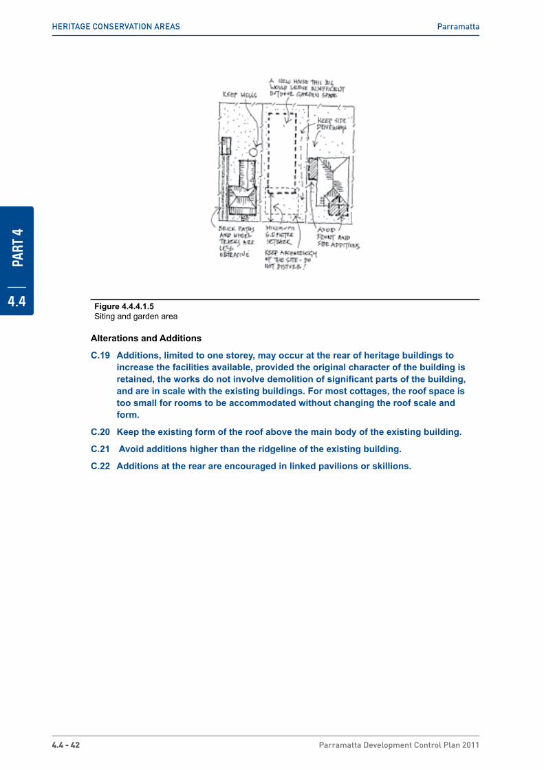
PART
4
4.4
4.4 - 42 Parramatta Development Control Plan 2011
HERiTAGE CoNSERvATioN AREAS Parramatta
Figure 4.4.4.1.5 Siting and garden area
Alterations and Additions
C.19 Additions, limited to one storey, may occur at the rear of heritage buildings to increase the facilities available, provided the original character of the building is retained, the works do not involve demolition of significant parts of the building, and are in scale with the existing buildings. For most cottages, the roof space is too small for rooms to be accommodated without changing the roof scale and form.
C.20 Keep the existing form of the roof above the main body of the existing building.
C.21 Avoid additions higher than the ridgeline of the existing building.
C.22 Additions at the rear are encouraged in linked pavilions or skillions.

PART
4
4.4
Parramatta Development Control Plan 2011 4.4 - 43
HERiTAGE CoNSERvATioN AREAS Parramatta
Figure 4.4.4.1.6 Alterations and Additions
New Dwellings
A new small dwelling may be permissible in the rear garden of an historic building. Provided substantial land is retained around the existing building, car access can be obtained using an existing driveway, or from a rear lane or right of way from an adjoining property. Rooms in the roof may be permissible in the new dwelling provided the total height of the building does not exceed the height of the ridge of the existing building by more than one metre.
C.23 New rear buildings should be single storey scale with a wall height not greater than 3.6 metres.
C.24 Avoid hearted or speckled bricks in light colours.
C.25 Avoid using brightly-coloured or shiny roof coverings, excepting corrugated iron.
The following controls apply to development on properties listed under ‘Existing Significant Buildings’ at the end of this section.
C.26 Avoid placing new buildings closer to the front boundary than the existing adjoining buildings and no closer than 6m.
C.27 New buildings to be set back from the rear of existing buildings by a minimum of 10m.
C.28 Investigate archaeological potential of area where new buildings are sited.
C.29 Keep and repeat the existing form of the roof above the main body of building.
C.30 Hipped or gabled pitched roofs should not exceed 35 degrees.
C.31 Materials for new buildings to be rendered brick, common or face bricks, with tiles or corrugated iron roof.
C.32 Keep significant archaeological deposits intact unless excavated in accordance with the provisions of the NSW Heritage Act 1977.

PART
4
4.4
4.4 - 44 Parramatta Development Control Plan 2011
HERiTAGE CoNSERvATioN AREAS Parramatta
The following controls apply to new development on all properties not listed under ‘Existing Significant Buildings’ at the end of this section.
C.33 The building should have a residential use.
C.34 Keep and repeat the existing setback from the front boundary (or minimum setback of 6m which ever is the greater).
C.35 Keep and repeat verandahs at the front of buildings.
C.36 Keep and repeat the scale of nearby historic buildings, with no building exceeding 10m in width at the front wall.
C.37 Avoid having rooms in the roof which are larger than 60% of the floor area of the ground floor covered by the same roof.
C.38 Avoid constructing buildings of similar scale to the existing residential flat buildings.
Figure 4.4.4.1.7 New Dwellings
Character of Additions and New Dwellings
C.39 New building works should respect the scale of historic buildings but should not copy their style or details (such as by reproducing small panel windows). It is appropriate for the new work to be in a contemporary style.

PART
4
4.4
Parramatta Development Control Plan 2011 4.4 - 45
HERiTAGE CoNSERvATioN AREAS Parramatta
Figure 4.4.4.1.8 Character Additions and New Dwellings
Garages, carports and other ancillary development
C.40 Garages and carports should not become a prominent part of the streetscape.
C.41 Back garden placement of garages, carports and other utility buildings must be separate from the main building.
C.42 Carports may be sited beside the house but only where they:
i. are constructed of lightweight frame of timber or metal
ii. stand at least 1 m back from the front wall of the building and would not be a feature in the streetscape, and
iii. are not attached to the building and would not obstruct light and air into the building.
C.43 Avoid creating new vehicular access driveways off Sorrell Street or anywhere in the North Parramatta Conservation Area.
C.44 Avoid integrating garages into the facades of new buildings, except at the rear of allotments with access to two street frontages (eg laneway frontage) or with access to Trott Street.

PART
4
4.4
4.4 - 46 Parramatta Development Control Plan 2011
HERiTAGE CoNSERvATioN AREAS Parramatta
Figure 4.4.4.1.9 Garages, carports and other ancillary development
Fences
C.45 Use low light-weight fences along the front boundary, such as timber picket fences with square tops, or timber frame fences with wire panels, which are common in the area.
C.46 Front fences are not to exceed 1.2m in height.
C.47 Open wire or other metal fences are permissible provided shrubs, hedges or vines are planted to cover the fence.

PART
4
4.4
Parramatta Development Control Plan 2011 4.4 - 47
HERiTAGE CoNSERvATioN AREAS Parramatta
Figure 4.4.4.1.10 Fences
Public Lands
C.48 Avoid change to existing stone kerbs and gutters. If repairs are needed, reuse stone for both kerbs and gutters.
C.49 Avoid planting of shrubs and trees that will obscure the views along the streets for pedestrians.
C.50 Avoid designs that involve major changes to the street pavement, such as chicanes, wide paved speed bumps or decorative paving.
Existing Significant Buildings
The following buildings together demonstrate the history of the area and contribute to its significance. They must be retained, together with their original features.
North Parramatta
� Fennell Street: 2*, 4*, 9*, 11*, 12*, 16*, 17, 18*, 20*, 21*, 23, 22*, 24*
� Grose Street: 1*, 6*, 8*, 9, 10*, 12*, 13, 15*, 17*, 19*, 20*, 22*, 24
� Harold Street: 1, 2, 3, 5
� O’Connell Street: 40-42*, 44, 46, 48, 56, 60, 62*, 72*, 74*, 76*
� Trott Street: 1*, 2*, 3*, 3c*, 5, 9*
� Villiers Street: 1, 3, 9
Sorrell Street
� Albert Street: 44*, 54*
� Gladstone Street: 1, 4
� Grose Street: 44*, 46*, 48.
� Isabella Street: 8*, 10*, 12A*, 14*, 25*
� Sorrell Street: 31, 33, 36, 40*, 42, 44*, 48, 50*, 51A, 52*, 53*, 54*, 54A (north of Endrim) 56, 60*, 62*, 63*, 64*, 66*, 68A*, 70*, 72*, 75*, 76*, 77*, 78*, 79*, 80*, 81*, 82*, 86*, 88*, 90*
* Heritage Item

PART
4
4.4
4.4 - 48 Parramatta Development Control Plan 2011
HERiTAGE CoNSERvATioN AREAS Parramatta
4.4.4.2 South Parramatta
This area includes two rural grants to Meehan and to Norris. Development to the south of Parramatta township occurred later than that to the north, and the 1855 Street Alignment Plan shows very few buildings in this area. In 1855 the railway from Sydney to Parramatta Junction (now Granville) terminated near Meehan’s grant. Anticipating a demand for housing close to the terminus, Meehan’s land was subdivided into 22 allotments of 50 feet x 150 feet and auctioned in 1856. When the railway was extended to Parramatta in 1860, the subdivision lost its attraction. Nevertheless, modest but slow development did occur, most aimed at the rental market. Brickmaking was also occurring at that time along A’Becketts Creek. Ten houses remain from this early period. All stand on or close to the front fence.
The 1880s saw rapid suburban expansion throughout Sydney. In South Parramatta, Norris’s grant was subdivided and more houses built. Rental housing remained important. Some allotments were amalgamated and re-subdivided for smaller lot housing. The Detail Survey of 1895 shows 104 buildings scattered through the Conservation Area at that time. Eleven were later demolished for the park and eight went in recent years for the flats in Lennox Street. Forty-seven of those 104 houses remain today - a very high retention rate.
Houses continued to be built in the early years of last century, 28 of which remain intact. They stand further from the front fence than the earlier cottages. In the 1920s, Sydney experienced another rash of suburban development, at which time all houses on the western side of Alma Street and most of those on the eastern side of Denison Street were built. Other houses were built on vacant allotments scattered throughout the area. Front gardens were deeper than previously, gardening being at that time an important part of suburban living. Crimea Street was the important cross street, linking Church Street with Pitt Street, and small groups of shops were built on corner positions to serve this passing trade and local needs. Some vacant allotments remained, however, until the 1960s. Since then some earlier houses have been demolished for new development, or altered comprehensively in attempts to update them.
Figure 4.4.4.2.1 South Parramatta Precinct Map
Statement of Significance
This area is the earliest remaining example in Parramatta of a speculative private subdivision related to the railway. The pattern of subdivision remains along with a very intact collection

PART
4
4.4
Parramatta Development Control Plan 2011 4.4 - 49
HERiTAGE CoNSERvATioN AREAS Parramatta
of early pre- 1900 cottages. The consistently single storey scale of most of its housing and associated shops, and the range of building styles, from the 1850s to the 1960s, clearly demonstrate the way in which this suburb gradually developed and allows its history to be understood.
Significant Characteristics
� gently sloping landforms on either side of A’Becketts Creek and views across houses and the park to city buildings beyond
� that most of the original regular 50 by 150 foot allotments remain
� contains single storey freestanding dwellings or pairs of semis separated from the street and neighbours by planted garden space
� there is a consistency in the scale of mostly single storey houses
� few street trees so buildings enclose street space
� enclosed character reinforced by: - width of allotment - 50 feet or less - early buildings built on or close to front fence - groups of early cottages on narrow lots built close together and close to the street - small groups of one or two storey shops at or near the corner
� houses stand parallel to the street
� predominance of modest houses dating from 1850s - 1960s which collectively show how the area has grown, and which provide the historic significance and character of the area
� limited range of building materials - brick, timber, fibro, tiles and iron
� age of the houses often apparent by the depth of the front garden from 1 - 8 m
� space between building line and front fence is without garages or carports
� pattern of narrow driveway openings beside most houses leading to backyard garages
� front gardens visible from the street over low fences, generally of lightweight material such as timber or wire mesh on timber frame
� familiar suburban timber paling fence to side and back boundaries

PART
4
4.4
4.4 - 50 Parramatta Development Control Plan 2011
HERiTAGE CoNSERvATioN AREAS Parramatta
Figure 4.4.4.2.2 Significant Characteristics
Figure 4.4.4.2.3 Typology and Siting
Objectives
O.1 To maintain the area’s single storey character.
O.2 To ensure additions to increase accommodation are modest.

PART
4
4.4
Parramatta Development Control Plan 2011 4.4 - 51
HERiTAGE CoNSERvATioN AREAS Parramatta
Design Controls
Subdivision
C.1 Consider re-subdivision along the length of the allotment where it would not affect the setting of an existing building listed at the end of this Clause, or the character of the street
C.2 Avoid re-subdivision across line of subdivision or by amalgamation of back garden space.
Figure 4.4.4.2.4 Subdivision
Siting and Garden Area
C.3 Maintain the historical pattern of development of detached dwellings with garden space around, with the oldest dwellings close to the front boundary and later dwellings and other buildings with larger setbacks
C.4 Keep views around and between buildings.
C.5 Maintain amenity and privacy of back gardens.
C.6 Keep at least 50% of the site for garden area.
C.7 Keep driveways to garages/carports in back yards.
C.8 Ensure similar side boundary setbacks to those existing.
C.9 Avoid additions to the front or side of an existing house. Linked pavilions or skillions at back of a house are supported as a form of additions.
C.10 Dual occupancy development is not considered to be appropriate, except where it can be accommodated in a modest attached addition to the rear of existing house.
C.11 New buildings should not be established closer than 8m to the front street alignment.
C.12 New buildings should not be constructed with zero side setbacks except on lots narrower than 10m.
Alterations and Additions
C.13 Avoid painting or re-skinning original brick walls.

PART
4
4.4
4.4 - 52 Parramatta Development Control Plan 2011
HERiTAGE CoNSERvATioN AREAS Parramatta
Figure 4.4.4.2.5 Alterations and Additions
New Development
C.14 Single storey scale with maximum wall height to relate to any nearby existing significant building listed above.
C.15 Roofs should be hipped or gabled pitched and should not exceed 35 degrees in pitch. Rooms in roof can be considered where ventilated only by flat, in-plane skylights.
C.16 Setback of 8m or more for any new house
C.17 Side driveway access to garage in backyard.
C.18 Materials for new buildings of face or common bricks, timber or fibro, with terracotta tile or corrugated steel roofs.
C.19 Avoid boundary-to-boundary development which prevents garages and carports being located in the rear yard. In exceptional cases, where the lot is less than 10m wide, a front garage may be integrated with a new house, providing that it is setback from the front wall of the house by a minimum of 1m and its design and construction avoids negative impact on the streetscape.
C.20 Avoid hearted, speckled, multicoloured or textured bricks in light colours.
C.21 Avoid imitation slate or obtrusively coloured roofing materials.
Garages, carports and other ancillary development
C.22 Keep side driveways free of structures. In exceptional cases, where the lot is less than 10m wide, a front garage may be integrated with a new house, providing that it is setback from the front wall of the house by a minimum of 1m and its design and construction avoid negative impact on the streetscape.
C.23 Secured standing space only to side of house may allow better use of limited site area for garden.
C.24 Continue the use of lighter weight cladding materials such as timber, imitation timber cladding or corrugated iron.
C.25 Driveways should not continue over footpath space.
C.26 Garages should not be integrated with the house or be located at side driveways (including carports), except where the allotment is less than 10m wide.

PART
4
4.4
Parramatta Development Control Plan 2011 4.4 - 53
HERiTAGE CoNSERvATioN AREAS Parramatta
Fences
C.27 Fences at the following properties must be retained:
� Crimea Street: Nos 17, 19, 21, 33
� Denison Street: Nos 10, 11, 16*
* Heritage Item
C.28 For front boundaries, continue with fences of varied unobtrusive lightweight materials such as timber or wire mesh on timber frame with hedges if desired.
C.29 Where existing, timber framed fences sheeted with corrugated iron should be maintained, and where necessary, replaced with fence of same height and materials.
C.30 Avoid creating high front privacy walls of brick, timber or brush.
C.31 New brick front fences are not desirable, except where there is evidence of an earlier brick fence lost or changed since its construction.
Cyclone mesh fences are later but appropriate low-cost front fences for older homes
After 1920, picket fences were more plain in design and avoided fancy tops
Figure 4.4.4.2.6 Fences
Public Lands
C.32 Conserve and enhance those elements of the public domain which contribute to an understanding of the history of the area.
C.33 Improve the residential amenity of the area by screening structures which intrude upon that amenity.
C.34 Improve public enjoyment of public open spaces and views.
C.35 Maintain and restore (where they remain beneath the bitumen) the sandstone kerbs and gutters in Lansdowne and Inkerman Streets.
C.36 Prepare, plant and maintain a landscape plan for the drainage easement and park between Inkerman and Glebe Streets. This plan will need to respond to the modest historic suburban character of the area.
C.37 Plant a dense strip of evergreen trees along the grass verge on the north side of Lennox Street and the north side of Lansdowne Street to screen the intrusive scale and materials of the new flats from the low scale suburban character of the Conservation Area.

PART
4
4.4
4.4 - 54 Parramatta Development Control Plan 2011
HERiTAGE CoNSERvATioN AREAS Parramatta
Figure 4.4.4.2.7 Significant Characteristics
Existing Significant Buildings
The following houses which are shown on the 1895 Detail Survey must be retained, together with their original features:
Houses built between 1850s and 1880s
� Inkerman Street: No 40* (c1870)
� Lansdowne Street: No 19* (c1870)
� Lennox Street: Nos 1 and 3* (1850s-1860s)
� Marsden Street: Nos 44* 46* 48* 50* (1880s); 56* 58* (1860)
Houses Built From 1880s - 1895
� Alma Street: Nos 6, 8, 10
� Carrington Street: Nos 4*, 9, 11, 13, 15
� Crimea Street: Nos 6, 25*, 26, 34, 42
� Denison Street: No 16
� Inkerman Street: No 34*
� Lansdowne Street: Nos 5, 35*, 41*, 43*, 49*, 51*
� Marsden Street: Nos 38, 39, 40B, 41, 42, 60, 62, 74*, 76*
� Pitt Street: No 58
� Rosehill Street: Nos 10, 12, 14, 16, 18
* Heritage Item
Any building not listed above but located on the site of a building shown on the 1895 Detail Survey should not be demolished until Council has examined the building for any evidence of the structure extant in 1895.
The following buildings constructed since 1895 must be retained:
Federation houses of the 1900s - c1920
� Carrington Street: No 3

PART
4
4.4
Parramatta Development Control Plan 2011 4.4 - 55
HERiTAGE CoNSERvATioN AREAS Parramatta
� Crimea Street: Nos 5, 9, 12, 13, 18, 30, 33A, 40
� Denison Street: No 6
� Inkerman Street: Nos 38, 44
� Lansdowne Street: Nos 7, 23, 25, 27, 39
� Marsden Street: Nos 23, 25, 27, 31, 35, 37, 43, 45, 47, 49, 51
� Rosehill Street: No 20
Bungalows of the 1920s & 1930s
� Alma Street: Nos 1, 3, 5, 7, 9, 11, 13, 15
� Carrington Street: No 5
� Crimea Street: Nos 8, 8A, 11, 15, 16, 17, 19, 23, 31, 38, 46
� Denison Street: Nos 4, 9, 10, 11, 13, 15, 17, 19
� Inkerman Street: No 32
� Lansdowne Street: Nos 2, 4, 6A, 8, 9,10, 12, 13, 15, 17, 31, 37
� Marsden Street: Nos 23, 33, 49, 51, 72
Where possible, the following intact early post-war buildings should be retained:
Intact Houses of late 1940s & 1950s
These houses complete the developmental history of this area. Their scale, siting, setbacks and materials complement the character of the area. Their conservation is to be encouraged:
� Alma Street: No 4
� Carrington Street: Nos 1, 6, 7, 8,12
� Crimea Street: Nos 2, 3, 4, 7, 14, 21, 22, 24, 27, 33, 33B, 36
� Denison Street: Nos 8, 21
� Inkerman Street: No 36
� Lansdowne Street: No 21
� Pitt Street: Nos 52, 54, 56
� Railway Street: Nos 101, 103, 105
� Rosehill Street: No 2

PART
4
4.4
4.4 - 56 Parramatta Development Control Plan 2011
HERiTAGE CoNSERvATioN AREAS South Granville
4.4.5 South Granville
4.4.5.1 Blaxcell Estate
History
The land on which this conservation area is situated had been privately acquired and subdivided as early as 1922, but very few of the lots had sold. The Commission bought the estate, kept the proposed street pattern, re-subdivided the lots, leaving a few private lots (all at the end of streets). This was the first of the Commission’s group developments in New South Wales and the buildings in Montgomery Street were completed in December 1944. They were constructed in full double brick with Marseilles tiled roofs, decorative use of bricks around front porches and identical front fences.
Figure 4.4.5.1.1 Blaxcell Estate, South Granville
Distinctive Characteristics
� flat to gently undulating clay land which drains slowly to the east and Duck Creek
� regular sized allotments, mostly
� 20m x 34m
� single storey freestanding houses separated from the street and neighbours by large garden space, with lawn and shrubs
� spaciousness of the area created by: - width of each allotment - wide side boundaries - background view to large remaining eucalypts - backyard placement of garages and carports
� houses standing parallel to the street
� intact street character and a remarkable number of the houses, most of which have very few alterations or additions

PART
4
4.4
Parramatta Development Control Plan 2011 4.4 - 57
HERiTAGE CoNSERvATioN AREAS South Granville
� consistent age of the houses - almost all date from 1944 - 1950 with a few from the 1960s
� uniform building shape (form), scale and setbacks
� one chimney per house
� uniform building materials - bricks and tiles to Montgomery Street; fibro and tiles to the other street, with the occasional timber clad house and brick corner houses in Oakleigh Ave
� uniform brick fences to Montgomery Street and few fences throughout the rest of the area area
Figure 4.4.5.1.2 Distinctive Characteristics
Statement of Significance
This area comprises the first group development in NSW constructed in 1944 by the newly formed Housing Commission, having taken over a privately developed subdivision. The area is remarkable for its totally intact core area of Montgomery Street which has kept all its fencing and all original houses without second storey additions. The brick houses demonstrate the ideals with which the Commission commenced its charter, while the fibro houses are the result of the cost effective measures undertaken soon after to produce the quantity of houses needed at that time.
The consistent scale, siting, materials and fences of the development provides a cohesive 1940s suburban character, and the fibro housing is a particularly good example of the very extensive Housing Commission development throughout Parramatta.
Objectives
O.1 To protect the area’s single storey residential character, especially its 1944 face brick houses and fences.
O.2 To maintain front and side garden spaces.
Design Controls
Landform/Natural Characteristics
C.1 Keep remaining eucalypts and encourage their replanting on rear boundaries of private gardens.

PART
4
4.4
4.4 - 58 Parramatta Development Control Plan 2011
HERiTAGE CoNSERvATioN AREAS South Granville
Subdivision Pattern
C.2 Maintain the 1944 pattern of subdivision
C.3 Avoid re-subdivision by amalgamation of back garden space.
Figure 4.4.5.1.3 Subdivision Pattern
Siting, Setbacks & Garden Area
C.4 Maintain the existing pattern of development, of individual single storey houses on wide parcels of land surrounded and separated by garden space.
C.5 Keep views and space between buildings and maintain amenity and privacy of back gardens.
C.6 Keep at least 50% of the site for garden area.
C.7 Ensure similar side boundary setbacks to those existing.
C.8 Avoid additions to the front or side of an existing house.
C.9 Avoid establishing any new building or structure standing closer to the front street alignment than existing houses.
C.10 Second storey additions will not be supported.

PART
4
4.4
Parramatta Development Control Plan 2011 4.4 - 59
HERiTAGE CoNSERvATioN AREAS South Granville
Figure 4.4.5.1.4 Side Setbacks and Garden areas
Alterations and Additions
C.11 Extra rooms above the existing main body of the house which require alteration of existing roof shape are not permissible. Rooms in roof may be considered but only where they are ventilated by flat, in-plane skylights on the back slope of the roof.
C.12 Avoid new dormer windows, mansard roofs or large bulky additions visible from the street.
C.13 Linked pavilions underr a separate roof form, or skillion extensions both to the back of the house are supported.
C.14 Keep all existing chimneys
C.15 Painting, plastering or re-skinning of brick houses or fences in Montgomery Street or Oakleigh Street is not desirable.
C.16 Avoid recladding of existing fibro buildings (including garages and other ancillary buildings) in brick as this would confuse the history of the area. Recladding in other light weight materials, such as fibro-cement, timber or imitation timber is acceptable.
C.17 Avoid re-roofing of main body of the existing house except to match original materials, maintaining the existing balance of red and blue tiles.

PART
4
4.4
4.4 - 60 Parramatta Development Control Plan 2011
HERiTAGE CoNSERvATioN AREAS South Granville
New Development
C.18 Repeat single storey scale for houses with maximum wall height the same as existing houses.
C.19 Hipped pitched house roofs should not exceed the pitch of existing house roofs.
C.20 Setbacks should be the same as original houses in the street.
C.21 Access to garages and carports should be by a side driveway beside house to the backyard.
C.22 Materials for any new house facing Montgomery Street to be of face or common bricks with Marseilles tile roof.
C.23 Materials for main part of any new house in other streets to be of timber, fibro or imitation timber cladding, with terra cotta tile roofs.
C.24 Materials for utility buildings and garages in light weight materials such as fibro, imitation timber cladding or ‘corrugated iron’.
C.25 In Montgomery Street avoid use of hearted, speckled, multicoloured or textured bricks in light colours.
C.26 Roofing materials other than terracotta tiles are not desirable.
Figure 4.4.5.1.5 New Development
Fences
C.27 The following fences must be kept:
� Clyde Street: Nos 286 and 288
� Montgomery Street: Nos 2 - 24 and Nos 9 - 25 and 29

PART
4
4.4
Parramatta Development Control Plan 2011 4.4 - 61
HERiTAGE CoNSERvATioN AREAS South Granville
C.28 Keep the existing street character, with fenceless street alignments for all properties other than those listed in the above control.
Public Lands
C.29 Maintain and reinstate those elements of the public domain which contribute to an understanding of the history of the area.
C.30 Improve the residential amenity and enjoyment of the public street area.
C.31 Prepare a uniform planting scheme for the streets of this area to complement the formal 1940s character of the houses. Plantings such as crepe myrtle (which is bare in winter) or clipped pine are the most suitable.
C.32 Street plantings of native shrubs or trees are not suitable to the formal line of the streets and the house setbacks.
C.33 Plant on or near side boundary alignment to minimise effect of tree shade on front wall of house.
Existing Significant Buildings
Keep all buildings and other structures that explain the history of the area and contribute to its significance.
Keep all the following buildings, which together demonstrate the history of the area and contribute to its significance, with their present form and roof shape:
� Blaxcell Street: Nos 347 - 361
� Chiswick Street: Nos 27- 47
� Clyde Street: Nos 270 - 280 and 286, 288.
� Cordon Street: Nos 69, 71 and 82
� Montgomery Street: Nos 2 - 24 and Nos 7 - 29
� Pegler Street: Nos 76, 78, 79, 80, 81
� Oakleigh Street: Nos. 4 - 16 and 20 - 26 and 1 - 7 and 11 - 17

THIS PAGE HAS BEEN INTENTIONALLY LEFT BLANK

PART 5OTHER PROVISIONS

TOC - 2 Parramatta Development Control Plan 2011
PART
5
CONTENTS5.1 Boarding Houses 5-4
5.1.1 Development to which this section of the DCP applies 5-5
5.1.2 Building classifications under the Building Code of Australia (BCA) 5-5
5.1.3 Relationship of DCP to other Environmental Planning Instruments 5-5
5.1.4 Planning Controls for Boarding Houses 5-6
5.2 Child Care Centres 5-19
5.2.1 Development to which this section of the DCP applies 5-20
5.2.2 Relationship to other Documents 5-20
5.2.3 Planning Controls for Child Care Centres 5-215.2.3.1 Site Selection 5-215.2.3.2 Child Care Centres in Residential Zones 5-235.2.3.3 Child Care Centres in other Zones 5-255.2.3.4 Access and Parking 5-265.2.3.5 Acoustic and visual Privacy 5-285.2.3.6 indoor Areas 5-305.2.3.7 outdoor Areas 5-32
5.2.4 Application Preparation and Pre-lodgement 5-355.2.4.1 The Approval Process 5-355.2.4.2 Prior to Lodgement of Development Application 5-365.2.4.3 Requirements for Submission of information with Development Applications 5-37
5.3 Places of Public Worship and Educational Establishments 5-43
5.3.1 Development to which this section of the DCP applies 5-43
5.3.2 Submitting a Development Application 5-43
5.3.3 Planning Controls 5-445.3.3.1 Locational Requirements 5-445.3.3.2 Bulk and Scale 5-445.3.3.3 Acoustic Privacy 5-445.3.3.4 open Space Areas 5-455.3.3.5 Traffic, Parking and Access 5-455.3.3.6 operational Plan of management 5-46
5.4 Preservation of Trees or Vegetation 5-48
5.4.1 Introduction 5-49
5.4.2 Tree permit 5-49

Parramatta Development Control Plan 2011 TOC - 3
PART
5
5.4.2.1 How an Application is made 5-495.4.2.2 Assessment Process 5-505.4.2.3 Consent Duration 5-515.4.2.4 opportunity for Review 5-52
5.4.3 Exempt works 5-52
5.4.4 Definitions 5-55
5.5 Signage 5-58
5.5.1 Signs on heritage buildings and conservation areas 5-60
5.6 Sex Services and Restricted Premises 5-62
5.6.1 Development to which this section of the DCP applies 5-62
5.6.2 Submitting a Development Application 5-64
5.6.3 Guide to Plans of Management 5-65
5.6.4 Planning Controls 5-665.6.4.1 Location 5-665.6.4.2 Design of Premises 5-675.6.4.3 Parking 5-685.6.4.4 Hours of operation 5-685.6.4.5 Scale of operation 5-695.6.4.6 Advertising Signs and Structures 5-695.6.4.7 Health and Building matters 5-705.6.4.8 Safety and Security 5-70
5.7 Telecommunications Facilities 5-72

PART
5
5.1
5 - 4 Parramatta Development Control Plan 2011
PART 5 - OTHER PROVISIONS Boarding Houses
5.1 Boarding HousesBoarding houses play a key role in providing affordable accommodation for many people on lower incomes. Residents often include aged persons, people with a disability, the de-institutionalised, and unemployed persons. As detailed in the ABS Paper 4102.0 Australian Social Trends 2004, boarding houses are predominantly occupied by males (72%), with the majority of residents being lone persons (83%). 74% of boarding house residents were either unemployed or not in the labour force. Data also suggests that while Australia’s indigenous population makes up around 2% of the total population, indigenous persons comprise around 7% of boarding house residents. Council encourages the retention and the provision of boarding house stock to assist in meeting the housing needs of these people.
Very often people who live in boarding houses have less access to private open space, internal amenities and facilities and rely heavily on public transport. Accordingly, the surrounding environment has increased importance for boarding house residents.
The NSW State Government has various mechanisms in place to encourage the provision and retention of boarding house accommodation including: State Environmental Planning Policy (Affordable Rental Housing) 2009; the Office of State Revenue’s land tax exemptions for boarding houses; and Housing NSW’s Boarding House Financial Assistance Program which offers grants to boarding house owners for fire safety upgrades.
NOTE: Boarding house has the same meaning as in the Parramatta LEP 2011.
Objectives
O.1 Encourage the provision of high quality boarding houses within the Parramatta Local Government Area (LGA).
O.2 Recognise boarding house accommodation as an essential component of residential housing for low to moderate income earners and the socially disadvantaged within the Parramatta LGA.
O.3 Minimise the potential adverse impacts of boarding houses on adjoining properties and the wider locality by introducing effective planning, design and on-going management controls.
O.4 Ensure an acceptable level of amenity in boarding house premises to meet the needs of residents.
O.5 Ensure the appropriate level of fire safety within all boarding houses, and that acceptable levels of service provision are maintained.
O.6 Ensure that boarding houses are appropriately located within the Parramatta LGA to ensure the safety, security, health and amenity for both boarding house residents and adjoining neighbours.
O.7 Ensure that all new boarding houses are compatible with the scale and character of the surrounding built form.
O.8 To ensure the size and intensity of boarding house developments are suitable for the zone in which they are proposed to be located.
O.9 Encourage the provision of boarding houses within close proximity of public transport services and within areas where there is appropriate access to services and facilities, employment opportunities, entertainment and recreation.
O.10 Ensure that boarding houses meet the needs of people with a disability.
O.11 Ensure that boarding houses comply with the performance requirements of the Building Code of Australia.

PART
5
5.1
Parramatta Development Control Plan 2011 5 - 5
PART 5 - OTHER PROVISIONS Boarding Houses
5.1.1 Development to which this section of the DCP applies � The demolition or change of use of an existing boarding house;
� The establishment of a new purpose built boarding house;
� Conversion or adaptation of existing buildings to a boarding house;
� Alterations and/or additions to, or intensification of an existing boarding house.
5.1.2 Building classifications under the Building Code of Australia (BCA)
The BCA provides technical provisions for the design and construction of boarding houses including fire safety, access and structural stability. Reference should be made to the BCA and relevant Australian Standards that are contained in the BCA to ensure compliance with all relevant requirements. The BCA classifies buildings according to the purpose for which they have been designed, constructed or intended to be used. Boarding houses fall under two separate classifications under the BCA as detailed below.
Table 5.1.2.1 BCA Building Classifications
BCA Building Class Definition
Class 1(b) A boarding house, guest house, hostel or the like with a total floor area not exceeding 300m² and in which not more than 12 persons would ordinarily be resident, which is not located above or below another dwelling or another Class of building other than a private garage.
Class 3 A residential building, other than a building of Class 1 or 2, which is a
common place of long term or transient living for a number of unrelated persons, including a boarding house, guest house, hostel, lodgings house or backpackers accommodation.
5.1.3 Relationship of DCP to other Environmental Planning instruments
State Environmental Planning Policy (Affordable Rental Housing) 2009
Part of the development application process may involve consideration of the requirements of SEPP (Affordable Rental Housing). The SEPP provides a means to retain low cost rental accommodation through the development application process. All development applications that propose works to existing boarding houses (operating with lawful consent before 28 January 2000) are subject to determination under SEPP (Affordable Rental Housing).
If the development proposal incorporates demolition of the boarding house; or alterations or additions to the structure or fabric of the inside or outside of the boarding house; or changing the use of the boarding house to another use (particularly to backpackers accommodation), the consent authority must have regard to Part 3 of SEPP (Affordable Rental Housing).
NOTE: Part 2 of SEPP (Affordable Rental Housing) also provides development controls for boarding house development. Where there are any inconsistencies between this DCP and the SEPP, the SEPP will prevail.

PART
5
5.1
5 - 6 Parramatta Development Control Plan 2011
PART 5 - OTHER PROVISIONS Boarding Houses
5.1.4 Planning Controls for Boarding Houses
Location Criteria
Objectives
O.1 To ensure that boarding house residents have reasonable access to retail and commercial services, community facilities, recreational and entertainment facilities, employment opportunities and public transport services.
O.2 To ensure that public transport services available to boarding house residents are frequent and provide access to a suitable range of services, facilities and employment opportunities.
O.3 To ensure that the intensity and size of a boarding house development within low density residential zones is compatible with the scale and character of predominant development in the zone.
Design Principles
P.1 When considering an application for a boarding house development, Council must be satisfied that residents of the proposed development will have reasonable access to the following:
a. retail and commercial services that residents may reasonably require to meet their daily needs;
b. community services and facilities;
c. recreation and entertainment facilities;
d. opportunities for employment; and
e. public transport services.
Access is deemed to satisfy if:
a. the facilities and services likely to meet the daily needs of residents are located within a walking distance of 400 metres from the site; and
b. there is a regular public transport service available to additional retail and commercial services, community services and facilities, recreation and entertainment facilities and employment opportunities, within a walking distance of 400 metres from the site, that:
i. is available both to and from the site at least once every hour between 8.00am and 6.00pm Monday to Friday; and
ii. will take those residents to a place that is located no more than 400 metres to those services and facilities, and
c. the likely path of travel is reasonable with regard to topography and pedestrian connectivity.

PART
5
5.1
Parramatta Development Control Plan 2011 5 - 7
PART 5 - OTHER PROVISIONS Boarding Houses
Where a proposed development cannot meet the above criteria, the applicant will be required to demonstrate to Council’s satisfaction how boarding house residents will achieve alternative access to retail and commercial services; community services and facilities; recreation and entertainment facilities; opportunities for employment; and public transport services.
Retention of Existing Boarding Houses
P.2 Where a development application proposes the demolition or change of use of an existing boarding house, Council must have regard to the provisions of Part 3 of SEPP (Affordable Rental Housing). Where an existing boarding house is not covered by the parameters of Part 3 of SEPP (Affordable Rental Housing), Council may require the submission of a Social Impact Assessment to accompany the development application, and should consider the social and economic impacts of development under Section 79C(1)(b) of the Environmental Planning and Assessment Act 1979.
Site Planning
As many boarding houses occur as infill development in established areas, a sympatheticrelationship with adjoining development is critical to their long-term success. A site analysis is required to establish the site context and should be reflected in the design, addressing the constraints and opportunities of the site and its context.
P.3 A site analysis is to be submitted with all new boarding house development applications. Detail of what should be included in a site analysis is provided in Section 2.3 of this DCP.
Building Form and Appearance
P.4 New development (including alterations and additions) shall be consistent with the predominant built form and design elements of the surrounding locality and streetscape. Refer to Section 3.2 of this DCP.
P.5 The main entrance of the boarding house should be provided within the front (street) elevation to address the street and to minimise potential privacy impacts upon neighbouring properties.
P.6 Development is to be designed and sited to minimise the extent of shadows that it casts on:
� Private and communal open space within the development;
� Private and communal open space of adjoining dwellings;
� Public open space such as bushland reserves and parkland;
� Solar collectors of adjoining development; and
� Habitable rooms within the development and in adjoining developments.
P.7 Landscaped treatment at the front of the site should be compatible with the streetscape in which the building is located.
P.8 If the boarding house is on land zoned primarily for commercial purposes, no part of the ground floor of the boarding house that fronts a street is to be used for residential purposes.
Building Envelope Controls
P.9 New development shall comply with the relevant height and floor space ratio controls prescribed by the LEP.

PART
5
5.1
5 - 8 Parramatta Development Control Plan 2011
PART 5 - OTHER PROVISIONS Boarding Houses
P.10 New boarding houses (including alterations and additions) shall comply with the Preliminary Building Envelope Tables provided in Section 3.1.3 of this DCP for the comparable predominant building type in the relevant zone where the new development is proposed.
Table 5.1.4.1 Boarding House Development Zones and Envelope controls
Zone in which boarding house development is proposed
Development type building envelope controls to be referred to in Section 3.1.3 of this DCP or area specific controls for Special Precincts
R1 General Residential Dwelling house
R2 Low Density Residential Dwelling houseR3 Medium Density Residential Multi-dwelling housingR4 High Density Residential Residential flat buildingB1 Neighbourhood Centre Shop top housing
B2 Local Centre Shop top housingB4 Mixed Use General B4 Zone
Occupation Requirements
P.11 A maximum number of 12 bedrooms per boarding house will be permitted in the R1 General Residential and R2 Low Density Residential zones and shall have a maximum of 12 residents.
The total number of rooms in boarding houses located in the R3 Medium Density Residential zone, R4 High Density Residential zone, B4 Mixed Use zone, B1 Neighbourhood Centre zone and B2 Local Centre zone will be required to demonstrate that the proposal will not have an adverse impact upon the amenity of the surrounding neighbourhood with regard to noise, privacy, overshadowing, traffic generation and the like.
P.12 Any shared rooms are to be limited to a maximum of 2 occupants per room.
P.13 Residents of the boarding house must enter into a lease or licence agreement with the managing agent agreeing to comply with the boarding house rules and fees payable. The length of the lease is to be determined by the managing agent, but must be for a minimum of 3 months.
Operational Management
P.14 All boarding houses are to have a managing agent, contactable 24 hours per day, 7 days per week. If a boarding house has capacity to accommodate 20 or more lodgers, it is required that there be an on-site resident manager. The on-site resident manager must be 18 years of age or over.
P.15 The name and contact details of the on-site manager or managing agent is to be provided externally at the front entrance of the boarding house and internally within the communal living area.
P.16 A Plan of Management must accompany a development application for any new boarding house or intensification of an existing boarding house. The Plan of Management must be completed in accordance with Appendix 9 of this DCP. The approved Plan of Management will form part of any development consent. Copies of the approved Plan of Management must be provided to the relevant managing agent.

PART
5
5.1
Parramatta Development Control Plan 2011 5 - 9
PART 5 - OTHER PROVISIONS Boarding Houses
P.17 ‘House Rules’ must be prepared as part of the Plan of Management. The approved House Rules must be clearly displayed within each bedroom and within the communal living area of the boarding house.
P.18 An Emergency Evacuation Plan must be prepared as part of the Plan of Management detailing the evacuation procedures in the event of the emergency, provision of resident log book, identifying the assembly point and detailing how residents will be made aware of the procedures contained within the Plan. Copies of the approved Emergency Evacuation Plan must be provided to the relevant managing agent, and a copy must be provided to all residents.
P.19 A list of contact details must be clearly displayed within the common area including the contact details for: the managing agent; emergency services including fire, ambulance and police; utilities such as gas, electricity, water and any approved emergency repair persons such as a plumber, electrician etc.
P.20 Copies of the Plan of Management including the House Rules, Emergency Evacuation Plan and managing agent’s details must be provided to all residents and must be available for neighbours to view.
P.21 Developments of 3 storeys or more must incorporate a lift capable of accommodating a stretcher and must be accessible at each floor.
Annual Certification/Registration
P.22 Boarding houses are to be registered with Council prior to the issue of an occupationcertificate and annually thereafter.
P.23 Boarding houses providing accommodation for 2 or more people with a disability (as defined by the Youth and Community Services Act 1973) must be registered in accordance with the Youth and Community Services Act 1973 and licensed by the NSW Department of Ageing, Disability and Home Care.
Design of Boarding Houses - General
P.24 Boarding houses must provide the following facilities within each building:
� Bedrooms
� Communal laundry facilities
� Communal kitchen and dining area (one per floor for multi storey boarding houses)
� Individual ensuite and/or communal bathrooms
� Communal lounge room (one per floor for multi storey boarding houses)
� Communal garbage storage and recycling facilities
� Communal outdoor open space area
� Car parking (as required by this DCP)
� On-site manager accommodation (where 20 or more lodgers)
P.25 Floor coverings throughout the boarding house should be impervious, washable and flame resistant.
P.26 All furniture and fittings required to be provided within individual rooms and communal area must be permanently affixed to the building/site, must be easy to clean/maintain and must be kept in a suitable state of repair.
P.27 All parts of the premises including furniture, fittings, cooking equipment, fridges, beds, bed linen must be kept in a clean condition and free from vermin.
P.28 Fly screens are to be provided to all openable windows and doors.

PART
5
5.1
5 - 10 Parramatta Development Control Plan 2011
PART 5 - OTHER PROVISIONS Boarding Houses
P.29 Liquid soap dispensers must be provided to all hand basins, showers, baths and laundry tubs.
P.30 At least one phone must be provided within the communal area to allow residents to contact emergency services.
P.31 Where internal doors are provided to kitchens or communal areas, these must be clear glazed and impact resistant in accordance with the BCA.
P.32 Use of ducted air conditioning systems is highly encouraged to eliminate the use of portable heating devices which may cause fire hazard.
P.33 A safety switch must be fitted to all electrical meter box/es.
P.34 A maximum of one T.V. antenna is to be provided per boarding house.
Minimum Size and Design for Bedrooms
P.35 The minimum size for a bedroom within a boarding house must be as follows:
Table 5.1.4.2 Minimum Room Sizes for Boarding Houses
Bedroom Type Minimum Room Size
Single person bedroom 12m²Two person bedroom 16m²
Single person bedroom plus ensuite bathroom 15m²
Two person bedroom plus ensuite bathroom 19m²
Wheelchair accessible room Applicant to demonstrate minimum circulation requirements within sleeping room in accordance with AS 1428.1.
Wheelchair accessible room plus accessible ensuite bathroom
Applicant to demonstrate minimum circulation requirements within sleeping room and ensuite bathroom in accordance with AS 1428.1.
Manager/Caretaker bedroom plus ensuite 16m²
Kitchenette (for fire rated rooms only) 2m²
P.36 The following minimum storage facilities and furnishings must be provided within each bedroom. A furniture layout plan must be provided at 1:100 or 1:50 scale for each room type. Maintenance and cleaning of furniture and fittings must be detailed in the Plan of Management.
P.37 No boarding room is to have a gross floor area (excluding any area used for an ensuite, bathroom or kitchenette) of more than 25m2.
NOTE: The maximum gross floor area does not apply to on-site resident manager accommodation.

PART
5
5.1
Parramatta Development Control Plan 2011 5 - 11
PART 5 - OTHER PROVISIONS Boarding Houses
Table 5.1.4.3 Minimum Requirements for Facilities
Facility Type Minimum Requirement
Secure storage facilities
Minimum capacity of 1m³ per person. This space must be lockable.
Minimum fixed room furnishings per room
� Single bed (per resident if twin share) including mattress (minimum 800mm x 1900mm), base, waterproof mattress protector.
� Wardrobe – preferably built in (per resident if twin share)
� Mirror
� Table
� Chair (per resident if twin share)
� Lamp (per resident if twin share)
� BCA compliant latching device
� Separate waste and recycling containers
� Window coverings
� 1 x phone connection
� 2 x twin electrical power points
� 1 x television outlet
� Sink including hot and cold water, ancillary bench and cupboard space.
� For Class 3 buildings it is recommended that a kitchenette be provided within each room. Where kitchenettes are provided in individual boarding house rooms, these rooms must be fire rated in accordance with the BCA.
P.38 Bedroom design must comply with the BCA with regard to requirements for natural light, natural ventilation, ceiling heights and fire safety.
P.39 Individual bedrooms must be key lockable.
Minimum Size and Design for Bathrooms
P.40 Provision of individual ensuite bathrooms for each room is highly encouraged, particularly for wheelchair accessible rooms.
P.41 Where ensuite bathrooms are not provided, communal bathroom facilities shall be provided in accordance with the table below:
Table 5.1.4.4 Minimum Size and design for Bathrooms
Description Minimum Requirement
Class 1(b) and 3 Buildings
Bathroom facilities must comply with the minimum requirements of the BCA and be in an accessible location for all residents. The minimum requirement is 1 bath or shower for each 10 residents or part thereof and 1 toilet and washbasin with hot and cold running water for each 10 residents or part thereof.

PART
5
5.1
5 - 12 Parramatta Development Control Plan 2011
PART 5 - OTHER PROVISIONS Boarding Houses
Description Minimum Requirement
Minimum Size The minimum size of any bathroom will be determined by ensuring that
Minimum circulation spaces for disabled persons can be accommodated in accordance with AS 1428.1.
P.42 Communal toilet facilities shall be provided in a separate room to communal shower/bathroom facilities.
P.43 Hot and cold water must be provided in all showers, baths and hand basins.
P.44 Where communal bathrooms are provided, separate facilities should be provided for male and female residents.
Minimum Size and Design for Kitchens, Laundries and Clothes Drying Facilities
P.45 The following requirements must be met for kitchens, laundries and clothes drying facilities:
Table 5.1.4.5 Minimum Size and Design for Kitchens, Laundries and Clothes Drying Facilities
Facility Type Minimum Requirement
Kitchen Facilities - General
All kitchen areas shall be maintained in a clean and sanitary condition at all times.
No bathrooms, toilets or bedrooms shall open directly on to communal kitchen facilities.
The floor of the kitchen area shall be constructed of a smooth impervious surface.
Where food is proposed to be provided as part of boarding house operations, or is for sale, kitchen and food areas shall comply with requirements of the food safety standards adopted under the NSW Food Act 2003. Guidelines for design and construction are provided under Australian Standard AS 4674 ‘Design, construction and fitout of food premises’. Provision shall be made for sufficient ventilation, and any mechanical exhaust systems installed are to be in accordance with the BCA.
Kitchen facilities shall be available for all residents 24 hours per day.
Provision of communal cooking and dining equipment including utensils, pots, pans, cutlery, crockery etc is highly encouraged.

PART
5
5.1
Parramatta Development Control Plan 2011 5 - 13
PART 5 - OTHER PROVISIONS Boarding Houses
Facility Type Minimum Requirement
Kitchen / Dining Facilities
A communal kitchen and dining area with a minimum area of 20m², plus 1m² per resident over 12 residents. Note: Class 1(b) buildings are to have a maximum of 12 residents.
The following must be provided at a minimum:
� Bench top for food preparation;
� 1 sink for every 6 residents with running hot and cold water;
� 1 stove top cooker for every 6 residents;
� A refrigerator with storage space of 0.13m³ per resident;
� A freezer with storage space of 0.05m³ per resident;
� Storage for dry goods of 0.30m³ per resident;
� Exhaust ventilation;
� Waste disposal and recycling containers;
� Microwave oven;
� Toaster and kettle;
� A lockable drawer or cupboard for food storage for each resident; and
� Dining table and chair (or similar) allowing for one space per resident.
NOTE: Kitchen size and facilities may be reduced where kitchenettes are provided.
Laundry Facility Requirements
� 1 automatic washing machine for the first 12 residents plus 1 automatic washing machine for every additional 12 residents thereafter or part thereof;
� 1 domestic dryer for first 12 residents plus 1 domestic dryer for every additional 12 residents thereafter or part thereof;
� 1 large laundry tub with running hot and cold water for up to 12 residents and one additional tub for premises that contain more than 12 residents; and
� 2.5 metres of outdoor clothesline per resident (can be retractable).
Location of Clothes Drying Facilities
Drying areas must not be visible from the street, or any public place.
Drying areas shall be located to maximise solar access.
Clothes drying and laundry facilities shall be wheelchair accessible.
Minimum Size and Design for Internal Communal Living Areas and External Recreation Areas
P.46 The following requirements must be met for internal communal living areas and external recreational areas:

PART
5
5.1
5 - 14 Parramatta Development Control Plan 2011
PART 5 - OTHER PROVISIONS Boarding Houses
Table 5.1.4.6 Minimum Size and Design for Internal Communal Living Areas and External Recreation Areas
Facility Type Minimum Requirement
Internal Communal Living Area
All boarding houses are to provide a common living area of a minimum 20m² in area, with a further 1.5m² provided per resident where resident numbers exceed 12 persons. Note: Class 1(b) buildings are to have a maximum of 12 residents.
Living areas are to have a minimum dimension of 4 metres.
Furniture including lounge suites and coffee tables are encouraged.
Location of Internal Communal Living Area/s
Communal living area/s must be located on the ground floor and are to be located near commonly used spaces or adjacent to the communal outdoor open space. An additional communal living area shall be provided on each
level for multi-storey Class 3 level boarding houses.
Communal living area/s should have a northerly aspect where possible and should be located where they will have a minimal impact on adjoining properties in terms of noise generation and visual privacy.
Consideration should be given to ensure that bedrooms adjoining the living area/s are protected from excessive noise.
The use of highlight windows on upper levels is encouraged along side boundaries to minimise direct overlooking, particularly when adjoining or adjacent to residential properties.
Calculation of Communal Living Areas
The floor area of bedrooms, bathrooms, laundries, storage, kitchens, car parking, driveways, clothes drying areas, corridors and the like are not counted when determining the area of internal communal areas.

PART
5
5.1
Parramatta Development Control Plan 2011 5 - 15
PART 5 - OTHER PROVISIONS Boarding Houses
Facility Type Minimum Requirement
Communal Outdoor Area
A communal outdoor area must be provided for all boarding house developments. This space must be provided behind the front setback line. The design of the communal outdoor area will also need to be designed with regard to the ‘Building Envelope Controls’.
The communal outdoor area shall have a minimum area of 20m², with a minimum dimension of 3 metres and should be partly covered to provide
weather protection.
The communal outdoor area should be directly accessible from communal internal living areas.
Where possible, both hard and soft landscaped areas shall be provided within the outdoor communal area.
Communal facilities including fixed outdoor tables and chairs, BBQs and the like are encouraged.
Private Open Space
P.47 Consider opportunities for the provision of private open space to individual rooms where it will not result in a visual or acoustic privacy impact upon neighbouring properties.
P.48 If accommodation is provided for an on-site manager, one area of at least 8m2 with a minimum dimension of 2.5m is to be provided adjacent to that accommodation, other than in the front setback area.
Acoustic Amenity
P.49 For new boarding house developments (including intensification of, or conversion of an existing building), adequate sound insulation shall be provided between bedrooms, in accordance with the BCA, to ensure reasonable amenity for residents.
P.50 Boarding house design should attempt to locate bedrooms away from significant internal and external noise sources.
P.51 During the design of a new boarding house (including intensification of, or conversion of an existing building), consideration must be given to the potential acoustic impact upon adjoining neighbours. The following noise abatement issues should be considered at the design stage:
� location of windows in respect to the location of windows on neighbouring properties;
� sensitive location of communal outdoor areas away from main living areas or bedroom windows of any adjoining dwelling (where possible)
� the use of screen fencing or acoustic barriers as a noise buffer to external noise sources;
� the incorporation of double glazing of windows or use of glass blocks (for light penetration but not suitable where natural ventilation is also required); and
� locate similar building uses (such as bedrooms or bathrooms) back to back internally within the building, to minimise internal noise transmission.
P.52 An Acoustic Impact Assessment prepared by a suitably qualified person shall accompany all boarding house development applications, identifying (but not limited to) the following:
� Identification of sensitive noise receivers potentially impacted by the proposal;

PART
5
5.1
5 - 16 Parramatta Development Control Plan 2011
PART 5 - OTHER PROVISIONS Boarding Houses
� Quantification of the existing acoustic environment;
� Detail of the acoustic mitigation measures to be implemented in the proposal;
� Identification of noise likely to be generated by the proposal based on full occupation; and
� Certification that the proposal is capable of operating without causing nuisance, including a statement of mitigation measures required to ensure this.
NOTE: An Acoustic Impact Assessment will not be required for minor alterations and additions to existing boarding houses where resident numbers will not increase.
Visual Privacy
P.53 Placement of windows and other openings should not result in overlooking of adjoining residential uses. Where overlooking may occur, use of highlight windows, window screening or similar mechanism should be used. Refer to Section 3.3.3 of this DCP.
P.54 Landscape screening should be provided within outdoor communal areas to minimise overlooking of adjoining properties.
Access for People with Disabilities
P.55 All new boarding houses (including building conversions or additions to existing premises) should comply with the minimum access requirements contained within the BCA and AS 1428.1 – Design for Access and Mobility.
P.56 Disabled access must be provided to all wheelchair accessible bedrooms, internal and external communal facilities (including waste storage area, car parking area, clothes drying area) and to the adjoining roadway.
P.57 Wheelchair accessible/adaptable bedrooms with an ensuite bathroom shall be provided in all new boarding house developments (including building conversions, substantial alterations and additions or intensification of an existing development) at the rate of 1 per 10 bedrooms (or part thereof). At minimum, 1 wheelchair accessible/adaptable bedroom with ensuite bathroom shall be provided.
Sustainability, Energy Efficiency and Solar Access
P.58 All development applications for new boarding house developments (including substantial alterations and additions) must be accompanied by a BASIX Certification prepared in accordance with State Environmental Planning Policy (Building Sustainability Index: BASIX).
P.59 All whitegoods and appliances provided within the boarding house must have a minimum 3.5 star energy rating.
P.60 Boarding houses should be located so that solar access to at least 50% of the communal open space areas and to communal living area windows is achieved for at least 3 hours between 9am and 3pm during the winter solstice (21 June).
P.61 Dwellings on adjoining properties are to receive a minimum of 3 hours sunlight in habitable rooms and in at least 50% of the private open space between 9am and 3pm on 21 June. Where existing development currently receives less sunlight than this requirement, thisshould not be unreasonably reduced. In order to demonstrate that this can be achieved, shadow diagrams may be required with the development application.
Car and Bicycle Parking
P.62 Car parking spaces and bicycle storage spaces shall be provided and designed in accordance with the standards referred to in Section 3.6.2 of this DCP.

PART
5
5.1
Parramatta Development Control Plan 2011 5 - 17
PART 5 - OTHER PROVISIONS Boarding Houses
P.63 A Parking Statement shall be prepared for all new boarding house developments detailing how any overflow parking demand will be managed. This should form part of the Plan of Management. Overflow parking refers to any car parking demand generated by the proposal that cannot be satisfied by meeting Council’s minimum parking requirements for boarding houses.
Waste Management
P.64 Communal garbage and recycling facilities are to be provided within the development site. The waste storage area must be suitably enclosed, screened from view from the street, and located behind the front setback line. Facilities to cleanse storage containers on site are to be provided.
P.65 Waste storage areas shall be provided in an accessible location, and must achieve at grade access to the street for collection.
P.66 New boarding houses and the intensification of existing boarding houses must comply with the design principles in Section 3.3.7 of this DCP and must submit a Waste Management Plan with the development application.
P.67 At minimum waste storage must be provided at the following rate:
� Class 1(b) buildings (up to 12 residents) must provide 2 x 240 litre waste bins; and 2 x 240 litre recycling bins; and 1 x 240 litre green waste bin, or the equivalent capacity.
� Class 3 buildings (over 12 residents or 300m²) must provide waste storage in accordance with requirements for Class1(b) buildings, for up to 12 residents, with an additional capacity of 40 litres waste storage and 40 litres recycling storage per person over 12 persons.
� Provision for additional green waste bins will be determined on the size and nature of outdoor areas.
P.68 If contaminated sharps are generated, non reusable sharps containers shall be provided in accordance with relevant Australian Standards for disposal. Final disposal must be undertaken by licensed contaminated waste contractors.
Fire Safety
P.69 All boarding house developments shall comply with the fire safety requirements of the BCA.
P.70 Premises providing shared accommodation must display current annual fire safety certification in a prominent location.
P.71 A floor plan must be permanently affixed to the inside of the door of each bedroom detailing emergency egress routes from the respective bedroom.
P.72 An Emergency Evacuation Plan must be provided as part of the required Plan of Management.
P.73 Hard wired smoke detectors shall be provided within all bedrooms and within communal areas in accordance with the BCA.
P.74 For fire safety reasons any potential ignition sources (e.g. candles, incense, lighters, smoking or open flames), cooking or heating facilities (including any plug in microwave, electric frying pan, toasters, kettles, heaters and the like) must not be provided or used within individual bedrooms unless rooms are individually fire rated.
P.75 Where kitchenettes are provided in individual rooms, rooms must be fire rated.
P.76 Windows shall be key lockable only and no bars are to be affixed to the windows.
P.77 A portable fire extinguisher and fire blanket must be provided within any kitchen (including kitchenettes) in accordance with AS 2444.

PART
5
5.1
5 - 18 Parramatta Development Control Plan 2011
PART 5 - OTHER PROVISIONS Boarding Houses
NOTE: Housing NSW administers the Boarding House Financial Assistance Program which offers grants to boarding house owners for fire safety upgrading.
Signage
P.78 Signage will be limited to a maximum of one sign per street frontage, detailing only the name and address of the premises and contact details of the managing agent. Signage must be affixed to the front elevation of the building or the front fence.
P.79 TThe sign/s shall have a maximum area of 0.25m² (e.g. 50cm x 50cm).
P.80 Signage shall be non-illuminated.
Strata Subdivision
P.81 As a boarding house is required to be maintained and operated in a single entity; strata subdivision of a boarding house is not permitted.
Further Information
Building Code of Australia
Environmental Planning & Assessment Act, 1979
Environmental Planning & Assessment Regulation 2000
Food Standards Australia New Zealand
Local Government Act, 1993
Local Government (General) Regulation, 2005
Public Health Act, 1991
Public Health (General Regulation), 2002
Protection of Environment Operations Act, 1997
The Disability Discrimination Act, 1992
Youth and Community Services Act, 1973

PART
5
5.2
Parramatta Development Control Plan 2011 5 - 19
PART 5 - OTHER PROVISIONS Child Care Centres
5.2 Child Care CentresCity of Parramatta Council is committed to planning for the needs of its families and children.
Formal child care services, such as pre-schools and long day care, have a significant role to play in a child’s development. Whereas once the education and care of children aged under 6 was the principal responsibility of their parents and families, child care provided by accredited and licensed providers has now become commonplace in Australia. With the sustained high rates of workforce participation for women, formal child care services are in fact critical to a healthy, modern society.
The quality of the environment provided in early childhood education services, together with thequality of teaching programs, are critical factors in a young child’s development. The environment must be rich, attractive and inviting to the child and parent and be flexible enough to be constantly adapted to meet children’s ongoing needs.
The physical environment plays a critical role in keeping children safe; reducing the risk of unintentional injuries; contributing to their wellbeing, happiness, creativity and developing independence; and determining the quality of children’s learning and experiences. To maximise children’s engagement and level of positive experience and inclusive relationships, an approved service needs to carefully consider physical layout and resources in the environment. (Australian Children’s Education & Care Quality Authority (2013) Guide to the National Quality Standard, page 80).
Because children are critical to our future, Council will encourage excellence and best practice in the design of centre-based child care services. Council will also encourage the provision of child care services that meet identified unmet demands.
This Section in the DCP contains guidance, objectives and development standards designed to encourage both private and not-for-profit providers to achieve best practice in the physical design of centre-based children’s services.
At the same time, Council is mindful that the people who live in its residential neighbourhoods highly value the amenity afforded by those neighbourhoods. This DCP therefore contains development standards that limit the potential impacts of child care centres on the residents’ enjoyment of their neighbourhoods.
NOTE: Child care centre has the same meaning as in the Parramatta LEP 2011.
Overall Objectives
O.1 To promote excellence and best practice in the location and physical design of child care centres.
O.2 To promote the creation of superior child-friendly environments and the operation of high quality early childhood education programs in child care centres.
O.3 To promote the establishment of centre-based children’s services on a range of suitable sites throughout the City of Parramatta.
O.4 To promote the establishment of children’s services that meet the needs of the community, including the provision of more places for children aged under 2 years of age and the provision of places in and around employment nodes.
O.5 To provide guidance for Council, the community and children’s services providers regarding the minimum development standards that apply to the location and physical design of child care centres.
O.6 To ensure that proposals for new and enlarged child care centres respond positively to their context and setting, and minimise impacts on the amenity of the surrounding neighbourhood.

PART
5
5.2
5 - 20 Parramatta Development Control Plan 2011
PART 5 - OTHER PROVISIONS Child Care Centres
O.7 To encourage the development of child care centres that maximise the safety and well-being of children in care.
O.8 To describe the steps, information requirements and approvals required in order for a new child care centre to be established or an existing centre to be enlarged.
O.9 To establish development standards and controls for child care centres that are succinct, consistent and unambiguous; and which state in what circumstances those controls may be varied and outlining the process for an applicant seeking a variation.
5.2.1 Development to which this section of the DCP applies
This Section applies to proposals to establish a new child care centre and to proposals to alter or enlarge an existing child care centre.
A child care centre is defined in Parramatta LEP 2011.
Alterations to an existing centre may include demolition or extension of a building or outdoor structures, an increase in the approved number and age group of child care places, an alteration to the hours of operation, or a proposal to add or expand outside of school hours (OOSH) care services.
Home based child care services
A home-based child care means a dwelling used by a resident of the dwelling for the supervision and care of one or more children and that satisfies the following conditions:
� the service is appropriately licensed within the meaning of the Children and Young Persons (Care and Protection) Act 1998.
� the number children (including children related to the carer or licensee) does not at any one time exceed 7 children under the age of 12 years, including no more than 5 who do not ordinarily attend school.
This section does not generally apply to home based child care services, although many of the objectives and standards for centre-based services in this Section may be useful for those wishing to establish such a service.
A proposed new home based child care service (or a proposal to alter or enlarge an existing service) generally requires the development consent of Council. Applicants for home based services should refer to the Parramatta LEP 2011 to determine the consent requirements.
5.2.2 Relationship to other Documents
Children’s Services Legislation
Servicing approval for operation of a child care centre or the expansion of an existing centre is to be obtained from the NSW Department of Education and Communities under the Children and Young Persons (Care and Protection) Act 1998. To obtain a Service Approval, the Act requires a children’s services provider to comply with Children (Education and Care Services) Supplementary Provisions Regulation 2012 (the Regulation). This Section addresses issues pertaining to Council’s planning responsibilities, as well as complementing and expanding upon the minimum Regulation licensing standards. This Section does not reiterate the Regulation requirements in any detail as they may be subject to change. Selected references to the Regulation are included where appropriate in this Section.

PART
5
5.2
Parramatta Development Control Plan 2011 5 - 21
PART 5 - OTHER PROVISIONS Child Care Centres
Please note however, that not all the provisions of the Regulation are included, therefore applicants are advised to refer to the Regulation to ensure compliance with all relevant provisions.
National Quality Framework
The National Quality Framework aims to increase quality and drives continuous improvement and consistency across Australian education and care services.
The Framework came into effect in 2012 and is underpinned by the Education and Care Services National Law (‘National Law’), and Education and Care Services National Regulations (‘National Regulations’) to create the National Quality Standard and Regulatory Framework for most long day care, preschool, kindergarten, family day care and outside school hours care services in all states and territories.
National Quality Standard – Quality Area 3 ‘Physical Environment’
the National Quality Standard sets a national benchmark for the quality of education and care services, and gives services and families a better understanding of a quality service. This enables families to make informed decisions about the services providing education and care to their child.
Quality Area 3 – ‘Physical Environment’ of the National Quality Standard focuses on the physical environment and ensuring that it is safe, suitable and provides a rich and diverse range of experiences that promote children’s learning and development. This Quality Area promotes best practice in the location and design of physical environments for centre based children’s services.
Proponents should refer to and obtain a copy of “The Guide to the National Quality Standard” online from the Australian Children’s Education & Care Quality Authority’s website as part of the design of their child care centre and the preparation of their development application.
Building Code of Australia
Building Code of Australia (BCA) compliance is necessary in order to be granted a construction certificate. The BCA specifies the relevant standards which apply to centre based children’s services. These are technical requirements relating to structural considerations, fire resistance, access and egress, services and equipment, and health and amenity. They are mandatory and the child care centre proponents are strongly advised to take the BCA requirements into consideration early in the design process.
Food Act 2003 (incorporating food safety standards)
Where child care centres conduct food preparation on their premises, the activity is subject to the provisions of the NSW Food Act. This legislation adopts national food safety standards which apply to all food businesses and places requirements on the operator to ensure the facilities provide for the safe preparation of food. More information on specific design needs for the kitchen and associated areas is contained in Section 5.2.3. The business is also obliged to notify the details of the business to the NSW Food Authority. Contact details are Tel: 1300 552 406 or visit the website www.foodauthority.nsw.gov.au.
5.2.3 Planning Controls for Child Care Centres
5.2.3.1 Site Selection
Objectives
O.1 To ensure that child care centres are located on sites that are suitable for the purpose of providing high quality care for young children.

PART
5
5.2
5 - 22 Parramatta Development Control Plan 2011
PART 5 - OTHER PROVISIONS Child Care Centres
O.2 To ensure that child care centres are located on sites that provide high levels of safety, security, environmental health, and amenity for children.
O.3 To ensure users of child care centres are not exposed to undesirable health and safety risks.
O.4 To ensure child care centres are provided in locations that will make a positive contribution to, and not prejudice the continued operation of, existing surrounding uses.
O.5 To encourage the location of child care centres in locations where they are easily accessed by all forms of public transport, vehicles, bicycles and walking, and in proximity to public transport nodes and complementary community land uses.
O.6 To encourage the provision of children’s services in and near business centres and workplaces.
O.7 To discourage the location of child care centres in locations where they will cause unreasonable levels of disruption to the existing amenity of residential areas.
Design Principles and Controls
The way in which an environment is designed, equipped and organised determines the way that space and resources are used by children (Australian Children’s Education & Care Quality Authority (2013) Guide to the National Quality Standard, page 80).
Preferred sites for a child care centre are sites:
� where safe and convenient vehicular access can be provided;
� where safe and convenient pedestrian access can be provided;
� where there is less exposure to neighbouring dwellings and other noise sensitive uses (for example, corner sites);
� that are of a size and shape that provides for efficient building forms, generous access/ circulation spaces and extensive play areas;
� that form part of an existing educational, open space or other community facility;
� that are within walking distance of major public transport services;
� that are within existing workplaces or business and employment nodes; and
� that are not located adjacent to arterial and main roads or sites within cul-de-sacs.
Child care centres on the following sites are discouraged:
� sites comprising battle-axe allotments and sites with access to a road with limited access and turning capability;
� steep sites that inhibit convenient access for persons with a disability or reduce the usability of outdoor play areas;
� where land contaminants, air or noise pollution or other risks or hazards are present on the site or in the immediate vicinity;
� long, narrow sites; and
� that are in close proximity to another existing or approved child care centre in a Residential zone. A separation of at least 200m is preferred.
Sites in proximity to another existing or approved child care centre
The location of child care centres on land within close proximity to another existing or approved centre in a residential zone is discouraged, unless it can be demonstrated that the cumulative

PART
5
5.2
Parramatta Development Control Plan 2011 5 - 23
PART 5 - OTHER PROVISIONS Child Care Centres
impacts relating to traffic generation, on-street car parking and noise generation are within acceptable limits for a residential area.
Site size and shape
The size and shape of a potential site for a proposed child care centre is a major factor that will affect the quality of care that can be provided by the children’s service, the long-term viability of the centre and the effectiveness of the facilities to be provided.
The Regulation’s requirements for minimum unencumbered indoor and outdoor space (which in turn are key determinants of total site size) are considered a bare minimum which may limit the centre’s ability to respond to future trends, child or community needs.
Larger sites support larger spaces, both indoor and outdoor. A larger space ensures a greater variety, diversity and number of play opportunities for children. It also gives greater flexibility to take advantage of other site planning issues and constraints (such as providing sufficient car parking and providing adequate setbacks to neighbours).
This DCP does not stipulate a minimum site size for the establishment of a child care centre, although does require the provision of best practice standards of indoor and outdoor unencumbered spaces that are required for service approval.
Quality Area 3 - ‘Physical Environment’ of the National Quality Standard refers to the National regulations in providing the required space provisions for outdoor (Regulation 107) and indoor (Regulation 108) encumbered spaces. For each child being educated and cared for by the approved service, the following space provisions apply:
Table 5.2.3.1.1 Required Space Provisions for Child Care Centres
Indoor Space Outdoor Space
3.25m2/child being educated and cared for by the approved service
7m2/child being educated and cared for by the approved service
5.2.3.2 Child Care Centres in Residential Zones
Objectives
O.1 To limit the impact of child care centres on the amenity of residential areas by promoting the establishment of smaller-sized centres in the City’s residential neighbourhoods.
O.2 To allow larger child care centres only in circumstances where a minimum component of places for children under 2 years of age is prov ided and where best practice standards of indoor and outdoor unencumbered space is provided.
O.3 To ensure that child care centres in residential areas are an ancillary facility servicing the local community in which they are located and not a dominant non-residential use.
O.4 To promote child care centre building forms that are compatible with the character of existing surrounding residential development.
O.5 To ensure that child care centres do not undermine or compromise the amenity of residential areas.
O.6 To use landscaping to:
� protect the visual and acoustic privacy of adjoining properties;
� provide adequate screening for outdoor play areas; and
� enhance the streetscape presentation of the development.

PART
5
5.2
5 - 24 Parramatta Development Control Plan 2011
PART 5 - OTHER PROVISIONS Child Care Centres
Design Principles and Controls
Building siting and design
Except where provided by this Section, the child care centre shall comply with the relevant height, floor space ratio, minimum frontage, minimum street and side setback and building envelope controls for the respective Residential zones contained in both the relevant environmental planning instrument applying to the land and any other section applying to this land.
The minimum side setback for a new child care centre is 2 metres, except where the proposal involves conversion of an existing dwelling house then the setbacks shall comply with the requirements of Part 3 of this DCP.
On sites zoned Residential:
� the child care centre building is to be designed so as to appear as a dwelling house when viewed from the street. However, this does not preclude the use of ‘U’ shaped or ‘L’ shaped buildings for the purpose of minimising acoustic impacts on neighbouring properties as described in the section on Acoustic and Visual Privacy.
� the front setback area may only be used for access, parking and landscaping purposes, shall not be used as an outdoor play space and shall not be included in calculations of unencumbered outdoor space.
Council encourages the use of single storey buildings in Residential zones for the purposes of child care centres for reasons of safety and access. In the case of a building that is higher than single storey, the above ground levels of the building should only be used for the purposes of storage and staff facilities.
Minimum indoor and outdoor space and maximum number of child care places
Except as provided for below, the minimum amount of indoor unencumbered space and outdoor unencumbered space to be provided per child care place shall comply with the requirements of the Regulation. At the time this DCP was made the Regulation required a minimum of 3.25 square metres of indoor unencumbered space per place and a minimum of 7 square metres per place for outdoor unencumbered space.
The maximum number of child care places to be provided in any child care centre in a Residential zone is 40.
However, in recognition of the unmet demand for child care places for children aged under 2 years throughout the City and as a means of encouraging the provision of more of these places, Council may permit the establishment of child care centres with more than 40 places.
Council will only permit a child care centre in a Residential zone with more than 40 places where:
� a minimum of 33% of the places are provided for children under 2 years of age; and
� best practice standards of both indoor and outdoor unencumbered space is to be provided. The best practice standards are interpreted as a minimum of 4.5 square metres indoor unencumbered space per place and a minimum of 15 square metres per place for outdoor unencumbered space.
In cases where a proposed centre meets the two criteria described above, the maximum number of child care places to be provided in any child care centre in a Residential zone is 75. This standard is to ensure that any child care centre in a Residential zone does not

PART
5
5.2
Parramatta Development Control Plan 2011 5 - 25
PART 5 - OTHER PROVISIONS Child Care Centres
unreasonably impact upon the amenity of the neighbourhood in terms of traffic safety, privacy and noise.
Hours of operation
Hours of operation will be generally limited to between 7am and 7pm Monday to Friday. Variation of these hours of operation will only be considered where the proposed child care centre is to be located in proximity to other non residential uses that are permitted to operate outside of these hours.
Landscaping
A landscape buffer with a minimum width of 1 metre shall be provided along the side and rear boundaries of the development. A landscaping setback abutting the street frontage with a minimum width of 2 metres shall be provided.
5.2.3.3 Child Care Centres in other Zones
Objectives
O.1 To ensure that proposed child care centres will be compatible with the objectives of the relevant zone.
O.2 To ensure that proposed child care centres in non residential zones are compatible with, and do not affect the operation of, any existing or likely future non residential land uses in the immediate vicinity.
O.3 To provide opportunities for child care places close to workplaces and business centres.
O.4 To allow the location of child care centres above ground level where no viable alternatives exist.
Design Principles and Controls
Building siting and design
The child care centre shall comply with the relevant height, floor space ratio, minimum frontage, minimum street and side setback and building envelope controls for the respective zones contained in both the relevant environmental planning instrument applying to the land and any other Section applying to the land.
Minimum indoor and outdoor space
Except as provided below, the minimum amount of indoor unencumbered space and outdoor unencumbered space to be provided per child care place shall comply with the requirements of the Regulation. At the time this Section was made the Regulation required a minimum of 3.25 square metres of indoor unencumbered space per place and a minimum of 7 square metres per place for outdoor unencumbered space.
In recognition of the greater amount of space usually available on sites zoned for either Special Uses (SP2 Infrastructure Zone) or Open Space purposes (RE1 Public Recreation or RE2 Private Recreation Zones), Council will pursue best practice provision of indoor and outdoor space for child care centres located in these zones.
Child care centres to be situated on land zoned either Special Uses (SP2 Infrastructure Zone) or Open Space purposes (RE1 Public Recreation or RE2 Private Recreation Zones) shall incorporate the following standards:
� Indoor unencumbered space: minimum 4.5 square metres per child care place

PART
5
5.2
5 - 26 Parramatta Development Control Plan 2011
PART 5 - OTHER PROVISIONS Child Care Centres
� Outdoor unencumbered space: minimum 15 square metres per child care place.
Level within building
Child care centres should generally be situated on ground level of a building.
Child care centres in business zones may be located above ground level, but only where it can be demonstrated that there are no viable alternatives for the location of a child care centre at ground level in the building due to:
� the built form of the building and density of the surrounding area; and
� access to above-ground open space is available.
Other requirements in respect to above-ground centres are as follows:
� A reduction in the minimum amount of indoor unencumbered space per child is not permitted.
� Playrooms are to be designed so as to be enclosed by floor to ceiling height glass. Glass used in the building is to be in accordance with AS 1288-2006 - Glass in buildings - Selection and installation.
� Indoor areas adjacent to public areas shall be screened to prevent direct sight into child care centres.
� A safe refuge area shall be provided within the child care centre and opening directly to a dedicated fire-isolated stair. The minimum total area of the refuge shall be calculated at the rate of 0.25 square metres per person for the capacity of the centre, including staff. The doors, walls, floors and ceiling of the refuge shall have a minimum Fire Resistance Level (FRL) equal to that required for the fire stairs.
� Also refer to the Section on ‘Outdoor Areas’ below for requirements for outdoor play spaces.
Proximity to noise or odour generating uses
Child care centres must not be situated near to significant noise or odour generating uses, or to sites which (due to the prevailing land use zoning) may in future accommodate noise or odour generating uses.
5.2.3.4 Access and Parking
Objectives
O.1 To maintain a safe environment for pedestrians, motorists and cyclists in and around child care centres.
O.2 To ensure that safe and convenient car parking arrangements for child care centres are provided.
O.3 To ensure all new child care centres, and alterations and additions including any associated spaces such as outdoor space, parking areas and the like, are designed to be accessible to all people within the community.
O.4 To ensure that car parking areas associated with child care centres are designed to be consistent with the character of the area and to have minimal visual impact.
Design Principles and Controls
Car parking rates
On site car parking is to be provided at the rate of a minimum of 1 parking space per 4 child care places. Parking for people with a disability is to be provided at the rate of 1 space in every 10 spaces. If the car parking required is less than 10 spaces then at least 1 space must be provided.

PART
5
5.2
Parramatta Development Control Plan 2011 5 - 27
PART 5 - OTHER PROVISIONS Child Care Centres
A reduction in the minimum parking requirement may be considered where:
� there is sufficient safe on street parking available at appropriate times located outside the development within the frontage of the subject site; and
� the development is not likely to result in any adverse impact on the safe operation of the surrounding road network.
Notwithstanding the above, the availability of on street parking within cul-de-sacs will not be considered in any justification for the reduction in the minimum parking requirement.
Any variation to the minimum parking requirement, is to be justified by a traffic and transport assessment. Refer to ‘Supporting Technical Assessments’ 5.2.4 of this section for the matters to be addressed in a traffic and transport assessment.
Vehicle circulation and car parking design
Vehicle circulation and car parking areas shall be designed to allow the safe drop-off and collection of children and the safe movement and parking of staff, parent, visitor and service vehicles. In this regard:
� the design shall take into account nearby traffic generators, street design, and the existing environment for pedestrians and cyclists;
� access driveways shall not be located opposite, or in the vicinity of, road intersections;
� on site car parking and vehicle manoeuvring areas are to be designed so that vehicles are able to safely enter and leave the site in a forward direction;
� the development must comply with the provisions of AS 2890.1 Parking Facilities - Off Street Car Parking;
� tandem parking may be provided but only where the spaces that are not accessible at all times are designated for staff use;
� car parking areas and access ways shall not visually dominate the external appearance of the development and shall be softened by the provision of appropriate plantings in the front setback area;
� access provision to the outdoor play spaces and playgrounds should allow for trucks that occasionally deliver items such as sand or gardening supplies through secure-locking gates; and
� provision of at least one secure bicycle parking space should be made for each development at a rate of one space per 25 child care places.
Council will not support applications where existing traffic volumes or road geometry are such that danger would be created by pedestrians crossing the road to enter the child care centre site or by vehicles turning in the vicinity of the site.
Pedestrian access design
Access arrangements must ensure that safe and convenient access to the entry of the child care centre is available to all persons. Additionally, outdoor play spaces in the centre must be accessible for children. In this regard:
� pedestrian access that is separated from vehicular access is to be provided from the street to the building and from all car spaces to the building (it is essential that children using the centre do not need to walk past the back turning circle of a car);
� the development must comply with the provisions of AS 1428.1 Design for Access and Mobility and comply with Part D of the Building Code of Australia;
� all pedestrian pathways in the development should have a minimum width of 1.2 metres to allow easy circulation throughout the site;

PART
5
5.2
5 - 28 Parramatta Development Control Plan 2011
PART 5 - OTHER PROVISIONS Child Care Centres
� the maximum grade of the front setback and any area of the site to be counted as unencumbered play space should be no greater than 1 in 12;
� hard paved surfaces are to be provided leading into the entry of a play environment and continuing inside that will allow children and adults with mobility aids as well as toddlers in strollers to enter with ease;
� if basement car parking is to be incorporated into the proposal, a lift or ramp must be provided between the basement level and upper levels; and
� the use of inclinators as the sole access for persons with a disability will not be supported.
5.2.3.5 Acoustic and visual Privacy
Objectives
O.1 To minimise the noise generation impacts generated by child care centres on the amenity of neighbouring residential properties.
O.2 To minimise intrusion of noise on child care centres from external sources.
O.3 To ensure the privacy of surrounding premises is maintained and protected from overlooking.
Design Principles and Controls
Acoustic privacy
The design of the child care centre should aim to locate sleep rooms and play areas away from external noise sources.
Centres must be designed in a manner that minimises noise transmission to neighbouring residential premises. The following design and operational matters are to be adopted for the management of noise generated by the centre:
� Where feasible, designs should be based on a ‘U’ shaped or ‘L’ shaped layout for the buildings, with external activity areas positioned such that the building structures act as a noise barrier (refer to Figures A10.2 and A10.3 in Appendix A10). If one of these layouts is not adopted, the applicant must provide a valid justification to Council as to why an alternative approach is more suitable or necessary.
� Orienting the building and outdoor play spaces having regard to impacts on neighbours (for example, locating play areas away from neighbouring bedrooms).
� Maximising the separation between the active outdoor play area (as opposed to passive activities such as sand pits, painting, storytelling etc) and the façade of any neighbouring premises.
� Ensuring openable windows at the child care centre and external play areas do not have a direct line of sight to neighbouring sensitive uses.
� Locate pedestrian access ways and ramps away from neighbouring sensitive premises where practicable.
� Adopt low noise features such as self closing gates with soft closure (ie low noise) hinges, selection of low noise air conditioning equipment, minimising the use of speed humps and ensuring car park surfaces and access ways are smooth.
The applicant should note that use of acoustic controls and management measures will not be accepted in cases where the design has not adequately addressed the above objectives.
Acceptable Acoustic Management Measures
Where optimal design and layout of the child care centre results in noise levels that do not comply with the acoustic criteria specified in Table A10.1 in Appendix A10, acoustic

PART
5
5.2
Parramatta Development Control Plan 2011 5 - 29
PART 5 - OTHER PROVISIONS Child Care Centres
management measures must also be incorporated in the design. The preferred approach to acoustic management is through provision of physical measures such as barriers, enclosures, changes to glazing and provision of air conditioning. Management measures that must be implemented and monitored by staff and parents are not considered appropriate for a well designed child care centre.
Acceptable acoustic mitigation solutions include, but are not necessarily restricted to, the following:
� Erection of noise barriers, which may include fencing types and other barriers that minimise noise transmission, to a maximum height of 2m for a flat site. Noise barriers in excess of 2m in height will be considered for sloping sites (eg. where a barrier is positioned on a retaining wall due to changes in levels). Figure A10.4 in Appendix A10 presents examples of situations where barrier heights in excess of 2m are acceptable. The at the base. The use of composite barrier constructions utilising clear barrier panels should be considered where there is potential for the barrier to restrict the vision of vehicles entering and/or leaving the premises.
� The majority of internal surfaces are to utilise absorptive materials as opposed to reflective to reduce the potential for reverberant fields to increase noise emissions and reduce speech intelligibility.
� Provision of mechanical ventilation and fixed windows (at the child care centre or adjacent receptors) where windows and doors must remain closed to achieve the appropriate noise criteria.
The following approaches are not considered appropriate for management of noise emissions from child care centre activities:
� Restricting the number of children utilising external play areas at any one time.
� Restricting the time periods and/or times of day that children are allowed to use external play areas.
� Staging of outdoor activities to reduce the number of children playing outdoors at any one time.
All child care centre development applications are to be supported by an acoustic assessment report. The acoustic assessment must be completed by an appropriately qualified and experienced person or organisation The assessment is to address the following:
� Noise and acoustics matters included in Quality Area 3 - ‘Physical Environment’ of the National Quality Standard in association with the Regulation.
� Identification of sensitive noise receivers to be potentially impacted.
� Quantification of the existing acoustic environment at the receiver locations. Measurement techniques and assessment period should be fully justified and in accordance with relevant Australian Standards and NSW Office of Environment and Heritage requirements. The following specific requirements are to be followed as a minimum: - Type 1 or Type 2 noise instrumentation in current NATA or manufacturers calibration,
field calibrated before and after the measurements. - Monitoring of LAeq, LAmax, LA1, LA10, LA50 and LA90 noise levels continuously, with
results presented as 15 minute averages. - Details of the prevailing meteorological conditions during the monitoring. Monitoring data for
periods with wind speeds at ground level in excess of 5m/s or when more than 1mm of rain per hour must be deleted from the monitoring dataset to prevent a weather related bias.

PART
5
5.2
5 - 30 Parramatta Development Control Plan 2011
PART 5 - OTHER PROVISIONS Child Care Centres
- Details of the noise monitoring positions, including microphone height (1.5m above ground level is the preferred height to represent receiver noise levels), whether a wind shield was fitted, potential effects of reflecting surfaces, trees or structures, confirmation of either a free-field or façade monitoring position (including distance from the building façade), whether the monitoring position was located on hard or soft ground and information about the most significant noise sources at the measurement position.
- Confirmation that the noise monitoring was completed during representative conditions and that no unusual circumstances or activities are likely to have affected the noise monitoring results.
- A five (5) day measuring period is required in order to cover proposed operating hours for weekdays. If Saturday operations are proposed, monitoring data must also be collected for a representative Saturday.
- The acoustic report is to present in full, the results of the noise monitoring for each position along with a summary of these data for the proposed operating hours of the child care centre. The summary must present the data as hourly average noise levels for each of the noise indices and statistical parameters measured.
� Identification of all noise that is likely to emanate from the child care centre and the subsequent prediction of resultant noise at the identified sensitive receiver locations from the operation of the premises. The predictions are to be completed in accordance with the recommendations of the NSW Office of Environment and Heritage and specifically address the following: - Provide predicted noise levels at all receptors on adjacent properties of noise levels from
all relevant activities at the child care centre. - Consider the influence of topography, relative heights and actual floor levels for the
activities for the activities at the child care centre. - All predictions must represent the receiver position. This should be taken as 1.5m above
floor level for noise impacts at centre and neighbouring receptors. - The noise modelling of external play areas must assume that all external play areas
could be utilised simultaneously. - This source noise level must be adopted for each area and room where children’s
activities can occur, and the modelling must assume that noise can be emitted from each play area or room simultaneously.
- The acoustic report is to provide details of all modelling assumptions including source noise data, modelled noise positions, receiver heights and locations, confirmation of the methodology adopted along with a copy of the model input and output data.
- Details of any acoustic control measures that will be incorporated into the proposal. - Proposed fencing height, materials and acoustic performance of barriers where barrier
structures are to be used to ameliorate noise impacts. - A statement from a certified acoustic consultant certifying that the development is
capable of operating without causing a nuisance and able to operate without undue noise disturbance from external noise sources.
Visual privacy
The development design should incorporate measures to minimise overlooking of living areas and private open space areas in adjoining residential premises. A landscape buffer with suitable screening plants and with a minimum width of 1 metre shall be provided along the side and rear boundaries of the development to help achieve this.
5.2.3.6 indoor Areas
Objective
O.1 To provide attractive, adaptable, safe and functional indoor spaces which provide positive experiences and developmental growth of children and enable adequate staff supervision of children at all times.

PART
5
5.2
Parramatta Development Control Plan 2011 5 - 31
PART 5 - OTHER PROVISIONS Child Care Centres
Design Principles and Controls
Sufficient physical space and careful arrangement of the environment allows children to access different areas, move between spaces, explore, experiment, create and express themselves without disturbing other children. By creating environments that work for children, educators are able to spend valuable time interacting with children (Australian Children’s Education & Care Quality Authority (2013) Guide to the National Quality Standard, page 82).
A minimum of 3.25 square metres of unencumbered indoor floor space shall be provided for each child care place.
The design of indoor spaces shall address the facilities and equipment requirements contained in Part 3 of the Children (Education and Care Services) Supplementary Provisions Regulation 2012. Evidence shall be submitted with the development application substantiating that the child care centre proposal complies with these requirements.
Quality Area 3 ‘Physical Environment’ of the National Quality Standard in association with the Regulation provides comprehensive guidance on appropriate facility inclusions and the optimum size, arrangement and interrelationships of indoor spaces.
The guidelines and standards contained in the National Quality Standard should be applied wherever possible in the design of the child care centre proposal and in all cases where a proposal seeks to exceed the maximum 40 child care places in a Residential zone. The Children’s Services Regulation’s minimum indoor space requirements do not necessarily constitute best practice. Council encourages the application of the best practice indoor space standards to be applied in all child care centres (that is, 4.5 square metres of unencumbered indoor space per child care place) and requires the best practice standards to be applied in certain circumstances (that is, in centres zoned SP2 Infrastructure, RE1 Public Recreation or RE2 Private Recreation, and in larger centres in Residential zones).
The design of indoor areas shall address the following (as a minimum):
� appropriate pedestrian access and circulation within the building;
� convenient access from indoor to outdoor spaces;
� safety and security within the child care centre in relation to occupational health and safety for children, staff and visitors;
� external security to ensure that access into the centre is monitored, which may require the installation of camera surveillance, and installation of a security system with access only permitted to authorised persons;
� clear and unobstructed lines of sight to all areas within the child care centre for views of staff and children at all times, especially in toilets, nappy change areas and sleeping areas;
� the provision of food preparation and storage areas commensurate with the preparation of safe food;
� consideration of the food flow pattern to establish adequate space and operating efficiencies; guidance on how to design a facility addressing these aspects is provided in Australian Standard 4674 - Design, fitout and construction of food premises;
� sufficient natural light for play areas and appropriate external shading of windows;
� natural cross ventilation through the appropriate placement of openings;
� use of safety glass and safety markers on glass at child and adult height is required;
� the use of energy efficient appliances;
� appropriate storage and construction of garbage and recycling areas;
� mechanical ventilation of nappy change areas and toilets;
� floors to be of a non slip surface and easy to clean; and
� each playroom has its own storeroom/cupboard and bed storage.

PART
5
5.2
5 - 32 Parramatta Development Control Plan 2011
PART 5 - OTHER PROVISIONS Child Care Centres
5.2.3.7 outdoor Areas
Objectives
O.1 To ensure the provision of outdoor play areas that cater for a variety of experiences for children including learning play, active and quiet time and other development experiences.
O.2 To facilitate best practice in the provision of early childhood play spaces, ensuring such spaces are interesting, stimulating, safe, secure and functional, and that enable adequate staff supervision of children at all times.
O.3 To ensure that landscaping is aesthetically pleasing to children as well as being safe and functional.
O.4 To ensure that the outdoor areas are designed so as to minimise potential impacts on any adjacent residential premises.
Design Principles and Controls
Outdoor play spaces and playgrounds
For urban children, a playground may offer their only opportunity for [active] play. The safe backyards, streets and parks of their parents’ generation are no longer a part of childhood. The early childhood playground deserves fuller attention and development than it has received in the past, since it meets a right of childhood. (Walsh, P. and NSW Department of Community Services, op. cit., page 94)
Outdoor play spaces are to be:
� located away from the main entrance of the child care centre, car parking areas or vehicle circulation areas;
� designed to incorporate natural elements, with rocky outcrops, existing trees and gardens that utilise child-friendly species;
� landscaped with plants that are not noxious, do not have prickles, and do not represent a major allergy or inhalation hazard;
� integrated with indoor space and provide direct and easy access between those areas (refer to ‘Transition Areas’ below);
� of a design and layout to enable clear lines of sight to all areas of the outdoor space to allow direct staff supervision from other areas of the child care centre;
� a compact square, rectangular or L-shaped area sited on one or two adjoining sides of the building, to facilitate functional use by children and effective supervision by staff;
� located with a northern orientation for maximum solar access where possible;
� adequately shaded in accordance with Shade for Child Care Services published by the NSW Cancer Council and NSW Health Department;
� located away from existing and potential noise and environmental pollution sources;
� located away from the living/bedroom windows of surrounding dwellings where possible;
� located away from areas where objects can be projected down onto play areas where possible;
� inaccessible from public areas outside the child care centre (except in the case of an emergency evacuation or centre deliveries);
� adequately fenced on all sides; and
� designed with an outdoor storage area for the storage of outdoor equipment without being part of the outdoor play area and without inhibiting supervision of children.

PART
5
5.2
Parramatta Development Control Plan 2011 5 - 33
PART 5 - OTHER PROVISIONS Child Care Centres
Further requirements for outdoor play spaces are as follows:
� Measures for the protection of outdoor play areas from adverse wind and climatic conditions are to be implemented. Shade structures are to be designed so as to be visually unobtrusive when viewed from neighbouring residential properties.
� The outdoor play spaces must allow ready egress in the case of an emergency.
Outdoor play spaces should be designed in accordance with the requirements included in Quality Area 3 ‘Physical Environment’ of the National Quality Standard in association with the Regulation. In accordance with the National Quality Standard, outdoor spaces are to provide for a variety of play experiences through the provision of distinct and roughly equal-sized sub-spaces, being:
� open areas for the use of gross motor skills such as running;
� quiet areas for focused play like sandpits (including formal quiet areas for contained play like finger painting); and
� active areas for busy physical play like climbing.
Playgrounds are to comply with AS 1924 Playground Equipment for Parks, Schools and Domestic Use, Part 1 General Requirements and Part 2 Design Construction - Safety Aspects; AS/NZS 4422 - Playground Surfacing - Specifications, Requirements and Test Methods; and AS/NZS 4486 - Playgrounds and Playground Equipment.
The design of interesting, stimulating, safe, secure and functional outdoor play spaces is a specialised task requiring the involvement of professionals experienced in the task. Council will require a landscape plan prepared by a qualified landscape architect or other landscape design professional with demonstrated experience in the design of children’s play spaces to be submitted with any development application for a child care centre.
Centres located in business zones
In addition to the above requirements, for centres that are to be located above ground level in business zones:
� child-safe fencing is to be provided for the safety of children and to prevent objects being thrown over the edge; and
� every effort should be made to make outdoor space as inviting as possible with generous use of shade structures and tub planting.
It may be impracticable to provide the required minimum amount of useable outdoor play space in child care centres located in business zones. In these circumstances Council may permit the provision of some or all of that space in an indoor space.
Such space is to be designed and equipped to permit children to participate in activities that promote gross motor skills, provided that:
� the outdoor space is to be physically separated from the indoor space, with visual and physical access between the two areas for staff supervision and ease of access for children and staff; and
� the area has a northern orientation for access to natural sunlight.
Transition Areas
A transition area is an area between the building and the playground that provides supporting space for both indoor and outdoor activities. It is space additional to the space required for the building and the playground and may comprise a veranda, terrace or undercroft.
The design of new child care centres should make provision for a transition area or areas. The design criteria for transition areas are as follows:

PART
5
5.2
5 - 34 Parramatta Development Control Plan 2011
PART 5 - OTHER PROVISIONS Child Care Centres
� The transition area should be located between the playrooms and the playground either as a separate space or as one large continuous space.
� The dimensions of the transition area (width and length) must provide for effective activity zones. A minimum width of 4 metres is required to ensure sufficient space for activity zones with access space around them.
� Transition areas should be designed in accordance with the requirements included in Quality Area 3 ‘Physical Environment’ of the National Quality Standard in association with the Regulation. Transition areas are not to be included in calculations of outdoor unencumbered play space.
Fencing
Fencing is to comply with the requirements of Section 3.2.6 of this document, applying to the land that contains provisions for the fencing of developments.
The perimeter of the site should be fenced on all sides with a fence at least 1.8 metres high, except within the front setback area. Front setback fencing is to comply with any relevant requirements contained in any other DCP applying to the land.
Fencing with a height greater than 1.8m will only be supported where it is considered necessary to achieve compliance with the acoustic privacy provisions of this DCP.
Fencing is to be of a height, design and material suitable to contain noise generated by the children’s activities and compatible with the building and fencing materials in the area.
Fencing is to be designed so as to enable emergency evacuation by emergency services personnel.
Child-proof fencing and gates shall be provided around the outdoor play areas, and to the entrance of the child care centre.
Fencing must not obstruct sight lines between pedestrians and vehicles.
Landscape plan
A detailed landscape plan (minimum scale 1:100) must be prepared by a suitably qualified landscape professional and submitted with all development applications for child care centres. The plan must address the following:
� trees to be retained and the means of protecting them;
� trees to be removed;
� material of all paved and hard standing areas;
� height and type of fences;
� location and species of all plants proposed, with a variety of trees and plants to be used which create visual interest for children and can provide shading where appropriate;
� location of outdoor play areas and play equipment and consideration of the effects of outdoor play on the compaction and erosion of soil and vegetation (raised garden beds may be appropriate to address this issue);
� size of plants at maturity, container sizes, quantities, staking and spacing;
� best practice landscape design for child care centres contained in Quality Area 3 ‘Physical Environment’ of the National Quality Standard in association with the Regulation including: - separation of outdoor space into active and quiet areas; - separation of outdoor space according to age ranges, including the locations of low
fencing or other structures which divide the outdoor spaces; and

PART
5
5.2
Parramatta Development Control Plan 2011 5 - 35
PART 5 - OTHER PROVISIONS Child Care Centres
- outdoor spaces which include a variety of surfaces such as grass, sand, soft porous paving and the like.
Waste Management
A waste storage area/facility is required to be provided for all centres in accordance with the requirements of the Section 3.3.7 of this DCP.
All centres are required to use the services of a private waste contractor with collections occurring at least twice per week.
A waste management plan is required to be submitted with all applications that addresses the waste management related to both demolition/construction waste and the on-going management of waste during operation of the centre. For matters required to be addressed in the Waste Management Plan, refer to the requirements in Section 3.3.7 of this DCP. In addition, the Waste Management Plan is to address the following:
� number and type of bins and recycling receptacles;
� placement of garbage and recycling bins in relation to the outdoor play spaces and neighbouring properties;
� arrangements for the cleaning of bins;
� frequency and times of collection and proposed measures to minimise the impacts of waste vehicle noise and offensive odours on neighbouring properties; and
� the submission of written evidence demonstrating that the applicant has contacted a minimum of three (3) private waste contractors to enquire regarding waste collection services and nomination of the preferred contractor.
5.2.4 Application Preparation and Pre-lodgement
5.2.4.1 The Approval Process
Approval of a new child care centre will involve a proponent completing the following steps. Some of the steps will be appropriate for existing children’s services licensees intending to modify the operation of or enlarge an existing child care centre.
� Understand the licensing process for establishing a new children’s service by obtaining information from the NSW Department of Education and Communities’ web site.
� Research the need for children’s services in the local area, including location and service offered by existing centres, and the demography of the area.
� Locate a suitable site for the proposed child care centre based on needs research and the site selection and other criteria included in this DCP.
� Prepare documentation to support the submission of a development application for the proposed child care centre. The documentation requirements are described in this section.
� Arrange a development application pre-lodgement meeting with officers from Council’s Development Unit to confirm that all relevant issues associated with the proposal have been adequately addressed.
� Lodge the development application, plans and documentation with City of Parramatta Council.
� Council officers will assess the development application and, where necessary, the applicant may be requested to provide additional information on the proposal.
� Council determines the application.
� If development consent is granted, the provider of the children’s service will be required to lodge a Service Approval application with the NSW Department of Education and

PART
5
5.2
5 - 36 Parramatta Development Control Plan 2011
PART 5 - OTHER PROVISIONS Child Care Centres
Communities under the Regulation. Responsibility for determination of this application rests with the Department.
� Proponent to obtain a Construction Certificate.
� Following construction of the development, an Occupation Certificate must be obtained prior to the issue of a Service Approval by the Department of Education and Communities. Once a Service Approval is issued, the child care centre may commence operations.
5.2.4.2 Prior to Lodgement of Development Application
The period prior to the lodgement of a development application is very important. This is the period when the need for the proposed children’s service should be researched, when a site for the centre is selected and a preliminary design prepared. Sufficient time spent in the planning of a new centre will in most cases result in a timely assessment and approval by Council.
Child care centres require approvals from at least two authorities: the relevant local council and the NSW Department of Education and Communities. Council is responsible for issuing development and (where it is the Principal Certifying Authority) construction approvals for centres while the Department is responsible for licensing of centres. The proponent must also be familiar with the Department’s licensing requirements prior to lodging a DA for the proposal.
Use of appropriate professionals
Council aims to promote excellence and best practice in early childhood education environments. The design of excellent physical environments for centre-based child care services is a specialised task requiring the involvement of qualified and experienced design professionals throughout.
Deployment of a skilled architect and landscape architect who are experienced in designing internal and external spaces for child care centres will assist in ensuring that a high quality design is prepared and that the proposal is approved by Council.
The use of design professionals with experience in the application of best practice standards and the standards contained in the Regulation is considered fundamental to a successful application. Other professional involvement, as described in this section will also be required in the centre design process.
Consultation with Council staff
All proponents for new child care centres are strongly advised to consult with Council officers about the details of their application at an early stage. The range of staff to be contacted include but are not limited to, Council’s Town Planner, Building Surveyor and Environmental Health Officer to address the range of matters that will apply to the development application. Once a preliminary design has been prepared a DA pre-lodgement meeting may be arranged to clarify issues associated with the proposal and check the type and level of documentation required to be submitted with the formal application.
Proponents wishing to arrange a DA pre-lodgement meeting should contact Council’s Development Services Unit on 9806 5600.
Note: Proponents wishing to research the social characteristics of particular local areas prior to the selection of development sites may contact Council’s Community Place Development Officer for the relevant area in the Community Capacity Building Team on 9806 5792.
Consultation with the community
Child care centre proposals can attract a great deal of community interest and concern - particularly centres proposed to be sited in residential neighbourhoods.
Proponents are strongly encouraged to discuss their preliminary plans with those who neighbour the child care centre site prior to the lodgement of a formal development application.

PART
5
5.2
Parramatta Development Control Plan 2011 5 - 37
PART 5 - OTHER PROVISIONS Child Care Centres
This activity can be very effective in establishing good relationships with those who would be living near the children’s service. It can also be useful in crystallising key neighbour concerns at an early stage enabling the centre design to be modified to respond to those concerns, which can in turn avoid or reduce delays in the processing of the application once it is formally lodged.
5.2.4.3 Requirements for Submission of information with Development Applications
All Applications
A Formal development application with accompanying building plans is required to be submitted for proposals for new child care centres or alterations and additions to existing child care centres.
All building plans must be prepared by an accredited architect or other professional as defined in the Children’s Services Regulation.
The following support documentation is also required to be submitted.
� A Statement of Environmental Effects addressing the matters included in Section 79C of the Environmental Planning and Assessment Act 1979.
� A checklist and statement prepared by the professional responsible for preparing the building plans substantiating that the proposed child care centre satisfies the requirements of Part 3 of the Regulation and the requirements of the BCA.
� A landscape plan prepared by a qualified landscape architect or other landscape design professional with demonstrated experience in the design of children’s play spaces. The plan shall address the matters included in the Sections ‘Supporting Technical Assistance’ and ‘Outdoor Areas’ below.
� A site analysis addressing the requirements included in Section ‘Site Analysis’ below.
Supporting Technical Assessments
In addition to the documentation discussed above, the applicant will need to arrange for various supporting technical assessments to be prepared. In many cases this will involve the use of qualified professionals (for example, traffic engineers, acoustic engineers).
The type of assessment required, the circumstances when it is required, and the matters to be covered in the assessment are described in the table below.
Table 5.2.4.1 Technical Assessment
Types of technical assessment
This assessment is required This assessment should address
Architectural plans and statement of compliance
For any proposed new or enlarged child care centre
Building siting and design matters included in this DCP.
Matters included in clause 16 (1) (e) of the Children’s Services Regulation 2004
Relevant Building Code of Australia standards relating to child care centres
Indoor and transition area requirements included in the National Quality Standard.
The suitability of the food preparation facilities to meet the requirements of the food safety standards

PART
5
5.2
5 - 38 Parramatta Development Control Plan 2011
PART 5 - OTHER PROVISIONS Child Care Centres
Types of technical assessment
This assessment is required This assessment should address
Landscape plans
For any proposed new or enlarged child care centre
Matters included in this Section for Outdoor Areas
Outdoor play space matters included in the National Quality Standard
Play area matters included in Child-friendly environments (DUAP and the NSW Play Alliance 1999)
Requirements of Shade for child care services (NSW Cancer Council and NSW Department of Health 2005)
Child care centre operational plan of management
For any proposed new or enlarged child care centre
The process for consideration and resolution of any complaints made by users or neighbours of the centre
The timing and frequency of staff / parent meetings or other events at the centre outside the usual hours of operation of the centre
Measures to manage child safety in and around the proposed centre, including management of car parking and vehicle drop-off areas, access by unauthorised persons, etc.
Measures to manage noise that will be emitted from the proposed centre, including noise emitted from play areas and for car parking and vehicle areas
Waste management plan
For any proposed new or enlarged child care centre
Matters included in Section 3.3.7 of this DCP
Access and mobility audit
For any proposed new or enlarged child care centre
Matters included in this Section for Access and Car Parking
Access requirements included in the National Quality Standard
Shade audit For any proposed new or enlarged child care centre
Matters included in Best Practice Guidelines in the National Quality Standard
Requirements of Shade for child care services (NSW Cancer Council and NSW Department of Health 2005)

PART
5
5.2
Parramatta Development Control Plan 2011 5 - 39
PART 5 - OTHER PROVISIONS Child Care Centres
Types of technical assessment
This assessment is required This assessment should address
Traffic and transport assessment
For any of the following:
� a child care centre that proposes 30 or more places
� a child care centre that is to front a major road
� a child care centre that proposes any variation to the minimum access and parking requirements
Matters included in this Section for Access and Car parking
Matters included in Section 3.6.2 of this DCP.
Access and turning provisions for service and emergency vehicles, such as ambulances, delivery, garbage collection and maintenance vehicles.
Other matters including:
� likely/projected trip generation;
� parking requirements, including the design of parking areas, and any pick-up and drop-off facilities;
� current road safety conditions, including an accident history in the locality; and
� the expected impact of the proposed development on the existing and future traffic conditions.
Acoustic assessment
For any proposed new or enlarged child care centre
Matters included in Section 3.3.3 of this DCP
Land contamination assessment
For any of the following:
� a child care centre to be located on or adjacent to land currently or formerly used for purposes identified in Section 2.4.4 of this DCP
� a child care centre to be located on land fronting a major road or a road that was previously a major road
� a child care centre to be located within a building erected prior to 1970 and that could contain elevated levels of lead in paint
� a child care centre to be located on land containing any building likely to contain asbestos
Requirements of State Environmental Planning Policy No. 55 - Remediation of Land and Managing Land Contamination Planning Guidelines SEPP 55 - Remediation of Land (DUAP and EPA 1998)

PART
5
5.2
5 - 40 Parramatta Development Control Plan 2011
PART 5 - OTHER PROVISIONS Child Care Centres
Types of technical assessment
This assessment is required This assessment should address
Electro magnetic field or radio frequency impacts assessment
For any proposed new or enlarged child care centre within 100 metres of a high voltage transmission line easment, or the site of a mobile phone tower or antennae, or any other source of electromagnetic radiation
Guidelines or research issued by the Commonwealth Government’s Australian Radiation Protection and Nuclear Safety Agency
Air quality assessment
For any of the following:
� a child care centre that is to be located adjacent a railway or major road
� a child care centre within or adjacent to Business, Mixed Use or Industrial zoned land or adjacent to industrial land uses
Any quality guidelines issued by the NSW Environment Protection Authority
Fire safety and evacuation plan (required prior to the issue of an Occupation Certificate)
For any proposed new or enlarged child care centre
Compliance with the requirements of AS 3745-2002. Emergency control organisation and procedures for buildings, structures and workplaces
The mobility of children and how this is to be accommodated during an evacuation
The location of a safe congregation area, away from the evacuated building, busy roads, other hazards and evacuation points of other residents or tenants within the building or surrounding buildings
Where the centre is part of a larger building or complex, that the evacuation plan is complementary and consistent with other emergency evacuation plans in place
The supervision of children during the evacuation and at the safe congregation area with regard to the capacity of the child care centre and the child : staff ratios.
Aboriginal heritage Assessment
For any proposed new or enlarged child care centre on a properly identified as High or Medium Sensitivity or that involves the disturbance of sandstone outcrops, bushland or land within 100m of a creek or river foreshore
Relevant matters included in Parramatta LEP 2011
Relevant matters included in Part 4 of this DCP

PART
5
5.2
Parramatta Development Control Plan 2011 5 - 41
PART 5 - OTHER PROVISIONS Child Care Centres
Types of technical assessment
This assessment is required This assessment should address
Heritage Impact Statement
For any proposed new or enlarged child care centre on a properly identified in an environmental planning instrument as an item of heritage significance or within a heritage conservation area
Relevant matters included in Parramatta LEP 2011
Relevant matters included in Part 4 of this DCP
Archaeological Assessment
For any proposed new or enlarged child care centre that proposes to disturb a relic or is likely to disturb a relic
Relevant matters included in Parramatta LEP 2011
Relevant matters included in Part 4 of this DCP
Parramatta Historical Archaeological Landscape Management Study
Arts Plan For child care centres on sites greater than 5,000sqm in area
Matters included in Section 3.4.1 of this DCP
Matters included in the Public Domain Plan, the Arts Facilities and Cultural Places framework and the Arts Plan Process Guidelines
Site Analysis
The following details are to be provided in a site analysis to be submitted with any development application involving a proposal to establish a new or enlarge an existing child care centre. These details are in addition to any other matters to be included in a site analysis required under Section 2.3 of this DCP.
Site characteristics:
� Natural features, including bushland and rock outcrops
� Topography and slope
� History of land use and any potential sources of land contamination
� Microclimate and aspect
� Trees and landscape
� Stormwater drainage
� Availability of utility services
Proximity to hazards and risks:
� Existing and potential on and off-site electromagnetic fields (50Hz and radio frequency fields 3khz – 300ghz)
� Contaminated land on or near the site
� Lead in painted surfaces, carpets, furnishings and roof void in existing buildings
� Proximity to sources of air and noise pollution (for example, major roads, smokestacks)
� Proximity to odour generating uses and sources
� Proximity to LPG tanks
� Proximity to water cooling and water warming systems

PART
5
5.2
5 - 42 Parramatta Development Control Plan 2011
PART 5 - OTHER PROVISIONS Child Care Centres
� Proximity to legal and approved drugs clinics, brothels or other like uses
� Any other identified environmental health hazard or risk relevant to the site and/or existing buildings within the site
Neighbouring properties details:
� Location of buildings, structures, major trees and private open space
� Height and floor levels of buildings
� Land use
� Street elevation including one house on each side of site
� Living room windows overlooking the site
� Location of any facing doors and windows, particularly those likely to be near children’s play areas
� Locations of bedrooms and other noise sensitive rooms
� Structures located on or near boundaries of the site
� Architectural character of buildings and front fencing
� Setbacks and building zones
� Difference in levels between the site and adjacent properties
� Views and solar access enjoyed by neighbouring properties
� Drainage characteristics
Traffic and parking:
� Traffic volumes in peak hours
� Street carriageway width
� Location of nearby side streets and public parking areas
� Availability of on-street parking throughout the day
� Nearby traffic control devices (for example, median strips, roundabouts)
Direction and distance to local facilities:
� Local shops
� Schools
� Public transport
� Recreation and community facilities
� Public open space
� Existing child care centres

PART
5
5.3
Parramatta Development Control Plan 2011 5 - 43
PART 5 - OTHER PROVISIONS Places of Public Worship and Educational Establishments
5.3 Places of Public Worship and Educational EstablishmentsPreparation of this section of the DCP involved consultation with the community including representatives from several places of public worship within the local government area. It is recognised that many community and religious groups play an important role in providing social support for the community. A primary purpose of this section of the DCP is to ensure the process of the assessment of any development proposal for a place of public worship is consistent, fair and accessible to all religious groups and to manage the impacts of places of public worship on the amenity of neighbourhoods.
Objectives
O.1 To limit and manage the impacts of places of public worship and educational establishments on the amenity of residential areas.
O.2 To ensure that places of public worship and educational establishments have a scale and intensity that is suitable to the site and consistent with the prevailing and likely neighbourhood character in which the development is proposed.
O.3 To encourage the location of larger places of public worship to lands zoned for business or industrial purposes.
O.4 To ensure that the development assessment process for proposed places of public worship is consistent for all religious groups.
5.3.1 Development to which this section of the DCP applies
This part of the DCP applies to all land where places of public worship and educational establishments are permissible and specifically applies to development applications for any of the following:
� The establishment of a new purpose built place of public worship or educational establishment.
� Alterations and/or additions to, or intensification of an existing place of public worship or educational establishment.
� Conversion or adaptation of existing buildings to a place of public worship or educational establishment.
� Any of the above, where the place of public worship is ancillary to an educational establishment.
5.3.2 Submitting a Development Application
As a first step in the development consent process, proponents of places of public worship or educational establishments are strongly advised to consult with Council officers.
The following requirements detail the specific information that must be provided to the consent authority as part of any development application for a place of public worship or educational establishment. These requirements are in addition to the information requirements for all development applications.
a. Detailed information relating to: - The likely effects of the development on the amenity of nearby residents. - Traffic and noise generation. - The consistency of the proposed development with the zone objectives contained in any
environmental planning instruments pertaining to the land. - The suitability of the site and neighbourhood for the scale and intensity of development - proposed. - The impact of the development on the character of the locality.

PART
5
5.3
5 - 44 Parramatta Development Control Plan 2011
PART 5 - OTHER PROVISIONS Places of Public Worship and Educational Establishments
b. An Operational Plan of Management (refer to 5.3.3) which sets out necessary considerations to be addressed for the operation of the proposed place of public worship or educational establishment.
5.3.3 Planning Controls
5.3.3.1 Locational Requirements
Objective
O.1 To prevent unacceptable impacts on the amenity of residential areas by encouraging the location of larger places of public worship within non-residential zones.
Design Principle
P.1 Larger places of public worship (ie. with a seating capacity of greater than 250) are to be located within lands zoned for business or industrial purposes.
5.3.3.2 Bulk and Scale
Objectives
O.1 To ensure that a consistency of built form is maintained in residential zones.
O.2 To ensure that the scale of places of public worship and educational establishments is consistent with the scale of existing or likely future development in the area.
O.3 To maintain the residential character of established residential areas.
Design Principles
P.1 Applications for places of public worship and educational establishments will be subject to the same height, floor space ratio and envelope controls that are identified in the Parramatta LEP 2011, Parramatta City Centre DCP 2007 and Part 3 of this DCP applicable to the land for permissible development within the applicable zone.
P.2 Consideration will be given to variation of the applicable height or envelope controls to accommodate the unique architectural requirements of places of public worship establishments as long as the objectives of the controls and this clause are maintained.
P.3 Site planning must be sensitive to the streetscape character and views.
P.4 Places of public worship and educational establishments are to be designed and landscaped in a manner that enhances the quality and visual amenity of the streetscape.
P.5 Development for the purpose of a place of public worship within a residential zone is to have a maximum seating capacity of 250.
5.3.3.3 Acoustic Privacy
Objective
O.1 To minimise noise levels from places of public worship and educational establishments that may impact upon neighbouring or nearby properties.
Design Principles
P.1 The design of the proposed place of public worship or educational establishment should minimise the projection of noise from the various activities anticipated to occur within the site. Adjoining and nearby residents should not be exposed to unreasonable levels of noise arising from the proposed use.

PART
5
5.3
Parramatta Development Control Plan 2011 5 - 45
PART 5 - OTHER PROVISIONS Places of Public Worship and Educational Establishments
P.2 A noise impact assessment statement, prepared by a suitably qualified acoustic engineer, is to be submitted with all applications for development within residential zones or which adjoin residential zones. This should describe hours of operation and predicted noise levels for regular lunch and tea breaks and for special events such as festivals and religious celebrations. Where possible, reference should be made to similar operating uses whether or not within the Parramatta Local Government area.
NOTE: Consideration will be given to exempt P.2 where applications are received for minor modifications or alterations to existing premises.
5.3.3.4 open Space Areas
Objective
O.1 To provide adequate open space areas for passive and active recreational activities for new educational establishments.
Design Principle
P.1 For all new educational establishments, an Open Space Plan is to be included with the development application. The plan shall:
a. identify the amount of open space area to be provided;
b. identity the types of open space area to be provided, including indoor and outdoor recreation facilities; and
c. identify the likely effects of the use of open space areas on the amenity of nearby residents (including how often and the type of activities to occur) and measures to mitigate and manage the impacts of noise on adjoining propertiesmitigate and manage the impacts of noise on adjoining properties.
5.3.3.5 Traffic, Parking and Access
Objectives
O.1 To ensure that pedestrian safety is maintained and protected.
O.2 To ensure that the surrounding street network and intersections continue to operate effectively and within design parameters.
O.3 To minimise the impact of parking on the local streets.
O.4 To minimise impact upon the amenity of the neighbourhood.
Design Principles
P.1 A traffic impact statement is to be included with the development application. The statement shall:
a. assess the impact upon the surrounding streets and the measures proposed to mitigate such impacts.
b. identify the number of parking spaces required on the basis of the general use of the site. Reference should be made to similar existing and operating premises in similar neighbourhoods as far as possible.
For educational establishments, on-site parking must be provided for employees, student drivers (for senior level educational establishments only), pick-up and drop-off areas and bicycle parking.
c. identify the activities (e.g. carnivals, celebrations, festivals) and other gatherings which are likely to attract larger than normal attendances at the premises, the attendance

PART
5
5.3
5 - 46 Parramatta Development Control Plan 2011
PART 5 - OTHER PROVISIONS Places of Public Worship and Educational Establishments
numbers associated with such events and measures to mitigate and manage their impacts associated with traffic movements.
d. adequately consider future parking needs that may result from anticipated growth in the congregation of places of public worship.
P.2 On-site parking shall be provided at the rate determined by the traffic impact statement having regard to the objectives of this clause. As a general guide for places of public worship, new development shall provide 1 car parking space per 5m2 of usable floor space for the first 100m2 and 1 car parking space per 3m2 of usable floor space thereafter. (Usable floor space not being corridor space, stairways, storage areas, toilets and other floor space that will not increase the capacity of the development.)
P.3 All vehicles shall enter and leave the site in a forward direction. Clear distinctions should be made for vehicular traffic and pedestrian movements, both onsite and off-site. Measures should be taken to separate these and reduce potential conflict through design and management practices.
P.4 Car parking spaces are to be designed to ensure ease of access, egress and manoeuvring on-site. The standards of AS 2890 are to be complied with.
P.5 Basement or at-grade parking must be provided for all new developments.
P.6 To ensure adequate traffic flow, worship services are not to commence until thirty minutes have elapsed following the completion of any preceding service.
5.3.3.6 operational Plan of management
Objective
O.1 To provide certainty for both the consent authority and the local community about the ongoing management practices to be employed by the proposed use to manage its impact upon the neighbourhood.
Design Principle
P.1 A development application for the purposes of establishing a new place of public worship or educational establishment must include an Operational Plan of Management. This will be used both for the assessment of the application as well as a means to manage the ongoing operation of the proposed premises through the conditions of development consent. The Operational Plan of Management (as may be amended) will be incorporated as a condition of development consent. This plan must include, but is not limited to the following information for each proposed use:
Table 5.3.3.6.1 Requirements for Operational Plan of Management
Places of Public Worship Educational EstablishmentsDetails of the proposed hours of operation, a schedule of regular services held and recurring events and special events throughout the year. Where special events attracting greater than 250 people will occur, details including the expected numbers of people are to be provided.
A schedule of the regular classes held, lunch and tea breaks, recurring events (such as sport afternoons) and special events throughout the year.

PART
5
5.3
Parramatta Development Control Plan 2011 5 - 47
PART 5 - OTHER PROVISIONS Places of Public Worship and Educational Establishments
Places of Public Worship Educational EstablishmentsA list of the types of community purposes (i.e. community colleges, senior citizens groups, youth groups etc) the building may be used for outside the regular services. How often and how many people it will attract.
A list of the types of community purposes (i.e. community colleges, senior citizens groups, youth groups etc) any building may be used for outside the regular classes, breaks and other events. How often and how many people it will attract.
A list of the type of organisations that may let or use the building and for what purposes. How often and how many people it will attract.
A list of the type of organisations that may let or use any building and for what purposes. How often and how many people it will attract.
An explanation of the measures that will be in place to manage parking and local traffic when a special event is scheduled.
An explanation of the measures that will be in place to manage parking and local traffic when a special event is scheduled.
The estimated number of people to be in attendance at regular services, main events and those other times where it is described that the place of public worship will be in use.
The number of students to be in attendance at regular classes. The number of people to be in attendance at other times where it is described that the educational establishment will be in use.
Contact persons who will be responsible for complaints handling. This is to be updated periodically.
Contact persons who will be responsible for complaints handling. This is to be updated periodically.
Anticipated growth of the congregation and how these long term projections will be factored into the development and managed in the future.
Anticipated growth of the educational establishment and how these long term projections will be factored into the development and managed in the future.For senior level educational establishments, details of the number of student drivers, the number and location of allocated parking spaces and the measures to monitor the safety of student drivers (e.g. guardian permission slips).
Further Information
NSW Department of Education and Training

PART
5
5.4
5 - 48 Parramatta Development Control Plan 2011
PART 5 - OTHER PROVISIONS Preservation of Trees or vegetation
5.4 Preservation of Trees or VegetationThis section outlines the trees or vegetation to which Clause 5.9 of the City of Parramatta Council Local Environmental Plan 2011 (LEP 2011) and Clause 34 Parramatta City Centre Local Environmental Plan 2007 applies by reference to species, size, or location.
Trees play an important role in the ‘greening’ of our city. They make our surroundings pleasant, provide relief from summer heat and reduce glare from the pavement. They also increase the value of real estate, reduce runoff and improve the quality of the air we breathe.
Council considers it important to carefully manage this precious resource and to preserve the existing urban forest within the City of Parramatta Council Local Government Area for the purpose of establishing green corridors and maintaining the natural aesthetic values within the urban environment.
Trees on sites listed on the New South Wales State Heritage Register require Heritage Council approval or exemption from this approval prior to any pruning or proposed removal. Exemptions may be granted for pruning up to 30% of the canopy of a tree on a State Heritage Register-listed site within a two year period. More information on Heritage Council approvals and exemptions is available online at www.heritage.nsw.gov.au/development.
Objectives
O.1 To maintain and enhance the amenity of Parramatta Local Government Area through the preservation of appropriate trees and vegetation.
O.2 To retain Parramatta Local Government Area’s urban forest cover particularly its street tree and parkland tree population to alleviate urban heat impact.
O.3 To appropriately manage trees and vegetation in order to ensure their health and long term retention.
O.4 To conserve trees of ecological, heritage, aesthetic and cultural significance.
O.5 To protect and manage individual trees as an important community asset.
O.6 To establish the procedural framework and requirements governing the pruning, removal and subsequent replacement of trees within the City.
O.7 To ensure all new development considers and protects existing trees on development sites and provides opportunity for the healthy growth of large trees.
How to use this Part
This Part is to be read in conjunction with Clause 5.9 Preservation of Trees or Vegetation of LEP 2011, or Clause 34 of LEP 2007.
The controls in this Part, to the extent of any inconsistency in relation to trees, take precedence over the controls in other Parts of the Development Control Plan 2011 (DCP 2011).
All references to Acts, Regulations, Codes, Australian Standards, Plans, policies, the Technical Manual and the Guide are to those documents as amended over time.
This Part has 4 sections:
� Section 1 - Introduction
� Section 2 - Tree Permits - Explains which tree works require a tree permit and sets out the controls for these works.
� Section 3 - Exempt Works - Explains which tree works do not require a tree permit or development application approval.
� Section 4 - Definitions

PART
5
5.4
Parramatta Development Control Plan 2011 5 - 49
PART 5 - OTHER PROVISIONS Preservation of Trees or vegetation
5.4.1 introduction
Trees to which the control applies:
1. Any tree or palm - whether indigenous, endemic, exotic or introduced species with a height equal to or exceeding 5 metres.
2. Any tree or mangrove vegetation located on public land, irrespective of size.
3. Any tree or plant, irrespective of size:
a. that is listed in a Register of Significant Trees; or
b. that is or forms part of a heritage item, or that is within a heritage conservation area; or
c. that is or forms part of an Aboriginal object, or that is within an Aboriginal place of heritage significance.
Penalties
A person found guilty of an offence for a contravention of these controls may be issued a penalty infringement notice not exceeding $3000 for individuals, $6000 for companies, fined up to $110,000 if dealt with in the Local Court or up to $1,100,000 if dealt with in the Land & Environment Court.
In addition to a penalty awarded, the Court may also order the repair, remedial pruning or replacement of a damaged or removed tree and impose an order to maintain such replacement to maturity.
5.4.2 Tree permit
This section explains which tree works require a tree permit and sets out the controls for these works.
Controls
C.1 A tree permit must be obtained before any tree works are carried out on a tree. An arboricultural report and other reports and information, may be required to be submitted as part of the Tree Permit assessment process.
C.2 All tree works must be carried out in accordance with the WorkCover NSW Code of Practice: ‘Amenity Tree Industry’ - 1998.
C.3 Trees removed as a consequence of approval by a tree permit may need to be replaced with a suitable canopy tree or trees in a suitable location on the site.
Offset Program
Should Council approve tree works, Council prefers that trees that are removed are replaced on the site with a suitable replacement canopy tree and in a suitable location onsite. However, there may be circumstances when there is no suitable location on site (for example, in the case of small backyards); in this case, a financial contribution will be required to be paid to support public tree planting. Offset fees are contained within Council’s published fees and charges.
5.4.2.1 How an Application is made
An application for consent to undertake tree works shall be made, using Council’s Tree Permit Application, by all owners of the land on which the tree works are to be carried out or by any person with written consent of the owners. The application form must be completed and submitted to Council together with the appropriate fee.
Trees which are considered to be dangerous
If a tree is considered to be:

PART
5
5.4
5 - 50 Parramatta Development Control Plan 2011
PART 5 - OTHER PROVISIONS Preservation of Trees or vegetation
� dead;
� dying; or
� posing an imminent risk to human life or property,
a tree permit application is not required to be submitted to Council for the removal of that tree.
If Council is satisfied that the tree is dead, dying or posing an imminent risk to human life or property, it will issue a letter confirming that the tree is exempt from the requirement for a tree permit and tree works may be undertaken. Council may require a replacement tree to be planted to ensure that in time this tree is replaced.
Note: Section 3 details exemptions from a tree permit for tree works to be undertaken by the State Emergency Service or Rural Fire Service in response to emergency, severe natural event and other nominated circumstances.
In determining if the tree is posing an imminent risk to human life or property, a tree risk assessment will be undertaken that will consider:
� Likelihood of failure
� Likelihood of impacting a target
� Consequences of impact
5.4.2.2 Assessment Process
In considering a tree application, the Council shall consider the retention value of the tree through a 3 step process:
Step 1: Assess the sustainability of the tree in its location. This is determined by considering the vitality, structural condition, age/longevity of the tree and suitability of the tree to the site.
Questions to be considered:
� Has the tree reached the end of its lifespan or is there evidence of decline?
� Does the tree show evidence of potential structural failure, and could become dangerous requiring it to be removed at a later date?
� Does the tree impact on a main area of private open space, so that it compromises the use of the open space for passive or active recreation?
� Is there evidence of damage to the tree due to pests or disease that will reduce the lifespan of the tree?
� Is there evidence that the tree is causing structural damage to a building?
� Is the species of tree suited to the location?
Step 2: Assess the landscape and amenity significance of the tree. This is determined by considering the amenity, heritage and environmental value of each tree.
Questions to be considered:
� Is the tree prominent in the streetscape?
� Does the tree have heritage significance or contribute to the significance of a place?
� Is the tree a contributory item to a heritage place or conservation area?
� Does the tree represent a typical planting of the era of the associated building or park’s construction or creation?
� Does the tree contribute to an established streetscape?
� Does the tree have high aesthetic value?
� Is the tree indigenous or endemic species?
� Is the tree part of a remnant endemic collection of trees or vegetation?

PART
5
5.4
Parramatta Development Control Plan 2011 5 - 51
PART 5 - OTHER PROVISIONS Preservation of Trees or vegetation
� Does the tree have the potential to provide a habitat for native fauna?
� Is the tree part of a threatened ecological community listed under the Threatened Species Conservation Act 1995? If yes, a Seven Part Test may be required.
Where a tree is identified as part of an ecological community listed under Schedules 1 and 2 of the Threatened Species Conservation Act 1995, Section 5A of the Environmental Planning and Assessment Act 1979 applies and an “Assessment of Significance” must be prepared by a qualified ecologist and submitted to Council with the application
Step 3: Consider sustainability and landscape significance together to determine the retention value.
� Trees will be categorised as having a high, medium, low or very low retention value.
� Trees with a high retention value or a medium retention value should be considered for retention.
� Trees with a low retention value can usually be removed, however their replacement may be a requirement of removal.
Neighbour’s Trees
If a neighbour’s tree overhangs your property boundary you may undertake pruning within your property boundary, provided it can be carried out in accordance with Australian Standard AS4373 – 2007, ‘Pruning of Amenity trees’ from within your property and you have obtained consent from Council prior to undertaking such works.
5.4.2.3 Consent Duration
1. Consent issued by Council shall lapse if the works referred to in the consent have not been completed within two (2) years from the date of consent.
2. Consent issued by Council in conjunction with a subdivision approval, a building approval, complying development or development consent shall lapse if these approvals or consents lapse or become invalid, void or are surrendered.
3. Consent for tree works associated with development may, if granted, be issued concurrently with the development application or complying development consent but may also be subject to any landscaping and streetscaping requirements or any conditions imposed under any relevant SEPP, LEP, DCP or other Council Policy.
4. A copy of the consent must be kept on the site of the tree works and produced on demand to Council’s duly authorised officers, servants or agents.
Issues which do not usually warrant removal / pruning of trees:
� A tree is shedding leaves, fruit, bark, cones or twigs.
� A tree is causing minor structural damage, such as footpaths or driveways.
� There are fears about healthy trees failing.
� A tree is causing minor shading.
� A tree is causing blockage to pipes, unless the damage is serious and recurring. Root pruning, replacement of old dilapidated pipes, or use of root barriers may solve the problem (evidence would need to be provided if the problem is serious).
� Pruning for amenity views.
Applications for consent to prune or remove trees located on publicly owned land, including Council Parks, Reserves and Road Reserves
Council, or its duly authorised servants or agents, may carry out the pruning or removal of a tree/s including bushland vegetation from Council owned or controlled land.

PART
5
5.4
5 - 52 Parramatta Development Control Plan 2011
PART 5 - OTHER PROVISIONS Preservation of Trees or vegetation
1. All tree works conducted by Council will comply with relevant Australian standards and specifications as determined by the Council policies. The cost of all non-essential tree works for trees located on public land will be the responsibility of the applicant. Council or an authorised agent will carry out any such approved works.
2. Where a Council Public Works project requires tree/s to be pruned or removed, consent must be sought at the planning stage in consultation with Council’s Open Space and Natural Resources Unit.
Public consultation on the removal of public trees will be undertaken in accordance with Council’s Public Tree Assessment and Procedural Guidelines.
5.4.2.4 opportunity for Review
If you are dissatisfied with a decision, you may request a review of the determination of a tree application.
Section 82A of the Environmental Planning and Assessment Act 1979 provides that the applicant may request the Council to review the determination. The request must be made in writing (or on the review application form) together with payment of the appropriate fee. The review must be lodged and determined within six (6) months of the date on which you receive the determination notice.
Note: To enable the Section 82A review to be considered within the six month time frame prescribed under the Environmental Planning and Assessment Act 1979, it is advisable to lodge the application for review under Section 82A as soon as possible.
Section 82A does not apply to complying development, designated development, integrated development, or a determination made by Council under Division 4 in respect of Crown applications.
Section 97 of the Environmental Planning and Assessment Act 1979 gives you the right to appeal to the Land and Environment Court within six (6) months of the date on which you receive advice of Council’s decision.
5.4.3 Exempt works
Explains which tree works do not require a permit or development application approval.
Introduction
This section explains when approval from Council (either by tree permit or by development application) is not required to carry out tree works, including the removal or pruning of a tree.
Exempt Tree Works
The following are exempt tree works and do not require a permit or development application approval:
Part A - Exemption applies to land under care, control, management of Council
1. Tree works on a tree on land owned or under the care, control and management of Council where the tree works are carried out by Council.
Part B - Exemption applies to all land:
1. Removal of a dead tree in accordance with WorkCover NSW Code of Practice ‘Amenity Tree Industry’ - 1998.
2. Tree works carried out on a tree by the State Emergency Service or Rural Fire Service in response to an emergency or severe natural event.
3. Tree works required under the provisions of Section 48 of the Electricity Supply Act 1995.

PART
5
5.4
Parramatta Development Control Plan 2011 5 - 53
PART 5 - OTHER PROVISIONS Preservation of Trees or vegetation
4. Tree works on any tree of a species that has been declared a noxious plant under the Noxious Weeds Act 1993.
5. Trees that are required to be removed as part of a Section 66 Directive under the Rural Fires Act 1997 or the provisions provided under the 10/50 Vegetation Clearance Code of practice for New South Wales.
6. Trees that are required to be removed by a Rural Fire Brigade because it poses or will pose a significant threat to access along required fire trails or to human life, buildings or other property during a bushfire.
7. Trees that have otherwise become dangerous from actions associated with hazard reduction burns undertaken in accordance with a Part V approval under the Environmental Planning and Assessment Act 1979, or a bushfire.
8. Trees that are required for immediate removal where this is essential for emergency access or emergency works by Council or the State Emergency Services.
9. Trees that are required for removal in accordance with Part 6 Division 4 section 46 of the Sydney Water Act 1994.
10. Trees required for removal in accordance with sections 88, 107, 138 and 139 of the Roads Act 1993.
Part C - Exemption applies to all land, except for land/tree which:
� is listed on the Register of Significant Trees;
� is or is located on a site classified as being part of a vulnerable, threatened or endangered ecological community or provides or has the potential to provide habitat for native fauna or fauna classified as vulnerable or threatened under the Threatened Species Conservation Act 1995 (NSW) or the Environmental Protection and Biodiversity Conservation Act 1999 (Commonwealth);
� is or forms part of a heritage item or place;
� is within a heritage conservation area;
� is or forms part of an Aboriginal object;
� is within an Aboriginal place of heritage significance; or
� is on public land.
1. Tree works on a tree where the trunk of the tree at ground level is within 3 metres of:
a. the outside enclosing wall of a legally constructed building; or
b. the outside edge of the footings of a legally constructed carport; or
c. the outside edge of the coping of a legally constructed in-ground swimming pool.
Note: This exemption does not apply to a tree on adjoining land. The tree and the dwelling house or other structure referred to above must both be on the same land for the exemption to apply.
2. The tree is of a species Populus spp. - (Poplar), Salix spp. - (Willow), Cinnamommum camphora - (Camphor Laurel) and Liquidambar styraciflua - (sweet gum), where the trunk of such tree is located within 5 metres of any sewer or
a. the outside enclosing wall of a legally constructed building; or
b. the outside edge of the footings of a legally constructed carport; or
c. the outside edge of the coping of a legally constructed in-ground swimming pool.
Note: This exemption does not apply to a tree on adjoining land. The tree and the dwelling house or other structure referred to above must both be on the same land for the exemption to apply.

PART
5
5.4
5 - 54 Parramatta Development Control Plan 2011
PART 5 - OTHER PROVISIONS Preservation of Trees or vegetation
3. Tree works on any tree on the following list:
Note: The trees listed below are identified by their botanical name (common names are provided as reference only). Cultivated varieties (cvs.) of the trees listed are not included for exemption except where specified.
Table 5.4.3.1 Botanical and Common Names of tree species
Botanical Name Common Name
Acacia baileyana Cootamundra Wattle
Acacia decurrens Green Wattle
Acacia salignus W.A. / Golden Wreath Wattle
Acer negundo Box Elder
Albizia lopantha Crested Wattle / Persian silk
Ailanthus altissima Tree of Heaven
Alnus jorullensis Evergreen Alder
Cotoneaster pannosus Cotoneaster
Eriobotrya japonica Loquats
Erythrina spp. Coral Trees
Ficus elastica Rubber TreeGleditsia triacanthos Honey Locust
Lagunaria patersonia Norfolk Is. Hibiscus
Ligustrum lucidum & cvs Large Leafed Privet
Ligustrum sinense Small Leafed Privet
Melia azedarach White Cedar
Nerium oleander Oleander
Olea europaea var. africana African Olive
Populus alba White / Silver Poplar
Populus deltoides White / Silver Poplar
Populus nigra Black Poplar
Populus nigra Italica Lombardy Poplar
Pyracantha augustifolia Firethorn
Robinia pseudoacacia False Acacia / Black Locust
Rhus toxicondendron Rhus / Sumac Tree
Salix alba ssp.babylonica Weeping Willow
Salix matusdana ‘Tortuosa’ Tortured Willow
Schefflera actinophylla Umbrella Tree

PART
5
5.4
Parramatta Development Control Plan 2011 5 - 55
PART 5 - OTHER PROVISIONS Preservation of Trees or vegetation
Botanical Name Common Name
Schinus terebinthifolius Brazilian Mastic / Pepper Tree
Syagrus romanzoffianum Cocos Island / Queen Palm
All edible fruit and nut trees except native species such as Acmena spp. (Lily Pilly), Syzygium spp. (Lily Pilly), Elaeocarpus spp. (Blueberry Ash) or Macadamia spp.(Macadamia Tree).
Exempt Pruning Works
This clause only allows pruning of a tree if it is carried out in accordance with Australian Standard AS4373 – 2007, ‘Pruning of Amenity trees’ and WorkCover NSW Code of Practice ‘Amenity Tree Industry’ – 1998.
These exemptions apply to all land:
1. The removal of dead branches from a tree.
2. Selective pruning, being only pruning to remove branches no larger than 50mm diameter at the nearest branch collar to clear:
a. a roof;
b. an external face of a building; - where branch encroachment is within 2m of such and where the owner of the land where
the centre of the tree trunk originates provides written consent.
3. Pruning of trees to remove branches no larger than 50mm diameter at the nearest branch collar to maintain distance clearances to powerlines as set out under section 48 of the Electricity Supply Act 1995.
4. Crown modification pruning of a hedge by no more than 20% of its height and or width in any one year.
5. Crown maintenance pruning of trees in accordance with sections 88,107,138 and 139 of the Roads Act 1993 and in accordance with AS4373 2007.
6. Selective pruning of branches or foliage emanating over public land from privately owned trees where access is required to be restored or created by Council or the State Emergency Services.
7. Selective pruning to remove any species of parasitic mistletoe or parasitic plant from any part of a tree.
5.4.4 Definitions
In this Part:
“Aboriginal Object” means any deposit, object or other material evidence (not being a handicraft made for sale) relating to the Aboriginal habitation of an area of New South Wales, being habitation before or concurrent with (or both) the occupation of that area by persons of non- Aboriginal extraction, and includes Aboriginal remains.
“Aboriginal Place of Heritage Significance” means an area of land, the general location of which is identified in an Aboriginal heritage study adopted by the Council after public exhibition, that is:
a. the site of mone or more Aboriginal obhects or a place that has the physical remains of pre-European occuptation by, or is of contemporary significance to, the Aboriginal people. It may (but need not) include items and remnants of the occupation of the lands by Aboriginal people, such as burial places, engraving sites, rock art, midden deposits, scarred and sacred trees and sharpening grooves, or

PART
5
5.4
5 - 56 Parramatta Development Control Plan 2011
PART 5 - OTHER PROVISIONS Preservation of Trees or vegetation
b. a natural Aboriginal sacred site or other sacred feature. It includes natural features such as creeks or mountains of long-standing cultural significance, as well as initiation ceremonial or story places or areas of more contemporary cultural significance.
Note: The term may include (but is not limited to) places that are declared under section 84 of the National Parks and Wildlife Act 1974 to be Aboriginal places for the purposes of that Act.
“Bushland” has the same meaning as that defined in ‘State Environmental Planning Policy No. 19 – Bushland in Urban Areas’, as referred to in the City of Parramatta Council’s Vegetation Management Plan 1998.
“Contributory Item” means a tree that makes a contribution to a heritage item or conservation area including streetscape and parkland trees. This contribution may be visual, aesthetic functional (e.g. wind protection, provision of scale, shelter, etc.).
“Dangerous Tree” means a tree that will inflict imminent liability or harm to a person’s life or property.
“Dead Tree” means a tree that is no longer capable of performing any of the following processes:
� Photosynthesis via its foliage crown (as indicated by the presence of moist, green or other coloured leaves);
� Osmosis (the ability of the roots system to take up water);
� Turgidity (the ability of the plant to hold moisture in its cells);
� Epicormic shoots (the production of new shoots as a response to stress, generated from buds under the bark or from a lignotuber – an underground stem);
or is exhibiting any of the following symptoms:
� Permanent leaf loss in both deciduous and evergreen plants;
� Permanent wilting (the loss of turgidity which is marked by drying out of stems, leaves and roots);
� Shedding of the epidermis (bark dries out and peels off to the beginning of the sapwood – new wood).
“Destroy” means any immediate or ongoing process or activity leading to the death of a tree.
“Dying Tree” means a tree that has entered senescence and is unable to be restored to a former healthy condition.
“Hedge” means a dense line or row of trees planted as a screen, fenceline or boundary indicator.
“Height” means the distance measured vertically between the horizontal plane of the lowest point of the base of the tree which is immediately above ground and the horizontal plane of the uppermost point of the tree.
“Heritage Conservation Area” means an area of land of heritage significance shown on a heritage map and described in a heritage schedule in a Local Environmental Plan, and includes any heritage items situated on or within that area.
“Heritage Item” means a building, work, place, relic, tree, object or archaeological site the location and nature of which is identified in a Heritage Study, described in a heritage schedule in a Local Environmental Plan, or the NSW State Heritage Register.
“Injury” and “Willful Destruction” includes the administering of a chemical or artificial substance to a tree or part of a tree or, the alteration of ground level or water table which causes damage to the tree or any part of the tree including roots. This includes any physical injury especially by machinery on construction sites.
“Legally constructed” means built in compliance with environmental and planning legislation

PART
5
5.4
Parramatta Development Control Plan 2011 5 - 57
PART 5 - OTHER PROVISIONS Preservation of Trees or vegetation
and instruments in force within the City of Parramatta Council at the time of construction.
“Lop” or “Lopping” means cutting branches or stems between branch unions or internodes, with the final cut leaving a stub.
“Owner” has the meaning ascribed to it in the Local Government Act, 1993, No. 30.
“Pruning” means the removal of any stem/s back to the intersection of another stem/s to a swollen area of the intersection called the branch collar. This also means any act or acts of severing any part of a tree so as to cause reduction of the air space occupied by the branches and foliage of a tree. All pruning is to conform to Australian Standard AS 4373 – 2007 “Pruning of amenity trees”.
“Removal” and “Cutting Down” means the cutting down or dismantling of a tree so that the tree, including its branches, foliage, trunk, stump and root system will not regrow. This includes the poisoning of the stump and/or roots and/or removal or grinding out of its remains to prevent regrowth.
“Top” or “Top Lopping” means the reduction of the height of a tree through the practice of lopping.
“Transplant” or “Transplanting” is the removal of a tree that is excavated from its place of origin from within the ground and is relocated within the ground of the same property or re-establishment within the ground or a container within another property.
“Tree” long lived woody perennial plant greater than (or potentially greater than) 5 metres in height with one or relatively few stems (Australian Standard AS 4373-1996 “Pruning of amenity trees”).
“Tree Works” means:
a. Any pruning of the crown of a tree (except for deadwood in accordance with Section 2 of this Part);
b. any removal of a tree
c. any pruning or removal of roots (greater than 40mm in diameter); and/or
d. any alteration (excavation or fill) to the soil level within the Tree Protection Zone of a tree on the land or on adjoining land.
“Urban Forest” is defined as the totality of trees and shrubs on all land around urban areas and is measured as a canopy cover percentage of the total urban area.

PART
5
5.5
5 - 58 Parramatta Development Control Plan 2011
PART 5 - OTHER PROVISIONS Signage
5.5 Signage
Objectives
O.1 To encourage signage that provides identification and information about premises in a manner that complements the development on which it is displayed and minimises the visual impact on the surrounding locality.
O.2 To contribute to the appearance of the building, structure or place by encouraging coordinated signage of high-quality design and materials.
O.3 To protect residential areas, open space areas and buildings or areas of heritage significance or special character from the adverse impacts of inappropriate signage.
O.4 To ensure that the visual and physical amenity of a locality is not impaired by a proliferation of signs.
O.5 To protect the significant characteristics of buildings, streetscapes, vistas and the Parramatta CBD skyline.
O.6 To require that signs complement the architectural style and use of buildings.
O.7 To promote signs that will add character to the streetscape and assist with way finding and the pedestrian usability of the Parramatta CBD.
O.8 To limit the overall amount of signage through the provision of fewer, more effective signs, to avoid the creation of visual on buildings and streetscapes.
General Requirements
� Signs are to be sited and designed so that they do not adversely impact on the amenity of the streetscape and the surrounding locality, in particular signs are not to dominate or obscure other signs or result in visual clutter.
� Signs are to be compatible with the design, scale and architectural character of the building or site on which they are to be placed.
� Structures supporting signs should be of a high aesthetic appearance and not impact on the visual amenity of the locality.
� Materials used should be durable, fade proof and of a high aesthetic quality.
� Advertisements and advertising structures should not protrude above the skyline.
� Advertisements and advertising structures should complement natural features and not result in the trimming and lopping of significant trees.
� The following types of advertising and signs are discouraged to protect the visual quality of the City: - Posters on poles or other structures in public places - Sky signs - Temporary signs of a commercial nature on land whether zoned or unzoned - Trees used to support advertisement - Flashing lights - A-frame signs, goods and signboards in public places - Pylon signs not directly related to an activity carried out on the site. - Signs painted on or applied on the roof.
� General advertising signs that do not relate to a use, business or activity carried on the site or building on which the sign is to be placed are discouraged in order to protect visual amenity and reduce visual clutter.
� Sign content is to relate directly to a use, business or activity carried out on or associated with the building or site on which the sign is to be placed, or to within 400m of the site, except where the sign:

PART
5
5.5
Parramatta Development Control Plan 2011 5 - 59
PART 5 - OTHER PROVISIONS Signage
- is incorporated with a bus shelter, home kiosk, telephone booth, - street furniture and the like, or - is in conjunction with the provision of public infrastructure, or - incorporates sponsorship acknowledgement.
� Sponsorship acknowledgement will be limited to words related to the sponsoring company’s name, and the sponsor’s logo, provided it does not exceed 5% of the area of the sign.
� The language of signs is to be accessible to the wider population.
� All signs displaying the language of a foreign country must contain the English equivalent.
� Signs and their supporting structures are to be structurally sound and constructed to ensure pedestrian and traffic safety.
� Signs and their supporting structures should not be: - hazardous to passers-by and for traffic safety - located so is to obscure a driver’s or pedestrian’s view of road or rail vehicles,
pedestrians or features of the road, railway or footpath - highly illuminated so as to cause discomfort to, or inhibit vision of drivers or pedestrians - mistaken as an official traffic sign and should not distract a drivers attention or be
confused with traffic signal instructions.
� The erection of any sign must comply with the applicable requirements of the Building Code of Australia.
� Illuminated signs are not to detract from the architecture of the supporting building during daylight.
� Illuminated signs are to be energy efficient.
� In considering applications for new signs, the consent authority must have regard to the number of existing signs on the site or the number of signs on a new building and in its vicinity and whether the cumulative impact gives rise to visual clutter.
� A curfew may be imposed on the operation of illuminated signs where continuous illumination may impact adversely on the amenity of residential buildings, serviced apartments or other visitor accommodation, or have adverse environmental effects.
� External lighting of signs is to be downward pointing and focused directly on the sign and is to prevent or minimise the escape of light beyond the sign.
Residential Zones
� Signs in residential zones are not to detract from the residential amenity of the locality.
� Signage is restricted to one business identification sign identifying the office of a professional person, or a home occupation business that meets the exempt development requirements.
Business Zones
� Signs should permit adequate identification and business advertising while avoiding visual clutter.
� Signs are to reflect the character of the town, neighbourhood centre or mixed use locality in which they are located and are to be incorporated into the development at the design stage.
� To protect the amenity of adjoining residential uses: - signs may not be permitted on walls facing adjoining residences - signs should be located on the street facing wall areas of buildings, below the roof - eaves line or parapet line, and relate to the architectural appearance of the building - special care is to be taken to avoid any likely nuisance to nearby residents - as a result of glare or light spillage.

PART
5
5.5
5 - 60 Parramatta Development Control Plan 2011
PART 5 - OTHER PROVISIONS Signage
� Flush wall signs should not span across window openings or facade bays. Where traditional recessed advertising panels have been incorporated into the design of the facade, these should be utilised.
� Under awning signs, illuminated and non-illuminated, are to: - have maximum dimensions 2500mm in length and 500mm in height - be erected horizontal to the ground and at no point be less than 2600mm from the ground - not project beyond the edge of the awning include a separation distance of 3m from other
under awning signs.
� Top hamper signs are to be: - proportionate to the size of the top hamper facia, but, shall not exceed 600mm in height
and 4000mm in length - set back 600mm from side boundaries to satisfy fire regulations, where illuminated - be restricted to one per premises.
� Signs on multi-storey office and multi tenancy retail buildings, usually referred to as naming rights, will be limited to a corporate or head tenant identification only. Secondary naming rights may also be located at the entrance(s) of a building. All other signs relating to the tenants of the building are to be contained in a directory board. Such directory boards are to be designed and constructed of high quality material, incorporated into the architecture of the building and are not to dominate landscaped areas and public domain areas. Individual tenant signs are not permitted.
� Signs for individual non-residential land uses are restricted to 1 top-hamper sign, 1 under-awning sign and 1 wall sign.
� Fascia signs are generally to be no larger than 0.75m2, where the bottom of the sign is at least 2.6m above the pavement and where the outer edge is at least 1 metre from the kerb. Surface mounted box signs attached to the front fascia’s which detract from the building’s appearance will not be favoured. Timber or cast metal signs are encouraged on traditional shop frontages.
Industrial Zones
� Signs in the industrial zones are to adequately identify the premises in a coordinated way while preserving the architectural qualities of the site.
� Signage should be incorporated into the architecture of the buildings on the site.
� Signs identifying multiple occupancy buildings should take the form of one/two directory boards at the entrance. Such boards are to: - be designed and constructed of high quality material and incorporated into the - architecture of the building - complement landscaped areas and are not to dominate public domain areas - identify the name of industrial estate and the occupants.
5.5.1 Signs on heritage buildings and conservation areas
Objectives
O.1 To encourage signs that are appropriate to a heritage item having regard to the significance and context of each item.
O.2 To ensure that the installation of a sign does not result in damage to significant fabric of a heritage item.
O.3 To ensure that a sign (including its supporting structure) on a heritage item responds to the significant aesthetic elements of the heritage item.
O.4 To ensure that existing signs on a heritage item, when significant, are retained and not impacted upon by the provision of any new sign.

PART
5
5.5
Parramatta Development Control Plan 2011 5 - 61
PART 5 - OTHER PROVISIONS Signage
O.5 To prevent inappropriate signs on a heritage item.
O.6 To restrict illumination of signs on a heritage item and to prohibit the use of internally illuminated signs on a heritage item.
O.7 To ensure that there is consistency of approach to the retention of existing signs and provisions of all new signs on a heritage item.
Controls
All signs on a heritage item are to be:
C.1 Restrained in design.
C.2 Of a high standard of materials, construction and graphics.
C.3 Carefully placed and of compatible design and style where appropriate.
C.4 Any sign proposed for a heritage item is to be consistent with the recommendations of an approved Signs Strategy forming part of a development consent or the policies and recommendations of any Conservation Management Plan applying to the heritage item.
C.5 Signs between the first floor level and the parapet of a heritage item are not permissible.
C.6 Internally illuminated signs are not permitted on a heritage item unless they are a reconstruction of an original significant sign.
C.7 Externally illuminated signs are permitted only where:
� The design of the sign achieves a very high degree of compatibility with the heritage item;
� The cabling and conduit supplying power to the sign is completely concealed and does not involve intervention in or damage to significant fabric.
C.8 Existing signs on a heritage item may have heritage value and may need to be retained. As well as signs that are applied to the building, existing signs may include many other more intrinsic sign types, such as written in the pavement, in tile work, in lead lighting or windows, painted on walls or In raised lettering in render. Any new signs are to be designed and installed sympathetically with regard to existing signs. In cases this may result in the potential locations for new signs being restricted or unavailable. New signs should be located in areas or elements of buildings that have traditionally been used for signage.
C.9 The installation of any sign on a heritage item is to be carried out in a reversible manner without damage to the significant fabric. In the case of a sign affixed to any stone or brick wall of a heritage item the sign is to be fixed in such a way that stone is not damaged and any fixings are put only onto mortar joints.
C.10 The consent authority shall have regard to the name of a heritage item and whether or not the name is significant before allowing its building name sign to be changed. On some buildings this may mean that the building name may not be changed.

PART
5
5.6
5 - 62 Parramatta Development Control Plan 2011
PART 5 - OTHER PROVISIONS Sex Services and Restricted Premises
5.6 Sex Services and Restricted PremisesThe purpose of this section is to provide detailed provisions to guide the preparation and assessment of development applications for sex services premises, restricted premises and business and entertainment premises providing adult entertainment. The planning controls in this section are designed to ensure that sex services and restricted premises are operated in appropriate locations so that they do not give offence to the community or result in a loss of amenity for residents.
Objectives
O.1 Regulate and control sex services premises, restricted premises and business and entertainment premises providing adult entertainment in appropriate locations so as to minimise amenity impacts upon adjoing land uses in the zone.
O.2 Discourage a concentration of sex services premises, restricted premises and business and entertainment premises providing adult entertainment in close proximity to each other.
O.3 Ensure high levels of both internal and external amenity are provided for sex services premises and restricted premises to ensure the amenity and security of staff, and users or occupiers of the respective premises as well as neighbouring properties.
O.4 Ensure that restricted premises and similar establishments such as massage parlours are designed in such a way as to prevent either the easy conversion or use as sex services premises without obtaining development consent or operating outside their development consents.
O.5 Provide an appropriate framework to effectively regulate the operation of sex service premises and restricted premises, through detailed provisions of development consent in the provision of plans of management and coordination with other relevant government agencies.
O.6 Support the health and safety initiatives of NSW Health and WorkCover NSW in regard to sex workers and their clients.
O.7 In accordance with Section 5.6.2, prescribe the information to be submitted with a development application for sex services premises and restricted premises.
5.6.1 Development to which this section of the DCP applies
This section applies to sex services premises including brothels, restricted premises and business and entertainment premises where adult entertainment is provided as defined in the Parramatta LEP 2011 and which may include premises as outlined below:
Brothels and sex services premises comprise premises, as defined in the above instruments, where sexual acts or sexual services are provided for payment. These may include:
i. Safe house brothels for street-based sex workers;
ii. Bondage and discipline parlours; and
iii. Massage parlours (see note below).
NOTE: Premises described as providing massage related services involving sexual acts or sexual services will be considered as a brothel. However, please note that Section 16 of the Summary Offences Act 1988 makes it an offence for a person being the owner, occupier, or manager, or person assisting in the management of a premises held out as being available for: ‘massage, sauna baths, steam baths, facilities for physical exercise, taking of photographs or services of a like nature’ to knowingly suffer or permit sexual services.
Where development consent is sought for premises for medical or therapeutic massage, additional information, as outlined may be required to demonstrate that measures are proposed to ensure compliance with this Act. This information will include:

PART
5
5.6
Parramatta Development Control Plan 2011 5 - 63
PART 5 - OTHER PROVISIONS Sex Services and Restricted Premises
- ABN number; - Details of a current public liability insurance policy; - Evidence that the operator of the business has completed HLT 50307-Diploma of Remedial
Massage or an equivalent qualification; - Evidence that staff providing massage therapy have completed HLT 40307 - Certificate IV in
Massage or an equivalent qualification; - Evidence that the operator of the business is accredited with at least one recognised health
fund as a registered health provider; - Evidence that the operator of the business is currently certified in HLTFA301B - Apply First
Aid. (Workplace Level 2 - formerly known as Senior First Aid Certificate) - insurance details; and - demonstration that the persons proposed to work on the premises are qualified or
recognised in the treatment that they are making application for.
Conditions may be imposed on any development application: - preventing the conversion or use of massage parlours and similar establishments as sex
services premises - ensuring that the premises must only be used in accordance with the information provided in
the development applicaton and - by physical controls that limit the illegitimate use for sex services.
Restricted premises are defined in the Parramatta LEP 2011 and may comprise premises which sell restricted materials such as adult bookshops.
Business and entertainment premises providing adult entertainment and hereafter termed adult entertainment premises in this DCP. These may include:
i. Strip club premises;
ii. Sex on premises venues; and
iii. Swingers clubs.
Period of consent
Consent for sex services, restricted premises and businesses conducting massage related services will be limited to two years at which time a new development application will need to be lodged.
GLOSSARY OF TERMS
This glossary supports terms used in this section of the DCP. Definitions in the Parramatta LEP 2011 prevail in the event of any conflict with terms outlined in this glossary.
Ancillary services premises means premises that are used to arrange contacts between sex workers and clients, such as offices of an escort agency, with the intention of sexual activity taking place off site. Sex workers may or may not be based at the premises or visit the premises to obtain work. Premises where sexual activity occurs on site will be defined as a brothel.
Bondage & Discipline Parlour means premises where the primary service provided is bondage and discipline, sadism and masochism, or similar role plays and activities. Premises may also provide a sexual service.
Brothel means premises habitually used for the purposes of sex services, or that have been used for that purpose and are likely again to be used for that purpose.
Safe House Brothel (for Street-Based Sex Workers) means premises where income is gained from the short-term rental of rooms to street-based sex workers (who usually solicit for work in the public domain) or their clients, for the purposes of sex services. The sex workers are not employed “inhouse”, nor do they solicit from the premises, or live on the premises.
Sex on Premises Venue means premises that gain income from entrance and/or membership fees paid for the use of the premises for sex between the clients but are not premises where

PART
5
5.6
5 - 64 Parramatta Development Control Plan 2011
PART 5 - OTHER PROVISIONS Sex Services and Restricted Premises
sex services take place, or are arranged in exchange for payment. Such premises include: swingers clubs and sauna clubs that accommodate sexual encounters.
Strip Club Premises means premises providing striptease acts, erotic dancing, tabletop, or podium performances, private dancing, peepshows, or nude or semi nude bar/waiting staff. Sexual intercourse does not take place on site. Premises may require payment to gain entry/view the performance, and may be liquor licensed.
5.6.2 Submitting a Development Application
Development consent is needed for sex services premises, restricted premises and adult entertainment premises. As a first step in the development consent process, proponents of such premises are strongly advised to consult with Council officers.
The following additional information should accompany any application for development consent for sex services premises, restricted premises and adult entertainment premises in order to enable Council to properly consider the development application.
1. Specific information as to the operation of the proposed use must be clearly set out in the Statement of environmental effects, including: - Number and role of all staff - Description of the activities that are proposed to be undertaken at the premises - Hours of operation - Number of rooms in premises - Identification of the rooms to be used for the proposed activities.
2. Plan of management (refer to 5.6.3 of this section): which sets out necessary considerations to be addressed for the establishment and operation of all types of sex services premises.
3. Plan information: plans or drawings clearly showing the following information must be provided for all development applications. - Location plan drawn to scale showing the proximity of the subject site to churches,
hospitals, schools, community facilities, parks, other sex services premises, licensed premises in residential properties, or any other place readily frequented by children for recreational or cultural pursuits. A location plan is to identify specified uses within 200m of the proposed sex services site, measured as a radius from the closest boundary or of the allotment of the proposed sex services site.
- Detailed floor plans/elevation/sections showing: - The use of each room including staff areas and reception areas - All sanitary facilities including toilets, showers and hand basins - Details of any spas or swimming pools - Entrances to and exits from the building - Details of food preparation areas - Details of contaminated waste storage - Any on-site laundry facilities - Any proposed building alterations or additions (a construction certificate
application - may also be required) - Proposed external colour scheme, if intended to change - Access for people with a disability, including assessable entries/exits, sanitary
facilities and showers pathway and circulation details - Details of any advertising signs or structures - Details of existing and proposed external lighting.
NOTE:
� For sex services premises, an annual registration fee for each approved room will be made payable to Council.

PART
5
5.6
Parramatta Development Control Plan 2011 5 - 65
PART 5 - OTHER PROVISIONS Sex Services and Restricted Premises
� Applications for sex services and restricted premises will be referred to NSW Police for comment prior to their detrmination.
Council will continue to pursue an inter-agency approach of control to enforce compliance.
5.6.3 Guide to Plans of management
The Plan of Management will be used both in the development assessment process and as a means to identify the way in which the premises will operate in compliance to conditions of consent.
The Plan of Management will be incorporated as a condition of development consent. The Plan of Management should supplement the information provided in the Statement of Environmental Effects and the plans submitted with the development application. In addition to providing information to allow the assessment of the potential impact of the premises and compliance with the provisions of this DCP, the Plan of Management can be used by both managers and employees to outline roles and responsibilities and identify procedures for the successful operation and management of the premises. The Plan of Management should include the following essential information.
All Premises
Business Details
i. Name and contact details of the operator(s) and manager(s).
ii. ABN, registered business name, trading name and insurance.
iii. Record keeping procedures for employees.
iv. The procedure for recording and dealing with complaints regarding the operation of the premises or the behaviour of visitors arriving or leaving the premises.
v. All of the above information, approvals for the establishment of the premises, the Plan of Management are to be made available to the public and be kept on the premises at all times. Confidential information on employee details is not expected to be released to the public.
NOTE: The consent authority must be advised of any changes in ownership, management, registered business on trading name during the period of consent.
Safety and Security
i. Detail systems ensuring safety for staff and visitors including: - Risk management procedures appropriate to the service provisions (e.g. accident and
injury, violent behaviour); - The number and role of security personnel; - Procedures for the safe handling of money; - The method of survelliance of common areas; and - Monitoring of alarms.
Induction and Training
i. Staff training and induction procedures and emergency evaluation procedures.
Health Access
i. Access arrangement for the attendance of health service providers must be detailed.
ii. Health and safety policies for workers together with incident reports and an accident register.
Cleaning and Cleanliness
i. Details of cleaning systems.

PART
5
5.6
5 - 66 Parramatta Development Control Plan 2011
PART 5 - OTHER PROVISIONS Sex Services and Restricted Premises
ii. Details of the surface materials of equipment and facilities including stages, sling room facilities, etc.
iii. Details of cleaning products and equipment.
iv. Identified cleaning areas for equipment and other removable items.
v. Details of cleaning procedures including staff allocations.
vi. Detail cleaning and management systems for swimming pools and spas and douching.
Waste
i. Details for disposing of commercial waste.
ii. Details for managing the safe disposal of sharps.
Equipment
i. Detail of all specialist equipment, including information on how it is to be used, and how it is to be cleaned and maintained.
5.6.4 Planning Controls
5.6.4.1 Location
The locations where sex services premises, restricted premises and adult entertainment premises are permitted are generally prescribed by land use zones in the Parramatta LEP 2011 and Parramatta City Centre 2007. This section provides additional provisions associated with the location of sex services, restricted premises and adult entertainment premises in relation to existing residential and sensitive land uses, and to existing approved sex services premises, restricted premises and adult entertainment premises.
Objectives
O.1 To ensure that sex services premises, restricted premises and adult entertainment premises are located in appropriate areas where they do not impact adversely on the amenity of the environment and in particular do not cause an adverse impact upon neighbouring properties, nearby residential occupancies or other sensitive uses.
O.2 To ensure that sex services, restricted premises and adult entertainment premises are sensitively located and are not noticeable within an area.
O.3 To optimise the safety and security of sex services, restricted premises and adult entertainment premises and their users and workers.
O.4 To avoid the concentration of sex services, restricted premises and adult entertainment premises in any one area which changes the current character or is not in keeping with the desired future character of the area.
Location Controls
C.1 Sex services, restricted premises and adult entertainment premises must not be sited:
a. within a radius of 200 m of existing sex services, restricted premises and adult entertainment premises. Council will limit the congregation of sex services, restricted premises and adult entertainment premises.
b. within shopping malls/arcades.
c. within a radius of 200 m of a licensed premises being a hotel, public bar nightclub or the like.

PART
5
5.6
Parramatta Development Control Plan 2011 5 - 67
PART 5 - OTHER PROVISIONS Sex Services and Restricted Premises
NOTE: Distances referred to in this section and in the Parramatta LEP 2011 in respect of sex services premises and restricted premises are to be measured as a radius from the boundary of the allotment upon which the premises are proposed.
5.6.4.2 Design of Premises
Objectives
O.1 To ensure that sex services, restricted premises and adult entertainment premises are designed to minimise their potential impacts in the locality.
O.2 To ensure the privacy and comfort of patrons.
O.3 To ensure that the design and external appearance of the premises and any associated structures do not have an adverse impact on and are in keeping with the character of the area.
O.4 To ensure that adequate and appropriate access to the premises and its facilities is provided to a person with a disability.
O.5 To ensure that the access to sex services and restricted premises is discreet and discourages clients from gathering or waiting on the street.
Design Controls
C.1 The external appearance of sex services premises, restricted premises and adult entertainment premises must respect the architectural character of the streetscape and not be a prominent feature in the street.
C.2 All entrances and exits to sex services premises, restricted premises and adult entertainment premises should be designed to facilitate the privacy of staff and visitors without compromising personal safety (through avoiding the use of isolated back lanes and poorly lit areas). Shared access to the premises is not permitted.
C.3 The interior of sex services premises, restricted premises and adult entertainment premises must not be visible from any place in the public domain. Where the interior of sex services premises, restricted premises and adult entertainment premises may be visible from neighbouring buildings, adequate measures should be taken to screen the interior of the building, for example using blinds, screens etc.
C.4 Sex services premises, restricted premises and adult entertainment premises must not display sex related products, sex workers, or performers, or nude or semi-dressed staff from windows, doors or outside of the premises.
C.5 Adequate design measures must be provided that ensure the safety and security of sex services premises, restricted premises and adult entertainment premises staff and visitors and where appropriate shall include:
� reception and visitor assessment areas that incorporate design measures and management procedures to ensure the safety and security of staff and visitors
� design which minimises alcoves and entrapment spaces
� adequate safety and surveillance systems.
� adequate amenities (i.e. showers, basins and toilets) are to be provided for staff and visitors.
C.6 Premises must not be designed or operated to have the appearance and function of a ‘fortress’ and in particular there is to be no physical obstructions to internal and external access.

PART
5
5.6
5 - 68 Parramatta Development Control Plan 2011
PART 5 - OTHER PROVISIONS Sex Services and Restricted Premises
C.7 Doors to working rooms must not be fitted with locking mechanisms.
5.6.4.3 Parking
Objectives
O.1 To ensure that adequate parking is provided for people working on the premises and clients using the facility so that the establishment of sex services premises, restricted premises and adult entertainment premises does not give rise to car parking congestion on the street.
O.2 To ensure that the location of parking does not adversely affect the surrounding locality, particularly residential properties and sensitive land uses.
O.3 To ensure the safety and security of car parking areas.
Design Controls
C.1 On-site car parking shall be provided for sex services premises, restricted premises and adult entertainment premises at the rate of one space per two working rooms and shall be designed in accordance with the provisions of the section relating to parking.
C.2 Parking areas, access corridors and entrances are to be well lit and signposted at all times, but not interfere with the amenity of the area.
C.3 Reduced parking requirements may be considered if it can be demonstrated by the applicant that adequate on street car parking and/or public transport services exist close to the premises and public transport services operate at the time at which the premises is proposed to be open. It will also be necessary to demonstrate that a variation to the requirements in the provision of less on-site parking, will not adversely affect the amenity of any adjoining properties.
5.6.4.4 Hours of operation
Objectives
O.1 Ensure that sex services premises, restricted premises and adult entertainment premises operate at times where they will have least impact on the community, the environment and nearby land uses.
O.2 Ensure that sex services premises, restricted premises and adult entertainment premises are not operated over a full 24 hour period.
Design Controls
C.1 Council will exercise its discretion in relation to permitted hours of operation of sex services premises, restricted premises and adult entertainment premises by taking into consideration the nature of adjoining land uses, hours of operation/use of those premises and possible conflicts with such uses.
C.2 Sex services premises, restricted premises and adult entertainment premises must not operate between the hours of 2 a.m. and 7 a.m., unless such operation can be justified by the hours of operation and nature of adjoining uses.

PART
5
5.6
Parramatta Development Control Plan 2011 5 - 69
PART 5 - OTHER PROVISIONS Sex Services and Restricted Premises
5.6.4.5 Scale of operation
Objective
O.1 To limit the potential for adverse social and environmental impact of sex services, restricted premises and adult entertainment premises in any locality by controlling the intensity of operation.
Design Control
C.1 No more than 10 employees (includes all staff, e.g. administration staff, sex workers, security guards, etc.) and no more than 8 sex workers are to be on the premises at any one time, but Council may exercise its discretion in relation to the number of employees taking into consideration the nature of adjoining land uses and possible conflicts with such uses.
5.6.4.6 Advertising Signs and Structures
Objectives
O.1 To ensure advertising is discreet.
O.2 To encourage appropriately designed and suitably located signs for sex service premises and restricted premises.
O.3 To consider the amenity of the surrounding area.
O.4 To ensure advertising does not result in visual clutter or other visual impacts upon a locality.
O.5 To minimise the potential for advertising to cause offence to the public.
O.6 To ensure that there is no confusion over the location of the sex services premises, which may result in disturbance to surrounding properties.
Design Controls
C.1 A maximum of one (1) external sign per premises is permitted and shall indicate only the name of the business operated and/or the address*. However, additional signage for parking and traffic management may be provided.
C.2 Where primary pedestrian access is from the rear of the site e.g. from a car park (and subject to Council’s assessment of the safety aspects of allowing rear access), a second sign may be provided on the site indicating only the name of the business operated and the street number or address.
*NOTE: Advertising premises specifically for the purposes of prostitution is an offence under the Summary Offences Act 1988.
C.3 The advertising sign is to be limited in size to 0.3 x 0.6 metres (or other dimensions, but of equivalent surface area of 0.18m2).
C.4 Signs may be illuminated, but flashing signs are not permitted, provided this would not result in adverse impacts upon the environment or amenity of the area. Illuminated signs are to be extinguished between 2 a.m. and 7 a.m.
C.5 The sign shall not display words or images, which are in the opinion of the consent authority sexually explicit, lewd or otherwise offensive.
C.6 A clearly visible street number is to be displayed on the premises to avoid disturbance to surrounding premises arising out of confusion as to the location of the premises.

PART
5
5.6
5 - 70 Parramatta Development Control Plan 2011
PART 5 - OTHER PROVISIONS Sex Services and Restricted Premises
5.6.4.7 Health and Building matters
Objectives
O.1 To ensure sex services premises, restricted premises and adult entertainment premises comply with relevant health and building regulations.
O.2 To promote the operation of sex services premises, restricted premises and adult entertainment premises in a manner which will ensure the meeting of best practice health standards.
O.3 To promote safe sex education to sex workers and their clients so as to minimise the risk of contracting sexually transmitted diseases.
O.4 To ensure that reasonable working conditions are provided for sex workers.
Design Controls
C.1 All applications to which this section of the DCP relates shall comply with the requirements of the Public Health Act 1991 and the requirements of the New South Wales Health Department.
NOTE: The NSW Health and WorkCover “Health and Safety Guidelines for Brothels in NSW” (2001) provide detailed advice on how occupational health and safety requirements can be met. It is the responsibility of the services premises owner/operator to ensure that the NSW Health and WorkCover Guidelines are satisfied in the design and ongoing operation of the premises.
C.2 All sex services and restricted Premises must be fitted with the necessary services and facilities required for Class 5 Buildings (an office building used for professional or commercial purposes) under the Building Code of Australia (BCA). This includes, but is not limited to the following:
� fire safety requirements;
� adequate lighting in accordance with Australian Standard AS 1680- Interior lighting; and
� ventilation requirements.
5.6.4.8 Safety and Security
Objective
O.1 To maximise the safety and security of sex workers, other staff, clients and the general public at all times by ensuring the development upholds the principles of Crime Prevention Through Environmental Design (CPTED).
Design Controls
Siting of Buildings and Structures
C.1 The pedestrian entrance to a building must be easily recognisable and provided at the front of the building.
C.2 New buildings or alterations and additions to existing buildings should avoid the creation of recesses in the building form, as these can become potential entrapment spots where intruders may hide. In existing developments to which no new works are proposed, appropriate lighting should illuminate existing entrapment spots, without interfering with the amenity of the area.
C.3 Opportunities to provide surveillance of vehicle routes, outdoor car parks and access to car parks must be maximised. This should be achieved by a building

PART
5
5.6
Parramatta Development Control Plan 2011 5 - 71
PART 5 - OTHER PROVISIONS Sex Services and Restricted Premises
layout with windows overlooking these areas, provided there is no reduction in privacy or potential for offence or electronic surveillance where casual surveillance cannot be provided.
C.4 In new developments, parking spaces should be arranged in a grid pattern rather than a herringbone configuration, which reduces surveillance.
Blind Corners
C.5 Pathways must be direct (i.e. straight) and blind corners avoided (including on stairs, in corridors or in other situations where movement can be predicted). If blind corners cannot be avoided then they must be treated with mirrors to improve sightlines.
C.6 All barriers beside pathways must be low in height or visually permeable (i.e. ‘see-through’) including landscaping, fencing and the like.
Lighting
C.7 The pedestrian entrance to the building must be well lit but not to the extent where it becomes a prominent feature in the streetscape (e.g. by high intensity lighting or the use of excessively bright colours). Details must be provided with the development application.
C.8 External lighting should be vandal resistant by being high mounted and/or protected and must be directed towards access/egress routes rather than towards buildings (including the subject or neighbouring buildings).
Landscaping
C.9 Landscaping must not conceal the building entrance from the street or obstruct site lines between the building and the street.
C.10 Any proposed plantings must not create opportunities for entrapment spots or the concealment of intruders.
Security Measures
C.11 All premises are to have either an intercom or a duress alarm in each room that is used for sexual activity. Alarms are to connect back to a central base (such as reception) that is to be monitored at all times.
C.12 External storage areas, including waste storage, must be secured to avoid creating hiding places or potential entrapment spots for victims and unauthorised access to the premises by potential offenders.
C.13 Any security grilles used on windows must be able to be opened from the inside in case of emergency.
C.14 All intruder alarm systems, security screens, door and window locks and intruder resistant materials used in the development should comply with relevant Australian Standards.

PART
5
5.7
5 - 72 Parramatta Development Control Plan 2011
PART 5 - OTHER PROVISIONS Telecommunications Facilities
5.7 Telecommunications Facilities
Objectives
O.1 To apply a precautionary approach to the site selection, design and operation of telecommunications infrastructure.
O.2 To minimise the possible adverse public health effects of electromagnetic radiation emitted from telecommunications facilities.
O.3 To encourage the separation of transmitters emitting electromagnetic radiation from concentrations of possible at- risk populations, such as hospitals, retirement villages, schools, child care centres, children’s playgrounds as well as residential land uses where practicable and reasonable.
O.4 To minimise the visibility and visual impact of telecommunications infrastructure and to ensure the character of a locality is considered by telecommunication carriers in selecting sites.
O.5 To provide guidance to telecommunication carriers about the requirements for site selection to ensure reasonable and equitable access to telecommunication technology.
General Requirements
Siting
� The potential for sharing and co-location is to be given a high priority. The sharing of existing antennas, via the use of combiners, should be pursued in the first instance, wherever possible. Existing towers and poles or other appropriate structures should be investigated for appropriateness for the sharing of antennas.
� Efforts made to co-locate are to be demonstrated by the carrier in the development application. The carriers’ network masterplan for the subject infrastructure type should be included to identify opportunities for co-location or sharing of facilities within or between carriers.
� Where possible broad band and other cabling should be located underground.
� Transmitting roof top antennas and towers should preferably be located in industrial or business zones, rather than residential zones or areas that have residential buildings.
� In assessing a development application for telecommunications infrastructure, a merit-based approach will be taken. Siting of facilities will be assessed in terms of the overall pattern of existing telecommunications facilities, so that opportunities for sharing are maximised and the cumulative impact can be determined.
� Facilities are to be sited to avoid possible locations within or at the termination of a significant vista or focal point of a streetscape, visually sensitive areas or a streetscape or landscape dominated by heritage significance.
� Telecommunication facilities are to minimise impacts on flora and fauna during construction, maintenance and operation.
Location Requirements
� Telecommunications infrastructure, including mobile base stations, are to be located a minimum of 300m from any dwelling, residential land, school, child care centre, boarding house, hospital, aged care accommodation or other sensitive land use. If it is proposed to locate closer than 300m, the development application is to include documentation to show that the proposed facility complies with the relevant Australian exposure standard as specified by the Australian Communications Authority.

PART
5
5.7
Parramatta Development Control Plan 2011 5 - 73
PART 5 - OTHER PROVISIONS Telecommunications Facilities
� Details are also to be submitted on proposed monitoring to ensure compliance with exposure levels.
Visual Amenity
� Telecommunication facilities are to be designed to minimise their visibility and visual impact and within the local context to take account of colour, texture, form, bulk and scale.
� Suitable landscaping is to be provided for screening and to soften the appearance of relevant facilities.
Environmental/Health Impact
� Telecommunication carriers will be required to demonstrate that the development will not cause a level of electromagnetic radiation as measured cumulatively across all sources of more than the relevant Australian exposure standard at ground level within 300m of the proposed transmitting facility.
Public Safety
� The development application shall include details on measures taken to ensure public safety for antennas with respect to their structural and electrical safety. A certificate from a suitably qualified structural engineer showing conformity to AS1170 is to be included for soundness of roof top antennas.

THIS PAGE HAS BEEN INTENTIONALLY LEFT BLANK

GLOSSARY

THIS PAGE HAS BEEN INTENTIONALLY LEFT BLANK

Parramatta Development Control Plan 2011 GLOSSARY - 3
GLOS
SARY
GLOSSARYTerm DescriptionAdequate Warning Systems, Signage and Exits
is where the following is provided: � an audible and visual alarm system which alerts occupants to the need to evacuate, sufficiently prior to likely inundation to allow for the safe evacuation of pedestrians and vehicles;
� signage to identify the appropriate procedure and route to evacuate; and
� exits which are located such that pedestrians evacuating any location during any flood do not have to travel through deeper water to reach a place of refuge above the 100 year flood away from the enclosed car parking.
Adverse flood impact Flooding that adversely affects human safety, environmental impact/damage or the value or use of land, whether public or privately owned.Adverse flooding may result from a change in: � peak discharge � run-off volume � impervious area � rate of run-off, ie the travel time of stormwater run-off through the catchment
At-grade Any form of parking provided either on the ground level of a building or at ground level outside a building.
Average Recurrence Interval (ARI)
The long term average number of years between of the occurrence of a flood as big as or largerthan the selected event.
Balcony Includes any porch, patio, covered deck or verandah, but does not include any deck area which is not provided with a roof.
Biodiversity The different plants, animals and microorganisms, the genes they contain, and the ecosystems of which they are a part. The concept of biodiversity emphasises the inter-relatedness of the biological world, and encompasses the terrestrial, marine, and aquatic environments.
Building Sustainability Index (BASIX)
A web-based planning tool for the assessment of the potential performance of new residential development in terms of its efficiency in energy and water use. It enables the production of a rating for a project on the sustainability index and where the required targets are met, the issuing of a BASIX certificate which must be submitted with development applications and complying development certificates. BASIX is implemented under State Environmental Planning Policy, Building Sustainability Index 2004.
Building envelope The three dimensional space within which a building can be built.
Building line or setback(has the same meaning as in the Parramatta LEP 2011)
The horizontal distance between the property boundary or other stated boundary (measured at 90 degrees from the boundary) and: � a building wall, or � the outside face of any balcony, deck or the like, or � the supporting posts of a carport or verandah roof,
whichever distance is the shortest.

GLOSSARY - 4 Parramatta Development Control Plan 2011
GL
OSSA
RY
Term DescriptionCatchment The entire area of land drained by a river and its tributaries
bounded by a defined ridge lineChildren’s service As defined in the Children’s Services Regulation 2004.Children’s Services Regulation
Meaning Children’s Services Regulation 2004.
Communal open space An area on the site set aside for the purposes of providing deep soil zones, passive and active recreation areas and landscaping but does not include private open space.
Context The broader setting of a place, the extent of which is influenced by the scale of development and thenature of surrounding land uses and patterns.
Concessional development
Definition in Table 2.6 Land Use Category in Section 2.4.2.1.
Cultural trees Trees that can be indigenous, native or exotic and are important for cultural reasons.
dBA Decibels of the “A-scale”- a set frequency weighted scale of noise which allows for lack of sensitivityto the ear to sound at very high and very low frequencies.
Deep soil zone A specified area of the development site, not covered by an impervious surface, that allows water on the site to infiltrate naturally to the groundwater and allows for the future provision of mature vegetation.
Design floor level Meaning the minimum floor level that applies to the development. If the development is concessional, this level is determined based on what land use category would apply if it was not categorised as Concessional Development. The floor level standards specified for the relevant land use category (excluding Concessional Development) in the low flood risk precinct are to be applied.
Eco-industrial development
Where local businesses work together and with their community to reduce waste and pollution whilstincreasing resource efficiencies and sharing.
Effective warning time The time available after receiving advice of an impending flood and before the flood waters prevent appropriate flood response actions being undertaken. The effective warning time is typically used to move farm equipment, move stock, raise furniture, evacuate people and transport their possessions.
End of pipe Stormwater quality controls that are designed to treat pollutants at the point of discharge rather than at source
Façade The major portion of the building that addresses the principal street frontage on the site upon which the building is located
Fascia sign A sign attached to the fascia or return of an awning

Parramatta Development Control Plan 2011 GLOSSARY - 5
GLOS
SARY
Term DescriptionFlood A relatively high stream flow which overtops the natural or
artificial banks in any part of a stream, river, estuary, lake or dam, and/or local over land flooding associated with major drainage as defined by the Floodplain Development Manual (FDM) before entering the water course.NOTE: Consistent with the FDM, this Policy does not apply in circumstances of local drainage inundation as defined in the FDM and determined by Council. Local drainage problems can generally be minimised by the adoption of urban building controls requiring a minimum difference between finished floor and ground levels.
Flood compatible building components
Meaning a combination of measures incorporated in the design and/or construction and alteration of individual buildings or structures subject to flooding, and the use of flood compatible materials for the reduction or elimination of flood damage.
Flood compatible materials
Include those materials used in building which are resistant to damage when inundated.
Flood education, awareness and readiness
� Flood education seeks to provide information to raise awareness of the flood problem so as to enable individuals to understand how to manage themselves and their property in response to flood warnings and in a flood event. It invokes a state of flood readiness.
� Flood awareness is an appreciation of the likely effects of flooding and knowledge of the relevant flood warning, response and evacuation procedures.
� Flood readiness is an ability to react within the effective warning time.
Flood evacuation strategy Meaning the strategy for the evacuation of areas within effective warning time during periods of flood as specified within Council’s Floodplain Risk Management Plan, the relevant State Emergency Services (SES) Flood Plan, by advice received from the SES or as determined in the assessment of individual proposals.
Flood risk � The potential danger to personal safety and potential damage to property resulting from flooding. The degree of risk varies with circumstances across the full range floods. Flood risk in the Floodplain Management Manual is divided into 3 types, existing, future and continuing risks. They are described below.
� Existing flood risk is the risk a community is exposed to as a result of its location on the floodplain.
� Future flood risk is the risk the community is exposed to as a result of new development on the floodplain.
� Continuing flood risk is the risk a community is exposed to after floodplain management measures have been implemented.
Flood risk management plan or study
The catchment wide flood study prepared under the direction of the NSW Government Development Manual (2005) or previous versions, for the sustainable management of the floodplain including the management of existing flood risk, future flood risk and continuing flood risk.

GLOSSARY - 6 Parramatta Development Control Plan 2011
GL
OSSA
RY
Term DescriptionFlood storage areas Those parts of the floodplain that are important for the
temporary storage of floodwaters during the passage of a flood. The extent and behaviour of flood storage areas may change with flood severity, and loss of flood storage can increase the severity of flood impacts by reducing the natural flood attenuation.
Flood prone land Being synonymous with ‘flood liable land’ and ‘floodplain’ is the area of land which is subject to inundation by floods up to and including an extreme flood such as a probable maximum flood (PMF).
Floodway areas Those areas of the floodplain where a significant discharge of water occurs during floods. They are often aligned with naturally defined channels. Floodways are areas that, even if only partially blocked, would cause a significant redistribution of flood flow, or significant increase in flood levels.
Flush wall sign A sign which is attached to the wall of a building (other than the transom of a doorway or display window) and not projecting more than 300mm from the wall.
Freeboard A factor of safety expressed as the height above the flood used to determine the design floor level or ground level. Freeboard provides a factor of safety to compensate for uncertainties in the estimation of flood levels across the floodplain, such as wave action, localised hydraulic behaviour and impacts that are specific event related, such as levee and embankment settlement, and other effects such as “greenhouse” and climate change.
Frontage A boundary of a lot which abuts a road.Gentrification The redevelopment of existing housing stock with new
housing forms, thus improving property values, but often displacing low-income residents and small businesses.
Gross floor area(has the same meaning as in the Parramatta LEP 2011)
The sum of the floor area of each floor of a building measured from the internal face of external walls, or from the internal face of walls separating the building from any other building, measured at a height of 1.4 metres above the floor, and includes: � the area of a mezzanine, and � habitable rooms in a basement or an attic, and � any shop, auditorium, cinema, and the like, in a basement or attic,
but excludes: � any area for common vertical circulation, such as lifts and stairs, and
� any basement: � storage, and � vehicular access, loading areas, garbage and services, and � plant rooms, lift towers and other areas used exclusively for mechanical services or ducting, and
� car parking to meet any requirements of the consent authority (including access to that car parking), and
� any space used for the loading or unloading of goods (including access to it), and
� terraces and balconies with outer walls less than 1.4 metres high, and
� voids above a floor at the level of a storey or storey above.

Parramatta Development Control Plan 2011 GLOSSARY - 7
GLOS
SARY
Term DescriptionGround level (existing) (has the same meaning as in the Parramatta LEP 2011)
The existing level of a site at any point.
Ground level (finished) (has the same meaning as in the Parramatta LEP 2011)
For any point on a site, the ground surface after completion of any earthworks (excluding any excavation for a basement, footings or the like) for which consent has been granted or that is exempt development.
Ground level (mean) (has the same meaning as in the Parramatta LEP 2011)
For any site on which a building is situated or proposed, one half of the sum of the highest and lowest levels at ground level (finished) of the outer surface of the external walls of the building.
Groundwater All water that occurs below the land surface in aquifers.Habitable floor area in a residential situation:
� a living or working area, such as a lounge room, dining room, rumpus room, kitchen, bedroom or workroom;
� in an industrial or commercial situation � an area used for offices or to store valuable possessions � susceptible to flood damage in the event of a flood.
Habitable room Any room used for normal domestic activities other than a bathroom, toilet, pantry, walk-in wardrobe, corridor, lobby, photographic darkroom, clothes drying room, and other spaces of a specialised nature occupied neither frequently nor for extended periods
Hazard Source of potential harm or a situation with a potential to cause loss. In relation to this manual, the hazard is flooding which has the potential to cause harm or loss to the community
Height of building (or building height) (has the same meaning as in the Parramatta LEP 2011)
The vertical distance between ground level (existing) at any point to the highest point of the building, including plant and lift overruns, but excluding communication devices, antennae, satellite dishes, masts, flagpoles, chimneys, flues and the like.
High pollution risk Development sites that are considered to have a potential to impact on the receiving water quality. The following sites have been determined as being ‘high pollution risk’. � fast food, drive in or take away restaurants with an uncovered floor area greater than 100sqm
� shopping centres on allotments greater than 1000sqm � service stations � car wash bays � industrial developments or industrial units � developments with uncovered car parking for more than 12 cars
� medium density residential developments (units/villas/town houses) having an impermeable surface area greater than 1000m2 (not including roof area)
Illuminated Sign A sign which is internally or externally lit by artificial lighting whether that lighting is integral or separate from the sign, including signs that have flashing or sequenced lighting, spotlighting, directional, projected or laser lighting.

GLOSSARY - 8 Parramatta Development Control Plan 2011
GL
OSSA
RY
Term DescriptionImpervious surface Surfaces which do not allow rainwater to penetrate into the
underlying soil.Indigenous species A plant or animal species that occurs at a place within its
historically known natural range and that forms part of the natural biological diversity of a place.
Indoor unencumbered space
Indoor unencumbered play space as defined in Clause 30 of the Children’s Services Regulation 2004.
Isolated site A site that has limitations on its future potential development because of its size and shape, proximity to other development and its ability to be consolidated with other properties fordevelopment purposes.
Landscaped area(has the same meaning as in the Parramatta LEP 2011)
A part of a site used for growing plants, grasses and trees, but does not include any building, structure or hard paved area.To measure landscaped open space: � impervious surfaces such as driveways, paved areas, roofed areas, carparking and stormwater structures, decks and the like and any area with a width or length of less than 2m are excluded
� the water surface of swimming pools is included � landscaping is to be at ground level � the minimum soil depth of land that can be included as landscaped open space is 1m.
Legibility The extent to which people can understand the layout of a place and find their way, including cues from three-dimensional forms and patterns in the landscape.
Local drainage Smaller scale problems in urban areas. They are outside the definition of major drainage in this glossary.
Local overland flooding Inundation by local runoff rather than overbank discharge from a stream, river, estuary, lake or dam.
Mainstream flooding Inundation of normally dry land occurring when water overflows the natural or artificial banks of a stream, river, estuary, lake or dam.
Major drainage Council has discretion in determining whether urban drainage problems are associated with major or local drainage. Major drainage involves: � the floodplains of original watercourses (which may now be piped, channelised or diverted), or sloping areas where overland flows develop along alternative paths once system capacity is exceeded; and/or
� water depths generally in excess of 0.3m (in the major system design storm as defined in the current version of Australian Rainfall and Runoff). These conditions may result in danger to personal safety and property damage to both premises and vehicles; and/or
� major overland flowpaths through developed areas outside of defined drainage reserves; and/or
� the potential to affect a number of buildings along the major flow path.
Multi dwelling housing (has the same meaning as in the Parramatta LEP 2011)
Three or more dwellings (whether attached or detached) on one lot of land each with access at ground level, but does not include a residential flat building.
Native Indigenous to Australia but not necessarily to the area.

Parramatta Development Control Plan 2011 GLOSSARY - 9
GLOS
SARY
Term DescriptionNatural Channel Design (NCD)
Maintain the hydraulic conveyance requirements of engineered or affected channels while improving environmental values. NCD combines the disciplines of hydraulic engineering, fluvial geomorphology, in-stream and riparian ecology and community requirements. NCD involves the creation of channels with attributes of natural channels, including a meandering plan, pool and riffle zones, use of natural materials and riparian/floodplain vegetation.
Natural functions Functions associated with water movement such as water flow distribution, volume and quality.
Natural ground level Means the ground level of a site before any site works have been undertaken to alter the naturally occurring height and/or contours of the land.
Outdoor unencumbered space
Outdoor unencumbered play spaces as defined in clause 30 of the Children’s Services Regulation 2004.
Parramatta LEP 2011 Parramatta Local Environmental Plan 2011.Private open space The portion of private land which serves as an extension
of the dwelling to provide space for relaxation, dining, entertainment and recreation.
Probable Maximum Flood (PMF)
The largest flood that could conceivably occur at a particular location.
Public domain Comprises the shared urban area and spaces, the structures that relate to those spaces and the infrastructure that supports and serves them (e.g. railway corridors, streetscapes, public car parks, parks and reserves, waterways and river systems).
Reliable access Reliable access during a flood means the ability for people to safely evacuate an area subject to imminent flooding, having regard to the depth and velocity of flood waters, the suitability of the evacuation route, and without a need to travel through areas where water depths increase.
Risk Meaning the chance of something happening that will have an impact. It is measured in terms of consequences and probability (likelihood). In the context of this plan, it is the likelihood of consequences arising from the interaction of floods, communities and the environment.
Robust Refers to the durability of buildings and structures.Site Emergency Response Flood Plan
A management plan prepared in consultation with the State Emergency Services (SES) and approved by Council which demonstrates the means to minimise the likelihood of flood damage, including demonstrated ability to move goods above flood level within the likely available flood warning time and a requirement for flood drills for larger commercial/industrial premises. This could be in the form of an individual Flood Plan.

GLOSSARY - 10 Parramatta Development Control Plan 2011
GL
OSSA
RY
Term DescriptionSite Stormwater Management Plan (SSMP)
A plan identifying the potential impacts associated with stormwater run-off for a proposed development and providing a range of management strategies and appropriate measures for water quantity, water quality, water re-use and environmental concerns. SSMP needs to be developedin accordance with Council’s Design and Development Guidelines and may form part of the development’s overall Environmental Management Plan.
Spatial The relationship of space.Streetscape The composition of elements in a street which create the
urban form and includes elements such as building forms and styles, landscaping, street furniture, pavements etc.
Storey (has the same meaning as the Parramatta LEP 2011)
A storey is a space within a building that is situated between one floor level and the floor level next above, or if there is no floor above, the ceiling or roof above, but does not include: � space that contains only a lift shaft, stairway or meter room, or
� A mezzanine, or � An attic.
Stormwater Run-off from land during and after rain. Stormwater removes accumulated material including litter, soil, nutrient, pathogens, chemicals, pesticides, oils and grease.
Subfloor space The space between the underside of a suspended floor and the ground.
The City The area defined as the Parramatta Local Government Area.Top Hamper Sign A sign attached to the transom of a doorway or display
window of a building.Under Awning Sign A sign located below or otherwise supported from the
underside of an awning.Wall height The vertical distance between the top of the eaves at the
wall line (excluding dormer windows), parapet or flat roof (not including a chimney), whichever is the highest, and the natural ground level immediately below that point.
Waterway (has the same meaning as in the Parramatta LEP 2011)
The whole or any part of a watercourse, wetland, waterbody (artificial) or waterbody (natural). These individual terms are defined in the Parramatta LEP 2011.
Water Sensitive Urban Design (WSUD)
WSUD offers an alternative to the traditional conveyance approach to stormwater management. WSUD is a philosophy which aims to mitigate environmental impacts particularly on water quantity, water quality and receiving waterways, conventionally associated with urbanisation. Thus WSUD incorporates holistic management measures that take into account urban planning and design, social and environmental amenity of the urban landscape and stormwater management which are integrated with stormwater conveyance by reducing peak flows, protection of natural systems and water quality, stormwater reuse and water conserving landscaping.

SECTION X[DESCRIPTION]
APPENDICES

APPE
NDIX
ES
TOC - 2 Parramatta Development Control Plan 2011
CONTENTSA1 Section 79C - Environmental Planning and Assessment Act 1979 4
A2 Views and Vistas 6
A3 Vegetation Communities and Remnant Trees 22
A4 Neighbourhood Character Areas 26
A5 Notification Procedures 38
A6 Heritage Information: Terms, Responsibilities and Procedures 52
A7 Water Sensitive Urban Design Strategy Guide 58
A8 Waste Management Plan 62
A9 Guide to Plans of Management for Boarding House Developments 72
A10 Acoustic Privacy - Child Care Centres 76
A11 Aboriginal Sensitivity 82

APPENDIX 1SECTION 79C - ENVIRONMENTAL PLANNING
AND ASSESSMENT ACT 1979

APPE
NDIX
ES
A1
APPENDIX - 4 Parramatta Development Control Plan 2011
APPENDix 1 Section 79C - Environmental Planning and Assessment Act 1979
APPENDIX 1
A1 Section 79C - Environmental Planning and Assessment Act 1979
Environmental Planning and Assessment Act 1979
79C Evaluation
1. Matters for consideration - general
In determining a development application, a consent authority is to take into consideration such of the following matters as are of relevance to the development the subject of the development application:
a. the provisions of:
i. any environmental planning instrument, and any proposed instrument that is or has been the subject of public consultation under this Act and that has been notified to the consent authority (unless the Director-General has notified the consent authority that the making of the proposed instrument has been deferred indefinitely or has not been approved), and
ii. any proposed instrument that is or has been the subject of public consultation under this Act and that has been notified to the consent authority (unless the Director- General has notified the consent authority that the making of the proposed instrument has been deferred indefinitely or has not been approved), and
iii. any development control plan, and
iv. any development control plan, and any planning agreement that has been entered into under section 93F, and
v. the regulations (to the extent that they prescribe matters for the purposes of this paragraph), that apply to the land to which the development application relates,
b. the likely impacts of that development, including environmental impacts on both the natural and built environments, and social and economic impacts in the locality,
c. the suitability of the site for the development,
d. any submissions made in accordance with this Act or the regulations,
e. the public interest.
NOTE: This extract is current at the date of printing of this DCP, but should not be relied upon. Please refer to the Environmental Planning and Assessment Act, 1979.

APPENDIX 2VIEWS AND VISTAS

APPE
NDIX
ES
A2
APPENDIX - 6 Parramatta Development Control Plan 2011
APPENDix 2 views and vistas
APPENDIX 2
A2 Views and Vistas
A2.1 Harris Park (refer section 4.4.3)
JAM
ES
RU
SE
DR
VICTORIA RD
HA
RR
IS S
T
AL
FR
ED
ST
THOMAS ST
WESTON ST
ALICE ST
AR
TH
UR
ST
MA
CA
RT
HU
R S
T
HASSALL ST
GO
OD
ST
VIRGINIA ST
OAK ST
GROSE ST
ELEANOR ST
PROSPECT ST
GEORGE ST
GRAND AV
MO
RT
ON
ST
GO
RE
ST
PE
MB
ER
TON
ST
FENNELL ST
RIVER RD W
PARKES ST
IRV
ING
ST
ALLEN ST
RUSE ST
HOPE ST
BE
TT
S S
T
PENNANT ST
MASON ST
CROWN ST
PATH
WA
ND
SW
OR
TH
ST
BRISBANE ST
ROSS ST
TRAMWAY AV
NOLLER PDE
PEMBERTON LA
HARVEY ST
HE
NR
Y S
TG
RAND AVE N
JAMES RUSE DR ON RAMP
BROUGHTON STG
RA
ND
VIE
W S
T
GRAND AV N
GR
EG
OR
Y P
L
SYMONDS AV
PU
RC
HA
SE
ST
NEW ZEALAND ST
UNA ST
GOULD PLMELVILLE ST
AR
TH
UR
ST
HASSALL ST
6
51
43
2
8
7
10
9
Historic View Corridors
Corridor Views
ST
EW
AR
T S
T
13
14
15 16
11
12
Figure A2.1.1 Historic View Corridors

APPE
NDIX
ES
A2
Parramatta Development Control Plan 2011 APPENDIX - 7
APPENDix 2 views and vistas
Table A2.1.2 Historic View Corridors
View Number Description Significance
No. 1-5, 11 and 12 on views map
Views from Elizabeth Farm and Harris Park colonial precinct north to the ridgeline of hills, river basin (area bounded by Victoria Road, James Ruse Drive, Prospect and Harris Streets) to trees along river, former Newlands, trees of former Rangihou, Wavertree, Macarthur Girls High School, marked by tall tree plantings, including bunya and hoop pines, visible above surrounding suburban development.
Broadest panorama views in Parramatta, of hills to the north allowing appreciation, river valley landscape setting, the siting and interrelationships between key colonial farms and remnant early houses (marked by historic tall tree plantings of Elizabeth Farm, Newlands, Wavertree, Macarthur House, Rangihou). Also modern views of key historic farm plantings from major roads.
No. 6 and 10 on views map
Views of the former Female Orphan School/ UWS Rydalmere from southwest, from James Ruse Drive, Elizabeth Farm and Experiment Farm.
Views to a key heritage item, the former Female Orphan School, retention of historical visual connections to Elizabeth Farm and Experiment Farm.
No. 7 on views map
View from Experiment Farm northeast to trees of Hambledon Cottage.
Demonstrates interrelationship between two key colonial cottages.
No. 8 on views map
Views from Hambledon Cottage to trees of Elizabeth Farm.
Demonstrates interrelationship between master and servant, the Macarthur family and governess.
No. 9 on views map
Views from Elizabeth Farm to trees of Hambledon Cottage.
No. 13-16 on views map
Views from riverbank ridge defined by Thomas Street, North Parramatta, looking south down Stewart, Macarthur, Morton and Pemberton Streets to tall tree plantings of Hambledon Cottage, Experiment Farm, Elizabeth Farm and ridgeline of Harris Park colonial precinct.
Retain modern views of landmark tree plantings from the riverbank edge.

APPE
NDIX
ES
A2
APPENDIX - 8 Parramatta Development Control Plan 2011
APPENDix 2 views and vistas
VIEW FROM NORTH OF ELIZABETH FARM RESERVE (outide garden fence) TOWARDS N/NNW; CLAY CLIFF CREEK, CITY, TREES OF HAMBLEDON COTTAGE
CITY HOOP PINEHAMBLEDON COTTAGE
CLAY CLIFF CREEK
Figure A2.1.3 VIEW FROM NORTH OF ELIZABETH FARM RESERVE (outside garden fence) TOWARDS N/NNW; CLAY CLIFF CREEK, CITY, TREES OF HAMBLEDON COTTAGE
VIEW FROM NORTH OF ELIZABETH FARM RESERVE (outide garden fence) TOWARDSCLAY CLIFF CREEK, TREES ALONG PARRAMATTA RIVER, MACARTHUR HOUSE & RUDGE LINE BEYOND
MACARTHUR HOUSERIDGE LINE
UWS RYDALMERE - FORMER FEMALE ORPHAN SCHOOL & GROUNDS
CLAY CLIFF CREEK
Figure A2.1.4 VIEW FROM NORTH OF ELIZABETH FARM RESERVE (outside garden fence) TOWARDS CLAY CLIFF CREEK, TREES ALONG PARRAMATTA RIVER, MACARTHUR HOUSE & RIDGE LINE BEYOND

APPE
NDIX
ES
A2
Parramatta Development Control Plan 2011 APPENDIX - 9
APPENDix 2 views and vistas
MERCURE HOTEL RIDGE LINE
ARTHUR STREET
VIEW FROM NORTH OF ELIZABETH FARM RESERVE (outide garden fence) TOWARDSUWS RYDALMERE - FEMALE ORPHAN SCHOOL TREES, RIVER & RIDGE LINE BEYOND
Figure A2.1.5 VIEW FROM NORTH OF ELIZABETH FARM RESERVE (outside garden fence) TOWARDS CLAY CLIFF CREEK, TREES ALONG PARRAMATTA RIVER, MACARTHUR HOUSE & RIDGE LINE BEYOND
VIEW FROM NORTH OF ELIZABETH FARM RESERVE (outide garden fence) TOWARDSUWS RYDALMERE - FEMALE ORPHAN SCHOOL TREES, RIVER & RIDGE LINE BEYOND
RIDGE NORFOLK PINE, UWS RYDALMERE(FORMER FEMALE ORPHAN SCHOOL)
CLAY CLIFF CREEK
Figure A2.1.6 VIEW FROM NORTH OF ELIZABETH FARM RESERVE (outside garden fence) TOWARDS CLAY CLIFF CREEK, TREES ALONG PARRAMATTA RIVER, MACARTHUR HOUSE & RIDGE LINE BEYOND

APPE
NDIX
ES
A2
APPENDIX - 10 Parramatta Development Control Plan 2011
APPENDix 2 views and vistas
VIEW FROM NORTH OF ELIZABETH FARM RESERVE (outide garden fence) TOWARDS CLAY CLIFF CREEK, CITY, TREES OF HAMBLEDON COTTAGE, TREES OF ELIZABETH MACARTHUR GIRLS HIGH SCHOOL (former grounds of Newlands), & TREES OF BROUGTON HOUSE (former Newlands)
CITY
CLAY CLIFF CREEK
HOOP PINE, EUCALYPT, BUNYA PINE AT ELIZABETH MACARTHUR GIRLS HIGH SCHOOL, BROUGHTON HOUSE & TREES, AND HOOP PINE AT HAMBLEDON COTTAGE
Figure A2.1.7 VIEW FROM NORTH OF ELIZABETH FARM RESERVE (outside garden fence) TOWARDS CLAY CLIFF CREEK, CITY, TREES OF HAMBLEDON COTTAGE, TREES OF ELIZABETH MACARTHUR GIRLS HIGH SCHOOL (former grounds of Newlands), & TREES OF BROUGTON HOUSE (former Newlands)

APPE
NDIX
ES
A2
Parramatta Development Control Plan 2011 APPENDIX - 11
APPENDix 2 views and vistas
A2.2 other Suburbs
Figure A2.2.1 Views and Vistas

APPE
NDIX
ES
A2
APPENDIX - 12 Parramatta Development Control Plan 2011
APPENDix 2 views and vistas
Figure A2.2.2 District view looking South, corner Bettington and Pennant Hills Road, Telopea
Figure A2.2.3 Panoramic view of Camellia and Rydalmere looking South, corner Adderton and Pennant Hills Road, Telopea

APPE
NDIX
ES
A2
Parramatta Development Control Plan 2011 APPENDIX - 13
APPENDix 2 views and vistas
Figure A2.2.4 District view looking South West, Eric Mobbs Reserve, Mobbs Hill
Figure A2.2.5 Looking South West towards Camellia industrial area, Perry Street, Dundas

APPE
NDIX
ES
A2
APPENDIX - 14 Parramatta Development Control Plan 2011
APPENDix 2 views and vistas
Figure A2.2.6 Parramatta district view looking South towards Parramatta City Centre, Perry Street, Dundas.
Figure A2.2.7 Looking South towards the Homebush Olympic Centre, Marsden Road, Dundas

APPE
NDIX
ES
A2
Parramatta Development Control Plan 2011 APPENDIX - 15
APPENDix 2 views and vistas
Figure A2.2.8 Looking South East towards Sydney City, Victoria Road, Ermington
Figure A2.2.9 Looking South towards the Homebush Olympic site, Silverwater Road, Ermington

APPE
NDIX
ES
A2
APPENDIX - 16 Parramatta Development Control Plan 2011
APPENDix 2 views and vistas
Figure A2.2.10 Looking South towards the Homebush Olympic site, Spurway Street, Ermington
Figure A2.2.11 Looking South towards the Homebush Olympic site, Coffey Street, Ermington

APPE
NDIX
ES
A2
Parramatta Development Control Plan 2011 APPENDIX - 17
APPENDix 2 views and vistas
Figure A2.2.12 Looking South towards Camellia industrial area, corner of Patricia and Gladys Street, Ermington
Figure A2.2.13 District view looking North from The Trongate, Granville

APPE
NDIX
ES
A2
APPENDIX - 18 Parramatta Development Control Plan 2011
APPENDix 2 views and vistas
Figure A2.2.14 Looking North towards Parramatta City Centre, Woodville Road, Granville
Figure A2.2.15 Looking South East towards Sydney City, Constitution Road Wentworthville

APPE
NDIX
ES
A2
Parramatta Development Control Plan 2011 APPENDIX - 19
APPENDix 2 views and vistas
Figure A2.2.16 Looking South East towards Parramatta City Centre, Wessex Lane, Wentworthville
Figure A2.2.17 Looking South West towards Prospect Hill, Buckleys Road, Winston Hills

APPE
NDIX
ES
APPENDIX - 20 Parramatta Development Control Plan 2011
APPENDix 2 views and vistas
Figure A2.2.18 Looking South East towards Parramatta City Centre, Buckleys Road, Winston Hills

APPENDIX 3VEGETATION COMMUNITIES AND
REMNANT TREES

APPE
NDIX
ES
A3
APPENDIX - 22 Parramatta Development Control Plan 2011
APPENDix 3 vegetation Communities and Remnant Trees
APPENDIX 3
A3 Vegetation Communities and Remnant Trees
Figure A3.1 Vegetation Communities
A3.1 Area 1 - Southern Zone
Vegetation Communities
� Cumberland Plain Woodland

APPE
NDIX
ES
A3
Parramatta Development Control Plan 2011 APPENDIX - 23
APPENDix 3 vegetation Communities and Remnant Trees
� Cooks River Clay Plain Scrub Forest
Tree species found in the above communities:
Creeks and Swales Drier Flats and Slopes
Angophora floribunda Eucalyptus tereticornisMelaleuca linarifolia Eucalyptus fibrosaMelaeuca nodosa Eucalyptus moluccanaMelaleuca decora Eucalyptus eugenioidesMelaleuca styphellioides Eucalyptus crebraCallistemon salignus Eucalyptus longifolia
Eucalyptus amplifoliaCasuarina glaucaEucalyptus tereticornis
A3.2 Area 2 - Eastern Zone
Vegetation Communities
� Blue Gum High Forest
� Turpentine Ironbark Forest
� Shale Sandstone Transition Forest
� Sydney Coastal River Flat Forest
Tree species found in the above communities:
Creeks and Swales Slopes
Angophora floribunda Eucalyptus pilularisMelaleuca linarifolia Syncarpia glomuliferaMelaleuca styphellioides Eucalyptus punctataEucalyptus salignus Angophora costataAcmena smithii Eucalyptus resiniferaElaeocarpus reticulatus Allocasuarina torulosa
Eucalyptus paniculataEucalyptus acmenoides
A3.3 Area 3 - Northern Zone
Vegetation Communities
� Sydney Sandstone Gully Complex
� Shale Sandstone Transition
Tree species found in the above communities:
Gullies and Slopes
Eucalyptus pilularisEucalyptus gummiferaEucalyptus punctataAngophora costataAngophora bakeriEucalyptus resinifera

APPE
NDIX
ES
A3
APPENDIX - 24 Parramatta Development Control Plan 2011
APPENDix 3 vegetation Communities and Remnant Trees
Gullies and Slopes
Allocasuarina torulosaCeratopetalum gummikferumElaeocarpus reticulatusSyncarpia glomulifera
A3.4 Area 4 - Western Zone
Vegetation Communities
� Cumberland Plain Woodland
� Shale / Sandstone Transition Forest
� Sydney Coastal River Flat Forest
Tree species found in the above communities:
Creeks and Swales Drier Flats and Slopes
Angophora floribunda Eucalyptus tereticornisMelaleuca linarifolia Eucalyptus fibrosaEucalyptus saligna Eucalyptus moluccanaEucalyptus punctata Eucalyptus eugenioidesCallistemon salignus Eucalyptus floboideaEucalyptus amplifolia Eucalyptus crebraCasuarina glauca Eucalyptus punctataBackhousia myrtifoliaStenocarpus salignusEucalyptus tereticornis

APPENDIX 4NEIGHBOURHOOD CHARACTER AREAS

APPE
NDIX
ES
A4
APPENDIX - 26 Parramatta Development Control Plan 2011
APPENDix 4 Neighbourhood Character Areas
APPENDIX 4
A4 Neighbourhood Character AreasTraditional residential development patterns of detached houses are a distinguishing feature of the identity of suburban areas of Parramatta LGA. The setback, landscaping, overall form, proportion, materials and detailing of the buildings contributes towards the character of residential neighbourhoods.
Although the housing and landscaping forms and styles vary from street to street and even within each block, recurrent themes have been identified to enable the design of new residential development to fit more sympathetically with the existing local context.
As new housing development takes place, it should not simply mimic the decorative, surface features of past styles, nor restrict freedom of expression of individual householders, but rather should broadly continue the themes, forms and patterns that have helped to establish the character of the locality. By understanding the overall form, proportion and colour range that makes the existing character, it is possible, and indeed desirable, to interpret them in contemporary design.
Four housing character types have been identified, and their characteristics described. A map showing the location of housing character types is included. The housing character types primarily serve as a guide, because within these types there is variation, and because in most suburbs there is a mix of types. The character descriptions are intended to be used to help a development proponent and the community identify the features of housing character type(s) prevalent in proximity to a development proposal and provide guidance on compatible design themes.

APPE
NDIX
ES
A4
Parramatta Development Control Plan 2011 APPENDIX - 27
APPENDix 4 Neighbourhood Character Areas
Figure A4.1 Building Types

APPE
NDIX
ES
A4
APPENDIX - 28 Parramatta Development Control Plan 2011
APPENDix 4 Neighbourhood Character Areas
A4.1 TyPE 1: Fibro/Weatherboard, Brick Cottages
Figure A4.1.1 Fibro cottage
Figure A4.1.2 Weatherboard cottage
These buildings generally occur within a grid street pattern on relatively flat or gently sloping land with small to medium rectilinear lots, prevalent in:
� Guildford
� Merrylands
� Granville
� Rydalmere
� Ermington
Variations along curvilinear streets and/or sloping sites, larger blocks are prevalent in:
� Ermington
� Rydalmere
� Pendle Hill
� Toongabbie
� Wentworthville

APPE
NDIX
ES
A4
Parramatta Development Control Plan 2011 APPENDIX - 29
APPENDix 4 Neighbourhood Character Areas
Building frontage and setback
� Building design is to enhance the existing built character by translating into contemporary design solutions the themes found in the neighbourhood regarding: - the building setback and landscape character of the street frontage - front fences are low and transparent, sympathetic with the prevailing materials and - detailing of surrounding properties.
� Street setback similar to neighbouring buildings
� Low front fences (usually a mixture; occasionally consistent use of one of the following): - brick, with piers and capping, 300-750 high - picket - wire mesh with steel, timber or brick posts - low hedges and shrubs - embankments or retaining walls of low brick, random rubble or stone.
� Side setback is generally wider on one side (3m) providing regular gaps between houses
Massing
� The massing, i.e. the arrangement of the building bulk and articulation of building parts
� Low, simple forms, divided mostly into two and occasionally three bays, with simple entry feature/recess usually in the longer, setback bay
� Base of the buildings is usually expressed by brick base up to floor structure and lightweight cladding above or corbelled course in brickwork
Design Controls
Roofs
� The roof shape, pitch and overhangs
� Roofs are the most consistent elements characterised by: - single, pitched and hipped roofs, with minimum articulation given by a return hip facing - the street above projecting bay - generally, small (approximately 450mm) roof eaves overhang - flat or skillion roof over entry feature and rear utility areas, verandahs and extensions.
Entries
� Entry porches, verandahs, balconies and terraces. A variety of entries characterised by: - steps to small porch, within front door recess - small flat concrete roof over projecting entry porch - steps to verandah with screen feature panel, railing, skillion roof or pergola - verandah wrapping around front and side of the longer, recessed bay.
Car parking, access and garages
� Form, materials and detailing of car parking structures should be consistent with the associated building, preferably at rear, with rear lane or side driveway access.
� Car park entry or garage to be setback beyond the building line from the street to reduce its visual dominance, and to reinforce building articulation along street frontage.
� Garage entries to be no more than one-third of building frontage width.
Windows and doors
� Regular pattern of rectilinear openings surrounded by solid walling in each bay.
� Variety of window and door types, ranging from vertical proportioned to almost square, horizontal proportion - divided by mullions or into vertical panels.

APPE
NDIX
ES
A4
APPENDIX - 30 Parramatta Development Control Plan 2011
APPENDix 4 Neighbourhood Character Areas
Materials, finishes and details
� Materials finishes, fixtures, patterns, colours and detailing. There is a wide, yet restricted palette range: - red/brown brick, pale-pastel coloured painted, rendered masonry, cement fibro or - weatherboard cladding - terracotta roof tiles, red-brown prevalent - eaves and soffit lined, pale pastel colour painted finish - timber or aluminium window framing - sections feature or contrasting colour to wall and to - glass, to highlight division of glazing into panels - minimum or no decorative features, e.g. vertical timber screen at entry, wrought iron - balustrading around entry porch and stair.
A4.2 TyPE 2: Federation Houses and Californian Bungalows
Figure A4.2.1 Federation house
These building types generally occur on small to medium/large rectilinear lots within a grid street pattern on flat or gently sloping land. Front fences are generally low brick and pier, transparent, such as picket fencing, or retaining walls.
This housing type is characteristic in:
� Epping
� Eastwood
It occurs in smaller groupings in:
� Ermington
� Merrylands/Guildford
� Granville
� Pendle Hill
� Wentworthville
Building frontage and setback
� Building design is to enhance the existing built character by translating into contemporary design solutions the themes found in the neighbourhood regarding: - the building setback and landscape character of the street frontage - front fences are low and transparent, sympathetic with the prevailing materials and
detailing of surrounding properties - Buildings parallel to street similar frontage to neighbouring buildings

APPE
NDIX
ES
A4
Parramatta Development Control Plan 2011 APPENDIX - 31
APPENDix 4 Neighbourhood Character Areas
- Low front fences - brick with capping course and piers - same colour as building with timber or metal rail, or timber paling, low retaining walls
- Open lawn with ornamental flowering shrubs and specimen trees - palms, pencil pines, - bound canopied flowering trees - Side setback is generally wider on one side - 3m - providing regular gaps between
houses.
Massing
� The massing, i.e. the arrangement of the building bulk and articulation of building parts. Articulated built form, divided into bays along frontage, one bay with front verandah or projecting bay with feature window
� Regular pattern formed by building width, spacing and stepped facade
� Ground floor slightly raised
Design Controls
Roofs
� The roof shape, pitch and overhangs, composite steeply pitched hipped roof with one or two gables towards street, wide, varied overhands
� Regular sequence of gables along street
Entries and verandahs
� Entry porches, verandahs, balconies and terraces - generous width verandah gabled or flat roofed, front of one or both bays of frontage, part of rhythm of repeated forms along street frontage
� Solid masonry base and balustrade, and decorative column above
Car parking, access and garages
� Form, materials and detailing of car parking structures should be consistent with the associated building
� Car parking at rear or setback far beyond building line
� Garage gable ended roof and similar roof pitch as the house
Windows and doors
� Windows and doors - location and proportion - projecting, solid bay has central feature window with horizontal projection, divided into three or more vertical panels and highlights
� Window treatment varies from house to house with a consistent building massing giving individuality, e.g. project beyond facade, hoods over bay windows, varying mullion arrangement, use of leadlight
Materials, finishes and details
� Materials finishes, fixtures, patterns, colours and detailing
� Dark brick walls, darker brick varied bonding pattern decorative banding or trim
� Recessed panelling with gable roof tile or slate roof
� Timber or masonry feature columns on verandah, and window framing contrasts with masonry to provide decorative relief and richness in detail

APPE
NDIX
ES
A4
APPENDIX - 32 Parramatta Development Control Plan 2011
APPENDix 4 Neighbourhood Character Areas
A4.3 TyPE 3: Wide Frontage Ranch-Style Houses
Figure A4.3.1 Wide Frontage Ranch-style house
Figure A4.3.2 Wide Frontage Ranch-style house cottage
These buildings generally occur on medium to medium/large lots within a curvilinear street pattern with streets winding along contours connected by steeper side streets. Culs-de-sac are common, often leading towards an open space system along a valley or ridge.
The diversity of building forms, roof shapes, window and entry styles, and the palette of materials is much wider, reflecting the expansion of building technologies through the 1960s and 70s. Unity is provided by the horizontal massing, the front lawn and landscape, and the fashion of the times, such as the popularity of red texture bricks and cream/yellow-ochre bricks in some areas.
Boundary definition between the properties and the street is absent, or very subtly achieved through level changes, such as embankments or low retaining walls and planting. This form of housing is prevalent in:
� Dundas
� Dundas Valley
� Eastwood
� Oatlands
� Wentworthville
� Toongabbie
� Pendle Hill
� Winston Hills

APPE
NDIX
ES
A4
Parramatta Development Control Plan 2011 APPENDIX - 33
APPENDix 4 Neighbourhood Character Areas
Building frontage and setback - Building design is to enhance the existing built character by translating into contemporary
design solutions the themes found in the neighbourhood regarding the building setback and landscape character of the street frontage
- front fences are low and transparent, sympathetic with the prevailing materials and detailing of surrounding properties.
� Setback from the street is similar to neighbouring buildings
� No front fence; boundary definition, if any, is achieved by shrubs, embankments or low, stone retaining walls
� Lawns extend from entry to the kerb.
� Mixed species of shrubs and trees - eucalyptus, ornamental shrubs and flower beds are prevalent
� Garages are often integrated within the main building, therefore, the wider setback on one side prevalent in earlier housing forms is not common
Massing
� The massing, i.e. the arrangement of the building bulk and articulation of building parts
� Double or triple fronted houses
� The low, horizontal lines of the frontage width is accentuated by one or more of the following measures: eaves overhang, verandahs extending along frontage, garage or carport integrated with building
Design Controls
Entries
� Entry porches, verandahs, balconies and terraces
� Houses open towards and overlook the street
� Entries are expressed by one or more of the following: - front verandah, i.e. roof overhang continues with the main roof, generous facia, verandah - posts widely spaced - entry porch and pergola - recessed front door with feature glass panelling above and to one or both sides of the
door - if verandah or entry porch is raised, wrought iron balustrading is provided - base of verandah or porch may be lined and paved with special feature material
Car parking, access and garages
� Form, materials and detailing of car parking structures should be consistent with the associated building
� Garages or carports are integrated with the main building by: - split level arrangement, with garage at lower level to one side of the house - main roof, or pergola/verandah roof extends over garage/carport emphasising - horizontality
Roofs
� The roof shape, pitch and overhangs
� Roofs are the most consistent elements characterised by: - simple low pitched roofs - ridge parallel with the street, gable ended, occasionally, a feature gable faces the street - wide eaves or verandah along front.

APPE
NDIX
ES
A4
APPENDIX - 34 Parramatta Development Control Plan 2011
APPENDix 4 Neighbourhood Character Areas
Car parking, access and garages
� Garage doors, roller door or tilt panels with colour to match other details, trims, doors or window frames
� Driveways paved as part of entry feature paving
� Edges of driveways and paths are often landscaped with flower beds and shrubs
Windows and doors
� Windows and doors - location and proportion
� Windows divide the predominantly horizontal wall surfaces into vertical bays
� Windows and doors accentuate horizontality by a number of means: - windows extend to underside of eaves - horizontally proportioned windows divided into vertical and horizontal panels - corner windows feature, giving greater emphasis to the eaves overhang.
Materials, finishes and details
� Materials finishes, fixtures, patterns, colours and detailing
� There is a wide palette of materials and finishes, within which, certain themes dominate each area and include: - red texture brick, cream or yellow brick walls, timber or CFC feature panelling. The base - of the building, up to floor slab, occasionally expressed with sandstone cladding - concrete, terracotta and occasionally ribbed or corrugated sheet roofing; grey, dark - brown/red predominate, horizontal timber panelling of gable ends - timber or aluminium window frames, usually white or natural finish - minimum decorative features painted light colour to match window frames and other trims - wrought iron rails or balustrades - cast iron or timber verandah columns.
A4.4 TyPE 4: Closely Spaced Cottages, Semi and Terraces
Figure A4.4.1 Semi-attached cottage
This building type predominantly occurs on small lots with a rectilinear or distorted grid street pattern on gently slopping or near-flat land, prevalent in:
� Granville, north of William Street
� Merrylands
� South Parramatta
Buildings are closely spaced; setback from the street is usually less than 5m. Buildings adjoin, as semis, or side setbacks are minimal (900mm). Wider side setback for car access to the rear

APPE
NDIX
ES
A4
Parramatta Development Control Plan 2011 APPENDIX - 35
APPENDix 4 Neighbourhood Character Areas
is not always provided.
Building frontage and setback
� Building design is to enhance the existing built character by translating into contemporary design solutions the themes found in the neighbourhood regarding: - the building setback and landscape character of the street frontage - front fences are low and transparent, sympathetic with the prevailing materials and
detailing of surrounding properties.
� Setback from the street is similar to neighbouring buildings (usually 5m or less)
� Low to medium height (1-2m), see-through front fence, similar to neighbouring buildings such as timber picket fence, low brick fence with piers and timber rails, wrought iron or cast iron fences
� Paving in front gardens is kept to a minimum, to pathway and driveway only, and soft landscape is provided utilising lawn, flower beds, ornamental shrubs and small trees
� Minimum side setbacks (900mm) and zero setbacks are common
Massing
� The massing, i.e. the arrangement of the building bulk and articulation of building parts
� Simple form, parallel to the street, projections and articulation is more common at the rear of the building
� Ground floor is often elevated slightly
� Consistent rhythm of dwelling width and spacing
� Articulation provided by party walls, double frontage and verandahs, feature gable above entry porches or above verandahs
Design Controls
Roofs
� The roof shape, pitch and overhangs
� Simple steep primary roof, usually hipped in semis. In attached row housing and semis, ridge is usually parallel to the street
� Articulation provided by gables in part of roof facing street and occasionally by chimneys. This form of articulation can be used to provide a sympathetic relationship between two storey infill and existing single storey buildings
� Dormer windows to attic rooms may be allowed, if they reflect the scale and form prevalent in this type of building
Entries
� Entry porches, verandahs, balconies and terraces
� Houses open to and overlook the street
� Continuous verandahs along front, verandah roof lower and usually shallower pitch than primary roof
� Entry given emphasis with gable or portico
Car parking, access and garages
� Form, materials and detailing of car parking structures should be consistent with the associated building
� Car park or garages are setback beyond the building line.

APPE
NDIX
ES
A4
APPENDIX - 36 Parramatta Development Control Plan 2011
APPENDix 4 Neighbourhood Character Areas
� Access drive, or new lane, to carports or garages at the rear, is preferred.
Windows and doors
� Windows and doors - location and proportion
� Opening with vertical proportions are arranged in a symmetrical pattern within verandah bays. Front doors are given visual prominence with high lights and side lights and are sometimes recessed
� Vertical proportion or bay windows, symmetrically placed beneath gable divided into vertical panels and highlights
Materials, finishes and details
� Materials finishes, fixtures, patterns, colours and detailing
� Walls similar with neighbouring buildings, usually dark brick or rendered masonry with decorative banding and trims
� Roofs compatible with tile or slate gable ends panelled and recessed
� Verandahs have timber posts, may provide brick base, up to balustrade height, timber frieze

APPENDIX 5NOTIFICATION PROCEDURES

APPE
NDIX
ES
A5
APPENDIX - 38 Parramatta Development Control Plan 2011
APPENDix 5 Notification Procedures
APPENDIX 5
A5 Notification Procedures
A5.1 Notification of Development Applications
The minimum standard for notification of development applications is as follows: This section applies to development including single and two storey dwelling houses, alterations and additions to dwelling houses, swimming pools, carports and garages, dual occupancies, land subdivisions, and minor alterations and additions to multi-dwelling housing, residential flat buildings and other advertised development.
a. A letter will be sent to all adjoining property owners and occupiers, and where possible the name of the owner/occupier will be used. Adjoining land means land that abuts or is directly opposite a development site or is separated from it only by a pathway, driveway, road, lane or similar thoroughfare. Adjoining land does not include land separated by a highway, major or arterial road. The general extent of notification by letter is shown in Figure A5.1.1.
b. In cases where the property is a strata titled building, Council will notify all owners and occupiers.
c. Where the development site adjoins or is in the nearby vicinity of a Heritage Conservation Area, at least two properties into the Heritage Conservation Area will be notified.
d. Where the development site fronts a park where there is a Parks Committee, that committee will be sent a notification letter.
e. Where the development site is within a town or neighourhood centre that is the focus of a Civic Trust, neighbourhood association or similar, that is known to Council, that group will be sent a notification letter.
f. As a minimum, the letter will include the following advice: - Identification/description of the relevant parcel of land (lot description and address). - a description of the proposed development - an A4 size plan including a site plan and the elevations of the building and number of
storeys (if relevant) - the place and times the application can be inspected - name of applicant - the registered number of the application - the closing date for submissions - a statement that submissions will be disclosed to any person requesting information
under the Freedom of Information guidelines - multi-lingual advice alerting that the letter contains important information about a
development proposal and that a translation service is available.
g. The notification period is 14 calendar days.

APPE
NDIX
ES
A5
Parramatta Development Control Plan 2011 APPENDIX - 39
APPENDix 5 Notification Procedures
Figure A5.1.1 Properties to be notifiedThe Manager, Development Services has the discretion to expand the amount of properties notified having regard to the nature, scale, intensity, and the context of the develoment proposal.
A5.2 Public Exhibition of Certain Development Applications
A5.2.1 Advertised Development
What is advertised development?
The EP&A Act enables Council to identify “advertised development” which includes notification processes over and above the minimum notification procedures.
i. Advertised development under Clause 5 of the Environmental Planning and Assessment Regulation 2000 is:
a. State significant advertised development, which will be advertised in accordance with Clauses 82-85 of the EP&A Regulation 2000.
b. Nominated integration development which requires approval under the Heritage Act. 1977, the Water Act 1912 or the Protection of the Environment Operations Act 1997; Threatened Species Development and Class 1 Aquaculture Development, which will be advertised in accordance with Clauses 87-89 of the EP&A Regulation 2000.
ii. In addition, this DCP identifies the following as advertised development:
a. Residential flat buildings
b. Multi dwelling housing
c. SEPP (Seniors Living)
d. Non residential development in or adjoining a residential area that may impact on residential amenity.
e. Mixed use development
f. the demolition of a heritage item or a building, work, relic, tree, or place in a heritage conservation area
g. the carrying out of development referred to in Clause 5.10.10 of Parramatta LEP 2011.
but excludes minor additions or alterations to the above.

APPE
NDIX
ES
A5
APPENDIX - 40 Parramatta Development Control Plan 2011
APPENDix 5 Notification Procedures
How will advertised development be publically notified?
Advertised development under this DCP as specified above will be advertised in accordance with criteria set out below:
a. A letter containing the information outlined in Section B(c) will be sent to all adjoining property owners and occupiers and surrounding owners and occupiers whose possible use or enjoyment of their land may be detrimentally effected by the development. Where possible the name of the owner/occupier will be used. As a minimum, letters will be sent to owners and occupiers of five (5) properties either side of the development site, any other adjoining properties and five (5) properties on the opposite side of the street. Where application is for a brothel, notification letters will be sent to schools, aged persons residential developments and churches in the nearby vicinity.
b. In cases where the development application proposes to exceed the height limit specified in Council’s planning instruments, a letter will be sent to property owners and occupiers within a 100 metre radius as a minimum.
c. In cases where non-residential development within residential zones may impact on a residential amenity and operates outside business hours of 9am to 5pm Monday to Saturday, a letter will be sent to property owners and occupiers within a 100 metre radius as a minimum.
d. In cases where the property is a strata titled building, Council will notify all owners and occupiers.
e. A notice will be published in a local newspaper circulating in the area of the development.
f. A notice will be placed on the Council’s website.
g. Relevant material, including copies of the plans and supporting information will be displayed at Council’s Central Library and the Branch Library closest to the development site.
h. A suitably protected notice (at least laminated) will be placed on the land in an area that is highly visible. Cost of the notice to be paid by the applicant as part of the advertising fee.
i. A letter will be sent to public authorities, which may have an interest in the application.
j. The notification period is 21 calendar days commencing the day after the notice appears in the local paper.
A5.2.2 Designated Development
Designated Development refers to certain types of high impact development that are identified under Schedule 3 of the EP&A Regulation 2000. The requirements for public exhibition of development applications for designated & A Act and Clauses 77-81 of the EP&A Regulation 2000.

APPE
NDIX
ES
A5
Parramatta Development Control Plan 2011 APPENDIX - 41
APPENDix 5 Notification Procedures
A5.3 Notification by major Land use Types
Table A5.3.1 Development Applications - Residential Development
Reference Number
Development (which requires development consent)
Notification Method Minimum period
1.1 Single and 2 storeydwelling houses,alterations and additionsto dwelling houses,carports, garages,outbuildings andswimming pools.
a. Letter to adjoining owners and occupiers.
14 days
1.2 Dual occupancies a. Letter to adjoining owners and occupiers
14 days
1.3 Multi dwelling housing Residential flat buildings Senior’s housing
a. Letter to adjoining owners and occupiers of five (5) properties either side of the development site, any other adjoining properties on the opposite side of the street. Plus surrounding owners and occupiers whose use or enjoyment of their land may be detrimentally affected by the development.
b. Where the development application proposes to exceed the height limit specified in Council’s planning instruments, letter to owners and occupiers within a 100 metre radius as a minimum.
c. A notice published in a local newspaper circulating in the area of development.
d. A notice placed on the Council’s website.
e. Exhibited at central library and branch library closest to development site.
f. A sign placed on the land.g. Letter to public authorities
which may have an interest.
21 days

APPE
NDIX
ES
A5
APPENDIX - 42 Parramatta Development Control Plan 2011
APPENDix 5 Notification Procedures
Table A5.3.2 Development Applications - Non-Residential Development in Residential Zones
Reference Number
Development (which requires development consent)
Notification Method Minimum period
2.1 Non residential development within residential zones that may impact on residential amenity, which will include � Educational establishments
� Places of public worship � Child care centres � Hospitals � Hotels, motels, and shops with existing use rights.
a. Letter to adjoining owners and occupiers of five (5) properties either side of the development site, any other adjoining properties and five (5) properties on the opposite side of the street. Plus surrounding owners and occupiers whose use or enjoyment of their land may be detrimentally affected by the development.
b. Where the development application proposes to exceed the height limit specified in Council’s planning instruments, or operates outside business hours of 9am to 5pm limit Monday to Saturday, letter to owners and occupiers within a 100 metre radius as a minimum.
c. A notice published in a local newspaper circulating in the area of development.
d. A notice placed on the Council’s website.
e. Exhibited at central library and branch library closest to development site.
f. A sign placed on the land.g. Letter to public authorities
which may have an interest.
21 days

APPE
NDIX
ES
A5
Parramatta Development Control Plan 2011 APPENDIX - 43
APPENDix 5 Notification Procedures
Table A5.3.3 Development Applications - Business and Industrial Zones
Reference Number
Development (which requires development consent) Notification Method Minimum
period3.1 Mixed use development a. Letter to adjoining owners
and occupiers of five (5) properties either side of the development site, any other adjoining properties and five (5) properties on the opposite side of the street. Plus surrounding owners and occupiers whose use or enjoyment of their land may be detrimentally effected by the development.
b. Where the development application proposes to exceed the height limit specified in Council’s planning instruments, letter to owners and occupiers within a 100 metre radius as a minimum.
c. A notice published in a local newspaper circulating in the area of development.
d. A notice placed on the Council’s website.
e. Exhibited at central library and branch library closest to development site.
f. A sign placed on the land.g. Letter to public authorities
which may have an interest.
21 days

APPE
NDIX
ES
A5
APPENDIX - 44 Parramatta Development Control Plan 2011
APPENDix 5 Notification Procedures
Reference Number
Development (which requires development consent) Notification Method Minimum
period3.2 Non-residential
development in Businessand Industrial Zonesadjoining a residentialarea that may impact onresidential amenity.
a. Letter to adjoining owners and occupiers of five (5) properties either side of the development site, any other adjoining properties and five (5) properties on the opposite side of the street. Plus surrounding owners and occupiers whose use or enjoyment of their land may be detrimentally affected by the development. Where the application is for a brothel, this is to include schools, aged persons residential developments and churches in the nearby vicinity.
b. Where the development application proposes to exceed the height limit specified in Council’s planning instruments, letter to owners and occupiers within a 100 metre radius as a minimum.
c. A notice published in a local newspaper circulating in the area of development.
d. A notice placed on the Council’s website.
e. Exhibited at central library and branch library closest to development site.
f. A sign placed on the land.g. Letter to public authorities
which may have an interest.
21 days

APPE
NDIX
ES
A5
Parramatta Development Control Plan 2011 APPENDIX - 45
APPENDix 5 Notification Procedures
Table A5.3.4 Development Applications - Demolition or Development of Heritage Items/Places
Reference Number
Development (which requires development consent) Notification Method Minimum
period4.14.2
Demolition or substantial demolition of a heritage item or a building, work, relic, tree or place in a heritage conservation area.Carrying out of development allowed in Clause 5.10.10 of the Parramatta LEP 2011.
a. Letter to adjoining owners and occupiers of five (5) properties either side of the development properties and five (5) properties on the opposite side of the street. Plus surrounding owners and occupiers whose use or enjoyment of their land may be detrimentally effected by the development.
b. Where the development application proposes to exceed the height limit specified in Council’s planning instruments, letter to owners and occupiers within a 100 metre radius as a minimum.
c. A notice published in a local newspaper circulating in the area of development.
d. A notice placed on the Council’s website.
e. Exhibited at central library and branch library closest to development site.
f. A sign placed on the land.g. Letter to public authorities
which may have an interest.
21 days
Table A5.3.5 Development Applications - Subdivision
Reference Number
Development (which requires development consent) Notification Method Minimum
period5.1 Land subdivision a. Letter to adjoining owners
and occupiers.14 days

APPE
NDIX
ES
A5
APPENDIX - 46 Parramatta Development Control Plan 2011
APPENDix 5 Notification Procedures
A5.4 Development that is not notified under this DCP
The following development will NOT be notified under this DCP:
a. Exempt development as referred to in Parramatta LEP 2011. (Examples of exempt development under Parramatta LEP 2011 include decks, fences, barbeques and carports that meet certain standards.)
b. Complying development as referred to Parramatta LEP 2011. (Examples of complying development under Parramatta LEP 2011 include single storey dwelling houses and ground floor single storey additions or alterations to single story dwelling houses that meet certain standards.)
c. Applications for modification of development consent, where the modification involves minor error, misdescription or miscalculation (Section 96(1) of the Environmental Planning and Assessment (EP&A) Act).
d. Where the proposal is for internal alterations and does not alter or modify the height or external configuration of the building.
e. Strata subdivision applications and torrens title subdivisions where the erection of a dual occupancy has been approved.
f. Changes of use in a business zone where there will be no detrimental impact on the neighbourhood. Note: Uses such as brothels, adult bookshops and hotels will be notified.
g. Development within industrial zones that is not adjacent to or adjoining residential zoned land.
A5.5 Applications for modification of Development Consent
A5.5.1 modification applications involving minimal environmental impact
Applications for modification of development consent where the modification involves minimal environmental impact fall under two sections of the EP&A Act, these being Section 96(1A) or Section 96AA (Section 96AA applications refer to those applications for modification by Council of consents granted by the Land & Environment Court).
For S96(1A) applications, public notification requirements are as follows:
a. Where no physical changes to an original consent/no visible external change to an approved development is proposed, no notification or advertising is required.
b. Where physical changes proposed or modifications generate appreciable impacts to surrounding development, notification and advertising as per the original development application is required.
These applications will be publicly notified as follows under this DCP:
Section 96AA Applications will be publically notified
Where section 96(1A) applications require public notification under this DCP, they are to be notified as follows:
a. A letter to adjoining land owners and occupiers, and where possible the name of the owner/ occupier will be used. As a minimum, the extent of surrounding properties receiving a letter shall be as shown in Figure A5.1.1.
b. A letter to each person who made a submission to the original development application.
c. The notification period is 14 calendar days.
NOTE: Clause 117 of the EP&A Regulation specifies requirements for notification to the Land & Environment Court of Section 96(1A) modification applications where the development consent was granted by the Land & Environment Court.

APPE
NDIX
ES
A5
Parramatta Development Control Plan 2011 APPENDIX - 47
APPENDix 5 Notification Procedures
A5.5.2 other modification Applications
A5.5.2.1 This section of the DCP addresses:
a. Section 96(2) modification applications, being modifications other than those involving “minor error, misdescription or miscalculation” and those involving minor environmental impact, and
b. Section 96AA applications other than those where the modification is of minimal environmental impact.
A5.5.2.2 Where modification applications under this section are for designated development, State significant advertised development or any other development where the application was made to a consent authority other than Council the following is required:
a. Public notification in accordance with Clause 118 of the EP&A Regulation 2000. This involves publishing a notice in a local newspaper and a letter to each person who made a submission in relation to the original application, with a notification period of at least 14 days, commencing on the day after which the notice is published in the local newspaper.
b. Such notification period shall be the same as for the original application, but not less than 14 days.
c. A letter will be sent to adjoining property owners and occupiers, and where possible the name of the owner/occupier will be used. As a minimum, the extent of surrounding properties receiving a letter shall be as shown in Figure 5.1.1.
A5.5.2.3 Other modification applications that are not addressed in Parts A5.5.2.1 and A5.5.2.2 of this section (ie. applications under Section 96(2) and 96AA that are not addressed under Clause 117 or 118 of the EP&A Regulation 2000) will be notified as follows:
a. Public notification in accordance with Clause 119 of the EP&A Regulation 2000. This involves notification of the modification application for a period not exceeding 14 days but otherwise in the same manner as the original application was notified or advertised.
b. In addition, a letter will be sent to each person who made a submission in relation to the original application.
c. NOTE: Clause 119 of the EP&A Regulation 2000 also specifies requirements for notification by Council of Section 96(2) and Section 96AA modification applications where the development consent was granted by the Land and Environment Court.
A5.5.3 Notification Requirements for Building Certificate Applications for unauthorised Work
A building certificate application is made to Council to determine whether the buildings erected on a parcel of land are consistent with the appropriate regulations.
Council may issue a building certificate under Section 149A of the EP&A Act if it is satisfied that it would not require any unauthorised works to be demolished, altered, added to or rebuilt.
In considering an application for a building certificate for unauthorised works, notification of the application will be carried out as follows:
a. letter will be sent to all adjoining property owners and occupiers, and where possible the name of the owner/occupier will be used. As a minimum letters will be sent to the owners and occupiers of properties as shown in Figure 5.1.1.
b. Notification period will be 14 calendar days.
A5.5.4 Notification Requirements for Applications for Review of Council’s Determination under Section 82a of the EP&A Act
An applicant may request that determination of a development application whether by way of refusal or approval be reviewed by Council within 12 months of the date of the issue of the

APPE
NDIX
ES
A5
APPENDIX - 48 Parramatta Development Control Plan 2011
APPENDix 5 Notification Procedures
Notice of Determination under Section 82A of the EP&A Act.
Under Clause 113A of the EP&A Regulation and this DCP, notification and advertising requirements are:
a. An application to which this clause applies must be notified or advertised for a period not exceeding 14 days, but otherwise in the same manner as the original development application was notified or advertised.
b. A letter will be sent to each person at the last known address who made a submission in relation to the original development.
c. The notification will include a description of the development application and the land to which it relates.
A5.5.5 Public Exhibition of master Plans
Stage 1 development applications will be advertised and publicly exhibited as follows:
a. A notice will be placed in a local newspaper circulating in the area of development, on the Council website and on the land which is proposed to be developed.
b. Copies of the DA will be submitted to any public authorities or community organisations which in Council’s opinion are likely to be affected by the development.
c. As a minimum a letter will be sent to all property owners and occupiers within 100 metre radius of the perimeter of the masterplan development site and where possible the name of the owner/occupier will be used.
d. Will be exhibited at Council offices, Council’s Central Library and the Branch Library closest to the development site.
e. Notification period is 21 calendar days commencing the day after the notice appears in the local paper.
A5.5.6 Planning Proposals
Draft Planning Proposals, which are prepared for the purpose of amending planning controls that apply to land, will be publicly exhibited in accordance with the requirements of the EP&A Act. A letter will also be sent to property owners and occupiers within the area affected by the change proposed to be amended. Planning Proposal documents which are reported to Council prior to consultation being undertaken must contain an outline of the public consultation to be undertaken in respect of the planning proposal.
A5.5.7 Discretion to Expand Standards
The Manager, Development Services has the discretion to expand the standards of notification/exhibition in this DCP having regard to the nature, scale, intensity and the context of development proposals. The Manager Development Services cannot reduce the notification period below the minimums stated in this policy.
NOTE: The period of notification cannot be extended for certain applications where the EP&A Regulation stipulates a maximum notification/advertising period, ie. for Section 82A reviews and applications for modification of consent under Sections 92(2) and 96AA of the EP&A Act referred to in Section A5.5.2.3 of this DCP.
Note also that the discretion will be used in instances such as to notify a greater area of properties to the minimum standard when a development is likely to have a wider impact on the community.
A5.5.8 Copies of Plans
If a member of the public requires more information about a development application, and is unable to access City of Parramatta Council’s e-planning portal on City of Parramatta

APPE
NDIX
ES
A5
Parramatta Development Control Plan 2011 APPENDIX - 49
APPENDix 5 Notification Procedures
Council’s website via private internet access or public internet access in City of Parramatta Council Libraries, copies of the relevant plans will be mailed to them on request. Development applicants should be aware that such information can be supplied to a member of the public under the Freedom of Information legislation.
A5.5.9 Notification of Amended Development Applications Where the Development is Substantially unchanged
- If a development application is amended, and - the original application has been notified/advertised in accordance with this DCP, and - the amended application is substantially the same development and does not result in
a greater environmental impact, the amended application need not be notified, such decision being at the discretion of the Manager Development Services.
A5.5.10 Notification of Development With Amendments Deemed To Be Substantial
Amended applications, other than those referred to in Section 5.5.9 of this Plan, will be notified/ advertised in the same manner as the original application and to each person who made a submission to the original application. In the case of submissions being made by petition, only the principal author or first signatory will be notified.
A5.5.11 Time Period for Notification over the Christmas/ New year Period
During the Christmas Notification Period (three weeks commencing at the start of the NSW Public School Holidays and concluding no earlier than 5 January) Council does not undertake notification / advertising of applications. All applications lodged with Council during this time will not commence their notification / advertising until the conclusion of the three week Christmas Notification Period. However if an application’s notification / advertising is scheduled to close during the Christmas Notification Period, the notification / advertising period will be extended to the end of the three week Christmas Notification Period.
A5.5.12 What Happens When an Application Has Been Determined?
Written notice will be given of the determination of a development application to each person who made a written submission in relation to that application. This notice will specify when the determination was made and whether the application was refused or approved. The notice to the applicant will specify conditions of approval or reasons for refusal.
In the case of petitions submitted to Council, the principal author will be notified of Council’s decision. If the principal author is not readily identifiable then the first identifiable signatory will be notified.

THIS PAGE HAS BEEN INTENTIONALLY LEFT BLANK

APPENDIX 6HERITAGE INFORMATION: TERMS,
RESPONSIBILITIES AND PROCEDURES

APPE
NDIX
ES
A6
APPENDIX - 52 Parramatta Development Control Plan 2011
APPENDix 6 Heritage information: Terms, Responsibilities and Procedures
APPENDIX 6
A6 Heritage Information: Terms, Responsibilities and Procedures
A6.1 Terms and Definitions
Heritage
The word heritage means different things to different people. One of the best definitions of heritage at a broad level is ‘those things that we value now, which we wish to retain for future generations’. In the context of this plan, it means places that relate to the European and Indigenous history of Parramatta.
Conservation
Conservation means caring for what you have and includes such activities as maintenance, restoration and, where necessary, reconstruction. It also includes providing an appropriate use for the place, providing for its long term security and maintaining an appropriate setting. Conservation of our heritage is in part an acknowledgment that pleasant environments make good financial sense: they attract investment and increase land value. Old buildings, parks and gardens, old trees and subdivision patterns all make a contribution in this regard.
Heritage Listing
Lists of places that are considered to have heritage significance are held by several different bodies, including the National Trust, the State Government, and the Commonwealth Government. However, when we refer to a place being ‘heritage listed’ in this plan, we mean that it is listed in the Parramatta LEP 2011. If you want to check whether your property is heritage listed, you need to check the Parramatta LEP 2011. You need to determine whether it is listed individually as a heritage item, or is within a conservation area. In very few cases, you may find that your property is also listed on the State Heritage Register, or protected by an Interim Heritage Order made under the NSW Heritage Act 1977. You should contact Council to determine whether this is the case, or you may contact the Heritage Office of NSW.
Information about all of the heritage items that are listed in Parramatta LEP 2011 can be found on the State Heritage Inventory, which can be accessed through the website of the Heritage Office of NSW at www.heritage.nsw.gov.au. You will find information about the history of the property, and why it is considered to be significant. This information can also be obtained from Council.
The following terms have the same meaning as in the Parramatta LEP 2011:
� Heritage conservation area
� Heritage conservation management plan
� Heritage impact statement
� Heritage item
� Heritage significance
� Maintenance
� Place of Aboriginal heritage significance
� Relic

APPE
NDIX
ES
A6
Parramatta Development Control Plan 2011 APPENDIX - 53
APPENDix 6 Heritage information: Terms, Responsibilities and Procedures
A6.2 Council’s Role
Legal Framework
The Local Government Act NSW (1993) provides a mandate for, and in fact confers a responsibility on, all Local Councils in NSW to ‘properly manage, develop, protect, restore, enhance and conserve the environment of the area for which it is responsible’. The Parramatta LEP 2011 identifies heritage items and heritage conservation areas, and includes provisions which are designed to provide legal protection for listed sites and to clarify the procedures involved when considering development. These provisions are standard provisions used by most local Councils in NSW, and are similar to provisions which apply elsewhere in Australia.
Council’s Approach To Heritage Management
Council is committed to protecting Parramatta’s heritage as a major element in its present day identity, and to integrating its conservation into its day-today planning decisions. It is important to note that heritage listing does not mean that heritage items or buildings within conservation areas cannot be modernised, altered or developed. It simply means that such changes need to be considered more carefully and that applicants need to consult with Council before plans proceed too far.
Restrictions that apply within conservation areas are more flexible than those affecting heritage items. Many properties will be ‘contributory’, but others will ‘neutral’ or even ‘intrusive’ in terms of the contribution they make to the values of the area. Development on such properties will be considered on a case-by-case basis, with the aim being to maintain the character and ‘heritage significance’ of the area as a whole.
The guidelines for each of the conservation areas include a list of buildings which are considered ‘contributory’. Council will generally be cautious about approving changes which destroy original parts of a heritage-listed building, particularly where such changes would be readily visible from the street. New work will not be approved which is unsympathetic to the character and heritage significance of a heritage item or a conservation area. It is highly unlikely that Council will give permission to demolish a heritage item, and applications to demolition will also be considered very cautiously within conservation areas.
A6.3 The Development Approval Process
General
Where work is being considered to a heritage listed property, then the process of getting approval from Council will in many ways be the same as for other properties. However, there are some important differences. Applicants need to consider proposed changes more carefully, and may be required to follow some additional steps in the approval process. There may be a requirement to submit an application for minor work. A Heritage Impact Statement will almost certainly be requested by Council in order to help it decide whether to approve the proposed work. In a few cases referrals to other authorities may be required.
Minor Work
Council has the authority to ask for a Development Application (DA) for almost any type of work that is likely to affect the external appearance or the structure of a heritage-listed building. However there are certain types of work that do not concern Council and where it is not necessary to make any sort of application. This would include most minor maintenance work, and almost any interior work that does not affect the structure of the building.
There are minor types of work where Council may have some concerns, but where it is possible for Council to give approval without a DA being required. Examples would include replacing roof gutters, a new fence, or repainting a house in a new colour scheme. For this type of work, the Council will need to be advised in writing of the proposal, and if it is acceptable, Council will

APPE
NDIX
ES
A6
APPENDIX - 54 Parramatta Development Control Plan 2011
APPENDix 6 Heritage information: Terms, Responsibilities and Procedures
then write back giving approval for the work. This is quicker and easier than going through the DA process. If the proposal is not acceptable to Council a DA will be requested. If owners are unsure whether an application is required for proposed work, they should contact Council to seek clarification.
Heritage Impact Statement
If a DA is being submitted for work that is likely to affect a heritage-listed property, additional information in the form of a Heritage Impact Statement will be required.
A Heritage Impact Statement should:
� clarify why the building is significant
� describe what the impact will be of the proposed work
� explain what measures have been taken to minimise that impact.
The detail required in a Heritage Impact Statement varies depending on the situation. For a typical situation such as renovations and extensions to a heritage-listed house of local significance, it may be only a page or two long. In other situations much more detail may be required. The Heritage Impact Statements must be prepared in accordance with Guidelines published by the Heritage Office of NSW. These Guidelines are available from Council.
Referrals to other Authorities
If a property is on the State Heritage Register, or if it is subject to an Interim Heritage Order under the Heritage Act, then a referral is required to the Heritage Office of NSW as part of the approval process. This applies in very few cases. For almost all privately owned heritage-listed properties in Parramatta, Council has the full responsibility for all decision-making, and no referrals are required.
Demolition
It is possible under certain circumstances for Council to give consent to demolish a heritage item or a building in a conservation area. Such demolition, even if it is partial demolition, must be subject to a Development Application. Council will consider not just the outside appearance of the building and whether or not it looks run down. Council will weigh up the heritage significance of the property, its contribution to the history and identity of its street and neighbourhood, and its importance to Parramatta as a whole. The loss of any one heritage property identified in the Heritage Study will reduce the heritage value of Parramatta as a whole, so Council is unlikely to approve demolition unless the property is incapable of reasonable use or would be too costly to make usable.
A6.4 Benefits and incentives
Introduction
If you are the owner of a heritage-listed property, you are contributing towards preserving our heritage. There are other positive aspects to a property being heritage listed which are often overlooked, including the following:
� Assistance with DA fees
� Financial assistance through the Local Heritage Fund
� Planning concessions in relation to allowable uses
� Possible reductions in council rates and land tax.
Assistance With DA Fees
Council has a scheme in place which offers assistance in two ways:

APPE
NDIX
ES
A6
Parramatta Development Control Plan 2011 APPENDIX - 55
APPENDix 6 Heritage information: Terms, Responsibilities and Procedures
� A rebate of 10% on the cost of the DA fee may be paid when a Statement of Heritage Impact is required,
� An amount equal to the entire DA fee may be reimbursed in cases where the application is required only because the building or place is heritage listed.
Owners proposing renovations and extensions to their properties will find that Council will probably require a DA whether or not the property is heritage-listed. The key difference with a heritage-listed property is that applicants are required to provide extra information in the form of a ‘Statement of Heritage Impact’. In such cases, applicants may apply for a rebate of 10% on the cost of the DA fee to help offset the effort of preparing the Statement of Heritage Impact. In some cases, a DA may be required by Council for minor work to a heritage- listed property, when in normal circumstances a DA would not be required. An example of this would be a proposal for a new front fence. Council would almost certainly require a DA to make sure the proposed new fence is appropriate, but applicants may apply to be reimbursed for an amount equal to the entire DA fee. This scheme only applies to work on privately-owned residential properties.
Local Heritage Fund
The aim of the Local Heritage Fund is to assist with appropriate conservation work to privately owned heritage items in Parramatta. Council can provide direct financial assistance of up to $2,500 as varied by Council from time to time for each project. Funding guidelines and an application form are available on request from Council.
Planning Concessions
In certain circumstances, Council may allow a building listed as a heritage item to be used for a use which would not normally be allowed in the zone. For example, it may be possible for Council to give consent for a house to be used as small commercial offices or a gallery, or for a warehouse to be converted to flats. It is important to note that Council will only consider issuing such a consent as a measure of last resort, and where it is satisfied that the retention of the building depends on the granting of the consent. The applicant must also meet a number of other tests, including showing that the amenity of the area will not be affected. Details are set out in Clause 5.10 of the Parramatta LEP 2011.
Rates and Land Tax
Reductions in rates and land tax will only apply in very few cases, but it may be worth investigating for those who are eligible. Rates reductions are not offered by Council for heritage-listed properties. However, if a property is listed as a heritage item or is within a conservation area, the Valuer-General will automatically calculate an artificial reduction in the value of the property. This will have the effect of reducing your Council rates, since the calculation of those rates is based on the value of the property as provided by the Valuer-General. For some properties, this can represent a significant saving over time.
Property owners do not pay land tax on their principle place of residence. However, owners who are paying land tax on an investment property that is heritage-listed can apply for a reduction in land tax. It is important to remember that in this case, there is no automatic reduction; owners must apply to obtain the reduction. A letter needs to be obtained from Council confirming the status of the property in terms of heritage listing, and then an application made to the Office of State Revenue.

THIS PAGE HAS BEEN INTENTIONALLY LEFT BLANK

APPENDIX 7WATER SENSITIVE URBAN DESIGN
STRATEGY GUIDE

APPE
NDIX
ES
A7
APPENDIX - 58 Parramatta Development Control Plan 2011
APPENDix 7 Water Sensitive urban Design Strategy Guide
APPENDIX 7
A7 Water Sensitive Urban Design Strategy GuideSource: Adapted from Sydney Metropolitan Catchment Management Authority 2009, Water Sensitive Urban Design LEP/DCP Template.
Pre-Application Consultation for Water Sensitive Urban Design Strategy
Discussions with Council are encouraged at an early stage in the development application process to discuss and agree on the overall design approach before a detailed Water Sensitive Urban Design Strategy (WSUD) is prepared. The aim of the consultation process is to provide direction and guidelines to the applicant, and to provide advice on Council’s requirements. The level of consultation required will largely depend on the size and the complexity of the development
Water Sensitive Urban Design Strategy
A WSUD Strategy is a written report detailing potable water saving and stormwater management/treatment measures that are to be implemented on the site. The strategy is to include, at a minimum, the following detail:
� Background information – Summarise any background information available, including previous studies, concurrent studies, mapping data.
� Site context – Identify catchments, drainage lines and receiving environments (both within and downstream of the site). Characterise the ecological values of the site and its receiving environments.
� Proposed development – Describe the proposed development at the site, including site boundaries, proposed land uses, densities, population, infrastructure and development staging.
� WSUD objectives – Identify the WSUD principles and targets that apply to the proposed development.
� Constraints and opportunities – Identify the key constraints and opportunities for water management on the site, including flooding. This should include the identification of natural watercourses and other sensitive environments within the site that should be preserved and/ or remediated by the development. Integration with the landscape requirements should be considered to maximise the site opportunities.
� Best planning practices – The capital and life-cycle costs of infrastructure required to meet WSUD targets can be minimised by considering site planning opportunities early in the planning process.
� Water conservation – This section should demonstrate how the potable water conservation targets will be met, and how potable water will be supplemented with roofwater, treated stormwater and/or wastewater.
� Stormwater management – This section should demonstrate how the WSUD stormwater quality targets will be met. It should include stormwater quality and flow modelling results and identify the location, size and configuration of stormwater treatment measures proposed for the development.
� Integration with urban design – The WSUD Strategy should outline how WSUD elements will integrate with the urban design of the development.
� Costs – Prepare capital, operation and maintenance cost estimates of proposed water cycle management measures. Both typical annual maintenance costs and corrective maintenance or renewal/adaptation costs should be included.

APPE
NDIX
ES
A7
Parramatta Development Control Plan 2011 APPENDIX - 59
APPENDix 7 Water Sensitive urban Design Strategy Guide
� Operation and Maintenance Plan – should outline inspection and maintenance requirements to ensure proposed measures remain effective. The ongoing operation and maintenance requirements should be borne by the respective property owner or Community/Strata body depending on the property title.
Additional Requirements
Modelling parameters for the determination of the size and configuration of WSUD elements must be in accordance with MUSIC Modelling Guidelines for New South Wales (eWater Corporative Research Centre, 2009). Electronic copies of the modelling are to be submitted to Council with the Development Application.

THIS PAGE HAS BEEN INTENTIONALLY LEFT BLANK

APPENDIX 8WASTE MANAGEMENT PLANS

APPE
NDIX
ES
A8
APPENDIX - 62 Parramatta Development Control Plan 2011
APPENDix 8 Waste management Plan
APPENDIX 8
A8 Waste Management Plan
A8.1 Demolition, Construction and use of Premises
The applicable sections of this table must be completed and submitted with your Development Application.
Completing this table will assist you in identifying the type of waste that will be generated and will advise Council of how you intend to reuse, recycle or dispose of the waste.
Please refer to the City of Parramatta Waste Management Guidelines for new applications for the specific requirements for your type of application. This can be downloaded from https://www.cityofparramatta.nsw.gov.au/about-parramatta/key-council-documents/development-building-forms
If you choose to provide an alternative waste management plan to the attached template please ensure all of the required information is addressed. Failure to provide all the required information may lead to further information being requested and a hold up in the final decision of your application.
The information provided will be assessed against the objectives of the City of Parramatta Council’s Development Control Plan (DCP) 2011.
If space is insufficient, please provide attachments.

APPE
NDIX
ES
A8
Parramatta Development Control Plan 2011 APPENDIX - 63
APPENDix 8 Waste management Plan
Table A8.1.1 Form 1 - Waste Management Plan for Demolition, Construction and Use of Premises
Outline of Proposal
Site Address
Applicant’s name and address
Phone
Mobile
Building and any other structures on site
Brief description of proposal
The details provided on these forms, plans and attached documents are the intentions of managing waste relating to this project.
Name
Signature
Date

APPE
NDIX
ES
A8
APPENDIX - 64 Parramatta Development Control Plan 2011
APPENDix 8 Waste management Plan
A8.2 Demolition and Construction
Council is seeking to reduce the quantity of waste and encourage the recycling of waste generated by demolition and construction works. Applicants should seek to demonstrate project management which seeks to:
1. Re-use excavated material on-site and disposal of any excess to an approved site
2. Green waste mulched and re-used on-site as appropriate, or recycled off-site
3. Bricks, tiles and concrete re-used on-site as appropriate, or recycled off-site
4. Plasterboard waste returned to supplier for recycling
5. Framing timber re-used on site or recycled off-site
6. Windows, doors and joinery recycled off-site
7. All asbestos, hazardous and/or intractable wastes are to be disposed of in accordance with WorkCover Authority and EPA requirements
8. Plumbing, fittings and metal elements recycled off-site
9. Ordering the right quantities of materials and prefabrication of materials where possible
10. Re-using formwork
11. Careful source separation of off-cuts to facilitate re-use, resale or recycling
How to Estimate Quantities of Waste
There are many simple techniques to estimate volumes of construction and demolition waste. The information below can be used as a guide by builders, developers & homeowners when completing a waste management plan:
To estimate Your Waste:
1. Quantify materials for the project
2. Use margin normally allowed in ordering
3. Copy these amount of waste into your waste management plan
When estimating waste the following percentages are building ‘rule of thumb’ and relate to renovations and small home building:
Table A8.2.1 Waste percentages of total material ordered
Material Waste as a Percent of the Total Material Ordered
Timber 5-7%
Plasterboard 5-20%
Concrete 3-5%
Bricks 5-10%
Tiles 2-5%

APPE
NDIX
ES
A8
Parramatta Development Control Plan 2011 APPENDIX - 65
APPENDix 8 Waste management Plan
Table A8.2.2 Converting Volume into Tonnes : A Guide for Conversion
Material ConversionTimber 0.5 tonnes per m3 Concrete 2.4 tonne per m3
Bricks 1.0 tonne per m3
Tiles 0.75 tonne per m3
Steel 2.4 tonne per m3
To improve/provide more reliable figures:
� Compare your projected waste quantities with actual waste produced;
� Conduct waste audits of current projects;
� Note waste generated and disposal methods;
� Look at past waste disposal receipts;
� Record this information to help estimate future waste management plans.
� On a waste management plan amounts of waste may be stated in – m2 or m3 or tonnes (t).
IMPORTANT
� The following tables should be completed by applicants proposing any demolition or construction work including the change of use, fit-out as well as alterations and additions of existing premises.
� The location of temporary waste storage areas and soil stockpiles during demolition and construction are to be shown on the submitted plans.
� Vehicle access to and from the site must be shown on the submitted plans.
� Stage three – Design of facilities should be completed by all applicants including change of use, fit-out as well as alterations and additions.

APPE
NDIX
ES
A8
APPENDIX - 66 Parramatta Development Control Plan 2011
APPENDix 8 Waste management Plan
A8.3 Demolition Stage one
To be completed for proposals involving demolition
Materials On-Site DestinationReuse & Recycling Disposal
Type of material
Estimated Volume (m³) or Area (m²) or weight (tonnes)
On-Site
Specify how materials will be reused or recycled on-site
Off-Site
Specify the contractor and recycling outlet
Specify the contractor and landfill site
*Example only
* Bricks *2m³
* Clean and reuse for footings
*Broken bricks sent by XYZ demolishers to ABC Recycling company (including address and contact number)
* Nil to landfill *or sent by XYZ demolishers to ABC Recycling company (including address and contact number)
Excavation material
Green waste
Bricks
Tiles
Concrete
Timber
Plasterboard
Metals
Asbestos
Other waste

APPE
NDIX
ES
A8
Parramatta Development Control Plan 2011 APPENDIX - 67
APPENDix 8 Waste management Plan
How will waste be separated and/or stored onsite for reuse and recycling? How will site operations be managed to ensure minimal waste creation and maximum reuse and recycling? e.g. Staff training, selected deconstruction v. straight demolition, waste management requirements stipulated in contracts with sub-contractors, on-going checks by site supervisors, separate area set aside for sorted wastes, clear signage for waste areas etc . Note: Details of the site area to be used for on-site separation, treatment and storage (including weather protection) should be provided on plan drawings accompanying your application.
A8.4 Demolition Stage Two
To be completed for proposals involving construction
Materials On- Site DestinationReuse & Recycling Disposal
Type of material
Estimated Volume (m³) or Area (m²) or weight (tonnes)
On-Site
Specify how materials will be reused or recycled on-site
Off-Site
Specify the contractor and recycling outlet
Specify the contractor and landfill site
*Example only
* Bricks *2m³
* Clean and reuse for footings
*Broken bricks sent by XYZ demolishers to ABC Recycling company (including address and contact number)
* Nil to landfill *or sent by XYZ demolishers to ABC Recycling company (including address and contact number)
Excavation material
Green waste
Bricks
Tiles
Concrete

APPE
NDIX
ES
A8
APPENDIX - 68 Parramatta Development Control Plan 2011
APPENDix 8 Waste management Plan
Timber
Plasterboard
Metals
Asbestos
Other waste
How will waste be separated and/or stored onsite for reuse and recycling? How will site operations be managed to ensure minimal waste creation and maximum reuse and recycling? e.g. Staff training, selected deconstruction v. straight demolition, waste management requirements stipulated in contracts with sub-contractors, on-going checks by site supervisors, separate area set aside for sorted wastes, clear signage for waste areas etc . Note: Details of the site area to be used for on-site separation, treatment and storage (including weather protection) should be provided on plan drawings accompanying your application.
A8.5 Design of facilities (use of site) Stage three
To be completed for all proposals including change of use, fit out as well as alterations and additions
� Applicants should refer to Councils document ‘Waste Management Guidelines for New Development Applications’ for specific requirements related to the type of development proposed. This is available on Councils website.
� In the case of change of use, fit out as well as alterations and additions, if the proposal involves existing waste management practices then full details of current methods are to be provided.
� All proposals are to show the waste storage areas on plan drawings which should accompany your application.

APPE
NDIX
ES
A8
Parramatta Development Control Plan 2011 APPENDIX - 69
APPENDix 8 Waste management Plan
Table A8.5.1 Design of facilities (use of site)
Type of waste to be generated
Expected volume per week, number and size of bins
Proposed on-site storage and treatment facilities
Destination and contractor
Please specify. e.g. glass, paper, food waste, green waste, compost etc.
Volume (Litres – L)
For example: waste storage room, garbage chute, compaction equipment
For example: Recycling, landfill by council or private contractor (include name of contractor)
*Example only
*Non-recyclable
*480L/week2 x 240 L bins *Waste storage room
*Landfill and recycling collected by XXX Collection company

APPE
NDIX
ES
A8
APPENDIX - 70 Parramatta Development Control Plan 2011
APPENDix 8 Waste management Plan
Describe how you intend to ensure on-going management of waste on-site (e.g. lease conditions, caretaker, strata manger) as well as provide details of how the bin store area complies with councils bin storage area requirements relevant to the type of proposed development.
A8.6 Final Check
Please read and tick the box to ensure all required information has been provided
1. Have you checked the waste requirements for the proposed type of development in Council’s document ‘Waste Management Guidelines for New Development Applications’ and provided all of the required information?
2. Have you completed the relevant sections to your application of the above waste management plan template or provided an alternative waste management plan addressing the required information?
3. Have you shown use of site waste storage areas, garbage chutes, bin pulls and compaction equipment on plans accompanying this application?
4. Have you shown the location of temporary waste storage areas, soil stock piles and vehicle entry/exit points during construction and demolition on the plans accompanying this application?
5. Have you shown the waste collection vehicle access to the collection point on-site (if applicable) on the plans accompanying this application
6. Have you shown the pathway taken to move the bins to and from the on street collection point and the location of the on street collection point on the plans accompanying this application?

APPENDIX 9GUIDE TO PLANS OF MANAGEMENT FOR
BOARDING HOUSE DEVELOPMENTS

APPE
NDIX
ES
A9
APPENDIX - 72 Parramatta Development Control Plan 2011
APPENDix 9 Guide to Plans of management for Boarding House Developments
APPENDIX 9
A9 Guide to Plans of Management for Boarding House DevelopmentsA Plan of Management must be provided with all development applications for new boarding houses, including intensification of existing boarding house developments. The Plan of Management will form part of any development consent. The Plan of Management shall address the criteria detailed below.
Management Arrangement and Staff
a. Type of management arrangement (e.g. on-site manager).
b. Name, address and contact details of the managing agent (if known).
c. Detail how managing agent’s details will be made available to residents and neighbours.
d. Details of any other staff associated with the boarding house.
e. Detail frequency of boarding house inspection/visitation by managing agent.
Lease Agreements
a. Describe lease agreements to be entered into with residents.
b. Detail the process for choosing residents. Note: Preference should be given to low and moderate income earners and socially disadvantaged persons where appropriate.
c. Detail minimum required stay.
d. Policy for handling difficult residents.
Compliance with Minimum Standards of the DCP
a. Identify BCA class.
b. Provide a schedule detailing compliance with the DCP including:
i. Minimum bedroom sizes;
ii. Minimum bedroom furnishings, including furniture plan;
iii. Maximum occupancy per bedroom;
iv. Maximum number of total residents;
v. Size of communal internal and external areas;
vi. Provision of kitchen and laundry facilities;
vii. Number of rooms for people with a disability;
viii. Number of communal waste and recycling bins; and
ix. Number of parking spaces.
Furniture / Equipment
a. Provide documentation of all furniture, fittings and fixtures to be provided within the boarding house.
b. Detail of process for cleaning, maintenance and replacement of furniture, fixtures and fittings.
Fire Safety
a. Detail fire safety regime to be implemented, including:
i. Annual certification;

APPE
NDIX
ES
A9
Parramatta Development Control Plan 2011 APPENDIX - 73
APPENDix 9 Guide to Plans of management for Boarding House Developments
ii. Provision, inspection frequency and maintenance of smoke alarms; and
iii. Actions to reduce fire risk (e.g. prevent smoking indoors; prevent use of open flames, cooking or heating devices within individual rooms; fire rating of individual rooms).
Cleaning / Maintenance / Gardening / Pest Control
a. Name and contact details of cleaner/s, maintenance person/s, and gardener/s etc. (if known).
b. Detail responsibility of contracted staff/service providers.
c. Detail responsibility of residents.
d. Frequency and cleaning standard of individual rooms, bathrooms and communal indoor and outdoor areas.
e. Frequency of cleaning inspections and details of person/s responsible to undertake inspections.
f. Frequency of building maintenance and repairs.
g. Frequency and type of gardening services (including lawn mowing, garden watering and maintenance etc).
h. Frequency of pest inspection and control.
i. Frequency of linen change.
j. Detail recording and management of breakages and required repairs.
k. Detail cleaning/maintenance programme of individual rooms and furniture between tenants.
Waste and Recycling
a. Detail person/s responsible for the emptying of waste and recycling bins within individual rooms and communal areas (internal and external).
b. Detail person/s responsible for wheeling bins to street for collection (if Council collection service used).
c. Detail person/s responsible for keeping waste storage area clean
d. Detail methods to encourage proper recycling by residents.
e. Detail frequency of waste collection.
f. Detail if sharps bin will be provided on site, and nominate collection contractor.
Maximum Occupation
a. Detail measures to ensure occupant numbers (including guests) do not exceed those permitted by Council.
Safety, Security and Amenity
a. Detail how noise impacts upon neighbours and residents will be minimised and managed, including use of communal outdoor areas.
b. Detail safety and security measures to be implemented (e.g. provision of emergency contact list, access for emergency services, provision of perimeter lighting, fencing etc).
c. Detail proposed security measures to individual rooms and communal entries.
Neighbour Interaction / Complaints Handling
a. Detail proposed regime to interact with residents and adjoining neighbours to discuss any concerns (e.g. monthly meetings).
b. Detail person to which complaints should be made to and how these details will be given to residents and neighbours.

APPE
NDIX
ES
A9
APPENDIX - 74 Parramatta Development Control Plan 2011
APPENDix 9 Guide to Plans of management for Boarding House Developments
c. Detail how complaints will be recorded and actioned.
d. Detail how the complainant be notified of any action taken.
e. Detail how residents and neighbours be provided with a copy of the Plan of Management.
Kitchen / Meals Provision
a. Detail provision of food/meals (if any).
b. Detail kitchen usage rules. N.B Kitchen facilities must be available to residents 24 hours per day.
House Rules
a. Provide house rules addressing:
i. Maximum room occupation;
ii. Maintenance of rooms;
iii. Use of common areas;
iv. Resident and guest behaviour;
v. Guest policy;
vi. Access to rooms for inspection;
vii. Cooking and dining;
viii. Waste disposal;
ix. Damage / breakages / loss of keys;
x. Fire safety;
xi. Smoking, consumption of alcohol and drugs;
xii. Noise Control; and
xiii. Keeping of animals.
Parking Statement
a. Provide details of how parking demand that cannot be accommodated on the site will be managed.
Emergency Evacuation Plan
a. Detail the evacuation procedures in the event of an emergency, including:
i. Emergency egress routes for each room/common area.
ii. Resident assembly point.
iii. How resident presence will be checked/recorded in the event of an emergency (e.g. provision of resident log book).
iv. Provision of emergency contact details.
v. Detail of how residents will be trained in the relevant procedures.

APPENDIX 10ACOUSTIC PRIVACY - CHILD CARE CENTRES

APPE
NDIX
ES
A10
APPENDIX - 76 Parramatta Development Control Plan 2011
APPENDix 10 Acoustic Privacy - Child Care Centres
APPENDIX 10
A10 Acoustic Privacy - Child Care Centres
Table A10.1 Acoustic Criteria for Child Care Centres
Noise Criteria Applicable to: Notes
Intrusiveness:A source noise (soundpressure) level of 75dB(A) at 1m, positioned a minimum of 1m above the ground, must be adopted for noise from children’s activities (internaland external).LAeq 15 minute from the child care centre must not exceed the pre-existing background LA90 noise levels plus 5 dB(A), at 1 m from the facade of sensitive receivers.
Noise emissions fromactivities at the child carecentre (including noise fromexternal and internal play/teaching/sleeping areas, car parking and fixed plant).
Applies at all sensitivereceptors with a potentialto be affected by noiseemissions from all activities at the child care centre.
Internal Noise - Sleeping RoomsLAeq 15 minute of 35 dB(A)
Rooms at the centre which are primarily utilised for sleeping.
Existing ambient noiselevels at the site must notresult in internal noise levels in excess of the criterion.
Internal Noise - Other roomsLAeq 15 minute 40dB(A)
Rooms at the centre that are not primarily used for sleeping.
Existing ambient noiselevels at the site must notresult in internal noise levels in excess of the criterion.
External Noise - Playgrounds and Activity AreasLAeq 1 Hour 55 dB(A)
All external areas at the centre that are utilised by children or babies for external recreationand learning activities.
Existing ambient noiselevels at the site must notresult in internal noise levels in excess of the criterion.

APPE
NDIX
ES
A10
Parramatta Development Control Plan 2011 APPENDIX - 77
APPENDix 10 Acoustic Privacy - Child Care Centres
Figure A10.1 ‘U’ shape child care centre layout

APPE
NDIX
ES
A10
APPENDIX - 78 Parramatta Development Control Plan 2011
APPENDix 10 Acoustic Privacy - Child Care Centres
Figure A10.2 ‘L’ shape child care centre layout

APPE
NDIX
ES
A10
Parramatta Development Control Plan 2011 APPENDIX - 79
APPENDix 10 Acoustic Privacy - Child Care Centres
Figure A10.3 Examples of Barrier Design Options

APPE
NDIX
ES
A10
APPENDIX - 80 Parramatta Development Control Plan 2011
APPENDix 10 Acoustic Privacy - Child Care Centres
Figure A10.4 Appropriate Noise Monitoring Locations for a Proposed Child Care Centre

APPENDIX 11ABORIGINAL SENSITIVITY

APPE
NDIX
ES
A11
APPENDIX - 82 Parramatta Development Control Plan 2011
APPENDix 11 Aboriginal Sensitivity
APPENDIX 11
A11 Aboriginal Sensitivity
LegendArea of Aboriginal AssociationHigh SensitivityMedium SensitivityLow SensitivityNo Sensitivity
Figure A11.1 Aboriginal Sensitivity Map