DETAILED PRIMITIVE-BASED 3D MODELING OF ARCHITECTURAL ELEMENTS
6
DETAILED PRIMITIVE-BASED 3D MODELING OF ARCHITECTURAL ELEMENTS F. Remondino 1 , D. Lo Buglio 2,3 , N. Nony 2 , L. De Luca 2 1 3D Optical Metrology (3DOM) unit, Bruno Kessler Foundation (FBK), Trento, Italy [email protected], http://3dom.fbk.eu 2 MAP-Gamsau (UMR 3495 CNRS/MM), Marseille, France [email protected], [email protected], http://www.map.archi.fr 3 Laboratoire AlICe, Faculté d'Architecture La Cambre Horta, Université Libre de Bruxelles [email protected] TC V – WG 4 KEY WORDS: 3D modeling, Image matching, Primitives ABSTRACT: The article describes a pipeline, based on image-data, for the 3D reconstruction of building façades or architectural elements and the successive modeling using geometric primitives. The approach overcome some existing problems in modeling architectural elements and deliver efficient-in-size reality-based textured 3D models useful for metric applications. For the 3D reconstruction, an open- source pipeline developed within the TAPENADE project is employed. In the successive modeling steps, the user manually selects an area containing an architectural element (capital, column, bas-relief, window tympanum, etc.) and then the procedure fits geometric primitives and computes disparity and displacement maps in order to tie visual and geometric information together in a light but detailed 3D model. Examples are reported and commented. 1. INTRODUCTION Reality-based 3D surveying and modeling of scenes or objects should be intended as the entire procedure that starts with the reality-based data acquisition, geometric and radiometric data processing and structured 3D information generation. Surveying techniques employ hardware and software to metrically record the reality as it is, documenting in 3D the actual visible situation of a site by means of images, range-data, CAD drawing and maps, classical surveying or an integration of the aforementioned techniques, in particular in case of large and complex sites. For the detailed 3D modeling of monuments or single objects (columns, arches, etc.), unstructured dense or sparse point clouds need to be segmented and converted into structured data, like polygonal meshes, for further applications like texturing, visualization, understanding, style analyses, etc. Often the final 3D polygonal model, after the texture mapping phase, due to its high geometric details and heavy texture information, needs to be subsampled or highly reduce in order to allow more fast visualization (e.g. web or gaming) and interactive access. For this reason, bump and normal mapping techniques were developed in order to enhance the appearance and details of low-resolution models adding visual geometric details without using more polygons (Cohen et al., 1998; Cignoni et al., 1998). As already reported in El-Hakim (2002), a 3D reconstruction system must be able to produce digital models of real world scenes with the following requirements: (i) high geometric accuracy, (ii) capturing of all the details and (iii) photo-realism. These should be linked to (iv) full automation, (v) low-cost, (vi) portability, (vii) flexibility in applications and (viii) efficiency in model size. We can certainly say that such a system which satisfies all the aforementioned requirements and characteristics is still in the future. The article presents a methodology which tries to fulfill the above-mentioned points in particular to create highly detailed 3D models with reduced model size. The methodology is based on dense image matching 3D reconstruction and on a fitting of geometric primitives (cubes, cylinders, pyramids, etc.) for the generation of light but still detailed 3D models. The method relies only on reality-based 3D data, produces efficient 3D models in model size and it is reliable even on complex geometric elements. 2. RELATED WORKS Automated architectural 3D reconstruction is still an active topic of research, pushed by the public demand of complete and photo-realistic 3D city models (e.g. for management, planning and BIM applications) and by the activities of Google and Microsoft. The generation of textured polygonal models from aerial images started almost 20 years ago (Gruen et al., 1995) with numerous approaches, data sources, performances and LOD representations (Gruen and Wang, 1998; Brenner, 2005; Kolbe et al., 2005; Haala and Kada, 2010; Karantzalos and Paragios, 2010). Although it is often considered a solved task, digital building model generation of complex structures still remains a challenging issue (Habib et al., 2010), in particular when geometrically detailed textured façades are needed. Indeed in many north American or modern cities, simple planar polygons are sufficient while many European cities comprise buildings with different architectural styles and epochs, thus demanding a complete modeling of all the façade features. This must be achieved (possibly) with an automated approach able to deliver structured surface representations similar to those achievable by an expert photogrammetric operator or CAD- designer (Van den Heuvel, 2000). Considering only ground- based data acquisitions, the literature on detailed façade reconstruction is quite vast. The employed data can be ground- based façade multi-view images (El-Hakim et al., 2005; Xiao et al., 2008), single images (Mueller et al., 2007; Barinova et al., 2008), ground-based laser scanning (Wan and Sharf, 2012) or a combination of sources (Becker and Haala, 2007; El-Hakim et al., 2007; Pu and Vosselman, 2009). Regarding the developed International Archives of the Photogrammetry, Remote Sensing and Spatial Information Sciences, Volume XXXIX-B5, 2012 XXII ISPRS Congress, 25 August – 01 September 2012, Melbourne, Australia 285
-
Upload
univ-tours -
Category
Documents
-
view
0 -
download
0
Transcript of DETAILED PRIMITIVE-BASED 3D MODELING OF ARCHITECTURAL ELEMENTS
DETAILED PRIMITIVE-BASED 3D MODELING OF ARCHITECTURAL ELEMENTS
F. Remondino1, D. Lo Buglio2,3, N. Nony2, L. De Luca2
1 3D Optical Metrology (3DOM) unit, Bruno Kessler Foundation (FBK), Trento, [email protected], http://3dom.fbk.eu
2 MAP-Gamsau (UMR 3495 CNRS/MM), Marseille, [email protected], [email protected], http://www.map.archi.fr
3 Laboratoire AlICe, Faculté d'Architecture La Cambre Horta, Université Libre de [email protected]
TC V – WG 4
KEY WORDS: 3D modeling, Image matching, Primitives
ABSTRACT:The article describes a pipeline, based on image-data, for the 3D reconstruction of building façades or architectural elements and thesuccessive modeling using geometric primitives. The approach overcome some existing problems in modeling architectural elementsand deliver efficient-in-size reality-based textured 3D models useful for metric applications. For the 3D reconstruction, an open-source pipeline developed within the TAPENADE project is employed. In the successive modeling steps, the user manually selectsan area containing an architectural element (capital, column, bas-relief, window tympanum, etc.) and then the procedure fitsgeometric primitives and computes disparity and displacement maps in order to tie visual and geometric information together in alight but detailed 3D model. Examples are reported and commented.
1. INTRODUCTION
Reality-based 3D surveying and modeling of scenes or objectsshould be intended as the entire procedure that starts with thereality-based data acquisition, geometric and radiometric dataprocessing and structured 3D information generation. Surveyingtechniques employ hardware and software to metrically recordthe reality as it is, documenting in 3D the actual visiblesituation of a site by means of images, range-data, CADdrawing and maps, classical surveying or an integration of theaforementioned techniques, in particular in case of large andcomplex sites.For the detailed 3D modeling of monuments or single objects(columns, arches, etc.), unstructured dense or sparse pointclouds need to be segmented and converted into structured data,like polygonal meshes, for further applications like texturing,visualization, understanding, style analyses, etc. Often the final3D polygonal model, after the texture mapping phase, due to itshigh geometric details and heavy texture information, needs tobe subsampled or highly reduce in order to allow more fastvisualization (e.g. web or gaming) and interactive access. Forthis reason, bump and normal mapping techniques weredeveloped in order to enhance the appearance and details oflow-resolution models adding visual geometric details withoutusing more polygons (Cohen et al., 1998; Cignoni et al., 1998).As already reported in El-Hakim (2002), a 3D reconstructionsystem must be able to produce digital models of real worldscenes with the following requirements: (i) high geometricaccuracy, (ii) capturing of all the details and (iii) photo-realism.These should be linked to (iv) full automation, (v) low-cost, (vi)portability, (vii) flexibility in applications and (viii) efficiencyin model size. We can certainly say that such a system whichsatisfies all the aforementioned requirements and characteristicsis still in the future.The article presents a methodology which tries to fulfill theabove-mentioned points in particular to create highly detailed3D models with reduced model size. The methodology is basedon dense image matching 3D reconstruction and on a fitting of
geometric primitives (cubes, cylinders, pyramids, etc.) for thegeneration of light but still detailed 3D models. The methodrelies only on reality-based 3D data, produces efficient 3Dmodels in model size and it is reliable even on complexgeometric elements.
2. RELATED WORKS
Automated architectural 3D reconstruction is still an activetopic of research, pushed by the public demand of complete andphoto-realistic 3D city models (e.g. for management, planningand BIM applications) and by the activities of Google andMicrosoft. The generation of textured polygonal models fromaerial images started almost 20 years ago (Gruen et al., 1995)with numerous approaches, data sources, performances andLOD representations (Gruen and Wang, 1998; Brenner, 2005;Kolbe et al., 2005; Haala and Kada, 2010; Karantzalos andParagios, 2010). Although it is often considered a solved task,digital building model generation of complex structures stillremains a challenging issue (Habib et al., 2010), in particularwhen geometrically detailed textured façades are needed.Indeed in many north American or modern cities, simple planarpolygons are sufficient while many European cities comprisebuildings with different architectural styles and epochs, thusdemanding a complete modeling of all the façade features. Thismust be achieved (possibly) with an automated approach able todeliver structured surface representations similar to thoseachievable by an expert photogrammetric operator or CAD-designer (Van den Heuvel, 2000). Considering only ground-based data acquisitions, the literature on detailed façadereconstruction is quite vast. The employed data can be ground-based façade multi-view images (El-Hakim et al., 2005; Xiao etal., 2008), single images (Mueller et al., 2007; Barinova et al.,2008), ground-based laser scanning (Wan and Sharf, 2012) or acombination of sources (Becker and Haala, 2007; El-Hakim etal., 2007; Pu and Vosselman, 2009). Regarding the developed
International Archives of the Photogrammetry, Remote Sensing and Spatial Information Sciences, Volume XXXIX-B5, 2012 XXII ISPRS Congress, 25 August – 01 September 2012, Melbourne, Australia
285
approaches, the most reliable algorithms applicable to realscenarios could be classified as: procedural methods (Wonka et al., 2003; Mueller et al.,
2006; Finkenzeller, 2008; Hohmann et al., 2009): they arebased on grammar-based CGA shape modeling, usinginteractive or automated approaches and GenerativeModeling Language (GML).
model-based methods (Debevec et al., 1996; Schindler andBauer, 2003; Zhang et al., 2011): they introduce priorknowledge into the shape reconstruction of buildings orfaçades. Thus geometric features are used, computing theirparameters in order to optimally fit the input data (images orranges).
data-driven (Penard et al., 2005; Becker, 2009; Larsen andMoeslund, 2011): starting from a coarse model or a pointcloud, the 3D reconstruction is refined and finalized aspolygonal model.
All the proposed systems which produced satisfactory andcomplete results are semi-automated (El-Hakim, 2002; Kerstenet al., 2004; Sinha et al., 2008) thus requiring an operatorduring the modeling part of the façade elements. Fullyautomated methods still rely on geometry simplifications (e.g.limiting the possible façade elements to pre-specific types orconsidering windows as dark areas) or produce geometricmodels which are not containing all the salient architecturalelements.
3. UNDERSTANDING ARCHITECTURAL SHAPESAND COMPOSITIONS
The developed methodology is based on the principle that oneof the most effective ways to define the architectural surveyingis to regard it as the (digital) rebuilding of the originalarchitectural project. A 3D surveying and modeling project isindeed a reverse process in which, starting from an existingobject, the process of its realization is rebuilt and the idea of thedesign is interpreted, i.e. it is an upstream of its realization.The study of the drawing convention in the history of thearchitectural representation has a double finality: the first oneleads to the representation, the second one leads to thesurveying of the object. These two analyses the architecturalelements are strictly interdependent. On the other hand, theknowledge extraction problem consists in identifying thegenesis of the element shape to define the appropriate way forits measurement and for its representation. To this end,architectural knowledge rules have to be formalized. Anarchitectural knowledge system can be described as a collectionof structured objects, identified through a precise vocabulary.Several studies led to the definition of classification methodsfor architectural elements based on levels of abstraction of thearchitectural space (Tzonis et al. 1986). These classificationsare based on the study of the architecture treaties whichorganize the art to build knowledge relatively to differenthistorical periods.Many treaties developed an identity coding of architecturalelements. This identity is normally expressed through ahierarchical description of all the elements which make a buildunit. In (Palladio, 1570), by means of a representationconvention, each architectural element is expressed by (i) ageometrical description level (lines, curves), (ii) a topologicalrelations level (parallelism, concentricity, etc) and (iii) a spatialrelations level (proportions, harmonic reports/ratios). Theproblem of reverse engineering processes of architecturalbuildings return to the extraction of these three dimensionsstarting from the acquired 3D data. Thus an appropriate 3D
modeling method should start from the various sources ofknowledge and data (including the study of particular cases) inorder to extract drawing rules, formalize them and make theirappropriate digital translation into a semantic-based templatelibrary.Starting from a geometrical analysis of the various parts of abuilding and having as a goal its geometrical and semanticdescription, De Luca et al. (2006) proposed a method for thegeometrical reconstruction starting from profiles. This methodis based on the analysis of invariant and morphologicalspecificities that can be extracted from a semantic cutting of anarchitectural structure. It is known that throughout the history ofarchitecture, the morphological complexity of the shapes wasalways influenced by the methods of geometrical control thatmade their conception possible. Examples of these methods arethe descriptive geometry (Monge, 1799), or stereotomy(Desargues, 1640). Based on a study of the principles subjacentto these control methods of the architectural shape, one can thenidentify on one side relevant information to extract from asurvey (profiles in a point cloud for example) and on the otherside the process of construction better adapted to ensure thegeometrical restitution of the elements.In the presented methodology, we identified five key conceptsfor understanding the geometrical nature of classical buildingsand for a better detailed 3D restitution of their shape (De Lucaet al., 2007): Dominant surface: each building presents a dominant
surface which characterizes its space extension and itsprincipal internal divisions.
Transition: in the classical language, architectural shapesare based on geometrical transitions thus profiles shared bytwo elements must be distinguished in the generalcomposition. In the specific case of a digital 3Dreconstruction, the problem consists in identifying thetransitions between the elements throughout a dominantdirection (see Fig. 2b).
Plans of construction: the profiles extracted from relevantplans thus constitute the descriptors of surfaces that can begenerated by traditional functions of modeling (sweeping,revolution, interpolation, etc.).
Replication: the composition of large architecturalbuildings is normally based on the distribution of repeatedelements. These elements are often organized followinggeometrical layouts: symmetry, rhythm and other rules ofcomposition. Moreover, these replications can interestvarious scales: the hierarchical relations that thearchitectural composition expresses organize thecharacterized elements around the concepts of order,module, stage, or frontage.
Mouldings: understanding the role the decorativemouldings are playing in the definition of architectureelement shapes is essential. Indeed it help to (i) rebuildprofiles by comparing them with a description languagethat belongs to the architectural representation, (ii)describe the building as a collection of objects identifiedby a precise vocabulary, (iii) better interpret the surveyingdata and (iv) avoid producing incorrect profiles from anarchitectural analysis point of view.
4. METHODOLOGY
The methodology relies on terrestrial image acquisitions inorder to derive dense unstructured point clouds for thesuccessive 3D modeling phase based on geometric primitives.
International Archives of the Photogrammetry, Remote Sensing and Spatial Information Sciences, Volume XXXIX-B5, 2012 XXII ISPRS Congress, 25 August – 01 September 2012, Melbourne, Australia
286
The aim is to generate simple geometric primitives that can beenriched with details contained in the original data set.For the image-based 3D reconstruction (section 4.1 and 4.2), anopen-source photogrammetric pipeline developed within theTAPEnADe project (www.tapenade.gamsau.archi.fr) isemployed (Pierrot-Deseilligny et al., 2011). Indeed thepotentialities of the image-based approach with respect torange-based / LiDAR methods is getting more and moreevident, thanks to the latest developments in dense imagematching (Hirschmueller 2008; Remondino et al. 2008; Hiep etal. 2009; Furukawa and Ponce 2010; Jachiet et al., 2010;Hirschmueller, 2011) and the availability of web-based andopen-source processing tools (e.g. Photosynth, 123DCatch,Apero, MicMac, etc.). These developments for terrestrialapplications, based on photogrammetry and computer visionmethods, have shown very promising results and renewedattention for image-based 3D modeling as an inexpensive,robust and practical alternative to 3D scanning.For the successive modeling steps, the user manually selects anarea containing an architectural element (capital, column, bas-relief, window tympanum, etc.) and then the procedure (i)model the element using geometric primitives (section 4.3) and(ii) map visual and geometric information on the simplifiedelements using “enriched textures” (section 4.4 and 4.5). Thismodeling part of the methodology has been implemented into a3D reconstruction tool developed in MEL (Maya EmbeddedLanguage).
4.1 Image data acquisition
The employed digital camera are assumed to be perfectlycalibrated in advanced in order to compute precise and reliableinterior parameters (Remondino and Fraser, 2006). Althoughthe developed algorithms and methodology can perform self-calibration (i.e. on-the-field camera calibration), it is alwaysbetter to accurately calibrate the camera using a 3D object /scene (e.g. lab testfield or building’s corner) following the basicphotogrammetric rules. To deliver metric results that meetspecific project requirements, the image capturing must beplanned follow well-tested best practice guidelines (e.g.Waldhaeusl and Ogleby, 1994). Nowadays the appropriateplanning of sensor positions remains a highly active researcharea and efficient methods are still under investigation in orderto guarantee (i) optimum sensor positioning, (ii) completeobject coverage, (iii) sufficient overlap for automated multi-view registration (a good compromise between a strong B/Dratio and automated matching methods is mandatory) and (iv)high geometric accuracy and detail of the final results.
4.2 Image triangulation and DSM generation
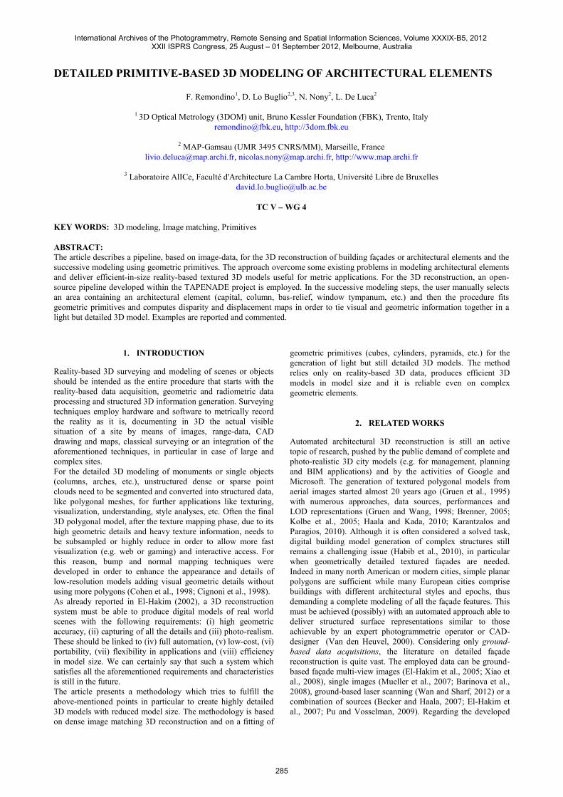
For the image orientation, the methodology relies on the opensource APERO software (Pierrot-Deseilligny and Clery, 2011).As APERO is targeted for a wide range of images, lenses andapplications, it requires some input parameters to give to theuser a fine control on all the initialization and minimizationsteps of the orientation procedure. APERO consists of differentmodules for tie point extraction, initial solution computation,bundle adjustment for relative and absolute orientation. Ifavailable, external information like GNSS/INS observations ofthe camera perspective centres, GCPs coordinates, knowndistances and planes can be imported and included in the leastsquares adjustment.Once the camera poses are estimated, a dense point cloud isextracted (Fig. 1) using the open-source MicMac software(Pierrot-Deseilligny and Paparoditis, 2006). The matching
algorithm consists of a multi-scale, multi-resolution, pyramidalapproach and derives dense point clouds using an energyminimization function to enforce surface regularities and avoidundesirable jumps. The pyramidal approach speed up theprocessing time and assures that the matched points extracted ineach level are similar.
Figure 1: Image-based 3D reconstruction of a column with itsdecorated capital and basement.
4.3 Primitive-based 3D modeling
Starting from the extracted dense point cloud or generatedpolygonal mesh model, the interactive and semi-automatic 3Dreconstruction approach is based on three methods according tothe morphological complexity of the analyzed architecturalshapes: Basic primitive adjustment (cubes, cylinders, pyramids,
etc.) to the selected architectural element using aminimization approach.
Progressive extrusion of relevant profiles (extracted fromthe point cloud) along typical path (arcs, columns, vaults,etc.) by using a set of low-level primitives (parametricmouldings).
A library of parameterized architectural primitives(moulded elements of the classical language) which can beinstantiated (i.e. dimensioned and positioned) onto thepoint cloud (De Luca et al. 2007).
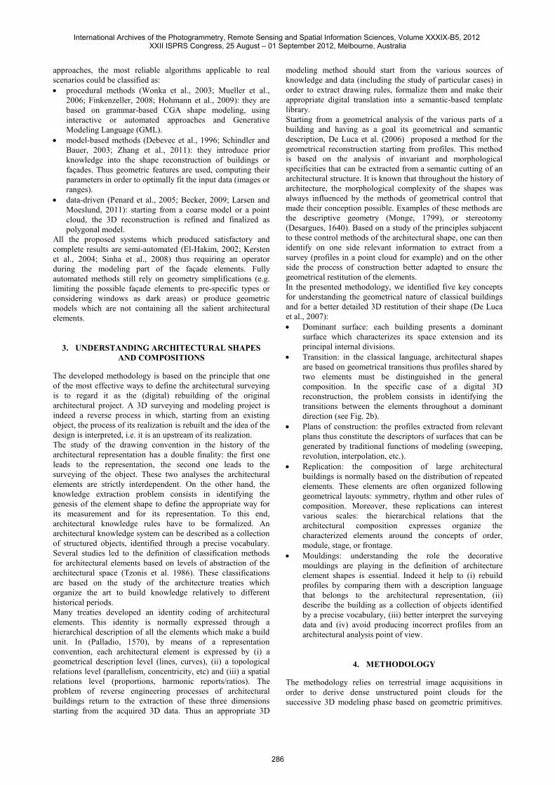
The intersection of a point cloud with a relevant plane allows toextract and identify points describing distinctive profiles of thearchitectural elements in order to exploit them for a successivesurface reconstruction process. The relevant plane is defined bya generic surface connected to a camera with an orthogonalprojection defined by an in-depth limited visual pyramid (inorder to display entities ranging between the near and the farclip plane). Profiles extracted from this intersection planeconstitute the surface descriptors which can be generated usingfive customized “surface generation” operators: linearextrusion, path extrusion, surface revolution, boundary andplanar surface generation.As described in section 3, the architectural composition of agreat number of buildings is based on a logical spatialdistribution of elements. These elements are often organized bygeometrical layouts around the concepts of order, module,stage, etc. Symmetry is the basic principle of a great number ofarchitectural shapes where we can find correspondences andreplications of sizes, positions and orientations between thedifferent parts and sub-parts of an element. In geometricalmodeling, symmetry is also an intrinsic property related toextrusion. The combined use of extrusion and scaling functionsalong the same symmetry axis, allows, for example, aprogressive reconstruction of the transitions characterizing theshape along a dominant direction. Thus this principle can beapplied to the basic 3D reconstruction of the envelope of acolumn (Fig. 2b) in order to: Automatically extract several horizontal profiles in order to
define a general vertical axis of the object.
International Archives of the Photogrammetry, Remote Sensing and Spatial Information Sciences, Volume XXXIX-B5, 2012 XXII ISPRS Congress, 25 August – 01 September 2012, Melbourne, Australia
287
a) b) c) d) e)Figure 2: The reconstructed column, planes in correspondence of the identified shape transitions, the basic primitives fitted between the planes, thedisparity map derived from the geometric details and mapped onto the basic primitives and the final light and efficient-in-size 3D model of thecolumn textured with a displacement map.
Select (interactive or automatic) shape’s transitions (i.e.discontinuities) to extract relevant profiles describingparticular sections along the shape’s dominant axis.
Best fit generic profiles (circles, arcs, rectangles, etc.) ormouldings (fillet, astragal, scotia, echinus, torus, etc.) on theextracted profiles.
Generate a parametric surface by interpolation of theextracted profiles along the dominant axis.
This approach (De Luca et al., 2007) allows the description ofarchitectural shapes with a generic formalism based on anetwork of semantic atoms. A node atom contains essentialinformation for its representation in space (position, rotation,scale) and controls four under-nodes which share attributes.
4.4 Embedding visual and geometric details in primitives
This step of the process is based on the computation of adisparity map between the original surveyed element (densepoint cloud or mesh) and the simplified one (primitive, lightmesh, etc.). In principle: a generic texture image is created defining a mapping
function according to the object complexity (planar, cubic,cylindrical, spherical).
for each pixel of the generic texture image, (i) thetransformation between the image point (texture space) andthe primitive point (object space) and (ii) the distancebetween the primitive point and the original point cloud(or mesh) along the primitive’s surface normal arecomputed.
considering the distribution of the extracted distances, aparametric color ramp (in gray scale) is computed toexpress the complete range of disparity between theprimitive and the original element (see Fig. 2d).
The visual and geometric information (coming from the originalelement) is then mapped onto the simplified elements (Fig. 2e)by creating “enriched textures” composed by: a displacement map altering the surface of the simplified
geometry in order to embed and simulate surface details.This map is created (in the rendering step) capturing thevertical distance between two points on a surface into thecomputed disparity map.
a normal map capturing the surface normal information ofthe original point cloud or mesh.
a traditional color map containing high definition texturesproduced using the oriented images.
5. A COMPLEX ARCHITECTURE
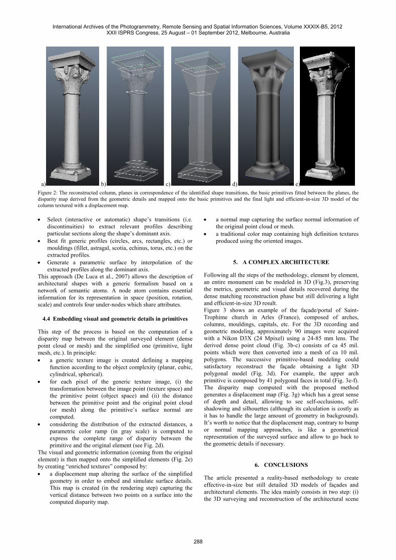
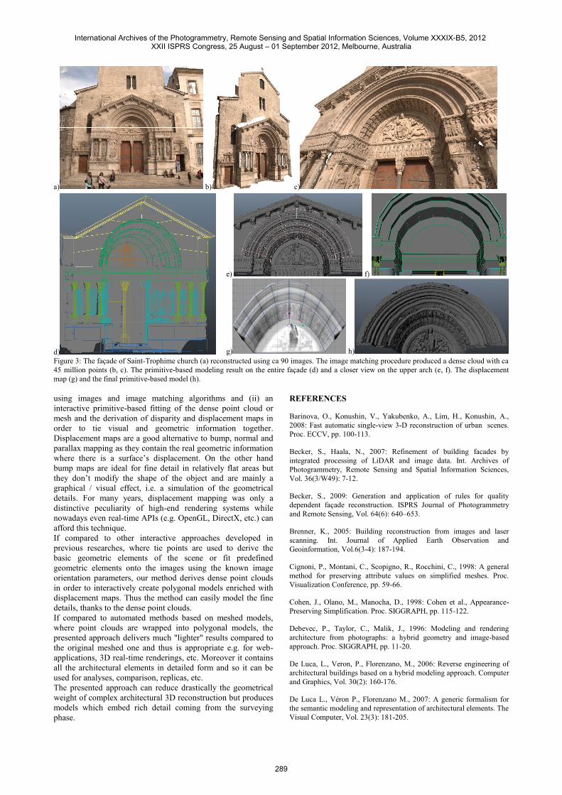
Following all the steps of the methodology, element by element,an entire monument can be modeled in 3D (Fig.3), preservingthe metrics, geometric and visual details recovered during thedense matching reconstruction phase but still delivering a lightand efficient-in-size 3D result.Figure 3 shows an example of the façade/portal of Saint-Trophime church in Arles (France), composed of arches,columns, mouldings, capitals, etc. For the 3D recording andgeometric modeling, approximately 90 images were acquiredwith a Nikon D3X (24 Mpixel) using a 24-85 mm lens. Thederived dense point cloud (Fig. 3b-c) consists of ca 45 mil.points which were then converted into a mesh of ca 10 mil.polygons. The successive primitive-based modeling couldsatisfactory reconstruct the façade obtaining a light 3Dpolygonal model (Fig. 3d). For example, the upper archprimitive is composed by 41 polygonal faces in total (Fig. 3e-f).The disparity map computed with the proposed methodgenerates a displacement map (Fig. 3g) which has a great senseof depth and detail, allowing to see self-occlusions, self-shadowing and silhouettes (although its calculation is costly asit has to handle the large amount of geometry in background).It’s worth to notice that the displacement map, contrary to bumpor normal mapping approaches, is like a geometricalrepresentation of the surveyed surface and allow to go back tothe geometric details if necessary.
6. CONCLUSIONS
The article presented a reality-based methodology to createeffective-in-size but still detailed 3D models of façades andarchitectural elements. The idea mainly consists in two step: (i)the 3D surveying and reconstruction of the architectural scene
International Archives of the Photogrammetry, Remote Sensing and Spatial Information Sciences, Volume XXXIX-B5, 2012 XXII ISPRS Congress, 25 August – 01 September 2012, Melbourne, Australia
288
a) b) c)
d)
e) f)
g) h)Figure 3: The façade of Saint-Trophime church (a) reconstructed using ca 90 images. The image matching procedure produced a dense cloud with ca45 million points (b, c). The primitive-based modeling result on the entire façade (d) and a closer view on the upper arch (e, f). The displacementmap (g) and the final primitive-based model (h).
using images and image matching algorithms and (ii) aninteractive primitive-based fitting of the dense point cloud ormesh and the derivation of disparity and displacement maps inorder to tie visual and geometric information together.Displacement maps are a good alternative to bump, normal andparallax mapping as they contain the real geometric informationwhere there is a surface’s displacement. On the other handbump maps are ideal for fine detail in relatively flat areas butthey don’t modify the shape of the object and are mainly agraphical / visual effect, i.e. a simulation of the geometricaldetails. For many years, displacement mapping was only adistinctive peculiarity of high-end rendering systems whilenowadays even real-time APIs (e.g. OpenGL, DirectX, etc.) canafford this technique.If compared to other interactive approaches developed inprevious researches, where tie points are used to derive thebasic geometric elements of the scene or fit predefinedgeometric elements onto the images using the known imageorientation parameters, our method derives dense point cloudsin order to interactively create polygonal models enriched withdisplacement maps. Thus the method can easily model the finedetails, thanks to the dense point clouds.If compared to automated methods based on meshed models,where point clouds are wrapped into polygonal models, thepresented approach delivers much "lighter" results compared tothe original meshed one and thus is appropriate e.g. for web-applications, 3D real-time renderings, etc. Moreover it containsall the architectural elements in detailed form and so it can beused for analyses, comparison, replicas, etc.The presented approach can reduce drastically the geometricalweight of complex architectural 3D reconstruction but producesmodels which embed rich detail coming from the surveyingphase.
REFERENCES
Barinova, O., Konushin, V., Yakubenko, A., Lim, H., Konushin, A.,2008: Fast automatic single-view 3-D reconstruction of urban scenes.Proc. ECCV, pp. 100-113.
Becker, S., Haala, N., 2007: Refinement of building facades byintegrated processing of LiDAR and image data. Int. Archives ofPhotogrammetry, Remote Sensing and Spatial Information Sciences,Vol. 36(3/W49): 7-12.
Becker, S., 2009: Generation and application of rules for qualitydependent façade reconstruction. ISPRS Journal of Photogrammetryand Remote Sensing, Vol. 64(6): 640–653.
Brenner, K., 2005: Building reconstruction from images and laserscanning. Int. Journal of Applied Earth Observation andGeoinformation, Vol.6(3-4): 187-194.
Cignoni, P., Montani, C., Scopigno, R., Rocchini, C., 1998: A generalmethod for preserving attribute values on simplified meshes. Proc.Visualization Conference, pp. 59-66.
Cohen, J., Olano, M., Manocha, D., 1998: Cohen et al., Appearance-Preserving Simplification. Proc. SIGGRAPH, pp. 115-122.
Debevec, P., Taylor, C., Malik, J., 1996: Modeling and renderingarchitecture from photographs: a hybrid geometry and image-basedapproach. Proc. SIGGRAPH, pp. 11-20.
De Luca, L., Veron, P., Florenzano, M., 2006: Reverse engineering ofarchitectural buildings based on a hybrid modeling approach. Computerand Graphics, Vol. 30(2): 160-176.
De Luca L., Véron P., Florenzano M., 2007: A generic formalism forthe semantic modeling and representation of architectural elements. TheVisual Computer, Vol. 23(3): 181-205.
International Archives of the Photogrammetry, Remote Sensing and Spatial Information Sciences, Volume XXXIX-B5, 2012 XXII ISPRS Congress, 25 August – 01 September 2012, Melbourne, Australia
289
El-Hakim, S., 2002: Semi-automated 3D reconstruction of occludedand unmarked surfaces from widely separated images. Int. Archives ofPhotogrammetry, Remote Sensing and Spatial Information Sciences,Vol.34(5): 143-148, Corfu, Greece.
El-Hakim, S., Whiting, E., Gonzo, L., 2005: 3D modeling with reusableand integrated building blocks. Proc. 7th Optical 3D MeasurementConference, Vienna, Austria.
El-Hakim, S., Gonzo, L. Voltolini, F., Girardi, S., Rizzi, A.,Remondino, F., Whiting, E., 2007: Detailed 3D modeling of castles. Int.Journal of Architectural Computing, Vol.5(2): 199-220.
Finkenzeller, D., 2008: Detailed building façades. Computer Graphicsand Applications, Vol.28(3): 58-66.
Furukawa, Y. and Ponce, J., 2010: Accurate, dense and robustmultiview stereopsis. IEEE Transactions on Pattern Analysis andMachine Intelligence, Vol. 32(8): 1362-1376.
Gruen, A., Kuebler, O., Agouris, P. (Eds), 1995: Automatic extractionof man-made objects from aerial and space images. Birkhaeuser, Basel,340 pages.
Gruen, A., Wang, X., 1998: CC-Modeler: a topology generator for 3-Dcity models. ISPRS Journal of Photogrammetry and Remote Sensing,Vol. 53(5): 286-295
Hiep, V.H., Keriven, R., Labatut, P., Pons, J.P., 2009: Towards high-resolution large-scale multi-view stereo. Proc. CVPR, Kyoto, Japan.
Hirschmueller, H., 2008: Stereo processing by semi-global matchingand mutual information. IEEE Transactions on Pattern Analysis andMachine Intelligence, Vol. 30(2): 328–341.
Hirschmueller, H., 2011: Semi-Global Matching - Motivation,developments and applications. Proc. Photogrammetric Week, pp. 173-184.
Hohmann, B., Krispel, U., Havemann, S., Fellner, D., 2009: CityFit -High-quality urban reconstructions by fitting shape grammars to imagesand derived textured point clouds. Int. Archives of Photogrammetry,Remote Sensing and Spatial Information Sciences, Vol. 38(5/W1),Trento, Italy (on CD-ROM).
Jachiet, A.L., Labatut, P., Pons, J.P., 2010: Robust piecewise-planar 3Dreconstruction and completion from large-scale unstructured point data.Proc. CVPR, San Francisco, USA.
Karantzalos K. and Paragios N., 2010: Large-scale buildingreconstruction through information fusion and 3D priors. IEEE Trans.on Geoscience and Remote Sensing, Vol. 48(5): 2283-2296.
Kolbe, T.H., Groeger, G., Pluemer, L., 2005: CityGML – interoperableaccess to 3D city models. In van Oosterom, Zlatanova, Fendel (Eds.),Geo-Information for Disaster Management. Springer, pp. 883-899.
Habib, A.F., Zhai, R., Kim, C., 2010: Generation of complex polyhedralbuilding models by integrating stereo-aerial imagery and LiDAR data.Photogrammetric Engineering & Remote Sensing, Vol.76(5): 609-623.
Haala, N., Kada, M., 2010: An update on automatic 3D buildingreconstruction. ISPRS Journal of Photogrammetry and Remote Sensing,Vol.65: 570-580.
Larsen, C., Moeslund, T.B., 2011: 3D reconstruction of buildings withautomatic facade refinement. In G. Bebis et al. (Eds.), Proc. ISVC2011, Part I, LNCS 6938, pp. 451-460.
Monge, G., 1799. Géométrie descriptive. Paris.
Mueller, P., Wonka, P., Haegler, S., Ulmer, A., Van Gool, L., 2006:Procedural modeling of building. Proc. ACM SIGGRAPH, Vol.25(2).
Mueller, P., Zeng, G., Wonka, P., Van Gool, L., 2007: Image-basedprocedural modeling of façades. Proc. ACM SIGGRAPH, Vol.26(2).
Palladio, A., 1965: The four books of Architecture. Dover publications,New York (original edition: Venezia, 1570).
Penard, L., Paparoditis, N., Pierrot-Deseilligny, M., 2005: 3D buildingfacade reconstruction under mesh form from multiple wide angle views.Int. Archives of Photogrammetry, Remote Sensing and SpatialInformation Sciences, Vol. 36(5/W17), Venice, Italy (on CD-ROM).
Pierrot-Deseilligny M., Paparoditis N., 2006: A multiresolution andoptimization-based image matching approach: An application tosurface reconstruction from SPOT5-HRS stereo imagery. Int. Archivesof Photogrammetry, Remote Sensing and Spatial Information Sciences,Vol. 36(1/W41), Ankara, Turkey.
Pierrot-Deseilligny, M., Clery, I., 2011: APERO, an open source bundleadjustment software for automatic calibration and orientation of set ofimages. Int. Archives of Photogrammetry, Remote Sensing and SpatialInformation Sciences, Vol. 38(5/W16), Trento, Italy (on CD-ROM).
Pierrot-Deseilligny, M., De Luca, L. and Remondino, F., 2011.Automated image-based procedures for accurate artifacts 3D modelingand orthoimage generation. Proc. 23th Int. CIPA Symposium, Prague,Czech Republic (on CD-ROM).
Pu, S., Vosselman, G., 2009: Building facade reconstruction by fusingterrestrial laser points and images. Sensors, Vol. 9: 4525-4542.
Remondino, F., Fraser, C., 2006: Digital camera calibration methods:considerations and comparisons. Int. Archives of Photogrammetry,Remote Sensing and Spatial Information Sciences, Vol. 36(5): 266-272,Dresden, Germany.
Remondino, F., El-Hakim, S., Gruen, A. and Zhang, L., 2008.Development and performance analysis of image matching for detailedsurface reconstruction of heritage objects. IEEE Signal ProcessingMagazine. Vol. 25(4): 55-65.
Schindler, K., Bauer, J., 2003: A model-based method for buildingreconstruction. Proc. ICCV.
Sinha, S., Steedly, D., Szeliski, R., Agrawala, M., Pollefeys, M., 2008:Interactive 3D Architectural modeling from unordered photocollections, ACM Transactions on Graphics (SIGGRAPH ASIA 2008),27(5): 159:1-10.
Tzonis A, Lefaivre L., 1986: Classical Architecture - The poetics oforder. Cambridge. MIT Press.
Van den Heuvel, F., 2000: Trends in CAD-based photogrammetricmeasurement. Int. Archives of Photogrammetry and Remote Sensing,Vol. 33(5/2): 852-863.
Wan, G., Sharf, A., 2012: Grammar-based 3D facade segmentation andreconstruction. Computer & Graphics, Vol. 36(4): 216-223.
Wonka, P., Wimmer, M., Silliuon, F., Ribarsky, W., 2003: Instantarchitecture. Proc. ACM SIGGRAPH.
Xiao, J., Fang, T., Tan, P., Zhao, P., Ofek, E., Quan, L., 2008: Image-based façade modeling. ACM Transaction on Graphics, Vol.27(5):161:1-10.
Waldhäusl, P., Ogleby, C., 1994: 3-by-3 Rules for simplephotogrammetric documentation of architecture. Int. Archives ofPhotogrammetry and Remote Sensing, Vol. (30/5): 426-429.
Zhang, W., Grussenmeyer, P., Yan, G., Mohamed, M., 2011: Primitive-based building reconstruction by integrating of LiDAR data and opticalimagery. Int. Archives of Photogrammetry, Remote Sensing and SpatialInformation Sciences, Vol. 38(5/W12), Calgary, Canada (on CD-ROM).
International Archives of the Photogrammetry, Remote Sensing and Spatial Information Sciences, Volume XXXIX-B5, 2012 XXII ISPRS Congress, 25 August – 01 September 2012, Melbourne, Australia
290