Designing the Chinese post-Imperial capitals in ...
9
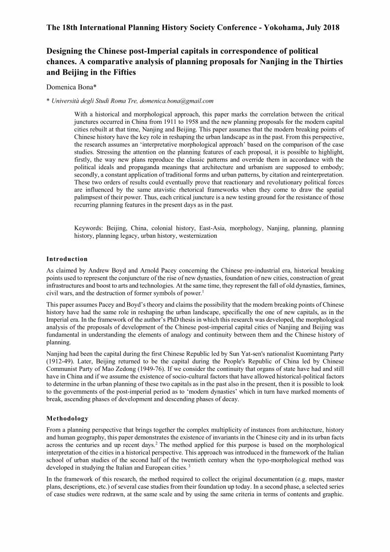
The 18th International Planning History Society Conference - Yokohama, July 2018 Designing the Chinese post-Imperial capitals in correspondence of political chances. A comparative analysis of planning proposals for Nanjing in the Thirties and Beijing in the Fifties Domenica Bona* * Università degli Studi Roma Tre, [email protected] With a historical and morphological approach, this paper marks the correlation between the critical junctures occurred in China from 1911 to 1958 and the new planning proposals for the modern capital cities rebuilt at that time, Nanjing and Beijing. This paper assumes that the modern breaking points of Chinese history have the key role in reshaping the urban landscape as in the past. From this perspective, the research assumes an ‘interpretative morphological approach’ based on the comparison of the case studies. Stressing the attention on the planning features of each proposal, it is possible to highlight, firstly, the way new plans reproduce the classic patterns and override them in accordance with the political ideals and propaganda meanings that architecture and urbanism are supposed to embody; secondly, a constant application of traditional forms and urban patterns, by citation and reinterpretation. These two orders of results could eventually prove that reactionary and revolutionary political forces are influenced by the same atavistic rhetorical frameworks when they come to draw the spatial palimpsest of their power. Thus, each critical juncture is a new testing ground for the resistance of those recurring planning features in the present days as in the past. Keywords: Beijing, China, colonial history, East-Asia, morphology, Nanjing, planning, planning history, planning legacy, urban history, westernization Introduction As claimed by Andrew Boyd and Arnold Pacey concerning the Chinese pre-industrial era, historical breaking points used to represent the conjuncture of the rise of new dynasties, foundation of new cities, construction of great infrastructures and boost to arts and technologies. At the same time, they represent the fall of old dynasties, famines, civil wars, and the destruction of former symbols of power. 1 This paper assumes Pacey and Boyd’s theory and claims the possibility that the modern breaking points of Chinese history have had the same role in reshaping the urban landscape, specifically the one of new capitals, as in the Imperial era. In the framework of the author’s PhD thesis in which this research was developed, the morphological analysis of the proposals of development of the Chinese post-imperial capital cities of Nanjing and Beijing was fundamental in understanding the elements of analogy and continuity between them and the Chinese history of planning. Nanjing had been the capital during the first Chinese Republic led by Sun Yat-sen's nationalist Kuomintang Party (1912-49). Later, Beijing returned to be the capital during the People's Republic of China led by Chinese Communist Party of Mao Zedong (1949-76). If we consider the continuity that organs of state have had and still have in China and if we assume the existence of socio-cultural factors that have allowed historical-political factors to determine in the urban planning of these two capitals as in the past also in the present, then it is possible to look to the governments of the post-imperial period as to ‘modern dynasties’ which in turn have marked moments of break, ascending phases of development and descending phases of decay. Methodology From a planning perspective that brings together the complex multiplicity of instances from architecture, history and human geography, this paper demonstrates the existence of invariants in the Chinese city and in its urban facts across the centuries and up recent days. 2 The method applied for this purpose is based on the morphological interpretation of the cities in a historical perspective. This approach was introduced in the framework of the Italian school of urban studies of the second half of the twentieth century when the typo-morphological method was developed in studying the Italian and European cities. 3 In the framework of this research, the method required to collect the original documentation (e.g. maps, master plans, descriptions, etc.) of several case studies from their foundation up today. In a second phase, a selected series of case studies were redrawn, at the same scale and by using the same criteria in terms of contents and graphic.
-
Upload
khangminh22 -
Category
Documents
-
view
3 -
download
0
Transcript of Designing the Chinese post-Imperial capitals in ...
The 18th International Planning History Society Conference - Yokohama, July 2018
Designing the Chinese post-Imperial capitals in correspondence of political chances. A comparative analysis of planning proposals for Nanjing in the Thirties and Beijing in the Fifties
Domenica Bona*
* Università degli Studi Roma Tre, [email protected]
With a historical and morphological approach, this paper marks the correlation between the critical junctures occurred in China from 1911 to 1958 and the new planning proposals for the modern capital cities rebuilt at that time, Nanjing and Beijing. This paper assumes that the modern breaking points of Chinese history have the key role in reshaping the urban landscape as in the past. From this perspective, the research assumes an ‘interpretative morphological approach’ based on the comparison of the case studies. Stressing the attention on the planning features of each proposal, it is possible to highlight, firstly, the way new plans reproduce the classic patterns and override them in accordance with the political ideals and propaganda meanings that architecture and urbanism are supposed to embody; secondly, a constant application of traditional forms and urban patterns, by citation and reinterpretation. These two orders of results could eventually prove that reactionary and revolutionary political forces are influenced by the same atavistic rhetorical frameworks when they come to draw the spatial palimpsest of their power. Thus, each critical juncture is a new testing ground for the resistance of those recurring planning features in the present days as in the past.
Keywords: Beijing, China, colonial history, East-Asia, morphology, Nanjing, planning, planning history, planning legacy, urban history, westernization
Introduction
As claimed by Andrew Boyd and Arnold Pacey concerning the Chinese pre-industrial era, historical breaking points used to represent the conjuncture of the rise of new dynasties, foundation of new cities, construction of great infrastructures and boost to arts and technologies. At the same time, they represent the fall of old dynasties, famines, civil wars, and the destruction of former symbols of power.1
This paper assumes Pacey and Boyd’s theory and claims the possibility that the modern breaking points of Chinese history have had the same role in reshaping the urban landscape, specifically the one of new capitals, as in the Imperial era. In the framework of the author’s PhD thesis in which this research was developed, the morphological analysis of the proposals of development of the Chinese post-imperial capital cities of Nanjing and Beijing was fundamental in understanding the elements of analogy and continuity between them and the Chinese history of planning.
Nanjing had been the capital during the first Chinese Republic led by Sun Yat-sen's nationalist Kuomintang Party (1912-49). Later, Beijing returned to be the capital during the People's Republic of China led by Chinese Communist Party of Mao Zedong (1949-76). If we consider the continuity that organs of state have had and still have in China and if we assume the existence of socio-cultural factors that have allowed historical-political factors to determine in the urban planning of these two capitals as in the past also in the present, then it is possible to look to the governments of the post-imperial period as to ‘modern dynasties’ which in turn have marked moments of break, ascending phases of development and descending phases of decay.
Methodology
From a planning perspective that brings together the complex multiplicity of instances from architecture, history and human geography, this paper demonstrates the existence of invariants in the Chinese city and in its urban facts across the centuries and up recent days.2 The method applied for this purpose is based on the morphological interpretation of the cities in a historical perspective. This approach was introduced in the framework of the Italian school of urban studies of the second half of the twentieth century when the typo-morphological method was developed in studying the Italian and European cities. 3
In the framework of this research, the method required to collect the original documentation (e.g. maps, master plans, descriptions, etc.) of several case studies from their foundation up today. In a second phase, a selected series of case studies were redrawn, at the same scale and by using the same criteria in terms of contents and graphic.
The 18th International Planning History Society Conference - Yokohama, July 2018
These redrawn maps synthesize the elements of the urban structure and allow to compare in their diachronic evolution the different stage of development of each city also with the unbuilt planning proposals. Indeed, the confrontation of these morphological comparative maps picks out similarities and correspondences under various aspects (e.g. structural, dimensional, formal and visual) that do not end in the physical description of urban data but refer to a vocabulary that is more than ever symbolic and rooted in the Chinese urban culture.
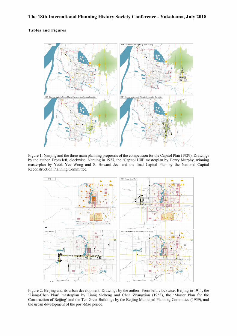
First case study. The nationalist capital of Nanjing
With the fall of the Chinese Empire after the Xinhai Rebellion in 1911, Sun Yat-sen4 led the founding of the first Chinese Republic and the relocation of the capital to Nanjing.5 During the Thirties, a decade remembered as the 'Nanjing decade', the city became a symbol of modern Republican China. Indeed, in a pro-western climate the KMT involved many experts in the re-construction of Nanjing, among which Chinese and foreign technicians and politicians affiliated to the party, many of the young educated abroad, and entrepreneurs active in the Treaty Ports interested in participating in the construction of the Post-Imperial Modern China.6
Already capital in the medieval period, the original urban structure is that of a double city. Dated back to the tenth century, the first settlement has a rectangular shape and is located near the Yangtze River. Subsequently, new walls were built to include a larger area to the north-west of the city, between the river and Xuan Lake, and the imperial palace built extra moenia in 1368 under the Ming dynasty (1368-1644). 7
Nanjing was an important commercial city but the proximity to Shanghai contributed to its decay. This did not favour urban growth so much that the structure, the footprint and the built fabrics remained mostly unchanged from the Middle Ages until the stipulation of the Treaty of Nanjing (1842) when the establishment of the foreign commercial companies contributed to build the railway, strengthen the port, and found numerous activities related to overseas trade.
The state of decadence and the possibility of building freely on the still predominantly agricultural land made Nanjing the ideal place to settle the capital of the Republic of China as Sun Yat-sen already proposed in the first decade of the twentieth century. In 1925, important works were started to improve the road network and build new buildings; 8 in the same year, the competition for the construction of the Sun Yat-sen Mausoleum was launched and won by Lu Yanzhi.9 It was the first Nanjing building designed to consecrate the new Republican political power;10 on the southern side of Mount Zijin east of the Ming Tombs, Lu proposes an elegant and majestic adaptive architecture that reflects the aims of the tender and the principles of the 'Chinese form movement' (trad. �����, Zhōngguó gùyǒu xíngshì), combining classic architectural forms with modern construction technologies.11 The construction of the mausoleum was crucial to enable Nanjing to become the capital of the Republic, with the consent of the entire KMT; the southern position made Nanjing well placed, safe enough and far from the north occupied by Japanese and Communists.
For the leader of KMT Chiang Kai-shek, the development of the city was a priority so that in 1928 the ‘National Capital Reconstruction Planning Committee, guesting Chinese and American designers including Ernest Goodrich and Henry Murphy.12 The committee soon launched the competition for the 'Capital Plan' (trad. ����, Shǒudū jìhuà) proposing an unprecedented program whose objective was the creation of a new capitolium. This was to turn into a project that would glorify China rebirth, in continuity with the past, and KTM rise to world power. As in the case of the mausoleum, the competition brief gave precise indications on the aesthetics of the project, that is a classical Chinese style with explicit sober monumental elements reworked in a modern key and contaminated by new types and construction technologies. Wide boulevards, long-laced straight-lines, tree-lined avenues, public gardens, grand buildings, and triumphal monuments are the elements that can be found in all the proposals.
In fact, all the projects took inspiration from the beaux-arts plans of Washington, New Delhi, Canberra and Paris, adapting the classical features of Chinese urbanism, such as the symmetry along the longitudinal axis, the partition into sectors and the horizontality of the built skyline. Among the many projects presented, two are those that best represent the positions and variations suggested by the design teams, that by Henry Murphy and the winner by Wong Yook Yee and S. Howard Jee. 13
Murphy planned a 'Capitol Hill' outside the walls south of the Sun Yat-sen Mausoleum. With a second doubling of the city, Murphy proposes a continuation of the longitudinal axis of the memorial on which to graft monumental urban settlement that would have collected the governmental, administrative, cultural, and residential functions of the new capital.14 The winning project by Wong Yook Yee and S. Howard Jee proposed another beaux-arts urban layout and overlapped the eastern part of the city, thus foreseeing the demolition of the imperial palace and the eastern city walls. With large orthogonal straights and diagonal vaults, the urban grid is permeated with marked citations of the cosmological city, eventually, making architectural choices and setting itself in the wake of the adaptive style in vogue.
The 18th International Planning History Society Conference - Yokohama, July 2018
However, the winning project of Wong and Zhu was criticized because it was too expensive and complex to carry out. The Planning Committee then opted for a less onerous proposal, eventually not wither realised, that plans to raze the eastern intra-moenia area of the Ming Palace. The layout is based on an orthogonal grid with an irregular perimeter that follows the pre-existing form of the city. The central north-south axis is conceived as a large tree-lined boulevard interrupted in the middle by two monumental buildings surrounded by squares and gardens, which ends in the north at the railway station on which converges a new section of the railway that winds the city up at the banks of the river. The core area along the main axes is intended for large public functions, the peripheral blocks are intended for high to low-income residential areas, and the whole settlement would have featured a broad and coherent range of adaptive architectural designs. 15
Second care study. The communist capital of Beijing
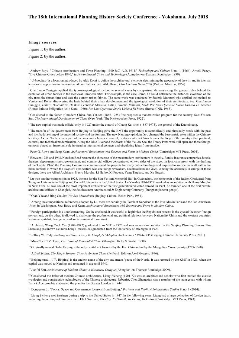
Beijing has had the fortune of never having been dismissed from its role of capital until the fall of the Empire.16 Founded by the Mongol Kublai Khan in 1271 adjacent to a pre-existing Chinese city dating back to 221 BC, Beijing may be considered the most sacred city in Chinese history for its precise adherence to the cosmological model of the ‘magic square’.17 With the abdication of Emperor Puyi in 1911, however, the decline of Beijing begins. The city changed its name to Beiping, was dismissed from the role of capital and fell under Japanese control between 1937 and 1945.18
In 1949, right after the founding of the People's Republic of China, the Communist intelligentsia brought back the capital to Beijing and started an apologetic-glorifying program that led to the definition of political symbols, cults and, the image of the new Chinese proletarian era. These interventions can be grouped into two macro-phases.19 The first phase (1950-53) contributed defining the image of the state with the projects for the National Emblem (1950), the Monument to the People's Heroes (1952) and the urban expansion plan of Beijing (1949-53). They respond, in fact, to the immediate needs to make the identity of the Party recognizable and concretely demonstrate the political purposes that led to Mao's seizure of power. The second phase (1954-59) instead represents a theoretical and practical climax during which the dominant cultural positions were defined. During that time, the expansion plan for the capital was done (1954-58) and a new capitolium was created with the so-called ‘Ten Great Buildings’ and Tiananmen Square (1959).
When in 1949 the Beijing Municipal Government announced the design competition for urban expansion in Beijing, that was the first Chinese experience of urban planning since the Nanjing days. The debate was fervent and the ideas were inspired by what had already been done in Russia. The attitude was basically explorative and the main proposals were three, very different from each other: (1) the conservative one by Liang Sicheng and Chen Zhangxian and known as the 'Liang-Chen Plan' which proposes an urban doubling and the conservation of the historical fabric, 20 (2) that of the Soviet technicians coordinated by M.G. Barannikov redefining the historical core and urban growth on the Muscovite model, and (3) that of the Planning Committee headed by Hua Nankui, Zhu Zhaoxue, and Zhao Dongri which mediates the positions of the other two proposals.21
The 'Liang-Chen Plan' applied the principle of organic decentralization proposed by Eliel Saarinen in the plan for Helsinki (1917) and applied by Abercrombie to London (1944).22 It proposed the preservation of the built fabric of Beijing and the construction of a new core of expansion to the west outside the historical city.23 Preserving the walls, the monuments, and the hutong, the plan thus concentrated the new functions outside the walls. The administrative centre was placed along a longitudinal axis parallel and dimensionally analogue to the one of the Forbidden City which was taken as a reference for proportions and typological layout. The result was meant to create a double city with the historical low-dense built fabric and a new modern settlement built by a set of monumental pavilions for public functions and skyscrapers for apartments and offices. 24 However, Liang's foresight found a weak endorsement by the Party and the ‘Liang-Chen Plan’ was considered excessively conservative.
On the contrary, the ‘Proposal on the improvement of the Beijing Municipal Administration’ draft by the Soviet group was based on the idea that Beijing should become the industrial centre capable of leading the modernization of the new China by abandoning its traditional political and cultural vocation. In general, the plan contained elements already tested in the construction of Soviet industrial cities and in the redesign of Moscow and Stalingrad. The historic centre was meant to host the central administrative and civic district, on the site of the future Tiananmen Square and Chang'an Road. The program also proposed the construction of social-housing neighbourhoods and greenbelts separating them from the historic city centre where the main public, military and administrative functions should have converged. In fact, the plan denied the monocentric structure of Beijing, transforming the city in a polycentric system with a core and several new towns, every one characterized by a functional vocation and high levels of independence.
Assuming to the Soviet proposal, in 1953 the Planning Committee elaborated a Party-internal project, the so-called 'Chang-guan-lou Plan', and in 1954 the final version was published as the 'Master Plan for the Construction of
The 18th International Planning History Society Conference - Yokohama, July 2018
Beijing',25 the first definitive urban project for Beijing further revised in 1958. The plan thus clarifies the dual role of Beijing as an industrial metropolis and political, institutional and cultural reference core of the country. It outlined a twenty-year development based on the principle of 'control urban area and develop the far suburb'.26 From a planning perspective, the plan proposed the reversal of the traditional north-south axis and the strengthening of Chang'an Road, an east-west boulevard appointed to be the 'axis of modernization'.27 Indeed, by changing the logic of the original layout, this new plan deeply upset the classical structure of the consolidated city, creating an unseen double axiality, like a cardo and decuman system.
On the basis of the 'Chang-guan-lou Plan', Beijing Municipal Government in parallel carried on the architectural for Tiananmen Square and the 'Ten Great Buildings'.28 The design of the square and these buildings was entrusted to various groups of architects and engineers in order to favour the typological-stylistic variety that the Party intended to pursue. Despite the modern technologies applied in the construction, in fact, the whole composition of the facades or just details evoke the Chinese identity that has its roots in history. Indeed, all the buildings were endowed with decorative elements of the classical tradition (e.g. architraves, shelves, and stairways), the essence of the ‘National Style’ that would be developed from then on.29
Comparing the two case studies
The analysis of the planning proposals and the urban development of the case studies briefly presented was conducted by applying a comparative morphological method. Specifically, Nanjing was analysed in seven drawings, mapping the urban development in 1912, 1927, 1941, and 1974, and the three planning proposals of the ‘Capital Plan’ (1929) by Henry Murphy and the winner by Wong Yook Yee and S. Howard Jee and Nanking Planning Committee. Beijing was analysed in seven drawings too, mapping the urban development in 1911, 1940, 1959, and 1974 and the unbuilt planning proposals by the Japanese (1937), Liang Si Cheng and the M.G. Barannikov (1953). By reading the evolution of each city and then comparing the two, it came to evidence the presence to analogous patterns in terms of design tools, planning features, political context and cultural background, despite the apparent diverse historical frameworks.
Grafts and doublings
Planning history of China has shown two different attitudes towards expansion tools that were detected also in the proposals for Nanjing and Beijing. On one hand, the ‘urban graft’ overwhelms the order of things by destroying the existent built fabrics and super-impress a new settlement. It is a practice that would imply a clear intention of creating a new palimpsest in contrast with the past. On the other, the ‘urban doubling’ allow building a new settlement by juxtaposition rather than. It is a consolidated practice that can be observed in the most ancient Chinese cities, as in the nineteenth-century Nanjing and in the early twentieth-century. The will to not cancel the traces of established settlements tells us about a dual purpose: to build on symbolically uncontaminated foundations and construct in a regime of rapidity and economy of efforts.30
In pre-modern times when Kublai Khan establishes the Tartar capital in Beijing, instead of occupying the pre-existing Chinese city, he founded his own one ex-novo based on the cosmological model, whose walls were graft on the northern side of those of the ancient settlement. The same happens in many other cities where the rise of new rulers creates the conditions for expanding, reorganizing and re-imagining the structure of existing cities. Nanjing makes no exceptions since the Ming doubled the urban structure when they built the new imperial palace extra-moenia, side by side of the original walled city.
This modus operandi was later reinterpreted functionally by the foreigners who ‘colonized’ China in the Nineteenth century, in the transition period between the pre-modern and modern age, and by the Chinese intelligentsia in the post-imperial time. This is demonstrated by the planning proposals draft at the competitions for Nanjing (1929) and later for Beijing, with the doubling project by the Japanese (1941) and the Liang-Chen Plan (1949). In all these projects, the doubling theme becomes functional to the definition of an urban plan of great impact and to the safeguard of the historical settlements from the devastation that an urban graft would have produced. However, although the theme of the double city has been revised frequently and has found a broad consensus, none of the doubling projects has been brought to realization. Eventually, in Nanjing the fall of the KMT blocked the process of urban re-foundation and, even more striking, in Beijing the urban structure remained still strongly monocentric, despite the attempts to shift the centre of gravity to areas other than the Forbidden City.
The axis of urban symmetry
Modern plans for the capitals show that the monumental axis is one of the most frequent figures of reinterpretation of the cosmological urban model. As in the pre-modern age, the axis is a planning tool capable to set the urban
The 18th International Planning History Society Conference - Yokohama, July 2018
structure of settlements and put into relation the practical issues of design with the spiritual symbology of religion (e.g. North-South as god-man) and the celebratory issues politics.
In Nanjing, all the projects developed during the Nanjing Decade were based on a symmetrical development supported by a longitudinal axis that connects the city with the surrounding environment (e.g. the mountains to the north, the water to the south). Associated with the use of classical architectural typologies (e.g. pavilion buildings with pagoda roof), those projects all introduced modern western themes such as that of public space, extroversion, verticality, and therefore a panoptic vision of the axis which dominates the entire array of buildings surrounding the great open space along the axis. The axiality, in fact, is reiterated by the design of built fabrics that generates a series of typified blocks aligned from north to south, which surround the public space and the special blocks leaning against the axis. In Beijing, instead, Tiananmen Square is located south of the Forbidden City along the existing axis of symmetry to the south up to Qianmen. By symbolically extending the pavilions of the Forbidden City outside its walls along the edges and in the middle of the square, the axis intercepts a series of buildings that double the system of the imperial compound, made up of interrupted central perspectives and paths that, never straights, oblige to cross or turn around these large buildings. At the same time, the consistency of the architectural artefacts accentuates the long perspective and dominance of a horizontal landscape, devoid of spatial references outside the square itself.
Indeed, the figure of the axis returns to the most relevant urban projects through the past to the twentieth century. On the one hand, it preserves the formal characteristics of the physical urban layout based on rigour, symmetry, and a ration. On the other, it embodies the values and uses proper of the institutions in place.
In the ancient time already, the triumphal road used to connect the southern gate of the imperial palace to corresponding one of the city walls, with a straight line along which stand a series of temples and altars marking the obligatory stages of solemn processions conduced by the emperor. In the twentieth century the transfer of the power of the hands of the emperor first, the KMT then, and the CCP later has meant the shift of institutions from one capital to another. In this process, in both Nanjing and Beijing the characters of the axis change and the functions evolved and the instances of the modern city were added to the traditional celebratory values. In fact, the monumental axis is transformed into in an equipped linear urban space, reminiscent of the market street, characterised by a dense agglomeration of civic venues, government headquarters, and business centres attractive at the urban at mostly national scale.
Conclusions
As emperors of ‘modern dynasties’, Chang Kai-shek and Mao Zedong have sealed the beginning of their power through the construction of modern capitals inspired more or less explicitly to the Chinese classical model. In fact, in both moments the change in the geography of power has pushed the intelligentsia to redesign the capital city, so to embody new values and objectives in a city as much as in the nation. This fact eventually proves that reactionary and revolutionary political forces were influenced by the same atavistic rhetorical frameworks when they came to draw the spatial palimpsest of their power. Thus, urban planning continues to have in itself a strong political connotation and, we could say, the anti-democratic characteristics that belong to the feudal culture of the past period. As commonly known, the Chinese political model has historically been heavily subjected to hierarchical mechanisms of control that left little room for the debate and participatory policies. In this sense, the exceptional nature of the two cases is confirmed by the way in which the urban planning process was carried out. The competition of ideas, in fact, is an uncommon tool for the Chinese context, both in terms of architectural and urban design, as it implies a level of democracy and cultural openness that de facto do not belong to the Chinese cultural mind set. Nevertheless, in both cases, the winners of the tenders had been disregarded and the project re-entrusted to a design institute, a direct expression of the government.
To conclude, similarities emerged between the urban and architectural proposals for Nanjing and Beijing. From the urban perspective, all the projects envisaged significant interventions on the urban structure, monumental and necessary for the construction of the new centralities and the expansion of the existing urban fabric. From the architectural point of view, in Nanjing the adaptive architecture combines classical forms with modern construction techniques, while in Beijing the scientific principles of socialist functionalism imported from Russia were applied for the first time and gave birth to the National Style. Therefore, both proposals do not end within the urban scale but develop the composition of the architectural objects and their typological, constructive, and decorative characters so that each competition is an occasion of a choral work on multiple design scales.
As a result, Nanjing and Beijing represent the modern continuum of that tradition of urban renewal contextual to the advent of new political powers; at the same time, they show how urban planning and architecture are conditioned by the political power. Despite the differences in the political climate that characterizes the two historical moments of the Chinese modern history, in both, we see analogous celebratory intentions for which the urban project becomes an opportunity to transfer the symbols of power in the physical space of the city.
The 18th International Planning History Society Conference - Yokohama, July 2018
Tables and Figures
Figure 1: Nanjing and the three main planning proposals of the competition for the Capitol Plan (1929). Drawings by the author. From left, clockwise: Nanjing in 1927, the ‘Capitol Hill’ masterplan by Henry Murphy, winning masterplan by Yook Yee Wong and S. Howard Jee, and the final Capital Plan by the National Capital Reconstruction Planning Committee.
Figure 2: Beijing and its urban development. Drawings by the author. From left, clockwise: Beijing in 1911, the ‘Liang-Chen Plan’ masterplan by Liang Sicheng and Chen Zhangxian (1953), the ‘Master Plan for the Construction of Beijing’ and the Ten Great Buildings by the Beijing Municipal Planning Committee (1959), and the urban development of the post-Mao period.

The 18th International Planning History Society Conference - Yokohama, July 2018
Acknowledgements
This paper presents partial results of the author’s PhD thesis ‘La città cinese e i caratteri perduranti tra tradizione e modernità’ (transl. ‘The Chinese city and its persistent planning features between tradition and modernity’).
Disclosure Statement
No potential conflict of interest was reported by the author.
Notes on contributor
Domenica Bona (1986) is an Italian architect, and researcher currently based in Rome. She studied architecture at the Shenzhen University (PRC) and graduated from School of Architecture of Polytechnic of Milan in 2012. Largely involved in academic research related to contemporary Chinese urbanism and architecture, she holds a Ph.D. from the Third Rome University and her doctoral thesis investigates the concept of chineseness in the image of Chinese contemporary cities. Since 2013, Domenica has been teaching assistant in Urban Planning, Human Geography and Urban Studies in Milan and Rome. Since 2015, she has been the curator of Divisare and was recently appointed editor-in-chief of Divisare Books.
Bibliography
BICP. "Preliminary Master Plan for Construction of Beijing City in the Years of 1957 -1958." Beijing Municipal Institute of City Planning & Design, http://www.bjghy.com.cn/ghyEng/ghyEng3develop.aspx.
Boyd, Andrew. "Chinese Architecture and Town Planning, 1500 B.C.-A.D. 1911." Technology and Culture 5, no. 1 (1964): 92-96.
Caniggia, Gianfranco. Lettura Dell'edilizia Di Base. [in Ita] Venezia: Marsilio, 1981.
Cody, Jeffrey W. Building in China: Henry K. Murphy's "Adaptive Architecture" 1914-1935. Beijing: Chinese University Press, 2001.
Lao-Tzu. Tao Te Ching. Edited by D. C. Lau. Penguin Classics, 1964.
Li, Dongquan. "Policy, Space and Governance: Lessons from Beijing." Business and Public Administration Studies 8, no. 1 (2014): 77-90.
Liang, Si Cheng. Complete Works. [in Chinese] [�� ��]. Vol. 5, Beijing: China Construction Industry Press, 2004.
Ming, Yueze. The Manchukuo Capital Planning. [in Chinese] [��������: Wěi mǎnzhōu guó shǒudū guīhuà]. Beijing: Social Science Literature Publishing House, 2011.
Muratori, Saverio. Per Una Operante Storia Urbana Di Roma. [in Italian] Roma: CNR, 1963.
���. Studi Per Una Operante Storia Urbana Di Venezia. [in Italian] Roma: Istituto Poligrafico dello Stato, 1960.
Pacey, Arnold. "Five Chinese Cities before 1840." In Pre-Industrial Cities and Technology, 263. Abingdon-on-Thames: Routledge, 1999.
Rossi, Aldo. L'architettura Della Città. [in Italian] Padova: Marsilio, 1966.
Rowe, Peter G., and Seng Kuan. Architectural Encounters with Essence and Form in Modern China. Cambridge: MIT Press, 2004.
Saarinen, Eliel. The City: Its Growth, Its Decay, Its Future. Cambridge: MIT Press, 1943.
Schinz, Alfred. The Magic Square: Cities in Ancient China. Fellbach: Edition Axel Menges, 1996.
Sun, Yat-sen. The International Development of China. New York: The Nickerbocker Press, 1922.
Tyau, Min-Chien T.Z. Two Years of Nationalist China. Shanghai: Kelly & Walsh, 1930.
Yao, Qian, and Bing Gu. Sun Yat-Sen Mausoleum. [in Cn/En] Beijing: Cultural Relics Pub., 1981.
Yu, Shuishan. Chang'an Avenue and the Modernization of Chinese Architecture. Washington: University of Washington Press, 2013.
Zhu, Jianfei. Architecture of Modern China: A Historical Critique. Abingdon-on-Thames: Routledge, 2009.
The 18th International Planning History Society Conference - Yokohama, July 2018
Image sources
Figure 1: by the author.
Figure 2: by the author.
1 Andrew Boyd, "Chinese Architecture and Town Planning, 1500 B.C.-A.D. 1911," Technology and Culture 5, no. 1 (1964); Arnold Pacey, "Five Chinese Cities before 1840," in Pre-Industrial Cities and Technology (Abingdon-on-Thames: Routledge, 1999). 2 ‘Urban facts’ is a locution introduced by Aldo Rossi to define the architectural elements determining the geography of the city and its internal tensions in opposition to the residential built fabrics. See: Aldo Rossi, L'architettura Della Città (Padova: Marsilio, 1966). 3 Gianfranco Caniggia applied the typo-morphological method to several cases by comparison, demonstrating the general rules behind the evolution of urban fabrics in the medieval European cities. For example, in the case Como, he could determine the historical evolution of the city from the roman time and date the current urban fabrics. The same work was conduced by Saverio Muratori who applied the method to Venice and Rome, discovering the logic behind their urban development and the typological evolution of their architecture. See: Gianfranco Caniggia, Lettura Dell'edilizia Di Base (Venezia: Marsilio, 1981); Saverio Muratori, Studi Per Una Operante Storia Urbana Di Venezia (Roma: Istituto Poligrafico dello Stato, 1960); Per Una Operante Storia Urbana Di Roma (Roma: CNR, 1963). 4 Considered as the father of modern China, Sun Yat-sen (1866-1925) first proposed a modernization program for the country. See: Yat-sen Sun, The International Development of China (New York: The Nickerbocker Press, 1922). 5 The new capital was made official only in 1927 under the control of Chang Kai-shek (1887-1975), the general of the Kuomintang. 6 The transfer of the government from Beijing to Nanjing gave the KMT the opportunity to symbolically and physically break with the past and the feudal setting of the imperial society and institutions. The new Nanjing capital, in fact, changed the barycentric roles within the Chinese territory. As the North became part of the area under Japanese control, central-southern China became the forge of the country's first political, cultural, and technical modernization. Along the Blue River and the coasts of the Yellow Sea, the Treaty Ports were still open and these foreign outposts played an important role in creating international contacts and circulating ideas from outside. 7 Peter G. Rowe and Seng Kuan, Architectural Encounters with Essence and Form in Modern China (Cambridge: MIT Press, 2004). 8 Between 1925 and 1948, Nanshan Road became the showcase of the most modern architecture in the city. Banks, insurance companies, hotels, theaters, department stores, government, and commercial offices concentrated on two sides of the street. In fact, concurrent with the drafting of the 'Capital Plan', the Planning Committee commissioned the projects for many public buildings and required to ascribe them all within the main currents in which the adaptive architecture was declining: revivalism, neoclassicism and déco. Among the architects in charge of these designs, there are Allied Architects, Henry Murphy, Li Huibo, Xi Fuquan, Yang Tingbao, and Xu Jingzhi. 9 Lu won another competition in 1925, the one for the Sun Yat-sen Memorial Hall in Guangzhou, the hometown of the leader. Graduated from Tsinghua University in Beijing and Cornell University in the United States, Lu Yanzhi (1894-1929) worked as an architect with Henry Murphy in New York. Lu was one of the most important architects of the first generation educated abroad. In 1921, he founded one of the first private architectural offices in Shanghai, the Southeastern Architectural & Engineering Company (Dongnan jianzhu gongsi). 10 Qian Yao and Bing Gu, Sun Yat-Sen Mausoleum (Beijing: Cultural Relics Pub., 1981). 11 Among the compositional references adopted by Lu, there are certainly the Tomb of Napoleon at the Invalides in Paris and the Pan American Union in Washington. See: Rowe and Kuan, Architectural Encounters with Essence and Form in Modern China. 12 Foreign participation is a double meaning. On the one hand, it was useful to legitimize the Republican process in the eyes of the other foreign powers and, on the other, it allowed to challenge the professional and political relations between Nationalist China and the western countries within a capitalist, bourgeois, and anti-communist framework. 13 Architect, Wong Yook Yee (1902-1942) graduated from MIT in 1925 and was an assistant architect in the Nanjing Planning Bureau. Zhu Shenkang (as known as Shinn-hong Howard Jee) graduated from the University of Michigan in 1923. 14 Jeffrey W. Cody, Building in China: Henry K. Murphy's "Adaptive Architecture" 1914-1935 (Beijing: Chinese University Press, 2001). 15 Min-Chien T.Z. Tyau, Two Years of Nationalist China (Shanghai: Kelly & Walsh, 1930). 16 Originally named Dadu, Beijing is the only capital not founded by the Han Chinese but by the Mongolian Yuan dynasty (1279-1368). 17 Alfred Schinz, The Magic Square: Cities in Ancient China (Fellbach: Edition Axel Menges, 1996). 18 Beiping (trad. �, Běipíng) is the ancient name of the city and means 'peace of the North'. It was restored by the KMT in 1929, when the capital was moved to Nanjing and remained in use until 1949. 19 Jianfei Zhu, Architecture of Modern China: A Historical Critique (Abingdon-on-Thames: Routledge, 2009). 20 Considered the father of modern Chinese architecture, Liang Sicheng (1901-72) was an architect and scholar who first studied the classic typologies and constructive technologies of the Chinese architecture. Urbanist, Chen Zhangxian was a member of the team group with whom Patrick Abercrombie elaborated the plan for the Greater London in 1944. 21 Dongquan Li, "Policy, Space and Governance: Lessons from Beijing," Business and Public Administration Studies 8, no. 1 (2014). 22 Liang Sicheng met Saarinen during a trip to the United States in 1947. In the following years, Liang had a large collection of foreign texts, including the writings of Saarinen. See: Eliel Saarinen, The City: Its Growth, Its Decay, Its Future (Cambridge: MIT Press, 1943).
The 18th International Planning History Society Conference - Yokohama, July 2018
23 A similar idea had already been proposed by the Japanese in 1941 when they drew the ‘Beiping Urban Plan’. See: Yueze Ming, The Manchukuo Capital Planning [��������: Wěi mǎnzhōu guó shǒudū guīhuà] (Beijing: Social Science Literature Publishing House, 2011). 24 Si Cheng Liang, Complete Works [�� ��], vol. 5 (Beijing: China Construction Industry Press, 2004). 25 The plan was widely implemented and remained valid until 1973. 26 BICP, "Preliminary Master Plan for Construction of Beijing City in the Years of 1957 -1958," Beijing Municipal Institute of City Planning & Design, http://www.bjghy.com.cn/ghyEng/ghyEng3develop.aspx. 27 Shuishan Yu, Chang'an Avenue and the Modernization of Chinese Architecture (Washington: University of Washington Press, 2013). 28 The so-called ‘Ten Great Buildings’ were majestic and heterogeneous for layout and decoration. Some were placed around Tiananmen Square and others along Chang'an Avenue or in strategic points identified by the urban expansion plan. Around the Tiananmen Square, there are the Great Hall of the People and the National Museum of China, the Monument to the People's Heroes designed by Liang in 1952, and the Mausoleum of Mao built in 1976.
Along the western section of Chang'an Avenue, there are the Cultural Palace of Nationalities, the Minzu Hotel, the Chinese People's Revolutionary Military Museum, and the Diaoyutai State Guesthouse. In the eastern sector of the historical city, the Beijing Railway Station was built close to the south-eastern walls of the Tartar city and the Overseas Chinese Hotel in the Wangfujing district. The Workers Stadium and the National Agriculture Exhibition Hall were located outside the walls in the Dongzhimen area. Among them, four buildings reproduced the traditional pagoda roofs, two others used the element of the colonnade of western neo-classical matrix, another referred to Soviet monumentalism and three others, finally, were attributable to modern rationalism. 29 Zhu, Architecture of Modern China; Rowe and Kuan, Architectural Encounters with Essence and Form in Modern China. 30 In pragmatic terms, it is cheaper to build on mackerel soils than ‘demolish and build’ where there is already a liveable and at most modifiable city. Nevertheless, the concept of ‘demolish and build’ [trad. ��, chāiqiān] is at the base of great part of the contemporary urbanization which has been conducted through this kind of operations. The whole Taoist philosophy is based on the balance of a binary system of things defining every dimension of the tangible and intangible world (e.g. yin and yang, humans and gods, nature and artefacts, square and circle). See: Lao-Tzu, Tao Te Ching, ed. D. C. Lau (Penguin Classics, 1964).