Designing sustainable landscapes: from experience to theory
233
Designing Sustainable Landscapes: From Experience to Theory A process of reflective learning from case-study projects in Kenya Ingrid Duchhart Wageningen University, The Netherlands, 2007 Designing Sustainable Landscapes Ingrid Duchhart From Experience to T heory A Process of Reflective Learning from Case-study Projects in Kenya Designing Sustainable Landscapes: From Experience to Theory A Process of Reflective Learning from Case-study Projects in Kenya Ingrid Duchhart 2007
-
Upload
khangminh22 -
Category
Documents
-
view
2 -
download
0
Transcript of Designing sustainable landscapes: from experience to theory

Designing Sustainable Landscapes: From Experience to TheoryA process of reflective learning from case-study projects in KenyaIngrid Duchhart Wageningen University, The Netherlands, 2007
Designing Sustainable Landscapes
Ingrid Duchhart
From Experience to TheoryA Process of Reflective Learning from Case-study Projects in Kenya
Designing S
ustainable Landscapes: From E
xperience to Theory A Process of R
eflective Learning from C
ase-study Projects in K
enyaIngrid D
uchhart 2007
Designing Sustainable Landscapes:
From Experience to Theory
A Process of Reflective Learning from Case-study Projects in Kenya
Promotor: Prof. ir. K. Kerkstra Hoogleraar Landschapsarchitectuur, Wageningen Universiteit
Co-Promotor: Prof. F.R. Steiner PhD, University of Texas, USA Dean School of Architecture, Henry M. Rockwell Chair in Architecture
Promotie Commissie: Prof. dr. A.J. Dietz, Universiteit van Amsterdam Prof. dr. ir. L. Stroosnijder, Wageningen Universiteit Prof. dr. A.J.J. van der Valk, Wageningen Universiteit Ir. D. Sijmons, H+N+S Landschapsarchitecten Utrecht
Ingrid Duchhart
Proefschrift
ter verkrijging van de graad van doctorop gezag van de rector magnificusvan Wageningen UniversiteitProf. dr. M.J. Kropffin het openbaar te verdedigenop maandag 18 juni 2007des namiddags te 13.30 in de Aula.
Designing Sustainable Landscapes:
From Experience to Theory
A Process of Reflective Learning from Case-study Projects in Kenya
Duchhart, I.Designing Sustainable Landscapes: From Experience to TheoryA Process of Reflective Learning from Case-study Projects in Kenya
Wageningen University, The NetherlandsISBN 978-90-8504-675-2
Key Words: Kenya, participatory landscape planning and design, landscape architecture, sustainable development, empirical experience, theory development, physical planning, Kenyan landscapes
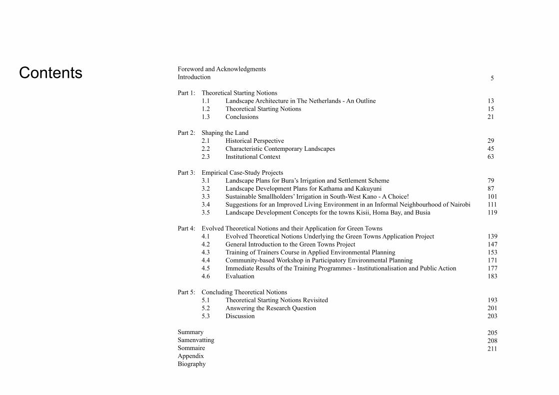
Contents Foreword and AcknowledgmentsIntroduction
Part 1: Theoretical Starting Notions 1.1 Landscape Architecture in The Netherlands - An Outline 1.2 Theoretical Starting Notions 1.3 Conclusions
Part 2: Shaping the Land 2.1 Historical Perspective 2.2 Characteristic Contemporary Landscapes 2.3 Institutional Context
Part 3: Empirical Case-Study Projects 3.1 Landscape Plans for Bura’s Irrigation and Settlement Scheme 3.2 Landscape Development Plans for Kathama and Kakuyuni 3.3 Sustainable Smallholders’ Irrigation in South-West Kano - A Choice! 3.4 Suggestions for an Improved Living Environment in an Informal Neighbourhood of Nairobi 3.5 Landscape Development Concepts for the towns Kisii, Homa Bay, and Busia Part 4: Evolved Theoretical Notions and their Application for Green Towns 4.1 Evolved Theoretical Notions Underlying the Green Towns Application Project 4.2 General Introduction to the Green Towns Project 4.3 Training of Trainers Course in Applied Environmental Planning 4.4 Community-based Workshop in Participatory Environmental Planning 4.5 Immediate Results of the Training Programmes - Institutionalisation and Public Action 4.6 Evaluation
Part 5: Concluding Theoretical Notions 5.1 Theoretical Starting Notions Revisited 5.2 Answering the Research Question 5.3 Discussion
SummarySamenvattingSommaireAppendixBiography
131521
294563
7987101111119
139147153171177183
193201203
205208211
5
Dedicated to the Green Towns children:
Anna, Boni, Edwin (Mazingira), Shalin, Rashid, Owino, Tom, Keith, Ngina, Nasimiyu, and Jabali
It was 1986 when the late Wageningen University Professor Nico de Jonge suggested that I should base a doctoral research on my interest in the role landscape archi-tecture could play in developing countries. In the Netherlands Professor De Jonge had worked exten-sively as a landscape architect in Walcheren, the new polders, and on many relocation projects. He strongly believed that landscape architecture had a contribution to make to countries on the brink of modern development. Professor De Jonge shared much of his experience with me during our many field trips. Together, we marvelled at the superb form of trees he had planted 30 years earlier as they stood etched against intensely coloured skies. He made me aware of the beauty of nature in a world created by humans. Having seen many examples of immensely beautiful Dutch landscapes, I began to wonder if it would be possible to apply Professor De Jonge’s approach also in much poorer countries. What aspects of professional rational would stand ground? Once the cosmetic embellishments were removed what would remain and may, thus, prove to be the core of the landscape-architecture profession? After Professor De Jonge’s retirement Professor Klaas Kerkstra took on the role of my research promoter. Professor Kerkstra was convinced that the theoretical notions underlying landscape architecture in the Netherlands were universal. He continued to challenge me to keep searching for the universal core of our profession even when I felt it had left me empty handed.
Why did I choose Kenya, a country without real roots in the landscape-architecture profession? I had worked with students in many different countries and I could have chosen for comparative research between these experiences, for example. In 1984, however, I made
the explicit choice to focus on Kenya. That summer, while tutoring students in Indonesia, I had become increasingly aware of the cultural complexity of that Asian country. Although I felt competent to raise the right questions, I doubted if I could come to practicable and durable design solutions. The Indonesian context was so different! Looking across a blue-grey sawah covered with an early morning mist I made my decision. It would be Kenya. I had already a network of contacts there. Wageningen University staff were running a variety of soil science, vegetation, agronomy, and agro-forestry projects. Kenya was an African country with reasonable economic development and political stability and a concentration-country for development aid from The Netherlands Government. This made it possible to find funding for several of the case-study projects presented in this thesis. At the same time I could rely on the help and support of Frédèrique Grootenhuis. Frédèrique was a landscape architect trained in Wageningen who was now living in Kenya. She shared her long practical experience and helped me avoid the most elementary mistakes. She became my friend and soul mate. With her I could continue discussing the potentials and restrictions of working as landscape architects in a country like Kenya. She introduced me to organisations like the Undugu Society, United States Agency for International Development (USAID), International Council for Research in Agroforestry (ICRAF), and Matrix Development Consultants and when I was in The Netherlands, she had always been willing to follow contacts and clarify proposals for me.
Moreover, from my first stay in Kenya, I had been captured by the beauty of the country. On camping tours with Frédèrique and her husband, Jan-Geu, I
Foreword and
Acknowledgments
1

had come to know and appreciate the uniqueness of Kenyan wildlife. With them, I gazed at timeless grass savannahs where zebra and wildebeests stood guard over their defenceless young and where at night, el-ephants and buffalos roamed freely around our tents. Oebele van de Wal showed me the tea landscapes of Kericho that - from a distance - took the contours of Japanese moss gardens. Together with my study mate Hanny Heetman, I gazed at bare, unrealistic moon-scapes dominated by the colours pink, copper-green, and black east of Lake Turkana. Many Kenyans wel-comed me in their homes. Nikki Musa took me deep into Luo land, and through his family I learned how their culture had shaped their land and their society. Professor dr. Gideon Mutiso talked to me all about land and politics and his parents demonstrated the potentials of good land management even under semi-arid conditions. With Wilfred Korir I experienced the blood-red sunsets of his Kericho homeland just after the ever-timely rains and - in 1992 - Chris Njomo, the father of my son, “offered” me the high peaks of Mount Kenya on a late afternoon. It was fascinating to learn that most Kenyan landscapes still have their tangible stories. Men, women, and children were all bound in their own unique way to their homeland. Travelling with Kenyans is an amazing experience – no matter where they go, they know someone. Either they come from the same village or family or attended the same school. Imagine a social network finely woven over a country of over 580,000 km2 and a population of over 30 million people.
But there was another side to Kenya too. Deforesta-tion, serious erosion, droughts, floods, poverty, hap-hazard urbanization and industrialization, and modern irrigation had scarred the landscape. In my mind I
compared these landscapes with the landscapes of the polders I had visited in the Netherlands with Prof. De Jonge. I could not understand why projects that had been funded with Dutch money in Kenya had often left behind barren landscapes while in the Netherlands similar projects had led to beautifully sheltered places. Frédèrique’s work, including her designs for the Lake View Estate in Nairobi, showed me that it was pos-sible that in Kenya too development can enrich the landscape. I began to realise the enormous challenges and potentials of sharing my landscape-architecture expertise with Kenyans. As time passed the Kenyans themselves became the driving force. Especially the hard working and ambitious Green Towners pushed me to the limit. Together we were able to achieve results none of us could have dreamed possible. Although there were many people I should mention, here, I want to mention the late Charity Gatari, Joyce Kiringo and Esther Mwaura from the Green Towns office and Geoffrey Karume, the Chairman of the Green Towns Partnership Association who became the engine behind many of the public awareness activities and the late Roger Matara who eased the contacts between central government and many local action groups.
This process of learning and sharing was not always easy and straightforward, as this dissertation will show. Sometimes sociocultural issues, economic problems or political factors stood in our way. These difficulties required flexible and innovative solutions. For my research, I needed to develop a theoretical structure that acknowledged these issues. The theoretical model developed by Professor Fer Kleefmann - Emeritus Chair of Physical Planning at Wageningen University - describing the physical environment in
terms of sociophysical organisation principles proved extremely important. Using this model I could link my practical learning experiences to theory. During the years I worked on this research Professor Kleefmann helped me develop sound argumentation and I am profoundly grateful to him for the time and support he gave me. There were also times when I found that, although I had thought out a conceptual approach to achieving a sustainable landscape, I lacked insight into practical techniques. Here I needed input from disciplines and technologies such as irrigation, soil and water conservation, agroforestry, tree-nursery management, engineering and communication science. Many people willingly shared their expertise and insights with me. Here I can only mention a few. They include the late Peter van Bolhuis, Pieter Germeraad, David Campbell, Jos Frijns, Kuria Gathuru, Esther Kabati, Paul Kirai, Joseph Makopa, Kibe Muigai, Kaleb Murilla, N. Nyariki, Sylvester Povel, Diane Rocheleau, John Raintree, Cor Veer, Remko Vonk and Freerk Wiersum. Alan Fowler, Graham Alder, Sarah Wakeham, Tom Oyieke and Graham Jenkinson from Matrix Development Consultants also shared their extensive experience in management and project implementation with me.
While Professor Kleefmann guided me at the theoretical level, Professor Fritz Steiner, now Dean at the University of Texas encouraged me to hold on to my beliefs. Right from my first case study he supported my earliest findings - that landscape architecture should be people centred. He continually drew my attention to relevant international literature, stimulated me to publish my results and meticulously went through the many drafts of my thesis. He came to Kenya and visited several of the case study 2

projects. Where Professor Kerkstra stood guard over the specific landscape-architectural notions and Professor Kleefmann over my theoretical reasoning, Professor Steiner gave me the confidence to follow my human-ecological line of thought. I am also grateful to Frédèrique Grootenhuis and the many others who ensured that I continued to be alert to the practical implications of my work. The conclusions I draw in my dissertation show how these different influences affected my work, helped me to build my case and – over the course of time – enabled me to develop my theoretical approach. Without them, I would not have been able to produce this research. Thank you.
Amongst those who supported my work and research were Henk van Aggelen, Franciska Moors, Barbara van Roosmalen, Reint Rosenstok, Gerrit Kleinrensink, Monique Jansen, and Adrie van het Veer, Marilyn Minderhoud-Jones and Immelina Vroom. In addition, I want to thank all those involved in the Green Towns initiatives, specifically Teresia Munya, Emmy M’bwanga, the late Zebedeus Omwando, Anthony Kibutu, Naomi Gitau, Sylvia Njambi, and Zacharia Maleche as well as all the students and colleagues who worked with me on the case-study projects including Han Beumer, Marjanska Leeuwerik, Jan-Willem Jansens, Annet van den Hoek, Carmen Aalbers and Janneke van de Wetering. A special thank you to Hanny Heetman without whom I would not have taken the first step. At times - when there were no funds available - I was hosted by my friends, sometimes for substantial periods of time – thank you all for your hospitality. My position as lecturer and researcher at Wagenin-gen University provided me with the opportunity to
link practical experience to theory and vice versa. Professor Meto Vroom - who visited me in Kenya - and Professor Jusuck Koh thank you for allowing me to work on this research. Monique Jansen, thank you for your help with the last finshing touches and Immellina Vroom for a wonderful translation of the summary in French. My colleagues Harro de Jong, Peter Vrijlandt, Ger Parlevliet, Dieter Boland, Sanda Lenzholzer, Paul Roncken, Rudi van Etteger, Sven Stremke, Jan van Nieuwenhuize, and Jan Philipsen, thank you all for taking on extra work so that I had the time to focus on my research.
I also want to express my gratitude to the Kenyan Government who showed me great hospitality and the Government of the Netherlands for funding some of the case-study projects. I am also grateful to to the Royal Netherlands Embassy in Nairobi for their enthusiastic and sometimes critical support - Hein van Asperen particularly. Last, I want to thank my parents and my son Jabali, whose childhood has been coloured by this doctoral research.
3

4

5
Introduction In the wake of unprecented population growth and the influence of global economies, many societies in developing countries are putting heavy demands on their natural resources at a speed and a mag-nitude never experienced before. Rural land use is intensifying and urban centres are expanding rapidly with little respect for the environment. As a result, extreme degradation of the rural areas and unbearable living-conditions for many people living in the urban areas are jeopardizing human livelihoods (see for example; United Nations En-vironment Programme, 1999; Satterhwaite, 1999; Agarwal, 1986; Eckholm, 1987; Pacione, 1981; United Nations Centre for Human Settlements (Habitat), 1996; World Commission on Environ-ment and Development, 1987; International Union for Conservation Nature and Natural Resources, 1983).
Consequently, national and international organi-sations are becoming increasingly convinced that environmental care must accompany development if spiralling degradation and poverty are to be halted. During the 1980s and 1990s of the last century, this awareness led to the emerge of many significant national and international envi-ronmental institutions, while the United Nations embarked on a series of world-wide environmental and social conferences. As a result of these confe-rences, many nations subscribed the need of incorporating sociocultural and natural processes in their planning for sustainable economic development. Ignoring these processes will make development extremely difficult, if not impossible (United Nations Environment Programme, 1999; United Nations Centre for Human Settlements
(Habitat), 1997; United Nations Department of Economic and Social Affairs (DESA), 2000). This awareness calls for new integrative approaches to planning for effective economic development that is socioculturally appropriate and environmentally sustainable. It is the overall objective of this doctorate research to contribute to the development of such an approach from a landscape-planning perspective.
In the western world landscape planning is a more or less established profession. In the Netherlands, landscape architects have developed a specific expertise in the planning and design of integrated and multifunctional landscapes on a regional scale. In a creative process, they are looking for ways to combine environmental constraints and opportunities with efficient agriculture, forestry, recreation, nature development, and infrastructure to achieve harmonious land and town development (Visser, 1997; Vroom, 1992).
Although the developing nations are looking for new integrative approaches towards planning, the type of landscape-planning expertise referred to above is seldom mentioned. I had the opportunity to apply landscape-planning approaches in a variety of projects that addressed rural land degradation, slum improvement, and urban development in Kenya. Based on this experience, I will argue that the basic principles of landscape-planning expertise can make a potentially useful contribution to the development of a socioculturally appropriate and environmentally-sustainable planning approach in the Kenyan situation.
6
Between 1980 and 1990, I was involved in several landscape-planning projects in Kenya. Some projects followed a full landscape-planning and design cycle, others focussed on project evaluation or landscape analysis. The lessons learned in one project would be incorporated, at first intuitively but later on deliberately in subsequent ones.
Some of these Kenyan projects2 have been published in the form of articles (Duchhart, 1989a; Duchhart and Povel, 1991; Duchhart and Grootenhuis, 1988; Jansens, 1991; Hoek, 1986). Others have been described in project documents. An evaluation of the working method that emerged from the earlier projects were
published in: “Planning Methods for Agroforestry” (Duchhart et al., 1989; Budd et al., 1991; Duchhart, et al., 1991), and: “Landscape planning, an approach to local-level planning?”(Duchhart, 1989b). A popular version of the various planning steps was given in the “Manual On Environment and Urban Development” (Duchhart, 1989c). Preliminary lecture notes gave an overview of useful supportive techniques, such as agroforestry and soil conservation (Duchhart, 1988).
From 1992 to 2000, the Environment and Urban Deve-lopment Training Project in Kenya - popularly called the Green Towns project - was implemented. This project built on the lessons learned from the earlier projects and evolving landscape-planning procedures
and, as will be explained later, on an evaluation of the Kenyan planning context (Duchhart, 2000).
These practical experiences and procedural evalua-tions gave rise to the overall research question:
Does the approach emerging from the landscape-planning projects provide a methodologically appropriate approach to physical development in Kenya that integrates ecological and social pro-cesses?
Research Question
1 1980, Landscape planning aspects of the Bura Irrigation and Settlement Project, prepared for Kenyan Government (Master thesis Ingrid Duchhart and Hanny Heetman)
1983, Landscape planning and design of watersheds in the Kathama Agroforestry Project, prepared for International Council for Research in Agroforestry (ICRAF)(Master thesis Annet van den Hoek)
1984, A landscape plan for Bamburi Farm, A plan for rehabilitation of a cement quarry Mombasa, prepared for Bamburi Cement Factory (Master thesis Erik Mackay)
1986, A landscape development plan for the improvement of grazings in Kakuyuni, prepared for KARI/ICRAF (Master thesis Jan-Willem Jansens)
1986, Proposal for an Integrated Agricultural Development Programme for Kisii District prepared with Alan Fowler for European Economic Community (EEC)
1986, Slum-improvement for the villages Kanuku and Kinyago prepared for the Kenyan NGO Undugu Society in collaboration with Frederique Grootenhuis
1986, Towards a land-use strategy for the small-holder South-West Kano Irrigation Project, Nyanza Province prepared with Sylvester Povel for the Kenyan Government
1988, Kisii Town; Integration of the natural environment in the Local Authority Development Programme (Master Thesis Reintje van Haeringen)
1988-1989, Integration of the natural environment in the Local Authority Development Programme in three towns Kisii, Homa Bay, and Busia carried out for the Kenyan Government
1989, An environmental impacts assessment of Dutch funded projects in collaboration with Matrix Development Consultants carried out for the Netherlands Government
1992-2000, Green Towns Environment and Urban Development Training Project carried out for the Kenyan Government

7
The research question addresses methodological is-sues and the extent to which these are appropriate for the Kenyan situation. In order to find answers to the methodological questions, it is insufficient to confine the research to describing the Kenyan projects and the lessons that can be derived from them. It is also necessary to make explicit the theoretical notions at the very start of the case-study projects. Robert Chambers, for example, has argued that exposing professional biases makes it possible to look beyond their limitations and to make adjustments (Chambers, 1988). At the same time, assessing the appropriateness of an approach requires a careful study of the context that influences the planning and development of a physical environment (Pacione, 1981; Corner, 1990; 1991). Both statements are in line with the research steps propounded for applied sciences (Beerling and Kwee, 1972; Groot, 1969). In this context, research procedures in applied sciences should include the following steps; - summarising the existing theory,- exploring the new field,- applying the theory in the new field, and- building an adjusted theory.
Although undertaken in a different order, this pro-cedure was followed in the presented research, and as such, the research can be defined as a exercise in theory development.
As mentioned earlier, during the period of 1980 to 1990, a series of case-study projects were carried out in Kenya. As a result, some methodological lessons
were learned. However, the Kenyan context in which the projects took place had not been explored and the theoretical notions adopted at the start of the projects had also not been explained. Therefore, between 1990 to 1994, the Kenyan context was studied in depth with the help of literature reviews, field visits, and open-ended face-to-face interviews. Meanwhile, the intuitively theoretical notions, largely derived from landscape-architectural and physical-planning theories underlying the empirical projects were made explicit.
The last practical application project drew on the three sources mentioned above; the lessons learned from the practical cases, the evolving procedural planning steps, and an understanding of the landscape-forming forces including the opportunities and restrictions of the local planning context. This last project - the Green Towns project - differed from the earlier projects both in character, and geographic and temporal scale. It was predominantly an educational landscape-planning project even though it included project design and implementation. It provided a unique opportunity to check whether the approach evolved from the previous projects offered an appropriate basis for the planning of a sustainable environment in Kenya. In the final stages of the research, carried out after completing the Green Towns project, the approach was evaluated in terms of the initial theoretical notions in order to assess whether a methodology that integrates ecological and sociocultural processes had emerged from the landscape-planning projects. In other words had an adjusted theory on landscape planning in fact been developed?
The research results will be described as follows. The practical experiences are described in the Parts 3.1 up to 3.5 and in Part 4.2. The way in which renewed theoretical notions appropriate for the planning of the physical environment in Kenya were developed, begin with a review of the initial theoretical notions adopted at the beginning of the case-study projects (Part 1). Subsequently, the theoretical notions that evolved from the lessons learned during each of these projects and which later informed the starting notions for the Green Towns project, are discussed in Part 4.1. Finally, the concluding theoretical themes linking the initial notions via the theoretical notions evolved and the lessons learned from the Green Towns project will be analysed in Part 5.1. The study of the Kenyan context (Part 2) influenced both the theory forming line and the project line.
Research Method
In this thesis, these projects are referred to as case-study projects. They helped to develop a landscape-planning method which was consiously applied in the last project. This last project - the Green Towns project - is referred to as an application project. This project is well documented, widely presented in various fora, and systematically monitored and evaluated. The evaluations were done internally by project staff as well as by external evaluators. The earlier cases were published in refereed journals.
In this way, the research in this thesis follows a case-study method that has become increasingly common in landscape architecture. The systematic documentation and examination of the process, decision-making, and outcomes - that should bring out positive as well as negative aspects - are important in this method. This is done to inform further practice, policy, theory, and/or educa-tion (Francis, 1999).

8
The two lines above are intimately interwoven and this is reflected in the structure of this dissertation. Its contents can be briefly summarized as follows;
- Part 1 clarifies the initial landscape-architecture and planning theories adopted at the departure of the projects. These theoretical notions also provided the analytical framework for the description of the Kenyan landscapes found in Part 2.
- Part 2 describes in detail the specific conditions and forces that form the basis for the unique Kenyan landscapes. Part 2.1 addresses these landscape-forming forces in their historical context. Part 2.2 describes how these forces continue to influence the contemporary landscapes. In Part 2.3 an assessment is made of the formal institutional context in order to clarify the extent to which it is possible to actually plan for the development of the physcial environment.
- Part 3 describes eigth selected projects and includes reflections on their successes and failures. These reflections contributed to improving the planning approach and to dealing with the next case and so allowed for the incremental learning process discussed in the methodological research line. To allow for an objective assessment, the presented drawings and sketches are reproduced as much as possible in their original state.
- Part 4 presents the Green Towns application project. Part 4.1 resumes the theoretical notions adopted for the Green Towns project, Part 4.2 contains a description of the project implementation. In Part 4.3 the results of the Green Towns project are evaluated.
- In Part 5 final conclusions are drawn. Part 5.1 reflects on the evolved landscape-planning principles in the context of the initial theoretical notions discussed in Part 1. In Part 5.2, the research question is answered and the research objective readdressed. Part 5.3 sets the scene for research questions that may follow.
To allow for an objective presentation of the case-study results, all case-study sketches and drawings are reproduced in their original form.

9
References Agarwal, B. 1986. Cold Hearths and Barren Slopes, The Woodfuel Crisis in the Third World, Zed Books, London, 209 p.
Beerling, R.F., S.L. Kwee, J.J.A. Hooij, en C.A. Van Peursen. 1972. Inleiding tot de Wetenschapsleer, Bijleveld, Utrecht, 159 p.
Budd, W.W., I. Duchhart, L.H. Hardesty and F. Steiner. 1991. Planning for Agroforestry, ISOMUL, Developments in Land-scape Management and Urban Planning 6c, Elsevier, Amsterdam, 338 p.
Chambers, R. 1988. Sustainable rural livelihoods: a key strategy for people, environment and development. In (Ed) Conroy, Czech and Litvinoff, Miles: The Greening of Aid, Sustainable livelihoods in practice. Earthscan Publications Ltd., pp. 1-17.
Corner, J. 1990. A discourse on theory I: “Sounding the depths” - Origins, theory, and representation, Landscape Journal, Vol. 9, No. 2, pp. 61-78
Corner, J. 1991. A discourse on theory II: Three tyrannies of contemporary theory and the alternative of hermeneutics, Landscape Journal, Vol. 10, No. 2, pp. 115-133
Duchhart, I. 1988. Landscape Planning in Developing Countries, Lecture Notes, 225 p.
Duchhart, I. 1989a. Evaluation and options for improvement of the environment in a slum-upgrading project in Nairobi, Kenya, Elsevier Science Publishers BV, Amsterdam, Landscape and Urban Planning 18, pp. 153-174
Duchhart, Ingrid. 1989b. Landscape planning: an approach to local-level planning? In (Ed) Van Haeringen, Reintje and Wiersum, Freerk K.: Local-level Planning. Stichting Bos, Bos-Document 9, pp. 55-72.
Duchhart, Ingrid. 1989c. Manual on Environment and Urban Development, in cooperation with the Ministry of Local Government and Physical Planning, Kenya, Nairobi, 86 p.
Duchhart, I. and F. Grootenhuis. 1988. Het landschap als basis voor het menselijk bestaan, Groen, Vakblad voor Groen en Landschap, 44e jaargang, nr. 4, pp 9-12
Duchhart, I., F. Steiner and J. Bassman. 1989. Planning Methods for Agroforestry in Agroforestry Systems 7, Kluwer, Dordrecht, pp. 227-258
Duchhart, I., R. van Haeringen, and F. Steiner. 1991. Introduc-tion: Integrated planning for Agroforestry in Budd, Duchhart, Hardesty, en Steiner (Editors), Planning for Agroforestry, ISO-MUL, Developments in Landscape Management and Urban Planning 6c, Elsevier, Amsterdam, pp.1-18
Duchhart, I. and S. Povel. 1991. Landscape analysis: a design tool for sustainable irrigation development, Kluwer, Dordrecht, Vol. 5, No. 3, pp. 191-212
Duchhart, I. 2000. Introduction to Participatory Environmental Planning for Sustainable Urban Development, Environment and Urban Development Training Project, Kenya, Wageningen Uni-versity, Environmental Science Group, Wageningen, 120 p.
Eckholm, E.P. 1987. Losing Ground, Environmental Stress and World Food Prospects, Pergamon Press, Oxford, 223 p.
Francis, Marc. 1999. A Case Study Method for Landscape Architecture, Report to the Landscape Architecture Foundation, Washington DC. 58 pp. Groot, A.D. 1969. Methodology, Foundations of inference and research in the behavioral sciences, Psychological Studies, Mouton & Co, Belgium, 400 p.
Hoek, Annet van den. 1986. Landschapsplanning en -ontwerp van stroomgebieden in het Kathama agroforestry project, Kenya, in Duchhart, Ingrid and Nauta, Anneke (Editors), Landschapsplanning in de (Sub)Tropen, Een Verkenning naar Mogelijkheden, Wegen en Resultaten, Verslag van een studiedag, Vakgroep Tuin- en Landschapsarchitectuur, Landbouw-hogeschool Wageningen and NVTL/BNT, Amsterdam, pp. 43-50

10
International Union for Conservation of Nature and Natural Resources (IUCN). 1983. World Conservation Strategy, Living Resource Conservation for Sustainable Development, prepared with United Nations Environment Programme (UNEP), World Wildlife Fund (WWF), Food and Agriculture Organization of the United Nations (FAO), and United Nations Educational, Scientific and Cultural Organization (Unesco), IUCN, Gland, 4 delen.
Jansens, J.W. 1991. Landscape development scenarios for planning and implementing agroforestry: a case study in the semi-arid lands of eastern Kenya, in Budd, W.W., Duchhart, I., Hardesty, L.H., and Steiner, F. (Editors), Planning for Agroforestry, ISOMUL Series, Elsevier, Amsterdam, pp. 267-292
Pacione, M. 1981. Problems and Planning in Third World Cities, Croom Helm Ltd. London, 290 p.
Swatterwhaite, D. 1999. Healthy cities, neighourhoods and homes in Environment and Urbanization, Volume 11, Number 1, April 1999, pp. 3-10
United Nations Centre for Human Settlements (Habitat). 1997. The Istanbul Declaration and The Habitat Agenda with subject index, United Nations Conference on Human Settlements (Habitat II), Istanbul, Turkey 3-14 June 1996, Habitat Nairobi, 172 p.
United Nations Centre for Human Settlements (Habitat). 1996. An Urbanizing World, Global Report on Human Settlements, 1996, Oxford University Press, Oxford, 559 p.
United Nations Department of Economic and Social Affairs (DESA). 2000. Report of the United Nations Conference on Environment and Development, Rio de Janeiro, 3-4 June 1992, United Nations, General Assembly A/Conf.15/26 (Vol. I), www.un.org, 5 p.
United Nations Environment Programme. 1999. Global Environment Outlook 2000, UNEP’s Millennium Report on the Environment, Earthscan Publications Ltd, London, 398 p.
Visser, R. de. 1997. Het Landschap van de Landinrichting, Een Halve Eeuw Landschapsbouw, Blauwdruk, Wageningen, 144 p.
Vroom, Meto J. 1992. Outdoor Space, Environments Designed by Dutch Landscape Architects since 1945, Ontwerpen van Nederlandse Tuin- en Landschapsarchitecten in de periode na 1945, Thoth Publishers, Amsterdam, 208 p.
World Commission on Environment and Development. 1987. Our Common Future, Report of the Brundtland Commission, Oxford University Press, Oxford, 383 p.
Theoretical Starting NotionsPART 1

12
It is the aim of Part 1 of this dissertation to expose the theoretical notions underlying the Kenyan case-study projects. These notions are founded in landscape-architecture and planning theories as developed at Wageningen University in the last dec-ades of the 20th century. They were used because in Kenya - as in many other developing countries - there was a lack of any theoretical foundation on which to base landscape-architecture premises1.
These theoretical notions do not form a coherent whole. Rather they represent a set of different ideas and intentions. Prof. Vroom, Chair of the Landscape-Architecture Department from 1966 to 1989, introduced landscape-architecture theories strongly inspired by the Anglo-American world.
Prof. Vroom’s teachings emphasized behavioural sciences and system approaches to landscape analysis and design. Prof. De Jonge, who worked with the department from 1977 to 1986, advocated functional, development-orientated landscapes, while Prof. Kerkstra, who held the Chair of the Landscape-Architecture Department from 1990-2002, and his associate Vrijlandt stressed an ecological and site-specific approach to landscape architecture. The planning theories of Prof. Kleef-mann - former Chair of the Department of Physical Planning and Rural Development - especially his sociophysical-organisation model also exerted a strong influence on the theoretical notions. Some critical American reflections, among others from Steiner, have also been included.
2
For comprehensive overviews, reference is made to Vroom (1992), Guinee (2000), Buuren (2000), and Visser (2002), among others.
Part 1 begins with a brief outline of the way in which landscape architecture has developed in the Netherlands. This gives an impression of the context in which the theorical starting points have been formed and is not intended to be exhaustive2. This outline will help the reader to understand the restricted position of landscape architecture in Kenya as it is presented in Part 2. Part 1 concludes with a discussion of conceptual matters.
1
Little theory on landscape architecture in the developing world was published at the time of the first case-study project. Crowe’s (1969) IUCN publication “Landscape Planning for an Overcrowded World”, was a notable exception, while during the mid 1980s certain German landscape architects discussed the role of landscape planning in developing countries (Bechmann, 1982; Maas, 1986). Germeraad, Kuitert, and Van den Hoek did research in Saudi Arabia, Japan, and Indonesia in the 1980s and early 1990s. Germeraad’s research concentrated on design of gardens and parks following the Islamic traditions, Kuitert’s work was largely historical, while Van den Hoek focussed on project implementation (Germeraad, 1990; Hoek, 1992, Kuitert, 1988). Burle Marx worked in Brazil and elsewhere from 1932 onwards and became the best known landscape architect in South America. His architecture is artistic, exemplified by the
promenade along Copacabana beach constructed in 1970 (Kruger et al., 1989; Weissenborn et al., 1989).
Landscape-planning and landscape-architecture practice in Kenya was also limited. Frédèrique Grootenhuis and Melanie Schwenke-Richards both qualified landscape architects were involved in garden-design and housing projects. Grootenhuis taught introductory courses in landscape architecture at the Nairobi University from 1973-1983. Even though at several In-ternational Federation of Landscape Architects (IFLA) seminars and conferences attention was paid to landscape architecture in Africa, the profession was far from being institutionalised. A Landscape Architecture Chapter was established under the Kenya Association of Architects in 1981.

13
The unique circumstances of the landscape-architecture discipline in the Netherlands shaped the theoretical starting notions discussed in Part 1.2. This context is briefly outlined below.
Meeus and Vroom (1986) date the beginnings of park and garden architecture in the Netherlands to the 17th century.
“The architecture of parks and gardens in The Netherlands is founded on a long-standing tradition. The layout of 17th century rural gardens and estates in the western provinces is a phenom-enon well known abroad. ... Old engravings show treelined avenues marching through a flat landscape, terminating at an estate that is without the formal and decorative transitional spaces (forecourts, terraces) so typical of examples dating from the same period in neighbouring countries. A sense of realism, thrift and frugality resulted in examples of austere landscape design for polders, with patterns of squares or rectangles formed by inter-secting roads and ditches” (Meeus and Vroom, 1986, p. 277).
During the 18th and 19th centuries professional land-scapers turned their attention from rural estates to town villas and gardens. There were relatively few changes in this period apart from some developments in style of design. Up to the early decades of the 20th century, professional garden and landscape architects worked as independent craftsmen. Rapid social and economic developments in the 20th century - including popu-lation growth, industrialization, outdoor recreation, urbanization, and motorisation - challenged landscape architects to work in the public domain. These devel-opments required different skills. There was a need for site planning and systematic regional planning as well as interdisciplinary co-operation (Vroom, 1992; Meeus and Vroom, 1986; Buuren, 2000). The reclama-tion of the Zuiderzee polders challenged the current thinking on planning of new landscapes on a hitherto
unimagined scale. These new demands meant that the artistic approach of the early landscape architects had to make way for planning and design proposals that were rooted in logic, reasoning and calculation (Visser, 2002; Meeus and Vroom, 1986). Vroom dis-tinguishes three main periods since World War II:- A post-war reconstruction period characterized by economic growth. An emerging group of young landscape architects became increasingly involved in the design of new towns. For example, Ruys and Boer worked in Nagele, a village in the Noordoost Polder reclaimed in 1940, and De Jonge pioneered as a landscape architect in the interdisciplinary teams that designed landscape plans for re-allocation projects in the old land and for the new polder Oostelijk Flevo-land. Functionality was a key word in their design philosophy. - The period between 1965 and 1980 was charac-terized by a growing demand for public involvement in the planning process and by economic recession. American planners and architects provided Dutch landscape architecture with theoretical foundations for perception as well as ecological principles. The idea of historical continuity gained ground. Landscape planning was also stimulated by the conclusions of the policy paper “Second Government Report on Physical Planning” including the “Vision on Landscape Devel-opment” which enabled environmental processes that were based on a holistic and centralistic philosophy informed by systems theory. - Between 1980 to 1992 there was sufficient econo-mic revival to make a more imaginative approach to landscape design possible. Vroom wrote: “Younger architects are now challenging the doctrines of their older colleagues such as the ideals of light and air, of hygienic improvements, of utilitarian construction
1.1
Landscape Architecture in The Netherlands - An Outline

14
and of rationality of design, and especially the sense of responsibility for social welfare” (Vroom, 1992, p. 45). In this period, the “Fourth Government Report on Physical Planning” was published. This policy document rejected centralistic national planning and gave provincial planning more legal status. Landscape protection and development became central and this stimulated environmental impact assessment and imaginative environmental design (Vroom, 1992).
By 1992, landscape architects were working within a fairly well established legislative framework. Vroom observed that although Dutch landscape architecture practice was now well established, at the level of regional development plans, landscape planning in 1990s was restricted to inventorising and assessing existing landscapes in terms of predominantly aesthetic qualities. This resulted in plans that were often defensive zoning plans indicating either land-use development or preservation (Vroom, 1990). Furthermore, the rural development act that acknowledged the importance of a landscape plan categorised landscape as a sector in the same way that nature, recreation, and agriculture had been defined as sectors. As a result landscape architecture lost much of its integrative character (Vroom, 1992; 1982; Luiten and Visser, 1985). In reaction to these developments a number of pioneers working in the rural areas tried to introduce more creativity into planning and design. They looked for ways in which a form of conceptual thinking could be injected into regional planning (Vroom, 1990). In their prize-winning plan “Ooievaar” Bruin et al. (1987) contended that a landscape design represents a multitude of ideas, suggestions and global principles that had to be translated into everyday reality. In the process of
realisation, these ideas would be adjusted, improved, worked out in detail and be given shape. Over time, the field of landscape architecture and landscape planning evolved from landscape care (landschapsverzorging) into landscape construction and landscape creation (landschapsbouw) (Vroom, 1976; 1990; Luiten and Visser, 1985). They had now to address multiple land-use and the demands of agriculture, nature, recreation, and housing, for example. There was limited space and environmental problems, including serious soil and water pollution, loss of landscape diversity, and decreasing diversity in flora and fauna had to be taken into consideration (Buuren, 2000).
The three periods identified by Vroom were followed by a period of continuous economic growth and extensive urban development. During this time landscape architects forged a strong position for themselves in the design of the urban environment and excerted a significant international influence, i.e. landscape-architecture offices as DS Landschaps-architecten and West 8. A period of economic recession around the turn of the century found some landscape architects taking a renewed interest in participatory approaches and development-oriented landscape architecture. At the same time the institutional position of landscape architecture discipline was strengthened by the establishment of a Rijksadviseur voor het Landschap. This last period is relatively new and as yet has not been well evaluated. It also ran parallel to the Kenyan case-study applications and, therefore, hardly influenced the departure points of this research.
15
The outline presented above shows how the profession landscape architecture has broadened in the recent years and how this has coincided with the development of certain specialised methods. Some landscape architects still worked in a traditional way, while others used more programmatic methods based on logic and reasoning, adopted participatory approaches or followed a mode of artistic and personalised design. Some worked in an urban setting and designed public parks and urban open-space, others in peri-urban and rural areas where their designs had to address multiple land-use demands. The line of reasoning applied by the latter group of landscape architects seemed to be most appropriate for the first Kenyan case-study projects. Therefore, the theoretical starting notions of this research draw heavily on the work of the Wageningen University landscape architects Prof. De Jonge, Prof. Kerkstra, and Ir. Vrijlandt, all whom were specialised in landscape-architectural theories for the rural areas. In order to make clear the parameters of my own professional perspective, I will begin by acknowledging their roots in Prof. Vroom’s academic work. I also draw on Prof. Kleefmann’s sociophysical-organisation model as this too seemed a useful academic framework for discussing the Kenyan planning context.
1.2.1 Landscape, Landscape Architecture, and Design
In 1986, Vroom stated that although progress was made in selecting and processing data and in the development of an organised approach towards design and planning questions, there was as yet no
systematically ordered package of knowledge on landscape architecture (Vroom1986 b; Meeus and Vroom, 1986). This observation should be borne in mind when considering the following differences in defining landscape architecture:- Landscape architecture is a design discipline within the scope of ordering of space. It directs the function as well as the design, the layout and manage-ment of space. Through a design or a management plan the landscape architect gives the best possible form to space (Meeus, 1984).- Landscape architects are designers who occupy themselves with the lay-out of space. This activity is carried out on different levels of spatial ordering: lo-cal, regional, and international. They contribute to fix-ing the destiny and shaping of the landscape, through spatial design. “Landschapszorg” (Landscape care) is understood as caring for the beauty of landscape (Vroom, 1983).- Landscape architecture is one of the activities dealing with the mutual adjustment of human activities and the space available. A landscape architect adapts new development to that which already exists and cre-ates new forms required for new types of use (Vroom, 1986c; Vroom and Steiner, 1991). - Landscape architects perceive the landscape as physical space. His/her activities are, thus, primarily of a spatial character. Architecture is the ordering and shaping of space. The social context has to legitimize these actions, but it leaves a certain amount of room to play with form (Vroom, 1986a). - A conceptual approach with a strong emphasis on ecological processes and landscape form are the in-gredients of landscape planning. Depending on the geographical conditions, emphasis may be put on design concepts or on management plans to ascertain
1.2
Theoretical Starting Notions
16
the protection of ecological processes and sustainable development (Vroom, 1976; 1990).
In these definitions, design for space plays an impor-tant role. In the design, spatial form and ecological processes are two major ingredients. A major goal as far as landscape form is concerned would be to en-hance sensory delights and meaning (Vroom, 1983). To achieve this, Vroom advocated, for example: the incorporation of visual memories and recognition, regularity, polarity, directions, landscape patterns, rhythm, mass and openness interrelationships. Fur-thermore, the response of human beings to the physical environment, in the sense of assessment as well as in behaviour, was thought to be related to needs such as the need for identity, structure, and meaning. Although social legitimacy is mentioned, it only plays a minor role in these notions.
The scientific basis for Vroom’s approach was derived from predominantly Anglo-American research, such as that undertaken by Lynch (1976; 1973), Lynch and Rivkin (1959); Tuan (1974), Arnheim (1969; 1971), Hall (1969), Sommer (1969), Appleyard (1976), Appleton (1976), Downs and Stea (1973), Rapoport (1976), and Gombrich (1964; 1979) (Vroom, 1986a). Dutch research from, among others, Coeterier (1987), Ham (1970) and Boekhorst et al. (1986) also contributed (Vroom, 1986a). With respect to the ecological ingredient, Vroom drew, amongst others, on McHarg’s philosophies as exemplified by his book “Design with Nature” (Mc Harg, 1971). The work of Van Leeuwen was also important (Vroom, 1986a).
The definitions portray landscape architects as designers, as people who give form to space. In his
approach to the act of designing, Vroom (1986b) drew heavily, although critically on a variety of approaches that saw the landscape as a system, such as the ones of Alexander (1964), Steinitz (1970), McHarg (1971), and Patri, Streatfield and Ingmire (1970). The following quotation gives an illustration of his point of view “... an understanding of the complexity of existing relations, of factors natural and cultural that constitute the totality we call landscape, and which contribute towards an outward appearance which is in constant change. Landscape can be seen as a system, a web of structural elements of interconnected biological and geological systems, such as food chains and river valleys, and the vast interrelationships of trade and industry ... and the comprehension, classification and organisation of all these relationships require all our inventiveness and energy” (Vroom, 1976, p. 376).
It was the idea that through the design process, a complex landscape will become known and manipulated. Vroom saw the design process largely as a logical process, i.e. terrain inventory and analysis, needs and opinion of target groups, problem statement and objectives, inventory and selection of appropriate tools, and some black boxes that represent the actual creative act (Meeus and Vroom, 1986). Checklists for terrain analyses would cover items such as, site history, physical and built environment, spatial analysis, and land-use functions (Vroom, 1983; 1986b). After the landscape analysis, an abstract landscape concept and a master plan were made and detailed designs were prepared. In this rather implicit design method, the scale levels of the master plan and detailed designs were related to each other in a process from general to more detailed (Duchhart, 1981; Dekker and Thijsen, 1985).
Already in the 1970s Kerkstra responded to the rational approach to design by turning around the analysis-design process. He asked students to experiment with a design process that started with a conceptual design based on creatively playing with intuitively available landscape knowledge. Landscape analysis and problem identification were then tools to check and adjust this conceptual design until it reached a satisfactory level. In the United States too, landscape architects and landscape planners reacted to the dominance of rational planning procedures. Steiner, visiting Professor at Wageningen University in 1980, warned that inventories and analyses should be mindful of goals and not only focuss on means. More explicitly, he stated that these goals should be community based (Steiner and Brooks, 1981). Furthermore, he argued that humans had to be included as an active, integrative, and potentially beneficial component of the ecosystem.
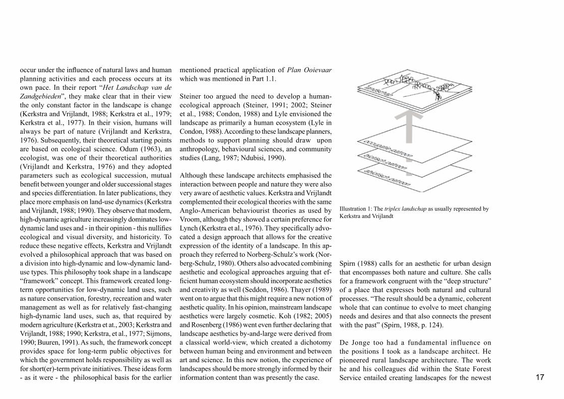
The theoretical departure notions in respect of the ecological ingredient of landscape architecture were heavily influenced by the work of Kerkstra and Vrijlandt. Their approach was largely derived from the object of study: the landscape. Kerkstra and Vrijlandt define landscape as follows: “Landscape is the visible result on the surface of the earth of the interactions between man and nature” (Kerkstra and Vrijlandt, 1988). They used a simple layer-cake model - known as the triplex landschap to illustrate these interactions. Their layer-cake model is composed of an anthropogenic, biotic, and abiotic layer (Illustration 1). In a further elaboration of their definition, they stated that a landscape perceived at a certain moment is, in fact, a snapshot of a continuous and unavoidable process of change. These changes
17
occur under the influence of natural laws and human planning activities and each process occurs at its own pace. In their report “Het Landschap van de Zandgebieden”, they make clear that in their view the only constant factor in the landscape is change (Kerkstra and Vrijlandt, 1988; Kerkstra et al., 1979; Kerkstra et al., 1977). In their vision, humans will always be part of nature (Vrijlandt and Kerkstra, 1976). Subsequently, their theoretical starting points are based on ecological science. Odum (1963), an ecologist, was one of their theoretical authorities (Vrijlandt and Kerkstra, 1976) and they adopted parameters such as ecological succession, mutual benefit between younger and older successional stages and species differentiation. In later publications, they place more emphasis on land-use dynamics (Kerkstra and Vrijlandt, 1988; 1990). They observe that modern, high-dynamic agriculture increasingly dominates low-dynamic land uses and - in their opinion - this nullifies ecological and visual diversity, and historicity. To reduce these negative effects, Kerkstra and Vrijlandt evolved a philosophical approach that was based on a division into high-dynamic and low-dynamic land-use types. This philosophy took shape in a landscape “framework” concept. This framework created long-term opportunities for low-dynamic land uses, such as nature conservation, forestry, recreation and water management as well as for relatively fast-changing high-dynamic land uses, such as, that required by modern agriculture (Kerkstra et at., 2003; Kerkstra and Vrijlandt, 1988; 1990; Kerkstra, et al., 1977; Sijmons, 1990; Buuren, 1991). As such, the framework concept provides space for long-term public objectives for which the government holds responsibility as well as for short(er)-term private initiatives. These ideas form - as it were - the philosophical basis for the earlier
mentioned practical application of Plan Ooievaar which was mentioned in Part 1.1.
Steiner too argued the need to develop a human-ecological approach (Steiner, 1991; 2002; Steiner et al., 1988; Condon, 1988) and Lyle envisioned the landscape as primarily a human ecosystem (Lyle in Condon, 1988). According to these landscape planners, methods to support planning should draw upon anthropology, behavioural sciences, and community studies (Lang, 1987; Ndubisi, 1990).
Although these landscape architects emphasised the interaction between people and nature they were also very aware of aesthetic values. Kerkstra and Vrijlandt complemented their ecological theories with the same Anglo-American behaviourist theories as used by Vroom, although they showed a certain preference for Lynch (Kerkstra et al., 1976). They specifically advo-cated a design approach that allows for the creative expression of the identity of a landscape. In this ap-proach they referred to Norberg-Schulz’s work (Nor-berg-Schulz, 1980). Others also advocated combining aesthetic and ecological approaches arguing that ef-ficient human ecosystem should incorporate aesthetics and creativity as well (Seddon, 1986). Thayer (1989) went on to argue that this might require a new notion of aesthetic quality. In his opinion, mainstream landscape aesthetics were largely cosmetic. Koh (1982; 2005) and Rosenberg (1986) went even further declaring that landscape aesthetics by-and-large were derived from a classical world-view, which created a dichotomy between human being and environment and between art and science. In this new notion, the experience of landscapes should be more strongly informed by their information content than was presently the case.
Spirn (1988) calls for an aesthetic for urban design that encompasses both nature and culture. She calls for a framework congruent with the “deep structure” of a place that expresses both natural and cultural processes. “The result should be a dynamic, coherent whole that can continue to evolve to meet changing needs and desires and that also connects the present with the past” (Spirn, 1988, p. 124). De Jonge too had a fundamental influence on the positions I took as a landscape architect. He pioneered rural landscape architecture. The work he and his colleagues did within the State Forest Service entailed creating landscapes for the newest
Illustration 1: The triplex landschap as usually represented by Kerkstra and Vrijlandt
18
polders, revamping the landscape of Walcheren, and designing and implementing many rural development and reallocation projects. His influence was based not so much on the strength of academic theories as on practical experience and his strong belief in the creative and enriching powers of people. In De Jonge’s opinion, the main responsibility of landscape architects was to create a landscape that was optimally productive. However, to ensure environmental sta-bility, this had to be done with full attention to natural balance. De Jonge called this functional landscapes. In his vision, landscape architects had the task of assisting in designing functional landscapes that took full advantage of available potentials. He noted in 1971 “I dream of a rich, harmonious and dynamic landscape, not perfect, and yet a landscape in which life is complete. I dream not of large nature reserves in which we try to lose ourselves, but of a cultural landscape.”(Jonge, 1971; 1978; Steiner, 1989).
1.2.2 Kleefmann’s Sociophysical-organisation Model
The physical-planning theories promoted by Kleefmann have also provided a foundation for this research. His theory evolves around what he called the sociophysical-organisation model. This model is based on the reciprocal relationships between man and nature and should be seen as an abstract notion of the functioning and co-ordinating of human activities required for living a meaningful life (Kleefmann, 1984a; 1985). These reciprocal relations also played an important role among the theoretical landscape-architectural concepts referred to earlier. However,
landscape architects tend to approach these relations much more from an ecological and spatial perspective, while Kleefmann explicitly includes a social point of view.
A short note on the general development of physical planning in the western world will place Kleefmann’s discussion model in its context. Physical planning in the Netherlands originated in housing and town planning. Over the years, it became increasingly concerned with strategic policy planning at regional and national levels. Because of its origin, the
traditional physical planning was strongly related to specific features of the public domain such as housing needs, urbanization, infrastructure, employment, industrialisation, recreation, and open space (Faludi, 1989; 1991). The shift to national policies reinforced by major changes in the society including the growing emphasis on environmental concerns, increasing public-private co-operation, and the realisation that there was a limit to the extent to which societal processes could be directed - forced physical planners to review their concepts and planning instruments (Faludi, 1987; Buit, 1987; Quené, 1990).
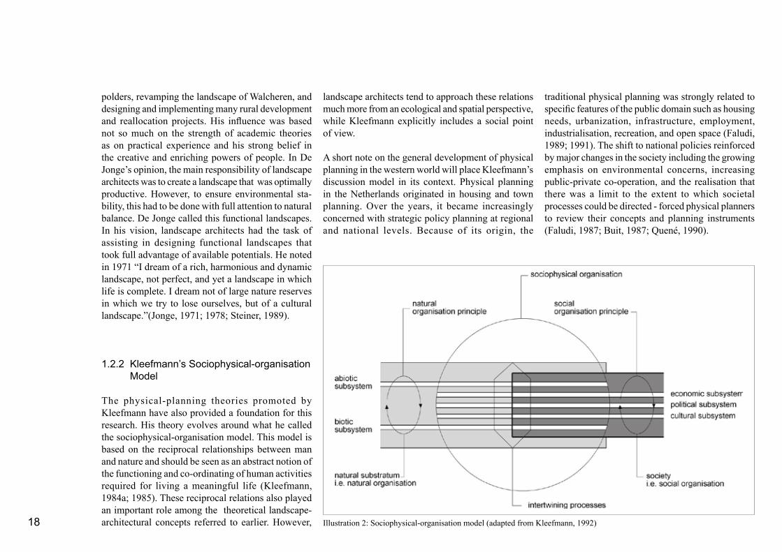
Illustration 2: Sociophysical-organisation model (adapted from Kleefmann, 1992)
19
Kleefmann’s organisation model (1984a; 1994) has two basic components: the natural substratum of a territory and the society concerned (Illustration 2). The basic idea is that the natural substratum is the sustaining base for human existence. Both components are inextricably connected through intertwining proc-esses to fit the natural substratum to the societal needs. The result of these interactions is called sociophysical organisation.
Within the natural substratum two subsystems were distinguished:- An abiotic subsystem representing inanimate nature (e.g. soil, water, and air), and- A biotic subsystem concerning living organisms, including the biotic dimensions of human beings.These two subsystems are closely interrelated through ecological structures and laws of nature. Since the ecological or natural principles of organisation do not depend on human actions, the principle of natural organisation is defined as self-regulating.
Within society the following three subsystems are distinguished:- An economic subsystem representing the organi- sation of production (often derived from the natural substratum) and labour,- A cultural subsystem representing the shared pat- terns of norms and values, and- A political subsystem representing the intermediary between the two foregoing subsystems.
These three subsystems are closely related, according to the principle of social organisation. This social-organisation principle evolved within sociohistorical development processes in which it assumed a specific
form. In western societies, three main stages can be distinguished: earlier, traditional, and modern societies. The last stage developed in two phases: the liberal-capitalistic, organised according to free-market principles and the present regulated-capitalistic phase in which the guided market prevails. Under the guided market regime, social organisation in Europe has taken on the form of a welfare state. In such societies, the political subsystem functions as a pivotal entity steering relationships between the economic and cultural subsystems. In this function, the political subsystem has a dual task. On the one hand, it has to provide purposive measures to maintain economic growth and on the other, it has to retain social legitimacy. As a result of its interventions in the economic sphere, the political subsystem generates revenues in the form of taxes, for example. These revenues enable this subsystem to invest in a wide range of welfare programmes through which it can consolidate its social legitimacy (Kleefmann, 1992).
The sociophysical organisation is, therefore, the result of two basically different regulating principles. The question is whether these principles work in the same or in opposing directions. According to Kleefmann, a demanding and dynamic western society with a high level of technology coupled with an environment with limited natural resources requires a well functioning political decision-making subsystem in order to prevent the two regulating principles from diverging. The steering capacity of this political subsystem and to some extent the way technology is used then determines the extent of which the two principles may convergence. Disturbances in the physical environment, such as environmental pollution and exhaustion of natural resources, are consequently
the result of diverging regulating principles. The complexity of determining where these principles diverge, relates to the fact that all subsystems are susceptible to tension and that each subsystem, once affected, will influence others.
The abstract idea of sociophysical organisation can be viewed from different perspectives. Kleefmann looked at the model from a perspective of spatial organisation. In this context spatial organisation is viewed on the one hand as a social-spatial organisation comprising the spatial positions of social activities and on the other as a physical spatial organisation that consists of physical entities (Kleefmann, 1984a; Kleefmann and Van der Vlist, 1989). It should be noted that Kleefmann believed it was the government’s task to care for the physical organisation (Hetsen and Hid-ding, 1991).
From this perspective landscape falls within the domain of the sociophysical organisation and is, therefore, regulated by the laws of nature and by the society through economic, cultural, and political mechanisms. The value of Kleefmann’s model is that it links the physical aspects of landscape including soil and vegetation to social aspects such as culture and history. As such the model can provide a useful guideline for landscape analysis. Major questions in this landscape analysis would then be: “What are the landscape-forming principles in both the natural and the social environment?” and “Do these principles converge or diverge?”
Kleefmann views planning and design as instruments to prepare for future spatial-organisation opportunities (Kleefmann, 1984b; 1994). Thus, planning becomes

20
a tool in learning and in choosing objectives with an open-ended outcome. Unlike traditional planning that can be regarded as a search for means to realise a set purpose, planning as a learning process is a tool in the search for a purpose which can subsequently be prioritised and selected for implementation (Kleefmann, 1994, p. 10; 1984b). This search for a purpose goes in Kleefmann’s view further than an extrapolation of current trends. It calls for creative imagination capable of making the leap between the present and the future. Once attractive development prospects have been found, the probability that they actually will be able to bridge the gap between now and the envisioned future will have to be analysed. Analyses and imaginative plans thus alternate in a strong feedback-mechanism as plans are continuously checked against their consequences (Hetsen and Hidding, 1991). As such, Kleefmann links the iterative character of the design process to evaluate the imaginative future to the reality of the present.
Kleefmann’s model coincided with the unfolding of new planning theories elsewhere. In the Anglo-American world planning was coming under attack from different quarters (Hall, 1988; Friedmann, 1987; Muller, 1992). Criticism focussed on the fact that planning methodology ignored the political context of decision making, norms and values, and also did not take other irrational elements such as experience into consideration. To counteract these shortcomings new approaches to planning developed that allowed for the incorporation of irrational elements, design and increased citizen involvement (Muller, 1992). Others took a more critical stand in their reaction to the rational planning method and questioned, like Quené (1990) in the Netherlands, for example, the
capacity of humans to create new comprehensive environments or predict the future. In their view planning could only be partial and experimental and deal with problems as they arose. This resulted in methods which combined the advantages of rational planning, incremental decision making, and strategic choice as a decision-making process (Muller, 1992). In these approaches to planning, the planners became advocate planners, informal co-ordinators and catalysts, or decision-making facilitators for citizens (Hall, 1988; Friedmann, 1987).

21
1.3
Conclusions
The account of landscape architecture and planning given above shows that in the ongoing process of trying to meet the problems of the real world, both landscape planners and physical (town and regional) planners were looking for new planning theories and concepts. Flexibility, imaginative design, as well as (ecological) science seem to play a role in this search (Castell, 1992; Corner, 1990; 1991; Seddon, 1986; Spirn, 1988; Rosenberg, 1988). As a result, the two professions underwent several changes.
Planning seemed to have moved from;- Philanthropy to rational state planning to social awareness, - Blueprint design to open-ended strategies, - Belief in human powers to create the world to incremental problem solving, - Apolitical to politicised advocacy practises,- One-man craftmenship to interdisciplinary to participatory or transdisciplinary, and from - Guidance of growth to stimulation of growth. Landscape architects developed the casco or framework concept to meet the new demands placed on landscape designs. Their theoretical approach, however, remained rather conventional. Even though, social awareness may be covered through a general human ecological approach, unlike planning, open-ended strategies, participatory approaches, and incremental problem solving did not enter mainstream landscape architecture. Rather, most landscape architects do not seem to have changed their way of working and continue to operate as if they were working for the private sector even though their profession has moved into the planning of the public domain. Some landscape architects did, however, try to rationalise the
originally predominantly intuitive approach, but were then warned of the risk of loosing their characteristic creativity. The casco concept purposely addressed governmental responsibilities for public goods and respect for private enterpreneurship.
As indicated earlier, the theoretical starting no-tions for this research do not form a concise theory. Rather they consist of several complementary lines of thought. The ones that seem most relevant are summarised below. - The object of study in landscape planning is the landscape. In this thesis, landscape is seen as the visible and tangible reflection of human ecosystems (Steiner, 2002) or, in Kleefmann’s words, as the outer form of the sociophysical organisation in a specific territory. Consequently, all natural and social subsystems, as defined by Kleefmann work on the landscape. This makes landscapes site and society specific. - A landscape, therefore, can be seen as a mirror of the defined processes and subsystems that steer land use including cultural values, politics, economics, and ecological opportunities and restrictions. A sound landscape analysis should reveal site-specific landscape-ecological information, economic land uses, and even invisible sociocultural agreements. As a result, landscape designs should creatively express what Spirn calls “deep structure” or what Kerkstra refers to as “identity”. - The landscape is perceived as a snapshot at a defined moment in time and is, therefore, always rooted in the past while forming an integrative platform for the future. - The overall binding goal in the fields of landscape architecture and planning seems to be the creation of landscapes that provide safer and healthier human
22
habitats, that are more resilient to deteriorating forces and in harmony with natural processes than in an unplanned world (Marsh, 1983). - The continuous movement that characterizes social and natural forces, however, demand a dynamic and flexible approach. Kleefmann defines planning as a searching activity, whereby, images of possible future situations are created on the basis of a definition of the present situation. These images, visualised in a design, could be the result of an extrapolation of current trends or new development options or could arise from a combination of these two. Realistic planning should involve a continuous process of feedback between envisioned futuristic designs and the present. Planning defined in this way could incorporate such aspects as social learning and people mobilisation. De Jonge, Kerkstra, and Vrijlandt see the normative landscape-framework concept as a way of providing the required flexibility.
The approaches and theories discussed in this chapter are intended to explicate the theoretical departure points of my research. In the final chapter, the ap-propriateness of these starting points for the Kenyan context will be addressed.

23
Bechmann, A. 1982. Die neuorientering der entwickelungspoli-tik, eine chance fur die landschaftsplanung? Landschaft und Stadt 14, Vol. 3, Eugen Ulmer GmbH & Co., Stuttgart, pp. 97-101 Boekhorst, J.K.M. te, J.F. Couterier, en W.F.C. Hoeffnagel. 1986. Effecten van Rijkswegen op de Beleving, Rijksinstituut voor Onderzoek in de Bos- en Landschapsbouw “De Dorschkamp”, Wageningen, Reeks 15 Betekenis van de Omgeving, nr. 442, 159 p.
Buuren, M. van. 1991. A hydrological approach to landscape planning: the framework concept elaborated from a hydrological perspective, Landscape and Urban Planning, Elsevier, Amster-dam, Vol. 21, pp. 91-107
Buuren, M. van. 2000. De erfenis van de moderne beweging, Blauwe Kamer, Tijdschrift voor Landschapsontwikkeling en Stedebouw, Wageningen, June 2000, No. 3, pp. 46-57
Bruin, D. de, D. Hamhuis, L. van Nieuwenhuijze, W. Overmars, D. Sijmons en F. Vera. 1987. Ooievaar, De Toekomst van het Rivierengebied, Stichting Gelderse Milieufederatie, Arnhem, 128 p.
Buit, J. 1987. De ontwikkeling van de planologie: verandering en continuiteit, Stedebouw en Volkshuisvesting, 68e Jaargang, Samson Uitgeverij BV, Alphen aan de Rijn, pp. 151-154.
Castells, M. 1992. The world has changed: can planning change?, Landscape and Urban Planning, Elsevier, Amsterdam, Vol. 22, pp. 73-78
Condon, P. M. 1988. Cubist space, volumetric space, and land-scape architecture, Landscape Journal, Vol. 7, No. 1, pp. 1-15
Corner, J. 1990. A discourse on theory I: “Sounding the depths” - Origins, theorym and representation, Landscape Journal, Vol. 9, No. 2. pp. 61-78
Corner, J. 1991. A discourse on theory II: Three tyrannies of comtemporary theory and the alternative of Hermeneutics, Landscape Journal, Vol. 10, No. 2, pp. 115-133
Crowe, S. 1969. Landscape Planning, a Policy for an Over-crowded World. International Union for Conservation of Nature and Natural Resources, Commision on Landscape Planning, Supplementary paper No. 021, Morges, pp. 19
Dekker, H. en S. Thijsen. 1985. De Rode Draad, Een evalu-atie van een veertigtal kandidaats- en dotoraalwerkstukken landschapsarchitectuur, Master thesis, Landscape Architecture Department, Agricultural University Wageningen, Wageningen, Part 1, 173 p. Part 2, 65 p.
Duchhart, I. 1981. KB-3 Ontwerpproject 1980, Spaarnwoude, Landscape Architecture Department, Agricultural University Wageningen, Wageningen, 46 p. and 7 annexes
Faludi, A. 1987. “Varen op gegist bestek”, Stedebouw en Volkshuisvesting, 68e Jaargang, Samson Uitgeverij BV, Alphen aan de Rijn, pp. 151-154.
Faludi, A. (Guest editor). 1991. Fifty Years of Dutch National Physical Planning, Special Issue, Built Environment, Volume 17, Number 1, Alexandrine Press, Oxford, 81 p.
Faludi, A. (Guest editor). 1989. Keeping the Netherlands in Shape, Special Issue, Built Environment, Volume 15, Number 1, Alexandrine Press, Oxford, 68 p.
Friedmann, J. 1987. Planning in the Public Domain, From Knowledge to Action, Princeton University Press, Princeton, New Yersey, 501 p.
Germeraad, P.W. 1990. Open Space in Human Settlements: The lesson from the Islamic Tradition, Dissertation Landbouw-uni-versiteit te Wageningen, DGS Schiedam, 150 p.
Guinee, A. 2000. Landschapsarchitect met een missie, Blauwe Kamer, Tijdschrift voor Landschapsontwikkeling en Stedebouw, Wageningen, June 2000, No. 3, pp. 24-45Ham, R. van de. 1970. Een voorstel voor een nieuwe landschaps-typologie naar visuele kenmerken, Stedebouw en Volkshuis-vesting, pp. 421-438
References

24
Kerkstra, K., J.B. Struik, en P.Vrijlandt. 1976. Denkraam, Instructie KB2-studio landschapsarchitectuur, Vakgroep Landschapsarchitectuur, Landbouw Hogeschool Wageningen, Wageningen, 45 p.
Kerkstra, K., P. Vrijlandt, en M.J. Vroom. 1979. Mergelland: the impact of limestone quarrying on a scenic rural area, in Lovejoy, D. (Ed.) Land Use and Landscape Planning (1st printing 1979), Leonard Hill, Glasgow, pp. 269-280
Kleefmann, F. 1985. Handelen, Handelingscontext en Planning, Een theoretisch-sociologische verkenning, Mededelingen van de vakgroepen Sociologie 15, Landbouwhogeschool Wageningen, Pudoc Wageningen, 369 p.
Kleefmann, F., 1984. Onze Leefruimte als Uitdaging, Ontwerpen als Zoekinstrument op de Speurtocht naar Inhoud en Betekenis van de Gebouwde Omgeving. Kreits, Rotterdam, 128 p.
Kleefmann, F. 1984. Planning als Zoekinstrument, Deel 5 uit de serie Planologische Verkenningen, VUGA, ‘s- Gravenhage, 132 p.
Kleefmann, F. en M.J. van der Vlist. 1989. Vijf beleidsdocu-menten bezien vanuit twee gezichtspunten. In: M.J. van der Vlist, W. Brussaard (samenstellers), Ruimte, Water, Milieu: Relaties in Planning en Beleid. Landbouwuniversiteit Wageningen, pp. 74-117
Kleefmann, F. 1992. Physical and spatial planning contextualized within the area of tension between sustainability and flexibility, Department of Physical Planning, Wageningen Agricultural University, 12 p. (unpublished)
Koh, J. 1982. Ecological Design: A post-modern design para-digm of holisic philosophy and evolutionary ethic, Landscape Journal The University of Winsconsin Press, Madison, Vol.1, No 2, pp. 76-84
Koh, J. 2005. Ecologisch Denken en Architectonische Verbeeld-ing, Ecological Reasoning and Architectural Imagination (trans-lation Prof. M.J. Vroom), Uitgeverij Blauwdruk in co-operation with Wageningen University, p. 64
Kruger B., J. Lehnhoff, und H. Mohrle. 1989. Der maler als gartner, Garten+Landschaft 9/89, Georg D.W. Callwey, Munchen, pp. 28-32
Kuitert, W. 1988. Themes, Scenes, and Taste in the History of Japanese Garden Art, J.C. Gieben, Amsterdam, 348 p.
Lang, J. 1987. Creating Architectural Theory, The Role of the Behavioral Sciences in Environmental Design, Van Nostrand Reinhold, New York, 278 p.
Luiten, E. en R. de Visser. 1985. Landschapsbouw in On-twikkeling, Het denken over de bijdrgae aan ruilverkaveling-sprojecten, Master thesis, Agricultural University Wageningen, Department Landscape Architecture, Wageningen, 65 p.
Marsh, W.M. 1983. Landscape Planning, Environmental Applica-tions. John Wiley and Sons, United States of America, 356 pp.
McHarg, I.L. 1971. Design with Nature, Doubleday & Company, Inc. Garden City, New York, 197 p. (First print 1969)
Maas, I. 1986. Landschaftsplaner und entwicklungshilfe, Gar-ten + Landschaft, Jahrgang 96, Vol. 7, Callwey, Munchen, pp. 26-32
Meeus, J. 1984. Op Zoek naar een Instrumentarium voor Ontwerpkritiek in de Landschapsarchitectuur. Ponsen en Looyen, Wageningen, 338 p.
Meeus J.H.A. and M.J. Vroom. 1986. Critique and theory in Dutch landscape architecture, Landscape and Urban Planning 13, pp.277-302
Muller, J. 1992. From survey to strategy: twentieth century de-velopments in western planning methods, Planning Perspectives, Spon, London, Volume 7, Number 2, pp. 125-155
Ndubisi, F. 1990. Evaluation of ecological assessment methods, Landscape Architecture Foundation/Council of Educators in Landscape Architecture, Washington, pp. 139-148
Hall, P. 1988. Cities of Tomorrow, An Intellectual History of Urban Planning and Design in the Twentieth Century, Basil Blackwell, Oxford, 473 p.
Hetsen, H. en M. Hidding. 1991. Landbouw en Ruimtelijke Organisatie in Nederland, Analyse en Toekomstverkenning van een regionaal gedifferentieerde betrekking, Dissertation, Land-bouwuniversiteit Wageningen, Wageningen, 343 p.
Hoek, A. van den. Planning as A Learning Process, A strategy for planning land use programmes at local level with special refer-ence to the uplands of Java, Dissertation Landbouwuniversiteit Wageningen, Imprint, Islamabad, 232 p.
Jonge, N.M. de. 1978. Landschap, luister der cultuur, Agricul-tural University Wageningen, Wageningen, (inaugural speech), 28 p.
Jonge, N.M. de. 1971. Tomorrow’s Landscape, in Proceedings IFLA Conference, Environment and Man, Man and Environment, A European discussion about the role of planning and design in the future developments of the landscape, Wageningen, 12 p.
Kerkstra, K., P. Vrijlandt, T. van Loon, J. Vervloet, en M. Tilstra. 2003. Verborgen tuin van Midden-Limburg, in Ontwerpen aan de Zandgebieden van Noord- en Midden-Limburg 2030, Project 3 over 30, Provincie Limburg, Maastricht, pp. 95-119
Kerkstra, K. en P. Vrijlandt. 1988. Het Landschap van de Zandgebieden, Probleemverkenning en oplossingsrichting, Studiereeks Bouwen aan een Levend Landschap No. 8, Bos en Landschapsbouw, Rapport Nr. 1987-3, State Forest Service, Utrecht, 98 p.
Kerkstra, K. en , P. Vrijlandt. 1990. Landscape planning for industrial agriculture: A proposed framework for rural areas, Landscape and Urban Planning 18, pp. 275-287
Kerkstra, K., C. Groenewoud en R. van Baarsen. 1977. Landsc-hapsstructuurplan Ruilverkaveling Terschelling. Landbouwho-geschool Wageningen, Wageningen, 27 p.

25
Norberg-Schulz, C. 1980. Genius Loci, Towards A Phenomenol-ogy of Architecture, Academic Editions, London, 213 p.Odum, E.P. 1963. Ecology: The Link Between the Natural and the Social Sciences, Holt Rinehart and Winston, London, 244 p.
Quené, Th. 1990. Tussen maakbaarheid en marktorientatie, Landbouwkundig Tijdschrift, Jaargang 102, Vol. 8, pp. 20-21
Rosenberg, A.M. 1986. An emerging paradigm for landscape architecture, Landscape Journal, The University of Winsconsin Press, Madison, Vol. 5, No. 2, pp. 75-82
Seddon, G. 1986. Landscape planning: a conceptual perspective, Landscape and Urban Planning, Elsevier, Amsterdam, Vol. 13 Nos. 5-6, pp. 335-348
Sijmons, D. 1990. Regional planning as a strategy, Landscape and Urban Planning 18, pp. 265-273
Spirn, A.W. 1988. The poetics of city and nature: Towards a new aesthetic for urban design, Landscape Journal, The University of Winsconsin Press, Madison, Vol. 7, No. 2, pp. 108-126
Steiner, F. 1989. Nico de Jonge’s masterful planning in the Neth-erlands, Landscape Architecture, Vol. 79, No. 6, pp. 76-78
Steiner, F. and K. Brooks. 1981. Ecological planning: A review, Environmental Management, Vol. 5, No. 6, pp. 495-505
Steiner, F., G. Young, and E. Zube. 1988. Ecological planning: Retrospect and prospect, Landscape Journal, Vol. 7, pp. 31-39
Steiner, F. 1991. The Living Landscape, An Ecological Approach to Landscape Planning, McGraw-Hill, Inc., New York, 356 p.
Steiner, Frederick. 2002. Human Ecology, Following Nature’s Lead, Island Press, Washington, 237 p.
Thayer, R. L., Jr. 1989. The experience of sustainable landscapes, Landscape Journal Vol. 8, pp. 101-109
Visser, R. de. 2002. Het Landschap van de Landinrichting, Een Halve Eeuw Landschapsbouw, Uitgeverij Blauwdruk, Wage-ningen, 144 p.
Vrijlandt, P. en K. Kerkstra. 1976. Mergelland - Landschap en Mergelwinning, Landbouwhogeschool Wageningen, Wagenin-gen, 3 delen, Part A 62 p., Part B, 75 p. and Part C, maps 36
Vroom (Ed.), M.J. 1992. Buitenruimte, Ontwerpen van Ned-erlandse Tuin- en Landschapsarchitecten Na 1945 / Outdoor Space, Environments Designed by Dutch Landscape Architects Since 1945 (bi-lingual), Thoth, Amsterdam, 208 p.
Vroom, M.J. 1983. Inleiding Landschapsarchitectuur, Landbou-wuniversiteit Wageningen, 19 p.
Vroom, M.J. 1986a. Syllabus College DA Waarnemen en Ontwerpen. Voorlopige editie. Landbouwuniversiteit Wagenin-gen, 90 p.
Vroom, M.J. 1986b. Syllabus College DB Ontwerpbenaderin-gen. Voorlopige editie. Landbouwuniversiteit Wageningen, pp. I1-V20.
Vroom, M.J. 1986c. Bijlagen Syllabus College Landschapsarchi-tectuur. Landbouwuniversiteit Wageningen, pp. 201-278.
Vroom, M.J. and Steiner, F. 1991. Well-placed plots, Landscape Architecture Magazine, 81(7) pp. 38
Vroom, M.J. 1990. Landscape planning in the Netherlands: the role of competitions, Built Environment, Volume 16, Number 2, Alexandrine Press, Oxford, pp. 141-161
Vroom, M.J. 1982. Uitgangspunten landschapsarchitectuur bij de inrichting van het landelijk gebied, Landbouwkundig Tijdschrift, 5A Jaargang 94, Stam Tijdschriften BV, Rijswijk, pp. 190-194
Vroom, M.J. 1976. Landscape planning: a cooperative effort; a professional activity, Landscape Planning, 3 (1976), Elsevier Scientific Publishing Company, Amsterdam, pp. 371-382
Weissenborn J. und P. Zadel. 1989. Burle Marx has turned 80, Garten+Landschaftsplannung 9/89, Georg D.W. Callwey, Munchen, pp. 35-36

26

Shaping the Land PART 2

28
Based on the idea that the present-day landscape is the platform of departure for the future, it is necessary to gain an insight in the making of the contemporary Kenyan landscapes. Part 2 of this thesis will present some of the major landscape forming forces that have shaped the country’s landscape. In line with Kerkstra’s idea that the landscape is a physical reflection of the interaction between man and nature at a certain moment in time, it is necessary to look back and get to know how the Kenyan landscape was formed. Part 2.1 gives a summary of the most important landscape forming forces that have affected the landscape in the past. Kleefmann’s sociophysical organisa-tion model is used to place these interactions in a process of dynamic change. Part 2.2 illustrates how these dynamics continue to operate in the contem-porary Kenyan landscape. Part 2.3 describes the administrative planning context.
Together Part 2.1, Part 2.2, and Part 2.3 provide the overall planning context in which the case-study projects discussed in this thesis were imple-mented.

29
2.1
Historical Perspective
The Republic of Kenya is located in East Africa, be-tween latitudes 5o 0’N and 4o 40’S and longitudes 33o 83’E and 41o 75’E. Kenya covers an area of 580,367 square kilometres. It has boundaries with Tanzania, Uganda, Ethiopia, Sudan, and Somalia. In the south-east the country borders on the Indian Ocean (Ojany and Ogendo, 1973).
The morphology of Kenya can be described as an old undulating plateau whose centre is cut by the Rift Valley. The plateau gradually slopes in the east towards the Indian Ocean and in the west to Lake Victoria. Its climate is predominantly arid and semi-arid in character. Near the ocean the climate is humid. Here, the natural vegetation is lush and tropical. The rift is part of the Great African Rift System and runs in a north-south direction. The Kano Rift, however, is an exception and runs east west (Illustration 3). Northern Kenya consists of dry stone and sand deserts. These change towards the south into immense grass savannahs. The rift bottom is strewn with large inland lakes, such as Lake Nakuru and Lake Turkana. The upthrows form highlands with a humid climate. Some of the faults form escarpments that can reach heights of over a thousand metres. On the eastern side of the Rift Valley - nearly in the middle of the country - lies Mount Kenya and in the west towards the Ungandan border is Mount Elgon. On the highlands and on these mountains, the natural vegetation consists of moorlands and tropical forests (Morgan, 1973; Ojany and Ogendo, 1973; Miller, 1984; Sombroek et al., 1982).
The Kenyan climate varies from humid or equatorial tropical rainforest to tropical or continental savannah. Rainfall is variable and - in many parts of the
country unpredictable. Altitude and air streams from the Sahara, Arabia, and the Indian Ocean exert an influence on the local climatic regimes. At the coast, May is a time of maximum rainfall. The central areas of the country have two rather well-defined rainy periods: March to May and October to December. The western lake region has a less defined rainy period although April is usually the month when maximum rainfall is recorded. Large parts of the country, in particular in the north and east do not receive enough rain for agricultural development. In these different ecological settings found a variety of indigenous groups a livelihood niche (Ojany and Ogendo, 1973).
African ethnic groups from Nilotic, Bantu, and Cushitic origins have, over time, migrated through East Africa and settled in - what is today - Kenya. In general it were the Nilotic tribes who settled in the dry areas to continue living a nomadic way of life, while Bantu and Cushitics settled in the more humid areas and lived as agriculturists and gatherers. Nature dominated land use. Along the coast seafaring peoples, basically of Arabic origin settled and mixed there with Africans. They had, however, a limited cultural influence on the peoples of the interior. Around 1850, the British colonised Kenya. The white colonists settled in what came to be known as the White Highlands”. They introduced new large-scale human-dominated agricultural landscapes and urban centres. Part 2.2 will describe some of the characteristic landscapes that emerged from this unique mixture of nature, indigenous land-use traditions, and British colonial influences.

30
2.2.1 The Old Days 1
Archaeological evidence shows that human beings have lived in parts of Kenya since 50,000 BC (Ogot, 1979). These early humans occupied open grasslands also in the Sahara and Ethiopia. The climate during these early periods of occupation was cold and dry. Around 18,000 BC, the climate changed and gradually became warm and wet. Geomorphological studies show that between 9500 BC and 8500 BC the water level in the major lakes of Kenya rose. Lake Elementeita and Lake Nakuru rose 180 metres above their current level. Lake Turkana was larger than the current Lake Victoria and was connected to the river Nile. Plenty of fish and wildlife formed secure sources of food. Between 3000 to 1000 BC the climate became dryer (Onyango-Abuje and Wandibba, 1979) and water levels in the lakes fell. The old lake boundaries can still be seen in today’s landscapes. Linguistic studies indicate that during this period a group of Southern Cushitics - originating from Ethiopia - (Sutton, 1986; Ochieng’, 1986a) migrated into Kenya. They were followed by people of Bantu and Nilotic origins.
Oral traditions narrate that most of the ancestors of present day Kenyans migrated into the region between 1000 and 1800 AD. Many of them came from the north (Sudan, Ethiopia and Somalia) and the west (Uganda). The Akamba arrived from the south (Tanzania). They followed routes where movement was easy preferring river valleys and avoiding mountains (Ogot, 1986; Ochieng’, 1986a; Okello-Ayot, 1979). In general, they stayed away from areas already settled. Often the people moved without haste in search for new land and prosperity. Sometimes, however, large
Illustration 3: East African Rift System cuts through Kenya (Adapted from Morgan, 1973)
1
The overview of Kenya’s occupation history can only be general. Firstly, it would require much more in-depth historical research to capture all the major and minor movements, and this does not come under the scope of this thesis. Secondly, until the arrival of the first European explorers, very little of the history of East Africa was written down. Although later colonial administrators,
settlers and traders narrated their impressions of Africa, most of it was done with a foreign perception of local life. It is only recently that anthropological, archaeological, linguistic, and historical research has made it possible to reconstruct a large part of Kenya’s local history (Ogot, 1976; Ogot, 1979; Ochieng’, 1986b).

31
groups were forced into migration because of famine, injustice, diseases, and war. Ecology, security and ethnic traditions determined where these new migrants chose to settle. Bantu-speaking societies usually selected the better-watered regions. They cultivated grain, root and tuber crops, and kept some livestock. On the open plains the majority of societies were Nilotic-speaking pastoralists although there were also scattered communities of hunters, gatherers and Southern Cushitic groups. In these areas extensive cattle raising predominated (Ochieng’, 1986a). Population movements and changes of territory continued into the 19th century until British colonial rule put a halt to it.
The Kenyan coast has quite a different history to that of the East-African interior. For centuries the coast formed an important link in international trade routes of Arabian, Asian and later of European people. During the early centuries AD commerce flourished. From the 7th century AD the Zinj - people of Persian/Arabian origin - controlled the coast of East African. The Zinj economy prospered on the export of gold, ivory, and spices and the import of pets and silks from Persia, cut gems, jewelry, gold and silver ornamentation from India, silver plate and tempered steel swords from the Levant, and fine porcelain from China. The people lived in towns described by the historian Basil Davidson as city empires. The houses in these towns such as Mombasa and Lamu were built of wood and of cut coral and lime stone (Kirkman, 1966; Miller, 1987). They had “pillared verandas and arched porticos, and they girdled spacious courtyards that glowed in smothering oleander, jasmine and roses. Alongside the polished crystal glassware on any well-set table lay silver cutlery and emerald-encrusted
gold fingerbowls. Retiring for the night one mounted a silver stepladder to reach an elevated bedstead of ivory-inlaid rosewood. Gold-embroidered silk robes were everyday garb” (Miller, 1987, p. 16). Through intermarriage with Africans, the Islamic Zinjians shaped the Islamic and Arab character of the Swahili coastal people. The decline came abruptly. In 1497, the Portuguese looted the towns killing many of their inhabitants. They controlled the coast for about two hundred years until the Omani sultan Seyyid Said came to power in 1729. He wielded his power from
his court in Zanzibar. The Omani empire exerted an influence over approximately two million square kilometres - some 10% of all Africa - including present-day Tanzania, large parts of Malawi, Zambia, the Congo, Uganda and Kenya (Miller, 1987). Like the Zinj’s empire, it was largely an empire in name only. Much of its wealth was derived from slave and ivory trade that caused war and destruction throughout the region (Miller, 1987; Jackson, 1988). The Omanis, however, were unable to recapture the grandeur of the Zinj period.
Illustration 4: Sociophysical organisation of the nomadic pastoralists of the semi-arid and arid lands (Drawing A. van het Veer)

32
All together, at around 1850, over 40 tribes had settled throughout Kenya in selected ecological niches.The extensive semi-arid savannah and rocky arid lands were occupied by nomadic pastoralists, such as the Maasai, Samburu, and Turkanas, who were always on the move in their search of grass and water. They controlled vast expanses of land stretching out over the Rift Valley bottom and the old East-African plateau. This land, although marginal in terms of their day to day livelihood, was crucial for their survival in times of hardship. Except for the groups of small semi-permanent huts and the wandering herders with their cattle, these landscapes looked untouched and unused by human hands. They were rich in wildlife, supporting huge herds of wildebeest, buffalo, elephant, and lion. A military form of social organisation developed to control these vast areas. Organised in age sets, groups of young warriors were responsible for protecting the community’s territory (Illustration 4). The elders ruled social life, but there were also influential individuals who occupied important decision-making positions. These people belonged to a select lineage of seers and medicine men who acted as intermediaries between their people and their god. They played a decisive role in ritual and communal activities such as initiation, warfare, and offerings (Kituyi,1990; Miller, 1984; Pavitt, 1989; Jackson, 1986; Mbiti, 1984).
The landscapes of the humid and fertile areas on the footslopes of Mount Kilimanjaro, Mount Kenya and Mount Elgon, on the upthrows of the Rift Valley sys-tem, and along the coast consisted of small, cultivated fields and forests. The first explorers reported finding an incredible variety of agricultural products, such as, mango, macademia nuts, peanuts, coconut, oranges, limes, banana, a whole range of green vegetables,
maize, beans, cow peas, cassave, tomatoes, sorghum, millet, sweet potatoes, rice, and sugar cane. The peo-ple lived a largely sedentary life in mainly patrilineal family groups whose size was often dictated by the topography of the area, such as hills and sharp ridges, and the general carrying capacity of the natural envi-ronment (Illustration 5). Some villages, for example in Taita-Taveta, were cut out of the forests and protected by palisades (Pavitt, 1989). These people lived close together and this was reflected in their sociopolitical organisation. The (extended) family head dealt with
any disputes and problems on the homestead. His deci-sions had the force of law. The family head, himself, however, was accountable to his ancestral spirits and to his immediate lineage relatives for his conduct and actions. Conflicts, for example over land use, involv-ing members of more than one homestead were usually brought to the attention of the immediate community or sub-clan council of elders. A sub-clan often oc-cupied the same ridge or hill. Serious cases, such as cattle thefts, murder, land or boundary disputes, rape or incest were all dealt with at a clan level.
Illustration 5: Sociophysical organisation of the sedentary agriculturalists of the humid areas (Drawing A. van het Veer)

33
This hop, step and jump through the early landscape development of Kenya can only be a rough genera-lisation. It is significant to know that each tribe had its unique way of organising their life and environ-ment. For example, among the Gusii, there was a mix of patrilineal relations regulating social life and age groups of young clan warriors who were responsi-ble for executing law, order and defence (Ochieng’, 1986a; 1986b; Okello-Ayot, 1979; Cohen and Odhiambo, 1979). There were also groups in which the age-set system was less-well developed such as the Luo-Abasuba. Norms and values were then often transmitted through story telling and beliefs (Okello-Ayot, 1979).
SummarySocial organisation was closely intertwined with the opportunities and restrictions offered by nature.The driving force behind these indigenous forms of sociophysical organisation was the need to ensure the survival of the group, e.g. sub-clan, clan, and ultimately the tribe. In general, self-sufficiency with a little barter characterised the tribal economy. The political sub-systems were organised to serve military dominance (nomadic societies) or social co-operation (sedentary societies) and the cultural sub-systems were determined by tribal lineage. These small societies were relatively stable but certainly not static. An illustrative example is the development of the irrigated terrace cultivation by the Akamba and Pokot - a response to the shortage of suitable agricultural land. Irrigated agriculture in turn, required a form of social organisation that ensured an appropriate regulation of access to and maintenance of irrigation water (Jackson, 1986; Dietz, 1991; 1987).
In these early societies of the 19th century, the ruled and the rulers were bound to each other in an intense and strict network of political, social and religious relationships (Mutiso, 1976; Ochieng’, 1986a). This network left very little freedom for the individual - particularly women and young people - to act (Sutton, 1986). Warfare and efforts to expand could sometimes be severely disruptive and could result in the disappearance of a whole tribal group. Often communities had to deal with an extremely hostile nature. Serious droughts occurred regularly and during such times hundreds of thousands of people and animals perished forcing the group to develop new ways of intervening with nature. It should be noted that, although the principles of social organisation were fully intertwined with nature, this did not mean that life was Arcadian and harmonious.
2.1.2. The Colonial Days
The imperial powers Germany, England and France were attracted to the interior of East Africa at the beginning of the 19th century (Okoth-Ogendo, 1991; Miller, 1987). International treaties signed in 1886 and 1890 resulted in West Africa coming under French influence and East Africa under German and British control. Kenya - or British East Africa as it was then known - together with Zanzibar came under British rule.
The colonial period in Kenya started in 1888 with the granting of a royal charter to the Imperial British East Africa Company (IBEAC) that enabled it to exploit the area under British influence (Miller, 1987; Ochieng’,
1986a). Territory was conquered in distinct phases. Like the Zinj, Omani’s and Portugese, the British first established themselves on the coast. Later, they pushed into the interior along the Buganda road that was gradually replaced by the Uganda railway (Illustration 6). Finally, they established control over the highlands. In 1905, the Foreign Office handed over control to the Colonial Office (Lonsdale, 1989). With the completion of the Uganda railway in 1901 came the first white settlers. According to Miller, in 1901, Sir Charles Eliot, the Protectorate’s Commissioner stated that unless greater effort was made to develop the East African territories, it was unlikely that the Uganda line would repay the costs of its construction (Miller, 1987). The Foreign Office did not expect local African farming methods be capable of generating the volume of produce required to sustain a viable export. It was believed that high-volume, high-quality agricultural produce, managed and grown on European-owned farms was essential. The British government, therefore, stimulated the immigration of foreign settlers. Moreover, as the British regarded the land as unoccupied, unclaimed, untouched, and undeveloped, and thus cheap to purchase. By 1907 white settlement had taken firm root (Miller, 1987).
Indigenous African customs did not recognise private land-ownership and was unfamiliar with buying and selling of land. In order to allow for orderly and legal British settlement, a western form of land legislation was introduced (Okoth-Ogendo, 1991; Zeleza, 1989a). In 1901, the East African Lands Order in Council defined all public land that was not private as Crown Land. Private land included land occupied by African villages. In 1902, the Crown Lands Ordinance stated that all “empty” land could be sold or rented out.

34
Krapf, Rebman and Thomson were among the first people to depict Kenya’s landscapes of the second half of the 19th century (Miller, 1987; Pavitt, 1989). This box gives a collage of some of their descriptions complemented with reconstructions of present-day historians.
CoastAround 1850, the Mijikenda who lived on the old coral ridges at the coast, cultivated mangoes, coconut, oranges and limes, and in parts almond and cinnamon. Acacias and baobabs also grew here. The ridges were characterised by an abundant presence of coconut palms. In the markets such as of Mombasa, fruits and vegetables (tomatoes, chillies, maize, beans, cassava, limes, lemons, mangoes, guavas, and Zanzibar oranges) were on sale. In 1883, Mombasa was full of decayed grandeur, ruins of houses and mosques were to be found everywhere. Mud huts had replaced the well-built dwellings of the Omani Mazrui period (Miller, 1987). Mangrove-fringed tidal creeks cut through the coastal plain and extended inland for about 15 km. The swamps accompanying the creeks formed the habitat for an infinite variety of birds, butterflies, crocodiles, leeches and scorpions (Pavitt, 1989).
When Krapf, visited Rabai, one of the main kayas (small endemic tropical forests), during his search for a suitable place for a mission post, he described the ridge and the hills as a wood of lofty trees, with the people living on hill tops in villages, encircled by triple palisades (Pavitt, 1989). Prior to the 19th century they cultivated the land in a slowly shifting pattern. When the population increased and, therefore, the distance from the villages to the fields became too large, the Mijikenda settled on the plateau in a dispersed fashion. Their economy was primarily agricultural. The staple grain crops were maize, and in a lesser extent sorghum, eleusine or finger millet. Additional food crops were beans, cassava, sweet potatoes, and yams. A surplus of these crops, coconut, sesame and palm wine were traded (Spear, 1986). Krapf also noticed rice. Because of the continuous threat of cattle raids by the neighbouring tribes, the Mijikenda kept only a few goats, sheep, ducks and chickens for domestic consumption. However, in the more marginal agricultural areas the people kept cattle in numbers (Fedders and Salvadori, 1979; Miller, 1987; Pavitt, 1989). The other side of this tropical picture was that the area was infested with malaria mosquitos and many people died from this disease.
Taita HillsThe first European explorers marvelled at the view of the Taita-Taveta landscapes. They found a rich variety of hills and dales covered by dense forest of species such as the palm Hyphaene coriacea, luxuriant pastures, plantations of Indian corn, beans and banana which were sometimes irrigated, and some fortified villages (Pavitt, 1989). Taveta town, together with the villages at the southern foothills of Mount Kilimanjaro,
had always been a place of great importance for traders from the coast. The people (Taveta and Chagga) traded food, such as fish, fowl, eggs, goat, tomatoes, sweet potatoes, yams, manioc, green maize, sugar cane, bananas and vegetables of all kind with the slave and ivory caravans for beads, cloths and other European presents. Big game, such as buffalo and antelope, was abundant (Pavitt, 1989). The Taita Hills were densely populated. There were shambas (smallholder plots) of cassava, sweet potatoes, sugar-cane and bananas. The southern flanks of Taita hills were a “glorious profusion of tree ferns, brackens, club mosses, orchids, heaths and other plants of a temperate aspect” (Pavitt, 1989 p.87). From here some of the first European explorers, like Count Teleki and Van Hohnel, climbed Mount Kilimanjaro. They passed tree heaths, conifers, everlasting flowers, irises, amaryllises and a number of giant groundsels, every arm of which bore splendid upright panicles of yellow-orange flowers three or four feet long (Pavitt, 1989, p. 152).
North of Mount Kilimanjaro and the Taita Hills lay an immense grass savannah. “A forty-thousand-square-mile scrub-whiskered scar tissue of colossal hogback ridges, gully-slashed tablelands and grotesque boulders ten storeys high, the country afforded ideal hunting ground for bushwhackers” (Miller, 1987 pp. 92-93). Along the banks of permanent rivers like the Tsavo and the Athi river, doum palms were found. The winds blowing over the plateau could be bitterly cold (Pavitt, 1989; Jackson, 1986). To supply their cattle with sufficient water in this semi-arid land the Wakamba had constructed water pans and rock catchments. The country was abundant in game, including large herds of elephant (Jackson, 1986).
Eastern PlateauThe Wakamba had originally cultivated the hill sites in the country, such as Mbooni Hills, and later migrated to the plateau into Kitui. From the eighteenth century onwards the Mbooni Akamba adopted a form of terrace cultivation supported by irrigation. Woods bordered the fields. This gave the landscape of the Mbooni hills the character of a wood. Depletion of soils in the intensively cultivated Mbooni Hills drove a portion of these settlers to the semi-arid grasslands of Kitui. The people settled in scattered villages and lived from a mixed economy of agriculture, hunting, apiculture, gathering and cattle herding. The principal crops grown were a type of red maize, beans, sorghum, millet, eleusine and cow peas. In valleys, they grew bananas and sugar cane. Cattle and small stock were herded relatively close to the settlements. As well as being farmers, the Akamba were adept hunters of elephant. They organized long-distance elephant hunting parties to collect ivory for commerce (O’Leary, 1984; Jackson, 1986).
The Wakamba were the traditional intermediaries between the coast and the East African hinterland. For centuries they were the organisers of ivory caravans. At the height of the trading season,
often as many as five hundred persons involved in the trading network camped in and around villages. In the nineteenth century the country was struck by several droughts, leaving the people dying from hunger and thirst (Pavitt, 1989; Jackson, 1986; O’Leary, 1984; Miller, 1971).
Eastern Upthrows On the slopes of Mount Kenya, the explorers found a fertile and rich country, carefully and systematically cultivated.”Teleki saw several areas where the primeval forest was in the process of being burnt and cleared to make way for settlement. There is no doubt that the whole of Kikuyu land ... a stretch of land from about eight to eleven miles in breadth between Ngongo Bagas and Kenia ... was once densely wooded, but the industrious natives have cleared away almost every trace of forest from the interior, leaving only a belt as a frontier buttress from one to two hours’ march deep .... The Wakikuyu are not only zealous agriculturalists, they also keep bees and breed cattle, sheep, poultry and goats ...” (Pavitt, 1989, p. 164). Owing to the physical configuration of Kikuyu land, the settlement pattern followed knife-like ridges separated by rivers, valleys or deep ravines (Muriuki, 1986). The homesteads were placed in a dispersed pattern and the land cultivated in rotation. The Kikuyu people traded sweet potatoes, yams, cassava, sugar-cane, maize and millet (Pavitt, 1989). The fallow land was used for grazing. There was also woodland, reserved for building materials and firewood. Pasture lands located further from the homesteads were used communally (Pavitt, 1989). “If we consider for a moment the pasture lands, salt-licks, public meeting and dance places, and the woodlands, including big forests along the frontier of the Gikukyu and the neighbouring tribes, we will at once see that there were big tracts of lands used for other purposes than cultivation and which was equally important to the community” (Kenyatta, 1987, p. 37).
Rift ValleyIn the 19th century the landscape of the Rift Valley was described as flat to undulating with bush-grown steppe of acacias, leleshwa (Tarchonanthus camphoratus) and tooth brush (Salvadora persica) or as an open, grass savannah. Trees were found along rivers and in hollows. In the south considerable tracts of white salt crusts of natron or saltpetre covered the earth. These areas appeared as pure white snow (Pavitt, 1989). Immense herds of game, gazelle, zebra, wildebeest, hartebeest and impala had their habitat in the Rift. Rhinoceroses, elephants, giraffes, warthogs, ostriches, bustards, guinea-fowls and partridges also lived here. Thomson enthused from the top ledge of the Rift Valley escarpment:
“We were looking across a great plain, slightly undulating and perfectly treeless, bounded on the east by the magnificent mass of the Aberdare Range, with Doinyo Kinangop rising
Box 1: Some descriptions of Kenyan landscapes around 1850

35
In addition, the ordinance stated that land must be developed or else forfeited (Ochieng’, 1986a).
These new laws overruled the customary land-use rights of the various tribes and grossly ignored the pastoral lifestyle that was based on access to, rather than on cultivation of land. The land alienated to mostly European settlers was in the most fertile regions and in the beginning followed the route of the railway. The Maasai, the Kiambu Kikuyu, and the Machakos Akamba were all seriously affected. In the decade before the First World War, white people obtained about half of the so-called “unoccupied and unclaimed” land even though this land by and large belonged to Maasai pastoralists. The coastal belt was also alienated. Comparatively little land alienation took place in the northern and eastern parts of the country and along the eastern shores of Lake Victoria. By 1916, six thousand square miles had been alienated to the Europeans (Lonsdale, 1989; Ochieng’, 1986a; Kituyi, 1990; Miller, 1987; Kenyatta, 1987).
In 1915, the Crown Lands Ordinance defined Crown Land as land that was occupied by and reserved for Africans. The Africans became “tenants at will” of the Crown and could thus be turned off their land at the government’s pleasure. In 1924, the Land Commission fixed the boundaries of African reserves and these were legalised in 1926. In 1930, the Native Land Trust Ordinance decreed that “African Reserves belong to Africans for ever”. The boundaries of the White Highlands were demarcated in 1932 and all Africans were removed (Ochieng’, 1986a; Zeleza, 1989a; Okoth-Ogendo, 1991).
Apart from regulating land issues and matters af-fecting the British colonists, the Government had to introduce reasonably uniform administrative and legal procedures to govern the two million indigenous inhabitants of the newly created colony. Kenya was divided into a number of provinces and these were further subdivided into districts following more or less the tribal territories, divisions, and locations. Provinces, districts, and divisions were put under the jurisdiction of European officers, while locations be-came the responsibility of African chiefs. The chief’s responsibilities included maintaining public order, hearing petty cases, and collecting taxes (Ochieng’, 1986a; Miller, 1987). As described earlier, most Kenyan peoples were ruled through councils of elders and were unfamiliar with chieftainship (Ochieng’, 1989). The chiefs were directly responsible to the colonial government and out of self-interest often flouted tribal control. Although indigenous modes were retained, they were no longer self-sustaining and self-perpetuating structures (Zeleza, 1989a). Foreign governing procedures cut across and paralleled the indigenous forms of sociophysical organisation. In 1907, the settlers were represented in a Legislative Council and a Native Affairs Department was created. However, it was not until 1957 that Africans were nominated to represent the indigenous population (Lonsdale, 1989).
In addition to the changes imposed on the local societies by British state-imposed administration and legislation, colonial rule had other more indirect effects on the indigenous economic and cultural (religious) sub-systems. As early as 1860, Kamba and Kikuyu agricultural production started to expand in response to the increase in caravan trade. Local
picturesquely from the mass. Through a slight gap the snowy peak of Kenya glittered in crystal purity. To the south-east lay the wooded highlands of Kikuyu, with forest of bamboo in the foreground. To the south-west we saw the yawning pit of Doinyo Longonot and the romantic expanse of Naivasha. To the south the desolate plains of Dogilani, and to the east [he meant west] the massive escarpment of the Mau” (Pavitt, 1989, p. 136). It should be noted, here, that in a straight line from the point Thomson gave this description of the area, it is approximately 120 km. to Mount Kenya, 60 km. to the Mau escarpment, 30 km. to Lake Naivasha and about 40 km. to Mount Kinangop.
Further north, the Njemps inhabited the Rift. They were ingenious fishers and had extensive grazing grounds around lake Baringo. At the southern end of the lake an efficient irrigation system watered the rich loam. The Njemps grew crops like millet and melons. In addition, wildlife was astonishingly rich and bird life was very varied. In contrast to Maasailand, the game here was noticeably shy. A probable reason was that the Wandorobo hunters hunted the animals with packs of pye-dogs. During Thomson’s journey, the Baringo area provided the caravan with everything they needed. Later in 1887, famine was rife at Baringo and no supplies could be obtained by his successors Teleki and Von Hohnel (Pavitt, 1989). Teleki and Von Hohnel shot elephants and rhinos. Although the area was extremely hot and dry, rain storms occurred, turning the dry river beds into raging torrents. After the rains wild flowers, lilies and fresh green grass sprung up everywhere, acacia trees burst into pale green foliage, bringing welcome life to hitherto barren areas (Pavitt, 1989).
North-west of the Rift Valley, the explorers described an area with a semi-humid to humid climate. For example, the Tugen cultivated the Tugen Hills by slashing and burning the thick undergrowth. At a higher altitude on the Uasin Gishu plateau grew a forest of giant cedar trees festooned with mosses and orchids. The Nandi Hills and the foothills of Mount Elgon were also densely wooded. On the foothills of Mount Elgon the Il Kony or Sebei people lived in caves and their cattle and granaries were well-protected by high palisades. They did not live in these caves permanently, but used them as a place of refuge in times of conflict (Pavitt, 1989). South of Mount Elgon lay the prosperous country of the Baluya. Almost every foot of ground was cultivated and several markets existed where the travellers bought honey, milk, chickens, beans, maize and sweet potatoes. The area was densely populated and the people lived in villages protected by a thick wall of compacted mud and a deep outer trench (Pavitt, 1989).
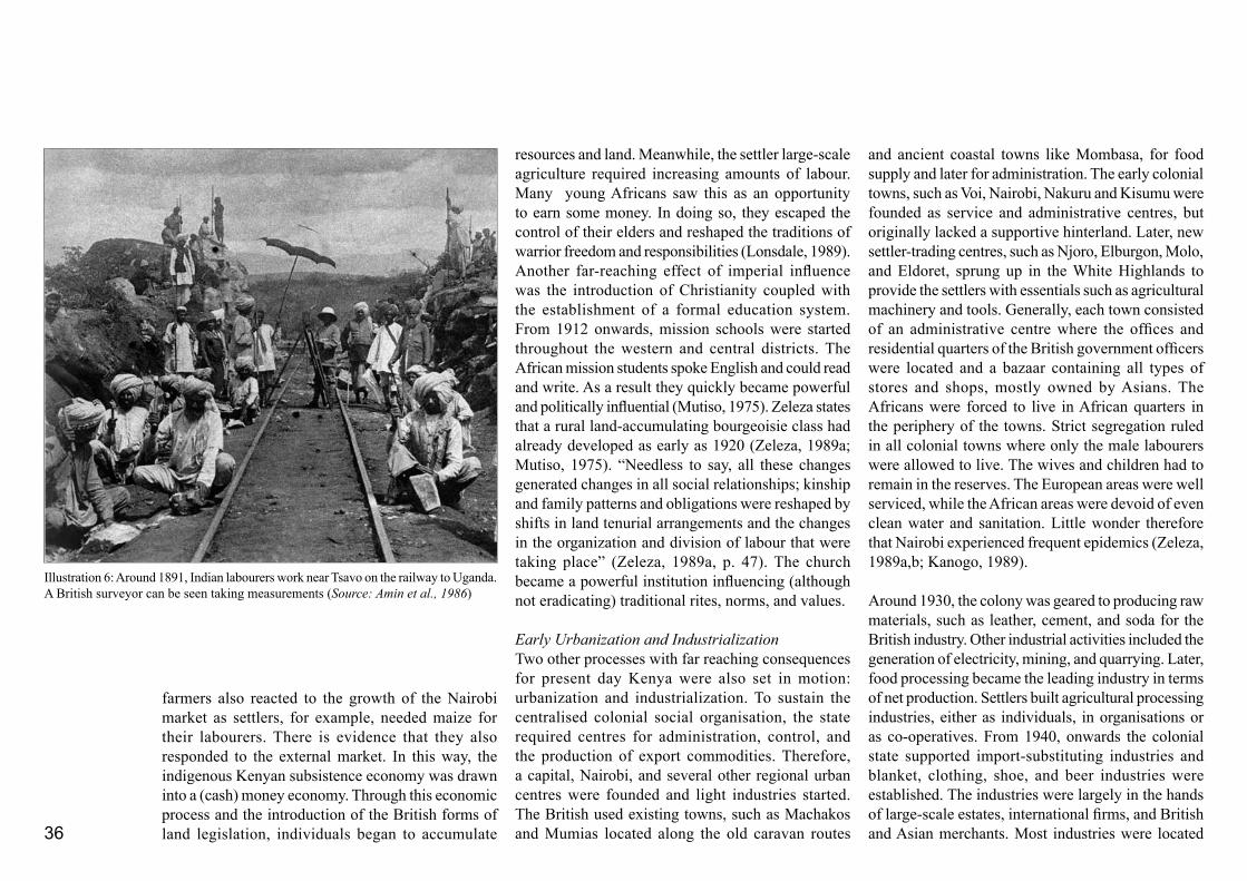
36
farmers also reacted to the growth of the Nairobi market as settlers, for example, needed maize for their labourers. There is evidence that they also responded to the external market. In this way, the indigenous Kenyan subsistence economy was drawn into a (cash) money economy. Through this economic process and the introduction of the British forms of land legislation, individuals began to accumulate
and ancient coastal towns like Mombasa, for food supply and later for administration. The early colonial towns, such as Voi, Nairobi, Nakuru and Kisumu were founded as service and administrative centres, but originally lacked a supportive hinterland. Later, new settler-trading centres, such as Njoro, Elburgon, Molo, and Eldoret, sprung up in the White Highlands to provide the settlers with essentials such as agricultural machinery and tools. Generally, each town consisted of an administrative centre where the offices and residential quarters of the British government officers were located and a bazaar containing all types of stores and shops, mostly owned by Asians. The Africans were forced to live in African quarters in the periphery of the towns. Strict segregation ruled in all colonial towns where only the male labourers were allowed to live. The wives and children had to remain in the reserves. The European areas were well serviced, while the African areas were devoid of even clean water and sanitation. Little wonder therefore that Nairobi experienced frequent epidemics (Zeleza, 1989a,b; Kanogo, 1989). Around 1930, the colony was geared to producing raw materials, such as leather, cement, and soda for the British industry. Other industrial activities included the generation of electricity, mining, and quarrying. Later, food processing became the leading industry in terms of net production. Settlers built agricultural processing industries, either as individuals, in organisations or as co-operatives. From 1940, onwards the colonial state supported import-substituting industries and blanket, clothing, shoe, and beer industries were established. The industries were largely in the hands of large-scale estates, international firms, and British and Asian merchants. Most industries were located
resources and land. Meanwhile, the settler large-scale agriculture required increasing amounts of labour. Many young Africans saw this as an opportunity to earn some money. In doing so, they escaped the control of their elders and reshaped the traditions of warrior freedom and responsibilities (Lonsdale, 1989). Another far-reaching effect of imperial influence was the introduction of Christianity coupled with the establishment of a formal education system. From 1912 onwards, mission schools were started throughout the western and central districts. The African mission students spoke English and could read and write. As a result they quickly became powerful and politically influential (Mutiso, 1975). Zeleza states that a rural land-accumulating bourgeoisie class had already developed as early as 1920 (Zeleza, 1989a; Mutiso, 1975). “Needless to say, all these changes generated changes in all social relationships; kinship and family patterns and obligations were reshaped by shifts in land tenurial arrangements and the changes in the organization and division of labour that were taking place” (Zeleza, 1989a, p. 47). The church became a powerful institution influencing (although not eradicating) traditional rites, norms, and values.
Early Urbanization and Industrialization Two other processes with far reaching consequences for present day Kenya were also set in motion: urbanization and industrialization. To sustain the centralised colonial social organisation, the state required centres for administration, control, and the production of export commodities. Therefore, a capital, Nairobi, and several other regional urban centres were founded and light industries started. The British used existing towns, such as Machakos and Mumias located along the old caravan routes
Illustration 6: Around 1891, Indian labourers work near Tsavo on the railway to Uganda. A British surveyor can be seen taking measurements (Source: Amin et al., 1986)
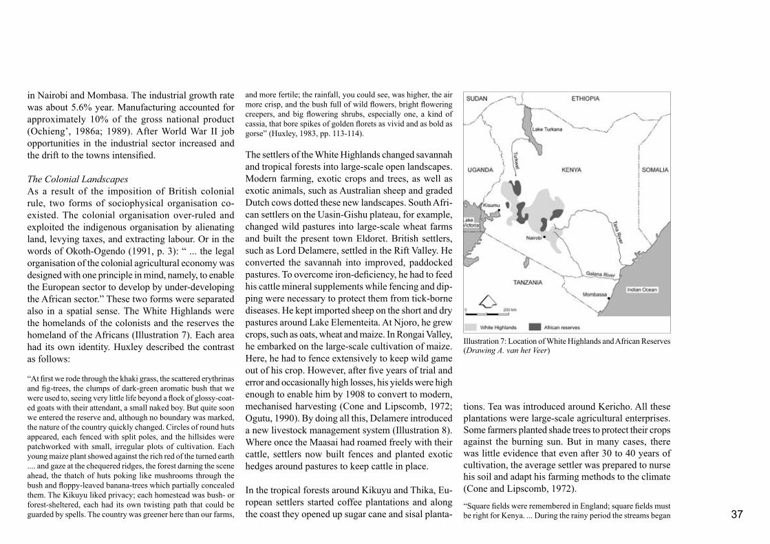
37
in Nairobi and Mombasa. The industrial growth rate was about 5.6% year. Manufacturing accounted for approximately 10% of the gross national product (Ochieng’, 1986a; 1989). After World War II job opportunities in the industrial sector increased and the drift to the towns intensified.
The Colonial LandscapesAs a result of the imposition of British colonial rule, two forms of sociophysical organisation co-existed. The colonial organisation over-ruled and exploited the indigenous organisation by alienating land, levying taxes, and extracting labour. Or in the words of Okoth-Ogendo (1991, p. 3): “ ... the legal organisation of the colonial agricultural economy was designed with one principle in mind, namely, to enable the European sector to develop by under-developing the African sector.” These two forms were separated also in a spatial sense. The White Highlands were the homelands of the colonists and the reserves the homeland of the Africans (Illustration 7). Each area had its own identity. Huxley described the contrast as follows:
“At first we rode through the khaki grass, the scattered erythrinas and fig-trees, the clumps of dark-green aromatic bush that we were used to, seeing very little life beyond a flock of glossy-coat-ed goats with their attendant, a small naked boy. But quite soon we entered the reserve and, although no boundary was marked, the nature of the country quickly changed. Circles of round huts appeared, each fenced with split poles, and the hillsides were patchworked with small, irregular plots of cultivation. Each young maize plant showed against the rich red of the turned earth .... and gaze at the chequered ridges, the forest darning the scene ahead, the thatch of huts poking like mushrooms through the bush and floppy-leaved banana-trees which partially concealed them. The Kikuyu liked privacy; each homestead was bush- or forest-sheltered, each had its own twisting path that could be guarded by spells. The country was greener here than our farms,
and more fertile; the rainfall, you could see, was higher, the air more crisp, and the bush full of wild flowers, bright flowering creepers, and big flowering shrubs, especially one, a kind of cassia, that bore spikes of golden florets as vivid and as bold as gorse” (Huxley, 1983, pp. 113-114).
The settlers of the White Highlands changed savannah and tropical forests into large-scale open landscapes. Modern farming, exotic crops and trees, as well as exotic animals, such as Australian sheep and graded Dutch cows dotted these new landscapes. South Afri-can settlers on the Uasin-Gishu plateau, for example, changed wild pastures into large-scale wheat farms and built the present town Eldoret. British settlers, such as Lord Delamere, settled in the Rift Valley. He converted the savannah into improved, paddocked pastures. To overcome iron-deficiency, he had to feed his cattle mineral supplements while fencing and dip-ping were necessary to protect them from tick-borne diseases. He kept imported sheep on the short and dry pastures around Lake Elementeita. At Njoro, he grew crops, such as oats, wheat and maize. In Rongai Valley, he embarked on the large-scale cultivation of maize. Here, he had to fence extensively to keep wild game out of his crop. However, after five years of trial and error and occasionally high losses, his yields were high enough to enable him by 1908 to convert to modern, mechanised harvesting (Cone and Lipscomb, 1972; Ogutu, 1990). By doing all this, Delamere introduced a new livestock management system (Illustration 8). Where once the Maasai had roamed freely with their cattle, settlers now built fences and planted exotic hedges around pastures to keep cattle in place.
In the tropical forests around Kikuyu and Thika, Eu-ropean settlers started coffee plantations and along the coast they opened up sugar cane and sisal planta-
tions. Tea was introduced around Kericho. All these plantations were large-scale agricultural enterprises. Some farmers planted shade trees to protect their crops against the burning sun. But in many cases, there was little evidence that even after 30 to 40 years of cultivation, the average settler was prepared to nurse his soil and adapt his farming methods to the climate (Cone and Lipscomb, 1972).
“Square fields were remembered in England; square fields must be right for Kenya. ... During the rainy period the streams began
Illustration 7: Location of White Highlands and African Reserves (Drawing A. van het Veer)

38
to run muddy, and swamps began to appear in places which had been crossed with ease by the wagons of earlier settlers. The violent beating rains began to carry silt and sand to form great deltas at the bottom of the fields, blocking farm roads, sometimes right up to the farmhouse doors. ... During the next few years farmers with home-made or home-devised instruments began to protect their lands from those rains, the effects of which, if uncontrolled, may be the reverse of a blessing. Unfortunately, enthusiasm often outstripped knowledge, energy replaced care. ... Disastrous breaks and severe gullying down the fields often followed upon the farmer’s attempts at saving his soil. (Cone and Lipscomb, 1972, pp. 73-74).
Squatter settlements sprang up on many of the settler properties. Most of the settlers - with the exception of large “aristocratic” landowners like Delamere - were heavily undercapitalised and often not skilled in farming. Cultivation of the new land was only possible because of a large and cheap labour force. The majority of the settlers could only pay in kind and would allow their workers, for example, to use some land for cultivation and grazing. As a result squatter settlements - predominantly Kikuyu - were established within the White Highlands (Kanogo, 1987). The Kikuyu saw these settlements as an opportunity for building up a new future. They transferred their cul-tural and political traditions, such as elders’ councils, circumcision and marriage ceremonies to the new situation. Elders’ councils dealt with all aspects of life and were responsible for safeguarding the interests of the squatter community and maintaining a healthy social structure. Occasionally, the council would refer an issue to the settler. If the council felt that an issue was sufficiently important, for example, a dispute involving people from different farms, an inter-farm council would be convened. If the accused disagreed with the decision of the joint council, the issue was referred to either a township chief or to the District
Commissioner’s office. In this way indigenous Kikuyu governing institutions which had been closely linked to the natural topography of Kikuyu land bonded with the organisation of the settler farms (Kanogo, 1987).
Originally the squatters did well and were able to accumulate large herds of goats, sheep and cattle (Zeleza, 1989b; Kanogo, 1987). However, after the First World War the settlers, supported by the Colonial Government, started to take several measures to protect their economy. Squatters, for example, were no longer allowed to keep cattle or to cultivate land.
Many squatters had no other option but to leave the settler’s farm, sell their livestock at low prices or use them for dowry, otherwise their livestock would simply be confiscated. As a result squatters lost much of their savings and wealth while the undercapitalised settlers who could not pay wages lost their workers (Kanogo, 1987; Zeleza, 1989; Ochieng’, 1986a). Not only did the settlers need labour to cultivate land, labour was needed everywhere. Railway lines, roads, dams, bridges, settler farms, administrative offices and centres, had to be built and the settler government turned to forced labour to meet its needs. Chiefs were
Illustration 8: Sociophysical organisation principles of the colonial state (Drawing A. van het Veer)
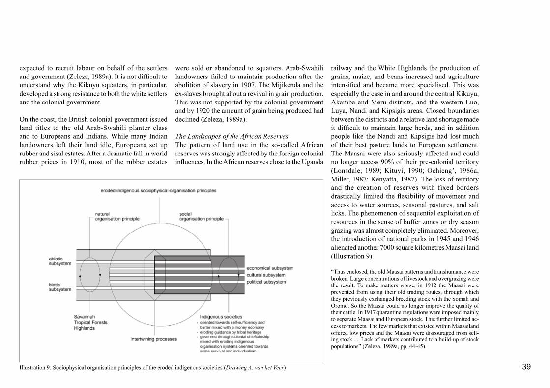
39
expected to recruit labour on behalf of the settlers and government (Zeleza, 1989a). It is not difficult to understand why the Kikuyu squatters, in particular, developed a strong resistance to both the white settlers and the colonial government.
On the coast, the British colonial government issued land titles to the old Arab-Swahili planter class and to Europeans and Indians. While many Indian landowners left their land idle, Europeans set up rubber and sisal estates. After a dramatic fall in world rubber prices in 1910, most of the rubber estates
were sold or abandoned to squatters. Arab-Swahili landowners failed to maintain production after the abolition of slavery in 1907. The Mijikenda and the ex-slaves brought about a revival in grain production. This was not supported by the colonial government and by 1920 the amount of grain being produced had declined (Zeleza, 1989a).
The Landscapes of the African ReservesThe pattern of land use in the so-called African reserves was strongly affected by the foreign colonial influences. In the African reserves close to the Uganda
railway and the White Highlands the production of grains, maize, and beans increased and agriculture intensified and became more specialised. This was especially the case in and around the central Kikuyu, Akamba and Meru districts, and the western Luo, Luya, Nandi and Kipsigis areas. Closed boundaries between the districts and a relative land shortage made it difficult to maintain large herds, and in addition people like the Nandi and Kipsigis had lost much of their best pasture lands to European settlement. The Maasai were also seriously affected and could no longer access 90% of their pre-colonial territory (Lonsdale, 1989; Kituyi, 1990; Ochieng’, 1986a; Miller, 1987; Kenyatta, 1987). The loss of territory and the creation of reserves with fixed borders drastically limited the flexibility of movement and access to water sources, seasonal pastures, and salt licks. The phenomenon of sequential exploitation of resources in the sense of buffer zones or dry season grazing was almost completely eliminated. Moreover, the introduction of national parks in 1945 and 1946 alienated another 7000 square kilometres Maasai land (Illustration 9).
“Thus enclosed, the old Maasai patterns and transhumance were broken. Large concentrations of livestock and overgrazing were the result. To make matters worse, in 1912 the Maasai were prevented from using their old trading routes, through which they previously exchanged breeding stock with the Somali and Oromo. So the Maasai could no longer improve the quality of their cattle. In 1917 quarantine regulations were imposed mainly to separate Maasai and European stock. This further limited ac-cess to markets. The few markets that existed within Maasailand offered low prices and the Maasai were discouraged from sell-ing stock. ... Lack of markets contributed to a build-up of stock populations” (Zeleza, 1989a, pp. 44-45).
Illustration 9: Sociophysical organisation principles of the eroded indigenous societies (Drawing A. van het Veer)

40
Renewed Land-use PoliciesThe measures taken by the colonial government in favour of the settler community resulted in a steady surpression of the indigenous population. As a result the sociophysical-organisation principles continued to diverge. The organisation principles introduced by the new colonial government and particular its political and economic principles were not in balance with the natural regulating principles. The substantial reduction in the right of indigenous people to access land led, among other things, to land degradation and social disintegration. The traditional, social system that provided land tenure and security for landless people enabling them to make a living slowly broke down. Livestock quarantine regulations limited trade and meant that animals could no longer be used to ensure cash flow. Instead the local people were forced to leave their communities to look for wage employment (Illustration 10).
Under the pressure of the economic depression in the 1920s and 1930s, the imperial government attempted to bridge the fractures between the state and the indigenous tribal organisations. Notwithstanding governmental support, the settlers had only managed to cultivate 5.6 % of the White Highlands. By 1920, the national economy was largely sustained by the agricultural production of the indigenous farmers (Zeleza, 1989a, 1989b; Cone and Lipscomb, 1972; Huxley, 1983). Legget (Chairman of the East African Section of the London Chamber of Commerce and Director of the British East African Corporation) acknowledged that “The solution to Kenya’s economic problems, ... was to stimulate African production by spending more on the reserves while reducing the load of African taxation. He ... called for African production
of low value, bulk agricultural products with the settler production focused on high-value, capital intensive products” (Maxon, 1989, pp. 84-85).
These ideas formed the basis of the Dual Policy announced in 1926 and in 1932 a Native Betterment Fund was set up. The few resources available were spent in those districts and regions that were already most productive, i.e. Kikuyuland, Nyanza Province, the coast and Ukambani. From 1934 onwards, farmers in districts such as Kisii, Embu and Meru - far away from settler areas were allowed to grow export crops such as coffee (Maxon, 1989; Cone and Lipscomb, 1972; Alila,1977). The settlers, however, continued to exert a considerable influence on the Legislative Council. It still took another 15 years before the colonial and imperial government prepared plans for general and overall development. In 1946, a first integrated ten-year Development Plan was published. In this plan, the development of Kenya’s resources - land, crops, livestock, and water - were central. To achieve this objective, projects were designed and funds were allocated to the departments of Agriculture, Veterinary Services, Forestry and Water Development. A substantial block allocation was made under the general heading of Reconditioning of African Lands and African Settlement. This allocation was to be controlled by the African Land Development Organization (ALDEV). The Swynnerton Plan, published in 1954, outlined a scheme to accelerate the development of agriculture in African areas. The plan was based on individual land tenure, on growth of cash crops, notably coffee, tea and pyrethrum, on improvement of livestock and, in semi-arid pastoral regions on development of water supplies, grazing management, protective afforestation, and control
of tsetse fly. Funds were made available to increase extension services, develop processing and marketing facilities and establish co-operatives and credit for African farmers. During this planning period, the first attempts at integrated planning were made in districts like Machakos and Baringo. In Central Province, land reallocation took place around 1948. Tick-borne cattle diseases made it necessary to isolate herds from each other. A certain chief, therefore, persuaded his people to combine their scattered holdings so that they could be consolidated and enclosed by a fence or hedge. The agricultural extension workers reacted by encouraging people to paddock their grassland for rotational grazing, erect cattle sheds so manure could be collected, and spray their cattle against ticks (Cone and Lipscomb, 1972). Due to the emphasis on individual ownership in the Swynnerton Plan the early members of the petty bourgeoisie became a stable African land-owning class with access to capital and an income derived from cash crops. Later this class would have a moderating influence on African inde-pendence politics.
2.1.3 Uhuru! Independence
Even though the Dual Policy had its successes, by the 1950’s the principles of social organisation on which the colonial state was based were increasingly at odds with how the indigenous population wanted to organise their life. People started to revolt (Maloba, 1989; Zeleza, 1989b). Political associations were created amongst the Kikuyu in the reserves and in the squatter settlements of the White Highlands. A guerilla movement - the Mau Mau Revolt - gained momentum
41
local communities were encouraged to legitimise the government by being given development projects in their area (Fowler, 1993).
In 1982, Moi faced and survived a coup initiated by the military. For about 10 years or so, political move-ments and freedom of expression were restricted and political opponents were detained without charge. The constitution was changed and Kenya moved from being a two-party to a one-party state. In 1990, the new constitution was revoked (Fowler, 1993; Koigi wa Wamwere, 1992) and several parties emerged including FORD Kenya, FORD Asili, and the Democratic Party (DP). From 1992 onwards, general multiparty elections were held. In 2001, President Moi stepped down and a coalition government under the new President Mwai Kibaki was formed.
The Landscapes of Early IndependenceAlthough Kenya adopted many of the principles of colonial social organisation, there were major changes particularly in the White Highlands. Africans, including the Kikuyu, the Maasai, the Kalenjin, the Luo and the Kisii expected their “stolen” lands to be returned. They were to be disappointed. President Kenyatta, “sounded strong warnings against any Africans who anticipated, then or after independence, free grants of land from the government. There would be limited settlement schemes for some landless people. But this did not mean that all land procured from settlers would be freely distributed” (Kanogo, 1987, p.171). The settlers feared their lands would be seized without reasonable compensation. However, the new Kenyan government received financial assistance from, among others, the British government, the World Bank, the Colonial Development Corporation,
principle of social organisation replaced the colonial one. This new principle was a mild modification of the old colonial system. The economic subsystem of “guided” free economy was adopted by the new Kenyan leaders with the difference that the profits were used for the management of the newly independent state of Kenya and not the British empire. The cultural sub-system was based on a mixture of British and African norms and values. The political subsystem - although changed into a parliamentary democracy- retained outwardly a predominantly British form. However, internally the system changed automatically when the Kenyan ruling class - with its specific African back-ground - took over from the Europeans. Within the structure of formal parliamentary democracy, an in-formal but powerful structure of patron-client relations was established. These often developed along tribal lines and weakened the workings of parliament (Koigi wa Wamwere, 1992; Miller, 1984). Kenyatta used the civil services as a form of patronage often to the benefit of the Kikuyu bourgeoisie. He increased the degree of government centralisation by strengthening the postition of the provincial commissioners. Later Moi too would rule through a system of patronage. He, however, had to look for a different power base within the civil services. He did this by strengthening KANU to such an extent that the government and KANU virtually became one. He also decentralised national development - bypassing the provincial commissioners - to a district level. The political system, therefore, did not have the features of a government “controlling and regulating system” - to use Kleefmann’s model - rather it functioned as a tool of patronage and delegated power. In Kenyatta’s as well as in Moi’s system, public (crown) land was used to reward faithful supporters (Koigi wa Wamwere, 1992) and
in the period 1952 to 1956. Land was the central issue and, for the Kikuyu who took part in the struggle, there was little doubt that all the land that had been alienated was theirs by right. In reality this was not the case (Kanogo, 1987). The British adopted a strategy of “friendship” to safeguard the flow of commerce between Great Britain and Kenya and keep the colony out of the hands of “communist nationalists”. Therefore, in 1957, direct elections were held and eight Africans were elected to the Legislative Council. They did not represent a national political party and acted as individuals. They demanded independence, the abolition of discrimination, the release of detainees, and an increase in wages. However, they never sought the destruction or reformulation of the prevailing colonial social and economic system. In 1960, two national movements - Kenya African National Union (KANU) and Kenya African Democratic Union (KADU) were formed bringing together several smaller political organisations.
In 1963, Kenya achieved independence. However, the centralised, colonial state administration and economy remained largely intact. The new leadership officially endorsed private ownership and free enterprise as the country’s economic system (Maloba, 1989). In 1964, Kenya became a republic with a president who was the head of the government, the state and the ruling party. Jomo Kenyatta was the first president, and was succeeded by President Daniel Arap Moi in 1979 (Miller, 1984; Ochieng’, 1989). President Moi has followed the policy outlined by Kenyatta and encouraged the entrepreneurial spirit in his country.
Gradually, a mixture of eroded African traditions and modified western values and norms developed. A new
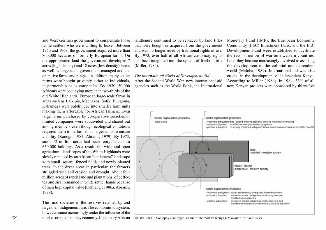
42
and West German government to compensate those white settlers who were willing to leave. Between 1960 and 1968, the government acquired more than 800,000 hectares of formerly European farms. On the appropriated land the government developed 7 acres (high density) and 18 acres (low density) farms as well as large-scale government managed and co-operative farms and ranges. In addition, many settler farms were bought privately either as individuals, in partnership or as companies. By 1970, 50,000 Africans were occupying more than two-thirds of the old White Highlands. European large-scale farms in areas such as Laikipia, Machakos, Sotik, Bungoma, Kakamega were subdivided into smaller farm units making them affordable for African farmers. Even large farms purchased by co-operative societies or limited companies were subdivided and shared out among members even though ecological conditions required them to be farmed as larger units to ensure viability (Kanogo, 1987; Abrams, 1979). By 1973, some 12 million acres had been reorganised into 650,000 holdings. As a result, the wide and open agricultural landscapes of the White Highlands were slowly replaced by an African “settlement” landscape with small, square, fenced fields and newly planted trees. In the dryer areas in particular, the farmers struggled with soil erosion and drought. About four million acres of ranch land and plantations, of coffee, tea and sisal remained in white settler hands because of their high capital value (Ochieng’, 1986a; Abrams, 1979).
The rural societies in the reserves retained by and large their indigenous base. The economic subsystem, however, came increasingly under the influence of the market-oriented, money economy. Customary African
landtenure continued to be replaced by land titles that were bought or acquired from the government and was no longer ruled by traditional rights of use. By 1973, over half of all African customary rights had been integrated into the system of freehold title (Miller, 1984).
The International World of Development AidAfter the Second World War, new international aid agencies such as the World Bank, the International
Monetary Fund (IMF), the European Economic Community (EEC) Investment Bank, and the EEC Development Fund were established to facilitate the reconstruction of war-torn western countries. Later they became increasingly involved in assisting the development of the colonial and dependent world (Maloba, 1989). International aid was also crucial in the development of independent Kenya. According to Miller (1984), in 1984, 33% of all new Kenyan projects were sponsored by thirty-five
Illustration 10: Sociophysical organisation of the modern Kenya (Drawing A. van het Veer)

43
nations or international organisations. At that time Kenya was receiving bilateral aid from Britain, West Germany, the United States, Sweden, the Netherlands, France, Canada, Australia, Denmark, Norway, Italy, and Japan. Other aid came through multilateral assistance, particularly the World Bank, United Nations Development Programme (UNDP), Food and Agricultural Organization (FAO), United Nations Children Emergency Fund (UNICEF), World Health Organization (WHO), the European Development Fund, and the Arab Development Bank. Aid was given in the form of grants and loans. As mentioned earlier, the first aid programmes focused on land-exchange programmes. Later, foreign aid was more specifically concerned with the development of agriculture, water supplies, and the construction of roads. In the period 1978-1983 much of the aid - particularly from USA - was assigned for military purposes (Miller, 1984). In his book Kenya, “The Quest for Prosperity” Miller states that there are limits to the amount of money a bureaucracy effectively can use. “It is not the money that is scarce, but managerial help, secretarial help, time, space, transportation, and tools in the right place at the right time are scarce. Overflows of money can also disrupt ongoing operations” (Miller, 1984, p. 144). Currently, international donors no longer restrict themselves to technical or economic support, but intervene in the political and cultural subsystems as well. In exchange for support, Kenya has to fulfil a range of demands aimed at initiating structural economic change, political freedom, institutional reorganisation, constitutional reform and development of policies that provide for democracy, gender equity and environmental care. These demands are related to the politics of the giving country and an international belief of what is right and wrong rather than to local
orientated ethics. The British pulled Kenya into a market cash-economy. Development aid has drawn Kenya into a system of global norms and values.
2.1.4 Summary
Historically, the natural system in Kenya dominated human land use and clearly influenced the organising principles on which societies were based. A multiplicity of tribes selected different ecological niches for their livelihood. The extensive dry and open savannah of the Rift Valley and the old plateau supported a nomadic lifestyle. This way of life required a politico-military form of social organisation based on age sets in which the warriors had the task of protecting the territory. The landscapes looked untouched. In the humid and fertile areas of the uplands people lived a sedentary life built around the extended family and tribal inter-relationships. Physical features often dictated the size of the family group. The landscapes in these areas consisted of small, cultivated fields and forests. Even though life was not easy, there was a kind of continuous but slowly changing equilibrium between nature and society. The driving force behind social organisation was predominantly the survival of the group and the tribe.
The British occupation radically disrupted the balance between society and nature. Land was expropriated, men forced into labour, national and district boundaries, and cordons prevented movement and discriminatory land regulations were enforced. An alien principle of above-tribe, national social organisation was introduced. The objective was to turn Kenya into a
profit-making colony for Britain. Colonists obtained “untouched” land that in fact was being used by the nomadic tribes and - with the unequivocal support of the colonial government- they set about establishing export-orientated agriculture. Nature and indigenous culture had surprises in store for the white farmer, however. Diseases ravaged their (exotic) crops and imported cattle, inappropriate farming methods caused soil erosion and land degradation, and the inability to acquire enough labour often made it impossible to harvest crops. Enormous capital investments and a plentiful supply of labour were needed to make the colonial agricultural cash economy work. The result of colonial efforts to ensure that these conditions prevailed was a new socio-physical organisation, which expressed itself in the form of large-scale, open farmland with some small service centres. Within the White Highlands area small-scale agricultural squatter settlements established by the African agricultural labourers formed independent and distinct units.
In the reserves, the local societies - for the first time in their history - were confronted by external economic forces and closed and fixed land boundaries. This meant changes in labour distribution (men worked for the white settlers, leaving women to work in the reserves), land ownership (communal land was privatised), and land availability (insufficient land for rotation and heirs). The result was land fragmentation and land degradation. Furthermore, closed boundaries put an end to the symbiotic, inter-tribal way of life of pastoralists and agriculturists. Pastoralists became marginalised. Individual profit making became a powerful driving force pre-emting the principal of group survival. In fact, during the colonial period, two forms of sociophysical organisation existed side
44
by side: a multitude of slowly adapting, indigenous societies, and the national, colonial British system. The latter dominated and exploited the former. It took 25 years before the colonial government recognised the extent to which the economy was dependent on indigenous farmers and began to include African farmers in its agricultural support plans.
Independence brought modifications to these systems. The new Kenyan leaders adopted the capital market economy and many of the British norms and values. This, combined with the Kenyan sociocultural system, formed the basis for a state based on modified western principle of organisation (Illustration 10). This modified principle brought about major changes in land use, in the White Highlands, in particular. Large areas of settler farmland were Kenyanised and transformed into settlement schemes. Among those Kenyan smallholders who lived outside the old White Highlands, a mixture of subsistence and cash economy took root and private land ownership was established. These changes accelerated the erosion of indigenous norms and values and social institutions.
The colonial principles of national organisation were not intended to improve the wellbeing of the indigenous population. When Kenya adopted this system at independence not much changed. Local communities - with their specific social organisation did not become the focal point of development. Neither did the political subsystem develop into a government controlling system. Rather it remained, by and large, a government/president support system. The legitimacy of the state government was, therefore, questionable. Furthermore, the international community not only influenced the economic sub-system through its
financial aid, it also interfered with the political and cultural sub-systems via conditionalities and technical aid. In some instances, this international interference was reflected in new Kenyan landscapes such as those created by the introduction of large-scale irrigation or intense afforestation programmes.
This historical overview illustrates the complexity of present-day Kenya. Kenya is a country with dramatic ecological differences. It is home to some 40 different tribal groups with a sliding scale of modern influences. It has inherited its national government from the British. The result is a large variety of landscapes each with their own unique driving forces. To ensure proper interventions in these landscapes it is essential that the various forces are identified and critically reviewed in relation to each other.
45
At higher altitudes and in the east well-developed soils, such as cambisols are found (Wahome, 1986; Sombroek et al., 1982; Buringh, 1979; Touber, 1989g). Most of the soils, though, are unstable and prone to erosion. Even limited amount of land-use pressure can trigger the development of badland topography (Touber, 1989d). In the arid areas vegetation is either entirely absent or consists of desert scrub and grass (Commiphora-Acacia). The semi-arid lands have dry woodland and bushland vegetations (Acacia-Themeda) (Ojany and Ogendo, 1987). Although, the nutritive value of the vegetation varies, where conditions are favourable, grazing is the most suitable form of land use (Touber, 1989a; 1989b). In the vicinity of permanent or periodic rivers the land may be suitable for careful, small-scale floodplain irrigation (Touber, 1989e). In general, however, natural conditions in these areas are harsh and hostile.
The Maasai, Samburu, Kamba, and Njemps as well as the Turkana and Pokot live in the western part of the arid and semi-arid areas. In the east, the Orma, Pokot, Borana, Gabbra, Rendiles, and Somali peoples occupy the land. The majority of these peoples have a nomadic life style. In general, the arid and semi-arid areas have a below average population density and a female-dominated sex ratio indicating the out-migration of men. There is also a below average percentage of wage labourers and per capita wage income, a less than average presence of civil servants in the region, and the production value per capita and cash income from export is also below average. There are low levels of school attendance and a comparatively few educated people live here. However, commercial livestock income per capita and annual population increase are above average (Dietz, 1987).
Kenya’s contemporary landscapes - as discussed in Part 2.1 - have been shaped by a combination of indig-enous African practice and colonial interventions. Part 2.2 illustrates how these two intertwined organisation forms manifest themselves in present-day Kenyan landscapes. The landscapes of arid Turkana, the neigh-bouring semi-arid Pokot, and the humid landscape of Kisii provide illustrative examples.
The forces that determine the way in which landscapes have developed are similar to those operative in the case-study areas, which will be discussed in Part 3. Part 2.2, therefore, provides a basis for understanding and evaluating suggested landscape interventions.
2.2.1 TheAridandSemi-AridLandscapes
According to Dietz (1987), 38% of Kenya’s land surface is semi-arid and 45% is very arid. As a result, some 28 districts have to deal with the problem of aridity. Socioeconomic conditions in the arid and semi-arid areas are generally below average and their ecological potentials are low to very low (Survey of Kenya, 1970). The arid land in the north experiences mean maximum temperatures of 30 to 360 C and mean minimum temperatures of between 18 to 240 C making the region climatically one of the most arid in East Africa. In the southwestern part of the country, the climate is more agreeable, but even here a chance of a serious rainfall deficit can occur in two out of three years (Dietz, 1987, Sombroek et al., 1982). Many of the soils in these areas are shallow and typically arid in character (xerosols and regosols) and have ironstone layers. Some are highly saline (solonchaks), others consist of heavy montmorillinitic clay (vertisols).
2.2
Characteristic Contemporary Landscapes

46
and clay plains, lakebeds and mountain foot slopes are composed of unconsolidated materials. Wind erosion and deposition in the form of small dunes occurs near the mouths of the Turkwel and Kerio Rivers. Odegi-Awuondo writes that Turkana land has more sources of drinking water than is usual for an arid environment (Odegi-Awuondo, 1990). These include rivers, springs and wells dug in dry riverbeds of intermittent rivers. In some areas bore-holes provide good drinking water. Lake Turkana lies in the east. The lake water is alkaline and contains high concentrations of sodium chloride and sodium bicarbonate, lead and iron. It is
unsuitable for irrigated crop production and human consumption. Nevertheless, the lake abounds in fish (DGIS/IOV mission, 1990). The central region is covered with annual grasses and dwarf shrubs that provide nutritious forage for livestock during and shortly after the rains. However, they dry out quickly with the onset of the dry season. In the southern and western part of Turkana land, the vegetation has a considerably higher production potential. Here, the predominantly perennial grasses are generally capable of maintaining photosynthetic activity into the dry season. The Acacia, Commiphora, and Balanitus shrub canopy varies from 10 to 20% coverage. The vegetation along the Turkwel and Kerio rivers and on the hills consists of several acacia species including Acacia seyal, Acacia tortilis,and Acacia senegal and salt-resistant scrubs such as Zizyphus mauritiana and Cordia sinensis. Palm trees like the doum palm (Hyphaena compressa) can also be found.
Turkana’s nature makes the area largely unsuitable for crop production but reasonably suitable for grazing with indigenous livestock. The Turkana people have developed an efficient reaction to nature’s (un)predictability with mobility as their major strategy. They make use of the diverse ecological potentials of the region in the form of dry and wet season grazing. For example, an extended family will have a herd that consists of diffe-rent species - camels, goats, sheep, and cows. This diversity of domestic stock is necessary in order to optimise the use of natural resources. Camels browse shrubs, for example, while cattle eat grass. Further-more, the family herd is placed in various ecological zones and these may be hundreds of kilometres apart. The head of the family supervises the work, but the wives and
The arid Turkana landscapeTurkana is located in the north-western corner of the Rift Valley. The countryside consists of a relatively flat to undulating plain. Isolated mountains and hills following the north-south trend of the Rift Valley are found at intervals. The elevation varies from 600 to 900 metres with the Loima Hills reaching 2133 metres above sea level. Average rainfall is 300 to 400 millimetres per year with less than 150 millimetres in the central very arid region and in the northern Lotikippi plains. Volcanic rocks cover about a third of the district. Most of the soils found in the sandy
Illustration 11: The barren lands around Lake Turkana (Photo I. Duchhart)

47
their children perform the daily pastoral activities. The Turkana also rely on the heterogeneity of their herd to carry out social and economic functions and to meet their customary responsibilities. Goats and sheep may be used as currency, camel as a source of food, and bulls to meet specific social obligations. In periods of prolonged drought, scouts will search for productive pastures including grazings in hills and mountains. In such periods a wide network of peaceful inter-tribal and intra-tribal contacts provides an important life-support system and secures access to dry-season grazing grounds. The Turkana combine this husbandry system with hunting, gathering, some crop production, trade and metallurgy.
In the Turkana region, land is predominantly commu-nally owned. The use of grazings is controlled through grazing organisations (adakar) and in the riverine forest through user-rights organisations (ekwars). The riverine forests provide the people with shelter in the form of shade, building materials, firewood, and fruits. Small-scale riverbed flood irrigation enables food crops such as millet and sorghum to be grown (Illustration 15). Recent data indicate that 35 to 40% of the livestock in Turkana can be found near rivers and along the Turkana River in particular.
The traditional multi-resource economy of the Turkana can only thrive if there are peaceful relationships with their neighbours in Uganda, Sudan, and Ethiopia. The introduction of international boundaries, a district administration, and the harassment of the British made cross-boundary nomadic movements difficult and brought the Turkana in conflict with people such as the Samburu. From the beginning, the Turkana people strongly resisted colonial rule and British
reprisals lead to heavy casualties and considerable loss of livestock. To counter these losses, they turned to raiding their neighbours. The British introduced taxes that were payable in livestock and this - together with a series of natural calamities that included drought and cattle diseases - seriously weakened the Turkana economy. The drought of 1918 enabled the British to finally strengthen their hold on the Turkanas. The impoverished people were recruited and their leaders imprisoned. Three decades of western interference resulted in the Turkanas loosing access to large areas
of land including their dry season grazings in the north. They also lost most of their cattle and this deprived them of capital, food, milk, meat, and their base for trade.
By 1926, the Turkana found themselves confined to the more arid central plains and congestion and ecological degradation became serious problems (Odegi-Awuondo, 1990). Later, due to quarrels with the Pokots that continued into the 1980s, the southern part of Turkana became an under-utilized area.
Illustration 12: Turkana people and their herd at a drinking place (Photo I. Duchhart, Compilation J. van Aggelen)

48
people living in the camps have lost all hope of building up a new herd and have developed a serious sense of dependency. Traditionally, the youth fulfilled important functions as herdsmen and scouts. Today, however, there is little for them to do and as a result the extensive Turkana nomadic knowledge system is rapidly disappearing.
In the 1960s and 1970s the national government introduced modern large-scale irrigated agriculture in particular on the Turkwel River and commercial fishing along Lake Turkana. Irrigation schemes like Katilu and Kapitur triggered urban settlements. Food collection and distribution camps also attracted Turkana traders and offered impoverished Turkana the chance of eking out a living. According to Norad (Norwegian Agency for Development Cooperation) nearly one third of the 200,000 people living in Turkana district have
now settled in urban centres. Three quarters of these urbanised Turkana live in Lodwar and Katilu. These large settlements are situated in the most vulnerable zones of the district. They put an enormous strain on the arid environment. Most of the acacia bush and scrub in the vicinity of these centres has been cut and used for firewood or to make charcoal and much of the doum palm in the riverine forest has been felled for building houses and fences. Degeneration of the riparian forests and devegetation of the savannah are the result. Furthermore, the lack of proper sanitation measures means that the direct urban environment is contaminated with human excrement. Around Lodwar, the process of land degradation is particularly visible. In 1990, the landscape within a circle of ten kilometres around the town was com-pletely denuded and barren. In the urban centres, there is always a shortage of water, while fresh food must be imported from the more fertile uplands in the south. In addition, while the district had a negative growth rate of 1.29% in the 1970s because of an out-migration to escape famine, the 1980s saw a substantial in-migration of, among others, Samburu and Pokot. The population growth in Turkana District reached an estimated 5%. This growth is expected to concentrate mainly in business and commercial centres. These projections are in line with the anticipated doubling of the urban population (Republic of Kenya, 1989b). The rich urbanized Turkana who are themselves non-pastoralists, are mainly civil servants, teachers, politicians and businessmen. Often, they accumulate large herds. As, they are still a member of a Turkana family, their (private) herds can be kept on communally owned grounds. This makes livestock-keeping - for these individuals - a most profitable form of capital investment (Odegi-Awuondo, 1990). However,
Vegetation and wildlife recovered to such an extent that the government has recently set part of it aside as a national reserve. This move further reduced the Turkana’s access to dry-season grazings.
By the 1980s, it was clear that the Turkanas had lost much of their ability to cope with drought. During the droughts of the early 1980s and 1990s, the Turkana denied even their own tribesmen the use of grazings in the mountains and the hills. The Kenyan government - with the help of international donors such as the EEC and local charities - built famine relief camps to distribute food to prevent the Turkana people dying. Unfortunately, because the traditional life-support network among the pastoralists only works when people are actually active in the nomadic economy and its related social structures, many of the recipients settled almost permanently in the relief camps. Most
Illustration 13: Turkana men moving with their herd through theTurkwel river (Photo I. Duchhart)

49
because the increased grazing pressure per square kilometre leads to environmental degradation, they actually pose a threat to Turkana’s life-support system. As a result the originally egalitarian Turkana community - characterised by a fair distribution of wealth - has changed into a stratified society of extremely rich and absolutely destitute people.
Permanent settlement is further encouraged by modern education. According to Odegi-Awuondo, in periods of famine, the Turkanas traditionally sent children off to kinsmen and friends. A relatively new reaction to drought is to send children to school. In Turkana most of the schools are boarding schools and sending children to school saves them from famine. Although school attendance increases during periods of drought, education is not only seen as a survival mechanism. Formal and western education is appreciated as a way of securing a prosperous future. The career aspirations of school children beyond Standard V include anything but a nomadic life. These ideas are re-enforced by the boarding system. Children severe their ties with pastoral life and become completely divorced from the daily tasks of their age group. The school-going generation - like the youths in the famine camps - no longer grow up with indigenous pastoral knowledge, while the nomadic community is deprived of their labour. A study carried out in 1990 showed that the Turkana family preferred to live on a more permanent basis so that their children could attend (day) school (DGIS/IOV mission, 1990). Schooling, therefore, stimulates sedentarisation. In addition, the privatisation of communally owned land is gathering momentum and has extended to the riparian forest along the Turkwel River (DGIS/IOV, 1990). Because pastoralists are no longer able to follow widely
fluctuating rainfall patterns, livestock and people concentrate in one area with land degradation as its result.
The adoption of western values so apparent in the career aspirations of the school-going youth, is not the only aspect of the changing social structure amongst the Turkana. The office of the High Priest, the emuron, is also loosing its significance and as a result the powers of the elders have declined. During colonial times the most important diviners were imprisoned. More crucial is the fact that the emuron has been confronted with unknown diseases for which he has no cure. The people are, therefore, losing their trust in the abilities of these seers. The dwindling power of the elders over the younger generations is well illustrated by the following excerpt from one of the interviews Odegi-Awuondo conducted with Turkana elders. They explain that the famine of 1979/1980 was the result of a curse casted by the elders on the warrior generation.
“The traditional rule by the elders (gerontocracy) had the unchallenged powers of moderating cattle raids so as to make it a sport rather than war. Thus raids and counter-raids had to be blessed and sanctioned by the elders. It happened, about three generations ago, that the elders refused to bless an anticipated raid because the people to be raided lived in a distant land and it was considered a risky exercise. The warriors, however, defied the orders of the elders who tried to follow them. The warriors rebuked them and told them to return home. The elders felt insulted and cursed themselves and the rebellious warriors and their generation-set. The curse was that they would live at war with their neighbours, who would not allow them to gain access to better watered pastures on the northern and western borders. Many Turkana would be killed in their attempts to force their way into these pasturelands. The elders therefore said that the land must be cleansed of that curse if they were to regain their lost economic prosperity. This could be done by organising a community-wide ceremony where the generation-set
representing the rebellious warriors would collectively present offerings in the form of livestock to the elders representing the offended generation-set. The latter would then be asked to lift the curse, for it would be in the interest of all” (Odegi-Awuondo, 1990, p. 110).
Another explanation for the drought given by the interviewed elders is that rainmaking powers of the emuron had declined.“The respondents viewed themselves as a people without a strong spiritual leader, unlike their grandfathers whose spiritual leaders like Lokerio spear-headed the occupation of the land and the acquisition of the camel. They lamented that the white-man destroyed the spiritual foundation of the society by hunting down and killing powerful emuron and then introducing new religiouspractices” (Odegi-Awuodon, 1990, p. 111).
Illustration 14: A Samburu woman with child (Photo I. Duchhart)

50
The office of the High Priest lost its mystical aura and the youth and the educated do not take the emuron seriously any more. In times of crisis, however, the emuron is still consulted by those who believe in his powers. To avert the predicted drought and famine of 1979/80 prayers were conducted and sacrifices made to Akuj (God) ten kilometres south of Lokitaung town. Unfortunately, they were ineffective. People, believed that the prayers were not effective because of the change from true meditation to hypocrisy and that undisciplined life had angered their gods (Odegi-Awuondo, 1990). In short, the Turkana community feels lost and has certainly not developed an understanding of the more modern processes going on in their environment.
Turkana’s major rivers rise in the uplands of Pokot and Ethiopia. The land and water use in these uplands will, therefore, have far-reaching effects on the water sources in Turkana. The Turkwel Gorge Dam in the Turkwel River on the border with West Pokot supplies a hydroelectric power station (Illustration 16). The storage capacity is around 600 million cubic metres and the average area-under-water is some 28 square kilometres. The dam affects the Turkana in various ways. First, the creation of a huge body of water increases evaporation, reducing the average amount of water flowing through the downstream river by 20%. Second, the water flow of the river will be more regular and thus the riverbanks will no longer flood. This will seriously threaten the health of the riverine forests and make the cultivation of sorghum and millet on the retreating floods impossible. Furthermore, the dam will act as a silt trap, reducing the fertilising effect of the floods. In 1990, when the dam was under construction, the Katilu irrigation
scheme was deprived of its irrigation water and at Lodwar hardly any water flowed through the Turkwel river. The Kenyan government with the assistance of the Italian government has planned large-scale irrigation along the Wei-wei River, a major tributary of the Turkwel. The Kerio, another important river flowing into Turkana, is polluted with fluorspar from mining activities in the Kerio Valley. In Ethiopia a dam is being built in the Omo River which is a main feeder of Lake Turkana. The consequences of all these interventions have not been studied coherently or in depth, but it is more than likely that they will have se-vere repercussions for the Turkana people (DGIS/IOV mission, 1990).
The semi-arid Pokot landscapeSouthwest of the Turkana live the Pokot. Unlike the Turkana the Pokot have access to a variety of ecosystems. The mountains and hills can reach altitudes between 1800 and 3000 metre above sea level. The hills in West Pokot belong to the Rift Valley system and run predominantly north-south (Hendrix et al. 1985; Republic of Kenya, 1989a). Ample rainfall (over 1,500 millimetre per year) in long and dependable biannual rainy seasons, plus low temperature, and low evaporation mean that these areas have high agricultural potential. Crop cultivation and livestock are the main economic activities at these higher altitudes. Widely grown food crops are maize, sorghum, and beans and cash crops include coffee, pyrethrum and sunflower. Medium altitude, semi-arid areas are located directly around the mountains and hills. These areas are predominantly used as grazing although some indigenous small-scale irrigation is also practised. The driest, arid flat lands can be found in the eastern part of West Pokot at altitudes below
Illustration 15: Sorghum grown on the remaining ground water of the retreating Turkwel River (Photo I. Duchhart)
Illustration 16: The Turkwell Dam photographed just after completion (Photo I. Duchhart)
51
1500 metres. Here, the climate is characterised by extremely unreliable rains (less than 400 millimetres per year), high temperatures and high evaporation. Agriculture is, therefore, a risky business and livestock herds comprise hardy local breeds that can withstand the heat.
The ecosystem diversity of the region is also reflected in the population density of the Pokot. About 280,000 people live in West Pokot. The highest densities are found on the best agricultural lands (Kapenguria and Chepareria) and where there are good opportunities of employment such as around Kapenguria (25 to 34 people per square kilometre). The irrigation facilities of Sigor also encouraged high population densities (17 people per square kilometre). Fewer people have settled in the north and the east (8 people per square kilometre). Here agricultural potential is low and there is always the fear of raids from over the Ugandan border.
To make an optimal use of the potentials of the natural environment, the Pokots have based their economy on diversification. Its mainstay is pastoralism combined with arable livelihood strategies. The men manage the household farming system. They move around with herds of goats, sheep, and cattle and sometimes with a few camels and donkeys. This animal diversity makes it possible to use the environment efficiently. It also increased the herd’s resistance to disease, raids and drought. The Pokot regard their small stock as trade good. Cattle are kept for milk and meat. Lactating animals, calves and cows that soon will give birth are separated from most male animals. Male herders take the male and non-milking animals to the various grazing grounds. The others stay with the women
near the homestead and permanent water points where girls and very young boys take care of them. The organisation of labour is defined by an age-grade system based on eight circumcision sets. The temporary shelters used by the men are not so far away from the homesteads as the shelters of Turkana men. Each grazing is used for a specific purpose. Particular hills, for example, may be reserved for calves and others for pregnant cows. The senior men of the community decide when the grazing reserves may be used. They also impose fines for trespass. Further away there are reserve- grazing areas with more permanent water sources. Located in Uganda and Mnagei highlands, they function as “drought fall-back” areas. In periods of serious drought rescue operations are organised to save the homestead herd. The pastoral farming system described here is used by the Pokots in a flexible way with climatic circumstances and availability of labour the determining factors in the day-to-day management.
Arable farming takes place around the homesteads. In the past a kind of shifting cultivation was practised. More sedentary crop cultivation activities - sometimes even dominating the farming system - started in semi-arid areas in the 1960s. The cropped area increased rapidly after 1980, especially in Kacheliba (Cappon, 1985; DGIS/IOV, 1990). Arable agriculture is largely the responsibility of women. A man settles his wives in different ecological zones, thus spreading the risks of crop failure. The Pokots have been engaged in irrigated agriculture for a long time. Furrows are used to irrigate crops such as sorghum when the rainfall during the growing season fails or to grow a second crop during the short rains. After the introduction of maize - a crop normally planted near the tops of hills
and escarpments - the furrows were less intensely used. Because much forest was cleared for this maize growing, erosion, landslides, and flash floods created havoc with the irrigation furrows. More recently, it became possible to market surplus crops and fruits. This has made furrow irrigation a more feasible proposition again. The Ministry of Agriculture with the support of foreign aid, is helping farmers restore the old furrows. Now irrigation not only provides security against droughts but enables farmers to earn a cash income (Hendrix et al., 1985). The traditional response of farmers to drought has been to turn to hunting, gathering, fishing, or poaching (ivory, leopard skins etc.) or sending unproductive mouths to kinsmen. Marrying out of the community, migration, schooling, and - more recently- famine food relief campaigns, wage labour, and business can also be seen as strategies to enable the Pokot to survive a period of drought and famine. In general, the money earned used to be invested in rebuilding a herd (Dietz, 1987).
European interference just before and during colonial times was reasonably mild when compared with the government and settler interventions in other parts of Kenya. The British took many animals from the Pokots for tax, but labour recruitment was not significant. However, the international boundary with Uganda and the district boundaries with Turkana and Baringo divided the traditional Pokot country into different administrative units. This in combination with quarantine measures dramatically reduced the Pokot’s managerial flexibility and marketing opportunities. The area along the boundary with Uganda became particularly insecure. Armed raids involving military from both sides resulted in the loss of thousands of Pokot animals (Dietz, 1987).

52
As mentioned, the Pokot farming system has always been combined pastoralism with arable agriculture. The two land-use types were combined in a symbiotic way. Currently, however, competition for space is intensifying especially in the dry-season grazing areas. Two processes can be distinguished. First, the combined effects of population increase - the annual population growth rate over the last twenty years is approximately 5% - the inheritance system, and land demarcation have led to a serious shortage of land. The Pokot who live in the hills and mountains have responded by reducing the length of fallow periods. They have brought forest under cultivation as well as marginal areas such as steeper slopes and drier zones. As a result, there is less grazing available on the hills. Second, the Pokot of the medium and lower footslopes, particularly the younger, well-educated generation, are now tending to settle permanently in formerly dry-season grazing areas. The clan elders determine the area for settlement and cultivation. In general, the area will be located in the relatively fertile and humid areas of the arid zone. Although land demarcation in the lower zones has not gathered momentum, de facto “privatisation” of the communal grounds is taking place. Because, the areas originally used for (dry-season) grazing are being privatised and cultivated, Pokot’s survival strategies - certainly in cases of serious drought- are hampered (DGIS/IOV mission, 1990).
The central government is starting to realise the impossible position of the Pokots. Financial and technical support, backed up by foreign aid, is beginning to be effective. Support programmes may entail projects such as technical assistance to repair traditional irrigation systems, grazing improvement
through agroforestry, livestock marketing, and stock improvement. Recently, pricing mechanisms are also being used to stimulate the livestock market.
The arid and semi-arid landscapes elsewhereSimilar processes take place elsewhere in the arid and semi-arid areas of Kenya, although they may have reached another phase of development. For example, most of Maasai land has been adjudicated and is in the hands of individuals or group ranges. Rich entrepreneurs, not always Maasai, with government support have established large-scale commercial farms. These enterprises are located on former grazing grounds and especially on former dry-season pastures. Others have invested in medium-scale agriculture often combined with herding. This type of agriculture can be found in the transitional zones between the open rangelands and the humid highlands, such as in Ngong, for example. The Masaai farmers in these areas compete with migrant agriculturalists and pastoralists in search of dry-season pastures. Although the area cultivated is relatively rich, investment is required otherwise production will eventually decline. In some areas, cultivating has already led to denudation of woodlands and increasing soil erosion. Some Maasai pastoralists have moved into small-scale agriculture cultivating suitable pockets of land in dry season pastures or besides streams and swamps. Here, traditional farming practices are combined with experiments by impoverished herdsmen who are trying to build up their herds (Kituyi, 1990). In addition to agriculture, the Maasai have also invested in shops, mini-busses, salaried employment, and in the education of their children. Contrary to expectation they do not invest significantly in livestock improvement. It is the large, individual
rancher who have taken the step to improve their herds and land-management strategies. These changes have brought about a new type of social stratification among the Maasai in which the landless are clearly represented. Slum manyattas around the townships in Maasailand and Nairobi provide a refuge for these landless people (Kituyi, 1990; Campbell, 1984, 1986; Fowler and Ole Sein, 1981).
In Samburu District similar processes of sedentaris-ation, urbanization, land demarcation and privatisation, loss of dry-season grazing grounds and, social strati-fication are taking place. In Samburu, the most probably reason for these changes is the growing number of water points available in the area. This has made a distinct growth of livestock numbers possible over the last 30 to 40 years. This growth is not evenly distributed over the population. Relatively few people own these additional animals and they are kept at the expense of dramatic land degradation. By 1990, one-third of the land in Samburu district was severely eroded, one-third moderately to slightly eroded, and only one-third had not been affected by erosion (Touber, 1989c). The areas with no evidence of erosion are also the areas that are difficult to access by animals. The Samburu too brought more land under cultivation. This has already resulted in previously perennial rivers falling dry during the dry season as can be seen on the Matthew Range. Large-scale, high input wheat farming in the vicinity of Maralal has resulted in pollution of drinking water. The landscape of Baringo District also tells the story of over-stocking. Rapid erosion is causing Lake Baringo to silt up. Rivers that were previously a source of irrigation water now fall almost completely dry in the dry seasons. The footslopes of Tugen Hills and Laikipia escarpment, once areas of
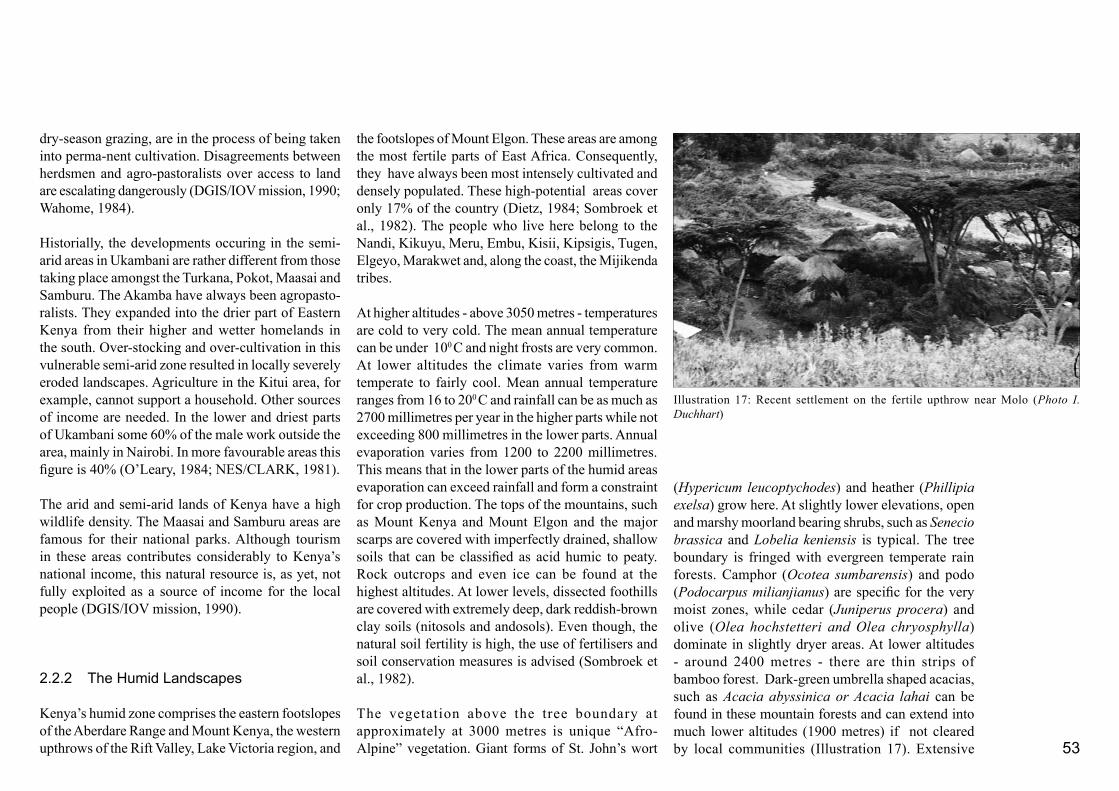
53
the footslopes of Mount Elgon. These areas are among the most fertile parts of East Africa. Consequently, they have always been most intensely cultivated and densely populated. These high-potential areas cover only 17% of the country (Dietz, 1984; Sombroek et al., 1982). The people who live here belong to the Nandi, Kikuyu, Meru, Embu, Kisii, Kipsigis, Tugen, Elgeyo, Marakwet and, along the coast, the Mijikenda tribes.
At higher altitudes - above 3050 metres - temperatures are cold to very cold. The mean annual temperature can be under 100 C and night frosts are very common. At lower altitudes the climate varies from warm temperate to fairly cool. Mean annual temperature ranges from 16 to 200 C and rainfall can be as much as 2700 millimetres per year in the higher parts while not exceeding 800 millimetres in the lower parts. Annual evaporation varies from 1200 to 2200 millimetres. This means that in the lower parts of the humid areas evaporation can exceed rainfall and form a constraint for crop production. The tops of the mountains, such as Mount Kenya and Mount Elgon and the major scarps are covered with imperfectly drained, shallow soils that can be classified as acid humic to peaty. Rock outcrops and even ice can be found at the highest altitudes. At lower levels, dissected foothills are covered with extremely deep, dark reddish-brown clay soils (nitosols and andosols). Even though, the natural soil fertility is high, the use of fertilisers and soil conservation measures is advised (Sombroek et al., 1982).
The vegetation above the tree boundary at approximately at 3000 metres is unique “Afro-Alpine” vegetation. Giant forms of St. John’s wort
(Hypericum leucoptychodes) and heather (Phillipia exelsa) grow here. At slightly lower elevations, open and marshy moorland bearing shrubs, such as Senecio brassica and Lobelia keniensis is typical. The tree boundary is fringed with evergreen temperate rain forests. Camphor (Ocotea sumbarensis) and podo (Podocarpus milianjianus) are specific for the very moist zones, while cedar (Juniperus procera) and olive (Olea hochstetteri and Olea chryosphylla) dominate in slightly dryer areas. At lower altitudes - around 2400 metres - there are thin strips of bamboo forest. Dark-green umbrella shaped acacias, such as Acacia abyssinica or Acacia lahai can be found in these mountain forests and can extend into much lower altitudes (1900 metres) if not cleared by local communities (Illustration 17). Extensive
dry-season grazing, are in the process of being taken into perma-nent cultivation. Disagreements between herdsmen and agro-pastoralists over access to land are escalating dangerously (DGIS/IOV mission, 1990; Wahome, 1984).
Historially, the developments occuring in the semi-arid areas in Ukambani are rather different from those taking place amongst the Turkana, Pokot, Maasai and Samburu. The Akamba have always been agropasto-ralists. They expanded into the drier part of Eastern Kenya from their higher and wetter homelands in the south. Over-stocking and over-cultivation in this vulnerable semi-arid zone resulted in locally severely eroded landscapes. Agriculture in the Kitui area, for example, cannot support a household. Other sources of income are needed. In the lower and driest parts of Ukambani some 60% of the male work outside the area, mainly in Nairobi. In more favourable areas this figure is 40% (O’Leary, 1984; NES/CLARK, 1981).
The arid and semi-arid lands of Kenya have a high wildlife density. The Maasai and Samburu areas are famous for their national parks. Although tourism in these areas contributes considerably to Kenya’s national income, this natural resource is, as yet, not fully exploited as a source of income for the local people (DGIS/IOV mission, 1990).
2.2.2 TheHumidLandscapes
Kenya’s humid zone comprises the eastern footslopes of the Aberdare Range and Mount Kenya, the western upthrows of the Rift Valley, Lake Victoria region, and
Illustration 17: Recent settlement on the fertile upthrow near Molo (Photo I. Duchhart)

54
grasslands can also be found at these lower altitudes containing species such as Kikuyu grass (Pennisetum clandestinum). Exotic tree species, such as conifers and eucalyptus have been planted.
Between 900 and 1800 metres at a lower and much dryer elevation the natural cover consists of a sub-climax vegetation of low broad-leaved deciduous trees with high-grasses that are kept from evolving further by regular fires. The dominant tree species is Combretum. The grass species belong to Hyparrhenia and Cymbopogon genera. On the coast, a narrow strip of humid sea-climate can be found. Here small patches of lowland rain forest like the Shimba Hills, lowland dry forest in Sokoke and in tidal estuaries, creeks and lagoons mangrove swamps proliferate. Coconut (Cocos nucifera) and doum palms (Hyphaene coriacea) are dominant tree species along the white beaches of the Indian Ocean (Ojany and Ogendo, 1987; Sombroek et al., 1982; Floor et al., 1980).
Among the crops grown at higher elevation are tea, pyrethrum, some wattle, wheat, and maize. There is also some dairying. Bananas, coffee, and tobacco are grown at slightly lower altitudes. In the zone of low-tree, high-grass vegetation sisal, sorghum, maize, groundnuts, cotton, and pineapple are cultivated and ranching is practised (Sombroek et al., 1982). Along the coastal strip a large variety of tree crops including coconut, mango, and cashew nut as well as sisal, maize, and sorghum are grown. Some rice cultivation can be found in the small-scale rolling landscapes of the ancient coral reefs.
However, even in these areas, with their comfortable climate and fertile soils, serious land degradation
Illustration 18: Kisii Uplands near Keroka (Photos I. Duchhart, Compilation J. van Aggelen)
Illustration 19: Aerial photograph of the Kisii Highland clearly showing the small strips that run perpendicular to contours. (Photo Survey of Kenya, 1976)

55
has become an acute problem. Population pressure has forced people to extend production to areas ecologically unsuitable for demanding agricultural activities. This coupled with unsuitable agricultural methods, sheer carelessness in matters of soil management, and overstocking has resulted in a decline of the quality of the land (Ojany and Ogendo, 1987). Other factors that have exacerbated problems in the region, including the introduction of tax, closed district boundaries, out-migration of male labour, and intensification of cash-crop production to a point where it triggered land degradation, are described in Part 2.1. To give a further insight in how these changes affected the socio-physical organisation of the humid areas, the landscapes found in Kisii District are described below.
The humid Kisii landscapeKisii land is located in western Kenya and inhabited by the Gusii (Kisii people). Some parts of the Kisii landscape are of stunning tropical beauty. Intensely cultivated fields are aligned with single or multiple hedges. Compounds are sheltered by shady banana trees and pink flowered Albizia trees. Farmers removed much of the indigenous moist-montane vegetation and replanted blue gums (Eucalyptus species), cypresses (Cupressusspecies), and black wattle (Acacia mearnsii) in its place (Barnes, 1984; Wielemaker and Boxem, 1982). This left the landscape looking green and forested.
In the eastern half of Kisii District lie the strongly dissected Keroka and Magombo uplands with flat- topped ridges and flat bottomlands. The western part of the district has a gently undulating landscape. In the vicinity of Kisii Town, the Keroka and Magombo
The Gusii, a small Bantu tribe, came around 1520 AD from Elgon, and settled on the eastern shores of Lake Victoria at the mouth of the Yala River. Their stay here lasted for only two generations. Although it is not absolutely clear why the Gusii left, Ochieng’ believes that there are two possible factors that militated against their continued stay. First the arrival of the Luo sections of Joka-Jok in the area posed a serious risk for their safety and second the region became overcrowded by various other Bantu groups. The Gusii group then migrated to Kisumu. From there, drought and famine forced the entire group to break up into small units, and those who became later the Gusii travelled to the Kano plains. Here, they settled along the lakeshore and spread into the interior along streams for a period of five to seven generations (presumably AD 1640 -1755). The settlement pattern consisted of dispersed family units in a vast parkland. Kano, in those days, was covered with thick bushes and tall grass. It is remembered that the area was rich in wild animals, such as bushbuck, wildebeest and hartebeest and fish was abundant. It is, therefore, not surprising that the Gusii found the Kano plains an ideal place for fishing, hunting and rearing large herds of cattle. They also grew finger millet. Fruits, especially berries were collected. This “Kano” period has been very important for the development of the Gusii so-ciety and clans and sub-clans were formed. Around 1750 AD Luo invaded the plains and most of the Gusii fled southwards. During the next generations, the Gusii people wandered at and around the current Kisii Highlands. They hoped to find safety in the protection of the heavily wooded hills. The cold and wet conditions of the highlands, however, were unsuitable for them and their crops and herds. Many people and livestock died. It was difficult to find suitable grazing areas for their remaining livestock. The Gusii, therefore, turned increasingly to agricul-ture, cultivating finger millet and root plants.
The next two generations were marked by war and cattle raid-ing with the Maasai and the Kipsigis, as a result they had to flee in all directions and their corporate society was destroyed. Some of the Gusii resettled close to the present-day Kisii town, others were absorbed by the Kipsigis or took refuge on Luo
land. For protection by the Luos they had to pay in a form of servitude. A period of relative peace from about 1850 up to 1900 AD followed. Various Gusii groups slowly occupied the southern highlands. Ridge by ridge, the forest was opened up and cultivated by closely related people. The valley bottoms were considered as unsafe and unsuitable for cultivation. They lived in homesteads protected by stone fortifications. Although, for security reasons, clans and sub-clans looked to each other for support, internal fights over land issues meant that smaller and weaker groups had to move continuously. Despite of all the warfare, the Luo and the Kisii traded constantly. It was predominantly run by women and children. Especially during periods of severe drought the Luo depended heavily on the Gusii for food, i.e. finger millet. The Gusii, who in the process of settlement had lost most of their cattle, now depended on the Luo for their livestock. Iron works, soapstone, cattle salt, pots and drums were other commodities exchanged between (Ochieng’, 1986b). This form of co-existence between the Luo and Gusii still exists today.
Box2:ThewanderingsoftheGusii

56
uplands are bounded by prominent scarps (Epp et al., 1983; Wielemaker and Boxem, 1982).
The natural relief has been a determinant factor in the formation of the landscape. Peat and planosols have developed on the valley floors and deep and fertile nitosols and luvisols have formed on the slopes. It has also been responsible for shallow lithosols found on the hill tops and for high groundwater tables in the valley bottoms with springs and seepage zones along the base of the slopes. The Gusii have made good use of the features that typify the Kisii land. The average farm household practises mixed, predominantly smallholder agriculture. In Keroka and Magombo in
particular land is cultivated from the top of the ridge down to the valley. In this way full use is made of the various ecological potentials. Hedges are used to separate the relatively narrow fields (Illustrations 18 and 19). Trees protect the tops and sometimes the valley bottoms.
As colonial rule became established, warfare ceased, and public health improved, the Gusii population began to grow with more than 3% per year (Barnes, 1984). Average fertility rose from 6.8 to 8.1 births for each female of reproductive age and infant mortality declined sharply. The result was a rapid increase of in the proportion of children and young people in the region. In the 1980s some 60% of the population could be considered dependent on the working population. In 1986, the Gusii population numbered approximately 1.2 million people with an estimated 60,000 resident in Kisii town. By 1990, the population density had reached 400 to 700 people per square kilometre. This made the Kisii Highlands one of the most densely populated areas of the country.
The Gusii have a patrilineal system of inheritance. Each son inherits a piece of land that preferably runs from the top to the bottom of a ridge. This inheritance system has resulted in an alarming fragmention of land holdings (Wielemaker and Boxem, 1982). There are fields, for example, that are little more than one meter wide. In 1982, there were 108,000 smallholdings of between 1.4 to 2.2 hectares and the average field size in the district was 0.18 hectare. In practical terms this meant that each rural dweller had not more than 0.26 hectare on which to make a living (Jaetzold and Schmidt, 1982). In the tea zones this was sufficient to do fairly well, but in the wheat/maize/pyrethrum
zone such acreages were insufficient to support basic subsistence (Jaetzold and Schmidt, 1982).
The dominant land use is maize often intercropped with beans which occupies 38% of the land. Thirty three percent of the land in the district is grazing and fallow land. Hedges account for 8%, and woodlands (8%), roads, tracks and footpaths (3%) and tea (3%) make up the remainder. Woodlands and road reserves are often used as grazing thus extending the land area used as pasture or grazing. A little land is also used for coffee, sugar cane, pyrethrum, bananas (growing in importance), sweet potatoes, finger millet, cab-bage, cassava, napier grass, and tobacco production as well as for buildings and schools. Water bodies and marshes can be distinguised too. Tea, coffee, pyrethrum and sugar cane are the major cash crops (Epp et al., 1983).
Growing population pressure has meant that every centimetre of land is used. Eighty five percent of the total amount of available land is intensely cultivated (Orvis, 1985; DGIS/IOV mission, 1990). In 1985, already 70% of the marginal valley-bottom land had already been brought under cultivation and much of the hill tops were reclaimed. The reclamation of the valley-bottoms gave short-term profits but left ex-hausted and deeply eroded soils (Floor and Muyesu, 1985). Illustration 20 shows such an eroded valley-bottom. The cultivation of the wood lots on hill tops and ridges reduced wood biomass production and led to wood fuel shortages even in this tree-rich district (Barnes, 1984). In some areas firewood shortage has become so acute that the local population have started to use crop residues and cow dung as cooking fuel thus depriving the agricultural system of valuable
Illustration 20: Irreversable gully erosion of a reclaimed peaty valley bottoms in Kisii (Photo I. Duchhart)

57
minerals and organic materials (Wielemaker and Boxem, 1982).
The male household head owns the land and decides how the land is farmed. His wife or wives are allocated a portion of land to grow food for their children and the husband. The husband may have a separated field in which he cultivates cash crops. Traditionally, each piece of land was used for two and a half years and then left fallow while new fields were cleared. Women are responsible for most of the other household activities including collecting water and firewood, cooking, and taking care of the children. Previously the children helped with the work but today they go to school leaving the women to carry out most of the work alone. Because agricultural tasks are culturally determined and cannot be evenly spread over the household members, an increase in the production of food crops will depend on women. Improved husbandry practices generally require higher inputs of labour and often a substantial capital investment. The Agricultural Development Programme for Kisii District states clearly that this additional female labour is not available (Fowler and Duchhart, 1986). Neither do women have access to capital because they cannot own land or other major assets like livestock and trees which can be sold or used as a security. Thus, while in general women are responsible for food crop production, they are rarely in a position to improve land husbandry practices because of labour shortage, lack of access to cash, and limited say in farm management. To overcome some of these restrictions women meet to work together. Traditionally, in Kisii the egesangio groups of 3 to 8 women would work every day in rotation on each other’s fields. Today, these women groups are much larger - in Kisii District
there can be as many as 250 in one group - and agricultural work is no longer the only reason why they come together. Bahemuka (1985) reported that these groups enable women to gain access to credit and other types of assistance.
Formerly, men used the income they earned by cultivating cash crops to obtain cattle. Cattle were valued as a dowry, for their milk and meat products and for their longer-term exchange value. The Kisii obtained cattle by trading with the neighbouring Luo and Maasai. Young men would herd cattle communally and live in a joint cattle village. Between 1920 and 1940 the communally owned bush land and the cattle villages became settled and claimed by individuals. Although there was an increasing amount of individual tenure, the land itself continued to be inalienable from the clan residing on it. This changed in the late 1960s and early 1970s with the switch to freehold tenure (Orvis, 1985). By 1982, all land had been registered (Wielemaker and Boxem, 1982). The valley bottoms were registered under the County Council. In reality owning the land on the hill slopes implied user rights of the adjoining valley bottoms. To realise these rights many of the up-slope owners cultivated “their” valley bottoms and so triggered off the erosion processes referred to earlier. Land division and population growth in Kisii resulted in the fragmentation of farm land and forced many farming household to intensify their land use. A much smaller parcel of land now had to provide a living for a rural household of six to eight people. Over a period of 15 years, the average amount of land per person decreased by 30%. A second season of maize produc-tion and the use of higher yielding hybrids had to help
raise the overall production. However, fertilisers to sustain this higher production level were seldom used and as a result there has been a decrease in soil fertility (Wielemaker and Boxem, 1982; Fowler and Duchhart, 1986). Presently, there is a growing awareness of the importance of composting although most of the house-holds only allow land to lie fallow when they see the soil is almost exhausted. The drastic shortening of this rotation system has resulted in a decline in the input of organic matter, a deterioration in soil structure, and a decrease of microbiological life. With the communal grazing land settled, woodlots cleared, valley bottoms reclaimed, and fallow periods almost eliminated, the land available for grazing also decreased. However, although herds have decreased in size, some 75% of the smallholders still keep between one and six cows. Often there are insufficient grazings available and as a result there is evidence of local overgrazing especially on the hill tops (Jaetzhold and Schmidt, 1982). There are some farmers who have invested in graded cows and zero-grazing and there are also those who send out their cattle to graze outside Kisii District in Nyanza, for example. Most Kisii farmers who included zero-grazing in their farming system are doing extremely well. Some other farmers have turned to cash crops like coffee, tea, and pyrethrum. Although they manure the soil and use some fertilizers, these crops exert a significant claim on soil fertility. It is interesting to mention that the fragmentation of the land led to an increase in the number of trees planted on farm lands. Each farming family, although having access to only a smaller parcel of land, still needs the same amount of tree products for building materials and firewood. A temporal comparison of aerial photographs taken of the Kisii area between 1957 and 1976, therefore, shows an increase in tree cover.

58
The fertile highlands of the humid zone often function as important water resources. The soils of the Kisii Highlands are deep and permeable and have an enormous capacity to retain rainwater. The Kisii Valley Bottom Project measured a runoff of only 3%, indicating that 97% was being absorbed. The soils of the valley floors are mainly composed of peat and clay and can contain approximately 700% water (Republic of Kenya, 1985). This means that the Keroka and Kisii uplands act like a sponge. The rainwater collected is slowly released and carried to the surrounding plains by the main rivers - Gucha and Awach Tende - before finally draining in Lake Victoria. Because the surrounding plains receive much less rainfall and their evaporation rates are much higher, the rain
rivers from Kisii are a crucial water source for the low-lying plains. The land degradation described earlier can be expected to have repercussions not only for the Kisii Highlands but also for the people living in the surrounding plains and the quality of the lake water as well. Spring water and water holes are used as sources of drinking water by many Kisii people. Contamination by latrines together with the steady degradation of the soil structure seriously threaten the quantity and quality of water available from these sources.
Kisii Highlands received the attention of many international donor organisations, including the Danish, Swedish, Dutch, Americans and EEC. A large
variety of development projects are being carried out in the area, including fertiliser, zero-grazing, soil conservation, agroforestry, horticulture, and credit projects (Smaling, 1988; Fowler and Duchhart, 1986; DGIS/IOV mission, 1990). These projects all aim at improving the farming systems in the area. The Kenyan government runs farmers training projects. The extension network of the Ministry of Agriculture is intense and impressive. In the towns, medical health centres and schools receive support from multilateral donor organisations, such as UNICEF. Municipalities are being given technical support and projects include the development of sewerage and sanitation infrastructures. Rural access road pro-grammes are opening up the area and improving
Illustration 22: Banana’s growing on one of the many parallel ridges of the heavily dissected landscape of Muranga (Photo I. Duchhart, retouch H. van Aggelen)
Illustration 21: The humid highlands form important water catchment areas (Photo I. Duchhart).

59
marketing opportunities. The liberalisation of pricing mechanisms for products, such as milk and coffee have further stimulated agricultural production and helped to generate employment.
The humid landscapes elsewhereSimilar patterns such as fully occupied land, land fragmentation, and continued intensification can also be found in the other humid areas of Kenya, included Kakamega, Taita Hills, Muranga (Illustrations 21 and 22), and Kericho (Epp and Durand, 1984). Areas less suitable for demanding agriculture, such as hill tops and steep slopes are being cultivated and forests encroachment is common. Not only does this lead to serious land degradation, it also reduces the amount of wood fuel available (Muchoki, 1990; Mwenda, 1985). In Kisii the economy is based on smallholder agriculture, in other humid regions large-scale estate agriculture, like the tea estates in Kericho, also plays a role (Peden et al., 1984). In Kericho and in areas were smallholders have taken up cash-crop farming, the use of chemical fertilisers is on the rise. Ammonium-based fertilisers in particular have been shown to have adverse effect. On dry soils ammonia gas, which is toxic to seedlings, is released and on wet soils there is an ammonium-based increase in soil acidity (Juma and Munro, 1989).
In addition to the land-use issues hampering the growth of the agricultural economy discussed in the Kisii example, weak marketing positions and infrastructure can also be serious constraints. In Nyandarua District at the foot of the Aberdare Range, for example, dairy farming suffered from impassable roads. Milk remained uncollected for days, particularly in the wet seasons (Muchoki, 1985a). Although, the last decades
show a distinct improvement, the poor management of co-operatives and fluctuating prices frustrate agri-cultural initiative (Ojany and Ogendo, 1987; Ottichilo, 1985). In this thesis, little attention has been paid to cattle and crop diseases, but these too hampered the agricultural development of the country. Diseases such as east-coast fever and sleeping sickness have had dramatic effects for livestock farmers (Mwenda, 1985; Ottichilo, 1985).
An important issue in all parts of the humid zone is the growing interest in the production of cash crops. In Muranga the farmers even tend to give cash crop production priority above the production of food crops (Muchoki, 1985b; Ochanda, 1987). In societies where the responsibility for cash and food production are gender determined this can have particularly far reaching consequences. In situations where women are responsible for the production and preparation of food and the men for cash income, and where men rule the farm management, women and children become dependent on the men’s income to buy food (Agatsiva, 1984; Smith, 1977). However, many men do not give the purchase of food high priority.
The farming families of the humid zones react to population increase and land shortage, as we have seen, by intensifying land use. They also migrate to other parts of the country and to the capital Nairobi in search of paid employment. Most of these migrants are men (Republic of Kenya, 1984). This often means that the decision-making head no longer lives permanently in the compound, a fact that influences the overall manage-ment of the farming households. Furthermore, it deprives the farm household of male labour and as a result less attention is given to heavier
jobs like building and maintenance of terraces and opening up of grazings for shifting cultivation.
2.2.4 Conclusions
Part 2.1 has shown that two basic principles of social organisation, modern western and abraded indigenous, are the driving forces behind Kenya’s landscape deve-lopment.
The abraded indigenous principles of social organi-sation, particular with regards to the cultural sub-system still strongly influence the way land is used. However, at the tribal level, the indigenous political sub-system or governing structures that regulate land use are being eroded. As a result, the family unit has become the crucial decision making and acting unit. In their decision making, traditional issues, such as, spreading risks through resource diversification, self sustenance, and optimizating the use of resources remained important. At the same time, modern is-sues, such as schooling and the desire to earn a cash income also play a role. Nevertheless, the examples given in Part 2.2 illustrate that in many cases the historically evolved socio-physical organisations still parallel nature’s hierarchical organisation. The spatial distribution of land used by the family by and large follows the spatial distribution of the natural conditions. A group of families still held together by the weakened traditions of their sub-clan, therefore, remained closely linked to a specific landscape. As a result of these specific interactions with the physical environment, the following nested hierarchies can be distinguished;
60
- At the lowest level the farming household or extend-ed family is closely linked to a variety of ecosystems, - At the middle level the sub-clan or clan is inter-twined with local landscapes in particular through the cultural sub-system, and - At the highest level the tribe is related to regional landscapes also predominantly through the cultural subsystem.
Where these nested hierarchies remain driven by the same forces, resilient landscapes with a strong identity, such as the Kisii landscape, could develop. However, because the two dominant principles of social organisation in Kenya are driven by different norms and values, i.e. profit making/self-interest/maximising of resources versus sustenance/group interest/optimising of resources, the two principles often conflict. The landscape study presented here shows that the conflicts manifest themselves at all scales and in all sub-systems of socio-physical organisation. Below a summary is given of the main points of conflict per scale level.
Farm household or extended family - ecosystem levelThe introduction of the modern western cash economy aggravated competition between cash crop production and other uses of land. Food and firewood production were marginalised. Another consequence of land competition within the family is that bush, scrub, and fallow-land ecosystems are disappearing. These ecosystems form the basic source of critical materials such as firewood, medical herbs, and wild vegetables. Women and girls are responsible for food production and for water and firewood collection. Because of the loss of the ecosystems pro-viding these resources, life
is becoming increasingly difficult for them. Schooling also influences labour distribution on the farm. In other areas, where land is unsuitable for cash-crop production, large numbers of men move to towns to look for work. This leaves the farm household without much needed male labour. As a result heavier work such as the building terraces tends to be neglected. Some of the consequences of the conflicting forces between the two organisation principles are;- Depletion of soil nutrients,- Increased soil erosion,- Shortage of food production for women and children, - Shortages of wood fuel,- Loss of indigenous vegetables and medical herbs,- Increased pressure on women,- Labour shortage, - Reduced variety in ecosystems, and- Land shortage.
Subclan or clan - local landscape levelThe internal competition between sustenance and cash production within the family is also reflected at the level of the local landscapes. Landscape units that were previously under forest are now cultivated, steep slopes overgrazed, and valleys drained. Natural land-protecting mechanism are negatively affected. The hydrological cycles in particular are disturbed and as a result springs are drying up and the flow of water is becoming increasingly irregular. Although the family lineage bonds are still very strong, at group or community level the indigenous land-regulating systems - particularly those related to common lands- are weakening. This has lead among other things to overgrazing and erosion. The consequences of the frictions between the two principles include;
- Loss of resource-protecting ecosystems, - Loss of common resources, like water, and - Loss of social network for the poor, resulting in destitutes and a landless class.
Tribe - regional landscapesBecause of a common way of doing things and the specificity of nature’s geographical features, each regional landscape still has its own defining characteristics. However, the domination of the free enterprise economy has, in some cases, tended to over-ride the powers of the councils of elders and the seers. This has resulted, for example, in large tracks of land that were formerly communally owned being privatised by an emerging bourgeoisie. This is particular evident in the semi-arid areas. For pastoralists, this has created a life-threatening situation because it means the loss of their dry season grazings. During dry periods the existence of the whole tribe is at risk. The disturbances caused by the friction between the modified western and the abraded indigenous principles of sociophysical organisation have reached the level where the modified western principles are destroying the indige-nous organisation principles and sub-systems. These changes have resulted in; - Loss of socio-cultural knowledge systems,- Loss of ecological knowledge systems,- Loss of economic resource,- Erosion and degradation of land,- Loss of land-use regulating systems,- Loss of bio-diversity,- Loss of nomadic mobility, and- Loss of regional identity.
61
Kenya as a countryAt a national level the state’s principles of modified western social organisation do not complement nature’s logic. The state machine is driven more by economic and political motives than physical motives. A well-balanced national sociophysical organisation that incorporates the spreading of risk and protective land-use regulating systems that operate effectively, appears to be lacking. The national government has not stepped in to fill the regulatory vacuum left by the dwindling regulating powers of the indigenous elder structure. The result is that the overall pressure on the environment has increased and that pastoralism has become less drought-resilient. Even though, in some areas commerce and large scale, high investment modern agriculture have developed, there is little evidence that new forms of balanced land-use systems are emerging as the following shows.
The transition zone between the humid and the arid lands is under considerable stress. People transmigrate from the fertile, humid lands with their high population densities to the semi-arid and arid lands selecting the best parts of the dry and pastoral lands (Republic of Kenya, 1989d). Because of this in-migration Laikipia District and Meru District, both located in such a transition zone, have a high level of population growth - 7% per annum - (Peperkamp, 1986). Coming from the arid lands, the educated pastoralist youth settle in the same zone. They too claim the best parts of area for permanent cultivation. In periods of drought, the pastoralists reclaim their dry-season grazing reserves, which are also predominantly located in this transition zone (DGIS/IOV mission, 1990). In the long term this zone of semi-arid land will be divided up into relatively small pieces of land for high-risk
agriculture, leaving the land susceptible to serious land degradation. At the same time, the withdrawal of the dry-season grazings from the pastoralists’ land-use systems will threathen the effective use of the whole area of arid lands (Campbell, 1981; Juma and Munro, 1989). Desertification might very well be the result. Moreover, the hydrological cycle binds arid and humid lands into the same water catchments. Destruction of the highland ecosystems will vitally affect the water sources in the arid lowlands. The arid lands will be confronted with increasingly frequent seasonal floods that will not only destroy bridges and irrigation schemes but will leave water dams filled with sediments and rivers that dry up during dry spells. Both the protection of the vulnerable semi-arid tran-sition zone and the preservation of water catchment areas require pro-active, regulatory political deci-sion-making at a national level. If this responsibility is not taken up soon dramatic consequences can be expected:- Large-scale import of food crops,- Destruction of nomadic lifestyle, - Floods that destroy built structures and kill people and animals,- Land degradation and desertification of a large portion of the country,- Limited possibilities of wildlife migration, - Deforestation and loss of indigenous forests,- Water shortages,- Reduction of biological diversity, and- Violent conflicts over land and water.
In this connection, Part 2.3 will explore Kenya’s na-tional environmental legislation.
In general, it can be stated that the modern forms of social organisation in the arid areas still rest to some extent their heavily eroded, historic indigenous roots. Ways of incorporating modern husbandry in these practices to revitalise them and to increase their resilience have yet to be found. In the humid areas, although people were quick to incorporate modern, western influences, evidence of land degradation indicates that here too natural resources are being used in an unsustainable way. Furthermore, it seems that Kenya is wasting its hard-won, ecological knowledge systems. Purposeful management of Kenya’s national natural and sociocultural resources at all levels may turn out to be critical for the development of the country as a whole.

62
63
2.3
InstitutionalContext
Part 2.2 focused on the factors that determined the outer physical form of the Kenyan landscape. Part 2.3 explores more closely governmental organisation and environmental legislation in present-day Kenya. The case-study projects described in Part 3 were conducted within this formal institutional setting regardless of whether the project was carried out within a government institution or a non-governmental organisation. It should be noted, however, that landscape architecture or landscape planning as known in European countries and North America - and discussed in the introduction to this thesis - has no institutional parallel in Kenya1. Consequently, depending on the type of project, landscape architects themselves have to search for an institutional niche.
As explained in Part 2.1, the foundation of the institu-tional context was laid in the colonial days with slight modifications after Kenya’s independence. Specific environmental and land-use legislation were laid down in a whole range of acts, such as the Agricultural Act (1955), Water Act (1952), and Land Regulation Act. Comprehensive environmental and physical-planning legislation were not in place until 2001.
Several administrative bodies are charged with re-sponsibility for environmental management and they operate on different scale levels. At a national level, there are, among others, the Ministry of Environment and the Ministry of Lands and Settlement, while at district level authority lies with District Environment Committees and District Development Committees. Formal Local Authority Planning and Environment Committees - sometimes combined with a Public Health Committee - address environmental issues at a local level.
This section of the thesis was particularly difficult to write, as the results of the research itself, and in particular the Green Towns Project, influenced the institutional context, for example: the establishment of environmental units within the Ministry of Local Government and the Ministry of Lands and Settlement. At the same time, the Kenya Government continues working on far-reaching legal adjustments also at the constitutional level. When relevant, these adjustments are mentioned. The purpose of this Part 2.3 is to provide insight into Kenya’s administrative and political sub-system. It is not intended to be comprehensive.
2.3.1GovernmentalAdministrationandPolicies
The Republic of Kenya has a parliamentary form of democracy with one chamber, which is headed by a president. The parliament consists of the National Assembly and the executive President who has wide-ranging constitutional powers. The National Assembly
1
The Kenya Association of Architects established a Landscape Architecture Chapter around 1982, which at least formalised the title of Landscape Architect. The founding members were mainly composed of expatriates. At the University of Nairobi, architecture students can take a landscape design class, while at Jomo Kenyatta University for Agriculture and Technology a landscape approach is in the process of development.

64
is composed of 158 elected members, 12 nominated members by KANU (Kenya African National Union), the Speaker, and the Attorney General. The normal term of Parliament is five years.The introduction of the multiparty system in 1990s allowed for a coalition government in 2002 and also affected the nomination of KANU members. A new constitution is in process of being developed which will, among other things, have an effect on presidential powers.
Under the present system, the president appoints min-isters from among members of the National Assembly. The ministers, the president and the vice-president form the cabinet. The cabinet’s main function is to aid and advise the president in the government of Kenya and is collectively responsible to the National Assembly. Government departments including the Office of the President, Office of the Vice-President and Ministry of Home Affairs, Ministry of Planning and National Development, Ministry of Finance and line ministries such as Ministry of Agriculture and Ministry of Water Development implement policy decisions made by the parliament, the cabinet, or a minister (Gicheru and Kabuya, 1987).
ment policies. Some of the most important long-term policy papers are Sessional Paper No. 1 of 1986 on “Economic Management for Renewed Growth”, the KANU Manifestos, and the “District Focus for Rural Development Strategy” (Republic of Kenya, 1986a; 1989a).
With the Sessional Paper No. 1 of 1986, the govern-ment opened-up the market and shifted away from a heavy dependence on import substitution and protec-tion. At approximately the same time, a process of decentralisation was put in place with the institution of the “District Focus for Rural Development”. This gave more responsibility for the planning and implementa-tion of development on the district authorities.
In the mid-1980s, the government was trying to achieve an economic growth of 5.6% per year3. Agriculture would continue to be the engine of economic development and job creation. As productive land was scarce, agricultural growth would depend on existing crop and dairy land. The anticipated increase, thus, required a further intensification of farming practices through the use of fertilisers, mechanisation, improved varieties, and more extensive disease and pest control. The government set out to stimulate farmers to raise productivity by improving pricing, marketing and research, strenghtening extension services and agricultural co-operatives, and making access to credit easier. The government also aimed at further diversifying the farming systems in favour of coffee, tea, and horticulture products. By 2000, planners envisioned a 50% expansion in areas under tea and coffee. Six thousand hectares of forest edges were to be converted into tea plantations - the so-called Nyayo tea zones. Veterinary services, sanitary services,
The members of the National Assembly - as outlined in Part 2.1 - are linked to the general public through a system of patron-client hierarchical linkages (Bar-kan, 1984; Miller, 1984; Koigi wa Wawere, 1992). The administrative hierarchy extends from state to sub-location level. Some line ministries, such as the Ministry of Agriculture have staff working on various levels, including extension officers at the sub-loca-tional level. Others - like the Ministry for Lands and Settlement - operate from state to district level. This powerful administrative structure approves all action and without their consent, no work can be done.
Overall governmental policiesPolicy planning is centralised and formulated at a national level. Fundamental long-term policies are laid down in sessional papers while medium-term policies are addressed in national development plans. The sessional papers provide blueprints for subsequent development plans and guidelines for ministries. The Ministry of Planning and National Development - formerly Ministry of Planning and Finance2 - plays a co-ordinating role. The president and cabinet and the parliament have to formally approve develop-
3
Sessional Paper No. 1 of 1986 worked with a population growth assessment of 35 to 38 million Kenyans (at least 78% more than in 1984) in the year 2000. This means that Kenya will have a working force of at least 14 million people (6.5% more than in 1984). These future workers have already been born. The urban population will be 9 to 10 million people (25% of the total popula-tion) in 1984 the urban population was 3 million people (15% of the total population) (Republic of Kenya, 1986a). The census of 2000 gave an actual population of about 30 million people with about 10 million people living in urban areas.
2
Ministries and ministerial departments are regularly reshuffled usually after elections, but occasionally also in between elec-tions. The reshuffles often reflect in the name of the ministry or department, while senior officers are transferred.

65
reliable water supplies, and security in pastoral areas were also high on the lists of improvements. The marketing of dairy products would also receive special attention, while agricultural land was to be expanded through flood control, drainage and irrigation for the benefit of low-cost smallholder systems. Land would have to be optimally used otherwise the economic future of the country would be in jeopardy. In this way the government put a special social obligation on land-owners to use their land in the most intensive and productive way possible. At the same time, limits were set to the subdivision of small farms and plans were made for a major review of land policy in general. Finally, the government turned its attention to the need to integrate efforts to increase production with the improvement of export infrastructures and to stimulate the growth of rural service centres and small towns. The authors of the sessional paper note that guidelines to local authorities had to be developed in the planning of towns and cities to avoid damage to Kenya’s natural resources, especially land, water, and forests (This paved the path for the case-study projects presented in Part 3.5).
This strategy of economic growth based on agriculture and rural-urban balance required a complementary strategy for energy development and environmental protection. The sessional paper referred specifically to the protection of water catchments and prevention of soil erosion in the medium to high potential areas and in the arid and semi-arid lands to the development of strategies to increase the water carrying capacity and to prevent environmental deterioration (Republic of Kenya, 1986).
Through the “District Focus for Rural Development Strategy” greater authority was transferred to the districts (Republic of Kenya, 1983). From the top-down, the district became the platform from which the central government issued directives. From the bottom-up, the district formed the arena in which local people brought their issues and demands to attention of the district officers. Divisional Develop-ment Committees are responsible for assembling and prioritising project ideas initiated by the local people (Republic of Kenya, 1982; Makokha, 1985; Fowler, 1987), while the District Development Officer under the guidance of the District Commissioner prepares District Development Plans. These plans must be discussed and approved by the full District Develop-ment Committee. The Provincial Planning Officers are responsible to the Ministry of Planning and National Development. It is they who present these plans to the Minister of Planning and National Development. The economic planning of the urban areas comes under the responsibility of the Ministry of Local Government or the Ministry of Local Authorities as it is sometimes known. However, the Local Authority Development Plans developed by the Local Authority officials have to be endorsed by the District Development Com-mittee before they are forwarded to the Permanent Secretary of the Ministry of Local Government for approval and funding (Akivaga et al., 1985). American and German development aid organisations have been providing support to the Ministry of Local Govern-ment by training these officers in the preparation of these plans (see also Part 3.5 and Part 4.2).
District and central officers of the Ministry of Lands and Settlement assist the Local Authorities in the physical planning of urban centres by preparing, for
example, structure plans. The new physical-plan-ning act will give their advice and assistance a more legal and binding status, and at the same time make physical planners liable. This means that they can be prosecuted for mistakes.
Policies Related to Sustainable ManagementPolicies related to the sustainable management of Ken-ya’s environment date back to the early 1930s when the Colonial Government adopted the Dual Policy (see Part 2.1). Even though land was a critical issue in the fight for independence and the Kenyan Government usurped much of the old British administration, it took more than 20 years before the Kenyan govern-ment began to include environmental issues in their national policies.
The “Sixth National Development Plan” covered the period 1988 up to 1993 and is among the first national development plans that explicitly stress the need for sustainable development. In this plan, the government makes clear that development hinges on environmental care. The government planned to minimise the environmental diseconomies of deve-lopment through environmental impact assessments and resource surveys for all districts. The plan announced a comprehensive system to monitor and control environmental pollution and the initiation of a National Environment Enhancement and Management Act, which will provide for an arbitration tribunal to deal with environmental disputes (Republic of Kenya, 1984; 1989a; Juma and Munro, 1989). Parliament approved this act by the year 2000 and today there is an administrative system in place that reports and controls environmental pollution.
66
Amongst the environmental issues addressed in the “Sixth National Development Plan” were the problems of soil-nutrient depletion, land division into non-economic units, in-migration into vulnerable arid and semi-arid lands, pollution through fertilisers and pesticides, the ongoing deforestation that threatened water-catchments, and irrigation-related health hazards. With the establishment of the Permanent Presidential Commission on Soil and Water Conservation and Afforestation, water and soil conservation efforts received top priority. Voluntary community participation was to be promoted in the implementation of these activities by countrywide education and information programmes. The government further planned to give incentives to industrialists to develop environmentally sound technologies and penalties for polluting practices. In addition, the government introduced a strict zoning system for industries likely to damage the environment in order to reduce risks to human health and habitat. Measures to counter the exceedingly high rate of exploitation of forest and other vegetative resources
were also introduced. It was recognised that when forests lost their critical functions they were no longer able to prevent soil erosion, protect water catchments and wildlife habitats, and to ensure the conservation of valuable gene pools of fauna and flora. The government planned to continue promoting wildlife protection by suppressing poaching, carrying out more research on wildlife management, intervening in the translocation of endangered species, fencing of parks, and by educating the public on the importance of wildlife. The Wildlife Conservation and Management Act (Republic of Kenya, 1989a) was also to be updated. Although the overall policies outlined in the “Sixth National Development Plan” take environmental considerations into account and reflect a political will to protect and enhance the environment, in practice - as was illustrated in the previous chapter - problems still exist and continue to need attention.
2.3.2GovernmentalExecutivePowersandLegislation
The responsibility for environmental management is exercised on a ministerial and departmental basis. According to Juma and Munro (1989) in the DANIDA (Danish International Development Agency) report, 28 ministries play a role in environmental protection and natural resource management. Sixteen committees, 43 parastatals, 44 national institutions, 27 international institutions, 7 Kenyan and 13 international environ-mental non-governmental organisations, 80 general non-governmental, and 23 international organisations are active in environment or environment-related sectors. Furthermore, nine important bilateral donors
are operative. As a result, Kenya has an extensive institutional framework for environmental protection and management. However, even though there is a Ministry of Environment and Natural Resources, a common focus and concerted action seemed lacking before 2000 (Juma and Munro, 1989). The specific mandate of the Environmental Management and Co-ordination Act was to create instruments that would ensure such a common focus and enable co-ordina-tion. A variety of formal institutions on a national and district level were charged with implementating this act. An overall committee with representatives of the government, the public, and the academic community are responsible for ensuring the act is put into practice. An overview of the mandates and executive powers of most relevant ministries4 is given in Table 1 largely based on the results of the DGIS/IOV mission, 1990 and other relevant literature. Within the context of the Green Towns Project (see Part 4), the Ministry of Lands and Settlement created an inter-departemental Environmental Monitoring Unit. This unit prepared a policy paper that provided guidelines to encourage a participatory approach to ensure that the natural environment was included in physical plans.
Kenya’s indigenous people had a variety of customary laws that protect the use of environmental resources. Since 1882, Kenya knows formal laws regulating various aspects of the use and management of the environment. These include the Indian Transfer of Property Act (ITPA) promulgated to govern land ownership in the White Highlands (Wanjala, 1990). In 1989, Juma and Munro stated that 50 separate acts that dealt directly with environmental protection and natural resource management and a further 20 that did so indirectly. The Environmental Management
4
The ministries were selected because they either play a direct role in the management of the environment or because of the impact of their activities on the environment. The list is not exhaustive. The Environmental Profile of Kenya, published by Danida gives a much more extensive list. The data were collected in 1990 through interviewing key representatives. In some cases, only written information was used. Any comments made by representatives were made in a personal capacity and do not necessarily represent the views of the organization. A DGIS/IOV mission, co-ordinated by J. de la Rive Box, carried out the study. The fieldwork mission members were Dr. Mutiso, Dr. Njoka, Mr. de la Rive Box, and Ir. I. Duchhart. Mrs. Wanaina prepared the questionnaires.

67
and Co-ordination Bill of 1999 (enacted in 2000) superseded all these separate acts. Table 2 provides an overview of environmentally relevant legislation (Juma and Munro, 1989; Republic of Kenya, 1989b; 1981; Laws of Kenya, 1972; 1986; Butegwa, 1987; Caponera, 1979; Okoth-Ogendo, 1991; Ojwang, 1992). Although it is not complete, it does provide a basis for describing the modern planning context from a legal perspective. Most enactments were passed during the colonial era. If the objectives of the colonial principles of social organisation are considered, it is obvious that the legislation - in particular that relating to land, land use, and land ownership - was designed to develop the colonial and settler economy (Wanjala, 1990; Okoth-Ogendo 1991). The new Environmental Management and Co-ordination Act and Physical Planning Act introduced powerful tools to represent the rights of all Kenyan people equally.
2 .3 .3 Harambee and Maende leo ya Wanawake
Traditionally, people organised themselves in self-help groups, consisting of men and women, to provide emergency assistance or to meet special needs, such as building of houses or clearing new fields. In order to meet the more recent needs, some of these groups have been revived. Groups may have 25-35 members. In some cases, such as, in Katheka sub-location of Machakos District these groups turned to environmental protection. The Katheka groups, for example, constructed over 20 kilometres of bench terraces and almost 100 check dams (Thomas-Slayter, 1991). In the adjoining Mbuni sub-location
womens groups were active in tree planting and soil conservation. Im-mediately after Kenya gained independence, President Kenyatta used this commonly held idea of self-help to initiate the Harambee (pull together) movement. The people would contribute money and/or labour and together they would build a school, for example. In return, the government would ensure the school had teachers. The schemes flourished for many years because of a strong social and political control (Miller, 1984; Holmquist, 1984). Recently, mistrust has crept into the system and people seem to be more reluctant to participate. Harambee is also organised to cover individual costs, for hospitalisation, weddings, and funerals.
Another, more formal form of involving the country’s women in development is the nation-wide Maendeleo ya Wanawake. Linked to KANU, it was founded in 1950 with the aim of improving the status of women socially, economically, and politically; fighting illiteracy and ignorance, poverty and unemployment, malnutrition and ill-health; ensuring government support to women’s groups and to help encourage the Harambee self-help spirit (Moi, 1986). All groups must be registered with the Ministry of Culture and Social Services.
2.3.4Conclusions
Logically, formal planning, such as physical planning, proceeds from the national level and is, therefore, active within the national, modified modern social organisation. Although the district focus strategy emphasises de-centralisation of planning activities,
decision making is still basically done within the centralistic framework of the principles of modified modern social organisation. More recently, however, participatory approaches are gaining acceptance in the central government planning policies (see also Part 4).
In a sense, Kenya follows a form of strategic planning through a series of policy papers. Lower planning lev-els, from ministerial to local authority, must fit within these policy papers. At the same time, the physical planning methods used are predominantly based on the British “growth” control methods, involving rules and regulations and founded in zoning principles. Al-though some changes have taken place, much of the criticism levelled at the earliest planning methods in the western world still apply to Kenyan planning.
Part 2.3 shows that Kenyan policy papers and legislation pay considerable attention to environmental issues. In practice, the implementation of these policies still has a long way to go. The enumeration of environment-related legislation illustrates that by and large the existing legal system should be sufficient to protect Kenya from environmental deterioration. In reality, environmental degradation is rife. In spite of the national policy to provide environmental impact assessments for major development projects, it was in the late 1980s still possible to build the Turkwel dam that subsequently had far-reaching consequences for the Turkana life-support system. Here, the political sub-systems failed on a national as well as on a regional level. Unfortunately, it has to be noted that a big gap exists between the intentions of the government and day-to-day reality.
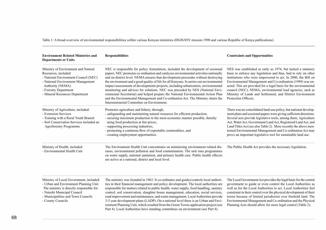
68
Table 1: A broad overview of environmental responsibilities within various Kenyan ministries (DGIS/IOV mission 1990 and various Republic of Kenya publications)
Environment Related Ministries and Departments or Units
Responsibilities Constraints and Opportunities
Ministry of Environment and Natural Resources, included:- National Environment Council (NEC)- National Environment Management Authority (NEMA)- Forestry Department- Mineral Resources Department
Ministry of Agriculture, included:- Extension Services- Training with a Rural Youth Branch- Soil Conservation Services included an Agroforestry Programme
Ministry of Health, included:- Environmental Health Unit
Ministry of Local Government, included:- Urban and Environment Planning Unit The ministry is directly responsible for: - Nairobi Municipal Council- Municipalities and Town Councils- County Councils
NEC is responsible for policy formulation, included the development of sessional papers. NEC promotes co-ordination and catalyses environmental activities nationally and on district level. NEMA ensures that development proceedes without destroying the environment and a good quality of life for all Kenyans. It carries out environmental impact assessments of developments projects, including urbanization, environmental monitoring and advices for solutions. NEC was preceded by NES (National Envi-ronmental Secretariat) and helped prepare the National Environmental Action Plan and the Environmental Management and Co-ordination Act. The Ministry chairs the Interministerial Committee on Environment.
Promotes agriculture and fishery, through;- safeguarding and maintaining natural resources for efficient production,- securing maximum production in the most economic manner possible, thereby using food production at fair prices,- supporting processing industries,- promoting a continous flow of exportable commodities, and- creating employment opportunities.
The Environment Health Unit concentrates on minimizing environment related dis-eases, environmental pollution and food contamination. The unit runs programmes on water supply, national sanitation, and primary health care. Public health officers are active at a national, district and local level.
The ministry was founded in 1963. It co-ordinates and guides/controls local authori-ties in their financial management and policy development. The local authorities are responsible for matters related to public health, water supply, food handling, sanitary control, soil conservation, slaughter house management, education, social services, road improvement and maintenance, and waste management. Local Authorities provide 3-5 year development plans (LADP). On a national level there is an Urban and Envi-ronment Planning Unit, which resulted from the Green Towns application project (see Part 4). Local Authorities have standing committees on environment (see Part 4).
NES was established as early as 1974, but lacked a statutory basis to enforce any legislation and thus, had to rely on other institutions who were empowered to act. In 2000, the Bill on Environmental Management and Co-ordination (1999) was en-acted. This act provided for a legal basis for the environmental council (NEC), NEMA, environmental lead agencies, such as Ministry of Lands and Settlement, and District Environment Protection Officers.
There was no consolidated land-use policy, but national develop-ment plans and sessional papers were giving sufficient directions. Several acts provide legislative tools, among them, Agriculture Act, Water Act, Government Land Act, Registered Land Act, and Land Titles Act (see also Table 2). More recently the above men-tioned Environmental Management and Co-ordination Act may prove an important legislative tool for sustainable land use.
The Public Health Act provides the necessary legislation.
The Local Government Act provides the legal basis for the central government to guide or even control the Local Authorities as well as for the Local Authorities to act. Local Authorities feel constraint in their control over the physical development of their towns because of limited jurisdiction over freehold land. The Environmental Management and Co-ordination and the Physical Planning Acts should allow for more legal control (Table 2).
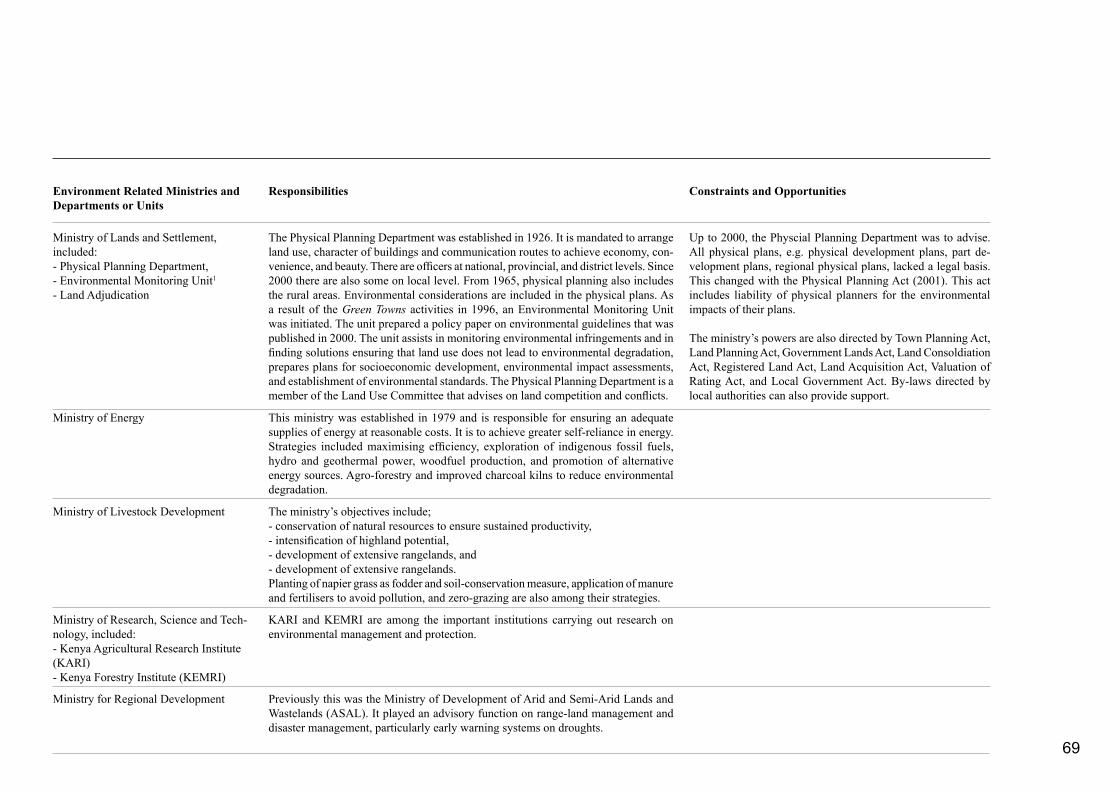
69
Environment Related Ministries and Departments or Units
Responsibilities Constraints and Opportunities
The Physical Planning Department was established in 1926. It is mandated to arrange land use, character of buildings and communication routes to achieve economy, con-venience, and beauty. There are officers at national, provincial, and district levels. Since 2000 there are also some on local level. From 1965, physical planning also includes the rural areas. Environmental considerations are included in the physical plans. As a result of the Green Towns activities in 1996, an Environmental Monitoring Unit was initiated. The unit prepared a policy paper on environmental guidelines that was published in 2000. The unit assists in monitoring environmental infringements and in finding solutions ensuring that land use does not lead to environmental degradation, prepares plans for socioeconomic development, environmental impact assessments, and establishment of environmental standards. The Physical Planning Department is a member of the Land Use Committee that advises on land competition and conflicts.
Ministry of Lands and Settlement, included:- Physical Planning Department, - Environmental Monitoring Unit1
- Land Adjudication
Up to 2000, the Physcial Planning Department was to advise. All physical plans, e.g. physical development plans, part de-velopment plans, regional physical plans, lacked a legal basis. This changed with the Physical Planning Act (2001). This act includes liability of physical planners for the environmental impacts of their plans.
The ministry’s powers are also directed by Town Planning Act, Land Planning Act, Government Lands Act, Land Consoldiation Act, Registered Land Act, Land Acquisition Act, Valuation of Rating Act, and Local Government Act. By-laws directed by local authorities can also provide support.
Ministry of Energy
Ministry of Livestock Development
Ministry of Research, Science and Tech-nology, included:- Kenya Agricultural Research Institute (KARI)- Kenya Forestry Institute (KEMRI)
Ministry for Regional Development Previously this was the Ministry of Development of Arid and Semi-Arid Lands and Wastelands (ASAL). It played an advisory function on range-land management and disaster management, particularly early warning systems on droughts.
This ministry was established in 1979 and is responsible for ensuring an adequate supplies of energy at reasonable costs. It is to achieve greater self-reliance in energy. Strategies included maximising efficiency, exploration of indigenous fossil fuels, hydro and geothermal power, woodfuel production, and promotion of alternative energy sources. Agro-forestry and improved charcoal kilns to reduce environmental degradation.
KARI and KEMRI are among the important institutions carrying out research on environmental management and protection.
The ministry’s objectives include;- conservation of natural resources to ensure sustained productivity,- intensification of highland potential,- development of extensive rangelands, and- development of extensive rangelands.Planting of napier grass as fodder and soil-conservation measure, application of manure and fertilisers to avoid pollution, and zero-grazing are also among their strategies.
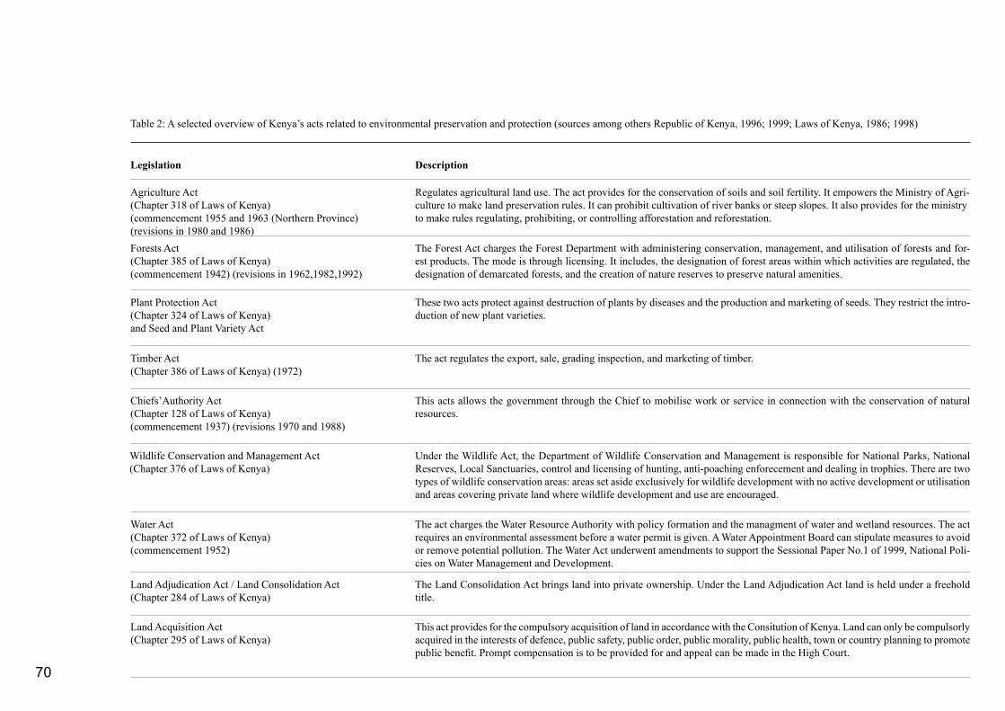
70
Table 2: A selected overview of Kenya’s acts related to environmental preservation and protection (sources among others Republic of Kenya, 1996; 1999; Laws of Kenya, 1986; 1998)
Legislation Description
Regulates agricultural land use. The act provides for the conservation of soils and soil fertility. It empowers the Ministry of Agri-culture to make land preservation rules. It can prohibit cultivation of river banks or steep slopes. It also provides for the ministry to make rules regulating, prohibiting, or controlling afforestation and reforestation.
Agriculture Act(Chapter 318 of Laws of Kenya)(commencement 1955 and 1963 (Northern Province) (revisions in 1980 and 1986)Forests Act(Chapter 385 of Laws of Kenya)(commencement 1942) (revisions in 1962,1982,1992)
The Forest Act charges the Forest Department with administering conservation, management, and utilisation of forests and for-est products. The mode is through licensing. It includes, the designation of forest areas within which activities are regulated, the designation of demarcated forests, and the creation of nature reserves to preserve natural amenities.
Plant Protection Act(Chapter 324 of Laws of Kenya)and Seed and Plant Variety Act
These two acts protect against destruction of plants by diseases and the production and marketing of seeds. They restrict the intro-duction of new plant varieties.
Timber Act(Chapter 386 of Laws of Kenya) (1972)
The act regulates the export, sale, grading inspection, and marketing of timber.
Chiefs’Authority Act(Chapter 128 of Laws of Kenya)(commencement 1937) (revisions 1970 and 1988)
This acts allows the government through the Chief to mobilise work or service in connection with the conservation of natural resources.
Wildlife Conservation and Management Act(Chapter 376 of Laws of Kenya)
Under the Wildlife Act, the Department of Wildlife Conservation and Management is responsible for National Parks, National Reserves, Local Sanctuaries, control and licensing of hunting, anti-poaching enforecement and dealing in trophies. There are two types of wildlife conservation areas: areas set aside exclusively for wildlife development with no active development or utilisation and areas covering private land where wildlife development and use are encouraged.
Water Act(Chapter 372 of Laws of Kenya)(commencement 1952)
The act charges the Water Resource Authority with policy formation and the managment of water and wetland resources. The act requires an environmental assessment before a water permit is given. A Water Appointment Board can stipulate measures to avoid or remove potential pollution. The Water Act underwent amendments to support the Sessional Paper No.1 of 1999, National Poli-cies on Water Management and Development.
Land Adjudication Act / Land Consolidation Act(Chapter 284 of Laws of Kenya)
The Land Consolidation Act brings land into private ownership. Under the Land Adjudication Act land is held under a freehold title.
Land Acquisition Act(Chapter 295 of Laws of Kenya)
This act provides for the compulsory acquisition of land in accordance with the Consitution of Kenya. Land can only be compulsorly acquired in the interests of defence, public safety, public order, public morality, public health, town or country planning to promote public benefit. Prompt compensation is to be provided for and appeal can be made in the High Court.

71
Legislation Description
Public Health Act(Chapter 242 of Laws of Kenya)(commencement 1921)
This act gives rules for primary environmental health care. It covers rules to prevent and control diseases. E.g. a person is not al-lowed to have open water or keep long grasses likely to harbour mosquitos on his or her premises. The act also provides for the making of by-laws by municipalities to regulate food processing.
Maritime Zones Act(Chapter 371)(1989, Laws of Kenya)
The act seeks to conserve and manage the natural resources in the maritime zone and brings approximately 60,000 km2 under the jurisdiction of Kenya.
Land Planning Act(Chapter 303 of Laws of Kenya)
The act includes various Development and Use of Land (Planning) Regulations. These regulations lay down the responsibility of planning for the development of an area. A local authority may be constituted as the Interim Planning Authority and then may prepare town plans or area plans, which have to be submitted to the minister for approval. The plans must show the existing development, proposed roads, density zones and the areas in which sub-division of land is permitted. It is an offence to carry out development without the consent of the relevant authority.
Physical Planning Act(Laws of Kenya) (tabled in 1996 and enacted in 1999)
Registered Land Act(Chapter 300 of Laws of Kenya) (revised in 1985, 1989)
Under this act all dealings with land, save for leases of less than one year, must be registered. The act of registration confers title on the proprietor which cannot be challenged. It governs land formerly held under customary law. The law is aimed at replacing customary law system of communal ownership of land with individual ownership.
Land Control Act(Chapter 302 of Laws of Kenya)
Charges the Land Control Board to decide whether to grant or refuse consent in a land transaction. Generally consent will be refused when a person is unikely to farm or develop the land well. Subdivision of plots below minimum areage is controlled by the Land Control Board.
Local Government Act(Chapter 265 of Laws of Kenya)(commencement 1963, in process of revision)
This act makes the City Commission, Municipal, Town, Urban and County Council responsible for the collection and disposal of waste.
Environmental Management and Co-ordination Act(tabled in 1999 and enacted in 2000)
This act is to provide for the establishment of an appropriate legal and institutional framework (NEC and NEMA) for the manage-ment of the environment. The act is based among other things on the principle that “every person in Kenya is entitled to a clean and healthy environment and has the duty to safeguard and enhance the environment”. NEMA is to help the minister to prepare an Annual Report on the State of the Environment in Kenya for the National Assemblee. The objective of the act is to harmonize various sector-specific legislations touching on environment in a manner designed to ensure greater protection of the environment, both physical and social in line with the sustainable development goals enunciated in Agenda 21 of the Earth Summit held at Rio De Janeiro in 1992. The ultimate object is to provide a framework for integrating environmental considerations into the country’s overall economic and social development.

72
REFERENCES Abrams, P.D. 1979. Kenya’s Land Re-settlement Story, How 66,000 African Families were Settled on 1325 Large Scale European Owned Farms, Challenge Publishers and Distributors, Nairobi, 76 p. plus appendices
Agatsiva, Jaspat L. 1984. Land Use in Bungoma District, Technical Report No. 100, Kenya Rangeland Ecological Monitoring Unit, Nairobi, 43 p.
Akivaga, S.K., W. Kulundu-Bitonye and M.W. Opi. 1985. Local Authorities in Kenya, Heinemann Educational Books, Nairobi, 89 p.
Alila, Patrick O. 1977. Kenyan agricultural policy: the colonial roots of African smallholder agriculture policy and services, IDS Working Paper 327, 48 p.
Amin, Mohamed, Duncan Willets, and Alastair Matheson. 1986. Railway Across Equator, the Story of the East African Line, Dodley Head, London, 191 p.
Bahemuka, J.M. 1985. Social-antropological Survey of Small Scale Farming in Western Kenya, On-farm Grain Storage Project, Development Planning and Research Associates, Inc.
Barkan, Joel D. 1984. Politics and Public Policy in Kenya and Tanzania, Revised Edition, Heinemann Kenya, Nairobi, 375 p.
Barnes, C. 1984. The historial context of the fuelwood situation in Kisii District, in Barnes, C., Ensminger, J. and O’Keefe, Ph. (Ed.), Wood, Energy and Households, Perspectives on Rural Kenya, The Beijer Institute, Stockholm and The Scandinavian Institute of African Studies, Uppsala, pp. 61-78
Bosworth D.A., and A.B. Foster. 1982. Approved Practices in Soil Conservation, Soil Conservation Service U.S. Department of Agriculture, The Interstat Printers & Publishers, Danville, Illinois, 478 p.
Butegwa, Florence. 1987. Malaria Control and the Law in Kenya, University of Nairobi (Master thesis in Law, Unpub-lished), 183 p.
Campbell, David J. 1981. Land-use competition at the margins of the rangelands: an issue in development strategies for semi-arid areas In G. Norcliff and T. Pinfold (Ed), Planning African Development, Westview Press Colorado, pp. 39-61
Campbell, David, J. 1984. Response to drought among farmers and herders in southern Kajiado district, Kenya, Humman Ecol-ogy, Vol. 12, No. 1, pp. 35-62
Campbell David, J. 1986. The prospect for desertification in Kajiado district, Kenya, The Geography Journal, Vol. 152, No. 1, pp. 44-55
Cappon, J.C. 1985. District Atlas Elgeyo Marakwet, Arid and Semi-arid Lands Development Programme, Ministry of Planning and National Development, Iten, Kenya, p. 93
Caponera, Dante A. (Ed). 1979. Water Law in Selected African Countries, FAO, Rome, 267 p.
Cohen, D.W. and Atieno E.S. Odhiambo. 1989. Siaya, The Historical Anthropology of an African Landscape, Heinemann Kenya, Nairobi, 152 p.
Cone, Winston L. and J.F. Lipscomb. 1972. The History of Kenya Agriculture, University Press of Africa, Nairobi, 160 p.
Dietz, Ton. 1987. Pastoralists in Dire Straits, Survival strategies and external interventions in a semi-arid region at the Kenya/Uganda border: West Pokot, 1900-1986, Koninklijk Nederlands Aardrijkskundig Genootschap, Instituut for Sociale Geografie, Universiteit van Amsterdam, Amsterdam, 324 p.
Dietz, Ton. 1991. Indigenous irrigation as a starting point in northwest Kneya, in Savenije, H. and A. Huijsman (Eds), Mak-ing Hat Slowly, Royal Tropical Institute (KIT), Amsterdam, pp. 149-173
DGIS/IOV. 1990. Thematic evaluation on development and environment for DGIS/IOV, Country study Kenya: Part II and III; Asal West-Pokot (draft); West Pokot Environmental Profile; Turkana District Environmental Profile; Turkana Drought Contingency Planning Unit (TDCPU), Samburu
73
District Environmental Profile, Water Resource Assessment and Planning Project (WRAP), Baringo Fuel and Fodder Project (BFFP), Baringo District Environmental Profile, Kenya Woodfuel Agroforestry Programme, Kisii Valley Development Programme, Kisii District Environmental Profile, Part I Main Report, Unpublished
Eastwell, J. 1967. Regional planning practice and possibilities in Kenya: II, in Safier, Michael (Ed). 1967. The Role of Urban and Regional Planning in National Development for East Africa, Milton Obote Foundation, Kampala, p. 60-67
Epp, H., Killmayer, A., and D. Peden. 1983. Land Use in Kisii District, Technical Report No. 97, Kenya Rangeland Ecological Monitoring Unit, 23 p.
Epp, H., and C. le Durand. 1984. Land Use in Taita-Taveta District, Kenya Rangeland Ecological Monitoring Unit, 19 p. (unpublished)
Fedders, A. and C. Salvadori. 1979. Peoples and Cultures of Kenya, Transafrica Book Distributors, Nairobi, 167 p.
Floor, J. and C.G. Myesu. 1985. Wet land soils in Kisii District and their suitability for agriculture and other types of land use, Paper presented at the 7th Annual General Meeting of the Soil Science Society of East Africa, Arusha, ...p.
Floor, J., R.Onck, E. Smaling, J. van der Lek, and J. Reitsma. 1980. A Preliminary Reconnaissance Soil Survey of the Kilifi Area, Preliminary Report No. 1 (Kilifi Series), Training Project in Pedology, Kilifi Kenya, Agricultural University Wageningen, Wageningen, 124 p.
Fowler, Alan and J.K. Ole Sein. 1981. Olooseos Feasibilty Study, A project of P.C.E.A. in Maasailand, Unpublished, 56 p. plus appendices
Fowler, A. and I. Duchhart. 1986. Kisii District, Proposal for an Integrated Agricultural Development Programme, Ministry of Agriculture and Livestock Development, Kisii, 47 p. plus appendices
Fowler, Alan F. 1987. Government Decentralization and Energy Planning in Kenya, Institute of Development Studies, Brighton, 26 p. (Unpublished)
Fowler, A.F. 1993. Non-governmental organisations and the promotion of democracy in Kenya, Ph.D. Thesis - University of Sussex, Division of Development Studies, Brighton, 308 p.
Gicheru, Ndoria H.B. and Miano Kabuya. 1987. A Textbook of the Constitution and Government of Kenya for Secondary Schools, A Series in Civics and Development Studies, Sterling Publishers Private Limited, New Delhi, 654 p.
Gertzel, C., Maure Goldschmidt, and Donald Rothchild (Ed). 1969. Government and Politics in Kenya, A Nation Building Text, East African Publishing House, Nairobi, 611 p.
Hendrix, H., M.S. Mwangi, and N. de Vos. 1985. District Atlas West Pokot, Kapenguria: Arid and Semi Arid Lands Development Programme, Ministry of Planning and National Development, VII, 137 p.
Holmquist, Frank. 1984. Class structure, peasant participation, and rural self-help, in Barkan, Joel D. (Ed). Politics and Public Policy in Kenya and Tanzania, Revised Edition, Heinemann Kenya Limited, Nairobi, pp. 171-197
Huxley, Elspeth. 1983. The Flame Trees of Thika, Pinguin Books Ltd. Middlesex, 1st Print by Chatto & Windus, 1959, 280 p.
Jaetzold, R. and H. Schmidt. 1982. Farm Management Handbook of Kenya, Volume II, German Technical Team and Ministry of Agriculture, Nairobi.
Jackson, K. 1986. The dimensions of Kamba pre-colonial history, in Ogot, B.A. (Ed) Kenya Before 1900, Eight Regional Studies, East African Publishing House, Nairobi, pp 174-250.
Juma, Calestous and Robert Munro. 1989. Country Strategy for Strengthening Environmental Considerations in Danish Development Assistance to Kenya, Danida, Ministry of Foreign Affairs, Department of International Development Cooperation, Copenhagen, 116 p.
Kanogo, Tabitha. 1987. Squatters and the Roots of Mau Mau 1905-63, Heinemann Kenya Ltd., Nairobi, in association with James Currey Ltd, London, 206 p.
Kanogo, Tabitha. 1989. Kenya and the depression, 1929—1939, in Ochieng’ W.R. (Ed) A Modern History of Kenya 1895-1980, Evans Brothers (Kenya) Limited, Nairobi, p. 112-143
Kenyatta, Jomo. 1987. Facing Mount Kenya, Heinemann Kenya, Nairobi (first published in 1938 by Martin Secker & Warburg Ltd.), 339 p.
Kirkman, James. 1966. Ungwana on the Tana, Mounton & Co, The Hague.Paris, 128 p.
Kituyi, Mukhisa. 1990. Becoming Kenyans, Socio-economic Transformation fo the Pastoral Maasai, African Centre for Technology Studies (ACTS), Dryland Research Series No. 1, Nairobi, 251 p.
Kleefmann, F. 1992. Physical and spatial planning contextualized within the area of tension between sustainability and flexibility, Department of Physical Planning, Wageningen Agricultural University, 12 p. (unpublished)
Kleefmann, F. 1985. Handelen, Handelingscontext en Planning, Een theoretisch-sociologische verkenning, Mededelingen van de vakgroepen Sociologie 15, Landbouwhogeschool Wageningen, Pudoc Wageningen, 369 p.
Koigi wa Wamwere. 1992. The People’s representative and the Tyrants, New Concept Typesetters, Nairobi, 182 p.
Laws of Kenya. 1972. The Public Health Act, Chapter 242, Nairobi, 237 p.
Laws of Kenya. 1972. The Water Act, Chapter 372, Revised Edition 1972 (1962), Printed and Published by the Government Printer, Nairobi, 193 p.
Laws of Kenya. 1986. The Public Health Act, Chapter 242, Revised Edition 1986 (1972), Printed and Published by the Government Printer, Nairobi, 209 p.

74
Laws of Kenya. 1986. The Agriculture Act, Chapter 318, Revised Edition 1986 (1980), Printed and Published by the Government Printer, Nairobi, 170 p.
Laws of Kenya. 1998. The Chiefs’s Act, Chapter 128, Revised Edition 1998 (1988), Printed and Published by the Government Printer, Nairobi, 10 p.
Laws of Kenya. 1998. The Local Government Act, Chapter 265, Revised Edition 1998 (1986), Printed and Published by the Government Printer, Nairobi, 208 p.
Ligale, A. 1967. Regional planning practice and possibilities in Kenya: I, in Safier, Michael (Ed). 1967. The Role of Urban and Regional Planning in National Development for East Africa, Milton Obote Foundation, Kampala, p. 55-59
Lonsdale, J. 1989. The conquest state, 1895-1904, in Ochieng’ W.R. (Ed), A Modern History of Kenya 1895-1980, Evans Broth-ers (Kenya) Limited, Nairobi, p. 6-34
Makokha Joseph. 1985. The District Focus: Conceptual and Management Problems, Africa Press Research Bureau, Nairobi, 210 p.
Maloba, Wunyabari. 1989. Nationalism and decolonization, 1947-1963, in Ochieng’ (Ed) A Modern History of Kenya 1895-1980, Evans Brothers (Kenya) Limited, Nairobi, p. 173-201
Maxon, Robert. 1989. The years of revolutionary advance, 1920-1929, in Ochieng’ (Ed) A Modern History of Kenya 1895-1980, Evans Brothers (Kenya) Limited, Nairobi, p. 71-111
Maxon, R.M. 1990. Agriculture in Ochieng’, W.R. (Ed.) Themes in Kenyan History, Heinemann Kenya Limited, Nairobi, pp. 29-35
Mbiti, John S. 1984. Akamba Stories, Oxford University Press, Nairobi, London, 240 p.
Miller, Charles. 1987. Lunatic Express, The Building of an Im-possible 600 Mile Railway across Eas Africa, Westlands Sundries Ltd., Nairobi, first print 1971, 629 p.
Miller, N. Norman. 1984. Kenya, The Quest for Prosperity, Westview Press, Inc., Nairobi, 180 p.
Moi, Daniel T. arap. 1986. Kenya African Nationalism, Nyayo Philosphy and Principles, Macmillan Publishers Ltd, London and Basingstoke, 192 p.
Morgan, W.T.W. 1973. East Africa, Longman Group Limited, London, 410 p.
Muchoki, C.H.K. 1990. Land Use in Kwale District, Technical Report No. 136, Department of Resource Surveys and Remote Sensing, Ministry of Finance and Planning, Nairobi, 20 p.
Muchoki, C.H.K. 1985a. Land Use in Nyandarua District, Tech-nical Report No. 117, Kenya Rangeland Ecological Monitoring Unit, Nairobi, 33 p.Muchoki, C.H.K. 1985b. Land Use in Murang’a District, Kneya Rangeland Ecological Monitoring Unit, Nairobi, 22 p.
Muriuki, G. 1986. The Kikuyu in the pre-colonial period, in: Ogot, B.A. (Ed), Kenya Before 1900, Eight Regional Studies, East African Publishing House, Nairobi, pp. 106-138.
Muslim, Abdi Farouk. 1975. The Law and the Environment in Kenya, University of Nairobi, Nairobi, 306 p. (unpublished master thesis)
Mutiso, Gideon Cyrus. 1975. Kenya, Politics, Policy and Society, East African Literature Bureau, Nairobi, 286 p.
Mwenda, H. 1985. Land Use in South Nyanza District, Techni-cal Report No. 116, Kenya Rangeland Ecological Monitoring Unit, Nairobi, 20 p.
NES/CLARK. 1981. Kitui District Environmental Assess-ment Report, National Ennvironment Secretariat, Ministry of Environment and Natural Resources in cooperation with Clark University and United States Agency for International Develop-ment, Nairobi, 117 p.
Ochanda, N. 1987. Land Use in Kakamega District, Technical Report No. 92, Department of Resource Survey and Remote
Sensing, Ministry of Planning and National Development, Nairobi, 14 p.
Ochieng’, W.R. 1986a. A History of Kenya, Macmillan Kenya, Nairobi, (first print 1985), 168 p.
Ochieng’, W.R. 1986. The Gusii before 1900, in: Ogot, B.A. (Ed) Kenya Before 1900, Eight Regional Studies, East African Publishing House, Nairobi, pp. 84-105
Ochieng’, William R. 1989. A Modern History of Kenya 1895-1980, Evans Brothers (Kenya) Limited, Nairobi, 260 p.
Ochieng’, William R. 1990. Themes in Kenyan History, Hein-emann Kenya Limited, Nairobi, 261 p.
Odegi-Awuondo, Casper. 1990. Life in the Balance, Ecological Sociology of Turkana Nomads, African Centre for Technology Studies (ACTS), Drylands Research Series No. 2, Nairobi, p. 164
Ogalla, Bondi D. 1987. Role of environmental role, Journal of the Indian Law Institute, Vol. 29:2, pp. 187-200
Ogot, Bethwell A. (Ed). 1979. Ecology and History in East Africa, Kenya Literature Bureau, Nairobi, 242 p.
Ogot, B.A. (Ed). 1986. Kenya Before 1900, Eight Regional Studies, East African Publishing House, Nairobi, (first published 1976) 291 p.
Ogutu, M.A. 1990. Pastoralism, in Ochieng’ W.R. (Ed.) Themes in Kenyan History, Heinemann Kenya Limited, Nairobi, pp. 36-43
Ohas, J.M. 1967. Urban development policies and urban planning experiencec in Kenya: I, in Safier, Michael (Ed). 1967. The Role of Urban and Regional Planning in National Development for East Africa, Milton Obote Foundation, Kampala, p. 182-186
Ojany F.F. and R.B. Ogendo. 1987. Kenya, A study in Physical and Human Geography, Longman Kenya Ltd. Nairobi, 228 p.

75
Ojwang, J.B. 1992. Ecopolicy 1, Environmental Law and Politi-cal Change in Kenya, African Centre for Technology Studies, Nairobi, 30 p.
Okello Ayot, Henry. 1979. A History of the Luo-Abasuba of Western Kenya, from A.D. 1760-1940, Kenya Literature Bureau, Nairobi, 214 p.
Okoth-Ogendo, H.W.O. 1991. Tenants of the Crown, Evoluotion of Agrarian Law and Institutions in Kenya, African Centre for Technology Studies, Nairobi, 197 p.
Onyango-Abuje and Simiyu Wandibba. 1979. The Paleoenviron-ment and its influence on man’s activities in East Africa during the latter part of Upper Pleistocene and Holocene, in Ogot, B.A. (Ed) Ecology and History in East Africa, Kenya Literature Bureau, Nairobi, pp. 24-40
Orvis, S. 1985. Men and women in a household economy: evi-dence from Kisii, Institute of Development Studies, Working Paper No. 434, ....p.
Ottichilo, W.K. 1985. Land Use in Busia District, Technical Report No. 118, Kenya Rangeland Ecological Monitoring Unit, Nairobi, 24 p.
O’Leary, Michael. 1984. The Kitui Akamba, Economic and Social Change in Semi-arid Kenya, Heinemann Educational Books, Nairobi, 139 p.
Pavitt, Nigel. 1989. Kenya, The First Explorers, Aurum Press, London, 207 p.
Peden, D., H. Epp, and C. le. Durand, 1984. Land Use in Kericho District, Technical Report No. 106, Kenya Randeland Ecological Monitoring Unit, Nairobi, 24 p.
Peperkamp, G. 1986. Land-use Competition and Conflicts in Kenya’s Marginal Areas as Exemplified by the Situation in Laikipia and Meru Districts, An Introduction, Institute for Ge-ography and Planning of the Catholic University, Study Group for Human Geography of Developing Countries, Publication No. 45, 116 p.
Republic of Kenya. 1966. Regional Planning Seminar, Summary of Topic and Discussion, Ministry of Lands and Settlement, The Town Planning Department, Nairobi, 18 p.
Republic of Kenya. 1971. Hand Book for Town Planning Offic-ers, Ministry of Lands and Settlement, Department of Physical Planning
Republic of Kenya. 1973. Rift Valley Province, Regional Physi-cal Development Plan, Ministry of Lands and Settlement, Physi-cal Planning Department, Nairobi, 86 p.
Republic of Kenya. 1981. Report of the GoK/UNEP/UNDP Project on Environment and Development, Ministry of Environ-ment and Natural Resources, National Environment Secretariat, Nairobi, Volumes V, 931 p.
Republic of Kenya. 1982. Environmental Management Report, Ministry of Environment and National Resources, The National Environment Secretariat, Nairobi, 51 p.
Republic of Kenya. 1983. District Focus for Rural Develop-ment, Office of the President, The Government Printer, Nairobi, 95 p.
Republic of Kenya. 1995. District Focus for Rural Development Third Revised Edition, Office of the President, The Government Printer, Nairobi, 93p.
Republic of Kenya. 1984. District Development Plan for Kisii District 1984-1988, Ministry of Finance and Planning, Nai-robi,.
Republic of Kenya. 1985. Kisii Valley Bottom Development Pro-gramme, Report of the Review Mission, Ministry of Agriculture and Livestock Development.
Republic of Kenya. 1986a. Sessional Paper No 1 of 1986 on Economic Management for Renewed Growth, Ministry of Planning and National Development, The Government Printer, Nairobi, 117 p.
Republic of Kenya. 1989a. National Development Plan for the Period 1989 to 1993, Ministry for Planning and National Development, 262 p.
Republic of Kenya. 1989a. West Pokot District Development Plan 1989-1993, Ministry of Planning and National Develop-ment, Nairobi.
Republic of Kenya. 1989b. Turkana District Development Plan 1989-1991, Ministry of Planning and National Development, Nairobi.
Republic of Kenya. 1989c. Kisii District Development Plan 1989-1993, Ministry of Planning and National Development.
Republic of Kenya. 1986b. Report on Physical Planning Depart-ment by the year 2000, Ministry of Works, Housing and Physical Planning, Department of Physical Planning, Nairobi, 50 p.
Republic of Kenya. 1978. Human Settlements in Kenya, A Strategy for Urban and Rural Development, Ministry of Lands and Settlement, Physical Planning Department, Nairobi, Col-ourprint Ltd., 177 p.
Republic of Kenya. 1989b. Draft, Sessional Paper on Environ-ment and Sustainable Development 1989, Ministry of Environ-ment and Natural Resources, National Environment Secretariat, Nairobi, 66 p. (Unpublised)
Republic of Kenya. 1990. Economic Survey 1990, Ministry of Planning and National Development, Central Bureau of Statis-tics, Nairobi, 181.
Republic of Kenya. 1996. The Physical Planning Act, 1996, Kenya Gazette Supplement No. 61 (Acts No. 6), Government Printer, Nairobi, pp. 61- 98`Republic of Kenya. 1999. The Environmental Management and Co-ordination Bill, 1999, Kenya Gazette Supplement No. 24 (Bills No.4), The Government Printer, Nairobi, pp. 61- 98
76
Smaling, E.M.A. 1988. Kenia op weg naar een adviesbasis voor bemesting, Landbouwkundig Tijdschrift, Rijswijk, pp. 25-28
Smith, O., Regina. 1977. Work and Leisure in Modern Nandi, Preliminary Results of a Study of Time Allocation, Institute for Development Studies, Nairobi, 30 p.
Sombroek, W.G., H.M.H. Braun, and B.J.A. van der Pouw. 1982. Exploratory Soil Survey Report No. E1, Kenya Soil Survey, Nairobi, 58 p. and maps
Spear, Thomas, T. 1986. The Mijikenda, 1550-1900, in Ogot, B.A. (Ed), Kenya Before 1900, Eight Regional Studies, East African Publishing House, Nairobi, pp. 262-285.
Sutton, J.E.G. 1986. The Kalenjin, in Ogot, B.A. (Ed) Kenya Before 1900, Eight Regional Studies, East African Publishing House, Nairobi, pp 21-52.
Survey of Kenya. 1970. National Atlas of Kenya, Nairobi, (1st edition).
Thomas-Slayter, Barbara, Charity Kabutha,and Richard Ford. 1991. Traditional village institutions in environmental management: Erosion control in Katheka, Kenya, (Edited by the Center for International Development and Environment), From the Ground Up Case Study Series, No. 1, ACTS Press, 34p.
Touber, L. 1989a. Landforms and Soils of Mandera District, A site evaluation for range land use, Kenya, Winand Staring Centre, Report 19, Wageningen, 61 p.
Touber, L. 1989b. Landforms and Soils of Wajir District, Kenya, A site evaluation for range land use, Winand Staring Centre, Report 11, Wageningen, 73 p.
Touber, L. 1989c. Landforms and Soils of Samburu District, Kenya, A site evaluation for rangeland use, Winand Staring Centre, Report 6, Wageningen, 49 p.
Touber, L. 1989d. Landforms and Soils of Baringo District, Kenya, A site evaluation fo rangeland use, Winand Staring Centre, Report 20, Wageningen, 57 p.
Touber, L. 1989e. Landforms and Soils of Isiolo District, Kenya, A site evaluation fo rangeland use, Winand Staring Centre, Report 29, Wageningen, 67 p.
Touber, L. 1989f. Landforms and Soils of West Pokot District, Kenya, A site evaluation fo rangeland use, Winand Staring Centre, Report 50, Wageningen, 51 p.
Touber, L. 1989g. Landforms and Soils of Turkana District, Kenya, A site evaluation fo rangeland use, Winand Staring Centre, Report 41, Wageningen, 63 p.
Wahome, E.K. 1984. Soil Erosion Classification and Assessment Using LANDSAT Imagery: A Case Study in Baringo District, Kenya, KREMU, Technical Report No. 105, Nairobi, 13 p.
Wanjala, Smokin. 1990. Land Law and Disputes in Kenya, Oxford University Press, Nairobi, 79 p.
Wielemaker, W.G. and H.W. Boxem. 1982. Soils of the Kisii Area (quarter degree sheet 130), Training Project in Pedology, Kisii-Kenya, Agricultural University, Wageningen-The Netherlands, Reconnaissance Soil Survey Report No. R4, 1982, Kenya Soil Survey, Ministry of Agriculture, National Agricultural Labora-tories, Nairobi, 208 p. plus appendices.
Zeleza, Tiyambe. 1989a. The establishment of colonial rule, 1905-1920, in Ochieng’ W.R. (Ed), A Modern History of Kenya 1895-1980, Evans Brothers (Kenya) Limited, Nairobi, p. 35-70
Zeleza, Tiyambe. 1989b. Kenya and the Second World War, 1939—1950, in Ochieng’ W.R. (Ed), A Modern History of Kenya 1895-1980, Evans Brothers (Kenya) Limited, Nairobi, p. 144-172

Empirical Case-Study Projects PART 3
78
Part 3 presents a series of case-study projects which were carried out in the period 1979-1991. The lessons learned in between cases are also addressed. Appendix 1 provides a summary.
Some of the lessons learned have already been published. These include “Planning methods for agroforestry” (Duchhart et al., 1989); “Landscape planning, an approach to local-level planning?” (Duchhart, 1989b) and the “Manual On Envi-ronment and Urban Development” (Duchhart, 1989a).
The following cases will be discussed:- Landscape Plans for Bura’s Irrigation and Settlement Scheme - Landscape Development Plans for Kathama and Kakuyuni- Sustainable Smallholders’ Irrigation in South- West Kano - A Choice!- Suggestions for an Improved Living Environ- ment in an Informal Neighbourhood of Nairobi- Landscape Development Concepts for Kisii, Homa Bay, and Busia
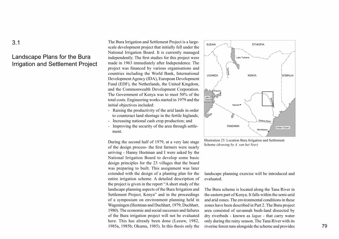
79
The Bura Irrigation and Settlement Project is a large-scale development project that initially fell under the National Irrigation Board. It is currently managed independently. The first studies for this project were made in 1963 immediately after Independence. The project was financed by various organisations and countries including the World Bank, International Development Agency (IDA), European Development Fund (EDF), the Netherlands, the United Kingdom, and the Commonwealth Development Corporation. The Government of Kenya was to meet 50% of the total costs. Engineering works started in 1979 and the initial objectives included: - Raising the productivity of the arid lands in order to counteract land shortage in the fertile higlands;- Increasing national cash crop production; and- Improving the security of the area through settle- ment.
During the second half of 1979, at a very late stage of the design process- the first farmers were nearly arriving - Hanny Heetman and I were asked by the National Irrigation Board to develop some basic design principles for the 23 villages that the board was preparing to built. This assignment was later extended with the design of a planting plan for the entire irrigation scheme. A detailed description of the project is given in the report “A short study of the landscape planning aspects of the Bura Irrigation and Settlement Project, Kenya” and in the proceedings of a symposium on environment planning held in Wageningen (Heetman and Duchhart, 1979; Duchhart, 1980). The economic and social successes and failures of the Bura irrigation project will not be evaluated here. This has already been done (Leeuw, 1982, 1985a, 1985b; Okumu, 1985). In this thesis only the
landscape planning exercise will be introduced and evaluated.
The Bura scheme is located along the Tana River in the eastern part of Kenya. It falls within the semi-arid and arid zones. The environmental conditions in these zones have been described in Part 2. The Bura project area consisted of savannah bush-land dissected by dry riverbeds - known as lagas - that carry water only during the rainy season. The Tana River with its riverine forest runs alongside the scheme and provides
3.1
Landscape Plans for the Bura Irrigation and Settlement Project
Illustration 23: Location Bura Irrigation and Settlement Scheme (drawing by A. van het Veer)
80
the irrigation water. The population density in this area is very low and numbering about 17 people per square kilometre. The Orma, a semi-nomadic tribe of Cushitic origin, use the savannah to graze their cattle and the Pokomo and Malekote Bantu peoples take advantage of river floods to cultivate their small plots (Fedders and Salvadori, 1979). The Pokomo and Malekote people live in small permanent settlements along the river. The project area was planned to cover a total of 6700 hectares and to provide a livelihood to 5154 families - between 36,000 and 45,000 people. Some of the settlers were recruited locally, but most came from other parts of the country. The new settlers often were poor and landless and had no experience with irrigated cash-crop cotton production. Management and implementation of the scheme - including land preparation - was the responsibility of the irrigation board while the tenants were responsible for weeding and harvesting. They had also access to a vegetable plot within the irrigated area for their own use.
3.1.1 Approach and Problem Statement
This first case study leant heavily on the theoretical notions of Vroom, Kerkstra, and Vrijlandt as described in Part 1. In Kerkstra’s “triplex” model, the abiotic, biotic, and human factors form an integrated and unique entity. Landscapes will continuously change and the factors that determine change will effect the speed of this change (Vroom, 1983; 1986; Kerkstra et al. 1976). The landscape should, therefore, not only be viewed as the result of the processes that gave shape to it in the past but also as the framework from which future development will take place. It was,
the humid, high potential areas of the country. The landscape design could possibly help to ameliorate these conditions.
3.1.2 Working Method
The working method adopted consisted basically of three phases: landscape inventory, landscape analysis, and design. Landscape inventory and analysis com-prised: - Studying irrigation techniques, management andmaintenance of the scheme, soils, vegetation, climate, and hydrology;- Face-to-face, open-ended interviews, predominantly with irrigation engineers and architects;- Field trips to the project area and to on-going irrigation schemes. Visits were also made to indigenous villages and agricultural areas in order to be able to anticipate the needs of the new tenants who had not yet arrived on the scheme; and- A spatial analysis of villages in the neighbourhood of the scheme.
In fact, the design phase actually began during the process of inventorisation and analysis as the results of these studies were translated into sketches. These sketches formed the basis for the design phase. This phase involved the development of five alternative landscape plans. After the alternatives had been evaluated with the irrigation engineers and supervising architect, subjected to visual and spatial arguments, and assessed in terms of technical and ecological constraints two possible alternatives were selected.
therefore, con-sidered important to investigate the basic conditions from which the existing landscape quality had evolved i.e. landscape analysis, and to search for opportunities to develop future qualities, i.e. impact assessment and spatial analysis of villages.
These departure points are defined more closely below. Human health is closely related to the environment. Fresh, clean water, for example, that is free from diseases-carrying organisms and adequate shelter are crucial for human survival. This accounts too for the appreciation of the environment. People’s sense of wellbeing is strongly influenced by the visual and spatial layout of the environment. Notions, such as identity, structure, and legibility of the intrinsic inter-relations of the “triplex” play a role here.
Given these assumptions the following elements were added to the original project problems and objectives:- A complete foreign landscape element will be in-troduced into the existing savannah. For economic, ecological and environmental psychological reasons, this new landscape element should, where possible, respect the existing and potential qualities of the underlying landscape elements.- It was expected that the dramatic increase of popu-lation would intensify the use of land in the immediate vicinity of the irrigation scheme and the indigenous riverine forest. This might result in land degradation. The landscape plans should try to assist in mitigating the negative impacts of the irrigation scheme. - The harsh living conditions, posed by the arid cli-mate and the unhealthy exposure to large water bodies were also seen as problems. They were expected to be problematic especially for those farmers coming from

81
Modern rational village layout
Amorphous layout and spatial pattern of an indigenous village nearby the irrigation
scheme
Layout of a family compound
Illustration 24: Landscape analysis of the Bura landscape as per triplex landscape principle before the irrigation interven-tion (Heetman and Duchhart, 1979)
Illustration 25: Spatial analysis of the Bura landscape (Heet-man and Duchhart, 1979)
Illustration 26: Spatial analysis of various Kenyan settlements (Heetman and Duchhart, 1979)

82
The design of the two “example” villages was chosen as a model for the other villages.
3.1.3 Landscape Analysis
Three specific landscape (sub)units could be identified in the savannah area in which the Bura scheme would be built. The densily forested Tana River system, which ran north-south; the lagas that ran east-west and formed the connection between the north-south running grassy floodzone of the Tana River and the savannah scrub land itself. Illustrations 24 gives a impression of the location of these different units. The analysis took into account the flow of water through the lagas and along the river as well as soil conditions, vegetation, and wildlife. It was discovered that the riverine forest, for example, harboured precious bird life and rare monkeys. This strengthened the conviction that the forest should be protected from destruction as far as possible. The analysis also revealed that the irrigation engineers may have located some of the villages too closely to the lagas. Boundaries, orientation directions, and possible landmarks were subsequently determined in a spatial analysis. Illustration 25 provides a summary of the result.
Building on the assumption that proper spatial ordering can contribute to the wellbeing of people and trigger off certain activities, the layout of existing villages were studied in order to find design starting points. As the new settlers were to come from the humid and high potential areas and from the surrounding of the scheme, a variety of villages from the highlands and
Illustration 27: Landscape plan Bura Irrigation Scheme Alternative I (Heetman and Duchhart, 1979)
Illustration 28: Lines of irrigated trees at the nearby Hola Irrigation Scheme (Photo by I. Duchhart)

83
from the neighbourhood were analysed to determine their spatial outline. Illustration 26 gives some of the findings. It was established that most villages consisted of a central street full of small-scale business activities and a series of open spaces. The older settlements had a much more amorphous structure while the newer settlements tended to be more rational and often had a central large market square.
3.1.4 Landscape Designs
Two slightly different landscape plans were presented to the irrigation boards. A number of factors heavily influenced the plans. They included the layout of the irrigation scheme, management interventions such as aerial spraying of pesticides and maintenance of drains and canals, and the need to find permanent places that allowed trees to reach maturity in what was going to be an ever changing agricultural environment. Trees were a significant factor in the plans proposed. They were intended to: - Improve the microclimate; - Produce timber and seeds; and- Support spatial organisation.
The trees to be planted within the irrigation scheme were, however, not supposed to be used as firewood. Their influence on the micro-climate, specifically the reduction of direct sunlight, would provide shade to humans and check the growth of weeds in the canals to interrupt the life cycle of the bilharzia host. Environmental psychological reasons also affected the tree-planting design. These included openness, views, boundaries and notions such as identity and
Illustration 29: Example design for two of the villages to be built in the irrigation scheme. Windbreaks and trees provide shade and protect the villages against the permanent wind and dust storms (Heetman and Duchhart, 1979)
Illustration 30: Schematic impression of hierarchy of open spaces in the proposed village design. A variety of activities is ex-pected to develop on each scale level (Heetman and Duchhart, 1979)

84
hierarchy. For example, the lagas were purposely kept open so that the irrigation scheme would remain visually connected with the surrounding open grass and scrub savannah. The densily planted villages were supposed to stand out as landmarks. Several rows of trees (see Illustration 27) were to be planted along the main feeder canals and roads. This would emphasise the core of each irrigation command. In one alternative, no trees were planted within the irrigated fields in order to maintain the full sense of openness so characteristic for the Kenyan savannah. In the other alternative, a few additional roads were also planted. In order not to be in the way, detailed cross-sections indicated exactly the places where the trees should be planted. Both landscape plans added new qualities to the Bura irrigation scheme while similtaneously emphasising the unique landscape qualities of the original landscape.
Village layout The design for the villages was based on the departure points formulated by the National Irrigation Board with regard to factors such as total numbers of inhabitants - approximately 2000 people per village - functions including shops, schools, etc., and the walking distance to the irrigation fields, schools, and other facilities. The results of the analysis of the physical environment including the suitability for building and tree planting, the presence of lagas, and climatic conditions like wind speed and wind direction, were also critical for the location and position of the houses and open spaces. The conclusions from the spatial analysis were also taken as departure points.
It was assumed that if the settlers could recognise aspects of spatial layout of the places where they
Illustration 31: Innovative farmer used spill-over water to irri-gate a small vegetable garden on his plot. He also built a water tank (Photo I. Duchhart)
Illustration 34: The potentials of the area are demonstrated by the lush gardens of the senior staff (Photo I. Duchhart)
Illustration 32: Artist impression of the farm in Illustration 28. The farmer also used rainwater fetched in a water tank (Leslie Duckworth, Communication Development, 1989).
Illustration 33: The first village was built in 1980/1981. This photograph shows one of the major squares. Only few settlers had arrived and trees were not planted (Photo I. Duchhart)

85
came from in the new villages - even unconsciously- the settling-in would be easy and effective. Markets, shops, and meeting points might then develop quickly. At the same time, the villages should also express a sense of prosperity and progress. The notion of recognition was considered as more important than the notion of imitation.
The analysis of village layouts showed that there was a common denominator of main streets and hierarchically ordered spaces. The design for the villages in the irrigation scheme also included a dominant street with the idea of triggering off small-scale business and other activities. There was also a three-level, hierarchically organised series of open spaces. These open spaces varied from small and semi-private to larger spaces where schools, community halls, and also parks with possibly public facilities such as bars and restaurants could be located. Illustration 30 gives the schematic layout, while Illustration 29 shows the integrated village design.
A planting design was to accompany the village layout. The different squares, lanes, and wind breaks were well-detailed and tree species and planting densities described. All selected trees were drought resistant, resilient, provided shade, produced edible fruits, and many had medicinal qualities. The trees to be planted along the main street and the larger open spaces were neem (Azadirachta indica). This is a tree with mosquito repellent characteristics and thus might help reduce the incidence of malaria. The seeds of neem can be used to make soap and lamp oil. In Swahili, the tree is called mu-arobaini - the tree that cures forty diseases. Windbreaks were designed to protect the villages from the continous
dust bearing winds blowing from either the north-east or south-west. With the right management, these windbreaks could also provide the village inhabitants with firewood and building materials. The trees to be planted in the semi-private spaces were intended to provide shade and fruits.
A bathing pond was planned in between the two villages. Providing women with a place where they could wash their family’s clothes would stop them having to resort to doing their laundry in the irrigation canals and ditches. The water in the ponds would have to be refreshed every 3 to 5 days in order to reduce the risk of bilharzia. The outflowing pond water was envisioned to irrigate a fenced village “green”. Here villagers could keep goats and cows, even though this was officially frowned upon by the irrigation board.
Suggested implementation and maintenanceThe responsibilities for building the irrigation scheme and the villages was with the National Irrigation Board. In the landscape plans it was suggested that the Forestry Department of the Ministry of Environment and Natural Resources should be responsible for supervising the tree planting. Parti-cipation of the tenants’ community was seen as essential for sustainable maintenance and operation of the trees planted. National Tree Planting Days and environmental education programmes at schools were to stimulate this local participation. It was expected that the tenants would seek permission from the forestry staff to harvest tree products. The ideas on implementation were not elaborated because when the plan was being prepared the tenants had not arrived and the responsible institutional officers had not yet been appointed.
3.1.5 Lessons learned
The first unit of the irrigation scheme came into operation in 1980/1981. However, there were many technical and managerial problems. The Tana River, for example, appeared unpredictable. Water level and even the course of the riverbed changed. At times this deprived the gravity driven irrigation scheme of its precious irrigation water. In 1985, project costs had escalated to Kenyan Shillings 2.2 billion
Illustration 35: The freshly appointed Bura forester used indigenous knowledge to plant drought resistent acacia trees in front of his house to provide a pleasant shade. (Photo I. Duchhart)
86
(approximately US$ 8000 million), 180% more than anticipated (Okumu, 1985; Leeuw, 1985a, 1985b). In the late 1980s, the Bura Irrigation Scheme was made an independent organisation in the hope that this would make it possible to address the specific Bura issues more effectively.
In 1981 and 1983, I revisited the scheme. The villages were built according to the schematic village layout. The major open spaces were incorporated in the vill-ages, but the smaller, semi-private squares were part of the designs that had not been adopted. The scheme had indeed attracted a business community, but they were forced to settle outside the project boundaries. This deprived the squares in the villages of the anticipated liveliness. Neither were the trees suggested in the landscape plans planted. There were probably two main reasons for this. Firstly, water was scarce - in fact there was hardly enough for irrigation. Secondly, the landscape plan was insufficiently institutionalised and, therefore, in 1983 Forestry Department staff was not aware of its existence. However, the Forestry Department had planted trees in an irrigated forest of 24 hectare under an internationally funded Food for Work Programme (Okumu, 1985). This forest was intended to provide the tenants with firewood.
In one of the villagers, a tenant was seen to use spill- over drinking water to irrigate the land around his house. He had planted a hedge and some trees and grew vegetables. This person had also built a water tank (see Illustrations 31 and 32). As mentioned above, the newly established Bura Forestry Department limited their tree planting actvities in the villages because of a perceived scarcity of water. The forester himself, however, had planted drought-resistant acacia
trees in front of his own house (Illustration 35). He proudly stated that his grandmother taught him how to grow them. At the same time he maintained the argument that there was insufficient rainfall to plant trees in the villages or the irrigation scheme. It seemed he had neglected to incorporate his indigenous knowledge into his work.
It can be concluded that: - The landscape plans were insufficiently institu-tionalised. In the implementation phase, it showed that the National Irrigation Board had little interest in the upkeep of communal grounds, except for one or two “strategic sites” and the community itself had also not taken action;- The plans were far too detailed for the implementa-tion capacities of the irrigation board or the tenants;- The village layout was only partially adopted. The smaller squares and open spaces had been left out; - People developed useful initiatives on their pri-vate land. Their knowledge, like knowledge on tree planting was not exploited by the scheme managers; and- Even though the irrigation engineers refuted the warning that the villages where located too close to the lagas, the landscape analysis proved right when during one of the first rains the villages were flooded. The engineers had to dikes to protect the villages against the flood water.
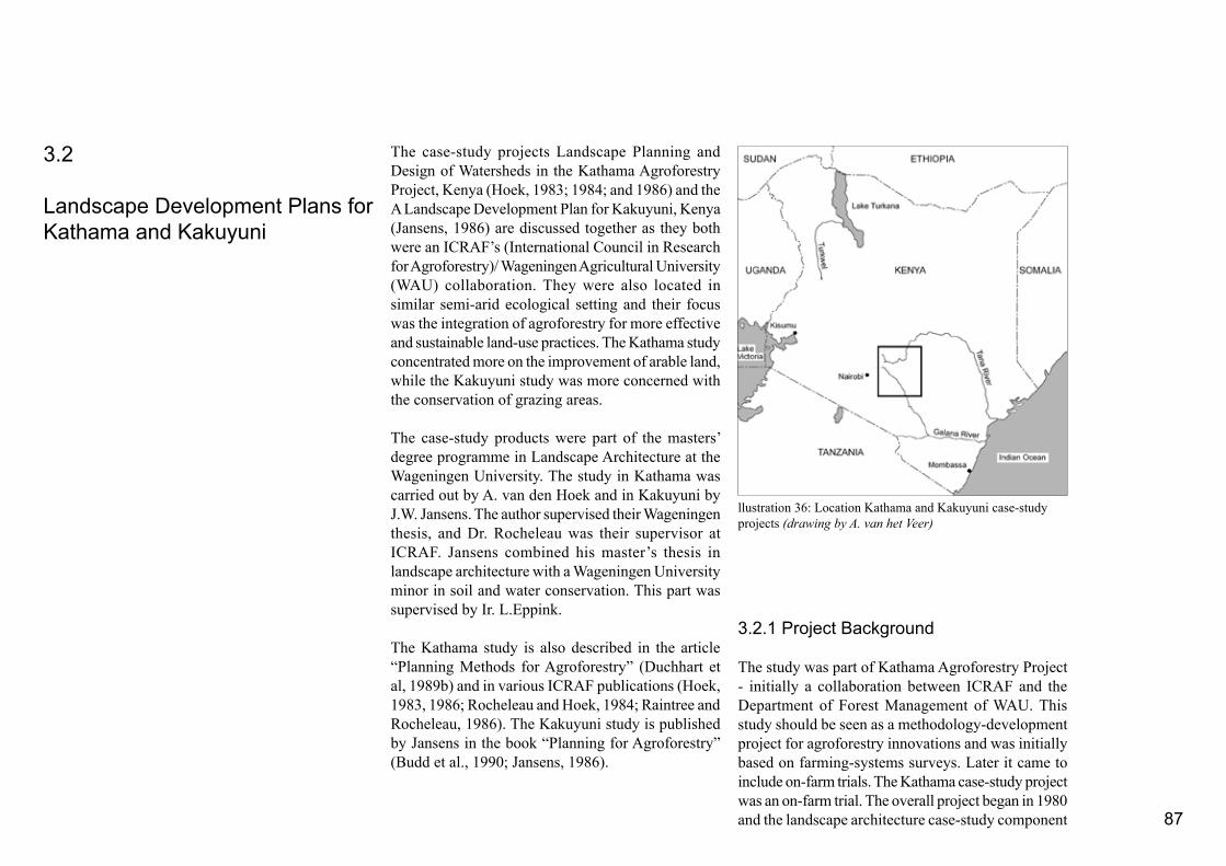
87
The case-study projects Landscape Planning and Design of Watersheds in the Kathama Agroforestry Project, Kenya (Hoek, 1983; 1984; and 1986) and the A Landscape Development Plan for Kakuyuni, Kenya
(Jansens, 1986) are discussed together as they both were an ICRAF’s (International Council in Research for Agroforestry)/ Wageningen Agricultural University (WAU) collaboration. They were also located in similar semi-arid ecological setting and their focus was the integration of agroforestry for more effective and sustainable land-use practices. The Kathama study concentrated more on the improvement of arable land, while the Kakuyuni study was more concerned with the conservation of grazing areas.
The case-study products were part of the masters’ degree programme in Landscape Architecture at the Wageningen University. The study in Kathama was carried out by A. van den Hoek and in Kakuyuni by J.W. Jansens. The author supervised their Wageningen thesis, and Dr. Rocheleau was their supervisor at ICRAF. Jansens combined his master’s thesis in landscape architecture with a Wageningen University minor in soil and water conservation. This part was supervised by Ir. L.Eppink.
The Kathama study is also described in the article “Planning Methods for Agroforestry” (Duchhart et al, 1989b) and in various ICRAF publications (Hoek, 1983, 1986; Rocheleau and Hoek, 1984; Raintree and Rocheleau, 1986). The Kakuyuni study is published by Jansens in the book “Planning for Agroforestry” (Budd et al., 1990; Jansens, 1986).
3.2.1 Project Background
The study was part of Kathama Agroforestry Project - initially a collaboration between ICRAF and the Department of Forest Management of WAU. This study should be seen as a methodology-development project for agroforestry innovations and was initially based on farming-systems surveys. Later it came to include on-farm trials. The Kathama case-study project was an on-farm trial. The overall project began in 1980 and the landscape architecture case-study component
3.2
Landscape Development Plans for Kathama and Kakuyuni
llustration 36: Location Kathama and Kakuyuni case-study projects (drawing by A. van het Veer)
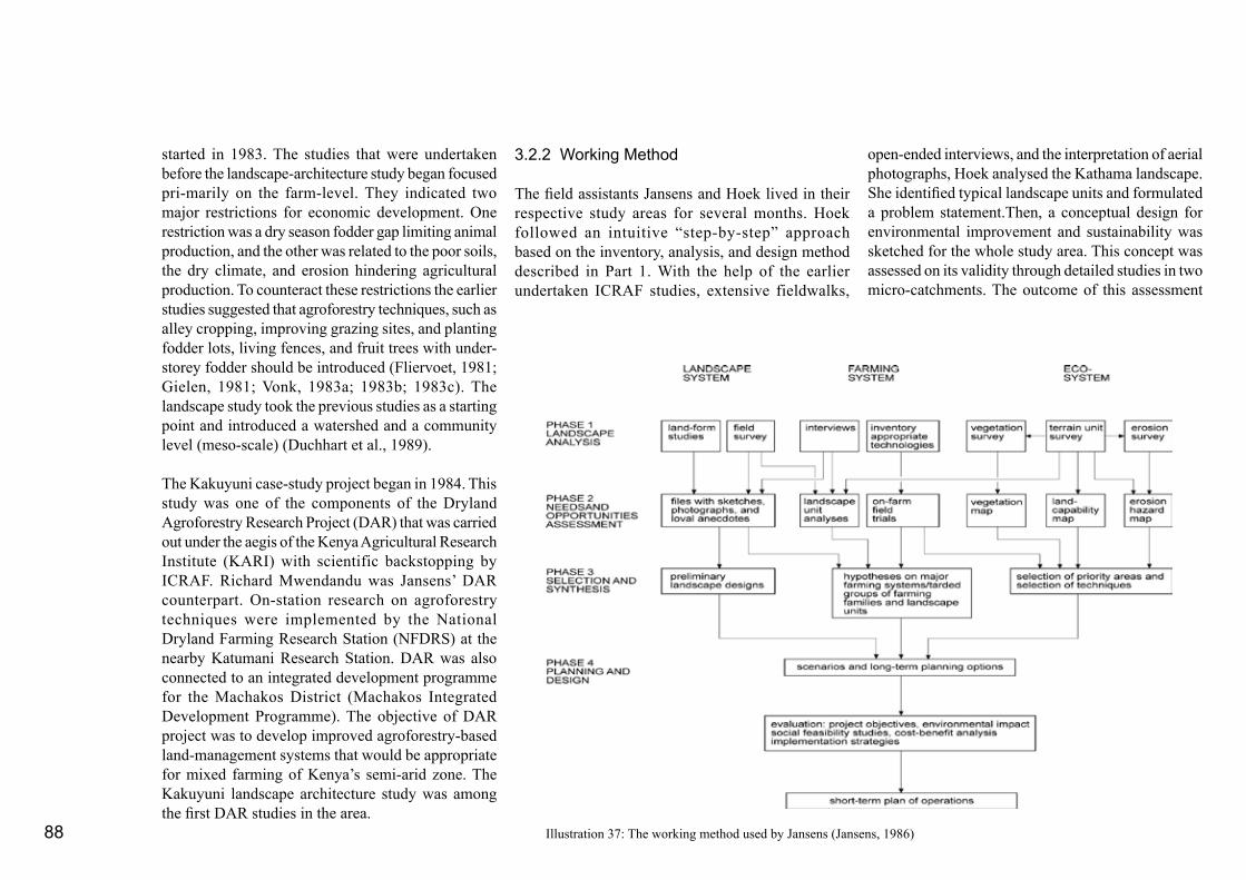
88
started in 1983. The studies that were undertaken before the landscape-architecture study began focused pri-marily on the farm-level. They indicated two major restrictions for economic development. One restriction was a dry season fodder gap limiting animal production, and the other was related to the poor soils, the dry climate, and erosion hindering agricultural production. To counteract these restrictions the earlier studies suggested that agroforestry techniques, such as alley cropping, improving grazing sites, and planting fodder lots, living fences, and fruit trees with under-storey fodder should be introduced (Fliervoet, 1981; Gielen, 1981; Vonk, 1983a; 1983b; 1983c). The landscape study took the previous studies as a starting point and introduced a watershed and a community level (meso-scale) (Duchhart et al., 1989).
The Kakuyuni case-study project began in 1984. This study was one of the components of the Dryland Agroforestry Research Project (DAR) that was carried out under the aegis of the Kenya Agricultural Research Institute (KARI) with scientific backstopping by ICRAF. Richard Mwendandu was Jansens’ DAR counterpart. On-station research on agroforestry techniques were implemented by the National Dryland Farming Research Station (NFDRS) at the nearby Katumani Research Station. DAR was also connected to an integrated development programme for the Machakos District (Machakos Integrated Development Programme). The objective of DAR project was to develop improved agroforestry-based land-management systems that would be appropriate for mixed farming of Kenya’s semi-arid zone. The Kakuyuni landscape architecture study was among the first DAR studies in the area.
3.2.2 Working Method
The field assistants Jansens and Hoek lived in their respective study areas for several months. Hoek followed an intuitive “step-by-step” approach based on the inventory, analysis, and design method described in Part 1. With the help of the earlier undertaken ICRAF studies, extensive fieldwalks,
open-ended interviews, and the interpretation of aerial photographs, Hoek analysed the Kathama landscape. She identified typical landscape units and formulated a problem statement.Then, a conceptual design for environmental improvement and sustainability was sketched for the whole study area. This concept was assessed on its validity through detailed studies in two micro-catchments. The outcome of this assessment
Illustration 37: The working method used by Jansens (Jansens, 1986)

89
by the colonial administration resulted in people moving away from the more fertile hill sides into the fragile lands of Kathama and Kakuyuni. Here, they continued their mixed farming practices of arable and livestock production. At the beginning of the 1980s, 27% of the total area of Kathama was under cultivation while in Kakuyuni about 20% of the study area was being farmed (Gielen, 1981).
In 1981, the population density in Kathama was 172 people per square kilometre, which is high for a semi-arid zone. In Kakuyuni there were 65 persons per square kilometre, while the average population density in the semi-arid areas of Kenya is usually about 47 persons per square kilometre. In Kathama, the birth rate was approximately 4% which meant that the population could double within 10 to 15 years. Poor land conditions with subsequently low yields and small farm sizes - between 2 to 10 hectare being typical - resulted in widespread poverty. The income of nearly half the households in Kathama were below poverty level at that time. Many of the men in the age group of 20 to 50 years went to look for work in Nairobi or other urban centres leaving the women to take care of most of the farming activities. Farmers often sent their cattle off to graze elsewhere.
In Kakuyuni the farm size varied between three and 120 hectares. Jansens data lead him to make a distinction between younger and older farming families and their respective land-use methods. The younger and also poorer, but often better educated farming families lived predominantly in the valleys and had smaller farms. Co-operation and self-organisation was on the rise among these younger and more recently settled farmers. The older and richer farm households were
provided feed-back for the abstract conceptual plan and was visualised in a landscape master plan. Subsequently detailed implementation directives were formulated and tested in a pilot implementation study.
Jansens used a more systematic working method (see Illustration 37). The study he and his Kenyan counterparts were undertaking, was the first DAR study in the area. They had to collect much of the basic data on erosion, rainfall, vegetation, and land-use themselves. Most data was collected in the field and from aerial photographs.Systematic analyses using overlays, matrices, and other matching techniques resulted in a series of maps showing landscape units, land capability, and erosion hazards. Information on social factors were collected through open-ended questions during field walks as well as through interviews guided by questionnaires. Jansens developed two preliminary models, which he evaluated on their positive and negative impacts. He rejected both, basically because he concluded that the implementation would be too labour intensive. He also thought the models were not flexible enough to accomodate changes that might occur in the future. Instead, he reverted to working out maps indicating intervention priorities. On the basis of these, he was able to develop two possible landscape development scenarios based on the capacity of individual farmers or farmer groups to restore the land. With the help of detailed soil conservation designs, Jansens guided farmers’ groups in the implementation of several trials. Lessons learned from these trials were fed back into short-term and long-term landscape plans. In both studies, feedback loops between analysis, visualisation in designs, and assessments played a central role.
3.2.2 Landscape Analysis
The areas under study were located in the semi-arid lands roughly one hundred kilometre east of Nairobi. Kathama lies between the steep Kanzalu Range and the prominent Yatta Plateau with at its foot the Athi River. Kakuyuni lies about 50 kilometre further east on top of the Yatta Plateau. The nearest towns are Machakos and Kitui.
The landscapes of Kathama and Kakuyuni are of typical African dry-land tree savannah. Dominant trees and shrubs are Acacia, Combretum, and Croton species. Kathama is situated in the rain shadow of the Kanzalu Range where rainfall varied from 140 to 700 millimetres and evaporation exceeds 1000 millimetres per year. Even so there are - relatively speaking - many sources of water including springs and underground water flows following dry river beds. As a result, in some locations on the foothills of the range large mango trees and several sacred fig trees can be found. The Athi River also provides a year round source of water. Nevertheless, periods of serious drought regularly occur. Kakuyuni appeared much drier. Two man-made dams have to provide human beings and animals with water. The old dam was marked with a huge sacred fig tree. The soils are infertile and vulnerable to erosion. In depressions and valley bottoms, the heavy clay soils are difficult to cultivate and therefore this land is used for grazing.
Historically, the Wakamba used the area extensively for grazing, hunting, and gathering. Over the last 50 years the land has gradually been opened up for cultivation. Over-population and according to some the compulsory soil conservation measures introduced

90
more self-reliant and independent. Land adjudication was advanced and most land was in private hands.
Settlement patterns in Kathama clearly followed the natural conditions. The very steep slopes of the Kan-zalu range and the heavy clay depressions that ran mostly north-south were avoided. In Kakuyuni the farm houses were more evenly spread, but farmers also tended to avoid the steeper slopes and heavier soils. The older farms were located in the southern part of the study area close to the main road to Kitui. The northern section consisted of recently opened up farm land.
Landscape unitsThe research assistants identified distinct landscape units in Kathama as well as in Kakuyuni. Each landscape unit had its own specific physical features and characteristics. Landscape forming factors, such as land use, vegetation, geomorphology, soil, and drainage were interlinked and visualised in cross-sections. Hoek, distinguished four landscape units in the Kathama study area (Illustration 38). The Kanzalu Range with a steep, nearly 90 degrees slope, had rock outcrops mixed with some grazing and trees.
Illustration 38: A cross-section running east-west accross the Kathama landscape showing the interlinkages between abiotic, biotic, and anthropological factors (Duchhart, 1986a; Hoek, 1983).

91
Farmers at the foothills of the range mixed grazing with cultivated land. Serious gully erosion occurred occassionally leaving the soil completely bare. The middle level was known as the Kunikila Plain. Farmers on this undulating plain used the heavy clays depressions for grazing and the sandy ridges for cultivation. The plain bordered with relatively long slopes to the Athi River. These slopes were used as grazing interspersed with settlements.
Jansens visualised the various landscape forming factors in small geographical sketches making it
easier to discover the underlying interlinkages. Aerial photographs were interpreted to map out the landscape units. A focal point of activities in Kathama study area was Kathama village and in Kakuyuni Katangi village.
One of the earlier studies carried out in Kathama had revealed the importance of trees for the local community. For example, children would eat certain fruits while walking to school this provided them with necessary food and vitamins especially in times of drought and famine (Gielen, 1981; Fliervoet, 1981).
The trials on alley-cropping systems initiated by ICRAF showed that farmers were not too keen to copy this system because the inter-planted hedges intended for fodder and mulch competed for light and disadvanteged their food crops. However, they did see the benefits of growing fodder shrubs and mulching, and were interested to plant hedges on plot boundaries or in a field corner.
During field walks, examples of good land-management were discovered. For example, the farmer Mushoki maintained a well-terraced orange orchard on his farm on the Kanzalu footslope. He had also established an excellent tree nursery. It should be kept in mind that he had direct access to a year-round spring. Field trials showed that the natural vegetation of the grazing areas had a strong regeneration capacity once the fields were closed to animals (Vonk, 1983c).
3.2.3 Problem Identification
The Wakamba Kathama and Kakuyuni struggled to maintain their livelihoods under the natural conditions that - although reasonably suitable for grazing - are extremely vulnerable to the effects of arable agriculture (See also Part 2). In Kathama, for example, crop failures occured every five years (Vonk, 1983b). At such times, hunger was rife making people susceptable to diseases and starvation. The general conclusion of both landscape analyses was that the relatively intensive land use had unbalanced the carrying capacity of the natural resources and had lead to widespread and serious erosion. In Kathama, it was the cultivated plots that were more severely
Illustration 39: The undulating Kunikila Plain with depressions of black cotton soils and sandy ridges. In the background is the skyline of the Yatta Plateau (Photo I. Duchhart).
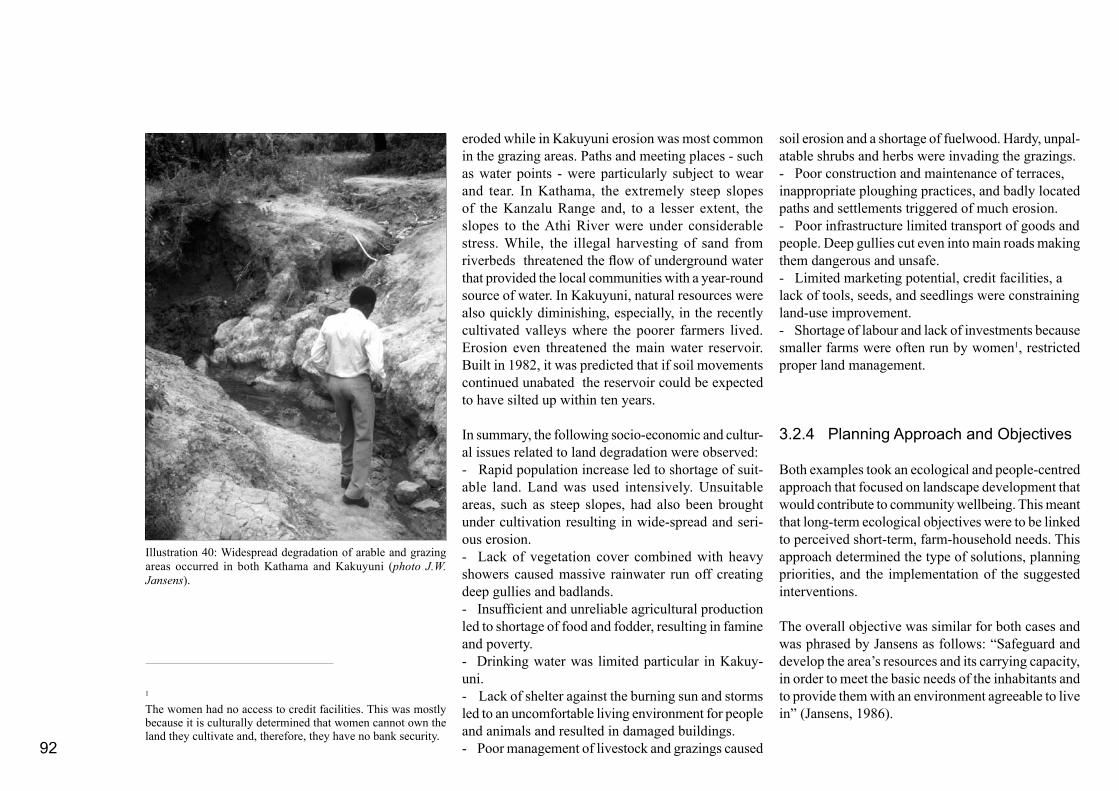
92
eroded while in Kakuyuni erosion was most common in the grazing areas. Paths and meeting places - such as water points - were particularly subject to wear and tear. In Kathama, the extremely steep slopes of the Kanzalu Range and, to a lesser extent, the slopes to the Athi River were under considerable stress. While, the illegal harvesting of sand from riverbeds threatened the flow of underground water that provided the local communities with a year-round source of water. In Kakuyuni, natural resources were also quickly diminishing, especially, in the recently cultivated valleys where the poorer farmers lived. Erosion even threatened the main water reservoir. Built in 1982, it was predicted that if soil movements continued unabated the reservoir could be expected to have silted up within ten years.
In summary, the following socio-economic and cultur-al issues related to land degradation were observed: - Rapid population increase led to shortage of suit-able land. Land was used intensively. Unsuitable areas, such as steep slopes, had also been brought under cultivation resulting in wide-spread and seri-ous erosion. - Lack of vegetation cover combined with heavy showers caused massive rainwater run off creating deep gullies and badlands. - Insufficient and unreliable agricultural production led to shortage of food and fodder, resulting in famine and poverty.- Drinking water was limited particular in Kakuy-uni. - Lack of shelter against the burning sun and storms led to an uncomfortable living environment for people and animals and resulted in damaged buildings.- Poor management of livestock and grazings caused
soil erosion and a shortage of fuelwood. Hardy, unpal-atable shrubs and herbs were invading the grazings.- Poor construction and maintenance of terraces,inappropriate ploughing practices, and badly located paths and settlements triggered of much erosion.- Poor infrastructure limited transport of goods andpeople. Deep gullies cut even into main roads making them dangerous and unsafe.- Limited marketing potential, credit facilities, a lack of tools, seeds, and seedlings were constraining land-use improvement.- Shortage of labour and lack of investments because smaller farms were often run by women1, restricted proper land management.
3.2.4 Planning Approach and Objectives
Both examples took an ecological and people-centred approach that focused on landscape development that would contribute to community wellbeing. This meant that long-term ecological objectives were to be linked to perceived short-term, farm-household needs. This approach determined the type of solutions, planning priorities, and the implementation of the suggested interventions.
The overall objective was similar for both cases and was phrased by Jansens as follows: “Safeguard and develop the area’s resources and its carrying capacity, in order to meet the basic needs of the inhabitants and to provide them with an environment agreeable to live in” (Jansens, 1986).
Illustration 40: Widespread degradation of arable and grazing areas occurred in both Kathama and Kakuyuni (photo J.W. Jansens).
1 The women had no access to credit facilities. This was mostly because it is culturally determined that women cannot own the land they cultivate and, therefore, they have no bank security.
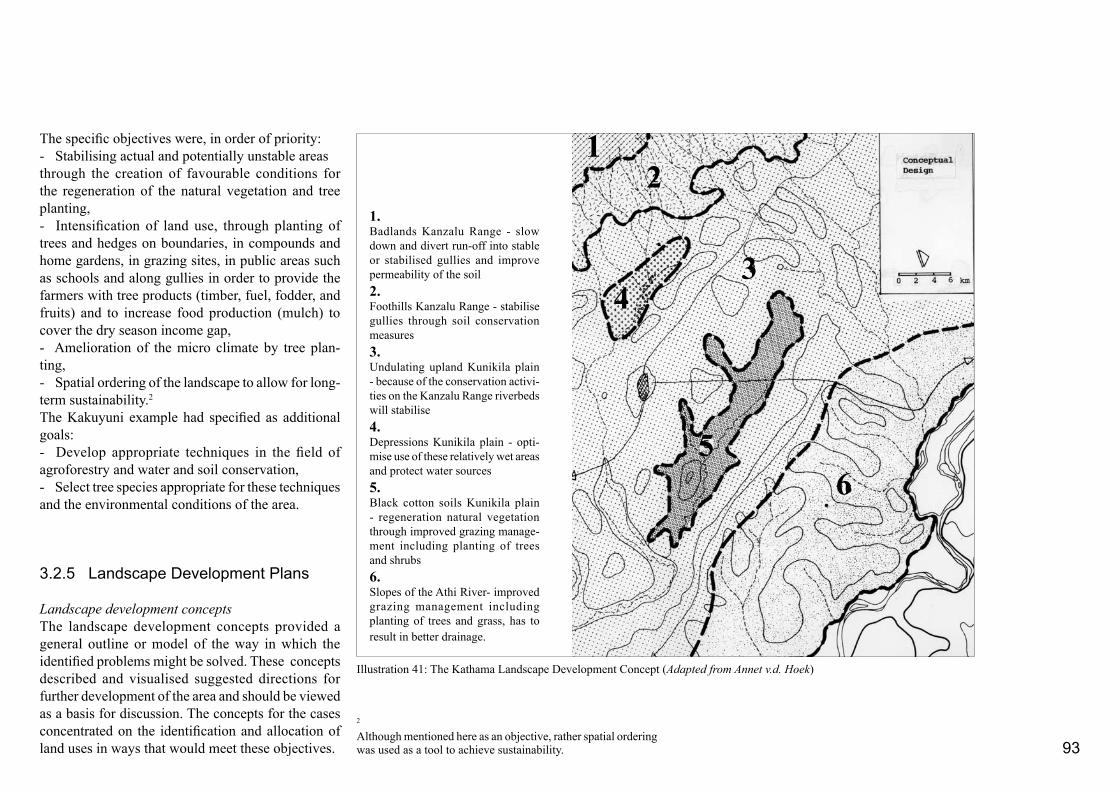
93
The specific objectives were, in order of priority:- Stabilising actual and potentially unstable areasthrough the creation of favourable conditions for the regeneration of the natural vegetation and tree planting,- Intensification of land use, through planting of trees and hedges on boundaries, in compounds and home gardens, in grazing sites, in public areas such as schools and along gullies in order to provide the farmers with tree products (timber, fuel, fodder, and fruits) and to increase food production (mulch) to cover the dry season income gap,- Amelioration of the micro climate by tree plan-ting, - Spatial ordering of the landscape to allow for long-term sustainability.2
The Kakuyuni example had specified as additional goals: - Develop appropriate techniques in the field of agroforestry and water and soil conservation, - Select tree species appropriate for these techniques and the environmental conditions of the area.
3.2.5 Landscape Development Plans
Landscape development conceptsThe landscape development concepts provided a general outline or model of the way in which the identified problems might be solved. These concepts described and visualised suggested directions for further development of the area and should be viewed as a basis for discussion. The concepts for the cases concentrated on the identification and allocation of land uses in ways that would meet these objectives.
Illustration 41: The Kathama Landscape Development Concept (Adapted from Annet v.d. Hoek)
1. Badlands Kanzalu Range - slow down and divert run-off into stable or stabilised gullies and improve permeability of the soil2. Foothills Kanzalu Range - stabilise gullies through soil conservation measures3.Undulating upland Kunikila plain - because of the conservation activi-ties on the Kanzalu Range riverbeds will stabilise4.Depressions Kunikila plain - opti-mise use of these relatively wet areas and protect water sources5. Black cotton soils Kunikila plain - regeneration natural vegetation through improved grazing manage-ment including planting of trees and shrubs6. Slopes of the Athi River- improved grazing management including planting of trees and grass, has to result in better drainage.
12
34
56
2
Although mentioned here as an objective, rather spatial ordering was used as a tool to achieve sustainability.

94
Illustration 42 shows three partly overlapping areas that need to be protected mostly from soil-erosion hazards and/or developed because of their communal importance as a water catchment area.
The concepts raised new questions. For example, What kind of appropriate interventions are needed and possible in the short term in order to be able to improve the environment in the mid and long term? and What are the basic causes of erosion? Detailed studies and design exercises were necessary to answer these questions.
Detailed studies and designsThe detailed studies and designs formed an important and crucial step in the working method. It was at this stage of planning that the rather abstract concepts, which were largely based on landscape ecological prin-ciples and in the Kakuyuni case also on land-use systems, could be linked to individual farm-household needs. The detailed studies differed a great deal in character depending on the questions to be answered.
Detailed erosion studies were made in both Kathama and Kakuyuni. Jansens also made detailed vegetation studies. Exemplary micro-catchment basins were se-lected in which the land use and the soil movement were studied. In Kathama it emerged that often the intense use of paths and roads, as well as the sweeping and compacting of the ground directly around the farm house encouraged erosion. Depending on the location, this could seriously aggravate the situation. These erosion studies were done on farms within the selected micro water catchments (Illustration 43). Wind erosion was a destructive force in Kakuyuni. This meant that the study area also had to be approached as a unit with specific sub-regional climatic conditions.
At this stage of the design process, it was important to analysis possible implementation strategies. As in many development projects in Kenya, the people had to implement the designs themselves. Therefore, the study had to include the people’s perception of the landscape and their perceived environmental problems. Much time was spent in getting this step right. Open interviews based on active listening were a major source of information. Jansens guided the community to carry out trials of soil conservation and
Illustration 41 shows the concept for the Kathama case study . The Kathama concept was based on stabilising the drainage network by land rehabilitation and so that rainwater run-off could be slowed down and collected. The characteristic landscape units defined in the analysis determined the type of general guidelines for improvement.The initial conceptual landscape development principles for the Kakuyuni area were supplemented with a ranking system indicating areas that prioritized for improvement. Important criteria included, among others, actual and potential erosion hazards, land-use features of high communal importance as well as farm size and land ownership.
Illustration 42: The three most important areas in Kakuyuni that should be protected and developed (Adapted from J.W. Jansens ).
1. Areas with the highest erosion hazards.
2. The dam area and its water catchment.
3. The area of poorer farmers with few options for investments.

95
tree planting in on-farm micro-catchments. Self-help groups worked for seven Saturdays. They spent about three hours digging cut-off drains and soak pits. A living fence was planted using stakes (Illustrations 42-46). Their reactions to these activities formed an important source of information.
Both Hoek and Jansens asked the inhabitants to draw their environment including important routes and orientation points. The work done in this design step provided the groundwork for the important link between farmers’ perceived needs and their ways of working and the overall communal need to stabilise and balance the ecology of the area.This inventory also helped to indentify the priority of intervention.
Detailed designs and sketches were used to integrate the relatively independent and sometimes uni-sectoral detailed studies. These designs involved selecting intervention techniques as well as deciding on their physical arrangements. It was very important to discuss possible interventions with everybody involved in implementing and financing the project, including farmers, self-help group participants, local chiefs, representatives of non-governmental organisations, ICRAF, and government officials. In the case of Kathama, the detailed designs concentrated on stabilising gullies and roadsides. Discussions and interviews with the residents made it clear that gully sites and roadsides were often used as off-farm grazing lands and sources of fuel wood. This raised the idea of strengthening these practices by intensifying the productive functions of roadsides through the planting of trees and grasses, which would simultaneously help stabilising the overall landscape ecosystem. Illustration 43: A detailed design for a micro-catchment in Kathama illustrating the technical interventions and the future land-
scape image (Designs and drawings A. v.d. Hoek)

96
ICRAF’s initial agroforestry designs focused on tech-niques to raise agricultural production at plot level. In the landscape designs, these techniques were adapted to tree planting for a multiplicity of uses including fodder production and soil conservation on road-sides, plot, and parcel boundaries while maintaining ICRAF’s objectives. In this way, tree planting would benefit not only the individual farmer but the com-munity as a whole. It also reduced the negative side effects of growing trees on arable land. Shade trees and wind breaks were included to improve the micro and meso-climate. Landscape plansThe conceptual designs gradually developed into a more realistic landscape plan through the process of checking and refining the rather abstract landscape development concepts. Feedback from the relatively realistic detailed studies, detailed designs, and in the Kakuyuni example real-life trials contributed significantly to this process. The results of the detailed studies could not be fed back in an automatic way but involved a creative process in which questions were addressed, such as: What happens when the detailed designs are applied throughout the larger region? How do the different directives for the specific landscape units influence each other? Is it necessary to add extra
The above Illustration 44 shows a self-help group active in Kakuyuni. The lower Illustration 45 gives a detailed study on terrace constructions (Photo and drawing J.W. Jansens)
Illustration 46: In Kakuyuni several on-farm trials were car-ried out in March and April of 1985. The photograph shows the amount of sedimentation caught after one heavy rain shower. (Photo J.W. Jansens)

97
directives for areas not covered by the detailed studies or is it possible to reduce the intensity of the suggested activities as the interventions may influence each other in a positive way? What are the labour demands and on whom do they fall? And if, in the Kathama area, for example, the soils on the Kanzalu Range and its
foothills were stabilised, to what extent would this protect the undulating Kunikila uplands from erosive powers of storm water?
In the Kakuyuni study, the idea that an overall landscape plan could be implemented as a whole
was not followed through. Instead Jansens identified specific groups of farmers who lived in the most vulnerable areas and who were keen to achieve an integrated development of their area. As a result of this choice, Jansens presented two development scenarios for Kakuyuni and a short-term plan with
Illustration 48: A cross-section at farm-level shows how the various interventions built-up the landscape plan (Hoek, 1983). (Drawing G. Kleinrensink).
Illustration 47: The landscape plan for Kathama. Main components are forestation of the steepest slopes, management of gulley erosion on the foot slopes, and measures to control run-off on the slopes towards the Athi River. A framework of tree lines fol-low the main roads. (Design by A. v.d. Hoek, drawing G. Kleinrensink)

98
development horizons of 30 years (2015) and 5 years (1990) respectively. The two scenarios were based on two different social trends that had emerged from projected socioeconomic developments, such as a further increase of the population living on smaller plots and the number of people engaged in on-farm, non-agricultural income-generating activities, such as wood carving and carpentry. Such activities would increase the demand for wood still further. Jansens first scenario - referred to as the “Independence Scenario” - was based on the first generation relatively rich farmers who worked independently. The second was the “Co-operation Scenario” and reflected his observation that there was an increasing degree of co-operation among poorer, second generation families. The short-term plan was based on the “Co-operation Scenario”. The landscape plan for Kakuyuni consisted of clumps of forested areas formed by more or less north-south running wind-breaks, living fences marking plot boundaries and focal points, such as schools and water points planted with shade trees and soil protecting scrubs and trees. The largely on-farm soil erosion measures were intended to stimulate the natural regeneration of grazing areas and living fences were designed to encourage the rotation of cattle (Illustration 44-46 and 49).
In the Kathama landscape plan, rehabilitating measures focused on bio-physical forms, such as gullies, and on human-made artefacts, such as roads, plot, and terrace boundaries. The rehabilitation measures mainly involved the planting of trees, shrubs, and grasses. Sometimes, trees were also needed to break the wind. Both plans suggested that cheap and locally available materials be used (Illustrations 47 and 48).
Illustration 49: The short-term landscape plan for the Kakuyuni area. The most densily planted areas occur around water dams and areas with grazing rehabilitation (Design and drawing by J.W. Jansens).
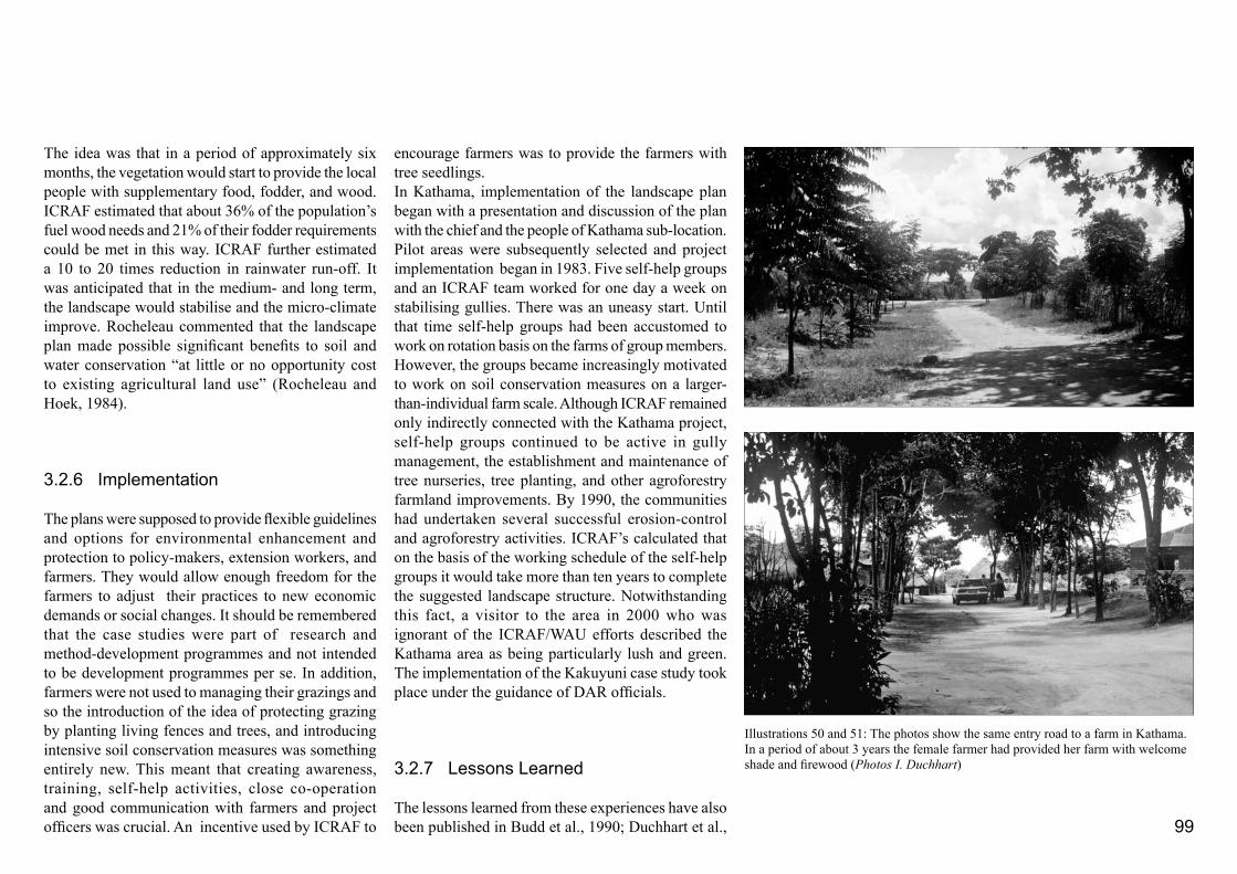
99
The idea was that in a period of approximately six months, the vegetation would start to provide the local people with supplementary food, fodder, and wood. ICRAF estimated that about 36% of the population’s fuel wood needs and 21% of their fodder requirements could be met in this way. ICRAF further estimated a 10 to 20 times reduction in rainwater run-off. It was anticipated that in the medium- and long term, the landscape would stabilise and the micro-climate improve. Rocheleau commented that the landscape plan made possible significant benefits to soil and water conservation “at little or no opportunity cost to existing agricultural land use” (Rocheleau and Hoek, 1984).
3.2.6 Implementation
The plans were supposed to provide flexible guidelines and options for environmental enhancement and protection to policy-makers, extension workers, and farmers. They would allow enough freedom for the farmers to adjust their practices to new economic demands or social changes. It should be remembered that the case studies were part of research and method-development programmes and not intended to be development programmes per se. In addition, farmers were not used to managing their grazings and so the introduction of the idea of protecting grazing by planting living fences and trees, and introducing intensive soil conservation measures was something entirely new. This meant that creating awareness, training, self-help activities, close co-operation and good communication with farmers and project officers was crucial. An incentive used by ICRAF to
encourage farmers was to provide the farmers with tree seedlings. In Kathama, implementation of the landscape plan began with a presentation and discussion of the plan with the chief and the people of Kathama sub-location. Pilot areas were subsequently selected and project implementation began in 1983. Five self-help groups and an ICRAF team worked for one day a week on stabilising gullies. There was an uneasy start. Until that time self-help groups had been accustomed to work on rotation basis on the farms of group members. However, the groups became increasingly motivated to work on soil conservation measures on a larger-than-individual farm scale. Although ICRAF remained only indirectly connected with the Kathama project, self-help groups continued to be active in gully management, the establishment and maintenance of tree nurseries, tree planting, and other agroforestry farmland improvements. By 1990, the communities had undertaken several successful erosion-control and agroforestry activities. ICRAF’s calculated that on the basis of the working schedule of the self-help groups it would take more than ten years to complete the suggested landscape structure. Notwithstanding this fact, a visitor to the area in 2000 who was ignorant of the ICRAF/WAU efforts described the Kathama area as being particularly lush and green. The implementation of the Kakuyuni case study took place under the guidance of DAR officials.
3.2.7 Lessons Learned
The lessons learned from these experiences have also been published in Budd et al., 1990; Duchhart et al.,
Illustrations 50 and 51: The photos show the same entry road to a farm in Kathama. In a period of about 3 years the female farmer had provided her farm with welcome shade and firewood (Photos I. Duchhart)
100
1990; and Raintree, 1986. The landscape planning exercise contributed to the overall ICRAF/WAU and the KARI/DAR projects by:- Visualising the actual and possibly future land-scapes,- Understanding the landscape in integrated, co-herent, and unique landscape units, - Using the design process as a way of defining problems and integrating information from different scales and disciplines, and - Designing individual, farm-level, agroforestry techniques in a way that address environmental problems beyond farm level.
Furthermore, the landscape plan presented a strategy for comprehensive rehabilitation of the area using marginal and non-productive lands. In particular, the erosion problems experienced on many farms required solutions that reach beyond farm. “It was recognized by ICRAF that the individual household was not the only social unit capable of carrying out agroforestry trials, particular in the light of a study of existing agricultural self-help community groups” (Leachs and Mearns, 1988, p. 165).
As far as the design process is concerned, an important lesson learned was that the farmers should be involved in the actual design process at an early stage. Although the problems and possible solutions of farmers were listened to in various analysis and inventory stages of the planning process, the farmers were not intensively enough involved in the design stages. In Kathama, this resulted in the implementation process getting an uneasy start. This was partly due to the traditional working schedule of the self-help groups, but it was also because the designers had not properly
understood the land tenure, user rights, and terms of access to water and plants operating in the area. In the later Kakuyuni case study the implementation of pilot projects was integrated in the planning process. Hence some of the problems that had arisen in Kathama were avoided. Even though there was this advantage, however, it became clear that the design needed to be set out in real-life for farmers to understand its purpose and to demonstrate that it was workable.
In both cases, it was obvious that the long-term commitment of a locally based co-ordinating and stimulating organisation was of crucial importance for the success of the project. In addition, Jansens (1986) recommended training and extension services.
All proposed landscape plans - whether they were conceptual or detailed - were intended to generate a debate on the advantages and disadvantages of the chosen departure points and to help planners and project officials to become more aware of the consequences of particular project strategies and “autonomous” processes opera-ting in an area. In the context of the Kakuyuni study Jansens expressed this as follows: “Continuous adjustment of interventions means that it will be impossible to make one definitive, final plan for the area in which all the problems can be solved. ... A plan can only be a tool for the exploration of solutions and techniques, and for the generation of new goals for the community. This open-ended planning attitude is based on the opinion that planning must guide development processes rather than try to control development” (Jansens, 1990, p. 289).
The Kathama project was monitored more intensively than the Kakuyuni study. The most striking outcome
of the monitoring field visits to Kathama was the fact that the landscape elements selected for interference, e.g. road verges, terrace, and plot boundaries, were actually used by the farmers to plant trees and grasses (Duchhart, 1986a). Tree planting on boundaries turned out to be more popular than tree planting in grazing areas or alley cropping in arable plots (Illustrations 50 and 51). In other words, a secure and detailed landscape analysis appears to be of great value for agroforestry projects as carried out by ICRAF and DAR. This is in addition to the design process whereby the zooming in and out levels of scale - in particular between farm and micro-catchment levels - was particularly important.

101
structuring factor as will be illustrated later.The area has a humidity of above 62% with moderate average temperatures of around a daily average of 210 C. The annual precipitation is about 1,200 millimetre and evaporation can reach 2,000 millimetre per year. There are two rainy seasons: from mid March to the end of May, and from the end of October to the middle of December. Flooding was common during the rainy seasons and between the rainfall periods there were pe-riodic droughts (Republic of Kenya 1984; Republic of Kenya and Agrar- und Hydrotechnik 1981). However,
3.3
Sustainable Smallholders’Irrigation in South-West Kano - A Choice!
In the 1980s the Provincial Irrigation Unit (PIU) for Nyanza worked in Kisumu District on the South-West Kano smallholder irrigation development (Republic of Kenya and Agrar und Hydrotechnik, 1981; Republic of Kenya, 1984; 1986b). The project had to bring 1100 to 1300 hectare under irrigation in a 5800 hectare project area. The Dutch advisor to the project, the ir-rigation engineer Sylvester Povel, asked me to assist in developing a strategy to identify suitable areas for irrigated agriculture as part of a new, self-sustaining land-use system.There was close co-operation with the PIU engineers Makau and Opiyo and several ex-tension officers.The landscape study was carried out between August and October 1986. The results were described in the PIU report “Towards a Land-use Strat-egy for the Small-holder South-West Kano Irrigation Project, Nyanza Province, Kenya” (Duchhart, 1986) and published in the journal “Irrigation and Drainage Systems” (Duchhart and Povel, 1991).
The project area was located in the Kano plains south of Kisumu and bordered Lake Victoria in the west. The plains formed a distinct physiographic unit walled in by the Nyando Escarpment, the Nyabondo Plateau, the Tinderet Highlands, and the Lava Hills. They form a part of a east-west running trench of the Rift Valley system. Rivers running from the surrounding hills and plateaus meandered through the area and drained their water into the lake. Over the centuries erosion and sedimentation processes had taken place interweaving lake and river sediments and building a microrelief of ridges and levees interspersed with low-lying permanent and seasonal swamps and marshes (Da Costa 1969; Italconsult 1982). The difference in elevation was not more than a metre (Engelen,1987). Even so the micro-relief was an important land-use
Illustration 52: Location South-West Kano case-study project (Drawing by A. van het Veer)

102
since the beginning of the 1980s, rainfed agriculture has become increasingly unreliable more as a result of floods than because of the impact of droughts. The soils in the area are characterised by a very high clay content (60-80%), a good nutrient status, and very low permeability. Lack of organic matter has resulted in a nitrogen deficiency. The soils are sticky and plastic when wet, and when dry, they are particularly hard. Two aspects that made land preparation extremely difficult. Although the soils on the ridges contained slightly more loam and were more permeable than the soils in the depressions, these soil types often became water logged as well (Da Costa 1969; Van Engelen 1987).
The majority of the people living in the area at present belong to the Luo ethnical group (Ochieng, 1979). Luo farmers practise a mixed agriculture of cropping and husbandry. Some local farmers had brought
two small schemes (Obange and Nyatini) of about 350 hectare under irrigation to cultivate rice.Their irrigation water was drawn from the water outlet of the nearby large-scale Ahero Scheme managed by the National Irrigation Board (NIB). The farmers had difficulties with water availability, water distribution, and drainage. To assist the farmers to overcome these problems, the PIU started to construct a major water-intake structure in the Nyando River. This construction also provided an opportunity to extend the irrigable area in the south-west Kano plains. Subsequently an irrigation canal network needed to be designed.
3.3.1 Planning Approach and Working Method
The approach in this landscape study was based on the notion that in a rural area, such as south-west Kano, the local population would gradually - through a process of trial and error - develop a land-use system that would fit in with the ecology of the area, prevailing norms and values, and the level of technology attained. All these factors interact and any influence - whether from internal factors in the form of norms and values, or external influences such as the impact of the national economy, climate, or technology will tend to set off a chainreaction forcing farming households to find a new balance in their land-use system (Kortenhorst, 1980).
Introducing an irrigation project involves major changes as it displaces current rainfed agricultural practices, woodlots, or grazing, among other things. In order to be able to design for sustainable irrigation development, it is important that the effects of these
changes are well understood. For this reason, this landscape study concentrated on two interrelated types of research activities:- An impact analysis of irrigated agriculture on theland-use system. In this context four carefully selected studies on recently introduced irrigation schemes in the Kano area were examined; and- A landscape analysis to gain insight into the current land-use processes and environmental resources. For this, the landscape of the southwest Kano project area was analysed on the basis of field visits, aerial photographs and aerial slides. A statistical analysis of land uses was extracted from the aerial slides produced by EcoSystems Ltd.1 (EcoSystems Ltd., 1986; Duchhart, 1986c). Interviews with farmers combined with relevant literature provided important data.
The results of these two research activities were integrated, and then visualised into four development options, each of which was discussed in terms of its consequences for the land-use system. The PIU together with the farmers were to choose the best fit development option.
3.3.2 Impact Analysis of Irrigation on Land Use
The impact analysis focused on aspects that may have implications for the design of the South-West Kano Irrigation Scheme. The schemes discussed were all located in the vicinity of the study area. The natural conditions were comparable to those in south-west Kano, and the farmers involved had similar sociocultural, Luo backgrounds. The results of the
1
Aerial slides from 1986, played an important role in accurately qualifying and quantifying the data. The accurate statistics of the actual land use, as presented in Table 3, were obtained by categorizing all relevant land-use features and calculating their relative areas by sampling. To that end, each slide was projected on a standardized sample grid of very small unit areas as devel-oped by Ecosystems Ltd. These unit areas were then specified and tallied according to their land use. The land-use map - in-cluding the settlement pattern - was obtained by projecting the slides onto accurate topographical maps (scale 1:10,000). Slides of one flight line were projected on a scale 1:2,000 in order to visualize a representative cross-section.
103
analysis, therefore, provided important lessons for the design of the South-West Kano scheme. Three of the four schemes - Obange, Nyatini and Kore - were initiated by small groups of farmers. The first scheme started in 1950 (Republic of Kenya, 1979) and the other two in the late 1970s (Republic of Kenya, 1986a; Povel-Speleers, 1982; Dibbits and Povel-Speleers, 1983). The fourth scheme - Ahero - was a large-scale irrigation scheme in the vicinity of the Kano scheme which was initiated, implemented, and managed by the governmental National Irrigation Board. This scheme can be compared with the Bura Irrigation and Settlement Scheme discussed in Part 3.1.
Obange, Nyatini, and Kore SchemesThe people of the smallholders’ schemes grew irrigated rice as a cash crop and lived mainly from rainfed subsistence crops, such as sorghum and maize, and livestock keeping. About 70% of the rice was sold and the remainder used for paying of labour and a little for home consumption. On average a family would consist of ten members of whom seven actually lived on the compound. Every family member has his or her own tasks. The work on the land is done by men and women in a complementary way. Men would take on the heavier tasks like clearing and ploughing and women the lighter but more labour-intensive tasks, like weeding and harvesting. In general, men and boys were more occupied with earning cash income and herding cattle. Women and girls were also responsible for the subsistence crops, food processing, water and firewood collection, cleaning, washing, cooking, and taking care of the children. The families also spent much time on off-farm activities such as marketing surplus production, trading, fishing, and fulfilling social commitments. The average annual
labour time spent on irrigated rice was between 2000 and 2500 hours per hectare. Children also participated in rice cultivation. Their main task was to transplant seedlings. In order to get the work done the farmers had to hire labour but even then the rice fields were not used to their full capacity. Women gave priority to cultivating food crops. This meant that rice cultivation had to wait until the food crops had been taken care of. In the Kore Scheme women complained that their workload had increased with the introduction of irrigated rice. They attributed this to a shortage of ox-ploughs and the schooling of their children. Despite the increased work load, women regarded the rice yield as an indispensable support for their families (Povel-Speleers, 1982). The study of the Obange Scheme showed that farmers were in favour of irrigated rice production as long as it did not involve the large-scale uprooting of their homesteads. Rice accounted for about 41% of the total income of the Obange Scheme. Half of the revenue was spent on casual labour. A family owned on average 3.6 hectare. Usually 2.1 hectare would be located outside and 1.5 hectare within the irrigation scheme. The ratio between irrigated land for rice, rainfed land for subsistence crops - often mixed with cotton for cash - and other land uses including grazing and firewood, was 1:1.4:1.5 (Republic of Kenya, 1979).
Ahero SchemeQuite a range of studies were available on the large-scale Ahero Irrigation Scheme. As was the case on the Bura irrigation scheme, farmers were tenants. They were only responsible for weeding and harvesting. The National Irrigation Board made the managerial decisions and arranged for ploughing and seeding. This management construction left many farmers
without a sense of ownership. Comparative surveys of health conditions with other rice-growing families in the Kano Plains revealed that these smallholders were in a significant better condition than the tenants living in Ahero scheme (Niemeijer, 1985). In-depth research findings showed that 50 to 60% of the tenants’ children weigh below 80% of the standard weight (Noij & Niemeijer, 1988). Tenants who also grew crops outside the scheme were in a better condition. The observed differences in nutritional conditions were related to access to resources that enabled tenants to produce subsistence crops, keep livestock, earn an income from off-farm activities and cash crops, and access to firewood and clean drinking water. The resident tenants who were almost totally depended on irrigated rice production had the smallest resource base and lived in extremely poor nutritional conditions (Noij & Niemijer, 1988).
The off-farm activities of the non-resident farmers yielded approximately 75% of the household income. No more than 25% was earned through rice production because of the very high production costs in this Ahero scheme. The cash income of male household members was used for irregular expenses, included the purchase of staple food in the dry season, school fees, and repairs. This cash was also invested in optimizing rice production and was, for example, spent on hiring labour during peak cultivation periods. About 70% of the tenant families grew subsistence crops on bunds when adjoining lands were being irrigated, in gardens on scheme land or in the compound. Thirty percent of the tenants used land outside the scheme.
The land available for ‘non-irrigation’ activities, like rainfed agriculture and communal activities was far
104
from sufficient. Extra land on the pre-designed com-pound was also needed to house the polygamous and multigeneration Luo families. In Luo culture, for example, sons older than seven years were not allowed to sleep under same roof as their mother. Because of the lack of space, some tenants moved out of the scheme villages. Almost all tenants owned livestock, mostly as a form of saving. However, as grazing land was scarce and grazing inside the scheme was not allowed, the herd was usually kept by relatives far outside the scheme in exchange for the milk the animals produce. There were neither woodlots nor bushes in the scheme. Tenants obtained the wood from off-scheme land. As a result, half of the families do not boil their drinking water because they could not afford firewood. This resulted a high incidence of diarrhoea1. Noij and Niemijer (1988) concluded that the conditions of the irrigation blocks and the subsequent yields varied significantly. Rehabilitation of blocks requiring repair was costly and proved un-
sustainable. This meant that it was scarcely profitable for the farmers to grow rice in these blocks.
What can be learnt from these impact studies?Although the above studies covered different sub-jects and varied in nature and depth, some general conclusions can be drawn that have implications for the design of the South-West Kano Irrigation Project were found. These included: - The nutritional condition of the farmers in the Kano Plains was positively related to access to a large diver-sity of resources. The resource base should include subsistence and cash crops, off-farm income, live-stock, firewood, and clean drinking water.- Importance should be given to maintaining cul-tivation and improving production per area (mainly by improved drainage) of rainfed subsistence crops, such as maize and sorghum. - Farmers considered livestock and, consequently, grazing areas, as very important.- Smallholders were interested in the production of rice. Rice, though increasingly used as food by the smallholder families, was still predominantly a cash crop. 25 to 40% of the farmers’ income came from paddy production.- Paddy yields depended on the condition of the field. In order to make paddy production cost-effective, only the most suitable land should be used for irrigation.- Introducing irrigated rice production into the farm-ing system increases the workload of the farming family, especially that of women who were as much involved in the production and sales of rice as men.- At the time of the case study, the rice fields in both the smallholder and the large-scale irrigation schemes were not being used to their full capacity because of a shortage of (family)labour and cash to pay for it.
- Irrigated land at Ahero occupied so much space that there was little over for non-irrigated land uses, like woodlots, compounds, and schools.
From this analysis, it can be concluded that the major criterion for the design of irrigation schemes in the Kano Plains lay in finding a balance between irrigated and non-irrigated land in order to ensure a sufficiently diverse resource base for the farming household. Land use should be directly related to the potential of the land in question.
3.3.4 Landscape Analysis of the South-West Kano Project Area
South-west Kano had a beautiful park-like landscape. Open rice fields or grassy swamps were framed by clumps of high trees that shelter small settlements enclosed by well-maintained hedges. This pattern was closely linked to a microrelief of levees and depressions. The first settlers found a landscape covered by bushes, papyrus, reeds, and sedges. They built their huts on the dryer and firmer levees and avoided the wet and marshy depressions. This pattern formed the basis for the use and the cultivation of the area up to the present day. Three distinct landscape units emerged as a resulted; a village unit on the levees, a swamp unit in the depressions, and a maize unit in the transition from levee to swamp. Despite, its natural beauty, it is not an easy area to live in. Temperatures and humidity are high and the land is infested with malaria and other water-born diseases. As noted earlier, periods of prolonged drought and also floods are common.
1 A general problem found in many developing countries is that scarcity of firewood has forced women to change the family diet to less heat consuming food, or even to skip meals altogether (Argawal 1986). In this area, diarrhoea is often a cause of death for small children.
2 Bushes consist of Acacia spp., Cassia spp., Parkinsonia aculeata, Eucalyptus spp., Spathodea campanulata, Lantana camara, some old ficus trees (Ficus spp.), and there are hedges of Euphorbia tirucalli, and of Thevetia peruviana.
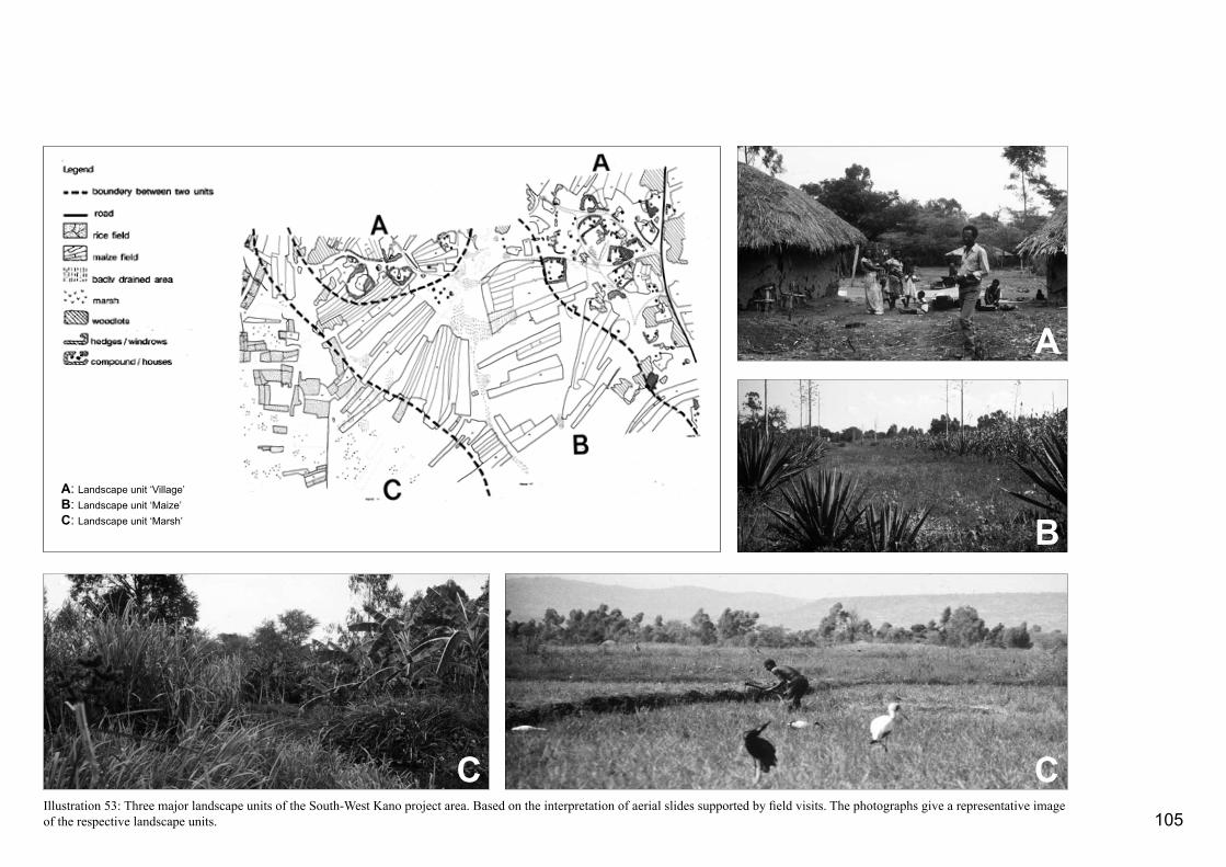
105
A
B
CCIllustration 53: Three major landscape units of the South-West Kano project area. Based on the interpretation of aerial slides supported by field visits. The photographs give a representative image of the respective landscape units.
A: Landscape unit ‘Village’B: Landscape unit ‘Maize’ C: Landscape unit ‘Marsh’

A BIllustrations 53 and 54 provide a detailed impression of these three major landscape units. The ‘village’ landscape unit (Landscape Unit A) was characterised by roads, homesteads, trees, bushes2 , crop and grazing land. The trees and shrubs provided shade as well as fuel and building materials. Rainfed crops like maize and sorghum were also grown within the compounds. This unit was correlated with the relatively higher levees, where soils are sandier in nature. From the levees, the land was cultivated in long strips running towards the marshes and these supported rainfed crops, such as maize and sorghum. Each strip was owned by a different landowner. This ‘maize’ zone was the second landscape unit identified (Landscape Unit B). Herds grazed on communally used grazings, on fallow or bush land as well as on recently harvested land, and on smaller strips of ground around homesteads and along roads. In this way, in 1986, more than 36% of the total project area was used for grazing, illustrating the importance of cattle keeping for the Luo farmers (EcoSystems Ltd., 1986). Table 3 presents the numerical distribution of land uses as derived from the aerial slides. Even though land shortage had already caused a drastic reduction in herd size and considerable numbers of cattle had been sent to relatives living in remote areas, the effects of overgrazing in the project area were obvious (Arao, 1986).
The relatively low-lying depressions with their heavy clay soils, shallow water tabel, and characteristic vegetation of reeds, sedges and grasses constituted the third ‘marsh’ landscape unit (Landscape Unit C). People used the grasses for thatching and roofing. During dry spells, the depressions were critical because it was only in these areas that farmers could
C
find grass for their cattle and water. Some of these depressions, for example, the earlier described Obange smallholder irrigation scheme had been reclaimed as early as 1950 for rice cultivation.
The Nyando River, streams, irrigated fields, water-courses and marshes, were the main sources of drinking water. In some areas, shallow wells had been constructed. Very few households practiced roofwater catchment. Each family member had his or her own tasks in the farming household. If this social organisation is related to landscape, it becomes clear that different types of responsibility were associated with particular landscape units. Women, for example, grow their subsistence crops and collect firewood mainly in the ‘maize’ unit while men are active in rice 106
Landscape Unit A: ‘Village’
Landscape features HousesMajor routesRainfed agriculture(maize, sorghum, beans)(cotton)FallowSoil quality recoveryHedgesWind rows
Woodlots
Bush cover
GrasslandScatterd trees
Landscape Unit B: ‘Maize’
Landscape features Rainfed agriculture(maize, sorghum, beans)(cotton, sugar cane)GrasslandBush cover Fallow land
Shallow wells
Landscape Unit C: ‘Marsh’
Landscape features
RicePapyrus swampsMarshGrass cover
Fallow landOpen water
Functions
ShelterCommunication
Subsistence cropsCash cropsGrazing
Protection, privacyBuilding material, cash(firewood)Building material, cash(firewood)Communal cattle grazingFirewoodCommunal cattle grazingShade, fruits, pods, reli-gion,Builing material, firewood
Functions
SubsistenceCash Cattle grazingCattle grazingFirewood Grazing Soil quality recoveryDrinking water
Functions
Cash/subsistenceRoof thatchingWater sourceGrasses for roof thatching(grazing)GrazingWater source
Users’ groups
FamilyCommunity
Women/menMenFamily
FamilyMen(women)Men(women)FamilyWomenFamilyCommunityFamily
Users’ groups
Women/MenFamilyFamilyWomen Family
women
Users’ groups
FamilyMenWomenMenFamilyFamilyWomen
Illustration 54: Landscape units, their uses and user’s groups
Type of land use Per cent
Marsh/swamp 4Rice 12Rainfed crops 29Fallow land 12Bush cover within village area 1.5Bush cover 3.5Grassland within village area 7Grassland 14Compound 10Hedges/windows/woodlots 3Miscellaneous, including open water 3
Table 3: Proportions of land-use types in rounded figures in the South-West Kano project area based on the statistics of Ecosys-tems Ltd (1986)

production, herding, and collecting building materials in the ‘marsh’ unit. ‘Wise’ women collect medicinal herbs from the bushland, swamps, and marshes. Illustration 52 gives the relations between landscape units, land uses and users’ groups.
What can be learned from this landscape analysis?The following conclusions emerged from the land-scape analysis: - The physical environment of the southwest Kanoarea provided a diverse resource base. The farming families used this base to build houses and community buildings, cultivate subsistence and cash crops, col-lect firewood and herbs, grow woodlots for cash and building poles, and herd cattle. Trees provided shade and hedges gave privacy and protection;- Each landscape unit had its own function for the farming household. Uncultivated areas, such as fal-low and bush land, also played a specific role in the land-use system;- Men, women, girl and boy children used different parts of the landscape; and - Land was getting scarce. It will not be easy for the people to find alternative areas that meet their land uses after irrigation has been introduced.
The following design criterion can be drawn from these conclusions. The design of the proposed scheme should be assessed on its implications for the resource base provided by the physical environment, the division of labour within the farming household, and the needs of the individual family members to access a variety of landscape resources.
The effects of implementing this option would reduce the areas being used for grazing and gathering grasses and reeds for roof thatching. To a certain extent, it might be possible to counterbalance this loss as it might be assumed that off-season rice land could be used for grazing. While, the remaining swamps and marshes south of the project area - which are unsuitable for reclamation - could continue providing the farmers with the necessary building materials . However, the farmers would have to travel a greater distance to collect them. The marshes are also a critical water reservoir and essential if cattle are to survive in dry periods. They have a regulating effect on the hydrology of the area as they function as a kind of sponge. Canals and drains would certainly impact this process. It can, however, be expected that flood irrigation would retain a certain amount of water in the depressions, and it might be suggested that the irrigated fields could fulfil a role in the hydrological cycle similar to that of the marshes.
In Option 2, the canal network was laid out with a view to develop a command area that included the depressions (as in Option 1) as well as their immediate surroundings. This option would, therefore, cover the landscape unit ‘marsh’ and the wetter parts of landscape unit ‘maize’. According to EcoSystems Ltd. statistics, the total amount of land taken up by rainfed crops is about 30%. EcoSystems Ltd. did not make a distinction between rainfed crops in the relatively wetter zones and those in the drier ones. From the analysis of the aerial slides and field visits, however, it appeared that approximately 15% of the total rainfed cultivated area was located in the wetter areas. Consequently, an additional area of 4.5% (15% of 30% see Table 3) would be brought under irrigation.
3.3.5 Four Options for Future Land Use
The location of primary and secondary canals determines the boundaries of the irrigated schemes and the non-irrigated area. The irrigated land was mainly used for male-dominated cash-crop production and the non-irrigated land for subsistence crops, shelter, firewood, medicine and other typically female-related responsibilities. In other words, the location of the canals form the preconditions within which the farming household could develop a modified land-use system - but now including a large portion of irrigated crop production. Four optional layouts are discussed to illustrate the consequences of the layout of the canal network for future land-use systems. These options show the local situation under increased irrigation development when subsequently the swamp, maize, and village landscape units are brought under irrigation command (Illustration 55 and 56). The options were evaluated against the knowledge obtained from the literature study and the landscape analysis. It was assumed that for the first five years the irrigated area would mainly be used for rice production.
In Option 1, the network of primary and secondary canals was laid out with a view to irrigating all areas already under rice and all the marshes and fallow land in the depressions. This was basically the landscape unit ‘marsh’. According to the statistics of EcoSystems Ltd., 16% of the project area was either used for rice cultivation or covered by marshes. So, Option 1 could bring an area of 930 hectare (16% of 5800 hectare) under irrigation, including the 350 hectare coverd by the two existing schemes Nyatini and Obange.
107

108
A relatively large portion of fallow land was found in the zone surrounding the depressions. It was assumed that approximately half of the total fallow land - 6% of the total project area - would be added to the irrigated area in Option 2. In total, Option 2 shows a situation in which 26% (Option 1 plus 4.5% plus 6%) of the overall area, i.e. 1500 hectare are brought under irrigation.
The additional area brought under irrigation in this option is currently being used for subsistence cropping and grazing. The replacement of these rainfed crops - grown in the lower and wetter areas- would dramatically increase the risk of a food-crop failure during periods of drought. Substituting the fallow and bush land with irrigation would reduce the amount of land available for grazing, it would also deprive the community further of sources of firewood and building materials. To counteract this negative effect of introducing irrigation, trees should be planted as an integral part of the project. It should be noted however, that within the irrigated fields there would be very little space available for growing trees. In addition, not many tree species would do well because of the high ground-water table. Tree planting should, therefore, be concentrated in the non-irrigated areas.
In Option 3, a canal network was envisaged that would enable the development of irrigation that - with the exception of the elevated ridges - would cover most of the project area This option would usurp the ‘marsh’ and ‘maize’ landscape units. The result would be that the area used for rainfed crops, fallow land, most of the bush cover and a substantial part of the grazing land available would be taken up by irrigation. In this scenario the remaining land that is presently used for
the production of food crops (25% of the total area), the land under bush cover outside the villages (3.5% of the total area), 65% of the remaining fallow land (4% of the total area), and half of the grasslands outside the villages constituting 7% of the total area might be brought under irrigation. In total this represents about 41% of the project area. Option 3, therefore, shows a situation in which 67% (Option 2 plus 41%) of the overall area - some 3900 hectares - will be brought under irrigation.
The replacement of rainfed crops by irrigated crops would lead to the elimination of most subsistence crop production. The region as a whole would no longer be able to produce sufficient food crops and would suffer a serious shortage of firewood. In addition, it would no longer be possible to keep herds. The land-use system would be seriously disturbed because of the drastic reduction in the farmers’resource base. The cash earned by the sale of paddy would have to be used to obtain food, dairy products and firewood. Traditionally cash incomes are largely controlled by men. Food and energy are predominantly the responsibility of women. So, Option 3 would only be successful if in-depth social change could be realized in which women are allowed more say in how cash incomes were to be spent. It is highly-doubtful whether such a change would be possible in the short term. In addition, it is questionable if there would be sufficient labour available to cultivate the whole irrigated area effectively.
In Option 4, the whole project area would fall un-der the command of the irrigation scheme. The consequence of this option would be that irrigated agriculture would take the place of houses, compounds
ABC
Illustration 55: Four options for rice irrigation (Duchhart and Povel, 1991) (Drawing G. Kleinrensink)
irrigation
irrigation
irrigation
irrigation

109
and the area surrounding them. This would deprive the farm household of shelter, grazing land, building materials, firewood and other tree products as well as infrastructure such as roads. This option would lead to a situation similar to that described in the Ahero Scheme where the farmers’resource base had been reduced to a level where it was too narrow for a durable subsistence.
3.3.6 Conclusions
In order to facilitate the design of a sustainable, relatively large, smallholder irrigation development in the Kano Plains, the effects of irrigated rice production on the local land-use systems in various small-scale, farmer-managed schemes and in the large-scale, centrally-managed Ahero Scheme, were evaluated. It was found that rice production was an integrated part of a multiple land-use system. Where irrigated rice was the dominant feature of land utilisation, as in the Ahero Scheme, the general health condition of the farming family dete-riorated.
The knowledge that socio-economic processes are reflected in the landscape made it possible to relate land users’ groups to specific landscape units. This relationship proved a helpful tool in assessing the impacts of changes in the landscape for the different groups concerned. Visualizing the present and the future physical environment in maps and cross-sections made these interrelationships even more tangible. It made clear the type of choices that needed to be made and their consequences.
irrigated land
Illustration 56: Four options for future irrigation development. (Drawings by A. van het Veer)
Option 1: Landscape unit C: ‘Marsh’ brought under irrigation totalling up to 930 ha.
Option 2: Marsh land together with the wetter parts of land-scape unit B: ‘Maize’ brought under irrigation totalling up to 1500 ha.
Option 3: Landscape unit C: ‘Marsh’ and landscape unit B: ‘Maize’ both fully brought under irrigation totalling up to 3900 hectares.
Option 4: All three landscape units brought under irrigation - including roads and villages.
110
A major design criterion was that the introduction of an irrigation system should not prevent farming households from accessing the resources they need to grow subsistence crops, collect firewood and access drinking water. There should also be sufficient grazing, resources for building materials, and land for compound expansion and community facilities. It appeared that access to a diverse resource base that, indeed, included a cash income from an irrigated rice crop offered farm households the opportunity to improve their standard of living.
This statement was illustrated by exploring four options for irrigation development. The resource base of the farm household was gradually narrowed down from irrigating just the depressions in the area to irrigating the area as a whole. The reclamation of the depressions and their direct surroundings as described in Option 2, would have a minimum impact on the land-use system and would make an increase in agricultural production possible. Here the diversity of types of land use - irrigated land, rainfed cropped land, bush cover - approached the situation at Obange where, after 30 years of irrigated agriculture, the ratio between irrigated and non-irrigated land is approximately 1 to 3. If Option 2 were chosen about 1500 hectare could be developed for irrigated crop production including the rehabilitation of the existing schemes. In this option, only the most suitable areas for rice irrigation would be developed for irrigation. Furthermore, the fact that the existing schemes were not used to their full capacity, and also that - in the short term - irrigation would not be used for food crop production indicated that the initial irrigable area should not exceed the 1 to 3 ratio. In addition,
Option 2 would make possible a gradual extension of the irrigable area if necessary.
The laying out of a canal network alone - even in the case of Option 2 - would not lead to an optimal situation. Success, would depend on development programmes for agroforestry, drinking water, and livestock being introduced when the new irrigation system was being established. These programmes would help the farm households find a new balance in their land-use system and enable the development of a sufficiently broad resource base. The landscape analysis was instrumental in setting the boundary conditions for the design of an irrigation scheme in which non–irrigated land uses were also taken into account. A multifunctional landscape design visualizing the best locations for tree planting to provide for building materials, shelter, and agroforestry would further enhance the quality of the irrigation intervention. As per 1988, the PIU implemented a canal network that followed the scenario sketched in Option 3.

111
The Undugu Society of Kenya, a non-governmental organisation assists the urban poor, in particular, the children of Nairobi. They run various vocational training programmes, a souvenir shop, and manage orphanages for street children, among other activities. They receive support from circles of friends in The Netherlands and Germany and from various other donor organisations.
In 1983, the Undugu Society fostered a self-help housing programme. A fire had broken out in Pumwani, a slum area in Eastleigh, Nairobi - an area in which Undugu was already active. In consultation with the stricken people, it was decided to build better houses than the plastic structures in which they had previously lived. This would make them less vulnerable to fire. The Undugu Society helped the local people with technical assistance and materials while the people themselves did the work. By 1986, 1068 houses were built in three so-called “villages”, Kitui, Kanuku, and Kinyago. Approximately six people lived in one house. The low-cost housing Undugu programme had thus provided housing to some 6500 people.
Early 1986, some youth groups living in the villages asked the Undugu Society for technical and financial support so they could start off a tree nursery. This was around the same time, that Undugu Society realised that although the housing conditions in the villages had dramatically improved, the direct living environment was still in a pathetic condition and presented a threath to the health of the people of Pumwani. The Director of Undugu Society asked Frédèrique Grootenhuis and myself for advice. In addition to a strategy for improvement, the director was keen to gain insight into the design process (Duchhart, 1986b; 1989c).
3.4
Suggestions for an ImprovedLiving Environment in an Informal Neighbourhood of Nairobi
3.4.1 Planning Approach and Working Method
The overall idea was to combine the request of the youth group with plans to improve the direct living environment in the villages. The individual house-holds struggled daily with the problems of water shortage, lack of space, bad sanitation, no income or an irregular one, and sick children and family members. At a village level, bad drainage, floods, uncollected garbage and human waste dominated the environ-
Illustration 57 Location of the Kanuku and Kinyago Villages (Drawing by A. van het Veer)

112
ment. Mismanagement at village level was having a devastating effect on household life. Obviously, in the Kanuku and Kinyago villages two planning levels had to be addressed; the level of the individual or household and the level of the village community. Hence, a successful landscape intervention had to include the following:- Integration of the two relevant planning levels mentioned above. As environmental improvement in a slum area lay solely in the hands of the inhabitants themselves, individual interests must be respected. Only then would the individual put efforts to improv-ing the immediate living environment; - Attention had to be given to meeting the (daily) human needs of adequate nutrition, shelter and clothing, and the provision of conveniently accessible and clean water, good health and education; - Assessment of the site: the people in Kanuku and Kinyago had to cope with problems that would not have occurred if the site characteristics had been taken into account initially. If the access roads would have been located parallel instead of perpendicular to the contour lines, there would have been less erosion of roads and consequently less damage to houses;- Flexible planning with an eye to future but as yet unaffordable improvements and fast changing socio-economic and population conditions; and - Respect for the institutional intervention envir-onment of Undugu Society as well as the Kenyan Government.
Illustration 58 gives the working method that was fol-lowed in this case-study project. An important aspect was the inclusion of the conscious analysis of the institutional context - called by the Undugu Society the intervening variables.
3.4.2 Landscape Analysis and Problem Identification
The case study focused on Kinyago and Kanuku in which 500 semi-permanent houses were constructed housing approximately 3000 people. Most of Kinyago and Kanuku people came from the rural areas and many of them had a Wakamba background. When they arrived they belonged to the poorest in Nairobi. To earn an income some had to sub-let part of their one-room house, sometimes there would be as many as three lodgers to a room. Others engaged in com-
mercial sex or small-businesses like carpentry, ironing and washing, or selling of vegetables and water.
The villages were located in the neighbourhood Pumwani in the eastern part of Nairobi, which was relatively near the city centre and the industrial area of Nairobi and thus to (potential) work. Access to public transport was good and a retail market and an informal industrial centre lay nearby.
The villages were built on the slopes and floodplain of the Nairobi River. The difference in elevation between
implementation and planning process of low-cost housing programme Undugu Society
Kenya
landscape planning criteria for a healthy and comfortable living environment
inventory existing immediate physical envi-ronment (villages Kanuku and Kinyago)
evaluation intervention variables
impact
suggestions for further improvement of the living environment
discussions with inhabitants by Undugu Society (from 1987 onwards)
Illustration 58: Working method followed in the Kinyago, Kanuku case study project (I. Duchhart, 1986)

113
the top of the slope and the floodplain was about 8 metres. The slope was short and rather steep with a soil that consists of murram and rocks. The floodplain is about 25 metres wide.The water level in the Nairobi River fluctuates and floods the area regularly during the rainy season. The soil is badly drained, but fertile and suitable for agricultural production. The area covered about 1.6 hectare of land. Illustration 59 gives a schematic cross-section of the area.
The houses were built in lines perpendicular to the slopes and clustered in about six houses around a small open space. This open space had a ‘semi-private’ character and was actively used (Illustration 60). Houses were built less than a metre apart and not connected to a sewerage system. A few pit latrines were built in the floodplain, but these fell apart during the floods. The floodplain was, in fact, used as a public toilet and garbage dump. In some areas, soil had been excavated for the construction of the houses leaving stagnant water to collect in the pits left behind. Despite the dirt, youngsters played football and toddlers roamed around in the garbage.
A few roads ran from the top of the slope down to the floodplain. During the rains, the rainwater gushed down the roofs and roads and accumulated in the floodplain, damaging the houses located at the foot of the slope and eroding roads. Often, the already contaminated and polluted Nairobi River would also flood and as water levels rose houses would suffer water damage from below as well as above. The climate is hot and there were no trees to provide shade.
Water and fuel were expensive and sold at selling-points. Even after the renovation of the villages the im-
mediate living environment continued to be unhealthy because of the combination of uncollected garbage, human excrement, stagnant water, crowded houses, high temperatures, and lack of clean water. Children, in particular, suffered from diarrhoea and fevers and wounds and injuries that were slow to heal.
Trees as a means for environmental improvementWhen the youths requested support for their tree nursery project they envisioned earning an income from the sale of seedlings and fruits. They hoped that people would plant the seedlings to beautify their
homes, but also that the fruits would help the village people to improve their health.
In addition to these benefits, trees and shrubs could also improve the outdoor and indoor microclimate. People tend to gather and sit, talk, and sell products under the shade of a tree. Furthermore, trees and shrubs can offer useful products such as, fuelwood, fodder for goats and chicken, and building materials. Soil conservation would be another beneficial side effect of planting shrubs and trees. The combination of the young people’s vision and the potential
Illustration 59: A schematic cross-section of the Kinyago and Kanuku site (Duchhart, 1986b; 1989).
Illustration 60: The villages Kinyago and Kanuku were characterised by intensively used open-spaces (Photo I. Duchhart, 1986).
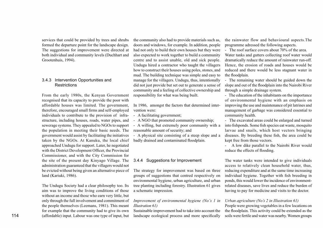
114
services that could be provided by trees and shrubs formed the departure point for the landscape design. The suggestions for improvement were directed at both individual and community levels (Duchhart and Grootenhuis, 1994).
3.4.3 Intervention Opportunities and Restrictions
From the early 1980s, the Kenyan Government recognised that its capacity to provide the poor with affordable houses was limited. The government, therefore, encouraged small firms and self-employed individuals to contribute to the provision of infra-structure, including houses, roads, water pipes, and sewerage systems. They appealed to NGOs to support the population in meeting their basic needs. The government would assist by facilitating the initiatives taken by the NGOs. At Kanuku, the local chief approached Undugu for support. Later, he negotiated with the District Development Officer, the Provincial Commissioner, and with the City Commission for the site of the present day Kinyago Village. The administration guaranteed that the villagers would not be evicted without being given an alternative piece of land (Kariuki, 1986).
The Undugu Society had a clear philosophy too. Its aim was to improve the living conditions of those without an income and those who earn very little, but only through the full involvement and commitment of the people themselves (Leemans, 1981). This meant for example that the community had to give its own (affordable) input. Labour was one type of input, but
the community also had to provide materials such as, doors and windows, for example. In addition, people had not only to build their own houses but they were also expected to work together to build a community centre and to assist unable, old and sick people. Undugu hired a contractor who taught the villagers how to construct their houses using poles, stones, and mud. The building technique was simple and easy to manage for the villagers. Undugu, thus, intentionally did not just provide but set out to generate a sense of community and a feeling of collective ownership and responsibility for what was being built.
In 1986, amongst the factors that determined inter-vention were:- A facilitating government;- A NGO that promoted community ownership;- A willing, but extremely poor community with a reasonable amount of security; and - A physical site consisting of a steep slope and a badly drained and contaminated floodplain.
3.4.4 Suggestions for Improvement
The strategy for improvement was based on three groups of suggestions that centred respectively on environmental hygiene, urban agriculture, and urban tree planting including forestry. Illustration 61 gives a schematic impression.
Improvement of environmental hygiene (No’s 1 in Illustration 61)Sustainable improvement had to take into account the landscape ecological process and more specifically
the rainwater flow and behavioural aspects.The programme adressed the following aspects.- The roof surface covers about 70% of the area.Water tanks and gutters collecting roof water would dramatically reduce the amount of rainwater run-off. Hence, the erosion of roads and houses would be reduced and there would be less stagnant water in the floodplain.- The remaining water should be guided down the slope and out of the floodplain into the Nairobi River through a simple drainage system.- The education of the inhabitants on the importance of environmental hygiene with an emphasis on improving the use and maintenance of pit latrines and management of garbage was considered essential to community health.- The excavated areas could be enlarged and turned into fishponds. Some fish species eat waste, mosquito larvae and snails, which host vectors bringing diseases. By breeding these fish, the area could be kept free from those vectors.- A low dike parallel to the Nairobi River would reduce the effects of flooding.
The water tanks were intended to give individuals access to relatively clean household water, thus, reducing expenditure and at the same time increasing individual hygiene. Together with fish breeding in ponds, this would lower the incidence of environment-related diseases, save lives and reduce the burden of having to pay for medicine and visits to the doctor.
Urban agriculture (No’s 2 in Illustration 61)People were growing vegetables in a few locations on the floodplain. This activity could be extended as the soils were fertile and water was nearby. Women groups
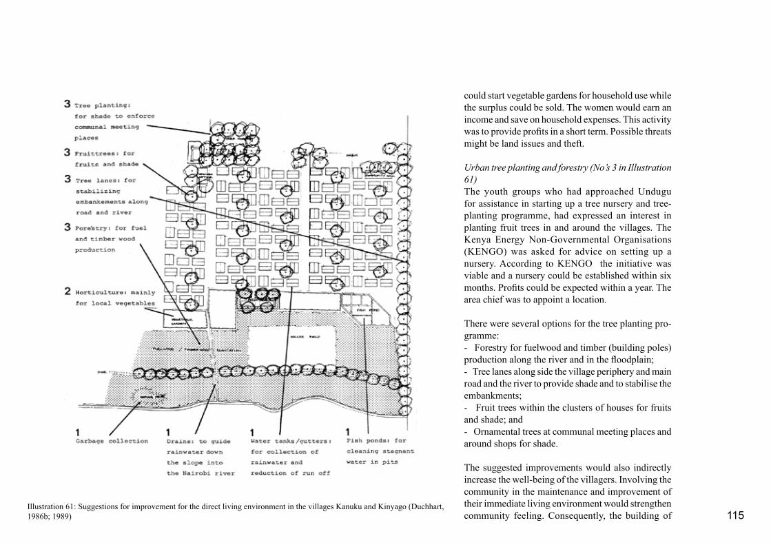
115
could start vegetable gardens for household use while the surplus could be sold. The women would earn an income and save on household expenses. This activity was to provide profits in a short term. Possible threats might be land issues and theft.
Urban tree planting and forestry (No’s 3 in Illustration 61)The youth groups who had approached Undugu for assistance in starting up a tree nursery and tree-planting programme, had expressed an interest in planting fruit trees in and around the villages. The Kenya Energy Non-Governmental Organisations (KENGO) was asked for advice on setting up a nursery. According to KENGO the initiative was viable and a nursery could be established within six months. Profits could be expected within a year. The area chief was to appoint a location.
There were several options for the tree planting pro-gramme:- Forestry for fuelwood and timber (building poles) production along the river and in the floodplain;- Tree lanes along side the village periphery and main road and the river to provide shade and to stabilise the embankments;- Fruit trees within the clusters of houses for fruits and shade; and - Ornamental trees at communal meeting places and around shops for shade.
The suggested improvements would also indirectly increase the well-being of the villagers. Involving the community in the maintenance and improvement of their immediate living environment would strengthen community feeling. Consequently, the building of
Illustration 61: Suggestions for improvement for the direct living environment in the villages Kanuku and Kinyago (Duchhart, 1986b; 1989)

116
the houses would not remain an isolated “high-lighted” activity, but rather one of the many activities designed to build a village. The higher the quality of the environment and community maintenance, the fewer arguments could be raised against “informal” non-legalised, low-income villages. This would then strengthen the negotiation position of the community vis-a-vis eviction.
3.4.5 Implementation
Undugu Society Kenya adopted the suggestions for improvement and forwarded the plan for financial support to their Dutch Circle of Friends. They in turn forwarded the idea to the Netherlands Habitat Committee. The committee adopted the idea and promoted the programme as one of their activities in the context of the UN Year “Shelter for the Homeless”. In 1987, the Kenya Undugu Society received about US$ 18,000 from the committee to facilitate the implementation of the proposed environmental impro-vements.
The basic idea behind the design was that all activities should be linked together in a network of relations. The gutters and water tanks on the slopes created new opportunities for using the floodplain. The activities scheduled for the flood plain would not only give the area a purpose, but they would also counter the way it was being misused as toilet and garbage dump. One activity supported the other and together they would improve the environment and the life of the inhabitants. As the co-ordination between the various programme elements was crucial to achieve
a comparative advantage, Undugu Society hired a local programme co-ordinator - Kuria Gathuru. Kuria proved an excellent choice. He worked closely with and through the community. He educated them, talked with them, listened to their problems and their ideas, and patiently assisted the community in identifying their needs and priorities further.
Within a year: - The community had constructed water tanks and had also cemented the walls of their houses increasing their durability by some 15-20 years;- Women groups had started vegetable gardens; - The chief had allocated a site for a tree nursery;- Stagnant water ponds were used to keep geese (their meat was preferred above fish);- Shade trees were planted and being cared for; - With the assistance of UNICEF, Undugu was in the process of removing the old pit latrines and construct-ing toilet blocks on the upper parts of the villages.
During the next five years, the village community had further improved their houses by plastering them and putting up gutters and water tanks. They dug drains, extended vegetable gardens, planted trees, and had removed old and dirty pit latrines and built new ones. The Undugu Society continued to support the process through communication and by providing technical expertise and materials. The women were particularly active in the urban agriculture programme and set up a small flourishing vegetable market (see Illustrations 62 and 63).
Illustration 62: The water tanks constructed by the community with technical assistance from the Undugu Society (Source: Green Towns Video “Working Together”, 1994)
Illustration 63: Vegetable and banana gardens replaced the dirty and contaminated floodplain (Source: Green Towns Video “Work-ing Together”, 1994)

117
The case-study exercise itself took a couple of weeks. However, the actual implementation process took many years. Things changed. Frederique Grootenhuis interviewed Mr. Kuria Gathuru to find out what happened to the villages. It is June 2000 and Kuria looks back (Duchhart, 2000).
Mr. Kuria you worked with the Kanuku and Kinyago commu-nity from 1987 up to 1995. You left just after the Green Towns Project filmed the villages – how did you feel at that time?
I was very proud of the community and the work they had done. In particular the ‘agricultural’ and ‘artifacts’ women groups had done so well. These women no longer relied on Undugu Society. Actually, it was these women who pushed me to leave Undugu Society. They told me that they were very fine and that it was time that I started to think about myself.
Last year November 2000, you were asked to assess Undugu’s intervention in the villages. Could you please share with us some of your findings?
At first glance, it looked like that all efforts had vanished. The water tanks were no longer in use, because the rainwater is too polluted. The floodplain is built up and nearly every other open space is taken up by shelters. The area is so congested that even the fire brigade cannot enter anymore. The area is again full of garbage, because the clean-up groups stopped.
But, at a second glance, the banana and other fruit trees planted in the early days still protect the floodplain from floods. Ba-nanas are harvested. One woman protected her avocado tree with determination and now sells the fruits. The area is properly drained by six kilometres of drain. The floodplain became a safe place to settle, and thus (even though this was not the original intention) many shelters were constructed.
The women who started the vegetable gardens and the little market to sell their produce now go to the retail market to buy vegetables and trade them on their own market. Many other
income-generating activities have come up. The villagers have money to pay school fees and improve their shelters. Many of the original residents are still living there. Many rent out one or two rooms. Some even want to apply for electricity and telephone connections.
Security of tenure has improved. The villagers are in the proc-ess of establishing a land trust. Occupation letters are issued. Neighbourhood guards protect the area for a small fee. Plans are made to organise garbage collection in a similar way. Kinyago and Kanuku villagers became respected Nairobians.”
Even though the outcome of the original environmental strategy changed, do you believe that Undugu’s initiative to address the immediate living environment was a worthwhile and valid activity?
Yes, I am absolutely convinced that the initiative triggered off a change for the better. The production of vegetables kept hun-ger at bay and later provided a good income. The water tanks improved the health of the villagers. Many villagers modified the idea of the water tank into idea of having bathrooms (built on top of the drains). Some of these bathrooms changed into a paid public facility.
The clean-ups and the various recycling activities that followed created a community spirit. The agriculture and horticulture groups developed into small-credit and investment groups. As a result, many strong and independent women created a posi-tive environment for their children to grow up in. Currently, the residents are contemplating their own primary school while more and more people can afford secondary school fees. So, yes even though the first step was the provision of decent housing, the initiative to address the environmental issues on a village level was crucial to facilitate the growth of the individual residents and the village community.
I agree, not everything was implemented as originally was envisioned, other activities more important to the community were included, and the beautiful vegetable gardens in the flood-
plain disappeared again. But, please, do not forget that the environmental strategy gave suggestions to start up a process and stimulate a discussion. The environmental plan was never intended to be an end product. It was the process that counted most.
Mr. Kuria, thank you for your collaboration. I do know that you gave more than 100% of your energy to the development of Kanuku and Kinyago Villages. The process was slow and tedious and sometimes even depressing. The problems, such as commercial sex, youth criminality, fresh influx of desperate people, sometimes seemed insurmountable. The newly planted trees died because men were ‘urinating’ on them. New environ-mental problems cropped – air pollution made it impossible to harvest the rainwater and industrial groundwater pollution jeopardised the growing of vegetables. Nevertheless, you never gave up and you helped to improve the lives of many children, women and men.
Box 3: Kanuku and Kinyago Villages in the year 2000 - an interview with Kuria Gaturu

118
4.3.6 Lessons Learmed
By 1994, the floodplain had developed into a flouris-hing vegetable garden. Women started a vegetable market along the main road near the villages and were earning a decent living by selling their products. The case-study project provided an example for slum upgrading for the Kenyan government, international organisations, and other NGO’s. The project played an important role in the development of the Green Towns project (see Part 4) and featured in the Green Towns training videos. Kuria looks back on his work in the villages Kanuku and Kinyago in a brief interview given in the year 2000 (Box 3, page 117).
The integration of the individual and household inter-est with community interests seemed a workable for-mula. The benefits, however, should be visible within a very short space of time. Even when the benefits were clear and obvious, ownership and userfruct played a more important role than was originally anticipated. Occasionally, this caused substantial delays in improv-ing the lower-lying sections of the drains. At other moments, actions took place in a reverse order. Only after the floodplain gained a profitable agricultural function, for example, did digging begin on the main drain to the Nairobi River. For several reasons, the forestry component had not developed, while the idea of fish ponds was too alien for adoption. Most people did not like fish and started to keep ducks and geese instead.
Nevertheless, the landscape analysis of the area proved a reliable design tool, not only in assessing the area’s qualities and dangers, but also in anticipating certain activities, such as the establishment of shops
at the village entrees. It should be noted that the actual design exercise took some weeks, while full implementation took nearly five years. The success of the case-study experience can be attributed largely to Undugu and the commitment of Kuria.
As stated in the theoretical starting notions, people and thus landscapes change. In Kinyago and Kanuku too the situation changed, sometimes for the better and sometimes for worse. Within a time span of ten years, the village communities of Kinyago and Kanuku gained a certain degree of social cohesion and pride. The living environment had improved substantially helped by the development of vegetable and banana gardens. However, with the continuous influx of people, the vegetable gardens were replaced by a new village of plastic structures. The market, however, has continued to develop and still provides the women with an income.

119
Thirty years after Kenya’s Independence, the number of urban centres with a population of 2000 or more had increased from 34 to over 100. The total urban population of about 4.1 million people became six times as large as it was in the 1960s (Omwando, 1988; Republic of Kenya, 1986, 1988). With an annual growth of 4% - and up to 11% in some towns - the urban population doubled again in the last decade. Today it represents one third of the country’s total population of approximately 30 million people. All these people need houses, schools, shops, food, water, energy, roads, and services like sewer treatment plants.
Organising, planning and managing these urban centres is an enormous task for the local authorities. To support the town officials in their planning and management activities, the Ministry of Local Govern-ment (MoLG) of Kenya initiated with the assistance of the United States (USAID), a Local Authority Development Programme (LADP) (Republic of Kenya, 1985). The programme aimed to provide support to enable each local authority to prepare a five-year development plan. Soon, USAID and the Ministry of Local Government realised that environmental and spatial issues were not sufficiently being addressed.
After a visit to the villages Kinyago and Kanuku, Mr. Omwando of the Urban Development Department of Ministry of Local Government allowed Reintje van Haeringen to prepare a development plan for Kisii town in which environmental and spatial issues were addressed (Haeringen, 1988). The plan was part of her Wageningen University minor thesis and was carried out under my guidance. With this plan setting the
scene, we embarked together on the project known as the “Integration of the Natural Environment in the Local Authority Development Programmes”. The Netherlands Ministry of Development Co-operation provided the funds and the project ran in three pilot towns, Kisii, Busia, and Homa Bay from March 1988 to March 1989. It was implemented with staff from the Urban Development Department of the Ministry of Local Government, the Kisii, Busia and Homa
3.5
Landscape DevelopmentConcepts for the Towns Kisii, Homa Bay, and Busia
Illustration 64: Location of the Kanuku and Kinyago Villages (drawing by A. van het Veer)
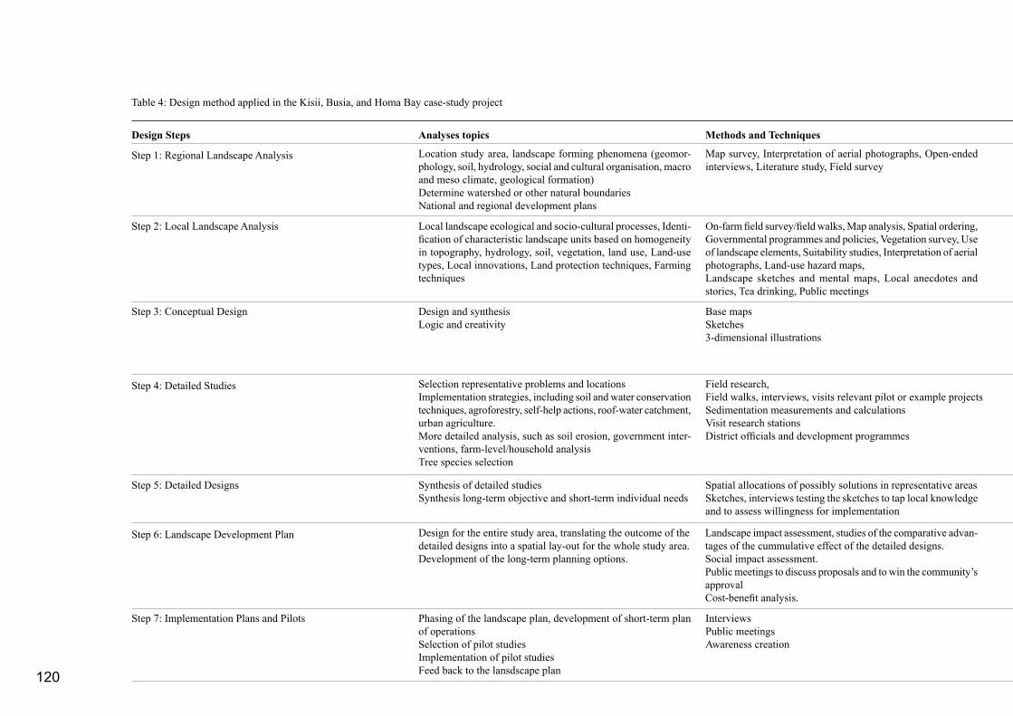
120
Step 1: Regional Landscape Analysis
Step 2: Local Landscape Analysis
Step 3: Conceptual Design
Step 4: Detailed Studies
Step 5: Detailed Designs
Step 6: Landscape Development Plan
Location study area, landscape forming phenomena (geomor-phology, soil, hydrology, social and cultural organisation, macro and meso climate, geological formation)Determine watershed or other natural boundariesNational and regional development plans
Map survey, Interpretation of aerial photographs, Open-ended interviews, Literature study, Field survey
Local landscape ecological and socio-cultural processes, Identi-fication of characteristic landscape units based on homogeneity in topography, hydrology, soil, vegetation, land use, Land-use types, Local innovations, Land protection techniques, Farming techniques
On-farm field survey/field walks, Map analysis, Spatial ordering, Governmental programmes and policies, Vegetation survey, Use of landscape elements, Suitability studies, Interpretation of aerial photographs, Land-use hazard maps,Landscape sketches and mental maps, Local anecdotes and stories, Tea drinking, Public meetings
Design and synthesisLogic and creativity
Base mapsSketches3-dimensional illustrations
Selection representative problems and locationsImplementation strategies, including soil and water conservation techniques, agroforestry, self-help actions, roof-water catchment, urban agriculture. More detailed analysis, such as soil erosion, government inter-ventions, farm-level/household analysis Tree species selection
Field research, Field walks, interviews, visits relevant pilot or example projectsSedimentation measurements and calculationsVisit research stationsDistrict officials and development programmes
Synthesis of detailed studiesSynthesis long-term objective and short-term individual needs
Spatial allocations of possibly solutions in representative areasSketches, interviews testing the sketches to tap local knowledge and to assess willingness for implementation
Design for the entire study area, translating the outcome of the detailed designs into a spatial lay-out for the whole study area. Development of the long-term planning options.
Landscape impact assessment, studies of the comparative advan-tages of the cummulative effect of the detailed designs.Social impact assessment. Public meetings to discuss proposals and to win the community’s approval Cost-benefit analysis.
Phasing of the landscape plan, development of short-term plan of operationsSelection of pilot studies Implementation of pilot studies Feed back to the lansdscape plan
Interviews Public meetingsAwareness creation
Step 7: Implementation Plans and Pilots
Table 4: Design method applied in the Kisii, Busia, and Homa Bay case-study project
Design Steps Analyses topics Methods and Techniques
121
Bay municipal councils and several other relevant ministerial departments, including the district officers of the Physical Planning Department, the Ministry of Agriculture and the Ministry of Environment and Natural Resources. I was project manager and responsible for the content. The Kenyan counterparts R. Chutha and J. Makokha, and three Dutch field assistants H. Beumer, M. Leeuwerik and C. Aalbers carried out the fieldwork. Frédèrique Grootenhuis provided substantial assistance (Chutha et al., 1989; Makokha et al., 1988; Aalbers et al., 1989).
3.5.1 Approach and Working Method
On the basis of the case-study projects discussed earlier, a step-by-step landscape-planning working method and approach had been evolved. The working method and approach used in these three case studies were founded on this approach. The method is described in the article “Planning methods for agroforestry” (Duchhart et al., 1989). Seven steps were distinguished. Table 4 shows these steps and summarises the actions involved in each planning step and the expected outcomes. The seven steps were run through iteratively, e.g. analysis results were used directly in planning or design activities while in turn plans or designs generated new data requirements. The first three steps from analysis to a first conceptual design took a relatively short space of time - perhaps a couple of weeks. Subsequent steps took longer. In total, the preparation of each case study took about three months.
Step 2 results in insight in the land-use system, in horizontal and vertical landscape relationships, mostly visualised in cross-sections, and a landscape unit map. Some understanding of the environmental perception of the local people might be included. Step no. 2 assesses and refines step no. 1. The problem statement indicated in step 1 often relates to environmental and landscape ecological issues while step 2 often refers to local and group socio-economic needs and may refer to the community as a resource base.
Step 1 results in a hypothesis on how the landscape was formed and how the area is socially and ecologically interlinked with its wider surroundings. Preliminary conclusions, often expressed in the form of objectives, and a general problem statements are formulated. A initial understanding of the study area and relevant questions to guide further study, are important results.
Step 3 results in a conceptual design. The conceptual design is a map in which a general outline is given of how problems, as stated in the problem statement (part of step 1 and 2) might be solved. The design shows allocations of uses and actions. It sets possible directions for future development of the area and therefore should be viewed as a basis for discussion. The development of a concept has the aim of generating questions and directing further analysis. The spatial lay-out helps to select representative areas for detailed analysis and design.
Step 4 results in different studies, often carried out on various scale levels. Problem statements, causes and effects, and new objec-tives related to individual household needs can now be included in the results of steps 1 and 2. A selection of promising techniques will be made and possibly tested. Assumptions in the concept will be verified. In the cases of Kisii and Busia, the use and origin of spring water and the production and marketing of urban agriculture, charcoal and firewoord, are exemples.
Step 5 results in various detailed designs for representative areas selected from the different landscape units. The designs may be tested in the field. It is on this scale, in particular, that the various techniques can be incorporated into an overall landscape develop-ment plan. Detailed designs (and implementation) form test cases for the conceptual plan.
A landscape or master plan is the result of step 6. This plan is not a fixed plan, but rather a spatial illustration of the suggested in-terventions. It provides guidelines for policy makers, extension workers, or self-help groups about how the rehabilitate and enhace the environment. The aim of the design activity in this step is that the total will be more that the sum of the parts (e.g. the detailed designs). Alternative plans can also be developed, which depending, among other things on future trend analysis. In the design process, it is not easy to point out where the coneptual plan has become the landscape or master plan.
Step 7, basically, relates to the implementation of development plans and the evaluation of the approach and technique. Implementing pilot projects can also be part of the detailed study and design exercise. This step may demand new detailed studies, for example, on the activities and social place of self-help or women groups or the protection of springs. The identification of constraints may lead to a reconsideration of the plans or pilots. Lessons learnt will be fed back. In Kisii and Busia, an implementation strategy was based on development “incentives” for private initiatives.
Results

122
From a normative stance, the method was based on the conviction that in order to create sustainable landscapes an integrated approach was necessary. This approach included integration of different points of study (social, economic, cultural, ecological, and political), the integration of various sectors (agriculture, forestry, and shelter) and most critically the integration and co-ordination of interactions between different planning levels (national, regional, local, and household). Design and sketching played a central role in achieving coherent and meaningful integration. The visual impressions of the existing or desired situation helped, for example, to reveal contradictions or conflicts between different types of land uses. As such, the design functioned as a guide for landscape development, an illustration of possible future scenarios, and as a decision making tool .
As in earlier case studies, the Kenyan counterparts and the Dutch field assistants lived in the towns through-out the project. This enabled the data collected to be continuously tested and verified which was particu-lar helpful in ensuring the purposeful integration of the different scale levels. The Kenyan counterparts accessed crucial information, in particular if they belonged to the dominant ethnic groups living in the town. Open-ended interviews with persons from all social and cultural groups were used to collect relevant data. Aerial photographs provided information on the spatial distribution of land uses and urban-growth processes.
Illustration 66: Homa Bay along Lake Victoria
Illustration 65: Kisii’s centre with peri-urban sprawl
Illustration 67: Busia’s strip development along the main road to Uganda (Photos by I. Duchhart)
Box 4: Landscape Analyses
The landscape analyses for Kisii, Busia, and Homa Bay towns entailed the following studies:
- Analysis of the capability of the town’s council and administrative staff,- Analysis of the most recent development plans, in particular the LADPs when available and the physical plans (Master Plan, Part Development Plans),- Inventory of ongoing development activities initiated by the local government, donors, self-help groups and non-government organizations at town and district level,- General landscape ecology analysis of the district (soil, water, geology, geomorphology, vegetation),- General land-use analysis of the district, specified for each ecological zone and ethnic group when necessary,- Specific landscape analyses within town boundaries (soil, water, geology, geomorphology, vegetation) and land-use analysis identifying physical characteristics and landscape units,- Analysis of the urbanization process addressing issues, such as economic forces and physical precondi tions,- Analysis of rural-urban relationships, with special atten- tion for the collection of drinking water from springs, peri-urban agricultural and the marketing of its products, and the production of fire wood and import of charcoal,- Analysis of social and cultural backgrounds of the popu- lation of the towns.

123
Kisii municipality covered about 29 square kilometres, Busia 40 square kilometres, and Homa Bay 19 square kilometres. The population in Kisii was estimated to be 53,500 people, in Homa Bay 19,500 people, and Busia had about 36,800 inhabitants. Each town had its own unique physical characteristics (Illustrations 65-67). Kisii town centre was most intensily built-up and had several high-rise buildings. The centre is surrounded by hills and in the north guarded by a steep escarpment. Even though rainfall is plentiful, there was still a shortage of clean drinking water. Piped water was insufficient and natural springs were contaminated (Chutha et al., 1989). Busia was a predominantly agricultural town located on a relatively flat plateau. Agricultural production was low because of the limiting physical conditions and also because of cheap food imported from Uganda meant competition was heavy (Makokha et al., 1988). Homa Bay was an interesting town with many contrasts. Half of the town was built on stable, sandy ground in relatively higher locations. Here, the district offices and the better houses had been built. The remainder of the town had developed in a valley that drained towards the lake and which has heavy black clay soils. In this unsuitable location, uncontrolled urban development had resulted in living circumstances that were hardly bearable and where the inhabitants were vulnerable to respiratory diseases, diarrhoea, typhoid, and malaria. Child mortality in Homa Bay district was extremely high. Data from 1986 showed that one out of five children died (Aalbers et al., 1989).
Kisii’s geographic position at 2000 metres above sea level made its climate relatively cool, Busia and Homa Bay are located at lower altitudes - both
3.5.2 Landscape Analysis
All three pilot towns are located in the western part of Kenya. Kisii is located in an area of high-agricultural potential in the Kisii Highlands and has a rapidly growing population. Homa Bay and Busia are located in medium to low potential areas. Their growth has been less dramatic. Nevertheless, it was estimated that Homa Bay’s and Busia’s population would double within 15 years. Homa Bay lies on the shores of Lake Victoria. Small boats connected Homa Bay with some of the lake’s islands and there is a ferry to Kisumu. Busia is a town on the border between Kenya and Uganda. Each town functions as a district headquarter and administrative centre, which meant that they offered services such as a district hospital. They also have banks, some industry and commerce, and secondary education. Gusii is the main ethnic group in Kisii, Luo in Homa Bay, and Luya in Busia.
Illustration 69: Characteristic landscape units as identified for Kisii town (Chutha et al., 1989) (Drawing H. Beumer).
B A
Illustration 68: Characteristic landscape units as identified for Kisii town (Chutha et al., 1989) (Drawing H. Beumer).
A
B

124
approximately 1100 metres - and have a hot and humid climate. Twice a week there is a busy market in Kisii and people from all over the region come there to buy and sell products.
Box 4 gives the specific areas of analyses that were covered by the project team. Illustrations 68-70 repro-duces some of the outcomes of the analyses.
Problem IdentificationIllustration 70 gives a schematic impression of the landscape problems observed in Kisii town. The impression is organised in such a way that causes and effects of problems are interlinked. Even though each town experienced problems specific to its unique location - for example, Busia as a border town had to deal with security issues - all three towns experienced the types of problems that arise when urban growth is particularly rapid. These include: - Expansion of hard surface resulted in serious ero-sion problems; - Urban services such as piped water, sewerage,refuse collection and also market and infrastructure facilities were overloaded, causing health hazards and nuisance to the public; - Drainage systems were often lacking, leading tothe destruction of land, roads and other facilities;- The high concentration of pit latrines threatened the quality of water in sources such as springs, wells, and boreholes; - Fertile agricultural land was being taken up by urban land uses, reducing the general capacity to produce food;- De-vegetation of the area caused shortages of fire-wood and charcoal, and resulted in erosion and an uncomfortable micro-climate; and
The urban growth in Kisii leads to an urban extension (controlled or uncontrolled) of about 1 km2 every 5 years and intensified use of the existing urban facilities and infrastructure (1). The existing facilities were not enough to serve the present population (2), let alone the extra population. The intensification of urban development will increase the total surface of built-up land (3). More houses and paved areas force rain water to run off and reduce infiltration (4) into the soil. Consequently, this causes serious erosion (6) and dried-up springs (5). Both effects, would form an extra burden on the already strained infrastructure (7). Urban growth also affects the rural environment of the municipality, the so-called peri-urban areas. Agriculturally productive land will be replaced by houses and roads and as a result the production of food and firewood goes down (9). Ultimately this will reduce the capability of the peri-urban population to be self-sufficient and diminish the supply of relatively cheap food for the informal markets in town (10). Due to the scarcity of land under the control of the municipality, urban extension and intensification of urban uses will increas-ingly take place in unsuitable areas (11). Already scattered urban houses and multi-story buildings are built on very steep slopes, which results in the degradation of these erosion-prone slopes and ultimately also of areas located down-streams. Because of this land-degradation the area will loose its capacity to retain water and to produce food and fire wood (12, 13, 14).
Illustration 70: Flow diagram illustrating Kisii town’s environmental issues, their causes and effects.

125
- Uncontrolled, scattered urbanization took place on unsuitable areas causing erosion, and because of lack of basic services increased health hazards.
Although every citizen suffered from the negative side effects of urban development, the urban poor suffered disproportionately from the degradation of the envi-ronment. They were often dependant for drinking water on springs or rivers and for their food on cheap, locally-grown, urban and peri-urban agricultural production. They lived in areas that lacked proper roads and drainage and as a result there were very many places where stagnant water formed breeding places for malaria mosquitoes and where heavy rains could do untold damage to their houses. This together with insufficient garbage collection generated hazardous and sub-standard living conditions.
3.5.3 Objectives
The landscape analysis and the subsequent problem statement led to the following overall objective for future urban development:
To steer urban development into areas suitable for urban growth in such a way that sustainable land use can be achieved – or in other words, to allow for ur-ban development without the negative consequences of rapid growth and to use natural resources to their optimum potential.
This objective was combined with the national deve-lopment policies of the central government1. As a result the overall objective was extended with the
following specific development objectives:- Support agricultural and energy production2;- Provide the population with a healthy environ- ment;- Protect areas vulnerable to land degradation;- Secure a sufficient supply of drinking water of good quality; and- Create a favourable and attractive working andliving environment.
3.5.4 Detailed Landscape Analyses To achieve objectives, such as support of agricultural production or protection of vulnerable areas, it was important to undertake more specific landscape analyses including things the identification of the potentials and constraints of the study areas (for example Illustration 73). Physical characteristics largely determine their suitability either for specific land uses, such as urban development and agriculture or whether they could fulfil special functions, such as water retention. The earlier identified landscape units were assessed in terms of their suitability for urban settlement, agriculture, and forestry. These assessments were based on specified criteria. The availability of infrastructural services, as illustrated in the urban growth analysis, were also included in identifying areas most suitable for urban development.
A detailed analysis was also made in relation to the factors that had triggered urban growth, where this had taken place and when. Aerial photographs taken at intervals of about 10 years and the situation on the ground in 1988 and 1989 were compared. The
Illustration 71: Kisii market was overcrowded. There was no protection against sun and rain and no sanitanitary facilities available. The massive storm-water run-off eroded the market and the access roads. The foreground shows an old overloaded sewage pond, while informal car mechanics spill oils directly into the soil. Subsequently, the lower-lying spring was contaminated and polluted, nevertheless people collected drinking water from here (Photo H. Beumer).
1
Reference is made here to Part 2 were the Kenyan planning context was set out. Sessional Paper No. 1, 1986, played in particular an important role.
2
Studies undertaken, among others, by the Mazingira Institute in Nairobi and Earthscan in London , indicated that urban agri-culture and forestry could provide the urban poor with approxi-mately 40 per cent of their needs for vegetables and firewood.

126
3.5.5 Strategy
These major constraints would jeopardise the im-plementation of the development concepts for the various towns and, therefore, the achievement of the objectives. The project team thought out a strategy of incentives that they considered might help overcome constraints. These incentives were based on the fol-lowing notions:
Low-costs solutions and low-maintenance interven-tionsAll interventions should be low in costs and main-tenance and fit into the financial resources, planning capacity, and human power available.
Incentives for private urban initiatives The analysis showed that both urban and rural development were generally the result of private initiatives and investments. Municipalities could
urban development on land that was in the hands of the council followed by and large the various physical plans, but on land in private hands there appeared to be a close correlation with the availability of infrastructure, in particular, all weather roads and piped water (Illustration 72). The suitability maps were compared and combined with one and other, which resulted in an initial spatial concept for future sustainable development of the towns. Interviews and observation studies were carried out to help identify sources of firewood or charcoal as well as how springwater was used (Chutha et al., 1989).
ConstraintsThe first spatial lay-outs for an ideal development of the town were presented to the staff of the respective districts and municipalities. Some non-governmental organisations were also included. Together, they appraised the feasibility of the layouts. The constraints varied from town to town but in all towns, the
municipal councils had very limited say on how freehold land was used and all had an extremely restricted budget. Other factors that would possibly hinder the imple-mentation of plans were the lack of proper legislation and weak law enforcement and political will.
In Busia private finances and human resources were also limited. Farmers had little capital available to in-vest in extending their agricultural activities. The inse-cure situation in this border town created an unreliable investment climate while the smuggling of cheap food and charcoal from Uganda had a negative affect on the local market. In addition, the natural conditions of the area were such that the physical basis for agricul-tural development was relatively narrow. Relatively well-to-do business men and farmers lived in Kisii, but here land shortage was specifically mentioned as hampering sound urban development.
1955 1967 1976 1988
Illustration 72: Temporal comparative study of the growth of Kisii Town. The development of urban houses was clearly linked to the development of all-weather roads (Chutha et al. 1989)
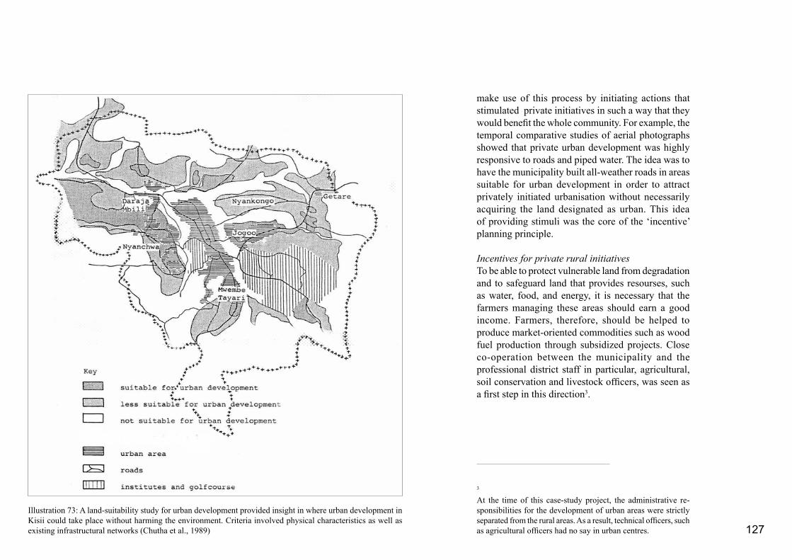
127
make use of this process by initiating actions that stimulated private initiatives in such a way that they would benefit the whole community. For example, the temporal comparative studies of aerial photographs showed that private urban development was highly responsive to roads and piped water. The idea was to have the municipality built all-weather roads in areas suitable for urban development in order to attract privately initiated urbanisation without necessarily acquiring the land designated as urban. This idea of providing stimuli was the core of the ‘incentive’ planning principle.
Incentives for private rural initiativesTo be able to protect vulnerable land from degradation and to safeguard land that provides resourses, such as water, food, and energy, it is necessary that the farmers managing these areas should earn a good income. Farmers, therefore, should be helped to produce market-oriented commodities such as wood fuel production through subsidized projects. Close co-operation between the municipality and the professional district staff in particular, agricultural, soil conservation and livestock officers, was seen as a first step in this direction3.
Illustration 73: A land-suitability study for urban development provided insight in where urban development in Kisii could take place without harming the environment. Criteria involved physical characteristics as well as existing infrastructural networks (Chutha et al., 1989)
3
At the time of this case-study project, the administrative re-sponsibilities for the development of urban areas were strictly separated from the rural areas. As a result, technical officers, such as agricultural officers had no say in urban centres.

128
3.5.6 Landscape Development Plans
The “incentive” planning approach was integrated with initial landscape development concepts that were based on land-use suitability. The resulting landscape development plans illustrated how environmental issues could be integrated in the future development of the various towns. They showed how different land uses should be organised spatially in order to achieve the objectives. The plans acted as guidelines in the decision-making process of the municipal councils and as a framework for future development programmes and projects. The plans were strongly based on the characteristics of the defined landscape units, their interrelationships, their suitability for urban or agricultural development as well as on their potentials for private incentive-driven development. Illustration 74 shows the development plan for Kisii town. As far as natural resources were concerned each plan balanced protective (forestry), productive (agriculture and agroforestry), and non-productive, hard (urban) land uses. The protective as well as productive land uses supported soil and water conservation.
3.5.7 Detailed Designs and Actions
To achieve the goals outlined in the proposed land-scape development plan, each report suggested a set
Illustration 74: Landscape development plan for Kisii town (Chutha et al., 1989) (Drawing H. Beumer)

129
of interlinked projects. Detailed designs supported by specific and detailed studies laid the foundation for these development projects. Every project could be implemented on its own but when combined with other projects it would have a much stronger impact.
Although each town developed its own specific landscape development concept and set of interlinked projects and designs, they all formulated programmes on soil and water conservation, road improvement and road extension, urban improvement, and public health and public awareness. Some programmes and their subsequent projects are described below:
A. Soil and Water Conservation (Illustration 75) - Peri-urban drainage projectTo protect infrastructure and fertile lands, run-off should be slowed down, divided, and allowed to infiltrate into soil as much as possible. Public grassed drains linked with private gardens were suggested to Kisii.- Urban drainage projectIn the densely built-up part of town storm drainage systems should be built along the main roads as was suggested to Homa Bay.- Roof-water catchment projectRoof-water catchment will reduce the amount of run-off reaching the roads and drains and at the same time provided the population with an extra water source. - Agricultural/agroforestry support projectUrban agriculture and agroforestry were regarded as most-suitable land uses for landscape units that served as water infiltration areas or that require soil protection. Emphasis should be put on the production of marketable vegetables, fruits and dairy products. Agroforestry practices were oriented towards land
Prevention of Erosion
Preventive measures (urban setting)1. Protect the ground from large raindrops a. protection through vegetation cover b. protection through trenches filled with small stones
2. Prevent large raindrops reaching the ground, through rain water catchment
Grass drains for improved rainwater infiltration
Illustration 75: A detailed design to illustrate possible solutions for the prevention of erosion (Duchhart, 1989; 2000; Development Communications, 1990) (Artistic impression L. Duckworth).

130
protection while producing fuel wood, fodder, and timber.- Forestry projectIn Kisii, in particular, the steep valley slopes played an important role in the overall drainage system of the town. Many of these slopes were eroded. They there-fore needed a protective vegetative cover. Forestry could also provide an income to the municipality. It was suggested that Busia Town Council use treated sewage to irrigate forest trees.
B. Improvement and Construction of RoadsThe planning strategy suggested that roads were the most important incentive for urbanization. The plans indicated where roads should be improved or constructed to stimulate private urban development. The programme mostly consised of two types of projects: the improvement of existing roads and the construction of new roads.
C: Drinking Water Supply - Piped water supply In Kisii and Busia, the water quantity supplied by the municipality was totally insufficient. To increase the supply of water, the reticulation system had to
Illustration 76: Improvement of the market in Homa Bay through tree planting and terracing (Duchhart, 2000; Develop-ment Communications, 1990) (Design, I. Duchhart; Artistic impressions L. Duckworth).
Problems
Erosion of the market area. Bad access to and on the market. Lack selling places. No shade. Dust
Solutions
Construction of terraces, stabilised through retaining walls of local stones.Reconstruction of access road.Drainage system to drain rainwater from terraces and road.Terraces function as selling places.Trees are planted for shade and to keep the soil.Planting of surrounding hedge to reduce wind speeds and control the dust.Murram surface reduces dust and improves access.
131
and welfare officers defended projects that would fulfil the more primary needs of the population, such as the provision of clean drinking water, drainage, and toilet facilities as well as affordable markets. The landscape planners found themselves somewhere in between. On the one hand, they were concerned with integrating the needs of the various parties involved. On the other, they also had to defend their own agenda which included ensuring that natural resources were protected in such a way that food, water, and shelter could continue to be produced. In putting forward unique designs they also aimed to encourage a sense of local identity and pride. Implementation of the landscape plan was reasonably flexible and focused on the idea of providing “incentives” that would generate development.
These case studies not only further underlined the im-portance of links among individual drives and interests with community needs for sustainable planning, but also made clear that links should be sought at gov-ernmental levels and with political interests. A major and time-consuming activity in the landscape design process was the search for such links. The renovation of the market in Kisii, for example, had to satisfy the need for status expressed by politicians and govern-ment officials; protect the area from further land deg-radation; improve the micro climate; fulfil the wishes of the market women for a better market; protect shop owners from losing their shops through soil erosion; improve access to the shops; function as an illustra-tive example for (peri)urban watershed management; improve the market with relatively cheap and local means for economic purposes as well as enhance the identity of the place. Part 4.2 will present the design and implementation strategy for this market.
be improved and its capacity enlarged. Furthermore, the capacity of the booster tanks would have to be expanded. - Spring protectionA spring survey indicated the importance of spring water for the rural, peri-urban and even for the urban population. The water was often used as drinking water. The water quality, therefore, had to be assured. This could be achieved by the protection of spring outlets and catchment areas.
D: Public Health Studies indicated that public health was threatened in four ways. First, springs were sometimes contami-nated. Second, raw sewage was regularly dumped into drains and rivers. Third, aeration time in the sewer-age pond was too short to clean the sewage properly. Fourth, refuse collection was inadequate. Spring pro-tection was dealt with in the water supply programme, which left two other projects: the improvement of the sewerage systems and refuse-collection.
E: Market Renovation (Illustration 76)To strengthen the economic position of towns, the open-air market facilities had to be improved especially in Kisii and Homa Bay. The existing markets could be substantially improved by better drainage, an amelioration of the micro-climate and better access. Terracing and tree planting could improve small informal markets.
F: Micro-climate Improvement The micro-climate programme consisted of several tree-planting projects in and around the towns. The prgramme was closely linked to the improvement of public spaces and buildings, such as town halls and
slaughter houses, markets, bus stops, and roadsides.
G: Co-ordination and Public AwarenessThe above mentioned programmes and projects were interrelated and involved many ministries, depart-ments, NGOs, and the public. An interdepartmental/municipality committee is needed to take responsibil-ity for co-ordinating the projects. Many projects rely on individual and private involvement and initiative. It was for this reason that the Kenyan counterparts were very keen on raising public awareness to get a positive response to the suggested programmes and projects to be implemented. For this purpose, already in the context of the presented case-study project, a manual, exhibitions, and posters were distributed.
3.5.8 Lessons Learned
As a result of working within a governmental organ-isation and the relative close contact with citizens, it became clear that there were distinct differences between the development needs and wishes of the government officials, the elected councillors, and the local population. In particular, the town and physical planners emphasised the development of blue-print plans which then needed powerful control mechanisms to be implemented. These plans would indicate housing standards, locations for schools, shopping centres, industries, low-income, and high-income housing areas. Park areas were to provide for the necessary green. Town councillors - who represented the local population - were preoccupied with capital-intensive projects that had clearly visible and tangible results, for example, a modern, covered market. Social

132
This case study revealed that sustainable integration of the environment in urban development programmes could only be achieved when decision makers and planners were trained to become more aware of the ecological aspects of planning and landscape design. A first step in this direction was to transfer the experi-ence and knowledge in the USAID tradition through the production of a LADP manual on “Environment and Urban Development” (Duchhart, 1989a). This manual was distributed to all Local Authorities, Dis-trict Officers on Environment, and District Physical Planning Officers in Kenya.
The plan process used in the Kisii, Busia and Homa Bay case-study projects showed that the step-by-step iterative planning and design process was appropriate to developing integrated landscape development plans and designs that formed the basis for a variety development projects. As such, this was an answer to one of the starting points of the USAID Local Authority Development Programme: USAID wanted to do away with the incoherent requests (“shopping lists”) from the local authorities for financial support. However, even with the projects placed within an overall development framework, it was found that the difficult reality of implementation still was in general insufficiently acknowledged. The lack of legislative power, the limited planning capabilities of the different councils and officials, and limited finances hampered the realisation of the plans. Nevertheless, these Kisii, Busia, Homa Bay case-study projects showed that development generating projects in the form of “incentives” would make planning activities more realistic. To make things really work a much closer collaboration between all stakeholders including councillors, farmers, individuals, self-help
groups and planners themselves throughout the entire planning, design, and implementation cycle, seems a critical pre-requisite.
The case-study projects carried out in the towns Kisii, Busia, and Homa Bay continued to play an important role in the Green Towns application case, as will be show in Part 4. The Kisii market, the municipal park in Busia, and the drainage improvement for Homa Bay were all carried out as joint public-private partnership projects. These activities were filmed and used as training videos for dissemination throughout Kenya from 1994 onwards.
133
Aalbers, C., Z. Omwando, I. Duchhart, and F. Grootenhuis. 1989. Suggestions for Development of Homa Bay Town, Integration of the Natural Environment in the Development Programmes of the Local Authorities, Ministry of Local Government of Kenya and Agricultural University Wageningen, Nairobi, 54 p. plus appendices
Aspecten. 1985. Stadslandbouw biedt armen kans op betere voeding, Aspecten, 1985-4, p. 127
Budd, W.W., I. Duchhart, L.H. Hardesty, and F. Steiner. 1990. Planning for Agroforestry, ISOMUL Series, Elsevier, Amsterdam, 338 p.
Chutha, R., H. Beumer, Z. Omwando, I. Duchhart, F. Grooten-huis. 1989. Suggestions for Development of Kisii Town, Integration of the Natural Environment in the Development Programmes of the Local Authorities, Ministry of Local Government of Kenya and Agricultural University Wageningen, Nairobi, 51 p. plus appendices Dacosta V. 1969. Soils of the Kano Plains, Republic of Kenya, University College Nairobi.
Dibbits J. and F. Povel-Speleers. 1983. Labour Films of the Kore Scheme, Republic of Kenya, Ministry of Agriculture, Kisumu
Duchhart, Ingrid. 1980. Verslag van de studiedag “Environment Planning”, Klaroen, No. 1, 1980, pp. 1-16
Duchhart, Ingrid. 1986a. Inleiding landschapsplanning in ontwikkelingslanden, in Duchhart, Ingrid and Nauta, Anneke (Editors), Landschapsplanning in de (Sub)Tropen, Een Verkenning naar Mogelijkheden, Wegen en Resultaten, Verslag van een studiedag, Vakgroep Tuin- en Landschapsarchitectuur, Landbouwhogeschool Wageningen and NVTL/BNT, Amsterdam, 59 p.
Duchhart, Ingrid. 1986b. An Evaluation of the Kenya Undugu Society Low-Cost Housing Programme with an Emphasis on the Quality of the Living Environment; Including Suggestions for Further Improvement, Agricultural University Wageningen, Department of Landscape Planning, Wageningen, 26 p.
Duchhart, I. 1989a. Manual on Environment and Urban Development, Ministry of Local Government and Agricultural University Wageningen, Nairobi, 86 p.
Duchhart, I. 1989b. Landscape planning: An approach to local-level planning? in Haeringen R.P.F. van and Wiersum, K.F. Local Level Planning for Sustainable Land Use, Bos Document 9, pp. 55-72 Duchhart, Ingrid. 1989c. Evaluation and options for improvement of the environment in a slum upgrading project in Nairobi, Kenya, Landscape and Urban Planning, Elsevier Science Publishers B.V., Amsterdam, Vol. 18, pp. 153-174
Duchhart, Ingrid. 1986c. Towards a Land-Use Strategy for the Small-Holder South-West Kano Project, Nyanza Province, Kenya, A study prepared for the Provincial Irrigation Unit, Nyanza Province, Ministry of Agriculutre and Livestock Development, Agricultlural Engineering Division, Irrigation and Drainage Branch, Kisumu and Agricultural University Wageningen, Wageningen, 32 p.
Duchhart, Ingrid, Frederick Steiner, and John H. Bassman. 1989. Planning Methods for Agroforestry, Agroforestry Systems 7, Kluwer Academic Publishers, Dordrecht, pp. 227-258
Duchhart, I., R. van Haeringen, and F. Steiner. 1990. Introduction: integrated planning for agroforestry in Budd, W.W., Duchhart, I., Hardesty, L.H., Steiner, F. (Ed.), Planning for Agroforestry, ISOMUL Series, Elsevier, Amsterdam, pp. 1-17
Duchhart, Ingrid and Sylvester Povel. 1991. Landscape analysis: A design tool for sustainable irrigation development, An example from South-West Kano, Kenya, Kluwer Academic Publishers, Irrigation and Drainage Systems 5, pp. 191-212
Duchhart, I. and F. Grootenhuis. 1994. Urban Agriculture, Incentive planning and Green Towns, USAID Human Settlement Magazine, pp 17-18
Duchhart, I., 2000, Introduction to Participatory Environmental Planning (PEP) for Sustainable Development, Environment and Urban Development Training Project, Wageningen University, 120 p.
REFERENCES
134
Development Communications Ltd. 1990. Make Your Town A Green Town, Microclimate and Land Protection, Environment and Urban Development Training Project (EUDTP), Majestic Printer Works, Nairobi, 2 posters
EcoSystems Ltd. 1986. Aerial Photography of the Kano Plains, Photo interpretation 1:20,000 scale slides, Nairobi
Engelen, V.W.P. van. 1987. Soil Conditions in the Southwestern Kano Plains (Kisumu District). Site Evaluation Report no. P82, Agricultural Laboratories, Ministry of Agriculture, Nairobi.
Fedders, A. and C. Salvadori. 1979. Peoples and Cultures of Kenya, Transafrica Book Distributors, Nairobi, 167 p.
Fliervoet, Els. 1981. An Inventory of Trees and shrubs in the Northern Division of Machakos District, Kenya, ICRAF/AUW Department Forest Management, 37 p.
Fowler A. and I. Duchhart. 1986. Proposal for an Integrated Agricultural Development Programme, Ministry of Agriculture and Livestock Development, Kisii District, Kisii, 52 p.
Gielen, Hans. 1981. The Role of Trees in Farming Systems in the Northern Division of Machakos District, Kenya, Agricultural University Wageningen, Forestry Departement, Wageningen, (Master thesis in Forestry), 66 p.
Haeringen Reintje van. 1988. Kisii Town; Integration of the Natural Environment in the Local Authority Development Programme, Ministry of Local Government, Kenya and Agricultural Unversity Wageningen, Department of Landscape Architecture (Master’s thesis), 45 p.
Heetman, Hanny, and Ingrid Duchhart. 1979. A Short Study of the Landscape Planning Aspects of the Bura Irrigation and Settlement Project, Kenya, Agricultural University Wageningen, Landscape Planning Department (Msc thesis), Wageningen, 95 p.
Hoek, Annet van den. 1983. Landscape Planning and Design of Watersheds in the Kathama Agroforestry Project, Kenya, Agricultural University Wageningen, Department of Landscape Architecture and International Council in Research on Agroforestry, Nairobi, (Master thesis) 59 p.
Hoek, Annet van den Hoek. 1984. Landscape Planning and design of watersheds in the Kathama agroforestry project, Kenya in De Klaroen, Nr. 2, Tropen Special, Jaargang 1984, pp. 13-22
Hoek, Annet van den. 1986. Landschapsplanning en -ontwerp van stroomgebieden in het Kathama agroforestry project, Kenya, in Duchhart, Ingrid and Nauta, Anneke (Editors), Landschapsplanning in de (Sub)Tropen, Een Verkenning naar Mogelijkheden, Wegen en Resultaten, Verslag van een studiedag, Vakgroep Tuin- en Landschapsarchitectuur, Landbouwhogeschool Wageningen and NVTL/BNT, Amsterdam, pp. 43-50
Italconsult. 1982. Pre-Investment Study for Water Management and Development of the Nyando and Nzoia Basins, Republic of Kenya, Ministry of Water Development, Nairobi
Jansens, J.W. 1990. Landscape development scenarios for planning and implementing agroforestry: a case study in the semi-arid lands of eastern Kenya, in Budd, W.W., Duchhart, I., Hardesty, L.H., and Steiner, F. (Editors), Planning for Agroforestry, ISOMUL Series, Elsevier, Amsterdam, pp. 267-292
Jansens, Jan Willem. 1986. A Landscape Development Plan for Kakuyuni, Kenya, Agricultural University Wageningen, Department of Landscape Architecture and Dryland Agroforestry Research Project, Machakos, (Master thesis), 165 p. and appendices
Kariuki, J. 1986. Report on the Low-Cost Housing Programme with Emphasis on Kinyago Village, Undugu Society of Kenya, Nairobi, 6 p.
Kerkstra, K., J.B. Struik, en P. Vrijlandt. 1976. Denkraam. Agricultural University Wageningen, Landscape Architecture Department, Wageningen, 45 p.
Kortenhorst, L.F. 1980. Factors affecting the viability of smallholders’ irrigation,, ILRI, Publication No. 27, Wageningen.
Leach, G. and R. Mearns. 1988. Beyond the Woodfuel Crisis, Earthscan Publications Ltd., London, 309 p.
Leemans, A. 1981. Urban community development, the approach of Undugu, University of Tilburg, Department of Sociology, pp. 14-29
Leeuw, Wiegert de. 1982. Recruitment of Tenants and Some Social Aspects Related to the Early Settlement of People in Bura Irrigation Settlement Scheme, National Irrigation Board, Nairobi, 78 p.
Leeuw, Wiegert de. 1985a. Het Bura Irrigation- en Vestigingsproject: Zelfs Geen Illusie van Ontwikkeling, een analyse van de voorbereiding, besluitvorming, uitvoering en konsekwenties van een grootschalig irrigatie project in Kenya, Vrije Universiteit Amsterdam, Subfaculteit Culturele Antropologie/Niet Westers Sociologie, Hengel (Doctoraal thesis), 342 p.
Leeuw, W. de. 1985b. Wereldbank zelf medeschuldig aan mislukkingen, Volkskrant, July 4, Open Forum, pp. 15
Makokha, J., M. Leeuwerik , Z. Omwando, I. Duchhart, and F. Grootenhuis. 1988. Suggestions for Development of Busia Town Council, Integration of the Natural Environment in the Development Programmes of the Local Authorities, Ministry of Local Government of Kenya and Agricultural University Wageningen, Nairobi, 65 p. plus appendices
Niemeijer R. et al. 1985. Nutrional Aspects of Rice Cultivation in Nyanza Province, Kenya. Republic of Kenya, Ministry of Planning and National Development, Nairobi and The African Studies Centre, Leiden, Report No. 14, 156p.
Noij F. and R. Niemeijer. 1988. Resident Tenants at the Ahero Irrigation scheme, Household Economics and Nutrition, Report no. 29, Republic of Kenya, Ministry of Planning and National Development, Nairobi, Kenya and The African Studies Centre, Leiden, 69 p.
135
Ochieng, W.R. 1979. People around the Lake, Series Kenya’s People, Nairobi
Okumu, Victoria.1985. Is Bura scheme a white elephant? Daily Nation, March 1, pp. 16-17
Omwando, Z.P., 1988. Kenya case study, expert group meeting on government/non-governmental cooperation and partnership in human settlement management and development, Nairobi, Ministry of Local Government, 11 p.
Povel-Speleers, F. 1982. The incorporation of women-farmers into the organizational structure of the Kore rice schemes. Discussion paper, Republic of Kenya, Ministry of Agriculture, Nairobi, 53 p. plus Appendix
Raintree J.B. (Editor). 1986. D & D User’s Manual, International Council for Research in Agroforestry, Nairobi, 37 p.
Raintree, J.B. and D.E. Rocheleau. 1986. Case study example of the D &.D, learning process, in Raintree J.B. (Editor) D & D User’s Manual, International Council for Research in Agroforestry, Nairobi, pp. 25-34 Republic of Kenya. 1979. Obange smallholder rice irrigation scheme, Kisumu District, Nyanza, Technical Note no. 17, Ministry of Agriculture, Kisumu
Republic of Kenya and Agrar- und Hydrotechnik. 1981. South Kano Irrigation Scheme, Feasibility Study. Main Report and Annexes, National Irrigation Board, Nairobi/Essen.
Republic of Kenya. 1984. South Kano Irrigation Program, project proposal, Technical Note 28, Ministry of Agriculture Kisumu.
Republic of Kenya. 1985. Local Authority Development Programme Guidelines to Assist in Development Project Planning and Implemetnation, Ministry of Local Government, Nairobi, 39 p.
Republic of Kenya. 1986a. Report on the reconnaissance survey held in Nyatini, Ministry of Agriculture, Kisumu
Republic of Kenya. 1986b. The Provincial Irrigation Unit Nyanza Province, Tasks, Activities and Organization, Ministry of Agriculture, Kisumu
Republic of Kenya. 1986c. Sessional Paper No.1 of 1986 on Economic Management for Renewed Growth, Ministry of Planning and National Development, Nairobi, 117 p.
Republic of Kenya. 1988. National Development Plan for the Period 1989 to 1993, Ministry of Planning and National Development, Nairobi, 262 p.
Republic of Kenya and Agricultural University Wageningen. 1990. Environment and Urban Development Training Project, Detailed Project Proposal and Work Plan, Ministry of Local Government, Urban Development Department, Central Planning Unit and Agricultural Univeristy Wageningen, Department of Physical Planning and Rural Development, Nairobi, Appendix 8, pp. i-vix
Rocheleau, D.E., and A. van den Hoek. 1984. The Application of Ecosystems and Landscape Analysis in Agroforestry Diagnosis and Design: a Case Study from Kathama Sub-location, Machakos District, Kenya, ICRAF Working Paper No. 11, International Council for Research in Agroforestry, Nairobi, p. 92
Vonk, Remko B. 1983a. Kathama Agroforestry Project, Report on a Methodology and Technology Generating Exercise, International Council for Research in Agroforestry, Nairobi and Agricultural University Wageningen, Department of Forest Management, Wageningen, (Master Thesis), 134 p.
Vonk, Remko B. 1983b. A Study on Possible Agroforestry Tree Species for the Kathama Area, International Council for Research in Agroforestry, Nairobi and Agricultural University Wageningen, Department of Sylviculture, Wageningen, (Master Thesis), 71 p.
Vonk, Remko B. 1983c. International Council for Research in Agroforestry, International Council for Research in Agroforestry, Nairobi and Agricultural University Wageningen, Department of Sylviculture, Wageningen, 71 p.
Vroom, M.J. 1983. Inleiding Landschapsarchitectuur, Agricultural University Wageningen, Wageningen, 19 p.
Vroom, M.J. 1986. Syllabus College DA Waarnemen en Ontwerpen, Voorlopige editie, Landbouwuniversiteit Wageningen, Wageningen, 90 p.

136
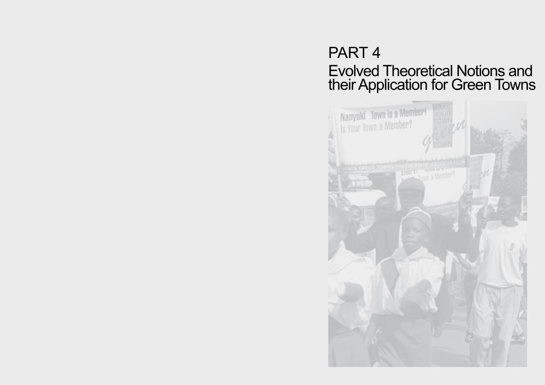
PART 4Evolved Theoretical Notions andtheir Application for Green Towns
138
The Green Towns project was different in scale, outreach, available funds, time frame, and the responsibilities involved than the previous case studies. It covered the whole of Kenya and involved many different partners and organisations. The project began in 1992 and implementation took nearly nine years. I provided technical advice and was responsible for the content, the management, and the Dutch funds. In this project, the content matter went far beyond preparing a landscape plan, suggestions that would upgrade the living environment, or elaborating landscape development scenarios for specific areas or towns. This was in marked contrast to the earlier case studies discussed in Part 3. Now the client - the Ministry of Local Government - also wanted staffmembers to be trained in making such landscape plans. This represented a specific challenge. Instead of only applying a landscape-planning approach, I was now required to transfer the knowledge and skills others would require to implement such an approach.
The first step in this process was to make clear the evolved theoretical notions that informed the approach. The description of the Green Towns application, therefore, is prefaced by a section in which these theoretical notions are made explicit. Second, it was necessary to examine how to these notions were to be transferred to adults in the Kenyan context. These didactical aspects will be discussed in the project description.
The Green Towns application project holds a particularly significant position in the context of this dissertation. The case-study projects discussed
earlier were the result of an empirical learning process. The Green Towns project, however, was the conscious application of the outcome of the theoretical reflections on this process of empirical learning. The contours of this cumulative learning are described in Part 4.1. The Green Towns project can be seen as testing the applicability of the renewed theoretical landscape-planning notions in an actual situation.

139
4.1
Evolved Theoretical Notions Un-derlying the Green Towns Applica-tion Project
The theoretical notions at the beginning of the Green Towns project had evolved from the lessons learned during the case-study projects discussed in Part 3 (see also Appendix 1) and the results of research into the Kenyan landscape and planning context presented in Part 2. A landscape-based human-ecological approach remained central in these evolved theoretical notions. The experience of the earlier case studies suggested that this was a promising way to address the issues in-volved in planning for Kenya’s physical environment. The added value of an interscale landscape analysis and design-approach was also demonstrated.
However, as described in the second part of this thesis and illustrated during discussing on the case studies, Kenya lacked the institutional mechanisms for land-scape plans to be implemented and maintained. In Part 4.1 revised theoretical notions resulting from the case-to-case search for possibilities to have landscape plans nevertheless implemented and cared for will be discussed. As each case study had different purposes and involved a variety of clients, considerable insight was gained into vicissitudes of implementation in complex rural and urban contexts. Working with non-governmental organisations, the Nairobi-based central government, local governments, and individual communities showed that opportunities for implementation increased (be it not exclusively) when:- A participatory approach was adopted in which stakeholders were jointly responsible for the analyis and design as well as for implementation;- The community understood that a well-cared for landscape is an important resource base; - The diverse needs of the various stakeholders were brought together in a common vision and purpose;
- The problems that constrained implementation at different levels of scale were addressed at each design phase, and - There was an inter-institutional and interdisciplinary collaboration accross all scale levels.These factors will be further elaborated in the theo-retical notions presented below.
4.1.1 Theoretical Stances
Linking indigenous landscape-forming forces with the present ones The landscape-planning approach that emerged from the experiences of the case-study projects continued to hold the landscape as the dominant entry point in addressing the physical environment. Kenya has many unique landscapes, each has been shaped by a sliding scale of indigenous driving forces towards sustenance and survival and impacted by modern western forces driving towards a market economy. The market forces frequently led to a male-orientated cash economy that threatened to oust the more female-orientated sustenance economies. As food-crop production and environment-protective land uses were replaced the impact was felt at (intra)household, clan and district level. A diminishing resource base and land degradation were evidence of this process that if unchecked often led to famine and poverty.
Meanwhile, the actions and decisions of centralised government are predominantly driven by modern, western forces and poorly informed about the unique mixture of driving forces that determine the local situation. The experiences in the Kisii, Homa Bay,
140
Generating income or cost-saving - utility and identityLooking back on those case-study projects that were successfully implemented, it becomes clear that the proposed landscape interventions were largely imple-mented and maintained by individuals and community groups who recognised the benefits involved. It was, therefore, concluded that a critical starting point in the landscape-planning approach ought to be the premise that long-term, environment-protecting interventions should provide family units with short-term incomes, useful products, or cost-saving benefits.
Mid-term and long-term success often depended on the extent to which the proposed landscape plans were able to initiate a solution-orientated, self-sustaining process that would ultimately lead to landscapes that offer a balance between the protection of natural resources, such as water and fertile soils, and the production of food or building materials. If they are developed well, these landscape plans can result in the re-establishment of unique landscapes that not only reflect local identity but also provide a basis for pride in what has been achieved.
Implementing through incentives Perceived benefits such as an increase in income opportunities can act as an incentive for action. In the landscape plans for Kisii, Homa Bay, and Busia, this idea of incentive planning was applied as an implementation strategy at town level. In the peri-urban zones where private land-ownership was well established, farmers were already selling out small parcels of land to individuals who wanted to construct non-farm houses. This resulted in an indiscriminated urban sprawl. A chronological
requires the design process to be understood, owned, and largely carried out by the stakeholders. A proper participatory approach must, thus, go beyond tapping local-knowledge systems by the so-called experts. On the other hand, the research in Part 2 revealed an erosion of the local sociophysical knowledge and management systems. Bridging the divide, therefore, will also require a community aware of their own knowledge and taking responsibility again for its environment and future. In some cases, this process may become a task for government officials that is as important as their actual planning responsibilities. In Kenya, planning for the physical environment involves more ministries than the Ministry of Lands and Settlement alone. The Ministry of Local Gov-ernment and the Ministry of Works, for example are also involved. Part 2.3 provided an overview of the sectoral ministries involved in environmental plan-ning and management. Unfortunately, as the Bura case illustrated, the various ministries are often poorly informed about each others plans and motives and they frequently work in isolation. Inter-institutional col-laboration among the various relevant ministries could contribute substantially to achieving landscape plans that are affordable and implementable. Preferably, this collaboration should take place accross all scale levels - sub-local, local, district, and central. The vari-ous landscape-development projects proposed in the Kisii, Homa Bay, and Busia cases clearly illlustrate the importance of the engagement by several ministries and the need for collaboration and co-ordination on and between municipality and district levels in order to gain their comparative advantages.
and Busia described in Part 3, clearly showed the different environment-related requirements among politicians and government officers. The South-West Kano case showed very clearly that the choice between development options involved choosing between those that favoured cash-crop production, predominantly a male responsibility, and those that would ensure the production of products needed for daily survival, such as food and firewood, largely a female responsibility. If landscape planning is to yield durable effect, its working method has to offer opportunities for bridging the divide between these types of driving forces and to help new, more sustainable balances arise.
Working together - participation and awarenessThe lessons from the previous cases showed that in bridging the types of divides discussed above, close communication and co-operation between the government and the male and female members of the community is essential. As we have seen in Part 2.3, the central government is formally responsible for the planning of the physical environment which, in Kenya, still bears the imprint of programmatic demands from the colonial era. Bridging the divide means that government officers, in addition to formulating programmatic demands, also need to acquire an insight in the processes that formed the local landscape and community. However, as demonstrated in Part 2 and Part 3 of this thesis, these processes are complex and varied. Therefore, for the government officers to gain the required insight a participatory approach - that allows local knowledge to surface - is a theoretical departure notion of utmost importance.
This proposed approach, however, as the case stud-ies in Kathama and Kakuyuni demonstrated also

141
analysis of this sprawl illustrated the pull effect of all-weather roads and water connections. This effect was purposefully used to initiate the implementation of the urban development plans for Kisii and Homa Bay. Road construction, possibly enforced with the supply of running water and electricity, was used to trigger the development of urban housing in a specific direction. The local government had limited finances and little say over private land, but in this way they would bundle private initiatives and finances without necessarily acquiring land or providing the housing themselves. The search for the driving forces behind the landscape forming processes not only provided an insight into how the landscape had developed, it also delivered a cost-saving and efficient tool for building future landscapes and assessing the impact of certain interventions. In poor countries like Kenya, landscape plans should incorporate these types of self-steering and development-triggering elements as much as possible.
Creating sustainability with trees and water Vegetation - particularly trees and shrubs - proved to be an excellent tool to link up short-term benefits for the individual with long-term landscape-ecological sustainability. In the Bura case, trees with mosquito-repellent properties were to be used to create a healthier living environment for humans, while their shade over irrigation canals were to inhibit the spread of bilharzia. Among the tree products envisaged were raw material for soap and lamp oil, and medicines. Shrubs and trees were to be planted to break wind and catch dust. In the Kathama and Kakuyuni cases the introduction of trees and shrubs was directly linked to securing improvements in farm management through the pro-duction of fodder, reduction of weed, and improving
the soil. Fruit trees were planted to provide food in periods of drought and hunger. In addition, well-planted trees, shrubs, and grasses played an important role in soil conservation. Trees also had to provide firewood and building materials. Also in the urban context, such as Kisii and Homa Bay, agroforestry and bio-technical soil conservation concepts similar to the Kathama and Kakuyuni cases were introduced to protect hill slopes and river valleys and to make the city centres less vulnerable to the devastating effects of floods. At a more detailed level of scale, in the Kinyago and Kanuku villages, for example, banana trees were planted along side the Nairobi river to protect food crops from being swept away in times of floods. In all cases, the planting of trees was suggested because of their direct and positive effect on the microclimate and the protection of people from the scorching sun. In the city centres, trees would be typically planted in common public areas, such as, along road sides, bus stops, markets, and occasionally parks. The shade provided an incentive for small informal, local markets to develop. Each tree was specifically selected for its proposed beneficial characteristics and to fit into a specific ecological niche.
Water also proved an important entry point in the designs. By creatively linking up water as a menace and water as a resource, many designs included rain-water catchment in gutters and water tanks, cut-off drains or water dams, and improved rain-water infiltration into the soil through terracing, parks, trees and grass. In Kathama, Busia, and Kisii catchment management was applied to protect springs and wells from drying up and to prevent contamination by pit latrines and pollution from small-scale industries. In Kakuyuni, agroforestry and soil conservation
measures were introduced into catchment areas to prevent water dams silting up.
Ordering of space for durable landscape structuresThe landscape-based planning approach based on a purposefully ordering of the landscape was much appreciated. The planting of trees and shrubs alone, for example, will not solve the problems of land degradation and a dwindling resource base, or produce in a socio-economic and ecological sustainable living environment for people. In order to be able to exercise their valued functions and potential services as addressed in the previous section as well as to guarantee implementation and maintenance, their geographical position is of utmost importance.
The landscape plans for both the agricultural and the urban case-study projects discussed in this thesis were based on natural landscape features linked to geomorphology and hydrology and combined with suitability for human land use. Planting designs combined with soil and water conservation measures were made for environmentally vulnerable areas, such as steep slopes, hill tops, and river valleys to protect these important landscape-ecological positions. The combined masses of trees and shrubs were supposed to form a protective, landscape stabilising framework that would hold the landscape together. Depending on the local situation, this framework was based on a zoning system composed of various tree planting patterns ranging from densely planted hill tops, half-open green areas with agroforestry on slopes, and open landscapes created by grazing or arable practices in a rural setting to private gardens, lanes of trees and parks in high-density urban housing areas. The landscape framework also included protective tree planting in

142
natural river-valley systems forming connective green lines that ran through urban and rural areas.
Finally trees were also planted at a location where human activity was most intense, such as along the most important roads and at specific communication points, such as markets and bus stops. Trees were to provide shade but also to protect the road body from erosion. The roads themselves are stable landscape features. Planting trees along roads will increase the chances that the trees will have the time to grow until they are mature enough to provide the service wished for. On private land, people planted trees along driveways and on their compounds, to provide shade but also to beautify their holding.
It is important to keep in mind that the spatial ordering at the landscape level is the result of the appropriate ordering of space at the level of the individual farm. At the farm-level, the plan evolved from a search for a stabilising framework. Road verges, terrace benches, plot boundaries, and boundaries between the farm field and the farm compound were seen as durable small-scale landscape features, which - when planted with trees, shrubs, or grasses - would form a framework that would protect the farm land from the effects of uncontrolled run-off. Here too, attempts were made to find a compromise between agricultural production and environmental protection in order to optimise goods and services for the farmer.
4.1.2 Working Method
In the case study “The integration of the natural environment in the development programmes of the towns of Kisii, Homa Bay, and Busia” a working method of seven steps was used in preparing the three environmental development plans. Even though the process and the resulting landscape plans were appreciated by the Ministry of Local Government (MoLG), implementation was hampered at the local
level. Again this highlighted the importance of taking impediments to implementation into consideration at an earlier stage in the design process. Implementation experience should be monitored and evaluated and the conclusions drawn to be fed-back into the design process. Not to do so would surely lead to failure. As a result, the working method was adjusted. Analysis, planning, design, implementation, and monitoring are now brought together in one - even more iterative- design process than used in the Kisii, Busia, and Homa Bay case-study project.
Illustration 77: An adjusted landscape planning method clusters design and implementation activities in one iterative process, while collaboration and consultation with relevant stakeholders is to take place whenever possible.

143
The constraints to implementation in Kisii, Busia, and Homa Bay were closely related to a lack of inner drive among decision-makers. Local politicians and government officials were reluctant to look for creative ways of implementation. It seemed that what was missing was a joint vision on how environment could be integrated in urban development, was missing. Even though the community was invited for several presentations, the plans had remained largely a MoLG/Wageningen action. Without such a vision, the moti-vation to take responsibility for implementating plans and proposals will remain limited. Therefore, from the start the adjusted procedure should include working on a joint and binding vision that propably should be solution oriented. This requires the government and the community to work closely together. The method will still draw on visualising the present and the future landscapes in maps, sketches, cross-sections, and other tools which - over the years - had proven their value. The various stages of adjustments in the landscape-planning working method that slowly evolved in this way are discussed in Duchhart et al, 1989; Duchhart, 1989, 1990, and 2000. The renewed procedural aspects of the theoretical departure notions for the Green Towns application are addressed below in more detail.
The renewed landscape-planning method is clustered in three groups of related activities. Cluster 1 covers activities such as working on visions, establishing goals and objectives, landscape analyses, problem identification, and conceptual landscape plans. Constraints to the implementation of the plans are addressed in an implementation strategy. In Cluster 2, detailed studies and designs further explore the opportunities and restrictions of the concept. If neces-
sary, adjustments have to be made to decisions taken in Cluster 1. A more realistic landscape plan will be the result. Cluster 3 includes actual implementation and evaluation. A graphical impression is provided in Illustration 77. Each circle represents a cluster of design activities that hinge into each other. While changing from one to the other, design activities car-ried out in the one will flow into the other. Abstract thinking moves into concrete doing, and an analysis becomes a construct or the other way around.
Cluster 1 - Vision and ConceptualisationThe basic objective of this cluster is to arrive at a joint vision among stakeholders visualised in a conceptual landscape design. To arrive at such a vision, cluster 1 is built around seven activities (see Illustration 78), as follows: - Vision; is based on the normative stances regard-ing nature-people relations. Without an explicit basic vision on how things should be done, it is extremely difficult to develop coherent ideas for the landscape plan and implementation strategy. The vision can be the personal stances of the landscape architect,
Illustration 78: A possible flow of the various activities that are undertaken in Cluster 1.

144
planner, or decision-maker, but it can also reflect the socio-cultural norms and values of a group or society. But, diverging stances will mean conflict or a lack of will, which can affect the quality of the plan and its subsequent implementation and maintenance.- Landscape analysis; the landscape was defined as the tangible reflection of the workings of nature and the use people make of natural resources. The physi-cal environment, therefore, can to a large extent be en as a mirror of these interactions. “Reading” and “understanding” this environment provides an enor-mous amount of information. A detailed description of the activities included is given in the case study Landscape Development Concepts for the towns of Kisii, Homa Bay, and Busia.- Sociocultural and political analyses; the landscape analysis may already have revealed a lot about how people relate to the environment. However, there are issues that are not directly physically reflected. In Western Province, for example, water tanks and pit latrines are often absent for very legitimate socio-cultural reasons and taboos. Focusing on individual face-to-face and group discussions, field walks, and secondary research can provide information. This type of analysis will continue throughout the whole design process. When, for instance, detailed design solutions are being discussed or pilot projects are implemented, new insights with far-reaching implications for the designs may become apparent. - Problem definition; should reflect the problems experienced by the people as well as those related to the ecology of the area. Problem definitions often result from an intervention analysis, for example, of how irrigation systems impacts on the existing landscape. The South-West Kano case study shows how a detailed analysis of the impact of interventions
on the environment and on the people could help in responsible decision-making.- Objectives and goals; result from the previous steps. They reflect the view on the solutions to the identi-fied problems. Programmatic demands are usually included too. - Constraints; with an increasing emphasis on plans that realisticly can be implemented, a specific analy-sis of the intervention environment as for example was done in the Undugu case and the identification of variables that might hamper maintenance and im-plementation, is essentical. Such an analysis covers a wide field, and include an assessment of govern-mental capacities, legislation, ownership, labour re-quirements, and socio-cultural issues. It also includes studies from intra-household levels, including gender issues, and national policies. The definition of con-straints improves with the amount of feedback from the implementation Cluster 3. - Conceptual landscape plan and strategy; this isthe first rough idea of what a harmonious future will look like. The concept can be presented as a sche-matic impression or a map featuring geographical and locational factors. The conceptual landscape plan provides a vision of the physical development for a specific location while respecting natural and societal opportunities and restrictions.This step in the planning process is one of the most difficult ones. Here multiple claims, objectives and goals, have to be combined in a creative and cohesive fashion. A search for smart strategies that make it possible to avoid identified implementation and maintenance constraints must also be included. From this point, the conceptual landscape plan, which can be seen as the spatial reflection of the joint vision, will form the guiding idea.
The activities do not always follow each other in the presented order. Illustration 78 simply presents a first possible routing. There are many linkages with the other clusters that have not been included in this diagram.
Cluster 2 – Checks and BalancesIn Cluster 2, the validity of the conceptual landscape plan is checked and its feasibility assessed. Illustra-tion 79 gives a schematic impression of the order of interactions between the various activities. It also shows the link with Cluster 1. However, even in a greater extent than in the previous cluster most activi-ties take place more or less simultaneously. A detailed description of the activities mentioned below is also given on pages 120 and 121. Here - in the adjusted procedure - the iterative character and feedback loops are emphasised. Cluster 2 consists of the following activities:- Detailed studies; it may be necessary to further analyse an issue already identified in cluster 1. For example, in the Kathama case study, the detailed mapping out of the erosion pattern, revealed that the well-swept compounds were one of the main causes of the erosion problem in the area. Without the detailed study, it is highly unlikely that this unexpected and unintended but basic cause of soil erosion would have been identified.- Detailed designs; the conceptual landscape planusually includes many suggestions for environmen-tal improvement, such as, spring protection and tree planting in and around public spaces. It is in this clus-ter that the ‘how’ of these suggestions must be sorted out. Questions like ‘How can river slopes be protected while most of the land is formally or informally oc-cupied? How can land users be challenged to adopt
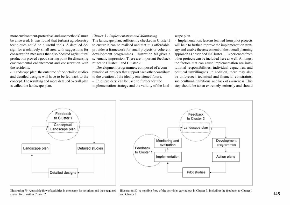
145
more environment-protective land-use methods? must be answered. It was found that (urban) agroforestry techniques could be a useful tools. A detailed de-sign for a relatively small area with suggestions for conservation measures that also boosted agricultural production proved a good starting point for discussing environmental enhancement and conservation with the residents.- Landscape plan; the outcome of the detailed studies and detailed designs will have to be fed back to the concept. The resulting and more detailed overall plan is called the landscape plan.
Cluster 3 - Implementation and MonitoringThe landscape plan, sufficiently checked in Cluster 2 to ensure it can be realised and that it is affordable, provides a framework for small projects or coherent development programmes. Illustration 80 gives a schematic impression. There are important feedback routes to Cluster 1 and Cluster 2. - Development programmes; composed of a com-bination of projects that support each other contribute to the creation of the ideally envisioned future. - Pilot projects; can be used to further test theimplementation strategy and the validity of the land-
scape plan.- Implementation; lessons learned from pilot projects will help to further improve the implementation strat-egy and enable the assessment of the overall planning approach as described in Cluster 1. Experiences from other projects can be included here as well. Amongst the factors that can cause implementation are insti-tutional responsibilities, individual capacities, and political unwillingnes. In addition, there may also be unforeseen technical and financial constraints, sociocultural inhibitions, and lack of awareness. This step should be taken extremely seriously and should
Illustration 79: A possible flow of activities in the search for solutions and their required spatial form within Cluster 2.
Illustration 80: A possible flow of the activities carried out in Cluster 3, including the feedback to Cluster 1 and Cluster 2.

146
be included in every design round. Nearly all case studies discussed here ran into difficulties during the imple-mentation phase. - Monitoring and evaluation; may help respond to changes in the planning context and in helping to improve the planning approach.Monitoring and evalu-ation may also help to find answers to the question “Are we still on the right track?” Whether it will be necessary to adjust the professional theoretical start-ing points and the vision mentioned in Cluster 1 will depend on how this question is answered.
The three clusters could be followed through in several rounds, at several scale levels and at different points in time. Gradually, the necessary insight in the quality and appropriateness of the landscape plans, detailed designs, and development programmes and projects will be obtained. At the same time the complexity of the plans will increase with each round.

147
4.2
General Introduction to the Green Towns Project
The Ministry of Local Government (MoLG), im-pressed with the results of the case-study project described in Part 3.5 “Landscape Development Con-cepts for the towns Kisii, Homa Bay, and Busia” asked me together with my Kenyan counterparts to prepare a proposal for a training programme for environmental1 development planning. The underlying idea being that each Kenyan town would have an environmental development plan. The proposal was granted funding by the Royal Netherlands Government and in 1992, the Landscape Architecture Chairgroup, Wageningen Agricultural University (WAU), won the Directorate General International Co-operation (DGIS) contract to implement the project “Environment and Urban De-velopment Training Project” (EUDTP). The EUDTP was soon dubbed the Green Towns project by the Kenyans. The DGIS contract was extended twice - first to to enable formal institutionalisation of the Phase I project results and later to allow for a smooth phasing out of the Dutch funding and management. The project came to a close in December 2000. I was seconded by my chair group to manage the project team, guide the content as the technical expert, and be responsible for
Illustration 81: By 2000, the Green Towns project covered 29 towns - the first 13 towns were originally invited by the MoLG because of their high growth rate, their environmental issues, economic base, ecological setting, and the vitality of their council. Later, the towns themselves requested participation.
BusiaElburgonEldoretEmbuHoma BayKakamegaKaruriKendu Bay KerichoKilifi
KisiiKisumuMachakosMalabaMalindiMariakaniMavokoMbita PointMigoriMtwapa
NaivashaNanyukiNyeriOl KalouRunyenjesSiayaThikaWebuye
“Green-Town” towns
1 In this case description, the word landscape is often replaced by the word environment. The word landscape - in Kenya - associated with landscaping, gardening, and beautification, and consequently linked with a privilage for the rich. Contrary to the landscape approach in this thesis, the word landscape in the opinion of most Kenyans had, thus, little to nothing to do with the daily living environment of ordinary people.

148
the way the Dutch funding was allocated and spent.The original project partners, the Ministry of Local Government and the Ministry of Lands and Settle-ment, who were also involved in the earlier case-study project were joined by the Office of the President (Government Training Institute, Mombasa), and four national universities: Nairobi University, Kenyatta University, Moi University, and Egerton University. In the second project phase, the Kenya Green Towns Partnership Association became an important partner as well. This partnership association arose in the first phase of project activities. The Ministry of Local Government was the lead ministry. In total the Kenyan government made it possible for about 35 people to actively participate in project implementation for the full length of the project period.
Various local organisations, such as Matrix Develop-ment Consultants, the Agricultural Information Centre, the London based Television Trust for the Environment, and the Wageningen University Environmental Science Group also provided expertise. Over 50 individuals from local universities, governmental and non-governmental organisations and small private companies acted as advisors, trainers, or independent evaluators. A small project office of about 5 people worked on the logistics and administration. Frédèrique Grootenhuis was particularly involved in the training of trainers programme. The Green Towns office was based in Nairobi. The project carried out activities in 29 small towns spread out over the whole country (Illustration 81).
The Green Towns project was different in scale, out-reach, available funds, time-frame, responsibilities, and the number of people involved from the previ-
ous case-study projects. It focused primarily on the transfer of the landscape-planning approach rather than on concrete products although it also involved the preparation of concrete plans and the implemen-tation of projects. In addition to crystallising content matter, the didactics of transfering this to Kenyan professionals and laymen and women was extremely important.
During a time span of 10 years many concrete products, activities, evaluations, and communications took place. This thesis can only address the main features of the way in which the landscape approach was applied in the Green Towns project. Emphasis will be given to the training programmes and its results because this provides the best basis for discussing the way the content matter was used. Where necessary, supportive activities, such as the design and implementation of specific example projects will also be addressed. A brief description will also be given of the overall project context in which the training programmes developed.
4.2.1 Overall Problem Identification
The events that led up to the Green Towns initiative can be defined along two lines; first, the deplorable urban environmental conditions in the urban centres, and second, the limited capacity of the government and the public to address this situation.
Earlier in this thesis the conditions in Kenya’s urban centres have been described (see Landscape Develop-ment Concepts for the towns Kisii, Homa Bay, and
Busia (Part 3.5) and Suggestions for an Improved Living Environment in an Informal Neighbourhood of Nairobi (Part 3.4)). Although each town had its own specific problems, urban areas in general had many problems in common, including:- Hazardous biological pathogens and pollutants circulated in the direct living environment because sewage systems were absent or badly maintained and garbage remained uncollected;- Limited access to natural resources, like fresh air, water, greenery, and playgrounds, essential elements in human welfare; and- Physical hazards, such as floods, mudslides, or landslides caused by the destruction of water catch-ments and vegetation.
The most extreme situations were found in the slum areas (Illustration 82). Women and children were among those hardest hit. In the course of the project these areas received a certain emphasis and women and children were specifically targetted. It should be noted that environmental degradation as a result of urban expansion was not confined within town boundaries. It also extended into the surrounding countryside (Duchhart, 1990). Surveys carried out in 1989 - during the implementation of the case-study project in Kisii town - showed that resources were being drawn from distances varying from a few kilometres in the case of vegetables to hundreds of kilometres in the case of charcoal often leading to an over-exploitation of the natural resources in the supply areas (Chutha et al., 1990).
The capacity within Kenya to redirect these negative trends was limited. On the one hand, most of the urban communities and their political and administrative

149
leaders were either ignorant of the basic causes of environmental degradation and the importance of the environment for a healthy life, or they did not know how to mediate their degraded environment or assess the environmental impact of their decisions. On the other hand, the government also lacked the technical and financial capacity to act. Even though several laws had been promulgated to deal with environmental issues, the government had great difficulties in enforcing them. When the project began in 1992, there were no embracing environmental policies and laws.2
4.2.2 Objectives The Green Towns project was initiated as a first step towards steering the development of urban centres in such a way that they can live up to their potentials without negatively affecting the environment. Several workshops were organised to establish the overall project objectives and outputs. Small discussion groups were involved in the preparations of Phase I, while more than 70 people participated in the workshops held to prepare Phase II. Specific target groups including community representatives, local and national-government representatives discussed, in a guided process issues and potential solutions. In a separate workshop the groups presented their findings to each other, identified their strenghts and ironed out their differences. Then together they set the objectives and anticipated outputs and selected, on the basis of their expertise, the activities that would be their responsibility. Although, the formulation of the overall objective changed slightly from the first project
phase to the second, the overall intention remained the same. It can be summarised as follows:- A sustainable integration of environmental conside-rations in development planning for towns in Kenya, in order to achieve a healthy and attractive urban environment providing its inhabitants with their basic needs such as water, food, energy and shelter through the establishment of adequate institutional and human capacity for urban environmental management and planning in all relevant institutions, agencies and stakeholders. To achieve this overall objective, the following needs were identified:- Create sufficient capacity in sustainable environmen-tal planning (landscape planning) among the managers of the urban environment, more specifically among central government and local authorities. Considerable importance was given to the initiation of a self-perpetuating process. The idea is that a critical mass of motivated trainers educated in environmental planning will act as agents of change so that, through them, the managers of the urban environment in all Kenyan towns will be trained in environmental planning and be able to enhance environmental care;- Stimulate institution building by putting in place an institutional framework and supportive capacity in the short term to allow the trainers to apply their newly obtained knowledge and in the longer term to sustain the incorporation of environmental issues in their daily management and policies; - Develop training materials in participatory environ-mental planning to assist the trainers in their outreach to the local authorities and other relevant groups; - Increase environmental awareness and education to develop appropriate environmental attitudes amongst
Illustration 82: The most extreme situations of dilapidated environments were found in the slum areas where women and children were among the hardest hit (Photo I. Duchhart).
2
In 1999, an Environmental Bill was tabled (Republic of Kenya, 1999). Several of the Green Towns’ trainees had participated in one way or the other in the preparations of the bill. After enact-ment in 2000, jurisprudency needed to be built up.

150
Long-term objective EUDTP-Phase II
A sustainable integration of environmental considerations in development planning for towns in Kenya through the establishment of adequate institutional and human capacity for urban environmental management and planning in all relevant institutions, agencies and stakeholders, allowing for gender sensitive and broad-based community participa-tion.
Short-term objective EUDTP-Phase II
A framework and sufficient supportive institutional capacity to sustain and expand the work started by EUDTP I
Overall Outputs EUDTP-Phase II
1. An enabling environment for participatory environ-mental planning at all relevant levels achieved. At central government level through policiy papers, at district level through sensitized district officials, at local level through training of action groups and public awareness campaigns.2. A training capacity in environmental planning built.3. Environment units within the core ministries operation-alized4. Knowledgeable and empowered “Green Towns” envi-ronmental action groups.
Outputs per key actor EUDT-Phase II
Ministry of Local Government- Operationalised Environment Unit- Capacity in participatory environmental planning built- Developed ToR for environmental committees in LA- Sensitised public on urban environmental planning and management in “green towns” approach- “Green-towns” approach in LADP’s incorporated and followed up- Developed policy on environment and urban development adapted(the ministry planned to carry out 24 activities to achieve these projected outputs)
Ministry of Lands and Settlement - Environmental training unit established and operationsalised- Environmental curriculum developed (for district physical planners) and implemented- Evaluation tools in place and applied- Capacity built and skills for participatory and environmental planning management attained(the ministry planned to carry out 17 activities to achieve these projected outputs)
Government Training Institute- Environmental training Unit establised and operational- Environmental curriculum developed and implemented- Environmental tools in place and applied- Capacity built and skills for participatory planning attained(the institute planned to carry out 17 activities to achieve these projected outputs)
Action groups (Kenya Green Towns Partnership Association)- Action groups formalised and registered- Self-reliant action groups formed- Urban environmental awareness increased- Action-group activities at national and district level co-ordinated- Environmental action plans implemented and sustained- Collaboration between District Environmental Committees, Local Authority, Environmental Committees, Action groups, and others enhanced (external environment)(the action groups/association planned to 19 activities to achieve these projected outputs)
Universities- “Green-towns” approach incorporated in the university curricula- Backstopping capacity to the partner institutions developed(all four universities combined planned to carry out 14 activities)
Advisory office- Institutionalisation process of environmental managment and planning within relevant institutions and other agencies supported- “Environment and Urban Development Training Project” ideas and activities appraised and disseminated- Training responsibilities transferred- “Green-towns” operations within external environment embedded(the Advisory Office planned to carry out 25 activities)
Project Management Committee- Co-ordinated EUDTP II activities
Table 5: Overall objectives, overall outputs, and outputs per key actor formulated for the Green Towns Project Phase II.
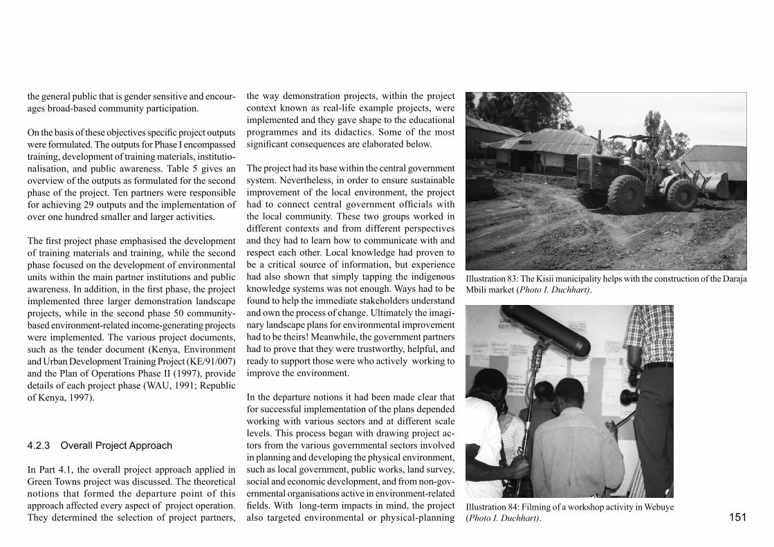
151
the general public that is gender sensitive and encour-ages broad-based community participation.
On the basis of these objectives specific project outputs were formulated. The outputs for Phase I encompassed training, development of training materials, institutio-nalisation, and public awareness. Table 5 gives an overview of the outputs as formulated for the second phase of the project. Ten partners were responsible for achieving 29 outputs and the implementation of over one hundred smaller and larger activities.
The first project phase emphasised the development of training materials and training, while the second phase focused on the development of environmental units within the main partner institutions and public awareness. In addition, in the first phase, the project implemented three larger demonstration landscape projects, while in the second phase 50 community-based environment-related income-generating projects were implemented. The various project documents, such as the tender document (Kenya, Environment and Urban Development Training Project (KE/91/007) and the Plan of Operations Phase II (1997), provide details of each project phase (WAU, 1991; Republic of Kenya, 1997).
4.2.3 Overall Project Approach
In Part 4.1, the overall project approach applied in Green Towns project was discussed. The theoretical notions that formed the departure point of this approach affected every aspect of project operation. They determined the selection of project partners,
the way demonstration projects, within the project context known as real-life example projects, were implemented and they gave shape to the educational programmes and its didactics. Some of the most significant consequences are elaborated below.
The project had its base within the central government system. Nevertheless, in order to ensure sustainable improvement of the local environment, the project had to connect central government officials with the local community. These two groups worked in different contexts and from different perspectives and they had to learn how to communicate with and respect each other. Local knowledge had proven to be a critical source of information, but experience had also shown that simply tapping the indigenous knowledge systems was not enough. Ways had to be found to help the immediate stakeholders understand and own the process of change. Ultimately the imagi-nary landscape plans for environmental improvement had to be theirs! Meanwhile, the government partners had to prove that they were trustworthy, helpful, and ready to support those were who actively working to improve the environment.
In the departure notions it had been made clear that for successful implementation of the plans depended working with various sectors and at different scale levels. This process began with drawing project ac-tors from the various governmental sectors involved in planning and developing the physical environment, such as local government, public works, land survey, social and economic development, and from non-gov-ernmental organisations active in environment-related fields. With long-term impacts in mind, the project also targeted environmental or physical-planning
Illustration 83: The Kisii municipality helps with the construction of the Daraja Mbili market (Photo I. Duchhart).
Illustration 84: Filming of a workshop activity in Webuye (Photo I. Duchhart).
152
orientated departments of the Kenya’s national univer-sities to entrench the Green Towns approach within the higher education system. Initially, the project focused on central and local government officials, but gradually also district-level officials were included as much as possible. In general, neither the Kenyan government nor the community had any previous experience with the purposefully design of landscapes. As adult learning follows largely from observing experiences and examples, the project was structured to facilitate the community-based design and implementation of three projects that could provide practical examples. These projects were selected from the last case-study project and included the Daraja Mbili market in Kisii, urban drainage improvement in Homa Bay, and a park in Busia. Local voluntary action groups - making them the first Green Towns Action Groups- took with the help of the project responsibility for the implementation of the initiative. The three projects were filmed. The video films formed the hard core for the training and public awareness components of the project. A summary was also aired on television. In addition, a group of graduate trainers made a study tour through the Netherlands in 1996 to widen their reference framework regarding green and clean urban environments.
In summary, in order to work in line with the theo-retical departure points underlying the Green Towns project required at an operational level a multi-entry, multi-level, and action-oriented management strategy. Training, development of training materials, project implementation, institutionalisation, and public awareness were carried out more or less simultane-
ously at different levels of scale. This made an in-ternal learning process possible among project staff and partners. The practical example projects provided feedback that was crucial to many activities. They helped us to understand more than any other experi-ence the effects of political interferences and facili-tated the articulation of measures needed to ensure effective institutionalisation and awareness creation. They also helped streamline and simplify the renewed theoretical landscape-planning notions to enable their translation into an educational programme suitable for future trainers, community, and local authorities. Perhaps most important of all, this mode of operation stimulated the development of a Green Towns social network, which cut accross institutions and communi-ties, and ultimately embraced thousands of people.
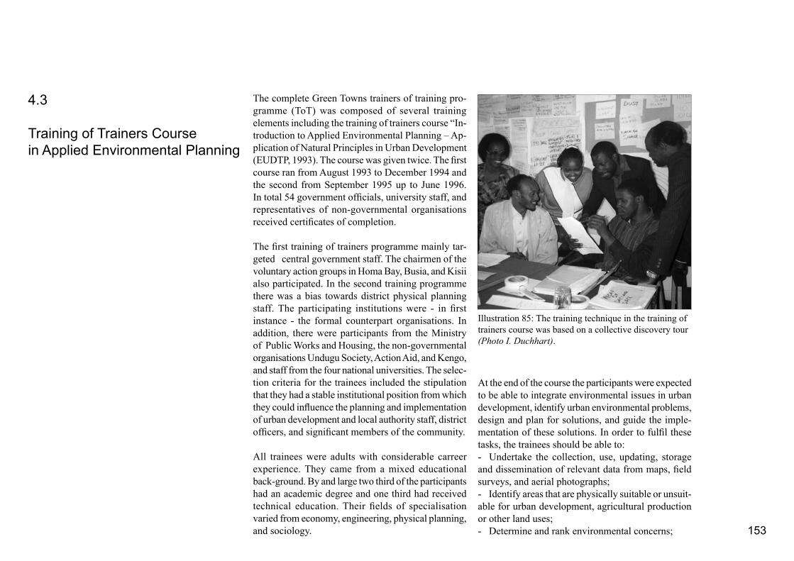
153
The complete Green Towns trainers of training pro-gramme (ToT) was composed of several training elements including the training of trainers course “In-troduction to Applied Environmental Planning – Ap-plication of Natural Principles in Urban Development (EUDTP, 1993). The course was given twice. The first course ran from August 1993 to December 1994 and the second from September 1995 up to June 1996. In total 54 government officials, university staff, and representatives of non-governmental organisations received certificates of completion.
The first training of trainers programme mainly tar-geted central government staff. The chairmen of the voluntary action groups in Homa Bay, Busia, and Kisii also participated. In the second training programme there was a bias towards district physical planning staff. The participating institutions were - in first instance - the formal counterpart organisations. In addition, there were participants from the Ministry of Public Works and Housing, the non-governmental organisations Undugu Society, Action Aid, and Kengo, and staff from the four national universities. The selec-tion criteria for the trainees included the stipulation that they had a stable institutional position from which they could influence the planning and implementation of urban development and local authority staff, district officers, and significant members of the community.
All trainees were adults with considerable carreer experience. They came from a mixed educational back-ground. By and large two third of the participants had an academic degree and one third had received technical education. Their fields of specialisation varied from economy, engineering, physical planning, and sociology.
4.3
Training of Trainers Coursein Applied Environmental Planning
At the end of the course the participants were expected to be able to integrate environmental issues in urban development, identify urban environmental problems, design and plan for solutions, and guide the imple-mentation of these solutions. In order to fulfil these tasks, the trainees should be able to:- Undertake the collection, use, updating, storage and dissemination of relevant data from maps, field surveys, and aerial photographs; - Identify areas that are physically suitable or unsuit-able for urban development, agricultural production or other land uses;- Determine and rank environmental concerns;
Illustration 85: The training technique in the training of trainers course was based on a collective discovery tour (Photo I. Duchhart).
154
- Understand environmental planning procedures;- Conceptualise solutions and design environmen-tal (landscape) development programmes;- Visualise and present data in various forms, such as maps, sketches, cross-sections, and graphs; and - Write proposals for environmental projects (WAU, 1991).
4.3.1 Training Approach
The target group of the ToT course required training tools and techniques geared towards adult training and learning principles. Personal experience at Wagenin-gen University and lengthy discussions with training professionals, such as David Campbell and Herine Simbowo from the Agricultural Information Centre in Nairobi, among others, indicated that successful training should be:- Connective: new knowledge should be built up from the participants’ current knowledge and experi-ence;- Complementary: new knowledge should extend the participants’ current knowledge;
- Participative: stimulate interactions among parti-cipants and between trainers and participants to enable them to use and acknowledge each others experience and knowledge;- Active: use a minimum of lectures and a maximum of challenging, involving, and self-discovering learn-ing experiences, such as field visits and evaluative discussions; - Appropriate: the newly acquired knowledge should be applicable in the participants’ working environment,- Realistic: use practical examples with which theparticipants can identify; and- Needed: address issues and provide solutions iden-tified by the participants.
Consequently, teaching techniques were based largely on a process of collective discovery. Active video watching and focused, well-facilitated discussions stimulating the trainees to share their personal find-ings were techniques frequently used to increase the consciousness and awareness of the participants.
Frédèrique Grootenhuis, who had lectured at Nairobi University, was among the first to point out that the Kenyan schooling system was largely based on the reproduction of skills. The Green Towns trainees, however, would be required to do more than repro-ducing skills. They had to be active and innovative. The graduated trainee had to work within a variety of regional sociophysical contexts. At present there was no institutional base for providing consultation and advice when this was needed (see Part 2). In addition, he or she would have to bridge the divide identified earlier between central and local government and be-tween government and community. In other words, the
graduated trainee had to be able to cope with continu-ously changing situations and would, by and large, be on his or her own. This meant that more competences than the technical landscape-design skills mentioned above would be required. The graduate had also to: - Develop an independent and critical but open mind;- Be committed to general environmental care; - Become an inquisitive person;- Develop a positive attitude; and- Be flexible (Duchhart and Grootenhuis, 1993).
As the underlying theoretical starting notions for the Green Towns project make clear, environmental care could only find a firm place in modern society, if it was linked to human basic needs, socioeconomic and ecological sustainability, community participation, gender consciousness, and closely integrated with a problem-solving and action-oriented approach. The project team1 undertook several preparatory sessions and training needs assessment exercises in 1992 and 1993 to establish those environmental and institutional demands that had to be addressed during the course. The information that emerged complemented earlier findings and addressed issues such as environmental sanitation, hygiene, and environment-related diseases. More emphasis was placed, however, on dealing with the terrible living-conditions of poor women and children. The partner institutions specifi-cally requested for a training module in environmental impact assessment. Furthermore, an experienced training professional in the field of public health recommended that between training modules, as-signments should be carried out at home. Field work should not exceed a period of two weeks (Lynam, 1993 in EUDTP, 2000a).
1
Members of the team were, Robert Chutha, Jacintha Makokha, Rose Okoth, Wilfred Korir, Esther Mwaura and later Mr. Chege and Emmy M’bwanga, Frederique Grootenhuis and the author.

155
the full 3-day course in Participatory Environmental Planning (PEP) in practice.
The modules followed each other at intervals of about six weeks.The publication “Introduction to Participa-tory Environmental Planning (PEP) for Sustainable Urban Development” provides detailed information on the introductory course, field course, communication courses, and the participatory environmental planning course (Duchhart, 2000).
Module 1 - Introductory Course This module took one week. The module started with a video showing world-wide environmental issues and presenting some creative solutions. The trainees were asked to identify typical Kenyan issues. They described the environmental problems they encountered at home and at work. The trainees were then taken into the slums of Nairobi. They walked through garbage, human waste and stinking pools of water infested with mosquito larvae. They saw chil-dren playing in contaminated riverbeds or alongside dangerous road. They also saw young people under the influence of drugs, hanging around with nothing to do. They were invited inside the dark and smokey shelters of branches and plastics that were also homes. Many of the trainees had never been deep inside the urban slums and were seriously shocked by the envi-ronmental problems they encountered. This field trip captured the interest of the most sceptical trainee.
The trainees actively watched videos supplemented by discussions and assignments to gain an inside in natural processes and the human interventions that had taken place. They learned how older ecosystems played a prominent role in the protection of the overall
4.3.2 Training Programme
The training programme curriculum followed the cycle of the renewed landscape-planning method described in Part 4.1. It consisted of training modules that more or less followed the three clusters of activities inden-tified in the design method. During the first module - Introductory Course - the trainees were stimulated to develop a (personal) vision on environmental care. They were also introduced to landscape analysis and conceptual design techniques. In Modules 2, 3 and 5 the participants were provided with tools and ideas that would enable them to deal with the pervasive environmental problems found in urban settlements. Two training modules were specifically concerned with environmental sanitation (WASH) and land degradation (SOWAT) techniques. The fifth module focussed on environmental-impact assessment (EIA) as requested by the participating institutions. These solution and impact-oriented modules paralled activi-ties related to detailed landscape designs and studies as presented in the second design cluster of the landscape planning method. In the fourth module - Environ-mental Planning - the trainees reviewed the experi-ence with the example projects in landscape design. This module coincided with the evaluative Cluster 3 of the design process. In the sixth module - Field Course - the trainees put the full design circle into practice and had the opportunity to apply their newly acquired knowledge in a real situation. As the training programme was designed to ensure that participants would adopt a fully participatory approach in their professional work the course outline emphasised this aspect. Module 7, therefore, addressed communica-tion and facilitation techniques, while the last module provided the trainees with the opportunity to facilitate
Abiotic
SocietyBiotic
Nature
Economic
Cultural
Political
Abiotic EnvironmentEconomic
Cultural
PoliticalBiotic
Abiotic EnvironmentEconomic
CulturalPoliticalBiotic
Environment
Nature
Society
Illustration 86: A simplified socio-physical organisation model (adapted from Kleefmann) explained the trainees that the en-vironment is the result of the interactions between nature and society (Duchhart, 2000)
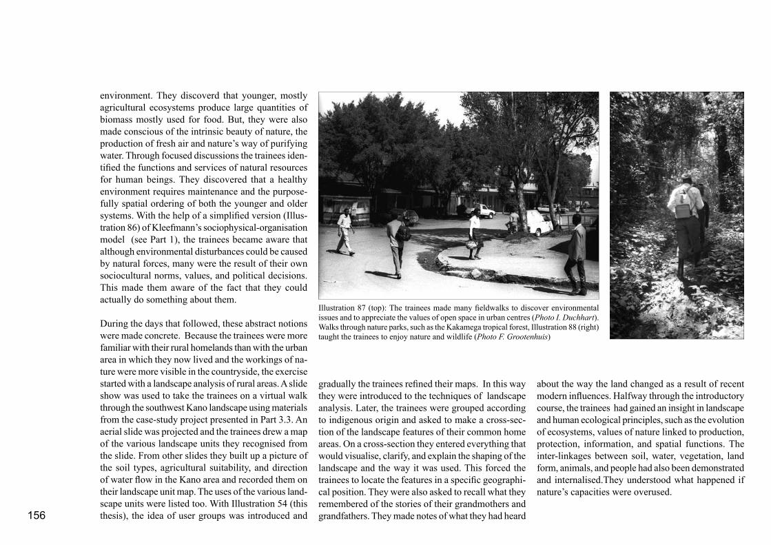
156
environment. They discoverd that younger, mostly agricultural ecosystems produce large quantities of biomass mostly used for food. But, they were also made conscious of the intrinsic beauty of nature, the production of fresh air and nature’s way of purifying water. Through focused discussions the trainees iden-tified the functions and services of natural resources for human beings. They discovered that a healthy environment requires maintenance and the purpose-fully spatial ordering of both the younger and older systems. With the help of a simplified version (Illus-tration 86) of Kleefmann’s sociophysical-organisation model (see Part 1), the trainees became aware that although environmental disturbances could be caused by natural forces, many were the result of their own sociocultural norms, values, and political decisions. This made them aware of the fact that they could actually do something about them.
During the days that followed, these abstract notions were made concrete. Because the trainees were more familiar with their rural homelands than with the urban area in which they now lived and the workings of na-ture were more visible in the countryside, the exercise started with a landscape analysis of rural areas. A slide show was used to take the trainees on a virtual walk through the southwest Kano landscape using materials from the case-study project presented in Part 3.3. An aerial slide was projected and the trainees drew a map of the various landscape units they recognised from the slide. From other slides they built up a picture of the soil types, agricultural suitability, and direction of water flow in the Kano area and recorded them on their landscape unit map. The uses of the various land-scape units were listed too. With Illustration 54 (this thesis), the idea of user groups was introduced and
about the way the land changed as a result of recent modern influences. Halfway through the introductory course, the trainees had gained an insight in landscape and human ecological principles, such as the evolution of ecosystems, values of nature linked to production, protection, information, and spatial functions. The inter-linkages between soil, water, vegetation, land form, animals, and people had also been demonstrated and internalised.They understood what happened if nature’s capacities were overused.
gradually the trainees refined their maps. In this way they were introduced to the techniques of landscape analysis. Later, the trainees were grouped according to indigenous origin and asked to make a cross-sec-tion of the landscape features of their common home areas. On a cross-section they entered everything that would visualise, clarify, and explain the shaping of the landscape and the way it was used. This forced the trainees to locate the features in a specific geographi-cal position. They were also asked to recall what they remembered of the stories of their grandmothers and grandfathers. They made notes of what they had heard
Illustration 87 (top): The trainees made many fieldwalks to discover environmental issues and to appreciate the values of open space in urban centres (Photo I. Duchhart). Walks through nature parks, such as the Kakamega tropical forest, Illustration 88 (right) taught the trainees to enjoy nature and wildlife (Photo F. Grootenhuis)
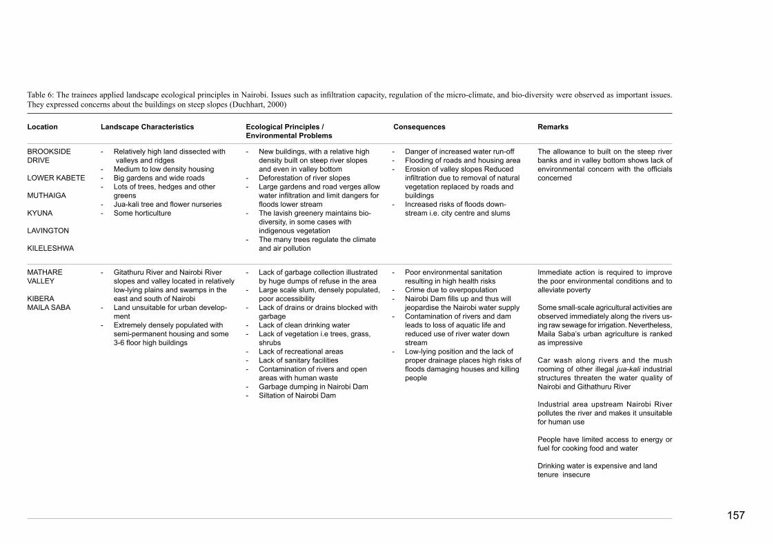
157
Table 6: The trainees applied landscape ecological principles in Nairobi. Issues such as infiltration capacity, regulation of the micro-climate, and bio-diversity were observed as important issues. They expressed concerns about the buildings on steep slopes (Duchhart, 2000)
Landscape Characteristics Ecological Principles / Environmental Problems
Consequences RemarksLocation
BROOKSIDE DRIVE
LOWER KABETE
MUTHAIGA
KYUNA
LAVINGTON
KILELESHWA
- Relatively high land dissected with valleys and ridges- Medium to low density housing- Big gardens and wide roads- Lots of trees, hedges and other greens- Jua-kali tree and flower nurseries- Some horticulture
- New buildings, with a relative high density built on steep river slopes and even in valley bottom- Deforestation of river slopes - Large gardens and road verges allow water infiltration and limit dangers for floods lower stream- The lavish greenery maintains bio- diversity, in some cases with indigenous vegetation- The many trees regulate the climate and air pollution
- Danger of increased water run-off- Flooding of roads and housing area- Erosion of valley slopes Reduced infiltration due to removal of natural vegetation replaced by roads and buildings- Increased risks of floods down- stream i.e. city centre and slums
The allowance to built on the steep river banks and in valley bottom shows lack of environmental concern with the officials concerned
MATHAREVALLEY
KIBERAMAILA SABA
- Gitathuru River and Nairobi River slopes and valley located in relatively low-lying plains and swamps in the east and south of Nairobi- Land unsuitable for urban develop- ment- Extremely densely populated with semi-permanent housing and some 3-6 floor high buildings
- Lack of garbage collection illustrated by huge dumps of refuse in the area- Large scale slum, densely populated, poor accessibility- Lack of drains or drains blocked with garbage- Lack of clean drinking water- Lack of vegetation i.e trees, grass, shrubs- Lack of recreational areas- Lack of sanitary facilities- Contamination of rivers and open areas with human waste- Garbage dumping in Nairobi Dam - Siltation of Nairobi Dam
- Poor environmental sanitation resulting in high health risks- Crime due to overpopulation- Nairobi Dam fills up and thus will jeopardise the Nairobi water supply- Contamination of rivers and dam leads to loss of aquatic life and reduced use of river water down stream - Low-lying position and the lack of proper drainage places high risks of floods damaging houses and killing people
Immediate action is required to improve the poor environmental conditions and to alleviate poverty
Some small-scale agricultural activities are observed immediately along the rivers us-ing raw sewage for irrigation. Nevertheless, Maila Saba’s urban agriculture is ranked as impressive
Car wash along rivers and the mush rooming of other illegal jua-kali industrial structures threaten the water quality of Nairobi and Githathuru River
Industrial area upstream Nairobi River pollutes the river and makes it unsuitable for human use
People have limited access to energy or fuel for cooking food and water
Drinking water is expensive and land tenure insecure

158
through this process of self-discovery, the trainees would identify the importance of open space and proper maintenance of drainage, for example , and the functions of private and public green areas including urban agriculture, parks and what was left of forests and woods. Table 6 provides an overview of a selection of their findings.
In the last course element, the trainees moved from vision development and landscape ecological principles to integrated landscape design for environmental enhancement. The Kanuku and Kinyago villages described in Part 3.4, were used as models for this exercise. The trainees visited the project and received a guided tour through the improved area. They looked at the water tanks, gutters, and drainage system. They walked through the agricultural zone and wooded floodplain. In the community hall, they met with the inhabitants, asked questions, and listened to their experiences.
To prepare the trainees for the later field-course, the trainees were asked to design together an appropriate planning process that would lead to environmental protection and enhancement. This session was preceded by a brief introduction to the changes in western planning approaches included advocacy planning and community participation, to stimulate the trainees to be innovative. Although community participation had found a prominent place in the trainees’ individual learning process, the planning steps they identified were the fairly traditional (physical) planning steps of inventory, analysis, planning (EUDTP, 1993).
Module 2 - Waste, Sanitation and Public Health (WASH)This first solution-orientated module focussed on gain-ing understanding of issues related to environmental health, such as, water-born diseases, respiratory dis-eases related to high humidity, contaminated drinking water, and uncollected garbage and finding low-cost solutions to these problems. The module started with the trainees working together on a detailed problem analysis. This was followed by 10 to 15 minutes lectures on subjects like excreta-related cycles of pathogens, issues related to the use of sewage to ir-rigate vegetables, industrial-waste water, and storm-water run-off. The issues of environmentally sound techniques for liquid and solid waste management were also addressed in this way. Some legal issues related to urban green, including urban agriculture and forestry, were also briefly mentioned (see Part 2.3). Several field trips were made. The trainees were taken to a wetland system designed by Dee Raimer. This system purifies waste water from the Carnivore Restaurant and Splash Water Resort in Nairobi, which is then used to irrigate the restaurant’s garden. The SOS Village in Nairobi was also visited. Here they used treated waste water to irrigate a vegetable garden (Illustration 89). The trainees visited the municipal garbage dump in Nairobi where homeless youth and women collected food, cloths, glass and paper, and composted greens and woody materials. A visit was paid to the Kenya Paper Mills in Thika - one of the first plants to recycle paper. Further, the trainees were introduced to solutions as guttering to collect rainwa-ter, the planting of open areas with trees, grass, and vegetables, maintenance of open drains, and filling of depressions with stagnant water as was suggested for
The next course element dealt with how these landscape approaches and functions could be used in an urban setting. From a relative high building in Nairobi, the trainees observed the various landscape units that made up Nairobi’s neighbourhoods. From here, the trainees went to several representative locations in these landscape units. They were asked to observe, draw, and note down visual, but also non-visual impressions like smells and temperatures using cross-sections and tables. The idea was that
Illustration 89: The ToT trainees visited the SOS Village in Nairobi to learn about the purification of liquid waste water that was used for irrigation of bananas and vegetables (Photo I. Duchhart).

159
the Kanuku and Kinyago villages in Part 4.4. Some of Undugu’s waste management and income generating projects such as the growing of vegetables, basket weaving from banana fibres, and the compression of ash and sawdust for fuel were also given attention. Module 3 - Soil, Water Conservation and Agroforestry (SOWAT)The second solutions-orientated training module focused on how trees and vegetation not only contributed to repairing or preventing environmental degradation but also could increase a household’s access to water, food, energy, and shelter. Over a period of three days, this module introduced the trainees to these important landscape building blocks.
The workshop began with a field visit to an outstand-ing farm in the semi-arid, heavily degraded Machakos district. Here, the Mutiso family had been practising soil and water conservation for over 30 years. Some of their techniques included: terracing to protect the farm from erosion and to improve rainwater infiltra-tion; planting of grasses to enforce terrace edges and to provide fodder; planting woodlots to provide build-ing poles and fuel; roof-water catchment to ensure clean drinking water; harvesting run-off water from the main road to irrigate their land; planting bananas and sugar cane in wetter sections; and digging cut-off drains to avert gulley erosion. They had also planted a euphorbia hedge as a wind break and trees for shade and shelter. The trainees sketched the layout of the farm in order to discover its spatial logic.
This visit was followed by series of brief technical lectures dealing with soil and water conservation. Mitigating measures such as mulching, improving
soil structure, terracing, tree planting, rainwater harvesting, and surface water management through rock and roof catchment, sand dams, underground catchments, and retention ponds were also discussed. References were made to ways in which these types of measures could interact and enhance each other. The potential functions and services of trees and their effect on their direct environment were also elaborated (Illustration 91). The trainees were introduced to how trees could be used as fuel, timber, for art sculptures,
food (edible fruits and leaves), services (decoration and beauty), as well as anchoring the soil. Some of these uses such as for medicines, beverages, encouraging honey production, and providing seeds valuable for making oils and soaps, were less well known. The way trees provided natural habitats for wildlife and their capacity to purify the air and act as sound barriers were also explored. They were reminded that trees are surrounded by sociocultural rules and beliefs. An overview of the required tree-planting patterns,
Illustration 90: The trainees observed that houses were built on unsuitable places, such as steep slopes, resulting in soil erosion. Here a community tried - with stakes and metal sheets - to prevent their houses from sliding down the slope (Photo I. Duchhart)
Illustration 91: The trainees learned about the many products and services of trees (Photo A. Kibutu)

160
composition, species, orientation and sizes, as well as possible combinations with grasses and bushes to improve the climate was also provided.
On the last day of this SOWAT training module, the trainees went into the field to put their newly aquired knowledge into practice. They were asked to prepare a landscape analysis and landscape plan for Waithaka, a peri-urban area on the northern fringe of Nairobi. The area suffered from serious soil erosion and was heav-ily contaminated by a slaughter-house complex. The trainees had to formulate integrated solutions using soil and water conservation measures and tree planting to improve the overall landscape. Inhabitants of Wait-haka area returned with the trainees to the workshop space and together they translated the landscape plans into an action plan for the community.
Module 4 - Environmental Planning (EP)The objective of this module was to introduce the trainees to the implementation of a landscape design,
and more specifically, one in which the municipality and the community had worked in partnership. From the three, earlier mentioned, real-life example projects implemented under the responsibility of the Green Towns project2, the training team decided to visit the Daraja Mbili market in Kisii and the park in Busia. The implementation of these projects had started half a year earlier than the training programme and then progressed simultaneously with the training.
The module started in Kericho with an introductory lecture that specifically addressed the landscape planning and design method underlying the design and implementation of the Green Towns example projects presented in Part 4.1. Emphasis was placed on envi-ronmental (landscape) planning defined as a discipline that works from an understanding of landscape dynamics through a design process towards balanced land uses. The priorities here were safeguarding natural resources in the long term and providing the population with their basic needs in
the short term. This implied that the discipline lies at the interface between the workings of nature and society. A participatory partnership approach was also advocated. The deviations with the planning steps identified by the trainees at the end of the introductory course were noted and discussed. They related in particular to the cyclic character of the process, the explicit movement backwards and forewards between a conceptual design to details, and the need to take a normative stand and express it in a clear vision.
In the towns Kisii and Busia, the trainees saw how this design method functioned using exhibits. The volun-tary action groups who were in charge of project im-plementation made presentations. The action group in Kisii, who worked on the improvement of the market, demonstrated the need for an integrated approach. The market and its access roads were located at the foot of a micro-watershed and suffered from floods and erosion. The Kisii action group acknowledged that at the head of the catchment protective soil-conservation
2
The Green Towns project implemented detailed landscape designs for a park and greening of public space in Busia, an improvement of the Daraja Mbili market in Kisii, and drainage improvement in Homa Bay. The ideas originated from the case-study project described in Part 3.5.
The market in Kisii and the drain in Homa Bay encompassed substantial constructional work, such as gabion lining and ter-racing. The designs were made in different stages. In 1990, Fréderique Grootenhuis and Ingrid Duchhart prepared the overall designs (Republic of Kenya, 1990, Appendix 8) Peter van Bolhuis
detailed the market, while the engineers of Ministry of Local Government made the technical drawings.
Matrix Development Consultants, Graham Jenkinson and Tom Oyieke helped to introduce a participatory approach. Through mobilisation workshops, the workshop participants redefined environmental issues and possible solutions. The community representatives both in Kisii and Homa Bay, placed their respec-tive projects in a wider watershed context than was done in the earlier designs. The workshop participants included government officials, teachers, NGO staff, and business men and women,
listed their own local and district resources (knowledge, labour, materials, and even some finances) and the resources required from the Nairobi based “Green Towns” office (external finances and technical knowledge). At the end of the workshops, the first “Green Towns” action groups were elected. The volunteer group was to be the motor, the Nairobi “Green Towns” office the grease. Later, in the phase of actual construction, the action group contracted work out to local contractors. The first-day chairmen of the volunteers Mr. Ombiro and Mr. Wire remained role-models for many action groups to follow.

161
measures were needed, while in the middle part of the catchment run-off water was to be re-directed away from the road. The Illustrations 95 to 97 provide an overview of the designs and the implemented situa-tion. The example project in Busia involved landscape designs for a park and other public spaces. Important issues that were addressed during the training visit revolved around the ownership and maintenance of the planted trees. A collaboration between a women’s group and the municipality helped to address some of them. At the time the trainees visited the areas, the action groups were in the middle of the often difficult process of implementing their projects. The trainees undertook field walks, talked with the community, and the group members during their time in the area. A summarising and reflective discussion brought this module to a close.
The route to the two example towns Kisii and Busia ran through the unique landscapes of the Rift Valley, the Kisii Highlands, along Lake Victoria, and over the undulating plateaus of western Kenya. Combined with a vist to Lake Naivasha on the way back to Nairobi this was a distance of more than eleven hundred kilometres. Many of the trainees had not travelled much beyond their own homeland and Nairobi and had not looked at the landscape in what they called “the Green Towns way”. Although, this exercise was an addition to the content, the learning “en route” was much appreciated.
Module 5 - Environmental Impact Assessment (EIA)This training module on environmental impact as-sessments was developed at the special request of participating institutions and trainees. Formal western-based, environmental impact assessment procedures
were introduced by staff from the School of Environ-mental Studies of Moi University. To connect theory with a real situation, a video of people discussing the environmental and social impact of the construction of a hydrological dam in the Tana River on Kenya’s Eastern Province, was shown (Agricultural Informa-tion Centre, 1995).
The trainees were asked to compare the presented formal techniques with the technique used in the video and list the constraints of the formal environ-mental impact assessment procedures in the Kenyan context. They were invited to draft a procedure that would take away some of the constraints. In the days that followed the participants applied and tested their alternative procedure in Nakuru. They looked at the impact of Nakuru’s urban expansion and modern hor-ticulture and floriculture on Lake Nakuru - a lake of national and international importance and famous for its flamingos. Although urban expansion and intense agriculture in the area threatened the environment, the trainees felt able to suggest possible solutions to the problems of the area.
The trainees included a landscape approach in their alternative assessment procedure. This involved the preparation of a base map, a landscape analysis, the identification of landscape units, the mapping of consequences of urban growth for among other things groundwater flows. They also included mitigating techniques and alternatives that could guide urban growth in Nakuru. The procedure involved many open-ended face-to-face interviews with inhabitants, technical staff from the municipality and the district, politicians, as well as Kenya Wildlife Services, who were the managers of the national park. The data
collected by the trainees during the three-day period covered by this module, was sufficient for a thorough screening of the situation and made it possible to in-dentify issues requiring further attention. On the last day of the module, the trainees presented their find-ings to a panel that included members of the National Environment Secretariat (Ministry of Environment and Natural Resources), United Nations Develop-ment Programme (UNEP), and the Royal Netherlands Embassy. The trainees pleaded with the panel to adapt the western-based environmental impact assessment procedures to the specific circumstances of the Kenyan situation, among others by including social impact as-sessment and public participation. They considered the procedure important and asked for sufficient financial and legal support.3
Module 6 – Field coursesIn a two weeks studio-like field course, the trainees prepared an environmental (landscape) development plan for a small town. The landscape theory, presented in the introductory course, and the relatively discon-nected landscape building blocks, presented in the SOWAT and WASH modules, now had to be combined and integrated into aggregated solutions using the landscape planning and design approach. Abstract
3
The Environmental Management and Co-ordination Bill of 1999 included sufficient tools to implement and enforce environmental impact assessment procedures (Republic of Kenya, 1999).

162
Illustration 92: The drawing at the left shows the direction of storm-water run-off within the Daraja Mbili watershed. The drawing on the right shows the solutions as suggested by the Kisii people. Most of the run-off water was diverted away from the market. The run-off water ate into the road and destabalised trees (Drawings I. Duchhart) (Republic of Kenya/AUW, 1990, Appendix 8).
Illustration 94: Two years later eroded roots and a stump is all that remained of the eucalyptus tree in Illustration 90 (Photo H. Beumer)
Illustration 93: The Daraja Mbili market in full use before the renovation. After the renovations - the municipality trippled their revenues. The tree in the back ground still provides shade (Photo I. Duchhart)

163
Illustration 95: The renovated Daraja Mbili market photographed during the opening ceremony in 1995 (Photo I. Duchhart)
Illustration 97: The design of the Daraja Mbili market was based on the idea that the market should express a local character. The terraces followed the natural contourlines. The surface was murrammed - this allowed for rainwater infiltration, was cheaply avail-able, and had the colour of the soil. The ramps and terrace benches were covered with locally avaible stones. The suggested trees were indigenous (in this picture the trees were not as yet planted) (Drawing P. van Bolhuis)
Illustration 96: Some of the detailed designs as drawn-up by the engineers of the Ministry of Local Government.
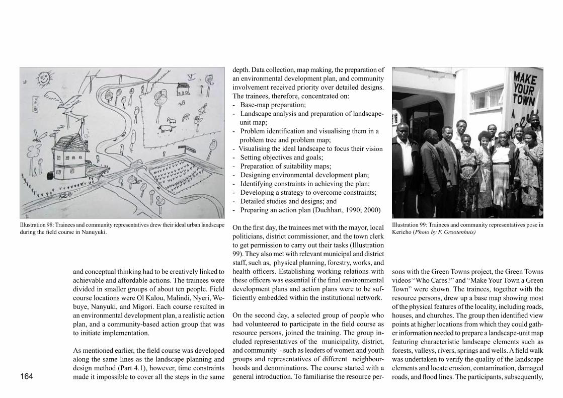
164
and conceptual thinking had to be creatively linked to achievable and affordable actions. The trainees were divided in smaller groups of about ten people. Field course locations were Ol Kalou, Malindi, Nyeri, We-buye, Nanyuki, and Migori. Each course resulted in an environmental development plan, a realistic action plan, and a community-based action group that was to initiate implementation.
As mentioned earlier, the field course was developed along the same lines as the landscape planning and design method (Part 4.1), however, time constraints made it impossible to cover all the steps in the same
depth. Data collection, map making, the preparation of an environmental development plan, and community involvement received priority over detailed designs. The trainees, therefore, concentrated on:- Base-map preparation;- Landscape analysis and preparation of landscape- unit map;- Problem identification and visualising them in a problem tree and problem map;- Visualising the ideal landscape to focus their vision - Setting objectives and goals;- Preparation of suitability maps;- Designing environmental development plan;- Identifying constraints in achieving the plan;- Developing a strategy to overcome constraints; - Detailed studies and designs; and- Preparing an action plan (Duchhart, 1990; 2000)
On the first day, the trainees met with the mayor, local politicians, district commissioner, and the town clerk to get permission to carry out their tasks (Illustration 99). They also met with relevant municipal and district staff, such as, physical planning, forestry, works, and health officers. Establishing working relations with these officers was essential if the final environmental development plans and action plans were to be suf-ficiently embedded within the institutional network.
On the second day, a selected group of people who had volunteered to participate in the field course as resource persons, joined the training. The group in-cluded representatives of the municipality, district, and community - such as leaders of women and youth groups and representatives of different neighbour-hoods and denominations. The course started with a general introduction. To familiarise the resource per-
sons with the Green Towns project, the Green Towns videos “Who Cares?” and “Make Your Town a Green Town” were shown. The trainees, together with the resource persons, drew up a base map showing most of the physical features of the locality, including roads, houses, and churches. The group then identified view points at higher locations from which they could gath-er information needed to prepare a landscape-unit map featuring characteristic landscape elements such as forests, valleys, rivers, springs and wells. A field walk was undertaken to verify the quality of the landscape elements and locate erosion, contamination, damaged roads, and flood lines. The participants, subsequently,
Illustration 98: Trainees and community representatives drew their ideal urban landscape during the field course in Nanuyuki.
Illustration 99: Trainees and community representatives pose in Kericho (Photo by F. Grootenhuis)

165
identified environmental issues and grouped them in a problem tree that illustrated causes and effects. The issues were also mapped out geographically in the landscape unit map (Illustration 101). A second verify-ing field visit followed. In the first four field-courses of the first ToT course, the problems identified were further elaborated upon in a workshop with a large group of local citizens. However, the organisation and facilitation of this workshop placed a disproportion-ally heavy demand on the trainers and trainees. For this reason it was omitted as a field-course training element in the second ToT course and replaced by a full 3-day Participatory Environmental Planning workshop (see Part 4.2.3). Subsequently, the participants set out objectives and goals and embarked on the preparation of the environmental (landscape) development concept. At the start of this group of activities, the trainees were asked to develop an ideal image of an urban centre (Illustration 98). The trainers felt that focusing on an image of an ideal urban environment would help to set objectives that would go beyond the “healing” of problems. This exercise was an important element in designing the landscape development concept - which nevertheless remained difficult to do. Among other things, it involved making coherent choices. To enable this process, the exercise was structured as follows. The course participants were divided in four groups. One group was asked to prepare a suitability map for agriculture and one a suitability map for urban de-velopment. Another third group was asked to prepare a zero map that showed the urban growth as it was expected to develop in the next 10 to 15 years if no one intervened. The last group prepared a protection map showing vulnerable areas where measures had
to be taken if degradation was to repair or prevent (Illustration 102). The landscape unit map formed the basis. The two groups who prepared the suitability maps compared their findings and indicated areas of conflict (Illustration 103). The zero map group and protection group did the same. The conflict maps were, then, compared. In plenary, the groups now debated the conflict areas and issues. They had to make choices on their preferences and suggest possibly mediating measures (Illustration 104). The choices were mapped out in a first environmental concept. This concept was then evaluated against the problems map and the images of the ideal landscape. The trainees were then asked to include solutions to environmental problems they had seen during their field walks in order to refine their first concept. Unresolved issues were listed for later study.
From here the environmental concept was tested for possible constraints. These included issues such as land ownership, finance, technical expertise, the extent to which men and women could exercise influence over the situation as well as the legislative context. The participants were asked to think of a possible strategy that could overcome these constraints or in which way the concept could be adjusted to facilitate the suggested interventions. Detailed studies and designs were made to gain more technical insight, to test the strategies and the viability of the concept. The resource persons proved particularly valuable at this stage. They were very well aware of local constraints and successful experiments and knew of those interventions that had not been so successful. The video “What Can We Do” was used to enable the trainees to take the next step and to illustrate community participation and some integrated solutions. Moving from the level of detailed
studies, designs, and observations to a more detailed environmental development plan was, in fact, the next step. In this context, Illustration 105 provides an environmental development plan for the town Migori and Illustration 106 presents a similar plan with some details for Ol Kalou.
The last stage of the field course involved the prepa-ration of a community-based action plan. Short-term actions were selected using criteria such as environ-mental urgency, a reasonably quick and visible result, and affordability. These actions were then ranked, resources identified, and the main actors were listed. During the first field courses, the course participants presented their environmental plans to the community
Illustration 100: Trainees, among them Mr. Maleche from Nairobi University and Webuye residents, with Serah Nyongesa in the middle work on an environmental development plan for their town. Serah Nyongesa will volunteer as an action group member (Photo by I. Duchhart).

166
Illustration 101: Trainees and community representatives of Migori drew up a base map, a landscape unit map, a cross-sec-tion, and a problem map (EUDTP, 1996b).

167
Illustration 104: Possible (observed) solutions for the identi-fied problems mapped in the base map and areas of conflict (EUDTP, 1996b)
Illustration 103: A conflict map shows those areas in need of environmental protection but are also identified as areas of an-ticipated urban growth of Migori town (EUDTP, 1996b)
Illustration 102: A so-called safety or environmental protection map indicates the vulnerable areas of Migori town (EUDTP, 1996b).

168
and then facilitated the selection of actions in terms of priority. In subsequent field courses, for the reasons mentioned above, this workshop too was replaced by a PEP workshop. Volunteers took responsibility for the implementation of the action plan. The field course ended with a formal presentation of the environmental development and action plan to the mayor, politicians, and relevant decision-makers. The closing ceremony usually included the planting of some trees or a clean-up operation to encourage the implementation of the action plan.
Module 7 - Communication and Facilitation CourseThe communication course consisted of two sepa-rate workshops. The first one was scheduled before the field course and addressed general facilitation and training techniques. The second workshop was scheduled in between the field course and a three-day participatory environmental planning (PEP) exercise. During this exercise, participants practised facilitating the 3-Day PEP workshop. Both workshops focused on facilitation techniques that stimulated community involvement and participation. This required a major change in attitude of the trainees, particularly those working with the government. Generally, these par-ticipants were used to being directive, knowledgeable, and acting as the mwalimu (teacher). Now, they had to facilitate a process that allowed also others to offer
Illustration 105: An environmental development map prepared for Migori town. Main actions were tree planting along the main road, drainage improvement, watershed management and spring protection, and agroforestry on hill tops. Small parks and improvement of the open market were planned to enhance public open space (EUDTP, 1996b) .
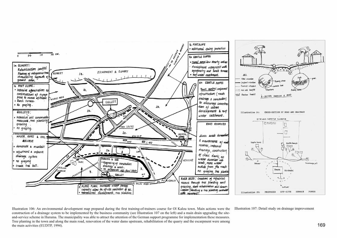
169
Illustration 106: An environmental development map prepared during the first training-of-trainers course for Ol Kalou town. Main actions were the construction of a drainage system to be implemented by the business community (see Illustration 107 on the left) and a main drain upgrading the site-and-service scheme in Huruma. The municipality was able to attract the attention of the German support programme for implementation these measures. Tree planting in the town and along the main road, renovation of the water dams upstream, rehabilitation of the quarry and the escarpment were among the main activities (EUDTP, 1994).
Illustration 107: Detail study on drainage improvement

170
their information and knowledge. They had to be able to listen, learn, and at the same convey a message. Lecturers of the Kenyan Institute for Management and Agricultural Information Centre introduced the participants to the theory behind participatory train-ing techniques, including the use of cards and slips of paper, working with videos, field and discovery tours, and story telling. Group work, plenary discussions, slides and picture shows, as well as the use of case studies, ‘real-life’ cases, interviews, and brainstorming were also introduced. During the second workshop, the trainees practised these techniques within the framework of the 3-Day PEP workshop. In the second communication workshop special attention was paid to the potentials and constraints of video as a training tool and to ways of handling group dynamics. The mock presentations of the PEP workshop were filmed and discussed to consolidate their learning experi-ence. Facilitators and trainees alike gave advice for improvement. Module 8 – 3-Day Participatory Environmental Planning WorkshopThe last training module dealt with the application of the 3-Day Participatory Environmental Planning (PEP) workshop. The project’s trainers assisted where necessary, but the trainees had to facilitate the workshop largely on their own. The PEP workshops targeted towns with a population of between 15,000 and 60,000 people. During the training of trainers course, the trainees worked in six towns - Machakos, Eldoret, Runyenjes, Kericho, Migori, and Nanyuki. Migori and Nanyuki featured both in the field course as in the PEP excercise. The workshop itself took three days. A fourth day was used for reporting and initiating implementation. Prior to the workshop one
day was spent on dealing with issues like travel, paying courtesy calls, and screening the towns’ area. The 3-Day PEP workshop will be discussed in detail in Part 4.4.
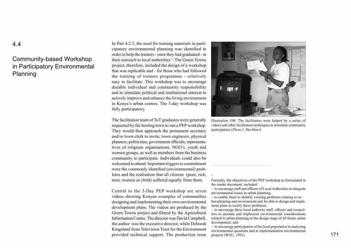
171
In Part 4.2.3, the need for training materials in parti-cipatory environmental planning was identified in order to help the trainers - once they had graduated - in their outreach to local authorities 1. The Green Towns project, therefore, included the design of a workshop that was replicable and - for those who had followed the training of trainers programme - relatively easy to facilitate. This workshop was to encourage durable individual and community responsibility and to stimulate political and institutional interest to actively improve and enhance the living environment in Kenya’s urban centres. The 3-day workshop was fully participatory.
The facilitation team of ToT graduates were generally requested by the hosting town to run a PEP workshop. They would then approach the permanent secretary and/or town clerk to invite, town engineers, physical planners, politicians, government officials, representa-tives of religious organisations, NGO’s, youth and women groups, as well as members from the business community to participate. Individuals could also be welcomed to attend. Important triggers to commitment were the commonly identified (environmental) prob-lems and the realisation that all citizens (poor, rich, men, women or child) suffered equally from them.
Central to the 3-Day PEP workshop are seven videos showing Kenyan examples of communities designing and implementing their own environmental development plans. The videos are produced by the Green Towns project and filmed by the Agricultural Information Centre. The director was David Campbell, the author was the executive director, while Deborah Kingsland from Television Trust for the Environment provided technical support. The production team
4.4
Community-based Workshop in Participatory Environmental Planning
Illustration 108: The facilitators were helped by a series of videos and other facilitation techniques to stimulate community participation (Photo I. Duchhart).
1
Formally, the objectives of the PEP workshop as formulated in the tender document, included:- to encourage staff and officers of Local Authorities to integrate environmental issues in urban planning;- to enable them to identify existing problems relating to ur-ban planning and environment and be able to design and imple-ment plans to rectify these problems;- to encourage these local authority staff, officers and council-lors to animate and implement environmental considerations related to urban planning at the design stage of all future urban development; and- to encourage participation of the local population in analyzing environmental questions and in implementation environmental projects (WAU, 1991).

172
chose an open, real-life approach which made it easy for workshop participants to identify themselves with the situations portrayed. This act of identification is extremely important in making the participants feel confident enough to tackle their own environmental problems. Assignments were designed to stimulate a focussed viewing of the videos and to help the facilitators stimulate a lively debate. The document “Introduction to Participatory Environmental Planning (PEP) for Sustainable Urban Development” (Duchhart, 2000) gives various examples. Like the training-of-trainers programme, the training technique used in this workshop was one of guided self-discovery. To activate this process, participants were invited to go
out into the field to observe real-life situations and interview town residents. They had to note down their findings in cross-sections and on maps to localise the information they collected.
In addition to videos, the project prepared a facilitation guide to direct the facilitators through the workshop (Grootenhuis et al., 1998). After several try-outs, for example in Module 7 of the ToT programme, this guide developed into a minutely detailed facilitation programme. The facilitators were thus helped to order locally available environmental knowledge into an environmental development plan and important ac-tions. The facilitators had to keep an extremely tight
time schedule because the specific objectives of each session had to be achieved before they could proceed to the next stage. This was not always an easy task, particularly, because most workshop participants had never been asked to express their environmental needs before and had never visualised their ideas in the form of a map.
4.4.1 3-Day PEP Workshop
The 3-Day PEP workshop consists of eight sessions to be carried out in three days. Table 7 provides an overview of how these days are organised. In addition to the workshop, the facilitators had to make prepa-ratory arrangements and conduct a final session on an additional fourth day. These activities are also included in the facilitation guide.
The first day of the programme is taken up by settling in, explaining the programme, and identifying environmental problems including an indication of who is most affected. The emphasis of second day is on the ecological relationships between human beings and the environment, whereby the participants have to link the environmental problems they have identified on the first day to their own actions and behaviour. They are then shown videos of people taking action to protect and improve their environment. The workshop participants are then invited to specify the actions they themselves could take to remedy their own situations and to verify these in the field. In previous workshops, the actions generally suggested related to more con-scious environmental management and care, tree planting, improving the way space is organised,
Illustration 109: During a PEP workshop, community representatives map out how they see their environment and what actions can be taken to improve their direct living environment (Photo A. Kibutu).

173
Table 7: The layout of the 3-Day PEP workshop as developed by the Green Towns project (Grootenhuis et al. 1998).
• Election of a voluntary action group (but action group should represent the workshop participants and include women and youth)• In Video 7 members of the action groups in Homa Bay, Kisii, and Busia narrate their experiences
• Finding solutions• Video shows how both in Nairobi (Undugu) and Kisii people used simple solutions to solve complicated problems in a durable way• Storm-water run-off; floods; erosion, health hazards; climate• Roofwater catchment; terracing; drainage; urban agriculture
Day 1 Who Cares Session 1 – Who Cares?!Video 1 – Who Cares?!
Session 2 – Making of the Problem Map
Session 3 – Workshop at workVideo 2 – A workshop at work
• The environment provides in our basic needs• Listing of environmental problems in the workshop town using cards
• Workshop participants make their base map showing physical features, roads, built-up areas, rivers, hills and swamps, forest (footnote on skeleton map)• Locating listed problems on the base map. This map is called the problem map.
• Video shows what people of Homa Bay did about their problems
• Workshop participants gained an insight in the PEP programme; • Made a base map;• Located problems on the map; • Selected areas with a concentration of environmental problems; • Saw how Homa Bay solved theirs; • Workshop participants decided to do the same
Day 2: Love Your Town Like Your Shamba
Session 4: Man and Nature – InterlinkagesVideo 3: Crying Hills
• Causes and effects of environmental problems• Linkages among problems and potentials for durable solutions• Video is taken in Taita-Taveta and shows how nature works, how it provides in human needs, how people can damage and repair the environment• The problems in the workshop town are re-organised in the form of a problem tree• Observations and interviews verify problems, find additional problems, identification cause and effects, and possibly solutions• The participants prepare maps and cross-sections
Session 5: Inter-linkages between solutionsVideo 4: Working Together
• The video “Crying Hills” showed that with care for the (shamba) environment we have a good place to live in (footnote on reference framework)• The video Working Together showed that the same principles apply for the urban living environment• Completion of problems• Discovery of integrated solutions in a part of the workshop town and elsewhere
Day 3: “Make Your Town A Green Town – Planning for Real”
Session 6: Make Your Town A Green TownVideo 5: Make Your Town a Green Town
• The video shows the planning steps the people of Webuye took to prepare their environ-mental development plan and prioritized actions• To discover potential qualities and environmental hazards the participants prepare: an agricultural suitability map; a suitability map for urban development; a land protection map; and a zero map (what happens if you do nothing)• The participants prepare conflict maps and discusse choices or possible solutions to mitigate the conflicts• Plenary preparation of the environmental development plan on the basis of previous maps• Participants include suggestions for environmental enhancement, beauty, shade or oth-erwise
Session 7: Planning for Real
Session 8: Election of Voluntary Action GroupVideo 7: Taking Action
• On the basis of the environmental development plan, actions necessary for implementa-tion are listed and ranked• Participants list what is needed, who should be involved, possible constraints, and time span of implementing the actions
• The participants prepared an environ-mental development plan, action plan, and • elected an action group (7-8 members)

174
and raising the standard of general maintenance. During, the third day, the participants develop an environmental (landscape) development plan and subsequently an action plan (Illustrations 110-112). With the help of criteria such as, affordability and visibility of the results, they rank the actions listed. At the end, a voluntary action group is elected to take the lead in the implementation of the action plans. Most of the sessions follow a similar approach and content as described for the training field course in Part 4.3.2. In the evenings, the facilitators prepare a report of the day’s work and these are given to the workshop participants the following morning before the workshop begins. On the additional fourth day the facilitators finalise the workshop report. One of the facilitators, volunteers to become the contact person for central government. His or her task will include providing the action group with technical advice. This action-group coach assists the action group in getting started. He or she will recapitulate the roles and responsibilities of the action-group members and help to elect office bearers. The process of registering formally with the Ministry of Social Affairs too is explained. Contacts with other Green Towns action groups and counterpart institutions are provided. When these tasks are completed, the action group together with the faciliators formally present the workshop report to the relevant office bearers.
expected urban development
areas in need of protectionIllustration 110: Environmental Protection
Map for Eldoret Town indicating environ-mentally vulnerable areas prepared during a PEP workshop (EUDTP, 1995b).
Illustration 111: Zero Map for Eldoret Town indicating the expected urban growth in the coming 10 years prepared during a PEP workshop (EUDTP, 1995b).

175
1: Mixed residential development (no agricultural)
2: Parks: Planting of trees, flowers, and grass
3: Reforestation and agro-forestry
4: Middle-income housing
5: Low density residential areas with kitchen gardening
6: Industrial development
7: Low-density housing development
8: Agricultural and forest development
9: Riparian reserves and areas of springs and natural drainage
10: Low-density hosuing area with trees, flowers and kitchen gardening
11: Areas for middle density housing development
12: Mountain range: no more develop-ment along the moutain range but the ones already there can remain, trees should be planted and terraces dug where necessary
Illustration 112: The PEP workshop in Eldoret resulted in the Environmen-tal Development Plan Eldoret Town (EUDTP, 1995b)

176

177
The training of trainers programme as well as the workshops in environmental planning had far reaching effects in terms of outreach. Participants of both the training programme and the PEP workshops made people - they lived and worked with - aware of the importance of caring for their immediate living environment. They turned into agents of change in formal and informal institutionalization processes and public awareness activities.
4.5.1 Institutionalization
In July 1996, 54 of the original 66 participants had graduated from the two Green Towns training-of-trainers programmes. Twenty two percent of the graduates were women. Most of these graduates brought their knowledge back to their respective institutions. At the national universities, the participatory landscape-planning approach was introduced either into the university’s curricula (Nairobi University) or was taken up in individual courses (Egerton and Kenyatta University) (EUDTP, 2000b; Wokabi, 1998). At Moi University and Kenyatta University, the Green Towns graduates introduced the approach to primary and secondary schools as part of their environmental education programmes. Students started an action group at Moi University and an environmental club at Nairobi University.
The graduates were particularly instrumental in setting up formal environmental units. The Ministry of Local Government included environment as a separate section in their urban development unit, the Ministry of Lands and Settlements established the Environmental
Management Unit (initially named Environmental Monitoring Unit), and the Government Training Institute set up the Environmental Department. The Environmental Management Unit produced an official policy paper, which acted as a directive to the integration of the Green Towns approach in the formal physical planning procedures (EMU, 2000). These changes slowly emerged from the training programme, in particular the assignments in between the training modules played an important role in this. Later, a well-defined institutionalisation process, largely implemented during the second phase of the project paved the way for these developments (Table 5). Box 5 gives an overview of the sequence of activities taken by the project to effect institutionalisation.
The Green Towns project also stimulated an informal institutionalisation process. The production of a broadcasting quality video “Love Your Town Like Your Shamba” which was aired on the national television in Kenya and Tanzania was part of this process (EUDTP, 1996a). UNEP translated the film into Swahili and French (1996) making it accessible to other broadcasting stations in the region as well. Meanwhile, many graduates started small environmental groups to improve their own personal living environment. Tree planting and clean-up activities figured prominently in their actions. Several Green Towns graduates pursued further studies obtaining MSc and PhD degrees in the field of environmental management. This further strengthened the capacity of the organisations where they worked. Some presented the work of the Green Towns project at international fora such as the Organisation for Economic Co-operation and Development (OECD) in Rome in 1996 (OECD, 1997; IIED, 1996), Habitat
4.5
Immediate Results of the Training Programmes - Institutionalisation and Public Action
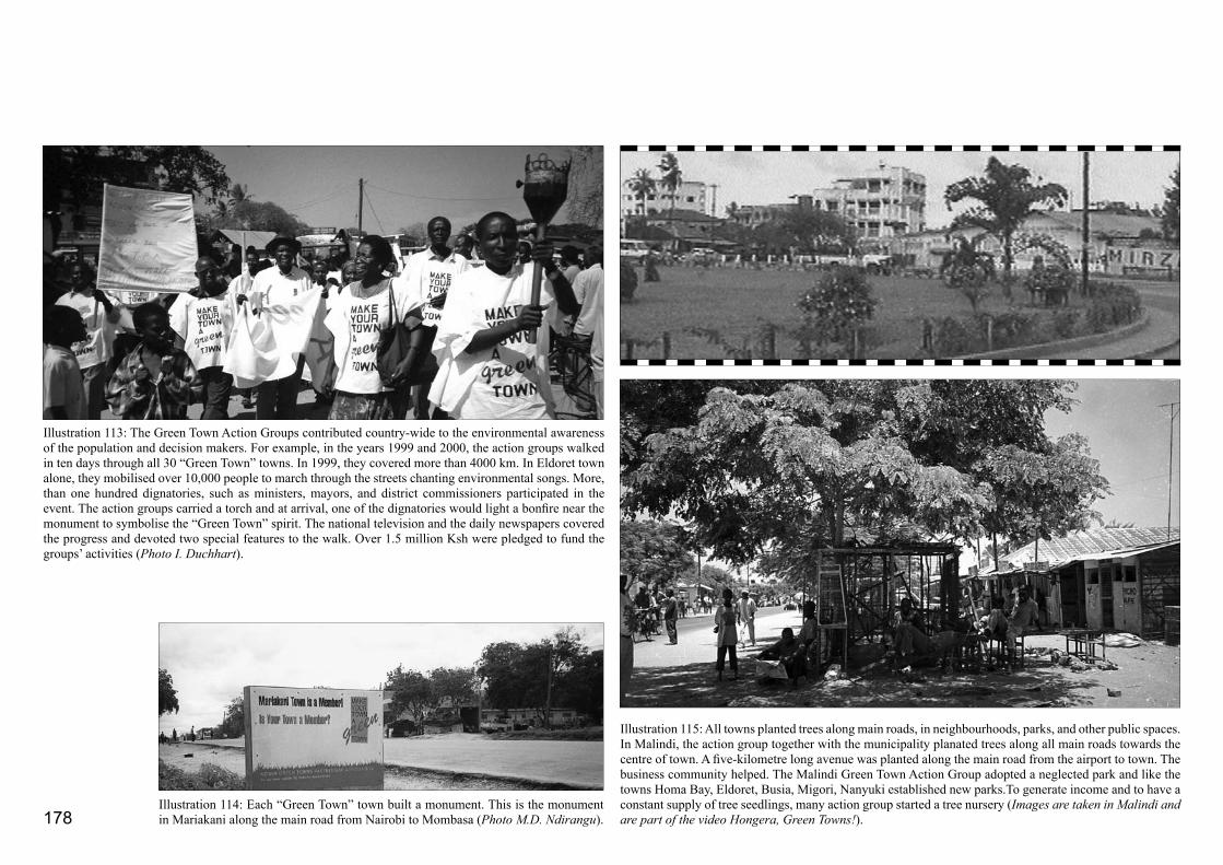
178
Illustration 113: The Green Town Action Groups contributed country-wide to the environmental awareness of the population and decision makers. For example, in the years 1999 and 2000, the action groups walked in ten days through all 30 “Green Town” towns. In 1999, they covered more than 4000 km. In Eldoret town alone, they mobilised over 10,000 people to march through the streets chanting environmental songs. More, than one hundred dignatories, such as ministers, mayors, and district commissioners participated in the event. The action groups carried a torch and at arrival, one of the dignatories would light a bonfire near the monument to symbolise the “Green Town” spirit. The national television and the daily newspapers covered the progress and devoted two special features to the walk. Over 1.5 million Ksh were pledged to fund the groups’ activities (Photo I. Duchhart).
Illustration 115: All towns planted trees along main roads, in neighbourhoods, parks, and other public spaces. In Malindi, the action group together with the municipality planated trees along all main roads towards the centre of town. A five-kilometre long avenue was planted along the main road from the airport to town. The business community helped. The Malindi Green Town Action Group adopted a neglected park and like the towns Homa Bay, Eldoret, Busia, Migori, Nanyuki established new parks.To generate income and to have a constant supply of tree seedlings, many action group started a tree nursery (Images are taken in Malindi and are part of the video Hongera, Green Towns!).
Illustration 114: Each “Green Town” town built a monument. This is the monument in Mariakani along the main road from Nairobi to Mombasa (Photo M.D. Ndirangu).
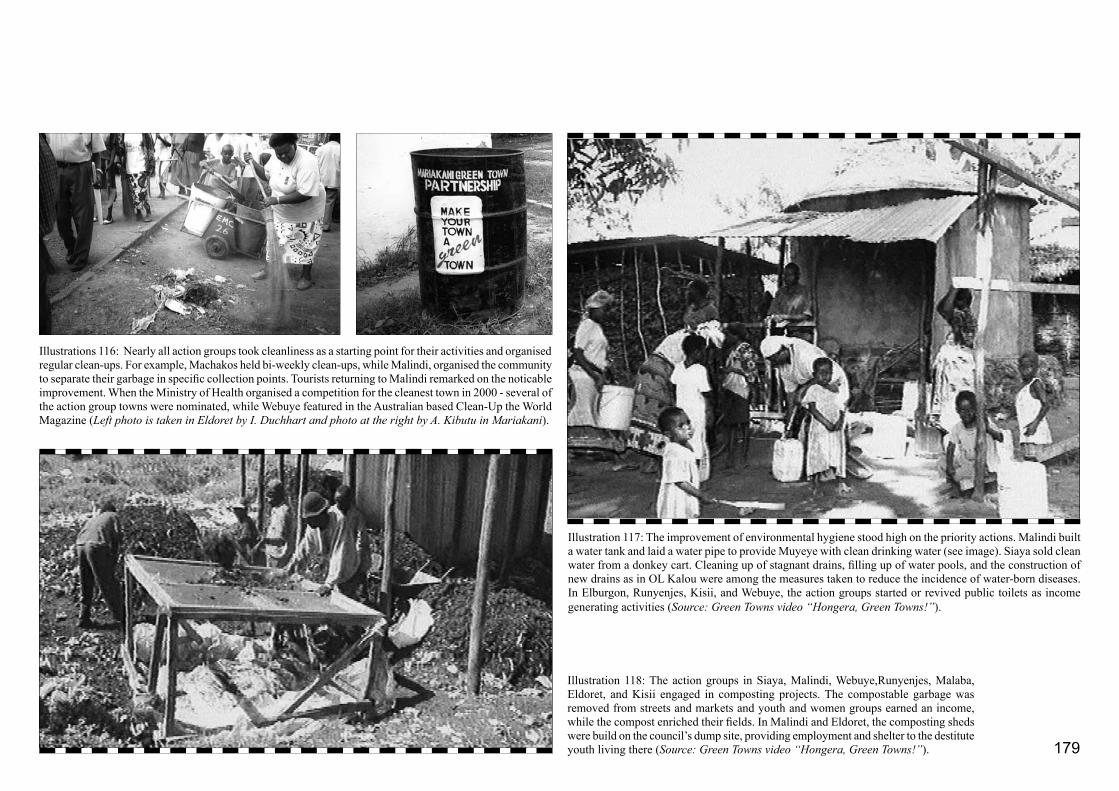
179
Illustrations 116: Nearly all action groups took cleanliness as a starting point for their activities and organised regular clean-ups. For example, Machakos held bi-weekly clean-ups, while Malindi, organised the community to separate their garbage in specific collection points. Tourists returning to Malindi remarked on the noticable improvement. When the Ministry of Health organised a competition for the cleanest town in 2000 - several of the action group towns were nominated, while Webuye featured in the Australian based Clean-Up the World Magazine (Left photo is taken in Eldoret by I. Duchhart and photo at the right by A. Kibutu in Mariakani).
Illustration 118: The action groups in Siaya, Malindi, Webuye,Runyenjes, Malaba, Eldoret, and Kisii engaged in composting projects. The compostable garbage was removed from streets and markets and youth and women groups earned an income, while the compost enriched their fields. In Malindi and Eldoret, the composting sheds were build on the council’s dump site, providing employment and shelter to the destitute youth living there (Source: Green Towns video “Hongera, Green Towns!”).
Illustration 117: The improvement of environmental hygiene stood high on the priority actions. Malindi built a water tank and laid a water pipe to provide Muyeye with clean drinking water (see image). Siaya sold clean water from a donkey cart. Cleaning up of stagnant drains, filling up of water pools, and the construction of new drains as in OL Kalou were among the measures taken to reduce the incidence of water-born diseases. In Elburgon, Runyenjes, Kisii, and Webuye, the action groups started or revived public toilets as income generating activities (Source: Green Towns video “Hongera, Green Towns!”).

180
II Conference in Istanbul in 1996 and Dakar, Senegal (UNCHS,1997a; 1997b), International Network for Green Planners in Brussels (M’mbwanga and Karume, 1998), and in the scope of Localising Agenda 21 in Sweden and Indonesia (Ngure, 1999). The MoLG participated in International Labour Organisation (ILO) conferences in Zambia and Tanzania (Matara and Chege, 1999). Donors and other non-governmental organisations requested Green Towns graduates to facilitate environmental (PEP) workshops.
Twenty Green Towns graduates jointly facilitated 16 PEP workshops. Six of these workshops fell under the responsibility of the Environmental Management Unit of the Ministry of Lands and Settlement and the Ministry of Local Government was responsible for ten more. The Ministry of Lands concentrated mainly on training District Physical Planners and other district officers involved in environmental issues. Altogether some 300 officers were trained in this way. The unit established at the Ministry of Local Government targeted the community and local government officers. In total, they trained about 450 people (EUDTP, 2000a; 2000b). By 2000, 29 Kenyan towns - including the 13 towns which prepared their plans as part of the training of trainers programme - had their own environmental development plan.
4.5.2 Community Awareness and Action
The participants of the PEP workshops became mem-bers of the local action group and were actively in-volved in the action groups’ work and the recruitment of members. The membership of an action group could
Step 1- ConceptionThe ToT training ignited the process. At the end of each training module, the trainees thought about the integration of their newly acquired knowledge into their daily work and life. Ultimately, these ideas lead to the conclusion that each counterpart institution required an environment co-ordinating unit. A formulation mission critically reviewed this idea in 1996. Meanwhile, senior officers of core ministries (who would most likely be the ones to approve the formal institutionalization of the Green Towns approach) were invited to open and close the training modules. In this way, these officers became involved in the project’s approach and intentions.
Step 2 – Formulation of substantial and related administrative issuesDuring several workshops, the Green Towns graduates formulated the institutional opportunities and constraints at the national level, local, and district levels. The needs for partnership relations with the community were also addressed. These workshops resulted - per counterpart institution - in independent plans of operation to institutionalize urban environmental issues in general and the Green Towns approach in particular. Then, detailed Memoranda of Understanding between the respective environmental units, Wageningen University as the contractor, and the Netherlands government, were prepared.
Step 3 – Team building and institutional changeThe institutionalisation process would go along with changes in individual positions. Even though, action was taken at an early stage to prepare decision makers for these changes, some resistance was still to be expected. Team building exercises and coaching carried out by Matrix Development Consultants helped the change agents to cope with resistance and to spearhead the process.
Step 4 – Institutional and public acceptanceThe graduates - now the change agents - carried out multiple appreciation and advocacy activities in order to convince their colleagues and superiors (up to the level of ministers) to support
the establishment of environmental units with specifically allocated budget lines. The Ministry of Lands and Settlement went the furthest and produced a formal position paper (EMU, 2000). In addition, for the action groups to be successful, they needed the support of the decision makers at local level and the advice of district level technical staff. The staff of the Ministry of Local Government played a crucial role in building partnership relations at the local level, while the Ministry of Lands and Settlement did the same at district level.
The public too had to accept responsibilities in preserving and maintaining the environment. The Green Town action groups and the Kenya Green Town Partnership Association mounted many local actions and large-scale public awareness campaigns, such as a secondary school debate campaign (reaching thousands of children in 61 schools in 16 towns), and a mass-walk that reached hundreds of thousands of people throughout the country. The local communities cleaned up their neighbourhoods, planted trees and cared for them. Action group members organised public meetings and gave lectures in schools. Television, radio, and the daily newspapers reported most activities.
Step 5 – Actual implementationDuring Step 5 - which covered a period of about two years - the environmental units implemented their own plan of operations including carrying out training programmes and sensitisation workshops, coaching action groups, and physically setting up their units. Even though attention for the process withered, the experience was crucial for the assessment and refueling of institutionalisation issues.
Step 6 – Monitoring and evaluation At the end of the project period Matrix Development Consultants helped to evaluate and assess the process.
Step 7 – Feedback of the lessons learnedThe Matrix review should help to strengthen the units and further the institutionalization process.
Box 5: Green Towns Institutionalization Process in 7 steps

181
sometimes run up to a couple of hundred people. In the case of Malindi it even reached nearly 2000.
The action groups actively preserved their environment by creating awareness, political lobbying, and the implementation of small-scale environmental projects, such as parks, planting trees in and around public spaces, garbage collection and composting, and clean-up activities. Those facilitators who opted to become an action group’s contact person at central government level as discussed in Part 4.4.1 provided the action groups with training, technical and moral support. This type of coaching linked the Ministry of Local Government with the action groups. Out of principle they worked through local authority’s officials. In this way they were able to help the groups to deal with bureaucratic and other issues. Through the coaches the action groups could apply for Green Towns seed-money - on average of some US$ 2000 - to start income-generating projects. In total, the action groups implemented a little over 50 projects. These varied from building public toilets, water tanks, and garbage containers to erecting bill-board monuments. Illustrations 113-118 show some of the results and provide brief explanotory notes. The Green Towns video “Hongera, Green Towns!” (which means Congratulations, Green Towns!) featured some of the implemented projects.
As early as 1996, the action groups that had already been set up decided to form a national umbrella organisation. This was formally registered two years later in the Register of Associations as the Kenya Green Towns Partnership Association. The word partnership was used with the express intention of conveying the importance of collaboration between government and
community. The Kenya Green Towns Partnership Association organised national activities, such as, national secondary school debates on environmental issues and a large-scale Mass Walk covering all Green Towns towns (see Illustrations 113). The association collected over 43,000 signatures to successfully protest when the Netherlands government - the major donor - decided to withdraw its support.
There was considerable television and newspapers coverage of Green Towns activities. In particular, the various initiatives of the action groups and the association featured. It has been estimated that the Green Towns project - in the course of its existence - managed to reach between two to four million people. Kenya Green Towns Partnership Association’s executives were invited to participate in several national and international forums including those organised by NGO’s such as Nairobi-based Shelter Forum, the women’s network GROOTS (Mwaura and Nyongesa, 1998; Nyongesa, 1999), the African NGO-caucus in Nigeria (Karume, 1997; Karume and Duchhart, 1998), and at the bi-annual United Nations Habitat commissions (UNCHS, 1997; 1999). The chairman Mr. G. Karume of the association participated in several conferences of the International Network for Green Planners (Karume, 1999) included ones in Brussel and Curitiba. These activities profiled the association and helped institutionalising its position within the sector.

182
183
4.6
Evaluation
Judging from the local, national, and international recognition the Green Towns project received, it can be said that it proved quite successful. The evolved theoretical notions underlying the Green Towns application-project as explicated in Chapter 4.1 would seem to have provided an appropriate basis for action. By 2001, the inhabitants of nearly 30 Kenyan towns had developed useful and effective ideas about the environmental and the physical development of their towns. Voluntary groups together with government were implementing many of the planned activities and this had led to a considerable improvement in the immediate living environment. Dignitaries, schoolchildren, youth, women and men, planted and cared for thousands of trees. The message of “green and clean” towns had reached an estimated two million Kenyans (Gatari, 2000) and had stimulated many - even outside the project - to action.1 The Green Towns initiative enabled the government to gain access to local knowledge and resources, while an informed community found it easier to approach politicians and government officials to discuss their environmental issues and to work out the best possible solution (Illustration 119). The central government mainstreamed the approach through policy papers and by establishing environment units in three ministries. The Green Towns approach changed physical planning from a desk-bound to a participatory, community and action oriented planning activity (EMU, 2000).
Several internal and external evaluations reflected on the project’s activities. Among them were studies assessing the successes and failures of the action groups (EMS, 1995; Teuwsen, 1995; Donde, 2000; Gathuru Kuria, 2000), the participatory environmental planning workshops, and the curriculum and training modules
of the training-of-trainers programme (EUDTP, 2000a; Njau, et al. 1994; Njau and Mc. Callum, 1996). Professors and staff of the four national universities - a total 22 staff members - assessed the Green Towns approach in terms of its specific characteristics (Duchhart, 1999). Other studies addressed issues such as youth participation (Waiganjo, 1997), gender sensitivity and poverty alleviation (Maingi, 2000). Some of the most significant issues that emerged in relation to the approach, environmental development plans, action groups, training of trainers programme, and institutionalisation will be discussed in Part 4.6.1. Part 4.6.2 reflects on the validity of the departure notions employed by the Green Towns project (see Part 4.1).
1
In Part 4.5, reference was made to the fact that Green Towns graduates on their own initiative started small groups to clean and green their neighbourhoods. After 1996, there was a notable growth of environmental (youth) groups, especially in Nairobi. These groups were started at the same time that the Green Towns project and action groups prominently began to feature in the media (Gatari, 2000). In an evaluative visit in 2006, it was found that the Green Towns activities had sparked off various environmental groups and actions in different the Green Town towns (Wetering, 2006).

184
4.6.1 Findings Related to Project Activities
Green Towns approachIn 1999, the Green Towns activities were presented to an audience of head of departments and other university staff of Moi University, Kenyatta University, Nairobi University, and Egerton University. The audience characterised the Green Towns approach using the following key-words and phrases: integrating theory and practice in the physical planning, collaborative, informal, innovative, people driven, positive, visionary, action-oriented, area specific, needed, ecologically sensitive, transparent, urban focussed, and linked to institutionalisation. Critical questions were raised about possible conflicts of interests among partners, including among the community itself and within action groups, the sustainability of attitude change, political interference, cultural inertia, and the harmonisation of landscape units with urban land use. With regard to sustaining the innovative character of the approach, the university staff raised issues such as how to integrate the participatory approach more strongly into conventional planning approaches, replicability and transferability, the development of a legal framework to further facilitate the innovation, and the continued capacity building in Green Towns participatory environmental planning (Duchhart, 1999). Later, some university staff prepared a proposal (KUNDI) to enable the development of a wider inter-university programme that included Wageningen University. KUNDI’s aim was to build capacity and further develop the approach (Donde, 2000). This proposal was never implemented. Graduates of the training-of-trainers programme were also positive about the action-orientated approach of the Green
Towns project (Duchhart, 2000). Because capacity building through adaptations in university curricula will need a certain amount of time to have effect, an external evaluation mission recommended a third training-of-trainers programme in 1996. The Kenyan counterparts made it clear that it was more important to deepen their knowledge by putting what they had learned into practice rather than enlarging the group of ToT graduates. In retrospect this proved to be a wise decision. However, in 2000, the issue of capacity building came up again when the staff of the Environmental Management Unit of the Ministry of Lands and Settlement expressed their concern about whether the current capacity was sufficient. They wished to run a third training themselves - and therefore encouraged the writing of the guide “Introduction to Par-ticipatory Environmental Planning (PEP) for Sustainable Urban Development” (Duchhart, 2000).
Environmental development plansIn 1999, after three years experience with the preparation of environmental development plans - otherwise known as landscape plans - the Green Towns graduates and PEP facilitators evaluated their usefulness. They thought the plans were an important tool in the planning for the physical environment, land management, and community participation. They also saw them as a mechanism for building up partnership relations between the community and the government (Illustration 118). In their daily work they noticed that the environmental development plans had also provided a basis for coherent Local Authority Development Programmes and a good start for the formal physical structure plans as prepared by the Ministry of Lands and Settlement. The facilitators
Illustration 119: The Green Towns environmental development plans provided a mechanism for building partnership relations between the government and the community. The public awareness flowing from the government to the public and local officers was largely based on training activities. The action groups, in particular, contributed largely to the spreading of the Green Towns’ message. Newspapers, radio and television covered many of their activities. Furthermore, the action group members initiated a large variety of awareness activities in schools and community groups. Formal institutionalization provided the foundation for technical support and advice from the government to the action groups. The Kenya Green Towns Partnership Association reported back to the government on the needs and wishes of the community.

185
emphasised the importance of the participatory environmental planning (PEP) process in building up an understanding of the town (“Self-evaluation, Siaya, Mavoko, and Karuri on 22 September 1998” in EUDTP, 2000).
Nevertheless, even though, 80% of the graduated trainers felt confident enough to facilitate a PEP workshop, they believed they still lacked certain skills. Although, the facilitators recommended that the related Green Towns videos and the corresponding facilitation guide provided support, they indicated they had difficulties in the following areas: the transition from conflict maps to environmental development plans and the visualisation of these plans (“Refresher Course, 11-12 August 1999” in EUDTP, 2000).
When all available environmental development plans were compared in 2005, it emerged that the latest prepared base maps, although they showed physical features, showed hardly any landscape-ecological elements. The preparation of a cross-section show-ing ecological connections missed and and a land-scape-unit map was not prepared. Consequently, this lowered the quality of the suitability studies as these were built on the landscape-unit maps. Nevertheless, the conflict areas remained quite well defined. The environmental-development plans had, in fact, be-come geographical representations of the action plans rather than coherent landscape plans that would lead to an overall improvement of the environment. Dur-ing the evaluation workshop, the facilitators realised had already realised that this may be the issue that created the difficulties when it came to designing the environmental development plan. They decided that they would pay renewed attention to the preparation
of a base map, cross-section, and a landscape unit map in order to emphasises landscape characteristics. It should be remembered, however, that designing is a complex activity requiring much more time than half day it is scheduled for in the PEP workshop (see Part 3). The facilitators of the Ministry of Lands and Settlement adjusted the workshop time schedule ac-cordingly (“Refresher Course, 11-12 August 1999 in EUDTP”, 2000a). By reducing the amount of time spent on problem identification2 and increasing the time allocated to preparing the environmental devel-opment plan more space could be reserved for this activity. Furthermore, the PEP facilitators proposed to rename the “zero” map into “reality” map. They also suggested transforming the “conflict” maps after they have discussed them into “compromise” maps, in this way also easing the transition to the design of the environmental development plan.
Even though the facilitators had difficulties in having the workshop participants to prepare an environmental development plan, a comparison of the plans revealed that the emphasis continued to be on measures to protect environmentally vulnerable areas, such as valleys and hill-tops. In nearly all the plans, the key activities were tree planting along main roads and school compounds, the establishment of parks and tree nurseries, and a whole variety of initiatives to improve the cleanliness of the environment and public health. Public awareness was the most prominent activity in the action plans.
PEP workshopsNotwithstanding the difficulties the facilitators experienced in carrying out the PEP workshops, the workshop participants were highly appreciative of the
design process they followed. This was illustrated in comments - such as “I never worked so hard, but I am fully satisfied and I achieved something” and “Well, Green Towns does not make you rich with money but proud and rich at heart” - were noted down in the workshop evaluations. In Karuri town, for example, the participants loved the videos most and described the environmental development plans as particularly useful. They appreciated the Green Towns approach as appropriate and requested regular PEP workshops (“Evaluation Results - PEP Workshops” in EUDTP, 2000). The field trips were also highly appreciated. The requests for assistance in preparing environmental development plans through PEP workshops, forwarded to the Ministry of Local Government by towns such as Kikuyu, Bungoma, Vihiga, Muranga, and Kiambu also reflect this appreciation.
In 1995, Teuwsen reported that almost all the eight action groups she studied were carrying out their activities according to the environment development plans. However, there was no structural feedback of the effects of their implemented actions into these plans (Teuwsen, 1996). After an average period of
2
At the time (1993-1995), the PEP workshop was developed the identification of environmental problems was still a critical is-sue, but in 1999, the public awareness on environmental issues had increased. This allowed for the required shift of emphasis to the preparation of the landscape/environmental development plans.

186
about 4 years, however, various groups started to request for refresher workshops to assess their progress and to renew their environmental development plans. The Green Towns vision, however, acts as a guide for a period much longer than four years. This is demonstrated by the fact that some groups are still active as this thesis is being written (Wetering, 2006).
Action groupsAlthough the actions groups received ample appreciation - in 1996 and 2000, for example, Habitat listed the Malindi and Webuye Green Towns action groups formally as Good Practices In Improving The Living Environment (UNHSC, 1996; 2000) - nearly all action-group evaluations reported factors that threatened the groups. These included adverse group dynamics, political interference, or difficulties in action-group leadership (Donde, 2000; Gathuru Kuria, 2000; EMS, 1995; Teuwsen, 1996; Wetering, 2006). A conflict of interests among partners was sometimes also an issue particularly if an action group became too strong as a pressure group or when the group lacked financial accountability. Sometimes difficulties arose because action group members showed political aspirations or when action groups blocked prestigious private developments as happened, for example, in Malindi and Nanyuki. These types of situations are, however, unavoidable phenomena as indeed several action-group members were elected to be councillors or mayors. By the year 2000, about 17 groups were active, ten groups reasonably active, and three were inactive (EUDTP, 2000b). Good collaboration with the council, alert government coaches, and charismatic leaders appeared crucial for maintaining group success. In 2004, the Malindi Green Towns Action
Group celebrated its tenth anniversary indicating the sustainability that can be achieved when attitudes change.
Training of Trainers programmeThe original objective of the training programme was to train trainers capable of guiding local authorities in the preparation of an environmental development plan. Ultimately, the training went far beyond this objective. When it was over, the graduates appeared to have undergone a complete shift in values. All graduates who participated in the alumni evaluation carried out by Grootenhuis and Gatari in 1999 and 2000, claimed that the course had changed their lives - environment had become their way of living - They felt they had acquired a common vision and mission and were motivated to put this mission into effect. A quarter of the graduates had initiated environmental groups outside the Green Towns context. Sixty percent felt that they had become part of a group and contemplated starting a Green Towns alumni club (“ToT 1 and 2” in EUDTP, 2000). Overall appreciation of the courses and curricula were high. Field trips, discussions, and audio-visual training rated highest. Most graduates wished for more training in skills, such as project implementation and communication techniques, and in landscape ecology, landscape analysis and landscape design combined with practical solutions and environmental impact assessments (“Conclusions and Recommendations” in EUDTP, 2000b). These needs coincided with the plan evaluations discussed earlier.
Formal institutionalisationIn 2000, the Environmental Management Unit (EMU) of the Ministry of Lands and Settlement, which emerged
from the Green Towns project, was the most effective example of institutionalisation (Matrix, 2000). They integrated the participatory environmental-planning approach into the conventional planning by preparing the “Ministerial Position Paper Environmental Consi-derations in Land-Use Planning and Management”. According to this paper, physical planning had to contribute purposefully to the creation of a sustainable, healthy, and attractive living rural and urban environment. Moreover, the paper states that without meaningful environmental management strategies poverty reduction could not be achieved (EMU, 2000). A first practical experiment was the introduction of the 3-Day Participatory Environmental Planning workshop in the preparation for the Regional Structure Plan for Nakuru (EUDTP, 2000b). Early in 2000, the Physical Planning Act No. 6 (1996) was enacted. Graduates from Green Towns training insisted that recommendation for participatory approaches and giving power to the local authorities to demand environmental impact assessments should be included in this act.
Several graduates joined committees that worked on the development of the Environmental Management and Co-ordination Bill (1996). This bill would mean that individuals and organisations would be able to bring environmental issues to court without being adversely affected themselves. The bill, in fact, had now empowered action groups to report environ-mental mismanagement. The act also introduced the National Environmental Management Agency (NEMA). The Environmental Management Unit from the Ministry of Lands and Settlement considered itself as one of the NEMA agencies in this process.

187
In 1994, the Ministry of Local Government established Local Authority Environmental Committees. Green Town graduates worked on the terms of references for these committees. Most committees of the towns in which Green Towns had been active, adopted the Green Towns environmental-development plans as their guide. Some Green Town Action Groups were co-opted members in district environmental committees. Staff of the environmental unit of the Ministry of Local Government actively participated in the revision of the Local Authority Development Programme and the Local Government Act and lobbied for the inclusion of participatory environmental approaches (Mbatia Nyagah and Njoka, 1997). Together, these developments imply that the project’s activities had a positive effect on the institutionalisation of landscape issues into both formal and informal organisations concerned with the Kenyan environment.
To conclude, it is suggested that the strength of the Green Towns approach lay in its capacity to:- Build up a sense of ownership and responsibility for the environment;- Emphasise the process rather than the end product;- Create a unity of purpose regarding the future of the physical environment;- Bridge local knowledge and initiative with government guidance;- Build up partnerships;- Change desk-planning into a local-based partici- patory approach to planning the physical environment;- Link analysis, to planning, design, and action;- Initiate simultaneous actions at local and at cen- tral levels; and
- Make local knowledge and resources accessible. The universities singled out the participatory approach, ecological sensitivity in urban planning, and the combination of training and institutionalisation as the main strengths of the approach. The graduated trainers appreciated the relative simplicity of method, its practicality and claimed that the training changed their lives at work and at home. The action groups welcomed the easy access to governmental-decision makers and the respect they had won from the community. As environmental problems became more manageable, community appreciation of their increasingly clean and green environment grew. At the same time, the government discovered the community as a knowledgeable and appropriate vehicle for spearheading development.
4.6.2 Reflecting the Theoretical Starting Notions
To assess the appropriateness of the notions underlying the Green Towns project - as described in Part 4.1 - some key issues are examined in the light of the actual project processes and results.
The strengths of the Green Towns project, such as ownership and responsibility, unity of purpose regarding the future of the physical environment are closely related to vision, stances, and attitudes. Participatory approaches, access to local knowledge and resources, and ecological sensitivity were basic issues that related to landscape analysis and the emphasis on the design process rather than the product. All this is linked to the first Cluster - Vision
and Conceptualisation - of the working method discussed. The activities such as detailed design and detailed studies - that are part of Cluster 2 - Checks and Balances - relate to the frequent field studies, field walks partly to further detail the identified problems and partly to look for and to test possible solutions. The results were highly motivated, hard working trainers, and community leaders who dared to take risks, while many government officers showed great enthusiasm. Together they made the project a success. The building up of partnerships, the planning for action, and the joint efforts taken at various scale levels all were strengths related to implementation activities such as proposed for the third Cluster - Monitoring and Evaluation.
A participatory approach together with the notion that stakeholders should take joint responsibility for the analyses, design, and implementation of landscape plans was also an important starting point. Tuning in to community and governmental expectations, bridging the divide between diverting landscape forming forces, and establishing intersectoral collaboration were also strong theoretical notions. Together they were critical to the success of the Green Towns project. This confirmed that the renewed working method formed a proper theoretical departure point.
It should be noted, however, that the 1990’s were a conducive to environmental action. The Rio Conference of 1992 and The Habitat II Conference in Istanbul in 1996, and Agenda 21 in particular, stimulated interest in the environment from the side of the government. On-going climatic change bringing with it horrendous rains and serious droughts is a constant reminder to local communities that nature has to be respected.
188
References Agricultural Information Centre, 2000, Hongera Green Town! Congratulations Green Town! Video production of the results of the Green Towns Action Groups directed by Herine Simbowo, 23 minutes
Agricultural Information Centre (MALDM). 1995. The Tana River, Directors Herine Simbowo and Suleiman Juma, JICA Study Team TARDA Local Communities, Nairobi, video, 54 minutes
Chutha, R., H. Beumer, Z. Omwando, I. Duchhart, and F. Grootenhuis. 1989. Suggestions for Development of Kisii Town, Integration of the Natural Environment in the Development Programmes of the Local Authorities, Ministry of Local Government of Kenya and Agricultural University Wageningen, Nairobi, 51 p. plus appendices
Donde, G., 2000, Participatory Evaluative Progress Rerport on Green Towns Environmental Initiatives Asction Groups of Kisii, Kisumu, Eldoret, Mariakani, Mtwapa, and Runyenjes, Ministry of Local Government, Urban Planning and Environment Unit, 111 p.
Donde, G. 2000. KUNDI Kenya University Environment and Development Initiative, Report from the KUNDI working group (Kenyatta University, Nairobi University, Egerton University, Moi University, and Green Towns Advisory Office, 19 p. plus appendix
Duchhart, I. 2000. Introduction to Participatory Environmental Planning (PEP) for Sustainable Urban Development, Wageningen Universiteit, Environment and Urban Development Training Project, 120 pg
Duchhart, I. (Editor). 1999. The Green Towns Approach to Environmental Planning and Management for Sustainable Development in Kenya, Environment and Urban Development Training Project - Phase II, Nakuru, 43 p. plus appendices
Duchhart, I. and F. Grootenhuis. 1993. Internal Notes ToT - Introductory Course and Field Courses. Environment and Urban Development Training Project, 22 p.
Duchhart, I. 1990. Manual on Environment and Urban Development, Republic of Kenya, Ministry of Local Government and Physical Planning in collaboration with the Agricultural University Wageningen, 86 p.
Duchhart, I., 1996, Environment and Urban Development Training Project, in Kenya Best Practices 1996 Produced and Printed by Small Towns Project GTZ and ITDG, Nairobi, pages 18-23
Duchhart, Ingrid, Frederick Steiner, and John H. Bassman. 1989. Planning Methods for Agroforestry, Agroforestry Systems 7, Kluwer Academic Publishers, Dordrecht, pp. 227-258
Duchhart, I. 1989. Landscape planning: An approach to local-level planning? in Haeringen R.P.F. van and K.F. Wiersum, Local Level Planning for Sustainable Land Use, Bos Document 9, pp. 55-72
Environment and Urban Development Training Project (EUDTP). 2000b. End of Project Report, Kenya Green Towns Partnership Association, Ministry of Local Government, Kenya in collaboration with the Agricultural University Wageningen, the Netherlands, Nairobi, 8 parts
Environment and Urban Development Training Project (EUDTP). 1993. Introduction to Applied Environmental Planning, Applica-tion of Natural Principles in Urban Development, Course Notes August 1993- July 1994, Ministry of Local Government, Kenya in collaboration with the Agricultural University Wageningen, the Netherlands, Nairobi, Two Parts
Environment and Urban Development Training Project (EUDTP). 2000a. Quality Control, Green Towns Training of Trainers Programme in Introduction to Applied Environmental Planning - Application of Natural Principles in Urban Environment, Compiled by I. Duchhart, no pagenumbers plus appendices
Environment and Urban Development Training Project (EUDTP). 1996b. Migori Town Council, Field Course Report, Main Report, Maps, and Plans, Migori, 39 p.

189
Environment and Urban Development Training Project (EUDTP). 1994. Ol Kalou Environment Development Plan and Action Plans, Environment and Urban Development Training Project in co-operation with Ol Kalou Town Council, Introduc-tion to Applied Evironmental Planning Application of Natural Principles in Urban Development Environmental Planning Field Course, Ol Kalou, 32 p. plus appendices
Environment and Urban Development Training Project (EUDTP). 1995b. Make Your Town A “Green Town” Eldoret, Environment and Urban Development Training Project Ministry of Local Government in collaboration with the Wageningen Agricultural University, Eldoret, 42 p. plus appendices
Environment and Urban Development Training Project and Agricultural Information Centre, 1996a, Summarising Video Green Towns Project Training Approach produced and directed by Deborah Kingsland en I. Duchhart, 25 minuten
Environment and Urban Development Training Project and Agricultural Information Centre, 1995a, Make Your Town a Green Town, Seven videos of average ten minutes each (Who cares?, A workshop at work, The crying hills, working together, Make your town a green town, What can we do? And Taking action) directed and produced by Deborah Kingsland and I. Duchhart, total 70 minutes
Environmental Management Unit (EMU). 2000. Ministerial Position Paper on Environmental Considerations in Land-Use Planning and Management, Ministry of Lands and Settlement, Nairobi, 48 p.
Environment Management Services (EMS). 1995. Impact Analysis of “Real-life” Example Towns, A report of an evaluation of the environmental, economic, and social impacts of environmental improvement projects by the EUDTP in Kisii, Homa Bay and Busia Towns, Environment and Urban Development Training Project (EUDTP), Nairobi, 94 p.
Gatari, Charity. 2000. Green Towns Project Newspaper Environmental Articles Research on Urban Environmental Coverage by the Daily Nation and Standard Newspaper 1992-2000, Green Towns Project, Nairobi, 18 pp summary plus actual newspaper coverage 1992-2000
Gathuru Kuria, P. 2000. Strategic Transformations A Social and Financial Assessment of Green Towns Environmental Initiatives, Environment and Urban Development Training Project, Phase II, 48 pp. Grootenhuis, F., I. Duchhart, and J. Mburu. 1998. Make Your Town a “Green Town”, Facilitation Guide for 3-Day Workshop in Participatroy Environmetnal Planning for Urban Centres, Wageningen Agricultural University, EUDTP, Nairobi, 98 p.
IIED, 1997, Proceedings of a Workshop held in Rome, Italy, 4-6 December, 1996, OECD/DAC, pp 49-51
Karume, G., 1999, International Network for Green Planning, Kenya Green Towns Partnership Association presents Green Towns activities in Malindi, Curitiba, Brazil
Karume, G., 1997, Presentation of the Green Towns Partnership Association for the African NGO-caucus Habitat, Nigeria
Karume, G. and I. Duchhart. 1998. Malindi Green Town Movement, PRECEUP Provisional Research Topic and Methods and UNCHS Best Practice Reporting Format, Habitat and Environment Commitee (HEC of the Habitat International Coalition (HIC) Case Study No. 29 ENDA Book for the Urban Environment, Edited by ??, Nigeria
Kenyatta University (compiler) Urban Environmental Planning Studio (EPM 303), Academic Year 1998/1999, Toward Environmentally Sustainable Waste Disposal Strategies for Ol Kalou Town, Kenyatta University, Faculty of Environmental Studies, 49 p.
Matara R. and O.J.N Chege. 1999. International Labor Organisation, Urban Planning and Environment Unit, Ministry of Local Government present Green Towns’ Concept on Community Participation in Tanzania and Zambia.
Matrix Development Consultants. 2000. Institutionalisation of the Green Towns Project, An Assessment, Nairobi, 2000, 15 p.
Mwaura, E. and S. Nyongesa, 1998, GROOTS (Grasssroots Organisations Operating Together in Sisterhood) Exchange Programme presentation Green Towns experience with community participation and gender in Papua New Guinea
Mwangi Wokabi, S. 1998. Institutional Participation for Environmental Policy Implementation: Lessons from Experience in Environment and Urban Development Training Programme (EUDTP/Egerton University Aceptance Workshop) held in Kunste Hotel, Nakuru, Kenya, University of Amsterdam, Amsterdam
M’mbwanga, E. 1997. Kenya Small Towns – Mobilizing Voluntary and Community Action for Environmental Planning and Management, in Environmental Planning and Managment (EPM) Source Book, Volume 2: Experiences and Internation Support, United Nations Centre of Human Settlements (Habitat) in collaboration with the UNEP, pages 82-85 (presentation in Dakar, Senegal)
M’mbwanga, E. and G. Karume. 1998. Green Towns Government/Community-based-organisation Partnership Concept, International Network for Green Planners, Brussels
Mbatia Nyagah, P. and John Murimi Njoka. 1997. Planning Problems in Kenya Local Authorities, A situation analysis of seven local authorities, GTZ/Nairobi University, 142 pp.
Ngure, G., 1999, Habitat Localising Agenda 21 (Follow-Up), presents results Green Town’s experience, Surabaya, Indonesia
Njau, G. , D. McCallum, E. Frank, and Kihumba F. Njuguna. 1994. Report of the Review Mission, Environment and Urban Development Training Project (EUDTP) (The “Green Towns” Project) Project KE/91/007, Government of the Netherlands, Government of Kenya, 60 pp.
Njau, G. and D. McCallum.1996. Report of the Review Mission, Environment and Urban Development Training Project (EUDTP) (The “Green Towns” Project) Project KE/91/007, Government of the Netherlands, Government of Kenya, ?pp.
Nyongesa, S. 1999. GROOTS International Exchange Programme Canada and United States, Webuye Green Towns Action Group results with emphasis on gender. Meetings with local women-groups among others in Washington DC. First Lady Hilary Clinton provided transport.
190
OECD. 1997. Capacity Development in Environment – Principles in Practice – Lessons of Green Towns Project, pg 10-11
Republic of Kenya and Agricultural University Wageningen. 1990. Environment and Urban Development Training Project, Detailed Project Proposal and Work Plan, Ministry of Local Government, Urban Development Department, Central Planning Unit and Agricultural University Wageningen, Department of Physical Planning and Rural Development, Nairobi, 57 p. plus appendices
Republic of Kenya. 1999. The Environmental Management and Co-ordination Bill, 1999, Kenya Gazette Supplement No. 24 (Bills No.4), The Government Printer, Nairobi, pp. 61- 98
Republic of Kenya. 1997. Environment and Urban Development Training Project, Phase II, Plan of Operations in RNE Log-Frame Format, REvised Version, Ministry of Local Government, Urban Development Department, Nairobi, 114 p. plus annexes
Teuwsen, N. 1996. Community Participation in the Planning Process of the Direct Environment in Developing Countries, The Case Kenya, 3 parts, master thesis landscape architecture, Wageningen University, Wageningen, 56 p. plus appendices
United Nations Centre of Human Settlements (Habitat), 1997a, Chapter 1, Cities – Environmental Planning and Management (EPM) Source Book, Volume 1: The Urban Environment Forum Directory, page 12 (presentation in Dakar, Senegal)
United Nations Centre of Human Settlements (Habitat) in collaboration with the UNEP, 1997b, Kenya Small Towns, Environmental Planning and Management (EPM) Source Book, Volume 1: Implementing the Urban Environment Agenda, pages 22, 46, 62 (presentation in Dakar, Senegal)
1997, 16th United Nations Commission for Human Settlement Green Towns presentations of several action group executives in the form of exhibitions and round-table discussion within the NGO Forum, Nairobi
University of Nairobi, Department of Urban and Regional Plan-ning. 2000. Green Town Project (End of Project Document), EUDTP, Nairobi, 4 p.
UNEP/UNCHS. 1996. Mji Safi Malindi Green Towns Project directed by Ursula Löw produced in three languages (Swahili, Engels en Frans) Istanbul, 23 minuten
Wambui Maingi, P. 2000. The Impact of the Environment and Urban Development Training Project (EUDTP) - Green Towns Project - in Poverty Alleviation in the Urban Areas of Kenya, Nairobi, 38 p.
Wanyonyi, J. and I. Duchhart, 1998, Urban Forum for the Environment (United Nations Environment Program/ United Nations for Human Settlements (Habitat) workshop on Gender Sensitive Planning presentation on the incorporation of gender issues and female participation in the training and application in the Green Town’s project, Nairobi
Wageningen Agricultural University (WAU). 1991. Kenya, Environment and Urban Development Training Project, Tender Document, Project Nummer, KE/91/007, 27 pages plus appendices
Waiganjo S.N. 1997. Sustainable Human Settlements: An Investigation into the Need and Benefits of Youth Participation in Environment and Urban Development Management (Case study Green Towns Project), research project report, Faculty of Architecture, Design and Development, college of Architecture and Engineering, University of Nairobi, 81 pp.
UNCHS.1999. 17th United Nations Commission for Human Settlements, Executives Kenya Green Towns Partnership Association, The Green Towns Project participated in the international exhibition, Nairobi
Mwaura, E. 1999. East African Regional Community Development Programme, Kenya Green Towns Assocation participates in discussions about a National Plan for community participation, Uganda, Tanzania, en Kenya
UNCHS. 1999. United Nations Center for Human Settlements (Habitat), Workshop Report and Evaluation, Sub-regional Capacity Building Workshop on Management and Leadership of NGO’s/CBO’s and on NGO/CBO-Local Government Collaboration in the Sub-saharan African Countries, Nakuru, pages 69-73; 79-99
UNCHS. 1997. 16th United Nations Commission for Human Settlement Green Towns presentations of several action group executives in the form of exhibitions and round-table discussion within the NGO Forum, Nairobi
EUDTP. 2000. Report of EUDTP Self Evaluation and Facilita-tion, Institutionalisation Workshop held at Nairobi Safari Club (Lilian Towers) 29th - 30 th August 2000, EUDTP, Nairobi, 9 p.
Wetering, J. van. 2006. Evaluation Report on the Green Towns Movement - The door to a better environment, Minor Thesis Landscape Architecture, Wageningen Unviversity, 214 p.

Concluding Theoretical NotionsPART 5

192
In the introduction to this dissertation, it was stated that the basic principles of the landscape-architecture discipline possibly could contribute to developing an integrative planning approach for Kenya. The typical Kenyan context - a dual society, a vulnerable and often degraded natural environment, frequent abject poverty and poor urban living conditions, together with limited finances and institutional capacity to plan for a sustainable physical environment providing people with their basic needs - placed the discipline firmly in the public domain and demanded a people-centred approach. Consequently, the discipline’s perception of the outdoor environment had to be re-considered (Duchhart, 1988). Supportive knowledge from other disciplines, such as environmental sanitation and public health, waste management, soil and water conservation, farming-system research, agroforestry, and irrigation techniques needed to be harnessed. The later projects had to incorporate professional support in the areas of adult education, management, institutional change, and communication.
Notwithstanding the circumstances described above, the Green Towns application project described in Part 4, showed that indeed an evolved landscape-design approach contributed to a more integrative planning in Kenya. However, even though the landscape continued to be the arena for action and the integrative design approach of the landscape-architecture discipline the binding factor, the theoretical starting notions as explicated in Part 1, did evolve over time. Moreover, the positioning of these rather pluriform notions became clearer and more coherent. Part 5.1 will
discuss the most prominent common themes and modifications. Together with the practical experiences acquired with the Green Towns application this provides the theoretical basis for answering the research question in Part 5.2. Part 5 concludes this thesis with a review of research questions that may follow.
193
Part 5.1 brings the theoretical line of reasoning to a closure. The emerging themes that run as a common thread through the thesis are discussed. Important themes are, the landscape as a reality that integrates sociocultural and ecological processes, the role of the designer and the landscape design, and the design process.These themes are discussed in terms of the initial starting notions and linked with the theoretical reasoning at the beginning and end of the Green Towns application case study.
5.1.1 Landscape as Object of Study –from Landscape Systems to Human Ecology
Approaching the landscape as a set of topographical or structural relations between geomorphology, surface and ground water, soil types and related vegetation types and land uses continued to be a central departure point in all cases. This approach leads back to the initial theoretical starting notions that revolve around the triplex-landscape model as promoted by Kerkstra and Vrijlandt. They stated that even though the reality is complex, landscape morphology, soil and vegetation types as well as water flow are major land-use guiding principles. In their most recent publications the anthropological component receives more emphasis (Kerkstra et al., 2003a). This model proved to be valuable as an analytic and interactive tool in the Green Towns participatory-planning workshops. It enabled the workshop participants to gain a basic understanding of the functioning of their own landscape in a relatively short space of time. It gave them a tool to identify the logic behind the most relevant inter-linkages between landscape forms, soil
types, water flows, and human land use. With these inter-linkages visualised in cross-sections and block diagrams, the triplex model was quite a powerful one.
Notwithstanding this positive finding, as we have seen in Part 2 - Shaping the Land - physical dynamics are not the only ones that guide land use. For a full un-derstanding of the Kenyan landscapes, sociocultural, economic, and political forces, are as important as physical forces. They prove the anthropogenic layer of the triplex landscape model too thin. Kleefmann’s sociophysical-organisation model (Kleefmann, 1985, 1994) turned out to be a more realistic guide to under-standing Kenya’s landscape-forming dynamics. Both the triplex-landscape model and the sociophysical organisation model take the interactions between the natural system and the society as a starting point in their explanation of the physical environment. How-ever, while Kleefmann focuses mainly on exploring the driving forces behind the factors that form the landscape, Kerkstra and Vrijlandt are more concerned with defining the landscape in visible and tangible terms. A simplified version of Kleefmann’s model also proved to be a useful tool in the Green Towns training programme (Duchhart, 2000). The theoretical notions behind the two models are largely complementary. The combination of detailed and alert observations of the actual physical environment - the landscape image - and the opportunity of providing a wide range of clarifications from both physical as well as social perspectives gave depth to the various landscapes analysed in this thesis.
By intertwining the theoretical notions of both models, it was possible to gain an understanding of
5.1
The Initial Theoretical Notions Revisited

194
the Kenyan landscape as a hierarchically organised set of landscape systems in which farming households or extended families, clans, and indigenous tribes were bound together by integrated landscape-ecological and socio-cultural networks (Illustration 120). In a recent work, Steiner calls this nested hierarchies (2002). However, at a national level, it emerged that the governmental system derived from the British colonial occupation had few links with these local ecological and sociocultural nested networks. The national economic and political lines along which later the modern Kenya state has developed first overwhelmed
and later cut-across the finely interwoven indigenous landscape systems - often with devastating effects. Applying the principles of sociophysical organisation distinguished by Kleefmann particularly helped to clarify the divide between the two sets of forces within Kenya. In the complex relationship between these forces lay the explanation for much of the present day environmental degradation.
Recognition of this divide led in the Green Towns application to a conscious effort to link networks at national state level with those at local ecological
and sociocultural levels. An educational programme was developed to train central government officers in understanding, recognising, and appreciating the historically grown landscape-ecological systems. During 3-Day Participatory Environmental Planning workshops, these officers were brought together with local level offials and the local community in an effort create a network of social contacts between different scale levels - community, local decision-makers, national, and district administrators - and sectors and institutions - including physical planning, social welfare, water and sanitation, and agriculture in particular. Meanwhile, local Green Towns action groups organised themselves in a national associa-tion enabling them to act as an equal partner with the national government. Later on, institutional interven-tions further tightened and formalised certain links. It should be noted here, however, that the urban context of the Green Towns approach brought with it its own complications. In contrast to the rural environment where communities are relatively homogeneous, urban communities are heterogeneous. Towns people have still one foot in their area of origin and another in the modern urban neighbourhood. This also ex-plains the emphasis the non-governmental as well as the governmental project partners laid on public awareness to ensure that a new overarching set of environment related norms and values necessary for the urban community, would develop. People were guided towards a common vision of a clean, healthy, and green environment for all. While the govern-mental officers approached this task mainly from an educational perspective, the non-government partners were particularly concerned with gaining political support to improve environmental governance and stimulate local communities to take responsibility for
Illustration 120: Intertwining the theoretical propositions of Kerkstra’s triplex-landscape model with those of Kleefmann’s sociophysical-organisation model increased the understanding of driving forces underlying the visual landscapes.
195
the environment. Despite this difference both had the same vision and this contributed to further bridging the divide between the two principles of sociophysi-cal-organisation.
The combination of the two theoretical models men-tioned above strengthened the notions underlying the Green Towns project and boosted their application. On the one hand, they helped to understand landscapes as hierarchically organised human-ecological systems, on the other hand, they revealed sociocultural and political networks that linked these landscape systems. Moreover, they revealed the importance of including the level of the home in landscape analyses and de-signs and focused attention on the dual nature of the Kenyan society. The triplex-landscape model is strong in analysing the tangible physical environment and natural organisation principles, while Kleefmann’s sociophysical-organisation model helps to bring to light less tangible issues, such as cultural taboos, and the way principles of social organisation interact with nature. Kleefmann’s model facilitates the analysis and explanation of misfits between social and natural forces, making it easier to assess the non-physical requirements for sustainable plans.
Apart from all this, it has to be emphasised that only if the present landscape and the future landscapes is visualised in a design, will the process of understanding lead to a set of coherent practical actions. Only by means of a landscape plan, can the analysis be transformed into the actions required to build the envisioned future.This statement will be further elaborated in the following Parts 5.1.2 and 5.1.3.
5.1.2 Landscape Design – from Individual to Community Action
Designing considered as a problem-solving technique and a way to explore new, alternative futures was another strong common theme to emerge from the initial positions. In Vroom’s terms, landscape architects follow an iterative design process of terrain inventory and analysis, assessment of needs and opinion of target groups, problem statement and objectives, inventory and selection of appropriate tools, and some black boxes representing the creative act (Vroom, 1983; 1986b). This design process includes zooming in and out relevant scale levels. In the Netherlands, this up-and-down scaling usually relates to the actual scale of the design assignment, i.e. one scale level higher and one scale level lower. The process results in abstract concepts, master plans, and detailed designs. Most data are secondary, collected and retrieved from maps and literature - except for the landscape perception studies that entail primary data, such as those derived from field walks, sketching, and photographing. The problem definition usually relates to landscape issues, such as a loss of diversity in images, a loss of diversity in flora and fauna, and a loss of identity as a result of the de-linking of image and landscape structure. Recently, issues such as water retention and water harvesting may be included (Van Buuren, 1991), while Steiner (2002) introduces issues related to human health and well-being. Landscape architects typically visualise the outcome of their activities in the form of drawn designs, cross-sections, and illustrations. Currently much of this work is computer-aided.
The design method as described in Part 4.1 and confirmed in the Green Towns application - still
represents an iterative design process. However, in contrast to the method proposed by Vroom (1986b), the iterative design cycle included implementation and maintenance, monitoring and evaluation, while data collection focused on collecting primary data and is mostly interactive. In addition to conceptualisation and detailing of designs in the form of sketches and drawings, this process also included the implementation of pilot projects and the evaluations of projects already implemented. Steiner also believed that the actions of planners should be based on (empirical) knowledge of what has and has not worked (2000). Another critical adjustment arose from the necessity to make normative stances explicit. In the evolved method, this is called establishing visions and required answering questions, such as: For whom? Why? What should the future look like? Who is responsible for what? How is it done? (Duchhart, 2000). If these questions remained unanswered, it may be possible that instit-utions or communities expect a different process and result than the professionals themselve envisage. This will undoubtedly lead to disappointments among all involved. In the training programmes developed in the Green Towns project much time was set aside to discuss the inter-linkages between nature and society and to answering questions such as: What will happen when this relationship becomes unbalanced? and Who will suffer most from such an unbalanced environment? Kleefmann’s practical experiences also lead him to include an explicated normative stance in the planning process itself and in the feedback loops from the possible future to the present reality.
Vroom mentioned the inventory of needs and opinions of target groups as an element of the design process, the Green Towns approach went much further than

196
that, however. It states that an inventory alone is an insufficient basis for developing successful landscape interventions. Active and purposeful participation must be stimulated and a partnership approach is essential. During the Green Towns project a fully interactive design process was developed. The community or stakeholders were not only heard, but they were directly involved as the actors. They were the designers and took responsibility for implementation and maintenance of their design. Although, initially the intention had been to focus on specific procedural design-steps on community participation, the Green Towns experience made clear that the idea of community participation required a shared normative stance underlying the entire design process. As a result, this stance became part of the overall visions and appeared in and shaped each design step. Community participation, therefore, became a way of doing things. Most foremost, a successful interactive design process must start with the community identifying their problems and confirming their commitment to solving them. This contrasts sharply with the traditional systematic design process as expounded by Vroom, where problem definitions follow analyses. Rather, it parallels the ecological-planning steps promoted by Steiner (2000) who also starts with a community-borne problem definition. In the participatory approach followed by the Green Towns project, the ownership of the design process and the responsibility for the design lay with the community members and not with the professionals. As a result, not only the design procedure, but also the role of the professional, the function of the design, and its graphical expression, had also to change as will be explained later.
As mentioned earlier, data collection shifted from secondary to primary material. Originally, this shift was made because there was a lack of specific types of up-to-date, accessible information - including maps. At first, aerial photographs proved helpful in filling in the gaps. Later as a result of problems encountered during implementation and maintenance it became necessary to collect first-hand evidence about the opportunities and restrictions that determined implementation. Primary data collection through structured and open-ended interviews, field observations, live experiences, and questioning became important tools. Once the participatory approach was developed the use of precise topographical maps became less important. Base maps drawn up by the community showing landscape features relevant for their understanding of landscape forming processes came to replace the topographical maps. In short, maps became more and more tools for facilitating learning and communication. The full design process as set out in the 3-Day Participatory Environmental Planning workshop was build around the visualisation of locally-available data in maps, sketches, cross-sections, and flow-diagrams which community members drew themselves.
The abilities of landscape architects to incorporate different scale levels in their designs proved one of the important added values of their profession. The community also learned to recognize ecologically connected landscapes and to link structural design solutions to practical implementations. The method that evolved and came to underly the Green Towns project included - like the up-and-down scaling in the Netherlands - in general three scale levels. However, it was made explicit that in Kenya the (extended) family or household scale level should be included.
This level is so crucial because the responsibility for implementing the plans and maintaining the landscape - often involving an increased workload - ultimately lies with individual members of the community (Ministry of Agriculture and Livestock Development, 1986). Detailed analyses of the willingness to put in the energy required for these tasks in relation to possible direct and indirect benefits may provide an insight in the affordability of the landscape plans or environmental plans at a conceptual level. In the Green Towns training activities, however, scaling plans up and down – paralleling creative design versus assessing opportunities and restrictions of plan alternatives – appeared to be one of the most difficult aspects to teach (see Part 4.5).
5.1.3 Role of the Design and Designer – from Product to Process
As mentioned at several occasions, the various maps, designs, cross-sections, and sketches, proved extremely valuable tools in developing knowledge about and representing current landscape-ecological systems as well as to visualise the prospective future landscapes. Even though the landscape design formed an important common theme throughout the thesis, its character changed as it moved from a blueprint design drawn-up by a professional to a mental map drawn by the community themselves.
The initial theoretical notions described - among other definitions - a landscape architect’s design activities as ordering or designing of space in which ecological processes and landscape images formed two main

197
components. According to those notions, a landscape plan precisely identifying land use and form could even be the objective in itself. The landscape plans for the Bura Irrigation project, even though they showed a strong utilitarian focus in relation to human ecology, were still landscape designs in this sense. The designs were exact and detailed blue-prints. However, the institutions implementing the irrigation schemes were neither mandated nor willing to implement the landscape plans and in addition they lacked the technical insight and financial resources to do so. As a result only parts of the plans were implemented. The landscape plans presented in the later case studies included sketched tree-planting principles and illustrations of optional solutions. The objective was to stimulate the community to adopt these principles and perhaps experiment with them or even with other ones. Thus, although the landscape plan provided an overall framework, the detailed form remained to a certain extent unknown.
This does not mean that blueprint plans are never needed. The Kisii market was built exactly as it was designed. Design, finance, and implementation were fully in line with the landscape development plan previously prepared by the community. Experience showed that a blueprint landscape design within the Kenyan planning context had a very limited chance of being realised. The landscape designs that did result in successful implementation appeared to be those that functioned as a tool to facilitate a debate on the future, helped assess the impact of interventions on landscape resources for different user groups, or guided communities towards a common vision on the future. Although, in the various landscape plans spatial ordering and designing of
ecological processes and landscape forms remained important, the detailing and implementation of the landscape plans no longer consisted of detailed form solutions only, but also included programmes and activities evolving around health care, agricultural improvement, community awareness, and so on. In conclusions, the activities varied from interventions related to the natural subsystems to interventions related to the sociocultural and even the political subsystems. Logically, there was also a change of name from landscape plan to a landscape development plan (or environmental development plan as in the Green Towns project) in the later case studies. This is in line with Kleefmann’s reasoning that if landscape-forming forces stem from natural principles as well as from the social-organisation principles the programmatic implementation to achieve the desired future landscapes should take the natural domain as well as the social domain in account.
As the function of the designs changed in character, the way they were drawn also changed. In everyday practice of blueprint design landscape architects need to transfer their images and ideas to the client with the help of a design. Their drawing must, therefore, be highly communicative and attractive. The landscape designs that visualise a joint mental image produced by the community themselves, no longer needs to bridge this mental gap between the professionals and the clients. The landscape design can be sketchy as long as all parties involved develop the same mental images of the future and agreed about how it should be achieved. This change in the character of the landscape designs developed as it became clear that in Kenya the design process was more important than the drawn-up design. There are links here with
Kleefmann’s planning theories. He defined planning as a learning tool and as an investigative instrument that could be used to discover new opportunities to develop a physical environment in which social and natural organising principles are balanced and integrated (Kleefmann, 1984). According to Kleefmann planning then becomes a search for a common purpose or vision. This corresponds with the theoretical notions underlying the Green Towns project in which the need of a basic unity of purpose among all stakeholders - and in particular between the national government and the local community - was called for. The conscious application of this specific theoretical notion contributed to the strength of the Green Towns landscape plans. During their course of elaboration, these plans had gained such a unity of purpose that they were able to provide guidance to the community’s activities for many years.
The change in character of the designs to the emphasis on process rather than on the design drawing meant also that the landscape architects involved had to re-assess their role. The 3-Day Participatory Environmental Planning programme as developed for the Green Towns project was basically a facilitation programme whose object was to assist trained facilitators to guide stakeholders through an interactive design process that went from the sociospatial definition of the problem to the elaboration of landscape and action plans. In order to enable stakeholders to consciously reach designs on their common future, the current situation had to be analysed and the future explored. In the PEP programme, the stakeholders were guided in taking several imaginative leaps into the future - through projections of current trends (zero maps), an assessment of the suitability of preferred land uses

198
(suitability maps), and the identification of landscapes that required protection - which were checked on their feasibility and for conflicts. Together stakeholders ranked their choices to come to the best fitting future scenario. These steps were taken in the context of solving existing problems and anticipated land-use conflicts. In a subsequent phase, other prospective wishes for their future environment were included, such as tree planting along roads and markets. The final environmental development plan or landscape design formed the frame for collective thinking and the basis for the elected action groups to structure their activities and co-opt political and institutional decision making. In the words of Kleefmann’s sociophysical-organisation model, in this facilitated design process the community searched step by step for the manoeuvring space within the various sub-systems, including nature’s capacity (protection and suitability), economic forces (zero maps), and sociocultural norms and values and the extent to which conflicts between the various perspectives (conflict and solution maps) could be overcome. In this way, the final landscape plan became a direct reflection of the choices made by the community and was thus a result of the cultural subsystem. It is important to note, that the facilitators - in guiding this process - need to have sufficient knowledge of the significant landscape issues and the potential driving forces. They also needed to be design competent, because during the facilitation process they would have to provide critical feedback on the content, not by answering the questions raised themselves but by stimulating the type of discussion that would lead to finding answers (Duchhart, 2000). In addition, they should be able to assist when necessary in giving form, for example, to landscape plans and detailed designs.
5.1.4 A Green Network as a Protective Landscape Frame In the earlier sections, the importance of designs and design process were highlighted as being the main link between the theoretical starting notions and the landscape approach that subsequently had evolved. What these designs look like will be discussed in this section.
In the landscape plans and the Green Towns application presented in this thesis, the physical designs often consists of a green network that - in general - followed natural landscape features and main infrastructural lines. These green structures express elements of landscape healing, landscape repair and care, and protect landscape resources. However, they also express elements of beauty, status, shelter, and identity. First, the entry of landscape healing and then the expressive character of the designs will be discussed.
Landscape protection and production The various plans - in the case studies called environ-mental development plans, landscape plans, or landscape development plans - show an interesting similarity with the conceptual framework concept adopted for the rural areas in the Netherlands discussed in the theoretical notions at the start of this research (Kerkstra et al., 2003; Kerkstra and Vrijlandt,1990; Bruin, 1987) and with the research of Jack Ahern on greenways in the United States (Ahern, 2002). The landscape plans which were prepared for the small towns in the later case studies show a similarity to the study carried out by Cook, who assessed the potentials of this kind of green framework approach for the city
of Phoenix Arizona (Cook, 2000). However, even though the designs look similar, the objectives and details were different. This is because of the wide variation in sociocultural and economic contexts involved.
On a conceptual level the framework approach revolves around the idea that landscape plans form a structure for a multitude of detailed ideas and plans (in the Netherlands) or for development programmes and action plans (in Kenya) and that implementation will ultimately give the landscape its precise architecture. In the Netherlands, the structuring landscape frame-work is usually derived from a centrally designed development concept, in which landownership, land management, objectives, and functions are separated.
In Kenya, the structuring landscape framework emerged from the deliberate assessment of possible environmental actions of individual farmers or farmer groups. Here, the landscape frameworks is intended to link landscape-protecting and landscape-stabilising elements and should be seen as a hierarchically organised network in which all elements remain part of the farming system. This green landscape-stabilising framework holds so to speak, the overall landscape together. At each level of scale, protective landscape elements are included. Together they form a 3-dimensional spatial network of vegetation that serves to protect vulnerable areas according to natural laws. At the same time, they should be economically and socioculturally accepted. At one level, the landscape plans indicate the protection of hilltops and rivers through forestation and foot slopes with agroforestry techniques. At other levels, protection is afforded by

199
grasses and shrubs, for example, along the paths and gullies at micro water-catchment level, and along terrace benches and plot boundaries at farm level. The result is a finely woven, layered landscape that is resilient and allows for development. However, each scale level requires its own integrated search for the most appropriate spatial location of the landscape protecting elements. In the Green Towns project, the urban environment-development plans were construc-ted according to the same principles. The work of urban and peri-urban farmers were to fill in the green framework. The basic idea was to stimulate these farmers using proper agroforestry and soil-conser-vation techniques in order to increase farm production while enhancing environmental stability (Duchhart and Grootenhuis, 1994). At the same time, private investors could be triggered to locate their initiatives in areas suitable for growth and development, for example, by offering infrastructural facilities or shaded open spaces. In Part 3.6, this concept was called incentive planning, though others call it process or development planning.
In the Netherlands, the basic objective of the framework approach was to protect common goods through nature conservation and nature development in a green landscape network stimulated by the government. Relatively large meshes were used allowing, for example, for agricultural or urban development. In Kenya, however, in addition to ecological sustainability the much more finely meshed framework had to provide a wide landscape-resource base for human livelihoods. In the Netherlands, the framework also had to increase visual diversity and historical identity. In Kenya, visual diversity and historicity of the place did not have its specifc part
to play in decision-making, but they were undoubtly a result.
Nevertheless, whether it is a landscape plan designed centrally prepared by professionals such as the landscape plans described in Part 3, or designed locally by the community like the Green Towns environmental development plans described in Part 4, the landscape framework is the result of proper geographical and spatial ordering of protective landscape elements following natural laws and social organisation. The common theme continued to be the search for a balance between slow natural dynamics such as the growth of trees and vegetation and fast human land-use dynamics like agriculture development and urbanisation.
Landscape expressionIn this section, the expressive character of the landscape designs will be discussed. In the initial starting notions, Vroom stated that a major goal of landscape form is to enhance sensory delights. To achieve this he advocated drawing on visual memories, recognition, mass, landscape patterns, openness, and human responses to the physical environment as well as on concepts as identity, structure, and meaning (Vroom, 1983). In the Bura case study some of these elements still figured explicitly in the designs. However, in Kenya, these concepts were considered to be a luxury and in the later cases only limited references were made to these kind of design motivations. Instead, emphasis was placed on human ecological motivations, such as shade and the potential use of tree products. This did not mean that the various landscape plans were void of sensory delights. Beauty was linked to green and clean landscapes that worked well. This
concept of beauty was closely linked to the functional aesthetics described by De Jonge or the ecological aesthetic as described by Koh (Jonge, 1996; Koh, 1982). Some Kenyan experiences with these concepts are narrated below.
An open place, a small square or the corner of the street shaded by trees or even a single tree throwing shade along a sunburnt road attracts people to built little shops and come together. In a crowded village such semi-private open space is used to carry out all kinds of household chores. In the designs for Bura, Busia, and the Nairobi villages Kanuku and Kinyago, trees were purposely planted to stimulate economic activities in the most appropriate places. The design for the renovation of the Kisii market followed contour lines, included natural, locally available building materials, and as a result attained a highly appreciated unique Kisii identity. Where the professional landscape architects had slightly more control over the implementation of the design, it was possible to include issues related to aesthetics, spatial memory, structure, orientation, and other environmental sociopsychological design principles, which - after implementation - were highly appreciated. Although in Kenya the time may not be ripe for this approach or the finances insufficient, this appreciation confirmed Spirn’s principle of rootedness1 and deep structure of a
1
Design that resonates with the natural and cultural rhythms of a place, that echoes, amplifies, clarifies, or extends them, contributes to a sense of rootedness in space and time (Spirn, 1988, page 110).

200
place as well as Kerkstra’s principle of identity (Spirn, 1988; Kerkstra et al., 1976; 2003b). Nevertheless, the Malindi action group was extremely keen to plant trees along the town’s main streets. Their main argument was to beautify the environment and thus to boost the tourist industry.In this sense there was a slight different motivation. Still, in all other towns too trees were planted along main roads gradually building up a network of green lines throughout the city, even though these lines were not always included in the landscape development plans.
In Kenya, however, problem definitions such as the lack of identity, chaos, and lack of orientation, were never mentioned whereas in the Dutch situation these types of problem statements are considered quite normal. It is suggested here that De Jonge’s utilitarian aesthetics, Spirn’s deep structure, Kerkstra and Vrijlandt’s ideas of identity related to the triplex-design approaches, and Kleefmann’s statement that the landscape form should be an expression of the integration between nature and local culture is for now more fitting for the Kenyan situation than a more explicitly artistic expression of individual landscape architects. This confirms that in Kenya it is only by observing the workings of the principles of social and natural organisation that landscape architects will come to designs that can be implemented and that will be durable and culturally meaningful. If sustainable and expressive landscapes are be realised landscape ecological networks must be closely linked to sociocultural and institutional networks.

201
5.2
Answering the Research Question
The above theoretical reflections now challenge to answer the research question. Does the approach developed during the landscape-planning case studies and the Green Towns project offer Kenya a methodologically appropriate approach to the development of the physcial environment that integrates ecological and social processes? Initially, the various landscape studies had their footing in landscape-orientated design and planning disciplines. The typical Kenyan context placed these disciplines in the midst of the public domain. Learning from one case and applying this in another, methods and principles gradually developed that indeed drew theoretical notions from the field of landscape architecture - dealing with the actual form and landscape construction - but also had its roots in the physical planning discipline - dealing with the planning for the spatial organisation of the public domain. The reality of implementation and maintenance pushed the method evolved towards a participatory design approach forging partnership relations between the government and the community. In addition, the success of these partnership relations were to be built on good citizenship - i.e. knowledgeable citizens - and good governance - i.e. a respectful government that serves its community - which required actions in terms of the promotion of public awareness and the institutionalisation of environmental care and mana-gement.
Landscape design proved a crucial tool in the inte-gration of the complex relations between landscape-ecological principles and sociocultural processes. The highly visual, designing approach revealed these relations, while at the same time, in a creative process
of discussions and decision-making images of the en-visioned common future came to the fore. In the proc-ess, immediate actions were taken to translate these images into reality. It orientated Kenya’s physical planning towards a people-centred landscape-design approach.
The Kenyan government confirmed the appropriateness of the approach, among other things, by taking up the Green Towns project as a best practice and by adopting the Green Towns participatory landscape-design approach as a tool for including environmental considerations into the day-to-day operations of those dealing with the planning of the physical environment. The many continued activities now being carried out by the Green Towns action groups illustrated the extent to which the approach has been accepted by the Kenyan community. Taking into account the reflections on the common threads discussed in Part 5.1, which together address an appropriate system of principles and methods for integrative planning of the Kenya’s physical environment, allows the research question to be answered positively.

202
203
Although, the research question has been answered positively certain issues remain. These pose new challenges and provide a possible basis for further research.
Some issues that require follow-up research relate to the Kenyan context and the durability and possibly the improvement of the newly introduced landscape design processes. Questions that arise are, for example, Whether the interventions will be strong enough to withstand economic and political forces in the long run? Will the critical mass be large enough to maintain the change that has been set in motion? Will the universities have enough capacity and finances to educate planners in a participatory and environmentally sensitive way? What will remain of the work on the ground?
Further research could also focus on improving the participatory tools, such as the participatory environ-mental planning workshops. A question that arises in this context is, for example, Should there be an input of aesthetic qualities as the Malindi case showed that action groups sometimes do take this factor into account? And if so, how and when should the factor of what the community perceives as aestheticly pleasing, be included in the design process?
To propel the landscape approach further, a systematic comparison is needed between the methods and principles employed by other disciplines involved in landscape development. Such a comparison might reveal the added value of landscape architecture as well as its weaknesses. Areas of comparison might include watershed management, soil and water conservation, and community forestry. Approaches
5.3
Discussion
such as rapid rural and urban appraisals may also be included. Upcoming practices and research in participatory approaches in The Netherlands too may provide interesting compartive materials.
Research into issues that arise within the context of the discipline of landscape architecture may also be challenging. Following the research cycle as propounded for this thesis, the themes discussed in Part 5.1 should form the basis for the landscape-architecture discipline as professed in the public domain? After all, even though the context changed, the landscape system as the object of study, the landscape-design approach, and the form and use of green networks to build sustainable environments, remained core issues within the applications. If this holds some truth, then the theoretical reasoning evolved here could possibly have meaning for the western world. Taking into account that governments are - at the moment - withdrawing from planning for the public domain in the Netherlands as well as in many other European countries, the answer to this question may be of great importance. And if this is the case, the question arises as to what could be the new position of landscape architecture? What tools would be required and how would European landscape-architecture education be affected ?
204
Kerkstra, K., M.J. Vroom, D. Lowenthal, S.I. Andersson, D. Ogrin, and M. Hough. 2003. The Landscape of Symbols, Landschap van Symbolen, Uitgeverij Blauwdruk in cooperation with Leerstoelgroep Landschapsarchitectuur, Wageningen Universiteit, Wageningen, 144 p.
Kleefmann, F. 1984. Planning als Zoekinstrument, Ruimtelijke Planning als Instrument bij het richtingzoeken, Deel 5 uit de Serie “Planologische Verkenningen”, VUGA -Uitgeverij, ‘s-Gravenhage, 132 p.
Kleefmann, F. 1985. Handelen, Handelingscontext en Planning, Een theoretisch-sociologische verkenning, Mededelingen van de vakgroepen Sociologie 15, Landbouwhogeschool Wageningen, Pudoc Wageningen, 369 p.
Kleefmann, F. 1994. Physical and spatial planning contextualized within the area of tension between sustainability and flexibility, Department of Physical Planning, Wageningen Agricultural Uni-versity, 12 p. (unpublished)
Koh, J. 1982. Ecological Design: A post-modern design paradigm of holisic philosophy and evolutionary ethic, Landscape Journal The University of Winsconsin Press, Madison, Vol.1, No 2, pp. 76-84
Ministry of Agriculture and Livestock Development. 1986. Proposal for an Integrated Agricultural Development Programme for Kisii District prepared by the District Agricultural Officer with the assistance of A. Fowler and I. Duchhart for European Economic Community (EEC), 52 p. plus appendices
Spirn, Anne Whiston. 1988. The poetics of city and nature: Towards a new aesthetic of urban design, Landscape Journal, Volume 7, Number 2, pp. 108-125
Steiner, F. 2000. The Living Landscape, An Ecological Approach to Landscape Planning, 2nd Edition, McGraw-Hill, Inc., New York, 477 p.Steiner, Frederick. 2002. Human Ecology, Following Nature’s Lead, Island Press, Washington, 237 p.
Vroom, M.J. 1986b. Syllabus College DB Ontwerpbenaderin-gen. Voorlopige editie. Landbouwuniversiteit Wageningen, pp. I1-V20.
Vroom, M.J. 1983. Inleiding Landschapsarchitectuur, Landbou-wuniversiteit Wageningen, 19 p.
Ahern, Jack. 2002. Greenways as Strategic Landscape Planning: theory and application, PhD thesis, Wageningen University, Wageningen, The Netherlands, 156 pp.
Bruin, D. de, D. Hamhuis, L. van Nieuwenhuijze, W. Overmars, D. Sijmons en F. Vera. 1987. Ooievaar, De Toekomst van het Rivierengebied, Stichting Gelderse Milieufederatie, Arnhem, 128 p.
Buuren, M. van. 1991. A hydrological approach to landscape planning: the framework concept elaborated from a hydrological perspective, Landscape and Urban Planning, Elsevier, Amster-dam, Vol. 21, pp. 91-107
Cook, Edward A. 2000. Ecological Networks in Urban Land-scapes, PhD thesis, Wageningen University, Wageningen, The Netherlands, 201 pp.
Duchhart, I. 1988. Landscapes in developing countries, A source for human existence, Chapter 1 in Lecture Notes on Landscape Planning in Developing Countries, Vakgroep Ruimtelijke Planvorming, Landbouwuniversiteit Wageningen, pp. 1-17
Duchhart, I. 2000. Introduction to Participatory Environmental Planning (PEP) for Sustainable Urban Development, Wageningen Universiteit, Environment and Urban Development Training Project, 120 pg
Duchhart, I. en F. Grootenhuis Urban Agriculture, 1994, Incen-tive planning and Green Towns, USAID Human Settlement Magazine, pp 17-18
Jonge, Nico de. 1996. Het Fenomeen Delta, the Phenomenon Delta, Blauwdruk, Wageningen, 82 p.
Kerkstra, K., P. Vrijlandt, T. van Loon, J. Vervloet, en M. Tilstra. 2003. Verborgen tuin van Midden-Limburg, in Ontwerpen aan de Zandgebieden van Noord- en Midden-Limburg 2030, Project 3 over 30, Provincie Limburg, Maastricht, pp. 95-119
Kerkstra, K., J.B. Struik, en P.Vrijlandt. 1976. Denkraam, Instruc-tie KB2-studio landschapsarchitectuur, Vakgroep Landschapsar-chitectuur, Landbouw Hogeschool Wageningen, Wageningen, 45 p.Kerkstra, K. and Vrijlandt, P. 1990. Landscape planning for industrial agriculture: A proposed framework for rural areas, Landscape and Urban Planning 18, pp. 275-287
References
205
Summary Since the last decades of the 20th century, developing nations and international organisations began to search for new integrative approaches of planning for effective development that were socioculturally appropriate and environmentally sustainable. The research described in this thesis demonstrates that at least for Kenya, landscape planning and design offers a solid foundation for such an integrative approach. The research is presented along two interlinked lines. One describes a series of authentic case-study projects and an analysis of the specific Kenyan planning context. The other revolves round a process of theory development that starts with the theoretical notions underlying the research then gradually incorporates the lessons learned from case-study projects and the Kenyan context and concludes with a theoretical foundation for the above mentioned landscape planning and design approach.
The thesis begins by explicating the theoretical starting notions that are based largely on the landscape-architecture and physical-planning theories of the Dutch landscape architects M.J. Vroom, N.M. de Jonge, K. Kerkstra, and P. Vrijlandt, and the architect/sociologist/physical planner F. Kleefmann. These notions initially formed the basis for the approach of the first case studies. However, it soon became apparent that this was not fully appropriate for the Kenyan context and the subsequent constraints that hindered implementation. Learning continued from one case to the other. It became clear that a human-ecological perspective was critical and that the visual-spatial perspective advocated in the starting notions should take second place. The inter-scale design approach and the (functional) landscape focus promoted by Kerkstra and De Jonge, however, ascertained their value. Also,
a planning approach based on incentives to stimulate private initiative instead of control seemed to lead to better results. Furthermore, the typical landscape-architectural tool - the appropriate siting of small-scale landscape elements, such as, trees and hedges - appeared an excellent way to achieve long-term ecological sustainability while producing individual benefits in the short-term. Their use, however, required a good insight and understanding of factors such as soil and water conservation, agriculture, agroforestry, environmental health, and climate. In this thesis nine different case-study projects are described. The analysis of the Kenyan planning context focussed on the landscape-forming forces as these have evolved over time and the role of institutional physical planning. The analysis showed that many Kenyan landscapes originated from intimate and complex inter-relations between nature and the indigenous societies. The establishment of a national government during the colonial period, however, brought about a serious divide between the two. Whereas indigenous communities traditionally sought to ensure subsistence and survival by adopting a protective and knowledgeable attitude towards nature, the objectives of the colonial administration - and subsequently the Kenyan government - portrayed an exploitive attitude emanating from the introduction of a cash economy. Today, this division between nurturing resources for subsistence and survival and the pressure to generate cash extends into the local communities and households. This tension is an important cause of environmental degradation and in some cases can lead even to social disintegration. Here, Kleefmann’s sociophysical-organisation model that includes sociocultural, political as well as natural dynamics

206
in the shaping of the physical environment proved a valuable analytic tool for landscape analysis.
The insights in the landscape-forming forces that determined Kenya’s physical environment combined with the cumulated learning from the case-study projects led to a renewed design procedure that brought analysis, design, implementation, and moni-toring together in one iterative design process. In this process community participation and private-public partnerships, in which community knowledge and action were linked with governmental interventions, played an all persuasive role. The renewed design process consists of three interlinked clusters of design activities. The first cluster covers, among others, working on problem identification, visions, establishing goals and objectives, landscape analyses, and implementation strategy. It results in a geographically outlined landscape-development concept. In the second cluster detailed studies related to social, cultural, politial, technical, and natural issues together with designs for development interventions are used to explore the viability of the concept, elucidate it and guide its detailed development. The third cluster is concerned with learning from pilot projects that are implemented and monitored, and/or from the evaluation of comparable existing projects. The activities of one cluster move smoothly into the other, alternating abstract thinking and concrete doing and levels scale. Problems are gradually identified and solved and natural and social processes more closely integrated. The end result is a vision of the future visualised in a landscape plan and subsequently a coherent development programme.
The renewed theoretical notions were consciously applied in the Green Towns application project. This project aimed at the integration of environmental considerations in development plans to achieve healthy and attractive urban centres that could provide for the basic needs of their population. It ran from 1992 to 2000 and involved governmental institutions mandated to build, educate and plan for the physical environment in urban centres. Later, the Kenya Green Towns Partnership Association, the umbrella organisation for the local Green Towns action groups that resulted from the project, became an official partner as well. Organised in this way, the project allowed for much needed inter-institutional and interdisciplinary collaboration and enabled the institutions involved to reach all relevant scale levels.The project started out with a training-of-trainers programme for the governmental partners. This programme showed how a healthy urban environment using renewed landscape-design theories could be designed. The partners were also taught how to transfer this to others in a participatory way. In addition to transfering knowledge, the programme aimed at creating a commitment to environmental care and respect for local needs and knowledge.
A 3-day workshop to help local residents and town officials to work together for the development of a sustainable physical environment of their town was elaborated. The workshop was structured along the lines of the renewed design process and used videos, fieldwork, and design sessions. The videos featured, among others, how communities were designing and implementing landscape projects. The workshop was designed to be facilitated by government partners who had been trained for this task during the training-
of-trainers programme. At the end of the three days period, the workshop participants were expected to have designed a landscape plan, and listed actions of high importance. They would have elected a voluntary action group to take responsibility for facilitating im-plementation. One of the facilitators would continue working with this action group to provide support when required. Thirty workshops were held during the Green Towns period. Another ten followed later. To ensure that the work initiated by the project con-tinued, Green Towns trainees took the initiative to in-stitutionalise the approach. Environmental units were established and policy papers prepared. The approach was also incorporated in educational curricula.
The Green Towns experience, however, showed that a participatory approach in urban centres where people have a mixed tribal background requires not only good governance but also good citizenship. The project, therefore, supported a variety of public awareness activities, including, public meetings, newspaper coverage, television and radio programmes, a national walk and school debates. The message of ‘green and clean’ towns reached an estimated one to two million Kenyans. The results of the Green Towns application project fully supported the renewed theoretical notions and demonstrated its replicability. At an operational level though additional departure notions on communication techniques, adult education, and management of institutional change were also needed.
After presenting and evaluating the Green Towns project, the theoretical starting notions were revisited. This resulted in a coherent landscape planning and design theory appropriate for Kenya. The most critical
207
notions are numerated below. The sociophysical model as developed by Kleefmann is fully intertwined with the triplex-landscape model as propounded by Kerkstra. Combined they enable landscapes to be understood as the result of tangible, hierarchically organised human-ecological interventions and of less tangible, socio-cultural and political systems. The act of creatively designing remains the most important tool in finding solutions and exploring alternative futures. In this, the zooming in and out scale levels continue to be important. Usually, three scale levels should be involved. In the concluding theoretical notions, however, special emphasis is placed on the importance of including the scale level of the extended family or household. To further ensure that plans are implemented and maintained, a participatory and interactive approach was adopted. This enabled decisions to be reached that were owned by the community and also created a basis for government and community partnership relations. Consequently, the role of the landscape architect shifted from an individual designer to a facilitator who structures a joint design process. At the same time the design is no longer a blue-print but an expression of a common vision on the future. In terms of landscape form, green frameworks emerging from small landscape elements seem especially appropriate for linking individual and community benefits to ecological sustainability.
The thesis ends by putting forward an answer to the research question. On the basis of the practical experiences and evolved theory, the research question: Does the approach emerging from the landscape planning projects provide a methodologically appropriate approach to physical development in Kenya, which integrates ecological and social
processes? can be answered in the affirmitive. The evolved landscape planning and design approach did prove to be an appropriate tool in the integration of the complex relations between landscape-ecological principles and socio-cultural processes. The Kenyan government affirmed its appropriateness by nominating the Green Towns project and the work of individual action groups such as the ones in Webuye and Malindi in 1996 and 2000 as examples of good practice. Adopting the approach into the formal government system is also a sign of its relevance. The many activities and sustained Green Towns action groups illustrate the acceptance of the approach by the Kenyan community. International organisations, such as, the United Nations Centre for Human Settlement (Habitat) have also expressed their appreciation.
Although a positive answer had been given to the research question, new questions have arisen in relation to the further development of the landscape planning and design method in Kenya and its possible applications elswhere. As this research has shown, answers to these questions can only be found through a continuous process of doing accompagnied by reflecting on and learning from experiences gained.
208
Sinds de laatste decennia van de 20ste eeuw, zoeken ontwikkelingslanden en internationale organisaties naar nieuwe planningsbenaderingen voor effectieve economische ontwikkeling waarin sociaal-culturele en ecologische aspecten zijn geïntegreerd. Het onderzoek dat beschreven is in deze dissertatie toont aan dat in elk geval voor Kenia, landschapsplanning en -ontwerp een goede basis biedt voor een dergelijke benadering. Het onderzoek heeft zich ontwikkeld langs twee samenhangende lijnen. De ene lijn betrof een aantal authentieke casestudies en een analyse van de Keniaanse planning context. De andere lijn volgde een proces van theorie-ontwikkeling dat begon met theoretische noties aan het begin van het onderzoek waarin geleidelijk de leerervaringen uit casestudie projecten en de analyse zijn verwerkt en eindigt met concluderende theoretische noties ter onderbouwing van de bovengenoemde landschapsplanning en -ontwerp benadering.
De dissertatie begint dan ook met een uiteenzetting van de theoretische noties aan het begin van het onderzoek. Deze noties zijn grotendeels gebaseerd op de landschapsarchitectonische en ruimtelijke planningstheorieën, zoals voorgestaan door de Nederlandse landschapsarchitecten M.J. Vroom, N.M. de Jonge, K. Kerkstra, en P. Vrijlandt, en de architect/socioloog/planoloog F. Kleefmann. Deze noties vormden oorspronkelijk de basis voor de aanpak van de eerste casestudieprojecten, maar bleken als snel onvoldoende toereikend voor de Keniaanse context. In het bijzonder boden zij onvoldoende houvast ten aanzien van uitvoerings- en onderhoudsaspecten van de landschapsplannen. Al lerend uit de een na de andere casestudie rees het grote belang op van een mensecologische benadering en daarmee kwam
de visueel-ruimtelijke benadering gepropageerd in de theoretische start noties op de tweede plaats te staan. De ontwerpbenadering waarin vooral ook het schakelen tussen verschillende schaalniveaus en de functionele landschapsbenadering zoals voorgestaan door Kerkstra en De Jonge, bevestigden echter hun waarde. Bovendien bleek een planningsbenadering gebaseerd op het stimuleren van privé initiatief in plaats van op controle tot betere resultaten te leiden. De typisch landschapsarchitectonische middelen, zoals kleine landschapselementen opgebouwd uit bomen en struiken, waren ook in Kenia effectief. Op een juiste wijze geplaatst, leidden zij op korte termijn tot bruikbare producten en diensten en de lange termijn ecologisch tot duurzame landschappen. Dit vereiste echter wel een goed inzicht in de samenhang tussen vegetatie en, onder andere, bodem- en waterbeheer, landbouw, publieke gezondheid, en klimaat. In de dissertatie zijn een negental verschillende casestudie projecten beschreven.
De analyse van de Keniaanse planning context concentreert zich vooral op de huidige landschaps-vormende krachten zoals zij zich vanuit het verleden ontwikkelden, maar neemt ook de rol van het institutioneel planningshandelen in ogenschouw. De Keniaanse landschappen lieten oorspronkelijk een zeer verweven samenhang zien tussen de natuur en de lokale sociale gemeenschappen. De introductie van een nationale overheid gedurende de koloniale periode bracht echter een grote scheiding tussen de twee teweeg. Waar de lokale gemeenschappen zich traditioneel hadden gericht op overleven en levensonderhoud, wat een beschermende houding ten opzichte van de natuur met zich mee had gebracht, baseerde de nationale overheid zijn handelen op een geldeconomie en het
Samenvatting
209
maken van winst, en vertoonde ten gevolge daarvan een exploiterende houding. Betrof deze scheiding in eerste instantie het handelen van de nationale overheid, tegenwoordig betreft hij ook de lokale gemeenschappen op alle niveaus, inclusief dat van het huishouden. In vele gevallen blijkt deze scheiding een belangrijke oorzaak van milieudegradatie en zelfs van het uiteenvallen van sociale structuren. Kleefmann’s fysiek-maatschappelijk organisatiemodel, dat zowel uitgaat van een sociaal-culturele, politieke als van een zelfsturende natuurlijke dynamiek in de vorming van de fysieke ruimte, bleek een verrijkend instrument voor de analyse van de planningscontext.
De inzichten in de bovengenoemde landschaps-vormende krachten tezamen met de kennis opgedaan in de casestudieprojecten, hebben geleid tot vernieuwde theoretische uitgangspunten en ontwerpmethode. Analyse, ontwerp, uitvoering, en evaluatie zijn bijeen gebracht in één cyclisch ontwerpproces. Een participatieve benadering waarbij overheidsinterventies gekoppeld zijn aan lokale kennis en acties, staan centraal. Het vernieuwde ontwerpproces bestaat uit drie clusters van ontwerpactiviteiten. Het eerste cluster betreft het werken aan onder andere een probleem formulering en visie, doelen, landschapsanalyse, en uitvoerings-strategie. Het resultaat worden vertaald in een ruimtelijk, nog conceptueel landschapsplan. Het tweede cluster bestaat uit het doen van oplos-singsgerichte deelstudies en het maken van detail ontwerpen, aan de ene kant om de haalbaarheid van het concept te onderzoeken en aan de andere kant om het concept toe te lichten. In het derde cluster zijn de ontwerpactiviteiten gerelateerd aan het leren van proefprojecten en/of bestaande vergelijkbare projecten. De activiteiten van het ene cluster lopen
vloeiend over in die van het andere, waarbij creatief en abstract denken en concreet han-delen evenals de schaalniveaus onderling worden afgewisseld. Al ontwerpend worden zo geleidelijk problemen verkend en opgelost en natuurlijke en sociaal-culturele processen geïntegreerd. Het eindresultaat is een visie op de toekomst, gevisualiseerd in een landschapsplan en een daaruit volgend ontwik-kelingsprogramma en uitvoeringsplan.
De vernieuwde theoretische noties zijn bewust toegepast in het Green Towns project. Dit project had tot doel milieuaspecten te integreren in de planning, om zo de ontwikkeling van gezonde en attractieve kleine steden te bevorderen waarin de bewoners in hun basis behoeften (water, voedsel, energie, en beschutting) worden voorzien. Het project liep van 1992 tot en met 2000. De partnerorganisaties (Ministery of Local Government, Ministry of Lands and Settlement, Government Training Institute - Mombasa, en vier nationale universiteiten) waren verantwoordelijk voor het bouwen, opleiden, en de planning van de fysieke omgeving in stedelijke gebieden. Later, werd ook de overkoepelende organisatie van lokale Green Towns actiegroepen, een formele partner. Aldus georganiseerd had het project bewust de mogelijkheid gecreëerd om tot een inter-institutionele en inter-disciplinaire samenwerking te kunnen komen, terwijl zij gezamenlijk alle relevante schaalniveaus konden bereiken. Het project begon met een training van de projectpartners. Op basis van de vernieuwde theoretische noties leerden zij hoe te ontwerpen voor een gezonde stedelijke omgeving. De training stuurde hierbij aan op het ontwikkelen van respect voor de natuur en lokale kennis. Tegelijkertijd werd een workshop in participatory
environmental planning tot ontwikkeling gebracht, waarin dorpsbewoners en lokale ambtenaren in drie dagen samen een landschapsplan konden maken voor hun dorp. De workshop volgde de eerder besproken vernieuwde ontwerpmethode en was opgebouwd uit video’s, veld bezoeken, en ontwerp sessies. De getrainde overheidspartners faciliteerden. Aan het eind van de workshop hadden de participants een landschapsplan ontworpen, een prioriteitenlijst met acties gemaakt, en een groep vrijwillige actiegroep gekozen die zich verantwoordelijk stelden voor de uitvoering. Een van de facilitatoren was bereid om als contactpersoon op te treden en hulp te bieden waar nodig. Uiteindelijk zijn er in het kader van het project 30 workshops uitgevoerd, later zijn daar nog een tiental bij gekomen. De actiegroepen hebben een groot aantal kleinere projecten uitgevoerd. Zij hebben ook vele voorlichtingscampagnes gevoerd. Uiteindelijk, bereikte de boodschap ‘Green en Clean Towns‘ een geschatte één a twéé miljoen Kenianen. Om de voortgang van het werk te verzekeren, namen de Green Towns alumni het initiatief om de ‘green towns‘ landschap en ontwerpbenadering formeel te institutionaliseren door ministeriele richtlijnen op te stellen, milieu-afdelingen op te richten binnen hun ministeries, en curricula te ontwikkelen. Deze resultaten ondersteunen de vernieuwde theoretische noties en tonen ook de herhaalbaarheid ervan aan. Opgemerkt dient te worden dat kennis op het gebied van voorlichting, volwassenen- onderwijs, en management van veranderingsprocessen ingehuurd is geweest.
Na de bespreking en evaluatie van de Green Towns toepassing volgt een terugblik op de theoretische start noties. Dit resulteert in een samenhangende theorie

210
die ten grondslag ligt aan een landschapsplanning en ontwerp benadering geschikt voor Kenia. De belangrijkste grondgedachten worden hier samengevat. Het maatschappelijk-fysieke discussiemodel zoals ontwikkeld door Kleefmann is verweven met het triplex-model van Kerkstra. Gecombineerd helpen zij het landschap te begrijpen als het resultaat van zichtbare, hierarchisch georganiseerde mens-ecologische en de onderliggende sociaal-culturele, economische, en politieke systemen. Het creatief ontwerpen bleef het meest belangrijke middel in het vinden van oplossingen en het verkennen van alternatieve toekomstmodellen. Daarnaast bleek evenzeer het in en uitzoomen op verschillende schaalniveaus van belang, waarbij stellig ook het niveau van de familie of het huishouden betrokken moet zijn. Tevens, vraagt de realiteit van uitvoering en onderhoud om een participatief en interactief ontwerpproces, dat partnerschap verbanden moet smeden tussen de lokale gemeenschap en de overheid. Hiermee veranderde ook de rol van de landschapsarchitect van een individueel ontwerper naar een vaardig facilitator die het gemeenschappelijke ontwerpproces structureert. Het ontwerp zelf was niet langer een blauwdruk maar een expressie van een gemeenschappelijk gedragen visie op het landschap van de toekomst.
De dissertatie eindigt met het beantwoorden van de onderzoeksvraag. Op basis van de besproken praktische toepassingen en de theoretische ontwikkeling kan de onderzoeksvraag: “Biedt de benadering die oprijst uit de landschapsplanning casestudies een geschikte methodologische benadering voor ontwikkeling, waarbij de integratie van ecologische en sociale processen in Kenia het doel is?” positief worden
beantwoord. De ontwikkelde landschapsplanning en -ontwerp-benadering bleek inderdaad een adequate benadering om de complexe relaties tussen landschapecologische principes te integreren met sociaal-culturele processen. De Keniaanse overheid ondersteunde deze uitspraak door het Green Towns project te benoemen als een voorbeeldproject in 1996 en 2000, en door de benadering op te nemen in het formele overheidssysteem. De vele activiteiten die de Green Towns actie groepen hebben uitgevoerd illustreren hoe ook de Keniaanse gemeenschap de benadering accepteerde. Ook van internationale organisaties zoals de United Nations Centre for Human Settlement (Habitat) ontving de benadering waardering.
Niettegenstaande de onderzoeksvraag positief beant-woord kan worden, blijven er nog vele uitdagingen zowel met betrekking tot de verdere ontwikkelingen van de methode in Kenia als tot de mogelijke toepas-singen daarbuiten. Echter zoals dit onderzoek heeft aangetoond, alleen door proberenderwijs te handelen en vervolgens te reflecteren op de resultaten daarvan kunnen er antwoorden worden gevonden.
211
Depuis ces dernières décennies du vingtième siècle les pays en voie de développement et les organisations internationales ont commencé à rechercher de nouvelles approches intégrées de planification pour un développement effectif, qui soit à la fois appropriée du point de vue socioculturel ainsi que durable sur le plan environnemental. Les recherches présentées dans cette thèse démontrent le fait que, au moins pour le Kenya, la planification et les projets de paysage offrent une base solide pour une approche intégrée. Les recherches ont été présentées le long de deux filières entremêlées. L’une répertorie des projets d’études de cas authentiques ainsi qu’une analyse du contexte spécifique de la planification kényane. L’autre se concentre sur un processus de développement de théorie qui commence par les notions de base des recherches sous-jacentes et incorpore ensuite graduellement les leçons apprises dans les études de cas dans le contexte kényan. Elle se termine par des notions théoriques concluantes qui soutiennent la planification du paysage mentionnée ci-dessus.
La thèse commence par l’explication des idées de base fondées pour la plus grande partie sur les théories de planification de l’architecture du paysage des architectes paysagistes néerlandais comme les Professeurs M.J.Vroom, N.M. de Jonge, K. Kerkstra et de Monsieur Vrijlandt, ainsi que de l’architecte-sociologue et planologue, le Professeur F.Kleefmann. Au début ces notions étaient à la base des premières études de cas. Il s’est trouvé assez vite qu’elles ne suffisaient pas tout à fait pour le contexte kényan et pour les contraintes en découlant qui empêchaient leur application. En particulier, ils ne donnaient pas assez de fondements par rapport aux aspects d’exécution et d’entretien des plans de paysage. Ceci a servi de
Sommaire précepte de cas par cas. Il s’est avéré que l’approche de l’écologie humaine était essentielle et que l’approche visuelle/spatiale prônée dans les premiers concepts devait venir secondement. L’approche de projet dans laquelle on peut surtout varier les niveaux d’échelle différents et l’approche fonctionnelle du paysage comme proposée par Kerkstra et de Jonge ont toutefois prouvé leur valeur.En plus il était clair qu’une approche de planification fondée sur l’encouragement d’initiative individuelle au lieu d’un contrôle d’en haut a mené à de meilleurs résultats. Les moyens typiques de l’architecture du paysage comme les petits éléments du paysage construits d’arbres et de buissons ont fait preuve d’efficacité pour créer un paysage renouvelable à long terme tout en produisant des bénéfices individuels à court terme. Leur emploi demande pourtant une bonne compréhension des relations entre les notions telles que la gestion du sol et de l’eau, l’agriculture, l’agroforestrie, la santé environnementale et le climat. Dans cette thèse on trouvera une description de neuf études de cas.
L’analyse du contexte de planification rurale au Kenya converge surtout sur les forces de formation des paysages actuelles comme elles ont évolué dans le temps, mais examine aussi le rôle de la planification institutionnelle. L’analyse révèle que beaucoup de paysages kényans ont comme origine des interrelations intimes et complexes entre les sociétés indigènes et la nature. Cependant l’établissement d’un gouvernement national pendant la période coloniale a amené une dissociation sérieuse entre les deux. Là, où les communautés indigènes ont toujours recherché d’assurer traditionnellement leur subsistance et leur survie en adoptant une attitude protectrice par rapport à
212
la nature, les objectifs de l’administration coloniale et puis du gouvernement kényan ont montré une attitude d’exploitation provenant de l’introduction d’une économie de marché. Dans le passé cette dissociation se portait en particulier sur les opérations des pouvoirs publics, tandis qu’aujourd’hui cette dissociation entre les ressources naturelles pour la subsistance et la survie ainsi que la pression pour générer de l’argent touche aussi les communautés de tous les niveaux, les foyers individuels inclus. Dans la plupart des cas cette division s’est avérée être une cause importante de dégradation de l’environnement et même celle de la désagrégation des structures sociales. Ici, le modèle d’organisation physiosociale de Kleefmann, en se basant sur les dynamiques socioculturelles et politiques aussi bien qu’autodirectives et naturelles dans le façonnement de l’environnement physique, a prouvé être un outil additif pour l’analyse de la planification du paysage.
La compréhension des forces concernant la formation du paysage qui ont déterminé l’environnement physique du Kenya, mise en rapport avec la connaissance des projets des études de cas, a abouti à un nouveau processus de conception qui réunit l’analyse, les projets, la mise en oeuvre et le suivi dans un seul processus cyclique de projet.Dans ce processus, là où les connaissances et les actions locales ont été connectées aux interventions des pouvoirs publics, une approche participative et un partenariat public-privé jouent un rôle de premier plan. Le processus de conception renovée comprend trois clusters d’activités de planification entremêlées.Le premier cluster couvre, entre autres, le travail de définition des problèmes, l’établissement des objectifs, l’analyse du paysage et la stratégie de praticabilité,
qui doivent aboutir à un plan d’aménagement du territoire bien défini pour une certaine région. Le résultat est exprimé dans une spatialisation encore conceptuelle.Le second cluster se consacre à des études partielles en rapport avec des questions sociales, culturelles, politiques et naturelles en même temps que des projets détaillés d’intervention pour le développement d’un côté et à tester la faisabilité de l’autre en expliquant le concept.Le troisième cluster s’occupe des informations provenant des projets pilotes réalisés et suivis et/ou de l’évaluation des projets existants comparables pour en tirer des leçons. Les activités d’un cluster passent à celles de l’autre d’une manière souple en alternant la réflexion créative et abstraite, les opérations concrètes et les niveaux d’échelle différents. Les problèmes sont identifiés et résolus progressivement et les processus naturels et sociaux sont ainsi intégrés d’une meilleure façon. Le résultat final permet une vision sur l’avenir représentée dans un plan d’aménagement du territoire et d’un programme de développement et d’implication qui en découle.
Ces nouveaux processus de conception ont été appliqués délibérément dans le projet de « Green Towns » . Ce projet avait comme objectif d’intégrer les aspects environnementaux dans la planification afin d’encourager le développement de petites villes saines et attractives où les citoyens puissent pourvoir à leurs besoins de base comme eau, nourriture, énergie et protection. Le projet s’est étendu de l’an 1992 à l’an 2000 et a impliqué des institutions gouvernementales ( le ministère de Territoire et d’Etablissement, ainsi que l’Institut de formation gouvernemental - Mombasa et quatre universités nationales ensemble) qui étaient
responsables de la construction, de l’enseignement et de la planification dans les centres urbains.Plus tard l’organisation de partenaires de « Green Towns » kényane qui chapeaute les groupes d’action locaux des « Green Towns » est également devenue un partenaire formel. Organisé de cette façon, le projet avait créé intentionnellement la possibilité de coopération interinstitutionnelle et interdisciplinaire, tout en atteignant tous les niveaux d’échelle importants ensemble.
Le projet a commencé par un programme d’entraînement pour les partenaires/entraîneurs gouvernementaux du projet. Sur base de notions théoriques renovées ils ont appris comment faire des projets pour un environnement urbain sain. A part ça cet entraînement visait le développement du respect de l’environnement et du savoir local. On a appris à ces partenaires comment transmettre ce savoir à d’autres d’une manière participative. En même temps des ateliers de trois jours ont été programmés pour aider des villageois et des fonctionnaires locaux à élaborer un plan pour leur village. Les partenaires gouvernementaux ont facilité ces ateliers. Un atelier travaillait sur base de la méthode de planification renovée mentionnée ci-dessus et se composait de vidéos, de visites sur le terrain et de séances de dessin et il était conçu pour être accessible aux partenaires gouvernementaux , qui avaient suivi le programme de formation. Au bout de trois jours, les participants à l’atelier devaient avoir conçu un plan d’aménagement du territoire et avoir dressé une liste d’actions de haute priorité et ils devaient avoir élu un groupe d’action de volontaires responsables pour en faciliter l’application. L’un des facilitateurs se déclarait prêt à figurer en personne de

213
contact pour ce groupe d’action et à apporter de l’aide lorsque nécessaire.Trente ateliers ont été créés ainsi dans le cadre du projet « Green Towns » et plus tard une dizaine s’y est encore ajoutée. Les groupes d’action ont exécuté un bon nombre de petits projets. Ils ont également mené plusieurs campagnes d’information. Finalement le message « Green and Clean Towns » ( villes vertes et propres) a atteint environ un à deux millions de Kényans.Pour s’assurer de la continuité du travail initié par le projet, les stagiaires ont pris l’initiative d’institutionnaliser formellement leur approche en établissant des directives ministérielles et des sections écologistes au sein des ministères et en développant des curricula. Cette approche a aussi été incorporée aux programmes de l’enseignement.L’expérience des « Green Towns » a démontré qu’une approche participative dans les centres urbains, où les citoyens ont un milieu familial de tribus mixtes ne demande pas seulement une bonne gestion, mais aussi une bonne citoyenneté. Le projet a supporté une diversité d’activités de conscientisation publique comme p.e. réunions, articles dans les journaux, programmes de radio et de télévision, promenade nationale et débats scolaires. Ces résultats confirment les nouvelles idées théoriques et en montrent l’itération. Il faut signaler que la connaissance dans le domaine de l’éducation et de l’enseignement pour adultes et du management des processus de changements est venue des bureaux exogènes.
Après la discussion et l’évaluation du concept «Green Towns », les notions théoriques de base ont été revues pour aboutir à une notion de planification du paysage cohérente et à une conception théorique
appropriée au Kenya. Ses idées principales en sont résumées ici. Le modèle de discussion sociophysique comme développé par Kleefmann a été entièrement imbriqué au modèle de paysage triplex de Kerkstra. Mélangées, elles aident à comprendre le paysage comme résultat des interventions visibles, organisées hiérarchiquement suivant l’écologie humaine, ainsi que les systèmes socioculturels, économiques et politiques sous-jacents.Concevoir d’une façon créative reste l’outil le plus important pour trouver des solutions et pour explorer les modèles alternatifs pour l’avenir. Faire des zooms à plusieurs niveaux et échelles sur le plan total et sur ses détails s’est trouvé être très important, tout en tenant compte du niveau de la famille et du foyer.Pour assurer l’exécution et la gestion des plans, une approche de planification participative et interactive doit être adoptée, qui forgera des liens entre la communauté locale et les pouvoirs publics. Il s’ensuit que le rôle de l’architecte paysagiste évolue d’un concepteur individuel à un facilitateur adroit, qui structure le processus de planification collective. Le plan n’est plus simplement un projet, mais l’expression d’un point de vue commun sur le paysage de l’avenir.
La thèse se termine par une réponse à la question de recherches. Sur base des applications pratiques discutées et du développement théorique, on pourra répondre à la question : « Est-ce que l’approche qui surgit des études de cas dans la planification du paysage pourra offrir une approche méthodologique appropriée à un développement où le but, pour le Kenya, est l’intégration positive des processus écologiques et sociaux ? « d’une manière positive.L’approche de la planification du paysage et de la
conception comme expliquée ci-dessus s’est avérée être une approche adéquate pour intégrer les relations complexes entre les principes du paysage écologiques dans les processus socioculturels. Le gouvernement kényan a supporté ce jugement en nommant e.a. en 1996 et 2000 le projet de « Green Towns » exemplaire et en reprenant formellement cette approche dans le système gouvernemental. Les nombreuses activités que les groupes « Green Towns » ont effectuées ont montré clairement comment la communauté kényane a accepté cette approche. Des organisations internationales comme par exemple « Le centre des Nations Unies pour l’Etablissement Humain » (Habitat) ont également exprimé leur estime.
Malgré le fait que l’on pourra répondre à la question des recherches d’une manière positive, il reste encore maints défis quant aux développements ultérieurs de cette méthode au Kenya ainsi qu’aux applications possibles ailleurs.Comme l’a démontré cette enquête, ce n’est qu’en tâtonnant et par des essais successifs que l’on pourra influer sur les résultats et que l’on pourra trouver les bonnes réponses.

214

215
Appendix
Overview Case Studies
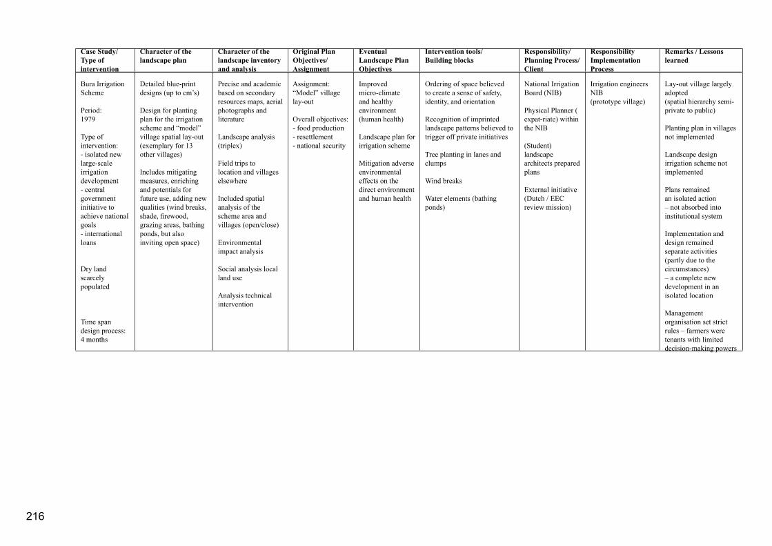
216
Case Study/Type of intervention
Character of the landscape plan
Character of the landscape inventory and analysis
Original Plan Objectives/Assignment
Eventual Landscape Plan Objectives
Intervention tools/Building blocks
Responsibility/ Planning Process/Client
Responsibility Implementation Process
Remarks / Lessons learned
Bura Irrigation Scheme
Period:1979
Type of intervention:- isolated new large-scale irrigation development- central government initiative to achieve national goals- international loans
Dry land scarcely populated
Time spandesign process:4 months
Detailed blue-print designs (up to cm’s)
Design for planting plan for the irrigation scheme and “model” village spatial lay-out (exemplary for 13 other villages)
Includes mitigating measures, enriching and potentials for future use, adding new qualities (wind breaks, shade, firewood, grazing areas, bathing ponds, but also inviting open space)
Precise and academic based on secondary resources maps, aerial photographs and literature
Landscape analysis (triplex)
Field trips to location and villages elsewhere
Included spatial analysis of the scheme area and villages (open/close)
Environmental impact analysis
Social analysis local land use
Analysis technical intervention
Assignment:“Model” village lay-out
Overall objectives:- food production- resettlement- national security
Improved micro-climate and healthy environment (human health)
Landscape plan for irrigation scheme
Mitigation adverse environmental effects on the direct environment and human health
Ordering of space believed to create a sense of safety, identity, and orientation
Recognition of imprinted landscape patterns believed to trigger off private initiatives
Tree planting in lanes and clumps Wind breaks
Water elements (bathing ponds)
National Irrigation Board (NIB)
Physical Planner ( expat-riate) within the NIB
(Student) landscape architects prepared plans
External initiative (Dutch / EEC review mission)
Irrigation engineers NIB(prototype village)
Lay-out village largely adopted(spatial hierarchy semi-private to public)
Planting plan in villages not implemented
Landscape design irrigation scheme not implemented
Plans remained an isolated action – not absorbed into institutional system
Implementation and design remained separate activities (partly due to the circumstances) – a complete new development in an isolated location
Management organisation set strict rules – farmers were tenants with limited decision-making powers
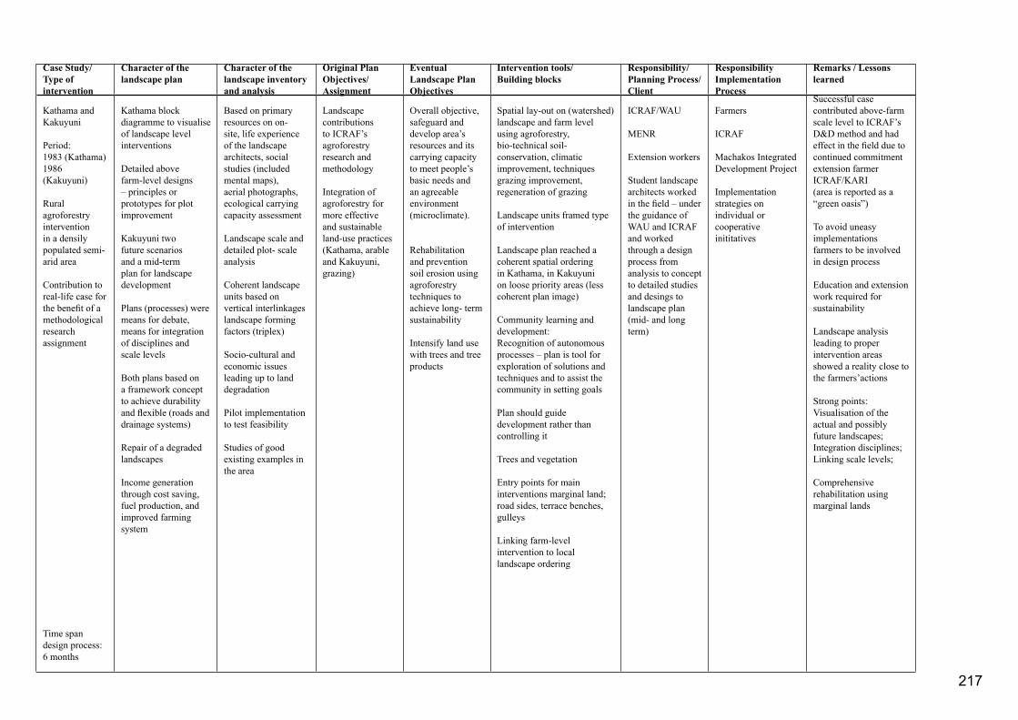
Case Study/Type of intervention
Character of the landscape plan
Character of the landscape inventory and analysis
Original Plan Objectives/Assignment
Eventual Landscape Plan Objectives
Intervention tools/Building blocks
Responsibility/ Planning Process/Client
Responsibility Implementation Process
Remarks / Lessons learned
Kathama and Kakuyuni
Period:1983 (Kathama)1986 (Kakuyuni)
Rural agroforestry intervention in a densily populated semi-arid area
Contribution to real-life case for the benefit of a methodological research assignment
Time span design process: 6 months
Kathama block diagramme to visualise of landscape level interventions
Detailed above farm-level designs – principles or prototypes for plot improvement
Kakuyuni two future scenarios and a mid-term plan for landscape development
Plans (processes) were means for debate, means for integration of disciplines and scale levels
Both plans based on a framework concept to achieve durability and flexible (roads and drainage systems)
Repair of a degraded landscapes
Income generation through cost saving, fuel production, and improved farming system
Based on primary resources on on-site, life experience of the landscape architects, social studies (included mental maps), aerial photographs, ecological carrying capacity assessment
Landscape scale and detailed plot- scale analysis
Coherent landscape units based on vertical interlinkages landscape forming factors (triplex)
Socio-cultural and economic issues leading up to land degradation
Pilot implementation to test feasibility
Studies of good existing examples in the area
Landscape contributions to ICRAF’s agroforestry research and methodology
Integration of agroforestry for more effective and sustainable land-use practices (Kathama, arable and Kakuyuni, grazing)
Overall objective, safeguard and develop area’s resources and its carrying capacity to meet people’s basic needs and an agreeable environment (microclimate).
Rehabilitation and prevention soil erosion using agroforestry techniques to achieve long- term sustainability
Intensify land use with trees and tree products
Spatial lay-out on (watershed) landscape and farm level using agroforestry, bio-technical soil-conservation, climatic improvement, techniquesgrazing improvement, regeneration of grazing
Landscape units framed type of intervention
Landscape plan reached a coherent spatial ordering in Kathama, in Kakuyuni on loose priority areas (less coherent plan image)
Community learning and development:Recognition of autonomous processes – plan is tool for exploration of solutions and techniques and to assist the community in setting goals
Plan should guide development rather than controlling it
Trees and vegetation
Entry points for main interventions marginal land; road sides, terrace benches, gulleys
Linking farm-level intervention to local landscape ordering
ICRAF/WAU
MENR
Extension workers
Student landscape architects worked in the field – under the guidance of WAU and ICRAF and worked through a design process from analysis to concept to detailed studies and desings to landscape plan (mid- and long term)
Farmers
ICRAF
Machakos Integrated Development Project
Implementation strategies on individual or cooperative inititatives
Successful case contributed above-farm scale level to ICRAF’s D&D method and had effect in the field due to continued commitment extension farmer ICRAF/KARI(area is reported as a “green oasis”)
To avoid uneasy implementations farmers to be involved in design process
Education and extension work required for sustainability
Landscape analysis leading to proper intervention areas showed a reality close to the farmers’actions
Strong points: Visualisation of the actual and possibly future landscapes;Integration disciplines;Linking scale levels;
Comprehensive rehabilitation using marginal lands
217

Case Study/Type of intervention
Character of the landscape plan
Character of the landscape inventory and analysis
Original Plan Objectives/Assignment
Eventual Landscape Plan Objectives
Intervention tools/Building blocks
Responsibility/ Planning Process/Client
Responsibility Implementation Process
Remarks / Lessons learned
South-West Kano Small-holders Irrigation Project
Period: 1986
Small irrigation scheme in existing densily populated area
Rural location study
Time span design process: 2-4 weeks
Four development options showing socio-cultural, ecological, and economic impacts
Tool for decision-making
Analytic and methodological
Detailed landscape analysis using aerial photographs and ground truth, identifying land-use processes and environmental resources
Landscape units related to user groups
Comparative impact analysis of existing schemes using secondary sources
Increasing the irrigated area from 350 ha to 1100 ha (mainly for rice cash-crop production)
Assist in a strategy that identifies areas suitable for irrigation as part of a new self-sustaining land-use system
Balance between irrigated and non-irrigated land to ensure diverse resource base and effective use according to its suitability
Spatial location of the main irrigation canals to allow for balanced (cash-subsistence economies)
Agroforestry, drinking water and livestock programmes to lead to an optimal situation
Provincial irrigation unit
Advisory irrigation-engineer (expatriate)
Provincial Irrigation Unit (main irrigation canals)
Male farmers (tertiary irrigation canals)
Irrigation unit did not adopt the advised option leaving the ultimate choice to the male farmers, consequently the female farmers may loose access to a variety of resources (fuel, food, herbs)
Strong contribution landscape analysis to set boundary conditions
A mono-disciplinary (technical) design alone leads to sub-optimal future for the farming family
Undugu
Landscape plan for improvement slum neighbourhood in Nairobi (1.6 ha; 3,000 inhabitants)
1986 plan period
1987 implementation
1988-1995 successful
2000 slums took over
Time span design process:2-4 weeks
A flexible landscape plan indicating the location of relatively small interventions
Plan was used as a basis for a community-based initiative
Redirection and repair of land degradation
Primary field observations
Problem analysis based on landscape analysis using cross-section (slope and river bottom)
Socio-cultural information secondary sources (literature, interviews Undugu staff)
Analysis of the restrictions and opportunities of the intervening environment (socio-cultural; institutional; physical)
Household level analysis and a neighbourhood level analysis
Assist youth group with setting up a tree nursery including an overall strategy for theimprovement of the outdoor environment
More sustainable improvement of environmental hygiene (public health)
Income generation through tree nursery
Protection against floods and erosion
Urban agriculture (women) as an incentive for open-space management
Tree planting for shade and fuel, timber, fruits, banana (youth/women)
Fish ponds to prevent diseases from stagnant water in depressions
Tree nursery as an income generation project for youth
Storm water management (catchment and safe diversion)
Interventions on marginal lands
Undugu Society(with permission of the government)
Undugu Society
Mostly the female slum inhabitants
Youth
Successful example for slum improvement with starting funds made from the Dutch Habitat Committee
Long-term commit-ment Undugu Society instrumental
Improved health, income, and security
Community building crucial for successes
Life-time plan close to 10 years. Plan made floodplain safe and pro-ductive – in 2000 urban pressure pushed the agriculture out. Ownership was a critical issue
Akamba disliked fish and replaced fish ponds for ducks
218

Case Study/Type of intervention
Character of the landscape plan
Character of the landscape inventory and analysis
Original Plan Objectives/Assignment
Eventual Landscape Plan Objectives
Intervention tools/Building blocks
Responsibility/ Planning Process/Client
Responsibility Implementation Process
Remarks / Lessons learned
Kisii, Busia, Homa Bay
Test to integrate environmental issues (green and brown environment) in Local Authority Development Plans
Period 1988-1989
Town sizes: 19-40 km2
20.000 – 60.000 inhabitants
Time span design process:3 months per town
A flexible plan largely provided a proper spatial ordering derived from characteristic landscape units their interlinkages, land-use suitability and preferable future land uses, illustrated with exemplary detailed designs.
Proposed low-cost development initiatives, the government to provide incentives to stimulate private actions
Protective/productive land-uses balanced at various scale levels
Environmental enhancement and beautification
General regional landscape analysis, and detailed landscape analysis using aerial photographs and maps – resulted in landscape units
Primary research through life experiences, ground truth, observations, face-to-face open ended interviews, focussed question-naires – socio-cultural analysis, insight in on-going activities and land ownership, town’s management capabilities.
Analysis driving forces urbanization processes and urban –rural relations (food, water, fuel)
Secondary sources, policy papers and government documents
Testing by the community in workshops
Integration of the natural environment in the Local Authority Development Programmes
Achieve sustainable urbandevelopment using natural re-sources while avoiding degradation
Support agricultural and energy production
Provide a healthy environment with trees for shade
Secure drinking water supply including springs
Attractive and favourable working and living environment
Protect vulnerable land
Green framework based on urban agriculture, urban forestry, ornamental for sustainable town development
Strategic low-cost and low maintenance incentives
Incentives for development of private initiative based on the provision of infrastructure and starting subsidies for agroforestry, urban agriculture, watershed management and spring protection.
Market development and improvement
Tree planting, maintenance and repair of roads, drainage and sewage systems.
Spatial ordering to protect ecologically vulnerable areas
Distribution of public awareness posters to visualise effects of tree planting for climatic improvement and soil-and water conservation
Ministry of Local Government (Urban Development Department) and Ministry of Lands and Settlement (Physical Planning Department)
The municipality would be responsible for co-ordinated and local level implementation, for example of markets and drainage.
A variety of governmental organisations such as, Ministry of Local Government, Public Works, Agriculture, and Housing and Physical Planning would be required to assist in the provision of the incentives, information or starting subsidies, or support and district level permissions.
Development of a manual with guidelines for sustainable development to disseminate a simple environmental planning procedure
Central government extremely enthusiastic, local government distantly interested, waiting passively for central government to provide funds, community largely unaware of the plans
Implementation in 1992 zero – manual “grey-literature” on the desk of town-clerks; use limited to few physical planners
Confusion about role of landscape architects/planners (facilitators? designing professionals? Adding professional needs? Quality requirements?)
Distinct differences in development needs of community, politicians, community, and government officials
219

Case Study/Type of intervention
Character of the landscape plan
Character of the landscape inventory and analysis
Original Plan Objectives/Assignment
Eventual Landscape Plan Objectives
Intervention tools/Building blocks
Responsibility/ Planning Process/Client
Responsibility Implementation Process
Remarks / Lessons learned
Green Towns Project(EUDTP)
Project inception and project period 1990-2000
Training project in landscape planning
Several institutional partners
Covering small towns spread out over the country (except for the north)
Time span:participatory design process 4 days
Landscape plans were called environmental development plans
Community fully participates in design process
Life-time plans approximately 5 years
Plans were based on jointly prepared “mental” maps
Plans were visualised line-of-thoughts
Plans focussed on problem solving and action plans with an emphasis on environmental preservation and protection
Compromises between urban development forces, agricultural potentials, and environmental vulnerability
Certain emphasis on watershed relations (erosion, floods) and protection of water sources
Landscape plans acted as a frame for environmental actions (tree planting, clean-ups, public awareness, community mobilization etc)
Landscape analysis was based on local knowledge – characteristics landscape units were identified by community
Cross-sections were used to indicate vertical relations (using local knowledge and observations)
A zero-map (what will happen within 5 year without any planning intervention) to discover horizontal relations
Problem analysis in workshop resulting in problem tree and problem map
Detailed field analyses were done in specific problem areas
Suitability for agriculture and urban development (criteria were rough and determined by the community)
Needs analysis discussed among citizens, technicians, government, and politicians
Sustainable urban development providing the citizens in their basic needs
Clean and green environment
Framework for local authority development projects and actions
Specific plan objectives concluded by the community in the participatory planning workshops were not set
Problem solving becomes a major issue – beautification and climatic improvement also comes up
Real-life examples included local identity and uses of local resources
Major intervention tools were tree planting in environmentally vulnerable areas (sometimes indicated as green zones only) and tree planting in prominent public urban areas (urban forestry, agroforestry)
Clean-ups and public sanitary facilities (sewage, drainage)
Public awareness
Political lobby
Participation of stakeholders in decision making forums
Initiating voluntary action groups
Ministry of Local Government and Ministry of Lands and Settlement facilitated participatory environmental planning process
Local Authorities requested for the participatory environmental planning workshop and environmental development plans
Community
Environmental volunteer groups facilitated the implementation
Local and central government assisted with land, technical expertise, formalisation, financial and logistical support
Community
Highly successful – over 30 towns developed a plan, 50 projects started off with small GTP subsidies
The common goals – the unity of purpose or the mental map was the strongest element in the plan
Detailed designs, implementation etc were not fed back into the landscape plans (although after a couple of years the volunteer groups requested for refresher workshops Implementation of actions was community initiated – some finances though were needed even it was just to run the logistics
Balanced government / community partnerships were necessary for success
Newspapers, television and radio supported the volunteer groups.
Public awareness influenced socio-cultural setting
Most-senior government officials oiled the process
Business community financed and maintained
220

221

222
Biography Ingrid Duchhart was born and educated in Amsterdam on the 28th of October 1953. In 1972, she obtained her HBS-B diploma from the Cartesius Lyceum. Ingrid started her Landscape Architecture studies at Wageningen University - then known as Landbouw Hogeschool, in 1973 and in 1980 graduated cum laude.
Working under the guidance of Professor Klaas Kerkstra, Professor de Jonge, and Yvonne Horsten, amongst others, her interest for finding integrated solutions for the various land-use claims in the urban fringe and rural areas was formed. Her master thesis involved the design of a landscape development plan for a reallocation project in Western Brabant and was carried out in collaboration with agricultural engineering (cultuurtechniek) department. This plan was based on informed design solutions that balanced agricultural improvement, peri-urban issues, such as, recreation and informal developments, and nature development. This study brought her in contact with agricultural engineering methods and techniques. She took a minor in remote sensing techniques, which helped her to adopt a systematic approach towards the landscape analysis, and a second minor in landscape architecture, which was carried out in Kenya. These experiences laid the foundations for a career characterised by a growing determination to create landscapes that were functional, sustainable, and beautiful.
After her graduation, Ingrid went on to teach at the Landscape Architecture Department at Wageningen University. During the 1980s, she taught design studios to second and third year bachelor students. Teaching these design studions challenged her to
systemize design methods and techniques. She also taught a lecture course in planting design for functional landscapes in the dry tropics, including agroforestry, microclimate improvement, and soil- and water conservation. She carried out several consultancies - mostly in Kenya and Oman – for private companies and governmental and non-governmental organisations. These consultancies brought her in contact with a wide-range of environment and planning related disciplines – in particular with agroforestry, soil and water conservation, and farming-ystems research. She also worked with anthropologists and sociologists and built up an understanding of the importance of land politics in landscape-forming processes. The practical experiences gained during these assignments provided an important basis for the coaching of the master students. She coached students in their final thesis, particularly those with an interest in landscape architecture in Mediterranean and non-western countries. These master studies dealt with the development of landscape plans for projects, among others, on water dams, regeneration of mining areas, soil and water conservation, agroforestry, town development, and agricultural development in over 15 countries. During this period, she began her research presented in this thesis.
During the 1990s, Ingrid was based in Kenya where she managed the Kenya Green Towns project. She was responsible for initiating and implementing several landscape construction projects of varying scales. This experience contributed to her growing technical insight and managerial capacity. In particular, she came to understand the importance of emotional intelligence and collaboration. Working with people, motivating and stimulating staff, and putting their 223
224
interest first rather than rigidly pursuing a particular intellectual path was a challenging experience and one she enjoyed tremendously. Her work with the Green Towns project gained substantial national and international recognition.
In 2001, she returned to Wageningen to a fulltime position at the University. In 2003, she acted as interim manager for the Chair group of Landscape Architecture. At the present, she teaches a third-year regional landscape design studio and a first year class jointly with the Chair group Spatial Planning - both addressing metropolitan issues - at bachelor’s level. At the level of the master’s programme, she is coaching students in their final thesis and teaching a lecture course in advanced design research methods. She is well aware of the challenge she faces in trying to create an interface between landscape-design methods and the actualy giving form to the landscape design.
Ingrid Duchhart has published in refereed journals, such as, Landscape and Urban Planning, Irrigation and Drainage Systems. She was co-editor of the Isomul production “Planning for Agroforestry” and produced teaching and other communication materials, such as the videos and exhibitions. Videos were aired on national television in Kenya and Tanzania, while exhibitions were exhibited in the National Museum of Kenya in Nairobi and during international conferences in Istanbul and Rome. She prepared several documents describing simple landscape-design methods and participatory design processes and presented papers in Council for Educators in Landscape Architecture (CELA) and International Federation of Landscape Architects
(IFLA) Conferences. Her thesis brings together the interests that have guided her career: design, people, technique, and landscapes.

Colophon:
Graphic Design: Monique Jansen (cover and fine tuning) Adriaan van Haaften (fine tuning) Reint Rosenstok (master grid)
Draftsmen: Adrie van het Veer Gerrit Kleinrensink
Photo Technique: Henk van Aggelen Peter Vrijlandt
English Editor: Marilyn Minderhoud-Jones
French Translation: Immelina Vroom Jeanine Genin Joseph de Gryse
Printer: Grafisch bedrijf, Ponsen & Looyen b.v., Wageningen
© 2007