Designing landscapes as evolutionary system / Chernobyl
94
Iurii Lotonenko Faculty of Science Department of Geosciences and Natural Resource Management (IGN) University of Copenhagen Student ID: fkc949 Supervisor: Assistant Professor Anne Tietjen ECTS points: 30 Date of submission: 26th of August 2013 Master thesis
Transcript of Designing landscapes as evolutionary system / Chernobyl

Iurii Lotonenko
Faculty of ScienceDepartment of Geosciences and Natural Resource Management (IGN)
University of Copenhagen
Student ID: fkc949 Supervisor: Assistant Professor Anne TietjenECTS points: 30 Date of submission: 26th of August 2013
Master thesis

Recent years manifest the changes in a theoretical debate in designing landscapes. The landscape that was defined by a very static and conservative nature is shifting towards the direction of constant changes and evolution. The impetus for writing this paper was the work of ‘ Designing landscapes as evo-lutionary systems’ by Martin Prominsky. The bases for these debates were the works of J. B. Jackson ‘Landscape Three’ and R. P. Sieferle ‘Total Landscape’. The landscape is a system of many processes that are constantly changing and evolving in an unpredictable way. The landscape is not a static pastoral scene but rather a system that constantly evolves over the time and space. In addition, an aesthetic of these landscapes is changing from classical, scenic landscapes to a relational aesthetic or ‘System Esthetics’ described by Jack Burnham.
The work examines the theories and projects relating to the concept of the evolving landscapes. The investigation reveals that the design deals with high level of complexity, integration of time and adapt to the future uncertan. The aims of the thesis are to investigate and to test the theory for designing landscapes as evolving systems. The investigation found common principles in the design: link to the past, holism, creativity, adaptability and formlessness. In addition, the paper proposes a proceeding method for the designing land-scapes.
The new approach in the designing landscapes was implemented in a concrete design task. Proceeding the set of principles and working method the paper proposes the strategic Masterplan for the development of the site of one of the biggest technogenic catastrophe in the world – Chernobyl catastrophe of 1986.
Principles and method proposed in this paper have shown its ability to work with complex issues of modern landscapes exemplified by Chernobyl Exclusion Zone project.
Abstract

I am sincerely grateful and express the deepest gratitude and respect for every person involved in this project creation; especially the coordinator of the Master thesis program Associate Professor Torben Ebbesen Dam; Profes-sor MSO Gertrud Jørgensen for help with startup. Assistant Professor Anne Tietjen, my research supervisor, for patient guidance, enthusiastic encourage-ment, useful critique and tons of work. The completion of the practical part of the project could not have been accomplished without the support of the persons who work in Ukraine. My spe-cial thanks are extended to Academician of the Ukrainian Academy of Agrar-ian Sciences, Professor Igor Gydkov, for the providing information about the radioactive contamination situation of Chernobyl Exclusion Zone as well as familiarization with the technique of phytoremediation of polluted soils. Thank you that you have been one of the liquidators of consequences of the Cherno-byl catastrophe. Also, I express my gratitude to the organization Chernobyl in Ukraine, what helped me with the numerous of unique photographs and infor-mation when analysing the practical part of this work. I also thank to Associ-ate Professor Olga Zibceva and Associate Professor Anatolij Kyshnir from the National University of Life and Environmental Sciences of Ukraine for providing information what have been useful during the work under the practical part. I would like to express my special thanks to private charitable organiza-tion World Wide Studies Victor Pinchuk Foundation for granting me a scholar-ship and giving me the opportunity to study and write this Master thesis in one of the best universities of the world. Finally, I express my deepest thanks to all those who supported me morally all this time. I thank my family, in particular to my mother Lybov, to my sister Yuliya and to my girlfriend Daria. Thank you all for helping in writing this Master thesis.
Sincerely, Iurii Lotonenko
Acknowledgement

Index
Abstract
Acknowledgement
Intro
I. Theories and projects overview of landscapes as evolutionary systems The theories of evolutionary landscapes The projects of evolutionary landscapes
II. Principles and Method for designing landscapes as evolutionary systems Principles for designing landscapes as evolutionary systems Method for designing landscapes as evolutionary systems
III. Designing landscape as the evolutionary system. Polesia Transboundary Radioactive Ecological Biosphere Reserve Site Analysis Programming Dynamic Implementation Implementation over the time Design Evaluation
Discussion
Conclusion
Appendix 1
References
4
5610
212226
283060637985
87
88
89
90

Recent years show a theoretical change in work on the design of the landscape. The landscape that was de-fined by a very static and conservative nature is shifting towards the direction of constant changes and evolution. John Brinckerhoff Jackson described this shifting in his concepts of Landscape Two, and Landscape Three. Lately, this idea was supplemented by ‘Total landscape’ concept by Rolf Peter Sieferle. The landscape is no longer determined by the aesthetic canons of design. Rather, the landscape determined by a variety of processes that are constantly changing. Thus the design of these landscapes has its own approaches, and principles. The aims of the thesis are to investigate and to test a new approach in landscape architecture: designing land-scapes as evolutionary systems. The investigation of the principles and proceeding method for designing landscapes as evolutionary systems will provide an opportunity to work with the complex issues that have modern landscapes. For instance, the issues as following; a reclaiming of polluted industrial sites, an environmental reclamation from the larg-est city dump or a development of the strategic masterplan for the site of one of the biggest technogenic catastrophe – Chernobyl catastrophe of 1986. Evolutionary systems in landscape design integrate the time and processes flux. These landscapes deal with dynamic, unfinished driving by processes and interrelation-ships rather than in creating static scenery image. These systems are not finalized because of the uncertain process-es of changes all the time. Consequently, an aesthetic of the landscapes are changes from static to more relational what was described by Jack Burnham in 1968.
The thesis proposes to explore the new approach in landscape architecture both theoretically and practically. The first part of the project deals with theories and projects overview. Also, the theoretical part of this work may be con-sidered as an extension of Martin Prominsky’s work ‘De-signing Landscapes as Evolutionary Systems’. Based on the theories and case investigation, the thesis proposes a common design principles and proceeding method for de-signing landscapes as evolutionary systems. The second part of the thesis deals with a real design project and ap-plication of the principles and design method in it. The theoretical part of the thesis tested in the pro-ject is a design of Chernobyl Nuclear Power Plant Zone of Alienation. A polluted by radioactive elements site over 400 thousand hectares in the territory of Ukraine and Belarus has been closed to human shortly after the Chernobyl dis-aster in 1986. (State Agency of Ukraine on Exclusion Zone Management, 2011). The tragedy took place more than 25 years ago. The area is still closed for permanent residence due to the high level of radioactive pollution. For more than quarter of the century, the radioactive and abandoned site has become a unique place of wildlife phenomenon (TV PG, 2011). Today, the contaminated area is a place where wild-life takes over. Paradoxically, it becomes ‘a unique sanctu-ary for biodiversity’ (World Health Organisation, 2005). Proceeding the set of principles and working method for the designing landscapes as evolutionary systems the strategic Masterplan for the further development of the site is developed in this paper. The theory has shown the ability to work with complex issues and to design landscapes as evolutionary systems.
Intro
page_4

I.
Theories and projects overview of landscapes as evolutionary systems
page_5

The theories of evolutionary landscapes
In Renaissance times landscape was considered as a constant environment. The main idea of that time was in crea-tion static and ideal landscapes. This idea was described in the concept of ‘Landscape Two’ by John Brinckerhoff Jackson. This landscape was characterized as ‘permanent position both in the social and topographical sense, that gives us our identity’ (Jack-son, 1984, p. 152). The landscape was shown as very static and constant element of a person’s life.
‘A landscape identified with a very static, very conservative so-cial order, and that there can be one true philosophy of nature: that of landscape Two.’ (Jackson, 1984, p. 155).
Probably the most important about this concept that land-scape was seen as a gently organism and of course an inspira-tion for many artists. In pictorial art, the paintings of Claude Lor-rain are reflecting the idea of seeing a landscape that time (fig. 1.1). At that time the landscape was seen as a pastoral scene with balanced unity of man and nature. Jan Bijhouwer in his book ‘Het Nederlandse Landschap’ noticed that landscape development is seen as a continuous process over time (Bijhouwer, 1972). Thus, the permanent vis-ual image of the landscape changes to a more dynamic and unstable system. Lately, Jackson inspired by American landscapes and its processes of changes, wrote:
‘I am confused by the temporary spaces I see: the drive-in, fast-food establishment that is torn down after a year, the fields planted to corn and then to soya beans and then subdivided; the trailer communities that vanish when vacation is over, the tropi-
cal gardens in shopping malls that are replaced each season; motels abandoned when the highway moves.’ (Jackson, 1984, p. 155)
The landscape is no longer a scene where components are static and permanent (fig. 1.1). Constant changes in the landscape have been described in `Landscape Three` process-oriented concept by Jackson:
‘Landscape is not scenery, it is not a political unit; it is already no more than a collection, a system of man-made spaces on the surface of earth. Whatever its shape or size, it is never simply a natural process, a feature of the natural environment; it is always artificial, always synthetic, always subject to sudden or unpre-dictable change.’ (Jackson, 1984, p. 156).
Lately, this idea supplemented by ‘Total landscape’ concept by Rolf Peter Sieferle. This concept describes the landscape as a result of a variety of activities and processes:
‘The totality of the total landscape is a residual product of many different actions, each of which pursues its own ends. It reflects the results of work, traffic, housing, recreation, tourism, consum-erism, landscape planning and nature protection…’ (Sieferle, 2004).
These theories describe the landscape as a system con-sisted of processes. These processes are constantly changing and evolving. The landscape is no longer the permanent statical scene but rather a temporally and spatially open system.
From ‘scenery’ to ‘evolutionary landscape’
page_6

Fig. 1.1. Claude Lorrain. Landscape with the marriage of Isaac and Rebekah, 1648
page_7

As a result different actions and processes lead to a change of style and aesthetics of the landscape. Sieferle de-scribed the lack of aesthetic of the place:
‘The current phase of transformation has no identifiable goal. It is not like in previous transition periods that there is a change of a stylistic identity, that a newer one replaces an older type. Instead, we find a general loosening-up, a cultural de-centrali-zation where nothing stable can be built. It is exactly because of the specific character of this situation that a stabilization of structures is impossible. Instead of a specific, stylistic colour, which could be labelled ‘modernity’, we now have a whole kalei-doscope of colours’ (Sieferle, 1997).
Sieferle highlighted the idea of the landscape with con-stant unpredictable changes without an identifiable goal. The effects of these processes lead to the loss of a unified style of landscape as a result. Therefore an aesthetic of landscape changes from sce-nic images of Renaissance times to more relational. This switch from classical aesthetic to relational aesthetic was described in ‘System Esthetics’ by Jack Burnham in 1968:
‘The systems approach goes beyond a concern with staged en-vironments and happenings; it deals in a revolutionary fashion with the larger problem of boundary concepts. In systems per-spective there are no contrived confines such as the theatre pro-scenium or a picture frame. Conceptual focus rather than mate-rial limits define the system… the consistency of a system may be altered in time and space, its behaviour determined both by external conditions and its mechanisms of control.’ (Burnham, 1968, p. 3).
This work represents the change in the Aesthetic perception from statical canons to a relative aesthetics. Hence, classical scenes principal does not anymore limit an artwork, it’s defined by conceptual focus and relationship of the things in time and space. A good example of the ‘System Esthetics’ in the pictorial art can be a work of Wassily Kandinsky (fig. 1.2). It represents a dynamic process that correlates and relate to each other in one system.
Koolhaas described `System Esthetics` like ‘free style’.
‘The best definition of the aesthetic of the Generic City is ‘free style.’ How to describe it? Imagine an open space, a clearing in the forest, a leveled city. There are three elements: roads, build-ings, and nature; they coexist in flexible relationships, seemingly without reason, in speculator organizational diversity.’ (Kool-haas & Mau, 1995, p. 1254).
It describes the idea the processes that take place are more important than the picture we visually perceive. Koolhaas criticizing ‘New Urbanism’ wrote:
‘If there is to be ‘new urbanism’ it will not be based on the twin fantasies of order and omnipotence; it will be the staging of un-certainty; it will no longer be concerned with the arrangement of more or less permanent objects but with the irrigation of territo-ries with potential; it will no longer aim for stableconfigurations but for the creation enbling fields that accommodate processes that refuse to be crystallized into defenitive form; it will no longer be about meticulous definition, the imposition of limits, but about expanding notions, denying boundaries, not about separating and identifying enteties, but about discovering unnameable hy-brids…’ (Koolhaas & Mau, 1995, p. 969).
Thus the design is not aimed at a creation of a complete static object. Design is measured in dynamic processes that oc-cur and change over time.
The theories overview described the new approach in landscape architecture and urban design. It describes the land-scapes as a system of processes that evolve in an unpredictable way. It describes an uncertainty of future changes. It is switch-ing the aesthetic from classical, ideal pastoral scenes to more relational aesthetic. This concept describes landscapes as an evolutionary system.
For the first time the definition and the concept ‘Land-scapes as evolutionary system’ was described by Dr. Martin Prominsky in his article ‘Designing Landscapes as Evolutionary Systems’ (Prominski, 2005).
New Aesthetic
page_8

Fig. 1.2. Wassily Kandinsky. Composition VIII, 1923
page_9

The projects of evolutionary landscapes
The last years’ projects show the big interest in landscape design as evolutionary systems.
Further case studies visually represent the idea of landscapes as evo-lutionary systems. The five cases were selected. These cases are: Amsterdam Bos park designed by Eesteren and Mulder, Proposal for Park de la Villette by OMA, North landscape Park by Latz+Partner, Drawn by the Clay by Vista, and lastly Lifescape – Fresh Kills Park by Fiels Operations. Also, French, Dutch and American projects were reviewed in ‘Designing Landscapes as Evolution-ary Systems’ by Martin Prominsky (Prominski, 2005).
These projects are elaborated by different companies. Despite this fact, all of them are united by similar idea of landscape as evolutionary systems. Thus, we can review this theory in practice. This work will represent a short overview of the projects. The idea of this work is to identify a common princi-ples that governs the designing landscape as evolutionary systems.
page_10
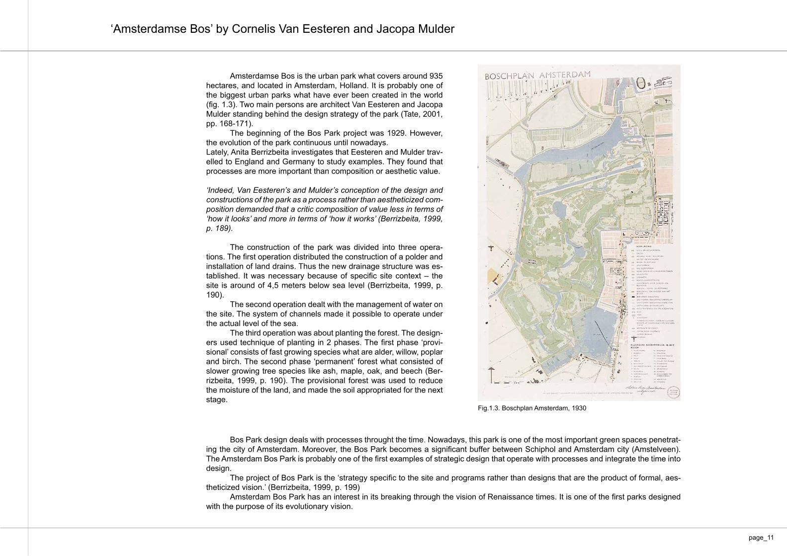
Amsterdamse Bos is the urban park what covers around 935 hectares, and located in Amsterdam, Holland. It is probably one of the biggest urban parks what have ever been created in the world (fig. 1.3). Two main persons are architect Van Eesteren and Jacopa Mulder standing behind the design strategy of the park (Tate, 2001, pp. 168-171). The beginning of the Bos Park project was 1929. However, the evolution of the park continuous until nowadays. Lately, Anita Berrizbeita investigates that Eesteren and Mulder trav-elled to England and Germany to study examples. They found that processes are more important than composition or aesthetic value.
‘Indeed, Van Eesteren’s and Mulder’s conception of the design and constructions of the park as a process rather than aestheticized com-position demanded that a critic composition of value less in terms of ‘how it looks’ and more in terms of ‘how it works’ (Berrizbeita, 1999, p. 189).
The construction of the park was divided into three opera-tions. The first operation distributed the construction of a polder and installation of land drains. Thus the new drainage structure was es-tablished. It was necessary because of specific site context – the site is around of 4,5 meters below sea level (Berrizbeita, 1999, p. 190). The second operation dealt with the management of water on the site. The system of channels made it possible to operate under the actual level of the sea. The third operation was about planting the forest. The design-ers used technique of planting in 2 phases. The first phase ‘provi-sional’ consists of fast growing species what are alder, willow, poplar and birch. The second phase ‘permanent’ forest what consisted of slower growing tree species like ash, maple, oak, and beech (Ber-rizbeita, 1999, p. 190). The provisional forest was used to reduce the moisture of the land, and made the soil appropriated for the next stage.
Fig.1.3. Boschplan Amsterdam, 1930
Bos Park design deals with processes throught the time. Nowadays, this park is one of the most important green spaces penetrat-ing the city of Amsterdam. Moreover, the Bos Park becomes a significant buffer between Schiphol and Amsterdam city (Amstelveen). The Amsterdam Bos Park is probably one of the first examples of strategic design that operate with processes and integrate the time into design. The project of Bos Park is the ‘strategy specific to the site and programs rather than designs that are the product of formal, aes-theticized vision.’ (Berrizbeita, 1999, p. 199) Amsterdam Bos Park has an interest in its breaking through the vision of Renaissance times. It is one of the first parks designed with the purpose of its evolutionary vision.
‘Amsterdamse Bos’ by Cornelis Van Eesteren and Jacopa Mulder
page_11

Fig.1.4. Park de La Villette proposal by OMA, Rem Koolhaas. 1982
Park de la Villette is the competition proposal for site in France by the Office of Metropolitan Architecture in 1982 (fig. 1.4). Rem Koolhaas described this project as ‘Congestion Without Matter’ (Koolhaas & Mau, 1995, p. 895). Also, this proposal described by Anita Berrizbeita like a continuation of engaging process and materi-ality in the landscape in the same conceptual way that Van Eesteren and Mulder did for the Bos Park. However, the work of Koolhaas redirects the rational demands of a project to a creative end (Ber-rizbeita, 1999, p. 199). This proposal received second prize, and has never been built, but it is probably one of the first times when the landscape de-signed as an adaptable system for future changes with purpose.
‘The underlying principle of programmatic indeterminacy as a basis of the formal concept allows any shift, modification, replacement, or substitution to occur without damaging the initial hypothesis’ (Kool-haas & Mau, 1995, p. 921).
The initial hypothesis or conceptual idea is to design a park in the recognizable sense of the word what deals with diverse hu-man activity (fig. 1.4). The initial hypothesis is also about to undergo constant and unknown changes:
‘It is not definitive: It is safe to predict, that during the life of the park, the program will undergo constant change and adjustment. The more the park works, the more it will be in a perpetual state of revision. Its “design” should therefore be the proposal of a method that combines the architectural specificity with programmatic inde-terminacy’ (Koolhaas & Mau, 1995, p. 921).
‘Park de la Villette’ by Office of Metropolitan Architecture
page_12

Fig.1.5. ‘The Strips’ Fig. 1.6. ‘Point Grids, or Confetti’
Fig. 1.8. ‘The Final Layer’Fig. 1.7. ‘Access and Circulations’
The proposal consists of four layers. These layers are ‘The Strips’, ‘Point Grids, or Confetti’, ’Access and Circulation’, and ‘The Final Layer’. `The Strips` layer proposes to divide the site into a series of parallel ribbons. These strips would accommodate different theme and activities.
‘The strips are based on certain standard dimensions – a basic with of 50 meters divisible into increments of 5, 10, 25, or 40 meters – to facilitate change and replacement without disruption and to create fixed points for the infrastructure.’ (Koolhaas & Mau, 1995, p. 923).
This fixed structure gives the possibility for changes and adaptability thought the time. The content of the stripes can be changed due to the future demands.
The next layer ‘Point Grids, or Confetti’ what consists of small-scale elements, those are kiosks, playgrounds, sale kiosks, refreshment bars, picnic areas etc. (fig. 1.6). These elements are distributed on the site due to the mathematical calculations. ‘Access and Circulations’ layer represents the idea of con-necting the site by the shortcuts within different zones (fig. 1.7). It consists of the two main elements what are the Boulevard and the Promenade. The Boulevard is designed in order to connect the Sci-ence museum, the Baths from the north, the Music City and the Grande Halle in the south.
‘The Final Layer’ is the composition of the main elements of the site in regards to the existing buildings (fig. 1.8). These large buildings are the Science Museum, the Ariane, the Ro-tonde des Veterinaries and others.
page_13

Fig. 1.9. Proposal for Park de la Villette by OMA, 1982
The four layers composed the proposal for Park de la Villette (fig. 1.9).
Rem Koolhaas summarized this project:
‘Finally, we insist that at no time have we presumed to have pro-duced a designed landscape. We have confined ourselves to devis-ing a framework capable of absorbing an endless series of further meanings, extensions, or intentions, without entailing compromises, redundancies, or contradictions. Our strategy is to confer on the sim-ple the dimension of adventure.’ (Koolhaas & Mau, 1995, p. 934).
Park de la Villette design has an evolutionary approach in landscape architecture. Possibly, this project could be called revo-lutionary at that time. Although, it was never built it makes sufficient input in the development of further work in designing landscapes as evolutionary systems.
page_14

Alan Tate wrote that Landschaftsparke Duisburg-Nord or Duisburg North landscape Park is the German prototype of the urban park of twenty-first century (Tate, 2001, p. 114). Duisburg is the city located along the River Emscher in the Ruhr District in northwest Germany. This region is one of the largest industrial areas in the world. The leading industries were coal mining and steel making. The production area was closed, and industrial plant was shut down in 1985, leaving the site sig-nificantly polluted (Tate, 2001, p. 114). The Park of 230 ha was designed by Latz + Partner in 1991 (fig. 1.10).
The intention of the design is the attempt to heal the site and leave the structure of heavy industry in order to under-stand it rather than neglect the history (fig. 1.11) (Latz+Parthers, 2005).
Fig. 1.10. Landschaftspark Duisburg-Nord Plan, Latz + Partner
Fig. 1.11. The photo of Duisburg-Nord Park
‘Landschaftspark Duisburg-Nord’ by Latz + Partner
page_15

Fig.1.12. Night time illumination of the park
The design proposes to use phytoremediation tech-nique for healing the polluted soil. Also the project cares about the memory of the site. It gives the second life for the processes of the past (fig. 1.12) Lately, Peter Latz describe place as:‘The park is not a park in the common sense, not easy to survey, not clearly arranged, not recognizable as a whole. According to its situation amidst chaotic agglomerations and infrastructure lines, it appears as a torn figure with numerous different aspects.’ Peter Latz (Latz+Parthers, 2005, p. 7).
The Duisburg North landscape Park is probably one of the best examples of the integration past processes in de-signing the project. This project is considered as a park with an open-ended strategy. That gives a possibility for an adjust-ments of design according to the future unknown demands.
page_16

Fig.1.13. The development processes of the ‘Drawn by the Clay’
Drawn from the Clay or ‘Uit de klei getrokken’ is the pro-ject of the nature development area in Haarlemmermeer, The Netherlands (fig. 1.13). The proposal made by VISTA, Dutch office for environmental planning, landscape architecture and ecology. This proposal consists of 16 folders what deals with five management concepts of regulation of water levels. The project proposes the nature development for the more than 80 years. It proposes the evolution of typical agricultural fields to forest, park like landscape, peat-marsh, reed-marsh, and water-con-taminant landscape (Den Ruiter, 1999, pp. 34-35). This proposal allows cultivate the site with high level of biodiversity without exact prediction or limitation of the future.
‘The special aspect of this method is that it does not seek to achieve a final ideal state. Rather, the planning sets out the natural and anthropomorphic parameters within which nature will be allowed to develop. The result is to be a kind of self-evident order, marked by a contrast of rectilinear and organic forms.’ (Den Ruiter, 1999, p. 37).
The project is not seaking for the complete design. The 80 years perspective of the project gives an open-ended strat-egy for the continuation of development of the site.
‘Uit de klei getrokken’ by Vista
page_17

Fig. 1.14. ‘Lifescape’ competition entry by Field operation, 2001
Fresh Kills Landfill located on Staten Island in New York City. It has served as dumping ground for city’s house-hold garbage since 1948 until it was closed initially in 2001. The site covers around 8,9 km2 (2200 acres) and being con-sidered as the largest domestic waste landfill in the world. The Lifescape is a competition entry by the interdisciplinary team Field Operation, directed by James Corner. Lifescape announced as the winning entry in 2001 and currently being constructed (fig. 1.14) (City of New York: Parks & Recreation, 2013).
Field Operation described the project as:
‘Lifescape is an ecological process of environmental recla-mation and renewal on a vast scale, recovering not only the health and biodiversity of ecosystems across the site, but also the spirit and imagination of people who will use the new park. Lifescape is about the dynamic cultivation of new ecolo-gies at Fresh Kills over time—ecologies of soil, air and water; of vegetation and wildlife; of program and human activity; of financing, stewardship and adaptive management; of envi-ronmental technology, renewable energy and education; and of new forms of interaction among people, nature, technology and the passage of time.’ (Field Operations, 2006, p. 6).
‘Lifescape - Fresh Kills Parkland’ by Field Operations
page_18

Fig. 1.15. Lifescape’s ‘Threads’, ‘Islands’, and ‘Mats’ by Field Operations, 2001
The design of the proposal consists of three main lay-ers: ‘Threats’, ‘Mats’, and ‘Clusters’ (fig. 1.15).
‘Linear Threads direct flows of water, energy and matter around the site, injecting new life into otherwise homogenous areas. These are organized along existing swale lines, con-tours, pathways, and connections… Cluster of Islands pro-vide denser nests of protected habitat, sees source and pro-gram activity… Surface mats create a patch-like mosaic of mostly porous surfaces to provide self-sustainable coverage, erosion control and native habitat. They include renovated salt-marsh, freshwater wetlands, eastern prairie grassland, recreation fields, sport surfaces, and event areas.’ (Field Op-eration, 2001, p. 2).
In addition to this complicated strategy Lifescape it is not just a project of recovering the site.
‘This is not just the place where, for more than 50 years, the rest of the city sent its potato peels, broken dishes and every kind of household trash. For several months after the terror-ist attacks on the World Trade Center, the sad bits of busted buildings and broken lives were sited on mound 1/9 of Fresh Kills, piece by shattered piece.’ (DePalma, 2004).
The landfill accommodated around 1,2 million tons of the ruins from the tragedy of 9/11 (Lindner, 2008). The Fresh Kills strategy developed by the duration of 30 years. After what, it gives an opportunity and freedom for further development to leave an open-ended program of the site.
page_19

Probably, the first breakthrough in the classical principles in landscape architecture was Amsterdam Bos Park designed by Cornelis Van Eesteren and Jacopa Mulder. It was the impor-tant milestone, in the development of process-oriented design idea. Afterwords, Rem Koolhaas with the proposal for Park de la Villette highlighted the idea of flexible and adjustable strategy within fixed and aesthetically beautiful structure. Although the proposal didn’t win, the interest in this work is still high. Another case study is Duisburg North landscape Park de-signed by Latz + Partner. The program gives a freedom for eco-logical restoration and social activities. Moreover it includes the history of the place into the design proposal. Also, it proposes a flexible program for future demands with its open-ended strat-egy. In addition, ‘Drawn by the Clay’ of Vista was analysed. Amazingly, the program on the site described a nature develop-ment process what will affect the site for 80 years. Moreover the design proposal is flexible and not seeking for the complete design.
Lastly, ‘Lifescape’ proposal for the development of Fresh Kills Park by Field Operations conclude the overview of the pro-jects. The world known project of recovering the site with its evolutionary perspective for the next 30 years was described. It gives an idea of dealing with comprehensive tasks like recover-ing the site from the city dump into the city park. It proposes to leave the freedom in the further development according to the future uncertainty. Together with the theoretical overview, the projects over-view assumes that the landscape is a system of processes that depend on time and place. A conceptual solution for further de-velopment depends on a unique creative approach of a team. Also, the program of the design has flexible and adjustable strat-egy that continues over time. Moreover, the Aesthetic of evolu-tionary landscapes is measured by the relationship rather that a static scene. Lastly, design is focused on an open-ended strat-egy rather than a complete static solution.
Conclusion
page_20

II.
Principles and Method for designing landscapes as evolutionary systems
page_21

The theories and project overview show that every pro-ject consists of its own processes. These processes are derived from the past and have a certain meaning. Hence, the connec-tion of the past and the future has a certain sense in landscape design. Also the processes identified in the past do not have the basic simple character. Design in landscape architecture be-comes more complex. The landscape consists of many different processes. Thus the design overviews the whole picture of the landscape. As a consequence, the cooperation of interdiscipli-nary teams is required for one project. During the work miscellaneous problems happen. The conclusion of these situations depends on the design creativity approach. Hence the creativity is one of the main elements of the project design.
Also, landscapes as evolutionary systems show the fu-ture as unpredictable. This fact has its consequences on the result of the design proposal. The work aims to introduce addi-tional changes in the future. The design becomes more flexible and adjustable to an unpredictable future. The landscape looks like a system of miscellaneous vari-ous processes, changing and updating in the unknown future. Thus, the aesthetics also changes.
The project proposes common principles for designing landscapes as evolutionary systems. These principles are de-rived from theories and project overviews. Therefore, there are five main principles: link to the past, holism, creativity, adaptabil-ity, and formlessness.
Principles for designing landscapes as evolutionary systems
page_22

Link to the Past
Holism
‘Landscape is never finished or completed, like a can of pre-serves; it is an accumulation of events and stories, a continually unfolding inheritance.’ George Descombes (Descombes, 1999, p. 81).
This principle emphasizes the importance of the relation-ship between past and upcoming future. A link between the past and the future is important, since it tells us about the past of the place. We find the ideas that give new life to the processes of the past. In this way, we allow the evolution of the past into the future. This principle considers reality as a result due to the con-tribution of previous processes.
Vroom described this principle as ‘historical continuity’ (Vroom, 1990, p. 114). Also, Marot called this principle as ‘an-amnesis’ (Marot, 1999, p. 50).
The design of the landscape becomes more complex. The processes that sustain in the landscape have different and complex nature. This principle suggests to consider the whole image of the landscape rather than trying to analyse a separate process by itself. Jan Smuts coined the term ‘holism’ in 1926. Smuts de-fined holism as:
‘The tendency in nature to form wholes that are greater than the sum of the parts through creative evolution’ (Smuts, 1927, p. 88).
Following this principle, the landscape system has to be viewed as wholes and as a part of a larger context, rather as separate sites, processes, elements etc.. It is necessary to determine the main directions, in order to better understand the principle. The first is the scale. A landscape consists of many small-er parts what further sustain and take a part of the larger system. Consequently, the site has to be seen as an open system for surroundings and bigger context. The second is components of the landscape. Landscape system consists of many components and define a whole sys-tem. For instance, these components are green spaces, water feature, urban infrastructure, road grid etc.. These components and processes form the landscape together. The last one is relations. The components and process-es that caused it defined a landscape system. In this way, they complement and relate to each other.
Probably, a good example of these systems could be ecology of the landscape.
page_23

Creativity
Adaptability
‘relating to or involving the use of the imagination or original ide-as to create something’ (Oxford Dictionary, 2011).
This principle suggests that each landscape as evolutionary sys-tem is unique in terms of the design proposal. Schoon described this issue like:
‘Depending on our disciplinary backgrounds, organizational roles, past histories, interests, and political/economic perspec-tives, we frame problematic situations in a different ways.’ (Schön, 1990, p. 4).
The principle suggests that there is simply no common creative tactics to design the landscape project. Also, the archi-tecture is a fine art (Schön, 1990, p. 18).
It is the creativity of our mind that looks for a way out of a problematic situation. This principle suggests that the land-scapes as evolutionary systems does not limit but encourage the creativity.
This principle defines the landscape as an evolutionary system as unstable in the future. We tried to operate in the fu-ture, based on the material reality of nowadays. However, we don’t know an exact result of the design because of future un-predictable changes. Moreover, the design has to consider pos-sible future uncertain needs. Therefore the program has to be flexible and adjustable. Vroom, described this principle like flex-ibility:
‘The landscape is never completed or in a final stage, but keeps changing and developing as a result of natural and functional modifications. In a dynamic process of change in use and mean-ing the main contours are fixed, while the details may be repeat-edly transformed.’ (Vroom, 1990, p. 145).
In addition, any landscapes as evolutionary system have to admit open-ended strategy. Marot described this idea in ‘prep-aration’ principle:
‘… Any project must assume the role of an open-ended strategy, as in staging of setting up future conditions. Being itself in a pro-cess of becoming, a landscape is fully bound into the effects of nature and time… by bringing the effects of time back to life and appearance, the designer may both restore and prepare sites for unforeseeable futures. (Marot, 1999, pp. 50-51).
An evolutionary landscape system deals with integration of time and future uncertainty in the design. Therefore landscape becomes more adaptable according to the future unknown pro-cesses.
page_24

Formlessness
Vroom addressed this issue from the designer’s point of view. However, the formal autonomy is the result of the mate-rial world. The landscape that we see is the result of a set of processes and changes that do not carry a particular meaning. Thus, these changes do not carry a specific stylistic direction. This idea is also emphasized by Sieferle (Sieferle, 1997). From this comes up that aesthetic of the landscape has the relational character of elements in space and time. The switch towards re-lational aesthetic or ‘System Esthetics’ described by Jack Burn-ham in 1968. Rem Koolhaas described similar ideas in ‘Generic City’ as ’free style’ (Koolhaas & Mau, 1995, p. 1254).
Hence, the principle defines the landscape system as ‘formlessness’.
Landscape system includes a set of processes that are constantly changing and evolving. Therefore the material real-ity that we see is also changing. Moreover, the character of the changes ongoing is uncertain. The processes that will take place in the future are also not defined. Therefore the form what we see does not carry any meaning. Vroom one of the first was to draw attention to this problem in the landscape:
‘In the city there are many forms with a pre-determined and all too obvious meaning. This can have an oppressing and even paralysing effect on the creativity of the designers. This is why some deny the existence of a relation between form and mean-ing or form and context and thereby proclaim the existence of ‘formal autonomy’ (Vroom, 1990, p. 147).
page_25

Based on the principles for designing landscape as evolutionary system the project proposes the following method. The work-ing method consists of five stages; these are site analysis, programming, dynamic implementation, implementation over the time, and design evaluation.
Site Analysis
Dynamic implementation
Programming
‘He who does not understand your silence will probably not un-derstand your words.’ Elbert Hubbard (Hubbard, 1945, p. 408). This phase of the project is focused on the analysis of the existing situation. It is necessary to identify the issues that pos-sess the landscape. Therefore, processes that cause and sus-tain the current situation of the landscape has to be analysed. Also, the site analysis would clarify the potential problematic is-sues of the project. For this the study of history, literature review, mapping should be done. The main idea of this work is to identify the main processes forming the landscape. Lastly, the analysis will help to define the possibilities of landscape for future design’s intervention.
‘Program – a plan of things that will be done or included in the development strategy.’ (Oxford Dictionary, 2011).
This part defines further development of the landscape. This part provides a conceptual solution for the issues that have been identified through the analysis of the landscape system. Here a vision of further development of the project should be described. This gives the possibility to add a new theme in the case of identification of new previously neglected issues. This, consequently, allows to work with more complex tasks. This part describes the main actions to be done in order to determine the design’s intervention.
This part of the method works by converting the program themes into dynamic processes. This part is tending for answer-ing the question of - What should be done in order to implement the concept?
This part of the project describes design’s intervention in details. Hence, the specific actions are proposed for design defi-nition. For example, the actions that aimed for improvement of wildlife and biodiversity. It is clear that these actions have a long-term perspective. This part shows the intervention of design in time in the schemes. The landscape as evolutionary system has an undefined future, so the time frame has more conceptual character either fixed. The processes’ interpretation in the dy-namics clearly shows a possible outcome of the design.
Dynamic introduction of conceptual themes opens as well the process that might be missed in the general overview. For example, the number of species of wildlife nature is hard to pre-sent on the Master plan, although it is a very important part of the project.
Thus, the dynamic implementation becomes an important part of project’s further development.
Method for designing landscapes as evolutionary systems
page_26

Implementation over the time
Design evaluation
This part works with the integration of the design interven-tion ideas to the existing situation. Thus, the dynamic processes should be presented in Master plan.
Also, such an embodiment may last from a few years until the decades of years. It makes sense to divide the implemen-tation into several phases. Therefore, it is possible to define a close, intermediate and long-term phases of the project. The nearest phase shows the processes that need to be done im-mediately. The intermediate phase depicts the processes that need to be done between close and long-term phases. Also, there could be a several intermediate phases of the project. The long-term phase represents the result of what is aimed for the development plan in a longer projection. Each phase of the project can be shown as a master plan.
Designing landscapes as evolutionary system is not aimed for complete and static results. Rather, the design focus-es on the processes that develops over time and space.
Design evaluation part carries the descriptive character. Here, the effects of design intervention into the landscape are introduced. This part describes the consequences of the design intervention, answering the question – What consequences will happen after the project implementation?
The consequences of the project after the final imple-mentation stage are described here. For example, the project is aimed at the creation of a reserve. It is assumed that this reserve will be a part of the bigger territory and might play an important role in the development of the whole area in the future; wildlife and biodiversity improvement, protection of rare flora and fauna species.
The principles and method for the designing landscapes as evolutionary system will be explained even further better un-der the conceptual project of further development the exclusion zone of Chernobyl, Ukraine.
page_27

III.
Designing landscape as the evolutionary system. Polesia Transboundary Radioactive Ecological Biosphere Reserve
page_28

A polluted by radioactive elements area over 400 thousand hectares in the territory of Ukraine and Belarus has been closed to human being shortly after the Chernobyl disaster in 1986. An area of 30 km radius around the reactor was closed. Around 116 000 people were evacuated (State Agency of Ukraine on Exclu-sion Zone Management, 2011).
Following the tragedy people were involved in the elimi-nation of the consequences of pollution. The Chernobyl nuclear power plant was attended by about 600,000 people in the af-termath of the explosion. 240,000 liquidators have received a large dose of radiation, many of these people died shortly (World Health Organisation, 2005). Residents of the former Soviet Un-ion will never forget the courage and bravery of the liquidators. The data indicates the magnitude of one of the biggest techno-genic catastrophes in the world. The tragedy took place more than 25 years ago. The area is still closed for permanent resi-dence due to the high level of radioactive pollution.
For more than quarter of the century, the radioactive and abandoned site has become a unique place of wildlife phenom-enon (TV PG, 2011). Today, the contaminated area is a place where wildlife takes over. Paradoxically, it becomes ‘a unique sanctuary for biodiversity’ (World Health Organisation, 2005). Also, debates are ongoing about further development of the site. In addition, there is no clear strategic Masterplan for this pur-pose.
Proceeding the set of principles and working method for the designing landscapes as evolutionary systems, the concep-tual strategic Masterplan for the further development of the site is developed in this paper. The working method for the design proceeded through the five main parts. These are site analysis, programming, dynamic represen-tation, integration, and design evaluation. Site analysis gives an introduction to the site including location, history, and the story of the accident at Chernobyl Nuclear Power Plant (CNPP in the future). Also, this part gives an idea of the processes ongoing on the site. It includes radioactivity, radioactive waste disposal, ecology, ruins of an abandoned settlement, scientific research and tourism issues. The program proposes a solution for the is-sue through the main themes of the design. It proposes to estab-lish Polesie Transboundary Radioactive Ecological Biosphere Reserve throughout the main theme. These themes are dealing with wildlife and biodiversity engagement, land reclamation, re-covering of the river bank, sciences development, continuation of memory, and improvement of the tourism infrastructure of the site. The dynamic representation visionary explains the program in an evolutionary progression for more than 40 years. These dynamic processes lead to the implementation part where three Masterplans for 2020, 2035 and 2056 year are presented. Lastly, design evaluation explains the benefits of the pro-posal. Here the question of the creating the Biosphere reserve on the contaminated area is highlighted.
page_29

Site Analysys
page_30

BelarusDenmark
Ukraine
Black Sea
. Kyiv city
Dnieper River
. CNPPChernobyl city
Chernobyl Nuclear Power Station
Pripyat city
Pripyat river
Location
The map represents a total exclusion zone, Chernobyl Nuclear Power Plant and two biggest abandoned cities, Pripyat and Chernobyl (fig. 2.5).
The site is located in the eastern part of Europe, and di-vided by Belaru¬sian and Ukrainian country border. (Fig.2.3). Chernobyl Nuclear Power Plant (CNPP) located 140 km north from the capital of Ukraine – Kyiv (fig. 2.4).
1:500 000
Fig.2.2. The World
Fig.2.3.The site in Europe context Fig.2.4 The site Fig.2.5. The site
0 5 10 20 50 km
page_31
GSPublisherEngine 0.0.100.100
0. Site comparison 1:400000
GSPublisherEngine 0.0.100.100
0. Site comparison 1:400000
Site comparison
Fyn, Denmark309,97 thousand hectars
Chernobyl Exclusion zone, Ukraine204,4 thousand hectares
Polesie State Radiation Ecological Reserve, Bularus
216,2 thousand hectares
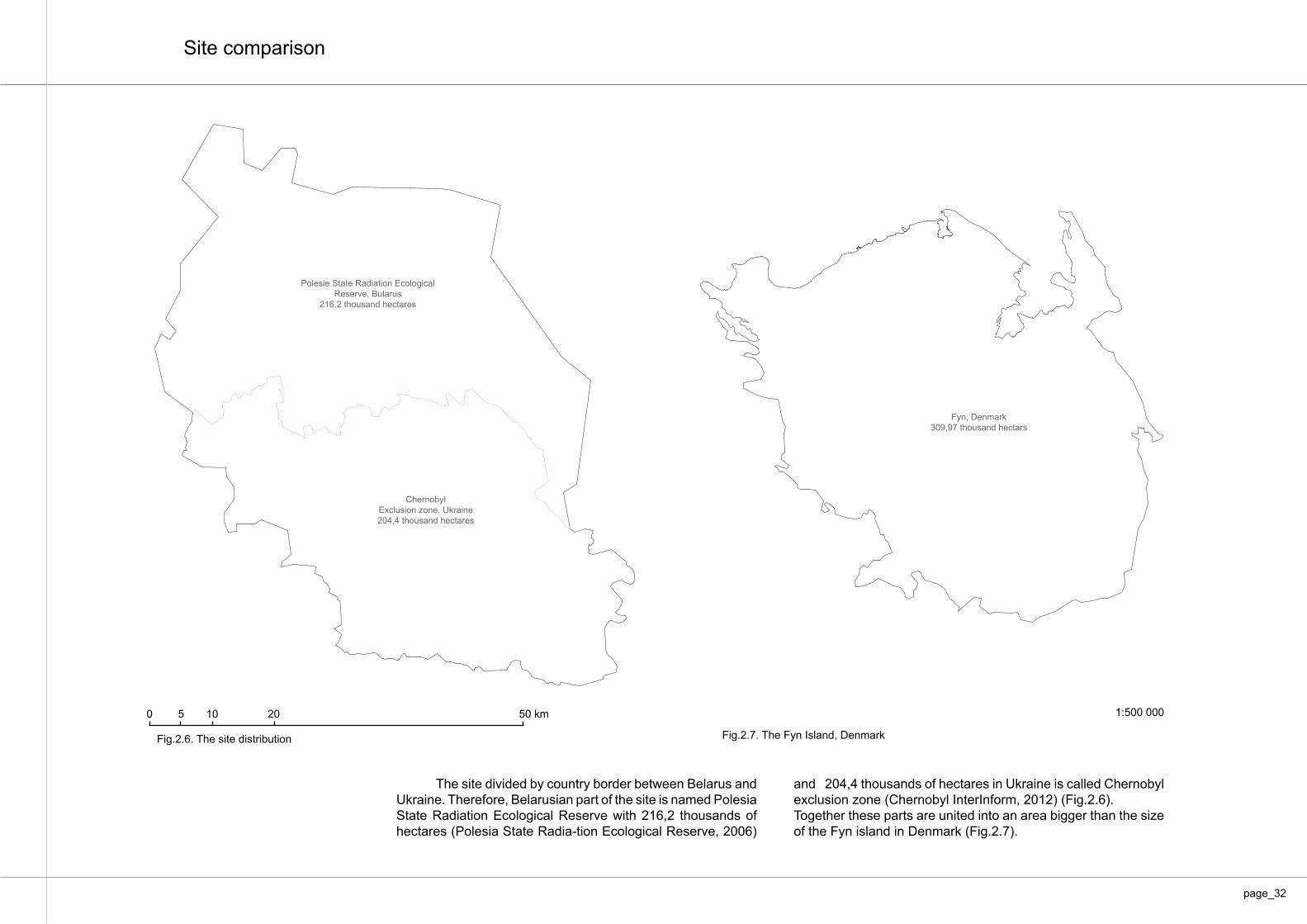
and 204,4 thousands of hectares in Ukraine is called Chernobyl exclusion zone (Chernobyl InterInform, 2012) (Fig.2.6). Together these parts are united into an area bigger than the size of the Fyn island in Denmark (Fig.2.7).
The site divided by country border between Belarus and Ukraine. Therefore, Belarusian part of the site is named Polesia State Radiation Ecological Reserve with 216,2 thousands of hectares (Polesia State Radia-tion Ecological Reserve, 2006)
Fig.2.6. The site distribution Fig.2.7. The Fyn Island, Denmark
1:500 0000 5 10 20 50 km
page_32

Chernobyl, 1868
1:200 000
Historical background
One of the oldest maps of the site stems from 1868 (fig. 2.8, shown below). This map represents numerous small settlements along the river Prypyat. Chernobyl, founded in 1193, is probably the oldest settlement in the area (Tarkhov & Kovalchuk, 2010).
Fig.2.8. Map of the area dated from 1868
0 5 10 20 km
page_33

Fig.2.9. Chernobyl Repair and Maintenance Base of Dnieper River fleet. Besedin Anatoliy, 1946.
Fig.2.10. Chernobyl Nuclear Power Station construction, 1975 Fig.2.11. Pripyat city in 1970
(fig. 2.10). In addition, a town of 47,500 people (with planned 75,000) called Pripyat was built closely to the power plant to house the workers and their families (fig.2.11) (Pripyat.com, 2004). At that time the Chernobyl Nuclear Power Plant was one of the most technically advanced in the Soviet Union. From 1977 to 1983 four reactors were started successively. Two additional reactors were planned to be constructed, but never realized. At 1:23 a.m. on April 26th, 1986, reactor four at the nuclear power plant exploded (Rosenberg, 2013). The sequence of the events can be seen in the timeline diagram (fig.2.12).
Prypyat River is a confluent of Dniepr which flows into the Black Sea. Therefore it serves as a strategic connection between the north and the south of Ukraine. In the period of Second World War and until the ac-cident, Chernobyl had an important role as a transportation hub for the Ukrainian Soviet Re¬public. Chernobyl city began to grow with the development of the Repair and Maintenance Base of the Dniepr River Fleet, just after the Second World War (fig.2.9). On the 1970, the construction of the Chernobyl Nuclear Power Plant was started 15 kilometres north of Chernobyl city
page_34

1193
1868
1946
1970
1977
1978
1981
1983
1986
1991
1996
2010
15 D
ecem
ber 2
000
Dece
mber
2011
26 A
pril 1
986
1988
2013
Fig. 2.12. Timeline diagram, 1193-2013
Timeline diagram
Che
rnob
yl v
illage
foun
ded
Begi
nnin
g of
tour
s in
side
the
Excl
usio
n zo
ne
Map
of t
he s
ite d
atre
d fro
m 1
868,
bac
kgro
und
Rep
air a
nd m
aint
enan
ce b
ase
of D
niep
er ri
ver fl
eet c
onst
ruct
ion
Begi
nnin
g of
Che
rnob
yl N
ucle
ar P
ower
Sta
tion
cons
truct
ion
Begi
nnin
g of
Prip
yat C
ity c
onst
ruct
ion
Star
t of 1
st re
acto
r St
art o
f 2nd
reac
tor
Star
t of 3
d re
acto
r St
art o
f 4th
reac
tor
Evac
uatio
n of
peo
ple
and
shut
dow
n th
e ar
ea
Pole
sia
Stat
e R
adia
tion
Ecol
ogic
al R
eser
ve fo
unde
dC
losi
ng o
f 2nd
reac
tor
Clo
sing
of 1
st re
acto
r
Begi
nnin
g of
wor
k w
ith d
econ
stru
ctio
n of
CN
PSC
hern
obyl
Pow
er p
lant
sta
tion
was
shu
t dow
n of
ficia
lly
Acci
dent
, exp
losi
on o
f 4th
reac
tor a
t CN
PP
page_35

Dnieper
Desna
Desna
Seym
Pripyat
Sozh
Dnie
per
Dni
eper
Dniepr
Berezina
Bolva
KievReservoir
Kiev
Minsk
Zhytomyr
Korosten
LypnykyOvruch
Narodychi Poliske
Pripyat
Chernobyl
Pershotravneve
Vystupovichi
Yelsk
Mazyr
NarowlaKhoiniki
Kalinkavičy
Luninets
Chernihiv
Kuz'minichy
Dobrush Kimovo
NovozybkovGomel
Vetka
Chachersk
RahachowBabruysk
Bykhov SlawharadKrasnapolle
CherykawKrychaw
Mogilev
Smolensk
Bryansk
Ukraine
BelarusRussia
Confiscated/Closed Zone
Permanent Control Zone
Periodic Control Zone
Unnamed zone
Greater than 40 curies per squarekilometer (Ci/km²) of Cesium-137
15 to 40 Ci/km² of Cesium-137
5 to 15 Ci/km² of Cesium-137
1 to 15 Ci/km² of Cesium-137
ChernobylPlant
Desna
Sozh
0
0
50 100 Kilometers
50 100 Miles
On April 26, 1986 4th nuclear reactor exploded due to the test of electrical equipment at the Chernobyl Nuclear Power Plant (fig. 2.13). A few seconds later, nearly 520 dangerous radioactive elements were released into the atmosphere. Enormous territory of the Soviet Union was polluted by radioactive contami-nants. Today these are the territories of Ukraine, Belarus and Russia mainly (fig. 2.14).
Fig.2.13. 3 days after explosion at Chernobyl Nuclear Power Plant. Repik Vladimir,1986. Fig. 2.14. Polluted areas by Cesium-137 in Ukraine, Belorussia and Russia.
Confiscated/Closed zone Greater that 40 curies per square kilometre (Ci/km2) of Cesium-137Permanent Control Zone 15 to 40 Ci/km2 of Cesium-137Periodic Control Zone5 to 15 Ci/km2 of Cesium-137 Unnamed zone1 to 15 Ci/km2 of Cesium-137
Accident
page_36

Fig.2.15. Atlas of polluted areas by Cesium-137 in Europe, 1998 Fig.2.16. Chernobyl Exclusion zone, 1986 and present
The contour of exclusion zone changed from an original radius of 30 km with development of maps of the radioactive contaminations of the site (fig. 2.16). The exclusion zone is di-vided by countries border between Belarus and Ukraine.
After the explosion a cloud with radioactive dust spread spread radioactive elements from the power plant reactor over the Europe (fig. 2.15). By May 1986; about 116,000 people were evacuated within a 30 km radius of the plant (fig. 2.17). (Chernobyl InterInform, 2012) This zone is often called as ‘Chernobyl zone of alienation’ or ‘Exclusion zone of Chernobyl’ (fig. 2.16).
Pollutions by Cs-137
page_37

Fig. 2.17. Person’s evacuation. Igor Kostin, 27 of April 1986
page_38

Consequences of Chernobyl tragedy are dramatic.
‘An estimated 350 000 cleanup workers or “liquidators” from the army, power plant staff (fig. 2.18), local police and fire services were initially involved in containing and cleaning up the radioac-tive debris during 1986-1987. About 240 000 liquidators received the highest radiation doses while conducting major mitigation activities within the 30 km zone around the reactor. Later, the number of registered liquidators rose to 600 000, although only a small fraction of these was exposed to high levels of radiation.’ (World Health Organization, 2013).
Furthermore, radiation exposure of humans lead to the progressive development of a large variety of diseases. These
are thyroid cancer, leukaemia, cataracts, cardiovascular dis-ease, mental and psychological effects, reproductive and hered-itary effects, and mortality (World Health Organization, 2013).
About 155,000 sq. km of territories in the three countries were contaminated. Agricultural areas covering nearly 52,000 sq. km, which is more than the size of Denmark, were contami-nated with ce¬sium-137 and strontium-90, with a 30-year and 28-year half-lives (United Nations, 2004).
Chernobyl is not only a site with polluted soil, it is hard to estimate consequences of this catastrophe. It is the site with its unforgettable meaning for the entire world. It is the tragedy that costs thousands of lives.
page_39

Fig.2.18. Liquidators of consequences of Chernobyl tragedy
‘Somebody had to do it…’ - Alexander Fedotov (liquidator) (Fedotov, 2013).
page_40

page_41
0.0.100.100
1. Processes of radioactivity 4. Ecological processes
5. Research processes
6. Tourism processes
2. Radioactive waste disposal processes
3. Ruins of the site
Fig. 2.19. Processes of the site
Existing transformation processes
The existing situation of the site can be described in six key processes (fig.2.19).

> 400 kBk/m2> 4000 kBk/m2
page_42
The radioactive maps were done differently in Ukraine and Belarus. The mapping for the Chernobyl ex-clusion zone was done by 1998 (Ministry of Ukraine of Emergencies & Intellectual systems GEO, 2002), where for Polesia State Radiation Ecological Reserve only in 2009 (ARPA, 2009). However, the period of 10 years is too small for the long-life radioactive isotopes. Common maps of radioactive isotopes represent the current overall situation.
The main radioactive pollution is formed by Cs-137 (fig. 2.20), Sr-90 (fig. 2.21), and isotopes of Pu-238, 239, 240, and 241 (fig. 2.22) what decays into Am-241 (fig. 2.23, 2.24) with long life period at the present. (Ivanov, 2004). Scientific data indicate that Cs-137 and J-131 (short-life period), rather than Pu, were the major sources of hazardous (Ivanov, 2004).
Fig. 2.20. Current site pollution by Cs-137 Fig. 2.21. Current site pollution by Sr-90 Fig. 2.22. Current site pollution by isotopes of Pu
Fig. 2.23. Current site pollution by Am-241 Fig. 2.24. Presence of Am-241 in 2056
Processes of radioactivity
Affordable Not affordable for living 1:1000 000
Affordable Not affordable for living 1:1000 000 Affordable Not affordable for living 1:1000 000
Affordable Not affordable for living 1:1000 000 Affordable Not affordable for living 1:1000 000
Cs-1372013
Am-2412013
Am-241 in 2056
Sr-902013
Pu-238, 239, 240, 2412013
> 4 kBk/m2
> 4 kBk/m2 > 4 kBk/m2

0 3015 90 430 24,000 240,000 700,000,000 years24,000,0006,500
1/2
1/2
1/2
1/2
1/2
1/2
1/2
1/2
1/2
1/2
Cs-137
Sr-90
Pu-238
Pu-239
Pu-240
Pu-241
Am-241
Am-241
U-234
U-234
U-235
U-235
U-236
U-236
Fig. 2.25. Diagram of the radioactive isotopes half-life
Radioactive isotopes have different lifetime period. This period can vary from a few hours until thousands of years. Also, radioactive isotopes have a tendency to decay into other elements (fig. 2.25). For instance, after a few decades pluto-nium-241 disintegrates into americium-241. A half-life of Pu-241 is 14,3 years, where Am-241 is 433 years. Therefore the map of Am-241 for 2056 become very important (fig. 2.26). In addition to Americium other isotopes of Plutonium would enhance radio-active situation. These are Pu-238 with 87,7 years, Pu-239 with 24,110 years, and Pu-240 with 6,561 years of half-life period (Cantrell & Felmy, 2012).
Regarding the norms of radioactive safety of Ukraine, the lower level of justification, defi¬nitely justified level of inter-vention and action for a decision on the relocation is varied for differ¬ent radioactive elements. For instance, the lower and defi-nite level of justification for Cs-137 are 400 and 4000 kBq/m^2. The lower and definite level of justification for Sr-90 are 80 and 400 kBq/m^2. The lower and definite level of justification for Pu-238, 239, 240, 241, and Am-241 are 0,5 and 4 kBq/m^2. (Minis-try of Health of Ukraine, 1997). A red area on the maps depicts the definite level of justification for the relocation or evacuation, here the site is not affordable for human living.
page_43

1986 20152000 20762056 2400 26,000 240,000 700,000,000 years24,000,0008,500
1/21/2
1/2
1/2
1/2
1/21/2
1/21/2
1/2
Cs-137Sr-90
Pu-238
Pu-239Pu-240
Pu-241
Am-241
Am-241
U-234
U-234U-235
U-235U-236
U-236
2056 new mapping of the radioactive isotopes needed
More than 4 kBk/m2 or 0,1 Ki/km2. The site is not affordable for human living according to the Ukrainian legislation (Ministry of Health of Ukraine, 1997).
Here the dose of radiation from Pu-238, 239, 240, and 241 is more than 4 kBk/m2 (0,1 Ki/km2). This site (red on the map) is not affordable for human living. The graphic (fig. 2.26) represent the timelife for each iso-tope presented on the site. However, new mapping has to be done by 2056 for the Pu isotopes, because the actual quantity of Pu-238, Pu-239, Pu-240 are not clear for now.
Today, the main radioactive situation is formed by Cs-137 and Sr-90. Also, the presents of these ele-ments are declining by the time. Furthermore, these isotopes would not be dominant by 2056.The maps of the Am-241 for 2056 and current pollu-tion by isotopes of Pu are the most important for 2056 perspective. The presence of these elements will de-termine the possibility of people re-settlement in the future.
The radioactivity of isotopes is declining by the time
Fig. 2.26. Diagram of the future radioactivity of the site
Fig. 2.22. Current site pollution by isotopes of Pu
Fig. 2.23. Current site pollution by Am-241 Fig. 2.24. Presence of Am-241 in 2056
page_44
Am-2412013
Am-241 in 2056
> 4 kBk/m2> 4 kBk/m2
> 4 kBk/m2
Pu-238, 239, 240, 2412013
Affordable Not affordable for living 1:1000 000 Affordable Not affordable for living 1:1000 000
Affordable Not affordable for living 1:1000 000

page_45
1) The main problem is in a fact that the radioactive isotopes have a long life period;2) There is no single technique for complete purification for the site polluted by radioactive isotopes;3) The documents show a decrease of radioactivity on the surface, such asphalt, concrete etc.; 4) Radioactive isotopes accumulated in the top level of the soil, but also washed away by precipitation. There is a risk that radioactive isotopes would reach the groundwater;5) Some of the areas are affordable for human living. Nowadays, the main radioactive situ-ation is formed by isotopes of caesium and strontium. However, in the perspective of 2056 the dominant pollutants will be americium and plutonium. The presence of this element will deter-mine the possibility of people resettlement in 2056.
The World Health Organization has made the report ‘Chernobyl: true scale of accident’. This report argues that the level of radiation in urban areas is fine and affordable for a human being, while the soil is polluted still.
`Open surfaces, such as roads, lawns and roofs, were most heavily contaminated. Residents of Pripyat, the city nearest to Chernobyl, were quickly evacuated, reducing their potential expo-sure to radioactive materials. Wind, rain and human activity has reduced surface contamination, but led to secondary contamination of sewage and sludge systems. Radiation in the air above settled areas returned to background levels, though levels remain higher where soils have re-mained undisturbed` (World Health Organisation, 2005).
Some of the research represents data that the most polluted areas of Chernobyl exclu-sion zone would be fully recovered by 2986 year, only. (Smith & Beresford, 2005).
‘Isotopes of plutonium and americium 241 will persist perhaps for thousands of years, their con-tribution to human exposure is low’ (World Health Organisation, 2005).
Conclusion for the processes of radioactivity:

GSPublisherEngine 0.0.100.100
Radioactive waste disposal processes
page_46
Fig. 2.27. Map of radioactive waste disposals
1) Radioactive waste disposals places need to be relocated away from the bank of Pripyat river;2) The cooling pond needs to be cleaned because of the con-centration of radioactive isotopes; 3) A radioactive waste disposal from all Ukrainian nuclear pow-er stations would be located in PRWD Vector;4) The access to the radioactive waste disposals have to be strictly limited.
During the liquidation of the consequences of Chernobyl disaster radioactive waste disposals were concentrated in certain places. These places are permanent or temporary. The permanent place calls ‘Point of Radioactive Waste Disposal’ (PRWD), and the temporary place is called ‘Temporary Centres of Radioactive Wastes’ (TCRW). The function of the temporary places is in the col-lections and segregation of radioactive particles for later permanent disposal, where the radioactive wastes have to last for a long pe-riod of time. There are four PRWD. These are Pidlisnij, 3-d stage of CNPP, Chistogalivka and Byryakivka. But there are also six ones of TCRW: Pischane Plato, Naftobaza, Stanciya Yaniv, Stara Bydbaza, Rydij Lis, and Kopachi (fig. 2.27). The main force of the liquidators was directed to purify the land while the water surface of the cool-ing pound of CNPP remained untouched. Thus a large amount of radioactive isotopes was naturally disposed in the cooling basin of the nuclear power plant.
Some of the radioactive disposals are located close to the Pripyat river, because of the location of CNPP. They need to be re-located to a more safer places, where a risk of dissemination to the local ecosystem is minimal.
Furthermore, Minister of Ecology and Nature Resources of Ukraine Oleg Proskyryakov said that Chernobyl would become a place for radioactive wastes from Ukrainian nuclear power stations. A central place for radioactive waste disposal ‘Vector’ would be built in Chernobyl (Proskyryakov, 2013), (MNS Ukraine, 2011). ‘Vector’ located close to the PRWD Byryakivka, what is 17 km from the nu-clear power plant.
1:100 000
PRWD Byryakivka
PRWD Vector
PRWD Chistogalivka
TCRW Kopachi
TCRW Stara Bydbaza
PRWD 3-d stage of CNPP
cooling pound of CNPP
PRWD Pidlisnyj
TCRW Pischane Plato
TCRW Stanciya Laniv
TCRW Naftobaza
TCRW Rydij Lis
CNPP
Chernobyl city
Pripyat city
Conclusion for the radioactive waste disposal processes:
0 5 10 20 km

page_47
Due to the accident at the Chernobyl Nuclear Power Plant the surrounded territory was heavily polluted. The population was evacuated in a shortest time within these areas. Thus the people from 173 settlements were relocated from Ukrainian and Belarus-sian Soviet Union Republic. The scale of the people evacuation amaze, it was around 138 thousands of people in total from these areas (State Agency of Ukraine on Exclusion Zone Management, 2011), (Polesia State Radiation Ecological Reserve, 2006). The territories of the Chernobyl Exclusion zone and Polesie State Ra-diation Ecological Reserve were closed down for more than a quar-ter of a century. Numerous of settlements were abandoned (fig. 2.28). These settlements increasingly became wild and acquired natural look. Certain areas have been gradually transformed into natural ecosystems. The houses become ruins due to the progres-sive decay (fig. 2.29).
The conditions of the houses can not be appropriate for liv-ing again. Some of the houses are totally demolished, another are falling apart (fig. 2.28, grey colour). The same condition has Pripyat and Chernobyl abandoned cities (fig. 2.28, red colour). Today these settlements are no more than just a ghost towns (fig. 2.30, 2.31). Here the buildings are taller and have 6 and more floors. Some of the buildings are dangerous. Firstly, because the buildings might fall down during the time of ex-cursion, research work, etc.. It is hard to estimate risk of building collapse. (Chernobyl InterInform, 2012). Additionally, the buildings at the time of the collapsing may raise dust. There is a risk that the dust contaminated with radioactive isotopes may enter into the at-mosphere (Bobro, 2012). The buildings of the town are in emergency situations nowa-days (fig. 2.31).
Fig.2.30. Pripyat ghost town
Ruins of the site
1:200 000
Fig. 2.28. Abandoned settlements on the site
Pripyat ghost town
Chernobyl ghost town
CNPP
Fig. 2.29. Rudnya-Veresnya village in Chernobyl Exclusion zone 0 5 10 20 km

page_48
Fig.2.31. Pripyat ghost town. Grossman, P. E., 2012.

GSPublisherEngine 0.0.100.100
0. current situation 1:400000
page_49
Pripyat ghost town
Chernobyl ghost town
CNPP
1) Set of abandoned villages is located throughout the site and do not carry a great risk;2) Pripyat and Chernobyl abandoned cities have a certain risk. The risk of building collapsing is increasing with every year;3) Set of the railway and road infrastructure become ruined and people don’t use it. However, other roads are playing an important part and has to be kept in usable condition.
As well as the settlements a railway (fig. 2.33) and a road (fig. 2.34) be-come decayed. The map depicts the location of the railways (fig. 2.32, orange line) and the roads (fig. 2.32, grey line) infrastructure. Some of the roads are in a good and usable condition. The road connected Nuclear Power Plant with Kyiv city is using permanently(fig. 2.32, red line).
Fig. 2.32. Existing infrastructure (roads, railway)
Fig. 2.33. Railway station
Fig. 2.34. Abandoned roads
1:400 000Conclusion for the ruins of the site:
0 5 10 20 km

Fig. 2.35. Polesia area.
Ukraine
Polesia. CNPP
Russia
Poland
Belorussia
Denmark
Ecological processes
Chernobyl nuclear power plant was built in the wooded marshlands of northern Ukraine (Rosenberg, 2006). This zone of Ukraine is also called Polesia. It is one of the largest Euro-pean swampy areas, located in the southwestern part of the Eastern-European lowland, mainly with Belorussia and Ukraine but also partly within Poland and Russia. (fig. 2.35, dark-green area) (Kubiyovych, 1955-1989). Polesia is situated in the Pripyat River basin in part of the Dnepr River basin and includes the area called the Priryat marshes. (Painter & Whicker, 1993). Polesia is also well known for its wealth of wildlife and biodiversity (fig. 2.36). Until now Ukrainian Polesia has four
preservation areas. These areas are Shatsky National Bio-sphere Park, Rivnensky Biosphere Reserve, Polisky Biosphere Reserve and Desnyantsko-Starovchytsky National Biosphere Reserve. Furthermore, Polish part of the region includes the Polesia National Park (West Polesia Biosphere Reserve), which borders with a Shatsky Biosphere Reserve from Ukrainian side and Pribuzhskoye-Polesie Biosphere Reserve from Belarusian side. Together these Biosphere reserves are united into one unique transboundary biosphere reserve. These areas have a protected status by UNESCO (UNESCO, 2006).
page_50
1:12500 000

Fig. 2.36. Common Crane (Grus grus L.) in Polesia
page_51

Fig. 2.37. Polesian ecological network developed by Andrienko, T. L., Onyshchenko, V. A., Klestov, N. L.
The project area is a part of Polesia ecological corridor network. Ukrainian Polesia serves 16 core areas and 27 ecologi-cal corridors (fig. 2.37). In this context the site becomes increas-
Humans left polluted areas more than 25 years ago. This time played an important role for the site. Today, the Cherno-byl exclusion zone is a place where wildlife takes over (TV PG, 2011).
World Health Organization documented, that ‘Increased mortality of coniferous plants, soil invertebrates and mammals and reproductive losses in plants and animals were seen in high exposure areas up to a distance of 20-30 kilome-
ingly important for the whole Polesian ecological network. The project area serves as an important connection hub for wildlife migration (fig. 2.37, the core number 8) (Andrienko, et al., 2012).
tres. Outside that zone, no acute radiation-induced effects have been reported. With reductions of exposure levels, biological populations have been recovered, though the genetic effects of radiation were seen in both somatic and germ cells of plants and animals. Prohibiting agricultural and industrial activities in the exclusion zone permitted many plant and animal populations to expand and created, paradoxically, “a unique sanctuary for bio-diversity”.’ (World Health Organisation, 2005).
page_52

A scientists’ documented dramatic decrease of animals associated with humans like pigeons, rats and sparrows. But also, dramatic increase in biodiversity of wild species in-cluding moose (Alces alces), wild boar (Sus scrofa), roe deer (Capreolus capreolus), red deer (Cervus elaphus), beaver (Castor fiber), wolf (Canis lupus), and black stork (Ciconia ni-gra). Also there is an evidence of other rare animals like Raccoon dog (Nyctereutes procyo-noides), Red Fox (Vulpes vulpes), European badger (Meles meles) (Gaschak, et al., 2000). Moreover, scientists documented about 200 species of birds, 55 species of mammals, 8 species of reptiles, 11 species of amphibians and 55 species of fishes (Smith & Beresford, 2005).
There is no clear data about the quantity of species in the area. But there is ap-proximate data about predators in the area. Interestingly, predators control the value of all animals. Therefore there has been a Wolf’s study inside the zone (fig. 2.39). Scientists documented around 120 individuals in the area (TV PG, 2011).
22 of Przewalsky horses (Equus przewalskii) (fig. 2.38) were delivered from National Reserve ‘Askania Nova’ in 1998. Release of the horses was made in stages by 1999. Lately, in order to improve the demographic situation of horses population, was brought six more mares were brought. Introduction of Przewalsky horses was performed according to the ‘Program to create a free population’ inside the zone. At the present scientists documented more than 60 horses (Jarkih, et al., 2002).
Scientists documented some anomalies in fishes from cooling pound of Chernobyl Nuclear Power Plant. Some anomalies occurred in a bird species, like decreasing the size of the brain due to the level of radiation. (Smith & Beresford, 2005). The current studies documented no anomalies in animals, but the bones and skel-eton of the species are contaminated with radioactive isotopes (TV PG, 2011), (Smith & Beresford, 2005).
Fig. 2.38. Przewalsky horses inside of the area (Equus przewalskii).
page_53
Przewalsky horsesFauna of the site

Fig. 2.39. The Wolf (Canis lupus) inside the zone.
page_54

page_55
GSPublisherEngine 0.0.100.1001:400000
Almost a half of the area was a forest before the accident. The dominant part of this forest was coniferous (nearly 80 %). The main coniferous species were Scots pine (Pinus sylvestris L.) and Norway spruce (Picea excelsa Lam., syn. Picea abies (L.) Karst.). The rest 20 percent of the forest were formed by predominantly Silver birch (Betula pendula Roth.), European aspen (Populus tremula L.), European alder (Alnus glutinosa (L.) Gaerth.), and English oak (Quercus robur L.). (Smith & Beresford, 2005), (Painter & Whicker, 1993).
The significant radiation doses after Chernobyl catastrophe damaged the trees. The deciduous trees were more resistant to radioactivity that coniferous trees. (Smith & Beres-ford, 2005), p. 268-272. Coniferous located close to the reactor damaged dramatically and changed the colour to more brown. That is why this area was named as Red forest. Lately, radioactive forest was chopped down and disposed in TCRW Rydij Lis (red forest) (see fig. 2.27). The current distribution of the forest is represented on the map (fig. 2.40).
Today, coniferous forest is formed by Scots pine (Pinus sylvestris L.) and European spruce (Picea abies (L.) H. Karst.) (fig. 2.40, light-green areas). The deciduous forest forms by Silver birch (Betula pendula Roth.), Downy birch (Betula pubescens Ehrh), European aspen (Populus tremula L.), Small-leaved Lime (Tilia cordata Mill.), English oak (Quercus robur L.), Black poplar (Populus nigra L.) (fig. 2.40, dark-green areas). Also, tree species like White willow (Salix alba L.), Goat Willow (Salix caprea L.), European alder (Alnus glu-tinosa (L.) Gaerth.), Grey alder (Alnus incana L.), European ash (Fraxinus excelsior L.), Norway maple (Acer platanoides L.), Sycamore maple (Acer pseudoplatanus L.), European hornbeam (Carpinus betulus L.), and European beech (Fagus sylvatica L.) might be found. (Painter & Whicker, 1993). Curiously, Silver birch, Downy birch, Black poplar and European aspen are the first tree species that appear in the abandoned settlements.
Fig. 2.40. The map represents the current forest state
1) The project area is located in the Polesia region, and serves an important role for the ecological corridors (Andrienko, et al., 2012);2) Currently, there are no anomalies in animals by radioactive expose documented, but the bones and skeleton of the species are contaminated with radioactive isotopes (TV PG, 2011), (Smith & Beresford, 2005);3) Abandoned area became ‘a unique sanctuary for biodiversity’ (World Health Organi-sation, 2005);4) The site gives a good possibility for increasing wildlife and biodiversity.
1:500 000
Flora of the site
Conclusion of the ecological processes of the site:Coniferous
Deciduous
Other areas
0 5 10 20 km

GSPublisherEngine 0.0.100.100 .
Chernobyl used to be one of the technically advanced nuclear power plan. Together with the development of the nuclear industry, different researched bas-es have been evolved. Thus the whole scientific infrastructure was created with research of the nuclear power energy, radiochemistry, radiology, ecology, hy-drology etc.. The situation was changed with Chernobyl catastrophe. Many of the research projects and laboratories were shut down. However, the interest in studying the effects of the radioactivity consequences was raised up in the in the first years after the explosion at the CNPP. Most of the work was carried out to study of recovering flora and fauna in the affected areas. Also, experiments on the production of safe food on the polluted by radioactive isotopes areas were done. Unfortunately, many of the research projects have been shut down due to the economical issues (Vishnevsky & Paskevich, 2012).
Nowadays, the area serves as a good base for different research projects. Cabinet of Ministers of Ukraine has an intention to develop a unique scientific base. The scientists on this base would work mainly with site recovering from radioactive pollution, radioactivity, radioecology, and radio genetic researchers (Cabinet of Ministers of Ukraine, 2012). Currently, there are few bases running from Ukrainian and Belarusian side. For instance, State Specialized Scientific-Production Enterprise “Chernobyl Radioecological Center” (GSNPP “Eco Cen-tre”) monitors all components of the environment of the exclusion zone. The company conducts radiation-monitoring personnel of the exclusion zone. But also, conducts researches within the Chernobyl exclusion zone (State Agency of Ukraine on Exclusion Zone Management, 2011). In addition, Belarusian side has three scientific departments. These are radiation and environmental monitoring, environmental and ecological complexes of plant life as well as laboratory meas-urements of radiation (Polesia State Radiation Ecological Reserve, 2006). These scientific bases are mainly concentrated on the areas indicated on the map (fig. 2.41). These areas are abandoned settlements of Babchyn, Masyani, Pripyat, and CNPP.
Also, there are huge interests in the site from international organization, documented by numerous researches and publications from abroad. Moreover, there is significant interest in the research work from the side of the united na-tions (United Nations, 2004). Also, the interest to the Chernobyl was raised again with an accident in Fukushima. For instance, actions that should be taken to mitigate the effects of radioactive contamination on the territory of Fukushima in comparisons with Chernobyl accident. (World Network For Saving Children from Radiation, 2013). Furthermore, there was a lecture and research studies from Denmark at Chernobyl (fig. 2.42) (MAP architects, 2012). The project area is the unique base for radioactive researches (Gydkov, 2013), (Appendix 1). Possibly, the Chernobyl research base could serve an im-portant role in elimination of the atomic war consequences. Recent years mani-fests high interest of such issue.
Fig. 2.41. Scientific institutions in the area.
Research processes
1:400 0000 5 10 20 km
page_56
CNPP
Pripyat
Masyani
Babchyn

page_57
Fig. 2.42. MAP architects from Denmark in Chernobyl.
1) There is a significant interest in studying the site for local and international scientists;2) Currently, there is no advanced constantly operating research base for studying the site.
The conclusion of the research processes:

GSPublisherEngine 0.0.100.100
GSPublisherEngine 0.0.100.100
page_58
Fig.2.43. Tourism activity of the site.
Tourism processes
1:400 0005 10 20 km0
Chernobyl serves an important role for the catastrophe tourism. It became popular place to visit. A tourist tours to Chernobyl Exclusion zone were official-ly opened from December 2011 (Ministry of Emergency Situations of Ukraine, 2011). The site of the world’s worst nuclear accident attracted around 10,000 visi-tors in 2011 (Osborn, 2011). Numerous companies propose a tour to Chernobyl Exclusion zone for one, two and even 3 days, the amount of tourists increases with every year. The visitor is able to see the Chernobyl Nuclear Power Plan, Pripyat and Chernobyl ghost cities. But also other objects that mainly situated close to the main route (fig. 2.43, red lines) However, special permission is needed in order to enter the site. The issues of permission may take up to the 14 business days. (Ministry of Emergency Situations of Ukraine, 2011). The docu-ment will be checked at the Dityatki check-in point (fig. 2.43). The tours are safe enough because of the special routs, less polluted by radioactive contaminants and a short period of the tours. However, debates are going on about the radioactive danger of the site. Of course, there are some ar-eas where the radioactive level is high, but these areas are under a strict permis-sion to access (Gydkov, 2013). The second issue is that radioactive dust blow-ing with the wind might cause serious health problems for visitors, said Dmitro Hmara from National ecological centre (Lebed, R., 2012). However, the probabil-ity of such situation is very low (Gydkov, 2013), (Appendix 1). Also, there are no real research data of radioactivity of the dust blowing in the wind. However, some people like to use breathing masks in order to secure themselves. Interestingly, there is no clear research data about consequences of short period radiation expose for human organism. The risk is unknown, said academician of medical science of Ukraine Eleonora Sarkisova (Lebed, R., 2012).
The tour is more popular for foreigners than for Ukrainians (Chernoby-tour, 2013). Firstly, Chernobyl catastrophe took thousands of lives. It left a memorable impression on the heart of every man. The majority of Ukrainian people does not want to visit the area. Secondly, The price for the 1-day tour varies between 100-200 USD. Also, this price is not affordable for the majority of local people.
The main interests of the visitors are: the site radioactivity (fig. 2.44), ghost towns like Pripyat and Chernobyl (fig. 2.45), ruins of the abandoned villages (fig. 2.46), nature recovering of the site (fig. 2.47), machine of liquidators (fig. 2.48 ), old military objects (fig. 2.49), etc. Relatives and friends of the liquidators returned to the place in order to honour the memory and lay down flowers. 15 thousand of people visited the site in a remembrance day from 1 to 9 on May 2011. The authorities expected around 80 thousands of people. Importantly, that entrance to the site was free of charge. The visitors needed only a passport (Ministry of Emergency Situations, 2012). It represents the idea that the majority of Ukrainian people does not want to visit the area.
Prypyat cityCNPP
Chernobyl city
Dityatki

page_59
1) Number of visitors of the site grows up with the time;2) The tour is more popular for foreigners than for locals;3) The price of 100-200$ for the tour is not affordable for the majority of local people;4) The site has a potential in the development of tourism infrastructure.
Fig. 2.44. The visitors of the site are able to measure current radioactivity
Fig. 2.47. Nature takes over
Fig. 2.45. Pripyat ghost town.
Fig.2.48. The Park of liquidator’s machines
Fig. 2.46. Rudnya-Veresnya village.
Fig. 2.49. Old military object
The conclusion of the tourism processes:

Programming
page_60

page_61
GSPublisherEngine 0.0.100.100
The areas of Chernobyl exclusion zone and Polesia State Radioactive Eco-logical Reserve are similar to the origin. The project proposes to merge these areas into Polesia Transboundary Radioactive Ecological Biosphere Reserve. The work on the national level has to be done. The project proposes future development within six main themes. These themes are wildlife, land, river, science, memory, and tourism. The themes are a logical continuation of the site analysis.The project is dealing with complex issues. For instance, some of the areas have to be with strict access, because of the level of radiation. Other areas might be visited any time. With this purpose zoning of the site is required (fig. 3.1).
Distribution of the zones: Zone D is the less polluted area (fig. 3.1, marked as green). The level of ra-dioactive expose is low. Visitors are welcome to access the zone without a special permission from the authorities. Also, here is no guides needed for the visitors. How-ever, passport or ID cards are needed in order to access the site. Additional entrance fee is required for visitors.The level of radiation in this zone is affordable for human living by 2056. However it is prohibited due to the ecological biosphere reserve rules.
Zone C is the most polluted area by radioactive isotopes of americium, plu-tonium and uranium by 2056 (fig. 3.1, marked as yellow). The level of radioactive expose is higher. Here visitors would need a special permit, passport or ID card. The permit could be issued at the entrance. The service of issuing the permit should not take more than 10 minutes. Also, a guide is needed to accompany the visitors. Ad-ditional entrance fee is required.
Zone B is the area for different kind of researches (fig. 3.1, marked as blue). The access to this zone might have scientists, researchers, students, and working personnel. Zone A is indicating the high level of radioactive danger (fig. 3.1, marked as red). All radioactive waste disposals are located in these areas. The access to this zone is granted to a scientist and working personnel dealing with radioactive wastes.
The function of whole infrastructure would be supported by renewable sourc-es of electricity. For instance, the windmills would be installed in the area.
Fig. 3.1. Zones of the site according to the access and usage.
1:400 0005 10 20 km0
Zone C
Zone D
Zone B
Zone A

page_62
The project proposes wildlife and biodiversity engagement. It proposes gradual and planned increase in existing species abundance of wildlife. Additionally, it proposes to sup-port the mastering new rare types of wildlife species in its ecological niches. Also, scientists would introduce a new species of flora and fauna in order to enhance wildlife and biodiver-sity of the site. The project proposes the development of wildlife and biodiversity until 2056. Furthermore, the area would become one of the largest ecological reserve of Europe in a longer perspective.
The bank of the Pripyat river will be gradually purified from radioactive contamina-tion. The project involves the relocation of closed to the river radioactive waste disposals. But also, cleaning the cooling pond of CNPP from the radioactive isotopes. Thus the risk of pollution of the river by radioactive isotopes is reduced. The form of the river would gradually change to its more historic look. Also, the river bank would gradually recover from natural processes.
This theme proposes land reclamation by phytoremediation technique in a long time strategy. This technique would help to avoid penetration of radioactive isotopes into the ground water. But also, keep it on the surface of the ground and in the phytomass of the plants. The radioactive elements with a long life period would become concentrated on the surface of the area.
Chernobyl has a unique basis for the development of science in the field of radio-active research. The project proposes to establish a new research institution. This would be Chernobyl University of Radioactive Science. It has to correspond to the higher world research standards. This institution would become one of the most advanced in the study of radiation, radioactive isotopes, the recycling of radioactive wastes, the consequences of radioactive expose for flora and fauna of wildlife, and the consequences of possible nuclear war. The University would include a radioactive waste recycling plan and all the radioac-tive waste disposals of the site.
The memory of the Chernobyl catastrophe will forever remain in the hearts of people. Chernobyl took thousands of lives. The project proposes the creation of two memorials of the Chernobyl tragedy in the areas of two ghost towns of Chernobyl and Pripyat. The project involves the dismantling of high-rise buildings to the ground floor level. The facades of the dismantled buildings would be pro-jected in the air at the night time. Also, the memory of the area will be reminded by numerical abandoned villages throughout the site. Thus, these places will honour the memory of the Chernobyl tragedy.
The project involves development of tourism infrastructure by 2035. Polesia Trans-boundary Radioactive Ecological Biosphere Reserve would become one of the major tourist core in Ukraine and Belorussia. Excursions to the area would be available in a day and night time. In daytime visitors will be able to see the current situation of the site and hear the history of the place. When in the night time, it would be possible visit Prypyat and Chernobyl ghost town memorials. Visit the site would be possible with guided tour only.
The project proposes future development within the six main themes:
Wildlife
River
Land
Science
Memory
Tourism

Dynamic implementation
page_63

page_64
The project proposes wildlife and biodiversity engagement. It proposes gradual and planned increase of existing species abundance of wildlife and introduction of a new species.
The radioactivity of the site will be decreased while wildlife and biodiversity would increase its populations with the time. The project proposes the development of wildlife and biodiversity of the site until 2056. Furthermore, the area would become one of the largest ecological European reserve in a longer perspective.
Diagram of the relationship of wildlife species visually represents the dependence of some species from others. Also, it shows the processes of species nutrition. Here some species are herbivores and others are carnivores (fig. 4.1). Controlling the number of predators would provide additional opportunities for the revival of other species.
The project involves a control the population of Gray wolf (Canis lupus), Red fox (Vulpes vulpes), and Wild boar (Sus scrofa). Also, it proposes a decrease the population of predators like wolves and foxes until 2025 (fig. 4.2). This enables to increase the population of a species like the moose (Alces alces), roe deer (Capreolus capreolus),
red deer (Cervus elaphus), beaver (Castor fiber), Przewalski horses (Equus ferus przewalskii) as well as birds (fig. 4.2), etc.. Additionally, this program would support the mastering of new rare types of wildlife species. These species are like Raccoon dog (Nyctereutes procyonoides), European badger (Meles meles), Eurasian lynx (Lunx lunx), Brown bear (Ursus arctos arctos), and others including birds, etc.. Also, scientists would introduce a rare species of flora and fauna in order to enhance wildlife and biodiversity of the site. For instance, it could be European bison (Bison Bonasus) etc.. Also, engaged species of flora would occupy their ecological niches during this time.
Wildlife

page_65
Fig. 4.1. Diagram of the relationship of wildlife species
Falco tinnunculus
Haliaeetus albicilla
Alces alcesEquus przewalskii
Capreolus capreolus
Anas platyrhynchos
Vulpes vulpesSus scrofa
Natrix tessellata
Apodemus agrarius Lepus europaeus
Castor Fiber Canis lupus
Pelophylax lessonaePisces sp.
Odonata sp.
Lacerta viridis
Ciconia nigra

Fig. 4.2. Diagram of development wildlife and biodiversity
page_66
20562013 2025
0,2
~ 0
0,4
0,6
8
36
100
quantity of species / 1000 ha
Lynx lynx
Bison bonasus
Endangered birds
Ursus arctos arctos
Alces alces
Canis lupus
Vulpes vulpes
Equus przewalskii
Castor Fiber
Сapreolus capreolus
Sus scrofa
Lepus europaeus
Anas platyrhynchos
Endangered plants
Freshwater fauna

page_67
The project proposes land reclamation by phytoremediation technique. This technology involves the use of plants to clean the soil from contaminants (Guralchyk, 2005).
The soil reclamation by phytoremediation technique with a minimal human intervention to the site is a long process. The project proposes to improve the soil situation by 2056 (fig. 4.3).
The project proposes the use of a mixture of plants with: common sainfoin (Onobrychis viciifolia Scop. (Ono-brychis sativa Lam.)), sundial lupine (Lupinus perennis L.), meadow fescue (Festuca pratensis Huds.), Lucerne (Medica-go sativa L.), stinging nettle (Urtica dioica L.), timophy-grass (Phleum pratense L.), sweet peas (Lathyrus silvester L.), red clover (Trifolium pratense Schreb.), white clover (Trifolium repens L.), smooth brome (Bromus inermis Leyss.), fodder galega (Galega orientalis Lam.). The researches proved that these plants absorb large quantities of caesium, strontium, americium and plutonium radioactive isotopes (Guralchyk, 2005), (Nizgko, 1996). The common sainfoin (Onobrychis viciifolia Scop.), smooth brome (Bromus inermis Leyss.), white clover (Trifo-lium repens L.), fodder galega (Galega orientalis Lam.) in-creased the content of nitrogen in the soil (Slepetus, 2012), (Surmei Balan, 2011). Nitrogen will help to increase mobility
of radioactive isotopes. This will lead to a better absorption of radioactive substances in the phytomass of the plants. The radioactive elements with a long life period would become concentrated on the surface of the area (fig. 4.3). Thus, it would reduce the risk of penetration radioactive isotopes into the ground water. In addition, some of these plants are widely used as forage crops. That means that the plants would feed the wild-life herbivore species. The project suggests to sow the seeds of the plants by seed drills. Of course, the seeding drills might be used only in an open area like a meadow, abandoned fields, etc.. The plants might be sown in a random order, because the plants would begin to dispel by winds. Thus, in the first years after planting the plants will form strict lines of flower beds. The wind will blow the seeds to other areas over the years. Hence, the plants would occupy its own ecological niches.
Land

Fig. 4.3. Soil phytoremediation.
page_68
205620202013 2015
Ono
bryc
his
sativ
a La
m.
Phle
um p
rate
nse
L.
Lupi
nus
pere
nnis
L.
Fest
uca
prat
ensi
s H
uds.
Med
icag
o sa
tiva
L.
Urti
ca d
ioic
a L.
Lath
yrus
pra
tens
is L
.
Trifo
lium
pra
tens
e Sc
hreb
.
Brom
us in
erm
is L
eyss
.
Gal
ega
orie
ntal
is L
am.
NHN03
pH
Cs
CsCs
Cs
Cs
Cs
CsCs
CsSr
SrSr Sr
Sr
Sr
Pu
Pu
Pu
PuPu Pu PuPu
Am
Am
AmAmAm
Am
Ground water

page_69
Pripyat River partially restored its ecosystem for more than 25 years since the accident at CNPP. Nowadays, radioactive waste disposals and the cooling pound of CNPP are the main threat to the river.
The project offers relocation of the radioactive waste disposals and cleaning the bottom of the cooling pound by 2020.
The project proposes to reduce the threat of radio-active isotopes penetration to the Pripyat River, and conse-quently, reducing the risk of radioactive elements penetration into the Dnieper River that flows into the Black Sea (fig. 2.3, 2.4). The project involves the relocation of closed to the river radioactive waste disposals to the PRWD Byryakivka, Vector, and Chistogalivka (fig. 2.27). Moreover, the gradual
descent of water from the cooling pond and purification from radioactive isotopes the bottom of the pool (fig. 4.4).
Thus the risk of the Pripyat river pollution by radioac-tive isotopes would be reduced. The form of the river would gradually change to its more historic look (fig. 2.8). Also, the river bank would be gradually recovered from natural pro-cesses.
River

0. river_old 1:4000000. River_new 1:400000
D
D
D
D`
D`
D`
1:10 000
1:1000
1:500
1:500
1:500
Fig. 4.4. Recovering of the Pripyat River.
page_70
C`
C`
C`
C`
C
C
C
C
20562013 20151:200 000
1:10 000
1:1000
1:500
1:500
1:500
A`
A`B`
D`
B
DB`B
A
A
cooling pound of CNPP
Pripyat River
Dniper River
radioactive waste disposals
0 5 10 20 km

page_71
Chernobyl has a unique basis for the development radioactive research. The project proposes to establish a new re-search institution. This would be Chernobyl University of Radioactive Science.
The development of Research infrastructure would be finished by 2035 (fig. 4.5).
The Chernobyl University of Radioactive Science would be an international institution. It would correspond to the higher world research standards of contemporary sci-ence. Furthermore, this institution would become one of the most advanced in the world in studying the radiation, radio-activity, radioactive isotopes, recycling of radioactive wastes, the consequences of radioactive expose for flora and fauna, radioactive ecology, radioactive chemistry, physics of radio-active elements, consequences of possible nuclear war, site recovering from radioactive pollution, etc.. The existing scientific bases of would become an interna-tional experimental research bases. Therefore Chernobyl University of Radioactive Science; Babchyn, Masyani, and Pripyat experimental bases; Byryakivka and Chistogalovka
radioactive waste disposal with Vector radioactive waste dis-posal and recycling station would become united internation-al research institution (fig. 4.5).
The University would include a radioactive waste re-cycling plan and have the access to the radioactive waste disposals of the site. A new radioactive waste disposals will be built with the idea of recycling in a coming year. The radio-active wastes from all the nuclear power stations of Ukraine would be stored and recycled in the future. The Chernobyl University of Radioactive Science has to address the issue of radioactive waste recycling. A new radioactive recycling plan has to be built. The access to such systems would be highly restricted. However researches and scientists would be al-lowed to make an experimental work.
Science

GSPublisherEngine 0.0.100.100 .
Fig. 4.5. Chernobyl University of Radioactive Science development.
page_72
Radioactive fauna and founa
Site recovering
Chernobyl University of Radioactive SciencesRadioactive waste repository
Chemistry of radioactive isotopsPhysics of radioactive elements
RadioactivityRadiation
Radioactive isotopes
Radioactive ecology
Recycling of radioactive wastes
2025 2030 205620352013 2015
1:250 000
Chernobyl University of Radioactive Sciences
Babchyn experimental base
Pripyat experimental base
Chistogalivka radioactive waste disposal
Byryakivka radioactive waste disposal Vector radioactive waste disposal and recycling station
Masyani experimental base
0 5 10 20 km

page_73
The project considers the abandoned settlements as a link with the unforgettable tragedy of humans.
The memory of the Chernobyl catastrophe will forever remain in the hearts of people. Chernobyl took thousand of lives. The consequences of this catastrophe are hard to estimate.
The numerous abandoned villages would enhance the identity of place. In this way, all these places will honour the mem-ory of the unforgettable Chernobyl tragedy. But also to be safe for the visiting of the places.
Firstly, the project proposes the creation of two memo-rials of the Chernobyl tragedy in the areas of two ghost towns of Chernobyl and Pripyat (fig. 4.6). The project involves the dismantling of unused and emergent building of 2 and more floors to the ground level by 2025 (fig.4.6). These places would have names of Prypyat and Chernobyl Memorials (fig. 4.7). On the perimeter of the some demolished buildings would be installed projectors. Thus, the facades of the dis-mantled buildings would be projected in the air during the night time (fig. 4.8). Therefore, the historical continuation of the ghost towns would be reached. The installation work of a required equipment would be completed by 2030.
Furthermore, the Chernobyl Nuclear Power Plan would be deconstructed. In addition, memorial park of Chernobyl liqui-dators would be created in the former place of the 4th reactor of the Chernobyl Nuclear Power Plant.
Secondly, the memory of the area will be reminded by nu-merical abandoned villages throughout the site. Here for the more than quarter of the century, an ecological processes are taking over. Also, abandoned villages does not pose a great danger. Hereby, the decaying of the settlements will continue in a natural way. Thereby, the project proposes to leave the abandoned villages without human intervention. However it would be possible to see the settlements for the visitors.
Memory

Fig. 4.6. Diagram of the memory of the place
page_74
2025 205620352013 2015
1:500 000
Prypyat city
CNPP
Chernobyl city
0 5 10 20 km

Fig. 4.7. Pripyat Memorial in a day time.
page_75

Fig. 4.8. Pripyat Memorial in a night time.
page_76

page_77
The project proposes Polesia Transboundary Radioactive Ecological Biosphere Reserve to become one of the major tour-ist core in Ukraine and Belorussia.
The project proposes the development of tourism infrastructure by 2035. Additionally, project considers inappropriate of construction entertainment complexes including hotels, clubs, burs etc., on the project area.
At the entrance to the area would be a checkpoint. Here would be located parking lot, bus stop, information cen-tre etc.. Here the visitors can buy a ticket for the entrance. The tickets would be of two types. The first one for the zone D, what might cost about 10 euro. The second what includes zone D, C and entrance to the cinema, museums, etc., what might cost less than 70 euro. Some of the cost should go to the foundation to help people affected by the Chernobyl dis-aster. Also, liquidators, students, the people what used to live in closed area, etc., might have a discount.
Also, tourists have to be aware of the rules of the site for the secure stay due to the excursion. These rules might include the prohibition of drink alcohol, hunting and kindling fire. It is also necessary to walk along the paths and marked
routes. Tourists should be aware that the entrance to the zones B and A is strictly prohibited.
The visitors would have the opportunity to hear the history of the site during the tour. Also, visit museums, cin-emas, memorials, watching the wildlife, etc., (fig. 4.7, 4.9). Also the project proposes to restore the railway partially. This railway would connect the Pripyat memorial with abandoned villages, where wildlife is taking over.
Excursions to the area would be available in a day and night time. When in the night time, it would be possible to vis-it Pripyat and Chernobyl Memorials (fig. 4.8). Thus, visitors could see the situation of the site at the moment of tragedy.
Tourism

Fig.4.9. Chernobyl tourism infrastructure development.
page_78
Chernobyl University of Radiation
Chernobyl memorial 3D ghost town
205620252020 20352013 2015
1:500 000
Chernobyl MuseumCinema
Wild life
Checkpoint ‘Dityatki’
Pripyat ghost town
Chernobyl ghost town
Abandoned villages
Guided tour
Chernobyl
Chernobyl city ruinsMuseum
vehicles of liquidators
0 5 10 20 km

Implementation over the time
page_79

The project of the further development of Chernobyl exclusion zone and Polesia Radioactive Ecological Reserve into Polesia Transboundary Radioactive Ecological Biosphere Reserve is an evolutionary process.
The year of 2056 is not the end of the development of the site. The processes which are incorporated into the design of the project would operate in the future as well.
The project offers three phases of the site develop-ment. These phases are 2020, 2035, and 2056. A Master-plan for 2020 is a short term development. It considers the problem that needs a solution for nowadays. A Masterplan for 2035 is an important date for the science and tourism devel-opment in the area. A Masterplan for 2056 is the plan that cel-ebrates the completion the processes described in this work. Dynamic implementation of the themes gives the certain idea of the realization time of the processes. Also, the Master-plans allow to trace the further development of the area. Hence, 2013 is the year of reference. The plan depicts the main objects that would be a subject of change in the future (fig. 5.1).
Masterplan for 2020, proposes the completion of such processes: establishment of the zoning of the site; seeding the plant for the land reclamation; relocation of radioactive waste disposals located close to the river Pripyat; descent of water from the cooling pound of CNPP; deconstruction
of Chernobyl Nuclear Power Plant; the development of the experimental-research bases like Babchyn, Masyani, and Pripyat; deconstruction of the Chernobyl abandoned town; beginning of dismantling of the Pripyat abandoned town; de-velopment of the Dityatki and Babchin checkpoints as a part of the tourism infrastructure (fig. 5.2). Masterplan for 2035, proposes the completion of pro-cesses like: completion of construction and beginning of work of the Chernobyl University of Radioactive Science; building of radioactive waste recycling plant; construction of Cherno-byl NPP, Chernobyl, and Pripyat memorials; establishment of the cinemas, museums; reconstruction of the part of the railway (fig. 5.3).
Masterplan for 2056 proposes the completion of the following processes: reconstruction of the railway; building of additional road infrastructure; establishment of Gdzen, Hrym-ni, Savichy, and Rudnya-illinetska checkpoints (fig. 5.4).
page_80

GSPublisherEngine 0.0.100.100
1:400000Fig. 5.1. Current situation of the site
20562020 20352013
page_81
1:300 000
Babchyn
Masyani
Cooling pound of CNPP
Pripyat abandoned town
Radioactive waste disposals
Chernobyl NPP
Chernobyl abandoned town
Checkpoint Dityatki
0 5 10 20 km

GSPublisherEngine 0.0.100.100
1:400000
Babchyn experimental base
Checkpoint Babchyn
Seeding the plants for land reclamation
Masyani experimental base
Pripyat experimental baseDeconstruction of CNPP
PRWD Byryakivka
PRWD ChistogalivkaDescent of water from the cooling pond
Deconstruction of Chernobyl abandoned town
Relocation of radioactive waste disposals
Checkpoint Dityatki
page_82
Fig. 5.2. Masterplan for the year of 2020
20562020 20352013
Seeding the plants for land reclamationSeeding the plants for land reclamation
Establishment of zone C
1:300 0000 5 10 20 km

GSPublisherEngine 0.0.100.100
1:400000
Chernobyl University of Radioactive Science
Reconstruction of the railway
PRWD VectorRadioactive waste recycling plant
Abandoned villages
Chernobyl memorial of abandoned town
Pripyat memorial of abandoned town
page_83
Fig. 5.3. Masterplan for the year of 2035
20562020 20352013
1:300 0000 5 10 20 km

GSPublisherEngine 0.0.100.100
1:400000
Reconstruction of the railway
Rudnya- illinetska checkpoint
Gdzen checkpoint
Savichy checkpoint
Hrydni checkpoint
1:300 0000 5 10 20 km
page_84
Fig. 5.4. Masterplan for the year of 2056
20562020 20352013

Design evaluation
page_85

The project proposes the strategic Masterplan for the future development of the Polesia Transboundary Radioactive Eco-logical Biosphere Reserve.
The design is based on the processes that should be implemented until 2056. In addition, the design proposal is not aimed for the complete static result, it leaves the possibilities for changes. The proposal for the development of Polesia Transboundary Radioactive Ecological Biosphere Reserve considers as an open-ended design strategy. This project gives an idea of understanding the further development of the area. However, a certain work on the details of the project should be done in a smaller scale.
This proposal gives the understanding of the whole image of the site development that exceeds of 400 thousand hectares. The proposed conceptual strategic Masterplan specifies the main ways of the site development, in which permanently includes the creation of Polesia Transboundary Radioactive Ecological Biosphere Reserve. The project includes the enhancing of wildlife and biodiver-sity, improving the quality of land resources, prevention of possible pollution of water resources by radioactive wastes, the development of scientific institutions, the creation of the memorial parks to honour the memory of the Chernobyl ca-tastrophe, and the development of the tourism infrastructure.
The design proposal would allow Polesia Transboundary Ra-dioactive Ecological Biosphere Reserve to increase the num-ber of biodiversity species of wildlife that will contribute to the development of wildlife of the Polesia region. In addition, the status of the protected area would allow to save an endan-gered species of flora and fauna. Possibly, Polesia Trans-boundary Radioactive Ecological Biosphere Reserve would become one the biggest in Europe in the future.The land reclamation proposal would contribute to keep the radioactive elements on the surfaces of the soil that would prevent the ingress of hazardous radioactive isotopes into
the groundwater. In addition, the phytoremediation technique proposes to use the plants that would promote the develop-ment of wildlife. Design proposal contributes to the protection of water re-sources of the Pripyat river from the hazard of the radioactive wastes. This would enable the secure way to use the water resources of the river Pripyat and Dnieper in the future. The design also proposes the development of a unique re-search centre for the study of radioactive elements and radia-tion. Thus Chernobyl University of Radioactive Science will be established. It would be one of the best modern centres for the study of radioactive isotopes. This will give the op-portunity to study radioactive isotopes, radiation, and effect of the radiation on flora and fauna, etc.. Also, it will stimulate the development of a new technology for radioactive waste recycling. The project proposes to create memorials of honour of the Chernobyl tragedy. This will allow people to remember the liquidators of the biggest technogenic catastrophe. The design offers the development of the tourism infrastruc-ture. Thus, tourists will be able to get acquainted with the his-tory of the place and to look at the site that had been closed for a long time.
page_86

The aims of the thesis are to investigate and test a new approach in landscape architecture: designing landscapes as evolutionary systems. This paper described common principles and proceeding method for designing landscapes as evolution-ary systems. Further, the theory was tested on the real design proposal of Polesia Transboundary Radioactive Ecological Bio-sphere Reserve on the site of Chernobyl zone of Alienation.
The study of the investigated theory revealed certain facts. The principles and method tested in the area of more that 400 thousand hectares. The project of large scale overlay some prints on the result. On this basis, the project has more conceptual and schematic character. However, it represents a good basis for the further development on a smaller scale. De-spite this fact, it was investigated that the project maintains the integrity image of the complex solutions that defined the further development of the landscape. The proposed theory has proven its working ability with complex landscapes. Based on the result of the project it can be assumed that the principles and working method would be applicated on a project on a smaller scale. The project has shown that the design proposal for the large-scale area leans towards the more ecological design de-velopment. This assumes that most of the projects dealing with areas of large-scale would lead to more eco-centric direction in the design proposal.
The proceeding or working method has the ability to oper-ate as a nonlinear design process. The work on the project has shown constant addition of new processes in the landscape. In fact, design work was not interrupted and did not begin from a starting point again, rather the work was complemented and enriched with a new data. The complexity of the design proposal only increased. The result of the working method that the new discoveries do not mean the loss of all accumulated results. The principles that guided the design is also demonstrat-ed its efficiency. The practical part of the work showed the result of the unification of creative or ‘design’ and scientific approach in the designing landscapes as evolutionary systems. Also, the design proposal is not aimed at creating a static final result. Thereby, the project has demonstrated the ability of efficiency of principles with adaptation to the future unknown changes. The work demonstrates the effectiveness of the principles in the de-sign proposal.
On the basis of the work done, the project repre-sents a weak part that will need to refine in the future. The theory has to also work on the aesthetic of the place. The theory de-scribes the landscape as a system of dynamic process that af-fect the material world. However, the designer should not forget that the material world is the first thing that we see and perceive. The aesthetic of the material world is an important component for further development of the landscapes.
Discussion
page_87

Recent years show a theoretical change in work when working on the design of the landscape. The landscape that was defined by a very static and conservative nature is shifting towards the direction of constant changes and evolution. John Brinckerhoff Jackson described this shifting in his concepts of Landscape Two, and Landscape Three. Lately, this idea supple-mented by ‘Total landscape’ concept by Rolf Peter Sieferle.
The aims of the thesis are to investigate and to test a new approach in landscape architecture: designing landscapes as evolutionary systems. The principles and working method have been developed. Also, the theoretical part has been implement-ed in the real design project. Proceeding the set of principles and working method for the designing landscapes as evolutionary systems, the strategic Masterplan for the further development of
the site is developed in this paper. The design proposal for Pole-sia Transboundary Radioactive Ecological Biosphere Reserve was developed. The area of more than 400 thousand hectares arose as a result of the Chernobyl disaster in 1986, one of the biggest man-made technogenic catastrophe. The theory proved its efficiency during the design project. It has been proven that the principles and working method allows to work with the com-plex issues of the modern landscapes. The practical part has shown the possibility to work with the design complexity, uncer-tainty, and adaptability of the landscape according to the future improbability.
The principles and working method outlined in the work can be considered as an instructional framework in the design-ing landscapes as evolutionary systems.
Conclusion
page_88

Interview with Academician of the Ukrainian Academy of Agrarian Sciences, Doctor of biological sciences, professor, head of department at the National University of Life and En-vironmental Sciences of Ukraine Ministry of Agrarian Policy of Ukraine, Gydkov Igor Nikolaevich. 10th of June 2013, National University of Life and Environmental Sciences in Kyiv, building nr.12, block A, k. 404. (Gydkov, 2013).
Is it safe enough to visit Exclusion zone of Chernobyl today?I would say it is absolutely safe enough, in case you ask me about radioactivity of the site. Yes, the site is polluted by radio-active isotopes, but radiation dose is affordable for being there. I have been in Chernobyl due to the scientific researches for many times, and I am healthy and by the way I am 72 years old.
Do you think that there are any affordable techniques for extracting radioactive isotopes from the site?Well, I heard this question for many times. I would say, there are some techniques. But only one of them more or less could be used. That is phytoremediation, when plants due to the physi-ological activity extract some heavy metals and radionuclides from the site. But, this technique is also limited. Firstly, of course it cost money. Secondly, It takes time. Thirdly, there is no 100 percent guarantee that all of the radioactive isotopes and heavy metals will be extracted from the soil. And finally, one of the big-gest problem is what to do with these plants? We do not have any special place for recycling radioactive wastes, in fact plants with radioactive isotopes. So by solving more or less one prob-lem we come to another important issue. But, yes there is one laboratory proved the technique.
What is the future of the Chernobyl Exclusion zone in your opinion? Well, some of the areas of the site are heavily polluted. And the soil of these areas will be polluted even in 100 years and for
some of them way more than 100 years from now. It is logical, that these areas will be used as radioactive waste disposals. Other areas might be used differently.
Do you think that people can forget the Chernobyl tragedy? I don’t think that people will forget the tragedy. It’s one of the biggest technogenic catastrophe of humans ever. This area has to serve an understanding of such tragedy. People have to see and take care of the history, we have to be educated and never do the same.
Do you think it is a good idea to establish scientific bases and special universities to study the radiation and radioac-tive isotopes in the Exclusion zone?Of course, I think it is necessary to create research bases for studying radiation and radioactivity. We do some very few re-searches, but it is probably one of the best places in the world for such work. Well, There are some problems with the budget. We are really low in financial support, and this work is also costly.
Do you think it is a good idea to create an international ra-dioactive research base of the Exclusion zone?I think it is a good idea, we have to collaborate. Many scientists from all around the world are interested in Chernobyl. It is 100 percent good idea.
Do you think that Exclusion zone of Chernobyl might be-come one of the tourist centres in the future?I think that it is good that we are able to visit the areas today. This place with a special identity, it is scary. I have been in Chernobyl for many times. All the times I could not sleep after I visited the site. Prypyat is called the city of ghosts. It used to be one of the modern cities for that time, but now nature takes over. That tree that growing directly from the asphalt and building are really im-pressive. This place is unique.
Appendix 1.
page_89

Andrienko, T. L., Onyshchenko, V. A. & Klestov, N. L., 2012. Polesian ecological net-work in Ukraine. [Online] Available at: http://science.basnet.by/unesco/pol_eco_eng.htm [Accessed 21 05 2013].ARPA, 2009. The Atlas of recent and predictable aspects of consequences of Chernobyl accident on polluted territories of Russia and Belarus. s.l.:ARPA Russia-Belarus.Berrizbeita, A., 1999. The Amsterdam Bos: The Modern Public Park and the Construc-tion of Collective Experience. In: J. Corner, ed. Recovering Landsacpe: Essays in Con-temporary Landscape Architecture. New York: Princeton Architectural Press, pp. 199, (186-203).Bijhouwer, J. T. P., 1972. Het Nederlandse landschap. Utrecht: Kosmos.Bobro, D., 2012. In ukrainian: Місто Прип’ять - не територія для розваг. ukr. Урядовий кур’єр, 5 9.Burnham, J., 1968. Systems Esthetics. [Online] Available at: http://www.arts.ucsb.edu/faculty/jevbratt/readings/burnham_se.html [Accessed 11 03 2013].Cabinet of Ministers of Ukraine, 2012. The concept of state policy in the field of develop-ment activities in certain radioactive polluted areas of the Chernobyl disaster. Kyiv: 535-p.Cantrell, K. J. & Felmy, A. R., 2012. Plutonium and Amercium Geochemistry at Hanford: A Site-Wide Review, Richland, Washington: United States Department of Enerdy.Chernobyl InterInform, 2012. About Zone. [Online] Available at: http://chii.gov.ua/ua/about_zone.php [Accessed 20 05 2013].Chernoby-tour, 2013. Home. [Online] Available at: http://chernobyl-tour.com/about_us.html [Accessed 21 05 2013].Chornobyl.in.ua, 2013. Lost villages. [Online] Available at: http://chornobyl.in.ua/lost-vil-lages.htm [Accessed 13 06 2013].City of New York: Parks & Recreation, 2013. Fresh kills Park. [Online] Available at: http://www.nycgovparks.org/park-features/freshkills-park/about-the-site#tabTop [Accessed 29 03 2013].Corner, J., 1997. Ecology and Landscape as agents of creativity. In: G. Thompson & F. Steiner, eds. Ecological Design and Planning. New York: John Wiley & Sons, Inc., pp. 80-107.Corner, J., 2006. Terra Fluxus. In: Landscape Urbanism Reader. New York: Princeton Ar-chitectural Press, pp. 21-33.Den Ruiter, M., 1999. The Netherlands: Landscape Architecture - A Process. Topos, Issue 27, pp. 32-37.DePalma, A., 2004. N.Y. Region. [Online] Available at: http://www.nytimes.com/2004/06/14/nyregion/14freshkills.html [Accessed 29 03 2013].Descombes, G., 1999. Shifting Sites: The Swiss Way, Geneva. In: J. Corner, ed. Recov-ering Landscape: Essays in Contemporary Landscape Architecture. New York: Princeton Architectural Press, pp. 81, 79-85.Fedotov, A., 2013. Liquidators. [Online] Available at: http://chernobylgallery.com/chernob-yl-disaster/liquidators/ [Accessed 29 07 2013].Field Operation, 2001. Fresh Kills Park Project. [Online] Available at: http://www.nyc.gov/html/dcp/pdf/fkl/fied2.pdf [Accessed 28 03 2013].
Field Operations, 2006. Fresh Kills Park: Draft Master Plan. New York: New York City Department of City Planning.Franklin, C., 1997. Fostering living landscapes. In: G. Thompson & F. Steiner, eds. Eco-logical Design and Planning. New York: John Willey & Sons, Inc., pp. 262-292.Gaschak, S. P., Byntova, O. G. & Zaliskiy, O. O., 2000. In ukrainian: Фауна хребетних тварин зони відчудження України. Чорнобиль: Славутич.Guralchyk, Z. Z. G. I. M., 2005. Phytoremediation and its role in soil cleaning from heavy metals and radionuclides. In: V. V. Morgun, ed. Physiology and biochemistry of cultivated plants, volume 37, #5 (217). Kyiv: Logos, pp. 371-383.Guralchyk, Z. Z. G. I. M., 2005. Phytoremediation and its role in soil cleaning from heavy metals and radionuclides. In: V. V. Morgun, ed. Physiology and biochemistry of cultivated plants. Kyiv: Logos, pp. 371-383.Gydkov, I. N., 2013. Exclusion zone of chernobyl today and tomorrow. [Interview] (10 06 2013), also in Appendix 1 of the work. .Harvey, D., 1990. The Condition of Post-Modernity. Cambridge: Blackwell.Hubbard, E., 1945. Preachments: Elbert Hubbard’s Selected Writings, part 4. Reprint edi-tion, 2007 ed. Whitefish (MT): Kessinger Publishing, LLC..Ivanov, A. E., 2004. Radioecological research. Lviv: LNU the name’s of Ivana Franka.Jackson, J. B., 1984. Concluding with Ladscape. In: Discovering the vernacular Land-scape. New Haven: Yale University Press, pp. 145-157.Jarkih, T. L., Yasineckaya, N. I., Borovsky, A. N. & Zvegincova, N. S., 2002. In rus-sian: Изучение популяции лошади Пржевальского в зоне Чернобыльской АЭС. 5 ed. Москва: МОИП.Koolhaas, R. & Mau, B., 1995. S,M,L,XL. New York: The Monacelli Press.Kubiyovych, V., 1955-1989. Encyclopedia of Ukraine (in 10 volumes). Paris, New York: Young Life (in ukrainian: Молоде життя).Latz+Parthers, 2005. Landschaftspark Duisburg Nord - Duisburg, Germany. [Online] Available at: http://designobserver.com/media/pdf/Landschaftspar_405.pdf [Accessed 13 04 2013].Lebed, R., 2012. Three hours in Chernobyl - ecologist. [Online] Available at: http://www.bbc.co.uk/ukrainian/entertainment/2012/01/120119_chornobyl_tourism_rl.shtml#page-top [Accessed 22 05 2013].Lindner, C., 2008. New York Undead: Globalization, Landscape Urbanism, and the After-life of the Twin Towers. The Journal of American Culture, 09, 31 (3), pp. 301-314.MAP architects, 2012. Research and lecture at chernobyl. [Online] Available at: http://www.maparchitects.dk/ [Accessed 31 07 2013].Marot, S., 1999. The reclaiming of Sites. In: Recovering Landscapes: Essays in Contem-porary Landscape Architecture. New York: Princeton Architecturel Press, pp. 45-57.McHarg, I. L., 1992. Processes as Values. In: Design with Nature. New York: John Wiley & Sons, Inc., pp. 103-113.Ministry of Emergency Situations of Ukraine, 2011. Order: On approval of the visiting zone and zone of unconditional (mandatory) resettlement #1157, 02.11.2011. Ministry of Justice of Ukraine ed. Kyiv: Kyiv Rada.
References
page_90

Ministry of Emergency Situations, 2012. Prohibition visit on Memorial Day only applies to Pripyat, not exclusion zone. [Online] Available at: http://www.kmu.gov.ua/control/uk/pub-lish/article?art_id=245108731&cat_id=244276429 [Accessed 31 07 2013].Ministry of Health of Ukraine, 1997. Radiation Safety Norms of Ukraine ( in ukrainian: Норми радіаційної безпеки України - НРБУ-97). Kyiv: s.n.MNS Ukraine, 2011. Building of Central radioactive waste disposal in Chernobyl. [Online] Available at: http://www.mns.gov.ua/news/19515.html [Accessed 21 05 2013].Nizgko, V. P., 1996. The use of wild and cultivated plant species to soil fitodezactivation. Kyiv: Naturalium.NVP ‘Kartographiya’, 1996. In ukrainian: Атлас Чорнобильської зони відчудження. Київ: НВП ‘Картографія’.Osborn, A., 2011. Chernobyl’s ‘illegal’ tours stopped. The Telegraph, 20 09, pp. 1-2.Oxford Dictionary, 2011. definition. [Online] Available at: http://oxforddictionaries.com/ [Accessed 30 03 2013].Painter, E. L. & Whicker, F. W., 1993. Chernobyl Doses, Volume 3 - Habitat and Vegeta-tion Near the Chernobyl Nuclear Reactor Station, Los Angeles: Pacific-Sierra Research Corporation.Polesia State Radiation Ecological Reserve, 2006. About. [Online] Available at: http://www.zapovednik.by/about/ [Accessed 20 05 2013].Polessky, S., 1868. Chornobyl old maps. [Online] Available at: http://www.chornobyl.com.ua/chornobyl_old_maps/ [Accessed 6 05 2013].Pripyat.com, 2004. Pripyat city. [Online] Available at: http://pripyat.com/faq/skolko-chelovek-prozhivalo-v-pripyati.html [Accessed 29 07 2013].Prominski, M., 2005. Designing landscapes as evolutionary systems. The Design Journal, vol.8, issue 3., November. pp. 25-34.Proskyryakov, O., 2013. Radioactive waste disposal in Chernobyl. [Online] Available at: http://www.radioera.com.ua/eranews/?idArticle=49689 [Accessed 21 05 2013].Rosenberg, J., 2006. Chernobyl Nuclear Disaster. [Online] Available at: http://histo-ry1900s.about.com/od/horribledisasters/p/Chernobyl.htm [Accessed 14 05 2013].Rosenberg, J., 2013. Chernobyl Nuclear Disaster. [Online] Available at: http://histo-ry1900s.about.com/od/horribledisasters/p/Chernobyl.htm [Accessed 29 07 2013].Schön, D., 1990. Educating the Reflective Practitioner: Towards a New Design for Teach-ing and Learning in the Professions. San Francisco & Oxford: Jossey-Bass Publisher.Sieferle, R. P., 1997. Rückblick auf Natur. München: Luchterhand.Sieferle, R. P., 2004. Total Landscape. Topos, 47, 9/04, pp. 6-13.Slepetus, J. S. A., 2012. Response of soil nitrogen and carbon to organic management. Lithu-anianResearchCentre forAgriculture and Forestry ed. s.l.:ŽEMDIRBYSTĖ=AGRICULTURE.Smith, T. J. & Beresford, N. A., 2005. Chernobyl: catastrophe and consequences. Chich-ester: Praxis Publishing Ltd, Chichester,.Smuts, J., 1927. Holism and Evolution. London: McMillan and Co Limited.State Agency of Ukraine on Exclusion zone management, 2010. Official Documenta-tion. [Online] Available at: http://dazv.gov.ua/ [Accessed 20 05 2013].Surmei Balan, M. V. V. S. C., 2011. RESEARCH REGARDING THE INFLUENCE OF SIMPLE MIXTURES. Universitatea de Ştiinţe Agricole şi Medicină Veterinară Iaşi ed. s.l.:Lucrări ştiinţifice.Tarkhov, M. & Kovalchuk, S., 2010. About Chernobyl. [Online] Available at: http://tour2ch-ernobyl.com/about-chernobyl.html [Accessed 7 05 2013].Tate, A., 2001. Great City Parks. Reprinted 2003 ed. London: Spon Press.Tihonenko, D. G., Gorin, M. O. & Laktionov, M. I., 2005. In ukrainian: Грунтознавство. Київ: Вища освіта.
TV PG, 2011. Wolves in Chernobyl dead zone. [Online] Available at: http://www.youtube.com/watch?v=y0wuc8SsMMI [Accessed 21 05 2013].UNESCO, 2006. Pribuzhskoe Polesie. [Online] Available at: http://www.unesco.org/ma-bdb/br/brdir/directory/biores.asp?code=BYE+03&mode=all [Accessed 14 05 2013].United Nations, 2004. History of United Nations and Chernobyl. [Online] Available at: http://www.un.org/ha/chernobyl/history.html [Accessed 13 05 2013].United Nations, 2004. United Nations and Chernobyl. [Online] Available at: http://cherno-byl.undp.org/english/ [Accessed 30 07 2013].Vishnevsky, D. & Paskevich, C., 2012. In russian: Руины научной инфраструктуры зоны отчуждения ЧАЭС. [Online] Available at: http://chornobyl.in.ua/nauka-chernobyl-zone.html [Accessed 30 07 2013].Vroom, M., 1990. Learning from Rotterdam: investigating the process of urban park de-sign. London: Mansell Publishing Limited.World Health Organisation, 2005. Chernobyl: the true scale of the accident. [Online] Available at: http://www.who.int/mediacentre/news/releases/2005/pr38/en/index1.html [Accessed 12 6 2013].World Health Organization, 2013. Health effects of the Chernobyl accident: an overview. [Online] Available at: http://www.who.int/ionizing_radiation/chernobyl/backgrounder/en/in-dex.html [Accessed 17 05 2013].World Network For Saving Children from Radiation, 2013. Procceding of the Scientific and Citizen Forum on Radioprotection: from Chernobyl to Fukushima, Geneva, Switzer-land: Independent WHO.
page_91

Fig.1.1. Lorrain, C., 1648. Landscape With The Marriage Of Isaac And Rebekah. [Online] Available at: http://www.wikipaintings.org/en/claude-lorrain/landscape-with-the-marriage-of-isaac-and-rebekah-1648#supersized-artistPaintings-248507 [Accessed 20 02 2013].Fig.1.2. Kandinsky, W., 1923. Composition VIII. [Online] Available at: http://www.ibiblio.org/wm/paint/auth/kandinsky/ [Accessed 23 07 2013].Fig.1.3. Eesteren, V. & Mulder, J., 1930. BoschPlan, special collections. [Online] Available at: http://library.wur.nl/speccol/13medium.jpg [Accessed 13 04 2013].Fig.1.4. Koolhaas, R., 1982. Visualisation of Parc de La Villette by OMA. [Online] Avail-able at: http://themadeshop.tumblr.com/post/22929653651/oma-rem-koolhaas-parc-de-la-villette-paris [Accessed 2013 03 28].Fig.1.5-1.9. Koolhaas, R. & Mau, B., 1995. Park de la Villette. In: J. Sigler, ed. S,M,L,XL. New York: The Monacelli Press.Fig.1.10. LatzPartner, 2009. Landschaftspark Duisburg-Nord - Lageplan. [Online] Avail-able at: http://upload.wikimedia.org/wikipedia/commons/f/f9/Landschaftspark_Duisburg-Nord_-_Lageplan.jpg [Accessed 14 04 2013].Fig.1.11. Carschten (wikimedia user), 2010. Landschaftspark Duisburg-Nord. [Online] Available at: http://commons.wikimedia.org/wiki/File:LaPaDu_Panorama_2010-10-03.jpg [Accessed 13 04 2013].Fig.1.12. Golland, D., 2010. Gallery of Dieter Golland Duisburg. [Online] Available at: http://home.fotocommunity.de/dieterg/index.php?id=741404&d=23144615 [Accessed 13 04 2013].Fig.1.13. Ruijter, D., 1999. The Netherlands: Landscape Architecture A Process. Topos, Volume 27, pp. 34-35.Fig.1.14. Field operation, 2001. The Fresh Kills. [Online] Available at: http://www.nycgov-parks.org/sub_your_park/fresh_kills_park/images/site_history_2_lg.jpg [Accessed 29 03 2013].Fig.1.15. Field Operation, 2001. Fresh Kills Park Project. [Online] Available at: http://www.nyc.gov/html/dcp/pdf/fkl/fied2.pdf [Accessed 29 03 2013].Fig.2.0-2.5, 3.0, 4.0, 5.0, 6.0. Google map, 2013. landsat Cnes/Spot Image. [Online] Avail-able at: http://www.maps.google.com [Accessed 2013].Fig.2.6-2.7, 2.12, 2.19-2.28, 2.32, 2.41, 2.43, 3.1, 4.1-4.9, 5.1-5.4. Made by myself. Fig.2.8. Polessky, S., 1868. Chernobyl old maps. [Online] Available at: http://www.chorno-byl.com.ua/chornobyl_old_maps/ [Accessed 6 05 2013].Fig.2.9. Besedin, A. 1., 1946. Chernobyl documentary photos. [Online] Available at: http://chornobyl.in.ua/uk/chernobyl-dokument-foto.html [Accessed 14 05 2013].Fig.2.10. ITAR-TASS, 1975. In russian: 26 лет со дня катастрофы на Чернобыльской АЭС. [Online] Available at: http://www.itar-tass.com/c307/403240.html [Accessed 14 05 2013].Fig.2.11. Reuters, 1986-2012. Photo. [Online] Available at: http://mail.shram.kiev.ua/img/work/chernoblphoto/20.jpg [Accessed 21 05 2013].Fig.2.13. Repik, V., 1986. Chernobyl: past and today. [Online] Available at: http://newsin-photo.ru/texnologii/chernobyl-togda-i-sejchas/ [Accessed 16 05 2013].Fig.2.14-2.15. Wikipedia, 1996. Chernobyl disaster. [Online] Available at: http://en.wikipedia.org/wiki/File:Chernobyl_radiation_map_1996.svg [Accessed 16 05 2013].Fig.2.16. Shukman, H., 2011. Chernobyl Exclusion Zone. [Online] Available at: http://www.outsideonline.com/outdoor-adventure/science/Chernobyl--My-Primeval--Teeming--Irradi-ated-Eden.html [Accessed 17 05 2013].
Fig.2.17. Kostin, I., 27 of April 1986. Timeline. [Online] Available at: http://chernobylgallery.com/chernobyl-disaster/timeline/ [Accessed 29 07 2013].Fig.2.18. The Chernobyl Gallery, 2012. Liquidators, Power plant personnel. [Online] Avail-able at: http://chernobylgallery.com/chernobyl-disaster/liquidators/ [Accessed 29 07 2013].Fig.2.29, 2.46. Chornobyl.in.ua, 2012. Photos - selo Rudnya-Veresnya. [Online] Available at: http://www.chornobyl.com.ua/selo-rudnya-veresnya/ [Accessed 13 06 2013].Fig.2.30. Chernobyl-tour, 2009. 2009.12.13 - Fotos from Chernobyl exclusion zone. [On-line] Available at: https://www.chernobyl-tour.com/photo-id-605.html [Accessed 30 07 2013].Fig.2.31. Grossman, P. E., 2012. Chernobyl-excursion. [Online] Available at: http://www.pgpimages.com/chernobyl-excursion/ [Accessed 13 06 2013].Fig.2.33. Chornobyl.in.ua, 2012. Yanov-dizel. [Online] Available at: http://chornobyl.in.ua/wp-content/uploads/yanov-dizel.jpg [Accessed 30 07 2013].Fig.2.34. Markpon-livejournal, 10.06.2008. Chernobyl part 2. [Online] Available at: http://markpon.livejournal.com/224207.html [Accessed 30 07 2013].Fig.2.35. Adjusted from Kybiyovich, V., 1954-1989. in ukrainian: Енциклопедія Українознавства (у 10 томах). Париж, Нью-Йорк: Молоде Життя.Fig.2.36. UNESCO, 2010. Main Page. [Online] Available at: http://science.basnet.by/un-esco/unesco_eng.htm [Accessed 14 05 2013].Fig.2.37. Andrienko, T. L., Onyshchenko, V. A. & Klestov, N. L., 2012. Polesian ecological network in Ukraine. [Online] Available at: http://science.basnet.by/unesco/pol_eco_eng.htm [Accessed 21 05 2013].Fig.2.38, 2.39. Gashchak, S., 2009. Chernobyl.in.ua. [Online] Available at: http://chorno-byl.in.ua/ [Accessed 2013].Fig.2.40. Adjusted from_NVP ‘Kartographiya’, 1996. in ukrainian: Атлас Чорнобильскої зони відчудження. Київ: НВП ‘Картографія’.Fig.2.42. MAP architects, 24 of April 2012. Research and lecture at Chernobyl. [Online] Available at: http://www.maparchitects.dk/ [Accessed 31 07 2013].Fig.2.44. Chernobyl-tour, 2013. Photos. [Online] Available at: http://www.chernobyl-tour.com/photo-20/4 [Accessed 21 05 2013].Fig.2.45. Panchenko, D., 2012. 10 famous ghost-towns. [Online] Available at: http://www.facegallery.ru/user/7/blogs/13033 [Accessed 31 07 2013].Fig.2.47. Gaschak, S., 2013. What Chernobyl Looks Like Almost Three Decades Later…. [Online] Available at: http://fstoppers.com/what-chernobyl-looks-like-almost-three-dec-ades-later [Accessed 21 05 2013].Fig.2.48. Associated Press, 2011. Before and after the catastrophe. [Online] Available at: http://mail.shram.kiev.ua/work/chernoblphoto.shtml [Accessed 21 05 2013].Fig.2.49. Planca, 2008. Chernobyl-2. [Online] Available at: http://pripyatzone.ucoz.ru/_si/0/62839397.jpg [Accessed 21 05 2013].
page_92
Figure references:

Iurii Lotonenko _ 26 of August 2013
Faculty of ScienceDepartment of Geosciences and Natural Resource Management (IGNO)
Master thesis
‘Designing landscapes as evolutionary systems’