Depositional Environments and Sequence Stratigraphy of an Exhumed Permian Mudstone-Dominated...
30
See discussions, stats, and author profiles for this publication at: https://www.researchgate.net/publication/223336556 Depositional environments and sequence stratigraphy of paralic glacial, paraglacial and postglacial Upper Ordovician... Article in Sedimentary Geology · June 2005 DOI: 10.1016/j.sedgeo.2005.02.006 CITATIONS 37 READS 348 1 author: Some of the authors of this publication are also working on these related projects: Reservoir quality evolution of the late Paleozoic glacial sandstones: Example Al Khlata Formation, Wadi Dayqah, Sultanate of Oman View project Depositional environment and reservoir quality of the pre-Cambrian Kharus (Lower Buah) Formation, Wadi Bani Kharous, Sultanate of Oman View project Mohamed El-Ghali Sultan Qaboos University 30 PUBLICATIONS 309 CITATIONS SEE PROFILE All content following this page was uploaded by Mohamed El-Ghali on 11 July 2014. The user has requested enhancement of the downloaded file. All in-text references underlined in blue are linked to publications on ResearchGate, letting you access and read them immediately.
Transcript of Depositional Environments and Sequence Stratigraphy of an Exhumed Permian Mudstone-Dominated...
Seediscussions,stats,andauthorprofilesforthispublicationat:https://www.researchgate.net/publication/223336556
Depositionalenvironmentsandsequencestratigraphyofparalicglacial,paraglacialandpostglacialUpperOrdovician...
ArticleinSedimentaryGeology·June2005
DOI:10.1016/j.sedgeo.2005.02.006
CITATIONS
37
READS
348
1author:
Someoftheauthorsofthispublicationarealsoworkingontheserelatedprojects:
ReservoirqualityevolutionofthelatePaleozoicglacialsandstones:ExampleAlKhlata
Formation,WadiDayqah,SultanateofOmanViewproject
Depositionalenvironmentandreservoirqualityofthepre-CambrianKharus(LowerBuah)
Formation,WadiBaniKharous,SultanateofOmanViewproject
MohamedEl-Ghali
SultanQaboosUniversity
30PUBLICATIONS309CITATIONS
SEEPROFILE
AllcontentfollowingthispagewasuploadedbyMohamedEl-Ghalion11July2014.
Theuserhasrequestedenhancementofthedownloadedfile.Allin-textreferencesunderlinedinblue
arelinkedtopublicationsonResearchGate,lettingyouaccessandreadthemimmediately.
www.elsevier.com/locate/sedgeo
Sedimentary Geology 17
Depositional environments and sequence stratigraphy of
paralic glacial, paraglacial and postglacial Upper Ordovician
siliciclastic deposits in the Murzuq Basin, SW Libya
Mohamed Ali Kalefa El-ghaliT
Department of Earth Science, Uppsala University, Villavagen 16, SE 75236 Uppsala, Sweden
Received 17 March 2004; received in revised form 30 December 2004; accepted 15 February 2005
Abstract
The application of sequence stratigraphy methods to glaciogenic deposits is more problematic than in normal paralic
deposits because changes in the relative sea level are strongly influenced by an interplay between glacial advance and retreat,
and concomitant isostatic loading and rebound of the continental shelf. The study of outcrop and subsurface sections of the
Upper Ordovician glaciogenic Melaz Shuqran and the Mamuniyat formations, Murzuq Basin SW Libya, yielded important
information on understanding changes in the relative sea level related to glacier movements. Three depositional sequences were
recognized. Depositional sequence one (DS-1) corresponds to the entire Melaz Shuqran Formation that was bounded below by
subglacial erosion surface (i.e. sequence boundary, SB) formed during glacier advance into shallow water areas. This surface
correlates with a transgressive surface (TS) in deep water areas and records an initial rise in the relative sea level owing to
glacier advance and loading of the continental shelf. Transgression occurred due to the slower rate of eustatic sea-level fall than
the isostatic loading. The transgressive systems tract (TST) comprises shoreface sandstones and offshore mudstones/diamictites
with ice-rafted debris. Further rise in relative sea level was associated with glacial retreat, which resulted in sediment starvation
in deep water areas and the formation of a condensed section. These deposits represent glacial depositional systems. The
highstand systems tract (HST) comprises prograding deltaic deposits, which was formed when the rate of sediment supply
exceeds the rate of relative sea level rise. The HST deposits represent paraglacial depositional systems.
Depositional sequence two (DS-2) corresponds to the lower and middle part of the Mamuniyat Formation, and is bounded
below by deep erosional surface (SB) that cuts into DS-1 as an incised valley, which was formed during glacial advance across
the continental shelf. Incision occurred due to the faster rate of eustatic sea-level fall than the rate of isostatic loading. Glacier
retreat and the concomitant rise in relative sea level resulted in the deposition of braided fluvial sediments in a lowstand systems
tract (LST) and tide-dominated estuarine sediments in a TST. These deposits represent glacial depositional systems. The HST
sediments represent prograding foreshore to shoreface deposits, which were formed when the rate of sediment supply exceeded
the rate of relative sea-level rise. These deposits represent paraglacial depositional systems.
Depositional sequence three (DS-3) corresponds to the upper part of the Mamuniyat Formation and is bounded below by an
erosional surface (SB) that was formed as a result of isostatic rebound, associated with relative sea-level fall. DS-3 LST
0037-0738/$ - s
doi:10.1016/j.se
T Correspondi
E-mail addr
7 (2005) 145–173
ee front matter D 2005 Elsevier B.V. All rights reserved.
dgeo.2005.02.006
ng author. Tel.: +46 18 4712552; fax: +46 18 4712591.
M. Ali Kalefa El-ghali / Sedimentary Geology 177 (2005) 145–173146
comprises Gilbert-type, deltaic conglomeratic sandstones grading upwards into sandstones. Subsequent relative sea-level rise
during the late Ordovician resulted in deposition of shoreface TST sandstone. Further rise in the relative sea level resulted in
sediment starvation in deep water areas and the formation of thin hardground layer (i.e. condensed section) that marks the upper
boundary of late Ordovician deposits. This study provides predictive model for the spatial and temporal distribution of ancient
glaciogenic depositional facies that may have important implications in hydrocarbon explorations.
D 2005 Elsevier B.V. All rights reserved.
Keywords: Sequence stratigraphy; Glaciated intracratonic basin; Murzuq Basin; Upper Ordovician; Glacial, paraglacial and postglacial
sediments
1. Introduction
Sequence stratigraphy is a powerful tool for
predicting the spatial and temporal distribution of
reservoir, seals and source rocks, which is con-
trolled by the interplay between the rates of
sediment supply, basin-floor physiography and the
rate of changes in relative sea level (Posamentier
and Allen, 1993, 1999). Sequence stratigraphic
models are relatively well constrained for non-
glaciogenic, paralic deposits (e.g. Posamentier et
al., 1988a,b; Galloway, 1989; Van Wagoner et al.,
1990; Einsele et al., 1991; Posamentier and Allen,
1993, 1999; Schwarzacher, 1993) because changes
in relative sea level are better recognized in such
environments. Conversely, the sequence stratigraphic
framework for glacial and glacial-related deposits is
complicated by the impact of glacial advance and
retreat (i.e. glacio-isostatic loading and rebound,
respectively) on relative changes in sea level.
Despite these difficulties, the interest to establish a
sequence stratigraphic framework for glaciogenic
deposits has accelerated considerably since their
importance as hydrocarbon reservoirs in several
Paleozoic basins of the world was recognized (e.g.
Marini and Glooschenko, 1985; Levell et al., 1988;
Boulton, 1990; Framca and Potter, 1991; Eyles and
Eyles, 1992; Eyles, 1993; O’Brien et al., 1998; Powell
and Cooper, 2000).
The upper Ordovician deposits in the Murzuq
Basin, SW Libya have traditionally been subdivided
into two formations, namely the mud-dominated
Melaz Shuqran and the sand-dominated Mamuniyat
formations. These two formations represent an
important oil exploration target, as hydrocarbon
reservoirs and source rocks in the Murzuq Basin.
Attempts to construct sequence stratigraphic
schemes for these deposits have been proposed by
Blanpied et al. (2000) and McDougall and Martin
(2000). Blanpied et al. (2000) suggested that the
sequence stratigraphic model proposed for the upper
Ordovician rocks in the Taoudeni Basin, Mauritania
could be used as an analogue for the upper
Ordovician rocks in the Murzuq Basin, SW Libya.
This model was limited to the Al-Qarqaf area. The
sequence stratigraphic model proposed for the upper
Ordovician rocks in the Murzuq Basin by McDou-
gall and Martin (2000) were not provided in detail,
and was limited to the Ghat and Al-Qarqaf areas. In
this study we attempt to extend the study area in the
Murzuq Basin to include the Ghat, Al-Qarqaf and
Wadi Anlalin areas (Fig. 1A) where extensive
outcrops of the upper Ordovician deposits are
exposed at the basin margin, in addition to drill
cores from the subsurface of NC 174 (Fig. 1B). In
each location, rocks were studied in detail to
provide an evaluation of the depositional history,
which resulted in alternative sequence stratigraphic
schemes for these deposits when compared with
those of Blanpied et al. (2000) and McDougall and
Martin (2000).
This paper aims to constrain the spatial and
temporal distribution of depositional facies in the
upper Ordovician glaciogenic rocks of the Murzuq
Basin, SW Libya within a sequence stratigraphic
context, and to highlight the effects of glacial,
paraglacial and postglacial depositional systems on
sediment distribution. The sequence stratigraphic
framework provided herein allows the prediction of
the spatial and temporal distribution of glaciogenic
sedimentary facies and sheds new light on the
interactions between relative sea-level fluctuations
and glacial cycles. Changes in the relative sea level,
which were concomitant with glacier movements
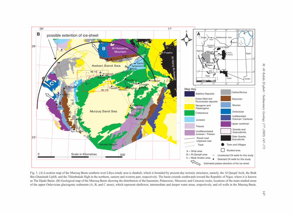
Fig. 1. (A) Location map of the Murzuq Basin southern west Libya (study area is shaded), which is bounded by present-day tectonic structures, namely, the Al Qarqaf Arch, the Brak
Bin Ghanimah Uplift, and the Tihimbukah High in the northern, eastern and western part, respectively. The basin extends southwards toward the Republic of Niger, where it is known
as The Djado Basin. (B) Geological map of the Murzuq Basin showing the distribution of the basement, Palaeozoic, Mesozoic and Cenozoic rocks, locations of the main studied areas
of the upper Ordovician glaciogenic sediments (A, B, and C areas), which represent shallower, intermediate and deeper water areas, respectively, and oil wells in the Murzuq Basin.
M.AliKalefa
El-g
hali/Sedimentary
Geology177(2005)145–173
147
M. Ali Kalefa El-ghali / Sedimentary Geology 177 (2005) 145–173148
during the upper Ordovician allowed the recognition
of three depositional sequences within the Murzuq
Basin. Each depositional sequence comprises numer-
ous facies successions that resulted from amalgamated
facies associations related to a spectrum of deposi-
tional environments.
2. Geological setting of the Murzuq Basin
The Murzuq Basin is located on the North
African Saharan platform, SW Libya, and represents
a huge Paleozoic intracratonic basin that was
glaciated in the Upper Ordovician. The present day
basin is triangular to sub-circular in shape and
extends southward towards the northern Republic
of Niger (Fig. 1A). The basin forms one structural
unit and covers an area in excess of 400,000 km2.
The present day basin margins are defined by three
prominent tectonic elements that were developed
during mid-Palaeozoic to Tertiary times. These
tectonic elements are Al-Qarqaf Arch, the Brak Bin
Ghanimah Uplift, and the Tihemboka Arch, which
form the northern, eastern and western margins of the
basin, respectively (Fig. 1A and B).
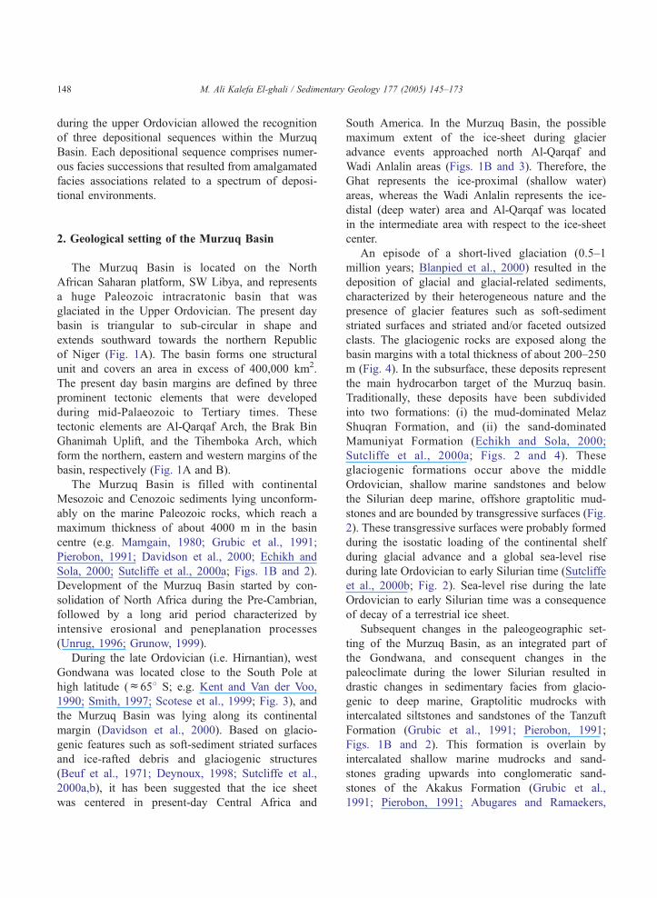
The Murzuq Basin is filled with continental
Mesozoic and Cenozoic sediments lying unconform-
ably on the marine Paleozoic rocks, which reach a
maximum thickness of about 4000 m in the basin
centre (e.g. Mamgain, 1980; Grubic et al., 1991;
Pierobon, 1991; Davidson et al., 2000; Echikh and
Sola, 2000; Sutcliffe et al., 2000a; Figs. 1B and 2).
Development of the Murzuq Basin started by con-
solidation of North Africa during the Pre-Cambrian,
followed by a long arid period characterized by
intensive erosional and peneplanation processes
(Unrug, 1996; Grunow, 1999).
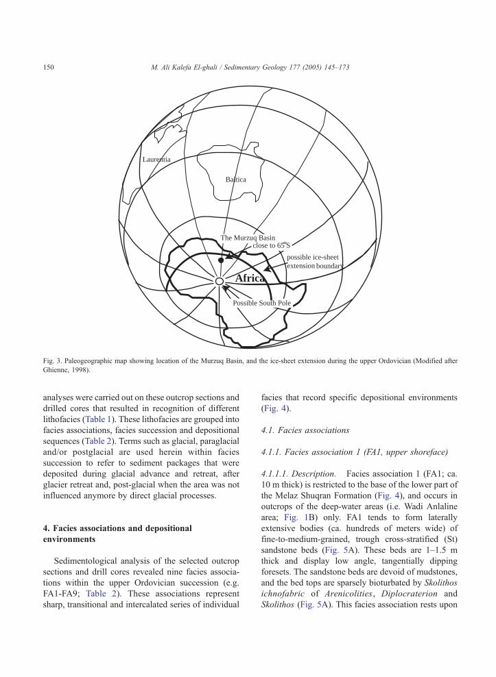
During the late Ordovician (i.e. Hirnantian), west
Gondwana was located close to the South Pole at
high latitude (c658 S; e.g. Kent and Van der Voo,
1990; Smith, 1997; Scotese et al., 1999; Fig. 3), and
the Murzuq Basin was lying along its continental
margin (Davidson et al., 2000). Based on glacio-
genic features such as soft-sediment striated surfaces
and ice-rafted debris and glaciogenic structures
(Beuf et al., 1971; Deynoux, 1998; Sutcliffe et al.,
2000a,b), it has been suggested that the ice sheet
was centered in present-day Central Africa and
South America. In the Murzuq Basin, the possible
maximum extent of the ice-sheet during glacier
advance events approached north Al-Qarqaf and
Wadi Anlalin areas (Figs. 1B and 3). Therefore, the
Ghat represents the ice-proximal (shallow water)
areas, whereas the Wadi Anlalin represents the ice-
distal (deep water) area and Al-Qarqaf was located
in the intermediate area with respect to the ice-sheet
center.
An episode of a short-lived glaciation (0.5–1
million years; Blanpied et al., 2000) resulted in the
deposition of glacial and glacial-related sediments,
characterized by their heterogeneous nature and the
presence of glacier features such as soft-sediment
striated surfaces and striated and/or faceted outsized
clasts. The glaciogenic rocks are exposed along the
basin margins with a total thickness of about 200–250
m (Fig. 4). In the subsurface, these deposits represent
the main hydrocarbon target of the Murzuq basin.
Traditionally, these deposits have been subdivided
into two formations: (i) the mud-dominated Melaz
Shuqran Formation, and (ii) the sand-dominated
Mamuniyat Formation (Echikh and Sola, 2000;
Sutcliffe et al., 2000a; Figs. 2 and 4). These
glaciogenic formations occur above the middle
Ordovician, shallow marine sandstones and below
the Silurian deep marine, offshore graptolitic mud-
stones and are bounded by transgressive surfaces (Fig.
2). These transgressive surfaces were probably formed
during the isostatic loading of the continental shelf
during glacial advance and a global sea-level rise
during late Ordovician to early Silurian time (Sutcliffe
et al., 2000b; Fig. 2). Sea-level rise during the late
Ordovician to early Silurian time was a consequence
of decay of a terrestrial ice sheet.
Subsequent changes in the paleogeographic set-
ting of the Murzuq Basin, as an integrated part of
the Gondwana, and consequent changes in the
paleoclimate during the lower Silurian resulted in
drastic changes in sedimentary facies from glacio-
genic to deep marine, Graptolitic mudrocks with
intercalated siltstones and sandstones of the Tanzuft
Formation (Grubic et al., 1991; Pierobon, 1991;
Figs. 1B and 2). This formation is overlain by
intercalated shallow marine mudrocks and sand-
stones grading upwards into conglomeratic sand-
stones of the Akakus Formation (Grubic et al.,
1991; Pierobon, 1991; Abugares and Ramaekers,
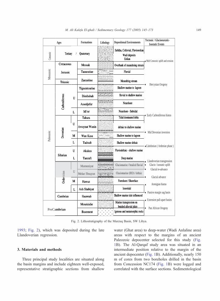
PreCa
Pale
ozoi
cM
esoz
oic
Ceno
zoic
Ages Formations Lithology Depositional EnvironmentsTectonic / Glacioeustatic- Isostatic Events
Pan African Orogeny
Extension pull-apart basins
Passive margin sag basin
Arenigian hiatus
Glacial advance
Glacial re-advanceGlacio / isostatic uplift
Llandoverian transgression
Caledonian ( Ardenian phase )
Mid Devonian inversion
Early Carboniferous hiatus
Hercynian Orogeny
Mid Cenozoic uplift and erosion
Fig. 2. Lithostratigraphy of the Murzuq Basin, SW Libya.
M. Ali Kalefa El-ghali / Sedimentary Geology 177 (2005) 145–173 149
1993; Fig. 2), which was deposited during the late
Llandoverian regression.
3. Materials and methods
Three principal study localities are situated along
the basin margins and include eighteen well-exposed,
representative stratigraphic sections from shallow
water (Ghat area) to deep-water (Wadi Anlaline area)
areas with respect to the margins of an ancient
Paleozoic depocenter selected for this study (Fig.
1B). The Al-Qarqaf study area was situated in an
intermediate position relative to the margin of the
ancient depocenter (Fig. 1B). Additionally, nearly 150
m of cores from two boreholes drilled in the basin
from Concession NC174 (Fig. 1B) were logged and
correlated with the surface sections. Sedimentological
Africa
Possible South Pole
Baltica
Laurentia
close to 65 S
possible ice-sheet extension boundary
The Murzuq Basin
Fig. 3. Paleogeographic map showing location of the Murzuq Basin, and the ice-sheet extension during the upper Ordovician (Modified after
Ghienne, 1998).
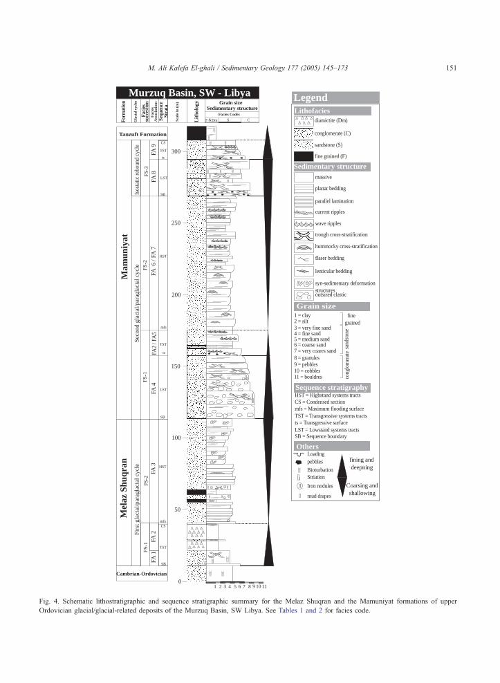
M. Ali Kalefa El-ghali / Sedimentary Geology 177 (2005) 145–173150
analyses were carried out on these outcrop sections and
drilled cores that resulted in recognition of different
lithofacies (Table 1). These lithofacies are grouped into
facies associations, facies succession and depositional
sequences (Table 2). Terms such as glacial, paraglacial
and/or postglacial are used herein within facies
succession to refer to sediment packages that were
deposited during glacial advance and retreat, after
glacier retreat and, post-glacial when the area was not
influenced anymore by direct glacial processes.
4. Facies associations and depositional
environments
Sedimentological analysis of the selected outcrop
sections and drill cores revealed nine facies associa-
tions within the upper Ordovician succession (e.g.
FA1-FA9; Table 2). These associations represent
sharp, transitional and intercalated series of individual
facies that record specific depositional environments
(Fig. 4).
4.1. Facies associations
4.1.1. Facies association 1 (FA1, upper shoreface)
4.1.1.1. Description. Facies association 1 (FA1; ca.
10 m thick) is restricted to the base of the lower part of
the Melaz Shuqran Formation (Fig. 4), and occurs in
outcrops of the deep-water areas (i.e. Wadi Anlaline
area; Fig. 1B) only. FA1 tends to form laterally
extensive bodies (ca. hundreds of meters wide) of
fine-to-medium-grained, trough cross-stratified (St)
sandstone beds (Fig. 5A). These beds are 1–1.5 m
thick and display low angle, tangentially dipping
foresets. The sandstone beds are devoid of mudstones,
and the bed tops are sparsely bioturbated by Skolithos
ichnofabric of Arenicolities, Diplocraterion and
Skolithos (Fig. 5A). This facies association rests upon
Isos
tatic
rebo
und
cycl
e
Sequ
ence
Stra
ta
F
acie
sA
ssoc
iati
ons
F
acie
s su
cces
tion
Form
atio
n
Scal
e in
(m
)
Lit
holo
gy Grain sizeSedimentary structure
Facies Codes
F S CDm&
HST
Mel
az S
huqr
an
CS
TST
mfs
SB
FA 2
FA 3
SB
FA 1
TST
LST
SB
Mam
uniy
at
HST
TST
ts
mfs
Tanzuft Formation
FA 4
FA2
/ FA
5FA
6 /
FA 7
FA 8
LST
tsFA
9
II
II
I
0
100
150
200
250
300
50
1 2 3 4 5 6 7 8 9 10 11
Cambrian-Ordovician
FS-1
FS-2
FS-1
FS-2
FS-3
Firs
t gla
cial
/par
agla
cial
cyc
le
Seco
nd g
laci
al/p
arag
laci
al c
ycle
G
laci
al c
ycle
s
Murzuq Basin, SW - Libya
CS
I
Loadingpebbles
BioturbationStriation
Iron nodules
diamictite (Dm)
conglomerate (C)
sandstone (S)
fine grained (F)
Lithofacies
Legend
planar bedding
parallel lamination
current ripples
massive
wave ripples
trough cross-stratification
hummocky cross-stratification
syn-sedimentary deformationstructuresoutsized clastic
Sedimentary structure
1 = clay2 = silt3 = very fine sand4 = fine sand5 = medium sand6 = coarse sand
fine grained
sand
ston
eco
nglo
mer
ate7 = very coares sand
8 = granules9 = pebbles10 = cobbles11 = bouldres
Grain size
LST = Lowstand systems tracts
TST = Transgressive systems tracts
HST = Highstand systems tractsCS = Condensed sectionmfs = Maximum flooding surface
ts = Transgressive surface
SB = Sequence boundary
Sequence stratigraphy
Others
lenticular bedding
flaser bedding
mud drapes
Coarsing and shallowing
fining and deepning
Fig. 4. Schematic lithostratigraphic and sequence stratigraphic summary for the Melaz Shuqran and the Mamuniyat formations of upper
Ordovician glacial/glacial-related deposits of the Murzuq Basin, SW Libya. See Tables 1 and 2 for facies code.
M. Ali Kalefa El-ghali / Sedimentary Geology 177 (2005) 145–173 151
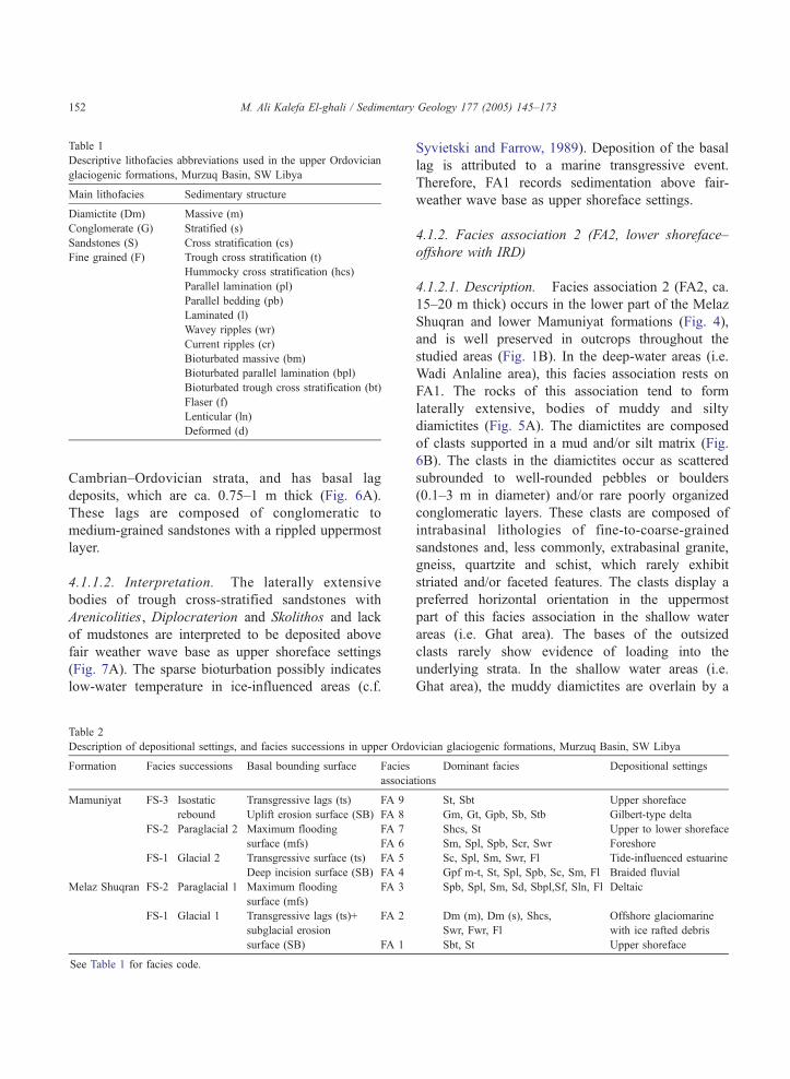
Table 1
Descriptive lithofacies abbreviations used in the upper Ordovician
glaciogenic formations, Murzuq Basin, SW Libya
Main lithofacies Sedimentary structure
Diamictite (Dm) Massive (m)
Conglomerate (G) Stratified (s)
Sandstones (S) Cross stratification (cs)
Fine grained (F) Trough cross stratification (t)
Hummocky cross stratification (hcs)
Parallel lamination (pl)
Parallel bedding (pb)
Laminated (l)
Wavey ripples (wr)
Current ripples (cr)
Bioturbated massive (bm)
Bioturbated parallel lamination (bpl)
Bioturbated trough cross stratification (bt)
Flaser (f)
Lenticular (ln)
Deformed (d)
M. Ali Kalefa El-ghali / Sedimentary Geology 177 (2005) 145–173152
Cambrian–Ordovician strata, and has basal lag
deposits, which are ca. 0.75–1 m thick (Fig. 6A).
These lags are composed of conglomeratic to
medium-grained sandstones with a rippled uppermost
layer.
4.1.1.2. Interpretation. The laterally extensive
bodies of trough cross-stratified sandstones with
Arenicolities, Diplocraterion and Skolithos and lack
of mudstones are interpreted to be deposited above
fair weather wave base as upper shoreface settings
(Fig. 7A). The sparse bioturbation possibly indicates
low-water temperature in ice-influenced areas (c.f.
Table 2
Description of depositional settings, and facies successions in upper Ordo
Formation Facies successions Basal bounding surface Facies
associa
Mamuniyat FS-3 Isostatic
rebound
Transgressive lags (ts) FA 9
Uplift erosion surface (SB) FA 8
FS-2 Paraglacial 2 Maximum flooding
surface (mfs)
FA 7
FA 6
FS-1 Glacial 2 Transgressive surface (ts) FA 5
Deep incision surface (SB) FA 4
Melaz Shuqran FS-2 Paraglacial 1 Maximum flooding
surface (mfs)
FA 3
FS-1 Glacial 1 Transgressive lags (ts)+
subglacial erosion
surface (SB)
FA 2
FA 1
See Table 1 for facies code.
Syvietski and Farrow, 1989). Deposition of the basal
lag is attributed to a marine transgressive event.
Therefore, FA1 records sedimentation above fair-
weather wave base as upper shoreface settings.
4.1.2. Facies association 2 (FA2, lower shoreface–
offshore with IRD)
4.1.2.1. Description. Facies association 2 (FA2, ca.
15–20 m thick) occurs in the lower part of the Melaz
Shuqran and lower Mamuniyat formations (Fig. 4),
and is well preserved in outcrops throughout the
studied areas (Fig. 1B). In the deep-water areas (i.e.
Wadi Anlaline area), this facies association rests on
FA1. The rocks of this association tend to form
laterally extensive, bodies of muddy and silty
diamictites (Fig. 5A). The diamictites are composed
of clasts supported in a mud and/or silt matrix (Fig.
6B). The clasts in the diamictites occur as scattered
subrounded to well-rounded pebbles or boulders
(0.1–3 m in diameter) and/or rare poorly organized
conglomeratic layers. These clasts are composed of
intrabasinal lithologies of fine-to-coarse-grained
sandstones and, less commonly, extrabasinal granite,
gneiss, quartzite and schist, which rarely exhibit
striated and/or faceted features. The clasts display a
preferred horizontal orientation in the uppermost
part of this facies association in the shallow water
areas (i.e. Ghat area). The bases of the outsized
clasts rarely show evidence of loading into the
underlying strata. In the shallow water areas (i.e.
Ghat area), the muddy diamictites are overlain by a
vician glaciogenic formations, Murzuq Basin, SW Libya
tions
Dominant facies Depositional settings
St, Sbt Upper shoreface
Gm, Gt, Gpb, Sb, Stb Gilbert-type delta
Shcs, St Upper to lower shoreface
Sm, Spl, Spb, Scr, Swr Foreshore
Sc, Spl, Sm, Swr, Fl Tide-influenced estuarine
Gpf m-t, St, Spl, Spb, Sc, Sm, Fl Braided fluvial
Spb, Spl, Sm, Sd, Sbpl,Sf, Sln, Fl Deltaic
Dm (m), Dm (s), Shcs,
Swr, Fwr, Fl
Offshore glaciomarine
with ice rafted debris
Sbt, St Upper shoreface
111 2 3 4 5 6 7 8 9 10
Sm
Spl
Spb
Spb
Fld
Sbpl
Spl
SbplI
Spb
Spl
Spb
Sm
Sd
Sm
Spl
0
10
20
30
40
50
Sd
I
I
I
I
I
I
I
FA 3
Dm (m)
Dm (s)
Dm (m)
Dm (s)
Dm (s)
Swr
Spl
Fl
10111 2 3 4 5 6 7 8 9
St
Sbt
Sm
I
I
I
Cs-sr
20
0
10
30
FA 1
FA 2
A) B)
Spl
SmbFf
SmSm
Ff
Sm
Sm
FlSplSmFmSm
Sm
Sm
Fl
Ff
Sm
Sm-pl
Sm
Sm
Fl
Sm
Ff
Ff
SmSpl
Sm
Ff
Ff
Ff
Sm
SmFf
Fl
1 234 567891011
2370
2360
2350
2340
FA3
C)m
etre
s
met
res
met
res
Wadi Anlalin area Al-Qarqaf areaoil well B1
ig. 5. (A–B) Graphic logs showing the typical facies and facies associations of the Melaz Shuqran Formation in the studied outcrops. (C)
raphic logs showing the typical facies and facies associations 3 in the Melaz Shuqran Formation on the subsurface of the Murzuq Basin. See
ig. 1 for location, Fig. 4 and Tables 1 and 2 for facies code and legend.
M. Ali Kalefa El-ghali / Sedimentary Geology 177 (2005) 145–173 153
F
G
F
C
FA 2
FA 3
A
B
Fig. 6. First depositional sequence: (A) Base of the Melaz Shuqran
Formation at Wadi Anlaline area (i.e. deeper water areas, see Fig. 1
for location) showing ca. one meter thick, conglomeratic to
medium-grained sandstones with ripples at top, which are inter-
preted as transgressive lag deposited formed due to a relative sea-
level rise that was coeval with a glacial advance and loading the
shelf. This lag deposit is resting on Cambrian–Ordovician strata. (B)
Uppermost lower Melaz Shuqran Formation showing muddy and
silty diamictite deposits (FA2) with ice-rafted debris (arrows) up to
3 m in diameter. This facies association forms part of TST that has
been deposited during a relative sea-level rise coeval with glacier
advance and loading the shelf and subsequent glacial retreat. (C)
Upper Melaz Shuqran Formation showing extensive syn-deposi-
tional deformation features. This facies (FA3) is regarded as HST
that has been deposited in a paraglacial system.
M. Ali Kalefa El-ghali / Sedimentary Geology 177 (2005) 145–173154
silty diamictite, and locally by layers of chaotic
clasts, which are traceable for ten of meters in
outcrops.
The diamictites are interbeded with thin beds of
mudstones and sandstones (5A). The latter comprising
fine-to-medium-grained, current rippled (Scr), hum-
mocky cross-stratified (Shcs) sandstone beds (0.1–
0.15 m thick; 5A). The sandstone beds fine upwards
from medium to fine-grained sands. The mudstones
have planer laminea (Fl), sparsely bioturbated (Fb),
and devoid of outsized clasts. In the shallow water
areas (i.e. Ghat area), these mudstones, which are
preserved in the uppermost part of this association,
have a lower surface lined by imbricate clasts (i.e.
shallow water areas).
In Wadi Anlalin area (i.e. deep water areas), the
rocks of this association rest on top of the underlying
FA1 with the boundary being marked locally by
loading, whereas in the shallow water areas (i.e. Ghat
area), the basal boundary is scoured and/or are
subglacially eroded surface on top of the Cambrian–
Ordovician strata (i.e. Ash Shabiyat and/or Hasawnah
formations). The upper boundary of this facies
association is caped by a thin Fe-rich layer of 0.1–
0.15 m thick.
4.1.2.2. Interpretation. The presence of striated and/
or faceted outsized clasts and distinct chaotic layers
that load and disrupt the underlying laminated mud-
stones are indicators of sedimentation in a glaciomar-
ine setting (c.f. Crowell and Frakes, 1971; Herbert,
1980; Eyles et al., 1998). The depositions of the
striated and/or faceted outsized clasts in mudstones
are interpreted to be ice-rafted debris (IRD) from
icebergs. Variations in the amount of IRD in the
diamictites are attributed to the rate of hemipelagic
clay sedimentation relative to deposition from ice-
bergs. The occurrence of relatively large amount of
IRD interbedded with thin layers of mudstones may
reflect higher water temperature during the summer
when increased melting of icebergs releases more
sediment into the ocean (c.f. Elverhoi and Henrich,
1996). Therefore, deposition of IRD exceeded the rate
of hemipelagic sedimentation. Conversely, the rela-
tively small amounts or absence of the IRD reflects
the lowering of water temperature during the winter so
that hemipelagic deposition exceeded the sedimenta-
tion of IRD. Diverse sources of IRD are indicated by
the diverse lithologies of these clasts.
In the shallow water areas (i.e. Ghat area), the local
preferred horizontal orientation and imbrication of the
relative sea level fa
ll Delta (FA 3)
Cambria
n-Ord
ovici
an
(Pre
-glac
ial S
trata
)
offshore mud (FA 2)
relative sea-level ris
e
NW
glacier advancelan
dward
icerbergs
subglacial erosion surface and subsidence
Cambr
ian-
Ord
ovici
an
(Pre
-gla
cial S
trat
a)
IRD
proglacial subsidence
isostatic rebound
B
A
offshore mud (FA 2)
Shoreface (FA 1)
Shoreface (FA 1)
Basindward
glacier retreat
Ghat area
Wadi Anlaline area
Al-Qarqaf area
Ghat area
Wadi Anlaline area
Al-Qarqaf area
Fig. 7. Schematic depositional model for first depositional sequence DS-1. (A) First glacial advance and isostatic loading the shelf that was
accompanied by a relative sea-level rise, which resulted in the formation of a subglacial erosion surface (SB) in ice-proximal and shallow water
areas and transgressive surface (ts) in ice-distal and deep water areas. The base of TST comprises upper shoreface deposits (FA1) that are
overlain by offshore–shoreface deposits including ice-rafted debris (FA2). (B) During glacial retreat, the system started to prograde due to a high
flux of sediment, which exceeded the rate of accommodation creation, resulting in the deposition of a HST comprising a tidal influenced-delta
(FA3).
M. Ali Kalefa El-ghali / Sedimentary Geology 177 (2005) 145–173 155
relatively small outsized clasts ( ca. b0.1 m in
diameter) at the contact with mudstone facies in the
shallow water areas (i.e. Ghat area) suggest current
reworking after deposition (cf. Eyles et al., 1998)
during relative sea-level rise associated with deglaci-
ation (Miller, 1996; Fig. 7A). The absence of IRD
within the upper mudstone facies (above the imbri-
cated clasts) suggests that this facies was deposited
during final stages of glacier retreat (Fig. 7A).
In the diamictites, the hummocky cross-stratified
sandstones were deposited by strong oscillatory flows
under storm-dominated wave conditions (e.g. Makh-
louf, 2002). The effects of strong, storm-generated
currents are recognized on the surfaces by the
presence of wave-formed gravel ripples (cf. Eyles et
al., 1998) and imbricate clasts. Such facies are
typically deposited in water depths greater than those
of the trough cross-stratified sandstone facies (i.e.
M. Ali Kalefa El-ghali / Sedimentary Geology 177 (2005) 145–173156
FA1; e.g. Walker and Plint, 1992), and may record
lower shoreface settings. Therefore, FA2 records
sedimentation below fair weather wave base in
transition offshore settings that was influenced by
the deposition of ice-rafted debris (IRD) from icebergs
(Fig. 7A).
4.1.3. Facies association 3 (FA3, deltaic)
4.1.3.1. Description. Facies association 3 (FA3) is
ca. 50-60 m thick and occurs in the upper part of the
Melaz Shuqran Formation (Fig. 4). The rocks of this
facies association crop out throughout the deep-
water areas (i.e. Wadi Anlaline area) and the
intermediate area (i.e. Al-Qarqaf area; Figs. 1B and
5B) and are recognized in the drill cores too (Fig.
5C). The rocks of FA 3 are comprised of ca. 0.25–
0.75 m thick beds of fine to medium-grained,
parallel bedded (Spb), trough cross-stratified (St),
and massive sandstones (Sm) that coarsen and
thicken upwards, and are interbeded with mudstone
facies (Fl; Fig. 5B and C) in the lower part of the
succession. These sandstones have bed tops that are
parallel laminated (Spl) near the base of the FA and
become wave rippled (Swr) upwards. Bioturbation in
sandstones within this facies association is rare. The
sandstone facies exhibit abundant mud drapes, and
have extensive syn-sedimentary deformation features
such as slumping and sliding (Fig. 6A) particularly
in the upper part of FA 3 (Fig. 5B). These facies and
features are also recognized in the drill cores, in
addition to 0.75–1 m thick, lenticular and flaser
bedded (Sln and Sf, respectively, Fig. 5C), fine-
grained sandstones and mudstones. The mudstone
facies (ca. 1–2.5 m thick) are planar laminated (Pl),
and interbeded with silty sandstones and sandstones,
and display rare syn-sedimentary deformations fea-
tures (Fig. 5B). FA3 in the Wadi Anlaline area (i.e.
deep water areas; Fig. 1B) rests on top of the ca.
0.1–0.15 m thick oxidized layer, whereas in the
intermediate area (i.e. Al-Qarqaf area), its basal
surface is erosional.
4.1.3.2. Interpretation. The presence of mud drapes,
flaser bedding, wavey ripples and lenticular bedding
suggest sedimentation in tidal influenced settings
(Reineck and Singh, 1980). The coarsening-upward
succession from lower energy, finer-grained deposits
(i.e. mudstones) to higher energy, coarser-grained
deposits are typically indicating deltaic settings (Fig.
7B). The presence of rare bioturbated sandstones and
the absence of IRD within FA3 suggest the amelio-
ration of depositional conditions from glacial domi-
nated to paraglacial dominated settings (Fig. 7B).
Conversely, the presence of syn-sedimentary defor-
mation features (e.g. slumps) is attributed to high
sedimentation rates induced by isostatic rebound of
the continental shelf in response to glacier retreat (Fig.
7B). Therefore, FA3 represents tide-dominated deltaic
deposits.
4.1.4. Facies association 4 (FA4, braided fluvial)
4.1.4.1. Description. Facies association 4 (FA4),
which is ca. 40–60 m thick, occurs in the lower part of
the Mamuniyat Formation (Fig. 4) and crops out
throughout the study area (Fig. 1B). The rocks of FA4
are composed predominately of massive to trough
cross-stratified, conglomeratic sandstones (Gpf m-t),
trough cross-stratified sandstones (St), planer-bedded
(Spb) to planar-laminated (Spl) and current-rippled
(Scr) sandstones, interbedded with mudstone facies
(Fl, Fm; Fig. 8A).
The conglomeratic sandstone facies (Gpf m-t)
occurs in the lower part of the lower Mamuniyat
Formation (Figs. 4 and 8A), and is comprised of
scattered clasts supported by conglomeratic sand-
stones to coarse-grained sandstones matrix (Fig. 9A
and B). The clasts range in size from granules to
large boulders (up to 3 m in diameter), vary in
shape from subrounded to well rounded, and are
composed predominantly of very fine-to-coarse-
grained sandstones and rarely granite. These clasts
are often intrabasinal, and are rarely striated and/or
faceted and display preferred orientation only in the
deep-water areas (i.e. Wadi Anlaline area; Fig. 1B)
where they form lateral continuous like layer and
decrease in size up to 10 mm in diameter basinward
(Fig. 9B).
Individual beds of massive conglomeratic sand-
stones and coarse-grained sandstones (ca. 2–5 m
thick) grade vertically and laterally into fine-to-
coarse-grained, trough cross-stratified and parallel
bedded to laminated sandstones (Fig. 8A). These
sandstones rarely pass upward into thin (N20 cm
thick), very fine-to-fine-grained, current-rippled and
0
10
20
30
40
50
60
0
10
1 2 3 4 5 6 7 8 91011
St-plFlSplSwr
St
Sm
Sg
1 2 3 4 5 6 7 8 9 1011
Sm
Spl
Sm
Swr
Spb
Spb
Spl
Swr
Spb
Swr
Spl
Spb
SplScr
SwrSpl
0
10
20
30
40
50
60
Spb
FA 6
FA 5
1 2 3 4 5 6 7 8 9 1011
Spl
St
Spl
Gpf
St
SHcsStSt
Sm
St?Sm
Spb
Scr
Spl
Sm
Spb
SmFlSplSt ?FlSmFlSplFlSplFlSt?
Fl
FA 4
A) B) C)
met
res
met
res
met
res
FA 2
Wadi Anlalin area Ghat area Al-Qarqaf area
Fig. 8. (A–F) Graphic logs showing the typical facies and facies associations of the Mamuniyat Formation in the studied outcrops. (G) Graphic
logs showing the typical facies and facies associations in the Mamuniyat Formation on the subsurface of the Murzuq Basin. See Fig. 1 for
location, Fig. 4 and Tables 1 and 2 for facies code and legend.
M. Ali Kalefa El-ghali / Sedimentary Geology 177 (2005) 145–173 157
1 2 3 4 5 6 7 8 910 11
Sbt
St0
10
Swr
0
Sbt
Sbt
Sb
Sbpb
GSbp
GStGSt
1 2 3 4 5 6 7 8 9 10 11
10
20
GSt
Sm
GSm
1 2 3 4 5 6 7 8 9 10 110
10
30
20
I
ShcsSpl
Sm
Spl
StFA 7
FA 8FA 9
D) Wadi Anlalin areaE) Ghat area F) Al-Qarqaf area
Tanzuft shale
Shcs
met
res
met
res
met
res
I
I
I
I
I
I
I
I
I
Fig. 8 (continued).
M. Ali Kalefa El-ghali / Sedimentary Geology 177 (2005) 145–173158
parallel-laminated sandstones that are interbedded
with laminated and current rippled, silty sandstones
and mudstones. The basal bounding surface of this
facies association has 50–70 m deep erosional
surfaces incised into the lower shoreface and offshore
deposits of FA2, and the deltaic deposits of FA3, and
pre-glacial Cambrian–Ordovician rocks (Fig. 9C).
4.1.4.2. Interpretation. The nature of the sandbod-
ies, which commonly fine upwards from basal erosion
surface that overlain coarse-grained sandstones with
little or no preserved fine-grained deposits, indicate
sedimentation in high-energy bedload braided streams
(Collinson, 1996). These fluvial deposits fill incised
valley as indicated by the large and deep erosional
surface that cuts down into underlying rocks (i.e. FA2
and FA3 of the Melaz Shuqran Formation and/or
preglacial Cambrian–Ordovician strata). These incised
valleys are believed to have been formed during
relative sea-level fall. The presence of striated (Fig.
9A) and faceted outsized clasts within the lower part
of this facies association suggests a glacial origin. The
interbedded mudstones and fine-grained, wave-
rippled, and laminated sandstones are interpreted to
be floodplain deposits. The upward fining of the
sandstones, disappearance of the striated, and facetted
outsized clasts may indicate that deposition occurred
during glacier decay.
4.1.5. Facies association 5 (FA5, estuarine)
4.1.5.1. Description. Facies association 5 (FA5) is
ca. 15–20 m thick, overlies FA4 (Fig. 4), and is
preserved in the shallow water areas (i.e. Ghat area)
and intermediate area (i.e. Al-Qarqaf area; Fig. 1B).
The base of this facies association is marked by multi-
scoured channels defined at their base by the presence
of pebble lags, overlain by fining upward succession
from medium-to-fine-grained sandstone interbedded
with mudstones (Fig. 8A). These sandstones are
comprised of fine- to medium-grained, trough cross-
stratified (St), massive (Sm), and wave rippled sand-
1700
1690
1680
Csm
SplSplSbSbt
Sbt
Sbt
StSbSbFlSmCsg
CsmFlCsmCsm
Csm
CsmSmCsmCsmSmCsm
CsmCsmSm
CsmSwrSpl
SplSm
Sm
Sm
SplSwrSmSpl
Spl
Sm
1740
Sm
Spl
Spl
Sm
SplFlSplSmSmFlSmSmSm
Sm
SmSm
SwrSpl
1730
1720
Sm
SmSmSmSmSplSm
Sm
Sm
SmSm
Spl
SwrSmSm
Spl
1710
1780
1750
1770
Sm
Swr
Sm
Sm
Sm
Sm
Sm
SmSmSmSpl
Sm
Sm
SmSmSm
Spl
Spl
Spl
Scr
Sm
1790
Sm
Sm
Sm
Sm
Sm
SmSmSm
Sm
Spl
Spl
1760
1 2 3 4 5 6 7 8 91011
FA 6
FA 6
FA 6
FA 8
G) oil well F2m
etre
s
not c
ored
Fig. 8 (continued).
M. Ali Kalefa El-ghali / Sedimentary Geology 177 (2005) 145–173 159
M. Ali Kalefa El-ghali / Sedimentary Geology 177 (2005) 145–173160
stones (Figs. 8A and 9A). The sandstones contain
abundant mud drapes. The mudstones display dis-
continues laminated and weak massive structure.
C
A B
FA 4
FA 2
FA 4
E
ice-rafted debris
FA 6
FA 4
F
4.1.5.2. Interpretation. The small scoured channel,
which has basal erosional surface with lags followed
by fining upward succession that overlain braided
FA 4
FA 5
D
4 m
M. Ali Kalefa El-ghali / Sedimentary Geology 177 (2005) 145–173 161
fluvial deposits in incised-valley landward position is
interpreted to have been in estuarine setting. The
presence of mud drapes and discontinuous laminated
muds indicate tidal influence (Nichols, 1999). How-
ever, there is no evidence of reverse flow as might be
expected in tidal influenced settings due to the
presence of multi-channels, which force the ebb and
tidal currents to follow different pathways. Thus, the
rocks FA5 record sedimentation in tide-dominated
estuarine environment (Fig. 10B).
4.1.6. Facies association 6 (FA6, foreshore)
4.1.6.1. Description. Facies association 6 (FA6),
which is up to 70 m thick, occurs within the middle
part of the Mamuniyat Formation, and occurs in the
intermediate area (i.e. Al-Qarqaf area) and in the drill
cores (Figs. 1B and 4). The rocks of this association
tend to form laterally extensive sandstone bodies,
which comprise 0.5–1 m thick beds of medium-to-
coarse-grained, with flat to low angle cross-stratifica-
tion (Scs) and planar bedding (Sp) sandstones. The
bed tops in the upper part of this association (Fig. 8C
and G) are, in some cases, fine-grained parallel
laminated (Spl), wave rippled (Swr), and current
rippled (Scr) sandstones. The rocks of this association
coarsen upwards from fine-to-medium-grained sand-
stones, and are devoid of mudstones. The basal
surface of this facies association with the underlying
FA5 is erosional.
4.1.6.2. Interpretation. The dominant of planar to
low angle cross-stratified, medium-to-coarse-grained
sandstones indicate sedimentation above fair weather
wave base in foreshore settings (Nichols, 1999). The
lack of mudstones within this facies association
indicates deposition under high-energy current, in
shallower water compared to those, which have
hummocky and trough cross-stratified sandstones.
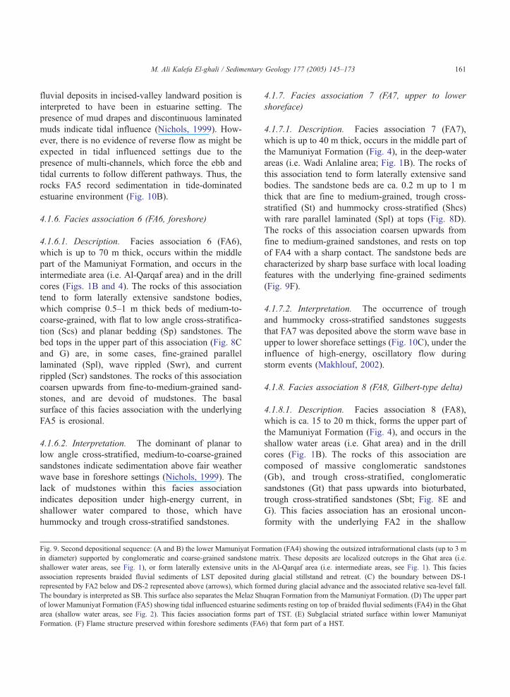
Fig. 9. Second depositional sequence: (A and B) the lower Mamuniyat Form
in diameter) supported by conglomeratic and coarse-grained sandstone m
shallower water areas, see Fig. 1), or form laterally extensive units in t
association represents braided fluvial sediments of LST deposited duri
represented by FA2 below and DS-2 represented above (arrows), which for
The boundary is interpreted as SB. This surface also separates the Melaz Sh
of lower Mamuniyat Formation (FA5) showing tidal influenced estuarine se
area (shallow water areas, see Fig. 2). This facies association forms par
Formation. (F) Flame structure preserved within foreshore sediments (FA6
4.1.7. Facies association 7 (FA7, upper to lower
shoreface)
4.1.7.1. Description. Facies association 7 (FA7),
which is up to 40 m thick, occurs in the middle part of
the Mamuniyat Formation (Fig. 4), in the deep-water
areas (i.e. Wadi Anlaline area; Fig. 1B). The rocks of
this association tend to form laterally extensive sand
bodies. The sandstone beds are ca. 0.2 m up to 1 m
thick that are fine to medium-grained, trough cross-
stratified (St) and hummocky cross-stratified (Shcs)
with rare parallel laminated (Spl) at tops (Fig. 8D).
The rocks of this association coarsen upwards from
fine to medium-grained sandstones, and rests on top
of FA4 with a sharp contact. The sandstone beds are
characterized by sharp base surface with local loading
features with the underlying fine-grained sediments
(Fig. 9F).
4.1.7.2. Interpretation. The occurrence of trough
and hummocky cross-stratified sandstones suggests
that FA7 was deposited above the storm wave base in
upper to lower shoreface settings (Fig. 10C), under the
influence of high-energy, oscillatory flow during
storm events (Makhlouf, 2002).
4.1.8. Facies association 8 (FA8, Gilbert-type delta)
4.1.8.1. Description. Facies association 8 (FA8),
which is ca. 15 to 20 m thick, forms the upper part of
the Mamuniyat Formation (Fig. 4), and occurs in the
shallow water areas (i.e. Ghat area) and in the drill
cores (Fig. 1B). The rocks of this association are
composed of massive conglomeratic sandstones
(Gb), and trough cross-stratified, conglomeratic
sandstones (Gt) that pass upwards into bioturbated,
trough cross-stratified sandstones (Sbt; Fig. 8E and
G). This facies association has an erosional uncon-
formity with the underlying FA2 in the shallow
ation (FA4) showing the outsized intraformational clasts (up to 3 m
atrix. These deposits are localized outcrops in the Ghat area (i.e.
he Al-Qarqaf area (i.e. intermediate areas, see Fig. 1). This facies
ng glacial stillstand and retreat. (C) the boundary between DS-1
med during glacial advance and the associated relative sea-level fall.
uqran Formation from the Mamuniyat Formation. (D) The upper part
diments resting on top of braided fluvial sediments (FA4) in the Ghat
t of TST. (E) Subglacial striated surface within lower Mamuniyat
) that form part of a HST.
Cambria
n-Ord
ovici
an
stra
ta an
d firs
t glci
al
braided fluvial (FA 4)
Tidal influencedEustuarine (FA 5)
B
relative sea-level fall
Cambria
n-Ord
ovici
an
strat
a and fi
rst g
lcial
Shoreface (FA 7)
foreshore (FA 6)
C
relative sea level fall
due to glacial advance
landward
Cambria
n-Ord
ovici
an
strat
a and fi
rst g
lcial
A
subglacial erosion surfacebasinward
relative sea-level rise
due to ice melt
braided fluvial (FA 4)
glacier retreat
Ghat area
Wadi Anlaline area
Al-Qarqaf area
glacier advance
NW
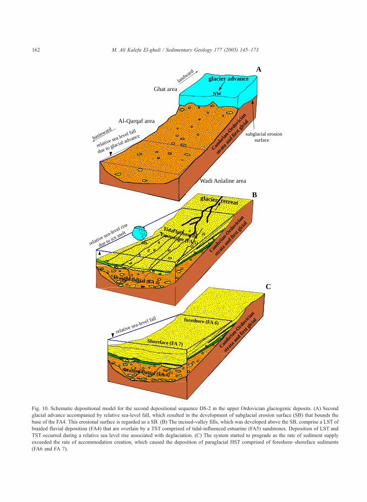
Fig. 10. Schematic depositional model for the second depositional sequence DS-2 in the upper Ordovician glaciogenic deposits. (A) Second
glacial advance accompanied by relative sea-level fall, which resulted in the development of subglacial erosion surface (SB) that bounds the
base of the FA4. This erosional surface is regarded as a SB. (B) The incised-valley fills, which was developed above the SB, comprise a LST of
braided fluvial deposition (FA4) that are overlain by a TST comprised of tidal-influenced estuarine (FA5) sandstones. Deposition of LST and
TST occurred during a relative sea level rise associated with deglaciation. (C) The system started to prograde as the rate of sediment supply
exceeded the rate of accommodation creation, which caused the deposition of paraglacial HST comprised of foreshore–shoreface sediments
(FA6 and FA 7).
M. Ali Kalefa El-ghali / Sedimentary Geology 177 (2005) 145–173162
M. Ali Kalefa El-ghali / Sedimentary Geology 177 (2005) 145–173 163
water areas (i.e. Ghat area; Fig. 11A), and progrades
away from palaeohighs with a dip angle N158. Thesandstone beds are medium- to coarse-grained,
massive to trough cross stratified, and extensively
bioturbated (Fig. 11B and C).
4.1.8.2. Interpretation. The prograding and coars-
ening-upward succession of coarse-grained deposits
with dips N158 from palaeohighs suggest that the
rocks of FA8 represent Gilbert-type delta setting
(Fig. 12). The presence of a paleohigh with a basin-
margin gradient is believed to be formed as a result
of isostatic rebound of the continental shelf that
postdates the glacier retreat (Sutcliffe et al., 2000a,b;
Fig. 12). The lack of glacial features and the
presence of bioturbation suggest amelioration of the
depositional environment from glacial, paraglacial to
postglacial environments. The erosional surface with
the lack of any incision and the presence of this
facies association on top of FA2 (Fig. 11A) in the
shallow water areas (i.e. Ghat area; Fig. 1B) implies
the removal of the lower and middle part of the
Mamuniyat Formation, which probably occurred
during uplift of the continental shelf as a result of
isostatic rebound during deglaciation (Sutcliffe et al.,
2000a).
4.1.9. Facies association 9 (FA9, upper shoreface)
4.1.9.1. Description. Facies association 9 (FA9), ca.
10 m thick, which occurs in the intermediate area (i.e.
Al-Qarqaf area; Fig. 1B), forms the uppermost part of
the Mamuniyat Formation (Figs. 4 and 11D) and rests
on top of lag deposits. FA9 tends to form laterally
extensive bodies of fine to medium-grained sand-
stones. These sandstones, which show large-scale,
trough cross-stratifications (St), occur as beds up to
0.75 m thick that are associated with rare wave rippled
surfaces (Fig. 11D). The uppermost part (ca. 1 m
thick) of this association comprises fine-grained,
bioturbated sandstones that show small-scale, trough
cross stratifications (Sbt) and herringbone cross
stratifications (Sh; Figs. 8F and 11C). These sand-
stones are covered by a distinctive hardground (12 cm
thick) of iron-oxide rich, very fine-grained sandstones
(Fig. 11D). The sandstones of FA9 thin and fine
upwards from medium-to-fine-grained sandstones
(Fig. 8F).
4.1.9.2. Interpretation. The presence of the laterally
extensive bodies of bioturbated, trough cross-stratified
sandstones and the absence of mudstones within FA9
suggest deposition above fair-weather, wave-base in
upper shoreface environments (Fig. 12). The occur-
rence of herringbone cross stratifications at the top of
this facies association indicates tidal influenced shore-
face settings. The thin distinctive iron-oxide rich
hardground (12 cm thick) of very fine-grained sand-
stones is attributed to be formed owing to sediment
starvation associated with a late Ordovician/early
Silurian global sea-level rise.
4.2. Paleoenvironments of the late Ordovician in the
Murzuq Basin
Upper Ordovician sediments of the Murzuq Basin
were deposited during the late Ashgillian glaciation of
Gondwana when the late Ordovician ice sheet was
centered over central Africa and expanded outward
onto the surrounding continental shelves during
extraordinarius zone of the early Hirnantian (Sutcliffe
et al., 2000a,b). The wide variety of the upper
Ordovician facies associations in the basin provides
important information on the depositional conditions
across a glaciated and glacial-related, paralic con-
tinental shelf at high latitudes.
The trough cross-stratified sandstones of FA1
record deposition above fair weather wave base in
upper shoreface environments close to an ice margin
(Fig. 7A). The overlying FA2 is dominated by
deposition of IRD and hemipelagic mud in offshore
to lower shoreface environments (Fig. 7A). The
transition from FA1 to FA2 represents a glacio-marine
transgressive event that resulted from isostatic loading
of the shelf during glacial advance and subsequent
glacial retreat (Figs. 7A and 13). The thin iron-oxide
rich layer on top of FA2 indicates sediment starvation
concomitant with relative sea-level rise during glacier
retreat (c.f. Miller, 1996), and thus represents the final
stage of glacial retreat event (Fig. 13). FA3 is
dominated by mud drapes, parallel to cross-bedded
and bioturbated sandstones that are interbedded with
mudstones, which show an increase in the sand/mud
ratio upwards and record deposition in tide-dominated
delta (Fig. 7B). Syn-sedimentary deformation feature
are common (Fig. 7C) and reflect high sedimentation
rates and deposition on unstable paleohigh. The
A
D
FA 2
FA 8
Tanzuft shale Formation (Lower Silurian)
Mamuniyat Formation
E
B
FA 8
FA 9
FA 9
C
0.5 metre
M. Ali Kalefa El-ghali / Sedimentary Geology 177 (2005) 145–173164
relative sea level rise
time 2
landward
basinward
fi
rst a
nd/or se
cond
g
lacial
depos
its
shoreface (FA 9)
rela
tive
sea
leve
l fal
ldu
e to
isos
tatic
upl
ift
Gilbert delta (FA 8)
time
1
Uplift erosion surface due to rebound
Ghat area
Al-Qarqaf area
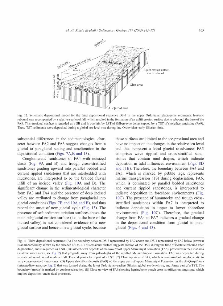
Fig. 12. Schematic depositional model for the third depositional sequence DS-3 in the upper Ordovician glaciogenic sediments. Isostatic
rebound was accompanied by a relative sea-level fall, which resulted in the formation of an uplift erosion surface due to rebound, the base of the
FA8. This erosional surface is regarded as a SB and is overlain by LST of Gilbert-type deltas capped by a TST of shoreface sandstone (FA9).
These TST sediments were deposited during a global sea-level rise during late Ordovician–early Silurian time.
M. Ali Kalefa El-ghali / Sedimentary Geology 177 (2005) 145–173 165
substantial differences in the sedimentological char-
acter between FA2 and FA3 suggest changes from a
glacial to paraglacial setting and amelioration in the
depositional condition (Figs. 7A,B and 13).
Conglomeratic sandstones of FA4 with outsized
clasts (Fig. 9A and B) and trough cross-stratified
sandstones grading upward into parallel bedded and
current rippled sandstones that are interbedded with
mudstones, are interpreted to be the braided fluvial
infill of an incised valley (Fig. 10A and B). The
significant change in the sedimentological character
from FA3 and FA4 and the presence of deep incised
valley are attributed to change from paraglacial into
glacial conditions (Figs. 7B and 10A and B), and thus
record the onset of new glacial cycle (Fig. 13). The
presence of soft sediment striation surfaces above the
main subglacial erosion surface (i.e. at the base of the
incised-valley) is not considered evidence of a new
glacial surface and hence a new glacial cycle, because
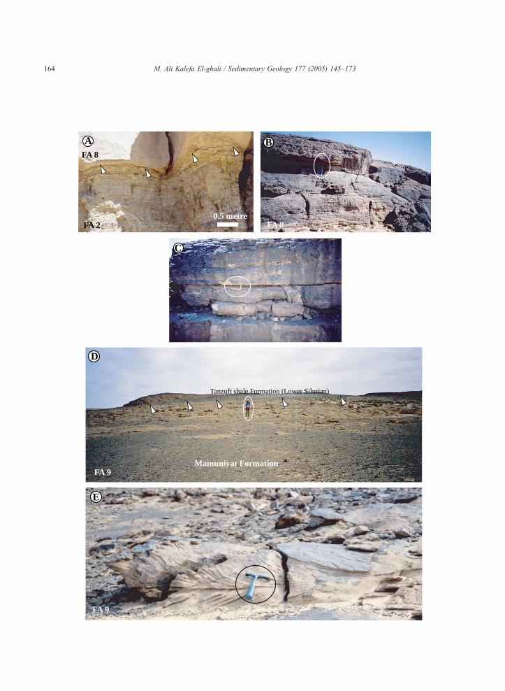
Fig. 11. Third depositional sequence: (A) The boundary between DS-3 repr
is an unconformity shown by the absence of DS-2. This erosional surface su
deglaciation, and is regarded as a SB. (B) Gilbert-delta deposits of the lowe
(shallow water areas, see Fig. 2) that prograde away from paleo-highs of
isostatic rebound coeval sea-level fall. These deposits form part of a LST.
very coarse-grained sandstones. (D) Upper shoreface deposits (FA9) of th
(intermediate area, see Fig. 2) that was formed during the latest Ordovician
boundary (arrows) is marked by condensed section. (E) Close up view of FA
implies deposition under tidal processes.
these surfaces are limited to the ice-proximal area and
have no impact on the changes in the relative sea level
and thus represent a local glacial re-advance. FA5
comprises wave rippled and cross-stratified sand-
stones that contain mud drapes, which indicate
deposition in tidal influenced environment (Figs. 8D
and 11B). Therefore, the boundary between FA4 and
FA5, which is marked by pebble lags, represents
marine transgression (TS) during deglaciation. FA6,
which is dominated by parallel bedded sandstones
and current rippled sandstones, is interpreted to
indicate deposition in foreshore environments (Fig.
10C). The presence of hummocky and trough cross-
stratified sandstones within FA7 is interpreted to
indicate deposition in upper to lower shoreface
environments (Fig. 10C). Therefore, the gradual
change from FA4 to FA7 indicates a gradual change
in the depositional condition from glacial to para-
glacial (Figs. 4 and 13).
esented by FA9 above and DS-1 represented by FA2 below (arrows)
ggests erosion of the DS-2 during the time of isostatic rebound after
rmost upper Mamuniyat Formation (FA8), preserved in the Ghat area
the uplifted Melaz Shuqran Formation. FA8 was deposited during
(C) Close up view of FA8, which is composed of conglomeratic to
e upper part of upper Mamuniyat Formation in the Al-Qarqaf area
–earliest Silurian global sea-level rise, and forms part of a TST. The
9 showing herringbone trough cross-stratification sandstone, which
II
II
? ?
?
I
I
I
I
I
I
I
I
I
I
CS
transgressive lags
1 2 3 4 5 6 7 8 9 10110
50
100
150
200
Sequ
ence
Stra
ta
Form
atio
n
Scal
e in
(m)
Lithology
Grain sizeSedimentary structure
Facies CodesF S CDm&
HST
Mel
az S
huqr
anM
amun
iyat
TST
mfs
Tanzuft
FA
2 F
A 3
TST
LST
SB
HST
TST
ts
mfs
FA
4 F
A 5
FA
6 F
A 9
II
II
FS-3
FS-1
FS-2
FS-1
Fa
cies
Ass
ocia
tions
Faci
es S
uce.
Al - Qarqaf Arch area
SB
1 2 3 4 5 6 7 8 9 10 110
50
HST
mfs
Mel
az S
huqr
anM
amun
iyat
100
150
TST
LST
ts
SB
HST
mfs
FA 7
FA 4
FA 3
FA 2
FA
1
Cambrian-Ordovician
FS-1
FS-2
FS-1
FS-2
Wadi Anlaline area
Sequ
ence
Stra
ta
Form
atio
n
Scal
e in
(m)
Lithology
Grain sizeSedimentary structure
Facies CodesF S CDm&
Faci
esA
ssoc
iatio
ns
Faci
es S
uce.
1 2 3 4 5 6 7 8 9 10 110
50
Ghat area
Sequ
ence
Stra
ta
Fa
cies
Ass
ocia
tions
Faci
es S
uce.
Form
atio
n
Scal
e in
(m)
Lithology
Grain sizeSedimentary structure
Facies CodesF S CDm&
TST
Melaz
Shuq
ranM
amun
iyat
FA
2
LST
TST
LST
ts
SB
FA
8FA
5 F
A 4
FS-3
FS-1
FS-1
Cambrian-Ordovician
SB
SB
? ?
?
BasinwardLandward
TST
SB+tsI
Loadingpebbles
BioturbationStriation
Iron nodules
diamictite (Dm)
conglomerate (C)
sandstone (S)
fine grained (F)
Lithofacies
Legend
planar bedding
parallel lamination
current ripples
massive
wave ripples
trough cross-stratification
hummocky cross-stratification
syn-sedimentary deformationstructuresoutsized clastic
Sedimentary structure
1 = clay2 = silt3 = very fine sand4 = fine sand5 = medium sand6 = coarse sand
fine grained
sand
ston
eco
nglo
mer
ate7 = very coares sand
8 = granules9 = pebbles10 = cobbles11 = bouldres
Grain size
LST = Lowstand systems tracts
TST = Transgressive systems tracts
HST = Highstand systems tractsCS = Condensed sectionmfs = Maximum flooding surface
ts = Transgressive surface
SB = Sequence boundary
Sequence stratigraphy
Others
I
I
I
I
I
I
I
I
CS
I
CS
transgressive lags
FS-2
lenticular bedding
flaser bedding
mud drapes
?
?
?
Coarsing and shallowing
fining and deepning
FA 2
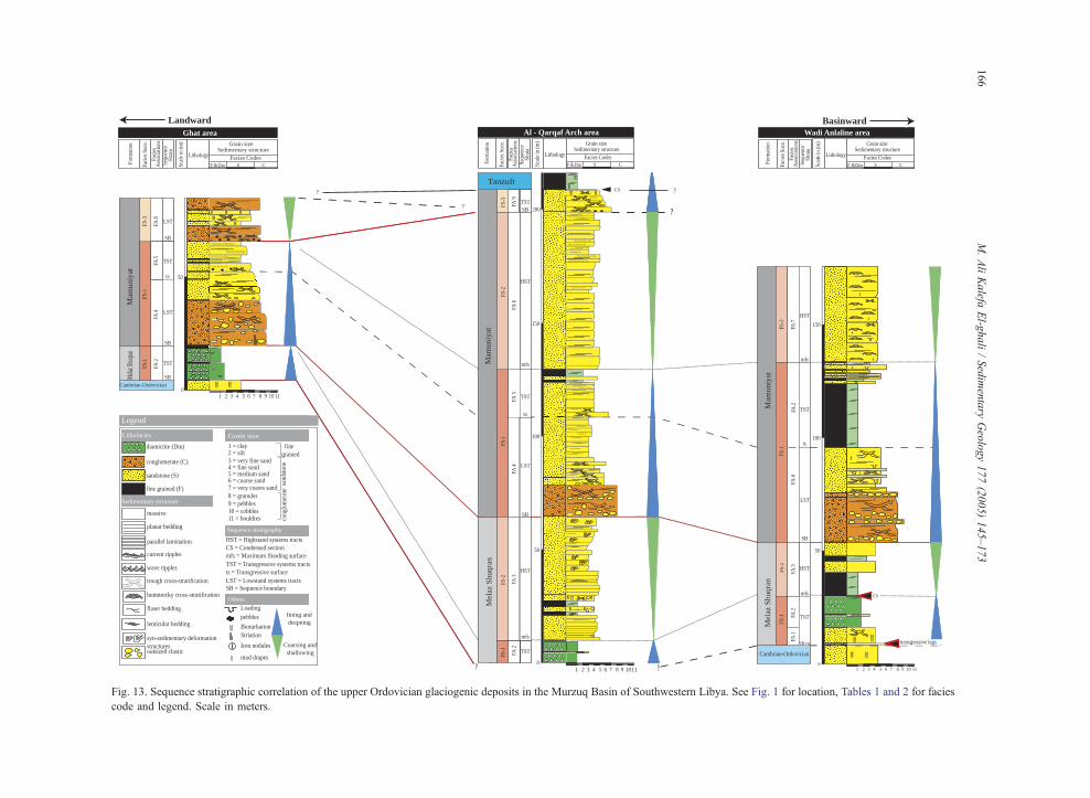
Fig. 13. Sequence stratigraphic correlation of the upper Ordovician glaciogenic deposits in the Murzuq Basin of Southwestern Libya. See Fig. 1 for location, Tables 1 and 2 for facies
code and legend. Scale in meters.
M.AliKalefa
El-g
hali/Sedimentary
Geology177(2005)145–173
166
M. Ali Kalefa El-ghali / Sedimentary Geology 177 (2005) 145–173 167
FA8, which is dominated by trough cross-stratified,
conglomeratic sandstones and extensively bioturbated
trough cross-stratified sandstones that prograde away
from palaeohighs record deposition as Gilbert-type
delta on an erosional surface (Figs. 11A and 12).
These deposits imply significant shallowing across
this unit. FA9, which is dominated by large scale,
trough cross-stratified sandstones, records deposition
in upper shoreface environments (Fig. 12). FA8 and
FA9 together record deposition during a period of
isostatic rebound (Figs. 12 and 13).
5. Facies succession: recognition of glacial,
paraglacial and postglacial isostatic rebound
Based on the interpretations of facies association
and the nature of the boundaries that separate them
(Fig. 13), the upper Ordovician deposits of the
Murzuq Basin display changes in depositional con-
ditions that reflect changes in the rates of sediment
supply and in relative sea level owing to glacial
advance and retreat and concomitant loading and
rebound of the continental shelf. The boundaries
between facies associations are either gradational or
sharp (Fig. 13). The recognition of these major
bounding surfaces at the base of some facies
associations allows recognition of the base of facies
successions (i.e. packages of genetically strata or
allomembers; Walker, 1992), which record large-scale
changes in relative sea level and deposition in glacial,
paraglacial and postglacial settings. Three different
types of facies successions have been recognized
including glacial, paraglacial, and isostatic rebound
cycles (Fig. 13 and Table 2).
5.1. Facies succession 1 (FS-1, glacial deposits)
Two examples of facies succession 1 (FS-1) occur
within the upper Ordovician glaciogenic rocks of the
Murzuq Basin that reflect two cycles of glaciations.
The first glacial cycle (Figs. 4 and 13) comprises FA1
and FA2 and correlates with the lower part of the
Melaz Shuqran Formation. The second glacial cycle
(Figs. 4 and 13) comprises FA2, FA4 and FA5, and
corresponds to the lower part of the Mamuniyat
Formation. The first example of FS-1 represents a
gradual deepening upward succession that deepens
from upper shoreface (FA1) to offshore (FA2) during
the first glacial advance and isostatic loading the shelf
and subsequent glacial retreat (Fig. 7A). The second
example of FS-1 records a shift from braided fluvial,
incised-valley fills (FA4) into tidally influenced
estuarine environments in shallow water areas and
into offshore in deep water areas, during second glacial
advance and subsequent retreat (Fig. 10A and B).
In the first glacial cycle, the basal boundary is a
transgressive lag in deep-water areas that may
correlate with a subglacial erosion surface in shallow
water areas (Figs. 7A and 13). This basal boundary
was formed during a time of glacial advance, loading
the continental shelf and concomitant relative sea-
level rise. The overlying deposits of FA2 were
accumulated during glacial advance and subsequent
glacial retreat. In the second glacial cycle, the basal
boundary of FS-1 is interpreted to represent a
subglacial erosion surface that was formed during
glacial advance (Figs. 11A and 13) in the shallow
water areas, while the overlying deposits were
accumulated during glacial standstill and subsequent
retreat (Figs. 7A,B and 11A,B).
The upper boundary of FS-1 is interpreted as MFS
that was formed during maximum sea level rise due to
glacial retreat, and marks the end of glacial cycles and
the onset of the paraglacial cycle (Fig. 13). The
difference in the sedimentological character of FS-1
between the first and second glacial cycle implies that
the extent of glacial advance was greater during
second glacial cycle, or that glacial retreat was faster
during the first glacial cycle.
5.2. Facies succession 2 (FS-2, paraglacial deposits)
Two examples of facies succession 2 (FS-2) that
reflect two paraglacial cycles in the Murzuq Basin
(Figs. 4 and 13) occur within the late Ordovician
glaciogenic rocks. FS-2 consists of FA3 in the first
paraglacial cycle (Figs. 4 and 13) that correlates with
the upper part of the Melaz Shuqran Formation, and of
FA6 and FA7 in the second paraglacial cycle that
correlate with the middle part of the Mamuniyat
Formation (Figs. 4 and 13).
FS-2 represents a shallowing upward succession as
evidenced by an overall prograding and coarsing
upward of tide-dominated deltaic deposits (FA3) in
the first paraglacial cycle, and progradational fore-
M. Ali Kalefa El-ghali / Sedimentary Geology 177 (2005) 145–173168
shore-shoreface deposits (FA6 and FA8) in the second
paraglacial cycle. The basal boundary of FS-2 is
interpreted to represent MFS, which separates the
deepening upwards succession below from the shal-
lowing upwards succession above. This MFS marks
the end of glacial cycle and the onset of deposition of
paraglacial cycles (Fig. 13). These two paraglacial
deposits are omitted in the shallow water areas (i.e.
Ghat area) due to erosion during second glacier
advance and isostatic rebound (Fig. 13).
5.3. Facies succession 3 (FS-3, isostatic rebound
deposits)
Facies succession 3 (FS-3) occurs above the
second paraglacial cycle, within the upper Mamuniyat
Formation, and consists of Gilbert-type delta (FA 8)
and upper shoreface deposits (FA9, Figs. 4 and 13).
The basal erosional boundary of this facies succession
is interpreted to represent uplift and erosion of the
underlying strata during isostatic rebound (Sutcliffe et
al., 2000a; Fig. 12) and a concomitant relative sea-
level fall that favored deposition of the Gilbert-type
deltaic sediments (FA8). Subsequent global sea-level
rise during the late Ordovician to early Silurian
resulted in the deposition of overlying upper shoreface
sediments (FA9; Fig. 12). The upper boundary of FS-
3 is marked by a distinctive hardground horizon (12
cm thick) of Fe-oxide rich, very fine-grained sand-
stones (Figs. 9D and 13). The top of this bed marks
the boundary between the upper Ordovician and the
overlying hot shale of the lower Silurian Tanzuft
Formation (Fig. 9D).
6. Sequence stratigraphy of the late Ordovician
glacial deposits
An attempt is made below to extend and apply the
methodology of sequence stratigraphy, which were
originally developed for non-glaciated paralic deposits
(e.g. Posamentier et al., 1988a,b; Galloway, 1989; Van
Wagoner et al., 1990; Einsele et al., 1991), to the
upper Ordovician glaciogenic sediments of the Mur-
zuq Basin. The sequence stratigraphic framework
proposed for this basin is based on careful sedimento-
logical and stratigraphic analysis in both outcrop
sections and borehole drilled cores.
Three depositional sequences, which represent
amalgamated units of different facies successions
have been recognized within the upper Ordovician
succession, which contains sequence boundaries,
maximum flooding surfaces and systems tracts
defined for each depositional sequence. Sequence
boundaries are placed at regional unconformities that
have resulted from subglacial or uplift erosion, while
maximum flooding surfaces are placed at surfaces that
define the maximum marine incursion and/or by the
presence of condensed section in the distal basinward
areas.
6.1. Depositional sequence 1
Depositional sequence 1 (DS-1) corresponds to the
entire Melaz Shuqran Formation (Fig. 4), and is
composed of: (i) transgressive systems tract (TST)
comprised of upper shoreface, lower shoreface, and
offshore deposits (i.e. FS-1), and (ii) highstand
systems tract (HST) with deltaic deposits (i.e. FS-2).
The sequence is bounded below by a subglacial
erosion surface that was formed in shallow-water
areas and is correlated with a transgressive surface
(TS) in deep-water areas and at its top by a subglacial
erosion surface. These two subglacial erosion surfaces
are the sequence boundaries of this depositional
sequence (SB; Fig. 13).
Depositional sequence 1 was deposited during a
period of overall transgression related to relative sea-
level rise during glacial advance and loading the
continental shelf and subsequent glacial retreat (Fig.
9A and B). The rise in the relative sea level during
glacial advance is attributed to the slower rate of
eustatic sea level fall than isostatic loading. The
timing of changes in the relative (i.e. transgression–
transgression) relative to glaciation and deglaciation
are very difficult to predict, because of isostatic effects
associated with the same glaciation–deglaciation
event. However, relative sea level rise owing to
glacial advance and loading of the continental shelf
is anticipated to occur subsequent to eustatic sea level
fall during glaciation (Miall and Turner-Keizer,
personal communication, 2004). The formation of a
regional subglacial erosional surface at the base of
DS-1, which cuts into the lower to middle Ordovician
formations (i.e. the Hawaz and the Hasawnah
formations) in the shallow water areas (i.e. Ghat area;
M. Ali Kalefa El-ghali / Sedimentary Geology 177 (2005) 145–173 169
Figs. 1B and 13) during glacial advance is also
associated by erosion of the sediment that is expected
to be deposited in front of the glacier. Thus, the
continental and shallow marine LST deposits are not
preserved in the stratigraphic record of the basin. The
subglacial erosion surface extends and merges with a
transgressive surface marked by lag deposits in deep
water areas (i.e. Wadi Anlalin area; Figs. 1B and 13),
which were formed during initial stages of relative sea
level rise concomitantly with glacial advance and
loading of the shelf.
Deposition of the early TST occurred as a
consequence of relative sea level rise caused by
glacial advance and loading of the continental shelf,
and deposition of upper shoreface sandstones on top
of the transgressive lag deposits (FA1; Figs. 6A and
13). Further rise in the relative sea level occurred as a
consequence of melting of the ice sheet during glacial
retreat, which resulted in the deposition of late TST
that is comprised of silty and muddy diamictite
alternating with layers of current-rippled and hum-
mocky cross-stratified, fine-grained sandstones (FA2;
Fig. 13), and finally mudstones. Rising relative sea
level during glacial retreat (Miller, 1996) was asso-
ciated with sediment starvation in the distal shelf areas
(i.e. deep water areas; c.f. Loutit et al., 1988) and
resulted in the deposition of ca. 0.1–0.15 m thick, of
thin Fe-oxide rich layer of very fine-grained sand-
stones (Figs. 4 and 13). This Fe-oxide layer is
interpreted to represent a condensed section, which
has traditionally been correlated with the maximum
flooding surfaces (Emery and Myers, 1996).
The occurrence of prograding deltaic deposits on
retrogradational, shoreface to offshore deposits sug-
gests regression above the maximum flooding surface.
These regressive deposits, which have been accumu-
lated when the rate of sediment supply ultimately
outstripped the rate of relative sea level rise and
accommodation creation is interpreted to be HST
deposits (FA3; Fig. 9B).
6.2. Depositional sequence 2
Depositional sequence 2 (DS-2) corresponds to the
lower and middle part of the Mamuniyat Formation
(Fig. 4), and is composed of: (i) lowstand systems
tract (LST) comprised of braided fluvial deposits, (ii)
transgressive systems tract (TST) comprised of
estuarine deposits (e.g. FS-1), and (iii) high systems
tract (HST) comprised of foreshore to shoreface
deposits (e.g. FS-2, Figs. 10A,B,C and 13). The
sequence is bounded at its base by a subglacial
erosion surface and its top by uplift erosion surface
(Figs. 4 and 13). These erosional surfaces represent
the sequence boundaries of this depositional sequence
(Fig. 13).
The overall formation and infilling of the incised
valley are consistent with a rapid relative sea level fall
followed by a stillstand and then a slow progressive
rise (e.g. Allen and Posamentier, 1993). The initial
rapid relative sea level fall is believed to have
occurred due to glacial advance and resulted in valley
incision (Smart, 2000; Deynoux and Ghienne, 2004;
Le Heron et al., 2004), and the formation of regional
unconformity (SB) at the base of the valley (Fig. 10A)
because the rate of eustatic sea level fall was faster
than isostatic loading. The valley has incised into the
TST of DS-1 and/or the middle Ordovician formations
(i.e. the Ash Shabiyat and Hawaz formations, Figs. 10
and 13). Deposition of LST occurred due to stabiliza-
tion of the relative sea level at the glacial maximum,
and the subsequent sea level rise was a result of
glacial retreat, which favored the deposition of
braided-fluvial conglomeratic sandstones and parallel
to trough cross-stratified, medium-to-coarse-grained
sandstones.
When the rate of relative sea level rise and
accommodation creation ultimately outstripped the
rate of sediment supply, the shelf was transgressed
and the incised valley was converted into an estuary
(Fig. 10B), and the fluvial deposits were subjected to
reworking by tidal currents. These tidal reworking
processes resulted in the deposition of transgressive
lag deposits at the base of estuary and formation of
transgressive surface (Fig. 13). Thus, the tidally
influenced, incised valley deposits mark the onset of
overall transgression (e.g. Allen and Posamentier,
1993) and the onset of deposition of the TST in DS-2
(Fig. 13). The TST sediments are dominated by wave
rippled and cross-stratified, fine-to-medium-grained
sandstones with mud drapes, and are intercalated with
mudstone (FA5; Figs. 6B and 7D).
The shift from retrogradational estuary into pro-
gradational foreshore to shoreface deposits has been
used as a criterion to recognize the MFS (Emery and
Myers, 1996), and the beginning of overall shoreline
M. Ali Kalefa El-ghali / Sedimentary Geology 177 (2005) 145–173170
regression, at the base of the HST in DS-2 (Figs. 4 and
13). These sediments were formed when the rate of
sediment supply ultimately outstripped the rate of
accommodation creation due to increasing sediment
supply from the ice melting (Fig. 10C). Deposition of
the HST is dominated by parallel, wave and current
rippled, fine-to-medium-grained sandstones of pro-
gradational foreshore, and trough cross-stratified and
hummocky cross-stratified, fine-to-medium-grained
sandstones of progradational lower to upper shoreface
deposits (FA6 and FA7).
6.3. Depositional sequence 3
Depositional sequence 3 (DS-3) corresponds to the
upper part of the Mamuniyat Formation (Fig. 4), and
represents: (i) a lowstand systems tract (LST) that is
comprised of Gilbert-type deltaic deposits, and (ii) a
transgressive systems tract (TST) that is comprised of
upper shoreface deposits. This sequence is bounded at
its base by an erosional surface (SB) and at its top by
condensed section that marks the boundary between
the Mamuniyat Formation below and the Silurian
Tanzuft Formation above (Fig. 13). The initial rapid
fall in relative sea level is believed to be a
consequence of isostatic rebound, which postdated
the last glacial retreat (e.g. Sutcliffe et al., 2000a,b)
and resulted in the formation of regional unconformity
at the base of DS-3 (Fig. 12). This erosional surface
extends down to the lower part of the Melaz Shuqran
Formation (i.e. TST of DS-1) and is devoid of
incision, and thus suggesting removal of the under-
lying facies subsequent to deglaciation and rebound of
the shelf (Figs. 8A and 12).
Subsequent to isostatic rebound, erosion and
formation of a SB, deposition of the LST occurred
during relative-sea level lowstand, which favored the
deposition of Gilbert-type deltaic sediments that
include trough cross-stratified, conglomeratic sand-
stones and bioturbated, trough cross-stratified sand-
stones (FA 8; Fig. 13). As a result of subsequent
relative sea level rise during the late Ordovician and
early Silurian, the accommodation creation ultimately
outstripped the rate of sediment supply and result in
the deposition of retrogradational upper shoreface
deposits (Fig. 12) that marked the onset of the TST in
DS-3 (Fig. 13). The TST within DS-3 comprises
trough cross-stratified, fine-to-medium-grained sand-
stones (FA 9; Fig. 13). Further rising in the relative
sea level was associated with sediment starvation in
the basinward area and resulted in the deposition of
distinctive thin hardground layer. This hardground is
interpreted to be a condensed section (Fig. 13), which
marks the top of the Mamuniyat Formation. The
condensed section is traditionally correlated with the
maximum flooding surfaces (Emery and Myers,
1996).
7. Implication for hydrocarbon exploration
The rocks of the Melaz Shouqran and Mamuniyat
formations represent the main hydrocarbon in the
Murzuq Basin. Therefore, applying sequence strati-
graphic concepts should help to better elucidate and
predict the spatial and temporal distribution of the
depositional facies, and hence of seal and reservoir
rocks. LST and HST deposits are often important
hydrocarbon reservoir targets because they are com-
monly composed of coarse-grained, and thus porous
and permeable deposits (Posamentier and Allen,
1999). Most discoveries of hydrocarbon in the upper
Ordovician rocks occurred in the tide-dominated,
deltaic HST sandstones of the DS-1, and foreshore
to shoreface HST and Gilbert-type deltaic LST sand-
stones of the DS-2 and DS-3. However, successful
exploration of these reservoir rocks in the basin can be
achieved when the impact of changes in the relative
sea level and glacier movements are considered,
which leads to successful prediction of the spatial
and temporal distribution of the depositional facies,
and hence reservoir rocks.
8. Comparison with other sequence stratigraphic
models
Comparison between the sequence stratigraphic
model proposed here and other models for glaciated
basins are of profound important in order to gain better
understanding of facies distribution as a result of
changes in relative sea level owing to glacier move-
ments and their impact on the spatial and temporal
distribution of reservoir and seal rocks. The model
proposed here agrees with that presented by McDou-
gall and Martin (2000) regarding consideration of; (i)
M. Ali Kalefa El-ghali / Sedimentary Geology 177 (2005) 145–173 171
the Melaz Shouqran Formation (i.e. DS-1) as one
depositional sequence formed during relative sea level
rise due to glacial advance loading the continental
shelf and subsequence melting of glacier during
retreat, and (ii) the upper Mamuniyat Formation (DS-
3) as one depositional sequence, which was formed
during isostatic rebound associated with relative sea
level fall and formation of LST sandstones overlain by
TST that formed as a result of global sea level rise
during early Silurian. The disagreement between these
two models is limited to the lower and middle
Mamuniyat Formation. The model in our study regards
the lower and middle Mamuniyat Formation as one
depositional sequence (DS-2), whereas McDougall
and Martin (2000) divided them into three depositional
sequences. Observations of our study do not count the
presence of any subglacial erosion surface as a major
sequence boundary unless it occurs as regional surface,
because such surfaces are localized and preserved in
the ice-proximal areas, which represent local glacial
re-advance of glacier.
The model of this study has several similarities to
the model proposed by O’Brien et al. (1998) for the
Permian glacial succession in Canning Basin, Western
Australia. These authors conclude that: (i) extreme
glacial advance can produce relative sea level at
highstands because the ice sheet loading of the crust
even though eustatic sea level is at lowstand and result
in deposition of TST and HST, which is similar to the
formation of DS-1 in the Murzuq Basin, and (ii)
Glacial advance produces relative sea level fall and
major erosion surface that cuts downward into under-
lying deposits, followed by relative sea level rise
owing to glacial retreat and deposition of LST, TST
and HST, which is similar to the formation of DS-2 in
the Murzuq Basin.
9. Conclusion
This study shows that the spatial and temporal
distribution of upper Ordovician deposits in the
Murzuq Basin can be constrained within a sequence
stratigraphic framework. Important findings of this
work include:
(1) Basin-fill sedimentary facies architecture of
glacial, paraglacial and postglacial deposits
were strongly controlled by changes in the
relative sea level that were induced by
glacial advance and retreat and concomitant
loading and unloading of the continental
shelf and changes in the rate of sediment
supply.
(2) The glaciogenic deposits have three prominent,
regional erosion surfaces that were formed
during glacial advance and/or isostatic rebound,
concomitant with major relative sea level fall.
These erosional surfaces mark the base of three
distinct depositional sequences.
(3) The first depositional sequence (DS-1) was
formed during a time of overall transgression.
Rising relative sea level was caused by glacial
advance and loading the continental shelf (i.e.
the rate of eustatic sea level fall was slower than
isostatic loading) and subsequent glacial retreat,
which resulted in the deposition of transgressive
systems tract (TST).
(4) A further rise in the relative sea level during
glacial retreat was associated with sediment
starvation in the deep-water areas and the
formation of a condensed section that correlates
with a MFS. Progradation of the highstand
systems tract (HST) sediments occurred above
the maximum flooding surface (MFS) when the
rate of sediment supply exceeded the rate of
relative sea level rise.
(5) Deposition of the second depositional sequence
started during an overall relative sea level fall
associated with glacial advance (i.e. rate of
eustatic sea level fall was faster than isostatic
loading) that caused the incision of DS-1 and
the formation of the sequence boundary (SB).
(6) Subsequently, the glacial retreat resulted in
relative sea level rise. Deposition during a glacial
stillstand favored the deposition of braided
fluvial deposits within the incised valley
(LST). The subsequent retreat results in depo-
sition of an estuarine transgressive systems
tract sediment.
(7) Progradation of foreshore to shoreface deposits
occurred when the rate of sediment supply
exceeded the rate of relative sea level rise.
These progradational deposits, which cover the
TST represent regression above MFS and
interpreted to belong to HST.
M. Ali Kalefa El-ghali / Sedimentary Geology 177 (2005) 145–173172
(8) Deposition of the third depositional sequence
occurred during isostatic rebound that postdated
glacial retreat and was concomitant with a rela-
tive sea level fall and the formation of a se-
quence boundary, followed by slow relative sea
level rise and deposition of Gilbert-type deltaic
sediments of LST. Subsequent relative sea level
rise during late Ordovician to early Silurian re-
sulted in the deposition of shoreface TST
sediments.
Acknowledgment
I would like to thank my supervisor Professor Sa-
doon Morad for his critical reading of several versions
of the manuscript. Special thanks go to the Petroleum
Research Center, Tripoli Libya, especially Professor
Ali Sbeta, Dr. A. Bourima and Dr. A. El-Harbi for
supporting the field trip. I also would like to thank my
colleagues K. Ashibani, J. Mayouf, A. Abd-Alkariem
and A. Bedada who accompanied me to the field.
Thanks also go to the National Oil Corporation es-
pecially B. El-Mejrab and data section for providing us
with access to the drill core samples. Thanks go to the
editor, editor assistant and the reviewers for their
comments, which have profound improvement on the
manuscript.
References
Abugares, Y.I., Ramaekers, P., 1993. Short notes and guidebook on
the Palaeozoic geology of the Ghat area, SW Libya, Field trip,
October 14–17, 1993. Earth Science Society of Libya. Interprint
Ltd., Malta. 84 pp.
Allen, G.P., Posamentier, H.W., 1993. Sequence stratigraphy and
facies models of an incised valley fill: the Gironde Estuary,
France. J. Sediment. Petrol. 63, 378–391.
Beuf, S., Biju-Duval, B., DE Charpal, O., Rognon, P., Gariel, O.,
Bennacef, A., 1971. Les gres du Paleozoique inferieur du
Sahara. Sci. Tech. Petrole. Editions Technip, Paris, 18, 464 pp.
Blanpied, C., Deynoux, M., Ghienne, J.F., Rubino, J.L., 2000. Late
Ordovician glacially related depositional systems of the Gargaf
Uplift (Libya) and comparisons with correlative deposits in the
Taoudeni Basin (Mauritania). In: Sola, M.A., Worsley, D.
(Eds.), Symposium on Geological Exploration in Murzuq Basin.
Elsevier, Amsterdam, pp. 485–507.
Boulton, G.S., 1990. Sedimentary and sea level changes during
glacial cycles and their control on glacimarine facies architec-
ture. In: Dowdeswell, J.A., Scourse, J.D. (Eds.), Glacimarine
Environments: Processes and Sediments, Special Publication,
vol. 53. Geological Society of London, pp. 15–52.
Collinson, J.D., 1996. Alluvial sediments. In: Reading, H.G. (Ed.),
Sedimentary Environments: Processes, Facies and Stratigraphy,
3rd edition. Blackwell Science Publication, Oxford, United
Kingdom. 706 pp.
Crowell, J.C., Frakes, L.A., 1971. Late paleozoic glaciation: Part IV.
Australia. Geol. Soc. Amer. Bull. 82, 2515–2540.
Davidson, L., Beswetherick, S., Craig, J., Eales, M., Fisher, A.,
Himmali, A., et al., 2000. The structure, stratigraphy and petroleum
geology of the Murzuq Basin, southwest Libya. In: Sola, M.A.,
Worsley, D. (Eds.), Symposium on Geological Exploration in
Murzuq Basin. Elsevier, Amsterdam, pp. 295–320.
Deynoux, M., 1998. Contribution to the stratigraphy and sedimen-
tology of the upper Ordovician- glacial formations of the
Murzuq Basin, Libya. Unpublished report, CNRS-EOST. Univ.
Louis Pasteur, Strasbourg. 52 pp.
Deynoux, M., Ghienne, J., 2004. Late Ordovician glacial pavement
revisited: a reappraisal of the origin of striated surface. Terra
Nova 16, 95–101.
Echikh, J., Sola, M.A., 2000. Geology and hydrocarbon occurrences
in the Murzuq basin, SW Libya. In: Sola, M.A., Worsley, D.
(Eds.), Symposium on Geological Exploration in Murzuq Basin.
Elsevier, Amsterdam, pp. 175–222.
Einsele, G., Ricken, W., Seilacher, A., 1991. Cycles and events in
stratigraphy—basic concepts and terms. In: Einsele, G., Ricken,
W., Seilacher, A. (Eds.), Cycles and Events in Stratigraphy. St.
John’s: Springer-Verlag, pp. 1–19.
Emery, D., Myers, K.J., 1996. Sequence stratigraphy. B.P explora-
tion. Blackwell Press, London. 297 pp.
Elverhoi, A., Henrich, R., 1996. Glaciomarine environments
ancient glaciomarine sediments. In: Manses, John (Ed.), Past
Glacial Environments: Sediments, Forms and Techniques,
Glacial Environments, vol. 2. Butterworth-Heinemann Ltd,
Oxford, UK, pp. 179–211.
Eyles, N., 1993. Earth’s glacial record and its tectonic setting. Earth
Sci. Rev. 35, 1–248.
Eyles, N., Eyles, C.H., 1992. Glacial depositional systems. In:
Walker, R.G., James, N.P. (Eds.), Facies Models: Response to
Sea Level Change. Geological Association of Canada, St John’s,
pp. 73–100.
Eyles, C.H., Eyles, N., Gostin, V.A., 1998. Facies and allostrati-
graphy of an early Permian polar continental margin: southern
Sydney Basin, Australia. Sedimentology 45, 121–161.
Framca, A.B., Potter, P.E., 1991. Stratigraphy and reservoir potential
of glacial deposits of the Itare Group (Carboniferous to Permian),
Parana basin, Brazil. AAPG Bull. 75, 62–85.
Galloway, W.E., 1989. Genetic stratigraphic sequence in basin
analysis I: architecture and genesis of flooding surface bounded
depositional units. AAPG Bull. 73, 125–142.
Grubic, A., Dimitrijevic, M., Galecic, M., Jakovljevic, Z., Komar-
nicki, S., Protic, D., et al., 1991. Stratigraphy of western Fezzan
(SW Libya). In: Salem, M.J., Belaid, M.N. (Eds.), The Geology
of Libya, vol. IV. Academic Press, London, pp. 1529–1564.
Grunow, A.M., 1999. Gondwana events and palaeogeography: a
palaeomagnetic review. J. Afr. Earth Sci. 28, 53–69.
M. Ali Kalefa El-ghali / Sedimentary Geology 177 (2005) 145–173 173
Herbert, C., 1980. Evidence of glaciation in the Sydney Basin
and Tamworth synclinorial zone. Geol. Surn. NSW Bull. 26,
275–293.
Kent, D.V., Van der Voo, R., 1990. Palaeozoic paleogeography from
palaeomagnetism of Atlantic bordering continents. In: McKer-
row, W.S., Scotese, C.R. (Eds.), Palaeozoic Paleogeography and
Biogeography Geol. Soc. Mem., vol. 12, pp. 49–56.
Le Heron, D., Sutcliffe, O., Bourgig, K., Craig, J., Visentin,
C., Whittington, R., 2004. Sedimentary architecture of
upper Ordovician tunnel valleys, Gargaf Arch, Libya:
implications for a genesis of a hydrocarbon reservoir.
GeoArabia 9, 137–160.
Levell, B.K., Braakman, J.H., Rutten, K.W., 1988. Oman glacia-
tions well log response. AAPG Bull. 72, 775–796.
Loutit, T.S., Hardenbol, J., Vail, P.R., Baum, G.R., 1988.
Condensed sections: the key to age dating and correlation
of continental margin sequence. In: Wilgus, C.K., Hastings,
B.S., Kendall, C.G.S.C., Posamentier, H.W., Ross, C.A., Van
Wagoner, J.C. (Eds.), Sea-level Changes: An Integrated
Approach SEPM Society For Sedimentary, Geology Special
Publication, vol. 42, pp. 183–216.
Makhlouf, I., 2002. Sea-level fluctuations and storm-wave influence
on Ordovician shelf sediments, Jordan. Littoral III, 319–324.
Mamgain, V.D., 1980. The pre-Mesozoic (pre-Cambrian to Paleo-
zoic) stratigraphy of Libya: a reappraisal. Bulletin, vol. 14. IRC,
Tripoli, Libya. 104 pp.
Marini, I.P., Glooschenko, W.A., 1985. Cold climate peat formation
in Canada and its relevance to lower Permian coal measures of
Australia. Earth Sci. Rev. 22, 107–140.
McDougall, N., Martin, M., 2000. Facies models and sequence
stratigraphy of upper Ordovician outcrops, Murzuq Basin,
Libya. In: Sola, D., Worsley, D. (Eds.), Symposium on
Geological Exploration in Murzuq Basin. Elsevier, Amsterdam,
pp. 223–236.
Miller, J.M.G., 1996. Glacial sediments. In: Reading, H.G. (Ed.),
Sedimentary Environments: Processes, Facies and Stratigraphy.
Blackwell science, pp. 454–484.
Nichols, G., 1999. Sedimentology and stratigraphy. Blackwell
Science Publication. 355 pp.
O’Brien, P.E., Lindsay, J.F., Knauer, K., Sexton, M.J., 1998.
Sequence stratigraphy of a sandstone-rich Permian glacial
succession, Fitzroy Trough, Canning Basin, Western Australia.
Aust. J. Earth Sci. 45, 533–545.
Pierobon, E.S.T., 1991. Contribution to the stratigraphy of the
Murzuq Basin, SW Libya. In: Salem, M.J., Belaid, M.N.
(Eds.), The Geology of Libya, vol. V. Elsevier, Amsterdam,
pp. 1767–1783.
Posamentier, H.W., Allen, G.P., 1993. Variability of the sequence
stratigraphic model: effects of local basin factors. Sedimentol.
Geol. 86, 91–109.
Posamentier, H.W., Allen, G.P., 1999. Siliciclastic sequence
stratigraphy—concepts and applications. Special Publication,
vol. 7. Society of Economic Palaeontologists and Mineralogists.
210 pp.
Posamentier, H.W., Jervey, M.T., Vail, P.R., 1988a. Eustatic controls
on clastic deposition. I—Conceptual framework. In: Wilgus,
C.K., et al. (Eds.), Sea Level Changes: An Integrated Approach,
Special Publication, vol. 42. Society of Economic Palaeon-
tologists and Mineralogists, pp. 109–124.
Posamentier, H.W., Jervey, M.T., Vail, P.R., 1988b. Eustatic controls
on clastic deposition. II—Sequence and systems tract models.
In: Wilgus, C.K., et al. (Eds.), Sea Level Changes: An Integrated
Approach, Special Publication, vol. 42. Society of Economic
Palaeontologists and Mineralogists, pp. 125–154.
Powell, R.D., Cooper, J.M., 2000. A glacial sequence
stratigraphic model for temperate, glaciated continental
shelves. Special Publication, vol. 203. Geological Society,
London, pp. 215–244.
Reineck, H.E., Singh, I.B., 1980. Depositional environments, 2nd
ed. Springer-Verlag, New York. 549 pp.
Schwarzacher, W., 1993. Cyclostratigraphy and the Milankovitch
theory. Developments in Sedimentology, vol. 52. Elsevier,
Amsterdam. 140 pp.
Scotese, C.R., Boucot, A.J., McKerrow, W.S., 1999. Gondwana
paleogeography and palaeoclimatology. J. Afr. Earth Sci. 28,
99–114.
Smart, J., 2000. Seismic expression of depositional processes in
the upper Ordovician succession of the Murzuq Basin, SW
Libya. In: Sola, M.A., Worsley, D. (Eds.), Symposium on
Geological Exploration in Murzuq Basin. Elsevier, Amsterdam.
p. 397–415.
Smith, A.G., 1997. Estimates of the Earth’s spin (geographic) axis
relative to Gondwana from glacial sediments and palaeomag-
netism. Earth Sci. Rev. 41, 161–179.
Sutcliffe, O.E., Harper, D.A.T., Ait Salem, A., Whittington, R.J.,
Craig, J., 2000a. The development of a typical Hirnantian-
brachiopod fauna and the onset of glaciation in the late
Ordovician of Gondwana. Trans. R. Soc. Edinb. Earth Sci. 92,
1–14.
Sutcliffe, O.E., Dowdeswell, J.A., Whittington, R.J., Theron, J.N.,
Craig, J., 2000b. Calibrating the Late Ordovician glaciation and
mass extinction by the eccentricity cycles of the Earth’s orbit.
Geology 18, 967–970.
Syvietski, J.P.M., Farrow, G.E., 1989. Fjord sedimentation as an
analogue for small hydrocarbon-bearing fan deltas. In: Whate-
ley, M.K.G., Pickering, K.T. (Eds.), Deltas Sites and Traps for
Fossil Fuels. Geological Society of London, pp. 21–43. Special
publication.
Unrug, R., 1996. The assembly of Gondwanaland: scientific results
of IGCP project 288: gondwanaland sutures and mobile belts.
Episodes 19, 11–20.
Van Wagoner, J.C., Mitchum, R.M., Campion, K.M., Rahmanian,
V.D., 1990. Siliciclastic sequence stratigraphy in well logs, cores,
and outcrops: concepts for high-resolution to correlation of time
and facies. American Association of Petroleum Geologists
methods in Exploration Series, vol. 7. 55 pp.
Walker, R.G., 1992. Facies, facies models and modern stratigraphic
concepts. In: Walker, R.G., James, N.P. (Eds.), Facies Models:
Response to Sea Level Change. Geological Association of
Canada, St. Johns, Newfoundland, pp. 1–14.
Walker, R.G., Plint, A.G., 1992.Wave- and storm-dominated shallow
marine systems. In: Walker, R.G., James, N.P. (Eds.), Facies
Models: Response to Sea Level Change. Geological Association
of Canada, St. Johns, Newfoundland, pp. 219–238.