
DCP-2014-Chapter-1-Non-residential-development-in-rural ...
21
Kyogle Development Control Plan 2014 Chapter 1 Non-Residential Development in Rural Zones RU1, RU2, RU3 and RU4 Page 4 CHAPTER 1 NON-RESIDENTIAL DEVELOPMENT IN RURAL ZONES RU1, RU2, RU3 AND RU4
-
Upload
khangminh22 -
Category
Documents
-
view
1 -
download
0
Transcript of DCP-2014-Chapter-1-Non-residential-development-in-rural ...
Kyogle Development Control Plan 2014
Chapter 1 Non-Residential Development in Rural Zones RU1, RU2, RU3 and RU4 Page 4
CHAPTER 1 NON-RESIDENTIAL DEVELOPMENT IN RURAL ZONES RU1, RU2, RU3 AND RU4

Kyogle Development Control Plan 2014
Chapter 1 Non-Residential Development in Rural Zones RU1, RU2, RU3 and RU4 Page 5
TABLE OF CONTENTS
Application ............................................................................................................................................................ 6 Aims of Chapter 1 ................................................................................................................................................ 6
Application ............................................................................................................................................................ 7 Objectives .............................................................................................................................................................. 7 Development Guidelines .................................................................................................................................. 8
Application .......................................................................................................................................................... 14 Exempt Development ...................................................................................................................................... 14 Objectives ............................................................................................................................................................ 14 Development Guidelines ................................................................................................................................ 14
Application .......................................................................................................................................................... 17 Objectives ............................................................................................................................................................ 17 Development Guidelines ................................................................................................................................ 18
Table C1.1 – Recommended minimum buffer distances (metres) ................................................................. 23 Table C1.2 Preferred operational or opening hours ............................................................................................ 24

Kyogle Development Control Plan 2014
Chapter 1 Non-Residential Development in Rural Zones RU1, RU2, RU3 and RU4 Page 6
1 Introduction
Application
This Chapter applies in preparing and assessing applications for development in rural Zones RU1 Primary Production, RU2 Rural Landscape, RU3 Forestry and RU4 Primary Production Small Lots, excluding residential development, subdivision, forestry, extractive industries and other development where regulated by other chapters of this DCP.
Aims of Chapter 1
a) To facilitate development in rural areas that is consistent with the objectives of the applicable zone and does not reduce the viability or potential of Regionally Significant Farmland1 or Class 1, 2 or 3 agricultural land2.
b) To assist potential developers to select suitable development sites. c) To provide development guidelines to assist the design of development proposals and
preparation of development applications and the assessment of those applications. 1As mapped by the Northern Rivers Farmland Protection Project (Department of Infrastructure, Planning and Natural Resources and Department of Primary Industries), 2005 2As mapped on Rural Land Capability maps produced by the NSW Department of Land and Water Conservation
Kyogle Development Control Plan 2014
Chapter 1 Non-Residential Development in Rural Zones RU1, RU2, RU3 and RU4 Page 7
Intensive Livestock Agriculture, Rural Industries and Animal Boarding or Training Establishments
Application
This section applies to development for the purposes of intensive livestock agriculture, rural industries and animal boarding or training establishments in Zones RU1, RU2, RU3 and RU4 where permitted with consent under the Kyogle LEP 2012. The Kyogle LEP 2012 states that a rural industry includes the following activities:
• Agricultural produce industries • Livestock processing industries (including abattoirs) • Composting facilities and works (including the production of mushroom substrate) • Sawmill or log processing works • Stock and sale yards • The regular servicing or repairing of plant or equipment used for the purposes of a rural
enterprise
Objectives
a) To facilitate development of intensive livestock agriculture, rural industries and animal boarding or training establishments in appropriate locations.
b) To encourage the development of rural industries that complements the agricultural activities within the Council area.
c) To ensure development does not fragment or significantly reduce the potential or viability of Regionally Significant Farmland1 or Class 1, 2 or 3 agricultural land2.
d) To ensure that development is appropriately sited and adequate buffers are provided to sensitive land uses so as to minimise the potential for land use conflict.
e) To ensure the design and operation of development does not create unacceptable impacts on the amenity of surrounding properties.
f) To ensure that development does not adversely impact on biodiversity, endangered ecological communities, fauna corridors or threatened species.
g) To minimise adverse impacts on the character of the rural landscape. h) To ensure development does not adversely impact on water quality and the ecological and
hydrological functions of watercourses, wetlands or water bodies. i) To ensure that development is adequately serviced and does not create unreasonable demands
on public infrastructure. j) To ensure that development has safe and suitable vehicular access. k) To ensure preservation of cultural heritage.
1As defined by the Northern Rivers Farmland Protection Project (Department of Infrastructure, Planning and Natural Resources and Department of Primary Industries), 2005
2As mapped on Rural Land Capability maps produced by the NSW Department of Land and Water Conservation
Kyogle Development Control Plan 2014
Chapter 1 Non-Residential Development in Rural Zones RU1, RU2, RU3 and RU4 Page 8
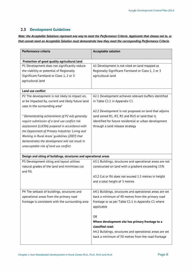
Development Guidelines
Note: the Acceptable Solutions represent one way to meet the Performance Criteria. Applicants that choose not to, or that cannot meet an Acceptable Solution must demonstrate how they meet the corresponding Performance Criteria.
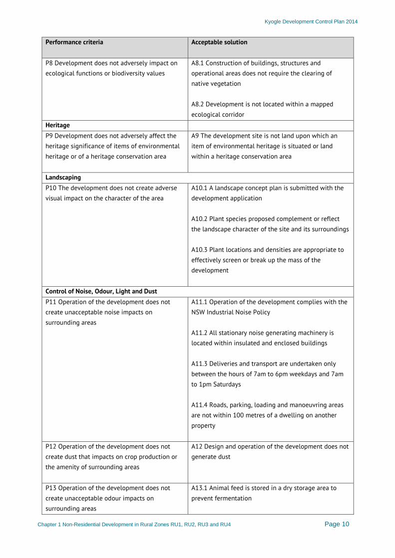
Performance criteria
Acceptable solution
Protection of good quality agricultural land P1 Development does not significantly reduce the viability or potential of Regionally Significant Farmland or Class 1, 2 or 3 agricultural land
A1 Development is not sited on land mapped as Regionally Significant Farmland or Class 1, 2 or 3 agricultural land
Land use conflict P2 The development is not likely to impact on, or be impacted by, current and likely future land uses in the surrounding area* * Demonstrating achievement of P2 will generally require submission of a land use conflict risk assessment (LUCRA) prepared in accordance with the Department of Primary Industries ‘Living and Working in Rural Areas’ guidelines (2007) that demonstrates the development will not result in unacceptable risk of land use conflict
A2.1 Development achieves relevant buffers identified in Table C1.1 in Appendix C1 A2.2 Development is not proposed on land that adjoins land zoned R1, R3, R5 and RU5 or land that is identified for future residential or urban development through a land release strategy
Design and siting of buildings, structures and operational areas P3 Development siting and layout utilises natural grades of the land and minimises cut and fill
A3.1 Buildings, structures and operational areas are not constructed on land with a gradient exceeding 15% A3.2 Cut or fill does not exceed 1.5 metres in height and a total height of 3 metres
P4 The setback of buildings, structures and operational areas from the primary road frontage is consistent with the surrounding area
A4.1 Buildings, structures and operational areas are set back a minimum of 40 metres from the primary road frontage or as per Table C1.1 in Appendix C1 where applicable OR Where development site has primary frontage to a classified road: A4.2 Buildings, structures and operational areas are set back a minimum of 50 metres from the road frontage
Kyogle Development Control Plan 2014
Chapter 1 Non-Residential Development in Rural Zones RU1, RU2, RU3 and RU4 Page 9
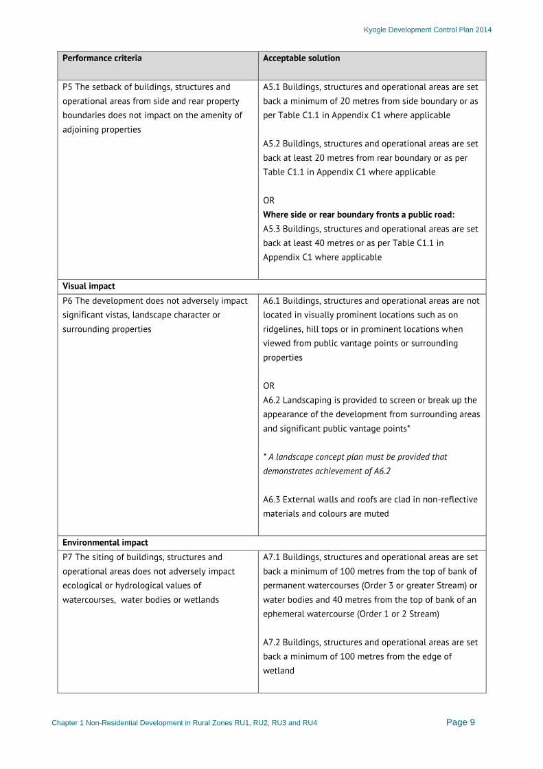
Performance criteria
Acceptable solution
P5 The setback of buildings, structures and operational areas from side and rear property boundaries does not impact on the amenity of adjoining properties
A5.1 Buildings, structures and operational areas are set back a minimum of 20 metres from side boundary or as per Table C1.1 in Appendix C1 where applicable A5.2 Buildings, structures and operational areas are set back at least 20 metres from rear boundary or as per Table C1.1 in Appendix C1 where applicable OR Where side or rear boundary fronts a public road: A5.3 Buildings, structures and operational areas are set back at least 40 metres or as per Table C1.1 in Appendix C1 where applicable
Visual impact P6 The development does not adversely impact significant vistas, landscape character or surrounding properties
A6.1 Buildings, structures and operational areas are not located in visually prominent locations such as on ridgelines, hill tops or in prominent locations when viewed from public vantage points or surrounding properties OR A6.2 Landscaping is provided to screen or break up the appearance of the development from surrounding areas and significant public vantage points* * A landscape concept plan must be provided that demonstrates achievement of A6.2 A6.3 External walls and roofs are clad in non-reflective materials and colours are muted
Environmental impact P7 The siting of buildings, structures and operational areas does not adversely impact ecological or hydrological values of watercourses, water bodies or wetlands
A7.1 Buildings, structures and operational areas are set back a minimum of 100 metres from the top of bank of permanent watercourses (Order 3 or greater Stream) or water bodies and 40 metres from the top of bank of an ephemeral watercourse (Order 1 or 2 Stream) A7.2 Buildings, structures and operational areas are set back a minimum of 100 metres from the edge of wetland
Kyogle Development Control Plan 2014
Chapter 1 Non-Residential Development in Rural Zones RU1, RU2, RU3 and RU4 Page 10
Performance criteria
Acceptable solution
P8 Development does not adversely impact on ecological functions or biodiversity values
A8.1 Construction of buildings, structures and operational areas does not require the clearing of native vegetation A8.2 Development is not located within a mapped ecological corridor
Heritage P9 Development does not adversely affect the heritage significance of items of environmental heritage or of a heritage conservation area
A9 The development site is not land upon which an item of environmental heritage is situated or land within a heritage conservation area
Landscaping P10 The development does not create adverse visual impact on the character of the area
A10.1 A landscape concept plan is submitted with the development application A10.2 Plant species proposed complement or reflect the landscape character of the site and its surroundings A10.3 Plant locations and densities are appropriate to effectively screen or break up the mass of the development
Control of Noise, Odour, Light and Dust P11 Operation of the development does not create unacceptable noise impacts on surrounding areas
A11.1 Operation of the development complies with the NSW Industrial Noise Policy A11.2 All stationary noise generating machinery is located within insulated and enclosed buildings A11.3 Deliveries and transport are undertaken only between the hours of 7am to 6pm weekdays and 7am to 1pm Saturdays A11.4 Roads, parking, loading and manoeuvring areas are not within 100 metres of a dwelling on another property
P12 Operation of the development does not create dust that impacts on crop production or the amenity of surrounding areas
A12 Design and operation of the development does not generate dust
P13 Operation of the development does not create unacceptable odour impacts on surrounding areas
A13.1 Animal feed is stored in a dry storage area to prevent fermentation
Kyogle Development Control Plan 2014
Chapter 1 Non-Residential Development in Rural Zones RU1, RU2, RU3 and RU4 Page 11
Performance criteria
Acceptable solution
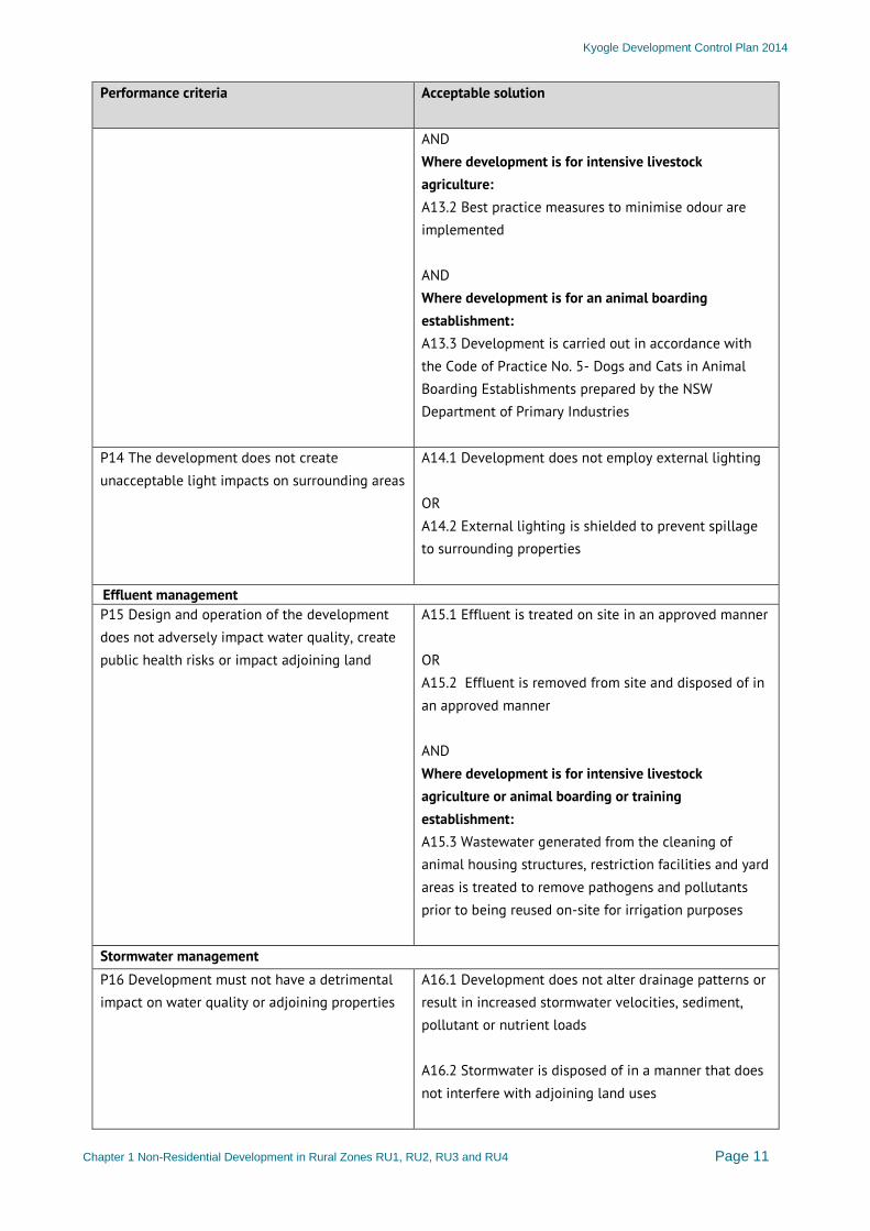
AND Where development is for intensive livestock agriculture: A13.2 Best practice measures to minimise odour are implemented AND Where development is for an animal boarding establishment: A13.3 Development is carried out in accordance with the Code of Practice No. 5- Dogs and Cats in Animal Boarding Establishments prepared by the NSW Department of Primary Industries
P14 The development does not create unacceptable light impacts on surrounding areas
A14.1 Development does not employ external lighting OR A14.2 External lighting is shielded to prevent spillage to surrounding properties
Effluent management P15 Design and operation of the development does not adversely impact water quality, create public health risks or impact adjoining land
A15.1 Effluent is treated on site in an approved manner OR A15.2 Effluent is removed from site and disposed of in an approved manner AND Where development is for intensive livestock agriculture or animal boarding or training establishment: A15.3 Wastewater generated from the cleaning of animal housing structures, restriction facilities and yard areas is treated to remove pathogens and pollutants prior to being reused on-site for irrigation purposes
Stormwater management P16 Development must not have a detrimental impact on water quality or adjoining properties
A16.1 Development does not alter drainage patterns or result in increased stormwater velocities, sediment, pollutant or nutrient loads A16.2 Stormwater is disposed of in a manner that does not interfere with adjoining land uses
Kyogle Development Control Plan 2014
Chapter 1 Non-Residential Development in Rural Zones RU1, RU2, RU3 and RU4 Page 12
Performance criteria
Acceptable solution
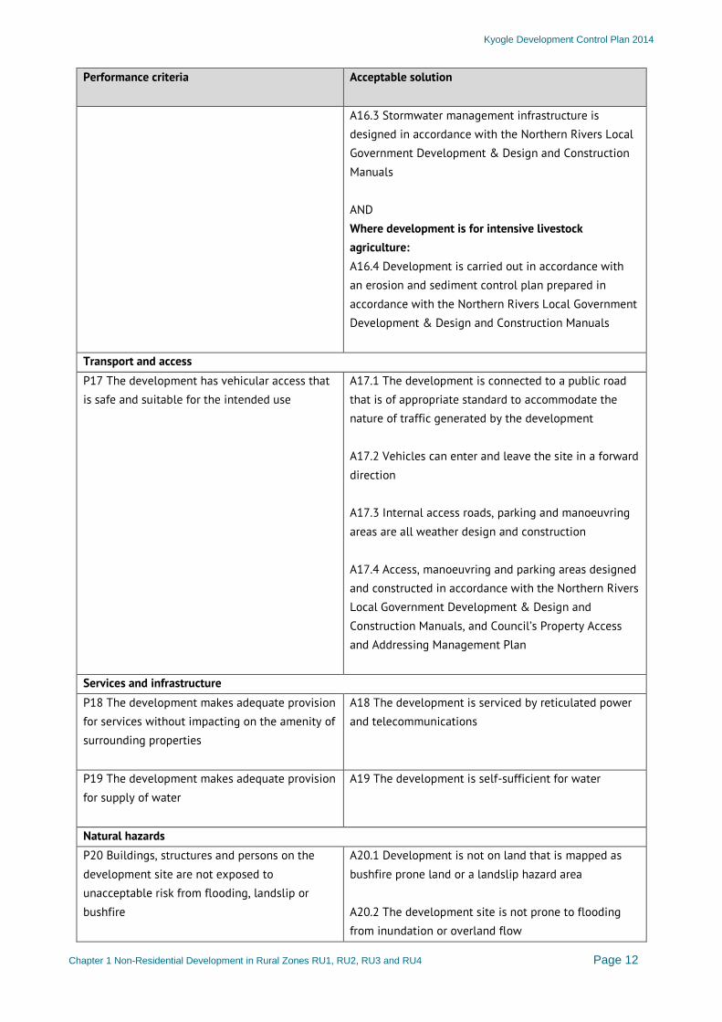
A16.3 Stormwater management infrastructure is designed in accordance with the Northern Rivers Local Government Development & Design and Construction Manuals AND Where development is for intensive livestock agriculture: A16.4 Development is carried out in accordance with an erosion and sediment control plan prepared in accordance with the Northern Rivers Local Government Development & Design and Construction Manuals
Transport and access P17 The development has vehicular access that is safe and suitable for the intended use
A17.1 The development is connected to a public road that is of appropriate standard to accommodate the nature of traffic generated by the development A17.2 Vehicles can enter and leave the site in a forward direction A17.3 Internal access roads, parking and manoeuvring areas are all weather design and construction A17.4 Access, manoeuvring and parking areas designed and constructed in accordance with the Northern Rivers Local Government Development & Design and Construction Manuals, and Council’s Property Access and Addressing Management Plan
Services and infrastructure P18 The development makes adequate provision for services without impacting on the amenity of surrounding properties
A18 The development is serviced by reticulated power and telecommunications
P19 The development makes adequate provision for supply of water
A19 The development is self-sufficient for water
Natural hazards P20 Buildings, structures and persons on the development site are not exposed to unacceptable risk from flooding, landslip or bushfire
A20.1 Development is not on land that is mapped as bushfire prone land or a landslip hazard area A20.2 The development site is not prone to flooding from inundation or overland flow
Kyogle Development Control Plan 2014
Chapter 1 Non-Residential Development in Rural Zones RU1, RU2, RU3 and RU4 Page 13
Performance criteria
Acceptable solution
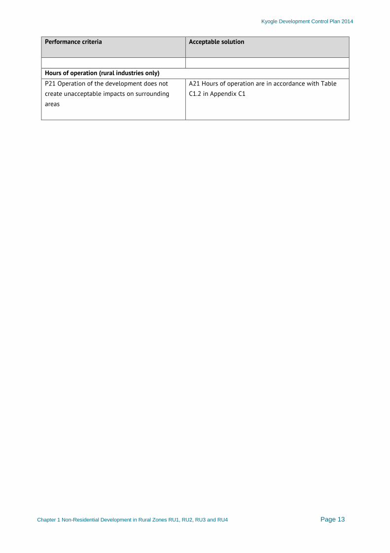
Hours of operation (rural industries only) P21 Operation of the development does not create unacceptable impacts on surrounding areas
A21 Hours of operation are in accordance with Table C1.2 in Appendix C1
Kyogle Development Control Plan 2014
Chapter 1 Non-Residential Development in Rural Zones RU1, RU2, RU3 and RU4 Page 14
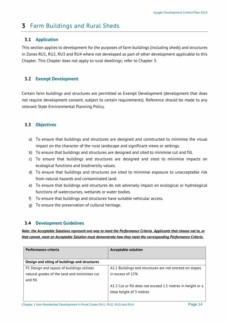
Farm Buildings and Rural Sheds
Application
This section applies to development for the purposes of farm buildings (including sheds) and structures in Zones RU1, RU2, RU3 and RU4 where not developed as part of other development applicable to this Chapter. This Chapter does not apply to rural dwellings; refer to Chapter 3.
Exempt Development
Certain farm buildings and structures are permitted as Exempt Development (development that does not require development consent, subject to certain requirements). Reference should be made to any relevant State Environmental Planning Policy.
Objectives
a) To ensure that buildings and structures are designed and constructed to minimise the visual
impact on the character of the rural landscape and significant views or settings. b) To ensure that buildings and structures are designed and sited to minimise cut and fill. c) To ensure that buildings and structures are designed and sited to minimise impacts on
ecological functions and biodiversity values. d) To ensure that buildings and structures are sited to minimise exposure to unacceptable risk
from natural hazards and contaminated land. e) To ensure that buildings and structures do not adversely impact on ecological or hydrological
functions of watercourses, wetlands or water bodies. f) To ensure that buildings and structures have suitable vehicular access. g) To ensure the preservation of cultural heritage.
Development Guidelines
Note: the Acceptable Solutions represent one way to meet the Performance Criteria. Applicants that choose not to, or that cannot, meet an Acceptable Solution must demonstrate how they meet the corresponding Performance Criteria.
Performance criteria
Acceptable solution
Design and siting of buildings and structures P1 Design and layout of buildings utilises natural grades of the land and minimises cut and fill
A1.1 Buildings and structures are not erected on slopes in excess of 15% A1.2 Cut or fill does not exceed 1.5 metres in height or a total height of 3 metres
Kyogle Development Control Plan 2014
Chapter 1 Non-Residential Development in Rural Zones RU1, RU2, RU3 and RU4 Page 15
Performance criteria
Acceptable solution
P2 The setback of buildings and structures to the primary road frontage is consistent with the surrounding area
A2.1 Buildings and structures are set back a minimum of 20 metres from the primary road frontage, where the road is not a classified road OR Where development site has primary frontage to a classified road: A2.2 Buildings and structures are set back a minimum of 50 metres from the road frontage
P3 The setback of buildings and structures does not impact on the amenity of adjoining properties or the surrounding area
A3.1 Buildings and structures are set back a minimum of 10 metres from side and rear boundaries OR Where side or rear boundary fronts a public road: A3.2 Buildings and structures are set back a minimum of 20 metres from boundary
P4 The siting of buildings and structures does not impact on ecological or hydrological values of watercourses and water bodies
A4 Buildings and structures are set back a minimum of 100 metres from the top of bank of permanent or ephemeral watercourses and water bodies
P5 The development does not adversely impact significant vistas, landscape character or surrounding properties
A5.1 Buildings and structures are not located in visually prominent locations such as on ridgelines, hill tops or in prominent locations when viewed from public vantage points OR A5.2 Landscaping is provided to screen or break up the appearance of the development from surrounding areas and significant vantage points* * A landscape concept plan must be provided that demonstrates achievement of A5.2 AND A5.3 External walls and roofs are clad in non-reflective materials and colours are muted. This includes colourbond materials.
P6 Development does not create unacceptable impact on ecological functions or biodiversity values
A6.1 Siting of buildings and structures does not require the clearing of native vegetation A6.2 Development is not located within a mapped ecological corridor
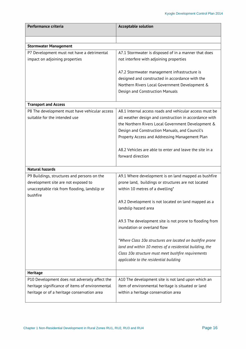
Kyogle Development Control Plan 2014
Chapter 1 Non-Residential Development in Rural Zones RU1, RU2, RU3 and RU4 Page 16
Performance criteria
Acceptable solution
Stormwater Management P7 Development must not have a detrimental impact on adjoining properties
A7.1 Stormwater is disposed of in a manner that does not interfere with adjoining properties A7.2 Stormwater management infrastructure is designed and constructed in accordance with the Northern Rivers Local Government Development & Design and Construction Manuals
Transport and Access P8 The development must have vehicular access suitable for the intended use
A8.1 Internal access roads and vehicular access must be all weather design and construction in accordance with the Northern Rivers Local Government Development & Design and Construction Manuals, and Council’s Property Access and Addressing Management Plan A8.2 Vehicles are able to enter and leave the site in a forward direction
Natural hazards P9 Buildings, structures and persons on the development site are not exposed to unacceptable risk from flooding, landslip or bushfire
A9.1 Where development is on land mapped as bushfire prone land, buildings or structures are not located within 10 metres of a dwelling* A9.2 Development is not located on land mapped as a landslip hazard area A9.3 The development site is not prone to flooding from inundation or overland flow *Where Class 10a structures are located on bushfire prone land and within 10 metres of a residential building, the Class 10a structure must meet bushfire requirements applicable to the residential building
Heritage P10 Development does not adversely affect the heritage significance of items of environmental heritage or of a heritage conservation area
A10 The development site is not land upon which an item of environmental heritage is situated or land within a heritage conservation area
Kyogle Development Control Plan 2014
Chapter 1 Non-Residential Development in Rural Zones RU1, RU2, RU3 and RU4 Page 17
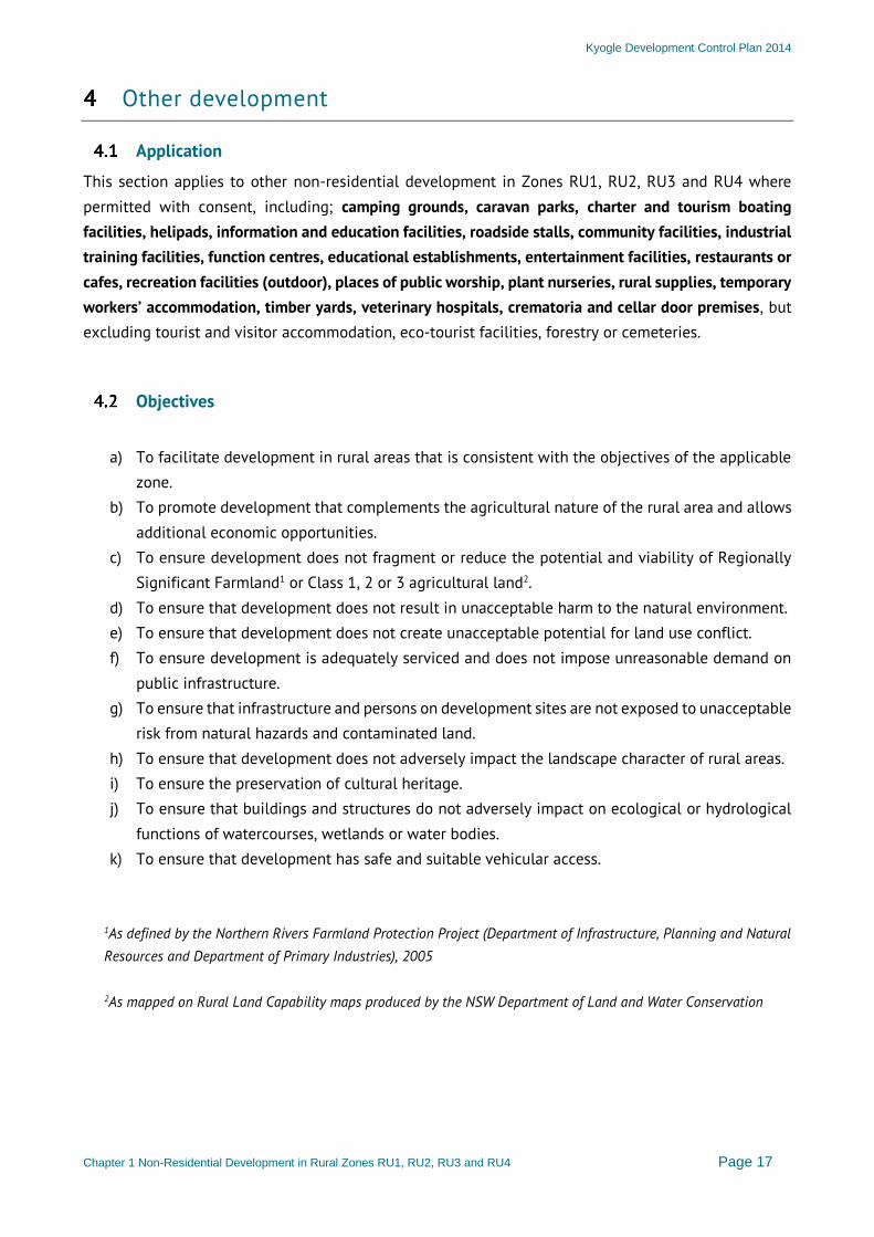
Other development
Application
This section applies to other non-residential development in Zones RU1, RU2, RU3 and RU4 where permitted with consent, including; camping grounds, caravan parks, charter and tourism boating facilities, helipads, information and education facilities, roadside stalls, community facilities, industrial training facilities, function centres, educational establishments, entertainment facilities, restaurants or cafes, recreation facilities (outdoor), places of public worship, plant nurseries, rural supplies, temporary workers’ accommodation, timber yards, veterinary hospitals, crematoria and cellar door premises, but excluding tourist and visitor accommodation, eco-tourist facilities, forestry or cemeteries.
Objectives
a) To facilitate development in rural areas that is consistent with the objectives of the applicable
zone. b) To promote development that complements the agricultural nature of the rural area and allows
additional economic opportunities. c) To ensure development does not fragment or reduce the potential and viability of Regionally
Significant Farmland1 or Class 1, 2 or 3 agricultural land2. d) To ensure that development does not result in unacceptable harm to the natural environment. e) To ensure that development does not create unacceptable potential for land use conflict. f) To ensure development is adequately serviced and does not impose unreasonable demand on
public infrastructure. g) To ensure that infrastructure and persons on development sites are not exposed to unacceptable
risk from natural hazards and contaminated land. h) To ensure that development does not adversely impact the landscape character of rural areas. i) To ensure the preservation of cultural heritage. j) To ensure that buildings and structures do not adversely impact on ecological or hydrological
functions of watercourses, wetlands or water bodies. k) To ensure that development has safe and suitable vehicular access.
1As defined by the Northern Rivers Farmland Protection Project (Department of Infrastructure, Planning and Natural Resources and Department of Primary Industries), 2005 2As mapped on Rural Land Capability maps produced by the NSW Department of Land and Water Conservation
Kyogle Development Control Plan 2014
Chapter 1 Non-Residential Development in Rural Zones RU1, RU2, RU3 and RU4 Page 18
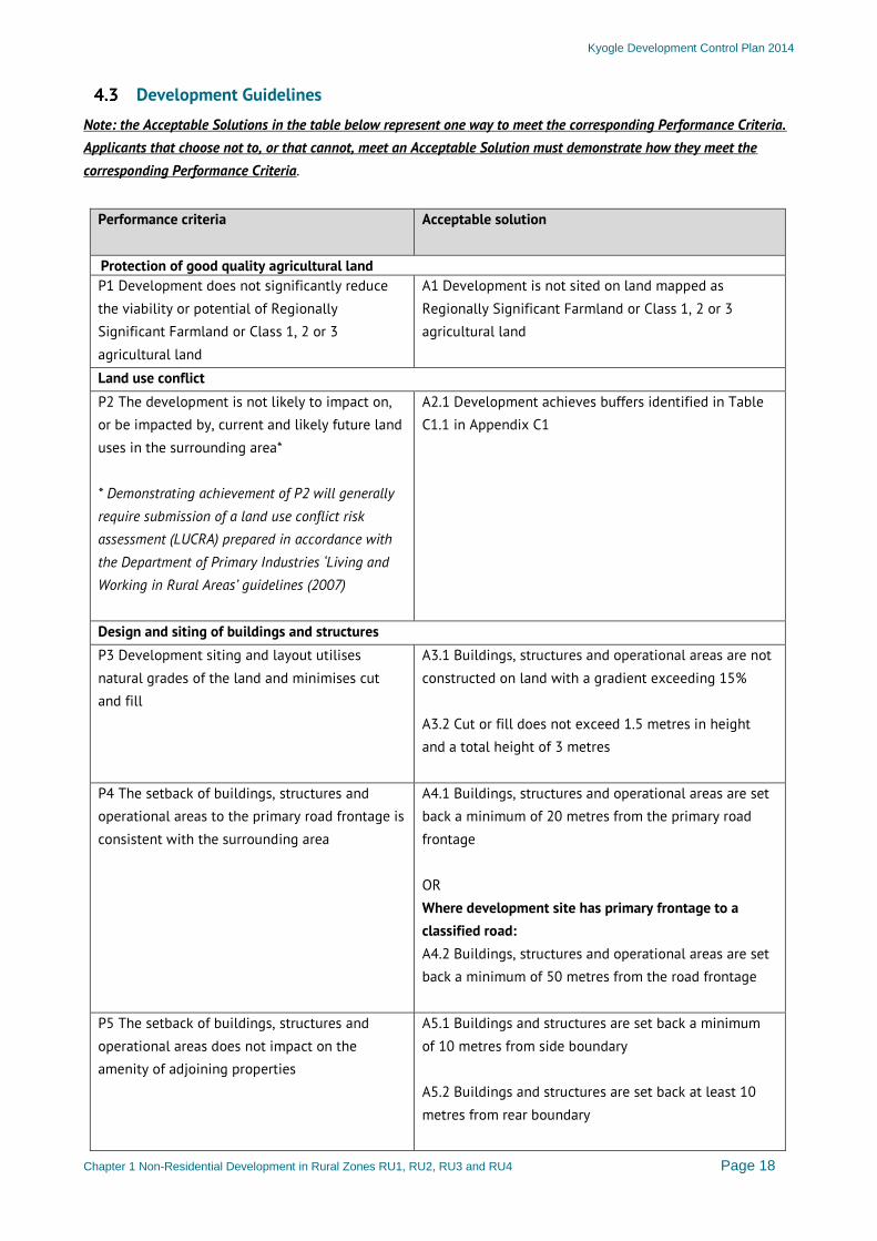
Development Guidelines
Note: the Acceptable Solutions in the table below represent one way to meet the corresponding Performance Criteria. Applicants that choose not to, or that cannot, meet an Acceptable Solution must demonstrate how they meet the corresponding Performance Criteria.
Performance criteria
Acceptable solution
Protection of good quality agricultural land P1 Development does not significantly reduce the viability or potential of Regionally Significant Farmland or Class 1, 2 or 3 agricultural land
A1 Development is not sited on land mapped as Regionally Significant Farmland or Class 1, 2 or 3 agricultural land
Land use conflict P2 The development is not likely to impact on, or be impacted by, current and likely future land uses in the surrounding area* * Demonstrating achievement of P2 will generally require submission of a land use conflict risk assessment (LUCRA) prepared in accordance with the Department of Primary Industries ‘Living and Working in Rural Areas’ guidelines (2007)
A2.1 Development achieves buffers identified in Table C1.1 in Appendix C1
Design and siting of buildings and structures P3 Development siting and layout utilises natural grades of the land and minimises cut and fill
A3.1 Buildings, structures and operational areas are not constructed on land with a gradient exceeding 15% A3.2 Cut or fill does not exceed 1.5 metres in height and a total height of 3 metres
P4 The setback of buildings, structures and operational areas to the primary road frontage is consistent with the surrounding area
A4.1 Buildings, structures and operational areas are set back a minimum of 20 metres from the primary road frontage OR Where development site has primary frontage to a classified road: A4.2 Buildings, structures and operational areas are set back a minimum of 50 metres from the road frontage
P5 The setback of buildings, structures and operational areas does not impact on the amenity of adjoining properties
A5.1 Buildings and structures are set back a minimum of 10 metres from side boundary A5.2 Buildings and structures are set back at least 10 metres from rear boundary
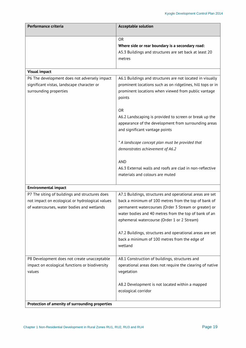
Kyogle Development Control Plan 2014
Chapter 1 Non-Residential Development in Rural Zones RU1, RU2, RU3 and RU4 Page 19
Performance criteria
Acceptable solution
OR Where side or rear boundary is a secondary road: A5.3 Buildings and structures are set back at least 20 metres
Visual impact P6 The development does not adversely impact significant vistas, landscape character or surrounding properties
A6.1 Buildings and structures are not located in visually prominent locations such as on ridgelines, hill tops or in prominent locations when viewed from public vantage points OR A6.2 Landscaping is provided to screen or break up the appearance of the development from surrounding areas and significant vantage points * A landscape concept plan must be provided that demonstrates achievement of A6.2 AND A6.3 External walls and roofs are clad in non-reflective materials and colours are muted
Environmental impact P7 The siting of buildings and structures does not impact on ecological or hydrological values of watercourses, water bodies and wetlands
A7.1 Buildings, structures and operational areas are set back a minimum of 100 metres from the top of bank of permanent watercourses (Order 3 Stream or greater) or water bodies and 40 metres from the top of bank of an ephemeral watercourse (Order 1 or 2 Stream) A7.2 Buildings, structures and operational areas are set back a minimum of 100 metres from the edge of wetland
P8 Development does not create unacceptable impact on ecological functions or biodiversity values
A8.1 Construction of buildings, structures and operational areas does not require the clearing of native vegetation A8.2 Development is not located within a mapped ecological corridor
Protection of amenity of surrounding properties
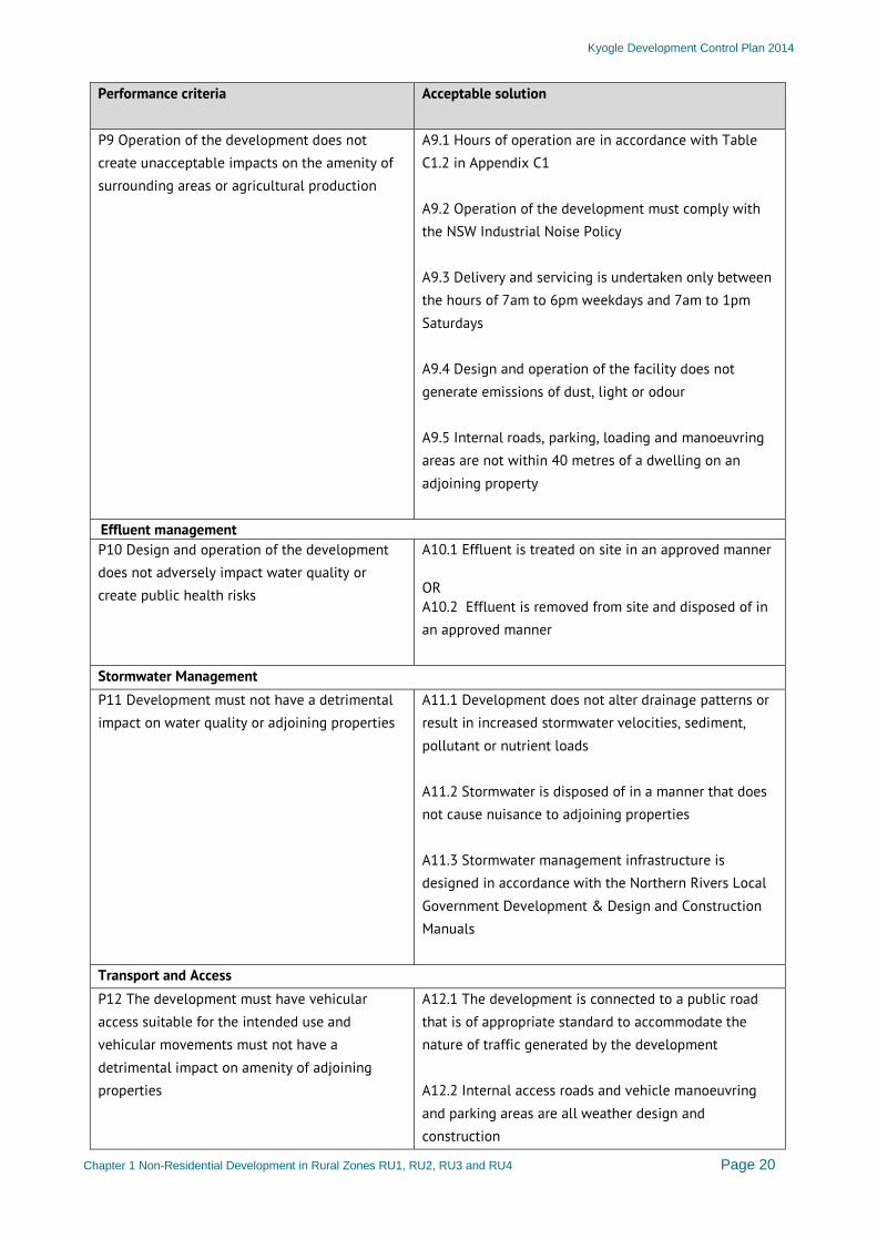
Kyogle Development Control Plan 2014
Chapter 1 Non-Residential Development in Rural Zones RU1, RU2, RU3 and RU4 Page 20
Performance criteria
Acceptable solution
P9 Operation of the development does not create unacceptable impacts on the amenity of surrounding areas or agricultural production
A9.1 Hours of operation are in accordance with Table C1.2 in Appendix C1 A9.2 Operation of the development must comply with the NSW Industrial Noise Policy A9.3 Delivery and servicing is undertaken only between the hours of 7am to 6pm weekdays and 7am to 1pm Saturdays A9.4 Design and operation of the facility does not generate emissions of dust, light or odour A9.5 Internal roads, parking, loading and manoeuvring areas are not within 40 metres of a dwelling on an adjoining property
Effluent management P10 Design and operation of the development does not adversely impact water quality or create public health risks
A10.1 Effluent is treated on site in an approved manner OR A10.2 Effluent is removed from site and disposed of in an approved manner
Stormwater Management P11 Development must not have a detrimental impact on water quality or adjoining properties
A11.1 Development does not alter drainage patterns or result in increased stormwater velocities, sediment, pollutant or nutrient loads A11.2 Stormwater is disposed of in a manner that does not cause nuisance to adjoining properties A11.3 Stormwater management infrastructure is designed in accordance with the Northern Rivers Local Government Development & Design and Construction Manuals
Transport and Access P12 The development must have vehicular access suitable for the intended use and vehicular movements must not have a detrimental impact on amenity of adjoining properties
A12.1 The development is connected to a public road that is of appropriate standard to accommodate the nature of traffic generated by the development A12.2 Internal access roads and vehicle manoeuvring and parking areas are all weather design and construction
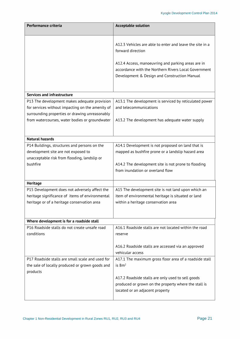
Kyogle Development Control Plan 2014
Chapter 1 Non-Residential Development in Rural Zones RU1, RU2, RU3 and RU4 Page 21
Performance criteria
Acceptable solution
A12.3 Vehicles are able to enter and leave the site in a forward direction A12.4 Access, manoeuvring and parking areas are in accordance with the Northern Rivers Local Government Development & Design and Construction Manual
Services and infrastructure P13 The development makes adequate provision for services without impacting on the amenity of surrounding properties or drawing unreasonably from watercourses, water bodies or groundwater
A13.1 The development is serviced by reticulated power and telecommunications A13.2 The development has adequate water supply
Natural hazards P14 Buildings, structures and persons on the development site are not exposed to unacceptable risk from flooding, landslip or bushfire
A14.1 Development is not proposed on land that is mapped as bushfire prone or a landslip hazard area A14.2 The development site is not prone to flooding from inundation or overland flow
Heritage P15 Development does not adversely affect the heritage significance of items of environmental heritage or of a heritage conservation area
A15 The development site is not land upon which an item of environmental heritage is situated or land within a heritage conservation area
Where development is for a roadside stall P16 Roadside stalls do not create unsafe road conditions
A16.1 Roadside stalls are not located within the road reserve A16.2 Roadside stalls are accessed via an approved vehicular access
P17 Roadside stalls are small scale and used for the sale of locally produced or grown goods and products
A17.1 The maximum gross floor area of a roadside stall is 8m2 A17.2 Roadside stalls are only used to sell goods produced or grown on the property where the stall is located or an adjacent property
Kyogle Development Control Plan 2014
Chapter 1 Non-Residential Development in Rural Zones RU1, RU2, RU3 and RU4 Page 22
Performance criteria
Acceptable solution
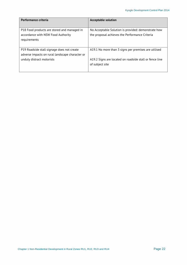
P18 Food products are stored and managed in accordance with NSW Food Authority requirements
No Acceptable Solution is provided: demonstrate how the proposal achieves the Performance Criteria
P19 Roadside stall signage does not create adverse impacts on rural landscape character or unduly distract motorists
A19.1 No more than 3 signs per premises are utilised A19.2 Signs are located on roadside stall or fence line of subject site
Kyogle Development Control Plan 2014
Chapter 1 Non-Residential Development in Rural Zones RU1, RU2, RU3 and RU4 Page 23
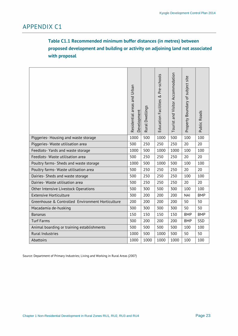
APPENDIX C1
Table C1.1 Recommended minimum buffer distances (in metres) between proposed development and building or activity on adjoining land not associated with proposal
Resi
dent
ial a
reas
and
Urb
an
Dev
elop
men
t
Rura
l Dw
ellin
gs
Educ
atio
n Fa
cilit
ies
& P
re-s
choo
ls
Tour
ist a
nd V
isito
r Acc
omm
odat
ion
Prop
erty
Bou
ndar
y of
sub
ject
site
Publ
ic R
oads
Piggeries- Housing and waste storage 1000 500 1000 500 100 100 Piggeries- Waste utilisation area 500 250 250 250 20 20 Feedlots- Yards and waste storage 1000 500 1000 1000 100 100 Feedlots- Waste utilisation area 500 250 250 250 20 20 Poultry farms- Sheds and waste storage 1000 500 1000 500 100 100 Poultry farms- Waste utilisation area 500 250 250 250 20 20 Dairies- Sheds and waste storage 500 250 250 250 100 100 Dairies- Waste utilisation area 500 250 250 250 20 20 Other Intensive Livestock Operations 500 300 500 300 100 100 Extensive Horticulture 300 200 200 200 NAI BMP Greenhouse & Controlled Environment Horticulture 200 200 200 200 50 50 Macadamia de-husking 300 300 300 300 50 50 Bananas 150 150 150 150 BMP BMP Turf Farms 300 200 200 200 BMP SSD Animal boarding or training establishments 500 500 500 500 100 100 Rural Industries 1000 500 1000 500 50 50 Abattoirs 1000 1000 1000 1000 100 100
Source: Department of Primary Industries; Living and Working in Rural Areas (2007)

Kyogle Development Control Plan 2014
Chapter 1 Non-Residential Development in Rural Zones RU1, RU2, RU3 and RU4 Page 24
Table C1.2 Preferred operational or opening hours
Development use or activity Monday to Friday Saturday Sunday and Public Holidays
Function centres, Restaurants and cafes, Cellar door premises, Neighbourhood shops, Educational establishments, Entertainment facilities, Information and education facilities, Place of public worship
7am-10pm 7am-10pm 7am-10pm
Charter and tourism boating facilities, Veterinary hospitals, Plant nurseries, Recreation facilities (outdoor), Rural supplies, Timber yards
7am-6pm 7am-5pm 7am-5pm
Rural industries, Industrial training facilities
7am-6pm 7am-1pm Not permitted
Crematoria
8am-5pm 8am-4pm 9am-3pm